Uplifted Holocene shorelines at Capo Milazzo (NE Sicily, Italy): Evidence of co-seismic and...
14
This article appeared in a journal published by Elsevier. The attached copy is furnished to the author for internal non-commercial research and education use, including for instruction at the authors institution and sharing with colleagues. Other uses, including reproduction and distribution, or selling or licensing copies, or posting to personal, institutional or third party websites are prohibited. In most cases authors are permitted to post their version of the article (e.g. in Word or Tex form) to their personal website or institutional repository. Authors requiring further information regarding Elsevier’s archiving and manuscript policies are encouraged to visit: http://www.elsevier.com/copyright
Transcript of Uplifted Holocene shorelines at Capo Milazzo (NE Sicily, Italy): Evidence of co-seismic and...
This article appeared in a journal published by Elsevier. The attachedcopy is furnished to the author for internal non-commercial researchand education use, including for instruction at the authors institution
and sharing with colleagues.
Other uses, including reproduction and distribution, or selling orlicensing copies, or posting to personal, institutional or third party
websites are prohibited.
In most cases authors are permitted to post their version of thearticle (e.g. in Word or Tex form) to their personal website orinstitutional repository. Authors requiring further information
regarding Elsevier’s archiving and manuscript policies areencouraged to visit:
http://www.elsevier.com/copyright
Author's personal copy
Uplifted Holocene shorelines at Capo Milazzo (NE Sicily, Italy): Evidenceof co-seismic and steady-state deformation
G. Scicchitano a, C.R. Spampinato a, L. Ferranti b, F. Antonioli c, C. Monaco a,*, M. Capano d, C. Lubritto d
aDipartimento di Scienze Geologiche, Università di Catania, Corso Italia, 55, 95129 Catania, ItalybDipartimento di Scienze della Terra, Università di Napoli Federico II, Italyc ENEA, Casaccia, Rome, ItalydDipartimento di Scienze Ambientali, Seconda Università di Napoli, Lab. CIRCE, Caserta, Italy
a r t i c l e i n f o
Article history:Available online 31 July 2010
a b s t r a c t
Detailed mapping of Holocene shorelines outcropping a few meters above the present sea-level at CapoMilazzo, the main headland of NE Sicily, supplied evidence of the interplay between abrupt and steadyuplift. Field analysis revealed two shorelines at distinct elevations, which were characterized throughposition and radiometric dating of geomorphologic and biological sea-level markers. The upper shorelineis represented by a notch, marine deposits and barnacle rims. The notch is found at average elevation ofw2.1 m above mean sea level (a.m.s.l.) and is filled by a marine deposit containing shells dated between6.2 and 3.9 ka BP. Locally, the deposit includes pottery of Roman age (w2 ka BP). An intertidal balanid rimassociated with the upper shoreline yielded ages between 3.8 and 1.6 ka BP. The lower shoreline involvesa notch at w0.8 m a.m.s.l., locally carved in the older Holocene deposit, and a likely coeval, subjacentabrasion platform at 0.5e0.6 m a.m.s.l. Remains of a balanid rim in this lower notch were dated atw1.4 ka BP. Morphological and chronostratigraphical relations indicate that uplift of the upper shorelineoccurred abruptly. Sudden displacement of 1.3e1.5 m occurred during a co-seismic event. Age andelevation relationships document that the upper shoreline was active between 6.2 and 1.6 ka, and thusco-seismic uplift must have occurred between 1.6 and w1.4 ka, the bracketed ages of cessation andinception of the upper and lower shorelines, respectively. Using similar reasoning, a younger(w0.8e0.9 m) co-seismic uplift occurred probably shortly after 1.4 ka. These uplifts supplementeda regional, background uplift that operated steadily during the lifespan of the two shorelines. Precisecompensation for the glacio-hydro-isostatic sea-level change indicated that this uplift took place atw0.65 mm/y. Thus, cumulative uplift at the studied sites occurred at 1.2e1.5 (locally up to 2.1) mm/y, inclose agreement with nearby coastal sites in Sicily and southern Calabria. Analysis suggests the occur-rence of a seismogenic source in the Capo Milazzo area, possibly related to transpressive structuresrecently mapped offshore. The seismogenic potential of this sector of Sicily needs to be re-evaluated.
� 2010 Elsevier Ltd and INQUA. All rights reserved.
1. Introduction
Sea level is the general reference for detecting ongoing verticalcrustal movements and assessing short- and long-term tectonicinstability in coastal areas (Lajoie, 1986). Crustal movements can bedetected by mapping and dating marine strandlines and separatingthe tectonic component from the eustatic and hydro-glacio-isostatic components of the relative sea-level change (see Lambecket al., 2004).
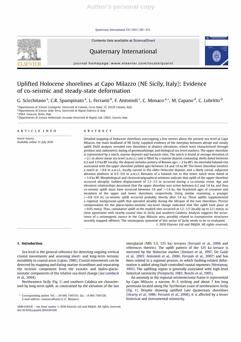
Northeastern Sicily (Fig. 1) and southern Calabria are character-ized by long-term uplift, as constrained by the elevation of the last
interglacial (MIS 5.5, 125 ka) terraces (Ferranti et al., 2006 andreferences therein). The uplift pattern of the 125 ka terrace ismirrored by the Holocene marker (Stewart et al., 1997; De Guidiet al., 2003; Antonioli et al., 2006; Ferranti et al., 2007) and hasbeen related to a regional process, to which faulting-related defor-mation is added along fault-controlled coastal segments (Westaway,1993). The uplifting region is generally associated with high-levelhistorical seismicity (Postpischl, 1985; Boschi et al., 1995).
An anomaly in the regional seismotectonic frame is representedby Capo Milazzo, a narrow, NeS striking and about 7 km longpeninsula located along the Tyrrhenian coast of northeastern Sicily(Fig. 1). Despite showing uplifted Late Quaternary shorelines(Hearty et al., 1986; Ferranti et al., 2006), it is affected by a lesserhistorical and instrumental seismicity.
* Corresponding author. Tel.: þ39 095 7195731; fax: þ9 095 7195728.E-mail address: [email protected] (C. Monaco).
Contents lists available at ScienceDirect
Quaternary International
journal homepage: www.elsevier .com/locate/quaint
1040-6182/$ e see front matter � 2010 Elsevier Ltd and INQUA. All rights reserved.doi:10.1016/j.quaint.2010.06.028
Quaternary International 232 (2011) 201e213
Author's personal copy
Fig. 1. (a) Regional tectonic map of the southern part of the Calabrian Arc. Double arrows show extension direction in Western Calabria and Eastern Sicily and contraction directionoffshore northern Sicily. Active faults (rectangles on down-thrown side) after Stewart et al. (1997), Monaco and Tortorici (2000): AF, Armo fault; CF, Cittanova fault; CVF, CapoVaticano fault; MEF, Messina fault; NF, Nicotera fault; RCF, Reggio Calabria fault; SEF, S. Eufemia fault; SF, Scilla fault; TaF, Taormina fault; TF, Tindari fault. The broad uplifted areasbetween Capo Milazzo and Vulcano (from Argnani et al., 2007) are indicated in grey pattern (VF, Vulcano fold; CMF, Capo Milazzo fold). Focal mechanisms of moderate to largeearthquakes (M > 4) after Harvard CMT (1976e2006) [http://www.seismology.harvard.edu/CMTsearch.html] and Mednet RCMT (1997e2006) [http://mednet.ingv.it/events/QRCMT/Welcome.html] catalogues (Pondrelli et al., 2002, 2004), Gasparini et al. (1985), and Anderson and Jackson (1987). Late Pleistocene uplift rates after Ferranti et al. (2006), Holoceneuplift rates from Antonioli et al. (2009). Inset shows the tectonic setting of the Calabrian Arc. (b) Epicenters of M > 4 earthquakes occurring in southern part of the Calabrian Arcbetween 217 BC and 2002 AD (data from CPTI04).
G. Scicchitano et al. / Quaternary International 232 (2011) 201e213202
Author's personal copy
However, recent studies on morphological and biological sea-level markers (Rust and Kershaw, 2000; Gringeri et al., 2004) havedocumented that the coastal sector of the peninsula has been alsouplifted during the Late Holocene, and thus deformation processesin this region may be still active today. In order to better constrainthe history of recent tectonic uplifting, a detailed mapping ofmorphologic and biological indicators of raised Holocene shore-lines over the Milazzo peninsula coastline was carried out. Themain purpose of this work is to seek evidence for regional and localcontributions to deformation. Resolution of mode and magnitudeof partitioning of vertical crustal motion into local regionalcomponents on a very short time scale can contribute to theidentification of seismogenic sources in the area.
2. Tectonic setting
The Capo Milazzo peninsula is located along the Tyrrheniancoast of northeastern Sicily south of the Aeolian archipelago (Fig. 1).The headland is separated by a Holocene coastal plain from thePeloritani range, the southwestern termination of the CalabrianArc. This prominent orogenic domain connects the Apennines andthe Sicilian-Maghrebian orogens that developed during theNeogene-Quaternary Africa-Europe collision (Dewey et al., 1989).The Calabrian Arc was emplaced to the south-east during north-westerly subduction and rollback of the Ionian oceanic slab(Malinverno and Ryan, 1986). Since Pliocene times, contractionstructures of the inner part of the orogen were superseded byextensional faults, both longitudinal and transversal with respect tothe arc, which caused the fragmentation into structural highs andmarine sedimentary basins (Ghisetti and Vezzani, 1982). In easternSicily and Calabria, Quaternary extensional collapse at the rear ofthe thrust belt has accompanied a vigorous uplift recorded byflights of marine terraces (Dumas et al., 1982; Ghisetti, 1984;Valensise and Pantosti, 1992; Westaway, 1993; Miyauchi et al.,1994; Bianca et al., 1999; Catalano and De Guidi, 2003; Tortoriciet al., 2003). The elevation of marine terraces and their offsetacross the main faults has been used to establish the relativecontribution of regional and fault-related sources to uplift.According to Westaway (1993), 1.67 mm/y of post-Middle Pleisto-cene uplift of southern Calabria was partitioned intow1 mm/y dueto regional processes and the residual to displacement on majorfaults. Shorter-term uplift rate estimates are provided by raisedHolocene beaches, terraces and tidal notches (Firth et al., 1996;Stewart et al., 1997; Pirazzoli et al., 1997; Rust and Kershaw,2000; De Guidi et al., 2003; Antonioli et al., 2003, 2006; Ferrantiet al., 2007).
Uplift of the Calabrian Arc has been related to important geo-dynamic changes which occurred in the region since the MiddlePleistocene, signalled by the end of frontal thrust displacement andstalling of subduction of the Ionian plate beneath the orogen(Westaway, 1993; Wortel and Spakman, 2000; Goes et al., 2004). Inthis context, the belt between the southernmost sector of theAeolian archipelago and northeastern Sicily, dominated by theVulcano-Tindari fault system (also known as Tindari-Letojanni faultsystem; Lanzafame and Bousquet, 1997; Billi et al., 2006), currentlyrepresents a key area as it separates two different tectonic regimes(Fig.1; Argnani et al., 2007;Mattia et al., 2008, 2009). To the east, anarray of extensional faults, characterized by strong crustal seis-micity and volcanism, cuts across southern Calabria and northeastSicily (Siculo-Calabrian rift zone; Monaco and Tortorici, 2000).Active WNW-ESE extension is documented by focal mechanisms ofcrustal earthquakes (Pondrelli et al., 2006), structural studies(Tortorici et al., 1995; Monaco et al., 1997; Monaco and Tortorici,2000; Jacques et al., 2001; Ferranti et al., 2007), and geodeticvelocities (D’Agostino and Selvaggi, 2004; Mattia et al., 2009). To
the west of the Vulcano-Tindari fault system, the southern Tyr-rhenian Sea margin is characterized bymoderate crustal seismicity.Focal mechanisms mostly show strike-slip and reverse-obliquekinematics compatible with low-dip wNNWeSSE trending p-axes(Frepoli and Amato, 2000; Neri et al., 2005; Pondrelli et al., 2006;Giunta et al., 2009), roughly consistent with the general conver-gence between the European and the African plates (Hollensteinet al., 2003; Lavecchia et al., 2007; Ferranti et al., 2008).
Kinematic changes also occur along the Vulcano-Tindari faultsystem, which is formed by NWeSE-oriented en-echelon segmentscharacterized by prevailing right lateral strike-slip movements inthe offshore sector (Ventura, 1994; Mazzuoli et al., 1995) and bytranstensional kinematic onshore (Ghisetti, 1979). Fault-planesolutions of crustal earthquakes reveal reverse focal mechanismsbetween Salina and Vulcano islands, dextral strike-slip mecha-nisms between Vulcano and Capo Milazzo and prevailing normalfaulting coupled with dextral transcurrence in Gulf of Patti area(Neri et al., 2005). This kinematic framework has been recentlyconfirmed by GPS velocity fields (Mattia et al., 2008). According toArgnani et al. (2007), the southern sector of the Aeolian archipelagobetween CapoMilazzo and the island of Vulcano is characterized bya NWeSE trending belt of transpressive (e.g. positive flower)structures. Along this belt, seismic profiles show the occurrence oftwo overstepping broad anticlines, Capo Milazzo and Vulcano folds(Fig. 1). According to the authors, transpressional deformation hasoccurred since the Middle Pleistocene and is superposed on a pre-existing extensional deformation. Despite these evidences, the areaaround Capo Milazzo and west of it shows low instrumental(Fig.1a) and historical (Fig.1b) seismicity, in sharp contrast with theMessina Straits area.
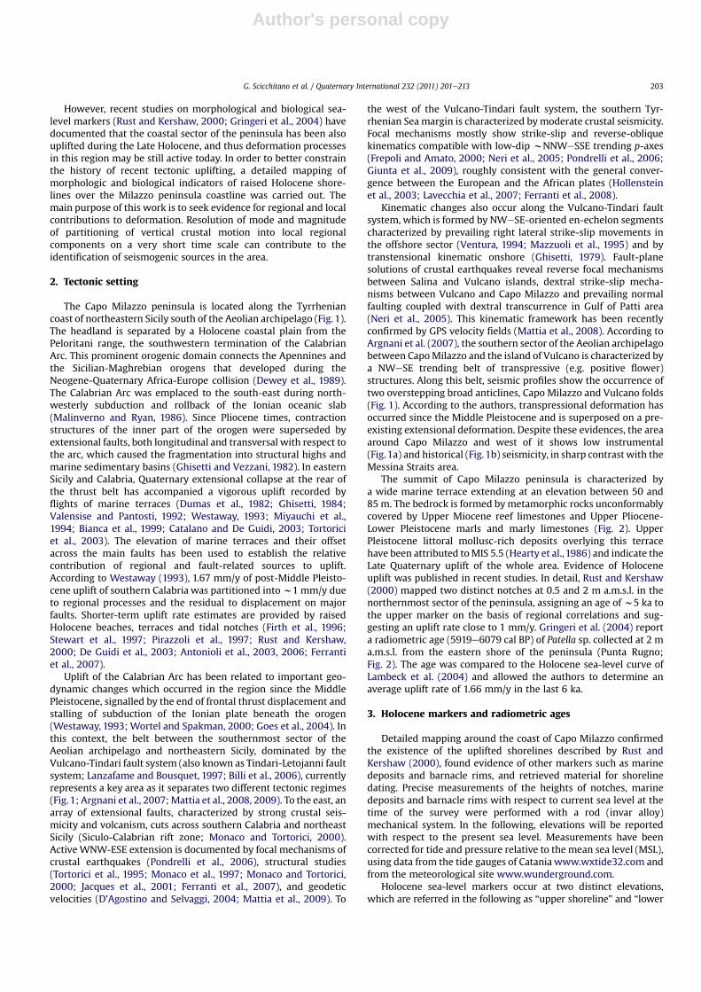
The summit of Capo Milazzo peninsula is characterized bya wide marine terrace extending at an elevation between 50 and85 m. The bedrock is formed bymetamorphic rocks unconformablycovered by Upper Miocene reef limestones and Upper Pliocene-Lower Pleistocene marls and marly limestones (Fig. 2). UpperPleistocene littoral mollusc-rich deposits overlying this terracehave been attributed toMIS 5.5 (Hearty et al., 1986) and indicate theLate Quaternary uplift of the whole area. Evidence of Holoceneuplift was published in recent studies. In detail, Rust and Kershaw(2000) mapped two distinct notches at 0.5 and 2 m a.m.s.l. in thenorthernmost sector of the peninsula, assigning an age of w5 ka tothe upper marker on the basis of regional correlations and sug-gesting an uplift rate close to 1 mm/y. Gringeri et al. (2004) reporta radiometric age (5919e6079 cal BP) of Patella sp. collected at 2 ma.m.s.l. from the eastern shore of the peninsula (Punta Rugno;Fig. 2). The age was compared to the Holocene sea-level curve ofLambeck et al. (2004) and allowed the authors to determine anaverage uplift rate of 1.66 mm/y in the last 6 ka.
3. Holocene markers and radiometric ages
Detailed mapping around the coast of Capo Milazzo confirmedthe existence of the uplifted shorelines described by Rust andKershaw (2000), found evidence of other markers such as marinedeposits and barnacle rims, and retrieved material for shorelinedating. Precise measurements of the heights of notches, marinedeposits and barnacle rims with respect to current sea level at thetime of the survey were performed with a rod (invar alloy)mechanical system. In the following, elevations will be reportedwith respect to the present sea level. Measurements have beencorrected for tide and pressure relative to the mean sea level (MSL),using data from the tide gauges of Catania www.wxtide32.com andfrom the meteorological site www.wunderground.com.
Holocene sea-level markers occur at two distinct elevations,which are referred in the following as “upper shoreline” and “lower
G. Scicchitano et al. / Quaternary International 232 (2011) 201e213 203
Author's personal copy
Fig. 2. Geological map of Capo Milazzo (after Lentini et al., 2000) with location of investigated Holocene sites (see Fig. 1 for location).
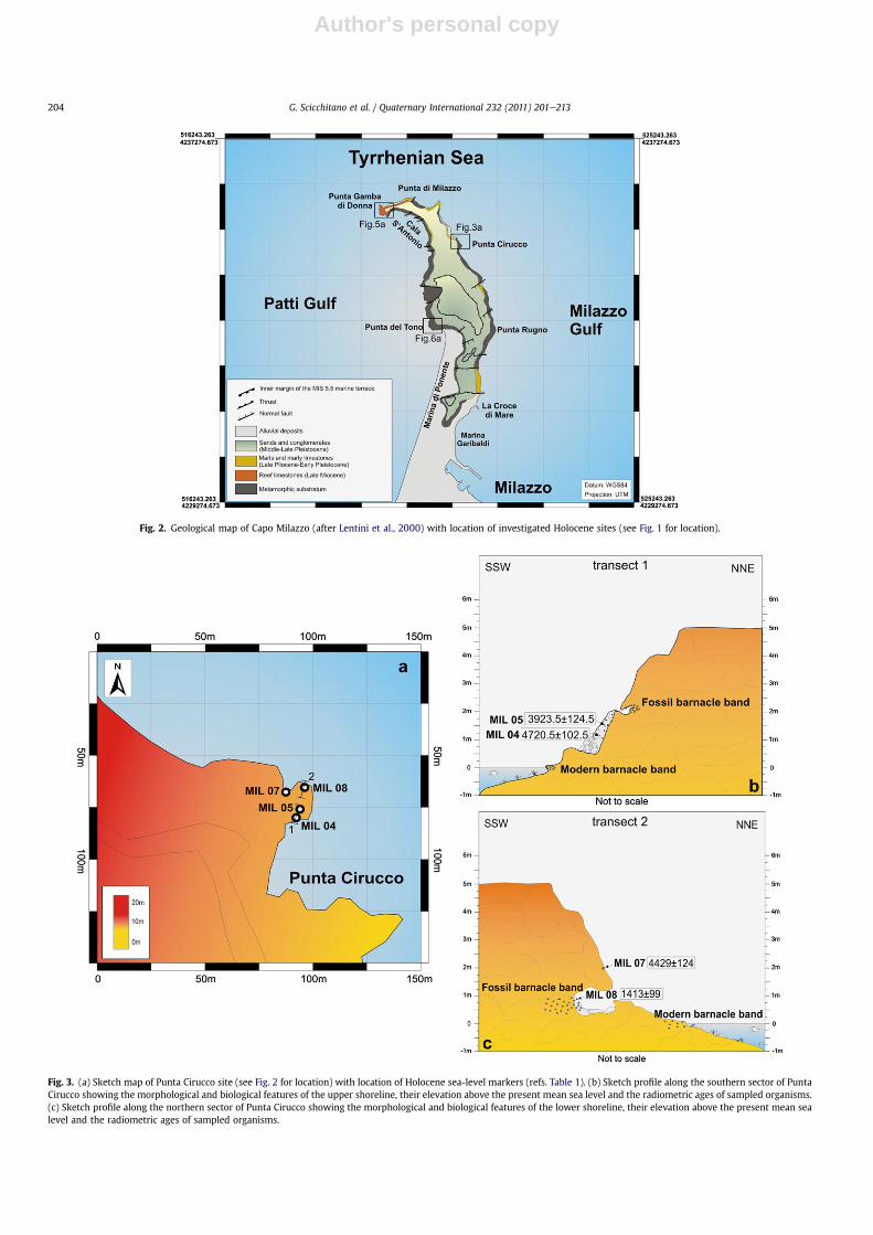
Fig. 3. (a) Sketch map of Punta Cirucco site (see Fig. 2 for location) with location of Holocene sea-level markers (refs. Table 1). (b) Sketch profile along the southern sector of PuntaCirucco showing the morphological and biological features of the upper shoreline, their elevation above the present mean sea level and the radiometric ages of sampled organisms.(c) Sketch profile along the northern sector of Punta Cirucco showing the morphological and biological features of the lower shoreline, their elevation above the present mean sealevel and the radiometric ages of sampled organisms.
G. Scicchitano et al. / Quaternary International 232 (2011) 201e213204
Author's personal copy
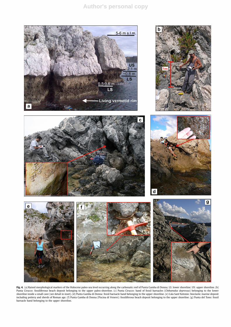
Fig. 4. (a) Raised morphological markers of the Holocene paleo-sea level occurring along the carbonatic reef of Punta Gamba di Donna; LS: lower shoreline; US: upper shoreline. (b)Punta Cirucco: fossiliferous beach deposit belonging to the upper paleo-shoreline. (c) Punta Cirucco: band of fossil barnacles (Chthamalus depressus) belonging to the lowershoreline inside a small cave (see detail in inset). (d) Punta Gamba di Donna: fossil barnacle band belonging to the upper shoreline. (e) Cala Sant’Antonio: bioclastic marine depositincluding pottery and sherds of Roman age. (f) Punta Gamba di Donna (Piscina di Venere): fossiliferous beach deposit belonging to the upper shoreline. (g) Punta del Tono: fossilbarnacle band belonging to the upper shoreline.
Author's personal copy
shoreline” (Fig. 4a). The upper shoreline is represented by a notch,marine deposits and barnacle rims. The notch is found at w2.1 melevation and is carved only in the Upper Miocene limestonesoutcropping along the northern coast of the peninsula (Punta Gambadi Donna, Fig. 2). Well-preserved Lithophaga sp. holes are present onthe perimeter of this notch. Locally, the notch is filled by a marinedeposit formed by well-sorted coarse sands and conglomerates,including small pebbles and bioclasts of intact and fragmentedshells. The average thickness of the deposit is w0.50 m, and its tophas been measured at an elevation of w1.9 m. A rim of intertidalbalanids associated to the upper shoreline has been found at a meanelevation of w2.4 m at sheltered sites. The rim is mostly composedby the species Chthamalus depressus that nowadays in the CentralMediterranean Sea colonizes themeso-tidal sector and represents animportant ingredient of the upper meso-littoral biocoenosis (Pèresand Picard, 1964). The width of the rim typically ranges between40 and 60 cm and reflects the combined effect of the above meantidal range and of the locally variable wave splash zone.
The lower shoreline appears less developed/preserved than theupper one, and includes a notch and a wave-cut platform (Fig. 4a).The notch is positioned at w0.80 m and is locally carved in thedeposit of the upper shoreline. Lithophaga sp. holes are alsoobserved within the notch, but they appear smaller than thoseassociated to the upper shoreline. At the base of the notch, a wave-cut platform borders all the coast of the headland at an elevation of0.5e0.6 m, and is particularly well developed in the northernsector. Locally, remains of a vermetid rim are found on the platform,as well as patches of a barnacle rim and a marine deposit. A livingvermetid reef also occurs as a rim along the Punta Gamba di Donnacoastal sector (Fig. 4a).
Below, observations on the two paleo-shorelines at three siteslocated along the Capo Milazzo peninsula will be described, fromeast to west (Fig. 2): Punta Cirucco, Punta Gamba di Donna andPunta del Tono. Discussion of each site includes the results ofradiometric AMS dating. Radiocarbon ages were calibrated by theCALIB 5.0 software (Stuiver et al., 2005) that incorporates a time-dependent global ocean reservoir correction of about 400 y.
3.1. Punta Cirucco
Punta Cirucco is located along the northeastern coast of thepeninsula (Fig. 2). In this area the rocky coast is steep, indented andhighly exposed to the E-NE wind-generated waves. The two paleo-shorelines are best exposed along a small coastal headlandw100mto the north of Punta Cirucco (Fig. 3a). The headland is orientatedNNEeSSW and extends w30 m seaward.
Along the southern corner (Fig. 3b) the upper shoreline ischaracterized by a fossiliferous beach deposit, by a small barnacleband and by other biological remnants. By contrast, the lowershoreline is only represented by an abrasion platform. The fossil-iferous beach deposit (Fig. 4b) is heavily eroded and only a smallsection, about 1 m thick, with the base located at w1.14 m eleva-tion, is visible. The section consists of alternating sandy and grav-elly layers of varying thickness containing small shell fragmentsand pebbles. Sediments are well sorted, although they are orga-nized in packages of different grain size, ranging from medium tovery coarse sands to granules. The finer layers showa plane-parallellamination. Organic content is represented by abundant molluscs,benthic foraminifers and fragments of echinoids (Paracentrotuslividus), and subordinate bryozoan. Mollusc content is character-ized bymostly encrusted and broken shells. Abundant specimens ofspecies belonging to the biocenosis of Posidonia meadows (HP) andphotophilic algae (AP), such as the gastropods Gibbula ardens,Jujubinus exasperatus, Rissoa ventricosa and the bivalve Venericardiaantiquata are also present. Species with wide ecologicalTa
ble
114Cdatingresu
ltsof
shellfragm
ents
colle
cted
from
theHoloc
enepaleo
-shorelines
intheCap
oMila
zzopen
insu
laan
destimated
upliftrates.Age
determinationsby
CIRCELabo
ratorium,C
aserta,Italy.A
llsampleswerecalib
rated
usingtheprogram
CALIB5.0.1(2-sigma,marineen
try;
Stuiver
etal.,20
05).Pred
ictedsea-leve
lpoints
from
theLambe
cket
al.(20
11)mod
el;av
erag
eupliftratesprovideuniform
upliftov
ertheen
tire
periodof
timeco
nsidered
.
Site
Sample
nam
eCoo
rdinates
Fossil
orga
nism
Mea
sured
marke
relev
ation(m
)
Mea
suremen
ttime
(yy/mm/dd/hh)
Tide
correction
(m)
Atm
ospheric
pressure
correction
Corrected
marke
relev
ation(m
)
14Cag
e,y
Calibrated
14
Cag
es,2
� calibrated
error,y
Pred
ictedsea
leve
l(Lambe
cket
al.,20
11)
Upliftrate
(mm/y)
Punta
Cirucco
MIL
0438
� 15.80
70N
15� 14.62
80E
Gastrop
od0.85
�0.10
08/05/21
/11
0.34
0.00
(101
3ba
r)1.19
�0.10
4529
�32
4720
.5�
102,5
�4.399
1.18
4
Punta
Cirucco
MIL
0538
� 15.80
70N
15� 14.62
80E
Gastrop
od1.33
�0.10
08/05/21
/11
0.33
0.00
(101
3ba
r)1.66
�0.10
3920
�37
3923
.5�
124.5
�-3.39
21.28
7
Punta
Cirucco
MIL
0738
� 15.81
00N
15� 14.60
30E
Serpulid
1.65
�0.10
08/06/05
/90.32
0.00
(101
3ba
r)1.97
�0.10
4429
�12
445
61�
322
�4.059
1.32
1
Punta
Cirucco
MIL
0838
� 15.81
70N
1500 1
4.61
70E
Balan
id0.60
�0.10
08/06/05
/10
0.37
0.00
(101
3ba
r)0.97
�0.10
1867
�39
1413
�99
�0.897
1.32
1
Punta
Gam
badiD
onna
MIL
0638
� 16.18
80N
15� 13.50
40E
Balan
id2.47
�0.10
08/11/11
/80.37
0.00
(101
3ba
r)2.84
�0.10
3843
�31
3791
�10
4�3
.067
1.55
8
PiscinadiVen
ere
MIL
1038
� 16.16
60N
15� 13.47
50E
Gastrop
od1.60
�0.10
08/11/11
/90.30
0.00
(101
3ba
r)1.90
�0.10
5765
�36
6184
�93
�6.868
1.41
7
Punta
del
Tono
MIL
1138
� 14.72
30N
15� 14.26
70E
Balan
id2.20
�0.10
08/11/11
/13
0.12
0.00
(101
3ba
r)2.32
�0.10
2056
�35
1622
.5�
99.5
�1.091
2.10
2
G. Scicchitano et al. / Quaternary International 232 (2011) 201e213206
Author's personal copy
distribution such as Bittium reticulatum and Cerithium vulgatumoccur in high percentages. Sedimentary features and faunal contentsuggest that no change in depositional conditions occurred duringthe time of its development, which occurred in an infralittoralbeach environment. Two gastropod shells have been sampled fromthis deposit (MIL 04 and MIL 05; Fig. 3b and Table 1). Remains ofa fossil barnacle band have been found directly above the fossilif-erous beach deposits inside a cavity carved into the bedrock(Fig. 3b). The band isw0.30mwide, reaches an elevation ofw2.4 mand marks the maximum height of the upper shoreline at this site.
In the northern corner of the headland (Fig. 3c), the uppershoreline is totally absent, possibly because this side is moreexposed to wave energy. Only serpulid encrustations were foundand a sample (MIL 07; Fig. 3c and Table 1) was collected atw1.97m.In contrast, markers of the lower shoreline are better preservedhere. The abrasion platform of the lower shoreline terminateslandward in a small cave, where a barnacle band was found(Fig. 4c). The denser part of the band is w0.2 m thick, and its topreaches an elevation of w1.0 m marking the maximum height ofthe lower shoreline at Punta Cirucco. Within this band, a fossilbarnacle has been sampled at 0.97 m (MIL 08; Table 1).
Radiocarbon age determinations performed on the samplescollected at Punta Cirucco allow tight constraints to be placed onthe age of the two paleo-shorelines (Table 1). Ages obtained for theupper shoreline range between 4720 � 102 cal BP (MIL 04) and3923 � 124 cal BP (MIL 05). These two age determinations wereperformed on shells collected at the base and the top, respectively,of the fossiliferous beach deposit, and are in good agreement withtheir stratigraphic position. The serpulid encrustation associated tothe upper shoreline must have been coeval to this deposit, becausethe sample MIL 07 yielded an age of 4561 � 322 cal BP. As regards
the lower shoreline, the balanid sampled from the rim yielded anage of 1413 � 99 cal BP (MIL 08).
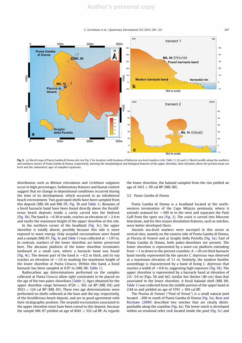
3.2. Punta Gamba di Donna
Punta Gamba di Donna is a headland located at the north-western termination of the Capo Milazzo peninsula, where itextends seaward for w300 m to the west and separates the PattiGulf from the open sea (Fig. 2). The coast is carved into Miocenelimestone, and for this reason dissolution features, such as notches,were better developed there.
Ancient sea-level markers were surveyed in this sector atseveral sites, namely on the eastern side of Punta Gamba di Donna,at Piscina di Venere and at Scoglio della Portella (Fig. 5a). East ofPunta Gamba di Donna, both paleo-shorelines are present. Thelower shoreline is represented by a wave-cut platform extendingfromw1m down to the present coastline. Aw20 cm thick barnacleband mostly represented by the species C. depressus was observedat a maximum elevation of 1.1 m. Similarly, the modern benthicassemblage is characterized by a band of living C. depressus thatreaches a width of w0.8 m, suggesting high exposure (Fig. 5b). Theupper shoreline is represented by a barnacle band at elevation of2.6e3.0 m (Figs. 5b and 4d), similar but thicker (40 cm) than thatassociated to the lower shoreline. A fossil balanid shell (MIL 06;Table 1) was collected from themiddle portion of the upper band at2.84 m and yielded an age of 3791 � 104 cal BP.
The Piscina di Venere (“Pool of Venus”) is a small natural poollocated �200 m south of Punta Gamba di Donna (Fig. 5a). Rust andKershaw (2000) described two notches that are clearly distin-guishable along the coastline (Fig. 4a). The lower notch is developedwithin an erosional relict rock located inside the pool (Fig. 5c) and
Fig. 5. (a) Sketch map of Punta Gamba di Donna site (see Fig. 2 for location) with location of Holocene sea-level markers (refs. Table 1). (b) and (c) Sketch profile along the southernand northern sectors of Punta Gamba di Donna, respectively, showing the morphological and biological features of the upper shoreline, their elevation above the present mean sealevel and the radiometric ages of sampled organisms.
G. Scicchitano et al. / Quaternary International 232 (2011) 201e213 207
Author's personal copy
along the small islet of Scoglio della Portella, 100 m offshore in frontof the pool. This notch appears poorly developed/preserved and,although several lithophaga holes are present, no biological remainswere found associated with the notch. The roof of the lower notchwas measured at an elevation of w0.8 m. The upper notch is larger,better preserved and wider than the lower notch, with a roof atw2.10 m. In the Pool of Venus, the higher notch is filled withamarine deposit about 50 cm thick (Figs. 5c and 4e), which is formedby well-sorted coarse sands and conglomerates and includespebbles, shells and fragments of shallow-water molluscs.A gastropod (MIL 10; Table 1), collected from the deposit at elevationof 1.9 m, yielded an age of 6184 � 93 cal BP. Several fossil barnaclebands have been found at sheltered sites (sea cavities, karst fissures),the highest of which located between 2.2 and 2.6 m.
Close to the northern corner of Cala S’Antonio, south-east ofPunta Gamba di Donna (Fig. 2), the marine deposit is present atelevations from�0.5 m toþ1 m and includes pottery and sherds ofRoman age (w2 ka, I. Radi�c, personal communication) (Fig. 4f).
In summary, morphologic and radiometric results at this sitedocument that: (i) the notch of the upper shoreline was activebeforew6.2 ka BP as shown by the gastropodMIL 10 collected fromthe deposit filling the upper notch; (ii) the highest horizon of the
upper shoreline corresponds to the maximum elevation of thefossil barnacle band discovered at Punta Gamba di Donna, in goodagreement with the elevation of the same band at Punta Cirucco.
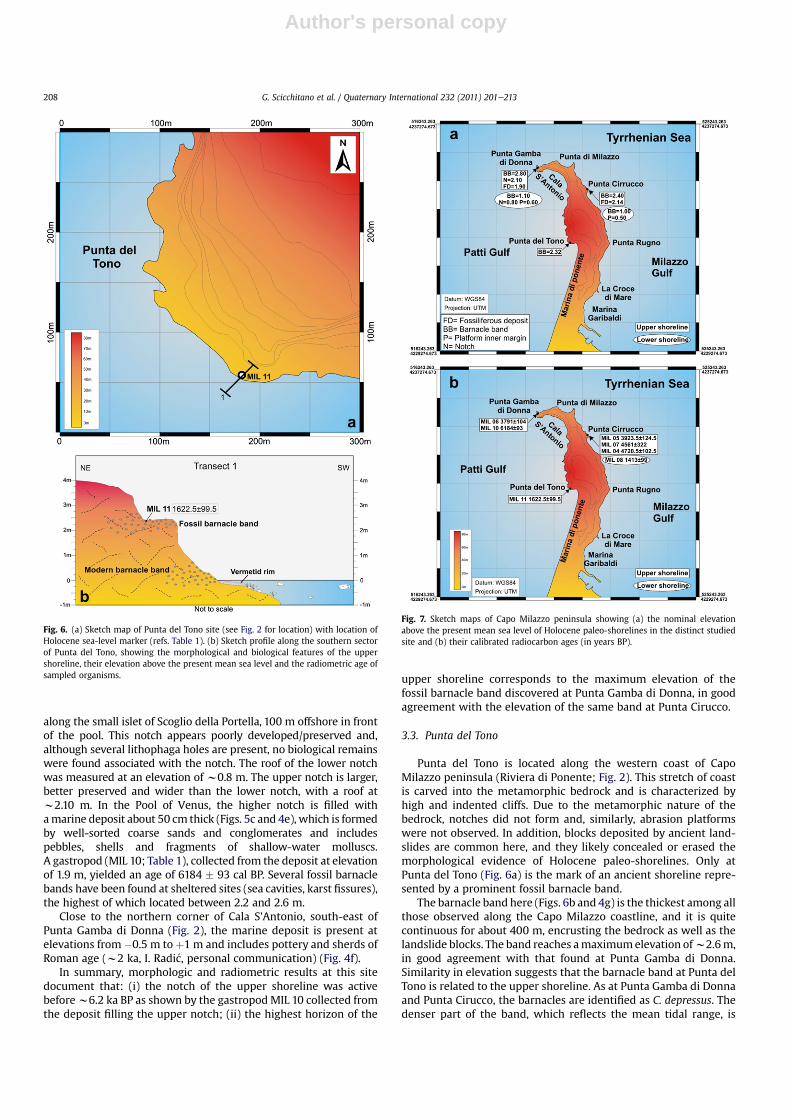
3.3. Punta del Tono
Punta del Tono is located along the western coast of CapoMilazzo peninsula (Riviera di Ponente; Fig. 2). This stretch of coastis carved into the metamorphic bedrock and is characterized byhigh and indented cliffs. Due to the metamorphic nature of thebedrock, notches did not form and, similarly, abrasion platformswere not observed. In addition, blocks deposited by ancient land-slides are common here, and they likely concealed or erased themorphological evidence of Holocene paleo-shorelines. Only atPunta del Tono (Fig. 6a) is the mark of an ancient shoreline repre-sented by a prominent fossil barnacle band.
The barnacle band here (Figs. 6b and 4g) is the thickest among allthose observed along the Capo Milazzo coastline, and it is quitecontinuous for about 400 m, encrusting the bedrock as well as thelandslide blocks. The band reaches amaximumelevation ofw2.6m,in good agreement with that found at Punta Gamba di Donna.Similarity in elevation suggests that the barnacle band at Punta delTono is related to the upper shoreline. As at Punta Gamba di Donnaand Punta Cirucco, the barnacles are identified as C. depressus. Thedenser part of the band, which reflects the mean tidal range, is
Fig. 6. (a) Sketch map of Punta del Tono site (see Fig. 2 for location) with location ofHolocene sea-level marker (refs. Table 1). (b) Sketch profile along the southern sectorof Punta del Tono, showing the morphological and biological features of the uppershoreline, their elevation above the present mean sea level and the radiometric age ofsampled organisms.
Fig. 7. Sketch maps of Capo Milazzo peninsula showing (a) the nominal elevationabove the present mean sea level of Holocene paleo-shorelines in the distinct studiedsite and (b) their calibrated radiocarbon ages (in years BP).
G. Scicchitano et al. / Quaternary International 232 (2011) 201e213208
Author's personal copy
w0.6mwide. Similarly, themodern shoreline benthic assemblage ischaracterized by a band of living C. depressus that reaches awidth ofw1 m, indicating a high exposure area probably related to thecontribution of the splash zone upon themean tide. A fossil barnaclewas collected at 2.34m from themiddle portion of the band (MIL 11;Table 1), and provided an age of 1622 � 99 cal BP.
4. Nominal age of paleo-shorelines and elevation
Cross inspection of position above the sea level and radiometricresults obtained for uplifted markers allows establishment ofa nominal elevation and age for the two paleo-shorelines. At eachoutcrop, individual markers provide different constraints on theshoreline elevation (Fig. 7a and Table 2). Whereas notches and bal-anid rims yield average estimations on the paleo-sea level position,platform inner margins and onlapping beach deposits furnishminimum constraints because they are formed below an unknown
depth of the water column (Table 2). In these latter cases, theuncertainty attached to the paleo-shoreline position is asymmetric,with an error of þ0.30 for the platform and þ0.20 for the beachdeposits (Table 2). These values honour the present-daymorphologyof the seafloor around Milazzo and are consistent with other Holo-cene paleo-shoreline studies in Calabria (Ferranti et al., 2007).
Determination of the nominal elevation of the paleo-shorelinesat the three studied sites derives from the integration of informa-tion provided by specific markers. At all sites, the average elevationof the upper shoreline is consistently computed at w2.3 m (Table3). In contrast, a slightly different nominal elevation for the lowershoreline was determined at Punta Cirucco and Punta Gamba diDonna, although within the uncertainty they could have the sameelevation of w0.9 m (Table 3).
By crossing calibrated ages obtained on all the samples collectedat different sites (Fig. 7b), tight constraints can be placed on thenominal ages of the two paleo-shorelines (Table 3). At Punta Cir-ucco, samples MIL 04 and MIL 05, coming respectively from thebase (1.19 m) and the top (1.66 m) of the beach deposit, furnishedcalibrated ages of 4721 � 103 cal BP and 3924 � 125 cal BP,respectively. The time extent of the upper shoreline can be pushedbackward by the radiometric result from Punta Gamba di Donna,where the shell sample MIL 10 from the marine deposit inside thenotch was dated at 6184 � 93 cal BP. Similarly, sample MIL 06 fromthe same site slightly rejuvenates the shoreline at 3791�322 cal BP(Fig. 7b). However, a markedly younger age for this shoreline isprovided by sample MIL 11, a balanid from Punta del Tono whichhas a 1622� 99 cal BP age (Table 3). Based on these constraints, theupper shoreline was active for a minimum time span of w4.6 ky,between �6.2 and �1.6 ka BP. However, the shoreline was slightlyolder than 6.2 ka, because the notch must have formed before thesediment filling it, including sample MIL 10. Based on the obser-vation that present-day notches in the Central Mediterranean Seatake only few centuries to form (Furlani et al., 2009), the stillstandindicated by the upper shoreline had a duration of w5 ka.
Outcrops of the lower shoreline, unfortunately, offer fewerconstraints for establishing a nominal age (Table 3). The maximumage constraint for the shoreline onset is merely indicated by the
Table 2Location and paleo-shoreline elevation at distinct sites, including tide and air pressure corrections.
Site Coordinates Marker Measured markerelevation (m)
Corrected markerelevation (m)
Datauncertainty
Shorelineelevation (m)
Sea-levelconstraint
Upper shorelinePunta Cirucco 38�15.8070N Balanid rim 2.07 � 0.10 2.40 � 0.10 �0.13 2.40 � 0.23 Average
15�14.6280EPunta Cirucco 38�15.8070N Onlap of beach
deposit1.81 � 0.10 2.14 � 0.10 þ0.20 2.14 þ0.30 Minimum
15�14.6280E �0.10Punta Gamba
di Donna38�16.1880N Balanid rim 2.47 þ 0.10 2.80 � 0.10 �0.20 2.80 � 0.30 Average15�13.5040E
Punta Gambadi Donna
38�16.1660N Onlap of beachdeposit
1.60 � 0.10 1.90 � 0.10 þ0.20 1.90 þ0.30 Minimum15�13.4750E �0.10
Punta Gambadi Donna
38�16.1660N Notch 1.80 � 0.10 2.10 � 0.10 �0.10 2.10 � 0.20 Average15�13.4750E
Punta del Tono 38�14.7230N Balanid rim 2.20 � 0.10 2.32 � 0.10 �0.30 2.32 � 0.40 Average15�14.2670E
Lower shorelinePunta Cirucco 38�15.8170N Platform
inner margin0.13 � 0.10 0.50 � 0.10 þ0.30 0.50 þ0.40 Minimum
15�14.6170E �0.10Punta Cirucco 38�15.8170N Balanid rim 0.63 � 0.10 1.00 � 0.10 �0.20 1.00 � 0.30 Average
15�14.6170EPunta Gamba
di Donna38�16.1880N Platform
inner margin0.23 � 0.10 0.60 � 0.10 þ0.30 0.60 þ0.40 Minimum
15�13.5040E �0.10Punta Gamba
di Donna38�16.1880N Balanid rim 0.68 � 0.10 1.10 � 0.10 �0.20 1.10 � 0.30 Average15�13.5040E
Punta Gambadi Donna
38�16.1660N Notch 0.5 � 0.10 0.80 � 0.10 �0.10 0.80 � 0.20 Average15�13.4750E
Table 3Nominal elevation above the present sea level and duration of the Holocene paleo-shoreline obtained by combining the individual marker elevation of dated samples(see Table 1).
Site NominalElevation (m)
Shorelineonset, y BP
Shorelineend, y BP
Upper shorelinePunta Cirucco 2.27 þ0.27 4720.5 � 102,5
(MIL 04)3923.5 � 124.5(MIL 05)�0.17
Punta Gambadi Donna
2.27 þ0.30 6184 � 93(MIL 10)
3791 � 104(MIL 06)�0.17
Punta del Tono 2.32 � 0.40 1622.5 � 99.5(MIL 11)
Nominal age, y BP ?6184 � 93 ?1622.5 � 99.5
Lower shorelinePunta Cirucco 0.75 þ0.35 1413 � 99
(MIL 08)�0.20Punta Gamba
di Donna0.85 þ0.30
�0.20Nominal age,
y BP?1622.5 � 99.5 ?1413 � 99
G. Scicchitano et al. / Quaternary International 232 (2011) 201e213 209
Author's personal copy
inferred cessation of the superjacent shoreline at w1.6 ka BP.Similarly, only sample MIL 08 dated at 1413 � 99 cal BP placesa maximum age constraint for the shoreline cessation (Table 3).
5. Glacio-hydro-isostatic correction and uplift
In order to correctly assess the total amount of tectonic upliftexperienced by the coast during the Late Holocene, accuratecorrections for sea-level variations must be applied. Toward thisend, the elevation-age data were compared to the local curve ofHolocene sea-level rise (Lambeck et al., 2011). Using modelpredictions calibrated against data from 40 sites in Italy, the authorshave calculated vertical motions of the crust caused by glacial andmelt-water loading/unloading during the glacial cycle in additionto the global sea-level rise from the melting of the last ice sheets(the eustatic change). Of these loading corrections, the glacialsignature is caused by the subsidence of the broad geoidal bulgewhich formed around the northern ice sheets during the lastglaciation, and the melt-water signature is the subsidence inducedby the weight of the melt-water on the ocean and shallow seafloor
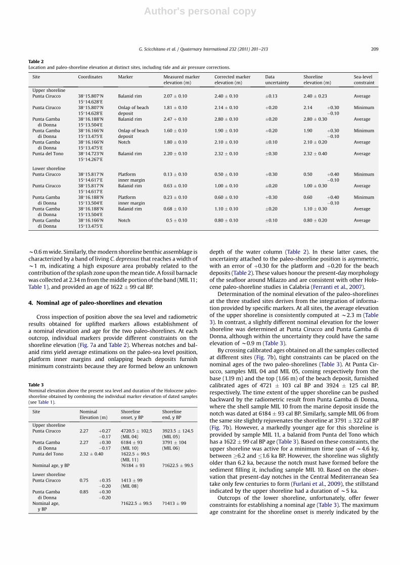
Fig. 8. Sea-level rise curve (thick solid line) and related s2 uncertainty (grey band) forthe Milazzo area according to the model of Lambeck et al. (2011). Displacement abovethe modern sea level, and ages of related co-seismic events I and II are also shown. Thegrey areas include samples from the lower and upper shorelines.
Table 4Age and amount of co-seismic vertical displacement during Events I and II.
Event Site VerticalDisplacement (m)
Event I (1.6-1.4 ky B.P.) Punta Cirucco 1.52+0.31-0.17
Punta Gamba di Donna 1.42+0.30-0.17
Event II (post 1.4ky B.P.) Punta Cirucco 0.75+0.35-0.20
Punta Gamba di Donna 0.85+0.30-0.20
Fig. 9. Sketch depicting the displacement history of Capo Milazzo peninsula as inte-gration of steady and co-seismic uplift patterns.
G. Scicchitano et al. / Quaternary International 232 (2011) 201e213210
Author's personal copy
including the shelves. For the locations considered here, these andthe eustatic contributions are additive.
The total tectonic uplift is portrayed in Fig. 8, where the datedsamples collected at Capo Milazzo are grouped into two pointclusters representing the upper and lower shorelines as bracketed byradiometric analysis. Inspection of Fig. 8 reveals that samples havebeen uplifted by an amount equivalent to their vertical distance fromthe sea-level curve. In Table 1 values of total uplift rate estimated forindividual samples are reported. For samples from the uppershoreline, they range between w1.2 mm/y for the beach deposit atPunta Cirucco (MIL 04), and w2.1 mm/y for the balanid sampled atPunta Tono (MIL 11), with an average value of 1.5 mm/y. The balanidcollected at Punta Cirucco, boarding the upper limit of the lowershoreline, provides a total uplift rate of w1.3 mm/y. Values calcu-lated for both shorelines are in good agreement suggesting that thetrend did not change during the Late Holocene.
6. Discussion and conclusions
6.1. Co-seismic and steady uplift of the Holocene shorelines
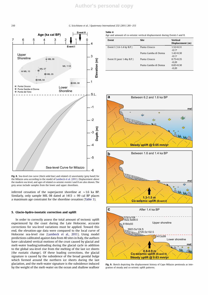
The coastline of Capo Milazzo offers an excellent opportunity toinvestigate the contribution of different processes to relative sea-level changes and cumulative tectonic displacement. The mostostensible evidence of relative sea-level change is represented by theseparation of the two shorelines known from previous studies (Rustand Kershaw, 2000) and studied here in more detail. Appraisal oflimiting ages suggests that distinction between the two shorelinesoccurred rather rapidly within a limited time window of w200 ybetween w1.6 and 1.4 ka BP. The radiometric results are in agree-ment with the observation that the two shorelines always showa clear spatial segregation. This separation cannot be related toa eustatic fall, because the historical sea-level curve shows uninter-rupted rising (Fig. 8). On these grounds, abrupt land uplift occurredduring this time window, and it was likely related to a co-seismicevent that displaced the upper shoreline above sea level and set theconditions for commencement of the lower shoreline. The magni-tude of the vertical displacement occurred during this event rangesfrom w1.4 to w1.5 m at Punta Cirucco and Punta Gamba di Donna,respectively (Event I in Table 4).
Similarly, the observation that the lower shoreline is also clearlyseparated from the modern shoreline points to a younger co-seismic event of uplift. Unfortunately, evidence of this youngermotion cannot be provided by radiometric dating, because no ageconstraint exists for shoreline cessation and onset of the modernshoreline. Toward this hand, stipulation of the realistic amount ofregional uplift experienced by both shorelines, in addition to theco-seismic uplift, is of use. The fact that the upper shorelineremained at a rather constant position ofw2.3 m above the presentsea level throughout its lifespan of w4.6e5 ka, when the eustaticcurve was steadily rising, suggests that a mechanismwas operatingto create a relative stillstand. Similar evidence was found in theMessina Strait (Fig. 1) by Ferranti et al. (2007), who suggested thatsteady, regional uplift must have occurred at a rate broadly coin-cident to that of the sea-level rise in order to maintain a fixedposition of uplifted Holocene shorelines. Following Ferranti et al.(2007), the Capo Milazzo paleo-shoreline was steadily uplifted atthe rate of local sea-level rise (Fig. 8).
A more accurate estimation of the steady uplift occurred at CapoMilazzo during development of the upper shoreline can be per-formed through stipulation of an admissible sedimentation rate forthe marine deposit at Punta Cirucco. At this locale, the rate ofsediment accumulation is provided by the age difference (0.80 ka)and vertical separation (0.46 m) of samples MIL 04 and MIL 05(Table 1) which are positioned at the base and the top of deposit
(Fig. 3b). These data yield a sedimentation rate of w0.6 mm/y.During the same time interval (w4.7e3.9 ka BP), the sea level wasrising from �4.4 to �3.4 m below the present sea-level (Fig. 8), ata rate of w1.25 mm/y. The real rate of land uplift is estimated bysubtracting the sedimentation rate from the isostatically-correctedeustatic sea-level rise, w0.65 mm/y.
Even though scarce remains of marine deposits are associatedwith the lower shoreline, a similar reasoning cannot beapplied in thiscase. However, thewidth of thedenser partof the associated barnacleband is comparable to thatof the living rim (Fig. 3c). Basedon this, thelower shoreline was steadily uplifted at a rate equal to the sea-levelrise (0.63mm/y), before being abruptly isolated above the sea bya co-seismic event. Following the discussion for the upper shoreline, theco-seismic vertical displacement of the lower shoreline can be esti-mated by considering themagnitude of steady uplift at CapoMilazzoand the total uplift of the younger barnacle band found at Punta Cir-ucco (MIL 08). The post-1.4 ka steady uplift estimated at 0.63 mm/ywould have displaced the barnacle band of about 0.9 m above itsphysiological position. However, the sea level during the last 1.4 kahas risenabout0.89m, andasa consequence thebarnacleband foundat Punta Cirucco should have remained close to the present sea-levelposition. Therefore, its actual location implies a displacement rangingbetween 0.75 and 0.85 m (Event II in Table 4).
Estimations of steady uplift for the two shorelines, using differentapproaches, are strikingly similar, suggesting that this inter-seismicdeformation was caused by a regional process. Support toward thisinference come from the elevation of the MIS 5.5 shoreline at CapoMilazzo (w90 m), which yields a long-term uplift at w0.7 mm/y(Ferranti et al., 2006). This rate should represent the cumulativeeffect of regional and abrupt (co-seismic) tectonic displacement atthe w100 ka scale. If this assumption is valid, the 0.7 mm/y long-term uplift is in large part due to the regional process. The fact that inthe long-term, the local, co-seismic tectonic signal is lost waspreviously noted in the Messina Strait by Ferranti et al. (2007), whosuggested that clusters of earthquakes occurred episodically andwere separated by longer quiescence intervals, when only theregional uplift operated. Accordingly, co-seismic uplift at the CapoMilazzo coastline is not constant, rather it is punctuated.
6.2. Late Holocene displacement history
Integration of steady and co-seismic uplift patterns indicates thehistory of displacement at the Capo Milazzo coastline (Fig. 9).Between 6.2 (but probably since w6.5 ka) and 1.6 ka, the uppershoreline was formed (Fig. 9a). The notch was the first morpho-logical feature that started to form some centuries before thew6.2 ka marine deposit commenced, filling it and halting itsenlargement. Sediments accumulated steadily, as indicated byradiometric dates at w4.7 and w3.9 ka. The deposit also grew inhistorical time, as indicated by the Roman (w2 ka) pottery includedin it. During this time span, the landwas tectonically raised at a rate(0.65 mm/y) equal to about half the eustatic rise. Only during theshort time span of notch formation it was possible that land upliftwas slightly faster to maintain a perfect stillstand. Starting from atleast 3.8 and until 1.6 ka, a barnacle rimwas formed at the top of thedeposit and even above the notch, as indicated by the rim elevationat Punta Gamba di Donna (Fig. 4c). This occurrence clearly reflectsthe fact that the seawas rising, even if at a reduced rate (0.9 mm/y),faster than the regional uplift rate (0.65 mm/y), so that the notchwas submerged and the barnacle band formed above. The fact thatthe band is wider than the younger and the modern ones is relatedto the at least w2 ka lifespan of the band, during which a slightrelative sea-level rise must have occurred.
Between 1.6 and 1.4 ka BP, co-sesimic uplift raised the uppershoreline above sea level and the lower shoreline started to form
G. Scicchitano et al. / Quaternary International 232 (2011) 201e213 211

Author's personal copy
(Fig. 9b). Although the lower shoreline includes a notch, a barnaclerim and a marine deposit, it was less developed/preserved than theupper shoreline. This occurred because the upper shorelinedeveloped during a longer time interval, and was uplifted a largeramount above the coeval sea level (Table 4). In addition, theobservation that the lower shoreline is heavily eroded couldsuggest that the younger co-seismic event that uplifted thisshoreline (Fig. 9c) occurred close to the shoreline inception (1.4 kaBP). A relatively old age for this event could also explain why it wasomitted in the historical seismicity record (see Fig. 1b).
6.3. Seismotectonic implications
This study documents that two paleo-earthquakes probablyoccurred in the Late Antiquity with coastal displacement in theCapo Milazzo area, where historical and instrumental seismicity isless intense than in nearby sectors such as the Messina Straits(Fig. 1). The analysis of historical seismicity reveals that a fewearthquakes occurred in this area within the time defined for thetwo events. According to Guidoboni et al. (2000), based on Libanius’chronicles, a strong earthquake probably affected northern Sicilybetween 350 and 363 AD. Another major event probably occurredin the second half of the VII century AD, following eruptions at theVulcano Island (Guidoboni et al., 1994). Finally, the chroniclesreport, even if with many uncertainties, the occurrence of a largeearthquake in eastern Sicily in the 853 AD (see Boschi et al., 1995and references therein). This uncertainty prevents definiteconclusions, and further analysis in the numerous archaeologicalsites of northeastern Sicily would be necessary to find new infor-mation and for a more complete evaluation of this uncertain eventreported in the catalogues.
Using well-established empirical relations between surfacedisplacement and magnitude (Wells and Coppersmith, 1994), theaverage vertical slip per event estimated for co-seismic events I andII (w1.4 and w0.8, respectively, see Fig. 9) at Capo Milazzo point toM w 6e7 earthquakes, which in turn is broadly compatible withcrustal structures having w10e40 km length. What remainsunsolved is the causative source for these earthquakes, which likelycorresponds to an offshore fault. In this area, the transition fromcrustal extension in the east to shortening in northwest Sicilyoccurs via a belt of strike-slip and transpressive faults (Fig. 1), and isindicated by structural studies, seismicity and geodetic analysis(e.g. D’Agostino and Selvaggi, 2004; Neri et al., 2005; Pondrelliet al., 2006; Billi et al., 2006; Ferranti et al., 2008; Mattia et al.,2008). In the immediate northwest offshore of Capo Milazzo,earlier extensional structures were reactivated in a dextral trans-pressional regime related to NeS active compression (Mattia et al.,2009). Two active anticlines, with NWeSE striking en-echelon axes(Vulcano and Capo Milazzo folds; Fig. 1), are clearly shown byseismic profiles (Argnani et al., 2007). The elongated shape of theCapo Milazzo peninsula and the sub-horizontal attitude of thesedimentary succession outcropping on its top suggest that it mayrepresent the southwards onshore extension of the Capo Milazzoanticline. Moreover, the geometry of this fold could be consistentwith the required size of seismogenic sources for the two paleo-earthquakes detected along the coastline of the Capo Milazzopeninsula. Although further investigation is needed to documenta direct link between offshore structure and coastal deformation,the analysis highlights the compelling need for a re-evaluation ofseismic hazard in northeast Sicily.
Acknowledgments
This work was supported by the Department of Civil Protection-INGV, through project S1 2007e2009 (grants to L. Ferranti), by the
VECTOR project funded by the Italian Ministry of Education,University and Research and by grants from University of Catania(responsible C. Monaco). We thank Irena Radic Rossi for agedetermination of archaeological sherds and the two anonymousreviewers for their comments that helped to clarify some aspects ofthe work.
References
Anderson, H., Jackson, J., 1987. Active tectonics of the Adriatic region. GeophysicalJournal Royal Astronomical Society 91, 937e983.
Antonioli, F., Kershaw, S., Rust, D., Verrubbi, V., 2003. Holocene sea-level change inSicily and its implications for tectonic models: new data from the Taorminaarea, northeast Sicily. Marine Geology 196, 53e71.
Antonioli, F., Ferranti, L., Lambeck, K., Kershaw, S., Verrubbi, V., Dai Pra, G., 2006.Late Pleistocene to Holocene record of changing uplift-rates in southern Cala-bria and northeastern Sicily (southern Italy, Central Mediterranean Sea). Tec-tonophysics 422, 23e40.
Antonioli, F., Ferranti, L., Fontana, A., Amorosi, A., Bondesan, A., Braitenberg, C.,Dutton, A., Fontolan, G., Furlani, S., Lambeck, K., Mastronuzzi, G., Monaco, C.,Spada, G., Stocchi, P., Orrù, P., 2009. A review of the Holocene sea-level changesand tectonic movements along the Italian coastline. Quaternary International206, 102e133.
Argnani, A., Serpelloni, E., Bonazzi, C., 2007. Pattern of deformation around thecentral Aeolian Islands: evidence from multichannel seismics and GPS data.Terra Nova 19, 317e323.
Bianca, M., Monaco, C., Tortorici, L., Cernobori, L., 1999. Quaternary normal faultingin southeastern Sicily (Italy): a seismic source for the 1693 large earthquake.Geophysical Journal International 139, 370e394.
Billi, A., Barberi, G., Faccenna, C., Neri, G., Pepe, F., Sulli, A., 2006. Tectonics andseismicity of the Tindary Fault System, southern Italy: crustal deformations atthe transition between ongoing contractional and extensional domains locatedabove the edge of a subducting slab. Tectonics 25, 1e20.
Boschi, E., Ferrari, G., Gasperini, P., Guidoboni, E., Smriglio, G., Valensise, G., 1995.Catalogo dei Forti Terremoti in Italia dal 461 A.D. al 1980. Istituto Nazionale diGeofisica, S.G.A., Roma.
Catalano, S., De Guidi, G., 2003. Late Quaternary uplift of northeastern Sicily:relation with the active normal faulting deformation. Journal of Geodynamics36, 445e467.
D’Agostino, N., Selvaggi, G., 2004. Crustal motion along the Eurasia-Nubia plateboundary in the Calabrian Arc and sicily and active extension in the messinastraits from GPS measurements. Journal of Geophysical Research 109, B11402.
De Guidi, G., Catalano, S., Monaco, C., Tortorici, L., 2003. Morphological evidence ofHolocene coseismic deformation in the Taormina region (NE Sicily). Journal ofGeodynamics 36, 193e211.
Dewey, J.F., Helman, M.L., Turco, E., Hutton, D.H.W., Knott, S.D., 1989. Kinematics ofthe western Mediterranean. In: Coward, M.P., Dietrich, D., Park, R.G. (Eds.),Alpine Tectonics. Geological Society London Special Publication, vol. 45, pp.265e283.
Dumas, B., Gueremy, P., Lhenaff, R., Raffy, J., 1982. Le soulèvement quaternaire de laCalabre méridionale. Revuede Geographie Physique et de Géologie Dynamique23, 27e40.
Ferranti, L., Antonioli, F., Mauz, B., Amorosi, A., Dai Pra, G., Mastronuzzi, G.,Monaco, C., Orrù, P., Pappalardo, M., Radtke, U., Renda, P., Romano, P., Sansò, P.,Verrubbi, V., 2006. Markers of the last interglacial sea level highstand along thecoast of Italy: tectonic implications. Quaternary International 145e146, 30e54.
Ferranti, L., Monaco, C., Antonioli, F., Maschio, L., Kershaw, S., Verrubbi, V., 2007. Thecontribution of regional uplift and coseismic slip to the vertical crustal motionin the Messina Straitss, Southern Italy: evidence from raised Late Holoceneshorelines. Journal of Geophysical Research 112, B06401.
Ferranti, L., Oldow, J.S., D’Argenio, B., Catalano, R., Lewis, D., Marsella, E.,Avellone, G., Maschio, L., Pappone, G., Pepe, F., Sulli, A., 2008. Active deforma-tion in Southern Italy, Sicily and southern Sardinia from GPS velocities of thePeri-Tyrrhenian geodetic array (PTGA). Bollettino Società Geologica Italiana 127,299e316.
Firth, C., Stewart, I., McGuire, W.M., Kershaw, S., Vita-Finzi, C., 1996. Coastal eleva-tion changes in eastern Sicily: implications for volcano instability at MountEtna. In: McGuire, W.M., Jones, A.P., Neuberg, J. (Eds.), Volcano Instability on theEarth and Other Planets. Geological Society of London Special Publication, vol.110, pp. 153e167.
Frepoli, A., Amato, A., 2000. Spatial variation in stresses in peninsular Italy and Sicilyfrom background seismicity. Tectonophysics 317, 109e124.
Furlani, S., Cucchi, F., Forti, F., Rossi, A., 2009. Comparison between coastal andinland Karst limestone lowering rates in the northeastern Adriatic Region (Italyand Croatia). Geomorphology 104, 73e81.
Gasparini, C., Iannaccone, G., Scarpa, R., 1985. Fault-plane solutions and seismicity ofthe Italian Peninsula. Tectonophysics 117, 59e78.
Ghisetti, F., 1979. Relazioni tra strutture e fasi trascorrenti e distensive lungo i sis-temi Messina-Fiumefreddo, Tindari-Letojanni e Alia-Malvagna (Sicilia nord-orientale): uno studio microtettonico. Geologica Romana 18, 23e58.
Ghisetti, F., Vezzani, L., 1982. The recent deformation mechanisms of the CalabrianArc. Earth Evolution Sciences 3, 197e206.
G. Scicchitano et al. / Quaternary International 232 (2011) 201e213212
Author's personal copy
Ghisetti, F., 1984. Recent deformations and the seismogenic source in the MessinaStraitss (southern Italy). Tectonophysics 109, 191e208.
Giunta, G., Luzio, D., Agosta, F., Calò, M., Di Trapani, F., Giorgianni, A., Oliveti, E.,Orioli, S., Perniciaro, M., Vitale, M., Chiodi, M., Adelfio, G., 2009. An integratedapproach to investigate the seismotectonics of northern Sicily and southernTyrrhenian. Tectonophysics 476, 13e21.
Goes, S., Giardini, D., Jenny, S., Hollenstein, C., Kahle, H.G., Geiger, A., 2004. A recenttectonic reorganization in the south-central Mediterranean. Earth and Plane-tary Science Letters 226, 335e345.
Gringeri, G., Bonfiglio, L., Di Geronimo, I., Mangano, G., Antonioli, F., 2004. UpliftedHolocene littoraldeposits in theMilazzopeninsula.QuaternariaNovaVIII,141e154.
Guidoboni, E., Comastri, A., Traina, G., 1994. Catalogue of Ancient Earthquakes in theMediterranean Area up to 10th Century. ING, Roma, 504 pp.
Guidoboni, E., Muggia, A., Valensise, G., 2000. Aims and methods in territorialarchaeology: possible clues to a strong fourth century AD earthquake in theStraits ofMessina (southern Italy). In:McGuire,W.G., Griffiths, D.R., Hancock, P.L.,Stewart, I. (Eds.), The Archaeology of Geological Catastrophes. Geological Societyof London Special Publication, vol. 171, pp. 45e70.
Hearty, P.J., Bonfiglio, L., Violanti, D., Sazo, B.J., 1986. Age of late Quaternary marinedeposits of Southern Italy determined by aminostratigraphy, faunal correlationand uranium-series dating. Rivista Italiana di Paleontologia e Stratigrafia 92,149e164.
Hollenstein, C., Kahle, H.G., Geiger, A., Jenny, S., Goes, S., Giardini, D., 2003. New GPSconstraints on the Africa-Eurasia plate boundary zone in southern Italy.Geophysical Research Letters 30 (18), 1935.
Jacques, E., Monaco, C., Tapponnier, P., Tortorici, L., Winter, T., 2001. Faulting andearthquake triggering during the 1783 Calabria seismic sequence. GeophysicalJournal International 147, 499e516.
Lajoie, K.R., 1986. Coastal tectonics. In: Geophysics Studies Committee, Commissionon Physical Sciences, Mathematics and Resources, Active Tectonics. NationalAcademy Press, Washington, pp. 95e124.
Lambeck, K., Antonioli, F., Purcell, A., Silenzi, S., 2004. Sea level change along theItalian coast for the past 10,000 y. Quaternary Science Reviews 23,1567e1598.
Lambeck, K., Antonioli, F., Anzidei, M., Ferranti, L., Leoni, G., 2011. Sea level changealong Italian coast during Holocene and a prediction for the future. QuaternaryInternational 232, 250e257.
Lanzafame, G., Bousquet, J.C., 1997. The Maltese escarpment and its extension fromMt. Etna to the aeolian islands (Sicily): importance and evolution of a litho-sphere discontinuity. Acta Vulcanologica. 9, 113e120.
Lavecchia, G., Ferrarini, F., De Nardis, R., Visini, F., Barbano, M.S., 2007. Activethrusting as a possible seismogenic source in Sicily (Southern Italy): someinsights from integrated structuralekinematic and seismological data. Tecto-nophysics 445, 145e167.
Lentini, F., Catalano, S., Carbone, S., 2000. Carta geologica della Provincia di Messina.Scala 1:50 000. Provincia Regionale di Messina, SELCA, Firenze.
Malinverno, A., Ryan, W.B.F., 1986. Extension in the Tyrrhenian Sea and shorteningin the Apennines as a result of arc migration driven by sinking of the litho-sphere. Tectonics 5, 227e245.
Mattia, M., Palano, M., Bruno, V., Cannavò, F., Bonaccorso, A., Gresta, S., 2008.Tectonic features of the LiparieVulcano complex (Aeolian archipelago, Italy)from 10 years (1996e2006) of GPS data. Terra Nova 20, 370e377.
Mattia, M., Palano, M., Bruno, V., Cannavò, F., 2009. Crustal motion along the Cal-abro-Peloritano Arc as imaged by twelve years of measurements on a dense GPSnetwork. Tectonophysics 476, 528e537.
Mazzuoli, R., Tortorici, L., Ventura, G., 1995. Oblique rifting in Salina, Lipari andVulcano islands (Aeolian islands, southern Italy). Terra Nova 7, 444e452.
Miyauchi, T., Dai Pra, G., Labini, S., 1994. Geochronology of Pleistocene marineterraces and regional tectonics in the Tyrrhenian coast of South Calabria, Italy. IlQuaternario 7, 17e34.
Monaco, C., Tapponnier, P., Tortorici, L., Gillot, P.Y., 1997. Late Quaternary slip rateson the Acireale-Piedimonte normal faults and tectonic origin of Mt. Etna(Sicily). Earth and Planetary Science Letters 147, 125e139.
Monaco, C., Tortorici, L., 2000. Active faulting in the Calabrian Arc and eastern Sicily.Journal of Geodynamics 29, 407e424.
Neri, G., Barberi, G., Oliva, G., Orecchio, B., 2005. Spatial variation of seismogenicstress orientations in Sicily, South Italy. Physics of the Earth and PlanetaryInteriors 148, 175e191.
Pères, J.M., Picard, J., 1964. Nouveau manuel de bionomie bentique de la MerMediterranee. Recueil des travaux de la Station Marine d’Endoume 31, 137.
Pirazzoli, P.A., Mastronuzzi, G., Saliege, J.F., Sansò, P., 1997. Late Holocene emergencein Calabria, Italy. Marine Geology 141, 61e70.
Pondrelli, S., Morelli, A., Ekström, G., Mazza, S., Boschi, E., Dziewonski, A.M., 2002.European-Mediterranean regional centroid moment tensors catalog:1997e2000. Physics of the Earth and Planetary Interiors 130, 71e101.
Pondrelli, S., Morelli, A., Ekström, G., 2004. European-Mediterranean regionalcentroid moment Tensor catalog: solutions for years 2001 and 2002. Physics ofthe Earth and Planetary Interiors 145, 127e147.
Pondrelli, S., Salimbeni, S., Ekström, G., Morelli, A., Gasperini, P., Vannucci, G., 2006.The Italian CMT dataset from 1977 to the present. Physics of the Earth andPlanetary Interiors 159, 286e303.
Postpischl, D., 1985. Catalogo dei terremoti italiani dall’anno 1000 al 1980. In:Consiglio Nazionale Richerche, Progetto Finalizzato Geodinamica. Graficoop,Bologna, p. 239.
Rust, D., Kershaw, S., 2000. Holocene tectonic uplift patterns in northeastern Sicily:evidence from marine notches in coastal outcrops. Marine Geology 167,105e126.
Stewart, I.S., Cundy, A., Kershaw, S., Firth, C., 1997. Holocene coastal uplift in theTaormina area, northeastern Sicily: implications for the southern prolongationof the Calabrian seismogenic belt. Journal of Geodynamics 24, 37e50.
Stuiver, M., Reimer, P.J., Reimer, R., 2005. Calib radiocarbon calibration, executeversion 5.0.2 html. http://calib.qub.ac.uk/calib.
Tortorici, G., Bianca, M., De Guidi, G., Monaco, C., Tortorici, L., 2003. Fault activityand marine terracing in the Capo Vaticano area (southern Calabria) during theMiddle-Late Quaternary. Quaternary International 101e102, 269e278.
Tortorici, L., Monaco, C., Tansi, C., Cocina, O., 1995. Recent and active tectonics in theCalabrian Arc (Southern Italy). Tectonophysics 243, 37e49.
Valensise, G., Pantosti, D., 1992. A 125 kyr-long geological record of seismic sourcerepeatability: the Messina straits (southern Italy) and the 1908 earthquake (MS71/2). Terra Nova 4, 472e483.
Ventura, G., 1994. Tectonics, structural evolution and caldera formation on vulcanoisland (aeolian Archipelago, Southern Tyrrhenian Sea). Journal of Volcanologyand Geothermal Research 60, 206e224.
Wells, D.L., Coppersmith, K.J., 1994. New empirical relationships among magnitude,rupture, length, rupture width, rupture area and surface displacement. BulletinSeismological Society American 84, 974e1002.
Westaway, R., 1993. Quaternary uplift of Southern Italy. Journal of GeophysicalResearch 98, 21741e21772.
Wortel, M.J.R., Spakman, W., 2000. Subduction and slab detachment in the Medi-terranean-Carpathian region. Science 290, 1910e1917.
G. Scicchitano et al. / Quaternary International 232 (2011) 201e213 213