Climate risks and vulnerability assessment tools in support of ...
20
CLIMATE RISKS AND VULNERABILITY ASSESSMENT TOOLS IN SUPPORT OF POLICY PLANNING AND CLIMATE SMART AGRICULTURE 293 CLIMATE RISKS AND VULNERABILITY ASSESSMENT TOOLS IN SUPPORT OF POLICY PLANNING AND CLIMATE SMART AGRICULTURE Hideki Kanamaru 1 and Mariko Fujisawa 2 1 Food and Agriculture Organization of the United Nations (FAO), Regional Office for Asia and the Pacific, Bangkok, Thailand 2 FAO, Rome, Italy E-mail: [email protected] ABSTRACT Climate change will pose considerable risks to agriculture and food security in Asia and the Pacific Region. Strengthening resilience and enhancing carbon sinks are key priorities for agriculture. It is recognized that incremental adaptation will not be enough and transformational adaptation will be required in some agro-ecosystems — a transition to more resilient society, beyond a typical rural development project and one-time investment, with innovations made available to smallholder farmers. An important element to support transformational changes is building robust evidence about past and future climate risks and vulnerabilities, and identification and appraisal of adaptation practices. Climate change adaptation is a long-term iterative process from the farm to national levels, and it requires a robust evidence base to design investments and interventions. However, beyond assessments of the impacts of historical trends in climate variables and projected climate change on the yield of key crops, understanding of climate change risks for agriculture and food security in the Region is weak. Critical knowledge gaps that need to be addressed to craft effective responses, at various scales, to risks posed by climate change to agricultural systems in the Region are highlighted. Insufficient capacities of many countries and their experts to produce evidence are gaps to be addressed. There is a need for climate change risks and vulnerability assessment tools that can fill both knowledge and capacity gaps. FAO developed Modelling System for Agricultural Impacts of Climate Change (MOSAICC) for this purpose. It packages multiple models from different disciplines into one system where researchers can work in collaborative manner to assess climate change impacts in agriculture. MOSAICC is transferred to countries together with extensive training programs. It was successfully implemented in the
-
Upload
khangminh22 -
Category
Documents
-
view
4 -
download
0
Transcript of Climate risks and vulnerability assessment tools in support of ...
CLIMATE RISKS AND VULNERABILITY ASSESSMENT TOOLS IN SUPPORT OF POLICY PLANNING AND CLIMATE
SMART AGRICULTURE
293
CLIMATE RISKS AND VULNERABILITY ASSESSMENT TOOLS IN SUPPORT OF POLICY
PLANNING AND CLIMATE SMART AGRICULTURE
Hideki Kanamaru1 and Mariko Fujisawa2
1Food and Agriculture Organization of the United Nations (FAO), Regional Office for Asia and the Pacific, Bangkok, Thailand
2FAO, Rome, Italy
E-mail: [email protected]
ABSTRACT
Climate change will pose considerable risks to agriculture and food security
in Asia and the Pacific Region. Strengthening resilience and enhancing
carbon sinks are key priorities for agriculture. It is recognized that
incremental adaptation will not be enough and transformational adaptation
will be required in some agro-ecosystems — a transition to more resilient
society, beyond a typical rural development project and one-time investment,
with innovations made available to smallholder farmers. An important
element to support transformational changes is building robust evidence
about past and future climate risks and vulnerabilities, and identification and
appraisal of adaptation practices. Climate change adaptation is a long-term
iterative process from the farm to national levels, and it requires a robust
evidence base to design investments and interventions. However, beyond
assessments of the impacts of historical trends in climate variables and
projected climate change on the yield of key crops, understanding of climate
change risks for agriculture and food security in the Region is weak. Critical
knowledge gaps that need to be addressed to craft effective responses, at
various scales, to risks posed by climate change to agricultural systems in
the Region are highlighted. Insufficient capacities of many countries and
their experts to produce evidence are gaps to be addressed. There is a need
for climate change risks and vulnerability assessment tools that can fill both
knowledge and capacity gaps. FAO developed Modelling System for
Agricultural Impacts of Climate Change (MOSAICC) for this purpose. It
packages multiple models from different disciplines into one system where
researchers can work in collaborative manner to assess climate change
impacts in agriculture. MOSAICC is transferred to countries together with
extensive training programs. It was successfully implemented in the
CLIMATE RISKS AND VULNERABILITY ASSESSMENT TOOLS IN SUPPORT OF POLICY PLANNING AND CLIMATE
SMART AGRICULTURE
294
Philippines, Indonesia, Morocco, Peru, Paraguay, Uruguay, Malawi, and
Zambia. In all these countries, an interdisciplinary technical working group
was established where modelers, data providers, and policy makers together
design the assessment study, run simulations, interpret results, and produce
policy briefs. Efforts are made to link evidence from MOSAICC with major
policy processes such as National Adaptation Plan by engaging relevant
stakeholders early in the process and fostering enabling environment. There
are high expectations for science community to translate research models
and methodologies into practical risk and vulnerability assessment tools for
decision making at the national and sub-national levels. There are
opportunities for further strengthening collaboration between the academia
and the development community.
Keywords: Climate change, impacts, vulnerability, risks, adaptation, agriculture, food security
INTRODUCTION
Climate change is affecting agriculture particularly in low latitudes. Around
2.5 billion small-scale farmers in developing countries are most vulnerable to
climate change and their food security is at risk. According to the latest UN
report, the number of food insecure people in the world has declined from
945 million in 2005 to 784 million in 2014. However the declining trend
reversed since 2014, and the number of undernourished people reached an
estimated 821 million in 2017 (FAO, 2018).
Climate affects all dimensions of food security: food availability, food access,
food utilization and food safety. Most researches focus on the relationship
between climate and food availability — how much productivity is reduced
(crop yields), how much cropping areas are changed, or how the number of
crops grown within a year (cropping intensity) change, due to climate change.
Food access may be impaired through food price increase and volatility, and
income loss (due to reduced food production), following extreme weather
events. Food utilization and food safety may be affected as climatic
conditions can change the pattern of pests and diseases, or affect food
storage and crop contamination.
Climate variability and extremes are identified as one of the major
causes behind the recent rise in global hunger. Among various climatic
hazards, floods, droughts, storms, and extreme heat affect food production
the most. Drought is estimated to be responsible for more than 80% of the
total damage and losses in agriculture, particularly for livestock and crops.
Impacts on fisheries are mostly from storms, while forestry impacts are
mainly caused by floods and storms. Thirty-six percent of the countries with
CLIMATE RISKS AND VULNERABILITY ASSESSMENT TOOLS IN SUPPORT OF POLICY PLANNING AND CLIMATE
SMART AGRICULTURE
295
a rise in undernourishment since 2005 experienced severe agricultural
drought. There is also a strong link between drought and stunting (i.e. short
height for age) in children. For example, droughts in Bangladesh are
correlated with a higher stunting rate around five and nine months after the
beginning of the drought event. In Zimbabwe, one to two year olds under
drought effects have lower growth velocity than those with average rainfall.
GLOBAL AGENDAS
World leaders established major global agendas that frame the issue of
climate change and agriculture over the past few years. The Sustainable
Development Goals (SDGs), agreed in 2015 at the United Nations General
Assembly, is a set of 17 global goals by 2030 towards achieving a better and
more sustainable future for the world. SDG-2 aims to achieve zero hunger,
and one of the indicators (2.4.11) under this second goal highlights climate
change as an underlying challenge2. SDG-13 is about taking urgent action to
combat climate change and its impacts, and it aims at strengthening
resilience and adaptive capacity to climate-related hazards and natural
disasters in all countries. One of the indicators (13.2.13) tracks the progress
in integrating climate change measures into national policies, strategies and
planning, “in a manner that does not threaten food production”. Both food
security and climate change goals recognize the interlinked nature of the
challenges.
The Sendai Framework for Disaster Risk Reduction is a 15-year
agreement (2015-2030) where the countries try to reduce disaster risk, with
seven targets and four priorities for action. The primary objective is to
substantially reduce "disaster risk and losses in lives, livelihoods and health
and in the economic, physical, social, cultural and environmental assets of
persons, businesses, communities and countries". Its target C aims to reduce
direct disaster economic loss in relation to global GDP by 2030, and C2
particularly monitors direct agricultural loss attributed to disasters.
On the longer-term climate change timescale, the Paris Agreement in
2015 aims to strengthen the world's commitment to reducing greenhouse gas
1Proportion of agricultural area under productive and sustainable agriculture. 2Target 2.4: By 2030, ensure sustainable food production systems and implement resilient agricultural
practices that increase productivity and production, that help maintain ecosystems, that strengthen
capacity for adaptation to climate change, extreme weather, drought, flooding and other disasters
and that progressively improve land and soil quality. 3Number of countries that have communicated the establishment or operationalization of an integrated
policy/strategy/plan which increases their ability to adapt to the adverse impacts of climate change,
and foster climate resilience and low greenhouse gas emissions development in a manner that does
not threaten food production (including a national adaptation plan, nationally determined
contribution, national communication, biennial update report or other).
CLIMATE RISKS AND VULNERABILITY ASSESSMENT TOOLS IN SUPPORT OF POLICY PLANNING AND CLIMATE
SMART AGRICULTURE
296
emission to keep a global temperature increase below 2°C above
pre-industrial levels, with an effort to limit it further to 1.5°C, and to
strengthen the ability of countries to adapt to climate change "in a manner
that does not threaten food production". Here, safeguarding food security is
regarded as the fundamental priority, and "the particular vulnerabilities of
food production systems to the adverse impacts of climate change" is
recognized. All countries submitted (intended) nationally determined
conditions (NDCs) where their climate actions to reduce national emissions
and adapt to the impacts of climate change are defined. On the other hand,
the National Adaptation Plan (NAP) processes, established in 2010 under the
UNFCCC, are domestic planning processes where countries identify, address
and review adaptation needs in order to adapt to climate change through
medium- to long-term planning.
FOCUS ON ADAPTATION
There are many challenges for climate actions to materialize in the
agriculture sector. Climate-smart agriculture is a concept that promotes
mitigation and adaptation in the sector in support of achieving food security
for all. A number of farm- to community-scale projects have already
demonstrated farming practices that are better suited to changing climate
conditions. It is imperative to scale up those climate-smart actions from
project to regional and national level actions, while recognizing best
climate-smart practices in one area may not be directly applicable to a
neighboring area or larger surrounding areas due to their location- and
context-specificity. In order to support scaling-up of climate-smart
agriculture, climate finance should be made available, which meets the needs
of a broad range of agricultural value chain actors that are involved from the
farm to the final consumer. Climate-smart agriculture needs to be promoted
while meeting transparency requirements for monitoring and verification. A
mechanism for reporting progress in GHG reduction and sequestration and in
adaptation, in a transparent manner, will be crucial for ensuring national and
international climate goals are met.
Food and Agriculture Organization of the United Nations has been
supporting countries with tackling climate change both for mitigation and
adaptation. In FAO's analysis of NDCs, it was evident that strengthening
resilience and enhancing carbon sinks are key priorities for agriculture in
Asia-Pacific countries. Although not required, most countries chose to
include an adaptation component in their NDC in addition to mitigation
commitments. Most developing countries' share of greenhouse gas emissions
is not significant but climate change affects everyone, regardless of emission
levels, prompting timely adaptation actions.
CLIMATE RISKS AND VULNERABILITY ASSESSMENT TOOLS IN SUPPORT OF POLICY PLANNING AND CLIMATE
SMART AGRICULTURE
297
It is recognized that incremental adaptation will not be enough and
transformational adaptation will be required in some agro-ecosystems (Jones
and Thornton, 2009; Kates et al., 2012). Incremental adaptation maintains
the essence and integrity of a system or process at a given scale, while
transformational adaptation changes the fundamental attributes of a system
in anticipation of climate change and its impacts (IPCC, 2014). In the
agriculture sector, improvements to crops (e.g. drought or flood tolerant
variety) or on-farm management practices (e.g. irrigation timing and quantity,
fertilizers, adjusting cropping calendars, use of weather forecast, seasonal
climate forecast and agrometeorological advisories) can be considered as
incremental adaptation. Transformational adaptation takes a variety of
forms — switching crop types, shifting locations for producing certain crops
and livestock, shifting farming systems new to an area, exploring alternative
livelihood strategies, etc. (Rippke et al. 2016). Major climate finance
mechanisms such as Green Climate Fund intend to support a paradigm shift
to low-emission and climate-resilient development by promoting innovations
that are catalytic to transformational changes. Transformational adaptation
carries a long-term perspective, beyond typical time frame of disaster risk
reduction in face of currently prevalent extreme weather events. Investments
should have a multiplying effect of an initial financing, setting a path for
climate-resilient and low-emission pathways. Innovative technologies need
to be made accessible for smallholder farmers while improving food security.
There are several important elements that are necessary for supporting
transformational adaptation, and are highly relevant to agrometeorological
research. Designing transformational adaptation requires a robust climate
rationale – information on climate risks and vulnerabilities of the
agro-ecosystem. The climate rationale (evidence) at the local scale justifies
the choice of adaptation options, and investments on adaptation interventions
at the project level. Evidence at a larger spatial scale (sub-national to
national) forms the basis for adaptation planning and policies at the national
level. Climate change adaptation is a long-term iterative process — learning
from lessons after projects and revising subsequent strategies to adapt better.
Countries need to have capacities in the full cycle of the process, from
producing evidence, planning policies, developing and implementing
projects, and monitoring and evaluating the progress. Most of the evidence
can be highly scientific but they need to be well linked with policy making
process. Research agendas should be formulated in response to emerging
policy-relevant questions, and the research results need to be channeled into
decision making. These essential elements needed for transformational
adaptation, with an emphasis on evidence and capacities, will be discussed in
the following sections with examples from countries we worked in.
CLIMATE RISKS AND VULNERABILITY ASSESSMENT TOOLS IN SUPPORT OF POLICY PLANNING AND CLIMATE
SMART AGRICULTURE
298
EVIDECE-BASED ADAPTATION
We identify five main types of evidence that facilitate evidence-based
adaptation planning and decision making. The first is about what happened
in the past — historical climate trends, including extreme weather events,
and their impacts on agriculture. The second type of evidence is similar but
for the future — projection of climate and its impacts on agriculture.
Characterized risks and vulnerability to climate change and social and
environmental factors is the third type of evidence. The fourth type of
evidence is identification and appraisal of potential adaptation practices.
They include on-farm trials, and desktop studies such as cost-benefit analysis
and biophysical assessments. Lastly, implemented adaptation practices need
to be monitored and evaluated to assess their effectiveness for the next
iteration in the adaptation pathway.
The complex nature of food security and climate change challenges
complicates the process of producing these types of evidence. Sub-sectors of
agriculture — crops, livestock, fisheries, aquaculture, and forest — are
interlinked with each other in an agro-ecosystem. Much attention is paid to
the production dimension of food security, but access to food, utilization and
safety of food, and stability of food systems are equally important to ensure
food security. The temporal scale for evidence varies from days (weather and
agronomic practice), monthly, seasonal, yearly, decades, to a century
(long-term climate projections). The spatial scale of relevance also varies
from farm to national level.
Looking at currently existing evidence, large knowledge gaps are
apparent in Asia and the Pacific. FAO assessed papers cited in Chapter 7
(Food security and food production systems) of Working Group II
contribution to the fifth assessment report of the IPCC (Porter et al. 2014),
which deals mainly with the first three types of evidence. The majority of
papers in the chapter about developing countries in the Region are for India
and China, and the literature is scarce for the rest of the Region. Papers about
crops are abundant but literature on other sub-sectors are noticeably lacking.
Capacities of countries and their experts in producing evidence are
insufficient, particularly in least developed countries. Even in middle income
countries such as Indonesia and the Philippines, a lot of research are
conducted by international scientists with only minimal involvement of local
researchers.
Most of climate risk assessment tools for producing evidence are
developed as research tools to answer academic questions in their own
discipline, and they are not designed for use by other researchers and for
answering policy questions. There is a need for more climate risks and
vulnerability assessment tools that address both gaps — knowledge
CLIMATE RISKS AND VULNERABILITY ASSESSMENT TOOLS IN SUPPORT OF POLICY PLANNING AND CLIMATE
SMART AGRICULTURE
299
(evidence) and capacities.
MOSAICC
Objectives of the modelling system
FAO developed a capacity development tool, Modelling System for
Agricultural Impacts of Climate Change (MOSAICC), in an attempt to fill
these gaps. It packages multiple models from different disciplines into one
system where researchers can work in a collaborative manner to assess
climate change impacts in agriculture. MOSAICC is transferred to countries
together with extensive training programs. An innovative software design of
MOSAICC supports participatory and integrated modelling environment in
an interdisciplinary working group.
MOSAICC addresses common climate impacts on agriculture in an
integrated way and in a modular system. Currently it combines five different
components from diverse academic disciplines: statistical downscaling of
climate change projections, yield simulation of crops, surface hydrology
simulation, forest landscape model, and macroeconomic model.
All components of MOSAICC run on a server and exchange data through
a central geospatial database. This system design brings together very
different models that are usually run independently by separate groups of
researchers. MOSAICC facilitates and fosters collaboration of researchers
from different disciplines who tend to work only in their own domains.
System design
MOSAICC’s basic design was determined to meet the requirements
elaborated in a series of consultations with international scientists and
economists, and government officials.
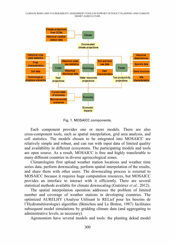
The five main components of the models (Fig. 1) are:
• Statistical methods for downscaling climate projections from General
Circulation Models (GCMs)
• Crop growth models to simulate future crop yields
• A hydrological model for estimating river water resources
• A forest model to simulate biomass and tree species distributions
• A CGE (Computable General Equilibrium) model to assess the effect
of changing yields and water availability on national economies
CLIMATE RISKS AND VULNERABILITY ASSESSMENT TOOLS IN SUPPORT OF POLICY PLANNING AND CLIMATE
SMART AGRICULTURE
300
Fig. 1. MOSAICC components.
Each component provides one or more models. There are also
cross-component tools, such as spatial interpolation, grid area analysis, and
cell statistics. The models chosen to be integrated into MOSAICC are
relatively simple and robust, and can run with input data of limited quality
and availability in different ecosystems. The participating models and tools
are open source. As a result, MOSAICC is free and highly transferable to
many different countries in diverse agroecological zones.
Climatologists first upload weather station locations and weather time
series data, perform downscaling, perform spatial interpolation of the results,
and share them with other users. The downscaling process is external to
MOSAICC because it requires huge computation resources, but MOSAICC
provides an interface to interact with it efficiently. There are several
statistical methods available for climate downscaling (Gutiérrez et al., 2012).
The spatial interpolation operation addresses the problem of limited
number and coverage of weather stations in developing countries. The
optimized AURELHY (Analyse Utilisant le RELief pour les besoins de
l’Hydrométéorologie) algorithm (Bénichou and Le Breton, 1987) facilitates
subsequent model simulations by gridding climate data (and aggregating to
administrative levels, as necessary).
Agronomists have several models and tools: the planting dekad model
CLIMATE RISKS AND VULNERABILITY ASSESSMENT TOOLS IN SUPPORT OF POLICY PLANNING AND CLIMATE
SMART AGRICULTURE
301
(PLD) (Franquin, 1973), the water balance model (WABAL) (Frère and
Popov, 1986), and the crop water productivity model (AQUACROP)
(Steduto et al., 2009). AQUACROP simulates crop yield and is used usually
in specific locations because it requires a number of data collected in the
field. WABAL is a simpler model with limited requirements of input data
and produces crop-specific water balance variables as outputs. The variables
are used to construct statistical models to simulate crop yield. The WABAL
approach is more suitable for assessments at larger spatial scale. Many
different crops can be simulated as long as necessary data are available.
Hydrologists work with a model called STREAM (Spatial Tools for
River Basins and Environment and Analysis of Management Options) (Aerts
et al., 1999). It is a rainfall-runoff model that simulates discharges in river
basins. The water availability is calculated at sub-basin level, depending on
data availability.
For foresters, MOSAICC provides LANDIS (Landscape Disturbance and
Succession) (Scheller and Mladenoff, 2004), which simulates forest
succession, disturbance (including fire, wind, harvesting, insects), and seed
dispersal across large landscapes. LANDIS requires a huge number of
parameters. MOSAICC provides an interface to deal with all the details and
re-arranges the information in required files. The results are post-processed
to generate key variables: forest biomass, tree species distributions,
biodiversity, establishments, forestry evolution, Leaf Area Index (LAI), and
non-wood products.
Economists have the DCGE (Dynamic Computable General Equilibrium)
model (Lofgren et al., 2002) to work with. It simulates the current and future
economy under different climate projections. The model distinguishes the
national economy and that of the rest of the world, between which goods and
services are exchanged. The model uses crop yields and water availability
generated by agronomists and hydrologists as shocks to the national
economy. The main outputs are macro indicators (GDP), domestic market
variables, external trade variables, and prices.
Key outputs of MOSAICC simulations are future projected values of
these different variables simulated by each model. All the models can use the
data generated from other models through a central geospatial database. The
user works on MOSAICC with a web browser to connect to the MOSAICC
server over the Internet. Data, models and results are all on the server.
Nothing is required on the user’s computer. The systems installed in
countries can be easily upgraded remotely by MOSAICC developers.
CLIMATE RISKS AND VULNERABILITY ASSESSMENT TOOLS IN SUPPORT OF POLICY PLANNING AND CLIMATE
SMART AGRICULTURE
302
IMPLEMENTATION OF MOSAICC IN COUNTRIES
Information needs and capacity assessments
MOSAICC was successfully implemented in the Philippines, Indonesia,
Morocco, Peru, Paraguay, Uruguay, Malawi, and Zambia. In order to ensure
that local researchers use MOSAICC to produce information that are useful
for stakeholders, we emphasize a country-driven process for implementing
MOSAICC. A typical implementation of MOSAICC in a new country starts
with a stocktaking exercise of existing information in the country about
climate change impacts on agriculture. Once gaps in information availability
become clear, national ministries are consulted as main stakeholders. They
provide their views about needs for information about climate impacts in the
sector for adaptation policies and programmes. In many cases, ministry of
agriculture and its climate change office are the main stakeholders. They
have responsibility for developing climate change adaptation policies and
programmes. Information on potential climate change impacts support their
work. For example, in Peru, the Ministry of Agriculture and Irrigation
(MINAGRI) was identified as the main stakeholder and its Vice-minister
chaired the steering committee of the project that implemented MOSAICC.
Other ministries such as the Ministry of Environment were also consulted.
In parallel with information needs assessment, country's technical and
institutional capacities in filling the gaps are assessed, across national
research institutes and universities. In Peru, the National Meteorological and
Hydrological Services, the National Agrarian University in La Molina, the
Office of Economic and Statistical Studies in MINAGRI, were found to
possess relevant knowledge and skills.
Interdisciplinary technical working group
If MOSAICC appears to address country's information and capacity gaps, we
start forming an interdisciplinary technical working group that is composed
typically of ministries, national research institutes, and universities, and the
group is supervised by the project steering committee. The main members of
the group are subject experts that will be responsible for running simulations
with each component of MOSAICC. Climatologists in national weather
service often take responsibility for climate component. National agricultural
research institutes may take on crop simulations. The group also includes
policy makers as a main stakeholder. They guide a climate change study as a
member of the working group from study design to communication of the
results. Other technical offices of the government can also provide necessary
CLIMATE RISKS AND VULNERABILITY ASSESSMENT TOOLS IN SUPPORT OF POLICY PLANNING AND CLIMATE
SMART AGRICULTURE
303
data and expertise as a member of the group. The agencies mentioned in the
previous section constituted the Peruvian technical working group. In the
Philippines, the Department of Agriculture, Philippine Atmospheric,
Geophysical and Astronomical Services Administration, Philippine Rice
Research Institute, University of the Philippines – National Institute of
Geological Sciences were the main members of the technical working group.
Data collection is a time-consuming process. MOSAICC requires
relatively small amount of data as inputs to models, but data are often
scattered across different offices, and not in a format suitable for computer
processing. We also make sure that the data providers agree on sharing the
data with all members of the technical working group so that a truly
collaborative research is possible. Digital elevation model (DEM), land use,
soil properties, weather data, hydrological data, crop yield statistics, and crop
parameters are examples of data that are necessary for MOSAICC
simulations.
As a next step, the technical working group agrees on the study
objectives, study design (including time periods, target crops, study areas,
basins, etc.), taking account of stakeholder needs and data availability. In the
process, the group members have an opportunity to reflect on country’s
context, and to build a common understanding about what would constitute a
successful adaptation to climate change in the agriculture sector, and what
kind of information MOSAICC should produce in support of achieving the
goal.
The Philippines decided to examine climate change impacts up to
mid-21st century. The climate statistical downscaling work is considered to
complement dynamical downscaling work conducted in the past, and to
provide up-to-date information with a new set of climate projections
(CMIP5). Their MOSAICC crop and hydrology work were designed to
highlight differentiated impacts of climate change in different locations
across the whole country with a focus on rice and corn at the province level,
and 24 river basins. Peru was interested in extending the projections up to
the end of the 21st century, with a set of 29 crops at the region level, and 16
river basins that represent different agroecological systems.
Usually at least two Representative Concentration Pathways are
examined (e.g. RCP 4.5 and RCP 8.5). Also at least three climatic models are
evaluated in order to account for uncertainties from GCMs. The spatial scale
for simulations is flexible, but MOSAICC’s system design and model
choices are most appropriate for national-level studies with sub-national
disaggregation. MOSAICC primarily deals with medium- to long-term
climate change time scale, beyond 10 years. The downscaled climate
projections are daily data so aggregation to any temporal scales (10-day,
month, season, year, etc.) is possible, and changes in frequency and intensity
CLIMATE RISKS AND VULNERABILITY ASSESSMENT TOOLS IN SUPPORT OF POLICY PLANNING AND CLIMATE
SMART AGRICULTURE
304
of extreme events, for example, can also be studied.
Capacity development and simulations
Capacity development is another important focus in our MOSAICC
implementation strategy. Climate change adaptation planning is a long and
iterative process that should be periodically reviewed with new evidence,
science, and outcomes from adaptation interventions. The capacities of
country experts to carry out science work that forms an evidence-base about
climate impacts and adaptation are key to a sustainable policy planning
process. We provide extensive training programs to the identified local
experts for use of each component of MOSAICC. At least one week of
training per component is usually provided. The sustainability of strengthened
technical capacities of individual experts is ensured by commitment of all
stakeholders represented in the interdisciplinary technical working group.
The idea is that country experts can perform simulations using their
country's own data in support of national planning. The trainers, who are
original developers of participating MOSAICC models, continue to provide
technical support to make sure the experts can accomplish simulation studies,
after training. It takes about three months (per component) for experts to
perform simulations provided dedicated researchers are assigned to the task.
Communication of results
Running simulations is only part of climate impact studies. The simulation
results need to be analysed, interpreted, and visualized for stakeholders. They
would inform policy makers of which areas / sub-sectors / crops / basins /
forest species are more vulnerable than others are. The information would
strengthen evidence-bases that support adaptation planning and allow
strategic resource allocations, investment programmes, research and
development, and prioritization of adaptation interventions.
The technical working group is tasked to make sure that the modellers can
communicate the implications of model outputs to aid policy processes.
Communication of the results can take a number of other forms: presentation
in conferences, paper and electronic publications, and web site. MOSAICC is
designed to publish results from the simulation server in a seamless manner as
graphs/maps to the web server.
The work in the Philippines was presented in a national project conference
hosted by the Department of Agriculture, with wide participation from other
Departments, Climate Change Commission, research institutes, universities,
international development agencies, NGOs, and media. The nation-wide
assessment work was highly appreciated and forms a basis for National
CLIMATE RISKS AND VULNERABILITY ASSESSMENT TOOLS IN SUPPORT OF POLICY PLANNING AND CLIMATE
SMART AGRICULTURE
305
Adaptation Plans in the agriculture sector, Philippine Development Plan,
National Climate Change Action Plan, and other policy processes.
In the following section, we provide two case studies. The Paraguay case
focuses more on scientific results while the Malawi case examines the
country-driven implementation process.
CASE STUDIES
Paraguay
Climate change impact assessment in the agriculture sector in Paraguay was
conducted as part of the Analysis and Mapping of Impacts under Climate
Change for Adaptation and Food Security (AMICAF) project. Climate
downscaling in Paraguay was based on the historical meteorological
information from 12 meteorological stations for the entire country. The
historical reference time considered was 1981 to 2010. The models under
analysis showed that a reduction in precipitation is expected for both time
periods up to 2070, while temperatures (maximum and minimum) are
expected to increase. The models showed a range of possible decrease in
precipitation from 2.40% to 10.24% under RCP4.5 while a possible decrease
in precipitation for RCP8.5 was 3.27 % to 15.92 %. Projected temperature
increases are from 1.8 to 2.7°C (TMax) and 1.8 to 3.3°C (TMin) under the
RCP4.5 and from 2.3 to 3.3°C (TMax) from 2.18 to 4°C (TMin) under the
RCP8.5.
The impact assessment of climate change on crops included the analysis of
historic yields and projected trends for the future. 8 crops were selected for
this analysis: sugarcane, common beans, cassava, corn, wheat, soybean,
irrigated rice and non-irrigated rice. The results showed great heterogeneity in
terms of future impacts on the yield of crops at the department level due to
climate change, with both increasing and decreasing projections for different
departments/crops. For several crops, no significant differences between
historical and expected future yields were reported, or different GCM
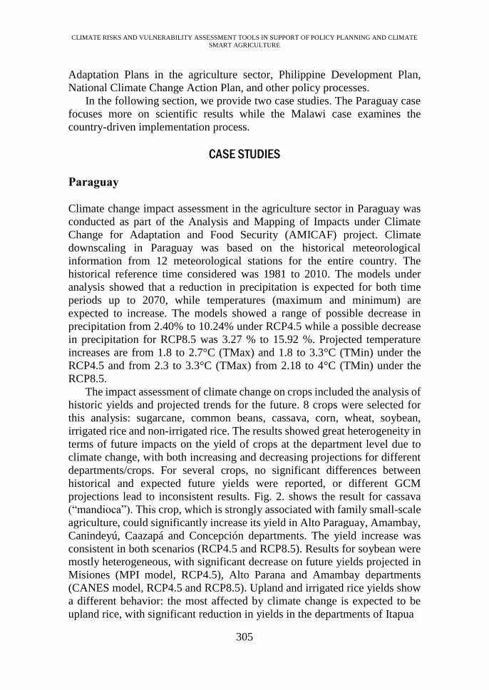
projections lead to inconsistent results. Fig. 2. shows the result for cassava
(“mandioca”). This crop, which is strongly associated with family small-scale
agriculture, could significantly increase its yield in Alto Paraguay, Amambay,
Canindeyú, Caazapá and Concepción departments. The yield increase was
consistent in both scenarios (RCP4.5 and RCP8.5). Results for soybean were
mostly heterogeneous, with significant decrease on future yields projected in
Misiones (MPI model, RCP4.5), Alto Parana and Amambay departments
(CANES model, RCP4.5 and RCP8.5). Upland and irrigated rice yields show
a different behavior: the most affected by climate change is expected to be
upland rice, with significant reduction in yields in the departments of Itapua
CLIMATE RISKS AND VULNERABILITY ASSESSMENT TOOLS IN SUPPORT OF POLICY PLANNING AND CLIMATE
SMART AGRICULTURE
306
Fig. 2. Projected Cassava yield changes under RCP 4.5 and 8.5 for different
GCMs.
(red – decrease; green – increase; yellow – no significant changes)
and Canindeyú. Irrigated rice shows instead positive changes in yields in the
departments of Cordillera and Misiones, and negative for Paraguarí.
In summary, negative impacts of climate change are expected for
sugarcane (in five departments), soybeans in three departments, and upland
rice in two departments. Interestingly, cassava shows a positive impact of
climate change on yields for approximately the same region for which
CLIMATE RISKS AND VULNERABILITY ASSESSMENT TOOLS IN SUPPORT OF POLICY PLANNING AND CLIMATE
SMART AGRICULTURE
307
negative impact is observed for sugarcane. Common bean yields are
expected to increase in three departments, and decrease in three other
departments. We can conclude that higher climate change risks concern
sugarcane, soybeans and upland rice, while wheat, maize and common beans
show no significant changes, or both positive and negative changes. We can
consider these crops as the most resilient, while cassava yields appear to
mainly benefit from climate change effects. These Paraguay results are a
good example of evidence that facilitates transformational adaptation
planning with potential options such as shifting cultivating areas of key crops
within a country.
Malawi
The Government of Malawi is committed to taking action to tackle food
security and climate change challenges. Over the last two decades, Malawi has
scaled up its efforts to identify vulnerabilities and related adaptation priorities,
and to mainstream climate change adaptation into development and sectoral
planning. The National Adaptation Plan process was launched in 2014 to
provide medium- to long-term options for Malawi to address adaptation needs.
In 2017, Malawi Growth and Development Strategy (MGDS) III was
established to move the country to a sustainable development growth path.
MDGS III recognizes that climate change has adverse impacts on the
agriculture sector.
FAO began supporting the integration of the agriculture sectors into the
Malawi NAP process in 2015. FAO is also a member of the NAP Core Team –
the formal coordinating mechanism at national level, driving this process and
reporting to the National Climate Change Technical Committee (NCCTP). A
stocktaking exercise found that decisions at ministry level are reached without
the backing of data and evidence, which make it difficult to monitor policies
for success or failure. FAO supported the use of MOSAICC by domestic
experts with the objective to incorporate a strong evidence base in policy
making. In the 2015-2016 rainfall season Malawi was hit by a prolonged dry
spell, and agriculture was severely affected by the drought. It was estimated
that this season saw 12.4% decline from the 2014/15 season in overall food
production, which was already down by about 30% (due to 2015 floods)
compared to the 2013/14 season (Government of Malawi, 2016). These two
extreme weather events together became a strong drive within the country to
assess the impacts of climate change on agriculture.
Key national stakeholders are engaged at every stage in the MOSAICC
process to ensure that the outputs exemplify local expertise and national
priorities. By bringing together national experts from across institutions,
participants in the process can prioritize activities taking the various
CLIMATE RISKS AND VULNERABILITY ASSESSMENT TOOLS IN SUPPORT OF POLICY PLANNING AND CLIMATE
SMART AGRICULTURE
308
perspectives and objectives into consideration. Stakeholder engagement also
ensures long-term sustainability and capacity development. Upon completion
of the MOSAICC process, local experts have the capacity to repeat the
exercises if new information (e.g. emission scenarios, updated data) becomes
available or national adaptation goals change. Also the Parties to the
UNFCCC are required to update National Communication every four years,
which include the types of evidence that MOSIACC produces. In Malawi, key
stakeholders involved are the Lilongwe University of Agriculture and Natural
Resources, the Department of Climate Change and Meteorological Services,
and the Departments of Agriculture Research Services, Agriculture Planning
Services, and Irrigation and Water Development. MOSAICC is also used in
the University as a training tool for students, who will be contributing to the
relevant work in academia or in the ministries in the future.
Country ownership is prioritized in the implementation of MOSAICC.
The process starts with the collection of data (meteorological, crop yield, etc.),
a process that also acts as a stocktaking exercise to identify potential data gaps
within the country. One of the issues encountered at this stage was that some
of the meteorological data are not in digital format, and records on paper had
to be digitized and manually entered into a database. Another issue was the
lack of systematic recoding of crop planting dates, which required capacity
and time to harmonize for use in any data processing activity.
Capacity building is a core element of MOSAICC and ensures that lessons
learned in establishing a climate information system are sustainable. A
computer server was provided to the country on which MOSAICC is installed.
Trainings on each module of MOSAICC, IT maintenance, climate and crop
were carried out. The trained experts were supported by FAO experts until the
completion of simulations using MOSAICC and report writing. The final
outputs of MOSAICC in Malawi include long-term climate projections
downscaled to local level, and projected crop yields, for five major crops
across eight districts up to 2070. The responsibility, management, and
ownership of the data, tools and results remain in the country. The final results
were presented to stakeholders in the final technical workshop. This workshop
served as the opportunity for validation of the results by stakeholders, and the
results were treated as the material to start discussion within and across the
ministries. The stakeholders were mostly convinced of the results of the
analysis, while they disagreed with some of the outputs. It was pointed out that
several key management practices such as irrigation were not well considered,
which resulted in misleading projections of crop productions in the future. The
Department of Agriculture Irrigation and Water Development particularly
showed a great interest in the simulation outputs, as the results may directly
affect their plan for selecting the location of new irrigation systems in the very
near future.
CLIMATE RISKS AND VULNERABILITY ASSESSMENT TOOLS IN SUPPORT OF POLICY PLANNING AND CLIMATE
SMART AGRICULTURE
309
Currently Malawian team is in the process to finalize the technical report
and disseminate their results to relevant stakeholders including several
ministries, reflecting the discussion at the final technical workshop. With
various degree of agreement due to spatial aggregation and future projections
range, they were able to identify consistency in climate projections in specific
areas, crops particularly sensitive (or insensitive) to this change, or areas
particularly impacted for most of the crops, for instance. The nation-wide
information, directly related to policy relevant administrative boundaries,
provides a new basis for improving adaptation measures (e.g. new crops of
relevance, irrigation option) for the government.
Several important lessons were learned in the implementation process.
Participating experts referred to the lack of human resources within the
ministries as a limiting factor in maintaining momentum to complete the
MOSAICC process. Strong encouragement of the team leader and senior
management of the ministries to push the process forward is necessary to
successfully coordinate the various components and to keep the experts
engaged throughout. The final objectives and key milestones should be clearly
laid out to incentivize the work. The utility of learning these models and the
transferability of the skills gained should be clear to the experts as additional
motivations to be involved in MOSAICC exercises.
CONCLUSION
Agriculture is widely recognized as one of the most vulnerable sectors to
climate change, and it requires urgent action, from the farm to global level.
Global agendas that frame the challenges are in place – Sustainable
Development Goals, Sendai Framework for Disaster Risk Reduction, and
Paris Agreement. Scaling up measures for climate-smart agriculture, and
particularly adaptation actions are important in the agriculture sector for many
developing countries. In view of promoting transformational adaptation,
critical knowledge and capacity gaps have been identified in Asia-Pacific
countries – lack of policy-relevant information on evidence about climate
risks and vulnerability in agriculture (and its sub-sectors) at the right spatial
and temporal scales; and limited capacities to produce evidence in the country
and to link them with policies.
Modelling System for Agricultural Impacts of Climate Change
(MOSAICC) has been developed and transferred to countries to address the
gaps. This in-country, simple, robust and modular nature of the platform
makes it a useful and accessible tool for nation-wide, nation-relevant,
collaborative and integrated assessment. This approach contributes to building
more sustainable institutional capacities within countries, hence improving
ownership, relevance and uptake of the assessment. The trained national
CLIMATE RISKS AND VULNERABILITY ASSESSMENT TOOLS IN SUPPORT OF POLICY PLANNING AND CLIMATE
SMART AGRICULTURE
310
experts can further promote the agricultural planning and policy based on the
evidence-base. It also enables national actors to periodically and
independently revisit climate change information in response to new science
and evidence. The locally developed evidence that is relevant to national
context supports policy discussions at the national level. The assessment,
conducted by the national experts, serves as a basis and a trigger for
inter-ministerial discussions. This brings relevant ministries to the same table,
and through stakeholder and expert validations, the outputs of the analysis are
reviewed and reflected in adaptation planning.
The involvement of the governmental people brings another benefit:
promotion of evidence-based adaptation within the community of practice.
They attend regional and international workshops on climate change
adaptation frequently, and exchange information with other countries. A
successful experience of a country in implementing agricultural policies based
on robust evidence motivates other countries to do so in their own country too.
South-south cooperation has also been facilitated by FAO between
Philippines and Indonesia, and Peru and Paraguay, where the lessons learned
in one country are communicated to the other, resulting in successful
implementation.
Although not discussed in this paper, FAO is also developing a tool to
analyze daily weather observation data, from agronomic point of view, in
terms of intensity and frequency of extreme weather events, with dozens of
indices defined for crop-specific agronomic seasons. The tool facilitates
visualization of the trends in the weather indices with ability to set
user-defined thresholds for extremes. The philosophy for the agronomic
weather indices is the same as MOSAICC — easy-to-use, policy-relevant,
decision-making and capacity development tool, in support of adaptation
planning.
There are high expectations for science community to contribute to the
climate change and agriculture agenda by making scientific information
available to national policy making process, and by making tools more
accessible to the global community of adaptation practitioners. Models and
methodologies originally developed for research can be translated into
practical tools for decision making. More application-oriented research can
be designed which may influence national and sub-national policies and
actions. The adaptation community, with un-biased assistance from scientists,
will be able to make an informed decision about how to produce evidence —
choice of tools and requirement of data. A guidance on selection of tools is
particularly important because any tool is developed for specific purposes
and for answering certain types of questions, and there is no one single best
tool. However it is difficult for practitioners to understand the differences in
characteristics of tools. A neutral forum where scientists and adaptation
CLIMATE RISKS AND VULNERABILITY ASSESSMENT TOOLS IN SUPPORT OF POLICY PLANNING AND CLIMATE
SMART AGRICULTURE
311
community can exchange information for advancing climate change risks
and vulnerability assessment will be highly useful. There are opportunities
for further strengthening collaboration between the academia and the
development community in the work of climate risks, vulnerability and
adaptation assessment.
REFERENCES
Aerts, J.C.J.H., M. Kriek, and M. Schepel. 1999. STREAM, spatial tools for
river basins and environment and analysis of management options: set up
and requirements, Physics and Chemistry of the Earth, Part B:
Hydrology, Oceans and Atmosphere, 24, 591-595.
Bénichou, P., and O.A. Le Breton. 1987. AURELHY: Une méthode
d’analyse utilisant le relief pour les besoins de l’hydrométéorologie.
Journées Hydrologiques de l’ORSTOM à Montpellier, 2, 299–304.
FAO, IFAD, UNICEF, WFP and WHO. 2018. The State of Food Security
and Nutrition in the World 2018. Building climate resilience for food
security and nutrition. Rome, FAO.
Franquin, P. 1973. Analyse agroclimatique en régions tropicales. Méthode
des intersections et période fréquentielle de végétation. Agronomie
tropicale, 28, 665-682.
Frère, M. and G.F. Popov. 1986. Early Agrometeorological crop yield
forecasting. FAO Plant Production and Protection, FAO, Paper No 73. ,
150.
Government of Malawi. 2016. Malawi drought 2015-16 post-disaster needs
assessment (PDNA).
Gutiérrez, J.M., D. San-Martín, A.S. Cofiño, S. Herrera, R. Manzanas, and
M.D. Frías. 2012. User Guide of the ENSEMBLES Downscaling Portal.
Version 3. Technical Note 2/2012, Santander Meteorology Group, Spain.
IPCC. 2014. Annex II Glossary. In: Climate Change 2014: Impacts,
Adaptation, and Vulnerability. Part A: Global and Sectoral Aspects.
Contribution of Working Group II to the Fifth Assessment Report of the
Intergovernmental Panel on Climate Change [Field, C.B., V.R. Barros,
D.J. Dokken, K.J. Mach, M.D. Mastrandrea, T.E. Bilir, M. Chatterjee,
K.L. Ebi, Y.O. Estrada, R.C. Genova, B. Girma, E.S. Kissel, A.N. Levy,
S. MacCracken, P.R. Mastrandrea, and L.L.White (eds.)]. Cambridge
University Press, Cambridge, United Kingdom and New York, NY, USA,
pp. 485-533.
Jones, P.G. and P.K. Thornton. 2009. Croppers to livestock keepers:
livelihood transitions to 2050 in Africa due to climate change.
Environmental Science & Policy, 12, 427-437.
Kates, R.W., W.R. Travis, and T.J. Wilbanks. 2012. Transformational
CLIMATE RISKS AND VULNERABILITY ASSESSMENT TOOLS IN SUPPORT OF POLICY PLANNING AND CLIMATE
SMART AGRICULTURE
312
adaptation when incremental adaptation to climate change are
insufficient. Proceedings of the National Academy of Sciences of the USA,
109, 7156-7161.
Lofgren, H., M. Thomas, and M. El-Said, 2002, A Standard Computable
General Equilibrium (CGE) Model in GAMS, A Standard Computable
General Equilibrium (CGE) Model in GAMS, International Food Policy
Research Institute 5, International Food Policy Research Institute.
Porter, J.R., L. Xie, A.J. Challinor, K. Cochrane, S.M. Howden, M.M. Iqbal,
D.B. Lobell, and M.I. Travasso. 2014. Food security and food production
systems. In: Climate Change 2014: Impacts, Adaptation, and
Vulnerability. Part A: Global and Sectoral Aspects. Contribution of
Working Group II to the Fifth Assessment Report of the
Intergovernmental Panel on Climate Change [Field, C.B., V.R. Barros,
D.J. Dokken, K.J. Mach, M.D. Mastrandrea, T.E. Bilir, M. Chatterjee,
K.L. Ebi, Y.O. Estrada, R.C. Genova, B. Girma, E.S. Kissel, A.N. Levy,
S. MacCracken, P.R. Mastrandrea, and L.L.White (eds.)]. Cambridge
University Press, Cambridge, United Kingdom and New York, NY, USA,
pp. 485-533.
Rippke, U., J. Ramirez-Villegas, A. Jarvis, S. Vermeulen, L. Parker, F. Mer,
B. Diekkruger, A.J. Challinor, and M. Howden. 2016. Timescales of
transformational climate change adaptation in sub-Saharan African
agriculture. Nature Climate Change 6. DOI:10.10387/NCLIMATE2947.
Scheller, R.M. and D.J. Mladenoff. 2004. A forest growth and biomass
module for a landscape simulation model, LANDIS: Design, validation,
and application, Ecological Modelling, 180, 211-229.
Steduto, P., et al. 2009. AquaCrop -The FAO crop model to simulate yield
response to water: I. Concepts and underlying principles, Agronomy
Journal, 101.3, 426-437.