The Progression of Vulnerability: - UCL Discovery
310
The Progression of Vulnerability: A multi-scalar perspective on disasters, the case of Chaitén, Chile Vicente Andrés Sandoval Henríquez Thesis submitted in fulfilment of the requirements of the degree of Doctor of Philosophy The Bartlett Development Planning Unit, UCL 2017
-
Upload
khangminh22 -
Category
Documents
-
view
1 -
download
0
Transcript of The Progression of Vulnerability: - UCL Discovery
The Progression of Vulnerability:A multi-scalar perspective on disasters, the case of Chaitén, Chile
Vicente Andrés Sandoval Henríquez
Thesis submitted in fulfilment of the requirements of
the degree of Doctor of Philosophy
The Bartlett Development Planning Unit, UCL
2017

Declaration of authorship
I, Vicente Andrés Sandoval Henríquez confirm that the work presented in this thesis is my own. Where information has been derived from other sources, I confirm that this has been indicated in the thesis.
Signature:
Abstract
This research analyses policy responses to disasters in Chile. The main objective is to explore linkages between temporally and spatially distant processes of policy, governance and decision-making, and the materialisation of disaster vulnerability in the form of ‘unsafe conditions’. The study focuses on the progression of vulnerability in a post-disaster context, critically reflecting on the multiplicity of agencies and pressures in creating and increasing vulnerability of a specific territory at local scale. The central argument is that the Chilean model of disaster risk management and reduction is dominated by top-down and reactive approaches that tend to diminish the potentials of policy responses to disasters and ultimately became sources of vulnerability and risk.
The research’s analytical framework is grounded in disaster studies and specifically it adopts a social constructionist approach to disaster, vulnerability and geographical scale focused on the Pressure and Release model. The latter allows one to look at the state territorial organisation of Chile as a structural factor in the national model of disaster management, and to place root causes and dynamic pressures of disaster vulnerability within the multi-scalar configuration of the country. The thesis chooses the Chaitén volcanic eruption that occurred in May 2008 in Los Lagos Region of Chile, and the disaster policy context in the country as the empirical base on which the argument is put forward.
Several policy responses are examined using qualitative methods at national, regional and local scales, revealing the centralisation of disaster governance in Chile as a key factor in producing inadequate responses to the disaster that failed to utilise people’s knowledge and local organisational capacities. This disaster policy context mediated the materialisation of four unsafe conditions in Chaitén: the uneven distribution of risks; the limited access to services; the erosion of trust in public authorities; and the weaknesses of emergency planning.
The research re-problematises and suggests new ways of ‘thinking vulnerability’ and disaster governance from a wider multi-scalar perspective. It explains that when policy responses to disasters do not consider local capacities and realities, these can facilitate the (re)production of unsafe conditions, and contribute to and perpetuate the generation of risks over time. This could help to challenge some still dominant views found in Chile and in many other national governments that dissimulate the causality of disaster generation and risk accumulation.
5
Acknowledgements
I would like to express my gratitude to my principal and secondary supervisors Camillo Boano and Cassidy Johnson for their aspiring guidance and invaluable constructive insights during the project work. I am sincerely grateful to Julio Dávila, Martin Voss, and Colin Marx for their meaningful support. Special thanks to my friends and colleagues Rosalina Babourkova, Claudia González-Muzzio, Daniel Oviedo, Cristian Albornoz, and Lucia Nascimento, and everyone who help me throughout the process of this research in Chile, Germany, and United Kingdom. A special thanks to the Government of Chile for financing this research.
I would like also to express my admiration to the people of Chaitén in Chile, for their courage and determination in adversity, and particularly I would like to thank those involved in the study for their time, openness, and hospitality. Finally, there is also my infinite gratitude to my partner Beatriz, and my daughter Emma and son Aitor, for their patience and love. Likewise, I would like to extend thanks to Rosamari and Javier for their support, as well as to my parents Miriam and Vicente for they taught me to always give my best effort.
Con amor para mi familia.
7
Table of contents
Abstract 5Acknowledgements 7List of figures 13List of tables 15List of acronyms and abbreviations 17
Chapter ONE 19Introduction
1.1 Objectives, justification, and questions 231.2 Methodology: research design and methods 291.3 Structure of the thesis 36
Chapter TWO 41Research strategy and methodology
Introduction 412.1 Case Study Strategy 42
2.1.1 Research questions 472.1.2 Theoretical propositions 502.1.3 Units of analysis, and other elements of the case study design 52
2.2 Research methodology 552.2.1 Considerations of quantitative and qualitative approaches 562.2.2 Period of research and feedback 582.2.3 Research methods 602.2.4 History as a ‘proxy’ to approach geographical scales in Chile 71
2.3 Introducing the study’s analytical approaches 722.4 Limitations of the study 74
Chapter THREE: The social and multi-scalar progression of vulnerability 77Theoretical background and analytical framework
Introduction 773.1 Interpreting disasters and risks 793.2 Situating disaster vulnerability and its significance 82
3.2.1 Disaster and risk as social constructions 823.2.2 The rise of the social production of disaster vulnerability 843.2.3 Vulnerability approaches 913.2.4 Structural factors and the social production of vulnerability 94
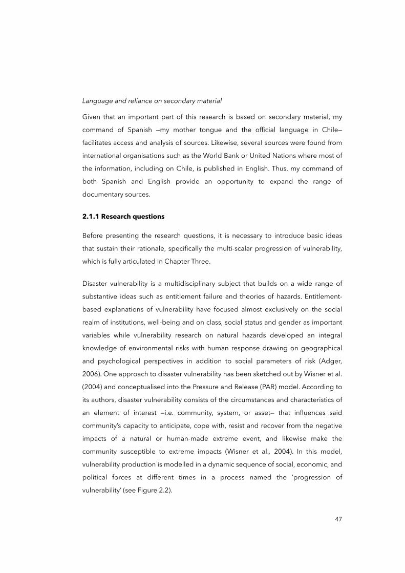
3.3 The PAR model and a scalar perspective 963.3.1 The PAR model explained 963.3.2 The multi-scalar progression of vulnerability 100
9
3.3.3 The social construction of scales 1033.4 Disaster governance, policy responses and vulnerability 1093.5 Analytical framework 112
Chapter FOUR: The disaster policy context in Chile 117Contextualising Chile
Introduction 1174.1 A brief history of Chilean disasters 118
4.1.1 The dominant view of the history of Chilean disasters: earthquakes 1204.1.2 History of disasters triggered by other extreme events 1264.1.3 Other issues in the mainstream view of the history 130
4.2 The ‘logic’ of the state territorial organisation of Chile 1344.2.1 The origins of the territorial structure of the state 1344.2.2 Approaching the current state territorial organisation 1394.2.3 The territorial structure of the state and the government 142
4.3 Economic model, centralisation and uneven development 1494.4 The model of managing disasters and reducing risks in Chile 155
4.4.1 The National Plan of Civil Protection and the ONEMI 1564.4.2 Legal frameworks for DRM and DRR 1614.4.3 Territorial planning instruments for DRM and DRR 169
4.5 Setting the context to analyse post-disaster Chaitén 175
Chapter FIVE: The case of post-disaster Chaitén 179Unpacking the policy responses
Introduction 1795.1 Chaitén, before and after the volcanic eruption: preparing the case 181
5.1.1 Introducing Chaitén 1835.1.2 A subsidised city? 190
5.2 The Chaitén disaster: emergency response 1935.2.1 Emergency meetings and the ‘dormant’ volcano 1955.2.2 The emergency response and evacuation 198
5.3 Recovery and relocation of Chaitén 2055.3.1 Friction between national and local decision-making 2065.3.2 The rebels: occupying Chaitén 2085.3.3 Compensation, benefits and subsidies 2125.3.4 The new Chaitén: the city relocation process 2175.3.5 Political shift on the Chaitén relocation 226
5.4 Reconstruction 2295.4.1 Occupying the South sector 2295.4.2 Chaitén (North) reconstruction plan? 233
10
5.4.3 Unmet demands 2345.4.4 Limited access to services 237
5.5 Mapping the progression of vulnerability 245
Chapter Six 255Conclusions
Introduction 2556.1 Research questions and epistemological implications 257
6.1.1 Vulnerability locally materialised 2576.1.2 Root causes of disaster vulnerability are often distant 262
6.2 Methodological and empirical implications 2656.2.1 Considering a multi-scalar perspective 2666.2.2 Guidance for policy and practice 269
6.3 Some reflections on the research experience 2746.4 Call and suggestions for further research 277
References 281Appendices 305
11
List of figures
Figure 1.1. Chaitén before and after the volcanic eruption 21
Figure 1.2. Analysed period of policy responses in the Chaitén disaster, 2008-2013 22
Figure 1.3. The disaster Pressure and Release (PAR) model 26
Figure 1.4. Case study entry points 32
Figure 2.1. National-local interplay in post-disaster Chaitén 45
Figure 2.2. The PAR model and its potential scalar dimensions 48
Figure 2.3. The case study method 51
Figure 2.4. Basic types of designs for case studies 52
Figure 2.5. The research process 53
Figure 2.6. Fieldwork and sub-fieldwork periods 59
Figure 2.7. Chaitén post-disaster 59
Figure 2.8. Research participants arranged by organisation and scales 66
Figure 3.1. The Hazards of Place Model of Vulnerability 91
Figure 3.2. The disaster Pressure and Release (PAR) model 98
Figure 3.3. The general model of DRM in Chile with the ONEMI 111
Figure 3.4. Mapping literature review, framing the analysis 114
Figure 4.1. Rationale for the chapter case study’s entry point 117
Figure 4.2. Areas flooded by the 1960 Chilean tsunami in Maullín (near to Valdivia) 122
Figure 4.3. Ships and factories destroyed by the 1960 Great Valdivia earthquake 123
Figure 4.4. La Nación’s headline, June 10, 1960 124
Figure 4.5. Administrative division by regions, provinces and municipalities, Chile 143
Figure 4.6. PAR model illustrating potential links between in Chaitén 154
Figure 4.7. Rationale for the case study’s chapter, entry point and progress 155
Figure 4.8. Relations between the PNPC, SNPC and ONEMI, and their functions 158
Figure 4.9. Structure of the National System of Civil Protection and ONEMI’s role 160
Figure 4.10. Map of the legal structure of the DRM and DRR model in Chile 168
Figure 4.11. Map of the institutional forms for DRM and DRR in Chile 176
13
Figure 5.1. Rationale for the second phase of the case study 179
Figure 5.2. Analysed period of policy responses in the Chaitén disaster, 2008-2013 180
Figure 5.3. Chaitén before and after the volcanic eruption 182
Figure 5.4. Physical impacts of the volcanic mudflows in Chaitén, May 2-4, 2008 183
Figure 5.5. Map of Los Lagos Region 185
Figure 5.6. Community activities in Chaitén 187
Figure 5.7. Public service buildings in Chaitén in 2013 191
Figure 5.8. Distribution of Chaitén municipal personnel by contract (2009-2015) 192
Figure 5.9. Distribution of Chaitén municipal income (2000-2015) 193
Figure 5.10. Map of exposed areas, and labels by national authorities 195
Figure 5.11. Map of the Province of Palena 197
Figure 5.12. Evacuees’ destinations from Chaitén, May 2-4, 2008 200
Figure 5.13. Progression diagram of vulnerability drivers during the early response 204
Figure 5.14. Distribution of policy responses in the Chaitén disaster 205
Figure 5.15. Demonstrations of Chaiteninos in Chaitén and Santiago 208
Figure 5.16. Demonstration on the Rio Blanco Bridge 215
Figure 5.17. Progression diagram of vulnerability drivers during the recovery 216
Figure 5.18. Location alternatives for the New Chaitén 219
Figure 5.19. Santa Barbara station to initiate the New Chaitén 222
Figure 5.20. Design proposal for the coastline of the New Chaitén 222
Figure 5.21. Progression diagram of vulnerability drivers during the relocation 225
Figure 5.22. Mitigatory infrastructures in Chaitén 230
Figure 5.23. Demolition works in the South sector of Chaitén 232
Figure 5.24. Bus arriving at the seaport and landed plane at the local airport 236
Figure 5.25. Walking distances between two spots in Chaitén in 2005 and 2016 238
Figure 5.26. Chaitén resident walking to the South sector 239
Figure 5.27. Demolished housing units in the South sector of Chaitén 240
Figure 5.28. Neighbourhood grocery store in the South sector of Chaitén 241
Figure 5.29. Progression diagram of vulnerability drivers during the reconstruction 242
14

Figure 5.30. Progression diagram of vulnerability drivers for the case of Chaitén 246
Figure 5.31. Scatter diagram for policy responses in post-disaster Chaitén,considering ‘progression of vulnerability’ and ‘geographical scales’ 249
Figure 5.32. Scatter diagram for policy responses in post-disaster Chaitén,considering ‘progression of vulnerability’ and ‘time in units of years’ 252
Figure 6.1. Case study entry points 256
Figure 6.2. Vulnerability progression diagram, Chaitén reconstruction phase 258
Figure 6.3. Scatter diagram of vulnerability progression, reconstruction phase 266
Figure 6.4. Two common diagram usages in PAR model analyses 267
Figure 6.5. Progression of vulnerability in Botshabelo, South Africa 267
Figure 6.6. Progression diagram of vulnerability drivers during the reconstruction 268
Figure 6.7. Complementarity of diagrams for analysing the multi-scalar progressionof vulnerability 269
List of tables
Table 4.1. Impacts in neighbouring countries of the 1960 Great Valdivia earthquake
Table 4.2. Disasters related to extreme natural events in Chile (1562-2016)
Table 4.3. Top 10 disasters in Chile sorted by human losses (1900-2015)
Table 4.4. Top 10 disasters in Chile sorted by costs (1900-2015)
Table 4.5. Regional GDP participation in percentages of national GDP
Table 4.6. Legal structure of the National System of Civil Protection in Chile
Table 4.7. Other regulations related to DRM and DRR in Chile
Table 4.8. Legal frameworks on ‘prevention’ related to DRM and DRR in Chile
Table 4.9. Territorial Planning Instruments that encourage risk assessments
Table 4.10. ONEMI’s annual budget in relation to the national GDP 2008–2013
Table 5.1. No. of workers per activity in Chaitén and Los Lagos Region (2006-2013)
Table 5.2. Intendentes of Los Lagos Region 2006-2015
Table 5.3. State budget to invest in Chaitén’s connectivity 2011-2014
15
List of acronyms and abbreviations
CASEN National Socio-Economic Survey
CH-7 Austral Highway
CIGIDEN National Research Centre for Integrated Natural Disaster Management
CIVDES Research Centre for Vulnerability and Socio-natural Disasters
COE Emergency Operation Centre
CPC Civil Protection Committee
CREDEN National Commission for Resilience to Disasters of Natural Origin
DDU Urban Development Division of the MINVU
DFL Decree with Force of Law
DKKV German Committee for Disaster Reduction
DL Decree-law
DRM Disaster Risk Management
DRR Disaster Risk Reduction
DS Supreme Decree
EM-DAT Emergency Events Database
FCM Municipal Common Fund
FNDR National Fund for Regional Development
FNR National Reconstruction Fund
GAR Global Assessment Report on Disaster Risk Reduction
GORE Regional Government of Los Lagos Region
HFA Hyogo Framework for Action 2005-2015
IFRC International Federation of Red Cross and Red Crescent Societies
INDAP National Institute for Agricultural and Livestock Development
IPCC Intergovernmental Panel on Climate Change
IPT Territorial Planning Instrument
IRDR Integrated Research on Disaster Risk
LA RED Network of Social Studies in the Prevention of Disasters in Latin America
MEP Municipal Emergency Plan
MIDEPLAN Ministry of Planning
MINSAL Ministry of Health
MINVU Ministry of Housing and Urbanism
MOP Ministry of Public Works
NCh433 Chilean Standard for Seismic Design of Buildings Nº429
17
ODEPLAN National Planning Office
ONEMI National Emergency Office of the Ministry of Interior and Public Security
OVDAS Southern Andean Volcano Observatory
PAR The disaster Pressure and Release model
PNPC National Plan of Civil Protection
PROT Regional Plan for Territorial Planning
PUC Pontificia Universidad Católica de Chile
RADIX Radical Interpretations of Disasters and Radical Solution
SDGs Sustainable Development Goals
SEREMI Regional Ministerial Secretaries
SERNAGEOMIN National Geology and Mining Service
SFDRR Sendai Framework for Disaster Risk Reduction 2015-2030
SHOA Chilean Navy Hydrographic and Oceanographic Service
SII National Tax Service
SINIM National System of Municipal Information
SMR Santiago Metropolitan Region
SNPC National System of Civil Protection
SUBDERE Subsecretariat for Regional Development and Administration
UACh Universidad Austral de Chile
UN-IDNDR United Nations International Decade for Natural Disaster Reduction
UNDESA United Nations Department of Economic and Social Affairs
UNDP United Nations Development Programme
UNDRO United Nations Disaster Relief Organization
UNESCO United Nations Educational, Scientific and Cultural Organization
UNISDR United Nations Office for Disaster Risk Reduction
US$ United State Dollar
USGS U.S. Geological Survey
18
Chapter ONEIntroductionThis doctoral journey began in 2008 when I moved to Berlin from Temuco, Chile,
with the intention of preparing myself to research social issues. I studied
management, planning and development linked to urban development in the
Global South, and I learnt various theories, methodologies and techniques that
helped me to develop my interest in disasters. But it was not until the 8.8-magnitude
Maule earthquake struck Chile in 2010 and the comparable 7.0-magnitude Haiti
earthquake in the same year that I became interested in disasters, and especially in
the underlying causes that contributed to the enormous difference in the impact of
these two events.
When I started the research back in 2011 my main aim was to understand how
macro forces and widespread processes such as globalisation and political
economic policies could exacerbate vulnerability to disaster at local levels. Chile’s
socio-economic and political history is linked to the current centralisation of power
and resources (Atienza and Aroca, 2012), privatisation of public services, and
deregulation of various sectors (Solimano, 2012). This has increased inequality
which, in turn, has precipitated an uneven distribution of vulnerability across regions
and population groups, with isolated and marginalised communities being
particularly vulnerable (Pulgar Pinaud, 2014a).
The translation of vulnerabilities and risks from global and national level to local
levels has long been a topic of social scientific research, but as yet there is no
consensus amongst central and local governments about how to reduce disasters
and risks and the development of such consensus is hindered by other more urgent
—although complementary— work on resilience, sustainable development and
adaptation to climate change (Maskrey, 2016). Vulnerability to disaster and the risk
of disaster are highly complex issues that encompass environmental, cultural, social,
economic and political factors. There is no single, uncontested cause of disasters, or
19

the factors governing vulnerability, risk and their mitigation. This may have
contributed to the confounding of vulnerability and risk (Cardona, 2006). This thesis
takes a practical approach, examining some aspects of policy responses to disasters
and decision-making that are particularly relevant to vulnerability and risk, and looks
at how communities at risks, governments, policies, and institutions relate at multiple
scales in response to disaster. This thesis recognises, however, that the environment
and extreme events contribute to the aetiology of disaster, the impact of disasters,
vulnerability to disasters and the risk of disasters.
This was the case in the aftermath of the Chaitén disaster in southern Chile. Chaitén
is a remote port city that was affected by a volcanic eruption in 2008 and its path to
recovery has been difficult. Generally termed a ‘local disaster’ by the media and
politicians, the Chaitén eruption provides an opportunity for a case study of how
apparently ‘local’ vulnerability is in fact embedded in the wider geographical and
temporal context and involves a complex web of national, regional, and local social
relations, including governance, power and gender relations, and economic and
political processes. Thus, the study of widespread processes nested on global and
national levels, and of vulnerable conditions at urban and local levels, involves the
shift from a single scale of analysis —Chaitén city— to focusing on the ‘process’ of
vulnerability creation. It is at this point that adopting a ‘perspective of scale’ begins
to seem both interesting and necessary to the simultaneous analysis of the
phenomena of disaster vulnerability and risk from different geographical and
temporal perspectives. In this thesis I adopt a perspective of scale to capture the
social relations linked to disaster risk management (DRM) and disaster risk reduction
(DRR) in Chile as they are configured at different spatial levels. I focus on the vertical
and horizontal links between local and extra-local levels. Specifically, I investigated
the processes of centralisation and decentralisation of the Chilean state from
historical and territorial administrative perspectives, to try to explain why the current
Chilean model of DRM and DRR is highly centralised, top-down and reactive, and
how policy responses to disaster —embedded within this model— may have
facilitated the reproduction of vulnerability during the aftermath of the Chaitén
20
disaster. By model of DRM and DRR I refer to a particular mode of dealing with the
reduction and management of risks and disasters.
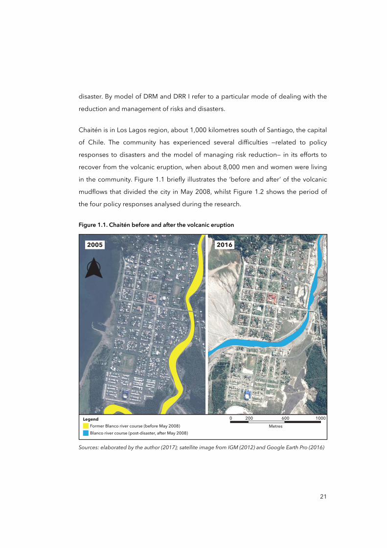
Chaitén is in Los Lagos region, about 1,000 kilometres south of Santiago, the capital
of Chile. The community has experienced several difficulties —related to policy
responses to disasters and the model of managing risk reduction— in its efforts to
recover from the volcanic eruption, when about 8,000 men and women were living
in the community. Figure 1.1 briefly illustrates the ‘before and after’ of the volcanic
mudflows that divided the city in May 2008, whilst Figure 1.2 shows the period of
the four policy responses analysed during the research.
Figure 1.1. Chaitén before and after the volcanic eruption
Sources: elaborated by the author (2017); satellite image from IGM (2012) and Google Earth Pro (2016)
2005 2016
0 200 600 1000Metres
Legend
Blanco river course (post-disaster, after May 2008)Former Blanco river course (before May 2008)
21
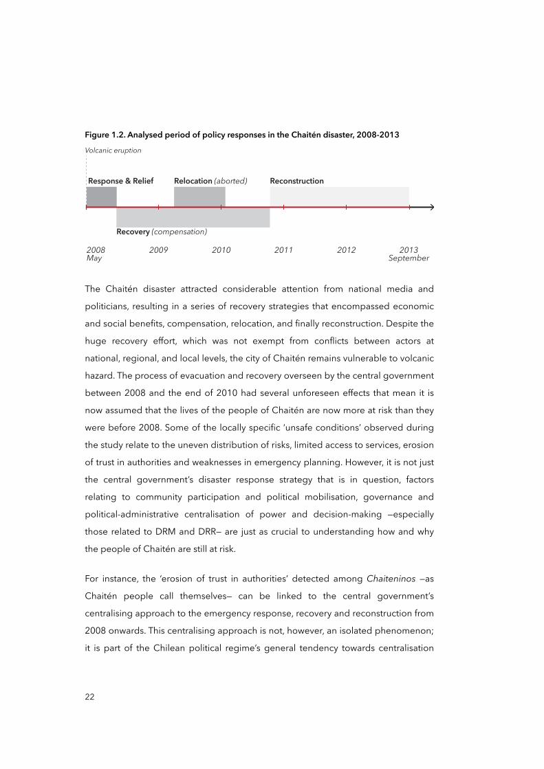
Figure 1.2. Analysed period of policy responses in the Chaitén disaster, 2008-2013
2009 2010 20122011 2013September
2008May
Volcanic eruption
Response & Relief ReconstructionRelocation (aborted)
Recovery (compensation)
The Chaitén disaster attracted considerable attention from national media and
politicians, resulting in a series of recovery strategies that encompassed economic
and social benefits, compensation, relocation, and finally reconstruction. Despite the
huge recovery effort, which was not exempt from conflicts between actors at
national, regional, and local levels, the city of Chaitén remains vulnerable to volcanic
hazard. The process of evacuation and recovery overseen by the central government
between 2008 and the end of 2010 had several unforeseen effects that mean it is
now assumed that the lives of the people of Chaitén are now more at risk than they
were before 2008. Some of the locally specific ‘unsafe conditions’ observed during
the study relate to the uneven distribution of risks, limited access to services, erosion
of trust in authorities and weaknesses in emergency planning. However, it is not just
the central government’s disaster response strategy that is in question, factors
relating to community participation and political mobilisation, governance and
political-administrative centralisation of power and decision-making —especially
those related to DRM and DRR— are just as crucial to understanding how and why
the people of Chaitén are still at risk.
For instance, the ‘erosion of trust in authorities’ detected among Chaiteninos —as
Chaitén people call themselves— can be linked to the central government’s
centralising approach to the emergency response, recovery and reconstruction from
2008 onwards. This centralising approach is not, however, an isolated phenomenon;
it is part of the Chilean political regime’s general tendency towards centralisation
22
which has prevailed since the 1970s. In describing ‘erosion of trust in authorities’ as
a vulnerability factor in Chaitén I mean that lack of ‘trust’ can exacerbate vulnerability
by altering evacuation strategies and by diminishing the impact of compensation
and recovery policies (Cutter et al., 2003). Testimony from several interviews
conducted during research for this thesis indicate an important local consensus: in
the event of another volcanic eruption Chaiteninos will not follow the authorities’
instructions as they did in 2008 and so they may react negatively to any new plans
for ‘evacuation’ of the city. The reasons for this relate to regional and national
processes: ‘misinterpretations’ by the central government and authorities
concerning the existence of a volcano in the area and the ‘tremors’ before volcano
eruption; an unplanned evacuation that split up families; poor supervision of
spending on subsidies and concerns about the misuse of public funds; the decision
to lift the ban on inhabiting the North sector but not considering the South; the
abandonment of the New Chaitén project after two years of planning, ‘spending’
and consultation; the creation of a ‘parallel’ authority —i.e. Presidential Delegate—
which bypassed local and regional governments. This thesis looks at all these
factors, from specific local vulnerabilities to national factors.
1.1 Objectives, justification, and questions
The objective of the thesis is to utilise the case of post-disaster Chaitén to re-
problematise the progression of disaster vulnerability and risk from a scalar
perspective, by examining how the social construction of disasters and policy
responses to them are articulated at inter-connected and hierarchically related
scales. In this instance ‘re-problematising’ means looking again at the causes of
disasters from a social constructionist perspective, paying particular attention to
disaster vulnerability and the socio-economic and political processes that
precipitate it. Vulnerability tends to manifest as ‘unsafe conditions’ in specific social
groups and spaces (Wisner et al., 2004) but a multiplicity of actors, rules, and
processes related to DRM at different geographical and social scales are also
extremely important to its course and reveal the grave significance of the root
causes of disaster risk and vulnerability (Tierney, 2012). Decision-making processes,
23
policy responses, political economic regimes, and powerful institutions involved in
DRM and DRR are not always clearly or directly responsible for the ‘unsafe
conditions’; instead they may be the roots and drivers underlying the development
of ‘unsafe conditions’ and hence the ultimate cause of disasters. This particular
extended view of disasters embeds them in a political economic context and
recognises that ‘social relations’, ‘structures of domination’, ‘class confrontations’, and
other forms of social struggle are the origins of disaster vulnerability and risk
(Gunewardena and Schuller, 2008; Wisner et al., 2004).
This view is also called the “vulnerability approach” (Wisner at al., 2004, p.10), which
rejects the assumption that disasters are ‘causes’ in any simple way by external
natural events. This thesis adopts this perspective because it enables one to
examine the structural factors contributing to disaster risk. Extending our ambitions
beyond simply seeking to reduce disaster risk and seeking to tackle the factors that
create disaster risk depends on detailed investigation of contemporary and
historical causes of vulnerability. Such work would support the integration of disaster
risk reduction in the many wider contexts that foment and perpetuate vulnerability
(Lewis and Kelman, 2012). Although I agree that other approaches to research on
resilience and hazards are necessary, in my view, the problematic of disasters —i.e.
the relevant theoretical concepts and practical realities, the debate about causality,
and its factual reduction— cannot be thoroughly overcome by means of such studies
alone. If we are fully to understand and tackle the causes of disasters, we cannot
afford to neglect investigations into the principles that ‘govern’ their social nature, as
social interventions are a far more promising way of reducing the incidence and
impact of disasters than interventions in the natural world (Hewitt, 1983; Quarantelli,
1998; Wisner et al., 2004). The value of addressing problematic disaster issues
through the lens of vulnerability is based on the idea that putting in places measures
to reduce disaster risk and increase resilience depends on societal foundations such
as equal access to power and institutions, effective reduction of poverty and
inequality, amongst others. Using a vulnerability framework, it is possible to identify
such foundations and eventually tackle the root causes of risk to people. In other
24
words, this thesis is based on the idea that the more effort we devote to uncovering
and understanding the root causes of disasters, the more powerful reasons there will
be to mobilise men and women and governments for efforts to reduce disaster risk.
As Wisner et al. (2004, p.61) noted, “[disaster] problems will recur again and again in
different and increasingly costly forms unless underlying causes are tackled”.
Although the theoretical and disciplinary debate that this thesis addresses is
deployed in Chapter Three, a clarification of key concepts is in order.
Disaster research is polarised into two strands. One emphasises the ‘trigger
role’ (Wisner et al., 2004) of extreme natural events such as earthquakes and
hurricanes and encompasses post-disaster research on human responses, trauma,
crisis and humanitarian intervention, and the economic, legal, and political
consequences of disasters (see examples in Alexander, 1993; Dynes, 1970; Smith,
1996). The second has emerged over the last forty years from social sciences
research. Although this perspective does not deny the relevance of natural hazards
as triggers events, it emphasises the multiple ways in which social systems produce
disasters by making people vulnerable (see examples in Hewitt, 1983; Pelling,
2003a; Wisner et al., 2004). This thesis takes the second perspective as its starting
point.
This social perspective puts ‘vulnerability’ at the centre of the debate. I use the term
‘disaster vulnerability’ or ‘vulnerability to disaster’ to refer to the circumstances and
characteristics of an element of interest —i.e. community, system, or asset— that
influence its capacity to anticipate, cope with, resist and recover from the negative
impact of a natural or anthropogenic extreme event (Wisner et al., 2004). To
understand and value vulnerability correctly it is necessary, however, to connect it at
the theoretical and epistemological levels with the concepts of disaster and risk. In
essence, disasters and disaster risk are produced by the combination of a hazardous
event, either natural or anthropogenic, and a vulnerable asset, people, or
community. At a conceptual level, the equation ‘hazard × vulnerability [ × exposure ]
= risk → disaster’ (Cardona et al., 2012) helps to illustrate how disasters and risk are
25
produced. Important determinants of the impact of a hazardous event are: where
people live and work, their level of preparedness, hazard protection, governance,
information, education, wealth, and health. Nevertheless, the circumstances above
mentioned have nothing to do with nature per se as they are produced and
exacerbated by socio-economic, socio-ecological, political and cultural factors
(Pelling, 2003a; Wisner et al., 2004). Likewise, the vulnerability approach is based on
the assertion that society has little control over sudden natural hazards (Davis,
1978), whereas vulnerability is solely a product of society (Wisner et al., 2004). This
idea was developed by Wisner et al. (2004) in their disaster Pressure and Release
(PAR) model, which focuses analytical attention on the social production of
disasters. The PAR model treats the production of vulnerability as the outcome of the
sequential operation of socio-economic and socio-ecological, political and/or
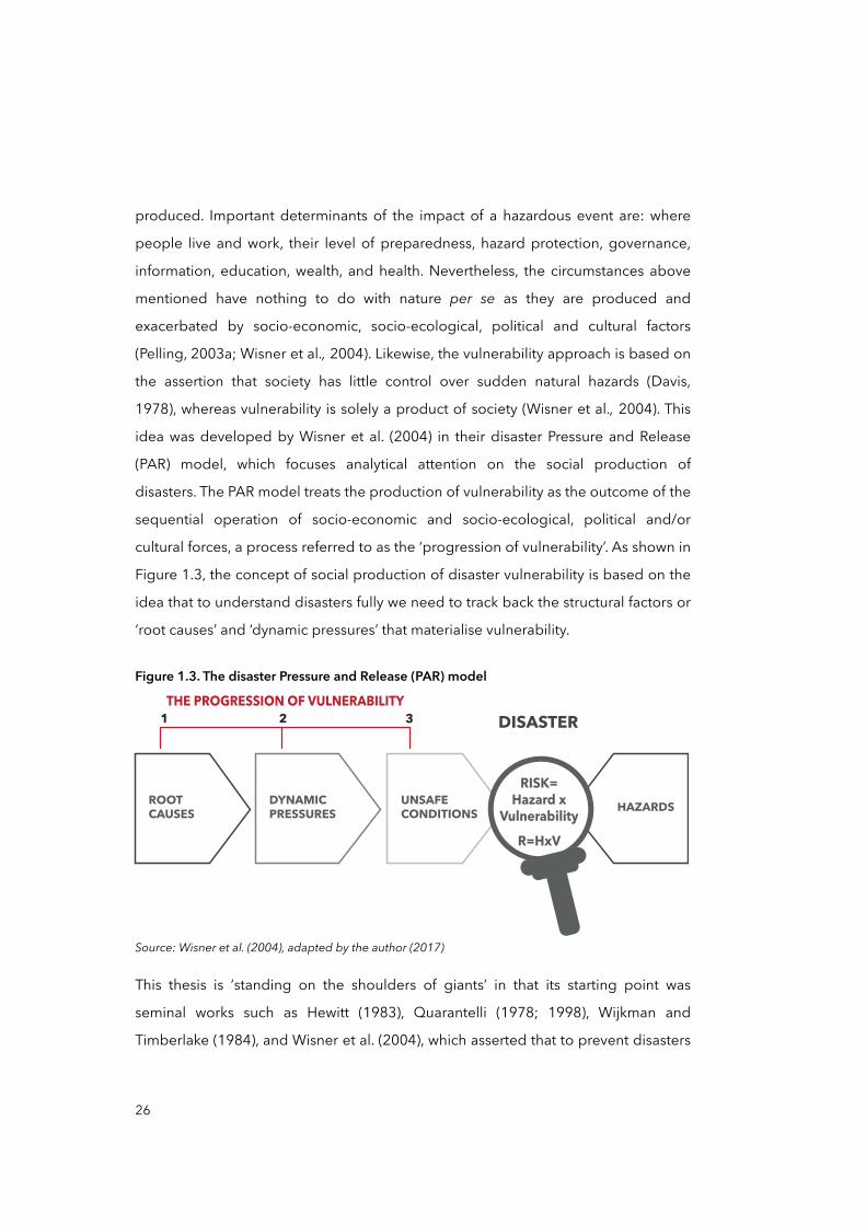
cultural forces, a process referred to as the ‘progression of vulnerability’. As shown in
Figure 1.3, the concept of social production of disaster vulnerability is based on the
idea that to understand disasters fully we need to track back the structural factors or
‘root causes’ and ‘dynamic pressures’ that materialise vulnerability.
Figure 1.3. The disaster Pressure and Release (PAR) model
ROOT CAUSES
DYNAMICPRESSURES
UNSAFECONDITIONS
DISASTER
HAZARDS
1THE PROGRESSION OF VULNERABILITY
32
RISK=Hazard x
VulnerabilityR=HxV
Source: Wisner et al. (2004), adapted by the author (2017)
This thesis is ‘standing on the shoulders of giants’ in that its starting point was
seminal works such as Hewitt (1983), Quarantelli (1978; 1998), Wijkman and
Timberlake (1984), and Wisner et al. (2004), which asserted that to prevent disasters
26
and promote effective disaster risk reduction and resilience, it is essential to reduce
vulnerability and to tackle its root causes. Reducing vulnerability should be a core
policy objective of DRM and DRR, although one cannot neglect the probability of
the occurrence of natural hazards, and their magnitude in specific social, cultural,
economic and political contexts (Aragón-Durand, 2007; Wisner et al., 2004). There
has, however, been little research on policy responses to disasters and decision-
making as causes and drivers of vulnerability and risk; multi-level studies have
tended to focus on infrastructural causal factors and institutional susceptibility to
disasters (MOVE project, 2012).
Adopted here that serves as key register on which I ground the present work is the
concept of ‘scale’. By scale I refer to the succession of two or more social, economic,
ecological, geographical, political and cultural spaces differentiated by size, level,
and relationally (Howitt, 1998; Montello, 2001). Throughout the thesis I used the
concept of ‘geographical scales’ to capture aspects of social, economic and political
order and their spatial configuration at different levels. Two important aspects to
consider here vis-à-vis the debate around disaster vulnerability and risk are: a) scales
are social constructions and b) scales need to be considered relationally. The first
point is stating that social relations and struggles produce geographical scales as
they need space to delineate their scale: locally, regionally, nationally or globally
(Swyngedouw, 1992). Accordingly, the spatial and scalar materialisation of social
struggles varies over time depending on the extension and contraction of the
struggle itself, making scales malleable and “historically changeable” (Brenner,
2001, p. 599). Consider, for instance, how geo-political boundaries have been
transformed over the course of human history, and how the ‘global’ scale has
contracted since the rise of ever faster transport networks and communication
technologies (Castells, 1996). The second point relates to the relative nature of
scales, in other words what make sense of one geographical scale —e.g. urban— is its
relationship to other geographical scales —e.g. regional, national, global— (Brenner,
1998) through “its upwards, downwards, and transversal links” (Brenner, 2009a, p.
72). According to Brenner (2000), social relations are spatially demarcated through
27
the creation of specific institutional configurations such as national, regional and
municipal governments. The resultant spatial ‘unit’ —e.g. urban, national, and local—
of the social relationship indicates the function and dynamics of a given
geographical scale, but this spatial ‘unit’ can be only grasped relationally in terms of
its hierarchical links to other levels of a broader multi-scalar configuration. This is
particularly relevant in the case of certain multi-scalar phenomena such as disaster
vulnerability, for which the causal factors are nested, articulated, and distributed
over multiple interconnected geographical scales. Thus, another aim of this thesis is
to explore epistemological links between disaster vulnerability and geographical
scales, referring particularly to how the spatio-temporal dialectic of decentralisation
and centralisation struggles in Chile have affected DRM and DRR with regard to
decision-making and policy response to disasters.
Finally, in Chaitén the risks and vulnerability to volcanic hazard and floods have not
been significantly reduced, despite the efforts of policy makers, institutions and
Chaiteninos over the first two years after the disaster (CIMM T&S Consultores, 2010;
Ugarte and Salgado, 2014). Thus the main research question was: How have policy
responses to disasters influenced the progression of disaster vulnerability, at
different scales, in post-disaster Chaitén? Addressing this question entailed
exploratory and inductive research, looking at how institutions, policy responses,
and stakeholders at different geographical scales contributed to the production of
vulnerability and how they should contribute to reducing it. To make it easier to
address this primary research question I formulated some subsidiary questions that
contribute incrementally to addressing the subject of study, working from the micro
to the macro level:
• What are the ‘unsafe conditions’ in Chaitén that place people at risk of experiencing future disasters?
• Why have policy responses to disasters in Chaitén not effectively reduced vulnerability?
28
• How and why did the Chilean model of DRM facilitate the production and progression of specific vulnerabilities in post-disaster Chaitén?
These questions were intended to introduce the research inductively, that is, the
research was intended to progress from more specific observations of the ‘unsafe
conditions’ in Chaitén, to possible explanations, disciplinary debates, and
implications for theory.
1.2 Methodology: research design and methods
Although the research strategy, methodology and methods used in this research are
detailed in Chapter Two, an introduction of key considerations is necessary. The first
concerns the epistemological debate about the production of disasters, risk and
vulnerability. There are three main schools of thought in this debate, the behavioural
paradigm (BP), the structural paradigm (SP) and the mutuality paradigm (MP). The
BP couples a hazard-centred approach to geo-physical processes underlying
disasters with a conviction that they can be anticipated by advancing societal
knowledge of nature. The SP highlights the role of structural factors in society, such
as social relations and structures of domination (Bankoff et al., 2006). Proponents of
the SP advocate tackling the underlying (social) causes of disaster vulnerability as
the most effective way of reducing disaster risks. The MP is the most recent and
refers to the ‘mutuality’ of vulnerability and natural hazards due to complex
interactions between nature and society (Hilhorst, 2006). The increased attention
paid to environmental problems that have been linked to development and
anthropogenic climate change is an indication of the MP’s importance. However,
despite its relevance it is relatively easy to lose focus when natural and social sub-
systems are combined in a more complex system of environmental and social
relations (Hilhorst, 2006). For that reason, and because my interests were centred on
the aftermath of disaster and on rapid-onset natural hazards (intensive risk) such as
mudflows and volcanic hazards in Chaitén in particular, I believed that the MP was
less appropriate as a framework for my research than the SP, at least initially.
29
A second consideration was the attempt to bridge two bodies of literature with
apparently different methodological perspectives. Whilst the production of
disasters, risks and vulnerability is approached from a structural perspective, in
disaster studies geographical scales are often considered from a positivist
perspective (Fekete et al., 2010), that is as ‘physical’ manifestations within nature, as
self-enclosed, static containers where social processes merely unfold (Brenner,
2009a). This positivist view contrasts with the idea of disasters as social constructions
produced on and affecting multiple levels, and it may hinder observation of the
relations between macro social processes and unsafe conditions at local level. For
this reason, I adopted a social constructionist approach to geographical scales
either. A social constructionist approach assumes that societal and individual
knowledge, experience and perceptions are always historically, culturally, and
linguistically mediated (Berger and Luckmann, 1966; Hacking, 1999). This means
that perceptions of ‘reality’, including scales, disasters, vulnerabilities and their
complex geography, are never a direct reflection of physical conditions ‘out there’;
‘reality’ must be understood as a specific, situated and contingent reading of
physical conditions (Berger and Luckmann, 1966). This thesis acknowledges the
initial differences between these two core concepts, disasters and scales, but deals
with them from a similar methodological perspective, namely the social
constructionist perspective. This perspective is well known in disaster research
(Cardona, 2006) as well as in literature on scales (Brenner, 2001; Marston, 2000), and
it encompasses the methodological approaches used in this research, such as the
study of historically contextualised socio-spatial relations.
The study of policy responses to disaster and decision-making at multiple temporal
and spatial levels led to the selection of the PAR model as the analytical framework
for this thesis. Within disaster studies, the PAR model is a well-known framework for
supporting the construction of explanations based on the social causes of disasters,
risks, and vulnerability (Wisner et al., 2004). The aim of this thesis, in using the PAR
model, is to explore how vulnerability ‘materialised’ in space and ‘accumulated’
locally in Chaitén, and to describe how the territorial structure of the Chilean state
30
may have influenced the scalar distribution and organisation of DRM and DRR, and
hence of policy responses and decision-making. Additionally, this thesis seeks to
look at potential links between the literature on disaster and scales, as they are rarely
dealt with together although they share conspicuous relations.
Although I am aware of the limitations of case-based research (Yin, 2003), another
consideration that it is important to mention in this introduction is the use I have
made of the ‘case study strategy’ to investigate “a contemporary phenomenon
within its real-life context, especially when the boundaries between phenomenon
and context are not clearly evident” (Yin, 2003, p.13). In post-disaster Chaitén, the
ʻphenomenonʼ is the progression of vulnerability and risks, and the ̒ contextʼ is Chile
—Chilean institutions for DRM and DRR, policy response to disasters, and Chilean
territorial organisation— the context in which ‘root causes’, ‘dynamic pressures’, and
‘unsafe conditions’ are situated.
The main step in the operationalisation of the intellectual approach set out here,
including the PAR model, consisted of drawing a provisional storyline of events and
processes in post-disaster Chaitén, covering the period from May 2008 to early
2014, similar to Figure 1.2 on page 22, and explained later in the methodological
second chapter. The aim was to identify key moments and periods, as well as
processes and mechanisms, in which the state and the Chaitén community
interacted on various levels to produce certain specific ‘unsafe conditions’.
Because the research moved between the policy response context in Chile and the
Chaitén disaster, I considered it crucial that the national level be considered first, as
it contextualises the policy responses and decisions made by national, regional and
local governments during and after the Chaitén disaster. Figure 1.4 below explains
briefly that the case study is addressed from two different entry points. One could
be called the ‘top-down’ entry point, as it attempted to reflect the progression of
vulnerability in Chaitén from general processes in Chile such as its state territorial
organisation and model of DRM. In contrast, the second could be called ‘inductive’
or ‘bottom-up’, because it tried to reflect the progression from the specificity and
31
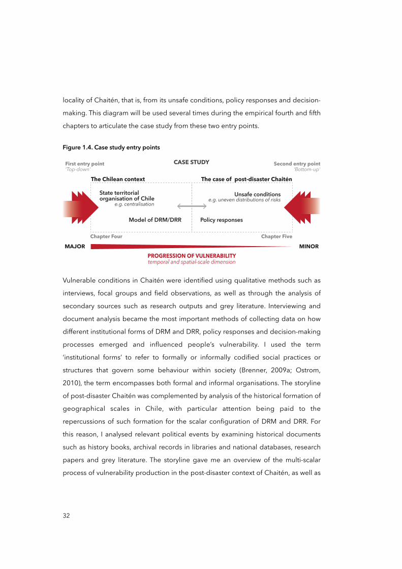
locality of Chaitén, that is, from its unsafe conditions, policy responses and decision-
making. This diagram will be used several times during the empirical fourth and fifth
chapters to articulate the case study from these two entry points.
Figure 1.4. Case study entry points
First entry point‘Top-down’ ‘Bottom-up’
Second entry pointCASE STUDY
Chapter Four Chapter Five
The case of post-disaster Chaitén
Unsafe conditionse.g. uneven distributions of risks
Policy responses
MAJOR MINORPROGRESSION OF VULNERABILITYtemporal and spatial-scale dimension
The Chilean context
State territorial organisation of Chile
Model of DRM/DRR
e.g. centralisation
Vulnerable conditions in Chaitén were identified using qualitative methods such as
interviews, focal groups and field observations, as well as through the analysis of
secondary sources such as research outputs and grey literature. Interviewing and
document analysis became the most important methods of collecting data on how
different institutional forms of DRM and DRR, policy responses and decision-making
processes emerged and influenced people’s vulnerability. I used the term
‘institutional forms’ to refer to formally or informally codified social practices or
structures that govern some behaviour within society (Brenner, 2009a; Ostrom,
2010), the term encompasses both formal and informal organisations. The storyline
of post-disaster Chaitén was complemented by analysis of the historical formation of
geographical scales in Chile, with particular attention being paid to the
repercussions of such formation for the scalar configuration of DRM and DRR. For
this reason, I analysed relevant political events by examining historical documents
such as history books, archival records in libraries and national databases, research
papers and grey literature. The storyline gave me an overview of the multi-scalar
process of vulnerability production in the post-disaster context of Chaitén, as well as
32
allowing me to work out the relationships between the wider processes of political
and economic centralisation and local vulnerabilities.
Field research was carried out between early March and mid-September 2013 with
one collaborator, in three different places in Chile: Chaitén, Puerto Montt (the capital
of Los Lagos Region), and Santiago de Chile. Final interviews were carried out and
answers to follow-up questions were obtained remotely, via telephone and email
correspondence. Some information, and peer feedback, was collected through
participation in academic events such as conferences and seminars in Chile,
Germany, and the United Kingdom between 2014 and 2015.
Interviewees were selected and approached using a snowball stratified sampling
technique. As the research was inductive, interviewing evolved from the ‘informal
conversational interview’ to the ‘general interview guide approach’ (Gall et al.,
2003), the former approach was used at the beginning of the study, when I visited
Chaitén for the first and second times —in March and July 2013. Guided interviewing
was often used with interviewees from the national and regional governments,
academia, and civil society organisations. In total, I visited Chaitén three times, in
March, July, and September 2013, and carried out 27 interviews, 2 focus groups,
and several participant observations, as well as obtaining access to municipal
records and documents. I also visited Puerto Montt twice, in July and September
2013. In Puerto Montt I interviewed a total of 7 people from the Regional
Government and the regional division of the National Emergency Office (ONEMI), as
these institutions had considerable influence on the relations between policy
responses and decision-making and the community during the post-disaster
phases. These interviewees were also selected using the snowball stratified
sampling technique, but the choices were also informed by media archives and
institutional reports. The same procedure was used for the rest of interviews in
Santiago de Chile, where 32 informants from national government officials, non-
governmental organisations (NGOs), and academia were selected. In the period of
the fieldwork, a total of 66 individuals participated in in-depth and guided
33
interviews, focus groups, and telephone interviews. See a complete list of
participants in the Appendix 1.
Other techniques used were field observations and analysis of documentary sources
such as archival records, reports and accountability books issued by government
institutions at national, regional, and local level, as well as items from media archives
such as newspapers articles, press releases, documentary films, news interviews etc.
In most of cases, document analysis was used as a complementary data collection
procedure, in support of triangulation (Bowen, 2009), to establish convergence with
or corroborate data from other sources such as interviews and observations. Field
observations were conducted in accordance with the suggestions of Yin (2003): in
group discussions and personal conversation between two or more participants with
another researcher, assistant or mediator guiding the interaction. Participant and
non-participant observations also took the form of walks through the North and
South sectors of Chaitén and the surrounding areas. I made participant observations
as a ‘visiting researcher’ and ‘guest’ in two disaster research centres in Chile, the
Research Centre for Vulnerability and Socio-natural Disasters (CIVDES) at the
Universidad of Chile (between March and August 2013) and the National Research
Centre for Integrated Natural Disaster Management (CIGIDEN) at the Pontificia
Universidad Católica de Chile (PUC) (in December 2014). On both visits I was able to
observe diverse academic discussions and comments on policies, governmental
efforts, and initiatives on DRM and DRR in Chile, and on the case of Chaitén. Both
direct and participant observations were registered as written notes and pictures.
The methods used in the research are subject to several limitations. Possibly the
most evident is the difficulty of generalising the study’s findings. The fact that the
study was case-based research, embedded in the historical and geographical
context of Chile, and the post-disaster Chaitén community in particular, as well as
being linked to a specific rapid-onset natural hazard —i.e. volcanic eruption—, makes
deeper and robust explanations as well as the refinement of theory more difficult.
For instance, it would have been interesting to carry out similar fieldwork in other
34
Chilean communities recently affected by intensive risks, for example the Calbuco
volcanic eruption in April 2015 —also in Los Lagos Region— or to pursue a more
detailed analysis of other processes and factors that have a critical influence on DRM
and DRR, such as public spending and budgeting. In practice I was only able to
approach these similar cases and processes though secondary sources such as
media archives and institutional reports. Nevertheless, the historical analysis of scale
formation in Chile and its repercussions for the configuration of DRM and DRR is
original, as is the application of the PAR model to a Chilean case.
As well as these empirical limitations, there are other methodological limitations that
affect the contribution this research makes to debate within the disaster studies
discipline. Perhaps the most obvious is that the study was framed within the
Structural Paradigm and takes a political economic perspective, which limited the
analysis of social structural factors and meant setting aside environmental and socio-
ecological that are also important to understanding of disasters. However, I believe
that using the case of post-disaster Chaitén to investigate socio-environmental
relations surrounding disaster would have been inappropriate, because the Chaitén
disaster was intimately tied to a rapid-onset natural event. Another limitation relates
to the fact that I collected most of the data personally, and probably influenced the
responses and behaviour of interviewees in some way. Likewise, the analysis and
interpretation of data, as well as the delineation of findings, is unavoidably
influenced by my history, views, values and beliefs (Yin, 2003), making this study
subjective. However, because I was aware of my position within the study, of being a
mestizo, heterosexual, cisgender male, and have lived in the southern Chile for most
of my life, I tried to reduce bias by obtaining convergent data using several different
qualitative methods, and by making use of peer review wherever possible. I have
done my best to provide accurate explanations from the case study and its
implications for efforts at disaster risk reduction. Throughout the thesis I indicate and
warn the reader about these limitations and scope of this work. In the final chapter, I
also point out several areas for future research.
35
1.3 Structure of the thesis
The case research process was iterative, oscillating between the macro and micro,
making bidirectional connections between general Chilean processes and locally
specific processes contributing to materialisation of vulnerability in Chaitén. The
structure of the thesis therefore warrants explanation. The structure mirrors the
bottom-up development of the research, which moved inductively from the case
study to theoretical issues. Chapter Two presents the methods used and discusses
the research methodology. Chapter Three sets out the disciplinary concepts of
disaster, risk, vulnerability and scales as well as their theoretical implications to give
the reader a sense of the debates in the field. This chapter also outlines the
analytical framework used to interpret the case study data and findings. The next
two chapters are interlinked and present the case study itself. Chapter Four analyses
the historic and administrative-territorial context of Chile, offering a close look at the
Chilean model of DRM and DRR. Chapter Five describes and analyses the localities
and the material conditions of post-disaster Chaitén. The final part of the thesis
offers conclusions that connect the findings of the case study to the general debate
on recovery and vulnerability and to the research questions.
Chapter One introduces the thesis and the next chapter discusses the research
strategy and the methodological design in more detail. Over four sections I seek to
connect the study approaches with the methods for literature review, as well as with
the fieldwork and its techniques for data collection and analysis. I introduce the
debate around vulnerability, disasters, and scales to develop the research questions
and limitations of the study.
In Chapter Three I set out the theoretical background of the thesis and the analytical
framework. Over five sections I discuss historical views and interpretations of
disasters and risks, looking at disasters as ‘acts of god’ and as ‘acts of women and
men’ and describing how interpretations of disaster have evolved. I look at the
different disciplines dealing with disaster phenomena, describe the current state of
disaster research and then discuss the re-problematisation of the progression of
36
vulnerability and risk. This forms the basis for a detailed discussion of disasters as
social constructions that situates the study within the Structural Paradigm. I argue
that vulnerability is a key factor in tackling the problematic of disaster —i.e. its
theoretical and practical conceptualisation, the debate about causality, and its
factual reduction. Then I examine the literature and academic debate on
vulnerability to disasters: this contains an historical review, facing physical, social,
and ecological interpretations of vulnerability. In particular, I analyse the
‘progression of vulnerability’ through the PAR model, which enables me to introduce
contemporary ideas about geographical scales to my analysis of vulnerability and its
causes. The final sections discuss how the study of the geographical distribution and
hierarchical organisation of certain socio-economic and political processes can help
us to understand how vulnerability is produced, progresses and finally how it
‘materialises’ within specific communities and social groups at local scale.
After the chapter dealing with theoretical background, the thesis continues with two
chapters —Chapter Four and Five— dedicated to the case study. Although the
research process oscillated between macro and micro levels, I consider it vital to
begin by providing a description of the Chilean context in which policy responses
and decision-making during the evacuation, relocation and eventual reconstruction
of Chaitén were embedded.
Chapter Four describes the history, institutions and territorial context of Chile. I start
by offering a historical review of disasters in Chile in order to highlight the dominant
narrative of Chilean disasters in its history, which emphasises their naturalness and
sees them as a ‘struggle against nature’. I explain how this view and some of the
disasters Chile has experienced have influenced the creation and characteristics of
the Chilean model of DRM and DRR. The next section is a historical review of the
state territorial organisation of Chile, which has been characterised by political
decentralisation and centralisation, based on how social processes have historically
changed the national and sub-national geographical scales in Chile, and how today
the relations between these scales is in terms of territorial administration. Chapter
37
Four ends with an analysis of the aspects of the institutional organisation of DRM
and DRR that were crucial to policy responses and decision-making in post-disaster
Chaitén: the ONEMI, the National Plan of Civil Protection (PNPC), emergency
procedures, legal frameworks and territorial planning instruments (IPTs).
Chapter Five dives deep into the case of post-disaster Chaitén to explore policy
responses and decision-making on emergency, recovery strategies, relocation, and
reconstruction, and their effects on vulnerability and risk in the current Chaitén. In
the early part of the chapter I describe the geography and economy of Chaitén prior
to the eruption in 2008, and look at the crucial days immediately before and after
the volcanic eruption, focusing on meetings between public authorities and people,
the links between the supposed ‘tectonic’ movements and the lack of information,
the ‘dormancy’ of the volcano and the evacuation and emergency response. Then I
analyse the recovery strategy, including compensatory measures and decision-
making at different geographical levels and by different actors, including politicians,
government officials, regional and local authorities and Chaiteninos. The following
can be considered ‘outputs’ of decisions about the disaster response: the ‘occupied’
city of Chaitén and the ‘rebels’, the New Chaitén project, subsidies and other
benefits and the eventual reconstruction of North Chaitén. The final section attempts
to articulate comprehensively both macro and micro levels of study —the Chilean
context and Chaitén— by highlighting multi-scalar relations between centralisation
and the geographical distribution and hierarchical organisation of DRM and DRR, as
well as their repercussions for the materialisation of vulnerability in Chaitén.
Finally, Chapter Six aims to answer the research questions and offer general
conclusions about the research process and set out the implications of the findings.
In the quest for answers I link the research findings to the literature reviewed in
Chapter Three in order to draw out the epistemological implications for the field of
disaster research, specifically findings about how policy responses to disasters and
decision-making in a context post-disaster may contribute, counterintuitively, to the
production and reproduction of vulnerabilities and risks. Following this, I describe
38
some of methodological innovations and practical implications arising from the
thesis. The methodological innovation involves the use of scatter diagrams to
visualise a multi-scalar perspective for the analysis of vulnerability progression. The
practical implications take the form of guidance on policy and practice that
emphasises the need for holistic evacuations, planning and decentralisation of
DRM. Finally, I offer some reflections about the research processes from my
perspective as a researcher, and I call for further research that takes into account
analyses of root causes and dynamic pressures at multiple scales into assessments
of vulnerability.
39
Chapter TWOResearch strategy and methodology
Introduction
This chapter introduces the research strategy and methodology adopted in this
study. The goal was to analyse the relationships between temporally and spatially
distant policies and governance processes, and the local ‘materialisation’ of ‘unsafe
conditions’ in Chaitén. The following four sections outline the research plan, the
research questions, theoretical propositions, methods for field research, analysis,
and the limitations of the study.
The first section details the research strategy by introducing the primary and
secondary research questions as well as the propositions, which aim to guide data
collection and analysis. I summarise key antecedents from the literature on disasters
and scales to connect the rationale of the study with the research question and
analysis phases, such as those from social constructionist approaches to causes of
disasters. In this section, I also deal with the justification, selection of and approach
to the case of post-disaster Chaitén. I specify the units of analysis and other
elements of the case study design such as the ‘explanation building’ method
described by Yin (2003).
In the second section, I describe the research methodology. I initiate it by
considering pros and cons of using quantitative and qualitative approaches for data
collection vis-à-vis the nature of a case study and potential data, to substantiate the
study as ‘qualitative research’. Then, the post-disaster —i.e. from 2008 onwards— and
research periods —i.e. March to September 2013— are explained, while the selection
of the sub-fieldwork locations —i.e. Chaitén, Puerto Montt, and Santiago— is justified.
In this section, I also describe the different qualitative methods and how they were
applied during the study: in-depth and guided interviews; participant and non-
participant observations; and document analysis. Finally, the study of the social
production of geographical scales in Chile is approached from a historical stand
41
point, a view used as a ‘proxy’ to better understand the centralisation and top-down
approach of the model of disaster risk management (DRM) in Chile.
The third section introduces the analytical framework of the study, characterised by
the Structural Paradigm within the study of disasters, a social constructionist
approach to disaster, vulnerability, and scales, and the Pressure and Release (PAR)
model. The details of the analytical framework are then addressed and linked with
the theoretical elaboration in Chapter Three.
Finally, the last part discusses some limitations of this case-based research and
generalisation, both empirical and theoretical according to Ritchie and Lewis
(2003), specifically on how the case of Chaitén may help to better understand the
way in which policy responses to disasters may, counterintuitively, contribute to
reproducing existing risks or producing new ones. Limitations were linked to the
interpretative process of analysis and positionality, the scope of findings in relation
to the composition of the sample —i.e. strata and size—, and the inherent limitations
linked to the analytical framework and methods —i.e. PAR model and the omission of
socio-environmental processes.
2.1 Case Study Strategy
A case study is an “empirical inquiry that investigates a contemporary phenomenon
within its real-life context, especially when the boundaries between phenomenon
and context are not clearly evident” (Yin, 2003, p.13). In the case of post-disaster
Chaitén, the ̒ phenomenonʼ is the progression of vulnerability and its ̒contextʼ would
be the Chilean system of rules, social relations, structures of domination, institutions
for DRM and DRR, cultural practices, and all processes and circumstances where
‘root causes’, ‘dynamic pressures’, and ‘unsafe conditions’ are situated. Both the
phenomenon and the context are inherently complex in the sense of being multi-
dimensional, multi-level, and dynamic. Thus, the analytical framework and the
research strategy must capture this complexity.
42
This case study investigated the progression of vulnerabilities by adopting the PAR
model, which enabled exploring the structural factors of risks and disasters
associated with governance, politics, and economic issues. Although some of these
structural factors of risks have emerged in the literature on resilience and social-
environmental change (Adger, 2000; Birkmann, 2006a; Aragón-Durand, 2009), the
very problem of disasters —including the theoretical and practical conceptualisation,
causality debate, and factual reduction— needs to be focused on the social tenets
that ‘govern’ disaster causation, beside their very natural condition, to embrace
more deliberately their political and social dimensions. With this position, this work
situates itself in a political economy perspective of disasters and applies the PAR
model as the analytical framework to guide the investigation.
According to Yin (2003), a case study should be selected as a research strategy
when its application responds at least to one of five different uses:
“To explain causal links when real-life interventions such as surveys and experimental research are too complex, to describe the intervention of a phenomenon and its real-life context, to illustrate diverse subjects in evaluated phenomenon, to explore those dimensions in which the evaluated phenomenon is not clear or when the study may be a meta-evaluation, that is, a study of an evaluation study”.
(Yin, 2003, p.15; own emphasis)
Thus, a case study was adopted given the rationale behind the research objectives.
Overall, this study aims for a deeper comprehension of the social production of risks
by explaining causal links between the productions of vulnerability in post-disaster
contexts on different geographical scales. In doing so, it explores relevant and
contemporary perspectives on disaster studies by incorporating the social science
notion of geographical scales and illustrates the progression of vulnerability as a
multi-scalar phenomenon. Yin (2003, p.21) proposed five fundamental components
for a case-based research design:
• Study's questions;
• its propositions or hypothesis, if any;
43
• its unit(s) of analysis;
• the logic linking the data to the propositions; and
• the criteria for interpreting the findings.
In this study, I adopted these five components and adapted them to the case of
post-disaster Chaitén. The research questions, propositions, and units of analysis are
outlined throughout this chapter, while the logic that links data with propositions
and the criteria for interpreting the findings are delineated in tandem with the next
chapter —the theoretical background and analytical framework. As can be seen, the
latter two emerge from the literature and the analytical framework selected for this
study, including the social constructionist approach to disasters, vulnerability, and
geographical scales, and the PAR model, which guide the research analysis. The five
components are important for the research design, as they represent a logical
sequence that connects the empirical data to a study's initial research questions
and, ultimately, to its conclusions (Yin, 2003). However, before posing the research
questions, I wish to briefly explain the reasons and motivations for selecting a case
study. In terms of operationalisation of research, post-disaster Chaitén and the
context of Chile have been selected as the object of this study mainly for four
reasons:
Academic interest
Chile is constantly affected by natural extreme events —e.g. earthquakes and volcano
eruptions— and is subject to the negative impacts of disasters. Thus, Chile offers a
wide range of cases in which the ‘root causes’ of vulnerability, ‘dynamic pressures’
and ‘unsafe conditions’ can be investigated. Specifically, the recent case of post-
disaster Chaitén offers a valuable opportunity to dig into a multi-scalar perspective
on the progression of vulnerability, since Chaitén is a remote port-city located in
Southern Chile embedded in a well-defined geographical and scalar configuration
of national, regional, and local politics and social relations. By being geographically
remote, and politically and economically distant from national and regional centres,
44
the case of post-disaster Chaitén is convenient to investigate as its actual ‘local’
vulnerability can be clearly separated from influential and distant processes
occurring at macro levels —e.g. political shifts in the national government and
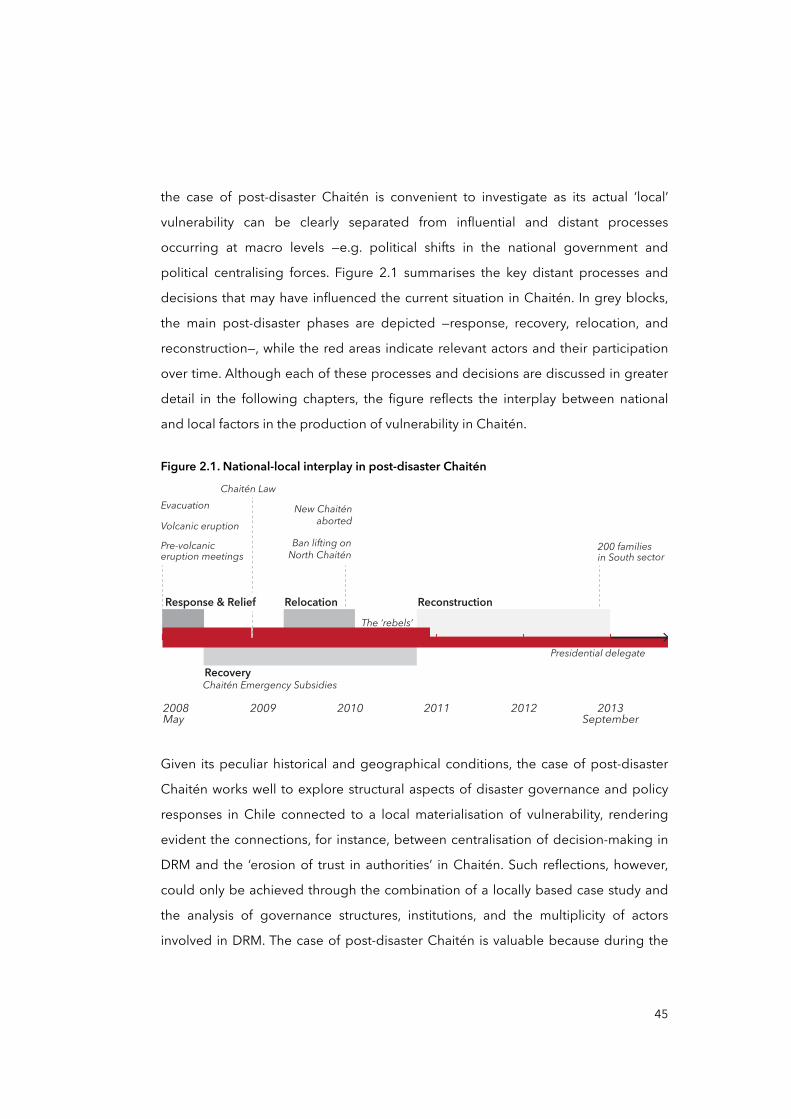
political centralising forces. Figure 2.1 summarises the key distant processes and
decisions that may have influenced the current situation in Chaitén. In grey blocks,
the main post-disaster phases are depicted —response, recovery, relocation, and
reconstruction—, while the red areas indicate relevant actors and their participation
over time. Although each of these processes and decisions are discussed in greater
detail in the following chapters, the figure reflects the interplay between national
and local factors in the production of vulnerability in Chaitén.
Figure 2.1. National-local interplay in post-disaster Chaitén
Volcanic eruption
2009 2010 20122011 2013September
2008May
Response & Relief ReconstructionRelocation
Recovery
Evacuation
Pre-volcaniceruption meetings
Chaitén Law
New Chaiténaborted
Ban lifting onNorth Chaitén
200 familiesin South sector
Presidential delegate
Chaitén Emergency Subsidies
The ‘rebels’
Given its peculiar historical and geographical conditions, the case of post-disaster
Chaitén works well to explore structural aspects of disaster governance and policy
responses in Chile connected to a local materialisation of vulnerability, rendering
evident the connections, for instance, between centralisation of decision-making in
DRM and the ‘erosion of trust in authorities’ in Chaitén. Such reflections, however,
could only be achieved through the combination of a locally based case study and
the analysis of governance structures, institutions, and the multiplicity of actors
involved in DRM. The case of post-disaster Chaitén is valuable because during the
45
emergency response, recovery strategy, relocation plan, and reconstruction of
Chaitén —totalling about 4 years—, the Chilean model of DRM operated, without
ambiguity, on different scales. The remoteness of Chaitén, as well as the spatial
distance of Los Lagos Region from Santiago, allowed investigating and more easily
distinguishing and differentiating national and regional processes from those nested
at local levels.
Contribution
Despite the interest mentioned above, there are currently no studies investigating
the progression of vulnerability on different geographical scales, or applying a multi-
scalar perspective in the broader context of Chile. Additionally, disaster studies
scholars have acknowledged the need for expanding knowledge on the social,
economic, political, and cultural causal factors of disasters and vulnerability, and
therefore the need to conduct more social science research from a multi-scalar
perspective addressing both major and minor scale factors simultaneously (IRDR,
2012; UNDP and MINVU, 2014; UNISDR, 2011).
Access and research support
Chile has a favourable open access system for most of its governmental services,
which includes historical repositories of reports, documents, legal frameworks, and
the like. Among the governmental open access sites, ‘Ley Chile’ (BCN, 2017) by the
National Congress Library is a key site, with access to an extensive archive of laws,
bills, and other parliamentary documents. Similarly, the website ‘SINIM’ or National
System for Municipal Information (SINIM, 2016) provides historical records on
municipal governments’ administration and expenditure. In addition, since 2008,
political and government services are subject to Law Nº 20,285 or ‘Transparency
Law’ (Ministerio Secretaría General de la Presidencia, 2008), which ensures access to
information on the administration of the state for any citizen.
46
Language and reliance on secondary material
Given that an important part of this research is based on secondary material, my
command of Spanish —my mother tongue and the official language in Chile—
facilitates access and analysis of sources. Likewise, several sources were found from
international organisations such as the World Bank or United Nations where most of
the information, including on Chile, is published in English. Thus, my command of
both Spanish and English provide an opportunity to expand the range of
documentary sources.
2.1.1 Research questions
Before presenting the research questions, it is necessary to introduce basic ideas
that sustain their rationale, specifically the multi-scalar progression of vulnerability,
which is fully articulated in Chapter Three.
Disaster vulnerability is a multidisciplinary subject that builds on a wide range of
substantive ideas such as entitlement failure and theories of hazards. Entitlement-
based explanations of vulnerability have focused almost exclusively on the social
realm of institutions, well-being and on class, social status and gender as important
variables while vulnerability research on natural hazards developed an integral
knowledge of environmental risks with human response drawing on geographical
and psychological perspectives in addition to social parameters of risk (Adger,
2006). One approach to disaster vulnerability has been sketched out by Wisner et al.
(2004) and conceptualised into the Pressure and Release (PAR) model. According to
its authors, disaster vulnerability consists of the circumstances and characteristics of
an element of interest —i.e. community, system, or asset— that influences said
community’s capacity to anticipate, cope with, resist and recover from the negative
impacts of a natural or human-made extreme event, and likewise make the
community susceptible to extreme impacts (Wisner et al., 2004). In this model,
vulnerability production is modelled in a dynamic sequence of social, economic, and
political forces at different times in a process named the ‘progression of
vulnerability’ (see Figure 2.2).
47
Figure 2.2. The PAR model and its potential scalar dimensions
e.g. e.g.
# Political economy regimes
e.g.
# Repid urbanisation
# Inquality
# Uneven development
# Unprotected buildings and infrastructure
e.g.
Earthquake
Volcanic eruptions
(Rapid onsethazards)
ROOT CAUSES
RISK=Hazard x
Vulnerability
R=HxV
DYNAMICPRESSURES
UNSAFECONDITIONS DISASTER HAZARDS
1THE PROGRESSION OF VULNERABILITY
TEMPORAL AND SPATIAL-SCALE DIMENSION
32
Source: Wisner et al. (2004), adapted by the author (2017)
The PAR model assumes that a disaster occurs at the intersection of two opposing
forces: those processes generating vulnerability on the one hand, and natural
extreme events on the other. The figure above depicts a ‘nutcracker’, with emphasis
on the increasing ‘pressure’ on a given community or element arising from either
side, from their vulnerability, and from the impact of a hazard (Wisner et al., 2004).
The PAR model highlights the ‘progression of vulnerability’. Through this process,
vulnerability is ‘developed’ and ‘advances’ from its ‘root causes’, ‘dynamic pressures’,
to ‘unsafe conditions’. Although the PAR model does not explicitly elaborate this, it
does touch upon the multi-scalar dimension of the progression of vulnerability,
proposing a hierarchically organised process that takes place in and through
differentiated spaces over time. Wisner et al. (2004) and Pelling (2003a) have
theorised that the ‘root causes’ and ‘dynamic pressures’ of disasters may be
geographically dispersed and temporally distant from the affected area, and from
the ‘unsafe conditions’. While unsafe conditions may often be evident at local or
48
urban scales, root causes and dynamic pressures are articulated at major
geographical scales: national and global.
Having briefly outlined the central feature of the PAR model, the essence of the
research questions is, thus, oriented towards the epistemological debate on disaster
vulnerability as a ‘process’: its production, progression, and ultimately its
materialisation in the form of unsafe conditions for the people of Chaitén. Then, as
the research is inductive, the construction of the storyline that answers the research
questions is organised from the micro to macro levels, that is, from the specificity of
the local unsafe conditions in Chaitén —e.g. erosion of trust in authorities— to
widespread processes in the context of Chile —e.g. political centralisation.
The research questions are:
• What are the ‘unsafe conditions’ in Chaitén that place people at risk of experiencing future disasters?
• Why have policy responses to disasters in Chaitén not effectively reduced vulnerability?
• How and why did the Chilean model of DRM facilitate the production and progression of specific vulnerabilities in post-disaster Chaitén?
Thus, the principal inquiry that the above questions pose is: How have policy
responses to disasters influenced the progression of disaster vulnerability, at
different scales, in post-disaster Chaitén? All these seek to illustrate the scalar
organisation within the social construction of disaster vulnerability, and to ascertain
the ‘scale’ of the progression of vulnerability: its geographical extension, its socio-
spatial hierarchisation, and its scale-specific materialisation.1
49
1 By ‘scale-specific materialisation’, this study views disaster risk and vulnerability emerging and becoming evident at minor geographical scales namely local and urban (Maskrey, 1993a; 1993b; Pelling, 2003b).

2.1.2 Theoretical propositions
For Yin (2003), making a hypothesis or proposition explicit helps the researcher
answer the research questions: “the proposition helps us to focus attention on
obtaining data and to ignore other data” (Yin, 2003, p.111). The theoretical
propositions are formulated to bring potential answers to the research questions
that undergird the process of data collection and analysis to the surface. Based on
these research questions, a number of propositions are established at two levels:
one oriented at case-based research and the other addressing the theory and
interdisciplinary debate on vulnerability and disasters.
• Disaster vulnerability in Chaitén persists despite various post-disaster efforts in part because policy responses did not consider the local reality, demands, and
capacities of men and women in relation to their pre-existing social and economic conditions.
• The Chilean model of DRM and DRR policy responses to disasters is centralised in terms of decision-making and budgeting. Institutions dealing
with DRM and DRR are organised in a top-down approach and distributed at different geographical scales, with the national level being the most powerful
arena where decisions are made, while local actors’ agency, capacities and expectations tend to be looked down upon.
• Policy responses are embedded in disaster governance structures that can be organised and distributed on different geographical scales. When policy
responses to disasters do not consider local realities, demands, and capacities, as in the case of Chaitén, the progression of vulnerability can initiate
its multi-scalar path to materialisation from distant root causes and dynamic pressures to local, specific, and unsafe conditions.
These propositions also aim to contribute to possible theories. In this case, although
theory developments are linked to the bounded system of policy responses to
disasters in Chile, they aim to expand our understanding of the social production of
vulnerability by connecting policy responses to underlying factors of vulnerability
50
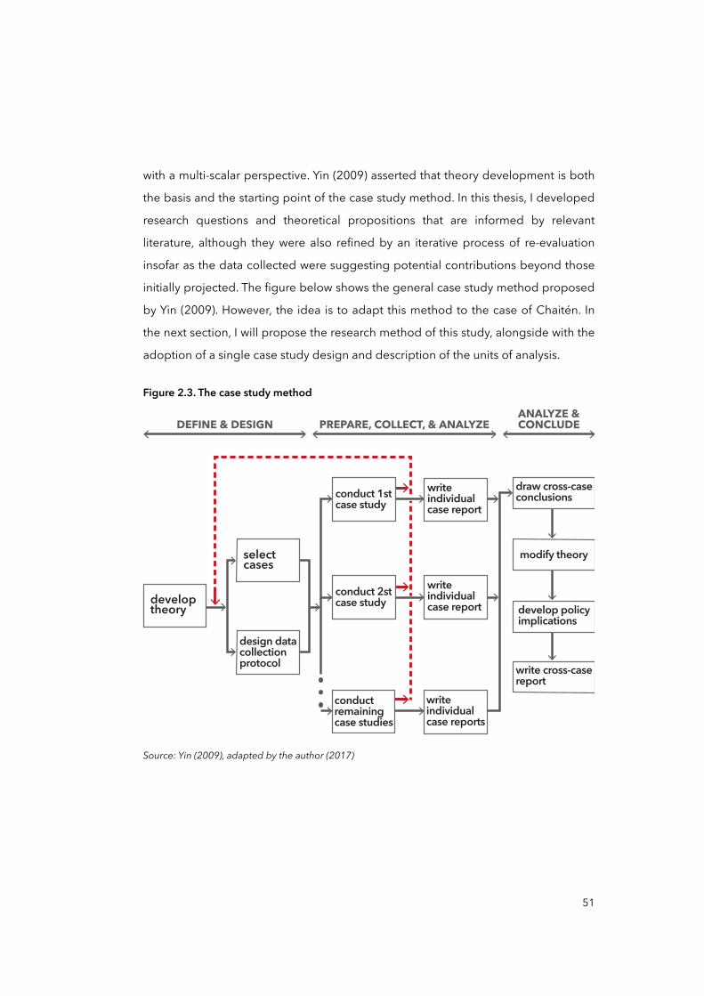
with a multi-scalar perspective. Yin (2009) asserted that theory development is both
the basis and the starting point of the case study method. In this thesis, I developed
research questions and theoretical propositions that are informed by relevant
literature, although they were also refined by an iterative process of re-evaluation
insofar as the data collected were suggesting potential contributions beyond those
initially projected. The figure below shows the general case study method proposed
by Yin (2009). However, the idea is to adapt this method to the case of Chaitén. In
the next section, I will propose the research method of this study, alongside with the
adoption of a single case study design and description of the units of analysis.
Figure 2.3. The case study method
developtheory
selectcases
writeindividualcase report
draw cross-caseconclusions
modify theory
develop policyimplications
write cross-casereport
writeindividualcase report
writeindividualcase reports
conductremainingcase studies
design datacollectionprotocol
DEFINE & DESIGN PREPARE, COLLECT, & ANALYZEANALYZE &CONCLUDE
conduct 1stcase study
conduct 2stcase study
Source: Yin (2009), adapted by the author (2017)
51
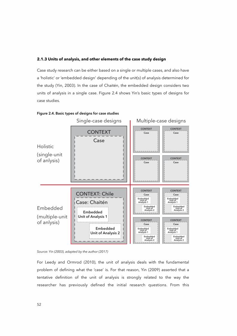
2.1.3 Units of analysis, and other elements of the case study design
Case study research can be either based on a single or multiple cases, and also have
a ‘holistic’ or ‘embedded design’ depending of the unit(s) of analysis determined for
the study (Yin, 2003). In the case of Chaitén, the embedded design considers two
units of analysis in a single case. Figure 2.4 shows Yin’s basic types of designs for
case studies.
Figure 2.4. Basic types of designs for case studies
Single-case designs
Holistic(single-unit of anlysis)
Embedded(multiple-unit of anlysis)
Multiple-case designs
CONTEXTCase
CONTEXT: ChileCase: Chaitén
EmbeddedUnit of Analysis 1
EmbeddedUnit of Analysis 2
CONTEXTCase
CONTEXTCase
CONTEXTCase
CONTEXTCase
CONTEXTCase
CONTEXTCase
CONTEXTCase
CONTEXTCase
EmbeddedUnit of
Analysis 1Embedded
Unit of Analysis 2
EmbeddedUnit of
Analysis 1Embedded
Unit of Analysis 2
EmbeddedUnit of
Analysis 1Embedded
Unit of Analysis 2
EmbeddedUnit of
Analysis 1Embedded
Unit of Analysis 2
Source: Yin (2003), adapted by the author (2017)
For Leedy and Ormrod (2010), the unit of analysis deals with the fundamental
problem of defining what the ‘case’ is. For that reason, Yin (2009) asserted that a
tentative definition of the unit of analysis is strongly related to the way the
researcher has previously defined the initial research questions. From this
52
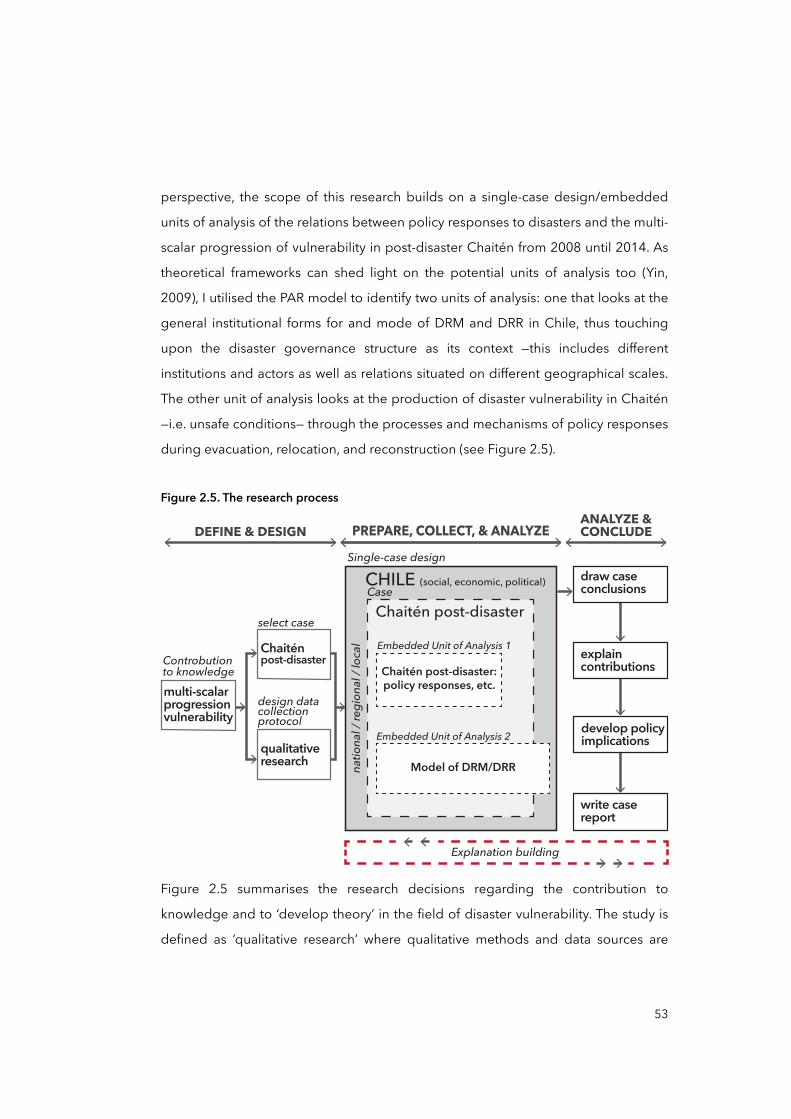
perspective, the scope of this research builds on a single-case design/embedded
units of analysis of the relations between policy responses to disasters and the multi-
scalar progression of vulnerability in post-disaster Chaitén from 2008 until 2014. As
theoretical frameworks can shed light on the potential units of analysis too (Yin,
2009), I utilised the PAR model to identify two units of analysis: one that looks at the
general institutional forms for and mode of DRM and DRR in Chile, thus touching
upon the disaster governance structure as its context —this includes different
institutions and actors as well as relations situated on different geographical scales.
The other unit of analysis looks at the production of disaster vulnerability in Chaitén
—i.e. unsafe conditions— through the processes and mechanisms of policy responses
during evacuation, relocation, and reconstruction (see Figure 2.5).
Figure 2.5. The research process
Single-case design
Case
natio
nal /
regi
onal
/ loc
al
Model of DRM/DRR
Embedded Unit of Analysis 2
Embedded Unit of Analysis 1
DEFINE & DESIGN PREPARE, COLLECT, & ANALYZEANALYZE &CONCLUDE
Controbutionto knowledgemulti-scalarprogressionvulnerability
select case
design datacollectionprotocol
Chaiténpost-disaster
qualitativeresearch
CHILE (social, economic, political)
Chaitén post-disaster
Chaitén post-disaster:policy responses, etc.
draw caseconclusions
explaincontributions
develop policyimplications
write casereport
Explanation building
Figure 2.5 summarises the research decisions regarding the contribution to
knowledge and to ‘develop theory’ in the field of disaster vulnerability. The study is
defined as ‘qualitative research’ where qualitative methods and data sources are
53
drawn from: interviews, observations, and qualitative document analysis. As
described above, the single-case design at hand encompasses two ‘embedded
units of analysis’ that work to connect the research on different scales. The ultimate
goal of this thesis is to arrive at conclusions that contribute to knowledge and to
develop policy implications.
Likewise, the logic linking the collected data to the propositions is established
through the ‘Explanation Building’ method (Yin, 2003). Essentially, explanation
building consists of analysing the general case study data by building an
explanation about the case and the phenomenon. In most cases, explanation
building occurs in a narrative form that constructs a storyline around the data, the
propositions, and the research questions. In this case, the basis as well as the
structure of the explanation building is given by the PAR model, based on the way
the progression of vulnerability occurs: root causes, dynamic pressures, and unsafe
conditions. In order to increase precision, Yin (2003) appealed to the iterative nature
of explanation building, then the following steps were conducted in order:
• Making an initial proposition about the phenomenon: e.g. disaster vulnerability in Chaitén persists despite various post-disaster efforts in part because policy
responses did not consider the local reality, among others;
• Comparing the findings of the case against the statement of the propositions;
• Revising the propositions;
• Revising other details of the case against the revision;
• Repeat this procedure as many times as needed.
Finally, as mentioned earlier, the criteria for interpreting the findings is established
through a social constructionist approach to vulnerability, disasters, and scales, and
the PAR model. The rationale behind the selection of these approaches and
frameworks is delineated in Chapter Three. In the following sections, I describe the
research methodology, including the period of fieldwork, methods utilised, and an
introduction to the analytical approach.
54

2.2 Research methodology
The research methodology utilised in this thesis builds on the case study method
looking at the bounded system of policy responses to disasters, the model of DRM
and DRR in Chile, and disaster vulnerability in post-disaster Chaitén. It aims to
explore and describe specific linkages between temporally and spatially distant
processes —e.g. policy responses, governance and decision-making, institutions—,
and the local ‘materialisation’ of vulnerability in the form of ‘unsafe conditions’ in
Chaitén.
In contrast to a positivist or naturalistic approach to disaster and risk, which see
these as factual realities independent of subjective value judgements, the thesis’
methodology deals with a constructivist approach, that is, with the power and
functions of discourses and institutions in constructing the socio-natural ‘reality’ of
risks and disasters, as well as with the role of the researcher —the observer— in the
process of research (Cohen and Manion, 1994; Mertens, 2005). Thus, the methods
and instruments for data collection, and the analytical framework employed in this
study are tied to this constructivist approach. In the next chapter, I will explore
different disciplinary and historical traditions approaching disaster, risk, and
vulnerability to sustain these as social constructions. Hence, a component of this is
the examination of disaster and scale literature. The literature review seeks to
engage in the epistemological debate on the progression of vulnerability, the
causes of disasters, and the implication of geographical scales, all crucial to
approach and answer the research questions. On the other hand, by utilising the
PAR model, I also try to articulate these two bodies of literature: as the PAR model
implicitly refers to geographical scales as the arenas where root causes, dynamic
pressures, and unsafe conditions are organised (Wisner et al., 2004). Then, the PAR
model works not only as a main analytical register but also as a connector of
literature bodies too. This operation is addressed in Chapter Three: in this chapter,
however, I focus on the methods and the research design.
55
Before introducing the period of research and methods employed during the study,
I briefly outline some considerations on the pros and cons of quantitative and
qualitative approaches used in this study.
2.2.1 Considerations of quantitative and qualitative approaches
Here, some brief considerations for using quantitative and qualitative data and
methods are presented to outline some methodological implications for the study,
the fieldwork, and the data analysis.
Quantitative
Frequently, quantitative researchers must infer the cause and the effect of a given
event through the selection of their independent and dependent variables —in
which case independent variables are manipulated (cause) and the dependent are
observed (effect). Nevertheless, this is difficult to apply in social research due to
independent and dependent variables being unreachable (O'Brien, 2006). In the
research of Chaitén, variables are not subject to manipulation. However, inferring
about the causes and effects —i.e. root causes and unsafe conditions— can be made
based on the quantitative evidence collected from secondary sources such as
accounting reports and statistics. For instance, in Chapter Five, an analysis of the
municipal budget in Chaitén accounted for the high dependence of the city on the
national economy, revealing the hierarchical and vertical relationship between
Chaitén and the state during recovery and reconstruction phases.
Both quantitative and qualitative methods seek to generalise their findings.
Generalisation is using a sample to explain the whole. In quantitative methods, the
idea that a sample could be representative of the whole is often used (Creswell,
1994). According to Creswell (1994), a researcher can generalise the findings of a
given sample just until to the ‘whole’ from which it was obtained —i.e. a school, a
town, a city and country—, but it can never be generalised beyond that sample
frame. Thus, it does not matter how many surveys and questionnaires were used, it
will be very difficult to get the complete picture of a given phenomenon, especially
56

social phenomena. For these reasons, this study does not attempt to generalise the
findings into the general debate on the social production of disasters, but rather
aims to provide insights for the refinement of a theoretical debate. Likewise, the
scope of research findings can represent, in the best case, the contemporary
Chilean context.
Qualitative
According to O'Brien (2006), qualitative research is difficult to replicate. Most case
study procedures and methods are collected and followed by the researcher as well
as the data analysis. Most critiques point out that the researcher’s findings are
affected by his or her interests, about how he or she decided to put attention on one
or another element or people, and so on. Aware of these limitations of qualitative
methods such as in-depth interviews and participant observations —as they were
used in the fieldwork— some measures were taken, such as triangulation. As Creswell
(1994, p.8) explained, “being objective is an essential aspect of competent inquiry,
and for this reason researchers must examine methods and conclusions for bias. For
example, standards of validity and reliability are important in quantitative research”.
One of these standards of validity widely used in qualitative research is triangulation
through the use of multiple sources (Jick, 1979). In the study of Chaitén,
triangulation was pursued through the use of multiple sources as a means of
seeking convergence across different methods: interviews —stratified on different
scales in Chile—, focus groups, field observations, and documentary analysis. For
instance, unsafe conditions such as the ‘uneven distribution of risks’ between North
and South sectors in Chaitén were corroborated by interviews, observations, and the
analysis of socio-demographic and economic records.
In general, this study can be considered ‘qualitative research’ based on the type of
evidence collected throughout the investigation, as well as the methods utilised. As
mentioned in the introductory chapter, interviewing, participant and non-participant
observation, and document analysis were the main techniques applied.
Nevertheless, in several moments of the study, quantitative data from secondary
57
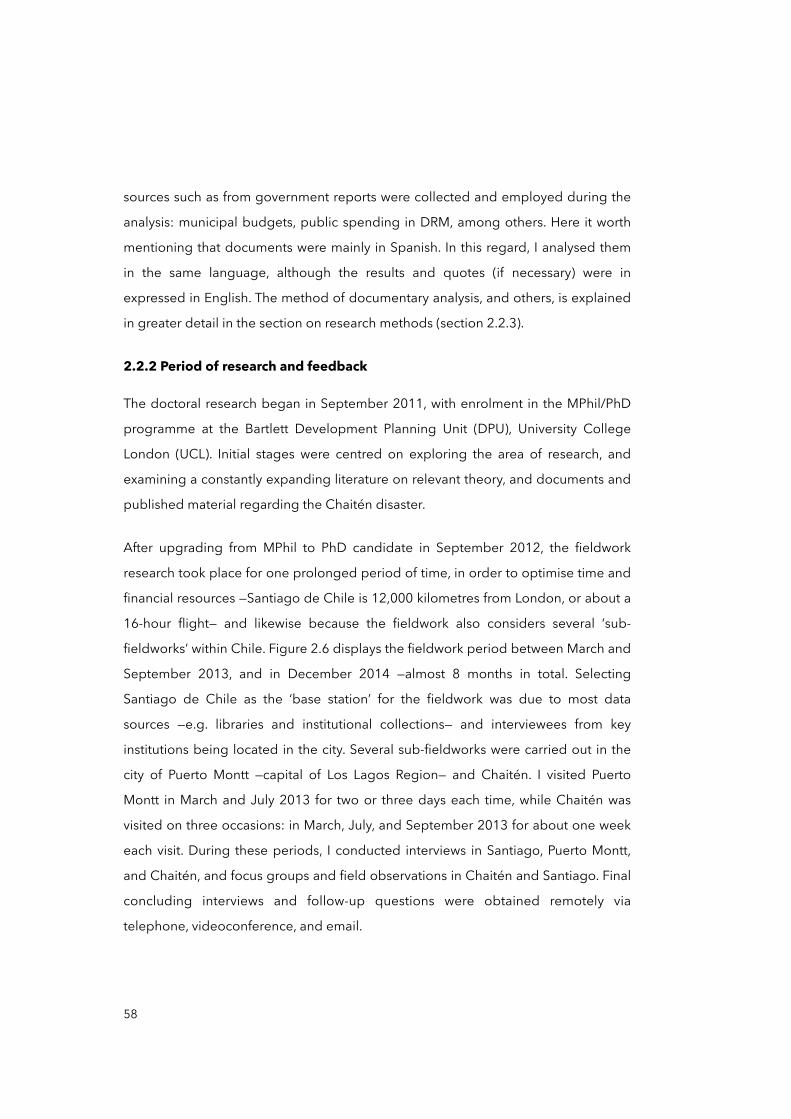
sources such as from government reports were collected and employed during the
analysis: municipal budgets, public spending in DRM, among others. Here it worth
mentioning that documents were mainly in Spanish. In this regard, I analysed them
in the same language, although the results and quotes (if necessary) were in
expressed in English. The method of documentary analysis, and others, is explained
in greater detail in the section on research methods (section 2.2.3).
2.2.2 Period of research and feedback
The doctoral research began in September 2011, with enrolment in the MPhil/PhD
programme at the Bartlett Development Planning Unit (DPU), University College
London (UCL). Initial stages were centred on exploring the area of research, and
examining a constantly expanding literature on relevant theory, and documents and
published material regarding the Chaitén disaster.
After upgrading from MPhil to PhD candidate in September 2012, the fieldwork
research took place for one prolonged period of time, in order to optimise time and
financial resources —Santiago de Chile is 12,000 kilometres from London, or about a
16-hour flight— and likewise because the fieldwork also considers several ‘sub-
fieldworks’ within Chile. Figure 2.6 displays the fieldwork period between March and
September 2013, and in December 2014 —almost 8 months in total. Selecting
Santiago de Chile as the ‘base station’ for the fieldwork was due to most data
sources —e.g. libraries and institutional collections— and interviewees from key
institutions being located in the city. Several sub-fieldworks were carried out in the
city of Puerto Montt —capital of Los Lagos Region— and Chaitén. I visited Puerto
Montt in March and July 2013 for two or three days each time, while Chaitén was
visited on three occasions: in March, July, and September 2013 for about one week
each visit. During these periods, I conducted interviews in Santiago, Puerto Montt,
and Chaitén, and focus groups and field observations in Chaitén and Santiago. Final
concluding interviews and follow-up questions were obtained remotely via
telephone, videoconference, and email.
58
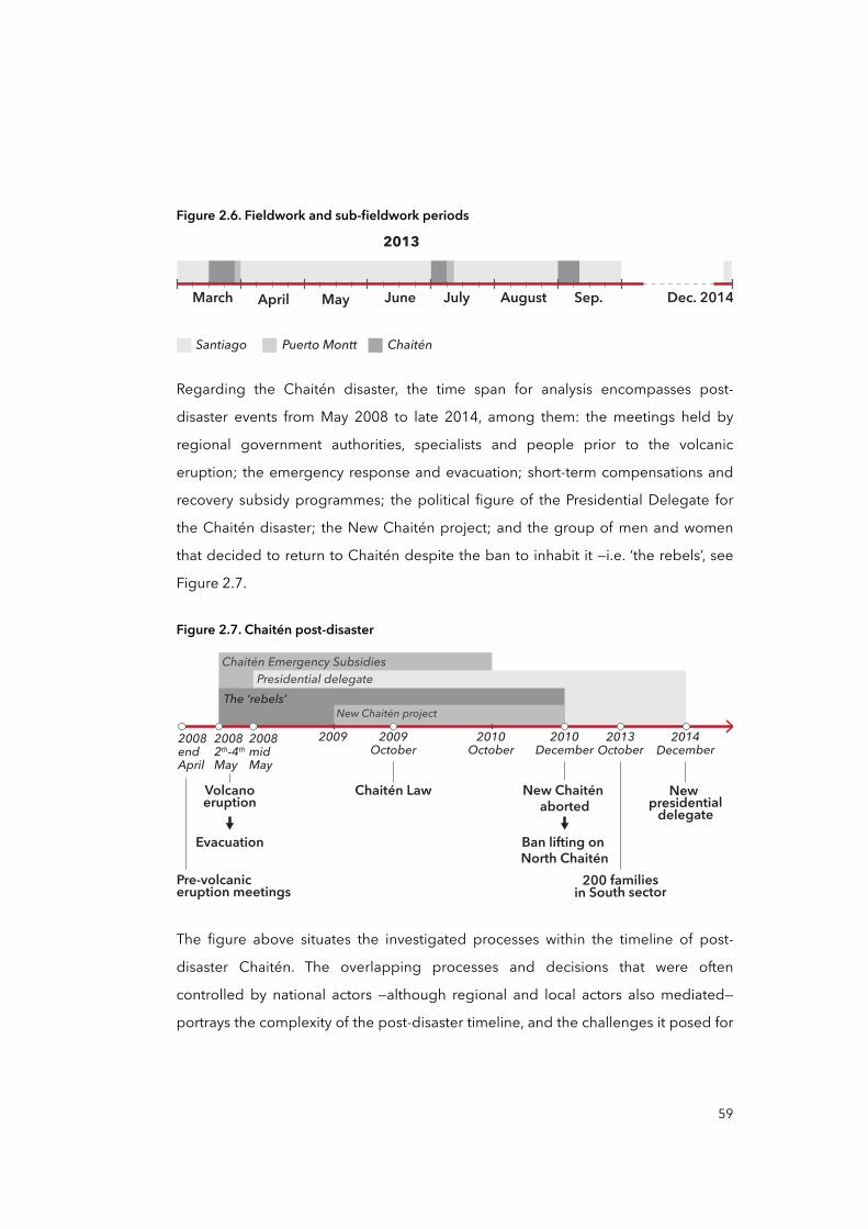
Figure 2.6. Fieldwork and sub-fieldwork periods
March
2013
April May June July August Sep. Dec. 2014
ChaiténPuerto MonttSantiago
Regarding the Chaitén disaster, the time span for analysis encompasses post-
disaster events from May 2008 to late 2014, among them: the meetings held by
regional government authorities, specialists and people prior to the volcanic
eruption; the emergency response and evacuation; short-term compensations and
recovery subsidy programmes; the political figure of the Presidential Delegate for
the Chaitén disaster; the New Chaitén project; and the group of men and women
that decided to return to Chaitén despite the ban to inhabit it —i.e. ‘the rebels’, see
Figure 2.7.
Figure 2.7. Chaitén post-disaster
2009October
2010October
Pre-volcaniceruption meetings
Chaitén Law
2009 2010December
2013October
2014December
New Chaitén aborted
200 familiesin South sector
New presidential
delegateBan lifting on North Chaitén
Evacuation
Volcanoeruption
2008endApril
20082th-4th
May
2008midMay
New Chaitén project
Chaitén Emergency SubsidiesPresidential delegate
The ‘rebels’
The figure above situates the investigated processes within the timeline of post-
disaster Chaitén. The overlapping processes and decisions that were often
controlled by national actors —although regional and local actors also mediated—
portrays the complexity of the post-disaster timeline, and the challenges it posed for
59
the research design. A detailed exploration and analysis of these processes and
decision, as well as their interrelations, are provided in Chapter Five.
Before addressing the research methods, it is worth mentioning here that valuable
insights and feedback were collected through participation either as a presenter or
moderator in conferences and seminars, in Chile, Germany, and United Kingdom
between 2013 and 2015. The feedback I received during these events had an
immense value since it helped me to test the robustness of the argument of the
thesis, as well as to rethink some of the interviewees and institutions selected for the
study. For example, in a roundtable2 that took place on December 16, 2014, the
ONEMI’s national director Rodrigo Toro pointed out —referring to the presentation I
did previously— the ‘success’ of the Chaitén case by arguing that nobody died. That
‘self-confidence’ attitude about the supposed ‘success’ intrigued me because it
contrasted with the appraisal from Chaitén people. That guided me later to look at
the ‘life saving’ discourse during emergencies within ONEMI’s documents and
politicians’ media releases, and discuss it in a holistic preparedness for emergency
response. Most of the feedback received during these events was documented in
the form of written notes and audio recordings. A complete list of attended events
can be found in Appendix 2.
2.2.3 Research methods
The case study methods introduced below look at the model of DRM and DRR
policy responses in Chile and disaster vulnerability in post-disaster Chaitén. They
aim to examine and characterise relevant relationships between temporally and
spatially distant processes —e.g. policy responses, governance and decision-
making, institutions—, and the local ‘materialisation’ of vulnerability in Chaitén. The
selection of the methods also considered the post-disaster time span from 2008
onwards —so it required a historic review—, and the inherent complexity linked to the
60
2 This roundtable took place within the 8th ChileGlobal Encuentros Conference. The session was called ‘Disasters, Emergency, and Reconstruction in Chile’.
multiplicity of actors and their positions within a multi-scalar system, which required
a stratification of interviews and documentary analysis.
Interviews and focus groups
An important part of the study and the fieldwork comprises conducting in-depth
and guided interviews and focus groups with key informants and actors at different
geographical and institutional levels: for instance, interviews with ONEMI officials at
national, regional and local levels. I decided to use interviewing as a data collection
technique for several reasons. Firstly, it allows for factually ‘exploring’ the case of
post-disaster Chaitén, since at the start some processes and actors remained unclear
or not confirmed. Thus, interviews being more like guided conversations rather than
structured queries allowed for the stream of questions to be more fluid and
exploratory, especially in-depth interviews at the beginning of the study. In addition
to the ONEMI, informants from other relevant institutions were contacted, for
example from:
• Congress of Chile
• Ministries of Interior and Public Security, Public Works (MOP), Housing and
Urbanism (MINVU), Finance, Social Development, Agriculture, National Property, and the Ministry of Health (MINSAL)
• Subsecretariat for Regional Development and Administration (SUBDERE)
• Government of Los Lagos Region
• Provincial Government of Palena
• Municipality of Chaitén
• Neighbourhood and community organisations in Chaitén such as the ‘Sons and Friends of Chaitén’ and ‘Potable Water Committee of Chaitén South’,
among others.
Experts, scholars, and practitioners at different geographical levels were also
approached, including from universities, research centres, and NGOs. Among them:
61
the National Research Center for Integrated Natural Disaster Management
(CIGIDEN) at the Pontificia Universidad Católica de Chile, the Research Center for
Vulnerability and Socio-natural Disasters (CIVDES) at the Universidad de Chile, the
Laboratory of Territorial Planning or Laboratorio de Planificación Territorial (LPT) at
the Universidad Católica de Temuco, Universidad de Los Lagos, the Lift Chile
Challenge or Desafío Levantemos Chile, Observatory for the Reconstruction or
Observatorio de la Reconstrucción, and Ámbito Consultores.
As the research was inductive, the first batch of interviews took place in Chaitén in
March 2013 to discern the actual vulnerability. Unsafe or vulnerable conditions
described by interviewees during these first round of interviews were then
converged alongside data collected through technical reports and scientific articles
—these are properly referenced in Chapter Five. Eleven interviewees were
approached using a snowball stratified sampling technique. Atkinson and Flint
(2004) defined snowballing as a qualitative method for gathering subjects who then
provide the names of other relevant actors. This technique was especially useful for
dealing with the difficult problem of obtaining respondents as they were few in
number and require higher levels of trust in order to initiate contact, such as the
politicians and government officials contacted to talk about the Chaitén case 3 and
the local leaders in Chaitén.
Taking advantage of my professional network, I contacted via email from London, in
December 2011, two colleagues who worked in Chaitén post-disaster researching
for academia and NGOs. They gave me an initial overview of potential key
informants who could provide essential information about vulnerable conditions in
Chaitén. One particular informant, Patricia Troncoso4, a local leader who was
immensely valuable in our first meeting in March 2013, provided me access to all
62
3 In the initial interviews with government officials, there was a clear political tension around the Chaitén disaster as they first asked me not to record the interviews or not to use their name in any published material.
4 Fictitious name. At the end of this section, on ‘ethical considerations’ I explain why I decided to use fictitious names for all research participants.
other local leaders, both in the North and South sectors of Chaitén. In most cases, I
approached the interviewees in the company of a person who had referenced him
or her previously. This was true for approaching most of the community leaders. On
other occasions, for local government officials such as the Mayor and the Head of
Police in Chaitén, I telephoned them using the contact details provided by other
interviewees. In these circumstances, I always used the names of the person who
gave me his or her contact details, in order to facilitate approaching the potential
informant. Although the informants were mainly community leaders from different
neighbourhood groups, there were also representatives from public services such as
police, health, and firefighters in Chaitén. As the research was inductive, interviewing
evolved from the ‘informal conversational interview’ to the ‘general interview guide
approach’ (Gall et al., 2003), being first applied at the beginning of the study when I
visited Chaitén the first and second time —in March and July 2013 respectively.
Guided interviewing was applied often with interviewees from the national and
regional governments, academia, and civil society. In the case of government
officials, these interviews looked at the role of institutions and their decisions in
relation to the evacuation, recovery, relocation, and reconstruction of Chaitén.
Interviews with experts and relevant informants in Chaitén looked at the same
relations but in combination with their perceptions on vulnerable conditions in
Chaitén (see samples of interview records in Appendices 3 and 4).
Once the interviewees were contacted, I arranged the encounters at places where
interviewees may feel comfortable to talk openly, such as in their offices, houses, and
sometimes in cafeterias, and on the street. To conduct the interviews, I used my own
experience in previous research and techniques described by several authors
(Leedy and Ormrod, 2010; Nelson, 2012). I viewed interviews as personal
encounters where social skills, avoiding judgemental attitudes, engaging with the
respondent —but keeping track of the questions—, and active listening techniques
were utilised —such ‘please repeat’, ‘really?’, ‘tell me more about that’. Basically, the
point was to let the respondents tell their own story on their own terms. I asked
simple but direct questions such as ‘What was your experience during the
63
evacuation?’ or ‘how did you and/or the ONEMI react when you received the
emergency call from Chaitén in May 2008?’ trying to elicit a descriptive answer from
the respondents.
I always initiated the encounters by introducing myself and the objectives of the
interview (very briefly), and I asked the interviewees to introduce themselves too.
Subsequently, I continued with ‘warming up’ questions —something that the
respondent could answer easily and at some length (though not too long)— in order
to put us more at ease and make the rest of the interview flow more smoothly. Then,
I started with the questions related to the subject of study, which varied from one
interviewee to another depending of the institution or organisation and the
geographical scale at which she or he was situated. In general, the conversations
included these topics and structure: 1) presentation and introduction, 2) about the
evacuation, 3) recovery —i.e. compensation, benefits and subsidies—, 4) the
relocation and New Chaitén project, and 5) reconstruction. After 30 minutes and one
hour, I started to end the interviews by mentioning that we were approaching the
end at the same time I asked the final questions, and by making a short summary of
the talk at the end —in case the interviewee desired to add or re-comment about
something addressed or not in the interview. Finally, I always thanked them for their
time and dedication, and I offered my contact details in case they would like to make
further comments on the discussed topics.
In total, I visited Chaitén three times for 27 interviews, two focus groups, and several
participant observations, and in some cases for accessing municipal records and
documents: in March, July, and September 2013. I also visited Puerto Montt two
times for interviews: in March and July 2013. In Puerto Montt, I interviewed eight
people total from the Regional Government of Los Lagos and the ONEMI’s regional
division, as these institutions played an influential role in the relation between policy
responses and decision-making and the community during the post-disaster phase.
They were selected using the snowball stratified sampling technique too, but also
informed by media archives and institutional reports.
64
In Santiago de Chile, I conducted 31 interviews during March until September 2013
and in December 2014 that included people from national government institutions,
NGOs, and academia. Informants were contacted in different ways, with most of the
executive government officials being approached through my personal and
professional network, while in other cases, officials were approached through formal
channels such as letters, emails, and telephone calls to their offices. Similar
procedures were taken for approaching experts and practitioners.
In a few cases, interviews were cancelled, and in other cases they had to be
conducted by telephone because it was not possible to find a convenient date and
time. It must be noted that the initial interview plan encompassed about 50
interviewees, however several interviews and interviewees suggested other relevant
contacts who were accordingly contacted to be interviewed.
During the fieldwork in Chile to late 2014, a total of 66 individuals participated in in-
depth and guided interviews, focus groups, and telephone interviews. This included
any follow-up in the form of informal conversations on email or other verbal
communications. In two sub-fieldworks in Chaitén, focus groups and interviews were
assisted by another researcher, Cristian Albornoz Espinoza from the CIVDES at the
Universidad de Chile who had been involved in previous research activities in
Chaitén.
Alongside the sampling process, the interviewees’ universe was stratified according
to different levels of organisational hierarchy within relevant institutions and
geographical scale. Figure 2.8 illustrates the various interviewees of the study. They
are organised in relation to the institution or ‘field’ they were working in at the time
when the interview took place —i.e. Ministry of Interior (MI), Other ministries (OM),
Civil society (CS), Academia and Practitioners (AP), or Local people (LP)—, or at the
time of the Chaitén disaster’s occurrence —i.e. 2008-2013. Likewise, the interviewees
were stratified in relation to the ‘geographical scale’ —i.e. national, regional, and local
— by which their institutions/organisations are organised. Interviewees’ identities
were codified —e.g. MI12 corresponds to the interviewee Nº12 of the Ministry of
65
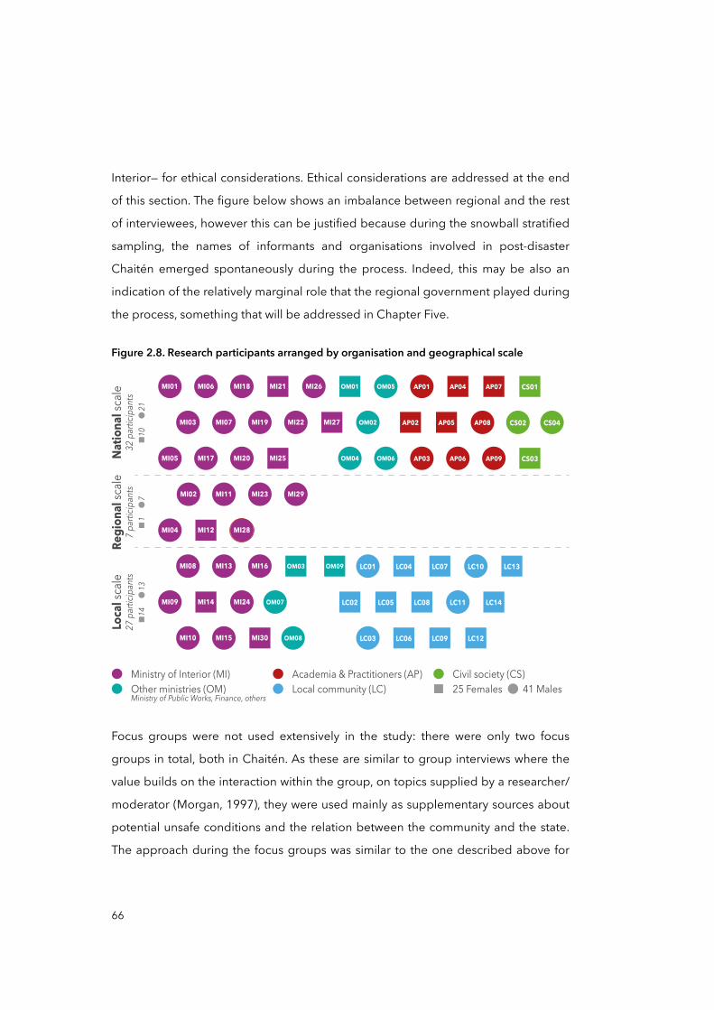
Interior— for ethical considerations. Ethical considerations are addressed at the end
of this section. The figure below shows an imbalance between regional and the rest
of interviewees, however this can be justified because during the snowball stratified
sampling, the names of informants and organisations involved in post-disaster
Chaitén emerged spontaneously during the process. Indeed, this may be also an
indication of the relatively marginal role that the regional government played during
the process, something that will be addressed in Chapter Five.
Figure 2.8. Research participants arranged by organisation and geographical scale
MI19
MI20
CS01
CS02
OM04
OM05
OM06
OM01
OM02
MI17
MI07
MI01 AP07AP01
AP03
AP04
AP08AP02 AP05
AP06 AP09
MI22
MI25
MI11 MI23 MI29MI02
MI04 MI12
CS04
MI28
CS03
MI27MI03
MI05
MI06 MI18 MI21 MI26
OM03
OM08
MI08 MI13 MI16 LC01 LC04 LC10 LC13LC07
MI09 MI14 LC02 LC05 LC08 LC11MI24
OM09
LC14OM07
MI10 MI15 LC03 LC06 LC09 LC12MI30
Ministry of Interior (MI) Academia & Practitioners (AP) Civil society (CS)25 Females 41 MalesLocal community (LC)Other ministries (OM)
Ministry of Public Works, Finance, others
Natio
nal s
cale
32 pa
rticip
ants
Regi
onal
scale
7 part
icipa
ntsLo
cal s
cale
27 pa
rticip
ants
10
21
14
13
1
7
Focus groups were not used extensively in the study: there were only two focus
groups in total, both in Chaitén. As these are similar to group interviews where the
value builds on the interaction within the group, on topics supplied by a researcher/
moderator (Morgan, 1997), they were used mainly as supplementary sources about
potential unsafe conditions and the relation between the community and the state.
The approach during the focus groups was similar to the one described above for
66
interpersonal interviews, although it considered pre-planning and recruiting, as well
as moderating as essential elements for the correct development of the activity
(Morgan and Scannell, 1998).
A complete list of participants in both interviews and focus groups can be found in
Appendix 1, where information about them regarding gender, affiliation or group,
position, and date of interaction is provided. Likewise, a sample of the preparation
and execution of guided interviews and of one focus group arranged in Chaitén is
available in Appendices 3 and 4.
Field observations
A second technique used in this study was participant and non-participant
observations. According to Leedy and Ormrod (2010), the qualitative researcher
may make observations either as a relative ‘outsider’ or non-participant and,
especially in the case of an ethnography, as a participant observer. Observations in
qualitative research are intentionally unstructured and ‘free-flowing’, owing to the
flexibility of taking advantage of unforeseen data sources as they surface (Leedy and
Ormrod, 2010). Yin (2003) asserted that both participant and non-participant
observations are valuable sources because of their closeness to ‘reality’, as they
allow the researcher to gather data in real-time, but also because observations are
contextual, covering the context of observed events. According to Yin,
“observational evidence is useful in providing additional information [...] for
understanding either the context and the phenomenon being studied” (Yin, 2003, p.
93). For the above-mentioned reasons, and because I have had previous experience
using this technique, I selected ‘observations’ as a complementary source of
evidence.
In the study, non-participant observations occurred within some group discussions
and team meetings in Santiago between two or more participants when another
researcher, assistant or mediator led the interaction. These observations included
spontaneous home meetings and sidewalk interactions in Chaitén too. These took
67
place in the North and South sectors in Chaitén and in surrounding areas. For Yin
(2003), participant observations occur when the researcher is identified as such and/
or when the researcher happens to be a part of the organisation or group being
studied. During the fieldwork in Santiago, I participated as ‘Visiting Researcher’ in
two research centres on disasters in Chile: in the CIVDES at the Universidad of Chile
between March and August 2013, and in the CIGIDEN at the Pontificia Universidad
Católica de Chile in December 2014. In both periods, I had the chance of observing
diverse academic discussions and comments on policies, governmental efforts, and
initiatives on DRM and DRR in Chile. Both direct and participant observations were
registered in the form of written notes and pictures (these were properly indicated in
Chapter Five). As recommended by Yin (2003), pictures were taken at several
fieldwork locations as they help to convey important case characteristics to outside
observers, to capture information that later may be useful for analysis, or can be
used to represent insights on some specific contextual situations (see for example
figures 5.23 in page 232 and 5.26 in page 239, Chapter Five).
Document analysis
A third research method and data source used in this study relates to the analysis of
documents or document analysis. For Bowen (2009), document analysis can involve
skimming (superficial examination), reading (thorough examination), and
interpretation of texts both printed or electronic. The process is iterative and can
combine elements of ‘content’ and ‘thematic’ analysis. Content analysis is the
process of organising information into categories that can be useful to address the
research questions, while thematic analysis is a form of pattern recognition within
the data, with emerging themes becoming the categories for analysis (Bowen,
2009). In this study, however, I have tried to exclude the quantification typical of
conventional mass media content analysis due to most of the documents utilised in
the study having different ‘content structure’: this study included reports, media
releases, newspaper interviews, historical books, websites, laws, legal documents,
among many other types of documents. According to Corbin and Strauss (2014),
quantitative document analysis is recommended when the content structure of the
68
sample is either equal or similar —e.g. books, press releases, or tweets from Twitter.
In cases like this study where documents have very different content structures,
document analysis can entail a first-pass document review, in which relevant
passages of text or other data —e.g. pictures— are identified and then analysed
(Bowen, 2009). In this regard, I first did a document sampling regarding the Chaitén
disaster between 2008 and 2014 that encompassed documents from different
organisations, institutions, and media. Of course, the document sampling was
guided and accordingly stratified in accordance with the analytical framework
defined previously —i.e. the PAR model. Thus, contents that pointed to certain ‘root
causes’ were categorised differently from those that pointed to ‘unsafe conditions’ in
Chaitén. Then, this sample expanded and contracted insofar as new data from
interviews and field observations emerged.
Although most of the documents used in this study are properly referenced in text
and the bibliography, a categorised list of studied documents is provided here:
• International reports: may be issued by private and non-private international organisations;
• Governmental reports: may be issued by ministerial departments and offices, it can include national reports, regional and municipal accountability reports,
among others;
• Consulting or private reports: may be issued by consulting firms, companies,
and universities, or from a combination of them —e.g. PUC et al. (2009);
• Laws: issued by the Congress of Chile or the Government of Chile and can
include Supreme Decrees, Force-of-law Decrees, Bills, among others;
• Media archives: may be issued by public or private organisations, and may
include text, audio, images, and/or videos;
• Press releases: generally issued by governmental bodies in written or recorded
communication;
69
• Newspaper articles: issued by newspaper private companies both physically or electronically, including national, regional, and local newspapers;
• Scientific articles: issued by academic publishers.
The rationale for document analysis lies in its role in methodological and data
triangulation, and the immense value of documents for investigating events in the
past (Bowen, 2009). This is especially true for a historical analysis of the
geographical scale formations in Chile and its relation to the model of DRM and
DRR, thus, document analysis was used as the predominant research method.
The data collected from documents were continuously contrasted with other
sources including key informants and field observations. To achieve greater validity
for the data collected, triangulation was always pursued. Triangulation has been
broadly defined (Denzin, 2009) as the combination of methodologies and/or
sources in the study of the same phenomenon. The triangulation metaphor is
borrowed from a navigation and military strategy that uses multiple reference points
to locate an object’s exact position (Jick, 1979). Thus, qualitative studies can improve
accuracy of their judgements by collecting different kinds of data, and using
different technique and methods (Jick, 1979). In this study, I decided to rely on the
combination of different methods of data collection as well as the use of quantitative
and qualitative data to provide more reliability and accuracy of findings.
Ethical considerations
Because of ethical considerations for primary research in the case of interviewing,
few interactions were recorded either using audio or video. This decision was made
considering the pros and cons of recording and transcribing interviews (Nelson,
2012): recording devices introduce different dynamics into the social encounter of
the interview, and transcription can be a very time-consuming process, especially
when the interviews are conducted in a language other than the one selected for the
study. I was also looking to “encourage openness and the establishment of trusting
relationships with the interviewer” (Diamond and Allcorn, 2009, p.185). The Chaitén
70
disaster had an important political impact for both government officials —e.g. the
forced resignation of the regional governor or intendente in 2009— and left-wing
parties in rule as they lost the elections against a right-wing coalition in 2009. These
reasons, I assumed, may explain why several government officials asked me
beforehand not to record the interviews. In addition to this, the requirements of the
UCL Graduate School Research Fund (which partially funded the fieldworks) and the
UCL Research Ethics Committee requested that I ensure confidentiality of human
participants during fieldworks. Finally, I decided that all interviewees were protected
by confidentiality and anonymity. In order to facilitate reading and understanding,
fictitious names were used for the interviewees while gender, institutional affiliation,
position and date of interaction is provided.
Of those recorded interactions, most of them were transcribed or partially
transcribed. All sources quoted in the thesis are from those transcripts. In addition to
the aforementioned transcriptions, most of the interviews were registered in
summary form as written notes (see an example in Appendices 3 and 4). These notes
were also transcribed and expanded upon immediately after each interview.
2.2.4 History as a ‘proxy’ to approach geographical scales in Chile
As in statistics, proxy variables or indicators are often used as an indirect measure or
sign that approximates the phenomenon and its characteristics in the absence of a
direct indicator (Miller, 2007). One of the study’s objectives is to understand how the
progression of disaster vulnerability may unfold through geographical scales,
considering these as social constructions, that is, that scales are not necessarily a
preordained framework or ontologically given categories for ordering the world —
local, regional, national and global. They are instead “a contingent outcome of the
tensions that exist between structural forces and the practices of human
agents” (Marston, 2000, p.220). Then, the idea of a multi-scale analysis required me
to deepen the history of certain socio-spatial and structural processes that can
explain as well as describe the current state territorial organisation of Chile, in terms
of its spatial, political, economic, and social organisation.
71
The study of geographical scales in Chile will be the focus of Chapter Four as a
‘proxy’ as it aims to inform the analysis of causal factors and processes of disaster
vulnerability in Chaitén through the history of the territorial structure of the Chilean
state. This seeks to assist the analysis of key characteristics of the state model of
DRM or any other institution potentially involved in the progression of vulnerability,
being either de- or centralised, top-down or bottom-up, pro- or reactive, and so
forth.
In this regard, Brenner (2009a; 2009b) and Marston (2000) recognised that
‘institutional forms’ have proven to be an invaluable analytical element to
conceptualise geographical scales. For instance, ‘education’ —as a social
phenomenon— is institutionalised at different levels and configured at different
geographical scales, from the national to the local: Ministry of Education, Regional
departments or sub-agencies, schools and universities at urban levels, and so forth.
Likewise, the geographical organisation of institutional processes on education may
include national policies and laws, regional regulatory frameworks, and municipal
ordinances. Although I only investigated the social construction of scales in Chile
from a historical perspective based on document analysis (see section 4.2), the main
objective was to link some general processes of scalar formation with the
geographical distribution and hierarchical organisation of the DRM in Chile, thus
enabling a multi-scalar arrangement of the ‘root causes’, ‘dynamic pressures’, and
‘unsafe conditions’ within the progression of vulnerability for Chaitén. Chapter Four
illustrates the territorial structure of the Chilean state since its independence from
the Spanish empire in 1810 until its contemporary form.
2.3 Introducing the study’s analytical approaches
The main analytical framework utilised in this study is the PAR model. However, this
needs to be considered in light of three other approaches which mediate the
process of analysis too: social constructionism, complexity, and cause-effect.
Although the analytical framework is addressed in Chapter Three, I briefly delineate
each of these approaches as follows.
72
The overall analytical approach is situated between social constructionist
perspectives on disasters, vulnerability, and scales. A social constructionist approach
posits that society and individual experience, including perception, is always
historically, culturally, and linguistically mediated (Berger and Luckmann, 1966). This
means that the perceived ‘reality’, including the one emerging from disasters and
vulnerability in their different scalar materialisation, is never a direct reflection of
physical conditions ‘out there’. Rather, ‘reality’ must be understood as a specific
reading of such material conditions (Berger and Luckmann, 1966). Thus, the analysis
of the epistemological debate on disasters and scales —addressed in Chapter Three
— is conditioned by this ontological stance (Echeverría, 2006).
In addition, a social constructionist and multi-scalar approach to the progression of
vulnerability inherently relates to the problem of complexity, “in the sense that a
great many independent agents are interacting with each other in a great many
ways” (Waldrop, 1993, p.11). The countless number of socio-economic and political,
ecological and cultural processes and circumstances that may intervene in the
process of vulnerability characterises the complexity of interactions between society
and nature as well as the unpredictability of causal chains in disasters (Hilhorst,
2006). Thus, a necessary task has been to somehow delimit complexity to a
manageable dimension for grounded research, such as the present one. This has
been achieved through the use of the PAR model as a cause-effect framework.
In a similar fashion, disasters have been historically interpreted in terms of cause-
effect (Etkin, 2014): ancient cultures used to explain disasters as divine punishment,
and in the modern era people have explained disasters as ‘natural’ events. With the
rise of constructionist approaches in disaster studies (Cardona, 2006), recent models
of disasters are based on the idea that societies have the ability and capacity to
determine their experiences, and to view such events within their locus of control
(Etkin, 2014). This positivism, and the cause-effect approach, are strongly linked to
the seventeenth and eighteenth centuries paradigms of rational thinkers such as
Newton and Descartes, and can even be traced back to Plato (Etkin, 2014). As
73
Hilhorst (2006) and Etkin (2014) asserted, classical rational and positivist notions of
disasters have given rise to more constructionist approaches as a result of the
development of political ecology theories and chaos theory. The complex and
chaotic inherent nature of disasters and vulnerability, “although bounded, can be
highly unpredictable and can exhibit surprising emerging properties. This has led to
a shift from management approaches that are deterministic to ones that are
adaptive and that recognise limitations to the degree to which humans can control
parts of their environment” (Etkin, 2014, p.202). Although the approach adopted in
the study aligns with the cause-effect approach described above, it contests that
single causes give rise to simple effects. Rather, this study refers to ‘cause-effect’ in
the sense of complexity, that is, as ‘cascades’: as cumulative and non-linear
sequential processes that may trigger complex effects such as disasters (Wisner et
al., 2004).
The PAR model, as a key analytical dimension, helped to tame such complexities for
several reasons: first, it is built on a cause-effect perspective (Wisner et al., 2004) and
complexity is delimited to structural factors within a social realm. Second, the
progression of vulnerability that is adopted in the PAR model inherently describes a
scalar organisation and distribution of causal factors of risks and disasters —e.g.
global widespread processes linked to local unsafe conditions. Third, as a very
common tool in disaster studies, it adjusts very well when applied to case-based
research, and there are several interesting case studies that can provide supporting
material for comparing methodologies and analyses (see examples in Dahlberg et
al., 2017; Wisner et al., 2004).
2.4 Limitations of the study
The most obvious methodological challenge was the generalisation of the study’s
findings. Although several methodological measures were taken in order to improve
accuracy, such as triangulation, I was aware that this study is difficult to replicate as
most of the analytical process was interpretative, and therefore, subjective (Yin,
2003). Likewise, although great emphasis has been placed on reliability and
74
accuracy by securing different and diverse data sources, I was also aware that the
analysis and interpretation of data, as well as the delineation of findings, is
unavoidably subject to the author’s history, views, values and beliefs (Creswell, 1994;
Ritchie and Lewis, 2003). Nevertheless, because I was conscious about my position
within the study I did my best in trying to reduce bias by means of convergence of
different qualitative methods, and by peer-review wherever possible.
In addition, the Chaitén disaster produced several political impacts within President
Bachelet’s administration in 2009, and possibly affected the subsequent presidential
elections that year. So the interviews, in 2013, may have been charged with political
tensions because Bachelet was participating in her second presidential campaign,
which she won in November 2013. This may, then, have obscured the interviewees’
perceptions about the circumstances and processes which they were describing.
Alongside this, such perceptions may have also been affected by the relation of the
interviewees with their employers: the fact that many of the interviewees were
government employees at the time of the interviews may perhaps have affected
their narratives.
Moreover, I acknowledge that the scope of the findings may be reduced due to the
limited universe of interviewees as well as its composition. Because the research
encompasses three differentiated territorial and administrative levels —i.e. national,
regional, and local—, a larger number of interviewees may have produced a finer
analysis of the case. Likewise, the composition and distribution of the interviewees
within these three distinctive levels could be better balanced in terms of scale and
gender (see Figure 2.8).
Another limitation relates to the fact that the study is framed within a Structural
Paradigm or a political economy perspective (Wisner et al., 2004, Gunewardena and
Schulle, 2008), which limits its scope and potentials to structural factors in society,
leaving aside relations equally important for disasters such as environmental and
socio-ecological ones —e.g. political ecology.
75
There are also other more practical limitations that relate to the methods utilised: in-
depth and guided interviews, participant and non-participant observations, and
document analysis. For instance, despite the strengths of interviewing mentioned
earlier there are also weaknesses: a potential bias due to poorly constructed
questions; response bias; bias due to poor recall; and ‘reflexibility’, as the
interviewees can state what the interviewer wants to hear (Yin, 2003). The limitation
of observations is also present: ‘selectivity’ unless broad coverage; and ‘reflexibility’
as subjects may proceed differently because they are being observed (Yin, 2003).
Document analysis also has disadvantages that limit the study: ‘insufficient details’ as
documents are for some purpose other than research, and in some cases for a
specific audience, consequently their level of details may be narrowed, insufficient,
and biased (Bowen, 2009). Throughout the thesis, I indicate and warn the reader
about such methodological and practical limitations, as well as the scope of this
work.
In conclusion, I would like to reiterate that despite such limitations, there has
been a considerable contribution to knowledge, especially on how to advance
policy responses to disasters in Chile, its governance systems and decision-making
in relation to DRM. These empirical contributions, as well as other methodological
and epistemological implications, are detailed in the conclusions of the thesis in
Chapter Six.
76
Chapter THREE: The social and multi-scalar progression of vulnerabilityTheoretical background and analytical framework
Introduction
Not long ago, before the 1950s, disasters were mainly seen by people as ‘Acts of
God’, as divine punishment to humankind for their evil ways (Etkin, 2014), and yet
today the idea of disasters being matters of fate persist in some cultures despite the
overwhelming evidence to the contrary (Burton, 2014; IFRC, 2014). This paradigm is
acknowledged by several scholars (Boano and Lund, 2011; Wijkman and
Timberlake, 1984) as the starting point for the interpretation of disasters and risks.
The first historical shift that abandoned the idea of disasters as ‘Acts of God’ came
with the advent of Enlightenment, rationality, and modern scientific thinking in the
eighteenth century. Disasters and risk were seen as ‘Acts of Nature’ (Wijkman and
Timberlake, 1984). Since then, natural extreme events such as earthquakes,
tsunamis, and floods were synonymous with disasters (Etkin, 2014; Hewitt, 1983).
The second and last historical shift in interpreting disasters is brought forth by the
social sciences and the idea of disasters as social constructions (Cardona, 2006;
Wisner et al., 2004). Wijkman and Timberlake (1984) referred to disasters as ‘Acts of
Men and Women’ to interpret disasters as results of conflicting socio-economic,
political, and cultural processes which, when translated into vulnerability, are
‘triggered’ by a given natural extreme event. This interpretation is the very starting
point of this work. In the following sections, I present the theoretical background
and the epistemological debate that uphold the thesis and its analytical framework.
Alongside the behavioural, mutuality, and structural paradigms introduced in
Chapter One (page 29), I initiate this chapter by describing the social constructionist
approach —nested in the Structural Paradigm which focuses on the role of structural
factors in society, such as social relations and structures of domination (Bankoff et
al., 2006)— in order to offer a conceptual and epistemological starting point for the
77
analytical framework of the thesis offered at the end of this chapter. The first section
briefly addresses the history of interpretations of disasters and risks, which I believe
is important for an interpretative perspective of the present and perhaps providing
insights into how to refine our interpretations in the future.
After situating the constellation of disaster studies and the significance of the
vulnerability approach (sections 3.1 and 3.2), the text proceeds in explaining and
discussing the disaster Pressure and Release (PAR) model from a multi-scalar
perspective. This is important because the PAR model is used both as a
methodological and analytical tool: a compass that guided the methodology as well
as the analysis of material collected in the fieldworks. At the end of section 3.3, I
explain how ‘geographical scales’ are conceived as social constructions and how this
perspective may contribute to a better understanding of the progression of
vulnerability. Following mainly Brenner (2009a), Swyngedouw (1992) and Lefebvre
(1991 [1974]), I refer to ‘geographical scales’ as differentiated spaces that are
hierarchically related and organised for and within a form of territorial coherence. As
in a vertical axis along which elements of interest are ranked or units of analysis are
placed, like on a ruler (Fekete et al., 2010), a given single geographical scale —e.g.
urban— should never be conceived and analysed in isolation (Brenner, 2001).
Rather, they must be interrogated vis-à-vis its upwards, downwards, and transversal
linkages within its scalar configuration (Brenner, 2009a).
With this perspective in mind, section 3.4 proposes understanding ‘policy responses
to disasters’ and ‘the model of disaster risk management and reduction in Chile’
within a specific ‘disaster governance’ (Tierney, 2012). This approach was useful as it
allowed me to grasp comprehensively the various aspects and forces that took place
during the progression of vulnerability in Chaitén such as for example on decision-
making. Then, the final section offers a synopsis of the analytical elements discussed
throughout this chapter.
78

3.1 Interpreting disasters and risks
Today, a disaster is commonly defined as “a serious disruption of the functioning of
a community or a society involving widespread human, material, economic or
environmental losses and impacts, which exceeds the ability of the affected
community or society to cope using its own resources” (UNISDR, 2009a, p.9).
International conventions, reports (IFRC, 2014; UNISDR, 2005; 2015b) and social
science literature (Pelling, 2003b; Quarantelli, 1998; Wisner et al., 2004) often
remark that disasters and disaster risk are a result of the interaction of a hazard —e.g.
earthquake, hurricane, etc.— and the vulnerability of an element or system exposed
(Birkmann, 2013), where disaster risk is “the potential disaster losses, in lives, health
status, livelihoods, assets and services, which could occur to a particular community
or society in a specified future time period” (UNISDR, 2009a, p.10). This way of
thinking is reflected in the conceptual equation:
hazard × vulnerability = risk → disaster
However, today’s interpretations have not emerged from thin air. Boano and Lund
(2011) have highlighted this historical transition of disaster interpretations from
disasters as ‘Acts of Nature’ to becoming ‘Acts of Men and Women’ by describing
how techno-centric perspectives are being substituted for a social constructionist
approach. The techno-centric approach builds on interpreting disasters as ‘natural’
events, and therefore focuses on reducing disasters by means of physical research —
e.g. geology, volcanology, engineering, among others— and investment in large-
scale mitigatory infrastructures. Contrarily, the social constructionist approach is
based on interpreting disasters as ‘Acts of Men and Women’, and therefore focuses
on reducing disasters by means of tackling the social causes of vulnerabilities and
risks.
This shift materialised during the 1980s (Quarantelli, 1987a) after the evident failure
of techno-centric approaches and the increasing number of global disasters
(Pelling, 2003b) which occurred despite the increase of ‘technical’ research, and the
79
investment on mitigatory measures worldwide (Hewitt, 1983). According to
Quarantelli (1998), the failure of techno-centric approaches in addressing the
problem of disasters lies in their misunderstanding of the multi-dimensional
complexity of disasters.
In 1987, Quarantelli described that the word ‘disaster’ was introduced to the English
language from French (disastre), which, in turn, was constructed from a derivation of
two Latin words (dis, astro) —meaning something like “formed on a
star” (Quarantelli, 1987b, p.8).5 Thus, the origins of the word ‘disaster’ reflect the
paradigm of time and a starting point in the interpretation of disasters, where such
extreme natural events were interpreted as God’s divine retribution for human
failings (White et al., 2001). Subsequently, with the advent of rational thinking in the
eighteenth century, ‘disasters as acts of God’ were substituted by ‘disasters as acts of
Nature’ (Etkin, 2014). Finally, as Quarantelli6 documented (1998), these ‘common
sense views’ were then challenged by social science approaches. For Dombrowsky,
Carr (1932) was “the first in the field to try to understand disasters in terms of social
action” (1998, p.24). Carr wrote in 1932:
“Not every windstorm, earth-tremor, or rush of water is a catastrophe. A catastrophe is known by its works; that is to say, by the occurrence of disaster. So long as the ship rides out the storm, so long as the city resists the earth-shocks, so long as the levees hold, there is no disaster. It is the collapse of the cultural protections that constitutes the disaster proper”.
(Carr, 1932, p.211)
Several decades later, authors such as Quarantelli (1977; 1998), Hewitt (1983), and
Dynes (1970), as well as others, systematised and organised important social science
contributions in the field of disaster studies. The flowering of social science research
on disasters occurred during the 1990s and continues until today. As evidence of
80
5 The English language has significance for disaster interpretation because studies have importantly been deepened and expanded throughout the twentieth century and the early twenty-first century, where English has become the primary language to communicate, disseminate, and present disasters studies’ results and to discuss perspectives.
6 Enrico Quarantelli died on April 3, 2017, at the age of 92.
such blooming, influential research groups or ‘think tanks’ emerged such as the
Disaster Research Center at the University of Delaware on the ‘sociology of disasters’
in the 1960s, the Network of Social Studies in the Prevention of Disasters in Latin
America (LA RED) in the 1990s, Radical Interpretations of Disasters and Radical
Solution (RADIX) in the 2000s, and more recently, the Integrated Research on
Disaster Risk (IRDR) in China, among others.
From another angle and more recently, Bankoff and his colleagues (2006) outlined
the epistemological debate on the production of disasters and risks around three
mainstream paradigms: the Behavioural Paradigm (BP), Structural Paradigm (SP),
and Mutuality Paradigm (MP). The BP and ST paradigms, Hilhorst said (2006), are
often presented within disaster studies as two rival paradigms. The BP used to
dominate disaster studies in the 1950s promoting a techno-centred interest in
geophysical processes underlying disaster and risks with the conviction that
monitoring and predicting hazards, as well as people’s behaviour to develop early
warning mechanisms, could be enough to avoid disasters and risks. The same shift
in disaster interpretations pointed out by Boano and Lund (2011) was made by
Hilhorst in 2006:
“Towards the 1980s, anthropologists, sociologists and geographers increasingly began to challenge the technocratic, hazard-centred approach to disaster. [...] Kenneth Hewitt (1983) postulated that disasters were not primarily the outcome of geographical processes. Especially in developing countries, structural factors such as increasing poverty and related social processes accounted for people and societies’ vulnerability to disaster”.
(Hilhorst, 2006, p.38)
The idea of vulnerability touched at the heart of understanding disaster. Whereas
disasters used to be practically a synonym for natural hazards, they were now
understood as the interaction between hazard and vulnerability. This was the origin
of the SP, and it was graphically expressed in the popular conceptual equation:
hazard × vulnerability = risk → disaster by Blaikie et al. (1994). According to Hilhorst
(2006), the solution proposed in the SP paradigm would be the transformation of
social and political structures that breed poverty and the social dynamics that serve
81
to perpetuate it. Although BP and SP are still in use, a new paradigm in disaster
studies grew in the 1990s, giving increased attention to environmental processes
and human-induced climate change. The MP emphasises the mutuality of hazard
and vulnerability due to complex interactions between the environment and society.
While SP looks at society to explain people’s vulnerability to disaster, MP looks at the
mutual constitution of society and environment. From this view, “people are not just
vulnerable to hazards, but hazards are increasingly the result of human
activity” (Hilhorst, 2006, p.38), being particularly clear in the cases of the
meteorological and hydrological processes producing high winds and floods.
Nevertheless, despite its relevance within MP, it is relatively easy to lose focus when
natural and social sub-systems are combined in a more complex system of
environmental and social relations (Hilhorst, 2006). For that reason, and because the
interests of this thesis centre around a ‘post-disaster’ case study and on a ‘rapid
onset natural hazard’ in particular —i.e. volcanic hazard in Chaitén—, I believe that MP
does not adjust to the study as the SP does as a starting point. The objective of this
thesis is to re-problematise the social production of vulnerability, risks, and disasters.
3.2 Situating disaster vulnerability and its significance
3.2.1 Disaster and risk as social constructions
Disasters and risks can be framed within a social constructionist perspective as the
factors that shape them can always be connected to socio-economic, political,
cultural processes. The social construction of disaster challenges the dominant
‘behavioural’ view, but the perspective is itself not new. A brief analysis of disaster
studies may contribute to illustrate innovative applications of social science disaster
research that take into account economic, political and cultural dimensions
altogether. Some contributions can be considered as ‘social constructionist
readings’ in disaster studies. Authors such as Quarantelli (1998), Dombrowky
(1998), Hewitt (1983), Pelling (2003b), Wisner et al. (2004), and Cardona (2006), but
surely many others, asserted that disasters are, in the ultimate analysis, ‘social
constructions’.
82

In the book Natural Disaster: Acts of God or Acts of Man?, the authors Wijkman and
Timberlake (1984) adopted a critical stance against the traditional-dominant views
of that time —hazard-oriented and techno-centric approaches—, and specifically
about disaster response and post-disaster processes. According to Wijkman and
Timberlake (1984), disasters are more related to social and political circumstances
than to natural ones, and they encouraged institutions to review their mode of
action.
“Most of the scientific effort and money devoted to natural disasters has been spent on studying the climatological and geological triggers –over which humans have very little control– rather than on studying the wide range of human actions –over which humans do have some control– which bring more disasters upon people every year. Contemporary natural disasters research has become ‘the single greatest impediment to improvement in both understanding of natural calamities and the strategies for alleviate them”.
(Wijkman and Timberlake, 1984, pp.11-13)
Quarantelli (1998) collaborated with several authors from different social science
schools in his book What is a disaster? Perspectives on the question to confront
hazard-oriented and social science perspectives on disasters. Among the
discussions, one issue raised was: “if workers in the area [of disasters] do not even
agree on whether a ‘disaster’ is fundamentally a social construction or a physical
happening, clearly the field has intellectual problems” (Quarantelli, 1998, p.3). What
Quarantelli is describing here is the dichotomy of perspectives on disaster among
naturalist and constructionist stances, geography and sociology schools, hazard-
oriented and social sciences approaches, behavioural and structural, and so forth.
With that, Quarantelli sought to promote refining concepts and ideas about disaster
and risk with all perspectives agreeing, and thus providing an intellectual basis for
its development (Quarantelli, 1998).
Certainly, there has been an intellectual shift towards the idea of disasters as social
constructions in recent times. Quarantelli described one of these challenges as
follows:
83
“I might note that even formulation by sociologist and other social scientists that appear to be fully social constructs, but which use geographical space and/or chronological time as dimensions or factors in defining “disaster”, in my view, are not using fully social construction concepts [...] they should use social space and social time features”.
(Quarantelli, 1998, p.3)
I took Quarantelli’s advice and legacy seriously because if we agree with the idea of
disaster and risk as socially constructed phenomena, then we should describe such
phenomena from, and analyse them with, social science perspectives and
techniques. For that reason, I decided to look at ‘geographical scales’ as social
constructions too. I will come back to this in section 3.3.3.
3.2.2 The rise of the social production of disaster vulnerability
The origins of the social concept of ‘disaster vulnerability’ or ‘vulnerability to
disasters’ can be traced back to the 1970s (Bosher, 2007). In 1976, Phil O'Keefe, Ken
Westgate and Ben Wisner published a paper Taking the 'naturalness' out of natural
disasters which introduced the idea that disaster risk may be at the interface
between an extreme physical event and a vulnerable human population, and
furthermore that disasters are irremediable consequences of an unbalanced relation
between natural hazards and vulnerability shaped by socio-economic, political, and
cultural factors (O'Keefe et al., 1976). Although disaster researchers between the
1970s and 1980s (Burton, 1974; Erikson, 1976; Hewitt, 1983; O'Keefe et al., 1976;
Quarantelli, 1977; 1978; Wijkman and Timberlake, 1984) emphasised more and
more the role of vulnerability within the causation of disaster, it was not until the
1990s when vulnerability to disasters was systematically proposed (Birkmann,
2006a). As a consequence of that process, several models were developed to
unpack vulnerability, such as the disaster PAR model suggested earlier by Blaikie et
al. (1994) —refined later by Wisner et al. (2004)— and the Hazards of Place Model of
Vulnerability proposed by Cutter (1996), among many others (Birkmann, 2006b).
84
For many theorists (Bankoff et al., 2006; Sen, 1981; Wisner et al., 2004), what makes
people vulnerable to disasters is a straightforward question about poverty,
depletion, and marginalisation. Although Sen (1981) never researched disasters as
such, he pioneered the introduction of an early conceptualisation of vulnerability by
observing the occurrences of famines in India. Sen demonstrated that acts such as
hunger, sickness, and deaths are set apart from the ‘nature’ of famines; on the
contrary, responsibility for famine rests squarely with society. Perhaps motivated by
Sen’s observations, there was a ‘flourishing’ regarding the subject as several works
on vulnerability to disasters were published thereafter (Hewitt, 1983; Quarantelli,
1987b). Some examples about how the conceptualisation of vulnerability evolved
from general conventions such as the United Nations Disaster Relief Organization
(UNDRO) and in the Hyogo Framework for Action (HFA) (UNISDR 2005) are
presented as follows:
“Vulnerability is the degree of loss to a given element at risk, or set of such elements, resulting from the occurrence of a natural phenomenon of a given magnitude and expressed on a scale from 0 (=no damage) to 1 (=total loss). [...] The factors that influence vulnerability include: demographics, the age and resilience of the built environment, technology, social differentiation and diversity, regional and global economies, and political arrangements”.
(UNDRO, 1979, p.5 and 8)
The above definition can be framed within the techno-centric ‘dominant view’ of the
time because it tends to reduce the role of ‘vulnerability’ of the causes of disasters to
‘the potential for loss’, without referring to the characteristics and circumstances of a
community. This also portrays the mainstream rationale behind the international
community about how to effectively reduce disasters and vulnerability. There is a
clear positivist stance in understanding and means to reduce vulnerability by the
quantification of variables that may affect vulnerability, but not necessarily pointing
out what produces them. Such positivist rationale can be exemplified by the 7th
principle of the Yokohama Strategy and Plan of Action for a Safer World in 1994:7
85
7 The Yokohama Strategy was the earliest global plan of action to address disaster risks and reduction as part of the UN International Decade for Natural Disaster Reduction (UN-IDNDR).
“Vulnerability can be reduced by the application of proper design and patterns of development focused on target groups, by appropriate education and training of the whole community”.
(UN-IDNDR, 1994, p.8)
Alternatively, in the 1990s, a series of researchers critically explored other
dimensions of vulnerability from different angles and disciplines. The geographer
Diana Liverman (1990), for instance, explored the political economy aspects of
environmental and climate change in the late 1980s. In her approximations,
Liverman realised that the production of vulnerability to disasters could occur within
political, social, and economic spaces in interaction with environmental spaces. As
Liverman explained:
“[The field of disaster research] distinguishes between vulnerability as a biophysical condition and vulnerability as defined by political, social and economic conditions of society. [...] Vulnerability is defined both in geographic space (where vulnerable people and places are located) and in social space (who in that place is vulnerable)”.
(Liverman, 1990, p.32)
Following this, two geographers, Susan Cutter in the US and Terry Cannon in the
UK, deepened Liverman’s observations by refining the distinction between space
and place, and by placing emphasis on the ‘interaction’ of the socio-economic,
political, and cultural processes within a given community and its environment. For
Cutter and Cannon, vulnerability is:
“The likelihood that an individual or group will be exposed to and adversely affected by a hazard. It is the interaction of the hazards of place (risk and mitigation) with the social profile of communities”.
(Cutter, 1993, p.522)
“A measure of the degree and type of exposure to risk generated by different societies in relation to hazards. […] Vulnerability is a characteristic of individuals and groups of people who inhabit a given natural, social and economic space, within which they are differentiated according to their varying position in society into more or less vulnerable individuals and groups”.
(Cannon, 1994, p.16 and 19)
86
The above two observations were not isolated at that time but they represented out-
of-the-box attempts to apprehend the complex web of physical, and especially non-
physical world where vulnerability plays a principal role. Although for Cutter (1993)
vulnerability is a ‘likelihood’ and for Cannon (1994) a ‘measure’, both definitions
agree in the significance of the social factors that determine it, identifying disaster
vulnerability with both internal (characteristics) and external factors (circumstances in
society and nature). The latter could be linked with the initial and yet relevant
interpretations of vulnerability given by the climate change researchers. With the
rise of the climate change debate in both national and international political
spheres, the concept of vulnerability was interrogated differently. Although the
Intergovernmental Panel on Climate Change’s (IPCC) emblematic report of 2001 is
clearly oriented at vulnerability to climate change, it introduces the idea of ‘adaptive
capacity’ and ‘exposure’ within the conceptualisation of vulnerability:
“Vulnerability is defined as the extent to which a natural or social system is susceptible to sustaining damage from climate change. Vulnerability is a function of the sensitivity of a system to changes in climate (the degree to which a system will respond to a given change in climate, including beneficial and harmful effects), adaptive capacity (the degree to which adjustments in practices, processes, or structures can moderate or offset the potential for damage or take advantage of opportunities created by a given change in climate), and the degree of exposure of the system to climatic hazards”.
(IPCC, 2001, p.89)
IPCC, like Cutter (1993) and Cannon (1994), highlighted internal (sensitivity and
adaptive capacity) and external factors (exposure) as constitutive elements of
vulnerability. However, in thinking about how structural factors shape vulnerability,
‘exposure’ represents the inventory of elements in an area in which hazardous events
may occur (UNISDR, 2004): if people or physical elements were not located in
‘dangerous’ settings, no problem of disasters and disaster risk would exist (Cardona
et al., 2012). I recognise that ‘exposure’ and ‘vulnerability’ are related, but are distinct
concepts:
87
“Exposure is a necessary, but not sufficient, determinant of risk [and disasters]. It is possible to be exposed but not vulnerable, for example by living in a floodplain but having sufficient means to modify building structure and behaviour to mitigate potential loss. However, to be vulnerable to an extreme event, it is necessary to also be exposed”.
(Cardona et al., 2012, p.69)
In this sense, I intentionally focus on the conceptual equation ‘hazard × vulnerability
= risk → disaster’ as in Wisner et al. (2004), thus considering that ‘exposure’ and
‘vulnerability’ are combined by means of a set of complex social, economic,
political, and cultural relations (Hewitt, 1983).
In 2012, the IPCC produced the Special Report on Managing the Risks of Extreme
Events and Disasters to Advance Climate Change Adaptation (SREX), edited by Field
et al. (2012), in which vulnerability is defined as an ‘internal’ factor but also as a
‘result’ of a wide range of physical and non-physical conditions and processes. This
definition is based on an entire decade of documentation, research, and
discussions:
“Vulnerability is defined in this report as the propensity or predisposition to be adversely affected. Such predisposition constitutes an internal characteristic of the affected element. [...] Vulnerability is a result of diverse historical, social, economic, political, cultural, institutional, natural resource, and environmental conditions and processes”.
(Field et al., 2012, p.44)
Clearly, there has been an evolution of the concept of vulnerability. In fact, Field et
al. (2012) touched upon a fundamental and yet problematic aspect of disaster
vulnerability: being an ‘internal’ factor that depends largely on ‘external’ social and
environmental conditions to become ‘real’. Now that ‘external’ social and
environmental processes are clearly important to understand vulnerability, the
connection between these two spheres —social and environmental— becomes a
central concern too. This connection is not always evident and clear for all hazards
and cases. I think there is a fundamental difference on how the relation society-
88
nature operates in producing intensive risks in cases of rapid-onset extreme events
such volcanic eruptions and earthquakes. In these cases, I believe that social
processes need to be examined independently from the impacts that society can
exert over environmental processes. Individual and community choices on living in
extreme environmental places such as in volcano slopes, when these have not been
mediated by social marginalisation and pressures, requires close attention. The case
of Chaitén, however, is distinct from the latter as the volcano was completely
unknown by people and institutions until the day of the eruption in 2008.
In 2005, the United Nations International Strategy for Disaster Reduction (UNISDR)
adopts the Hyogo Framework for Action (HFA), a global plan to explain, describe
and detail the work that is required from all different sectors and actors to reduce
disaster losses (UNISDR, 2005). In the HFA’s definition of vulnerability, it is a bit less
clear on vulnerability’s duality. However, the reference to structural and non-
structural factors that define vulnerability, both internally and externally, is there. For
UNISDR, vulnerability represents:
“The conditions determined by physical, social, economic, and environmental factors or processes, which increase the susceptibility of a community to the impact of hazards”.
(UNISDR, 2005, p.1)
International efforts to define vulnerability in a holistic manner have not been
exempt from criticism, especially regarding the inclusion and attention paid to the
social structural factors that shape vulnerability. The HFA and successor reports refer
to them as ‘underlying factors’ or ‘underlying drivers’ (UNISDR, 2009b; 2011), in a
certain way, diminishing their importance in the production of risks and causation of
disasters. Wisner has fiercely criticised the ‘real’ inclusion of these structural factors
within UNISDR works:
89
“We have to convince UNISDR and, especially, UNISDR's financial supporters (some of whom are quite skeptical about UNISDR's performance) that [the Sendai Framework] has got to include these root causes and dynamic pressures among the currently bland and superficial list of “underlying risk factors” in HFA”.
(Ben Wisner, Mailing list communication RADIX, 24 September 2013)
Although there is a general recognition that the socio-economic, political, and
cultural factors are determinants in shaping vulnerability, such factors are generally
minimised or simply taken out of risk assessments (Fekete et al., 2010). By the end of
2014, the HFA’s description of vulnerability remains invariable as it was used during
the entire process of the Post-2015 Framework for Disaster Risk Reduction (UNISDR,
2014b), and has even persisted as such in the Sendai Framework for Disaster Risk
Reduction 2015-2030 (SFDRR) signed in March 2015 (UNISDR, 2015b). The lack of
advances to render root causes of vulnerability visible, as was strived for in previous
decades, may displace its taxonomy to a less relevant position. As Cannon (2000)
advised, the challenge of analysing a highly complex and dynamic phenomenon like
‘vulnerability’, alongside with its ‘depolitisation’ and assessments often in inadequate
ways, would have swept the concept of vulnerability under the rug with other
buzzwords like ‘sustainability’ and thereby run the risk of the term becoming
meaningless. In this sense, by re-problematising the social production of
vulnerability and risks, this thesis seeks to render the relevance of societal/structural
factors visible by looking at how models of managing risks and disasters may
contribute, counterintuitively, to (re)produce vulnerability, especially to make such
factors visible to policy and decision makers as these play a critical role within the
governance of disaster risks.
The next section situates the significance of the underlying causes of vulnerability
and risks by illustrating how different approaches conceptualise ‘vulnerability to
disasters’ in the form of ‘biophysical’ and ‘social’ vulnerability. These perspectives
aim to support the analytical framework (outlined in section 3.5) as well as justify the
selection of the analytical PAR model.
90
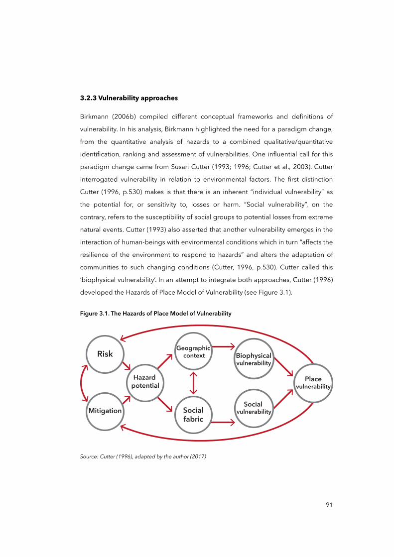
3.2.3 Vulnerability approaches
Birkmann (2006b) compiled different conceptual frameworks and definitions of
vulnerability. In his analysis, Birkmann highlighted the need for a paradigm change,
from the quantitative analysis of hazards to a combined qualitative/quantitative
identification, ranking and assessment of vulnerabilities. One influential call for this
paradigm change came from Susan Cutter (1993; 1996; Cutter et al., 2003). Cutter
interrogated vulnerability in relation to environmental factors. The first distinction
Cutter (1996, p.530) makes is that there is an inherent “individual vulnerability” as
the potential for, or sensitivity to, losses or harm. “Social vulnerability”, on the
contrary, refers to the susceptibility of social groups to potential losses from extreme
natural events. Cutter (1993) also asserted that another vulnerability emerges in the
interaction of human-beings with environmental conditions which in turn “affects the
resilience of the environment to respond to hazards” and alters the adaptation of
communities to such changing conditions (Cutter, 1996, p.530). Cutter called this
‘biophysical vulnerability’. In an attempt to integrate both approaches, Cutter (1996)
developed the Hazards of Place Model of Vulnerability (see Figure 3.1).
Figure 3.1. The Hazards of Place Model of Vulnerability
Biophysical vulnerability
Social vulnerability
Hazard potential
Socialfabric
Geographic contextRisk
Mitigation
Placevulnerability
Source: Cutter (1996), adapted by the author (2017)
91
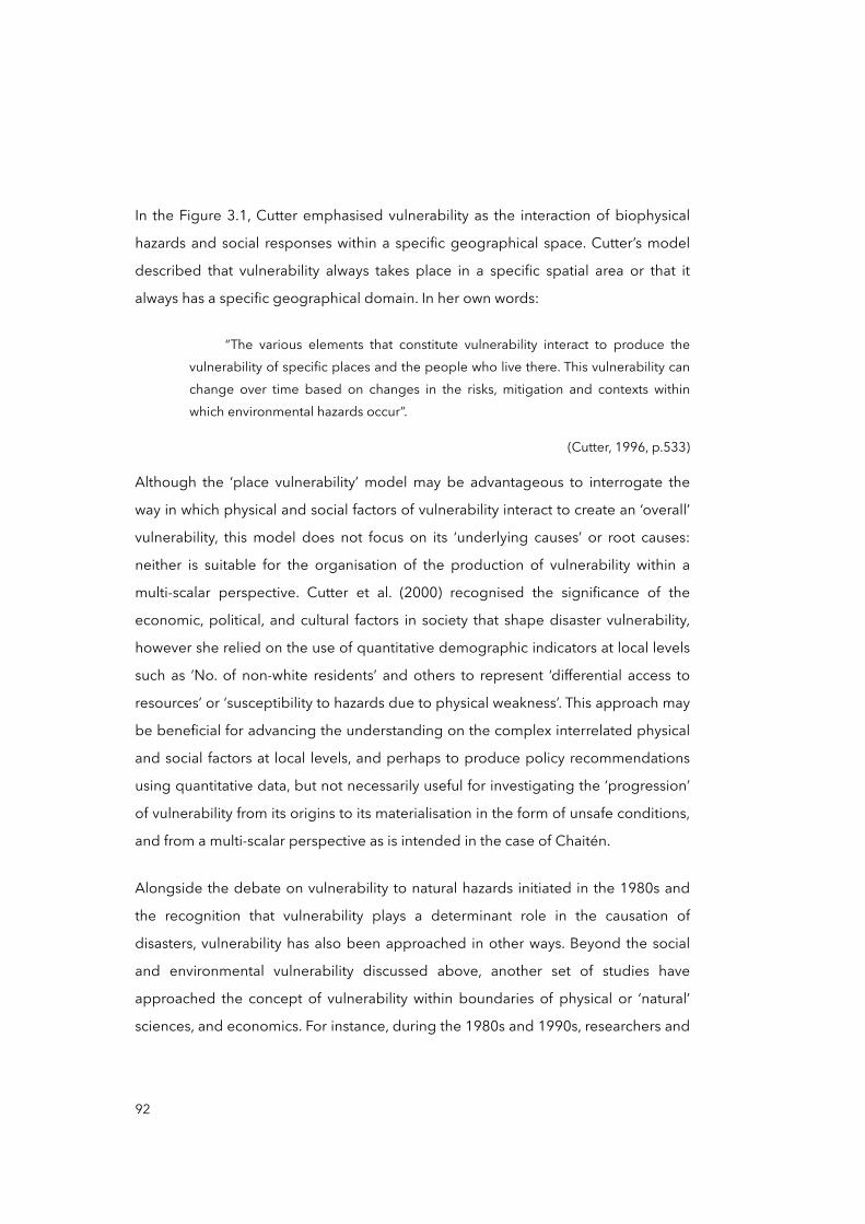
In the Figure 3.1, Cutter emphasised vulnerability as the interaction of biophysical
hazards and social responses within a specific geographical space. Cutter’s model
described that vulnerability always takes place in a specific spatial area or that it
always has a specific geographical domain. In her own words:
“The various elements that constitute vulnerability interact to produce the vulnerability of specific places and the people who live there. This vulnerability can change over time based on changes in the risks, mitigation and contexts within which environmental hazards occur”.
(Cutter, 1996, p.533)
Although the ‘place vulnerability’ model may be advantageous to interrogate the
way in which physical and social factors of vulnerability interact to create an ‘overall’
vulnerability, this model does not focus on its ‘underlying causes’ or root causes:
neither is suitable for the organisation of the production of vulnerability within a
multi-scalar perspective. Cutter et al. (2000) recognised the significance of the
economic, political, and cultural factors in society that shape disaster vulnerability,
however she relied on the use of quantitative demographic indicators at local levels
such as ‘No. of non-white residents’ and others to represent ‘differential access to
resources’ or ‘susceptibility to hazards due to physical weakness’. This approach may
be beneficial for advancing the understanding on the complex interrelated physical
and social factors at local levels, and perhaps to produce policy recommendations
using quantitative data, but not necessarily useful for investigating the ‘progression’
of vulnerability from its origins to its materialisation in the form of unsafe conditions,
and from a multi-scalar perspective as is intended in the case of Chaitén.
Alongside the debate on vulnerability to natural hazards initiated in the 1980s and
the recognition that vulnerability plays a determinant role in the causation of
disasters, vulnerability has also been approached in other ways. Beyond the social
and environmental vulnerability discussed above, another set of studies have
approached the concept of vulnerability within boundaries of physical or ‘natural’
sciences, and economics. For instance, during the 1980s and 1990s, researchers and
92
institutions such as Heyman et al. (1991) Gabor and Palenda (1982), and UNDRO
(1979) focused on exposure and ‘physical vulnerability’ by studying the rapid outset
of extreme events, their frequency, magnitude, impact, and duration. This group of
studies also focused on the analysis of specific hazardous events —e.g. floods,
volcano eruptions, earthquakes, and so forth—, their spatial distribution in relation to
the population, and their potential for losses. In economics, institutions such as the
International Monetary Fund (IMF) and the World Bank have promoted the study of
‘financial and economic vulnerability’ (GFDRR, 2012; Ghesquiere and Mahul, 2014;
IMF, 2008; OECD et al., 2012; The World Bank, 2014) at different analysis units —
states and urban levels—, thereby connecting them to poverty, climate change, and
disaster risk (Laframboise and Loko, 2012). More recently, the Asian Disaster
Preparedness Center (ADPC) has referred to ‘cultural vulnerability’ to assess the
exposure subjected to cultural values and norms, and the potential loss of cultural
assets such as monuments and temples (ADPC, 2014).
This brief outline of different trajectories of enquiry in vulnerability studies may
reflect the intricate process of conceptualising vulnerability. However, what emerges
among these attempts is the ultimate recognition that vulnerability is a complex
dynamic process focused on the social, ‘multi-dimensional and differential’ —as it
varies across space and among and within social groups—, and ‘scale dependent’ —
as it depends on time, space and units of analysis such as individual, household,
region or city (Vogel and O'Brien, 2004)— aspects. Hence, its assessment should not
be reduced to merely ‘physical’ factors, but also to structural social, economic,
political, and cultural ones (IFRC, 2014).
This perspective was captured by the well-known definition given by Wisner and his
colleagues (2004), and perhaps one of the most widespread definitions of
vulnerability in recent years. The book by Wisner et al. (2004) At risk: Natural
hazards, people’s vulnerability and disasters, in which vulnerability becomes a central
concern, is commonly referenced in reports such as the IPCC’s SREX (Field et al.,
93
2012) and UNISDR’s Global Assessments Reports (GARs) (2009b; 2011; 2013;
2015a). This is also the definition adopted for the thesis:
“The characteristics of a person or group and their situation that influence their capacity to anticipate, cope with, resist and recover from the impact of a natural hazard (an extreme natural event or process). It involves a combination of factors that determine the degree to which someone’s life, livelihood, property and other assets are put at risk by a discrete and identifiable event (or series or ‘cascade’ of such events) in nature and in society”.
(Wisner et al., 2004, p.11; own emphasis)
This perspective offered by Wisner and his colleagues (2004) talks about
‘internal’ (characteristics) as well as ‘external’ factors (situations). But beyond this
definition they explored, with much more intensity, the structural factors in economy
and politics rather than the society-nature relation. Although this can be a matter of
critique (Turner, Kasperson et al., 2003), Wisner et al. (2004) made great effort in
dissecting disaster vulnerability from a social constructionist and political economy
perspective. The next section further discusses it by stressing the social relations that
produce vulnerability.
3.2.4 Structural factors and the social production of vulnerability
Cardona (2006) argued that risk is a socially constructed phenomenon based on the
idea that social, economic, political, and cultural factors in conjunction with
environmental problems act over time to produce and reproduce vulnerability in the
form of unsafe conditions. However, vulnerability to disasters, as a process, does not
reside exclusively within physically unsafe conditions (both geophysical and
locational), but also exists in the various social, economic, political, and cultural
processes that contribute as ‘underlying causes’ to its materialisation (Chardon,
1998; 2004; Chardon and Gonzalez, 2002). Wisner et al. (2004) contested the
overemphasis on the ‘naturalness’ of disasters arguing that societal factors are
constitutive elements in the production of vulnerability and disaster risks:
94
“When disasters happen, people and media interpretation tend to focus on their “naturalness”, as in the phrase “natural disaster”. The natural hazards that trigger a disaster tend to appear overwhelming. [...] But crucially, humans are not equally able to access the resources and opportunities; nor are they equally exposed to the hazards. Whether or not people have enough land to farm, or adequate access to water, or a decent home, are determined by social factors (including economic and political processes). And these social processes also have a very significant role in determining who is most at risk from hazards: where people live and work, and in what kind of buildings, their level of hazard protection, preparedness, information, wealth and health have nothing to do with nature as such, but are attributes of society”.
(Wisner et al., 2004, p.6)
From this perspective, Wisner et al. (2004) modelled the political economy of
disaster by underlining the importance of ‘social relations’ and ‘structures of
domination’ within societies as they are the context where ‘normal life’ takes place,
as well as being the place where vulnerability is produced. ‘Social relations’ and
‘structures of domination’ are two concepts introduced by Wisner et al. (2004) as
part of the PAR model. According to the authors, the model is a political economy
exploration of people’s capacity to deal with the impact of hazards in terms of the
level of access they have (or do not have) to the resources needed for their
livelihoods before and after a hazard’s impact. On the one hand, social relation
“encompasses the flows of goods, money and surplus between different actors, for
example, merchants, urban renters, capitalist producers of food, rural and urban
households involved in various relations of production and endowed with a
particular range and quality of access to resources” (Wisner et al., 2004, p.93). On
the other hand, structures of domination “refer to the politics of relations between
people at different levels. [...] These relations shape, and are shaped by, existing
rights, obligations and expectations that exist within the household and which affect
the allocation of work and rewards” (Wisner et al., 2004, p.94). Thus, both ‘social
relations’ and ‘structures of domination’ may prove to be useful in exploring the
context where ‘root causes’ and ‘dynamic pressures’ are produced and vulnerability
advances until its materialisation. In this thesis, I explored these relations in the
context of Chile and its possible effects on the model of disaster risk management:
95
the processes of political and economic centralisation, and its repercussions in the
processes of policy responses to disasters and decision-making in the case of post-
disaster Chaitén (see Figure 2.5 in page 53, Chapter Two).
The next section examines the PAR model in greater detail. This is deemed
necessary as the model represents a suitable framework to interpret the process of
production of vulnerability from a social constructionist and structural approach, and
it enables the integration with a multi-scalar perspective adopted in this study. For
this reason, the next section aims to integrate the recently described perspectives of
vulnerability with the PAR model, as well as to introduce a multi-scalar perspective to
interpret such a model and therewith the causation of disasters.
3.3 The PAR model and a scalar perspective
3.3.1 The PAR model explained
The disaster PAR model was first developed by Blaikie et al. in 1994 and refined later
by Wisner et al. in 2004. Based on the conceptual equation ‘hazard × vulnerability =
risk → disaster’, the PAR model seeks to explain vulnerability to disasters and its
progression. By assuming natural rapid-onset extreme events as something that
society has little control over, the PAR model presents vulnerability as a
phenomenon strictly developed by means of social factors. The model innovates
disaster studies and disaster sociology by ‘unpacking’ the concept of vulnerability to
disasters, and then conceptualising ‘the progression of vulnerability’. The
representation of the model (see Figure 3.2) proposes that vulnerability’s
progression is organised through differentiated stages: from its ‘root causes’ and
‘dynamic pressures’ to ‘unsafe conditions’. This idea advances disaster studies by
suggesting that in order to prevent disasters and promote effective disaster risk
reduction strategies, vulnerability must be necessarily reduced, and its ‘root causes’
addressed. This also implies that the reduction of vulnerability should then be at the
core of policy goals for disaster risk management (DRM) and disaster risk reduction
(DRR) —though without neglecting the likelihood of natural hazards occurring, their
magnitude, as well as their intensity in specific social, cultural, economic and
96
political contexts (Aragón-Durand, 2007; Wisner et al., 2004). Additionally, structural
factors in society —e.g. ‘social relations’ and ‘structures of domination’— need to be
revisited and addressed within effective disaster risk discussions at all levels,
including but not restricted to policy and decision-making mechanisms, inclusion of
civil society and grass root organisations, gender relations, models of territorial
organisation, among others (Wisner et al., 2004). A close examination of these
structural factors could explain why and how men and women become affected by
and are vulnerable to specific hazards. For instance, Aragón-Durand (2007) used a
socio-historical analysis of disasters to underline the importance of taking into
consideration particular social actors and institutions in hazard generation and flood
vulnerability over time in Mexico City’s south-eastern peri-urban interface. He
asserted that chronic flooding in that area is the result of a complex interaction
between inadequate urbanisation policies, permanent ecological deterioration and
ground subsidence, poor sanitation and short-term policy responses to past and
present disasters.
In Figure 3.2, this progression is organised by means of tracing the nature of ‘root
causes’ of vulnerability and disasters: the way in which vulnerability’s origins can be
traced from local ‘unsafe conditions’ such as living in disaster-prone areas, through
economic and social ‘dynamic pressures’ such as corruption, all the way to the ‘root
causes’ such as economic models, ideologies, and the like. For Wisner et al. (2004),
vulnerability is socially, economically and politically rooted and, when combined
with physical processes such as earthquakes and volcanic hazards, it may produce
risk, and when confronted with the occurrence of an extreme event, disasters. In the
words of the authors:
“[The PAR model] is introduced as an analytical tool for showing how disasters occur when natural hazards affect vulnerable people. Their vulnerability is rooted in social processes and underlying causes which may ultimately be quite remote from the disaster event itself. The basis for the PAR idea is that a disaster is the intersection of two opposing forces: those processes generating vulnerability on one side, and the natural hazard event (or sometimes a slowly unfolding natural process) on the other”.
(Wisner et al., 2004, p.50; own emphasis)
97
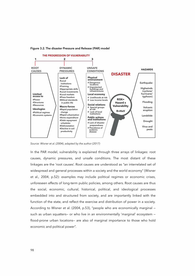
Figure 3.2. The disaster Pressure and Release (PAR) model
Source: Wisner et al. (2004), adapted by the author (2017)
In the PAR model, vulnerability is explained through three arrays of linkages: root
causes, dynamic pressures, and unsafe conditions. The most distant of these
linkages are the ‘root causes’. Root causes are understood as “an interrelated set of
widespread and general processes within a society and the world economy” (Wisner
et al., 2004, p.52): examples may include political regimes or economic crises,
unforeseen effects of long-term public policies, among others. Root causes are thus
the social, economic, cultural, historical, political, and ideological processes
embedded into and structured from society, and are importantly linked with the
function of the state, and reflect the exercise and distribution of power in a society.
According to Wisner et al. (2004, p.53), “people who are economically marginal —
such as urban squatters— or who live in an environmentally ‘marginal’ ecosystem —
flood-prone urban locations— are also of marginal importance to those who hold
economic and political power”.
ROOT
CAUSES
DYNAMIC
PRESSURES
UNSAFE
CONDITIONS
DISASTER
HAZARDS
1
THE PROGRESSION OF VULNERABILITY
32
Limited access to
#Power#Structures#Resources
Ideologies
#Political regimes#Economic systems
Lack of
#Local institutions#Training#Appropriate skills#Local investments#Local markets#Press freedom#Ethical standards in public life
Macro-forces
#Rapid population change#Rapid urbanisation#Arms expenditure#Debt repayment schedules#Deforestation#Decline in soil productivity
Physicalenvironment
# Dangerous locations# Unprotected buildings and infrastructuresLocal economy
# Livelihoods at risk# Low income levels
Social relations
# Special groups at risk# Lack of local institutionsPublic actions and institutions
# Lack of disaster preparedness# Prevalence of endemic disease
Earthquake
Highwinds(cyclone/
hurricane/typhoon)
Flooding
Volcaniceruption
Landslide
Drought
Virus and pests
RISK=
Hazard x
Vulnerability
R=HxV
98

Besides the root causes, ‘dynamic pressures’ are understood as processes and
actions that translate the effects of root causes both temporally and spatially into
particular and place-specific ‘unsafe conditions’. These may include, for instance,
structural adjustment policies implemented during a specific period —e.g.
decentralisation policies—, rapid urbanisation on the outskirts of cities, and rural-
urban migration in response to the economic and social inequalities inherent in root
causes. Likewise, unsafe conditions are understood here as “the specific forms in
which the vulnerability of a population is expressed in time and space in conjunction
with a hazard” (Wisner et al., 2004, p.55). In this sense, men and women with limited
opportunities may find themselves ‘forced’ to live in hazardous locations with
insufficient protection by the state and institutions, thereby being unable to afford
safe buildings or conversely having entitlements that are nonetheless prone to rapid
and severe disruption. ‘Unsafe conditions’ are also determined by the initial level of
people’s well-being and their access to tangible —e.g. cash, shelter, food stocks,
agricultural equipment— and intangible resources such as networks of support,
knowledge on survival, and sources of assistance, morale, and the ability to function
in a crisis (Cannon, 2000; Wisner et al., 2004).
Although I have explained that the PAR model offers an advantageous analytical
perspective to look at vulnerability, it is also, however, subject to a number of
inadequacies. This deep interrogation on the societal/structural factors of
vulnerability may obscure another important and equally determinant relation within
disaster causation: the environment. The environment also forms part of the social
framework that can and often does shape hazards and risks (Turner, Matson, et al.,
2003). There is much evidence in the use of natural resources for economic
activities, and the environmental problems and hazards associated with them. We
know that certain hazards are intertwined with societal systems affecting livelihoods
and assets such as land distribution and ownership after floods (Wisner et al., 2004).
Nevertheless, the environmental-human relation in the case of post-disaster Chaitén
does not seem to be present compared to the social factors —policy responses and
the model of governing disasters and risks— which better explain the vulnerability in
99

Chaitén. This overemphasis on the structural factors of vulnerability is also present in
the ‘rivalry’ between the SP and MP mentioned earlier, and of course is present in
the limitations of the thesis. From this perspective, in my opinion, the PAR model
sacrifices amplitude but gain in focus in untangling the social causes of disaster
vulnerability. And by using this model in the case of Chaitén, the thesis yields a
holistic understanding in empirical terms, as it concentrates the analysis of policy
responses to disasters and the model of DRM in Chile.
Thus, the conceptualisation of vulnerability proposed in the PAR model implicitly
expands the idea of vulnerability towards processes and circumstances —root
causes, dynamic pressures, and unsafe conditions, named in the model— that are
both temporally and spatially remote from the affected area. This ‘distancing’ of the
causes of vulnerability and disaster risks lies at the centre of this thesis’ inquiry and
specifically: How have policy responses to disasters influenced the progression of
disaster vulnerability, at different scales, in post-disaster Chaitén? The next section,
trying to answer this question, articulates how a multi-scalar perspective may
contribute to a better understanding of such progression.
3.3.2 The multi-scalar progression of vulnerability
The idea that disaster risk and vulnerability may be progressively accumulated by
socio-economic and political factors within minor geographical areas —e.g. city,
community, and other sub-regional or sub-national levels— is implicit within the
analysis of the PAR model. The PAR model represents causality and progressiveness
when it conceptualises vulnerability: ‘unsafe conditions’ are caused by ‘dynamic
pressures’ which, in turn, are produced by ‘root causes’. Through all these phases,
vulnerability is produced, reproduced or perpetuated by the social ‘system’ at
different levels. It can be interpreted then that ‘root causes’ are nested in major
geographical scales such as global or national, while ‘dynamic pressures’ operate
between major and minor scales, and ‘unsafe conditions’ are materialised at urban
and local scales. Wisner et al. (2004) suggested that ‘unsafe conditions’ are the most
evident expressions of vulnerability: these may include a poorly built environment,
100
and lack of response mechanisms and coping capacities, among other conditions.
On the one hand, unsafe conditions are often the easiest to identify and assess
because they are somehow ‘materialised’ and observable. While on the other hand,
it is more difficult to establish strong or evident connections between vulnerable
conditions and ‘dynamic pressures’ because the latter represent widespread
processes such as structural adjustment policies implemented during a certain
period, rapid urbanisation, rural-urban migration, poverty, lack of building codes or
poor construction supervision, and corruption (Wisner et al., 2004). These
widespread processes, either acting as root causes or dynamic pressures, seem to
be nested and organised at global, national and regional scales, as these often
interrelate and exist in extra-national and national scales (Pelling, 2003a).
For Wisner et al. (2004), root causes and dynamic pressures can be ‘distant’ from an
affected area in three different senses:
“[Root causes and dynamic pressures] are distant in one, two or all of the following senses: spatially distant (arising in a distant centre of economic or political power), temporally distant (in past history), and finally, distant in the sense of being so profoundly bound up with cultural assumptions, ideology, beliefs and social relations in the actual lived experience of the people concerned that they are ‘invisible’ and ‘taken for granted’”.
(Wisner et al., 2004, p.52)
Considering this, I suggest that the root causes and dynamic pressures that have
produced and materialised vulnerability in Chaitén are distant from the city in, at
least, two senses: spatially and temporally. Although the case of post-disaster
Chaitén will be described and analysed in greater detail during the case study in
Chapter Four and Chapter Five, I assumed that the PAR model frames the question
of the progression of vulnerability in post-disaster Chaitén within a ‘scale question’,
that is to say, how do policy responses to disasters unfold the progression of
disaster vulnerability through differentiated scales? I propose that this question may
be answered by examining how policy responses and decision-making in the post-
disaster context of Chaitén were organised at different geographical scales —i.e.
nationally, regionally, and locally— to ultimately enable the materialisation of
101
vulnerability in the form of ‘unsafe conditions’. This is done all whilst considering that
‘root causes’, ‘dynamic pressures’, and ‘unsafe conditions’ are embedded into an
already existent scalar structure of territorial governance for the case of Chile. The
methodological approach to address this scalar structure in Chile is clarified in the
following section.
Coming back to the PAR model, it may be said that the model implicitly describes
the progression of vulnerability as a multi-scalar phenomenon: ‘unsafe conditions’
often are evident at local or urban scales, ‘root causes’ and ‘dynamic pressures’ are
articulated within processes that operate at major geographical scales: regional,
national, and global. A strategy to interpret the progression of vulnerability with a
multi-scalar perspective lies in a subsidiary question: How are policy responses and
governance of DRM and DRR in Chile organised and distributed from national to
local level? This question adopts the idea that causes and drivers of disaster
vulnerability in a post-disaster context —e.g. policy responses and decision-making—
are organised in a geographical and scalar manner (Brenner, 2009a), from major to
minor geographical scales. Hence, by understanding the scalar organisation of
specific causes and drivers, I think it is possible to organise the progression of
vulnerability using a multi-scalar perspective. But perhaps more importantly, the
question is how these scalar relations were established and how these relations
affect the model of DRM and policy responses to disasters for the case of Chaitén.
These questions reveal another central aspect of this thesis that is useful to complete
the analytical framework: geographical scales need to be understood as historically
and socially mediated process (Marston, 2000).
The concept of geographical scales from a social constructionist approach, similar to
understanding the progression of vulnerability and risks, is a central element of this
work. At the end of section 3.2.1 in this chapter (page 83-84), I quoted Quarantelli to
point out the significance of using social science perspectives and techniques in
researching vulnerability as social phenomenon, including definitions of space and
scales. The following section introduces the reader to the social construction of
scales.
102
3.3.3 The social construction of scales
In approaching the ‘progression of vulnerability’ from a perspective of scales, it
becomes crucial to understand how a geographical scale is produced and how its
configuration —the relation between differentiated scales: e.g. global, national,
regional, and local— may facilitate such progression from major to minor scales. I
initiate this section by situating the idea of ‘geographical scales’ within a social
constructionist approach.
Discussed primarily by geographers and physicists, ‘geographical scale’ has
traditionally been conceived as fixed spatial units where social, economic, political
and even environmental dynamics simply unfold (Brenner, 2009a). Geographical
scales were understood just “as a fixed, bounded, self-enclosed and pregiven
[spatial] containers” (Brenner, 2001, p.592). Soja (1989, p.149) noted that the
“question of scale” and its social production remained “understudied” and was
“generally subordinate to analyses of spatial practices positioned within fixed
geographical scales: the local, the urban, the regional, the national, and/or the
global” (Brenner, 1998, p.460). This traditional view was adopted during
contemporary transformations such as the massive geographical changes entailed
by globalisation: the global labour market restructuring in the 1970s (Castells, 1989;
Sassen, 1991), the crisis of the nation-state’s territoriality (Appadurai, 1996;
Liubimau, 2011), and the reterritorialisation process of cities and states during the
1990s and 2000s (Brenner, 1999). Such transformations demonstrated that certain
social phenomena unfold not only at one single spatial scale —e.g. urban ‘or’ global—
but also at multiple geographical scales simultaneously —e.g. urban, regional ‘and’
global. Brenner (1998, p.463) referred to these phenomena as “multi-scalar
processes”. Accordingly, Brenner proposed a fundamental change in understanding
geographical scales, saying that these should not be grasped individually, but
instead as a result of multi-scalar processes and therefore as interconnected and
interdependent spatial entities:
103
“Scales can only be grasped relationally. Scales cannot be construed adequately as fixed units within a system of nested territorial containers defined by absolute geographic size (a ‘Russian dolls’ model of scale). The institutional configuration, function(s), histories, and dynamics of any one geographical scale can only be grasped relationally, in terms of its upwards, downwards, and transversal links to other geographical scales... [...] From this point of view, it is analytically imprecise to speak of scale in singular terms as, for instance, in discourses about ‘the’ urban, ‘the’ regional, ‘the’ national, or ‘the’ global. Such substantialist formulations misleadingly imply that individual scales contain a coherence in and of themselves, and thus bypass the essential task of analyzing their relational co-constitution in and through multiscalar structuration processes”.
(Brenner, 2009a, p.72; own emphasis)
In relation to the above, Doreen Massey’s famous (1994, p.63) question, “in what
sense are ‘regional’ problems regional problems?” and the well-known concept
“glocalization” developed by Swyngedouw (1992) both prove themselves useful
when applied to illustrate Brenner’s idea (2009a). The idea here is that when we
analyse the progression of vulnerability through different geographical scales, these
need to be grasped ‘relationally’ as well as the causes and drivers that compose the
‘vulnerability process’: “the values, ideas, behaviours, and actions that have led to
characteristics such as fragility, weakness, exposure, and susceptibility and that
could perpetuate or absolve these issues” (Kelman et al., 2016, p.136). In the same
line, I argue with this thesis that disaster vulnerability and its production should no
longer only be associated with local factors but rather always with a multiplicity of
actors and processes acting at different and interrelated scales. Then, root causes,
dynamic pressures, and unsafe conditions can be organised in vertical and
horizontal arrangements.
The idea of geographical scales as social constructions, in addition to Brenner’s
observations, has emerged from and has been supported by other critical thinkers8
104
8 This concept is devised within the critical theory. Critical theory here refers to the neo-Marxist reflexion —critical thinking methods— of the Frankfurt School developed in the late 1930s . In contrast to ‘traditional’ theory which aims to the solely understanding or explaining of society, critical theory can be understood as a social theory associated with the critique and change of society as a whole (Horkheimer, 1937).
such as Swyngedouw (1992), Smith (1984; 1993), and Knox (1995). For them,
geographical scales, as social space, were undoubtedly socially constructed as
social processes need space to delineate their practice and struggle (Lefebvre 1991
[1974]). In that process, geographical configurations emerge, that is, “a set of
interacting and nested scales (the ‘gestalt of scale’)” (Swyngedouw, 1997, p.169),
often composed of local, urban, regional, national, international, and global spaces.
The resulting scalar configuration is temporary and in perpetual transformation over
time, depending on the extension and contraction of the socio-spatial struggle itself
(Marston, 2000; Swyngedouw, 1997). As reflected by Swyngedouw (1992, p.60),
“geographical scale is both the realm and the outcome of the social struggle over
control over space”. Accordingly, Brenner (2001) concluded, geographical scales are
“malleable” and “historically changeable” as their production is subordinated to
socio-political contestation in history (Brenner, 2001, p.599). One only need look at
for instance how geo-political boundaries have been transformed throughout
human history, or how ‘global’ and ‘national’ scales have contracted since the rise of
ever faster transport networks and communication technologies (Castells, 1996).
This historical perspective is interesting and particularly useful for this thesis. Then, a
historical analysis of processes that are presumably connected with the production
of disaster vulnerability in Chaitén, are required to better understand how root
causes, dynamic pressures, and unsafe conditions are arranged within the scalar
configuration in Chile.
To initiate a scalar analysis, Brenner argued that geographical scales are better
grasped as “differentiated spaces” often by size but, more importantly, scales as the
result of a “vertical differentiation” (Brenner, 2009a, p. 71). Thus, what makes sense to
one geographical scale category —e.g. urban— is its relation with other categories —
e.g. regional, national, global. In other words, the socio-spatial analysis of urban,
regional or national social phenomena should not be dissociated from a scalar
differentiation analysis —“the hierarchical ordering or spatial hierarchisation of social
formations” (Brenner, 2009a, p. 71). The inter-scalar or multi-scalar relationships
between those classical spatial-scale categories —the global, the national, the
105

regional and the urban— should always be analytically considered. In that sense, this
thesis is an attempt to consider these ‘multi-scalar relations’ in the progression of
vulnerability. Crucial aspects of the socio-spatial analysis of scales such as ‘historical
changes’ and ‘hierarchical differentiations’ should then be incorporated into the
analysis of vulnerability and risks, as they allow for a deeper comprehension of the
underlying factors that produce, reproduce, and perpetuate risks. I consider that this
view is particularly advantageous when combined with the PAR model, as specific
processes or circumstances —such as the model of DRM and policy responses to
disasters in Chaitén— can be explored differentially and relationally.
Brenner proposed three analytical elements or ‘propositions’ to interpret scales from
a social constructionist approach:
• Scales result from vertical differentiation
• Scales ‘exist’ because social processes are scaled
• Scales can only be grasped relationally
In the section below, these three elements are explained and connected with the
PAR model and the analytical framework. They have been useful for interpreting the
scalar relations that already exist within Chile in regard to the model of disaster and
risk management, and policy responses.
Scales result from vertical differentiation
According to Brenner (2009a), the differentiation of social relations by scales occurs
due to the ‘vertical ordering’ or spatial hierarchisation of social formations. Besides
the ‘horizontal’ or territorial differentiation of social practices across space, there is
also a ‘vertical’ differentiation in which social relations are hierarchically organised
among global, extra-national, national, regional, metropolitan, and/or local levels.
Although Brenner (2009a, p.71) asserted that the “spatialities” of scale, its physical
manifestations, cannot be understood only in terms of this “verticality” or
hierarchical relation, he strongly claimed that this feature is the “differentia specifica”
of scalar configurations.
106
Regarding this thesis, one research purpose was to understand how policy
responses to disasters and governance of DRM and DRR are organised at different
geographical scales in Chile and why. This question looks at the ‘scalar
differentiation’ in Chile in terms of how social relations and practices in the country
have historically configured its territory. The resulting scalar configuration of the
state, addressed in Chapter Four, will support the multi-scalar analysis of the causes
and drivers of vulnerability in Chaitén.
Scales ‘exist’ because social processes are scaled
Brenner (2009a) pointed out that geographical scales exist because social processes
themselves are scaled. Although the terms such as local, urban, regional, and so
forth are used to demarcate apparently territorial “islands of social relations”, they
obfuscate the relational nature of social processes and the tangled multi-scalar
networks through which the latter is constituted (Brenner, 2009a, p.69). The
processes that shape geographical scales are socially based, and result from socio-
economic, socio-environmental, political and cultural forces. Such processes are
geographically scaled, that is, spatially organised, hierarchically differentiated, and
historically changeable (Brenner, 1998; 1999; 2001). In the context of Chile, the
process through which the country reached its current, yet ‘transitory’, scalar
configuration is analysed from the history of the state territorial organisation,
particularly through processes of administrative de- and centralisation. The historical
processes of political and economic centralisation of Chile (see section 4.2 in
Chapter Four) were interesting to the scalar analysis of the Chilean model of disaster
risk management, as they helped to explain why the model is top-down and reactive
oriented.
Scales can only be grasped relationally
According to Brenner (2000; 2009a), social relations are spatially demarcated
through the creation of specific institutional configurations —e.g. regional
governments and municipal councils. The resultant spatial ‘unit’ —e.g. urban, nation,
local— of the social relations indicates the function and dynamic of a given
107
geographical scale but it can be only grasped relationally, that is: “in terms of its
upwards, downwards, and transversal links to other geographical scales situated
within the broader multi-scalar configuration in which it is embedded” (Brenner,
2009a, p.72). Single scales do not contain a coherence in and of themselves, so the
processes of co-constitution in and through multi-scalar structuration processes with
a historical perspective should always be considered in socio-spatial analysis of
scales (Brenner, 2009a).
Furthermore, the relevance of a given geographical scale may differ qualitatively
from the others depending on the aspects of the social processes which are being
investigated —such as in the case of vulnerability. However, there will be always inter-
and multi-scalar relations between all of these geographical scales. Each spatially-
based social phenomenon and its scalar differentiation should be understood
differently, and incidentally, “each scale needs to be understood in terms of its
relation to other scales” (Mahon and Keil, 2009, p.8).
Hence, summing up Brenner’s propositions, geographical scales are social
constructions because the process that constitutes them is intrinsically intertwined
with social ones: politically, economically, culturally, and the history that comes with
it. Geographical scales are temporal crystallisations of ‘vertical differentiation’ of
social relations and struggles. Then, a more precise analysis of scales will require us
to look at the scales relationally, in terms of its upwards, downwards, and transversal
linkages with other scales.
The following section offers some insights to address the processes of policy
responses to disasters and model of DRM and DRR in Chile from the perspective of
disaster governance and vulnerability.
108

3.4 Disaster governance, policy responses and vulnerability
During the multi-scalar analysis of the case of post-disaster Chaitén, through the PAR
model, I inevitably encountered governance structures that participated in the
production of vulnerability in Chaitén. The model of managing disasters and
reducing risks in Chile and policy responses are undoubtedly framed within ‘disaster
governance’.
With the concept of disaster governance, I refer to the complex set of interrelated
regulatory frameworks and norms, organisations, institutions, actors, and practices
within the disaster cycle —i.e. disaster response, recovery, reconstruction, mitigation,
and preparedness— that are organised at multiple social and geographical scales to
anticipate, cope with, resist and recover from the impact of a natural or human-made
hazard (Gall et al., 2014; Tierney, 2012). Disaster governance encompasses a
multiplicity of organisational and institutional actors from formal governments,
private companies, and civil society bodies, to informal organisations such as
networks and elites. The relationships between sets of rules, actors, and
organisations can be configured in horizontal and vertical governance
arrangements. For Renn (2008), the horizontal arrangements capture the relevant set
of actors, rules, and organisations within a defined spatial or functional segment,
such as the actors within a community, city, or nation. Instead, vertical arrangements
consider the hierarchical relations among the elements of a given segment, as well
as the peculiarities of such linkages. Disaster governance may have an important
influence on the production and prevention of the growth of vulnerability, and
ultimately for the reduction of disaster risks (UNDP, 2015). Whilst disaster
governance on the one hand refers to the complexity of multiple elements that are
relevant within the never-ending disaster cycle, socio-ecological and political
economy perspectives tell us that such a ‘web’ of disaster governance can explain
both the production and reduction of vulnerability, risks, and disasters on the other.
This perspective of disaster governance is utilised in Chapter Four to analyse and
organise, in a multi-scalar manner, some specific drivers of disaster vulnerability in
109

Chile —e.g. how the National Emergency Office (ONEMI), for instance, is
hierarchically organised.
As I elaborated earlier, disaster governance has implications for the progression of
vulnerability. For instance, when viewing the historical evolution of the state
territorial organisation and governance of Chile —i.e. from federalist to centralising
models (Montecinos, 2005)— we can observe how this, as a ‘root cause’ process, has
enabled and facilitated the centralisation of decision-making within the domains of
DRM and DRR. I utilise the idea of disaster governance to comprehend and to offer
some coherence within the multiplicity of actors, rules, and processes related to
DRM on different geographical scales for the case of post-disaster Chaitén.
Another concept used during the analysis of the case study is ‘policy responses to
disasters’. Although there is a wide range of possible definitions, I prefer to use the
idea of Ward et al. (2016) which considers policy response as “a dialogue between
policy makers, who devise targets and programmes, and policy implementers, who
respond by putting these plans into action” (Ward et al., 2016, p.46). That ‘dialogue’
occurred in the case of Chaitén starting from the volcanic eruption when emergency
response and recovery mechanisms were activated by the government, until
end-2014 when most strategies and mechanisms were gradually halted. Four
fundamental processes are considered policy responses in the Chaitén disaster:
evacuation, recovery and compensation, relocation, and reconstruction. Policy
responses to the Chaitén disaster involved actors at major levels such as the
Congress and the national government, but also policy implementers such as the
Municipality of Chaitén and the ONEMI, among others. Although during the analysis
of the case study, I do not analyse the total disaster governance in Chile (for obvious
reasons), I do look at the model of DRM and DRR and specific policy responses and
decision-making.
The concepts of ‘disaster risk management’ and ‘disaster risk reduction’ are of
central concern in this thesis too. Although there are various definitions in the
technical literature (see for instance in UNISDR, 2009a), DRR is broadly understood
to mean “the development and application of policies, strategies and practices to
110
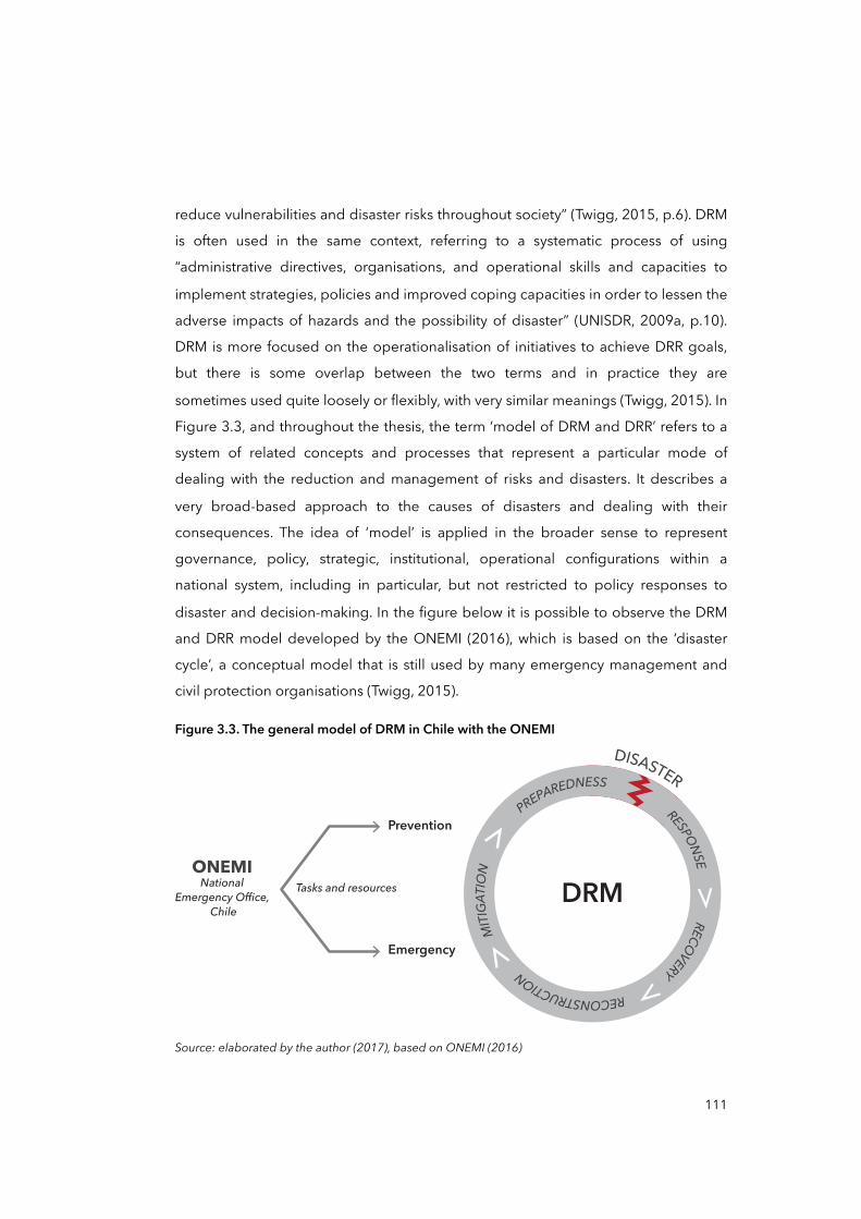
reduce vulnerabilities and disaster risks throughout society” (Twigg, 2015, p.6). DRM
is often used in the same context, referring to a systematic process of using
“administrative directives, organisations, and operational skills and capacities to
implement strategies, policies and improved coping capacities in order to lessen the
adverse impacts of hazards and the possibility of disaster” (UNISDR, 2009a, p.10).
DRM is more focused on the operationalisation of initiatives to achieve DRR goals,
but there is some overlap between the two terms and in practice they are
sometimes used quite loosely or flexibly, with very similar meanings (Twigg, 2015). In
Figure 3.3, and throughout the thesis, the term ‘model of DRM and DRR’ refers to a
system of related concepts and processes that represent a particular mode of
dealing with the reduction and management of risks and disasters. It describes a
very broad-based approach to the causes of disasters and dealing with their
consequences. The idea of ‘model’ is applied in the broader sense to represent
governance, policy, strategic, institutional, operational configurations within a
national system, including in particular, but not restricted to policy responses to
disaster and decision-making. In the figure below it is possible to observe the DRM
and DRR model developed by the ONEMI (2016), which is based on the ‘disaster
cycle’, a conceptual model that is still used by many emergency management and
civil protection organisations (Twigg, 2015).
Figure 3.3. The general model of DRM in Chile with the ONEMI
RESPONSE RECOVERY RECONSTRUCTION
M
ITIGA
TION
PREPAREDNESS
DISASTER
DRMONEMI
NationalEmergency Office,
Chile
Prevention
Emergency
Tasks and resources
Source: elaborated by the author (2017), based on ONEMI (2016)
111
This is a linear-cyclical operational model, dividing the cycle into phases —before,
during and after disaster—, each of which requires different forms of intervention —
mitigation, preparedness, response and recovery. The formulation is quite popular
perhaps because it is easy to grasp and use for DRM actors to allocate tasks and
resources. However, it does not capture the complexity of disasters. As we have
discussed in previous sections, root causes and dynamic pressures of risks and
disasters can be distant and entangled in a complex web of actors and processes at
different scales, and in history. Thus, the DRM cycle does not capture such
complexity, rather just compartmentalises it. DRM models, which are largely derived
from business and organisational management thinking (Oliver-Smith and Hoffman,
1999), provide a useful perspective on how to approach disasters and reduce risks
in a constantly repeating process of hazard and risk identification, analysis and
mitigation that incorporates feedback and learning, however, this also can lead to
fragmented efforts to reduce risks and disasters (Twigg 2015).
3.5 Analytical framework
All the previous parts of this chapter were discursively presenting the analytical
elements of the study. The purpose of this section is to sum up the analytical framework by outlining the principal analytical elements discussed so far.
The figure below offers a map of the literature review that includes authors, groups of researchers and ‘think tanks’, and methodological elements that inform the
analytical framework. It is important to note here that not all the literature I reviewed is necessarily included in this chapter due to matters of space and scope, and to
make the argument more fluid for the readers. Nevertheless, some extra authors are presented in the figure below as a matter of ‘accountability’ as their contributions
informed and influenced certain elements and ideas within the framework.
In Figure 3.4, there are two relevant bodies of knowledge selected for the study —
i.e. disasters (dark blue) and scale (light blue) literature—, and how these combine within the proposed ‘multi-scalar progression of vulnerability’ —at the centre in red.
Case-based elements are also included in the figure, in grey.
112
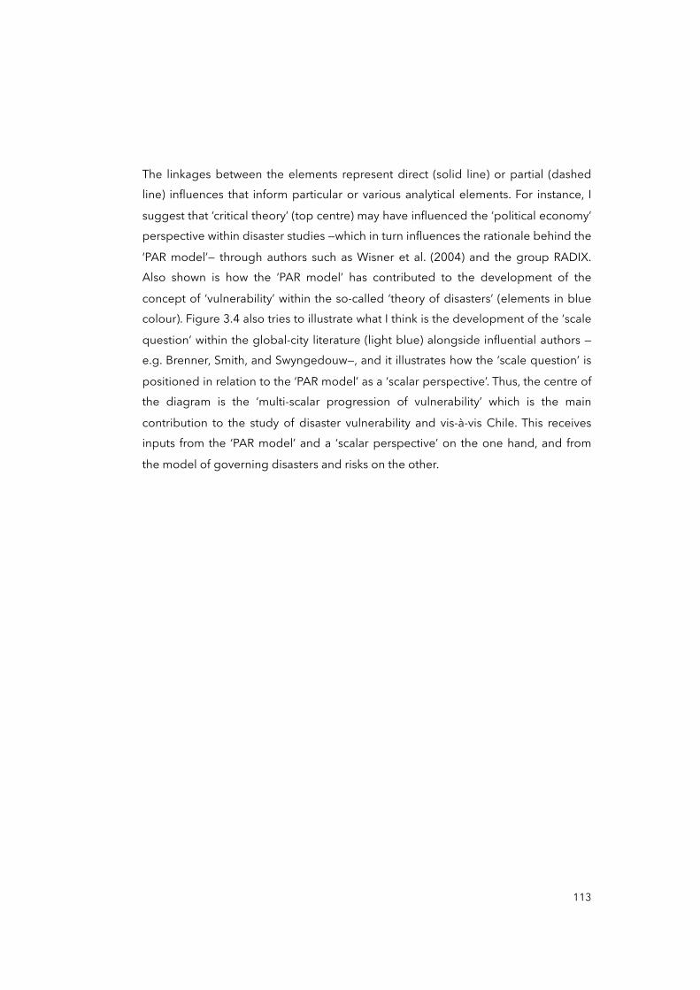
The linkages between the elements represent direct (solid line) or partial (dashed line) influences that inform particular or various analytical elements. For instance, I
suggest that ‘critical theory’ (top centre) may have influenced the ‘political economy’ perspective within disaster studies —which in turn influences the rationale behind the
‘PAR model’— through authors such as Wisner et al. (2004) and the group RADIX. Also shown is how the ‘PAR model’ has contributed to the development of the
concept of ‘vulnerability’ within the so-called ‘theory of disasters’ (elements in blue colour). Figure 3.4 also tries to illustrate what I think is the development of the ‘scale
question’ within the global-city literature (light blue) alongside influential authors —e.g. Brenner, Smith, and Swyngedouw—, and it illustrates how the ‘scale question’ is
positioned in relation to the ‘PAR model’ as a ‘scalar perspective’. Thus, the centre of the diagram is the ‘multi-scalar progression of vulnerability’ which is the main
contribution to the study of disaster vulnerability and vis-à-vis Chile. This receives inputs from the ‘PAR model’ and a ‘scalar perspective’ on the one hand, and from
the model of governing disasters and risks on the other.
113
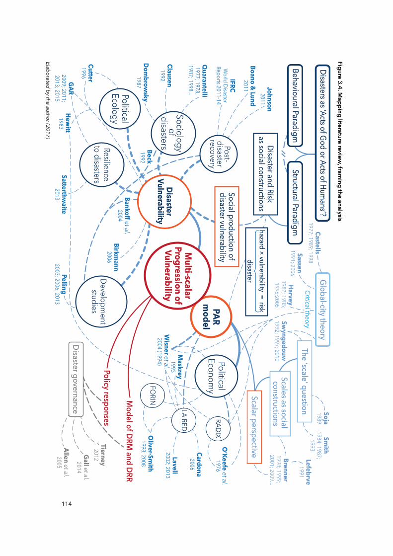
114
Figure 3.4. Mapping literature review
, framing the analysis
Elaborated by the author (2017)
PARm
odel
DisasterVulnerability
PoliticalEcology
Developm
entstudies
Post-disasterrecovery
Sociologyof
disasters
PoliticalEconom
yRAD
IX
LA RED
FORIN
Resilienceto disasters
Social production of disaster vulnerability
Structural ParadigmBehavioural Paradigm
Disasters as ‘Acts of God or Acts of Humans’?
Disaster and Riskas social constructions
The ‘scale’ question
Scalar perspective
Model of DRM and DRR
Policy responses
Disaster governance
Scales as social constructions
hazard × vulnerability = riskdisaster
Clausen1992
Allen et al.2005
Gall et al.2014
Tierney2012
Quarantelli
1977; 1978;1987; 1998...
Dombrow
sky1987
Beck 1992
Global-city theory
O’Keefe et al.
1976
Wisner et al.
2004 (1994)
Hewitt
1983Satterthw
aite2013
Boano & Lund2011 Johnson
2011
IFRCW
orld Disaster
Reports 2011-14
GAR2009; 2011;2013; 2015
Birkmann
2006
Pelling2003; 2006; 2013
Maskrey1993
Lavell2002; 2013
Cutter1996
Cardona2006
Oliver-Sm
ith1998; 2008
Lefebrve1991
Smith
1984; 1987;1993
Brenner1998; 1999; 2001; 2009...
Soja1989
Swyngedouw
1992; 1997; 2010
Castells1977; 1989; 1998
Sassen1991; 2006
Harvey1982; 1985; 1996;2005
Bankoff et al.2004
Critical theory
Multi-scalar
Progression ofVulnerability

In sum, the analytical framework is comprised of several fundamental elements.
Starting from the most elemental, this study is grounded within the SP, that is, a
perspective that looks at the structural factors —i.e. economic, political, cultural— in
society such as ‘social relations’ and ‘structures of domination’ as constitutive
elements of disasters and risks (Bankoff et al., 2006; Wisner et al., 2004). SP
advocates for tackling underlying (social) causes of disaster vulnerability as
fundamental ways to effectively reduce disaster risks. This departing point is
fundamental to position the argument —as well as the limitations— of the thesis. A
second analytical element is the idea that disasters and risks are social
constructions. Here disasters and risks are seen more and more as the result of an
imbalance between social and environmental factors, where vulnerability plays a
major and determinant role. This is precisely one of the crucial analytical elements
within the framework (in red): the social production of disaster vulnerability. The
latter has led to the discussion of other fundamental questions around the role of
politics, economy, governance, and culture in the production and prevention of
growth of vulnerability. Within this set of questions, the PAR model has been
advantageous to examine the relations between societal causal factors of
vulnerability and the occurrence of disasters: the progression of vulnerability, root
causes, dynamic pressures, and unsafe conditions. This perspective is
complemented later with a scalar perspective —grounded in the global-city theory—
which allows for organising causes and drivers of vulnerability in relation to the
scalar configuration of the Chilean state. Such scalar configuration is investigated in
the case of Chile but in particular to the case of post-disaster Chaitén. The model of
DRM and DRR, and policy responses to disasters —but also disaster governance— are
examined in both directions, from their praxis in the post-disaster in Chaitén, to their
histories and processes that have constituted them.
Overall, the framework aims to present the theoretical and methodological context
where the thesis builds on, assisting and informing the research process. This
analytical framework also aims to assist and inform the principal objective of the
thesis: re-problematise the progression of disaster vulnerability and risk from a
115

scalar perspective by examining how the social construction of disasters and policy
responses to them are articulated at different inter– and hierarchically connected
scales. The next two chapters are dedicated to analyse the context of Chile in
relation to the DRM and DRR models, including policy responses to disasters, and
the case of post-disaster Chaitén in particular.
116
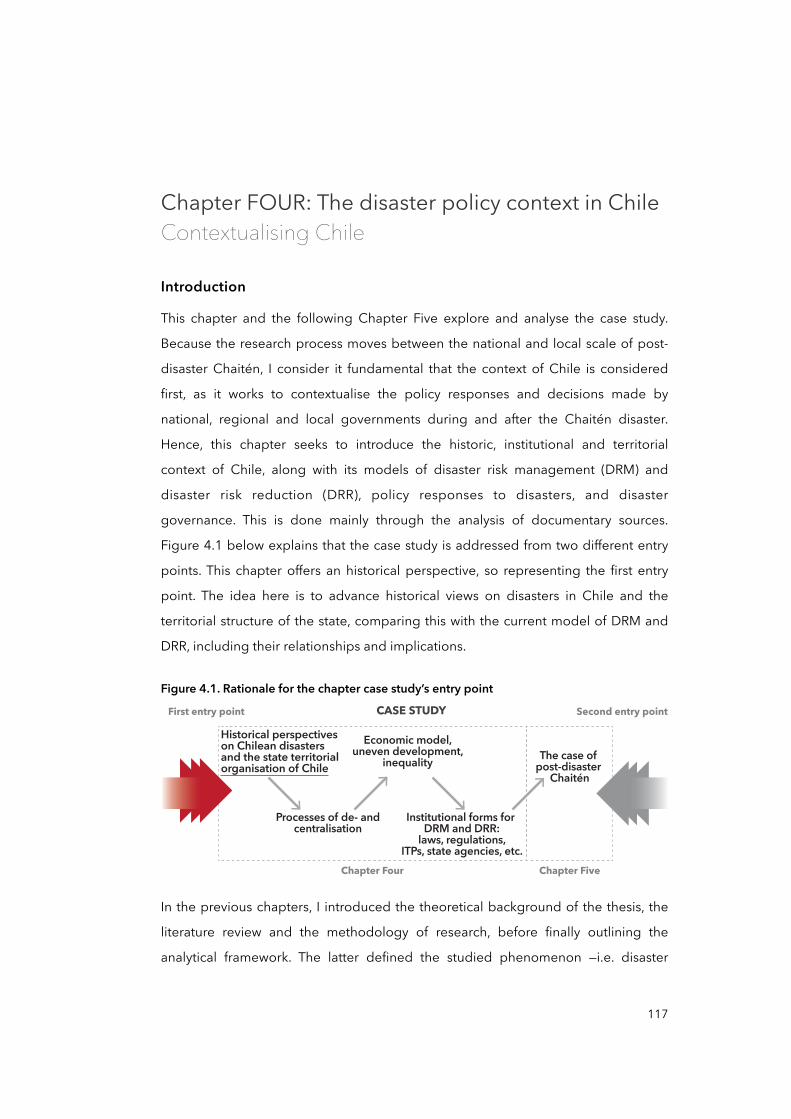
Chapter FOUR: The disaster policy context in ChileContextualising Chile
Introduction
This chapter and the following Chapter Five explore and analyse the case study.
Because the research process moves between the national and local scale of post-
disaster Chaitén, I consider it fundamental that the context of Chile is considered
first, as it works to contextualise the policy responses and decisions made by
national, regional and local governments during and after the Chaitén disaster.
Hence, this chapter seeks to introduce the historic, institutional and territorial
context of Chile, along with its models of disaster risk management (DRM) and
disaster risk reduction (DRR), policy responses to disasters, and disaster
governance. This is done mainly through the analysis of documentary sources.
Figure 4.1 below explains that the case study is addressed from two different entry
points. This chapter offers an historical perspective, so representing the first entry
point. The idea here is to advance historical views on disasters in Chile and the
territorial structure of the state, comparing this with the current model of DRM and
DRR, including their relationships and implications.
Figure 4.1. Rationale for the chapter case study’s entry point
First entry point Second entry pointCASE STUDY
Chapter Four Chapter Five
Historical perspectives on Chilean disasters and the state territorial organisation of Chile
Processes of de- and centralisation
Economic model, uneven development,
inequality
Institutional forms for DRM and DRR:
laws, regulations, ITPs, state agencies, etc.
The case of post-disaster
Chaitén
In the previous chapters, I introduced the theoretical background of the thesis, the
literature review and the methodology of research, before finally outlining the
analytical framework. The latter defined the studied phenomenon —i.e. disaster
117
vulnerability— from a social constructionist approach, and it introduced the Pressure
and Release (PAR) model to underpin the re-problematisation of the progression of
vulnerability and risk from a scalar perspective. Such a perspective requires us to
look at how social relations in a given society are articulated, organised and
distributed in different geographical spaces, particularly those that can be
connected to the production and progression of vulnerability. In this chapter, such
relations are investigated to contextualise Chile, as they are seen as fundamental in
understanding post-disaster Chaitén. The model of DRM and DRR —that is, a
particular mode of dealing with the reduction and management of risks and
disasters— is examined in two constitutive directions: the praxis of policy responses
to disasters in Chaitén, and the different processes that produced it. The latter
compel us to look back at certain events in the past that may have produced or
influenced the model of governing disasters. This is the departing point of this part
of the study.
4.1 A brief history of Chilean disasters
In this section I review existing narratives on the history of Chilean disasters in order
to propose an initial understanding of the constitution and development of the
Chilean disaster management approach.
The history of Chilean disasters is often positively highlighted by politicians,
researchers, journalists and historians (El Mercurio, 2015; Pardo, 2017). After the 8.8
magnitude earthquake occurred in the Maule Region in 2010, the most disastrous
event in the recent history of the country, the media and politicians underlined the
performance of institutions and society in terms of their resistance to the force of
nature and their capacity to resist and recover from disasters (American Red Cross
Multidisciplinary Team et al., 2011; Galilea, 2013; Kaufmann, 2010; López Tagle and
Santana Nazarit, 2011; MAE Center et al., 2010). Despite this, the evidence of
important deficiencies in terms of the disaster management that created an uneven
distribution of disaster impacts in Chile is often ignored: nor are the root causes of
such deficiencies questioned by the media and politicians. Some deficiencies are
118
noted in relation to: inadequate coordination of emergency and recovery response
(Navia, 2010), especially in effected remote localities (MAE Center et al., 2010); the
weak and late response of the government to the tsunami alarm in 2010 —a decision
that cost the lives of 156 men and women (Kaufmann, 2010)— and; the resilience of
transport and communication systems —“the earthquake caused a blackout that
affected 93 per cent of the entire population and lasted for several days in some
locations” (MAE Center et al., 2010, p.4).
According to Kaufmann (2010) and KnowledgeWharton (2010), these deficiencies in
preparedness reveal other profound issues or root causes. For instance, the MAE
Center et al. (2010) assert that pre-existing conditions such as regional-economy
disparities and political tensions between regions in Chile, stressed by the uneven
concentration of population, power and resources, have contributed to the uneven
impact of disasters, especially affecting the poor but significantly those who are
more isolated and disconnected from centres of power. Other researchers such as
Pulgar Pinaud (2014a) and Vidal and Romero (2010) have also underlined the role
that socio-economic and political contexts in Chile play in shaping vulnerability to
disasters. Pulgar Pinaud (2014a), for instance, asserts that neoliberal policies, such as
land deregulation during the dictatorship of Augusto Pinochet, have create
important social and spatial inequalities that may explain the uneven distribution of
disaster impacts.
This uneven distribution of impacts contrasts with the widespread idea that
highlights the heroism of people and the resilience of institutions. In the following
section, I base the analysis on a series of historical documents to contest this ‘typical’
or mainstream view of disasters in Chile, which emphasises their ‘naturalness’ and
their impacts. Here I suggest a departing point to understand how positivist
perspectives on disasters may tend to blur the relevance of socio-economic, political
and cultural pre-conditions that precede them, and which are crucial to comprehend
the social cause of disasters.
119
4.1.1 The dominant view of the history of Chilean disasters: earthquakes
A diverse range of extreme natural events have affected Chile, however,
earthquakes are probably the most remarkable. Most of the historical records
(CREDEN, 2016) highlight earthquakes as they somehow represent ‘milestones’ in
the history of Chile.
Many Chileans still have fresh memories of the Great Maule earthquake of February
27, 2010, and some of them remember where they were when great earthquakes
occurred in 1960 (Valdivia) and 1985 (Central Chile). Elderly Chileans may still
remember the 1939 earthquake in Chillán. Earthquakes and disasters have been
recurrent throughout Chilean history.
Located in the so-called Pacific Ring of Fire, Chile is one of the most seismic regions
in the world (EM-DAT, 2017). Chile sees the convergence of the Nazca plate and the
South American continental plate, causing periodic earthquakes of varying
magnitudes that sometimes trigger significant disasters. Thus, earthquakes and
disasters have become part of the collective identity of Chileans (Ugarte and
Salgado, 2014), being registered in popular culture through the oral tradition prior
to the Spanish conquest in the sixteenth century (BNC, 2014).
According to Foerster (1995), prior to the Spanish Empire colonisation, indigenous
peoples wove a network of symbolic and religious interpretations about
earthquakes and disasters. In the Mapuche culture —the largest in the country—
earthquakes and disasters were perceived as manifestations of a cosmic imbalance
that must be recovered by offerings to gods and rites to the spirits of ancestors. As
such, during the first decades of the conquest, the Spaniards may have felt the
devastating effects of seismic activity itself in the region. In May 1647, the largest
earthquake in colonial chronicles occurred, highlighting that the city of Santiago was
reduced to rubble while it deepened an important economic crisis initiated in
previous years (Amunátegui, 1882). A similar observation was documented during
the 1751 earthquake in Concepción, the capital city of the Bio-Bio Region. This
120
disaster even prompted the relocation of the city. Records from the National Library
of Chile (BNC 2014) also suggest that people mainly attributed earthquakes to
someone’s will and disasters as divine punishments.
In the early twentieth century, one of the most disastrous earthquakes in the new
Republican era occurred. Grossi (1907) documented the destruction of the city of
Valparaiso and thousands of human losses. Similar negative effects were registered
for the disasters of Atacama’s earthquake in 1922 and the earthquake in Talca in
1928 (BNC, 2014). The Talca disaster urged authorities and worker unions to
implement disaster management and risk reduction measures: the first standards for
anti-seismic construction of buildings and for the identification of disaster prone
areas (Presidencia de la Republica de Chile, 1936).
In 1939, yet another earthquake struck which affected the city of Chillán and the
entire surrounding region. It caused about 30,000 deaths and provoked the
destruction of almost the entire city (Reyes Coca, 1999). As a result, the central
government created an institutional body under Law Nº6.434 called Corporation for
Reconstruction, Relief and Production Development, which supported the
government in planning and executing reconstruction projects throughout the
country while promoting industrial development in all regions. These two objectives
were combined because, by the 1940s, Chile was going through a process of
industrialisation (Montecinos, 2005).
In most of the historical records kept by the Chilean government and the media
following the 1960 Valdivia disaster,9 attention was placed on the impacts and the
costs of reconstruction, reinforcing the idea of the Chilean people’s resistance
against the forces of nature. Valdivia suffered one of the most devastating episodes
in Chilean history. According to the U.S. Geological Survey (USGS, 2014), the May
22, 1960, registered ‘the largest earthquake in the world’ with a moment magnitude
recording of 9.5 (Mw), causing extensive devastation in the provinces of Cautín,
121
9 A list of media records consulted for this disaster is in Appendix 5.
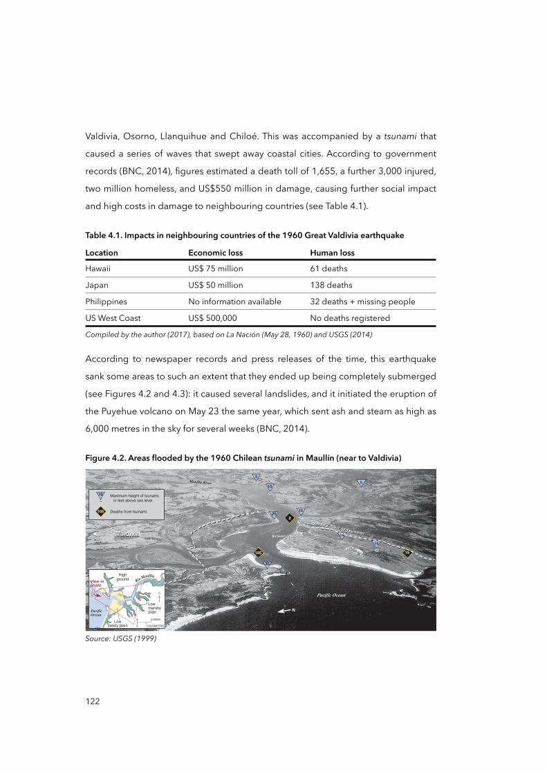
Valdivia, Osorno, Llanquihue and Chiloé. This was accompanied by a tsunami that
caused a series of waves that swept away coastal cities. According to government
records (BNC, 2014), figures estimated a death toll of 1,655, a further 3,000 injured,
two million homeless, and US$550 million in damage, causing further social impact
and high costs in damage to neighbouring countries (see Table 4.1).
Table 4.1. Impacts in neighbouring countries of the 1960 Great Valdivia earthquake
Location Economic loss Human loss
Hawaii US$ 75 million 61 deaths
Japan US$ 50 million 138 deaths
Philippines No information available 32 deaths + missing people
US West Coast US$ 500,000 No deaths registered
Compiled by the author (2017), based on ompiled by the author (2017), based on La Nación (May 28, 1960) and USGS (2014)1960) and USGS (2014)
According to newspaper records and press releases of the time, this earthquake
sank some areas to such an extent that they ended up being completely submerged
(see Figures 4.2 and 4.3): it caused several landslides, and it initiated the eruption of
the Puyehue volcano on May 23 the same year, which sent ash and steam as high as
6,000 metres in the sky for several weeks (BNC, 2014).
Figure 4.2. Areas flooded by the 1960 Chilean tsunami in Maullín (near to Valdivia)
Broken road
30
55
1520
10
15
15
Pacific Ocean
Maullín River
N
105
2
15
InIn land limitland limit of tsunami
of tsunamiBroken road
Maximum height of tsunami,in feet above sea level
Deaths from tsunami
10
105
PacificOcean
View inphoto
N
Lowmarshyplain
0 5 MILES
0 5 KILOMETERSLow
sandy plain
Highground Río Maullín
ValdiviaValdivia
Source: USGS (1999)
122
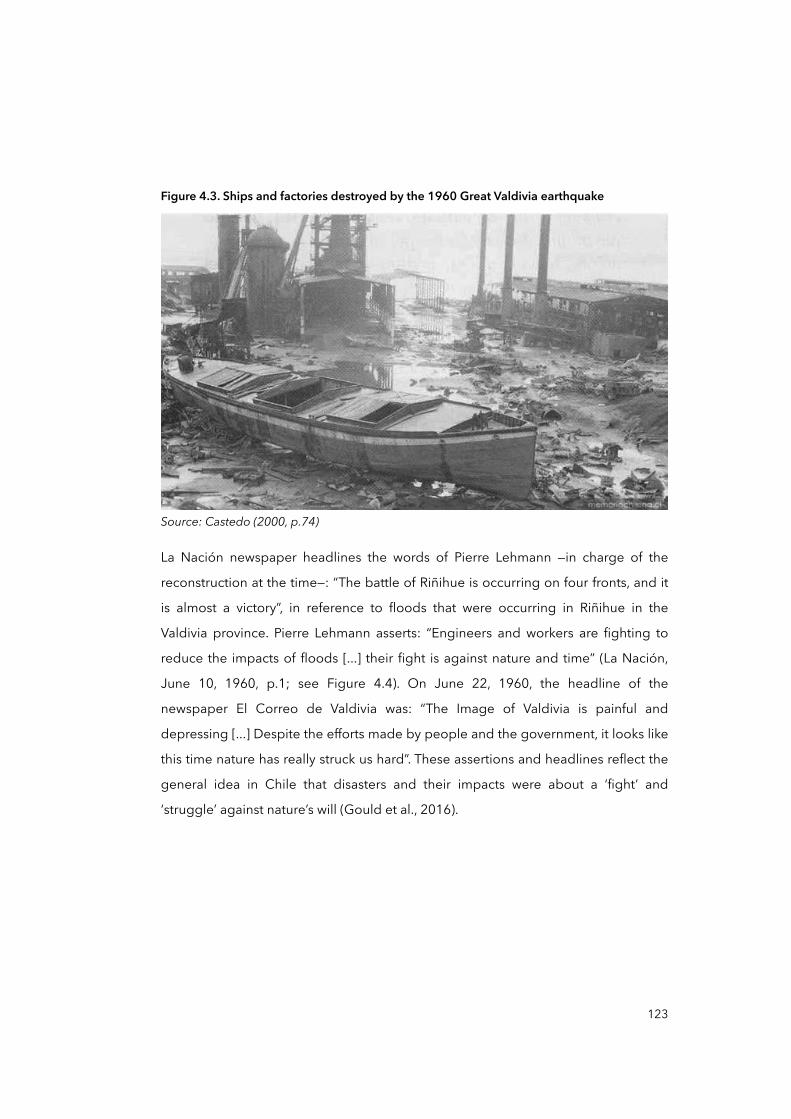
Figure 4.3. Ships and factories destroyed by the 1960 Great Valdivia earthquake
Source: Castedo (2000, p.74)
La Nación newspaper headlines the words of Pierre Lehmann —in charge of the
reconstruction at the time—: “The battle of Riñihue is occurring on four fronts, and it
is almost a victory”, in reference to floods that were occurring in Riñihue in the
Valdivia province. Pierre Lehmann asserts: “Engineers and workers are fighting to
reduce the impacts of floods [...] their fight is against nature and time” (La Nación,
June 10, 1960, p.1; see Figure 4.4). On June 22, 1960, the headline of the
newspaper El Correo de Valdivia was: “The Image of Valdivia is painful and
depressing [...] Despite the efforts made by people and the government, it looks like
this time nature has really struck us hard”. These assertions and headlines reflect the
general idea in Chile that disasters and their impacts were about a ‘fight’ and
‘struggle’ against nature’s will (Gould et al., 2016).
123
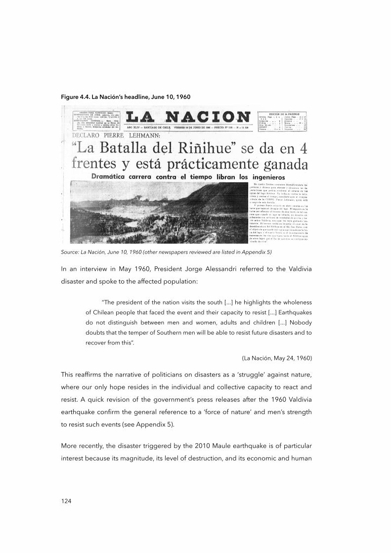
Figure 4.4. La Nación’s headline, June 10, 1960
Source: La Nación, June 10, 1960 (other newspapers reviewed are listed in Appendix 5)
In an interview in May 1960, President Jorge Alessandri referred to the Valdivia
disaster and spoke to the affected population:
“The president of the nation visits the south [...] he highlights the wholeness of Chilean people that faced the event and their capacity to resist [...] Earthquakes do not distinguish between men and women, adults and children [...] Nobody doubts that the temper of Southern men will be able to resist future disasters and to recover from this”.
(La Nación, May 24, 1960)
This reaffirms the narrative of politicians on disasters as a ‘struggle’ against nature,
where our only hope resides in the individual and collective capacity to react and
resist. A quick revision of the government’s press releases after the 1960 Valdivia
earthquake confirm the general reference to a ‘force of nature’ and men’s strength
to resist such events (see Appendix 5).
More recently, the disaster triggered by the 2010 Maule earthquake is of particular
interest because its magnitude, its level of destruction, and its economic and human
124
costs (Han, 2010; Navia, 2010; Volk, 2010). A few hours after the earthquake,
President Bachelet was quoted as saying:
“We are facing a massive catastrophe which has caused damage that will require an enormous effort by both the public and private sectors, one of the largest [efforts] in the history of the country. […] Once again our ability to deal with adversity and get back on our feet [is tested]. And we are examining every way to restore all the basic services in the country”.
(Bachelet, 2010, translated by Gould et al., 2016)
Bachelet addressed the nation, pointing out that the disaster was tragic and serious
but at the same time limited and manageable. According to Gould et al. (2016), this
and other statements rely on a formulation already familiar to Chileans: “the state as
possessing the human, economic, and technical resources to overcome great
challenges, including national/natural disasters” (Gould et al., 2016, p.100). This
reaffirms the narrative of politicians and the elite about the mainstream view in the
Chilean history of disaster, which restricts the causes of disasters to natural factors.
In her May 21 Speech of 2015, Bachelet remembered the 2008 Chaitén volcanic
eruption to point out the success of the different institutions in coping with such
extreme events: “Chaitén is a successful case where all institutions worked together
to protect the population” (Presidential May 21 Speech, May 2015). This perspective
is mainly supported by the fact that no fatalities were registered during the
eruption. However, this neglects determinant aspects of risk and disaster, such as
the role of the economy and politics that influence people’s capacity to resist and
recover from disasters (Wisner et al., 2004). Once more, political rhetoric and
historical records emphasise the number of deaths and other material impacts such
as destroyed houses. Rarely is attention paid to the socio-economic and political
pre-conditions that situated men and women in disaster prone areas or make them
more vulnerable to disasters in the first place.
125
4.1.2 History of disasters triggered by other extreme events
Disasters in Chile are not only triggered by earthquakes, but also by other extreme
natural events. For instance, some authors (Smink, 2011) suggest that volcanic
eruptions have an important role in the history of Chilean disasters because of their
social and economic impacts. It is well known that there are an estimated 2,000
volcanoes in Chile —the second highest number after Indonesia (Casertano, 1963)—
of which 100 are considered active volcanoes and only 50 are being regularly
monitored (OVDAS, 2014). Recent disasters related to volcanic activity are the
Villarrica and Lonquimay volcanic eruptions in 1984 and 1989 respectively, and the
Hudson eruption in 1991 that incurred important economic costs in agriculture and
in the livestock industry (Berezin, 2012). In 2011, the Puyehue volcanic eruption
provoked the displacement of more than 4,000 people in Los Ríos Region,
significant air traffic disruption, and economic costs for the local industry (Abumohor
and Díaz, 2011). But perhaps the most emblematic case is the eruption of the
Chaitén volcano in 2008 that caused the displacement of more than 8,000 men and
women, made 4,000 people homeless, and incurred around US$ 70 million in
economic costs (Presidencia de la República de Chile and Narváez, 2009). In this
case, great emphasis was given to the ‘effectiveness’ of the evacuation procedures
because there were no fatalities during the emergency (Galilea, 2013).
Nevertheless, unforeseen effects of policy responses and decisions made during the
subsequent years may have triggered the return of people to the city in spite of
volcanic risk. This issue will be addressed in greater detail in Chapter Five.
Likewise, other disasters in recent Chilean history were triggered neither by
earthquakes nor by volcanic eruptions. Once more, however, emphasis has been put
on the impacts and the suffering of people, neglecting almost completely the
importance of the social, economic and political pre-conditions that surrounded
such disasters. One example is the Great Fire of Valparaiso that occurred between
April 12 and 16, 2014. According to the ONEMI (2014a), the fires caused 15 deaths,
injured more than 500 people, destroyed 2,900 dwellings and made more than
12,500 people homeless. There is not yet any public information from the ONEMI,
126
the main state institution on disasters, pointing out the underlying causes and
drivers of such a disaster, despite researchers having already pointed to land market
deregulation and urban segregation (Pino, 2015; Pino and Hormazabal, 2016).
According to the ONEMI (2014b) and the United Nations International Strategy for
Disaster Reduction (UNISDR, 2014a), floods and storms have also been recurrent in
the recent history of Chilean disasters, often leaving people displaced and homeless
and incurring important economic losses. Perhaps the most important disaster
related to flash floods and mudflows in Chile’s recent history occurred between
March 23 and 25, 2015, in northern Chile. ONEMI and the media highlighted that
flooding caused at least 34 deaths and made 30,000 people homeless
(Cooperativa, 2015; ONEMI, 2015).
In general, politicians, researchers and the media have considered Chilean disaster
management performance —the actions of people, civil society, institutions and
authorities— as ‘positive’ (American Red Cross Multidisciplinary Team et al., 2011;
Kaufmann, 2010; López Tagle and Santana Nazarit, 2011; MAE Center et al., 2010).
This interpretation is strongly linked to the low number of casualties. However, more
and more researchers are pointing out the social costs of reconstruction and the
failure of emergency and recovery strategies as disasters’ levels of impact in terms of
economic and social costs have significantly increased (Gobierno de Chile, 2014).
Such literature calls for a more active ex-ante role of institutions in handling disasters
(González-Muzzio, 2013; Pulgar Pinaud, 2014a, 2014b; Romero and Albornoz, 2013;
Romero et al., 1999; Vidal and Romero, 2010), aiming to address potential causes
and drivers of risks focusing on preparedness and mitigation rather than
concentrating only on post-ante emergency response, relief and compensation.
From a multiplicity of official sources, governmental reports, media archives and
historiography, I elaborated a list of disasters triggered by ‘natural’ hazards in Chile
(see Table 4.2), collecting the main aspects referenced within each document in
order to visualise a ‘pattern’ of the official narrative on the history of Chilean
disasters.
127

Table 4.2. Disasters related to extreme natural events in Chile (1562-2016)
Year Event Area Aspects highlighted
1562 Earthquake Concepción 8.0-magnitude earthquake estimated. Changes in geography, houses destroyed and fatalities (Quezada, 1999).
1570 Earthquake Concepción The first documented earthquake in Chile. Destruction of houses and economic losses (Palacios Roa, 2016).
1575 Earthquake Valdivia The force of nature (Mariño de Lobera, 1960).
1647 Earthquake Santiago Central Chile is devastated and this provoked an intense economic crisis (BNC, 2014).
1657 Earthquake Concepción The force of nature and reference to God (BNC, 2014).
1730 Earthquake Santiago and Valparaíso The force of nature and reference to God (Quezada, 1999).
1737 Earthquake Concepción Economic losses and damage to the built environment (Quezada, 1999).
1751 Earthquake Concepción The force of nature and reference to God (Quezada, 1999).1819 Earthquake Copiapó Economic losses (BNC, 2014).
1822 Earthquake Santiago and Valparaíso
The force of nature and human losses. 200 deaths estimated (Fuentes et al., 1823).
1835 Earthquake Concepción The force of nature (BNC, 2014).
1837 Earthquake Valdivia The force of nature (BNC, 2014).
1868 Earthquake and tsunami Arica The force of nature and economic losses (BNC, 2014).
1877 Earthquake Santiago The force of nature (BNC, 2014).
1906 Earthquake Valparaíso Earthquake destroyed the port of Valparaíso and gave rise to commercial problems (Grossi, 1907); almost 20,000 deaths.
1922 Earthquake and tsunami Atacama The force of nature and economic losses (BNC, 2014).
1928 Earthquake TalcaEarthquake destroyed around 75 per cent of the city. This event gave rise to the General Law of Construction and Urbanisation in 1931 (Presidencia de la República de Chile, 1936).
1939 Earthquake Chillán CORFO created to coordinate reconstruction and economic recovery (CORFO, 2014).
1960 Earthquake and tsunami Valdivia
Southern Chile devastated, important economic and human losses. The most disastrous event in Chile’s history (USGS, 2014).
1965 Floods Atacama and Los Lagos 600 deaths and 375,000 affected people (Rojas et al., 2014).
1965 Earthquake La LiguaThe 7.4-magnitude earthquake and its associated disaster promoted the creation of the ONEMI in 1974 (ONEMI, 2014b).
1971 Earthquake Central ChileEarthquake heavily affected Illapel, Los Vilos, Salamanca, Combarbalá, and La Ligua. It generated the creation of the Chilean Standard for Seismic Design of Buildings (NCh433) in 1973 (BNC, 2014).
1980 Mudflows Santiago 3 deaths and US$ 500,000 in losses (SERNAGEOMIN, 2017).
128
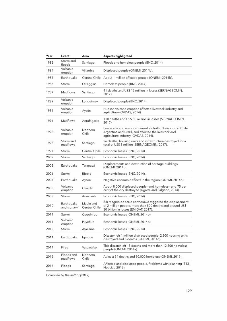
Year Event Area Aspects highlighted
1982 Storm and floods Santiago Floods and homeless people (BNC, 2014).
1984 Volcanic eruption Villarrica Displaced people (ONEMI, 2014b).
1985 Earthquake Central Chile About 1 million affected people (ONEMI, 2014b).
1986 Storm O’Higgins Homeless people (BNC, 2014).
1987 Mudflows Santiago 41 deaths and US$ 12 million in losses (SERNAGEOMIN, 2017).
1989 Volcanic eruption Lonquimay Displaced people (BNC, 2014).
1991 Volcanic eruption Aysén Hudson volcano eruption affected livestock industry and
agriculture (OVDAS, 2014).
1991 Mudflows Antofagasta 110 deaths and US$ 80 million in losses (SERNAGEOMIN, 2017).
1993 Volcanic eruption
Northern Chile
Láscar volcano eruption caused air traffic disruption in Chile, Argentina and Brazil, and affected the livestock and agriculture industry (OVDAS, 2014).
1993 Storm and mudflows Santiago 26 deaths; housing units and infrastructure destroyed for a
total of US$ 5 million (SERNAGEOMIN, 2017).
1997 Storm Central Chile Economic losses (BNC, 2014).
2002 Storm Santiago Economic losses (BNC, 2014).
2005 Earthquake Tarapacá Displacements and destruction of heritage buildings (ONEMI, 2014b).
2006 Storm Biobio Economic losses (BNC, 2014).
2007 Earthquake Aysén Negative economic effects in the region (ONEMI, 2014b).
2008 Volcanic eruption Chaitén About 8,000 displaced people –and homeless— and 75 per
cent of the city destroyed (Ugarte and Salgado, 2014).
2008 Storm Araucanía Economic losses (BNC, 2014).
2010 Earthquake and tsunami
Maule and Central Chile
8.8-magnitude scale earthquake triggered the displacement of 2 million people, more than 500 deaths and around US$ 30 billion in losses (EM-DAT, 2017).
2011 Storm Coquimbo Economic losses (ONEMI, 2014b).
2011 Volcanic eruption Puyehue Economic losses (ONEMI, 2014b).
2012 Storm Atacama Economic losses (BNC, 2014).
2014 Earthquake Iquique Disaster left 1 million displaced people, 2,500 housing units destroyed and 8 deaths (ONEMI, 2014c).
2014 Fires Valparaíso This disaster left 15 deaths and more than 12,500 homeless people (ONEMI, 2014a).
2015 Floods and mudflows
Northern Chile At least 34 deaths and 30,000 homeless (ONEMI, 2015).
2016 Floods Santiago Affected and displaced people. Problems with planning (T13 Noticias, 2016).
Compiled by the author (2017)Compiled by the author (2017)Compiled by the author (2017)Compiled by the author (2017)
129
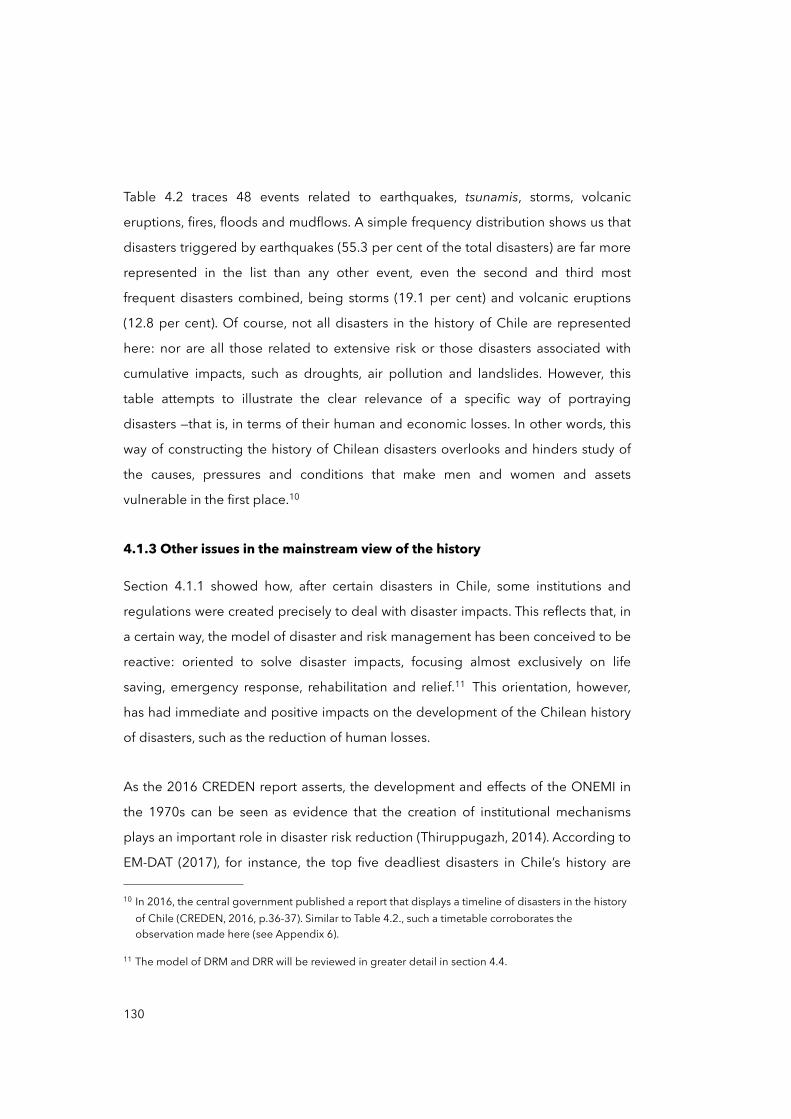
Table 4.2 traces 48 events related to earthquakes, tsunamis, storms, volcanic
eruptions, fires, floods and mudflows. A simple frequency distribution shows us that
disasters triggered by earthquakes (55.3 per cent of the total disasters) are far more
represented in the list than any other event, even the second and third most
frequent disasters combined, being storms (19.1 per cent) and volcanic eruptions
(12.8 per cent). Of course, not all disasters in the history of Chile are represented
here: nor are all those related to extensive risk or those disasters associated with
cumulative impacts, such as droughts, air pollution and landslides. However, this
table attempts to illustrate the clear relevance of a specific way of portraying
disasters —that is, in terms of their human and economic losses. In other words, this
way of constructing the history of Chilean disasters overlooks and hinders study of
the causes, pressures and conditions that make men and women and assets
vulnerable in the first place.10
4.1.3 Other issues in the mainstream view of the history
Section 4.1.1 showed how, after certain disasters in Chile, some institutions and
regulations were created precisely to deal with disaster impacts. This reflects that, in
a certain way, the model of disaster and risk management has been conceived to be
reactive: oriented to solve disaster impacts, focusing almost exclusively on life
saving, emergency response, rehabilitation and relief.11 This orientation, however,
has had immediate and positive impacts on the development of the Chilean history
of disasters, such as the reduction of human losses.
As the 2016 CREDEN report asserts, the development and effects of the ONEMI in
the 1970s can be seen as evidence that the creation of institutional mechanisms
plays an important role in disaster risk reduction (Thiruppugazh, 2014). According to
EM-DAT (2017), for instance, the top five deadliest disasters in Chile’s history are
130
10 In 2016, the central government published a report that displays a timeline of disasters in the history of Chile (CREDEN, 2016, p.36-37). Similar to Table 4.2., such a timetable corroborates the observation made here (see Appendix 6).
11 The model of DRM and DRR will be reviewed in greater detail in section 4.4.
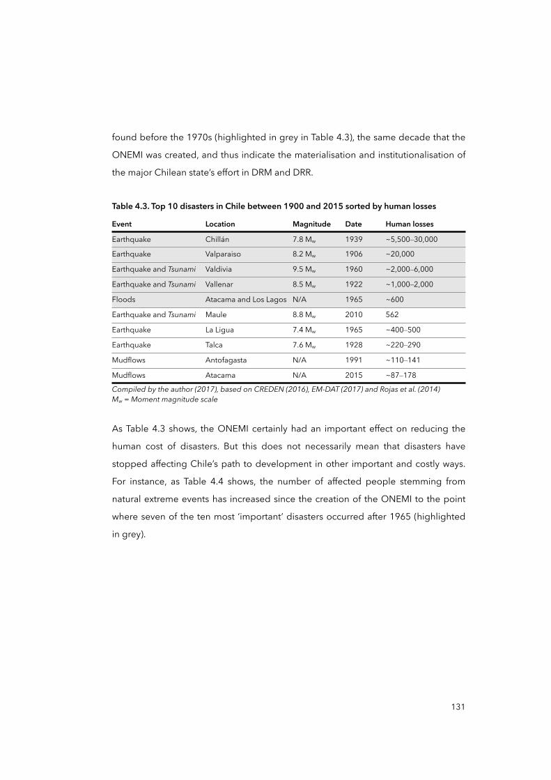
found before the 1970s (highlighted in grey in Table 4.3), the same decade that the
ONEMI was created, and thus indicate the materialisation and institutionalisation of
the major Chilean state’s effort in DRM and DRR.
Table 4.3. Top 10 disasters in Chile between 1900 and 2015 sorted by human losses
Event Location Magnitude Date Human losses
Earthquake Chillán 7.8 Mw 1939 ~5,500–30,000
Earthquake Valparaiso 8.2 Mw 1906 ~20,000
Earthquake and Tsunami Valdivia 9.5 Mw 1960 ~2,000–6,000
Earthquake and Tsunami Vallenar 8.5 Mw 1922 ~1,000–2,000
Floods Atacama and Los Lagos N/A 1965 ~600
Earthquake and Tsunami Maule 8.8 Mw 2010 562
Earthquake La Ligua 7.4 Mw 1965 ~400–500
Earthquake Talca 7.6 Mw 1928 ~220–290
Mudflows Antofagasta N/A 1991 ~110–141
Mudflows Atacama N/A 2015 ~87–178
Compiled by the author (2017), based on CREDEN (2016), EM-DAT (2017) and Rojas et al. (2014)Mw = Moment magnitude scaleCompiled by the author (2017), based on CREDEN (2016), EM-DAT (2017) and Rojas et al. (2014)Mw = Moment magnitude scaleCompiled by the author (2017), based on CREDEN (2016), EM-DAT (2017) and Rojas et al. (2014)Mw = Moment magnitude scaleCompiled by the author (2017), based on CREDEN (2016), EM-DAT (2017) and Rojas et al. (2014)Mw = Moment magnitude scaleCompiled by the author (2017), based on CREDEN (2016), EM-DAT (2017) and Rojas et al. (2014)Mw = Moment magnitude scale
As Table 4.3 shows, the ONEMI certainly had an important effect on reducing the
human cost of disasters. But this does not necessarily mean that disasters have
stopped affecting Chile’s path to development in other important and costly ways.
For instance, as Table 4.4 shows, the number of affected people stemming from
natural extreme events has increased since the creation of the ONEMI to the point
where seven of the ten most ‘important’ disasters occurred after 1965 (highlighted
in grey).
131
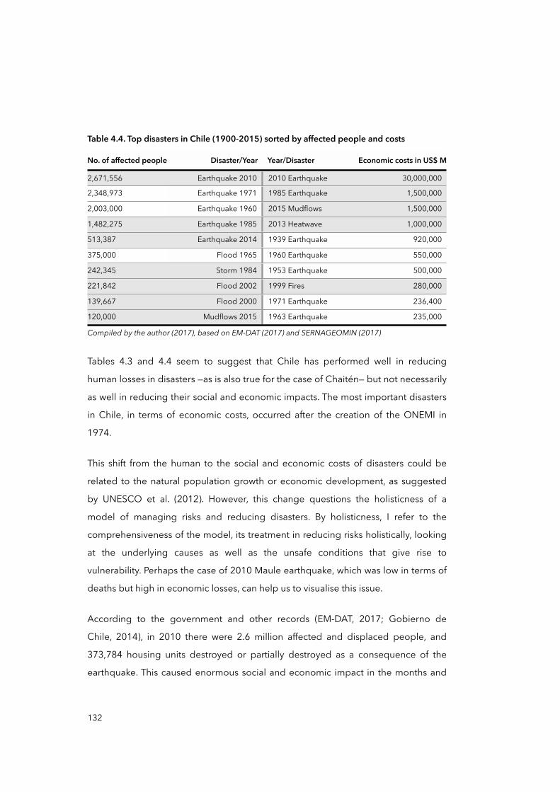
Table 4.4. Top disasters in Chile (1900-2015) sorted by affected people and costs
No. of affected people Disaster/Year Year/Disaster Economic costs in US$ M
2,671,556 Earthquake 2010 2010 Earthquake 30,000,000
2,348,973 Earthquake 1971 1985 Earthquake 1,500,000
2,003,000 Earthquake 1960 2015 Mudflows 1,500,000
1,482,275 Earthquake 1985 2013 Heatwave 1,000,000
513,387 Earthquake 2014 1939 Earthquake 920,000
375,000 Flood 1965 1960 Earthquake 550,000
242,345 Storm 1984 1953 Earthquake 500,000
221,842 Flood 2002 1999 Fires 280,000
139,667 Flood 2000 1971 Earthquake 236,400
120,000 Mudflows 2015 1963 Earthquake 235,000
Compiled by the author (2017), based on EM-DAT (2017) and SERNAGEOMIN (2017)Compiled by the author (2017), based on EM-DAT (2017) and SERNAGEOMIN (2017)Compiled by the author (2017), based on EM-DAT (2017) and SERNAGEOMIN (2017)Compiled by the author (2017), based on EM-DAT (2017) and SERNAGEOMIN (2017)
Tables 4.3 and 4.4 seem to suggest that Chile has performed well in reducing
human losses in disasters —as is also true for the case of Chaitén— but not necessarily
as well in reducing their social and economic impacts. The most important disasters
in Chile, in terms of economic costs, occurred after the creation of the ONEMI in
1974.
This shift from the human to the social and economic costs of disasters could be
related to the natural population growth or economic development, as suggested
by UNESCO et al. (2012). However, this change questions the holisticness of a
model of managing risks and reducing disasters. By holisticness, I refer to the
comprehensiveness of the model, its treatment in reducing risks holistically, looking
at the underlying causes as well as the unsafe conditions that give rise to
vulnerability. Perhaps the case of 2010 Maule earthquake, which was low in terms of
deaths but high in economic losses, can help us to visualise this issue.
According to the government and other records (EM-DAT, 2017; Gobierno de
Chile, 2014), in 2010 there were 2.6 million affected and displaced people, and
373,784 housing units destroyed or partially destroyed as a consequence of the
earthquake. This caused enormous social and economic impact in the months and
132
years after 2010: men and women in affected areas and communities organised
themselves in different ways to demonstrate their dissatisfaction with the
government’s strategies and plans for reconstruction and recovery (Pulgar Pinaud,
2014a, 2014b). Furthermore, reactive and top-down approaches to recovery and
reconstruction utilised by the government apparently created conditions that
exacerbated the underlying causes of vulnerability, reproducing it and perpetuating
risks in the long term (Imilan et al., 2015). In a way, post-disaster Chaitén fully
represents a neat example of how a recovery and reconstruction plan does not
consider local participation, aspirations and demands, and people’s ‘positive’
efforts, and so opens up the possibility of the emergence of sources of vulnerability
and risk.
When the recent history of Chilean disasters is investigated through governmental
documents and media archives, there are very few allusions to, and often disjointed
information about, the conditions preceding disasters —that is, the socio-economic,
political and cultural processes that place people at risk and make them more
vulnerable to disasters in the first place, such as living in disaster-prone areas, their
level of education, access to health and other urban services, poverty and the like.
The attention and efforts, then, have tended to focus on the effects of disasters in
lieu of to their root causes.
This dangerous missing and ignored element of Chilean disaster history is, for me, a
cyclical aspect. Reducing response, relief, rehabilitation and reconstruction to
technical solutions and the provision of basic needs means neglecting how post-
disaster strategies can contribute significantly to reduce future vulnerability and
exposure to disasters. Whilst investment in disaster risk management may help to
reduce deaths during extreme events, the social and economic costs associated with
disasters can also, over time, erode societal structures, affecting people’s ability to
resist, cope with and recover from future disasters (UNISDR, 2011).
This brief review of the history of Chilean disasters therefore aims to point out that
the dominant narrative is characterised by a strong emphasis on post-disaster
133
impacts and losses, while the vulnerable pre-conditions of people, along with the
socio-economic and political circumstances that facilitate their production, are often
neglected. I think that these dominant views, over time, may have created —from a
hermeneutical point of view— a reactive or post-event oriented model of DRM in
Chile. Furthermore, I consider that a managerial model that mainly focuses on
emergency response and relief, without a long-term view seeking to avoid
reproducing the existing vulnerabilities and risks —or producing new ones— is
somehow missing the opportunity to effectively reduce disaster risks.
The upcoming sections address another aspect of the history of Chilean disasters:
the development of DRM and DRR models and their related institutional forms.
However, such analysis need to be conducted bearing in mind that we are
constructing a multi-scalar perspective to look at the progression of vulnerability in
the case of Chaitén. This requires us to go back to the history of the state territorial
organisation through which the DRM institutional forms —such as the ONEMI— can
be better interpreted from a scalar viewpoint.
4.2 The ‘logic’ of the state territorial organisation of Chile
By making sense of the state territorial organisation of Chile and its territorial/scalar
configuration, this section aims to lay the groundwork for interpreting the
progression of vulnerability as a multi-scalar process in the case of Chaitén. I
propose here that the state territorial organisation has had, and has today, an
important influence on the way DRM and DRR are conceived and executed, and
therefore also influences decision-making, policy responses to disasters and disaster
governance. In the two following sections I address the territorial structure of Chile,
tracing its evolution from the origins of the nation state in the nineteenth century to
the present.
4.2.1 The origins of the territorial structure of the state
As argued by Brenner (2001, p.599), the social production of scale is subordinated
to socio-political contestation and is therefore “historically changeable” and
134
malleable. In reconstructing a scalar geography of Chile, a historical review of its
state territorial organisation becomes indispensable. By state territorial
organisation, I refer to the structure of the nation-state power and its apparatuses
and how these are spatially organised at different scales (Brenner, 1997, 1998). This
encompasses the hierarchical organisation and the spatial distributions of state
power in terms of governance, economy and politics (Lopez-Basaguren and Leire
Escajedo, 2013; Brenner, 1997). In global-city literature, the scalar forms of state
territorial organisations have been studied since the 1980s, arguing that such forms
may vary over time, depending on the mode of production —especially under
capitalism— and the social relations and struggles that are originated within
(Brenner, 1997). In this section, I focus on the two main scalar forms of territorial
organisation in the history of Chile, centralised and federalist models, but
particularly on the processes of centralisation and decentralisation as distinctive
forces in shaping the current territorial structure of the country.
The analysis starts with the Chilean process of decolonisation from the Spanish
Empire that took place between 1808 and 1824 (Silva, 1995). According to
Montecinos (2005), specific social, economic and political circumstances which
precipitated the emancipation can help to explain the current “territorial centrality”
of the Chilean state (Montecinos, 2005, p.440). These circumstances include poor
colonial administration, trade monopoly, postponement of Creoles, absolutism and
tyranny of colonial authority under both the Bourbon and the Hapsburg model.
Equally important are the philosophical influences from the Enlightenment among
Creole authorities, the French Revolution, and the Independence of the United
States.
After 1810, similar to other Spanish colonies, Chile developed a process of
decolonisation from the Spanish Empire and, with this, started the creation of the
nation-state (in the sense suggested by Appadurai, 1996). The initial composition of
the Chilean state was designed by the Government Junta of Chile or Primera Junta
de Gobierno (Collier and Sater, 1996). The Junta, due to the imminent war against
135
the Spanish Empire, established wide political and military powers for the Head of
the State, the Director Supremo or Supreme Director. The state project was
concluded by issuing its first constitution in 1818, which maintained broad
designated power to the Head of the State but also considered the separation of the
state powers —i.e. the Supreme Director (executive), the Senate (legislative) and the
Supreme Court (judicial)— and at least three provincias or regions: Coquimbo,
Concepción and Santiago, the latter being the capital. According to Montecinos
(2005), during this initial phase, the Supreme Director Bernardo O’Higgins governed
following the previously established centralised patterns of the Spanish Empire. The
state power was thus centralised in its capital Santiago de Chile and in the figure of
Director Supremo.
In 1823 a new constitution was issued. In its Chapter XIX, municipalities received
their first recognition as minor spatial entities which were subject to the orders of the
Departmental Councillors (Silva, 1995). Councillors had to be appointed by the
executive branch or the Supreme Director. This constitution was the first to refer to
different aspects of the territorial structure of the state. For instance, that the State of
Chile is declared ‘unitary and indivisible’ —so provinces or regions and municipalities
cannot be considered as being part of the state— and its sovereignty resides in the
‘nation’ (Congreso Nacional Constituyente, 1823).
In early 1826, the so-called ‘federal laws’ were drafted by José Miguel Infante, a
Chilean politician and admirer of the US federal system. These laws sought to
transform the figure of the Supreme Director into the President of the Republic and
delegate more autonomy to the provinces (Silva, 1995). However, the constitutional
law was never written because José Manuel Infante lost the presidential elections
that year (Donoso, 1963). This constitutional attempt resulted in a precedent for
future struggles to restructure the state territoriality. Its proposals included the
division of the territory into eight provinces (Coquimbo, Aconcagua, Santiago,
Colchagua, Maule, Concepción, Valdivia and Chiloé) and that all authorities,
including governors and parish priests, would be subject to a popular vote.
136
According to Montecinos (2005), this federalist attempt was produced as a result of
the claims for autonomy by the provinces of Coquimbo and Concepción in
opposition to the centralism dictated by Santiago.
Between at least one coup d'état and several other constitutional arrangements, the
State of Chile “settled down” and came to form the construction of a “strong and
centralised” country by 1833 (Montecinos, 2005, p.449). Villas or municipalities were
acknowledged as minor administrative-spatial units, and the nation as the centrality
from which order emanates. Each municipality must have an Alcalde or Mayor and
each province an Intendente or Governor, both directly selected by the executive
branch whose power resides in the Head of the State, the President of the Republic.
The constitution of 1833 was in rule until 1925, a period of almost 100 years.
According to Villalobos (1987), the ‘doctrinal content’ of the constitution
encompassed the fundamental basis of a centralised institutional regime: national
sovereignty, representative regime, division of state powers, governmental
accountability and individual rights. Thus, this constitution established that the
nation and its territoriality were to be exclusively delegated by national authorities,
in this way centralising the administration of the state into the executive branch
located in Santiago (Gran Convención de Chile, 1833).
In the period between the 1833 and 1924, nevertheless, territorial reconfigurations
were not abandoned. The parliamentary system was introduced in 1891 which, in
the following years, produced several constitutional reforms, including important
autonomic measures such as municipal participatory budgeting and voter
assemblies in provinces. However, by 1924, a military Pronuncimiento —a military
rebellion, but different from a coup d'état12— ended any, and the hitherto achieved,
parliamentary attempts in Chile. In its place, the presidential system was re-
137
12 In a typical coup d'état, a rebel faction which controls some critical element of the armed forces seizes control of the state by a sudden movement, organised and executed in stealth; in a pronunciamiento, a group of military officers publicly declare their opposition only to the current government —that is, to the current chief executive and cabinet— who may be legally elected civilians or the result of a previous coup (Luttwak, 1969).
established by the Junta government. The first significant reform of the restored
order was the dissolution of all municipal representatives and the designation of
regional intendentes in their place (Salazar and Pinto, 1999).
After 1925, the centralised organisation of the territory was thus initiated by a
doctrine based on the assumption that the success of municipalities and provinces
was only possible through their alignment with national plans (Montecinos, 2005).
The goal was to ‘discipline’ the municipalities under a national development plan
that was promoted by President Ibáñez (Salazar and Pinto, 1999). The period
between 1925 and 1973 is known as a ‘democratic presidential’ era. It is a phase
marked by the rise of the middle class, great prosperity and sustained increases in
living standards, including improvements in education and health, and the country
was undergoing a process of industrialisation. This period also saw the
implementation of several political and economic models, such as the socialist
model during the Salvador Allende administration, and the Keynesian with President
Aguirre Cerda. The latter had an important influence on the state territorial
organisation of that time. In 1938, the republican-political alliance called Frente
Popular or Popular Front won the presidency, the leader being the Radical Party
politician Pedro Aguirre Cerda. President Aguirre Cerda implemented a Keynesian
style economic model with strong state intervention in the national economic
development (Montecinos, 2005).
The result of this ‘developmental’ inspiration was that the ‘state territorial
organisation’ adopted new significance as a strategic tool of the state in order to
promote economic growth and development in the country. In 1939, the Production
Development Corporation (CORFO) was founded and thus the state took the helm
as the motor of industrial dynamism and national growth. A consequence of
industrialisation processes and the obsession with economic development and
growth was that the principal cities of Chile —Santiago, Concepción and Valparaíso—
emerged (Frías, 1960).
138
4.2.2 Approaching the current state territorial organisation
In the period from 1925 to 1973, we can find the most direct predecessors to the
current territorial structure of the Chilean state. Montecinos (2005, p.455) defines
this period as an attempt to reconfigure the state territoriality, and calls it “the first
regionalisation”. Remember that the period before 1925 was characterised by
demands coming from strong regionalist and federalist movements that were born
in the provinces and, in most cases, had violent outcomes by means of revolution or
armed uprising. These decentralising demands were considered, reflected upon
and mentioned in a specific article of the constitution:
“The laws will entrust gradually to provincial or municipal agencies the authority and administrative powers currently exercised by other authorities, in order to proceed with the decentralisation of the national administrative system”.
(Constitución Política de la República de Chile, 1925, Article Nº107)
This article described a process of ‘administrative decentralisation’ which sought to
promote economic development (Boisier, 2000). Since 1939, CORFO had
stimulated a new process of territorial organisation based on the economic
development of the country. This new organisation delineated six major productive
regions: Norte Grande, Norte Chico, Núcleo Central, Concepción and La Frontera,
Región de Los Lagos, and Región de Los Canales. These productive-administrative
divisions supposedly aimed to integrate people and human resources within a
national developmental plan. However, this did not take into account the socio-
spatial fabric of major ancient socio-economic and cultural groups such as the
Magallanes people in the South, the Mapuches in Central Chile and the Aimaras in
the North (Montecinos, 2005). According to Boisier (2000), the new division
delivered more autonomy to neither Concepción nor Coquimbo —regions that had
historically demanded more power— because it was mainly based on the spatial
distribution of natural resources. Thus, the principal objective of this ‘first
regionalisation’ was to encourage the economic development of each region based
on its geographical and economic characteristics (Boisier, 2001).
139
In 1965, the National Planning Office (ODEPLAN) increased regionalisation by
establishing new regions based on a system of poles of economic development.
This time, the territory was divided into eleven regions and one metropolitan area.
This ‘regionalisation’ was characterised by the designation of central spatial units,
determined by a city as a hub that was to connect the rest of the region. Santiago
and its metropolitan area were established as the main centre of national
development, while the three poles of multi-regional development were
Antofagasta, Valparaíso and Concepción. A third hierarchical level was composed by
another set of sub-poles of regional development which were first politically and
then economically subordinated to the aforementioned regional poles
(Montecinos, 2005). By observing such hierarchies, it is then possible to understand
better the underlying processes that have produced the current geographical and
scalar organisation of the Chilean state, as this logic of organisation continued in the
1970s.
Alongside the arrival of the military dictatorship in 1973, there was a phenomenon
that Montecinos (2011) considers paradoxical: instead of increasing the
centralisation of the country, the dictatorship headed by the General Augusto
Pinochet gave a strong impetus to the process of regionalisation and administrative
decentralisation already started in the 1950s. Decree Nº212, from December 17,
1973, created the National Commission for Administrative Reform, or CONARA
(Boisier, 2000). CONARA established the current national political-administrative
division of Chile, consisting of thirteen regions. Thirty-four years later, a major
modification to this spatial division was made in 2007 through the creation of two
additional regions: Los Ríos Region and the Arica and Parinacota Region (see
Appendix 7). According to Montecinos (2005), the military government discourses
on state territorial organisation in the 1970s was focused on the geographic and
economic potentialities of each region, and argued that this division would promote
better integration of citizens, national security, socio-economic development and
better national administration. In other words, the military government continued
the process of administrative decentralisation initiated since the constitution of
140
1925. Likewise, the development of a national security system intended to achieve
border security and internal cohesion by inhabiting the territory of ‘unoccupied’
spaces (Boisier, 2000). Although the foundation of Chaitén occurred in 1940 within
an ‘unoccupied’ region, it was only during the 1970s that an important influx of
people and economic progress took place (Delgado et al., 2005).
In the 1970s, the creation of regions displaced the power from provincial to regional
governments, thus giving them more recognition and resources to implement the
regional development plans (Szary, 1997). With this solution, the national
government aimed to keep a united country but without falling into a “utopian
federalism” while promoting economic development with territorial and political
harmony (Montecinos, 2005, p.458). However, more than 30 years after the first
regionalisation, the dialectic of centralisation and decentralisation processes —
federalist and regionalist— is still considered an unsolved issue in the Chile of today
(SUBDERE, 2000). According to Boisier (2001), this issue has created an imbalance
between an administrative decentralisation and one political, where concrete
redistribution of power to sub-national levels has not occurred. Moreover, Boisier
(2001) asserts that administrative decentralisation has not secured a balanced
distribution of the economy in the territory. On the contrary, since the 1980s, the
concentration of wealth, income opportunities, and economic and political power in
the Santiago Metropolitan Region has increased (Atienza and Aroca, 2012).
In sum, within the history of the Chilean territorial organisation, it is possible to
distinguish various centralisation and decentralisation attempts: however, there are
two clearly identifiable and distinctive styles of decentralisation: endogenous
decentralisation and vertical decentralisation. The first is described as a “bottom-up”
process (Montecinos, 2005, p.461) with a strong regional-political component based
on revolutionary attempts of involving a radical change to the model of government
and constitutional order. These, implemented in some cases, include attempts to
federalise the country in 1826, 1851 and 1859. Another endeavour was the attempt
to move the country from a highly centralised presidential system to a parliamentary
141
system, in practice for 34 years between 1891 and 1925. Both attempts brought no
radical institutional changes and policy outcomes; nor were they manifested in
Chilean social and political life (Boisier, 2001). On the contrary, the failure of these
attempts became sufficient reason to react and recentralise power in both 1833 and
1925.
The second style, described as a “vertical decentralisation” or top-down (Montecinos
2005, p.461), is characterised by governments deciding on a policy of
decentralisation with an administrative emphasis —a decentralisation of the functions
of the state aiming to contribute to the process of its modernisation and economic
growth in the country. In this period and under this logic, main government
institutions and frameworks for disaster management and risk reduction are
consolidated, such as the ONEMI, municipal emergency plans and territorial
planning instruments (IPTs). These will be fully addressed in section 4.4. To end this
historical revision, I will address the current structure of the Chilean territory.
4.2.3 The territorial structure of the state and the government
The current territorial organisation of Chile is characterised by a vertical
decentralisation where most of the functions of the state —the administration of state
services including civil protection— are territorialised into regional spaces, but these
functions still maintain a high subordination to and dependency on national powers
(Montecinos, 2013). Today, intendentes —or regional governors— and provincial
governors are directly elected by the President of the Republic, whereas mayors and
the Municipal Council have been democratically elected since the 1990s (Szary,
1997).
In trying to capture the centralising character of the territorial state, the political-
administrative divisions of its territory could be a good example. As displayed in
Figure 4.5, the division of minor administrative spatial units is concentrated in
Central Chile. Since the concentration of minor administrative divisions is also the
result of population density —Central Chile is inhabited by more than 80 per cent of
142
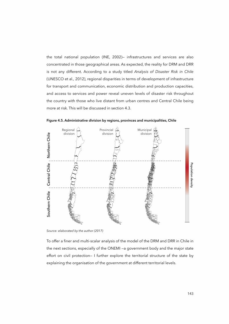
the total national population (INE, 2002)— infrastructures and services are also
concentrated in those geographical areas. As expected, the reality for DRM and DRR
is not any different. According to a study titled Analysis of Disaster Risk in Chile
(UNESCO et al., 2012), regional disparities in terms of development of infrastructure
for transport and communication, economic distribution and production capacities,
and access to services and power reveal uneven levels of disaster risk throughout
the country with those who live distant from urban centres and Central Chile being
more at risk. This will be discussed in section 4.3.
Figure 4.5. Administrative division by regions, provinces and municipalities, Chile
Cent
ral C
hile
Population density
North
ern
Chile
Sout
hern
Chi
le
Regionaldivision
Provincialdivision
Municipaldivision
Source: elaborated by the author (2017)
To offer a finer and multi-scalar analysis of the model of the DRM and DRR in Chile in
the next sections, especially of the ONEMI —a government body and the major state
effort on civil protection— I further explore the territorial structure of the state by
explaining the organisation of the government at different territorial levels.
143
Administratively speaking, the government of Chile is organised, in reference to
Figure 4.5, by institutions whose jurisdiction is limited by the political-administrative
spatial boundaries: regional government, provincial government, and communal
government or municipality. Financially speaking, only municipalities are entitled to
generate revenues through a special municipal tax system which includes real estate
tax, vehicle registration and road taxes, as well as street cleaning and maintenance
taxes (SII, 2016). Financial and spending patterns in DRM and DRR in Chile are
briefly addressed at the end of section 4.4.3.
Regional government and the Intendente
Regional governments are public bodies for the management of regions, tasked
with their social, cultural and economic development. Currently, there are 15
regional governments in Chile. They are based in the capital city of the region and
composed of two bodies: the Intendente, who is directly appointed by the President
of the Republic and remains in office as long as he or she has the confidence of the
President; and the Regional Council, a group of councillors that since 2014 have
been elected by popular vote, being in office for four years (Ministerio del Interior y
Seguridad Pública, 2013a).
Nonetheless, according to the Decree with Force of Law (DFL) Nº19175 of 2005
(Ministerio del Interior y Seguridad Pública, 2005), the governmental power of each
region rests solely with the Intendente as a natural and immediate representative of
the executive power, and the regional councils merely serve as consultative bodies.
So, on the one hand, regional councils have limited power to decide actions in
respect of key state functions such as civil protection, and in relation to DRM
functions and DRR actions, and on the other hand, intendentes depend on the
executive power to decide and take actions in respect of civil protection.
Furthermore, the legal functions of regional governments regarding civil protection
interweave with those of national authorities competent in those areas, such as the
ONEMI. The territorial planning instrument recently created in 2011, named
144
‘Regional Plan for Territorial Planning’ or PROT,13 aims that regional governments
implement DRM or DRR measures independently. However, like regional councils,
PROTs are merely consultative instruments which give guidance for the
development of the regions but are not binding plans. During the fieldwork,
according to an executive of the National Subsecretariat for Regional Development
and Administration (SUBDERE)14 interviewed in July 2013, “no region has handed its
PROT to the SUBDERE yet” (Carlos Villalobos,15 male, National government director,
July 2013, interview). It seems that although SUBDERE requested PROTs for each
region by 2011, there is a notorious delay or lack of interest from regions in
harnessing these plans to provide regions with more precise and locally pertinent
DRM and DRR. I think that the potentials and opportunities of PROTs are constrained
by the facts that PROTs are not binding, that the resources to prepare and
implement actions need to be covered by regional funds, and that there is a lack of
horizontal decentralisation in terms of decision-making over the functions of the
state in DRM and DRR. I will return to PROTs when I conduct a closer analysis of key
territorial planning instruments (IPTs) in section 4.4.3.
Provincial government and Governor
There are 53 provincial governments in Chile. According to the DFL Nº 19175
(Ministerio del Interior y Seguridad Pública, 2005), provincial governments are
decentralised figures of the Intendente within the regional territory, headed by a
Governor. Provincial governors are responsible for public management and
administration at the provincial level. Governors supervise all public services created
by law. Similarly, governors may appoint delegates to exercise governor’s will and
powers in one or more locations in the province. Although governors are trusted by
intendentes, they are appointed and removed freely by the President of the
145
13 In Spanish, Plan Regional de Ordenamiento Territorial.
14 In Spanish, Subsecretaría de Desarrollo Regional y Administrativo.
15 Fictitious name. As introduced in Chapter Two, for ethical reasons (confidentiality and anonymity), I decided that all interviewees’ names would be replaced by fictitious ones, whilst gender, institutional affiliation, position and date of interaction is provided.
Republic. A Governor performs his or her duties in the capital city of their respective
province, notwithstanding that he or she may exercise them temporarily from
another city in its jurisdictional territory, especially in case of disaster or emergency.
Provincial governors report directly to intendentes, while intendentes report directly
to the President of the Republic. By ‘reporting’, I mean that such authorities are
accountable and owe allegiance to a hierarchical political structure. This has
important implications for DRM and DRR, because the ONEMI’s Civil Protection
Committee (CPC) and Emergency Operation Centre (COE) must always be headed
by their respective territorial authority: the President of the Republic heads the
national COE (in case of disaster) and the Ministry of Interior the national CPC;
intendentes head regional CPC and COE, governors head provincial CPC and COE,
and mayors head communal CPC and COE (Ministerio del Interior y Seguridad
Pública, 2002). As an example of the vertical territorial relationship in terms of civil
protection, the law that ascertains the functions of the provincial governments
declares:
“Provincial governments should take all necessary measures to face emergency or disaster, according to law, and develop programmes for disaster prevention and protection, without prejudice to the powers of the competent national authorities”.
(Ministerio del Interior y Seguridad Pública, 2005, Chapter II, Letter F)
This means that the law allows provincial governments to take DRM and DRR action
yet it restricts those actions to the domains of national powers. During the fieldwork,
I observed that civil protection —preparedness and prevention— in Los Lagos Region
and Chaitén were mainly commanded by the ONEMI from Santiago, although
executed later by regional and municipal authorities. A provincial authority
interviewed in July 2013 confirmed that in terms of DRM and DRR:
146
“We receive instructions from Santiago [ONEMI] in terms of guidelines, procedures, and personnel [...] the programmes to be prepared, and to ensure prevention too”.
(Pablo Benavente, male, Regional government director, July 2013, interview)
I also interviewed an ONEMI’s delegate working at the Provincial Government of
Palena, Rosa Miranda, who confirms that provincial government is limited to
receiving instructions from ONEMI’s regional and national authorities in terms of
DRM and DRR. Again, as in the regional governments, I think there is a clear
hierarchical, vertical, top-down relationship among the various territorial
governments in terms of DRM and DRR. To some extent, this relationship is
apparently defined by the law, especially the DFL No. 19175, however, it is also
backed up by the historical processes that defined such relations: the retraction of
decentralising forces in the past, and the vertical decentralisation (Montecinos,
2005) in recent decades. But beyond the origins of such centralisation, the
subsequent question is, ‘what’ are the effects on the model of DRM and DRR in
Chile? This is something I will try to address from section 4.4 onwards.
Municipalities
In Chile, municipalities are ‘autonomous public bodies’ responsible for meeting the
needs of the local community and ensuring their participation in the economic
progress, social and cultural development of the community (Ministerio del Interior y
Seguridad Pública, 2005). Unlike intendentes and provincial governors,
municipalities are ruled by a Mayor and a Municipal Council elected directly for a
period of four years. Each municipality is advised by an Economic and Social
Community Council (CESCO), composed of representatives from principal
economic activities in the community, NGOs and neighbouring committees.
Municipalities are responsible for basic education and health services in the
community. Other functions, including civil protection, are defined by the Organic
Constitutional Law on Municipalities. In this law, there is only one brief mention of
DRM and DRR:
147
“Paragraph No.2: Functions and Attributions: [...] i) The prevention of risks and delivery of relief in case of emergency or disasters”.
(Ministerio del Interior y Seguridad Pública, 2006, p.3)
Unfortunately, there is no further explanation about how this should happen and
with what resources, nor a reference to other sets of rules or laws that could give
more details about the role of municipalities in managing disasters and reducing
risks. I consider this to be another indication of the reduced and limited role
allocated to minor territorial levels in regard to disaster prevention and risk
reduction.
Within the Chilean legal system, the ‘urban’ category can be applied at the
municipal or community level when a settlement of 5,000 or more inhabitants is
defined (Ministerio del Interior y Seguridad Pública, 2006). In that case, a settlement
would then be bestowed along with the title ‘city’. The urban category has significant
and far-reaching implications for civil protection in terms of resources allocated
based on the Cost-Benefit Analysis (CBA) carried out by the ONEMI and the
territorial governments. According to an ONEMI’s official interviewed in March
2013, medium and large urban areas are of high interest for the ONEMI, as they
combine critical infrastructure and density of people and assets:
“The concentration of assets such as urban infrastructure and population, parks, streets is going to influence the result of cost-benefit analysis made for DRR measures [...] mitigatory measures such as flood protection, or the river courses cleaning and maintenance are often subject to this cost-benefit analysis”.
(Rafael Montenegro, male, National government official, March 2013, interview)
By means of a CBA, it is possible to estimate the best alternatives to optimise the
use of resources in reducing risks and disasters at the local level, however, the
allocation of resources to specific DRR strategies or projects is not in the hands of
municipalities but those of regional governments and the Ministry of Interior, which
in turn, depend on the President of the Republic (Ministerio del Interior y Seguridad
Pública, 2002, 2006). Again, we find that although municipalities could own certain
148
functions and attributions in respect to DRM and DRR, in practice, decision-making is
subordinate to the executive central power.
Now, we move to an often ignored aspect within the historic development of the
state territorial organisation of Chile, and of relevance for the study of post-disaster
Chaitén: the uneven development among regions and territories in Chile. This
deserves attention because it may help to explain why there are important
disparities among territories in terms of risks and vulnerabilities, as was documented
by UNESCO et al. (2012) and other literature (Atienza and Aroca, 2012; Cooper and
Henriquez, 2010; Olavarria-Gambi, 2003; Schurman, 1996).
4.3 Economic model, centralisation and uneven development
Soto and Torche (2004) pointed out that the Chilean per capita gross domestic
product (GDP) grew by approximately five per cent annually between 1975 and
2000, but regions did not benefit equally from this growth: “poverty declined
significantly in all regions but regional income inequality remained stagnant” (Soto
and Torche, 2004, p.401).
Some researchers assert that this income inequality and uneven development of the
country have been the result of neoliberal reforms (Ferrada Borquez, 2000;
Solimano, 2012; Soto and Torche, 2004). After the coup d’état on September 11,
1973 as led by the General Commander Augusto Pinochet against the elected
government of Salvador Allende, substantial neoliberal reforms were implemented
(Solimano, 2012) which were consolidated within the Constitution of 1980 (Ferrada
Borquez, 2000). Such reforms were characterised by an aggressive strategy of
privatisation and market liberalisation, which included the privatisation of basic
social services such as health, education and pensions, trade opening, and
deregulation (Klein, 2008; Solimano 2012). Although these neoliberal reforms had
the intention of reinvigorating the Chilean economy, they produced significant
regional disparities and social inequality (Quitral Rojas, 2009). According to
Solimano (2012), after 20 years of left-wing governments —from 1990 to 2010— the
149
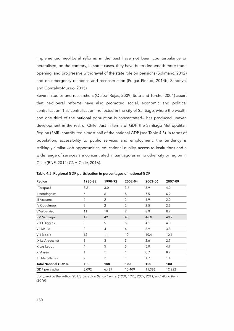
implemented neoliberal reforms in the past have not been counterbalance or
neutralised, on the contrary, in some cases, they have been deepened: more trade
opening, and progressive withdrawal of the state role on pensions (Solimano, 2012)
and on emergency response and reconstruction (Pulgar Pinaud, 2014b; Sandoval
and González-Muzzio, 2015).
Several studies and researchers (Quitral Rojas, 2009; Soto and Torche, 2004) assert
that neoliberal reforms have also promoted social, economic and political
centralisation. This centralisation —reflected in the city of Santiago, where the wealth
and one third of the national population is concentrated— has produced uneven
development in the rest of Chile. Just in terms of GDP, the Santiago Metropolitan
Region (SMR) contributed almost half of the national GDP (see Table 4.5). In terms of
population, accessibility to public services and employment, the tendency is
strikingly similar. Job opportunities, educational quality, access to institutions and a
wide range of services are concentrated in Santiago as in no other city or region in
Chile (BNE, 2014; CNA-Chile, 2016).
Table 4.5. Regional GDP participation in percentages of national GDP
Region 1980–82 1990–92 2002–04 2003–06 2007–09
I Tarapacá 3.2 3.0 3.5 3.9 4.0
II Antofagasta 6 6 8 7.5 6.9
III Atacama 2 2 2 1.9 2.0
IV Coquimbo 2 2 2 2.5 2.5
V Valparaíso 11 10 9 8.9 8.7
RM Santiago 47 49 48 46.8 48.2
VI O’Higgins 5 5 5 4.1 4.0
VII Maule 3 4 4 3.9 3.8
VIII Biobío 12 11 10 10.4 10.1
IX La Araucanía 3 3 3 2.6 2.7
X Los Lagos 4 5 5 5.0 4.9
XI Aysén 1 1 1 0.7 0.7
XII Magallanes 2 2 1 1.7 1.4
Total National GDP % 100 100 100 100 100GDP per capita 5,092 6,487 10,409 11,386 12,222
Compiled by the author (2017), based on Banco Central (1984, 1993, 2007, 2011) and World Bank (2016)Compiled by the author (2017), based on Banco Central (1984, 1993, 2007, 2011) and World Bank (2016)Compiled by the author (2017), based on Banco Central (1984, 1993, 2007, 2011) and World Bank (2016)Compiled by the author (2017), based on Banco Central (1984, 1993, 2007, 2011) and World Bank (2016)Compiled by the author (2017), based on Banco Central (1984, 1993, 2007, 2011) and World Bank (2016)Compiled by the author (2017), based on Banco Central (1984, 1993, 2007, 2011) and World Bank (2016)
150
According to Riffo (2007), although most of the national concentration in economic,
political and demographic terms occurred in the SMR, some regions reached
economic growth mainly due to the exploitation of raw materials such as copper
(Northern Chile), wood (South-Central Chile), and fishing (Southern Chile). As Table
4.5 shows, however, this economic growth has not necessarily translated into a
reduction in centralisation. In general, the contribution of regions to the national
GDP shows very little variation between 1980 and 2009. Although there are other
figures that can be used to demonstrate this view, the point here is to discuss
whether the territorial/scalar structure of the state has predisposed the uneven
development of territories and, if that is the case, what the repercussions are of this
uneven development for the production of vulnerability and risks.
It is equally important to mention here the role of the SUBDERE, being the major
state effort to counteract centralisation and to balance the development of regions.
SUBDERE is responsible for coordinating, promoting and evaluating
decentralisation and regional development. Established in 1984, SUBDERE aims to
contribute to municipal and regional development, promoting capacity building
and giving coherence to the country’s decentralisation processes. SUBDERE controls
one of the primary funding sources for regional and local governments, the National
Fund for Regional Development, or FNDR (OECD, 2013). Another similar instrument
managed by SUBDERE is the Municipal Common Fund, or FCM, a distributive tool
that aims to equalise income disparities between municipalities throughout the
country. Despite the intentions of SUBDERE and these mechanisms, Boisier (2000)
asserts that SUBDERE in general, and the FNDR in particular, have caused more
centralisation and reinforced inequality. The FNDR used to be a “reinvestment
budget where five per cent of the regional GDP must be used within each region”;
however, this idea was abandoned by the central government because it may
produce “budgetary rigidity” at the national level (Boisier, 2000, pp.93-94). In other
words, it would have reduced the capacity and power of the national government to
control and decide such budgets (Boisier, 2000). Today, most of the orders and
decisions related to FNDR and FCM are taken from and directed by Santiago, by
151
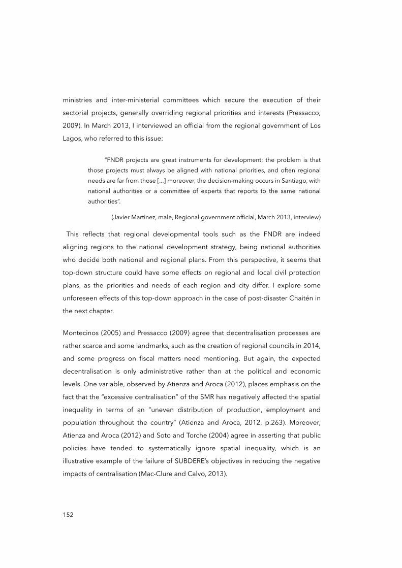
ministries and inter-ministerial committees which secure the execution of their
sectorial projects, generally overriding regional priorities and interests (Pressacco,
2009). In March 2013, I interviewed an official from the regional government of Los
Lagos, who referred to this issue:
“FNDR projects are great instruments for development; the problem is that those projects must always be aligned with national priorities, and often regional needs are far from those [...] moreover, the decision-making occurs in Santiago, with national authorities or a committee of experts that reports to the same national authorities”.
(Javier Martinez, male, Regional government official, March 2013, interview)
This reflects that regional developmental tools such as the FNDR are indeed
aligning regions to the national development strategy, being national authorities
who decide both national and regional plans. From this perspective, it seems that
top-down structure could have some effects on regional and local civil protection
plans, as the priorities and needs of each region and city differ. I explore some
unforeseen effects of this top-down approach in the case of post-disaster Chaitén in
the next chapter.
Montecinos (2005) and Pressacco (2009) agree that decentralisation processes are
rather scarce and some landmarks, such as the creation of regional councils in 2014,
and some progress on fiscal matters need mentioning. But again, the expected
decentralisation is only administrative rather than at the political and economic
levels. One variable, observed by Atienza and Aroca (2012), places emphasis on the
fact that the “excessive centralisation” of the SMR has negatively affected the spatial
inequality in terms of an “uneven distribution of production, employment and
population throughout the country” (Atienza and Aroca, 2012, p.263). Moreover,
Atienza and Aroca (2012) and Soto and Torche (2004) agree in asserting that public
policies have tended to systematically ignore spatial inequality, which is an
illustrative example of the failure of SUBDERE’s objectives in reducing the negative
impacts of centralisation (Mac-Clure and Calvo, 2013).
152
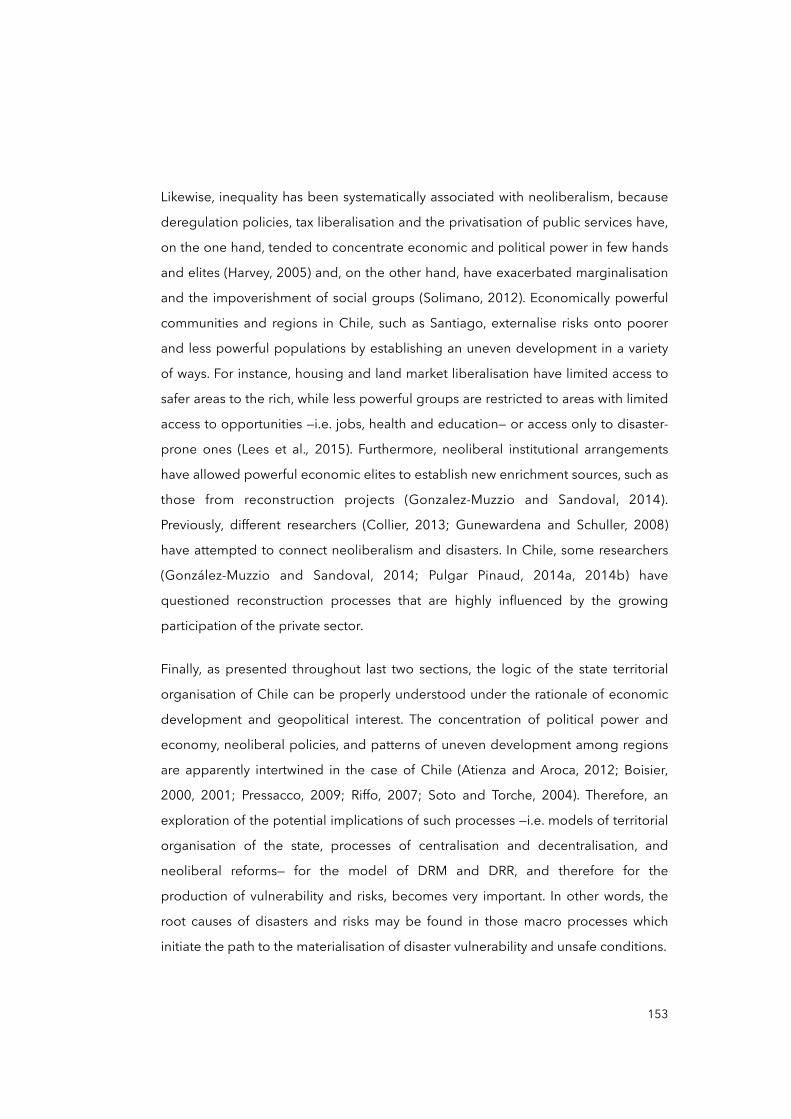
Likewise, inequality has been systematically associated with neoliberalism, because
deregulation policies, tax liberalisation and the privatisation of public services have,
on the one hand, tended to concentrate economic and political power in few hands
and elites (Harvey, 2005) and, on the other hand, have exacerbated marginalisation
and the impoverishment of social groups (Solimano, 2012). Economically powerful
communities and regions in Chile, such as Santiago, externalise risks onto poorer
and less powerful populations by establishing an uneven development in a variety
of ways. For instance, housing and land market liberalisation have limited access to
safer areas to the rich, while less powerful groups are restricted to areas with limited
access to opportunities —i.e. jobs, health and education— or access only to disaster-
prone ones (Lees et al., 2015). Furthermore, neoliberal institutional arrangements
have allowed powerful economic elites to establish new enrichment sources, such as
those from reconstruction projects (Gonzalez-Muzzio and Sandoval, 2014).
Previously, different researchers (Collier, 2013; Gunewardena and Schuller, 2008)
have attempted to connect neoliberalism and disasters. In Chile, some researchers
(González-Muzzio and Sandoval, 2014; Pulgar Pinaud, 2014a, 2014b) have
questioned reconstruction processes that are highly influenced by the growing
participation of the private sector.
Finally, as presented throughout last two sections, the logic of the state territorial
organisation of Chile can be properly understood under the rationale of economic
development and geopolitical interest. The concentration of political power and
economy, neoliberal policies, and patterns of uneven development among regions
are apparently intertwined in the case of Chile (Atienza and Aroca, 2012; Boisier,
2000, 2001; Pressacco, 2009; Riffo, 2007; Soto and Torche, 2004). Therefore, an
exploration of the potential implications of such processes —i.e. models of territorial
organisation of the state, processes of centralisation and decentralisation, and
neoliberal reforms— for the model of DRM and DRR, and therefore for the
production of vulnerability and risks, becomes very important. In other words, the
root causes of disasters and risks may be found in those macro processes which
initiate the path to the materialisation of disaster vulnerability and unsafe conditions.
153
Figure 4.6. Potential links between root causes and unsafe conditions in Chaitén
Source: elaborated by the author (2017)
In Figure 4.6, I hypothesise about potential connections within the progression of
vulnerability that are not yet evident. These seek to formulate trajectories to be
explored and elements that should be further investigated in the case of Chaitén —
for instance, how the territorial structure of the state and its scalar configuration (its
centrality) may have affected the scalar organisation of DRM and DRR and why, and
ultimately, how policy responses to disasters and the model of disaster risk
reduction may have facilitated the materialisation of unsafe conditions in Chaitén.
The next figure tries to explain the trajectories I have chosen to take the reader to
this point.
Figure 4.7 shows, as in the introduction, that the case study is investigated from two
entry points. The first occurs within this chapter, in which I look at the major historical
processes related to the context of Chile, and from a multi-scalar perspective. The
second entry point will take place in Chapter Five. Alongside with post-disaster
Chaitén itself, the idea of this second entry point is to investigate the same elements
discussed in this chapter but from the bottom up, from the local and particular
unsafe conditions in Chaitén, connecting the relationships with root causes and
e.g. e.g.
#Neoliberal reforms
#State territorial organisation
#Centralisation
e.g.
#Top-down, reactive model of DRM/DRR
#Inequality
#Uneven development
#Limited access to public services
#Trust in publicauthorities
e.g.
Earthquake
Volcanic eruptions
(Rapid onsethazards)
ROOT CAUSES
RISK=Hazard x
Vulnerability
R=HxV
DYNAMICPRESSURES
UNSAFECONDITIONS DISASTER HAZARDS
1THE PROGRESSION OF VULNERABILITY
TEMPORAL AND SPATIAL-SCALE DIMENSION
32
154
dynamic pressures on a major scale. Figure 4.7 also shows the direction where we
now head. The next section analyses the Chilean model of governing disasters and
risks, considering the mainstream narrative of the history of Chilean disasters and
the country’s centralised and top-down state territorial organisation.
Figure 4.7. Rationale for the case study’s chapter, entry point and progress
First entry point Second entry pointCASE STUDY
MAJOR MINORTEMPORAL AND SPATIAL-SCALE DIMENSION
Chapter Four Chapter Five
Historical perspectives on Chilean disasters and the state territorial organisation of Chile
Processes of de- and centralisation
Economic model, uneven development,
inequality
Institutional forms for DRM and DRR:
laws, regulations, ITPs, state agencies, etc.
The case of post-disaster
Chaitén
4.4 The model of managing disasters and reducing risks in Chile
Having reflected on the state territorial organisation of Chile and its scalar
configurations, here I examine how the model of DRM and DRR, and other
institutional forms, is defined, organised and distributed within such multi-scalar
territorial organisation. This part of the text aims to discuss the influence that the
territorial structure of the state has on the DRM and DRR models in Chile. This is the
case as other institutional forms such as in education —e.g. ministries, regional
departments, schools and so forth— are often geographically distributed and
hierarchically organised in accordance with a specific form of state territorial
organisation (Clark, 2014) —e.g. centralist and federalist. In other words, government
institutions tend to mirror or reproduce the form of the territorial structure of the
state.
DRM and DRR institutional forms such as the ONEMI are crucial for reducing risks
and developing DRR within a wide range of other institutions —including those from
155
civil society, the private sector and the population— in order to monitor natural and
man-made hazards, to reduce exposure and vulnerability, to develop preparedness
and to promote resilience (UNISDR, 2013). Thus, the connection between territorial
organisation, particularly centralisation, and the institutional model of managing
risks and disasters deserves to be investigated, as this connection may have
implications for the production and progression of vulnerability, risks and disaster
causation.
I start this examination with what is perhaps the more relevant institutional form of
DRM and DRR in Chile, the National Emergency Office (ONEMI) of the Ministry of
Interior and Public Security. Thereafter, other relevant forms such as legal
frameworks and planning instruments will be examined.
4.4.1 The National Plan of Civil Protection and the ONEMI
In Chile, as in other countries, the building, consolidation and updating of regulatory
and institutional frameworks on DRM and DRR came about as fallout from large
disastrous events. For example, the 1928 Talca earthquake advanced the creation of
the first Law on Urban Planning and Construction; the 1939 Chillán earthquake
provided the basis for earthquake-resistant construction standards called the
Chilean Standard for Seismic Design of Buildings Nº429 (NCh429)16 and NCh430;
the 1960 Valdivia earthquake and tsunami gave rise to the National Emergency
Office (ONEMI); and the 1985 Central Chile earthquake further strengthened the
existing standard of earthquake-resistant buildings, as enforced in the NCh433
code. Recently, the effects of the 2010 Maule earthquake and tsunami initiated the
reformulation of the ONEMI into a new National System of Civil Protection and
Emergency Plan, and the creation of a new National Agency of Civil Protection17
(ONEMI, 2011).
156
16 In Spanish, Diseño Sísmico de Edificios: Norma Chilena Oficial Nº429.
17 This plan and the creation of the agency were presented as a bill by the President of the Republic to the Congress by late 2011. Even though its status has been declared as an ‘urgent law’ (Senado de la República de Chile, 2014), its discussion and approval remain delayed to date (2016–17).
In 2002, Supreme Decree (DS) Nº156 (Ministerio del Interior y Seguridad Pública,
2002) established the current National Plan of Civil Protection, or Plan Nacional de
Protección Civil (PNPC), which represented the first institutional effort that explicitly
sought to address issues of risk reduction holistically, as it considered for first time
the pre-existing conditions of a disaster such as preparedness and mitigation.
Although initially created only for emergency management in 1974 by DS Nº369
(Ministerio del Interior y Seguridad Pública, 1974), the ONEMI today is the primary
technical agency of the state responsible for executing the PNPC and coordinating
the National System of Civil Protection, or Sistema Nacional de Protección Civil
(SNPC) (Ministerio del Interior y Seguridad Pública, 2002). ONEMI’s mission is to
plan, promote, coordinate and implement preventive actions, responses and
rehabilitation in the face of collective risk situations, emergencies and disasters
caused by natural or human action (ONEMI, 2017). ONEMI’s authorities report to,
and depend directly on, the Ministry of Interior and Public Security. The first plan was
called the National Emergency Plan and it was issued in 1977, approved by DS
Nº155. The current PNPC was approved by DS Nº156 in March 2002, and it dictates
the norms of the organisational and administrative structure of the SNPC (Ministerio
del Interior y Seguridad Pública, 2002), including the ONEMI. This plan is intended
to be multi-sectorial and is dedicated to the development of permanent actions for
the prevention and treatment of emergencies and disasters from a cyclical view of
disaster management (Figure 4.8).
Figure 4.8 shows that the PNPC sets the ground rules for how the management of
the SNPC is coordinated by the ONEMI. This diagram also depicts the importance
and centrality of the ONEMI within the PNPC and the SNPC, which role has major
relevance for this thesis as it considers the ONEMI as the main public and national
effort for the reduction of disaster risks and response.
157
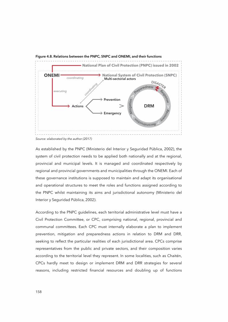
Figure 4.8. Relations between the PNPC, SNPC and ONEMI, and their functions
Source: elaborated by the author (2017)
As established by the PNPC (Ministerio del Interior y Seguridad Pública, 2002), the
system of civil protection needs to be applied both nationally and at the regional,
provincial and municipal levels. It is managed and coordinated respectively by
regional and provincial governments and municipalities through the ONEMI. Each of
these governance institutions is supposed to maintain and adapt its organisational
and operational structures to meet the roles and functions assigned according to
the PNPC whilst maintaining its aims and jurisdictional autonomy (Ministerio del
Interior y Seguridad Pública, 2002).
According to the PNPC guidelines, each territorial administrative level must have a
Civil Protection Committee, or CPC, comprising national, regional, provincial and
communal committees. Each CPC must internally elaborate a plan to implement
prevention, mitigation and preparedness actions in relation to DRM and DRR,
seeking to reflect the particular realities of each jurisdictional area. CPCs comprise
representatives from the public and private sectors, and their composition varies
according to the territorial level they represent. In some localities, such as Chaitén,
CPCs hardly meet to design or implement DRM and DRR strategies for several
reasons, including restricted financial resources and doubling up of functions
ONEMI National System of Civil Protection (SNPC)
National Plan of Civil Protection (PNPC) issued in 2002
coordinating
coordinating
executing
Multi-sectorial actors
ActionsPrevention
EmergencyDRM
Response Recovery Reconstruction M
itigati
on
P
reparednessDISASTER
158
among public agents that restricts their availability to participate in meetings and to
work on designing and implementing plans.18
Equally important is the financial distribution of the implementation costs of each
plan. The PNPC establishes that the cost of executing will be covered by each of the
ministries, regional and provincial administrations, and municipalities using their
own resources (Ministerio del Interior y Seguridad Pública, 2002). This embodies the
contradiction that, on the one hand, decision-making and authority command are
centralised at the national level, but, on the other, the funding of projects or
strategies must often come from local sources. This way of organising civil
protection committees and DRR can create conflicts between national and local
public authorities as their demands and interests are not always attended to.19
Furthermore, this hierarchical and interventionist approach can have negative results
for the development of crucial aspects of DRM such as preparedness and
prevention (Scolobig et al., 2015), as they require the real involvement of people
and local actors —not just consultative.
In addition, despite the declaration of the PNPC regarding preparedness and
mitigation, the ONEMI has tended to focus mainly on emergency management and
response, perhaps as a continuation of its legacy from its initial structure in 1974.
The first indication of this is the level of attention paid, and the detail of descriptions
given within DS Nº156, to emergency issues rather than to prevention and
preparedness. A quick text analysis of DS Nº156 will show that the word ‘emergency’
is used twice as often as the phrases ‘risk reduction’, ‘prevention’ and ‘preparedness’
combined (Ministerio del Interior y Seguridad Pública, 2002). Other indications of
this orientation towards emergencies and response will be explored through the
analysis of other institutional forms, such as legal frameworks.
159
18 During the fieldwork, I observed that Chaitén lacked an updated municipal emergency plan (MEP). The current MEP was elaborated in 2010. MEPs should be elaborated by the communal CPC yearly.
19 See again what Javier Martinez, from the Regional government, says on page 152.
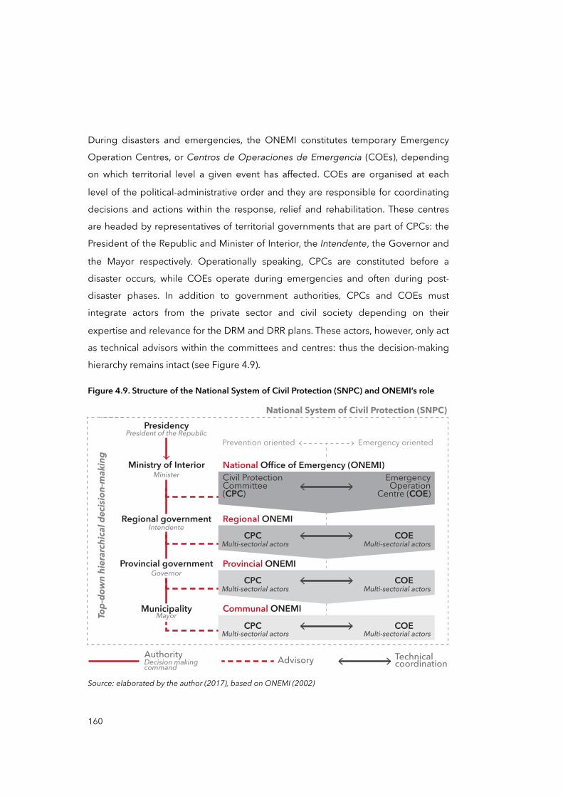
During disasters and emergencies, the ONEMI constitutes temporary Emergency
Operation Centres, or Centros de Operaciones de Emergencia (COEs), depending
on which territorial level a given event has affected. COEs are organised at each
level of the political-administrative order and they are responsible for coordinating
decisions and actions within the response, relief and rehabilitation. These centres
are headed by representatives of territorial governments that are part of CPCs: the
President of the Republic and Minister of Interior, the Intendente, the Governor and
the Mayor respectively. Operationally speaking, CPCs are constituted before a
disaster occurs, while COEs operate during emergencies and often during post-
disaster phases. In addition to government authorities, CPCs and COEs must
integrate actors from the private sector and civil society depending on their
expertise and relevance for the DRM and DRR plans. These actors, however, only act
as technical advisors within the committees and centres: thus the decision-making
hierarchy remains intact (see Figure 4.9).
Figure 4.9. Structure of the National System of Civil Protection (SNPC) and ONEMI’s role
Source: elaborated by the author (2017), based on ONEMI (2002)
National System of Civil Protection (SNPC)
Prevention oriented Emergency oriented
Municipality
Provincial government
Ministry of Interior
Presidency
National Office of Emergency (ONEMI)EmergencyOperation
Centre (COE)Civil ProtectionCommittee(CPC)
Regional ONEMICPC COE
Provincial ONEMICPC COE
Communal ONEMICPC COE
Top-
down
hie
rarc
hica
l dec
ision
-mak
ing
President of the Republic
Regional governmentIntendente
Minister
Governor
Mayor
Multi-sectorial actors Multi-sectorial actors
Multi-sectorial actors Multi-sectorial actors
Multi-sectorial actors Multi-sectorial actors
AuthorityDecision makingcommand
Advisory Technicalcoordination
160
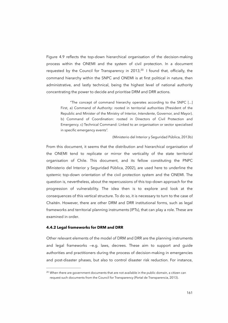
Figure 4.9 reflects the top-down hierarchical organisation of the decision-making
process within the ONEMI and the system of civil protection. In a document
requested by the Council for Transparency in 2013,20 I found that, officially, the
command hierarchy within the SNPC and ONEMI is at first political in nature, then
administrative, and lastly technical, being the highest level of national authority
concentrating the power to decide and prioritise DRM and DRR actions.
“The concept of command hierarchy operates according to the SNPC [...] First, a) Command of Authority: rooted in territorial authorities (President of the Republic and Minister of the Ministry of Interior, Intendente, Governor, and Mayor). b) Command of Coordination: rooted in Directors of Civil Protection and Emergency. c) Technical Command: Linked to an organisation or sector specialised in specific emergency events”.
(Ministerio del Interior y Seguridad Pública, 2013b)
From this document, it seems that the distribution and hierarchical organisation of
the ONEMI tend to replicate or mirror the verticality of the state territorial
organisation of Chile. This document, and its fellow constituting the PNPC
(Ministerio del Interior y Seguridad Pública, 2002), are used here to underline the
systemic top-down orientation of the civil protection system and the ONEMI. The
question is, nevertheless, about the repercussions of this top-down approach for the
progression of vulnerability. The idea then is to explore and look at the
consequences of this vertical structure. To do so, it is necessary to turn to the case of
Chaitén. However, there are other DRM and DRR institutional forms, such as legal
frameworks and territorial planning instruments (IPTs), that can play a role. These are
examined in order.
4.4.2 Legal frameworks for DRM and DRR
Other relevant elements of the model of DRM and DRR are the planning instruments
and legal frameworks —e.g. laws, decrees. These aim to support and guide
authorities and practitioners during the process of decision-making in emergencies
and post-disaster phases, but also to control disaster risk reduction. For instance,
161
20 When there are government documents that are not available in the public domain, a citizen can request such documents from the Council for Transparency (Portal de Transparencia, 2013).
legal frameworks such as building codes become indispensable in creating better
hazard management and risk reduction (UNISDR, 2013, 2015a). But what they can
tell us about the scalar configuration of the model of DRM? To interrogate the wide
range of documents, I used the document analysis technique described in Chapter
Two (see pages 68-70). The document sampling was based on representativeness
among the existing documents, and meaning. For the latter, I used the categories of
‘national security’, ‘civil protection’, ‘emergencies’ and ‘disasters’ in the online
database of the National Congress Library (BCN, 2017). Finally, I selected 30 legal
documents based on their relevance to describe the model of managing disasters
and reducing risks in different territorial tiers, and I organised them in three
categories:
• Structural legal frameworks: laws or systems of laws (e.g. organic laws) and documents that transversally help to describe the legal structure of the model
of DRM and DRR.
• Regulations/post-disaster laws: legal documents on policy responses to
disasters. Specific regulations related to emergency situations and states of catastrophe.
• Sets of rules/prevention laws: legal documents and sets of rules such as codes and standards related to the prevention and reduction of hazards and risks.
In the following tables, I analyse each document by extracting their main aspects in
the form of observations. I classified them in terms of their vertical/hierarchical
position vis-à-vis the territorial structure of the state, and its orientation within the
DRM cycle. Table 4.6 analyses different laws and the Constitution of Chile, which
define and structure the National System of Civil Protection.
162
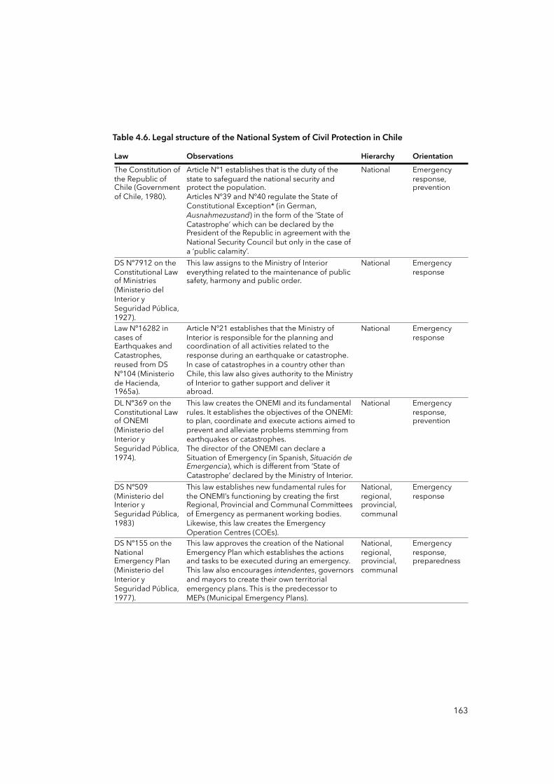
Table 4.6. Legal structure of the National System of Civil Protection in Chile
Law Observations Hierarchy OrientationThe Constitution of the Republic of Chile (Government of Chile, 1980).
Article Nº1 establishes that is the duty of the state to safeguard the national security and protect the population.Articles Nº39 and Nº40 regulate the State of Constitutional Exception* (in German, Ausnahmezustand) in the form of the ‘State of Catastrophe’ which can be declared by the President of the Republic in agreement with the National Security Council but only in the case of a ‘public calamity’.
National Emergency response, prevention
DS Nº7912 on the Constitutional Law of Ministries (Ministerio del Interior y Seguridad Pública, 1927).
This law assigns to the Ministry of Interior everything related to the maintenance of public safety, harmony and public order.
National Emergency response
Law Nº16282 in cases of Earthquakes and Catastrophes, reused from DS Nº104 (Ministerio de Hacienda, 1965a).
Article Nº21 establishes that the Ministry of Interior is responsible for the planning and coordination of all activities related to the response during an earthquake or catastrophe. In case of catastrophes in a country other than Chile, this law also gives authority to the Ministry of Interior to gather support and deliver it abroad.
National Emergency response
DL Nº369 on the Constitutional Law of ONEMI (Ministerio del Interior y Seguridad Pública, 1974).
This law creates the ONEMI and its fundamental rules. It establishes the objectives of the ONEMI: to plan, coordinate and execute actions aimed to prevent and alleviate problems stemming from earthquakes or catastrophes.The director of the ONEMI can declare a Situation of Emergency (in Spanish, Situación de Emergencia), which is different from ‘State of Catastrophe’ declared by the Ministry of Interior.
National Emergency response, prevention
DS Nº509(Ministerio del Interior y Seguridad Pública, 1983)
This law establishes new fundamental rules for the ONEMI’s functioning by creating the first Regional, Provincial and Communal Committees of Emergency as permanent working bodies. Likewise, this law creates the Emergency Operation Centres (COEs).
National, regional, provincial, communal
Emergency response
DS Nº155 on the National Emergency Plan (Ministerio del Interior y Seguridad Pública, 1977).
This law approves the creation of the National Emergency Plan which establishes the actions and tasks to be executed during an emergency. This law also encourages intendentes, governors and mayors to create their own territorial emergency plans. This is the predecessor to MEPs (Municipal Emergency Plans).
National, regional, provincial, communal
Emergency response, preparedness
163
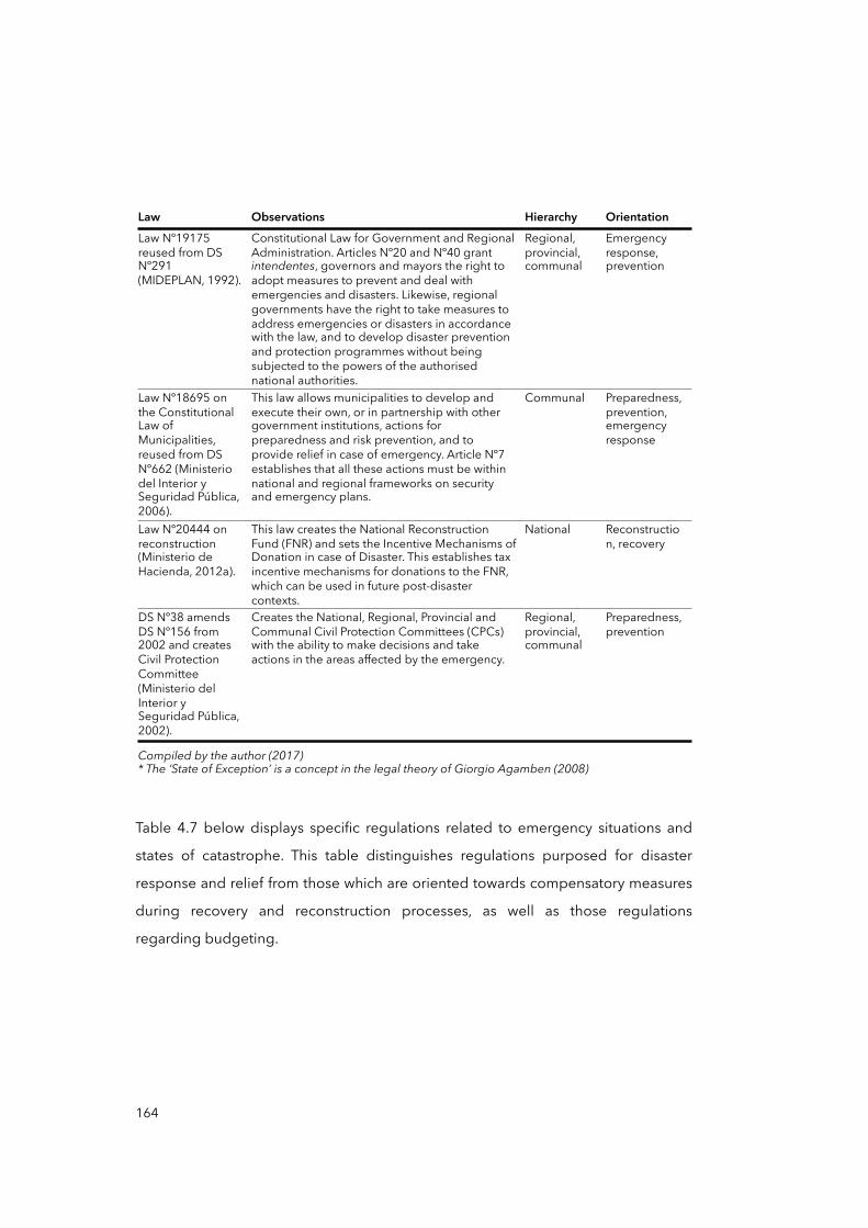
Law Observations Hierarchy OrientationLaw Nº19175 reused from DS Nº291 (MIDEPLAN, 1992).
Constitutional Law for Government and Regional Administration. Articles Nº20 and Nº40 grant intendentes, governors and mayors the right to adopt measures to prevent and deal with emergencies and disasters. Likewise, regional governments have the right to take measures to address emergencies or disasters in accordance with the law, and to develop disaster prevention and protection programmes without being subjected to the powers of the authorised national authorities.
Regional, provincial, communal
Emergency response, prevention
Law Nº18695 on the Constitutional Law of Municipalities, reused from DS Nº662 (Ministerio del Interior y Seguridad Pública, 2006).
This law allows municipalities to develop and execute their own, or in partnership with other government institutions, actions for preparedness and risk prevention, and to provide relief in case of emergency. Article Nº7 establishes that all these actions must be within national and regional frameworks on security and emergency plans.
Communal Preparedness, prevention, emergency response
Law Nº20444 on reconstruction (Ministerio de Hacienda, 2012a).
This law creates the National Reconstruction Fund (FNR) and sets the Incentive Mechanisms of Donation in case of Disaster. This establishes tax incentive mechanisms for donations to the FNR, which can be used in future post-disaster contexts.
National Reconstruction, recovery
DS Nº38 amends DS Nº156 from 2002 and creates Civil Protection Committee (Ministerio del Interior y Seguridad Pública, 2002).
Creates the National, Regional, Provincial and Communal Civil Protection Committees (CPCs) with the ability to make decisions and take actions in the areas affected by the emergency.
Regional, provincial, communal
Preparedness, prevention
Compiled by the author (2017)* The ‘State of Exception’ is a concept in the legal theory of Giorgio Agamben (2008)Compiled by the author (2017)* The ‘State of Exception’ is a concept in the legal theory of Giorgio Agamben (2008)Compiled by the author (2017)* The ‘State of Exception’ is a concept in the legal theory of Giorgio Agamben (2008)Compiled by the author (2017)* The ‘State of Exception’ is a concept in the legal theory of Giorgio Agamben (2008)
Table 4.7 below displays specific regulations related to emergency situations and
states of catastrophe. This table distinguishes regulations purposed for disaster
response and relief from those which are oriented towards compensatory measures
during recovery and reconstruction processes, as well as those regulations
regarding budgeting.
164
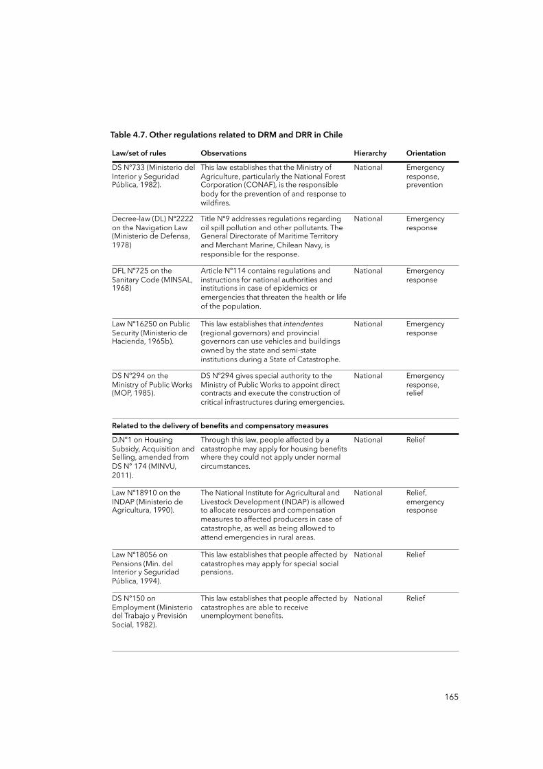
Table 4.7. Other regulations related to DRM and DRR in Chile
Law/set of rules Observations Hierarchy Orientation
DS Nº733 (Ministerio del Interior y Seguridad Pública, 1982).
This law establishes that the Ministry of Agriculture, particularly the National Forest Corporation (CONAF), is the responsible body for the prevention of and response to wildfires.
National Emergency response, prevention
Decree-law (DL) Nº2222 on the Navigation Law (Ministerio de Defensa, 1978)
Title Nº9 addresses regulations regarding oil spill pollution and other pollutants. The General Directorate of Maritime Territory and Merchant Marine, Chilean Navy, is responsible for the response.
National Emergency response
DFL Nº725 on the Sanitary Code (MINSAL, 1968)
Article Nº114 contains regulations and instructions for national authorities and institutions in case of epidemics or emergencies that threaten the health or life of the population.
National Emergency response
Law Nº16250 on Public Security (Ministerio de Hacienda, 1965b).
This law establishes that intendentes (regional governors) and provincial governors can use vehicles and buildings owned by the state and semi-state institutions during a State of Catastrophe.
National Emergency response
DS Nº294 on the Ministry of Public Works (MOP, 1985).
DS Nº294 gives special authority to the Ministry of Public Works to appoint direct contracts and execute the construction of critical infrastructures during emergencies.
National Emergency response, relief
Related to the delivery of benefits and compensatory measuresRelated to the delivery of benefits and compensatory measuresRelated to the delivery of benefits and compensatory measuresRelated to the delivery of benefits and compensatory measures
D.Nº1 on Housing Subsidy, Acquisition and Selling, amended from DS Nº 174 (MINVU, 2011).
Through this law, people affected by a catastrophe may apply for housing benefits where they could not apply under normal circumstances.
National Relief
Law Nº18910 on the INDAP (Ministerio de Agricultura, 1990).
The National Institute for Agricultural and Livestock Development (INDAP) is allowed to allocate resources and compensation measures to affected producers in case of catastrophe, as well as being allowed to attend emergencies in rural areas.
National Relief, emergency response
Law Nº18056 on Pensions (Min. del Interior y Seguridad Pública, 1994).
This law establishes that people affected by catastrophes may apply for special social pensions.
National Relief
DS Nº150 on Employment (Ministerio del Trabajo y Previsión Social, 1982).
This law establishes that people affected by catastrophes are able to receive unemployment benefits.
National Relief
165
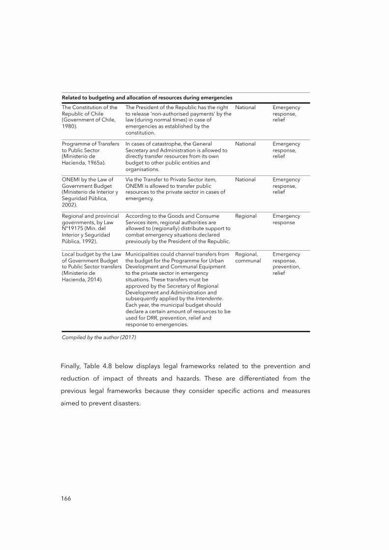
Related to budgeting and allocation of resources during emergenciesRelated to budgeting and allocation of resources during emergenciesRelated to budgeting and allocation of resources during emergenciesRelated to budgeting and allocation of resources during emergencies
The Constitution of the Republic of Chile (Government of Chile, 1980).
The President of the Republic has the right to release ‘non-authorised payments’ by the law (during normal times) in case of emergencies as established by the constitution.
National Emergency response, relief
Programme of Transfers to Public Sector (Ministerio de Hacienda, 1965a).
In cases of catastrophe, the General Secretary and Administration is allowed to directly transfer resources from its own budget to other public entities and organisations.
National Emergency response, relief
ONEMI by the Law of Government Budget (Ministerio de Interior y Seguridad Pública, 2002).
Via the Transfer to Private Sector item, ONEMI is allowed to transfer public resources to the private sector in cases of emergency.
National Emergency response, relief
Regional and provincial governments, by Law Nº19175 (Min. del Interior y Seguridad Pública, 1992).
According to the Goods and Consume Services item, regional authorities are allowed to (regionally) distribute support to combat emergency situations declared previously by the President of the Republic.
Regional Emergency response
Local budget by the Law of Government Budget to Public Sector transfers (Ministerio de Hacienda, 2014).
Municipalities could channel transfers from the budget for the Programme for Urban Development and Communal Equipment to the private sector in emergency situations. These transfers must be approved by the Secretary of Regional Development and Administration and subsequently applied by the Intendente. Each year, the municipal budget should declare a certain amount of resources to be used for DRR, prevention, relief and response to emergencies.
Regional, communal
Emergency response, prevention, relief
Compiled by the author (2017) Compiled by the author (2017) Compiled by the author (2017) Compiled by the author (2017)
Finally, Table 4.8 below displays legal frameworks related to the prevention and
reduction of impact of threats and hazards. These are differentiated from the
previous legal frameworks because they consider specific actions and measures
aimed to prevent disasters.
166

Table 4.8. Legal frameworks on ‘prevention’ related to DRM and DRR in Chile
Law/set of rules Observations Hierarchy Orientation
Law and General Ordinance of Urbanism and Construction, DS Nº458 and Nº48 (MINVU, 1976).
This law establishes the territorial planning instruments (IPTs) which require risk assessments. IPTs can, depending on the natural hazards, propose (so it is not a binding element) unbuildable or restricted areas.
National, regional, communal
Prevention,mitigation
Chilean Standard for Seismic Design of Buildings NCh433 from 1996 (INN, 1996).
NCh433 establishes minimum requirements for the seismic design of buildings and seismic requirements to be met by equipment and other secondary elements of buildings. It includes recommendations for the evaluation of seismic damage and repair. It also delimits the national territory by establishing differentiated design standards among regions.
National Prevention
DFL Nº1123 on the Water Code (MOP, 1981).
Regulates the use of water channels and user organisations of water resources, and establishes the standards for construction of waterworks. It entitles the Ministry of Public Works to monitor waterworks in natural water channels in order to prevent damage of defence mechanisms, flooding or increased risk of future flooding. It requires the development of mitigation works/ mechanisms. It also regulates the identification of droughts and the mitigation of their impact.
National Prevention,mitigation
Law Nº19525 by the Ministry of Public Works (MOP, 1997).
Regulates planning, policy development and the construction of rainwater evacuation systems in order to allow easy drainage and disposal, preventing the damage that floods may cause to people, housing and urban infrastructure.
Regional, provincial
Prevention,mitigation
Law Nº19300 on Basis for Environment (Ministerio Secretaría General de la Presidencia, 1994).
This law dictates the requirement for certain infrastructure and projects derived from territorial planning instruments (IPTs) to be subject to a System of Environmental Impact Assessment (SEIA). Among other aspects, this law requests an Environmental Impact Assessment for large projects and it demands mitigation measures where danger exists.
National Prevention,mitigation
Law Nº20417 on the Basis of General Environmental Framework (Min. Secretaría General de la Presidencia, 2010).
This law ensures new environmental management tools for the administration of waste and contaminated soil, as well as for the tackling of climate change and the promotion and restoration of water resources and conservation of ecosystems, among other matters.
National Prevention
Compiled by the author (2017)Compiled by the author (2017)Compiled by the author (2017)Compiled by the author (2017)
In order to reflect on legal frameworks from a more advantageous angle, I have
arranged them in three subcategories in a Cartesian layout (see Figure 4.10): i) Regulations or laws oriented to post-disaster scenarios; ii) Sets of rules or
frameworks oriented to preventive actions; and iii) Structural or organic laws, which are those that form sub-national governments and other bodies of rules, such as the
national constitution.
167
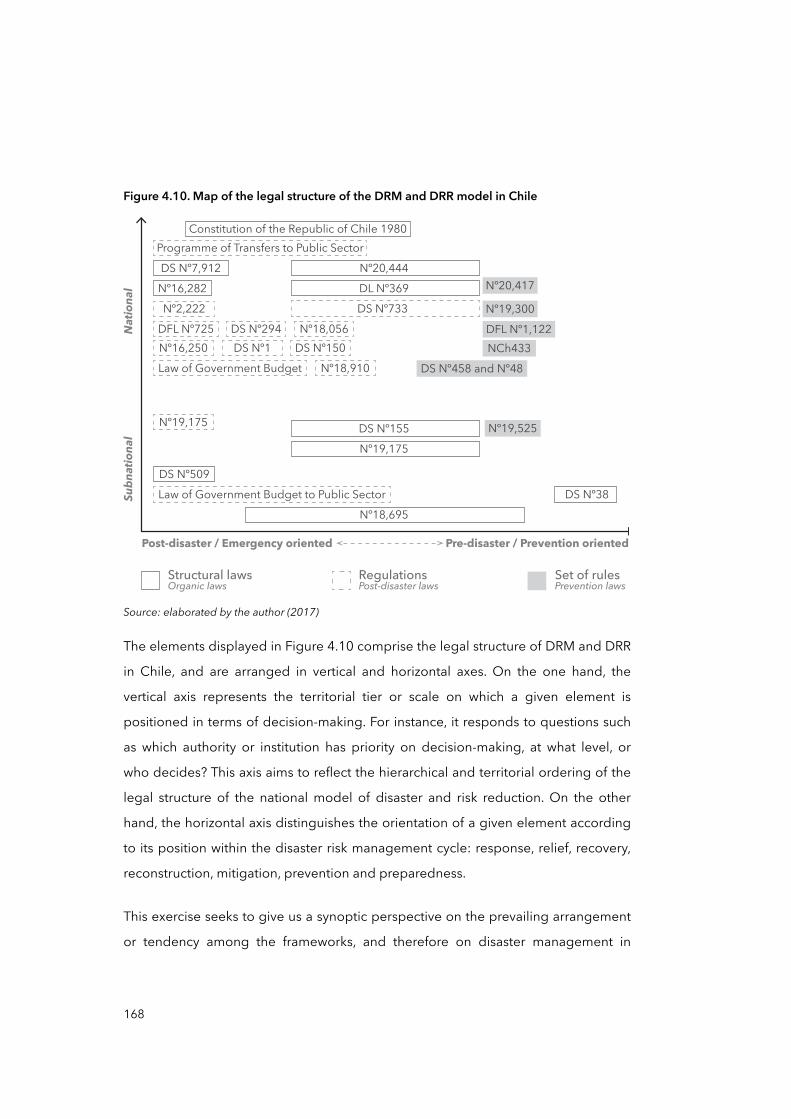
Figure 4.10. Map of the legal structure of the DRM and DRR model in Chile
Natio
nal
Subn
ationa
l
Pre-disaster / Prevention orientedPost-disaster / Emergency oriented
DL Nº369DS Nº733
Nº19,175DS Nº155
Nº20,444DS Nº7,912
DS Nº509
Nº19,175
Nº18,910 DS Nº458 and Nº48
DFL Nº1,122NCh433
Nº19,300
Nº20,417
Nº19,525
Nº18,056DS Nº150
Programme of Transfers to Public Sector
Nº16,282Nº2,222
DFL Nº725Nº16,250
DS Nº294DS Nº1
Law of Government Budget
Law of Government Budget to Public Sector DS Nº38Nº18,695
Constitution of the Republic of Chile 1980
RegulationsPost-disaster laws
Structural lawsOrganic laws
Set of rulesPrevention laws
Source: elaborated by the author (2017)
The elements displayed in Figure 4.10 comprise the legal structure of DRM and DRR
in Chile, and are arranged in vertical and horizontal axes. On the one hand, the
vertical axis represents the territorial tier or scale on which a given element is
positioned in terms of decision-making. For instance, it responds to questions such
as which authority or institution has priority on decision-making, at what level, or
who decides? This axis aims to reflect the hierarchical and territorial ordering of the
legal structure of the national model of disaster and risk reduction. On the other
hand, the horizontal axis distinguishes the orientation of a given element according
to its position within the disaster risk management cycle: response, relief, recovery,
reconstruction, mitigation, prevention and preparedness.
This exercise seeks to give us a synoptic perspective on the prevailing arrangement
or tendency among the frameworks, and therefore on disaster management in
168
general. Figure 4.10 captures a centralised, top-down and reactive legal system that
is centred in the predominant role of the national scale as the locus of administration
of DRM and DRR. The centralisation of the model of governing disasters and risks
surfaces when national powerful institutions concentrate —as they do in Santiago de
Chile— and do not redistribute power and decision-making downwards and
transversally among subnational levels. Centralisation of legal frameworks and
decision-making could negatively impact DRM, disaster risks and vulnerabilities in
different ways: low capacity at local level may create dependency; ‘un-earmarked’
funds —which could be used in other ways for DRR— can be diverted to other areas
that have a higher political profile; there is low participatory DRR; and policy
responses to disasters can result in inadequate actions and unforeseen effects, as
they do not require paying attention to local realities and needs (Scott and
Tarazona, 2011).
Another dimension within the model of DRM and DRR in Chile is the various
instruments for territorial planning, and implications for the progression of
vulnerability and risks.
4.4.3 Territorial planning instruments for DRM and DRR
Other important disaster management institutional forms are the Territorial Planning
Instruments, or Instrumentos de Planificación Territorial (IPTs). According to the
Ministry of Housing and Urbanisation, or MINVU (2015), the national legislation does
not have an exact definition for IPTs: they are used interchangeably with ‘plan of
urban development’, ‘plan of territorial ordering’, ‘regional plan of territorial
planning’, among others (see the national legislation in MINVU, 1992a). An initial
definition of IPTs offered by some official documents (MINVU, 1992a, 2015; UNDP
and MINVU, 2014) would be that IPTs are documents that aim to advise the
prioritisation of actions for the preparation of regional, provincial and municipal
territorial plans. Likewise, IPTs aim to coordinate territorial planning with other
authorities at different scales and engage with the community using participatory
planning techniques.
169
One of the aspects of IPTs of importance for DRM and DRR is the identification of
disaster-prone areas. IPTs have implicitly suggested since 1976 that local
governments identify risk areas in their master plans (MINVU, 1976), but it was not
until 1992 that DS Nº42 (MINVU, 1992b) began to impose risk assessments, making
them a requirement. Such assessments are often assigned to private engineering
contractors or consulting companies. In order to define and delimit the process of
identifying risk areas, DS Nº42 (MINVU, 1992b) guides companies and institutions
on what assessments should look at according to the following principles:
• Flood or potential flood areas due to the proximity of lakes, rivers, streams, creeks, un-channelled streams, ground water or wetlands.
• Avalanche-prone areas, boulders, landslides or accentuated erosion.
• Hazardous areas to be affected by volcanic activity, lava flows or faults.
• Hazardous areas generated by human activity or intervention.
Although disaster risk emerges as the result of combining hazards and
vulnerability,21 the aforementioned principles reveal that, from a policy framework
perspective, risk is merely understood as hazards and, in some cases, exposure to
hazards. In other words, so-called risk assessments do not make a comprehensive
evaluation of risks but only of hazards, bringing to light the still dominant techno-
centric approach that prevails. The problem with this is that governments are not
using the full potential of risk assessments. Comprehensive risk assessments should
look at vulnerabilities and their root causes with the same interest with which identify
hazards: this may contribute to the production of plans and development paths for
safer people and safer cities (UNISDR, 2015a, 2015b).
Table 4.9 shows how Chilean legislation has historically focused on the
encouragement of risk assessments on master plans and land-use planning
(MINVU, 1992a), confining the multi-scale complexity of hazards and vulnerability to
the urban scale. I think that neglecting the analysis of risks on multiple scales
170
21 Hazard × vulnerability = risk → disaster
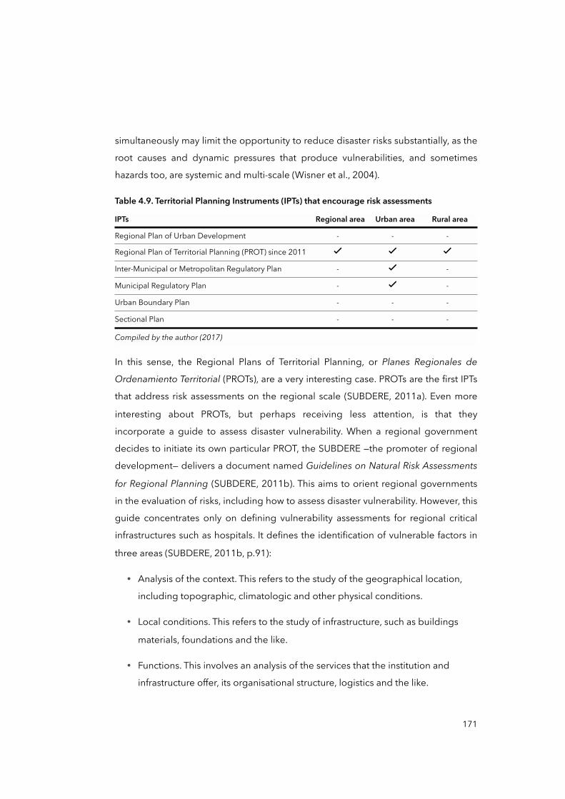
simultaneously may limit the opportunity to reduce disaster risks substantially, as the
root causes and dynamic pressures that produce vulnerabilities, and sometimes
hazards too, are systemic and multi-scale (Wisner et al., 2004).
Table 4.9. Territorial Planning Instruments (IPTs) that encourage risk assessments
IPTs Regional area Urban area Rural area
Regional Plan of Urban Development - - -
Regional Plan of Territorial Planning (PROT) since 2011 ✓ ✓ ✓Inter-Municipal or Metropolitan Regulatory Plan - ✓ -
Municipal Regulatory Plan - ✓ -
Urban Boundary Plan - - -
Sectional Plan - - -
Compiled by the author (2017)Compiled by the author (2017)Compiled by the author (2017)Compiled by the author (2017)
In this sense, the Regional Plans of Territorial Planning, or Planes Regionales de
Ordenamiento Territorial (PROTs), are a very interesting case. PROTs are the first IPTs
that address risk assessments on the regional scale (SUBDERE, 2011a). Even more
interesting about PROTs, but perhaps receiving less attention, is that they
incorporate a guide to assess disaster vulnerability. When a regional government
decides to initiate its own particular PROT, the SUBDERE —the promoter of regional
development— delivers a document named Guidelines on Natural Risk Assessments
for Regional Planning (SUBDERE, 2011b). This aims to orient regional governments
in the evaluation of risks, including how to assess disaster vulnerability. However, this
guide concentrates only on defining vulnerability assessments for regional critical
infrastructures such as hospitals. It defines the identification of vulnerable factors in
three areas (SUBDERE, 2011b, p.91):
• Analysis of the context. This refers to the study of the geographical location,
including topographic, climatologic and other physical conditions.
• Local conditions. This refers to the study of infrastructure, such as buildings
materials, foundations and the like.
• Functions. This involves an analysis of the services that the institution and
infrastructure offer, its organisational structure, logistics and the like.
171
In the same vein, in July 2013, I interviewed a SUBDERE official who participated in
the preparation of this guide. One aspect of the conversation was revealing about
the assessment of disaster vulnerability:
“Vulnerability is [in the PROTs] considered only in physical terms such as on the quality of building materials, proximity to hazards, and lacking of evacuation routes”.
(Pablo Gonzalez, male, National government official, July 2013, interview)
Here, Gonzalez and the analysis of the document reveal a fundamental aspect, a
kind of trend that is repeated among the institutional forms reviewed so far: it is a
techno-centric approach with a belief that by mastering only the physical
dimensions of hazards and vulnerability, disasters and risks will be reduced. The
international and historical experience has demonstrated the opposite (UNISDR,
2015a), as a comprehensive social and environmental analysis of hazards and
vulnerability is needed, including the capacities and resiliency of men and women,
communities and institutions, as well as the political, economic, governance and
cultural dimensions of risks at multiple levels, and all this intertwined with the history
that comes with it (UNISDR, 2015b). Another interesting aspect emerges from the
way in which vulnerability is conceived in the guide mentioned above, and of
relevance for the implementation of PROTs: vulnerability and risks are limited to
circumstances and conditions at local levels —neighbourhoods, city. Effectively, when
I reviewed the section on vulnerability (SUBDERE, 2011b, pp.14-15), only local
unsafe conditions had to be identified, but not the drivers of such conditions —
neither the linkages of such conditions with dynamic pressures nor the root causes
that could have generated them in the first place. It is like all multi-scale relations are
missing.
I also interviewed an executive member of the SUBDERE who shed light on a
fundamental limitation of PROTs:
172
“Probably regional governments will commission PROTs to be prepared by private consulting companies in order to comply with the request. Then, I am sure, governments will archive the document [PROT] because there is no way to enforce regional governments to take actions in order to reduce detected vulnerabilities and risks [...] we must still work on that —that is, in policy terms”.
(Jorge Mardones, male, National government director, June 2013, interview)
Although SUBDERE assigned PROTs to regional governments in 2011, only a few
regional governments have prepared their PROTs, at least towards the end of the
fieldwork in December 2014. This reveals another limitation of PROTs, as they are
not binding planning tools, just advisory ones. This also applies to most IPTs, except
the Municipal Regulatory Plan (MINVU, 1992b). Thus, what is the purpose of
requesting more comprehensive risk assessments if the actions to reduce or
mitigate risks may or may not be implemented? I think this is a disincentive for
regional governments and municipalities, as is the top-down approach by which
these IPTs are requested.
In January 2014, the MINVU and United Nations Development Programme (UNDP)
launched a document titled the National Strategy of Urban Development (UNDP and
MINVU, 2014), with the intention that it should become a bill by 2018. This
document deserves to be mentioned here because it aims to redesign IPTs in order
to integrate them into a national strategy of urban, regional and national
development. In doing so, the proposal points out “the importance of introducing
the concept of DRM, DRR, and resilience into IPTs in a better way” (UNDP and
MINVU, 2014, p.43). It recognises that DRM has to be integrated into development
as a critical part of it. More importantly, this document recognises that the
integration of DRM and DRR into IPTs “must consider inter and multi-scalar
interdependencies among different political-administrative and spatial
orders” (UNDP and MINVU, 2014, pp.56-57). In other words, the model of DRM and
the reduction of vulnerability must be seen from a multi-scalar perspective. This
somehow corroborates the relevance of the topics addressed in this thesis.
Before continuing with the final section of this chapter, I would like briefly to offer
some reflections on the financing of and spending on DRM and DRR in Chile. I do so
173
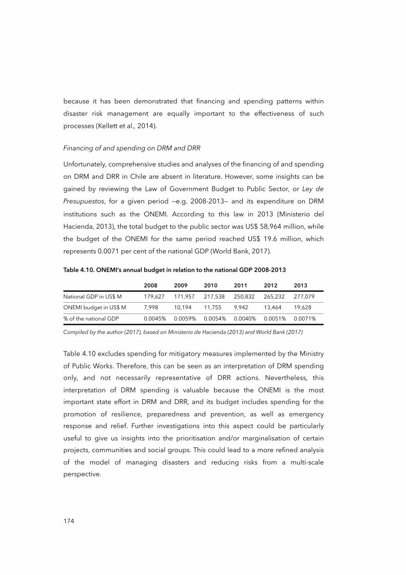
because it has been demonstrated that financing and spending patterns within
disaster risk management are equally important to the effectiveness of such
processes (Kellett et al., 2014).
Financing of and spending on DRM and DRR
Unfortunately, comprehensive studies and analyses of the financing of and spending
on DRM and DRR in Chile are absent in literature. However, some insights can be
gained by reviewing the Law of Government Budget to Public Sector, or Ley de
Presupuestos, for a given period —e.g. 2008-2013— and its expenditure on DRM
institutions such as the ONEMI. According to this law in 2013 (Ministerio del
Hacienda, 2013), the total budget to the public sector was US$ 58,964 million, while
the budget of the ONEMI for the same period reached US$ 19.6 million, which
represents 0.0071 per cent of the national GDP (World Bank, 2017).
Table 4.10. ONEMI’s annual budget in relation to the national GDP 2008-2013
2008 2009 2010 2011 2012 2013
National GDP in US$ M 179,627 171,957 217,538 250,832 265,232 277,079
ONEMI budget in US$ M 7,998 10,194 11,755 9,942 13,464 19,628
% of the national GDP 0.0045% 0.0059% 0.0054% 0.0040% 0.0051% 0.0071%
Compiled by the author (2017), based on Ministerio de Hacienda (2013) and World Bank (2017)Compiled by the author (2017), based on Ministerio de Hacienda (2013) and World Bank (2017)Compiled by the author (2017), based on Ministerio de Hacienda (2013) and World Bank (2017)Compiled by the author (2017), based on Ministerio de Hacienda (2013) and World Bank (2017)Compiled by the author (2017), based on Ministerio de Hacienda (2013) and World Bank (2017)Compiled by the author (2017), based on Ministerio de Hacienda (2013) and World Bank (2017)Compiled by the author (2017), based on Ministerio de Hacienda (2013) and World Bank (2017)
Table 4.10 excludes spending for mitigatory measures implemented by the Ministry
of Public Works. Therefore, this can be seen as an interpretation of DRM spending only, and not necessarily representative of DRR actions. Nevertheless, this
interpretation of DRM spending is valuable because the ONEMI is the most important state effort in DRM and DRR, and its budget includes spending for the
promotion of resilience, preparedness and prevention, as well as emergency response and relief. Further investigations into this aspect could be particularly
useful to give us insights into the prioritisation and/or marginalisation of certain projects, communities and social groups. This could lead to a more refined analysis
of the model of managing disasters and reducing risks from a multi-scale perspective.
174
To conclude provisionally, the final section of this chapter aims to synthesise the key elements that have emerged so far and connect them with the analytical framework
and objective of the thesis.
4.5 Setting the context to analyse post-disaster Chaitén
This chapter began by explaining that it is the first of two parts focusing on the case study. The chapter sought to introduce the historic, institutional and territorial scale
and context of Chile, as well as the relations with its model of disaster risk management and reduction. From what has been discussed so far, one can extract
several insights that are indispensable to explore the case of post-disaster Chaitén from a multi-scalar perspective. Firstly, the ‘cyclical’ facet of DRM has historically
been an ignored aspect of the Chilean history of disasters. Beyond emergency and relief, other processes such as reconstruction, mitigation and preparedness have not
been considered with the same level of attention by the dominant views of disasters in Chile. Perhaps for this reason the current model of DRM is in question (Imilan et
al., 2015), as it mainly concentrates on emergency responses and the application of technological solutions rather than on prevention and on comprehending the social
causes of risks. Secondly, we reviewed the historical formation of geographical scales in Chile in order to prepare a multi-scale analysis of the progression of
vulnerability for the case of Chaitén. Here, I proposed that the centralised territorial structure of the state has had, and continues to have, an important influence on the
way that the DRM and DRR model is conceived and implemented, and therefore on how decision-making, policy responses and disaster governance are conducted.
Finally, I examined how DRM and DRR, and other institutional forms, are defined, organised and distributed within this multi-scalar structure of territorial organisation
in Chile. This illustrated the influence that the territorial structure has on the mode of managing disasters and risks: it is a highly centralised model, a top-down approach,
and is reactive or post-disaster oriented. In Figure 4.10 (page 168) I described relevant legal frameworks for the DRM and DRR and categorised them in terms of
their vertical position or hierarchy within the decision-making and territorial structure of the state, as well as the orientation of such frameworks within the DRM
cycle. Figure 4.11 expands the analysis of the mentioned frameworks to the other analysed institutional forms: the ONEMI and territorial planning instruments.
175
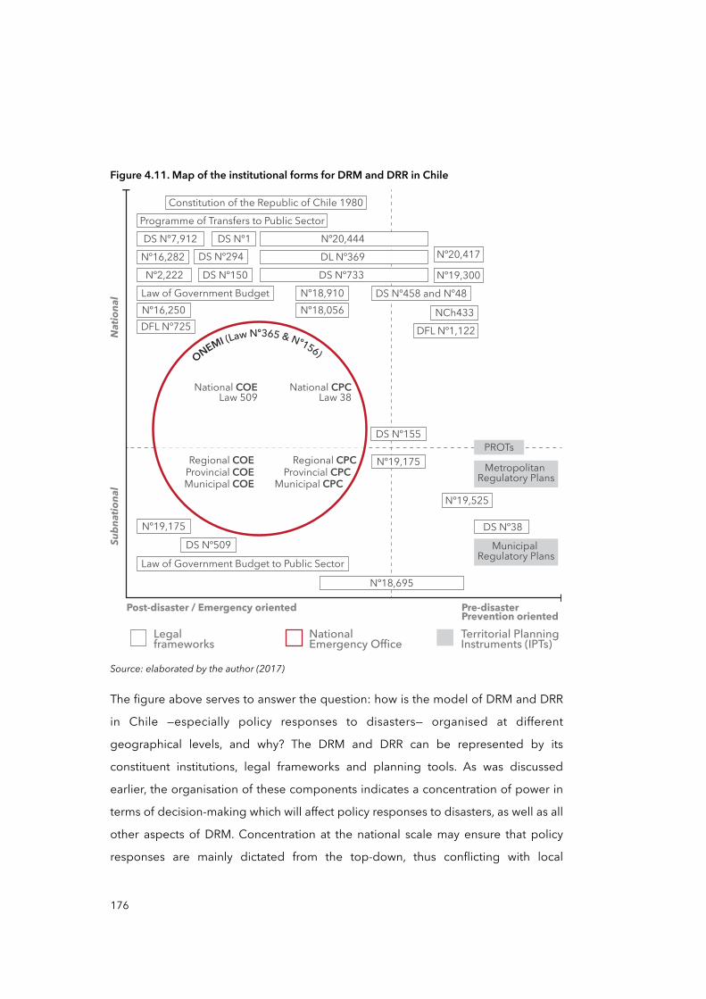
Figure 4.11. Map of the institutional forms for DRM and DRR in Chile
Nº19,175
DS Nº155
Natio
nal
Subn
ationa
l
Pre-disasterPrevention oriented
Post-disaster / Emergency oriented
Legalframeworks
NationalEmergency Office
Territorial PlanningInstruments (IPTs)
ONEMI (Law Nº365 & Nº156)
National CPCLaw 38
National COELaw 509
Regional COEProvincial COE
Regional CPCProvincial CPC
Municipal CPCMunicipal COE
PROTs
DS Nº509Nº19,175
Law of Government Budget to Public Sector
Nº18,695
DL Nº369DS Nº733
Nº20,444DS Nº7,912
Nº18,910 DS Nº458 and Nº48
DFL Nº1,122NCh433
Nº19,300
Nº20,417
Nº18,056
DS Nº150
Programme of Transfers to Public Sector
Nº16,282Nº2,222
DFL Nº725Nº16,250
DS Nº294DS Nº1
Law of Government Budget
Constitution of the Republic of Chile 1980
Nº19,525
Metropolitan Regulatory Plans
Municipal Regulatory Plans
DS Nº38
Source: elaborated by the author (2017)
The figure above serves to answer the question: how is the model of DRM and DRR
in Chile —especially policy responses to disasters— organised at different
geographical levels, and why? The DRM and DRR can be represented by its
constituent institutions, legal frameworks and planning tools. As was discussed
earlier, the organisation of these components indicates a concentration of power in
terms of decision-making which will affect policy responses to disasters, as well as all
other aspects of DRM. Concentration at the national scale may ensure that policy
responses are mainly dictated from the top-down, thus conflicting with local
176
participation and the inclusion of local demands and needs, and therefore with the
effectiveness of such responses. In recalling what was discussed in Chapter Three on
geographical scales, it could be said that the territorial structure of the Chilean state
apparently corresponds to a vertical organisation: subnational institutions such as
regional and provincial governments, and municipalities, are subsequently and
schematically subordinated from the national to the local levels. As presented here,
this scalar organisation is a consequence of historical socio-political and economic
processes, and it has influenced the logic of the current geographical distribution
and hierarchical organisation of DRM and DRR. In other words, the processes are
apparently connected. The question now is, what are the effects of this centralised,
top-down and reactive-oriented model on the progression of vulnerability, and how
does this take place? This is something I will try to respond to by utilising the case of
post-disaster Chaitén.
177
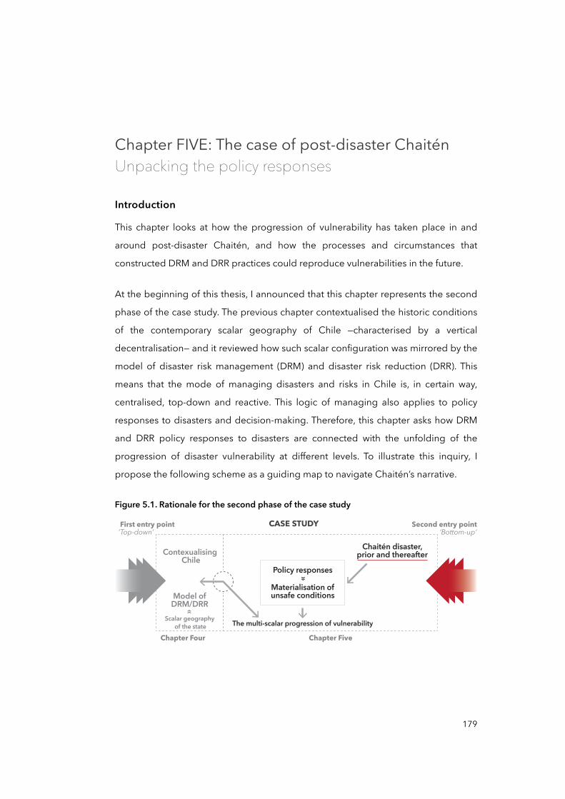
Chapter FIVE: The case of post-disaster ChaiténUnpacking the policy responses
Introduction
This chapter looks at how the progression of vulnerability has taken place in and
around post-disaster Chaitén, and how the processes and circumstances that
constructed DRM and DRR practices could reproduce vulnerabilities in the future.
At the beginning of this thesis, I announced that this chapter represents the second
phase of the case study. The previous chapter contextualised the historic conditions
of the contemporary scalar geography of Chile —characterised by a vertical
decentralisation— and it reviewed how such scalar configuration was mirrored by the
model of disaster risk management (DRM) and disaster risk reduction (DRR). This
means that the mode of managing disasters and risks in Chile is, in certain way,
centralised, top-down and reactive. This logic of managing also applies to policy
responses to disasters and decision-making. Therefore, this chapter asks how DRM
and DRR policy responses to disasters are connected with the unfolding of the
progression of disaster vulnerability at different levels. To illustrate this inquiry, I
propose the following scheme as a guiding map to navigate Chaitén’s narrative.
Figure 5.1. Rationale for the second phase of the case study
First entry point Second entry pointCASE STUDY
Chapter Four Chapter Five
Contexualising Chile
Model ofDRM/DRR
Scalar geography of the state
Chaitén disaster,prior and thereafter
The multi-scalar progression of vulnerability
»
Policy responses»
Materialisation ofunsafe conditions
‘Top-down’ ‘Bottom-up’
179
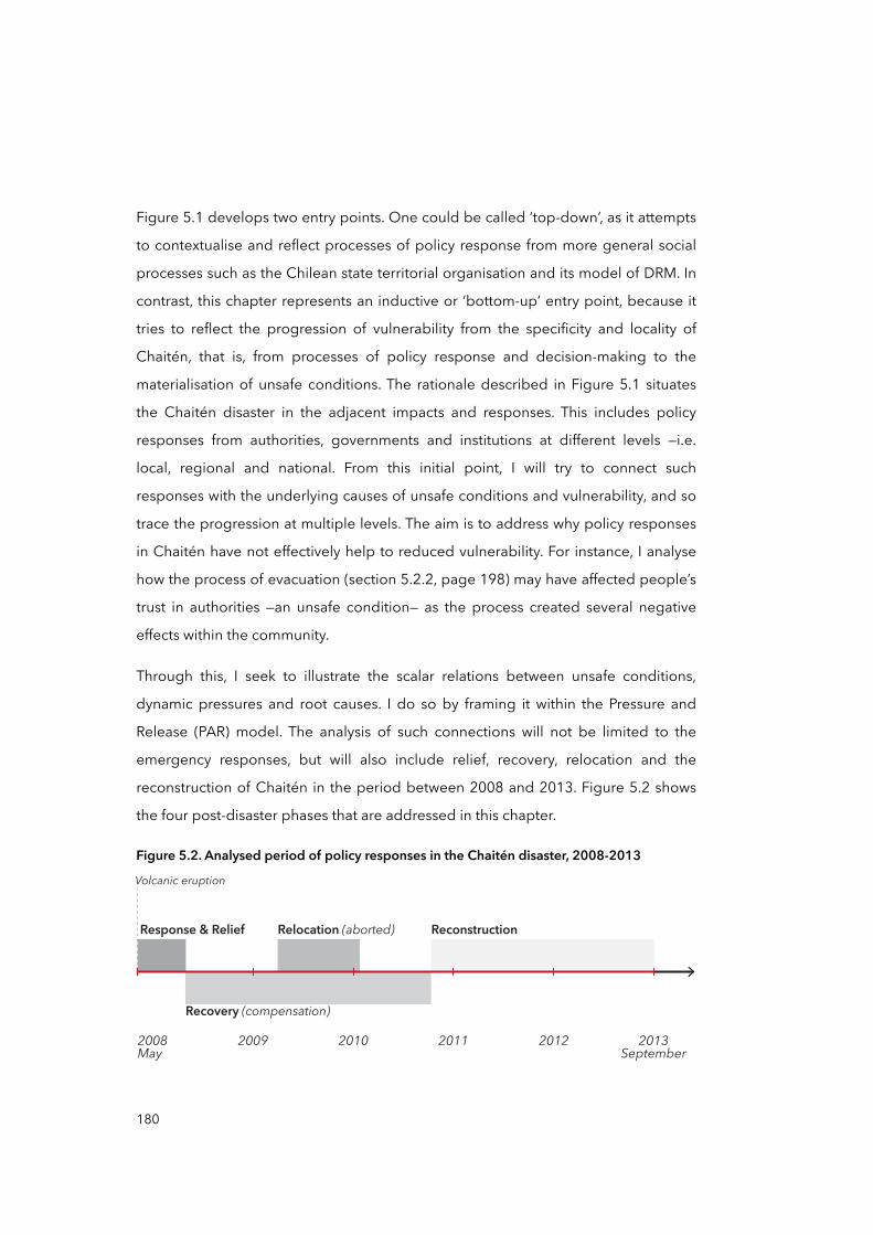
Figure 5.1 develops two entry points. One could be called ‘top-down’, as it attempts
to contextualise and reflect processes of policy response from more general social
processes such as the Chilean state territorial organisation and its model of DRM. In
contrast, this chapter represents an inductive or ‘bottom-up’ entry point, because it
tries to reflect the progression of vulnerability from the specificity and locality of
Chaitén, that is, from processes of policy response and decision-making to the
materialisation of unsafe conditions. The rationale described in Figure 5.1 situates
the Chaitén disaster in the adjacent impacts and responses. This includes policy
responses from authorities, governments and institutions at different levels —i.e.
local, regional and national. From this initial point, I will try to connect such
responses with the underlying causes of unsafe conditions and vulnerability, and so
trace the progression at multiple levels. The aim is to address why policy responses
in Chaitén have not effectively help to reduced vulnerability. For instance, I analyse
how the process of evacuation (section 5.2.2, page 198) may have affected people’s
trust in authorities —an unsafe condition— as the process created several negative
effects within the community.
Through this, I seek to illustrate the scalar relations between unsafe conditions,
dynamic pressures and root causes. I do so by framing it within the Pressure and
Release (PAR) model. The analysis of such connections will not be limited to the
emergency responses, but will also include relief, recovery, relocation and the
reconstruction of Chaitén in the period between 2008 and 2013. Figure 5.2 shows
the four post-disaster phases that are addressed in this chapter.
Figure 5.2. Analysed period of policy responses in the Chaitén disaster, 2008-2013
2009 2010 20122011 2013September
2008May
Volcanic eruption
Response & Relief ReconstructionRelocation (aborted)
Recovery (compensation)
180
The next five sections analyse these phases. The first section contextualises Chaitén —historically, geographically and economically— and looks at the circumstances of
the disaster and its immediate aftermath. The second section concentrates on the early response, including the evacuation. The third section analyses two parallel
processes: the compensatory strategy and the relocation of Chaitén. It discusses tensions between local and national decision-making processes, community
mobilisation and national politics. The fourth section looks at the latest post-disaster phase, the reconstruction. The last section offers a final analysis of the progression of
vulnerability in Chaitén considering the multi-scalar context of Chile and its model of DRM.
5.1 Chaitén, before and after the volcanic eruption: preparing the case
Chaitén is a remote city port in Los Lagos Region about 1,000km south from
Santiago. Chaitén was severely affected by a volcanic eruption in May 2008 at a time when roughly 8,000 people lived in the commune. Figure 5.3 summarises the
principal physical effect of the volcano’s eruption on the city —that is, the new course of the Blanco River. This new course literally divided the city into the North and
South sectors. Other physical effects of the volcanic mudflows can be appreciated in Figure 5.4.
Before presenting in detail the disaster itself and its immediate aftermath, it is
opportune to start this section by offering a historical perspective on Chaitén’s
people, economy and geography in order to contextualise local responses to the
emergency procedures, and to better comprehend people’s reaction to relocation
and reconstruction. Specifically, I highlight two fundamental aspects: the sense of
remoteness and poor connectivity of Chaitén with respect with the region and the
country, and the local economy’s dependency on the public sector. These two
aspects are fundamental because they allow us to understand the cohesiveness
among certain groups of Chaiteninos —as Chaitén people call themselves— and the
demands made of the government for more attention.
181
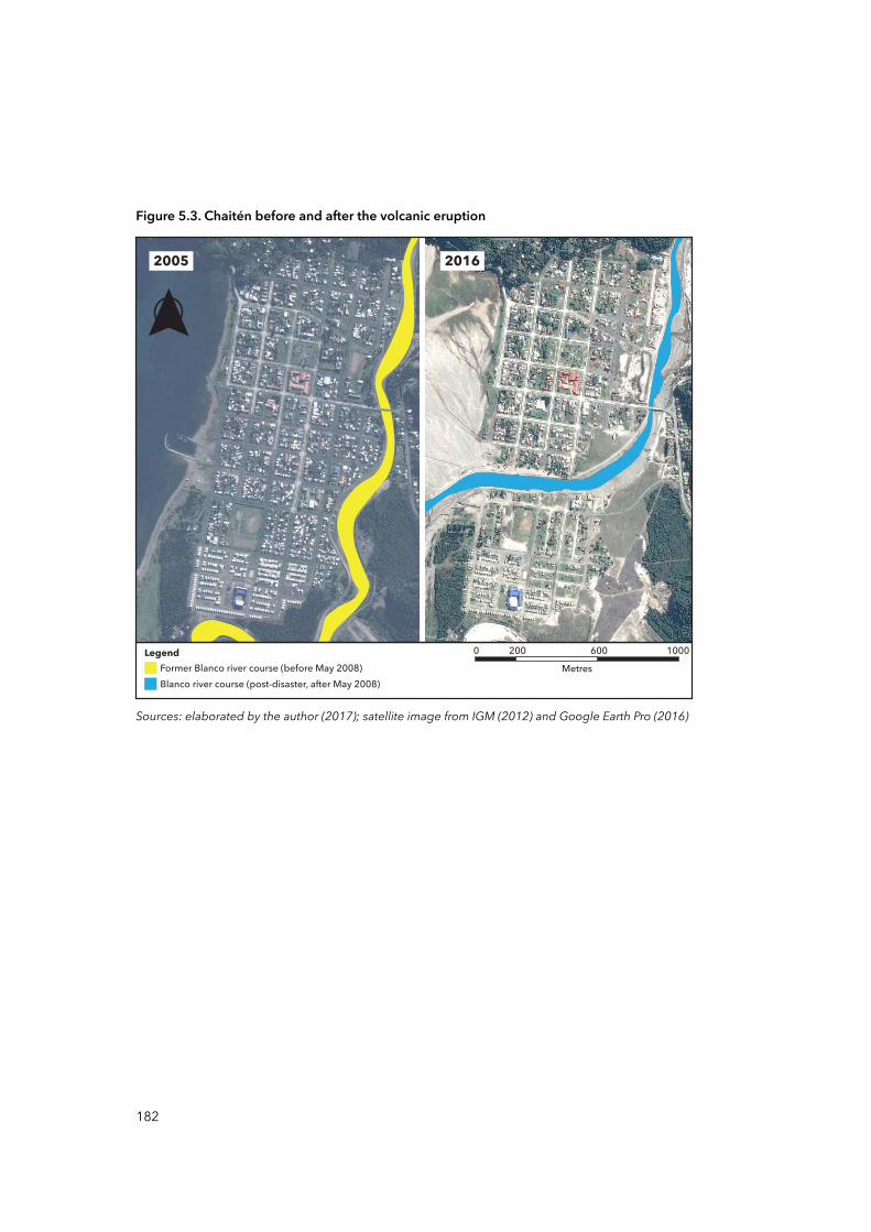
Figure 5.3. Chaitén before and after the volcanic eruption
Sources: elaborated by the author (2017); satellite image from IGM (2012) and Google Earth Pro (2016)
2005 2016
0 200 600 1000Metres
Legend
Blanco river course (post-disaster, after May 2008)Former Blanco river course (before May 2008)
182
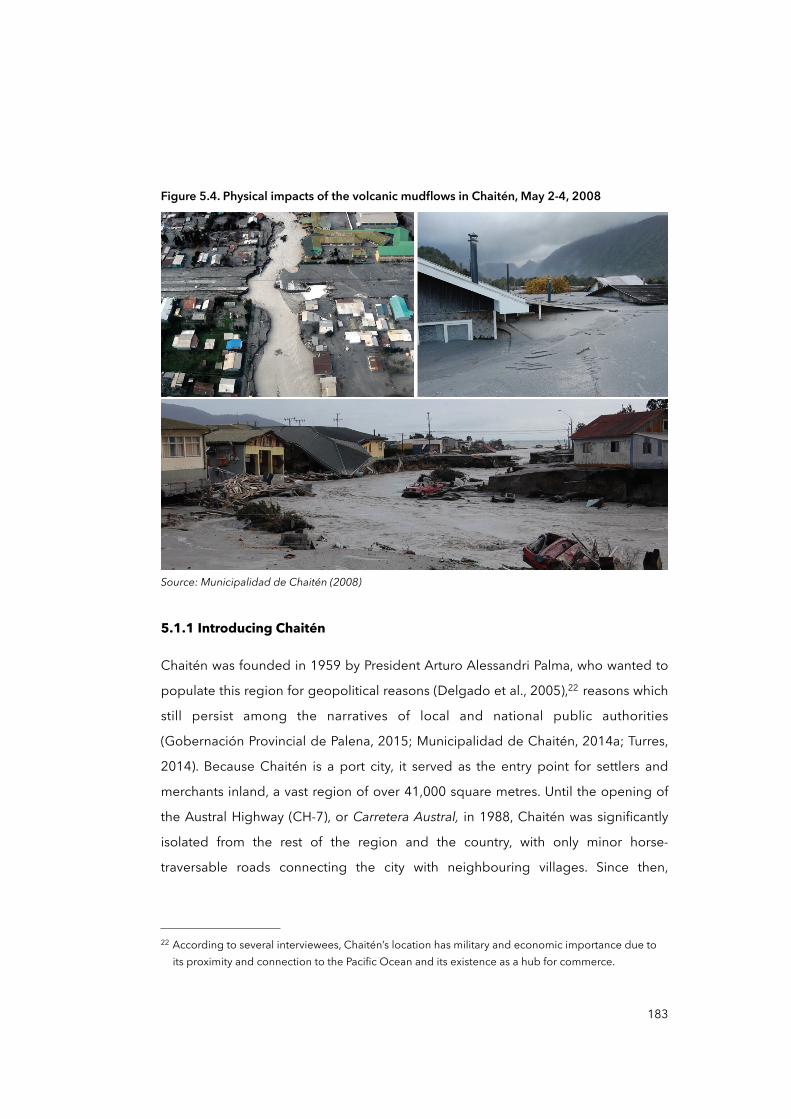
Figure 5.4. Physical impacts of the volcanic mudflows in Chaitén, May 2-4, 2008
Source: Municipalidad de Chaitén (2008)
5.1.1 Introducing Chaitén
Chaitén was founded in 1959 by President Arturo Alessandri Palma, who wanted to
populate this region for geopolitical reasons (Delgado et al., 2005),22 reasons which
still persist among the narratives of local and national public authorities
(Gobernación Provincial de Palena, 2015; Municipalidad de Chaitén, 2014a; Turres,
2014). Because Chaitén is a port city, it served as the entry point for settlers and
merchants inland, a vast region of over 41,000 square metres. Until the opening of
the Austral Highway (CH-7), or Carretera Austral, in 1988, Chaitén was significantly
isolated from the rest of the region and the country, with only minor horse-
traversable roads connecting the city with neighbouring villages. Since then,
183
22 According to several interviewees, Chaitén’s location has military and economic importance due to its proximity and connection to the Pacific Ocean and its existence as a hub for commerce.
however, the CH-7 has connected most of the villages, towns and cities in Los Lagos
and Aysén regions (see Figure 5.5).
Nevertheless, with the CH-7, the isolation of Chaitén was only partially solved
because, both before and after the disaster in 2008, Chaitén lacked significant and
important ways of communicating between the city and the rest of the region and
the country. A proof or recognition of the latter is that Chaitén holds the official
category of ‘Isolated Location’ or Localidad Aislada issued by the Inter-ministerial
Committee for the Development of Remote and Special Areas or CIDEZE (GORE Los
Lagos and Gobierno de Chile, 2012). Being an ‘isolated location’ means, on the one
hand, the allocation of special state support and resources for the city’s
development but, on the other hand, this evidences the situational remoteness in
which Chaitén is embedded. Remoteness has several implications. Although
remoteness is often understood in physical and spatial terms, remoteness has
different effects on people, institutions, the economy and development (UNDESA,
2014). For instance, remoteness may imply intrinsic vulnerability due to high external
transport costs, time delays and high costs in accessing external goods, and delays
and reduced quality in information flows, among others (UNDESA, 2014). According
to Pelling and Uitto (2001), it affects disaster mitigation capabilities due to limited
hazard forecasting ability and little insurance cover. Furthermore, it can have
demographic and economic implications: limited human resources, rapid
population changes, population concentrated in coastal zones, and diseconomies of
scale, leading to high per capita costs for infrastructure and services, dependence
on external finance, small internal market, and dependence on natural resources,
among others.
184
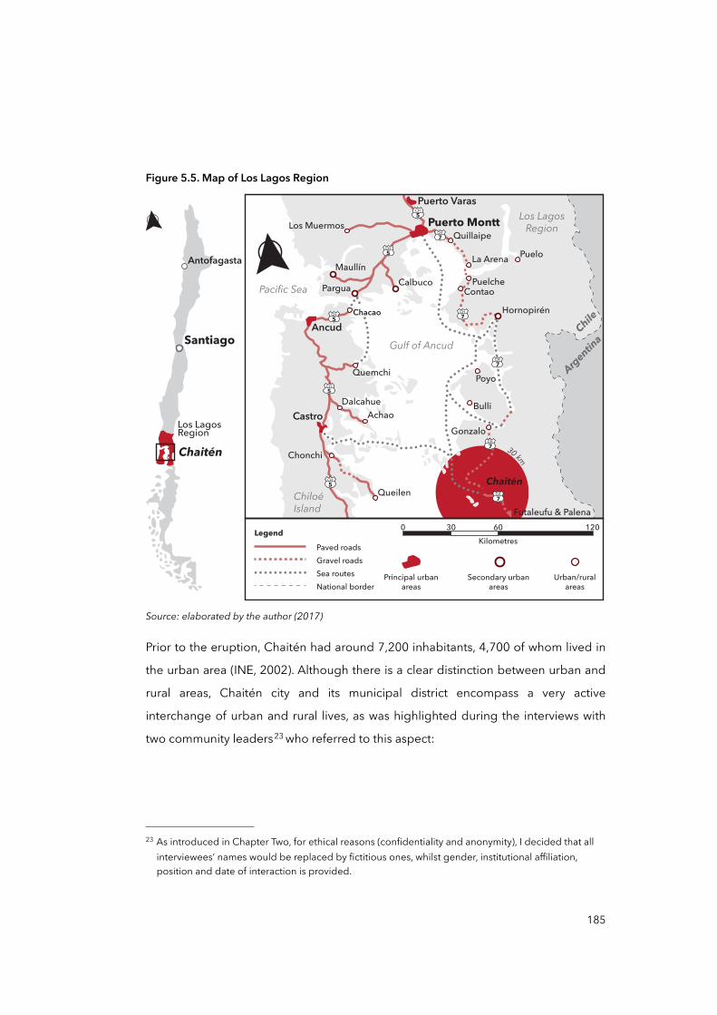
Figure 5.5. Map of Los Lagos Region
30 km
Castro AchaoDalcahue
Ancud
Pacific Sea
ChiloéIsland
Chacao
CalbucoPargua
Los LagosRegion
Chile
Argentina
Maullín
Los Muermos
Puerto Varas
Quillaipe
La Arena Puelo
Futaleufu & Palena
Chaitén
Santiago
Antofagasta
Los LagosRegion
Quemchi
Puerto Montt
PuelcheContao
Poyo
Bulli
Gonzalo
Hornopirén
Gulf of Ancud
CH7
CH5
CH5
CH5
CH5
CH5
CH7
CH7
CH7
CH7
QueilenChaitén
Chonchi
0 30 60 120Kilometres
Legend
Principal urbanareas
Secondary urbanareas
Urban/ruralareas
Paved roadsGravel roadsSea routesNational border
Source: elaborated by the author (2017)
Prior to the eruption, Chaitén had around 7,200 inhabitants, 4,700 of whom lived in
the urban area (INE, 2002). Although there is a clear distinction between urban and
rural areas, Chaitén city and its municipal district encompass a very active
interchange of urban and rural lives, as was highlighted during the interviews with
two community leaders23 who referred to this aspect:
185
23 As introduced in Chapter Two, for ethical reasons (confidentiality and anonymity), I decided that all interviewees’ names would be replaced by fictitious ones, whilst gender, institutional affiliation, position and date of interaction is provided.
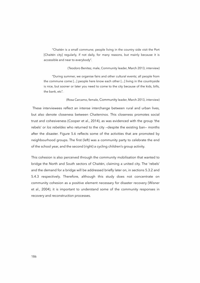
“Chaitén is a small commune; people living in the country side visit the Port [Chaitén city] regularly, if not daily, for many reasons, but mainly because it is accessible and near to everybody”.
(Teodoro Benitez, male, Community leader, March 2013, interview)
“During summer, we organise fairs and other cultural events; all people from the commune come [...] people here know each other [...] living in the countryside is nice, but sooner or later you need to come to the city because of the kids, bills, the bank, etc”.
(Rosa Carcamo, female, Community leader, March 2013, interview)
These interviewees reflect an intense interchange between rural and urban lives,
but also denote closeness between Chaiteninos. This closeness promotes social
trust and cohesiveness (Cooper et al., 2014), as was evidenced with the group ‘the
rebels’ or los rebeldes who returned to the city —despite the existing ban— months
after the disaster. Figure 5.6 reflects some of the activities that are promoted by
neighbourhood groups. The first (left) was a community party to celebrate the end
of the school year, and the second (right) a cycling children’s group activity.
This cohesion is also perceived through the community mobilisation that wanted to
bridge the North and South sectors of Chaitén, claiming a united city. The ‘rebels’
and the demand for a bridge will be addressed briefly later on, in sections 5.3.2 and
5.4.3 respectively. Therefore, although this study does not concentrate on
community cohesion as a positive element necessary for disaster recovery (Wisner
et al., 2004), it is important to understand some of the community responses in
recovery and reconstruction processes.
186
Figure 5.6. Community activities in Chaitén
Source: Leonardo Garcia Godoy (2014)
According to the now dissolved Ministry of Planning (MIDEPLAN),24 the economy of
Chaitén significantly changed after the opening of the CH-7 (MIDEPLAN, 2003). Prior
to 1988, Chaitén’s economy was primarily based on fishing one, with artisanal fishing
communities and fishing fleets offshore. Local production supplied seafood
processing, frozen food and canned food industries in the region. Although fishing
activity continued after the opening of the CH-7, it declined totally after the
volcano’s eruption in 2008. In 2013, during the fieldwork, there was neither
recognition nor register of any important fishing activities in Chaitén. To identify the
main economic activity in Chaitén before and after the volcanic eruption, I
conducted a frequency distribution of the number of workers per economic activity
(see Table 5.1). I looked at the number of workers because it was not possible to find
data on the actual composition of the economy of Chaitén.
187
24 In 2011, the government of President Piñera transformed MIDEPLAN into the current Ministry of Social Development.
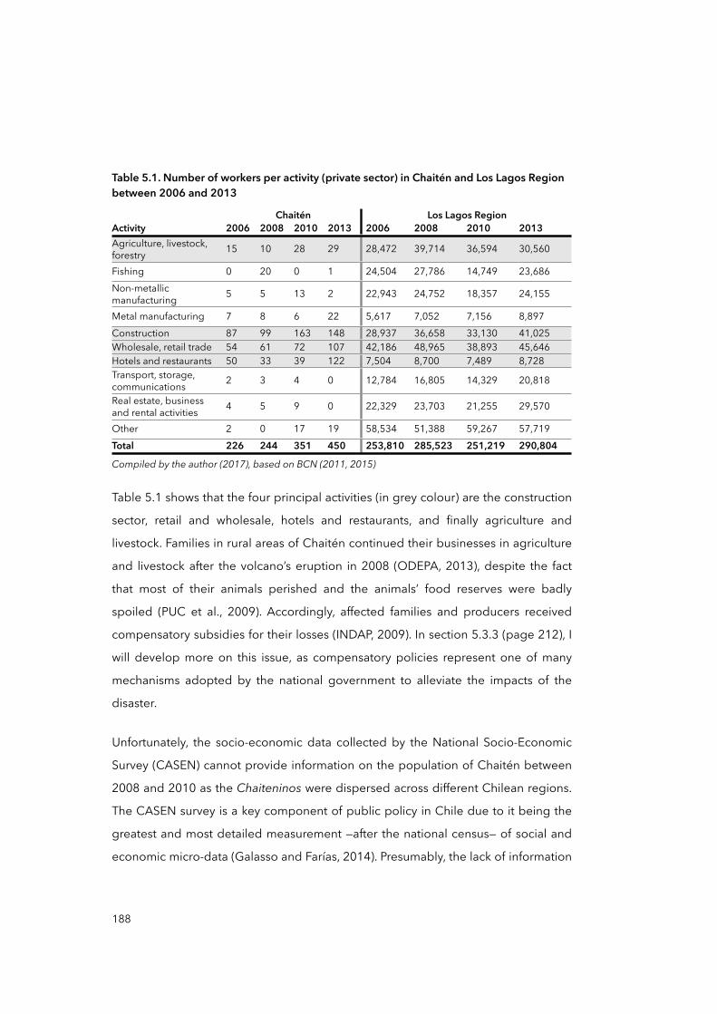
Table 5.1. Number of workers per activity (private sector) in Chaitén and Los Lagos Region between 2006 and 2013
ChaiténChaiténChaiténChaitén Los Lagos RegionLos Lagos RegionLos Lagos RegionLos Lagos RegionActivity 2006 2008 2010 2013 2006 2008 2010 2013Agriculture, livestock, forestry 15 10 28 29 28,472 39,714 36,594 30,560
Fishing 0 20 0 1 24,504 27,786 14,749 23,686Non-metallic manufacturing 5 5 13 2 22,943 24,752 18,357 24,155
Metal manufacturing 7 8 6 22 5,617 7,052 7,156 8,897Construction 87 99 163 148 28,937 36,658 33,130 41,025Wholesale, retail trade 54 61 72 107 42,186 48,965 38,893 45,646Hotels and restaurants 50 33 39 122 7,504 8,700 7,489 8,728Transport, storage, communications 2 3 4 0 12,784 16,805 14,329 20,818
Real estate, business and rental activities 4 5 9 0 22,329 23,703 21,255 29,570
Other 2 0 17 19 58,534 51,388 59,267 57,719Total 226 244 351 450 253,810 285,523 251,219 290,804
Compiled by the author (2017), based on BCN (2011, 2015)Compiled by the author (2017), based on BCN (2011, 2015)Compiled by the author (2017), based on BCN (2011, 2015)Compiled by the author (2017), based on BCN (2011, 2015)Compiled by the author (2017), based on BCN (2011, 2015)Compiled by the author (2017), based on BCN (2011, 2015)Compiled by the author (2017), based on BCN (2011, 2015)Compiled by the author (2017), based on BCN (2011, 2015)Compiled by the author (2017), based on BCN (2011, 2015)
Table 5.1 shows that the four principal activities (in grey colour) are the construction
sector, retail and wholesale, hotels and restaurants, and finally agriculture and
livestock. Families in rural areas of Chaitén continued their businesses in agriculture
and livestock after the volcano’s eruption in 2008 (ODEPA, 2013), despite the fact
that most of their animals perished and the animals’ food reserves were badly
spoiled (PUC et al., 2009). Accordingly, affected families and producers received
compensatory subsidies for their losses (INDAP, 2009). In section 5.3.3 (page 212), I
will develop more on this issue, as compensatory policies represent one of many
mechanisms adopted by the national government to alleviate the impacts of the
disaster.
Unfortunately, the socio-economic data collected by the National Socio-Economic
Survey (CASEN) cannot provide information on the population of Chaitén between
2008 and 2010 as the Chaiteninos were dispersed across different Chilean regions.
The CASEN survey is a key component of public policy in Chile due to it being the
greatest and most detailed measurement —after the national census— of social and
economic micro-data (Galasso and Farías, 2014). Presumably, the lack of information
188
on Chaitén during that period may have affected short-term public policies for
recovery, in addition to long-term decision-making such as on the relocation of
Chaitén and its subsequent reconstruction. These policies and decisions are revised
later, but draw our attention to this lack of information as a potential dynamic
pressure.
One area of activity that experienced a significant increase was the construction
sector. From 2006 to 2013, the number of workers increased from 87 to 148.
Another activity which is an important part of Chaitén’s economy is tourism,
although the only indicator of the latter is the number of workers in hotels and
restaurants (see Table 5.1 above), which actually decreased between 2006 and
2013: there are no studies or official figures that demonstrate or refute the
importance of the tourism industry. In this regard, I interviewed several local
authorities from the Municipality and the provincial government who referred to the
economic situation of Chaitén prior to and after the volcanic eruption.
“Chaitén is a subsidised city: one third of the commune’s income is generated by the FCM [Common Municipal Fund] and by projects funded by regional and central governments [...] Half of Chaitén’s workers are employed directly in public services, the other half depends, at some point, on the public sector [...] Chaitén is nowadays as it used to be in the past [...] we received a lot of [economic] support from the [national] government”.
(Pedro Delgado, male, Local government director, May 2013, interview)
“We have allocated special resources to families [for businesses] thanks to special funds from the [national] government [...] During 2012 we tried to generate local businesses and to strengthen some family businesses based on agriculture and livestock, but it is difficult; we help them to survive”.
(Veronica Zarate, female, Local government director, March 2013, interview)
189

“The provincial government, and also the Municipality, have made efforts to attract private investment, mainly for tourism and related services [...] I do not know why, but the result is few investments and few jobs in all [economic] sectors [...] our economy is stuck”.
(Antonio Gomez, male, Local government council member, July 2013, interview)
In the extracts above, two relevant aspects can be observed, the first related to the
idea that Chaitén relies on the public sector to sustain its economy, the second that
the economy is paralysed and stuck. The latter is difficult to uphold as the number of
workers in Chaitén between 2006 and 2013 increased by about 99.1 per cent (from
226 to 450), in much higher proportion than the region —14.6 per cent, from
253,810 to 290,804 in the same period (see Table 5.1, page 188). The supposed
dependency of Chaitén’s economy on the public sector is also difficult to estimate
using only the number of workers or companies, as there are no figures or indicators
available to triangulate these data with public-state services in the city —e.g.
infrastructure maintenance and municipal services such as education and health,
among others. However, as the municipalities are entitled to generate public
incomes via local taxes and to receive public funds, looking at the financial situation
of the Municipality of Chaitén could shed light on such supposed dependency. This
is addressed in the next section, as the municipal economy may help us better to
understand the hierarchical and vertical relationship between Chaitén and the state
during the recovery and reconstruction phases.
5.1.2 A subsidised city?
To gain an initial approximation of the presence of the public sector25 in the city’s
economy, Figure 5.7 maps all municipal services and provincial offices of ministerial
services located in Chaitén in September 2013. Although the number and
distribution of these public buildings is not an accurate indicator of the role of the
public sector as the main source of local income, the figure shows an important
number of infrastructures: in 2013, there were 20 government offices in Chaitén
from at least 11 ministries.
190
25 This is based on the theory of political architecture (Schumacher, 2012, Chapter 9).
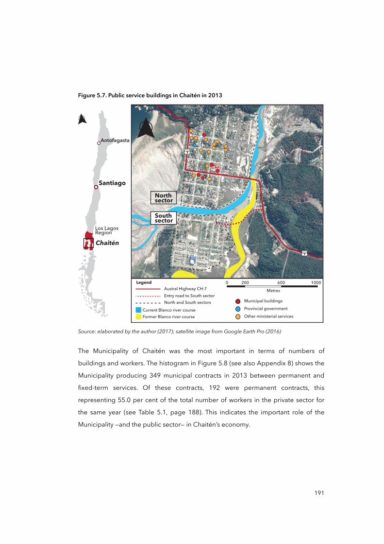
Figure 5.7. Public service buildings in Chaitén in 2013
Chaitén
Santiago
Antofagasta
Los LagosRegion
0 200 600 1000
Metres
LegendAustral Highway CH-7Entry road to South sectorNorth and South sectors
Former Blanco river courseCurrent Blanco river course
CH7
CH7
Northsector
Southsector
Other ministerial services
Municipal buildings
Provincial government
Source: elaborated by the author (2017); satellite image from Google Earth Pro (2016)
The Municipality of Chaitén was the most important in terms of numbers of
buildings and workers. The histogram in Figure 5.8 (see also Appendix 8) shows the
Municipality producing 349 municipal contracts in 2013 between permanent and
fixed-term services. Of these contracts, 192 were permanent contracts, this
representing 55.0 per cent of the total number of workers in the private sector for
the same year (see Table 5.1, page 188). This indicates the important role of the
Municipality —and the public sector— in Chaitén’s economy.
191
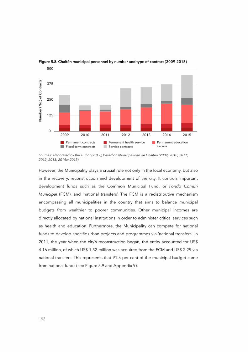
Figure 5.8. Chaitén municipal personnel by number and type of contract (2009-2015)
Permanent contracts Permanent health service Permanent educationserviceFixed-term contracts Service contracts
0
125
250
375
500
2009 2010 2011 2012 2013 2014 2015
Num
ber (
No.) o
f Con
tracts
Sources: elaborated by the author (2017), based on Municipalidad de Chaitén (2009; 2010; 2011; 2012; 2013; 2014a; 2015)
However, the Municipality plays a crucial role not only in the local economy, but also
in the recovery, reconstruction and development of the city. It controls important
development funds such as the Common Municipal Fund, or Fondo Común
Municipal (FCM), and ‘national transfers’. The FCM is a redistributive mechanism
encompassing all municipalities in the country that aims to balance municipal
budgets from wealthier to poorer communities. Other municipal incomes are
directly allocated by national institutions in order to administer critical services such
as health and education. Furthermore, the Municipality can compete for national
funds to develop specific urban projects and programmes via ‘national transfers’. In
2011, the year when the city’s reconstruction began, the entity accounted for US$
4.16 million, of which US$ 1.52 million was acquired from the FCM and US$ 2.29 via
national transfers. This represents that 91.5 per cent of the municipal budget came
from national funds (see Figure 5.9 and Appendix 9).
192

Figure 5.9. Chaitén municipal income by domestic and national incomes (2000-2015)
Mun
icipa
l Inco
me i
n US$
Milli
on
Total
2000 2002 2004 2006 2008 2010 2012 2014
1.25
2.50
3.75
5.00
Common MunicipalFund (FCM)
Domestic incomeOther nationaltransactions
Volcanic eruption, 2nd May
Sources: elaborated by the author (2017), based on Municipalidad de Chaitén (2009; 2010; 2011; 2012; 2013; 2014a; 2015) and SINIM (2016)
In addition, this calculation excluded all investments in large infrastructures made
directly by other ministries, such as the flood barrier by the Ministry of Public Works
in 2012. Therefore, it seems plausible to think of Chaitén as a subsidised city, as its
principal institution is deeply reliant on national support, and this is true both before
and after the volcanic eruption. Looking beyond the reasons for this, a high
dependency on external financing could result in higher exposure and vulnerability
to disasters (Wisner et al., 2004) in the sense that local institutions can become more
fragile and susceptible to national economic ups and downs, and DRR projects may
be less prioritised than projects with higher political profiles (Pelling, 2003a). This
economic vertical relationship between the national and the local could also be
useful in observing the multi-scalar progression of vulnerability, when such
dependency is seen as a dynamic pressure in times of economic crisis.
5.2 The Chaitén disaster: emergency response
To build the storyline of the progression of vulnerability in Chaitén, I started from the
days before the volcanic eruption and worked through until the reconstruction,
concluding in 2013. While constructing the storyline, I have gone back and forward
193
several times to connect the case antecedents with those aspects discussed in
Chapter Four —the centralised, top-down and reactive model of DRM and DRR.
Based on two technical reports commissioned by the national government in 2009
and 2010 (CIMM T&S Consultores, 2010; Infracon S.A., 2012) and one qualitative
study in 2013 (Ugarte and Salgado, 2014), I began my observations and interviews
in Chaitén, assuming two vulnerable conditions: the limited access to services and
the uneven distribution of risks. The first relates to the difficulties that men and
women, especially in the southern sector, have in accessing basic public services
such as health, water, sanitation and transportation. The second refers to the risk of
exposure to floods and mudflows as a consequence of future volcanic eruptions,
which is again distributed unevenly between the North and South sectors of the city.
This situation is accentuated by the limited access to services, leaving the South
sector more at risk (see Figure 5.10).
In Figure 5.10, it can be seen that the North and South sectors are both populated
areas, with about 4,000 people living in the North and 500 in the South. More
importantly, the figure shows the uneven distribution of exposure of the city to
volcanic mudflows. Evidently, the South sector is more exposed and therefore more
at risk than the North, where flood barriers have been in place since 2011. This is
accentuated by the fact that the South sector has limited access to basic services
such as water, sanitation, education and health. This uneven distribution of risk and
the limited access to services are indeed two unsafe conditions materialised locally
in the city of Chaitén. Certainly, these conditions came about after several processes
and post-disaster decisions where policy responses played an important role. Thus,
what are the dynamic pressures and their root causes that produced these unsafe
conditions? To elucidate this, we need to examine policy responses and decision-
making from the volcanic eruption onwards.
194

Figure 5.10. Map of exposed areas, and labels by national authorities
Northsector
Southsector
CH7
CH7
0 200 600 1000MetresLegend
Entry road to South sectorAustral HighwayNorth and South sectors
High risk - exclusion of urban developmentModerate risk - urban developmentFurther studies needed Former Blanco river course
Current Blanco river course
Sources: elaborated by the author (2017), based on CIMM T&S Consultores (2010) and Infracon S.A (2012); satellite image from Google Earth Pro (2016)
5.2.1 Emergency meetings and the ‘dormant’ volcano
On the morning of April 30, 2008, the inhabitants of Chaitén were awoken by
unusual seismic movements. The same day, regional authorities established a
Regional Emergency Operation Centre (COE) to monitor the situation. By law, COEs
are established by the jurisdictional authority —e.g. the Mayor at the municipal level—
and are to work with other local institutions and community organisations which
have the responsibility of evaluating, managing and taking action in a specific
emergency (Ministerio del Interior y Seguridad Pública, 2002). The COE, headed by
the Intendente of Los Lagos Region, Sergio Galilea, included local services such as
carabineros, Navy, health service, fire service, army and some neighbouring
195
organisations. According to several interviewees, since the establishment of the
regional COE, some issues have arisen. A local leader and a resident who attended
such meetings refer to it as follows:
“These meetings were very strange because from the beginning they [authorities] said that the tremors were only seismic activity without risks [of stronger quakes] [...] they explained to us about the tectonic movements. But in reality they had no idea [...] because there was an eruption two days later [...] The meetings always started about the movements and tremors, and from the very beginning the discussions used to turn into local problems such as connectivity, poverty, abandonment and other non-related things”.
(Pablo Carcamo, male, Community leader, March 2013, interview)
“Nobody really knew what was going on [...] even when the authority tried to explain to us with figures and drawings that these movements where tectonic, we knew that they were not [...] many people used to point to the volcano [...] in the end, people were right”.
(Isabel Jimenez, female, North Chaitén resident, March 2013, interview)
What emerges from the above transcript is a lack of information about the nature of
the hazard, producing uncertainty and concern among the population, something
that would later stimulate distrust in authorities: this will be examined throughout
this chapter and in Chapter Six. Community leaders assert that regional authorities
tried to minimise the importance of tremors prior to the disaster, thus hindering
preventive and preparedness actions. Contemplating risks is always difficult,
especially with a lack of information, but beyond this, it seems evident that the
authorities minimised not only scientific evidence but also people’s claims and
concerns.
During the first days of the emergency prior to the eruption, SERNAGOMIN26 tried
to figure out the source of the tremors by flying over the nearest volcano,
Michimahuida, 30 kilometres away from Chaitén (see Figure 5.11). The state service
failed to identify the Chaitén volcano because there were no data or records about
this volcano before then.
196
26 The state institution responsible for evaluating natural hazards.
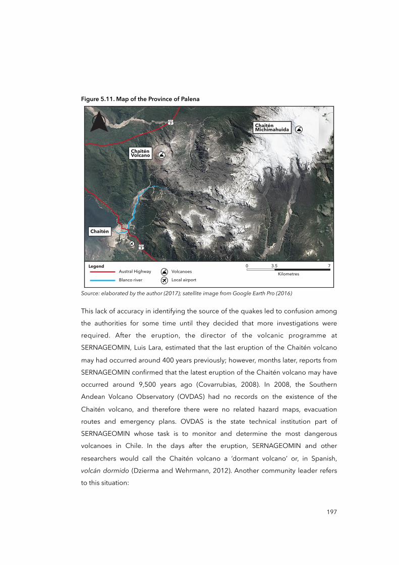
Figure 5.11. Map of the Province of Palena
CH7
CH7
Chaitén
ChaiténVolcano
ChaiténMichimahuida
0 3.5 7Kilometres
LegendAustral HighwayBlanco river
VolcanoesLocal airport
Source: elaborated by the author (2017); satellite image from Google Earth Pro (2016)
This lack of accuracy in identifying the source of the quakes led to confusion among
the authorities for some time until they decided that more investigations were
required. After the eruption, the director of the volcanic programme at
SERNAGEOMIN, Luis Lara, estimated that the last eruption of the Chaitén volcano
may had occurred around 400 years previously; however, months later, reports from
SERNAGEOMIN confirmed that the latest eruption of the Chaitén volcano may have
occurred around 9,500 years ago (Covarrubias, 2008). In 2008, the Southern
Andean Volcano Observatory (OVDAS) had no records on the existence of the
Chaitén volcano, and therefore there were no related hazard maps, evacuation
routes and emergency plans. OVDAS is the state technical institution part of
SERNAGEOMIN whose task is to monitor and determine the most dangerous
volcanoes in Chile. In the days after the eruption, SERNAGEOMIN and other
researchers would call the Chaitén volcano a ‘dormant volcano’ or, in Spanish,
volcán dormido (Dzierma and Wehrmann, 2012). Another community leader refers
to this situation:
197

“It was a feeling that the authorities and the specialists had no idea, really no idea [...] they were insisting that Michimahuida [the volcano] had erupted, so we were not at risk [...] the next day they discovered that was the Chaitén volcano, here! Just ten kilometres [from the city] […] we were lucky we had time to run”.
(Angela Rodriguez, female, Community leader, September 2013, interview)
In these interview extracts, it is possible to observe a conflict between residents and
the authority on evaluating government reactions in the early days. The initial
government reaction is crucial to understanding Chaiteninos’ post-disaster erosion
of trust of national authorities, which progressed alongside the evacuation,
recovery, relocation and reconstruction. This erosion of trust in authorities is
considered here an unsafe condition, as a lack of trust can negatively alter future
DRM and DRR actions, as well as lessening the effects of compensatory and recovery
policies (Cutter et al., 2003). I will corroborate this with more evidence when
reviewing the rest of the policy responses to the disaster. This includes the
compensatory strategy, the relocation of Chaitén and reconstruction.
Another reflection from those first days is how quickly regional authorities —
especially the Intendente Sergio Galilea— took control over the emergency, which
tells us about the verticality of the model of DRM. This is coherent with Mena’s
observations (2016) about how often disaster emergencies in Chile tend to be
treated by authorities in the upper levels of government.
The next section reviews how decision-making about the evacuation and the
constitution of the national COE can be considered powerful examples of the top-
down approach during emergencies in Chile, and how this approach may affect
vulnerability in the future.
5.2.2 The emergency response and evacuation
According to a consultancy project (PUC et al., 2009), tremors related to the
eruption of Chaitén volcano started on April 30, 2008, and were perceived by the
inhabitants in Chaitén, Futaleufu and Palena. These quakes culminated in a violent
198
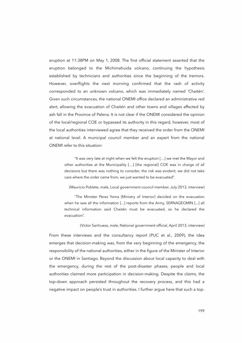
eruption at 11:38PM on May 1, 2008. The first official statement asserted that the
eruption belonged to the Michimahuida volcano, continuing the hypothesis
established by technicians and authorities since the beginning of the tremors.
However, overflights the next morning confirmed that the rash of activity
corresponded to an unknown volcano, which was immediately named ‘Chaitén’.
Given such circumstances, the national ONEMI office declared an administrative red
alert, allowing the evacuation of Chaitén and other towns and villages affected by
ash fall in the Province of Palena. It is not clear if the ONEMI considered the opinion
of the local/regional COE or bypassed its authority in this regard, however, most of
the local authorities interviewed agree that they received the order from the ONEMI
at national level. A municipal council member and an expert from the national
ONEMI refer to this situation:
“It was very late at night when we felt the eruption […] we met the Mayor and other authorities at the Municipality […] [the regional] COE was in charge of all decisions but there was nothing to consider, the risk was evident; we did not take care where the order came from, we just wanted to be evacuated”.
(Mauricio Poblete, male, Local government council member, July 2013, interview)
“The Minister Perez Yoma [Ministry of Interior] decided on the evacuation when he saw all the information [...] reports from the Army, SERNAGEOMIN [...] all technical information said Chaitén must be evacuated, so he declared the evacuation”.
(Victor Sanhueza, male, National government official, April 2013, interview)
From these interviews and the consultancy report (PUC et al., 2009), the idea
emerges that decision-making was, from the very beginning of the emergency, the
responsibility of the national authorities, either in the figure of the Minister of Interior
or the ONEMI in Santiago. Beyond the discussion about local capacity to deal with
the emergency, during the rest of the post-disaster phases, people and local
authorities claimed more participation in decision-making. Despite the claims, the
top-down approach persisted throughout the recovery process, and this had a
negative impact on people’s trust in authorities. I further argue here that such a top-
199
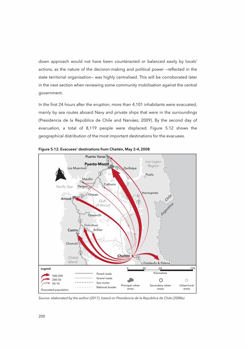
down approach would not have been counteracted or balanced easily by locals’
actions, as the nature of the decision-making and political power —reflected in the
state territorial organisation— was highly centralised. This will be corroborated later
in the next section when reviewing some community mobilisation against the central
government.
In the first 24 hours after the eruption, more than 4,101 inhabitants were evacuated,
mainly by sea routes aboard Navy and private ships that were in the surroundings
(Presidencia de la República de Chile and Narváez, 2009). By the second day of
evacuation, a total of 8,119 people were displaced. Figure 5.12 shows the
geographical distribution of the most important destinations for the evacuees.
Figure 5.12. Evacuees’ destinations from Chaitén, May 2-4, 2008
Source: elaborated by the author (2017), based on Presidencia de la República de Chile (2008a)
Castro Achao
Dalcahue
Ancud
Pacific Sea
ChiloéIsland
Chacao
CalbucoPargua
Los LagosRegion
Chile
Argentina
Maullín
Los Muermos
Puerto Varas
Quillaipe
Puelo
Futaleufu & Palena
Quemchi
Puerto Montt
Hornopirén
Gulf of Ancud
CH
7CH
5
CH
5
CH
5
CH
5
CH
5CH
7
Chonchi
0 30 60 120
Kilometres
Legend
Principal urban
areas
Secondary urban
areas
Urban/rural
areas
Paved roads
Gravel roads
Sea routes
National border
Chaitén
CH
7
Evacuated population
500-200
200-50
50-10
200
One of the most relevant aspects that emerged during the interviews in relation to
the evacuation process and the production of vulnerability is something I call the
‘erosion of trust in authorities’. Disaster literature establishes trust in authorities as a
very important aspect of prevention, especially when preparing people in case of
evacuations and for developing DRM and DRR strategies (Cutter et al., 2003). This
erosion of trust could have been initiated as a result of the false interpretations of
the volcanic hazard by specialists and authorities, and exacerbated by the way in
which the evacuation was conducted. Two community leaders refer to this.
“The evacuation was a mess [...] they [the authorities] sent children and mothers to one city and fathers to another [...] many did not know where the others were for weeks. [...] In case of a new evacuation, I will stand firm here. I will not leave my land, my house [...] I will not let them take me anywhere. I prefer to die here than to live how we lived during our time in Puerto Montt [city where she was evacuated with her family]”.
(Roberta Monsalvez, female, Community leader, July 2013, interview)
“We lost all our personal belongings [referring to pictures, memories, personal valuables] because they told us that we would come back in few weeks [...] many left their animals and pets; they all died because we trusted we could come back”.
(Marcela Segovia, female, Community leader, July 2013, interview)
From the above, is possible to identify two negative and still painful issues in relation
to the evacuation. The first refers to the splitting of families, the second to the
possibility of returning to the city few days after the evacuation.
Families were split. Women and children were evacuated first, followed by men.
Chaiteninos had no means of knowing where their family members were, being
unable to communicate with one another during the first days, and this created
anxiety and uncertainty. This also provides evidence that evacuees’ destinations
were not pre-established: nor was there a prepared plan of action for the
evacuation. Furthermore, the existing social organisation was somehow
disarticulated and there were no interlocutors able to represent the dispersed
201
population or to establish communication with regional and local authorities
(Mardones et al., 2011). As observed here, in the presence of high risk or the
occurrence of a disaster, the evacuation operated under a universal driver: life
saving and the provision of basic subsistence for the affected populations. However,
ensuring the right to information and the continuity of daily life for those displaced
appears not to have been addressed as a policy response. A multi-scalar
perspective on this could tell us that the sudden evacuation was indeed nested in
distant processes and underlying causes. The evacuation strategy followed a distinct
pattern of life saving and reduction of losses. These, as a rule of thumb, are found
recurrently in the ONEMI documents consulted on emergency management, and
this prevalence makes it appear as if other elements of evacuation, such as the right
to information, are unimportant. The ONEMI’s main document, the National Plan of
Civil Protection (ONEMI, 2002), refers to emergency responses as follows:
“Emergency responses is action carried out immediately after a destructive event. Its principal aim is to save life, and reduce impacts and losses. Examples: search and rescue, medical assistance, evacuation, temporal shelter, food supply and shelter”.
(ONEMI, 2002, p.28)
From this extract and the way in which the evacuation was conducted in Chaitén, it is
evident that the lack of attention to other aspects of emergency response, such as
the right to information and participation, reflect the reactiveness of the DRM
model. This idea, directed from the ONEMI national office down to local authorities
and practitioners, may explain the reaction of authorities during the evacuation in
terms of both the lack of preparation in terms of destinations of evacuees and the
subsequent splitting up of families that occurred.
A second conflicting issue regarding the evacuation was the possibility of returning
to the city a few days after the evacuation. The interviews above point out that
people were told that the evacuation would last for a maximum of two weeks.
However, most would never return to their homes for their belongings and
valuables. By May 6, 2008, the national authorities decided that the exclusion zone —
202
i.e. the commune of Chaitén— would last for an unspecified length of time. Many
Chaiteninos felt anxious about the future of their houses and animals and
livelihoods, and many regretted having believed in the authorities. From these
views, is also possible to perceive a feeling of abandonment and distance from the
authorities.
Finally, other issues arose in relation to the allocation of emergency and response
resources. An audit issued by the General Accounting Office or Contraloría General
de la República in 2009 revealed that an undetermined number of state agencies
and departments received emergency funds to alleviate the impacts of the disaster
in Chaitén between 2008 and 2009. Some of the recognised government bodies
include the SUBDERE, the Municipality of Chaitén, the regional government of Los
Lagos Region, the National Institute for Agricultural and Livestock Development
(INDAP), the National Service for Training and Employment (SENCE) and the Service
of Technical Cooperation (SERCOTEC), among others. The inter-ministerial interest
in supporting Chaitén was evident but not necessarily planned beforehand. The
audit pointed out irregularities in the way the emergency funds were allocated,
distributed and spent by public and private companies (Contraloría General de la
República, 2009). For instance, private donors such as the retailers Cencosud S.A.
and Walmart Chile and others, and energy and food companies such as Lipigas and
Colun are highlighted in the report because their donations could not be traced to
the intended destinations. The concern about these ‘irregularities’ is that the above-
mentioned companies received tax exemptions through their donations, and not all
public money was accounted for, as reported in the audit. And yet the cost of the
emergency seems ambiguous. According to the annual account prepared in 2009
by the Intendente of Los Lagos Region, Sergio Galilea, the total cost of the
emergency was around US$ 61 million (Galilea, 2009), while in the annual account
produced by the national government it reached about US$ 78.5 million
(Presidencia de la República de Chile and Narváez, 2009). Thus, accountability
emerged as an issue informing and contributing to the mistrust towards authorities
and the private sector. For Chaiteninos and its local authorities, the real cost of the
recovery has never been clarified.
203
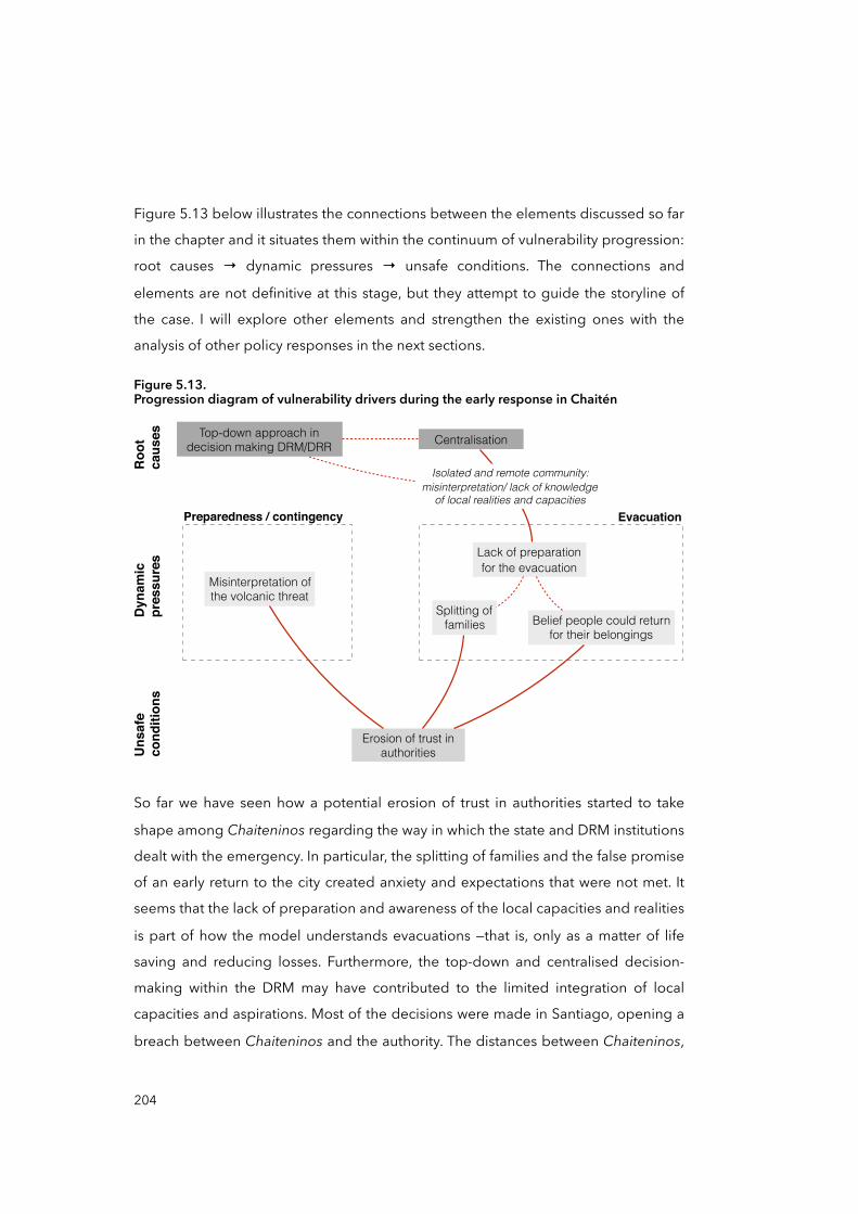
Figure 5.13 below illustrates the connections between the elements discussed so far
in the chapter and it situates them within the continuum of vulnerability progression:
root causes → dynamic pressures → unsafe conditions. The connections and
elements are not definitive at this stage, but they attempt to guide the storyline of
the case. I will explore other elements and strengthen the existing ones with the
analysis of other policy responses in the next sections.
Figure 5.13.Progression diagram of vulnerability drivers during the early response in Chaitén
Erosion of trust in authorities
Top-down approach in decision making DRM/DRR Centralisation
Evacuation
Roo
tca
uses
Dyn
amic
pr
essu
res
Uns
afe
cond
ition
s
Isolated and remote community: misinterpretation/ lack of knowledge
of local realities and capacities
Splitting of families
Lack of preparation for the evacuation
Belief people could return for their belongings
Preparedness / contingency
Misinterpretation of the volcanic threat
So far we have seen how a potential erosion of trust in authorities started to take
shape among Chaiteninos regarding the way in which the state and DRM institutions
dealt with the emergency. In particular, the splitting of families and the false promise
of an early return to the city created anxiety and expectations that were not met. It
seems that the lack of preparation and awareness of the local capacities and realities
is part of how the model understands evacuations —that is, only as a matter of life
saving and reducing losses. Furthermore, the top-down and centralised decision-
making within the DRM may have contributed to the limited integration of local
capacities and aspirations. Most of the decisions were made in Santiago, opening a
breach between Chaiteninos and the authority. The distances between Chaiteninos,
204

regional and national authorities were increased by the creation of a parallel
authority named the Presidential Delegate for the Chaitén recovery. This designation
represents a new phase in the storyline of the case and is when the recovery process
starts.
5.3 Recovery and relocation of Chaitén
In order to examine the recovery phase, the timeline below in Figure 5.14
introduces, in order, the elements that will be discussed in the following sub-
sections.
Figure 5.14. Distribution of policy responses in the Chaitén disaster
New Chaitén relocation project
Chaitén emergency subsidies
Presidential Delegate
The ‘rebels’
ReconstructionRecoveryResponse
2009
Oct
2010
Oct
2010
Mar
Pre-volcaniceruption meetings
‘Chaitén Law’
2010
Dec
2013
Oct
New Chaitén aborted
200 familiesin South sector
Ban lifting on North Chaitén
2008
end
Apr
2008
Early-mid
May
Evacuation
Volcanoeruption
2008
2th-4th
May
Power transferingBachelet-Piñera
2014
Dec
New presidential
delegate
2009
1
2
3
4
This figure explains that certain processes in the recovery took place simultaneously:
the Presidential Delegate, the formation of a group of rebels, the emergency
subsidies and the relocation of Chaitén. The analysis begins with those elements
that I assume to have triggered or influenced the development of others. The
numbers within red circles show the sequence I will follow in this section. Other
events displayed in the timeline, such as the Chaitén Law, are addressed within the
analysis of the mentioned recovery processes.
205
5.3.1 Friction between national and local decision-making
On May 9, 2008, President Bachelet designated Paula Narváez the Presidential
Delegate for Chaitén to coordinate the recovery and a possible relocation of
Chaitén. This designation created friction between regional and national
governments and the people of Chaitén. Officials from the national, regional and
local governments refer to this designation and her role:
“Paula Narváez was designated as Presidential Delegate because was a figure we used successfully in the previous disaster of Tocopilla [2007 earthquake] [...] the idea of the delegate is to ‘reduce’ the distance between the central government and local needs [...] speed up the allocation of resources and support”.
(Noria Saavedra, female, National government official, August 2013, interview)
“I remember she [Paula Narváez] came to Chaitén with the media and other people to convince us that Chaitén must be abandoned [...] we organised a big demonstration [around 200 people] because she did not want to defend us and Chaitén [...] many felt abandoned by the state”.
(Guillermo Ugarte, male, Local government council member, March 2013, interview)
“It supposed that the Presidential Delegate was a technical authority; however, it was political [...] the roles of the Intendente and the Presidential Delegate overlapped in many cases —for instance, in the decision on the relocation”.
(Jacinto Tello, male, Regional government official, July 2013, interview)
These excerpts shows that the designation of the Presidential Delegate created
some friction with regional and local public authorities. Narváez’s appointment was
issued by DS Nº608, which states: “the Presidential Delegate, under the direct
mandate of the President of the Republic, and in coordination with the Intendente of
Los Lagos Region, assumes the direction of the recovery of Chaitén and, if
necessary, its reconstruction” (Presidencia de la República de Chile, 2008b, p.2).
However, the figure of the Intendente is the major representative of the President of
the Republic in regions (Ministerio del Interior y Seguridad Pública, 2005). DS Nº608
does not specify the command hierarchy and how coordination between these two
206
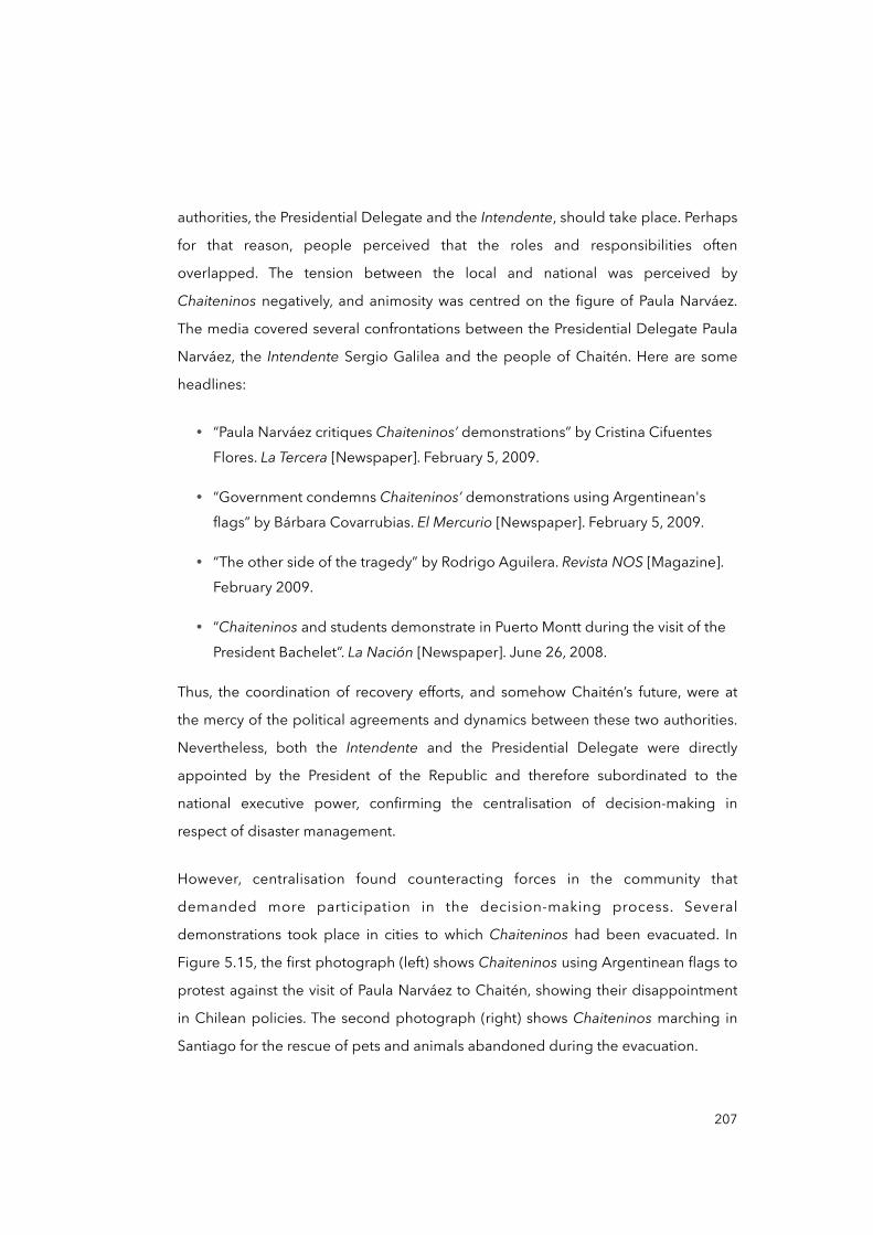
authorities, the Presidential Delegate and the Intendente, should take place. Perhaps
for that reason, people perceived that the roles and responsibilities often
overlapped. The tension between the local and national was perceived by
Chaiteninos negatively, and animosity was centred on the figure of Paula Narváez.
The media covered several confrontations between the Presidential Delegate Paula
Narváez, the Intendente Sergio Galilea and the people of Chaitén. Here are some
headlines:
• “Paula Narváez critiques Chaiteninos’ demonstrations” by Cristina Cifuentes Flores. La Tercera [Newspaper]. February 5, 2009.
• “Government condemns Chaiteninos’ demonstrations using Argentinean's flags” by Bárbara Covarrubias. El Mercurio [Newspaper]. February 5, 2009.
• “The other side of the tragedy” by Rodrigo Aguilera. Revista NOS [Magazine]. February 2009.
• “Chaiteninos and students demonstrate in Puerto Montt during the visit of the President Bachelet”. La Nación [Newspaper]. June 26, 2008.
Thus, the coordination of recovery efforts, and somehow Chaitén’s future, were at
the mercy of the political agreements and dynamics between these two authorities.
Nevertheless, both the Intendente and the Presidential Delegate were directly
appointed by the President of the Republic and therefore subordinated to the
national executive power, confirming the centralisation of decision-making in
respect of disaster management.
However, centralisation found counteracting forces in the community that
demanded more participation in the decision-making process. Several
demonstrations took place in cities to which Chaiteninos had been evacuated. In
Figure 5.15, the first photograph (left) shows Chaiteninos using Argentinean flags to
protest against the visit of Paula Narváez to Chaitén, showing their disappointment
in Chilean policies. The second photograph (right) shows Chaiteninos marching in
Santiago for the rescue of pets and animals abandoned during the evacuation.
207
Figure 5.15. Demonstrations of Chaiteninos in Chaitén and Santiago
Sources: (left) Cristina Cifuentes (February 2009) and (right) Daydalaus (July 2008)
One particular group, called ‘the rebels’, or los rebeldes, by the media, needs to be
addressed in this analysis as it represented a breaking point in relations between the
local people and national plans in Chaitén. This group, and a series of actions
initiated by other Chaiteninos throughout the recovery and reconstruction
processes, are very important as they symbolise bottom-up attempts to negotiate
Chaitén’s future. This group also embodies Chaiteninos’ agency to push for reforms
and the capacity to cope with the disaster impacts.
5.3.2 The rebels: occupying Chaitén
Once evacuated and facing uncertainty about the future, some Chaiteninos, led by
Patricia Troncoso,27 banded together to form a collective action group named Sons
and Friends of Chaitén, or Hijos y Amigos de Chaitén. This group aimed to
communicate to the authorities their needs as well as their intention to return to the
city. Due to the low impact they had on the media, the lack of attention from
authorities and the uncertainty about the future, some of them decided to occupy
Chaitén despite the existing ban. I interviewed Patricia Troncoso several times
208
27 Fictitious name.
during 2013, and I accompanied her to visit other community leaders. They refer to
the first days of the emergency as follows:
“Nobody really told us what was next [...] whether we would come back to Chaitén or not, if we should start to find a job, nothing [...] during the first weeks we tried to organise something [civil organisation] to claim our rights, for answers [...] we organised a demonstration in Castro [Chiloé Island’s capital] but it was funny because only a few of us turned up [...] nobody paid us attention”.
(Patricia Troncoso, female, Community leader, March 2013, interview)
“Even the Senator Escalona [Chilean Socialist Party] came for a meeting with us, but he gave hugs, shook hands, and posed for pictures with [city] Castro’s authorities only [...] it was really frustrating [...] so, we organised ourselves to visit Chaitén, to know about our valuables, animals and pets [...] we did not think twice. We settled back in Chaitén by late 2008”.
(Olga Pineda, female, Community leader, September 2013, interview)
From these interviews, it is possible to observe a sort of disorientation and
uncertainty among Chaiteninos about what was happening with their houses and
valuables right after the evacuation. The lack of information during the process and
in the following days also reveals the poor integration of Chaiteninos in the recovery
proceedings and their distance from powerful institutions and structures. Thus, some
of them thought of organising something they called resistance, which included
coming back to Chaitén despite the risks. The media named them ‘the
rebels’ (Rojas, 2013). This ‘emergent group’ —in Quarantelli’s terminology (1994)—
was spontaneous in its formation, since at first there were only about five people
who returned to Chaitén during the months following the eruption. This number
grew over time, adding up to well more than twenty people by the end of 2008. The
reasons for this returning include territorial rootedness, an inability to adapt and
access to resources, among others (Ugarte and Salgado, 2014). However, their
intentions converged on the idea of transmitting to their fellow citizens, and
209
especially to the public authorities, that Chaitén was not dead, alluding to Minster of
Interior Edmundo Perez Yoma.28
As the interviewees described, living in the abandoned city meant they had to get
potable water from a little stream to which they had connected water pipes, while
energy was obtained from a diesel generator. People organised themselves to clean
the streets and repair their houses. They also redefined their previous livelihoods
into subsistence strategies to face the scarcity of goods and products available in
the city, in light of there being no commerce or jobs available. As the interviewees
said, these situations strengthen cohesiveness and the sense of community.
By mid-2009, the rebels’ children were arriving in the city to meet their parents for
holidays. However, when the regional authorities became aware of this, they
decided to ‘persuade’ the rebels by ordering the Navy to bring children out of the
occupied Chaitén, assuming their parents would follow them. Parents refused to
abandon the city and sent the children away alone. Two rebels referred to this
situation as follows:
“I had to send my 13 year old daughter alone in that ship [a Navy ship] [...] I cried for several hours and days until I knew she was good in the house of my brother in Puerto Montt”.
(Olga Pineda, female, Community leader, September 2013, interview)
“The strategy of the government to take us out of the city was by pushing us with our children. That was cruel [...] they [government officials] argued that we are adults so we can decide to stay in the city despite the risks, but children are another story, children are a ‘state responsibility’ [...] We were treated as if we were irresponsible parents”.
(Margarita Salamanca, female, Community leader, September 2013, interview)
210
28 On February 20, 2009, the Minister of Interior Edmundo Perez Yoma announced “Chaitén, unfortunately, is dead”, asserting that there would not be investment of any kind in the city (La Nación, 2009).
That government move bothered people even more. For many Chaiteninos,
especially those living already in Chaitén, the regional and national government had
become the main obstacle to them recovering their livelihoods. Remember that
during the emergency all people were forced to evacuate the city according to the
national emergency plan, without considering either local knowledge or their social
and family structure. Chaiteninos were sent to neighbouring cities, such as Puerto
Montt, Castro and Coyhaique, with very different urban lives, social structures and
economies, with a greater degree of difference than those found in Chaitén prior to
the eruption —such as extended family relations and a sense of community rooted in
the territory (Marchant, 2010).
The rebels became the voice of Chaitén’s dispersed population, the only social
organisation that fought against national plans. Furthermore, communication
between Chaiteninos within and outside the city was possible thanks to a radio
programme named Here Chaitén, or ‘Aquí Chaitén’, led by Pablo Carcamo.29 The
programme was broadcast from Chaitén itself and was picked up by other radio
stations in the region. According to Pablo, the programme “sought to encourage
other Chaiteninos not to forget our land, to fight for it [...] to face the
government” (Pablo Carcamo, male, Community leader, March 2013, interview).
Despite such difficulties, the ‘settlers’30 adapted to the new situation while
encouraging other Chaiteninos to return. By mid-2009, when the ban was still in
force, some rebels perceived others living outside Chaitén to be expatriated, or
exiliados, people ‘forced’ to leave Chaitén, revealing their strong conviction that it
was not their decision to abandon Chaitén.
After observing such struggles, it is possible to argue that the return process finds
justification in the uncertainty surrounding the recovery plan —if we can call it that
(see section 5.3.3, page 212)— and the lack of attention and of participation in
decision-making. The feeling of abandonment after the evacuation, and later the
211
29 Fictitious name.
30 This is what Chaiteninos call the people that decided to come back to Chaitén after the eruption.
impression of fighting against the state’s intentions to leave the city behind,
encouraged them to take the lead. It is therefore possible to identify two clear and
antagonistic stances on Chaitén’s future. The first was the government’s position on
the impossibility of repopulating Chaitén, based on the early technical risk
assessments (PUC et al., 2009), and the second position, represented by the rebels,
affirmed that Chaitén was not dead. Certainly, this group has played an important
role in the recent history of Chaitén by actively participating in the processes that
resulted in the recognition of Chaitén as a habitable city in 2010. But before moving
towards that episode, let us review the various twists brought about by the central
government that could have triggered that end: the city relocation project, called
the ‘New Chaitén’; the presidential change in March 2010, including the regional
Intendente; and the compensatory strategy, including benefits and subsidies. The
latter is the focus of the next section.
5.3.3 Compensation, benefits and subsidies
On May 2, 2008, Chaitén was declared a catastrophe zone through DS Nº588,
signed by the President of the Republic (Ministerio del Interior y Seguridad Pública,
2008). In Chile, only the President of the Republic can declare a State of Catastrophe
—which is one of the States of Constitutional Exception.31 This resolution was
applicable for one year —i.e. until May 2, 2009— and could be extended for an
equivalent amount of time. In Chaitén, it was in force until May 2010. During that
period, a still undetermined amount of public and private resources (Contraloría
General de la República, 2009) was allocated to government services and
organisations to support the displaced population and its recovery.
According to government officials and government records (Presidencia de la
República de Chile, 2008a), the main measure implemented to support people was
the Chaitén Emergency Subsidy, or Bono Emergencia Chaitén. This bono involved a
212
31 As reviewed in Chapter Four, in a State of Catastrophe, the President of the Republic may authorise the direct allocation of resources to alleviate people suffering and provide relief (República de Chile, 1980).
monthly payment of up to US$ 1,000 per family and was awarded between May
2008 and October 2010. During the first year, more than 3,200 families benefited
from it, and about 1,800 families in the second and third years. Other compensatory
subsidies were given to farmers and producers, alongside grants for education.
Between 2008 and 2009, the National Institute for Agricultural and Livestock
Development (INDAP) allocated US$ 1.2 million in order to compensate for the
losses of approximately 1,100 producers (INDAP, 2009). Another important
compensatory measure was delivered in the form of housing subsidies: 2,235
families received a one-off housing subsidy of about US$ 20,000 each (GORE Los
Lagos, 2009a). The housing subsidy aimed to offer special financial support to
displaced people from Chaitén to resettle them in other cities such as Castro, Puerto
Montt and Puerto Varas. In some places, such as in Puerto Varas, a brand new
neighbourhood was constructed with the purpose of receiving several displaced
Chaiteninos (MINVU, 2008). Likewise, other subsidies for entrepreneurship and
psychological support were given (GORE Los Lagos 2009a, 2010; Presidencia de la
República de Chile and Narváez, 2009). Some collected testimonies from
government officials and the community refer to this support:
“I was responsible for supporting the allocation of the bono in the Province of Palena [...] basically there was no supervision and there were many problems in knowing whether we were helping people or not [...] Prior to 2008, people used to live with so much less [...] When they received that amount of money, some people wasted it on holidays, travelling and expensive clothing”.
(Karina Navarrete, female, Local government official, July 2013, interview).
“I received the housing subsidy to get a home in Puerto Montt [...] It was not easy. We got a house very far away from the city centre [her place of work], so not well connected [...] when we heard about the return [to Chaitén] we did the impossible and came back to Chaitén”.
(Angela Rodriguez, female, Community leader, September 2013, interview)
As clearly set out by the first interviewee, poor supervision in the allocation of
resources is evident. This may have produced some unforeseen effects on people’s
213

ability to cope with the disaster impacts. According to the interviewed provincial
officer above, people relied on benefits for two years almost without supervision,
with an amount of money that exceeded their incomes prior the eruption in 2008.
When benefits ran out, most people found themselves without savings and with
debts (Paz, 2011; Sáez, 2009). This lack of supervision and the misuse of recovery
benefits, as well as financial debts and the fact that Chaitén was already people
encouraging to return, seemed powerful reasons to repopulate Chaitén.
Such poor supervision was not only limited to people, but also to government
services and the private sector. The lack of supervision and other irregularities were
detected by an audit commissioned by the General Accounting Office (Contraloría
General de la República, 2009) and covered later by the media (René González,
2014). This could have further eroded people’s trust in the authorities. Two audits
found the regional government and the Municipality of Chaitén failing to allocate
and supervise subsidies and benefits (Contraloría General de la República, 2009;
2011). The perception of Angela Rodriguez (interview excerpt above) also reflects
how subsidies and benefits failed to support Chaiteninos transitioning from their
previous lifestyles and livelihoods to new ones. Although there are no exact figures,
authorities assert that most of the current population residing in Chaitén today —
about 4,500 people in total— returned to the city because they were not able to
adapt to the new urban life and/or they missed the Chaitén lifestyle. Something
similar was found by Ugarte and Salgado (2014).
As a part of the national government’s strategy to encourage people to leave
Chaitén, Law Nº20,385, or the Chaitén Law, was promulgated in October 2009. This
special law allowed the state to purchase properties, paying the market price prior
to the eruption. According to experts and local authorities interviewed, this
strategy’s objective was twofold: on the one hand, it had to restrict the habitability
and occupancy of Chaitén because of its high risk; on the other hand, it was a way to
compensate for the losses of the affected population by transferring more financial
resources to them. Once the Chaitén Law was approved, the state bought 889
214
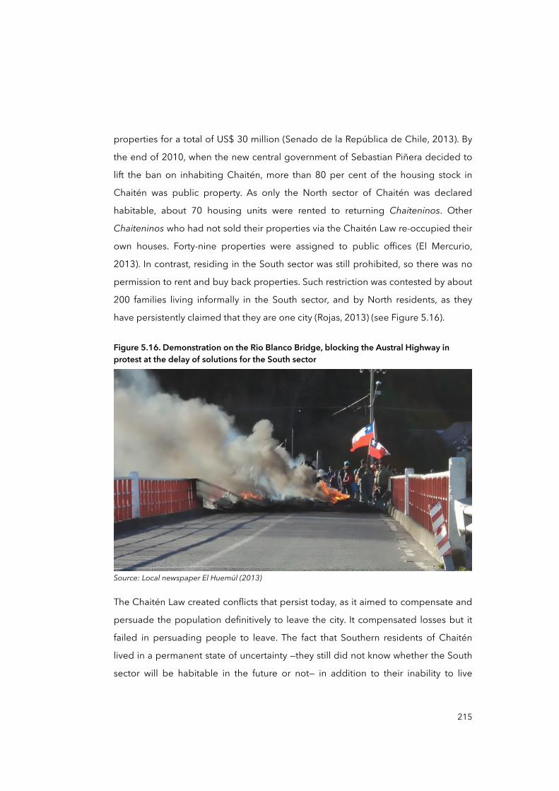
properties for a total of US$ 30 million (Senado de la República de Chile, 2013). By
the end of 2010, when the new central government of Sebastian Piñera decided to
lift the ban on inhabiting Chaitén, more than 80 per cent of the housing stock in
Chaitén was public property. As only the North sector of Chaitén was declared
habitable, about 70 housing units were rented to returning Chaiteninos. Other
Chaiteninos who had not sold their properties via the Chaitén Law re-occupied their
own houses. Forty-nine properties were assigned to public offices (El Mercurio,
2013). In contrast, residing in the South sector was still prohibited, so there was no
permission to rent and buy back properties. Such restriction was contested by about
200 families living informally in the South sector, and by North residents, as they
have persistently claimed that they are one city (Rojas, 2013) (see Figure 5.16).
Figure 5.16. Demonstration on the Rio Blanco Bridge, blocking the Austral Highway in protest at the delay of solutions for the South sector
Source: Local newspaper El Huemúl (2013)
The Chaitén Law created conflicts that persist today, as it aimed to compensate and
persuade the population definitively to leave the city. It compensated losses but it
failed in persuading people to leave. The fact that Southern residents of Chaitén
lived in a permanent state of uncertainty —they still did not know whether the South
sector will be habitable in the future or not— in addition to their inability to live
215
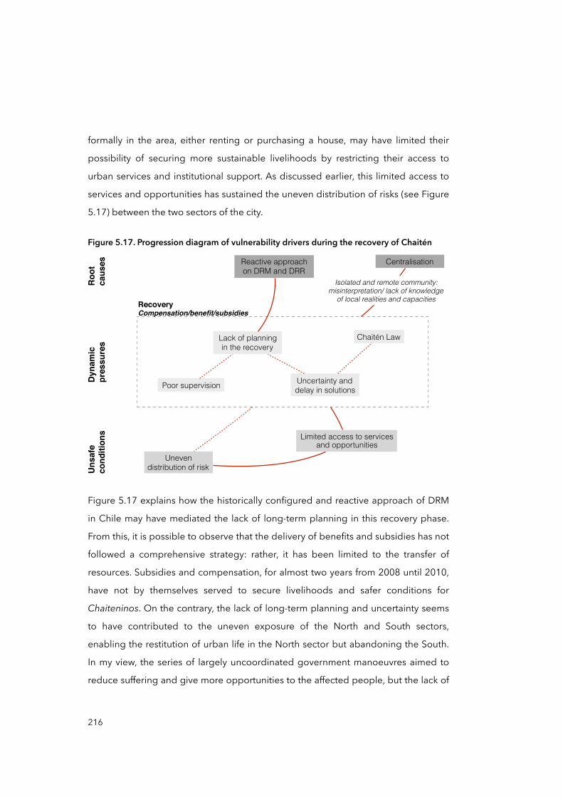
formally in the area, either renting or purchasing a house, may have limited their
possibility of securing more sustainable livelihoods by restricting their access to
urban services and institutional support. As discussed earlier, this limited access to
services and opportunities has sustained the uneven distribution of risks (see Figure
5.17) between the two sectors of the city.
Figure 5.17. Progression diagram of vulnerability drivers during the recovery of Chaitén
Centralisation
Uneven distribution of risk
Chaitén Law
Compensation/benefit/subsidies
Limited access to services and opportunities
Uncertainty and delay in solutions
Lack of planning in the recovery
Reactive approach on DRM and DRR
Recovery
Poor supervision
Isolated and remote community: misinterpretation/ lack of knowledge
of local realities and capacities
Roo
tca
uses
Dyn
amic
pr
essu
res
Uns
afe
cond
ition
s
Figure 5.17 explains how the historically configured and reactive approach of DRM
in Chile may have mediated the lack of long-term planning in this recovery phase.
From this, it is possible to observe that the delivery of benefits and subsidies has not
followed a comprehensive strategy: rather, it has been limited to the transfer of
resources. Subsidies and compensation, for almost two years from 2008 until 2010,
have not by themselves served to secure livelihoods and safer conditions for
Chaiteninos. On the contrary, the lack of long-term planning and uncertainty seems
to have contributed to the uneven exposure of the North and South sectors,
enabling the restitution of urban life in the North sector but abandoning the South.
In my view, the series of largely uncoordinated government manoeuvres aimed to
reduce suffering and give more opportunities to the affected people, but the lack of
216
a long-term strategy for recovery and the poor supervision had unforeseen effects
and perhaps contributed to the production of unsafe conditions in Chaitén. For
instance, the absence of a clear policy on the South sector that went beyond the
simple prohibition of inhabitancy may have encouraged the informal settlement of
that area which, because of its exposure and lack of disaster risk reduction
measures, is at risk. However, this conclusion cannot be arrived at by considering the
delivery of subsidies alone: it requires analysis of other mutually influential
processes that were ongoing in parallel, such as the presidential change in March in
2010 and the city relocation process initiated in mid-2009. The latter is addressed in
the following section.
5.3.4 The new Chaitén: the city relocation process
Just after the evacuation of Chaitén in 2008, two research groups started individually
to collect data in order to consider possible solutions for Chaitén. One group was
from the Observatory of Cities (OC) from the Pontificia Universidad Católica de Chile
(PUC), the other from the Universidad Austral de Chile (UACh). These two groups,
plus the national architecture firm Elemental and the international consulting office
ARUP, developed the idea of relocating the city of Chaitén by mid-2009. I
interviewed several researchers and officials who participated in the process from
the PUC and UACh, and the Urban Development Division (DDU) of the Ministry of
Housing and Urbanism (MINVU).
By October of 2008, and after several negotiations with the above-mentioned
actors, the national government signed a contract named Consultancy for the
Development of Strategic Guidelines of Reconstruction/Re-localisation and
Conceptual Master Plan Post-Disaster Chaitén (GORE Los Lagos, 2009b). The
consultancy project was led by the PUC team and planned in three stages between
June 2008 and July 2009.32 The first report (PUC et al., 2008a) was delivered in
217
32 The consultancy contract had a total cost of US$ 321,000 (GORE Los Lagos, 2009b), which can be included within the overall government expenditure on the Chaitén disaster.
October 2008 and included a characterisation of Chaitén, the Province of Palena
and Los Lagos Region.
The second report (PUC et al., 2008b) was delivered in December 2008 and focused
on the evaluation of alternatives for Chaitén. The evaluation involved a feasibility
assessment on the relocation and/or reconstruction of the city. Based on technical
calculations and development estimations such as economic potential and hazard
exposure, the second report openly recommended the relocation of Chaitén to a
safer area. From this point, the relocation project was called New Chaitén. The report
included a planning-political strategy to lead the process. This strategy offered a
‘recipe’ (PUC et al., 2008b, pp.121-125) to the government on how to present the
relocation project to Chaiteninos and the general public, based on:
• Community participation built on people’s need and ambitions
• Justifying the relocation of the city by arguing that the threats were
permanent, giving them ‘good’ alternatives through relocation such as better housing, employment, health assistance, and so forth
• Respecting the right to information
• Not lying or speculating about future actions
• Strict use and management of information
Looking back now, from the perspective of almost night years after this report, it is
possible to observe that most of these recommendations were not followed as
expected. Simply the declaration made by the Ministry of Interior Perez Yoma that
“Chaitén, unfortunately, is dead” in 2009 is powerful evidence of how information
was managed, and how decision-making occurred. Many times the interviewed
Chaiteninos complained about the lack of transparency and participation, the
delayed replies or the absence of answers from authorities, and the lack of attention
paid to their needs and claims.
218
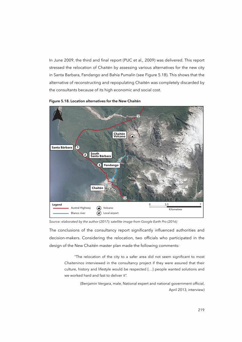
In June 2009, the third and final report (PUC et al., 2009) was delivered. This report
stressed the relocation of Chaitén by assessing various alternatives for the new city
in Santa Barbara, Fandango and Bahía Pumalín (see Figure 5.18). This shows that the
alternative of reconstructing and repopulating Chaitén was completely discarded by
the consultants because of its high economic and social cost.
Figure 5.18. Location alternatives for the New Chaitén
CH7
CH7
Chaitén
Santa Bárbara
Fandango
South Santa Bárbara
ChaiténVolcano
1
2
3
0 3.5 7Kilometres
LegendAustral HighwayBlanco river
VolcanoLocal airport
Source: elaborated by the author (2017); satellite image from Google Earth Pro (2016)
The conclusions of the consultancy report significantly influenced authorities and
decision-makers. Considering the relocation, two officials who participated in the
design of the New Chaitén master plan made the following comments:
“The relocation of the city to a safer area did not seem significant to most Chaiteninos interviewed in the consultancy project if they were assured that their culture, history and lifestyle would be respected […] people wanted solutions and we worked hard and fast to deliver it”.
(Benjamin Vergara, male, National expert and national government official, April 2013, interview)
219
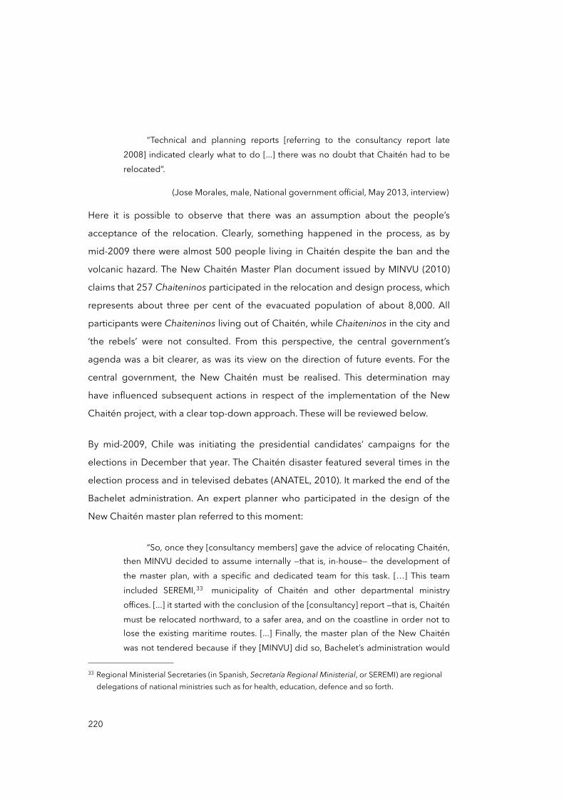
“Technical and planning reports [referring to the consultancy report late 2008] indicated clearly what to do [...] there was no doubt that Chaitén had to be relocated”.
(Jose Morales, male, National government official, May 2013, interview)
Here it is possible to observe that there was an assumption about the people’s
acceptance of the relocation. Clearly, something happened in the process, as by
mid-2009 there were almost 500 people living in Chaitén despite the ban and the
volcanic hazard. The New Chaitén Master Plan document issued by MINVU (2010)
claims that 257 Chaiteninos participated in the relocation and design process, which
represents about three per cent of the evacuated population of about 8,000. All
participants were Chaiteninos living out of Chaitén, while Chaiteninos in the city and
‘the rebels’ were not consulted. From this perspective, the central government’s
agenda was a bit clearer, as was its view on the direction of future events. For the
central government, the New Chaitén must be realised. This determination may
have influenced subsequent actions in respect of the implementation of the New
Chaitén project, with a clear top-down approach. These will be reviewed below.
By mid-2009, Chile was initiating the presidential candidates’ campaigns for the
elections in December that year. The Chaitén disaster featured several times in the
election process and in televised debates (ANATEL, 2010). It marked the end of the
Bachelet administration. An expert planner who participated in the design of the
New Chaitén master plan referred to this moment:
“So, once they [consultancy members] gave the advice of relocating Chaitén, then MINVU decided to assume internally —that is, in-house— the development of the master plan, with a specific and dedicated team for this task. […] This team included SEREMI,33 municipality of Chaitén and other departmental ministry offices. [...] it started with the conclusion of the [consultancy] report —that is, Chaitén must be relocated northward, to a safer area, and on the coastline in order not to lose the existing maritime routes. [...] Finally, the master plan of the New Chaitén was not tendered because if they [MINVU] did so, Bachelet’s administration would
220
33 Regional Ministerial Secretaries (in Spanish, Secretaría Regional Ministerial, or SEREMI) are regional delegations of national ministries such as for health, education, defence and so forth.
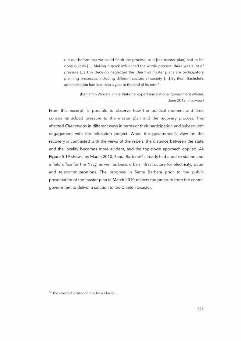
run out before that we could finish the process, so it [the master plan] had to be done quickly [...] Making it quick influenced the whole process: there was a lot of pressure [...] This decision neglected the idea that master plans are participatory planning processes, including different sectors of society. […] By then, Bachelet’s administration had less than a year to the end of its term”.
(Benjamin Vergara, male, National expert and national government official, June 2013, interview)
From this excerpt, is possible to observe how the political moment and time
constraints added pressure to the master plan and the recovery process. This
affected Chaiteninos in different ways in terms of their participation and subsequent
engagement with the relocation project. When the government’s view on the
recovery is contrasted with the views of the rebels, the distance between the state
and the locality becomes more evident, and the top-down approach applied. As
Figure 5.19 shows, by March 2010, Santa Barbara34 already had a police station and
a field office for the Navy, as well as basic urban infrastructure for electricity, water
and telecommunications. The progress in Santa Barbara prior to the public
presentation of the master plan in March 2010 reflects the pressure from the central
government to deliver a solution to the Chaitén disaster.
221
34 The selected location for the New Chaitén.
Figure 5.19. Santa Barbara station to initiate the New Chaitén
Sources: Bernardo Valdes (MINVU, 2010) and Verónica Veloso (May, 2009)
Figure 5.20. Design proposals for the New Chaitén
Source: MINVU (2010)
222
According to an urban planner interviewed in 2013, who was consulted by the
urban division team at MINVU, the New Chaitén master plan involved idealistic
views about sustainability and modernity which idealise the New Chaitén project as
a unique opportunity to create an energetically efficient, resilient and vibrant city.
These views are reflected in the pictures in Figure 5.20, which were selected from
the master plan document (MINVU, 2010). An urban practitioner and a community
leader who attended an ‘informative’ meeting (Cifuentes, 2009) in February 2010 in
Puerto Montt, aiming to communicate to people the process of relocation, refer to
the presentation of the New Chaitén master plan:
“For the government, it was very important to achieve approval [by Chaiteninos] of the project before the presidential transition [March 11, 2010] [...] they wanted to initiate a dialogue with the people in Chaitén [...] but many were disappointed because the project was in a very early stage [...] they [the government] projected a process of two or three years; the people did not want to wait more and many knew about Chaiteninos already living in Chaitén”.
(Gabriela Miranda, female, National consultant and planner, July 2013, interview)
“Finally, it was something they [the government] stubbornly wanted to do, against everything [...] they wanted us to wait, like, three years more. No, impossible to accept that [...] they spent so much, much money [...] Mr Galilea did many things wrong and Bachelet too [...] they played with us”.
(Patricia Troncoso, female, Community leader, September 2013, interview)
Here is possible to observe how frictions between the government and community
about the relocation and the New Chaitén became more intense, in part because of
the delay —the relocation project was launched almost two years after the disaster—
but also because the process would need two or three additional years. This eroded
people’s trust in the Bachelet administration, something that was reflected in the
presidential elections in December 2009.35 Weeks later, these delays would confirm
people’s refusal to be relocated, as this and other circumstances precipitated the
223
35 Piñera won the presidential election in the commune with 51.14 per cent of the votes. Chaiteninos were able to vote from other jurisdictions (SERVEL, 2017).
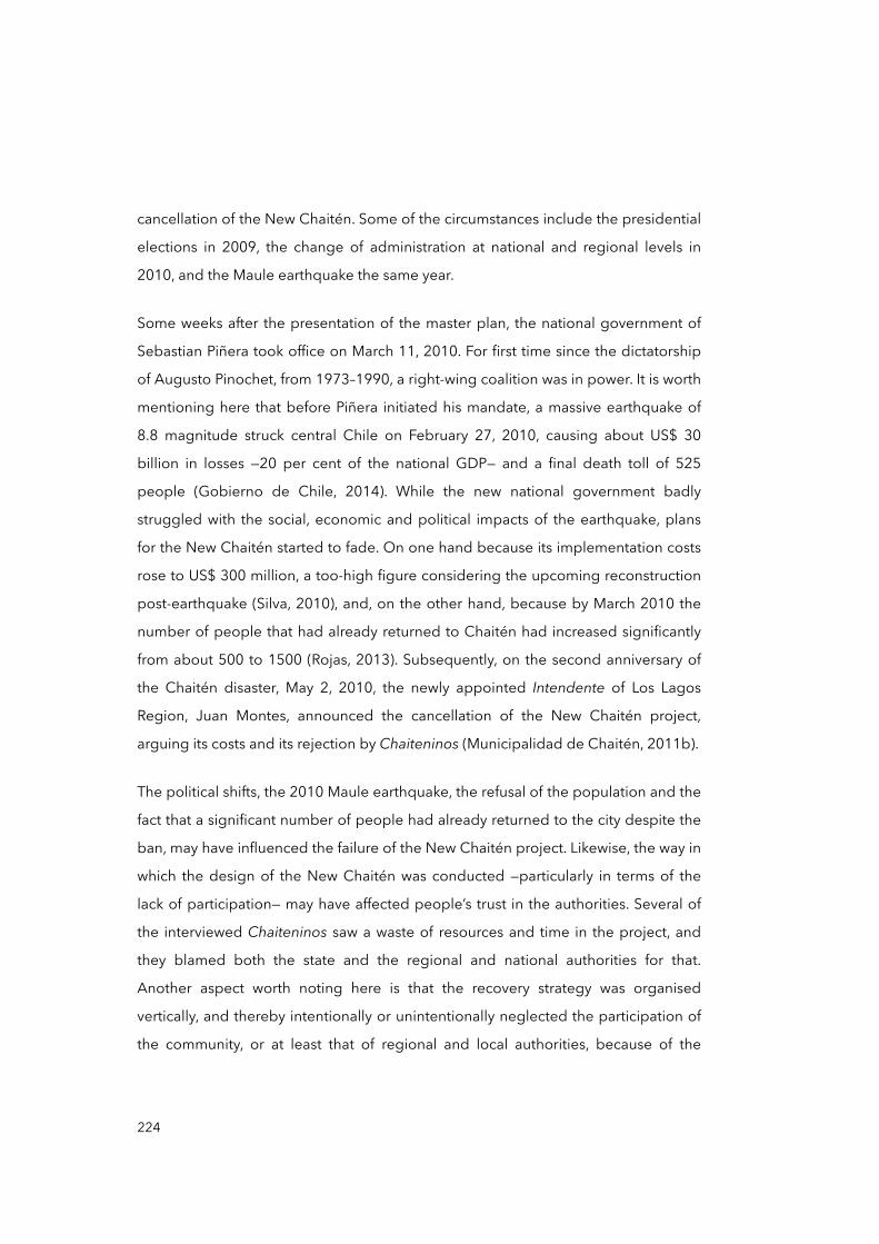
cancellation of the New Chaitén. Some of the circumstances include the presidential
elections in 2009, the change of administration at national and regional levels in
2010, and the Maule earthquake the same year.
Some weeks after the presentation of the master plan, the national government of
Sebastian Piñera took office on March 11, 2010. For first time since the dictatorship
of Augusto Pinochet, from 1973–1990, a right-wing coalition was in power. It is worth
mentioning here that before Piñera initiated his mandate, a massive earthquake of
8.8 magnitude struck central Chile on February 27, 2010, causing about US$ 30
billion in losses —20 per cent of the national GDP— and a final death toll of 525
people (Gobierno de Chile, 2014). While the new national government badly
struggled with the social, economic and political impacts of the earthquake, plans
for the New Chaitén started to fade. On one hand because its implementation costs
rose to US$ 300 million, a too-high figure considering the upcoming reconstruction
post-earthquake (Silva, 2010), and, on the other hand, because by March 2010 the
number of people that had already returned to Chaitén had increased significantly
from about 500 to 1500 (Rojas, 2013). Subsequently, on the second anniversary of
the Chaitén disaster, May 2, 2010, the newly appointed Intendente of Los Lagos
Region, Juan Montes, announced the cancellation of the New Chaitén project,
arguing its costs and its rejection by Chaiteninos (Municipalidad de Chaitén, 2011b).
The political shifts, the 2010 Maule earthquake, the refusal of the population and the
fact that a significant number of people had already returned to the city despite the
ban, may have influenced the failure of the New Chaitén project. Likewise, the way in
which the design of the New Chaitén was conducted —particularly in terms of the
lack of participation— may have affected people’s trust in the authorities. Several of
the interviewed Chaiteninos saw a waste of resources and time in the project, and
they blamed both the state and the regional and national authorities for that.
Another aspect worth noting here is that the recovery strategy was organised
vertically, and thereby intentionally or unintentionally neglected the participation of
the community, or at least that of regional and local authorities, because of the
224
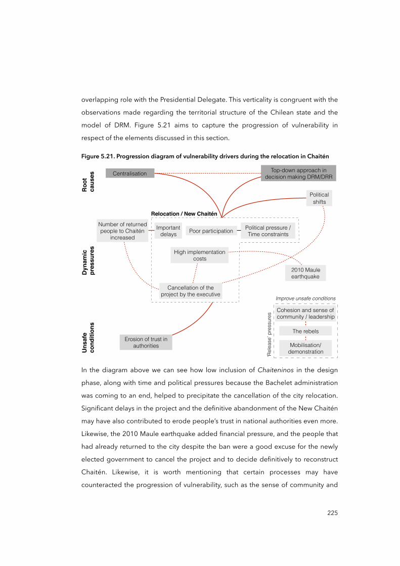
overlapping role with the Presidential Delegate. This verticality is congruent with the
observations made regarding the territorial structure of the Chilean state and the
model of DRM. Figure 5.21 aims to capture the progression of vulnerability in
respect of the elements discussed in this section.
Figure 5.21. Progression diagram of vulnerability drivers during the relocation in Chaitén
Erosion of trust in authorities
Top-down approach in decision making DRM/DRRCentralisation
Relocation / New Chaitén
Poor participation Political pressure / Time constraints
Important delays
High implementation costs
2010 Maule earthquake
Cancellation of the project by the executive
Number of returned people to Chaitén
increased
Political shifts
Cohesion and sense of community / leadership
Improve unsafe conditions
‘Rel
ease
’ pre
ssur
es
Mobilisation/demonstration
The rebels
Roo
tca
uses
Dyn
amic
pr
essu
res
Uns
afe
cond
ition
s
In the diagram above we can see how low inclusion of Chaiteninos in the design
phase, along with time and political pressures because the Bachelet administration
was coming to an end, helped to precipitate the cancellation of the city relocation.
Significant delays in the project and the definitive abandonment of the New Chaitén
may have also contributed to erode people’s trust in national authorities even more.
Likewise, the 2010 Maule earthquake added financial pressure, and the people that
had already returned to the city despite the ban were a good excuse for the newly
elected government to cancel the project and to decide definitively to reconstruct
Chaitén. Likewise, it is worth mentioning that certain processes may have
counteracted the progression of vulnerability, such as the sense of community and
225
cohesion that existed. These reflect existing capacities and characteristics in the
community that may result in resilient actions in the future.
The beginning of the Piñera administration in March 2010, however, deserves its
own analysis, as the decision to cancel the New Chaitén project confronted national,
regional and local authorities. These political confrontations, and a new political
approach to the disaster recovery, evolved over time until finally Chaitén was
declared habitable in December 2010.
5.3.5 Political shift on the Chaitén relocation
President Piñera began his tenure with the impact of the Maule 2010 earthquake
and the tension resulting from the Chaitén people’s struggle to stay in the historic
location. This led to a political shift on the relocation of the city. An important aspect
of this shift relates to the newly appointed Intendente of Los Lagos Region, Juan
Montes. As explained earlier, intendentes are loyal bureaucrats of the President of
the Republic who exercise the administration of regions in the country (Montecinos,
2005). In May 2008, then Intendente Galilea was loyal to the Bachelet administration
as he participated actively in the meetings between local and regional authorities
and Chaitén people, and actively defended the government’s intention to relocate
the city. However, just days after President Piñera took office, still in March 2010,
Galilea was replaced by Juan Montes. Table 5.2 shows different intendentes of Los
Lagos Region during the Bachelet and Piñera administrations. In grey colour is the
period during which the New Chaitén project was negotiated.
Table 5.2. Intendentes of Los Lagos Region 2006-2015
Intendente Took office Left office President of the RepublicJaime Bertin March 11, 2006 January 4, 2008
Michelle BacheletSergio Galliela January 4, 2008 March 11, 2010
Michelle Bachelet
Juan Montes March 11, 2010 November 15, 2012Sebastian Piñera
Jaime Brahm November 15, 2012 March 11, 2014Sebastian Piñera
Nofal Abud March 11, 2014 July 13, 2015 Michelle Bachelet
Compiled by the author (2017)Compiled by the author (2017)Compiled by the author (2017)Compiled by the author (2017)
226
Montes first visited Chaitén in March 2010, the same month he was appointed. A
local government official and two community leaders who participated in his visit
referred to the new approach:
“Montes was shocked by the situation in Chaitén when he took office [...] People living without basic services, abandoned, and the [New Chaitén] master plan stuck”.
(Ignacio Saavedra, male, Local government official, March 2013, interview)
“He [Montes] positioned himself into the idea that Chaitén should be repopulated, contradicting the decision of the previous and even the current [President Piñera] national administration”.
(Alejandro Soto, male, Community leader, July 2013, interview)
“Mr Montes promised that the regional government, if not the national, would lift the ban on Chaitén”.
(Regina Muñoz, female, Community leader, August 2013, interview)
It is evident from these extracts that the visit of Montes to Chaitén perhaps indicated
the clearest signal so far of the chance that Chaitén would be reconstructed. This did
not necessarily mean that Chaitén was the best option, however, nor the safest, as
early technical reports indicated the risk of reconstructing Chaitén (CIMM T&S
Consultores, 2010; PUC et al., 2008a). But beyond judging the best solution for
Chaitén’s future, this new approach may have encouraged ‘exiled’ Chaiteninos to
return to the city. Rojas (2013) estimated that between March and December 2010,
the number of people living in Chaitén increased from about 500 to 1,500, but
figures are hazy since there are no official records for that period. A national
government official at MINVU who participated in the development of the New
Chaitén master plan refers to Montes’ new approach:
“We perceived Montes’ declarations as very bad [...] by giving them [Chaiteninos] hope, Montes stimulated people to remain in the devastated city, and maybe encouraged other Chaiteninos to return to the city despite the risks”.
(Benjamin Vergara, male, National expert and national government official, June 2013, interview)
227
It therefore seems that Montes’ approach aimed to shift the central government’s
angle and thus alleviate tension between the Chaitén people and the national
government. Ugarte and Salgado (2014) assert that this moment was characterised
by a retraction of the national power and the dominant presence of the regional
government, perhaps also a consequence of the 2010 Maule earthquake. This
retraction is exemplified by the lack of coordination between the Intendente Montes
and President Piñera. Montes announced the cancellation of the project in March
but, in May 2010 during a presidential visit to Puerto Montt, Piñera amended
Montes’ statement by insisting that the New Chaitén would be built (El Mercurio,
2010). Several months later, Piñera contradicted himself and accepted the
cancellation of the project. During that period, uncertainty returned to Chaiteninos
until December 10, 2010, when Intendente Montes definitively discarded the New
Chaitén and declared the North sector of Chaitén habitable again (Intendencia de la
Región de Los Lagos, 2010). A community leader referred to this shift:
“It was a tremendous struggle against the government’s intention to relocate us definitively [...] we stayed firm and strong because Chaitén has always been our land, we did not want to live anywhere else”.
(María Jose Navarro, female, Community leader, July 2013, interview)
This view reflects the mood of many Chaiteninos living in Chaitén at the time.
Although happy because of the recognition of a community decision that they had
made long ago, the transition to a recovered community was far from being
complete. As mentioned earlier, Chaitén is today a divided city, where more than
200 families lack access to basic services and are unevenly exposed to hazards, and
the trust in authorities has eroded. The progression and configuration of this latest
vulnerable scenario is understandable through analysis of the post-disaster
processes discussed so far —evacuation, recovery, the aborted relocation— but only
completed with the examination of the reconstruction of (half of) Chaitén.
228
5.4 Reconstruction
The ban on inhabiting the North sector of Chaitén was lifted on December 10,
2010. Beyond the reasons behind such a decision discussed already, it represented
an important change in many aspects of Chaiteninos’ lives and how they projected
their future. This is also true for local authorities, especially the Municipality. The
analysis of the reconstruction phase and its effects on the accumulation and
materialisation of vulnerabilities in the city and its population spans December 2010
to the end of 2013. It considers the significant resources allocated to restore urban
services, and a series of pre- and post-disaster demands that remain unmet —e.g.
connectivity and the recovery of the ‘community’ (North and South sectors together).
Many aspects of the reconstruction of Chaitén have already been introduced or
mentioned in this chapter as they served to better understand certain processes. For
instance, section 5.1.1 mentions that the principal activity by number of workers
registered between 2006 and 2013 was the construction sector, perhaps because of
the need to reconstruct the city, and section 5.1.2 discussed how the public sector,
since 2010, has become almost the only source of employment and income,
accentuated by the fact that the state still owns the majority of the housing stock in
the city, thanks to the Chaitén Law.
5.4.1 Occupying the South sector
According to several municipal and provincial officials interviewed in 2013, the
significant resources allocated to reconstruction of the city included the restoration
of basic services and infrastructure, and mitigatory measures to reduce exposure,
such as the flood barrier for the North sector constructed during 2011 (see Figure
5.22).
229
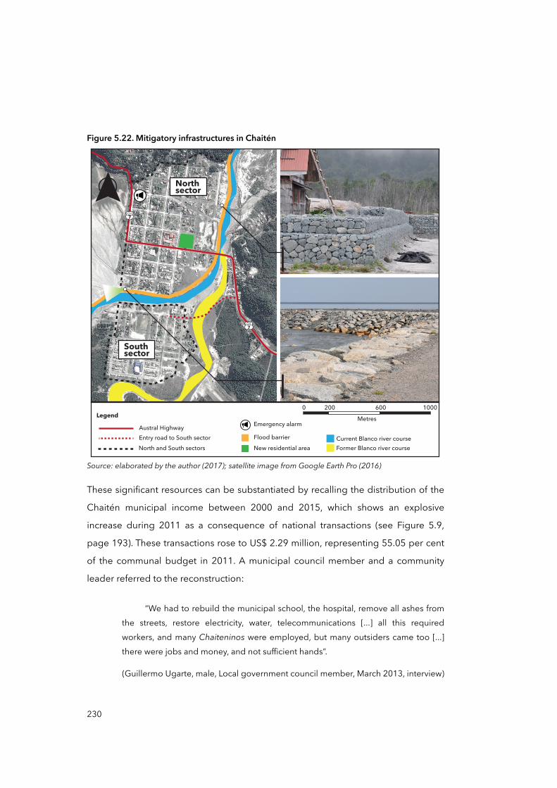
Figure 5.22. Mitigatory infrastructures in Chaitén
Southsector
Northsector
CH7
CH7
0 200 600 1000MetresLegend
Entry road to South sectorAustral Highway
North and South sectors
Emergency alarm
Flood barrierNew residential area Former Blanco river course
Current Blanco river course
Source: elaborated by the author (2017); satellite image from Google Earth Pro (2016)
These significant resources can be substantiated by recalling the distribution of the
Chaitén municipal income between 2000 and 2015, which shows an explosive
increase during 2011 as a consequence of national transactions (see Figure 5.9,
page 193). These transactions rose to US$ 2.29 million, representing 55.05 per cent
of the communal budget in 2011. A municipal council member and a community
leader referred to the reconstruction:
“We had to rebuild the municipal school, the hospital, remove all ashes from the streets, restore electricity, water, telecommunications [...] all this required workers, and many Chaiteninos were employed, but many outsiders came too [...] there were jobs and money, and not sufficient hands”.
(Guillermo Ugarte, male, Local government council member, March 2013, interview)
230
“Chaiteninos started to come back throughout 2011, especially those who did not sell their houses through the Chaitén Law [...] some of them had to rent houses from the state [...] others just occupied their houses. That happened especially in the South [...] especially the outsider workers, they just saw empty houses [in the South sector] and occupied them. […] Many people were unable to pay rents and there were not many affordable houses”.
(Angela Rodriguez, female, Community leader, September 2010, interview)
From this interview, it is possible to observe an early and yet significant element of
the reconstruction phase: the need for labour and for housing for both the returned
population and outsider workers. For some municipal officials interviewed, and
highlighted by community leaders, the scarcity and lack of affordability of housing
opportunities in the North sector pushed people to occupy the South sector
illegally. According to an official from the Ministry of Housing (MINVU) in Chaitén
interviewed in September 2013, MINVU was aware of the need for housing. The
same is true of the Mayor of Chaitén in 2013, Pedro Vásquez (Baeza, 2013). The
same official also revealed that the government was planning housing projects in
the future, but there was nothing concrete to talk about at that time. ‘Nothing
concrete’ was also confirmed by some community leaders, who pointed out their
feelings of uncertainty regarding the need for housing. Rojas (2013) also
documented Chaiteninos complaining about the high cost of renting a property in
the North sector —state owned houses— because most of the houses had
deteriorated or were damaged due to the disaster in 2008 and abandonment. This
confirms that the lack of housing projects and affordability may have been a factor
that influenced the informal settlement of South Chaitén.
On January 17, 2017, under the second Bachelet administration, MINVU
inaugurated the first new residential settlement in the North sector for about 60
people. Perhaps further investigations into Chaitén could look at the impact of this
housing project in the city (see ‘New residential area’ in Figure 5.22).
231
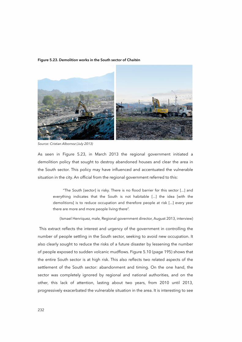
Figure 5.23. Demolition works in the South sector of Chaitén
Source: Cristian Albornoz (July 2013)
As seen in Figure 5.23, in March 2013 the regional government initiated a
demolition policy that sought to destroy abandoned houses and clear the area in
the South sector. This policy may have influenced and accentuated the vulnerable
situation in the city. An official from the regional government referred to this:
“The South [sector] is risky. There is no flood barrier for this sector [...] and everything indicates that the South is not habitable [...] the idea [with the demolitions] is to reduce occupation and therefore people at risk [...] every year there are more and more people living there”.
(Ismael Henriquez, male, Regional government director, August 2013, interview)
This extract reflects the interest and urgency of the government in controlling the
number of people settling in the South sector, seeking to avoid new occupation. It
also clearly sought to reduce the risks of a future disaster by lessening the number
of people exposed to sudden volcanic mudflows. Figure 5.10 (page 195) shows that
the entire South sector is at high risk. This also reflects two related aspects of the
settlement of the South sector: abandonment and timing. On the one hand, the
sector was completely ignored by regional and national authorities, and on the
other, this lack of attention, lasting about two years, from 2010 until 2013,
progressively exacerbated the vulnerable situation in the area. It is interesting to see
232
that after North Chaitén became habitable in December 2010, there were no
policies for the South sector that were beyond the simple prohibition of inhabitancy:
no incentives to leave, or law enforcement and compliance. In 2014, according to
the new Presidential Delegate for the reconstruction, Paula Forttes, “Chaitén has
today a serious housing problem: there are not enough housing units for all, the
biggest obstacle to the development of Chaitén" (El Mercurio, 2014). The lack of
attention, planning and policies for the South sector for more than two years may
have contributed to its repopulation. Therefore, the settlement of families in the
sector highlighted the materialisation of an uneven distribution of risks, as northern
and southern Chaiteninos are unevenly exposed to hazards. This uneven exposure
can be understood as a vulnerable —or unsafe— condition that Chaitén’s people face
at the local level. Here, ‘local’ refers to the spatial proximity of Chaitén’s people to
the source of hazard —the Chaitén volcano is just ten kilometres away. We would
assume that proximity to a volcanic hazard should suppose a homogeneous
distribution of risk, but it does not. The North sector has flood protections that
mitigate its exposure to potential ‘volcanic mudflows’ that may be produced in
future eruptions, while the South sector lacks such provision (see Figure 5.22, page
230). However, to experience an uneven distribution of risk, Chaiteninos must not
only have uneven exposure to hazards, but also unequal coping capacities and
vulnerabilities. The latter is something that will be addressed in section 5.4.4.
5.4.2 Chaitén (North) reconstruction plan?
In 2011, the Municipality’s budget for recovery projects increased by 257.8 per cent
in relation to the previous year, from US$ 0.64 to 2.29 million (Municipalidad de
Chaitén, 2011a). This indicated a significant state effort aimed at recovering
Chaitén. ‘Chaitén solution’, the ‘Chaitén solution plan’ (Cooperativa, 2011) or the
‘North Chaitén solution’ (Presidencia de la República de Chile, 2011) are some of the
names that official documents and authorities have used to refer to all the projects
and initiatives aimed at mitigating risk, reducing exposure and rehabilitating
services in Chaitén (GORE Los Lagos, 2011). Some of these initiatives included the
233
rehabilitation of public buildings, the restoration of public transport and street
lighting, and educational and health services, among others. During the fieldwork,
however, when I asked local, regional and national officials to review such a plan,
there was no document to refer to; nor was I able to find one in the institutional
archives. In some cases, I received copies of the Municipal Accountability Reports, in
others, budgeting documents. The lack of a document that encapsulated the
supposed plan for the reconstruction of Chaitén beyond the simple restoration of
services and mitigation of risks can be seen as an indicator of the urgency of the
government to transition quickly from the relocation of the city to a reconstruction
approach. The narrative of a ‘reconstruction plan’ was regularly used by authorities
simply to indicate that attention was being paid to Chaitén and that a significant
amount of resources were being allocated to rehabilitate services and rebuild the
destroyed infrastructure. However, these resources and projects were not bounded
within a comprehensive plan, within a long-term planning process. Indeed, it is the
lack of a plan which may have influenced the repopulation of the South sector and
later developed an uneven distribution of exposure. The supposed ‘plan’ restricted
all investments —including risk reduction projects— to one group of the population
and almost entirely neglected the other in the South.
5.4.3 Unmet demands
Poor connectivity between Chaitén and the rest of the region is one of the historic
local demands that persisted during the reconstruction. Based on reports from the
CASEN survey (MIDEPLAN, 2003, 2006) and the experiences shared by
interviewees, poor connectivity has historically produced unequal mobility and
opportunities between Chaitén and Los Lagos Region, and the country. The
literature on the relationship between remote settlements and development (Taylor
and Susilawati, 2012) refers to the importance of connectivity not only as a crucial
element for social and economic development, but also as a human security issue in
cases of evacuation (Pelling and Uitto, 2001). Remember that during the emergency
in May 2008, the evacuation was possible thanks to private ships that answered the
call. I personally experienced the connectivity issue, as it took me around 12 to 14
234

hours to reach Chaitén from Puerto Montt, an approximate distance of 200
kilometres. The director of the Health Station in Chaitén told me in March 2013 that
in case of health emergencies such as complications in childbirth, they depend on a
regional private company which offers air assistance to transport patients to Puerto
Montt’s hospital. This means that connectivity has been, and continues to be, an
important element in the development and safety of Chaitén, and perhaps it can be
considered an unsafe condition, although its root causes are not directly linked to
policy responses.
For instance, although the bi-mode route36 was entirely re-established in 2012, local
authorities from the Palena province and Los Lagos Region assert that the route is
just an alternative, not a real solution to the connectivity issue. A bi-mode route
indicates that there is no direct land connection between Chaitén and Puerto Montt,
the regional capital. Table 5.3 shows that in 2010 the regional government projected
to invest about US$ 212 million for reconstructing and rehabilitating the existing
transport and communication infrastructure.
Table 5.3. State budget to invest in Chaitén’s connectivity 2011-2014
Areas Include US$ million
Emergency connectivity
Basic road to Chaitén, Caleta Gonzalo, mechanical bridge, cleaning of Chaitén’s port and recourse of the river 5.566
Connectivity Fandango port, Chaitén local airport, paving of Route 7, the bi-mode section between Puerto Montt to La Junta (Aysén Region)
22.90925.455157.729
Total amount 212.345
Compiled by the author (2017), based on Montes and Allendes (2010)Compiled by the author (2017), based on Montes and Allendes (2010)Compiled by the author (2017), based on Montes and Allendes (2010)
However, only a few of these projected investments could be traced or found within
official documents such as budgeting and accountability reports (GORE Los Lagos,
2011; Municipalidad de Chaitén, 2011a). This suggests that the issue of connectivity
will remain an important problem and likely will be an increasing demand. A
municipal council member referred to this demand and the relationship with
regional and national authorities:
235
36 A bi-mode route combines two modes of transport in one route, by land and sea.
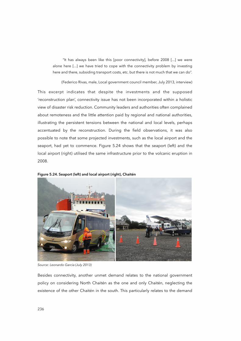
“It has always been like this [poor connectivity], before 2008 [...] we were alone here [...] we have tried to cope with the connectivity problem by investing here and there, subsiding transport costs, etc. but there is not much that we can do”.
(Federico Rivas, male, Local government council member, July 2013, interview)
This excerpt indicates that despite the investments and the supposed
‘reconstruction plan’, connectivity issue has not been incorporated within a holistic
view of disaster risk reduction. Community leaders and authorities often complained
about remoteness and the little attention paid by regional and national authorities,
illustrating the persistent tensions between the national and local levels, perhaps
accentuated by the reconstruction. During the field observations, it was also
possible to note that some projected investments, such as the local airport and the
seaport, had yet to commence. Figure 5.24 shows that the seaport (left) and the
local airport (right) utilised the same infrastructure prior to the volcanic eruption in
2008.
Figure 5.24. Seaport (left) and local airport (right), Chaitén
Source: Leonardo García (July 2013)
Besides connectivity, another unmet demand relates to the national government
policy on considering North Chaitén as the one and only Chaitén, neglecting the
existence of the other Chaitén in the south. This particularly relates to the demand
236
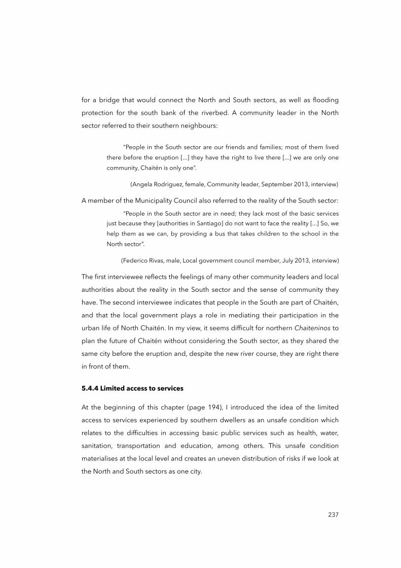
for a bridge that would connect the North and South sectors, as well as flooding
protection for the south bank of the riverbed. A community leader in the North
sector referred to their southern neighbours:
“People in the South sector are our friends and families; most of them lived there before the eruption [...] they have the right to live there [...] we are only one community, Chaitén is only one”.
(Angela Rodriguez, female, Community leader, September 2013, interview)
A member of the Municipality Council also referred to the reality of the South sector:
“People in the South sector are in need; they lack most of the basic services just because they [authorities in Santiago] do not want to face the reality [...] So, we help them as we can, by providing a bus that takes children to the school in the North sector”.
(Federico Rivas, male, Local government council member, July 2013, interview)
The first interviewee reflects the feelings of many other community leaders and local
authorities about the reality in the South sector and the sense of community they
have. The second interviewee indicates that people in the South are part of Chaitén,
and that the local government plays a role in mediating their participation in the
urban life of North Chaitén. In my view, it seems difficult for northern Chaiteninos to
plan the future of Chaitén without considering the South sector, as they shared the
same city before the eruption and, despite the new river course, they are right there
in front of them.
5.4.4 Limited access to services
At the beginning of this chapter (page 194), I introduced the idea of the limited
access to services experienced by southern dwellers as an unsafe condition which
relates to the difficulties in accessing basic public services such as health, water,
sanitation, transportation and education, among others. This unsafe condition
materialises at the local level and creates an uneven distribution of risks if we look at
the North and South sectors as one city.
237

Figures 5.25 and 5.26 show that Chaiteninos in the South must walk long distances
to access these services. Distances in Figure 5.25 were calculated using the Google
Earth Pro measuring tool, considering the principal street corners in the North and
South sectors according to the interviewees. Walking time was calculated using the
preferred walking speed in Chile: 1.1 mts/sec. (MINVU, 2009).
Figure 5.25. Walking distances between two spots in Chaitén in 2005 and 2016
Source: elaborated by the author (2017); satellite images from IGM (2012) and Google Earth Pro (2016)
Southsector
2005 2016
CH7
CH7
CH7
1020 mts15.5 min
Northsector
2290 mts34.7 min
Former Blanco river course (before May 2008) Blanco river course (post-disaster, after May 2008)
CH7
0 200 600 1000MetresLegend
Walking distancesNorth and South sectors
Concentration of servicesMost residents in the sector
238
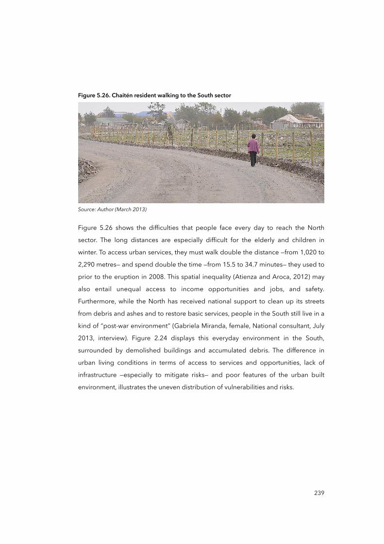
Figure 5.26. Chaitén resident walking to the South sector
Source: Author (March 2013)
Figure 5.26 shows the difficulties that people face every day to reach the North
sector. The long distances are especially difficult for the elderly and children in
winter. To access urban services, they must walk double the distance —from 1,020 to
2,290 metres— and spend double the time —from 15.5 to 34.7 minutes— they used to
prior to the eruption in 2008. This spatial inequality (Atienza and Aroca, 2012) may
also entail unequal access to income opportunities and jobs, and safety.
Furthermore, while the North has received national support to clean up its streets
from debris and ashes and to restore basic services, people in the South still live in a
kind of “post-war environment” (Gabriela Miranda, female, National consultant, July
2013, interview). Figure 2.24 displays this everyday environment in the South,
surrounded by demolished buildings and accumulated debris. The difference in
urban living conditions in terms of access to services and opportunities, lack of
infrastructure —especially to mitigate risks— and poor features of the urban built
environment, illustrates the uneven distribution of vulnerabilities and risks.
239

Figure 5.27. Demolished housing units in the South sector of Chaitén
Source: Author (July 2013)
During several visits to the South sector, I observed how residents have invested in
repairing their houses while no public services have been restored. Figure 5.28
shows El Rinconcito, the only grocery store in the sector. In the picture, it is possible
to appreciate the water storage tanks standing high on the roof of the store (black
tank) and on the house on the right (blue tank). This illustrates how they deal with
the lack of water supply. In July 2014, I was informed by another researcher in the
area, Cristian Albornoz, that the neighbourhood association Junta de Vecinos
Chaitén Sur had signed an agreement with the Municipality to provide them with
water through a cistern truck or tanker, which visits the sector twice a week.
240
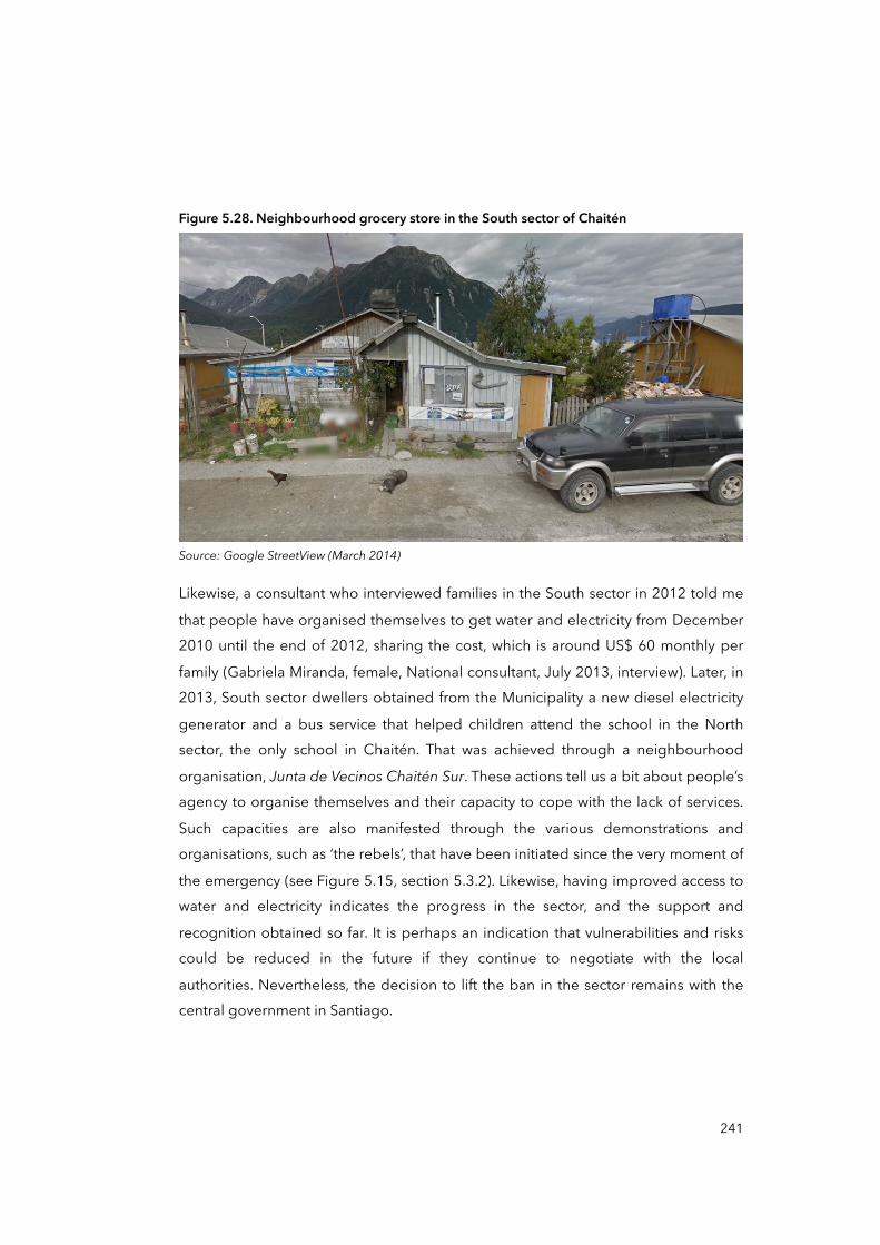
Figure 5.28. Neighbourhood grocery store in the South sector of Chaitén
Source: Google StreetView (March 2014)
Likewise, a consultant who interviewed families in the South sector in 2012 told me
that people have organised themselves to get water and electricity from December 2010 until the end of 2012, sharing the cost, which is around US$ 60 monthly per
family (Gabriela Miranda, female, National consultant, July 2013, interview). Later, in 2013, South sector dwellers obtained from the Municipality a new diesel electricity
generator and a bus service that helped children attend the school in the North sector, the only school in Chaitén. That was achieved through a neighbourhood
organisation, Junta de Vecinos Chaitén Sur. These actions tell us a bit about people’s agency to organise themselves and their capacity to cope with the lack of services.
Such capacities are also manifested through the various demonstrations and organisations, such as ‘the rebels’, that have been initiated since the very moment of
the emergency (see Figure 5.15, section 5.3.2). Likewise, having improved access to water and electricity indicates the progress in the sector, and the support and
recognition obtained so far. It is perhaps an indication that vulnerabilities and risks could be reduced in the future if they continue to negotiate with the local
authorities. Nevertheless, the decision to lift the ban in the sector remains with the central government in Santiago.
241
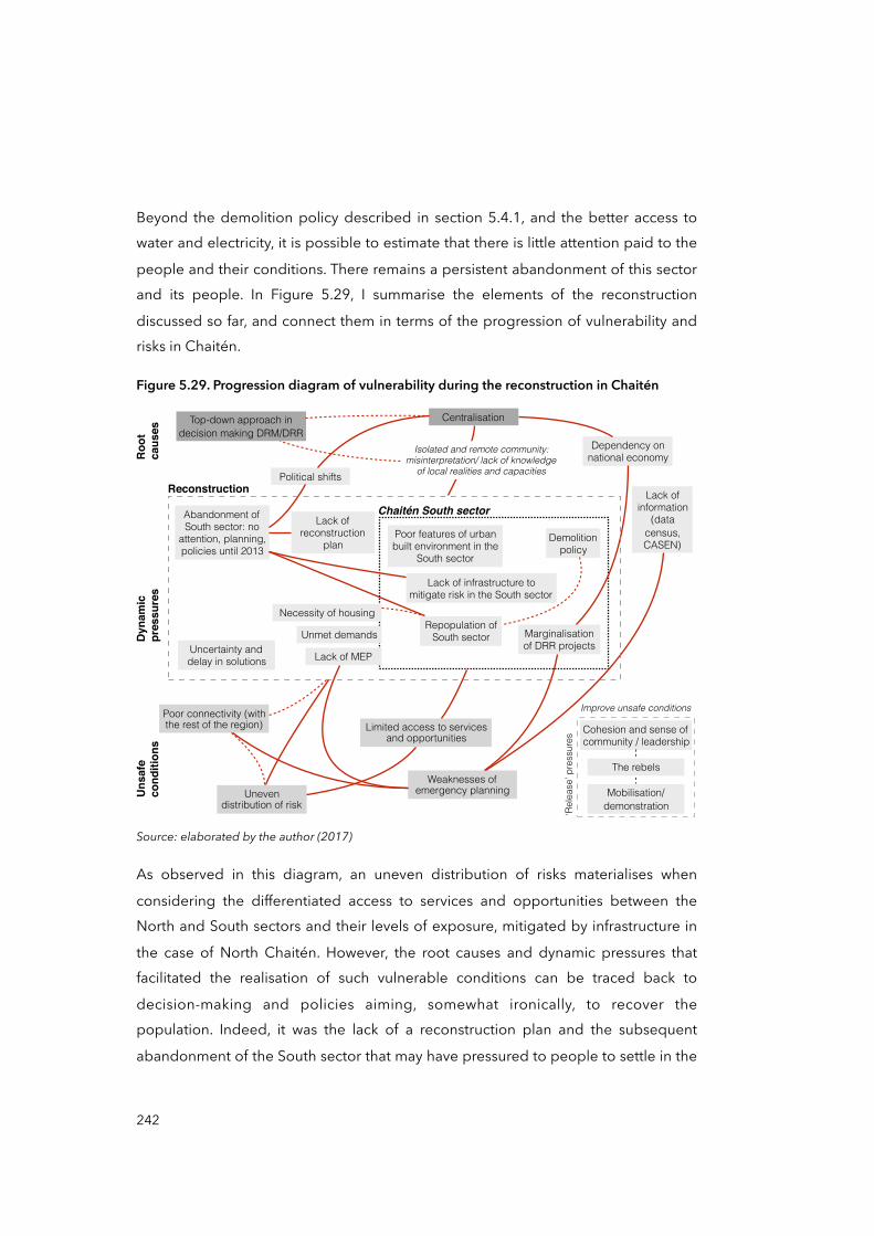
Beyond the demolition policy described in section 5.4.1, and the better access to water and electricity, it is possible to estimate that there is little attention paid to the
people and their conditions. There remains a persistent abandonment of this sector and its people. In Figure 5.29, I summarise the elements of the reconstruction
discussed so far, and connect them in terms of the progression of vulnerability and risks in Chaitén.
Figure 5.29. Progression diagram of vulnerability during the reconstruction in Chaitén
Weaknesses of emergency planning
Lack of information
(data census, CASEN)
Top-down approach in decision making DRM/DRR
Centralisation
Dependency on national economy
Marginalisation of DRR projects
Uneven distribution of risk
Limited access to services and opportunities
Political shifts
Abandonment of South sector: no
attention, planning, policies until 2013
Necessity of housing
Reconstruction
Uncertainty and delay in solutions
Demolition policy
Repopulation of South sector
Lack of reconstruction
plan
Poor connectivity (with the rest of the region)
Lack of infrastructure to mitigate risk in the South sector
Poor features of urban built environment in the
South sector
Unmet demands
Lack of MEP
Chaitén South sector
Roo
tca
uses
Dyn
amic
pr
essu
res
Uns
afe
cond
ition
s
Isolated and remote community: misinterpretation/ lack of knowledge
of local realities and capacities
Cohesion and sense of community / leadership
Improve unsafe conditions
‘Rel
ease
’ pre
ssur
es
Mobilisation/demonstration
The rebels
Source: elaborated by the author (2017)
As observed in this diagram, an uneven distribution of risks materialises when
considering the differentiated access to services and opportunities between the North and South sectors and their levels of exposure, mitigated by infrastructure in
the case of North Chaitén. However, the root causes and dynamic pressures that facilitated the realisation of such vulnerable conditions can be traced back to
decision-making and policies aiming, somewhat ironically, to recover the population. Indeed, it was the lack of a reconstruction plan and the subsequent
abandonment of the South sector that may have pressured to people to settle in the
242
South. The political shift from Bachelet to Piñera’s approach was of fundamental importance for the future of Chaiteninos, but it also demonstrated the vertical
ordering and centralised power of the state. Certainly, this centralisation and top-down approach manifested during the reconstruction, as it did in the other post-
disaster phases, in form of Chaitén’s dependency on the national economy and the marginalisation of DRR projects (see section 5.1.2), and of unmet demands such as
in relation to connectivity and integration between the North and South sectors.
Another unsafe condition detected during the analysis of the reconstruction was the
weaknesses in emergency planning, based mainly on the lack of an updated Municipal Emergency Plan (MEP). MEPs are crucial for the coordination of
emergency actions at local levels such as during evacuation, but also to enable preparedness and DRR actions. Communal Civil Protection Committees (Communal
CPCs)37 in each of the country’s municipality are responsible for elaborating MEPs and updating such plans every year. MEPs are supposedly designed collaboratively
and yearly by different communal actors such as police, fire and health services, and private and civil society organisations. During the fieldwork in 2013, the latest MEP
had been issued in 2010. The lack of an updated MEP can put people directly at risk by not considering actions to assess vulnerabilities, exposure, risks and, eventually,
the necessary actions to reduce them. In other words, it means that the main local leaders such as the Mayor, the police, community-based organisations and so forth
have not met to check their procedures for coordinated action in the event of an emergency. This may have the subsequent effect that such organisations have not
held meetings to review the provisional resources they have and will need in order to ensure the effectiveness of future emergency operations, nor to detect limitations
and opportunities in relation to DRR, and other important measures. The weakness in emergency planning is accentuated by the historical problem of connectivity/
accessibility of the city with the rest of the region and the country, and the lack of information, something crucial for good decision-making (see section 5.1.1). The
lack of an updated MEP —at least until the composition of this thesis— may also suggest a problem with the prioritisation of DRR projects and actions.
243
37 The National Plan of Civil Protection and the role of CPCs are discussed in section 4.4.1, page 156, Chapter Four.
Regarding Chaitén and its multi-scalar progression of vulnerability, it is possible that although there was a significant presence of the state during the emergency and the
post-disaster phase —characterised by its policy response of recovery strategy, relocation, reconstruction— there are other aspects of policy response which operate
in the opposite direction to disaster risk reduction, like those reviewed above. The lack of planning, the little space for participation and the top-down approach of
DRM are some examples. It seems that during the post-disaster phase two opposite forces coexisted, acting at the same time: on the one hand were all the processes
aiming to respond to the emergency and recovery, while on the other there were underlying processes that diminished the potential of such response actions and
ultimately became sources of future vulnerabilities and risks.
However, there were also counteracting elements inherent in people and the
community that were able to focus the pressure over unsafe conditions: the community group deemed ‘the rebels’ is a good example of self-organisation and
determination which has not stopped fighting for attention from regional and national authorities, as is the fact that people in the South sector are now organising
themselves to cope with the lack of basic services and to fight for attention, too. This can be seen as an indication of the capacities of people and of communities that
should be considered when improving unsafe conditions in the sector. This study has not focused on the ‘release’ aspects of vulnerability and risk production, rather, it
aimed to explore the pressure processes within the model of DRM and DRR and the institutional and policy responses, with the intention of re-problematising the
production of vulnerability and risks from that angle. Nevertheless, I think it is analytically precise to recognise that communities and people are not mere
recipients of support who are passively affected by policy responses to disasters. For these reasons, I think further investigations of Chaitén and other similar cases should
look at incorporating a more comprehensive characterisation of the capacities and abilities of people and communities.
244
5.5 Mapping the progression of vulnerability
So far, I have analysed policy responses from authorities, governments and
institutions at different level —local, regional and national— relating them to the context of Chile, but specifically to the model of disaster risk management and
reduction. I have tried to connect such responses with the potential underlying causes of unsafe conditions and vulnerability, with the intention of understanding
why policy responses to the Chaitén disaster have not effectively reduced vulnerability. In the process, I observed four relevant unsafe conditions:
• Erosion of trust in authorities
• Uneven distribution of risks
• Limited access to services and opportunities
• Weaknesses in emergency planning
These vulnerable conditions are specific to Chaitén city and place-dependent. However, the dynamic pressures that facilitated their materialisation may have been
influenced by the verticality of the model of DRM and DRR, as well as by the centralisation of decision-making. For instance, a process that initially contributed to
the erosion of trust in authorities was the evacuation. The unplanned destinations, the fact that families were separated and the false indication that they could return
days later for their animals, pets, belongings and other valuables were just some of the reasons given by interviewees arguing that they would not follow authorities’
indications in future emergencies. As we reviewed in section 5.2.2, the evacuation was applied by the national government using a top-down approach that did not
consider people’s capacities, needs and local realities, revealing how pressures that give rise to unsafe conditions can be distant and nested at major scales. The same
logic is repeated with other elements of policy response, such as the compensatory measures —subsidies and benefits—, the relocation project and the reconstruction.
Figure 5.30 tries to capture a more complete picture of the progression of vulnerability for the case of Chaitén, considering the elements discussed in Chapter
Four and Chapter Five. This figure puts together all progression diagrams introduced throughout this chapter (Figures 5.13, 5.17, 5.21 and 5.29), which were
in fact partial sections of the full case.
245

246
Figure 5.30. Progression diagram of vulnerability for the case of post-disaster Chaitén
Elaborated by the author (2017)
Erosion of trust in authorities
Weaknesses of
emergency planning
Lack of inform
ation (census, C
ASEN)
Splitting of fam
ilies Lack of preparation for the evacuationBelief people
could return for their belongings
Preparedness/contingency M
isinterpretation of the volcanic threat
Top-down approach in
decision making D
RM/D
RRReactive approach on
DRM
and DRR
Centralisation
Evacuation
Dependency on
national economy
Marginalisation
of DRR projects
Presidential D
elegateDisarticulation of
social structure
Accountability / irregularities in the recovery process
Uneven
distribution of risk
Chaitén Law
Compensation/benefits / subsidies
Limited access to services and
opportunities
Uncertainty and
delay in solutions
Lack of planning in the recovery
Poor supervision
Relocation / New Chaitén
Poor participation
Political pressure /
Time
constraints
Important
delays
High costs
2010 Maule
earthquake
Cancellation of
the project by the executive
Num
ber of returned people to C
haitén increased
Political shifts
Abandonment
of South sector
Necessity
of housing
Reconstruction
Uncertainty and
delay in solutions
Dem
olition policy
Repopulation of South sector
Lack of reconstruction
plan
Poor connectivity (with
the rest of the region)
Lack of infrastructure to m
itigate risk in the South sector
Poor built environm
ent in the South
sector
Unm
et dem
ands
Policy responses scenario
Lack of M
EP
Dynamic pressures / Root causesUnsafe conditions
Cohesion and sense of
comm
unity / leadership
Improve unsafe conditions
‘Release’ pressures
Mobilisation/
demonstration
The rebels
Every element of this progression diagram has been explained and discussed
individually in different sections in this chapter, so after introducing the diagram I will
concentrate on analysing and connecting the main processes of the case study. The
first thing that stands out from the figure is the gradient area. This attempts to
represent the scenario in which root causes and dynamic pressures are embedded
and which facilitates the production and progression of vulnerable conditions. This
scenario contains the four principal processes of policy response analysed:
evacuation; compensation, benefits and subsidies; relocation and New Chaitén; and
reconstruction.38 The gradient is used here to visualise a continuum rather than an
exact line that separates root causes from dynamic pressures, and for that reason
these processes should not be seen merely through the lens of cause and effect. As
described in the PAR model, root causes and dynamic pressures “are not
independent of each other, they are intricately connected in a series of mutually
influencing relationships that obscure causes and consequences” (Wisner et al.,
2004, p.62), and although the perspective adopted in the study aligns with the
cause-effect approach, in this study I refer to cause and effect in the sense of
cascades, as cumulative and non-linear sequential processes that may trigger
complex effects such as vulnerability (Wisner et al., 2004). Processes such as
centralisation or the top-down approach of DRM, highlighted in blue coloured
boxes, are proposed as influential elements rather than single causes of single
effects.
Figure 5.30 also illustrates a relevant number of processes and events at the root
causes/dynamic pressures level. Among them, the reconstruction phase stands out
because of the number of links —six in total— with several unsafe conditions. This
could be explained by reconstruction being the latest phase in the progression
analysis, and therefore closer to the materialisation of unsafe conditions.
Centralisation also attracts attention because of its connections —eight in total— with
the four main processes of policy response analysed. This could be related to the
247
38 Analysis of each of these processes is found in this order: early response on page 193 (summarised in Figure 5.13); compensation strategy on page 212 (summarised in Figure 5.17); relocation and New Chaitén project on page 217 (summarised in Figure 5.21); and reconstruction on page 229 (summarised in Figure 5.29).
fundamental role of decision-making of DRM in Chile, characterised by its
centralisation at the national level. Nevertheless, analysis of the progression of
vulnerability would benefit from a multi-scalar visualisation that better distributes the
analysed elements, in terms of the geographical scale at which they were generated
and their historical moments.
For that reason, a multi-scalar visualisation could offer an advantageous perspective
for looking at dynamic pressures and root causes in relation to structural factors of
society and institutions, increasing the chances of scaling up observations and
positing conclusions, although still within the inherent limitations of the study. By
scaling up, I meant looking at how the progression of vulnerability takes place
beyond the materiality of Chaitén, and how general processes of DRM and DRR
could reproduce vulnerabilities in the future in other cases in Chile. To address the
question of enabling a multi-scalar perspective for the progression of vulnerability, I
have the elements discussed so far are plotted on a Cartesian coordinate system
(see Figure 5.31) that considers different geographical scales (X-axis) and the
progression of vulnerability (Y-axis). To place each element, I asked two simple
questions in this order:
• At which level is the process or event originated or nested? —global, national, regional or local.
• If it is not possible to know its origin, which scale is this element or event affecting?
Figure 5.31 plots a significant proportion (nearly two-thirds) of processes and events
that are situated above the first horizontal dotted line. This line separates the area of dynamic pressures (rectangle at the centre) from the unsafe conditions at the
bottom. This reflects an underlying and intricate web of causes and drivers that participate in the production and progression of vulnerability, a complexity that is
somehow tamed thanks to the PAR model and the adoption of a multi-scalar perspective. Another observation is that certain processes of policy response are
more or less dispersed on the scale dimension (X-axis). For instance, the elements of relocation/New Chaitén (in red colour) are mainly concentrated in the area of the
national scale, reflecting that the process of relocation may have been influenced principally by national processes and decision-making.
248

249
Figu
re 5
.31.
Tent
ativ
e sc
atte
r dia
gram
for p
olic
y re
spon
ses i
n po
st-d
isast
er
Chai
tén,
con
sider
ing
‘pro
gres
sion
of v
ulne
rabi
lity’
and
‘geo
grap
hica
l sca
les’
Uns
afe
cond
ition
s
Roo
t cau
ses
Nat
iona
l /G
loba
lLo
cal
Top-
dow
n D
RM/D
RRRe
activ
e D
RM/D
RR
Cen
tralis
atio
n
Mis
inte
rpre
tatio
n of
thre
at
Pres
iden
tial
Del
egat
e
Poor
Ac
coun
tabi
lity
in R
ecov
ery
Retu
rned
pe
ople
to
Cha
itén
Lack
of
info
rmat
ion
Dep
ende
ncy
on
natio
nal e
cono
my
Polit
ical
sh
ifts
Repo
pula
tion
Sout
h se
ctor
Split
ting
of
fam
ilies
Unp
lann
ed
evac
uatio
n
Retu
rn fo
r be
long
ings
Dis
artic
ulat
ion
of
soci
al s
truct
ure
Cha
itén
Law
Unc
erta
inty
on
sol
utio
ns
Unp
lann
ed
com
pens
atio
n
Poor
su
perv
isio
n Poor
pa
rtici
patio
n
Polit
ical
pr
essu
re /
Tim
e co
nstra
ints
Impo
rtant
de
lays
Hig
h co
sts
2010
Mau
le
earth
quak
e
Can
cella
tion
New
Cha
itén
Mar
gina
lisat
ion
DRR
pro
ject
s
Aban
donm
ent
Sout
h se
ctor
Nec
essi
ty
Hou
sing
Del
ays
on
solu
tions
Dem
oliti
on
polic
y
Lack
re
cons
truct
ion
plan
Lack
miti
gatio
n So
uth
sect
or
Unm
et
dem
ands
Lack
of
MEP
Erod
ed tr
ust
in a
utho
ritie
s
Wea
k em
erge
ncy
plan
ning
Une
ven
risk
Lim
ited
acce
ss
Poor
co
nnec
tivity
Mai
n ro
ot c
ause
sM
ain
unsa
fe c
ondi
tions
Evac
uatio
n / R
espo
nse
Com
pens
atio
n / benefit
Rel
ocat
ion
/ New
Cha
itén
Rec
onst
ruct
ion
Lege
nd
Elab
orat
ed b
y th
e au
thor
(201
7)
In contrast, the elements of the reconstruction are more dispersed along the X-axis, indicating that more actors and processes interacted in the reconstruction than in
the relocation process. This may be so because, firstly, during the relocation in 2009, Chaiteninos were dispersed and not very active —except the rebels— and,
secondly, the reconstruction encountered a local government back in place, people and community structures already existing in the city, and a national government in
retreat or less present than in previous years as a consequence of the presidential shift and the Maule earthquake in 2010.
Despite its potential, however, this diagram needs to be complemented by the previous progression diagram (Figure 5.30) to better understand why these policy
responses have not reduced people’s vulnerability. Figure 5.31 does not completely show the relationships between the elements —for instance, how the relocation
project (in red) influenced the return of people to Chaitén and the erosion of trust in authorities. In that respect, I would like to point out that the lack of planning during
the post-disaster phase was an important driver of vulnerability in the current Chaitén. In the diagram above, it is possible to observe that evacuation,
compensation/benefit and reconstruction all contain the lack of planning element ‘lack of planning’ —underlined text— as a fundamental and root cause: for instance,
the lack of a reconstruction plan provoked the abandonment of the South sector by the authorities and then its repopulation (see section 5.4.2, page 233). In contrast,
the New Chaitén project did not have problems with planning, in the sense that the government worked on a master plan for the new city, dedicating time and
resources to studying and planning solutions. However, it faced critical problems in coping with political and economic pressures, and time constraints that created
important delays. So, being costly, without political and popular support, and delayed, the relocation was definitively aborted by the national government in
December 2010 (see sections 5.3.4. and 5.3.5, pages 217 and 226 respectively).
Finally, a last observation on Figure 5.31 is directed to the gap that exists on the
intermediate or regional scale, that is, the empty space between national and local scales. This gap may have been produced because most of the policy responses
were nested within and articulated from the national power: the national government had the power to decide and articulate most of the policy responses,
showing its gravitational role within the model of DRM and DRR. Likewise, this gap
250
reflects the centralisation of decision-making in the case of Chile, exposing the power of the national over regional and local powers (see more details in sections
4.2.3 and 4.3 in Chapter Four).
Concluding this chapter, I would like to offer a complementary third diagram
centred on the temporal scale. The conceptual diagram in Figure 5.32 uses the same progression of vulnerability dimension (Y-axis) as Figure 5.31, but it replaces
geographical scales with a temporal dimension (X-axis). The exercise is exploratory and seeks to analyse how distant the causes and drivers are from the unsafe
conditions. By exploratory, I mean that this exercise cannot be completely exhaustive because the data collection instruments and methods were designed to
look at the geographical scale dimension rather the temporal.
To initiate the exercise, I selected only the elements that could be expressed in time,
asking two simple questions:
• At what time/date was this event or process initiated?
• If it is not possible to estimate an initial date, at what time was this event or process realised or materialised?
At first sight, the diagram shows a more distinctive pattern of distribution of the
analysed elements, suggesting a more linear relationship between time and the progression of vulnerability. Wisner et al. (2004, p.52) assert that the root causes are
always “distant in a spatial and temporal sense”, so the pattern found in Figure 5.32 is congruent with such a proposition. If we look at the details, we can find some
differences from the geographical dimension in Figure 5.31. For instance, processes of policy response such as the evacuation are less dispersed: the elements are
concentrated at the beginning of 2008 (May) because the evacuation occurred in a relatively short period of time. This is also the case for the relocation/New Chaitén
(in red). This may indicate that policy responses in the case of Chaitén have tended to occur concatenated over time, which is plausible if we consider the cyclical, but
sequential, process of disaster management (see Figure 3.3 in Chapter Three). Nevertheless, other processes remain dispersed over time, such as the
reconstruction. This may be because the reconstruction covered a larger period of time —from 2010 onwards. This may imply that, over time, longer processes of policy
response may present more dispersed dynamic pressures and root causes.
251
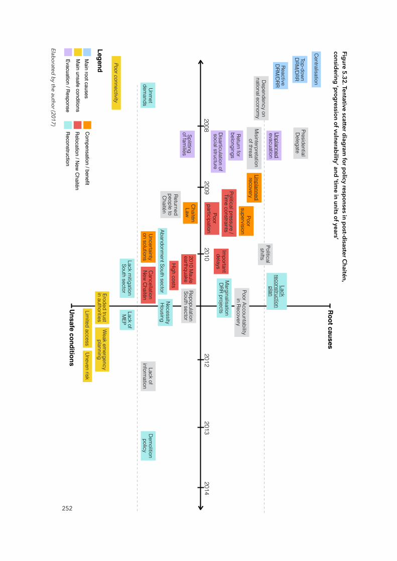
252
Figure 5.32. Tentative scatter diagram for policy responses in post-disaster Chaitén,
considering ‘progression of vulnerability’ and ‘time in units of years’
Unsafe conditions
Root causes
20082014
Top-down DRM
/DRR
Reactive DRM
/DRR
Centralisation
Misinterpretation
of threat
Presidential Delegate
Poor Accountability in Recovery
Returned people to Chaitén
Lack of inform
ation
Dependency on national econom
y
Political shifts
Repopulation South sector
Splitting of fam
ilies
Unplanned evacuation
Return for belongings
Disarticulation of social structure
Chaitén Law
Uncertainty on solutions
Unplanned recovery
Poor supervision
Poor participation
Political pressure / Tim
e constraintsIm
portant delaysHigh costs
2010 Maule
earthquake
Cancellation New Chaitén
Marginalisation
DRR projects
Abandonment South sector
Necessity Housing
Demolition
policy
Lack reconstruction
plan
Lack mitigation
South sector
Unmet
demands
Lack of M
EP
Eroded trust in authorities
Weak em
ergency planning
Uneven risk Lim
ited access
Poor connectivity
Main root causes
Main unsafe conditions
Evacuation / Response
Com
pensation / benefit
Relocation / N
ew C
haitén
Reconstruction
Legend
20132012
20102009
Elaborated by the author (2017)
Finally, it is true that the temporal dimension of the progression of vulnerability was
not directly included in the methodological design, nevertheless, time is a constant
within such progression (Wisner et al., 2004). Therefore, during the study, I collected
the dates of the different policy responses, decision-making, events and actions
almost unintentionally. The data collected refer to the year or month in which a
policy was conceived, the date on which a decision was made, and the like. I think
that incorporating a historical perspective to analyse the progression of vulnerability
from the beginning would perhaps have facilitated a deeper look at more distant
events and processes than those examined here. This could, of course, be a matter
for future investigations.
The next chapter is the last of this thesis, in which I will try to offer a comprehensive
reflection on the process of research. Centred on the analysis made during the last
two chapters, I seek to address how the thesis responds to the research questions
and how it contributes to knowledge in epistemological, methodological and
empirical terms.
253
Chapter SixConclusions
Introduction
In the previous chapters, we explored and analysed specific links between temporally and spatially distant processes —e.g. policy responses, governance and decision-making, institutions— and the local ‘materialisation’ of vulnerability in the form of ‘unsafe conditions’ in Chaitén. As formulated in Chapter One, the main research question reads: How have policy responses to disasters influenced the progression of disaster vulnerability, at different scales, in post-disaster Chaitén?Each chapter unpacked the different components of the enquiry to provide the empirical grounds for answering the question. This study found that policy responses and other vulnerability causal factors were distanced from Chaitén itself —as the theory of vulnerability suggested— and organised according to their scalar nature: national, regional, and local.
The main question had two subsidiary dimensions that aimed to focus on specific elements of vulnerability creation. The first centred on critically determining that vulnerabilities in Chaitén are locally materialised in form of, for instance, uneven distributions of risks. The second looked at how these unsafe conditions were not exclusively locally produced —as distant, extra-local processes of policy response and decision-making may have contributed to the materialisation these vulnerabilities. These two dimensions are two sides of the same coin, and were expressed on the research design as ‘entry points’ (see Figure 6.1).39 The figure below develops these two dimensions investigated in the case study. One could be called ‘inductive’ or ‘bottom-up’, because it tried to reflect the progression from the specificity and locality of Chaitén, to processes of policy response and decision-making. In contrast, the second could be called ‘top-down’ entry point, as it attempted to trace, document, and reflect these processes of policy response from more general social processes such as the Chilean state territorial organisation and its model of DRM.
255
39 See alternatively the ‘research process’ in Figure 2.5, page 53.
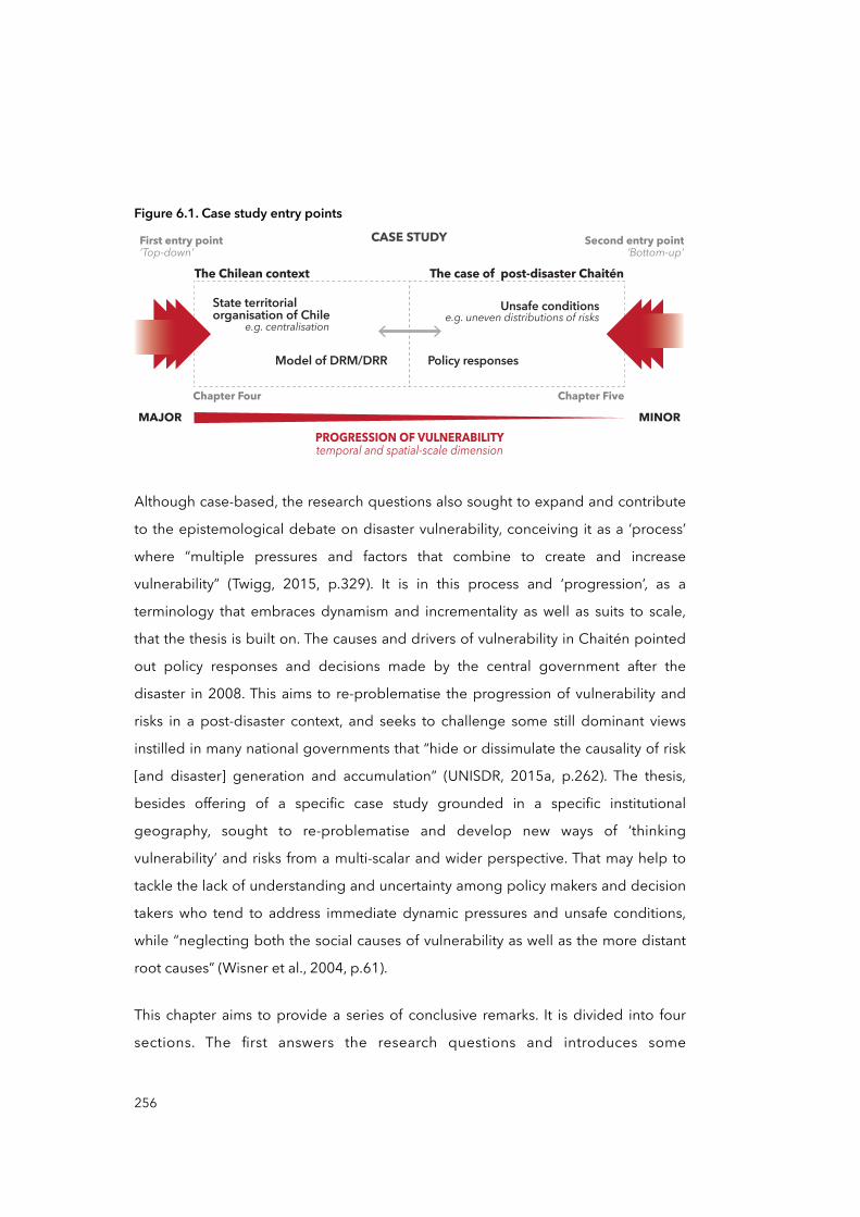
Figure 6.1. Case study entry points
First entry point‘Top-down’ ‘Bottom-up’
Second entry pointCASE STUDY
Chapter Four Chapter Five
The case of post-disaster Chaitén
Unsafe conditionse.g. uneven distributions of risks
Policy responses
MAJOR MINORPROGRESSION OF VULNERABILITYtemporal and spatial-scale dimension
The Chilean context
State territorial organisation of Chile
Model of DRM/DRR
e.g. centralisation
Although case-based, the research questions also sought to expand and contribute
to the epistemological debate on disaster vulnerability, conceiving it as a ‘process’
where “multiple pressures and factors that combine to create and increase
vulnerability” (Twigg, 2015, p.329). It is in this process and ‘progression’, as a
terminology that embraces dynamism and incrementality as well as suits to scale,
that the thesis is built on. The causes and drivers of vulnerability in Chaitén pointed
out policy responses and decisions made by the central government after the
disaster in 2008. This aims to re-problematise the progression of vulnerability and
risks in a post-disaster context, and seeks to challenge some still dominant views
instilled in many national governments that “hide or dissimulate the causality of risk
[and disaster] generation and accumulation” (UNISDR, 2015a, p.262). The thesis,
besides offering of a specific case study grounded in a specific institutional
geography, sought to re-problematise and develop new ways of ‘thinking
vulnerability’ and risks from a multi-scalar and wider perspective. That may help to
tackle the lack of understanding and uncertainty among policy makers and decision
takers who tend to address immediate dynamic pressures and unsafe conditions,
while “neglecting both the social causes of vulnerability as well as the more distant
root causes” (Wisner et al., 2004, p.61).
This chapter aims to provide a series of conclusive remarks. It is divided into four
sections. The first answers the research questions and introduces some
256
epistemological implications illustrating how policy responses to disasters may,
counterintuitively, contribute to (re)produce risks. This part also answers the
question showing how vulnerability is locally ‘materialised’, and how the state
territorial organisation of Chile and its model of managing and governing disasters
are connected. The second section introduces some methodological and empirical
implications that re-problematise the progression of vulnerability and risks and
advances policy responses to disasters. The third section offers some final remarks
and reflections on the research journey, while the fourth section presents
suggestions for further research.
6.1 Research questions and epistemological implications
6.1.1 Vulnerability locally materialised
Dominant views of ‘disaster risk’ still recall the dilemma of ‘taking the naturalness out
of natural disasters’ (O'Keefe et al., 1976), restricted views that see disasters
‘natural’, “as if nature were the executioner and not the victim” (Galeano, 2012, p.
113). This ontology determines that models of management are still dominated by
the paradigm of ‘disaster risk’, where efforts and resources are concentrated in
emergency management and preparedness, as well as in corrective or
compensatory risk management, rather than in prospective governance of risks, with
sensitive risk development in social, economic, and environmental terms (Lavell and
Maskrey, 2013). Restricted views that still persist in many countries and national
models of disaster management (UNISDR, 2015a): “this is the space into which most
nations have yet to tread” (Lavell and Maskrey, 2013, p.7). Chapter Two posed the
question: How and why did the Chilean model of DRM facilitate the production
and progression of specific vulnerabilities in post-disaster Chaitén? with the
intention to explore and bring to light the underlying causes and relations that take
place at multiple scales to, ultimately, see what makes possible vulnerability become
actual vulnerability. To disentangle the multiple causes and drivers that create and
reproduce vulnerability, the disaster Pressure and Release (PAR) model is a useful
257

analytical tool, allowing us to distinguish and categorise diverse elements into ‘root
causes’, ‘dynamic pressures’, and ‘unsafe conditions’.
In Chapter Five, the current vulnerabilities detected in Chaitén are expressed in the
form of local-specific unsafe conditions and specifically: a) the erosion of trust in
authorities, b) the uneven distribution of risks, c) the limited access to services, and
d) the weaknesses in emergency planning. These conditions were materialised
through several stages, both spatially and temporally, by policy responses and
decision-making actions40. For instance, the figure below develops the progression
of the unsafe condition in Chaitén that we defined as ‘weak emergency planning’.
This links basically to the lack of a Municipal Emergency Plan (MEP), which puts
people at risk because there is no preparedness. Some of the reasons behind this
lack of preparation relates to the centralisation of disaster governance, which is
mainly reactive and top-down oriented, producing inadequate reconstruction
planning and poor participatory mechanisms.
Figure 6.2. Vulnerability progression diagram, Chaitén reconstruction phase
Unsafe conditions
Root causes
National Local
Top-down DRM/DRR
Reactive DRM/DRR
Centralisation
Marginalisation DRR actions
Abandonment South sector
Necessity Housing
Delays on solutions
Demolition policy
Lack (participatory) reconstruction plan
Lack mitigation South sector
Unmet demands
Lack of MEP
Weak emergency planning
Uneven risk
Limited accessMain root causes
Main unsafe conditions
Reconstruction
Legend
As we reviewed in section 4.2 (page 134), the scalar logic of policy responses and
decision-making resides in the way in which the national model of disaster
258
40 See other examples in Chapter Five —Figures 5.13, 5.17, 5.21, 5.29, and 5.30.

management operates and its organisational structure, which has tended to
reproduce the hierarchical structure of the state. Centralised, top-down
approached, and reactive, the practice of managing disasters set the ‘ground rules’
that allowed national authorities ‘dictate’ policies and decisions without taking into
consideration local aspirations, demands, and needs. This creates the conditions for
national actors such as the Presidential Delegate to ignore and underestimate
people’s demands and aspirations while it justifies a top-down response to disasters
and recovery. The Presidential Delegate, for instance, eroded the trust of
Chaiteninos on public authorities and institutions, and this may negatively affect
future evacuations and the effectiveness of DRR strategies in the long run.
In Chaitén, the ‘uneven distribution of risk’ to volcanic hazards can be understood as
a vulnerable condition that Chaiteninos face at the local level. Here, ‘local’ refers to
the spatial proximity of women and men to the source of hazard —the Chaitén
volcano at just 10 Kilometres from the city. Such proximity to a volcanic hazard
should suppose a homogeneous distribution of risk, but it does not. Chapter Five
expounded upon the observation that exposure and risks are unevenly distributed
despite the common spatial feature of volcanic proximity. Exposure to volcanic
hazard in Chaitén is disproportionally distributed between people settled to the
North and South. The North sector counts with flood protections that mitigate its
exposure to potential volcanic mudflows that may be produced in future eruptions,
while the South sector lacks such measures (see Figure 5.22, page 230). More
importantly, the ‘origins’ of this imbalance or, to use the PAR terminology, its ‘root
causes’ point to the decision-making process headed by authorities who are far
removed in time and space from the affected location. Three particular decisions
affected the ‘uneven distribution of risk’: i) aborting the New Chaitén relocation
project, ii) reconsidering the North sector as habitable in 2010 but maintaining the
state of ‘uncertainty’ about the South sector, iii) and postponing the expansion of
housing development. These had an important impact on the number of people —
i.e. 200 families by late 2014— that informally reside in the South sector at present
Policy responses aimed to support the entire community, but failed in facilitating the
259
development of multi-scale partnerships between stakeholders —including extra-
local actors— and in providing appropriate and timely solutions. As other
documented cases have suggested (Bicknell et al., 2009; Gero et al., 2011; Pelling
and Wisner 2009), successful disaster management efforts are those that include
major and minor scale actors, allowing “local strength and priorities to surface in
disaster risk management, while acknowledging also that communities —including
local government— have limited resources and strategic scope and alone cannot
always address the underlying drivers of risk” (O’Brien et al., 2012, p.464).
The analysis of local leaders’ narratives and voices, collected in Chapter Five,
pointed to an ‘erosion of trust in authorities’. The lack of trust can negatively shape
vulnerability by altering evacuation strategies as well as by diminishing the effect of
compensatory and recovery policies (Cutter et al., 2003). Although trust in
authorities is somehow ‘observable’ at local level, its root causes are linked to the
fact that decision-making and policy responses are applied by temporally and
spatially distant actors. Several of the evidences collected in interviews pointed
towards the same idea: in case of an eventual volcanic eruption, people will not
follow authorities’ instructions, and it will be difficult to ‘believe’ again in what
authorities say. In other words, Chaitén’s people may react negatively to the idea of
evacuating the city again in case of future extreme events. Six situations propitiated
the ‘erosion of trust in authorities’:
i) ‘Misinterpretations’ by authorities about the existence of a volcano in the area, as well as the early and wrongly conclusions on the ‘tremors’ days before
the eruption,
i) the splitting up of families during the evacuation, as well as the false
statement that they could return to their belongings days later,
ii) poor supervision over spending of public money that triggered several
investigations about irregularities and misuse of public funds by authorities,
iii) the lifting of the ban to inhabit the North sector but not considering the South,
260
iv) the abandonment of the New Chaitén project after two years of planning, ‘spending’, and consulting efforts,
v) and the creation of a ‘parallel’ authority —the Presidential Delegate— that bypassed regional and local authorities.
Because its historical roots in de- centralising and centralising strategies of the
Chilean state formation (see sections 4.2.1 and 4.2.2, pages 134 and 139
respectively), the mode of operation of the Chilean DRM in the case of Chaitén
reflects a centralised and top-down governance system. Although much of the
recent literature on DRR stresses the importance of good governance as a key factor
that creates an enabling environment for risk reduction policies and programmes
(UNISDR, 2009b, 2015b), Scott and Tarazona (2011) assert that an important majority
of countries operated with centralised and top-down models of management. In a
certain way, we can say that what we found in Chile is corroborated and confirmed
by different disciplinary research on disasters.
The 2015 Global Assessment Report on Disaster Risk Reduction (GAR) (UNISDR,
2015a) points to poor governance as a key underlying risk driver. But in Chaitén it
was not ‘poor governance’ or ‘weak policy responses’ alone that created the
conditions to reproduce risks or create new ones. Rather, it was that the verticality of
the model of management somehow obstructed the inclusion of local actors. In
other moments of the post-disaster phase, as during the New Chaitén relocation
project, it seems that good DRM governance not only was dependent on its own
internal arrangements but also on a broader context of existing governance
systems. How the presidential elections and the change of the central administration
precipitated the end of the New Chaitén project are good examples that disaster
governance is intertwined with a multiplicity of actors and political processes. It
seems that the DRM model of Chile works well to respond to emergencies and
reducing fatalities, something that has been highlighted nationally and
internationally (American Red Cross Multidisciplinary Team et al., 2011; Kaufmann,
2010; López Tagle and Santana Nazarit, 2011; MAE Center et al., 2010). But Chaitén
261
sheds light on how policy responses to disasters, when they do not provide sound,
participatory, and timely solutions, could facilitate the production and reproduction
of unsafe conditions, and contributing to and perpetuating the generation of risks
over time.
6.1.2 Root causes of disaster vulnerability are often distant
Although Wisner et al. (2004) developed an analytical framework to consider root
causes of vulnerability and risks, these concepts have been criticised for being too
generic (DKKV, 2012; Birkmann, 2011). For instance, they are based on a widely-
used definition41 of disaster risk to identify root causes of disasters as a result of
different development patterns that determine dynamic pressures, which then
shape a range of unsafe conditions. According to the DKKV (2012), this view is
limited as they present more general or “macro-economic root causes […] based on
the perspective of political economy” (p.14) and therefore, in some cases,
underestimate “the role of context specific and local root causes” (Birkmann, 2011,
p.1127). Although is clear that context-specific processes are important to define
drivers and root causes of vulnerability, this present study raises the issue of which
scale we should consider as ‘context’ specific. A ‘context’ of disaster risk creation
should not be only grasped at one single scale, whether it be local, regional, ‘or’
national. Rather we should always consider the vertical and horizontal linkages
between local ‘and’ extra-local scales (Brenner 2009). The institutional configuration,
functions, histories, and dynamics of any unsafe condition at local scale should be
always grasped relationally, in terms of its “upwards, downwards, and transversal
links to other geographical scales situated within the broader interscalar
configuration in which it is embedded” (Brenner, 2009, p.72). Practically no ‘local’
processes occur isolated from other territorial units, making it imprecise to speak of
root causes in single-scale terms. Such formulations misleadingly imply that, from a
local scale, the multiplicity of factors that create vulnerabilities and risks at local level
262
41 “hazard × vulnerability* = risk → disaster” (Wisner et al. 2004, p.49). *root causes, dynamic pressures, and unsafe conditions.
can be contained and coherently grasped. This, however, ignores the essential task
of analysing the relational nature of the progression of vulnerability.
The second question posed earlier in Chapter Two: Why have policy responses to
disasters in Chaitén not effectively reduced vulnerability? was made with the
intention of understanding how certain causes and drivers such as policy responses
and decision-making may have influenced the ‘materialisation’ of vulnerability in
Chaitén. Specifically addressed in Chapter Five, the features of ‘centralisation’, ‘top-
down decision-making’, and ‘reactiveness’ of the DRM model were diagnosed as
historically reproduced in the manifold dimensions on how the state is structured.
Built on the national concentration of powers and in a process of ‘administrative’ and
‘vertical’ decentralisation with little intention to redistribute economic and political
powers to regional and local levels (Montecinos, 2013), this ‘context’ has influenced
the managerial model of DRM and DRR in Chile, especially influencing policy
responses and decision-making.
The territorial structure of the Chilean state is representative of a ‘centralised’ scalar
organisation where most of the economic activities, people, and opportunities
concentrate in the Santiago Metropolitan Region (SMR) —see section 4.3 in Chapter
Four. Such structure, established by its history of socio-economic and political
struggles, is influencing the geographical distribution and hierarchical organisation
of disaster management decisions and its relative budgeting: from the National
Emergency Office (ONEMI) to the Territorial Planning Instruments (IPTs), and
Municipal Emergency Plans (MEPs).
As Chapter Four points out, IPTs and several legal frameworks —such as the Law
Nº19,175 on regional and municipal powers, the Law Nº18,695 on municipal
attributions on security, and the Regional Plans of Territorial Planning or PROTs— aim
to ‘transfer’ the autonomy of dealing with preparedness, prevention, reduction of
exposure and promotion of resilience from national to regional and municipal
levels. However, Chapter Five confirmed that such ‘autonomy’ has not been really
concretising in DRM and DRR governance arrangements that considers local needs,
263
priorities, and capacities in Chaitén. Policy responses to the Chaitén disaster, such as
compensatory measures, relocation, and reconstruction. were the result of the
national government’s decisions. This move was further supported by the decision
of the central government in 2008 to create a ‘parallel’ authority named ‘Presidential
Delegate’. This literally bypassed local and regional authorities when dealing with
recovery, relocation, and reconstruction of Chaitén.
Finally, as described in the previous section, policy responses to the Chaitén disaster
were ineffective in avoiding the (re)production of vulnerabilities because they did
not consider local realities and lacked long term plans that effectively integrate local
actors and people, as well as their ideas and concerns, from the very moment of
evacuation until even today. Whether this should not be treated as a simple
uncritical support of DRM and DRR ‘decentralisation’ —in part because literature have
not empirically demonstrated that ‘decentralisation’ per se is positive or negative
(Scott and Tarazona, 2011) or its unfinished open discussion (Garschagen, 2016)—,
the central point in question here is that a national model of DRM would be always
embedded in broader existing governance system —either centralised or
decentralised, national and/or regional such as in the EU42. And this national
governance system would ultimately influence the form and content of any national
DRM models. In the case of Chile, the findings in Chaitén suggest that inclusive risk
governance will not be possible unless deeper institutional configurations of power
and political will are overcome in the first place.
From another perspective, Chapter Five demonstrated that specific risks in Chaitén
are not only the result of presence or proximity to the volcano —the ‘natural’ hazard
—, rather, its vulnerabilities materialise and risks emerge because of a series of
decision-making and policy responses during the post-disaster phase. During that
period (2008 and 2014), the analysis of Chaitén allows us to see that policy
264
42 More and more, member states of the European Union (EU) see how the economic and social integration is altering national governance systems —e.g. through EU laws and directives—, this posits changes also in the arena of managing disasters and recovery —see for instance the EU Parliament resolution on stepping up the Union's disaster response capacity (European Parliament, 2008).
responses to disasters, although well intended, have contributed to generate new
and reproduce previous vulnerable conditions. Specifically, the informal settlement
in the South sector of Chaitén and the uneven distribution of risks between North
and South were unforeseen effects of, or at least mediated by, policy responses and
decision-making. The reasons why these have not effectively reduced vulnerability in
communities is because the centralisation of the Chilean state has influenced the
top-down model of managing disasters and its policy responses. These, in turn, were
ineffective in preventing the generation of new unsafe conditions because
inadequate reconstruction planning and poor participatory mechanisms did not
effectively consider local actors and people, as well as their ideas and concerns.
6.2 Methodological and empirical implications
Chapter Three reviewed different schools of thought and approaches on the
causation of disasters and its related discourses. They were examined to place the
question of the multi-scalar progression of vulnerability at a suitable junction within
the discussion: at the crossroad between causation and progression of
vulnerabilities. The discussion on the causation of disasters has focused on the
dialectic of natural and human-made systems (Bankoff, 2006; Quarantelli, 1987b).
Some authors such as Turner, Kasperson et al. (2003), Turner, Matson, et al. (2003)
and O’Brien et al. (2004) have focused on the characteristics of social-ecological
systems —biological, biophysical processes, and social systems made up of rules and
institutions that mediate use of resources— to highlight people’s agency and
resilience to disasters, as well as on responsibilities of social systems over
environment change.
Others such as Wisner et al. (2004), Bankoff et al. (2006), and Gunewardena and
Schuller (2008), have focused on the social relations, structures of domination, and
politics behind the production of disaster vulnerability, assuming this is as a
determinant aspect of disaster causation. Building upon the latter, the re-
problematisation of the progression of vulnerability and risk from a multi-scalar
perspective may have several implications. The first of these implications refers to
265
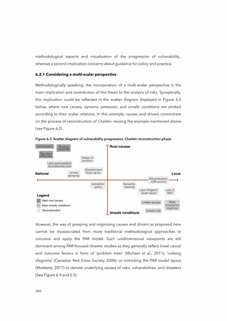
methodological aspects and visualisation of the progression of vulnerability.,
whereas a second implication concerns about guidance for policy and practice.
6.2.1 Considering a multi-scalar perspective
Methodologically speaking, the incorporation of a multi-scalar perspective is the
main implication and contribution of this thesis to the analysis of risks. Synoptically,
this implication could be reflected in the scatter diagram displayed in Figure 6.3
below, where root causes, dynamic pressures, and unsafe conditions are plotted
according to their scalar relations. In this example, causes and drivers concentrate
on the process of reconstruction of Chaitén, reusing the example mentioned above
(see Figure 6.2).
Figure 6.3. Scatter diagram of vulnerability progression, Chaitén reconstruction phase
Unsafe conditions
Root causes
National Local
Top-down DRM/DRR
Reactive DRM/DRR
Centralisation
Marginalisation DRR actions
Abandonment South sector
Necessity Housing
Delays on solutions
Demolition policy
Lack (participatory) reconstruction plan
Lack mitigation South sector
Unmet demands
Lack of MEP
Weak emergency response
Uneven risk
Limited accessMain root causes
Main unsafe conditions
Reconstruction
Legend
However, the way of grasping and organising causes and drivers as proposed here
cannot be disassociated from more traditional methodological approaches to
conceive and apply the PAR model. Such unidimensional viewpoints are still
dominant among PAR-focused disaster studies as they generally reflect lineal causal
and outcome factors in form of ‘problem trees’ (Michael et al., 2017), ‘iceberg
diagrams’ (Canadian Red Cross Society, 2008), or mimicking the PAR model layout
(Moeketsi, 2017) to denote underlying causes of risks, vulnerabilities, and disasters
(See Figure 6.4 and 6.5).
266
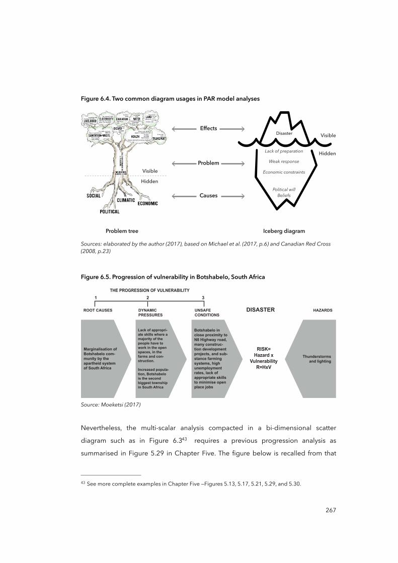
Figure 6.4. Two common diagram usages in PAR model analyses
Effects
Problem
Causes
Problem tree Iceberg diagram
Visible
Hidden
Visible
Hidden
Lack of preparation
Weak response
Economic constraints
Political willBeliefs
Disaster
Sources: elaborated by the author (2017), based on Michael et al. (2017, p.6) and Canadian Red Cross (2008, p.23)
Figure 6.5. Progression of vulnerability in Botshabelo, South Africa
ROOT CAUSES DISASTER
RISK=Hazard x
VulnerabilityR=HxV
HAZARDSDYNAMICPRESSURES
UNSAFECONDITIONS
1
THE PROGRESSION OF VULNERABILITY
32
Marginalisation of Botshabelo com-munity by the apartheid system of South Africa
Lack of appropri-ate skills where a majority of the people have to work in the open spaces, in the farms and con-struction.
Increased popula-tion, Botshabelo is the second biggest township in South Africa
Botshabelo in close proximity to N8 Highway road, many construc-tion development projects, and sub-stance farming systems, high unemployment rates, lack of appropriate skills to minimise open place jobs
Thunderstorms and lighting
Source: Moeketsi (2017)
Nevertheless, the multi-scalar analysis compacted in a bi-dimensional scatter
diagram such as in Figure 6.343 requires a previous progression analysis as
summarised in Figure 5.29 in Chapter Five. The figure below is recalled from that
267
43 See more complete examples in Chapter Five —Figures 5.13, 5.17, 5.21, 5.29, and 5.30.
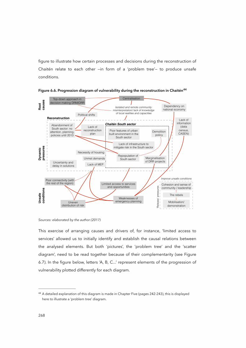
figure to illustrate how certain processes and decisions during the reconstruction of
Chaitén relate to each other —in form of a ‘problem tree’— to produce unsafe
conditions.
Figure 6.6. Progression diagram of vulnerability during the reconstruction in Chaitén44
Weaknesses of emergency planning
Lack of information
(data census, CASEN)
Top-down approach in decision making DRM/DRR
Centralisation
Dependency on national economy
Marginalisation of DRR projects
Uneven distribution of risk
Limited access to services and opportunities
Political shifts
Abandonment of South sector: no
attention, planning, policies until 2013
Necessity of housing
Reconstruction
Uncertainty and delay in solutions
Demolition policy
Repopulation of South sector
Lack of reconstruction
plan
Poor connectivity (with the rest of the region)
Lack of infrastructure to mitigate risk in the South sector
Poor features of urban built environment in the
South sector
Unmet demands
Lack of MEP
Chaitén South sector
Roo
tca
uses
Dyn
amic
pr
essu
res
Uns
afe
cond
ition
s
Isolated and remote community: misinterpretation/ lack of knowledge
of local realities and capacities
Cohesion and sense of community / leadership
Improve unsafe conditions
‘Rel
ease
’ pre
ssur
es
Mobilisation/demonstration
The rebels
Sources: elaborated by the author (2017)
This exercise of arranging causes and drivers of, for instance, ‘limited access to
services’ allowed us to initially identify and establish the causal relations between
the analysed elements. But both ‘pictures’, the ‘problem tree’ and the ‘scatter
diagram’, need to be read together because of their complementarity (see Figure
6.7). In the figure below, letters ‘A, B, C...’ represent elements of the progression of
vulnerability plotted differently for each diagram.
268
44 A detailed explanation of this diagram is made in Chapter Five (pages 242-243), this is displayed here to illustrate a ‘problem tree’ diagram.
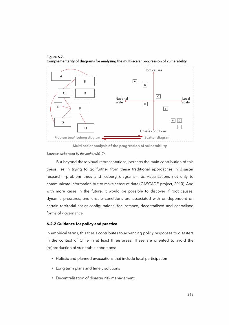
Figure 6.7.Complementarity of diagrams for analysing the multi-scalar progression of vulnerability
AB
DC
E F
GH
Root causes
Nationalscale
Localscale
Unsafe conditionsH
GF
E
C
D
BA
Problem tree/ Iceberg diagram Scatter diagram
Multi-scalar analysis of the progression of vulnerabilitySources: elaborated by the author (2017)
But beyond these visual representations, perhaps the main contribution of this
thesis lies in trying to go further from these traditional approaches in disaster
research —problem trees and iceberg diagrams—, as visualisations not only to
communicate information but to make sense of data (CASCADE project, 2013). And
with more cases in the future, it would be possible to discover if root causes,
dynamic pressures, and unsafe conditions are associated with or dependent on
certain territorial scalar configurations: for instance, decentralised and centralised
forms of governance.
6.2.2 Guidance for policy and practice
In empirical terms, this thesis contributes to advancing policy responses to disasters
in the context of Chile in at least three areas. These are oriented to avoid the
(re)production of vulnerable conditions:
• Holistic and planned evacuations that include local participation
• Long term plans and timely solutions
• Decentralisation of disaster risk management
269
Holistic and planned evacuations
In Chaitén —but also in other cases in Chile (León, 2012)—, evacuation processes
pointed out the importance of men and women’s participation in such important
decisions. Their involvement helps them to keep control over their future and their
opportunities, as well as creating trusting relations with government institutions and
authorities essential to secure quality, equity, and sustainability of post-disaster
programmes (Gall et al., 2014).
The analysis of public polices linked to managing and reducing disaster risks shows
that Chile counts on ambitious national plans and holistic views. However, these
were not well adapted to promote long term plans and sustainable solutions for
both North and South sectors of Chaitén. Even though Chaitén may constitute only
one particular example, the analysis of the national DRM suggests that
centralisation, top-down approach, and reactiveness are systemic features of the
model of DRM and DRR. This may mean that unforeseen effects of policy responses
—including forced evacuations— may have contributed in the past and may
contribute in the future to reproduce risks in other cases.
Some indications of this may be found in other Chilean cases such as in Lilco during
the 2010 Maule earthquake (Imilan et al., 2015). The case of Lilco describes the
slowness with which the state support arrived after the earthquake, and how the
inhabitants were marginalised from planning processes and during the
implementation of reconstruction projects. As a result, policy responses failed to
utilise people’s knowledge and organisational capacities. According to Imilan et al.
(2015), in Lilco and elsewhere in Chile, post-disaster reconstruction processes miss
the opportunity to improve living conditions for the affected communities and to
develop policies for disaster management that incorporate and use their social
capital. Then, it is fair enough to say that policy responses in Chile continue focusing
on life saving and attending basic needs as this save lives. Nevertheless, everything
seems to indicate that, without ‘right to information’, ‘participation’, and ‘securing the
270
continuity of daily life’ after disasters, forced evacuations may (re)produce new and
unforeseen vulnerabilities.
Policy responses with long term plans
Although well intended and apparently well designed, the New Chaitén plan failed
in eluding political pressures and economic constraints within a period that took
longer than desired —almost three years since the volcano eruption in 2008. In
general, recovery and especially reconstructions are not immune to political and
economic pressures (Lyon et al., 2010). At least in Chile, when post-disaster
processes extend longer than expected, such tensions tend to easily escalate (Platt
and So, 2017; Santiago Research Cell, 2015). Then, as the New Chaitén project
demonstrated, ‘time’ becomes a tangible thing that needs to be seriously
considered in policy responses. From this point, planning tools such as ‘scenario
planning’, ‘contingency plans’, as well as IPTs, take special relevance in dealing with
time pressures and uncertainty. Policy responses that consider recovery as a long-
term plan, inclusive and participatory, can serve to create systematic decision-
making through decisions that can be made in advance concerning potential
contingencies, as well as to avoid to reproduce unsafe conditions. For example,
Chad Briggs (2011) uses the 2010 Eyjafjallajökull volcano eruption in Iceland to
illustrate how ‘scenario planning’ for designing, testing, and maintaining
contingency plans related to volcanic activity in Europe may help to reduce impacts
and losses.
Decentralisation of disaster risk management
The GAR 2015 (UNISDR, 2015a) and the Sendai Framework (SFDRR) (UNISDR,
2015b) emphasise the importance of local governments in disaster risk reduction,
highlighting the ‘positiveness’ of decentralised models disaster risk management.
However, there is still limited empirical evidence that confirm this (Garschagen,
2016; Grady et al., 2016; Scott and Tarazona, 2011) and that document the critical
barriers to achieve it. This thesis, in that sense, acknowledges and endorses the
importance of local governments, by suggesting that the lack of inter-sectorial and
271
multi-scale planning, as well as poor inclusion of local actors, have been main
obstacles for successful DRR in Chaitén. But besides this, or perhaps more
importantly, the nature of such obstacles are apparently in the way the territorial
structure of the Chilean state is organised and constructed. This may constitute one
of the barriers to truly transfer power —especially on decision-making: financially and
politically— to local governments in terms of DRM and DRR. Some ideas that may
help to advance a true decentralised disaster risk and risk reduction management:
• Create awareness among national, regional, and local actors about the ‘transversality’ —inter-sectorial and multi-scale— of DRM and DRR. An effective
decentralisation of disaster risk management may not only consist in an administrative de-concentration —or ‘vertical decentralisation’— of state
functions, but in a true balance between national, regional, local capacities with equal decision-making. Awareness certainly involved research and
communication but it may work by incentives such as showing financial information to authorities and politicians about the cost of future disasters
versus the possible savings that DRR can potentially secure; including DRR activities within job descriptions/requirements and performance assessments
for regional and local officials; and the importance of citizen participation in DRR through public campaigns that show how pressure from citizens on their
locally elected politicians can encourages these officials to take direct and specific DRR actions (Scott and Tarazona, 2011).
• Enabling local capacities in disaster risk management by strengthening institutions and mechanisms at lower levels of the territorial organisation. In
Chile, regional academic institutions have demonstrated usefulness in providing DRR skills that local governments do not have, for instance, in
disaster risk assessments, risk mapping, participatory strategies, and even with infrastructures and facilities (UNESCO et al., 2012). Likewise, regional and local
NGOs and civil societies alike have demonstrated the ability to create awareness and mobilise local communities about their own capacities and
agency (Korten, 1990; Alemneh, 2003; Aravena and Sepúlveda, 2011).
272
• Decentralisation of disaster risk management requires decision makers to effectively allocate national funds into local governments. Scott and Tarazona
(2011) point out that local DRR funds are easily diverted to other projects and priorities or even more dangerously, not used and so returned to the central
government. One idea to secure effective DRR funding may be articulating local development, climate change adaptation, and DRR agendas. In 2015,
three high-profile global agreements for development were achieved: the Sendai Framework for Disaster Risk Reduction 2015-2030, the Sustainable
Development Goals (SDG), and the Paris Agreement on the COP21. These post-2015 agendas share, join, and embrace common objectives such as
tackling impacts and losses as a result of climate change. According to Roberts et al. (2015, p.1024), “framing post-2015 development as a means to address
loss and damage can synergize these agendas”. For instance, poverty reduction and sustainable development play a crucial role in preventing
vulnerability and building resilience to climate change. Efforts to address climate change should therefore build on robust sustainable development and
poverty reduction policies and plans, which will increase the extent to which losses and damages can be avoided Roberts et al. (2015).
• Decentralisation of DRM does not mean a weak national governance system. On the contrary, some evidence (Scott and Tarazona, 2011) points out that
effective decentralisation requires an active national leadership: “strong regional and local DRR is more likely when there is a strong national entity that
provides oversight and enforcement” (Scott and Tarazona, 2011, p.26). The
thesis shows precisely that the ONEMI (national) lacks enforcement and compliance mechanisms at local level. So, effective decentralisation of disaster
risk management would require the giving of such mechanisms to the ONEMI, or another national actor. This also means that a decentralised model of DRM
should consist in a ‘constant’ leadership —not only during emergencies— in
enabling and strengthening local and regional capacities to deal with pre- and post-disaster actions, to the point that its ‘function’ seems unnoticed and
completely normalised in the everyday management and responsibilities of local institutions. Likewise, a national leadership should also focus on the
273
underlying causes and drivers of disaster vulnerability as they are often distant from local and regional levels and capacities. This view differs from the current
model in Chile, where the ONEMI and the central government appear overwhelmingly more relevant than other institutions and actors at lower levels
—the top-down approach utilised to conduct the evacuation, relocation, and reconstruction of Chaitén are good examples.
Following these recommendations, this thesis points out that the current situation in
Chaitén may be also improved, firstly —although superficially—, by improving access
to services and opportunities to Chaiteninos residing in the South sector. This would
help to increase their capacities as well as enable favourable circumstances for all
residents. However, improving access would not solve the problem alone. This
requires that the ‘uncertainty’ of the future of the South sector would to be solve. If
the central government and the Congress decide to keep or lift the ban to inhabit
the sector, the trust in authorities and institutions need to be also restored and
strengthened, especially in regard to the regional and national institutions.
6.3 Some reflections on the research experience
Once the study was concluded, I initiated a process of reflexibility on the research
decisions I made and the directions I took. Some of the factors that influenced these
came from my own personal history. I am a mestizo, heterosexual, cisgender male,
and I have lived in southern Chile for most of my life. Prior to conducing the research
study, I worked in territorial planning at a regional office in La Araucania Region. My
experiences working with diverse regional and national actors influenced my
interest in the territorial imbalance between national and regional levels. Finally, my
studies in Berlin and my experience with the earthquakes in Chile and Haiti in 2010
ultimately led me to focus on the causation of disasters. Through conversations with
affected people and volunteers, I heard stories in which people shared their
struggles with the impacts of disaster in very different ways, depending on their
locations, the social group they belong to, their economic resources, social networks
and the like. I initiated this research in the hope of developing an understanding of
the ways in which these territorial imbalances mediate the causation of disasters.
274

By acknowledging who I am as an individual, and as a member of a group, and as
resting in and moving within a social position, I had to be careful not to attempt to
speak for research participants both at national and local levels. Instead, I tried to
reflect their voices as an ally and advocate, although always contrasting their
perceptions with the existing literature. I took a similar attitude to dealing with my
positionality, as I always tried to share and discuss my appreciations with more
experienced colleagues in the field, and to confront these on literature.
During the research I became particularly interested into how policies to disasters
associated with long-term processes, such as relocation and reconstruction, may
affect future disaster vulnerability. Disaster vulnerability research has, during the
years I was preparing this study, been competing with ‘resilience’ research (Miller et
al., 2010). Though resilience has become a popular concept among academic
circles and development agencies alike, criticism has been raised, considering it to
serve neoliberal politic purposes, “which shifts the burden of recovery —and implied
blame— to individuals and communities themselves” (Brown, 2015, p.191). Having
this in mind, I decided to take the opposite direction to turn into the core of
vulnerability and analyse the progression of vulnerability as a multi-scalar process,
embedded within a governance system of disaster management. As pointed out in
Chapter One, this was done with the idea that the more studying we dedicate to the
implication of causes and drivers of disasters, the more powerful will be the reasons
to mobilise men and women and authorities towards a disaster risk causation and
reduction thinking. Otherwise, as Wisner et al. suggest “[disaster] problems will
recur again and again in different and increasingly costly forms unless underlying
causes are tackled” (2004, p.61).
On the other hand, during the development of the thesis, there was a growing
interest among some academic circles for moving forward to the tackling of disaster
risk creation, instead of simply seeking disaster risk reduction (Oliver-Smith et al.,
2016). As noted by Lewis and Kelman (2012), this requires more detailed
investigation into these multi-scalar and historical realities of the causes of
275

vulnerability, which would support the integration of disaster risk reduction within
the many wider contexts that foment and perpetuate vulnerability. Such
developments corroborate that this thesis goes in the right direction.
The research process had to undergo various transformations and overcome several
challenges throughout all these years to reach this final stage. This revealed its non-
linear nature, the inherent complexity of social phenomena, but also my own
positionality within the research process and disciplinary debate. Some reflections
about my position within this study were already introduced in this section and in
Chapters One and Two, but now I would like to offer a brief projection of my
positionality in the future.
At the end of the research, I was more conscious about my position as a ‘male’ within
a system of unequal gender relations, where women and girls are relatively less
powerful and often materially deprived in almost all cultures (Cannon, 2014), and
this is a significant factor in making females more vulnerable to some types of
hazards (Habtezion, 2013). And although I did not consider gender relations as a
root cause to be analysed in the case of Chaitén, being aware of this will make me to
reconsider such gender relations, as well as my position within these relations, in
future investigations. I strongly believe that to advance disaster risk reduction
necessarily we should advance also on equal gender relations.
A similar positionality applies for the area of disaster research when I recognise
myself as a Chilean. Because my personal experiences with hazards and risks in
Chile, related to the country’s location and long history with disasters —as well as of
disaster-related institutions—, my initial perceptions about how disaster and risk
management operate was mediated by such personal experiences. For instance, my
experience with disasters, democracy, the inequalities of neoliberalism and
centralisation, the strength of national institutions in Chile, among other elements of
the contemporary Chilean context, moderated my positionality about the important
role that institutions play in emergencies and recovery. But also because I grew up in
276
a remote region in Chile, La Araucanía, my position about the necessity to
redistribute power and opportunities among the national territory is very clear.
Being a Chilean who has studied abroad, especially between Germany and the
United Kingdom, has established my positionality in regard to my future role with,
and viewpoints about, Chile and its model of DRM. When I come back to Chile,
specifically to La Araucanía Region, my experiences mainly with European
institutions, and development and disaster risk discourses, will mediate my
perspectives on Chilean institutions, social relations, and the like. In this regard, I
consider it fundamental to review my own positionality from time to time when
relevant personal or external societal transformations take place, as our positions are
dynamic and vary depending of our experiences throughout life (Throne et al.,
2016).
To end this journey, I would like to offer some suggestions for further research.
6.4 Call and suggestions for further research
Further case-based analyses in Chile that look at disaster risk creation and the root
causes of vulnerability and risk
One of the motivations to conduct this research was that there were few studies
dedicated to understanding and documenting the underlying and socio-economic/
political causes and drivers of vulnerability and risk in Chile. Further research using
the PAR model, or other similar analytical frameworks, may contribute to systematise
root causes and dynamic pressures of vulnerability in different cases. This may, in
turn, allow us to contrast and compare drivers and causes beyond the nearness of
each case, to try to identify patterns within the model of DRM and risk governance in
Chile. As mentioned in the previous section, there is a growing interest in some
academic circles, such as within the group RADIX, in the idea that governments and
institutions should acknowledge and take action to tackle disaster risk creation
(Oliver-Smith et al., 2016). In the 2017 Global Platform for Disaster Risk Reduction,
taking place on 22-26 May in Cancun, Mexico, there will be several sessions that aim
277
to discuss and present advances on the governance of risks and disasters and
accountability, as a fundamental perspective on advance disaster risk reduction.
Nevertheless, there is still a need for further case-based research at the country
level, including Chile, that looks at the root causes of vulnerability, as well as the
governance and accountability of disasters and risks.
‘Perspective of scale’ to disaster vulnerability, and with attention to other forms of
state territorial organisation.
The GAR 2015 (UNISDR, 2015) points out that in order to develop a comprehensive
analysis of disaster vulnerability and to integrate topics like environment and
society, vulnerability assessments need to be aware of scale implications.
Vulnerability assessments and scales are highly intertwined, not only in technical
application but also in conceptualisation (Fekete et al., 2010). Chaitén is embedded
in a particular scalar system of risk and territorial governance historically mediated
by political and social tensions. Its resultant centralisation and top-down approach
have influenced the post-disaster Chaitén, and it will influence other cases in Chile
insofar as its scalar system of governance continue evolving over time. Although this
makes the case study and thesis quite specific, further research could be developed
on the light of other —different than Chile— state territorial structures, where different
political-administrative spaces exist and other scalar configurations dominate —e.g.
federalist systems, global-cities, urban-regions, and metropolitan areas, among
others.
Evacuations
Emergency evacuation research has often looked at the behaviour of people during
disasters: what people are likely to do, when they are likely to do it and how they are
likely to do it, but rarely on the role of institutions and decision-making (DeYoung et
al., 2016). The evacuation of Chaitén points out the importance of people’s
participation in decision-making as well as their ‘right to information’ and continuity
of daily life. Unfortunately, beyond the case of Chaitén there is not strong evidence
based on other cases that demonstrate how these may help to better articulate
278
evacuations, displacements, resettlements, as well as forced migrations, to longer
term policy responses such as compensatory strategies and reconstruction
processes (Kates et al., 2006). Further investigations on past and future disaster
evacuations in regard to some elements observed in Chaitén such as ‘right to
information’, ‘participation’, and ‘continuity of daily life’ may ultimately help to
develop better policy responses in this respect.
279
References
Abumohor, J., and Díaz, C. (2011). Informe Técnico. Actividad Volcánica: Complejo Puyehue - Cordón Caulle desde Junio a Octubre de 2011. Santiago: ONEMI.
Adger, N. (2000). Social and ecological resilience: are they related? Progress in Human Geography, 24(3), 347-364.
Adger, N. (2006). Vulnerability. Global Environmental Change, 16, 268-281.ADPC (Asian Disaster Preparedness Center). (2014). Capacity Building in Asia using
Information Technology Applications (CASITA): Understanding vulnerability. Bangkok: ADPC.
Agamben, G. (2008). State of Exception. Chicago: University of Chicago Press.Alemneh, D. (2003). Integrated Natural Resources Management to Enhance Food Security:
The Case for Community-Based Approaches in Ethiopia. Technical Paper No.16. Rome: FAO (Food and Agriculture Organization of the United Nations).
Alexander, D. (1993). Natural disasters. Dordrecht & London: Kluwer Academic Publisher & UCL Press.
Allen, A., Dávila, J. D., and Hofmann, P. (2005). Gobernabilidad y acceso al agua y saneamiento en la interfaz periurbana: análisis preliminar de cinco estudios de caso. Cuadernos del CENDES, 22(59), 23-44.
American Red Cross Multidisciplinary Team, Hinrichs, R., Jones, L., Stanley, E. M., and Kleiner, M. (2011). Report on the 2010 Chilean Earthquake and Tsunami Response. Reston, Vir.: US Department of the Interior and USGS.
Amunátegui, M. L. (1882). El terremoto del 13 de Mayo de 1647. Santiago: Rafael Jover.ANATEL (Asociación Nacional de la Televisión Chilena). (2010, 11 Jan). Debate Presidencial
ANATEL 2009-2010. [Presidential debate]. Santiago: ANATEL. Available from: https://youtu.be/PaZnR6aXWbQ [accessed 24 Aug 2016].
Appadurai, A. (1996). Sovereignty without Territoriality: Notes for a Postnational Geography. In P. Yaeger (Ed.), The Geography of Identity (pp. 40-58). Michigan: University of Michigan Press.
Aragón-Durand, F. (2007). Urbanisation and flood vulnerability in the peri-urban interface of Mexico City. Disasters, 31, 477-494.
Aragón-Durand, F. (2009). Unpacking the Social Construction of 'Natural' Disaster through Policy Discourses and Institutional Responses in Mexico : The case of Chalco Valley's floods, State of Mexico. (PhD. PhD.). University College London, London. Available from: http://discovery.ucl.ac.uk/18983/ [accessed 2 Feb 2017].
Aravena, F., and Sepúlveda, A. (2011). Nuestro terremoto, el camino de reconstrucción de una empresa y la comunidad después del 27/F. Santiago: Ediciones B.
Atienza, M., and Aroca, P. (2012). Concentración y crecimiento en Chile: una relación negativa ignorada. EURE, 38, 257-277.
Atkinson, R., and Flint, J. (2004). Snowball sampling. In M. S. Lewis-Beck, A. Bryman and T. F. Liao (Eds.), The Encyclopaedia of Social Science Research Methods (pp. 1044-1045). Thousand Oaks, CA: Sage Publications.
281
Baeza, A. (2013, 23 Apr). A cinco años de la erupción del volcán Chaitén: los logros y los proyectos de una ciudad que estuvo cerca de desaparecer. La Nación. Available from: http://goo.gl/ocp47P [accessed 16 Feb 2017].
Banco Central de Chile (BCC). (1984). Cuentas Nacionales 1960-1983. Santiago: BCC.BCC. (1993). Cuentas Nacionales 1985-1992. Santiago: BCC.BCC. (2007). Cuentas Nacionales 2003-2007. Santiago: BCC.BCC. (2011). Cuentas Nacionales 2003-2010. Santiago: BCC.Bankoff, G. (2006). The Historical Geography of Disaster: 'Vulnerability' and 'Local
Knowledge' in Western Discourse. In G. Bankoff, G. Frerks and D. Hilhorst (Eds.), Mapping Vulnerability : Disasters, Development, and People (pp. 25-36). London: Earthscan.
Bankoff, G., Frerks, G., and Hilhorst, T. (2006). Mapping vulnerability: disasters, development, and people. London: Earthscan Publications.
BCN (Biblioteca del Congreso Nacional de Chile). (2011). Reportes Estadísticos Comunales 2011: Chaitén. Congreso Nacional de Chile. [Online]. Available from: http://reportescomunales.bcn.cl/2011/index.php/Chaitén [accessed 10 Mar 2017].
BCN. (2015). Reportes Estadísticos Comunales 2015: Chaitén. Congreso Nacional de Chile. [Online]. Available from: http://reportescomunales.bcn.cl/2015/index.php/Chaitén [accessed 10 Mar 2017].
BCN. (2017). Ley Chile. BCN. [Online]. Available from: http://www.leychile.cl/Consulta [accessed 01 Apr 2017].
Berezin Bercovich, A. (2012). Chaitén: Una historia en el lugar. (B.A. Sociology). Universidad de Chile, Santiago.
Berger, P., and Luckmann, T. (1966). The Social Construction of Reality. New York: Anchor Books.
Bicknell, J., Dodman, D., and Satterthwaite, D. (2009). Adapting Cities to Climate Change: Understanding and Addressing the Development Challenges. London: Earthscan Publications.
Birkmann, J. (2006a). Measuring Vulnerability to Natural Hazards : Towards disaster resilient societies. Hong-Kong: United Nations University Press.
Birkmann, J. (2006b). Measuring Vulnerability to Promote Disaster-resilient Societies : Conceptual framework and definitions. In J. Birkmann (Ed.), Measuring Vulnerability to Natural Hazards: Towards disaster resilient societies (pp. 9-54). Hong-Kong: United Nations University Press.
Birkmann, J. (2011). Regulation and coupling of society and nature in the context of natural hazards. In H. Brauch, Ú. Oswald Spring, C. Mesjasz, J. Grin, P. Kameri-Mbote, C. Béchir, P. Dunay and J. Birkmann (Eds.), Coping with global environmental change, disasters and security: threats, challenges, vulnerabilities and risks (pp. 1103-1128). Berlin & Heidelberg: Springer-Verlag.
Birkmann, J. (2013). Risk. In P. T. Bobrowsky (Ed.), Encyclopedia of Natural Hazards (pp. 856-862). Dordrecht: Springer Netherlands.
282
Blaikie, P., Cannon, T., Davis, I., and Wisner, B. (1994). At risk: natural hazards, people's vulnerability, and disasters. London: Routledge.
BNC (Biblioteca Nacional de Chile). (2014). Los terremotos en Chile 1570-2010. BNC. [Online]. Available from: https://goo.gl/w1Q63Q [accessed 2 Abr 2017].
BNE (Bolsa Nacional de Empleo). (2015). Buscador de empleos por regiones. [Online]. Available from: http://www.bne.cl/buscar-trabajo-empleo/ [accessed 08 Feb 2015].
Boano, C., and Lund, R. (2011). Disasters, Crisis And Communication: A Literature Review. In M. Vos, R. Lund, Z. Reich and H. Harro-Loit (Eds.), Developing a Crisis Communication Scorecard : Outcomes of an International Research Project 2008-2011 (pp. 50-153). Jyväskyla: Jyväskylä University Printing House.
Boisier, S. (2000). Chile: la vocación regionalista del gobierno militar. EURE, 26, 81-107.Boisier, S. (2001). La doctrina oculta de a descentralización Chilena. Biblioteca Virtual sobre
Gestión Pública. [Online]. Available from: www.top.org.ar/publicac.htm [accessed 9 July 2016].
Bosher, L. (2007). Social and institutional elements of disaster vulnerability: the case of South India. Bethesda: Academica Press.
Bowen, G., A. . (2009). Document Analysis as a Qualitative Research Method. Qualitative Research Journal, 9(2), 27-40.
Brenner, N. (1997). State territorial restructuring and the production of spatial scale - Urban and regional planning in the Federal Republic of Germany, 1960-1990. Political Geography, 16, 273-306.
Brenner, N. (1998). Between fixity and motion: accumulation, territorial organization and the historical geography of spatial scales. Environment and Planning D-Society & Space, 16, 459-481.
Brenner, N. (1999). Globalisation as Reterritorialisation: The Re-scaling of Urban Governance in the European Union. Urban Studies, 36, 431-451.
Brenner, N. (2000). The Urban Question as Scale Question: Reflections on Henri Lefebvre, Urban Theory and the Politics of scale. International Journal of Urban and Regional Research, 24, 361-378.
Brenner, N. (2001). The limits to scale? Methodological reflections on scalar structuration. Progress in Human Geography, 25, 591-614.
Brenner, N. (2009a). Restructuring, Rescaling and the Urban Question. Critical Planning, 16, 61-79.
Brenner, N. (2009b). A thousand leaves: notes on the geographies of uneven spatial development. In R. Keil and R. Mahon (Eds.), Leviathan undone? Towards a political economy of scale (pp. 27-49). Vancouver: University of British Columbia Press.
Briggs, C. (2011). Abrupt environmental changes: Scenario planning for catastrophic security risks. In A. Alemanno (Ed.), Governing Disasters: The Challenges of Emergency Risk Regulation (pp. 162-181). Cheltenham, UK: Edward Elgar Publishing.
Brown, K. (2015). Resilience, Development and Global Change. New York: Taylor & Francis.Burton, I. (1974). Ecological dimensions of environmental hazards. In F. Sargent (Ed.), Human
Ecology. (pp. 253-283). Amsterdam: North-Holland.
283
Burton, I. (2014). Foreword. In D. Etkin (Ed.), Disaster Theory: An Interdisciplinary Approach to Concepts and Causes (pp. xv-xvi). Oxford, UK: Elsevier Science.
Canadian Red Cross Society. (2008). Natural Disasters: Exploring the un-natural causes of vulnerability. Ottawa: CRCS.
Cannon, T. (1994). Vulnerability analysis and the explanation of "natural" disasters. In A. Varley (Ed.), Disasters, development and the environment (pp. 13-30). Chichester: John Wiley.
Cannon, T. (2000). Vulnerability Analysis and Disasters. In D. Parker (Ed.), Floods (pp. 45-55). London: Routledge.
Cannon, T. (2014). The links between culture and risk. In The International Federation of Red Cross and Red Crescent Societies IFRC (Ed.), World Disaster Report 2014: Focus on culture and risk (pp. 10-35). Geneva: IFRC.
Cardona, O. D. (2006). The Need for Rethinking the Concepts of Vulnerability and Risk from a Holistic Perspective: A Necessary Review and Criticism for Effective Risk Management. In G. Bankoff, G. Frerks and D. Hilhorst (Eds.), Mapping Vulnerability : Disasters, Development, and People (pp. 37-51). London: Earthscan.
Cardona, O. D., M.K. van Aalst, Birkmann, J., M. Fordham, G. McGregor, R. Perez, . . . B.T. Sinh. (2012). Determinants of risk: exposure and vulnerability. In C. B. Field, V. Barros, T.F. Stocker, D. Qin, D.J. Dokken, K.L. Ebi, M.D. Mastrandrea, K.J. Mach, G.-K. Plattner, S.K. Allen, M. Tignor and P. M. Midgley (Eds.), Managing the Risks of Extreme Events and Disasters to Advance Climate Change Adaptation. A Special Report of Working Groups I and II of the Intergovernmental Panel on Climate Change (IPCC) (pp. 65-108). Cambridge, UK & New York: Cambridge University Press.
Carr, L. (1932). Disasters and the Sequence-Pattern Concept of Social Change. American Journal of Sociology, 38, 207-218.
CASCADE Project. (2013). CASCADE Briefing Paper: Data visualisa on for researchers andscholars. Exeter, Devon UK: University of Exeter.
Casertano, L. (1963). General characteristics of active andean volcanoes and a summary of their activities during recent centuries. Bulletin of the Seismological Society of America, 53, 1415-1433.
Castedo, L. (2000). 1915-1999 Hazaña del Riñihue : el terremoto de 1960 y la resurrección de Valdivia: crónica de un episodio ejemplar de la historia de Chile. Santiago: Editorial Sudamericana.
Castells, M. (1989). The informational city : information technology, economic restructuring, and the urban-regional process. Oxford, UK & Cambridge, Mass.: Blackwell Publishers.
Castells, M. (1996). The rise of the network society. Malden, Mass.: Blackwell Publishers.Chardon, A. C. (1998). Crecimiento urbano y riesgos “ naturales”: evaluacion final de la
vulnerabilidad global en Manizales, Colombia. Desastres y Sociedad, 6, 2-33.Chardon, A. C. (2004). Un enfoque geográfico de la vulnerabilidad global de un hábitat
urbano de ladera expuesto a amenazas naturales: el caso andino de Manizales, Colombia. Madrid: CYTED.
284
Chardon, A. C., and Gonzalez, J. L. (2002). Programa de Información e Indicadores de Gestión de Riesgos. Ejecución del Componente II: Indicadores para la Gestión de Riesgos. Manizales: BID (Banco Interamericano de Desarrollo).
Cifuentes, C. (2009, 25 Feb). Delegada presidencial inicia proceso informativo por reubicación de Chaitén. La Tercera. Available from: https://goo.gl/GXsIYY [accessed 28 Mar 2016].
CIMM T&S Consultores. (2010). Estudio de contaminación de cenizas y suelos en la ciudad de chaitén y propuesta de medidas de mitigación y restauración. Santiago: SEREMI Salud Región de Los Lagos.
Clark, G. L. (2014). The Geography of the Euro Crisis: The ECB, Its Institutional Form, Functions, and Performance. SSRN Working paper series, 10, 1-29.
CNA-Chile (Comisión Nacional de Acreditación). (2016). Buscador de Acreditaciones. CNA-Chile. [Online]. Available from: http://www.cnachile.cl/Paginas/buscador-avanzado.aspx [accessed 29 Dec 2016].
Cohen, L., and Manion, L. (1994). Research methods in education (4th ed.). London: Routledge.
Collier, S., and Sater, W. F. (1996). A History of Chile, 1808-1994. Cambridge, Mass.: Cambridge University Press.
Collier, S. J. (2013). Neoliberalism and Natural Disaster. Journal of Cultural Economy, 7(1), 273- 290.
Comisión Nacional para la Resiliencia frente a Desastres de Origen Natural CREDEN. (2016). Hacia un Chile Resiliente frente a Desastres: Estrategia Nacional de Investigación, Desarrollo e Innovación para un Chile Resiliente frente a Desastres de Origen Natural. Santiago: CNID.
Congreso Nacional Constituyente. (1823). Constitución Política del Estado de Chile. Santiago: Gobierno de Chile.
Contraloría General de la República de Chile. (2009). Informe Final Municipalidad de Chaitén. Santiago: Contraloría.
Contraloría General de la República de Chile. (2011). Auditoría Efectuada en la Intendencia Regional de Los Lagos. Santiago: Contraloría.
Cooper, C., David L., F., and Chiaradia, A. (2014). Measuring the Impact of Spatial Network Layout on Community Social Cohesion: A Cross-Sectional Study. International Journal of Health Geographics, 13(1), 1-11.
Cooper, M. A., and Henriquez, C. R. (2010). Planificación territorial y crecimiento urbano: desarticulaciones y desafíos de la sostenibilidad urbano-regional en Santiago metropolitano. Scripta Nova. Revista Electrónica de Geografía y Ciencias Sociales, 14, 1-14.
Cooperativa. (2011, 13 Mar). Piñera dio a conocer "Plan Solución Chaitén" y oficializó refundación de la ciudad. Cooperativa.cl. Available from: https://goo.gl/xX11mx [accessed 11 Nov 2016].
Cooperativa. (2015, 05 Apr). Las consecuencias de la catástrofe en el norte. Cooperativa.cl. Available from: https://goo.gl/2irTaA [accessed 25 Sep 2016].
285
Corbin, J., and Strauss, A. (2014). Basics of Qualitative Research: Techniques and Procedures for Developing Grounded Theory (4th ed.). Thousand Oaks, CA: Sage Publications.
Corporación de Fomento de la Producción CORFO. (2014). Historia de Corfo. CORFO. [Online]. Available from: https://goo.gl/evMcf2 [accessed 1 May 2017].
Covarrubias, B. r. (2008, 02 May). Sernageomin: Escasa visibilidad provocó la confusión de volcanes. EMOL. Available from: https://goo.gl/Zs4HNm [accessed 12 Nov 2016].
Creswell, J. W. (1994). Research Design: Qualitative and Quantitative Approaches. California: Sage Publications.
Cutter, S. L. (1993). Living with Risk: The Geography of Technological Hazards. London: Edward Arnold.
Cutter, S. L. (1996). Vulnerability to environmental hazards. Progress in Human Geography, 20, 529-539.
Cutter, S. L., Boruff, B. J., and Shirley, W. L. (2003). Social vulnerability to environmental hazards. Social Science Quarterly, 84, 242-261.
Cutter, S. L., Mitchell, J., and Scott, M. (2000). Revealing the vulnerability of people and place: A case study of Georgetown County, South Carolina. Annals of the Association of American Geographers, 90(4), 713-737.
Dahlberg, R., Albris, K., and Jebens, M. (2017). The Baltic Storm Surge in November 1872: Urban Processes, Gendered Vulnerability and Scientific Transformations. In D. Simonton and H. Salmi (Eds.), Catastrophe, Gender and Urban Experience, 1648–1920 (pp. 177-198). Oxon: Routledge.
Davis, I. (1978). Shelter after disaster. Oxford, UK: Oxford Polytechnic Press.Delgado Muñoz, G., Huneeus Alliende, T., Jeldes Silva, C., and Villarroel Rojas, G. (2005).
Chaitén: Su historia desde la memoria. Santiago: Caminante Libros.Denzin, N. K. (2009). The Research Act: A Theoretical Introduction to Sociological Methods
(3rd ed.). New York: Aldine Publishing Company.DeYoung, S. E., Wachtendorf, T., Davidson, R. A., Xu, K., Nozick, L., Farmer, A. K., and
Zelewicz, L. (2016). A mixed method study of hurricane evacuation: demographic predictors for stated compliance to voluntary and mandatory orders. Environmental Hazards, 15(2), 95-112.
Diamond, M. A., and Allcorn, S. (2009). Private Selves in Public Organizations: The Psychodynamics of Organizational Diagnosis and Change. London: Palgrave Macmillan.
DKKV (German Committee for Disaster Reduction). (2012). Detecting Disaster Root Causes: A Framework and an Analytic Tool for Practitioners. Bonn: DKKV.
Dombrowsky, W. R. (1998). Again and again: is disaster what we call a "disaster". In E. L. Quarantelli (Ed.), What is a disaster? perspectives on the question (pp. 19-30). London: Routledge.
Donoso, R. (1963). Breve historia de Chile. Buenos Aires: EUDEBA.Dynes, R. R. (1970). Organized behavior in disaster. Lexington, Mass.: Heath Lexington Books.Dzierma, Y., and Wehrmann, H. (2012). On the likelihood of future eruptions in the Chilean
Southern Volcanic Zone: interpreting the past century's eruption record based on statistical analyses. Andean geology, 39, 380-393.
286
Echeverría, R. (2006). Ontología del lenguaje. Madrid: Granica.El Huemúl. (2013, 26 Aug). Gobierno debe dar a conocer resultados de estudios sobre
Chaitén Sur que comprometió en abril. El Huemúl. Available from: https://goo.gl/8NI43H [accessed 24 Feb 2017].
El Mercurio. (2010, 27 May). Piñera corrige al intendente de Los Lagos y asegura que Nueva Chaitén se emplazará en Santa Bárbara. EMOL. Available from: https://goo.gl/7Bd0Gm [accessed 14 Aug 2016].
El Mercurio. (2013, 29 Apr). Chaitén, a cinco años de dura erupción. EMOL. Available from: https://goo.gl/lm6zv0 [accessed 18 Nov 2016].
El Mercurio. (2014, 07 May). Escasez de viviendas agobia a Chaitén a seis años de la erupción. EMOL. Available from: https://goo.gl/kyYtFy [accessed 12 Feb 2017].
EM-DAT (Emergency Events Database). (2017). Chile Country Profile. CRED (Centre for Research on the Epidemiology of Disasters). [Online]. Available from: http://www.emdat.be/country_profile/index.html [accessed 21 Apr 2017].
Erikson, K. T. (1976). Everything In Its Path. New York: Simon & Schuster.Etkin, D. (2014). Disaster Theory: An Interdisciplinary Approach to Concepts and Causes.
Oxford, UK: Elsevier Science.European Parliament. (2008). European Parliament resolution of 19 June 2008 on stepping
up the Union's disaster response capacity. Strasbourg: European Parliament. Available from: https://goo.gl/lQ3NFY [accessed 13 Apr 2017].
Fekete, A., Damm, M., and Birkmann, J. (2010). Scales as a challenge for vulnerability assessment. Natural Hazards, 55, 729-747.
Ferrada Borquez, J. C. (2000). La Constitución Económica de 1980: Algunas reflexiones críticas. Revista de Derecho (Valdivia), 11, 47-54.
Field, C. B., Barros, V., Stocker, T. F., Qin, D., Dokken, D. J., Ebi, K. L., . . . Midgley, P. M. (2012). Managing the Risks of Extreme Events and Disasters to Advance Climate Change Adaptation : A Special Report of Working Groups I and II of the Intergovernmental Panel on Climate Change. Cambridge, UK & New York: IPCC & Cambridge University Press.
Foerster, R. (1995). Introducción a la religiosidad Mapuche. Santiago: Universitaria.Frías, V., F. (1960). Historia de Chile (5nd ed.). Santiago: Editorial Nascimento.Fuentes, Cortes, and Castillo. (1823, 04 Feb). Recuento Histórico del Desastre. Las Ultimas
Noticias de Santiago.Gabor, T., and Pelanda, C. (1982). Assessing differences in chemical disaster proneness: The
community chemical hazard vulnerability inventory. Disasters, 6, 215-221.Galasso, F., and Farías, P. (2014). CASEN survey: statistical and methodological misleads in
key public policy in Chile. Emerald Emerging Markets Case Studies, 4(7), 1-6.Galeano, E. (2012). Los hijos de los días. Buenos Aires: Siglo XXI.Galilea, S. (2009). Recursos "Emergencia Volcán Chaitén". Puerto Montt: GORE Los Lagos.Galilea, S. (2013, 02 May). Lecciones de Chaitén a 5 años. La Nación. Available from: http://
blog.lanacion.cl/2013/05/02/lecciones-de-chaiten-a-5-anos/ [accessed 25 Jul 2016].
287
Gall, M., Cutter, S. L., and Nguyen, K. (2014). Governance in Disaster Risk Management: IRDR AIRDR Publication No. 3. Beijing: IRDR.
Gall, M. D., Gall, J. P., and Borg, W. R. (2003). Educational Research: An Introduction (7th ed.). Boston MA: Allyn & Bacon Publications.
Garschagen, M. (2016). Decentralizing urban disaster risk management in a centralized system? Agendas, actors and contentions in Vietnam. Habitat International, 52, 43-49.
Gero, A., Méheux, K., and Dominey-Howes, D. (2011). Integrating community based disaster risk reduction and climate change adaptation: examples from the Pacific. Nat. Hazards Earth Syst. Sci., 11(1), 101-113.
GFDRR (Global Facility for Disaster Reduction And Recovery). (2012). Managing Disaster Risks for a Resilient Future: A Strategy for the Global Facility for Disaster Reduction and Recovery 2013-2015. Washington D.C.: The World Bank.
Ghesquiere, F., and Mahul, O. (2014). How Can Innovative Financing Solutions Help Build Resilience to Natural Disasters? The World Bank. [Online]. Available from: https://goo.gl/MZGPWF [accessed 1 May 2017].
Gobernación Provincial de Palena. (2015). Intendente de Los Lagos visita obras en ejecución en Chaitén. Gobernación Provincial de Palena. [Online]. Available from: https://goo.gl/7uxYYp [accessed 1 May 2017].
Gobierno de Chile. (1980). Constitución Política del Estado de Chile. Santiago: Gobierno de Chile.
Gobierno de Chile. (2014). Diagnóstico estado de la reconstrucción: terremoto y tsunami 27 de febrero de 2010, Delegación Presidencial para la Reconstrucción. Santiago: Ministerio del Interior y Seguridad Pública.
González-Muzzio, C. (2013). El rol del lugar y el capital social en la resiliencia comunitaria posdesastre: Aproximaciones mediante un estudio de caso después del terremoto del 27/F. EURE, 39, 25-48.
González-Muzzio, C., and Sandoval, V. (2014). Neoliberalism and reconstruction processes in Chile, discussing the role of State and communities. Paper presented at the 2nd International Conference on Urban Sustainability and Resilience USAR, London, 3rd-5th November.
Google Earth Pro v.7.1 (Service) and CNES-Airbus (Provider). (2016). Chaitén 42°54'59.70"S, 72°42'30.23"W, elevation 12 mts., on 4 Jan 2016 [Digital]. Available from: https://www.google.com/earth/desktop/ [accessed 1 May 2017].
GORE Los Lagos (Gobierno Regional de Los Lagos). (2009a). Criterios en el Proceso de Asignación del Bono de desplazamiento víctimas del Volcán Chaitén. Puerto Montt: Ministerio del Interior y Seguridad Pública.
GORE Los Lagos. (2009b). Convenio Consultoría para el Desarrollo de Lineamientos Estratégicos de Reconstrucción/Relocalización y Plan Maestro Conceptual Post-Desastre Chaitén. Puerto Montt: GORE Los Lagos.
GORE Los Lagos. Cuenta Anual Regional 2011: Región de Los Lagos. Puerto Montt: Ministerio del Interior y Seguridad Pública.
GORE Los Lagos and Gobierno de Chile. (2012). Política Regional para el Desarrollo de Localidades Aisladas. Puerto Montt: GORE Los Lagos.
288
Gould, K., Garcia, M., and Remes, J. (2016). Beyond "natural-disasters-are-not-natural": the work of state and nature after the 2010 earthquake in Chile. Journal of Political Ecology, 23(1), 93-114.
Grady, A., Gersonius, B., and Makarigakis, A. (2016). Taking stock of decentralized disaster risk reduction in Indonesia. Nat. Hazards Earth Syst. Sci., 16(9), 2145-2157.
Gran Convención de Chile. (1833). Constitución Política de 1833. Santiago: Gobierno de Chile.
Grossi, J. (1907). Servicio Médico de un Terremoto: Valparaiso 1906. Valparaiso: Litografìa e Imprenta Moderna de Scherrer y Herrmann.
Gunewardena, N., and Schuller, M. (2008). Capitalizing on Catastrophe: Neoliberal Strategies in Disaster Reconstruction. Plymouth, UK: AltaMira Press.
Habtezion, S. (2013). Gender and disaster risk reduction. Policy brief. No.3. New York: UNDP.Hacking, I. (1999). The Social Construction of What? Cambridge, Mass.: Harvard University
Press.Han, C. (2010). Earthquake in Chile: Poverty and social diagnoses. Latin American Studies
Association Forum, 61, 9-11.Harvey, D. (2005). A brief history of neoliberalism. Oxford, UK & New York: Oxford University
Press.Hewitt, K. (1983). Interpretations of calamity from the viewpoint of human ecology.
Massachusetts: Allen & Unwin.Heyman, B. N., Davis, C., and Krumpe, P. F. (1991). An assessment of worldwide disaster
vulnerability. Disaster Management, 4, 3-14.Hilhorst, D. (2006). Complexity and diversity: Unlocking social domains of disaster response.
In G. Bankoff, G. Frerks and D. Hilhorst (Eds.), Mapping Vulnerability: Disasters, Development, and People (pp. 52-66). London: Earthscan.
Horkheimer, M. (1937). Traditional and Critical Theory. In M. Horkheimer (Ed.), Critical Theory: Selected Essays (pp. 188-243). London & New York: Continuum.
Howitt, R. (1998). Scale as Relation: Musical Metaphors of Geographical Scale. Area, 30, 49-58.
IFRC (International Federation of Red Cross and Red Crescent Societies). (2014). World Disaster Report 2014: Focus on culture and risk. Geneva: IFRC.
IGM (Instituto Geográfico Militar de Chile) (Service). (2012). Chaitén 42°54'59.70"S, 72°42'30.23"W, elevation 12 mts., on 20 May 2005. Available from: http://200.27.184.149/IGMChile/ [accessed 28 Nov 2016].
IMF (International Monetary Fund). (2008). Vulnerability Indicators. IMF. [Online]. Available from: https://www.imf.org/external/np/exr/facts/vul.htm [accessed 1 May 2017].
Imilan, W. A., Fuster, X., and Vergara, P. (2015). Post-disaster reconstruction without citizens and their social capital in Llico, Chile. Environment and Urbanization, 27(1), 317-326.
INDAP (Instituto Nacional de Desarrollo Agropecuario). (2009). Modifica Resolución Exenta Nº672 del 2008. Santiago: INDAP.
INE (Instituto Nacional de Estadísticas de Chile). (2002). Censo. Santiago: INE.
289

Infracon S.A. (2012). Estudio de riesgo de sismos, volcanismo, remoción en masa, inundación por desborde de cauces y canales y maremotos para ocho localidades de la comuna de Chaitén, Informe Final. Santiago: SUBDERE.
INN (Instituto Nacional de Normalización). (1996). Diseño Sísmico de Edificios: Norma Chilena Oficial NCh433.Of96. Santiago: INN.
Intendencia de la Región de Los Lagos. (2010). Informó el intendente Montes: Declaración sobre habitabilidad de Chaitén. Gobierno de Chile. [Online]. Available from: http://www.intendencialoslagos.gov.cl/n154_10-12-2010.html [accessed 18 Dec 2016].
IPCC (Intergovernmental Panel on Climate Change). (2001). Synthesis Report. A Contribution of Working Groups I, II, and III to the Third Assessment Report of the Integovernmental Panel on Climate Change. Cambridge, UK and New York: C. U. Press.
IRDR (Integrated Research on Disaster Risk). (2012). The FORIN project: Forensic Investigations of Disasters. Beijin: IRDR.
Jick, T. D. (1979). Mixing Qualitative and Quantitative Methods: Triangulation in Action. Administrative Science Quarterly, 24, 602-611.
Kates, R. W., Colten, C. E., Laska, S., and Leatherman, S. P. (2006). Reconstruction of New Orleans after Hurricane Katrina: A research perspective. Proceedings of the National Academy of Sciences of the United States of America, 103(40), 14653-14660.
Kaufmann, D. (2010). Natural Disasters, National Diligence: The Chilean Earthquake in Perspective. Washington D.C.: Brookings Institution.
Kellett, J., Caravani, A., and Pichon, F. (2014). Financing disaster risk reduction: Towards a coherent and comprehensive approach. London: UNDP & ODI (Overseas Development Institute).
Kelman, I., Gaillard, J. C., Lewis, J., and Mercer, J. (2016). Learning from the history of disaster vulnerability and resilience research and practice for climate change. Natural Hazards, 82(1), 129-143.
Klein, N. (2008). The Shock Doctrine: The Rise of Disaster Capitalism. New York: Picador.KnowledgeWharton. (2010, March 10). The Social, Political and Economic Aftershocks of the
Chilean Earthquake. Available from: http://knowledge.wharton.upenn.edu/article/the-social-political-and-economic-aftershocks-of-the-chilean-earthquake/ [accessed 1 May 2017].
Knox, P. L. (1995). World Cities in a World-system. In P. J. Taylor and P. L. Knox (Eds.), World cities in a world-system (pp. 3-20). Cambridge, UK & New York: Cambridge University Press.
Korten, D. C. (1990). Getting to the 21st Century: Voluntary Action and the Global Agenda. Boulder: Lynne Rienner Publishers.
La Nación. (2009, 20 Feb). Edmundo Pérez Yoma: "Chaitén desgraciadamente ha muerto". Available from: http://www.lanacion.cl/noticias/site/artic/20090220/pags/20090220214000.html# [accessed 23 Feb 2016].
Laframboise, N., and Loko, B. (2012). Natural Disasters: Mitigating Impact, Managing Risks. IMF Working paper, 12, 1-31.
Lavell, A., and Maskrey, A. (2013). The future of Disaster Risk Management: An on-going discussion. San Jose, Costa Rica: UNISDR.
290
Leedy, P. D., and Ormrod, J. E. (2010). Practical research: Planning and Design (9th ed.). New Jersey: Kevin M. Davis.
Lees, L., Shin, H. B., and Lopez-Morales, E. (2015). Global Gentrifications: Uneven Development and Displacement. Bristol: Policy Press.
Lefebvre, H. (1991 [1974]). The production of space (D. Nicholson-Smith, Trans.). Cambridge, Mass.: Blackwell Publishers.
León C, F. J. (2012). Después de un terremoto: Bioética en situaciones de catástrofe. Revista médica de Chile, 140, 108-112.
Lewis, J., and Kelman, I. (2012). The Good, The Bad and The Ugly: Disaster Risk Reduction (DRR) Versus Disaster Risk Creation (DRC). PLoS Currents, 4(1), 1-25.
Liubimau, S. (2011). Europeanisation and The Built Environment: The Re-scaling of the Border City Goerlitz-Zgorzelec. In T. Bhambry, C. Griffin, J. Hjelm, C. Nicholson and O. Voronina (Eds.), Perpetual Motion? : Transformation and Transition in Central and Eastern Europe & Russia (pp. 57-71). London: School of Slavonic and East European Studies, UCL.
Liverman, D. (1990). Vulnerability to Global Environmental Change. In R. E. Kasperson, K. Dow, D. Golding and J. X. Kasperson (Eds.), Understanding Global Environmental Change: the Contributions of Risk Analysis and management (pp. 27-44). Worcester, MA: The Earth Transformed Program, Clark University.
López Tagle, E., and Santana Nazarit, P. (2011). El terremoto de 2010 en Chile: Respuesta del sistema de salud y de la cooperación internacional. Revista Panamericana de Salud Pública, 30, 160-166.
Lopez-Basaguren, A., and Leire Escajedo, S.-E. (2013). The Ways of Federalism in Western Countries and the Horizons of Territorial Autonomy in Spain. Berlin-Heidelberg: Springer
Luttwak, E. (1969). Coup D'Etat: A Practical Handbook. Michigan: Allen Lane.Lyon, M., Schinderman, T., and Boano, C. (2010). Building Back Better. Delivering People-
centered housing reconstruction at scale. Rugby: Practical Action Publishing.Mac-Clure, Ó., and Calvo, R. (2013). Desigualdades sociales y tipos de territorios en Chile.
Polis, 12, 467-490.MAE Center (Mid-America Earthquake Center), Amr S. Elnashai, Bora Gencturk, Oh-Sung
Kwon, Imad L. Al-Qadi, Youssef Hashash, . . . Valdivia, A. (2010). The Maule (Chile) Earthquake of February 27, 2010: Consequence Assessment and Case Studies. Urbana, Illinois: MAE Center - University of Illinois.
Mahon, R., and Keil, R. (2009). Leviathan Undone?: Towards a Political Economy of Scale. Vancouver: University of British Columbia Press.
Marchant, J. P. (2010). Lágrimas de ceniza: Estudio cualitativo sobre la experiencia de desplazamiento de los habitantes de Chaitén, asentados en las ciudades de la Isla de Chiloé y Puerto Montt. Santiago: ONEMI.
Mardones, R., Rueda, S., and Guzmán, M. (2011). Tejiendo vínculos: una mirada a la organización “renacer de Chaitén” de la tercera edad en un contexto de posdesastre. Cuadernos de Crisis y Emergencias, 2, 19-40.
291
Mariño de Lobera, P. (1960). Crónica del Reino de Chile. In Padre Bartolomé de Escobar (Ed.), Crónica del Reino de Chile, escrita por el capitán Pedro Mariño de Lobera, reducido a nuevo método y estilo por el Padre Bartolomé de Escobar (pp. 569-575). Madrid: Atlas.
Marston, S. A. (2000). The social construction of scale. Progress in Human Geography, 24, 219-242.
Maskrey, A. (1993a). Los Desastres No Son Naturales. Bogota, Colombia: LA RED & Intermediate Technology Development Group, Tercer Mundo.
Maskrey, A. (1993b). Vulnerability accumulation in peripheral regions in Latin America: The challenge for disaster prevention and management. In P. A. Merriman and C. W. A. Browitt (Eds.), Natural Disasters: Protecting Vulnerable Communities (pp. 461-472). London: Thomas Telford.
Maskrey, A. (2016). Monitoring the Sendai Framework for DRR 2015-2030 and promoting coherence with the SDGs. IISD. [Online]. Available from: https://goo.gl/SBBx3l [accessed 30 Mar 2017].
Massey, D. B. (1994). In what sense a regional problem? In D. B. Massey (Ed.), Space, place, and gender (pp. 50-66). Minneapolis: University of Minnesota Press.
Mena, C. (2016). Window of Opportunity? Disaster Public Policy Change in Chile, a case study. (M.Sc.). University College London, London.
Mercurio, E. (2015, 19 September). ONU: Chile es un ejemplo de cómo hacer las cosas bien frente a desastres naturales. EMOL. Available from: https://goo.gl/ZF9qCx [accessed 21 Apr 2017].
Mertens, D. M. (2005). Research methods in education and psychology: Integrating diversity with quantitative and qualitative approaches (A. Weisz, Trans. 2nd ed.). Thousand Oaks, CA: Sage Publications.
Michael, K., Deshpande, T., and Ziervogel, G. (2017). Examining Vulnerability in a Dynamic Urban Setting: The Case of Bangalore's Interstate Migrant Waste Pickers. Available from: http://dx.doi.org/10.2139/ssrn.2924375 [accessed 24 Mar 2017].
MIDEPLAN (Ministerio de Planificación). (1992). Ley Nº19175. Ley Orgánica Constitucional sobre Gobierno y Administracion Regional. Santiago: MIDEPLAN.
MIDEPLAN. (2003). Analisis de Resultados de la Encuesta de Caracterización Socioeconomica Nacional: CASEN 2003. Santiago: MIDEPLAN.
MIDEPLAN. (2006). Analisis de Resultados de la Encuesta de Caracterización Socioeconomica Nacional: CASEN 2006. Santiago: MIDEPLAN.
Miller, C. (2007). Creating indicators of sustainability: a social approach. Winnipeg: IISD (International Institute for Sustainable Development).
Miller, F., Osbahr, H., Boyd, E., Thomalla, F., Bharwani, S., Ziervogel, G., . . . Nelson, D. (2010). Resilience and vulnerability: complementary or conflicting concepts? Ecology and Society, 15(3), 1-25.
Ministerio de Agricultura. (1990). Ley Nº18910. Sustituye Ley Organica del Instituto de Desarrollo Agropecuario. Santiago: Ministerio de Agricultura.
Ministerio de Defensa. (1978). Ley Nº22222. Sustituye Ley de Navegacion. Santiago: Ministerio de Defensa.
292
Ministerio de Hacienda. (1965a). Decreto Ley (DL) Nº16,282: Fija Disposiciones para casos de Sismos o Catastrofes, Establece Normas para la Reconstruccion de la Zona Afectada por el Sismo de 28 de Marzo de 1965 y modifica La Ley N° 16.250. Santiago: Ministerio de Hacienda. Available from: http://bcn.cl/1m53m [accessed 1 May 2017].
Ministerio de Hacienda. (1965b). Ley Nº16250. Reajusta Sueldos y Salarios que Indica y Modifica los Decretos con Fuerza de Ley y Leyes que Señala. Santiago: Ministerio del Interior. Available from: http://bcn.cl/1m090 [accessed 2 Apr 2017].
Ministerio de Hacienda. (2013). Ley de Presupuestos del Sector Público año 2013. Santiago: DIPRES.
Ministerio de Hacienda. (2014). Fondo Nacional de la Reconstrucción (FNR). Ministerio de Hacienda. [Online]. Available from: http://donaciones.hacienda.cl [accessed 1 Sep 2016].
Ministerio del Hacienda. (2012a). Ley Nº20444. Crea el Fondo Nacional de la Reconstrucción y Establece Mecanismos de Incentivo Tributario a las Donaciones Efectuadas en Caso de Catástrofe. Santiago: Ministerio de Hacienda.
Ministerio del Interior y Seguridad Pública (Min. Interior). (1927). Decreo Supremo (DS) Nº7,912: Organiza las Secretarias del Estado. Santiago: Ministerio del Interior. Available from: http://bcn.cl/1mggi [accessed 25 Feb 2017].
Min. Interior. (1974). Decreto Ley DL Nº 369: Crea la Oficina Nacional de Emergencia, dependiente del Ministerio del Interior. Santiago: Min. Interior. Available from: http://bcn.cl/1m090 [accessed 5 May 2017].
Min. Interior. (1977). Decreto Supremo (DS) Nº155: Aprueba Plan Nacional de Emergencia. Santiago: Subsecretaría del Interior.
Min. Interior. (1982). Ley Nº733. Deroga Decretos Supremos Nº1.027 de 1976, y 1.040 de 1979, a Aprueba Normas que indica. Santiago: Subsecretaría del Interior.
Min. Interior. (1983). Aprueba Reglamento para la Aplicación del Decreto Ley 369, de 1974. Santiago: Subsecretaría del Interior.
Min. Interior. (1992). Ley Nº19175. Ley Orgánica Constitucional sobre Gobierno y Administracion Regional. Santiago: Min. Interior.
Min. Interior. (1994). Ley Nº18056. Establece Normas Generales sobre Otorgamiento de Pensiones de Gracia por el Presidente de la Republica. Santiago: Subsecretaría del Interior.
Min. Interior. (2002). Decreto Supremo (DS) Nº156: Aprueba Plan Nacional de Proteccion Civil, y deroga Decreto Nº 155, de 1977, que aprobo el Plan Nacional de Emergencia. Santiago: Subsecretaría del Interior. Available from: http://bcn.cl/1m1dw [accessed 1 May 2017].
Min. Interior. (2005). Decreto con Fuerza de Ley (DFL) Nº 19175: Organica constitucional sobre gobierno y administracion regional. Santiago: SUBDERE.
Min. Interior. (2006). Ley Nº 18695: Organica constitucional de municipalidades. Santiago: SUBDERE. Available from: http://bcn.cl/1lzeb [accessed 1 May 2017].
Min. Interior. (2008). Decreto Supremo Nº 588 del 02 de Mayo de 2008 que Señala como afectada por la catástrofe a la Provincia de Palena. Santiago: Min. Interior. Available from: http://bcn.cl/1yv0d [accessed 1 May 2017].
293
Min. Interior. (2013a). Ley Nº 20678: Establece la elección directa de los Consejeros Regionales. Santiago: Subsecretaría del Interior. Available from: http://bcn.cl/1m08u [accessed 1 May 2017].
Min. Interior. (2013b). Aprueba instructivo sobre dependencia, misión, organización y funcionamiento de las direcciones regionales de protección civil y emergencia. Santiago: Min. Interior.
Ministerio del Trabajo y Previsión Social. (1982). Decreto con Fuerza de Ley Nº150. Fija el Texto Refundido, Coordinado y Sistematizado de las Normas sobre Sistema Unico de Prestaciones Familiares y Sistema de Subsidios de Cesantia para los Trabajadores de los Sectores Privado y Publico, contenidas en los Decretos Leyes DS. Nº307 y 603, ambos de 1974. Santiago: Ministerio del Trabajo y Previsión Social.
Ministerio Secretaría General de la Presidencia. (1994). Ley Nº19300. Aprueba Ley sobre Bases Generales del Medio Ambiente. Santiago: Ministerio Secretaría General de la República. Available from: http://bcn.cl/1lze1 [accessed 1 May 2017].
Ministerio Secretaría General de la Presidencia. (2008). Ley Nº 20285: Ley de transparencia de la función pública y de acceso a la información de la Administración del Estado. Santiago: Ministerio Secretaría General de la República. Available from: http://bcn.cl/1lze1 [accessed 5 Feb 2017].
Ministerio Secretaría General de la Presidencia. (2010). Ley Nº20417. Crea el Ministerio, el Servicio de Evaluación Ambiental y la Superintendencia del Medio Ambiente. Santiago: Ministerio Secretaría General de la República. Available from: http://bcn.cl/1lze1 [accessed 1 May 2017].
MINSAL (Ministerio de Salud). (1968). Decreto con Fuerza de Ley Nº725. Código Sanitario. Santiago: MINSAL.
MINVU (Ministerio de Vivienda y Urbanismo). (1976). Decreto Supermo Nº60: Ley General de Urbanismo y Construcción LGUC. Santiago: Congreso de Chile.
MINVU. (1992a). Decreto Supremo Nº42: Ordenanza General de Urbanismo y Construcción OGUC. Santiago: Congreso de Chile.
MINVU. (1992b). Decreto Supremo (DS) Nº47: Ordenanza General de la Ley General de Urbanismo y Construcciones. Santiago: MINVU. Available from: http://bcn.cl/1lzrh [accessed 1 May 2017].
MINVU. (2008). Millonario plan de inversiones en zonas cercanas a Chaitén. MINVU. [Online]. Available from: http://www.minvu.cl/opensite_det_20080625190648.aspx [accessed 12 Jun 2016].
MINVU. (2009). Manual de Vialidad Urbana 2009: Recomendaciones para el Diseño de Elementos de Infraestructura Vial Urbana (REDEVU). Santiago: MINVU.
MINVU. (2010). Plan Maestro Ciudad de Chaitén: Informe Final. Santiago: MINVU.MINVU. (2011). Nuevo Reglamento del Sistema Integrado de Subsidio Habitacional.
Santiago: MINVU. Available from: http://bcn.cl/1uyyv [accessed 19 Apr 2016].MINVU. (2015). Planificación Urbana. MINVU. [Online]. Available from: http://www.minvu.cl/
opensite_20061113163052.aspx [accessed 1 May 2017].Montecinos, E. (2005). Antecedentes sobre la relación histórica centralismo y
descentralización en Chile. Revista Venezolana de Gerencia, 10, 433-462.
294
Montecinos, E. (2011). Democracia participativa y presupuesto participativo en Chile: ¿Complemento subordinación a las instituciones representativas locales? Revista de ciencia política (Santiago), 31, 63-89.
Montecinos, E. (2013). De la descentralización administrativa a la descentralización política. Propuestas de reformas y políticas públicas para un Chile descentralizado, democrático y participativo. Santiago: RIMISP.
Montello, D. R. (2001). Scale in Geography. In N. J. Smelser and P. B. Baltes (Eds.), International Encyclopedia of the Social & Behavioral Sciences (pp. 14771-14775). Oxford, UK: Pergamon Press.
Montes, J. S., and Allendes, S. (2010). Solución Chaitén: Estado de la Situación a Noviembre de 2010. Puerto Montt: GORE Los Lagos.
MOP (Ministerio de Obras Públicas). (1981). Ley Nº1123. Establece Normas sobre Ejecucion de Obras de Riego por el Estado. Santiago: MOP.
MOP. (1997). Ley Nº 19525. Regula Sistemas de Evacuacion y Drenaje de Aguas Lluvias. Santiago: MOP.
Morgan, D. L. (1997). Focus Groups as Qualitative Research (2nd ed.). Thousand Oaks, CA: Sage Publications.
Morgan, D. L., and Scannell, A. U. (1998). Planning Focus Groups. Thousand Oaks, CA: Sage Publications.
MOVE project. (2012). Methods for the Improvement of Vulnerability Assessment in Europe. European Commission. [Online]. Available from: http://www.move-fp7.eu [accessed 1 Apr 2017].
Municipalidad de Chaitén. (2009). Cuenta Pública 2009. Chaitén: Min. Interior.Municipalidad de Chaitén. (2010). Cuenta Pública 2010. Chaitén: Min. Interior.Municipalidad de Chaitén. (2011a). Cuenta Pública 2011. Chaitén: Min. Interior.Municipalidad de Chaitén. (2011b). Reconstrucción de Chaitén. Santiago: GORE Los Lagos.Municipalidad de Chaitén. (2012). Cuenta Pública 2012. Chaitén: Min. Interior.Municipalidad de Chaitén. (2013). Cuenta Pública 2013. Chaitén: Min. Interior.Municipalidad de Chaitén. (2014a). Ubicación y Geografía. Municipalidad de Chaitén.
[Online]. Available from: https://goo.gl/hmcUgV [accessed 12 Dec 2014].Municipalidad de Chaitén. (2014b). Cuenta Pública 2014. Chaitén: Min. Interior.Municipalidad de Chaitén. (2015). Cuenta Pública 2015. Chaitén: Min. Interior.Municipalidad de Chaitén. (2017). Cuentas Públicas. Municipalidad de Chaitén. [Online].
Available from: http://www.municipalidadchaiten.cl/index.php/cuenta [accessed 17 Feb 2017].
Navia, P. (2010). Small Earthquake in Chile: Not Many Dead. Latin American Studies Association Forum, 61, 6-8.
Nelson, T. (2012). Strategies for Qualitative Interviews. Cambridge, Massachusetts: Harvard University.
O'Brien, D. (2006). An Introduction to the Theory of Knowledge. Cambridge, Mass.: Polity Press.
295
O'Keefe, P., Westgate, K., and Wisner, B. (1976). Taking the naturalness out of natural disasters. Nature, 260, 566-567.
O’Brien, K., Leichenko, R., Kelkar, U., Venema, H., Aandahl, G., Tompkins, H., . . . West, J. (2004). Mapping vulnerability to multiple stressors: climate change and globalization in India. Global Environmental Change, 14(4), 303-313.
O’Brien, K., Pelling, M., Patwardhan, A., Hallegatte, S., Maskrey, A., Oki, T., . . . Pius, Z. Y. (2012). Toward a Sustainable and Resilient Future. In C. B. Field, V. Barros, T.F. Stocker, D. Qin, D.J. Dokken, K.L. Ebi, M.D. Mastrandrea, K.J. Mach, G.-K. Plattner, S.K. Allen, M. Tignor and P. M. Midgley (Eds.), Managing the Risks of Extreme Events and Disasters to Advance Climate Change Adaptation. A Special Report of Working Groups I and II of the Intergovernmental Panel on Climate Change (IPCC) (pp. 437-486). Cambridge, UK & New York: Cambridge University Press.
ODEPA (Oficina de Estudios y Políticas Agrarías ). (2013). Sistema de Consulta Estadístico Territorial (CET). INE. [Online]. Available from: http://icet.odepa.cl/ [accessed 12 Dec 2016].
OECD (Organisation for Economic Co-operation and Development). (2013). OECD Territorial Reviews: Antofagasta, Chile 2013. New York: OECD Publishing.
OECD, G20 Finance Ministers and Central Bank Governors, and The World Bank. (2012). Disaster Risk Assessment and Risk Financing: A G20 and OECD Methodological Framework. Mexico D.F.: OECD.
Olavarria-Gambi, M. (2003). Poverty Reduction in Chile: Has economic growth been enough? Journal of Human Development, 4, 103-123.
Oliver-Smith, A., Alcántara-Ayala, I., Burton, I., and Lavell, A. (2016). Forensic Investigations of Disasters (FORIN): A Conceptual Framework and Guide to Research. FORIN Publication No.2. Beijing: IRDR.
Oliver-Smith, A., and Hoffman, S. M. (1999). The Angry Earth: Disaster in Anthropological Perspective. New York: Routledge.
ONEMI (Oficina Nacional de Emergencia de Chile). (2002). Plan Nacional de Protección Civil. Santiago: Ministerio del Interior y Seguridad Pública.
ONEMI. (2011). ONEMI dio a conocer Proyecto de Ley que crea la nueva Agencia Nacional de protección civil. ONEMI. [Online]. Available from: https://goo.gl/Vxzjl9 [accessed 12 Dec 2016].
ONEMI. (2014a). Incendio en Valparaíso. ONEMI. [Online]. Available from: http://www.onemi.cl/incendio-en-valparaiso/ [accessed 4 Apr 2017].
ONEMI. (2014b). Repositorio. ONEMI. [Online]. Available from: http://repositoriodigitalonemi.cl/web/ [accessed 1 Abr 2017].
ONEMI. (2014c). Terremoto en el Norte. ONEMI. [Online]. Available from: http://www.onemi.cl/terremoto-en-el-norte/ [accessed 23 Abr 2017].
ONEMI. (2015). Información Emergencia en el Norte. ONEMI. [Online]. Available from: http://www.onemi.cl/informacion-emergencia-en-el-norte/ [accessed 2 Feb 2017].
ONEMI. (2016). Plan Estratégico Nacional para la Gestión del Riesgo de Desastres 2015-2018. Santiago: ONEMI.
296
ONEMI. (2017). Misión y Visión. ONEMI. [Online]. Available from: http://www.onemi.cl/mision-y-vision/ [accessed 1 May 2017].
Ostrom, E. (2010). Institutional Analysis and Development: Elements of the Framework in Historical Perspective. In C. Crothers (Ed.), Historical Developments and Theoretical Approaches in Sociology - Volume II (Vol. 2, pp. 261-288). Paris: Eolss Publishers.
OVDAS (Observatorio Volcanológico de Los Andes del Sur). (2014). OVDAS. SERNAGEOMIN. [Online]. Available from: http://www.sernageomin.cl/volcan-observatorio.php [accessed 22 Mar 2017].
Palacios Roa, A. (2016). Fuentes para la Historia Sísmica de Chile (1570-1906). Santiago: DIBAM.
Pardo, D. (2017, 02 Feb). Qué hace que los chilenos sean tan resistentes a los terremotos, incendios y otras tragedias. BBC Mundo. Available from: http://www.bbc.com/mundo/noticias-america-latina-38849822 [accessed 21 Apr 2017].
Paz, V. (2011, 11 Jan). Deudas, miedo y abandono, la otra cara del Chaitén. Revista Milcaos. Available from: http://www.revistamilcaos.cl/articulo-deudas-miedo-y-abandono-la-otra-cara-del-chaiten [accessed 12 Feb 2016].
Pelling, M. (2003a). Natural Disasters and Development in a Globalizing World. London: Routledge.
Pelling, M. (2003b). Cities as sites of disaster. In M. Pelling (Ed.), The vulnerability of cities: natural disasters and social resilience (pp. 19-45). London: Earthscan.
Pelling, M., and Uitto, J. I. (2001). Small island developing states: natural disaster vulnerability and global change. Environmental Hazards, 3(2), 49-62.
Pelling, M., and Wisner, B. (2009). Disaster Risk Reduction: Cases from Urban Africa. London: Taylor & Francis.
Pino, A., and Hormazábal, N. (2016). Informal settlements: Reinterpreting rural imaginary in urban areas: The case of Valparaiso's ravines. Habitat International, 53, 534-545.
Pino Vásquez, A. (2015). Quebradas de Valparaíso: Memoria social autoconstruida. Santiago: LOM.
Platt, S., and So, E. (2017). Speed or deliberation: a comparison of post-disaster recovery in Japan, Turkey, and Chile. Disasters, Forthcoming.
Portal de Transparencia. (2013). Qué es transparencia. Consejo para la Transparencia, Chile. [Online]. Available from: https://goo.gl/Efphr5 [accessed 12 Feb 2017].
Presidencia de la Republica de Chile. (1936). Ley y Ordenanza General sobre Construcciones y Urbanización. Santiago: Congreso de Chile.
Presidencia de la Republica de Chile. (2008a). Primer Informe de Avances: Programa de Apoyo a las Familia de Chaitén. Santiago: Presidencia de la Republica de Chile.
Presidencia de la Republica de Chile. (2008b). Decreto Supremo Nº608: Dispone nueva medida para resolver y agilizar las acciones que adopte la autoridad para la atención de las personas damnificadas y reconstrucción de las zonas afectadas por la catástrofe derivada de la erupción del volcán Chaitén. Santiago: Presidencia de la República. Available from: http://bcn.cl/1zmkp [accessed 1 May 2017].
297
Presidencia de la Republica de Chile. (2011). Encuentro con la comunidad local y se refiere al programa “Solución Chaitén Norte”. Prensa Presidencia. [Online]. Available from: http://www.prensapresidencia.cl/discurso.aspx?codigo=6937 [accessed 12 Feb 2017].
Presidencia de la República de Chile, and Narváez, P. (2009). Cuenta Pública de la Delegada Presidencial Paula Narváez en Chaitén. Santiago: Gobierno de Chile.
Pressacco, C. F. (2009). El proceso de descentralización regional chileno: avances y asignaturas pendientes. Papel Politico, 14, 409-429.
PUC (Pontificia Universidad Católica de Chile), OC (Observatorio de Ciudades), UACH (Universidad Austral de Chile), and ARUP. (2008a). Informe Final Etapa 1: Consultoría para el desarrollo de lineamientos estratégicos de reconstrucción / relocalización y Plan Maestro conceptual post-desastre Chaitén. Santiago: PUC.
PUC, OC, UACH and ARUP. (2008b). Informe Final Etapa 2: Consultoría para el desarrollo de lineamientos estratégicos de reconstrucción / relocalización y Plan Maestro conceptual post-desastre Chaitén. Santiago: PUC.
PUC, OC, UACH and ARUP. (2009). Informe Final Etapa 3:Consultoría para el desarrollo de lineamientos estratégicos de reconstrucción / relocalización y Plan Maestro conceptual post-desastre Chaitén. Santiago: PUC.
Pulgar Pinaud, C. (2014a). Chile: Neoliberal and Vulnerable Cities. Post-Disaster Reconstruction and Resistance. In C. Mathivet (Ed.), Take Back the Land! The Social Function of Land and Housing, Resistances & Alternatives (pp. 32-39). Paris: Ritimo.
Pulgar Pinaud, C. (2014b). La reconstrucción no ha terminado, y lo más es que sus secuelas serán largas. Sentidos Comunes. [Online]. Available from: http://www.sentidoscomunes.cl/claudio-pulgar/ [accessed 1 May 2017].
Quarantelli, E. L. (1977). Social aspects of disasters and their relevance to pre-disaster planning. Disasters, 1, 98-107.
Quarantelli, E. L. (1978). Disasters: Theory and Research. London & Beverly Hills, Cal.: Sage Publications.
Quarantelli, E. L. (1987a). What should we study? Questions and suggestions for researchers about the concept of disasters. International Journal of Mass Emergencies and Disasters, 5, 7-32.
Quarantelli, E. L. (1987b). Disaster studies: An analysis of the social historical factors affecting the development of research in the area. International Journal of Mass Emergencies and Disasters, 5, 285-310.
Quarantelli, E. L. (1994). Emergent behaviors and groups in the crisis time periods of disasters. Available from: http://udspace.udel.edu/handle/19716/591 [accessed 1 May 2017].
Quarantelli, E. L. (1998). What is a disaster?: perspectives on the question. London: Routledge.
Quezada, J. (1999). Terremotos y Tsunamis en la Región del BíoBío. Universidad de Concepción. [Online]. Available from: http://www2.udec.cl/gema/main.html [accessed 1 May 2017].
Quitral Rojas, M. (2009). El modelo económico chileno y su relación con Bolivia. Revista Latinoamericana de Desarrollo Economico, 1, 183-205.
298
Renn, O. (2008). Risk Governance: Coping with Uncertainty in a Complex World. London: Earthscan.
República de Chile. (1980). Constitución Política de la República de Chile. Santiago: Editorial Jurídica de Chile.
Reyes Coca, M. (1999). Breve historia de Chillán: 1935-1939. Concepción: Universidad de Concepción.
Riffo, L. (2007). Desarrollo económico regional y movimientos de población en Chile. Paper presented at the Taller Nacional sobre: Migración interna y desarrollo en Chile: diagnóstico, perspectivas y políticas, Organizado por la Comisión Económica para América Latina y el Caribe, CELADE-División de Población, con el apoyo y auspicio del Banco Interamericano de Desarrollo (BID), Santiago, 10th April.
Ritchie, J., and Lewis, J. (2003). Qualitative Research Practice: A Guide for Social Science Students and Researchers. London: Sage Publications.
Roberts, E., Andrei, S., Huq, S., and Flint, L. (2015). Resilience synergies in the post-2015 development agenda. Nature Clim. Change, 5(12), 1024-1025.
Rojas, J. (2013, 23 Jul). La reconquista de Chaitén. The Clinic. Available from: http://www.theclinic.cl/2013/07/23/la-reconquista-de-chaiten/ [accessed 22 Jul 2016].
Rojas, O., Mardones, M., Arumí, J. L., and Aguayo, M. (2014). Una revisión de inundaciones fluviales en Chile, período 1574-2012: causas, recurrencia y efectos geográficos. Revista de geografía Norte Grande, 177-192.
Romero, H., and Albornoz, C. (2013). Erupciones volcánicas, en Chile: La educación de los jóvenes en Putre. Retratos de la Escuela, 13, 513-527.
Romero, H., Rivera, A., Zalazar, P., and Azocar, P. (1999). Rapid urban growth, land-use changes and air pollution in Santiago, Chile. Atmospheric Environment, 33, 4039-4047.
Sáez, M. E. (2009, 6 Mar). Chaitén: ¿Por qué resistimos? Un testimonio de las familias que permanecen en Chaitén. Part 1 of 11. [Ethnographic documentary]. Available from: https://youtu.be/X70jiVHsiMQ [accessed 23 Jul 2016].
Salazar, V., G., and Pinto, J. (1999). Historia contemporánea de Chile I: Estado, legitimidad, ciudadanía. Santiago: LOM Ediciones.
Sandoval, V., and González-Muzzio, C. (2015). Examining ‘disaster capitalism’: post-disaster actions in Chile. Paper presented at the 7th i-Rec Conference 2015: Reconstruction and Recovery in Urban Contexts, University College London, UK, 6th-8th July.
Santiago Research Cell. (2015). Learning from 27F: A Comparative Assessment of Urban Reconstruction Processes after the 2010 Earthquake in Chile. Santiago: GSAPP Columbia.
Sassen, S. (1991). The global city : New York, London, Tokyo. Princeton, N.J.: Princeton University Press.
Schumacher, P. (2012). The Autopoiesis of Architecture, Volume II: A New Agenda for Architecture. West Sussex, UK: Wiley.
Schurman, R. A. (1996). Snails, southern hake and sustainability: Neoliberalism and natural resource exports in Chile. World Development, 24, 1695-1709.
299
Scolobig, A., Prior, T., Schröter, D., Jörin, J., and Patt, A. (2015). Towards people-centred approaches for effective disaster risk management: Balancing rhetoric with reality. International Journal of Disaster Risk Reduction, 12, 202-212.
Scott, Z., and Tarazona, M. (2011). Decentralization and Disaster Risk Reduction. Study on Disaster Risk Reduction, Decentralization and Political Economy Analysis for the UNDP’s Contribution to the Global Assessment Report on Disaster Risk Reduction 2011. Geneva: UNDP.
Sen, A. (1981). Poverty and Famines: An Essay on Entitlement and Deprivation. Oxford, UK: Clarendon Press.
Senado de la República de Chile. (2013). Recuperación de Chaitén. Senado. [Online]. Available from: https://goo.gl/urgMNq [accessed 30 Abr 2016].
Senado de la República de Chile. (2014). Sistema Nacional de Emergencia y Protección Civil: concuerdan en la necesidad de priorizar su tramitación. Senado. [Online]. Available from: https://goo.gl/gx8fpN [accessed 3 Dec 2016].
SERNAGEOMIN (Servicio Nacional de Geología y Minería). (2017). Registro de principales desastres en Chile desde 1980. Santiago: SERNAGEOMIN.
SII (Servicio de Impuestos Internos). (2016). Impuesto territorial. SII. [Online]. Available from: http://www.sii.cl/aprenda_sobre_impuestos/impuestos/otros_impuestos.htm [accessed 1 May 2017].
Silva, O. (1995). Breve Historia Contemporánea de Chile. Mexico D.F.: Fondo de Cultura Economica.
Silva, S. (2010). Piñera asegura que Chaitén será reubicado en localidad de Santa Bárbara. Radio Universidad de Chile. [Online]. Available from: https://goo.gl/Ud9edA [accessed 1 May 2017].
SINIM (Sistema Nacional de Información Municipal). (2016). Informes y Bases de Datos. SUBDERE. [Online]. Available from: http://www.sinim.gov.cl [accessed 09 Apr 2017].
Smith, K. (1996). Environmental Hazards: Assessing Risk and Reducing Disaster. London & New York: Routledge.
Smith, N. (1984). Uneven development : nature, capital, and the production of space. New York: Blackwell Publishers.
Smith, N. (1993). Homeless/Global: Scaling Places. In J. Bird, B. Curtis, T. Putnam, G. Robertson and L. Tickner (Eds.), Mapping the Futures: Local Cultures, Global Change (pp. 87-119). London: Routledge.
Solimano, A. (2012). Chile and the Neoliberal Trap: The Post-Pinochet Era. New York: Cambridge University Press.
Soto, R., and Torche, A. (2004). Spatial inequality, migration and economic growth in Chile. Cuadernos de economía, 41, 401-424.
SUBDERE (Subsecretaría de Desarrollo Regional y Administrativo). (2000). Diagnóstico sobre el proceso de descentralización en Chile. Santiago: SUBDERE.
SUBDERE. (2011a). Plan Regional de Ordenamiento Territorial (PROT): Contenido y Procedimientos. Santiago: Min. Interior.
300
SUBDERE. (2011b). Guía: Análisis de Riesgos Naturales para el Ordenamiento Territorial. Santiago: Min. Interior.
Swyngedouw, E. (1992). The Mammon Quest: 'Glocalisation', interspatial competition and the monetary order-the construction of new scales. In M. Dunford and G. Kafkalas (Eds.), Cities and Regions in the New Europe (pp. 39-67). London: Belhaven Press.
Swyngedouw, E. (1997). Excluding the other: the production of scale and scaled politics. In R. Lee and J. Wills (Eds.), Geographies of economies (pp. 167-176). London: Arnold.
Szary, A.-L. (1997). Regiones ganadoras y regiones perdedoras en el retorno de la democracia en Chile: poderes locales y desequilibrios territoriales. EURE, 23, 59-78.
T13 Noticias. (2016). Último balance de la Onemi: Lluvias dejan 300 personas damnificadas y 87 viviendas con daño mayor. T13. [Online]. Available from: http://t13.cl/160284 [accessed 1 May 2017].
Taylor, M., and Susilawati, M. (2012). Remoteness and accessibility in the vulnerability analysis of regional road networks. Transportation Research Part A: Policy and Practice, 46, 761-771.
The World Bank. (2014). Reducing Financial Vulnerability to Natural Disasters: The Caribbean Experience. The World Bank. [Online]. Available from: https://goo.gl/CFZZwj [accessed 1 May 2017].
The World Bank. (2016). Chile. World Bank. [Online]. Available from: http://www.worldbank.org/en/country/chile [accessed 17 Feb 2017].
The World Bank. (2017). Chile GDP (current US$). The World Bank. [Online]. Available from: http://data.worldbank.org/country/chile [accessed 1 May 2017].
Thiruppugazh, V. (2014). Post-Disaster Reconstruction and Institutional Mechanisms for Risk Reduction: A Comparative Study of Three Disasters in India. In R. Shaw (Ed.), Disaster Recovery: Used or Misused Development Opportunity (pp. 17-39). London: Springer.
Throne, R., Buckner, S. A., and Bowlin, L. K. (2016). Duality, Positionality, and Stance: Workplace Dissertation Research as Preparation for Practice-based Research. Paper presented at the 12th International Congress of Qualitative Inquiry, University of Illinois, 18th-21st May.
Tierney, K. (2012). Disaster Governance: Social, Political, and Economic Dimensions. Annual Review of Environment and Resources, 37(1), 341-363.
Turner, B. L., Kasperson, R. E., Matson, P. A., McCarthy, J. J., Corell, R. W., Christensen, L., . . . Schiller, A. (2003). A framework for vulnerability analysis in sustainability science. Proceedings of the National Academy of Sciences, 100, 8074-8079.
Turner, B. L., Matson, P. A., McCarthy, J. J., Corell, R. W., Christensen, L., Eckley, N., . . . Tyler, N. (2003). Illustrating the coupled human–environment system for vulnerability analysis: Three case studies. Proceedings of the National Academy of Sciences, 100(14), 8080-8085.
Turres, M. (2014). Parlamentaria de la UDI criticó la idea de edificar viviendas en una zona que no cuenta con servicios básicos. “Si el Gobierno tiene dudas, que haga una consulta ciudadana y que la gente decida dónde quiere vivir”, sostuvo Turres. Marisol Turres Diputada. [Online]. Available from: http://www.marisolturres.cl/sitio/?p=2320 [accessed 12 Feb 2016].
301
Twigg, J. (2015). Disaster Risk Reduction. London: Humanitarian Policy Group & ODI (Overseas Development Institute).
Ugarte, A. M., and Salgado, M. (2014). Sujetos en emergencia: acciones colectivas de resistencia y enfrentamiento del riesgo ante desastres; el caso de Chaitén, Chile. Revista INVI, 29, 143-168.
UN-IDNDR (United Nations International Decade for Natural Disaster Reduction). (1994). Yokohama Strategy and Plan of Action for a Safer World. Guidelines for Natural Disaster Prevention, Preparedness and Mitigation. World Conference on Natural Disaster Reduction Yokohama, Japan, 23-27 May 1994. Yokohama: UN-IDNDR.
UNDESA (United Nations Department of Economic and Social Affairs). (2014). The criteria for identifying least developed countries. United Nations. [Online]. Available from: https://goo.gl/BMpwui [accessed 1 Feb 2017].
UNDP (United Nations Development Program). (2015). Strengthening Disaster Risk Governance: UNDP Support during the HFA Implementation Period 2005-2015. New York: UNDP.
UNDP and MINVU. (2014). Política Nacional de Desarrollo Urbano. Santiago: MINVU.UNDRO (United Nations Disaster Relief Organization). (1979). Natural disasters and
vulnerability analysis: Report of Expert Group Meeting (9-12 July 1979). Geneva: UNDRO.
UNESCO (United Nations Educational Scientific and Cultural Organization), UNDP (United Nations Development Program), Cruz Roja Chilena, ONEMI (Oficina Nacional de Emergencia de Chile), and ECHO (European Commission's Humanitarian Aid and Civil Protection department). (2012). Análisis de Riesgos de Desastres en Chile: VII Plan de Acción DIPECHO en Sudamérica 2011-2012. Santiago: UNESCO.
UNISDR (United Nations International Strategy for Disaster Reduction). (2004). Living with risk : a global review of disaster reduction initiatives / International Strategy for Disaster Reduction, United Nations (Vol. 1). New York: United Nations.
UNISDR. (2005). Hyogo Framework for Actions 2005-2015: Building the Resilience of Nations and Communities to Disasters. UNISDR. [Online]. Available from: https://goo.gl/E306N4 [accessed 1 May 2017].
UNISDR. (2009a). 2009 UNISDR Terminology on Disaster Risk Reduction. Geneva: United Nations.
UNISDR. (2009b). 2009 Global Assessment Report on Disaster Risk Reduction: Risk and poverty in a changing climate. Geneva: United Nations.
UNISDR. (2011). 2011 Global Assessment Report on Disaster Risk Reduction : Revealing risk, redefining development. Oxford, UK: United Nations.
UNISDR. (2013). 2013 Global Assessment Report on Disaster Risk Reduction. From Shared Risk to Shared Value: The Business Case for Disaster Risk Reduction. Geneva: United Nations.
UNISDR. (2014a). Chile. PreventionWeb. [Online]. Available from: http://www.preventionweb.net/english/countries/americas/chl/? [accessed 2 Apr 2017].
302

UNISDR. (2014b). Zero Draft: Post-2015 Framework for Disaster Risk Reduction. WCDRR. [Online]. Available from: http://www.wcdrr.org/preparatory/post2015 [accessed 18 Dec 2015].
UNISDR. (2015a). 2015 Global Assessment Report on Disaster Risk Reduction. Making development sustainable: The future of disaster risk management. Geneva: United Nations.
UNISDR. (2015b). Sendai Framework for Disaster Risk Reduction 2015-2030. Sendai: UNISDR.USGS (US Geological Survey). (1999). Surviving a Tsunami: Lessons From Chile, Hawaii, and
Japan. Reston, Virginia: USGS.USGS. (2014). Historic Earthquakes: Chile. 1960 May 22 at 19:11:14 UTC Magnitude 9.5 "The
Largest Earthquake in the World". USGS. [Online]. Available from: http://earthquake.usgs.gov/earthquakes/world/events/1960_05_22.php [accessed 1 May 2016].
Vidal, C., and Romero, H. (2010). Efectos ambientales de la urbanización de las cuencas de los ríos Bíobío y Andalién sobre los riesgos de inundación y anegamiento de la ciudad de Concepción. In L. Pérez and R. Hidalgo (Eds.), Concepción metropolitano (AMC): Planes, procesos y proyectos. (pp. 1-19). Santiago: PUC.
Villalobos, S. (1987). Breve historia de Chile. Caracas: Academia Nacional de la Historia.Volk, S. S. (2010). The Chilean Earthquake of 2010: Three perspectives on one disaster. Latin
American Studies Association Forum, 61, 3-5.Waldrop, M. M. (1993). Complexity: The Emerging Science at the Edge of Order and Chaos.
New York: Simon & Schuster.Ward, S. C., Bagley, C., Lumby, J., Hamilton, T., Woods, P., and Roberts, A. (2016). What is
‘policy’ and what is ‘policy response’? An illustrative study of the implementation of the Leadership Standards for Social Justice in Scotland. Educational management administration and leadership., 44(1), 43-56.
White, G. F., Kates, R. W., and Burton, I. (2001). Knowing better and losing even more: the use of knowledge in hazards management. Environmental Hazards, 3, 81-92.
Wijkman, A., and Timberlake, L. (1984). Natural disasters: Acts of God or acts of Man? London & Washington D.C.: Earthscan.
Wisner, B., Blaikie, P., Cannon, T., and Davis, I. (2004). At risk : natural hazards, people's vulnerability, and disasters (2nd ed.). London & New York: Routledge.
Yin, R. K. (2003). Case study research : design and methods (3rd ed.). Thousand Oaks, CA: Sage Publications.
Yin, R. K. (2009). Case study research : design and methods (4th ed.). Thousand Oaks, CA: Sage Publications.
303
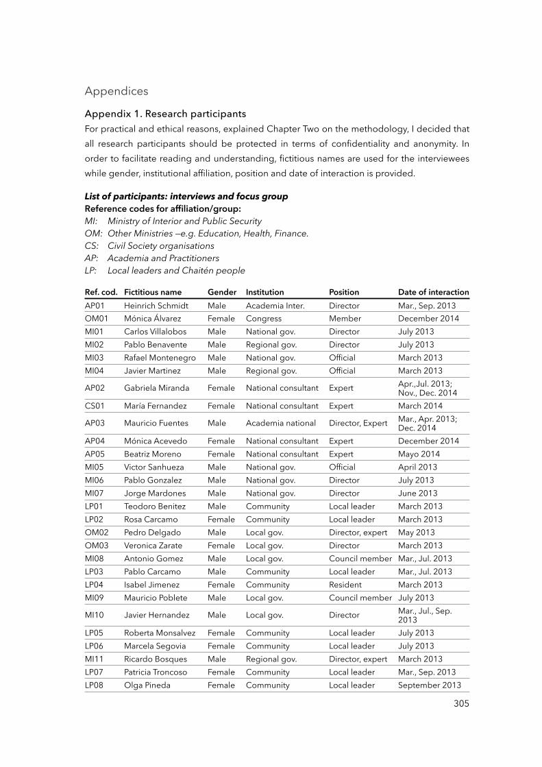
Appendices
Appendix 1. Research participantsFor practical and ethical reasons, explained Chapter Two on the methodology, I decided that all research participants should be protected in terms of confidentiality and anonymity. In order to facilitate reading and understanding, fictitious names are used for the interviewees while gender, institutional affiliation, position and date of interaction is provided.
List of participants: interviews and focus groupReference codes for affiliation/group:MI: Ministry of Interior and Public SecurityOM: Other Ministries —e.g. Education, Health, Finance.CS: Civil Society organisationsAP: Academia and PractitionersLP: Local leaders and Chaitén people
Ref. cod. Fictitious name Gender Institution Position Date of interactionAP01 Heinrich Schmidt Male Academia Inter. Director Mar., Sep. 2013OM01 Mónica Álvarez Female Congress Member December 2014MI01 Carlos Villalobos Male National gov. Director July 2013MI02 Pablo Benavente Male Regional gov. Director July 2013MI03 Rafael Montenegro Male National gov. Official March 2013MI04 Javier Martinez Male Regional gov. Official March 2013
AP02 Gabriela Miranda Female National consultant Expert Apr.,Jul. 2013; Nov., Dec. 2014
CS01 María Fernandez Female National consultant Expert March 2014
AP03 Mauricio Fuentes Male Academia national Director, Expert Mar., Apr. 2013; Dec. 2014
AP04 Mónica Acevedo Female National consultant Expert December 2014AP05 Beatriz Moreno Female National consultant Expert Mayo 2014MI05 Victor Sanhueza Male National gov. Official April 2013MI06 Pablo Gonzalez Male National gov. Director July 2013MI07 Jorge Mardones Male National gov. Director June 2013LP01 Teodoro Benitez Male Community Local leader March 2013LP02 Rosa Carcamo Female Community Local leader March 2013OM02 Pedro Delgado Male Local gov. Director, expert May 2013OM03 Veronica Zarate Female Local gov. Director March 2013MI08 Antonio Gomez Male Local gov. Council member Mar., Jul. 2013LP03 Pablo Carcamo Male Community Local leader Mar., Jul. 2013LP04 Isabel Jimenez Female Community Resident March 2013MI09 Mauricio Poblete Male Local gov. Council member July 2013
MI10 Javier Hernandez Male Local gov. Director Mar., Jul., Sep. 2013
LP05 Roberta Monsalvez Female Community Local leader July 2013LP06 Marcela Segovia Female Community Local leader July 2013MI11 Ricardo Bosques Male Regional gov. Director, expert March 2013LP07 Patricia Troncoso Female Community Local leader Mar., Sep. 2013LP08 Olga Pineda Female Community Local leader September 2013
305
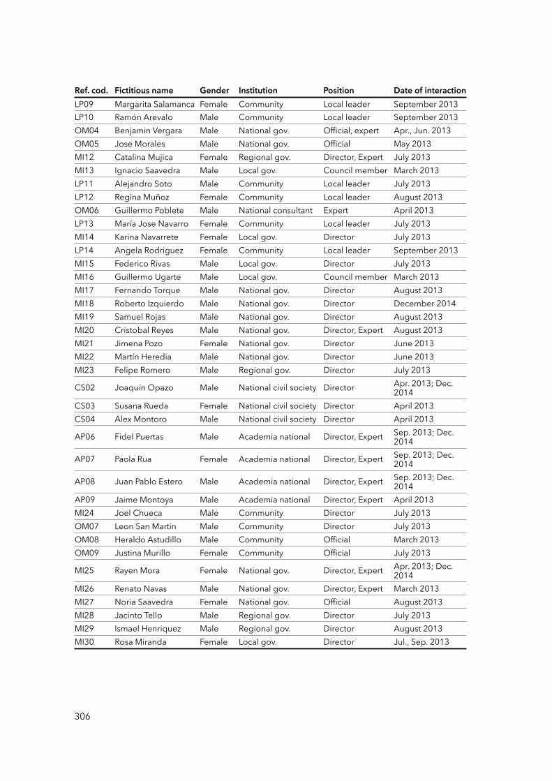
Ref. cod. Fictitious name Gender Institution Position Date of interactionLP09 Margarita Salamanca Female Community Local leader September 2013LP10 Ramón Arevalo Male Community Local leader September 2013OM04 Benjamin Vergara Male National gov. Official, expert Apr., Jun. 2013OM05 Jose Morales Male National gov. Official May 2013MI12 Catalina Mujica Female Regional gov. Director, Expert July 2013MI13 Ignacio Saavedra Male Local gov. Council member March 2013LP11 Alejandro Soto Male Community Local leader July 2013LP12 Regina Muñoz Female Community Local leader August 2013OM06 Guillermo Poblete Male National consultant Expert April 2013LP13 María Jose Navarro Female Community Local leader July 2013MI14 Karina Navarrete Female Local gov. Director July 2013LP14 Angela Rodriguez Female Community Local leader September 2013MI15 Federico Rivas Male Local gov. Director July 2013MI16 Guillermo Ugarte Male Local gov. Council member March 2013MI17 Fernando Torque Male National gov. Director August 2013MI18 Roberto Izquierdo Male National gov. Director December 2014MI19 Samuel Rojas Male National gov. Director August 2013MI20 Cristobal Reyes Male National gov. Director, Expert August 2013MI21 Jimena Pozo Female National gov. Director June 2013MI22 Martín Heredia Male National gov. Director June 2013MI23 Felipe Romero Male Regional gov. Director July 2013
CS02 Joaquín Opazo Male National civil society Director Apr. 2013; Dec. 2014
CS03 Susana Rueda Female National civil society Director April 2013CS04 Alex Montoro Male National civil society Director April 2013
AP06 Fidel Puertas Male Academia national Director, Expert Sep. 2013; Dec. 2014
AP07 Paola Rua Female Academia national Director, Expert Sep. 2013; Dec. 2014
AP08 Juan Pablo Estero Male Academia national Director, Expert Sep. 2013; Dec. 2014
AP09 Jaime Montoya Male Academia national Director, Expert April 2013MI24 Joel Chueca Male Community Director July 2013OM07 Leon San Martin Male Community Director July 2013OM08 Heraldo Astudillo Male Community Official March 2013OM09 Justina Murillo Female Community Official July 2013
MI25 Rayen Mora Female National gov. Director, Expert Apr. 2013; Dec. 2014
MI26 Renato Navas Male National gov. Director, Expert March 2013MI27 Noria Saavedra Female National gov. Official August 2013MI28 Jacinto Tello Male Regional gov. Director July 2013MI29 Ismael Henriquez Male Regional gov. Director August 2013MI30 Rosa Miranda Female Local gov. Director Jul., Sep. 2013
306
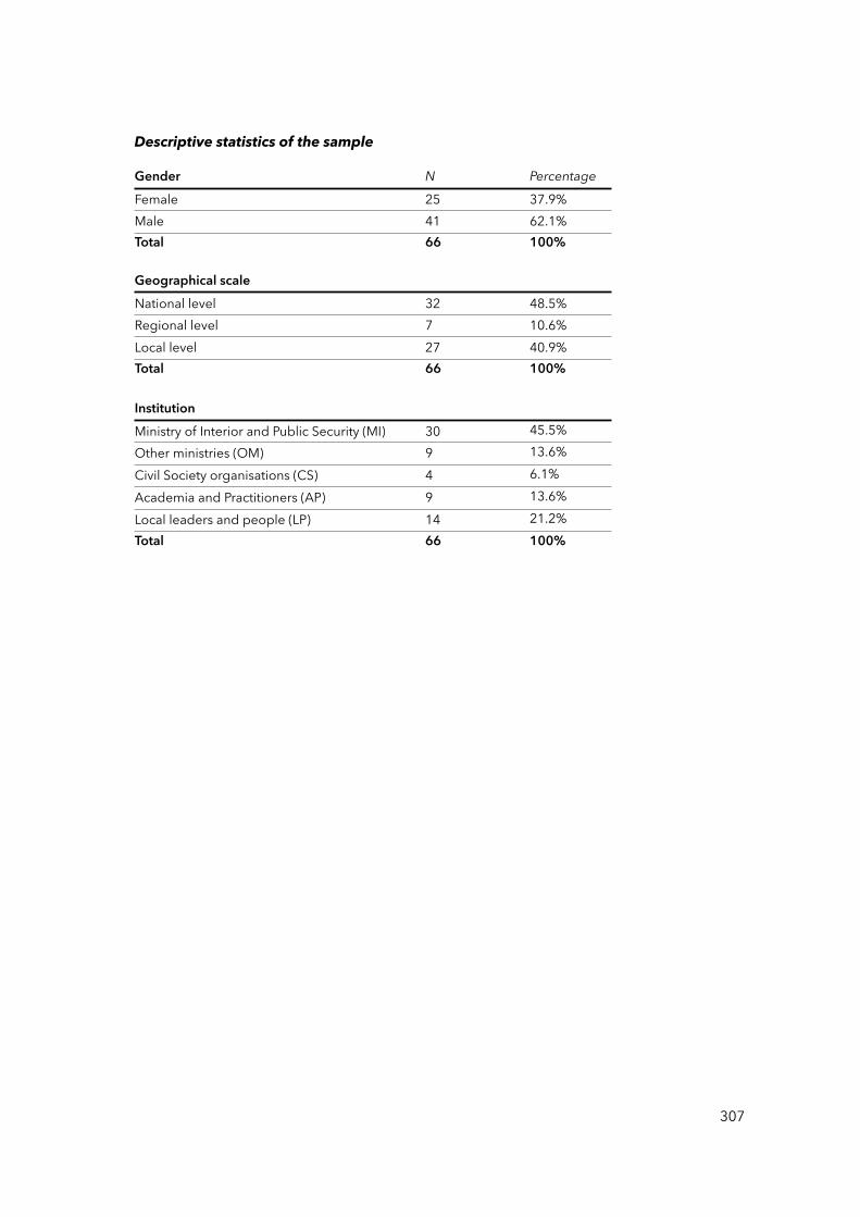
Descriptive statistics of the sample
Gender N PercentageFemale 25 37.9%Male 41 62.1%Total 66 100%
Geographical scaleNational level 32 48.5%Regional level 7 10.6%Local level 27 40.9%Total 66 100%
InstitutionMinistry of Interior and Public Security (MI) 30 45.5%Other ministries (OM) 9 13.6%Civil Society organisations (CS) 4 6.1%Academia and Practitioners (AP) 9 13.6%Local leaders and people (LP) 14 21.2%Total 66 100%
307
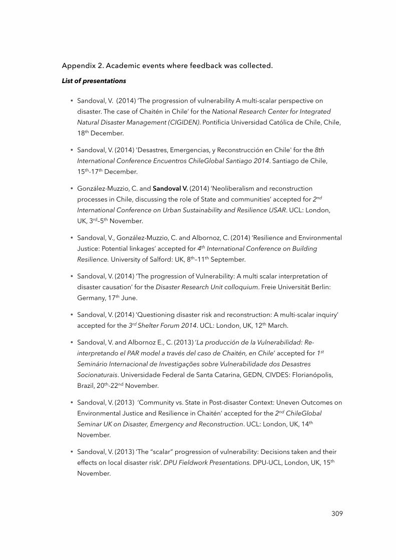
Appendix 2. Academic events where feedback was collected.
List of presentations
• Sandoval, V. (2014) ‘The progression of vulnerability A multi-scalar perspective on disaster. The case of Chaitén in Chile’ for the National Research Center for Integrated Natural Disaster Management (CIGIDEN). Pontificia Universidad Católica de Chile, Chile, 18th December.
• Sandoval, V. (2014) 'Desastres, Emergencias, y Reconstrucción en Chile' for the 8th International Conference Encuentros ChileGlobal Santiago 2014. Santiago de Chile, 15th-17th December.
• González-Muzzio, C. and Sandoval V. (2014) ‘Neoliberalism and reconstruction processes in Chile, discussing the role of State and communities’ accepted for 2nd International Conference on Urban Sustainability and Resilience USAR. UCL: London, UK, 3rd–5th November.
• Sandoval, V., González-Muzzio, C. and Albornoz, C. (2014) ‘Resilience and Environmental Justice: Potential linkages’ accepted for 4th International Conference on Building Resilience. University of Salford: UK, 8th–11th September.
• Sandoval, V. (2014) ‘The progression of Vulnerability: A multi scalar interpretation of disaster causation’ for the Disaster Research Unit colloquium. Freie Universität Berlin: Germany, 17th June.
• Sandoval, V. (2014) ‘Questioning disaster risk and reconstruction: A multi-scalar inquiry’ accepted for the 3rd Shelter Forum 2014. UCL: London, UK, 12th March.
• Sandoval, V. and Albornoz E., C. (2013) ‘La producción de la Vulnerabilidad: Re-interpretando el PAR model a través del caso de Chaitén, en Chile’ accepted for 1st Seminário Internacional de Investigações sobre Vulnerabilidade dos Desastres Socionaturais. Universidade Federal de Santa Catarina, GEDN, CIVDES: Florianópolis, Brazil, 20th-22nd November.
• Sandoval, V. (2013) ‘Community vs. State in Post-disaster Context: Uneven Outcomes on Environmental Justice and Resilience in Chaitén’ accepted for the 2nd ChileGlobal Seminar UK on Disaster, Emergency and Reconstruction. UCL: London, UK, 14th November.
• Sandoval, V. (2013) ‘The “scalar” progression of vulnerability: Decisions taken and their effects on local disaster risk’. DPU Fieldwork Presentations. DPU-UCL, London, UK, 15th November.
309
• Sandoval, V. (2013) ‘Disaster and Sustainability: Development at Risk’ accepted for the 1st International Alumni Conference on Conservation and Sustainable Use of Ecosystems. Greifswald University: Greifswald, Germany, 11th-17th October.
• Sandoval, V., González-Muzzio, C. and Albornoz E., C. (2013) ‘Community versus State in post-disaster context: Uneven outcomes on environmental justice and resilience in Chaitén, Chile’ accepted for the workshop Resilience and Environmental Justice in the Urban Global South. EJUR Research Cluster, DPU-UCL: London, UK, 12th-13th September.
• Sandoval, V. and Boano, C. (2013) 'The progression of vulnerability: A multi-scalar perspective on disasters, the case of Chaitén in Chile' accepted for 4th EUGEO Congress: Europe, what’s next? Changing geographies and geographies of change. University of Rome, Italy, 5th-7th September.
• Sandoval, V. (2013) ‘PhD thesis: The progression of vulnerability: A multi-scalar perspective’ for the Thesis Presentation Seminar at the Research Centre for Vulnerability and Socio-natural Disasters (CIVDES). Universidad de Chile: Chile, 13th March.
310
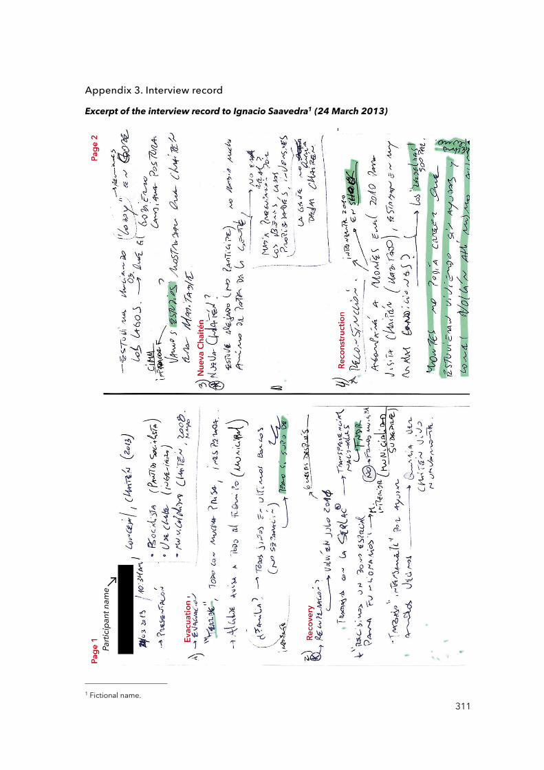
Appendix 3. Interview record
Excerpt of the interview record to Ignacio Saavedra1 (24 March 2013)
3111 Fictional name.
312

Excerpt of the interview record to Federico Rivas 2 (05 July 2013)
3132 Fictional name.

Appendix 4. Interview records
Excerpt of the focus group record to community leaders, Chaitén (05 July 2013).In Spanish.
315
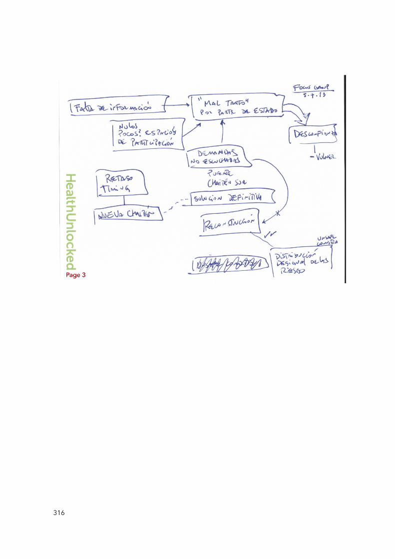
316
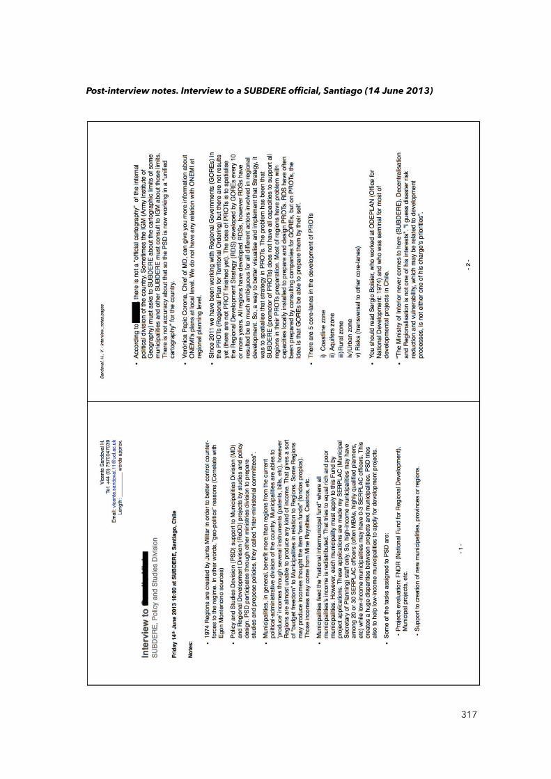
Post-interview notes. Interview to a SUBDERE official, Santiago (14 June 2013)
317
Appendix 5. Newspaper records
List of newspaper records consulted for the 1960 Valdivia earthquake
Newspaper Date Retrieved page(s)La Nación 24 May 1960 1-6La Nación 25 May 1960 1, 8, 18-20, 22La Nación 26May 1960 1-8, 24La Nación 27 May 1960 1-2, 5, 18La Nación 28 May 1960 1, 5, 8, 18La Nación 29 May 1960 1, 5, 10-12, 24La Nación 09 June 1960 1La Nación 08 June 1960 1, 5La Nación 01 June 1960 1-2, 18La Nación 04 June 1960 8La Nación 05 June 1960 4La Nación 06 June 1960 1La Nación 07 June 1960 1-2La Nación 10 June 1960 1, 5, 14, 21, 25La Nación 13 June 1960 1La Nación 15 June 1960 1La Nación 01 July 1960 1, 4-5, 14La Nación 03 July 1960 2La Nación 05 July 1960 1La Nación 06 July 1960 1La Nación 07 July 1960 1, 8Revista VEA 02 June 1960 1-21, 25-30Revista VEA 09 June 1960 4-9,18-26, 30Revista VEA 16 June 1960 1-14, 19, 23-25, 27, 31-32Revista VEA 23 June 1960 7-13, 20-21Revista VEA 30 June 1960 8-14, 19, 24-25El Mercurio 23 May 1960 1El Mercurio 24 May 1960 1El Mercurio 25 May 1960 1El Mercurio 26 May 1960 1El Mercurio 27 May 1960 1El Mercurio 28 May 1960 1El Mercurio 31 May 1960 1El Mercurio 01 June 1960 1El Mercurio 02 June 1960 1El Mercurio 03 June 1960 1El Mercurio 04 June 1960 1El Mercurio 09 June 1960 1El Mercurio 11 June 1960 1El Mercurio 14 June 1960 1
319
El Mercurio 15 June 1960 1El Siglo 22 July 1960 1El Siglo 20 July 1960 1El Siglo 16 July 1960 1El Siglo 12 July 1960 1El Siglo 26 June 1960 1El Siglo 12 June 1960 1El Siglo 11 June 1960 1El Siglo 03 June 1960 1El Siglo 02 June 1960 1El Siglo 30 May 1960 1
320
Appendix 6. Relevant disasters in the recent history of Chile
Relevant disasters in the last 200 years of the Chilean history according to the National
Commission for Resilience to Disasters of Natural Origin or CREDEN (2016 pp. 36-37).
Timeline of relevant disasters
Te
rre
mo
tos
Fe
nó
me
no
s c
lim
áti
co
s e
xtr
em
os
Eru
pcio
ne
s V
olc
án
ica
s
Ince
nd
ios
18
20
18
40
18
60
18
80
19
00
19
20
19
40
18
35
Te
rre
mo
to
de
Co
nce
pció
n
18
22
Te
rre
mo
to
de
Va
lpa
raís
o
19
06
Te
rre
mo
to
de
Va
lpa
raís
o
19
22
Te
rre
mo
to
de
Va
lle
na
r
Te
rre
mo
to
de
Ch
illá
n
Ince
nd
io
de
Ca
utí
n
19
28
Te
rre
mo
to
de
Ta
lca
19
39
19
32
Eru
pció
n
Vo
lcá
n
Qu
iza
pú
19
60
20
00
20
15
19
61
Eru
pció
n
Vo
lcá
n
Ca
lbu
co
19
60
Te
rre
mo
to
de
Va
ldiv
ia
19
85
Te
rre
mo
to
de
Va
lpa
raís
o
19
68
Gra
n
Se
qu
ía
19
72
Alu
vió
n
de
Ch
añ
ara
l1
98
0-8
2
Inu
nd
acio
ne
s
de
Sa
nti
ag
o
Te
rre
mo
to
de
Ta
lca
19
71
Eru
pció
n
Vo
lcá
n
Hu
dso
n
19
87
Inu
nd
acio
ne
s
de
Sa
nti
ag
o
Alu
vió
n R
io
Co
lora
do
19
93
Inu
nd
acio
ne
s
y A
luv
ión
Qu
eb
rad
a
Ma
cu
l
(Sa
nti
ag
o)
19
96
Se
qu
ía (
Áre
a
Ce
ntr
o N
ort
e)
19
97
Alu
vió
n
Co
pia
pó
Te
rre
mo
to
Bla
nco
19
95
19
64
Eru
pció
n
Vo
lcá
n
Vil
larr
ica
19
91
Alu
vió
n
An
tofa
ga
sta
Se
qu
ía
(No
rte
Ch
ico
)
Eru
pció
n
Vo
lcá
n
Hu
dso
n
19
98
-99
Gra
n S
eq
uía
Eru
pció
n
Vo
lcá
n
Lo
nq
uim
ay
Ince
nd
io d
e G
ran
Gu
ait
eca
s
Incen
dio de
La Ru
fina
Eru
pció
n
Vo
lca
ne
s
Ca
lbu
co
y
Vil
larr
ica
20
07
Te
rre
mo
to
de
To
co
pil
la
20
10
Te
rre
mo
to
de
Ma
ule
20
15
Alu
vió
n
Ata
ca
ma
20
08
Eru
pció
n
Vo
lcá
n
Ch
ait
én
Te
rre
mo
to
de
Ill
ap
el
Te
rre
mo
to
de
Ta
rap
acá
20
05
Ince
nd
io d
e
La
gu
na
Azu
lE
rup
ció
n V
olc
án
Pu
ye
hu
e -
Co
rdó
n C
au
lle
20
11
Ince
nd
io d
e
To
rre
s d
el
Pa
ine
20
14
Te
rre
mo
to
de
Pis
ag
ua
Ince
nd
io d
e
Va
lpa
raís
o
Actu
alm
en
te
Se
qu
ía2
01
2-1
3
Eru
pció
n
Vo
lcá
n
Co
pa
hu
e
Ince
nd
io
de
Qu
illó
n
321
Appendix 7. Regions of Chile
Political-administrative division of the Chilean territory
323
Argentina
BoliviaN
Arica y Parinacota
Tarapacá
Antofagasta
Atacama
Coquimbo
ValparaísoMetropolitana
O'HigginsMaule
Bío-Bío
La Araucanía
Los Ríos
Los Lagos
Aysén
Magallanes
Pacifi
c Sea
0 300150 600
Kilometres
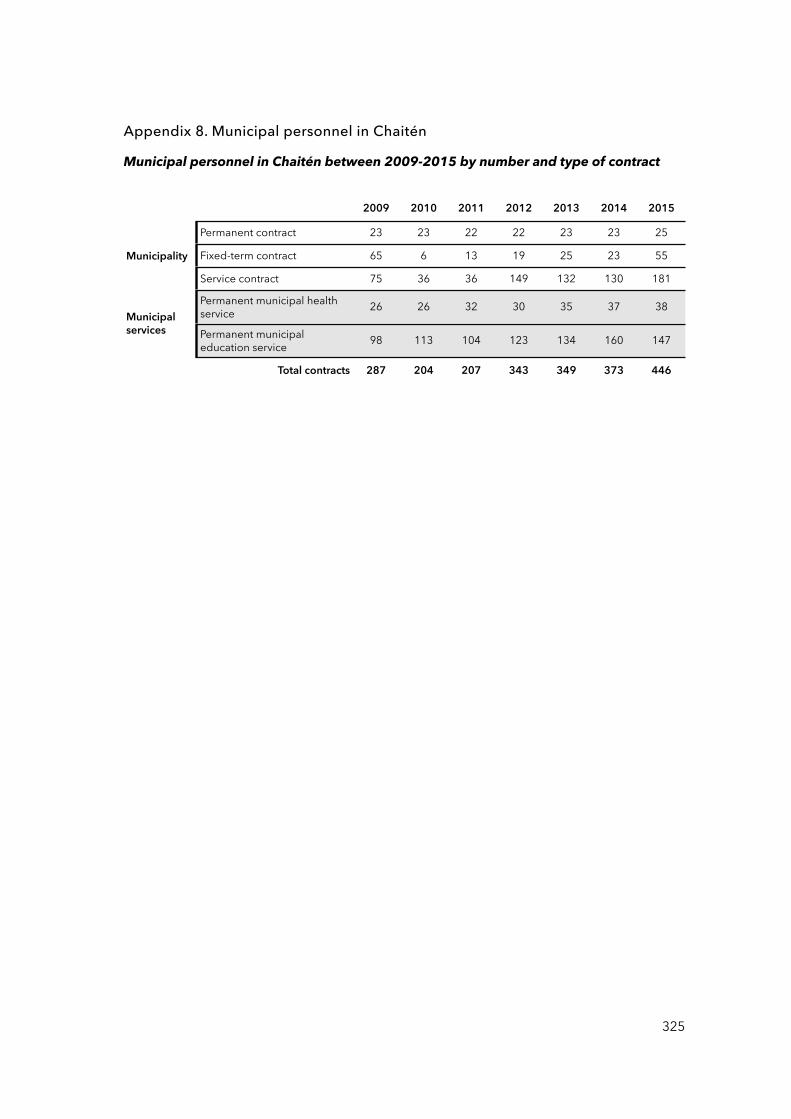
Appendix 8. Municipal personnel in Chaitén
Municipal personnel in Chaitén between 2009-2015 by number and type of contract
2009 2010 2011 2012 2013 2014 2015
Municipality
Permanent contract 23 23 22 22 23 23 25
Municipality Fixed-term contract 65 6 13 19 25 23 55Municipality
Service contract 75 36 36 149 132 130 181
Municipal services
Permanent municipal health service 26 26 32 30 35 37 38
Municipal services Permanent municipal
education service 98 113 104 123 134 160 147
Total contracts 287 204 207 343 349 373 446
325
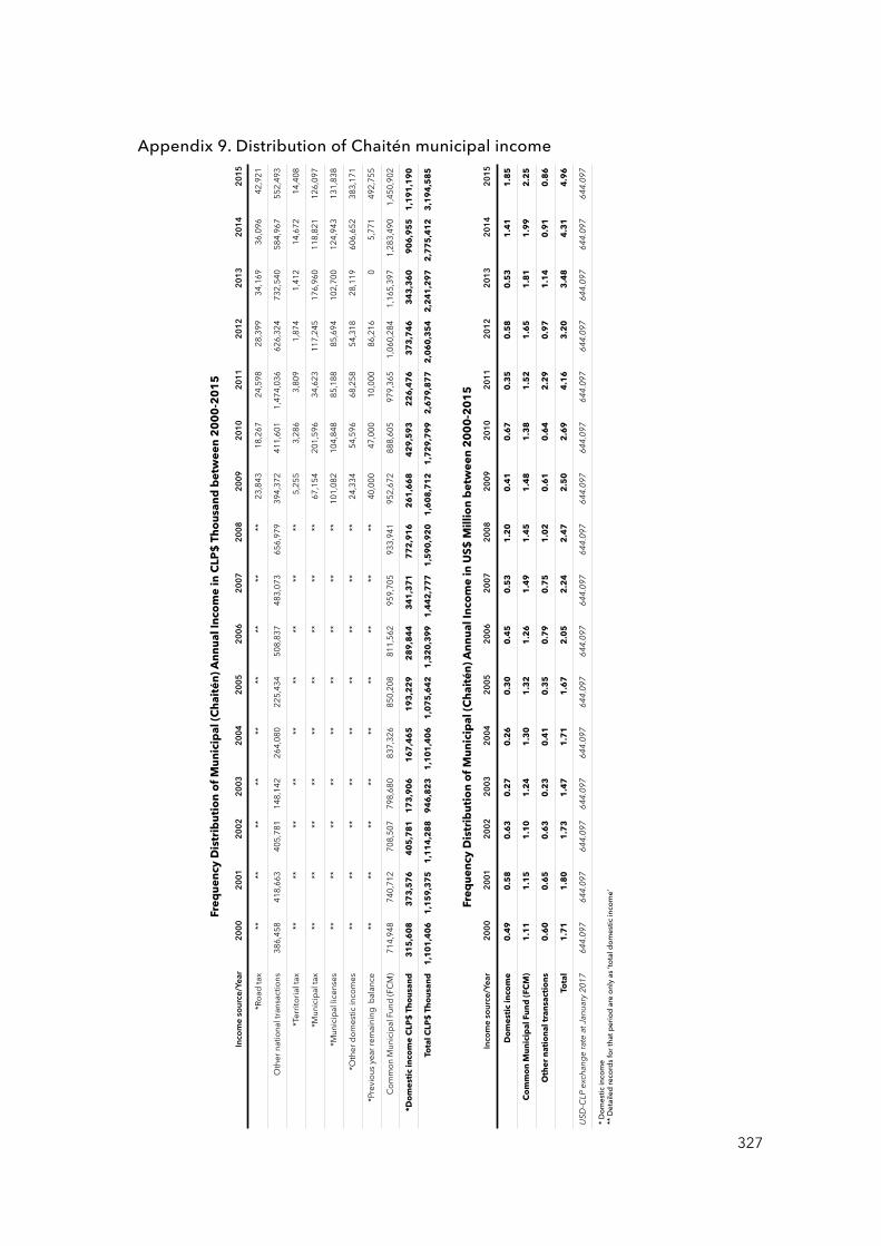
Appendix 9. Distribution of Chaitén municipal income
327
Fre
qu
en
cy D
istr
ibu
tio
n o
f M
un
icip
al (
Ch
ait
én
) A
nn
ua
l In
com
e in
CLP
$ T
ho
usa
nd
be
twe
en
20
00
-20
15
Inco
me s
ourc
e/Ye
ar20
0020
0120
0220
0320
0420
0520
0620
0720
0820
0920
1020
1120
1220
1320
1420
15
*Roa
d ta
x **
****
****
****
****
23,8
4318
,267
24,5
9828
,399
34,1
6936
,096
42,9
21
Oth
er n
atio
nal t
rans
actio
ns38
6,45
841
8,66
340
5,78
114
8,14
226
4,08
022
5,43
450
8,83
748
3,07
365
6,97
939
4,37
241
1,60
11,
474,
036
626,
324
732,
540
584,
967
552,
493
*Ter
ritor
ial t
ax**
****
****
****
****
5,25
53,
286
3,80
91,
874
1,41
214
,672
14,4
08
*Mun
icip
al ta
x **
****
****
****
****
67,1
5420
1,59
634
,623
117,
245
176,
960
118,
821
126,
097
*Mun
icip
al li
cens
es**
****
****
****
****
101,
082
104,
848
85,1
8885
,694
102,
700
124,
943
131,
838
*Oth
er d
omes
tic in
com
es
****
****
****
****
**24
,334
54,5
9668
,258
54,3
1828
,119
606,
652
383,
171
*Pre
viou
s yea
r rem
aini
ng b
alan
ce
****
****
****
****
**40
,000
47,0
0010
,000
86,2
160
5,77
149
2,75
5
Com
mon
Mun
icip
al F
und
(FC
M)
714,
948
740,
712
708,
507
798,
680
837,
326
850,
208
811,
562
959,
705
933,
941
952,
672
888,
605
979,
365
1,06
0,28
41,
165,
397
1,28
3,49
01,
450,
902
*Do
me
stic
inco
me
CLP
$ T
ho
usa
nd
31
5,6
08
37
3,5
76
40
5,7
81
17
3,9
06
16
7,4
65
19
3,2
29
28
9,8
44
34
1,3
71
77
2,9
16
26
1,6
68
42
9,5
93
22
6,4
76
37
3,7
46
34
3,3
60
90
6,9
55
1,1
91
,19
0
Tota
l CLP
$ T
ho
usa
nd
1,1
01
,40
61
,15
9,3
75
1,1
14
,28
89
46
,82
31
,10
1,4
06
1,0
75
,64
21
,32
0,3
99
1,4
42
,77
71
,59
0,9
20
1,6
08
,71
21
,72
9,7
99
2,6
79
,87
72
,06
0,3
54
2,2
41
,29
72
,77
5,4
12
3,1
94
,58
5
Fre
qu
en
cy D
istr
ibu
tio
n o
f M
un
icip
al (
Ch
ait
én
) A
nn
ua
l In
com
e in
US
$ M
illi
on
be
twe
en
20
00
-20
15
Inco
me s
ourc
e/Ye
ar20
0020
0120
0220
0320
0420
0520
0620
0720
0820
0920
1020
1120
1220
1320
1420
15
Do
me
stic
inco
me
0.4
90
.58
0.6
30
.27
0.2
60
.30
0.4
50
.53
1.2
00
.41
0.6
70
.35
0.5
80
.53
1.4
11
.85
Co
mm
on
Mu
nic
ipa
l Fu
nd
(F
CM
) 1
.11
1.1
51
.10
1.2
41
.30
1.3
21
.26
1.4
91
.45
1.4
81
.38
1.5
21
.65
1.8
11
.99
2.2
5
Oth
er
nat
ion
al t
ran
sact
ion
s0
.60
0.6
50
.63
0.2
30
.41
0.3
50
.79
0.7
51
.02
0.6
10
.64
2.2
90
.97
1.1
40
.91
0.8
6
Tota
l1
.71
1.8
01
.73
1.4
71
.71
1.6
72
.05
2.2
42
.47
2.5
02
.69
4.1
63
.20
3.4
84
.31
4.9
6
USD-
CLP
exch
ange
rate
at Ja
nuar
y 201
764
4.09
764
4.09
764
4.09
764
4.09
764
4.09
764
4.09
764
4.09
764
4.09
764
4.09
764
4.09
764
4.09
764
4.09
764
4.09
764
4.09
764
4.09
764
4.09
7
* Dom
estic
inco
me
** D
etail
ed re
cord
s for
that
per
iod
are
only
as ‘t
otal
dom
estic
inco
me’