Classification and Distribution Clay Residues Debris Flow ...
7
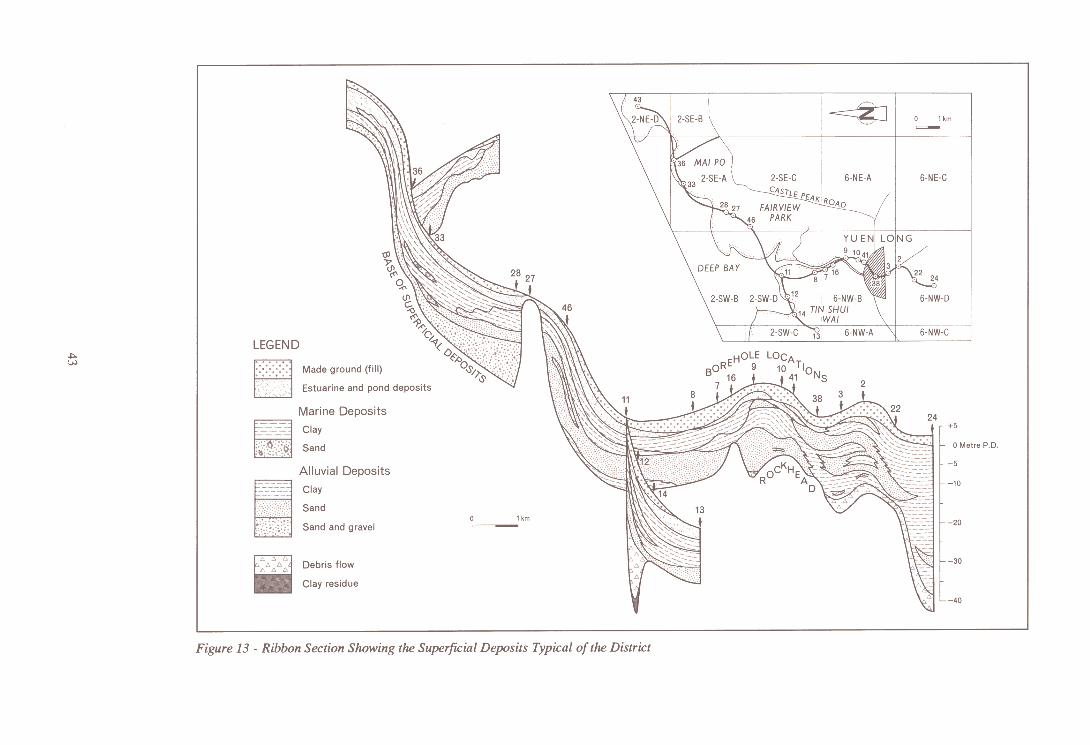
Classification and Distribution Superficial depositsoccur mostly in the low-lying ground, forming extensive flood plains stretching from Tuen Mun north through Yuen Long to Lok Ma Chau (Figure 12). Debris flow deposits occur upslopeof the alluvial plains filling the floors of small side-valleys, but are also found beneath alluvial depositsfilling irregularities in the karst marble surface. Marine deposits over' 4 m in thickness are limited to the area adjacentto Deep Bay and the Sham Chun River. Alluvial depositsare the most important sub-division of the superficial sediments, and are invariably representedin sections or borehole cores. They comprise clays, silts, sands and gravels, with the arenaceous sediments locally forming lenseswhich serveas aquifers in the urbanareasof the district. The containedgroundwater has been used for both flushing and drinking purposes. Much of the urban area has been coveredby fill, usually comprisingweathered granite,sandstones and siltstones, or, more recently,marine sand(Figure 13). Clay Residues One of the oldest superficial deposits of the disbict occurs immediately above the marble bedrock, and is usually confined to the base of hollows within the karst topography. It comprises brown and dark grey silty clay rich in sericite and pyrite, together with weathered fragments of siltstone, marble and quartz. These deposits vary from a few metres to only a few centimetres, being thickest above the dark grey marble (Long Ping Member), with some 3 m proved in BGS 12 at a depth of 38.34 m. Radiocarbon dates obtained from clay residue samples in this borehole ranged from 37 000 to 39 000 years BP (Appendix 7). The clay residue is the only remaining representative deposit of the karstification process, other fractions having been transported in solution laterally out of the area or vertically down into the epikarst. It is the only deposit which may be accurately called completely weathered marble. However, there may be some mixing with fine clays and micas derived from the surrounding completely weathered metamorphic rocks or the derived boulders from such rocks in the debris flow deposits (see below), and these origins could explain the common occurrence of sericite. Debris Flow Deposits Deposits belonging to this classification, generally referred to as colluvium in Hong Kong (GCO, 1988b), are soil accumulations, usually of locally derived material, which have flowed downslope during periods of high rainfall. Such flows may be initiated on slopes inclined at only a few degrees. Debris flow deposits commonly occur over the irregular karst topography of the marble subcrop in the vicinity of Yuen Long town. They comprise a structureless, silt, clay and sand matrix with embedded subangular fragments of weathered country rock. The colour of the matrix varies from yellowish brown, through brownish grey to pink; white kaolin streaks and spots are common. The rock fragments show a weathered rind. The maximum recorded thickness of debris flow deposits is nearly 50 m in BGS I, but the close proximity of highly weathered volcanic rocks faulted against marble make identification uncertain. The thickness of 5 to 10 m proved in BGS 3 and BGS 9 is more typical. Alluvium The alluvial depositsof the district are generally thicker and more widespread than any of the other superficial deposits, reachinga maximum recorded thickness of 38 m in BGS 24. They were laid down in the Quaternary period and compriseclays and silts with interbedded sandsand gravels. The sands and gravelsare commonest towardsthe baseof the sequence, and thicknesses of 10 m were recordedin boreholes by the Sham Chun River between Fairview Parkand Lok Ma Chau. The sands at higher levels are greyish white to yellow in colour, well-sorted and medium- to coarse-grained. Radiocarbon dating of a sample conrnining carbonaceous fragments (at 20.2 m depth in BGS 12) gave an age date of 26 ()()() to 27 ()()() years BP. Clays and silts vary in colour from pale grey to yellowish brown with red and pink mottling. Organic alluvial clay samples collected by K. W. Lai (Langford et a1,1989)in the YuenLong areagavedates ranging from 15 ()()() to 33 ()()() years BP.
-
Upload
khangminh22 -
Category
Documents
-
view
1 -
download
0
Transcript of Classification and Distribution Clay Residues Debris Flow ...

Classification and Distribution
Superficial deposits occur mostly in the low-lying ground, forming extensive flood plains stretchingfrom Tuen Mun north through Yuen Long to Lok Ma Chau (Figure 12). Debris flow deposits occurupslope of the alluvial plains filling the floors of small side-valleys, but are also found beneath alluvialdeposits filling irregularities in the karst marble surface. Marine deposits over' 4 m in thickness arelimited to the area adjacent to Deep Bay and the Sham Chun River. Alluvial deposits are the mostimportant sub-division of the superficial sediments, and are invariably represented in sections orborehole cores. They comprise clays, silts, sands and gravels, with the arenaceous sediments locallyforming lenses which serve as aquifers in the urban areas of the district. The contained groundwater hasbeen used for both flushing and drinking purposes.
Much of the urban area has been covered by fill, usually comprising weathered granite, sandstones andsiltstones, or, more recently, marine sand (Figure 13).
Clay ResiduesOne of the oldest superficial deposits of the disbict occurs immediately above the marble bedrock, andis usually confined to the base of hollows within the karst topography. It comprises brown and darkgrey silty clay rich in sericite and pyrite, together with weathered fragments of siltstone, marble andquartz. These deposits vary from a few metres to only a few centimetres, being thickest above the darkgrey marble (Long Ping Member), with some 3 m proved in BGS 12 at a depth of 38.34 m.Radiocarbon dates obtained from clay residue samples in this borehole ranged from 37 000 to 39 000years BP (Appendix 7).
The clay residue is the only remaining representative deposit of the karstification process, otherfractions having been transported in solution laterally out of the area or vertically down into theepikarst. It is the only deposit which may be accurately called completely weathered marble. However,there may be some mixing with fine clays and micas derived from the surrounding completelyweathered metamorphic rocks or the derived boulders from such rocks in the debris flow deposits (seebelow), and these origins could explain the common occurrence of sericite.
Debris Flow Deposits
Deposits belonging to this classification, generally referred to as colluvium in Hong Kong (GCO,1988b), are soil accumulations, usually of locally derived material, which have flowed downslopeduring periods of high rainfall. Such flows may be initiated on slopes inclined at only a few degrees.
Debris flow deposits commonly occur over the irregular karst topography of the marble subcrop in thevicinity of Yuen Long town. They comprise a structureless, silt, clay and sand matrix with embeddedsubangular fragments of weathered country rock. The colour of the matrix varies from yellowish brown,through brownish grey to pink; white kaolin streaks and spots are common. The rock fragments show aweathered rind. The maximum recorded thickness of debris flow deposits is nearly 50 m in BGS I, butthe close proximity of highly weathered volcanic rocks faulted against marble make identificationuncertain. The thickness of 5 to 10 m proved in BGS 3 and BGS 9 is more typical.
Alluvium
The alluvial deposits of the district are generally thicker and more widespread than any of the othersuperficial deposits, reaching a maximum recorded thickness of 38 m in BGS 24. They were laid downin the Quaternary period and comprise clays and silts with interbedded sands and gravels. The sandsand gravels are commonest towards the base of the sequence, and thicknesses of 10 m were recorded inboreholes by the Sham Chun River between Fairview Park and Lok Ma Chau.
The sands at higher levels are greyish white to yellow in colour, well-sorted and medium- tocoarse-grained. Radiocarbon dating of a sample conrnining carbonaceous fragments (at 20.2 m depth inBGS 12) gave an age date of 26 ()()() to 27 ()()() years BP. Clays and silts vary in colour from pale greyto yellowish brown with red and pink mottling. Organic alluvial clay samples collected by K. W. Lai(Langford et a1, 1989) in the Yuen Long area gave dates ranging from 15 ()()() to 33 ()()() years BP.


The alluvial deposits were laid down under various conditions of deposition. During periods of activeerosion of nearby hills, coarse arenaceous material was deposited not far from the source. At othertimes, a quieter environment existed, allowing far-travelled silts and muds to be laid down. Contoursdrawn on the base of the alluvial deposits for a site [2105 3355] in southern Yuen Long suggest apalaeogeography of meandering channels separated by ridges and islands of higher ground with a reliefof some 8 m. Plant debris accumulated along the margins of some of the channels, probably on the leeside of the meanders. Sporadic areas of standing water are indicated by lacustrine or pond deposits(Figure 14).
Figure 14 -Contour Map Showing the Base of the Alluvial Deposits Suggesting a Palaeogeogra-phy of Meandering Channels
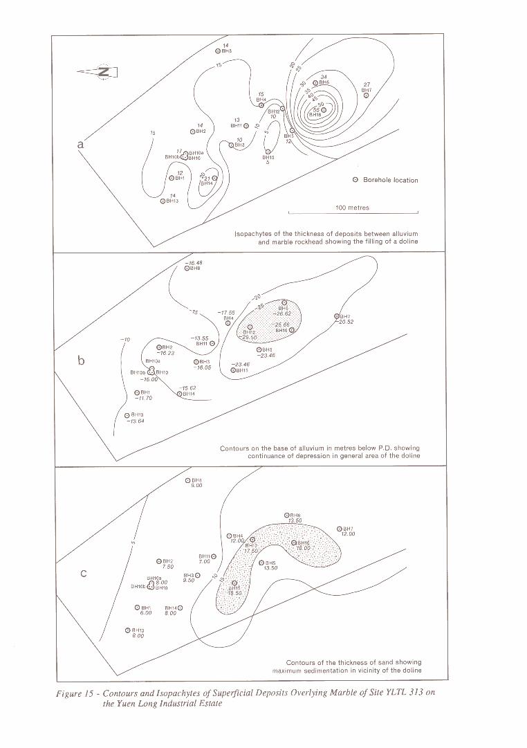
Evidence from sites in Yuen Long suggests a correlation between rockhead channels and majorstructural lines of weakness, and there is a northeasterly grain to some of the alluvial patterns ofdrainage (Figure 15). Detailed information available from a site adjacent to Wang Lok Street on theYuen Long Industrial Estate has shown that alluvial sands tend to thicken above a doline due to adepression in the surface of the underlying debris flow deposits (Figure 16).
Marine DepositsThe Hang Hau Formation (Strange & Shaw, 1986) is of Holocene age and forms the seabed over muchof the marine part the district. This deposit occurs inland as far as Yuen Long and the Castle Peak Road(Figure 17). The marine deposits are usually very soft to soft clays, but in the present district firm tostiff silty clays with some fine lamination are also present. They are an olive grey colour and commonlycontain shell fragments (mostly Paphia undulata, Bassina calophylla, small gastropods and echinoidspines). The clays thicken northwards (Figure 17) and generally exceed 4 m along the margin of DeepBay.
An embayment of thicker sediments occurs near Mai Po where they exceed 10 m. North of TinShui Wai, two marine incursions are separated by a non-marine interval (BGS 12). Radiocarbon datingof samples from the lowest deposit gave ages of 21 000 to 22000 years BP, which correlates with theChek Lap Kok Formation of late Pleistocene age.
44