
Clare River (Claregalway) Flood Relief Scheme
153
Clare River (Claregalway) Flood Relief Scheme November 2012 rpsgroup.com/ireland MGE0262CR0023 Environmental Impact Statement Volume II – Main Report
-
Upload
khangminh22 -
Category
Documents
-
view
1 -
download
0
Transcript of Clare River (Claregalway) Flood Relief Scheme
Clare River (Claregalway) Flood Relief Scheme
November 2012
rpsgroup.com/ireland
MGE0262CR0023
Environmental Impact StatementVolume II – Main Report


Clare River (Claregalway) Flood Relief Scheme Table of Contents
MGE0262Rp0012 i Rev F01
CONTENTS
1 INTRODUCTION........................................................................................................................ 1
2 ENVIRONMENTAL IMPACT ASSESSMENT ........................................................................... 6
2.1 LEGISLATIVE CONTEXT..................................................................................................... 6
2.2 ENVIRONMENTAL IMPACT ASSESSMENT PROCESS............................................................. 6
2.3 STRUCTURE OF THIS EIS ................................................................................................. 7
2.4 EIS STUDY TEAM ............................................................................................................ 8
2.5 TECHNICAL DIFFICULTIES ................................................................................................. 9
3 POLICY PLANNING AND LEGISLATION .............................................................................. 10
3.1 EU POLICY.................................................................................................................... 10
3.2 NATIONAL POLICY AND LEGISLATION............................................................................... 10
3.3 REGIONAL POLICY ......................................................................................................... 12
4 CONSULTATION ..................................................................................................................... 16
4.1 INTRODUCTION .............................................................................................................. 16
4.2 STATUTORY AND NON-GOVERNMENTAL ORGANISATION CONSULTATION ............................ 16
4.3 PUBLIC STAKEHOLDER CONSULTATION............................................................................ 24
4.4 OTHER CONSULTATION .................................................................................................. 28
4.5 SUMMARY OF CONSULTATIONS UNDERTAKEN ................................................................. 29
5 STUDY AREA .......................................................................................................................... 31
5.1 HISTORICAL AND CURRENT DAY CLARE RIVER CATCHMENT .............................................. 31
5.2 SECTION OF THE CLARE RIVER CATCHMENT PERTINENT TO THIS STUDY............................ 34
5.3 LAND USE IN THE STUDY AREA ....................................................................................... 34
6 PROJECT DESCRIPTION....................................................................................................... 35
6.1 INTRODUCTION .............................................................................................................. 35
6.2 CLARE RIVER FLOOD RELIEF SCHEME DESIGN PHILOSOPHY ........................................... 36
6.3 DETAILED DESCRIPTION OF THE PROPOSED FLOOD RELIEF SCHEME................................. 42
6.4 HYDRAULIC IMPACT OF THE PROPOSED FLOOD RELIEF SCHEME ...................................... 63
6.5 PROGRAMME AND PHASING OF WORKS FOR THE FLOOD RELIEF SCHEME ........................ 65
6.6 EXCAVATION WORKS AND QUANTITIES ........................................................................... 65
6.7 SITE ACCESS AND COMPOUNDS ..................................................................................... 67
6.8 OPERATION OF THE PROPOSED FLOOD RELIEF SCHEME.................................................. 70
6.9 GROUND INVESTIGATIONS............................................................................................... 70
6.10 CLAREGALWAY FOOTBRIDGE – FEASIBILITY STUDY......................................................... 70
7 NEED FOR THE PROPOSED SCHEME AND ALTERNATIVES CONSIDERED.................. 72
7.1 BACKGROUND AND NEED FOR THE PROPOSED SCHEME ................................................... 72
7.2 ALTERNATIVES CONSIDERED AND NEED FOR THE PROPOSED SCHEME .............................. 75
8 HYDROLOGY AND DRAINAGE ............................................................................................. 79
8.1 INTRODUCTION .............................................................................................................. 79
Clare River (Claregalway) Flood Relief Scheme Table of Contents
MGE0262Rp0012 ii Rev F01
8.2 METHODOLOGY ............................................................................................................. 79
8.3 EXISTING ENVIRONMENT ................................................................................................ 81
8.4 FLOOD RELIEF SCHEME – PREFERRED SCHEME SUMMARY................................................ 83
8.5 POTENTIAL IMPACTS ...................................................................................................... 84
8.6 MITIGATION MEASURES.................................................................................................. 87
8.7 RESIDUAL IMPACTS........................................................................................................ 89
8.8 CONCLUSIONS ............................................................................................................... 92
9 SOILS, GEOLOGY AND HYDROGEOLOGY ......................................................................... 93
9.1 INTRODUCTION .............................................................................................................. 93
9.2 METHODOLOGY ............................................................................................................. 93
9.3 EXISTING ENVIRONMENT ................................................................................................ 94
9.4 POTENTIAL IMPACTS .................................................................................................... 105
9.5 MITIGATION MEASURES................................................................................................ 111
9.6 RESIDUAL IMPACTS...................................................................................................... 111
9.7 CONCLUSIONS ............................................................................................................. 112
10 TERRESTRIAL ECOLOGY ................................................................................................... 113
10.1 INTRODUCTION ............................................................................................................ 113
10.2 METHODOLOGY ........................................................................................................... 113
10.3 EXISTING ENVIRONMENT .............................................................................................. 120
10.4 POTENTIAL IMPACTS .................................................................................................... 168
10.5 MITIGATION MEASURES................................................................................................ 183
10.6 RESIDUAL IMPACTS...................................................................................................... 203
10.7 CONCLUSIONS ............................................................................................................. 203
11 AQUATIC ECOLOGY AND WATER QUALITY .................................................................... 205
11.1 INTRODUCTION ............................................................................................................ 205
11.2 METHODOLOGY ........................................................................................................... 206
11.3 EXISTING ENVIRONMENT .............................................................................................. 215
11.4 POTENTIAL IMPACTS .................................................................................................... 241
11.5 MITIGATION MEASURES................................................................................................ 258
11.6 RESIDUAL IMPACTS...................................................................................................... 263
11.7 CONCLUSIONS ............................................................................................................. 272
12 AIR QUALITY AND CLIMATE............................................................................................... 275
12.1 INTRODUCTION ............................................................................................................ 275
12.2 METHODOLOGY ........................................................................................................... 275
12.3 EXISTING ENVIRONMENT .............................................................................................. 277
12.4 POTENTIAL IMPACTS .................................................................................................... 284
12.5 MITIGATION MEASURES................................................................................................ 286
12.6 RESIDUAL IMPACTS...................................................................................................... 288
12.7 CONCLUSIONS ............................................................................................................. 288
13 NOISE AND VIBRATION....................................................................................................... 289
Clare River (Claregalway) Flood Relief Scheme Table of Contents
MGE0262Rp0012 iii Rev F01
13.1 INTRODUCTION ............................................................................................................ 289
13.2 METHODOLOGY ........................................................................................................... 289
13.3 EXISTING ENVIRONMENT .............................................................................................. 292
13.4 POTENTIAL IMPACTS .................................................................................................... 293
13.5 MITIGATION MEASURES................................................................................................ 294
13.6 RESIDUAL IMPACTS...................................................................................................... 297
13.7 CONCLUSIONS ............................................................................................................. 297
14 ARCHAEOLOGY, ARCHITECTURAL AND CULTURAL HERITAGE................................. 298
14.1 INTRODUCTION ............................................................................................................ 298
14.2 METHODOLOGY ........................................................................................................... 300
14.3 EXISTING ENVIRONMENT .............................................................................................. 303
14.4 POTENTIAL IMPACTS .................................................................................................... 330
14.5 MITIGATION MEASURES................................................................................................ 334
14.6 RESIDUAL IMPACTS...................................................................................................... 336
14.7 CONCLUSIONS ............................................................................................................. 336
15 LANDSCAPE AND VISUAL ENVIRONMENT ...................................................................... 339
15.1 INTRODUCTION ............................................................................................................ 339
15.2 METHODOLOGY ........................................................................................................... 339
15.3 EXISTING ENVIRONMENT .............................................................................................. 343
15.4 POTENTIAL IMPACTS .................................................................................................... 347
15.5 MITIGATION MEASURES................................................................................................ 358
15.6 RESIDUAL IMPACTS...................................................................................................... 361
15.7 CONCLUSIONS ............................................................................................................. 361
16 HUMAN BEINGS AND MATERIAL ASSETS ....................................................................... 362
16.1 INTRODUCTION ............................................................................................................ 362
16.2 METHODOLOGY ........................................................................................................... 362
16.3 EXISTING ENVIRONMENT .............................................................................................. 363
16.4 POTENTIAL IMPACTS .................................................................................................... 369
16.5 MITIGATION MEASURES................................................................................................ 370
16.6 RESIDUAL IMPACTS...................................................................................................... 370
16.7 CONCLUSIONS ............................................................................................................. 370
17 TRAFFIC ................................................................................................................................ 373
17.1 INTRODUCTION ............................................................................................................ 373
17.2 METHODOLOGY ........................................................................................................... 373
17.3 EXISTING ENVIRONMENT .............................................................................................. 374
17.4 POTENTIAL IMPACTS .................................................................................................... 378
17.5 MITIGATION MEASURES................................................................................................ 379
17.6 RESIDUAL IMPACTS...................................................................................................... 382
17.7 CONCLUSIONS ............................................................................................................. 382
Clare River (Claregalway) Flood Relief Scheme Table of Contents
MGE0262Rp0012 iv Rev F01
18 INTERACTION BETWEEN ENVIRONMENTAL ASPECTS AND CUMULATIVE IMPACTS
383
18.1 INTRODUCTION ............................................................................................................ 383
18.2 CUMULATIVE IMPACTS.................................................................................................. 386
19 SUMMARY MITIGATION MEASURES ................................................................................. 394
20 REFERENCES ....................................................................................................................... 420
Clare River (Claregalway) Flood Relief Scheme Table of Contents
MGE0262Rp0012 v Rev F01
List of Acronyms AADT Annual Average Daily Traffic
AEP Annual Exceedance Probability
APSR Areas of Potentially Significant Risk
AQS Air Quality Standards
ASU Aquatic Services Unit
ASPT Average Score Per Taxon
BAP Biodiversity Action Plan
BoCCI Birds of Conservation Concern in Ireland
CDP County Development Plan
CFRAM Catchment Flood Risk Assessment and Management
DAHG Department of Arts, Heritage and the Gaeltacht
DAU Development Applications Unit of the Department of Arts, Heritage and the Gaeltacht
dB Decibels
DEHLG Department of Environment, Heritage and Local Government (now the Department of Environment, Community and Local Government)
EC European Commission
EIA Environmental Impact Assessment
EIS Environmental Impact Statement
EPA Environmental Protection Agency
EQR Ecological Quality Ratio
ER Ecological Receptor
EREP Environmental River Enhancement Programme
ESB Electricity Supply Board
EU European Union
FIPS Forest Inventory and Planning System
FRMP Flood Risk Management Plans
GCC Galway County Council
GHG Green House Gas
GSI Geological Survey of Ireland
GWS Groundwater Supply
GWSS Group Water Supply Scheme
HEC-RAS Hydrologic Engineering Centers River Analysis System
HEFS High-End Future Scenario
LiDAR Light Detection and Ranging (Survey)
IFI Inland Fisheries Ireland
IGI Institute of Geologists of Ireland
IRDB Irish Red Data Book
LGVs Light Goods Vehicles
MRFS Mid-Range Future Scenario
NBDC National Biodiversity Data Centre
NDP National Development Plan
NHA or pNHA Natural Heritage Area or proposed Natural Heritage Area
NIAH National Inventory of Architectural Heritage
NIS Natura Impact Statement
NPWS National Parks and Wildlife Service (part of the Department of Arts, Heritage and the Gaeltacht)
NRA National Roads Authority
OD Ordnance Datum
OPW Office of Public Works
OSI Ordnance Survey Ireland
QBAR Mean Annual Flood
PFRA Preliminary Flood Risk Assessment
PM Particulate Matter
RPS Record of Protected Structures
QBC Quality Bus Corridor

Clare River (Claregalway) Flood Relief Scheme Table of Contents
MGE0262Rp0012 vi Rev F01
RDB Red Data Book
RHAT River Hydromorphology Assessment Technique
RMP Record of Monuments and Places
(c)SAC (Candidate) Special Area of Conservation
SMR Sites and Monuments Record
SOP Standard Operating Procedure
SPA Special Protection Area
SuDS Sustainable Urban Drainage Systems
WFD Water Framework Directive
WRBD Western River Basin District
ZOI Zone of Influence
ZVI Zone of Visual Influence
List of Figures
Figure 1.1 Extent of the Clare River (Claregalway) study area for the flood relief scheme Figure 4.1 First statutory consultation phase – copy of letter disseminated on the 11
th May
2011 Figure 4.2 Second statutory consultation phase – copy of email disseminated on the 18
th
November 2011 Figure 5.1 Extent of the Clare River (Claregalway) catchment Figure 5.2 Drainage pattern within the present Clare Catchment – Late 18
th Century
Figure 6.1 Longitudinal profile of flood peak for 100 year plus 20% climate change allowance for existing and proposed flood alleviation conditions
Figure 6.2 Extent of works in Montiagh South Figure 6.3 Extent of works in Montiagh North – Measure 3a Figure 6.4 Extent of works in Montiagh North – Measure 3b Figure 6.5 Temporary Works for River Deepening Works at Claregalway – Stage 1 Figure 6.6 Temporary Works for River Deepening Works at Claregalway – Stage 2 Figure 6.7 Embankment at Nine Arches Bridge Figure 6.8 Proposed Works at Kiniska Figure 6.9 Proposed Surface Water Outlet from Lakeview Figure 6.10 New Bridge at Crusheeny Figure 6.11 Channel widening measures, potential spoil spreading locations and site
investigation works Figure 6.12a-c Cross Sections showing extents of river widening works Figure 6.13 Islandmore Drain and Road to be raised at Caherlea Figure 6.14 Proposed Flood Alleviation Drain from Carnmore/Cashla Figure 6.15 Proposed Maintenance Works on the Clare River from the Outfall to Lough
Corrib to Claregalway Figure 6.16 Proposed Maintenance Works on Clare River from Claregalway to Cregmore
Bridge Figure 6.17 Outline Programme for Flood Relief Scheme Works Figure 6.18 Typical Detail of Landspreading of Excavated Materials Figure 6.19 Typical Detail of Spoil Heap Figure 6.20 Typical Embankment Detail Figure 6.21a-b Site access and compounds Figure 6.22 Indicative location for Claregalway Footbridge Figure 7.1 Percentage of Normal Rainfall (Met Eireann Monthly Weather Bulletin November
2009) Figure 7.2 Daily recorded rainfall depths recorded at NUIG – November 2009 Figure 9.1 Soils Map Figure 9.2 Bedrock Geology Map Figure 9.3 Aquifer Map Figure 9.4 Groundwater Vulnerability Map Figure 10.1 Special Areas of Conservation (SAC’s) and Special Protection Areas (SPA’s)
within a 15km radius of the proposed works Figure 10.2 10km Squares M33, M43 and M44 Figure 10.3 Habitat Map Figure 10.4 Mitigation Measures for the Control of Water Course Pollution during the
Construction of the Two-Stage Channel Figure 10.5 Structural Measures for Erosion and Sediment Control - Temporary Check Dams
in Interceptor Ditches Figure 10.6 Typical Detail of Landspreading of Excavated Materials, Spoil Heaps and
Embankment Figure 11.1 Aquatic survey target notes Map 1 of 5 Figure 11.2 Aquatic survey target notes Map 2 of 5 Figure 11.3 Aquatic survey target notes Map 3 of 5 Figure 11.4 Aquatic survey target notes Map 4 of 5 Figure 11.5 Aquatic survey target notes Map 5 of 5
Figure 11.6 Location and names of bridges and tributaries / arterial drainage channels surveyed in relation to the Scheme
Figure 11.7 Clare River Habitat Types and Study Area Sensitivities Figure 12.1 Air Quality Zones 2009 Figure 12.2 Particulate Matter levels at Claremorris (units are microgrammes per cubic
meter) Figure 12.3 Air Quality Zones 2009 Figure 12.4 Percentage of Normal Rainfall (Met Eireann Monthly Weather Bulletin November
2009) Figure 12.5 Daily recorded rainfall depths recorded at NUIG – November 2009 Figure 13.1 Level of Typical Common Sounds on the dB(A) Scale Figure 13.2 Strategic Noise Map for N17 Figure 14.1 Site location Figure 14.2a Plan of proposed development showing cultural heritage designations – Clare
River Figure 14.2b Plan of proposed development showing cultural heritage designations –
Carnmore/Cashla Figure 14.3 Extract of Larkin’s Map of County Galway 1819 Figure 14.4 Extract of first edition OS Map (1840) Figure 14.5 Extract of second edition OS Map (1896-7) Figure 15.1 Landscape Sensitivity and Character Areas of County Galway Figure 15.2 Landscape Value Rating of Galway County Figure 15.3 Focal Points/Views in Galway County Figure 16.1 Bord Gáis Distribution Network Figure 17.1 Road network Map
Clare River (Claregalway) Flood Relief Scheme Table of Contents
MGE0262Rp0012 ix Rev F01
List of Tables Table 2.1 EIS Study Team
Table 3.1 Policy and Legislation Relative to the Clare River (Claregalway) Stream Flood Relief Scheme
Table 4.1 Key issues raised by stakeholders relative to the scope of the EIS for the Clare River (Claregalway) Flood Relief Scheme
Table 4.2 Summary of Consultation associated with the EIS for the Clare River (Claregalway) Flood Relief Scheme
Table 6.1 Identified Alleviation Measures for the Clare River (Claregalway) Flood Relief Scheme
Table 6.2 Summary of Gauging Stations used in Flood Frequency Analysis
Table 6.3 Calibration results in flood affected areas for Nov 2009 flood event – Clare River Reach
Table 6.4 Simulation Results for the Do-nothing scenario – Clare River at key flood reference points with 100 year flood flow plus 20% climate change allowance
Table 6.5 Simulation Results for the revised flood alleviation measures with 100 year flood flow
Table 6.6 Simulation Results for the revised flood alleviation measures with 100 year flood flow plus 20% climate change allowance
Table 6.7 Areas Considered for Proposed Flood Alleviation Measures
Table 6.8 Summary of the Preferred Scheme
Table 6.9 Crusheeny Bridge Cross-Section
Table 6.10 Arterial Drainage Maintenance Activities from Cregmore Bridge to Lough Corrib
Table 6.11 Impact on velocities for the existing and design conditions for a flood equal to the November 2009 flood event
Table 6.12 Impact on velocities for the existing and design conditions for the median flow of 13 m
3/s
Table 6.13 Summary of Approximate Volumes of Spoil to be Excavated
Table 8.1 Rating criteria for the hydrological attributes
Table 8.2 Impact assessment criteria
Table 8.3 Summary of flow records for the Clare River at Ballygaddy, Corofin and Claregalway hydrometric stations
Table 8.4 Rainfall with estimated return periods during November 2009
Table 8.5 Summary of the Preferred Scheme
Table 8.6 Computed flood levels at a number of points for the do-nothing and proposed scenarios
Table 8.7 Assessment of hydrological impacts of the proposed flood relief scheme
Table 9.1 Rating criteria for the hydrological attributes
Table 9.2 Impact assessment criteria
Table 9.3 Mineral sites located within proximity to the study area
Table 9.4 Quarries located in proximity to the study area
Table 9.5 GSI Well data
Table 9.6 Karst features within the study area
Table 9.7 Proposed Flood Relief Scheme Measures and Potential Impacts
Table 10.1 Ecological Site Assessment Scheme
Table 10.2 Lough Corrib cSAC Habitats
Table 10.3 Lough Corrib cSAC Species
Table 10.4 Lough Corrib Annex I Bird Species
Table 10.5 Lough Corrib SPA Regularly Occurring Migratory Birds Not Listed On Annex I
Table 10.6 NPWS Rare and Protected Species Records
Table 10.7 Bird Species of High Conservation Concern Recorded by Gibbons et. al. (1993) From 10km National Grid Squares M33, M43, and M44
Table 10.8 Wintering Birds by Lack (1986) from 10km National Grid Squares M33, M43, and M44
Table 10.9 Flora Atlas Data
Table 10.10 Summaries of Consultations and Responses for the FRS
Clare River (Claregalway) Flood Relief Scheme Table of Contents
MGE0262Rp0012 x Rev F01
Table 10.11 Habitats Recorded within the Study Area
Table 10.12 Comparison of Mesotrophic Lake (FL4) with Annex I Habitat
Table 10.13 Karst features within study area
Table 10.14 Comparison of Lowland River (FW2) with Annex I Habitat
Table 10.15 Comparison of Petrifying springs with tufa formation (Cratoneurion) with Annex I Habitat
Table 10.16 Adjudged status of Irish Bat Species within the Study Area
Table 10.17 Observations of Otter Activity within Study Area
Table 10.18 Bird Species Recorded within the Zone of Influence for the Proposed Flood Relief Project
Table 10.19 Ecological Receptors Potentially Subject to Impacts from the Proposed Scheme
Table 10.20 Characterisation of Ecological Receptors and Determination of Significance of Impacts
Table 10.21 Characterisation of Ecological Constraints at Specific Channel Widening Locations for Measure 8b at Sections between just below Crusheeny Bridge to 1.3km upstream of Crusheeny Bridge
Table 10.22 Characterisation of Potential Direct and Indirect Effects which may arise as a result of Arterial Drainage Maintenance Works
Table 10.23 Standard Pollution Prevention Control Measures
Table 10.24 Placement of Checkdam within Interceptor Ditch
Table 10.25 Summary Mitigation Measures for Each Area of the Proposed Flood Alleviation Scheme
Table 10.26 Mitigation Measures for Area 8b Channel widening from 1.3km upstream of Crusheeny Bridge to immediately downstream of Crusheeny Bridge
Table 10.27 Mitigation Measures for Claregalway Footbridge
Table 11.1 EPA water quality status summary
Table 11.2 Watercourses affected by measures proposed under the Scheme
Table 11.3 Qualifying aquatic Annex II Species of the Lough Corrib cSAC listed on of Council directive 92/43/EEC (the Habitats Directive)
Table 11.4 Qualifying aquatic Annex I habitats of Lough Corrib cSAC
Table 11.5 Clare River habitat type summary
Table 11.6 Summary of EPA biological water quality monitoring on the Clare River at Cregmore Bridge (upstream) and Claregalway Bridge (downstream)
Table 11.7 Summary of EPA water chemistry monitoring on the Clare River at Claregalway Bridge (St,. 1200) just downstream of the proposed works and at Curraghmore Bridge (Stn 1300) just upstream of Lough Corrib)
Table 11.8 Fish species and numbers caught on the Clare River near Crusheeny Bridge
Table 11.9 Summarised salmon redd count data for the spawning seasons 2006/7 to 2010/11
Table 11.10 Total numbers of fish taken in a netting survey of Lough Corrib in 2008 (CFB, 2009)
Table 11.11 Trophic status in Lough Corrib based on average maximum chlorophyll a
Table 11.12 Chemical and biological criteria used to assess status of Lough Corrib under the WFD
Table 11.13 Clare River – valuation of aquatic ecological resources (adapted from NRA, 2009)
Table 11.14 Clare River Tributaries and Arterial Drainage Channels - valuation of aquatic ecological resources (adapted from NRA, 2009)
Table 11.15 Lough Corrib - valuation of aquatic ecological resources (adapted from NRA, 2009)
Table 11.16 Predicted % of time that water level of the Clare River will exceed the low flow channel and inundate the the 2
nd stage channel
Table 11.17 Claregalway Flood Relief Scheme – Impact mitigation and residual effects (adapted from NRA, 2009)
Table 12.1 Ambient Air Quality Limits as specified in S.I. 271 of 2002
Table 12.2 30-year Average Meteorological Data from Clár Chlainne Mhuiris
Table 12.3 Mean precipitation (Claremorris Meteorological station 1961-1990)
Table 12.4 Summary of Potential Impacts and Proposed Mitigation Measures Relative to Air quality and Climate
Table 13.1 Maximum Permissible Noise Levels at the Façade of Dwellings During Construction
Clare River (Claregalway) Flood Relief Scheme Table of Contents
MGE0262Rp0012 xi Rev F01
Table 13.2 Significance Scale for Changes in Noise Levels (Perceptible to Human Beings)
Table 13.3 Typical Noise levels in our environment
Table 13.4 Sound Pressure Levels of Typical Machinery to be Used During Construction Phase
Table 13.5 Summary of Potential Impacts and Proposed Mitigation Measures Relative to Noise
Table 14.1 Place name analysis
Table 15.1 Significance of Landscape Impact
Table 15.2 Significance of Visual Impact
Table 15.3 Summary of Impact Assessment on Landscape and Visuals
Table 16.1 EIS Chapters Relevant to Human Beings and Material Assets
Table 16.2 National and Regional Population Change from 2006-2011
Table 16.3 Unemployment Rate 2011
Table 16.4 Population Structure, Employment Trends and Employment Levels for the Three Main Electoral Divisions
Table 16.5 Summary of Impact Assessment on Human Beings & Material Assets
Table 17.1 Summary of Potential Impacts and Proposed Mitigation Measures Relative to Traffic and Transport
Table 18.1 Summary of Potential Interactions Resulting from the Proposed Flood Relief Scheme
Table 18.2 Summary of the Potential Cumulative Impacts in combination with other Plans and Projects for the Proposed Clare River (Claregalway) Flood Relief Scheme
Table 18.3 Summary of the Potential Cumulative Impacts arising from the proposed Claregalway Bypass, the proposed Claregalway waste water treatment plant and the proposed Clare River (Claregalway) flood relief scheme
Table 19.1 Schedule of Mitigation Measures
List of Images
Image 1.1 Flooding at Claregalway in November 2009
Image 4.1 Public Information Notice Connacht Tribune 3rd
June 2011
Image 4.2 Public Information Notice Galway Advertiser 2nd
June 2011
Image 4.3 Public Consultation Evening No.1 -8th June 2011
Image 4.4 Public Information Notice Galway Advertiser 24th November 2011
Image 4.5 Public Information Notice Connacht Tribune 25th November 2011
Image 4.6 Public Consultation Evening No.2 -30th November 2011
Image 6.1 Montiagh South Road to be Raised
Image 6.2 Montiagh South existing culvert to be upsized
Image 6.3 Road to be Raised at Montiagh North
Image 6.4 Road to be Raised at Montiagh North
Image 6.5 Nine Arches Bridge
Image 6.6 Flood eye at Claregalway Bridge installed as Advanced Works
Image 6.7 Gap in the retaining wall behind the ESB substation at An Mhainistir housing estate
Image 6.8 Cúirt na hAbhainn Estate
Image 6.9 Claregalway Corporate Park
Image 6.10 Old Crusheeny Bridge
Image 6.11 Replacement Bridge at Crusheeny
Image 6.12 Proposed Start of Surface Water Drain at Carnmore/Cashla
Image 6.13 Proposed Route of Surface Water Drain Carnmore/Cashla
Image 6.14 Crusheeny Bridge
Image 6.15 Clare River Downstream of Crusheeny Bridge
Image 6.16 Proposed Start of Surface Water Drain at Carnmore/Cashla
Image 6.17 Proposed Route of Surface Water Drain at Carnmore/Cashla
Image 7.1 Flooding at Claregalway in 2009
Clare River (Claregalway) Flood Relief Scheme Table of Contents
MGE0262Rp0012 xii Rev F01
Image 7.2 Flooding in Caherlea/Lisheenavalla
Image 7.3 Flooding in Carnmore/Cashla
Image 7.4 Flooding at Claregalway Corporate Park
Image 9.1 Laghtgeorge Spring
Image 9.2 Wet Grassland at Gortatleva
Image 9.3 Polldonnell Spring
Image 9.4 Groundwater Flooding at Carnmore and Cashla
Image 9.5 Groundwater Pool with overflow channel towards the top of the photo along the northern bank of Clare River downstream of Crusheeney Bridge
Image 10.1 Spring beside Crusheeny Bridge
Image 10.2 Dry Neutral and Calcareous Grassland on a Spoil Heap by the Clare River
Image 10.3 Wet Grassland in Kiniska, classified as Annex I habitat, Molinia Meadow
Image 10.4 Species-rich Marsh GM1 in the townland of Montiagh North
Image 10.5 Cutover Bog with Stacks of Turf Sods
Image 10.6 Small Area of Bog Woodland in the townland of Montiagh North
Image 10.7 Scrub Habitat in the townland of Cregmore
Image 10.8 Spoil ED2 Adjacent to the Clare River
Image 10.9 Stone Wall Adjoining Crusheeny Bridge
Image 14.1 Southern bank of river, north of abbey and graveyard (RMP GA070-012), facing east
Image 14.2 Church and graveyard (RMP GA070-012), facing east
Image 14.3 Area to the east of bridge at Baile Chláir (Claregalway), facing east
Image 14.4 Moated site GA070-11101, facing south
Image 14.5 Site of earthwork GA070-11102, facing south-west
Image 14.6 Southern bank of the river in Droim na gaoithe (Lakeview) townland, facing east
Image 14.7 Stone wall on the bank in Droim na gaoithe (Lakeview) townland and confluence of Kiniska Stream with Clare River in background, facing east
Image 14.8 Northern banks of the river in Cill Torróg (Kiltroge) townland, facing east
Image 14.9 Field wall and embankment to the south-west of Kiltroge Castle, facing west
Image 14.10 Kiltroge Castle (RMP GA070-071) and ‘polldonnell’ (right foreground), facing north
Image 14.11 North bank to the east of Crusheeny bridge, facing east
Image 14.12 Commemorative plaque at Cill Torróg (Kiltroge), facing west
Image 15.1 Lough Corrib to Curraghmore – view of cutover bog downstream of Claregalway
Image 15.2 Montiagh South – view of road to be raised
Image 15.3 Montiagh North - view east from local road
Image 15.4 Claregalway - downstream view from Claregalway Bridge
Image 15.5 Claregalway - view upstream of the Clare River N17 road bridge at Claregalway near to the completion of the flood eye works in June 2011
Image 15.6 Claregalway – view of Clare River bank upstream of Claregalway
Image 15.7 Claregalway - view of Clare River bank upstream of Claregalway
Image 15.8 Kiniska tributary
Image 15.9 View of Claregalway Corporate Park
Image 15.10 View of Gortatleva – typical grassland
Image 15.11 Views of existing spoil heaps along the banks of the Clare River
Image 15.12 View of replacement Crusheeny Bridge
Image 15.13 View of the northern Clare River bank upstream of Crusheeny Bridge
Image 15.14 View of southern Clare River bank upstream of Crusheeny Bridge
Image 15.15 Islandmore drain
Image 15.16 Proposed Route of surface water drain at Carnmore/Cashla
Image 17.1 Montiagh South – view of road to be raised
Image 17.2 Montiagh North - view east from local road to be raised
Image 17.3 Compound access area at Claregalway – used for Claregalway Bridge works – located off the N17 beside the Nine Arches Bridge
Image 17.4 Proposed Route of surface water drain at Carnmore/Cashla
Clare River (Claregalway) Flood Relief Scheme Table of Contents
MGE0262Rp0012 xiii Rev F01
Image 17.5 Compound access area located on the northern bank of the Clare River at Crusheeny Bridge. View taken from the southern bank during bridge replacement works in December 2011
Image 17.6 View of R339, Monivea road, which will be raised as part of flood relief measures
List of Appendices (Volume III) Appendix 1.1 OPW Arterial Drainage Maintenance Service Environmental
Management Protocols & Standard Operating Procedures
Appendix 4.1 Constraints Stage consultation responses received
Appendix 4.2 Clare River (Claregalway) Flood Relief Scheme Public Summary of Public Information Evening 8
th June 2011
Appendix 4.3 Clare River (Claregalway) Flood Relief Scheme Public Summary of Public Information Evening 30
th November 2011
Appendix 10.1 Lough Corrib cSAC site synopsis
Appendix 11.1 Ecological valuation of Aquatic Resources
Appendix 11.2 Site Photographs
Appendix 11.3 Aquatic Macroinvertebrates
Appendix 11.4 White clawed Crayfish surveys and assessment criteria
Appendix 11.5 Inland Fisheries Ireland Clare River Flood Relief Scheme and Fishery Enhancement Works – Details 1 to 3
Appendix 11.6 Clare River Hydraulic changes
Appendix 14.1 RMP Sites within the surrounding area
Appendix 14.2 Stray Finds within the surrounding area
Appendix 14.3 Protected structures and NIAH structures within the surrounding area
Appendix 14.4 Legislative Framework Protecting the archaeological resource
Appendix 14.5 Legislative Framework Protecting the architectural resource
Appendix 14.6 Impact Assessment and the cultural heritage resource
Appendix 14.7 Mitigation Measures and the cultural heritage resource
Clare River (Claregalway) Flood Relief Scheme Introduction
MGE0262Rp0012 1 Rev.F01
1 INTRODUCTION
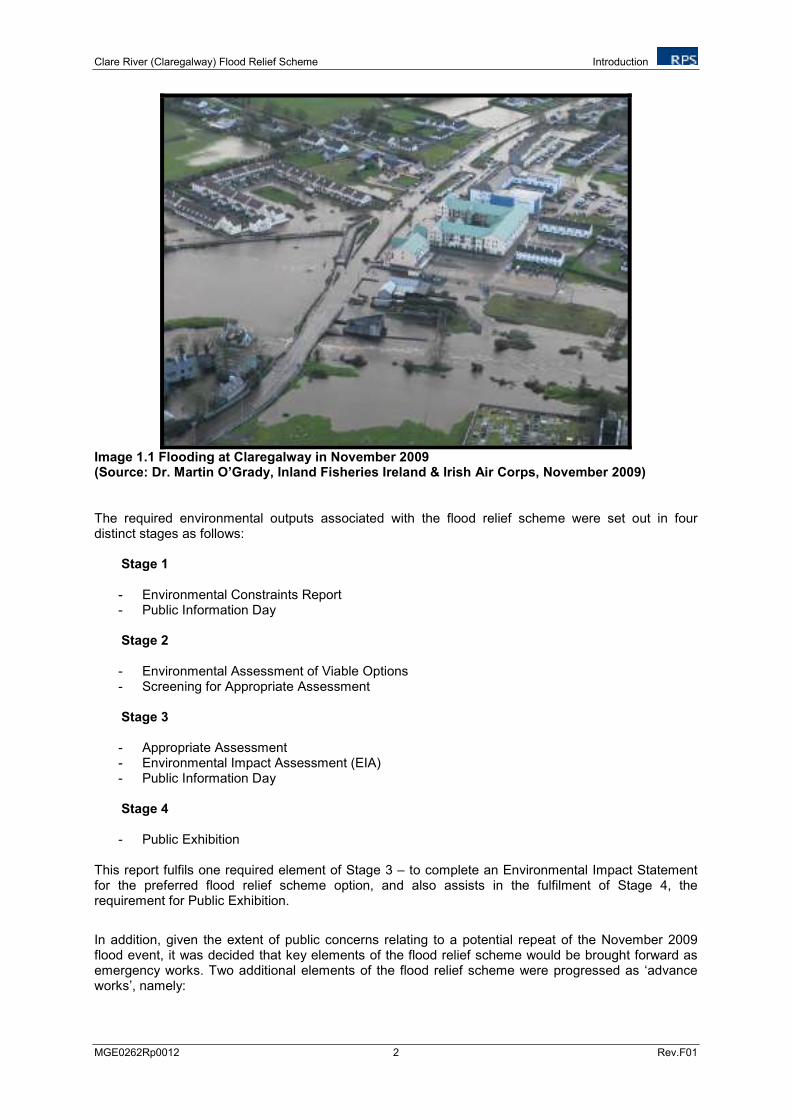
In March 2010 the Office of Public Works (OPW) commissioned a study related to the Clare River and its main tributary, the Abbert River, within a study area from Corofin to Lough Corrib (Ryan Hanley, 2010a). The study was commissioned as a result of severe damage and disruption caused by flooding in the area in November 2009 (Image 1.1). The OPW also commissioned a second study related to the townlands of Carnmore East and Cashla on the R339 Galway to Monivea Regional Road, which was also affected by flooding in November 2009 (Ryan Hanley, 2010b). These studies should be read together, and are referred to as the 2010 Flood Studies for the remainder of this EIS.
In May 2011 the OPW appointed RPS as environmental consultants and as design engineers for the Clare River (Claregalway) Flood Relief Scheme. As part of the design engineering contract, the 2010 Flood Studies were reviewed (RPS, 2011a) in conjunction with an Environmental Constraints Study (RPS, 2011b), and Environmental Assessment of Viable Options Study (RPS, 2011g) to amend the proposed flood relief measures as required and to determine the preferred flood relief scheme option.
Between 1945 and 1995 the OPW completed 34 Arterial Drainage Schemes on river catchments, and maintenance has been ongoing on all schemes since their completion. The Clare River forms part of the Corrib-Clare Arterial Drainage Scheme which commenced in 1954 and was completed in 1964. The OPW has a statutory responsibility for the maintenance of completed Arterial Drainage Schemes and completed Flood Relief Schemes. No maintenance of the main Clare River channel, other than tree management has been carried out within the study area since construction, as no significant siltation has occurred in the channel. However, the tributaries are generally maintained every five to six years as needed, by suitably rigged hydraulic excavators (OPW Fleet). These maintenance works are undertaken with strict adherence to the OPW’s Arterial Drainage Maintenance Service Environmental Management Protocols and Standard Operating Procedures (OPW, 2011 – see Appendix 1.1).
The OPW commenced an Environmental River Enhancement Programme (EREP) in 2008. The programme is funded by the OPW, coordinated and managed jointly with Inland Fisheries Ireland (IFI). The main objective of the EREP is to assist in the achievement of 'Good Ecological Status' under the Water Framework Directive, by enhancing the biodiversity and hydromorphology of arterially drained channels and river corridors in Ireland, while retaining their drainage function. The programme focuses primarily on the enhancement of selected drained salmonid rivers. Over 100km of OPW channel have been enhanced across all OPW regions, through the EREP in 2011, and a similar target has been set for 2012. The Clare River was selected for targeted capital enhancement works under the EREP. These enhancement works will be carried out in conjunction with the Clare River Flood Relief Scheme.
Clare River (Claregalway) Flood Relief Scheme Introduction
MGE0262Rp0012 2 Rev.F01
Image 1.1 Flooding at Claregalway in November 2009 (Source: Dr. Martin O’Grady, Inland Fisheries Ireland & Irish Air Corps, November 2009) The required environmental outputs associated with the flood relief scheme were set out in four distinct stages as follows:
Stage 1 - Environmental Constraints Report - Public Information Day
Stage 2 - Environmental Assessment of Viable Options - Screening for Appropriate Assessment Stage 3 - Appropriate Assessment - Environmental Impact Assessment (EIA) - Public Information Day
Stage 4 - Public Exhibition
This report fulfils one required element of Stage 3 – to complete an Environmental Impact Statement for the preferred flood relief scheme option, and also assists in the fulfilment of Stage 4, the requirement for Public Exhibition.
In addition, given the extent of public concerns relating to a potential repeat of the November 2009 flood event, it was decided that key elements of the flood relief scheme would be brought forward as emergency works. Two additional elements of the flood relief scheme were progressed as ‘advance works’, namely:

Clare River (Claregalway) Flood Relief Scheme Introduction
MGE0262Rp0012 3 Rev.F01
1. Flood conveyance works at Claregalway Bridge. The installation of the flood eye at Claregalway Bridge was undertaken as advanced works by the OPW and completed in June 2011.
2. Crusheeny Bridge replacement, completed in April 2012.
A Natura Impact Statement was prepared for the advance works at Claregalway Bridge (McCarthy Keville O’Sullivan, 2010), and a Screening for Appropriate Assessment and a Natura Impact Statement were prepared for the advance works at Crusheeny Bridge (RPS, 2011d & e). Both advance works will be considered as part of this EIA in terms of cumulative impacts.
In addition to the proposed flood measures set out in Chapter Six and to the advanced works described here, the scope of the EIS will also considers a proposed footbridge for Claregalway.
The Planning and Development Regulations 2001 Schedule 5 Part II, Section 10 (f) (ii) (as amended by Article 19 (e) of the Planning and Development (Amendment) (2) Regulations 2011) states that an EIS is required to be completed for the following:
“Canalisation and flood relief works, where the immediate contributing sub-catchment of the proposed works (i.e., the difference between the contributing catchments at the upper and lower extent of the works) would exceed 100 hectares or where more than 2 hectares of woodland would be affected or where the length of river channel on which works are proposed would be greater than 2 km”.
An EIS is required for the Clare River (Claregalway) Flood Relief Scheme as the length of river channel proposed for flood relief works exceeds 2km and the immediate contributing sub-catchment exceeds 100 hectares.
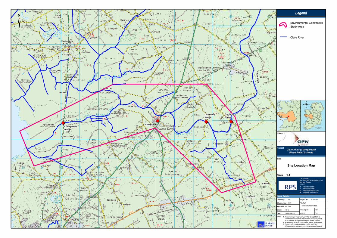
Figure 1.1 shows the extent of the Clare River (Claregalway) study area (discussed further in Chapter 5). The reports listed below were prepared in advance of or in parallel with the delivery of this EIS and informed its content:
• RPS. 2011a. Clare River (Claregalway) Flood Relief Scheme. Engineering Design - Stage 1. Report to the OPW.
• RPS. 2011b. Clare River (Claregalway) Flood Relief Scheme - Environmental Constraints Study. Report to the OPW.
• RPS. 2011c. Clare River (Claregalway) Flood Relief Scheme - Summary of Public Information Evening 8
th June 2011. Report to the OPW.
• RPS. 2011d. Screening for Appropriate Assessment Advance Works Crusheeny Bridge. Report to the OPW.
• RPS. 2011e. Natura Impact Statement Advance Works Crusheeny Bridge. Report to the OPW.
• RPS. 2011f. Scope of NIS and EIS Surveys for the Clare River (Claregalway) Flood Relief Scheme. Report to the OPW and NPWS.
• RPS. 2011g. Clare River (Claregalway) Flood Relief Scheme - Environmental Assessment of Viable Options. Report to the OPW.
• RPS. 2011h. Clare River (Claregalway) Flood Relief Scheme - Screening for Appropriate Assessment. Report to the OPW.
• RPS. 2011i. Clare River (Claregalway) Flood Relief Scheme -Summary of Public Information Evening 30
th November 2011. Report to the OPW.
Clare River (Claregalway) Flood Relief Scheme Introduction
MGE0262Rp0012 4 Rev.F01
• RPS. 2011j. Clare River (Claregalway) Flood Relief Scheme - Natura Impact Statement. Report to the OPW.
������������������������������������������������������������������������
������������������������������������
�� ����
���
�� ����
���
�� ����
���
�� ����
���
�� ����
���
�� ����
���
�� ����
���
�� ����
���
�� ����
���
������������������������������������������������������������������������
������������������������������������������������������
������������������������������������������������������������������������
������������������������������������������������������
��������������������
����������
����������
���������������������������������������������������������������������������������������������������������������������������������������������������������������������������
������������������������������������������������������
� �����
�������
����� ��
�����
����� ������
����������
����
��!���
"�����������
���������
��������������������������������������������� ���
������!������������!���������������"�!����#����#�
����������!�������$����������������������!�����
%��&����$��������������'�����!�(���#�)�����*���
+��'�����!����$�� ��������!�!�, ��������
����-'�����!����$�� ������������$�������� ������
#�����
�����$��������%��
��������������������� �
�������������������
&'&
�� '
#�����('
����� (!�"����.
/)
0�1
2�%
21 ��!������' )�,�%3%
����������'
) ����
)�,�%3%) ����2�%
4+�+�5��6��%��
4+�+�5��6��%55
������7���������!���
���������!��8������
�����0�������#
(&�0�������9��!�����������:#
)�$�#�������#
�����
�
#
)
*
�����
������
,�$���������1��������,�$���������1��������,�$���������1��������,�$���������1��������,�$���������1��������,�$���������1��������,�$���������1��������,�$���������1��������,�$���������1��������
�����&�������&�������&�������&�������&�������&�������&�������&�������&��
1������$�1������$�1������$�1������$�1������$�1������$�1������$�1������$�1������$�
Clare River (Claregalway) Flood Relief Scheme Environmental Impact Assessment
MGE0262Rp0012 6 Rev.F01
2 ENVIRONMENTAL IMPACT ASSESSMENT
2.1 LEGISLATIVE CONTEXT
Environmental Impact Assessment (EIA) can be described as “the process for anticipating the effects on the environment caused by a development. An Environmental Impact Statement (EIS) is the document produced as a result of that process” (EPA, 2002)
1.
The purpose of producing an EIS for the Clare River (Claregalway) Flood Relief Scheme is to identify the potential environmental impacts of the proposed flood alleviation measures and examine how these impacts can be avoided or reduced during the implementation and operation of the scheme measures.
This EIS is prepared having regard to all relevant EU Directives and National legislation including:
• The Council Directive 85/337/EEC on the assessment of the effects of certain public and private projects on the environment as amended,
• The EU Directive implemented in Ireland through S.I. No. 349 of 1989 entitled European Communities (Environmental Impact Assessment) Regulations, as amended,
• The Planning and Development Regulations, 2001 to 2012, and
• The Planning and Development Act 2000 - 2010.
This EIS has been completed in accordance with the requirements of Article 94 of the Planning and Development Regulations 2001, as amended.
The following guidance documents were also consulted in the preparation of this EIS:
• ‘Guidelines on the Information to be contained in Environmental Impact Statements’, EPA, 2002, and
• ‘Advice Notes on Current Practice in the preparation of Environmental Impact Statements’, EPA, 2003.
2.2 ENVIRONMENTAL IMPACT ASSESSMENT PROCESS
The main purpose of the EIA process is to identify the likely significant impacts on the human environment, the natural environment and on cultural heritage associated with the proposed flood relief scheme and to determine how to eliminate or minimise such impacts. The EIS summarises the environmental information collected during the impact assessment.
Several interacting steps typify the early stages of the EIA process and include:
- Screening, - Scoping and Consultation, - Assessing Alternatives, and - Assessing and Evaluating.
1 Guidelines on the Information to be Contained in Environmental Impact Statements, EPA, 2002
Clare River (Claregalway) Flood Relief Scheme Environmental Impact Assessment
MGE0262Rp0012 7 Rev.F01
Screening: This stage establishes if an EIS is required. It has already been established in accordance with the Planning and Development Regulations 2001, Schedule 5 Part II, Section 10 (f) (ii) that an EIS is required to be completed.
Scoping and Consultation: This stage identifies the issues likely to be important and the likely significant impacts of the flood relief scheme through consulting with various parties. Details of the various methods of scoping and consultation completed as part of the EIA process are further set out in Chapter 4.
Assessing Alternatives: This stage outlines the possible alternative approaches to the project including do nothing and alternative methods of alleviating future flooding (non-structural, retention etc.). This stage of the EIA process is set out in Chapter 7.
Assessing and Evaluating: The central steps of the EIA process include baseline assessment (desk study and field surveys) to determine the status of the existing environment, impact prediction and evaluation, and determining appropriate mitigation measures where necessary. This stage of the EIS is presented in Chapters 8 to 17.
2.3 STRUCTURE OF THIS EIS
This EIS has been prepared in the following format:
Volume 1 - Non-Technical Summary: This section provides a summary description of the existing environment, the application process, and describes the main potential impacts associated with the proposed flood relief scheme using non-technical terminology.
Volume 2 – Main Report:
Background and Scope: This section addresses the legislative, planning and policy context of flood alleviation. Alternatives to the proposed measures are considered and the scoping and consultation process which has been undertaken is described. Finally, any technical difficulties encountered during the assessment process are detailed.
Study Area Description and Proposed Flood Relief Scheme: This section describes the study area in the context of its setting and surrounding land use. It also provides a description of the proposed flood relief scheme detailing the individual flood alleviation measures proposed.
Environmental Impact Assessment: This section examines the individual environmental aspects of the study area as required under Article 94 of the Planning and Development Regulations 2001, as amended. Each of the environmental aspects as listed below are examined in terms of the existing or baseline environment, identification of potential impacts during the implementation and operation of the proposed scheme and where necessary mitigation measures are identified. The interaction of the environmental aspects with each other is also examined in this section as is the cumulative impact of the proposed scheme with surrounding land uses.
Environmental aspects considered include:
- Terrestrial ecology,
- Aquatic ecology and water quality,
- Hydrology and drainage,
- Soils, geology and hydrogeology,
Clare River (Claregalway) Flood Relief Scheme Environmental Impact Assessment
MGE0262Rp0012 8 Rev.F01
- Air quality and climate,
- Noise and vibration,
- Archaeology, architectural and cultural heritage,
- Landscape and visual environment,
- Human beings and material assets,
- Traffic, and
- Interaction of the foregoing.
The assessment follows the “Grouped Format Structure” as set out in ‘Guidelines on the Information to be contained in Environmental Impact Statements’ (EPA, 2002). This method of assessment examines each environmental topic as a separate section making reference in each section to the existing environment, the potential impacts of the proposed scheme and proposed mitigation measures. As a result each environmental topic is presented in the following format:
- Introduction,
- Methodology,
- Existing Environment,
- Potential Impacts,
- Proposed Mitigation Measures,
- Residual Impacts, and
- Conclusions.
Summary and Conclusions: This section summarises the findings of the assessments and includes conclusions on the impacts of the proposed flood relief scheme on the existing environment.
Volume 3 – Technical Appendices: This section includes the technical appendices relevant to the EIS.
2.4 EIS STUDY TEAM
This EIS has been prepared by RPS on behalf of the OPW. Contributions to the EIS are outlined in Table 2.1.
Table 2.1 EIS Study Team
Volume Chapter Topic Specialists
1 Non-Technical Summary RPS
2 1 Introduction RPS
2 2 Environmental Impact Assessment RPS
2 3 Policy, Planning and Legislation RPS
2 4 Consultation RPS
2 5 Alternatives RPS
2 6 Study Area RPS
2 7 Project Description RPS
2 8 Hydrology and Drainage RPS
2 9 Soils, Geology and Hydrogeology RPS
2 10 Terrestrial Ecology RPS
2 11 Aquatic Ecology and Water Quality Aquatic Services Unit
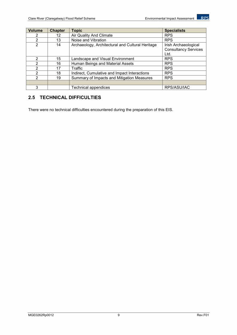
Clare River (Claregalway) Flood Relief Scheme Environmental Impact Assessment
MGE0262Rp0012 9 Rev.F01
Volume Chapter Topic Specialists
2 12 Air Quality And Climate RPS
2 13 Noise and Vibration RPS
2 14 Archaeology, Architectural and Cultural Heritage Irish Archaeological Consultancy Services Ltd.
2 15 Landscape and Visual Environment RPS
2 16 Human Beings and Material Assets RPS
2 17 Traffic RPS
2 18 Indirect, Cumulative and Impact Interactions RPS
2 19 Summary of Impacts and Mitigation Measures RPS
3 Technical appendices RPS/ASU/IAC
2.5 TECHNICAL DIFFICULTIES
There were no technical difficulties encountered during the preparation of this EIS.
Clare River (Claregalway) Flood Relief Scheme Policy, Planning and Legislation
MGE0262Rp0012 10 Rev.F01
3 POLICY PLANNING AND LEGISLATION
This Chapter of the EIS sets out current EU, national, regional and where relevant local policy and legislation relating to flood management and its place within the planning and development system. The purpose of this Chapter is to consider the Clare River (Claregalway) Flood Relief Scheme in the context of this policy and legislation.
3.1 EU POLICY
In 2002 the European Commission (EC) recognised that flood events have the potential to undermine the EU’s drive towards sustainable development and that the risk of flooding was on the increase. In response to severe flooding experienced along the Danube and Elbe Rivers in 2002, the Commission took the initiative to launch concerted action at Community level to help reduce the severity of flood events and the damage caused by these floods. A European Flood Action Programme was developed and in 2007 the EC implemented Directive 2007/60/EC of the European Parliament and of the Council of 23 October 2007 on the Assessment and Management of Flood Risks or EU Flood Directive (2007/60/EC).
The overall aim of the Directive is to reduce and manage the risks that floods pose to human health, the environment, cultural heritage and economic activity. It also has the purpose of establishing a framework for the assessment and management of flood risks. The Directive has specific requirements which each member state must implement. These include the following:
• a Preliminary Flood Risk Assessment (PFRA), to be completed by the end of 2011, that shall identify areas of potentially significant flood risk based on available or readily-derivable information;
• the production of flood hazard and risk maps for the areas identified under the PFRA; and
• the preparation of Flood Risk Management Plans (FRMPs) at a catchment or river basin scale, setting out measures aimed at achieving objectives for the management of flood risks within the areas identified under the PFRA.
The Directive requires that the above is undertaken in a coordinated manner with the implementation of the Water Framework Directive [2000/60/EC] to promote integrated river basin management. The Directive further requires that the active involvement of the public and stakeholders be encouraged, and that the above requirements are made readily available to the public.
3.2 NATIONAL POLICY AND LEGISLATION
The Browne Commission (Report of The Drainage Commission 1938-1940), which examined flooding and improvement of land through drainage, commenced its deliberations in 1938 and resulted in the development of the Arterial Drainage Act, 1945. This is the primary piece of legislation with which the OPW have operated under for the last 50 years, and empowers the OPW to undertake catchment-wide arterial drainage schemes to reduce flooding. The Act is described as:
“An Act to make provision for the drainage and improvement of land by the execution of works of arterial drainage, to provide for the maintenance of those works and make further and better provision for the maintenance of existing drainage works, and to provide for matters incidental to or connected with the matter aforesaid or relating generally to the drainage of land”.
The emphasis of the 1945 Act was on the improvement of agricultural land. Following severe flooding of a number of towns in the mid to late 1980’s and early 1990’s, the Act was amended in 1995 by the
Clare River (Claregalway) Flood Relief Scheme Policy, Planning and Legislation
MGE0262Rp0012 11 Rev.F01
Arterial Drainage (Amendment) Act 1995, when the emphasis of flood management activity shifted to the protection of urban areas subject to flooding. This amendment empowered the OPW to undertake localised flood relief schemes to protect and reduce flood risk in individual urban areas.
Under the Arterial Drainage Act, 1945 the OPW undertook a number of arterial drainage schemes to improve land for agricultural production. The OPW has a statutory duty to maintain these schemes, which is delivered through their arterial drainage maintenance programme. The OPW does not have powers to undertake river or channel maintenance other than where these rivers form part of an arterial drainage scheme or flood relief schemes.
In September 2004, the Irish Government approved the Flood Policy Review - Final Report (OPW, 2004) which was published by the Flood Policy Review Group in 2004. It sets out the National Policy on Flooding as follows:
'to minimise the national level of flood risk to people, businesses, infrastructure and the environment, through the identification and management of existing, and particularly potential future, flood risks in an integrated, proactive and catchment-based manner'.
This Report also presents the possible causes, extents and impacts of flooding, responsible bodies, future policy proposals and resource requirements for same. Among other things the report sets out the determining factors when considering the implementation of a flood relief scheme as follows:
“ (a) the scheme must be technically feasible;
(b) the scheme must generally be cost beneficial (a cost benefit analysis is undertaken to determine the economic merits of the project); and
(c) the scheme must also be environmentally compatible (an Environmental Impact Study is normally undertaken for each scheme and the scheme must satisfy the requirements of the EIS).”
The National Development Plan (NDP) 2007-2013 (Government of Ireland, 2006) further sets out structural measures to be implemented in order to provide relief from flooding where such occurs, prevent the creation of new problem areas and to maintain existing defences. The Plan states that this will be achieved through structural works involving the construction of flood relief schemes which will be implemented in an environmentally friendly fashion as far as possible, taking account of the principles of the Government’s National Biodiversity Plan (DAHG, 2011).
In November 2009 the OPW in association with the Department of Environment, Heritage and Local Government (DEHLG; now the Department of Environment, Community and Local Government) published Planning System and Flood Risk Management – Guidelines for Local Authorities (Government of Ireland, 2009). The core objectives of these guidelines are to:
• Avoid inappropriate development in areas at risk of flooding;
• Avoid new developments increasing flood risk elsewhere, including that which may arise from surface water run-off;
• Ensure effective management of residual risks for development permitted in floodplains;
• Avoid unnecessary restriction of national, regional or local economic and social growth;
• Improve the understanding of flood risk among relevant stakeholders; and
• Ensure that the requirements of EU and national law in relation to the natural environment and nature conservation are complied with at all stages of flood risk management.
Clare River (Claregalway) Flood Relief Scheme Policy, Planning and Legislation
MGE0262Rp0012 12 Rev.F01
The EU Flood Directive (2007/60/EC) was transposed into Irish law through the European Communities (Assessment and Management of Flood Risks) Regulations 2010 (S.I. No. 122 of 2010). The Regulations appoint the Commissioners of Public Works in Ireland as the Competent Authority under the Directive, reinforcing the Lead Agency role the OPW was given in 2004 under the National Flood Policy. The Regulations also identifies roles for other organisations, such as the Local Authorities, Waterways Ireland and ESB, to undertake certain duties with respect to flood risk within their existing areas of responsibility.
The OPW has developed a Catchment Flood Risk Assessment and Management (CFRAM) Programme, which lies at the core of the assessment of flood risk and the long-term planning of the flood risk management measures throughout the country, including capital structural and non-structural measures. The Programme delivers on core components of the National Flood Policy, adopted in 2004, and on the requirements of the EU Floods Directive.
The CFRAM Programme is being delivered through the CFRAM Studies. The CFRAM Studies are comprehensive catchment-based studies focused on Areas of Potentially Significant Risk (APSR), for which detailed flood maps are produced and flood risk management measures are assessed and taken to outline design. These measures will be prioritised and set out in a Flood Risk Management Plan (FRMP).
The Eastern, Shannon, South Eastern, and Western CFRAM Studies commenced in 2011. The flood maps will be produced over the period 2011 to 2013, with the production of maps prioritised for areas where development plans are scheduled for review and could benefit from the early production of the maps. The draft FRMPs will then be produced for consultation at the end of 2014 before finalisation at the end of 2015.
3.3 REGIONAL POLICY
The Regional Planning Guidelines for the West Region 2010 – 2022 (West Regional Authority, 2010) have the following policies and objectives relative to flood management works:
Policy SPP11: Development of catchment management strategies and design of flood management works will be informed by the Habitats Directive Assessment process and/or other relevant environmental assessment.
Objective SPO31: To ensure that where flood alleviation works take place the natural heritage and landscape character of rivers, streams and watercourses are protected and enhanced to the greatest extent possible, and that there are no negative impacts on the Conservation Objectives of Natura 2000 sites through Habitats Directive Assessment.
Further to this, the Draft Regional Flood Risk Appraisal (West Regional Authority, 2010) was published in January 2010 forming part of the Draft Regional Planning Guidelines for the West Region 2010-2022. It sets out policies, objectives and monitoring for Flood Risk Management in the Western Region.
The Galway County Development Plan 2009-2015 (Galway County Council, 2009) also sets out the circumstance where development of flood relief schemes will be further considered under Objective HL40 “.......Development proposals which include proposals for mitigation and management of flood risk will only be considered where avoidance is not possible and where development can be clearly justified with the Guidelines Justification Test”.
Clare River (Claregalway) Flood Relief Scheme Policy, Planning and Legislation
MGE0262Rp0012 13 Rev.F01
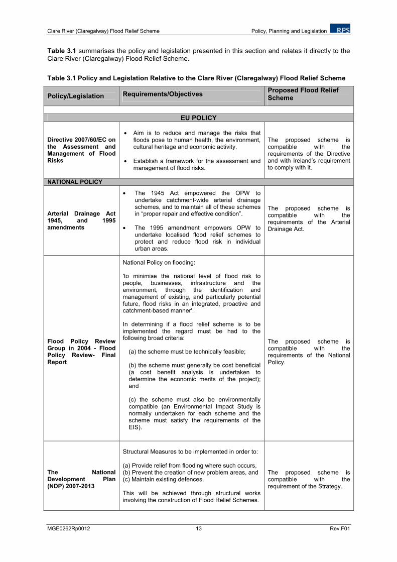
Table 3.1 summarises the policy and legislation presented in this section and relates it directly to the Clare River (Claregalway) Flood Relief Scheme.
Table 3.1 Policy and Legislation Relative to the Clare River (Claregalway) Flood Relief Scheme
Policy/Legislation Requirements/Objectives Proposed Flood Relief Scheme
EU POLICY
Directive 2007/60/EC on the Assessment and Management of Flood Risks
• Aim is to reduce and manage the risks that floods pose to human health, the environment, cultural heritage and economic activity.
• Establish a framework for the assessment and management of flood risks.
The proposed scheme is compatible with the requirements of the Directive and with Ireland’s requirement to comply with it.
NATIONAL POLICY
Arterial Drainage Act 1945, and 1995 amendments
• The 1945 Act empowered the OPW to undertake catchment-wide arterial drainage schemes, and to maintain all of these schemes in “proper repair and effective condition”.
• The 1995 amendment empowers OPW to undertake localised flood relief schemes to protect and reduce flood risk in individual urban areas.
The proposed scheme is compatible with the requirements of the Arterial Drainage Act.
Flood Policy Review Group in 2004 - Flood Policy Review- Final Report
National Policy on flooding:
'to minimise the national level of flood risk to people, businesses, infrastructure and the environment, through the identification and management of existing, and particularly potential future, flood risks in an integrated, proactive and catchment-based manner'.
In determining if a flood relief scheme is to be implemented the regard must be had to the following broad criteria:
(a) the scheme must be technically feasible;
(b) the scheme must generally be cost beneficial (a cost benefit analysis is undertaken to determine the economic merits of the project); and
(c) the scheme must also be environmentally compatible (an Environmental Impact Study is normally undertaken for each scheme and the scheme must satisfy the requirements of the EIS).
The proposed scheme is compatible with the requirements of the National Policy.
The National Development Plan (NDP) 2007-2013
Structural Measures to be implemented in order to: (a) Provide relief from flooding where such occurs, (b) Prevent the creation of new problem areas, and (c) Maintain existing defences. This will be achieved through structural works involving the construction of Flood Relief Schemes.
The proposed scheme is compatible with the requirement of the Strategy.
Clare River (Claregalway) Flood Relief Scheme Policy, Planning and Legislation
MGE0262Rp0012 14 Rev.F01
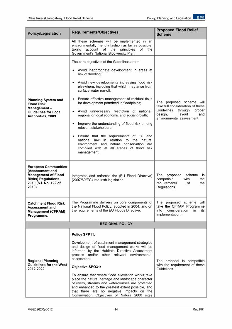
Policy/Legislation Requirements/Objectives Proposed Flood Relief Scheme
All these schemes will be implemented in an environmentally friendly fashion as far as possible, taking account of the principles of the Government’s National Biodiversity Plan.
Planning System and Flood Risk Management – Guidelines for Local Authorities, 2009
The core objectives of the Guidelines are to:
• Avoid inappropriate development in areas at risk of flooding;
• Avoid new developments increasing flood risk elsewhere, including that which may arise from surface water run-off;
• Ensure effective management of residual risks for development permitted in floodplains;
• Avoid unnecessary restriction of national, regional or local economic and social growth;
• Improve the understanding of flood risk among relevant stakeholders;
• Ensure that the requirements of EU and national law in relation to the natural environment and nature conservation are complied with at all stages of flood risk management.
The proposed scheme will take full consideration of these Guidelines through proper design, layout and environmental assessment.
European Communities (Assessment and Management of Flood Risks) Regulations 2010 (S.I. No. 122 of 2010)
Integrates and enforces the (EU Flood Directive) (2007/60/EC) into Irish legislation.
The proposed scheme is compatible with the requirements of the Regulations.
Catchment Flood Risk Assessment and Management (CFRAM) Programme,
The Programme delivers on core components of the National Flood Policy, adopted in 2004, and on the requirements of the EU Floods Directive.
The proposed scheme will take the CFRAM Programme into consideration in its implementation.
REGIONAL POLICY
Regional Planning Guidelines for the West 2012-2022
Policy SPP11:
Development of catchment management strategies and design of flood management works will be informed by the Habitats Directive Assessment process and/or other relevant environmental assessment. Objective SPO31:
To ensure that where flood alleviation works take place the natural heritage and landscape character of rivers, streams and watercourses are protected and enhanced to the greatest extent possible, and that there are no negative impacts on the Conservation Objectives of Natura 2000 sites
The proposal is compatible with the requirement of these Guidelines.
Clare River (Claregalway) Flood Relief Scheme Policy, Planning and Legislation
MGE0262Rp0012 15 Rev.F01
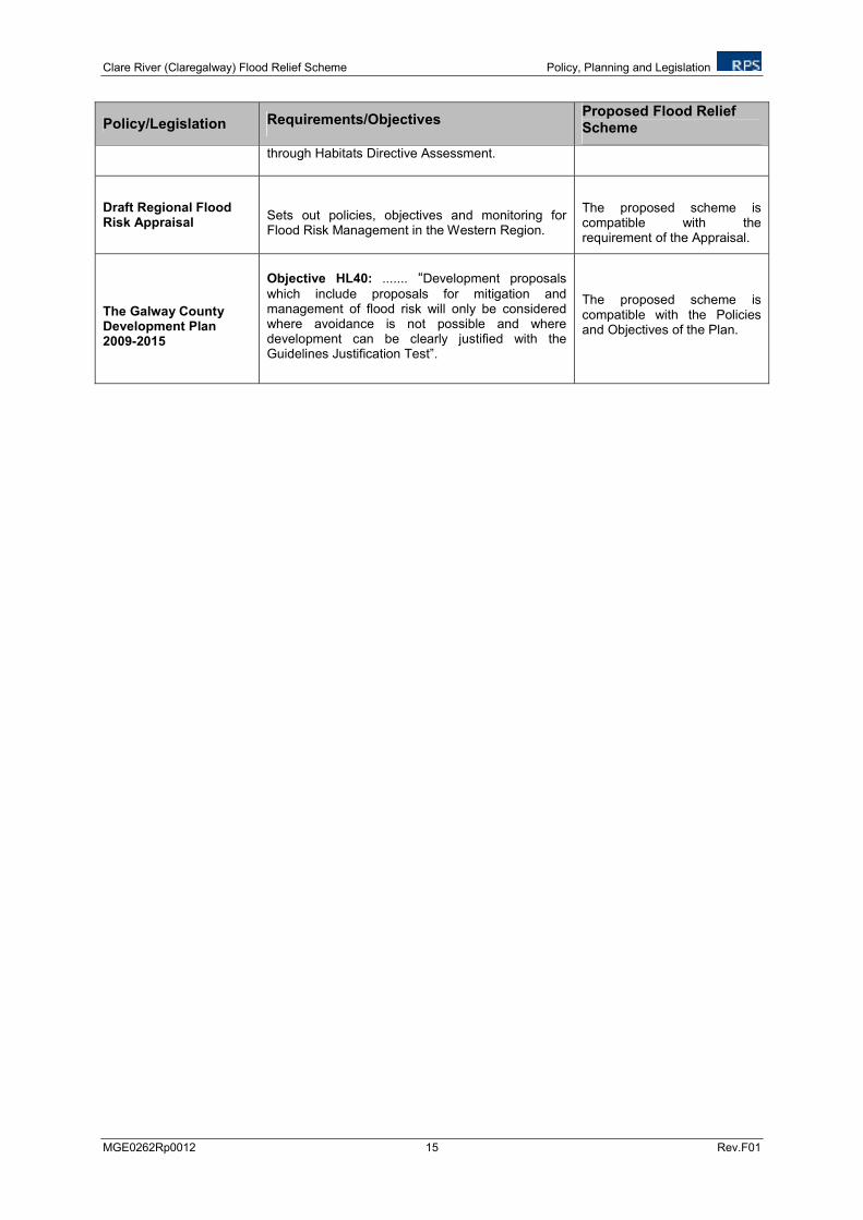
Policy/Legislation Requirements/Objectives Proposed Flood Relief Scheme
through Habitats Directive Assessment.
Draft Regional Flood Risk Appraisal
Sets out policies, objectives and monitoring for Flood Risk Management in the Western Region.
The proposed scheme is compatible with the requirement of the Appraisal.
The Galway County Development Plan 2009-2015
Objective HL40: ....... “Development proposals
which include proposals for mitigation and management of flood risk will only be considered where avoidance is not possible and where development can be clearly justified with the Guidelines Justification Test”.
The proposed scheme is compatible with the Policies and Objectives of the Plan.
Clare River (Claregalway) Flood Relief Scheme Consultation
MGE0262Rp0012 16 Rev.F01
4 CONSULTATION
4.1 INTRODUCTION
This chapter describes the consultations carried out in relation to the Environmental Impact Statement (EIS) for the Clare River (Claregalway) Flood Relief Scheme with the purpose of outlining the key issues raised by stakeholders, both statutory and non statutory (including the general public). Consultation forms an essential part of the EIA process. In this case, the early involvement of stakeholders has helped to ensure that the views of various groups or individuals were taken into consideration from the constraints stage through choosing a preferred viable flood relief scheme and to the preparation of this EIS.
Consultation was carried out through written communication and the holding of public information events throughout the course of the EIS process. These are further outlined in the following sections.
4.2 STATUTORY AND NON-GOVERNMENTAL ORGANISATION CONSULTATION
In May 2011, when the environmental impact assessment work commenced, a letter was issued to twenty-eight statutory and non-statutory stakeholders informing them of the commencement of the environmental assessment of the proposed flood relief scheme. The letter set out a brief background to the proposed scheme and the environmental steps that would be completed during the planning process. The correspondence further invited stakeholders for comment on what should be included in the scope of this environmental work. Refer to Figure 4.1 for a copy of this letter. Table 4.1 sets out the stakeholders that were consulted and the responses received. The full text of responses received is presented in Appendix 4.1.
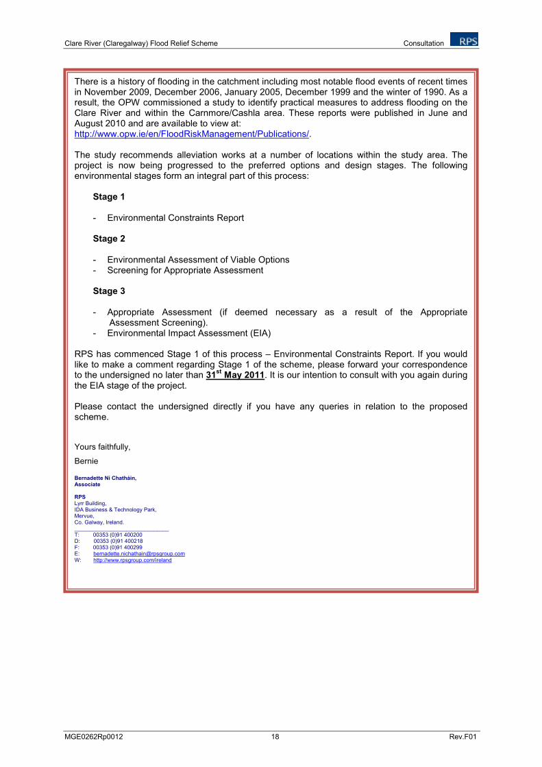
A second round of written consultation (via email) was issued to stakeholders consulted during the May 2011 consultation phase with the exception of those who surrendered their rights to consultation (i.e. Teagasc). Refer to Figure 4.2 for a copy of this email. To date, no responses have been received on this second round of consultation.
Clare River (Claregalway) Flood Relief Scheme Consultation
MGE0262Rp0012 17 Rev.F01
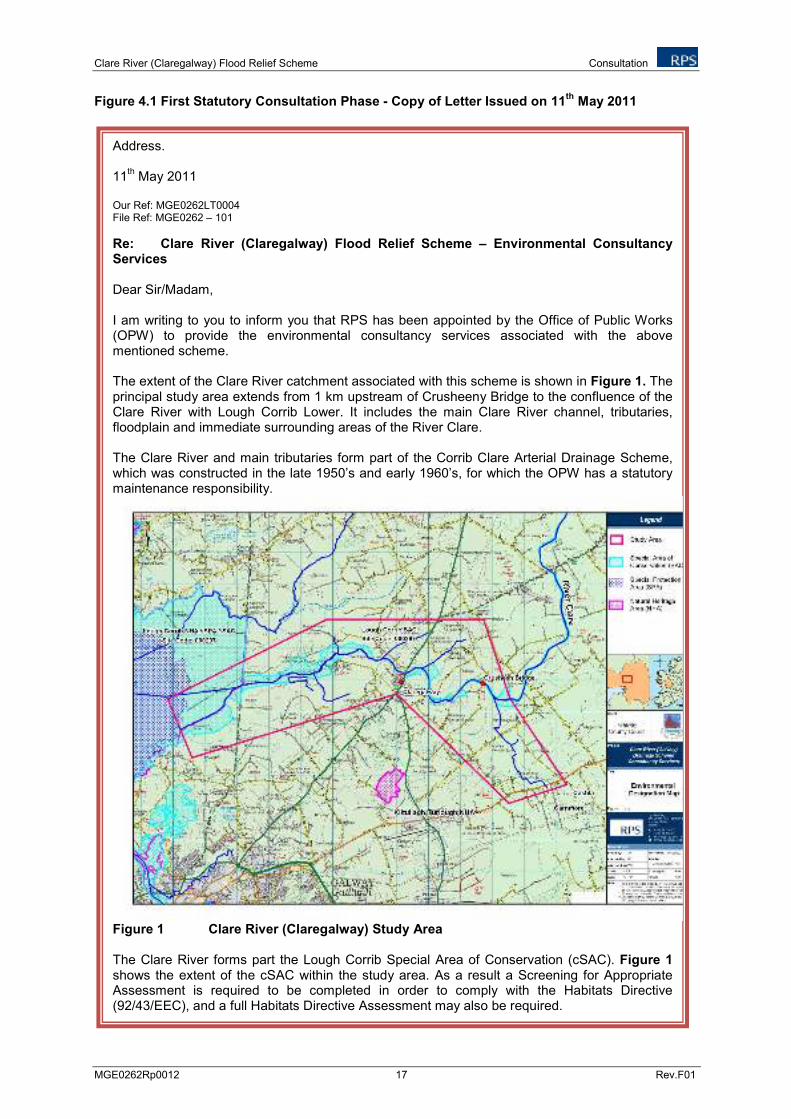
Figure 4.1 First Statutory Consultation Phase - Copy of Letter Issued on 11th
May 2011
Address. 11
th May 2011
Our Ref: MGE0262LT0004 File Ref: MGE0262 – 101
Re: Clare River (Claregalway) Flood Relief Scheme – Environmental Consultancy Services Dear Sir/Madam, I am writing to you to inform you that RPS has been appointed by the Office of Public Works (OPW) to provide the environmental consultancy services associated with the above mentioned scheme. The extent of the Clare River catchment associated with this scheme is shown in Figure 1. The principal study area extends from 1 km upstream of Crusheeny Bridge to the confluence of the Clare River with Lough Corrib Lower. It includes the main Clare River channel, tributaries, floodplain and immediate surrounding areas of the River Clare. The Clare River and main tributaries form part of the Corrib Clare Arterial Drainage Scheme, which was constructed in the late 1950’s and early 1960’s, for which the OPW has a statutory maintenance responsibility.
Figure 1 Clare River (Claregalway) Study Area The Clare River forms part the Lough Corrib Special Area of Conservation (cSAC). Figure 1 shows the extent of the cSAC within the study area. As a result a Screening for Appropriate Assessment is required to be completed in order to comply with the Habitats Directive (92/43/EEC), and a full Habitats Directive Assessment may also be required.
Clare River (Claregalway) Flood Relief Scheme Consultation
MGE0262Rp0012 18 Rev.F01
There is a history of flooding in the catchment including most notable flood events of recent times in November 2009, December 2006, January 2005, December 1999 and the winter of 1990. As a result, the OPW commissioned a study to identify practical measures to address flooding on the Clare River and within the Carnmore/Cashla area. These reports were published in June and August 2010 and are available to view at: http://www.opw.ie/en/FloodRiskManagement/Publications/. The study recommends alleviation works at a number of locations within the study area. The project is now being progressed to the preferred options and design stages. The following environmental stages form an integral part of this process:
Stage 1 - Environmental Constraints Report
Stage 2 - Environmental Assessment of Viable Options - Screening for Appropriate Assessment
Stage 3 - Appropriate Assessment (if deemed necessary as a result of the Appropriate
Assessment Screening). - Environmental Impact Assessment (EIA)
RPS has commenced Stage 1 of this process – Environmental Constraints Report. If you would like to make a comment regarding Stage 1 of the scheme, please forward your correspondence to the undersigned no later than 31
st May 2011. It is our intention to consult with you again during
the EIA stage of the project. Please contact the undersigned directly if you have any queries in relation to the proposed scheme. Yours faithfully,
Bernie Bernadette Ní Chatháin, Associate RPS Lyrr Building, IDA Business & Technology Park, Mervue, Co. Galway, Ireland. _______________________________ T: 00353 (0)91 400200 D: 00353 (0)91 400218 F: 00353 (0)91 400299 E: [email protected]
W: http://www.rpsgroup.com/ireland
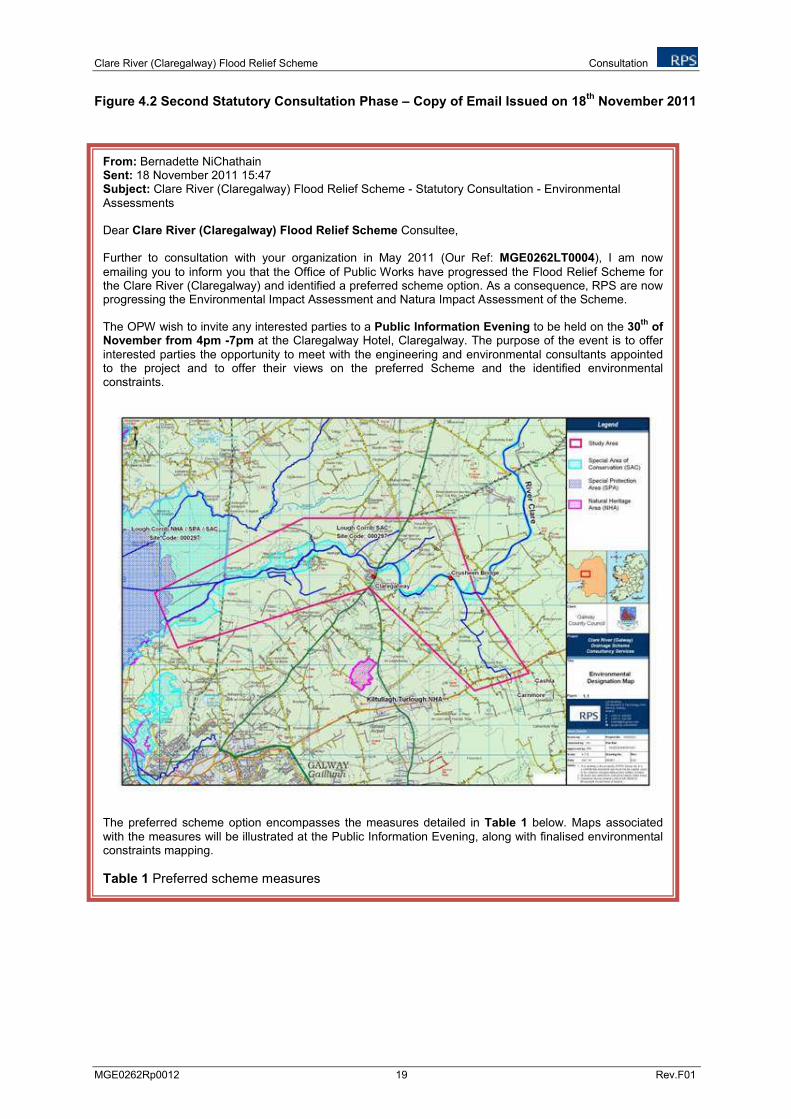
Clare River (Claregalway) Flood Relief Scheme Consultation
MGE0262Rp0012 19 Rev.F01
Figure 4.2 Second Statutory Consultation Phase – Copy of Email Issued on 18th
November 2011
From: Bernadette NiChathain Sent: 18 November 2011 15:47 Subject: Clare River (Claregalway) Flood Relief Scheme - Statutory Consultation - Environmental Assessments Dear Clare River (Claregalway) Flood Relief Scheme Consultee, Further to consultation with your organization in May 2011 (Our Ref: MGE0262LT0004), I am now
emailing you to inform you that the Office of Public Works have progressed the Flood Relief Scheme for the Clare River (Claregalway) and identified a preferred scheme option. As a consequence, RPS are now progressing the Environmental Impact Assessment and Natura Impact Assessment of the Scheme. The OPW wish to invite any interested parties to a Public Information Evening to be held on the 30
th of
November from 4pm -7pm at the Claregalway Hotel, Claregalway. The purpose of the event is to offer interested parties the opportunity to meet with the engineering and environmental consultants appointed to the project and to offer their views on the preferred Scheme and the identified environmental constraints.
The preferred scheme option encompasses the measures detailed in Table 1 below. Maps associated with the measures will be illustrated at the Public Information Evening, along with finalised environmental constraints mapping.
Table 1 Preferred scheme measures
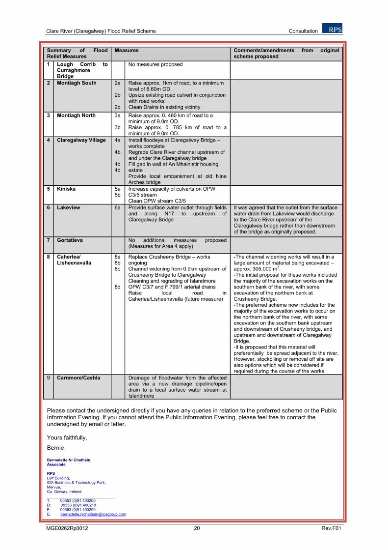
Clare River (Claregalway) Flood Relief Scheme Consultation
MGE0262Rp0012 20 Rev.F01
Summary of Flood Relief Measures
Measures Comments/amendments from original scheme proposed
1 Lough Corrib to Curraghmore Bridge
No measures proposed
2 Montiagh South 2a 2b 2c
Raise approx. 1km of road, to a minimum level of 8.60m OD. Upsize existing road culvert in conjunction with road works Clean Drains in existing vicinity
3 Montiagh North 3a 3b
Raise approx. 0. 460 km of road to a minimum of 9.0m OD. Raise approx. 0. 785 km of road to a minimum of 9.0m OD.
4 Claregalway Village 4a 4b 4c 4d
Install floodeye at Claregalway Bridge – works complete Regrade Clare River channel upstream of and under the Claregalway bridge Fill gap in wall at An Mhainistir housing estate Provide local embankment at old Nine Arches bridge
5 Kiniska 5a 5b
Increase capacity of culverts on OPW C3/5 stream Clean OPW stream C3/5
6 Lakeview 6a Provide surface water outlet through fields and along N17 to upstream of Claregalway Bridge
It was agreed that the outlet from the surface water drain from Lakeview would discharge to the Clare River upstream of the Claregalway bridge rather than downstream of the bridge as originally proposed.
7 Gortatleva No additional measures proposed (Measures for Area 4 apply)
8 Caherlea/ Lisheenavalla
8a 8b 8c 8d
Replace Crusheeny Bridge – works ongoing Channel widening from 0.9km upstream of Crusheeny Bridge to Claregalway Cleaning and regrading of Islandmore OPW C3/7 and F.799/1 arterial drains Raise local road in Caherlea/Lisheenavalla (future measure)
-The channel widening works will result in a large amount of material being excavated – approx. 305,000 m
3.
-The initial proposal for these works included the majority of the excavation works on the southern bank of the river, with some excavation of the northern bank at Crusheeny Bridge. -The preferred scheme now includes for the majority of the excavation works to occur on the northern bank of the river, with some excavation on the southern bank upstream and downstream of Crusheeny bridge, and upstream and downstream of Claregalway Bridge. -It is proposed that this material will preferentially be spread adjacent to the river. However, stockpiling or removal off site are also options which will be considered if required during the course of the works.
9 Carnmore/Cashla Drainage of floodwater from the affected area via a new drainage pipeline/open drain to a local surface water stream at Islandmore
Please contact the undersigned directly if you have any queries in relation to the preferred scheme or the Public Information Evening. If you cannot attend the Public Information Evening, please feel free to contact the undersigned by email or letter. Yours faithfully,
Bernie Bernadette Ní Chatháin, Associate
RPS
Lyrr Building, IDA Business & Technology Park, Mervue, Co. Galway, Ireland. _______________________________ T: 00353 (0)91 400200 D: 00353 (0)91 400218 F: 00353 (0)91 400299 E: [email protected]
Clare River (Claregalway) Flood Relief Scheme Consultation
MGE0262Rp0012 21 Rev.F01
Table 4.1 Key Issues Raised by Stakeholders Relative to the Scope of the EIS for the Clare River (Claregalway) Flood Relief Scheme
Body Issued Notice by RPS (by letter on 11.05.11)
Date and nature of Response
Comments
Development Applications Unit, Department of the Arts, Heritage and the Gaeltacht,
7th June 2011
by letter Confirmed that the overall project and any advanced works will require an Appropriate Assessment Outlined the Natura 2000 sites of relevance to the study area – Lough Corrib cSAC and Lough Corrib
SPA. Confirmed that an EIS would be required to assess the ecological issues of relevance to proper planning
and sustainable development, and to address all legal requirements in relation to the conservation and protection of ecological sites, habitats and species.
All aspects of the project at site preparation (including advance works), construction and operation stages should be taken into account in undertaking assessments
The following projects were identified which may give rise to in combination effects: Claregalway Local Area Plan 2005-2011; existing flood relief and flood prevention measures; new wastewater treatment plant (Cahergowan) (permitted); M17/N18 Gort to Tuam road (permitted); Claregalway riverside walkway (proposed); Claregalway bypass road (proposed).
Department of Agriculture, Fisheries and Food
26th May 2011
by letter and email
Correspondence indicated no comments on the Environmental Constraints at this time.
Geological Survey of Ireland
12th May 2011
by email Advised that there is currently a 4 week turnaround for answering environmental impact consultations and planning enquiries. Advised of datasets available on their website.
Teagasc
16th May 2011
by email Confirmed that Teagasc will not be making any submission on this or any other amendment to the project and confirmed that Teagasc agrees to surrender its entitlement to be consulted on any aspect of this project.
Inland Fisheries Ireland 13th May 2011
by letter Main constraints/issues summarised as: Impact on resident/migratory fish populations Establishment and mapping of existing baseline conditions, identification of existing pools/glide and riffle
zones Timing to avoid impacting salmonid ova, smolt or elvers or other fish species. Disruption of angling Access to the river from the main road and access to the proposed low bank and flood berm Impact of sediment release and transport Changes to low flow regimes as a result of the level at which the base of the flood berm is set in relation
to the new proposed river bed level Car parking for anglers Plan for remediation of channel and riparian zone Integration with Clare River walkway project
Commented that it is assumed the project will be undertaken in accordance with EREP (Environmental River Enhancement Programme) methodology which aims to enhance all water dependent habitats and species.
Clare River (Claregalway) Flood Relief Scheme Consultation
MGE0262Rp0012 22 Rev.F01
Body Issued Notice by RPS (by letter on 11.05.11)
Date and nature of Response
Comments
The creation of a fish holding pool at a suitable location downstream of Claregalway bridge adjacent to the proposed angling platform to be integrated into the river walkway project was indicated as having been discussed with the OPW. The existing pool previously selected was indicated as being too far downstream for disabled anglers to traverse (Maps were provided illustrating the Clare River Catchment water bodies and the Original location proposed for disabled anglers stand).
An Taisce
16th May 2011
by email Commented that: Non structural options need to be investigated. Protection, and where applicable, management of wetlands as part of the Flood Relief Scheme is
important for ensuring the link between such ecosystems is recognised, valued, and accordingly protected.
Recommended consideration of sustainable drainage options that can be used for urban areas. The opening up of lands to flooding upstream needs further consideration, such as practiced in the UK
since the 2007 flooding there and the resultant ‘Pitt review’ which has led to ‘Right to flood agreements’ with landowners.
Galway County Council Water Services
18th May 2011
by letter i) Water Services Infrastructure pertaining to the Study area received and a request for a consultation
meeting. ii) Trunk watermains in the area of the scheme were identified from a number of private group water supply
schemes. iii) A proposal to construct Claregalway Sewerage Scheme with treatment plant and outfall to be located on
lands to the west of Claregalway bridge was advised of. iv) It was advised that there are a number of private sewerage treatment plants in the study area discharging
to the Clare River.
Claregalway GAA Club 30th May 2011
by email v) Specified that the Claregalway GAA pitch is located between two major floods, and therefore they have a
particular interest in all proposals to resolve flood risks. Requested to be kept fully informed of developments.
Regional Ecologist, NPWS Galway
Addressed through Development Applications Unit of the Department of Arts, Heritage and the Gaeltacht, response.
IFA
Birdwatch Ireland
EPA Headquarters Co. Wexford.
EPA Regional Inspectorate, Co. Mayo.
Fáilte Ireland – West
No response

Clare River (Claregalway) Flood Relief Scheme Consultation
MGE0262Rp0012 23 Rev.F01
Body Issued Notice by RPS (by letter on 11.05.11)
Date and nature of Response
Comments
Western River Basin District Project Office
Galway Rural Development Company Ltd.
Western Development Commission
Heritage Officer, Galway County Council
Environment Department, Galway County Council
Planning Department, Galway County Council,
Galway County Development Board
Roads & Transportation Unit Galway County Council
Galway Archaeological and Historical Society
Carra Mask Corrib Water Protection Group Ltd.
Claregalway Community Development Association
No response

Clare River (Claregalway) Flood Relief Scheme Consultation
MGE0262Rp0012 24 Rev.F01
4.3 PUBLIC STAKEHOLDER CONSULTATION
Two public information evenings were held during the course of preparing the environmental reports for the proposed Scheme. The purpose of these events was to inform stakeholders and the general public of the progress and details of the Scheme and to invite their views. Details on each of the events are set out below.
4.3.1 Public Information Evening No. 1
The first public information evening was held on the 8th of June 2011 from 4pm to 7pm at the
Claregalway Hotel, Claregalway, Co. Galway.
The event was advertised in the Galway Advertiser (2nd
June) and Connacht Tribune (3rd
June). A copy of the public notice that appeared in each paper is presented below (Images 4.1 and 4.2). In addition the notice was announced on Galway Bay FM Radio from the 1
st June to the 8
th June several
times throughout each day.
The format of the event was centred around the presentation of two separate information boards, one detailing the design and engineering aspects of the proposed Scheme and the other detailing the environmental constraints associated with the Scheme (Refer to Image 4.3).
Attendees were requested to fill out an attendance log and were invited to fill out a comments sheet setting out their views and concerns regarding the Scheme.
Representatives from RPS’s environmental team and project design team were present for the duration of the event to explain and discuss the environmental and engineering elements of the Scheme respectively. Representatives from the OPW also attended the event.
Image 4.1 Public Information Notice Connacht Tribune 3
rd June 2011
Image 4.2 Public Information Notice Galway Advertiser 2
nd June 2011
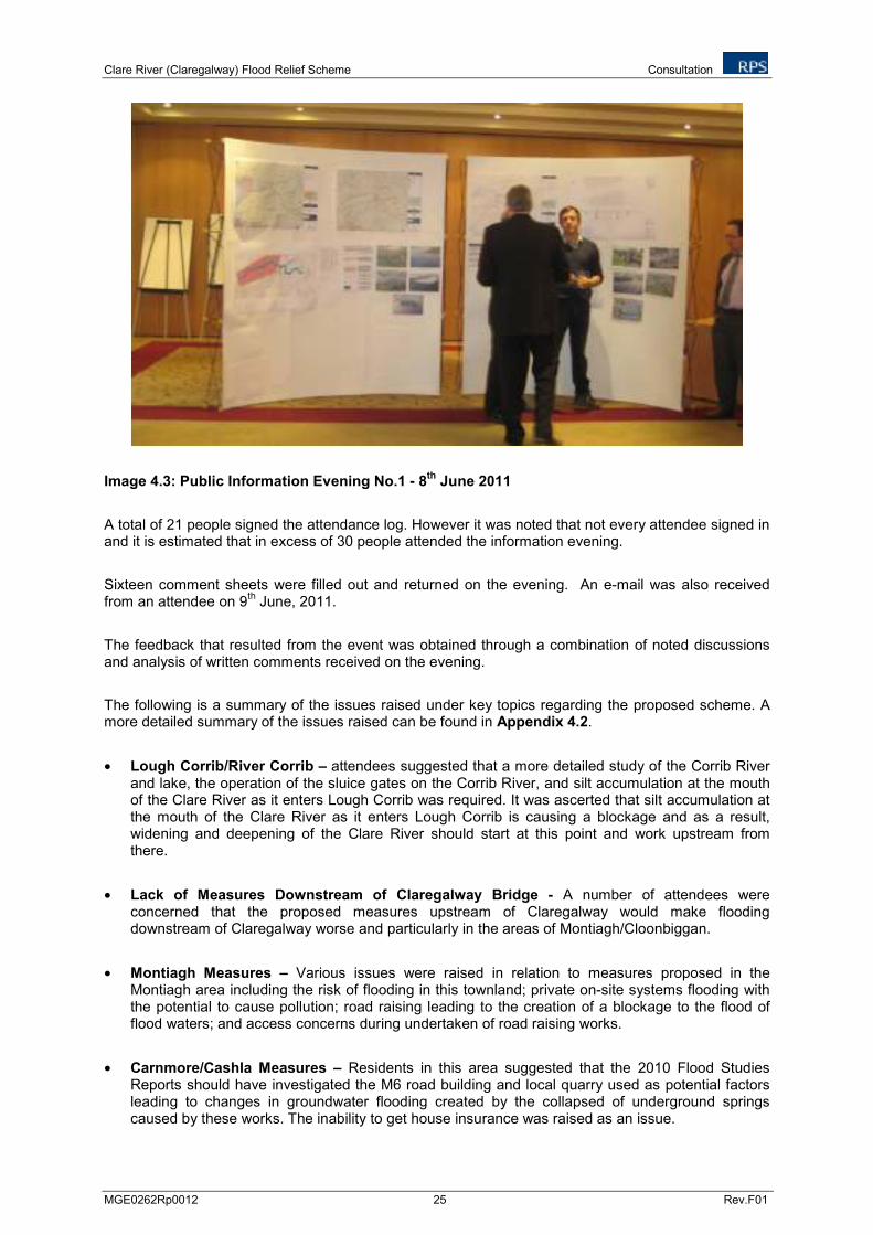
Clare River (Claregalway) Flood Relief Scheme Consultation
MGE0262Rp0012 25 Rev.F01
Image 4.3: Public Information Evening No.1 - 8th
June 2011
A total of 21 people signed the attendance log. However it was noted that not every attendee signed in and it is estimated that in excess of 30 people attended the information evening.
Sixteen comment sheets were filled out and returned on the evening. An e-mail was also received from an attendee on 9
th June, 2011.
The feedback that resulted from the event was obtained through a combination of noted discussions and analysis of written comments received on the evening.
The following is a summary of the issues raised under key topics regarding the proposed scheme. A more detailed summary of the issues raised can be found in Appendix 4.2.
• Lough Corrib/River Corrib – attendees suggested that a more detailed study of the Corrib River and lake, the operation of the sluice gates on the Corrib River, and silt accumulation at the mouth of the Clare River as it enters Lough Corrib was required. It was ascerted that silt accumulation at the mouth of the Clare River as it enters Lough Corrib is causing a blockage and as a result, widening and deepening of the Clare River should start at this point and work upstream from there.
• Lack of Measures Downstream of Claregalway Bridge - A number of attendees were concerned that the proposed measures upstream of Claregalway would make flooding downstream of Claregalway worse and particularly in the areas of Montiagh/Cloonbiggan.
• Montiagh Measures – Various issues were raised in relation to measures proposed in the Montiagh area including the risk of flooding in this townland; private on-site systems flooding with the potential to cause pollution; road raising leading to the creation of a blockage to the flood of flood waters; and access concerns during undertaken of road raising works.
• Carnmore/Cashla Measures – Residents in this area suggested that the 2010 Flood Studies Reports should have investigated the M6 road building and local quarry used as potential factors leading to changes in groundwater flooding created by the collapsed of underground springs caused by these works. The inability to get house insurance was raised as an issue.

Clare River (Claregalway) Flood Relief Scheme Consultation
MGE0262Rp0012 26 Rev.F01
• Footbridge – The majority of comments received were welcoming of a footbridge alongside the bridge in Claregalway, to provide safe transit for school children and the residents of Claregalway.
• Crusheeny Bridge – One comment sheet suggested that a bailey bridge be put in place at Crusheeny while the new bridge is under construction. Others requested a timetable for the scheduled works. It was also queried what the impact might be if any on the Kiltrogue area in terms of potential erosion as a result of the flood relief scheme.
• Water Framework Directive and Floods Directive – It was queried whether the Water Framework Directive and Floods Directive would force all bodies concerned to work together – Galway City/County Councils/Fisheries etc?
• Environmental Concerns – Only one comment was received in relation to environmental concerns. This concerned the channel widening measure and concern was raised whether this might disrupt salmon and trout spawning beds and reduce viable habitat for salmonids.
• Location of Claregalway Wastewater Treatment Plant – A number of attendees queried the logic of locating the proposed Claregalway Waste Water Treatment Plant at Cahergowan, on a floodplain.
It can be noted from the above, the majority of the concerns raised at the Public Information Evening related to design issues associated with the scheme as opposed to environmental concerns.
4.3.2 Public Information Evening No. 2
The second Public Information Evening was held on the 30th November 2011 from 4pm to 7pm at the
Claregalway Hotel, Claregalway, Co. Galway.
The event was advertised in the Galway Advertiser (24th November) and Connacht Tribune (25
th
November). A copy of the public notice that appeared in each paper is presented below (Images 4.4 and 4.5). In addition the notice was announced on Galway Bay FM Radio from the 23
rd November to
the 30th November several times throughout each day, and was published in the Claregalway Parish
Notes on the 27th November.
The format of the event was centred around the presentation of two separate information boards (Images 4.6), one detailing the design and engineering aspects of the preferred scheme and the other detailing the sensitive environmental and archaeological receptors associated with the study area.
Attendees were requested to fill out an attendance log and were invited to fill out a comments sheet setting out their views and concerns regarding the scheme. Representatives from RPS’s environmental and engineering design teams were present for the duration of the event to explain and discuss the environmental and engineering elements of the scheme respectively. Representatives from the OPW also attended the event and addressed queries from the public in relation to the scheme.

Clare River (Claregalway) Flood Relief Scheme Consultation
MGE0262Rp0012 27 Rev.F01
Image 4.4 Public Information Notice Galway Advertiser 24
th November 2011
Image 4.5 Public Information Notice Connacht Tribune 25
th November 2011
Image 4.6: Public Information Evening No. 2 – 30
th November 2011
A total of 31 people signed the attendance log. Fifteen comment sheets were filled out and returned on the evening. The feedback that resulted from the event was obtained through a combination of noted discussions and analysis of written comments received on the evening. The following is a summary of the issues raised under key topics regarding the proposed scheme. A more detailed summary of the issues raised can be found in Appendix 4.3.
• Flooding of houses on the night of the 30th
November 2011 - A couple presented photographic evidence of flooding of their house on the day of the public information evening, following two days of heavy rain. The issue of the M6 and quarry behind their home as a potential cause of flooding in the Carnmore area was raised again as it was previously raised in June 2011.

Clare River (Claregalway) Flood Relief Scheme Consultation
MGE0262Rp0012 28 Rev.F01
• Caherlea - One resident outlined the history of the Caherlea flooding in November 2009, where after one week of rain, her house along with sixteen others flooded. The resident was extremely distressed that the measures undertaken to date i.e. advance works at Claregalway and Crusheeny bridges, didn’t appear to have made the situation any better. A review of the 2010 Flood Studies measures by Dr. Kieran Hickey stated that “the planned works for the Caherlea area will not alleviate the problem”.
• Lakeview Measures (Measure 6a) – A large number of issues were raised in relation to the measures proposed at Lakeview. The Claregalway GAA club expressed serious issue with the proposal to install an open drain inside their boundary on the juvenile and adult football pitches. One landowner stated he would not allow Measure 6a (open drainage channel) to go ahead on his land. The measure was considered to come too close to the houses in Lakeview and concern was raised about an open drain in close proximity to areas where children and adults cross an undeveloped portion of the Cuirt na hAbhainn housing estate.
• Timing of the works - One comment sheet expressed appreciation if the proposed works could commence as soon as possible in the Carnmore West area in order to prevent further flooding.
• Lough Corrib/River Corrib - During verbal discussions with attendees it was expressed strongly on several occasions that the reason for the extensive flooding in Claregalway area is due to the siltation and bed levels at the mouth of the Clare River where it discharges into Lough Corrib and that floodwater cannot enter the lake.
• Claregalway Measures – A comment, was made that the pipe under the road at the Arches Bar should be cleaned out. The planning authority was blamed for allowing the Arches Hotel to be built on the old Clare River channel bed, and that there had not been a flooding issue at this location prior to the construction of the hotel.
• Montiagh Measures – As noted during the June consultation event, locals in the Montiagh area raised concerns about access to and from their premises during the road raising measures proposed at Montiagh North.
4.4 OTHER CONSULTATION
1. A meeting was held within the study area between IFI and Aquatic Services Unit (aquatic ecology and water quality sub-consultants) on the 20
th July 2011. The following people were in attendance:
• IFI – Kevin Rogers, Pat Gorman, and
• Aquatic Services Unit representing RPS – Ger Morgan.
Key fisheries features within the study area were discussed and potential issues surrounding the proposed flood relief scheme measures.
2. A meeting with IFI was held on the 22nd
August 2011. The following people were in attendance:
• IFI – Mr. Kevin Rogers, Mr. Pat Gorman, and
• RPS – Dr Bernadette Ni Chatháin and Mr. PJ Griffin.

Clare River (Claregalway) Flood Relief Scheme Consultation
MGE0262Rp0012 29 Rev.F01
The purpose of the meeting was to discuss any issues which IFI had in relation to the flood relief scheme design.
3. A meeting with the National Parks and Wildlife Service (NPWS) was held on the 16th September
2011. The following people were in attendance:
• OPW – Mr. Paul Costello, Mr. Richard Dooley,
• Galway County Council – Mr. Sean Langan, Mr. Liam Gavin, Mr. Frank Gilmore,
• NPWS – Dr Julie Fossit, Mr Enda Mooney, and
• RPS – Dr Bernadette Ni Chatháin, Ms. Paula Kearney, Mr. PJ Griffin, and Mr. Willie Madden.
The purpose of the meeting was to discuss the flood relief scheme, the proposed scope of environmental, and more specifically ecological work, associated with it and timescales for completion. It was agreed at this meeting that a proposed scope of the Natura Impact Statement (NIS) and required surveys for inclusion in the EIS would be issued by RPS to the NPWS for their consideration. This scope was subsequently issued to the NPWS on the 26
th September 2011.
4.5 SUMMARY OF CONSULTATIONS UNDERTAKEN
Table 4.2 summarises the various types of consultation that were undertaken throughout the course of completing the EIS for the Clare River (Claregalway) Flood Relief Scheme. All comments and correspondence were analysed as part of the delivery of this EIS.
Table 4.2 Summary of Consultations associated with the EIS for the Scheme
Consultation Method Details Comments/ Responses
EIS Scoping letter issued to 28 stakeholders on 11
th May 2011
Response received from 8 stakeholders.
Written Consultation
Proposed scope of EIS email issued to 27 stakeholders on 18
th
November 2011
No response received from stakeholders.
Public Information Evening in Claregalway on 8
th June 2011
30 people signed the attendance log.
Public Consultation
Public Information Evening in Claregalway on 30
th November
2011
31 people signed the attendance log.
Other Consultation Meeting with IFI inspector in the catchment of the Clare River on the 20
th of July 2011
Discussed aspects of the proposed scheme and environmental considerations
Meeting with IFI on the 22nd
August 2011
Discussed aspects of the proposed scheme and environmental considerations
Meeting with NPWS on 16th
September 2011
Agreed scope of surveys required for a Natura Impact Statement (NIS).
Public Exhibition Scheduled between 16th
November to 13
th December 2012. In
accordance with Section 5 of the Arterial Drainage Act, 1945 and Section 5 of the Arterial Drainage (Amendment) Act, 1995, the OPW, being of the opinion that drainage works are required with respect to part of the Clare River, Claregalway, for the purpose of
Office of Public Works will: - Display the EIS by Public
Exhibition - Provide a copy of the EIS for
Ministerial Review

Clare River (Claregalway) Flood Relief Scheme Consultation
MGE0262Rp0012 30 Rev.F01
Consultation Method Details Comments/ Responses
preventing or substantially reducing the periodical localised flooding of lands in the area of the Clare river, have in accordance with Section 4 of that 1945 Act, as amended, prepared a Drainage Scheme for this area.

Clare River (Claregalway) Flood Relief Scheme Study Area
MGE0262Rp0012 31 Rev.F01
5 STUDY AREA
5.1 HISTORICAL AND CURRENT DAY CLARE RIVER CATCHMENT
The Clare River forms part of the Corrib-Clare catchment which covers an area of 3,056 km2. The
Corrib-Clare catchment is bounded on the north by the Moy River catchment, on the east by the Suck River catchment, on the south by the catchments of the Craughwell and Kilcolgan Rivers and on the west by the catchments of a number of small rivers which discharge to the Atlantic on the western seaboard. The Corrib River is the main river channel discharging waters from the Corrib-Mask catchment via Lower Lough Corrib and the Corrib River channel which flows from the lower lake to the sea at Galway City.
The Clare River catchment is approximately 1,036km2 or approximately 30% of the Corrib catchment.
Figure 5.1 illustrates the Clare River catchment.
The Clare River, with a reach of approximately 93 kilometres from its confluence with Lough Corrib Lower, rises approximately 8km above the town of Ballyhaunis, County Mayo. Its principal tributaries working in a southerly direction from its source in County Mayo are the Sinking River, the Nanny River, the Grange River and the Abbert River. For the greater part of its length the Clare River flows north south passing through Ballyhaunis, Milltown, the outskirts of Tuam, through the villages of Corofin and Claregalway to its confluence with Lough Corrib at Coarsefield, approximately 8km west of Claregalway. The confluence of the river with the lake is located at the Lough Corrib Lower which ultimately drains to the sea via the Corrib River channel to Galway City.
The present day drainage network has been significantly influenced by arterial drainage schemes carried out since the early nineteenth century to reduce winter flooding. Figure 5.2 below shows the drainage pattern of the catchment prior to arterial drainage in the early nineteenth century. Prior to drainage, many streams within the present Clare catchment flowed underground or terminated in permanent or temporary lakes (turloughs) due to the karst limestone geology of east County Galway. These surface waters discharged underground emerging later as groundwater further down the catchment.
A large permanent lake existed north of Corofin at the confluence of the Grange River and the Clare River. The Abbert River ended in a turlough at Ballyglunin and was not linked by a surface channel to the Clare River. Water in these turloughs flowed into swallow holes and from there via underground conduits until it emerged at large springs.
An extensive turlough was also located between Corofin and Turloughmore. Water flowed underground through swallow holes in this turlough and re-emerged in springs such as at Loughgeorge. There was no surface water channel from this turlough to Lough Corrib.
Generally, extensive flooding would have occurred at Ballyglunin, north of Corofin at Clonkeen, south of Corofin and at Turloughmore. Arterial drainage works in the Clare River catchment initially involved removing the water from the upper and middle parts of the catchment, and the reduction of flooding at Ballyglunin and Corofin. A more detailed description of historical drainage in the Clare River catchment can be found in Chapter 14 – Archaeology, Architectural and Cultural Heritage.

���������������������������������������������������������������������������������������������������
� �����
�������
���� �����
� ���
���� �������
����������
�����
�� ���
�������������
���������
��������������������������������������������� ���
������!������������!���������������"�!����#����#�
����������!�������$����������������������!�����
%��&����$��������������'�����!�(���#�)�����*���
+��'�����!����$�� ��������!�!�, ��������
����-.����������$�������� ������
�����
����!����"��
��������������������� ��������������������
#$%
&��$
����&�'$
����� �$�"��/��
0)
1�.
2�%
2. �� ����� $ )�,�%3%
��������� $
) ���%
)�,�%3%) ����2�%
4+�+�5��6��%��
4+�+�5��6��%55
������7���������!���
���������!��8������
�����1�������#
(&�1�������9��!�����������:#
)�$�#�������#
�����
�
(
)
������
������
,�$���������.�������������&��
.������$�
��$��0���1���
�����!�������$���9������
&��������
��
&��������
��
&��������
��&���
�������
&��������
��&���
�������
&��������
��
&��������
��&���
�������
&����������
&����������
&����������
&����������
&����������
&����������
&����������
&����������
&����������
�������&
����
�������&
����
�������&
����
�������&
����
�������&
����
�������&
����
�������&
����
�������&
����
�������&
����
*������&���
�
*������&���
�
*������&���
�*����
��&����
*������&���
�*����
��&����
*������&���
�
*������&���
�*����
��&����

Clare River (Claregalway) Flood Relief Scheme Study Area
MGE0262Rp0012 33 Rev.F01
Figure 5.2 Drainage pattern within the Clare Catchment – Late 18th
Century (Source: Coxon and Drew, 1983) A further Arterial Drainage Scheme was carried out by the OPW in the 1950’s and 1960’s on the Clare River in order to further drain agricultural land in the catchment. The scheme involved continuous channel excavation along the whole length of the Clare River. Key features of this drainage scheme was extensive deepening or widening or both including the deep rock cut at Lackagh and further deep rock cuts at Corofin and at Conagher above Milltown. Approximately 1.7million m
3 of material was
excavated in total from the river channel, 350,000m3 of which was rock. Similar works were also
undertaken on the tributaries and smaller watercourses.

Clare River (Claregalway) Flood Relief Scheme Study Area
MGE0262Rp0012 34 Rev.F01
The scheme was designed as a deep drainage project whose basic objective was to provide the basic conditions for increased crop production and the improvement of stock by the relief of 135,000km
2 of
agricultural lands from flooding and waterlogging.
5.2 SECTION OF THE CLARE RIVER CATCHMENT PERTINENT TO THIS STUDY
The principal study area for the proposed flood relief scheme is the channel, floodplain, and immediate surrounding areas of the Clare River extending along the main channel from its outfall in Lough Corrib to approximately 1.3 km upstream of Crusheeny Bridge, and including existing tributaries and flood paths where flood mitigation measures have been identified in the Engineering Reports. Figure 1.1 illustrates the extent of the study area.
The width of the Clare River varies along its course and is approximately 9m wide at Anabally field bridge, just upstream of the Abbert River confluence and upstream of the study area, to 32m wide, downstream of the Curraghmore Bridge on the N84 road.
The corresponding range of river channel depths (i.e. depths from bank to lowest point of riverbed), varies across the catchment both inside and outside of the study area. For example, a depth of 2.5m is noted at Turloughcartron (halfway between Corofin and the Abbert River confluence) to a maximum of 7.7m at Corofin and 7m at the most downstream section of the study area just upstream of the confluence with Lough Corrib Lower. Channel depth typically range from 3m to 4m with the exception of a 1,800m stretch of river channel in the vicinity of Lackagh Bridge where the channel depth is up to 10m. The overall gradient of the river over the section of river channel from Corofin to Lough Corrib is in the region of 1/1240 with a minimum bed level at Corofin of approximately 22.2m OD (Malin) to a minimum bed level of -0.5m OD (Malin) at the river’s confluence with Lough Corrib Lower.
5.3 LAND USE IN THE STUDY AREA
The study area is generally rural, apart from the urban settlement of Claregalway through which the river flows. The main villages and agglomerations of houses, located along this reach of the river include Grange West, Lisheenavalla, Caherlea, Islandmore, Crusheeny, Kiltroge, Gortatleva, Lakeview, Montiagh North, Montiagh South, Cahergowan/Summerfield and Curraghmore. Although classified as rural, there is substantial ribbon development in all of the above areas, much of which has been developed in the recent past.
The nature of the Clare catchment is generally gently undulating pastureland with highest elevations generally in the region of 30m OD (Malin), with the exception of the area around Knockdoe Hill which rises to approximately 70m OD (Malin). Portions of the river channel banks throughout the study area are in a high vegetative state most notably from Corofin to the Abbert River outfall, in the vicinity of Lackagh Bridge and Cregmore Bridge as well as from Crusheeny Bridge to approximately 1km upstream of Claregalway.

Clare River (Claregalway) Flood Relief Scheme Project Description
MGE0262Rp0012 35 Rev.F01
6 PROJECT DESCRIPTION
6.1 INTRODUCTION
This chapter of the EIS details the Flood Relief Scheme proposed for the Clare River and the proposed Claregalway footbridge. In completing this chapter Schedule 6(2) (a) of the Planning and Development Regulations 2001, as amended, (setting out the elements to be included when describing the proposed development) has been considered, as outlined below:
“(i) a description of the physical characteristics of the whole proposed development and the land- use requirements during the construction and operational phases; (ii) a description of the main characteristics of the production processes, for instance, nature and quantity of the materials used; (iii) an estimate, by type and quantity, of expected residues and emissions (including water, air and soil pollution, noise, vibration, light, heat and radiation) resulting from the operation of the proposed development;”.
The proposed scheme is described in terms of design rationale, detailed measures, construction stage activities, spoil management, and operational or maintenance requirements.
In May 2011 the OPW appointed RPS as design and environmental consultants for the Clare River (Claregalway) Flood Relief Scheme. The Clare River and main tributaries form part of the Corrib Clare Arterial Drainage Scheme, which was constructed in the late 1950’s and early 1960’s, for which the OPW have a statutory maintenance responsibility. These original Arterial Drainage Scheme works involved substantial widening and deepening of the existing channel and tributaries with the purpose of providing an outfall for the drainage of agricultural lands (OPW, 1954). The study area has been described in Chapter 5.
A review of the proposed flood alleviation measures outlined in the 2010 Flood Studies was carried out in order to assess the appropriateness of the measures and amend if deemed necessary. A summary of the proposed measures from the 2010 Flood Studies is outlined in Table 6.1 below.
Table 6.1 Identified Alleviation Measures for the Clare River (Claregalway) Flood Relief Scheme from the 2010 Flood Studies
Area Name Recommended measures
Montiagh South Raising of 1km of road, upsizing of an existing road culvert and cleaning/regarding of drains
Montiagh North Raising of 1.3 km of road,
Claregalway Village Installation of an additional flood eye at Claregalway Bridge
Regrade Clare River channel upstream of and under the Claregalwaybridge, and regrade flood eye
Address the gap in wall at An Mhainistir housing estate
Provide local embankment at old Nine Arches bridge
Kiniska Increase capacity of two culverts on OPW C3/5 stream
Clean OPW stream C3/5
Lakeview Provide surface water outlet through fields and along N17 to downstream of Claregalway Bridge
Caherlea/Lisheenavalla Install 2 No. flood eyes at Crusheeny Bridge
Channel widening from 0.9km upstream of Crusheeny Bridge toClaregalway
Cleaning and regrading of Islandmore OPW C3/7 and F.799/1 arterial drains
Raise local road in Caherlea/Lisheenavalla

Clare River (Claregalway) Flood Relief Scheme Project Description
MGE0262Rp0012 36 Rev.F01
Area Name Recommended measures
Carmore/Cashla Drainage of floodwater from the affected area via a new drainagepipeline/open drain to a local surface water stream at Islandmore
The flood alleviation measures identified in the 2010 Flood Studies were updated as follows by RPS;
1. The installation of the flood eye at Claregalway Bridge was undertaken as advanced works by the OPW and completed in June 2011.
2. It was decided that the surface water outlet from the Lakeview estate and Claregalway Corporate Park should discharge upstream of Claregalway Bridge and not downstream of the bridge as originally proposed.
3. It was decided in conjunction with Galway County Council and the NRA that a new bridge should be provided at Crusheeny in lieu of flood eyes on either side of the existing bridge.
4. Following completion of a Cost Benefit Analysis for the scheme it was necessary to revisit the works proposed to obtain similar benefits for reduced costs. This resulted in the two stage channel works from Crusheeny to Claregalway being removed and replaced with a two stage channel from Crusheeny Bridge to approximately 1.3km upstream of the bridge along with the construction of an embankment 750m in length upstream of the Islandmore Drain.
The Clare River Flood Relief Scheme is discussed further in Sections 6.2 – 6.8 below.
In addition to the flood relief scheme, a proposed footbridge for Claregalway is also assessed as part of this EIA. RPS was appointed by Galway County Council in June 2010 to undertake a Feasibility Study in connection with a possible pedestrian footbridge over the Clare River at Claregalway. The design of the footbridge is discussed further in Section 6.9 below.
6.2 CLARE RIVER FLOOD RELIEF SCHEME DESIGN PHILOSOPHY
6.2.1 PREFERRED DESIGN STANDARDS
The preferred design standards identified in the brief (i.e., flood event probabilities that the Scheme and risk management measures and options should address) were the 1% AEP event, with provision for adaptability to the Mid-Range Future Scenario (MRFS) where AEP is the Annual Exceedance Probability. The brief also required the Consultant to consider flood risks associated with more significant events than those of the preferred or proposed design standard (e.g., 0.1% AEP) as part of the appraisal to assess the impacts of failure of the Scheme or other measures, and, if appropriate, for inclusion in design of the Scheme and measures.
6.2.2 Design Flood Estimation
A design flood may be determined by either of two broad categories of methods, namely;
• Methods based on statistical analysis of flood peak data, or
• Methods based on a design rainstorm and a rainfall-runoff model which converts the design rainstorm into a design flood.
Generally in Ireland the Extreme Value Type 1 (EV1) distribution fits reasonably well with the majority of gauged rivers. In the case of the Clare River at Claregalway there are a sufficient number of reliable gauged stations to perform flood frequency analysis and extrapolate to ungauged sites based on catchment characteristics. If a catchment is gauged and there is a sufficiently long historical flow record then the NERC Flood Studies Report (1975) recommends that flood flows should be estimated by statistical flood frequency. Annual Maximum flow data can be obtained from the OPW or the Environmental Protection Agency (EPA). In this study, flood frequency analysis was carried out using the EV1 statistical probability distribution which has been found suitable for predicting extreme flood flows for Irish catchments. The EV1 distribution can be fitted to Annual Maxima Series (flood level and flow) using

Clare River (Claregalway) Flood Relief Scheme Project Description
MGE0262Rp0012 37 Rev.F01
a variety of methods from Least Squares fit using gringorten plotting position to fitting by method of moments. The Least Square fit with gringorten plotting position provides a reasonable fit of the series to the data. The relevant gauges on the Clare River and the Corrib System used in the statistical analysis for this study are summarised in Table 6.2 below. It is noted that there are no gauges available on the Abbert River.
Table 6.2 Summary of Gauging Stations used in Flood Frequency Analysis
Station Location River Area Period Rating Class
30012 (EPA) Claregalway Clare River 1073km2 1996-2009 B
30004 (OPW) Corofin Clare River 699km2 1964-2009 A1
30007 (OPW) Ballygaddy Clare River 442km2 1974-2009 A2
30089 (OPW) Angliham Lough Corrib 3100km2 1991-2009 N/A (water
level only)
30061 (OPW) Wolfe Tone Bridge Galway
Corrib River 3111km2 1972-2002 Gauge
relocated and new rating not established for 2003-2010
A2
A hydraulic model of the Clare River and its tributary the Abbert River, from Lough Corrib upstream to Corofin on the Clare River and from Anabally to Ballyglunin on the Abbert River was developed to predict the peak flood level profile within the modelled reach under existing conditions and under various proposed flood risk management measures for a range of return period flood events. The selected software used for this hydraulic assessment is the latest Hydrologic Engineering Centers River Analysis System version 4.1 (HEC-RAS 4.1).
The 2010 Flood Studies hydrology and hydraulics were further developed as part of the review of the proposed scheme as follows;
1. The various options identified in the 2010 Flood Studies were designed by building a steady state HEC-RAS hydraulic model. An unsteady state model taking account of the storage effects of the floodplain was not completed as part of the 2010 studies;
2. The design flood flow estimation for the November 2009 event at Claregalway was estimated to be 165 m
3/s while the flood flow estimation for the same event at Corofin was 192.5 m
3/s. This is
despite the fact that the Clare River has a catchment area 50% larger at Claregalway than at Corofin and includes the Abbert River in-flow which was estimated to be 55 m
3/s for the
November 2009 event; and
3. The Manning’s roughness coefficient (n) used for the overbanks in the calibration of the flood study model appeared to be quite high (values of 0.1 to 0.5).
An unsteady state model was developed for the river stretch utilising LiDAR (Light Detection and Ranging) survey data to allow the river cross sections to be extended through the extent of the flood plain. LiDAR survey data was obtained from the OSI for the extent of the floodplain as observed during the November 2009 flood event. The unsteady state model predicted that the flow at Claregalway may have been significantly higher than measured during the November 2009 flood and may have been as high as 205 m
3/s.
6.2.3 Estimated Return Period for the November 2009 Flood Event
Since the observed flood flows at Corofin during the November 2009 flood event has an estimated frequency of 100 year, it is realistic to assume that the estimated flood flows at Claregalway of 205m
3/s
also has a return period of 100 year.

Clare River (Claregalway) Flood Relief Scheme Project Description
MGE0262Rp0012 38 Rev.F01
6.2.4 Climate Change and Future Flow Scenarios
Designing for climate change is an approach where the level of proposed defences or the size of the proposed channel works is such that future climate change predictions are considered.
Two broad approaches are considered when implementing a proposed flood relief scheme.
These are:
1. Design based on historic records
This approach considers historic flood and water level data and while climate change impacts are investigated, no allowance is made for climate change in relevant design parameters.
2. Design for Climate Change
Whilst the design of the proposed works along this stretch of the Clare River takes into account a series of environmental river enhancement works, the proposed approach to implementing the Clare River Flood Relief Scheme is to design for climate change.
The document entitled “Assessment of Potential Future Scenarios for Flood Risk Management” and published by the OPW in August 2009 has been reviewed as part of this planning stage design.
This document states that:
“To provide an adequate understanding of the potential implications of the predicted impacts of climate change and other future changes, with due consideration of the significant uncertainty associated with such predictions, the OPW recommends that a minimum of two potential future scenarios are considered.”
The two minimum scenarios are referred to as the:
“Mid-Range Future Scenario (MRFS) which is intended to represent a ‘likely’ future scenario, based on the wide range of predictions available and with the allowances for increased flow, sea level rise, etc. within the bounds of widely accepted projections.”
and
“High-End Future Scenario (HEFS), is intended to represent a more extreme potential future scenario, but one that is nonetheless not significantly outside the range of accepted predictions available, and with the allowances for increased flow, sea level rise, etc. at the upper the bounds of widely accepted projections.”
Present recommendations are to include in the design flow a 20% increase in flood peaks over a 50 years return period to take account of potential climate change. This scenario based on the Irish growth curve will result in a present day 100 year flood becoming a 25 year flood in approximately 50 years time.
The design of the Clare River Flood Relief Scheme was therefore based on a 100 year design flood flow of 205m
3/s plus a climate change allowance of 20%.
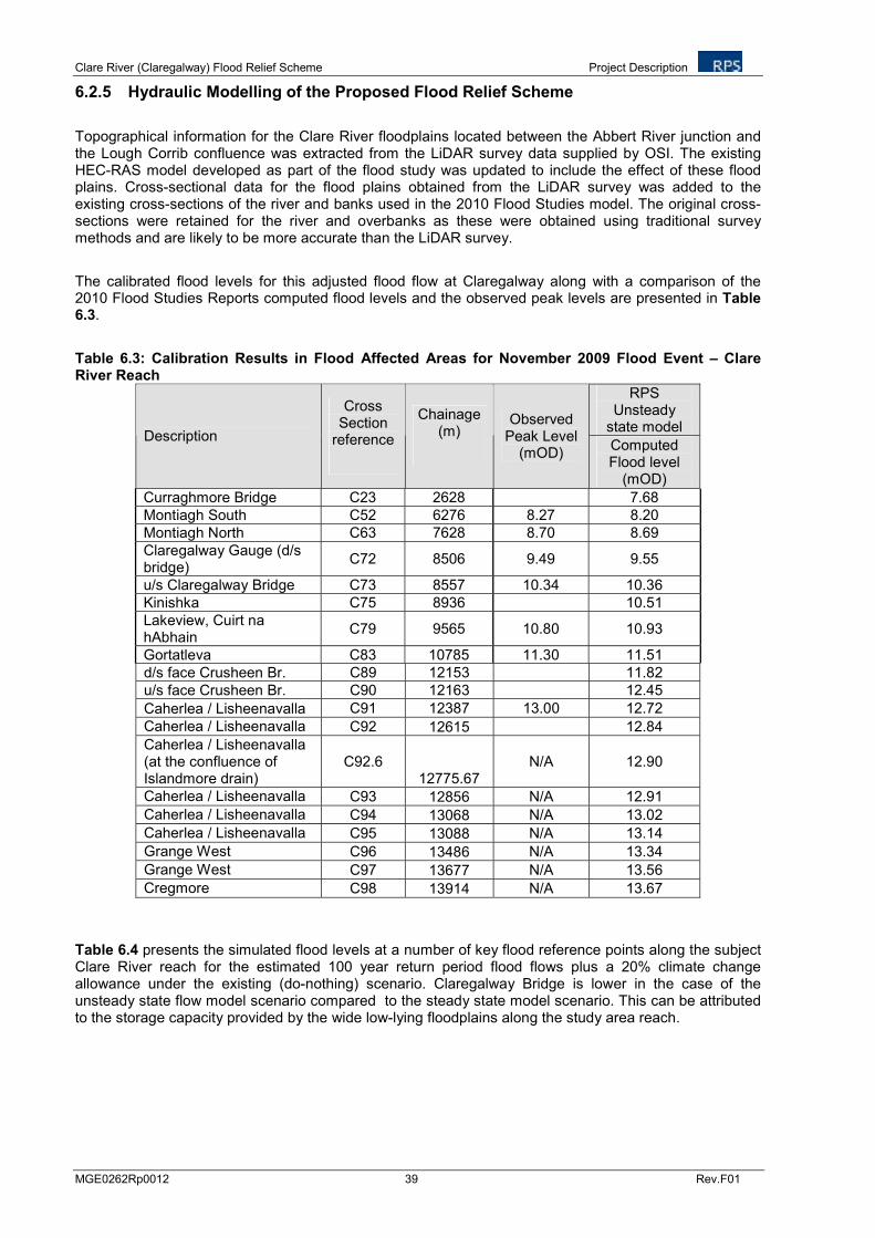
Clare River (Claregalway) Flood Relief Scheme Project Description
MGE0262Rp0012 39 Rev.F01
6.2.5 Hydraulic Modelling of the Proposed Flood Relief Scheme
Topographical information for the Clare River floodplains located between the Abbert River junction and the Lough Corrib confluence was extracted from the LiDAR survey data supplied by OSI. The existing HEC-RAS model developed as part of the flood study was updated to include the effect of these flood plains. Cross-sectional data for the flood plains obtained from the LiDAR survey was added to the existing cross-sections of the river and banks used in the 2010 Flood Studies model. The original cross-sections were retained for the river and overbanks as these were obtained using traditional survey methods and are likely to be more accurate than the LiDAR survey.
The calibrated flood levels for this adjusted flood flow at Claregalway along with a comparison of the 2010 Flood Studies Reports computed flood levels and the observed peak levels are presented in Table 6.3.
Table 6.3: Calibration Results in Flood Affected Areas for November 2009 Flood Event – Clare River Reach
RPS Unsteady
state model Description
Cross Section
reference
Chainage (m)
Observed Peak Level
(mOD) Computed Flood level
(mOD)
Curraghmore Bridge C23 2628 7.68
Montiagh South C52 6276 8.27 8.20
Montiagh North C63 7628 8.70 8.69
Claregalway Gauge (d/s bridge)
C72 8506 9.49 9.55
u/s Claregalway Bridge C73 8557 10.34 10.36
Kinishka C75 8936 10.51
Lakeview, Cuirt na hAbhain
C79 9565 10.80 10.93
Gortatleva C83 10785 11.30 11.51
d/s face Crusheen Br. C89 12153 11.82
u/s face Crusheen Br. C90 12163 12.45
Caherlea / Lisheenavalla C91 12387 13.00 12.72
Caherlea / Lisheenavalla C92 12615 12.84
Caherlea / Lisheenavalla (at the confluence of Islandmore drain)
C92.6 12775.67
N/A 12.90
Caherlea / Lisheenavalla C93 12856 N/A 12.91
Caherlea / Lisheenavalla C94 13068 N/A 13.02
Caherlea / Lisheenavalla C95 13088 N/A 13.14
Grange West C96 13486 N/A 13.34
Grange West C97 13677 N/A 13.56
Cregmore C98 13914 N/A 13.67
Table 6.4 presents the simulated flood levels at a number of key flood reference points along the subject Clare River reach for the estimated 100 year return period flood flows plus a 20% climate change allowance under the existing (do-nothing) scenario. Claregalway Bridge is lower in the case of the unsteady state flow model scenario compared to the steady state model scenario. This can be attributed to the storage capacity provided by the wide low-lying floodplains along the study area reach.
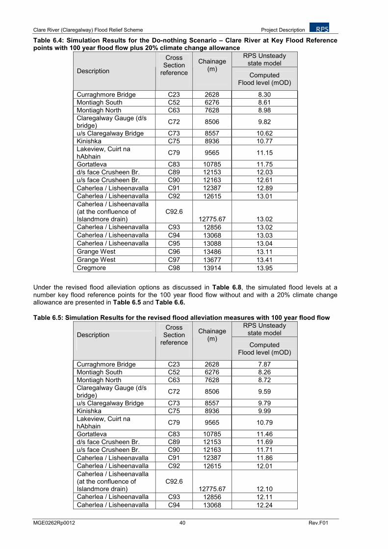
Clare River (Claregalway) Flood Relief Scheme Project Description
MGE0262Rp0012 40 Rev.F01
Table 6.4: Simulation Results for the Do-nothing Scenario – Clare River at Key Flood Reference points with 100 year flood flow plus 20% climate change allowance
RPS Unsteady state model
Description
Cross Section
reference
Chainage (m)
Computed Flood level (mOD)
Curraghmore Bridge C23 2628 8.30
Montiagh South C52 6276 8.61
Montiagh North C63 7628 8.98
Claregalway Gauge (d/s bridge)
C72 8506 9.82
u/s Claregalway Bridge C73 8557 10.62
Kinishka C75 8936 10.77
Lakeview, Cuirt na hAbhain
C79 9565 11.15
Gortatleva C83 10785 11.75
d/s face Crusheen Br. C89 12153 12.03
u/s face Crusheen Br. C90 12163 12.61
Caherlea / Lisheenavalla C91 12387 12.89
Caherlea / Lisheenavalla C92 12615 13.01
Caherlea / Lisheenavalla (at the confluence of Islandmore drain)
C92.6 12775.67 13.02
Caherlea / Lisheenavalla C93 12856 13.02
Caherlea / Lisheenavalla C94 13068 13.03
Caherlea / Lisheenavalla C95 13088 13.04
Grange West C96 13486 13.11
Grange West C97 13677 13.41
Cregmore C98 13914 13.95
Under the revised flood alleviation options as discussed in Table 6.8, the simulated flood levels at a number key flood reference points for the 100 year flood flow without and with a 20% climate change allowance are presented in Table 6.5 and Table 6.6.
Table 6.5: Simulation Results for the revised flood alleviation measures with 100 year flood flow
RPS Unsteady state model Description
Cross Section
reference
Chainage (m)
Computed Flood level (mOD)
Curraghmore Bridge C23 2628 7.87
Montiagh South C52 6276 8.26
Montiagh North C63 7628 8.72
Claregalway Gauge (d/s bridge)
C72 8506 9.59
u/s Claregalway Bridge C73 8557 9.79
Kinishka C75 8936 9.99
Lakeview, Cuirt na hAbhain
C79 9565 10.79
Gortatleva C83 10785 11.46
d/s face Crusheen Br. C89 12153 11.69
u/s face Crusheen Br. C90 12163 11.71
Caherlea / Lisheenavalla C91 12387 11.86
Caherlea / Lisheenavalla C92 12615 12.01
Caherlea / Lisheenavalla (at the confluence of Islandmore drain)
C92.6 12775.67 12.10
Caherlea / Lisheenavalla C93 12856 12.11
Caherlea / Lisheenavalla C94 13068 12.24
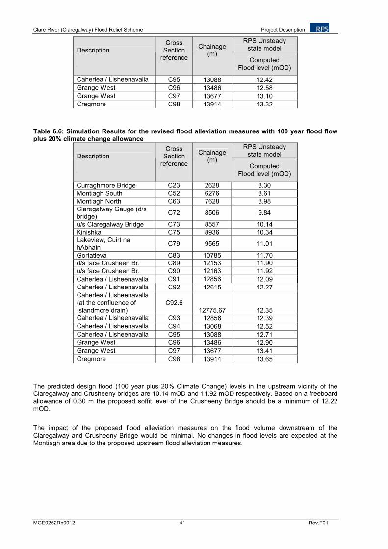
Clare River (Claregalway) Flood Relief Scheme Project Description
MGE0262Rp0012 41 Rev.F01
RPS Unsteady state model Description
Cross Section
reference
Chainage (m)
Computed Flood level (mOD)
Caherlea / Lisheenavalla C95 13088 12.42
Grange West C96 13486 12.58
Grange West C97 13677 13.10
Cregmore C98 13914 13.32
Table 6.6: Simulation Results for the revised flood alleviation measures with 100 year flood flow plus 20% climate change allowance
RPS Unsteady state model Description
Cross Section
reference
Chainage (m)
Computed Flood level (mOD)
Curraghmore Bridge C23 2628 8.30
Montiagh South C52 6276 8.61
Montiagh North C63 7628 8.98
Claregalway Gauge (d/s bridge)
C72 8506 9.84
u/s Claregalway Bridge C73 8557 10.14
Kinishka C75 8936 10.34
Lakeview, Cuirt na hAbhain
C79 9565 11.01
Gortatleva C83 10785 11.70
d/s face Crusheen Br. C89 12153 11.90
u/s face Crusheen Br. C90 12163 11.92
Caherlea / Lisheenavalla C91 12856 12.09
Caherlea / Lisheenavalla C92 12615 12.27
Caherlea / Lisheenavalla (at the confluence of Islandmore drain)
C92.6 12775.67 12.35
Caherlea / Lisheenavalla C93 12856 12.39
Caherlea / Lisheenavalla C94 13068 12.52
Caherlea / Lisheenavalla C95 13088 12.71
Grange West C96 13486 12.90
Grange West C97 13677 13.41
Cregmore C98 13914 13.65
The predicted design flood (100 year plus 20% Climate Change) levels in the upstream vicinity of the Claregalway and Crusheeny bridges are 10.14 mOD and 11.92 mOD respectively. Based on a freeboard allowance of 0.30 m the proposed soffit level of the Crusheeny Bridge should be a minimum of 12.22 mOD.
The impact of the proposed flood alleviation measures on the flood volume downstream of the Claregalway and Crusheeny Bridge would be minimal. No changes in flood levels are expected at the Montiagh area due to the proposed upstream flood alleviation measures.
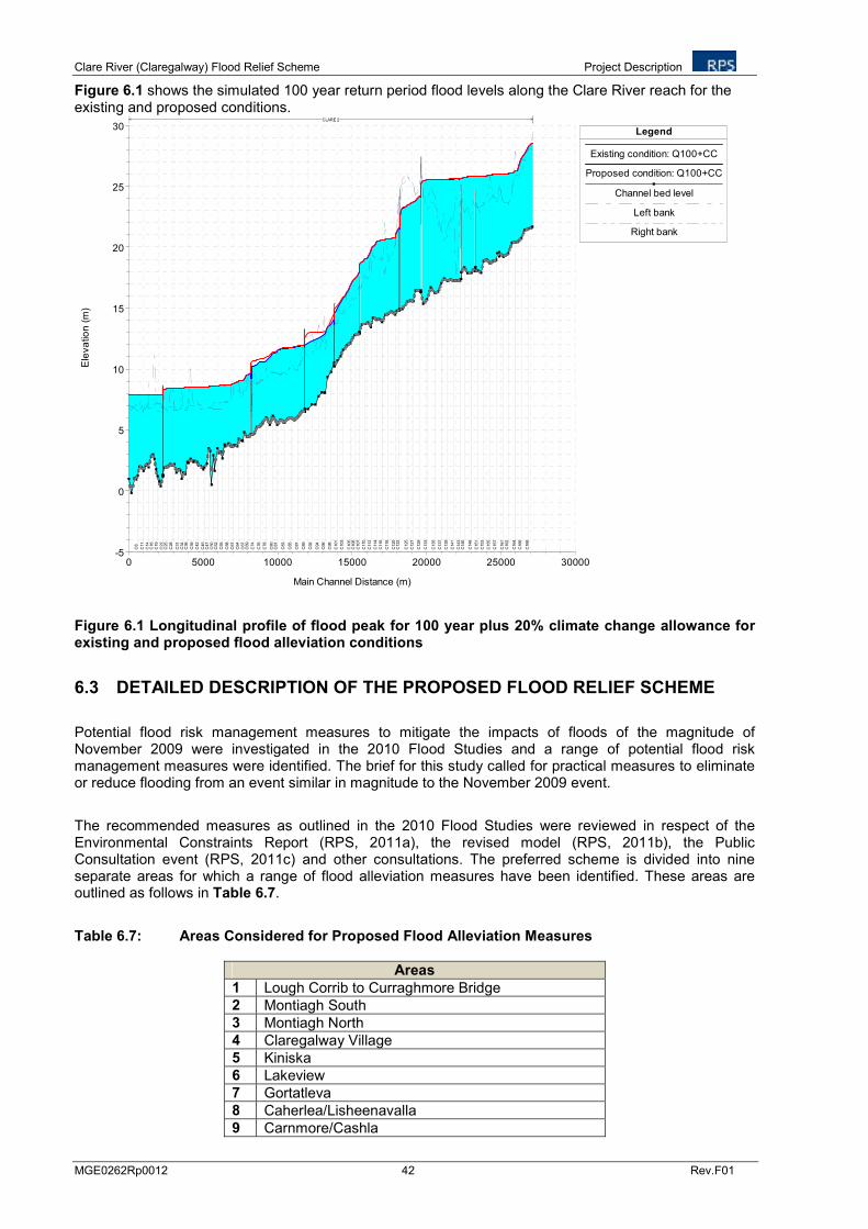
Clare River (Claregalway) Flood Relief Scheme Project Description
MGE0262Rp0012 42 Rev.F01
Figure 6.1 shows the simulated 100 year return period flood levels along the Clare River reach for the existing and proposed conditions.
0 5000 10000 15000 20000 25000 30000-5
0
5
10
15
20
25
30
Main Channel Distance (m)
Ele
va
tio
n (
m)
Legend
Existing condition: Q100+CC
Proposed condition: Q100+CC
Channel bed level
Left bank
Right bank
C8
C11
C14
C16
C19
C22
C25
C28
C31
C34
C36
C39
C42
C45
C47
C50
C52
C55
C58
C61
C64
C67
C69
C74
C76
C78
C80
C81
C83
C85
C87
C89
C92
C94
C96
C98
C101
C103
C105
C106
C107
C110
C112
C114
C116
C118
C120
C122
C125
C127
C129
C133
C135
C137
C139
C141
C143
C146
C148
C151
C153
C155
C157
C161
C162
C164
C166
C168
CLARE 2
Figure 6.1 Longitudinal profile of flood peak for 100 year plus 20% climate change allowance for existing and proposed flood alleviation conditions
6.3 DETAILED DESCRIPTION OF THE PROPOSED FLOOD RELIEF SCHEME
Potential flood risk management measures to mitigate the impacts of floods of the magnitude of November 2009 were investigated in the 2010 Flood Studies and a range of potential flood risk management measures were identified. The brief for this study called for practical measures to eliminate or reduce flooding from an event similar in magnitude to the November 2009 event.
The recommended measures as outlined in the 2010 Flood Studies were reviewed in respect of the Environmental Constraints Report (RPS, 2011a), the revised model (RPS, 2011b), the Public Consultation event (RPS, 2011c) and other consultations. The preferred scheme is divided into nine separate areas for which a range of flood alleviation measures have been identified. These areas are outlined as follows in Table 6.7.
Table 6.7: Areas Considered for Proposed Flood Alleviation Measures
Areas
1 Lough Corrib to Curraghmore Bridge
2 Montiagh South
3 Montiagh North
4 Claregalway Village
5 Kiniska
6 Lakeview
7 Gortatleva
8 Caherlea/Lisheenavalla
9 Carnmore/Cashla
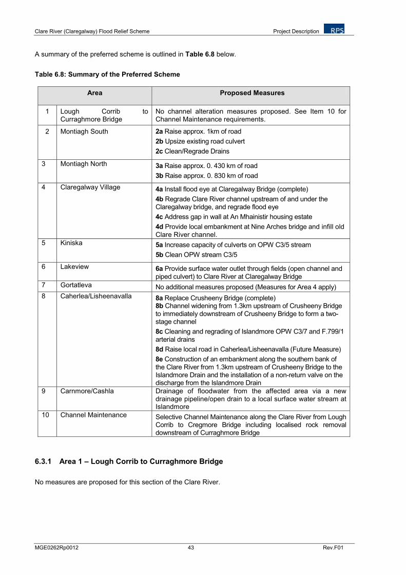
Clare River (Claregalway) Flood Relief Scheme Project Description
MGE0262Rp0012 43 Rev.F01
A summary of the preferred scheme is outlined in Table 6.8 below.
Table 6.8: Summary of the Preferred Scheme
Area Proposed Measures
1 Lough Corrib to Curraghmore Bridge
No channel alteration measures proposed. See Item 10 for Channel Maintenance requirements.
2 Montiagh South 2a Raise approx. 1km of road
2b Upsize existing road culvert
2c Clean/Regrade Drains
3 Montiagh North 3a Raise approx. 0. 430 km of road
3b Raise approx. 0. 830 km of road
4 Claregalway Village 4a Install flood eye at Claregalway Bridge (complete)
4b Regrade Clare River channel upstream of and under the Claregalway bridge, and regrade flood eye
4c Address gap in wall at An Mhainistir housing estate
4d Provide local embankment at Nine Arches bridge and infill old Clare River channel.
5 Kiniska 5a Increase capacity of culverts on OPW C3/5 stream
5b Clean OPW stream C3/5
6 Lakeview 6a Provide surface water outlet through fields (open channel and piped culvert) to Clare River at Claregalway Bridge
7 Gortatleva No additional measures proposed (Measures for Area 4 apply)
8 Caherlea/Lisheenavalla 8a Replace Crusheeny Bridge (complete) 8b Channel widening from 1.3km upstream of Crusheeny Bridge to immediately downstream of Crusheeny Bridge to form a two-stage channel
8c Cleaning and regrading of Islandmore OPW C3/7 and F.799/1 arterial drains
8d Raise local road in Caherlea/Lisheenavalla (Future Measure)
8e Construction of an embankment along the southern bank of the Clare River from 1.3km upstream of Crusheeny Bridge to the Islandmore Drain and the installation of a non-return valve on the discharge from the Islandmore Drain
9 Carnmore/Cashla Drainage of floodwater from the affected area via a new drainage pipeline/open drain to a local surface water stream at Islandmore
10 Channel Maintenance Selective Channel Maintenance along the Clare River from Lough Corrib to Cregmore Bridge including localised rock removal downstream of Curraghmore Bridge
6.3.1 Area 1 – Lough Corrib to Curraghmore Bridge
No measures are proposed for this section of the Clare River.
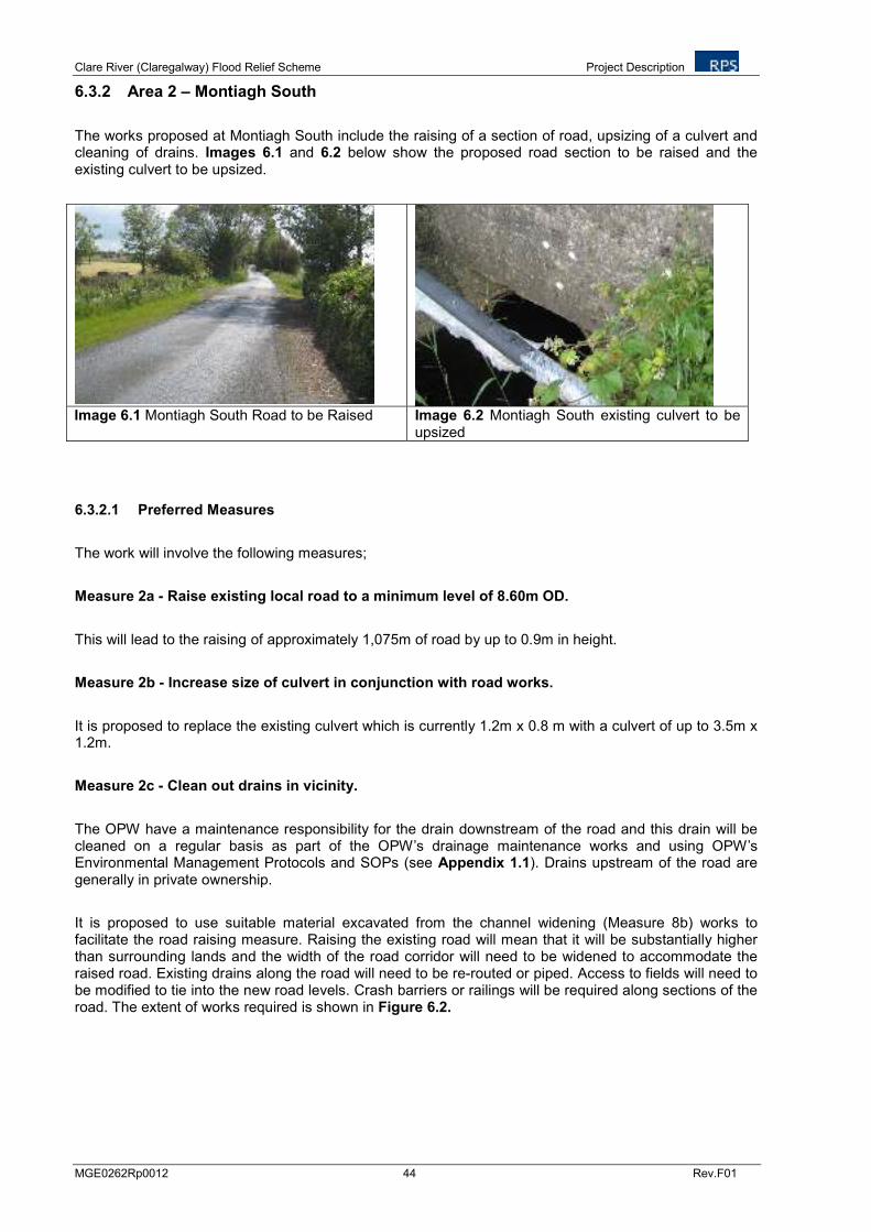
Clare River (Claregalway) Flood Relief Scheme Project Description
MGE0262Rp0012 44 Rev.F01
6.3.2 Area 2 – Montiagh South
The works proposed at Montiagh South include the raising of a section of road, upsizing of a culvert and cleaning of drains. Images 6.1 and 6.2 below show the proposed road section to be raised and the existing culvert to be upsized.
Image 6.1 Montiagh South Road to be Raised Image 6.2 Montiagh South existing culvert to be
upsized
6.3.2.1 Preferred Measures
The work will involve the following measures;
Measure 2a - Raise existing local road to a minimum level of 8.60m OD.
This will lead to the raising of approximately 1,075m of road by up to 0.9m in height.
Measure 2b - Increase size of culvert in conjunction with road works.
It is proposed to replace the existing culvert which is currently 1.2m x 0.8 m with a culvert of up to 3.5m x 1.2m.
Measure 2c - Clean out drains in vicinity.
The OPW have a maintenance responsibility for the drain downstream of the road and this drain will be cleaned on a regular basis as part of the OPW’s drainage maintenance works and using OPW’s Environmental Management Protocols and SOPs (see Appendix 1.1). Drains upstream of the road are generally in private ownership.
It is proposed to use suitable material excavated from the channel widening (Measure 8b) works to facilitate the road raising measure. Raising the existing road will mean that it will be substantially higher than surrounding lands and the width of the road corridor will need to be widened to accommodate the raised road. Existing drains along the road will need to be re-routed or piped. Access to fields will need to be modified to tie into the new road levels. Crash barriers or railings will be required along sections of the road. The extent of works required is shown in Figure 6.2.
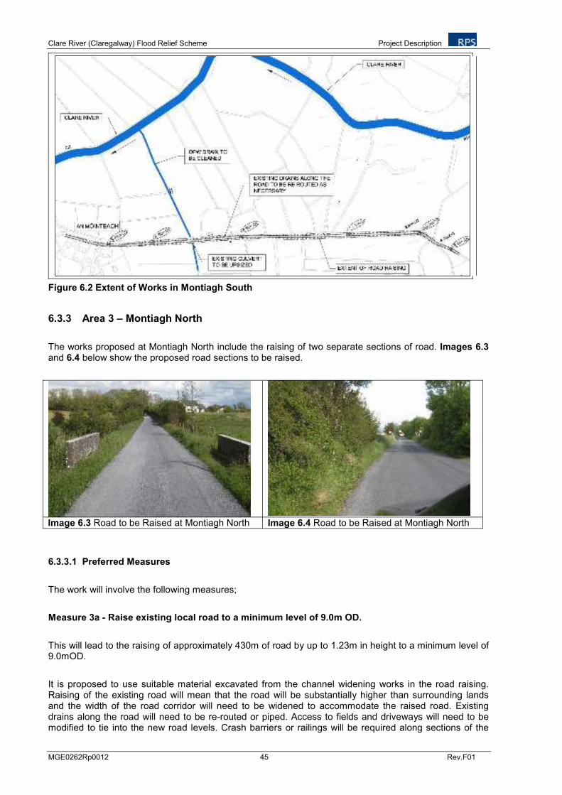
Clare River (Claregalway) Flood Relief Scheme Project Description
MGE0262Rp0012 45 Rev.F01
Figure 6.2 Extent of Works in Montiagh South
6.3.3 Area 3 – Montiagh North
The works proposed at Montiagh North include the raising of two separate sections of road. Images 6.3 and 6.4 below show the proposed road sections to be raised.
Image 6.3 Road to be Raised at Montiagh North Image 6.4 Road to be Raised at Montiagh North
6.3.3.1 Preferred Measures
The work will involve the following measures;
Measure 3a - Raise existing local road to a minimum level of 9.0m OD.
This will lead to the raising of approximately 430m of road by up to 1.23m in height to a minimum level of 9.0mOD.
It is proposed to use suitable material excavated from the channel widening works in the road raising. Raising of the existing road will mean that the road will be substantially higher than surrounding lands and the width of the road corridor will need to be widened to accommodate the raised road. Existing drains along the road will need to be re-routed or piped. Access to fields and driveways will need to be modified to tie into the new road levels. Crash barriers or railings will be required along sections of the
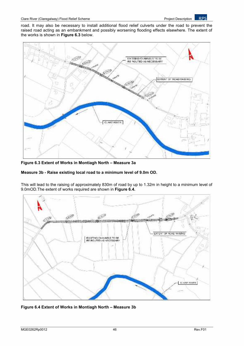
Clare River (Claregalway) Flood Relief Scheme Project Description
MGE0262Rp0012 46 Rev.F01
road. It may also be necessary to install additional flood relief culverts under the road to prevent the raised road acting as an embankment and possibly worsening flooding effects elsewhere. The extent of the works is shown in Figure 6.3 below.
Figure 6.3 Extent of Works in Montiagh North – Measure 3a
Measure 3b - Raise existing local road to a minimum level of 9.0m OD.
This will lead to the raising of approximately 830m of road by up to 1.32m in height to a minimum level of 9.0mOD.The extent of works required are shown in Figure 6.4.
Figure 6.4 Extent of Works in Montiagh North – Measure 3b
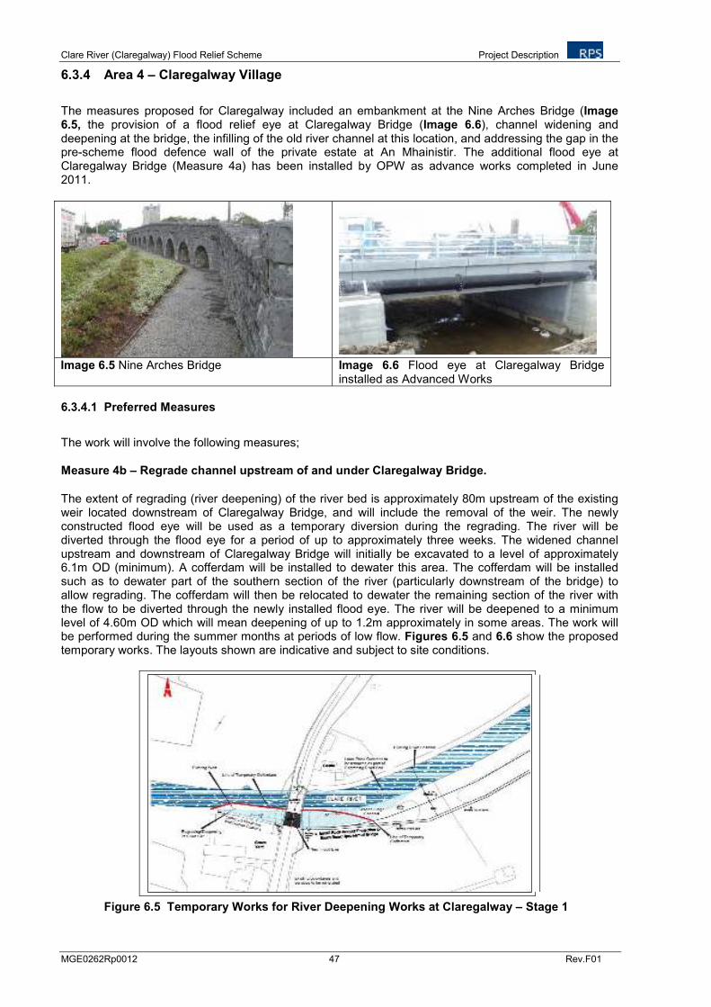
Clare River (Claregalway) Flood Relief Scheme Project Description
MGE0262Rp0012 47 Rev.F01
6.3.4 Area 4 – Claregalway Village
The measures proposed for Claregalway included an embankment at the Nine Arches Bridge (Image 6.5, the provision of a flood relief eye at Claregalway Bridge (Image 6.6), channel widening and deepening at the bridge, the infilling of the old river channel at this location, and addressing the gap in the pre-scheme flood defence wall of the private estate at An Mhainistir. The additional flood eye at Claregalway Bridge (Measure 4a) has been installed by OPW as advance works completed in June 2011.
Image 6.5 Nine Arches Bridge Image 6.6 Flood eye at Claregalway Bridge installed as Advanced Works
6.3.4.1 Preferred Measures
The work will involve the following measures;
Measure 4b – Regrade channel upstream of and under Claregalway Bridge.
The extent of regrading (river deepening) of the river bed is approximately 80m upstream of the existing weir located downstream of Claregalway Bridge, and will include the removal of the weir. The newly constructed flood eye will be used as a temporary diversion during the regrading. The river will be diverted through the flood eye for a period of up to approximately three weeks. The widened channel upstream and downstream of Claregalway Bridge will initially be excavated to a level of approximately 6.1m OD (minimum). A cofferdam will be installed to dewater this area. The cofferdam will be installed such as to dewater part of the southern section of the river (particularly downstream of the bridge) to allow regrading. The cofferdam will then be relocated to dewater the remaining section of the river with the flow to be diverted through the newly installed flood eye. The river will be deepened to a minimum level of 4.60m OD which will mean deepening of up to 1.2m approximately in some areas. The work will be performed during the summer months at periods of low flow. Figures 6.5 and 6.6 show the proposed temporary works. The layouts shown are indicative and subject to site conditions.
Figure 6.5 Temporary Works for River Deepening Works at Claregalway – Stage 1
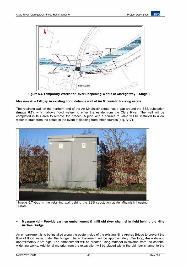
Clare River (Claregalway) Flood Relief Scheme Project Description
MGE0262Rp0012 48 Rev.F01
Figure 6.6 Temporary Works for River Deepening Works at Claregalway – Stage 2 Measure 4c – Fill gap in existing flood defence wall at An Mhainistir housing estate.
The retaining wall on the northern end of the An Mhainistir estate has a gap around the ESB substation (Image 6.7), which allows flood waters to enter the estate from the Clare River. The wall will be completed in this area to remove the breach. A pipe with a non-return valve will be installed to allow water to drain from the estate in the event of flooding from other sources (e.g. N17).
Image 6.7 Gap in the retaining wall behind the ESB substation at An Mhainistir housing estate
• Measure 4d – Provide earthen embankment & infill old river channel in field behind old Nine Arches Bridge
An embankment is to be installed along the eastern side of the existing Nine Arches Bridge to prevent the flow of flood water under the bridge. The embankment will be approximately 53m long, 4m wide and approximately 2.5m high. The embankment will be created using material excavated from the channel widening works. Additional material from the excavation will be placed within the old river channel to the
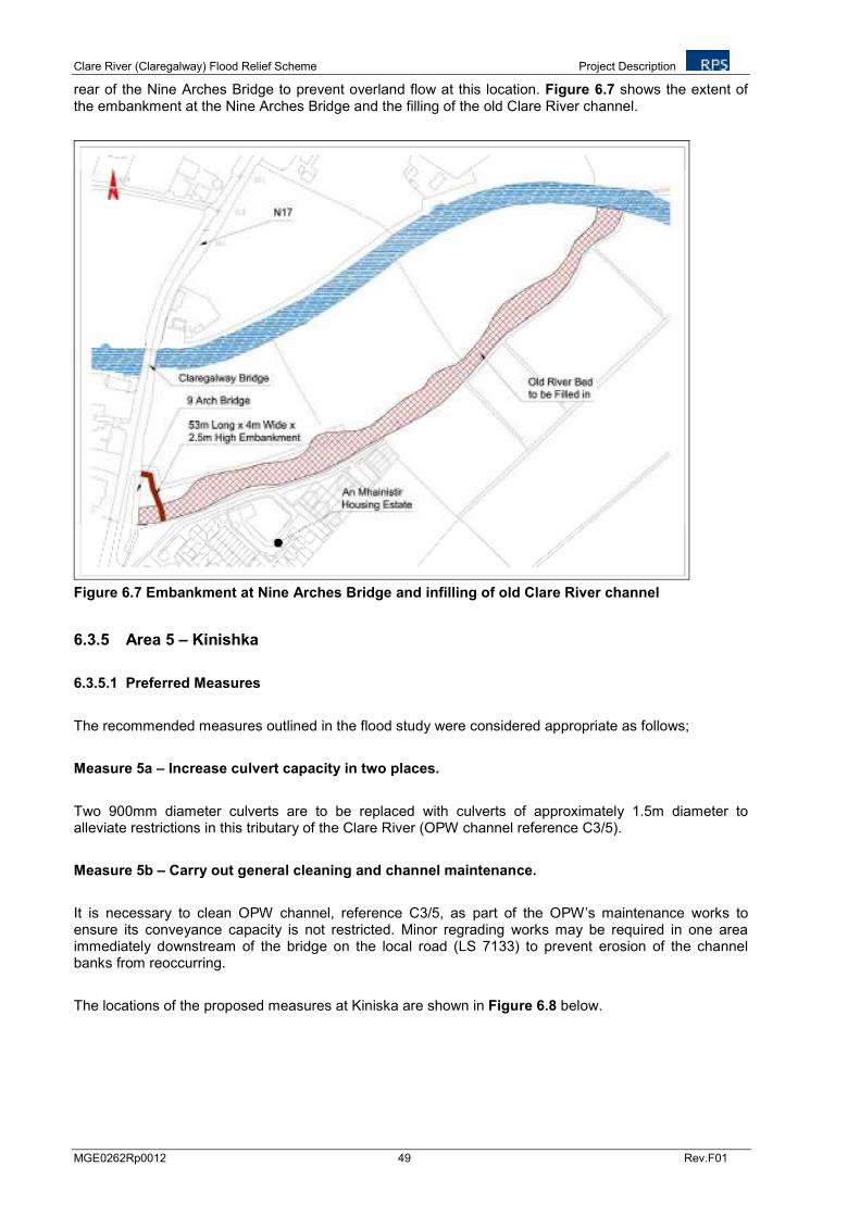
Clare River (Claregalway) Flood Relief Scheme Project Description
MGE0262Rp0012 49 Rev.F01
rear of the Nine Arches Bridge to prevent overland flow at this location. Figure 6.7 shows the extent of the embankment at the Nine Arches Bridge and the filling of the old Clare River channel.
Figure 6.7 Embankment at Nine Arches Bridge and infilling of old Clare River channel
6.3.5 Area 5 – Kinishka
6.3.5.1 Preferred Measures
The recommended measures outlined in the flood study were considered appropriate as follows;
Measure 5a – Increase culvert capacity in two places.
Two 900mm diameter culverts are to be replaced with culverts of approximately 1.5m diameter to alleviate restrictions in this tributary of the Clare River (OPW channel reference C3/5).
Measure 5b – Carry out general cleaning and channel maintenance.
It is necessary to clean OPW channel, reference C3/5, as part of the OPW’s maintenance works to ensure its conveyance capacity is not restricted. Minor regrading works may be required in one area immediately downstream of the bridge on the local road (LS 7133) to prevent erosion of the channel banks from reoccurring.
The locations of the proposed measures at Kiniska are shown in Figure 6.8 below.
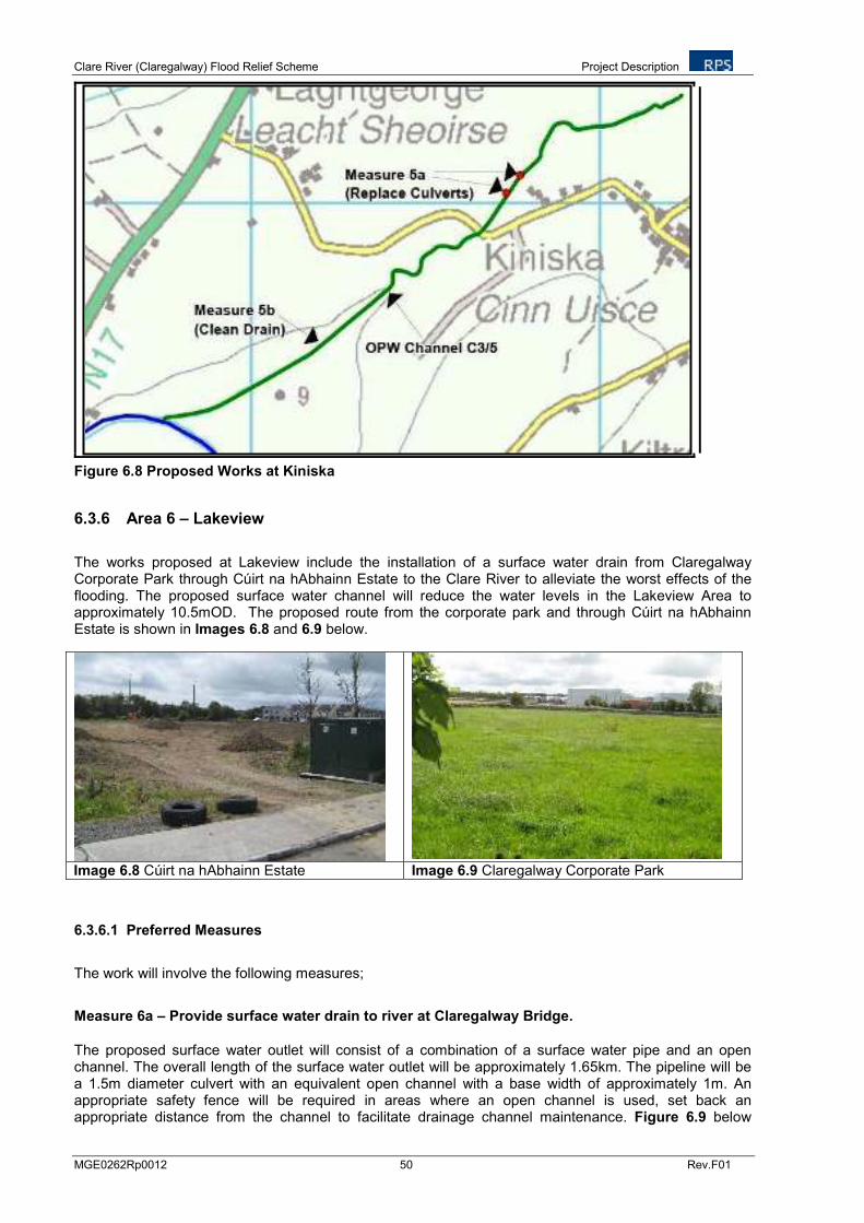
Clare River (Claregalway) Flood Relief Scheme Project Description
MGE0262Rp0012 50 Rev.F01
Figure 6.8 Proposed Works at Kiniska
6.3.6 Area 6 – Lakeview
The works proposed at Lakeview include the installation of a surface water drain from Claregalway Corporate Park through Cúirt na hAbhainn Estate to the Clare River to alleviate the worst effects of the flooding. The proposed surface water channel will reduce the water levels in the Lakeview Area to approximately 10.5mOD. The proposed route from the corporate park and through Cúirt na hAbhainn Estate is shown in Images 6.8 and 6.9 below.
Image 6.8 Cúirt na hAbhainn Estate Image 6.9 Claregalway Corporate Park
6.3.6.1 Preferred Measures
The work will involve the following measures;
Measure 6a – Provide surface water drain to river at Claregalway Bridge.
The proposed surface water outlet will consist of a combination of a surface water pipe and an open channel. The overall length of the surface water outlet will be approximately 1.65km. The pipeline will be a 1.5m diameter culvert with an equivalent open channel with a base width of approximately 1m. An appropriate safety fence will be required in areas where an open channel is used, set back an appropriate distance from the channel to facilitate drainage channel maintenance. Figure 6.9 below
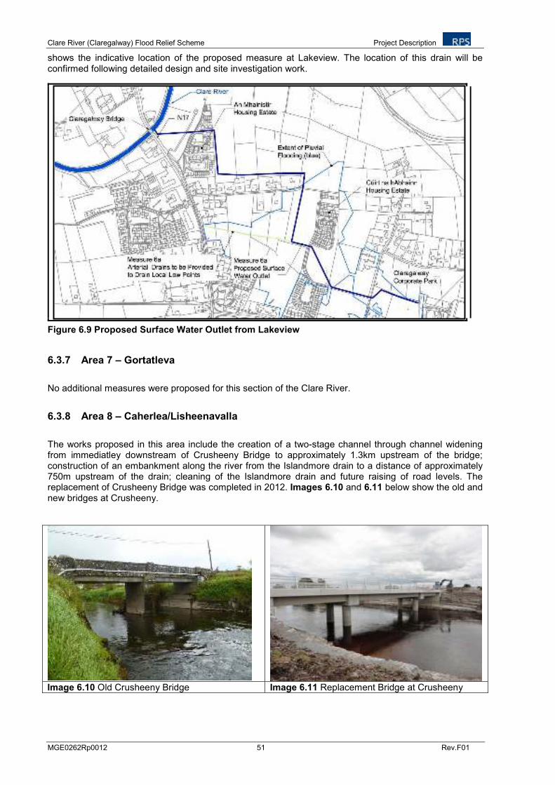
Clare River (Claregalway) Flood Relief Scheme Project Description
MGE0262Rp0012 51 Rev.F01
shows the indicative location of the proposed measure at Lakeview. The location of this drain will be confirmed following detailed design and site investigation work.
Figure 6.9 Proposed Surface Water Outlet from Lakeview
6.3.7 Area 7 – Gortatleva
No additional measures were proposed for this section of the Clare River.
6.3.8 Area 8 – Caherlea/Lisheenavalla
The works proposed in this area include the creation of a two-stage channel through channel widening from immediatley downstream of Crusheeny Bridge to approximately 1.3km upstream of the bridge; construction of an embankment along the river from the Islandmore drain to a distance of approximately 750m upstream of the drain; cleaning of the Islandmore drain and future raising of road levels. The replacement of Crusheeny Bridge was completed in 2012. Images 6.10 and 6.11 below show the old and new bridges at Crusheeny.
Image 6.10 Old Crusheeny Bridge Image 6.11 Replacement Bridge at Crusheeny
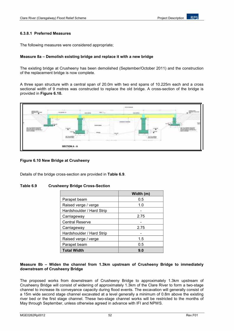
Clare River (Claregalway) Flood Relief Scheme Project Description
MGE0262Rp0012 52 Rev.F01
6.3.8.1 Preferred Measures
The following measures were considered appropriate;
Measure 8a – Demolish existing bridge and replace it with a new bridge
The existing bridge at Crusheeny has been demolished (September/October 2011) and the construction of the replacement bridge is now complete.
A three span structure with a central span of 20.0m with two end spans of 10.225m each and a cross sectional width of 9 metres was constructed to replace the old bridge. A cross-section of the bridge is provided in Figure 6.10.
Figure 6.10 New Bridge at Crusheeny
Details of the bridge cross-section are provided in Table 6.9.
Table 6.9 Crusheeny Bridge Cross-Section
Width (m)
Parapet beam 0.5
Raised verge / verge 1.0
Hardshoulder / Hard Strip -
Carriageway 2.75
Central Reserve -
Carriageway 2.75
Hardshoulder / Hard Strip -
Raised verge / verge 1.5
Parapet beam 0.5
Total Width 9.0
Measure 8b – Widen the channel from 1.3km upstream of Crusheeny Bridge to immediately downstream of Crusheeny Bridge
The proposed works from downstream of Crusheeny Bridge to approximately 1.3km upstream of Crusheeny Bridge will consist of widening of approximately 1.3km of the Clare River to form a two-stage channel to increase its conveyance capacity during flood events. The excavation will generally consist of a 15m wide second stage channel excavated at a level generally a minimum of 0.8m above the existing river bed or the first stage channel. These two-stage channel works will be restricted to the months of May through September, unless otherwise agreed in advance with IFI and NPWS.
Clare River (Claregalway) Flood Relief Scheme Project Description
MGE0262Rp0012 53 Rev.F01
The two-stage channel works will result in a large amount of material being excavated. Approximately 88,634m
3 of overburden and rock will be removed as part of the channel widening works. A further
3,380m3 is to be removed from the river bed at Claregalway Bridge as part of the channel deepening
works. In addition 36,854m3
of existing spoil heaps on the bank of the river will also be removed as they are located within the footprint of the second stage channel. In total, this will result in 128,868m
3 of
material to be excavated. The excavation works will generally occur on the south bank of the river upstream of the Islandmore drain and on the north bank downstream of the Islandmore Drain. Excavation works on both sides of the river may be necessary in some areas.
Some of the material excavated as part of the two-stage channel works will be used to create the embankment on the south bank of the river. The remaining material may be added to existing spoil heaps by increasing the width of the spoil heaps but not the height. Alternatively the material will be spread adjacent to the river on the bank. However, removal off site may also be required at various locations, or reuse for other aspects of the scheme e.g. road raising measures, including Measures 2a, 3a, 3b and 8d, or for other projects e.g. construction of the proposed waste water treatment plant at Claregalway in the townland of Cahergowan/Summerfield.
The extent of the river widening works is shown in Figure 6.11 and cross sections of the channel widening are shown in Figures 6.12a to 6.12c.
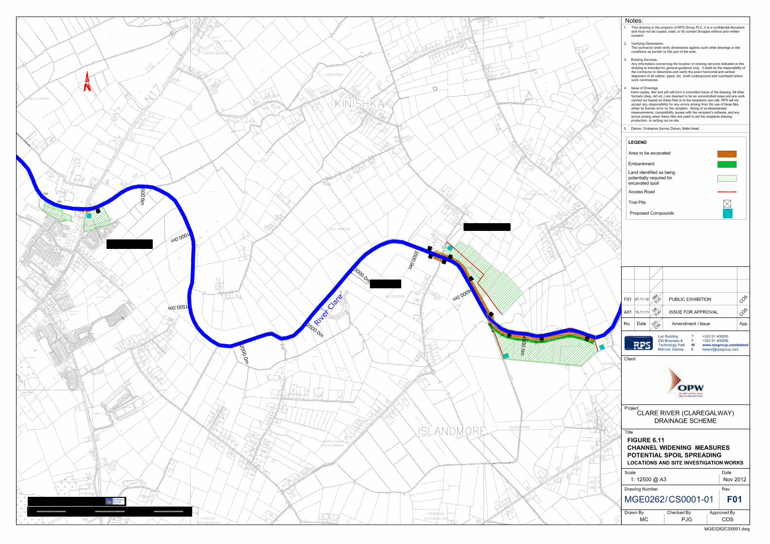
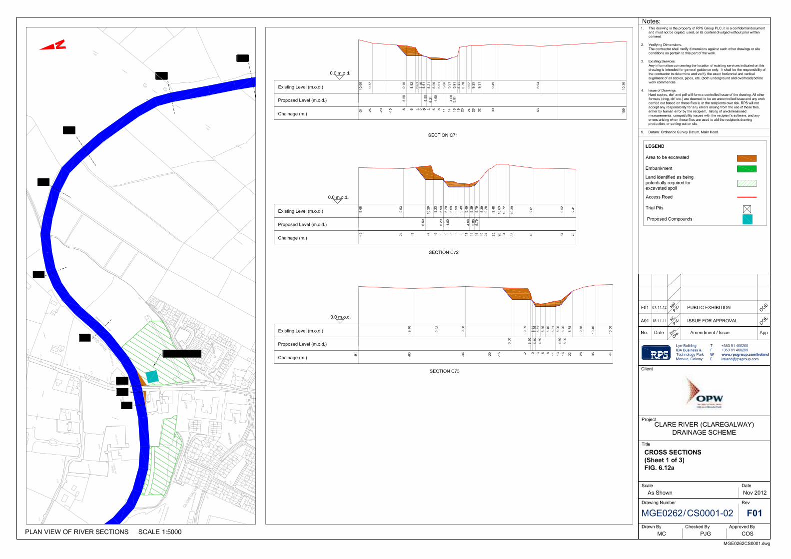
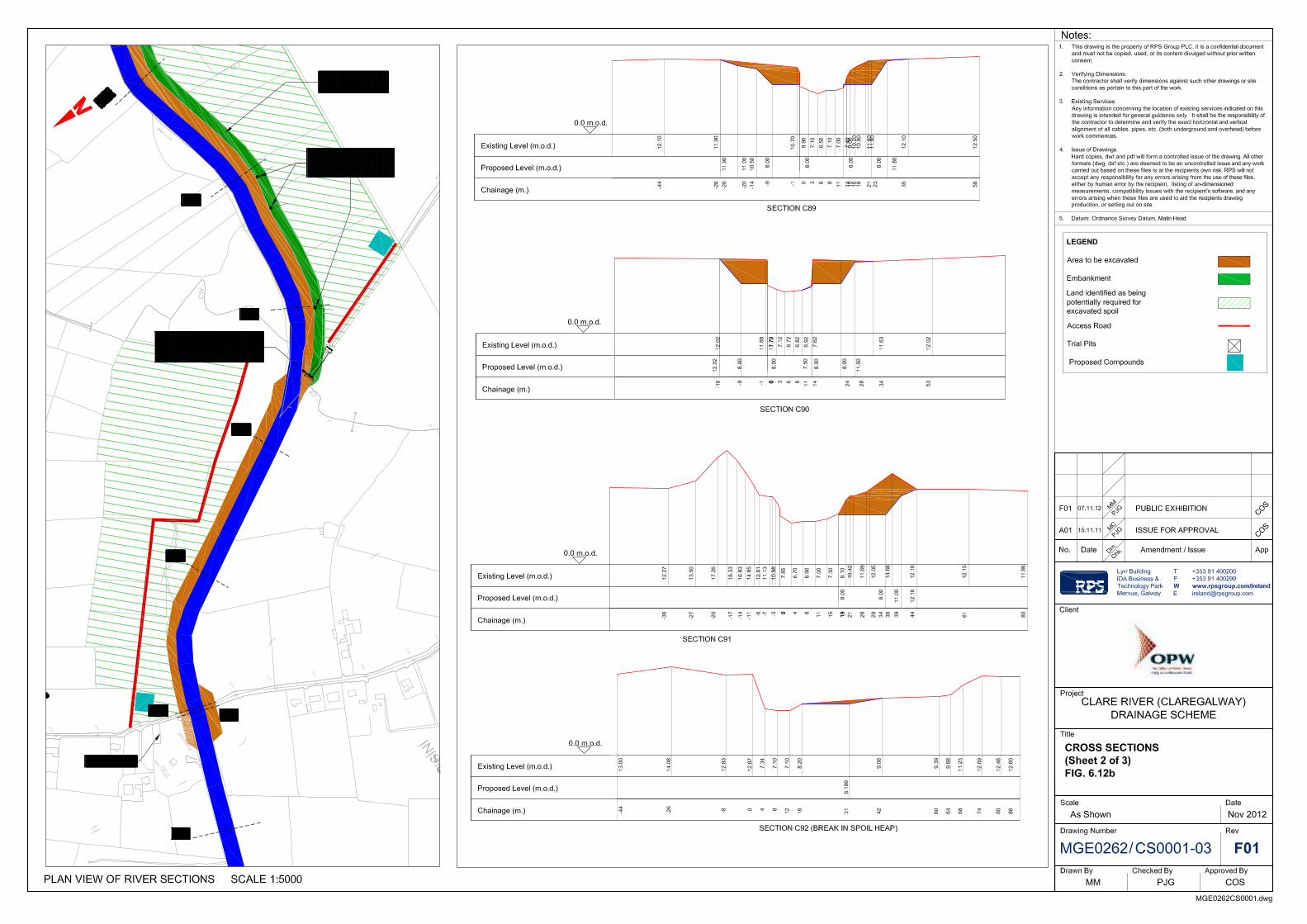
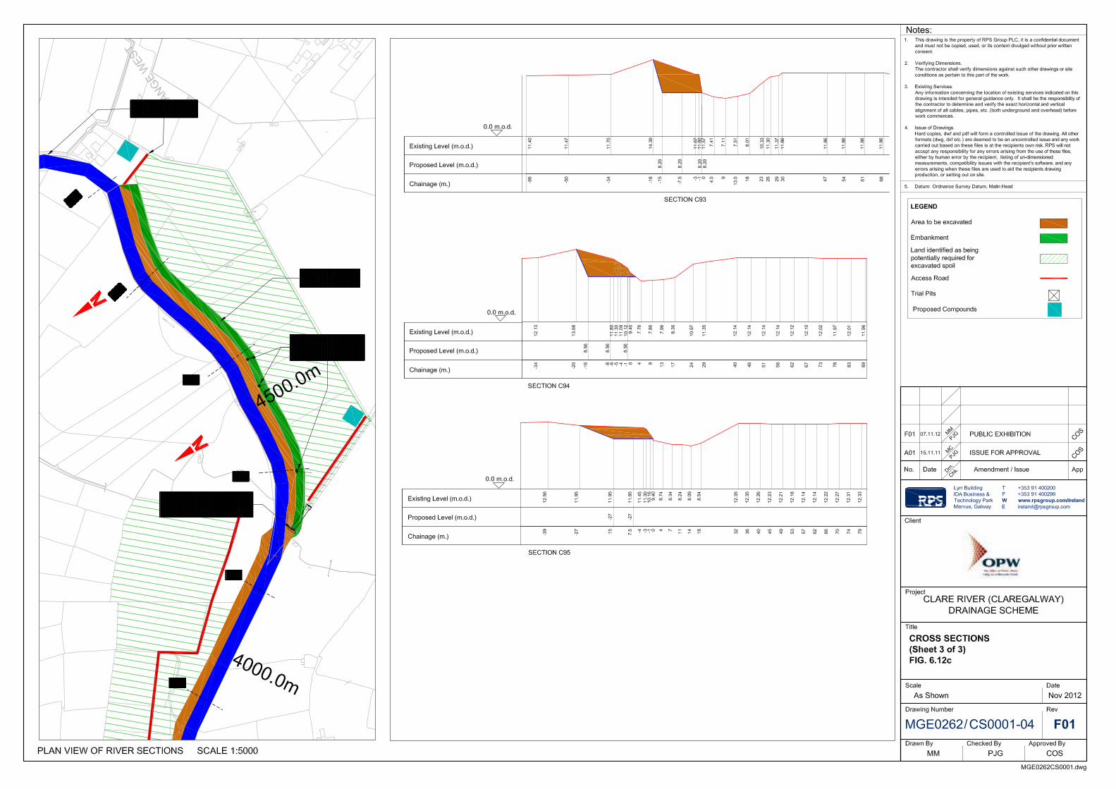

Clare River (Claregalway) Flood Relief Scheme Project Description
MGE0262Rp0012 57 Rev.F01
Measure 8c - Cleaning and limited regrading of Islandmore Drain
Cleaning of the Islandmore drain along with minor regrading works along its entire length is also required to ensure that the drain’s conveyance capacity is not restricted as a result of vegetation growth. This work will be accomplished in accordance with the OPW’s Environmental Management Protocols & Standard Operating Procedures (OPW, April 2011).
Measure 8d – Raise the local road in Caherlea/Lisheenavalla (future measure)
The replacement of the bridge at Crusheeny along with the widening of the Clare River and cleaning of the Islandmore drain will have a significant effect on reducing the flood levels at Caherlea. For a flood event of the magnitude of November 2009 the maximum flood level will be approximately 11.89 mOD which is approximately the same level as the existing road and will thereby result in little or no flooding of the road and no flooding of houses in this area. Under design flood conditions, however, the road will flood to a level of approximately 280mm. Therefore it is proposed to raise the road at Caherlea/Lisheenavalla by an additional 500mm for a length of 500m as a future measure to cater for the design flood. The extent of the works required is shown on Figure 6.13.
Measure 8e – Construction of an embankment along the southern bank of the Clare River from 1.3km upstream of Crusheeny Bridge to the Islandmore Drain and the installation of a non-return valve on the discharge from the Islandmore Drain
These works include the creation of an embankment on the south bank of the Clare River from a distance of approximately 750m upstream of the confluence of the Islandmore Drain as far as the Islandmore Drain itself. The embankment will prevent flood waters from the Clare River from flooding the Islandmore Drain catchment (Caherlea/Lisheenavalla area) during flood events. The embankment will generally be a minimum of 1-2m above the existing river bank. The maximum height of the embankments will not exceed the height of the existing spoil heaps in the immediate vicinity.
As part of this work, a non-return valve will be installed at the end of the Islandmore Drain to prevent backflow of flood waters from the Clare River to the Islandmore Drain. Non-return valves will also be required on 2-3 other small drains within the area scheduled for embankment (see Figure 6.12(b)). The extent of the embankment works is also shown in Figure 6.11.
Figure 6.13 Islandmore Drain and Road to be raised at Caherlea
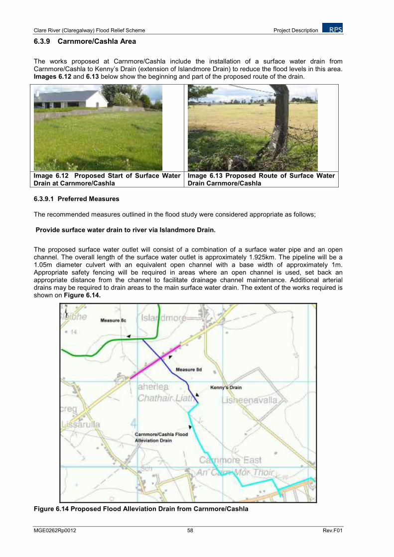
Clare River (Claregalway) Flood Relief Scheme Project Description
MGE0262Rp0012 58 Rev.F01
6.3.9 Carnmore/Cashla Area
The works proposed at Carnmore/Cashla include the installation of a surface water drain from Carnmore/Cashla to Kenny’s Drain (extension of Islandmore Drain) to reduce the flood levels in this area. Images 6.12 and 6.13 below show the beginning and part of the proposed route of the drain.
Image 6.12 Proposed Start of Surface Water Drain at Carnmore/Cashla
Image 6.13 Proposed Route of Surface Water Drain Carnmore/Cashla
6.3.9.1 Preferred Measures
The recommended measures outlined in the flood study were considered appropriate as follows;
Provide surface water drain to river via Islandmore Drain.
The proposed surface water outlet will consist of a combination of a surface water pipe and an open channel. The overall length of the surface water outlet is approximately 1.925km. The pipeline will be a 1.05m diameter culvert with an equivalent open channel with a base width of approximately 1m. Appropriate safety fencing will be required in areas where an open channel is used, set back an appropriate distance from the channel to facilitate drainage channel maintenance. Additional arterial drains may be required to drain areas to the main surface water drain. The extent of the works required is shown on Figure 6.14.
Figure 6.14 Proposed Flood Alleviation Drain from Carnmore/Cashla
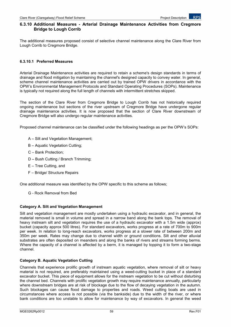
Clare River (Claregalway) Flood Relief Scheme Project Description
MGE0262Rp0012 59 Rev.F01
6.3.10 Additional Measures - Arterial Drainage Maintenance Activities from Cregmore Bridge to Lough Corrib
The additional measures proposed consist of selective channel maintenance along the Clare River from Lough Corrib to Cregmore Bridge.
6.3.10.1 Preferred Measures
Arterial Drainage Maintenance activities are required to retain a scheme's design standards in terms of drainage and flood mitigation by maintaining the channel's designed capacity to convey water. In general, scheme channel maintenance activities are carried out by trained OPW drivers in accordance with the OPW’s Environmental Management Protocols and Standard Operating Procedures (SOPs). Maintenance is typically not required along the full length of channels with intermittent stretches skipped.
The section of the Clare River from Cregmore Bridge to Lough Corrib has not historically required ongoing maintenance but sections of the river upstream of Cregmore Bridge have undergone regular drainage maintenance activities. It is now proposed that the section of Clare River downstream of Cregmore Bridge will also undergo regular maintenance activities.
Proposed channel maintenance can be classified under the following headings as per the OPW’s SOPs:
A – Silt and Vegetation Management;
B – Aquatic Vegetation Cutting;
C – Bank Protection;
D – Bush Cutting / Branch Trimming;
E – Tree Cutting, and
F – Bridge/ Structure Repairs
One additional measure was identified by the OPW specific to this scheme as follows;
G - Rock Removal from Bed
Category A. Silt and Vegetation Management
Silt and vegetation management are mostly undertaken using a hydraulic excavator, and in general, the material removed is small in volume and spread in a narrow band along the bank tops. The removal of heavy instream silt and vegetation requires the use of a hydraulic excavator with a 1.5m wide (approx) bucket (capacity approx 500 litres). For standard excavators, works progress at a rate of 700m to 900m per week. In relation to long-reach excavators, works progress at a slower rate of between 200m and 350m per week. Rates may change due to channel width or ground conditions. Silt and other alluvial substrates are often deposited on meanders and along the banks of rivers and streams forming berms. Where the capacity of a channel is affected by a berm, it is managed by topping it to form a two-stage channel.
Category B. Aquatic Vegetation Cutting
Channels that experience prolific growth of instream aquatic vegetation, where removal of silt or heavy material is not required, are preferably maintained using a weed-cutting bucket in place of a standard excavator bucket. This piece of equipment allows for the instream vegetation to be cut without disturbing the channel bed. Channels with prolific vegetation growth may require maintenance annually, particularly where downstream bridges are at risk of blockage due to the flow of decaying vegetation in the autumn. Such blockages can cause flood damage to properties and roads. Weed cutting boats are used in circumstances where access is not possible (via the bankside) due to the width of the river, or where bank conditions are too unstable to allow for maintenance by way of excavators. In general the weed
Clare River (Claregalway) Flood Relief Scheme Project Description
MGE0262Rp0012 60 Rev.F01
cutting boats are used on deeper, sluggish channels, and cut approximately to a maximum depth of 1.3m, leaving the bed and base of the weeds untouched. The species generally cut include Scirpus and Sparganium emerging in the open channel. None proposed under this scheme.
Category C. Bank Protection
Restrictions in channels due to bank slippage or damage are generally regraded to their original profile. Channel breaches due to bank erosion are resolved by reprofiling the channel in-situ or by importing bank protection material such as rock armour or log poles. Bank protection works are generally required along discrete stretches of channels where erosion or instability is present due to the absence of vegetation cover.
Category D. Bush Cutting/Branch Trimming
Branches which hang into or just above the water during periods of low flow are generally targeted for removal as they serve to impede the passage of debris during periods of high flow or flood events. Such work are carried out manually or with a hydraulic shears fitted to an excavator. This gives greater flexibility in selective and clean removal of woody vegetation.
Category E. Tree Cutting
Tree cutting is required, where the capacity of the channel is reduced by trees growing in the channel, or where trees have fallen into the channel. In other cases, tree removal may be carried out in consultation with IFI where tunnelling is considered a problem. A selective approach to tree removal is devised to retain a dappling of shade along the channel length.
Category F. Bridge/ Structure Repairs
None proposed under this scheme.
Category G. Localised Rock Removal
Localised rock removal involves the removal of rock at a number of discrete locations to design grade or as close to as possible to design grade. Any rock to be removed will be rock accessible from the bank with a standard reach machine. If the rock is not sufficiently fissured and cracked (from blasting during scheme works) a rock breaker will be used to break up the material and then dig it out of the channel. Spoil will be stored on existing spoil heaps/used as fill locally (if requested by landowner)/ drawn away or buried.
6.3.10.2 Schedule of Maintenance Works
The maintenance works proposed on the Clare River from the oufall to Lough Corrib to Clare Galway and from Claregalway to upstream of Crusheeny Bridge, are outlined in Table 6.10 below and shown in Figures 6.15 and 6.16.
Table 6.10 Arterial Drainage Maintenance Activities from Cregmore Bridge to Lough Corrib
Point ID No. Channel Maintenance Classification
Clare River from outfall into Lough Corrib to Claregalway
Location A Some deepening along Left Bank, Rock outcrop 250 linear m (A & G)
Location B Typical weed growth (A)-Maintenance work along length of channel where necessary
Location C Some deepening inside of bend left bank, solid bottom, 140 linear m (A & G)
Location D Heavy tree growth on bank over water on bank edge – approx 450 linear m (D & E)
Clare River from Claregalway to Upstream of Crusheeny
2 G very short length
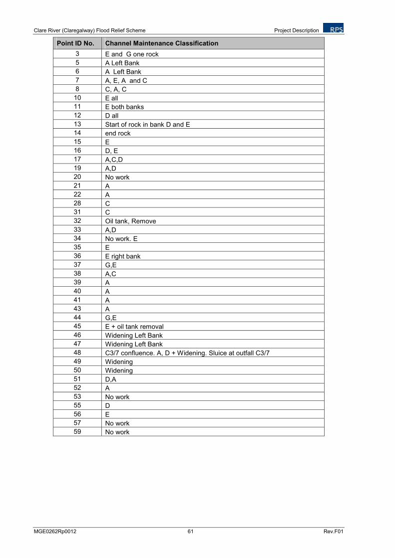
Clare River (Claregalway) Flood Relief Scheme Project Description
MGE0262Rp0012 61 Rev.F01
Point ID No. Channel Maintenance Classification
3 E and G one rock
5 A Left Bank
6 A Left Bank
7 A, E, A and C
8 C, A, C
10 E all
11 E both banks
12 D all
13 Start of rock in bank D and E
14 end rock
15 E
16 D, E
17 A,C,D
19 A,D
20 No work
21 A
22 A
28 C
31 C
32 Oil tank, Remove
33 A,D
34 No work. E
35 E
36 E right bank
37 G,E
38 A,C
39 A
40 A
41 A
43 A
44 G,E
45 E + oil tank removal
46 Widening Left Bank
47 Widening Left Bank
48 C3/7 confluence. A, D + Widening. Sluice at outfall C3/7
49 Widening
50 Widening
51 D,A
52 A
53 No work
55 D
56 E
57 No work
59 No work
Clare River (Claregalway) Flood Relief Scheme Project Description
MGE0262Rp0012 62 Rev.F01
Figure 6.15 Proposed Maintenance Works on the Clare River from the Outfall to Lough Corrib to Claregalway
Figure 6.16 Proposed Maintenance Works on Clare River from Claregalway to Cregmore Bridge
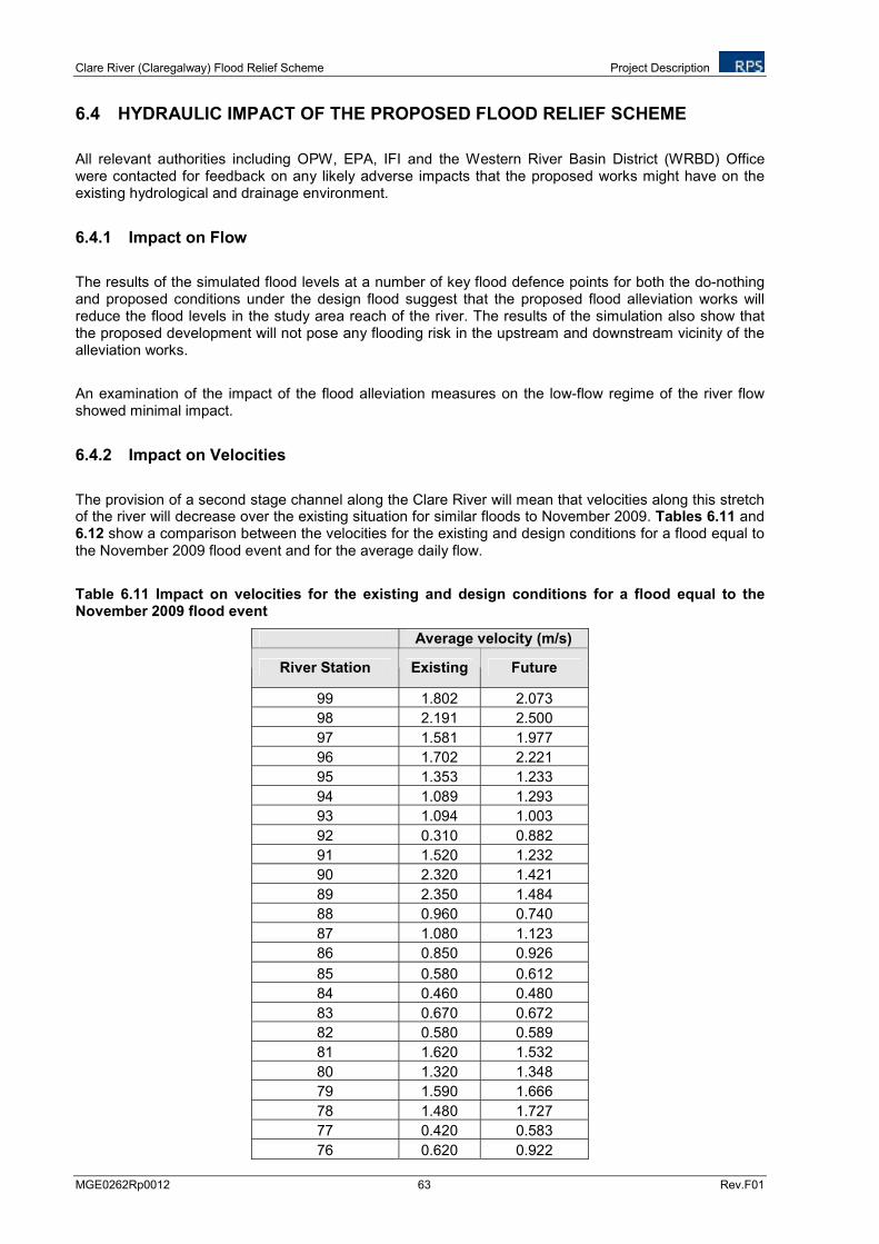
Clare River (Claregalway) Flood Relief Scheme Project Description
MGE0262Rp0012 63 Rev.F01
6.4 HYDRAULIC IMPACT OF THE PROPOSED FLOOD RELIEF SCHEME
All relevant authorities including OPW, EPA, IFI and the Western River Basin District (WRBD) Office were contacted for feedback on any likely adverse impacts that the proposed works might have on the existing hydrological and drainage environment.
6.4.1 Impact on Flow
The results of the simulated flood levels at a number of key flood defence points for both the do-nothing and proposed conditions under the design flood suggest that the proposed flood alleviation works will reduce the flood levels in the study area reach of the river. The results of the simulation also show that the proposed development will not pose any flooding risk in the upstream and downstream vicinity of the alleviation works.
An examination of the impact of the flood alleviation measures on the low-flow regime of the river flow showed minimal impact.
6.4.2 Impact on Velocities
The provision of a second stage channel along the Clare River will mean that velocities along this stretch of the river will decrease over the existing situation for similar floods to November 2009. Tables 6.11 and 6.12 show a comparison between the velocities for the existing and design conditions for a flood equal to the November 2009 flood event and for the average daily flow.
Table 6.11 Impact on velocities for the existing and design conditions for a flood equal to the November 2009 flood event
Average velocity (m/s)
River Station Existing Future
99 1.802 2.073
98 2.191 2.500
97 1.581 1.977
96 1.702 2.221
95 1.353 1.233
94 1.089 1.293
93 1.094 1.003
92 0.310 0.882
91 1.520 1.232
90 2.320 1.421
89 2.350 1.484
88 0.960 0.740
87 1.080 1.123
86 0.850 0.926
85 0.580 0.612
84 0.460 0.480
83 0.670 0.672
82 0.580 0.589
81 1.620 1.532
80 1.320 1.348
79 1.590 1.666
78 1.480 1.727
77 0.420 0.583
76 0.620 0.922
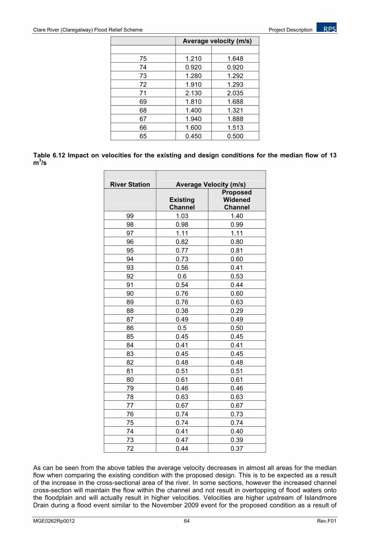
Clare River (Claregalway) Flood Relief Scheme Project Description
MGE0262Rp0012 64 Rev.F01
Average velocity (m/s)
75 1.210 1.648
74 0.920 0.920
73 1.280 1.292
72 1.910 1.293
71 2.130 2.035
69 1.810 1.688
68 1.400 1.321
67 1.940 1.888
66 1.600 1.513
65 0.450 0.500
Table 6.12 Impact on velocities for the existing and design conditions for the median flow of 13 m
3/s
River Station Average Velocity (m/s)
Existing Channel
Proposed Widened Channel
99 1.03 1.40
98 0.98 0.99
97 1.11 1.11
96 0.82 0.80
95 0.77 0.81
94 0.73 0.60
93 0.56 0.41
92 0.6 0.53
91 0.54 0.44
90 0.76 0.60
89 0.76 0.63
88 0.38 0.29
87 0.49 0.49
86 0.5 0.50
85 0.45 0.45
84 0.41 0.41
83 0.45 0.45
82 0.48 0.48
81 0.51 0.51
80 0.61 0.61
79 0.46 0.46
78 0.63 0.63
77 0.67 0.67
76 0.74 0.73
75 0.74 0.74
74 0.41 0.40
73 0.47 0.39
72 0.44 0.37
As can be seen from the above tables the average velocity decreases in almost all areas for the median flow when comparing the existing condition with the proposed design. This is to be expected as a result of the increase in the cross-sectional area of the river. In some sections, however the increased channel cross-section will maintain the flow within the channel and not result in overtopping of flood waters onto the floodplain and will actually result in higher velocities. Velocities are higher upstream of Islandmore Drain during a flood event similar to the November 2009 event for the proposed condition as a result of
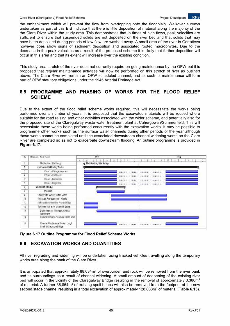
Clare River (Claregalway) Flood Relief Scheme Project Description
MGE0262Rp0012 65 Rev.F01
the embankment which will prevent the flow from overtopping onto the floodplain. Walkover surveys undertaken as part of this EIS indicate that there is little deposition of material along the majority of the the Clare River within the study area. This demonstrates that in times of high flows, peak velocities are sufficient to ensure that suspended solids are not deposited on the river bed and that solids that may have been deposited during periods of low flow are washed away. A small area of the river in Gortatleva however does show signs of sediment deposition and associated rooted macrophytes. Due to the decrease in the peak velocities as a result of the proposed scheme it is likely that further deposition will occur in this area and that its extent will increase over the existing condition.
This study area stretch of the river does not currently require on-going maintenance by the OPW but it is proposed that regular maintenance activities will now be performed on this stretch of river as outlined above. The Clare River will remain an OPW scheduled channel, and as such its maintenance will form part of OPW statutory obligations under the 1945 Arterial Drainage Act.
6.5 PROGRAMME AND PHASING OF WORKS FOR THE FLOOD RELIEF SCHEME
Due to the extent of the flood relief scheme works required, this will necessitate the works being performed over a number of years. It is proposed that the excavated materials will be reused where suitable for the road raising and other activities associated with the wider scheme, and potentially also for the proposed site of the Claregalway waste water treatment plant at Cahergowan/Summerfield. This will necessitate these works being performed concurrently with the excavation works. It may be possible to programme other works such as the surface water channels during other periods of the year although these works cannot be completed until the associated downstream channel widening works on the Clare River are completed so as not to exacerbate downstream flooding. An outline programme is provided in Figure 6.17.
Figure 6.17 Outline Programme for Flood Relief Scheme Works
6.6 EXCAVATION WORKS AND QUANTITIES
All river regrading and widening will be undertaken using tracked vehicles travelling along the temporary works area along the bank of the Clare River.
It is anticipated that approximately 88,634m³ of overburden and rock will be removed from the river bank and its surroundings as a result of channel widening. A small amount of deepening of the existing river bed will occur in the vicinity of the Claregalway Bridge resulting in the removal of approximately 3,380m
3
of material. A further 36,854m³ of existing spoil heaps will also be removed from the footprint of the new second stage channel resulting in a total excavation of approximately 128,868m³ of material (Table 6.13).
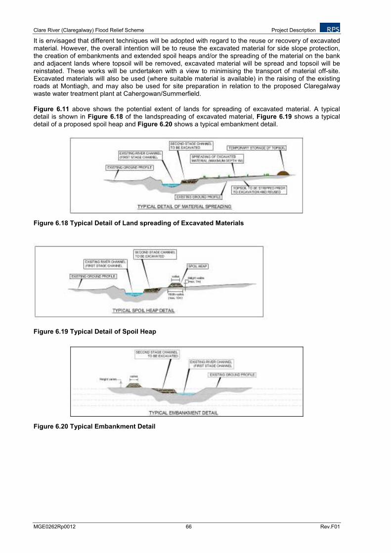
Clare River (Claregalway) Flood Relief Scheme Project Description
MGE0262Rp0012 66 Rev.F01
It is envisaged that different techniques will be adopted with regard to the reuse or recovery of excavated material. However, the overall intention will be to reuse the excavated material for side slope protection, the creation of embankments and extended spoil heaps and/or the spreading of the material on the bank and adjacent lands where topsoil will be removed, excavated material will be spread and topsoil will be reinstated. These works will be undertaken with a view to minimising the transport of material off-site. Excavated materials will also be used (where suitable material is available) in the raising of the existing roads at Montiagh, and may also be used for site preparation in relation to the proposed Claregalway waste water treatment plant at Cahergowan/Summerfield.
Figure 6.11 above shows the potential extent of lands for spreading of excavated material. A typical detail is shown in Figure 6.18 of the landspreading of excavated material, Figure 6.19 shows a typical detail of a proposed spoil heap and Figure 6.20 shows a typical embankment detail.
Figure 6.18 Typical Detail of Land spreading of Excavated Materials
Figure 6.19 Typical Detail of Spoil Heap
Figure 6.20 Typical Embankment Detail
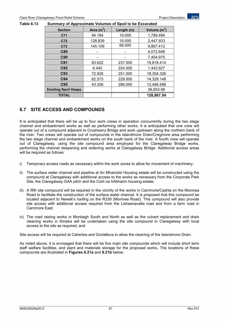
Clare River (Claregalway) Flood Relief Scheme Project Description
MGE0262Rp0012 67 Rev.F01
Table 6.13 Summary of Approximate Volumes of Spoil to be Excavated
Section Area (m2) Length (m) Volume (m
3)
C71 94.184 19.000 1,789.494
C72 128.839 19.000 2,447.933
C73 145.109 68.000 9,867.412
C89 - - 4,072.648
C90 - - 7,454.975
C91 83.622 237.000 19,818.414
C92 6.440 224.000 1,442.627
C93 72.926 251.000 18,304.326
C94 62.573 229.000 14,329.148
C95 43.356 288.000 12,486.586
Existing Spoil Heaps 36,853.98
TOTAL 128,867.54
6.7 SITE ACCESS AND COMPOUNDS
It is anticipated that there will be up to four work crews in operation concurrently during the two stage channel and embankment works as well as performing other works. It is anticipated that one crew will operate out of a compound adjacent to Crusheeny Bridge and work upstream along the northern bank of the river. Two crews will operate out of compounds in the Islandmore Drain/Cregmore area performing the two stage channel and embankment works on the south bank of the river. A fourth crew will operate out of Claregalway, using the site compound area employed for the Claregalway Bridge works, performing the channel deepening and widening works at Claregalway Bridge. Additional access areas will be required as follows:
i) Temporary access roads as necessary within the work zones to allow for movement of machinery;
ii) The surface water channel and pipeline at An Mhainistir Housing estate will be constructed using the compound at Claregalway with additional access to the works as necessary from the Corporate Park Site, the Claregalway GAA pitch and the Cúirt na hAbhainn housing estate;
iii) A fifth site compound will be required in the vicinity of the works in Carnmore/Cashla on the Monivea
Road to facilitate the construction of the surface water channel. It is proposed that this compound be located adjacent to Newell’s roofing on the R339 (Monivea Road). This compound will also provide site access with additional access required from the Lisheenavalla road and from a farm road in Carnmore East;
iv) The road raising works in Montiagh South and North as well as the culvert replacement and drain
cleaning works in Kiniska will be undertaken using the site compound in Claregalway with local access to the site as required, and
Site access will be required at Caherlea and Gortatleva to allow the cleaning of the Islandmore Drain. As noted above, it is envisaged that there will be five main site compounds which will include short term staff welfare facilities, and plant and materials storage for the proposed works. The locations of these compounds are illustrated in Figures 6.21a and 6.21b below.
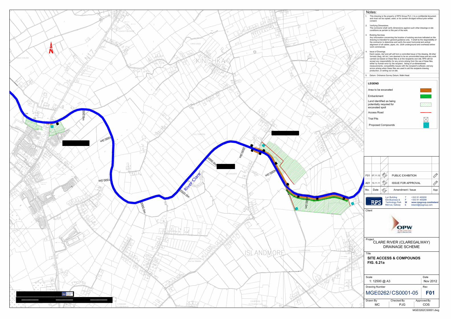
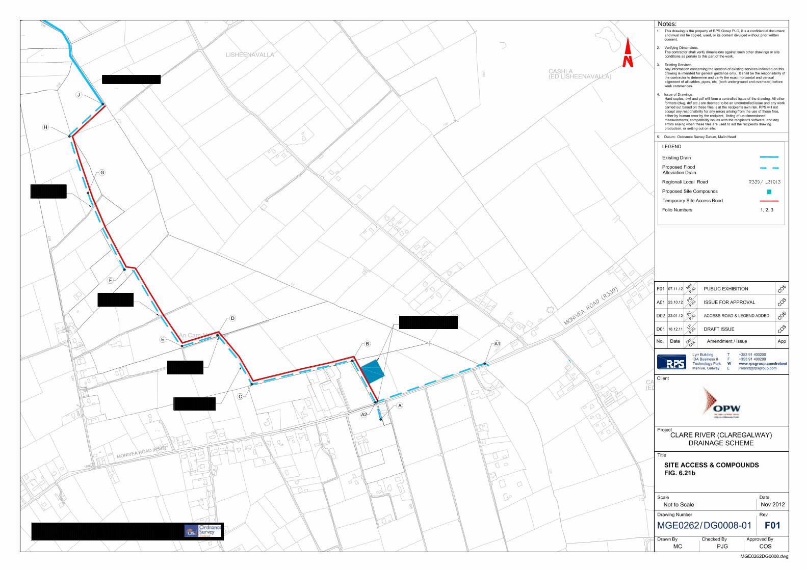
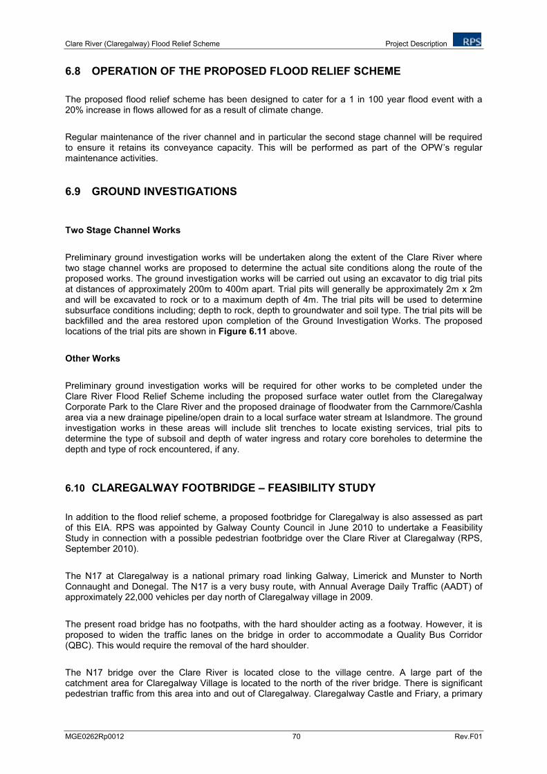
Clare River (Claregalway) Flood Relief Scheme Project Description
MGE0262Rp0012 70 Rev.F01
6.8 OPERATION OF THE PROPOSED FLOOD RELIEF SCHEME
The proposed flood relief scheme has been designed to cater for a 1 in 100 year flood event with a 20% increase in flows allowed for as a result of climate change.
Regular maintenance of the river channel and in particular the second stage channel will be required to ensure it retains its conveyance capacity. This will be performed as part of the OPW’s regular maintenance activities.
6.9 GROUND INVESTIGATIONS
Two Stage Channel Works
Preliminary ground investigation works will be undertaken along the extent of the Clare River where two stage channel works are proposed to determine the actual site conditions along the route of the proposed works. The ground investigation works will be carried out using an excavator to dig trial pits at distances of approximately 200m to 400m apart. Trial pits will generally be approximately 2m x 2m and will be excavated to rock or to a maximum depth of 4m. The trial pits will be used to determine subsurface conditions including; depth to rock, depth to groundwater and soil type. The trial pits will be backfilled and the area restored upon completion of the Ground Investigation Works. The proposed locations of the trial pits are shown in Figure 6.11 above.
Other Works
Preliminary ground investigation works will be required for other works to be completed under the Clare River Flood Relief Scheme including the proposed surface water outlet from the Claregalway Corporate Park to the Clare River and the proposed drainage of floodwater from the Carnmore/Cashla area via a new drainage pipeline/open drain to a local surface water stream at Islandmore. The ground investigation works in these areas will include slit trenches to locate existing services, trial pits to determine the type of subsoil and depth of water ingress and rotary core boreholes to determine the depth and type of rock encountered, if any.
6.10 CLAREGALWAY FOOTBRIDGE – FEASIBILITY STUDY
In addition to the flood relief scheme, a proposed footbridge for Claregalway is also assessed as part of this EIA. RPS was appointed by Galway County Council in June 2010 to undertake a Feasibility Study in connection with a possible pedestrian footbridge over the Clare River at Claregalway (RPS, September 2010).
The N17 at Claregalway is a national primary road linking Galway, Limerick and Munster to North Connaught and Donegal. The N17 is a very busy route, with Annual Average Daily Traffic (AADT) of approximately 22,000 vehicles per day north of Claregalway village in 2009.
The present road bridge has no footpaths, with the hard shoulder acting as a footway. However, it is proposed to widen the traffic lanes on the bridge in order to accommodate a Quality Bus Corridor (QBC). This would require the removal of the hard shoulder.
The N17 bridge over the Clare River is located close to the village centre. A large part of the catchment area for Claregalway Village is located to the north of the river bridge. There is significant pedestrian traffic from this area into and out of Claregalway. Claregalway Castle and Friary, a primary
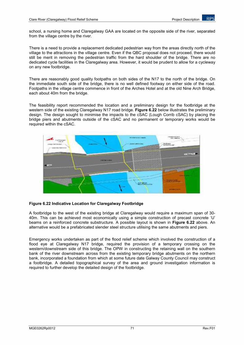
Clare River (Claregalway) Flood Relief Scheme Project Description
MGE0262Rp0012 71 Rev.F01
school, a nursing home and Claregalway GAA are located on the opposite side of the river, separated from the village centre by the river.
There is a need to provide a replacement dedicated pedestrian way from the areas directly north of the village to the attractions in the village centre. Even if the QBC proposal does not proceed, there would still be merit in removing the pedestrian traffic from the hard shoulder of the bridge. There are no dedicated cycle facilities in the Claregalway area. However, it would be prudent to allow for a cycleway on any new footbridge.
There are reasonably good quality footpaths on both sides of the N17 to the north of the bridge. On the immediate south side of the bridge, there is no well defined footway on either side of the road. Footpaths in the village centre commence in front of the Arches Hotel and at the old Nine Arch Bridge, each about 40m from the bridge.
The feasibility report recommended the location and a preliminary design for the footbridge at the western side of the existing Claregalway N17 road bridge. Figure 6.22 below illustrates the preliminary design. The design sought to minimise the impacts to the cSAC (Lough Corrib cSAC) by placing the bridge piers and abutments outside of the cSAC and no permanent or temporary works would be required within the cSAC.
Figure 6.22 Indicative Location for Claregalway Footbridge A footbridge to the west of the existing bridge at Claregalway would require a maximum span of 30-40m. This can be achieved most economically using a simple construction of precast concrete ‘U’ beams on a reinforced concrete substructure. A possible layout is shown in Figure 6.22 above. An alternative would be a prefabricated slender steel structure utilising the same abutments and piers.
Emergency works undertaken as part of the flood relief scheme which involved the construction of a flood eye at Claregalway N17 bridge, required the provision of a temporary crossing on the western/downstream side of this bridge. The OPW in constructing the retaining wall on the southern bank of the river downstream across from the existing temporary bridge abutments on the northern bank, incorporated a foundation from which at some future date Galway County Council may construct a footbridge. A detailed topographical survey of the area and ground investigation information is required to further develop the detailed design of the footbridge.
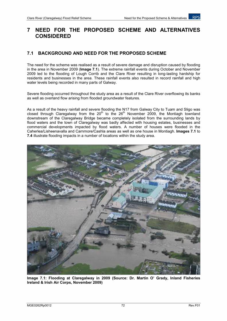
Clare River (Claregalway) Flood Relief Scheme Need for the Proposed Scheme & Alternatives
MGE0262Rp0012 72 Rev.F01
7 NEED FOR THE PROPOSED SCHEME AND ALTERNATIVES CONSIDERED
7.1 BACKGROUND AND NEED FOR THE PROPOSED SCHEME
The need for the scheme was realised as a result of severe damage and disruption caused by flooding in the area in November 2009 (Image 7.1). The extreme rainfall events during October and November 2009 led to the flooding of Lough Corrib and the Clare River resulting in long-lasting hardship for residents and businesses in the area. These rainfall events also resulted in record rainfall and high water levels being recorded in many parts of Galway.
Severe flooding occurred throughout the study area as a result of the Clare River overflowing its banks as well as overland flow arising from flooded groundwater features.
As a result of the heavy rainfall and severe flooding the N17 from Galway City to Tuam and Sligo was closed through Claregalway from the 20
th to the 26
th November 2009, the Montiagh townland
downstream of the Claregalway Bridge became completely isolated from the surrounding lands by flood waters and the town of Claregalway was badly affected with housing estates, businesses and commercial developments impacted by flood waters. A number of houses were flooded in the Caherlea/Lisheenavalla and Carnmore/Cashla areas as well as one house in Montiagh. Images 7.1 to 7.4 illustrate flooding impacts in a number of locations within the study area.
Image 7.1: Flooding at Claregalway in 2009 (Source: Dr. Martin O’ Grady, Inland Fisheries Ireland & Irish Air Corps, November 2009)
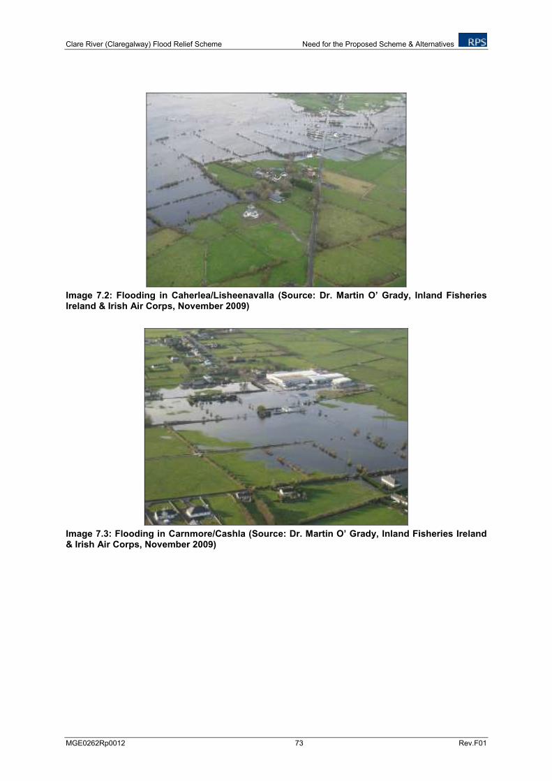
Clare River (Claregalway) Flood Relief Scheme Need for the Proposed Scheme & Alternatives
MGE0262Rp0012 73 Rev.F01
Image 7.2: Flooding in Caherlea/Lisheenavalla (Source: Dr. Martin O’ Grady, Inland Fisheries Ireland & Irish Air Corps, November 2009)
Image 7.3: Flooding in Carnmore/Cashla (Source: Dr. Martin O’ Grady, Inland Fisheries Ireland & Irish Air Corps, November 2009)
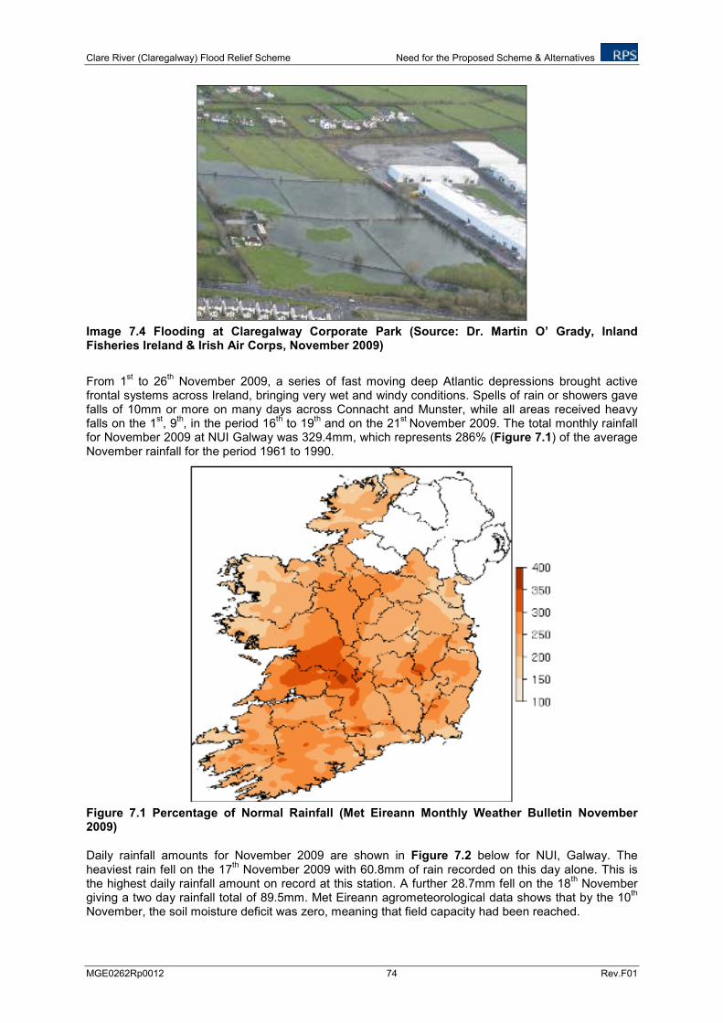
Clare River (Claregalway) Flood Relief Scheme Need for the Proposed Scheme & Alternatives
MGE0262Rp0012 74 Rev.F01
Image 7.4 Flooding at Claregalway Corporate Park (Source: Dr. Martin O’ Grady, Inland Fisheries Ireland & Irish Air Corps, November 2009)
From 1st to 26
th November 2009, a series of fast moving deep Atlantic depressions brought active
frontal systems across Ireland, bringing very wet and windy conditions. Spells of rain or showers gave falls of 10mm or more on many days across Connacht and Munster, while all areas received heavy falls on the 1
st, 9
th, in the period 16
th to 19
th and on the 21
st November 2009. The total monthly rainfall
for November 2009 at NUI Galway was 329.4mm, which represents 286% (Figure 7.1) of the average November rainfall for the period 1961 to 1990.
Figure 7.1 Percentage of Normal Rainfall (Met Eireann Monthly Weather Bulletin November 2009)
Daily rainfall amounts for November 2009 are shown in Figure 7.2 below for NUI, Galway. The heaviest rain fell on the 17
th November 2009 with 60.8mm of rain recorded on this day alone. This is
the highest daily rainfall amount on record at this station. A further 28.7mm fell on the 18th November
giving a two day rainfall total of 89.5mm. Met Eireann agrometeorological data shows that by the 10th
November, the soil moisture deficit was zero, meaning that field capacity had been reached.
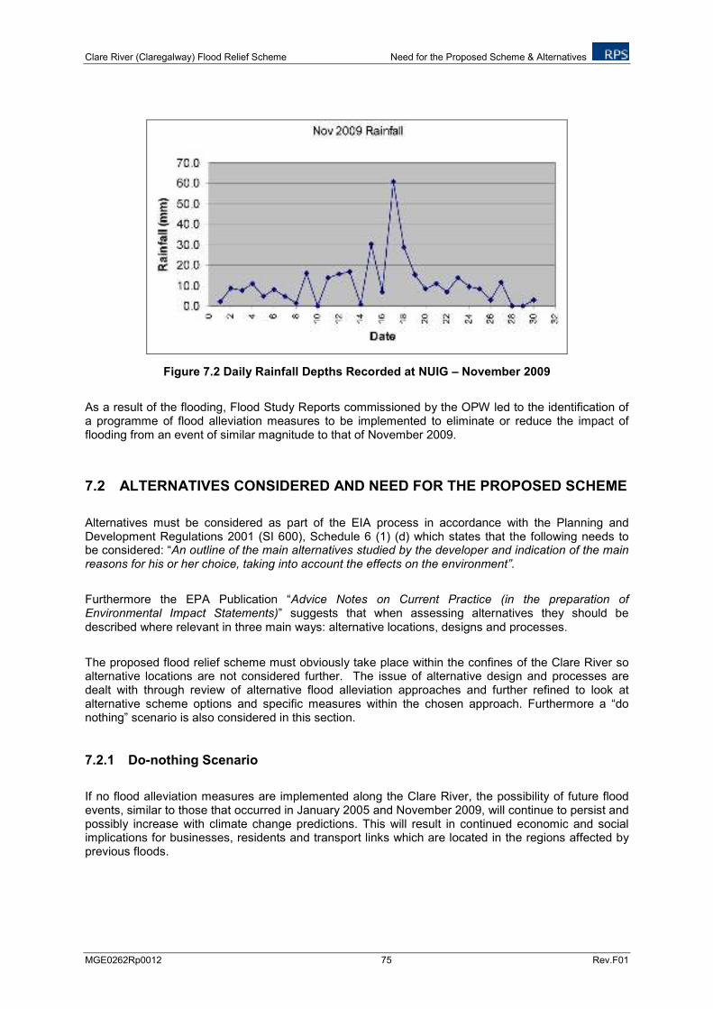
Clare River (Claregalway) Flood Relief Scheme Need for the Proposed Scheme & Alternatives
MGE0262Rp0012 75 Rev.F01
Figure 7.2 Daily Rainfall Depths Recorded at NUIG – November 2009
As a result of the flooding, Flood Study Reports commissioned by the OPW led to the identification of a programme of flood alleviation measures to be implemented to eliminate or reduce the impact of flooding from an event of similar magnitude to that of November 2009.
7.2 ALTERNATIVES CONSIDERED AND NEED FOR THE PROPOSED SCHEME
Alternatives must be considered as part of the EIA process in accordance with the Planning and Development Regulations 2001 (SI 600), Schedule 6 (1) (d) which states that the following needs to be considered: “An outline of the main alternatives studied by the developer and indication of the main reasons for his or her choice, taking into account the effects on the environment”.
Furthermore the EPA Publication “Advice Notes on Current Practice (in the preparation of Environmental Impact Statements)” suggests that when assessing alternatives they should be described where relevant in three main ways: alternative locations, designs and processes.
The proposed flood relief scheme must obviously take place within the confines of the Clare River so alternative locations are not considered further. The issue of alternative design and processes are dealt with through review of alternative flood alleviation approaches and further refined to look at alternative scheme options and specific measures within the chosen approach. Furthermore a “do nothing” scenario is also considered in this section.
7.2.1 Do-nothing Scenario
If no flood alleviation measures are implemented along the Clare River, the possibility of future flood events, similar to those that occurred in January 2005 and November 2009, will continue to persist and possibly increase with climate change predictions. This will result in continued economic and social implications for businesses, residents and transport links which are located in the regions affected by previous floods.
Clare River (Claregalway) Flood Relief Scheme Need for the Proposed Scheme & Alternatives
MGE0262Rp0012 76 Rev.F01
7.2.2 Alternative Flood Alleviation Approaches
A range of flood alleviation approaches were considered in arriving at a preferred scheme and associated set of alleviation measure. These include the following:
Non-Structural Measures: Risk assessment, research programme, forecasting and flood warning systems.
Removal and Relocation: Relocate affected flooded properties away from flood risk areas.
Flow Diversion and/or Reduction: Diverting flood water through alternative channels, retaining water upstream etc.
Flow Retention: Provide lands upstream (e.g. wetlands) for the retention of flood waters.
Flood Defences: Introducing structural elements to the river system to lessen the impact of flood water.
Structural Measures: Alter/remove instream structures, widen and deepen water channel for increased conveyance and regular river channel maintenance
In assessing the suitability of these range of flood relief approaches, structural measures were considered the most appropriate given the extent and frequency of the flooding, the number of properties affected, costs, land availability, river morphology, hydrology and output of modelling.
7.2.3 Alternative Scheme Options and Measures
Area 1 – Lough Corrib to Curraghmore Bridge
It was considered that a do-nothing approach for this area was sufficient in the 2010 Flood Study and this was brought forward as the final measure proposed for this area.
Area 2 – Montiagh South
a) The provision of a flood wall or embankment on both sides of the road was considered as an alternative in the 2010 Flood Study for the Clare River. This alternative was seen as a more costly and visually obtrusive measure which would have acted as a barrier to the passage of fauna across the road from field to field and so ultimately was not seen as a viable option. The final measures proposed included rasing the existing road, upsizing existing culverts and cleaning and regarding drains in the area.
Area 3 – Montiagh North
a) The provision of a flood wall or embankment on both sides of the road was considered as an alternative in the 2010 Flood Study for the Clare River. This alternative was seen as a more costly and visually obtrusive measure which would have acted as a barrier to the passage of fauna across the road from field to field and so ultimately was not considered a viable option.The final measure proposed was to raise this existing section of road.
Clare River (Claregalway) Flood Relief Scheme Need for the Proposed Scheme & Alternatives
MGE0262Rp0012 77 Rev.F01
b) In order to alleviate property flooding in the area a range of measures were considered in the 2010 Flood Study for the Clare River which included the provision of a flood barrier, the installation of a pump stand within the site of the affected house and channel widening. However, all were considered economically unviable and were not further pursued. The final measure proposed was to raise this existing section of road.
Area 4 – Claregalway Village
a) The removal of the channel constriction at the bridge was considered in the 2010 Flood Study for the Clare River which would involve the removal of the current bridge, however, as a bridge is required at the crossing and as the current bridge appears to be structurally sound this was not considered a practical solution. The final measure which was completed as advanced works was the installation of a flood eye at Claregalway Bridge.
b) Another alternative considered in the original Flood Study was the provision of a flood bypass channel to convey moderate to high flows. Although when modelled this measure provided a significant reduction in flood level, due to a number of issues relating to the associated works and impacts, this option was not deemed to be an appropriate solution. The final measure proposed was to regrade the Clare River channel upstream of and under the Claregalway Bridge and to regarde the flood eye.
c) The installation of demountable flood defences was also considered as an alternative in the original Flood Study. This alternative may have been effective at properties but was unlikely to prove feasible in protecting the N17 from flooding in certain areas. The erection of flood defences would also be dependent on a well coordinated emergency response team. Taking these factors into consideration the provision of demountable flood defences was not considered possible. The final measures proposed for this area include addressing a gap in the wall of An Mhainistir housing estate, provision of a local embankment at the Nine Arches bridge and infilling of the old Clare River channel.
Area 5 – Kinishka
No additional final measures were considered over and above the measures outlined in the Flood Study of 2010 which proposed an increase in culvert capacity and cleaning of a stream in the area.
Area 6 – Lakeview
No additional final measures were considered over and above the measures outlined in the Flood Study of 2010 which proposed that the outlet from the surface water drainage pipeline from Lakeview would discharge to the Clare River upstream of the Claregalway Bridge rather than downstream of the bridge as originally proposed.
Area 7 – Gortatleva
It was considered that a do-nothing approach for this area was sufficient in the 2010 Flood Study and that the area would benefit from measures proposed for Area 4. This was brought forward as the final measure proposed for this area.
Area 8 – Caherlea/Lisheenavalla
a) The 2010 Flood Study recommended that flood eyes be installed on either side of the existing bridge at Crusheeny. It was agreed between the OPW, Galway County Council and the NRA, however, that Crusheeny Bridge be replaced rather than flood eyes installed. A Bridge Options Report was prepared by RPS which recommended the provision of a three span
Clare River (Claregalway) Flood Relief Scheme Need for the Proposed Scheme & Alternatives
MGE0262Rp0012 78 Rev.F01
bridge to minimise the in-river works. A Technical Acceptance report was also prepared and submitted for NRA approval. The bridge demolition has been undertaken and replacement works were completed in April 2012.
b) The 2010 Flood Study recommended that the Clare River channel should be widened from 900 metres upstream of Crusheeney Bridge to Claregalway village. However on further review this measure was deemed to be considered economically unviable and was not considered further. The final measures proposed for this area include channel widening from 1.3km upstream of Crusheeny Bridge to immediately downstream of Crusheeny Bridge to form a two stage channel.
c) The 2010 Flood Study recommended cleaning and regarding of the Islandmore OPW C3/7 and F.799/1 arterial drains and this was brought forward as a final proposed measure for this area.
d) The 2010 Flood Study recommended raising the local road in Caherlea/Lisheenavalla and this was brought forward as a final proposed measure for this area as a future measure.
Area 9 - Carnmore/Cashla
The 2010 Flood Study did not consider further measures for this area and a do-nothing measure was considered. However on further review the final proposed measures recommend that drainage of floodwater from the affected area via a new drainage pipeline/open drain to a local surface water stream at Islandmore should be implemented.
Clare River (Claregalway) Flood Relief Scheme Hydrology and Drainage
MGE0262Rp0012 79 Rev. F01
8 HYDROLOGY AND DRAINAGE
8.1 INTRODUCTION
This chapter assess the potential impacts of the proposed development on the existing hydrological and drainage environment in the study area.
The principal scope of the assessment is to:
Identify, describe and evaluate sites of known or potential hydrological interest,
Assess the significance of the likely impacts of the proposed scheme on the existing hydrological and drainage including residual impact, and
To propose mitigation measures required to minimise the likely impacts.
The details of the proposed flood relief works are discussed in Chapter 6.
8.2 METHODOLOGY
This assessment was based on a desk study of available information and site visits carried out within the study area in July 2011, and was prepared having regard to:
Guidelines on Procedures for Assessment and Treatment of Geology, Hydrology and Hydrogeology for National Road Schemes (National Road Authority (NRA), 2007),
Environmental Impact Assessment Guidelines of National Road Schemes – A Practical Guide (NRA, 2004),
Advice Notes on Current Practice in the preparation of Environmental Impact Statements (EPA, 2003),
Guidelines on the information to be contained in Environmental Impact Statements (EPA, 2002),
Guidelines for the Crossing of Watercourses during the construction of National Road Schemes (NRA),
Control of water pollution from linear construction projects, CIRIA Report No. C648, 2006, and
Fisheries Protection Guidelines – requirements for the protection of Fisheries Habitats during construction and development works at river sites, Eastern Regional Fisheries Board.
The following sources of information were used in order to complete the assessment:
2010 Flood Studies,
Clare River (Claregalway) Flood Relief Scheme – Stage I Report, RPS, August 2011,
Clare River (Claregalway) Flood Relief Scheme, Environmental Constraints Study, RPS, June 2011,
Clare River (Claregalway) Flood Relief Scheme Hydrology and Drainage
MGE0262Rp0012 80 Rev. F01
Clare River (Claregalway) Flood Relief Scheme – RPS Hydraulic Report on the revised design of the scheme, August 2012,
Flood data was obtained from OPW and EPA (www.opw.ie , www.floodmaps.ie, www.epa.ie),
Western River Basin District (WRBD) – River Basin Management Plan, and WaterMaps (www.wfdireland.ie),
Other relevant websites consulted were those of the Met Eireann (www.meteireann.ie), and
Ordnance Survey 1:50,000 Discovery Series.
The following three hydrological attributes are considered to be affected by the proposed development:
Flood Hydrology,
Drainage, and
Low Flows.
The importance of the hydrological attributes (rating criteria) is defined in accordance with the Guidelines on Procedures for Assessment and Treatment of Geology, Hydrology and Hydrogeology for National Road Scheme, NRA, 2007. These are presented in Table 8.1.
Table 8.1: Rating Criteria for the Hydrological Attributes
Importance Criteria Typical Examples
Extremely high Attribute has a high quality or value on an international scale
River, wetland or surface water body ecosystem protected by EU legislation.
Very high Attribute has a high quality or value on a regional scale
Floodplain protecting more than 50 residential or commercial properties from flooding
High Attribute has a high quality or value on a local scale
Floodplain protecting between 5 and 50 residential or commercial properties from flooding
Medium Attribute has a medium quality or value on a local scale
Floodplain protecting between 1 and 5 residential or commercial properties
Low Attribute has a low quality or value on a local scale
Floodplain protecting 1 residential or commercial property from flooding
The magnitudes of the impacts on the existing environment of the attributes were defined in accordance with the criteria provided in the EPA publication - Guideline on the Information to be Contained in Environmental Impact Statements (2002). These are presented in Table 8.2.
Clare River (Claregalway) Flood Relief Scheme Hydrology and Drainage
MGE0262Rp0012 81 Rev. F01
Table 8.2: Impact Assessment Criteria
Magnitude of Impact Description
Imperceptible An impact capable of measurement but without noticeable consequences
Slight An impact that alters the character of the environment without affecting its sensitivities
Moderate An impact that alters the character of the environment in a manner that is consistent with existing or emerging trends
Significant An impact, which by its character, magnitude, duration or intensity alters a sensitive aspect of the environment
Profound An impact which obliterates all previous sensitive characteristics
All relevant information including, catchment soil type, topography of the lands and the land drainage systems adjacent to the proposed development have been collected through a walkover survey during the site visits and also from the LiDAR survey carried out on the Clare River floodplain in June 2011.
8.3 EXISTING ENVIRONMENT
The regional hydrological environment within the study area is discussed below in the context of the above mentioned hydrological attributes of flood and low-flow hydrology and drainage system.
8.3.1 River Catchment and Flood and Low-flow Hydrology
The Clare River forms the part of the Corrib-Clare catchment and falls within National Hydrometric Area 9 (Corrib) and Western River Basin District.
The Clare River, with a reach of approximately 93 km from its confluence with Lough Corrib Lower, rises approximately 8km above the town of Ballyhaunis, County Mayo. Its principal tributaries working in a southerly direction from its source in County Mayo are the Sinking River, the Nanny River, the Grange River and the Abbert River. For the greater part of its length the Clare River flows north south passing through Ballyhaunis, Milltown, the outskirts of Tuam, through the villages of Corofin and Claregalway to its confluence with Lough Corrib, approximately 8 km west of Claregalway. The confluence of the river with the lake is located at the Lough Corrib Lower which ultimately drains to the sea via the Corrib River channel to Galway City. The River has an approximate catchment area of 1,100 km
2 upstream of its confluence with
Lough Corrib.
The soil type within the Clare River catchment area vary between the UK Flood Studies Report (NERC, 1975) soil types 1 (50%) and 2 (50%), indicating low to very low runoff potential. The general soil description associated with soil type 1 is ‘Well drained sandy, loamy or earthy peat soils’ or ‘Less permeable loamy solids over clayey soils on plateaux adjacent to very permeable soils in valley’ while the general soil description associated with soil type 2 is ‘Very permeable soils (e.g gravel, sand) with shallow groundwater, Permeable soils over rocks, Moderately permeable soils some with slowly permeable subsoils’. Soil type 1 is defined as having very low runoff potential while soil type 2 has a low runoff potential. The river has a main channel slope of approximately 1 in 1000 (S1085). The observed long-term average annual rainfall at Galway (NUI, Galway) and Athenry are 1,147 mm and 1,164 mm respectively.
The geology of the Clare River catchment area is characterised by karst limestone bedrock from the Burren, Lucan and Tubber formation, and Visean limestone. The presence of turloughs,
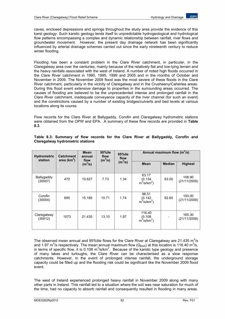
Clare River (Claregalway) Flood Relief Scheme Hydrology and Drainage
MGE0262Rp0012 82 Rev. F01
caves, enclosed depressions and springs throughout the study area provide the evidence of this karst geology. Such karstic geology lends itself to unpredictable hydrogeological and hydrological flow patterns encompassing a complex and dynamic relationship between rainfall, river flows and groundwater movement. However, the present day drainage network has been significantly influenced by arterial drainage schemes carried out since the early nineteenth century to reduce winter flooding.
Flooding has been a constant problem in the Clare River catchment, in particular, in the Claregalway area over the centuries, mainly because of the relatively flat and low-lying terrain and the heavy rainfalls associated with the west of Ireland. A number of noted high floods occurred in the Clare River catchment in 1990, 1995, 1999 and 2005 and in the months of October and November in 2009. The November 2009 flood was the most severe of these floods in the Clare River catchment, particularly in the vicinity of Claregalway and in the Crusheeny/Caherlea areas. During this flood event extensive damage to properties in the surrounding areas occurred. The causes of flooding are believed to be the unprecedented intense and prolonged rainfall in the Clare River catchment, inadequate conveyance capacity of the river channel (for such an event) and the constrictions caused by a number of existing bridges/culverts and bed levels at various locations along its course.
Flow records for the Clare River at Ballygaddy, Corofin and Claregalway hydrometric stations were obtained from the OPW and EPA. A summary of these flow records are provided in Table 8.3.
Table 8.3: Summary of flow records for the Clare River at Ballygaddy, Corofin and Claregalway hydrometric stations
Annual maximum flow (m3/s)
Hydrometric station
Catchment area (km
2)
Mean annual
flow (m
3/s)
50%ile flow
(m3/s)
95%ile flow
(m3/s)
Mean Median Highest
Ballygaddy (30007)
470 10.627 7.73 1.34 63.17 (0.134
m3/s/km
2)
63.00 108.90
(21/11/2009)
Corofin (30004)
695 15.185 10.71 1.74 98.51 (0.142
m3/s/km
2)
92.65 193.00
(21/11/2009)
Claregalway (30012)
1073 21.435 13.10 1.97 116.40 (0.108
m3/s/km
2)
- 165.30
(21/11/2009)
The observed mean annual and 95%tile flows for the Clare River at Claregalway are 21.435 m3/s
and 1.97 m3/s respectively. The mean annual maximum flow (QBAR) at this location is 116.40 m
3/s,
in terms of specific flow, it is 0.108 m3/s/km
2. Because of the karstic type geology and presence
of many lakes and turloughs, the Clare River can be characterised as a slow response catchments. However, in the event of prolonged intense rainfall, the underground storage capacity could be filled up and the flooding risk could be significant like the November 2009 flood event.
The west of Ireland experienced prolonged heavy rainfall in November 2009 along with many other parts in Ireland. This rainfall led to a situation where the soil was near saturation for much of the time, had no capacity to absorb rainfall and consequently resulted in flooding in many areas.
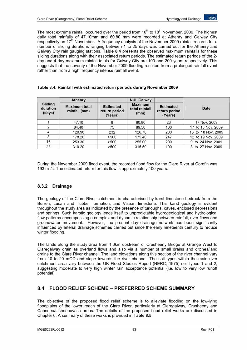
Clare River (Claregalway) Flood Relief Scheme Hydrology and Drainage
MGE0262Rp0012 83 Rev. F01
The most extreme rainfall occurred over the period from 16th to 18
th November, 2009. The highest
daily total rainfalls of 47.10mm and 60.80 mm were recorded at Athenry and Galway City respectively on 17
th November. A frequency analysis of the November 2009 rainfall records for a
number of sliding durations ranging between 1 to 25 days was carried out for the Athenry and Galway City rain gauging stations. Table 8.4 presents the observed maximum rainfalls for these sliding durations along with their associated return periods. The estimated return periods of the 2-day and 4-day maximum rainfall totals for Galway City are 100 and 200 years respectively. This suggests that the severity of the November 2009 flooding resulted from a prolonged rainfall event rather than from a high frequency intense rainfall event.
Table 8.4: Rainfall with estimated return periods during November 2009
Athenry NUI, Galway Sliding
duration (days)
Maximum total rainfall (mm)
Estimated return period
(Years)
Maximum total rainfall
(mm)
Estimated return period
(Years)
Date
1 47.10 8 60.80 23 17 Nov. 2009
2 84.40 75 89.50 100 17 to 18 Nov. 2009
4 120.90 232 126.70 200 15 to 18 Nov. 2009
8 178.20 >500 175.40 247 12 to 19 Nov. 2009
16 253.30 >500 255.00 200 9 to 24 Nov. 2009
25 310.20 >500 315.50 100 3 to 27 Nov. 2009
During the November 2009 flood event, the recorded flood flow for the Clare River at Corofin was 193 m
3/s. The estimated return for this flow is approximately 100 years.
8.3.2 Drainage
The geology of the Clare River catchment is characterised by karst limestone bedrock from the Burren, Lucan and Tubber formation, and Visean limestone. This karst geology is evident throughout the study area as indicated by the presence of turloughs, caves, enclosed depressions and springs. Such karstic geology lends itself to unpredictable hydrogeological and hydrological flow patterns encompassing a complex and dynamic relationship between rainfall, river flows and groundwater movement. However, the present day drainage network has been significantly influenced by arterial drainage schemes carried out since the early nineteenth century to reduce winter flooding.
The lands along the study area from 1.3km upstream of Crusheeny Bridge at Grange West to Claregalway drain as overland flows and also via a number of small drains and ditches/land drains to the Clare River channel. The land elevations along this section of the river channel vary from 10 to 20 mOD and slope towards the river channel. The soil types within the main river catchment area vary between the UK Flood Studies Report (NERC, 1975) soil types 1 and 2, suggesting moderate to very high winter rain acceptance potential (i.e. low to very low runoff potential).
8.4 FLOOD RELIEF SCHEME – PREFERRED SCHEME SUMMARY
The objective of the proposed flood relief scheme is to alleviate flooding on the low-lying floodplains of the lower reach of the Clare River, particularly at Claregalway, Crusheeny and Caherlea/Lisheenavalla areas. The details of the proposed flood relief works are discussed in Chapter 6. A summary of these works is provided in Table 8.5:
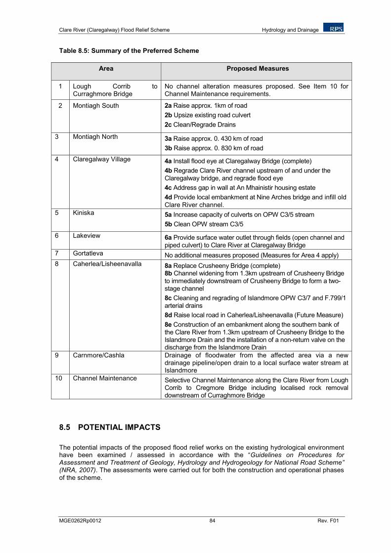
Clare River (Claregalway) Flood Relief Scheme Hydrology and Drainage
MGE0262Rp0012 84 Rev. F01
Table 8.5: Summary of the Preferred Scheme
Area Proposed Measures
1 Lough Corrib to Curraghmore Bridge
No channel alteration measures proposed. See Item 10 for Channel Maintenance requirements.
2 Montiagh South 2a Raise approx. 1km of road
2b Upsize existing road culvert
2c Clean/Regrade Drains
3 Montiagh North 3a Raise approx. 0. 430 km of road
3b Raise approx. 0. 830 km of road
4 Claregalway Village 4a Install flood eye at Claregalway Bridge (complete)
4b Regrade Clare River channel upstream of and under the Claregalway bridge, and regrade flood eye
4c Address gap in wall at An Mhainistir housing estate
4d Provide local embankment at Nine Arches bridge and infill old Clare River channel.
5 Kiniska 5a Increase capacity of culverts on OPW C3/5 stream
5b Clean OPW stream C3/5
6 Lakeview 6a Provide surface water outlet through fields (open channel and piped culvert) to Clare River at Claregalway Bridge
7 Gortatleva No additional measures proposed (Measures for Area 4 apply)
8 Caherlea/Lisheenavalla 8a Replace Crusheeny Bridge (complete) 8b Channel widening from 1.3km upstream of Crusheeny Bridge to immediately downstream of Crusheeny Bridge to form a two-stage channel
8c Cleaning and regrading of Islandmore OPW C3/7 and F.799/1 arterial drains
8d Raise local road in Caherlea/Lisheenavalla (Future Measure)
8e Construction of an embankment along the southern bank of the Clare River from 1.3km upstream of Crusheeny Bridge to the Islandmore Drain and the installation of a non-return valve on the discharge from the Islandmore Drain
9 Carnmore/Cashla Drainage of floodwater from the affected area via a new drainage pipeline/open drain to a local surface water stream at Islandmore
10 Channel Maintenance Selective Channel Maintenance along the Clare River from Lough Corrib to Cregmore Bridge including localised rock removal downstream of Curraghmore Bridge
8.5 POTENTIAL IMPACTS
The potential impacts of the proposed flood relief works on the existing hydrological environment have been examined / assessed in accordance with the “Guidelines on Procedures for Assessment and Treatment of Geology, Hydrology and Hydrogeology for National Road Scheme” (NRA, 2007). The assessments were carried out for both the construction and operational phases of the scheme.
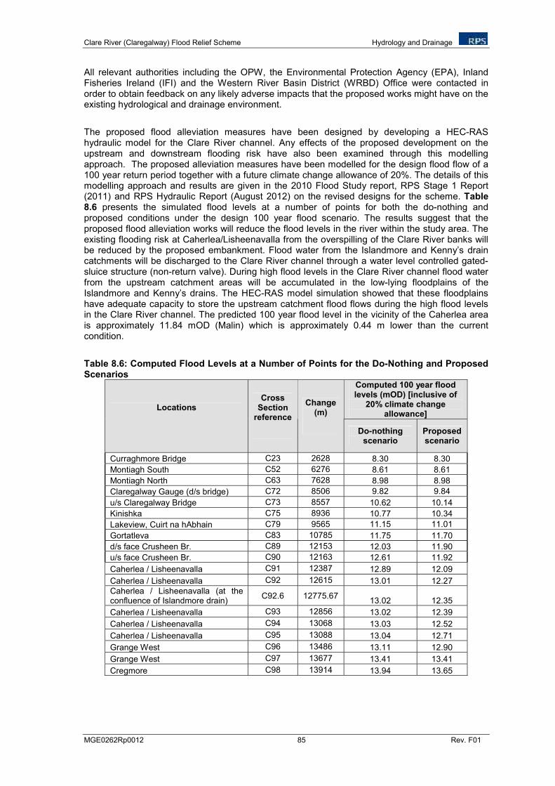
Clare River (Claregalway) Flood Relief Scheme Hydrology and Drainage
MGE0262Rp0012 85 Rev. F01
All relevant authorities including the OPW, the Environmental Protection Agency (EPA), Inland Fisheries Ireland (IFI) and the Western River Basin District (WRBD) Office were contacted in order to obtain feedback on any likely adverse impacts that the proposed works might have on the existing hydrological and drainage environment.
The proposed flood alleviation measures have been designed by developing a HEC-RAS hydraulic model for the Clare River channel. Any effects of the proposed development on the upstream and downstream flooding risk have also been examined through this modelling approach. The proposed alleviation measures have been modelled for the design flood flow of a 100 year return period together with a future climate change allowance of 20%. The details of this modelling approach and results are given in the 2010 Flood Study report, RPS Stage 1 Report (2011) and RPS Hydraulic Report (August 2012) on the revised designs for the scheme. Table 8.6 presents the simulated flood levels at a number of points for both the do-nothing and proposed conditions under the design 100 year flood scenario. The results suggest that the proposed flood alleviation works will reduce the flood levels in the river within the study area. The existing flooding risk at Caherlea/Lisheenavalla from the overspilling of the Clare River banks will be reduced by the proposed embankment. Flood water from the Islandmore and Kenny’s drain catchments will be discharged to the Clare River channel through a water level controlled gated-sluice structure (non-return valve). During high flood levels in the Clare River channel flood water from the upstream catchment areas will be accumulated in the low-lying floodplains of the Islandmore and Kenny’s drains. The HEC-RAS model simulation showed that these floodplains have adequate capacity to store the upstream catchment flood flows during the high flood levels in the Clare River channel. The predicted 100 year flood level in the vicinity of the Caherlea area is approximately 11.84 mOD (Malin) which is approximately 0.44 m lower than the current condition.
Table 8.6: Computed Flood Levels at a Number of Points for the Do-Nothing and Proposed Scenarios
Computed 100 year flood levels (mOD) [inclusive of
20% climate change allowance]
Locations Cross
Section reference
Change (m)
Do-nothing scenario
Proposed scenario
Curraghmore Bridge C23 2628 8.30 8.30
Montiagh South C52 6276 8.61 8.61
Montiagh North C63 7628 8.98 8.98
Claregalway Gauge (d/s bridge) C72 8506 9.82 9.84
u/s Claregalway Bridge C73 8557 10.62 10.14
Kinishka C75 8936 10.77 10.34
Lakeview, Cuirt na hAbhain C79 9565 11.15 11.01
Gortatleva C83 10785 11.75 11.70
d/s face Crusheen Br. C89 12153 12.03 11.90
u/s face Crusheen Br. C90 12163 12.61 11.92
Caherlea / Lisheenavalla C91 12387 12.89 12.09
Caherlea / Lisheenavalla C92 12615 13.01 12.27
Caherlea / Lisheenavalla (at the confluence of Islandmore drain)
C92.6 12775.67 13.02 12.35
Caherlea / Lisheenavalla C93 12856 13.02 12.39
Caherlea / Lisheenavalla C94 13068 13.03 12.52
Caherlea / Lisheenavalla C95 13088 13.04 12.71
Grange West C96 13486 13.11 12.90
Grange West C97 13677 13.41 13.41
Cregmore C98 13914 13.94 13.65
Clare River (Claregalway) Flood Relief Scheme Hydrology and Drainage
MGE0262Rp0012 86 Rev. F01
The above results thus show that the proposed flood relief scheme will not pose any flooding risk to the areas upstream or downstream of the study area. The proposed channel widening along the south bank of the Clare River upstream of Crusheeny Bridge over a length of approximately 1.3 km will reduce the risk of flooding to lands and properties located along the northern floodplains as a result of the proposed flood protection embankment on the south bank.
An examination of the impacts of the proposed flood relief scheme on the low-flow regime of the river showed minimal impact.
A summary of the likely impacts of the proposed developed on each of the hydrological attributes are presented below for both the construction and operational phases of the proposed works.
Flooding
During Construction:
During the construction phase of the works, the potential causes of flooding could include:
There is potential for flooding of lands and properties located on the southern floodplains of the proposed embankment at Caherlea/Lisheenavalla due to a reduction in channel conveyancing capacity during the construction of a sluice structure (non-return valve) on the Islandmore drain and also due to the potential obstruction of overland flow to the Clare River channel as a result of the proposed flood protection embankment,
Flooding of adjacent lands and properties caused by any reduction of channel conveyancing capacity during the implementation of channel widening works, and
Blockage to the river flows due to collapsing of unstable river banks or temporary or permanent stockpiles during construction.
During Operation:
The proposed flood relief scheme will reduce flooding risk significantly in the Claregalway, Crusheeny, Caherlea/Lisheenavalla and Carnmore/Cashla areas and will not pose any flooding risk in the upstream and downstream vicinity.
Low-flow:
During Construction:
Any blockage to normal flow rate in the river during the implementation of channel widening works and river crossing works could reduce the downstream flow rate which could have an impact on the aquatic ecology, and
Any obstruction to lateral overland flow (surface runoff) paths towards the river channel from the construction of the proposed flood protection embankment and from the temporary storage of excavation materials along the river bank could reduce the flow rate in the river.
During Operation:
During the operational phase of the works no changes in the existing low-flow patterns are anticipated. The results of the simulated flood levels at a number of key flood defence points for
Clare River (Claregalway) Flood Relief Scheme Hydrology and Drainage
MGE0262Rp0012 87 Rev. F01
both the do-nothing and proposed conditions under the design flood suggest that the proposed flood alleviation works will reduce the flood levels in the study area reach of the river. The results of the simulation also show that the proposed development will not pose any flooding risk in the upstream and downstream vicinity of the alleviation works.
An examination of the impact of the flood alleviation measures on the low-flow regime of the river flow showed minimal impact.
Drainage:
During Construction:
The existing land drainage system in the study area will likely be affected during the construction period of the works. Potential impacts on the existing drainage systems could include:
The pattern of runoff could change with some existing drains and ditches receiving significantly more or less flow than they receive currently;
Rainfall on elevated areas could wash peat and silt into the surrounding watercourses.
Localised erosion and scouring could occur while reduced flow may result in stagnation in some drains and ditches, and
Obstruction of upland flow paths could cause localised water logging in the upstream
vicinity of the proposed flood protection embankment and temporary storage of excavation material along the river bank.
During Operation:
The drainage pattern of the overland flows to the river channel along the embanked section may be changed slightly. Any infilling of excavation material in the floodplain will change the slope of the existing lands in some areas which consequently may have an impact on the existing surface water drainage pattern. For example, the existing permeability of the soil could be reduced and the time of concentration to surface water flow could increase if the existing slope reduces.
Table 8.6 summarises the hydrological impact assessment results.
8.6 MITIGATION MEASURES
Appropriate mitigation measures have been proposed in order to minimise each of the above identified impacts both during the construction and operational phases of the proposed flood relief works. The following documents were referenced during the preparation of the mitigation measures:
Requirements for the Protection of Fisheries Habitat during Construction and Development Works at River Sites. North Western Regional Fisheries Board,
CIRIA (Construction Industry Research and Information Association) guidance on ‘Control of Water Pollution from Linear Construction Projects’ (CIRIA Report No. C648, 2006), and
Developing Your Stormwater Pollution Prevention Plan: A Guide for Construction Sites. EPA 833-R-060-04 May 2007.
Clare River (Claregalway) Flood Relief Scheme Hydrology and Drainage
MGE0262Rp0012 88 Rev. F01
Drainage and Flooding
During Construction:
The following mitigation measures are proposed to manage flooding and storm water drainage during the construction phase of the works:
• To avoid any water logging in the lands adjacent to the river banks, it is proposed to maintain the existing surface water flow paths by providing regular breaks in the proposed flood protection embankment and any temporary or permanent stockpiles to ensure overland surface water flow is not restricted.
• Any spoil stockpiles must be stabilised through reseeding, to prevent spoil collapsing during high rainfall events.
An examination of historical flood records for the Clare River at Claregalway and Corofin
hydrometric stations shows that most of the worst fluvial flooding in this catchment occurs during the winter months as would be expected. It is therefore recommended that the works be undertaken when flooding risks are low.
Any impact of the proposed works on river water quality should be kept minimal.
Mitigation measures have been specified in Chapters 10 and 11 for this purpose and should be adhered to.
IFI should be informed prior to channel widening and embankment construction works
commencing. All works will be carried out in accordance with the “Requirements for the Protection of Fisheries Habitat during Construction and Development Works at River Sites, North Western Regional Fisheries Board” and the OPW Environmental Management Protocols and Standard Operating Procedures (April, 2011: see Appendix 1.1).
During Operation:
The completed scheme will reduce the extent of flooding in the Claregalway, Crusheeny, Caherlea/Lisheenavalla and Carnmore/Cashla areas. There will be minimal impacts on the existing drainage regime during the operational phase of the works. Any impacts on the existing surface water drainage regime in the upstream vicinity of the proposed embankment will be minimised by maintaining the existing drainage channels discharging to the Clare River through water level controlled sluice structures. The completed scheme will however result in changed velocities along the river stretch during all flow conditions. The potential impacts of these changed velocities are discussed in Chapter 9. On completion the Clare River will remain an OPW scheduled channel, and as such its maintenance will form part of OPW statutory obligations under the 1945 Arterial Drainage Act.
Low-flows:
During Construction:
Any impact on the low-flow rate (reduction) in the river likely to be caused during the construction stage of the works will be minimised by maintaining the normal lateral surface water flow path to the river by providing regular breaks in the proposed flood protection embankment and in any temporary or permanent stockpiles to ensure overland surface water flow is not restricted.
Clare River (Claregalway) Flood Relief Scheme Hydrology and Drainage
MGE0262Rp0012 89 Rev. F01
During Operation:
Any impacts of the proposed flood relief scheme on the low-flow regime of the river during the post construction stage are expected to be minimal, since the proposed works will not include any deepening and widening of the existing low-flow channel of the river (with the exception of minor works at Claregalway Bridge and EREP works). Any expected reduction in the lateral overland flows to the Clare River channel adjacent to the proposed embankments will be reduced by maintaining the existing surface water discharge route through culvert constructions.
8.7 RESIDUAL IMPACTS
It is predicted that impacts on the existing hydrological environment will be minimised as a result of the above protection measures.
Table 8.7 overleaf summarises the hydrological impact assessment results and proposed mitigation measures.
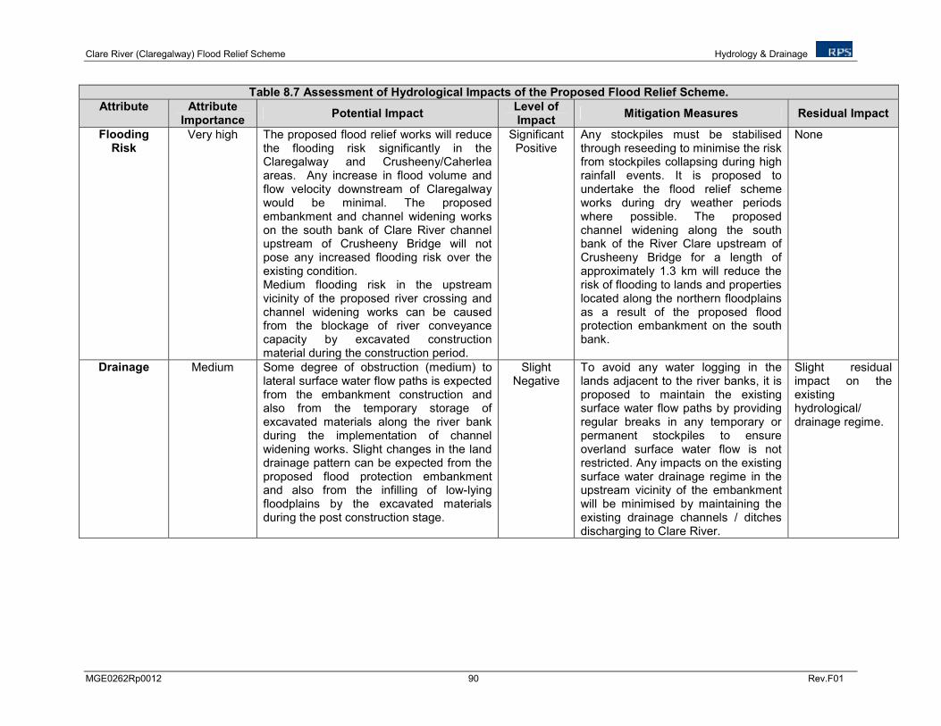
Clare River (Claregalway) Flood Relief Scheme Hydrology & Drainage
MGE0262Rp0012 90 Rev.F01
Table 8.7 Assessment of Hydrological Impacts of the Proposed Flood Relief Scheme.
Attribute Attribute Importance
Potential Impact Level of Impact
Mitigation Measures Residual Impact
Flooding Risk
Very high The proposed flood relief works will reduce the flooding risk significantly in the Claregalway and Crusheeny/Caherlea areas. Any increase in flood volume and flow velocity downstream of Claregalway would be minimal. The proposed embankment and channel widening works on the south bank of Clare River channel upstream of Crusheeny Bridge will not pose any increased flooding risk over the existing condition. Medium flooding risk in the upstream vicinity of the proposed river crossing and channel widening works can be caused from the blockage of river conveyance capacity by excavated construction material during the construction period.
Significant Positive
Any stockpiles must be stabilised through reseeding to minimise the risk from stockpiles collapsing during high rainfall events. It is proposed to undertake the flood relief scheme works during dry weather periods where possible. The proposed channel widening along the south bank of the River Clare upstream of Crusheeny Bridge for a length of approximately 1.3 km will reduce the risk of flooding to lands and properties located along the northern floodplains as a result of the proposed flood protection embankment on the south bank.
None
Drainage
Medium Some degree of obstruction (medium) to lateral surface water flow paths is expected from the embankment construction and also from the temporary storage of excavated materials along the river bank during the implementation of channel widening works. Slight changes in the land drainage pattern can be expected from the proposed flood protection embankment and also from the infilling of low-lying floodplains by the excavated materials during the post construction stage.
Slight Negative
To avoid any water logging in the lands adjacent to the river banks, it is proposed to maintain the existing surface water flow paths by providing regular breaks in any temporary or permanent stockpiles to ensure overland surface water flow is not restricted. Any impacts on the existing surface water drainage regime in the upstream vicinity of the embankment will be minimised by maintaining the existing drainage channels / ditches discharging to Clare River.
Slight residual impact on the existing hydrological/ drainage regime.
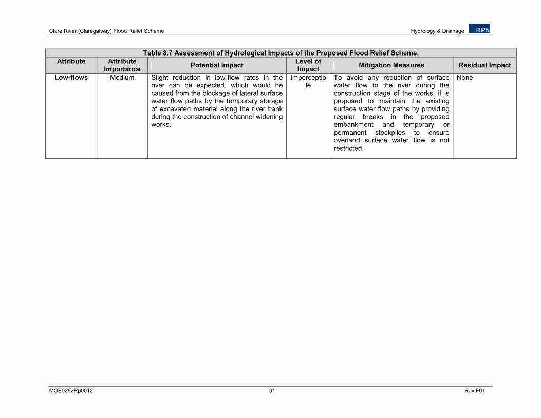
Clare River (Claregalway) Flood Relief Scheme Hydrology & Drainage
MGE0262Rp0012 91 Rev.F01
Table 8.7 Assessment of Hydrological Impacts of the Proposed Flood Relief Scheme.
Attribute Attribute Importance
Potential Impact Level of Impact
Mitigation Measures Residual Impact
Low-flows Medium Slight reduction in low-flow rates in the river can be expected, which would be caused from the blockage of lateral surface water flow paths by the temporary storage of excavated material along the river bank during the construction of channel widening works.
Imperceptible
To avoid any reduction of surface water flow to the river during the construction stage of the works, it is proposed to maintain the existing surface water flow paths by providing regular breaks in the proposed embankment and temporary or permanent stockpiles to ensure overland surface water flow is not restricted.
None
Clare River (Claregalway) Flood Relief Scheme Hydrology & Drainage
MGE0262Rp0012 92 Rev.F01
8.8 CONCLUSIONS
The proposed flood relief scheme will reduce the risk of flooding in the Claregalway, Crusheeny, Caherlea/Lisheenavalla and Carnmore/Cashla areas and will not pose any additional flooding risk to the area upstream and downstream of the study area. The proposed works will therefore have minimal residual impacts on the existing hydrological regime of the Clare River catchment.
Clare River (Claregalway) Flood Relief Scheme Soils, Geology & Hydrogeology
MGE0262Rp0012 93 Rev.F01
9 SOILS, GEOLOGY AND HYDROGEOLOGY
9.1 INTRODUCTION
This chapter of the EIS examines the baseline environment in terms of soils, geology and hydrogeology and assesses the potential impact of the proposed works associated with the Clare River Flood Relief Scheme and the Claregalway Footbridge on these environmental attributes. Mitigation measures are recommended to minimise any adverse impacts.
This section should be read in conjunction with the site layout plans, drawings and project description provided and hydrological assessment in Chapters 6 and 8.
9.2 METHODOLOGY
The soils, geology and hydrogeology of the study area were assessed by means of a desk study of literature pertinent to the site and the surrounding area. A site walkover and assessment was carried out on the 14
th July 2011.
The following sources of information were used in conjunction with the walkover in order to complete the assessment:
• Geological Survey of Ireland (GSI) 1:100,000 Geology of Galway Bay (Sheet 14),
• G.S.I. Well Record Database,
• G.S.I. National Vulnerability Map,
• Teagasc Subsoils Map,
• Aerial Photographs,
• Clare-Corrib Groundwater Body Description (G.S.I. 2004),
• Water Framework Directive (WFD) Water Body Reports http://watermaps.wfdireland.ie,
• Ordnance Survey of Ireland (OSI) 1:50,000 Map Discovery Series and Historical Mapping
• Guidelines on the Information to be contained in Environmental Impact Statements, EPA 1995 and 2002,
• Geology and the EIS process, Institute of Geologists of Ireland (IGI), 2002
• Guidelines on Procedures for Assessment and Treatment of Geology, Hydrology and Hydrogeology for National Road Scheme, NRA (National Roads Authority), 2009.
The methodology for impact assessment is defined by the EPA Guidelines to be contained in Environmental Impact Statements (EPA, 2002 & 2003). An application of these guidelines to Soils, Geology and Hydrogeology is outlined in the NRA document Guidelines on Procedures for Assessment and Treatment of Geology, Hydrology and Hydrogeology for National Road Scheme (NRA, 2009).
In this methodology the significance of an impact is defined by considering the importance of the attribute impacted and the magnitude of the impact. The importance of geological and hydrogeological attributes (rating criteria) is defined in accordance with the NRA (NRA, 2009) Guidelines which are presented in Table 9.1.

Clare River (Claregalway) Flood Relief Scheme Soils, Geology & Hydrogeology
MGE0262Rp0012 94 Rev.F01
Table 9.1: Rating Criteria for the Hydrological Attributes
Importance Criteria Typical Examples
Geology Hydrogeology
Extremely high Attribute has a high quality or value on an international scale
-
Groundwater supports river, wetland or surface water body ecosystem protected by EU legislation e.g. cSAC or SPA status
Very high Attribute has a high quality or value on a regional scale
Geological feature rare on a regional or national scale (NHA)
Groundwater supports river, wetland or surface water body ecosystem protected by national legislation – NHA status
High Attribute has a high quality or value on a local scale
Geological feature of high value on a local scale (County Geological Site)
Groundwater provides large proportion of baseflow to local rivers Locally important potable water source supplying >1000 homes
Medium Attribute has a medium quality or value on a local scale
Small existing quarry or pit Sub-economic extractable mineral resource
Locally Important Aquifer Potable water source supplying >50 homes Outer source protection area for locally important water source
Low Attribute has a low quality or value on a local scale
Poorly drained and/or low fertility soils
Poor Bedrock Aquifer Potable water source supplying <50 homes
The magnitude of the impacts on the existing environment of the attributes was defined in accordance with the criteria provided in the EPA publication - Guideline on the Information to be Contained in Environmental Impact Statements (2002). These are presented in Table 9.2.
Table 9.2: Impact Assessment Criteria
Magnitude of Impact Description
Imperceptible An impact capable of measurement but without noticeable consequences
Slight An impact that alters the character of the environment without affecting its sensitivities
Moderate An impact that alters the character of the environment in a manner that is consistent with existing or emerging trends
Significant An impact, which by its character, magnitude, duration or intensity alters a sensitive aspect of the environment
Profound An impact which obliterates all previous sensitive characteristics
9.3 EXISTING ENVIRONMENT
9.3.1 Soils and Subsoils
Soils in the area are mapped under the Teagasc FIPS classification system predominately as Basic Mineral Deep Well Drained Soil (BminDW) which is more commonly referred to as Grey Brown Podzolics. There are areas mapped as mineral alluvium (AlluvMIN) along the Clare River corridor.
Teagasc subsoils mapping shows the area is comprised predominantly of limestone till east of Claregalway and cutover peat to the west. Cutover peat is predominant along the banks of the Clare River from Montiagh townland downstream to Lough Corrib. Limestone till is predominant along the banks of the Clare River from Montiagh townland upstream to Crusheeny Bridge and Carnmore. There is an area of made ground in the village of Claregalway and areas of alluvium can be found along the banks of the Clare River. Pockets of lake sediments can also be found in the study area.
Clare River (Claregalway) Flood Relief Scheme Soils, Geology & Hydrogeology
MGE0262Rp0012 95 Rev.F01
Outcrops of karst rock are scattered throughout the study area. Details on soils in the study area are shown on Figure 9.1.
9.3.2 Bedrock Geology
The bedrock geology of the area is dominated undifferentiated Visean Limestone. Few faults are mapped in this area and very limited information exists in general (GSI, 2004). Details on bedrock geology are shown on Figure 9.2.
The locations of mineral sites and quarries in proximity to the study area are shown in Figure 9.2 and detailed in Table 9.3 and Table 9.4, however none are located within the land area as illustrated in Figure 9.2.
Table 9.3 Mineral Sites Located within Proximity to the Study Area
Location No.
Mineral Townland Description Notes
2165 Stone Terryland Non-metallic Grey marble quarry said to have produced stone for St. Augustine's Chapel, Galway.
3001 Stone Pollkeen Non-metallic Large active Limestone quarry
4610 Stone Coolagh Non-metallic Recently developed aggregate quarry.
4705 Stone Cregboy Non-metallic Disused aggregate quarry of grey micrite.
4717 Stone Lisheenkyle
West Non-metallic Extensive limestone pavement of grey micrite.
5241 Fluorspar Glennascaul Non-metallic Patchily dolomitized Burren Limestone
contains calcite veins with fluorite.
5365 Copper Ballybrit Metallic Exploration Site
Table 9.4 Quarries Located in Proximity to the Study Area
Quarry Name Quarry Address Operation Name
Lackagh Quarries Coolough Coolagh, Menlo, Galway Lackagh Quarries Ltd.
Roadstone Two Mile Ditch Quarry
Two Mile Ditch, Pollkeen, Galway
Roadstone Provinces Ltd.
J. Smith Sand & Gravel Cloonboo, Tuam, Galway J. Smith Sand & Gravel
Coshla Quarries Limited
Coshla, Athenry, Co. Galway Coshla Quarries Limited
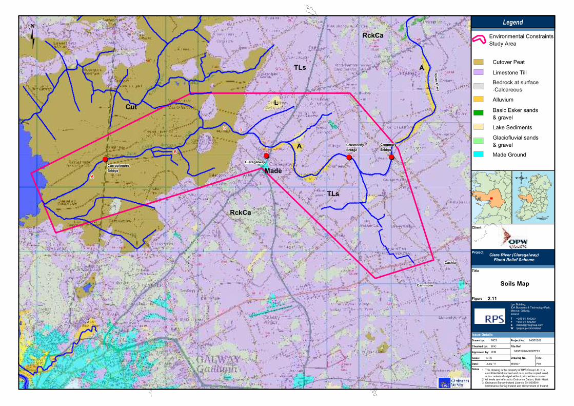
������������������������������������������������������������������������
������������������������������������
�� �������
�� �������
�� �������
�� �������
�� �������
�� �������
�� �������
�� �������
�� �������
������������������������������������������������������������������������
������������������������������������������������������
������������������������������������������������������������������������
������������������������������������������������������
��������������������
����������
����������
���������������������������������������������������������������������������������������������������������������������������������������������������������������������������
������������������������������������������������������
������
���
�
�����
�
�����
�
���
���
����
� �����
�������
����� ��
����
�!!�� ���"��
�������"��
����
#��$���
%�����������
������"��
��������������������������������������������� ���
������!������������!���������������"�!����#����#�
����������!�������$����������������������!�����
%��&����$��������������'�����!�(���#�)�����*���
+��'�����!����$�� ��������!�!�, ��������
����-'�����!����$�� ������������$�������� ������
&�����
�������!
��������������������� �
�������������������
'())
�� (
&�����*(
����� .���/��
0)
1�2
3��
)2� #��$���� �( )�,�%4%
�������� �(
) ���5
)�,�%4%) ���53��
6+�+�7��8��%��
6+�+�7��8��%77
������9���������!���
���������!��:������
�����1�������#
(&�1�������;��!�����������<#
)�$�#�������#
�����
�
&
�
+
�����
������
,�$���������2��������,�$���������2��������,�$���������2��������,�$���������2��������,�$���������2��������,�$���������2��������,�$���������2��������,�$���������2��������,�$���������2��������
�����&�������&�������&�������&�������&�������&�������&�������&�������&��
2��$����2��$����2��$����2��$����2��$����2��$����2��$����2��$����2��$����
���������������������������������������������������������������������������������������������������
1���!<��������!1���!<��������!1���!<��������!1���!<��������!1���!<��������!1���!<��������!1���!<��������!1���!<��������!1���!<��������!
=2��!�����=2��!�����=2��!�����=2��!�����=2��!�����=2��!�����=2��!�����=2��!�����=2��!�����
&���$���&���$���&���$���&���$���&���$���&���$���&���$���&���$���&���$���
1���!�,�<��������1���!�,�<��������1���!�,�<��������1���!�,�<��������1���!�,�<��������1���!�,�<��������1���!�,�<��������1���!�,�<��������1���!�,�<��������
;����$�;����$�;����$�;����$�;����$�;����$�;����$�;����$�;����$�
��<���������<���������<���������<���������<���������<���������<���������<���������<�������
���!�����$������������!�����$������������!�����$������������!�����$������������!�����$������������!�����$������������!�����$������������!�����$������������!�����$���������
;����$�;����$�;����$�;����$�;����$�;����$�;����$�;����$�;����$�
)���������)���������)���������)���������)���������)���������)���������)���������)���������
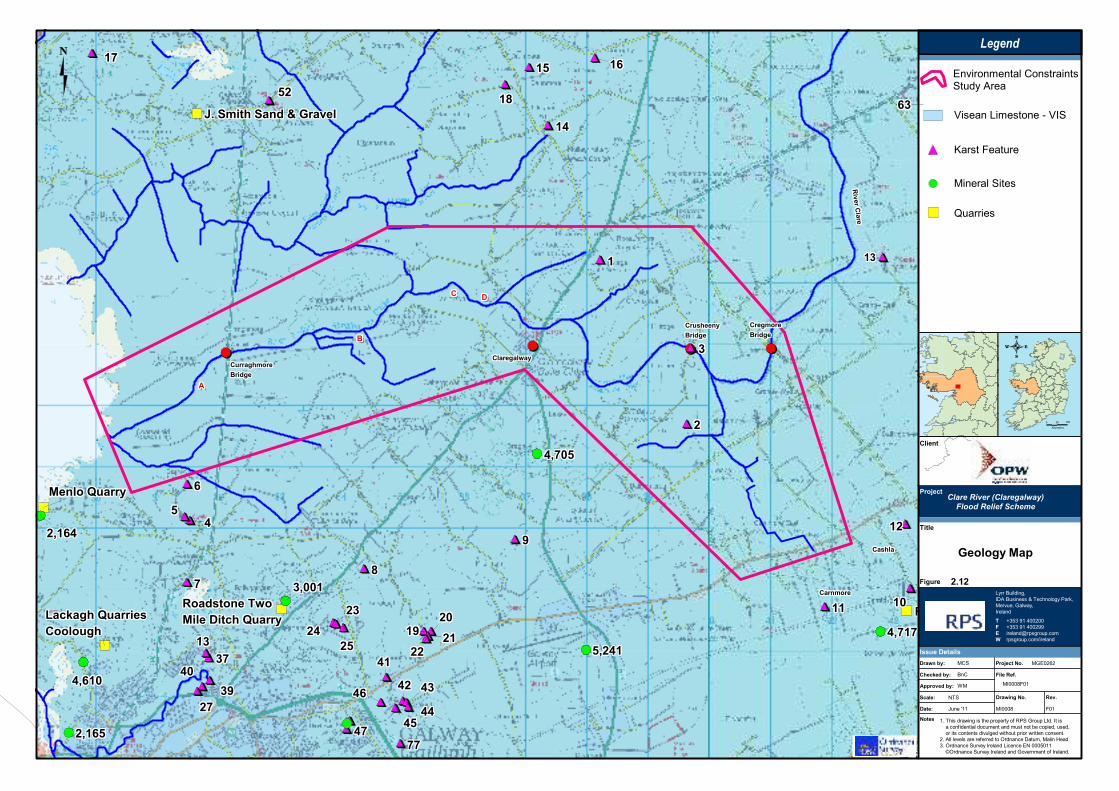
������������������������������������������������������������������������
������������������������������������
�� ����
���
�� ����
���
�� ����
���
�� ����
���
�� ����
���
�� ����
���
�� ����
���
�� ����
���
�� ����
���
������������������������������������������������������������������������
������������������������������������������������������
������������������������������������������������������������������������
������������������������������������������������������
��������������������
����������
����������
���������������������������������������������������������������������������������������������������������������������������������������������������������������������������
������������������������������������������������������
������������������
���������������������������������������������������������������������������������������������������������������������
���������������������������������������������������������������������������������������������������������������������������������������
���������������������������������������������������������������������������������������������������
������������������������������������������������������������������������������������������������������������������������������������������������
������������������������������������������������������
� � � � � � � � �
! ! ! ! ! ! ! ! !�"�"�"�"�"�"�"�"�"
�!�!�!�!�!�!�!�!�!
#########$$$$$$$$$
� � � � � � � � �
� � � � � � � � �
# # # # # # # # #
$ $ $ $ $ $ $ $ $������������������
%�%�%�%�%�%�%�%�%��&�&�&�&�&�&�&�&�&
$ $ $ $ $ $ $ $ $
#�#�#�#�#�#�#�#�#�#!#!#!#!#!#!#!#!#!
# # # # # # # # # #�#�#�#�#�#�#�#�#�
' ' ' ' ' ' ' ' '
�"�"�"�"�"�"�"�"�" #%#%#%#%#%#%#%#%#%
�%�%�%�%�%�%�%�%�%�'�'�'�'�'�'�'�'�'
#$#$#$#$#$#$#$#$#$##################
�(!!��(!!��(!!��(!!��(!!��(!!��(!!��(!!��(!!�
(�%# (�%# (�%# (�%# (�%# (�%# (�%# (�%# (�%#
#(%�!#(%�!#(%�!#(%�!#(%�!#(%�!#(%�!#(%�!#(%�!
)*�+����+����,�-�� �)*�+����+����,�-�� �)*�+����+����,�-�� �)*�+����+����,�-�� �)*�+����+����,�-�� �)*�+����+����,�-�� �)*�+����+����,�-�� �)*�+����+����,�-�� �)*�+����+����,�-�� �
������������������
���������
���������
%%%%%%%%%
'''''''''
&&&&&&&&&
"""""""""
������������������
�#�#�#�#�#�#�#�#�#
�$�$�$�$�$�$�$�$�$
�'�'�'�'�'�'�'�'�'
#'#'#'#'#'#'#'#'#'
$$$$$$$$$$$$$$$$$$''''''''''''''''''
(�%$ (�%$ (�%$ (�%$ (�%$ (�%$ (�%$ (�%$ (�%$
#('!$#('!$#('!$#('!$#('!$#('!$#('!$#('!$#('!$
#('�'#('�'#('�'#('�'#('�'#('�'#('�'#('�'#('�'
$( #�$( #�$( #�$( #�$( #�$( #�$( #�$( #�$( #�
� �����
�������
+���. ��
/����
�00�� ���1�.
�������1�.
����
2��3���
4�����������
������1�.
��������������������������������������������� ���
������!������������!���������������"�!����#����#�
����������!�������$����������������������!�����
%��&����$��������������'�����!�(���#�)�����*���
+��'�����!����$�� ��������!�!�, ��������
����-'�����!����$�� ������������$�������� ������
5�����
-��������0
��������������������� �
�������������������
*�
�� *
5�����6*
����. .���/��
0)
1�2
3��
)2� 2��3����/�* )�,�%4%
��������/�*
) ���5
) ���53��
6+�+�7��8��%��
6+�+�7��8��%77
������9���������!���
���������!��:������
�����1�������#
(&�1�������;��!�����������<#
)�$�#�������#
�����
�
5
7
8
�����
������
,�$���������2�������������&��
=������������>�= �=������������>�= �=������������>�= �=������������>�= �=������������>�= �=������������>�= �=������������>�= �=������������>�= �=������������>�= �
�����3��������3��������3��������3��������3��������3��������3��������3��������3���
)���������)���������)���������)���������)���������)���������)���������)���������)���������
?������?������?������?������?������?������?������?������?������
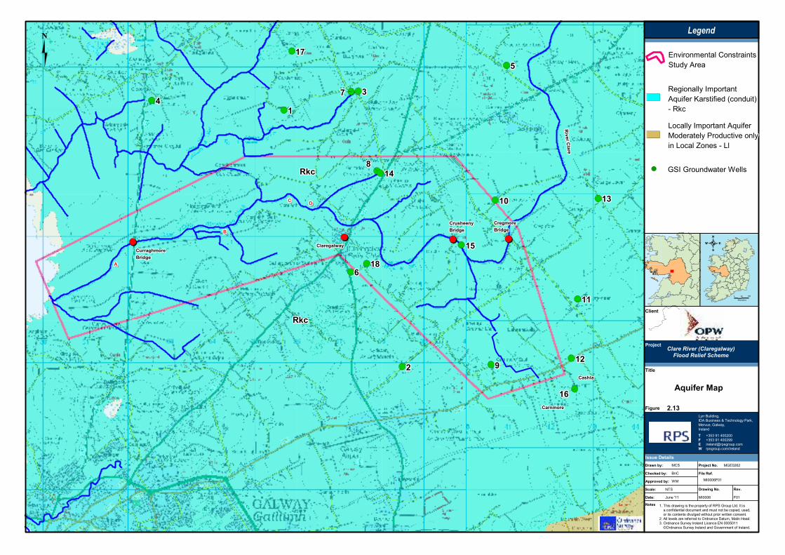
������������������������������������������������������������������������
������������������������������������
�� ����
���
�� ����
���
�� ����
���
�� ����
���
�� ����
���
�� ����
���
�� ����
���
�� ����
���
�� ����
���
������������������������������������������������������������������������
������������������������������������������������������
������������������������������������������������������������������������
������������������������������������������������������
��������������������
����������
����������
���������������������������������������������������������������������������������������������������������������������������������������������������������������������������
������������������������������������������������������
���������������������������
���������������������������
������������������
���������
���������
���������
���������
������������������
���������
!!!!!!!!!
�"�"�"�"�"�"�"�"�"
������������������
������������������
������������������
������������������
� � � � � � � � �
������������������
������������������
� �����
�������
#���$ ��
%�&��
�''�� ���(�$
�������(�$
)�&�
*��+��&
,�������&���
������(�$
��������������������������������������������� ���
������!������������!���������������"�!����#����#�
����������!�������$����������������������!�����
%��&����$��������������'�����!�(���#�)�����*���
+��'�����!����$�� ��������!�!�, ��������
����-'�����!����$�� ������������$�������� ������
-�����
�.��/���0�'
��������������������� �
�������������������
�1��
�� 1
-�����/1
��&�$ .���/��
0)
1�2
3��
)2� *��+��&�%�1 )�,�%4%
��������%�1
) ���4
) ���43��
5+�+�6��7��%��
5+�+�6��7��%66
������8���������!���
���������!��9������
�����1�������#
(&�1�������:��!�����������;#
)�$�#�������#
�����
)
-
2
3
����&
������
,�$���������2��������,�$���������2��������,�$���������2��������,�$���������2��������,�$���������2��������,�$���������2��������,�$���������2��������,�$���������2��������,�$���������2��������
�����&�������&�������&�������&�������&�������&�������&�������&�������&��
���������� ����������������� ����������������� ����������������� ����������������� ����������������� ����������������� ����������������� ����������������� �������
&<��������������=!�����>�&<��������������=!�����>�&<��������������=!�����>�&<��������������=!�����>�&<��������������=!�����>�&<��������������=!�����>�&<��������������=!�����>�&<��������������=!�����>�&<��������������=!�����>�
?��;!?��;!?��;!?��;!?��;!?��;!?��;!?��;!?��;!
��!����� �������&<������!����� �������&<������!����� �������&<������!����� �������&<������!����� �������&<������!����� �������&<������!����� �������&<������!����� �������&<������!����� �������&<����
)������������!�$�����)������������!�$�����)������������!�$�����)������������!�$�����)������������!�$�����)������������!�$�����)������������!�$�����)������������!�$�����)������������!�$�����
�����!���@����?��������!���@����?��������!���@����?��������!���@����?��������!���@����?��������!���@����?��������!���@����?��������!���@����?��������!���@����?���
�� �����������0����� �����������0����� �����������0����� �����������0����� �����������0����� �����������0����� �����������0����� �����������0����� �����������0���

Vulnerability
0 2 4 6 km.
Legend
Copyright DCENR 2010 and Ordnance Survey of Ireland No. EN 0047208 and Government of Ireland
This map and its data may not be used or reproduced for commercial purposes without theprior written permission of Ordnance Survey of Ireland. This map is a user generated staticoutput from an Internet mapping site and is for general reference only. Data layers thatappear on this map may or may not be accurate, current, or otherwise reliable.
Scale: 1:76,154
Snapshot Date: 09-May-2011
Map center: 136057, 231941
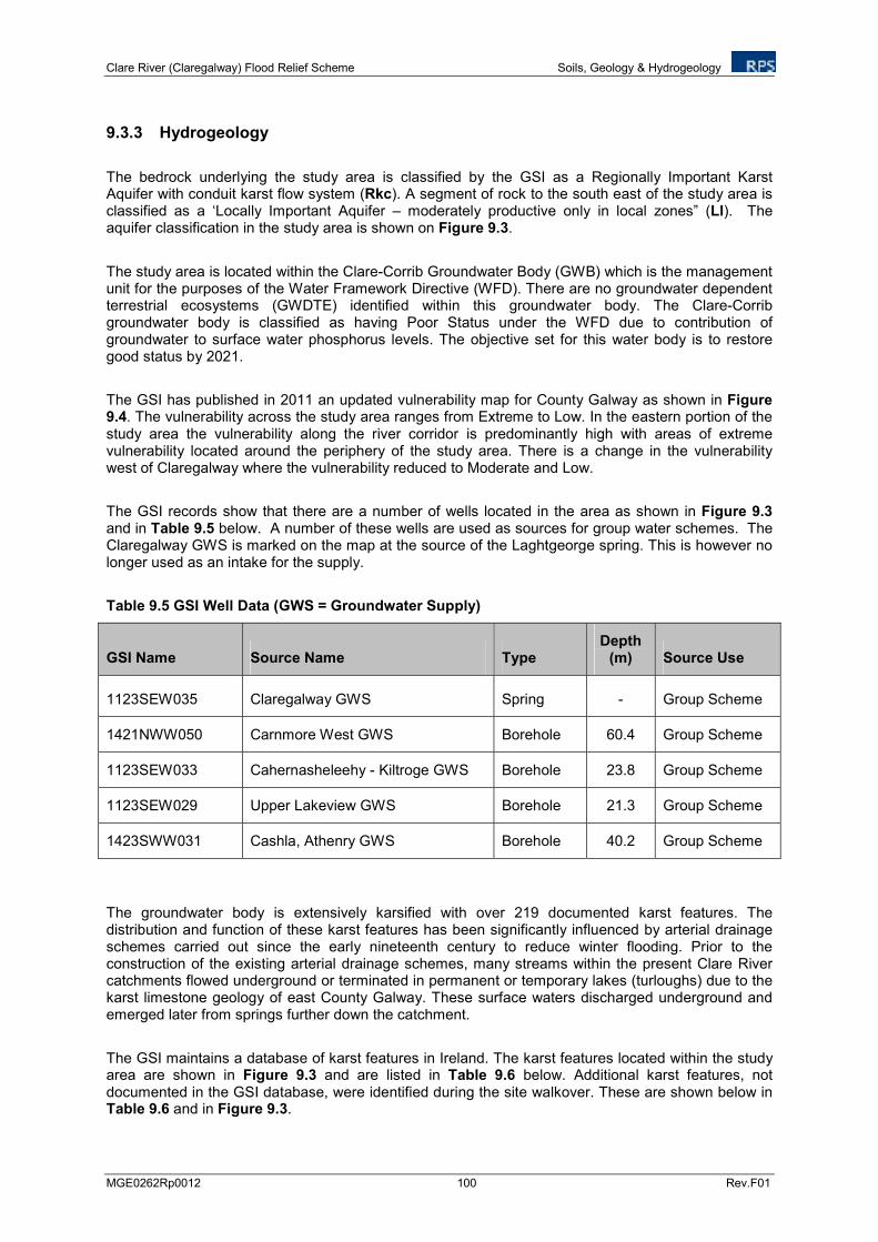
Clare River (Claregalway) Flood Relief Scheme Soils, Geology & Hydrogeology
MGE0262Rp0012 100 Rev.F01
9.3.3 Hydrogeology
The bedrock underlying the study area is classified by the GSI as a Regionally Important Karst Aquifer with conduit karst flow system (Rkc). A segment of rock to the south east of the study area is classified as a ‘Locally Important Aquifer – moderately productive only in local zones” (Ll). The aquifer classification in the study area is shown on Figure 9.3.
The study area is located within the Clare-Corrib Groundwater Body (GWB) which is the management unit for the purposes of the Water Framework Directive (WFD). There are no groundwater dependent terrestrial ecosystems (GWDTE) identified within this groundwater body. The Clare-Corrib groundwater body is classified as having Poor Status under the WFD due to contribution of groundwater to surface water phosphorus levels. The objective set for this water body is to restore good status by 2021.
The GSI has published in 2011 an updated vulnerability map for County Galway as shown in Figure 9.4. The vulnerability across the study area ranges from Extreme to Low. In the eastern portion of the study area the vulnerability along the river corridor is predominantly high with areas of extreme vulnerability located around the periphery of the study area. There is a change in the vulnerability west of Claregalway where the vulnerability reduced to Moderate and Low.
The GSI records show that there are a number of wells located in the area as shown in Figure 9.3 and in Table 9.5 below. A number of these wells are used as sources for group water schemes. The Claregalway GWS is marked on the map at the source of the Laghtgeorge spring. This is however no longer used as an intake for the supply.
Table 9.5 GSI Well Data (GWS = Groundwater Supply)
GSI Name Source Name Type Depth
(m) Source Use
1123SEW035 Claregalway GWS Spring - Group Scheme
1421NWW050 Carnmore West GWS Borehole 60.4 Group Scheme
1123SEW033 Cahernasheleehy - Kiltroge GWS Borehole 23.8 Group Scheme
1123SEW029 Upper Lakeview GWS Borehole 21.3 Group Scheme
1423SWW031 Cashla, Athenry GWS Borehole 40.2 Group Scheme
The groundwater body is extensively karsified with over 219 documented karst features. The distribution and function of these karst features has been significantly influenced by arterial drainage schemes carried out since the early nineteenth century to reduce winter flooding. Prior to the construction of the existing arterial drainage schemes, many streams within the present Clare River catchments flowed underground or terminated in permanent or temporary lakes (turloughs) due to the karst limestone geology of east County Galway. These surface waters discharged underground and emerged later from springs further down the catchment.
The GSI maintains a database of karst features in Ireland. The karst features located within the study area are shown in Figure 9.3 and are listed in Table 9.6 below. Additional karst features, not documented in the GSI database, were identified during the site walkover. These are shown below in Table 9.6 and in Figure 9.3.
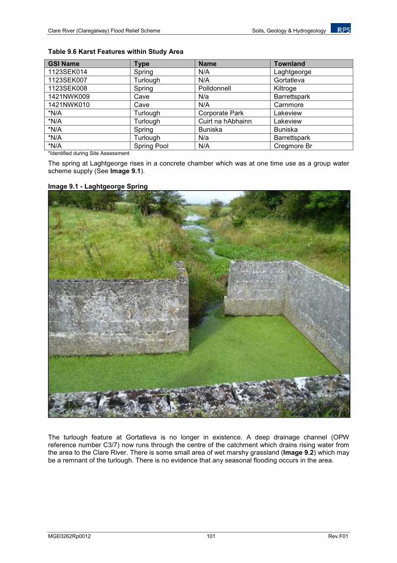
Clare River (Claregalway) Flood Relief Scheme Soils, Geology & Hydrogeology
MGE0262Rp0012 101 Rev.F01
Table 9.6 Karst Features within Study Area
GSI Name Type Name Townland
1123SEK014 Spring N/A Laghtgeorge
1123SEK007 Turlough N/A Gortatleva
1123SEK008 Spring Polldonnell Kiltroge
1421NWK009 Cave N/a Barrettspark
1421NWK010 Cave N/A Carnmore
*N/A Turlough Corporate Park Lakeview
*N/A Turlough Cuirt na hAbhainn Lakeview
*N/A Spring Buniska Buniska
*N/A Turlough N/a Barrettspark
*N/A Spring Pool N/A Cregmore Br *Identified during Site Assessment
The spring at Laghtgeorge rises in a concrete chamber which was at one time use as a group water scheme supply (See Image 9.1). Image 9.1 - Laghtgeorge Spring
The turlough feature at Gortatleva is no longer in existence. A deep drainage channel (OPW reference number C3/7) now runs through the centre of the catchment which drains rising water from the area to the Clare River. There is some small area of wet marshy grassland (Image 9.2) which may be a remnant of the turlough. There is no evidence that any seasonal flooding occurs in the area.
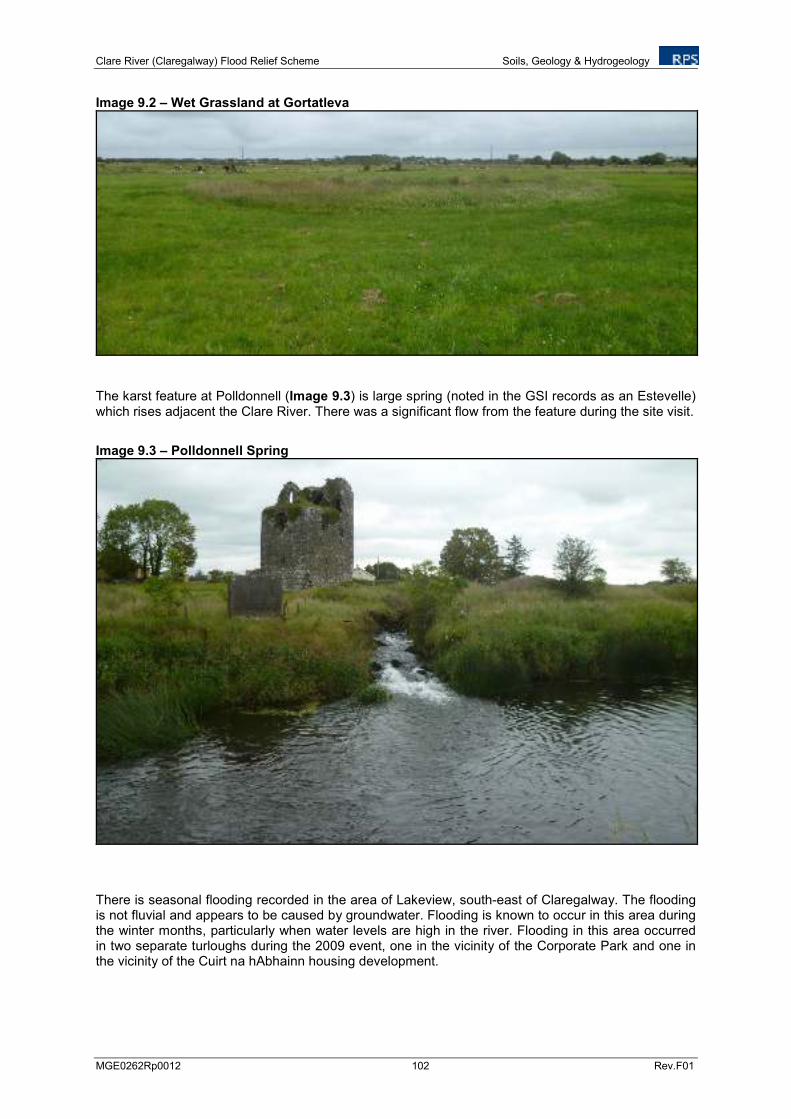
Clare River (Claregalway) Flood Relief Scheme Soils, Geology & Hydrogeology
MGE0262Rp0012 102 Rev.F01
Image 9.2 – Wet Grassland at Gortatleva
The karst feature at Polldonnell (Image 9.3) is large spring (noted in the GSI records as an Estevelle) which rises adjacent the Clare River. There was a significant flow from the feature during the site visit.
Image 9.3 – Polldonnell Spring
There is seasonal flooding recorded in the area of Lakeview, south-east of Claregalway. The flooding is not fluvial and appears to be caused by groundwater. Flooding is known to occur in this area during the winter months, particularly when water levels are high in the river. Flooding in this area occurred in two separate turloughs during the 2009 event, one in the vicinity of the Corporate Park and one in the vicinity of the Cuirt na hAbhainn housing development.
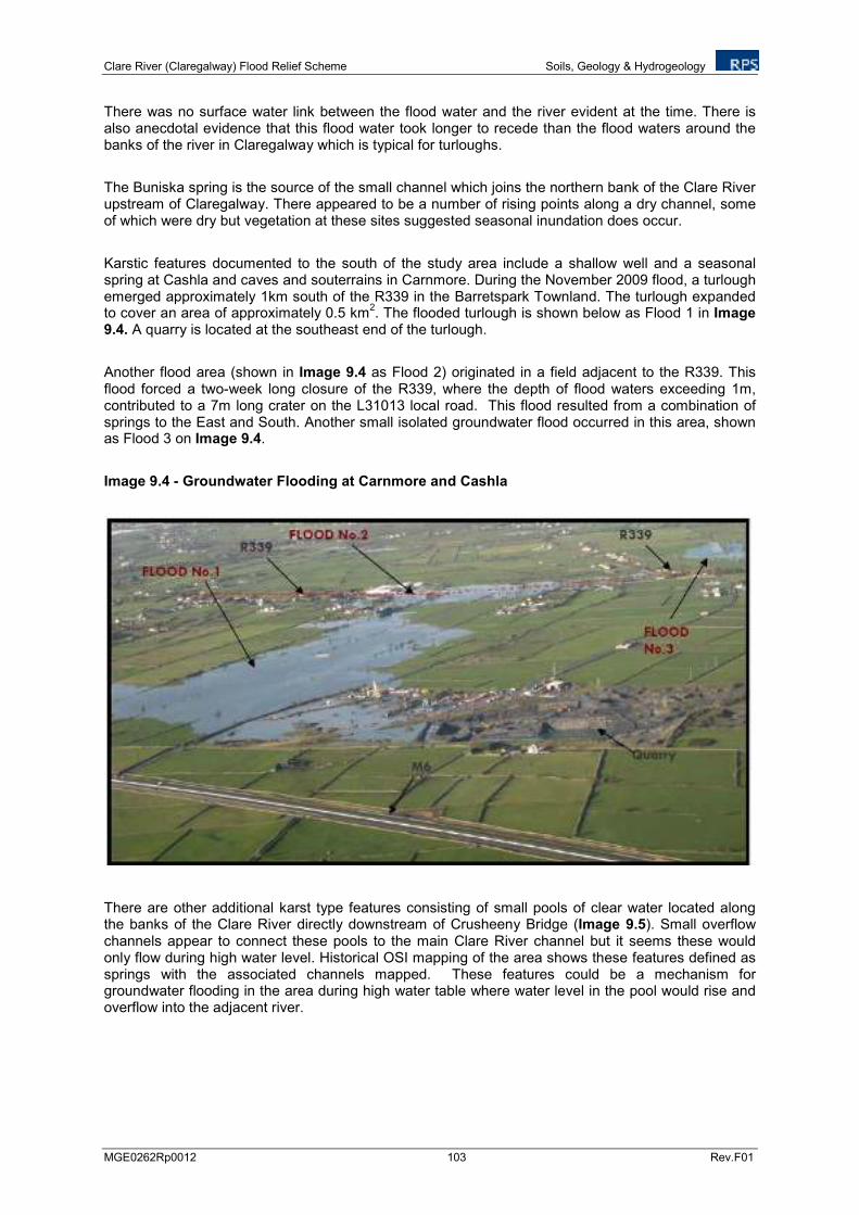
Clare River (Claregalway) Flood Relief Scheme Soils, Geology & Hydrogeology
MGE0262Rp0012 103 Rev.F01
There was no surface water link between the flood water and the river evident at the time. There is also anecdotal evidence that this flood water took longer to recede than the flood waters around the banks of the river in Claregalway which is typical for turloughs.
The Buniska spring is the source of the small channel which joins the northern bank of the Clare River upstream of Claregalway. There appeared to be a number of rising points along a dry channel, some of which were dry but vegetation at these sites suggested seasonal inundation does occur.
Karstic features documented to the south of the study area include a shallow well and a seasonal spring at Cashla and caves and souterrains in Carnmore. During the November 2009 flood, a turlough emerged approximately 1km south of the R339 in the Barretspark Townland. The turlough expanded to cover an area of approximately 0.5 km
2. The flooded turlough is shown below as Flood 1 in Image
9.4. A quarry is located at the southeast end of the turlough.
Another flood area (shown in Image 9.4 as Flood 2) originated in a field adjacent to the R339. This flood forced a two-week long closure of the R339, where the depth of flood waters exceeding 1m, contributed to a 7m long crater on the L31013 local road. This flood resulted from a combination of springs to the East and South. Another small isolated groundwater flood occurred in this area, shown as Flood 3 on Image 9.4.
Image 9.4 - Groundwater Flooding at Carnmore and Cashla
There are other additional karst type features consisting of small pools of clear water located along the banks of the Clare River directly downstream of Crusheeny Bridge (Image 9.5). Small overflow channels appear to connect these pools to the main Clare River channel but it seems these would only flow during high water level. Historical OSI mapping of the area shows these features defined as springs with the associated channels mapped. These features could be a mechanism for groundwater flooding in the area during high water table where water level in the pool would rise and overflow into the adjacent river.
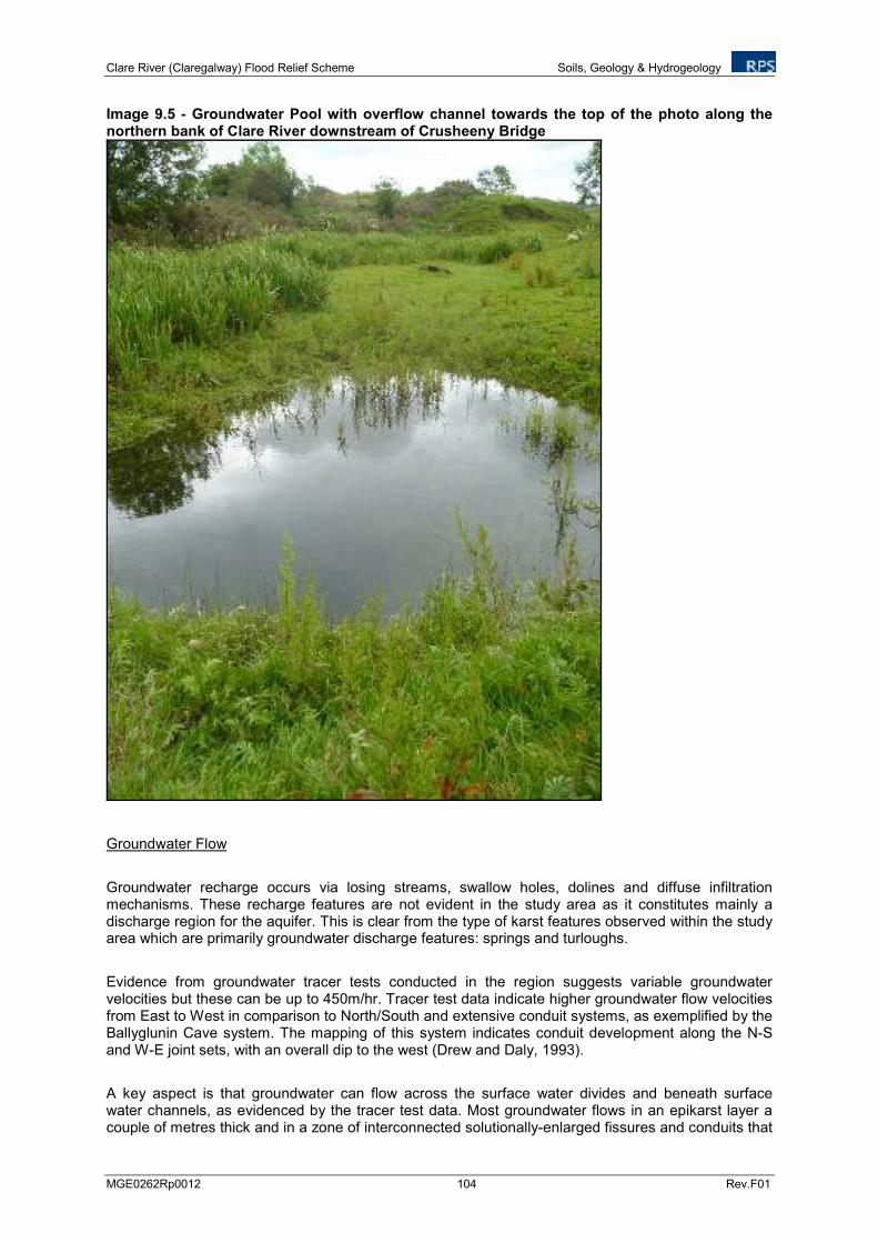
Clare River (Claregalway) Flood Relief Scheme Soils, Geology & Hydrogeology
MGE0262Rp0012 104 Rev.F01
Image 9.5 - Groundwater Pool with overflow channel towards the top of the photo along the northern bank of Clare River downstream of Crusheeny Bridge
Groundwater Flow
Groundwater recharge occurs via losing streams, swallow holes, dolines and diffuse infiltration mechanisms. These recharge features are not evident in the study area as it constitutes mainly a discharge region for the aquifer. This is clear from the type of karst features observed within the study area which are primarily groundwater discharge features: springs and turloughs.
Evidence from groundwater tracer tests conducted in the region suggests variable groundwater velocities but these can be up to 450m/hr. Tracer test data indicate higher groundwater flow velocities from East to West in comparison to North/South and extensive conduit systems, as exemplified by the Ballyglunin Cave system. The mapping of this system indicates conduit development along the N-S and W-E joint sets, with an overall dip to the west (Drew and Daly, 1993).
A key aspect is that groundwater can flow across the surface water divides and beneath surface water channels, as evidenced by the tracer test data. Most groundwater flows in an epikarst layer a couple of metres thick and in a zone of interconnected solutionally-enlarged fissures and conduits that
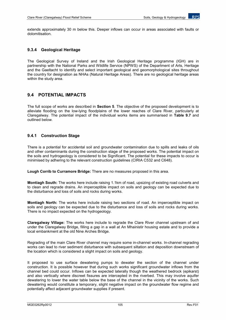
Clare River (Claregalway) Flood Relief Scheme Soils, Geology & Hydrogeology
MGE0262Rp0012 105 Rev.F01
extends approximately 30 m below this. Deeper inflows can occur in areas associated with faults or dolomitisation.
9.3.4 Geological Heritage
The Geological Survey of Ireland and the Irish Geological Heritage programme (IGH) are in partnership with the National Parks and Wildlife Service (NPWS) of the Department of Arts, Heritage and the Gaeltacht to identify and select important geological and geomorphological sites throughout the country for designation as NHAs (Natural Heritage Areas). There are no geological heritage areas within the study area.
9.4 POTENTIAL IMPACTS
The full scope of works are described in Section 5. The objective of the proposed development is to alleviate flooding on the low-lying floodplains of the lower reaches of Clare River, particularly at Claregalway. The potential impact of the individual works items are summarised in Table 9.7 and outlined below.
9.4.1 Construction Stage
There is a potential for accidental soil and groundwater contamination due to spills and leaks of oils and other contaminants during the construction stage of the proposed works. The potential impact on the soils and hydrogeology is considered to be Significant. The potential for these impacts to occur is minimised by adhering to the relevant construction guidelines (CIRIA C532 and C648).
Lough Corrib to Curramore Bridge: There are no measures proposed in this area.
Montiagh South: The works here include raising 1.1km of road, upsizing of existing road culverts and to clean and regrade drains. An imperceptible impact on soils and geology can be expected due to the disturbance and loss of soils and rocks during works.
Montiagh North: The works here include raising two sections of road. An imperceptible impact on soils and geology can be expected due to the disturbance and loss of soils and rocks during works. There is no impact expected on the hydrogeology.
Claregalway Village: The works here include to regrade the Clare River channel upstream of and under the Claregalway Bridge, filling a gap in a wall at An Mhainistir housing estate and to provide a local embankment at the old Nine Arches Bridge.
Regrading of the main Clare River channel may require some in-channel works. In-channel regrading works can lead to river sediment disturbance with subsequent siltation and deposition downstream of the location which is considered a slight impact on soils and geology.
It proposed to use surface dewatering pumps to dewater the section of the channel under construction. It is possible however that during such works significant groundwater inflows from the channel bed could occur. Inflows can be expected laterally though the weathered bedrock (epikarst) and also vertically where discreet fissures are intercepted in the riverbed. This may involve aquifer dewatering to lower the water table below the base of the channel in the vicinity of the works. Such dewatering would constitute a temporary, slight negative impact on the groundwater flow regime and potentially affect adjacent groundwater supplies if present.
Clare River (Claregalway) Flood Relief Scheme Soils, Geology & Hydrogeology
MGE0262Rp0012 106 Rev.F01
Kiniska: The works here include increasing the capacity of culverts and cleaning of OPW C3/5 stream. An imperceptible impact on soils and geology can be expected due to the disturbance and loss of soils and rocks during works. There is no impact expected on the hydrogeology.
Lakeview: The works include the installation of a surface water outlet from this area through fields and along the N17 to Clare River at Claregalway Bridge. Flooding in this area is a result of groundwater flooding which is known to occur during winter months. An imperceptible impact on soils and geology can be associated with the construction of the new outlet. There is no impact expected on the hydrogeology during construction.
Gortatleva: No additional measures proposed.
Caherlea/Lisheenavalla: Measures include replacement of Crusheeny Bridge, channel widening from Crusheeny Bridge to approximately 1.3km upstream of Crusheeny Bridge and cleaning and regrading of Islandmore OPW C3/7 and F.799/1 arterial drains.
The proposed design for channel widening works involves 3,380 m3 of material being removed from
the river bed at Claregalway bridge as part of channel deepening works. The proposed channel widening works will result in a large amount of material being removed from the banks of the Clare River. It is proposed that this material will be spread or stockpiled adjacent to the river. The approximate quantity of materials to be excavated is 88,634 m
3. This does not include the existing
spoil heaps adjacent to the river which will also need to be removed in areas where channel widening works are proposed. A further 36,854 m
3 of existing spoil heap is estimated to be removed, resulting
in a total excavation of approximately 128,868 m3 of material.
Some excavated material will be used to augment the existing embankments on the south bank of the river from Crusheeny Bridge to approximately 1.3 km upstream. The purpose of the embankment is to prevent flooding of the Caherlea/Lisheenavalla area by flood waters from the Clare River. The new embankments will generally be a maximum of 1.5 - 2m above the existing bank and will not be higher than existing spoil heaps.
The remaining material will preferentially be spread adjacent to the river on the bank. However, stockpiling or removal off site may also be required at various locations, or reuse for other aspects of the scheme or for other projects in the area.
The nature of the excavated material will be a mixture of river bed sediments, topsoil, subsoil, weathered rock and solid bedrock. Teagasc soil mapping indicates the soil type along the river where the excavation is to occur is Alluvium and Grey Brown Podzolics. The depth of the topsoil can be very thin and there is a risk that the reinstated ground may not be of a comparable quality.
Where the soil cannot be returned to a similar quality this would constitute a permanent negative impact on the soils and geology of the area. The attribute importance of the soils is considered to be medium as they are considered in general moderately drained with moderate fertility. A permanent impact on a significant proportion of the soil in the area would constitute a moderate impact on soils and geology.
Potential areas for spreading are shown in Figure 6.11. It is recommended that the material is not deposited in the vicinity of existing karst features as this could lead to subsidence and/or a disturbance of the hydrogeological system. An examination of these areas using currently available information shows there are no active karst features in the area.
The Polldonnel spring located on the northern bank of the Clare River directly downstream of Crusheeny Bridge is a significant groundwater discharge feature. Channel widening works extend directly up to this feature. Any alteration of the bank morphology directly at the feature would impact on the spring flow regime and could consitute a moderate impact on the groundwater flow system.
Clare River (Claregalway) Flood Relief Scheme Soils, Geology & Hydrogeology
MGE0262Rp0012 107 Rev.F01
Carnmore/Cashla: Proposed works include drainage of floodwater from the affected area via a new drainage pipeline/open drain to a local surface water stream at Islandmore. An imperceptible impact on soils and geology can be expected due to the disturbance and loss of soils and rocks during works. There is no construction impacts expected on the hydrogeology.
Additional consideration separate to the flood relief scheme measures: Claregalway Footbridge: An imperceptible impact on soils and geology can be expected due to the disturbance and loss of soils and rocks during works. There is no impact expected on the hydrogeology.
9.4.2 Operational Stage
Lough Corrib to Curramore Bridge: There are no measures proposed in this area.
Montiagh South: There are no potential impacts expected on soils, geology and hydrogeology.
Montiagh North: There are no potential impacts expected on soils, geology and hydrogeology.
Claregalway Village: The works here include a regrade of the Clare River channel upstream of and under the Claregalway bridge, to address a gap in a wall at An Mhainistir housing estate and to provide local embankment at the old Nine Arches bridge.
The deepening of the channel will alter the baseflow in the river channel particularly during lower flows. The water table in the vicinity will be lowered as a result of the deeper channel. This will typically result in increased groundwater flow into the river channel and improved drainage of adjacent lands. There may also be a slight impact on local groundwater users where the abstraction is from a shallow well or spring. There are no shallow wells currently documented within the vicinity of the works. Improved drainage during storm events will reduce the potential for groundwater flooding along the floodplain. This is considered a slight neutral impact on the hydrogeology. Improved soil drainage is considered a slight positive impact.
Kiniska: There are no operational impacts on soils, geology or hydrogeology expected.
Lakeview: Surface water drains are to be installed to drain some portion of the flood water but inundation will still occur during peak events.
There are no groundwater dependant ecosystems associated with these turlough features. The works will prevent regular groundwater flooding and as such constitute an alteration to groundwater levels and flow in the vicinity of the flooding but it is considered a neutral impact as this will only occur when the aquifer is saturated.
Gortatleva: No additional measures proposed
Caherlea/Lisheenavalla: Measures include channel widening from 1.3km upstream of Crusheeny Bridge to immediately downstream of Crusheeny Bridge to form a two-stage channel; cleaning and regrading of Islandmore OPW C3/7 and F.799/1 arterial drains; construction of an embankment along the southern bank of the Clare River from 1.3km upstream of Crusheeny Bridge to the Islandmore Drain and the installation of a non-return valve on the discharge from the Islandmore Drain
The proposed design for channel widening works ensures that it will not involve excavation within the existing channel (in river works) and it is not proposed to alter the existing bed levels. This method of construction means that average annual flow can be contained within the existing channel and excavation can be undertaken along the bank with minimal interference to the water quality.
Clare River (Claregalway) Flood Relief Scheme Soils, Geology & Hydrogeology
MGE0262Rp0012 108 Rev.F01
Based on this design it is expected that baseflow (groundwater contribution) to the river will only be altered during higher flows when the main channel floods. Groundwater contribution during lower flows will continue in a similar pattern as there will be minimal influence at these times. Improved drainage during storm events will reduce the potential for groundwater flooding along the floodplain and is considered a slight neutral impact.
The current design of the Islandmore OPW C3/7 arterial drain serves to prevent flooding of a turlough in the Gortatleva/Caherlea area. Cleaning and regrading of this drain will further improve drainage of the area and may be considered a slight positive impact on the soils but is not expected to have any further perceptible impact on the hydrogeological environment.
As part of this work a non-return valve will be installed at the end of the Islandmore Drain to prevent backflow of flood waters from the Clare River to the Islandmore Drain. The drain will be culverted underneath the embankment with a head wall and tide flex on the river side of the embankment. Currently during flood conditions the Clare River overflows its bank upstream of the Islandmore drain and flows into the Islandmore Drain catchment. The embankment will prevent this occurring and the non-return valve will prevent flood waters going back up the Islandmore Drain. Non-return valves will also be required on any other drains within the area scheduled for embankment (see Figure 6.12(b)).
The installation of the non-return valve on the Islandmore drain will prevent flood waters travelling back up the Islandmore channel and prevent discharge from the drain. When the valve is closed the culvert will fill and back up the water in the drain. It is possible that this could propagate a rise in the surrounding water-table as the aquifer is less able to discharge into the drain. This could possibly lead to groundwater flooding behind the embankment or in topographic lows in the area. These areas would probably have flooded as a result of inundation from the Clare River if the valve is not provided. This may therefore only constitute a change in the flooding process and possibly a reduction in frequency and magnitude.
Carnmore/Cashla: Proposed works include drainage of floodwater from the affected area via a new drainage pipeline/open drain to a local surface water stream at Islandmore.
Historically this area was a turlough; however previous drainage works have removed standing water from the turlough to the Clare River. This additional proposed drain will further improve drainage in the area and reduce the potential of groundwater flooding. The works will have a slight neutral impact on the groundwater levels in particular during flood events.
9.4.3 Claregalway Footbridge
Additional consideration separate to the flood relief scheme measures: Claregalway Footbridge: There are no operational impacts on soils, geology or hydrogeology expected.

Clare River (Claregalway) Flood Relief Scheme Soils, Geology & Hydrogeology
MGE0262Rp0012 109 Rev.F01
Table 9.7 Proposed Flood Relief Scheme Measures and Potential Impacts Area/location Proposed Measures Type Quality Duration Significance
Construction 1. Lough Corrib to Curramore Bridge
No measures proposed
Operation No Predicted Impacts
Construction Negative Permanent Imperceptible 2. Montiagh South 2a. Raise approx. 1.1 km of road
2b. Upsize existing road culvert
2c. Clean/Regrade Drains
Operation No Predicted Impacts
Construction Negative Permanent Imperceptible 3. Montiagh North 3a. Raise approx. 0.43 km of road
3b. Raise approx. 0.830 km of road Operation No Predicted Impacts
Construction Negative Temporary Slight 4. Claregalway Village 4a. Regrade Clare River channel upstream of and under the Claregalway bridge
4b. Address gap in wall at An Mhainistir housing estate
4c. Provide local embankment at old Nine Arches bridge
Operation Neutral Permanent Slight
Construction Negative Permanent Imperceptible 5. Kiniska 5a. Increase capacity of culverts on OPW C3/5 stream
5b. Clean OPW stream C3/5. Operation No Predicted Impacts
Construction Negative Permanent Imperceptible 6. Lakeview 6a. Provide surface water outlet through fields (open channel and piped culvert) to Clare River at Claregalway Bridge
Operation Neutral Permanent Slight
Construction 7. Gortatleva No additional measures proposed (Measures for Area 4 apply)
Operation No Predicted Impacts
Construction Negative Permanent Moderate 8. Caherlea/Lisheenavalla 8a. Replace Crusheeny Bridge
8b Channel widening from 1.3km upstream of Crusheeny Bridge to immediately downstream of Crusheeny Bridge to form a two-stage channel.
8c Cleaning and regrading of Islandmore OPW C3/7 and F.799/1 arterial drains
8d Raise local road in Caherlea/Lisheenavalla (Future Measure)
8e Construction of an embankment along the southern bank of the Clare River from 1.3km upstream of Crusheeny Bridge to the Islandmore Drain and the installation of a non-return valve on the discharge from the Islandmore Drain
Operation Positive Permanent Slight
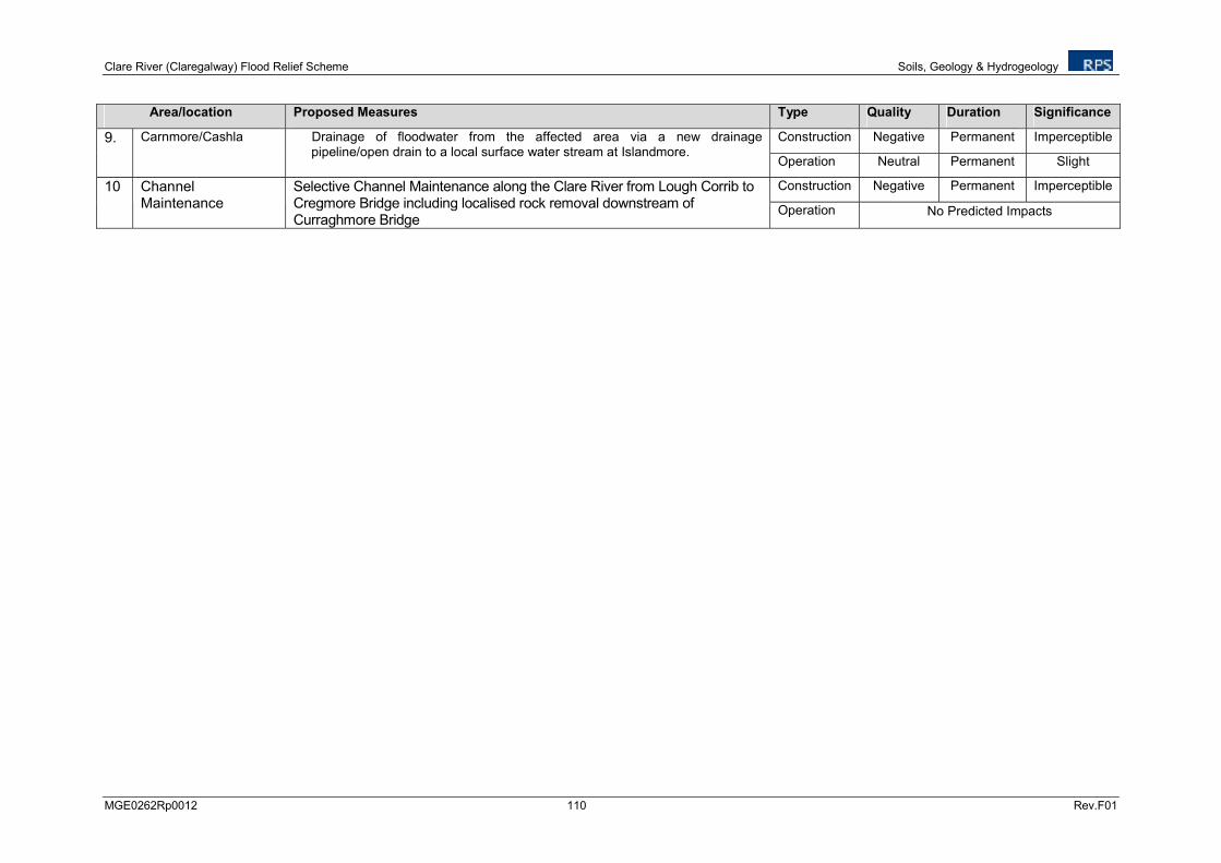
Clare River (Claregalway) Flood Relief Scheme Soils, Geology & Hydrogeology
MGE0262Rp0012 110 Rev.F01
Area/location Proposed Measures Type Quality Duration Significance
Construction Negative Permanent Imperceptible 9. Carnmore/Cashla Drainage of floodwater from the affected area via a new drainage pipeline/open drain to a local surface water stream at Islandmore.
Operation Neutral Permanent Slight
Construction Negative Permanent Imperceptible 10 Channel Maintenance
Selective Channel Maintenance along the Clare River from Lough Corrib to Cregmore Bridge including localised rock removal downstream of Curraghmore Bridge
Operation No Predicted Impacts
Clare River (Claregalway) Flood Relief Scheme Soils, Geology & Hydrogeology
MGE0262Rp0012 111 Rev.F01
9.5 MITIGATION MEASURES
9.5.1 Construction Stage
The potential negative impacts on geology and hydrogeology at construction stage are considered to be moderate to imperceptible. The existing design contains a number of mitigating measure which will ensure to minimise any impacts on the geology and hydrogeology including soil and water management.
All construction works should be completed in line with the following best practice guidelines to ensure the potential for accidental soil and groundwater contamination is minimised:
• CIRIA (Construction Industry Research and Information Association) guidance on ‘Control of Water Pollution from Construction Sites’ (CIRIA Report No C532, 2001)
• CIRIA (Construction Industry Research and Information Association) guidance on ‘Control of Water Pollution from Linear Construction Projects’ (CIRIA Report No. C648, 2006)
Where dewatering of the aquifer is required to produce a dry working environment for in channel works a local water feature survey, including private and public wells, should be completed in conjunction with a hydrogeological risk assessment to determine the potential impact on local groundwater users.
Spoil spreading of excavated materials should not be undertaken in the immediate vicinity of karst features. A large number of karst features have been documented in the region, however, the GSI karst database is incomplete and many field scale karst features are not included. Material deposition should be excluded from within 5m of any karst feature including springs, enclosed depressions (dolines), swallow holes, turloughs and caves.
Spoil spreading methodology should be completed to ensure the soil is returned to the same quality of that present before the works commenced.
The construction of the new river banks should be completed to ensure slope stability based on in-situ material. The final design of these features should be approved by a geotechnical engineer to ensure slope failure will not occur.
The construction of the bankside spoil embankments should be completed to ensure slope stability based on mixture rock and soil type used in the construction. The final design of these features should be approved by a geotechnical engineer to ensure slope failure will not occur.
9.5.2 Operational Stage
There are no operational mitigation measures with regards to soils, geology and hydrogeology.
9.6 RESIDUAL IMPACTS
There are no significant residual negative impacts expected to the soils, geology and hydrogeology. Slight negative impacts on the geology and hydrogeology are expected.
Clare River (Claregalway) Flood Relief Scheme Soils, Geology & Hydrogeology
MGE0262Rp0012 112 Rev.F01
9.7 CONCLUSIONS
The proposed flood relief works on the Clare River system will be completed in karstified limestone bedrock environment which constitutes a regionally important aquifer. The flood alleviation measures have been designed to minimize the impacts on the geology and hydrogeology of the area.
The proposed work including channel widening, channel regrading, spoil deposition and channel maintenance have been assessed to determine their potential impact on the soils, geology and hydrogeology.
There are slight to imperceptible impacts expected on the soils, geology and hydrogeology as a result of the proposed works.
Mitigation measures have been recommended in relation to the control of water pollution, aquifer dewatering for in-channel works and exclusion zones for spoil deposition surrounding karst features.
Clare River (Claregalway) Flood Relief Scheme Terrestrial Ecology
MGE0262Rp0012 113 Rev.F01
10 TERRESTRIAL ECOLOGY
10.1 INTRODUCTION
10.1.1 Scope and Objectives
This chapter of the EIS assesses the ecological value of the study area, assesses the potential impacts on the terrestrial ecology of the surrounding area and recommends mitigation measures in order to alleviate potential impacts. This assessment has been carried out in accordance with the EPA document Guidelines on Information to be contained in Environmental Impact Statements (EPA, 2002).
The principal objectives of this assessment are to:
• Complete a desk study and to obtain relevant terrestrial and aquatic ecological data for the zone of influence (ZOI) of the proposed works,
• Identify and describe sites of known or potential ecological interest, and
• Assess the significance of the likely significant impacts of the proposed flood relief scheme on each of these environmental aspects.
10.1.2 Description of the Project
Chapter 6 of this EIS outlines the Project Description.
10.2 METHODOLOGY
10.2.1 General
This assessment has been prepared in accordance with the following guidelines;
Guidelines on the information to be contained in Environmental Impact Statements (EPA 2002),
Advice Notes on current practice in the preparation of Environmental Impact Statements (EPA, 2003),
European Communities (Environmental Impact Assessment) Regulations, 1989 to 2006,
Planning and Development Act, 2000 (as amended),
Institute of Ecology and Environmental Management Draft Guidelines for Ecological Impact Assessment (IEEM 2005),
Appropriate Assessment of Plans and Projects in Ireland Guidance for Planning Authorities (DOE, 2009),
Managing Natura 2000 Sites: the provisions of Article 6 of the ‘Habitats’ Directive 92/43/EEC, Office for Official Publications of the European Communities, Luxembourg (EC, 2000),
Clare River (Claregalway) Flood Relief Scheme Terrestrial Ecology
MGE0262Rp0012 114 Rev.F01
Assessment of Plans and Projects Significantly Affecting Natura 2000 Sites: Methodological guidance on the provisions of Article 6(3) and (4) of the Habitats Directive 92/43/EEC, Office for Official Publications of the European Communities, Luxembourg (EC, 2002),
Guidance document on Article 6(4) of the 'Habitats Directive' 92/43/EEC – Clarification of the concepts of: alternative solutions, imperative reasons of overriding public interest, compensatory measures, overall coherence, opinion of the commission (EC, 2007), and
Interpretation Manual of European Union Habitats. Version EUR 27. European Commission 2007.
The methodology comprises the following elements: Desk Study, Consultation and Field Assessments. These elements are used to identify, describe and map areas of known or potential ecological value.
A review of aerial photographs of the study area was carried out prior to field visits. This exercise aimed to identify areas of low ecological value, such as; urban areas, areas under arable cultivation or areas under intensive pasture. Conversely, the review of aerial photographs was also used to identify areas of potentially high ecological value such as woodlands and wetlands, so that field survey work was targeted to focus upon these.
Site walkover surveys were undertaken by RPS ecologists along the Clare River in 2011 from the 6th
to the 10th of June, 11
th and 12
th of July, 8
th of November and on the 4
th of September 2012. Weather
conditions on most days in 2011 were dry and clear. Weather conditions on the 4th of September 2012
were showery with a high degree of cloud cover.
10.2.2 Desk Study
The sources of published material that were consulted as part of the desk study for the purposes of the EIS are as follows:
• A review of the National Parks & Wildlife Service (NPWS) natural heritage database for designated areas of ecological interest and sites of nature conservation importance within and adjacent to the study area,
• The Flora and Bird Atlas,
• NPWS Rare and Protected Species Database,
• Literature review to identify and collate relevant published information on both ecological aspects of the study area and relevant ecological studies conducted in other areas, and
• Review of Ordnance Survey maps and of aerial images where available.
The Site Synopses for the designated conservation areas within the study area produced by the NPWS contain a description of the scientific interest and conservation importance of each designated site. The Natura 2000 Data Form contains relevant background information on each of the designated sites, while the Conservation Objectives summarise the aims and objectives of the designation awarded to a particular site. All of these documents were referenced for each of the designated conservation areas.
A full desktop review was conducted of the higher plant species recorded within the Ordinance Survey (OS) National Grid Squares (10 km x 10km) within which the proposed flood relief scheme works are located. The principal source of information regarding the distribution of flora in Ireland is the New Atlas of the British & Irish Flora (Preston et al., 2002). The data included in this Atlas is from the 1987-1999 Atlas survey. The Atlas shows data for vascular plants in individual 10 km Grid Squares or ‘hectads’. The records for the relevant Grid Squares were consulted and a search was carried out to investigate if any rare or protected plant species had been recorded in the squares during the 1987-
Clare River (Claregalway) Flood Relief Scheme Terrestrial Ecology
MGE0262Rp0012 115 Rev.F01
1999 atlas survey (and previous surveys) carried out by the Botanical Society of the British Isles (BSBI). The NPWS were consulted for records of rare and protected species within the study area. The NPWS Maps and Data Database and the NPWS Rare Plants Database for all rare and protected species for the relevant Grid Squares were consulted in order to identify any legally protected or rare plant species known to be present within the study area. The desktop review also included the identification of vascular plants that are listed in Annex II of the EU Habitats Directive, Flora Protection Order (FPO) of 1999, the Wildlife Act 1976, the Irish Red Data Book (IRDB) and the NPWS Site Synopsis for designated conservation areas.
A full desktop review of bird and mammal species and populations of conservation concern within the relevant Grid Squares which are traversed or are adjacent to the proposed Clare River Flood Relief Scheme was undertaken.
‘The New Atlas of Breeding Birds in Britain and Ireland: 1988-1991’ (Gibbons et al., 1993) was consulted for information regarding the distribution of birds recorded in the relevant Grid Squares. However, it should be noted that for some species at least, more recent work has been carried out. The birds listed under Annex I which are offered special protection by the EU Birds Directive and on the Birds of Conservation Concern in Ireland (BoCCI) red list were also identified.
Those listed on the BoCCI red list meet one or more of the following criteria:
v) Their breeding population or range has declined by more than 50% in the last 25 years,
vi) Their breeding population has undergone significant decline since 1900, or
vii) They are of global conservation concern.
The Butterfly Ireland website (www.butterflyireland.com) and Irish Butterflies website (www.irishbutterflies.com) were consulted to identify the presence of any rare species within the study area including; Marsh Fritillary, Small Blue, Green Hairstreak, Purple Hairstreak, Dingy Skipper, Large Heath and Brimstone.
10.2.3 Walkover Surveys and Site Visits
Following a full desktop study of available biological information pertaining to the study area, RPS ecologists carried out ecological assessments in 2011 from the 6
th to the 10
th of June, 11
th and 12
th
July and the 8th of November. Further ecological assessments were carried out on 4
th September
2012.
These studies included:
• Habitat Surveys and Mapping,
• Mammal Surveys, and
• Aquatic Surveys.
The data collected during these surveys provided detailed information on the existing environment. The habitat mapping information is used for assessing the impacts of the proposed works on the terrestrial and aquatic environment.
Aquatic ecology and fisheries habitat surveys were carried out by Aquatic Services Unit (ASU), details of which are provided in Chapter 11.
Clare River (Claregalway) Flood Relief Scheme Terrestrial Ecology
MGE0262Rp0012 116 Rev.F01
10.2.4 Habitat Mapping
The field survey comprised an assessment of the range of habitats within the study area based on desktop and vegetation surveys. The habitats on site were classified in accordance with The Heritage Councils ‘A Guide to Habitats in Ireland’ (Fossitt, 2000) and mapped in accordance with ‘Best Practice Guidance for Habitat Survey and Mapping’ (Smith et al., 2011).
The classification is a standard scheme for identifying, describing and classifying wildlife habitats in Ireland. The classification is hierarchical and operates at three levels, outlining the correlation between its habitat categories and the phytosociological units (plant communities) of botanical classifications. Correspondence with Priority and Non Priority habitats listed in Annex I of the EU Habitats Directive (92/43/EEC) is also described. The ecological interest of the site is assessed based on whether it is of international, national, regional or local importance as this has a direct bearing on the potential magnitude and the significance of impacts. Seasonal factors that affect distribution patterns and habitats or species were taken into account when conducting the surveys and the potential of the site to support certain populations.
10.2.5 Botanical Surveys
Common, dominant and noteworthy plant species were recorded as part of the Phase 1 Habitat Survey. The impact of the proposed scheme on flora species of conservation value was assessed.
10.2.6 Birds and Mammals
During the course of the Phase 1 Habitat Survey, the birds and mammals encountered were recorded, and any bird or mammal species of conservation concern which were found were investigated and noted. Mammal signs were actively searched for in any areas of potential importance to protected mammal species such as watercourses and their banks (otter) and woodlands (badgers, bats, red squirrel and others) etc.
10.2.7 Aquatic Ecology
The aquatic ecology assessment was conducted by Aquatic Services Unit and is contained within Chapter 11.
10.2.8 Amphibians and Reptile
During the course of Phase 1 Habitat Survey the presence of common frog (Rana temporaria), smooth newt (Triturus vulgaris) and common lizard (Lacerta vivipara) was investigated and noted
within the study area.
10.2.9 Terrestrial Invertebrates
During the course of Phase 1 Habitat Survey the presence of rare invertebrates such as butterfly species and the Kerry Slug was investigated and noted within the study area.
Clare River (Claregalway) Flood Relief Scheme Terrestrial Ecology
MGE0262Rp0012 117 Rev.F01
10.2.10 Limitations in Methodology
Some limitations were encountered during the surveys due to poor or unsafe access at some locations.
10.2.11 Impact Assessment Criteria
All ecological sites were assessed according to the criteria for site evaluation outlined in the NRA ‘Guidelines for Ecological Impact Assessment of National Road Schemes’ (NRA, 2009). The geographic frame of reference which is used to determine value is provided in Table 10.1.
Table 10.1 Ecological Site Assessment Scheme
Ratings for Ecological Sites
International Importance:
- ‘European Site’ including candidate Special Area of Conservation (cSAC), Site of Community Importance (SCI), Special Protection Area (SPA) or proposed Special Area of Conservation.
- Proposed Special Protection Area (pSPA).
- Site that fulfils the criteria for designation as a ‘European Site’ (see Annex III of the Habitats Directive, as amended).
- Features essential to maintaining the coherence of the Natura 2000 Network.
- Site containing ‘best examples’ of the habitat types listed in Annex I of the Habitats Directive.
- Resident or regularly occurring populations (assessed to be important at the national level) of the following:
o Species of bird, listed in Annex I and/or referred to in Article 4(2) of the Birds Directive; and/or
o Species of animal and plants listed in Annex II and/or IV of the Habitats Directive.
- Ramsar Site (Convention on Wetlands of International Importance Especially Waterfowl Habitat 1971).
- World Heritage Site (Convention for the Protection of World Cultural & Natural Heritage, 1972).
- Biosphere Reserve (UNESCO Man & the Biosphere Programme).
- Site hosting significant species populations under the Bonn Convention (Convention on the Conservation of Migratory Species of Wild Animals, 1979).
- Site hosting significant populations under the Berne Convention (Convention on the Conservation of European Wildlife and Natural Habitats, 1979).
- Biogenetic Reserve under the Council of Europe.
- European Diploma Site under the Council of Europe.
- Salmonid water designated pursuant to the European Communities (Quality of Salmonid Waters) Regulations, 1988, (S.I. No. 293 of 1988).
National Importance:
- Site designated or proposed as a Natural Heritage Area (NHA).
- Statutory Nature Reserve.
- Refuge for Fauna and Flora protected under the Wildlife Acts.
- National Park.
- Undesignated site fulfilling the criteria for designation as a Natural Heritage Area (NHA); Statutory Nature Reserve; Refuge for Fauna and Flora protected under the Wildlife Act; and/or a National Park.
- Resident or regularly occurring populations (assessed to be important at the national level) of the following:
o Species protected under the Wildlife Acts; and/or o Species listed on the relevant Red Data list.
- Site containing ‘viable areas’ of the habitat types listed in Annex I of the Habitats Directive.
County Importance:
- Area of Special Amenity.
Clare River (Claregalway) Flood Relief Scheme Terrestrial Ecology
MGE0262Rp0012 118 Rev.F01
Ratings for Ecological Sites
- Area subject to a Tree Preservation Order.
- Area of High Amenity, or equivalent, designated under the County Development Plan.
- Resident or regularly occurring populations (assessed to be important at the County level) of the following:
o Species of bird, listed in Annex I and/or referred to in Article 4(2) of the Birds Directive;
o Species of animal and plants listed in Annex II and/or IV of the Habitats Directive;
o Species protected under the Wildlife Acts; and/or o Species listed on the relevant Red Data list.
- Site containing area or areas of the habitat types listed in Annex I of the Habitats Directive that do not fulfil the criteria for valuation as of International or National importance.
- County important populations of species or viable areas of semi-natural habitats or natural heritage features identified in the National or Local Biodiversity Action Plan (BAP), if this has been prepared.
- Sites containing semi-natural habitat types with high biodiversity in a county context and a high degree of naturalness, or populations of species that are uncommon within the county.
- Sites containing habitats and species that are rare or are undergoing a decline in quality or extent at a national level.
Local Importance (higher value):
- Locally important populations of Priority species or habitats or natural heritage features identified in the Local BAP, if this has been prepared;
- Resident or regularly occurring populations (assessed to be important at the Local level) of the following:
o Species of bird, listed in Annex I and/or referred to in Article 4(2) of the Birds Directive;
o Species of animal and plants listed in Annex II and/or IV of the Habitats Directive;
o Species protected under the Wildlife Acts; and/or o Species listed on the relevant Red Data list.
- Sites containing semi-natural habitat types with high biodiversity in a local context and a high degree of naturalness, or populations of species that are uncommon in the locality;
- Sites or features containing common or lower value habitats, including naturalised species that are nevertheless essential in maintaining links and ecological corridors between features of higher ecological value.
Local Importance (lower value):
- Sites containing small areas of semi-natural habitat that are of some local importance for wildlife;
- Sites or features containing non-native species that are of some importance in maintaining habitat links.
10.2.12 Characterising Impacts
The methodology for the assessment of impacts is derived from the Guidelines for Ecological Impact Assessment (IEEM, 2006). When describing changes/activities and impacts on ecosystem structure and function, reference should be made to the parameters, which are discussed below.
Positive or negative: Is the impact likely to be positive or negative? Positive impacts merit just as much consideration as negative ones, as international, national and local policies increasingly press for projects to deliver positive biodiversity outcomes.
Magnitude: ‘Magnitude’ should be predicted in a quantified manner wherever possible and relates to the quantum of an impact, for example the number of individuals affected by an activity.
Clare River (Claregalway) Flood Relief Scheme Terrestrial Ecology
MGE0262Rp0012 119 Rev.F01
Extent: ‘Extent’ should also be predicted in a quantified manner and relates to the area over which the impact occurs. Where the receptor is in an area of a particular plant community for example, Extent=Magnitude.
Duration: ‘Duration’ is intended to refer to the time during which the impact is predicted to continue, until recovery or re-instatement (which may be longer than the impact-causing activity). This should be quantified wherever possible, and interpreted in relation to the ecological processes involved rather than on a human timescale.
Reversibility: ‘Reversibility’ should be addressed by identifying whether an impact is ecologically reversible (either spontaneously or through specific action) and whether such an outcome is likely.
Timing and frequency: The timing of impacts in relation to important seasonal and/or life-cycle constraints should be evaluated. Similarly, the frequency with which activities (and concomitant impacts) would take place can be an important determinant of the impact on receptors and should also be assessed and described.
10.2.13 Integration of Impact Characteristics
An informed integration, for each potentially significant impact, of each of these impact characteristics is necessary in order to underpin the determination of impact significance set out below. In each case, it is important to assess the likelihood that the change will occur as anticipated and that the impact on ecological structure and function will manifest as predicted. The following scale should be applied (adapted from IEEM 2006):
− Near-certain: >95% chance of occurring as predicted,
− Probable: 50-95% chance of occurring as predicted,
− Unlikely: 5-50% chance of occurring as predicted, or
− Extremely unlikely: <5% chance of occurring as predicted.
Clare River (Claregalway) Flood Relief Scheme Terrestrial Ecology
MGE0262Rp0012 120 Rev.F01
10.3 EXISTING ENVIRONMENT
10.3.1 Designated Areas
The site synopses produced by the NPWS contains a description of the scientific interest and conservation importance of each designated site. Special Areas of Conservation (SACs) and Special Protection Areas (SPAs) are designated under the EU Habitats Directive (92/43/EEC) and the EU Birds Directive (2009/147/EC), respectively, and as such form part of the Natura 2000 network of sites. In total 11 Natura 2000 Sites, candidate Special Areas of Conservation (cSAC’s) and Special Protection Areas (SPA’s) lie within a 15km radius of the proposed works (ref. Figure 10.1 below). These are listed below:
1. Lough Corrib cSAC/pNHA (Site Code: 000297),
2. Lough Corrib SPA (Site Code: 004042),
3. Monivea Bog cSAC/pNHA (Site Code: 002352),
4. Galway Bay Complex cSAC/pNHA (Site Code: 000268),
5. Inner Galway Bay SPA (Site Code: 004031),
6. Cregganna Marsh SPA/pNHA (Site Code: 004142) and pNHA (Site Code: 000253),
7. Rahasane Turlough (cSAC/pNHA Site Code: 000322)/ SPA (Site Code: 004089),
8. Lough Fingall Complex cSAC/pNHA (Site Code: 000606),
9. Castletaylor Complex cSAC/pNHA (Site Code: 000242),
10. Ross Lake and Woods cSAC (Site Code: 001312), and
11. Gortnandarragh Limestone Pavement cSAC (Site Code: 001271)
Given that the Natura 2000 sites 5-11 do not lie within either the Clare River surface water catchment or the Clare/Corrib groundwater catchment, a reasonable assumption may be made that the proposed works will not have any direct or indirect impacts on these sites. Monivea Bog lies approximately 15km upstream of the proposed works, and so it is also assumed that this site will not be affected. Galway Bay Complex cSAC/pNHA is not directly hydrologically linked with the Clare River so it is assumed that the proposed works will not impact on this designated site.
There are a further eight Natural Heritage Areas (NHAs) and proposed Natural Heritage Areas (pNHAs) within 10km of the study area. NHAs are legally protected from damage from the date they are formally proposed for designation and pNHAs have not been statutorily proposed or designated, but do have some protection under REPS, Coillte and Planning and Licencing Authorities. The local NHAs and pNHAs include:
1. Kiltullagh Turlough pNHA (Site Code: 000287),
2. Moycullen Bogs NHA (Site Code: 002364),
3. Turlough Monaghan (Site Code: 001322),
4. Turloughcor (Site Code: 001788),
5. Ballyquirke Lough (Site Code: 000228),
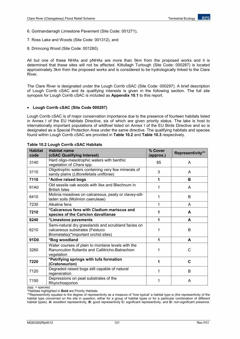
Clare River (Claregalway) Flood Relief Scheme Terrestrial Ecology
MGE0262Rp0012 121 Rev.F01
6. Gortnandarragh Limestone Pavement (Site Code: 001271),
7. Ross Lake and Woods (Site Code: 001312), and
8. Drimcong Wood (Site Code: 001260).
All but one of these NHAs and pNHAs are more than 5km from the proposed works and it is determined that these sites will not be affected. Kiltullagh Turlough (Site Code: 000287) is located approximately 3km from the proposed works and is considered to be hydrologically linked to the Clare River.
The Clare River is designated under the Lough Corrib cSAC (Site Code: 000297). A brief description of Lough Corrib cSAC and its qualifying interests is given in the following section. The full site synopsis for Lough Corrib cSAC is included as Appendix 10.1 to this report.
• Lough Corrib cSAC (Site Code 000297)
Lough Corrib cSAC is of major conservation importance due to the presence of fourteen habitats listed in Annex I of the EU Habitats Directive, six of which are given priority status. The lake is host to internationally important populations of wildfowl listed on Annex I of the EU Birds Directive and so is designated as a Special Protection Area under the same directive. The qualifying habitats and species found within Lough Corrib cSAC are provided in Table 10.2 and Table 10.3 respectively.
Table 10.2 Lough Corrib cSAC Habitats
Habitat code
Habitat name (cSAC Qualifying Interest)
% Cover (approx.)
Representivity**
3140 Hard oligo-mesotrophic waters with benthic vegetation of Chara spp.
85 A
3110 Oligotrophic waters containing very few minerals of sandy plains (Littorelletalia uniflorae)
3 A
7110 *Active raised bogs 1 B
91A0 Old sessile oak woods with Ilex and Blechnum in British Isles
1 A
6410 Molinia meadows on calcareous, peaty or clavey-silt-laden soils (Molinion caeruleae)
1 B
7230 Alkaline fens 1 A
7210 *Calcareous fens with Cladium mariscus and species of the Caricion davallianae
1 A
8240 *Limestone pavements 1 A
6210 Semi-natural dry grasslands and scrubland facies on calcareous substrates (Festuco Brometalia)(*important orchid sites)
1 B
91D0 *Bog woodland 1 A
3260 Water courses of plain to montane levels with the Ranunculion fluitantis and Callitricho-Batrachion vegetation
1 C
7220 *Petrifying springs with tufa formation (Cratoneurion)
1 C
7120 Degraded raised bogs still capable of natural regeneration
1 B
7150 Depressions on peat substrates of the Rhynchosporion
1 A
(spp. = species) *Habitats highlighted in Bold are Priority Habitats **Representivity equates to the degree of representivity as a measure of 'how typical' a habitat type is (the representivity of the habitat type concerned on the site in question, either for a group of habitat types or for a particular combination of different habitat types). A: excellent representivity, B: good representivity C: significant representivity, and D: non-significant presence.
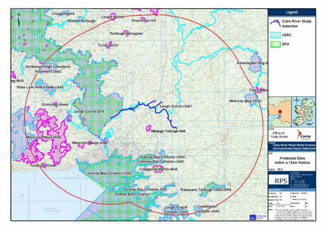
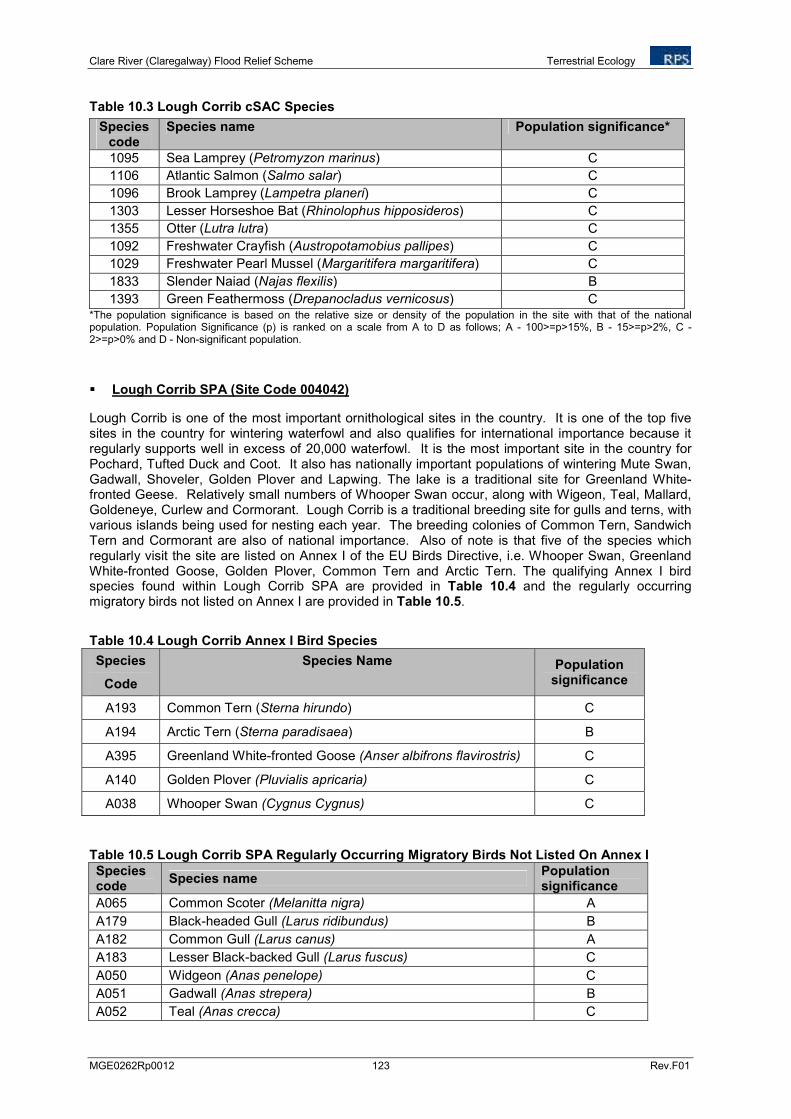
Clare River (Claregalway) Flood Relief Scheme Terrestrial Ecology
MGE0262Rp0012 123 Rev.F01
Table 10.3 Lough Corrib cSAC Species
Species code
Species name Population significance*
1095 Sea Lamprey (Petromyzon marinus) C
1106 Atlantic Salmon (Salmo salar) C
1096 Brook Lamprey (Lampetra planeri) C
1303 Lesser Horseshoe Bat (Rhinolophus hipposideros) C
1355 Otter (Lutra lutra) C
1092 Freshwater Crayfish (Austropotamobius pallipes) C
1029 Freshwater Pearl Mussel (Margaritifera margaritifera) C
1833 Slender Naiad (Najas flexilis) B
1393 Green Feathermoss (Drepanocladus vernicosus) C
*The population significance is based on the relative size or density of the population in the site with that of the national population. Population Significance (p) is ranked on a scale from A to D as follows; A - 100>=p>15%, B - 15>=p>2%, C - 2>=p>0% and D - Non-significant population.
Lough Corrib SPA (Site Code 004042)
Lough Corrib is one of the most important ornithological sites in the country. It is one of the top five sites in the country for wintering waterfowl and also qualifies for international importance because it regularly supports well in excess of 20,000 waterfowl. It is the most important site in the country for Pochard, Tufted Duck and Coot. It also has nationally important populations of wintering Mute Swan, Gadwall, Shoveler, Golden Plover and Lapwing. The lake is a traditional site for Greenland White-fronted Geese. Relatively small numbers of Whooper Swan occur, along with Wigeon, Teal, Mallard, Goldeneye, Curlew and Cormorant. Lough Corrib is a traditional breeding site for gulls and terns, with various islands being used for nesting each year. The breeding colonies of Common Tern, Sandwich Tern and Cormorant are also of national importance. Also of note is that five of the species which regularly visit the site are listed on Annex I of the EU Birds Directive, i.e. Whooper Swan, Greenland White-fronted Goose, Golden Plover, Common Tern and Arctic Tern. The qualifying Annex I bird species found within Lough Corrib SPA are provided in Table 10.4 and the regularly occurring migratory birds not listed on Annex I are provided in Table 10.5.
Table 10.4 Lough Corrib Annex I Bird Species
Species
Code
Species Name Population significance
A193 Common Tern (Sterna hirundo) C
A194 Arctic Tern (Sterna paradisaea) B
A395 Greenland White-fronted Goose (Anser albifrons flavirostris) C
A140 Golden Plover (Pluvialis apricaria) C
A038 Whooper Swan (Cygnus Cygnus) C
Table 10.5 Lough Corrib SPA Regularly Occurring Migratory Birds Not Listed On Annex I
Species code
Species name Population significance
A065 Common Scoter (Melanitta nigra) A
A179 Black-headed Gull (Larus ridibundus) B
A182 Common Gull (Larus canus) A
A183 Lesser Black-backed Gull (Larus fuscus) C
A050 Widgeon (Anas penelope) C
A051 Gadwall (Anas strepera) B
A052 Teal (Anas crecca) C
Clare River (Claregalway) Flood Relief Scheme Terrestrial Ecology
MGE0262Rp0012 124 Rev.F01
Species code
Species name Population significance
A053 Mallard (Anas platyrhynchos) C
A056 Shoveler (Anas clypeata) B
A059 Pochard (Aythya ferina) A
A061 Tufted duck (Aythya fuligula) B
A067 Goldeneye (Bucephala clangula) C
A125 Coot (Fulica atra) A
A142 Lapwing(Vanellus vanellus) C
A160 Curlew (Numenius arquata) C
A017 Cormorant (Phalacrocorax carbo) C
• Kiltullagh Turlough pNHA (Site Code: 000287)
Kiltullagh Turlough pNHA is located approximately 3km from the proposed works. Kiltullagh Turlough lies close to Galway airport, north-east of Galway City. It is a flat linear basin running north-east to south-west, deepening at its southern end. A few boulders occur along the edges, but it has the general appearance of a grassy field. The majority of the turlough is covered by pasture with Tormentil (Potentilla erecta) and Sea Plantain (Plantago maritima) at the edges. On deeper soil Common Sedge (Carex nigra) is present. The lower ground contains Creeping Cinquefoil (Potentilla reptans), while the spring at the south end is partly grown over by Small Sweet-grass (Glyceria declinata). The entire area is grazed closely by cattle and sheep. Kiltullagh Turlough is at the dry extreme of turloughs, and has a large proportion of dry grassland. The turlough is in the catchment of the Clare River and may therefore potentially be impacted by the flood relief scheme. This would explain the preponderance of a dry vegetation type and if true, reduces the level of ecological interest at the site. It is possible however that it is a natural phenomenon, in which case the site is quite unusual.
10.3.2 NPWS Rare and Protected Species Records
The NPWS Rare and Protected Species database was consulted for records on species of conservation importance in the area. The site for the proposed development lies within the 10km Grid squares (hectads) M33, M43 and M44. According to this database, there are records for twenty-eight rare and protected species within the three grid squares. However, the NPWS dataset is known to be incomplete, particularly for fish, bats and birds, and so the absence of records for a species does not necessarily mean that the species does not occur in the area.
The relevant hectads are shown in Figure 10.2. Rare and protected species recorded within these squares are shown in Table 10.6.
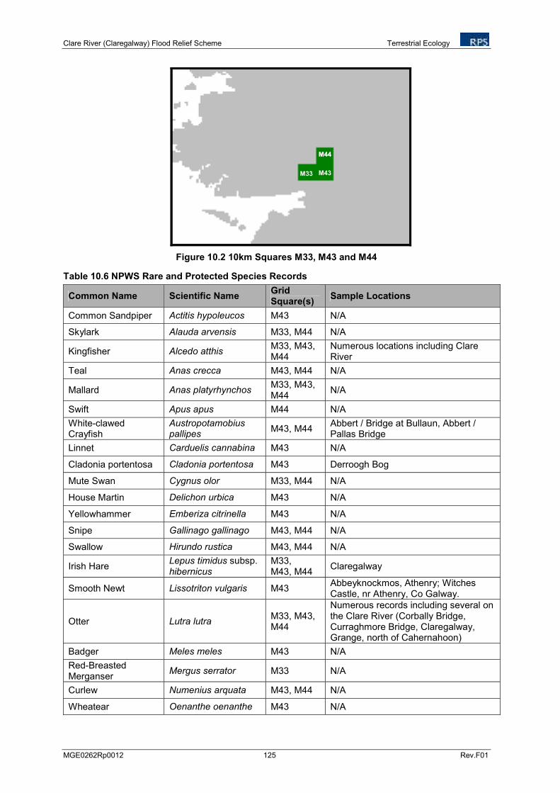
Clare River (Claregalway) Flood Relief Scheme Terrestrial Ecology
MGE0262Rp0012 125 Rev.F01
Figure 10.2 10km Squares M33, M43 and M44
Table 10.6 NPWS Rare and Protected Species Records
Common Name Scientific Name Grid Square(s)
Sample Locations
Common Sandpiper Actitis hypoleucos M43 N/A
Skylark Alauda arvensis M33, M44 N/A
Kingfisher Alcedo atthis M33, M43, M44
Numerous locations including Clare River
Teal Anas crecca M43, M44 N/A
Mallard Anas platyrhynchos M33, M43, M44
N/A
Swift Apus apus M44 N/A
White-clawed Crayfish
Austropotamobius pallipes
M43, M44 Abbert / Bridge at Bullaun, Abbert / Pallas Bridge
Linnet Carduelis cannabina M43 N/A
Cladonia portentosa Cladonia portentosa M43 Derroogh Bog
Mute Swan Cygnus olor M33, M44 N/A
House Martin Delichon urbica M43 N/A
Yellowhammer Emberiza citrinella M43 N/A
Snipe Gallinago gallinago M43, M44 N/A
Swallow Hirundo rustica M43, M44 N/A
Irish Hare Lepus timidus subsp. hibernicus
M33, M43, M44
Claregalway
Smooth Newt Lissotriton vulgaris M43 Abbeyknockmos, Athenry; Witches Castle, nr Athenry, Co Galway.
Otter Lutra lutra M33, M43, M44
Numerous records including several on the Clare River (Corbally Bridge, Curraghmore Bridge, Claregalway, Grange, north of Cahernahoon)
Badger Meles meles M43 N/A
Red-Breasted Merganser
Mergus serrator M33 N/A
Curlew Numenius arquata M43, M44 N/A
Wheatear Oenanthe oenanthe M43 N/A
M33
MM4444
M43

Clare River (Claregalway) Flood Relief Scheme Terrestrial Ecology
MGE0262Rp0012 126 Rev.F01
Common Name Scientific Name Grid Square(s)
Sample Locations
Cormorant Phalacrocorax carbo M33, M43, M44
N/A
Golden Plover Pluvialis apricaria M43, M44 N/A
Small-White Orchid Pseudorchis albida M43 Grange East
Common Frog Rana temporaria M33, M43, M44
Claregalway; Abbeyknockmos Pond, Athenry; Cloona Bog; Addergoole Fen East.
Sand Martin Riparia riparia M33, M43, M44
N/A
Atlantic Salmon Salmo salar M43 Clare River near Grange
Wood Bitter-vetch Vicia orobus M43 Grange East, Creg East, Coolaran.
10.3.3 Terrestrial Invertebrate Data
10.3.3.1 Lepidoptera
There is one record of Marsh Fritillary from M33 from a 2000-2009 survey as detailed on the Butterfly Ireland website. The NPWS have no records in the area. The Marsh Fritillary is the only species which is afforded legal protection, as part of Annex II of the EU Habitats Directive. This species, whose food plant is Devil’s Bit Scabious (Succisa pratensis), has become endangered due to the destruction of its boggy habitat.
10.3.3.2 Bird Atlas Data
The New Atlas of Breeding Birds in Britain and Ireland: 1988-1991 (Gibbons et. al., 1993) was consulted for information on breeding birds recorded within 10km grid squares M33, M43, and M44 within which the study area is located. Table 10.7 presents details of bird species of high conservation concern recorded as breeding within 10km Grid Squares M33, M43, and M44 and during the 1988-1991 survey. The following sources of information were consulted in order to determine the conservation status of bird species:
• Annex I of the EU ‘Birds Directive’,
• The ‘Red List’ of Birds of Conservation Concern in Ireland (BoCCI) (Lynas et. al. 2007), and,
• The Irish Red Data Book (RDB) (Whilde 1993).
Table 10.7 Bird Species of High Conservation Concern Recorded by Gibbons et. al. (1993) From 10km National Grid Squares M33, M43, and M44.
Species Qualification for ‘High Conservation Concern’ status
Breeding status in OS 10km square M33
Breeding status in OS 10km square M43
Breeding status in OS 10km square M44
Shoveler (Anas clypeata)
Red Data Book ‘Endangered’ ConfirmedNot recorded
Not recorded
Clare River (Claregalway) Flood Relief Scheme Terrestrial Ecology
MGE0262Rp0012 127 Rev.F01
Species Qualification for ‘High Conservation Concern’ status
Breeding status in OS 10km square M33
Breeding status in OS 10km square M43
Breeding status in OS 10km square M44
Hen Harrier (Circus ayaneus)
EU Bird’s Directive Annex I; Red Data Book ‘Endangered’
Not recorded
Not recorded
Confirmed
Merlin (Falco colombarius)
EU Bird’s Directive Annex I; Red Data Book ‘Rare’
ConfirmedNot recorded
Not recorded
Lapwing (Vanellus vanellus)
Red Data Book ‘Vulnerable’ ConfirmedNot recorded
Not recorded
Curlew (Numenius arquata)
BoCCI, Red List Confirmed
Not recorded
Not recorded
Redshank (Tringa totanus)
BoCCI, Red List Confirmed
Not recorded
Not recorded
Black headed Gull (Larus ridibundus)
BoCCI, Amber List Confirmed
Not recorded
Not recorded
Barn Owl (Tyto alba) BoCCI, Red List Red Data Book ‘Indeterminate’
ConfirmedNot recorded
Confirmed
*Kingfisher (Alcedo atthis)
EU Bird’s Directive Annex I Confirmed Confirmed Confirmed
Yellow Hammer (Emberiza citrinella)
BoCCI, Red List ConfirmedNot recorded
Not recorded
*Kingfisher nests and activity were recorded during a Kingfisher Survey undertaken on behalf of NPWS (see NPWS 2010).
Three bird species are recorded as breeding within Grid Squares M33, M43, and M44 during the 1988-1991 survey are protected under Annex I of the EU Birds Directive; Hen Harrier, Merlin, and Kingfisher. The breeding habitat preferences of these species are discussed below.
Hen Harriers are confined to moorland and young forestry plantations, where they nest on the ground during the breeding season. Hen Harriers mainly hunt over moorland whilst breeding where they take ground nesting birds and mammals.
Merlin is a rare breeding bird in Ireland. This species nests on the ground on moorland, mountain and blanket bog. It also nests in woodland and in forestry plantations adjacent to moorland.
Barn Owl and Yellow Hammer are found in lowland farmland with associated trees, hedgerows and scrub.
Kingfisher breed in earth banks near slow flowing water.
The species listed on the BoCCI Red and Amber List, Shovler, Redshank and Blackheaded Gull are associated with the lake habitats and islands of Lough Corrib.
‘The Atlas of Wintering Birds in Britain and Ireland (Lack, 1986) was consulted for information on wintering birds recorded within 10km grid squares M33, M43, and M44 within which the study area is located. Table 10.8 presents details of bird species of high conservation concern recorded as wintering within 10km Grid Squares M33, M43, and M44.
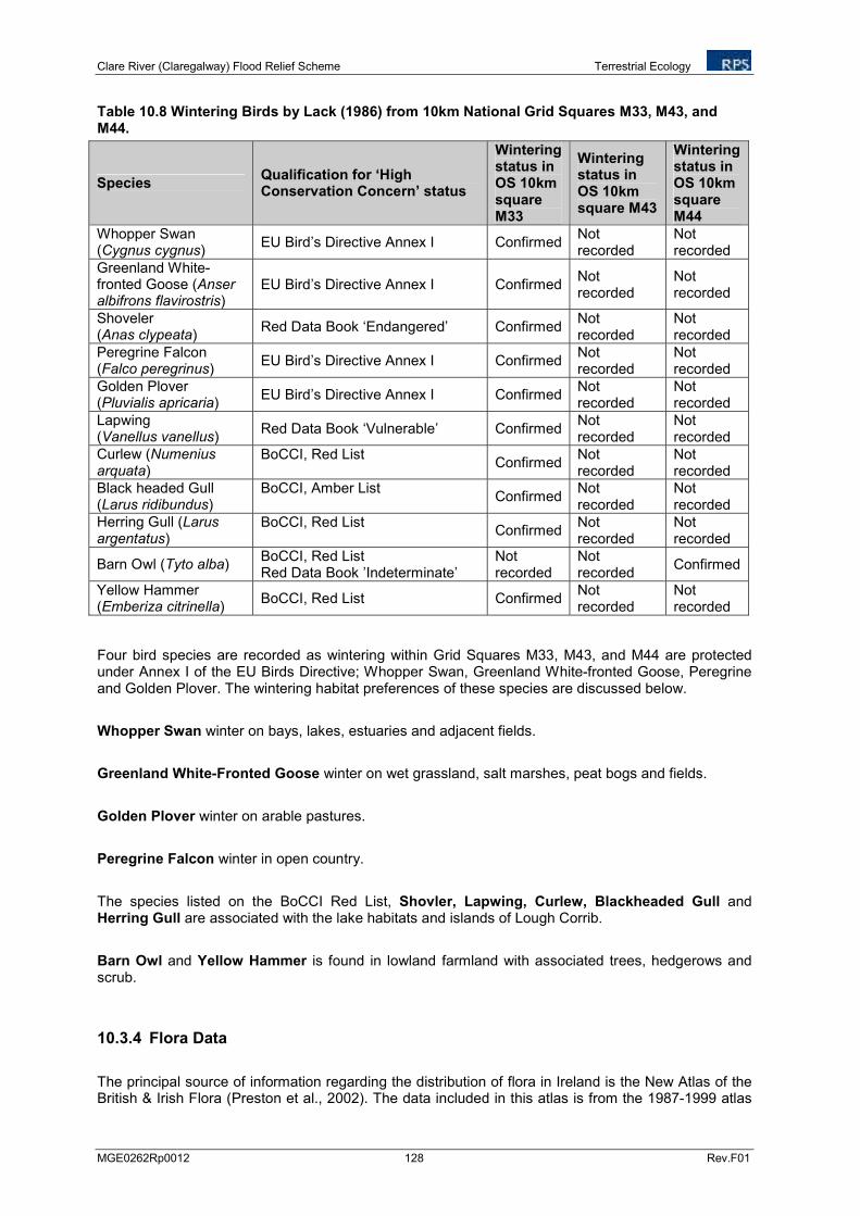
Clare River (Claregalway) Flood Relief Scheme Terrestrial Ecology
MGE0262Rp0012 128 Rev.F01
Table 10.8 Wintering Birds by Lack (1986) from 10km National Grid Squares M33, M43, and M44.
Species Qualification for ‘High Conservation Concern’ status
Wintering status in OS 10km square M33
Wintering status in OS 10km square M43
Wintering status in OS 10km square M44
Whopper Swan (Cygnus cygnus)
EU Bird’s Directive Annex I ConfirmedNot recorded
Not recorded
Greenland White- fronted Goose (Anser albifrons flavirostris)
EU Bird’s Directive Annex I ConfirmedNot recorded
Not recorded
Shoveler (Anas clypeata)
Red Data Book ‘Endangered’ ConfirmedNot recorded
Not recorded
Peregrine Falcon (Falco peregrinus)
EU Bird’s Directive Annex I ConfirmedNot recorded
Not recorded
Golden Plover (Pluvialis apricaria)
EU Bird’s Directive Annex I ConfirmedNot recorded
Not recorded
Lapwing (Vanellus vanellus)
Red Data Book ‘Vulnerable’ ConfirmedNot recorded
Not recorded
Curlew (Numenius arquata)
BoCCI, Red List Confirmed
Not recorded
Not recorded
Black headed Gull (Larus ridibundus)
BoCCI, Amber List Confirmed
Not recorded
Not recorded
Herring Gull (Larus argentatus)
BoCCI, Red List Confirmed
Not recorded
Not recorded
Barn Owl (Tyto alba) BoCCI, Red List Red Data Book ’Indeterminate’
Not recorded
Not recorded
Confirmed
Yellow Hammer (Emberiza citrinella)
BoCCI, Red List ConfirmedNot recorded
Not recorded
Four bird species are recorded as wintering within Grid Squares M33, M43, and M44 are protected under Annex I of the EU Birds Directive; Whopper Swan, Greenland White-fronted Goose, Peregrine and Golden Plover. The wintering habitat preferences of these species are discussed below.
Whopper Swan winter on bays, lakes, estuaries and adjacent fields.
Greenland White-Fronted Goose winter on wet grassland, salt marshes, peat bogs and fields.
Golden Plover winter on arable pastures.
Peregrine Falcon winter in open country.
The species listed on the BoCCI Red List, Shovler, Lapwing, Curlew, Blackheaded Gull and Herring Gull are associated with the lake habitats and islands of Lough Corrib.
Barn Owl and Yellow Hammer is found in lowland farmland with associated trees, hedgerows and scrub.
10.3.4 Flora Data
The principal source of information regarding the distribution of flora in Ireland is the New Atlas of the British & Irish Flora (Preston et al., 2002). The data included in this atlas is from the 1987-1999 atlas
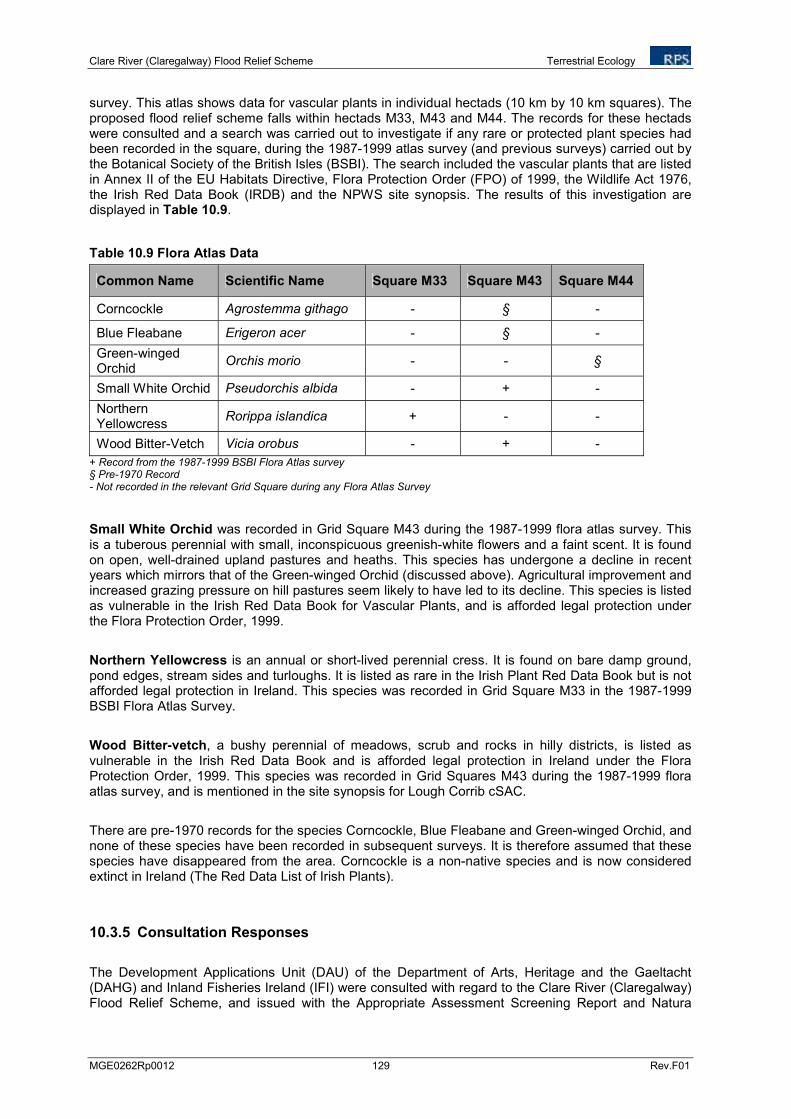
Clare River (Claregalway) Flood Relief Scheme Terrestrial Ecology
MGE0262Rp0012 129 Rev.F01
survey. This atlas shows data for vascular plants in individual hectads (10 km by 10 km squares). The proposed flood relief scheme falls within hectads M33, M43 and M44. The records for these hectads were consulted and a search was carried out to investigate if any rare or protected plant species had been recorded in the square, during the 1987-1999 atlas survey (and previous surveys) carried out by the Botanical Society of the British Isles (BSBI). The search included the vascular plants that are listed in Annex II of the EU Habitats Directive, Flora Protection Order (FPO) of 1999, the Wildlife Act 1976, the Irish Red Data Book (IRDB) and the NPWS site synopsis. The results of this investigation are displayed in Table 10.9.
Table 10.9 Flora Atlas Data
Common Name Scientific Name Square M33 Square M43 Square M44
Corncockle Agrostemma githago - § -
Blue Fleabane Erigeron acer - § -
Green-winged Orchid
Orchis morio - - §
Small White Orchid Pseudorchis albida - + -
Northern Yellowcress
Rorippa islandica + - -
Wood Bitter-Vetch Vicia orobus - + -
+ Record from the 1987-1999 BSBI Flora Atlas survey § Pre-1970 Record - Not recorded in the relevant Grid Square during any Flora Atlas Survey
Small White Orchid was recorded in Grid Square M43 during the 1987-1999 flora atlas survey. This is a tuberous perennial with small, inconspicuous greenish-white flowers and a faint scent. It is found on open, well-drained upland pastures and heaths. This species has undergone a decline in recent years which mirrors that of the Green-winged Orchid (discussed above). Agricultural improvement and increased grazing pressure on hill pastures seem likely to have led to its decline. This species is listed as vulnerable in the Irish Red Data Book for Vascular Plants, and is afforded legal protection under the Flora Protection Order, 1999.
Northern Yellowcress is an annual or short-lived perennial cress. It is found on bare damp ground, pond edges, stream sides and turloughs. It is listed as rare in the Irish Plant Red Data Book but is not afforded legal protection in Ireland. This species was recorded in Grid Square M33 in the 1987-1999 BSBI Flora Atlas Survey.
Wood Bitter-vetch, a bushy perennial of meadows, scrub and rocks in hilly districts, is listed as vulnerable in the Irish Red Data Book and is afforded legal protection in Ireland under the Flora Protection Order, 1999. This species was recorded in Grid Squares M43 during the 1987-1999 flora atlas survey, and is mentioned in the site synopsis for Lough Corrib cSAC.
There are pre-1970 records for the species Corncockle, Blue Fleabane and Green-winged Orchid, and none of these species have been recorded in subsequent surveys. It is therefore assumed that these species have disappeared from the area. Corncockle is a non-native species and is now considered extinct in Ireland (The Red Data List of Irish Plants).
10.3.5 Consultation Responses
The Development Applications Unit (DAU) of the Department of Arts, Heritage and the Gaeltacht (DAHG) and Inland Fisheries Ireland (IFI) were consulted with regard to the Clare River (Claregalway) Flood Relief Scheme, and issued with the Appropriate Assessment Screening Report and Natura
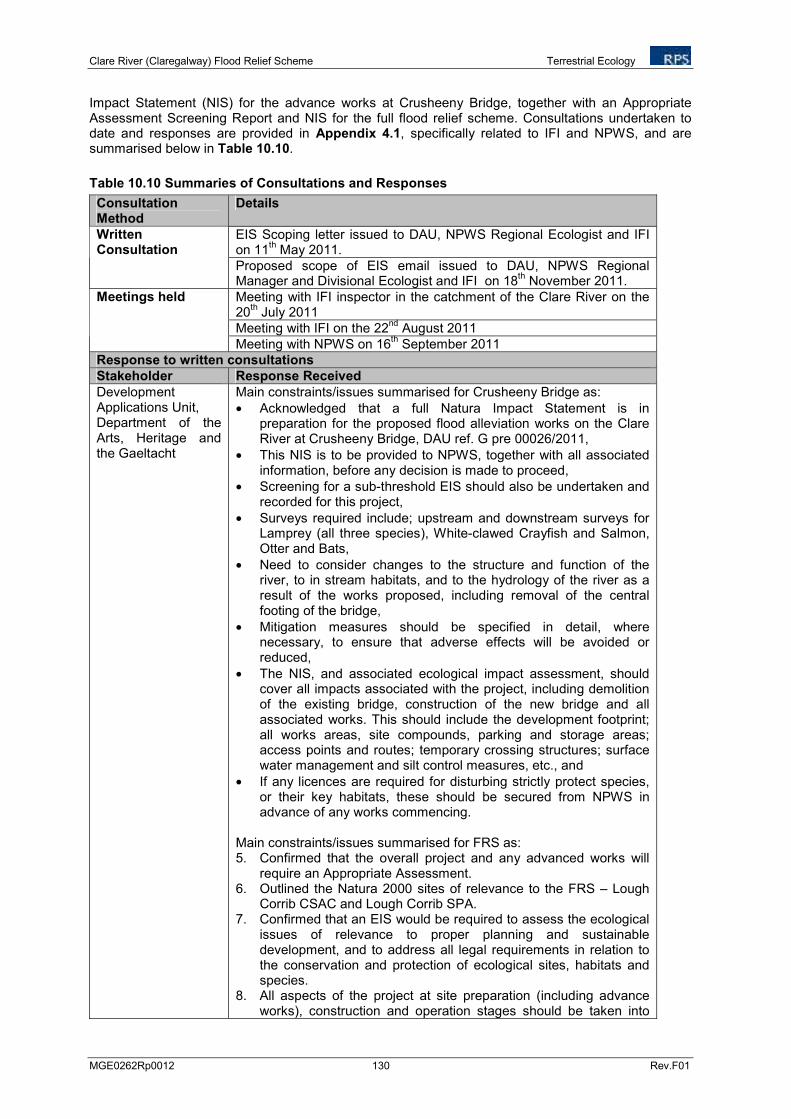
Clare River (Claregalway) Flood Relief Scheme Terrestrial Ecology
MGE0262Rp0012 130 Rev.F01
Impact Statement (NIS) for the advance works at Crusheeny Bridge, together with an Appropriate Assessment Screening Report and NIS for the full flood relief scheme. Consultations undertaken to date and responses are provided in Appendix 4.1, specifically related to IFI and NPWS, and are summarised below in Table 10.10.
Table 10.10 Summaries of Consultations and Responses
Consultation Method
Details
EIS Scoping letter issued to DAU, NPWS Regional Ecologist and IFI on 11
th May 2011.
Written Consultation
Proposed scope of EIS email issued to DAU, NPWS Regional Manager and Divisional Ecologist and IFI on 18
th November 2011.
Meeting with IFI inspector in the catchment of the Clare River on the 20
th July 2011
Meeting with IFI on the 22nd
August 2011
Meetings held
Meeting with NPWS on 16th September 2011
Response to written consultations
Stakeholder Response Received
Development Applications Unit, Department of the Arts, Heritage and the Gaeltacht
Main constraints/issues summarised for Crusheeny Bridge as:
• Acknowledged that a full Natura Impact Statement is in preparation for the proposed flood alleviation works on the Clare River at Crusheeny Bridge, DAU ref. G pre 00026/2011,
• This NIS is to be provided to NPWS, together with all associated information, before any decision is made to proceed,
• Screening for a sub-threshold EIS should also be undertaken and recorded for this project,
• Surveys required include; upstream and downstream surveys for Lamprey (all three species), White-clawed Crayfish and Salmon, Otter and Bats,
• Need to consider changes to the structure and function of the river, to in stream habitats, and to the hydrology of the river as a result of the works proposed, including removal of the central footing of the bridge,
• Mitigation measures should be specified in detail, where necessary, to ensure that adverse effects will be avoided or reduced,
• The NIS, and associated ecological impact assessment, should cover all impacts associated with the project, including demolition of the existing bridge, construction of the new bridge and all associated works. This should include the development footprint; all works areas, site compounds, parking and storage areas; access points and routes; temporary crossing structures; surface water management and silt control measures, etc., and
• If any licences are required for disturbing strictly protect species, or their key habitats, these should be secured from NPWS in advance of any works commencing.
Main constraints/issues summarised for FRS as: 5. Confirmed that the overall project and any advanced works will
require an Appropriate Assessment. 6. Outlined the Natura 2000 sites of relevance to the FRS – Lough
Corrib CSAC and Lough Corrib SPA. 7. Confirmed that an EIS would be required to assess the ecological
issues of relevance to proper planning and sustainable development, and to address all legal requirements in relation to the conservation and protection of ecological sites, habitats and species.
8. All aspects of the project at site preparation (including advance works), construction and operation stages should be taken into
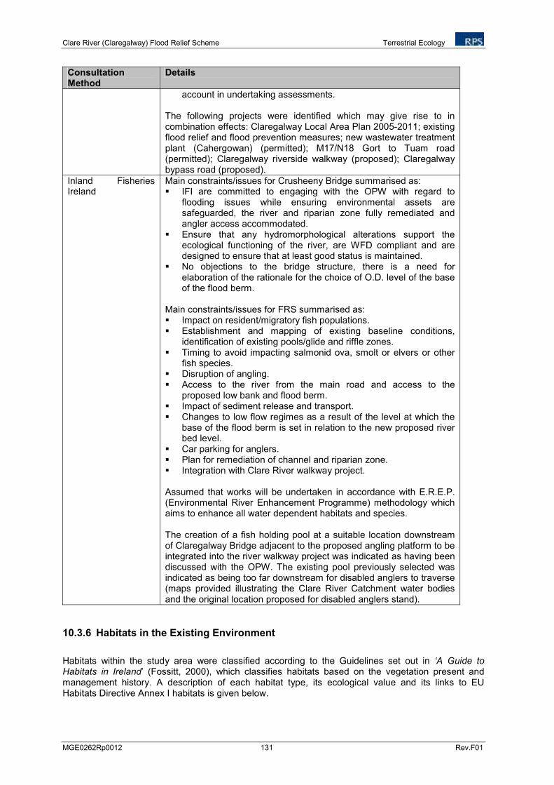
Clare River (Claregalway) Flood Relief Scheme Terrestrial Ecology
MGE0262Rp0012 131 Rev.F01
Consultation Method
Details
account in undertaking assessments. The following projects were identified which may give rise to in combination effects: Claregalway Local Area Plan 2005-2011; existing flood relief and flood prevention measures; new wastewater treatment plant (Cahergowan) (permitted); M17/N18 Gort to Tuam road (permitted); Claregalway riverside walkway (proposed); Claregalway bypass road (proposed).
Inland Fisheries Ireland
Main constraints/issues for Crusheeny Bridge summarised as: IFI are committed to engaging with the OPW with regard to
flooding issues while ensuring environmental assets are safeguarded, the river and riparian zone fully remediated and angler access accommodated.
Ensure that any hydromorphological alterations support the ecological functioning of the river, are WFD compliant and are designed to ensure that at least good status is maintained.
No objections to the bridge structure, there is a need for elaboration of the rationale for the choice of O.D. level of the base of the flood berm.
Main constraints/issues for FRS summarised as: Impact on resident/migratory fish populations. Establishment and mapping of existing baseline conditions,
identification of existing pools/glide and riffle zones. Timing to avoid impacting salmonid ova, smolt or elvers or other
fish species. Disruption of angling. Access to the river from the main road and access to the
proposed low bank and flood berm. Impact of sediment release and transport. Changes to low flow regimes as a result of the level at which the
base of the flood berm is set in relation to the new proposed river bed level.
Car parking for anglers. Plan for remediation of channel and riparian zone. Integration with Clare River walkway project.
Assumed that works will be undertaken in accordance with E.R.E.P. (Environmental River Enhancement Programme) methodology which aims to enhance all water dependent habitats and species. The creation of a fish holding pool at a suitable location downstream of Claregalway Bridge adjacent to the proposed angling platform to be integrated into the river walkway project was indicated as having been discussed with the OPW. The existing pool previously selected was indicated as being too far downstream for disabled anglers to traverse (maps provided illustrating the Clare River Catchment water bodies and the original location proposed for disabled anglers stand).
10.3.6 Habitats in the Existing Environment
Habitats within the study area were classified according to the Guidelines set out in ‘A Guide to Habitats in Ireland’ (Fossitt, 2000), which classifies habitats based on the vegetation present and management history. A description of each habitat type, its ecological value and its links to EU Habitats Directive Annex I habitats is given below.
Clare River (Claregalway) Flood Relief Scheme Terrestrial Ecology
MGE0262Rp0012 132 Rev.F01
The distribution of these habitats within the study area is illustrated in Figure 10.3 Habitat Map.
The habitats found within the zone of influence of the project and their corresponding habitat codes in accordance with ‘Fossitt Level 3, and habitats which correspond to Annex I habitats, are listed in Table 10.11. Those which correspond to Annex I Habitats or which support Annex II species are in italics and highlighted in bold. The area of each habitat impacted Measure 8b and land impacted by Measure 8b within the cSAC, i.e. either removed through river widening or infilled through landspreading, both outside and within the cSAC is listed in Table 10.11.
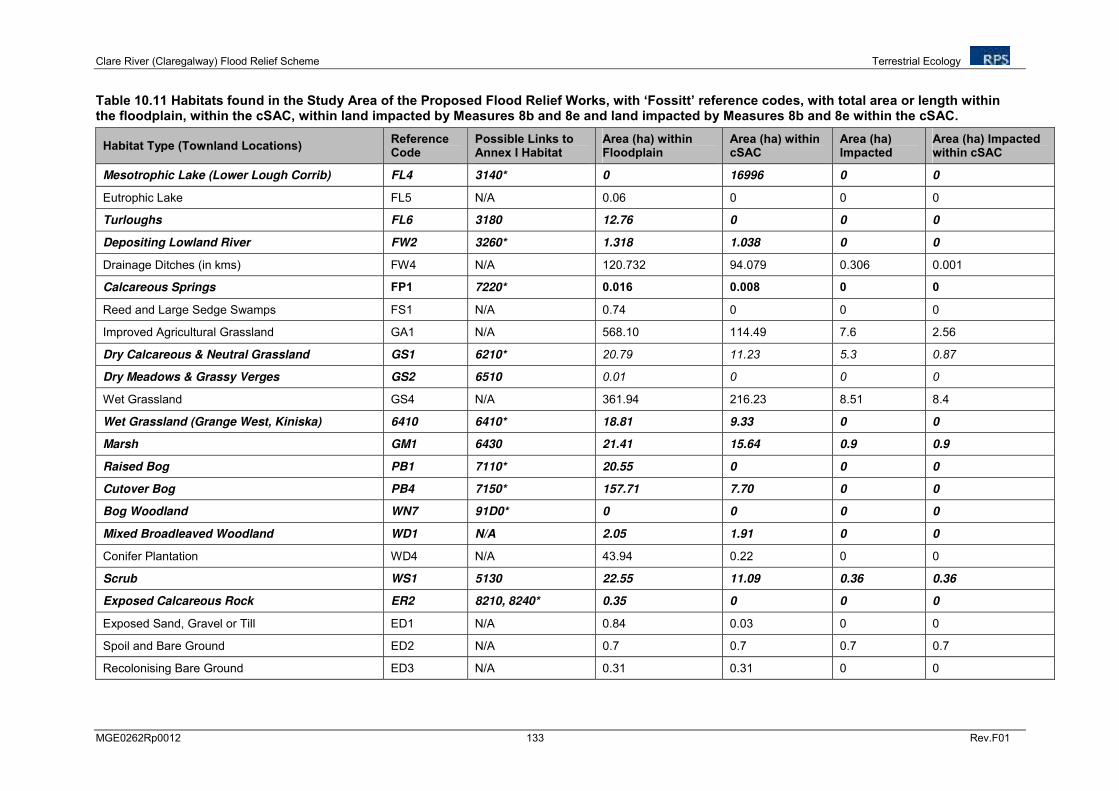
Clare River (Claregalway) Flood Relief Scheme Terrestrial Ecology
MGE0262Rp0012 133 Rev.F01
Table 10.11 Habitats found in the Study Area of the Proposed Flood Relief Works, with ‘Fossitt’ reference codes, with total area or length within the floodplain, within the cSAC, within land impacted by Measures 8b and 8e and land impacted by Measures 8b and 8e within the cSAC.
Habitat Type (Townland Locations) Reference Code
Possible Links to Annex I Habitat
Area (ha) within Floodplain
Area (ha) within cSAC
Area (ha) Impacted
Area (ha) Impacted within cSAC
Mesotrophic Lake (Lower Lough Corrib) FL4 3140* 0 16996 0 0
Eutrophic Lake FL5 N/A 0.06 0 0 0
Turloughs FL6 3180 12.76 0 0 0
Depositing Lowland River FW2 3260* 1.318 1.038 0 0
Drainage Ditches (in kms) FW4 N/A 120.732 94.079 0.306 0.001
Calcareous Springs FP1 7220* 0.016 0.008 0 0
Reed and Large Sedge Swamps FS1 N/A 0.74 0 0 0
Improved Agricultural Grassland GA1 N/A 568.10 114.49 7.6 2.56
Dry Calcareous & Neutral Grassland GS1 6210* 20.79 11.23 5.3 0.87
Dry Meadows & Grassy Verges GS2 6510 0.01 0 0 0
Wet Grassland GS4 N/A 361.94 216.23 8.51 8.4
Wet Grassland (Grange West, Kiniska) 6410 6410* 18.81 9.33 0 0
Marsh GM1 6430 21.41 15.64 0.9 0.9
Raised Bog PB1 7110* 20.55 0 0 0
Cutover Bog PB4 7150* 157.71 7.70 0 0
Bog Woodland WN7 91D0* 0 0 0 0
Mixed Broadleaved Woodland WD1 N/A 2.05 1.91 0 0
Conifer Plantation WD4 N/A 43.94 0.22 0 0
Scrub WS1 5130 22.55 11.09 0.36 0.36
Exposed Calcareous Rock ER2 8210, 8240* 0.35 0 0 0
Exposed Sand, Gravel or Till ED1 N/A 0.84 0.03 0 0
Spoil and Bare Ground ED2 N/A 0.7 0.7 0.7 0.7
Recolonising Bare Ground ED3 N/A 0.31 0.31 0 0
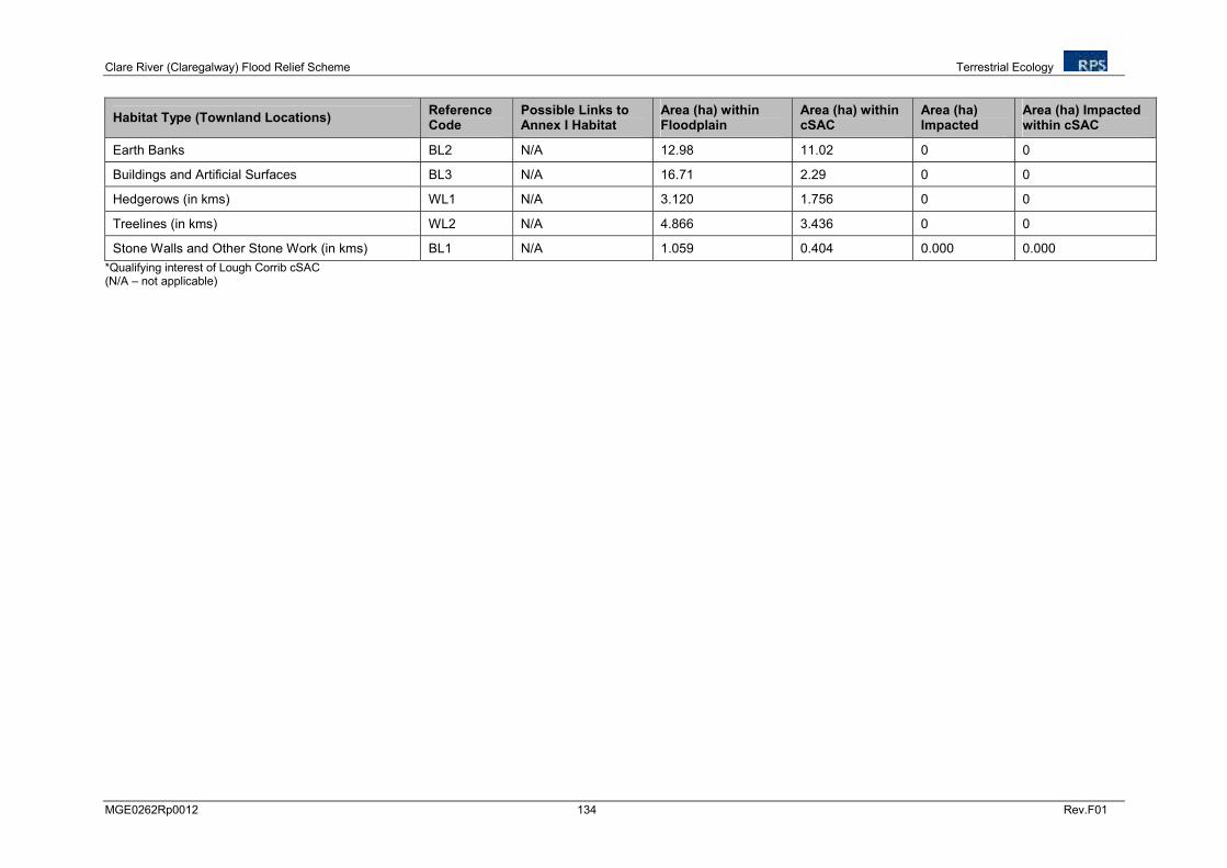
Clare River (Claregalway) Flood Relief Scheme Terrestrial Ecology
MGE0262Rp0012 134 Rev.F01
Habitat Type (Townland Locations) Reference Code
Possible Links to Annex I Habitat
Area (ha) within Floodplain
Area (ha) within cSAC
Area (ha) Impacted
Area (ha) Impacted within cSAC
Earth Banks BL2 N/A 12.98 11.02 0 0
Buildings and Artificial Surfaces BL3 N/A 16.71 2.29 0 0
Hedgerows (in kms) WL1 N/A 3.120 1.756 0 0
Treelines (in kms) WL2 N/A 4.866 3.436 0 0
Stone Walls and Other Stone Work (in kms) BL1 N/A 1.059 0.404 0.000 0.000
*Qualifying interest of Lough Corrib cSAC (N/A – not applicable)
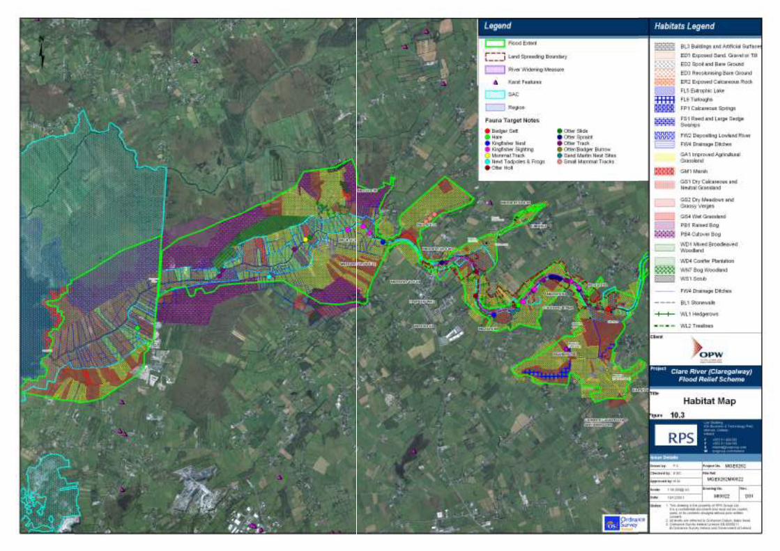


![.Noah's Flood WTJ2004[1]](https://static.fdokumen.com/doc/165x107/631c39e73e8acd997705cf6b/noahs-flood-wtj20041.jpg)

