A systematic review of thrust manipulation for non-surgical ...
Upload
independentCategory
view
1download
0
Central Zagros fold-thrust belt (Iran): New insights from seismic
data, field observation, and sandbox modeling
S. Sherkati,1 J. Letouzey,2 and D. Frizon de Lamotte3
Received 10 November 2004; revised 27 January 2006; accepted 29 March 2006; published 20 July 2006.
[1] We present five generalized cross sections acrossthe central Zagros fold-and-thrust belt (Iran). Thesesections show that the fold geometry variessignificantly both horizontally and vertically. Thestyle is closely related to the changes in themechanical behavior of the lithostratigraphichorizons and, in particular, to the presence ofintermediate decollements within the sedimentarypile. Restoration of the sections shows amounts ofshortening of the same order from one section to theother. However, it appears to be unequally distributed,suggesting variations in basal decollement shearstrength. Analogue modeling has been performed tosystematically investigate the effect of an intermediatedecollement level at different depths on the style offolding. The models demonstrate that the position ofintermediate decollements is an important factorcontrolling both structural style and fold wavelength.Models with shallow intermediate decollement showregularly and widely spaced anticlines. In thesemodels, the fold wavelength depends directly on thethickness of the dominant competent layer and short-wavelength superficial structures mask broadanticlines at depth. Models with deep intermediatedecollement are characterized by the rapid propagationof deformation (with small rate of shortening) alongthis decollement influencing localization offorthcoming anticlines in the upper levels. Suchpropagation favors the development of duplexes andmultiwavelength folds. On this basis, fold kinematicsin central Zagros is discussed using the variation ofstructural style along different folds as an indicator ofthe sequence of deformation. Detachment folding isthe main folding style at least for the initial stages ofdeformation and thrust faults developed only at laterstages. Some of these faults, branched on decollementlevels, express the progression of folding, whereasothers are linked to late basement faults cuttingthrough early structures. In general, the decollement
levels are activated sequentially from deeper horizonsto shallower ones. However, in one case (Gachsarandecollement) a shallow decollement is activated duringthe early stages of folding and then abandoned duringthe subsequent evolution.Citation: Sherkati, S., J. Letouzey,
and D. Frizon de Lamotte (2006), Central Zagros fold-thrust belt
(Iran): New insights from seismic data, field observation, and
sandbox modeling, Tectonics, 25, TC4007, doi:10.1029/
2004TC001766.
1. Introduction
[2] The Zagros fold-and-thrust (ZFTB) is currently thesite of intense geological studies, which led to the publica-tion of generalized balanced cross sections across the wholechain [Letouzey et al., 2002; Blanc et al., 2003; McQuarrie,2004; Letouzey and Sherkati, 2004; Sherkati and Letouzey,2004; Molinaro et al., 2005a]. Following Colman-Sadd[1978], all these studies agree with a structural styledominated by detachment folding over a ductile lowerdecollement.[3] Within the folded sedimentary pile, the presence of
multiple secondary decollement levels complicates the foldgeometry and explains the great difficulty to extrapolate ageometry at depth when subsurface data are lacking. As amatter of fact, Falcon [1969] mentioned the role of gravitytectonics in limestones and marls of the ZFTB in creatingstructural complexity at surface in places where the under-lying structure is simple. Conversely, O’Brien [1957],Edgell [1996], and Sherkati et al. [2005] show throughsubsurface data, that simple surface geometries can maskcomplexity at depth.[4] The role of basement faults during the building of the
ZFTB remains a matter of debate. The seismic activity[Berberian, 1995; Talebian and Jackson, 2004] shows thatthe basement is currently involved in the deformation.However, Molinaro et al. [2005a] and Sherkati et al.[2005] demonstrate that the basement control on the surfacestructures only occurred at a late stage in the tectonichistory. In other words, the current thick skinned style ofZagros folding succeeded a more general thin-skinnedevolution.[5] In this general frame, the aims of the present study
can be summarized as follows: (1) to establish a compre-hensive structural (mechanical) classification of the sedi-mentary pile in central Zagros; (2) to present new balancedcross sections across the central Zagros; (3) to describe theinfluence of intermediate decollement levels on structuralstyle (for this purpose, we have obtain new insights from
TECTONICS, VOL. 25, TC4007, doi:10.1029/2004TC001766, 2006ClickHere
for
FullArticle
1National Iranian Oil Company, Tehran, Iran.2Institut Francais du Petrole, Rueil-Malmaison, France.3Departement des science de la Terre et Environnement, CNRS UMR
7072, Universite de Cergy-Pontoise, Cergy, France.
Copyright 2006 by the American Geophysical Union.0278-7407/06/2004TC001766$12.00
TC4007 1 of 27

some analogue modeling experiments); and (4) to presentkinematic hypotheses for fold development in Zagros.
2. Geologic Setting
[6] The Zagros fold-and-thrust (ZFTB) is a NW-SEtrending orogenic belt, which extends over about 2000 kmfrom Turkey through southwest Iran down to the strait ofHormuz. It is bound to the north by the Main Zagros Fault,interpreted as the suture zone of the Neo-Tethys ocean[Ricou, 1971] (Figure 1). Mainly on the basis of morphol-ogy, the ZFTB is divided in two adjacent belts: the HighZagros Belt (HZB) and the Zagros Simply Folded Belt(ZSFB) separated by the High Zagros Fault (HZF) (Figure1) [Stocklin, 1968; Falcon, 1974; Berberian and King,1981; Alavi, 1991]. On the basis of lateral facies variations,the Iranian ZSFB is divided into different tectonostrati-graphic domains that are from SE to NW: The Fars provinceor eastern Zagros, the Izeh zone and Dezful Embayment orcentral Zagros and finally the Lurestan province or westernZagros [Motiei, 1994, 1995] (Figure 1).[7] In the ZFTB, compressive deformation began in the
Late Cretaceous by ophiolite obduction [Ricou, 1971].Subsequent folding and thrusting are related to the ongoingcollision of the Arabian plate with central Iran, which beganby Oligocene–early Miocene along the Main Zagros Fault(Figure 1) [Stocklin, 1968; Falcon, 1969; Berberian andKing, 1981]. The deformation front propagated progressivelysouthwestward [Hessami et al., 2001] and attained itscurrent position along the shore of the Persian Gulf inPlio-Pleistocene times. The thick (6 to 12 km) sedimentarysequence involved in the Zagros folds has recorded thecomplex tectonic history of this area. It presents all thestages of evolution of a basin from a platform or a passivecontinental shelf to a rift and various stages of deformationassociated with ophiolite obduction and plate collision.
2.1. Preobduction Sedimentary Sequence
[8] The sedimentary cover is supported by a Panafricanbasement, which is exposed in the western part of theArabian shield [Falcon, 1969; Husseini, 1988; Konert etal., 2001]. There is no exposure of the basement in IranianZagros. Information about its depth and composition aregained from seismic, gravity and aeromagnetic surveys andfragments brought to the surface by salt diapirs [Kent,1970].[9] It is generally considered that the evaporites of the
Hormuz Formation (latest Proterozoic–Early Cambrian)were deposited directly on the basement. However, as inOman [Peters et al., 2003], seismic evidence from northernFars suggests the existence of pre-Hormuz sediments insome parts of the Iranian Zagros [Letouzey and Sherkati,2004]. Unfortunately, the nature and precise age of themremain unknown. The Hormuz Formation is only knownfrom diapirs and salt plugs in the Fars province and HighZagros Belt. It was originally deposited in evaporitic basinsrelated to the north trending rifting, which developed at thattime in the Arabian plate [Edgell, 1996]. It consists of salt,anhydrite, dolomite, shale and volcanic rocks [Harrison,
1930; Kent, 1970, 1986; Haynes and McQuillan, 1974; Ala,1974].[10] Epicontinental deposits of Paleozoic age contain
some sedimentary gaps and show thickness and facieschanges (see review by Berberian and King [1981]) linkedto salt and epeirogenic movements, basement faulting andeustatic sea level changes. Deposition of Permian clasticsand carbonates on a truncated Silurian to Cambrian surfaceunderlines a Hercynian unconformity, which is the mostimportant sedimentary gap in the Zagros belt [Szabo andKheradpir, 1978].[11] Permian and Triassic subsidence and facies patterns
are parallel to the Main Zagros Fault (Figure 1). Crustthinning along this line is taken as evidence of thermalarching, rifting and opening of the Neo-Tethys ocean [Koopand Stoneley, 1982; Stampfli and Borel, 2004]. Throughoutmost of the Upper Triassic to Lower Cretaceous, theArabian platform remained a broad, stable shallow shelfdominated by carbonate and some evaporite deposition(Figure 2). Numerous transgressions and regressions duringthe Mesozoic explain the lateral variations in facies ofcarbonates from southeastern Zagros to the Lurestan prov-ince in the northwest of the Zagros belt [Setudehnia, 1978;Van Buchem et al., 2003; Taati et al., 2003].[12] Sedimentation on the Arabian and Zagros platform
during the Mesozoic (Figure 2) was also strongly influencedby the presence of deep-seated basement faults. Murris[1980] pointed out that the basement faults influenced theEarly Mesozoic sedimentation in the Arabian plate andcentral part of the Persian Gulf. These structures had periodsof important activity alternating with intervals of relativequiescence. In particular, they were most active from thelate Turonian to the early Campanian [Sherkati andLetouzey, 2004]. These periods correspond to major changesin basin configuration marking the early stages of regionalcompressive activity [Murris, 1980; Koop and Stoneley,1982; Sherkati and Letouzey, 2004].
2.2. Synobduction and Postobduction SedimentarySequence
[13] The configuration of the NE margin of the Arabianplatform changed abruptly with the early Coniacian–lateSantonian ophiolite obduction [Ricou, 1971; Falcon, 1974;Berberian and King, 1981; Sherkati and Letouzey, 2004;Agard et al., 2005]. Field surveys especially in the innerpart of the belt provide information allowing a betterunderstanding of this long period of convergence. Figure 3presents the main sedimentary events from late Cretaceoustill Pleistocene time in northwest of central Zagros.[14] Northeast of the Arabian plate, a flexural basin has
been formed due to the overloading of continental crust byophiolite obduction in the late Cretaceous. This basin ismarked by accumulation of Campanian flysch supportingradiolaritic nappes (Figure 3, events A and B). The nappesemplacement was followed by an uplift, which provokedPaleocene erosion in the High Zagros Belt (Figure 3, eventC). The origin of this uplift is uncertain. It could correspondto a lithospheric response to the Paleogene breakoff of theNeo-Tethys slab put forward by Agard et al. [2005]. It is
TC4007 SHERKATI ET AL.: CENTRAL ZAGROS FOLD-THRUST BELT
2 of 27
TC4007

followed by a relatively calm period during the late Eocene(deposition of the Jahrom carbonate). During the lateOligocene–early Miocene, basinal facies (turbidite) devel-oped in the northeast of the High Zagros area whereaselsewhere the limestones of the Asmari Formation weredeposited (Figure 3, event D). This reveals the presence of asecond flexural basin associated with the onset of continent-
continent collision during the late Oligocene–lower Mio-cene (see review by Agard et al. [2005]). Erosion of theOligocene and upper Eocene in some parts of the belt(Figure 3, events E and F) could be related to the develop-ment of a collision-related lithospheric flexure (bulge ge-ometry) and linked activation of deep-seated basementfaults.
Figure 1. Topographic map and index map of the central Zagros showing the locations of the fivestructural transects A, B, C, D, and E (Figure 4) (white solid lines) and the location of the stratigraphiccorrelation chart (Figure 3) (black dashed line). The synthetic stratigraphic columns (a to g) of Figures 2,16, and 17 are also located.
TC4007 SHERKATI ET AL.: CENTRAL ZAGROS FOLD-THRUST BELT
3 of 27
TC4007

Figure
2.
Generalized
stratigraphiccolumnsofthecentralZagrosfold-and-thrustbelt.Thesedim
entary
columnsconsist
ofseveral
stifflayersthat
areseparated
bydecollem
entlevels(see
Figure
1forthelocationofeach
column).
TC4007 SHERKATI ET AL.: CENTRAL ZAGROS FOLD-THRUST BELT
4 of 27
TC4007
Figure
3.
Correlationchartforthelate
CretaceousandTertiary(see
Figure
1forlocation)showingthemainstructural
events
that
followed
theophiolite
obduction.Theseevents
could
besummarized
asfollows:
EventA,depositionof
Cam
panianflyschsin
aflexuralbasin
relatedto
theophioliteobductionover
thenortheasternmargin
oftheArabianplate;
eventB,em
placementofradiolariticnappes
comingfrom
theArabianmargin
andtectonically
superim
posedonthe
Cam
paniansedim
ents;eventC,erosionlinked
toapostobductionuplift;eventD,northwardchangeofOligocene–early
MioceneAsm
ariForm
ation(lim
estone)
tobasinal
facies
(turbidites)restingunconform
ably
onEocenelimestones
(this
form
ation
has
been
dated
by
C.Muller
(oralcommunication,2004)as
Aquitanian-Burdigalian);
eventE,erosion
interpretedas
theresultofan
upliftofthecontinentallithosphere(bulgeeffect)relatedto
thecontinent-continentcollision
that
initiatedlikelyduringthelate
Oligocene–earlyMiocene;
eventF,erosionrelatedto
upliftalongtheMountain
Front
Fault(basem
entfaultreactivation?);eventG,erosionrelatedto
thesynfoldingZagrosuplift.
TC4007 SHERKATI ET AL.: CENTRAL ZAGROS FOLD-THRUST BELT
5 of 27
TC4007
Figure
4
TC4007 SHERKATI ET AL.: CENTRAL ZAGROS FOLD-THRUST BELT
6 of 27
TC4007

[15] The major regional angular unconformity betweenthe Agha Jari and Bakhtyari formations is generally con-sidered to have marked the late Pliocene climax of orogenyin the Zagros fold-and-thrust belt [Haynes and McQuillan,1974; Kashfi, 1976]. However, growth strata within theupper part of the Agha Jari formation show earlier move-ments before this major unconformity as mentioned byprevious workers [Falcon, 1974; Motiei, 1994; Hessami etal., 2001; Homke et al., 2004; Sherkati et al., 2005]. Thebase of the growth strata is dated at 8.1–7.2 Ma bymagnetostratigraphic correlation in northwest Zagros (Lure-stan) [Homke et al., 2004]. On the other hand, new seismicdata show pinch out in the upper Gachsaran seismicreflectors along the forelimb of some anticlines, showingthat folding began in middle Miocene time north of theDezful Embayment [Sherkati et al., 2005]. On the basis ofthese considerations, we acknowledge that the Zagrosfolding started in middle Miocene and covered the entirebelt by the early Pliocene. The important uplift and erosion,which preceded the deposition of the Bakhtyari conglom-erates (Figure 3, event G) could be related to the slab breakoff [Molinaro et al., 2005b] of the ‘‘residual Tethys’’ (theocean, which remained after the obduction [see Agard et al.,2005]). A part of the salt extrusions is coeval with Zagrosfolding. Some of them remain active at the moment, butpinch outs and sedimentary gaps in southeastern Fars andHigh Zagros area show that important salt movementsoccurred prior to the Zagros orogeny [Kent, 1970; Letouzeyand Sherkati, 2004].
2.3. Mechanical Stratigraphy of the ZFTB
[16] O’Brien’s [1957] mechanical stratigraphy of theZFTB is not sufficiently detailed to explain the variationsof structural style all over the Zagros. Figure 2 presents themechanical stratigraphy of the sedimentary cover based onextensive geological study and subsurface data analysis[Letouzey et al., 2002; Sherkati and Letouzey, 2004;Sherkati et al., 2005]. It consists of several competent stifflayers that are separated by evaporitic or shale layers,involved in deformation as intermediate decollements.[17] The Hormuz Formation is the basal decollement
level in the Fars, Lurestan and High Zagros area. In theIzeh zone and Dezful Embayment, there is no surface occur-rence of Hormuz salt plugs suggesting the absence of salt atdepth, Eo-Cambrian evaporite horizons or Cambrian shalemay be, in this case, the best alternative for basal decollement[Sherkati and Letouzey, 2004]. Whatever its nature, this basaldecollement has been disrupted and cut by movement alonglate basement faults [Sherkati and Letouzey, 2004;Molinaroet al., 2005a; Sherkati et al., 2005].[18] The Triassic evaporite (Dashtak Formation) is one of
the major intermediate decollement levels in Coastal andsubcoastal Fars as well as in the southwest Izeh zone. It isreplaced northeastward by dolomite of the Khaneh Kat
Formation, which is no longer a decollement horizon(Figure 2). Lower and Middle Jurassic evaporite and shales(Adayah and Sargelu formations), Upper Jurassic evaporites(Gotnia Formation), Lower and Middle Cretaceous shales(Garau and Kazhdumi formations), Eocene marls (PabdehFormation) and middle Miocene evaporites (GachsaranFormation) are the other intermediate decollement levelswithin the sedimentary cover in different regions of the belt(Figure 2). The upper Miocene Mishan marl constitutesthe main upper decollement in the Bandar Abbas area[Molinaro et al., 2005a] but does not show the samemechanical behavior in central Zagros.
3. Presentation of the Regional Transects
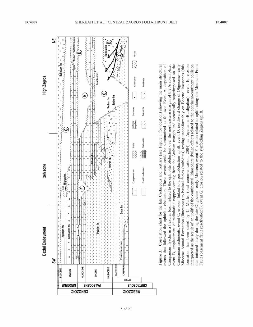
[19] In order to study the lateral variation in structuralstyle and shortening within the northern Fars and centralZagros, surface data, well information and seismic profileswere integrated to construct five cross sections from innerzone to foreland (Figure 4). Three of these cross sections arenew (Figures 4c, 4d, and 4e), whereas two of them aremodified from sections already published by Sherkati andLetouzey [2004] (Figure 4b) and Letouzey and Sherkati[2004] (Figure 4a). Surface data were obtained from1:100,000 and 1:250,000 National Iranian Oil Company(NIOC) geological maps and also from several field surveysin the area. Unpublished seismic reflection and well dataprovided by NIOC were used to interpret the structures atdepth. Seismic profiles exist in the Dezful Embayment,south of Izeh zone, all along transect B and along transect Afrom Dashtak anticline toward southwest (Figure 4).
3.1. Principles of Construction
[20] The cross sections were balanced, using LOCACESoftware [Moretti and Larrere, 1989] on the basis of bedlength and thickness conservation for stiff layers[Dahlstrom, 1969; Woodward et al., 1985]. The orientationof the cross sections, drawn northeastward from the firstNW-SE trending structures, is parallel to the inferredtectonic transport direction (i.e., perpendicular to the foldaxis) (Figure 1). All sections are composite transects withseveral doglegs in order to include the best surface andsubsurface data. As the folds are quite cylindrical at largescale and as the slip transmitted from one anticline to theother remains small everywhere, we assume that thesejumps do not have significant consequences on sectionsbalancing. In addition, none of our sections cross majorstrike-slip faults, so we minimize out-of-the-plane transport.Additionally, the transects are located away from theHormuz salt plugs minimizing also lateral salt flow.[21] In the High Zagros Belt, the stratigraphic thicknesses
of the various Phanerozoic units are determined fromsurface outcrops. In the Fars province, outcrops and borehole data provide good thickness control on Permian to
Figure 4. Five regional balanced cross sections across the central Zagros from the inner parts of the belt to thedeformation front (see Figure 1 for location map). The thin dashed line close to the top of the basement represents asuggested bottom for the pre-Hormuz sediments.
TC4007 SHERKATI ET AL.: CENTRAL ZAGROS FOLD-THRUST BELT
7 of 27
TC4007
Figure
5
TC4007 SHERKATI ET AL.: CENTRAL ZAGROS FOLD-THRUST BELT
8 of 27
TC4007

recent horizons. In the Izeh zone, outcrops and bore holedata provide control on Jurassic to recent units, whereas inthe Dezful Embayment, well information is limited to theformations younger than Lower Cretaceous. The thick-nesses of Jurassic and Triassic units were estimated fromseismic data, and thicknesses for the Paleozoic formationswere extrapolated from outcrop data in the High Zagros andseismic in the northern Fars.[22] The depth to Hormuz or ‘‘equivalent Hormuz’’
decollement is deduced from an hypothesis of constantthickness of Paleozoic units except for Coastal Fars area,where a deep decollement level is visible on seismic linesallowing us to constrain the thickness of the phanerozoicsedimentary pile in this area [Letouzey et al., 2002]. Such ahypothesis, is consistent with the stepwise uplift of thebasement northeastward already discussed in recent papers[Blanc et al., 2003; Sherkati and Letouzey, 2004; Molinaroet al., 2005a; Sherkati et al., 2005]. On our sections(Figure 4), the throw along these basement faults has beenestimated by measuring the step in the elevation of the sameMesozoic formations at the bottom of the synclines fromone side to the other of the faults. As noticed before inCoastal Fars [Letouzey and Sherkati, 2004], some pre-Hormuz Proterozoic basins may exist in different parts ofthe Zagros. Basement structures such as Mountain FrontFault and High Zagros Fault could have been induced byinversion of such Proterozoic basins, reactivation of Perm-ian-Triassic normal faults [Letouzey and Sherkati, 2004;Sepehr and Cosgrove, 2004] related to the Neo-Tethysrifting or both (Figure 4). On the other hand, presence ofinfra-Hormuz Proterozoic basins could also explain somediscrepancy between basement depth map deduced fromgravity and magnetic data [Motiei, 1995].[23] In the Dezful Embayment, McQuarrie [2004]
restricted the deformation to superficial levels. However,good seismic lines in this zone demonstrate that Paleozoicseismic reflectors are involved in folding indicating that abasal decollement exists and is at least deeper than thesePaleozoic seismic reflectors. In addition, the size andwavelength of the folds are consistent with a deepdecollement. More generally, the southern segments ofthe cross sections cut through the ZSFB, where, accord-ing to the existence of an efficient basal decollementlevel, we assume that the structural style is dominated bylarge-scale detachment folding [Davis and Engelder,1985; Sattarzadeh et al., 2000; Grelaud et al., 2002;Mitra, 2002; Bonini, 2003; Sherkati et al., 2005]. Whensubsidiary decollement levels exist (Dezful Embayment,Izeh zone) disharmonic folding may develop [O’Brien,1957; Bonini, 2003; Sherkati et al., 2005]. The late stagesof folding are marked by formation of faults connecting
the different decollement levels. In the High Zagros Belt,the style is simpler and the anticlines may be interpretedas faulted detachment folds.
3.2. Description of the Transects
[24] Transects A, D, and E run from Main Zagros Fault(near the suture zone) to the deformation front, whereastransects B and C were constructed only from High ZagrosFault to the deformation front (Figures 1 and 4). Thesegments of the sections crossing the HZB are undercon-strained by comparison to the ones crossing the ZSFB.Their geometry is only indicative, and the discussion willfocus on the latter.[25] Transect A (Figure 4) is a composite transect north
of the Fars province and east of the Kazerun fault. Itconsists of asymmetric structures verging principally south-westward. Shortening is well distributed all along thetransect: The shortening is 50 km for the whole sectionand 34 km for the ZSFB alone. Anticline wavelength isvariable and shows close relationships with sedimentarythickness and mechanical stratigraphy (Figure 5). Averagewavelength of the folds in High Zagros area is about 15–20 km in relation with the absence of decollement level(Dashtak Formation), which is represented here by carbon-ate and dolomite of the Khaneh-Kat Formation (Figure 5)[Szabo and Kheradpir, 1978]. In the ZSFB, the Kuh-e-Narh, Shahneshin, Kaki, and Mand anticlines also presentthe same style but with slightly larger wavelength due to athickening of the sedimentary pile. In northern Fars, fromKuh-e-Banish to Kuh-e-Narh anticlines, 2–3 km wave-length anticlines in Oligo-Miocene carbonate mask under-lying larger structures and suggest the implication of Eocenemarl (Pabdeh Formation) as a superficial decollement level(Figure 5). Multiwavelength anticlines are characteristicfeatures in the middle part of the northern Fars, whereTriassic evaporite form a secondary decollement level.Anticline spacing varies from 7 to 15 km in this area.[26] Transect B (Figure 4) is also a composite transect,
which is drawn west of Kazerun fault [Sherkati andLetouzey, 2004]. The amount of shortening in ZSFB is27 km, which is 7 km less than in transect A east ofKazerun fault. However, variation in structural character-istics of the anticlines from east to west of Kazerun faultremains unconnected to such a moderate decrease of theamount of shortening and seems to be mostly related tolateral change in sedimentary facies and basal friction value.Compared to transect A, anticline wavelength decreases(except Binak and Kilur Karim anticlines, which are larger)and structures are significantly tighter and more complex.Shortening seems to be mostly concentrated in the northernpart of the section, where major thrust faults put Lower
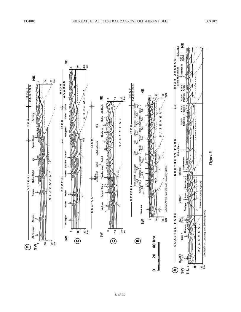
Figure 5. Major decollement levels in central Zagros and north Fars province: 1, Late Proterozic–Lower Paleozoic(Hormuz salt); 2, Lower Paleozoic shales or evaporites; 3, Triassic evaporites (Dashtak Formation); 4, Triassic, JurassicLower Cretaceous soft sediments (Mus, Adaiyah, Alan, Sargelu, Gotnia, and Garau formations); 5, Jurassic to LowerCretaceous soft sediments (Mus, Adaiyah, Alan, Sargelu, Gotnia, and Garau formations); 6, Albian shales (KazhdumiFormation); 7, Campanian to Eocene marls (Gurpi and Pabdeh formations); 8, middle Miocene salt and evaporite(Gachsaran Formation).
TC4007 SHERKATI ET AL.: CENTRAL ZAGROS FOLD-THRUST BELT
9 of 27
TC4007

Paleozoic over the Middle Cretaceous. Absence of Hormuzsalt west of Kazerun fault [Edgell, 1996] certainly causedvariation in shear strength along the basal decollement[Letouzey et al., 1995; Cotton and Koyi, 2000] and couldexplain the unequal strain distribution.[27] The other key structural characteristic of transect B is
the complete decoupling between deep and shallow levels.Shortening for each structure especially in Izeh zone ishigher at shallow levels (for example, at Asmari Formationlevel) than in deep horizons (for example at Sarvak orFahliyan levels). This difference shows that intermediatedecollements (Pabdeh and Kazhdumi formations) efficientlytransfer deformation from the anticlines to the adjacentsynclines (Figure 5).[28] Transect C (Figure 4) presents 33 km of shortening
in the ZSFB. As in transect B, shortening is concentrated inthe northern part of the transect, where Paleozoic rocks areexposed and thrust over Upper Cretaceous formations.Wavelength and style variation of folds are related to theactive decollement levels. In the north of the section, 10–12 km wavelength anticlines (except Kular anticline) areobserved. In the middle part of the section (i.e., betweenHaftcheshmeh and Dodurou anticlines) fold wavelengthdecreases to 3–4 km. Chevron type structures and ‘‘rabbitears’’ folds in the Cenomanian carbonates of the Sarvak
Formation are related to the existence of a secondarydecollement level within Albian shale (Kazhdumi Forma-tion) [Sherkati et al., 2005] (Figure 5). These short-wavelength structures mask larger anticlines at depth inpre-Kazhdumi formations. South of Izeh zone, anticlinewavelength increases again to 10–12 km. However, someshorter and tighter structures are also observed in the area(Safid anticline).[29] Triassic evaporite (Dashtak formation) was drilled in
the Bangestan well. More to the south in Dezful Embay-ment facies changes in the Lower Cretaceous from platformlimestone (Fahliyan Formation) to deep marine shales andmarly limestones (Garau Formation). Facies changes also inJurassic from limestones (Surmeh Formation) to alterna-tions of shales and anhydrite (Gotnia, Sargelu, Alan andAdayah formations) providing potential decollement levels.Middle Miocene evaporite (Gachsaran Formation) is amajor decollement level in the Dezful Embayment[O’Brien, 1957; Colman-Sadd, 1978; Bahroudi and Koyi,2003; Sherkati et al., 2005]. As it is seen in the transects(Figure 5), mechanical behavior of Gachsaran formation asdecollement is more efficient northwest of Dezful Embay-ment (transects C, D, and E) with respect to the southeast.This is probably related to increase of its thickness from SEto NW.
Figure 6. Modeling apparatus: (a) Schematic cross sections across the model setup and (b) schematicplan view of the sandbox. It is divided into three different models (A, B, and C) with different ductile andbrittle material arrangement. The left wall is the pushing wall and the right wall remains stationary. ModelA is for no intermediate decollement, model B is for deep intermediate decollement, and model C is forshallow intermediate decollement.
TC4007 SHERKATI ET AL.: CENTRAL ZAGROS FOLD-THRUST BELT
10 of 27
TC4007

[30] Transects D and E (Figure 4) present an identicalshortening of 33 km in Izeh zone and Dezful Embaymentand 65 km shortening through the entire belt. Along thesetransects, anticline wavelengths are about 15–20 km. In thesouthern part of the Dezful Embayment, shortening is
considerably less than in the northern part. Structuralcomplexity increases north of Dezful, as a result of theimplication of intermediate decollement levels. Decollementlevels are identified in Lower Cambrian, Triassic to LowerCretaceous ductile units (Dashtak, Adayah, Sargelu, Gotnia
Figure 7. Map and cross sections through the models after 23% of shortening. (a) Cross sectionsthrough models A, B, and C. In model A, the structures are large, simple, and isopachly folded. There isless complexity at depth and in more shortened structures, thrust faults are seen at the surface with largedisplacement. In model B, multiwavelength folds are cored by complex compressional structures. Inmodel C, upper brittle level contains small structures along the limbs or between the main anticlines,whereas below the intermediate decollement level, widely spaced ramp-related folds are characteristicfeatures. The wavelengths of the main anticlines in the sections A and B are very different showing thatthe depth of the intermediate decollement level influences the spacing between the anticlines. (b) Planview of the sandbox. Geometrical characteristics of the folds change across the box in relation with thedifferent arrangements of weak and brittle materials. Model A is for no intermediate decollement, modelB is for deep intermediate decollement, and model C is for shallow intermediate decollement.
TC4007 SHERKATI ET AL.: CENTRAL ZAGROS FOLD-THRUST BELT
11 of 27
TC4007
and Garau formations) and Miocene evaporite (GachsaranFormation) (Figure 5).[31] It is known that disharmonic features formed in the
middle Miocene (Gachsaran Formation) concurrently withfolding [Sherkati et al., 2005]. Such structures are ob-served in poorly developed structures like the Shadegan,Marun, and Kupal anticlines, which are the most externalon section D and the Ahwaz and Ramin anticlines, whichare in the same position on section E (Figure 4). So it
appears that the Gachsaran Formation was activated as adecollement level in the early stage of folding concurrentlywith the basal decollement level [Sherkati et al., 2005].During further stages of deformation, it seems that theGachsaran decollement was no more active and has beencut out by forelimb thrusts branched on the Dashtakdecollement (see the Haftkel, Asmari, Naft-e-Safid andMis anticlines, Figures 4d and 4e). As a consequence, thepost middle Miocene clastics, which were trapped in the
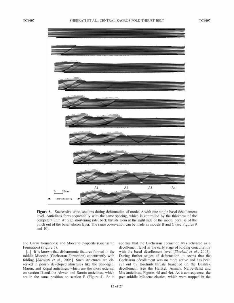
Figure 8. Successive cross sections during deformation of model A with one single basal decollementlevel. Anticlines form sequentially with the same spacing, which is controlled by the thickness of thecompetent unit. At high shortening rate, back thrusts form at the right side of the model because of thepinch out of the basal silicon layer. The same observation can be made in models B and C (see Figures 9and 10).
TC4007 SHERKATI ET AL.: CENTRAL ZAGROS FOLD-THRUST BELT
12 of 27
TC4007

synclines, were subject to steepening and overthrustingbetween the main anticlines. For instance, between Naft-e-Safid, Mis, and Gurpi anticlines (transect E) as well asbetween Haftkel and Asmari anticlines (transect D), thedevelopment of minor ramp-related folds in the interven-ing synclines show that a part of shortening has beentransferred out of the anticlines.
4. Role of Intermediate Decollement Levels
During Folding: An Analogue Modeling
Approach
[32] Our sections through the ZFTB give an opportunityto address the question of the control exercised by theexistence and depth of intermediate decollement levels on
Figure 9. Successive cross sections during deformation of model B with a deep intermediatedecollement level. Deformation of the lower sand layer before folding localizes forthcoming anticlines.The irregular anticlinal spacing results from the interaction between two factors: (1) the thickness of thepile and (2) the influence of the deep ductile unit.
TC4007 SHERKATI ET AL.: CENTRAL ZAGROS FOLD-THRUST BELT
13 of 27
TC4007

the geometry and kinematics of folding. For this purpose,we perform sandbox experiment visualized by X-raytomography.[33] Through mechanical analyses [Biot, 1961] and ex-
perimental analyses [Currie et al., 1962], it is known for along time that the stronger dominant member within thelithostratigraphic pile have a determining effect on the size
of the folds. Sandbox modeling shows that viscous layers atdifferent depth and small overlaps could govern the prop-agation of deformation front [Koyi et al., 2004]. In addition,the effects of lithological contrasts on the folding style hasbeen studied in the field as well as experimentally [Letouzeyet al., 1995; Sans and Verges, 1995; Bonini, 2003; Couzens-Schultz et al., 2003; Teixell and Koyi, 2003; Koyi et al.,
Figure 10. Successive cross sections during deformation of model C with shallow intermediatedecollement level. Small structures mask main deep anticlines. Regularly spaced anticlines withwavelength close to the one observed on model A are seen at depth. Their wavelength is controlled by thethickness of the lower competent unit. Folds above the intermediate decollement level show highcurvature and short wavelength. It is worth noting the development of some ‘‘rabbit ears’’ structures inupper competent unit in both flanks of the deep structures.
TC4007 SHERKATI ET AL.: CENTRAL ZAGROS FOLD-THRUST BELT
14 of 27
TC4007
2004; Massoli et al., 2006]. In this paper we focus on therole of intermediate decollement level. In particular, we willshow that the depth to this decollement level influences theanticlinal spacing and structural style both laterally andvertically.
4.1. Model Setup
[34] Two kinds of analogue materials were used: drygranular materials to simulate brittle sedimentary rocks,which obey a Mohr-Coulomb failure criterion, and viscousNewtonian material to simulate ductile rocks. Brittle ana-logues consist of dry sand and corundum with grain size of100 mm. Their slight density contrast is large enough to beshown on the X-ray images. The ductile analogue consistsof silicon putty (PDMS, variety SGM 36 of Dow Corning)
with Newtonian behavior at low strain, a viscosity of10�4 N s/m2 and a density of 970 kg/m3. ComputerizedX-ray tomography applied to analogue sandbox modelallows us to analyze the kinematic evolution and the three-dimensional geometry without interrupting or destroying themodel [Colletta et al., 1991]. Distinct boundary conditionswere used to simulate the distinct tectonic regimes discussedin this paper. When boundary conditions are perfectlyrepeated, the resulting structures obtained in the deformedmodels are also repeated, showing that structures are notdeveloped at random but are strongly controlled by therheology and boundary conditions [Colletta et al., 1991].All the models were deformed by moving the vertical wall atvelocity of about 1.7 cm/h. The thickness of models repre-sents about 8 km of sedimentary rocks. The box was initially39 cm wide and 78 cm long. During each experiment, thebox is divided laterally into three distinct models withdimensions of 26 cm wide and 39 cm long (Figure 6).
4.2. Model Results
[35] The result of analogue modeling shows that evolu-tion of the model depends on the imposed arrangement ofductile and brittle layers (Figure 7). As indicated above, wewill distinguish three different models: without intermediatedecollement level (model A), with a deep intermediatedecollement level (model B) and with a shallow decolle-ment level (model C).[36] In model A, without intermediate decollement level
(Figures 7 and 8), the structures are large and simple. Foldwavelength is uniform and controlled by dominant compe-tent unit. In more shortened structures, thrust faults withlarge displacement are seen at the surface. Back thrusts cutthrough the back limbs of the anticlines and terminateagainst the fore thrusts. Pop-up structures develop at earlystages of deformation and are passively transported duringthe subsequent evolution. The development of such struc-tures depends on the mechanical property of granularmaterials used in models. In the Zagros structures backthrusting is less frequently observed. This could be due tothe rheology of carbonate rocks, which favors diffusivemass transfer (pressure solution) and folding rather thanfracturing [Gratier and Gamond, 1990].[37] In model B, with a deep intermediate decollement
(Figures 7 and 9, folds are cored by duplex structures. Backthrusts are rarely seen on the back limb of the folds in theupper sand level. Within the deep brittle layer, folds andduplexes propagate rapidly during early stages of deforma-tion localizing thrusts and folds in the upper level. Spacingbetween surface anticlines is not regular. However, the sizeof surface anticlines is controlled by the thickness of upperbrittle layer and is influenced by deep structures. There is nodirect connection between faults in lower and upper brittleunits. However, Figure 9 shows that the lower and upperstructures are related and formed simultaneously. In addi-tion, we notice that each individual folds develop ‘‘fish tail’’style similar to the one described by Harrison and Bally[1988] in Melville Island.[38] In model C, with a shallow decollement (Figures 7
and 10), the shortening is also accommodated differently on
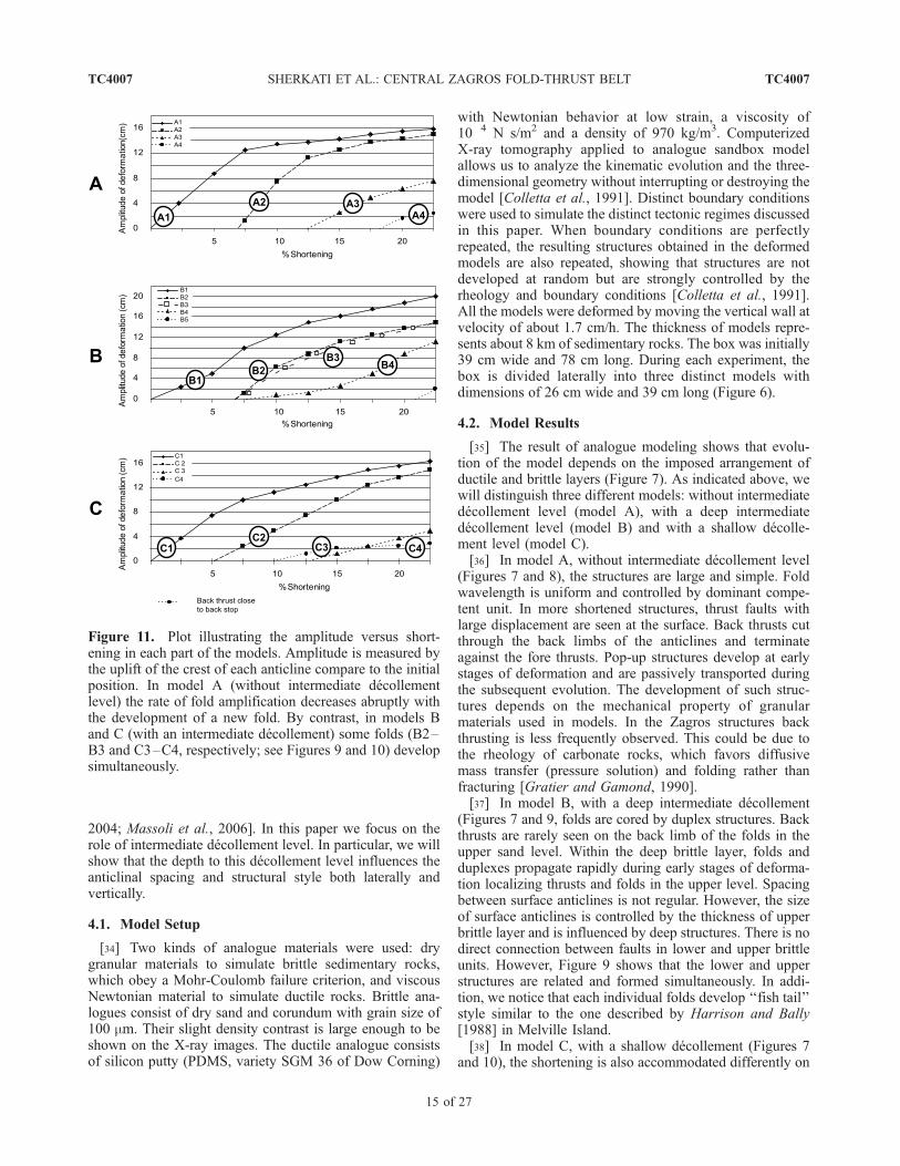
Figure 11. Plot illustrating the amplitude versus short-ening in each part of the models. Amplitude is measured bythe uplift of the crest of each anticline compare to the initialposition. In model A (without intermediate decollementlevel) the rate of fold amplification decreases abruptly withthe development of a new fold. By contrast, in models Band C (with an intermediate decollement) some folds (B2–B3 and C3–C4, respectively; see Figures 9 and 10) developsimultaneously.
TC4007 SHERKATI ET AL.: CENTRAL ZAGROS FOLD-THRUST BELT
15 of 27
TC4007

Figure 12. Typology of the basal decollement in central Zagros. (a) Structural map of the central Zagrosand north Fars area showing the nature and probable extent of the basal decollement levels: Legend: 1,Late Proterozoic–Early Cambrian Hormuz decollement (proved by salt plugs in the Fars and HighZagros provinces); 2a, Lower Paleozoic shale or evaporite decollement; 2b, zone where the basaldecollement is not activated. (b) Zoom into the northern half of the transect D (see Figure 4 for completesection and legend), showing widely spaced anticline cut by large thrust faults. The entire sedimentarypile is folded isopachly without important disharmonic features. Wavelengths of anticlines are about 10–15 km. Structural configuration along the northern part of the transect shows similarity with model A ofanalogue experiment (Figure 7). (c) Zoom into the northern part of the transect A (see Figure 4 forcomplete section). Because of the lack of major weak level within the stratigraphic column, large andsimple structures isopachly folded above the basal decollement level (Hormuz salt).
TC4007 SHERKATI ET AL.: CENTRAL ZAGROS FOLD-THRUST BELT
16 of 27
TC4007
both sides of the intermediate decollement level. The upperlevel contains small structures along the flank of the mainanticlines with minor displacement along numerous foreand back thrust faults whereas below the weak level, widelyspaced fault-related folds with major faulting are the rule.Fold wavelength in lower competent unit is close to thespacing observed in model A and is proportional to thethickness of the lower brittle layer. The main faults in lowerbrittle unit curve upward into the upper decollement level.Further shortening is accommodated by triangle zone indeep section and minor thrusts in upper unit (rabbit earfolds). Our observations show similarity with results ofanalogue modeling, which was carried out by Letouzey etal. [1995] to illustrate structural style in the Atlas mountainsof Algeria.[39] As a general trend, we observe an increase of the
amplitude of individual folds related to the shorteningincrease (Figure 11). According to Cotton and Koyi[2000] and in the absence of intermediate decollement,the rate of amplification of oldest folds decreases asshortening is transferred to a new imbricate ahead of theexisting folds (Figure 11a). The general sequence offolds development is from the hinterland to the foreland(Figures 8, 9, and 10). However, modeling shows that in thepresence of intermediate decollement, some folds developsynchronously (Figures 11b and 11c).
5. Discussion
[40] It is now possible to compare the model results withthe central Zagros transects. As described above and com-pared to other areas in Zagros, this region is made up with asedimentary pile presenting the highest competency con-trasts. The different mechanical response of these nonuni-form strata caused important changes in geometry of foldsand the similarities with our analogue models suggest thattheir modes of formation are close to those observed in the
field. We will first compare different subregions with themodels; then we will address some specific problemsdealing with the regional geology.
5.1. Comparison Between Cross Sections and Models
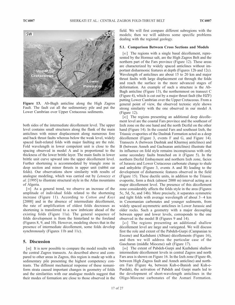
[41] The regions with a single basal decollement, repre-sented by the Hormuz salt, are the High Zagros Belt and thenorthern part of the Fars province (Figure 12). These areasare characterized by widely spaced anticlines without im-portant disharmonic features at depth (Figures 12b and 12c).Wavelength of anticlines are about 15 to 20 km and majorthrust faults with large displacement cut through the foldsand reach the surface in the more advanced stages ofdeformation. An example of such a structure is the Ab-Bagh anticline (Figure 13), the northernmost on transect C(Figure 4), which is cut out by a major thrust fault (the HZF)putting Lower Cambrian over the Upper Cretaceous. From ageneral point of view, the observed tectonic style showsstrong similarity with the one observed in our model A(Figure 12).[42] The regions presenting an additional deep decolle-
ment level are the coastal Fars province and the southeast ofIzeh zone on the one hand and the north Dezful on the otherhand (Figure 14). In the coastal Fars and southeast Izeh, theTriassic evaporites of the Dashtak Formation acted as a deepdecollement (Figure 3, events F and G, and Figure 14).Transects A (between Dashtak and Khurmoj anticlines) andB (between Anneh and Gachsaran anticlines) illustrate thatits influence on fold style remains inconspicuous with onlysome secondary faults branched on it (Figure 5). In thenorthern Dezful Embayment and northern Izeh zone, faciesof Jurassic and Lower Cretaceous carbonate change to shaleand anhydrite (Figure 3, events A and B) leading to thedevelopment of disharmonic features observed in the field(Figure 15). These ductile units, in addition to the Triassicevaporite, form a thick (almost 2000 m) interval acting as amajor decollement level. The presence of this decollementzone considerably affects the folds style in the area (Figures5c, 5d, 5e, and 14b). More precisely, it separates symmetricand tight folds with average wavelength of about 3–4 kmin Cenomanian carbonates and younger sediments, fromwidely spaced asymmetric anticlines in Lower Jurassic andolder rocks. Such a geometry with a major decouplingbetween upper and lower levels, corresponds to the oneobserved in the model B (Figures 9 and 14).[43] The regions presenting an additional shallow
decollement level are large and variegated. We will discussfirst the role and extent of the Pabdeh-Gurpi (Campanian toEocene) and Kazhdumi (Albian) decollements (Figure 16),and then we will address the particular case of theGascharan (middle Miocene) salt (Figure 17).[44] The extent of Pabdeh-Gurpi and Kazhdumi shallow
intermediate decollement levels in central Zagros and northFars area is shown on Figure 16. In the Izeh zone (Figure 4b,between High Zagros fault and Anneh anticline) and north-ern Fars (Figure 4a, between Kuh-e-Banish and Kuh-e-Purdah), the activation of Pabdeh and Gurpi marls led tothe development of short-wavelength anticlines in theOligo-Miocene carbonates of the Asmari Formation.
Figure 13. Ab-Bagh anticline along the High ZagrosFault. The fault cut all the sedimentary pile and put theLower Cambrian over Upper Cretaceous sediments.
TC4007 SHERKATI ET AL.: CENTRAL ZAGROS FOLD-THRUST BELT
17 of 27
TC4007
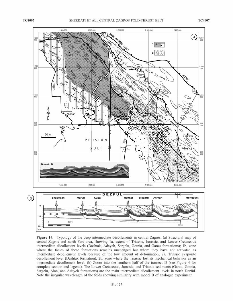
Figure 14. Typology of the deep intermediate decollements in central Zagros. (a) Structural map ofcentral Zagros and north Fars area, showing 1a, extent of Triassic, Jurassic, and Lower Cretaceousintermediate decollement levels (Dashtak, Adayah, Sargelu, Gotnia, and Garau formations); 1b, zonewhere the facies of these formations remains unchanged but where they have not activated asintermediate decollement levels because of the low amount of deformation; 2a, Triassic evaporitedecollement level (Dashtak formation); 2b, zone where the Triassic lost its mechanical behavior as anintermediate decollement level. (b) Zoom into the southern half of the transect D (see Figure 4 forcomplete section and legend). The Lower Cretaceous, Jurassic, and Triassic sediments (Garau, Gotnia,Sargelu, Alan, and Adayeh formations) are the main intermediate decollement levels in north Dezful.Note the irregular wavelength of the folds showing similarity with model B of analogue experiment.
TC4007 SHERKATI ET AL.: CENTRAL ZAGROS FOLD-THRUST BELT
18 of 27
TC4007
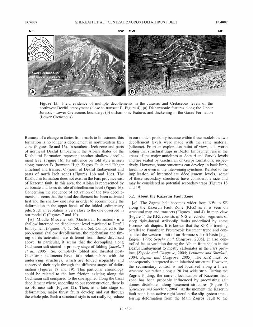
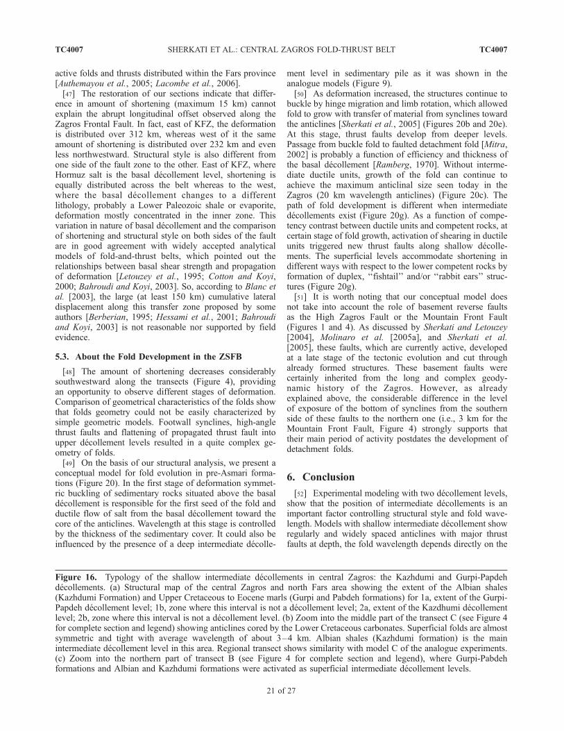
Because of a change in facies from marls to limestones, thisformation is no longer a decollement in northwestern Izehzone (Figures 5e and 16). In southeast Izeh zone and partsof northeast Dezful Embayment the Albian shales of theKazhdumi Formation represent another shallow decolle-ment level (Figure 16). Its influence on fold style is seenalong transect B (between High Zagros Fault and Eshgaranticline) and transect C (north of Dezful Embayment andparts of north Izeh zone) (Figures 16b and 16c). TheKazhdumi formation does not exist in the Fars province eastof Kazerun fault. In this area, the Albian is represented bycarbonate and loses its role of decollement level (Figure 16).Concerning the sequence of activation of the two decolle-ments, it seems that the basal decollement has been activatedfirst and the shallow one later in order to accommodate thedeformation in the upper levels of the folded sedimentarypile. Such an evolution is very close to the one observed inour model C (Figures 7 and 10).[45] Middle Miocene salt (Gachsaran formation) is a
shallow intermediate decollement level restricted to DezfulEmbayment (Figures 17, 5c, 5d, and 5e). Compared to thepre-Asmari shallow decollements, the mechanism and tim-ing of its activation are different from those discussedabove. In particular, it seems that the decoupling alongGachsaran salt started in primary stage of folding [Sherkatiet al., 2005]. So, complexly folded and thrusted post-Gachsaran sediments have little relationships with theunderlying structures, which are folded isopachly andconserved their style through the different stages of defor-mation (Figures 18 and 19). This particular chronologycould be related to the low friction existing along theGachsaran salt compared to the one applied along the basaldecollement where, according to our reconstruction, there isno Hormuz salt (Figure 12). Then, at a late stage ofdeformation, major thrust faults develop and cut throughthe whole pile. Such a structural style is not really reproduce
in our models probably because within these models the twodecollement levels were made with the same material(silicone). From an exploration point of view, it is worthnoting that structural traps in Dezful Embayment are in thecrests of the major anticlines at Asmari and Sarvak levelsand are sealed by Gachsaran or Gurpi formations, respec-tively. However, some structures can develop in back limb,forelimb or even in the intervening synclines. Related to theimplication of intermediate decollement levels, someof these secondary structures have considerable size andmay be considered as potential secondary traps (Figures 18and 19).
5.2. About the Kazerun Fault Zone
[46] The Zagros belt becomes wider from NW to SEalong the Kazerun Fault Zone (KFZ) as it is seen onstructural map and transects (Figures 1 and 4). In map view(Figure 1) the KFZ consists of N-S en echelon segments ofsteep right-lateral strike-slip faults underlined by someHormuz salt diapirs. It is known that the KFZ is trendingparallel to Panafrican Proterozoic basement trend and con-stituted the western limit of an Hormuz salt rift basin [e.g.,Edgell, 1996; Sepehr and Cosgrove, 2005]. It also con-trolled facies variation during the Albian from shales in theDezful Embayment to mostly carbonates in the Fars prov-ince [Sepehr and Cosgrove, 2004; Letouzey and Sherkati,2004; Sepehr and Cosgrove, 2005]. The KFZ must beconsequently interpreted as an inherited structure. However,the sedimentary control is not localized along a linearstructure but rather along a 20 km wide strip. During theZagros folding, the current localization of Kazerun faultzone has been probably influenced by preexisting saltdomes distributed along basement structures (Figure 1)[Letouzey and Sherkati, 2004]. At the moment, the Kazerunfault zone is an active right-lateral strike-slip system trans-ferring deformation from the Main Zagros Fault to the
Figure 15. Field evidence of multiple decollements in the Jurassic and Cretaceous levels of thenorthwest Dezful embayment (close to transect E, Figure 4). (a) Disharmonic features along the UpperJurassic–Lower Cretaceous boundary; (b) disharmonic features and thickening in the Garau Formation(Lower Cretaceous).
TC4007 SHERKATI ET AL.: CENTRAL ZAGROS FOLD-THRUST BELT
19 of 27
TC4007

Figure 16
TC4007 SHERKATI ET AL.: CENTRAL ZAGROS FOLD-THRUST BELT
20 of 27
TC4007
active folds and thrusts distributed within the Fars province[Authemayou et al., 2005; Lacombe et al., 2006].[47] The restoration of our sections indicate that differ-
ence in amount of shortening (maximum 15 km) cannotexplain the abrupt longitudinal offset observed along theZagros Frontal Fault. In fact, east of KFZ, the deformationis distributed over 312 km, whereas west of it the sameamount of shortening is distributed over 232 km and evenless northwestward. Structural style is also different fromone side of the fault zone to the other. East of KFZ, whereHormuz salt is the basal decollement level, shortening isequally distributed across the belt whereas to the west,where the basal decollement changes to a differentlithology, probably a Lower Paleozoic shale or evaporite,deformation mostly concentrated in the inner zone. Thisvariation in nature of basal decollement and the comparisonof shortening and structural style on both sides of the faultare in good agreement with widely accepted analyticalmodels of fold-and-thrust belts, which pointed out therelationships between basal shear strength and propagationof deformation [Letouzey et al., 1995; Cotton and Koyi,2000; Bahroudi and Koyi, 2003]. So, according to Blanc etal. [2003], the large (at least 150 km) cumulative lateraldisplacement along this transfer zone proposed by someauthors [Berberian, 1995; Hessami et al., 2001; Bahroudiand Koyi, 2003] is not reasonable nor supported by fieldevidence.
5.3. About the Fold Development in the ZSFB
[48] The amount of shortening decreases considerablysouthwestward along the transects (Figure 4), providingan opportunity to observe different stages of deformation.Comparison of geometrical characteristics of the folds showthat folds geometry could not be easily characterized bysimple geometric models. Footwall synclines, high-anglethrust faults and flattening of propagated thrust fault intoupper decollement levels resulted in a quite complex ge-ometry of folds.[49] On the basis of our structural analysis, we present a
conceptual model for fold evolution in pre-Asmari forma-tions (Figure 20). In the first stage of deformation symmet-ric buckling of sedimentary rocks situated above the basaldecollement is responsible for the first seed of the fold andductile flow of salt from the basal decollement toward thecore of the anticlines. Wavelength at this stage is controlledby the thickness of the sedimentary cover. It could also beinfluenced by the presence of a deep intermediate decolle-
ment level in sedimentary pile as it was shown in theanalogue models (Figure 9).[50] As deformation increased, the structures continue to
buckle by hinge migration and limb rotation, which allowedfold to grow with transfer of material from synclines towardthe anticlines [Sherkati et al., 2005] (Figures 20b and 20e).At this stage, thrust faults develop from deeper levels.Passage from buckle fold to faulted detachment fold [Mitra,2002] is probably a function of efficiency and thickness ofthe basal decollement [Ramberg, 1970]. Without interme-diate ductile units, growth of the fold can continue toachieve the maximum anticlinal size seen today in theZagros (20 km wavelength anticlines) (Figure 20c). Thepath of fold development is different when intermediatedecollements exist (Figure 20g). As a function of compe-tency contrast between ductile units and competent rocks, atcertain stage of fold growth, activation of shearing in ductileunits triggered new thrust faults along shallow decolle-ments. The superficial levels accommodate shortening indifferent ways with respect to the lower competent rocks byformation of duplex, ‘‘fishtail’’ and/or ‘‘rabbit ears’’ struc-tures (Figure 20g).[51] It is worth noting that our conceptual model does
not take into account the role of basement reverse faultsas the High Zagros Fault or the Mountain Front Fault(Figures 1 and 4). As discussed by Sherkati and Letouzey[2004], Molinaro et al. [2005a], and Sherkati et al.[2005], these faults, which are currently active, developedat a late stage of the tectonic evolution and cut throughalready formed structures. These basement faults werecertainly inherited from the long and complex geody-namic history of the Zagros. However, as alreadyexplained above, the considerable difference in the levelof exposure of the bottom of synclines from the southernside of these faults to the northern one (i.e., 3 km for theMountain Front Fault, Figure 4) strongly supports thattheir main period of activity postdates the development ofdetachment folds.
6. Conclusion
[52] Experimental modeling with two decollement levels,show that the position of intermediate decollements is animportant factor controlling structural style and fold wave-length. Models with shallow intermediate decollement showregularly and widely spaced anticlines with major thrustfaults at depth, the fold wavelength depends directly on the
Figure 16. Typology of the shallow intermediate decollements in central Zagros: the Kazhdumi and Gurpi-Papdehdecollements. (a) Structural map of the central Zagros and north Fars area showing the extent of the Albian shales(Kazhdumi Formation) and Upper Cretaceous to Eocene marls (Gurpi and Pabdeh formations) for 1a, extent of the Gurpi-Papdeh decollement level; 1b, zone where this interval is not a decollement level; 2a, extent of the Kazdhumi decollementlevel; 2b, zone where this interval is not a decollement level. (b) Zoom into the middle part of the transect C (see Figure 4for complete section and legend) showing anticlines cored by the Lower Cretaceous carbonates. Superficial folds are almostsymmetric and tight with average wavelength of about 3–4 km. Albian shales (Kazhdumi formation) is the mainintermediate decollement level in this area. Regional transect shows similarity with model C of the analogue experiments.(c) Zoom into the northern part of transect B (see Figure 4 for complete section and legend), where Gurpi-Pabdehformations and Albian and Kazhdumi formations were activated as superficial intermediate decollement levels.
TC4007 SHERKATI ET AL.: CENTRAL ZAGROS FOLD-THRUST BELT
21 of 27
TC4007
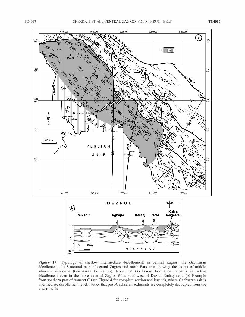
Figure 17. Typology of shallow intermediate decollements in central Zagros: the Gachsarandecollement. (a) Structural map of central Zagros and north Fars area showing the extent of middleMiocene evaporite (Gachsaran Formation). Note that Gachsaran Formation remains an activedecollement even in the more external Zagros folds southwest of Dezful Embayment. (b) Examplefrom southern part of transect C (see Figure 4 for complete section and legend), where Gachsaran salt isintermediate decollement level. Notice that post-Gachsaran sediments are completely decoupled from thelower levels.
TC4007 SHERKATI ET AL.: CENTRAL ZAGROS FOLD-THRUST BELT
22 of 27
TC4007

Figure 18. Seismic example of folded structures in the Dezful Embayment, south of the Mountain FrontFault (see location on Figure 1). The lower part of the middle Miocene Gachsaran formation is a majorweak zone, which separates two completely different folded domains. Multiple decollement levelsat (1) middle Miocene (Gachsaran Formation), (2) Albian (Kazhdumi Formation), and (3) Campanian toEocene levels (Gurpi and Pabdeh formations) increase the complexity of the fold geometry. They favordevelopment of triangle zones and nonisopach folding.
TC4007 SHERKATI ET AL.: CENTRAL ZAGROS FOLD-THRUST BELT
23 of 27
TC4007

Figure 19. Seismic section through the Naft-e-Safid anticline in the Dezful embayment (see location onFigure 1). The southern flank of the Naft-e-Safid anticline is not imaged by the seismic. However, thedifference in elevation from the crest of this anticline to the adjacent syncline is about 4000 m suggestinga steep and faulted southern flank. Seismic horizons within upper Gachsaran Formation correspond toalternation of anhydrite and shale, whereas transparent lower Gachsaran corresponds to mobile salt. Somehorizon pinch outs at the bottom and top of Gachsaran formation suggest early tectonic movements inthis zone (see Sherkati et al. [2005] for a discussion). Small buckling within Asmari Formation likelyresults from the activation of the Kazhdumi decollement.
TC4007 SHERKATI ET AL.: CENTRAL ZAGROS FOLD-THRUST BELT
24 of 27
TC4007

Figure 20. Conceptual kinematic scenario for folding in central Zagros. (a–c) Model withoutintermediate decollement level, a- state before deformation; b- buckling and migration of the basal ductileunit toward the core of the detachment fold; c- development of the fold with migration of material fromsynclines toward the anticline and limb rotation. At this stage a major thrust fault develops in deeper thehorizons. (d–g) Model with intermediate decollement level, a- state before deformation; b- buckling of thesedimentary pile and slip along the basal decollement level; c- a thrust fault develops in the lower competentunit and a box-fold forms in the upper stiff layer; d- development of secondary structures such as ‘‘fishtail’’(d1 and d3) or ‘‘rabbit ears’’ folds (d2). The excess of shortening in the upper levels is transferred to anadjacent structure (d4 and d5).
TC4007 SHERKATI ET AL.: CENTRAL ZAGROS FOLD-THRUST BELT
25 of 27
TC4007
thickness of the dominant competent unit. Short wavelengthsuperficial structures mask broad underlying anticlines.Models with deep intermediate decollement show rapidpropagation of deformation (with small rate of shortening)along this decollement influencing localization of forthcom-ing anticlines in upper levels. Such a propagation favors thedevelopment of duplexes at depth and multiwavelengthfolds, which are controlled by the thickness of the dominantcompetent unit.[53] Analysis of field and subsurface data in the central
Zagros show that response to deformation in the sedimen-tary cover varies both laterally and vertically in the sedi-mentary pile as a function of the distribution of decollementlevels and the relative competence of the different forma-tions. On the basis of our analysis of the structures in studyarea (Figure 4), the distribution of these decollement levelswere mapped. Except Gachsaran decollement (see above),which was activated at early stage of folding the otherdecollement seems to be sequentially activated from basallevel upward (Figures 20d–20g). The surface configurationof some folds does not always reflect subsurface structuralconditions. So modern seismic acquisition and processingare necessary to image deep structures.[54] The restoration of the transects in north Fars and
central Zagros shows that shortening is of the same orderacross the study area. It changes from 50 km in north Farsprovince to 65 km in northwest of central Zagros. However,
the same amount of shortening is unequally distributed fromone side to the other of the Kazerun transfer zone. In theFars area, the distribution of deformation is almost homo-geneous from inner zone to foreland whereas west of theKazerun fault zone it is mostly concentrated in inner zones.The absence of Hormuz salt west of Kazerun fault couldexplain the difficulty in the propagation of deformation incentral Zagros as suggested by previous workers [Cottonand Koyi, 2000; Bahroudi and Koyi, 2003; Sepehr andCosgrove, 2004, 2005].[55] The observed final geometries resulted from impli-
cation of intermediate decollement levels in folding andthrusting. Activation of these ductile units within thesedimentary cover during continuous folding triggerednew thrust faults in shallower levels and favored thedevelopment of fishtail and a variety of small-scale struc-tures, which are not easily characterized by existing geo-metrical models.
[56] Acknowledgments. The authors thank the National Iranian OilCompany (NIOC) exploration staff for permission to publish this paper andparticularly M. Mohaddes, M. Zadeh Mohammadi, and A. Ahmadnia fortheir continuing support over many years. We acknowledge our colleaguesfrom Institut Francais du Petrole (IFP) and Universite de Cergy-Pontoiseand in particular C. Aubourg, J. M. Daniel, J. C. Guezou, P. Leturmy,M. Molinaro, and J. L. Rudkiewicz, for helpful discussions during thisstudy. S.S. acknowledges a Ph.D. grant from the NIOC and TOTAL.Special thanks are due to Eric Blanc, Hemin Koyi, and Jaume Verges fortheir helpful reviews.
ReferencesAgard, P., J. Omrani, L. Jolivet, and F. Mouthereau
(2005), Convergence history across Zagros (Iran):Constraints from collisional an earlier deformation,Int. J. Earth Sci., 94, 401–419.
Ala, M. A. (1974), Salt diapirism in southern Iran,AAPG Bull., 58, 758–770.
Alavi, M. (1991), Sedimentary and structural character-istics of the Paleo-Tethys remnant in NE Iran, Geol.Soc. Am. Bull., 103, 983–992.
Authemayou, C., O. Bellier, D. Chardon, Z. Malekzade,and M. Abassi (2005), Role of the Kazerun faultsystem in active deformation of the Zagros fold-and-thrust belt (Iran), C. R. Geosci., 337, 539–545.
Bahroudi, A., and H. A. Koyi (2003), Effect of spatialdistribution of Hormuz salt and deformation style inthe Zagros fold and thrust belt: An analogue mod-eling approach, J. Geol. Soc. London, 160, 719–733.
Berberian, M. (1995), Master ‘‘blind’’ thrust faultshidden under the Zagros folds: Active basementtectonics and surface morphotectonics, Tectonophy-sics, 241, 193–224.
Berberian, M., and G. C. P. King (1981), Towards apaleogeography and tectonic evolution of Iran,Can. J. Earth Sci., 18, 210–265.
Biot, M. A. (1961), Theory of folding of stratified visco-elastic media and its implications in tectonics andorogenesis, Geol. Soc. Am. Bull., 72, 1595–1620.
Blanc, E. J. P., M. B. Allen, S. Inger, and H. Hassani(2003), Structural styles in the Zagros simple foldedzone, Iran, J. Geol Soc. London, 160, 401–412.
Bonini, M. (2003), Detachment folding, fold amplifica-tion, and diapirism in thrust wedge experiments,Te c t o n i c s , 2 2 ( 6 ) , 1 0 6 5 , d o i : 1 0 . 1 0 2 9 /2002TC001458.
Colletta, B., J. Letouzey, R. Pinedo, J. F. Ballard, andP. Bale (1991), Computerised X-ray tomographyanalysis of sand-box models: Examples of thin-skinned thrust systems, Geology, 19, 1063–1067.
Colman-Sadd, S. P. (1978), Fold development in Za-gros Simply Folded Belt, southwest Iran, AAPGBull., 62, 984–1003.
Cotton, J. T., and H. A. Koyi (2000), Modeling of thrustfronts above ductile and frictional detachments: Ap-plication to structures in the Salt Range and PotwarPlateau, Pakistan, Geol. Soc. Am.a Bull., 112, 351–363.
Couzens-Schultz, B. A., B. C. Vendeville, and D. V.Wiltschko (2003), Duplex style and triangle zoneformation: Insights from physical modeling,J. Struct. Geol., 25, 1623–1644.
Currie, J. B., H. W. Patnode, and R. P. Trump (1962),Development of folds in sedimentary strata, Geol.Soc. Am. Bull., 73, 655–674.
Dahlstrom, C. D. A. (1969), Balanced cross sections,Can. J. Earth Sci., 6, 743–757.
Davis, D. M., and T. Engelder (1985), The role of saltin fold-and-thrust belts, Tectonophysics, 19, 67–88.
Edgell, H. S. (1996), Salt tectonism in the Persian GulfBasin, in Salt Tectonics, edited by J. L. Alsop, D. J.Blundell, and I. Davison, Geol. Soc. Spec. Publ.,100, 129–151.
Falcon, N. (1969), Problems of the relationship be-tween surface structure and deep displacements il-lustrated by Zagros range, in Time and Place in
Orogeny, edited by P. E. Kent, G. E. Satterthwaite,and A. M. Spencer, Geol. Soc. Spec. Publ., 3, 9 –22.
Falcon, N. (1974), Southern Iran: Zagros mountains, inMesozoic-Cenozoic Orogenic Belts, edited byA. Spencer, Geol. Soc. Spec. Publ., 4, 199–211.
Gratier, J. P., and J. F. Gamond (1990), Transition be-tween seismic and aseismic deformation in theupper crust, Geol. Soc. Spec. Public., 54, 461–473.
Grelaud, S., W. Sassi, D. Frizon de Lamotte, T. Jaswal,and F. Roure (2002), Kinematics of eastern SaltRange and south Potwar Basin (Pakistan): A newscenario, Mar. Petrol. Geol., 19, 1127–1139.
Harrison, J. C., and A. W. Bally (1988), Cross sectionsof the Parry Islands fold belt on Melville Island,Canadian arctic islands: Implications for the timingand kinematic history of some thin-skinned decolle-ment systems, Bull. Can. Petl. Geol., 36, 311–332.
Harrison, J. V. (1930), The geology of some salt plugsin Laristan (southern Persia), Q. J. Geol. Soc. Lon-don., 86, 463–522.
Haynes, S. J., and H. McQuillan (1974), Evolution ofthe Zagros suture zone, southern Iran, Geol. Soc.Am. Bull., 85, 739–744.
Hessami, K., H. A. Koyi, C. J. Talbot, H. Tabasi, andE. Shabanian (2001), Progressive unconformitieswithin an evolving foreland fold-thrust belt, Zagrosmountains, J. Geol. Soc. London, 158, 969–981.
Homke, S., J. Verges, M. Garces, H. Emami, andR. Karpuz (2004), Magnetostratigraphy of Miocene-Pliocene Zagros foreland deposits in the front of thePush-e-Kush arc (Lurestan province, Iran), EarthPlanet. Sci. Lett., 225, 397–410.
Husseini, M. I. (1988), The Arabian Infracambrian ex-tensional system, Tectonophysics, 148, 93–103.
Kashfi, M. S. (1976), A source bed study of the Oligo-Miocene Asmari limestone in SW Iran, J. Pet.Geol., 7, 419–428.
Kent, P. E. (1970), The salt plugs of the Persian Gulfregion, Leicester Lit. Philos. Soc. Trans., 64, 56–88.
Kent, P. E. (1986), Island salt plugs in the Middle Eastand their tectonic implications, in DynamicalGeology of Salt and Related Structures, edited byI. Leiche and J. J. O’Brien, pp. 3 – 37, Elsevier,New York.
Konert, G., A. M. Afifi, S. A. Al-Hajri, K. De Groot,A. A. Al Naim, and H. J. Droste (2001), Palaeozoicstratigraphy and hydrocarbon habitat of the Arabianplate, in Petroleum Provinces of the Twenty-FirstCentury, edited by M. W. Downey, J. C. Threet,and W. A. Morgan, AAPG Mem., 74, 483–515.
TC4007 SHERKATI ET AL.: CENTRAL ZAGROS FOLD-THRUST BELT
26 of 27
TC4007
Koop, W. J., and R. Stoneley (1982), Subsidence his-tory of the Middle East Zagros Basin, Permian toRecent, Philos. Trans. R. Soc. London, Ser. A, 305,149–168.
Koyi, H. A., M. Sans, and A. Bahroudi (2004), Model-ling the deformation front of fold-thrust belts con-taining multiple weak horizons, Bull. Geofis.
Teorica Appl., 45, 101–103.Lacombe, O., F. Mouthereau, S. Kargar, and B. Meyer
(2006), Late Cenozoic and modern stress fields inthe western Fars (Iran): Implications for the tectonicand kinematic evolution of central Zagros, Tec-tonics, 25, TC1003, doi:10.1029/2005TC001831.
Letouzey, J., and S. Sherkati (2004), Salt movement,tectonic events and structural style in the centralZagros fold and thrust belt (Iran), in 24th AnnualGCSSEPM Foundation, Salt-Sediments Interac-tions and Hydrocarbon Prospectivity, Concepts,
Applications and Case Studies for the 21st Century[CD-ROM], Soc. of Econ. Paleontol. and Mineral.Found., Houston, Tex.
Letouzey, J., B. Colletta, R. Vially, and J. C. Chermette(1995), Evolution of salt related structures in com-pressional setting, in Salt Tectonics: A Global Per-spective, edited by M. P. A. Jackson, D. G. Roberts,and S. Snelson, AAPG Mem., 65, 41–60.
Letouzey, J., S. Sherkati, J. M. Mengus, H. Motiei,M. Ehsani, A. Ahmadnia, and J. L. Rudkiewicz(2002), A regional structural interpretation of theZagros Mountain Belt in northern Fars and HighZagros (SW Iran), paper presented at AAPGAnnual Meeting, Houston, Tex.
Massoli, D., H. A. Koyi, and M. R. Barchi (2006),Structural evolution of a fold and thrust belt gener-ated by multiple decollements: Analogue modelsand natural examples from the northern Apennines(Italy), J. Struct. Geol., 28, 185–190.
McQuarrie, N. (2004), Crustal scale geometry of theZagros fold-thrust belt, Iran, J. Struct. Geol., 26,519–535.
Mitra, S. (2002), Structural models of faulted detach-ment folds, AAPG Bull., 86, 671–693.
Molinaro, M., P. Leturmy, J. C. Guezou, D. Frizon deLamotte, and S. A. Eshragi (2005a), The structureand kinematics of the south-eastern Zagros fold -thrust belt, Iran: From thin-skinned to thick-skinnedtectonics, Tectonics, 24, TC3007, doi:10.1029/2004TC001633.
Molinaro, M., H. Zeyen, and X. Laurencin (2005b),Lithospheric structure beneath the south-eastern Za-gros Mountains, Iran: Recent slab break-off?, TerraNova, 17, 1 –6.
Moretti, I., and M. Larrere (1989), Computer-aidedconstruction of balanced geological cross sections,Geobyte, Oct. 1989, 2 – 24.
Motiei, H. (1994), Stratigraphy of Zagros (in Farsi),report, Geol. Surv. of Iran, Tehran.
Motiei, H. (1995), Petroleum geology of Zagros (inFarsi), vols. 1 and 2, Geol. Surv. of Iran, Tehran.
Murris, R. J. (1980), Middle East: Stratigraphic evo-lution and oil habitat, AAPG Bull., 64, 597 –618.
O’Brien, C. A. E. (1957), Salt diapirism in south Persia,Geol. Mijnbouw, 19, 357–376.
Peters, J. M., J. Filbrandt, J. Grotzinger, M. Newall,M. Shuster, and H. Al-Siyabi (2003), Surface-piercing Salt Domes of interior north Oman,and their significance of the Ara Carbonate ‘‘Stin-ger’’ hydrocarbon play, Geoarabia, 8, 231–270.
Ramberg, H. (1970), Folding of laterally compressedmultilayers in the field of gravity, Phys. Earth Pla-net. Inter., 2, 203–232.
Ricou, L. E. (1971), Le croissant ophiolitique peri-arabe. Une ceinture de nappes mises en place auCretace superieur, Rev. Geogr. Phys. Geol. Dyn.,13, 327–350.
Sans, M., and J. Verges (1995), Fold development re-lated to continental salt tectonic: Southeastern Pyr-enean thrust front, Spain, in Salt Tectonics: AGlobal Prospective, edited by M. P. A. Jackson,D. G. Roberts, and S. Snelson, AAPG Mem., 65,369–378.
Sattarzadeh, Y., J. W. Cosgrove, and C. Vita-Finzi(2000), The interplay of faulting and folding duringthe evolution of the Zagros deformation belt, inForced Folds and Fractures, edited by J. W.Cosgrove and M. S. Ameen, Geol. Soc. Spec.
Publ., 169, 187–196.Sepehr, M., and J. W. Cosgrove (2004), Structural fra-
mework of the Zagros fold-thrust belt, Iran, Mar.Pet. Geol., 21, 829–843.
Sepehr, M., and J. W. Cosgrove (2005), Role of theKazerun Fault Zone in the formation and deforma-tion of the Zagros fold-thrust belt, Iran, Tectonics,24, TC5005, doi:10.1029/2004TC001725.
Setudehnia, A. (1978), The Mesozoic sequence insouth-west Iran and adjacent areas, J. Petrol. Geol.,1, 3 –42.
Sherkati, S., and J. Letouzey (2004), Variation of struc-tural style and basin evolution in the central Zagros(Izeh zone and Dezful Embayment), Iran, Mar. Pet.
Geol., 21, 535 –554.Sherkati, S., M. Molinaro, D. Frizon de Lamotte, and
J. Letouzey (2005), Detachment folding in the
central and eastern Zagros fold-belt (Iran),J. Struct. Geol., 27, 1680–1696.
Stampfli, G. M., and G. D. Borel (2004), TheTRANSMED transects in space and time: Con-straints on the paleotectonic evolution of the Med-iterranean domain, in The TRANSMED Atlas, TheMediterranean Region From Crust to Mantle, edi-ted by W. Cavazza et al., pp. 53–80, Springer, NewYork.
Stocklin, J. (1968), Structural history and tectonics ofIran: A review, AAPG Bull., 52, 1229–1258.
Szabo, F., and A. Kheradpir (1978), Permian and Trias-sic stratigraphy, Zagros basin, south-west Iran,J. Pet. Geol., 1, 57–82.
Taati, F., F. Van-Buchem, and P. Razin (2003), Highresolution sequence stratigraphy of the Bangestangroup in a tectonically active setting (Dezful- Izeh)Zagros-Iran, paper presented at AAPG InternationalConference, Barcelona, Spain.
Talebian, M., and J. Jackson (2004), A reappraisal ofearthquake focal mechanisms and active shorteningin the Zagros mountains of Iran, Geophys. J. Int.,156, 506–526.
Teixell, A., and H. A. Koyi (2003), Experimental andfield study of the effects of lithological contrasts onthrust-related deformation, Tectonics, 22(5), 1054,doi:10.1029/2002TC001407.
VanBuchem,F., F.Gaumet,D.Baghbani,R.Ashrafzadeh,and F. Keyvani (2003), The relative impact ofinherited tectonic features and eustatic sea levelvariations on the Jurassic/Cretaceous evolution ofthe Dezful Embayment, central Zagros, Iran, paperpresented at AAPG International Conference,Barcelona, Spain.
Woodward, N. B., S. E. Boyer, and J. Suppe (1985), Anoutline of balanced cross sections, in Studies inGeology II, 170 pp., Dep. of Geol. Sci., Univ. ofTenn., Knoxville.
���������D. Frizon de Lamotte, Departement des science de
la Terre et Environnement (CNRS UMR 7072),Universite de Cergy-Pontoise, F-95031 Cergy Cedex,France. ([email protected])
J. Letouzey, Institut Francais du Petrole, BP 311,F-92852 Rueil-Malmaison Cedex, France. ([email protected])
S. Sherkati, National Iranian Oil Company, Yaghmaallay, Jomhouri avenue, Tehran, Iran. ([email protected])
TC4007 SHERKATI ET AL.: CENTRAL ZAGROS FOLD-THRUST BELT
27 of 27
TC4007
Copyright © 2022 FDOKUMEN