Cape Fear Commutes 2035 Transportation Plan
329
Visit CapeFearCommutes.org for full plan Cape Fear Commutes 2035 Transportation Plan: Technical Appendices prepared by the Cape Fear Commutes 2035 Committee of the Wilmington Urban Area Metropolitan Planning Organization Final Report December 2010
-
Upload
khangminh22 -
Category
Documents
-
view
3 -
download
0
Transcript of Cape Fear Commutes 2035 Transportation Plan

Visit CapeFearCommutes.org for full plan
Cape Fear Commutes 2035Transportation Plan:Technical Appendices
prepared by
the Cape Fear Commutes 2035 Committee of the
Wilmington Urban Area Metropolitan Planning Organization
Final Report
December 2010

Cape Fear Commutes 2035 Transportation Plan
1
Technical Appendices
Table of Contents
Appendix 1 Background
Appendix 2 Public Involvement
Appendix 3 Aviation
Appendix 4 Bicycle
Appendix 5 Freight
Appendix 6 Mass Transportation
Appendix 7 Pedestrian
Appendix 8 Roadways
Appendix 9 Transportation Demand Management
Appendix 10 Transportation Systems Management
Appendix 11 Environmental Analysis

APPENDIX 1: BACKGROUND
Cape Fear Commutes 2035 Transportation Plan 1
1. BACKGROUND INFORMATION
THE WILMINGTON URBAN AREA METROPOLITAN PLANNING ORGANIZATION
The Federal Aid Highway Act of 1962 required that transportation projects in urbanized areas of 50,000 or greater in population be based on a continuing, comprehensive, urban transportation planning process undertaken cooperatively by states and local governments. In an effort to complete this transportation planning process in an effective manner, the Wilmington Urban Area Metropolitan Planning Organization (WMPO) was created in 1982. The WMPO consists of representatives from the City of Wilmington, Town of Wrightsville Beach, Town of Carolina Beach, Town of Kure Beach, Town of Belville, Town of Leland, Town of Navassa, New Hanover County, Brunswick County, Pender County, the Cape Fear Public Transportation Authority and North Carolina Department of Transportation (NCDOT).
The City of Wilmington serves as the Lead Planning Agency for the WMPO. Staff support to the WMPO is located in the City of Wilmington’s Development Services Department, Planning Division, Transportation Planning Section. WMPO staff has the responsibility of coordinating Technical Coordinating Committee and Transportation Advisory Committee activities, completing a Planning Work Program (PWP), reviewing and approving the Metropolitan Transportation Improvement Program (MTIP), adopting a Long Range Transportation Plan (LRTP) and Comprehensive Transportation Plan (CTP), approving changes to the Federal-Aid Functional Classification System, and establishing goals and objectives for the transportation planning process.
Under Section 134 of the Federal Highway Act of 1973, MPOs are required to prepare long range transportation plans for the planning area with a 20-year minimum planning horizon. Furthermore, these long range transportation plans are required to be updated on a regular basis. The WMPO’s most recent long range transportation plan was adopted in March of 2005 and expired in March of 2010. To comply with current federal transportation legislation the WMPO will replace the most recent long range transportation plan with the Cape Fear Commutes 2035 Transportation Plan.
THE WILMINGTON URBAN AREA
The Wilmington Urban Area encompasses more than four hundred square miles of southeastern North Carolina including all of New Hanover County as well as portions of Pender County and Brunswick County (see Figure 1).

APPENDIX 1: BACKGROUND
Cape Fear Commutes 2035 Transportation Plan 2
FIGURE 1. WILMINGTON URBAN AREA

APPENDIX 1: BACKGROUND
Cape Fear Commutes 2035 Transportation Plan 3
SOCIEOECONOMIC CONDITIONS
U.S. Census: Population Trends
Recent statistics from the U.S. Census Bureau, dated March 19, 2009, ranked the Wilmington Metropolitan Statistical Area (MSA) as the 24th fastest growing urban area in the United States based upon percent population growth between 2000 and 2008. The Bureau’s most current population estimate indicates that the Wilmington MSA included more than 347,000 residents in July of 2008, which translates into a roughly 26.4% increase in population. Although the Wilmington MSA encompasses a larger portion of southeastern North Carolina than the Wilmington Urban Area (including Pender County and Columbus County in their entirety and a larger portion of eastern Brunswick County), MSA statistics are good indicators of Wilmington Urban Area growth since a majority of development activity and population density is currently located within the Wilmington Urban Area.
U.S. Census: Economic Trends
A comparison of 2000 and 2007 economic statistics from the U.S. Census Bureau indicate that business and industrial activity expanded in the Wilmington MSA commensurate with population growth during that period of time. In 2000, the region employed slightly more than 95,000 people with a total payroll of approximately $2.5 billion. At the time, the largest employer was retail trade followed by health services and accommodation/food services. In 2007, the number of employees within the region had increased by roughly 30% to 124,000 employees, with a total payroll of more than $4.19 billion. The largest employer groups continue to be retail trade, health services and accommodation/food services. Again, even though MSA statistics represent a larger area than the Wilmington Urban Area, they are good economic indicators since a majority of MSA employment opportunities are currently located within the Wilmington Urban Area.
WMPO Socioeconomic Estimates and Projections
The WMPO and NCDOT cooperatively maintain a regional travel demand model for the Wilmington Urban Area and routinely update population and employment data to ensure that the model accurately depicts current and anticipated socioeconomic conditions. Maintaining accurate socioeconomic data is critical to ensure that the travel demand model appropriately reflects current and future transportation network operations.
Methodology – Socioeconomic Data Update
The socioeconomic update for the Cape Fear Commutes 2035 Transportation Plan was completed utilizing a multi-step Geographic Information Systems-based process. The process can be generalized into six steps:
Data collection Base year household estimate Base year employment estimate Future year household projections Future year employment projections

APPENDIX 1: BACKGROUND
Cape Fear Commutes 2035 Transportation Plan 4
Calibration Adoption
Data collection
A considerable amount of GIS data was collected from member WMPO agencies including: parcel geometry, E-911 address points, zoning, existing land use, future land use, approved developments and environmental constraints. With the GIS data, a composite map was created that allowed for all three Wilmington Urban Area counties to be analyzed concurrently and with consistent variables. Some of the GIS data had to be modified slightly to create the composite map; however, the overall content of the data remained intact.
Base year household estimate
Base year household estimates were completed using 2008 E-911 address data for each of the three Wilmington Urban Area counties. Residential address points were extracted from the original databases and spatially referenced to each of the region’s Transportation Analysis Zones (TAZs). With the total number of households known for each TAZ, occupancy rates from the 2000 U.S. Census were applied to estimate the total number of occupied units within the region. Population estimates were also completed by multiplying the total number of occupied households by the Census persons per household rate. Once the 2008 household estimates were complete, the data was then incorporated into the travel demand model to complete the base year analysis.
Base year employment estimate
Base year employment data was obtained from InfoUSA, a company that specializes in the collection of employment data for marketing and business development purposes. The InfoUSA data was then checked for errors such as redundant entries, improper business locations, businesses that no longer existed and other critical errors. Employers with more than 100 employees were then contacted by NCDOT staff to verify employment numbers and business locations. Once the quality control efforts were complete, the 2008 employment data was utilized for the base year model analysis.
Future year household projections
Household projections were completed for 2020 and 2035 horizon years. To complete the household projections, WMPO staff extracted vacant and high-probability redevelopment parcels from parcels that demonstrated a relatively low potential for future growth (e.g. areas of high density, parks, schools, wetlands, etc.). The next step in the process was to single out, from the vacant/redevelopment parcels, all of the parcels that were zoned for residential use or identified on future land use plans for residential purposes. With these properties identified, density multipliers were applied to each residential parcel in two stages to arrive at household projections for 2020 and 2035.

APPENDIX 1: BACKGROUND
Cape Fear Commutes 2035 Transportation Plan 5
Future year employment projections
To forecast the total employment for the horizon years of 2020 and 2035, it was assumed that future TAZ employment/population ratios would remain constant under future year conditions. As a result, employment totals increased in proportion with the projected population growth.
Calibration
Initial household and employment projections conflicted with 2030 projections from the North Carolina Office of State Budget and Management. Through an elaborate process of refinement, WMPO and NCDOT staff was able to calibrate the future year conditions to result in more consistent numbers for use in the travel demand model.
Adoption
Household and employment projections were adopted by the WMPO Transportation Advisory Committee on September 29, 2009 and incorporated as baseline socioeconomic conditions for the WMPO Travel Demand Model.
Household Estimates and Projections
Wilmington Urban Area household estimates and projections for 2008, 2020 and 2035 are shown in Table 1 and Figures 2, 3, and 4.
TABLE 1 WILMINGTON URBAN AREA TOTAL HOUSEHOLD AND POPULATION ESTIMATES AND PROJECTIONS
Year Total Residential Units Population
2008 113,839 221,755
2020 165,972 326,262
2035 212,771 418,730
Source: WMPO Travel Demand Model
Note: Figures shown for “residential units” represent households, not total dwelling units. The average people/household used in the travel demand model were 2.4 for Brunswick County, 2.29 for New Hanover County, and 2.5 for Pender County. These were derived from the 2000 Census.
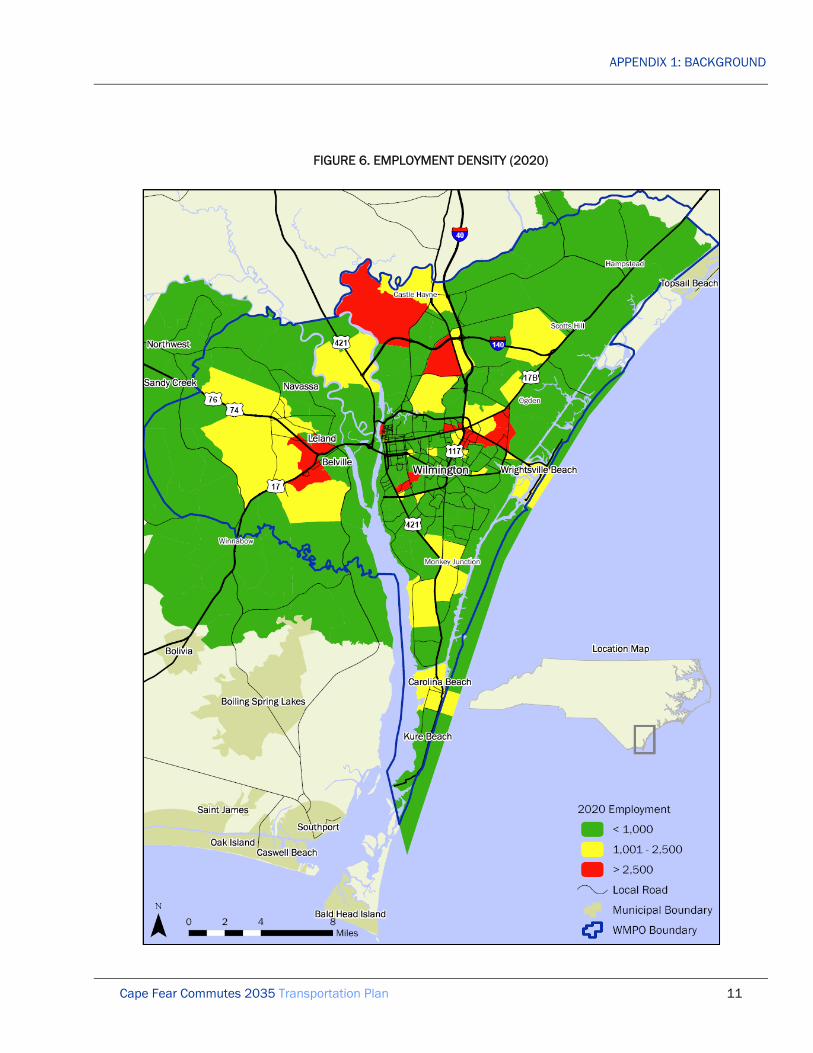
Employment Estimates and Projections
Wilmington Urban Area household estimates and projections for 2008, 2020 and 2035 are shown in Table 2 and Figures 5, 6, and 7.

APPENDIX 1: BACKGROUND
Cape Fear Commutes 2035 Transportation Plan 6
TABLE 2 WILMINGTON URBAN AREA EMPLOYMENT ESTIMATES AND PROJECTIONS
Year Employment
2008 112,945
2020 175,675
2035 221,326
Source: WMPO Travel Demand Model

APPENDIX 1: BACKGROUND
Cape Fear Commutes 2035 Transportation Plan 7
FIGURE 2. HOUSEHOLD DENSITY (2008)

APPENDIX 1: BACKGROUND
Cape Fear Commutes 2035 Transportation Plan 8
FIGURE 3. HOUSEHOLD DENSITY (2020)

APPENDIX 1: BACKGROUND
Cape Fear Commutes 2035 Transportation Plan 9
FIGURE 4. HOUSEHOLD DENSITY (2035)

APPENDIX 1: BACKGROUND
Cape Fear Commutes 2035 Transportation Plan 10
FIGURE 5. EMPLOYMENT DENSITY (2008)
APPENDIX 1: BACKGROUND
Cape Fear Commutes 2035 Transportation Plan 11
FIGURE 6. EMPLOYMENT DENSITY (2020)

APPENDIX 1: BACKGROUND
Cape Fear Commutes 2035 Transportation Plan 12
FIGURE 7. EMPLOYMENT DENSITY (2035)

APPENDIX 1: BACKGROUND
Cape Fear Commutes 2035 Transportation Plan 13
TRANSPORTATION NETWORK CONSTRAINTS
Roadway Constraints
Congestion on the Wilmington Urban Area’s major arterial roadways is the primary constraint for moving vehicles throughout the region. However, congestion is generally limited to prime commuter routes during peak travel periods. Areas where peak hour congestion routinely occurs are US 17-74-76-NC 133 in Brunswick County, Cape Fear Memorial Bridge (US 17 Business-76-421) , Isabel Holmes Bridge (Us 74-Nc 133), Monkey Junction (at the intersection of South College Road and Carolina Beach Road), Market Street (Us 17 Business), North and South College Road (US 117-NC 132), and several others. One of the main limiting factors to mitigate peak hour congestion is the lack of alternative routes and limited opportunities to for capacity improvements to existing roadways. Several factors including environmental issues, existing development, absence of right-of-way and funding shortfalls are all constraints that impact the region’s ability to alleviate roadway congestion.
The development of alternative routes and capacity improvements face a significant number of environmental challenges that can impact the feasibility, constructability and cost of every project. Design engineers must account for environmental conditions including poor soil conditions, riparian areas, estuaries, protected plant and animal species, and the human environment among others. Given these numerous constraints, roadway improvements are difficult to implement in southeastern North Carolina without a significant amount of time allocated to project development and substantial construction/mitigation costs.
Existing development in urbanized portions of the Wilmington Urban Area create impediments to roadway improvements to the point where certain road segments and intersections are currently at their maximum operating configuration given right-of-way constraints and construction of alternative routes would result in significant environmental and human impacts, not to mention tremendous construction costs. Further, historical development regulations and planning processes have encouraged the dispersion of low density suburban developments throughout the Wilmington Urban Area, which discourages the use of alternative transportation and overburdens local roadways with commuters during morning and evening peak hours. Many local roadways have experienced growing pains over the years including Masonboro Loop Road, Greenville Loop Road and Pine Grove Drive as more and more neighborhoods come to rely on these roads for primary access to the greater roadway network, but were initially designed to operate as low-volume rural roads. Consequently, these facilities are not only experiencing congestion, but maintenance has also become an issue.
Non-motorized Travel Constraints
Priority in non-motorized forms of travel within the Wilmington Urban Area has traditionally lagged behind that of private motor vehicles. Historically, funding constraints and a lack of emphasis during development approval processes have resulted in a fragmented bicycle and pedestrian network that is often missing in areas of population density and completely absent in suburban and rural areas of the Wilmington Urban Area. Further, roadway improvement projects have generally focused on increasing vehicle capacity and safety with a minimal amount of emphasis placed on accommodating bicyclists and pedestrians. However, in recent years public sentiment regarding non-motorized infrastructure has shifted to place greater value on

APPENDIX 1: BACKGROUND
Cape Fear Commutes 2035 Transportation Plan 14
walking and biking as viable transportation options for recreation, exercise and environmental conscientiousness. As a result, local governments in the region have responded by adopting complete streets policies and allocating resources for expanding the bicycle and pedestrian network. While conditions appear to be improving in higher density areas of the Wilmington Urban Area, it will be challenging to provide facilities to encourage non-motorized travel in the more remote areas of the region.
Outside the central business districts of the Wilmington Urban Area, traditional zoning practices have resulted in development patterns that generally consist of strip-oriented commercial development along major roadways, with suburban low-density single-family residential neighborhoods separated from commercial and employment centers by significant distances. This separation, combined with a lack of bicycle and pedestrian facilities have created a dependence on personal vehicles for mobility and resulted in significant barriers for those who are unable to drive or wish to walk or ride a bicycle to their destinations. Today, the emphasis has shifted toward providing “complete streets” and requiring bicycle and pedestrian accommodations to be included with development projects. However, it will be difficult to overcome the separation of co-dependent land uses and to retrofit existing communities with the infrastructure necessary to promote non-motorized travel.
Public Transit Constraints
Like bicycle and pedestrian infrastructure, funding resources for public transit have generally lagged behind those allocated for roadway improvements. Consequently, public transit operators within the Wilmington Urban Area regularly face financial constraints that impact their ability to provide convenient, effective and efficient transit services to local residents. Further, the unpredictability of fuel costs in recent years adds to budgetary concerns as a significant proportion of operation costs are directly related to fuel costs. As fuel costs continue to rise, more and more funding is needed to maintain a consistent level of service. Consequently, improvements to service including additional routes, reduced headways and other needs often have to take a back seat to maintaining the system.
Land use patterns are also a constraint to maximizing system effectiveness and efficiency. As previously mentioned, traditional zoning practices have resulted in the predominance of low-density residential developments that are intentionally separated from commercial and employment centers by significant distances. Consequently, the dispersal of riders throughout the Wilmington Urban Area and their separation from destinations requires public transit systems to service large areas of the community to achieve sustainable levels of ridership. The resulting system generally requires riders to travel far out of their way or make multiple transfers to reach their destination. Further, to service large areas of the community, headways between buses are generally greater than 30 minutes, which is less convenient for the rider, resulting in minimal voluntary ridership.
Rail Constraints
For more than 125 years, railroading was Wilmington's chief industry. However, by the late 1950’s Wilmington’s economy and the specific roles of freight and passenger rail services had changed. Truck hauling had begun to encroach heavily on the railroad’s primary business and although bulk and containerized shipping allowed freight rail service to survive, the last passenger train left Wilmington in 1968. While freight rail service still services the Port of Wilmington and other industrial uses, the service is

APPENDIX 1: BACKGROUND
Cape Fear Commutes 2035 Transportation Plan 15
presently constrained by the existence of only one rail service provider (CSX) and single-track service to the Charlotte market. Locally, another major concern is the CSX line that traverses the entire west side of Wilmington, creating safety and efficiency concerns because of frequent roadway crossings and the indirect route. Furthermore, the absence of a rail connection to Raleigh is a significant constraint on freight as well as passenger rail service.

APPENDIX 2: PUBLIC INVOLVEMENT
Cape Fear Commutes 2035 Transportation Plan 1
1. CAPE FEAR COMMUTES 2035 COMMITTEE
FORMATION
The Cape Fear Commutes 2035 Committee (CFC2035 Committee) was formed through an action by the Wilmington Urban Area Metropolitan Planning Organization (WMPO) Transportation Advisory Committee (TAC) on December 12, 2007. After the vote, an ad was placed in the Wilmington Star News requesting applicants for the committee. The WMPO received 25 applications from interested citizens throughout the region. Each TAC member was permitted to appoint one member to the CFC2035 Committee in order to represent their respective municipality, county or agency. The CFC2035 Committee’s first meeting was held on April 16, 2008 in the Lord Spencer Compton Conference Room in Wilmington City Hall.
RESEARCH
In early 2008, the CFC2035 Committee was briefed on the roles of the WMPO, North Carolina Department of Transportation (NCDOT), Federal Highway Administration (FHWA), Federal Transit Administration (FTA) and other government agencies in the regional transportation planning process. Representatives from the WMPO, NCDOT and FHWA provided presentations to the committee members at their first meeting. The committee then reviewed transportation planning strategies used by other MPOs throughout the nation, including scenario planning, the use of project selection criteria and matrices for project ranking. The committee also reviewed all projects that were already listed in the Metropolitan and State Transportation Improvement Programs (MTIP & STIP). Throughout 2008 and 2009, the CFC2035 Committee studied previously adopted plans and plans that were currently in development. These include Charting a New Direction for NCDOT: North Carolina's Long-Range, Multimodal Statewide Transportation Plan (2004), WMPO 2030 Long Range Transportation Plan (2005), Leland Collector Street Plan (2005), US 17 Corridor Study for Brunswick County (2005), US 17/NC 133 Collector Street Plan (2005), Southeastern North Carolina Passenger Rail Study (2005), Wilmington International Airport (ILM) Airport Master Plan (2005), Coastal Pender Collector Street Plan (2007), Dawson & Wooster Corridor Plan (2007), River Road Small Area Plan (2007), US 17 Business Corridor Study (2007), Bicycle Facilities Study for the Blue Clay Corridor (2008), WAVE Transit Satellite Transfer Stations: Evaluation of Site Locations & Planning Report (2008), Cape Fear Historic Byway Corridor Management Plan (2008), Comprehensive Bicycle Plan for Leland, NC (2008), Corridor Plan for Dow Road (2009), Pelican Drive/Salisbury Street Bicycle Plan for the Town of Wrightsville Beach (2009), Transit Needs for the Wilmington Multi-modal Transportation Center (2009), Walk Wilmington: A Comprehensive Pedestrian Plan (2009), and Market Street Corridor Study (estimated 2010). The CFC2035 Committee also reviewed long range transportation plans from several other comparable metropolitan areas throughout the United States in order to better define their preferences for plan content, design and structure.

APPENDIX 2: PUBLIC INVOLVEMENT
Cape Fear Commutes 2035 Transportation Plan 2
GOALS & VISION STATEMENT
Goals
In August 2008, the committee discussed possible strategies it can use to develop a set of objective regional ideals and goals that can be used to evaluate policy alternatives and new transportation projects. Some of the values and ideals that the committee identified include:
• reduce travel time • maintain safety • increase choices • improve aesthetics • complete streets • utilize intelligent transportation systems • integrate transportation with land use • plan for evacuation • preserve environment
Vision Statement
In March 2009, the CFC2035 Committee adopted the following vision statement, which was intended to guide the development of the entire plan.
Plan for a safe, efficient, appropriate, responsible, integrated, multi-modal transportation system throughout the Wilmington Urban Area over the next 25 years.
• Safe: reduces injuries and improves the sense of safety for all users • Efficient: moves the most people and goods in a cost effective manner, while using the least amount of resources • Appropriate: contributes to the quality of life and character of the region through proper design • Responsible: protects existing investments and limits environmental and social impacts • Integrated: links with other transportation and land use plans as well as future infrastructure investments • Multi-modal: provides a choice of modes for most trips

APPENDIX 2: PUBLIC INVOLVEMENT
Cape Fear Commutes 2035 Transportation Plan 3
OUTREACH METHODS & STRATEGY
Methods
In August and September 2008, the CFC2035 Committee brainstormed potential methods to involve the general public in the transportation planning process. The integration of public input in the final plan was essential to the committee, and much effort was directed toward the creation of a robust public involvement strategy in order to generate and receive this valuable data. Some of the methods included in this strategy include:
• advertise in newspapers and newsletters • advertise on television and radio • conduct survey through mail and internet • outreach through public schools and PTAs • present to clubs and organizations • present to government boards and committees • present to neighborhood associations • set-up information booths at events • utilize WMPO member websites • utilize traveling information van
Strategy
In October 2008, the CFC2035 Committee adopted a public outreach strategy and began to move forward with plan development. This strategy consisted of the following steps (in order):
• develop survey • create standard slide show, talking points and website • hold press event to kick-off planning process • collect surveys and conduct open houses, stakeholder interviews and presentations • process data, refine evaluation criteria and project list and analyze projects using travel demand
model • produce draft plan • present draft plan to TAC and WMPO members • present draft plan to general public at open houses • refine draft plan based on public input • finalize plan • present plan for adoption to TAC and WMPO members

APPENDIX 2: PUBLIC INVOLVEMENT
Cape Fear Commutes 2035 Transportation Plan 4
2. INTERNET OUTREACH
CAPEFEARCOMMUTES.ORG
The CFC2035 Committee developed a website, which is hosted on the WMPO server. The website, CapeFearCommute.org includes background information on the committee and plan, a link to the survey in English and Spanish, multimedia photos and videos, as well as links to other transportation planning information for the region. This website has been operational continuously from March 2009 to the present.
OTHER WEBSITES
Links to the CapeFearCommutes.org website were added to all of the member agency websites and several non-governmental organization websites. The goal of these links was to drive traffic to the on-line survey. Some of these websites include:
• Cape Fear Community College • University of North Carolina Wilmington • WECT TV 6 • WWAY TV 3 • Wilmington Downtown, Inc. • Wilmington Star News
Mass e-mails with a link to the CapeFearCommutes.org website were sent by major employers and schools to employees, students and faculty. The goal of these e-mails was to drive traffic to the on-line survey. Some of these major employers and schools include:
• Coastal Horizons Center • Corning Incorporated • GE • Intracoastal Realty • New Hanover County Parent-Teacher Association • New Hanover County Public Schools • North Brunswick High School • Pender County Public Schools • PPD, Inc.
APPENDIX 2: PUBLIC INVOLVEMENT
Cape Fear Commutes 2035 Transportation Plan 5
3. PUBLIC OUTREACH
KICK-OFF EVENT
After the survey was developed, the CFC2035 Committee turned its attention toward the promotion of the survey and plan in order to energize and excite the public. One method used to promote the survey and the planning effort was the organization of a kick-off event, that included elected officials and plan stakeholders. This event was held at the New Hanover County Public Library Northeast Regional Branch on March 20, 2009. Board of Transportation Member Lanny Wilson, Wilmington Mayor Bill Saffo, Pender County Commissioner Jimmy Tate and Belville Mayor Chuck Thurlow introduced the survey and plan to the public and the media. Sixty-two elected officials, transportation professionals and member of the general public attended the event and coverage of the event was included on the evening television news cast and in the area newspapers.
2009 OPEN HOUSES
In order to further publicize the survey and the planning process, the CFC2035 Committee organized six public open houses throughout the region in May 2009:
• Monday, May 11: Cape Fear Community College-North Campus, Castle Hayne (four attendees) • Tuesday, May 12: Topsail High School, Hampstead (13 attendees) • Thursday, May 14: New Hanover County Senior Center, Wilmington (15 attendees) • Monday, May 18: Katie B. Hines Senior Center, Carolina Beach (11 attendees) • Tuesday, May 19: North Brunswick High School, Leland (24 attendees) • Thursday, May 21: Wilmington City Hall, Wilmington (one attendee)
There were a total of 68 attendees at the six open houses, which were held in every county within the WMPO planning area. Each open house ran from 5:30pm to 7:30pm and all locations were handicapped and transit accessible (with the exception of the Carolina Beach and Hampstead locations, which do not have schedule transit service). The open houses were facilitated by members of the CFC2035 Committee and WMPO staff. Attendees were presented with maps and tables listing previously identified transportation projects and encouraged to identify new projects. They were also presented with the survey, which they could complete at the open houses or on-line at SurveyMonkey.com. See Figure 1 for the locations of the 2009 and 2010 open houses.

APPENDIX 2: PUBLIC INVOLVEMENT
Cape Fear Commutes 2035 Transportation Plan 6
FIGURE 1. Open House Locations

APPENDIX 2: PUBLIC INVOLVEMENT
Cape Fear Commutes 2035 Transportation Plan 7
MEDIA
CFC2035 Committee members and WMPO staff made extensive efforts to garner media attention for the plan and the survey. Members visited the following media outlets to promote the plan:
• Brunswick Magazine • Encore • Island Gazette • Lumina News • Pender Post • Snows Cut Monthly • Topsail Chronicle • Topsail Voice • WAAV AM 980 • WECT TV 6 • Wilma • Wilmington Journal • Wilmington Stare News • WLLT FM 106.3 • Wrightsville Beach Magazine • WWAY TV 3 • Greater Wilmington Business Journal
2009 SPEAKING TOUR
Following the open houses, the CFC2035 Committee toured the WMPO region and presented the plan process and survey to local governments, non-governmental organizations, social clubs and business groups. Some of the organizations include:
• Adult Scholars • Brunswick County Board of Commissioners • Brunswick County Home Builders Association • Cape Fear Community College job fair • Carolina Beach Town Council • Council of Neighborhood Associations • Earth Day celebrations • Greater Wilmington Chamber of Commerce • Hampstead Chamber of Commerce • Hospitality Association • Large homeowners associations • Local real estate brokers • Military Officers Association of America • Ministerial alliance

APPENDIX 2: PUBLIC INVOLVEMENT
Cape Fear Commutes 2035 Transportation Plan 8
• New Hanover County Airport Authority • New Hanover County Board of Commissioners • North Brunswick Chamber of Commerce • North Carolina Ports Authority • Pender County Board of Commissioners • Pleasure Island Chamber of Commerce • Religious institutions • Rotary Club • Senior centers • Town of Navassa Town Council • WMPO BikePed Committee • Wilmington City Council • Wilmington Regional Associations of Realtors • Wilmington-Cape Fear Coast Convention and Visitors Bureau • Wilmington-Cape Fear Homebuilders Association • Wrightsville Beach Board of Aldermen
2010 OPEN HOUSES
After the completion of the draft plan, three additional public open houses were hosted throughout the region in March and April 2010:
• Tuesday, March 30: New Hanover County Senior Center, Wilmington (15 attendees) • Monday, April 5: Topsail Middle School, Hampstead (31 attendees) • Thursday, April 8: Leland Town Hall, Leland (27 attendees)
There were a total of 73 attendees at the three open houses, which were held in every county within the WMPO planning area. Each open house ran from 5:30pm to 7:30pm and all locations were handicapped and transit accessible (with the exception of the Topsail Middle School location, which does not have scheduled transit service). The open houses were facilitated by members of the CFC2035 Committee and WMPO staff. Attendees were presented with maps and tables with recommended transportation projects as well as revenue and expenditures within the draft plan. They were also offered a chance to review the draft plan at the open house or on-line at CapeFearCommutes.org. The committee also presented information regarding the release of the plan appendices and the proposed public comment period, scheduled to open on May 6.

APPENDIX 2: PUBLIC INVOLVEMENT
Cape Fear Commutes 2035 Transportation Plan 9
2010 SPEAKING TOUR
Following the open houses, the CFC2035 Committee toured the WMPO region and presented the draft plan to local governments at their regular board meetings:
• WMPO Transportation Advisory Committee, March 24 • Cape Fear Public Transportation Authority, March 25 • Town of Wrightsville Beach, March 25 • Pender County, April 5 • Brunswick County, April 5 • City of Wilmington, April 6 • Town of Carolina Beach, April 13 • Town of Leland, April 15 • Town of Navassa, April 15 • New Hanover County, April 19 • Town of Kure Beach, April 20 • Town of Belville, April 26

APPENDIX 2: PUBLIC INVOLVEMENT
Cape Fear Commutes 2035 Transportation Plan 10
4. CAPE FEAR COMMUTES 2035 SURVEY
INTRODUCTION
From January to March 2009, the CFC2035 Committee worked hard to develop a survey for area residents. This survey had several underlying purposes, including:
• ascertain the community’s transportation needs and values • solicit new ideas for transportation projects • gauge public opinion regarding alternative funding sources for transportation projects
The committee finalized the survey in March 2009 and the survey was open between March 20 and June 16 for a total of 88 days.
DESIGN
Questions in the survey focused on age, gender, commuting patterns, currently used modes of transportation, preferred modes of transportation, methods to encourage use of alternative modes of transportation, transportation spending preferences, values during travel, tolls, transportation funding and identification of new transportation projects. The survey was available in both English and Spanish in print and on-line.
RESPONSE
The committee received 3,238 survey responses. The detailed breakdown of the responses is outlined in Table 0.
TABLE 0 SURVEY RESPONSES
Media Number
Completed on-line in English 2,867
Completes on-line in Spanish 11
Collected in-person in English 202
Collected in-person in Spanish 2
Cut-out of Star News and mailed-in in English 156

APPENDIX 2: PUBLIC INVOLVEMENT
Cape Fear Commutes 2035 Transportation Plan 11
RESULTS
Question 1
TABLE 1 QUESTION 1: AGE GROUP
Age Group Percentage
Under 18 0.7%
18-29 19.2%
30-39 21.0%
40-49 20.2%
50-64 30.0%
Over 64 9.0%
Question 2
TABLE 2 QUESTION 2: GENDER
Gender Percentage
Female 64.8%
Male 35.2%

APPENDIX 2: PUBLIC INVOLVEMENT
Cape Fear Commutes 2035 Transportation Plan 12
Question 3
FIGURE 1
QUESTION 3: ZIP CODE OF YOUR HOME
Wilmington (Northeast), 276, 9%
Wilmington (Southeast), 397, 12%
Wilmington (Southwest), 443, 14%
Wilmington (West), 218, 7%
Wrightsville Beach, 33, 1%
Other, 59, 2% Bladen, 8, 0%
Wilmington (Central), 389, 12%
Brunswick (Northeast), 343, 11%
Brunswick (Southeast), 69, 2%
Brunswick (West), 37, 1%
Burgaw, 41, 1%
Carolina Beach, 120, 4%Castle Hayne, 72, 2%
Columbus, 25, 1%
Duplin, 8, 0%
Fayetteville, 2, 0%
Hampstead, 114, 4%
Kure Beach, 24, 1%
Holly Ridge, 18, 1%
Pender (West), 12, 0%
Onslow, 4, 0%
Maple Hill, 7, 0%
Porters Neck, 397, 12%
Rocky Point, 45, 1%
Sneads Ferry, 8, 0%
Willard, 8, 0%

APPENDIX 2: PUBLIC INVOLVEMENT
Cape Fear Commutes 2035 Transportation Plan 13
Question 4
FIGURE 2
QUESTION 4: ZIP CODE OF YOUR WORK OR SCHOOL
Brunswick (Southeast), 58, 2%
Carolina Beach, 49, 2%
Castle Hayne, 61, 2%Bladen, 4, 0%
Brunswick (Northeast), 62, 2%
Wrightsville Beach, 21, 1%Columbus, 8, 0%
Fayetteville, 2, 0%
Hampstead, 78, 2%
Holly Ridge, 6, 0%
Kure Beach, 4, 0%
Other, 391, 12%
Porters Neck, 109, 3%
Rocky Point, 40, 1%
Willard, 3, 0%
Wilmington (Central), 484, 15%
Wilmington (Northeast), 332, 10%
Wilmington (Southeast), 116, 4%
Wilmington (Southwest), 346, 11%
Wilmington (West), 908, 29%

APPENDIX 2: PUBLIC INVOLVEMENT
Cape Fear Commutes 2035 Transportation Plan 14
Question 5
TABLE 3 QUESTION 5: WHAT PERCENTAGE OF YOUR TRIPS ARE CURRENTLY MADE BY BICYCLE?
Percentage of Total Trips Commuting to Work or School Running Errands
<10% 80.7% 79.1%
10-25% 8.9% 13.9%
26-50% 4.1% 3.4%
51-75% 1.4% 1.6%
>75% 4.8% 2.1%
TABLE 4 QUESTION 5: WHAT PERCENTAGE OF YOUR TRIPS ARE CURRENTLY MADE BY CARPOOL OR VANPOOL?
Percentage of Total Trips Commuting to Work or School Running Errands
<10% 73.2% 72.1%
10-25% 9.6% 12.9%
26-50% 4.3% 5.3%
51-75% 2.6% 2.9%
>75% 10.3% 6.7%
TABLE 5 QUESTION 5: WHAT PERCENTAGE OF YOUR TRIPS ARE CURRENTLY MADE BY PRIVATE MOTOR VEHICLE?
Percentage of Total Trips Commuting to Work or School Running Errands
<10% 2.5% 1.8%
10-25% 1.8% 2.4%
26-50% 2.6% 3.2%
51-75% 3.9% 6.6%
>75% 89.1% 86.0%

APPENDIX 2: PUBLIC INVOLVEMENT
Cape Fear Commutes 2035 Transportation Plan 15
TABLE 6 QUESTION 5: WHAT PERCENTAGE OF YOUR TRIPS ARE CURRENTLY MADE BY PUBLIC TRANSIT?
Percentage of Total Trips Commuting to Work or School Running Errands
<10% 86.3% 87.5%
10-25% 3.5% 4.4%
26-50% 3.3% 3.2%
51-75% 1.4% 1.4%
>75% 5.4% 3.6%
TABLE 7 QUESTION 5: WHAT PERCENTAGE OF YOUR TRIPS ARE CURRENTLY MADE BY WALKING?
Percentage of Total Trips Commuting to Work or School Running Errands
<10% 80.4% 72.0%
10-25% 13.0% 21.6%
26-50% 1.9% 3.5%
51-75% 1.1% 1.0%
>75% 3.7% 1.9%
TABLE 8 QUESTION 5: WHAT PERCENTAGE OF YOUR TRIPS ARE CURRENTLY MADE BY OTHER MODES?
Percentage of Total Trips Commuting to Work or School Running Errands
<10% 88.2% 89.4%
10-25% 3.6% 5.3%
26-50% 2.2% 2.5%
51-75% 1.4% 0.4%
>75% 4.7% 2.5%

APPENDIX 2: PUBLIC INVOLVEMENT
Cape Fear Commutes 2035 Transportation Plan 16
Question 6
TABLE 9 QUESTION 6: WHAT PERCENTAGE OF YOUR TRIPS WOULD YOU LIKE TO MAKE BY BICYCLE?
Percentage of Total Trips Commuting to Work or School Running Errands
<10% 37.7% 29.3%
10-25% 24.4% 33.1%
26-50% 18.4% 21.4%
51-75% 7.5% 6.7%
>75% 12.0% 9.5%
TABLE 10 QUESTION 6: WHAT PERCENTAGE OF YOUR TRIPS WOULD YOU LIKE TO MAKE BY CARPOOL OR VANPOOL?
Percentage of Total Trips Commuting to Work or School Running Errands
<10% 42.0% 59.4%
10-25% 20.5% 19.6%
26-50% 17.7% 11.1%
51-75% 7.7% 4.2%
>75% 12.1% 5.7%
TABLE 11 QUESTION 6: WHAT PERCENTAGE OF YOUR TRIPS WOULD YOU LIKE TO MAKE BY PRIVATE MOTOR VEHICLE?
Percentage of Total Trips Commuting to Work or School Running Errands
<10% 8.2% 7.2%
10-25% 10.4% 11.8%
26-50% 17.4% 18.3%
51-75% 13.3% 14.2%
>75% 50.6% 48.5%

APPENDIX 2: PUBLIC INVOLVEMENT
Cape Fear Commutes 2035 Transportation Plan 17
TABLE 12 QUESTION 6: WHAT PERCENTAGE OF YOUR TRIPS WOULD YOU LIKE TO MAKE BY PUBLIC TRANSIT?
Percentage of Total Trips Commuting to Work or School Running Errands
<10% 28.3% 32.3%
10-25% 19.4% 28.1%
26-50% 17.4% 18.3%
51-75% 13.3% 14.2%
>75% 50.6% 48.5%
TABLE 13 QUESTION 6: WHAT PERCENTAGE OF YOUR TRIPS WOULD YOU LIKE TO MAKE BY WALKING?
Percentage of Total Trips Commuting to Work or School Running Errands
<10% 46.4% 31.8%
10-25% 31.1% 41.6%
26-50% 10.0% 15.7%
51-75% 4.4% 4.3%
>75% 8.1% 6.5%
TABLE 14 QUESTION 6: WHAT PERCENTAGE OF YOUR TRIPS WOULD YOU LIKE TO MAKE BY OTHER MODES?
Percentage of Total Trips Commuting to Work or School Running Errands
<10% 81.9% 80.7%
10-25% 7.8% 9.7%
26-50% 4.2% 4.7%
51-75% 0.4% 0.8%
>75% 5.7% 4.1%

APPENDIX 2: PUBLIC INVOLVEMENT
Cape Fear Commutes 2035 Transportation Plan 18
Question 7
TABLE 15 QUESTION 7: HOW DO WE ENCOURAGE PEOPLE TO USE PUBLIC TRANSIT MORE OFTEN?
Strategy Percentage
Construct park and ride lots with bus service 46.5%
Improve access to bus stops 46.5%
Run more frequent bus service 45.3%
Provide express bus routes from nearby towns and cities 43.4%
Run buses earlier and later in the day 34.2%
Other 27.0%
See Question 7 Other Responses on Page 27.
Question 8
TABLE 16 QUESTION 8: HOW DO WE ENCOURAGE PEOPLE TO CARPOOL OR VANPOOL MORE OFTEN?
Strategy Percentage
Provide better information about others looking to carpool or vanpool 56.5%
Construct park and ride lots to meet others looking to carpool or vanpool 44.6%
Install priority parking for carpools and vanpools at workplaces 38.8%
Provide free emergency ride home during work day 33.7%
Build special lanes for carpools or vanpools to bypass traffic 32.8%
Other 8.2%
See Question 8 Other Responses on Page 45.

APPENDIX 2: PUBLIC INVOLVEMENT
Cape Fear Commutes 2035 Transportation Plan 19
Question 9
TABLE 17 QUESTION 9: HOW DO WE ENCOURAGE PEOPLE TO BICYCLE MORE OFTEN?
Strategy Percentage
Construct more off-road multi-use paths 71.9%
Construct more on-road bicycle lanes 68.6%
Provide better information about safe and comfortable bicycle routes 46.1%
Provide bicycle parking at workplaces 38.8%
Provide showers and changing rooms near workplaces 21.2%
Other 12.7%
See Question 9 Other Responses on Page 50.
Question 10
TABLE 18 QUESTION 10: HOW DO WE ENCOURAGE PEOPLE TO WALK MORE OFTEN?
Strategy Percentage
Construct more sidewalks and multi-use paths 81.3%
Improve safety of roadway crossings 62.5%
Improve connections between nearby homes, stores and offices 58.0%
Provide better information about safe walking routes 40.8%
Provide showers and changing rooms near workplaces 13.3%
Other 10.1%
See Question 10 Other Responses on Page 59.

APPENDIX 2: PUBLIC INVOLVEMENT
Cape Fear Commutes 2035 Transportation Plan 20
Question 11
TABLE 19 QUESTION 11: IF YOU HAD $100 TO SPEND ON TRANSPORTATION IMPROVEMENT PROJECTS, HOW MUCH WOULD YOU
PUT TOWARD EACH GOAL?
Goal Average Spent
Improving bicycle & pedestrian facilities $28.94
Expanding public transit service $28.16
Improving function of existing roadways $27.98
Improving bicycle & pedestrian safety $26.58
Building new roadways $25.69
Improving safety of existing roadways $23.51
Building park and ride lots $17.15
Beautifying existing roadways $10.59
Question 12
TABLE 20: QUESTION 12: RANK EACH FROM 1 (LEAST IMPORTANT) TO 7 (MOST IMPORTANT) WHEN YOU TRAVEL (EX. HOME TO
WORK):
Value Average Rating
Safety 5.43
Travel time 5.11
Convenience 4.93
Cost 4.16
Environmental impact 3.28
Comfort 3.13
Health benefits 2.80

APPENDIX 2: PUBLIC INVOLVEMENT
Cape Fear Commutes 2035 Transportation Plan 21
Question 13
TABLE 21 QUESTION 13: WOULD YOU BE WILLING TO PAY A TOLL TO BUILD A ROAD THAT CANNOT BE BUILT WITH EXISTING
FUNDS?
Value Percentage
No 50.7%
Yes 49.3%
Question 14
TABLE 22 QUESTION 14: ASSUMING THAT NEW FUNDING IS NEEDED, RANK YOUR SUPPORT FOR EACH SOURCE OF REVENUE
FROM 1 (DO NOT SUPPORT AT ALL) TO 7 (FULLY SUPPORT):
Value Average Rating
Impact fees on new development 5.86
Tolls 4.51
Higher motor vehicle registration fees 4.45
Mileage fee for use of roadways 3.57
Higher sales tax 3.49
Higher gas tax 3.44
Higher property tax 2.64
Question 15
List your ideas for specific NEW transportation projects in the Cape Fear Region (ex. add two lanes to Smith Road between A Street and B Street):
See Question 15 Responses on Page 66.

APPENDIX 2: PUBLIC INVOLVEMENT
Cape Fear Commutes 2035 Transportation Plan 22
ANALYSIS
Question 3
Location of Home:
More than half of the survey respondents live in the five ZIP codes that include the City of Wilmington. These ZIP codes also include large areas of unincorporated New Hanover County. The ZIP code with the largest number of respondents is 28412 (Wilmington southwest), which includes Long Leaf Park, Hanover Heights, Pine Valley, Echo Farms, Silver Lake, Carriage Hills and the western portion of the Monkey Junction area. The ZIP code with the next highest number of responses is 28409 (Wilmington southeast), which includes Long Leaf Hills, Greenville Sound, Masonboro Sound, Myrtle Grove and Seabreeze. Both of these areas are large, highly-populated and fast growing. ZIP codes 28411 (Porters Neck), 28403 (Wilmington central), 28405 (Wilmington northeast) and 28401 (Wilmington west) rounded out the top home locations for survey respondents. We also received significant response from northeast Brunswick County, Carolina Beach, Hampstead and Rocky Point. A surprising number of respondents live in outlying counties and towns, including Bladen County, Columbus County, Duplin County, Burgaw, Holly Ridge, Maple Hill, Sneads Ferry, Wallace, and Willard. Their interest in the survey illustrates how important the Wilmington Urban Area transportation system is to the health of the economy of Southeastern North Carolina, as many of them travel frequently to Wilmington to work and shop.
Location of Work or School:
More than 40% of the survey respondents work or attend school in the 28401 (Wilmington west) and the 28403 (Wilmington central) ZIP codes. These ZIP codes include Cape Fear Community College – Downtown Campus, downtown Wilmington, Independence Mall, New Hanover County Government Center, New Hanover Regional Medical Center, University of North Carolina Wilmington, US 421 industrial district, and many of the commercial establishments along Market Street and Oleander Drive. Fifteen percent of respondents work in the 28412 and 28409 ZIP codes. The City of Wilmington Operations Center, New Hanover County Public Schools Administration, Port of Wilmington, University of North Carolina Wilmington Marine Science Center and commercial establishments in the Monkey Junction area are located in these two ZIP codes. Ten percent of respondents work in the 28405 ZIP code. This ZIP code is home to Cape Fear Community College – North Campus, Corning Incorporated, Mayfaire Town Center, North Kerr Avenue industrial district, and Wilmington International Airport.

APPENDIX 2: PUBLIC INVOLVEMENT
Cape Fear Commutes 2035 Transportation Plan 23
Questions 5 & 6
Bicycle Trips:
Table 23 shows the difference between the desired trips by bicycle and the current trips by bicycle. Over 40% of people who currently make less than ten percent of their trips by bicycle would like to make more. The largest percentage of these respondents would like to make between ten and 50% of their trips by bicycle. Running errands via bicycle is more appealing than commuting to work or school, with a four- to five-percent difference in favor of the former in the 10-25% and 26-50% rows.
TABLE 23 DIFFERENCE BETWEEN DESIRED AND CURRENT TRIPS BY BICYCLE
Percentage of total trips Commuting to Work or School Running Errands
<10% -43.0% -49.8%
10-25% +15.5% +19.2%
26-50% +14.3% +18.0%
51-75% +6.1% +5.1%
>75% +7.2% +7.4%
Carpool or Vanpool Trips:
Table 24 shows the difference between the desired trips by carpool or vanpool and the current trips by carpool or vanpool. Over 31% of people who currently make less than ten percent of their trips to work or school by carpool or vanpool would like to make more. The largest percentage of these respondents would like to make between ten percent and 50% of their trips to work or school by carpool or vanpool. Very few respondents who are not already making a large number of trips by carpool or vanpool would like to travel this way. Even fewer would like to run errands using a carpool or vanpool. Of those who currently make more than 75% of their trips to run errands by carpool or vanpool, one percent of them would like to make less using this mode.
TABLE 24 DIFFERENCE BETWEEN DESIRED AND CURRENT TRIPS BY CARPOOL OR VANPOOL
Percentage of total trips Commuting to Work or School Running Errands
<10% -31.2% -12.7%
10-25% +10.9% +6.7%
26-50% +13.4% +5.8%
51-75% +5.1% +1.3%
>75% +1.8% -1.0%

APPENDIX 2: PUBLIC INVOLVEMENT
Cape Fear Commutes 2035 Transportation Plan 24
Private Motor Vehicle Trips:
Table 25 shows the difference between the desired trips by private motor vehicle and the current trips by private motor vehicle. Over 37% of people who currently make more than 75% of their trips by private motor vehicle would like to make less. Most would like to make only 26-50% of their trips using this mode, however the distribution is relatively even. There is a slight preference toward the use of a private motor to run errands versus commuting to work or school.
TABLE 25 DIFFERENCE BETWEEN DESIRED AND CURRENT TRIPS BY PRIVATE MOTOR VEHICLE
Percentage of total trips Commuting to Work or School Running Errands
<10% +5.7% +5.4%
10-25% +8.6% +9.4%
26-50% +14.8% +15.1%
51-75% +9.4% +7.6%
>75% -38.5% -37.5%
Public Transit Trips:
Table 26 shows the difference between the desired trips by public transit and the current trips by public transit. Over 55% of people who currently make less than ten percent of their trips by public transit would like to make more. Most would like to make more than 75% of their trips using this mode. This mode has the greatest differences between desired and current usage, with a 45% disparity between those who wish to make more than 75% of their trips by public transit and those who currently do.
TABLE 26 DIFFERENCE BETWEEN DESIRED AND CURRENT TRIPS BY PUBLIC TRANSIT
Percentage of total trips Commuting to Work or School Running Errands
<10% -58.0% -55.2%
10-25% +15.9% +23.7%
26-50% +14.1% +15.1%
51-75% +11.9% +12.8%
>75% +45.2% +44.9%

APPENDIX 2: PUBLIC INVOLVEMENT
Cape Fear Commutes 2035 Transportation Plan 25
Walking Trips:
Table 27 shows the difference between the desired trips by walking and the current trips by walking. Over 34% of people who currently make less than ten percent of their trips by walking would like to make more. Most would like to make between ten percent and 50% of their trips using this mode. Running errands via walking is more appealing than commuting to work or school, with a two- to four-percent difference in favor of the former in the 10-25% and 26-50% rows.
TABLE 27 DIFFERENCE BETWEEN DESIRED AND CURRENT TRIPS BY WALKING
Percentage of total trips Commuting to Work or School Running Errands
<10% -34.0% -40.2%
10-25% +18.1% +20.0%
26-50% +8.1% +12.2%
51-75% +3.3% +3.3%
>75% +4.4% +4.6%
Modal Preference for Commuting to Work or School:
Table 28 illustrates the interest shown by respondents toward each mode of transportation when commuting to work or school. There is a very high interest in making occasional (<10%) commuting trips by carpool or vanpool and by walking. There is medium interest in making between ten percent and 50% of commuting trips by bicycle, carpool or vanpool and public transit. Interest in private motor vehicles is very high for the majority (>75%) of trips to work or school.
TABLE 28 INTEREST IN MODE FOR SPECIFIED PERCENTAGE OF TRIPS FOR COMMUTING TO WORK OR SCHOOL
Percentage of total trips
Bicycling Carpool or Vanpool
Private Motor Vehicle
Public Transit Walking
<10% High Very High Very Low Medium Very High
10-25% Medium Medium Low Low High
26-50% Low Low Low Medium Low
51-75% Very Low Very Low Low Low Very Low
>75% Low Low Very High Low Very Low
Very Low=<10%, Low=10-19%, Medium=20-29%, High=30-39%, Very High=40-60%
Modal Preference for Running Errands:
Table 29 illustrates the interest shown by respondents toward each mode of transportation when commuting to work or school. There is high and very high interest in running occasional (<10%) errands by carpool or vanpool, public transit and walking. There is high and very high interest in making between

APPENDIX 2: PUBLIC INVOLVEMENT
Cape Fear Commutes 2035 Transportation Plan 26
ten percent and 25% of trips to run errands by bicycle, public transit and walking. There is medium interest in making 26-50% of these trips by carpool or vanpool. Interest in private motor vehicles is very high for the majority (>75%) of trips to run errands.
TABLE 29 INTEREST IN MODE FOR SPECIFIED PERCENTAGE OF TRIPS FOR RUNNING ERRANDS
Percentage of total trips
Bicycling Carpool or Vanpool
Private Motor Vehicle
Public Transit Walking
<10% Medium Very High Very Low High High
10-25% High Low Low Medium Very High
26-50% Medium Low Low Low Low
51-75% Very Low Very Low Low Very Low Very Low
>75% Very Low Very Low Very High Low Very Low
Very Low=<10%, Low=10-19%, Medium=20-29%, High=30-39%, Very High=40-60%

APPENDIX 2: PUBLIC INVOLVEMENT
Cape Fear Commutes 2035 Transportation Plan 27
FREE RESPONSES
Question 7 “How do we encourage people to use public transit more often”? - Other Responses:
• "green" buses • A bus running south from Monkey Junction would be nice • a major of people are afraid of getting on a bus due to inconvenience & crime • A person trying to get downtown from Gordon Rd must take two buses and travel in the opposite direction for a while
before getting downtown. This can take a long time. If possible buses could also go in the opposite direction. • A rail system between cities would be great. • Above ground commuter train system • access a mileage car tax on vehicles, wait till gas gets $6.00 a gallon, basically do things to encourage a change in
behavior • actually have public transit available in Pender County! • Add additional services - same as all New Hanover school bus stops • add bus route to the Porters Neck area • add dignified bus stops/shelters---these can generate revenue with advertising and can protect bus users in inclement
weather/summer heat • Add more buses to decrease the route times. • add more buses to the area. • add more routes. • Add more stops • Add more stops and run times • Add public transportation to outlying city & county areas • add rail service • add routes in more places • add routes where senior citizens live • Add Security Guards to Public Transit. People don’t feel safe riding with others who are on their way to visit their
probation officer. • add shade/ rain covers at bus stops • Add trolley between Wilmington and Wrightsville Beach • adding airport service • additional bus stops • Adequate security on the bus • Adequate storage for bicycles on buses • advertise - make the public aware • Advertise and educate • advertise how to access bus schedules and routes • Advertise more • Advertise more • Advertise routes/bus service frequently. • Advertise the busses more. In college everyone knew how to take a bus and felt safe. • advertise what's available • Advertise, offer free days to try it. • All of the above • all of the mentioned above • allow better student discounts • allow other times to get transportation. For example, the weekends • although probably not feasible, separate bus lanes would be nice (especially on Market St.)

APPENDIX 2: PUBLIC INVOLVEMENT
Cape Fear Commutes 2035 Transportation Plan 28
• Any the above answers. • any transportation that can get you where you need to go • are you sure you want to promote this? Wastes diesel. • As a relatively sparely populated area-public transit wastes more resources than it saves • As far as I know there is currently none available, so any. • Beach Shuttle Service, Beach Park and Ride, Advertising • Benches, and quicker routes • better access to broader but routes • Better bus routes • Better bus routes. Bus service to airport • Better bus stop facilities. i.e. covered benches, landscaping, etc • Better financial incentive without the time delay • Better more comprehensive Routes • Better Planning (Mixed Use Development) Encourage and Promote this type of development. • BETTER REPUTATION;CLEANER • better route planning • Better, more convenient routes. Express routes from within the county to major destinations to encourage use of
transit. Buses to the beaches with good frequency. • better, more direct, quicker routes to key destinations • biased question----who says they want to ride your buses? • bike paths on all roads • Bike racks on bus • bike racks on buses • bike trails • bring back train passenger service • Bring the buses to Wrightsville Beach!!!!! • Build a train • build a tram on college down the middle of the road • Build an above ground metro train line similar to other congested cities • Build an electric system that runs from Monkey Junction up Carolina Beach Road to downtown, then down Market to
College and back to Monkey Junction • build bike lines instead of focusing on tearing down every wooded lot in this town • Build bus stops in Carolina Beach and Monkey Junction, please! • build mono rails • build more roads • Build rail system • Build sheltered bus stops - the current are horrible. • build shelters at bus stops • build special lanes for buses to bypass traffic • Build transit oriented developments • bus access to beach & train/ Amtrak access to Wilmington • Bus does not come to the beach. • bus from downtown to University without transfer • Bus only lanes • bus or light rail connections to large towns in NC - right now you need a car to get a long way, so people use it instead
of local transit - so you need to be able to eliminate the need for any car • Bus route to continue down to Carolina beach/ fort fisher and back • bus routes that are reliable and run on time

APPENDIX 2: PUBLIC INVOLVEMENT
Cape Fear Commutes 2035 Transportation Plan 29
• Bus routes that make sense! • bus service from Monkey Junction to the South • Bus service all the way to North Campus • bus service outside of Wilmington • bus service to every area • bus shelters and benches!! • bus shelters, Sin Tax on cars in the city • bus stop at Wrightsville beach • Bus stops are just a sign, no covered seating, you are stuck out in all elements of weather with no shelter • bus stops at new locations • bus stops with shelters and benches • Bus to Carolina Beach • Bus within half-mile of every home--and sidewalks! • buses are always empty, run routes people need. • buses are old school. time for something new • Buses on all major roads and to Wrightsville Beach • Buses stay on schedule - be clean and safe • buses to all parts of Wrightsville Beach • Busing is simply not reliable or convenient • Buy more busses and make bus lanes in busy areas so busses can bypass traffic jams • buy reasonable sized buses, not elephants!!!!!!!!!!!!!! • BY NOW I WOULD THINK THAT WE WOULD HAVE FULL BUS SERVICE FROM MOST OF THE
URBAN&SUBURAN AREAS • CFCC bus that stops at school, not like 5 blocks away • change perception of bus riding to a real alternative • change the negative stereotype • charge less, more frequent service • city to beach service • Clean weather-proof bus stops and more route crossovers • cleaner • Collaborate with major employers (NHRMC, UNCW, Corning) for Express routes directly from remote lots to
employer location • Comment: it would greatly help traffic congestion on Carolina Beach Rd and College Rd to get public transportation out
to Carolina Beach • commuter parking lots • concentration of services is important. Even if someone took a bus to Wal Mart, Monkey Junction and wanted to walk
to Lowes, it’s almost too far to walk with packages. The hospital has little golf carts they run people around in. That might work in some instances.
• connect all existing services- trail- rail- paths • connect buses with rail and park and rides • connect Carolina beach to Wilmington • Connect Monkey Junction to Carolina Beach with bus service • connect with Brunswick County • Connecting Passenger Trains Tracks to Wilmington • Consider a rail system • Consider faster train/subway travel in Wilmington and vicinity. • consider rural areas in planning • Construct a rail service • Construct a rail service

APPENDIX 2: PUBLIC INVOLVEMENT
Cape Fear Commutes 2035 Transportation Plan 30
• construct all bus stops with shelter and benches • Construct covered shelters @ every bus stop so people don't have to stand/wait in inclement weather. • Construct Light Rail • Continue socialist agenda- Common people won't have a choice • convince me of my safety! • Cost Effective • cover a greater territory with public transit. • cover bus stops • cover bus stops • coverage of other areas • Covered & more bus stops • covered areas to wait in • Covered bench areas as bus stops, not just poles with a sign • Covered benches and benches at bus stops • covered bus stop • covered bus stops • covered bus stops • COVERED BUS STOPS OR AT LEAST BENCHES • Covered Shelters • Covered shelters at all bus stops • covered waiting areas • covered waiting areas for passengers • Create a bold advertising campaign that makes riding the bus cool. Provide bike racks at bus stops/have bike racks on
buses. Provide bus service countywide. • Create a metro train line similar to other congested cities • Create a more efficient system such as a subway. • create a real bus system, with service to Pender & Brunswick • create a train/subway that runs from Brunswick county into Wilmington • Create better routes, i.e. Kure Beach to UNCW • Create bike paths from Kure Beach to Wilmington • Create bus routes where riders can easily get from point A to point B instead of it taking over an hour to go half way
across town • Create bus stops with a covered area and bench to wait. • Create more bus stops • Create more connecting bus lines so that we can transfer without having to go downtown. • Create subways or buildings at bus stops so people aren't out in the weather. • current transportation system will never be like other cities as long as the present director and board members stay in
office, we need replacements. • decent shelters with posted bus schedules • de-mystify "who" rides the bus • Designate funding for public transit • Develop a rail system; advertise routes & schedules more widely • Develop light rail systems throughout town. Not just buses. • Direct routes • Direct routes to New Centre Drive & to UNCW • Direct routes to specific destinations from outlying areas. • direct trips from downtown to UNCW • discount on bus fares

APPENDIX 2: PUBLIC INVOLVEMENT
Cape Fear Commutes 2035 Transportation Plan 31
• discourage SOV, better signaling, HOV lanes, etc. • Do a study of selected areas • do not like buses • Do you mean how should we or how do we now? • Doesn't work for me • Don't hide the bus stations behind Target and off street downtown. They seem unsafe and an after thought versus
supporting public transit. No good connection to GE site. • don’t know • Don't know • Don't use mass transit • downtown to Wrightsville beach route with a stop off at UNCW/midtown • drive buses into neighborhoods, just like the school buses. if I have to drive to a bus stop, there is no commuter parking. • Driving 38 miles to work leaves me no options • Drop un filled routes and utilize on call mini vans • drunk buses • each bus stop need better covers/seating incase of rainy days • easier to get to beach and other busy areas • Easier to manage bus schedules • educate people on how to use the bus. most people don't understand the routes, etc. • Education • Electric Busses or Cable cars • Elevated light rail along major routes, with parking at stations • eliminate wave, subsidize taxis • encourage teens to use buses on weekends to mall or Mayfaire • ensure safety and cleanliness • Ensure safety and cleanliness of public transit • ensure the buses run in synch • Erect Bus Shelters @ ALL Stops. • Especially more frequent bus service • establish a regional transit entity that covers the NC southeastern coast • expand bus route • expand bus stops to include more of monkey junction • expand route to Masonboro and beaches • expand routes a little further north • expand routes to rural areas • expand service area • Expand service areas to suburbs • Expand service coverage to more regional areas • Expand service to include the whole county, not just the city • Expand services outside the city limits • expand to areas such as Carolina Beach from the Junction area • Explain how routes work. A way to say start/end - now what bus do I take. I have no clue how it works and would
probably take more if understood • express bus route from CB and Monkey Junction to downtown • Express bus routes around town • express routes through New Hanover County • express system from downtown to Ogden • Extend further into residential neighborhoods

APPENDIX 2: PUBLIC INVOLVEMENT
Cape Fear Commutes 2035 Transportation Plan 32
• extend routes into the county (i.e. down to Carolina Beach) • Extend routes to the beaches and Porters Neck area • Extend service to city areas that don't have service • Extend service to more areas • Fix WAVE transit! • Focus on bus service to downtown Wilmington, provide route from Brunswick County and run till midnight • focus on safety of the system • For Wilmington, it is a waste tax payer of money • Forget buses; need trolley from PN to downtown; light rail to Durham • Forget it, this MSA is not big enough • free for seniors • free for students & available downtown • Free transit for students • Free trolley on Pleasure Island • frequent and convenient routes • Frequent user discounts, advertise benefits of use • Friendly drivers & clean buses • get a fleet of hybrid buses & or natural gas fueled & be on time. bus stops should have recycle benches, cover, & solar
powered lights for nighttime. have sponsors to help keep bus stop taken care • get a train/trolley/light rail type system around the city with park and ride lots • get rid of drivers who don't care about their job • give a free pass weekend to get people "involved" and over the fears • give showers to the stinky people on the bus • go out further in the county • Go south of Monkey Junction, stop hiring idiot drivers • Go to high schools and middle schools about public transit/bus!! • go to the beaches • Good public relations job on it! Make it popular. Also W. doesn't have enough bus service. Probably rail service into
W. from other towns as in England and around NYC and Chicago. • Greater attention to seniors/disabled. • hand out bus schedules • have a better quality bus driver behind the wheels ..... • Have a bus that goes from monkey junction straight down college rd. and feed all those business people. • have a complete list of bus routes available by mail! • Have A service in Carolina Beach • have an exit to the bridge off 17 before the one that is there. When Cape Fear bridge is closed there is way to get to the
other bridge even if you use the Holmes bridge all the time. • have benches and shade at bus stops • Have bus route maps posted throughout the city and a map mailed to everyone in the study area • Have bus routes that don't require you to take an hour long ride for something that takes 10 minutes in a private vehicle. • Have bus service further out into the county • have buses run from Pender county into new Hanover • have buses run later than 9pm • Have Buses run longer hours in the evening • Have buses travel both directions instead of having to ride the whole loop to get where you need to go. ie: #106 run
both East and West • have covered bus stops • Have covered shelters to wait under for the buses

APPENDIX 2: PUBLIC INVOLVEMENT
Cape Fear Commutes 2035 Transportation Plan 33
• have group of "safe" citizens commit to being on bus at one time • Have locations for employees of larger employers to park and ride a van/ minibus • Have mass public transit available in Pender County • have mini buses to needed locations not on established routes • Have more benches and covered sitting area at bus stops • Have more bus stops that provide cover from the weather. • Have more interesting public transit. Nobody likes buses. • have more stops on south college road to monkey j • have public transit • Have routes going to more areas in county & region • Have shuttles to Raleigh on a regular basis. My husband travels back and forth every week to Raleigh as do many others
we know. NCSU students would use this service every weekend! All bus stops in town need shelters and posted schedules on the wind glass.
• have the wave bus cover the entire county with much better stop and the bus running every 20 minutes • have weather protected seating areas at all main stops • high speed rail to Charlotte & Raleigh • horse and buggy transportation • how about free transportation?? • I do not know unless gas taxes are raised • I do not think this will help current Brunswick Co situation much • I do not use bus transit • I don't know • I don't know, I've never used public transit and probably never will. • I don't know. • I don't like it running out to my neighborhood! • I don't think we should encourage public transportation • I don't think you SHOULD encourage public transit. I live in a rural area to get away from things like that. • I don't want to take a bus when I can get in a car at my convenience and go. • I feel most bus services are unsafe • I found your website of bus schedules very confusing. I don't ride because it isn't crystal clear where or when I should
be at the bus stop. • I have never seen a bus in Porters Neck area • I have no idea when or where buses run. • I have to be able to drive for emergencies with child • I know very little about the public transit system in this area. I've never used it. • I never know when and where they run. Could schedules be made available? Could you advertize the routes in the
paper? • I simply don't feel safe waiting for public transportation. This is why I choose to not use it. • I think everything is much better since more bus stops were added, especially those near public schools. • I think making a subway system would be a good idea • I use the ferry system...staying on schedule will help • I would not take it unless necessary, no amount of convenience would make me take public transportation • I'm not familiar enough with the bus schedule to make a suggestion • I'm not sure since I don't use bus transit currently. • Implement Light Rail • Improve access by building benches and shelters and sidewalks that lead to bus stops • Improve access by having bus stops in residential areas; incentives , discounts, and coupons for other local businesses
for using this type of transportation • Improve actual bus stops, providing shelter for waiting riders in inclement weather

APPENDIX 2: PUBLIC INVOLVEMENT
Cape Fear Commutes 2035 Transportation Plan 34
• improve appearance of stops and buses • Improve bus image • Improve bus routes - recent changes hurt a lot of people including my disabled brother who used WAVE, but now
many of his stops were eliminated • improve bus routing • Improve bus stop amenities • Improve bus system- no central bus exchange, instead coordinate between bus stops • improve east/west route on Wrightsville to extend to downtown • Improve information availability as to routes and times. • improve NCDOT plans and construction timing • Improve of the bus service, today it is viewed as dirty and a service only used by people without alternative • Improve perception of public transportation. • Improve perception, many avoid riding because of that • Improve quality as well as quantity • Improve ride length time to those workplaces where car not needed during work • improve routes (extend to other areas of city) • improve safety • improve security for riders (perception) • improve shelter/seating etc @ bus stops • Improve the shelter at bus stops, perhaps route maps. • improve the system and employee better people with better attitudes towards the customers • Improve understanding of the bus routes • In most cities buses go from point A to point B and back again, your trip from one place and back is basically the same
amount of time. For example: If you are going downtown you stand on one side of the street and if you are going back uptown, you go to the other side and take the reverse bus. Here buses go in a circle, if you want to go downtown, it may only take 10 minutes to get there, but if you want to go back up town you stand on the same side of the street and have to ride the bus all the way back around and which could be up to a 45 minute ride.
• In neighborhoods in area code 28412 a bus stop needs to be closer the nearest on is over 2 miles a way. • In Pender County there is no Public transit - Put one in place • increase access to transfer • Increase awareness, use smart cards to pay • Increase bus routes overall • increase bus routes/destinations • increase bus service geographically • Increase convenience • Increase number of service stops • Increase the distance buses travel from the center of the city • Increase you service area-further down in Monkey Junction • increased feeling of safety • inform people of how it works on the news or the radio. I have little knowledge about public transportation. make a
strong argument for people that own cars to ride the bus. • inform people on route and schedule • Inform the public of improved routes • inform us more of these • inter city fast trolleys • invest more money in public transportation • Is anyone looking at any kind of rail transportation? Elevated monorail on existing roads? • It has to be fast. No one wants to wait or sit on a bus for long periods of time or have to switch buses a lot to get
somewhere. Most bus stops aren't covered or protected, so no one wants to stand in the rain either.

APPENDIX 2: PUBLIC INVOLVEMENT
Cape Fear Commutes 2035 Transportation Plan 35
• It is a whole different mind set for people to choose public transportation (buses). Having lived in Europe, the most frequent form of transportation is public transportation. People are able to walk to bus stops and get everywhere they need to go through short walks. I would need to walk about 2 miles to get to a bus stop and then it doesn't go to my workplace (school).
• It's a culture thing. Got to have my own car. Can't be dependent. • Keep fees low • Keep schedules on time • Keep the buses cleaner and free of scary drunks • Keep this service affordable by all. • Keep traffic so congested that people have no other choice • less time enroute • Let people travel like they like. • Light rail between Jacksonville & Wilmington (along old CSX line?); ditto Brunswick count to Wilmington and on to
Jacksonville? • light rail in Raleigh • Light rail line • light rail needed NOW • Light rail or monorail service into Wilmington • light rail, light rail, light rail • Locate stops in places where people live, not just lower income • Look at how larger cities offer better public transit. • Look at rail options - streetcars, lighter rail. Great bias against busses in this region that will be difficult to overcome. • low cost • lower cost • lower prices • lower prices and add park and ride lot • Mail bus schedules to households with explicit instructions of bus usage and policies • Make available more covered bus stops with solar powered lights and panic buttons for security • Make bus riding safer • make bus routes and times more accessible; i.e. post them at each stop. • Make bus routes more user-friendly • make bus service county-wide • Make bus stop areas safer • Make bus stops more "weather" friendly, a bench, shelter, trash can, etc. • Make Bus stops more accessible to people living outside of the Wilmington City Limits • Make bus stops more user-friendly. Cover from rain for example • make bus stops safer and add benches and covers for those who wait long periods for a bus to arrive • make buses cleaner, safer, and more family-friendly • Make Buses more appealing • Make buses seem safer than they currently do • Make busses more reliable. I tried to take my daughter to school and it took nearly 3 hrs to get 5 miles because their bus
had broken down and they did not have a replacement • Make information about bus times known better • make it affordable • make it available in my area • MAKE IT CHEAPER • make it free • make it free • make it less convenient to drive

APPENDIX 2: PUBLIC INVOLVEMENT
Cape Fear Commutes 2035 Transportation Plan 36
• Make it more convenient and expand routes. • Make it more special needs (physical disabilities) friendly • Make it not a tax burden, but a self-sufficient business • Make it not seem so scary. • MAKE IT REALLY REASONABLY PRICED • make it safe and secure • make more space for the disabled or handicap • Make more stops farther out • Make one way loops two-way so if you don't live mid point you can still get a quick route both ways • Make people feel safe on the bus system. offer a discount package or free coffee coupons. I think more people would
ride the public transits if you didn’t have to stand and wait on the corner in all the elements. • Make public more aware of what the routes are and cost • Make public transit less "taboo" encourage EVERYONE from any walk of life to ride the bus. Keep them clean and
organized. • make riders feel safe and keep buses safe • make routes more convenient- busses from university area directly to downtown; busses to the beach! come on now! • make safer. • make sidewalks for bike paths available on main roads • make stops more attractive: seats/shelters at stops • make stops south of monkey junction • Make stops wheelchair accessible • make system easy to understand, provide coupons • Make the bus routes easier to understand - I never have cash, make a pay by card or prepaid card option available • Make the bus system more transparent • Make the buses nicer • make the fare free, or very cheap. also monthly passes • Make the price of bus service less pricy • make the schedule easier to understand • Make the schedule more user-friendly • make the times more consistent • Make their current mode of transportation prohibitively expensive • make transfers easier • Make transit accessible, easy to use and frequent - look at any country in Europe. • market in a "what's-in-it-for-me?" way • marketing • maybe look at other countries that are far ahead of us • mind set, has to start out when you don’t have so many choices to get to points A & B, neighborhood runs, maybe only
running through the major connector route within the subdivision? • Make bus stops more visible • monorail system • more advertising of routes. easier to read brochure. Newspaper ads of routes • more bus routes locally • more bus routes serving a larger part of the city • more buses to other places • more comfortable bus stop, route to airport • more community education and encouragement to ride public • More convenient bus stops • more convenient for sight impaired & less costly

APPENDIX 2: PUBLIC INVOLVEMENT
Cape Fear Commutes 2035 Transportation Plan 37
• more covered benches at bus stops • More direct routes • more direct routes rather than loops, better bus stop facilities • more direct routes to popular areas, easier to understand bus routes • More direct routes would be encouraging, to make the ride shorter. • more effective routing, with transfers at major intersections rather than having to go downtown. • More efficient bus routes • More Frequent bus pick up and drop off. More dispensed information pertaining to the bus schedule and travel routes.
Should be displayed bus schedule at all locations with times and drop off points • More frequent routes to certain common destinations like the hospital • more frequent train and ferry service • more frequent, more routes • more info about routes and service • more information about public transit • more information on the route/time of buses • more locations. simply put. • more routes • more routes to more areas • more service for the disabled • More shorter routes • more sidewalks in NHC out of city limits • more sidewalks, light rail service, bike paths, confidently located grocery stores • more stops • more useful bus stop locations/ different areas of service • more, smaller buses • Most importantly, better/more bus ROUTES. The new route system implemented last year is actually WORSE than it
used to be. Now, you can't get from Downtown to ANYWHERE ACROSS COLLEGE ROAD without transferring. This is why the bus is no longer a feasible option for me. I wish it was. Also, buses should USE THE SAME ROUTE BOTH WAYS. As is, there area a lot of routes that might get me from A to B in 15 minutes but can take an HOUR to get back! Then, encourage more dense development/infill along those routes.
• my business as a Realtor would not enable me to use public transportation for work • Myrtle Grove Rd to MJ not walkable now • need convenient routes • need more benches and covered areas • Need more bus shelters. • needs to be closer to my home--I can't walk as far as the bus stop • New Hanover County is not well suited for pedestrians once someone has arrived to a location by public transportation.
I would not be interested until substantial improvements like sidewalks have been constructed throughout the county. • No access to Public Transit • No amount of encouragement would help me. • No Idea • no opinion • no public transport exists on Pleasure Island • No public transportation is in N. Brunswick County • no sidewalks 28451; safety concerns • No sure. • none available • none of the above • NONE OF THE ABOVE.

APPENDIX 2: PUBLIC INVOLVEMENT
Cape Fear Commutes 2035 Transportation Plan 38
• NONE. • not interested • not interested in public transit • Not interested in public transportation Need better roads • not interested in public travel, want less pollution and more availability of safe bike travel paths. never mind the fact that
you decreased the bus routes... people didn’t like that. • not interested in slow moving buses • not sure • not sure • not sure • not sure - new to the area • Nothing comes to mind • Nothing. This is controlled by gas prices • Obamanomics the workforce • offer free days to try it out • offer park and ride for major events in Wilmington • offer pick up all over county and publicize it • OFFER SERVICE FROM CAROLINA BEACH TO OTHER PARTS OF THE COUNTY • on demand service • on some routes, use smaller vehicles, design the routes to be more "user friendly" and take less time • overhead shelter at bus stops • Park and Rides for specific businesses • parking downtown would be better with a better transportation system • passenger train service • Pender County will not get this • Perception of public transportation is that its unsafe and inconsistent, however in places like Europe, its the norm to
ride the bus/tram to work/errands/etc. If Public Transportation was perceived as being safe, clean, reliable, and speedy, it would help convince people to opt for that instead of their own vehicle.
• Perform origin & destination studies to see where people live and where they work, then adapt bus routes to meet transportation needs of those people.
• Permit CFCC students to ride city bus free like UNCW students. • place signs at bus stop with schedules and fares • possibly introduce a light rail system (above ground) to free up the buses to run different routes and reach out to further
areas • Post schedules at bus stops like major cities • Post schedules of routes in common areas of town. • Post schedules on public access television stations • Price makes a difference • Print a schedule • Probably would not ride at all. • Prompt adherence to the posted schedule • Provide a route I can actually use! • provide access (we are currently too remote) • Provide access for school teachers to park and ride • Provide better amenities at stops i.e. covered benches, etc. • provide better routes-more efficient vehicles • Provide bus or trolley service to the beach. Continue to make the area more bicycle friendly with bike racks on buses. • Provide bus service for medical services and for shopping centers from Oak Island to Wilmington • provide bus service from Carolina beach

APPENDIX 2: PUBLIC INVOLVEMENT
Cape Fear Commutes 2035 Transportation Plan 39
• provide bus service from Monkey Junction to Market St on College Rd • provide bus service to the Carolina Beach, Snow Cut's bridge area • Provide bus stop shelters • provide bus stops on Masonboro Loop Rd. • provide buses to beaches and along the sounds • Provide buses to Wrightsville Beach and provide more info on routes. • Provide commuter rail lines with nearby park and ride lots to and from cities with greater employment opportunities.
This could potentially help to increase Inch’s revenue in many different ways. • Provide county wide service • provide covered shelters when raining, provide signs with bus routes/times at bus stops. • Provide direct route from midtown/UNCW to downtown • Provide employees federally approved tax breaks • Provide express bus routes between route transfer stations and to airport • Provide info about bus routes, times and bus stops • provide light rail system- metro • provide more bus stops • provide more buses for less travel time • Provide more options for people with disabilities to access public transportation. • Provide more shelters at bus stops • provide more sophisticated rail system • Provide more stops • PROVIDE PASSENGER RAIL SERVICE • Provide places to sit and shade for people taking public transportation • provide public transit in southern new Hanover co. we have none! • provide seating and covering at bus stops • provide seating and shelter for each stop • Provide seats and shelters at stops • Provide service closer to schools • provide shelter at bus stops, give clear schedules out, and publish schedules in encore, and newspapers. • provide shelter at bus stops. rain or very hot sun is hard. • Provide shelters • provide shelters at bus stops • Provide shelters at bus stops • Provide shelters at stops • provide shelters or at least benches for the elderly or handicapped • provide shelters that actually protect against the weather • provide smaller buses and more routes, advertise • provide stops in areas where people live • Provide sun and rain shelter at stops. Too many people have to stand in the rain or get sprayed as cars pass. You might
try a trial free service, like Chapel Hill does. • provide tax credit or meal coupons or rewards if use • provide train service to/from Wilmington • provide trains • provide trans for disabled to be picked up at home • Provide Transport to and from beach • provide weather shelters at all bus stops • provide weather shelters at all bus stops • provide weekend routes for Castle Hayne

APPENDIX 2: PUBLIC INVOLVEMENT
Cape Fear Commutes 2035 Transportation Plan 40
• public rail • Public relations campaign advertising convenience, savings, community benefits • public trans. will never work in our situation. It is an ever increasing burden on the taxpayers. • public transit has to be easily accessible, affordable, convenient to major destinations and represent VALUE to the user
who in many case is also a car owner with those expenses as well. • public transit is inefficient and a burden to taxpayers • Public transit needs a major image makeover in this community-it needs to be see as a great way to show your greeness
and not socio-economic status • public transit to Hampstead - Heavy car volume • Public transport needs an overhaul. Perhaps small vans or mini-busses. But I have never seen a city bus more than half
full. Seems to be a waste of taxpayers’ money. • publicize bus schedules more • Publicize public transit options, make people aware of how easy it can be • Publicize the route information in a user-friendly way • Publish bus schedules and routes that are more easily understood • Publish schedules & routes at bus stops • Publicize routes • Put a stop within walking distance of where I live • Put bus stops at Monkey Junction that run to Carolina beach and Wrightsville Beach • put bus stops on main residential roads such as Masonboro loop or pine grove • put more info on the bus or at the bus stops about where the bus is going and often it passes by. • put more shelters and benches at stops. • Put the shelter bus stops at ALL the bus stops, no just the little signs • put up shelters at bus stops (ie. 2505 S 17th st bus stop) • Quick and easy trips with minimal transfers • quit punishing people that must have vehicle access on their jobs. this creates animosity. all citizens using the roads are
by definition taxpayers through motor fuel taxes and should have equal consideration for use. • Rail service • Rail service along US 17 corridor in Brunswick County • Rail services • Rail services between all NC cities • Rail to other cities • rail to Raleigh, Triad, Charlotte • Read maps (passenger) • Realize that there is a place called Carolina Beach then stop ignoring them. • Rebuild the streetcar lines • reduce need for route transitions • reduce price of a month pass significantly • reinstall the UNCW to downtown route • retired • Return the downtown to UNCW bus route. Add routes to the beaches. • river road needs bus service for the city of Wilmington employees • Route that gets me from near my home to work in a reasonable time. • routes are not clear • routes NOT always going through public housing • routing • Run a bus from Downtown Wilmington and UNCW to Carolina Beach • Run a bus to Carolina beach

APPENDIX 2: PUBLIC INVOLVEMENT
Cape Fear Commutes 2035 Transportation Plan 41
• Run a line from Carolina Beach to Downtown Wilmington • run a line to Carolina beach • run bus routes closer to housing developments • Run bus routes to more areas. • run buses from Campus to Downtown -late night • Run buses from traditional neighborhoods to doctors' offices for the elderly • run buses in both directions on a route! • run buses on schedule • run buses where people work and shop • run express from Monkey Junction other major intersections to downtown, to UNCW area, or other major work hub • Run express routes to more distant locations w/ fewer stops along the way w. ability to transfer local frequent stop
public transit • Run more frequent bus service nights and weekends • run on schedule and free to senior citizens • Run routes both ways. I live in Castle Hayne and that shuttle only runs one way. This is very cumbersome. It would be
good to run a shuttle both ways. We need more areas to park to access the bus, also. The bus stops do not need to be on the Castle Hayne Rd., where all the fast traffic is; the stops need to be in parking lots, church parking areas, and off that fast Castle Hayne Rd. These stops are dangerous.
• Run service more often to all parts of the county • Run smaller buses more often; provide SHELTER and a place to sit "while you wait." • Run the length of major corridors, such as 132 from CB to north of Wilmington • safer bike paths • safety • seating and shelters • Seating while waiting for the bus to pick you up • security is a concern • send questionnaire out with water bills to determine routes • serve a larger area • Serve the entire city limits • Service all areas of the county; provide more readily understandable instructions for routes • Service to 3am Thurs.-Sat. to cut drunk driving • service to Carolina Beach to mall & downtown, or at least to Monkey Junction and a SHELTER AT MONKEY
JUNCTION LOWES. • Shelter from the weather at the bus stops • shelters • shelters at all stops & 24 hr or 12 hr transfer passes • shelters at bus stops/faster service • shelters, cleanliness, safety, • should encourage private vehicle, no public subsidized trans • shuttle service • shuttle service like any resort out west • sidewalks for walking and biking • Signs, radio, advertise! • Simplify and expand bus routes • simplify/ clarify routes • smaller and new buses • smaller buses and sheltered, safe bus stops • smaller buses but more routes & frequency • Smaller buses running more often

APPENDIX 2: PUBLIC INVOLVEMENT
Cape Fear Commutes 2035 Transportation Plan 42
• smaller buses that run more routes • smaller buses, bike racks, simple color loop routes, free transfers, bus rapid transit • smaller busses, more developed routes • smaller, more fuel efficient buses • some kind of arrangement to reach beaches • start bus service from Hampstead to Wilmington • start planning light rail • Stop car dominated planning • Stop focusing on gasoline powered transport...think outside the box. • Stop wasting money on buses • stops in more locations • subway • subway or train • Sunday service • Target key areas, use smaller more energy efficient buses • Tax Breaks for Frequent Riders and discounted rides for frequent users • tax gas to encourage alternate methods of transportation • tax incentive • Teach elem. students about public transportation • The "image" public transportation has taken in this city is rather negative; perhaps marketing to businesses/professionals
and a better marketing campaign. • The bus routes do not go inbound and outbound, they only follow one track. Changing this would eliminate the
ridiculousness of riding 45 minutes around the entire route to go to somewhere one or two stops before you. • the buses I have been on do not seem as safe and clean as I would like • the buses stop at 9pm... some people are still working or in school and must drive or pay for a costly taxi • The city needs electric trolleys, which GM conspired to destroy in the 1920s. • THE FAMILIES I WORK WITH STATE THAT THEY MUST MAKE 2-3 BUS TRANSFERS TO COM E TO
THE SCHOOL. THEY OFTEN SAY IT TAKES 1 1/2 HOURS TO GET TO THE SCHOOL. MAYBE MORE DIRECT ROUTES AND MORE FREQUENT STOPS?
• The low density residential and economic development of the Cape Fear area will make any bus service initiatives extremely limited in impact
• The only thing that will get people to use public transportation is higher gas prices. • The previous bus schedule was more convenient • there are no adds to encourage people to use public transit • there are not any public transportation around my area • There is little to no public transportation in Pender County. • there is no bus system in Burgaw • There is no bus to the airport • There is no public transit where I live at all a train or bus would be good. • there’s no bus that goes from Wilmington to Carolina Beach • This has considerable success in the Pittsburgh, PA area • This place is basically rural, so public transport. isn't really possible. • times for second shift people • TO A BEACH !!!!! • to/from express service from a park & drive for business hours • Train • train system • train system, like a trolley, that perhaps uses less gas. And which run frequently. • train to Raleigh

APPENDIX 2: PUBLIC INVOLVEMENT
Cape Fear Commutes 2035 Transportation Plan 43
• Train to Southport and North Myrtle Beach • trains • trains • trains • trains for long distance travel, at least a link to Fayetteville. • tram or train • Tram system to downtown and beaches • transit is not possible where I live, build improved roads, wider and more • transportation from beaches to city • Transportation to RDU airport would be wonderful! • trolley down market street and Carolina beach road to downtown • trolley-train car directly connecting down town, Mayfaire and Monkey Junction • UNCW students are allowed to ride the public transit buses for free. CFCC students are not, I believe this is unfair and
should be changed. • underwrite their cost...but I don't recommend it • upscale image- did not want to bring children on bus • use "smaller" buses • use smaller busses...more flexibility in destinations • use mini vans, busses are never full • Use more smaller busses/vans • Use smaller vehicles • Use taxi service • Utilize minibuses for off hours • WAITING FOR BUSSES ARE TO LONG TO WAIT FOR . AND THERE IS NO SHELTER AT A BUS STOP IF
IT RAINS. WOULD BE NICE TO SEE SOME COVERAGE WHILE WAITNG FOR THE BUS. • Waiting/stop areas & covers/shelter from rain • Warmer bus stops out of the weather • wave bus authority is a joke---wastes enormous $$$ • We are in a rural part of the county and these really do not apply • We have no Bus Transportation • we need a north to south and east to west transit with parking, rail or similar!!! • We should not encourage people to use public transit. • weather booths • Weather Shelters at Bus Stops • weekly and monthly passes for unlimited rides • when possible, use smaller buses to save fuel • why did you stop the direct route from downtown to UNCW? • Why encourage it...if it's not needed. • wider area • Wider range of stops, more buses. None go down River Road. It was much better the way it was before the change.
Except there still is no bus that goes from the City building on Chestnut to the City building on River Road. • Wilmington has been poorly designed around the car - it is hard to go back and make this work • Wilmington needs a rail system as the MARTA in Atlanta • WOULD HAVE TO TAKE 2 OR 3 BUSES TO GET TO WORK • Would love to see a MetroRail system from Leland to ILM • would not work for me as I work at multiple locations throughout the day • Wrightsville beach - area trolley • You can't because of lack of city planning too many business districts.

APPENDIX 2: PUBLIC INVOLVEMENT
Cape Fear Commutes 2035 Transportation Plan 44
• You can't. If they have a car, they will drive. • you don't • You don't because it takes more tax money! • You need more routes, and transfers at major intersections, and NOT downtown. i.e. Fast commutes required for short
distances, vs. requiring 2 hours to go 15 minutes distance because of transfers in inconvenient places, and infrequent schedules.

APPENDIX 2: PUBLIC INVOLVEMENT
Cape Fear Commutes 2035 Transportation Plan 45
Question 8 “How do we encourage people to carpool or vanpool more often?” - Other Responses:
• A central location for the dissemination and coordination of a carpool / van pool along with city bus services. • Additional financial incentive, i.e. tax break • advertise advantages • advertise cost savings! • Again, marketing. Market to businesses to encourage this. I lived in Washington, DC and Northern VA most of my life.
Carpooling is huge up there, granted we were traveling many more miles to work than those do here but it was effective to have HOV (High occupancy Vehicles) lanes and encouraged commuters to travel together to lessen travel time.
• Again, why wait on people when you can simply leave at will. It is a time and convince issue for most. • All of the above • all of the above, but I think this town is not big enough for special carpool lanes • a lot of people like to do errands at lunch if the bus system is good near work places then carpooling is more attractive • Any the above answers. • Better Planning • Better publicity • build a website to match people who want to carpool • build it with out an increase taxes • bus supplied by transit, driver parks the bus at work and home • Businesses are too small to support carpooling • businesses could give discounts or pay workers (or customers) who carpool • Can use outer edges of large parking lots already standing for park and ride. Also individual businesses can setup their
own in house carpools to selected locations. On house child care in larges businesses will also eliminate a lot of early morning driving around.
• car hitchhiking spot like in San Fran • Carpool isn't feasible for me, no matter how you slice it, because I work at a tiny company with an unpredictable
schedule, so I'll leave this one to other people. • carpool to Corning • Carpooling does not allow for jobs demanding flexible schedules. • Change the mindset of the public • check St "J..cil" (spelling) Fla, which is successful • Companies buy vans and designate volunteers to drive them • construct more bus stop shelters • construct signup program for people looking to carpool • Contact the van service Ride Share (www.rideshare.com) that have the experience, facts, & team to present the program
advantages to the public; companies, & government. employers & able to start service now--not in the future!!!!!! • Convince employers to make it beneficial to carpoolers--probably through many of the steps indicated in this question. • designate HOV lanes during peak hours- • designate pedestrian streets, have parking lots nearby • Determine if there is a need, create a value proposition and exceptional service • develop incentives/awards for car/vanpooling • Difficult because of work hour requirements. • do not • do not car pool • doesn't work for me • Don't • don’t know • Earlier (arrive by 6:00 AM) • EDUCATE! Show the savings over a year !!

APPENDIX 2: PUBLIC INVOLVEMENT
Cape Fear Commutes 2035 Transportation Plan 46
• educate, educate, educate • Education- or incentive to try (gas card) • Emphasize cost savings, get companies more involved • employees need to make their own arrangements • employer encourage carpools • employer incentives in particular money • Employers can offer incentives or carpool subsidies. • Encourage businesses to schedule to allow carpooling • encourage employers to accommodate the use of this by employees • encouraging a change in behavior, by effecting to pocket book. • Emergency ride home is great idea, doesn't necessarily need to be free, perhaps a per mile fee to cover the expense of
gasoline. • find people that live close together and work the same schedule • flexibility and safety are the biggest concerns • for my profession it is not realistic • Free parking pass for drivers who car pool for weekends and lower car insurance rates for those who do car pool. • free transportation/ bus • Fuel or other discounts for carpoolers • get companies to work with you on making this happen • get large employers involved • GIVE FUEL DISCOUNT VOUCHERS TO COMPANY SPONSORED VANPOOLS • give incentives of car insurance and rewards of some sort at work • give prize incentives to entice people to try it • Give tax incentives to those who drive multi-passenger vehicles • Give taxi coupons to indigents • give teens free cars • give the stats on what is saved when we carpool, start with the youngest members of the community. high schools and
collages could give incentives as well as businesses. • Government has never been able to get this right---leave to private citizens • Hard to do since I need my vehicle for business • Have employers encourage it, and provide lists of willing employees • have employers provide van service to job site from park & Ride lots • have frequent buses to carpool lots to encourage usage • Have large area employers encourage and promote carpooling, i.e., publish gas and energy savings statistics, offer
monetary (nominal) incentives • Have people talk to each other and communicate • help connect carpoolers • I am currently boycotting the oil Industry • I am not sure how to do this. • I do not feel car polling is reliable. If something happens to the person driver then things go haywire and the others
involved have to pay the consequences for someone else’s fault or complications. • I don’t know. • I don't care for carpools • I don't know. • I have no great answer because even at our school with sky high gas prices parents still lined up for one on one pick up! • I have no idea. People have to want to do it before they will. • I need my vehicle every day • I need my vehicle for my job (home visits, etc.)

APPENDIX 2: PUBLIC INVOLVEMENT
Cape Fear Commutes 2035 Transportation Plan 47
• I really don't think people in general want to carpool. • I think it depends on co-workers and if you have children • I work 2 jobs and car pooling is not an option • I would like to see some more reward-based initiatives to carpooling. Better information is a great idea though. • I would not ride with other people, as I don't know their driving habits or their insurance coverage • Incentive programs • incentives , discounts, and coupons for other local businesses for using this type of transportation • incentives for van or carpooling • Increase congestion • increase gas taxes like the Europeans have • increase local taxes on gasoline • intangibles or incentives • It is a personal decision, parents will not carpool or use public transportation so they can have access to their car if there
is an emergency. • It is a waste of time and money, don't bother. • it is just not convenient or practical • It's hard to do with so many errands to run after work • keep busses clean • lend vehicles to carpoolers 4+ • let free enterprise work, skip the subsidized trans • light rail eliminates the need • make being able to afford a car a crime • Make Carpool sign up easy • Make it available in Pender County • make it financially better • Make owning and driving vehicles more expensive • Make people less irritating • Make their current mode of transportation prohibitively expensive • market in a "what's-in-it-for-me?" way • marketing • monorail system • more bus routes • My job would make this difficult. • NA -- I am retired • NEED MORE STOPS AND EXPAND OUTSIDE OF WILMINGTON TO CB, LA • No amount of encouragement would help me. • No Idea • no one comes my way so I can't carpool anyhow • no one likes to pool. there are too many responsibilities to deal with on the way home from work... groceries, school
supplies, car maintenance, school activities that one cannot be responsible for other commuters • no opinion • None • NONE. • not a fan of carpools • not apply • not interested • not interested in public transportation Need better roads • Not necessary, city is too small to warrant this.

APPENDIX 2: PUBLIC INVOLVEMENT
Cape Fear Commutes 2035 Transportation Plan 48
• not sure • not sure • Not sure • Not sure • not yet a critical issue- need public transport distribution • nothing can be done really for carpool b/c of people leading different lives with kids and such and in case of
emergencies. • nothing comes to mind • nothing to be done, no one carpools. • Nothing which is cost effective • Nothing. This is controlled by gas prices • Off "free service to senior citizens. • Offer a type of incentive through employer. Shorter work day on Fridays for those who carpool. • offer carpoolers incentives or coupons (free meals/movie tickets, etc) • offer gas vouchers thru workplaces • Offer incentives for those who carpool • Offer tax credit incentives for member programs • offer transport opportunities for concerts etc. in Wilmington • park and ride lots and bus rapid transit market, college, oleander • park n ride near shopping or eating or other daily needs • Partner with employers to market this program • pass laws that carpools can't sue one another • Pay incentives • pay them • People do not carpool anymore • People do not like this forced upon them • People don't want to rely on others; need trolley or light rail all the way to Carolina Beach along College • Perks to companies that have a certain % of carpoolers • Popularize it for people who can afford to drive. Good PR • PR • Private businesses should give employees gas cards or other incentives • Provide a financial incentive. • Provide a gas reimbursement for carpool people • provide a website and background check for carpoolers • Provide better schedule/maps/printed type materials about the service. Also, I have ridden the shuttle before: there
was not one single map of the route on the shuttle to access. Also, a number we could call, or a web site we could go to that would lay out the route that would be quickest and most convenient for us to use the shuttle/bus service, including time schedule, much like a MapQuest type service, so we could plot out our route to access Wal-Mart, the banks, the mall, the doctors, etc and other services, including the amount of time to get to each one and then back home.
• provide emergency ride home, not necessarily free • Provide 'fast lanes' at all schools to be used only by parents who are carpooling. • provide free parking for carpools in areas , such as downtown • Provide information about what is available. I have no info. • provide monetary incentives or tax incentives • provide park and ride in convenient locations for people who work in places like the hospital, Corning , GE etc. • provide priority reduced cost carpool/vanpool parking downtown • Provide some kind of economic incentive. • Provide some sort of a tax refund or gas credit???

APPENDIX 2: PUBLIC INVOLVEMENT
Cape Fear Commutes 2035 Transportation Plan 49
• PUBLICIZE A CAMPAOGN FOR WALKING AND BIKING.... Wilmington is a very dangerous area for bikers and walkers.. I grew up here and it's only gotten worse...
• put in an electric trolley system • raise taxes on gasoline • retired • ride-share, i.e. 2 people, eliminates 1 vehicle and is must easier for individuals to manage. special lanes, etc. are wasteful.
they go unused and other traffic sits and waits; not very smart use of resources. • Routes don't go where I live • Run public carpool lines throughout Wilmington for workers. • Safer Roads in Wilmington required • Same • same • same as above. use the news and radio to inform people, and make strong arguments why they should do it. • save gas • see who would like to help out with a carpool service. • Set up a rideshare program for the Wilmington region • shuttles • Spend your money building more roads instead. • stop widening roads, let congestion encourage this. • strangers carpooling??? get real • Study map of city • tax advantages, gas price advantages • tax break • Tax break • tax break or gas discount • tax credit to those who vanpool, verify with ticket, etc • tax gas to encourage sharing of resources • tax incentive • team up with radio/TV and businesses to offer prizes for those caught carpooling • Tell them to buy a car or move back to NYC • the market place will do it through higher gas prices or too many people on too few roads • The park and ride lots need to be a safe place for you and your car. • there are no adds to encourage people to car pool • there are too many individual circumstances and unreliable people to car pool. • This is a bad idea • Use existing empty closed business lots as park & ride locations • use large parking lots as meeting places (mall, Mayfaire, Wal-Mart, Target) • We should not encourage people to carpool. • website • wider lanes and safer for cyclists • Would not work for me as I work at multiple locations throughout the day • You can't! If they can afford a car, they will drive. • you don't • You Don't • You don't because it takes more tax money!

APPENDIX 2: PUBLIC INVOLVEMENT
Cape Fear Commutes 2035 Transportation Plan 50
Question 9 “ How do we encourage people to bicycle more often?”- Other Responses:
• 4-way stops downtown on 2nd, 4th, 6th streets • A combination of these 2 • Rails to trails program on old train routes • add bicycle stop lights (as in the Netherlands)--paths MUST be wider • add more on road bike lanes • Again...no...it takes more tax money!! • alert drivers and bicyclists about the hazards of not following the law • All of the above • allow bike/recreation clubs to convert/maintain all unused rail lines for multi use trails. • also, not an option unless your close enough • Any the above answers. • As above • At a minimum, build roads with shoulders. Why not?! • Being able to ride safely is the biggest issue in Wilmington for being able to ride a bike. I would love to ride a bike to
work, but I can't find what I consider to be a safe way to get here and back to home. • better access to Beaches via bike routes and parking • Better Bicycle Theft Prevention • Better bike lanes that are not 2 ft next to traffic • better educate public about rules of road for bicyclists -- and enforce them! • Bicycle lanes need to be separated from rd w/ grass median • bicycle parking/locking racks for security • bicycle safety for all residents. It makes me crazy when I see people on bikes riding incorrectly: wrong way in street
lanes, no helmet, on sidewalks in residential neighborhoods. When some bikers do not follow the rules, it reflects poorly on the entire bicycling community and makes it *even harder* for vehicles to know what to do with bikers.
• bicycles clog up traffic when they have to ride in lanes intended for automobiles - it's a pain • bicycles on roads are too dangerous - not an option • Bicycling in this area is extremely dangerous. More bike lanes and more bike paths and driver education is sorely
needed. I would like to bike to work some, but I have no safe route to take. Completion of the Wilmington cross-city trail would help enormously.
• Bicycle lanes could be better here in Carolina Beach I love riding a bike! • bike commuting is unsafe here on most commuting routes • Bike lanes are unsafe currently. They need to be away from the main highway separated such as walking lanes. • bike lanes bike lanes bike lanes! drivers in ILM are crazy- especially on market sty- it truly is risking your life to ride
there... • Bike lanes need to be safe for bikers. I've had drivers actually witnessed motorists aim their vehicles at cyclists just to
rattle them. I, myself, have been of victim of this behavior while out walking. • bike lanes on highways need to be set back from roadway with guardrail protecting bicyclist • bike lanes, bike lanes, bike lanes • BIKE LANES, BIKE LANES, BIKE LANES !! • Bike parking is a big issue. I noticed that the Northeast library, where meetings are held, does not have much in the way
of bike racks. • bike racks at retail locations • Bike routes are good in Wilmington, but not great. They need to be off main roads, i.e. the bike highway 1 should not
turn onto oleander after park!! that is very dangerous!! • bikes are not useful for work only play • bikes lanes badly needed in Wilmington!! • bike to work for a week challenge

APPENDIX 2: PUBLIC INVOLVEMENT
Cape Fear Commutes 2035 Transportation Plan 51
• Biking in this area is very dangerous. Would not even consider biking along any major road Brunswick County or into New Hanover County from Brunswick County until the roads were made much more safer by installing bike lanes.
• Biking in Wilmington is currently terrifying • biking is not practical for work days • Biking is SO dangerous in this town even with bike lanes on the roads. It be better if bike lanes were further away from
the roads. • BUILD BIKE/PEDESTRIAN BRIDGE OVER MARKET and OLEANDER and COLLEGE ROADS • build safer bike paths • Build true bike lanes! • by discouraging • Can't in a rural area like Pender County. Government has more pressing issues than bike paths. • CHANGE MOTORING PUBLIC'S PERCEPTION & AGGRESSIVE DRIVING • Citizens are intelligent enough to decide this. • College Rd. only has a sidewalk on one side of the road. I would walk and, or ride my bike to work more often if the
sidewalk was on both sides of College Rd. • Community’s do all they can to make biking on roads safer • connect bike-able paths from residential areas to commercial centers • Connect the multi-use off-road paths to create a countywide network for viable transportation. Treat bicycle as vehicles;
educate the public that they are not just for recreation any more than their car is simply for a Sunday drive. • construct better drivers • Construct bicycle paths NEXT TO, not IN, the roads. And walking paths. • Construct bike lanes that are safe and not directly on the road. • construct more communities where everything is close by, also create pickup and drop-off bike stations like in France • Construct safe biking alternatives to more major locations in the city and surrounding are, such as the route from
downtown to CFCC North Campus to UNCW Campus back to Downtown • Decent width bike lanes placed on all major roads • decrease our roadway speed rates for personal safety • Designate funding source for bicycle facilities • designate pedestrian/bicycle streets • develop a better police patrol • do not • DO NOT CONSTRUCT OFF-ROAD MULTI-USE PATHS. THESE PATHS HARM THE ENVIRONMENT
(PAVING IN UNDEVELOPED AREAS, TRASH ALONG PATHS, etc.), COST MORE THAN THEY ARE WORTH, PROVIDE AREAS FOR UNSAFE ACTIVITIES AWAY FROM PUBLIC EYE, AND ARE NOT WORTH THE INVESTMENT. KEEP PATH ALONG EXISTING ROADS (SIDEWALKS) TO SAVE MONEY AND HAVE MINIMUM IMPACT ON THE ENVIRONMENT.
• do not ride bikes • Don't forget about the county; not just downtown. Folks who live down PN road have no way to take a bike to the
store because the road is too fast/busy. • Don't have bike routes that go through the bad parts of town on North of 3rd • don’t know • driver education of biker rights and safe practices, enforcement of auto driver violations against bikes • Educate both cyclists and motorists as to how they should interact • Educate cyclist and car drivers of rights of cyclists • Educate drivers • educate drivers about safety issues concerning bike riders • educate Drivers of Motor vehicles better • Educate drivers that bicycles belong on the roads • Educate drivers to be more friendly towards cyclists and make certain they are aware of the rights of bicyclists.

APPENDIX 2: PUBLIC INVOLVEMENT
Cape Fear Commutes 2035 Transportation Plan 52
• Educate motorists about the rights of cyclists • Educate NC drivers and bikers on safe riding/driving practices • educate people to respect riders • educate public that bikers have a right to use the roads same as the drivers. lots of people don't like seeing bikers on the
road. of course the bikers need to stay in their lane and not 2-3 feet outside of it. • Educate the driving public of bicyclist rights. • educate the public about the need to share the road • Educate the public about the rights of bicycle riders & how to drive safely with bicyclists on the roadways. • educate drivers - understand road rules • education • eliminate sidewalks to nowhere & wider road shoulder • encourage healthy lifestyles. all the above answers are good. make have route signs so people develop a sense of
accomplishment • Encourage motorized bicycles • Encourage respect from drivers • Encourage through biking groups and move out from there with constant media blitz • Increase enforcement of "Share the Road" • Enforce safety laws for bikers • enforce the traffic laws-it's not being done-I'm a commercial driver and I see no enforcement on a daily basis traveling
between the state port and Leland. • Enforce traffic laws for both cyclists and motorists • Ensure bicyclists of the safety of the roads by educating public • Establish citations for motor-vehicle operators endangering cyclists, and enforce them. • Even sidewalks would be helpful. We biked/walked to the park, the library, and on errands in Michigan all the time. My
kids were dismayed with the difficulty of riding bikes here unless they ride IN/ON the road. My preschool/early elementary children complain that they miss riding their bike to these places. Build it and we will use it.
• forget it, we are too spread out for viable bike transport • Get people off their cell phones so a bike can survive • get major businesses involved with the effort • Give away free motors to be mounted on bicycles • Give bicyclist’s right of way, much like pedestrians • Green space thoroughfares, Driver safety campaign • Hard to do for those commuting from Brunswick County • hard to ride ones bike when you work 20 miles away • harsh punishment for drivers who harm cyclist in any way • Have a safer crossing at College across from the University. • Have you ever ridden your bike 40 mile round trip to work? • Heavy Traffic & Streets are too dangerous for Bikes • higher fines for speeders and dangerous drivers • Hwy 7 needs walking/ bike overpasses near Waterford, Wal-Mart & magnolia place • I bike to work every day and really like some of these ideas. Bike lanes in high density and highly biked areas should
have more dedicated shoulders...Sidewalks and streets are often littered with broken glass and cars do not like to share the roadways.
• I could do almost all of my errands by bike/walk if there was a better route along St Joseph Street and Lewis Road • I do not think Pender County will do this • I don't know. • I find this a very unsafe mode of travel for the next 5 to 7 years since our basic road system is not up to par. • I have a bicycle and do NOT feel safe riding it on our roads. In the late 1970's, I rode my bike to work. It was awful
when it rained.

APPENDIX 2: PUBLIC INVOLVEMENT
Cape Fear Commutes 2035 Transportation Plan 53
• I have no idea. People have to want to do it before they will. • I live in Leland so it is not safe for me to drive over the bridge to CFCC on a bike. • I live to far from both my jobs to bike and the grocery store are at least 12 miles away..... • I love to ride my bike as much as possible but we do not have enough safe routes for bicyclists. • I moved from a place that was very bike friendly so I was very comfortable riding my bike, but I am worried for my
safety here-people just are not aware of bikes and there really are very few safe bike routes • I never consider biking. I always fall off. • I quit riding because it wasn't safe both vehicle and people • I see bicyclers riding on the white line rather than a dedicated lane. Trash from the road collects on these lanes and can
be unsafe. The bike lanes should separate from the streets. Police should ticket bicyclers who ride the wrong way on a street.
• I think it's up to the workplace to provide showers/changing room. But I just want to say MORE SAFE ON-ROAD AND OFF-ROAD ROUTES in really big caps. If there are more/better routes, I think people will figure it out.
• I use the walk/bike path down military cutoff at least 5 timer per week, and love it, but do not understand why there is no "walk" signal to help people cross into Mayfaire! I feel like I take my life into my own hands each time I do it and yet there are tons of "walk" signals to cross the small roads on the same side of Military Cutoff.
• I would love to walk or ride bikes to more places if it were safe • If there were more off road means to get to work I would feel safer. Difficult to get across town safely. Maybe provide
maps of low traffic streets to main areas such as the mall or college. • Implement Pleasure Island bikeway • Improve bicycle safety • improve connections between subdivisions • improve shoulders- most of roads do not have shoulders- I have been run off road twice • Improved lighting and security • incentives , discounts, and coupons for other local businesses for using this type of transportation • Incentives such as free parking passes if most commuting done on bike • Increase bicycle safety on area roads. • increase gas taxes to discourage use of cars • Increase security of bicycle parking. • increase side walks • Increase sidewalks then allow bike traffic on them • Install bike rack at public areas & encourage private businesses to install bike racks. • Install exercise equipped rooms • It is a safety issue • It is not safe to ride a bike on the Castle Hayne Road. These people who ride on Castle Hayne Road and N. College Rd.
are a hazard and they also are very much at risk of getting hit. There needs to be separate areas for the bikes to travel, not on the roadways.
• It is not safe to share the road with cars in this area • It needs to be safer! • It seems like bike lanes are only available in the more affluent areas in the Wilmington and Cape Fear area. • it would be easy to construct bike lanes along major corridors such as Independence, Car. Beach Rd, Shipyard, College. • It would be really nice to have a place to park bikes on cape fear campus. • It's almost impossible to bike across College Road to get to the university. Please include a bike path or sidewalk on
both sides, and more traffic lights around the campus. • It's not safe to ride a bike in Wilmington on the streets. • It's scary to ride on most roads due to few bike lanes • it's too dangerous to ride a bike here • Just build off road paths on major roads • keep bikes off two lane highways

APPENDIX 2: PUBLIC INVOLVEMENT
Cape Fear Commutes 2035 Transportation Plan 54
• Let them ride on existing sidewalks • light rail from renewable energy sources • literature about the health benefits of the extra exercise • Look at Eugene, OR • Look at Canberra, Australia for multi-use bike path design • LOTS OF LUCK! • make a bike lane down market street or at least biker friendly • make at least one safe crosswalk on Military Cutoff • make bicycle paths more safe and accessible • Make bicycle safety the law. Promote it and provide safe bike lanes and off road paths. Outlaw cell phones while
driving in the City limits. • make bike lanes contiguous, wider, safer • Make bike lanes mandatory on new roads • make bike lanes wider and safer • Make bike paths that are safe to ride on without being hit by cars • Make biker safety a priority with Wilmington PD • Make bicycling a safe alternative. Right now it is not safe to ride around in Wilmington. • make biking safer in Wilmington! • Make break away dividers for on road bike lane to keep cars off bike lane. • make drivers aware of biker's rights • Make drivers more aware of the presence of bikes and give free helmets to the public. • make headlight and rear light mandatory on bicycles • Make it safer- reduce Traffic Congestion • make it safer to ride. riding a bicycle on the road in Wilmington is like a death wish currently • Make it safer! • make safer by educating drivers about safe roadsharing • make the roads SAFER for cyclists • Make their current mode of transportation prohibitively expensive • Mandate bicycle paths on any new road/development, work toward linking bike paths area wide. • Many cities have numerous separate asphalt bike paths that parallel roads. Unfortunately, on road bike lanes are too
dangerous. • marketing • marketing • more bike lanes on or off roads • More bike paths are needed. I live off of St. Andrews and ride my bike to Food Lion at 17th and College and have to
ride on the curb (dangerous) or in the grass - a sidewalk would be wonderful!!!! • More bike paths that are safe • more cautious, careful drivers i.e. better education • more crosswalks at intersections • more signage about bicycles • More street crossing lights for bikers • More taxes so they cannot afford a car or gas or both. • Most important is safe bicycle lanes on major road ways (Carolina Beach Rd, Dow Rd, River Rd) • Most major cities use multi-use paths this would be ideal • MUCH wider lanes with bicycle lanes demarked by double white lines • Multi-use paths between residential and commercial • must be cost-effective and practical to compete with alternatives • MUST BE SAFE.

APPENDIX 2: PUBLIC INVOLVEMENT
Cape Fear Commutes 2035 Transportation Plan 55
• Need bike lanes across Cape Fear Memorial bridge • need bike path along Randall Pkwy between Independence and College • need bike paths for safety • Need to have support facilities and SAFE routes • never going to work • NH County has dangerous deep ditches beside the roads • No idea • NO need most people live to far from work • no opinion • NONE. • not a good idea • not apply • not enough safety to walk to work • not interested in biking to work at my age! • nothing- too many extremely bad drivers in Wilmington • Obamanomics free bikes • Offer health benefits • Off-road multi-use paths should be limited to long routes or to connecting on-road lanes • Old railway paths to bike paths • On road bicycle baths are deadly dangerous • on road bike lanes need to be large enough that they are SAFE. Also should not end halfway to destination. • outlaw driving while talking on cell phones • outreach to educate DRIVERS about sharing the road; & to educate CYCLISTS about following the rules of the road • overpasses or pedestrian signal control at highways • Parking areas to safely keep bikes in apartment complexes • People are not going to bike to work and do errands. • please do this • Please EDUCATE DRIVERS about bicycle safety! • Please, create more bike paths. Leisure biking is important to so many people, not just commuting. • PR and education • provide safe bike avenues that connect to frequently visited areas/ keep bikes off of public roads, for safety • promote exercise and healthy living • Promote safety between motor vehicles / bicycles • provide a bike inspection 2x a year • provide a safer route • provide bicycles • Provide bike parking at retail & grocery stores too. We live on flat ground.. we have an incredible opportunity here that
few places have!!!! Use it!!!! • Provide both cyclists and drivers information on how share the road safely. • provide connections • Provide crosswalk on Military & Eastwood for Bikes • provide crosswalks on busy streets where lanes exist • Provide incentives to use scooters and bikes. • Provide info. relating to cleaner air when cars are used less often. • Provide more bicycle parking at stores, theatres, etc. • provide more information regarding cardio vascular exercise benefits of bicycle riding • provide more than recreational paths in high dollar neighborhoods...how about safe paths to schools and downtown? • provide place to store bicycle at work to use during work hours only

APPENDIX 2: PUBLIC INVOLVEMENT
Cape Fear Commutes 2035 Transportation Plan 56
• Provide protection against bicycle theft. • Provide 'rentable' bikes program to allow for picking up a bike and returning it using smart card technology. • provide ride and drop bikes • provide ride and drop bikes • Provide SAFE bicycle lanes!!!!! • Provide safe location for parking bike • provide safer bike routes • provide safer lanes away from traffic routes-plenty of inactive railroad beds, also construct over pass bike routes
especially around universities and mall areas incorporating the proposed bike lanes to intersect business areas i.e. food marts, shopping areas etc..
• Provide side paths as part of all major roads • provide space for bicycles to be stored on public transportation so they can be combined. • Providing showers and changing rooms near work places will not work. After showering people must then walk to
workplaces in the heat. Better to amend regulations to require construction of showers in office buildings which exceed a reasonable size threshold.
• provide more signs and pedestrian friendly signage for bike lanes and information on proper bike rules of the road. Military Cut-Off and intersections like that are NOT (no matter what anyone says) bike and pedestrian friendly. No Signage, major intersections, and safety hazards. If NCDOT does not want people crossing there then a bike and pedestrian route should be offered and properly displayed.
• Public bicycle access [like some major cities] and classes about bicycle maintenance • public education • Publicity campaign promoting community, health benefits • publish bicycle maps • purchase city bikes that can be used for free and check in/out of secure stalls; use driver’s license for access • Put commercial areas closer to residential areas: don't build a sprawling development here and a sprawling strip mall
there. Plan more integrated neighborhoods. • Recommend cross walks at Eastwood/Military Cutoff AND bike lanes down Eastwood AND the new path on the
South side of Eastwood extended all the way to Wrightsville. • reduce speed limit on major bicycle routes • reduce the danger of using a bicycle in town • regulate the awful traffic flow in Wilmington- make it safe • remove Wilmington drivers from the road!!! • require new sub-divisions to incorporate connect paths to city wide off-road multi-use paths • require sidewalks • restrict bicycling on major roads • retired • Riders need to feel safe, paved off-road paths are an absolute necessity • roads are to busy for bike riding, leave the riding around parks, etc. • Roads in NHC are NOT safe for bicycles • Safe bike lanes, that connect over the city. We need to connect the bike lanes that already exist, most of the lanes now
are too scattered, and it is difficult to connect without riding on very dangerous roads. • safe bike lanes/ bike lights/ overpasses on busy streets • safer • Safer bike lanes, mimic California law with motorists and bike lane • safer crosswalks with lights • Safer riding • Safer Roads by enforcement of laws • Safety Education & awareness to auto drivers about coexisting with bicycles. County & city governments should
aggressively mandate and self implement non auto based transportation modes.

APPENDIX 2: PUBLIC INVOLVEMENT
Cape Fear Commutes 2035 Transportation Plan 57
• safety is definitely my first concern • safety issues • Safety is the key word. Wilmington roads are dangerous and are not safe for riding bikes • same • sheltered parking. off-road multi-use is problematic. • shift in attitude towards bike riders and riding! • Showers are needed near Work for Bike riders • sidewalks • sidewalks on both sides of the street being mandatory • sidewalks, bike paths & crosswalks for major roads, bike parking at schools • smart planning of neighborhoods and commercial hubs by connecting with bicycle lanes/multi-use paths • Spend your money building more roads. • START a share the road campaign.... get all TV stations on board! • Take Castle Hayne road between GE and downtown. How long has GE been in the community and there is no safe
route. Look at bike route #1 and the part along Oleander between the bridge and Wrightsville. No lane but plenty of room on the side to put in a side walk.
• tax breaks • Tax incentives • Tax incentives for riding bicycle versus car. Less wear and tear on the roads and congestion. I think Wilmington can
make this happen. • Teach drivers how to deal with bicycles sharing the road. • telecommuting • Tell drivers not to hit us!!!! • the bike friendly roads are a joke as they are now • The bike lanes on and off road would help I think a lot. What about starting a service where the city takes recovered
bikes and puts them out at specific locations and people can use them for free. • The main reason I don't ride my bike as much is because there aren't any bike lanes around town. In the town I lived in
prior to Wilmington I rode my bike to work a couple of times a week. I also know a lot of people that enjoy biking, but don't because they don't feel safe riding in Wilmington.
• The traffic is just to busy to commute by bike safely!!! • there are no adds to encourage people to use a bicycle • there is a huge safety issue that exists between motor vehicles and two wheel forms of transportation. no one in their
right mind would regularly subject themselves and their families to the risk of injury or death when competing with larger vehicles for space on the public byways
• there need to be more multi-use paths away from major roads • This city has the worst network (non existent) of bike paths and sidewalks! Roads are too dangerous for bike lanes and
not for families with kids! This city needs off road bike paths desperately!!!!! They need to invest in some of the land along River Road and make it happen!!!!
• This is a great place to bike, but almost no bike paths. • this is a perfect place to ride but to dangerous, there should be paths that don't impede autos or leave the rider hoping
the car will move and not hit them. • ticket drivers who drive in bike lanes • Tie in with East Coast Greenway & Rails to Trails, they really work! • tie more routes together so you have safe routes to school, shopping and recreation • To dangerous to ride, bad lighting • traffic is too heavy- this hinders biking • Tri-county area desperately needs better and safer access for bicycles • turn old ACL RR to Park- Multi-use - use center islands for bikes • TV Commercial Campaign, Tax Credits on Bicycle

APPENDIX 2: PUBLIC INVOLVEMENT
Cape Fear Commutes 2035 Transportation Plan 58
• UNCW employees want a pay by use (e.g., a 3 day per week) parking pass. • vehicle tags for a fee to help with bike lanes • Vouchers for discounts on bicycles for lower income folks • warn drivers to be more careful toward bikers • We have to provide the infrastructure to encourage this kind of lifestyle. I think assessing a mileage usage tax at local?
state level will go a long way to changing behaviors and all revenues 100% are used purposes listed • We need all of these and showers AT workplaces not near • We need more bike lanes and paths. Essential crosswalks • we need more bike lanes/paths- I used to ride more until I was hit be a car • We should not encourage people to bicycle more. • we shouldn't, build good roads & that's it! • widen bike lanes • widen bike lanes • widen current bike lanes and IDENTIFY them as such • Wilmington doesn’t have sidewalks • Wilmington is a dangerous place to bike as the roads and drivers are now • Wilmington is a horrible town for bicycles, paths and driver awareness are BADLY needed! • Wilmington is a very dangerous city to bike ride in! • Wilmington is not a biker friendly town. The roads on my commute to work greatly affect how often I ride to work.
Shoulders are not wide enough and often the "bike" trails led you to a major intersection or high traffic area. I would like to see an improvement in road maintenance, bike trails, bike lanes and "Share the Road" signs.
• Wilmington is the least "bike friendly" community I have ever lived. • Wilmington is the least bicycle-friendly area I have ever lived in. Why not strive to be an innovative city in this time of
energy alternatives! • Wilmington REALLY needs more lanes in the city. Like Madison, Wisconsin, for example. • work places closer to where we live • Work/school info sessions on helmet/bike safety and importance of exercise for overall health benefits • Would bike if felt safe on the roads. Very little or no shoulder. Way too close to cars • You Don't • you just can't! • You need Copenhagen style on road, but separated by curb lanes. Lanes separated from high speed traffic by a line on
the road are a joke. The safety standard for bicycle lanes and paths should be "Would a mother feel safe riding with here baby on her bike here." If the answer is "no" then the lane/path is a failure.
• You're never going to get non cyclers to do this.

APPENDIX 2: PUBLIC INVOLVEMENT
Cape Fear Commutes 2035 Transportation Plan 59
Question 10 “How do we encourage people to walk more often?” - Other Responses:
• [see bicycle comment] • A "walk to work" event, perhaps semi-annually, with incentives or prizes offered. • A combination of these 2 • A sidewalk on both sides of College Rd. would be very helpful. • Add mixed use or services around housing developments • Add more cameras downtown to curb rampant muggings & murders • add more street lights • adding more cross walks or bridge ways above traffic for bicyclist and pedestrians a like. • advertise the benefits and provide incentives for miles walked and logged. • again rural area.. • again safety is the issue • Again, I think development of many communities were never intended for any travel outside the residential area to
commercial activity by any other medium except personal vehicles. Creating more sidewalks should be targeted in the few areas where it can create a walking community that is cool and interesting, making other citizens want that feature in their community. I think of Birkdale Village in Huntersville, NC (But this was greenfield development, not trying to retro-fit walking into an existing community)
• Again, safety • Again, work/school info sessions on importance of exercise for overall health benefits • again; L-I-G-H-T -R-A-I-L • All of the above • allow zoning that combines residential and shopping in the same area • Always include a pedestrian/bike lane in new and renovated bridges, including the Cape Fear Skyway. Will play big
dividends and will be great site for a public run or walk as in Charleston. • Any the above answers. • anyone can walk now without any of the above improvements • appropriate pre-planning of neighborhoods to allow people safe access to necessities by walking or biking • As with bicycling, safety is a serious issue when it comes to walking in Wilmington. Walking across some of the major
roads such as Oleander, Market, or College is dangerous even at intersections. Frequently there are no crosswalks and no signals for pedestrians. It is dangerous even for adults.
• better commercial to residential planning strategies • Better law enforcement • better lighting along walking routes • better lighting in existing walkways • beyond "downtown", Wilmington is not walking friendly. try crossing college or market on foot! • Both sides of Lake Park Blvd. could use sidewalks or at least more I walk that way 5 days a week! • bridge to cross from one side of Military Cut off to the other • Bring work and homes closer • build more communities that provide all necessities including schools, businesses, etc. • Build at central locations not remote i.e. North Campus • BUILD BRIDGES OVER COLLEGE, OLEANDER and MARKET Roads • build skywalk over busy roads • build walk-overs for major roads • build walkway over major highways • Build walkways over roads • buy me a house within walking distance of my job • Can't in a rural area like Pender County. Government has more pressing issues than bike/walking paths. • centralize commerce and residence in ONE area; eliminate sprawl

APPENDIX 2: PUBLIC INVOLVEMENT
Cape Fear Commutes 2035 Transportation Plan 60
• Change zoning to allow for more walkable neighborhoods - like Raleigh and others have done lately. Look at LEED zoning recommendations. Think sustainably!
• Change zoning to require walking/bike routes • college road is a nightmare.... • combat downtown crime!! • Communities do all they can to make walking and crossing streets safer • Connect "sections" of town such as Kings Grant area to Mayfaire and N. Market/UNCW area. Currently these areas
are close, but separated by busy roads and no sidewalks. • connect all sidewalks together, make all dev. add new sidewalks • Connect paths and provide crosswalks at intersections • construct more side walks and pedestrian accessible commerce • construct over the highway walkways to cross multi lane streets • construct sidewalks on busy roads • continue to fill in the missing sections • Create crosswalks at busy intersections i.e. Military Cutoff/Eastwood • Create more walking clubs • Cross walks downtown on 3rd St. It is a nightmare trying to cross before Chestnut St. • crossing N. 3rd street is a major problem for pedestrians • Crosswalks and continued sidewalks. • Crosswalks with enforcement of yield • Decrease street crime • design friendly pathways for scooters and bikes to be used. • Design neighborhoods that have easy access to goods. • develop more live/work area in business districts • do not allow any neighbor hoods to build in Wilmington without sidewalks. • don’t' allow urban sprawl, look at Mayfaire... NO ONE walks there, worst development ever • don’t know • Educate drivers about looking for pedestrians and not automatically turning right on red! • Education of health benefits; tax incentives • emphasize health benefits, designate pedestrian streets • Encourage motorists to NOT force pedestrians into ditches by whizzing past at unsafe speeds. • Encourage walking by having more public transportation routes to walk to. • Encourage/permit/plan for mixed land uses and higher density residential in proximity to commercial/office
development • Enforce leash laws • enforce speed limits • Enforce speeding and unsafe driving laws • Enforce stiffer penalties for drivers that do not yield to pedestrians that are attempting to cross intersections properly • every main intersection needs crosswalk signs • find jobs closer to home • finish sidewalks where not complete around town • Fix old ones we have in City • focus on sidewalks not multi use paths • foot bridges over major roads • For Downtown, get the lights working in the intersections again. The stop signs are dangerous, ignored, and make our
city look dated and less sophisticated. • general city safety • GET RID OF ALL THE CRAZY PEOPLE ON THE STREET
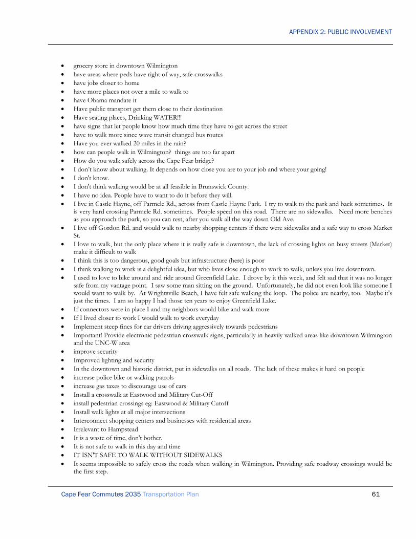
APPENDIX 2: PUBLIC INVOLVEMENT
Cape Fear Commutes 2035 Transportation Plan 61
• grocery store in downtown Wilmington • have areas where peds have right of way, safe crosswalks • have jobs closer to home • have more places not over a mile to walk to • have Obama mandate it • Have public transport get them close to their destination • Have seating places, Drinking WATER!!! • have signs that let people know how much time they have to get across the street • have to walk more since wave transit changed bus routes • Have you ever walked 20 miles in the rain? • how can people walk in Wilmington? things are too far apart • How do you walk safely across the Cape Fear bridge? • I don’t know about walking. It depends on how close you are to your job and where your going! • I don't know. • I don't think walking would be at all feasible in Brunswick County. • I have no idea. People have to want to do it before they will. • I live in Castle Hayne, off Parmele Rd., across from Castle Hayne Park. I try to walk to the park and back sometimes. It
is very hard crossing Parmele Rd. sometimes. People speed on this road. There are no sidewalks. Need more benches as you approach the park, so you can rest, after you walk all the way down Old Ave.
• I live off Gordon Rd. and would walk to nearby shopping centers if there were sidewalks and a safe way to cross Market St.
• I love to walk, but the only place where it is really safe is downtown, the lack of crossing lights on busy streets (Market) make it difficult to walk
• I think this is too dangerous, good goals but infrastructure (here) is poor • I think walking to work is a delightful idea, but who lives close enough to work to walk, unless you live downtown. • I used to love to bike around and ride around Greenfield Lake. I drove by it this week, and felt sad that it was no longer
safe from my vantage point. I saw some man sitting on the ground. Unfortunately, he did not even look like someone I would want to walk by. At Wrightsville Beach, I have felt safe walking the loop. The police are nearby, too. Maybe it's just the times. I am so happy I had those ten years to enjoy Greenfield Lake.
• If connectors were in place I and my neighbors would bike and walk more • If I lived closer to work I would walk to work everyday • Implement steep fines for car drivers driving aggressively towards pedestrians • Important! Provide electronic pedestrian crosswalk signs, particularly in heavily walked areas like downtown Wilmington
and the UNC-W area • improve security • Improved lighting and security • In the downtown and historic district, put in sidewalks on all roads. The lack of these makes it hard on people • increase police bike or walking patrols • increase gas taxes to discourage use of cars • Install a crosswalk at Eastwood and Military Cut-Off • install pedestrian crossings eg: Eastwood & Military Cutoff • Install walk lights at all major intersections • Interconnect shopping centers and businesses with residential areas • Irrelevant to Hampstead • It is a waste of time, don't bother. • It is not safe to walk in this day and time • IT ISN'T SAFE TO WALK WITHOUT SIDEWALKS • It seems impossible to safely cross the roads when walking in Wilmington. Providing safe roadway crossings would be
the first step.

APPENDIX 2: PUBLIC INVOLVEMENT
Cape Fear Commutes 2035 Transportation Plan 62
• It's a healthy thing to do if its within 1/2 mile or so • it's a mind set think about the folks up north (like me) I was used to walking because there was sidewalks and many
businesses located within the walking distance of shopping outlets small and large • It's frightening to cross at busy intersections • Less commercial area reliant on private transportation; more incorporated living areas with sidewalks like Mayfaire • Let neighborhoods provide info on their neighborhood. • Lethem walk if they want to! or not! I don't care! • Light crossing College Rd at Northchase Pkwy SE in much to short to cross - no crosswalks either • Lights across busy streets, or an above street walkway. I do not cross Oleander on foot, however many things I could
shop or go to doctor for are within easy walk of my house, if I could safely cross Oleander. I've called DOT, and they have no plans for lights or above street walkways, so I must drive 1/2 mile to go to doctor, shop, have someone drive me to pick up car at a garage, etc. - you can have all the sidewalks in the world, but if you don't have a way to cross a busy street - they are not worth a dime.
• Link portions of already constructed sidewalks • literature about the health benefits of the extra exercise • Little to walk to where I live. • locate shopping near neighborhoods • locate stores closer/in to neighborhoods • LOTS OF LUCK! • lower the speed limits in residential areas...I wouldn't even walk three blocks on my street • Make cell phone use while driving against the law & teach the public to pay attention to the road & what's around them
while they are operating a motor vehicle!!! • Make it possible to walk to nearby parks and recreation facilities as well as community events by constructing pedestrian
overpasses, etc. and create more smart growth mixed use facilities • make it safer to walk through town • make many wide multi use paths • Make sidewalk continuous, instead of sidewalk-no sidewalk-sidewalk • make sidewalks contiguous, wider, safer, further away from road lanes • Make sidewalks mandatory in residential areas • make the town safe to walk in • Make their current mode of transportation prohibitively expensive • Market street has NO PLACE for pedestrians to safely cross. I see people playing "frogger" all the time and I've seen
people nearly get hit. This is one place to start because if you can't cross Market, you lose out on lots of available services.
• marketing • more green medians with trees, better drivers education • more pedestrian friendly routes would increase the use of public space. Market Street is a primary example of a sidewalk
built for pedestrians and bikes but honestly, when was the last time anyone saw either on the sidewalk. You can then look at Eastwood Roads multi use path. a 3' + Buffer separates cars and traffic from the sidewalk for users. People won't use a sidewalk where they feel their life is in danger. It is noticeable that user utilize Eastwood Rd, which has a much higher speed limit as compared to Market Street which is a decrease in speed limit. The difference can be seen in the design of the sidewalks and the plaza separation of the street and sidewalk.
• more pedestrian crossing buttons on 3rd St. downtown. • More police concentration on heavily travelled areas • more police patrols at Carolina Beach Rd and Shipyard • More sidewalks & safer routes would be sufficient • More sidewalks! • more trees/shrubs on medians and educate drivers • More walk signs • most people live too far from where they work or shop

APPENDIX 2: PUBLIC INVOLVEMENT
Cape Fear Commutes 2035 Transportation Plan 63
• my work is 13 miles away.....please • Need good sidewalks- should not have to walk thru parking lots ( i.e. Wal-Mart to Market St) • need sidewalks on S. College Road • need to be skywalk over major roads (Dawson, Wooster, Oleander, etc.) • new developments require sidewalks, signs downtown- buttons must be pushed • NHHS's elevated walkway over Market Street should be duplicated elsewhere in the area over busy roads. • No amount of encouragement would help me. • No Idea • no more suburban enclaves • NO need most people live to far from main shopping area • No one wants to walk from their suburban home to a shopping center. Walking is only pertinent to those who live
within a mile of their destination. • No working through lunch! • NONE. • nothing- too much crime in Wilmington • nothing- we are too car dependent • offer health benefits • On Pleasure Island the walking/biking lanes are not safe in my estimation. • overpasses and pedestrian overpasses @ beaches • Overpasses would be great for busy areas. • pedestrian bridges @ busy streets- College, Market, Oleander • Pedestrian bridges in key locales, like near market and Gordon. • Pedestrian crossings at major signalized intersections • Pedestrian overpass from Piner Rd or library across s. college • Pedestrian signals have been eliminated on Front St. • Pender County is rural and definitely needs multi-use paths along the road • people are fat and lazy- they will never walk to work • People crossings at traffic lights. • People Downtown walk, but we don't have a lot of services close by such as grocery and health club • People need to feel safe when walking. • people should take ownership of program • People walk for exercise. Only city people walk to work. • Plan better routes for roads and businesses to centralize them • Plan villages rather than developments. • Poles where buttons are installed to push when needing to cross a busy street. • provide emergency access poles like done at universities at every corner or ever other corner for safety • Provide a booklet to New Hanover Residents on how to Drive. • provide crosswalk signals and countdowns. many people around here don't understand when a pedestrian has the right
of way. I would love to walk places but around here it's too scary. maybe look at how cities like Seattle have theirs set up. People walk much more there.
• provide crosswalks • provide more public transportation to where walking is desirable (downtown, etc) • Provide more walking trails throughout the current and future city and county parks/schools. Most of the infrastructure
is already in place. Parking, water fountains, restrooms, benches etc. Just add the trails and 911 call boxes for emergencies.
• provide security and law enforcement • Provide side paths as part of all major roads • provide sidewalks • Provide SIDEWALKS SEPARATE from the road

APPENDIX 2: PUBLIC INVOLVEMENT
Cape Fear Commutes 2035 Transportation Plan 64
• Provide walk-overs on busy roads and streets; meaning pedestrian routes OVER traffic. • Publicity campaign promoting safety, health benefits, etc. • PUBLICIZE this.... that is the only way to get it out to the community! • Put a sidewalk on Greenville Loop Road - the whole way • put a traffic light on harbor island side of Banks Channel Bridge, or at least a flashing yellow light • put adequate light on all roads to be walked • put in crosswalks and lights that have NO traffic moving for pedestrians • put more emergency call phones and lights along paths • raise gas prices • raise gas taxes so that alternatives are more attractive • Recommend cross walks at Eastwood/Military Cutoff AND bike lanes down Eastwood AND the new path on the
South side of Eastwood extended all the way to Wrightsville. • Repossess or disable their car. • require developers to install sidewalks, give tax credits • Requires a fundamental shift in regional development patterns. Better street connectivity is key. • retired • Roads in NHC are NOT safe for walking • roads too busy use parks, etc. • Sadly, during this time of high unemployment this is accomplished by necessity. • SAFE - is the key - more security-the more people walk/bike the more secure it will be • Safe neighborhoods • Safe Routes to School Program • safer crosswalks with lights • safety although I walk downtown everyday panhandlers • Safety has to be a consideration - especially at night • Safety Issue • safety patrols • same • same answer as #8 • Same as above: put stores closer to houses. • advertise the medical assets of walking • See comments in #8 • See note above • set up more areas where housing is close to common places like Mayfaire. • shift in attitude towards walkers and walking! • SIDEWALKS AND PATHS ALONG EXISTING ROADWAYS ONLY! • sidewalks! have you ever tried to walk on Kerr Ave or Randall pkwy? I feel awful for people in motorized wheelchairs
who have to motor down college road. • sidewalks, traffic lights, street lights • Spend your money building more roads. • Stop car dominated planning • Stop urban sprawl • Street lighting to improve safety • tax those who drive alone • that’s a hard one • The access for walking and biking is horrendous. Not only is it disappointing for those wanting to bike or walk, but it's
incredibly unsafe for the elderly, disabled, and those pushing strollers. • The other lottery in Wilmington - being a pedestrian! Except the results are not good

APPENDIX 2: PUBLIC INVOLVEMENT
Cape Fear Commutes 2035 Transportation Plan 65
• The term "more sidewalks" is a joke. • the thought of public baths is not very pleasant. health and safety issues, and common sense, have to overrule this • There are few sidewalks in Wilmington. and crosswalks - the few there are - are dangerous. • there are no adds to encourage people to walk • There are so many sidewalks that just abruptly end. And we need a sidewalk on Randall Pkwy and also on Kerr! • There is no way to cross Military Cutoff by bike or foot easily to the other side • this city is not built for pedestrians, no sidewalks in any new neighborhoods!!!! • this is just to emphasis the safe crossing spots. At Mayfair the bike path is across from the shopping and roads with no
pedestrian-bike crossing available or a button to push to change the light. This is key to safety!!! • This town has no sidewalks. very dangerous, no crossing signs either. scary to walk. • too dangers • too far between home and work to walk! • Turn off television and get out and meet your neighbors • Unfortunately, many people do not live close enough to work or shopping to walk. • unless you live near work or shopping, don't see how this is feasible • Walking in Wilmington is terrifying, few sidewalks, no street crossings • walkway/bike path bridges over highways to shopping center • We have a dangerous situation without CROSSWALKS in the city of Wilmington, and Wrightsville Beach • We should not encourage people to walk more. • we shouldn’t • What's a sidewalk? Unknown in this part of the county • When creating paths encourage heath benefits and estimated mileage • where a sidewalk breaks, construct the remainder! • Wilmington (& New Hanover Co) is severely lacking in sidewalks connecting neighborhoods to shopping, etc. • Wilmington is the worst place I have ever lived for crosswalks at lights. All along Market street (I am assuming one of
the oldest roads in town) there are very few crosswalks. Instead of ignoring walkers focus on them and make cars go the extra distance.
• work from home • work with developers to create more bike and walker friendly areas. • yeah, right • you can't make them walk! • you can't, people either live in walking distance or they don't • You don't • You don't...it akes more tax money and if they want to walk they will! • zoning changes to allow mixed-use development on smaller sites. Encourage urban dev. • zoning homes, schools, and businesses in a way so that one CAN walk everywhere necessary to obtain their daily needs

APPENDIX 2: PUBLIC INVOLVEMENT
Cape Fear Commutes 2035 Transportation Plan 66
Question 15 “List your ideas for specific new transportation projects in the Cape Fear Region”– Responses:
• "trolley" system • stop the growth of Wilmington... we are full. • 10 lane highway • 15 minute headways on buses • 17 south add two lanes when merging with business 17 • 18" to 24" of shoulder/bike lane on all new paving projects • 2 actual lanes out of Wilmington to the north- 17...over pass was a waste and has not fixed any problems. • 2d Ferry to Bald Head Island, from Ft Fisher area • 2nd bridge across Cape Fear River • 3 lanes from 1st Leland Exit to Bridges - traffic is always backed up. • 3 lanes from Pleasure Island to I40 • 3rd bridge over cape fear river at independence • 4 lane bridge north, south, east, west entire county • 4 lane from boiling spring lakes to Southport • 4 Lane Highway 133 from Leland to Southport • 4 Lane Hwy 133 to Southport • 4 LANE INDEPENDENCE -SHIPYARD TO RIVER RD • 4 lane Kerr or add a bike lane • 4 LANE ROADS WITH MEDIANS AND PED/BIKE PATHS • 4 lanes for Route 211 • 4 laning of Kerr Ave completely • 4 way stops downtown • 4 way stops in pedestrian areas • 421/17 merge disaster improvements • 6 lane 17 from Leland to cape fear river bridges • 7 day routes to Wrightsville, Carolina, and Kure beaches as well as Leland • 8 Lane Causeway from Leland to Wilmington • A better crossing of College at UNCW • A bike lane on College Rd from Car. Beach to Market St • A Bike Path on Greenville Loop and Masonboro Loop • a bike/pedestrian ONLY route between downtown and campus, and between campus and Wrightsville beach - utilizing
Burnt Mill Creek thoroughfare a great option! • A high occupancy alternative to cross Cape Fear • a link (better) between Independence and 17th St. • A MLK loop around town giving easy access to downtown, airport, etc. • A new river bridge • A parallel bypass road to Long Beach running from Oak Island to NC 211 • A road directly to downtown from Carolina beach road??? • A road/bridge connecting Greenville Loop Rd. with Masonboro Loop over Hewlett's Creek would be great, and take a
pressure off of two intersections: Pine Grove and Holly Tree, and Pine Grove and Greenville Loop. • A safer bike route from Downtown to the beach. Park Ave eventually ends. Options for bikers are not good. Having
to cross Oleander at Greenville is a dangerous intersection!! • a southerly bridge over Cape Fear River • a southerly bypass of Wilmington • A system of pneumatic tubes that would rocket people through town.

APPENDIX 2: PUBLIC INVOLVEMENT
Cape Fear Commutes 2035 Transportation Plan 67
• a third bridge • A viable bicycle route linking downtown to Wrightsville Beach • A way to safely Cross Bradley Creek Bridge on a bike • Abandon plans for Cape Fear Skyway and build two smaller bridges with bicycle & pedestrian facilities • Above ground Metro Train Line all over Wilmington to the beaches and both Pender/Brunswick Co. • above ground railway system, loop. • Access to the beach without stoplights • access for disabled/ blind getting to bus stops/ changing buses • Access roads with traffic lights at intersections • add new lane to market street • Add "diamond" lane • Add "It the Law" signs to high traffic pedestrian crossing, for example in the Downtown Wilmington area and in front
of the main building on Front St. at CFCC • add 1 lane per each direction on Shipyard Blvd • Add 2 feet on road bike lane on Wrightsville Ave. • Add 2 lanes in each direction on US 17/74/76 from US 421 merge (near Memorial bridge) to split of US 17 and US
74/76 in Brunswick County • Add 2 lanes on College Rd. from Shipyard to Wilshire • Add 2 lanes on Peachtree • Add 2 lanes on Wrightsville Ave from Independence Blvd to Oleander Drive • Add 2 lanes to Carolina Beach Rd • Add 2 lanes to College Rd • Add 2 more lanes to College Road south to Sanford • Add 2 more lanes to Gordon Road • add 2lns each way on us17-74-76 from Leland to Wilmington and add another bridge • Add 2nd left turn lane at Oleander & College • Add 2nd straight lane South on Independence where it crosses Shipyard • add 3 lanes to Market Street to Porters Neck area • add 3rd bridge from new Hanover to Brunswick county • Add 3rd lane each side • Add 3rd lane to US 17 South to North • add a metrorail system through university, airport, downtown, beaches. • Add a 2 lanes to Wrightsville Ave. • add a 3rd land between Leland and Wilmington • Add a 3rd lane from hwy 133 Leland exit on 74/76 towards the Cape Fear Memorial bridge to prevent traffic back-up
down 133 and 17/74/76. • Add a 3rd lane from hwy 421 & 74/76 merge near Battleship towards Leland to prevent bottleneck • Add a bicycle lane on College Rd. • Add a bicycle lane on Market St. • Add a bicycle lane on Shipyard Blvd. • Add a bike lane along Gordon Rd., connecting College to Market • add a bike lane on Gordon Road between N. College+ Mark. • Add a bike lane to Carolina Beach Rd between monkey junction and Carolina Beach • add a bike lane to Wrightsboro Ave • Add a bridge that doesn't open for Wrightsville Beach • Add A bus line from monkey junction to Carolina Beach • Add a bus route from CFCC to both Parks on River Road for a place for people to park and ride. • add a bus route on castle Hayne rd

APPENDIX 2: PUBLIC INVOLVEMENT
Cape Fear Commutes 2035 Transportation Plan 68
• Add a complete bike lane on Randall Parkway • add a dedicated signal for school traffic leaving schools... get them out faster. Especially at Eaton Elementary. • add a dual bridges to the two bridges coming in Wilmington. • Add a hi-rise bridge to enter into the Cape Fear Region • add a lane from Leland to and from Memorial Bridge • add a lane on Burnett St near the gas station • add a lane on college rd from monkey junction into town • Add a lane on each side of Hwy 74/76 and have one lane dedicated to the on and off ramps to merge • Add a lane on each side Shipyard to Wrightsville Ave. on College Road • Add a lane to 74-76 from Leland • add a multi use path down at least a portion of market street connecting to the path on Military Cutoff Road • Add a multi-use path ALL the way around Middle Sound Loop Road and connect it to other multi-use paths already in
existence. • Add a multi-use trail along River Road • Add a new road would help out • add a rail link to Amtrak, continue to Charlotte, Raleigh. • Add a road above main road to act as highway, with on/off ramps. • Add a second left turn lane from Market St. south to New Centre Dr. • Add a second left turn lane from Oleander on to College • Add a separate biking path off existing road from downtown to various areas such as: Sunset Park, Mayfaire, etc • add a stop light at intersection of St. Andrews & Carolina Beach Rd • add a stoplight at St. Andrews Drive and Carolina Beach Rd • Add a stoplight to the parking lot at Hoggard High School • add a stoplight where 421 merges with 74/76 • add a third lane in each direction on 74/76 over the Brunswick river • add a traffic light to Silver lake road and Carolina beach road • Add a traffic light to the corner of Masonboro Loop Road and Masonboro Sound/Pine Grove OR at least monitor the
enormous amount of drivers that speed through the back lot from Masonboro Loop to the Sound to get in front of others
• add a traffic signal at either Dogwood and Oleander or Peiffer and Oleander • add a train track to connect us to Raleigh, etc. • add a turning lane on 210 to117 towards Burgaw • Add accelerating lanes where possible • add access to and 4 lane River Rd to create a bypass to lighten traffic on S. College and CB Rd. • add additional lane each on each side of s. college road • add additional lane for merging traffic from 133 to 17 • Add additional lane to Village Road • add additional lanes • add additional lanes • Add additional lanes from 421 South exit to first Leland Exit • Add additional lanes on College Road from Oleander to Shipyard. • add additional lanes on Gordon Rd • add additional lanes to cape fear and Holmes bridges • Add additional lanes to hwy 17/74/76 into Brunswick County • add additional lanes to Market St • add additional lanes where 421 merges with 74/76 • Add additional merge lanes from hwy 421 onto 74/76/17 • Add an additional cut through at College and Oleander

APPENDIX 2: PUBLIC INVOLVEMENT
Cape Fear Commutes 2035 Transportation Plan 69
• Add an additional direct route from Wrightsville Avenue to Market Street besides Independence Blvd. That intersection gets too congested.
• Add an additional route from S. Kerr Avenue to Independence Blvd. Traffic on S. Kerr Avenue gets far too backed up during rush hour.
• Add an additional traffic light on College at Georgetown • Add an executive airport along Dow Road • Add an extra lane both ways between Carolina Beach & Downtown Wilmington • Add an extra lane where 421 & 17/74 meet till the Leland exit • add another bridge from Leland to Wilmington • Add another lane from Cape Fear Memorial exit and continue over causeway to Leland exit. • Add another lane off 133 and continue to Isabelle Homes Exit • Add another lane on Randall St. between Independence Ave. and S. Kerr. • Add another lane to College to keep it three lanes until Carolina Beach • add another lane to the draw bridge • Add another left hand lane on New Centre Dr. between Racine Dr. and College Rd. • Add another road connecting Carolina Beach Rd. & Myrtle Grove Rd. • add another way for Brunswick co. to get to Wilmington without use of 74/76 • Add bicycle friendly shoulder to major roads. • Add bicycle lanes • Add bicycle lanes and sidewalks to more roads • Add bicycle lanes on Carolina Beach Road between Monkey Junction & Shipyard Blvd • Add Bicycle Lanes on Oleander • Add bicycle lanes on St. Andrews Drive • add bicycle lanes throughout Wilmington, city and county • Add bicycle lanes to all road ways • Add bicycle lanes to existing roads • Add bicycle lanes to highly traveled areas/roads • Add bicycle lanes to the side of Market St. and pedestrian/bicycle overpass across Market St. • Add bicycle loop detectors at traffic signals • Add bicycle path to hwy 17 especially north of Eastwood Rd • Add bicycle paths everywhere & safety crosses across Market. • Add bicycle paths on College Road from 17th St. Ext. to Carolina Beach • Add bicycle paths to every road connecting Market and College and major thoroughfares • Add bike lane on college road or alt route to college from south Wilmington • Add bike lane on Racine to connect Eastwood bike path to University • Add bike lane to Market Street • Add bike lanes • add bike lanes / sidewalks off the major roads • add bike lanes at every major road • add bike lanes in Hampstead on Hwy. 17 • add bike lanes in Masonboro area • Add Bike lanes on ALL roads - not just the richer parts of town. • add bike lanes one market street and south college road • Add bike lanes or trails and support facilities to park avenue • Add bike lanes throughout the region • Add bike lanes to 16th and 17th Streets • Add bike lanes to all new projects and all resurfacing projects. • Add bike lanes to all new roads

APPENDIX 2: PUBLIC INVOLVEMENT
Cape Fear Commutes 2035 Transportation Plan 70
• Add Bike lanes to College Road • Add bike lanes to Pine Grove • Add bike lanes/multi use path connecting Greenfield Lake and downtown • Add Bike Lanes at Wrightsville Beach • Add bike path to Oleander • Add bike path/lane from exit 420B to north campus • Add bike paths (like the one down Military Cutoff Road) as many places as can be done. • Add bike paths all around the greater Wilmington area • add bike paths AWAY from but ALONG main thoroughfares • Add bike trails on Gordon Road • Add bike trails on Market Street • Add bike trails or paths for people to use, thousands of people utilize the loop at Wrightsville beach • add bile lanes down shipyard and Randall parkway • add bus only lanes • Add bus service to health care facilities on Porters Neck Road • add bus service to the beach and also to the airport. • add bus stop at CVS in Pine Valley or Food Lion in Pine Valley that shuttles from there back to hosp • Add bus stops in Carolina Beach and Monkey Junction • Add bus stops out to the porter's neck area • add bus transportation from Porters Neck Road area • Add buses on Saturdays and Sundays • Add bypass from north Wilmington to Monkey Junction area • Add capacity on Alligator Creek Bridge on HWY 17 • add carpool lane to s college rd • add carpool lanes on busy highways • Add carpool lanes on Hwy 17 • add center lane on college road from Wilmington to fort fisher • Add center turn lane to NC 133 from Castle Hayne to Pender County line. • Add Circle to Middle Sound Loop Ogden intersection • Add connection from US 17 to NC 210 in Hampstead (i.e. better connection from Burgaw to Hampstead) • Add connector Road between NC 211 and NC 87 • Add connector Road between NC 87 and Midway Rd • Add connector Road between US 17 & NC 133 • Add connector Road between US 17 & NC 133 • Add crosswalk @ Mayfair on Military Cutoff • Add crosswalk at Eastwood and Military Cutoff • Add crosswalks and pedestrian signals along Military Cutoff Rd • Add crosswalks at major intersections along Market Street. • Add crosswalks to Military Cutoff/Eastwood intersection • Add Elevated "by Pass" in Hampstead, Use existing right-of-way • Add elevated railways for commuters in the tri-country areas • Add E-W walk/bike path from Wrightsville Beach to downtown • Add Exit ramps to I-140 by NC132N • add express train travel • add extra lane on 74/76 between bridge and Leland • add extra lanes at 74/76 and 421 junction • add extra lanes by hwy 133 exit off 74/76 • add extra lanes from Brunswick county coming into Wilmington

APPENDIX 2: PUBLIC INVOLVEMENT
Cape Fear Commutes 2035 Transportation Plan 71
• add extra out bound lane on Market from Gordon Rd to Marsh Oaks • add full lines on the lanes • add jersey walls to entrance ramp in Leland from 133 to 74/76 • Add la center lane to Gordon Rd with a multi-use path • add landscape medians • Add lane to College Rd in area of Shipyard/Oleander • add lane where 421 merges with 74/76 coming into Brunswick Co • Add lanes at Leland 74/76/17 merge • Add lanes between Military Cutoff and Ogden • add lanes on 74/76 from where 17 merges • add lanes or overpass eastwood and military cutoff road intersection • add lanes to Gordon Rd. from Market St. to N. College Rd. • Add lanes to 133/Village Road in Leland/Belville • Add lanes to 17/74/76 between Leland and Wilmington • Add lanes to 74W/17S merge between Wilmington & Leland • Add lanes to Causeway bridge • add lanes to college rd • Add lanes to College Road near Hugh McRae Park • Add lanes to independence between river road and 17th • Add lanes to independence boulevard • Add lanes to Kerr Ave. from Market Street north • Add lanes to Market St. between Porter's Neck Rd. and Gordon Road. • Add lanes to Market Street north of Kerr through Porter's Neck • Add lanes to Oleander at College Road intersection • Add lanes to overcrowded roads NOW • add lanes to S. College Road • ADD LEFT HAND TURN SIGNALS AT ALL MAJOR INTERSECTIONS LIKE THEY DO IN MOST NORMAL
CITIES (we are WAY behind on this) • add left turn lane and light to intersection of Robinhood and South 17th street • add left turn onto S 17th from shopping area (with Brusters) at 17th/college • Add light rail down center of Market St and College Rd. • Add Light Rail from Leland across Cape Fear to downtown, and link with bus system • add light rail, Develop a better airport with more gates and better carrier to bring in bigger flights. • Add limited access interchange at I-140 & N. College Rd. • ADD LIT CROSSWALK paths • add longer bus hours • add medians (restricted turns) to Market street for safety • Add mid-block crosswalks • Add more and sidewalks for pedestrians. • Add more and wider bike lanes • Add more bicycle lanes to area in general • Add more bike and walking paths on Shipyard • Add more bike and walking paths around college road • add more bike lanes • add more bike lanes • add more bike paths • add more bridges • add more bus routes

APPENDIX 2: PUBLIC INVOLVEMENT
Cape Fear Commutes 2035 Transportation Plan 72
• add more bus routes maybe up and down college rd • Add more bus routes to airport and downtown. • Add more bus stops • add more bus stops in castle Hayne • add more buses • Add more buses • Add more dedicated bike lanes • Add more driving/turning lanes to Brunswick County end of hwy 133 • Add more lanes after the merge going into Brunswick Co. from bridges • Add more lanes all over • Add more lanes both ways on Carolina Beach Rd between Shipyard Blvd and Carolina Beach. • Add more lanes coming into Wilmington from the Leland Area • add more lanes on Brunswick side of C F Memorial Bridge • Add more lanes to 74-76-17-421 between Leland & Wilmington • add more lanes to Gordon Road • Add more lanes to Gordon Road • Add more lanes to Gordon Road (or at least a turning lane all the through) • Add more lanes to Hwy 17/74/76 and Cape Fear Memorial Bridge • Add more Leland-Downtown Wilmington Routes morn/evening • Add more of the Michigan U-turns on Rte 17 to eliminate need for traffic lights • add more on/off ramps to I140 to encourage use • Add more parkways • Add more paths for walking and bicycling commuters • Add MORE public transportation lots • Add more sidewalks for pedestrians and bikers • add more sidewalks for walking • add more super street type streets so cars can't just pull out in either direction and cause accidents, especially accidents • Add more turn lanes • add more turn lanes • Add Multi Use sidewalk/lane to Market Street north of Kerr through Porter's Neck • Add multi-use paths throughout the city to allow pedestrian/bicycle traffic to access most major areas of town • Add Multi-use sidewalk/lane to Middle Sound Loop Road • Add new bus routes, improve existing ones. • add new lanes on 74-76 coming from Brunswick County • add north side crosswalk to improve pedestrian safety at stoplight at Kure Beach • Add N-S walk/bike path from Kure Beach to N Wilmington. • Add off road bike and walking trails all over town. • add off-road bike lanes along key travel roads; Carolina bch rd, hwy 17, hwy 421, college rd, oleander dr, shipyard rd,
independence blvd.. • add off-road bike/pedestrian lane along River Road so kids can bike or walk to school from neighborhoods and homes. • Add overpass at College and Oleander • add pedestrian bridges over major roads (ex. college road and market streets) • Add pedestrian controlled lights to cross College Road in front of UNCW • Add pedestrian overpass at College and Holly Tree • Add pedestrian walkways in the monkey junction area. • Add public transportation service to Carolina Beach • Add public transportation service to Carolina Beach • Add public transportation service to Carolina Beach

APPENDIX 2: PUBLIC INVOLVEMENT
Cape Fear Commutes 2035 Transportation Plan 73
• Add ramps & loops to Market/College interchange • Add right hand turning lane on Wrightsville Ave (going towards downtown) and Independence • add right turn lane to college rd/oleander dr. intersection by CVS • Add right lane both directions on 74/76 between 421 exit and 1st Leland exit • Add SAFE bike lanes along main roads like Carolina Beach Rd, College Rd, Market St., Independence & 17th St • Add safe bike lanes everywhere you can. • Add safe bike lanes for travel throughout city, not same surface as automobile travel. • add safe bike lanes to busy roads and intersections (i.e. Oleander & Independence) • Add safe bike or scooter lanes • Add safe dedicated bicycle lanes to major roadways that are mandatory for motorized scooters too and can be used by
walkers as well. • Add safe, consistent pedestrian/bike lanes on market street from YMCA to downtown • Add safer bike paths • add second left turn lane from Market St. south to S. Kerr Ave. • Add service road at new development in Leland/Belville area • Add sidewalk/multi-use paths on Market St. It's just not safe to walk anywhere or ride a bike • add sidewalks all the way down Market street, from Porter's Neck to Downtown • add sidewalks down 17 street extension from hospital to collage rd • Add sidewalks from the Halcyon Forest community to Parsley Elementary crosswalk • Add sidewalks from the Woodsedge Community to the light at the Myrtle Grove Library and add a crosswalk to the
Wal-Mart shopping center • Add sidewalks on main roads and major commercial areas to promote alternate forms of transportation • Add sidewalks or bike lanes the length of 16th and 17th street • Add sidewalks to current streets • add sidewalks to every street on one side of the road • add sidewalks/bike paths on S 17th street from college to Hospital • ADD STOP LIGHT AT MIDDLE SOUND ROAD AND PINE GROVE • Add Texas frontage roads on 17 & eliminate Michigan left-turns on 17 • Add third lane to and from the Cape Fear Bridge to the first Leland Exit. Right now, 4 lanes have to merge into just 2
lanes. This causes huge backups every morning and evening. • Add third lane to be a right turn only lane on north bound HWY 133 at 74/76 junction • add third lane to College Road, both directions to Carolina Beach Road • add third lane to east bound Leland on ramp • Add Third lanes and Expand Bridges EB/WB on Hwy 74/76 • add true bike lanes and more multi-use paths • Add turn lanes for intersections on two-lane roads • add turn lanes to all main 2 lane roads • Add turning lanes and right/left turn SIGNAL at Country Club and Wrightsville - very unsafe intersection • add two extra lanes to s. college near pine valley • add two lanes each way on Gordon Rd. • Add two lanes exiting Wilmington, hwy 17 at Porters Neck • Add two lanes from Burgaw to ILM • Add two lanes from Cape Fear Bridge to Leland • Add two lanes from Hwy 74/76 into Wilmington from Leland to Wilmington • add two lanes from Shipyard Blvd to Carolina Beach • Add two lanes to College Road • add two lanes to college road between monkey junction and Wrightsville Ave. • Add two lanes to Gordon Road between Kerr & Market St.

APPENDIX 2: PUBLIC INVOLVEMENT
Cape Fear Commutes 2035 Transportation Plan 74
• Add two lanes to Gordon Road. • add two lanes to Kerr Ave between Gordon Rd. & College Rd. • Add two lanes to Market Street • Add two lanes to S Kerr Ave & N Kerr Ave. to M L Dr. • Add two lanes to South College Rd or elevated road • Add two more lanes between River Road from Leland to Southport • add underground rail with 3 lines with Blue line runs north and south, Red line run east and west through out the
county. Have the Blue line start at the town of Leland and end in the New Hanover Pender county line near Hampstead. • Add/expand bus transportation within the Wilmington, Ogden, Porter's Neck and Hampstead areas • Add/change turning lanes at Hwy 210/Hwy 117 junction. • Add at least one through lane at College and Oleander • Adding a shoulder to myrtle grove road • Adding extra exit lane from 421 S to 74/76 • adding more buses • Adding paved shoulders to the entire length of NC 133 from Town Creek to US 17 • Adding toll roads would mean less people would use them and those who are willing to pay would have a more direct
route • addition of secured exit from Landfall from Landfall Drive to Summer Place/Eastwood Rd • additional bike lanes • Additional Bike Lanes on major roads • Additional bridge from Brunswick to NH Co. • Additional bridge over Cape Fear River **critical need** • Additional bridge to Leland area • additional bus stops and frequency of runs • Additional Crossing for the Cape Fear River • Additional ferry trips at Southport • additional lanes on all major roads, where possible, to ease congestion • additional lanes on Hwy 211 Hwy 87 and Hwy 133 • Additional lanes on Market Street into/out of Pender County between Gordon Rd. and the new I-140 intersection
directly north of Porter's Neck • additional lanes where Cape Fear Memorial and Isabel Holmes Bridges come together going into Leland • additional off-road bike trails • additional shuttles to/from surrounding counties • Additional Stop for WAVE • Additional turn land for merging traffic from Hwy17 & Hwy133 onto 74/76 in Brunswick County • Address pedestrian crossing Wooster and Dawson streets, they run out all the time in the middle of traffic and is very
unsafe • Adjust lights on College Rd at Oleander • adjust timing of College Road stoplights between Market St and Oleander Drive • Advance traffic signal warning beacons for trucks along US 17 and US 74-76 • After the 2nd stoplight on 133 south build a median that prevents people from using the right lane as a passing lane
before Blackwell road. • Ages 14 to 18 can use bikes, scooters or walk only. • Alcohol tax to fund transportation projects • Align the lanes at intersection of US 117 & NC 210 in Rocky Point to safely make turns when there are several vehicles
in the turning lane • all bus routes need there own driving lane • All lights crossing College to be fixed - timed lights from 4-7 not triggered • All means of transportation-need a center

APPENDIX 2: PUBLIC INVOLVEMENT
Cape Fear Commutes 2035 Transportation Plan 75
• all night routes will raise more money too and keep a lot of people from drinking and driving that do not want to pay cab fare and need to sober up before going home it will probably lower domestic violence
• All roads and intersections at front, water, and dock St need to be walk and bike only. No cars. Build lots around 3rd St and protect them so people can walk to work.
• alleviate congestion on College going North in front of Hugh McRae park during AM Drive time • Allow left turns from Military Cutoff to Gordon Rd. during off-peak times • Allow long skateboards on sidewalks for transportation purposes • Allow taller residential and mixed use buildings downtown • Already developed roads like college, market & oleander/military- use dug handles eliminate "suicide" lanes so all turns
are to right. • Also, this is a very crime-ridden town! • Alternate bike/pedestrian paths • Alternate routes for pedestrians and bikes so they're not right on River Road • Alternative roads for College and Market Streets • alternative sources of energy used in cars • Always multiuse path NOT wider pavement along streets • Amtrak train service in Burgaw, NC • Amtrak running to Wilmington. NC from major cities • Amtrak • Amtrak Rail Station • Amtrak service • Amtrak Service to Raleigh, Greensboro and Charlotte • Amtrak to Raleigh from Wilmington • Amtrak to Wilmington from Raleigh with access to train to NY/ Eastern Corridor • an express route from I-40 to Pleasure Island • An overhead thorough fare for travel from Martin Luther King to Monkey Junction • another bigger better bridge • Another bridge across the Cape Fear River • Another bridge between Brunswick county and NHC • Another bridge from Brunswick County to New Hanover County South of the Cape Fear Memorial Bridge. • another bridge from Leland to Wilmington • Another bridge into Wilmington • Another bridge over Cape Fear River • Another bridge over Cape Fear River • another bridge over the cape fear river from Brunswick counties rising growth • another exit from 17 to Holmes Bridge • another four-lane north-south road - River rd to Independence and north • another route from Brunswick County • Another way Bridge from Brunswick to Wilmington • another way into and out of Wilmington by way of Leland • another way out of Middle Sound Loop Road to get to hwy 17 • antenna farm road to Bolivia, NC (county complex/college) • antenna farm road to connect with hwy 211 • ANY IDEAS OF CAPE FEAR IS GOOD TO ME • any new roads should be required to have a bicycle lane • any repairs to road should have 1-2 ft on side bur • anything that would help traffic on South College road

APPENDIX 2: PUBLIC INVOLVEMENT
Cape Fear Commutes 2035 Transportation Plan 76
• As Leland continues to expand, the bottlenecking is going to get much, much worse. I'm not sure what can be done about this, but do think planning for this inevitable situation needs to be a top priority.
• Ask large businesses to stagger their start-stop times • At the bank of america on racine and s. college. The bank has an entrance on racine that needs to be fixed because
someone is going to get seriously injured, it is not safe to turn out or in from that entrance. • Away from road Bike lanes the length of College Road • Ban left-turns at intersection of NC 133 and Blackwell Rd • Ban new commercial developments • Ban new housing developments • Ban or create specific lanes for scooters/bicycles • Beach specific shuttles from specific locations directly to beach areas -spoke style • beatify and control road construction. MPO is still not planning the development to allow for smart growth and
increased potential for maximizing uses along major corridors. I.E Market Street, Oleander, Dawson, Wooster • Beautification of Eastwood Road - More miles of trees, grass and rain garden median; bushes, trees rain gardens along
roadsides. No more stop lights, no more road crossings • Beautification of Martin Luther King Parkway. Can a safe pedestrian/bicycle path be added? • beautifying the current roads with plantings • Because Wilmington already is packed we need to take cars off the road. Expand the Bus service. More routes and stops
all the way to Ogden. Thanks. • begin plans to replace the Cape Fear Memorial Bridge • Beltline around city with more thoroughfares through city • beltline from North Wilmington to the far west/ SW communities • Better access from downtown to points south on US 17 • better advertising on campus about transit routes • Better and Expanded Bus service • Better and more bus routes. • Better and safer pedestrian routes for everyone. • better bicycle lanes throughout city • Better Bike lanes around town (existing too narrow) • Better bike lanes from downtown to Carolina Heights area and to the mall • better bike paths along busy roads • Better bike paths and more information on them • better bike paths in the city connect river road path to independence - all the way to market - down 17th to NHRMC • better bike paths on River Road • better bike routes • Better bike routes across the bridges (WB and Cape Fear River) • Better Bus Routes for suburbs to downtown/airport • Better bus service to hospital • Better Bus service to other cities. • better bus system • Better connection from Hampstead to Surf City • Better connectivity to Ploof Rd and US 17 • Better connector between beach areas especially Wrightsville and Carolina • Better coordinate Southport-Fort Fisher ferry runs for commuters • Better Cross Walks and Bike Crossing at Intersections • Better crossing lanes for College/Randall intersect • Better cruise ship access • better flow on college rd • better interchange from Wilmington to Leland at 17/74/76

APPENDIX 2: PUBLIC INVOLVEMENT
Cape Fear Commutes 2035 Transportation Plan 77
• Better lineal connection east of us 17 • Better pedestrian and bike facilities in Castle Hayne area • better public transport like Paris • Better routes to beltways outside city and/or connectors from one end of the city or county to the other. Better and
safer routes such as bridges/overpasses to and from congested areas first, before allowing development. Infrastructure and environmental impact FIRST before allowing rezoning for projects.
• better safety crossing at shipyard and 17th street • Better shelters and safer facilities to wait for the buses • better timing of traffic lights & no overnight flashers • Better timing of traffic signals to keep traffic moving • better traffic enforcement on independence blvd • Better traffic flow from Leland to US 421 north • Better traffic flow from US 421 south to Leland • Better traffic light controls • better traffic light coordination • Better walkways along all roads. • better way to get in Wilmington • Better, safer, more scenic bike routes • Better/safer bike paths that actually go somewhere. • Better/safer bike/walking paths from downtown to the beach, preferably away from major roads • Bicycle bridge over Snows Cut Bridge • Bicycle lane from MKL to Beach • Bicycle lane Oleander through Military • Bicycle lane on College Ave and Kerr • bicycle lane on College Rd. • Bicycle Lane on Wrightsville Avenue. People use it daily and it connects to the beach. • Bicycle lane/shoulder on all new roads/resurfacing • bicycle lanes • Bicycle lanes • bicycle lanes • bicycle lanes • bicycle lanes • bicycle lanes from snows cut to monkey junction • bicycle lanes needed everywhere • Bicycle lanes on ALL MAJOR roads including between counties • Bicycle lanes on Dow Road • bicycle lanes on major arteries • Bicycle Lanes on Market/17 from Downtown to North End of County • Bicycle lanes on Masonboro Loop Road • Bicycle lanes throughout Wilmington with connections to beach and downtown • Bicycle Lanes to improve safety • Bicycle path networks, i.e., Oak Island to Southport • bicycle path on 133 • Bicycle Path on Pleasure Island connected to River Road • Bicycle paths along (or near) busy 2 lane roads like Porters Neck Road • bicycle paths in Hampstead from major developments to subdivisions • Bicycle paths that are safe to travel • Bicycle paths to every park
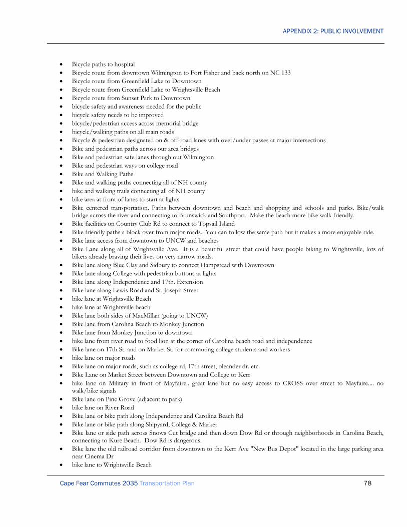
APPENDIX 2: PUBLIC INVOLVEMENT
Cape Fear Commutes 2035 Transportation Plan 78
• Bicycle paths to hospital • Bicycle route from downtown Wilmington to Fort Fisher and back north on NC 133 • Bicycle route from Greenfield Lake to Downtown • Bicycle route from Greenfield Lake to Wrightsville Beach • Bicycle route from Sunset Park to Downtown • bicycle safety and awareness needed for the public • bicycle safety needs to be improved • bicycle/pedestrian access across memorial bridge • bicycle/walking paths on all main roads • Bicycle & pedestrian designated on & off-road lanes with over/under passes at major intersections • Bike and pedestrian paths across our area bridges • Bike and pedestrian safe lanes through out Wilmington • Bike and pedestrian ways on college road • Bike and Walking Paths • Bike and walking paths connecting all of NH county • bike and walking trails connecting all of NH county • bike area at front of lanes to start at lights • Bike centered transportation. Paths between downtown and beach and shopping and schools and parks. Bike/walk
bridge across the river and connecting to Brunswick and Southport. Make the beach more bike walk friendly. • Bike facilities on Country Club Rd to connect to Topsail Island • Bike friendly paths a block over from major roads. You can follow the same path but it makes a more enjoyable ride. • Bike lane access from downtown to UNCW and beaches • Bike Lane along all of Wrightsville Ave. It is a beautiful street that could have people biking to Wrightsville, lots of
bikers already braving their lives on very narrow roads. • Bike lane along Blue Clay and Sidbury to connect Hampstead with Downtown • Bike lane along College with pedestrian buttons at lights • Bike lane along Independence and 17th. Extension • Bike lane along Lewis Road and St. Joseph Street • bike lane at Wrightsville Beach • bike lane at Wrightsville beach • Bike lane both sides of MacMillan (going to UNCW) • Bike lane from Carolina Beach to Monkey Junction • Bike lane from Monkey Junction to downtown • bike lane from river road to food lion at the corner of Carolina beach road and independence • Bike lane on 17th St. and on Market St. for commuting college students and workers • bike lane on major roads • Bike lane on major roads, such as college rd, 17th street, oleander dr. etc. • Bike Lane on Market Street between Downtown and College or Kerr • bike lane on Military in front of Mayfaire.. great lane but no easy access to CROSS over street to Mayfaire.... no
walk/bike signals • Bike lane on Pine Grove (adjacent to park) • bike lane on River Road • Bike lane or bike path along Independence and Carolina Beach Rd • Bike lane or bike path along Shipyard, College & Market • Bike lane or side path across Snows Cut bridge and then down Dow Rd or through neighborhoods in Carolina Beach,
connecting to Kure Beach. Dow Rd is dangerous. • Bike lane the old railroad corridor from downtown to the Kerr Ave "New Bus Depot" located in the large parking area
near Cinema Dr • bike lane to Wrightsville Beach

APPENDIX 2: PUBLIC INVOLVEMENT
Cape Fear Commutes 2035 Transportation Plan 79
• bike lane, Masonboro loop rd • bike lane, myrtle grove rd • bike lane on Pinero Rd • bike lanes • Bike Lanes • Bike Lanes • BIKE LANES • Bike lanes • bike lanes • bike lanes • Bike lanes • bike lanes • bike lanes • bike lanes • BIKE LANES • Bike lanes added on Market and College • Bike lanes adjacent to Wrightsville Avenue. • Bike lanes all over New Hanover county • Bike lanes all over New Hanover county • Bike lanes all over New Hanover county • bike lanes all the way down Dow Road • Bike lanes all the way down to Wrightsville Beach • Bike lanes along 133 from n kerr to martin luther • Bike lanes along all collector level streets • Bike lanes along all major roads. • Bike lanes along Carolina Beach Rd and College Rd. • Bike lanes along Hwy 117 • bike lanes along hwy 17 and hwy 210 from Hampstead to surf city • bike lanes and sidewalks on Masonboro Loop and Sound • Bike lanes College Road • Bike lanes EVERYWHERE • bike lanes- everywhere • BIKE LANES EVERYWHERE IN TOWN.. use Portland as a City with an Awesome bike and walking support system • Bike lanes for 23 North/Castle Hayne Rd from Market to Castle Hayne • BIKE LANES MARKET STREET • BIKE LANES OLEANDER DRIVE • Bike lanes on all major thoroughfares (Oleander, Market, etc). • bike lanes on both sides of streets on UNCW campus • Bike lanes on Carolina Beach Road • bike lanes on country roads, like Hwy 117 and 133 • bike lanes on dow road • Bike Lanes on Eastwood from current ending of bike lanes to Market street • Bike lanes on Gordon Road • bike lanes on Hwy 17 • bike lanes on Independence Blvd • Bike lanes on Isabel Holmes Bridge including non slip metal plates on the grating portion • Bike Lanes on major roads in city of Wilmington • bike lanes on market

APPENDIX 2: PUBLIC INVOLVEMENT
Cape Fear Commutes 2035 Transportation Plan 80
• Bike lanes on Market Street e.g. Hilton Head Island, SC • Bike lanes on Market street from downtown all the way to Porter's Neck • bike lanes on middle sound loop • Bike lanes on Middle Sound Road • Bike lanes on NC 133 in Brunswick County • bike lanes on oleander and college • Bike lanes on River Road • bike lanes on Wrightsville beach • bike lanes to Wrightsville beach • BIKE LANES!!!!!!!!! all over... especially College • BIKE LANES; SIDEWALKS ON CAROLINA BEACH RD • Bike Lanes-Wilmington and most importantly Wrightsville Beach!! if you can't ride a bike on the sidewalk, then provide
a bike lane • Bike or moped lanes ALL over the city • bike parking racks at every school • Bike path along 133 in Leland/Winnabow area • Bike path along Burnet St from Front Street to River Rd. This would connect downtown to a bikers' destination. • Bike path along Dow Road, Myrtle Grove road, Masonboro Loop Road • Bike path beach to downtown • bike path down Carolina beach road • Bike path from Carolina Beach to Kure Beach • bike path from downtown Wilmington to Wrightsville beach • Bike Path from Kings Grant to College rd area south of Market and to Eastwood rd • Bike path from Leland to Wilmington • Bike Path From Military Cutoff Rd to Wrightsville Beach • Bike Path linking Kure Beach to Wilmington • Bike Path linking Kure Beach to Wrightsville Beach • bike path Middle Sound Loop Road • Bike path on Carolina Beach Road • Bike path on College Rd • Bike path on Front Street from downtown to Sunset Park! • Bike path on Market St. • Bike path on Pleasure Island • Bike paths • bike paths • Bike paths • Bike Paths • Bike paths • BIKE PATHS • Bike paths along Covil Farms Road • Bike Paths and lanes • bike paths connecting homes and businesses • bike paths downtown and on river road • Bike paths from Hampstead to Wilmington • Bike Paths from Middle Sound Loop to Military Cut Off. • Bike paths Halyburton Park to Hugh McRae Park to UNCW • bike paths in Carolina Beach and Kure Beach • bike paths off road

APPENDIX 2: PUBLIC INVOLVEMENT
Cape Fear Commutes 2035 Transportation Plan 81
• bike paths on bridges thru out town • Bike paths thru Wilmington and New Hanover County • Bike paths/lanes connecting homes to shopping • Bike paths/trails in northern Brunswick Co. • Bike route from Monkey Junction to Downtown • bike routes on all roads • Bike routes throughout Wilmington esp. College Rd. • bike trail from Carolina to kure beach • bike trails • Bike Trails • bike/pedestrian path on Covil Farm Rd. • Bike/pedestrian paths separated from rd linking downtown, UNCW, Wrightsville Beach and Carolina Beach • Bike/walk path from downtown to Wrightsville Beach. • bike/walk path from University to Downtown that follows Burnt Mill creek from the reservoir on Randall Parkway to
Carolina place. could connect to bike way on Ann St. via Mets. • Bike/walking lane finished to end of Military cutoff • bike/walking paths Leonard St to Howe St in Southport • bike/walking trail across snows cut • bike lanes (for us Porter's Neck Rd and Market Street) • Bike paths & Sidewalks on College Rd, Eastwood Rd., etc with Safe crossing • Bikeways • bile lane to downtown and Carolina beach • Biodiesel Bus • blinking lights in early AM hours @ Carolina Bch & Sanders • blinking lights in early AM hours @ Independence & Wrightsville • Block left lane on 74 to Wilmington through Leland so people cannot change lanes until the first bridge • bona fide bike lanes from north topsail island to south topsail island • Both bridges need their own entrance into Brunswick • Bridge across river ( new) accommodates cruise ships • Bridge crossing to Southport - extension of Independence • bridge from 211 to independence road • Bridge from Brunswick County to Wilmington over CFR • Bridge from highway 87 (near sunny point) to Independence Blvd in Wilmington • bridge or safe crosswalk from one side of Military Cut-off to the other • Bridge over Cape Fear from ILM to Brunswick • bridge over ICWW from NHC to Brunswick county • bridge over the river closer to Carolina Beach to help bypass Wilmington • bridge system where market st and Eastwood meet. • bridge to bald head island (yeah right!) • Bridge to connect South end of co to Brunswick Co • bridge to Wrightsville beach • Bridge with more lane capacity • bridges over congested intersections • BRIGDGE FROM NHC TO BRUNSWICK CTY • bring back the Trolley downtown to the beach • Bring back train from Raleigh to Wilmington • Brunswick Co require connectivity w/all dev. with access to 17 &133 • Build overpasses at major intersections - like c college and oleander

APPENDIX 2: PUBLIC INVOLVEMENT
Cape Fear Commutes 2035 Transportation Plan 82
• build "skyway" bridge and finish I-140 • build 2nd bridge adjacent to CF Memorial Bridge for EB traffic • build 3rd bridge • Build 3rd bridge • build 8 lanes from Leland to WL and add parallel bridge • build a bicycle path/lane from Leland/Belville to Wilmington • build a bridge to Brunswick County. • build a bypass around all congested/growth areas • Build a by-pass around Hampstead on US 17 that connects from near Scott's Hill to Holly Ridge • build a collector road beside 132 instead of all the entrances have one entrance • Build a freeway linking Brunswick & NH county • Build a high-rise bridge that does not have to lift for ships • Build an Interstate grade road the length of college road • Build a monorail from one end of the county to the other. • build a multi use path along the rail line going from castle Hayne to Burgaw • Build a new 6 lane drawbridge over the Cape Fear River (without the grids) to ease congestion along 421/17/74 coming
in and out New Hanover and Brunswick Counties • Build a railway to run adjacent to Hwy 17 from Pender to Brunswick Co. • Build a road to bypass the Brunswick R. causeway for one of the bridges. Problems there tie up both bridges now. • Build alternative to College Rd. as North-South travel route - get the traffic out of the center • Build an additional bridge from Brunswick County • Build an additional north/south connector • Build an exit of I-40 to Holly Ridge • Build an off-road bicycle sidewalk down College rd. • Build an off-road bicycle sidewalk down Market St. • Build an off-road bicycle sidewalk on MLK, Jr. Parkway • Build an overpass near the College and Oleander area • Build an overpass over the Eastbrook railroad crossing • build and replace existing cape fear memorial bridge • Build another bridge across the Cape Fear river. The traffic to/from Brunswick Co. is only going to get worse. • build another bridge into Brunswick county • build another bridge to Leland • build better bike and pedestrian lanes in Porter's Neck • Build bicycle / walking lane on skyway if bridge is built (i.e. Cooper River Bridge in Charleston) • Build bike lanes • Build bicycle lanes on Carolina Beach Rd from Monkey Junction to Carolina Beach • Build bike paths along College Road • Build bike paths along Market Street • Build bike paths on all major roads • build bike underpasses and trails that allow you to get around the entire town without subjecting yourself to the unsafe
road conditions • build bridge that does not have to go up for the big ships to come through river • Build bridge/bypass over College & Oleander intersection • Build bring to connect • Build Brunswick part of I-140 bypass • Build bus stop shelters. • Build bypass from Carolina Beach to I40 with exits to Brunswick Co, College, Oleander and most widely used areas of
town

APPENDIX 2: PUBLIC INVOLVEMENT
Cape Fear Commutes 2035 Transportation Plan 83
• Build Cape Fear Skyway • Build Cape Fear Skyway • build commuter rail- coming from Philly I know the benefits • Build frontage roads along US 17 and 74-76 • Build full interchange at intersection of the Wilmington Bypass and US 74-76 • Build Hampstead Bypass • Build Hampstead Bypass • Build Hampstead Bypass • Build Intestate highways across town with access roads to businesses, instead of so many stop lights. • Build light rail lines • build lots and shelters • Build median on US 17 in Hampstead • Build MetroRail system in Wilmington and link it to Leland • Build more Bicycle lanes that make all of Wilmington safe to access via bicycle. • build more bypass roads to help with Market St traffic • build more safe bike paths • Build more sidewalks • build more sidewalks and bike paths in existing subdivisions and require them in new ones/less sprawl more planning • Build multi-use off-road path between Downtown and North Campus CFCC • build new bridge • Build new bridge across Cape Fear River • Build new bridge across river (toll or otherwise) • Build new bridge between Carolina Beach and Monkey Junction • build new bridge extending from Independence to Brunswick CO. • build new bridge to Brunswick County. • Build new Cape Fear River crossing • Build new connector road from Long Beach Rd to Rte 87 • build new roads at least 4 lanes • Build new solid bridge into Wilmington • build overpasses • build park and ride areas to run to downtown or to the beaches • Build park and ride lots • Build pedestrian and bike connection in sewer easement along Clear Run Dr • Build pedestrian and bike facilities around schools • Build pedestrian overpasses over various sections of Market St, College Rd, and Oleander Dr. These seem especially
necessary to link UNCW with the opposite side of College Rd. • Build pedestrian sky bridge to cross College St • Build pedestrian sky bridge to cross College St • build pedestrian skyways across market and college • Build proper bike lanes on Market St, College Rd, and Oleander Dr. It seems that bike lines are only available now in
the more affluent areas of Wilmington and the Cape Fear region. • Build rapid transit system • build real bike paths and routes • Build REAL bike paths on Masonboro and Myrtle Grove loop roads • Build REAL bike paths on River Rd. • build River rd bike/pedestrian path in stages linking existing & future parks • Build round about in congested, busy intersections • Build roundabout at Country Club Rd and Olde Pointe Rd

APPENDIX 2: PUBLIC INVOLVEMENT
Cape Fear Commutes 2035 Transportation Plan 84
• Build roundabout at N College Rd and Castle Hayne Rd • Build safe bicycle lanes all over town • build seats and roofs at bus stops- I see old people standing and mothers and fathers with children sitting on the grass • Build service roads on the northern portion of RT 17 from south of Brunswick Forest to north of the Leland exit. Or,
make a golf cart path. • build shelters at bus stops • build shower facilities for staff at work places • Build sidewalk on Honeycutt and other connecting roads to Pine Valley Elementary. I'm sure there are other schools
who do not have sidewalks to the roads feeding to them as well. • build Skyway bridge • Build skyway bridge from Rte 133 to Monkey Junction • build southern bridge • Build streetcar lines • Build the Hampstead bypass NOW! • Build the rest of the 140 bypass south • Build the Skyway Bridge and • build the skyway to make it easier to come into New Hanover from Brunswick • Build the Trolley Trail - river to sea bike path • Build toll road parallel to Market Street • Build transportation hub at Airport • Building more overpasses to handle congestion • Bumper Stickers at $100 each to sponsor "green" projects • Burgaw bypass • Bury all power cables along Market St. • bus- monkey junction to CFCC North Campus • Bus booth like in Charleston, SC or Savannah, GA - especially with all our tourism • Bus from downtown down Oleander all the way to Mayfaire both ways • bus or van service from central locating in BC to Wilmington sites • Bus Or Van to Raleigh & Myrtle Beach Airport • bus route from Carolina beach to downtown • Bus route from downtown Wilmington to Carolina Beach proper • Bus Route from Wrightsville Avenue at Greenville Loop straight to Downtown Wilmington • bus route on Masonboro Loop • bus routes from county to county • Bus routes that do not loop or that take less than 15 minutes to loop • Bus routes that go from one side of town to the other, and that USE THE SAME ROUTE BOTH WAYS!!!! (I've got
more - this survey needs a general comment section. P.S. I'm very happy that you're doing this. Please keep it up and actually implement this stuff. And do it sooner than 2035 if at all possible. It shouldn't take that long for bus routes and bike routes.)
• BUS ROUTES TO RUN ON CAROLINA AND WRIGHTSVILLE BEACH • bus service "along" College Rd, Market St, Eastwood Rd • Bus service between Carolina Beach, hospital and university • Bus service does not meet citizens’ needs • Bus service during peak season Lumina/Landfall to Wrightsville beach ( • bus service for blind- not possible now • bus service from Carolina Beach north • Bus service from Carolina Beach University • Bus service from Jacksonville to University • Bus service from outlying areas- Ogden, Topsail, Pender & Brunswick Co

APPENDIX 2: PUBLIC INVOLVEMENT
Cape Fear Commutes 2035 Transportation Plan 85
• Bus service from Wrightsville Beach to Wilmington • bus service- pay 1 fee and ride all day • Bus Service to & From Carolina Beach to Surrounding Areas • Bus service to beaches • bus service to beaches from park and ride lots • Bus service to Brunswick Co. • bus service to Carolina Beach • Bus service to Carolina Beach 3 times daily • Bus service to Raleigh, Myrtle Bch • Bus service within communities • Bus services need to be expanded to include more rural areas. • bus shelters • bus shelters with concrete pad to avoid standing in mud • Bus shelters with Emergency phones linked to WPD • Bus station in Leland, NC to serve Brunswick county • Bus stop at corner of Lansdowne & Navaho Trail • Bus Stops within Developments off Gordon Road • bus system-compliment rail system • Bus to outer towns from Wilmington • Bus transit for neighboring counties to Wilmington • Bus transportation between Hampstead and Wilmington • buses • Buses for rural areas • Buses go in both directions every 30 minutes • Buses that run late night between downtown and: UNCW, major suburban community centers (where riders could then
walk home), to alleviate downtown traffic and decrease drunk driving. • bus schedule postings • buy smaller buses-current buses are almost empty • buy smaller vans (not buses) and run more often • by pass for hwy 53 around Burgaw • By pass from monkey junction area to I-40 to eliminate people leaving town sitting in traffic • Bicycle paths to downtown • Bypass around Hampstead • bypass around HAMPSTEAD • By-pass around Hampstead • Bypass around Hwy 17 in Hampstead, connect to I140 • bypass at Eastwood Rd and Wrightsville Ave. • Bypass college road • bypass for college/oleander areas • bypass for north Market street (Ogden area) because of accidents • Bypass from Carolina Beach to I40 • Bypass from I-40 to Carolina/Kure Beach • bypass from Wilmington to north Hampstead • Bypass Hampstead • bypass Hampstead • By-Pass Hampstead, Now Moratorium on new Commercial bus. until by-pass is completed. Complete all work in two
(2) years. • bypass highway system

APPENDIX 2: PUBLIC INVOLVEMENT
Cape Fear Commutes 2035 Transportation Plan 86
• bypass Ogden • BYPASS THE COLLEGE RD /OLEANDER AREA • Bypasses around Ogden and Hampstead • bypasses from college road • campaign to encourage biking as transportation • Can't get enough bike paths. • Cape Fear Memorial Bridge • Cape Fear Memorial Bridge (a non-draw bridge type) • Cape Fear River Crossing for Bikes and small vehicles (electric, etc) • Cape Fear Skyway • Cape Fear Skyway • Cape Fear Skyway • Cape Fear Skyway Bridge • Cape Fear Skyway Bridge • Cape Fear Skyway Bridge • card access to roads for workers only • Carolina Beach, Myrtle Grove Rd to Monkey Junction to downtown bus service • car parks • carpool commuter lots • Carpool parking- no meter fee • Causeway from Leland to Wilmington is imperative • cement divider on market street from kerr to past jumble of florist and medical facilities on 17 • Center Turning Overpass at College and Oleander • Change College and oleander intersection to double turn lane • Change college road into a dedicated high speed route all the way to Carolina Beach. • Change HWY 17 from Porters Neck to County line • change Market St back to two lanes • change one way streets in neighborhoods such as 16th, 17th and Chestnut to protect our historic neighborhood. Route
traffic to 3rd or Kerr. It's a deadly few blocks with cars bumper to bumper or over the speed limit, limited visibility.. • Change some existing 2-lane urban streets to dedicate one lane to bike/pedestrian, and prohibit trucks • change speed limit to 35mph on Eastwood Road • change the bus 101 route back to how its was before • change the route to the hospital back to how it was before • Change the routes so that the commute time is shorter and more efficient • Change the stop light pattern on major roads. It seems that when you travel down S. College and get one light you get
them all! • Change the traffic pattern back at Monkey Junction • Change traffic light sequence for more fluid traffic flow. • change traffic patterns to be used in morning into city • change traffic patterns to be used exiting the city at 5.oclock/ • Changing public transportation routes • charlie from far away parking lots at night • Check for errors in your survey, e.g. #13 can only select a choice once. • City/County should have more responsibility for roadways. • Clear up congestion around bridges- no openings during rush hours • Close Front to ALL traffic and make it a pedestrian mall similar to Lincoln Road in South Beach, Miami Beach, FL • close Market St from 3rd to the river, and 3 blocks N and S, to vehicles.

APPENDIX 2: PUBLIC INVOLVEMENT
Cape Fear Commutes 2035 Transportation Plan 87
• Close the "YIELD" intersection of old River Rd and 133 in Bellville. Make it a stop to keep traffic from using it to bypass line on 133 which just make the line on 133 worse!
• close the left turn access from New Center to the Staples parking lot • Close the short cut on St. Andrews Dr. that connects 17th St. and Carolina Beach Rd. • closer alternate to the cape fear bridge • closer bus stops and more scheduling for transit outside of Wilmington • cloverleaf • College and Kerr reconstruction at Oleander • College and Oleander • College and Oleander intersection improvement • College Rd bypass • college road bypass to Carolina Beach • college road bypass?? • College Road from Oleander to Carolina Beach • College Road has too many intersections and/or driveways. Limit how you get onto the road between Market and
Shipyard to improve the flow of traffic. Also something has to be done about the traffic lights on college. They cause more harm than good.
• commuter lanes on collage road for bikes • commuter lanes on oleander for bikes • commuter light rail once multi-modal is complete • commuter parking lots • commuter rail/bus service Hampstead - Wilmington • commuter rail line between Wilmington. and Raleigh • complete 140 bypass • complete 140 bypass through into Brunswick Co • complete 140!!! • complete 140!!!!!!!! • complete 421, 76, 74 bypass • Complete all paving of roads in Carolina Beach • Complete an off road Bike paths and bike lanes throughout out Wilmington • Complete Beltline of Wilmington similar to MLK • complete bike trail from Halyburton Park to mall? • complete bypass 17 to 17 • complete by-pass from hi-way 421 t0 US 74-76 • Complete by-pass through Hampstead • Complete City Bike Trail as soon as possible • Complete construction of I 74 and I 73Jim Roach • Complete I140 • complete I-140 • Complete I-140 bypass • Complete I-140 extension • Complete I-140 extension • complete I-140 in Brunswick County • Complete I-140 thru Brunswick County to US-17 • complete I140 to 17 • Complete I-140 to 17 South in Brunswick County • Complete I-140 to hwy 17 • complete I-140 to US 17 from Hwy 421

APPENDIX 2: PUBLIC INVOLVEMENT
Cape Fear Commutes 2035 Transportation Plan 88
• Complete I-140 to US17 South • complete Independence Boulevard. to Martin Luther King, Jr. Parkway. • complete Independence Boulevard to Martin Luther King, Jr. Parkway. • Complete Military Cutoff Multiuse Trail to Market and Eastwood Roads • Complete new bike path and then expand it to other parts of the county - especially going south - perhaps connecting
the different county parks. • Complete new CF river bridge at Independence • Complete off road bike paths on railroad rights of way throughout the region. • Complete River to Beach bike lane • Complete sidewalk o the west side of the road on New Center (from Market to S. College Road) • complete sidewalk on Holly Tree rd • COMPLETE THE 140 HWY OVER 421 TO BRUNSWICK • complete the bypass • Complete the bypass (I-140) • Complete the cross city bike path • Complete the extension of 76 thru Leland • Complete the I-140 bypass from US 421 to US 17!!!!!! • Complete the I-140 bypass into Brunswick County as planned. • Complete the I-140 connection to US 17 • complete the I-140 connector around North Brunswick • Complete the I-140 extension to US 17 • Complete the I140 loop to US 17 • Complete the I40 road into Brunswick County • Complete the new bridge from Independence Boulevard to NC 133 • Complete the outer loop to Brunswick Co. • complete the projects on Hwy 17 that were abandoned in Hampstead • Complete the Toll Bridge to Brunswick County • Complete the Wilmington Bypass to US 17 • Complete the Wilmington cross-city trail, and then build a bike path along College Road. • complete TIP projects • Complete Wilmington Bypass • completely replace Memorial bridge • Completing I140 • completion of I-140 • Completion of I140 connector • completion of i-140 to 17 • comprehensive sidewalk survey for most used destinations • Computerize lights so that all in the vicinity turn red for emergency vehicles • concerned about College to Carolina Beach Route • Concerned about Market St/ US 17 N corridor • connect Bayshore to Middle Sound Loop Rd. for bike riding to school • connect between MLK and HWY 17 in Supply • Connect Bike paths • connect bridge from River Road near Monkey Junction to Brunswick County • Connect Brunswick County to New Hanover County • Connect Carolina Beach to Wave Transit • connect downtown to park avenue via Wallace Park and open space to the south with a trail • Connect Eastwood Rd bike lane and Wrightsville Beach

APPENDIX 2: PUBLIC INVOLVEMENT
Cape Fear Commutes 2035 Transportation Plan 89
• Connect existing bike path and pedestrian paths • connect existing sidewalks • connect I-140 bypass to Blue Clay Road near CFCC North Campus • Connect I40 area to Shipyard Blvd/Carolina Beach Rd area without having to go down S College Rd • Connect Independence Blvd to I-40 • connect independence blvd to MLK • Connect Independence with MLK • connect Military Cutoff Rd. to existing bypass • connect MLK Pkwy to Covil Ave for high volume commuters to use instead of accessing Market St. • Connect more side streets so motorist can avoid main roads such as Market St if possible • Connect Murrayville Road to Market • Connect neighborhoods • Connect New Center and Independence to MLK 4 lanes • Connect New Hanover County Medical Park Dr. and Gillette Dr. so that you don't have to go all the way down 17th
and then back down Oleander to get to the mall area from the hospital area. • Connect Randall Pkwy to Hooker Rd • connect sidewalk on Oleander to New Hanover Center • connect sidewalks from NHRMC going out 3-4 miles(i.e., to mall, Halyburton Park, river road) large developments
going in on river road give us easy walking access to those major points of shopping, park, home • Connect South End of County to Downtown like MLK • connecting all other existing bike paths • connecting bike paths downtown to beach • connecting more paths to Eastwood Rd multi-use path • Connecting Passenger Trains to Wilmington • connecting path throughout city to ride bikes or walk • Connecting service from Pender to NH on Hwy 117 • Connecting service from Pender to NH on Hwy 17 • Connection between Isabel Holmes Bridge and 17/74/76 in Leland • connective bike lane system citywide • Consider cable-stayed footbridge suitable for emergency vehicles over river downtown - shuttle to beaches • Construct bike lanes on Market St. • Construct bike lanes on MLK • Construct bike lanes on Oleander Rd. • Construct a bicycle route connecting Brunswick and New Hanover Counties- yes, I know a bridge connects the two, but
I don't care. • Construct a highway around the Town of Wilmington • construct a Michigan turnaround on 74/76 at enterprise blvd • Construct another access from Leland to Wilmington • Construct direct route from 40 to MLK • Construct East Coast Greenway along Cape Fear River to Southport • Construct extension of SC 31 into Brunswick County to connect with US 17 • Construct HOV lanes • Construct Independence from Randall to MLK • Construct light rail service for ILM to Myrtle Bch to Raleigh • construct more bike paths • Construct OFF ROAD Bicycle & pedestrian trails Southport to SC • construct off road bike path from downtown to (along market) porters neck • Construct overpass at Oleander and S. College Roads.

APPENDIX 2: PUBLIC INVOLVEMENT
Cape Fear Commutes 2035 Transportation Plan 90
• construct the market street project between 16th and colonial • Construct the Skyway Bridge • Construction of paved bicycle lanes that follow major highways to allow safe bike travel to and from work. such as the
path that is along Eastwood Rd., these types of paths would make me and my family feel much safer traveling to school, work and errands without being hit by horrible Wilmington traffic.
• Continuation of I140 around Leland toward Winnabow • continue 140 into Brunswick. Co. • continue adding & improving bike paths • continue I 140 through Brunswick County • continue I-140 • continue I-140 to junction of Hwy 87/Hwy 17 • Continue Independence road as a four lane road to Martin Luther King BLVD • continue Kerr avenue straight to oleander dr. • Continue Military Cutoff north into improved US 17 • continue project to create a bike route to the beach • continue work on bridge • Continue work on bypass and other city loops • continuous sidewalks from downtown to Mayfair • Control access on five-lane roads • Control traffic left turn traffic across busy roads (more lights at designated intersections); too many cross traffic
accidents. • Control Traffic through Gorman Plantation with speed bumps and/or restrictions on thru traffic during elementary
school drop-off and pick-up times. • Convert old railroad bed along US 17 in Hampstead to multi-use path • Convert old railways to public walking/biking trails for safer trails. • convert to one-way streets and no left turns in the area of college road & oleander Ave. in Wilmington • Coordinate major routes traffic lights for rush hours. • coordinate timing of stoplights simultaneously green by using cheap, simple methods like using accurate cheap clocks
updated wirelessly with the correct time to turn lights green on even minutes of the hour for east-west routes, odd minutes for north-south routes, etc. Use photo radar to keep drivers from speeding to make more green lights. Continue to take out crossing intersections and replace with U-turn intersections. More overpasses. Fix College and Oleander by buying nearby property and adding lanes.
• coordinate traffic lights • coordinate traffic lights (especially at Dawson, Wooster, 16th, 17th) • Coordinate traffic lights along College Rd • Coordinate traffic lights on busy roads in all directions • copy Oregon’s bike bill of 1971 • correct College Road congestion • correct Market street congestion • crosswalks and bike lanes • county doesn’t pay to reroute river road • Cover existing bus stops • Covered bus shelters • Covered bus stops accessible by sidewalks • Complete the I-140 Bypass • Create more bicycle lanes on high traffic roads or more alt routes for bikers/walkers • Create a "no left turn" exchange at NC 133/US 17/74/76 intersections • Create a "real" bike lane on many roads such as river road

APPENDIX 2: PUBLIC INVOLVEMENT
Cape Fear Commutes 2035 Transportation Plan 91
• create a bicycle-walking trail from Monkey Junction to Cape Fear Community College by way of S. College road to 17th ext. shipyard blvd. to Carolina Beach Road to 3rd through to the college
• Create a bypass from Carolina Beach to Downtown Wilmington/Brunswick County • create a collector road parallel to College in the southern portion of the county • create a cut-through to River Rd from S. College near Monkey Junction • Create a Grassy median on College Rd. with trees. this includes controlled Turning my removing the suicide lane. • Create a Greenway along Burnt Mill Creek from Market St to Randall Parkway and runs adjacent to Randall Parkway all
the way to UNCW. • Create a north/south bypass from Monkey Junction to the base of I-40 • Create a park and ride area in Porters Neck, where an express bus would travel downtown area • Create a ride share program • Create a shuttle service from a central location to the beaches • Create a shuttle service from downtown to central location • Create a water trolley from the river to the beaches or the river downtown the Brunswick county beaches • Create an Electric trolley system - gasoline is on it's way out. • Create an Overpass on College Road at MLK Parkway • Create an Overpass on MLK Parkway at Market Street • Create an Overpass similar to the one at the Market and College Intersection at the intersection of College and Oleander • create better light cycles for walkers and bikers • Create bicycle lanes all over • Create bike lane/path from Blue Clay to market on 23rd St. • Create Bike lanes on both College Rd and Market St • create bike paths • Create Bus Routes to Wrightsville Beach • create freeway-style interchanges on MLK parkway at Kerr, College and Market • Create Improved Traffic patterns at "Monkey Junction"/Carolina Beach Road area. • Create incentives for driving less (e.g., drivers with odd-numbered license plates get tax break if do not drive on certain
days; do the same for even-numbered license plates - this is similar to what Beijing did to reduce pollution before the Olympics. Guess what? It helped!)
• Create Market St. exit on MLK Parkway • Create more bicycle paths between nearby neighborhoods and Halyburton Park • create more bike routes • create more by-pass roads from one side of town to the other • Create more frequent bus stops. It needs to be 15 minutes between stops instead of an hour. • Create more Greenways for Walking or Biking Only • Create more turn lanes on Market (e.g. @23rd St.) • Create multi-story parking everywhere their is a heavy business center... people are not going to give up their cars • Create NETWORK of signed and striped bike routes • Create new bike trails • Create new bus stops in residential suburban areas • Create new bus/park and ride lot closer to Wrightsville beach and Ogden areas • Create Night Owl Bus Service • create park and ride lots for beach access, one fee rather than meter fee • Create public scheduled transportation to medical center areas in Wilmington from Oak Island • Create safe bike routes • create safe passageways over College Road for walkers • Create safe pedestrian & bike paths across Cape Fear River • create short ferry service from battleship to downtown for tourists & downtown commuters

APPENDIX 2: PUBLIC INVOLVEMENT
Cape Fear Commutes 2035 Transportation Plan 92
• create sidewalks • Create sidewalks in developments off Gordon for people to walk on • Create some crosswalks • Create special lottery to fund road projects • Create strategically located park and ride facilities • Creating an Enormous Solar powered collector facility in areas near Wilmington, Pender? Onslow? and infrastructure
from this facility to bring in electrical energy to supply power for electrical powered modes of transportation in Wilmington as well as meeting other energy needs.
• Cross City Bike trail • Cross City Trail • Cross walk pedestrian buttons on Eastwood and Military cutoff multi purpose routes • cross walks all along 3rd Street downtown • Cross walks at Eastwood and Military Cutoff • Cross walks at Eastwood/Military Cutoff • Cross walks over busy intersections such as Wrightsville and Independence • Crossing area for bikers and walkers Military Cutoff and Eastwood Rd • crossing guard at Ogden ES so that students within a mile can walk • crossing signals along the river to sea path • Cross-town bike paths so we can safely ride from downtown to Wrightsville Beach • crosswalk at Independence and Park Ave. • crosswalk signals and sidewalks and bike paths in front of all schools • Crosswalk/bike crossing at Independence and Wrightsville • Crosswalks across Oleander from Hanover Center to the Mall • Crosswalks at College Rd and New Centre Dr • Crosswalks at Eastwood and Military Cutoff • Crosswalks at intersections, e.g. on Military Cutoff by Mayfaire • Crosswalks at New Centre + College • Crosswalks at New Centre + Market • crosswalks for bikes and pedestrians across major roads, i.e. College, Shipyard, Oleander • crosswalks in Hampstead • crosswalks on major roads • Current road maintenance/repair • Cycling education for both cyclists and motorists • decrease the amount of stop lights(cut back from having a stop light at every intersection and parking lot) • Dedicated bike lanes • Dedicated bike paths • Dedicated bike pathways paralleling major roads • Dedicated bike/pedestrian paths crisscrossing county/area • dedicated bike/pedestrian path on River Rd-shipyard to Snow Cut Bridge • Dedicated bus lane 74/76 with supporting frequent buses • Dedicated bicycle and pedestrian paths • Dedicated lane for Hwy 421 exit off of Hwy 17/74/76 • deep River Road in NHC free flowing • Definitely buses run more frequently and to farther areas of the city. • Definitely need a skyway over Cape Fear from & to Wilmington/Brunswick Co. • definitely sidewalks for biking and walking • Denmark is energy independent-read the Time & let's do it • Depress Oleander under S. College Rd

APPENDIX 2: PUBLIC INVOLVEMENT
Cape Fear Commutes 2035 Transportation Plan 93
• designated bike lanes on busy streets • designated bike lanes to connect from Wrightsville to downtown • Designated times for bridge openings • Develop a rail system with park & ride lots • develop a transportation hub at the airport • Develop the train downtown • Develop the trolley line downtown to Wrightsville beach • develop effective strategies for increasing walking and biking of our children to their area schools. This will save money
in the educational budget that a large chunk of the pie is used for busing, fuel and drivers. • direct access to CFCC-North Campus from I-40/I-140 • Direct bus route from Castle Hayne to Wilmington • Direct bus routes between downtown and Mayfaire • Direct downtown /Leland traffic to the I140 loop • Direct Route from Downtown Wilmington to Beach (manage occupancy with memberships for bus service (i.e. have
riders COMMIT to # of rides/week @ certain times) • Direct route from downtown Wilmington to UNCW for students; EXCLUSIVELY for students in region (CFCC,
UNCW, etc); manage occupancy with memberships for bus service (i.e. have riders COMMIT to # of rides/week @ certain times)
• Direct Route from UNCW to Beach; for STUDENTS only (safety reasons); have students commit to # of rides/week to determine route frequency
• Dirigibles • Ditto (5 to 3 lane) for Oleander and Carolina Beach Rd, from downtown to at/near Independence • Ditto (5 to 3 lanes) for Eastwood. • Divide all four lane roads in half. 1/2 for cars & trucks, the other half for pedestrians, bikes, scooters. • Divide College onto one-way streets @ Oleander • Divider on US 17 • Do a better job of synching the traffic lights in peak periods, specifically, College Rd. • Do a better job with traffic lights being in sync. • Do a better maintenance job on existing roadways • do less 'beautifying' roadways and more improving the poor traffic flow systems, i.e. lights directly into major business
such as Wal-Mart. • Do more to improve the merge at Eagle Island/74/76 merge • Do not construct the Military Cutoff/17 bypass that would go through the park and neighborhoods. • Do not construct the Military Cutoff/17 bypass that would go through the park and neighborhoods. • Do not construct the Military Cutoff/17 bypass that would go through the park and neighborhoods. • Do NOT expand the size of main artery roads - increased traffic will follow; instead concentrate on reducing use and
creating alternate routes • Do not get rid of turning lanes at college and oleander • do not give up green space for projects/build overpasses particularly open up Murrayville road to I-40 • DO NOT implement any additional charges to homeowners or consumers in general--it isn't their responsibility to pay
for those using the roads • do not make River Road a traffic light road • Do NOT raise Taxes on anything! • Do something about the back up at College and Oleander • Do something about the Cape Fear Bridge!!! It's outdated, it's too narrow, and it's unsafe! • Do something about traffic on Oleander & College • Do something to help morning congestion on College Rd. between Hugh McRae Park and Wrightsville Ave. • do something to help with college rd traffic • do something to reduce traffic on College Rd, somehow

APPENDIX 2: PUBLIC INVOLVEMENT
Cape Fear Commutes 2035 Transportation Plan 94
• Do something, anything with College Road (from Monkey Junction to the Honda lot) to reduce congestion • Don't mess up College and Oleander • don't understand how mileage fees would work • Downtown and connecting mono rails • downtown to beach buses like free trolley downtown • Downtown transit station with express bus to airport and beaches, Greyhound Trailways terminal, taxi stands, park &
ride deck • Driver education • Drivers need to act and be treated by professionals NOT acting like a hood shouting to friends on the street corner and
talking on their cell phones • driving time rules/zones. subcontractors shouldn’t be pulling trailers during school commutes. From 7am to 830 They
should drive prior to school commute. • Dual lane NC 87 from Southport to US 74/76 • Dual right-turn lanes from NC 133 north to US 17-74-76 east • Dual right-turn lanes from NC 133 north to US 17-74-76 east • Dual right-turn lanes from NC 133 north to US 17-74-76 east • early hour runs (6 am) • Easier access to Isabella Holmes bridge from Brunswick County • Easy pick up fro elderly residents • Educate about hazards of travel in left lane at slow speed • educate bike riders and drivers about rules of the road • educate drivers. staying in left lane and no changing lanes before & during merge area seems to help. Driver are not
obeying solid white line. It seemed to help but without enforcement a lot of people do not obey the law • Educate public on how to properly turn left at a stop light! Everybody in this town sits behind the line and does not
move when the light turns yellow and then red. • education for public bike safety to motorists • Either use vehicle registration tax OR tolls on roads, using both is unconstitutional by taxing twice for the same purpose. • Elevate the speed on MLK from 50mph to 55mph to match the rest of the road. The 5mph drop is not the smartest
thing. It gives police a place to trap speeders and there is no need for the reduction in that area. • Elevated by-pass of Magnolia Greens area for US17 • elevated crossings for bike/walk paths • Elevated expressway over S. College from Market to Shipyard • elevated highways throughout area see Syracuse NY routes 690 and 81 for example • elevated multi-lane freeway from College Rd. & MLK Parkway interchange to Monkey Junction interchange • Elevated Rail • Elevated ramp from Oleander to northbound on College Rd. • eliminate cul-de-sacs • eliminate left hand turns across traffic • eliminate most left turns on 132especially from food line to monkey junction • eliminate sidewalks that abruptly end • Eliminate Traffic Signals on Martin Luther King, Jr. Parkway by building freeway interchanges at College Road, Kerr
Avenue, and the Isabel Holmes Bridge/US 421 intersection • Eliminate u-turns and put in an intersection and light. Rather than having all those dangerous U-turns, put in a plain
crossroad intersection and light. I have never lived in a state with such a dangerous and, quite frankly, stupid practice in my life.
• emergency and bus lanes • eminent domain college and oleander widen both • Emulate cities with successful bike paths. • Enable safe pedestrian access to Hugh McRae Park

APPENDIX 2: PUBLIC INVOLVEMENT
Cape Fear Commutes 2035 Transportation Plan 95
• encourage alternate energy sources for cars and public transportation via tax breaks • Encourage businesses to contribute • Encourage the usage of alternative travel once there are true alternatives • encourage total communities where you live, shop, dine, work etc • enforce laws against drunk/aggressive driving, speeding & minors' using cell phones • Enforce no parking on sidewalks on Pleasure Island • Enforce traffic laws • enhanced publicity of bike lane • ensure sidewalks are in place consistently...they are sporadic at best • Establish a seasonal express bus lines from the beach areas to the Historical Sea Port in Wilmington. • Establish bike routes on Carolina Beach Road • Establish greenways to combine bike and walking trails with parks • Establish rail service to Amtrak main line and Raleigh • Establish rest stops with water and bathroom facilities for bicycle users and walkers • establish safer roads in downtown Wilmington • Every home & business within safe 1/2 mile of bus • every new road should be built with a bike lane! • every road in town needs a bicycle lane • environmental friendly • Examine & improve public transportation • Exit access from 133 S. to 17/74/76 • Exit off of US 421 to US 74/76 not allow left lane to exit onto ramp. Right lane only • exit ramp on I-140 at hwy. 132 • expand • expand • expand • expand 133 • Expand 133 Castle Hayne Rd to 4 Lanes • Expand 17th street extension into 3 lanes each way • expand all existing bike lanes - they are too narrow now • Expand and widen College from Wilshire to split for Shipyard • expand bike ways • Expand bus routes for greater coverage • expand bus routes- increase routes • expand bus routes to be more accessible to the monkey junction area and Masonboro loop road • EXPAND BUS ROUTES WITH MORE FREQUENT STOPS • Expand bus service and routes- more buses needed • Expand bus service to entire county • expand bus service, express & local, update buses, flex fueled or hybrid. expand service where commuter growth is
occurring. • Expand bus services outside the city to a wider range • expand by pass loops around populated areas • Expand causeway between Leland and Wilmington • expand College Rd from 4 lanes to 6 lanes • Expand college road from highway 40 through to monkey junction • expand Gordon Rd. to help with traffic back up, should be two lanes • Expand Gordon Rd to 4 Lanes • Expand Hwy 17/421/74/76 intersection to at least 3 lanes
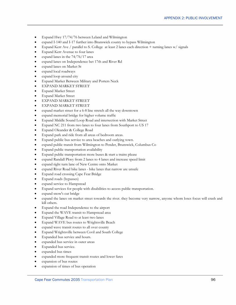
APPENDIX 2: PUBLIC INVOLVEMENT
Cape Fear Commutes 2035 Transportation Plan 96
• Expand Hwy 17/74/76 between Leland and Wilmington • expand I-140 and I-17 further into Brunswick county to bypass Wilmington • Expand Kerr Ave / parallel to S. College at least 2 lanes each direction + turning lanes w/ signals • Expand Kerr Avenue to four lanes • expand lanes in the 74/76/17 area • expand lanes on Independence bet 17th and River Rd • expand lanes on Market St • expand local roadways • expand loop around city • Expand Market Between Military and Porters Neck • EXPAND MARKET STREET • Expand Market Street • Expand Market Street • EXPAND MARKET STREET • EXPAND MARKET STREET • expand market street for a 6-8 line stretch all the way downtown • expand memorial bridge for higher volume traffic • Expand Middle Sound Loop Road and intersection with Market Street • Expand NC 211 from two lanes to four lanes from Southport to US 17 • Expand Oleander & College Road • Expand park and ride from all areas of bedroom areas. • Expand public bus service to area beaches and outlying town. • expand public transit from Wilmington to Pender, Brunswick, Columbus Co • Expand public transportation availability • Expand public transportation more buses & start a trains please • expand Randall Pkwy from 2 lanes to 4 lanes and increase speed limit • expand right turn lane of New Centre onto Market • expand River Road bike lanes - bike lanes that narrow are unsafe • Expand road crossing Cape Fear Bridge • Expand roads (bypasses) • expand service to Hampstead • Expand services for people with disabilities to access public transportation. • expand snow's cut bridge • expand the lanes on market street towards the river. they become very narrow, anyone whom loses focus will crash and
kill others. • Expand the road Independence to the airport • Expand the WAVE transit to Hampstead area • Expand Village Road to at least two lanes • Expand WAVE bus routes to Wrightsville Beach • expand wave transit routes to all over county • Expand Wrightsville between Covil and South College • Expanded bus service and hours. • expanded bus service in outer areas • Expanded bus service. • expanded bus times • expanded more frequent transit routes and lower fares • expansion of bus routes • expansion of times of bus operation

APPENDIX 2: PUBLIC INVOLVEMENT
Cape Fear Commutes 2035 Transportation Plan 97
• Expedite Skyway project • Express bus route from downtown to Mayfaire and Wrightsville Beach • Express bus routes from designated pick ups to major employers, without additional drops. (would require collaboration
& financial support from employers I would think) • Express Bus routes from outlying areas to downtown • Express bus routes to key destinations • Express Bus to and from outlying towns • express buses in AM and PM to employment hubs (e.g., E-W on Carolina Beach Road) • Express buses to Wrightsville Beach and Carolina Beach • express lanes for carpools • express lines to North County area, Leland to downtown • Express link sections between major intersections • Express route bypass...extend MLK Blvd Northward to I140 and beyond (hwy 17 bypass) and limit on/off exit points • express route to downtown from Ogden on Market • Express routes on busy streets (College, Market) with remote parking • express routes to CFCC and UNCW from Pender and Brunswick Counties • expressway from monkey junction to porters neck • Extend & Widen College Rd from I40 to Carolina Beach • extend 140 to go around Leland • Extend 421 SB merge at 17 SB and block early merging there as well • extend bike lanes into neighborhoods without sidewalks like Civil Farm Rd • extend bike path to Wrightsville beach • extend bike paths down two land roads such as Masonboro loop • extend bus hours • Extend ferry schedule for later hours • Extend Hoggard Dr to S college Rd • extend I 140 INTO BRUNSWICK COUNTY TO JOIN HWY 17 • Extend I-140 -- North & South • Extend I-140 and look into other projects that bypass the most congested areas • Extend I140 beyond Hwy 421 • extend I-140 to reach US-17 and SC Bay Pkwy SC-31 • extend I140 to Rt. 17 • extend I-40 north and south • Extend I-40 south to Carolina Beach • extend I-40 to Carolina Beach elevated over College with limited access • extend I40 to Porters Neck area. • Extend Independence Blvd to MLK Parkway • Extend Independence Blvd to MLK Parkway • Extend Independence to MLK • extend independence to MLK • extend Independence to MLK • Extend Independence to MLK • Extend Independence to Martin Luther Dr. • Extend length of merge lanes. People in this area always slow down to almost a stop tying up traffic b/h them. This is
b/c the lanes end quickly. In RTP, the merge lanes extend for much longer so people aren't pressured to merge quickly and traffic maintains a normal flow.
• extend merge lane @ Leland entrance on 17 north across first river bed to allow more time to merge and create better traffic flow

APPENDIX 2: PUBLIC INVOLVEMENT
Cape Fear Commutes 2035 Transportation Plan 98
• extend merge lane of 421 south across first river bed to allow more time to merge and create better traffic flow • Extend Military Cutoff to I-140 • Extend Military Cutoff to I-140 • Extend Military cutoff to I-140 • extend Military Cutoff to I-140 bypass • extend Military Cut-Off west-northwest • Extend Martin Luther King, Jr. Parkway to Gordon Road • Extend MLK to Myrtle Grove • extend public trans. hrs. at least 11pm • Extend Randall Pkwy thru to Hooker Rd • Extend Randall Pkwy to Hooker Rd • Extend S. Kerr to Shipyard, and make College one-way(northbound) and Kerr one-way (southbound) between Shipyard
and Wilshire. • Extend SC 31 from SC border to Wilmington in Brunswick County. Tolls could be charged to pay for it. • Extend sidewalk on 17th St to St Andrews Drive • Extend the bike path on Oleander from Mayfaire all the way to Hampstead. • Extend the bus route to Porters Neck and Hampstead areas • Extend the Cross City Trail to other parts of the city. • Extend the third westbound straight lane of Military Cutoff Road to become a right-turn-only lane at Eastwood Road,
instead of Parker Farm Road. • extension of Military Cutoff Road • extent I-140 bypass to Leland • extra lane at 133/Leland from 17 North, am commute ridiculous! • extra lanes on college road, and market St. • Fast track new bridge to Brunswick County • faster response to light outages • Feasibility of Electric Buses • Federal tax incentive programs to individuals should be implemented • Fee-based trolleys at the beaches from central parking lots • Ferry Service from Topsail to Carolina Beach • Fewer curb cuts or more right turn only intersections on College Road • Fewer left turns, more clover-leafs or loops • fewer lights in congested areas • fewer lights in monkey junction- slows traffic flow • Fewer stop lights and better programming for existing lights. • Fewer stop lights in downtown Wilmington • find a better solution for dangerous new left turns installed on Rte. 17/Hampstead • Find a way to time the streetlights so we don't have to stop so much. • Find alternates to the constant addition of new traffic lights on Rt. 17 in Leland. • Finish 140 by pass into Brunswick County • finish 140 bypass, • finish I-140 project from US 421 to US 74/76 • finish all dead end sidewalks in Wilmington • Finish an outer loop for traffic from I-40 with toll booths. • Finish bike lanes on McMillan Ave between Pine Grove Dr and Cedar Ave • Finish bypass project to Brunswick County US 17 • Finish connecting I-140 to US 74-76 • Finish extension of Independence Blvd to Smith Creek

APPENDIX 2: PUBLIC INVOLVEMENT
Cape Fear Commutes 2035 Transportation Plan 99
• finish I 140 to College Rd. • finish I140 • Finish I-140 • Finish I-140 • Finish I-140 around Leland • finish I-140 ASAP • Finish I-140 Bypass into Brunswick County • finish I-140 extend into S.C. • Finish I-140 into Brunswick County • Finish I-140 project to loop around Leland • Finish I-140 South towards Myrtle Beach • Finish I-140 to US 17 South • Finish Independence Blvd to MLK • finish independence blvd. • Finish Independence Blvd. all the way to Martin Luther King, Jr. Parkway • Finish Independence to MLK • Finish Independence to MLK • Finish route 140 • Finish the 140 by-pass • Finish the 140 connector into Brunswick County and build the skyway bridge • Finish the Bypass from 421 to 17 South • Finish the bypass to Leland • FINISH the bypass to Leland on I-140! • Finish the I-140 spur in Brunswick County • finish the I140 to 17South • Finish the I-40 by-pass to 74/76 in Brunswick County to reduce truck traffic on 17. • Finish widening Gordon Road between Market and I-40 • Finish Wilmington Bypass to US 17 • finish/ expand I 140 north and south • Fire Albert Eby, who does not answer mail • Fix • Fix 133 back log mess going onto hwy • Fix bottleneck at Oleander/South College Rd intersection • Fix bridges • fix bus routes! luckily I have a fast bike, otherwise- terribly inconvenient! • fix college road clutter by creating less stop lights • Fix College Road Congestion in ILM • Fix flooding in New Centre Drive / College and Wrightsville areas • Fix flooding problem on New Centre road area, it gets flooded way too fast, all the time • Fix Independence & Shipyard 4 lanes to River Road • fix intersection at college rd at oleander • fix intersection at college rd at oleander • fix intersection at college rd at oleander • Fix major intersections for safety both vehicular and pedestrian • fix market between 23rd and 16th street. It is so unsafe and I have see way to many accidents sitting at Port City Java • Fix Market Street between 16th and Covil • Fix merging lanes that forces vehicles to merge appropriately • fix oleander /college road intersection

APPENDIX 2: PUBLIC INVOLVEMENT
Cape Fear Commutes 2035 Transportation Plan 100
• fix Oleander and College intersection • fix Oleander Drive at S. College • Fix our old roads • FIX PED. CROSSING AT OLEANDER AND EASTWOOD • Fix potholes. We look like a third class region • Fix Princess place drive road from beginning to end. • Fix the bad roads • Fix the black hole around Eagle Island-add lanes ASAP • Fix the current roads • fix the downtown stop lights that do not change on a timely efficient basis • fix the holes in roadways! I drive road bike & vino scooter- these holes can cause a serious accident for being trying to
be environmentally cautious- this isn’t fair! • Fix the intersection at Oleander and College. I know that an overpass has been ruled out, but it needs to be put back on
the table. It is the only long-term solution. Everything else is simply a band-aid that will be overwhelmed eventually. • Fix the intersection of Hwy 210 and Hwy 117. The lanes are very confusing. • fix the intersection of Oleander and Shipyard • Fix the problems that are present. (pot holes) • Fix the stoplight pattern at the intersection of Eastwood and military cutoff/oleander • Fix the stoplight pattern at the intersection of market and Kerr • fix the streets in downtown Wilmington. • Fix Village Road merge on HWY17 to prevent it from stopping a highway! • fix your survey! You cannot select same column • Fixing on ramp to 74/76/17 from Leland so only one lane of traffic merges. Now up to 3 lines form on the ramp all
trying to merge on to 74/76 before Brunswick River Bridge. • flying cars • Focus on connectivity everywhere to lessen the use of heavily traveled roads. • Focus on public transport to appealing locations, such as the beaches, movies, downtown, malls, etc. if only for
weekends & holidays. Make sure the schedules are enticing. • focus on Wilmington’s poor safety driving record • For all major roads, add a separate bike/pedestrian asphalt path to allow for and encourage safe self-powered travel. • For funding: I did not answer #13 b/c there is plenty of DOT waste to pare down first. • four lane US 421 through Sampson County. • Four lane Castle Hayne Rd. • Four lane circumnavigation road in NH county • four lane Greenville Loop Road • Four lane NC 211 from US 17 to Southport • four lane Masonboro Loop Road • four lanes between bridges and Leland area • Four Lanes on Gordon Road between Market & I-40 • free bus passes • Free bus rides for CFCC students like the UNCW student already get. • Free flying cars would be great. • Free or reduced fee public transportation for students • free public transportation on pleasure island bridge to S. End of Island • Free Trolley • frequent bus service to the beach in the summer • friendly • From Covil to 3rd on Market - make 3 lanes, not 4 (w/middle for turning) and use excess on either side for bike lanes

APPENDIX 2: PUBLIC INVOLVEMENT
Cape Fear Commutes 2035 Transportation Plan 101
• From near Kerr on in, reduce Market St. from 5 to 3 lanes (middle turn lane) and use one of abandoned lane areas for 2-way bike lane.
• Full Bike Lane from river road to market St • full bike paths from down town to the beach • full control of access hwy/ interchange at I140 to 74/76@ Lanvale/Mt Misery interchange • fully repave certain roads • Fund Skyway project for easier access to Brunswick & adjoining counties • fund the Wilmington bypass immediately • get a train connecting Wilmington to the rest of the world instead of needing to drive to Selma • get as many non-profits involved to educate people on the health, environmental, etc. benefits of walking/biking or
carpooling/public transportation whenever possible. • Get idiots off cell phones • get more cars off roads with other initiatives-parking at River Front is impossible most times • get out of the sixties and start DOING SOMETHING! • get rid of fat, insolent bus drivers • get rid of new circles on Elisha road • get rid of some stop lights • get rid of suicide lane! -replace with grass and plantings • get rid of the stupid islands that take up a lane • Get rid of the two lanes on the exit of Leland to 74 east • get rid of the yellow blinking left turn arrows such as the one in front of Kmart on College Rd and at Eastwood &
Cardinal. They cause more traffic accidents rather than prevent traffic problems • get rid of those Manhattan intersections! • get rid of turning lane on market and make it like they did up in porters neck to Hampstead • get serious about eliminating cul-de-sacs and dead end streets • get some people in the department who are experienced in this area • Get the police out of unmarked vehicles (like Morehead City) • Get the SKYWAY BRIDE PROJECT MOVING NOW, NOW, NOW, NOW AND EXPAND INDEPENDENCE
ROAD TO 6 LANES WERE CAN. MOVE THESE PROJECTS TO TOP OF PRIORITY LIST AS MONKEY JUNCTION AND THAT AREA ARE GROWING ABOUT THE FASTEST AND CAROLINA BEACH. BRUNSWICK COUNTY IS GROWING ALSO BY LEAPS AND BOUNDS THIS SKYWAY PROJECT NEEDS TO BE DONE IN THE NEXT 3-6 YEARS TO ALLEVIATE MAJOR TRAFFIC PROBLEMS IN MONKEY JUNCTION, THE BRIDGES AND TRAFFIC BETWEEN NHC AND BRUNSWICK COUNTY. AND MOVING TRAFFIC ACROSS TOWN.
• Get traffic off 16th/17th from Market to Castle • get traffic off of college rd if possible • Give a public service announcement letting people know the turning lane is for TURNING, not slowing down in the
driving lane, putting on your turn signal, coming to a stop and THEN moving into the turn lane. • give free gas coupons for carpoolers • Give incentives for those who are willing to use public transportation • give incentives to individuals/business for using carpools/public transportation/walking to work. tax deductions or
credits would get people's attention. tax people more that want to use their private vehicle and give deductions to those that choose environmentally and socially friendly alternatives.
• Give tax incentives for those who register their mileage with the DMV and only use 12K or less a year. A tier system beginning with 12k and increase benefit for lower mileage
• Give the folks that do use public transit at least a bench at the stops so they wont drag shopping carts and turn them over for a makeshift seat!
• Good bike paths from Oleander to the mall. • Good bike paths from Shipyard to River Road. • good connections going out Market Street toward Ogden

APPENDIX 2: PUBLIC INVOLVEMENT
Cape Fear Commutes 2035 Transportation Plan 102
• Good rail service to Raleigh and charlotte, airports inc • greater connectivity between developments(commercial) • Green space regulation on new construction, MORE green space • Greenway from the airport area to downtown • Greyhound or Trailways Bus Service in Burgaw NC • growth boundaries- stop endless suburbanization! • Hampstead by pass • Hampstead Bypass • Hampstead Bypass • Hampstead bypass • Hampstead bypass • Hampstead bypass • Hampstead Bypass • Hampstead bypass • Hampstead bypass • Hampstead bypass • Hampstead bypass to relieve traffic on Highway 17 in Hampstead • Hampstead bypass. • have a bus system that goes longer distances with fewer stops (i.e. Carolina Beach to a location in downtown, where you
can catch a smaller bus) • Have a crossover walkway on Eastwood to connect Autumn Woods to Mayfaire • Have a crossover walkway on Eastwood to connect Mayfaire with the Forum/Landfall shops • have a downtown exit from the new loop • Have a less complicated survey. • Have a train to Myrtle Beach, SC then to Charleston,SC • Have a train to Raleigh, NC • Have another road parallel to College road • Have Brunswick Commuter bus run starting at 6am and ending at 9pm • Have bus route on Greenville Loop Road from Oleander to Pine Grove. • Have buses run on less than half hour intervals through out the greater Wilmington area. Make rates cheaper than
operating a vehicle • have city traffic people visit ideal cities • have continuous sidewalks to access hospital • Have employers stagger start times to ease the morning and afternoon commute • Have employers subcontract bus service for a modest fee. Then provide a tax break for the employer, so that the cost is
shared. Ex. GE • Have more busses and bus stops,...publish a booklet and put them everywhere showing the routes, there are tourist that
can pay for that some how. For example a hotel/motel fee for staying the night in a local hotel/motel. • have more thru streets parallel to each other • Have people drive in New York, Boston for a week, You would release traffic is a Sunday drive in the area • have sit down benches at each bus stop • Have smaller buses/vans, etc. • have straight and right turn lanes in one lane and left turn it's own lane for ALL stoplights. • Have the red line starts at Carolina Beach and end on Hwy 421, Run a (3) yellow line as a circle around the city area. • have traffic exit to the right to a light to make left hand turns. • have your programmer fix questions 11 & 13 • High rise bridge - make both toll roads- replace Wrightsville Beach bridge • High Rise Bridge across Cape Fear

APPENDIX 2: PUBLIC INVOLVEMENT
Cape Fear Commutes 2035 Transportation Plan 103
• High rise bridge to Brunswick County • High speed bus or train to major NC cities • High Speed Rail between Wilmington and Raleigh • High speed rail to Raleigh • high speed train from large city to large city • High speed train from Wilmington to Raleigh to Charlotte to Richmond • high speed, limited access rail to RDU on Brunswick Co side • higher cigarette taxes as a source of revenue • Highway • Highway 17 bypass • hiring jobs • how about building a train station around the Wilmington and Brunswick area? • How about more enforcement on the roads, pay the Highway Patrol what they're worth and let them actually hire
enough personnel to do their job. • Hwy 17 extended past Hwy 421 to Hwy 74 • hwy 17 north add two lanes when merging with business 17 • Hwy 53 Bypass Burgaw, NC • Hwy 74/76 need more lanes from Brunswick County into Wilmington • Hwy. 17 bypass in Hampstead • I 140 bypass completion • I 140 bypass completion • 140 extension • I am in favor of bike lanes and making is safer for no motorized transportation. • I am in favor of tolls to pay for new roads • I commute 65 miles one way 3-5 days/ week I would love a train instead of car • I DO NOT SUPPORT ANY NEW OR HIGHER TAXES! • I do NOT support any sources of new revenue, we need smarter planners, one area of congestion causes a domino
effect that impacts many other areas • I refused to use the Dulles toll road for 10 years b/c I refuse to pay tolls • i think we have enough roads! • I would have bus runs to the airport • I would like less medians, I do not want to do u-turns just to turn in to a business. • I would love to see the rail road back to Wilmington • I140 (w CF River bridge) completed before skyway • I-140 completion • I-140 extension from US 421 to US 17 past Leland • I-40 to Monkey Junction limited access • I-73 and I-74 highway • Independence Boulevard extension • if a road has home on it make the speed limit 25-35 • If funded, please keep the Cape Fear Skyway away from neighborhoods in Brunswick County like Snee Farm. There is
plenty of empty land where the bridge could be built. • If the paths are safe, people will use them. • if there's a stretch of road longer than a mile without stop signs add them to cut back on the speeding in residential areas • If you build walk/bike paths, just be sure to put up lights to provide extra safety • If you can't figure out how to use what you have then leave it alone! • If you do widen College Rd., then all of the properties along it should be zoned commercial property/residential and
those individual owners should be able to sell to major commercial bidders if they so desire. If you widen College Rd and do not change the zoning, then it is not an attractive place to live and it will only attract very poor people which will

APPENDIX 2: PUBLIC INVOLVEMENT
Cape Fear Commutes 2035 Transportation Plan 104
not keep up the appearance of the house or yard. This in turn will make our city very unattractive. It would be better to let it go commercial.
• if you need to raise taxes, do in one source, not 7 • I’m from Chicago and the only toll roads I drive on are pot hole filled roads. Don’t be like them if you put a toll
somewhere. If you do give two prices. One really cheap for locals, like .10. And an expensive one to people that don’t live here, like a dollar. Use a system like Chicago's I pass. it works great!
• implement bicycle & pedestrian master plans • Implement coastal Pender connector road plan • Implement Hampstead Bypass • Implement Pleasure Island bikeway throughout island • implement strategies for increasing biking and walking to and from work. • Improve mass transit • Improve "bottle Neck" 17/74 into & exiting Wilmington • Improve/widen Gordon Road - promised years ago • improve access to and from By-Pass • Improve all stoplight timing throughout the area • Improve alternate north-south streets • Improve awareness about public transit • Improve bicycle paths from downtown to the beach. • Improve Bike lane on Middle Sound Loop Road • improve bike lanes • improve bike lanes • improve bike routes • improve Blue Clay and North Kerr Ave, railroad • Improve bottle neck US 17, US 74/76, NC 133 • improve bridge traffic, add another bridge • Improve Burnett Boulevard to take traffic off Carolina Beach Rd. • improve bus service/improve bus shelters • improve citywide traffic • IMPROVE COLLEGE RD AND OLEANDER INTERSECTION • improve College Road congestion • Improve connectivity between Blackwell Rd and US 17 south • Improve coordination of traffic lights • Improve Covil and Kerr • Improve cross town routes • Improve engineering of existing roads with 55 mph speed limits • Improve existing roads - no more new roads or bypasses! • Improve existing roads (the pot wholes and bumps) • improve exit off North bound Hwy 17 onto Hwy 17 Business • Improve flow of traffic on College Road • Improve functionality of Market Street • improve highway between Fort Fisher ferry & Wilmington • Improve inner city roadway to insure smoother rides. (i.e. Market/Kerr) • improve intersection @ oleander/s. college • Improve intersection of NC 133 and Blackwell Rd • Improve intersection Us hwy 117/210 Rocky Point • Improve Kerr Ave. • improve lifts on shuttles

APPENDIX 2: PUBLIC INVOLVEMENT
Cape Fear Commutes 2035 Transportation Plan 105
• Improve light sequence on College to fit time of day • improve Market St between 23rd and 16th • improve market street • improve market street: the most unattractive/dangerous street/corridor in se nc • improve multi-modal transfer options at all terminals • Improve Oleander /NC 132 intersection • improve oleander and college Rd intersection • Improve opportunities for visiting the beaches specifically by providing affordable parking and shuttles back and forth.
Don't forget about restrooms and showers. • Improve parking and traffic flow at schools • improve Pine Grove Road or limit traffic access • Improve public transit • Improve River Road - Bicycle lanes needed • Improve River Road Bike Trail • improve road conditions • Improve road conditions throughout New Hanover and Brunswick area • Improve road structure (EX: dents, potholes, etc...) • Improve roads! • improve roadways and safety • Improve S College Rd and Oleander Dr intersection • improve safety • Improve safety at Colonial and Wrightsville - too many deaths! • Improve safety on Market St. between porters neck & downtown. • Improve safety on Market Street • Improve safety of NC 210 from Hampstead to Rocky Point • Improve sidewalk connections on College, Randall, New Centre • Improve sidewalks • Improve signs • Improve South College Road between Long Leaf Hills and Wrightsville Avenue • Improve Southport-Ft. Fisher ferry travel time • Improve Southport-Ft. Fisher ferry service to accommodate commuters • Improve street crossings to encourage walking and biking. • improve the safety of Market Street between Bayshore and Gordon Road • Improve the transition from new expressway that spills directly onto 3rd street-funnel through the North side that has
not been developed yet • improve timing of lights at major intersections during peak traffic times • Improve timing on existing stop lights • Improve traffic conditions at College & Oleander • Improve traffic conditions at College & Shipyard • Improve traffic flow & add parallel bicycle lane on Masonboro Loop road • improve traffic flow at Eastwood and Mil. Cutoff • improve traffic flow at Oleander and College • improve traffic flow by using medians to force right turns on major roads and remove many unnecessary lights • Improve traffic flow Oleander/South College Road • Improve traffic flow on S. College from Market to Oleander • Improve traffic flow over current bridges into and out of Brunswick county • Improve traffic in the Silva Terra area and that large neighborhood, by providing an additional road and signal to
Carolina Beach Road (besides Silva Terra exit, and the Silver Road Exit.) Take seriously long-time residents suggestions

APPENDIX 2: PUBLIC INVOLVEMENT
Cape Fear Commutes 2035 Transportation Plan 106
on transportation in that area and TAKE VERY SERIOUSLY their recommendations as these NHC Citizens have LIVED HERE FOR DECADES and their IDEAS and PROPERTY IS AS IMPORTANT, IF NOT MORE IMPORTANT THAN New residents ideas and convenience. Preserve more green space!
• improve traffic lights (for example: using sensors to detect no cars at opposing light so it can change more quickly • Improve traffic pattern on College & Oleander • Improve traffic pattern on College at Hugh McRae • Improve traffic pattern on Market Street • Improve traffic signal programming • Improve Village road, add lanes • Improve/add bike lanes for safety. Wilmington is a dense enough city to get around on a bicycle but I would not dare
ride a bike for fear of being run over. • improve/expand existing road network • Improved Bike and Moped lanes - visit Madison Wisconsin • Improved pedestrian traffic patterns on College Road near UNCW • Improved safety/enforcement of traffic laws • Improved traffic signal sync • Improving bike lanes on all roads • Improving sidewalks on all roads • Improving traffic flow around wilshire, wrightsville, independence interchange • in ? 13, funding needed for what? I don’t want any of the options above. • In general, speed limits too high. Realize the city has spread!! Lower speed limit to 35MPH on Carolina Beach Road
and College Road at least to Monkey Junction -- and actually should be farther. Carolina Beach Road beyond Monkey Junction should never be above 45 MPH. Far too much traffic, side streets, businesses for safe entering/exiting and traveling those roads at the current speed. Most of the drivers drive 5+ MPH above the speed limit anyway!
• In residential areas, place more 4 & 3 ways stop signs to slow down traffic • In the previous question, 13, I believe that before we enact more taxes, we should used the money already allocated to
the roadways more efficiently. It seems there is a waste of money by the government. Why pay more taxes when we can utilize the money in a better way.
• include no left turn exchange at Blackwell Rd. • Increase 74 east and west from Leland to Wilmington to 4 lanes in each direction • Increase accessibility of public trans. from Pender to New Hanover Co. • Increase bus routes. Commute time is often too long, especially with "one way" bus routes. • Increase bus service to every 15 minutes and new routes • Increase current lane capacity of current roads • INCREASE EDUCATION/ENFORCEMENT OF TURN SIGNAL USEAGES • Increase enforcement on NC 133 and US 17-74-76 • Increase Free Public Trans. by income, age, other variables • Increase frequency of bus arrivals at stops to every 15 minutes • Increase frequency of buses in certain areas • Increase frequency of Ferry to Southport • Increase in lanes coming in to New Hanover from Brunswick • Increase lanes on Independence from River Road to Shipyard Blvd. • Increase number of lanes on College between Shipyard & Oleander • increase penalties for speeding • Increase Public transit - trains, buses, etc. • increase safety of the cape fear bridge- I am scared driving on it and we are in the top 10 most unsafe bridges in NC • Increase space for bicycles on all major roads for safety • Increase speed limit on College Road near Monkey Junction for better / quicker traffic flow • increase speed on certain roads

APPENDIX 2: PUBLIC INVOLVEMENT
Cape Fear Commutes 2035 Transportation Plan 107
• increase speed on MLK to 55 mph • increase the speed limit 5 mph on the MLK Parkway • Increase the speed to 55 on Carolina Beach Road. • Increase ticketing (frequency and repercussions) for illegal turns, not signaling and otherwise driving unsafely. Increase
revenue and safety. • Increased advertisement of public transportation • Increased safety along Highway 17 between Forest Sound Road intersection and Country Club Road intersection • increased speed in certain areas • Independence Blvd 4 lanes to Carolina Beach Rd • Independence extension • independence extension to Martin Luther King, Jr. Parkway • independence to Martin Luther King, Jr. Parkway • Independence to Martin Luther King, Jr. Parkway connection • info on Campus to Wrightsville Beach bus stops/ routes • infrastructure first, developments afterwards (not like Mayfaire, for example) • install bike lanes along to entirety of Carolina Beach Road from Carolina Beach to the downtown area • install bike lanes on "sound roads" (i.e. Masonboro Sound Rd, Greenville Loop Myrtle Grove Rd etc.) from Carolina
Beach to Wrightsville Beach • Install bike path on College Road & Carolina Beach Road from Carolina Beach to north College area • Install bike path on Kerr Ave. • Install bus stop covers at all bus stops • Install Electronic detour signs when Cape Fear Memorial Bridge opens for ships. • install median on busiest sections of Market Street to force U-turns (maybe less accidents if people weren't cutting across
traffic to get to their destination) • install medians on all 4 lane streets • Install more one-way traffic circles in place of traffic lights where space permits. • Install overpasses on MLK Parkway • Install park and ride lots in Leland, North Market and Monkey Junction areas • Install pedestrian crosswalk electronic signs in downtown Wilmington and the UNC-W campus area on S. College Rd.
side • install stop polls so commuters can only merge were broken lines are • install traffic signal at intersection of River Rd/ Seabreeze Rd & US 421 • install traffic signal at intersection of River Rd/ Seabreeze Rd & US 421 • install traffic signal at intersection of River Rd/ Seabreeze Rd & US 421 • Install u-turns at lights on Market • INSTEAD OF WIDENING BOTH SIDES OF 17/74/76/133, PUT TWO LANES IN THE MIDDLE AND
ALTERNATE TRAFFIC DIRECTION BETWEEN MORNING AND EVENING RUSH HOURS • Intelligent design and programming of traffic signals • Interchange / overpass on College and MLK • Interchange / overpass on Oleander and College • Interchange at MLK and College Road • Interchanges on current outer loop • intercity train service to Raleigh, Richmond, Washington, etc.. • interconnect walking/ riding trails at country club rd/ schools • interconnect walking/ riding trails at topsail/ 210/sloop pt • INTER-PATH CONNECTING NETWORK • introduce convex mirrors elsewhere to increase visibility (common in Europe) • Invest in hybrid buses. • Isolate college road more

APPENDIX 2: PUBLIC INVOLVEMENT
Cape Fear Commutes 2035 Transportation Plan 108
• jet packs • Join the parking lot of Seahawk Square Condos with Hurst drive for easier entry and exit. • just a comment on your survey. in the ranking questions, you are only allowed to place a check mark in a column one
time. I would have placed any increase in taxes and registration fees in the do not support at all column. We have enough taxes and fees, just foolish spending and mismanagement in Raleigh
• Just a dream, but would love train service... • keep additional lane to merge onto 421 N • keep all roads in tip top shape even in the county • keep existing river road open for bicycle traffic • keep new road development away from Castle Hayne • keep roads in better shape • Kerr Ave 4 lanes • Kerr made into a 4 lane • Kerr More Lanes • Kerr/Randall intersection needs to be expanded (or add two lanes to Kerr between Wrightsville and Market) • Kill Cape Fear Skyway and use savings for Cape Fear Memorial Bridge repair and update • Landscape US 17 in Hampstead, medium with trees & grass • Lanes for small motor bikes and bicycles so more people will use them and be safe • Lanes that switch direction depending on time of day • Late night bus routes • Late night bus services in downtown Wilmington • late night transit to campus from downtown • late night weekend bus service downtown to Carolina Beach, UNCW, and Wrightsville Beach w/ stop-on-request,
charge flat fee of $8-10 per person • later and earlier bus routes • Later bus routes from the colleges • Laws keeping pedestrians and scooters OFF freeways • left hand turn signals at Covil and Market, Colonial and Oleander and Colonial and Wrightsville Ave., and numerous
other locations throughout own! • Left turn only intersection at Hwy 17 & 133 in Leland • Leland exits onto/off new bridge • lengthen the bridge overpass just beyond the merge off the bridge to 74/76 towards Leland • less deadly bike paths. • Less development along high traffic areas (College Road, Shipyard, Carolina Beach Road) • Less development around already very congested areas • less for meters • Less red lights and turns into communities and businesses • Less traffic lights • Let the buses run every 1/2 hr, 6 -9 am and 4 - 7pm. • lets get more bicycle lanes and walking lanes and lets IMPROVE them! • Lets make our first "transportation project" to get the General Assembly to quit robbing from the Highway fund for
their little pet projects, that way we wouldn't need to add toll roads or increase any taxes. • light at oleander and college to be checked for timing. It changes to quickly. • light Rail • light rail • light rail • Light Rail • LIGHT RAIL ALONG MAJOR ROUTES • light rail between Hampstead and Wilmington

APPENDIX 2: PUBLIC INVOLVEMENT
Cape Fear Commutes 2035 Transportation Plan 109
• light rail between major areas (e.g. Downtown, Wrightsville, UNCW, Monkey Junction, Carolina Beach, etc) • Light rail from Brunswick to Leland • Light rail from Hampstead into Wilmington • Light rail from Leland Village Rd to Downtown Wilmington • light rail into Pender County • Light rail lines to Raleigh and Charlotte • Light rail Service along Key Roads: College Rd, Market St, Oleander, 17 St. • light rail service to Raleigh, Charlotte, Charleston • Light rail system • Light rail system (subway) above ground • light rail system that connects Wilmington to surrounding towns and beaches • light rail system with key stops- downtown, Uncw, ogden, etc • Light rail to surrounding counties • Light rail transit • Light rail with terminal at ILM Airport. • light rail with three central hubs • light rails stops- include Leland, Monkey Junction, Mayfair, mall, and Wrightsville Beach • Lights change for one incoming car. Why? there should be a stack of cars waiting to initiate a light change. Why stop
lunch time traffic on college for ONE CAR? • light rail to Wrightsville Beach (use old beach car line row) • like Hawaii overhead roads where possible • limit access on and off of US 17 by providing access lanes for business • limit access to all major arteries • limit access to major streets from shopping centers • limit driveway access to US 17 • Limit entry/exit on River road and make it more of an expressway • Limit high-density housing until municipal infrastructure can support it properly via roadways and services • limit light changes on major streets allow flow • Limit new stores on existing roads. • Link parks with Safe and Wide bike paths • Local option sales tax • local rail service • Logically plan out the road grid accordingly to the growing population instead of making one lan roads everywhere, then
expanding that road into two-lane roads, etc. etc. • Longer green light for northbound 421 traffic in front of truck stop on Saturdays during the summer. This light backs
traffic up all the way to Magnolia Greens in Leland. Eventually an overpass could be built when funding is available. • Longer turn lane queues and better signs giving more notice of a lane change • Look at merge law in Indiana • Look at the traffic light pattern on Dawson and Wooster -- the lights just bunch up the cars they seem to change on no
pattern -- in the mornings, the cross streets like 13th -- the light just changes even when no traffic is trying to cross • Look into light rail transportation. • Loop around Wilmington from I-40 to Carolina Beach • Lose the left turn option at any traffic circle - who allowed the two-way traffic in the circle at Mayfair? • love the railroad track embellishment • love to see a subway system, that's the best/easiest way to get around • love to see more crosswalks. it would be nice to be able to walk across college/oleander without it being a death wish. • Lower horizontal bars on the buses to accommodate shorter people who have to stand. • Lower speed limit

APPENDIX 2: PUBLIC INVOLVEMENT
Cape Fear Commutes 2035 Transportation Plan 110
• LOWER SPEED LIMIT ON EASTWOOD TO 35 MPH • lower speed limits from 55 to 45 and 45 to 35, etc. • Lower speed limits in residential neighborhoods • Lower speed limits on 17th Street in between Castle Street and Market Street (unsafe for pedestrians) • Lower speed on River Road, improve bike path • Maintain/improve quality/safety of existing infrastructure (roads/bridges) • major limited access highways along the route 17 corridor • make more no passing zones • Make 133/ 74/76 overpass a larger cloverleaf & keep at least one lane open for thru traffic • Make 17 inbound and outbound at least 3 lanes • make 2 left turn lanes from oleander to college for both directions • make 74/76 three lanes • make a bike path along Market St. from downtown to Mayfair • make a bus route that goes from Carolina Beach up to Market st with two stops (monkey junction and at UNCW) • make a bypass or something to cut down on congestion from one end of college to the other. for people coming into
town that may have to get to Carolina Beach. • make a passing lane on 133 between Southport & Leland • make a small stretch (YMCA area to 17th street) Market street two-line only w/bike routes • Make access lanes for Market St. businesses • Make Airlie Rd along Banks Channel one-way, direction from draw bridge. Convert 2nd lane to multi-use path. • Make all left turns on College Rd at traffic lights only • Make all transportation planners and workers get to work in some other way than a motor vehicle once a week. • Make all turns from right lane via turnaround • make an off-road on Market Street to at least allow for walking • Make bike and pedestrian crossings on major roads. • make biking and walking accessible to Laney and Trask schools. • make bridges not drawbridges • make bus lines priority on College Rd • Make bus routes safer & more convenient. • Make bus stops closer to public schools • make buses load in a parking lot versus on main streets • Make buses more accessible • make bypass loops more accessible • Make Carolina Beach Road more bicycle friendly, like a bike path down both sides. • make Castle Hayne Rd. 4-lanes from GE to 23rd • Make changes at College & Oleander recommended by DOT • make College & Carolina Beach Rd safer • Make College Rd 1 way North & Kerr Av 1-way South • Make College Rd 1 way North & Kerr Av 1-way South • Make College Rd 1 way North & Kerr Av 1-way South • Make College Road pedestrian friendly • Make College Road three lanes each direction • Make college/oleander intersection like college/market intersection. • Make crosswalks with NO traffic moving when pedestrians have right of way • Make developers pay to improve roadways • Make double turning lanes at Oleander and College Road • Make downtown car-free • make existing public transportation more convenient

APPENDIX 2: PUBLIC INVOLVEMENT
Cape Fear Commutes 2035 Transportation Plan 111
• Make exit in Porters Neck going north 2 lanes wide • make Front Street a pedestrian-only avenue--limit to foot traffic • Make front street one way again. • Make Gordon Rd. 4 lanes from N. Collage to Market St. • Make headlight and rear light mandatory on bicycles! • make Hwy 17 a super hwy throughout NC from Va. to SC • make hwy 17 safe • make Hwy133 from/to Southport 4 lanes • Make Independence 4 lanes all the way • Make Independence Blvd. a competitive alternative to College Road. • Make Independence Blvd. four lane all the way • make it safe to walk and bike, not just traffic wise but visible police until these bike/walkways become more populated • Make Kerr Avenue connection with Blue Clay safer • Make Kerr have 2 lanes • make lane divisions clearer at intersection of castle and 16th • Make Market and New Center entering target 2 straight lanes with turn lane • Make Market St 2 lanes w middle turn lane in downtown • make market St and college rd safer for biking and walking • Make Market St. 2 lanes and add a separate bike path. • Make Market St. a thur street with feeder or Parallel roads • Make Market St. wider closer to downtown • Make Market Street 3 lanes • Make Market Street 3 lanes instead of 5, so that there would be wider lanes and a turning lane • make Market Street a super street • Make Market Street a true four lane road between Kerr & 3rd St • make Market Street one-way • Make Market Street one-way (at least for certain hours of the day) • Make Market Street one-way between Front St. and Kerr • Make Market street one way towards downtown from Kerr Ave, also add a lane and make Kerr ave one-way from
Market to College and add a lane to Kerr Ave make it a one way from Market street to MLK • make market street only two lanes for safety • make MLK PARKWAY safe and accessible by bicycle • make more lanes on HWY 133 • make more roundabouts!! • Make more, and safer, bike routes. • Make N132 near Laney HS two lanes • Make neighborhood roads connect • make New Hanover County pedestrian and bicycle friendly • Make Oleander pedestrian friendly • make overpass walkways between UNCW and opposite side of College Road • Make part of Water St. Pedestrian only • Make present roads and system totally efficient BEFORE spending money for new roads. • Make Princess Place Drive One Way curving into Market St. before Kerr • Make public transportation to airport more convenient • Make Randall Parkway between College Road and Independence Blvd. a four lane divided 45 MPH speed limit road • Make Randall parkway more connected to Wrightsville Ave and through UNCW. • make river road 4 lanes • Make River Road safe for cars, bikes, and pedestrians!!!

APPENDIX 2: PUBLIC INVOLVEMENT
Cape Fear Commutes 2035 Transportation Plan 112
• make roads safer for biking • Make S College Rd and S Kerr Ave one-way • Make S College Rd and S Kerr Ave one-way • Make S College Rd and S Kerr Ave one-way • Make S College Rd and S Kerr Ave one-way • Make S College Rd and S Kerr Ave one-way • Make schedules available by mail • Make school buses a part of public transit network • Make school children ride the school bus. • Make SHELTERS wit SEATS for bus stops (its humiliating and degrading to sit on the grass or stand in the rain.) • make some kind of bypass road for car bch/monkey junction area to town • Make NC 133 towards Wilmington 4 lanes • make stops wheelchair friendly • Make the bus service more reliable and safer • Make the bus stops all-weather bus stops • Make the bus transit system easier to use • Make the left turn from Oleander to S. College 2 lanes. • make the middle lane of Oleander approaching S. College a straight or left turn lane • Make the narrow part of Market Street into TWO wide lanes with a center turning lane • Make the truck route to the US 421 bridge 4 lanes • make transit more convenient for people w/ limited funds • Make walking and cycling safe between Porters Neck Road to Military Cutoff by adding short links between existing
developments East of Hwy 17 • make Wave the way to travel in Wilmington • Making Market Street a into a fast lane for carpools • many sidewalks beside main roads i.e. college & car beach roads • Marked bike routes from secondary roads to workplace destinations, shopping etc • Marked crosswalks and pedestrian signals at Eastwood Rd and Military Cutoff Rd • Market St needs bike lanes. and crosswalks. • Market St one lane each direction from 23rd to Water • Market St. from 17th one way • Market Street - eliminate center turn land • Market Street and College Road bike lane! • market street congestion, add lanes • Market Street Downtown Wider • Market Street needs to be upgraded and enlarged • Market Street road diet btw 16th and Colonial • Market Street towards downtown should be 1 lane in either direction with a middle turn lane. • Market Street…I don’t know what can be done because of the trees- one lane for cars one for trucks? I don’t know. • Market/Hwy17 (Business) heading toward Hampstead NEEDS 2 lanes that merge off to Hwy 17. Now it just
bottlenecks from 2 lanes to one. • marketing mass transit • MARTA • mass transit solution for aging population---local government investigate "Share a Ride Program" for Seniors, Disable,
or those w/o transportation. Charge nominal fee & investigate federal money, grants for municipalities & tax credits from DOT for Hybrid Vehicles.
• mass transit to other counties • Median between Hampstead and Porters Neck

APPENDIX 2: PUBLIC INVOLVEMENT
Cape Fear Commutes 2035 Transportation Plan 113
• Merge School Bus System with public transit. • Middle sound loop add bike lanes • middle sound loop bike path or larger road for bike access • Middle turning lane on Masonboro Loop Rd • Military Cutoff Extension project • MILL ROADS BEFORE PAVING THEM AND RAISE AND LOWER MANHOLES IN ROADWAY WHEN
PAVING. DON'T LET CAPE FEAR PAVING DO THE WORK. • MLK to hospital via 16th and 17th street • modernize traffic signal timing throughout area • Monkey Junction busses through Carolina Beach • Monorail • monorail because it requires less land • monorail connecting Wilmington to Triangle area running down the middle of I-40 • Monorail from Wilmington to Wrightsville and Carolina Beaches • Monorail in median of College Road • monorail over or under river (if over, auxiliary solar powered; if under, aux hydro powered) • Monorail system • moped path? They seem to be every where, slowing everything down • More Brunswick to New Hanover bus routes • more 1-way street systems where feasible • more advanced green for left turns to decrease wait times at lights • more airplanes • more alternative routes; connections • More and Later Bus Routes • More bicycle lanes • more bicycle lanes • more bicycle paths • More bicycle paths that are safe • More bicycle/hiking paths with safe road crossings • More Bike and Walking lanes all over • More bike and walking paths especially near schools and grocery stores • More bike lanes • More bike lanes • More bike lanes • More bike lanes • More bike lanes • more bike lanes across town • More bike lanes off the main road - drivers in the area are not accustomed to watching out for bikers and I don't feel
safe on the roads even though I prefer to bike to most places rather than drive. • more bike lanes throughout city • more bike lanes to existing roads • More bike lanes! • more bike lanes, and sidewalks not increased road lanes • More bike paths throughout Wilmington • more bike paths • more bike paths • more bike paths • More bike paths

APPENDIX 2: PUBLIC INVOLVEMENT
Cape Fear Commutes 2035 Transportation Plan 114
• more bike paths • More bike paths around the university to encourage biking. • MORE BIKE PATHS ESPECIALLY TOWARDS WRIGHTSVILLE BEACH • More bike paths like the ones near Mayfaire • more bike paths linking commercial and residential areas • more bike routes form downtown to the beach • more bike trails • more bike/pedestrian trails • more bike/walking trails • More biking lanes/mixed use roads • more biking trails throughout the city • more bridge lanes entering Wilmington • More bus routes • More bus stops closer to shopping centers and medical centers • More bus stops in Leland b/c it is a growing community • More bus stops in neighborhoods • more bus stops in the Pine valley extension area • More bus stops near large concentration of elderly • more bus stops on existing routes • more bus transportation • more buses in Brunswick County • more buses to other parts of the city • More buses to the Carolina Beach area • more buses/less travel time/shorter routes • more busses and stops • More busses running more often • More bicycle lanes • More bypass highways like MLK drive around city • more bypass routes • More bypasses (Where? Who knows?) • More controlled access roads • More covered seating for bus transportation • more cross streets through out Wilmington • More cross town off-road bike paths • more crosswalk signals and time to cross the road • more crosswalks • More crosswalks across Market Street. • more crosswalks- roads are not safe for walking • more direct bus routes • More directional signs • More double turn lanes • more east-west paths in Pender county • more education for people concerning alternatives • more education on following speed limit • more express highways to avoid downtown, college road and market street • more ferry services from Brunswick County to New Hanover county • more flashing speed signs to keep drivers going slower • More frequent and convenient public transportation

APPENDIX 2: PUBLIC INVOLVEMENT
Cape Fear Commutes 2035 Transportation Plan 115
• More frequent and wider coverage public transit • more frequent bus stops and more stops, (every 10- 15 minutes) • more frequent buses going from Wrightsville Beach to downtown • more frequent routes like every 30 minutes inbound & outbound • More frequent Southport-Fort Fisher ferry service • More green arrows at traffic signals • More green arrows to help get through lights • more info for drivers about sharing the road with bicyclers • more interchanges on I 140/US 17 north • more lanes • more lanes from Wilmington to Southport (hwy87 or 133) • more lanes from Wilmington to Leland (US 74/76) • more lanes going into Wilmington • more lanes on 74/76/17/421/133 from Leland to Wilmington • more lanes on downtown roads • more lanes on S. College Road • More lanes to and from Leland • more lanes to College Rd • more lanes to Military cutoff rd • More lights at strategic areas and more left turn lights • More loops for WAVE from UNCW campus • more multi-use paths like the one on Military Cutoff • More multiuse paths NOT part of the roadway (but can be adjacent with a little separation for safety) • more north south routes in Wilmington from Carolina Beach to Market St • more off road bike paths in and out of city • More off road bike/walk paths • more off/on-road bike paths • More one way streets similar to the 16th/17th project • More parallel one-way streets in high traffic areas • more parking decks • More parks and connect the parks by trails • more patrol people to slow traffic • more pedestrian and bike paths like Eastwood Road • more police to polite and more helpful to citizens • more police to regulate speeders • more public transportation • more public transportation in rural areas • more REAL bike lanes • More real bike lanes • More red lights controlled by traffic and not timers • More right on red turns, wherever feasible • More road access between New Hanover County and Pender County • More roads between college and market • more roads equal more costs---instead offer easier, more convenient ways to travel with sources already available • more roads- less buildings and houses • More roads to access downtown • more roundabouts instead of traffic lights • more routes and run more often

APPENDIX 2: PUBLIC INVOLVEMENT
Cape Fear Commutes 2035 Transportation Plan 116
• more side walks are needed throughout the region • More sidewalks • More sidewalks • More sidewalks • More sidewalks • MORE SIDEWALKS • MORE SIDEWALKS • more sidewalks • more sidewalks • MORE SIDEWALKS (Middle Sound Loop/Stoneybrook) • More sidewalks along College Rd • More sidewalks and bike paths • more sidewalks and bike paths to Eastwood, Martin Luther King, Jr. Pkwy, and oleander to make it safe to bike to
CFCC • More Sidewalks and Crosswalks, begin on dense commerce areas • more sidewalks throughout the city & county • More sidewalks!!!! • more sidewalks, crosswalks • More Sidewalks. • more signs • More simple traffic patterns • More timely bus travel PERIOD • more traffic lights • More traffic lights, less turnarounds • More user-friendly bus routes • More ways into and around Wilmington from Leland • more wheelchair accessible transportation in the evenings • more & safer bike routes • More, Safer & Better bike routes/lanes • More, safer and direct bicycle routes all over town! • More, wider bike paths along major roads to make commuting/errands easier to execute • Move Rt17 Business back to Military Trail to Oleander • Moving sidewalks would rock. • Multi-use path construction • Multi-use path From Carolina Beach to W. Beach along the loop roads...myrtle grove, masonboro, greenville • Multi-use paths southern end of county. Carolina Beach Road, South College Rd. • Multi-lane roundabout at College and Oleander • multi-purpose trails ANYWHERE, especially Masonboro Loop &Pine Grove • Multi-us path the entire length of Market St in Wilmington • multi-use path all around Middle Sound Loop Rd. • multi-use path along Greenville Loop to Eastwood • Multi-use path along Market Street • Multi-use path down Covil Farm Road • Multi-use path east of UNCW connector from Park Ave trail (River to Sea) to new Halyburton Park to Wrightsville
Beach trail (at Autumn Hall) - Adds to pedestrian/bike network, connects 2 major trails. Include beautification of road (overhanging trees, bushes, narrow Rose Ave, bury power/telephone lines) will look better and slow road traffic near pedestrian/bike trail. Also provides pedestrian/bike access for large parts of City to Autumn Hall, Mayfaire, Wrightsville Beach. Consider incorporating rain gardens, wetlands, detention to clean runoff from roads, trails before

APPENDIX 2: PUBLIC INVOLVEMENT
Cape Fear Commutes 2035 Transportation Plan 117
enters Creeks. Coop with UNCW seems important and likely. Current heavy use of Rose Ave for roadside pedestrian use, jogging by UNCW athletes, professors and students-encourage more and let us join in.
• Multi-use paths in Northern Brunswick County • Multi-Use paths in Ogden and Market St • Multi-use paths to get people connected countywide without getting in their cars. • Multi-use paths with every new construction • Multi-use trails/roadways for bicycles • must have better link between Brunswick County and New Hanover County • My husband commutes to New Hanover County from Brunswick County. There is a bottle neck of traffic coming off
the Leland exit. Something to help prevent bottle necking would be great. • NC is a high tax state a is i.e. gas tax, car inspections etc • NCDOT should set up bi-pass routes around the main & most congested intersections • need a better merge from 421 to hwy 74/76 • Need a bike lane from Leland to Wilmington • need a bike lane from Village Rd to Wal-Mart • need a dedicated road for carpool • Need a street light at the on-ramp at Hwy 421 and I-140. People miss the ramp ALL THE TIME!!! • Need additional bridge over the river • Need additional lanes on both current bridges • Need additional river crossings • Need an improvement at Oleander and College; way too much of a cluster at all times of the day • Need another bridge and additional road into Brunswick County • Need better bike lanes on many main roads, i.e. Market St., New Centre Dr., College Rd, Bridges, Etc. • Need Bike lanes • Need faster and more convenient north-south roadway in New Hanover County • need ferry service to Fayetteville - similar to old river boats • need more parking downtown • NEED MORE SIDEWALKS!!!!!!!!!! • Need some bike lanes on roadways • NEED TO IMPROVE ON STOP LIGHTS IN NEW HANOVER COUNTY. MAKE PEOPLE PAVE 100 FEET
IN ALL DIRECTION WHEN PATCHING ROADS. ALSO MAKE PEOPLE WARRANTY PATCH WORK FOR A YEAR. HOLD THEM TO IT.
• Need to improve train service • need to increase speed limit on Martin Luther King, Jr. Parkway • Need two lanes turning right onto N. College/I-40 East from Martin Luther King, Jr. Parkway • new access into Wilmington from Brunswick County • new access to/from Brunswick County • new bridge • New bridge across Cape Fear River • New Bridge across the Cape Fear river • New bridge between Brunswick and Wilmington to replace Cape Fear Memorial Bridge. • new bridge connecting 133s in Brunswick County to independence blvd • New bridge from Brunswick Co to New Hanover County • New bridge from Brunswick County to New Hanover County • New bridge from Brunswick County to New Hanover County • New bridge from Carolina Beach Rd to Brunswick Co. • New bridge from Leland • New bridge from Leland to South Wilmington • new bridge from River Road (NHC) to Rt. 133 (Brunswick Co.)

APPENDIX 2: PUBLIC INVOLVEMENT
Cape Fear Commutes 2035 Transportation Plan 118
• New bridge into Wilmington • new bridge into Wilmington from Brunswick Co. • new bridge linking Brunswick County to New Hanover County. • new bridge of utmost importance • New bridge over Cape Fear & I-74, I-20 to ILM • new bridge over cape fear river • New bridge over Cape Fear River • New bridge over Cape Fear river south of Port • new bridge over Cape Fear to Brunswick County • New bridge over Cape Fear where the old one is • New bridge over the Cape Fear • New Bridge over the Cape Fear River • New bridge over the Cape Fear River • new bridge over the river • new bridge to Brunswick County • new bridge to Brunswick County • New bridge to ILM from LA. (Call it the Bill Sue Toll Bridge) • new bridge to Leland • NEW BRIDGE!!!!! • New bridge? onto Pleasure Island • new bridge over cape fear at 74&76 • New bus route structure does not work • new bypass route from Hwy 211 at Long Beach Road to NC 87 • New Cape Fear Bridge • New Cape Fear Memorial Bridge • New Cape Fear River bridge south of downtown • New Hampstead Bypass • New Hanover to Brunswick county shuttle • new interchange at Leland/Bellville exit • NEW MO-PED LAWS • New north south corridor to bypass College • New off the road bike/multi use trails • New path on the South side of Eastwood extended all the way to Wrightsville. • new road from boiling spring lakes to Southport • New road to go from Market Street to I-40 at Ogden • New road/bridge into Wilmington from Brunswick Co. • New Roadways • New Route connecting I 40 to US 17 • new safe bike routes that are protected from cars • new shorter road going west to east in Pender County • new southern bridge over CF River • New toll bridges to the south • New traffic pattern @ College & Oleander • new traffic pattern at Oleander and College • New traffic system with present roads. safer and more efficient for the lest cost • New US 17 thru Brunswick county • new walking/ biking paths with in Belville • new/ better bike path all the way down Wrightsville Ave

APPENDIX 2: PUBLIC INVOLVEMENT
Cape Fear Commutes 2035 Transportation Plan 119
• New? Improve what we have- add sidewalks everywhere • Next Leg of Outer Loop • NH County - concrete divides on major roads (Market) with right turns only - overpass connector to opposite side of
road • No Boats allowed to cross Memorial Bridge during peak times (6:30am-9am, 4pm-6pm M-F) • NO circles • No closures of major roads like river rd for filming • No left turns at Oleander/College • no left turns on Market Street except at lights • NO MORE LEFT TURNS OF MARKET ! • no more mediums • no more new roads; think mass transit and alternate forms of travel • No more roads; they merely encourage more people to drive. • no port • no port • no right turn on red between Water--Fourth/Market--Grace • noise abatement help for homes on Oleander, Market, Wrightsville many homes existed long before Wilmington's large
growth we are being impacted by growing traffic noise and possible loss of on street parking • None - do not spend any more $ until we can afford it • NONE - we don't need new taxes! Question 13 is a horrible question. Any conclusions you make from it are in error. • non-toll bridge bypassing Leland/Waterford area over Cape Fear River • North South Express way -parallel to College or replacing college • North side entrance to the port • not allow the bridges to open during morning and afternoon commuting hours. • not sure of the real name for this but I'll try to explain the best I can. Fenced in walkways that are over the streets
meaning instead of waiting for red lights (traffic stop) before crossing. • not transportation- change zoning, need more density! • Obtain funding for a new Cape Fear bridge without making it a toll rd. • occupancy permits should be denied until infrastructure improvement are made • off road bicycle paths • Off road bike path from Monkey Junction to UNCW • off road bike/walking path downtown Southport to Wal-Mart - Howe St. from River to Wal-Mart - you would be
shocked at how many people would use this! • Off road bike/walking paths around College Rd.-how do students leave campus by foot or bike without getting run
over? • Offer free transportation between downtown/Mall • off-road bicycle paths down Pleasure Island • Off-road Bike Path along Park Avenue from Hinton to Bradley Creek • Off-Road Bike Path on Wrightsville Avenue from MacMillan to Wrightsville Beach • Off-road bike ways where collector connections don't work • Off-road path on River to Sea Bikeway • Off-road path on Wrightsville from UNCW to Wrightsville Beach- so many people are on bikes competing with traffic-
looks unsafe • Ogden- Middle Sound Loop Rd- Bicycle lanes and sidewalks • old • Oleander needs turning lane all the way from railroad track to Independence • One lane road on Market after 23rd to 16th/17th intersection- very dangerous section of time • One long bike lane from north to south college • one way roads especially downtown

APPENDIX 2: PUBLIC INVOLVEMENT
Cape Fear Commutes 2035 Transportation Plan 120
• One way traffic on college during peak times • ones. • Open front street more • open Independence from River Rd to Martin Luther King, Jr. Parkway • open the Princess Place Dr. and Market St. junction back up • Open up neighborhoods so everything does not funnel onto S. College • Optimize traffic lights along Market and/or College • or ask the questions differently • organize the entire project by 'thru traffic' and local flow • other routes from Brunswick County to New Hanover • outer loop interstate type roadway circling town • over pass at Eastwood and Market • over pass for College Road and Oleander Drive • Over roads - roads that will not have stop lights but be more like highways in the air. • Overpass • overpass at College & oleander • overpass at College & Oleander • Overpass at intersection of College and Oleander • overpass at intersection of Oleander and College Rd • overpass at Martin Luther King, Jr. Parkway and college road • Overpass at Martin Luther King, Jr. Parkway and College Rd • Overpass on Oleander and College Road • Overpasses (Market/Eastwood, College/ Martin Luther King, Jr. Parkway, Oleander/College) • Overpasses at Oleander and Monkey Junction where turning traffic exits and through traffic continues over
Oleander/College via a bridge • overpasses on Martin Luther King, Jr. Parkway instead of stoplights • Overpasses on Martin Luther King, Jr. Parkway limited access at Kerr Ave. • parallel road to US 17 in Brunswick Country • Park & Ride • Park & Ride between the mall and specific points in Wilmington • Park & ride for Wrightsville Beach on summer weekends • Park & Ride w/ bus connector on 17 & 421, finish I-140 • park and ride • Park and ride by Lumina/Landfall (this is only works if you use suggestion 3) • park and ride in Burgaw • park and ride in central Wilmington • park and ride in Leland • Park and ride is good for the people who don’t have cars, but we need to focus on more walk and bike paths. This isn’t
a very big town and I’m sure if people are willing to get out of the house then they would ride a bike or if the had a nice walking path
• Park and Ride lot with bus service to cross the Cape Fear Bridge into Wilmington • Park and ride lots • PARK AND RIDE LOTS around the Ogden Area • park and ride lots to popular destinations (mall, downtown, beach) • Park and ride on US 17 in Brunswick County • Park and ride on US 421 north of Wilmington • Park and Ride or Trolley system to beach • park and ride partially funded by bus co.

APPENDIX 2: PUBLIC INVOLVEMENT
Cape Fear Commutes 2035 Transportation Plan 121
• park and ride to and from Leland to NHRMC area • Park and Ride to CFCC • Park and Ride to UNCW • Park and ride trolley services between downtown and specific points in Wilmington • Park and ride trolley's between Carolina Beach and specific points in Wilmington • Park and rides from Pender county • Park and Rides on Hwy 17, Hwy 117 and 421 • Park 'n Ride connection to light rail from Brunswick to New Hanover • Partial interchange at 421& Isabel Holmes Bridge • Passenger Rail to join Amtrak at Selma. • PASSENGER RAIL - RALIEGH-GOLDSBORO-WILMINGTON • Passenger rail from Wilmington to Myrtle Beach • Passenger rail Wilmington to Raleigh, Fayetteville • Passenger train service to Raleigh • Passenger Train to Charlotte, Raleigh, Washington DC • passenger train travel throughout the state (Charlotte to Wilmington) • Pathway continued to Wrightsville Beach on SOUTH side of Eastwood • Patrol the do not merge on the Leland exit to Wilmington • PAVE ALL ROADS IN NEW HANOVER. IF YOU PUT IN A TURNING LANE THEN YOU NEED TO PAVE
ALL THE ROAD SURFACE NOT JUST THE TURING LANE. YOU SHOULD HAVE TO PAVE 500 FEET IN ALL DIRECTION IF YOU PUT A TURING LANE IN.
• pave all streets in all incorporated cities • Pave Crooked Pine Dr. and extend to 17 • Pave existing streets. • Pave Plantation & Crooked Pine Roads • pave Rankin Street more often • Pave roads in Carolina Beach • pave Torchwood Blvd. near Bow Hunter Dr. • Pave W Boiling Spring Road to Midway Road • pave/ repave Market St, widen it, and Do not put in a median • paved roads • Pay attention, get head out of butt • Pedestrian and bicycle friendly streets EVERYWHERE • Pedestrian and bike crossings at busy corners such as College and 17th. • Pedestrian and bike facilities between Military Cutoff Rd and Middle Sound Loop Rd • Pedestrian Bridge across Market St at Ogden Park • Pedestrian Bridge across Military Cutoff at Mayfaire • pedestrian bridges across college rd. • pedestrian bridges over or under busy roads (NHRMC, college & oleander) • Pedestrian cross walks at major intersections where people are known to try to cross at their own risk. • Pedestrian Crossing Bridge for Students @UNCW • Pedestrian crossing bridges above roadway, especially for UNCW area • Pedestrian crossing lanes and signals at all major intersections • Pedestrian crossing lanes and signals at Holly Tree and S. College • Pedestrian crossings on RT 17 in Leland • Pedestrian crosswalks on Lake Park BLVD in Carolina BEach • Pedestrian Crosswalks on Lake Park in Kure Beach • pedestrian crosswalks with lights and signals across market

APPENDIX 2: PUBLIC INVOLVEMENT
Cape Fear Commutes 2035 Transportation Plan 122
• Pedestrian ferry service across river from Brunswick County • Pedestrian overpasses • pedestrian overpasses on Market St & College Rd, especially at UNCW • pedestrian safe crosswalks • Pedestrian safety throughout city - downtown • Pedestrian walkways and lights on college rd near shops • Pedestrian walkways crossing college to UNCW • Pedestrian/Bike Bridge over College near University and near Monkey Junction • Pedestrian/Bike Bridge somewhere over Market Street - Ogden area and Downtown gateway area • Pedestrian/bike bridges across busy intersections. • Pedestrian/Bike Bridges over Oleander near Wallace St. • Pedestrian travel-over at some point on Oleander Dr & Dawson St and at intersection at NHRMC. • Perform all road construction and maintenance at night • Perhaps widen Gordon Rod. • Personal Rapid Transit System • pike paths • Place a barrier somehow on the bridges to prevent cars going into oncoming traffic. Cape Fear and Holmes bridges are
dangerous. • place a traffic sign at the end of Masonboro Loop Road where it intersects with Masonboro Sound Road to make it an
all way stop • place benches at all bus stops • place covers OVER bus STOPS when its raining • Place more lights on Carolina Beach Road from downtown to Monkey Junction "at the storage place" • place more stop lights on 17 • plan better traffic patterns for heavy traffic areas • Plan rather than react! • Planning to create successful public transportation system • plants in median on Military Cutoff • Please fix the bottleneck in Bellville, NC! • please improve bike and walking trails from neighborhoods to public areas • Please put a stop sign at the corner of Rye Field Ct. and Planters Ct. It's a four way intersection with no stop sign. Cars
speed by and there are children playing. • please read idea one again • Police officers set at specific locations to encourage safer driving practices, namely the newly developed areas. These
residents have no idea how to drive safely. • police presence • post convex mirror on north side of Market St at 21st so motorists turning right on Market can see oncoming traffic • Pot holes all over • Preserve the historic core of the city • Prevent left turns off Blackwell Road onto 133 • Private sector bus route opportunities (like ambulance service) • Prohibit 18-wheeler thru traffic on HWY 133 between Leland & Southport--Use Hwy 87 instead • Prohibit bridge openings 6:30am-8:30am & 4pm-7pm • PROHIBIT OUR STATE LEADERS FROM TAKING HIGHWAY $ FOR GENERAL FUNDS • Provide a light rail system, will decrease cars • Promote infrastructure which would allow living downtown e.g. supermarket, safe environment • Properly time stop lights to allow better flow • proposed new river bridge south of Independence Blvd

APPENDIX 2: PUBLIC INVOLVEMENT
Cape Fear Commutes 2035 Transportation Plan 123
• protect bus riders from the elements • Protect historic core of city • provide a bicycle lane/sidewalk on Wrightsville Avenue, help connect Wrightsville Avenue bikers/walkers to autumn
hall, Mayfaire, the beach • Provide a carpool connection service • provide a cut-through from NC 133 to NC 211 • Provide access roads in heavy commercial areas such as College Road • Provide and promote bus service express route from various points (e.g., northern Brunswick County, Wrightsville
Beach, Carolina Beach) to downtown Wilmington and hourly schedules • Provide better public transportation for elderly • Provide better transportation service in Pender County • Provide bike North South bike route to complement East West route being developed on Eastwood Rd • Provide bike paths from the neighborhoods around Masonboro Loop to Hoggard area and to Monkey Junction • Provide bike pedestrian path from the community college in the north to Kure Beach in the south • Provide Bus Service for Burgaw • Provide bus service that actually goes anywhere quickly and easily. Currently you can go anywhere if you have 3 hours
to waste and can change multiple busses • Provide bus service to Market Street neighborhoods • Provide free transportation services for individuals to medical/vocation/education related appointments. • Provide improved access to waterways • Provide incentives for pedestrian, bike & scooter users. Tax heavily car & truck users. • Provide later bus routes for those who do not have transportation • provide more public transportation for group activities • Provide more roundabouts or traffic circles • provide more routes for bus (Wave) • Provide more shoulder room • Provide more sidewalks • provide off-road bike lanes to Gordon Rd • provide planter islands at roadway intersections to improve crosswalks • Provide public transportation service to all public school facilities in New Hanover County. Not for the students but so
employees have the option of using public transportation to get to and from work at any worksite. • Provide public transportation to Carolina Beach • Provide reduce prices once a week to encourage more riders • Provide safe multi-use path across Military Cut-off at Mayfaire • provide safer pedestrian crossings throughout city • Provide sidewalks or bike trails to Village Road in Leland • Provide some kind of "outer loop" or expressway to bypass city traffic From highway 40 to get to beaches (Carolina
Beach, Kure Beach) • Provide taxi vouchers to needy and elderly • provide train service between Wilmington & Raleigh area & northeast • Provide transportation parking lots for more bus riders. • Provide trolley or bus express from downtown to the beach- we would ride to the beach rather than drive if it went
there • provide wave transit routes from Wilmington to the Ferry at Federal point south of Kure Beach with bike facilities for at
least 8 bikes • provide public transportation to more of Brunswick Co. • Public bus service from Carolina Beach to Monkey Junction • public bus service in Burgaw • Public Transportation from the beaches to the city limits

APPENDIX 2: PUBLIC INVOLVEMENT
Cape Fear Commutes 2035 Transportation Plan 124
• Public Transit to Beach • Public Transit to Carolina Beach • Public transit connection to ILM Airport • public transit from CB to Wilmington • public transit on pleasure island and Wrightsville Beach • Public Transit to Carolina Beach • public transit to/from Wilmington/Carolina Beach areas • public transport in Pender County that includes safe bike lanes • Public Transportation • Public transportation between Monkey Junction and Carolina Beach Bridge • public transportation between Wilmington and Hampstead • Public transportation from Shallotte to Wilmington • Public transportation to and from Carolina Beach • Public transportation to Brunswick County • public transportation system to beach • public works presence • Purchase land for Wilmington Bypass • Pursue an area-wide bike lane initiative. • push forward with 3rd bridge between NH/Brunswick counties • push-button pedestrian crossing at traffic lights at Eastwood and Military Cutoff • Put crosswalks on N 3rdSt at Red Cross St • put a bicycle/sidewalk on Hooker Rd. and/or Rogersville • put a bike lane on every major road in Wilmington. it is incredibly unsafe to ride a bike in this city due to accident rate/
poorly informed citizens about the rights a biker has on the road. more people would ride bikes as transportation if they felt safe and supported doing it.
• PUT A BIKE LANE ON WRIGHTSVILLE BRIDGE • Put a cap on the number of lights. This must be the traffic light capital of the east coast • put a center turn lane along the entirety of Masonboro Loop Road to improve traffic flow • Put a median on Market Street • put a signal at Masonboro Loop and Masonboro Sound by the new shops • put a toll booth on HWY 40 coming into Wilmington that only non-locals would have to pay • Put a yield sign on 17th and Princess Place- dangerous trying to cross walking or on bike • Put access point on I-140 that would connect to Hwy 17 north and college road south • put bike lanes along the entire river to sea route • Put Bike Lanes everywhere • Put camera eyes in traffic lights • Put in another traffic light on S. Kerr between Randall PKWY and Market St. • Put in safe bicycle lanes. • put left turn arrow at S 17th St & George Anderson Dr • Put medians on Oleander/Carolina Beach Road • put more benches at stops • put service roads on Hwy 17 • Put sidewalks in place in all urban areas for residents to walk to stores • Put truck traffic from both bridges on routes away from Downtown • put turn lanes on Lake Park Blvd. in Carolina Beach • PUT UP YIELD SIGNS FOR RAMPS ENTERING MAJOR HIGHWAYS- CARS COMING ONTO THE
HIGHWAY TAKE THE "I HAVE THE RIGHT OF WAY ATTITUDE" AND DISRUPT TRAFFIC FLOW. • Put walking bridges over the monkey junction intersection

APPENDIX 2: PUBLIC INVOLVEMENT
Cape Fear Commutes 2035 Transportation Plan 125
• quicker completion of I-140 • quicker extension of Independence Blvd • Quicker public transportation for people who live outside New Hanover, that commute to work. • quit putting traffic lights on US 17 through Leland. • Rail connection to Amtrak service • rail connection to Amtrak system • rail connection to Raleigh AND Charlotte • Rail in the region- regional rail service • rail line • Rail Line to new Port in Southport to remove future truck traffic • Rail or rapid transit between Wilmington and Jacksonville • Rail service • Rail service between all NC cities • Rail service from Cumberland County to coast • Rail service to Raleigh • rail service to Raleigh • rail service to Wilmington • Rail Service to Wilmington from Burgaw/Rocky Point/Hampstead/Leland/Calabash area, etc • Rail service to Raleigh and other cities • Rail System • Rail system that connects with bus, taxi, and air • rail system-triangulate NH County! • Rail to connect with Selma and Raleigh • Rail to Raleigh • rail to Raleigh or Fayetteville • Rail transit • Rail transport to Raleigh, Charlotte, etc. • Rail. Rail. Rail. Light rail from downtown to beach. Bring Amtrak back. • Railroad connection with other cities • railroads • railway between the Outer Banks and Myrtle Beach, Raleigh, Charlotte and Wilmington • Railway to and from beach areas to City of Wilmington • Raise speed limit on Martin Luther King, Jr. Parkway by 10mph • Raise speed limit on Martin Luther King, Jr. Parkway • Raise the speed limit from 50mph to 55mph on Martin Luther King, Jr. Parkway so that I don't keep feeling like I am
going to die because people feel the need to do 70 mph. Or have more patrol. But thats not really a transportation issue. • Raised pedestrian crossings/bridges over busy roadways in Wilmington. It's not safe to be a pedestrian in the port city. • Ramp to Murrayville Road from I-40 • ramp-offs to shopping stores • Randall needs to be 4 lane • Randall Parkway should be 4 lanes with a center turning lane the entire length from Independence Blvd to S. College Rd. • rankings in questionnaire only let you pick one in each column impossible to give opinion may want to fully support
more than one! • Rapid Transit (express lines) to Carolina Beach, Monkey Junction, Ogden • rapid transportation from Carolina Beach to Wilmington • Real bike lanes for bike commuters - example down Blue Clay road. It's designated as a bike route, but any cyclist who
rides Blue Clay has a death wish. Same thing for River Road - the bike lane there are dangerously inadequate. • real bike path & side walk down Blue Clay from ILM to CFCC N. Campus

APPENDIX 2: PUBLIC INVOLVEMENT
Cape Fear Commutes 2035 Transportation Plan 126
• Rearrange lanes to enter Hwy. 17 from 133 South perhaps using downtown Belville • Rebuild Beach Car Line • Rebuild roads that are in disrepair. • Rebuild the Cape Fear river drawbridge, forget skyway • reconfigure College Ave from Lake Ave to Wilshire (big bottle neck) • re-configure Hwy 17 at Porters Neck, Two lanes going north, one lane headed south I140 & dedicated turn lane into
Exxon Station • reconstruct existing cape fear memorial bridge to widen & include access lanes • Red Light cameras • red light cameras @ Cardinal & Eastwood • red light cameras @ Holly Tree & College • red lights on river road at Sanders & Independence • Redesign bottleneck intersection of 421 and 74 • redesign Cape Fear Memorial Bridge • Redesign of the 17/74/76/421 interchange at the Cape Fear Memorial Bridge to allow better traffic flow when one
bridge is up • Redesign, improve roads between River rd (Port) and drawbridge • redo Market St to a 3-lane road • Redo the intersection of hwy 421/17/74-76 west/southbound. • Reduce congestion on Market St • Reduce dominant auto-centric approach to all roads and intersections • Reduce driveway cuts on major commercial roads • Reduce lights and median breaks on major roads. • Reduce Market Street to 2 lanes between Covil and 3rd - the safety hazard is horrible. Over Memorial Day weekend,
there were 4 separate wrecks between 18th and 21st street. The road is just too narrow for 4 lanes. • Reduce Market street to two lanes from Kerr to Downtown • Reduce number of lanes on Market • Reduce speed limit on College Road between I-40 End and MLK • Reduce speed limit on Eastwood Rd. • reduce speed limit on Sloop Point Loop Rd, now that there are more homes with children. • Reduce speed on all of Carolina Beach Rd to 45 mph • reduce speed on the bridge • reduce speeds at rush hours at areas were there are merging traffic • reduce taxes for people who carpool or ride bike • reduce the number of suicide lanes. • REDUCE traffic at the corner of 17th and Princess Place • Reduce traffic lights on College between Monkey Junction and Market Street and put more median in. • Reduced fares (half price) for bicycle/public transit combination users. • reduced fees to developers who include sidewalks, etc • refill sand, dirt, etc. next to road ways to many holes cars can flip if go off the road • REFLECT MY OPINION • Regional bus network with Park 'n Ride in counties • Regional farm to market transportation to support local food and goods producers • Regional train service to Raleigh with connection to Amtrak • REGULAR BUS ALL OF COLLEGE AND CAROLINA BEACH ROADS • regular stop lights on College Road • regulate stop lights so you don't catch every one on red • Reinstall traffic lights on Front St

APPENDIX 2: PUBLIC INVOLVEMENT
Cape Fear Commutes 2035 Transportation Plan 127
• reinstitute the trolley between downtown and the beach • removal of trees, or widening of market b/w 17th-23rd, very dangerous blind spots • Remove "suicide" lane on Market St • Remove ALL dangerous, stupid quick-end lanes like those on Kerr, College, etc., which become race hazards • remove all impediments to travel like speed bumps, gates, roundabouts etc. • Remove crossovers, i.e. Market St except at traffic lights • remove median breaks from S. college and have turnarounds only • Remove median/add turn lanes on Carolina Beach RD • remove merges on 74/76 • Remove most direct access connections from major roads • Remove parking on Market St/Make Market St one-way. • Remove suicide lanes on market & BEAUTIFY market, oleander and college • remove the suicide lanes from ALL roads • Remove US 17 Business designation from Market St • Reopen Castle Hayne to Wallace Passenger Rail Service • Re-organized existing bus routes. Have one that goes from the downtown area to the college and back. Have one that
goes up and down Oleander/ Military Cutoff, and other high traffic areas. • Repair Cape Fear Memorial Bridge • Repair Cape Fear Memorial Bridge • Repair Gordon Rd. • Repair roads • repair the Cape Fear Memorial Bridge so I will feel safer • Re-pave 3rd Street and 41st Street • repave downtown roadways before creating anything new. • Repave Kerr Ave around the Market St junction • Repave Market Street from downtown to approx Gordon Road as well as downtown • repave road beside Tony's Foreign car dealership • repaving 3rd street • Repaving 3rd street between Market and Martin Luther King, Jr. Parkway • replace and expand bridge over Cape Fear River • replace and relocate Cape Fear Memorial bridge • Replace Cape Fear Bridge • Replace Cape Fear Memorial Bridge • Replace Cape Fear Memorial Bridge w/ a high rise (non-drawbridge version) • Replace Cape Fear Memorial Bridge: see http://www.abelard.org/france/pont_gustave_flaubert_rouen.php • Replace Memorial Bridge with a High Rise Bridge • Replace old Memorial Bridge • Replace suicide lane along Market St and Oleander with landscaped islands. • Replace Surf City & Wrightsville Beach bridges with permanent bridges. • replace the cape fear memorial bridge • Replace Wrightsville Beach "Y" intersection with traffic circle. • Require developers to include larger green spaces in all projects • Require developers to upfront provide transportation improvements to support new burden plus 25%, also not
necessarily only adjacent to development. Development impacts region as well. • Require higher density development around commercial core • Require interconnectivity in Brunswick County • require new dev. to include accommodations for bike/ped • Require safe pedestrian/bike crossings at all major intersections, including Mayfaire, Military Cutoff, College Road

APPENDIX 2: PUBLIC INVOLVEMENT
Cape Fear Commutes 2035 Transportation Plan 128
• re-route business 17 off of market • reroute traffic in Ogden that is going to Hampstead • response for multiple rows! who does your QA??? • restore in full bike path downtown to WB • Restrict left turns on major roads. • restrict turns on Market Street • Resurface all needed areas • Rethink Bike Routes • RETIME TRAFFIC LIGHTS • Retime traffic signal at US 421 and Isabel Holmes Br • return to a previous route system • Revaluate superstreet in Monkey Junction • reversible lanes for Carolina Beach Rd during tourist season • Review BRT to Brunswick County and Castle Hayne/Hampstead • revisit new WAVE schedule with specific analysis to justify • reward people who do carpool or take public transportation over using their private vehicles (e.g. tax deduction) • rework intersection of college and oleander (widen college) • Rework SR 1002, Add width, paved shoulders, bike lane and elevate road at Island Creek and low area east of Progress
Energy Site. Floods close this rd. • rid of Michigan left-turns in Leland. Poor design • Riding/walking to work is not an option, but if my employer encouraged carpooling I would participate. • Right turn lanes on Racine Drive • right turn only lanes shouldn't appear unexpectedly • Right-turn lanes on US 17 in Hampstead • River Road - 4 lanes - separate bike path off road w/traffic lights at main intersections • River to Sea Bike and Pedestrian path • road all the way around Wilmington into Brunswick Co • road enhancement/beautification around Carolina Beach Rd near legion stadium • road from Boiling Spring lakes to midway rd • Road from UNCW campus to Military Cutoff Rd • Road repair at the intersection of Kerr and Randall PKWY on the right side of Kerr, heading towards market. It is so
full of holes, a biker has to serve into traffic to avoid all the pot holes. • roads are the issue, concentrate on roads not transit or bikes • roads open for workers only 6 am to 10, 5 pm to 7 pm • Roads that have the busiest traffic flow, put a walk - over for safe access to the other side. • Rolling stop lights • Roundabout at Country Club Rd and Old Point Rd • Round-About for Ogden Elementary Middle Sound Loop • Run a median or such and limit left hand turns on Market street. • Run buses in both directions on routes! • Run direct bus routes not loops • Run SMALLER buses more often and much more often on the main roads. • S 17th Street by RR Tracks: widen shoulder &/or install sidewalk • safe access to bus stops AND minimal bus stop structures • Safe and clean public transport from north side of town (and Oleander area) to downtown late nights and weekends • safe areas to walk/bike • Safe bicycle lanes (N & S) on College Rd between Shipyard and Market Streets. • Safe bicycle lanes (N & S) on Masonboro Loop Road.

APPENDIX 2: PUBLIC INVOLVEMENT
Cape Fear Commutes 2035 Transportation Plan 129
• Safe bicycle lanes on S. College Road • Safe bicycle lanes/paths on major roadways like Gordon, Market, College • safe bicycle route to Wrightsville Beach • Safe bicycle routes paralleling main roads • safe bike and pedestrian trails connecting major areas • Safe bike path from my house to Corning • safe bike path on 17th street • safe bike path, River Rd. or elsewhere, north from Car. Bch. • SAFE BIKE PATHS • Safe bike paths - safe from traffic and safe from crime • Safe bike paths from down town to the beaches • Safe bike paths on major thoroughfares-Oleander, Market, College • safe bike paths... not the 3' danger zone next to the road • Safe Bike Routes • SAFE BIKE ROUTES!!! Carolina Beach Rd and Oleander!! • Safe Bike Throughways • safe bike/pedestrian route on College Road • Safe bike/walk path to downtown area (Market St is crazy unsafe to bike on alone) • Safe Bike/Walking path down Market St. from N New Hanover County • Safe bridges over 17 in Brunswick County • safe crossing of bike lane over Miltary Cutoff Rd and Eastwood Rd • Safe crossings and bike lanes or multipath at Military Cut Off end of Eastwood Rd path. IE connecting to a route to
UNCW on one end and crossing Military Cut Off to the side path to the beach • safe crossings- example try crossing at Wrightsville Avenue and Dawson St. extension - Oleander and Dawson • safe express bus service to suburbs • safe off road bike paths • Safe on-road Bike Routes • Safe pedestrian and bicycle crossings. • Safe pedestrian crosswalks on Market from Gordon to Eastwood and on College from New Centre to Oleander • Safe pedestrian path and crossing up Dawson/Oleander to the Food Lion. • Safe route to bike from Leland to Wilmington • Safe routes to school • Safe walking/bicycle areas along 17 (downtown to Porters Neck) • safe ways for biker/peds to change a traffic light • safe, multi-use bike path from downtown UNCW campus • safer bike lanes on 17th street • Safer bike lanes with access to shopping to centers • safer bike paths everywhere • safer bike routes on existing roads • safer bike, walking, and running paths are needed everywhere…that is the main reason I and many others do not
bike/run around the region--these roads are too dangerous! • Safer bus shelters • SAFER/EASIER PDESTRIAN CROSSINGS • safety crossing for pedestrians on Gordon/Market • safety highway • Safety patrol at crosswalks on Pleasure Island • safety repairs on Cape Fear Bridge • Safety. Crosswalks. Traffic Calming. Mkt. St. downtown to 2 lanes instead of the too skinny 4.
APPENDIX 2: PUBLIC INVOLVEMENT
Cape Fear Commutes 2035 Transportation Plan 130
• Saturated bus service (London style) so people don't hesitate to hop on and off the bus to run errands, have lunch, go to bank, etc.
• save gas/time/traffic congestion and reduce vehicle accidents w/ improved road signs throughout region and lighting at intersections
• Scheduled bridge opening - off limit times so boaters know not to come through b/t peak traffic times. We time up thousands and burn tons of gas for one sailboat. That's just crazy.
• scrap idiotic bridge over river at Independence Blvd • Second access to Carolina Beach from Wilmington • see idea #1 • SEE IDEA #1!! • Seek to turn downtown Wilmington into a car free area, give access to the current parking decks but otherwise restrict
access to delivery vehicles and residence. Would make downtown more pleasant. • Segregated Bicycle and Pedestrian Path along Market • Segregated Bicycle and Pedestrian Path along Market • send smaller vehicles up and down major roads often (3rd St, College Rd) • Separate Bike Lane on 23rd st. to MLK to Eastwood • Separate Bike Paths Connecting Shopping Centers • separate bike paths off of the roadways • Separate Bike Route Parallel to Market St. in Wilmington downtown (water to 41st or so) • separate lanes for pedestrians, bicycles and/or buses (maybe even pedestrian bridges over busy intersections?) • Sequence MLK traffic lights • sequence the lights in town so traffic will move along instead of stop and go • Serious attention needs to be given to eliminating direct access from driveways and small shopping centers onto Carolina
Beach Road and Market street. Cuts can be made to open individual parking lots into one another and then sealing off some of the driveway to lesson the number of cars cutting each other off on the larger roads.
• Service roads connecting all business possible - no more single entry curb cuts - positive example - Northchase development - in which business and residential are invisible from N. College Rd.
• Service roads in high traffic areas • Set all the stop lights in town similar to a large city. • Set aside bus/taxi lanes on all major roads • Set lights on S. Collage, Oleander, Market at speed limit, so that if you travel at the speed limit all lights are green • Set traffic lights to a better timing pattern • shelters to protect from rain at larger stops • Shipyard Blvd towards College Rd: intersection of Holly Tree Rd, make one lane a right-turn only • Shipyard to Oleander by 4 lane Long Leaf Hills Drive • Shorten left turn light synchronization during rush hrs • Shorter bus routes on WAVE • shoulder on Wrightsville Ave • shoulders on all roads not just designated bike routes • showers downtown • Shrink 4-5 lane roads where feasible to 3 lanes and use excess/balance on sides for bike lanes • shut down some smaller streets to vehicles • Shuttle bus service from Hampstead to Wilmington buses • shuttle buses to and from the university from downtown and the beach • Shuttles from Burgaw to Wilmington Running daily especially to the CFCC College campuses • shuttles from Monkey Junction to Carolina Beach • side walks • Sidewalk along Lewis Road and St. Joseph Street • Sidewalk between St. Andrews Drive and the shopping centers at 17th and College

APPENDIX 2: PUBLIC INVOLVEMENT
Cape Fear Commutes 2035 Transportation Plan 131
• sidewalk for school children • sidewalk on ALL of Oleander and Military Cut Off • Sidewalk on both sides of all non-residential road in city limits (ie 17th St. Ext.) • sidewalk on Greenville Loop Road • Sidewalk on Kerr/bike lane too • Sidewalk on Pine Grove Dr between Oakhurst Rd and Somerset Dr • Sidewalk on Randall Pkwy the entire way/bike lane too • Sidewalk on Wilshire • Sidewalk/bike lane all the way from downtown on Market to at least Wal-Mart/Target • sidewalks • Sidewalks • sidewalks • sidewalks & walking/bike paths in older, established neighborhoods • sidewalks along all roads • sidewalks along all streets joining businesses and homes • Sidewalks along College rd from University to Monkey Junction • sidewalks and bike paths throughout Hampstead • Sidewalks and safe crossing for UNCW along College Rd • sidewalks and/or bike lanes, everywhere • Sidewalks around all school zones for 1 sq mile • Sidewalks biking trails on Carolina Beach Rd from Independence to College intersection • Sidewalks both sides of Wrightsville Ave. • sidewalks connecting Eastwood/Wrightsville Ave & Oleander • Sidewalks every where • sidewalks everywhere • SIDEWALKS FOR BICYCLES • Sidewalks in school neighborhoods. • sidewalks on all heavily travelled roads • Sidewalks on all major road ways • Sidewalks on at least one side of streets • Sidewalks on Dawson St and Wrightsville Ave • Sidewalks on Lansdowne Road • sidewalks on major roads, Carolina Beach Rd, College, etc • Sidewalks on major roads. • Sidewalks on roads with bus service. • Sidewalks on Wilshire Blvd • Sidewalks on Wrightsville/Rose Ave • Sidewalks or bike lanes on Burnett Blvd. and 3rd St. • Sidewalks that lead somewhere and are not token sidewalks. • sidewalks to NTES, TES, and STES to encourage walkers • Sidewalks to promote more walking • sidewalks to/from housing areas and shopping centers/business centers • Sidewalks, sidewalks, sidewalks • sidewalks/crosswalks • sidewalks/off road bike paths on Masonboro Loop Road and on College Rd between Monkey Junction--Fulton Station • Sidewalk between St. Andrews and George Anderson - make Halyburton Park easier to access by bicycle and by foot • synch lights on Oleander Drive • SYNCHRONIZE TRAFFIC LIGHTS ON MAJOR ROADWAYS

APPENDIX 2: PUBLIC INVOLVEMENT
Cape Fear Commutes 2035 Transportation Plan 132
• Six lanes on Market Street • Sky Bridge • sky bridge • Skyway • Skyway Bridge • Skyway Bridge • Skyway bridge • SKYWAY BRIDGE • Skyway Bridge • Skyway bridge • Skyway bridge between Brunswick and New Hanover Counties • Skyway bridge from New Hanover to Brunswick • Skyway bridge is very important • Skyway Bridge south of Memorial Bridge • Skyway Bridge to Brunswick County • Skyway infrastructure i.e. 4 lane independence to MLK and above • skyway project to Brunswick County • Skyway to Brunswick County • Skyway toll bridge • Slow down Market Street with more stop lights • slow traffic near Carolina Place - Wrightsville Ave, 20th • slower speed limits on College Ave. • small lane for scooters from monkey junction to carolina beach • smaller buses • smaller transit buses • smarter spending of tax dollars • Martin Luther King, Jr. Parkway is nice, but it's a cut through, not a bypass. Build more functional roads like 140 • some north-south road that can be an alternative to College Road • Some other route for traffic to by-pass the light at College Rd. and the Martin Luther King, Jr. Parkway. Traffic backs up
there badly. • Some source of relief is needed for the Belville area to decrease traffic issue in the morning, unfortunately I have no idea
how to do this • some streets one way only • Somehow add lanes on 74/76 or widen CF Mem bridge? • someone directing traffic at stoplights where construction is going on • SOURCES OF REVENUE SHOULD BE HIGHER FOR COMMERCIAL VEHICLES/WEIGHTED VEHICLES.
BUSINESS THAT USE DELIVERY SERVICES SHOULD PAY HIGHER EVEN IF NOT REGISTERED AS COMMERCIAL. EX pizza delivery, parts dept. that delivers etc. the ones who use the highways more should pay more, especially if they are commercial
• Southern bridge between New Hanover & Brunswick Counties • southern bridge over cape fear • southport to US 17 four lane expressway • special lanes for buses • Special rates or passes for Medicaid/Medicare to use Bus or taxi for doctor appointment to encourage preventive care
instead of ED care. • Special turning Lanes off College onto Oleander • specific bus to transport to/from beaches • speed up light changes at all major intersections in wilmington • stagger work/school time schedules

APPENDIX 2: PUBLIC INVOLVEMENT
Cape Fear Commutes 2035 Transportation Plan 133
• start 140 project 74/76 to 17 • start planning a light rail service, wilmington is only going to grow, lets think ahead. • start planning a light rail service, wilmington is only going to grow, lets think ahead. • stop all left turns, except at stop lights • Stop blocking roads for movie filming. • STOP building infrastructure based on gasoline powered vehicles. • Stop building on major roads where driveways stop thru traffic. Create access roads. • Stop creating convoluted, dangerous and unnecessary lanes at intersections such as Monkey Junction -- what an
unnecessary mess and is confusing and dangerous -- what a waste of money!! • Stop encouraging people to move here, they'd be happier somewhere else. • stop letting people build houses without sidewalks • stop light at hwy 87 and east/west boiling spring road • stop light at Sanders Road and River Road • STOP LIGHT AT SILVER LAKE RD • stop light to turn into ogden park off of market st • stop lights/signs on white road • Stop new construction • Stop police roadblocks; this would improve travel. • Stop saying the city wants to collect. Most are state rds. and state maintained. • Stop spending road tax money on social programs • Stop spending road tax money on social programs • Stop spending road tax money on social programs • stop wasting OUR MONEY • stop wasting tax dollars • Stop with all the Michigan left turns (they cause more confusion and accidents) • Stoplight at entry to Codington School • Stoplight at Pine Grove and Masonboro Loop/Sound Roads • stops closest to my home are not safe • straighten out intersection of Carolina Beach Road and Greenfield lake • streamlining College Rd with access roads instead of more lanes • street lights for safety and visibility • streetscape improvement on Oleander- from the Cape Fear bridge to Military cutoff • Streetscaping US 17 and S. College • Strict enforcement of existing traffic laws • Stricter enforcement of traffic rules • Student truck drivers should avoid rush hour • Study and improve the intersection of Wrightsville Avenue and County Club • study demographics to make more convenient • Study the safety of existing roadways. • sub way that only make 4 stops in Wilmington • subsidize taxi for point to point travel • Sufficiently wide bike lanes on major roads (i.e., College, Market, Shipyard, Oleander) and in lower income areas • Summer trolley to and from beach/Mayfaire/downtown • super street not a good idea • supply bike/ scooter lanes on Hwy 17 • synchronize traffic lights • sync lights with u-turns only so often on college and market • sync stoplights better

APPENDIX 2: PUBLIC INVOLVEMENT
Cape Fear Commutes 2035 Transportation Plan 134
• synchronization of traffic signals • synchronize lights better • Synchronize lights. Driving in Wilmington is as follows: Green light, get up to speed, stop, repeat. • synchronize read lights to facilitate peak times • Synchronize the lights on College Rd to speed limit during peak hours • synchronize the lights on College Rd. (look at lights in downtown Raleigh) • synchronize traffic lights • Synchronize lights on Market St • synchronize stoplights • take down stop lights in Leland • Take one lane from each direction of 5th Ave and turn into bike lanes from new police station to Greenfield Lake. • Take out the stop lights on Martin Luther King, Jr. Parkway and replace with overpasses • take the near empty buses off the road • tax motorcycles, scooters and bikes more • tax sodas(w sugar) 1cents/ bottle -"trax tax" for new RR • Taxi service in Burgaw NC • Telecommuting • THANKS for your work. • That part of Oleander by the Country Club/Forest Hills that was recently re-striped - it's better, but just get rid of the
parallel parking lanes altogether (no one uses them) and continue the turn lane in the middle, or better yet, put in a median.
• the 74/76 merge when you cross the cape fear memorial bridge needs improving • the above question is out of order, because i do not support any more spending of any type • the buses should run every thirty minutes all of them even if you have to go up on the fare the fare should be 1.50 • The intersection at Carolina Beach Road and Golden Road is very dangerous and four way turns. Needs to belimited to
left hand turns from Carolina beach road onyl. There are turn arouns right there for traffic leaving Golden Road or the Masonboro Shopping centr to make left hand turns or cross Carolina Beach road. There are traffic lights withing a couple of feet on both sides of this intersection. Another light would be superfulous and cause grid lock.
• The intersection of Oleander and S. College Rd. • The MLK is great, and super convenient, expand that idea to the other side of town, towards the Monkey Junction area. • The traffic lights in town need to be synchronized better to get a good run of greens • There are several roads to widen. Gordon Road to start. Kerr would be a great one to widen. Wrightsville would be a
good one. You get the point. • There is a need to decrease the morning and afternoon traffic between Brunswick County and New Hanover County. • There needs to be another connector between E. Brunswick Co and S. NHCounty • there should be a direct shuttle to the beach in the summer with a fare of 2.50 children under 12 half price • there should be a overhead bypass from the end of I-40 to the begining of monkey junction with only one or two exits
and on ramps. this would do wonders for traffic especially if tourists who don't know where they are going anyway. Run directly over s. college rd to Monkey junction or further. It takes over 1hr to get from the end of 40 to carolina beach in the summer,10 years ago 25 min.
• there should be safe and accessable pedestrian and bike ways throughout the town -- put pipe in all those drainage ditches that line our streets and turn the mosquito-infested space into usable sidewalks and bike paths!
• Third bridge over Cape Fear River • Third bridge over the river • third bridge to Brunswick County so you don't have to drive to downtown • Third east and west lane between Wilmington and Leland on HWY. 17 • This is a very scary town (bad drivers!) for people who like to walk or ride a bicycle!! • THIS SURVEY FORCES ANSWERS THAT DO NOT TRULY

APPENDIX 2: PUBLIC INVOLVEMENT
Cape Fear Commutes 2035 Transportation Plan 135
• This survey is bogus. For the last few questions it forces you to choose least and most since you cant choose the same answer twice. that way in the future it can be said, well more people supported higher taxes to pay for this project but thats not true...the way the survey was set up was very poor!
• Time intersection lights to match traffic intensity • Time the lights better • time the stop lights correctly • Time the traffic lights better! • time traffic lights to move traffic through wilmington • timing lights on major thoroughfares (e.g. S.17th, Independence, Oleander • Timing of traffic lights on market • TOD, hubs- density at key points in city, upzoned. • toll bridge over Cape fear River • Toll Bridges • toll for cape fear memorial bridge • toll for isabelle holmes bridge • Toll road for I 140 with connector to Hwy 17/74/76 • Toll Road for I-40 for out of state visitors • Toll road in addition to Cape Fear Bridge • Toll Roads • Toll roads are an innefficient waste of time, mileage fees are an inefficient waste of money, just charge more for gas, it's
the most efficient method even though it's politically unpopular. • Tolls for bike paths, bike paths Oleander/ eastwood to downtown • traffic blocks at the end of Ann onto 17th so no through traffic - increased safety to bicyclists and pedestrians to/from
downtown from forest hills/carolina place • Traffic circles at Oleander and Monkey Junction • Traffic conjestion on Oleander (surrounding College Rd) • traffic diet for Market St from Colonial to 16th • Traffic laws enforced more • Traffic light at St. Andrews and Carolina Beach Road • traffic lights • traffic lights at all school entrances • Traffic signal at Carolina Beach Rd and River Rd • Train • train • Train (overhead) or subway system • train from wilmington to Raleigh, DC and NY • train or better bus system • Train route to Raleigh • Train service • Train service • Train service to Raleigh • Train station • Train to Raleigh and Washington, D.C. • Train to Raleigh, Charlotte & NB (DC Area) • train to Raleigh, mountains and beyond • Train- Wilmington to Raleigh • Trains • trains

APPENDIX 2: PUBLIC INVOLVEMENT
Cape Fear Commutes 2035 Transportation Plan 136
• Trains between NC cities • trains/subway throughout area • Trains-we should bring back rail service • tram on college from carolina beach to town • tram or rail system for wilmington (electric preferred) • tram or train from outlying areas into downtown Wilmington • tram systems to metro areas • Transform College Road into smart lanes. From approximately Shipyard to Martin Luther King Highway close off all
left hand turn lanes, remove all traffic lights and have a turn-around at each end so you can access each side of the street. • transit opportunities for Hampstead • Transit system using I-40 to connect Raleigh to Wilmington • transitional bike lanes (ex Eastwood Rd intersection at Military Cutoff-bike lane ends & you cannot cross road over to
CVS and continue on sidewalk-you have to cross the street again) • transportation center downtown wilmington (for local and non-local travel) • Transportation hub in Wilmington for bus and rail service • travel restriction as cutoff to covil farm road • traveling N on independence; make right lane turn only - no construction needed - just some paint • Triangular electric system that goes from Monkey Junction up Carolina Beach Road to Downtown then down Market to
College and back to Monkey Junction • Trolley around Mall and Hanover Center area shops • trolley from downtown to mayfaire • Trolley more available • trolley routes from porters neck to downtown • trolley that runs thru outlying areas • trolley to Wrightsville Beach • trolley up market street • Trolley/light rail on Market from downtown to PN; from Carolina Beach/Ft Fisher Ferry to Market • Trolley/Tram from Downtown to UNCW to Wrightsville Beach (think of how that would alleviate parking at the
beach!) • trolley • Tunnel under river. • Turn 133 exit to Wilmington into a 2 turning lane • turn arrows on the red light at rocky point intersection • Turn Cape Fear Memorial Bridge into a high rise instead of a draw bridge • Turn Front St. into Pedestrian Only. • turn lane at Oleander and College • Turn lane to go right from New Center to Market Street • Turn off lanes for bus stops • Turn off stupid GPS and pay attention • Turn signals on all stop lights on College, Market and Oleander • Turning lane along Greenville Loop Road • turning lane on Greenville Loop Road • Two Lane Kerr • TWO LEFT TURN LANES AT COLLEGE/OLEANDER FOR ALL FOUR DIRECTIONS • Two left turn lanes at Oleander & College • two turn lanes at the intersection of college & oleander • two turning lanes for intersection of oleander and college • Two-way bus service on Castle Street
APPENDIX 2: PUBLIC INVOLVEMENT
Cape Fear Commutes 2035 Transportation Plan 137
• U turns on College road • up the speed limit on new hwy I-140 • upgrade Cape Fear Bridge • Upgrade corridor between Wilmington and Leland • Upgrade existing bike paths • US 17 bypass around Hampstead • use access roads on 17 rather than Michigan left turns • Use airport as central bus station • Use church parking lots, or other rarely used lots for Park and Ride rather than constructing new lots. • Use demand-side approaches, rather than supply side. We don't need more, bigger roads. We need more efficient
approaches. Example: take out stop lights on college, if people don't want to wait at the intersection, they will avoid accessing that road and change course to an intersection with a stop light elsewhere. Make people make a choice about how they drive, eventually they will learn and change behaviors and the process will be more efficient.
• Use existing rail line to develop a local commuter rail system, or trolley, connect downtown, the airport, Leland and Wrightsville beach or other social centers that are near the current rail lines. You said idea!
• use federal funds to do construction of bike lanes • Use less sensors and turn lights. 50 cars have to stop so 1 car can take a left turn most of the time. • use more roundabouts to slow traffic • use of rotaries instead of traffic signals • Use old railroad beds' areas for building bike/walking paths. See Burlington, VT for a prototype • use old train tracks for bikers • use one ways more • Use renewable energy so stimulus/fed pay for project • use roundabouts where ever possible to keep traffic flowing • use smaller buses powered by propane • Use technology to control speed limits on College (trip lights if speed exceeds posted limits) • Use the bond money that we raised and get the project started. • use the tax money that is already being collected responsibly • use tolls to build bike pedestrian paths • Useable bike lane along US 17 and Market Streets, and other major roads • Utilize more exit patterns • utilize train tracks to commute from Lower Brunswick County to Wilmington • VAN POOLS THAT CAN PROVIDE NEAR TAXI SERVICES • van service for all employees--give incentive to use • Van/bus service on major highways with adjacent parking • village road to Brunswick Forest • Walk paths along roads • WALK PATHS SO WE CAN WALK • walking and biking trails from downtown to Wrightsville • Walking trails with lighting • Water Tax System • Water Taxi between Wilmington and Carolina Beach • Water Taxi from downtown to Beaches • water taxis between New Hanover and Brunswick County • Water taxis on the Cape Fear and the Intracoastal Waterway to area beaches and other attractions, like Southport • Wave Routes to entire county • we have very poor planning in wilmington, the money being collected from taxes are not returning a good value • We need a safe way ride bicycles

APPENDIX 2: PUBLIC INVOLVEMENT
Cape Fear Commutes 2035 Transportation Plan 138
• We need a safe way to get across Bradley creek by bike near Oleander • we need a traffic signal at River Rd and Carolina Beach Rd intersection • We need a train system, people are to proud to take the bus, its a social stigma • We need another way to get across the river in both directions, what about a tunnel? • We need more buses and routes • we need more buses, more /new routes • We need Railroad service • We need to address the problem with congestion on Market Street. • weekend circulator bus during tourist season in Car. Bch. • west boiling spring road to connect to oak island bridge • when freeways are built use overpasses. (enough with traffic lights) • When I-40 ends on College Road, add a third lane in front of WCA that runs all the way and connects to the third lane
at the MLK intersection • where sidewalks breaks, build the connection! • Whichever projects the WMPO deems to me the most efficient • widen Hwy 133 in Belville • Wide, safe pedestrian lanes on Carolina Beach Road • Wide, safe pedestrian lanes on South College Road • wide/visible bike & walk paths throughout the county-it's highly unsafe to walk/bike around here • Widen 133 • widen 133 to 2 lanes ea way • widen 17 • Widen 17 • Widen 17/74/76 • Widen 17/74/76 from Leland into NH County • widen 17/74/76 from where they connect to bridge • Widen 17/74/76 in brunswick county • Widen 17/74/76 in Brunswick Couny going toward the Cape Fear Bridge • widen 211 south from interstate 17 to the waterfront • widen 3rd street • Widen all bicycle lanes at least double vs. existing • Widen all two-lane roads with 55 mph speed limits • Widen and add bicycle lanes to Masonboro loop and sound roads • Widen and improve Gordon Road • WIDEN and maintain Park Ave as an east west connector AND have it cross a north south connector or two or three
north south connectors. Many problems could be solved by connecting neighborhoods with pedestrian/bike connectors, eg Holly Tree Web Trace Bragg Drive OR Wendover Ct to Bayshore Dr OR actually build the cross city trail and stop saying "we are starting immediately". Immediately was, what, 3 1/2 years ago. Stop giving money to companies like Titan and maybe we wouldn't have a deficit. Oops, sorry, not a specific transportation idea.
• widen bicycle/pedestrian lanes on main roads in Surf City • Widen both Market and S College to at least 3 through lanes each direction • Widen Causeway Hwy 17 S Brunswick Co. Wilmington to Leland/Belville • Widen causeway to/from Brunswick County from 133 to 17 (convert exit lanes to thru lanes) • widen College Rd between MJ and UNCW • widen College Rd/make it more of an expressway • Widen College Road to 3 Lanes both directions • widen College Road to six lanes from Wilshire to Shipyard • Widen Covil/Independence to 4 lanes through Market St. and connect to MLK Blvd • widen current roads to allow for bike lanes

APPENDIX 2: PUBLIC INVOLVEMENT
Cape Fear Commutes 2035 Transportation Plan 139
• Widen Dow Rd and provide multi-use path • Widen Fayetteville Rd from Lanvale Rd to Village Rd • widen Gordon Road • Widen Gordon Rd • Widen Gordon rd, add off road bike path • Widen Gordon Road (area around I-40 entrance) • Widen Gordon Road between I-40 and Market St • Widen Gordon Road to 4 lane from Market to Kerr • widen Hwy 133 from Southport to US 17 at Belville • Widen Hwy 17 starting at Magnolia Greens to 3rd St in Wilmington • widen hwy 17/74/76 in Brunswick County to the bridges • Widen Hwy 211 • widen hwy 211 to 4 lanes from southport to us 17 at supply • Widen Independence Ave. to 4 lanes (2 each direction) • Widen Independence Blvd to two lanes in each direction between Shipyard and River Rd. • Widen Independence, Carolina Beach to Shipyard • widen kerr av from College to Wrightsville & Wrightsville to Mil. cutoff • widen Kerr Ave • Widen Kerr Ave • widen Kerr Ave between Market St & Wrightsville Ave • Widen Kerr Ave. • Widen Kerr Ave. from Wrightsville Ave to Smith Creek Pkwy • Widen lanes for bike paths on busy roads- Masonboro Rd • widen lanes on 3rd St • widen lanes on market st near downtown wilmington • widen lanes on Market Street College Road overpass to 3rd Street • Widen lanes on Market Street coming from Downtown • Widen Lanvale Rd from US 17 to US 74/76 • widen lanvale rd from us17 to us 74-76 • widen lanvale rd from Village Rd to I-140 & old Fay. from Vilalge to Lanvale • Widen Lanvale Road and Maco Road • widen market and college where possible with more areas to enter the bypass • widen market between 16th and ymca • Widen market between 23rd and 3rd streets • widen Market St. • Widen Market St from downtown to 17th St. • widen Market St in downtown area • widen Market St. between 17th St. and 23rd St. • widen market St. going to downtown • Widen Market St/alleviate center turn lanes • Widen Market St. • widen market street • Widen Market Street • Widen Market Street • widen market street • widen Market street 17th-26th • widen market street btw 16th and 30th • Widen market street- downtown

APPENDIX 2: PUBLIC INVOLVEMENT
Cape Fear Commutes 2035 Transportation Plan 140
• Widen Market Street from Colonial Drive to downtown • Widen Market Street from Water St. to 28th Street(?) • Widen Market Street north of Military Cutoff • Widen Market Street or make it one way/Princess one way • Widen Market Street...it is so narrow in certain places • widen Masonboro Loop Rd - add turn lanes • Widen Myrtle Grove Road/Add bike lanes & Turn lanes • Widen N College Rd to 4 lanes from Castle Hayne to Murrayville • Widen N. Kerr Ave. and install lights at subdivision entrances (Churchill Estates) • widen narrow streets • Widen NC 133 to two lanes in each direction from Leland to Southport • Widen North & South Kerr Avenue • Widen North College Road from Murrayville to Castle Hayne • widen old fayetteville rd from village rd to lanvale rd and interchange at us 74-76 • widen Old Fayetteville Road in Leland • Widen Randal Parkway • Widen Randal Parkway and Independence to releive traffic on Oleander and Kerr • widen Randall Pkwy from College to Covil. • Widen Randall to 4 lanes • widen River Rd - bikes are too dangerous around curves • widen River Rd to include a turning lane • Widen River Road the entire route • widen River Road to 4 lanes • Widen River Road to Four Lanes • widen River Road to make bikers safer • widen road ways • Widen roads to four lanes • Widen route 133 in Brunswick County • widen rt 211 from rt 17 to Southport • widen shoulders on existing roads for bike safety • Widen South College Road (but must relocate Taste of Italy nearby) • Widen South Highway 17 from Highway 74 Leland to The Holmes Bridge • Widen the exit on US 17 where it splits to begin 140. The lane US17 lane to Hampstead needs to be TWO lanes. • Widen the I-40 lanes all the way to CB to lighten traffic • widen the lanes on market street • Widen the Randall Parkway • Widen US 17/74/76 to eight lanes from Leland to Wilmington • Widen US 17-74-76 • Widen US 17-74-76 before building Wilmington Bypass • Widen US74/76 NC133/421 causeway @ Leland • widen Wrightsville Ave. • Widen Wrightsville Avenue between College & Military Cutoff • Widening 133 • Widening Gordon Road between Market and N. College Road • Widening Market Street between 17th and Colonial to make a turning lane, bike lane, and to preserve historic area
heading to and away from downtown. • widening of 421 from Wilmington to Pleasure Island • Widening of Gordon Road

APPENDIX 2: PUBLIC INVOLVEMENT
Cape Fear Commutes 2035 Transportation Plan 141
• widening of Market street from 17th to covil • widening of Market, Gordon and north • Wider Bike lanes on River Road • Wider or seperate bike lanes on River Road • Wider roads/bike lanes • Wilmington inbound:17/74/76 merge including shoulder riding to Village Rd. exit /then crossing Village Rd. to re-enter
on ramp • Wilmington and surrounding area need a train type of transportation. • Wilmington Bypass Extension is priority 1 • Wilmington does not need more roads • Wilmington Loop (Independence Blvd) • Wilmington has one of the highest accident rates anywhere • Winter park bottleneck • With the development of Autumn Hall, a connection (roundabout?) between New Centre and Clear Run Dr. may be
warranted and would be helpful, along with another lane on New Centre from College Rd to Racine Dr. Also, right turn lanes, from Racine onto New Centre, Pine Grove onto Beasley, and many other intersections would help a great deal.
• would take the bus to work if it was a reasonable amount of time • would use train if available • Wrightsville Ave widened between Military and Mercer • Wrightsville Beach Bike path • You need to quit building so many apartments south of Shipyard blvd. The area is getting too congested. Locate one of
your carpool parking lots down in this area with a park. Include bathrooms and picnic area. I do not think you need to widen College Rd. The city needs to quit building housing facilities in the area south of shipyard.
• Your ranking questions are flawed and don't allow correct answers • You've already screwed up enough roads here in Wilmington, the only thing I'm going to mention is a STOPLIGHT at
the intersection of HWY 17 and FACTORY/PEANUT Rd. The residents on that road have been crying for a stoplight for decades, and still don't have one.

APPENDIX 2: PUBLIC INVOLVEMENT
Cape Fear Commutes 2035 Transportation Plan 142
5. PUBLIC INVOLVEMENT
The Wilmington MPO will develop a program to inform and involve citizens throughout all stages of the development, update, and implementation of Cape Fear Commutes 2035 Transportation Plan. The Wilmington MPO’s adopted Public Involvement Policy includes the following Goals and Objectives:
GOALS
• The WMPO will actively seek and consider public input and incorporate or otherwise respond to the views of its stakeholders in making its decisions.
• The public will be informed in a timely manner about and empowered to participate in the WMPO's decision-making processes, which are open, understandable, and consistently followed. Access points for public input will be clearly defined from the earliest stages of a decision process and provide adequate time for stakeholders to participate.
• Credible, effective public participation processes will be consistently incorporated into the WMPO's program operations, planning activities, and decision-making processes, at headquarters and in the field. Every employee within the WMPO will share responsibility to promote, practice, and improve public participation.
OBJECTIVES
• Bring a broad cross-section of the public into the public policy and transportation planning decision-making process.
• Maintain public involvement from the early stages of the planning process through detailed project development.
• Use different combinations of public involvement techniques to meet the diverse needs of the general public.
• Determine the public's knowledge of the metropolitan transportation system and the public's values and attitudes concerning transportation.
• Educate citizens and elected officials in order to increase general understanding of transportation issues.
• Make technical and other information available to the public.
• Establish a channel for an effective feedback process. Evaluate the public involvement process and procedures to assess their success at meeting requirements specified in the ISTEA, TEA-21, SAFETEA_LU, NEPA and FTA/FHWA Guidance on Public Participation.
The WMPO will seek public input through a menu of techniques, including public notices, comment periods, workshops, charrettes, public hearings, newsletters, surveys, media relations, periodic transportation summits, and the Citizen’s Advisory Committee (CAC). The techniques employed will vary, depending on the specific planning task.

APPENDIX 2: PUBLIC INVOLVEMENT
Cape Fear Commutes 2035 Transportation Plan 143
The adopted Public Involvement Plan indicates outreach efforts to involve the public in the transportation planning process. These techniques are outlined below:
STAKEHOLDER INTERVIEWS
A stakeholder is defined as any person or group that is affected by a transportation plan, program or project, including those who are not aware they will be affected. In accordance with ISTEA, TEA-21 or SAFETEA-LU, stakeholders will include “citizens, affected public agencies, representatives of transportation agency employees, freight shippers, providers of freight services, private providers of transportation, representatives of users of public transportation and other interested parties.” Citizens will include the general public; environmental, health, neighborhood, citizen and civic organizations; and, traditionally underserved communities such as people with disabilities, and/or low-income, minority, and elderly.
Individual stakeholders and representative stakeholders groups will be included in a WMPO database. WMPO will continually work to identify new stakeholders interested in and or affected by the transportation planning process. With their consent, these names, addresses, phone numbers and e-mail addresses will be included in a stakeholder database.
Ongoing meetings with stakeholders will be conducted to share information on a one-on-one basis. These meetings will give the stakeholders an opportunity to provide individual feedback on transportation issues and projects throughout the community and region.
DEVELOP AND IMPLEMENT A PLAN TO REACH NON-PARTICIPATING MINORITY AND LOW INCOME POPULATIONS
Reaching people and groups that have traditionally been underserved in the transportation planning process are of particular emphasis. These traditional non-participants include low-income, minority, elderly and disabled; have no vehicles; and low literate or have limited English language proficiency. Staff will identify and meet with these organizations and community leaders who represent these populations. The purpose of these meetings will be to build relationships with the groups and leaders as well as identify strategies to bring traditional non-participants into the planning process. The identified strategies will be implemented in cooperation with the organizations and community leaders. Detailed plans will outline the meetings with group leaders and implementing strategies.
Appendix 11 (Environmental Analysis) contains maps identifying major projects in the LRTP that will impact the above-mentioned groups. Special efforts will be made to ensure the active participation of populations impacted by these projects.
DEVELOP OUTREACH AND EDUCATION PROGRAMS
The outreach and education program will be designed to educate the public about the regional transportation planning process and its relevancy to all stakeholders. English and Spanish (and other languages as needed) materials may be produced as part of this program and may include such tools as pamphlets and brochures which can be used in various presentations and for distribution. It will be necessary to periodically review and update the program and materials.

APPENDIX 2: PUBLIC INVOLVEMENT
Cape Fear Commutes 2035 Transportation Plan 144
Special considerations and arrangements will be made to design a program that is tailored for non-participants such as minority, low income, those who do not have vehicles, those who are limited English proficient and disabled communities. These considerations will include developing materials specifically targeted to those communities.
PUBLICIZE WMPO ACTIVITIES
Media coverage will be actively cultivated to ensure that mainstream and ethnic radio, television and newspaper outlets understand the importance of providing information on transportation planning activities. In addition articles, new releases and/or media releases will be used to disseminate information to announce public review and comment periods and public meetings. In order to accomplish this task, a current list of media outlets such as mainstream and ethnic television and radio stations and newspapers, including small community-based publications, will be established and maintained.
ESTABLISH A SPEAKER BUREAU
The Speaker’s Bureau will consist of WMPO members and staff who can speak to civic organizations, professional organizations, neighborhood associations and other groups about the regional transportation planning process. Members of the Speakers Bureau will present information in order to educate the public regarding the MPO planning process and on-going transportation projects within the region. A receptacle of this Speaker’s Bureau will be that WMPO staff will be able to be educated by the public on issues/concerns and transportation needs in the region.
MAINTAIN A WEBSITE
WMPO’s website (www.wmpo.org) provides information about WMPO meetings and activities, including listing all upcoming meetings. This website includes a calendar, agendas and minutes; plans and documents and updates on current transportation projects. This website should provide the public with an opportunity to provide input and formal comments on an ongoing basis through the e-mail links.
DEVELOP AND DISTRIBUTE BROCHURES
The WMPO shall produce a brochure in English and Spanish dedicated to explaining the WMPO and its roles and responsibilities. If requested, this brochure should be provided in large print format. The brochure should be available on-line and distributed to all identified stakeholders, made available to libraries, government buildings, WMPO offices and other locations. Specialized brochures may be required to be provided to targeted groups.
CONDUCT PUBLIC INFORMATIONAL WORKSHOPS, CHARRETTES AND PUBLIC OPEN HOUSES
Public Informational workshops, charrettes and public Open Houses should be conducted on topics associated with the transportation planning process. Such workshops, charrettes and/or open houses should be designed to educate the participants on specific topics, i.e. transportation projects, the transportation model, planning efforts, etc. Public Informational Workshops, Charrettes and Public Open Houses provide a means for allowing the public to express their ideas and concerns in an informal setting. The workshops, charrettes and open houses should be conducted on an as-needed basis.

APPENDIX 2: PUBLIC INVOLVEMENT
Cape Fear Commutes 2035 Transportation Plan 145
CONDUCT SURVEYS
Surveys may be used to gather information from people’s perceptions, preferences and practices. In areas were low literacy exists; surveys should be conducted in person. In limited English proficient communities, these surveys should be published in Spanish. In areas where the public is literate, surveys may be mailed, e-mailed or using the WMPO’s website.
CREATE NEWSLETTERS
The WMPO may produce a quarterly newsletter in both English and Spanish dedicated to transportation planning activities in the Wilmington region. If requested, this newsletter should be provided in a large print format. This newsletter should include information regarding technical issues written in layman’s terms for the general public. In addition, the newsletter should provide the public with periodic updates of WMPO activities. The newsletter should be available on-line and distributed to all identified stakeholders, made available to libraries, government buildings, WMPO offices and other locations. Additionally, a specialized newsletter may be needed to provide timely information on targeted projects/topics.
PERIODIC TRANSPORTATION SUMMITS
Periodic Transportation Summits will be conducted by the WMPO to educate local elected officials, business, transportation, and community leaders on topics in the transportation industry. These summits will be focused on federal, state and local transportation issues and serves as an avenue to bring these leaders together to discuss transportation concerns and needs. The WMPO will also sponsor a Transportation Summit with every update of the Long-Range Transportation Plan that will be comprised of state and local leaders to discuss local and regional transportation issues.
CITIZEN ADVISORY COMMITTEE (CAC)
The CAC will be the foundation of the WMPO’s public involvement process. The CAC is a volunteer group consisting of representatives from community organizations, professional associations, neighborhood associations, civic and community organizations and the private sector. The CAC provides an avenue for obtaining public input for the TAC deliberations on transportation issues. Besides providing input directly to the TAC, the CAC will assist in developing public involvement programs to solicit general public input for the TAC. Comments received from the CAC members and non-members are treated equally. The CAC will meet approximately once a month with a meeting schedule approved at the first meeting of the calendar year. These meetings are open to the public and provide an opportunity for interested parties to hear and discuss transportation issues.
SAFETEA-LU requires MPO’s to use visioning tools in the public involvement process. Cape Fear Commutes 2035 Transportation Plan has met these requirements throughout the planning process.
Examples of the visioning tools that were used include:
• Poster-sized maps and tables of previously identified transportation projects • Cape Fear Commutes video posted on YouTube: Cape Fear Commutes 2035: Identifying
Tomorrow's Travel Needs Today.

APPENDIX 2: PUBLIC INVOLVEMENT
Cape Fear Commutes 2035 Transportation Plan 146
• Poster-sized maps and tables with recommended transportation projects • Poster-sized maps demonstrating revenues and expenditures within the draft plan • Visual PowerPoint presentations were provided to local governments, non-governmental
organizations, social clubs and business groups.
The Wilmington MPO will continue to use these and other visual techniques in the transportation planning process.

APPENDIX 3: AVIATION
Cape Fear Commutes 2035 Transportation Plan 1
1. AVIATION
INTRODUCTION
Purpose of Chapter
This chapter provides the aviation element of the Cape Fear Commutes 2035 Transportation Plan. It describes the relevance of the aviation to the regional transportation system, existing airport conditions and trends, and current and future issues.
Relevance to the Transportation System and the Plan
Both commercial and general aviation make distinct contributions to the transportation system, as well as having particular impacts on other aspects of the transportation system and the wider environment. Commercial aviation allows citizens to travel to other states and internationally for business, personal business or leisure. Commercial freight operations, including major parcel companies, provide a means of delivering commercial goods across the nation. Aviation is the fastest mode of transportation for traveling substantial distances. General aviation supports business travel needs, as well as providing for recreational flying. Larger airports, such as Wilmington International Airport (ILM), are significant generators of travel demand, not only for air travelers but also for commercial vehicles and the commuting needs of airport employees. It is also important to the local tourism industry. They can act as intermodal nodes not only between air and surface transportation, but also between modes of surface transportation for which the airport is simply a convenient meeting place. The Cape Fear Commutes 2035 Transportation Plan supports development of the aviation sector, and in particular plans for improved transit connections to the airport to give travelers and employees options other than driving to the airport.
The Aviation Element includes:
• A general inventory and history of the regionally significant aviation service and facilities in the Wilmington Urban Area;
• An estimation of the transportation demand associated with the aviation system;
• A list of the regional goals, objectives, and policies established for the regional aviation system;
• Recommended service and facility improvements needed to the aviation system in the area; and
• A general picture of funding sources for the potential improvements.
Airport Classification
The Federal Aviation Administration (FAA) in the National Plan of Integrated Airport Systems (NPIAS) has defined ILM as a Primary Commercial Service airport. The airport has two intersecting

APPENDIX 3: AVIATION
Cape Fear Commutes 2035 Transportation Plan 2
runways. Runway 6-24, is 8016 feet long with two CAT 1 Instrument Landing Systems (ILS). Runway 17-35, is 7004 feet long with a displaced threshold of 400 feet. Currently Runway 17-35 has a localizer approach, but by 2011, ILM will complete a project to upgrade the CAT 1 ILS and Medium Intensity Approach Lighting System with Runway Alignment Indicator Lights (MALSR). The airport airspace is class D with a Federal Aviation Administration Air Traffic Control Tower in operation from 6:30 am - 11:30 pm.
Existing Conditions and Trends
Wilmington International Airport (ILM) is the only regional aviation facility in the Wilmington Urban Area. It is located less than a mile northeast of the City of Wilmington and is located approximately 200 miles east of Charlotte and 130 miles southeast of Raleigh. The airport is owned by New Hanover County and operated by the New Hanover County Airport Authority under a thirty-year lease with the county. The 2005 Airport Master Plan is a 10-year plan for development at the airport.
FIGURE 1 WILMINGTON INTERNATIONAL AIRPORT (ILM)
Source: Wilmington International Airport Authority

APPENDIX 3: AVIATION
Cape Fear Commutes 2035 Transportation Plan 3
The current site of the Wilmington International Airport (ILM) was developed as an airport in the 1920s. During the Great Depression, a 3000-foot runway was constructed by the Works Progress Administration (WPA). The U.S. Army Air Corps constructed the present facility in 1942 when the airport was taken over by the federal government during World War II. After the war, the federal government declared the airfield surplus property, and, under the Surplus Property Act of 1944, the facility was deeded to New Hanover County in 1947 and 1948 at no cost to the county. Commercial passenger service began shortly after World War II. National Airlines started service in 1945 and discontinued service in 1962. Piedmont Airline’s inaugural flight was in Wilmington in 1948 and the airline still operates today as US Airways. Regional service by Atlantic Southeast Airlines was started during the 1980s, and Delta Connection initiated service in 2004. In 1989, the North Carolina Legislature at the request of the New Hanover County Commissioners established the New Hanover County Airport Authority. The authority consists of five members appointed for a four-year term. Wilmington International Airport (ILM) has two runways and a single terminal that has eight gates. The airport is also home to three fixed based operations which currently house over 100 private aircraft. There is also a 24-hour U.S. Customs and Border Protection area for international flights. ILM is one of four airports along the east coast that serve as an emergency airfield for a N.A.S.A. space shuttle aborting a takeoff.
Aviation Demand
Aviation demand forecasts are a key element in developing the Aviation Element of this Plan. In the 2005 Airport Master Plan, current levels of activity and trends were compared to the 20-year forecasted activity levels in the 1995 Airport Master Plan. According to the 2005 Airport Master Plan, several components of airport activity in 2004-2005 either outpaced the projected level or the timing of the facility improvements and expansion.
While Wilmington International Airport (ILM) has domestic commercial service, it also serves as a port of entry for clearance into and out of the country for international charter and general aviation corporate and recreational flights. This special designation by the U.S. Customs and Border Protection brings aircraft and passengers to the area. The service began in the 1980s and represents the airport’s most aggressive growth in terms of passengers cleared, at 18% per year. The projected activity of aircraft and persons cleared for 2005, according to the 1995 Airport Master Plan, was 15%, which is reasonable given that from 2001-2005 the rates were near 15% each.
Table 1 represents a summary of the 2004 air carrier enplanements in comparison with 1995 Airport Master Plan projections for 2005, 2010 and 2015. This comparison shows that the activity is fairly close to the 1995 predictions.

APPENDIX 3: AVIATION
Cape Fear Commutes 2035 Transportation Plan 4
Source: 2005 Wilmington International Airport Master Plan Revision
Air Service
Currently the airport has three carriers (US Airways, ASA/Delta Connection, and Allegiant Airways) servicing five non-stop destinations: Atlanta (ATL), New York (LGA), Charlotte (CLT), Philadelphia (PHL), and Orlando-Sanford (SFB) (See Figure 2). The most recent daily schedule had nine flights to CLT, four flights to LGA, four flights to PHL and eight flights to ATL. Allegiant flies to SFB on Thursday and Sunday.
TABLE 1: ILM ACTIVITY SUMMARY

APPENDIX 3: AVIATION
Cape Fear Commutes 2035 Transportation Plan 5
FIGURE 2 WILMINGTON AIRPORT FLIGHT ORIGINS/DESTINATIONS MAP
Source: Wilmington International Airport Authority
Air Cargo
The volume of air cargo (freight, mail, and air express) handled at Wilmington International Airport (ILM) has remained relatively constant over the past fifteen years. Federal Express, United Parcel Service, Airborne Express and DHL serve the airport. Eighty percent (80%) of the freight handled at Wilmington International Airport is by dedicated freight aircraft. Regularly scheduled commercial aircraft transports the remaining twenty percent (20%). This component as a share of total freight has been declining. Currently the airport is working to secure two new international cargo opportunities. Assuming both cargo carriers are in operation, the airport’s cargo growth will increase another 900 tons per year and justify the addition of a dedicated air cargo facility.
RECOMMENDED PROJECTS
The responsibility for planning improvements to the regional aviation system lies with the New Hanover County Airport Authority. The existing 2005 Airport Master Plan is broken-down into three phases.
Phase 1 (0-5 Years: 2006-2010) – Short Term Planning Period
Phase 2 (6-10 Years: 2011-2015) – Intermediate Planning Period
Phase 3 (+10 Years) – Long-Term Planning Period
Most of the projects under Phase I (2006-2010) are completed or in progress. Below is the list of projects for Phase 2. Long term projects in Phase 3 are not detailed in the 2005 Airport Master Plan.

APPENDIX 3: AVIATION
Cape Fear Commutes 2035 Transportation Plan 6
List of projects under Phase 2 (2011 – 2015):
Extend Runway 24 and Taxiway B system
Construct phase II stormwater improvements
Update pavement management system/pavement condition index
Update Airport Master Plan
Update Airport Layout Plan
Extend Runway 24
Expand apron for south side general aviation/specialized aviation services operation
Develop east side hangar for general aviation/specialized aviation services operation
Acquire land for existing Runway 17 runway protection zone
Acquire land for existing Runway 35 runway protection zone
Acquire land for south side t-hangar area
Upgrade airport surveillance radar 8 and 11
Construct Airfield Access Road around fire station
Develop north side hangar for general aviation/fixed base of operation 1
Develop north side hangar for general aviation/fixed base of operation 2
Develop south side hangar for general aviation/specialized aviation services operation
Map on-airport utilities
Improve Runway 17-35
Establish Runway 17 precision GPS (WAAS) approach
Establish Runway 24 precision GPS (WAAS) approach
Funding Sources for Projects
Three primary funding sources plus two secondary funding sources are used for airport capital improvement projects at the Wilmington International Airport (ILM). Two of the three primary sources are annual entitlement grants from the Federal Aviation Administration (FAA) and North Carolina Department of Transportation Division of Aviation. The airport must apply for these two sources annually, identifying the specific capital projects to be funded. The annual capital allocation from grants is approximately $5 million as of 2010. The third primary source is the Passenger Facility Charge (PFC), a locally funded long-term capital improvement program developed by the airport. Since PFC funding is based on the number of passengers enplaned, the airport must spread the cost of the improvements over a ten to fifteen year period.
The authority uses the two secondary funding sources, New Hanover County and private developers, only as necessary. The airport has maintained its own budget and capital improvement program since 1989. Furthermore, it is completely self-sufficient and does not require any subsidy

APPENDIX 3: AVIATION
Cape Fear Commutes 2035 Transportation Plan 7
from New Hanover County. The airport does use New Hanover County’s bond status periodically to finance some of its capital improvements over the life of the PFC program. The airport currently has one outstanding bond issue for $4.465 million, with a term of 2003 through 2013. Another source of income is the Car Facility Charges (CFC), which is a charge assessed on rental cars reserved at the airport. Additionally, as the airport grows, the authority may need to call on private developers to contribute capital for landside infrastructure, which is not eligible for FAA funding; this will be in the form of a business park. In an effort to remain self-sufficient, the authority seeks to diversify its revenue stream to include non-aviation business development. The Wilmington International Airport (ILM) Business Park will encourage business travel as well as assist the airport in balancing its budget. Funding requests from both secondary sources would be sporadic and related to the cost of water, sewer or other services required for aviation related industries and the Wilmington International Airport (ILM) Business Park.
RECOMMENDED POLICIES
• The WMPO will work to improve access to Wilmington International Airport (ILM) and business park via all modes of transportation.
• The WMPO will work to improve access from the Wilmington Urban Area to Raleigh-Durham International Airport (RDU) via mass transportation.
• The WMPO will work with the Cape Fear Public Transportation Authority and New Hanover County Airport Authority to implement mass transportation service between downtown Wilmington and Wilmington International Airport (ILM).
SAFETEA-LU PLANNING FACTORS
The Aviation element of Cape Fear Commutes 2035 addresses the SAFETEA-LU Planning Factors in the following ways:
A) Support the economic vitality of the metropolitan area, especially by enabling global competitiveness, productivity and efficiency.
This planning factor is achieved by identifying existing and future aviation needs and prioritizing those needs through cooperation with Wilmington International Airport (ILM). The results of this process are shown in this Plan. Improved air travel in the region will result in improved economic vitality and global competitiveness through providing access to the region’s employment centers and industry and by facilitating travel to other regions.
(B) Increase the safety of the transportation system for motorized and non-motorized users.
The recommendations from ILM Master Plan include safety improvements for all users.
(C) Increase the security of the transportation system for motorized and non-motorized users.
ILM continues to work to enhance security of air travel as part of emergency management and homeland security procedures.
APPENDIX 3: AVIATION
Cape Fear Commutes 2035 Transportation Plan 8
(D) Increase the accessibility and mobility of people and for freight.
This planning factor is achieved by identifying existing and future transportation needs and prioritizing those needs. The results of this process are shown in this Plan. The planning process has recognized that increasing mobility and accessibility does not necessarily mean by highway alone. This is shown in the continuing attention to bicycle planning and improvements to other alternative modes of travel.
(E) Protect and enhance the environment, promote energy conservation, improve the quality of life, and promote consistency between transportation improvements and State and local planned growth and economic development patterns.
The WMPO project development process ensures that potential social and environmental conflicts are identified very early in a project’s development. This assists in the selection of the most appropriate alignment, is beneficial to the public’s quality of life, and helps to preserve the natural environment. The recommended Aviation improvements are consistent with local plans and policies.
(F) Enhance the integration and connectivity of the transportation system, across and between modes, for people and freight.
The WMPO has supported continuous planning efforts to achieve an efficient multi-modal plan. The existing aviation facilities will be greatly improved and extended through past and current planning efforts.
(G) Promote efficient system management and operation.
Development of the aviation improvements and programs in this Plan will add efficiency to the existing transportation system and improve general operations.
(H) Emphasize the preservation of the existing transportation system.
This planning factor is achieved by recognizing the importance of system maintenance and by building on the significant aviation infrastructure already in place.

APPENDIX 4: BICYCLE
Cape Fear Commutes 2035 Transportation Plan 1
4. BICYCLE
INTRODUCTION
Purpose of Chapter
This chapter provides the bicycle element of the Cape Fear Commutes 2035 Transportation Plan. It describes the relevance of the bicycle facilities to the transportation system, existing facility conditions and trends, and current and future issues.
Relevance to the Transportation System and the Plan
The Wilmington Urban Area is ideal for bicycle commuting, offering flat topography, a mild climate, and a compact geographic footprint. However, greater Wilmington’s existing bicycle transportation system presents many challenges, as most of the roadway corridors lack even the most basic bicycle accommodations (i.e., marked crosswalks, sidewalks, bike lanes, and multi-use paths), and where they do exist are inconsistent and disconnected. This fact alone presents the Cape Fear Region with numerous challenges and problems that adversely impact the economically disadvantaged, the economic competitiveness of the region, the health and well-being of area residents, the integrity and sustainability of regional natural resources and the ability of residents and visitors to enjoy an existence filled with a safe and secure non-motorized means of moving from one regional location to another.
Once implemented, this plan will address the needs of the urban area, and in particular economically distressed areas, by connecting beaches, businesses, colleges, community centers, homes, libraries, museums, schools, parks, regional attractions and a university via a non-motorized transportation network. Completion of these bicycle projects will increase transportation efficiency by decreasing traffic congestion and associated delays through the substitution of bicycle trips for auto trips.
A robust non-motorized vehicular transportation network is vital and critical to the health, welfare and sustainability of the Wilmington Urban Area. The comprehensive network of bicycle facilities outlined in this plan will provide a significant and necessary means for ensuring improvements to and enhancement of the existing bicycle facilities in the region, increasing area economically distressed residents’ access to not only jobs and employment but other commercial and residential facilities and resources. The network will provide avenues for improving the health and well-being of area residents and visitors through physical activity, protecting the sustainability of regional natural resources, and enhancing and protecting the safety and welfare of the region’s residents and visitors.
In short, implementation of this plan will provide an alternative transportation network that works because of its connectivity and safety; will build off an existing infrastructure to speed construction and reduce costs; will accomplish great improvements to health and recreation opportunities and experiences in an integrated fashion; will improve livability in the region by connecting residential areas to employment opportunities and jobs, commercial businesses and other community services

APPENDIX 4: BICYCLE
Cape Fear Commutes 2035 Transportation Plan 2
and resources; and, will be a model for cooperation and coordination by crossing local government boundaries allowing persons from a wide variety of regional areas to utilize services and access jobs by connecting area resources, including several university campuses, via a non-motorized vehicular transportation network. The Bicycle Appendix includes:
• existing bicycle facilities in the Wilmington Urban Area; • an estimation of the transportation demand for bicycle facilities; • development of the Universe of Bicycle Projects and the evaluation and ranking of projects; • recommended bicycle facilities needed to improve the regional transportation system; and • recommended policy changes needed to improve the regional transportation system.
Existing Facilities
Types of Facilities:
• On-road wide outside lane: right-most lane of roadway is 14 feet wide or more in order to accommodate motor vehicles and bicycles in the same shared travel lane; this type of facility is standard on North Carolina Department of Transportation roadways within urban areas. Example: Market Street between Colonial Drive and New Centre Drive.
• On-road paved shoulder: additional paved area to the right of the travel lanes delineated by a solid white line; this type of facility is not specifically for the use of bicycles but it provides a paved area outside of the travel lanes for the use of bicyclists; the use of paved shoulders by bicyclists can create conflicts with right-turning motor vehicles at driveways and side streets. Example: Randall Parkway between Independence Boulevard and South College Road.
• On-road bicycle lane: marked travel lane designed specifically for the use of bicyclists; bicycle lanes are a minimum of four feet wide and do not include the concrete gutter; bicycle lanes should be a minimum of six feet wide when adjacent to on-street parking or on a roadway without curb and gutter; bicycle lanes are designed to limit conflicts between bicyclists and motor vehicles at driveways and side streets. Example: MacMillan Avenue between Hamilton Drive and Cedar Avenue.
• Bicycle boulevard: a local, low-speed, low-volume roadway that has been optimized for use by bicyclists; bicycle boulevards typically include bicycle parking, bicyclist wayfinding signage, improved pedestrian and bicycle crossings at major roadways, shared lane pavement markings, speed limit reductions, traffic calming devices, and through-traffic diversion. Example: Ann Street between South Front Street and South 15th Street.
• Off-road multi-use path: an eight- to twelve-foot-wide paved asphalt path for use by pedestrians and bicyclists; multi-use paths can be located within conservation areas,

APPENDIX 4: BICYCLE
Cape Fear Commutes 2035 Transportation Plan 3
easements, parks, roadway rights-of-way, and public lands. Example: Military Cutoff Road between Gordon Road and Drysdale Drive.
Regional Trails & Corridors:
• Cross-City Trail: Planned as an eight- to twelve-foot-wide paved asphalt path for use by pedestrians and bicyclists; the Cross-City Trail is proposed to run from the Heide-Trask Drawbridge to James E.L Wade Park, paralleling Eastwood Road, Mallard Street, Reigel Road, Wagoner Drive, Randall Parkway, Rosemont Avenue, Park Avenue Independence Boulevard, South 17th Street, Waltmoor Road and Bethel Road. Existing: Eastwood Road between Cardinal Drive and Military Cutoff Road.
• East Coast Greenway: Planned as an eight- to twelve-foot-wide paved asphalt path for use by pedestrians and bicyclists; the East Coast Greenway is proposed as the urban counterpart to the Appalachian Trail planned to run from Calais, Maine to Key West, Florida. Within the Wilmington Urban Area, the East Coast Greenway Spine Corridor is proposed to follow US 421, Wilmington Riverwalk, Greenfield Lake Trail, South 17th Street, Independence Boulevard, River Road, Dow Road, K Avenue, and South Fort Fisher Boulevard to the Fort Fisher-Southport Ferry. The East Coast Greenway Coastal Corridor is proposed to follow the Hampstead Bypass, Military Cutoff Road extension, Military Cutoff Trail, and Cross-City Trail to Cameron Art Museum. Existing: Greenfield Lake Trail in Greenfield Park & Gardens.
• Island Greenway: Planned as an eight- to twelve-foot-wide paved asphalt path for use by pedestrians and bicyclists; the Island Greenway is proposed to run from the Snows Cut Bridge in Carolina Beach to the Fort Fisher Ferry Terminal south of Kure Beach, paralleling Dow Road, K Avenue, and South Fort Fisher Boulevard. Existing: Carolina Beach Greenway between Snows Cut and Harper Avenue.
• North Carolina Bicycling Highway 3 (Ports of Call): North Carolina's coast is long and varied, with two major sounds—the Pamlico and the Albemarle—and a series of barrier islands known as the Outer Banks. This 300-mile route from South Carolina to Virginia takes you to all the major ports of the colonial era—Southport, Wilmington, New Bern, Bath, and Edenton. Other points of interest along this route include Fort Fisher State Historic Site, Carolina Beach State Park, the Croatan National Forest Recreation Areas, Tryon Palace, Goose Creek State Park and Merchants Millpond State Park. In the Cape Fear region, this route follows U.S. 421 on Pleasure Island (on-road bicycle lanes), River Road (on-road bicycle lanes), North and South Front Street, Princess Street, North 23rd Street and Blue Clay Road.
• North Carolina Bicycling Highway 5 (Cape Fear Run): This 160-mile route roughly
parallels the course of the Cape Fear River through the southeast coastal plain to the sea. Rolling hills soon give way to flat land in the swamps and Carolina bays typical of this region

APPENDIX 4: BICYCLE
Cape Fear Commutes 2035 Transportation Plan 4
of the state. Notable points of interest include Jones Lake State Park, Moore's Creek National Military Park, the USS North Carolina Battleship Memorial, Brunswick Town State Historic Site, Carolina Beach State Park, and Fort Fisher State Historic Site. In the Cape Fear region, this route follows U.S. 421 on Pleasure Island (on-road bicycle lanes), River Road (on-road bicycle lanes), North and South Front Street, Isabel Holmes Bridge and U.S. 421 north of downtown Wilmington.
• River to the Sea Bikeway: The River to the Sea Bikeway (WMPO Bicycle Route 1) is an 11-mile, on- and off-road bicycle route that follows the Historic Beach Car Line, which carried vacationers from downtown Wilmington to Wrightsville Beach by trolley. The bikeway is comprised of bicycle boulevards, bicycle lanes, multi-use paths, residential streets, and a few busy arterial roadways with no bicycle facilities. The bikeway follows Market Street, South Front Street, Ann Street, South 15th Street, Castle Street, Colwell Avenue, Park Avenue, Greenville Avenue, Wrightsville Avenue, Old Causeway Drive, Pelican Drive and Salisbury Street. Existing: Ann Street Bicycle Boulevard between South Front Street and South Water Street.
These regional trails and corridors are illustrated on Figure 1.
This Plan also recognizes the importance of bicycle connections between Brunswick and New Hanover counties. The Cape Fear Skyway should include an off-road multi-use path with bicycle and pedestrian connections to facilities on either side of the river.

APPENDIX 4: BICYCLE
Cape Fear Commutes 2035 Transportation Plan 5
FIGURE 1 REGIONAL TRAILS AND CORRIDORS

APPENDIX 4: BICYCLE
Cape Fear Commutes 2035 Transportation Plan 6
Existing Facilities:
The Wilmington Urban Area has a relatively significant number of bicycle facilities for a metropolitan area its size in North Carolina (see Figure 2). These existing facilities include:
• Ann Street Bicycle Boulevard (1.4 miles) • Aquarium Trail (0.4 miles) • Carolina Beach Greenway (0.9 miles) • Colwell Avenue multi-use path (0.5 miles) • Cross-City Trail along Eastwood Road (1.8 miles) • Cross-City Trail along Independence Boulevard (2.8 miles) • Cross-City Trail along South 17th Street (0.8 miles) • Greenville Loop Road bicycle lanes (2.8 miles) • Leland multi-use path (0.6 miles) • MacMillan Avenue bicycle lanes (0.4 miles) • Military Cutoff Trail (2.0 miles) • Navassa multi-use path (0.3 miles) • North Lake Park Boulevard bicycle lanes (0.1 miles) • Park Avenue bicycle lanes (1.2 miles) • Park Avenue multi-use path (0.5 miles) • Pine Grove Drive bicycle lanes (1.2 miles) • Princess Place Drive bicycle lanes (2.1 miles) • River Road bicycle lanes (12.0 miles) • South Front Street bicycle lanes (1.0 miles) • South Lake Park Boulevard and North Fort Fisher Boulevard bicycle lanes (1.5 miles) • Wood Dale Drive multi-use path and bicycle lanes (0.6 miles) • Wrightsville Avenue bicycle lanes (0.9 miles) • Total existing facilities: 35.8 miles
There are additional bicycle facilities that are in the design phase and should be constructed within the next five years:
• Cross-City Trail along Randall Parkway (1.0 miles) • Cross-City Trail along Eastwood Road (0.3 miles) • Cross-City Trail through Autumn Hall (1.4 miles) • Cross-City Trail through the UNCW campus (2.7 miles) • North and South 5th Avenue bicycle lanes (2.0 miles) • Randall Parkway bicycle lanes (1.7 miles) • Total facilities in design: 9.1 miles

APPENDIX 4: BICYCLE
Cape Fear Commutes 2035 Transportation Plan 7
There are additional greenways within some of the area’s larger parks (i.e. Greenfield Park and Gardens, Halyburton Park, Hugh McRae Park, etc.), but the transportation value of these facilities is rather limited.

APPENDIX 4: BICYCLE
Cape Fear Commutes 2035 Transportation Plan 8
FIGURE 2 MAP OF EXISTING BICYCLE FACILITIES

APPENDIX 4: BICYCLE
Cape Fear Commutes 2035 Transportation Plan 9
Previous Plans:
Several bicycle plans and transportation plans that include recommendations for bicycle facilities have been drafted and adopted by the WMPO since the adoption of the 2030 Long Range Transportation Plan. These include the Coastal Pender Collector Street Plan (2007), River Road Small Area Plan (2007), US 17 Business Corridor Study (2007), Bicycle Facilities Study for the Blue Clay Corridor (2008), Cape Fear Historic Byway Corridor Management Plan (2008), Comprehensive Bicycle Plan for Leland, NC (2008), Corridor Plan for Dow Road (2009), Pelican Drive/Salisbury Street Bicycle Plan for the Town of Wrightsville Beach (2009), Walk Wilmington: A Comprehensive Pedestrian Plan (2009), and Market Street Corridor Study (estimated 2010). Elements of these plans were incorporated into the development of the Cape Fear Commutes 2035 Transportation Plan.
Bicycle Facility Demand
Table 1 shows the transportation priorities of the respondents who completed the Cape Fear Commutes 2035 Survey which was administered in 2009. The highest transportation priority according to the survey is “Improving bicycle & pedestrian facilities,” while “Improving bicycle & pedestrian safety” ranked fourth out of the eight priorities listed.
TABLE 1 REGIONAL TRANSPORTATION PRIORITIES
Goal Rank
Improving bicycle & pedestrian facilities 1
Expanding public transit service 2
Improving function of existing roadways 3
Improving bicycle & pedestrian safety 4
Building new roadways 5
Improving safety of existing roadways 6
Building park and ride lots 7
Beautifying existing roadways 8
Source: Cape Fear Commutes 2035 Survey, 2009
Table 2 shows the difference between the desired trips by bicycle and the current trips by bicycle, according to the survey respondents. Over 40% of people who currently make less than ten percent of their trips by bicycle would like to make more. The largest percentage of these respondents would like to make between ten and 50% of their trips by bicycle. Running errands via bicycle is more appealing than commuting to work or school, with a four- to five-percent difference in favor of the former in the 10-25% and 26-50% rows.

APPENDIX 4: BICYCLE
Cape Fear Commutes 2035 Transportation Plan 10
TABLE 2 DIFFERENCE BETWEEN DESIRED AND CURRENT TRIPS BY BICYCLE
Percentage of total trips Commuting to Work or School Running Errands
<10% -43.0% -49.8%
10-25% +15.5% +19.2%
26-50% +14.3% +18.0%
51-75% +6.1% +5.1%
>75% +7.2% +7.4%
Source: Cape Fear Commutes 2035 Survey, 2009
Table 3 clearly illustrates where the perceived gaps are in the bicycle transportation system according to the survey. The public is strongly interested in the provision of additional off-road multi-use paths and, to a lesser extend, on-road bicycle lanes. Bicycle parking and shower facilities are far less important according to survey respondents.
TABLE 3 HOW DO WE ENCOURAGE PEOPLE TO BICYCLE MORE OFTEN?
Strategy Percentage
Construct more off-road multi-use paths 71.9%
Construct more on-road bicycle lanes 68.6%
Provide better information about safe and comfortable bicycle routes 46.1%
Provide bicycle parking at workplaces 38.8%
Provide showers and changing rooms near workplaces 21.2%
Other 12.7%
Source: Cape Fear Commutes 2035 Survey, 2009
RANKING PROJECTS
Universe of Bicycle Projects
Beginning in May 2007, the Wilmington Metropolitan Bicycle and Pedestrian Committee (D/B/A WMPO BikePed Committee) began to populate the WMPO Universe of Bicycle Projects. The universe is a master list of potential bicycle projects throughout the Wilmington Urban Area. The list of projects originated from previous plans, committee members, county and municipal staff and WMPO staff. After the Cape Fear Commutes 2035 Survey closed, bicycle projects identified in the responses were added to the universe. The master list includes: bicycle boulevards, bicycle lanes,

APPENDIX 4: BICYCLE
Cape Fear Commutes 2035 Transportation Plan 11
multi-use paths, and wide outside lanes along many of the area’s existing and planned roadways, along creeks and through public and private lands.
Criteria
Throughout 2008 and 2009, the WMPO BikePed Committee drafted a set of criteria to evaluate the projects in the universe. These criteria are intended to provide a completely objective score for each project based on factors identified as important by the committee members. The committee chose to weight the criteria heavily toward the creation of a trunk network of interconnected facilities that would serve primarily as transportation corridors, with less emphasis placed on recreational facilities.
TABLE 4 CRITERIA USED TO SCORE BICYCLE PROJECTS
Criteria Maximum Points
Average daily traffic on adjacent roadway (>5000=5) 5
Cross-City Trail (connects to=2, part of=5) 5
East Coast Greenway (part of or connects to) 5
Households without access to a motor vehicle (>3.32%=2, >7.94%=5) 5
Island Greenway (connects to=2, part of=5) 5
North Carolina Bicycling Highway (connects to=2, part of=5) 5
Part of adopted plan (yes=5) 5
River to the Sea Bikeway (connects to=2, part of=5) 5
Within public right-of-way (partly=2, yes=4) 4
Adjacent to park (<1/2 mile=2, <1/8 mile=3) 3
Adjacent to school (<1/2 mile=2, <1/8 mile=3) 3
Connects to existing bicycle facility (different type=2, same type=3) 3
Dwelling units per acre (>2.2=2, >6.6=5) 3
Jobs per acre (>4.9=2, >58.6=5) 3
Number of adjacent land uses (>2=2, >3=3) 3
Number of attractions nearby (schools, parks, museums, landmarks, etc.) Unlimited
RECOMMENDED PROJECTS
Proj
ect R
anki
ng
Proj
ect N
umbe
r (s
ee m
ap)
Project Location Between And
Faci
lity
Type
*
Proj
ect S
core
Proj
ect E
stim
ate

APPENDIX 4: BICYCLE
Cape Fear Commutes 2035 Transportation Plan 12
Proj
ect R
anki
ng
Proj
ect N
umbe
r (s
ee m
ap)
Project Location Between And
Faci
lity
Type
*
Proj
ect S
core
Proj
ect E
stim
ate
Horizon Period 2010-2015
1 253 Shipyard River S College BL-NP 39 $941,593
2 100 S 17th E Lake Shore Independence MUP 39 $1,079,544
3 221 Carolina Bch Burnett Shipyard BL-R( 37 $16,332
4 163 Peachtree Park McMillan BL-NP 37 $108,827
5 082 S Front/S 3rd Wooster Greenfield Pk MUP 37 $572,251
6 206 S Front Queen Burnett BL-R 36 $10,833
7 201 Ann S Front S 22nd BB 34 $40,751
8 179 N 23rd Blue Clay Market BL-NP 34 $584,483
9 105 N & S 5th Campbell E Lake Shore BL-R 33 $21,293
10 003 Riverwalk S Nun Wooster MUP 33 $187,543
11 103 Independence S 17th Carolina Bch MUP 33 $404,229
12 210 Wagoner/Riegel S College Autumn Hall MUP 33 $1,491,727
13 182 Dow Harper K MUP 33 $1,866,029
14 147 River Barnard Cr Carolina Bch MUP 33 $3,280,895
15 200 US 421 Pender Co Battleship MUP 33 $4,166,829
16 167 S Kerr Randall Park BL-R 32 $13,739
17 196 Princess/Chestnut N 5th N 23rd BB 32 $31,692
18 204 S 13th Dock E Lake Shore BB 32 $38,299
19 001 Riverwalk N E Lee I Holmes MUP 32 $504,837
20 165 Park Independence S Kerr MUP 32 $593,130

APPENDIX 4: BICYCLE
Cape Fear Commutes 2035 Transportation Plan 13
Proj
ect R
anki
ng
Proj
ect N
umbe
r (s
ee m
ap)
Project Location Between And
Faci
lity
Type
*
Proj
ect S
core
Proj
ect E
stim
ate
21 009 Military Cutoff Military Cutoff Plantation MUP 32 $2,001,396
22 088 Market S 17th Covil BL-R 31 $14,107
23 112 McMillan Wilshire Oleander BL-NP 31 $128,944
24 113 Wilshire Empie Pk Dead End BL-NP 31 $342,545
25 154 Waltmoor JD Barry Wade Pk MUP 31 $735,881
26 004 I Holmes US 421 N 3rd BL-R 30 $6,366
27 007 Princess Place N 18th Cinema BL-R 30 $15,913
28 116 Eastwood Burke Heide-Trask MUP 30 $158,188
29 260 S College Randall Wilshire BL-NP 30 $253,770
30 261 S College Market Randall BL-NP 30 $302,499
31 188 Pelican Heide-Trask N Lumina MUP 30 $662,280
32 203 Colwell Castle Kent MUP 29 $137,287
33 262 Wrightsville Wilshire S Kerr BL-NP 29 $300,441
34 135 Oleander Greenville Wrightsville MUP 29 $389,987
35 000 Burnt Mill Cr Stanley Metts MUP 29 $968,740
36 202 S 18th Ann Castle BB 28 $4,968
37 219 Military Cutoff Eastwood Wrightsville BL-NP 28 $129,584
38 125 Randall Pond S Rosemont Randall MUP 28 $302,272
39 164 Park Peachtree Wallace MUP 28 $322,256

APPENDIX 4: BICYCLE
Cape Fear Commutes 2035 Transportation Plan 14
Proj
ect R
anki
ng
Proj
ect N
umbe
r (s
ee m
ap)
Project Location Between And
Faci
lity
Type
*
Proj
ect S
core
Proj
ect E
stim
ate
Proj
ect
Ran
king
Proj
ect N
umbe
r (s
ee m
ap)
Project Location Between And
Faci
lity
Type
Proj
ect S
core
Proj
ect E
stim
ate
Horizon Period 2016-2020
40 129 Eastwood Racine Cardinal MUP 27 $134,251
41 181 NC Boat Ramp Old Causeway Pelican MUP 27 $157,157
42 087 Park Country Club Hawthorne MUP 27 $285,025
43 240 Cardinal Market Clear Run BL-NP 27 $338,086
44 162 Old Fayetteville Basin Village BL-NP 27 $354,100
45 143 Lincoln Wilshire Independence BL-NP 27 $430,925
46 186 Park 52nd Hinton MUP 27 $504,907
47 248 Oleander Greenville Wrightsville BL-R 26 $7,155
48 104 Central Burnett W Lake Shore BL-R 26 $9,539
49 011 Harper Dow Carolina Bch BL-R 26 $10,170
50 300 41st Oleander Shipyard BL-R 26 $10,318
51 166 Holly Tree Shipyard Pine Grove BL-R 26 $15,847
52 176 Greenville Lp Oleander Greenville Snd BL-NP 26 $67,708
53 111 Mercer Market Randall BL-NP 26 $198,757
54 235 Market Eastwood Gordon BL-NP 26 $590,079
55 229 Gordon N Kerr Military Cutoff BL-NP 26 $935,471
56 197 Lake 41st S College BL-NP 25 $134,175

APPENDIX 4: BICYCLE
Cape Fear Commutes 2035 Transportation Plan 15
Proj
ect R
anki
ng
Proj
ect N
umbe
r (s
ee m
ap)
Project Location Between And
Faci
lity
Type
*
Proj
ect S
core
Proj
ect E
stim
ate
57 146 River Independence Motts Cr MUP 25 $149,064
58 258 S College Peachtree Shipyard BL-NP 25 $201,452
59 027 Park Audubon S Kerr MUP 25 $256,287
60 190 Snows Cut N Seabreeze River MUP 25 $327,576
61 122 Barclay Pl Independence Shipyard MUP 25 $339,804
62 099 Medical Cntr Adams S 17th BL-NP 25 $368,458
63 274 Burnett S Front Shipyard BL-NP 25 $414,018
64 144 Mallard Rill Park BL-NP 25 $458,334
65 002 Smith Creek I Holmes Stanley MUP 25 $826,968
66 093 River (NC133) US 17-74-76-NC 133 Town Cr BL-NP 25 $2,092,755
67 136 Blue Clay Castle Hayne Castle Hayne MUP 25 $2,825,691
68 205 Greenfield S Front S 17th BL-R 24 $12,919
69 110 Mercer Dead End Randall MUP 24 $87,377
70 185 Military Cutoff Drysdale Eastwood MUP 24 $147,538
71 211 Mallard Rill Autumn Hall MUP 24 $190,080
72 187 Park Hinton Greenville MUP 24 $352,686
73 092 Village Lanvale Old Fayetteville BL-NP 24 $917,152
74 232 Heide-Trask Airlie Keel BL-R 23 $2,706
75 109 Mercer Dead End Park BL-R 23 $5,911
76 156 G Anderson Echo Farms S 17th BL-R 23 $10,593
77 157 St Andrews Carolina Bch S 17th BL-R 23 $14,849

APPENDIX 4: BICYCLE
Cape Fear Commutes 2035 Transportation Plan 16
Proj
ect R
anki
ng
Proj
ect N
umbe
r (s
ee m
ap)
Project Location Between And
Faci
lity
Type
*
Proj
ect S
core
Proj
ect E
stim
ate
78 255 Snows Cut River Lewis MUP 23 $488,974
79 239 New Centre N Kerr College Acres BL-NP 23 $515,611
80 102 Independence Carolina Bch River Road MUP 23 $651,804
81 224 Carolina Bch Independence S College BL-NP 23 $805,143
82 061 Murrayville Castle Hayne Military Cutoff BL-NP 23 $1,589,325
Proj
ect
Ran
king
Proj
ect N
umbe
r (s
ee m
ap)
Project Location Between And
Faci
lity
Type
*
Proj
ect S
core
Proj
ect E
stim
ate
Horizon Period 2021-2025
83 223 Carolina Bch Shipyard Independence BL-R 22 $12,949
84 217 Racine Eastwood Randall BL-R 22 $13,009
85 233 Market Covil Cinema BL-NP 22 $169,322
86 180 Wrightsville Greenville Oleander BL-NP 22 $306,611
87 265 Wrightsville Wooddale Greenville BL-NP 22 $375,770
88 127 Covil Farm Military Cutoff Middle Sound Lp BL-NP 22 $384,453
89 273 Airlie Wrightsville Wrightsville BL-NP 22 $398,620
90 230 Greenville Lp Pine Grove Park MUP 22 $1,573,415
91 114 Wilshire Dead End McMillan MUP 21 $87,694
92 287 Wallace Wrightsville Pine Grove BL-NP 21 $123,851
93 189 Summers Rest Eastwood Dead End MUP 21 $204,089
94 264 Wrightsville S Kerr Wooddale BL-NP 21 $222,243

APPENDIX 4: BICYCLE
Cape Fear Commutes 2035 Transportation Plan 17
Proj
ect R
anki
ng
Proj
ect N
umbe
r (s
ee m
ap)
Project Location Between And
Faci
lity
Type
*
Proj
ect S
core
Proj
ect E
stim
ate
95 137 McRae/C Harnett Bess Castle Hayne BL-NP 21 $272,448
96 272 St Nicholas Blair School Military Cutoff MUP 21 $490,497
97 271 Inland Greens Elisha Eastwood MUP 21 $556,864
98 192 Randall/Hooker Racine Mallard MUP 21 $616,230
99 231 Halyburton Mem River Carolina Bch MUP 21 $899,474
100 012 NC 210 Hampstead Byp US 17 BL-NP 21 $911,372
101 228 Dow K Fort Fisher MUP 21 $1,050,183
102 013 US 17 Plantation Kiwanis Pk BL-NP 21 $2,933,653
103 062 Hampstead Byp Plantation Saps MUP 21 $5,508,211
104 263 Wrightsville Castle Wilshire BL-R 20 $12,018
105 297 St Nicholas Elisha Blair Sch BL-NR 20 $12,785
106 059 Kinston Princess Place Van Campen BL-NR 20 $38,778
107 074 Wolf Pond Hoover US 17 BL-NR 20 $79,354
108 194 N College Northchase New Village MUP 20 $214,841
109 291 RE Lee/JD Barry S College S 17th BL-NP 20 $313,021
110 234 Market Cinema Eastwood BL-NP 20 $463,319
111 257 S College Shipyard S 17th BL-NP 20 $469,032
112 266 Island Greenway Sumter K MUP 20 $602,647
113 244 N College Kings Grant Market MUP 20 $818,292
114 073 Hoover Dead End US 17 BL-NP 20 $904,490
115 094 Village Old Fayetteville US 17-74-76-NC 133 BL-NR 19 $17,292

APPENDIX 4: BICYCLE
Cape Fear Commutes 2035 Transportation Plan 18
Proj
ect R
anki
ng
Proj
ect N
umbe
r (s
ee m
ap)
Project Location Between And
Faci
lity
Type
*
Proj
ect S
core
Proj
ect E
stim
ate
116 106 Silver Stream W Lake Shore Silver Stream MUP 19 $66,327
117 288 Hawthorne Wrightsville Oleander BL-NP 19 $69,487
118 207 Greenville Wrightsville Oleander BL-NP 19 $224,938
119 267 Smith Cr Love Grove N 23rd MUP 19 $299,253
120 175 Carolina Bch Myrtle Grove Snows Cut BL-NP 19 $452,909
121 133 Blue Clay Old Mill Dairy Farm BL-NP 19 $782,219
122 226 Castle Hayne Riverside Division BL-NP 19 $1,878,350
*Facility Type: BB=Bicycle Boulevard; BL-NP=on-road bicycle lanes–new pavement; BL-NR=on-road bicycle lanes–new roadway; BL-R=on-road bicycle lanes–restriping; MUP=off-road multi-use path
Horizon Period 2026-2030
123 068 Island Creek New Hanover Hampstead Byp BL-NP 18 $840,091
124 177 Masonboro Lp Pine Grove Myrtle Grove BL-NP 18 $926,243
125 225 Carolina Bch S College Myrtle Grove BL-NP 18 $953,115
126 098 Navassa S Broadway Village MUP 18 $977,071
127 005 Lanvale Village US 17 BL-NP 18 $1,043,821
128 132 McClelland Cobblestone New Centre MUP 17 $48,738
129 078 Collector G US 17 Belvedere BL-NR 17 $57,419
130 259 S College Wilshire Peachtree BL-NP 17 $115,907
131 285 Winston/Hoggard Rosemont S College BL-NP 17 $143,943
132 277 Olsen Pk N College Olsen Pk MUP 17 $229,298
133 301 N Kerr ML King Jr Bavarian BL-NP 17 $758,997
134 058 Peele Bragg S 17th BL-NR 16 $9,857

APPENDIX 4: BICYCLE
Cape Fear Commutes 2035 Transportation Plan 19
Proj
ect R
anki
ng
Proj
ect N
umbe
r (s
ee m
ap)
Project Location Between And
Faci
lity
Type
*
Proj
ect S
core
Proj
ect E
stim
ate
135 064 W Backage Collector C Wolf Pond BL-NR 16 $182,300
136 218 Hooker Mallard Wrightsville BL-NP 16 $202,260
137 283 Gillette/Halifax Fordham Lake BL-NP 16 $219,316
138 091 Pine Grove Holly Tree Masonboro Lp BL-NP 16 $232,456
139 249 Piner S College Myrtle Grove BL-NP 16 $276,983
140 251 Rogersville Eastwood Wrightsville MUP 16 $422,965
141 160 Old Mill Village Main BL-NP 16 $677,012
142 236 Market Gordon Porters Neck BL-NP 16 $921,618
143 183 Masonboro Lp Pine Grove Whiskey Cr MUP 16 $924,534
144 220 Cape Fear Mem Village S Front MUP 16 $1,499,553
145 302 Cape Fear Skyway Powerline Carolina Bch MUP 16 Incidental
146 130 Cobblestone McClelland Market BL-NP 15 $71,715
147 010 Northwest Pk Northwest Pk Fletcher MUP 15 $112,990
148 284 Independence Mall Canterbury Fordham MUP 15 $116,668
149 296 Long Leaf Acres Eastwood Elisha BL-NP 15 $155,435
150 178 Myrtle Grove Masonboro Lp Carolina Bch BL-NP 15 $949,250
151 238 Middle Sound Lp Darden Darden MUP 15 $2,572,982
152 077 Dan Owen US 17 Grandview BL-NR 14 $44,350
153 107 Savannah S 17th Dead End BL-NP 14 $53,543
154 060 Plantation Military Cutoff Market BL-NR 14 $57,549
155 292 Green Meadows Strawfield St Nicholas BL-NP 14 $241,526

APPENDIX 4: BICYCLE
Cape Fear Commutes 2035 Transportation Plan 20
Proj
ect R
anki
ng
Proj
ect N
umbe
r (s
ee m
ap)
Project Location Between And
Faci
lity
Type
*
Proj
ect S
core
Proj
ect E
stim
ate
156 252 St Joseph N Lake Park N Lake Park BL-NP 14 $369,620
157 149 Silver Lake River Carolina Bch BL-NP 14 $374,849
158 134 N Lumina Lagoon Sand Dollar MUP 14 $429,062
159 096 Navassa Central Davis Cr Main MUP 14 $657,536
160 199 Old Mill Magnolia Main MUP 14 $876,144
161 280 Little John Robin Hood Little John MUP 13 $21,070
162 150 Hewletts Cr Cascade Holly Tree MUP 13 $62,681
163 198 Magnolia Lincoln School Dorsey MUP 13 $78,280
164 227 Clear Run College Acres Mallard MUP 13 $459,039
165 089 Holly Shelter Blue Clay Pender Co BL-NP 13 $852,830
166 250 Porters Neck Market Bald Eagle MUP 13 $1,247,557
Proj
ect
Ran
king
Proj
ect N
umbe
r (s
ee m
ap)
Project Location Between And
Faci
lity
Type
*
Proj
ect S
core
Proj
ect E
stim
ate
Horizon Period 2031-2035
167 294 Bethel Pine Valley Wade Pk BL-R 12 $2,525
168 290 Kirby Smith Braemar Waltmoor BL-R 12 $12,329
169 108 Savannah Dead End Graymont MUP 12 $28,546
170 289 Dogwood Wrightsville Oleander BL-NP 12 $89,940
171 281 Raleigh Vance Newkirk BL-NP 12 $384,606
172 237 Middle Sound Lp Demarest Landing Anaca Point BL-NP 12 $753,899

APPENDIX 4: BICYCLE
Cape Fear Commutes 2035 Transportation Plan 21
Proj
ect R
anki
ng
Proj
ect N
umbe
r (s
ee m
ap)
Project Location Between And
Faci
lity
Type
*
Proj
ect S
core
Proj
ect E
stim
ate
173 076 Saps NC 210 Hoover BL-NR 11 $102,800
174 282 Newkirk Shipyard Hallandale BL-NP 11 $120,544
175 075 Collector A NC 210 Dogwood BL-NR 11 $122,647
176 070 Dairy Farm Blue Clay Sidbury BL-NP 11 $172,441
177 298 Tanbridge Camberly End BL-NP 11 $229,234
178 268 Maides Maides N Kerr MUP 11 $470,037
179 209 Powerline Smith Creek Pk Ogden Pk MUP 11 $778,355
180 195 Greentree S Kerr Dead End BL-R 10 $4,735
181 279 Gillette NHMP Gillette MUP 10 $101,367
182 158 Motts Cr Carolina Bch Linden Ridge MUP 10 $179,138
183 269 Scientific Park N 23rd N 26th MUP 10 $273,062
184 286 Beasley Pine Grove Masonboro Lp BL-NP 10 $392,316
185 254 Sidbury Old Dairy Market BL-NP 10 $1,724,603
186 295 Elisha Saint Nicholas Tanbridge BL-NP 9 $165,182
187 270 Maides N 26th Maides MUP 9 $339,925
188 063 Blue Clay Holly Shelter Dairy Farm BL-NP 9 $395,155
189 095 Navassa N Mt Misery Davis Creek MUP 9 $2,189,732
190 169 Autumn-Englewood Autumn Englewood MUP 8 $19,444
191 168 Arbor-Pasha Arbor Pasha MUP 8 $26,629
192 171 Brenda Patricia Greenville Lp MUP 8 $39,235
193 072 Huggins Island Cr Sidbury BL-NR 8 $105,773

APPENDIX 4: BICYCLE
Cape Fear Commutes 2035 Transportation Plan 22
Proj
ect R
anki
ng
Proj
ect N
umbe
r (s
ee m
ap)
Project Location Between And
Faci
lity
Type
*
Proj
ect S
core
Proj
ect E
stim
ate
194 161 Royal Wayne Royal MUP 8 $108,052
195 278 Newkirk Hillandale Independence MUP 8 $166,091
196 006 Powerline US 17 Brunswick Nature Pk MUP 8 $2,484,464
197 299 Wells Tanbridge Monument BL-NP 7 $41,587
198 208 Smith Creek Pk Dead End Shenandoah MUP 7 $797,243
199 066 Scotts Hill Lp US 17 Dogwood BL-NP 7 $845,040
200 097 Navassa West Timour Royster MUP 7 $2,116,686
201 067 Griffith W Backage US 17 BL-NR 6 $12,695
202 069 Sidbury Sidbury US 17 BL-NR 6 $15,285
203 079 Washington Acres US 17 Dogwood BL-NP 6 $477,693
204 222 CSX Railroad Navassa US 421 MUP 6 $1,207,520
205 128 Thais Wayneridge Bright Leaf MUP 4 $19,642
206 065 Collector C Huggins W Backage BL-NR 4 $21,006
207 275 Timber Grandiflora Timber MUP 4 $36,682
208 071 Dogwood Scotts Hill Lp Washington Acres BL-NR 4 $59,438
209 170 Shuney Hillwood Greenville Lp MUP 4 $171,039
210 293 Pine Valley S College Beasley BL-NP 4 $317,465
211 159 Night Harbor Coral Stone N Olde Towne MUP 2 $64,404
212 276 Sturgeon Sturgeon Holly Hills MUP 2 $127,672
*Facility Type: BB=Bicycle Boulevard; BL-NP=on-road bicycle lanes–new pavement; BL-NR=on-road bicycle lanes–new roadway; BL-R=on-road bicycle lanes–restriping; MUP=off-road multi-use path

APPENDIX 4: BICYCLE
Cape Fear Commutes 2035 Transportation Plan 23
FIGURE 3 MAP OF RECOMMENDED BICYCLE PROJECTS
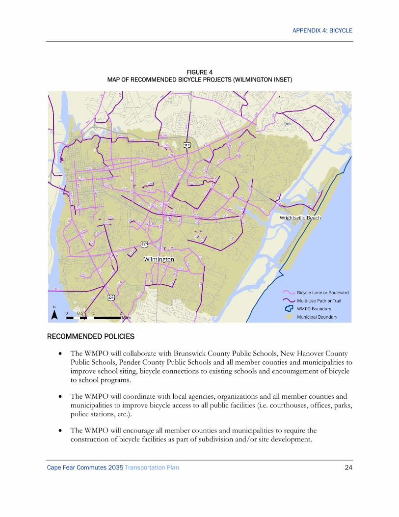
APPENDIX 4: BICYCLE
Cape Fear Commutes 2035 Transportation Plan 24
FIGURE 4 MAP OF RECOMMENDED BICYCLE PROJECTS (WILMINGTON INSET)
RECOMMENDED POLICIES
• The WMPO will collaborate with Brunswick County Public Schools, New Hanover County Public Schools, Pender County Public Schools and all member counties and municipalities to improve school siting, bicycle connections to existing schools and encouragement of bicycle to school programs.
• The WMPO will coordinate with local agencies, organizations and all member counties and municipalities to improve bicycle access to all public facilities (i.e. courthouses, offices, parks, police stations, etc.).
• The WMPO will encourage all member counties and municipalities to require the construction of bicycle facilities as part of subdivision and/or site development.

APPENDIX 4: BICYCLE
Cape Fear Commutes 2035 Transportation Plan 25
• The WMPO will encourage all member counties and municipalities to seek planning and infrastructure grants to improve the bicycle transportation system within the Wilmington Urban Area.
• The WMPO will support comprehensive bicycle plans for municipalities within the Wilmington Urban Area to identify additional bicycle projects for funding.
• The WMPO supports the inclusion of bicycle facilities in all new roadway and bridge projects within the Wilmington Urban Area.
• The WMPO supports the coordination and linkage of the bicycle transportation and mass transportation systems within the Wilmington Urban Area.
• The WMPO will work to ensure that transportation projects within the Wilmington Urban Area do not disrupt existing or planned bicycle routes or facilities
• The WMPO will work to construct the bicycle projects and implement the policies identified in the Coastal Pender Collector Street Plan (2007), Dawson & Wooster Corridor Plan (2007), River Road Small Area Plan (2007), US 17 Business Corridor Study (2007), Bicycle Facilities Study for the Blue Clay Corridor (2008), Cape Fear Historic Byway Corridor Management Plan (2008), Comprehensive Bicycle Plan for Leland, NC (2008), Corridor Plan for Dow Road (2009), Pelican Drive/Salisbury Street Bicycle Plan for the Town of Wrightsville Beach (2009), Walk Wilmington: A Comprehensive Pedestrian Plan (2009), Market Street Corridor Study (estimated 2010), and all other adopted transportation plans.
• The WMPO will work to implement the complete streets policies adopted by the WMPO and the North Carolina Board of Transportation.
• The WMPO will work to promote bicycling as a viable and safe mode of transportation throughout the Wilmington Urban Area.
SAFETEA-LU PLANNING FACTORS
The Bicycle element of Cape Fear Commutes 2035 addresses the SAFETEA-LU Planning Factors in the following ways:
A) Support the economic vitality of the metropolitan area, especially by enabling global competitiveness, productivity and efficiency.
This planning factor is achieved by identifying existing and future bicycle needs and prioritizing those needs. The results of this process are shown in this Plan. Improved bicycle travel in the region will likely result in improved economic vitality and efficiency through providing access to jobs and commerce by alternate means.
(B) Increase the safety of the transportation system for motorized and non-motorized users.

APPENDIX 4: BICYCLE
Cape Fear Commutes 2035 Transportation Plan 26
As described in this Plan, member jurisdictions have adopted plans and policies that will increase the extent of fit-for-purpose facilities for bicyclists and pedestrians. This will improve safety by reducing the potential conflicts with motor vehicles. Considerable planning efforts have been made to develop these plans and policies, and the growth of the bicycle and sidewalk networks in recent years confirms a degree of success.
(C) Increase the security of the transportation system for motorized and non-motorized users.
Bicycling improvements will continue to increase security for non-motorized users by offering choice in commuting options.
(D) Increase the accessibility and mobility of people and for freight.
This planning factor is achieved by identifying existing and future transportation needs and prioritizing those needs. The results of this process are shown in this Plan. The planning process has recognized that increasing mobility and accessibility does not necessarily mean by highway alone. This is shown in the continuing attention to bicycle planning and improvements to other alternative modes of travel.
(E) Protect and enhance the environment, promote energy conservation, improve the quality of life, and promote consistency between transportation improvements and State and local planned growth and economic development patterns.
The WMPO project development process ensures that potential social and environmental conflicts are identified very early in a project’s development. This assists in the selection of the most appropriate alignment, is beneficial to the public’s quality of life, and helps to preserve the natural environment.
(F) Enhance the integration and connectivity of the transportation system, across and between modes, for people and freight.
The WMPO has supported continuous planning efforts to achieve an efficient multi-modal plan. The existing bicycle facilities will be greatly improved and extended through past and current planning efforts. Connecting to other modes is also an emphasis of this Plan.
(G) Promote efficient system management and operation.
Development of the bicycle facilities and programs in this Plan will add efficiency to the existing transportation system and improve general operations.
(H) Emphasize the preservation of the existing transportation system.
This planning factor is achieved by recognizing the importance of system maintenance and completing missing links in the existing system to complete the network.
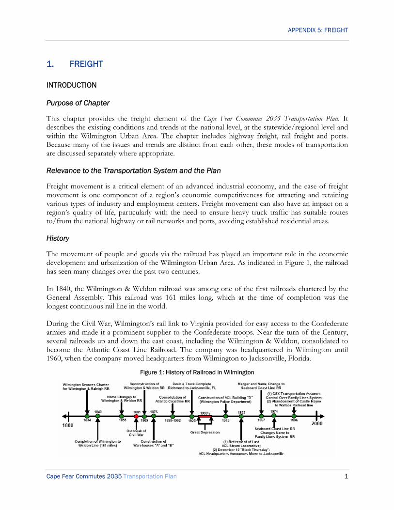
APPENDIX 5: FREIGHT
Cape Fear Commutes 2035 Transportation Plan 1
1. FREIGHT
INTRODUCTION
Purpose of Chapter
This chapter provides the freight element of the Cape Fear Commutes 2035 Transportation Plan. It describes the existing conditions and trends at the national level, at the statewide/regional level and within the Wilmington Urban Area. The chapter includes highway freight, rail freight and ports. Because many of the issues and trends are distinct from each other, these modes of transportation are discussed separately where appropriate.
Relevance to the Transportation System and the Plan
Freight movement is a critical element of an advanced industrial economy, and the ease of freight movement is one component of a region’s economic competitiveness for attracting and retaining various types of industry and employment centers. Freight movement can also have an impact on a region’s quality of life, particularly with the need to ensure heavy truck traffic has suitable routes to/from the national highway or rail networks and ports, avoiding established residential areas.
History
The movement of people and goods via the railroad has played an important role in the economic development and urbanization of the Wilmington Urban Area. As indicated in Figure 1, the railroad has seen many changes over the past two centuries. In 1840, the Wilmington & Weldon railroad was among one of the first railroads chartered by the General Assembly. This railroad was 161 miles long, which at the time of completion was the longest continuous rail line in the world. During the Civil War, Wilmington’s rail link to Virginia provided for easy access to the Confederate armies and made it a prominent supplier to the Confederate troops. Near the turn of the Century, several railroads up and down the east coast, including the Wilmington & Weldon, consolidated to become the Atlantic Coast Line Railroad. The company was headquartered in Wilmington until 1960, when the company moved headquarters from Wilmington to Jacksonville, Florida.
Figure 1: History of Railroad in Wilmington

APPENDIX 5: FREIGHT
Cape Fear Commutes 2035 Transportation Plan 2
Currently, Wilmington is served by a single railroad, CSX, and one transfer facility, Wilmington Terminal Railroad LP, within the Wilmington planning area boundary (See Figure 2).
FIGURE 2 AREA MAP
EXISTING CONDITIONS AND TRENDS
Entire Freight System: Statewide and Regional Conditions and Trends
The Federal Highway Administration (FHWA) produces the Freight Analysis Framework (FAF), which examines freight movements for each mode of transportation. The Framework is not detailed

APPENDIX 5: FREIGHT
Cape Fear Commutes 2035 Transportation Plan 3
enough to give specific data for the Wilmington Urban Area or a corresponding region, so the data for North Carolina are described here.
The analysis shows that trucks carried 75% of freight traffic in North Carolina in 2002, while rail carried 14% (See Table 1). The truck mode is expected to increase its share of freight traffic to over 76% in 2035, while overall truck freight tonnage nearly doubles. Rail freight is also expected to increase in tonnage terms, although losing market share to trucks.
TABLE 1 FREIGHT MOVEMENTS IN NORTH CAROLINA
Year Mode Millions of Tons
Percent Within NC From NC To NC Total
2002
Truck 272 82 79 433 75%
Rail 13 6 61 80 14%
Other 16 21 28 65 11%
Total 301 109 168 578 100%
2035
Truck 423 173 158 754 76%
Rail 17 11 112 140 14%
Other 21 48 29 98 10%
Total 461 232 299 992 100%
Source: Federal Highway Administration – Freight Analysis Framework
Highway Freight
Truck mileage has been consistently increasing nationally over the past decades, but has been accommodated in essentially the same amount of road space. Urban freeways and arterials in particular have become increasingly congested, and this trend is expected to continue. Trucks will be affected just as much as commuters, with implications for freight travel times and reliability.
Rail Freight
The US freight railroad industry is currently in a period of stability and growth following the major structural changes of the 1970s through the 1990s. The economic growth experienced in the past decade has particularly benefited some freight flows, such as containers to and from the major ports, with the result that railroads have been adding or reinstating capacity on their main lines. Although there is a strong focus on unit trains (entire trains of a single commodity, such as coal or containers), the more traditional, smaller-scale traffic flows of single cars or small numbers of cars to/from local industries (carload freight) remains an important part of the industry.
Wilmington Terminal Railroad LP
The Wilmington Terminal Railroad, L.P. (WTRY) was created in 1986 to lease and operate the rail switching operation for the North Carolina Ports Railway (NCPR) Commission. In 2002 the North Carolina Ports Authority abolished the NCPR and started leasing the railroad to WTRY on a long-

APPENDIX 5: FREIGHT
Cape Fear Commutes 2035 Transportation Plan 4
term lease. The cargos carried by WTRY are paper, steel, chemicals, lumber, agriculture products, waste oils and miscellaneous equipment. The Wilmington Terminal Railroad switches for all customers served by the ports and industry located on the main line.
The principle shippers that utilize WTRY are North Carolina State Ports, Vopak, Colonial Oil, Flint Hills Resources, Cape Fear Bulk, Rescar, Cape Fear Bonded Warehouse and Exxon. In 2003, WTRY handled approximately 8,300 carloads. Table 2 indicates the estimated monthly cars per company to utilize the WTRY rail service.
TABLE 2 WILMINGTON TERMINAL RAILROAD MONTHLY OUTPUT (CARS)
Supplier Estimated Cars (Monthly)
North Carolina State Port 304
Cape Fear Bonded Warehouse 18
Apex Oil 15
Rescar 50
Vopak 128
Colonial Oil 120
Exxon 9
Cape Fear Bulk 14
Flint Hills Resources 77
Port
According to the U.S. Department of Transportation, American Association of State Highway and Transportation Officials and the Congressional Budget Office, a 67 percent growth is anticipated in the freight industry by 2020. Capacity constraints in west coast ports mean more freight from Asia is being transported through the Panama and Suez canals and brought to the east coast ports. The freight transportation infrastructure and highways in the nation will be affected by this increase in the volume of freight.
Currently, the North Carolina Ports Authority has two ports in Morehead City and Wilmington, North Carolina. The Port at Morehead City is one of the deepest ports on the US East coast. It has a dry-bulk facility with a 225,000-ton capacity warehouse and has access to interstates I-95 and I-40 via US Highway 70 and 17. It also has daily train service from Norfolk Southern.
The Port of Wilmington is one of the few South Atlantic ports with readily available berths and storage for containers and cargo. CSX Transportation provides daily service for boxcar, tanker and general cargo services. Table 3 summarizes the estimate for origins/destinations of trucks for Port of Wilmington.
APPENDIX 5: FREIGHT
Cape Fear Commutes 2035 Transportation Plan 5
TABLE 3 WILMINGTON TERMINAL RAILROAD MONTHLY OUTPUT
Port of Wilmington Import Export Charlotte 25% 15% East of I-95/South of I-40 20% East of I-95/North of I-40 10% Greensboro/Winston Salem/Hickory/Lenoir 35% 40% RDU 10% Local 30% Central NC 10% N/E NC 5% TOTAL 100% 100%
Source: North Carolina State Ports Authority
FUTURE PLANS
A key focus of improving freight movement in the Wilmington Urban Area is promoting intermodal connections between the ports, highways, and rail networks. This focus includes making improvements to the US 74 highway corridor and the CSX rail line connecting the proposed North Carolina International Terminal at Southport to Charlotte, as well as restoration of the rail line between Castle Hayne and Wallace to provide rail access to Raleigh and the Northeast. It also may include upgrades to Independence Boulevard in Wilmington and development of the Cape Fear Skyway as an important connector. Because freight travel is impacted by roadway congestion, freight movement was a factor in ranking the Congestion Mitigation roadway projects.
Highway Freight
In order to accommodate the anticipated growth at the port of Wilmington and North Carolina International Terminal, the highway infrastructure will have to be improved. The completion of the Wilmington Bypass, the proposed Cape Fear Skyway and US 74 highway corridor between Wilmington and Charlotte will contribute to the infrastructure improvement. Figure 3 shows the existing and proposed strategic highway corridors in southeastern North Carolina.

APPENDIX 5: FREIGHT
Cape Fear Commutes 2035 Transportation Plan 6
FIGURE 3 STRATEGIC HIGHWAY CORRIDOR VISION PLAN, SOUTHEASTERN, NC
Source: North Carolina State Department of Transportation, Strategic Highway Corridors Vision Plan
Rail Freight
The demand for rail is increasing on an annual basis. The impact of rail on the movement of goods can be seen at the state and nationwide levels and could provide a significant impact to the economic growth of the area and the state port system. CSX has announced the planned upgrade of its rail line between Wilmington and Charlotte for double-stack containers. This plan is part of CSX’s National Gateway project to create a more efficient rail route liking Mid-Atlantic ports with Midwestern markets, improving the flow of rail traffic between these regions through the use of double-stack trains. The use of these trains to move containers from the proposed North Carolina International Terminal is fundamental to the plan. The plan involves using existing railroad through Boiling Spring Lakes to connect the terminal site to the CSXT railroad in Leland. The design assumption is that 882,000 containers will be moved each year by rail, and 900,000 more would be carried by truck.
Ports
The North Carolina Ports Authority proposed the construction of the North Carolina International Terminal, in Southport, North Carolina, as an expansion of the container facilities at the Port of Wilmington. The container terminal will be built on 600 acres of undeveloped land in Brunswick County.
APPENDIX 5: FREIGHT
Cape Fear Commutes 2035 Transportation Plan 7
The North Carolina International Terminal will provide a state of the art facility with enhanced port security. It will be able to meet the national security missions and provide operational flexibility by means of robust infrastructure. The port will enhance the US intermodal transportation system, which is critical to the economic growth of the state as well as the nation. It would create more competitive market for other developments such as retail distribution centers and global manufacturing assembly plants, which also increases employment opportunities.
RECOMMENDED PROJECTS
• South Front Street (US 421 Truck) widen between Cape Fear Memorial Bridge (US 17 Business-76-421) and Burnett Boulevard (US 421) [Roadway Project C100]*
• Burnett Boulevard (US 421) improvements at Carolina Beach Road (US 421) & South Front Street (US 421 Truck) [Roadway Project W01]*
• Cape Fear Skyway*
* See Appendix 8.
RECOMMENDED POLICIES
• The WMPO supports circulation improvements in the area surrounding the Port of Wilmington, particularly on Carolina Beach Road (US 421), River Road and Shipyard Boulevard (US 117).
• The WMPO supports the restoration of the rail line between Castle Hayne and Wallace for both passenger and freight service between the Wilmington Urban Area and Raleigh and the Northeast.
• The WMPO supports the upgrade of the rail junction in Pembroke to provide for improved connectivity between the Wilmington Urban Area and Fort Bragg.
• The WMPO supports the upgrade of US 74 between Wilmington Urban Area and Charlotte to interstate standards.
• The WMPO will work with regional partners to upgrade the rail line between Fayetteville and Wilmington to improve military deployments.
SAFETEA-LU PLANNING FACTORS
The Freight element of Cape Fear Commutes 2035 addresses the SAFETEA-LU Planning Factors in the following ways:
A) Support the economic vitality of the metropolitan area, especially by enabling global competitiveness, productivity and efficiency.
This planning factor is achieved by identifying existing and future freight needs and working with regional partners to develop and improve freight infrastructure. The results of this process are

APPENDIX 5: FREIGHT
Cape Fear Commutes 2035 Transportation Plan 8
shown in this Plan. Improved freight travel in the region will result in improved economic vitality and global competitiveness through providing access to the region’s employment centers and industry and by facilitating travel to other regions.
(B) Increase the safety of the transportation system for motorized and non-motorized users.
The recommendations in this Plan include safety improvements for all users. Improvements to freight travel will make the region’s roadways safer for all users.
(C) Increase the security of the transportation system for motorized and non-motorized users.
Regional freight providers continue to work to enhance security of freight travel as part of emergency management and homeland security procedures.
(D) Increase the accessibility and mobility of people and for freight.
This planning factor is achieved by identifying existing and future transportation needs and prioritizing those needs. The results of this process are shown in this Plan. The planning process has recognized that increasing mobility and accessibility does not necessarily mean by highway alone.
(E) Protect and enhance the environment, promote energy conservation, improve the quality of life, and promote consistency between transportation improvements and State and local planned growth and economic development patterns.
The WMPO project development process ensures that potential social and environmental conflicts are identified very early in a project’s development. This assists in the selection of the most appropriate alignment, is beneficial to the public’s quality of life, and helps to preserve the natural environment. The recommended freight improvements are consistent with local plans and policies.
(F) Enhance the integration and connectivity of the transportation system, across and between modes, for people and freight.
The WMPO has supported continuous planning efforts to achieve an efficient multi-modal plan. The existing freight facilities will be greatly improved and extended through past and current planning efforts.
(G) Promote efficient system management and operation.
Development of the freight improvements and programs in this Plan will add efficiency to the existing transportation system and improve general operations.
(H) Emphasize the preservation of the existing transportation system.
This planning factor is achieved by recognizing the importance of system maintenance and by building on the significant freight infrastructure already in place.

APPENDIX 6: MASS TRANSPORTATION
Cape Fear Commutes 2035 Transportation Plan 1
6. MASS TRANSPORTATION
INTRODUCTION
Purpose of Chapter
This chapter provides the Mass Transportation element of the Cape Fear Commutes 2035 Transportation Plan. It describes the existing conditions and trends, as well as future issues, at the national level and more specifically within the WMPO study area. It makes a series of recommendations for transit system improvements, including local bus, express bus, bus rapid transit, and other regional transit priorities. For the purposes of this Plan, “mass transportation” refers to shared transportation services that are available to the public, including both publically- and privately-operated services. Within the Wilmington Urban Area, it includes Brunswick Transit System, Cape Fear Public Transportation Authority (WAVE Transit), Greyhound, North Carolina Department of Transportation Ferry Division, Pender Adult Services, and various privately-owned operators.
RELEVANCE TO THE TRANSPORTATION SYSTEM AND THE PLAN
The Cape Fear Commutes 2035 Transportation Plan aims to improve mobility throughout the region by employing a variety of approaches and improvements to all modes of travel. As the region continues to grow and the population becomes more dispersed, transit will play a more central role in moving people throughout the region.
Public transportation has several roles in the transportation system. At the personal level, it provides mobility for people who are unable to drive, and an additional mobility for people who prefer not to drive. At a more strategic level, it can contribute to economic competitiveness, provide an alternative to congested highways, and assist with meeting air quality and other sustainability and quality-of-life goals.
Historically, public transportation has taken a low profile in long-range planning, with greatest attention and funding being given to highway projects. This will need to change as it is increasingly recognized that a highway-led approach is neither financially feasible nor the best way to achieve a region’s overall goals. In addition, land use patterns are an important determinant of whether transit service can be made attractive or even feasible, requiring forward-thinking policy development and regulatory standards.
This plan will improve transit through enhancing the local bus system, adding new express routes to capture regional commuters, and developing a bus rapid transit network in the urban area. These projects are shown on Figures 3 and 4, toward the end of this chapter.
1 Bus
=
80 Single-Occupant
Automobiles

APPENDIX 6: MASS TRANSPORTATION
Cape Fear Commutes 2035 Transportation Plan 2
EXISTING CONDITIONS AND TRENDS
National Conditions and Trends
At the national level, public transportation fulfills a small proportion of total travel demand, but remains important in particular geographic markets (mainly large cities) and for particular segments of the population (including people with low incomes and people with disabilities).
Local Transit
Transit ridership has been increasing slowly in recent years, for a variety of reasons including highway congestion, several recent spikes in gasoline prices, and the construction of new light rail and commuter rail systems in some cities. There is also an increasing focus on moving beyond the traditional transit-dependent ridership to capture new riders who positively choose transit over driving (‘choice riders’).
Inter-City Buses
Inter-city bus service is provided mostly by Greyhound, its subsidiaries and its business partners. Other firms also operate in some markets. Together these services provide a nationwide city-to-city network, including stops at smaller locations that are not served by either air or rail. They are widely recognized as an affordable option for long-distance travel. In the past few years, Greyhound has restructured many of its service patterns to concentrate on main flows and make fewer stops. Generally the result has been an increase in ridership with a decrease in vehicle miles. However, some smaller communities have lost their inter-city transit connections as a result.
Inter-City and Commuter Rail Services
Inter-city passenger rail service is provided by Amtrak, a quasi-governmental organization funded in part by state and federal governments. Outside the northeastern US, the services fall into two kinds: long-distance services, often running once a day, and shorter-distance ‘corridor’ services, often with several trips per day and usually supported financially by states. Amtrak mostly operates over track owned by freight railroads (‘host’ railroads). Amtrak does not cover its operating costs; both service levels and long-term capital investment planning are hampered by perennial pressure on the Federal budget. Nevertheless, Amtrak ridership has been increasing in recent years on both long-distance and corridor services. There is also an increasing political recognition of inter-city rail’s potential contribution to energy independence, offering an alternative to highway congestion, and providing resilience in the event of disruption to civil aviation.
Commuter rail services have become increasingly common in major metropolitan areas in recent years, and there is now considerable experience of implementing these services on existing railroad corridors, in some cases shared with existing freight services. Typically these new services are operated by local or state agencies as a part of the regional transit system, rather than by Amtrak.
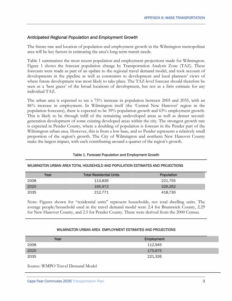
APPENDIX 6: MASS TRANSPORTATION
Cape Fear Commutes 2035 Transportation Plan 3
Anticipated Regional Population and Employment Growth
The future rate and location of population and employment growth in the Wilmington metropolitan area will be key factors in estimating the area’s long-term transit needs.
Table 1 summarizes the most recent population and employment projections made for Wilmington. Figure 1 shows the forecast population change by Transportation Analysis Zone (TAZ). These forecasts were made as part of an update to the regional travel demand model, and took account of developments in the pipeline as well as constraints to development and local planners’ views of where future development was most likely to take place. The TAZ-level forecast should therefore be seen as a ‘best guess’ of the broad locations of development, but not as a firm estimate for any individual TAZ.
The urban area is expected to see a 75% increase in population between 2005 and 2035, with an 86% increase in employment. In Wilmington itself (the ‘Central New Hanover’ region in the population forecasts), there is expected to be 39% population growth and 63% employment growth. This is likely to be through infill of the remaining undeveloped areas as well as denser second-generation development of some existing developed areas within the city. The strongest growth rate is expected in Pender County, where a doubling of population is forecast in the Pender part of the Wilmington urban area. However, this is from a low base, and so Pender represents a relatively small proportion of the region’s growth. The City of Wilmington and northern New Hanover County make the largest impact, with each contributing around a quarter of the region’s growth.
Table 1. Forecast Population and Employment Growth
WILMINGTON URBAN AREA TOTAL HOUSEHOLD AND POPULATION ESTIMATES AND PROJECTIONS
Year Total Residential Units Population
2008 113,839 221,755
2020 165,972 326,262
2035 212,771 418,730
Note: Figures shown for “residential units” represent households, not total dwelling units. The average people/household used in the travel demand model were 2.4 for Brunswick County, 2.29 for New Hanover County, and 2.5 for Pender County. These were derived from the 2000 Census.
WILMINGTON URBAN AREA EMPLOYMENT ESTIMATES AND PROJECTIONS
Year Employment
2008 112,945
2020 175,675
2035 221,326
Source: WMPO Travel Demand Model

APPENDIX 6: MASS TRANSPORTATION
Cape Fear Commutes 2035 Transportation Plan 4
Figure 1. Forecast Population Change 2005-2035, by TAZ
Source: Socio-Economic Forecasts made in 2007 for Wilmington Travel Demand Model Update

APPENDIX 6: MASS TRANSPORTATION
Cape Fear Commutes 2035 Transportation Plan 5
Current Local Bus Service
Wave Transit is the operating name of the Cape Fear Public Transportation Authority. Wave is an integrated agency covering the whole of New Hanover County, resulting from a merger in 2004 of the former Wilmington and New Hanover transit agencies.
The fixed-route service consists of nine routes within the Wilmington urban area east of the Cape Fear River and an additional route into Brunswick County. Wave also operates a free downtown circulator and Seahawk Shuttle routes serving the University of North Carolina – Wilmington (UNCW) campus area. Wave Transit also operates curb-to-curb paratransit service under the name Dial-a-Ride Transportation (DART).
Fixed-Route Service
The current WAVE Transit route structure was introduced on March 31, 2008, and represented a major shift in line with the recommendations in the WAVE Short-Range Transit Plan. Since the previous restructuring in 1974, the area had grown tremendously and the old route structure concentrated public transportation services to a very compact area where many routes overlapped one another. While this configuration was convenient to the passengers who lived and traveled in this area, it failed to offer other areas of the county access to fixed-route transit service.
The new route structure includes an expanded service area. The primary transfer location will be located at the authority’s new transfer and administration facility to be constructed on Cando Street. Temporarily, transfers are occurring on Columb Drive behind Target. This location is known as ‘Central Station’; it has also been described as ‘Market Station’ in the past. In addition to Central Station, there are two other major transfer points:
• Downtown Station, at North 2nd Street and Princess Street. This transfer point is expected to move to the Wilmington Multimodal Transportation Center (WMTC) in due course.
• Independence Station, at Independence Mall on Independence Boulevard. This transfer point is expected to remain for the long-term.
The base service pattern is hourly. Some routes operate half-hourly during peak service (Monday-Friday daytime). Up to four buses, plus potentially the downtown trolley, are scheduled to be at the downtown transfer point at any time. This is important, because it means that even though Central Station is the main hub, the downtown transfer point can and does still have a substantial hub role. (The schedule introduced March 31, 2008 had five buses plus potentially the downtown trolley present at any one time, but subsequent revisions have reduced this pulse to four buses plus potentially the downtown trolley.)

APPENDIX 6: MASS TRANSPORTATION
Cape Fear Commutes 2035 Transportation Plan 6
Figure 2. Existing Wave Transit Routes
Source: Wave Transit Route Map

APPENDIX 6: MASS TRANSPORTATION
Cape Fear Commutes 2035 Transportation Plan 7
Current Issues for Wave
After an initial drop in passengers following the restructuring in 2008, ridership levels have rebounded to their 2007 levels. In response to the initial reaction from patrons, Wave Transit held a series of public input meetings designed to listen to passenger concerns. These meetings led to minor modifications to many of the routes, additional bus stops, and improved amenities.
Wave Transit envisions continued minor modifications to the new routes. Although the transition was initially challenging, it believes that most passengers have come to understand the new routes. The public input also prompted staff and the route committee to develop an additional route to serve New Hanover Regional Medical Center and the Long Leaf Park neighborhood. Once funding can be identified, the new route will be implemented.
One pattern that has emerged is passengers’ continued desire to use downtown Wilmington for transfers, even though it is on the western edge of the service area. Wave therefore expects that the future WMTC will most likely serve as a transfer location with passenger counts that are comparable to Central Station.
Other Local Bus Services
In addition to WAVE Transit, Pender Transportation and Brunswick Transit System operate local bus services in the region. Pender Transportation provides both human service agency sponsored transit service and general public transportation for such things as medical appointments, shopping, and employment. Reservations for rides are required. Brunswick Transit System coordinates general public and human service transportation services for residents of Brunswick County. Like Pender Transportation, reservations are required.
RANKING PROJECTS
The recommended transit improvements in the Cape Fear Commutes 2035 Transportation Plan were developed through a variety of methods and sources, including: work with the Cape Fear Commutes 2035 Committee; input from the public at open houses and through the community survey; coordination with regional stakeholders; analysis of existing transit data and projected conditions; and study of what kinds of programs and systems other communities have implemented successfully.
Project Prioritization
The Cape Fear Commutes 2035 Committee decided to classify the recommended improvements into three general categories: local bus improvements, development of regional express routes, and development of bus rapid transit (BRT) routes in the Wilmington urban area. Once a complete list of potential projects was identified in each category, a prioritization system was developed and each of the projects was ranked and scored according to a variety of factors that related to the five goal areas of the Plan (see Table 2). The prioritization factors were:
• Efficient o High ridership potential
APPENDIX 6: MASS TRANSPORTATION
Cape Fear Commutes 2035 Transportation Plan 8
o Uses existing infrastructure • Multimodal
o Integrates with bicycle and pedestrian infrastructure o Serves congested corridors o Serves key destinations
• Integrated o Supports land use plans
• Responsible o Has low relative cost o Low impacts to community and environment o Demonstrates community support
• Appropriate o Serves urban community with existing infrastructure o Serves transit dependent populations o Promotes walkable communities
Each of the recommended projects in Table 2 are shown in Figures 3 and 4, and described in more detail in the sections that follow.

APPENDIX 6: MASS TRANSPORTATION
Cape Fear Commutes 2035 Transportation Plan 9
Table 2. Project Prioritization
5 5 10 5 5 5 15 5 5 5 5 5 15 5 5 5 15
Hig
h rid
ersh
ip p
oten
tial
Use
s ex
istin
g in
fras
truc
ture
Eff
icie
nt
Tota
l
Inte
grat
es w
/ pe
d/bi
ke in
fras
truc
ture
Serv
es c
onge
sted
cor
ridor
Ser
ves
key
dest
inat
ions
Mu
ltim
od
al
Tota
l
Supp
orts
land
use
pla
ns
Inte
gra
ted
To
tal
Has
low
rela
tive
cost
Low
impa
cts
to c
omm
unity
and
en
viro
nmen
t
Dem
onst
rate
s co
mm
unity
sup
port
Re
spo
nsi
ble
To
tal
Serv
es u
rban
com
mun
ity w
/ ex
istin
g in
fras
truc
ture
Serv
es tr
ansi
t dep
ende
nt p
opul
atio
ns
Prom
otes
wal
kabl
e co
mm
uniti
es
Ap
pro
pri
ate
To
tal
C UNCW to Downtown Local Local bus 5 5 10 3 3 5 11 3 3 5 3 4 12 5 3 5 13 49
A1 Central Station to Wrightsville Beach Local bus 4 5 9 3 3 3 9 3 3 5 3 4 12 3 3 3 9 42
PModify existing WAVE Route 207 (Castle Hayne) to serve ILM Airport
Local bus 2 5 7 3 2 3 8 3 3 5 3 3 11 5 3 3 11 40
F Masonboro Loop Road bus Local bus 3 5 8 3 3 2 8 3 3 5 3 3 11 3 3 3 9 39
A Downtown to River Road bus Local bus 3 5 8 3 1 1 5 3 3 5 3 2 10 3 3 3 9 35
GHampstead to Wilmington Express (serving Hampstead, Scotts Mill and Porters Neck to Downtown via Central Station)
Express bus 5 3 8 3 4 2 9 3 3 4 3 4 11 3 3 3 9 40
DOgden to Wilmington Express (to Downtown via Central Station)
Express bus 4 3 7 3 4 2 9 3 3 4 3 4 11 3 3 3 9 39
BCarolina Beach Express (to downtown Wilmington)
Express bus 5 3 8 3 3 2 8 3 3 4 3 3 10 3 3 3 9 38
B1Carolina Beach Express Alternate (to Central Station via UNCW)
Express bus 5 3 8 3 3 2 8 3 3 3 3 3 9 3 3 3 9 37
INorthwest and Leland to Wilmington Express (also serving Reiglewood, Acme, and Delco to New Hanover Medical Center
Express bus 4 3 7 3 2 2 7 3 3 4 3 3 10 1 3 3 7 34
HSouthport Commuter Express (serving Southport, Boiling Springs Lakes and Winnabow to Central Station via Downtown
Express bus 3 3 6 3 2 2 7 3 3 3 3 3 9 1 3 3 7 32
J Topsail Island to Wilmington Express Express bus 3 3 6 3 2 1 6 3 3 3 3 3 9 2 3 3 8 32
SShallotte to Wilmington Express (serving Shallotte, Supply, Bolivia, and Winnabow to Central Station via Downtown Station)
Express bus 3 3 6 3 2 2 7 3 3 3 3 3 9 1 3 3 7 32
H1
Southport Commuter Express Alternate (serving Southport, Boiling Springs Lakes and Winnabow to US 421 via future I-140/Cape Fear Skyway, to hospital)
Express bus 3 3 6 3 2 2 7 3 3 3 3 3 9 1 3 3 7 32
S1
Shallotte to Wilmington Express Alternate (serving Shallotte, Supply, Bolivia, and Winnabow to US 421 via future I-140/Cape Fear Skyway, to hospital)
Express bus 3 3 6 3 2 2 7 3 3 3 3 3 9 1 3 3 7 32
Q Jacksonville to Wilmington Express Express bus 2 3 5 3 2 3 8 3 3 3 3 1 7 1 3 3 7 30
L
Burgaw to Wilmington Express (serving Burgaw, Rocky Point and Castle Hayne to Hanover Regional Medical Ctr via Central Station and UNCW Station)
Express bus 2 3 5 3 1 1 5 3 3 3 3 3 9 1 3 3 7 29
R Pender County to Wilmington express bus Express bus 1 3 4 3 1 1 5 3 3 3 3 1 7 1 3 3 7 26
V Market Street BRTBRT (long term: light rail)
5 2 7 3 5 5 13 3 3 2 3 5 10 5 3 5 13 46
Y UNCW to downtown Wilmington BRTBRT (long term: light rail)
5 2 7 3 5 5 13 3 3 2 3 5 10 5 3 5 13 46
W Oleander Drive BRTBRT (long term: light rail)
5 2 7 3 5 5 13 3 3 1 3 5 9 5 3 5 13 45
X South 17th Street BRTBRT (long term: light rail)
4 2 6 3 5 5 13 3 3 2 3 5 10 5 3 5 13 45
Z Carolina Beach BRTBRT (long term: light rail)
4 2 6 3 4 3 10 3 3 2 3 5 10 4 3 5 12 41
Local Bus Projects
Express Bus Projects
Bus Rapid Transit Projects
Integrated
Responsible Appropriate
Tota
l S
core
Map ID ProjectRecommended
Technology
Eff icient Mult imodal

APPENDIX 6: MASS TRANSPORTATION
Cape Fear Commutes 2035 Transportation Plan 10
RECOMMENDED PROJECTS
Figure 3. Recommended Mass Transportation Projects

APPENDIX 6: MASS TRANSPORTATION
Cape Fear Commutes 2035 Transportation Plan 11
Figure 4. Recommended Mass Transportation Projects (Wilmington Inset)
Local Bus
The Wilmington community has worked to develop a successful local bus system, WAVE Transit. WAVE Transit buses provide an affordable and convenient way to access jobs, shopping, and other destinations in Wilmington without a car. As the city and region continue to grow, WAVE Transit will be relied on more as an alternative means of travel. This plan will add or modify five WAVE routes. These routes will connect key destinations, such as UNCW and the airport, with the downtown, and will reach out to growing parts of the urban area. The new routes, and improvements to existing routes, will take advantage of the Central and Downtown Stations.
The local bus projects that are included in the Cape Fear Commutes 2035 Transportation Plan, in ranked order, are:
• UNCW Station to Downtown Station Local (T01) – a new route that would provide access between two major destinations and employment centers, the UNCW camps and downtown Wilmington. Route would go through the Central Station and along Market Street.

APPENDIX 6: MASS TRANSPORTATION
Cape Fear Commutes 2035 Transportation Plan 12
• Wrightsville Beach (or Drawbridge Station) to Central Station Local (T02) – a new route connecting the Central Station to the Wrightsville Beach area. Depending on local input, the route could go directly into Wrightsville Beach or terminate at a station near the drawbridge. The benefits of providing transit access to Wrightsville Beach, for residents, tourists and workers in the area, should be balanced with potential impacts to the town.
• Decrease Headways – decreasing headways on local bus routes would add efficiency to the system and make it more attractive and convenient for users.
• Masonboro Loop Road to Independence Station Local (T04) – a new route along Masonboro Loop Road to provide access to currently under-served southeastern Wilmington and New Hanover County.
• River Road to Downtown Station Local (T05) – a new route to serve the rapidly developing area of western and southwestern Wilmington on the east side of the river.
Express Bus Routes
More and more of the region’s residents are living outside of the Wilmington urban area and commuting into the downtown, UNCW, the regional medical center, and other major employment centers. Today, their only real option is to drive. This plan creates 10 express bus routes that will give these commuters a viable and attractive alternative to driving. Many of these routes will access park-and-ride lots that are strategically located along major corridors, allowing commuters to drive a short distance from their home to the park-and-ride lot and ride the express bus into Wilmington. These routes will operate during the peak travel times and will have shorter travel times than local buses. The express routes are shown as red lines on Figures 3 and 4, and the park-and-ride lots are shown as circles.
Many of these express routes are intended to serve destinations outside of the WMPO area. Development and implementation of these routes will require planning and coordination with regional partners, as well as possible revisions to local land use ordinances and policies. Funding from Cape Fear Commutes 2035 only covers the project lengths within the WMPO area.
The express bus routes that are included in the Cape Fear Commutes 2035 Transportation Plan, in ranked order, are:
• Hampstead to Wilmington Express (T06) – express route serving Scotts Hill and Porters Neck areas, to the Downtown Station via Central Station. Route is within the WMPO area.
• Pleasure Island to Wilmington Express (T07) – express route serving Carolina Beach, to the Downtown Station via Carolina Beach Road (US 421). Route is within the WMPO area.
• Pleasure Island to Wilmington Express Alternate (T08) – express route as an alternate to T07, serving Carolina Beach, to UNCW Station and Central Stations via South College Road (NC132). Route is within the WMPO area.
• Riegelwood to Wilmington Express (T09) – express route serving Acme, Delco and Leland to the New Hanover Medical Center via Downtown Station. Route is largely outside of the WMPO area and would require coordination with regional partners.

APPENDIX 6: MASS TRANSPORTATION
Cape Fear Commutes 2035 Transportation Plan 13
• Southport to Wilmington Express (T10) – express route serving Boiling Springs Lakes and Winnabow, connecting to Central Station via Downtown Station. Route is largely outside of the WMPO area and would require coordination with regional partners.
• Shallotte to Wilmington Express (T11) – express route serving Supply, Bolivia and Winnabow, connecting to Central Station via Downtown Station. Route is largely outside of the WMPO area and would require coordination with regional partners.
• Southport to Wilmington Express Alternate (T12) – express route serving Boiling Springs Lakes and Winnabow, connecting to the New Hanover Medical Center via the planned Cape Fear Skyway. Route is largely outside of the WMPO area and would require coordination with regional partners.
• Shallotte to Wilmington Express Alternate (T13) – express route serving Supply, Bolivia and Winnabow, connecting to the New Hanover Medical Center via the planned Cape Fear Skyway. Route is largely outside of the WMPO area and would require coordination with regional partners.
• Burgaw to Wilmington Express (T14) – express route serving Rocky Point and Castle Hayne, connecting to the New Hanover Regional Medical Center via Central Station and UNCW Station. Route is largely outside of the WMPO area and would require coordination with regional partners.
• Western Pender County to Wilmington Express (T15) – serving the US 421 corridor north of Wilmington, connecting to the New Hanover Medical Center via Downtown Station.
A critical factor to the success of these express routes will be development of park-and-ride lots along the major corridors to support the routes. Potential locations for park-and-ride lots are identified on Figures 3 and 4. These lots could be developed as stand-alone lots constructed for this purpose, or they could function as leased or shared parking arrangements with existing commercial centers. Developing stand-alone lots may require property acquisition, and opportunities such as using NCDOT rights-of-way should be investigated.
Bus Rapid Transit
Supplementing the local bus service, the Cape Fear Commutes 2035 Transportation Plan establishes five corridors for the development of bus rapid transit, commonly referred to as BRT. These BRT corridors would serve the Wilmington urban area, as opposed to the express bus routes described earlier that would enhance transit opportunities for those living outside of the urban area who commute into Wilmington. Cities across the United States and internationally are developing BRT systems to provide efficient mass transit service in urban areas without the extremely high cost of commuter rail or light rail. BRT systems are cost-effective because they are developed on existing city streets with only moderate improvements to the infrastructure. They utilize modern, low-floor bus vehicles that provide many of the amenities that attract commuters who have a choice as to how they travel. The figure below illustrates features of a BRT project recently implemented in Eugene-Springfield, Oregon.

APPENDIX 6: MASS TRANSPORTATION
Cape Fear Commutes 2035 Transportation Plan 14
Federal Transit Administration Guidance
The Federal Transit Administration (FTA) and the Bus Rapid Transit Institute provide guidance on developing bus rapid transit systems and their potential benefits. According to the FTA and the Bus Rapid Transit Institute:
Bus Rapid Transit (BRT) systems provide a higher quality of service than traditional bus lines at a lower cost than rail systems. Through innovations in running ways, fare collection, signal priority and vehicle design, transit service is improved while maintaining the basic infrastructure of traditional bus systems. BRT projects can also include Intelligent Transportation Systems (ITS), branding and marketing strategies and land use benefits. The FTA supports BRT through demonstration, evaluation and informative programs. There are several key elements involved in making ordinary bus service into Bus Rapid Transit. Each element can be realized by taking advantage of one or more BRT features.

APPENDIX 6: MASS TRANSPORTATION
Cape Fear Commutes 2035 Transportation Plan 15
• Reducing Travel Time: All BRT projects seek to improve service by reducing travel time. The components of travel time include time getting to and from the transit stop, time waiting for the transit vehicle, and time in the vehicle. If a transfer is needed, there is also additional walking and waiting time. A central concept in BRT planning is to give priority to transit vehicles, since on average they carry many more people than other road vehicles, and the goal should be to maximize person-throughput, not necessarily vehicle-throughput. One form of priority is to run service on exclusive rights-of-way such as busways and exclusive lanes on expressways. These techniques can greatly reduce in-vehicle travel time. Another form of priority is to designate bus lanes on arterial streets. Providing traffic signal priority to transit vehicles can also speed operation on streets. Reducing the number of stops, providing limited-stop service, or relocating stops to areas where there is less congestion can also speed service, although potentially with the disadvantage of increasing walk time. All of these techniques not only reduce in-vehicle time but by improving the reliability of service can reducing waiting time also. Since customers particularly do not like to wait for transit, reductions in waiting time can make service much more attractive. Automatic vehicle location systems can be used to manage bus service to regularize the intervals between buses, thereby minimizing passenger waiting time. Changing fare collection policies to reduce or eliminate on-vehicle fare purchase can speed boarding. Using vehicle designs that feature fewer steps and more or wider doors can also reduce dwell time.
• User Friendly Service: Although faster travel is a key element in improving service and attracting more transit trips, transit will not be attractive to many potential riders unless it is more user-friendly. Better passenger information can make transit service easier to use. Providing real-time bus status information (a by-product of automatic vehicle location) can reduce customer anxiety while waiting. A unified system design, with colors and images coordinated between stops, vehicles, and print materials, can simplify the experience of using public transit. Using marketing techniques can make the public aware of service improvements, and also help to improve the public image of buses.
• Land Use Policies: Making land use policy more oriented to developing and maintaining pedestrian-friendly areas will improve enhance the attractiveness of transit. In the long-run, land use policy coordinated with transit investments will help to make transit trips convenient by locating attractors conveniently adjacent to transit corridors and stations.
Recommended Corridors
The Cape Fear Commutes 2035 Transportation Plan recommends developing bus rapid transit projects along five corridors in Wilmington. These projects will be most successful if they are directly tied to changes in land uses along the corridors to make the areas more transit-oriented and pedestrian-friendly. Bus rapid transit projects are often implemented in phases, starting out with relatively basic improvements and moving toward more comprehensive infrastructure improvements as the lines become more fully developed. The intent with these five corridors is to begin with incremental service improvements (e.g., increased frequency, marketing and branding, upgraded station-stops, unique rolling stock, and traffic signal queue-jump lanes). This gradual approach to bus rapid transit implementation has been utilized by cities throughout the United States and they have been able to access funding from the Federal Transit Administration.
The five corridors (see Figures 3 and 4) that are included in the Cape Fear Commutes 2035 Transportation Plan for bus rapid transit projects, in ranked order, are:

APPENDIX 6: MASS TRANSPORTATION
Cape Fear Commutes 2035 Transportation Plan 16
• Market Street between Downtown Station and Central Station (T16) – a BRT corridor along Market Street, between the Downtown Station and the Central Station. The Market Street corridor is the highest ranked BRT project and was identified as the ideal corridor for a starter segment. Development of the corridor should tie into the land use recommendations of the Market Street Corridor Study.
• UNCW between Downtown Station and Cape Fear Memorial Hospital (T17) – a BRT corridor between UNCW and downtown Wilmington, running along S. Kerr Avenue and Market Street. This project will provide a vital connection between two of the areas main employment centers and will also connect the cultural destinations of each area. A major station-stop is anticipated at UNCW.
• Oleander Drive between Downtown Station and Cape Fear Memorial Hospital (T18) – a BRT corridor along Oleander Drive, connecting the downtown area to Cape Fear Memorial Hospital. A major station-stop is anticipated at Cape Fear Memorial Hospital.
• South 17th Street between Downtown Station and Skyway Station (T19) – a BRT corridor along South 17th Street, connecting the Downtown Station to where the Cape Fear Skyway is anticipated to intersect with Carolina Beach Road (US 421). A major station-stop is anticipated near this major intersection.
• Carolina Beach Road BRT between Downtown Station and Skyway Station (T20) – a BRT corridor along Carolina Beach Road (US 421), connecting the Downtown Station to where the Cape Fear Skyway is anticipated to intersect with Carolina Beach Road (US 421). Runs parallel to project T19 and terminates at the same general location at Skyway Station.
Other Regional Priorities
As transit projects were developed for Cape Fear Commutes 2035 Transportation Plan, a number of regional priorities were identified as needs, but not designated for funding. The regional priority projects would provide important connections to key destinations outside of the WMPO area, such as Raleigh, Fayetteville, and Jacksonville. Key destinations could be accessed by heavy rail, inter-city bus, ferries, or potentially water taxis. For example, in the future there may be demand for express bus service from Wilmington to Raleigh-Durham International Airport (RDU). Private companies may operate water taxis along the Cape Fear River between Bald Head Island and downtown Wilmington. These kinds of services may provide travel benefits to residents of Wilmington but would be outside the scope of what is typically funded through regional long-range transportation plans.
RECOMMENDED POLICIES
• The WMPO supports the coordination and linkage of the mass transportation, bicycle transportation and pedestrian transportation systems within the Wilmington Urban Area.

APPENDIX 6: MASS TRANSPORTATION
Cape Fear Commutes 2035 Transportation Plan 17
• The WMPO supports the inclusion of mass transportation facilities (i.e. benches, bus lanes, park-and-ride lots, pull-outs, shelters, etc.) in all new roadway and bridge projects within the Wilmington Urban Area.
• The WMPO supports the restoration of the rail line between Castle Hayne and Wallace for both passenger and freight service between the Wilmington Urban Area and Raleigh and the Northeast.
• The WMPO will coordinate with local agencies, organizations and all member counties and municipalities to improve mass transportation access to all public facilities (i.e. courthouses, offices, parks, police stations, etc.).
• The WMPO will coordinate with the Brunswick Transit System, Cape Fear Transportation Authority (WAVE Transit), Greyhound, North Carolina Department of Transportation Ferry Division, Pender Adult Services, and privately-owned mass transportation operators.
• The WMPO will encourage all member counties and municipalities to require the construction of mass transportation facilities as part of subdivision and/or site development.
• The WMPO will work to construct the mass transportation projects and implement the policies identified in the Southeastern North Carolina Passenger Rail Study (2005), US 17 Business Corridor Study (2007), WAVE Transit Satellite Transfer Stations: Evaluation of Site Locations & Planning Report (2008), Cape Fear Historic Byway Corridor Management Plan (2008), Transit Needs for the Wilmington Multi-modal Transportation Center (2009), and Market Street Corridor Study (estimated 2010).
• The WMPO will work to ensure that land use plans in all member counties and municipalities support mass transportation projects identified in this Plan.
• The WMPO will work to ensure that transportation projects within the Wilmington Urban Area do not disrupt existing or planned mass transportation routes or facilities.
• The WMPO will work to implement the complete streets policies adopted by the WMPO and the North Carolina Board of Transportation.
• The WMPO will work to improve mass transportation connections between the Wilmington Urban Area and adjacent urban areas (i.e. Jacksonville, Myrtle Beach, Raleigh, etc.).
• The WMPO will work to promote mass transportation as a viable and safe mode of transportation throughout the Wilmington Urban Area.
• The WMPO will work with the North Carolina Department of Transportation to improve mass transportation facilities on existing state-maintained roadways.
• The WMPO will continue to work with Pender Transportation and Brunswick Transit System to provide human service and other local transit needs in these counties.

APPENDIX 6: MASS TRANSPORTATION
Cape Fear Commutes 2035 Transportation Plan 18
• The WMPO will continue development of two planned capital projects: the Wilmington Multimodal Center and the Cape Fear Public Transportation Authority Maintenance and Operations Center.
SAFETEA-LU PLANNING FACTORS
The Mass Transportation element of Cape Fear Commutes 2035 addresses the SAFETEA-LU Planning Factors in the following ways:
A) Support the economic vitality of the metropolitan area, especially by enabling global competitiveness, productivity and efficiency.
This planning factor is achieved by identifying existing and future mass transportation needs and prioritizing those needs through cooperation with local and regional transit providers. The results of this process are shown in this Plan. Improved transit in the region will result in improved economic vitality and global competitiveness through providing access to the region’s employment centers and industry and by facilitating travel to other regions.
(B) Increase the safety of the transportation system for motorized and non-motorized users.
The recommended mass transportation improvements will enhance safety for all users by offering mode choice and reducing roadway conflicts.
(C) Increase the security of the transportation system for motorized and non-motorized users.
Regional transit providers continue to work to enhance security of bus travel as part of emergency management and homeland security procedures.
(D) Increase the accessibility and mobility of people and for freight.
This planning factor is achieved by identifying existing and future transportation needs and prioritizing those needs. The results of this process are shown in this Plan. The planning process has recognized that increasing mobility and accessibility does not necessarily mean by highway alone. This is shown in the continuing attention to transit planning and improvements to other alternative modes of travel.
(E) Protect and enhance the environment, promote energy conservation, improve the quality of life, and promote consistency between transportation improvements and State and local planned growth and economic development patterns.
The WMPO project development process ensures that potential social and environmental conflicts are identified very early in a project’s development. This assists in the selection of the most appropriate alignment, is beneficial to the public’s quality of life, and helps to preserve the natural environment. The recommended transit improvements are consistent with local plans and policies.
(F) Enhance the integration and connectivity of the transportation system, across and between modes, for people and freight.

APPENDIX 6: MASS TRANSPORTATION
Cape Fear Commutes 2035 Transportation Plan 19
The WMPO has supported continuous planning efforts to achieve an efficient multi-modal plan. The existing aviation facilities will be greatly improved and extended through past and current planning efforts.
(G) Promote efficient system management and operation.
Development of the mass transportation improvements and programs in this Plan will add efficiency to the existing transportation system and improve general operations.
(H) Emphasize the preservation of the existing transportation system.
This planning factor is achieved by recognizing the importance of system maintenance and by building on the significant transit infrastructure already in place.
APPENDIX 7: PEDESTRIAN
Cape Fear Commutes 2035 Transportation Plan 1
7. PEDESTRIAN
INTRODUCTION
Purpose of Chapter
This chapter provides the pedestrian element of the Cape Fear Commutes 2035 Transportation Plan. It describes the relevance of pedestrian facilities to the transportation system, existing facility conditions and trends, and current and future issues.
Relevance to the Transportation System and the Plan
Going for a stroll along the Riverwalk on a summer evening is a favorite pastime of many Wilmington Urban Area residents and visitors (see Walk Wilmington: A Comprehensive Pedestrian Plan). This part of the region has been walkable from its founding days in the mid-eighteenth century and has a lively street life year-round. Outside of the historic core of the region, the walking environment changes from a traditional compact grid network of streets with sidewalks to a loosely connected network of neighborhood streets, sidewalks, trails, and informal paths separated by arterial roadways with multiple lanes of traffic in each direction.
The pedestrian experience varies dramatically in different parts of the Wilmington Urban Area. The historic downtown area has a rich system of sidewalks, marked crosswalks, signalized intersections, and other accommodations for walkers. Within residential neighborhoods, there are many areas with low traffic volumes and low vehicle speeds, so walking on the side of road is fairly pleasant. However, along many of the city’s major arterials, people must walk along busy roadways, and there are many areas where there are no sidewalks or crosswalks, resulting in a relatively unpleasant pedestrian environment.
WMPO members understand the importance of creating a region where streets, sidewalks and other pedestrian accommodations are designed to make pedestrians feel safe and comfortable. Several initiatives and projects are underway to support pedestrians and bicyclists including the NCDOT Safe Routes to School program, City of Wilmington Neighborhood Traffic Management Program, Cross-City Trail, Military Cutoff Trail, River to the Sea Bikeway improvements, and sidewalk construction program. The Military Cutoff Trail is a popular route for leisure walking and bicycling which connects the neighborhood of Ogden with the Mayfaire development. The Cross-City Trail, which will eventually span over twenty miles, will connect key destinations such as Wrightsville Beach, University of North Carolina Wilmington, McCrary Park, Empie Park, Cameron Art Museum, Halyburton Park and James E. L. Wade Park. The existing and planned improvements that are part of the East Coast Greenway will also enhance the pedestrian environment.
The walking environment is the base from which all residents, employees and visitors experience the Wilmington Urban Area. The region’s pedestrian system is vital to everyone, regardless of his or her transportation choice. Everyone who travels in the city is a pedestrian at some point during their journey. This includes walking to and from bus stops and parking facilities.

APPENDIX 7: PEDESTRIAN
Cape Fear Commutes 2035 Transportation Plan 2
However, it takes more than sidewalks to ensure an effective and appealing pedestrian transportation system—it requires attention to elements both inside and outside of the right-of-way. These elements can include landscaping, lighting, building design, building orientation, access to transit, and the presence of street crossings.
The Wilmington Urban Area needs to build upon its current strategies for constructing, improving, and maintaining the pedestrian facilities throughout the city. This will help address problems such as gaps in the pedestrian system, inadequate maintenance and repair, and hazardous conditions. A key component to developing a walkable region is effective and sustained public education and involvement. Opportunities for education exist with relation to the laws governing our roads and sidewalks, the availability of city programs for pedestrians, as well as communicating the societal need for transportation choices.
The Cape Fear Commutes 2035 Transportation Plan recommends the implementation of new policies, guidelines and design standards that ensure pedestrians are provided an adequate and safe transportation system. The plan also focuses on program development to expand education, encouragement and awareness campaigns and programs, which in turn helps to enhance safety and enforcement initiatives.
The Cape Fear Commutes 2035 Transportation Plan encourages pedestrian activity by working toward creating a safe and inviting environment for walking. The plan expands upon the foundation created by the 2030 Long Range Transportation Plan and other adopted studies and plans. The Pedestrian Appendix includes:
• existing pedestrian facilities in the Wilmington Urban Area; • an estimation of the transportation demand for pedestrian facilities; • recommended pedestrian facilities needed to improve the regional transportation system;
and • recommended policy changes needed to improve the regional transportation system.
Existing Facilities
Types of Facilities:
• Sidewalk: a five- to eight-foot-wide concrete walkway adjacent to a roadway for use by pedestrians. Example: South 3rd Street (US 17 Business) between Market Street and Willard Street.
• Multi-use path: an eight- to twelve-foot-wide paved asphalt path for use by pedestrians and bicyclists; multi-use paths can be located within conservation areas, easements, parks, roadway rights-of-way, and public lands. Example: Military Cutoff Road between Gordon Road and Drysdale Drive.
• Signalized pedestrian crossing: a marked crosswalk with pedestrian signal heads located at an intersection with a traffic control signal. Signalized pedestrian crossings may be

APPENDIX 7: PEDESTRIAN
Cape Fear Commutes 2035 Transportation Plan 3
actuated with push-buttons or concurrent with the parallel green phase during every signal cycle. Example: Oleander Drive (US 76) at Independence Boulevard.
• Mid-block pedestrian crossing: a marked crosswalk at a location other than an intersection with a traffic control signal. Mid-block pedestrian crossings may or may not have warning lights or other devices. Example: South 3rd Street (US 17 Business) at Ann Street.
Existing Facilities:
Pedestrian transportation systems cannot be properly evaluated in the context of the region as a whole. Different areas of the region serve different roles and therefore have different needs regarding pedestrian transportation and recreation. Development patterns in the Wilmington Urban Area and the corresponding character of the pedestrian transportation system can be divided into four general zones: Central Business District and Urban Core, Traditional Suburban Zone, and Automobile-Oriented Suburban Zone (see Figure 1).
Within each of these zones, arterials, collector streets and local streets fulfill a critical role in the region’s transportation network and provide varying levels of accommodation for pedestrians. These streets serve unique purposes and support differing volumes of traffic and therefore they should be assessed separately.
Much of the discussion and many of the recommendations in this plan are structured around these character zones. In this section, each area will be evaluated on the following aspects:
• Connectivity: does the pedestrian system provide convenient connections for non-vehicular travel? When viewed from the perspective of a pedestrian, connectivity refers to the completeness of the walking network. In other words, are there facilities that get the pedestrian where they want to go? In order to serve as a viable option for even short trips, the pedestrian network should be comfortable and easy to use, and should provide direct connections to destinations. Most pedestrian trips are to and from schools, shopping areas, libraries and community centers, work places, recreational opportunities and transit. Sidewalks and street crossings should be designed so people can easily and comfortably find a direct route to a destination, and delays are minimized. Connectivity is one of the most difficult and yet most important elements of transportation planning. People need to be able to access their destinations directly and safely. Missing sidewalks or crossing facilities may make walking trips difficult and deter people from choosing this transportation mode. In the Wilmington Urban Area, the pedestrian system generally provides good connectivity, but outside of the Central Business District and Urban Core, sidewalks, trails, and other walking facilities provide inconsistent functionality. This challenge can be observed in neighborhoods where residents may be able to walk to parks, schools and other institutions within the neighborhood, but may not be able to walk to other neighborhoods and destinations. Along the region’s commercial arterials there are many areas that have decent sidewalk systems but provide poor crossing opportunities due to either long separations between crossings or the absence of marked crosswalks and pedestrian signals at intersections. As a consequence, many trips that could be taken on foot are done in motor

APPENDIX 7: PEDESTRIAN
Cape Fear Commutes 2035 Transportation Plan 4
Figure 1 Map of WMPO Context Zones

APPENDIX 7: PEDESTRIAN
Cape Fear Commutes 2035 Transportation Plan 5
vehicles. These short car trips add congestion on the region’s roads and contribute emissions into the air.
• Street crossings: does the crossing provide appropriate accommodations for pedestrians? Street crossings present one of the greatest safety hazards for pedestrian travel. When crossing the street, pedestrians are entering into the realm of motor vehicle traffic and are most exposed to danger. Pedestrians must contend not only with cross traffic (cars and trucks passing along the cross street) but must also be aware of vehicles turning left or right across their path. Street crossings should be designed to provide maximum protection to the pedestrian through clear markings, appropriate signage or signalization, and adequate crossing time, pedestrian refuges (in certain cases) and other important elements. Signage and markings should provide clear guidance to both pedestrians and motorists as to their respective responsibilities at the crossing. Street crossing issues include:
o Crossing distance: Multi-lane arterials carry substantial vehicle traffic and create wide intersections and long crossings for pedestrians. For example, at the main entrance of UNCW, pedestrians crossing South College Road must cross eight lanes (approx. 100’).
o Jaywalking: Pedestrians often fail to use legal crossings, cross against the light, or step into the roadway without checking for oncoming traffic. These behaviors put pedestrians at risk of being struck by motor vehicles.
o Marked crosswalk: many signalized intersections do not have pedestrian signals or marked crosswalks. Where present, the crosswalks may not be on all ‘legs’ (sides) of the intersection. This is most prevalent on multi-lane arterials.
o Motorist behaviors: stopping within the crosswalk or pedestrian crossing area, failing to stop or yield for pedestrians, running red lights and exceeding posted speed limits significantly increase safety hazards for pedestrians. Turning motorists are often in conflict with pedestrians crossing major arterials.
o Signal spacing: long distances between signalized intersections on major arterials (up to one mile separation) either discourages crossing or promotes crossing away from an intersection. Crossing treatments that improve functionality and pedestrian comfort, such as high visibility crosswalks, median refuge islands, and curb ramps that meet ADA requirements are lacking in many locations.
o Signal timing: typical signal timing assumes that pedestrians walk between 3.5 and 4.0 feet per second. However, this may be inadequate for people do not enter the crossing at the beginning of the WALK signal or slower pedestrians (including people with strollers or small children, or wheelchair or other assistive device users).
o Stop bar location: throughout the region, stop bars at major signalized intersections appeared to be located within the legal pedestrian crossing area between the two sidewalk approached and/or wheelchair ramps.

APPENDIX 7: PEDESTRIAN
Cape Fear Commutes 2035 Transportation Plan 6
o Wait time: many pedestrian signals have a long delay (over 60 seconds) between the time the push button is depressed and the WALK signal is displayed This delay can lead to a lack of compliance.
• Quality of facility: generally, do pedestrian facilities look well maintained or is it in a state of disrepair? The quality of walking facilities relates to the condition and functionality of sidewalks, curb ramps and crosswalks. Sidewalks that are too narrow or are in poor condition are less comfortable for pedestrians to use, and may discourage walking in that area. Conversely, a well designed and maintained sidewalk allows pedestrians to walk where they want to go in a comfortable setting. Pedestrian facilities that are in very poor condition, with large cracks, uneven surfaces, or under designed pathways may be inaccessible for pedestrians with certain disabilities. For example, a curb ramp that is too steep may not be mountable by a wheelchair user.
• Accessibility: how easy is it for pedestrians with physical disabilities to use? Accessibility refers to the suitability of the walking network for people with disabilities. The availability, design and condition of a particular sidewalk or curb ramp is important for any person but it is critical for a person with a disability who may need more time crossing a street or is in a wheelchair. The following two sections describe some of the issues specific to two categories of pedestrians with disabilities.
o Walking-aid users: people who employ walking aids include those who use canes, crutches, or walkers to ease their ability to travel. Surface quality significantly affects ease of travel for walking-aid users. Grates and cracks wide enough to catch the tip of a cane can be potentially dangerous for walking-aid users. Uneven surfaces can also be hazardous because they further reduce the already precarious stability of walking-aid users. Additionally, people who use walking aids tend to travel more slowly than other pedestrians. As a result, they benefit from longer pedestrian signal cycles at intersections and the presence of passing spaces to allow others to travel around them. A rapid change in cross-slope can also cause people with walkers to stumble.
o Wheelchair users: wheelchair and scooter users often travel much faster than walking pedestrians, especially on level surfaces or downgrades, but they can be much slower when traveling uphill. In addition, their stability and control can be affected by surfaces with cross-slopes, grades, or rough terrain. Wheelchair and scooter users require a wider path of travel than ambulatory pedestrians. Because wheels are difficult to propel over uneven or soft surfaces, wheelchair and scooter users need firm, stable surfaces and structures such as ramps or beveled edges to negotiate changes in level. Curb ramps allow wheelchair users to negotiate curbs more easily. Because cross-slopes tend to cause wheelchairs and scooters to veer downhill, manual wheelchair users must perform additional work to continue traveling in a straight line over areas such as driveway crossings. Severe cross-slopes can cause wheelchairs to tip over sideways, especially during a turn.

APPENDIX 7: PEDESTRIAN
Cape Fear Commutes 2035 Transportation Plan 7
• Streetscape design: does the surrounding area feel safe and welcoming for pedestrians? Streetscape refers to roadway design and condition as it impacts street users and nearby residents. Generally, the streetscape is considered to be the aesthetic quality of the public space, between building fronts. The streetscape includes building placement and façade design, street plantings and street furniture, parking location and design and the design of the roadway. Because pedestrians move so much more slowly than cars, they are very aware of the surrounding environment. People tend to want to walk in settings that are attractive and visually interesting. Conversely, areas that are unattractive or are designed without consideration for the person walking by are unappealing and may make people feel unsafe. Streetscaping recognizes that streets are places where people engage in various activities, including walking, bicycling and driving. Streetscapes are an important component of the public realm (public spaces where people interact), which help defines a community’s aesthetic quality, identity, economic activity, health, social cohesion and opportunity, not just its mobility.
Previous Plans:
Several transportation plans that include recommendations for pedestrian facilities have been drafted and adopted by the WMPO since the adoption of the 2030 Long Range Transportation Plan. These include the Coastal Pender Collector Street Plan (2007), River Road Small Area Plan (2007), US 17 Business Corridor Study (2007), Bicycle Facilities Study for the Blue Clay Corridor (2008), Cape Fear Historic Byway Corridor Management Plan (2008), Comprehensive Bicycle Plan for Leland, NC (2008), Corridor Plan for Dow Road (2009), Pelican Drive/Salisbury Street Bicycle Plan for the Town of Wrightsville Beach (2009), Walk Wilmington: A Comprehensive Pedestrian Plan (2009), and Market Street Corridor Study (estimated 2010). Elements of these plans were incorporated into the development of the Cape Fear Commutes 2035 Transportation Plan.
Pedestrian Facility Demand
Table 1 shows the transportation priorities of the respondents who completed the Cape Fear Commutes 2035 Survey which was administered in 2009. The highest transportation priority according to the survey is “Improving bicycle & pedestrian facilities,” while “Improving bicycle & pedestrian safety” ranked fourth out of the eight priorities listed.
Table 1 Regional Transportation Priorities
Goal Rank
Improving bicycle & pedestrian facilities 1
Expanding public transit service 2
Improving function of existing roadways 3

APPENDIX 7: PEDESTRIAN
Cape Fear Commutes 2035 Transportation Plan 8
Improving bicycle & pedestrian safety 4
Building new roadways 5
Improving safety of existing roadways 6
Building park and ride lots 7
Beautifying existing roadways 8
SOURCE: CAPE FEAR COMMUTES 2035 SURVEY, 2009
Table 2 shows the difference between the desired trips by walking and the current trips by walking. Over 34% of people who currently make less than ten percent of their trips by walking would like to make more. Most would like to make between ten percent and 50% of their trips using this mode. Running errands via walking is more appealing than commuting to work or school, with a two- to four-percent difference in favor of the former in the 10-25% and 26-50% rows.
TABLE 2 DIFFERENCE BETWEEN DESIRED AND CURRENT TRIPS BY WALKING
Percentage of total trips Commuting to Work or School Running Errands
<10% -34.0% -40.2%
10-25% +18.1% +20.0%
26-50% +8.1% +12.2%
51-75% +3.3% +3.3%
>75% +4.4% +4.6%
SOURCE: CAPE FEAR COMMUTES 2035 SURVEY, 2009
Table 3 clearly illustrates where the perceived gaps are in the pedestrian transportation system according to the survey. The public is strongly interested in the provision of additional sidewalks and multi-use paths and, to a lesser extent, improving safety of roadway crossing and connections between nearby homes, stores and offices.
TABLE 3 HOW DO WE ENCOURAGE PEOPLE TO WALK MORE OFTEN?
Strategy Percentage
Construct more sidewalks and multi-use paths 81.3%
Improve safety of roadway crossings 62.5%
Improve connections between nearby homes, stores and offices 58.0%

APPENDIX 7: PEDESTRIAN
Cape Fear Commutes 2035 Transportation Plan 9
Provide better information about safe walking routes 40.8%
Provide showers and changing rooms near workplaces 13.3%
Other 10.1%
SOURCE: CAPE FEAR COMMUTES 2035 SURVEY, 2009
RECOMMENDED PROJECTS
• Construct new or improved pedestrian facilities as part of all transportation projects within the Wilmington Urban Area (with the exception of new freeways and limited-access roadways).
• Include marked crosswalks and pedestrian signal heads at all new traffic signals within the Wilmington Urban Area (with the exception of new freeways and limited-access roadways).
RECOMMENDED POLICIES
• The WMPO supports the coordination and linkage of the pedestrian transportation and mass transportation systems within the Wilmington Urban Area.
• The WMPO supports the inclusion of pedestrian facilities in all new roadway and bridge projects within the Wilmington Urban Area.
• The WMPO will collaborate with Brunswick County Public Schools, New Hanover County Public Schools, Pender County Public Schools and all member counties and municipalities to improve school siting, pedestrian connections to existing schools and encouragement of walk to school programs.
• The WMPO will coordinate with local agencies, organizations and all member counties and municipalities to improve pedestrian access to all public facilities (i.e. courthouses, offices, parks, police stations, etc.).
• The WMPO will encourage all member counties and municipalities to require the construction of pedestrian facilities as part of subdivision and/or site development.
• The WMPO will encourage all member counties and municipalities to seek planning and infrastructure grants to improve the pedestrian transportation system within the Wilmington Urban Area.
• The WMPO will support comprehensive pedestrian plans for municipalities within the Wilmington Urban Area to identify additional pedestrian projects for funding.
• The WMPO will work to construct the pedestrian projects and implement the policies identified in the Leland Collector Street Plan (2005), US 17/NC 133 Collector Street Plan (2005), Coastal Pender Collector Street Plan (2007), Dawson & Wooster Corridor Plan (2007), River Road Small Area Plan (2007), US 17 Business Corridor Study (2007), Bicycle Facilities Study for the Blue Clay Corridor (2008), Cape Fear Historic Byway Corridor Management Plan (2008), Comprehensive

APPENDIX 7: PEDESTRIAN
Cape Fear Commutes 2035 Transportation Plan 10
Bicycle Plan for Leland, NC (2008), Corridor Plan for Dow Road (2009), Pelican Drive/Salisbury Street Bicycle Plan for the Town of Wrightsville Beach (2009), Walk Wilmington: A Comprehensive Pedestrian Plan (2009), and Market Street Corridor Study (estimated 2010).
• The WMPO will work to ensure that transportation projects within the Wilmington Urban Area do not disrupt existing or planned pedestrian routes or facilities.
• The WMPO will work to implement the complete streets policies adopted by the WMPO and the North Carolina Board of Transportation.
• The WMPO will work to promote walking as a viable and safe mode of transportation throughout the Wilmington Urban Area.
SAFETEA-LU PLANNING FACTORS
The Pedestrian element of Cape Fear Commutes 2035 addresses the SAFETEA-LU Planning Factors in the following ways:
A) Support the economic vitality of the metropolitan area, especially by enabling global competitiveness, productivity and efficiency.
This planning factor is achieved by identifying existing and future bicycle needs and prioritizing those needs. The results of this process are shown in this Plan. Improved pedestrian travel in the region will likely result in improved economic vitality and efficiency through providing access to jobs and commerce by alternate means.
(B) Increase the safety of the transportation system for motorized and non-motorized users.
As described in this Plan, member jurisdictions have adopted plans and policies that will increase the extent of fit-for-purpose facilities for bicyclists and pedestrians. This will improve safety by reducing the potential conflicts with motor vehicles. Considerable planning efforts have been made to develop these plans and policies, and the growth of the bicycle and sidewalk networks in recent years confirms a degree of success.
(C) Increase the security of the transportation system for motorized and non-motorized users.
Pedestrian improvements will continue to increase security for non-motorized users by offering choice in commuting options.
(D) Increase the accessibility and mobility of people and for freight.
This planning factor is achieved by identifying existing and future transportation needs and prioritizing those needs. The results of this process are shown in this Plan. The planning process has recognized that increasing mobility and accessibility does not necessarily mean by highway alone. This is shown in the continuing attention to pedestrian planning and improvements to other alternative modes of travel.

APPENDIX 7: PEDESTRIAN
Cape Fear Commutes 2035 Transportation Plan 11
(E) Protect and enhance the environment, promote energy conservation, improve the quality of life, and promote consistency between transportation improvements and State and local planned growth and economic development patterns.
The WMPO project development process ensures that potential social and environmental conflicts are identified very early in a project’s development. This assists in the selection of the most appropriate alignment, is beneficial to the public’s quality of life, and helps to preserve the natural environment.
(F) Enhance the integration and connectivity of the transportation system, across and between modes, for people and freight.
The WMPO has supported continuous planning efforts to achieve an efficient multi-modal plan. The existing pedestrian facilities will be greatly improved and extended through past and current planning efforts. Connecting to other modes is also an emphasis of this Plan.
(G) Promote efficient system management and operation.
Development of the pedestrian facilities and programs in this Plan will add efficiency to the existing transportation system and improve general operations.
(H) Emphasize the preservation of the existing transportation system.
This planning factor is achieved by recognizing the importance of system maintenance and completing missing links in the existing system to complete the network.

APPENDIX 8: ROADWAY
Cape Fear Commutes 2035 Transportation Plan 1
8. ROADWAY
INTRODUCTION
Purpose of Chapter
This chapter provides the roadways element of the Cape Fear Commutes 2035 Transportation Plan. It describes existing conditions and trends as well as current and future roadway issues within the WMPO study area. The proposed roadway projects are then listed.
RELEVANCE TO THE TRANSPORTATION SYSTEM AND THE PLAN
The highway system is the principal means of mobility and accessibility within the overall transportation system. An efficient highway system provides a strong foundation upon which a regional economy can prosper.
There are also important linkages between transportation and land use. This was true in the past when the Wilmington area developed with the building of the railroads and ports, and it remains true today, particularly in relation to the highway system. Land use patterns determine travel needs and the demands placed upon highways. The need for changes to highways, whether widening, bypasses or simply a more context-sensitive street design, often reflects the adjoining land uses. Highways in turn have a major influence on land use, particularly by encouraging developments in highly accessible locations, and these land uses in turn feed into traffic volumes. The highway system in the WMPO study area connects the City of Wilmington to the smaller communities within each its area, and connects the urban area to the wider regional and national networks.
While a major emphasis of the plan’s development is creating a balanced, multimodal transportation system, Cape Fear Commutes 2035 Transportation Plan recognizes that automobile use is and will continue to be the predominant mode of transportation for many people. The roadway improvement projects in the plan fall into one of three categories: Congestion Mitigation (projects that relieve traffic congestion), Safety (projects that promote safe travel for all modes of travel), and Quality of Life (projects that enhance the streetscape and add to the urban fabric).
EXISTING CONDITIONS AND TRENDS
National Conditions and Trends
For the past three decades or more, personal highway travel has been increasing steadily, much faster than the rate of population increase (Figure 1). This has essentially been due to steadily rising incomes, which in turn have led to rising rates of car ownership, increasing suburbanization and the increasing affordability of longer trips rather than shorter ones.
However, since 1997 the relationship between incomes and highway travel has become weaker. Travel is still increasing, but falling behind the growth in incomes. This is likely due to a combination of factors: vehicle availability is reaching a saturation point (the vast majority of

APPENDIX 8: ROADWAY
Cape Fear Commutes 2035 Transportation Plan 2
households already have one or more vehicles per adult), and the historical trend of falling travel costs and rising average speeds has begun to reverse.
Nevertheless, it is still likely that travel demand will continue to grow, reflecting both economic growth and population growth. The challenge therefore remains to accommodate (or manage) this growth. The problem can also be seen in terms of rising congestion, particularly in metropolitan areas, which acts as a brake on growth and a cost to the economy.
FIGURE 1 NATIONAL TREND IN VEHICLE MAILES TRAVELED (VMT)
Source: Bureau of Transportation Statistics, Special Report,
‘Trends in Personal Income and Passenger Vehicle Miles’, October 2007
CURRENT AND FUTURE CONDITIONS
In order to determine the need for future roadway improvements, the Cape Fear Commutes 2035 Committee (CFC2035 Committee) analyzed existing and future roadway conditions within the Wilmington Urban Area. The principle tool for this analysis was the WMPO Travel Demand Model. The following sections describe this process and analysis and highlights findings of the model analysis. These findings are illustrated in the figures within this section that show existing and projected levels of congestion on the region’s roads.
The WMPO Travel Demand Model
The WMPO Travel Demand Model was updated on TransCAD software Version 4.8 Build 540. The following is a summary of key features of this model update:
Trip generation was based on a set of household and employment data obtained from the U.S. Census Bureau, the Emergency 911 database of households, and InfoUSA, a company that specializes in employment data. Traffic analysis zones were defined almost entirely by Census geography, which are primarily block group boundaries.
Future year household and employment forecasts were derived from demographic and economic forecasts. District-level control totals for households and employment were allocated to Traffic analysis zones based on input from local planners who considered existing and anticipated development trends, zoning, land use plans, infrastructure investments, etc. Socioeconomic data

APPENDIX 8: ROADWAY
Cape Fear Commutes 2035 Transportation Plan 3
forecasts were developed for two horizon years (2020 and 2035), and for Cape Fear Skyway build/no-build scenarios.
The WMPO Travel Demand Model incorporates three area types which are urban, non-urbanized, and central business district (CBD). They are derived from population and employment density and other characteristics. Area types were used for calculating roadway capacity and estimating terminal times.
Six trip purposes are used:
• Home-based work (HBW) • Home-based shopping (HBS) • Home-based other (HBO) • Non-home based (includes secondary NHB trips) (NHB) • Commercial vehicle (CV) • Through (EE)
External-internal trips are broken down into HBW, HBS, and HBO purposes, and all except commercial vehicle and through trips are generated as person-trips.
Ultimate Level of Service E roadway capacities for the following facility types were derived from Highway Capacity Manual 2000 methodologies: Freeway, Multi-lane highways, 2-lane highways, Urban Arterial 1s, Urban Arterial 2s, Urban Arterial 3s, Urban Arterial 4s, Collectors, Freeway ramps, and on and off ramps. Other key attributes used to determine capacity include number of through lanes, posted and free-flow speeds, left-turn treatments, signal spacing, and heavy vehicle percentages.
Mode choice was accomplished using a standard binary logit model that allows for consideration of transit or auto and provides flexibility for a more detailed mode choice model in the future.
Network assignment was performed via Stochastic User Equilibrium. Stochastic User Equilibrium assigns traffic using an iterative process to achieve a solution in which no travelers can improve their travel times by shifting routes. As routes get fuller and closer to capacity constraints, and thus slower, the model predicts which alternate route drivers will choose based on distance, time, and travel speed. Origin and destination stay the same. For example, if the traffic on Market Street (US 17 Business) is operating at capacity between North and South 3rd Street (US 17 Business) and North and South College Road (US 117-NC 132), drivers will switch to Martin Luther King Jr. Parkway to avoid the congestion.
Validation is the process used to verify that a travel demand model produces reasonable results when compared with observed traffic volumes. Validation often overlaps with calibration, which is the process of adjusting individual model parameters until predicted travel adequately replicates observed demand. In practice, validation and calibration are closely linked in an iterative process of adjustment and comparison, continuing until results fall within an acceptable range of error. Once the model has been validated to recreate existing conditions, it is considered reliable in predicting future conditions within the limitations of its assumptions.

APPENDIX 8: ROADWAY
Cape Fear Commutes 2035 Transportation Plan 4
The North Carolina Department of Transportation Transportation Planning Branch added a toll element to the WMPO Travel Demand Model. The use of a toll fee for selected links in the model creates a larger user cost for vehicles traveling on those links.
The Cape Fear Skyway is modeled as a toll facility. The toll fee was set at $7.00 in the year 2035 by the North Carolina Turnpike Authority. That was the cost for a vehicle to drive the entire length of the project from Ocean Highway (US 17) in Brunswick County to Carolina Beach Road (US 421) in New Hanover County. The proposed toll will cause approximately 13% of vehicles to seek alternate routes.
Utilization of the WMPO Travel Demand Model
The CFC2035 Committee created a list of Congestion Mitigation Roadway Projects for evaluation in the Plan. Each of these projects was modeled for the years 2020 and 2035.
Each project model run was compared to a model run that had none of the projects. The difference between the two was used to calculate the Reduction in Mean Travel Time and Reduction in Peak Hour Delay for the entire network. Also, the difference in average daily traffic for the project area was compared.
All the results were placed in a matrix that compared the benefits of each project using the previously mentioned factors as well as efficiency, safety, multi-modal, cost, proposed land use, and environmental and community impacts. The projects that scored the highest were placed on a fiscally-constrained list for the years 2020 and 2035.
All the projects on this list were evaluated for the years 2020 and 2035. For analysis purposes, the year 2020 was analyzed with and without the Cape Fear Skyway, and with and without the Wilmington Bypass (I 140-US 17) section between US 421 and US 74-76. The year 2035 was also analyzed with and without the Cape Fear Skyway. It was assumed that all State Transportation Improvement Projects (STIP) that are funded are to be constructed as scheduled.
Results of the WMPO Travel Demand Model
After the process of deciding which projects were fiscally constrained was complete, thirteen model networks were created to compare Build and No Build scenarios.
The Build scenarios contain all the funded STIP projects as well as the projects recommended in the Plan. The No Build scenarios only contain STIP projects. For the year 2020, scenarios were analyzed with and without the Cape Fear Skyway and with and without Wilmington Bypass (I 140-US 17) section between US 421 and US 74-76). Additionally, for the year 2035, scenarios were analyzed with and without the Cape Fear Skyway.
The following tables breakout the results based on Vehicle Miles Traveled (VMT), Vehicle Hours Traveled (VHT), Speed, Volume/Capacity (V/C), and Facility Type. Results are shown for Daily and PM Hour. The figures that follow the tables illustrate these results. The figures are followed by a map illustrating the roadway functional classifications (see Figure 14).

APPENDIX 8: ROADWAY
Cape Fear Commutes 2035 Transportation Plan 5
Table 1. Summary ResultsPM VMT Daily VMT PM VHT Daily VHT VMT per HH VHT per HH
1 2008 Base Year 549,047 6,322,144 13,560 191,212 64.5 2.02 No Build 2020 w/o Skyway 921,212 10,724,668 25,551 397,764 74.6 2.83 No Build 2020 with Skyway 927,502 10,716,821 24,583 364,134 74.6 2.54 No Build 2020 w/o Skyway w/o R-2633B 811,230 9,581,915 21,959 334,249 66.7 2.35 No Build 2020 with Skyway w/o R-2633B 889,004 10,323,625 24,353 378,465 71.8 2.66 No Build 2035 w/o Skyway 1,066,708 12,602,950 34,223 631,187 68.3 3.47 No Build 2035 with Skyway 1,118,419 13,095,159 34,033 568,321 71.0 3.18 Build 2020 w/o Skyway 920,600 10,707,996 25,339 391,952 74.5 2.79 Build 2020 with Skyway 925,990 10,686,999 24,358 359,224 74.4 2.5
10 Build 2020 w/o Skyway w/o R-2633B 811,770 9,582,815 21,860 331,648 66.7 2.311 Build 2020 with Skyway w/o R-2633B 888,215 10,304,281 24,145 372,122 71.7 2.612 Build 2035 w/o Skyway 1,073,589 12,661,157 33,973 622,603 68.7 3.413 Build 2035 with Skyway 1,130,038 13,190,879 34,153 570,765 71.5 3.1
VMT = Vehicle Miles TraveledVHT = Vehicle Hours Traveled Table 2. Vehicle Miles Traveled by F low PM Hour
> 5.0k 2.5k - 5.0k 1k - 2.5k 500 - 1k 250 - 500 100 - 250 < 1001 2008 Base Year 0 139,942 237,918 104,006 42,044 19,912 5,2252 No Build 2020 w/o Skyway 8,172 269,271 478,477 108,064 39,942 13,596 3,6903 No Build 2020 with Skyway 7,680 258,498 489,863 114,337 39,944 13,642 3,5384 No Build 2020 w/o Skyway w/o R-2633B 911 190,757 444,951 112,691 45,691 12,599 3,6305 No Build 2020 with Skyway w/o R-2633B 9,016 265,739 438,110 117,680 40,826 14,079 3,5526 No Build 2035 w/o Skyway 26,933 413,613 469,753 107,341 34,873 11,612 2,5837 No Build 2035 with Skyway 27,457 472,179 454,930 113,921 36,117 11,155 2,6608 Build 2020 w/o Skyway 10,286 275,441 463,930 114,560 39,167 13,219 3,9969 Build 2020 with Skyway 9,755 250,758 487,947 121,320 39,004 13,526 3,682
10 Build 2020 w/o Skyway w/o R-2633B 879 190,569 440,874 118,018 45,715 11,890 3,82311 Build 2020 with Skyway w/o R-2633B 11,121 258,857 436,533 124,940 38,930 14,185 3,64812 Build 2035 w/o Skyway 22,179 417,802 466,424 117,053 35,603 11,698 2,83113 Build 2035 with Skyway 26,335 484,338 451,814 116,993 36,815 10,982 2,760
Table 3. Vehicle Miles Traveled by Speed PM Hour
> 60 55 - 60 50 - 55 45 - 50 40 - 45 35 - 40 30 - 35 25 - 30 20 - 25 15 - 20 10 - 15 < 101 2008 Base Year 33,144 114,072 42,665 83,524 82,710 96,291 40,098 24,896 12,218 15,004 2,463 1,9612 No Build 2020 w/o Skyway 105,152 216,102 66,642 90,327 122,339 112,675 63,742 52,340 29,470 21,866 19,008 21,5493 No Build 2020 with Skyway 129,920 215,162 58,399 100,205 116,020 112,085 55,239 50,400 32,195 27,646 16,542 13,6894 No Build 2020 w/o Skyway w/o R-2633B 52,815 212,099 54,163 93,843 118,889 110,910 47,930 38,940 30,232 16,887 21,233 13,2885 No Build 2020 with Skyway w/o R-2633B 79,569 206,601 68,189 100,608 115,556 113,570 56,881 55,257 37,666 25,442 14,022 15,6436 No Build 2035 w/o Skyway 121,429 195,313 57,710 125,148 148,566 149,000 63,476 63,382 39,672 41,249 23,992 37,7707 No Build 2035 with Skyway 148,309 189,849 73,764 93,852 188,486 136,967 75,786 62,044 41,506 42,525 34,797 30,5348 Build 2020 w/o Skyway 105,597 215,568 62,586 96,970 122,633 113,714 58,700 57,344 25,632 22,275 20,009 19,5729 Build 2020 with Skyway 129,636 211,948 65,583 95,522 119,541 110,430 52,001 54,851 34,156 22,194 18,802 11,327
10 Build 2020 w/o Skyway w/o R-2633B 52,602 213,773 49,531 98,965 120,192 105,031 48,230 44,500 28,868 16,199 22,148 11,73111 Build 2020 with Skyway w/o R-2633B 79,045 207,430 56,623 111,766 117,049 114,710 55,007 57,169 37,889 20,965 17,982 12,58012 Build 2035 w/o Skyway 113,116 208,885 55,848 108,797 180,100 144,787 58,915 61,851 45,030 33,827 26,703 35,73313 Build 2035 with Skyway 150,705 177,062 87,907 100,888 198,609 143,619 61,529 59,971 51,723 35,050 34,231 28,743

APPENDIX 8: ROADWAY
Cape Fear Commutes 2035 Transportation Plan 6
Table 4. Vehicle Miles Traveled by V/C PM Hour
> 2.0 1.6 - 2.0 1.2 - 1.6 1.1 - 1.2 1.0 - 1.1 0.9 - 1.0 0.8 - 0.9 0.6 - 0.8 0.4 - 0.6 0.0 - 0.41 2008 Base Year 0 354 11,642 7,160 13,807 41,921 50,988 118,160 108,633 196,3822 No Build 2020 w/o Skyway 17 1,636 25,252 24,514 32,172 50,474 96,318 205,334 264,330 221,1653 No Build 2020 with Skyway 136 282 26,617 20,476 38,446 52,724 76,809 213,182 240,909 257,9204 No Build 2020 w/o Skyway w/o R-2633B 16 0 19,912 19,347 31,031 39,748 62,740 190,013 190,356 258,0665 No Build 2020 with Skyway w/o R-2633B 140 293 26,598 23,687 36,227 62,475 72,370 210,241 198,565 258,4086 No Build 2035 w/o Skyway 17 6,416 38,855 28,667 64,804 83,322 107,155 253,216 255,764 228,4947 No Build 2035 with Skyway 17 5,637 42,972 38,144 54,941 86,138 123,941 282,018 244,183 240,4288 Build 2020 w/o Skyway 17 1,634 24,254 22,367 33,798 50,186 93,393 206,638 266,891 221,4219 Build 2020 with Skyway 138 282 24,062 19,578 39,193 52,360 69,741 220,476 243,761 256,401
10 Build 2020 w/o Skyway w/o R-2633B 16 0 19,401 19,600 29,298 43,989 59,194 188,623 193,975 257,67411 Build 2020 with Skyway w/o R-2633B 141 293 24,203 25,882 34,436 62,059 59,571 222,330 203,000 256,30212 Build 2035 w/o Skyway 17 5,466 36,702 27,737 61,382 79,398 111,868 263,006 257,444 230,56913 Build 2035 with Skyway 17 4,434 42,377 32,329 60,686 74,902 134,370 286,875 256,909 237,139
Table 5. Vehicle Miles Traveled by Facility PM HourTwo-Lane Collector Minor Art Major Art Free/Exp'way
1 2008 Base Year 38,207 21,775 52,997 244,673 142,3842 No Build 2020 w/o Skyway 24,737 44,342 58,942 304,751 389,8933 No Build 2020 with Skyway 21,679 43,719 58,019 305,157 400,3204 No Build 2020 w/o Skyway w/o R-2633B 25,109 41,372 50,680 298,005 298,5965 No Build 2020 with Skyway w/o R-2633B 21,771 43,781 58,892 305,969 360,0946 No Build 2035 w/o Skyway 45,597 52,604 59,772 325,369 457,4817 No Build 2035 with Skyway 39,317 53,661 61,730 332,046 504,1148 Build 2020 w/o Skyway 24,749 47,785 58,784 301,744 389,3969 Build 2020 with Skyway 21,667 47,280 57,893 302,104 398,895
10 Build 2020 w/o Skyway w/o R-2633B 25,120 45,169 50,704 295,536 298,08911 Build 2020 with Skyway w/o R-2633B 21,757 47,418 58,749 303,002 359,16712 Build 2035 w/o Skyway 45,605 57,032 59,951 326,115 459,43313 Build 2035 with Skyway 39,509 58,095 61,910 333,469 509,834
Table 6. Vehicle Hours Traveled by F low PM Hour> 5.0k 2.5k - 5.0k 1k - 2.5k 500 - 1k 250 - 500 100 - 250 < 100
1 2008 Base Year 0 3,881 5,848 2,251 984 467 1292 No Build 2020 w/o Skyway 219 8,494 12,657 2,780 986 325 913 No Build 2020 with Skyway 193 8,072 12,045 2,882 982 323 864 No Build 2020 w/o Skyway w/o R-2633B 44 5,698 12,010 2,716 1,091 311 895 No Build 2020 with Skyway w/o R-2633B 284 8,295 11,455 2,914 994 323 886 No Build 2035 w/o Skyway 752 14,040 15,122 3,095 860 292 627 No Build 2035 with Skyway 788 14,430 14,342 3,260 870 278 648 Build 2020 w/o Skyway 288 8,336 12,334 3,008 958 315 1009 Build 2020 with Skyway 260 7,664 11,915 3,157 947 324 90
10 Build 2020 w/o Skyway w/o R-2633B 37 5,581 11,825 2,944 1,088 291 9611 Build 2020 with Skyway w/o R-2633B 353 7,918 11,323 3,196 937 327 9112 Build 2035 w/o Skyway 597 13,911 14,794 3,433 873 296 6913 Build 2035 with Skyway 764 14,504 14,235 3,409 900 275 67

APPENDIX 8: ROADWAY
Cape Fear Commutes 2035 Transportation Plan 7
Table 7. Vehicle Hours Traveled by Speed PM Hour
> 60 55 - 60 50 - 55 45 - 50 40 - 45 35 - 40 30 - 35 25 - 30 20 - 25 15 - 20 10 - 15 < 101 2008 Base Year 493 1,936 803 1,737 1,990 2,511 1,233 891 541 879 199 3472 No Build 2020 w/o Skyway 1,555 3,705 1,266 1,882 2,968 2,931 1,980 1,882 1,326 1,229 1,558 3,2693 No Build 2020 with Skyway 1,922 3,688 1,112 2,095 2,821 2,910 1,711 1,822 1,416 1,527 1,340 2,2194 No Build 2020 w/o Skyway w/o R-2633B 781 3,614 1,031 1,960 2,878 2,883 1,495 1,403 1,344 918 1,728 1,9255 No Build 2020 with Skyway w/o R-2633B 1,168 3,539 1,304 2,095 2,809 2,962 1,744 1,997 1,691 1,422 1,120 2,5026 No Build 2035 w/o Skyway 1,823 3,367 1,096 2,648 3,615 3,895 1,979 2,291 1,745 2,368 1,965 7,4327 No Build 2035 with Skyway 2,233 3,278 1,394 1,961 4,537 3,578 2,332 2,236 1,821 2,397 2,724 5,5418 Build 2020 w/o Skyway 1,563 3,694 1,181 2,016 2,975 2,958 1,826 2,064 1,136 1,262 1,651 3,0129 Build 2020 with Skyway 1,918 3,630 1,247 1,997 2,903 2,864 1,606 1,972 1,506 1,256 1,541 1,917
10 Build 2020 w/o Skyway w/o R-2633B 778 3,642 942 2,061 2,912 2,719 1,494 1,601 1,275 906 1,790 1,73811 Build 2020 with Skyway w/o R-2633B 1,160 3,551 1,073 2,313 2,842 2,992 1,691 2,067 1,693 1,178 1,450 2,13412 Build 2035 w/o Skyway 1,685 3,602 1,066 2,284 4,333 3,787 1,842 2,244 1,964 1,939 2,157 7,07113 Build 2035 with Skyway 2,270 3,048 1,671 2,111 4,791 3,783 1,912 2,157 2,290 1,982 2,787 5,352
Table 8. Vehicle Hours Traveled by V/C PM Hour> 2.0 1.6 - 2.0 1.2 - 1.6 1.1 - 1.2 1.0 - 1.1 0.9 - 1.0 0.8 - 0.9 0.6 - 0.8 0.4 - 0.6 0.0 - 0.4
1 2008 Base Year 0 115 847 364 666 1,293 1,380 2,717 2,233 3,9452 No Build 2020 w/o Skyway 29 699 2,571 1,358 1,342 2,135 3,100 4,675 4,833 4,8093 No Build 2020 with Skyway 137 109 2,601 1,152 1,958 1,916 1,999 4,918 4,425 5,3684 No Build 2020 w/o Skyway w/o R-2633B 23 0 2,222 1,092 1,324 1,381 2,357 4,403 3,755 5,4005 No Build 2020 with Skyway w/o R-2633B 160 132 2,669 1,342 1,855 2,250 1,889 4,926 3,773 5,3576 No Build 2035 w/o Skyway 32 2,068 3,911 1,668 4,338 3,203 3,159 5,917 4,816 5,1117 No Build 2035 with Skyway 27 1,690 4,494 2,630 2,466 3,003 3,394 6,405 4,618 5,3078 Build 2020 w/o Skyway 29 693 2,404 1,251 1,403 2,137 3,013 4,694 4,911 4,8049 Build 2020 with Skyway 144 107 2,353 1,123 1,992 1,892 1,865 5,044 4,501 5,337
10 Build 2020 w/o Skyway w/o R-2633B 23 0 2,117 1,098 1,203 1,583 2,230 4,365 3,853 5,38711 Build 2020 with Skyway w/o R-2633B 166 130 2,412 1,434 1,791 2,236 1,651 5,125 3,884 5,31612 Build 2035 w/o Skyway 32 1,903 3,618 1,570 4,293 3,211 3,179 6,137 4,885 5,14513 Build 2035 with Skyway 31 1,492 4,417 2,597 2,562 2,622 3,810 6,570 4,808 5,244
Table 9. Vehicle Hours Traveled by Facility PM HourTwo-Lane Collector Minor Art Major Art Free/Exp'way
1 2008 Base Year 747 636 1,542 6,295 3,0782 No Build 2020 w/o Skyway 908 2,070 1,901 10,831 7,3083 No Build 2020 with Skyway 906 1,503 1,845 10,413 7,3814 No Build 2020 w/o Skyway w/o R-2633B 860 1,691 1,481 10,021 5,4035 No Build 2020 with Skyway w/o R-2633B 888 1,493 1,896 10,419 7,1266 No Build 2035 w/o Skyway 3,849 2,668 1,930 13,593 8,9577 No Build 2035 with Skyway 1,908 2,228 2,061 14,625 9,9438 Build 2020 w/o Skyway 909 2,214 1,860 10,556 7,2829 Build 2020 with Skyway 905 1,662 1,808 10,116 7,349
10 Build 2020 w/o Skyway w/o R-2633B 862 1,849 1,466 9,806 5,38411 Build 2020 with Skyway w/o R-2633B 886 1,653 1,861 10,129 7,09912 Build 2035 w/o Skyway 3,870 2,870 1,883 13,144 8,99713 Build 2035 with Skyway 2,059 2,443 1,998 14,252 10,148

APPENDIX 8: ROADWAY
Cape Fear Commutes 2035 Transportation Plan 8

APPENDIX 8: ROADWAY
Cape Fear Commutes 2035 Transportation Plan 9

APPENDIX 8: ROADWAY
Cape Fear Commutes 2035 Transportation Plan 10

APPENDIX 8: ROADWAY
Cape Fear Commutes 2035 Transportation Plan 11

APPENDIX 8: ROADWAY
Cape Fear Commutes 2035 Transportation Plan 12

APPENDIX 8: ROADWAY
Cape Fear Commutes 2035 Transportation Plan 13

APPENDIX 8: ROADWAY
Cape Fear Commutes 2035 Transportation Plan 14

APPENDIX 8: ROADWAY
Cape Fear Commutes 2035 Transportation Plan 15

APPENDIX 8: ROADWAY
Cape Fear Commutes 2035 Transportation Plan 16

APPENDIX 8: ROADWAY
Cape Fear Commutes 2035 Transportation Plan 17
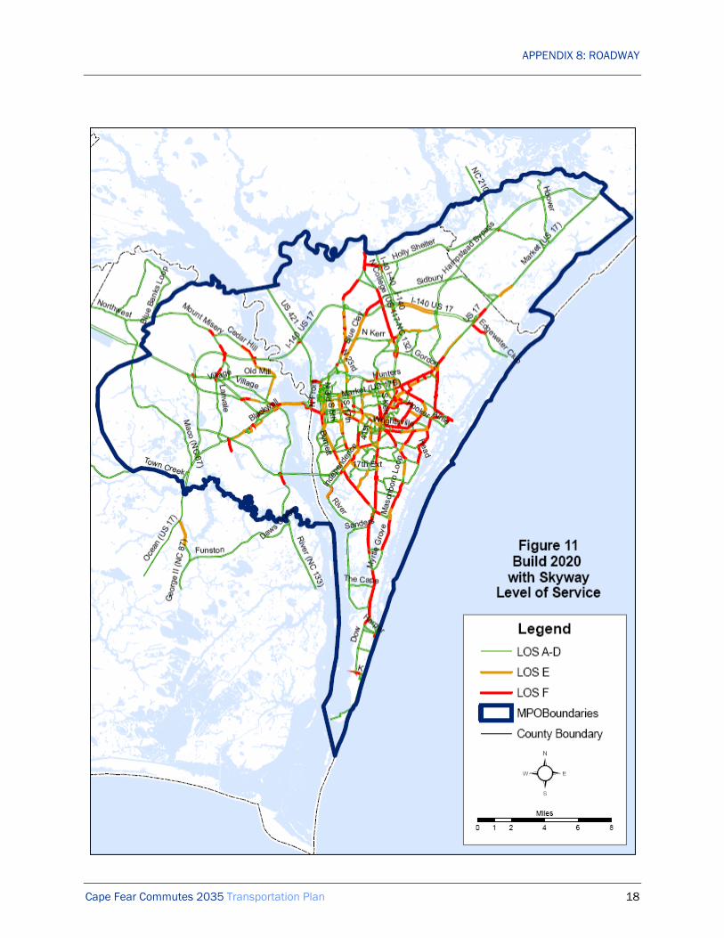
APPENDIX 8: ROADWAY
Cape Fear Commutes 2035 Transportation Plan 18

APPENDIX 8: ROADWAY
Cape Fear Commutes 2035 Transportation Plan 19

APPENDIX 8: ROADWAY
Cape Fear Commutes 2035 Transportation Plan 20

APPENDIX 8: ROADWAY
Cape Fear Commutes 2035 Transportation Plan 21
FIGURE 14 ROADWAY FUNCTIONAL CLASSIFICATION MAP
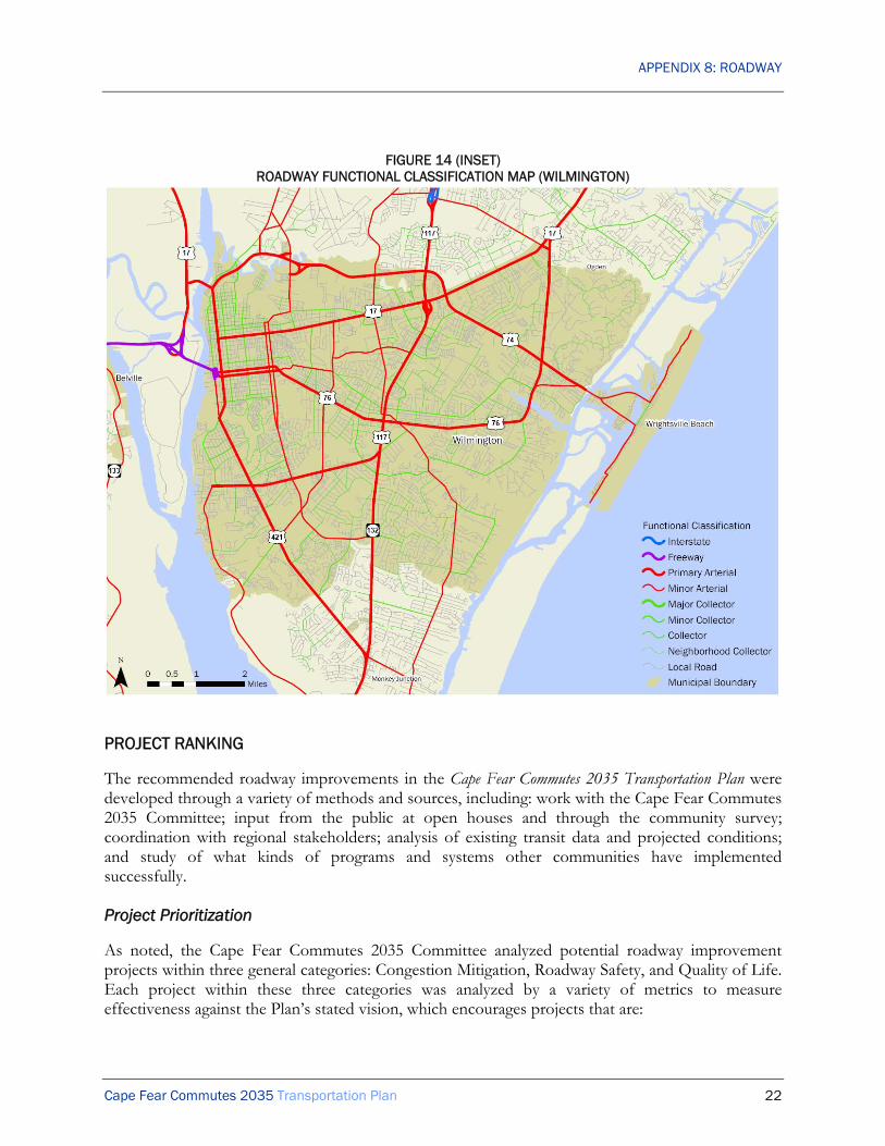
APPENDIX 8: ROADWAY
Cape Fear Commutes 2035 Transportation Plan 22
FIGURE 14 (INSET) ROADWAY FUNCTIONAL CLASSIFICATION MAP (WILMINGTON)
PROJECT RANKING
The recommended roadway improvements in the Cape Fear Commutes 2035 Transportation Plan were developed through a variety of methods and sources, including: work with the Cape Fear Commutes 2035 Committee; input from the public at open houses and through the community survey; coordination with regional stakeholders; analysis of existing transit data and projected conditions; and study of what kinds of programs and systems other communities have implemented successfully.
Project Prioritization
As noted, the Cape Fear Commutes 2035 Committee analyzed potential roadway improvement projects within three general categories: Congestion Mitigation, Roadway Safety, and Quality of Life. Each project within these three categories was analyzed by a variety of metrics to measure effectiveness against the Plan’s stated vision, which encourages projects that are:

APPENDIX 8: ROADWAY
Cape Fear Commutes 2035 Transportation Plan 23
• Safe: reduces injuries and improves the sense of safety for all users • Efficient: moves the most people and goods in a cost effective manner, while using the least
amount of resources • Appropriate: contributes to the quality of life and character of the region through proper
design • Responsible: protects existing investments and limits environmental and social impacts • Integrated: links with other transportation and land use plans as well as future infrastructure
investments • Multimodal: provides a choice of modes for most trips
The following tables show each project that was analyzed along with its final score and ranking. These rankings were used to develop the list of projects that comprised the financially constrained plan. The complete project rankings and analysis is found in the tables at the end of this section. The specific factors considered for each of the three categories were:
• Congestion Mitigation
o Efficient
Reduces mean travel time for people and freight
Maximizes throughput of roadway
Maximizes number of people and freight served per public dollar
Reduces cumulative peak hour delay
o Safe
Projected to reduce number of crashes
Projected to reduce severity of crashes
Reduces potential conflict points
Includes pedestrian and bicycle safety improvements
Improves ease of use/navigability through design
o Multimodal
Includes bicycle or pedestrian accommodations
Includes transit accommodations
Increases mode choice for trips along corridor
Improves convenience of alternative modes along corridor
o Appropriate
Minimizes number of homes and businesses impacted

APPENDIX 8: ROADWAY
Cape Fear Commutes 2035 Transportation Plan 24
Minimizes amount of new right-of-way
Consistent with character of surrounding community
Incorporates aesthetic amenities
o Integrated
Consistent with local land use plans
Consistent with NC Transportation Plan and Strategic Highway Safety Plan
Consistent with future infrastructure investments
Consistent with adjoining transportation plans
o Responsible
Incorporates existing roadways and rights-of-way
Minimizes environmental impacts
Minimizes community impacts
Demonstrates community support
• Quality of Life
o ADT Factor
o Ugly factor (ditches, lack of trees, excess signs, utility poles, etc)
o Existing or planned transit service
o Gateway to region
o Identified in adopted plan
o Within incorporated municipality
• Safety
o Crash rate (2005-2009)

APPENDIX 8: ROADWAY
Cape Fear Commutes 2035 Transportation Plan 25
Table 10. Project Prioritization – Congestion Mitigation
Ran
k
Proj
ect #
Congestion Mitigation Roadway
Projects Under Study Proposed Cross-section or Description
Tota
l sco
re
1 C059 Hurst Drive extend to South Kerr Avenue and Reigel Road
2 general purpose lanes; turn lanes; 2 bicycle lanes; 2 sidewalks; pedestrian crossings
81.4
2 C055 Cape Fear Riverway between Cape Fear Memorial Bridge (US 17 Business-76-421) and Snows Cut Bridge US 421)
4 general purpose lanes; turn lanes; median; 1 multi-use path; pedestrian crossings; partial grade separation
80.6
3 C056 Saint Nicholas Road extend to Cardinal Drive and Station Road
2 general purpose lanes; turn lanes; 2 bicycle lanes; 2 sidewalks; pedestrian crossings
76.8
4 C067 Dogwood Lane extend to Wrightsville Avenue and Pine Grove Drive
2 general purpose lanes; turn lanes; 2 bicycle lanes; 2 sidewalks; pedestrian crossings
70.2
5 C058 Head Road extend to Masonboro Sound Road
2 general purpose lanes; turn lanes; 2 bicycle lanes; 2 sidewalks; pedestrian crossings
69.9
6 C015 Castle Hayne Road (NC 133) widen between Wilmington Bypass (I 40-US 17) and Division Drive
2 general purpose lanes; turn lanes; 1 multi-use path; pedestrian crossings
61.9
7 C100 South Front Street (US 421 Truck) widen between Cape Fear Memorial Bridge (US 17 Business-76-421) and Burnett Boulevard (US 421)
4 general purpose lanes; turn lanes; median; 1 multi-use path; 1 sidewalk; pedestrian crossings
61.4
8 039 Martin Luther King, Jr. Parkway (US 74) at Market Street (US 17 Business) flyovers
1-lane EB US 74 to NB US 17 Business general purpose flyover; 1-lane WB US 74 to SB US 17 Business general purpose flyover
60.6
9 C069 North 23rd Street widen between Castle Hayne Road
4 general purpose lanes; turn lanes; median; 2 bicycle lanes; 2 sidewalks; pedestrian crossings
59.3

APPENDIX 8: ROADWAY
Cape Fear Commutes 2035 Transportation Plan 26
Ran
k
Proj
ect #
Congestion Mitigation Roadway
Projects Under Study Proposed Cross-section or Description
Tota
l sco
re
(NC 133) and Martin Luther King, Jr. Parkway (US 74)
10 C010 Carolina Beach Road (US 421) at South College Road (NC 132) flyovers
1-lane NB US 421 general purpose flyover; 1-lane SB NC 132 general purpose flyover
58.4
11 C117 Wilshire Boulevard extend to MacMillan Avenue
2 general purpose lanes; turn lanes; 2 bicycle lanes; 2 sidewalks; pedestrian crossings
58.3
12 C027 Independence Boulevard upgrade to expressway between Market Street (US 17 Business) and River Road
4 general purpose lanes; median; 1 multi-use path; pedestrian crossings; flyovers at arterials; right-in right-out at other cross-streets
58.2
13 C062 New roadway between Ocean Highway (US 17) and River Road (NC 133)
2 general purpose lanes; turn lanes; 2 bicycle lanes; 2 sidewalks; pedestrian crossings
58.2
14 C063 Randall Drive extend to Hooker Road
2 general purpose lanes; turn lanes; 2 bicycle lanes; 2 sidewalks; pedestrian crossings
57.4
15 C109 US 17-74-421-NC 133 upgrade to freeway at Battleship Road
4 general purpose lanes; median closure; 1 interchange
57.0
16 C002 Andrew Jackson Highway (US 74-76) upgrade to freeway between WMPO boundary and Mount Misery Road
4 general purpose lanes; median; service roads; full grade separation
56.0
17 C075 North College Road (US 117/NC132) upgrade to freeway between I-40 and north of Martin Luther King, Jr. Parkway (US 74)
6 general purpose lanes; median; 1 interchange 55.9
18 C051 New freeway between Martin Luther King, Jr.
6 general purpose lanes; median; 3 interchanges 55.6

APPENDIX 8: ROADWAY
Cape Fear Commutes 2035 Transportation Plan 27
Ran
k
Proj
ect #
Congestion Mitigation Roadway
Projects Under Study Proposed Cross-section or Description
Tota
l sco
re
Parkway (US 74) and Military Cutoff Road extension
19 C029 Isabel Holmes Bridge (US 74/NC 133) at US 17-421 interchange
1 general purpose WB US 74 flyover; 1 general purpose lane EB US 74 free-flow ramp
55.3
20 C105 South Kerr Avenue extend to Oleander Drive (US 76)
4 general purpose lanes; turn lanes; median; 1 multi-use path; 1 sidewalk; pedestrian crossings
54.9
21 C104 South College Road (US 117/NC132) from Wilshire Boulevard to Shipyard Boulevard (US 117) widen
6 general purpose lanes; turn lanes; 2 sidewalks; pedestrian crossings
54.5
22 C106 South Kerr Avenue widen between Patrick Avenue and Wrightsville Avenue
4 general purpose lanes; turn lanes; median; 1 multi-use path; 1 sidewalk; pedestrian crossings
53.2
23 C073 Gordon Road and North Kerr Avenue widen between North College Road (US 117-NC 132) and Martin Luther King, Jr. Parkway (US 74)
4 general purpose lanes; turn lanes; median; 1 multi-use path; 1 sidewalk; pedestrian crossings
53.1
24 C102 South College Road (NC 132) at Wrightsville Avenue, Peachtree Avenue and Oleander Drive flyovers
1-2 general purpose lane NB flyover; 1-2 general purpose lane SB flyover;
52.7
25 C112A
US 17-74-76-NC 133 add reversible HOV/HOT lane
6 general purpose lanes; 1 HOV/HOT lane 52.4
26 C041 Martin Luther King, Jr. Parkway (US 74) upgrade to freeway between North 23rd Street and north of Market Street (US 17 Business)
6 general purpose lanes; median; 2 interchanges 51.5

APPENDIX 8: ROADWAY
Cape Fear Commutes 2035 Transportation Plan 28
Ran
k
Proj
ect #
Congestion Mitigation Roadway
Projects Under Study Proposed Cross-section or Description
Tota
l sco
re
27 C112B
US 17-74-76-NC 133 add reversible HOV/HOT lanes
6 general purpose lanes; 2 HOV/HOT lanes 51.3
28 C061 Murrayville Road extend to Market Street (US 17 Business)
2 general purpose lanes; turn lanes; 2 bicycle lanes; 2 sidewalks; pedestrian crossings
50.8
29 C079 Ocean Highway (US 17) upgrade to freeway between Cape Fear Skyway and Andrew Jackson Highway (US 74-76)
4 general purpose lanes; median; service roads; full grade separation
50.8
30 C095 Sanders Road extend to Masonboro Loop Road
2 general purpose lanes; turn lanes; 1 multi-use path; 1 sidewalk; pedestrian crossings
50.7
31 C072 North College Road (US 117/NC 132) widen between Castle Hayne Road (NC 133) and I-40
4 general purpose lanes; turn lanes; median; 1 multi-use path; 1 sidewalk; pedestrian crossings
50.7
32 C096 Shipyard Boulevard (US 117) extend to Oleander Drive (US 76)
4 general purpose lanes; turn lanes; median; 1 multi-use path; 1 sidewalk; pedestrian crossings
50.2
33 C115 Wilmington Bypass (I 140-US 17) at US 17 Business add through lanes
2 general purpose lanes on each ramp; extended merge areas
48.9
34 C092 River Road (NC 133) widen from US 17-74-76 to Cape Fear Skyway
4 general purpose lanes; turn lanes; median; 1 multi-use path; 1 sidewalk; pedestrian crossings
48.7
35 C009 Carolina Beach Road (US 421) at Cape Fear Skyway interchange
Compressed diamond 48.1
36 C116 Wilmington Bypass (I 140-US 17) at Blue Clay Road interchange
Compressed diamond 39.9

APPENDIX 8: ROADWAY
Cape Fear Commutes 2035 Transportation Plan 29
Ran
k
Proj
ect #
Congestion Mitigation Roadway
Projects Under Study Proposed Cross-section or Description
Tota
l sco
re
37 C012 Carolina Beach Road (US 421) add reversible lane between Burnett Boulevard (US 421) and Sanders Road
4 general purpose lanes; 1 reversible general purpose lane
38.7
38 C113 US 17-74-76-NC 133 at US 421 interchange improvements
2 general purpose lanes on each ramp; extended merge areas
37.9
39 C111 US 17-74-76-NC 133 widen
8 general purpose lanes 35.1
40 C024 Hampstead Bypass (US 17) at Sidbury Road interchange
Compressed diamond 29.4
Table 11. Project Prioritization – Safety
Ran
k
Proj
ect #
Safety Roadway Projects Under Study Project Description
Crash Rate
2005-2009
(per 100 million
vehicles) 1 W15 River Road
roundabout at Sanders Road
One-lane roundabout 166.81
2 W25 Oleander Drive (US 76) improvements at Pine Grove Drive
Realign intersections & add signalized pedestrian crossings
140.82
3 W04 Market Street (US 17 Business) improvements at North & South 17th Street
Realign intersection 112.20
4 W08 North College Road (US 117-NC 132) roundabout at Castle Hayne Road (NC 133)
One-lane roundabout with bypass lanes 103.27
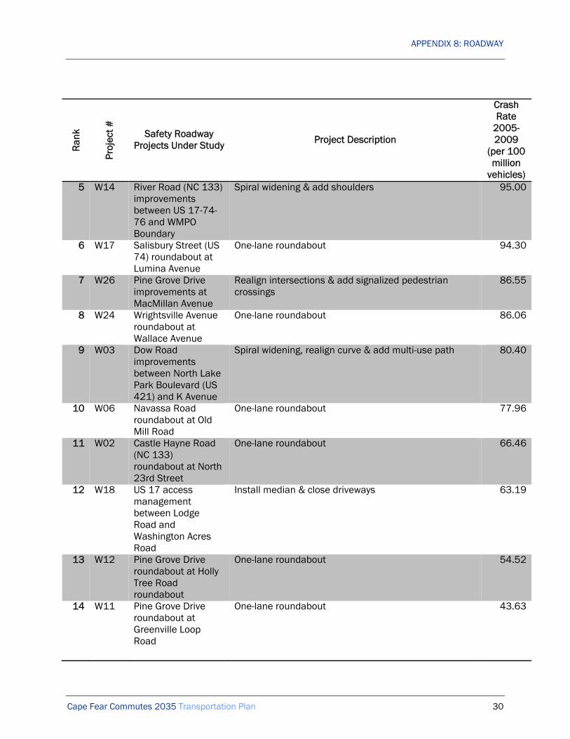
APPENDIX 8: ROADWAY
Cape Fear Commutes 2035 Transportation Plan 30
Ran
k
Proj
ect #
Safety Roadway Projects Under Study Project Description
Crash Rate
2005-2009
(per 100 million
vehicles) 5 W14 River Road (NC 133)
improvements between US 17-74-76 and WMPO Boundary
Spiral widening & add shoulders 95.00
6 W17 Salisbury Street (US 74) roundabout at Lumina Avenue
One-lane roundabout 94.30
7 W26 Pine Grove Drive improvements at MacMillan Avenue
Realign intersections & add signalized pedestrian crossings
86.55
8 W24 Wrightsville Avenue roundabout at Wallace Avenue
One-lane roundabout 86.06
9 W03 Dow Road improvements between North Lake Park Boulevard (US 421) and K Avenue
Spiral widening, realign curve & add multi-use path 80.40
10 W06 Navassa Road roundabout at Old Mill Road
One-lane roundabout 77.96
11 W02 Castle Hayne Road (NC 133) roundabout at North 23rd Street
One-lane roundabout 66.46
12 W18 US 17 access management between Lodge Road and Washington Acres Road
Install median & close driveways 63.19
13 W12 Pine Grove Drive roundabout at Holly Tree Road roundabout
One-lane roundabout 54.52
14 W11 Pine Grove Drive roundabout at Greenville Loop Road
One-lane roundabout 43.63

APPENDIX 8: ROADWAY
Cape Fear Commutes 2035 Transportation Plan 31
Ran
k
Proj
ect #
Safety Roadway Projects Under Study Project Description
Crash Rate
2005-2009
(per 100 million
vehicles) 15 W07 NC 210
improvements between WMPO boundary and US 17
Spiral widening & add shoulders 39.12
16 W22 Wrightsville Avenue (US 74-76) improvements between Pavillion Place and Heide-Trask Drawbridge
Install median & close driveways 37.30
17 W19 US 17 improvements at Factory Road & Peanut Road
Superstreet 35.24
18 W01 Burnett Boulevard (US 421) improvements at Carolina Beach Road (US 421) & South Front Street (US 421 Truck)
Realign intersection & add signalized pedestrian crossings
32.94
19 W20 US 17-74-421-NC 133 access management at USS North Carolina Road
Close median & add u-turns 32.14
20 W23 Wrightsville Avenue roundabout at MacMillan Avenue
One-lane roundabout 31.58
21 W10 North Lake Park Boulevard (US 421) improvements at Saint Joseph Street
Realign intersection 23.47
22 W21 US 74-76 access management between Lanvale Road and WMPO Boundary
Superstreet 22.70
23 W16 Salisbury Drive (US 74) roundabout at Causeway Drive (US 76)
Two-lane roundabout 21.82

APPENDIX 8: ROADWAY
Cape Fear Commutes 2035 Transportation Plan 32
Ran
k
Proj
ect #
Safety Roadway Projects Under Study Project Description
Crash Rate
2005-2009
(per 100 million
vehicles) 24 W05 Masonboro Loop
Road improvements at Grissom Road
Realign intersection 0.00
25 W09 North Kerr Avenue improvements at Blue Clay Road
Realign intersection 0.00
26 W13 Piner Road improvements at Grissom Road
Realign intersection 0.00
Table 12. Project Prioritization – Quality of Life
Ran
k
Proj
ect
Num
ber
Quality of Life Roadway Projects Under Study Project Description
Proj
ect
Scor
e
1 Q03 South College Road (NC 132) improvements between Market Street (US 17 Business) and Randall Parkway
Add curb and gutter, landscaping, 2 bicycle lanes, 2 sidewalks
87
2 Q10 Carolina Beach Road (US 421) streetscape between Burnett Boulevard and Shipyard Boulevard
Add landscaped median and bulb-outs 79
3 Q14 Carolina Beach Road (US 421) streetscape between Shipyard Boulevard and George Anderson Drive
Add landscaped median 78
4 Q11 Market Street (US 17 Business) road diet between North/South 17th Street and Covil Avenue
Reduce to 2 general purpose lanes, two-way left-turn lane, 2 bicycle lanes, 2 sidewalks
76

APPENDIX 8: ROADWAY
Cape Fear Commutes 2035 Transportation Plan 33
Ran
k
Proj
ect
Num
ber
Quality of Life Roadway Projects Under Study Project Description
Proj
ect
Scor
e
5 Q01 South College Road (NC 132) improvements between Randall Parkway and Oleander Drive (US 76)
Add curb and gutter, landscaping, 2 bicycle lanes, 2 sidewalks
72
6 Q28 River Road (NC 133) streetscape between US 17-74-76 and Old River Road
Add curb and gutter, landscaped median, left-turn lanes, 2 bicycle lanes, 2 sidewalks
71
7 Q16 Dawson Street (US 76) streetscape between South 3rd Street (US 17 Business) and Oleander Drive (US 76)
Add decorative crosswalks and bulb-outs 70
8 Q06 Market Street (US 17 Business) improvements between New Centre Drive and Gordon Road
Add curb and gutter, landscaped median, 2 bicycle lanes, 2 sidewalks
69
9 Q09 Oleander Drive & Military Cutoff Road (US 76) streetscape between South College Road (US 117-NC 132) and Eastwood Road (US 74)
Add landscaped median 65
10 Q15 South 3rd Street (US 17 Business-421) streetscape between Market Street and Burnett Boulevard (US 421)
Add landscaping, lighting, decorative crosswalks and bulb-outs
61
11 Q05 South College Road (NC 132) improvements between Oleander Drive (US 76) and Shipyard Boulevard (US 117)
Add curb and gutter, landscaping, 2 bicycle lanes, 2 sidewalks
60
12 Q26 Wrightsville Avenue improvements between South College Road (US 117-NC 132) and Hawthorne Drive
Add curb and gutter, left-turn lanes, 2 bicycle lanes, 2 sidewalks
59

APPENDIX 8: ROADWAY
Cape Fear Commutes 2035 Transportation Plan 34
Ran
k
Proj
ect
Num
ber
Quality of Life Roadway Projects Under Study Project Description
Proj
ect
Scor
e
13 Q29 Wrightsville Avenue improvements between Hawthorne Drive and Oleander Drive
Add curb and gutter, left-turn lanes, 2 bicycle lanes, 2 sidewalks
56
14 Q19 Wrightsville Avenue road diet between Castle Street and Independence Boulevard
Reduce to 2 general purpose lanes, two-way left-turn lane, 2 bicycle lanes
55
15 Q08 South College Road (NC 132) improvements between Shipyard Boulevard (US 117) and South 17th Street
Add curb and gutter, landscaping, 2 bicycle lanes, 2 sidewalks
54
16 Q24 Wrightsville Avenue improvements between Military Cutoff Road (US 76) and Eastwood Road (US 74-76)
Add curb and gutter, landscaped median, 2 bicycle lanes, 2 sidewalks
54
17 Q25 Wrightsville Avenue improvements between Independence Boulevard and South College Road (US 117-NC 132)
Add curb and gutter, left-turn lanes, 2 bicycle lanes, 2 sidewalks
53
18 Q22 North Lake Park Boulevard (US 421) road diet between Dow Road and Harper Avenue
Reduce to 2 general purpose lanes, two-way left-turn lane, 2 bicycle lanes, 2 sidewalks (or 1 multi-use path)
49
19 Q21 Wooster Street (US 76) streetscape between South 3rd Street (US 17 Business) and Oleander Drive (US 76)
Add decorative crosswalks and bulb-outs 46
20 Q13 South 17th Street improvements between Medical Center Drive and Shipyard Boulevard (US 117)
Add curb and gutter, landscaping, 2 bicycle lanes, 2 sidewalks
45

APPENDIX 8: ROADWAY
Cape Fear Commutes 2035 Transportation Plan 35
Ran
k
Proj
ect
Num
ber
Quality of Life Roadway Projects Under Study Project Description
Proj
ect
Scor
e
21 Q20 Castle Hayne Road (NC 133) streetscape between Northeast Cape Fear River and North College Road (US 117-NC 132)
Add curb and gutter, landscaped median, left-turn lanes, 2 bicycle lanes, 2 sidewalks
42
22 Q07 Ocean Highway (US 17) improvements between Lanvale Road and Andrew Jackson Highway (US 74-76)
Add landscaping and decorative fixtures 41
23 Q31 Wilshire Boulevard improvements between Wrightsville Avenue and dead end
Add curb and gutter, left-turn lanes, 2 bicycle lanes, 2 sidewalks
40
24 Q34 MacMillan Avenue improvements between Cedar Avenue and Pine Grove Drive
Add curb and gutter, left-turn lanes, 2 bicycle lanes, 2 sidewalks
40
25 Q12 Martin Luther King, Jr. Parkway (US 74) improvements between North 23rd Street and Market Street
Add landscaping and decorative fixtures 39
26 Q18 Peachtree Avenue & Pine Grove Drive improvements between South College Road (US 117-NC 132) and Masonboro Loop Road
Add curb and gutter, left-turn lanes, 2 bicycle lanes, 2 sidewalks
38
27 Q02 US 17-421 improvements at Isabel Holmes Bridge (US 74-NC 133)
Add landscaping and decorative fixtures 37
28 Q17 Causeway Drive (US 76) road diet between Salisbury Street and Waynick Boulevard
Reduce to 2 general purpose lanes, two-way left-turn lane, 2 bicycle lanes, 2 sidewalks (or 1 multi-use path)
37
29 Q30 Waynick Boulevard (US 76) road diet between Causeway Drive (US 76) and Sunset Avenue
Reduce to 2 general purpose lanes, two-way left-turn lane, 2 bicycle lanes, 2 sidewalks (or 1 multi-use path)
35

APPENDIX 8: ROADWAY
Cape Fear Commutes 2035 Transportation Plan 36
Ran
k
Proj
ect
Num
ber
Quality of Life Roadway Projects Under Study Project Description
Proj
ect
Scor
e
30 Q33 Burnett Boulevard improvements between South Front Street (US 421 Truck) and Shipyard Boulevard (US 117)
Add curb and gutter, left-turn lanes, 2 bicycle lanes, 2 sidewalks
32
31 Q04 South College Road (NC 132) improvements between South 17th Street and Carolina Beach Road (US 421)
Add curb and gutter, landscaping, 2 bicycle lanes, 2 sidewalks
32
32 Q23 Greenville Loop Road improvements between Pine Grove Drive and Oleander Drive (US 76)
Add curb and gutter, left-turn lanes, 1 multi-use path 27
33 Q32 Cardinal Drive improvements between Market Street and Eastwood Road
Add curb and gutter, left-turn lanes, 1 multi-use path 25
34 Q27 Masonboro Loop Road improvements between Pine Grove Drive and Myrtle Grove Road
Add curb and gutter, left-turn lanes, 1 multi-use path 25
35 Q35 Airlie Road streetscape between Military Cutoff Road (US 76) and Wrightsville Avenue (US 74-76)
Add landscaping, lighting, and bicycle and pedestrian facilities
22
RECOMMENDED PROJECTS
Congestion Mitigation
One of the major byproducts of the significant regional growth in the Wilmington area is increased traffic congestion. Congestion Mitigation projects are roadway improvement projects that address significant existing and projected capacity issues. In some cases that means widening existing roads, in others it means building new roads, and in still others it means providing congestion relief at major intersections.
The highest priority Congestion Mitigation projects have been planned for years and are currently programmed in the State Transportation Improvement Program (STIP). Among the highest priority projects are:

APPENDIX 8: ROADWAY
Cape Fear Commutes 2035 Transportation Plan 37
• Completion of the Wilmington Bypass (STIP R-2633B) • North and South Kerr Avenue improvements (STIP U-3338) • US 17/74/76 improvements, from US 421 to River Road (STIP R-3601) • Extension of Independence Boulevard (STIP U-4434) • Extension of Military Cutoff Road (STIP U-4751)
Roadway Safety
Another critical factor in improving the region’s transportation system is enhancing the safety of the region’s roads. Often, safety is closely tied to capacity issues on major corridors, but safety issues can also arise along roads and at intersections that were not originally designed and built to handle today’s traffic.
Many of the Safety projects in the plan are intersection improvement projects. These may entail realigning roads leading into the intersection, improving sight distances, upgrading or adding signalization, and other similar improvements. The plan also calls for constructing a number of roundabouts to replace existing traditional intersections. Under the right circumstances, roundabouts have been shown to be an effective way to both improve traffic flow and enhance safety.
Safety projects also include other types of improvements, such as access management. Like roadway widenings and intersection improvements, access management improvements can enhance capacity (and reduce congestion). But access management improvements, such as installing medians and restricting turning movements, can also make corridors safer by prohibiting dangerous turning movements and eliminating potential conflict points.
Safety is on the main considerations in the development of transportation initiates within the Wilmington MPO planning area boundary. The recommendations in Cape Fear Commutes 2035 Transportation Plan recommend safety improvements for all users. Safety was a major consideration in the project prioritization process and was included throughout the roadway selection process.
Quality of Life
Our streets are a key component of our community’s fabric. They help establish a meaningful sense of place and add value to our community. The Quality of Life projects in this plan aim to enhance urban design, mainly through streetscape improvements. Streetscape improvements could include adding curb and gutter, landscaping, bicycle lanes, sidewalks, landscaped medians, curb bulbouts, and decorative crosswalks. These projects would mainly be funded through local funds (not competing directly for funds with the Congestion Mitigation and Safety projects), except where they have demonstrable potential to improve roadway capacity.
Cape Fear Skyway
The Cape Fear Commutes 2035 Committee recognizes that there are other roadway projects of regional importance that fall outside the parameters of this plan for funding purposes. The highest profile project that is not funded through this plan is the Cape Fear Skyway, which is anticipated to

APPENDIX 8: ROADWAY
Cape Fear Commutes 2035 Transportation Plan 38
be partially funded by tolls. If built, the Cape Fear Skyway would significantly alter travel patterns in the region. The Cape Fear Skyway should be seen as not only a roadway project, but as a comprehensive transportation network connecting Brunswick County to New Hanover County. This network should include the following elements:
• Expressway and freeway link between I 40 in New Hanover County and Ocean Highway (US 17) in Brunswick County via North College Road (US 117-NC 132) (STIP project U-2724), Martin Luther King, Jr. Parkway (US 74) (STIP project U-3338C), Independence Boulevard (STIP project U-4434) and Cape Fear Skyway.
• Expressway and freeway link between Wilmington Bypass (I 140-US 17) in Brunswick County and Carolina Beach Road (US 421) at the Snows Cut Bridge in New Hanover County via Cape Fear Skyway and Cape Fear Riverway (roadway project C055).
• Bicycle and pedestrian link between Brunswick County and the Cross-City Trail in New Hanover County via the Independence Boulevard off-road multi-use path (bicycle project 103), Powerline off-road multi-use path (bicycle project 006), River Road off-road multi-use path (bicycle project 146), and Skyway Trail (bicycle project 302).
• Mass transportation link between Brunswick County and New Hanover County via express routes between Southport and Wilmington (mass transportation project T12) and Shallotte and Wilmington (mass transportation project T13) via the Cape Fear Skyway [potentially using high-occupancy toll (HOT) lane(s)]. Also supported by park and ride lots identified in appendix 9.
• Carpool and vanpool link between Brunswick County and New Hanover County via the Cape Fear Skyway [potentially using high-occupancy toll (HOT) lane(s)]. Also supported by park and ride lots identified in appendix 9.
• Skyway Station at the intersection of Cape Fear Skyway and Carolina Beach Road. Skyway Station will serve as an intermodal station providing connections between bus rapid transit routes (mass transportation projects T19 and T20), carpools, Cross-City Trail, express bus routes (mass transportation projects T12, T13 and T07), intercity bus routes, local bus routes, taxis, vanpools and other transportation services. It will serve as a trip interceptor for those arriving via the Cape Fear Skyway and headed to destinations throughout New Hanover County.

APPENDIX 8: ROADWAY
Cape Fear Commutes 2035 Transportation Plan 39
FIGURE 15 CAPE FEAR SKYWAY COMPREHENSIVE TRANSPORTATION NETWORK

APPENDIX 8: ROADWAY
Cape Fear Commutes 2035 Transportation Plan 40
Constrained Project List
Table 13 details each of the recommended roadway improvement projects, including projected horizon years and cost estimates. The projects in the current STIP are shown first, followed by Congestion Mitigation, Roadway Safety, and Quality of Life projects. These projects are illustrated on Figures 14 and 15. Note that alignments for some projects are for demonstration purposes and may not have been selected for development.
Table 13: Cape Fear Commutes 2035 Fiscally Constrained Roadway Projects
Proj
ect
Num
ber
Ran
k
Project Name Jurisdiction Horizon
Year Period
Potential Funding Source
Cost (Escalated)
Roadway Projects Current STIP Projects R-2633B
Wilmington Bypass Section B - US 74-76 to US 421 Multiple
2010-2025 STIP: Loop $203,700,000
U-3338
North and South Kerr Avenue widen between Martin Luther King, Jr Parkway and Kerr Avenue (Sections B and C) New Hanover
2010-2025 STIP $82,700,000
R-3601 US 17-74-76 widen from US 421 to River Road SE (NC 133) Brunswick
2010-2025 STIP $25,100,000
U-4434 Independence Boulevard Extension New Hanover 2016-2025 STIP: Loop $50,000,000
U-4751 Extend Military Cutoff Road to Wilmington Bypass (US 17) New Hanover
2010-2025 STIP $60,700,000
R-4063 Village Road widen from South Navassa Road to Lanvale Road Brunswick
2010-2025 STIP $18,900,000
R-3300 Hampstead Bypass Multiple 2010-2025 STIP $202,800,000
U-3337
Convert grade separation at US 74-76 at Old Fayetteville Road to an interchange Brunswick
2010-2035 STIP $13,300,000
U-4902 Market Street access management New Hanover 2010-2035 STIP $12,100,000
U-3831
Gordon Road widen from North College Road (NC 132) to Market Street (US 17 Business) New Hanover
2010-2035 STIP $24,800,000
R-4732 Ocean Highway (US 17) access management (WMPO component) Brunswick
2010-2025 STIP $2,200,000
U-2724
North College Road (US 117-NC132) upgrade to freeway between I 40 and north of Martin Luther King, Jr. Parkway (US 74) (interim solution alternative) New Hanover
2010-2025 STIP $48,000,000
U-4436 Wilmington Bypass ( I 140-US 17) at Blue Clay Road interchange Brunswick
2016-2025 STIP: Loop $25,600,000
Total Cost: TIP Projects $770,000,000
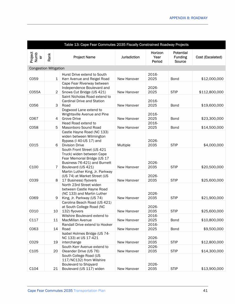
APPENDIX 8: ROADWAY
Cape Fear Commutes 2035 Transportation Plan 41
Table 13: Cape Fear Commutes 2035 Fiscally Constrained Roadway Projects
Proj
ect
Num
ber
Ran
k
Project Name Jurisdiction Horizon
Year Period
Potential Funding Source
Cost (Escalated)
Congestion Mitigation
C059 1 Hurst Drive extend to South Kerr Avenue and Reigel Road New Hanover
2016-2025 Bond $12,000,000
C055A 2
Cape Fear Riverway between Independence Boulevard and Snows Cut Bridge (US 421) New Hanover
2026-2025 STIP $112,800,000
C056 3
Saint Nicholas Road extend to Cardinal Drive and Station Road New Hanover
2016-2025 Bond $19,600,000
C067 4
Dogwood Lane extend to Wrightsville Avenue and Pine Grove Drive New Hanover
2016-2025 Bond $23,300,000
C058 5 Head Road extend to Masonboro Sound Road New Hanover
2016-2025 Bond $14,500,000
C015 6
Castle Hayne Road (NC 133) widen between Wilmington Bypass (I 40-US 17) and Division Drive Multiple
2026-2035 STIP $4,000,000
C100 7
South Front Street (US 421 Truck) widen between Cape Fear Memorial Bridge (US 17 Business-76-421) and Burnett Boulevard (US 421) New Hanover
2026-2035 STIP $20,500,000
C039 8
Martin Luther King, Jr. Parkway (US 74) at Market Street (US 17 Business) flyovers New Hanover
2026-2035 STIP $25,600,000
C069 9
North 23rd Street widen between Castle Hayne Road (NC 133) and Martin Luther King, Jr. Parkway (US 74) New Hanover
2026-2035 STIP $21,900,000
C010 10
Carolina Beach Road (US 421) at South College Road (NC 132) flyovers New Hanover
2026-2035 STIP $25,600,000
C117 11 Wilshire Boulevard extend to MacMillan Avenue New Hanover
2016-2025 Bond $10,800,000
C063 14 Randall Drive extend to Hooker Road New Hanover
2016-2025 Bond $9,500,000
C029 19
Isabel Holmes Bridge (US 74-NC 133) at US 17-421 interchange New Hanover
2026-2035 STIP $12,800,000
C105 20 South Kerr Avenue extend to Oleander Drive (US 76) New Hanover
2026-2035 STIP $14,300,000
C104 21
South College Road (US 117/NC132) from Wilshire Boulevard to Shipyard Boulevard (US 117) widen New Hanover
2026-2035 STIP $13,900,000

APPENDIX 8: ROADWAY
Cape Fear Commutes 2035 Transportation Plan 42
Table 13: Cape Fear Commutes 2035 Fiscally Constrained Roadway Projects
Proj
ect
Num
ber
Ran
k
Project Name Jurisdiction Horizon
Year Period
Potential Funding Source
Cost (Escalated)
C106 22
South Kerr Avenue widen between Patrick Avenue and Wrightsville Avenue New Hanover
2026-2035 STIP $16,400,000
Total Cost: Congestion Mitigation $357,400,000 Quality of Life
Q03 1
South College Road (NC 132) improvements between Market Street (US 17 Business) and Randall Parkway Wilmington
2016-2025 Bond $2,300,000
Q10 2
Carolina Beach Road (US 421) streetscape between Burnett Boulevard and Shipyard Boulevard Wilmington
2016-2025 Bond $4,000,000
Q14 3
Carolina Beach Road (US 421) streetscape between Shipyard Boulevard and George Anderson Drive Wilmington
2016-2025 Bond $4,300,000
Q11 4
Market Street (US 17 Business) road diet between North and South 17th Street and Covil Avenue Wilmington
2016-2025 Bond $850,000
Q01 5
South College Road (NC 132) improvements between Randall Parkway and Oleander Drive (US 76) Wilmington
2016-2025 Bond $3,100,000
Q28 6
River Road (NC 133) streetscape between US 17-74-76 and Old River Road Multiple
2026-2035 STIP $3,600,000
Q16 7
Dawson Street (US 76) streetscape between South 3rd Street (US 17 Business) and Oleander Drive (US 76) Wilmington
2016-2025 Bond $330,000
Q06 8
Market Street (US 17 Business) improvements between New Centre Drive and Gordon Road Wilmington
2016-2025 Bond $14,200,000
Q26 12
Wrightsville Avenue improvements between South College Road (US 117-NC 132) and Hawthorne Drive Wilmington
2026-2035 STIP $7,400,000
Q29 13
Wrightsville Avenue improvements between Hawthorne Drive and Oleander Drive Wilmington
2026-2035 STIP $11,900,000
Q19 14
Wrightsville Avenue road diet between Castle Street and Independence Boulevard Wilmington
2016-2025 Bond $150,000
Q25 17 Wrightsville Avenue Wilmington 2026- STIP $7,400,000

APPENDIX 8: ROADWAY
Cape Fear Commutes 2035 Transportation Plan 43
Table 13: Cape Fear Commutes 2035 Fiscally Constrained Roadway Projects
Proj
ect
Num
ber
Ran
k
Project Name Jurisdiction Horizon
Year Period
Potential Funding Source
Cost (Escalated)
improvements between Independence Boulevard and South College Road (US 117-NC 132)
2035
Q21 19
Wooster Street (US 76) streetscape between South 3rd Street (US 17 Business) and Oleander Drive (US 76) Wilmington
2016-2025 Bond $330,000
Q20 21
Castle Hayne Road (NC 133) streetscape between Northeast Cape Fear River and North College Road (US 117-NC 132) New Hanover
2026-2035 STIP $8,000,000
Q07 22
Ocean Highway (US 17) improvements between Lanvale Road and Andrew Jackson Highway (US 74-76) Multiple
2016-2025 Bond $160,000
Q31 23
Wilshire Boulevard improvements between Wrightsville Avenue and dead end Wilmington
2026-2035 STIP $6,800,000
Q34 24
MacMillan Avenue improvements between Cedar Avenue and Pine Grove Drive Wilmington
2026-2035 STIP $2,300,000
Total Cost: Quality of Life $77,120,000 Roadway Safety
W15 1 River Road roundabout at Sanders Road New Hanover
2010-2015 STIP: Safety $230,000
W25 2
Oleander Drive (US 76) improvements at Pine Grove Drive Wilmington
2010-2015 STIP: Safety $2,100,000
W04 3
Market Street (US 17 Business) improvements at North & South 17th Street Wilmington
2010-2015 STIP: Safety $580,000
W08 4
North College Road (US 117-NC 132) roundabout at Castle Hayne Road (NC 133) New Hanover
2010-2015 STIP: Safety $530,000
W14 5
River Road (NC 133) improvements between US 17-74-76 and WMPO Boundary Multiple
2010-2015 STIP: Safety $450,000
W17 6 Salisbury Street (US 74) roundabout at Lumina Avenue
Wrightsville Beach
2010-2015 STIP: Safety $230,000
W26 7 Pine Grove Drive improvements at MacMillan Avene Wilmington
2016-2025 STIP: Safety $2,800,000
W24 8 Wrightsville Avenue roundabout at Wallace Avenue Wilmington
2010-2025 STIP: Safety $340,000

APPENDIX 8: ROADWAY
Cape Fear Commutes 2035 Transportation Plan 44
Table 13: Cape Fear Commutes 2035 Fiscally Constrained Roadway Projects
Proj
ect
Num
ber
Ran
k
Project Name Jurisdiction Horizon
Year Period
Potential Funding Source
Cost (Escalated)
W03 9
Dow Road improvements between North Lake Park Boulevard (US 421) and K Avenue Multiple
2016-2025 STIP: Safety $960,000
W06 10 Navassa Road roundabout at Old Mill Road Navassa
2016-2025 STIP: Safety $2,400,000
W02 11
Castle Hayne Road (NC 133) roundabout at North 23rd Street New Hanover
2016-2025 STIP: Safety $300,000
W12 13 Pine Grove Drive roundabout at Holly Tree Road Wilmington
2016-2025 STIP: Safety $500,000
W11 14 Pine Grove Drive roundabout at Greenville Loop Road Wilmington
2016-2025 STIP: Safety $500,000
W07 15
NC 210 improvements between WMPO boundary and US 17 Pender
2016-2025 STIP: Safety $300,000
W22 16
Wrightsville Avenue (US 74-76) improvements between Pavillion Place and Heide-Trask Drawbridge Wilmington
2016-2025 STIP: Safety $2,100,000
W19 17 US 17 improvements at Factory Road & Peanut Road Pender
2026-2035 STIP: Safety $1,400,000
W01 18
Burnett Boulevard (US 421) improvements at Carolina Beach Road (US 421) & South Front Street (US 421 Truck) Wilmington
2026-2035 STIP: Safety $3,800,000
W20 19
US 17-74-421-NC 133 access management at USS North Carolina Road Brunswick
2026-2035 STIP: Safety $1,000,000
W23 20
Wrightsville Avenue roundabout at MacMillan Avenue Wilmington
2026-2035 STIP: Safety $460,000
W16 23
Salisbury Street (US 74) roundabout at Causeway Drive (US 76)
Wrightsville Beach
2026-2035 STIP: Safety $1,100,000
W13 26 Piner Road improvements at Grissom Road Wilmington
2026-2035 STIP: Safety $870,000
Total Cost: Roadway Safety $22,950,000 Total Cost: All Roadway Projects $1,227,470,000

APPENDIX 8: ROADWAY
Cape Fear Commutes 2035 Transportation Plan 45
FIGURE 16 RECOMMENDED ROADWAY PROJECTS
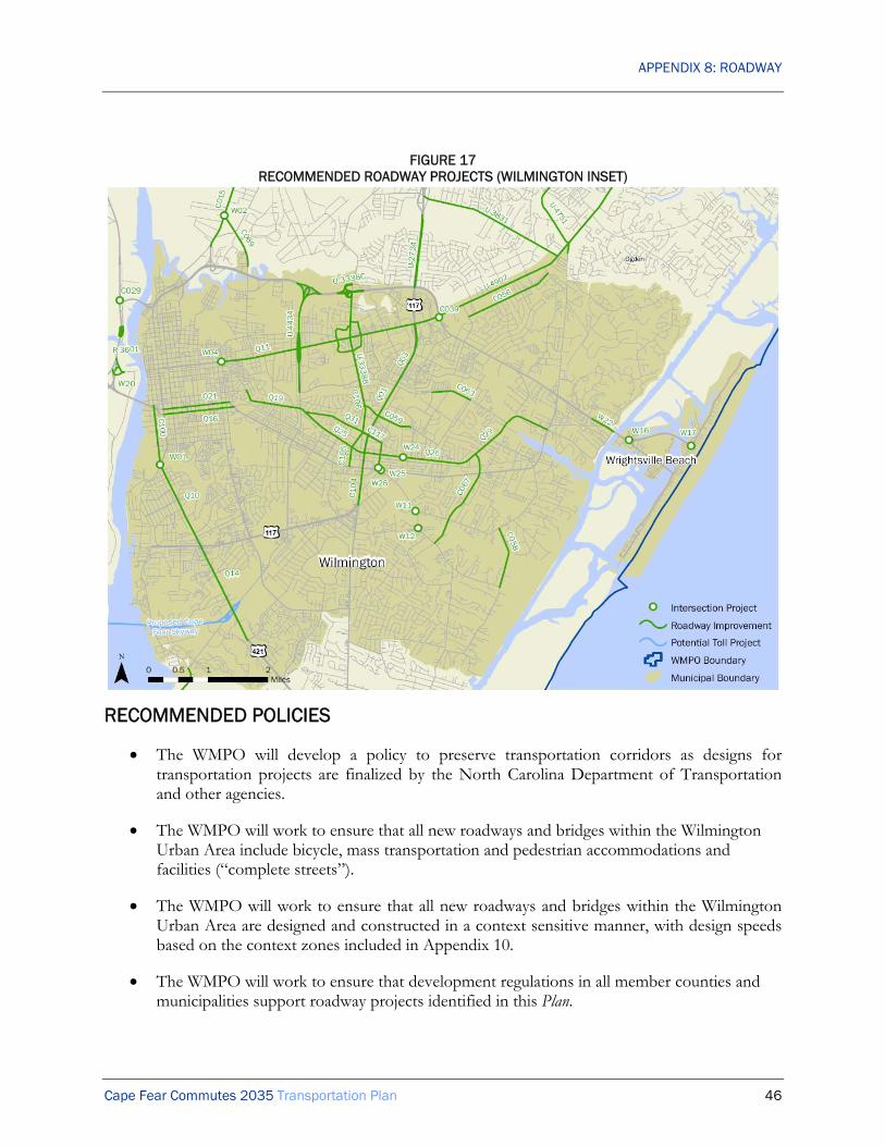
APPENDIX 8: ROADWAY
Cape Fear Commutes 2035 Transportation Plan 46
FIGURE 17 RECOMMENDED ROADWAY PROJECTS (WILMINGTON INSET)
RECOMMENDED POLICIES
• The WMPO will develop a policy to preserve transportation corridors as designs for transportation projects are finalized by the North Carolina Department of Transportation and other agencies.
• The WMPO will work to ensure that all new roadways and bridges within the Wilmington Urban Area include bicycle, mass transportation and pedestrian accommodations and facilities (“complete streets”).
• The WMPO will work to ensure that all new roadways and bridges within the Wilmington Urban Area are designed and constructed in a context sensitive manner, with design speeds based on the context zones included in Appendix 10.
• The WMPO will work to ensure that development regulations in all member counties and municipalities support roadway projects identified in this Plan.

APPENDIX 8: ROADWAY
Cape Fear Commutes 2035 Transportation Plan 47
• The WMPO will work to ensure that new development projects within the Wilmington Urban Area include roadway projects identified in this Plan.
• The WMPO will work with all member counties and municipalities to implement this Plan and all other adopted transportation plans.
SAFETEA-LU PLANNING FACTORS
The Roadway element of Cape Fear Commutes 2035 addresses the SAFETEA-LU Planning Factors in the following ways:
A) Support the economic vitality of the metropolitan area, especially by enabling global competitiveness, productivity and efficiency.
This planning factor is achieved by identifying existing and future roadway needs and prioritizing those needs. The results of this process are shown in this Plan. Improved roadway travel in the region will result in improved economic vitality and global competitiveness through providing access to the region’s employment centers and industry and by facilitating travel to other regions.
(B) Increase the safety of the transportation system for motorized and non-motorized users.
The recommended roadway improvements include significant safety improvements, and are itemized as such in the Plan. The Plan includes safety improvements for all users.
(C) Increase the security of the transportation system for motorized and non-motorized users.
The WMPO continues to work to enhance security of roadway travel as part of emergency management and homeland security procedures.
(D) Increase the accessibility and mobility of people and for freight.
This planning factor is achieved by identifying existing and future transportation needs and prioritizing those needs. The results of this process are shown in this Plan. The planning process has recognized that increasing mobility and accessibility does not necessarily mean by highway alone. This is shown in the continuing attention to bicycle and pedestrian planning and improvements to other alternative modes of travel.
(E) Protect and enhance the environment, promote energy conservation, improve the quality of life, and promote consistency between transportation improvements and State and local planned growth and economic development patterns.
The WMPO project development process ensures that potential social and environmental conflicts are identified very early in a project’s development. This assists in the selection of the most appropriate alignment, is beneficial to the public’s quality of life, and helps to preserve the natural environment. The recommended roadway improvements are consistent with local plans and policies.

APPENDIX 8: ROADWAY
Cape Fear Commutes 2035 Transportation Plan 48
(F) Enhance the integration and connectivity of the transportation system, across and between modes, for people and freight.
The WMPO has supported continuous planning efforts to achieve an efficient multi-modal plan. The existing roadway facilities will be greatly improved and extended through past and current planning efforts.
(G) Promote efficient system management and operation.
Development of the roadway improvements and programs in this Plan will add efficiency to the existing transportation system and improve general operations.
(H) Emphasize the preservation of the existing transportation system.
This planning factor is achieved by recognizing the importance of system maintenance and by building on the significant roadway infrastructure already in place.

Cape Fear Commutes 2035 Transportation Plan Congestion Mitigation Roadway Projects: Project Prioritization
10 5 5 5 25 5 5 5 5 5 25 5 5 5 5 20 2.5 2.5 2.5 2.5 10 2.5 2.5 2.5 2.5 10 2.5 2.5 2.5 2.5 10
0 Red
uctio
n in
mea
n tra
vel t
ime
for t
raffi
c w
ith p
roje
ct a
dded
to
netw
ork
in 2
020
Red
uctio
n in
mea
n tra
vel t
ime
for t
raffi
c w
ith p
roje
ct a
dded
to
netw
ork
in 2
035
Tota
l red
uctio
n in
mea
n tra
vel
time
Perc
enta
ge tr
uck
traffi
c pe
r N
CD
OT
Red
uctio
n in
mea
n tra
vel t
ime
for t
ruck
s w
ith p
roje
ct a
dded
to
net
wor
k in
202
0
Red
uctio
n in
mea
n tra
vel t
ime
for t
ruck
s w
ith p
roje
ct a
dded
to
net
wor
k in
203
5
Tota
l red
uctio
n in
mea
n tra
vel
time
for t
ruck
s
Aver
age
daily
traf
fic (A
DT)
co
unt o
n ro
adw
ay in
200
8
Aver
age
daily
traf
fic (A
DT)
co
unt o
n ro
adw
ay in
202
0
Incr
ease
in a
vera
ge d
aily
tra
ffic
(AD
T) fr
om 2
008
to
2020
Aver
age
daily
traf
fic (A
DT)
co
unt o
n ro
adw
ay in
203
5
Incr
ease
in a
vera
ge d
aily
tra
ffic
(AD
T) fr
om 2
008
to
2035
Aver
age
daily
traf
fic (A
DT)
per
la
ne in
202
0
Aver
age
daily
traf
fic (A
DT)
per
la
ne in
203
5
Red
uctio
n in
cum
ulat
ive
peak
ho
ur d
elay
for r
egio
n w
ith
proj
ect a
dded
to n
etw
ork
in
2020
(hou
rs)
Red
uctio
n in
cum
ulat
ive
peak
ho
ur d
elay
for r
egio
n w
ith
proj
ect a
dded
to n
etw
ork
in
2035
(hou
rs)
Red
uces
mea
n tra
vel t
ime
for
peop
le &
frei
ght
Max
imiz
es th
roug
hput
of
road
way
(peo
ple
& fre
ight
per
la
ne)
Max
imiz
es n
umbe
r of p
eopl
e &
freig
ht s
erve
d pe
r pub
lic
dolla
r
Red
uces
cum
ulat
ive
peak
ho
ur d
elay
Effic
ient
tota
l
Proj
ecte
d to
redu
ce n
umbe
r of
cras
hes
Proj
ecte
d to
redu
ce s
ever
ity o
fcr
ashe
s
Red
uces
pot
entia
l con
flict
po
ints
Incl
udes
ped
estri
an &
bic
ycle
sa
fety
impr
ovem
ents
Impr
oves
eas
e of
us
e/na
viga
bilit
y th
roug
h de
sign
Safe
tota
l
Incl
udes
bic
ycle
or p
edes
trian
ac
com
mod
atio
ns
Incl
udes
tran
sit
acco
mm
odat
ions
Incr
ease
s m
ode
choi
ce fo
r tri
ps a
long
cor
ridor
Impr
oves
con
veni
ence
of
alte
rnat
ive
mod
es a
long
co
rrid
or
Mul
timod
al to
tal
Min
imiz
es n
umbe
r of h
omes
an
d bu
sine
sses
impa
cted
Min
imiz
es a
mou
nt o
f new
rig
ht-o
f-way
(inc
reas
e in
AD
T pe
r new
lane
)
Con
sist
ent w
ith c
hara
cter
of
surr
ound
ing
com
mun
ity
Inco
rpor
ates
aes
thet
ic
amen
ities
(lan
dsca
ping
, de
cora
tive
elem
ents
, etc
.)
App
ropr
iate
tota
l
Con
sist
ent w
ith lo
cal l
and
use
plan
s
Con
sist
ent w
ith N
C
Tran
spor
tatio
n Pl
an a
nd
Stra
tegi
c H
ighw
ay C
orrid
or
Plan
Con
sist
ent w
ith fu
ture
in
frast
ruct
ure
inve
stm
ents
Con
sist
ent w
ith a
djoi
ning
tra
nspo
rtatio
n pl
ans
Inte
grat
ed to
tal
Inco
rpor
ates
exi
stin
g ro
adw
ays
and
right
s-of
-way
Min
imiz
es e
nviro
nmen
tal
impa
cts
Min
imiz
es c
omm
unity
impa
cts
Dem
onst
rate
s co
mm
unity
su
ppor
t
Res
pons
ible
tota
l
1 059Hurst Drive extend to South Kerr Avenue and Reigel Road
2 general purpose lanes; turn lanes; 2 bicycle lanes; 2 sidewalks; pedestrian crossings 2 2 4,676 0.9 1.8 1 New Hanover > C $8,950,500 5,731 156,765
162,496 3%172 4,703 4,875 8,016 8,711 695 14,959 6,943 4,356 7,480 183 4,853
6.680.86 0.21 3.36 11.1 Y Y Y Y Y 25.0 Y Y Y Y 20.0 Y 0.28 Y N 5.28 Y Y Y Y 10.0 Y Y Y Y 10.0 81.4
2 055
Cape Fear Riverway between Cape Fear Memorial Bridge (US 17 Business-76-421) and Snows Cut Bridge US 421)
4 general purpose lanes; turn lanes; median; 1 multi-use path; pedestrian crossings; partial grade separation 4 4 78,156 14.8 59.2 2 New Hanover > C $193,798,800 16,171 176,722
192,893 9%1,455 15,905 17,360 12,338 25,250 12,912 32,905 20,567 6,313 8,226 740 6,075
9.941.06 0.04 4.54 15.6 Y Y Y Y Y 25.0 Y Y Y Y 20.0 N 0.04 Y Y 5.04 Y Y Y Y 10.0 Y N N Y 5.0 80.6
3 056Saint Nicholas Road extend to Cardinal Drive and Station Road
2 general purpose lanes; turn lanes; 2 bicycle lanes; 2 sidewalks; pedestrian crossings 2 2 8,100 1.5 3.1 0 New Hanover + C $14,566,500 6,217 158,239
164,456 3%187 4,747 4,934 0 9,471 9,471 11,212 11,212 4,736 5,606 172 4,805
6.890.75 0.35 3.32 11.3 Y Y Y Y Y 25.0 Y N Y Y 15.0 Y 0.44 Y N 5.44 Y Y Y Y 10.0 Y Y Y Y 10.0 76.8
4 067Dogwood Lane extend to Wrightsville Avenue and Pine Grove Drive
2 general purpose lanes; turn lanes; 2 bicycle lanes; 2 sidewalks; pedestrian crossings 2 2 9,424 1.8 3.6 1 New Hanover > C $17,374,500 9,203 160,139
169,342 3%276 4,804 5,080 0 12,093 12,093 12,768 12,768 6,047 6,384 296 5,002
7.420.90 0.35 3.53 12.2 Y Y Y Y Y 25.0 Y N Y Y 15.0 N 0.45 Y N 2.95 Y Y Y Y 10.0 Y N N Y 5.0 70.2
5 058 Head Road extend to Masonboro Sound Road
2 general purpose lanes; turn lanes; 2 bicycle lanes; 2 sidewalks; pedestrian crossings 2 2 5,611 1.1 2.1 0 New Hanover > C $10,822,500 6,453 159,164
165,617 3%194 4,775 4,969 0 9,831 9,831 10,740 10,740 4,916 5,370 265 5,070
7.020.75 0.47 3.56 11.8 Y Y Y Y Y 25.0 Y N Y Y 15.0 N 0.63 Y N 3.13 Y Y Y Y 10.0 Y N N Y 5.0 69.9
6 015
Castle Hayne Road (NC 133) widen between Wilmington Bypass (I 40-US 17) and Division Drive
2 general purpose lanes; turn lanes; 1 multi-use path; pedestrian crossings 2 2 19,812 3.8 7.5 3 Multiple U C $2,206,620 10,900 162,545
173,445 12%1,308 19,505 20,813 13,679 32,586 18,907 39,489 25,810 16,293 19,745 345 4,910
7.862.62 4.99 3.50 19.0 N N N Y N 5.0 Y Y Y Y 20.0 N 0.39 Y Y 5.39 Y Y N Y 7.5 Y N N Y 5.0 61.9
7 100
South Front Street (US 421 Truck) widen between Cape Fear Memorial Bridge (US 17 Business-76-421) and Burnett Boulevard (US 421)
4 general purpose lanes; turn lanes; median; 1 multi-use path; 1 sidewalk; pedestrian crossings 2 4 5,432 1.0 2.1 0 New Hanover + C $11,349,000 5,361 155,075
160,436 6%
322 9,305 9,626 13,424 19,872 6,448 22,254 8,830 4,968 5,564 167 4,869
6.46
0.77 0.33 3.36 10.9 N N N Y N 5.0 Y Y Y Y 20.0 Y 0.48 Y Y 7.98 Y Y Y Y 10.0 Y Y N Y 7.5 61.4
8 039Martin Luther King, Jr. Parkway (US 74) at Market Street (US 17 Business) flyovers
1-lane EB US 74 to NB US 17 Business general purpose flyover; 1-lane WB US 74 to SB US 17 Business general purpose flyover 1 2 7,786 1.5 1.5 4 New Hanover > C $14,200,000 5,237 156,270
161,507 9%
471 14,064 14,536 35,622 49,605 13,983 53,196 17,574 24,803 26,598 169 4,857
6.58
3.74 0.55 3.35 14.2 Y Y Y N N 15.0 N N N Y 5.0 Y 1.39 Y N 6.39 Y Y Y Y 10.0 Y Y Y Y 10.0 60.6
9 069
North 23rd Street widen between Castle Hayne Road (NC 133) and Martin Luther King, Jr. Parkway (US 74)
4 general purpose lanes; turn lanes; median; 2 bicycle lanes; 2 sidewalks; pedestrian crossings 2 4 5,120 1.0 1.9 1 New Hanover > C $12,144,600 5,611 156,283
161,894 12%673 18,754 19,427 14,031 20,387 6,356 26,642 12,611 5,097 6,661 163 4,833
6.620.86 0.38 3.33 11.2 N N N Y N 5.0 Y N Y Y 15.0 Y 0.64 Y Y 8.14 Y Y Y Y 10.0 Y Y Y Y 10.0 59.3
10 010Carolina Beach Road (US 421) at South College Road (NC 132) flyovers
1-lane NB US 421 general purpose flyover; 1-lane SB NC 132 general purpose flyover 1 2 6,375 1.2 1.2 2 New Hanover > C $14,200,000 5,236 155,554
160,790 15%785 23,333 24,119 31,063 35,663 4,600 39,085 8,022 17,832 19,543 161 4,810
6.502.72 0.22 3.31 12.8 Y Y Y N N 15.0 N N N Y 5.0 Y 0.68 Y N 5.68 Y Y Y Y 10.0 Y Y Y Y 10.0 58.4
11 117Wilshire Boulevard extend to MacMillan Avenue
2 general purpose lanes; turn lanes; 2 bicycle lanes; 2 sidewalks; pedestrian crossings 2 2 4,401 0.8 1.7 0 New Hanover + C $8,014,500 4,951 154,491
159,442 3%149 4,635 4,783 8,059 9,336 1,277 11,125 3,066 4,668 5,563 164 4,859
6.360.74 0.13 3.35 10.6 N N N Y Y 10.0 Y N Y Y 15.0 Y 0.17 Y N 5.17 Y Y Y Y 10.0 Y Y N Y 7.5 58.3
12 027
Independence Boulevard upgrade to expressway between Market Street (US 17 Business) and River Road
4 general purpose lanes; median; 1 multi-use path; pedestrian crossings; flyovers at arterials; right-in right-out at other cross-streets 4 4 30,909 5.9 23.4 0 New Hanover + C $78,009,750 10,861 172,271
183,132 9%
977 15,504 16,482 24,977 63,438 38,461 77,336 52,359 15,860 19,334 262 5,285
8.89
2.56 0.29 3.70 15.4 Y Y Y N N 15.0 N N N Y 5.0 Y 0.25 Y N 5.25 Y N Y Y 7.5 Y Y Y Y 10.0 58.2
13 062New roadway between Ocean Highway (US 17) and River Road (NC 133)
2 general purpose lanes; turn lanes; 2 bicycle lanes; 2 sidewalks; pedestrian crossings 2 2 26,039 4.9 9.9 0 Brunswick > C $46,390,500 11,366 146,934
158,300 4%455 5,877 6,332 0 11,394 11,394 14,635 14,635 5,697 7,318 417 4,372
6.240.95 0.14 3.19 10.5 N N N Y Y 10.0 Y N Y Y 15.0 Y 0.17 Y N 5.17 Y Y Y Y 10.0 Y N Y Y 7.5 58.2
14 063 Randall Drive extend to Hooker Road
2 general purpose lanes; turn lanes; 2 bicycle lanes; 2 sidewalks; pedestrian crossings 2 2 3,569 0.7 1.4 3 New Hanover > C $7,078,500 6,147 156,778
162,925 2%123 3,136 3,259 1,062 10,434 9,372 11,017 9,955 5,217 5,509 166 4,832
6.730.78 0.67 3.33 11.5 N N N Y Y 10.0 Y Y Y Y 20.0 Y 0.93 N Y 5.93 N Y Y N 5.0 Y N N Y 5.0 57.4
15 109US 17-74-421-NC 133 upgrade to freeway at Battleship Road
4 general purpose lanes; median closure; 1 interchange
4 4 6,5991.2 5.0
0 New Hanover> C $38,304,000 5,273 157,891
163,164 8%422 12,631 13,053 29,392 29,024 -368 49,424 20,032 7,256 12,356 157 4,998
6.761.43 0.13 3.44 11.7 Y Y Y N N 15.0 N N N Y 5.0 Y 0.26 Y N 5.26 Y Y Y Y 10.0 Y Y Y Y 10.0 57.0
16 002
Andrew Jackson Highway (US 74-76) upgradeto freeway between WMPO boundary and Mount Misery Road
4 general purpose lanes; median; service roads; full grade separation 4 4 34,147 6.5 25.9 1
Brunswick
> C $126,594,000 5,489 142,949148,438 7%
384 10,006 10,391 19,408 57,701 38,293 72,873 53,465 14,425 18,218 163 4,3545.18
2.37 0.18 3.01 10.7 Y Y Y N N 15.0 N N N Y 5.0 Y 0.23 Y N 5.23 Y Y Y Y 10.0 Y Y Y Y 10.0 56.0
17 075
North College Road (US 117/NC132) upgrade to freeway between I-40 and north of Martin Luther King, Jr. Parkway (US 74)
6 general purpose lanes; median; 1 interchange 6 6 12,770 2.4 14.5 0 New Hanover > C $56,160,000 12,656 168,284
180,940 7%
886 11,780 12,666 44,154 94,066 49,912 104,600 60,446 15,678 17,433 492 5,306
8.66
2.41 0.48 3.87 15.4 Y Y Y N N 15.0 N N N N 0.0 Y 0.49 Y N 5.49 Y Y Y Y 10.0 Y Y Y Y 10.0 55.9
18 051
New freeway between Martin Luther King, Jr. Parkway (US 74) and Military Cutoff Road extension
6 general purpose lanes; median; 3 interchanges 6 6 22,761 4.3 25.9 2 New Hanover + C $182,075,400 17,079 176,027
193,106 10%1,708 17,603 19,311 0 49,075 49,075 61,206 61,206 8,179 10,201 537 5,245
9.961.34 0.15 3.85 15.3 Y Y Y N Y 20.0 N N N Y 5.0 N 0.28 Y N 2.78 Y Y Y Y 10.0 N N N Y 2.5 55.6
19 029Isabel Holmes Bridge (US 74/NC 133) at US 17-421 interchange
1 general purpose WB US 74 flyover; 1 general purpose lane EB US 74 free-flow ramp 1 2 8,435 1.6 1.6 1 New Hanover > C $7,100,000 8,032 148,347
156,379 10%803 14,835 15,638 27,999 57,994 29,995 78,458 50,459 28,997 39,229 218 4,638
6.034.96 2.79 3.24 17.0 Y Y Y N N 15.0 N N N Y 5.0 N 3.27 Y N 5.77 Y Y Y Y 10.0 N N N Y 2.5 55.3
20 105South Kerr Avenue extend to Oleander Drive (US 76)
4 general purpose lanes; turn lanes; median; 1 multi-use path; 1 sidewalk; pedestrian crossings 4 4 3,413 0.6 2.6 1 New Hanover > C $7,932,600 5,749 154,409
160,158 5%287 7,720 8,008 0 16,058 16,058 19,434 19,434 4,015 4,859 165 4,850
6.430.65 1.10 3.34 11.5 N N N Y Y 10.0 Y N Y Y 15.0 N 0.89 Y N 3.39 Y Y Y Y 10.0 N Y N Y 5.0 54.9
21 104
South College Road (US 117/NC132) from Wilshire Boulevard to Shipyard Boulevard (US 117) widen
6 general purpose lanes; turn lanes; 2 sidewalks; pedestrian crossings 1 6 6,380 1.2 1.2 5 New Hanover > C $7,722,000 4,702 155,271
159,973 10%470 15,527 15,997 45,235 49,467 4,232 53,787 8,552 8,245 8,965 100 4,817
6.411.25 0.41 3.28 11.4 N N N Y N 5.0 Y Y Y Y 20.0 N 0.69 N N 0.69 Y Y Y Y 10.0 Y Y N Y 7.5 54.5
22 106South Kerr Avenue widen between Patrick Avenue and Wrightsville Avenue
4 general purpose lanes; turn lanes; median; 1 multi-use path; 1 sidewalk; pedestrian crossings 2 4 4,141 0.8 1.6 23 New Hanover > C $9,079,200 6,454 156,696
163,150 5%323 7,835 8,158 15,576 28,541 12,965 31,695 16,119 7,135 7,924 188 4,892
6.751.10 0.79 3.39 12.0 N N N Y N 5.0 Y N Y Y 15.0 N 1.20 Y N 3.70 Y Y Y Y 10.0 Y Y N Y 7.5 53.2
23 073
Gordon Road and North Kerr Avenue widen between North College Road (US 117-NC 132) and Martin Luther King, Jr. Parkway (US 74)
4 general purpose lanes; turn lanes; median; 1 multi-use path; 1 sidewalk; pedestrian crossings 2 4 14,964 2.8 5.7 23 New Hanover > C $31,777,200 8,942 161,246
170,188 5%
447 8,062 8,509 16,662 35,179 18,517 39,260 22,598 8,795 9,815 245 4,867
7.51
1.35 0.32 3.41 12.6 N N N Y N 5.0 Y N Y Y 15.0 N 0.47 Y N 2.97 Y Y Y Y 10.0 Y Y N Y 7.5 53.1
24 102
South College Road (NC 132) at Wrightsville Avenue, Peachtree Avenue and Oleander Drive flyovers
1-2 general purpose lane NB flyover; 1-2 general purpose lane SB flyover; 2 4 4,315 0.8 1.6 0 New Hanover + C $14,200,000 5,734 154,283
160,017 10%573 15,428 16,002 41,789 49,105 7,316 53,187 11,398 12,276 13,297 171 4,857
6.421.86 0.32 3.35 12.0 Y Y Y N N 15.0 N N N Y 5.0 Y 0.74 N N 3.24 Y Y Y Y 10.0 Y Y N Y 7.5 52.7
25 112AUS 17-74-76-NC 133 add reversible HOV/HOT lane 6 general purpose lanes; 1 HOV/HOT lane 1 7 15,707 3.0 3.0 2
Brunswick> C $17,550,000 5,635 144,221
149,856 7%394 10,095 10,490 88,815 106,919 18,104 118,020 29,205 15,274 16,860 220 4,306
5.332.34 0.66 3.02 11.3 N N N N N 0.0 N Y Y Y 15.0 Y 1.03 Y N 6.03 Y Y Y Y 10.0 Y Y Y Y 10.0 52.4
26 041
Martin Luther King, Jr. Parkway (US 74) upgrade to freeway between North 23rd Streetand north of Market Street (US 17 Business)
6 general purpose lanes; median; 2 interchanges 6 6 26,707 5.1 30.3 0 New Hanover > C $325,143,000 5,421 135,253
140,674 9%
488 12,173 12,661 29,266 54,140 24,874 75,799 46,533 9,023 12,633 159 4,111
4.35
1.58 0.05 2.85 8.8 Y Y Y N N 15.0 N N N Y 5.0 Y 0.15 Y N 5.15 Y Y Y Y 10.0 Y N Y Y 7.5 51.5
27 112BUS 17-74-76-NC 133 add reversible HOV/HOT lanes 6 general purpose lanes; 2 HOV/HOT lanes 2 8 15,707 3.0 5.9 2
Brunswick> C $35,100,000 5,335 144,282
149,617 7%373 10,100 10,473 88,815 106,441 17,626 120,096 31,281 13,305 15,012 192 4,335
5.312.06 0.34 3.02 10.7 N N N N N 0.0 N Y Y Y 15.0 Y 0.53 Y N 5.53 Y Y Y Y 10.0 Y Y Y Y 10.0 51.3
28 061Murrayville Road extend to Market Street (US 17 Business)
2 general purpose lanes; turn lanes; 2 bicycle lanes; 2 sidewalks; pedestrian crossings 2 2 15,389 2.9 5.8 3 New Hanover > C $27,670,500 5,678 118,940
124,618 3%170 3,568 3,739 0 3,951 3,951 9,019 9,019 1,976 4,510 171 3,546
2.630.47 0.12 2.48 5.7 N N N Y Y 10.0 Y N Y Y 15.0 Y 0.14 N N 2.64 Y Y N Y 7.5 Y Y Y Y 10.0 50.8
29 079
Ocean Highway (US 17) upgrade to freeway between Cape Fear Skyway and Andrew Jackson Highway (US 74-76)
4 general purpose lanes; median; service roads; full grade separation 4 4 24,185 4.6 18.3 1
Brunswick
> C $207,745,200 4,274 161,240165,514 7%
299 11,287 11,586 44,948 66,705 21,757 69,871 24,923 16,676 17,468 203 5,1577.01
2.48 0.06 3.57 13.1 Y Y Y N N 15.0 N N N N 0.0 N 0.17 Y Y 5.17 Y Y Y Y 10.0 Y Y N Y 7.5 50.8
30 095Sanders Road extend to Masonboro Loop Road
2 general purpose lanes; turn lanes; 1 multi-use path; 1 sidewalk; pedestrian crossings 2 2 8,705 1.6 3.3 0 New Hanover U C $16,286,400 5,703 155,880
161,583 3%171 4,676 4,847 0 4,086 4,086 6,405 6,405 2,043 3,203 194 4,882
6.590.38 0.16 3.38 10.5 N N N Y Y 10.0 Y N Y Y 15.0 N 0.21 Y N 2.71 Y Y Y Y 10.0 N N N Y 2.5 50.7
31 072
North College Road (US 117/NC 132) widen between Castle Hayne Road (NC 133) and I-40
4 general purpose lanes; turn lanes; median; 1 multi-use path; 1 sidewalk; pedestrian crossings 2 4 26,184 5.0 9.9 36 New Hanover > C $56,745,000 2,449 136,003
138,452 7%171 9,520 9,692 16,513 35,762 19,249 39,458 22,945 8,941 9,865 -65 3,451
4.111.37 0.18 2.26 7.9 N N N Y N 5.0 Y Y Y Y 20.0 N 0.28 Y Y 5.28 Y Y N Y 7.5 Y N N Y 5.0 50.7
32 096Shipyard Boulevard (US 117) extend to Oleander Drive (US 76)
4 general purpose lanes; turn lanes; median; 1 multi-use path; 1 sidewalk; pedestrian crossings 4 4 4,754 0.9 3.6 0 New Hanover > C $11,898,900 6,498 156,519
163,017 7%455 10,956 11,411 7,045 26,863 19,818 28,102 21,057 6,716 7,026 204 4,869
6.741.00 0.85 3.38 12.0 N N N Y Y 10.0 Y N Y Y 15.0 N 0.74 N N 0.74 N Y Y Y 7.5 N Y N Y 5.0 50.2
33 115Wilmington Bypass (I 140-US 17) at US 17 Business add through lanes
2 general purpose lanes on each ramp; extended merge areas 1 4 9,350 1.8 1.8 4 New Hanover > C $4,800,000 5,310 154,524
159,834 15%797 23,179 23,975 34,919 62,458 27,539 81,548 46,629 15,615 20,387 163 4,865
6.402.62 3.80 3.35 16.2 N N N N Y 5.0 N N N N 0.0 Y 2.72 Y N 7.72 Y Y Y Y 10.0 Y Y Y Y 10.0 48.9
34 092River Road (NC 133) widen from US 17-74-76 to Cape Fear Skyway
4 general purpose lanes; turn lanes; median; 1 multi-use path; 1 sidewalk; pedestrian crossings 2 4 25,191 4.8 9.5 4
Brunswick
> C $54,475,200 9,474 170,749180,223 6%
568 10,245 10,813 12,738 26,256 13,518 32,624 19,886 6,564 8,156 371 5,1538.58
1.07 0.15 3.68 13.5 N N N Y N 5.0 Y N Y Y 15.0 N 0.23 N N 0.23 Y Y Y Y 10.0 Y N N Y 5.0 48.7
35 009Carolina Beach Road (US 421) at Cape Fear Skyway interchange Compressed diamond 1 4 7,522 1.4 1.4 0 New Hanover > C $19,071,000 5,518 155,918
161,436 18%993 28,065 29,058 0 44,550 44,550 63,871 63,871 11,138 15,968 105 4,751
6.571.97 1.40 3.24 13.2 Y Y Y N N 15.0 N N N Y 5.0 N 4.94 N N 4.94 Y N Y Y 7.5 N N N Y 2.5 48.1
36 116
Wilmington Bypass (I 140-US 17) at Blue Clay Road interchange Compressed diamond 1 4 6,467 1.2 1.2 1 New Hanover U C $19,071,000 9,355 153,960
163,315 4%374 6,158 6,533 0 12,353 12,353 13,661 13,661 3,088 3,415 342 4,801
6.770.47 0.34 3.43 11.0 N N N N Y 5.0 N N N N 0.0 Y 1.38 Y N 6.38 Y Y Y Y 10.0 Y N Y Y 7.5 39.9
37 012
Carolina Beach Road (US 421) add reversible lane between Burnett Boulevard (US 421) and Sanders Road
4 general purpose lanes; 1 reversible general purpose lane 1 5 36,063 6.8 6.8 1 New Hanover > C $39,780,000 5,335 162,589
167,924 15%800 24,388 25,189 30,849 37,328 6,479 42,233 11,384 7,466 8,447 952 6,479
7.261.16 0.11 4.95 13.5 N N N N N 0.0 N N N N 0.0 Y 0.17 Y N 5.17 Y Y Y Y 10.0 Y Y Y Y 10.0 38.7
38 113US 17-74-76-NC 133 at US 421 interchange improvements
2 general purpose lanes on each ramp; extended merge areas 1 4 8,225 1.6 1.6 13
Brunswick> C $4,800,000 5,512 145,184
150,696 7%386 10,163 10,549 29,395 30,860 1,465 34,670 5,275 7,715 8,668 165 4,540
5.421.19 0.35 3.14 10.1 N N N N Y 5.0 N N N N 0.0 Y 0.28 Y N 5.28 Y Y Y Y 10.0 Y N Y Y 7.5 37.9
39 111 US 17-74-76-NC 133 widen 8 general purpose lanes 2 8 15,707 3.0 5.9 0 Brunswick + C $58,635,900 5,519 152,556 158,075 7% 386 10,679 11,065 88,815 118,526 29,711 118,526 29,711 14,816 14,816 175 4,766 6.21 2.16 0.25 3.29 11.9 N N N N N 0.0 N N N Y 5.0 Y 0.65 Y N 5.65 Y Y Y N 7.5 N N Y Y 5.0 35.1
40 024Hampstead Bypass (US 17) at Sidbury Road interchange Compressed diamond 1 4 4,649 0.9 0.9 0 New Hanover > C $19,071,000 9,325 163,704
173,029 15%1,399 24,556 25,954 0 15,022 15,022 14,949 14,949 3,756 3,737 303 4,929
7.810.54 0.39 3.49 12.2 N N N N Y 5.0 N N N N 0.0 N 2.21 Y N 4.71 N N N Y 2.5 Y N N Y 5.0 29.4
IntegratedOutput from WMPO Travel Demand Model
Num
ber o
f new
/upg
rade
d la
nes
Leng
th o
f pro
ject
in fe
et
Num
ber o
f new
/upg
rade
d la
ne-
mile
s
*Status: > Carried forward for study; Ø Not carried forward for study; + Added by committee, agency staff or officials; U Unfunded project from previous plan
Leng
th o
f pro
ject
in m
iles
Num
ber o
f tot
al la
nes
Tota
l sco
re
Stat
us*
Estim
ated
cos
t per
M
artin
/Ale
xiou
/Bry
son
Proj
ect N
umbe
rEfficient Safe Responsible
**Details: ## See other numbered project; C Congestion mitigation project recommended for study by Cape Fear Commutes 2035 Committee; E Existing; F Already funded in TIP or CIP; G Conflicts with plan goals or vision; N Does not address 2020 or 2035 issues; O Outside WMPO planning area; P Previously studied; Q Quality of life project; R Recommended for 2035 plan; S Outside plan scope; V Vague or non-discrete; W Safety project
Det
ails
**
JurisdictionNum
ber o
f res
pons
es
Congestion Mitigation Roadway Projects Under Study
Multi-modal Appropriate
Proposed Cross-section

Cape Fear Commutes 2035 Transportation Plan Quality of Life Roadway Projects: Project Prioritization
15 15 15 15 15 25
01 Q03
g ( ) p(US 17 Business) and Randall Parkway Add curb and gutter, landscaping, 2 bicycle lanes, 2 sidewalks 59,593 Y Y Y Y Y 12 15 15 15 15 15 87
2 Q10Carolina Beach Road (US 421) streetscape between Burnett Boulevard and Shipyard Boulevard Add landscaped median and bulb-outs 38,085 N Y Y Y Y 7 12 15 15 15 15 79
3 Q14Carolina Beach Road (US 421) streetscape between Shipyard Boulevard and George Anderson Drive Add landscaped median 30,695 N Y Y Y Y 6 12 15 15 15 15 78
4 Q11Market Street (US 17 Business) road diet between North/South 17th Street and Covil Avenue
Reduce to 2 general purpose lanes, two-way left-turn lane, 2 bicycle lanes, 2 sidewalks 37,919 N Y Y Y N 7 9 15 15 15 15 76
5 Q01South College Road (NC 132) improvements between Randall Parkway and Oleander Drive (US 76) Add curb and gutter, landscaping, 2 bicycle lanes, 2 sidewalks 77,716 N Y Y Y Y 15 12 15 0 15 15 72
6 Q28River Road (NC 133) streetscape between US 17-74-76 and Old River Road
Add curb and gutter, landscaped median, left-turn lanes, 2 bicycle lanes, 2 sidewalks 11,692 Y Y N N Y 2 9 15 15 15 15 71
7 Q16Dawson Street (US 76) streetscape between South 3rd Street (US 17 Business) and Oleander Drive (US 76) Add decorative crosswalks and bulb-outs 20,665 N Y N Y N 4 6 15 15 15 15 70
8 Q06Market Street (US 17 Business) improvements between New Centre Drive and Gordon Road
Add curb and gutter, landscaped median, 2 bicycle lanes, 2 sidewalks 43,699 Y Y Y N N 8 9 7 15 15 15 69
9 Q09Oleander Drive & Military Cutoff Road (US 76) streetscape between South College Road (US 117-NC 132) and Eastwood Road (US 74) Add landscaped median 39,575 N Y Y Y Y 8 12 15 0 15 15 65
10 Q15South 3rd Street (US 17 Business-421) streetscape between Market Street and Burnett Boulevard (US 421) Add landscaping, lighting, decorative crosswalks and bulb-outs 22,696 Y N Y Y Y 4 12 0 15 15 15 61
11 Q05South College Road (NC 132) improvements between Oleander Drive (US 76) and Shipyard Boulevard (US 117) Add curb and gutter, landscaping, 2 bicycle lanes, 2 sidewalks 48,935 N N Y Y N 9 6 15 0 15 15 60
12 Q26Wrightsville Avenue improvements between South College Road (US 117-NC 132) and Hawthorne Drive Add curb and gutter, left-turn lanes, 2 bicycle lanes, 2 sidewalks 12,373 Y Y N Y Y 2 12 15 0 15 15 59
13 Q29Wrightsville Avenue improvements between Hawthorne Drive and Oleander Drive Add curb and gutter, left-turn lanes, 2 bicycle lanes, 2 sidewalks 11,647 Y Y N Y N 2 9 15 0 15 15 56
14 Q19Wrightsville Avenue road diet between Castle Street and Independence Boulevard
Reduce to 2 general purpose lanes, two-way left-turn lane, 2 bicycle lanes 18,927 N Y N Y N 4 6 15 0 15 15 55
15 Q08South College Road (NC 132) improvements between Shipyard Boulevard (US 117) and South 17th Street Add curb and gutter, landscaping, 2 bicycle lanes, 2 sidewalks 40,820 Y Y N Y N 8 9 7 0 15 15 54
16 Q24Wrightsville Avenue improvements between Military Cutoff Road (US 76) and Eastwood Road (US 74-76)
Add curb and gutter, landscaped median, 2 bicycle lanes, 2 sidewalks 13,100 N Y N Y N 3 6 15 0 15 15 54
17 Q25Wrightsville Avenue improvements between Independence Boulevard and South College Road (US 117-NC 132) Add curb and gutter, left-turn lanes, 2 bicycle lanes, 2 sidewalks 12,934 N Y N Y N 2 6 15 0 15 15 53
18 Q22North Lake Park Boulevard (US 421) road diet between Dow Road and Harper Avenue
Reduce to 2 general purpose lanes, two-way left-turn lane, 2 bicycle lanes, 2 sidewalks (or 1 multi-use path) 15,771 N Y Y Y N 3 9 7 15 0 15 49
19 Q21Wooster Street (US 76) streetscape between South 3rd Street (US 17 Business) and Oleander Drive (US 76) Add decorative crosswalks and bulb-outs 16,869 N Y Y N N 3 6 7 0 15 15 46
20 Q13South 17th Street improvements between Medical Center Drive and Shipyard Boulevard (US 117) Add curb and gutter, landscaping, 2 bicycle lanes, 2 sidewalks 31,832 N Y Y Y N 6 9 15 0 0 15 45
21 Q20Castle Hayne Road (NC 133) streetscape between Northeast Cape FearRiver and North College Road (US 117-NC 132)
Add curb and gutter, landscaped median, left-turn lanes, 2 bicycle lanes, 2 sidewalks 17,671 N Y Y Y N 3 9 0 15 15 0 42
22 Q07Ocean Highway (US 17) improvements between Lanvale Road and Andrew Jackson Highway (US 74-76) Add landscaping and decorative fixtures 43,214 N Y N N N 8 3 15 15 ? ? 41
23 Q31Wilshire Boulevard improvements between Wrightsville Avenue and dead end Add curb and gutter, left-turn lanes, 2 bicycle lanes, 2 sidewalks 7,377 Y Y N Y N 1 9 15 0 0 15 40
24 Q34MacMillan Avenue improvements between Cedar Avenue and Pine Grove Drive Add curb and gutter, left-turn lanes, 2 bicycle lanes, 2 sidewalks 4,851 Y Y N Y N 1 9 15 0 0 15 40
25 Q12Martin Luther King, Jr. Parkway (US 74) improvements between North 23rd Street and Market Street Add landscaping and decorative fixtures 33,037 N Y N N N 6 3 0 15 0 15 39
26 Q18Peachtree Avenue & Pine Grove Drive improvements between South College Road (US 117-NC 132) and Masonboro Loop Road Add curb and gutter, left-turn lanes, 2 bicycle lanes, 2 sidewalks 19,845 Y Y N Y Y 4 12 7 0 0 15 38
27 Q02 US 17-421 improvements at Isabel Holmes Bridge (US 74-NC 133) Add landscaping and decorative fixtures 67,662 N Y N Y Y 13 9 0 15 0 0 37
28 Q17Causeway Drive (US 76) road diet between Salisbury Street and Waynick Boulevard
Reduce to 2 general purpose lanes, two-way left-turn lane, 2 bicycle lanes, 2 sidewalks (or 1 multi-use path) 20,089 N Y N N N 4 3 0 15 0 15 37
29 Q30Waynick Boulevard (US 76) road diet between Causeway Drive (US 76) and Sunset Avenue
Reduce to 2 general purpose lanes, two-way left-turn lane, 2 bicycle lanes, 2 sidewalks (or 1 multi-use path) 11,468 N Y N N N 2 3 0 15 0 15 35
30 Q33Burnett Boulevard improvements between South Front Street (US 421 Truck) and Shipyard Boulevard (US 117) Add curb and gutter, left-turn lanes, 2 bicycle lanes, 2 sidewalks 6,766 Y N N Y Y 1 9 7 0 0 15 32
31 Q04South College Road (NC 132) improvements between South 17th Street and Carolina Beach Road (US 421) Add curb and gutter, landscaping, 2 bicycle lanes, 2 sidewalks 50,854 Y Y Y Y Y 10 15 7 0 0 0 32
32 Q23Greenville Loop Road improvements between Pine Grove Drive and Oleander Drive (US 76) Add curb and gutter, left-turn lanes, 1 multi-use path 15,455 Y Y N Y N 3 9 0 0 0 15 27
33 Q32Cardinal Drive improvements between Market Street and Eastwood Road Add curb and gutter, left-turn lanes, 1 multi-use path 6,941 Y Y N Y N 1 9 0 0 0 15 25
34 Q27Masonboro Loop Road improvements between Pine Grove Drive and Myrtle Grove Road Add curb and gutter, left-turn lanes, 1 multi-use path 12,097 Y Y N Y N 2 9 7 0 0 7 25
35 Q35Airlie Road streetscape between Military Cutoff Road (US 76) and Wrightsville Avenue (US 74-76) Add landscaping, lighting, and bicycle and pedestrian facilities 3,869 Y Y N N N 1 6 0 0 0 15 22
Oth
er u
nattr
activ
e fe
atur
es?
Ditc
hes?
Lack
of t
rees
?
Exce
ssiv
e si
gns?
Proj
ect S
core
With
in in
corp
orat
ed
mun
icip
ality
(no
= 0,
pa
rtia
lly =
7, y
es =
15
)
Iden
tifie
d in
ado
pted
pl
an (n
o =
0, y
es =
15
)
Quality of Life Roadway Projects Under Study
Proj
ect N
umbe
r
Ugl
y Fa
ctor
(d
itche
s, la
ck o
f tr
ees,
exc
essi
ve
sign
s, u
tility
pol
es,
etc.
)
Exis
ting
or p
lann
ed
tran
sit s
ervi
ce (n
o =
0, p
lann
ed =
7,
exis
ting
= 15
)
Gat
eway
to re
gion
or
mun
icip
ality
(no
= 0,
yes
= 1
5)
Project Description
AD
T Fa
ctor
(A
DT/
5181
)
Ave
rage
Dai
ly T
raffi
c (A
DT)
in 2
009
Larg
e nu
mbe
r of u
tility
po
les?

Cape Fear Commutes 2035 Transportation Plan Safety Roadway Projects: Project Prioritization
0
1 W15 River Road roundabout at Sanders Road One-lane roundabout 166.812 W25 Oleander Drive (US 76) improvements at Pine Grove Drive Realign intersections & add signalized pedestrian crossings 140.823 W04 Market Street (US 17 Business) improvements at North & South 17th Street Realign intersection 112.204 W08 North College Road (US 117-NC 132) roundabout at Castle Hayne Road (NC 133) One-lane roundabout with bypass lanes 103.275 W14 River Road (NC 133) improvements between US 17-74-76 and WMPO Boundary Spiral widening & add shoulders 95.006 W17 Salisbury Street (US 74) roundabout at Lumina Avenue One-lane roundabout 94.307 W26 Pine Grove Drive improvements at MacMillan Avenue Realign intersections & add signalized pedestrian crossings 86.558 W24 Wrightsville Avenue roundabout at Wallace Avenue One-lane roundabout 86.069 W03 Dow Road improvements between North Lake Park Boulevard (US 421) and K Avenue Spiral widening, realign curve & add multi-use path 80.40
10 W06 Navassa Road roundabout at Old Mill Road One-lane roundabout 77.9611 W02 Castle Hayne Road (NC 133) roundabout at North 23rd Street One-lane roundabout 66.4612 W18 US 17 access management between Lodge Road and Washington Acres Road Install median & close driveways 63.1913 W12 Pine Grove Drive roundabout at Holly Tree Road roundabout One-lane roundabout 54.5214 W11 Pine Grove Drive roundabout at Greenville Loop Road One-lane roundabout 43.6315 W07 NC 210 improvements between WMPO boundary and US 17 Spiral widening & add shoulders 39.1216 W22 Wrightsville Avenue (US 74-76) improvements between Pavillion Place and Heide-Trask Drawbridge Install median & close driveways 37.3017 W19 US 17 improvements at Factory Road & Peanut Road Superstreet 35.2418 W01 Burnett Boulevard (US 421) improvements at Carolina Beach Road (US 421) & South Front Street (US 421 Truck) Realign intersection & add signalized pedestrian crossings 32.9419 W20 US 17-74-421-NC 133 access management at USS North Carolina Road Close median & add u-turns 32.1420 W23 Wrightsville Avenue roundabout at MacMillan Avenue One-lane roundabout 31.5821 W10 North Lake Park Boulevard (US 421) improvements at Saint Joseph Street Realign intersection 23.4722 W21 US 74-76 access management between Lanvale Road and WMPO Boundary Superstreet 22.7023 W16 Salisbury Drive (US 74) roundabout at Causeway Drive (US 76) Two-lane roundabout 21.8224 W05 Masonboro Loop Road improvements at Grissom Road Realign intersection 0.0025 W09 North Kerr Avenue improvements at Blue Clay Road Realign intersection 0.0026 W13 Piner Road improvements at Grissom Road Realign intersection 0.00
Project Number Project Description
Crash Rate 2005-2009 (per
100 million vehicles)
Safety Roadway Projects Under Study

APPENDIX 9: TRANSPORTATION DEMAND MANAGEMENT
Cape Fear Commutes 2035 Transportation Plan 1
1. TRANSPORTATION DEMAND MANAGEMENT
INTRODUCTION
The purpose of Transportation Demand Management (TDM) is to increase the efficiency of the existing and future transportation network by reducing the number of vehicle trips and maximizing the movement of people and goods throughout the region. A successful TDM program can be implemented to achieve an increase in capacity without physical modifications to the area roadways. If implemented correctly, the TDM strategies will reduce delay and the need for street improvements throughout the community. The implementation will also help to reduce energy consumption and air quality issues in the region.
Some of the benefits of the TDM strategies include congestion mitigation, reduction in environmental impacts that include energy and fuel consumption, savings in the costs to widen existing facilities and construct new facilities, and improved safety and mobility. The TDM program is currently non-existent in the Wilmington region. The Cape Fear Commutes 2035 Transportation Plan recommends several options to improve TDM that include the creation of a full-time Transportation Demand Management Coordinator to work collaboratively with the regional partners and re-establish a TDM program for the Wilmington region. Implementation can be accomplished by better coordination with the public schools, UNCW and Cape Fear Community College and working with regional employers to develop programs that incentivize use of alternative modes for employees. Cape Fear Commutes also recommends the strategic placement of park-and-ride lots throughout the region to provide a means to implement a regional rideshare program. The following TDM strategies are included in Cape Fear Commutes 2035 Transportation Plan in an effort to reduce congestion throughout the Wilmington Urban Area Metropolitan Planning Organization (WMPO):
RECOMMENDED STRATEGIES
Alternative Work Weeks and Compressed Work Schedules
A compressed work schedule of four days, ten hours each or nine days, eighty hours in two weeks can reduce commuting trips and is often recognized as an effective and desirable recruitment and retention tool. A four day work week reduces work related travel by 20% and a nine day work period reduces work related travel by 10%. This strategy is an effective means to remove vehicular travel during peak periods. Another effective manner is to schedule employees to arrive at 7 am and depart at 6 pm to reduce the amount of travel during the peak hours. The TDM Coordinator should promote an alternative work week/schedule to employers and businesses.
Bicycle Sharing Program
The bicycle sharing concept has been spreading throughout Europe since the first technology-based programs in the late 1990s. There are now more than 30 European cities with a third-generation bicycle sharing program in place. It is currently being considered by cities throughout North America as well, including San Francisco, Chicago, Portland, Oregon, Vancouver, and Montreal. The District of Columbia has the first third-generation bicycle sharing program in the United States, which opened in July 2008. Bicycle sharing allows individuals to have the benefits of bicycle use, when needed, without having to purchase a bicycle, store it, or bring it into town. The bicycle purchase and maintenance costs are borne by

APPENDIX 9: TRANSPORTATION DEMAND MANAGEMENT
Cape Fear Commutes 2035 Transportation Plan 2
the service. To access the bicycles, users can swipe a credit card deposit to ensure they will return the bicycles and users are then charged an hourly rate. The plentiful distribution of rental stations within the Wilmington Urban Area would make bicycles readily available and a practical alternative to making short trips by car. Cape Fear Commutes recommends the WMPO work with the University of North Carolina Wilmington, Cape Fear Community College, Wilmington Downtown Inc., and large employers to implement a bicycle sharing program in the City of Wilmington.
For a bike sharing program to be effective, bicycle facilities (such as on-road bicycle lanes and off-road multi-use paths) and amenities (such as bicycle parking) must be provided throughout the community. The improvements identified in Appendix 4 (“Bicycle”) should be implemented in a way that ties them to the programs and policies that support transportation demand management
Carpooling
The term “carpooling” refers to the shared use of a car. Carpooling can be used for commuting to work, school or even for recreation. This is the most common form of ridesharing. Previous efforts of the Cape Fear Breeze Program developed a ride-matching program over the internet that can be accessed at www.capefearbreeze.com. The intent of the program is to provide an on-line database and interactive opportunity to encourage ridesharing within the community. This program allows users to find opportunities to share a ride or compute the costs of your travel. The strategy is intended to reduce the number of single-occupant vehicle trips, particularly during the peak periods of travel. Cape Fear Commutes recommends the WMPO evaluate the current Cape Fear Breeze website and develop a website that promotes carpooling. The TDM Coordinator should complete outreach and education materials that demonstrate the benefits of carpooling as a means to reduce congestion and the dependency on single-occupancy vehicles.
Education and Outreach
A key component of the TDM program is education and outreach to employers within the community. This outreach and marketing of a TDM program can be accomplished through working with local employers to promote and incentivize the TDM program. Incentives can include preferential employee parking, store gift cards, employee days off, etc. for employees that participate in the program. The TDM Coordinator should work employers within the community to provide information regarding preferential parking, promotional activities, etc. to promote the TDM program. The education and outreach should be consistent with the TDM marketing plan to ensure a successful TDM program.
Employer Outreach
The employers set the work schedules and have the most influence over the commuting habits of their employees. Employers are typically not aware of the benefits TDM activities and transit. These employers have an interest in their employees arriving on-time to work and without delay. Employers can offer commuting opportunities such as vanpooling and transit passes. Employers can also offer their employees incentives such as free transit or vanpool passes or preferential parking to employees that carpool. The TDM Coordinator should attend employer functions and events to promote the TDM program. This strategy is designed to give employers the tools necessary to promote a TDM program to their employees.

APPENDIX 9: TRANSPORTATION DEMAND MANAGEMENT
Cape Fear Commutes 2035 Transportation Plan 3
Employers benefit from learning of these subsidized programs and the promotion of an effective TDM program will help to recruit and retain employees.
Employer Transportation Coordinator
An Employer Transportation Coordinator is someone on the employer’s staff who will manage and promote the TDM activities. This staff member will serve as the liaison between the WMPO and the employer to promote the TDM program. This person is charged with distributing information to employees and provides training and educational materials to ensure the program’s success. This strategy provides a “point person” for TDM activities at each employer and provides a means to disseminate information to employees. The TDM Coordinator should work with the employers to identify an Employee Transportation Coordinator within each of the employers to serve as a “point person” and distribute information to the employees.
Full-time TDM Coordinator
The first step to implementing an effective TDM program is for the WMPO to hire a full-time TDM Coordinator. The creation of a full-time TDM Coordinator is an effective way to reduce delay and the need for street improvements through the research and marketing of a TDM program. Cape Fear Commutes 2035 Transportation Plan recommends the WMPO hire a full-time Transportation Demand Management Coordinator. The roles and responsibilities of this position will be to promote the TDM program.
Guaranteed Ride Home
The Guaranteed Ride Home program is typically part of the commute trip reduction program for carpooling or vanpooling. The Guaranteed Ride Home program offers rides to commuters during emergency or unexpected situations. The strategy provides participants of the ride sharing program with the ability to get home during an emergency. The TDM Coordinator should work with employers to develop a Guaranteed Ride Home program for employees who participate in the TDM program.
Market Research
Market Research can be a valuable tool used to ensure the effectiveness of the market and advertising program. This research can be used to target specific populations prior to the release of a product or to determine satisfaction with a program. This research should provide benchmarks and determine effectiveness of the program. The communities’ opinion should serve as the basis for the development of the TDM program and activities. This market research will reveal the specific TDM tools and programs that will work in different areas. The strategy is designed to provide feedback from the community regarding the TDM program. This research is a useful tool for pre and post deployment and implementation of a TDM program or activity. Surveys can be a useful tool in identifying preferences and can also serve as an advertising tool to create awareness of the program.
The WMPO should consider partnering with the local municipalities and counties or the local chambers of commerce to conduct a transportation needs assessment survey. This survey should focus around the TDM program and can be accomplished through the dissemination of surveys at participating businesses, churches, community organizations etc. The WMPO can also survey commuters, residents, visitors and

APPENDIX 9: TRANSPORTATION DEMAND MANAGEMENT
Cape Fear Commutes 2035 Transportation Plan 4
employers on current commuting patterns and request recommendations to improve TDM. The surveys can also be placed on the WMPO and local municipalities/counties websites and staff should work with the local newspapers to determine the feasibility of advertising the survey in the local publications
Outreach to Public School System
The public school system provides education to today’s youth. Over time, more parents wish to drop off and pick up their children at school. We have seen less reliance on bus transportation and longer lines during drop off and departure times at these school facilities. In an effort to improve transportation throughout the region, the Cape Fear Commutes 2035 Transportation Plan recommends that Brunswick, New Hanover and Pender County Schools consider a “walk/bicycle/bus first" policy. This policy will serve as a means to communicate to parents the desire of the school systems to utilize other transportation modes of transportation provided by the schools and community instead of picking up and dropping off the students at school. The TDM Coordinator should draft the “walk/bicycle/bus first” policy and present this policy to the school system. The WMPO would recommend the public /private school systems stagger start times outside of the peak periods. The WMPO acknowledges the need to better communicate with the public school transportation managers and should amend the Memorandum of Agreement to include the public school transportation managers on the WMPO’s Technical Coordinating Committee.
Outreach to University of North Carolina Wilmington and Cape Fear Community College
The University of North Carolina Wilmington and Cape Fear Community College provide college level curriculum and higher learning education opportunities within the Wilmington Urban Area. The University of North Carolina Wilmington enrolls nearly 12,500 students annually and Cape Fear Community College enrolls over 26,000 students annually. These students have a significant impact on the transportation infrastructure of the region. The University of North Carolina Wilmington has instituted a policy which will not provide a parking pass within a 1-mile radius of campus. In an effort to reduce vehicular trips to/from the University of North Carolina Wilmington and Cape Fear Community College, the WMPO recommends these institutions consider a “walk/bicycle/bus first” policy. This policy will serve as a means to communicate to the students the desire of the universities to utilize other transportation modes of transportation outside the single occupancy vehicles. The TDM Coordinator should draft the “walk/bicycle/bus first” policy and present it to UNCW and CFCC. The WMPO acknowledges the need to better communicate with the public school transportation managers and should amend the WMPO’s Memorandum of Agreement to include the university/college transportation managers on the Technical Coordinating Committee. UNCW may also wish to consider restructuring the UNCW shuttle system based on geocoding of student addresses and operational studies.
Park-and-Ride Lots
Park-and-ride facilities provide commuters with an opportunity to park their personal vehicle and connect with mass transportation or carpool partners for at least a portion of their trip. Park-and-ride facilities are locations where commuters can park their personal vehicles and connect with public transportation, carpool partners, rail, etc. The personal vehicles are stored at the park-and-ride facilities during the day and then retrieved following the tasks. These facilities are generally located in the suburbs or outer edges of the city. Park-and-ride lots aim to reduce congestion by making it easier for travelers to utilize mass transportation, carpooling and reduce the need to park vehicles in the center city where there are other competing land

APPENDIX 9: TRANSPORTATION DEMAND MANAGEMENT
Cape Fear Commutes 2035 Transportation Plan 5
uses. However, these facilities are not necessarily required to be located with convenient access to mass transportation and can serve for carpooling and vanpooling to reduce the number of single-occupancy vehicles on the roadway. These facilities allow commuters to avoid the stress of driving in congested areas, can provide convenient access to mass transportation and help to reduce emissions.
The Cape Fear Commutes 2035 Transportation Plan recommends the construction of 15 park-and-ride lots within the Wilmington Urban Area by 2035. These locations include:
• Cape Fear Skyway at River Road (NC 133) • Carolina Beach Road (US 421) at Snows Cut Bridge • Carolina Beach Road (US 421) at South College Road (NC 132) • I-40 at Holly Shelter Road • Market Street (US 17 Business) at Middle Sound Loop Road • Market Street (US 17 Business) at Porters Neck Road • Ocean Highway (US 17) at Magnolia Greens Drive • US 17 at Island Creek Road (NC 210) • US 17-74-76 at River Road (NC 133) • WAVE Central Station • Wilmington Bypass (I-140) at Andrew Jackson Highway (US 74-76) • Wilmington Bypass (I-140) at Castle Hayne Road (NC 133) • Wilmington Bypass (I-140) at Cedar Hill Road • Wilmington Bypass (I-140) at Ocean Highway (US 17) • Wilmington Bypass (I-140) at US 421
The plan also recommends that park-and-ride lots be constructed outside the Wilmington Urban Area in Boiling Springs Lakes, Bolivia, Burgaw, Maco, Rocky Point, Shallotte, and Southport. The WMPO and TDM Coordinator should work with the Cape Fear Public Transportation Authority, Brunswick County Transit, Pender Adult Services, municipal/county planning departments and property owners to integrate park-and-ride lots along mass transportation corridors and on major highways.
Parking Management
Parking management refers to specific strategies that encourage the efficient use of existing parking facilities and improve overall parking facility design. This strategy can be used to address a wide range of transportation problems including a lack of information on parking availability and pricing for the pay-to-park facilities. Parking management can also achieve a wide variety of transportation, land use and environmental concerns. Some parking management strategies include:
• Shared parking: accommodates more users with fewer spaces • Regulated parking use: regulate parking facilities to encourage more efficient use • Accurate and flexible parking standards: parking standards that are derived from the local
community • Parking maximums: limit the maximize amount of allowable parking

APPENDIX 9: TRANSPORTATION DEMAND MANAGEMENT
Cape Fear Commutes 2035 Transportation Plan 6
• Parking policies: parking policies that integrate transportation and land use to create more accessible, less automobile dependent land use patterns
• Improved information: provide information on parking availability and price
The TDM Coordinator should work with the City of Wilmington Parking Manager to determine more efficient ways to promote parking in downtown Wilmington. The TDM Coordinator should work with the member jurisdictions to review and improve the current parking policies and regulations including parking use, standards and parking maximums.
Public Outreach
This tool refers to the utilization of communications opportunities within the Wilmington Urban Area to promote the TDM program. This can be accomplished through the use of communications efforts such as cable television, websites, newsletters and signage to communicate TDM information to the public. The TDM Coordinator should attend functions such as Azalea Festival, Riverfest, Earth Day and other events to promote the TDM activities. This tool will allow the MPO to communicate with the public without a significant amount of resources invested.
TDM Marketing
The creation of a TDM program is only the first step in reducing vehicular trips on area roadways. Once the TDM program is established, it is important to market the program. The TDM coordinator should create a marketing plan to promote the activities. These marketing efforts to create public awareness can be accomplished by marketing, advertising, public relations, television, brochures, websites, outreach, mail inserts, e-mails, events, media buy, etc. The purpose of this strategy is to create a wide-spread public awareness of the TDM program.
The marketing plan outlines the process to promote the TDM activities and outlines the process to implement an effective TDM program. Some potential applications include:
• Presence on local municipalities/counties and WMPO website • Informational e-mails, brochures, posters survey forms etc. • Exhibit booth • Direct mails, newsletters, flyers, handouts and news releases • Promotion of incentives such as free bus passes, vanpool rides, store gift cards etc. in exchange for
participation in the program • Outreach, special events and speaking engagements

APPENDIX 9: TRANSPORTATION DEMAND MANAGEMENT
Cape Fear Commutes 2035 Transportation Plan 7
Telecommuting
Telecommuting is an effective strategy for reducing trips to/from work and home. This can be accomplished through the use of telecommunications (telephone, fax, e-mail, website, video conferencing, etc.) to substitute for travel. This program allows employees to work from home or another location to reduce the amount of travel. This program can be utilized on a part-time or temporary basis. The TDM Coordinator should work with employers to determine opportunities for telecommuting.
Transit Oriented Development
Transit Oriented Development (TOD) has been an advocated solution to traffic and congestion problems throughout the country. It is a tool for promoting smart growth and supporting economic development. TOD means to direct development and redevelopment in and around transit stops and nodes in an effort to maximize the utilization of the transit service and promote an effective means of transportation. TODs can be developed at or near bus stops. This strategy provides guidelines and regulations for development and business.
The opportunities to create TODs in the Wilmington Urban Area are limited due to the transit headways. However, the WMPO should review the existing policies and regulations to identify best practices that can be implemented in each community the WMPO serves. Where applicable, the WMPO should promote higher density development along transit corridors. The WMPO should draft and present policy and ordinance recommendations to implement TODs. The WMPO should also work with the Cape Fear Public Transportation Authority, Brunswick Transit System and Pender Adult Services to fund and implement improved service that will reduce transit headways and better serve the community. The WMPO should continue to work with the City of Wilmington Planning Division to encourage redevelopment of downtown Wilmington as a dense, walkable, mass transportation supported regional center. The local municipalities and counties should utilize the tools available to encourage mode choice in the Wilmington Urban Area.
Trip Reduction Ordinance/Planning Policies
Trip reduction ordinances are enacted to regulate larger trip generators including major employers and large employment centers. The employers are usually regulated because they have control over the commuting habits of their employees and can offer incentives such as transit passes, vanpools and rewards. This strategy formalizes the TDM activities into an ordinance that is typically utilized for new developments and re-development. The TDM Coordinator should work with local municipalities and counties to develop a Trip Reduction Ordinance that the local municipalities and counties can consider as part of their codes and ordinances.
Provisions to enhance bicycling should also be added to local ordinances. For example, the City of Wilmington requires new developments to include bicycle parking as part of the development. Other jurisdictions should add similar provisions to encourage use of alternative modes and reduce vehicular trips.
Vanpooling
Vanpooling is a form of ridesharing that utilizes vans to commute together on a regular basis. This service is typically funded and supported by employers, non-profits, commuter assistance agencies and/or public

APPENDIX 9: TRANSPORTATION DEMAND MANAGEMENT
Cape Fear Commutes 2035 Transportation Plan 8
transportation authorities. This is an efficient means for between seven and fifteen individuals to commute together to a common place. The operation works with one person typically volunteering to be the coordinator/driver of the van. The riders share a fee, which is usually paid monthly, for the vanpool fare. Some vanpools are self-supporting by the members and others require subsidization from employers, local commuter groups or transportation agencies. This initiative is better served for commutes greater than 10 miles because the greater the commute the greater the savings. The Cape Fear Commutes 2035 Transportation Plan recommends the TDM Coordinator work with the large employers and universities to promote a vanpool program. The strategy is intended to reduce the number of single-occupant vehicle trips, particularly during the peak periods of travel.
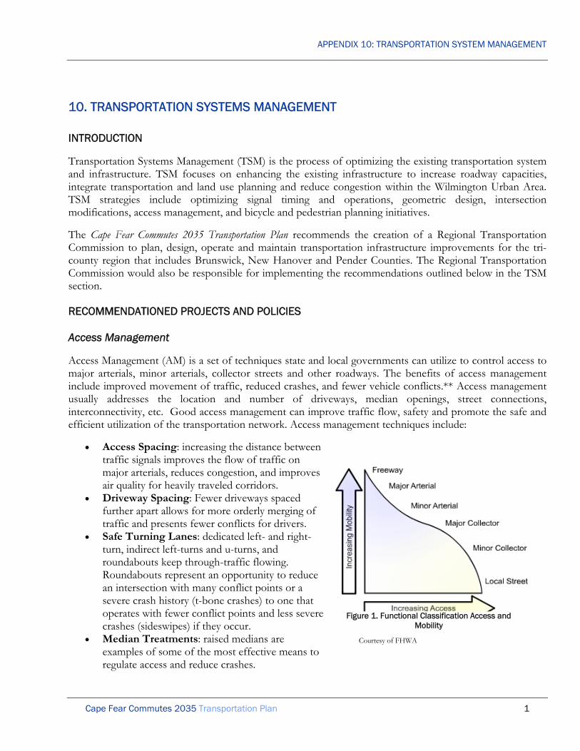
APPENDIX 10: TRANSPORTATION SYSTEM MANAGEMENT
Cape Fear Commutes 2035 Transportation Plan 1
10. TRANSPORTATION SYSTEMS MANAGEMENT
INTRODUCTION
Transportation Systems Management (TSM) is the process of optimizing the existing transportation system and infrastructure. TSM focuses on enhancing the existing infrastructure to increase roadway capacities, integrate transportation and land use planning and reduce congestion within the Wilmington Urban Area. TSM strategies include optimizing signal timing and operations, geometric design, intersection modifications, access management, and bicycle and pedestrian planning initiatives.
The Cape Fear Commutes 2035 Transportation Plan recommends the creation of a Regional Transportation Commission to plan, design, operate and maintain transportation infrastructure improvements for the tri-county region that includes Brunswick, New Hanover and Pender Counties. The Regional Transportation Commission would also be responsible for implementing the recommendations outlined below in the TSM section.
RECOMMENDATIONED PROJECTS AND POLICIES
Access Management
Access Management (AM) is a set of techniques state and local governments can utilize to control access to major arterials, minor arterials, collector streets and other roadways. The benefits of access management include improved movement of traffic, reduced crashes, and fewer vehicle conflicts.** Access management usually addresses the location and number of driveways, median openings, street connections, interconnectivity, etc. Good access management can improve traffic flow, safety and promote the safe and efficient utilization of the transportation network. Access management techniques include:
• Access Spacing: increasing the distance between traffic signals improves the flow of traffic on major arterials, reduces congestion, and improves air quality for heavily traveled corridors.
• Driveway Spacing: Fewer driveways spaced further apart allows for more orderly merging of traffic and presents fewer conflicts for drivers.
• Safe Turning Lanes: dedicated left- and right-turn, indirect left-turns and u-turns, and roundabouts keep through-traffic flowing. Roundabouts represent an opportunity to reduce an intersection with many conflict points or a severe crash history (t-bone crashes) to one that operates with fewer conflict points and less severe crashes (sideswipes) if they occur.
• Median Treatments: raised medians are examples of some of the most effective means to regulate access and reduce crashes.
Courtesy of FHWA
Figure 1. Functional Classification Access and Mobility

APPENDIX 10: TRANSPORTATION SYSTEM MANAGEMENT
Cape Fear Commutes 2035 Transportation Plan 2
• Right-of-Way Management: as it pertains to right of way reservation for future widenings, good sight distance, access location, and other access-related. ***
Access management can be accomplished through regulations, codes, guidelines, policies, and directives by NCDOT and the local municipalities; through the land development regulations; development review, etc. Access management can enhance capacity and level of service, improve traffic flow, reduce vehicles conflicts and improve safety.
Given the development patterns in the Wilmington Urban Area, there are significant challenges with access management. Most challenges occur along the major commercial corridors. A strategy for reducing the number of conflict points is the installation of median treatments. This is often met with opposition from commercial property owners because it limits access to their businesses. Another opportunity to improve access management is to provide cross-access between adjacent parcels. This cross-access eliminates the need to utilize a major transportation corridor to access an adjacent property. The WMPO aims to improve connectivity and access management throughout the Wilmington Urban Area.
The Cape Fear Commutes 2035 Transportation Plan recommends the WMPO complete access management plans for the major corridors within the WMPO planning area boundary. These plans should promote effective access management and interconnectivity. As properties develop and/or redevelop, local member jurisdictions should follow the access management plans and require those properties to construct connections to the adjacent properties.
This strategy will help to improve mobility and safety along the major corridors within the WMPO for all users.
Additional Turn Lanes
Turn lanes can be installed at signalized and un-signalized intersections to improve efficiency. The construction of turn lanes will help to improve the operating condition of the intersection by providing additional capacity. The installation of these turn lanes at unsignalized intersections and along roadway corridors are designed to help to remove the turning vehicles from the through lanes. Properly designed turn lanes can help to minimize delays and improve traffic flow. The appropriate length of a turn lane often depends on the existing and anticipated turning volumes during the peak hour. Access management plays an important role in determining the appropriate locations and lengths for right and left turn lanes.
The Cape Fear Commutes 2035 Transportation Plan recommends the study and, where appropriate, the construction of right- and left-turn lanes to reduce delay and improve mobility at signalized and unsignalized intersections and along roadway corridors. The plan recommends funding from the municipalities and North Carolina Department of Transportation be allocated for the construction of these turn lane improvements. The Cape Fear Commutes 2035 Transportation Plan recommends that as land development occurs, the local municipalities and counties work with the WMPO to develop appropriate access management strategies and appropriate turn lane storage lengths to accommodate the developments. The land developers should be required to contribute funding for the construction of the required improvements through the land development process.
Care should be taken when designing turn lanes not to negatively impact the pedestrian realm and disrupt existing or planned bicycle facilities. When feasible, it is recommended that channelized right-turn lanes be

APPENDIX 10: TRANSPORTATION SYSTEM MANAGEMENT
Cape Fear Commutes 2035 Transportation Plan 3
used to minimize the crossing distance for pedestrians. It is also recommended that corner radii at intersections be constructed to accommodate the most common vehicle, not the “worst case scenario.” Large corner radii increase the speed of turning vehicles and endanger pedestrians traveling along a roadway corridor. Pedestrian refuge islands should also be considered when adding dual left-turn lanes at an intersection.
Motorist Assistance Program
Whether it is from a flat tire, a blown head gasket or another problem with your vehicle, breaking down on the side of the road is never fun. Determining who to call can also be an issue. The Cape Fear Commutes 2035 Transportation Plan recommends the installation of signage on major corridors that notify the public of a number for reporting non-emergency assistance. This hotline would be answered by an operator who takes necessary information from motorists. This information is then relayed to the necessary police agency to provide assistance in this time of need. The Regional Transportation Commission could staff this operation and utilize a towing service to remove the vehicle from the roadway.
The plan also recommends the creation of a Motorist Assistance Program (MAP) to assist motorists and remove disabled vehicles from the roadway in the time of need. This strategy will improve mobility and reduce congestion by providing assistance for disable vehicles and removing the vehicles from the roadway more efficiently.
Pavement Markings
The installation of pavement markings is intended to provide information to roadway users utilizing the roadway. These markings can be installed in addition to or to supplement signs and traffic signals. These marking are used to delineate bicycle lanes, crosswalks, school zones, stop control, and edges of travel lanes.
The Cape Fear Commutes 2035 Transportation Plan recommends the evaluation of pavement markings on an annual basis to determine the need for re-installation of the markings. As development and/or redevelopment occur, each proposal should be reviewed to determine the appropriate pavement markings for installation. The plan recommends the installation of pavement markings using thermoplastic as opposed to paint to provide guidance and information to the roadway users that include bicyclists, pedestrians and motorists. This strategy could also reduce delay by providing motorists with additional time to make decisions about their route choices.
Sign and Lighting Upgrade
The installation of improved signage and lighting can enhance the safety for drivers, bicyclists and pedestrians. These improvements can provide wayfinding assistance and directions to important features (police stations, fire station, parks, etc.), improve visibility and enhance the streetscape of particular corridors. The use of improved signage and lighting creates a safe and attractive environment for all users.
The Wilmington City Council adopted the Wilmington Signage Plan in February 2009 that will serve as a guide for the installation of wayfinding signage throughout the city. The Wilmington Signage Plan is a result of the need for consistent, uniform signage standards, as indicated in the Vision 2020 Plan and the Cape Fear Historic

APPENDIX 10: TRANSPORTATION SYSTEM MANAGEMENT
Cape Fear Commutes 2035 Transportation Plan 4
Byway Corridor Management Plan.* The plan provides recommendations for vehicular and pedestrian wayfinding. This program will serve to provide direction to important city features.
The Cape Fear Commutes 2035 Transportation Plan recommends implementation of the Wilmington Signage Plan. The WMPO and North Carolina Department of Transportation should review the current signage program for the Wilmington Urban Area to determine any modifications that provide improved information to the traveler. The WMPO and North Carolina Department of Transportation should review the signs and streetlight details to determine potential enhancements with the construction of roadway, bicycle and pedestrian projects.
This strategy will help to improve mobility and safety and enhance aesthetics. It will provide a means of communicating information to residents and visitors on important community features. The improved street lighting will improve the safety of bicyclists, pedestrians and motorists.
Standardize Speed Limits
The functional classification of roadways is the process of grouping public streets and highways into classes according to their character and intended function. The functional classification reflects a balancing act between land accessibility and mobility. Figure 2 represents the relationship between the functional classification and land accessibility and mobility. Typically streets are classified as arterials, collectors or local streets.
Table 1. Description of Functional Classification
Functional System Services Provided
Arterial Provides the highest level of service at the greatest speed for the longest uninterrupted distance, with some degree of access control.
Collector Provides a less highly developed level of service at a lower speed for shorter distances by collecting traffic from local roads and connecting them with arterials.
Local Consists of all roads not defined as arterials or collectors; primarily provides access to land with little or no through movement.
Source: AASHTO Greenbook
The Cape Fear Commutes 2035 Transportation Plan recommends the WMPO and North Carolina Department of Transportation work collaboratively to standardize speed limits based on the functional classification of a roadway and the adjacent population and employment density along a roadway. Speed limits on limited access highway (i.e. Wilmington Bypass, Martin Luther King, Jr. Parkway) should be based on the design speed and/or the 85th percentile speed.

APPENDIX 10: TRANSPORTATION SYSTEM MANAGEMENT
Cape Fear Commutes 2035 Transportation Plan 5
Table 2. Recommended Speed Limits
Roadway Functional Classification
CBD & Urban Core (High Density)
Traditional Suburban (Medium Density)
Automobile-oriented Suburban
(Low Density)
Local 25 MPH 25MPH 25MPH
Collector 25MPH 35MPH 35MPH
Arterial 25MPH 35MPH 45MPH
Limited-access Roadway 85th Percentile 85th Percentile 85th Percentile

APPENDIX 10: TRANSPORTATION SYSTEM MANAGEMENT
Cape Fear Commutes 2035 Transportation Plan 6
Figure 1 Map of WMPO Context Zones

APPENDIX 10: TRANSPORTATION SYSTEM MANAGEMENT
Cape Fear Commutes 2035 Transportation Plan 7
Streetscape Improvements
Streetscape enhancement projects are typically constructed on roadways to improve the aesthetics of the corridor. These enhancements can include brick pavers, sidewalks, bulb-outs, decorative lighting, decorative traffic signals, medians, landscaping, benches, signage and other aesthetic improvements. These improvements can improve the mobility and safety of bicyclists, pedestrians and motorists and also spur redevelopment and a renewed interest from property owners that can increase the tax base of the region. The construction of bulb-outs can reduce the required crossing distance for pedestrians, medians can reduce the number of conflict points, and signage can help to better direct travelers throughout the community. Streetscape enhancements bring together several of the TDM and TSM strategies into one cohesive plan.
The Cape Fear Commutes 2035 Transportation Plan evaluated projects that were key to the community fabric and established criteria to rank projects that have an impact on the Quality of Life. These Quality of Life Roadway Projects aimed to enhance the urban design, mainly through streetscape enhancements. The plan studied 35 Quality of Life Roadway Projects within the Wilmington Urban Area. The funded Quality of Life Roadway Projects are included on Pages 21-22 of the report.
Tourist Transportation Plan
A tourist transportation plan should be developed to expand and improve tourist access to key destination points throughout the Wilmington Urban Area. This plan should be completed by the Wilmington-Cape Fear Coast Convention and Visitors Bureau with assistance from the WMPO.
Traffic Signal Timing Optimization
Traffic signals function in different patterns that include pre-timed, semi-actuated, actuated or actuated-coordinated.
• Pre-timed signals have a pre-described timing for each movement and cannot be modified. • Semi-actuated signal have established green times for some movements and have an opportunity for
additional timing that can be allocated to some movements. This actuation is dependent upon the vehicle detection for specific movements of the intersection.
• Actuated signals all have a form of detection. The green time is allocated to each movement based on the signal timing and vehicle detection at each of the intersections.
• Actuated-coordinated signals function as fully actuated signals and are coordinated with adjacent intersections to improve mobility and traffic flow along the corridor. These coordinated systems help the progression of traffic along the corridors and help to efficiently and effectively move traffic throughout the community.
The traffic signal timing optimization is to adjust the signal timings to enhance the capacity of the roadway intersections and corridors. This is a very cost effective way to improve traffic flow throughout the community.

APPENDIX 10: TRANSPORTATION SYSTEM MANAGEMENT
Cape Fear Commutes 2035 Transportation Plan 8
The City of Wilmington and North Carolina Department of Transportation recently completed the upgrade of the traffic signal system in the City of Wilmington. This included upgrading 210 signals throughout the City of Wilmington and New Hanover County from a combination of various signal configurations to one cohesive integrated system. This included replacement of all intersection control equipment, installation of over 60 miles of fiber optic cable, addition of wireless communication units, upgrade of 11 traffic monitoring cameras and installation of an additional 21 cameras. Some traffic signals in the unincorporated areas of New Hanover County and all signals in Pender and Brunswick Counties are operated and maintained by the North Carolina Department of Transportation and are not part of this upgrade.
The Cape Fear Commutes 2035 Transportation Plan recommends that all new traffic signals within the Wilmington Urban Area be connected to and coordinated with the City of Wilmington’s traffic signal system. Where possible, these signals should be constructed as actuated-coordinated to efficiently and effectively utilize the resources available to improve traffic flow throughout the system. The Cape Fear Commutes 2035 Transportation Plan recommends that each traffic signal within the Wilmington Urban Area be studied periodically for seasonal variation and to determine the appropriate signal timing. Timings should be changed periodically to accommodate the changes in traffic volumes at the intersections.
The intent of this strategy is to synchronize all of the traffic signals within the Wilmington Urba Area in an effort to improve mobility and safety throughout the community which also reducing greenhouse emissions. The synchronization of these signals will improve roadway capacity and reduce delay at the intersections and improve the level of service along each corridor.
Variable/Dynamic Message Signs
The use of variable message signs (VMS) is an important traffic control device that can provide real-time information to motorists. VMSs are either located on a fixed structure or on trailers which can be moved easily throughout the community. VMSs convey information to travelers regarding incidents that occur frequently (i.e. bridge opening) or unusual driving conditions (i.e. accident information, construction or maintenance, speed reduction, wet pavement, lane closures, speed limits, event notifications, etc.). VMSs are an important element of an Intelligent Transportation Systems (ITS) which is aimed to provide motorists information to alleviate congestion during peak periods and to alert drivers to avoid certain congested areas.
The Cape Fear Commutes 2035 Transportation Plan recommends the WMPO utilize variable message boards to convey frequent and unusual driving conditions to motorists. The WMPO should work with the North Carolina Department of Transportation to implement an area wide ITS plan and system for the region. The WMPO should work cooperatively with the North Carolina Department of Transportation to evaluate potential locations for the installation of stationary devices. The WMPO and North Carolina Department of Transportation should utilize movable VMSs to provide information on construction or maintenance, speed reduction, wet pavement, lane closures, speed limits, event notifications, safety messages, and amber alerts.
The North Carolina Department of Transportation currently disseminates information using VMSs and Highway Advisory Radio. Additionally, NCDOT developed and implemented a 511 system in 2004 that disseminates information over the telephone. The WMPO should work collaboratively with the North Carolina Department of Transportation to introduce and utilize new technologies as they become available to provide roadway users with real-time travel information.

APPENDIX 10: TRANSPORTATION SYSTEM MANAGEMENT
Cape Fear Commutes 2035 Transportation Plan 9
This strategy will help to improve mobility by providing information to motorists in an effort to avoid congested areas.
Vehicle Detectors Repair/Replacement
The vehicle detectors are an important element in the function of an efficient traffic signal system. The devices are installed in the roadway at signalized intersections to initiate a signals response to a vehicle. These devices serve as indicator loops that are placed in the travel lanes within the pavement. Other vehicle detection devices include video cameras that provide pixel sensitizing. These detection devices improve the efficiency of the intersections by optimizing the signal timing lengths based on the traffic at the intersection and allow for more “green” time to be allocated to the priority movements. The use of these devices can have a significant impact on mobility and traffic flow along entire corridors within the Wilmington Urban Area.
The Cape Fear Commutes 2035 Transportation Plan recommends that as roadways are constructed, widened or resurfaced, the Wilmington MPO coordinate with the City of Wilmington and North Carolina Department of Transportation to fund and implement loop detectors at all signalized intersections. As new signals are installed, the plan recommends coordination with the City of Wilmington and North Carolina Department of Transportation to install traffic cameras where appropriate.
This strategy will help to ensure that the intersections are functioning appropriately and help to improve efficiency at the signalized intersections. The installation of new loops with the construction, widening or resurfacing will reduce costs and improve efficiency.
Sources: *Wilmington Signage Plan ** http://ops.fhwa.dot.gov/access_mgmt/index.htm ***http://ops.fhwa.dot.gov/access_mgmt/what_is_accsmgmt.htm

APPENDIX 11: ENVIRONMENTAL ANALYSIS
Cape Fear Commutes 2035 Transportation Plan 1
11. ENVIRONMENTAL ANALYSIS
INTRODUCTION
Environmental features were considered in the analysis and prioritization of each of the projects in the Cape Fear Commutes 2035 Transportation Plan. While many of the projects in the Plan are roadway projects, environmental features were also considered in developing the transit, bicycle and pedestrian projects. This chapter provides more details on this analysis.
Historically, analysis of the impacts of transportation projects on communities and the natural environment occurred during individual project planning and design. This approach is reasonable, since many impacts cannot be accurately determined until specific design decisions have been made. However, there are several important reasons for conducting an earlier, system-planning level environmental screening of proposed Cape Fear Commutes 2035 Transportation Plan projects.
First, a preliminary environmental impact screening can identify potentially serious impacts that could end up stopping a project. Recognizing such issues at the earliest possible stage of the planning process provides the opportunity to avoid or mitigate undesirable impacts, through modification (or even elimination) of the project. Early “fatal flaw” analysis of this type helps reduce the possibility that subsequent, more detailed analyses will uncover unexpectedly serious environmental impacts. This approach helps reduce the risks inherent in an uncertain planning process, and helps ensure that time and resources are not expended unnecessarily.
Second, a systems-level environmental screening allows consideration of the interactions among various projects. Rarely does a project stand completely alone, independent of other projects. The combined impacts of several projects can vary substantially from the summation of individual project impacts. Furthermore, the modification or elimination of one project due to environmental considerations can significantly alter the performance or impacts of other projects. It is important, therefore, to be able to assess project impacts in the context of the entire Cape Fear Commutes 2035 Transportation Plan.
Finally, although system-level environmental screening does not substitute for detailed, project-specific review, this assessment can identify and highlight issues warranting further analysis. This knowledge not only reduces the likelihood of unexpected environmental impacts, it permits future environmental studies to focus on critical issues. The result is a transportation plan that not only minimizes negative impacts on the natural and man-made environments, but one that is ultimately more efficient, timely, and cost-effective.
This environmental screening process and its results reflect the reality that the overwhelming majority of the Cape Fear Commutes 2035 Transportation Plan’s environmental impacts are associated with roadway projects. This is understandable, given the potential disruption caused by the construction of more than 200 lane-miles of permanent infrastructure. Once a few critical decisions have been made, constraints on roadway cross-sections and alignments (due to safety factors and design criteria) limit opportunities to avoid or reduce these negative impacts.
Sidewalks and bicycle facilities are much more limited in the magnitude of their environmental and community impacts, due to smaller cross-sections and greater flexibility in design. Furthermore, pedestrian and bicycle facilities are most often built in conjunction with roadway facilities, and have only marginal environmental impacts, if any, beyond those of the roadway itself. In addition, bicycle

APPENDIX 11: ENVIRONMENTAL ANALYSIS
Cape Fear Commutes 2035 Transportation Plan 2
and pedestrian travel is inherently less disruptive to the environment than travel by automobile, especially with respect to air pollution, noise, and energy consumption.
Most of the transit elements in the Cape Fear Commutes 2035 Transportation Plan are associated with bus route and service expansions, which typically involve no new construction, and have minimal negative impacts on either natural or man-made environments. In general, transit impacts tend to be positive, in that increased service tends to reduce VMT and typically improves accessibility in disadvantaged neighborhoods. It is difficult to identify environmental impacts for these facilities in the context of this update, however, due to the specialized nature of these facilities, and given that they are still in the early planning stages. Specific studies will be needed to assess the impacts of these transit systems.
The following discussion of the Cape Fear Commutes 2035 Transportation Plan environmental screening process is divided into two parts. The first focuses on overall impacts to the natural and cultural environments. The second section addresses specific issues related to environmental justice.
ENVIRONMENTAL IMPACTS
A qualitative screening was performed to assess the potential environmental impacts of the roadway projects recommended for inclusion in the Cape Fear Commutes 2035 Transportation Plan. This analysis consisted of overlaying project alignments/locations onto a series of maps depicting sensitive natural and community resources (see Figures 11.1-11.5). Any proposed project determined to encroach on a sensitive area was identified. The nature and degree of conflict determines the level of impact assessed. For example, a roadway alignment across a stream is generally considered to have less severe impacts than one running along the course of the stream. Other relevant factors include the number of crossings, amount of traffic, roadway cross-section, and stream size and quality. As another example, a road widening is typically assumed to be less disruptive to the natural environment than a comparable project on new alignment. On the other hand, widening may be more disruptive than a new facility in terms of community impacts, depending on available right-of-way, alignment, type of development, and other factors.
Since this is a system-wide, planning-level screening, no formal field investigation was conducted, and screening could only be performed on those features for which GIS coverage was available. As project plans are further refined, more precise environmental assessments may be necessary. Results are summarized in Table 11.1.
The table rates the impacts of each roadway project in three categories (Congestion Mitigation, Quality of Life, and Safety), assessing impacts in the following categories:
Hydrological
Bodies of water
Floodplains
Wetlands
High Quality Resource Waters
Water Supply Watershed

APPENDIX 11: ENVIRONMENTAL ANALYSIS
Cape Fear Commutes 2035 Transportation Plan 3
Environmental
NPDES discharge sites
Hazardous Waste Disposal site
Land Trust Conservation Property/Lands managed for conservation & open space
Conservation tax credit property
Natural Heritage Element Occurrence
Significant Natural Heritage Area
Community
Schools
State-Owned Land
Federal-Owned Land
National Register of Historic Places
Vulnerable/Viable Farmland
Vulnerable/Viable Forestland
Potential project impacts (if any) are classified on a scale from “No Impact” to “Major Impact” for each of the above categories. This determination is based on a combination of objective and subjective criteria. For example, impacts are generally considered less severe if the project involves widening or other improvements along an existing roadway, as opposed to construction on new alignment. The following guidelines were used to rate project impacts in this screening process:
No Impact
Beyond ¼ mile distance from project
Minor Impacts
Road widening with single small creek crossing
Road widening near sensitive area
Moderate Impacts
Road widening with multiple creek crossings
Road widening through sensitive area
New alignment with single small creek crossing
New alignment near sensitive area
Major Impacts
New alignment along stream
New alignment with multiple stream crossings
New alignment through sensitive area
Road widening or new alignment with numerous impacts

APPENDIX 11: ENVIRONMENTAL ANALYSIS
Cape Fear Commutes 2035 Transportation Plan 4
This analysis is used to eliminate any candidate projects with “fatal” flaws, or environmental impacts that were considered potentially too severe to justify the project. In addition, the information obtained from this analysis allows proposed roadway alignments to be adjusted or refined to minimize possible environmental impacts. Finally, this screening process allows early identification of likely impacts and areas of uncertainty that will need to be investigated more fully as a particular project moves forward through more detailed planning and design.

APPENDIX 11: ENVIRONMENTAL ANALYSIS
Cape Fear Commutes 2035 Transportation Plan 5
Figure 11-1. Hydrologic Factors

APPENDIX 11: ENVIRONMENTAL ANALYSIS
Cape Fear Commutes 2035 Transportation Plan 6
Figure 11-2. Environmental Factors

APPENDIX 11: ENVIRONMENTAL ANALYSIS
Cape Fear Commutes 2035 Transportation Plan 7
Figure 11-3. Environmental Factors, Natural Heritage

APPENDIX 11: ENVIRONMENTAL ANALYSIS
Cape Fear Commutes 2035 Transportation Plan 8
Figure 11-4. Publically Owned Lands

APPENDIX 11: ENVIRONMENTAL ANALYSIS
Cape Fear Commutes 2035 Transportation Plan 9
Figure 11-5. Forestry Factors

APPENDIX 11: ENVIRONMENTAL ANALYSIS
Cape Fear Commutes 2035 Transportation Plan 10
Table 11.1 Potential Environmental Impacts

APPENDIX 11: ENVIRONMENTAL ANALYSIS
Cape Fear Commutes 2035 Transportation Plan 11
C029Isabel Holmes Bridge (US 74-NC 133)
at US 17-421 interchangeNew Hanover M aj M in M in M od N/A N/A M aj M aj M in N/A M od N/A M od M od M od N/A N/A N/A N/A N/A N/A M in M in
C039
M artin Luther King, Jr. Parkway (US 74)
at M arket Street (US 17 Business)
flyovers
New Hanover M od N/A N/A M in N/A N/A M in M in N/A N/A N/A N/A N/A M in N/A N/A N/A N/A N/A N/A N/A N/A N/A
C055A
Cape Fear Riverway between
Independence Boulevard and Snows
Cut Bridge (US 421)
New Hanover M od M in M od M od N/A N/A M od M od M in N/A M in M od M od M od M od M in N/A M od N/A N/A N/A M od M od
C056Saint Nicholas Road extend to
Cardinal Drive and Station RoadNew Hanover M aj N/A N/A M aj M od N/A N/A N/A N/A N/A N/A M in N/A M od N/A M in M in N/A N/A N/A N/A N/A M in
C058Head Road extend to M asonboro
Sound RoadNew Hanover M aj M aj M aj M aj M aj N/A M aj M aj N/A N/A N/A N/A N/A M od N/A N/A N/A N/A N/A N/A N/A M in M od
C059Hurst Drive extend to South Kerr
Avenue and Reigel RoadNew Hanover M aj N/A N/A M aj N/A N/A M in M in N/A N/A N/A N/A N/A M od N/A M in M aj N/A N/A N/A N/A N/A M od
C063 Randall Drive extend to Hooker Road New Hanover M aj N/A M in M od N/A N/A M in M in N/A N/A N/A N/A N/A M od M aj N/A M aj N/A N/A N/A N/A N/A M od
C067Dogwood Lane extend to Wrightsville
Avenue and Pine Grove DriveNew Hanover M aj N/A M aj M aj M aj N/A M aj M aj N/A N/A N/A N/A N/A M od N/A M od N/A N/A N/A N/A N/A N/A M od
C069
North 23rd Street widen between
Castle Hayne Road (NC 133) and
M artin Luther King, Jr. Parkway (US 74)
New Hanover M od M in M in M in N/A N/A M in M in N/A N/A N/A N/A N/A M od N/A N/A M od N/A N/A N/A N/A N/A M in
C100
South Front Street (US 421 Truck)
widen between Cape Fear M emorial
Bridge (US 17 Business-76-421) and
Burnett Boulevard (US 421)
New Hanover M od M in M od M od N/A N/A M od M od M in M od N/A M od N/A M od M in N/A M od N/A M in N/A N/A N/A M in
C104
South College Road (US 117/NC132)
from Wilshire Boulevard to Shipyard
Boulevard (US 117) widen
New Hanover M od N/A M in M in M od N/A N/A N/A N/A N/A N/A M od N/A M od N/A M od N/A N/A N/A N/A N/A N/A N/A
C105South Kerr Avenue extend to Oleander
Drive (US 76)New Hanover M aj N/A N/A N/A N/A N/A N/A N/A N/A N/A N/A N/A N/A M od N/A M in N/A N/A N/A N/A N/A N/A N/A
C106
South Kerr Avenue widen between
Patrick Avenue and Wrightsville
Avenue
New Hanover M od M od N/A M in N/A N/A M od M od N/A N/A N/A N/A N/A M od N/A M in M od N/A N/A N/A N/A N/A N/A
C117Wilshire Boulevard extend to
M acM illan AvenueNew Hanover M aj N/A N/A N/A N/A N/A N/A N/A N/A N/A N/A M in N/A M od N/A M od N/A N/A N/A N/A N/A N/A N/A
Quality of Life
Q01
South College Road (NC 132)
improvements between Randall
Parkway and Oleander Drive (US 76)
Wilmington M od N/A N/A M in N/A N/A N/A N/A N/A N/A N/A N/A N/A M od N/A M od M od N/A N/A N/A N/A N/A N/A

APPENDIX 11: ENVIRONMENTAL ANALYSIS
Cape Fear Commutes 2035 Transportation Plan 12
Q03
South College Road (NC 132)
improvements between M arket Street
(US 17 Business) and Randall Parkway
Wilmington M od N/A M od M in N/A N/A N/A N/A N/A N/A N/A N/A N/A M od N/A M in M in N/A N/A N/A N/A N/A N/A
Q06
M arket Street (US 17 Business)
improvements between New Centre
Drive and Gordon Road
Wilmington M od N/A N/A M in M in N/A N/A N/A N/A N/A N/A M in N/A M in N/A M od M od N/A N/A N/A N/A N/A N/A
Q07
Ocean Highway (US 17) improvements
between Lanvale Road and Andrew
Jackson Highway (US 74-76)
M ultiple M od N/A M od M od N/A N/A M od M od N/A N/A N/A N/A N/A M in N/A N/A N/A N/A N/A N/A N/A M od M od
Q10
Carolina Beach Road (US 421)
streetscape between Burnett
Boulevard and Shipyard Boulevard
Wilmington M in M in M in M in N/A N/A M in M in N/A N/A N/A M in N/A M in M in M in M in N/A M in N/A N/A N/A M in
Q11
M arket Street (US 17 Business) road
diet between North and South 17th
Street and Covil Avenue
Wilmington M in M in M in N/A N/A N/A M in M in N/A N/A N/A N/A N/A M in N/A M in M in N/A M in N/A N/A N/A N/A
Q14
Carolina Beach Road (US 421)
streetscape between Shipyard
Boulevard and George Anderson
Drive
Wilmington M in N/A M in M in N/A N/A N/A N/A N/A N/A N/A N/A N/A M in N/A N/A N/A N/A N/A N/A N/A N/A M in
Q16
Dawson Street (US 76) streetscape
between South 3rd Street (US 17
Business) and Oleander Drive (US 76)
Wilmington M in N/A N/A N/A N/A N/A N/A N/A N/A N/A N/A N/A N/A M in N/A M in N/A N/A N/A N/A N/A N/A N/A
Q19
Wrightsville Avenue road diet between
Castle Street and Independence
Boulevard
Wilmington M in N/A N/A N/A N/A N/A N/A N/A N/A N/A N/A M in N/A M in N/A M in N/A N/A N/A N/A N/A N/A N/A
Q20
Castle Hayne Road (NC 133)
streetscape between Northeast Cape
Fear River and North College Road
(US 117-NC 132)
New Hanover M in M in M in M in N/A N/A M in M in N/A N/A N/A N/A N/A M in M in N/A N/A N/A N/A N/A M in M in M in
Q21
Wooster Street (US 76) streetscape
between South 3rd Street (US 17
Business) and Oleander Drive (US 76)
Wilmington M in N/A N/A N/A N/A N/A N/A N/A N/A N/A N/A N/A N/A M in N/A M in N/A N/A N/A N/A N/A N/A N/A
Q25
Wrightsville Avenue improvements
between Independence Boulevard and
South College Road (US 117-NC 132)
Wilmington M od N/A N/A N/A N/A N/A N/A N/A N/A N/A N/A M in N/A M od N/A M od N/A N/A M in N/A N/A N/A N/A

APPENDIX 11: ENVIRONMENTAL ANALYSIS
Cape Fear Commutes 2035 Transportation Plan 13
Q26
Wrightsville Avenue improvements
between South College Road (US 117-
NC 132) and Hawthorne Drive
Wilmington M od N/A N/A N/A N/A N/A N/A N/A N/A N/A N/A N/A N/A M od N/A M od N/A N/A N/A N/A N/A N/A N/A
Q28
River Road (NC 133) streetscape
between US 17-74-76 and Old River
Road
M ultiple M in N/A M in M in N/A N/A M in M in N/A N/A N/A N/A N/A M in N/A N/A M in N/A N/A N/A N/A N/A M in
Q29
Wrightsville Avenue improvements
between Hawthorne Drive and
Oleander Drive
Wilmington M od N/A M od M od N/A N/A M od M od N/A N/A N/A N/A N/A M od N/A N/A N/A N/A N/A N/A N/A N/A M in
Q31
Wilshire Boulevard improvements
between Wrightsville Avenue and dead
end
Wilmington M od N/A N/A N/A N/A N/A N/A N/A N/A N/A N/A M in N/A M od N/A M od N/A N/A N/A N/A N/A N/A N/A
Q34
M acM illan Avenue improvements
between Cedar Avenue and Pine
Grove Drive
Wilmington M od N/A N/A N/A N/A N/A N/A N/A N/A N/A N/A M in N/A M od N/A M od N/A N/A N/A N/A N/A N/A N/A
Roadway Safety
W01
Burnett Boulevard (US 421)
improvements at Carolina Beach
Road (US 421) & South Front Street
(US 421 Truck)
Wilmington M od M od M od M od N/A N/A M od M od M in M in N/A N/A N/A M od M od M in M in N/A M in N/A N/A N/A N/A
W02Castle Hayne Road (NC 133)
roundabout at North 23rd StreetNew Hanover M aj N/A N/A M od N/A N/A N/A N/A N/A N/A N/A N/A N/A M od N/A N/A M in N/A N/A M in M in M in M od
W03
Dow Road improvements between
North Lake Park Boulevard (US 421)
and K Avenue
M ultiple M od M od M od M od N/A N/A M in M in M in M in N/A M od M od M od M od M in M od M od N/A N/A N/A M in M in
W04
M arket Street (US 17 Business)
improvements at North & South 17th
Street
Wilmington M od N/A N/A N/A N/A N/A N/A N/A N/A N/A N/A N/A N/A M in N/A M in M od N/A M od N/A N/A N/A N/A
W06Navassa Road roundabout at Old M ill
RoadNavassa M aj M in M in M in M in M in M in M in N/A M in N/A N/A N/A M od N/A N/A N/A N/A N/A N/A N/A N/A M in
W07NC 210 improvements between
WM PO boundary and US 17Pender M od M in M od M od M od N/A M in M in N/A N/A N/A N/A N/A M in M in N/A N/A N/A N/A N/A M in M od M od
W08
North College Road (US 117-NC 132)
roundabout at Castle Hayne Road (NC
133)
New Hanover M aj N/A M in M in N/A N/A M in M in N/A N/A N/A N/A N/A M in N/A N/A N/A N/A N/A N/A N/A N/A M in
W11Pine Grove Drive roundabout at
Greenville Loop RoadWilmington M aj N/A M od M od M aj N/A M od M aj N/A N/A N/A N/A N/A M od N/A N/A N/A N/A N/A N/A N/A N/A N/A
W12Pine Grove Drive roundabout at Holly
Tree RoadWilmington M aj N/A M od M od M aj N/A M od M od N/A N/A N/A N/A N/A M od N/A N/A N/A N/A N/A N/A N/A N/A N/A

APPENDIX 11: ENVIRONMENTAL ANALYSIS
Cape Fear Commutes 2035 Transportation Plan 14
W13Piner Road improvements at Grissom
RoadWilmington M od N/A N/A M in M in N/A N/A N/A N/A N/A N/A N/A N/A M in N/A M od N/A N/A N/A N/A N/A N/A M in
W14
River Road (NC 133) improvements
between US 17-74-76 and WM PO
Boundary
M ultiple M od N/A M in M in N/A N/A M in M in N/A N/A N/A N/A N/A M in N/A N/A N/A N/A N/A N/A N/A N/A M in
W15River Road roundabout at Sanders
Road New Hanover M aj M od M od M aj M in M in M aj M aj M in M in M in M in M in M od M od M in M in M in N/A M in M in M in M od
W16Salisbury Street (US 74) roundabout at
Causeway Drive (US 76)
Wrightsville
BeachM aj M in M aj M aj M in M in M aj M aj M in M in M in M od M in M od M in M in M in M in N/A M in M in M in M in
W17Salisbury Street (US 74) roundabout at
Lumina Avenue
Wrightsville
BeachM aj M in M od M aj M in M in M aj M aj M in M in M in M in M in M od M in N/A N/A N/A N/A N/A N/A N/A N/A
W19US 17 improvements at Factory Road
& Peanut RoadPender M od M in M od M in M in M in M in M in M in M in M in M in M in M in M in M in M in M in N/A M in M in M od M od
W20
US 17-74-421-NC 133 access
management at USS North Carolina
Road
Brunswick M in M in M in M in N/A N/A M in M in N/A N/A N/A M in M in M in M in N/A M in M in M in N/A N/A M in M in
W22
Wrightsville Avenue (US 74-76)
improvements between Pavillion
Place and Heide-Trask Drawbridge
Wilmington M od M od M od M od M in N/A M od M od N/A N/A N/A M in N/A M in N/A N/A M in N/A N/A N/A N/A N/A M in
W23Wrightsville Avenue roundabout at
M acM illan AvenueWilmington M aj N/A N/A N/A N/A N/A N/A N/A N/A N/A N/A M in N/A M in N/A N/A N/A N/A N/A N/A N/A N/A N/A
W24Wrightsville Avenue roundabout at
Wallace AvenueWilmington M aj N/A N/A N/A N/A N/A N/A N/A N/A N/A N/A N/A N/A M in N/A N/A N/A N/A N/A N/A N/A N/A N/A
W25Oleander Drive (US 76) improvements
at Pine Grove Drive Wilmington M od N/A N/A N/A M in N/A N/A N/A N/A N/A N/A M od N/A M in N/A M od N/A N/A N/A N/A N/A N/A N/A
W26Pine Grove Drive improvements at
M acM illan AveneWilmington M od N/A N/A N/A M in N/A N/A N/A N/A N/A N/A M od N/A M in N/A M od N/A N/A N/A N/A N/A N/A N/A
General N o tes
(1) This table represents a qualitat ive environmental screening only. Observations made by overlapping projects and various GIS data layers
(2) Existing projects are assigned a (M od) maximum value; Future projects are assigned a (M aj) maximum value
Legend
N/A DOES NOT APPLY; beyond 1/4 mile distance from project
M in M INOR Widening project; single small stream crossing; near environmentally sensitive area; Streetscape and Access M anagement projects
M od M ODERATE Widening project; multiple small stream crossings; cross or near edge of environmentally senstive area
M aj M AJOR New alignment; along stream or multiple crossings; through middle of environmentally sensitive area
.

APPENDIX 11: ENVIRONMENTAL ANALYSIS
Cape Fear Commutes 2035 Transportation Plan 15
Environmental Impact and Mitigation Activities
Environmental Impact Although all transportation projects impact the environment, some projects, such as new roadway construction, may have a significantly higher potential impact (see Table 11.1). While all of the projects in the Cape Fear Commutes 2035 Transportation Plan should continue to be evaluated for their potential environmental impacts as they move forward in the design and construction process, the following projects on new alignment in particular warrant special consideration as they develop:
R-2633B (Wilmington Bypass)
R-3300 (Hampstead Bypass)
U-4434 (Independence Blvd Extension)
U-4751 (Military Cutoff Road)
C056 (St. Nicholas Rd)
C058 (Head Rd)
C059 (Hurst Dr)
C063 (Randall Dr)
C067 (Dogwood Ln)
C105 (South Kerr Ave)
C117 (Wilshire Blvd) By far the greatest potential environmental impact for transportation projects being constructed in North Carolina’s coastal plain are wetlands, floodplains, and other hydrological factors. Other common potential environmental impacts include habitat fragmentation and loss of forest land.
Consultation Process Development of the Cape Fear Commutes 2035 Transportation Plan allows the WMPO the opportunity to consult with environmental agencies and review environmental impacts resulting from project recommendations. The Plan is an initial step in identifying impacted areas and adjusting project alignments to avoid or minimize impacts to natural resources. It also allows the MPO, as the project sponsor, to make informed decisions when setting project priorities for the urban area. The result is a transportation plan that not only minimizes negative impacts on the natural environment, but one that is ultimately more efficient, timely, and cost-effective.
The Federal Highway Administration (FHWA) provided a list of agency contacts to consult as part of the development of the Plan. Each of these agencies was formally contacted and provided project information to review. Feedback from the agencies will be used as projects continue to develop toward implementation. Since the transportation planning activities of the MPO are regional in scope, this environmental mitigation discussion does not focus on individual projects within the Plan but rather offers a summary of environmentally sensitive areas (see Table 11.1). The MPO conducts analyses to identify conflicts between planned projects and environmentally sensitive areas. The analysis process is an effort to minimize negative effects that a project can have on environmentally sensitive areas.

APPENDIX 11: ENVIRONMENTAL ANALYSIS
Cape Fear Commutes 2035 Transportation Plan 16
Environmental Mitigation The Wilmington Urban Area MPO is committed to minimizing and mitigating the negative effects of transportation projects on the natural and built environments in order to preserve the region’s quality of life. In doing so, the MPO recognizes that not every project will require the same type or level of mitigation. Some projects, such as new roadways and roadway widening, involve major construction with considerable earth disturbance. Others, like intersection improvements, street lighting, and resurfacing projects, involve minor construction and minimal, if any, earth disturbance. The mitigation efforts used for a project should be dependent upon how severe the impact on environmentally sensitive areas is expected to be. The following three-step process is used to determine the type of mitigation strategy to apply for any given project:
1. Identify and confirm environmentally sensitive areas throughout the project study area. 2. Determine how and to what extent the project will impact these environmentally sensitive
areas. 3. Develop and review appropriate mitigation strategies to lessen the impact these projects
have on the environmentally sensitive areas. Transportation projects should minimize off-site disturbance in sensitive areas and develop strategies to preserve air and water quality, limit tree removal, minimize grading and other earth disturbance, provide erosion and sediment control, and limit noise and vibration. Where feasible, planners should develop alternative designs or alignments that would lessen the project’s impact on environmentally sensitive areas. The three-step mitigation planning process is designed to solicit public input and offer alternative designs or alignments, as well as mitigation strategies, for comment by environmental review agencies, the MPO, and local governments.
The table below details mitigation activities and measures that should be considered when dealing with environmental impacts. Many of the measures are considered by the MPO during the project development phase. Measures considered include construction of sidewalks and bicycle lanes, design modifications to reduce community impacts, and request noise barriers and landscaping to reduce audio and visual impacts.
Impact Mitigation Measure(s)
Air Quality Designate pedestrian/transit oriented development areas Adopt local air quality mitigation fee program Develop energy efficient incentive programs Adopt air quality enhancing design guidelines
Archaeological Archaeological excavation Design modifications to avoid area Educational activities
Community Impacts Bridge community Sidewalks Bike lanes Develop recreational areas Traffic calming Oral history project
Endangered/Threatened Species Preservation Enhancement or restoration of degraded habitat Creation of new habitats Establishment of buffer areas around existing habitats

APPENDIX 11: ENVIRONMENTAL ANALYSIS
Cape Fear Commutes 2035 Transportation Plan 17
Modifications of land use practices Restrictions on land access
Farmland Protect one to one farmland acre for every acre converted Agricultural conservation easement on farmland Compensation
Fragmented Animal Habitats Construct overpasses with vegetation Construct underpasses, such as culverts and viaducts Other design measures to minimize potential fragmenting of animal habitats
Historic Sites Relocation of historical property Design modification Landscaping to reduce visual impacts Photo documentation Historic archival recording to present historic information to the public
Light Impacts Lens color Direction of lighting Low level lighting
Noise Depressed roads Noise barriers Planting trees Construct tunnels
Park Impacts Construct bike/pedestrian pathways Dedicate land Compensation for park dedication fees Replace impaired functions
Viewshed Impacts Vegetation and landscaping Screening Buffers Earth berms Camouflage Lighting
Wetlands Compensation Wetland restoration possible through EEP Creation of new wetlands Strict erosion and sedimentation control measures
ENVIRONMENTAL JUSTICE
Environmental Justice is a concept intended to avoid the use of federal funds for projects, programs, or other activities that generate disproportionate or discriminatory adverse impacts on minority or low-income populations. This effort is consistent with Title IV of the 1964 Civil Rights Act, and is promoted by the U.S. Department of Transportation (USDOT) as an integral part of the long-range transportation planning process, as well as individual project planning and design. The environmental justice assessment incorporated in this LRTP update was based on three basic principles, derived from guidance issued by the USDOT:

APPENDIX 11: ENVIRONMENTAL ANALYSIS
Cape Fear Commutes 2035 Transportation Plan 18
The planning process should minimize, mitigate, or avoid environmental impacts (including economic, social, and human health impacts) that affect minority and low-income populations with disproportionate severity.
The benefits intended to result from the transportation planning process should not be delayed, reduced, or denied to minority and low-income populations.
Any community potentially affected by outcomes of the transportation planning process should be provided with the opportunity for complete and equitable participation in decision-making.
The environmental justice screening conducted for this study is not intended to quantify specific impacts. As described above, it is intended to guide the development of a plan that is equitable in terms of both costs and benefits. In addition, a critical purpose of this screening is the identification of projects in the transportation plan that, due to proximity, have the potential to affect communities of special interest. When individual studies are begun as part of project implementation, more detailed analyses, including field surveys, will be needed to identify and minimize specific community impacts on a project-by-project basis.
Methodology and Findings
For the purposes of this study, the following methodology was used to identify communities subject to environmental justice screening. Census information from the year 2000 was analyzed at the block group level. The distributions of populations of interest within each block group were calculated. If individuals from any one of these three categories comprised more than 50% of the population in a particular block group, that block group was flagged for analysis for that population category.
Thematic maps were then prepared, graphically depicting concentrations of low-income, elderly, and minority (African-American, American Indian, Asian, Hispanic and Other) populations. Block groups were shaded to represent concentrations of populations of interest, by quartile. When overlaid with proposed roadway projects, these maps provided a useful tool for analyzing and communicating impacts. These maps are included as Figures 11.6-11.13. The following Block Groups, located predominantly in downtown Wilmington and the northwestern part of the study area, have a minority population > 50%:
370190201002
371290101001
371290101002
371290101003
371290102002
371290102003
371290102004
371290102005
371290103001
371290103002
371290110001
371290111001
371290111002
371290111003
371290112002
371290112003
371290113001
371290114001
371290114002
371290115005

APPENDIX 11: ENVIRONMENTAL ANALYSIS
Cape Fear Commutes 2035 Transportation Plan 19
Figure 11-6. Elderly Population

APPENDIX 11: ENVIRONMENTAL ANALYSIS
Cape Fear Commutes 2035 Transportation Plan 20
Figure 11-7. Low Income Population

APPENDIX 11: ENVIRONMENTAL ANALYSIS
Cape Fear Commutes 2035 Transportation Plan 21
Figure 11-8. Minority Population

APPENDIX 11: ENVIRONMENTAL ANALYSIS
Cape Fear Commutes 2035 Transportation Plan 22
Figure 11-9. African American Population

APPENDIX 11: ENVIRONMENTAL ANALYSIS
Cape Fear Commutes 2035 Transportation Plan 23
Figure 11-10. American Indian Population

APPENDIX 11: ENVIRONMENTAL ANALYSIS
Cape Fear Commutes 2035 Transportation Plan 24
Figure 11-11. Asian Population

APPENDIX 11: ENVIRONMENTAL ANALYSIS
Cape Fear Commutes 2035 Transportation Plan 25
Figure 11-12. Hispanic Population

APPENDIX 11: ENVIRONMENTAL ANALYSIS
Cape Fear Commutes 2035 Transportation Plan 26
Figure 11-13. Other Minority Populations


![Cape Fear Community College Catalog [1989-1990] - North ...](https://static.fdokumen.com/doc/165x107/6318da5a4cd7b3442408cb38/cape-fear-community-college-catalog-1989-1990-north-.jpg)