final environment assessment report (fear)
397
FINAL ENVIRONMENT ASSESSMENT REPORT (FEAR) FOR T & D NETWORK IN MOKOKCHUNG, KOHIMA, PHEK, WOKHA, ZUNHEBOTO, DIMAPUR & MON DISTRICTS UNDER NERPSIP TRANCHE-1, NAGALAND August, 2020 Prepared for: Power Grid Corporation of India Limited Prepared by: R. S. Envirolink Technologies Pvt. Ltd. 402, BESTECH CHAMBER COMMERCIAL PLAZA, B-BLOCK, SUSHANT LOK-I, GURGAON Phone: +91-124-4295383: www.rstechnologies.co.in Public Disclosure Authorized Public Disclosure Authorized Public Disclosure Authorized Public Disclosure Authorized
-
Upload
khangminh22 -
Category
Documents
-
view
2 -
download
0
Transcript of final environment assessment report (fear)

FINAL ENVIRONMENT ASSESSMENT REPORT (FEAR)
FOR
T & D NETWORK IN MOKOKCHUNG, KOHIMA, PHEK,
WOKHA, ZUNHEBOTO, DIMAPUR & MON DISTRICTS
UNDER NERPSIP TRANCHE-1, NAGALAND
August, 2020
Prepared for:
Power Grid Corporation of India Limited
Prepared by:
R. S. Envirolink Technologies Pvt. Ltd.
402, BESTECH CHAMBER COMMERCIAL PLAZA,
B-BLOCK, SUSHANT LOK-I, GURGAON
Phone: +91-124-4295383: www.rstechnologies.co.in
Pub
lic D
iscl
osur
e A
utho
rized
Pub
lic D
iscl
osur
e A
utho
rized
Pub
lic D
iscl
osur
e A
utho
rized
Pub
lic D
iscl
osur
e A
utho
rized

ABBREVIATIONS
ADC - Assistant Deputy Collector
AHH - Agricultural Households
AP - Affected Persons
CA - Compensatory Afforestation
CEA - Central Electricity Authority
CFC - Chlorofluorocarbon
CPIU - Central Project Implementation Unit
CPR - Common Property Resources
CPTD - Compensation Plan for Temporary Damage
CRM - Contractor’s Review Meeting
DC - Deputy Collector
DPN - Department of Power, Nagaland
DPR - Detailed Project Report
EMF - Electro Magnetic Field
EMP - Environment Management Plan
EN - Endangered
EPA - Environment Protection Act
ESMU - Environment and Social Management Unit
ESPPF - Environment and Social Policy & Procedures Framework
FEAR - Final Environment Assessment Report
FRA - Forest Right Act
FSI - Forest Survey of India
GA - Geographical Area
GCC - General Conditions of Contract
GHG - Green House Gas
GIS - Geographical Information System
GoI - Government of India
GoN - Government of Nagaland
GPS - Global Positioning System
GRC - Grievance Redress Committee
GRM - Grievance Redressal Mechanism
GSDP - Gross State Domestic Product
GW - Green Wash
HFL - High Flood Level
HQ - Head Quarter
IA - Implementing Agency
IBA - Important Bird Area
ICNIRP - International Commission on Non-Ionizing Radiation Protection
IEAR - Initial Environment Assessment Report
ISFR - India State of Forest Report

ITI - Industrial Training Institute
IUCN - International Union for Conservation of Nature
Km - Kilometer
kV - KiloVolt
LC - Least Concerned
LILO - Line-In Line-Out
MDF - Moderately Dense Forest
MoEF&CC - Ministry of Environment Forest & Climate Change
MSE - Medium and Small Enterprise
MVA - Mega Volt Ampere
MW - MegaWatt
NA - Not Assessed
NBSAP - National Biodiversity Strategy and Action Plan
NBSS&LUP - National Bureau of Soil Survey & Land Use Planning
NER - North East Region
NERPSIP - North Eastern Region Power System Improvement Project
NH - National Highway
NOC - No Objection Certificate
NPV - Net Present Value
NT - Near Threatened
NTFP - Non Timber Forest Product
NU - Nagaland University
OF - Open Forest
PCB - Poly Chlorinated Biphenyl
PF - Protected Forest
PGCIL - Powergrid Corporation of India Limited
PIU - Project Implementation Unit
PRA - Participatory Rural Appraisal
PWD - Public Works Department
RF - Reserved Forest
RFA - Recorded Forest Area
RFCTLARRA - Right to Fair Compensation and Transparency in Land
Acquisition, Rehabilitation and Resettlement Act
ROW - Right of Way
RSET - R S Envirolink Technologies Pvt. Ltd.
S/s - Substation
SDO - Sub Divisional Officer
SH - State Highway
SIA - Social Impact Assessment
SMF - Social Management Framework
SPCU - State Project Coordination Unit
Sq km - Square Kilometer

ST - Scheduled Tribes
T&D - Transmission and Distribution
TOF - Tree Outside Forest
TRC - Terrace Rice Cultivation
VDF - Very Dense Forest
VU - Vulnerable
WB - World Bank
ZSI - Zoological Survey of India

CONTENTS Page No.
EXECUTIVE SUMMARY
CHAPTER 1: INTRODUCTION & PROJECT DESCRIPTION
1.1 PROJECT BACKGROUND 1.1
1.2 PROJECT JUSTIFICATION 1.2
1.3 PROJECT BENEFIT 1.4
1.4 PRESENT SCOPE & PRESENT STUDY 1.5
1.4.1 Transmission Components 1.5
1.4.2 Distribution Components 1.6
1.5 OVERALL PRPJECT PROGRESS 1.9
1.6 OBJECTIVE & METHODOLOGY ADOPTED FOR FEAR STUDY 1.15
CHAPTER 2: BASELINE DATA
2.1 INTRODUCTION 2.1
2.2 STUDY AREA DISTRICTS 2.1
2.2.1 Physical Environment 2.2
2.2.1.1 River System 2.7
2.2.1.2 Meteorology 2.7
2.2.1.3 Soil 2.10
2.2.1.4 Landuse Pattern 2.15
2.2.1.5 Landslide Vulnerability 2.17
2.2.1.6 Erosion Vulnerability 2.19
2.2.2 Biological Environment 2.20
2.2.2.1 Floristic 2.21
2.2.2.2 Forest Cover 2.22
2.2.2.3 Forest Cover inside and outside Recorded Forest Area
(or Green Wash) 2.24
2.2.2.4 Floristic Diversity 2.24
2.3 STUDY AREA BASELINE DATA 2.25
2..3.1 Floristics Elements 2.25
2.3.1.1 Taxonomic Diversity 2.26
2.3.1.2 Rare Endangered and Threatened (RET) Species 2.27
2.3.1.3 Invasive Species and Their Control 2.28
2.3.1.4 Vegetation Profile of the Sampling Area 2.30
2.3.1.5 Economically Important Plant Species 2.36
2.3.2 Faunal Elements 2.40
2.3.2.1 Mammals 2.40
2.3.2.2 Avifauna 2.41

2.3.2.3 Herpetofauna 2.45
2.3.2.4 Butterflies 2.46
2.3.3 Protected Areas 2.47
2.3.4 Community Reserve 2.48
2.3.5 Sacred Groves and Community Conserved Areas (CCA) 2.53
2.3.6 Important Bird Areas (IBA) 2.55
2.3.7 Wetland 2.62
2.4 SOCIO-ECONOMIC ENVIRONMENT 2.64
CHAPTER 3: POLICY, LEGAL AND REGULATORY FRAMEWORK
3.1 INTRODUCTION 3.1
3.2 CONSTITUTIONAL PROVISIONS 3.1
3.3 ENVIRONMENTAL PROVISIONS 3.2
3.4 SOCIAL PROVISIONS 3.2
3.5 WORLD BANK OPERATIONAL POLICY 3.8
3.6 STATUTORY PERMISSION/LICENSES/NOC OBTAINED 3.8
CHAPTER 4: MAJOR FEATURES OF FINAL ROUTE & ENVIRONMENT IMPACT
4.1 INTRODUCTION 4.1
4.2 ENVIRONMENTAL CRITERIA FOR ROUTE SELECTION 4.1
4.3 MAJOR FEATURES OF FINAL ROUTE 4.29
4.3.1 Transmission lines 4.29
4.3.1.1 LILO of 132 kV Mariani - Mokokchung Line at Longnak 4.29
4.3.1.2 132 kV D/C New Kohima (Zadhima) to New Secretariat Complex
(NU Campus) 4.30
4.3.1.3 LILO of both Circuit of Kohima – Meluri (Kiphire) Line at Pfutsero 4.33
4.3.1.4 132 kV S/C (on D/C Tower) Wokha - Zunheboto - Mokokchung Line 4.34
4.3.1.5 220 kV S/C (on D/C Tower) New Kohima - Mokokchung via Wokha
Line 4.35
4.3.1.6 LILO of 132 kV S/C Kohima - Wokha Line at 220 kV New Kohima
Sub-station 4.37
4.3.2 Distribution Lines 4.38
4.3.2.1 33 kV line from tapping point of existing 33/11 kV Mokokchung –
Mariani Line at Longtho Sub-station 4.38
4.3.2.2 33 kV line from 132/33 kV Zunheboto (new) to 33/11 kV Zunheboto
South Point (new) Sub-station 4.39
4.3.2.3 33 kV line from 66 kV Mokokchung (existing) to 33/11 kV
Mokokchung Town Power House (new) Sub-station 4.40
4.3.2.4 33 kV line from 66 kV Mokokchung (existing) to 33/11 kV
Mokokchung Town Hospital (new) Sub-station 4.40
4.3.2.5 33 kV line from 132/33 kV Pfutsero (new) to 33/11 kV Pfutsero
(New) Sub-station 4.41

4.3.2.6 33 kV line from existing 132/66/33 kV Nagarjan Sub-station to new
33/11 kV Padampukhri Sub-station 4.42
4.3.2.7 33 kV line from 33/11 Akuloto (existing) Sub-station to 33/11 kV
Suruhuto (existing) Sub-station 4.44
4.3.2.8 33 kV line from existing 33/11 kV Pughoboto Sub-station to existing
33/11 kV Torogonyu Sub-station 4.45
4.4 PROJECT IMPACTS 4.45
4.4.1 Impact of Transmission & Distribution Lines 4.45
4.4.1.1 Type and Use of Land within Corridor Right of Way 4.45
4.4.1.2 Impact on Soil & Surface Geology 4.48
4.4.1.3 Impact on Land for Tower Base & Pole 4.48
4.4.1.4 Impact on Crop Area (RoW Corridor & Tower/Pole) 4.52
4.4.1.5 Impact on Trees 4.52
4.4.1.6 Impact on Other Assets (Small Shed in Agriculture Fields) 4.54
4.4.1.7 Other Damages 4.55
4.4.2 Impact Due to Construction of New Substation and Bay Extension 4.55
4.4.3 Impact on Indigenous People 4.56
4.4.4 Summary of Impacts 4.57
CHAPTER 5: POTENTIAL ENVIRONMENTAL IMPACTS, EVALUATION AND ITS MANAGEMENT
5.1 INTRODUCTION 5.1
5.2 IMPACT DUE TO PROJECT LOCATION 5.1
5.2.1 Resettlement 5.1
5.2.2 Land Value Depreciation 5.2
5.2.3 Historical/Cultural Monuments/Value 5.2
5.2.4 Encroachment into Precious Ecological Areas 5.2
5.2.5 Encroachment into Other Valuable Lands 5.3
5.2.6 Interference with Other Utilities and Traffic 5.6
5.2.7 Interference with Drainage Pattern 5.6
5.3 ENVIRONMENTAL PROVVBLEMS DUE TO DESIGN 5.7
5.3.1 Escape of Polluting Materials 5.7
5.3.2 Explosion/Fire Hazards 5.9
5.3.3 Erosion Hazards due to Inadequate Provision for Resurfacing of Exposed Area 5.9
5.3.4 Environmental Aesthetics 5.10
5.3.5 Noise/Vibration Nuisances 5.10
5.3.6 Blockage of Wildlife Passage 5.10
5.4 ENVIRONMENTAL PROBLEMS DURING CONSTRUCTION PHASE 5.11
5.4.1 Uncontrolled Silt Runoff 5.11
5.4.2 Nuisance to Nearby Properties 5.14
5.4.3 Interference with Utilities and Traffic and Blockage of Access Way 5.15
5.4.4 Inadequate Resurfacing for Erosion Control 5.16
5.4.5 Inadequate Disposition of Borrow Area 5.21

5.4.6 Protection of Worker’s Health/Safety 5.22
5.5 ENVIRONMENTAL PROBLEMS RESULTING FROM OPERATION 5.33
5.5.1 O&M Staff/Skills Less than Acceptable Resulting in Variety of Adverse Effects 5.33
5.6 CRITICAL ENVIRONMENTAL REVIEW CRITERIA 5.34
5.6.1 Loss of Irreplaceable Resources 5.34
5.6.2 Accelerated Use of Resources for Short-term Gains 5.34
5.6.3 Endangering of Species 5.34
5.6.4 Promoting Undesirable Rural-to Urban Migration 5.34
5.7 PUBLIC CONSULTATION 5.34
5.8 COMPLIANCE OF EMP 5.37
5.9 CONCLUSIONS 5.52
CHAPTER 6: MONITORING AND ORGANIZATION SUPPORT STRUCTURE
6.1 ADMINISTRATIVE ARRANGEMENT FOR PROJECT IMPLEMENTATION 6.1
6.2 REVIEW OF PROJECT IMPLEMENTATION PROGRESS 6.1
6.3 E&S MONITORING 6.2
6.4 GRIEVANCE REDRESSAL MECHANISM (GRM) 6.4
6.4.1 Grievance Received & Resolved 6.7

LIST OF TABLES
Table 1.1: State Wise Scope of Work Proposed Under Tranche-1 1.2
Table 1.2: Details of State Wise Funding 1.2
Table 1.3: Summary of subprojects in Tranche-I Under NERPSIP 1.3
Table 1.4: Details of Transmission Network 1.5
Table 1.5: Details of Distribution Network 1.6
Table 1.6: Brief Status on Project Implementation Progress 1.9
Table 2.1: Rivers Flowing Through Project Districts 2.7
Table 2.2: Soils in Project Districts 2.10
Table 2.3: Land use Pattern of Project Districts 2.16
Table 2.4: Percentage Area under Different Forest Types of Nagaland 2.22
Table 2.5: Forest Cover in Project Districts 2.23
Table 2.6: Forest Cover inside and outside Recorded Forest Area or (Green wash) in
Nagaland 2.24
Table 2.7: Shannon-Wiener Index of Tree, Shrub and Herb Species in different Type Groups
of Nagaland 2.25
Table 2.8: Transmission Lines and Transects Locations for Vegetation Sampling 2.25
Table 2.9: RET Plant Species Reported from Study Area 2.28
Table 2.10: Wild Edible Plant Species Used by Tribes in Study Area 2.36
Table 2.11: Plant Species Used for Medicinal Purposes 2.37
Table 2.12: List of Mammals 2.41
Table 2.13: List of Avifauna 2.42
Table 2.14: List of Herpetofauna 2.45
Table 2.15: Butterflies in Nagaland 2.46
Table 2.16: Protected Areas Network in Nagaland 2.47
Table 2.17: List of Community Reserves Notified Under section 36C(1) Wildlife Protection
Act 1972, in Nagaland 2.52
Table 2.18: List of Sacred Groves & Community Conserved Areas in Project Districts 2.54
Table 2.19: Important Bird Areas in Nagaland 2.59
Table 2.20: District Wise Area of Wetlands (Type-Wise) in Project Districts 2.63
Table 2.21: Demographic Profile of Project Districts 2.68
Table 2.22: Literacy Profile of Project Districts 2.68
Table 2.23: Occupational Pattern of Project Districts 2.69
Table 2.24: Main Worker Profile of Project Districts 2.69
Table 3.1: Environmental Provisions 3.3
Table 3.2: Social Provisions 3.6
Table 3.3: World Bank Operational Policy 3.9
Table 4.1: Change in Scope of Work w.r.t. IEAR 4.5
Table 4.2: Finalized Location of Transmission & Distribution Substation 4.8
Table 4.3: Type and Use of Land within Corridor of RoW 4.46
Table 4.4: Estimation of Actual Loss of Land for Tower Base & Pole 4.51

Table 4.5: Estimation on Loss of Land for Crop Damage due to Overhead Lines 4.53
Table 4.6: Loss of Trees 4.54
Table 4.7: Loss of Other Assets 4.55
Table 4.8: Summary of Impacts 4.57
Table 5.1: RoW Width & Clearance between Conductors and Trees 5.1
Table 5.2: Status of Crop & Tree Compensation 5.4
Table 5.3: Status of Land Compensation for Tower Base and Corridor 5.4
Table 5.4: Details of Slope Protection Measures 5.17
Table 5.5: Environment Monitoring Plan 5.39
Table 6.1: Details of Grievances/Complaints 6.7

LIST OF FIGURES
Figure 1.1: Power Map of Nagaland 1.4
Figure 1.2: Proposed T&D Network in Mokokchung, Kohima, Phek, Zunheboto, Dimapur,
Phek and Mon Districts under NERPSIP 1.8
Figure 2.1: Soil Map of Project Districts 2.15
Figure 2.2: Landslide Map of India 2.17
Figure 2.3: Areas Vulnerable to Erosion w.r.t. Sub-Projects 2.21
Figure 2.4: Forest Cover Map of Nagaland 2.23
Figure 2.5: Forest Cover in Project Districts 2.24
Figure 2.6: Protected Area Map of Nagaland 2.49
Figure 2.7: Distance of Sub-Projects from Puliebadze Wildlife Sanctuary 2.50
Figure 2.8: Distance of Sub-Projects from Rangapahar Wildlife Sanctuary 2.51
Figure 2.9: Distance of Chakasang Sacred Grove in Phek District w.r.t. to Sub-Projects 2.56
Figure 2.10: Distance of Ngaza and Ngatipang Sacred Groves in Mokokchung District w.r.t.
to Sub-Project 2.57
Figure 2.11: Distance of Longkhum Community Conserved Area in Wokha District w.r.t. to
Sub-Project 2.58
Figure 2.12: Distance of IBAs in Kohima District w.r.t. to Sub-Projects 2.60
Figure 2.13: Distance of Sub-Projects in Phek District w.r.t. to Nearest IBA 2.61
Figure 2.14: Wetland Area Map of Nagaland 2.62
Figure 4.1: Satellite Imagery Showing Route of LILO of 132kV S/C Mokokchung-Mariani at
Longnak 4.11
Figure 4.2: Satellite Imagery Showing Route of 132 KV D/C New Kohima (Zhadima) to New
Secretariat Complex (NU Campus) Transmission Line 4.12
Figure 4.3: Satellite Imagery Showing Route of LILO of both ckts of 132kV D/C Kohima-
Meluri (Kiphire) Line at Pfutsero 4.13
Figure 4.4: Satellite Imagery Showing Final and Alternative Routes of 132 kV S/C (on D/C
tower) Wokha-Zunheboto-Mokokchung Transmission Line 4.14
Figure 4.5: Satellite Imagery Showing Final and Alternative Route of 220 KV S/C (On D/C
Tower) New Kohima-Mokokchung via Wokha Transmission Line 4.15
Figure 4.6: Satellite Imagery Showing Route of LILO of 132kV S/C Kohima-Wokha at
New Kohima Transmission Lines 4.16
Figure 4.7: Satellite Imagery Showing Route of Existing 33 kV Mokokchung - Mariani Line to
Proposed 33/11 kV Longtho S/s Distribution Line 4.17
Figure 4.8: Satellite Imagery Showing Route of New 132/33kV Zunheboto S/S to New
33/11kV S/S Zunheboto South Point Distribution Line 4.18
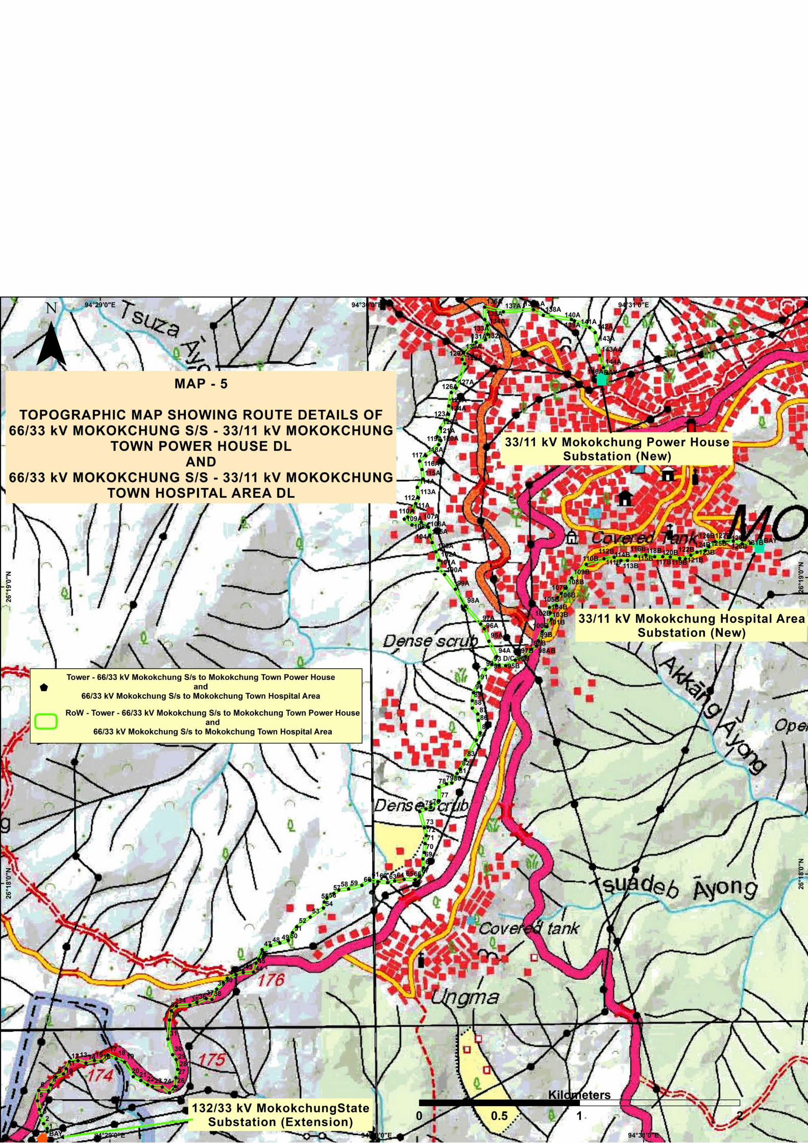
Figure 4.9: Satellite Imagery Showing Route of Existing 66/33kV Mokokchung S/S to New
33/11kV S/S Mokokchung Town Power House and Existing 66/33kV
Mokokchung S/S to New 33/11kV S/S Mokokchung Town Hospital Area
Distribution Lines 4.19
Figure 4.10: Satellite Imagery Showing Route of New 132/33kV Pfutsero S/S to New
33/11kV Pfutsero Distribution Line 4.20

Figure 4.11: Satellite Imagery Showing Route of Existing 132/66/33kV Nagarjan S/S to New
33/11kV S/S Padam Pukhri Distribution Line 4.21
Figure 4.12: Satellite Imagery Showing Route of Existing 33/11kV Suruhuto S/S to Existing
33/11kV S/S Akuloto Distribution Line 4.22
Figure 4.13: Satellite Imagery Showing Route of Existing 33/11kV Pughoboto S/S to Existing
33/11kV S/S Torogonyu Distribution Line 4.23
Figure 4.14: Major Features en route of LILO of 132kV S/C Mokokchung-Mariani at Longnak 4.30
Figure 4.15: Avoidance of Habitation Area in Zadhima Village 4.31
Figure 4.16: Avoidance of Habitation Area in Phenza Village 4.32
Figure 4.17: Avoidance of Habitation Area in Chieswama Village 4.32
Figure 4.18: Avoidance of Agricultural Land and Institutional Area 4.33
Figure 4.19: Increase in Length of Span Between Tower 07 and Tower 08 4.34
Figure 4.20: Avoidance of Habitation in Tseminyu Village 4.36
Figure 4.21: Avoidance of Agricultural Field 4.37
Figure 4.22: Increase in Length of Span Between Pole 4 and Pole 5 over Chering River 4.39
Figure 4.23: Increase in Length of Span Between Pole 12 and Pole 13 4.41
Figure 4.24: Avoidance of Habitation Area at Pfutsero 4.42
Figure 4.25: Route along the existing Road to Avoid Habitation Area at Nagarjan 4.43
Figure 4.26: Route along the existing Road to Avoid Habitation Area at Naharbari 4.43
Figure 4.27: Route along the existing Road to Avoid Habitation Area at Padampukhri 4.44
Figure 4.28: Typical Plan of Transmission Line Tower Footing 4.49
Figure 4.29: 33 kV Lines (Single & H Pole) Depicting Base Area Impact 4.50
Figure 6.1: Constitution of Site Level GRC, NERPISP, Nagaland 6.5

LIST OF ANNEXURES
Annexure I: List of Angiosperm
Annexure II: Details of Tower Schedule of 132kV Lines
Annexure III: NoC from Concerned Land owner/ Headman/ Village Council
Annexure IV: Sample Case of Compensation Payment
Annexure V: Drawing of Bird Guard/ Anti Perching Devises
Annexure VI: Signed Copy of Safety Plan Submitted by Contractor
Annexure VII: Safety/Penalty Provisions in Contract Conditions
Annexure VIII: Approved Labour License & Insurance Policy by Contractor
Annexure IX: Safety Checklists
Annexure X: Details of Public Consultation
LIST OF MAPS
Map 1: Topographic map showing route details of 132 KV D/C New Kohima (Zhadima) to New
Secretariat Complex (NU Campus) TL and LILO of 132kV S/C Kohima-Wokha at
New Kohima TL
Map 2: Topographic map showing route details of 220 KV S/C (On D/C Tower) New Kohima-
Mokokchung via Wokha TL and Existing 33/11kV Pughoboto S/s to Existing 33/11kV S/S
Torogonyu DL
Map 3: Topographic map showing route details of 132 kV S/C (on D/C tower) Wokha-Zunheboto-
Mokokchung TL, New 132/33kV Zunheboto S/s to New 33/11kV s/s Zunheboto South Point
DL and Existing 33/11kV Suruhuto S/s to Existing 33/11kV s/s Akuloto DL
Map 4: Topographic map showing route details of LILO of both ckts of 132kV D/C Kohima-Meluri
(Kiphire) at Pfutsero DL and New 132/33kV Pfutsero SS to New 33/11kV Pfutsero DL
Map 5: Topographic map showing route details of Existing 66/33kV Mokokchung S/s to New
33/11kV s/s Mokokchung Town Power House DL and Existing 66/33kV Mokokchung S/s to
New 33/11kV s/s Mokokchung Town Hospital Area DL
Map 6: Topographic map showing route details of Existing 132/66/33kV Nagarjan s/s to New
33/11kV s/s Padam Pukhri DL

Power Grid Corporation of India Ltd. Final Environment Assessment Report - 1, Nagaland
RS Envirolink Technologies Pvt. Ltd.
North Eastern Region Power Supply Improvement Project (NERPSIP) is a
World Bank funded project aimed at improving the impoverished power
transmission and distribution system in the North Eastern states of India with
Power Grid Corporation of India Ltd. (POWERGRID), the single transmission
utility of the country as the implementing agency (IA). The present Final
Environmental Assessment Report (FEAR) is for the transmission and
distribution system in Dimapur, Kohima, Mokokchung, Mon, Phek, Wokha and
Zunheboto district and has been undertaken to verify the actual locational
details of the project elements, to report any impacts on the biodiversity and
protected area and the project affected people, and to assess the compliance
of the Initial Environmental Assessment Report (IEAR) /Environment
Management Plan (EMP) prepared and submitted by the IA for the instant
project. The elements of the present project include one 220 kV transmission
line of 85 km, five 132 kV transmission lines of 78.333 km, construction of four
new transmission sub-stations, bay extension of four transmission sub-
stations, nine 33 kV distribution lines of 54.58 km, construction of nine new
distribution sub-stations and augmentation/ bay extension of fourteen
distribution sub-stations.
The topography of the districts is mainly hilly, part of Dimapur, Mokokchung
and Mon district is plain also. However, apart from one small 132 kV
transmission line all the transmission lines are in hilly region. Similarly, apart
from 2 distribution lines all the distribution lines are in hilly region. About 75%
of the landscape has a forest cover (open forest, plantations) mostly in the
hilly terrain, and the rest (25%) is constituted by jhum land, agricultural fields,
settlements etc. Most of the land is privately owned and some are under the
jurisdiction of the Village Council.
The final layout of transmission lines has been carefully selected from three
given options. The alignment has successfully avoided all reserve forests,
protected areas, all ecological and social sensitive areas such as protected
areas, sacred groves, community conserved areas, important bird areas,
wetlands, settlements, common property resources, etc. The land use along
the RoW (35 m for 220 kV and 27 m for 132 kV) of lines comprises of
agricultural land, private plantation and govt. land. The original length of the
line has been reduced to 163.333 km from earlier 177.05 km due to further
optimization during ground truthing survey. As a result, the environmental
EXECUTIVE SUMMARY

Power Grid Corporation of India Ltd. Final Environment Assessment Report - 1, Nagaland
RS Envirolink Technologies Pvt. Ltd.
footprints have been reduced without any additional impacts as envisaged in
IEAR. A total of 547 towers are being/to be erected for all 6 proposed
transmission lines.
Similarly, the distribution lines too have been aligned mostly along the
existing roads and by avoiding dense forest areas. Here, the RoW corridor
being narrower (15m) will further reduce the necessity of tree felling. Much of
the line would only need lopping of branches for unhindered passage. The
land use along the RoW of lines comprises of agricultural land, private
plantation and govt. land. The original length of the line has been increased to
54.58 km from earlier 46.06 km due to further optimization during ground
truthing survey. However, considering that distribution line has minimum
environmental footprints and without any change in land use and other base
line data, no additional impacts of any kind apart from earlier identified
impacts in IEAR/EMP are anticipated. A total of around 848 poles are being/to
be erected for all 9 proposed distribution lines.
Sub-station locations are based on environment and social aspects and
technical requirement. Various site-specific parameters that include
availability of infrastructure facilities such as access roads, water, distance
from railheads, type of land (Government/ revenue/private land); social
impacts such as number of families getting affected; CPR including feasibility
of acquisition were considered for analysis. The social aspects are provided
due weightage after technical requirement in decision making for
selection/finalization of land for substation. In the instant case land for all the
proposed substations are either in possession of DPN or identified for
purchase on willing seller–willing buyer basis.
Impacts due to project have been analyzed for all the phases of project i.e.
during design, construction and operation. Since, no involuntary acquisition
was involved and fresh lands were secured only through private purchase
there is no R & R and resettlement issues. Due to electricity supply, land value
is expected to increase, therefore, possibility of land value depreciation is not
envisaged. Final routes of lines and sites for construction of new sub-stations
don’t involve any monuments of historical or cultural significance. Since forest
area covered under Forest (Conservation) Act, 1980 has been completely
avoided with careful selection of route alignment, therefore, provisions of the
Forest (Conservation) Act, 1980 shall not prevail. However, in case of felling of
trees in non-designated forest areas DPN/IA shall provide fund for
compensatory afforestation for planting 3 trees for every tree to be felled
subject to availability of land. As per existing law, land for tower/pole & right
of way is not acquired and ownership of land remains with the owner and

Power Grid Corporation of India Ltd. Final Environment Assessment Report - 1, Nagaland
RS Envirolink Technologies Pvt. Ltd.
agricultural activities are allowed to continue after construction activity.
However, as per existing laws compensation for all damages (tree/crop) are
paid to the individual land owner. Additionally, land compensation @100%
land value for tower base is also paid to land owner as per prevailing
practices. execution of the projects covered in this report has not resulted in
any steep rise in traffic volume. The project does not require availing
clearances from Department of Railways, Department of
Telecommunications, and the Ministry of Aviation. Further, the present
project requires very less vehicular movement and that too restricted to
construction period only. Hence, neither any interference with other utility
nor steep rise in traffic volume is anticipated/ observed. The lines proposed
under this scheme don’t involve any tower/ pole to be placed in river bed
which could interfere with existing drainage patterns. In sub-stations, all
drainage channels along or inside substations are being trained and
connected to main or existing drainage to avoid any erosion due to
uncontrolled flow of water.
Detailed specification with respect to equipment design and substation
drainage and sewage design has been included in tender document to avoid
any incidence of land and water contamination. Adequate safety measures
are in place to avoid any potential fire/ explosion hazard. All the soil
excavated for tower/pole footings and substations construction are optimally
utilized for backfilling and the remaining soil being spread evenly and
compacted. Top soil disturbed during the development of sites are used to
restore the surface of the platform. Infertile and rocky material are dumped at
carefully selected dumping areas and used as fill for substation/ and
tower/pole foundations. Hence, possibility of erosion of exposed area due to
construction activity is negligible. To contain the noise level within the
permissible limits, measures like providing sound and vibration dampers and
rectification of equipment are undertaken. In addition, plantations of sound
absorbing species like Casuarinas, Tamarind, and Neem are raised at the
substations that reduce the sound level appreciably. The proposed lines are
not passing through any forest area, wildlife area. Since there is no protected
area or demarcated/ documented migration path of wildlife like elephant
corridor existing near to subproject locations, hence, possibility of any
disturbance to wildlife is not imminent. No bird migration/fly path found in
project area. Moreover, bird guard/anti perching devices are being made part
of BoQ/tower design.
Majority of tower/pole locations are on hilly terrain; therefore, tower/ poles
have been positioned on hilltops and where ever positioning of tower on hill
top is not possible leg extension is being utilized so as to minimize/ avoid

Power Grid Corporation of India Ltd. Final Environment Assessment Report - 1, Nagaland
RS Envirolink Technologies Pvt. Ltd.
benching/ revetment and to provide great stability. Retaining walls are also
being constructed to eliminate the chances of silt runoff/ soil erosion. Out of
total 542 towers being/ to be erected approx. 66% (359 no.) are with leg
extension. The excavated material has been backfilled and any remaining
earth, if any have been spread around the base and compacted. In case of
distribution lines all the excavated soil is backfilled and compacted after
erection of tubular poles. In case of sub-station, existing one are located on
flat land and adjacent to existing road and new ones are also being
constructed on flat land after site clearing and leveling. So far there are no
instances with potential of erosion during construction of above said lines.
Any adverse impact arising during the construction is limited to the
boundaries of proposed substation only and neither impacts nearby
habitat/property nor health & safety of neighboring community. Tower/pole
foundations involve excavations on small scale basis and the excavated soil is
utilized for back filling. In case of substations, generally the sites are selected
in such a manner that the volume of cutting is equal to volume of filling so as
to avoid borrowing of the area. Issues relating to operational health and
safety has been adequately addressed. The labourers are provided with safety
gear and provisions for first aid and arrangement for shifting of affected
persons to nearby hospitals are also in place. Compensation for injury and
death has been ensured through provisions in Safety Plan & Contract
condition. Proper sanitation facilities and safe drinking water are being
provided in the project locations. The site managers have been advised to
ensure that there are no instances of open defecation.
The IA has a continuous monitoring mechanism of the project w.r.t.
compliance of the mandatory requirements as stipulated in the IEAR. Thus,
the adherences to the clauses by the contractors are regularly monitored
especially in respect of EMP implementation, OHS compliance. The project
has thus far had zero fatality which is indicative of the strict vigil of the IA.
The Capacity building and Institutional Strengthening program of the IA is held
intermittently to enhance the skills of the project officials. Further, meetings
between IA and DPN are held on a monthly/ bimonthly basis to assess the
work progress and difficulties encountered in respect of land acquisition, RoW
and compensation if any.
Public is informed about the project at every stage of execution. Public
consultation using different technique like Public Meeting, Small Group
Meeting, informal meetings have been carried out during different activities
of project cycle. For the Participatory Rural Appraisal (PRA), informal meetings
were held with various stakeholders such as IA, contractors, labours, villagers

Power Grid Corporation of India Ltd. Final Environment Assessment Report - 1, Nagaland
RS Envirolink Technologies Pvt. Ltd.
etc. to capture their view about the project. It emerged from the survey that
the PAPs were appreciative of the project and hoped that the power scenario
would improve after commissioning of the project. Local people are also
getting benefited through project related employment that was being
generated.
Overall, the planning and layout of the project elements have been
undertaken in a judicious manner so as to ensure minimum environmental
impact. However, during the implementation phase, especially in respect of
the construction, strict monitoring by the IA should be undertaken so as to
ensure proper compliance by the contractors with reference to the IEAR and
especially with regard to compliance of the health and safety measures.

Power Grid Corporation of India Ltd. Final Environment Assessment Report - 1, Nagaland
RS Envirolink Technologies Pvt. Ltd. 1.1
1.1 PROJECT BACKGROUND India's North East Region (NER) stretches across the eastern foothills of the
Himalayan mountain range and is comprised of seven states including Assam,
Arunachal Pradesh, Manipur, Meghalaya, Mizoram, Nagaland, and Tripura.
Recognizing that intrastate Transmission & Distribution (T&D) systems in the
NER states have remained very weak and that there is a critical need to
improve the performance of these networks, the Central Electricity Authority
(CEA) developed a comprehensive scheme for the NER in consultation with
POWERGRID and the concerned state governments. This scheme is intended
to (a) augment the existing T&D infrastructure to improve the reliability of
service delivery across all the NER states and (b) build institutional capacity of
the power utilities and departments in the NER. This scheme is part of the
Government of India’s (GoI) wider efforts to develop energy resources in the
NER for electricity supply within the region, to strengthen transmission
networks, expand and strengthen sub-transmission systems, and extend last
mile electricity connectivity to household.
GoI requested for World Bank’s (WB) support in implementing a set of priority
investments in six NER States In 2016, the WB has approved a loan (IBRD 470
USD Million) to the GoI for North Eastern Region Power System
Improvement Project (NERPSIP) which aims to create a robust intrastate
transmission and distribution network in all the six (6) North Eastern States.
The project being funded on 50:50 (WB loan: Gol) basis except the component
of capacity building for Rs. 89 crore, which GoI will bear entirely. The scheme
is to be taken up under a new Central Sector Plan Scheme of Ministry of
Power (MoP).
MoP, GoI has appointed Power Grid Corporation of India Limited (PGCIL/
POWERGRID) as Implementing Agency (IA) to six North Eastern States for the
said project under Tranche-1 in close coordination with the respective State
Governments/Utilities. However, the ownership of the assets shall be with the
respective State Utilities/State Government which upon progressive
commissioning shall be handed over to them for taking care of Operation and
Maintenance of assets. POWERGRID is also facilitating in building the
institutional capacity of the state departments and utilities to continue
Chapter 1
INTRODUCTION & PROJECT DESCRIPTION

Power Grid Corporation of India Ltd. Final Environment Assessment Report - 1, Nagaland
RS Envirolink Technologies Pvt. Ltd. 1.2
managing the rehabilitated networks in an efficient manner. The state wise
scope of works proposed under Tranche-1 is given below in Table 1.1.
Table 1.1: State Wise Scope of Work Proposed Under Tranche-1
State
Transmission/ Sub-station (132kV & above)
Distribution (33kV)
Line (km)
New S/s (No.)
Total MVA (New & Aug.)
Line (km)
New S/s (No.)
Total MVA (New & Aug.)
Assam 233 11 1644 479 16 240 Manipur 254 2 160 131 13 229.4 Meghalaya 225 4 940 263 11 135 Mizoram 143 3 125 5 1 6.3 Nagaland 193 5 245 60 10 200 Tripura 261 9 1306.5 1096 34 450.5
Total 1309 34 4420.5 2034 85 1261.2
The project has two components namely Component A: Priority Investments
for Strengthening Intrastate Transmission, Sub-transmission, and Distribution
Systems, and Component B: Technical Assistance for Capacity Building and
Institutional Strengthening (CBIS) of Power Utilities and Departments of
Participating States. The total project cost is Rs. 5111.33 Crore with financing
from both GoI and Bank on 50:50 basis. The Bank is providing financial
support to the tune of US$ 470 million (Rs. 2511.165 Crore) under the Loan
No.-8631-IN which was signed on 28th November, 2016 and became effective
from 20th February, 2017. The loan closing date is 31st March, 2023. The
remaining financing including capacity building will be met through Govt. of
India funding. Details of State wise funding is placed below in Table 1.2.
Table 1.2: Details of State Wise Funding
State World Bank Government of India
Total (Rs. in Cr.)
Project Cost (Rs. in Cr.)
Project Cost (Rs. in Cr.)
Capacity Building (Rs. in Cr.)
Assam 729.485 729.485 14.83 1473.803 Manipur 213.690 213.690 14.83 442.213 Meghalaya 381.050 381.050 14.83 776.933 Mizoram 150.965 150.965 14.83 316.763 Nagaland 357.290 357.290 14.83 729.413 Tripura 678.685 678.685 14.83 1372.203
Total 2511.165 2511.165 89.00 5111.33
1.2 PROJECT JUSTIFICATION The State of Nagaland is spread over an area of about 16,579 sq. km with a
population of more than 19.80 lakh. The State of Nagaland faces significant
bottlenecks in electricity access and availability. The present per capita energy
consumption is of the order of 218 units (kWh) against the regional per capita

Power Grid Corporation of India Ltd. Final Environment Assessment Report - 1, Nagaland
RS Envirolink Technologies Pvt. Ltd. 1.3
consumption of about 258 units and national per capita consumption of about
779 units. Department of Power, Nagaland (DPN) has generation capacity of
24 MW at Likimro Hydro Power Project of its own. Other mini hydel plants
under the state sector are DuilumRoi stage I (0.54 MW), DuilomRoi stage II
(0.2 MW), Telangsao (0.6 MW), Lang (1 MW) summing up to 26.34 MW. Apart
from these sources of generation the remaining power requirements for DPN
is met through its share from Central Sector Power generation and power
purchases from electricity traders/other sources, which is wheeled through
the PGCIL network of North Eastern Region. The present average peak
demand of the State stands at 120 MW which is again restricted to 80 MW
due to infrastructural constraints especially in the Transmission and
Distribution networks.
Besides this, the present Intra-State transmission system of the State is quite
old & weak and is unable to cater to the growing power requirements of the
State. Although the present transmission and distribution (T&D) system
covers many areas of the State, it is inadequate in its reach and due to non-
availability of redundant T&D system, outage of any transmission system
element results in long term power shortages making the system highly
unreliable. Besides, some of the network elements have undergone long term
outage due to break-down. Therefore, it has become essential to address the
above situation through remedial measures in the T&D system. Accordingly,
phase wise strengthening of transmission & sub-transmission system has been
proposed.
The transmission schemes proposed under Tranche-1 of Nagaland State
include construction of 193 km of 220/132 kV Transmission Lines (TL) &
associated 5 nos. new substation and 59 km of 33 kV Distribution Lines (DL) &
associated 10 nos. substation along with augmentation & strengthening of
transmission and sub-transmission spread across the State. The Power Map of
Nagaland indicating the existing and proposed T&D network is placed in
Figure 1.1. Summary of subprojects to be implemented in the State in
Tranche-1 under NERPSIP along with capacity addition and cost is shown in
Table 1.3 below.
Table 1.3: Summary of Subprojects in Tranche- I Under NERPSIP
S.
No. Name of the subproject
Quantity
(Nos.)
Capacity Addition
(km/MVA)
Estimated Cost
(Rs. in Cr.)
1 220/132 kV Transmission lines 7 193 km
729.413 2
220/132 kV substations
(New/Augmentation) 10 245 MVA

Power Grid Corporation of India Ltd. Final Environment Assessment Report - 1, Nagaland
RS Envirolink Technologies Pvt. Ltd. 1.4
S.
No. Name of the subproject
Quantity
(Nos.)
Capacity Addition
(km/MVA)
Estimated Cost
(Rs. in Cr.)
3 33 kV Distribution lines 10 59 km
4 33/11kV substations
(New/Augmentation) 25 200 MVA
Figure 1.1: Power Map of Nagaland
1.3 PROJECT BENEFIT The proposed transmission and distribution schemes will not only improve
overall power supply situation but will also improve reliability, quality,
security and enhancement of power supply of the state.

Power Grid Corporation of India Ltd. Final Environment Assessment Report - 1, Nagaland
RS Envirolink Technologies Pvt. Ltd. 1.5
1.4 PROJECT SCOPE & PRESENT STUDY In line with DPN’s Environment and Social Policy & Procedures Framework
(ESPPF), POWERGRID carried out comprehensive environment and social
assessment of each subprojects and prepared Initial Environment Assessment
Report (IEAR). These reports were subsequently disclosed for public
information both on the State Utility, POWERGRID and Bank website after
obtaining clearance from The World Bank.
As mandated in the ESPPF, a Final Environment Assessment Report (FEAR) for
each subproject need to be prepared with an objective to assess the
compliance of mitigation measures identified in IEAR including
implementation of EMP provisions by IA/ Contractor. However, as per Project
Agreement signed between POWERGRID and Bank such study is required to
be undertaken by Independent Agencies as per Term of Reference agreed
with Bank. As a part of this development, POWERGRID appointed R S
Envirolink Technologies Pvt. Ltd. (RSET) as Independent consultant vide LOA
Ref No.: NEGW/C&M/2019-20/NERPSIP/600-27/FEAR-NAG/LOA-24/311
dated 29/10/2019 to carry out FEAR study.
The present Final Environment Assessment Report (FEAR) is a document
developed as a consultancy assignment to validate the work undertaken and
to critically examine any deviation, if any with respect to management
measures as outlined in the IEAR which is based on DPN’s ESPPF, World
Bank’s Operational Policies and Bank’s Environmental, Health, and Safety
Guidelines for Electric Power Transmission and Distribution.
The scope of the present study includes 220/132 kV transmission line and
associated 220/132/33 kV substations, 33 kV distribution lines and associated
33/11 kV substations which are being implemented in Dimapur, Kohima,
Mokokchung, Mon, Phek, Wokha and Zunheboto Districts of Nagaland. Detail
of T&D network are given below and shown in Figure 1.2.
1.4.1 Transmission Components
The present study includes six 220/132 kV transmission lines and associated
eight 220/132/33 kV substations being implemented in Kohima, Mokokchung,
Phek, Wokha and Zunheboto Districts of Nagaland. Details of Transmission
network are given below in Table 1.4.
Table 1.4: Details of Transmission Network
S. No.
Name of the Line Name of New/ Existing Sub-
station Project
District/s 1 LILO of 132 kV Mariani - Establishment of 132/33 kV Sub- Mokokchung

Power Grid Corporation of India Ltd. Final Environment Assessment Report - 1, Nagaland
RS Envirolink Technologies Pvt. Ltd. 1.6
S. No.
Name of the Line Name of New/ Existing Sub-
station Project
District/s Mokokchung Line at Longnak station at Longnak (New)
2 132 kV D/C New Kohima (Zadhima) to New Secretariat Complex (NU Campus)
Establishment of 132/33 kV Sub-station at Secretariat Complex Kohima (New)
Kohima
3 LILO of both Circuit of Kohima – Meluri (Kiphire) Line at Pfutsero
Establishment of 132/33 kV Sub-station at Pfutsero (New)
Phek
4 132 kV S/C (on D/C Tower) Wokha - Zunheboto -Mokokchung Line
Bay extension of 132/33 kV Sub-station at Wokha
Wokha
Establishment of 132/33 kV Sub-station at Zunheboto (New)
Zunheboto
Bay extension of 132/33 kV Sub-station at Mokokchung (State Owned)
Mokokchung
5 220 kV S/C (on D/C Tower) New Kohima - Mokokchung via Wokha Line
Bay extension of 220/132 kV existing Sub-station at Mokokchung (PGCIL owned)
Kohima, Wokha, Zunheboto
6 LILO of 132 kV S/C Kohima -Wokha Line at 220 kV New Kohima Sub-station
Bay extension of 220/132 kV existing sub-station at New Kohima
Kohima
1.4.2 Distribution Components
The present study includes nine 33 kV distribution lines and associated
twenty-four 33 kV substations being implemented in Dimapur, Kohima,
Mokokchung, Mon, Phek, Wokha and Zunheboto Districts of Nagaland. Details
of Distribution network are given below in Table 1.5.
Table 1.5: Details of Distribution Network
S. No.
Name of the Line Name of New/ Existing Sub-station Project
District/s
1
33 kV line from tapping point of existing 33/11 kV Mokokchung - Mariani Line at Longtho Sub-station
Establishment of 33/11 kV Sub-station at Longtho (New)
Mokokchung
2
33 kV line from 132/33 kV Zunheboto (new) to 33/11 kV Zunheboto South Point (new) Sub-station
Establishment of 33/11 kV Sub-station at Zunheboto South Point (New)
Zunheboto
3
33 kV line from 66 kV Mokokchung (existing) to 33/11 kV Mokokchung Power House (new) Sub-station
Establishment of 33/11 kV Sub-station at Mokokchung Power House (New)
Mokokchung
4
33 kV line from 66 kV Mokokchung (existing) to 33/11 kV Mokokchung Town Hospital Area (new) Sub-station
Establishment of 33/11 kV Sub-station at Mokokchung Town Hospital Area (New)
Mokokchung
5 33 kV line from 132/33 kV Establishment of 33/11 kV Sub- Kohima

Power Grid Corporation of India Ltd. Final Environment Assessment Report - 1, Nagaland
RS Envirolink Technologies Pvt. Ltd. 1.7
S. No.
Name of the Line Name of New/ Existing Sub-station Project
District/s Kohima (new) Sub-station to 33/11 kV Zhadima (new) Sub-station
station at Zhadima (Chiephobozou) (New)
6 33 kV line from 132/33 kV Pfutsero (new) to 33/11 kV Pfutsero (new) Sub-station
Establishment of 33/11 kV Sub-station at Pfutsero (New)
Phek
7
33 kV line from existing 132/66/33 kV Nagarjan Sub-station to new 33/11 kV Padampukhri Sub-station
Bay extension of 132/66/33 kV Sub-station at Nagarjan
Dimapur
Establishment of 33/11 kV Sub-station at Padampukhri (New)
Dimapur
8
33 kV line from 33/11 Akuloto (existing) Sub-station to 33/11 kV Suruhuto (existing) Sub-station
Bay extension of 33/11 kV (Existing) Sub-station at Akuloto
Zunheboto
Bay extension of 33/11 kV (Existing) Sub-station at Suruhoto
Zunheboto
9
33 kV line from existing 33/11 kV Pughoboto Sub-station to existing 33/11 kV Torogonyu Sub-station
Bay extension of 33/11 kV (Existing) Sub-station at Pughoboto
Kohima
Establishment of 33/11 kV Sub-station at Tizit (New)
Mon
Establishment of 33/11 kV Sub-station at Lalmati (Zubza) (New)
Kohima
Capacity augmentation of 33/11 kV (Existing) Sub-station at Changtongya
Mokokchung
Capacity augmentation of 33/11 kV (Existing) Sub-station at Mangkolemba
Mokokchung
Capacity augmentation of 33/11 kV (Existing) Sub-station at Wokha Power House
Wokha
Capacity augmentation of 33/11 kV (Existing) Sub-station at Chukitong
Wokha
Capacity augmentation of 33/11 kV (Existing) Sub-station at Tseminyu
Kohima
Capacity augmentation of 33/11 kV (Existing) Sub-station at Botsa
Kohima
Capacity augmentation of 33/11 kV (Existing) Sub-station at ITI Kohima
Kohima
Capacity augmentation of 33/11 kV (Existing) Sub-station at Chakabama
Kohima
Capacity augmentation of 33/11 kV (Existing) Sub-station at Industrial Estate
Dimapur
Capacity augmentation of 33/11 kV (Existing) Sub-station at Referral Hospital
Dimapur

Power Grid Corporation of India Ltd. Final Environment Assessment Report - 1, Nagaland
RS Envirolink Technologies Pvt. Ltd. 1.8
Figure 1.2: Proposed T&D Network in Mokokchung, Kohima, Phek, Zunheboto, Dimapur, Phek and Mon Districts under NERPSIP

Power Grid Corporation of India Ltd. Final Environment Assessment Report - 1, Nagaland
RS Envirolink Technologies Pvt. Ltd. 1.9
1.5 OVERALL PROJECT PROGRESS A brief status on project implementation progress of various transmission &
distribution components till March, 2020 is given below in Table 1.6.
Table 1.6: Brief Status on Project Implementation Progress
S. No.
Name of the T & D Components Progress as on March, 2020
A Transmission and Distribution Line
1 LILO of 132 kV Mariani - Mokokchung Line at Longnak
➢ 5 out of 5 tower foundation completed
➢ 5 out of 5 tower erection completed ➢ Stringing (0.637 km) yet to
commence
2 132 kV D/C New Kohima (Zadhima) to New Secretariat Complex (NU Campus)
➢ 22 out of 48 tower foundation completed
➢ 9 out of 48 tower erection completed ➢ Stringing (13.971 km) yet to
commence
3 LILO of both Circuit of 132 kV S/C Kohima – Meluri (Kiphire) Line at Pfutsero
➢ 10 out of 10 tower foundation completed
➢ 7 out of 10 tower erection completed ➢ Stringing (2.685 km) yet to
commence
4 132 kV S/C (on D/C Tower) Wokha - Zunheboto -Mokokchung Line
➢ 9 out of 168 tower foundation completed
➢ Tower erection (168 Nos.) yet to commence
➢ Stringing (50.293 km) yet to commence
5 220 kV S/C (on D/C Tower) New Kohima - Mokokchung via Wokha Line
➢ 85 out of 285 tower foundation completed
➢ 17 out of 285 tower erection completed
➢ Stringing (86.942 km) yet to commence
6 LILO of 132 kV S/C Kohima - Wokha Line at 220 kV New Kohima Sub-station
➢ 16 out of 33 tower foundation completed
➢ Tower erection (33 Nos.) yet to commence
➢ Stringing (9.54 km) yet to commence
7 33 kV line from tapping point of existing 33/11 kV Mokokchung - Mariani Line at Longtho Sub-station
➢ 14 out of 44 poles casted and erected
➢ Stringing (1.2 km) yet to commence
8 33 kV line from 132/33 kV Zunheboto (new) to 33/11 kV Zunheboto South Point (new) Sub-station
➢ 38 out of 93 poles casted and erected
➢ Stringing (5.186 km) yet to commence
9 33 kV line from 66 kV Mokokchung (existing) to 33/11 kV Mokokchung Town Hospital Area (new) Sub-station*
Re survey of 16 km of route alignment has been completed with DPN, Nagaland and report submitted to NERPSIP, Guwahati

Power Grid Corporation of India Ltd. Final Environment Assessment Report - 1, Nagaland
RS Envirolink Technologies Pvt. Ltd. 1.10
S. No.
Name of the T & D Components Progress as on March, 2020
10 33 kV line from 132/33 kV Kohima (new) Sub-station to 33/11 kV Zhadima (new) Sub-station
Completed ➢ 13 out of 13 poles erected (1 no. 4
pole, 3 nos. double pole & 3 nos. single pole)
➢ Stringing (0.542 km) completed
11 33 kV line from 132/33 kV Pfutsero (new) to 33/11 kV Pfutsero (new) Sub-station
➢ 13 out of 133 poles casted and erected
➢ Stringing (3.6 km) yet to commence
12 33 kV line from existing 132/66/33 kV Nagarjan Sub-station to new 33/11 kV Padampukhri (new) Sub-station
➢ 112 out of 192 poles casted and erected
➢ Stringing (6.152 km) yet to commence
13 33 kV line from 33/11 Akuloto (existing) Sub-station to 33/11 kV Suruhuto (existing) Sub-station
➢ Checking of the survey going on due to excessive number of poles/ km
14 33 kV line from existing 33/11 kV Pughoboto Sub-station to existing 33/11 kV Torogonyu Sub-station
➢ Survey completed from Pughoboto Jn. to Pughoboto balance Torogonyu to Pughoboto Jn. yet to be done
B Transmission and Distribution Sub-stations
1 132/33 kV Sub-station at Longnak (New) (2 x 25 MVA)
➢ Land area measuring 4.7 acre secured from single landowner through private purchase on willing buyer willing seller based on negotiated/market rate.
➢ CRB under progress. ➢ Boundary wall, equipment
foundation work under progress.
2 132/33 kV Sub-station at Secretariat Complex Kohima (New) (2 x 25 MVA)
➢ Land area measuring 3.4 acre is Govt. land and is provided by DPN.
➢ Site levelling works almost completed
➢ RCC Retaining wall construction is
under progress ➢ 10 no. 132 kV Tower 1 no. LM Tower
foundation casting completed ➢ Till date more than 1000 Cu.M. RCC
casting done ➢ Excavation works started for Column
Footing of CRB ➢ 1 no. 25 MVA TFR Fdn. Construction
works under progress
3 132/33 kV Sub-station at Pfutsero (New) (2 x 25 MVA)
➢ Land area measuring 4.94 acre secured from single landowner

Power Grid Corporation of India Ltd. Final Environment Assessment Report - 1, Nagaland
RS Envirolink Technologies Pvt. Ltd. 1.11
S. No.
Name of the T & D Components Progress as on March, 2020
through private purchase on willing buyer willing seller based on negotiated/market rate.
➢ Re-Engineering of the layout is being taken up by the CC Engg. in order to protect the site from the landslide.
4 Bay extension of 132/33 kV Sub-station at Wokha
➢ Required land for extension work already available in the existing substation premise and hence, no fresh land secured
➢ Civil work complete & equipment
erection work yet to commence
5 132/33 kV Sub-station at Zunheboto (New) (2 x 25 MVA)
➢ Land area measuring 14.64 acre secured from six landowners through private purchase on willing buyer willing seller based on negotiated/market rate.
➢ Site leveling under progress.
➢ Civil work under progress
6 Bay extension of 132/33 kV Sub-station at Mokokchung (State Owned)
➢ Required land for extension work already available in the existing substation premise and hence, no fresh land secured
➢ Civil work & equipment erection work under progress
7 Bay extension of 220/132 kV Sub-station at Mokokchung (PGCIL owned)
➢ Required land for extension work already available in the existing substation premise and hence, no fresh land secured
➢ Civil work & equipment erection
work under progress
8 Bay extension of 220/132/33 kV Sub-station at New Kohima (Zhadima)
➢ Required land for extension work already available in the existing substation premise and hence, no fresh land secured
➢ Civil work & equipment erection
work almost complete
9 33/11 kV Sub-station at Longtho (New) (2 x 5 MVA)
➢ Land area measuring 1.04 acre is Govt. land and is provided by DPN.
➢ Excavation: 40/40 Nos. PCC: 40/40
Nos. RCC up to Plinth Beam: 36/40 Nos. Plinth Beam- 86 m

Power Grid Corporation of India Ltd. Final Environment Assessment Report - 1, Nagaland
RS Envirolink Technologies Pvt. Ltd. 1.12
S. No.
Name of the T & D Components Progress as on March, 2020
➢ 1 no. Transformer pad completed and another up to wing wall level completed
10 33/11 kV Sub-station at Zunheboto South Point (New) (2 x 5 MVA)
➢ Land area measuring 0.76 acre is Govt. land and is provided by DPN.
➢ Rafting in both the Transformer Pads
are completed.
11 33/11 kV Sub-station at Mokokchung Power House (New) (2 x 10 MVA)
➢ Land area measuring 0.15 acre is Govt. land and is provided by DPN.
➢ Civil work & equipment erection
work yet to commence
12 33/11 kV Sub-station at Mokokchung Town Hospital Area (New) (2 x 5 MVA)
➢ Land area measuring 0.20 acre is Govt. land and is provided by DPN
➢ 2 no. of TFR foundation completed
➢ Control room building up to plinth
level completed, Column completed, roof casting in progress.
13 33/11 kV Sub-station at Zhadima (Chiephobozou) (New) (2 x 2.5 MVA)
➢ Land area measuring 0.37 acre is Govt. land and is provided by DPN.
➢ Equipment erection work under
progress
14 33/11 kV Sub-station at Pfutsero (New) (2 x 5 MVA)
➢ Land area measuring 0.15 acre is Govt. land and is provided by DPN
➢ Tower foundation work under
progress
➢ Transformer Erection 2 no completed
15 Bay extension of 132/66/33 kV Sub-station at Nagarjan
➢ Required land for extension work already available in the existing substation premise and hence, no fresh land secured
➢ Equipment erection work under
progress
16 33/11 kV Sub-station at Padampukhri (New) (2 x 10 MVA)
➢ Land area measuring 0.74 acre secured from single landowners through private purchase on willing buyer willing seller based on negotiated/market rate.
➢ Civil work yet to be completed
➢ Erection work under progress
17 Bay extension of 33/11 kV (Existing) Sub-station at Akuloto
➢ Required land for extension work already available in the existing

Power Grid Corporation of India Ltd. Final Environment Assessment Report - 1, Nagaland
RS Envirolink Technologies Pvt. Ltd. 1.13
S. No.
Name of the T & D Components Progress as on March, 2020
substation premise and hence, no fresh land secured
➢ Excavation for Control Room building
columns is completed
18 Bay extension of 33/11 kV (Existing) Sub-station at Suruhoto (1 x 5 MVA)
➢ Required land for extension work already available in the existing substation premise and hence, no fresh land secured
➢ Excavation for Transformer Pad
foundation is completed
19 Bay extension of 33/11 kV (Existing) Sub-station at Pughoboto (1 x 5 MVA)
➢ Required land for extension work already available in the existing substation premise and hence, no fresh land secured
➢ Transformer foundation completed
➢ Transformer reached at site for erection.
20 33/11 kV Sub-station at Tizit (New) (2 x 5 MVA)
➢ Land area measuring 0.15 acre is Govt. land and is provided by DPN.
➢ Transformers test charged on
02.10.2019, yet to be handed over to DPN
21 33/11 kV Sub-station at Lalmati (Zubza) (New) (2 x 5 MVA)
➢ Land area measuring 0.33 acre is Govt. land and is provided by DPN.
➢ Transformers test charged on 19.06.2019, yet to be handed over to DPN
22 Capacity augmentation of 33/11 kV (Existing) Sub-station at Changtongya (1 x 5 MVA)
➢ Required land for extension work already available in the existing substation premise and hence, no fresh land secured
➢ Transformer foundation completed. ➢ 4 pole equipment foundation
completed.
23 Capacity augmentation of 33/11 kV (Existing) Sub-station at Mangkolemba (1 x 5 MVA)
➢ Required land for extension work already available in the existing substation premise and hence, no fresh land secured
➢ Transformer foundation completed.
➢ 4 pole equipment foundation completed.

Power Grid Corporation of India Ltd. Final Environment Assessment Report - 1, Nagaland
RS Envirolink Technologies Pvt. Ltd. 1.14
S. No.
Name of the T & D Components Progress as on March, 2020
➢ Cable trench completed
24
Capacity augmentation of 33/11 kV (Existing) Sub-station at Wokha Power House (1 x 5 MVA)
➢ Land area measuring 0.47 acre secured from six landowners through DPN on willing buyer willing seller based on negotiated/market rate.
➢ Survey report is submitted for approval from DPN
25 Capacity augmentation of 33/11 kV (Existing) Sub-station at Chukitong (1 x 5 MVA)
➢ Required land for extension work already available in the existing substation premise and hence, no fresh land secured
➢ CRB Columns are concreted ➢ Transformer foundation completed
26 Capacity augmentation of 33/11 kV (Existing) Sub-station at Tseminyu (1 x 5 MVA)
➢ Required land for extension work already available in the existing substation premise and hence, no fresh land secured
➢ Excavation done for transformer foundation.
27 Capacity augmentation of 33/11 kV (Existing) Sub-station at Botsa (1 x 5 MVA)
➢ Required land for extension work already available in the existing substation premise and hence, no fresh land secured
➢ Commissioned on 01.07.2019 (test charged yet to be put into commercial operation)
28
Capacity augmentation of 33/11 kV (Existing) Sub-station at ITI Kohima {Replacement of (2x5MVA) Transformer with (2x10MVA)}
➢ Required land for extension work already available in the existing substation premise and hence, no fresh land secured
➢ (Commissioned on 7.04.2019 and 25.09.2019 both the transformers have been put into commercial operation. Provisional handing over done to DPN on 20.01.2020)
29 Capacity augmentation of 33/11 kV (Existing) Sub-station at Chakabama (1 x 5 MVA)
➢ Required land for extension work already available in the existing substation premise and hence, no fresh land secured
➢ Commissioned on 13.05.2019 (put into operation but formal handing over to be done)
30 Capacity augmentation of 33/11 kV ➢ Required land for extension work

Power Grid Corporation of India Ltd. Final Environment Assessment Report - 1, Nagaland
RS Envirolink Technologies Pvt. Ltd. 1.15
S. No.
Name of the T & D Components Progress as on March, 2020
(Existing) Sub-station at Industrial Estate (1 x 10 MVA)
already available in the existing substation premise and hence, no fresh land secured
➢ Commissioned on 18.03.2019 and handed over to DPN Nagaland
31 Capacity augmentation of 33/11 kV (Existing) Sub-station at Referral Hospital (1 x 10 MVA)
➢ Required land for extension work already available in the existing substation premise and hence, no fresh land secured
➢ CRB work yet to be completed. ➢ Erection work under progress.
Note: * 33 kV line from 66 kV Mokokchung (existing) to 33/11 kV Mokokchung Town Hospital Area (new) Sub-station
includes 33 kV line from 66 kV Mokokchung (existing) to 33/11 kV Mokokchung Power House (new) Sub-station also
1.6 OBJECTIVE & METHODOLOGY ADOPTED FOR FEAR STUDY The main objectives of the FEAR study are to assess the mitigative measures
as suggested in IEAR and/or EMP are effectively implemented/ addressed at
the ground during pre-construction & construction stages of project cycles.
The study also helps in establishing the status of compliance of various
mitigation/management measures provided in the IEAR/EMP and suggests
gaps or weaknesses, if any.
To achieve this, RSET undertook a comprehensive biophysical, environmental,
socioeconomic data gathering exercise along the transmission/ distribution
line routes and substations location to assess/verify the actual site-specific
measures implemented/ being implemented by IA/ Contractor in respect of
measure/ actions listed in IEAR/EMP. The methodologies adopted for instant
FEAR are as follows:
Review of existing reports: Review of existing reports and data prepared and
generated by POWERGRID such as Initial Environment Assessment Report
(IEAR), Environment and Social Policy & Procedures Framework (ESPPF),
Compensatory Plan for Temporary Damage (CPTD) etc. was undertaken and
suitably incorporated in the present report.
Literature review: Review of existing literature was undertaken for collection
of secondary baseline data related to physiography, climatic conditions,
demography, natural resources including forests/wildlife, protected area and
socio-economic features of the study area. Sources and data so collected have
been mentioned below:

Power Grid Corporation of India Ltd. Final Environment Assessment Report - 1, Nagaland
RS Envirolink Technologies Pvt. Ltd. 1.16
• ‘A Revised Survey of the Forest Types of India’ by Champion and Seth
(1968) was used for forest type classification of forests in the study area.
• Data collected from published literature of Zoological Survey of India,
Forest Survey of India, Botanical Survey of India and other research and
government publications for floral and faunal diversity of the study area.
• Soil map of the study area was prepared using ‘Soils of Nagaland for
Optimising Land Use, NBSS Publ.67b, 2000’ published by National Bureau
of Soil Survey & Land Use Planning (NBSS & LUP), Nagpur.
• Conservation status of flora and fauna of the study area as per Indian
Wildlife (Protection) Act (1972), threatened status according to IUCN Red
List 2020.1, Red Data Book of Indian Plants by Botanical Survey of India,
Kolkata.
• Census of India 2011 for demography of the study area.
Collection of primary data and Physical verification of construction
elements: To gather primary data/ physical verification, a field visit/ survey of
the project area along with IA and Contractor staff was made in January 2020.
The data which has been collected from field visit are implementation status
of proposed environmental management plan and mitigation measures as
suggested in IEAR.
Ground truthing/ physical verification was made with photographic evidence
and verification of record maintained by IA and Contracts for various activities
for monitoring the compliance of mitigation measures like Health and Safety
measures, Solid waste and sanitation, construction of protection wall/
retaining walls, status of labour camps location of proposed substations,
towers, and Transmission & Distribution Lines alignments. Findings of field
survey were consolidated along with secondary data for interpretation and
finding the gaps for immediate necessary action.
Surveys for flora and fauna: Being a transmission line project, phyto-
sociological surveys for assessment of vegetation structure/ profile in the
proximity of the proposed transmission lines, corridors of transmission line
routes, sub-stations, etc. were conducted wherein line transact methodology
has been followed. Faunal surveys also were conducted along the same
transects. As the topography along the routes varied from foothills to top of
the hills. It was therefore, not feasible to chart the entire routes of proposed

Power Grid Corporation of India Ltd. Final Environment Assessment Report - 1, Nagaland
RS Envirolink Technologies Pvt. Ltd. 1.17
transmission line as large part of the routes has steep slopes and due to issues
of accessibility at present. However, during the field surveys at least 10% of
the route was covered for the collection of baseline data, which in some cases
constituted a continuous stretch and in some cases could be covered in parts.
The results of the primary field surveys were supplemented with secondary
data to fill the gaps and further with the information generated through PRA.
In addition, at all the sites bird walks were also undertaken, particularly areas
under private plantations nearby the routes to locate nesting sites and for
bird sightings.
Consultation: Consultation was carried out with stakeholders like
POWERGRID officials, Department of Power, Nagaland officials, Contractor,
migratory labours, local labours, Gram Burrah (village head) and public
representatives to collect data with respect to compliance of suggested
Environmental Management Plan and implementation of mitigation
measures.
Development of Maps: Geo-referenced and Google maps with superimposed
coordinates of project elements were generated to verify locational details
and details of physical features of terrain of the project locations.

Power Grid Corporation of India Ltd. Final Environment Assessment Report - 1, Nagaland
RS Envirolink Technologies Pvt. Ltd. 2.1
2.1 INTRODUCTION Impact Assessment defines and assesses the potential physical, biological, and
socio-economic impacts of a project and helps in formulating management
and mitigation measures to minimize the impacts to a great extent. This
chapter deals with the baseline status of physical, biological, socio-economic
environment in the project districts as well as study area.
2.2 STUDY AREA DISTRICTS The project is an intra-state power sector project located in the State of
Nagaland and project area covers Dimapur, Kohima, Mokokchung, Mon, Phek,
Wokha, and Zunheboto districts of Nagaland.
Dimapur district lies between 25°45' and 26°00' North latitude and 93°30' and
93°54' East longitude and is bounded by Kohima district on the East and Peren
district in the South and Assam on its North and West. It is the most populous
district of Nagaland. Total Geographical Area of the district is 927 sq km.
Kohima district lies in the south-western part of Nagaland. It has an area of
1463 sq km. Kohima is located at 25°40’N to 25°67’ North latitude and 94°07’
to 94°12’ E longitude and has an average elevation of 1261m above sea level.
It shares its borders with Assam State and Dimapur District in the West, Phek
District in the East, Manipur State and Peren District in the South and Wokha
District in the North.
Mokokchung district is located between 26°20′N to 26°33’N latitude and
94°32′ to 94°53’E longitude. The district headquarters, Mokokchung, is at an
elevation of 1,326 meters above mean sea level. The District has a total
Geographical Area of 1615 sq km and is bounded by the state of Assam to its
north, Tuensang to its east, Zunheboto to its south and Wokha and Assam to
its west.
Mon district is located between 26°43′ to 26°717´N latitude and 95°02′ to
95°33´E longitude. Total geographical area of the district is 1786 Sq.km. The
district is bounded on the North by Sibsagar District of Assam, on the South by
Tuensang District of Nagaland and Myanmar (Burma), on the East by
Myanmar (Burma) and on the West by Tuensang and Mokokchung Districts of
Nagaland. On the Northeast lies the Tirap District of Arunachal Pradesh.
Chapter 2 BASELINE DATA

Power Grid Corporation of India Ltd. Final Environment Assessment Report - 1, Nagaland
RS Envirolink Technologies Pvt. Ltd. 2.2
Phek district is in southern part of Nagaland located between 94°35’to
94°38’E longitude and 25°37’ to 25°39’N latitude. It is bounded by Zunheboto
and Tuensang to the north, Manipur and Myanmar to the south and east and
Kohima district to the west, the district has an area of 2,026 sq. km.
Wokha District is situated in the mid-western part of Nagaland State, adjacent
to Sibsagar plain of the Assam State. It is bounded by Mokokchung District in
the North, Kohima District in the South. Zunheboto District in the East and the
State of the Assam in the West. The Wokha District is situated at a latitude of
26°80’ North and a longitude of 94°18’ East with a total geographical area of
1628 sq km.
Zunheboto district is located between 25°6´ to 26°4´N latitude and 93°20´ to
95°15´E longitude and is bounded by Phek in the south, Kohima and Wokha in
the west, Mokokchung in the north and Tuensang and Kiphire in the east. It
has total geographical area of 1255 sq km.
2.2.1 Physical Environment
Dimapur district, on the basis of basis of topography and physical features can
be divided into two distinct regional and natural divisions, namely, (1) Jalukie-
Medziphema Hills Tract and (2) Dimapur Plains, the first covering the hilly
regions while the later covers mostly the plain areas. The major part of the
district falls in Dimapur plain area.
The Jalukie-Medziphema Hills Tract covers the administrative circles of
Dhansiripar, Dimapur Sadar, Medziphema, Nihokhu, Kuhoboto and Niuland.
The altitude of the hills in this region is on an average low varying from 150
meters to 600 meters above mean sea level. Geologically, this region is
confined to Tipan Series and Changapara formation (Pliocene) and Barail
Series, Simsang formation of Garo Hills (Oligocene). The soils are Udalfs-
Ochrepts with small areas of Ochrepts-Orthents at the northernmost tip (high
base soils of humid regions, shallow black, brown and alluvial soils of northern
regions recently formed soils).
The Dimapur Plains cover Dimapur town and parts of administrative circles of
Dimapur Sadar Dhansiripar, Chümukedima and Medziphema. The region is
the only plain sub-micron region in Nagaland. Dimapur is a fast-developing
town in this region both industrially and commercially and has good
communication with the rest of the country. The mean elevation of Dimapur
is 260 meters above sea level. Geologically, this region is composed of
Alluvium (Recent) and Burma Series and Baghmara formation of Garo Hills

Power Grid Corporation of India Ltd. Final Environment Assessment Report - 1, Nagaland
RS Envirolink Technologies Pvt. Ltd. 2.3
(Miocene). Soils are combination of Ochrepts-Orthents, Udalfs (shallow black,
brown alluvial, recently formed soils, high base status soils of humid regions.
Kohima district forms an irregular plateau with the elevated ridges and peaks.
The Barail range enters the district from the south-west. Following a
northward direction, the range continues through Wokha into Mokokchung
and Tuensang. Kohima, the district and state headquarters, is situated on a
saddle, north of the Japfü-Barail intersections. It commands charming scenery
and a magnificent landscape. The highest peak in the district is Japfü (3,014
meters) and is situated in southern part of this region. Another peak called
Terogvuthun is in the northern part of Kohima in Rengma areas.
Based on topography and physical features the district can be divided into
two distinct regional and natural divisions, namely, (i) Kohima Hills and (ii)
Tseminyu Hills. Kohima Hills is spread over the northeast-south-western
portion of the district and comprises the administrative circles of
Chiephobozou, Botsa, Kezocha, Jakhama, Kohima Sadar and Sechu-Zubza.
Tseminyu Hills is situated on the north-western part of the district and
occupies the administrative circles of Tseminyu and Tsogin. The altitude of
this region varies from 600 meters to 1,800 meters. Geologically the region
belongs to Dihing Series, Dupitila Series, Jaintia Series, Barail Series and
Simang formation of Garo Hills. The soils are a combination of Ustalfs-Aqualfs-
Aquepts, Udalfs-Orthents-Fluvents and Ochrepts-Orthents.
Mokokchung district is mainly hilly and the plain areas are very limited. The
district is situated on the hill ranges of Naga Hills which is a dismembered
extension of the eastern Himalayan Mountain. The hill ranges traverse more
or less parallel to one another in a north-east to south-west direction. The
average height of the hills varies between 1,000 meters and 1,200 meters
above mean sea level. The district headquarters, Mokokchung, is at an
elevation of 1,326 meters above mean sea level. There are 6 important ranges
in the district. They are Japukong, Jangpetkong, Asetkong, Langpangkong,
Ongpangkong and Tsurangkong. Japukong and Jangpetkong ran almost
parallel to one another. Langpangkong is the easternmost range and
Ongpangkong the southernmost while Asetkong is in the central position. The
hill ranges are generally higher in altitude on the eastern side of the district
than that of the hills of the western side. Most parts of the region are covered
with thick jungles and deciduous trees which yield valuable timber and
firewood.
On the basis of topography and physical features the district can be divided
into two distinct regional and natural divisions, namely, (i) Eastern

Power Grid Corporation of India Ltd. Final Environment Assessment Report - 1, Nagaland
RS Envirolink Technologies Pvt. Ltd. 2.4
Mokokchung Hills and (ii) Western Mokokchung Hills. Eastern Mokokchung
Hills is spread over the eastern portion of the district and comprises the
administrative circles of Ongpangkong, Kubolong, Chuchuyimlang,
Changtongya, part of Tuli and Mokokchung town. The region is entirely hilly.
The region has a maximum height of 1,800 meters found in Ongpangkong
circle and a minimum height of about 400 meters found near Tuli station.
Geologically the region belongs to Dihing Series, Dupitila Series, Jaintia Series,
Barail Series and Simang formation of Garo Hills. The soils are Ustalfs-Aqualfs-
Aquepts and Ochrepts-Orthents.
Western Mokokchung Hills spreads over the western portion of the district
and occupies the administrative circles of Alongkima, Longchem,
Mangkolemba and part of Tuli. The region has a maximum height of 1,200
meters which is found in Mangkolemba circle. The soils are a combination of
Ustalfs-Aqualfs-Aquepts, Udalfs-Orthents-Fluvents and Ochrepts-Orthents.
Mon district is mainly hilly, and the plain areas are very limited. The district is
situated on the hill ranges of Naga Hills which is a dismembered extension of
the eastern Himalayan Mountain. The hill ranges traverse more or less parallel
to one another in a north-east to south-west direction. The district
headquarters, Mon, is at an elevation of 898 meters above mean sea level.
Based on topography and physical features the district can be divided into
three distinct regional and natural divisions, namely, (i) Champang-Phomching
Hilly Region, (ii) Mon Hilly Region and (iii) Singhphan-Chiknuyu Rolling Hills.
Champang-Phomching Hilly Region lies on the southern portion of the district
and comprises the administrative circles of Champang, Chen, Phomching and
part of Mon Sadar. The region is entirely hilly, and the ranges spread towards
east. The altitude of the rages varies from 400 to 1,800 meters approximately.
The region consists mainly of tropical deciduous forests. The alpine forests are
also visible on the top of the hills of this region. Vegetation is dense along the
eastern part bordering Myanmar. Geologically the region belongs to Disang
Series, Jaintia Series, Barail Series and Simang formation of Garo Hills. The
soils are Orthents-Ochrepts.
Mon Hilly Region traverse the middle portion of the district from the east to
the west covering the administrative circle of Mon town and part of
Naginimora, Mon Sadar and Tizit circles. The altitude of the ranges varies from
400 to 1,800 meters. The district headquarters is situated in this region. The
entire region is hilly and the ranges slope down towards the north. The ranges
are covered with tropical forests of different varieties. Geologically the region
consists of Disang Series (Eocene), Jaintia Series and Simang formation of

Power Grid Corporation of India Ltd. Final Environment Assessment Report - 1, Nagaland
RS Envirolink Technologies Pvt. Ltd. 2.5
Garo Hills (Oligocene). The soils are the combination of Ustalfs- Ochrepts –
Aquepts, Ustalfs-Aqualfs-Aquepts and Orthents-Ochrepts.
Singhphan-Chiknuyu Rolling Hills is situated in the extreme northern part of
the district bordering Assam in the north and covers part of administrative
circles of Tizit, Mon Sadar and Naginimora. The entire region is low lying area
with undulating hills having an altitude varying from 200 to 600 meter
approximately. The region is covered by sub-tropical forest of various species
of trees useful for commercial purposes. From the geological point of view the
region consists of Tipam Series and Chengapara formation (Pliocene), Dihing
Series, Dupitila Series (Pleistocene), Barail Series and Simang formation of
Garo Hills (Oligocene) and Jaintia Series and Disang Series (Eocene). The soils
are the combination of Ustalfs-Ochrepts-Aquepts, Ustalfs-Ochrepts-Orthents
and Ustalfs-Aqualfs-Aquepts.
Phek district is hilly with an altitude of about 1,444 meters above the sea
level. The Phek district is sheltered by the Japfü peak to the west. The peak is
8,493 ft. high and is situated in the east of Meluri. Another peak named
Terapimithu (7,200 ft.) is situated near Phek. The summits of the lofty peak
are thickly wooded and clad with evergreen vegetation. The foothills are,
however, deforested for jhum cultivation, yet these places have beautiful
landscapes. The topography of Phek district is undulating with gentle slope to
high slope.
Wokha district is situated in the mid-western part of Nagaland, adjacent to
the Sibsagar plains of the Assam State. The district more or less shares the
same topographical character of the other district of Nagaland having ranges
and ridges bisected by seasonal streams. Based on topography and physical
features the district can be divided into three distinct ranges, namely, (i)
Bhandari range or Lower Range, (ii) Sanis range and (iii) Wokha range.
Bhandari range or Lower Range is the outer most part of the district which
extends from Japukong range in the Mokokchung district and gradually slopes
down to the Assam plains in the north-western side. Two of the most fertile
valleys of the district namely, Baghty and Churang are situated in this range.
This valley area is a long stretch of land and also the home of varieties of
species of flora and fauna. These valleys are part of the lower range and
possess the largest valley areas in the district. Of the two, the Baghty valley is
the largest. The western part of the range gradually slopes down and merges
with the plain of Assam.

Power Grid Corporation of India Ltd. Final Environment Assessment Report - 1, Nagaland
RS Envirolink Technologies Pvt. Ltd. 2.6
Sanis range or the middle range is separated distinctly from the upper range
by the Doyang River. The middle range appears to have merged with the
Changkikong range emerging out of Mokokchung District in the north. It is a
long and continuous stretch of hilly range starting with Mekokla in the north
to Phyochu in the south. Had the Doyang River did not change its direction to
south-west cutting this range from Phyochu, it would have extended up to
Ralan area in a continuous stretch and merged with the Lower or the Bhandari
range. The area is mostly hilly with rugged terrain throughout the stretch of
land. On both sides of the middle range lie the intermontane valleys or low-
lying areas. In the east the range dips steeply into the Doyang River and is
marked by steep slopes. The west side of the range is characterized by gentle
slopes which moves down and merges with the Baghty and Churang valleys.
Wokha range or the upper range covers the upper area and lies in the eastern
and northern parts of the district. It is a long chain of ranges and starts from
Rengma area in Kohima district and gradually bends eastwards till it reaches
river Doyang. It is dominated and characterized by hilly terrains and rugged
topography. Major portion of this range is composed of landforms with high
elevation varying from 200 to 1970 meters above mean sea level.
The highest mountain peak in the district is Wokha peak which is locally called
Tiyi Enung and on the foot of lies Wokha town, the district headquarter. The
altitude of this peak (Tiyi Enung) is 1,969.61 meter. The peak is believed by
some groups of the Lothas, Semas and Aos, to be a repository of their
deceased. There are not many valleys in this district due to the steep
character of the hills. The most important valleys are Baghty and Churang.
Baghty is in lower range and is comparatively big and the land there is fertile.
Churang valley is also in lower range and is in Akok – Mekokla area.
Zunheboto district is centrally located within the state of Nagaland. The
district is entirely hilly. The shape of the district is semi-rectangular and
extends in south-north directions. The district can be divided into two sub-
micron regions based on geology, soil, rainfall, climate and vegetation namely,
(i) Western Zunheboto Hills, and (ii) Eastern Zunheboto Hills.
The western Zunheboto hills are situated in the western part of the district
bounded by Mokokchung district on the north, Wokha district on the west
and Kohima district on the south and covers an area of 23 sq km
approximately. The region covers the administrative circles of V.K., Akuluto,
Atoizu, Akuhaito, Suruhoto (partly), Pughoboto and Ghathashi. There are
many hill ranges running more or less parallel to one another extending from
northeast to southeast. The tributaries of the river Doyang flow through this

Power Grid Corporation of India Ltd. Final Environment Assessment Report - 1, Nagaland
RS Envirolink Technologies Pvt. Ltd. 2.7
region towards west. Geologically the region consists of Eocene (Jaintia series,
Disang series) and Oligocene (Barail series and Simsang formulation of Garo
hills) the soils are a combination of Udalf-Ochrepts-Orthents-Fluvents (high
base status soils of humid regions, shallow black, brown and alluvial soils of
northern region, recently formed soils and alluvial soils).
The eastern Zunheboto hills region covers the administrative circles of Asuto,
Ahgunato, Satoi, Zunheboto town and parts of Suruhuto, Zunheboto Sadar,
Saptiqa and Satakha covering an area of about 53.2 sq km approximately. The
altitude of the region varies from 1,200 meters to 2,400 meters above mean
sea level. The hill ranges run more or less from northeast to southwest
direction. The geology of the region is also of Eocene (Jaintia series, Disang
series) and Oligocene (Barail series and Simsang formulation of Garo hills).
Like the region of the western Zunheboto Hills the soils are the combination
of Udalfs-Ochrepts-Orthents-Fluvents.
2.2.1.1 River System
Project districts have several seasonal and perennial rivers and rivulets. The
major rivers of Nagaland include Doyang, Dikhu, Dhansiri, Tizu, Tsurong,
Nanung, Tsurang or Disai, Tsumok, Menung, Dzu, Langlong, Zunki, Likimro,
Lanye, Dzuza and Manglu. All these rivers are dendritic in nature. While
Dhansiri, Doyang and Dikhu flow westward into the Brahmaputra, the Tizu
River, on the other hand, flows towards east and joins the Chindwin River in
Burma. The main rivers flowing through project districts are given below in
Table 2.1.
Table 2.1: Rivers Flowing Through Project Districts
S. No. Name of District Name of River 1 Dimapur Dhansiri 2 Kohima Diyung, Nzhu, Zubza 3 Mokokchung Milak, Dikhu, Tsurang, Chubi, Tsumok, Menung 4 Mon Tapi, Yangnyu, Tikong, Tiru, Tijap, Dikhu 5 Phek Tizu, Lanye, Sedzu 6 Wokha Doyang, Chubi, Nzhu 7 Zunheboto Tizu, Doyang, Tsuthon
2.2.1.2 Meteorology
The climate of Nagaland has a wet climate with high humidity levels. Annual
Rainfall varies from 175 cm to 250 cm with maximum rainfall occurring during
months of June to September. Summer temperature varies from 16°C to 31°C,
while the winter temperature varies from 4°C to 24°C. Strong North West
winds blow through the state during the months of February and March.

Power Grid Corporation of India Ltd. Final Environment Assessment Report - 1, Nagaland
RS Envirolink Technologies Pvt. Ltd. 2.8
Dimapur is under the influence of the monsoon type of climate. The climate
of district is hot and humid in the plains during summer reaching a maximum
of 36°C, with humidity up to 93%. While the winter months are cool and
pleasant. Rainfall is moderate and is mostly due to south-western monsoon.
The average annual rainfall is 1504.7 mm.
Kohima experience heavy rainfall during the monsoon months. South west
monsoon sets in the middle of June and continues up to the middle of
September. Rainfall is heavier on the eastern side of the region. Average
rainfall is around 2,500 mm. The temperature during the summer does not
rise above 32°C which is moderate while in the winter it comes down to
around 2°C. During winter months of December and January, the coldest
months in the year, frost in the higher hills is not uncommon. Winter and
rainy seasons dominate the year while spring and autumn seasons are very
short. During February-March the sky is clear for most parts of the day.
Mokokchung is under the influence of the monsoon type of climate. Rainfall is
moderate and is mostly due to south-western monsoon. Average rainfall is
around 2,500 mm. South west monsoon sets in the middle of June and
continues up to the middle of September. The rain falls for about nine months
in a year, the heaviest concentration being in July and August. The
temperature during the summer months is not very high while it is pleasant
during the winter. The temperature does not rise above 32°C during the
summer while in the winter it comes down to around 2°C during January and
February which are the coldest months in a year. During February-March the
sky is clear for most parts of the day. Fogs are a common sight during the
winter months. Winter and rainy seasons dominate the year while spring and
autumn seasons are very short.
Mon is under the influence of the monsoon type of climate. Only two seasons
are predominantly felt in this district. The summer starts generally from April
and ends in September and the winter start from October and ends in March.
Rainfall is moderate and is mostly due to south-western monsoon. South west
monsoon sets in the middle of June and continues upto the middle of
September. The rain falls for about nine months in a year, the heaviest
concentration being in July and August. As compared to other regions of the
state, the rainfall has been observed heaviest in the Mon hilly region during
the monsoon. The temperature during the summer months is not very high
while it is cold during the winter. The temperature seldom rises above 30°C
during the summer while in the winter it comes down to around 20°C during
January and February which are the coldest months in a year. During
February-March the sky is clear for most parts of the day. Fogs are common

Power Grid Corporation of India Ltd. Final Environment Assessment Report - 1, Nagaland
RS Envirolink Technologies Pvt. Ltd. 2.9
sights during the winter months. Winter and rainy seasons dominate the year
while spring and autumn seasons are nominal and very short. The average
relative humidity is 76%. The average annual rainfall ranges from 2000mm to
3000mm.
Phek district enjoys a humid sub-tropical climate. The area enjoys a cold
winter and mild summer. January and February are the coldest months when
the night temperature comes down to around 0°C. In summer also, it is not at
all hot, rather it is cold in comparison to the adjoining plains of Assam. During
summer also, the temperature does not rise beyond 32°C and the average
summer temperature is 27°C.The annual average rainfall of the district is 1527
mm. The maximum rainfall occurs during the months of June and July. Rainfall
generally begins from April and continues till the end of September. Average
rainfall is around 1,500 mm.
Wokha district enjoys warm rainy summer and cold dry winter. Because of the
difference in the landscape of the region the areas adjoining the border of
Assam i.e. the lower or the Bhandari range which is mostly dominated by low
lying areas experiences a slight variation in the climatic variables/elements
such as temperature, rainfall, relative humidity, etc. in other words the
temperature is slightly warmer and rainfall is little lesser when compared to
the areas in the middle or upper range. In winter the night temperature is
between 4°0 to 20°C. December and January are the coldest months. The
average temperature in summer is approximately 27°C. Towards the end of
the winter the wind starts blowing throughout day and night; it blows so
strong that sometimes damage is caused to building and trees. The wind
generally blows from southwest and sometimes its velocity rises to 100 Km.
per hour. Towards the end of March, the wind slowly dies out. Southwest
monsoon set in from the middle of June and continues up to the middle of
September. The district received average annual rainfall of 2000 mm to
2500mm and rains for about six months in a year with greatest concentration
in July and August. During summer, the average humidity is 85%, which goes
sometimes up to 95% to 100%, and as such it is very damp during monsoon.
Zunheboto has a moderate monsoon type climate. During the summer, the
area falls under influence of the south-east monsoon while during the winter
it is under the influence of the cold north-west monsoon. Due to high altitude
the temperature is cold throughout the year round. During the summer
months the temperature rises to about 22°C. during the winter the minimum
temperature comes down to 1° C. January and February are the coldest
months of the year while May and June are the hottest months. Frost and fog
are a common sight in the night during the winter months. Rainfall is

Power Grid Corporation of India Ltd. Final Environment Assessment Report - 1, Nagaland
RS Envirolink Technologies Pvt. Ltd. 2.10
abundant and provides water for cultivation and luxurious growth of lust
vegetation all year round. Most of the rains are associated with the south-east
monsoon. The hills are covered with both deciduous and evergreen forests.
Average annual rainfall is about 200mm. June to August are the months of
rainy seasons. North-east monsoon also provides some rain during the winter
months.
2.2.1.3 Soil
The soil taxonomic (family) classification map of project districts was prepared
as per the data by National Bureau of Soil Survey & Land Use Planning
(NBSS&LUP). Soil map prepared from this data is given at Figure 2.1.
According to Figure 2.1 and Table 2.2 Soil Unit 34 is the most dominant Group
(11.48%) which is characterized by moderately shallow, somewhat excessively
drained fine soils on steeply sloping hill slopes having clayey surface with
severe erosion hazard and moderate stoniness. Rest all the soil units covers
less than 10% of the project districts.
Table 2.2: Soils in Project Districts Soil Unit
Description Taxonomic
Classification Area
(sq km) Area (%)
1
Deep, well drained, fine soils on moderately sloping side slopes of the hills having loamy surface with moderate erosion hazard;
Fine, Typic kanhapludalfs
336.93 3.15 associated with: Deep, well drained loamy soils on moderately sloping hills tops with moderate erosion hazard.
Fine - loamy, Umbric Dystrochrepts
2
Deep, excessively drained, fine loamy soils on gently sloping of the hills having loamy surface with moderate erosion hazards;
Fine - loamy, Typic Paleudalfs
183.39 1.71 associated with: Deep moderately well drained, fine loamy soils on gently sloping slight erosion hazards.
Fine - loamy, Typic Dystrochrepts
3
Moderately deep, well drained, fine soils on gently sloping hill escarpment having clayey surface with moderate erosion hazard;
Fine, Umbric Dystrochrepts
195.00 1.82 associated with: Deep, excessively drained fine loamy soils on gently sloping sides slopes of hills having loamy surface with moderate erosion hazards.
Fine - loamy, Typic Udifluvents
4
Deep, excessively drained, fine loamy soils moderately sloping side slopes of the hills having loamy surface with moderate erosion hazards;
Fine - loamy Umbric Dystrochrepts
970.04 9.07 associated with: Deep excessively drained fine loamy, soils on steep sloping hill tops with moderate erosion hazards and slight stoniness.
Fine - loamy, Typic Udifluvents
5
Deep, somewhat excessively drained, loamy skeletal soils on moderately steeply sloping side slopes of hills having loamy surface with moderate erosion hazard and slight stoniness;
Loamy - Skeletal Umbric Dystrochrepts
292.68 2.74

Power Grid Corporation of India Ltd. Final Environment Assessment Report - 1, Nagaland
RS Envirolink Technologies Pvt. Ltd. 2.11
Soil Unit
Description Taxonomic
Classification Area
(sq km) Area (%)
associated with: Deep, somewhat excessively drained fine soils on gently sloping side slopes of hills with moderate erosion hazards.
Fine - loamy, Typic Dystrochrepts
6
Deep, well drained, fine loamy soils on, moderately sloping side slopes of foot hills having loamy surface with very slight erosion hazard;
Fine - loamy, Typic Paleudults
289.33 2.70 associated with: Moderately deep well drained fine soils on gently sloping side slopes of hills having moderate erosion hazard, and slight stoniness.
Fine, Umbric Dystrochrepts
8
Moderately shallow, excessively drained fine soils on gently sloping side slopes of hills having loamy surface with moderate erosion hazard;
Fine, Umbric Dystrochrepts
317.27 2.97 associated with: Deep, somewhat excessively drained fine soils on steep hill tops with moderate erosion hazards.
Fine, Typic Dystrochrepts
9
Deep, excessively drained, Coarse loamy soils on moderately steep sloping side slopes of hills having loamy surface with moderate erosion hazard;
Coarse - loamy, Typic Udorthents
553.86 5.18 associated with: Deep moderately well drained, fine soils on moderately steep sloping hill tops with moderate erosion hazard.
Fine, Typic Dystrochrepts
10
Deep, somewhat excessively drained, fine soils on moderately sloping side slopes of hills having loamy surface with moderate erosion hazard and very slight stoniness;
Fine, Humic Hapludults
247.46 2.31 associated with: Moderately deep, somewhat excessively drained fine soils on steeply sloping hill tops with severe erosion hazard.
Fine, Typic Dystrochrepts
11
Deep, excessively drained, fine soils on moderately sloping side slopes of hills having loamy surface with moderate erosion hazard and very slight stoniness;
Fine, Typic Paleudults
149.89 1.40 associated with: Moderately shallow excessively drained loamy skeletal soils on moderately steep side slopes of hills with severe erosion hazard and moderate stoniness.
Loamy - Skeletal, Umbric Dystrochrepts
12
Moderately shallow, somewhat excessively drained loamy skeletal soils on steeply sloping side slopes of hills having clayey surface with severe erosion hazard and moderate stoniness;
Loamy - Skeletal, Umbric Dystrochrepts 146.74 1.37
associated with: Deep excessively drained fine soils on moderately sloping side slopes of hills with slight erosion hazard.
Fine, Typic Dystrochrepts
13
Deep, well drained fine loamy soils on moderately steeply side slopes of hills having loamy surface with moderate erosion hazard and moderate stoniness;
Fine - loamy, Umbric Dystrochrepts
758.40 7.09 associated with: Deep, well drained, fine soils on moderately sloping hill tops with moderate erosion hazard and slight stoniness.
Fine, Typic Paleudults
14
Deep, somewhat excessively drained, fine soils on steeply sloping side slopes of hills with clayey surface having moderate erosion hazard;
Fine, Umbric Dystrochrepts
274.93 2.57 associated with: Deep somewhat excessively drained fine loamy soils on moderately steep sloping hill tops
Fine - loamy, Typic

Power Grid Corporation of India Ltd. Final Environment Assessment Report - 1, Nagaland
RS Envirolink Technologies Pvt. Ltd. 2.12
Soil Unit
Description Taxonomic
Classification Area
(sq km) Area (%)
slight erosion hazard with slight stoniness. Dystrochrepts
15
Deep, excessively drained loamy skeletal soils on moderately steep sloping side slopes of hills with loamy surface having moderate erosion hazard and slight stoniness;
Loamy - Skeletal, Umbric Dystrochrepts 586.95 5.49
associated with: Deep, well drained fine loamy soils on gently sloping side slopes of hills with moderate erosion hazard.
Fine - loamy, Typic Dystrochrepts
16
Deep, excessively drained fine soils on gently sloping side slopes of hills with clayey surface having moderate erosion hazard and very slight stoniness;
Fine, Typic Paleudults
499.72 4.67 associated with: Deep, well drained fine soils on gently sloping hill tops with severe erosion hazard and slight stoniness.
Fine - loamy, Typic Dystrochrepts
17
Deep, excessively drained clayey skeletal soils on steeply sloping side slopes of hills having clayey surface with moderate erosion hazard and severe stoniness;
Clayey - skeletal, Umbric Dystrochrepts
95.27 0.89 associated with: Moderately shallow somewhat excessively drained fine soils on moderately sloping hill slopes with moderate erosion and slight stoniness.
Fine, Typic Dystrochrepts
18
Moderately deep, excessively drained, fine soils on steeply sloping hill tops having loamy surface with moderate erosion hazard;
Fine, Typic Dystrochrepts
77.37 0.72 associated with: Moderately deep, somewhat excessively drained loamy skeletal sloping hill tops with moderate erosion hazards and slight stoniness.
Loamy - Skeletal, Pachic Haplumbret
19
Shallow excessively drained fine loamy soils on moderately steep sloping valleys loamy surface with moderate erosion hazard and slight stoniness;
Fine - Loamy, Lithic Udorthents
74.46 0.70 associated with: Deep, excessively drained fine loamy soils on moderately sloping valleys with severe erosion hazard and slight stoniness.
Fine - loamy, Umbric Dystrochrepts
20
Deep, somewhat excessively drained, fine soils on gently sloping side slopes of hills having loamy surface with slight erosion hazard;
Loamy, Pachic Haplumbret
131.26 1.23 associated with: Deep, excessively drained fine loamy soils on steeply sloping piedmont plane with moderate erosion hazards.
Fine - loamy, Typic Udorthents
21
Moderately shallow, somewhat excessively drained fine loamy soils on moderately steep sloping side slopes of hills with loamy surface having moderate erosion hazards;
Fine - loamy, Typic Haplumbrepts
41.44 0.39 associated with: Deep, somewhat excessively drained clayey skeletal soils on gently sloping hill tops having severe erosion hazard and moderate stoniness.
Clayey - skeletal, Pachic Haplumbrepts
22
Deep, excessively drained fine loamy soils on moderately steeply sloping hill tops with clayey surface soils having moderate erosion hazard;
Fine - loamy, Typic Haplumbrepts 11.13 0.10
associated with: Deep, somewhat excessively drained fine loamy soils on moderately steep sloping hill
Fine - loamy, Pachic

Power Grid Corporation of India Ltd. Final Environment Assessment Report - 1, Nagaland
RS Envirolink Technologies Pvt. Ltd. 2.13
Soil Unit
Description Taxonomic
Classification Area
(sq km) Area (%)
slopes with moderate erosion hazards Haplumbrepts
23
Moderately deep, somewhat excessively drained, loamy skeletal soils on steeply sloping side slopes of hills with clayey surface having moderate erosion hazard and moderate stoniness;
Loamy - Skeletal, Pachic Haplumbret
288.56 2.70 associated with: Shallow, excessively drained coarse loamy soils on moderately steep sloping hill slopes having moderate erosion hazard and slight stoniness.
Coarse - loamy, Lithic Udorthents
24
Deep, excessively drained fine soils on moderately sloping hill tops with clayey surface having moderate erosion hazard;
Fine, Typic Haplohumults
95.36 0.89 associated with: Moderately deep, somewhat excessively drained fine loamy soils on nearly level hill tops having slight erosion hazard.
Fine - loamy, Dystric Eutrochrepts
25
Moderately deep, excessively drained fine loamy soils on steeply sloping side slopes of hills with loamy surface having moderate erosion hazard and very slight stoniness;
Fine - loamy, Pachic Haplumbrepts
69.71 0.65 associated with: Moderately deep, excessively drained loamy skeletal soils on moderately steep sloping hill tops with moderate erosion hazard and slight and slight stoniness
Loamy - Skeletal, Umbric Dystrochrepts
26
Deep, somewhat excessively drained, fine soils on steeply sloping side slopes of hills having loamy surface having moderate erosion hazard;
Fine, Typic Paleudults
35.41 0.33 associated with: Very shallow excessively drained coarse loamy soils on moderately steep sloping hill slopes with severe erosion and slight stoniness.
Coarse - loamy, Lithic Udorthents
27
Deep, excessively drained fine loamy soils on moderately sloping side slopes of hills having loamy surface with moderate erosion hazard;
Fine -loamy, Typic Hapludults
501.63 4.69 associated with: Moderately shallow somewhat excessively drained fine loamy soils on steeply sloping side slopes of hills having moderate erosion hazard and moderate stoniness.
Fine - Loamy, Umbric Dystrochrepts
28
Moderately deep, somewhat excessively drained, loamy skeletal soils on steeply sloping side slopes of hills having loamy surface with moderate erosion hazard and very slight stoniness;
Loamy - skeletal, Typic Dystrochrepts
831.82 7.77 associated with: Deep, somewhat excessively drained fine soils on moderately steep side slopes of hills with severe erosion and slight stoniness.
Fine - loamy, Typic Udorthents
29
Moderately shallow, excessively drained clayey skeletal soils on moderately steep sloping side slopes of hills having loamy surface with severe erosion hazard and moderate stoniness;
Clayey - skeletal, Pachic Haplumbrepts
143.63 1.34 associated with: Deep, excessively drained coarse loamy soils on moderately steep sloping hills tops having slight erosion hazards.
Coarse - loamy, Typic Dystrochrepts
30
Deep, excessively drained, fine soils on moderately sloping side slopes of hills with clayey surface having moderate erosion hazard and slight stoniness;
Fine, Typic Dystrochrepts 462.46 4.32
associated with: Moderately shallow, excessively Loamy -

Power Grid Corporation of India Ltd. Final Environment Assessment Report - 1, Nagaland
RS Envirolink Technologies Pvt. Ltd. 2.14
Soil Unit
Description Taxonomic
Classification Area
(sq km) Area (%)
drained loamy skeletal soils on moderately steep sloping side slopes of hills with severe erosion hazard and moderate stoniness.
skeletal, Typic Dystrochrepts
31
Deep, somewhat excessively drained, fine soils on moderately steep sloping hill slopes with clayey surface having moderate erosion hazard;
Fine, Pachic Haplumbrepts
171.70 1.60 associated with: Moderately deep somewhat excessively drained fine soils on steeply sloping hill tops with severe erosion hazard and slight stoniness.
Fine, Typic Dystrochrepts
33
Deep, excessively drained skeletal clayey - soils on steeply sloping hill slopes having clayey surface with moderate erosion hazard and slight stoniness;
Clayey - skeletal, Pachic Haplumbrepts
290.06 2.71 associated with: Deep, excessively drained fine loamy soils on moderately steep sloping side hill slopes with severe erosion and moderate stoniness.
Fine - loamy, Typic Paleudults
34
Moderately shallow, somewhat excessively drained fine soils on steeply sloping hill slopes having clayey surface with severe erosion hazard and moderate stoniness;
Fine, Pachic Haplumbrepts
1228.53 11.48 associated with: Deep, somewhat excessively drained fine soils on steeply sloping hill tops with moderate erosion hazards and slight stoniness.
Fine, Typic Haplohumults
35
Deep, excessively drained fine soils on moderately steep sloping side hill slopes having clayey surface with moderate erosion and slight stoniness;
Fine, Typic Paleudults
334.22 3.12 associated with: Moderately shallow drained loamy skeletal soils on very steeply sloping hill slopes with moderate erosion hazard and moderate stoniness.
Loamy - skeletal, Dystric Eutrochrepts
36
Shallow excessively drained fine loamy soils on moderately steep sloping valley having loamy surface with moderate erosion and slight stoniness;
Fine, loamy Lithic Udorthents
13.39 0.13 associated with: Deep, excessively drained fine loamy soils on moderately sloping valley with severe erosion and slight stoniness.
Fine - loamy. Umbric Dustrochrepts
TOTAL 10700.00 100

Power Grid Corporation of India Ltd. Final Environment Assessment Report - 1, Nagaland
RS Envirolink Technologies Pvt. Ltd. 2.15
Figure 2.1: Soil Map of Project Districts
(For Legend Refer Table 2.2)
2.2.1.4 Land use Pattern
Majority of the project district area i.e. 53.1% is covered by forest area, Net
sown area covers 26.3%, Other uncultivated land excluding fallow land covers
7.4%, Fallow land covers 7.2% and the rest 6% of the project district area is
not available for cultivation. The general land use pattern of the project area
is given in Table 2.3.
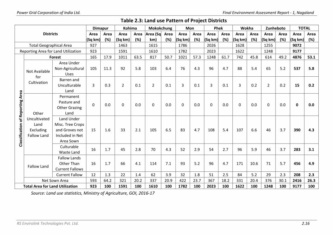
Power Grid Corporation of India Ltd. Final Environment Assessment Report - 1, Nagaland
RS Envirolink Technologies Pvt. Ltd. 2.16
Table 2.3: Land use Pattern of Project Districts
Districts
Dimapur Kohima Mokokchung Mon Phek Wokha Zunheboto TOTAL
Area
(Sq km)
Area
(%)
Area
(Sq km)
Area
(%)
Area (Sq
km)
Area
(%)
Area
(Sq km)
Area
(%)
Area
(Sq km)
Area
(%)
Area
(Sq km)
Area
(%)
Area
(Sq km)
Area
(%)
Area
(Sq km)
Area
(%)
Total Geographical Area 927 1463 1615 1786 2026 1628 1255 9072
Reporting Area for Land Utilization 923 1591 1610 1782 2023 1622 1248 9177
Cla
ssif
icat
ion
of
Re
po
rtin
g A
rea
Forest 165 17.9 1011 63.5 817 50.7 1021 57.3 1248 61.7 742 45.8 614 49.2 4876 53.1
Not Available
for
Cultivation
Area Under
Non-Agricultural
Uses
105 11.3 92 5.8 103 6.4 76 4.3 96 4.7 88 5.4 65 5.2 537 5.8
Barren and
Unculturable
Land
3 0.3 2 0.1 2 0.1 3 0.1 3 0.1 3 0.2 2 0.2 15 0.2
Other
Uncultivated
Land
Excluding
Fallow Land
Permanent
Pasture and
Other Grazing
Land
0 0.0 0 0.0 0 0.0 0 0.0 0 0.0 0 0.0 0 0.0 0 0.0
Land Under
Misc. Tree Crops
and Groves not
Included in Net
Area Sown
15 1.6 33 2.1 105 6.5 83 4.7 108 5.4 107 6.6 46 3.7 390 4.3
Culturable
Waste Land 16 1.7 45 2.8 70 4.3 52 2.9 54 2.7 96 5.9 46 3.7 283 3.1
Fallow Land
Fallow Lands
Other Than
Current Fallows
16 1.7 66 4.1 114 7.1 93 5.2 96 4.7 171 10.6 71 5.7 456 4.9
Current Fallow 12 1.3 22 1.4 62 3.9 32 1.8 51 2.5 84 5.2 29 2.3 208 2.3
Net Sown Area 593 64.2 321 20.2 337 20.9 422 23.7 367 18.2 331 20.4 376 30.1 2416 26.3
Total Area for Land Utilization 923 100 1591 100 1610 100 1782 100 2023 100 1622 100 1248 100 9177 100
Source: Land use statistics, Ministry of Agriculture, GOI, 2016-17

Power Grid Corporation of India Ltd. Final Environment Assessment Report - 1, Nagaland
RS Envirolink Technologies Pvt. Ltd. 2.17
2.2.1.5 Landslide Vulnerability
Landslide hazard stands as the second geological hazard following earthquake
(Li, et. al., 1999; the U.S. Geological Survey, 2000). The Food and Agriculture
Organization of the United Nations (FAO) states that steep terrain, vulnerable
soil, heavy rainfall and earthquake activities make large parts of Asia highly
susceptible to landslides. An area of about 0.49 million sq km out of the total
area of India is vulnerable to landslide and about 0.098 sq km of an area in
Northeast India is vulnerable to landslide. Nagaland comes under highly
affected landslide hazard class (Figure 2.2).
Figure 2.2: Landslide Map of India
Source: https://shodhganga.inflibnet.ac.in/bitstream/10603/220685/13/13_chapter%205.pdf
Landslide, a common phenomenon in hilly region is one of the most
important factors of soil erosion. Topsoil and vegetative covers on large scale
are considerably lost every year during the monsoon season. Landslides are
mainly found below settlement areas, terrace fields, rolling Jhum land and
road construction. The possible factors responsible for landslide occurrence
may be singular or a combination of several factors. Some of the factors
responsible for landslide in Nagaland are:

Power Grid Corporation of India Ltd. Final Environment Assessment Report - 1, Nagaland
RS Envirolink Technologies Pvt. Ltd. 2.18
Soil formations: Clayey and shales have low hydraulic conductivity and can be
difficult to drain. On the other hand, when the dip angle of the shale is along
the slope, the soils over the shale are more susceptible to landslide. Most of
the slides in the area are caused due to this reason. It is also observed that
during rainy season the shallow soils lying above shale bed are prone to
landslide.
Increase in the Runoff Volume: It affects the regimes of the natural downhill
drains and toe cutting has been observed in many cases. Such toe cutting
leads to slope failure near these natural drains. Slope failure occurring near
these drains adversely affects the stability of the slope in general and leads to
repeated slope failure in that area. Such toe failure also leads to blockage of
drains promoting infiltration of water into the ground causing saturation of
the soil, which adversely affects the stability. During the summer season,
more specifically from June to October, the rainfall is heavy and almost
continuous. So, permeable materials get saturated due to long continued
heavy rains that, instead of the pelting rain driving individual particles in the
form of ‘rill’ or ‘rain-wash’ down the slope, the whole of the surficial materials
becomes a mass of mud and debris.
Faulty Road Construction: Another important factor causing landslides, it has
aggravated the intensity of landslide. One of the main reasons for this is the
slope cutting process while constructing the road as it disturbed the slope
stability. Most of these slide areas remain weak with mud flow and sinking of
highways occur every monsoon season due to the composition of loose sand
and dark brown clays where water seepage are quite high.
Urbanization: Due to increasing urbanization and demand for land in the city
area, and lack of enforcement of development controls, people have started
construction even on the valley lines, completely blocking the drainage path
in some cases. These drains need to cross the road system in several stages
through culverts. Eroded soils and garbage carried down by water during
torrential rainy season block many a time cross drains and lead to overflowing
of water onto the road. Increasing urbanization has also increased the surface
runoff because extension in the pucca ground cover or black topping through
the construction of building, courtyards, roads, pavements, etc., reduces
infiltration of rainwater significantly and increases surface runoff, thereby
increasing the volume and discharge in the area and drain which in turn
remove the top soil rapidly and also cause landslide in the areas.
In the instant scheme, during construction limited quantity of excavated
material is generated from tower/pole foundations and sub-station

Power Grid Corporation of India Ltd. Final Environment Assessment Report - 1, Nagaland
RS Envirolink Technologies Pvt. Ltd. 2.19
foundation. However, adequate mitigation measures have been given in the
EMP and same are being undertaken to avoid any chances of landslide. In
addition, excavation is avoided in rainy days. So far there are no instances of
landslide due to any of the construction activity. Landslide due to operation
and maintenance is not at all expected.
2.2.1.6 Erosion Vulnerability
Unscientific land utilization incompatible with its carrying capacity leads to
land degradation which has both environmental and economic consequences.
The information on land degradation is needed for a variety of purposes like
planning reclamation programs, rational land use planning, for bringing
additional areas into cultivation, to improve productivity levels in degraded
lands etc. As per the land degradation mapping undertaken by Department of
Space, GoI along with partner institutions under National Natural Resources
Census (NRC), water and wind are the most important land degradation
process that occurs on the surface of the earth. Rainfall, soil, physical
properties, terrain slope, land cover and management practices play a
significant role in soil erosion. Some of the factors responsible for soil erosion
in Nagaland are:
Sheet Erosion: It is a common problem resulting from loss of topsoil. The soil
particles are removed from the whole soil surface on a uniform basis in the
form of thin layers. The severity of the problem is often difficult to visualize
with naked eyes in the field.
Rill Erosion: When sheet erosion is severe and the surface runoff goes in the
form of a concentric flow, tiny water channels are formed in the field called
rills. Rills are generally associated with the cultivated lands and are visible in
the ploughed soil after first heavy showers.
Gully Erosion: Gullies are formed as a result of localized surface run-off
affecting the unconsolidated material resulting in the formation of perceptible
channels causing undulating terrain. They are commonly found in sloping
lands, developed as a result of concentrated run-off over fairly long time.
They are mostly associated with stream courses, sloping grounds with good
rainfall regions and foothill regions.
Landslide/ Landslip Erosion: The region is quite prone to landslides/ landslips
that take a heavy toll on valuable lands, property and life besides aggravating
the problem of soil erosion. Factor responsible for landslide have already
been explained in earlier section.

Power Grid Corporation of India Ltd. Final Environment Assessment Report - 1, Nagaland
RS Envirolink Technologies Pvt. Ltd. 2.20
Faulty Road Construction: As explained in earlier section.
Unscientific Disposal of Debris Generated by Road Construction: Roads are
the only means of communication and form an important development
activity in the region. Road construction in the mountainous terrain requires a
lot of blasting and construction in a zigzag fashion. The debris thus produced
is not properly disposed at dumping sites and is just pushed onto the river
side slopes. This results in heavy erosion during the rainy season.
Urbanization: As explained in earlier section.
For the assessment of soil erosion vulnerable hazard area falling en route
proposed transmission line, all the transmission lines were superimposed over
erosion map of Nagaland (refer Figure 2.3). Except a small section of 132 kV
S/C (on D/C Tower) Wokha-Zunheboto-Mokokchung Line i.e. from Tower No.
36 to Tower No. 47 of Zunheboto – Mokokchung stretch which, either falls
under or in close proximity to areas vulnerable to erosion, all transmission
lines are nowhere near areas vulnerable to soil erosion. Since distribution
lines are along the existing roads and almost negligible excavation is required
therefore, vulnerability of such sites to distribution lines is not anticipated. In
the present project, chances of contribution to soil erosion or getting affected
by soil erosion, vulnerable area are negligible to very low. However, adequate
mitigation measures have been given in the EMP and same shall be followed
to avoid any chances of getting affected by soil erosion vulnerable areas. In
addition, any work shall be avoided in rainy days.
2.2.2 Biological Environment It is pertinent to mention that, in the present project, forest area/land
covered under Forest (Conservation) Act, 1980 has been completely avoided
with careful selection of route alignment. Therefore, diversion of forest land is
not involved in the project.
In order to analyze the impacts and plan mitigation measures, it is imperative
to study baseline information for transmission line and surrounding or
proximity area as well (study area), which includes forest areas under the
control of individual/community/village councils. The same has been
described in ensuing paragraphs.

Power Grid Corporation of India Ltd. Final Environment Assessment Report - 1, Nagaland
RS Envirolink Technologies Pvt. Ltd. 2.21
Figure 2.3: Areas Vulnerable to Erosion w.r.t. Sub-Projects
2.2.2.1 Floristics
Though Nagaland is a small State, it has been endowed with a wide variety of
forest types on account of its unique geographic location and wide range of
physiographic terrain. As per the Champion & Seth Classification of Forest
Types (1968), the forests in Nagaland belong to seven Type Groups, which are
further divided into 10 Forest Types and Plantation/Tree Outside Forest (TOF).
Percentage area under different forest types of Nagaland is given below in
Table 2.4.

Power Grid Corporation of India Ltd. Final Environment Assessment Report - 1, Nagaland
RS Envirolink Technologies Pvt. Ltd. 2.22
Table 2.4: Percentage Area under Different Forest Types of Nagaland S.
No. Forest Type
% of Forest Cover
1 1B/C1 Assam Valley Tropical Wet Evergreen Forest (Dipterocarpus)
0.61
2 1/2S1 Pioneer Euphorbiaceous Scrub 4.30 3 2B/2S2 Eastern Alluvial Secondary Semi-Evergreen Forest 17.55 4 2/2S1 Secondary Moist Bamboo Brakes 5.09 5 3C/C3b East Himalayan Moist Mixed Deciduous Forest 38.44 6 8B/C2 Khasi Sub-Tropical Wet Hill Forest 16.09 7 9/C2 Assam Sub-Tropical Pine Forest 5.84 8 9/C2/DS1 Assam Subtropical Pine Savannah 0.17 9 11B/C2 Naga Hill Wet Temperate Forest 11.32
10 12/DS1 Montane Bamboo Brakes 0.07 11 Plantation/Tree Outside Forest (TOF) 0.52
Total 100
Source: India State of Forest Report 2019, Nagaland
Forests in Nagaland are largely under the community and private forests. The
Forest Department owns only certain areas classified as Reserved Forests,
Protected Forests, Wildlife Sanctuaries, National parks, Nurseries & Botanical
Gardens, therefore the department has purchased land from private owners
for Biodiversity Conservation and taking up plantations. The total land
purchased by the department is approximately 192.47 sq km. The State has
started 'Joint Forest Management' program to elicit active participation of
villagers in creation, management and protection of plantations.
Intensification of Forest Management was carried out in the State by creating
adequate infrastructure and controlling the incidences of forest fire. Recorded Forest Area (RFA) in the State is 8,623 sq km of which 234 sq km is
Reserved Forest and 8,389 sq km is Unclassed Forests. In Nagaland, during the
period 1st January 2015 to 5th February 2019, no forest land was diverted for
non-forestry purposes under the Forest Conservation Act, 1980 (MoEF&CC,
2019). 2.2.2.2 Forest Cover
As per the India State of Forest Report (ISFR), 2019 by Forest Survey of India,
the forest cover in the State is 12,486.40 sq km which is 75.31 % of the State's
geographical area. In terms of forest canopy density classes, the State has
1,273.19 sq km under Very Dense Forest (VDF), 4,533.72 sq km under
Moderately Dense Forest (MDF) and 6,679.49 sq km under Open Forest (OF).
Forest cover map of Nagaland is given below in Figure 2.4. Total forest cover in the project districts is 8164.94 sq km, which is 76.31 % of
the project district’s geographical area. In terms of forest canopy density

Power Grid Corporation of India Ltd. Final Environment Assessment Report - 1, Nagaland
RS Envirolink Technologies Pvt. Ltd. 2.23
classes, the project districts have 546.84 sq km under VDF, 2938.91 sq km
under MDF and 4679.19 sq km under OF. The details of forest cover of sub-
project districts are given below in Table 2.5 and Figure 2.5.
Table 2.5: Forest Cover in Project Districts
S. No.
Name of District
Geographical Area (GA)
2019 Assessment % of GA
Very Dense Forest
Moderately Dense Forest
Open Forest
Total Area
1 Dimapur 927 24.00 161.71 406.38 592.09 63.87 2 Kohima 1463 131.70 377.68 673.28 1182.66 80.84 3 Mokokchung 1615 1.89 501.89 823.83 1327.61 82.20 4 Mon 1786 32.00 431.32 739.50 1202.82 67.35 5 Phek 2026 272.61 637.83 705.37 1615.81 79.75 6 Wokha 1628 1.00 465.13 839.68 1305.81 80.21 7 Zunheboto 1255 83.64 363.35 491.15 938.14 74.75 10700 546.84 2938.91 4679.19 8164.94 76.31
Source: India State of Forest Report 2019, Nagaland
Figure 2.4: Forest Cover Map of Nagaland (Source: ISFR, FSI, Dehradun)

Power Grid Corporation of India Ltd. Final Environment Assessment Report - 1, Nagaland
RS Envirolink Technologies Pvt. Ltd. 2.24
Figure 2.5: Forest Cover in Project Districts
2.2.2.3 Forest Cover inside and outside Recorded Forest Area (or Green
Wash)
The State has reported extent of recorded forest area (RFA) 8,623 sq km
which is 52.01% of its geographical area. The reserved and unclassed forests
are 2.71% and 97.29% of the recorded forest area in the State, respectively.
Due to non-availability of digitized boundary of recorded forest areas from the
State, the updated Green Wash from Survey of India (SoI) toposheets which is
10,633.44 sq km has been used as proxy to the RFA boundary and the analysis
of forest cover inside and outside this area is given below in Table 2.6.
Table 2.6: Forest Cover inside and outside Recorded Forest Area or (Green
Wash) in Nagaland
Forest Cover inside the Recorded
Forest Area (or Green Wash) Forest Cover outside the Recorded
Forest Area (or Green Wash) VDF MDF OF Total VDF MDF OF Total
Area (sq km)
1166 3279 4282 8727 107 1255 2397 3759
Area (%)
13.36 37.57 49.07 100 2.85 33.38 63.77 100
Source: India State of Forest Report 2019, Nagaland
2.2.2.4 Floristic Diversity
As per the rapid assessment of Biodiversity carried out by Forest Survey of
India (FSI) at the national level for natural forests during September 2018 to
May 2019 as part of the forest type mapping exercise in respect of Nagaland,
total number of species reported in the state are 306, out of which 56 are tree
species, 137 are shrub species and 113 are herb species. The Shannon-Wiener

Power Grid Corporation of India Ltd. Final Environment Assessment Report - 1, Nagaland
RS Envirolink Technologies Pvt. Ltd. 2.25
Index of Tree, Shrub and Herb species in different Type Groups of the state
are given below in Table 2.7.
Table 2.7: Shannon-Wiener Index of Tree, Shrub and Herb species in different
Type Groups of Nagaland
S. No. Forest Type Group
Shannon-Wiener Index Tree Shrub Herb
1 Group 1- Tropical Wet Evergreen Forests * 3.09 2.81 2 Group 2- Tropical Semi-Evergreen Forests 2.15 2.97 2.35 3 Group 3- Tropical Moist Deciduous Forests 2.94 3.48 3.61 4 Group 8- Subtropical Broadleaved Hill Forests 2.62 3.40 2.92 5 Group 9- Subtropical Pine Forests 1.31 1.55 2.19 6 Group 11- Montane Wet Temperate Forests 1.04 1.17 1.90 7 Group 12- Himalayan Moist Temperate Forests * 1.16 *
Source: India State of Forest Report 2019, Nagaland; * adequate number of sample plots were not available
2.3 STUDY AREA BASELINE DATA
2.3.1 Floristics Elements
The study area for the floristic surveys has already been defined in the
Chapter 1 which is defined as area in the proximity of the proposed
transmission lines on both left and right sides, corridors of transmission line
routes and substations. The description of the vegetation is based upon these
observations and data collected around each site collected through transects
as already mentioned above.
In general, the vegetation in and areas around sampling sites is comprised of
tropical wet evergreen and semi-evergreen floral elements. Therefore, field
surveys for the assessment and composition of vegetation were conducted to
assess the floral wealth in the proximity to the towers, sub-station and along
the routes of transmission line.
A series of transects were identified along the routes of transmission line
covering the corridors between the ROW of transmission line and substations.
Details of transmission line and locations (transects) selected for phyto-
sociological survey are as given in Table 2.8.
Table 2.8: Transmission Lines and Transects Locations for Vegetation Sampling
S. No.
Name of Transmission Line Stretch Covered Distance Covered
1 LILO of 132 kV Mariani - Mokokchung Line at Longnak – 0.64 km
Longnak S/s to Tower 4 Approx. 100 m
2 132 kV D/C New Kohima (Zadhima) to New Secretariat Complex (NU Campus) – 13.97 km
New Secretariat Complex to Tower 41
Approx. 1.5 km

Power Grid Corporation of India Ltd. Final Environment Assessment Report - 1, Nagaland
RS Envirolink Technologies Pvt. Ltd. 2.26
S. No.
Name of Transmission Line Stretch Covered Distance Covered
3 LILO of both Circuit of Kohima – Meluri (Kiphire) Line at Pfutsero – 2.7 km
Pfutsero 132/33 kV S/s to Tower No. 8
Approx. 250 m
4 220 kV S/C (on D/C Tower) New Kohima-Mokokchung via Wokha Line- 86.94 km
Tower 49-Tower 52 Tower 53- Tower 56 Tower 92- Tower 107 Tower 202- Tower 206 Tower 214- Tower 222
Approx. 800 m Approx. 600 m Approx. 5 km Approx. 1.2 km Approx. 2.1 km
5 LILO of 132 kV S/C Kohima-Wokha Line at 220 kV New Kohima sub-station - 9.54 km
Tower 2- Tower 8 Approx. 1.2 km
2.3.1.1 Taxonomic Diversity
Based upon the data collected during field surveys and data/information
collected from secondary sources (Jamir, 1992; Eshuo, 2012, 2013; Moaakum
and Chaturvedi, 2015; Leishangthem, 2018) inventory of 211 plant species
found in the area surveyed was prepared. Details of these 211 plant species
according to their families, genera and species are given in table below.
Group Angiosperms Gymnosperms Pteridophytes Bryophytes Total Family 62 3 8 9 82 Genera 143 3 13 10 169 Species 184 3 13 11 211
A brief description of number of plant species recorded in various taxonomic
groups is given in the following paragraphs.
a) Angiosperms
During the field surveys conducted in the study area 184 species of
angiosperms belonging 62 families were recorded (For detailed list see
Annexure I). These include trees, shrubs, herbs and climbers. Herbaceous
component comprises of 82 species, shrubs are 34 and trees are comprised of
69 species.
Most common families recorded from the study area are Orchidaceae,
Poaceae, Fabaceae, Araceae and Solanaceae, Lauraceae, Acanthaceae,
Asteraceae, Moraceae, and Polygonaceae.
b) Gymnosperms
Three species of gymnosperms recorded from the study area are:
S. No. Family Botanical name
1 Cupressaceae Platycladus orientalis (Syn. Thuja orientalis) 2 Gnetaceae Gnetum montanum 3 Pinaceae Pinus kesiya

Power Grid Corporation of India Ltd. Final Environment Assessment Report - 1, Nagaland
RS Envirolink Technologies Pvt. Ltd. 2.27
c) Pteridophytes
During field survey thirteen species of Pteridophytes belonging to 8 families
were recorded from the area.
S. No. Family Botanical name
1 Dennstaedtiaceae Pteridium aquilinum 2 Gleicheniaceae Dicranopteris linearis 3 Lindsaeaceae Sphenomeris chinensis 4 Lycopodiaceae Lycopodium clavatum 5 Lygodiaceae Lygodium flexuosum 6 Osmundaceae Osmunda regalis 7 Polypodiaceae Drymoglossum piloselloides 8 Polypodiaceae Lepidogramitis rostrata 9 Polypodiaceae Lepisorus sordidus
10 Polypodiaceae Polypodium amoena 11 Pteridaceae Adiantum caudatum 12 Pteridaceae Onychium siliculosum 13 Pteridaceae Pteris vittata
d) Bryophytes
Eleven species belonging to 9 families of Bryophytes were recorded from the
study area as follows.
S. No. Family Botanical Name
1 Jubulaceae Frullania wallachiana 2 Lejeuneaceae Lejeunea curviloba 3 Marchantiaceae Dumortiera hirsuta 4 Marchantiaceae Marchantia linearis 5 Marchantiaceae Marchantia papiliata 6 Metzgeriaceae Metzgeria lindenbergii 7 Pelliaceae Pellia endiviifolia 8 Plagiochilaceae Plagiochila subtropica 9 Ricciaceae Ricciocarpos natans
10 Targioniaceae Targionia hypophylla 11 Weisnerellaceae Wiesnerella denudata
2.3.1.2 Rare Endangered and Threatened (RET) Species
Conservation status of plant species found in the study area was assessed
using IUCN Red list of Threatened Species Version 2020.1 (accessed in
February 2020) as well as Red Data Book of Indian Plants by Botanical Survey
of India.
Majority of the 211 plant species found in the study area have not been
evaluated or assessed yet by IUCN (2020.1) and only 27 species have been
assessed (Table 2.9) and all of them fall under ‘Least Concern’ category of
IUCN Red List.

Power Grid Corporation of India Ltd. Final Environment Assessment Report - 1, Nagaland
RS Envirolink Technologies Pvt. Ltd. 2.28
None of the plant species falls under any threatened category of Red Data
Book of Indian Plants by BSI.
Table 2.9: RET Plant Species Reported from Study Area
Family Name of species Conservation Status
IUCN 2020.1
Anacardiaceae Mangifera sylvatica LC
Apiaceae Centella asiatica LC
Betulaceae Alnus nepalensis LC
Commelinaceae Commelina benghalensis LC
Cyperaceae Cyperus exaltatus LC
Cyperaceae Cyperus rotundus LC
Fabaceae Acacia pennata LC
Fabaceae Bauhinia purpurea LC
Fabaceae Bauhinia variegata LC
Fabaceae Erythrina variegata LC
Fabaceae Mimosa pudica LC
Fabaceae Parkia timoriana LC
Juglandaceae Engelhardtia spicata LC
Magnoliaceae Magnolia champaca LC
Meliaceae Chukrasia tabularis LC
Meliaceae Toona ciliata LC
Musaceae Musa acuminata LC
Pandanaceae Pandanus odorifer LC
Phyllanthaceaeceae Phyllanthus emblica LC
Poaceae Dendrocalamus giganteus LC
Poaceae Phragmites karka LC
Poaceae Poa annua LC
Poaceae Saccharum spontaneum LC
Simaroubaceae Ailanthus integrifolia LC
Solanaceae Physalis minima LC
Theaceae Schima wallichii LC
Urticaceae Urtica dioica LC
2.3.1.3 Invasive Species and Their Control
An invasive plant is a non-native plant that is able to persist and proliferate
outside of cultivation, resulting in ecological and/or economic harm. Once
established in these areas, invasive plants often continue to spread to
adjacent habitats. All invasive plant species are aggressive competitors with
the ability to significantly reduce diversity of native plant and also disturb &
alter wildlife habitat. As per ISFR, 2019, there are four invasive species in
Nagaland, Parthenium hysterophorus, Ageratum conyzoides, Mikania

Power Grid Corporation of India Ltd. Final Environment Assessment Report - 1, Nagaland
RS Envirolink Technologies Pvt. Ltd. 2.29
micrantha and Chromolaena odorata. Beside these four species Lantana
camara is another invasive species reported from all the over the state.
During the field survey Parthenium hysterophorus was recorded from Longnak
sub-station. Chromolaena odorata was recorded near tower 8 of Kohima –
Meluri (Kiphire) Line at Pfutsero and along the route of 220 kV S/C New
Kohima-Mokokchung line. Mikania micrantha was recorded from 132 kV S/C
Kohima-Wokha Line. Ageratum conyzoides was recorded at New Secretariat
Complex (NU Campus) and Mokokchung-Mariani Transmission Line route.
The presence of large number of invasive plant species is indicative of
degradation of vegetation in the study area i.e. transects studied along the
different transmission lines, their routes and substations. This has happened
mainly due to jhumming activities prevalent in the area.
As per literature review, paste of green leaves of Ageratum conyzoides is used
for cuts & sores and paste of roots is used as anthelmintic or anti- allergic.
Invasive plants spread by a variety of mechanisms, including birds, wind, and
water. Human activities are also a major factor in the spread of these plants,
from gardening and transport of nursery stock to erosion control and wildlife
plantings.
The newly disturbed ground is prime habitat for more invasive species to
colonize. A protective approach is required for eliminating or control the
spread and establishment of invasive plants species, for which there are two
key elements. First, project authorities would ensure to uproot all existing
alien/invasive species from the labour colony and other working areas.
Secondly, project workers will be discouraged to plant any alien and/or
invasive species in the camp and colony areas, which may spread in the forest
areas. Eliminating the invasive species by uprooting or pulling is laborious but
may be the best choice for on steep or rough terrain. Replanting the area
immediately with a desirable selection of native plants is necessary.
There must be an emphasis on early detection and eradication of these
invasive species populations in the area especially the new population. To
control and check the growth of invasive species, plantation of indigenous
species in the area occupied by invasive species is also necessary. The other
factor that helps in control of non-indigenous species is the increase of
knowledge and awareness among the workers and villagers.
In the present project, none of the project activity contribute in the growth of
any invasive species.

Power Grid Corporation of India Ltd. Final Environment Assessment Report - 1, Nagaland
RS Envirolink Technologies Pvt. Ltd. 2.30
2.3.1.4 Vegetation Profile of the Sampling Area
Site 1: LILO of 132 kV Mariani - Mokokchung Line at Longnak – 0.64 km
The vegetation, in general, in area around Longnak sub-station is comprised of
secondary vegetation with trees like Tectona grandis, Alangium chinense,
Ficus oligodon, Oroxylum indicum and bamboos.
The area along the RoW of Mokokchung-Mariani Transmission Line at
Longnak is mainly under agricultural fields, fallow and scrub land. Vegetation
in the area is mainly comprised of moderate sized trees like Alangium
chinense, Ficus oligodon, Oroxylum indicum, etc. associated with shrub species
like Acacia pennata, Aralia leschenaultia, Euphorbia pulcherrima, Sida
rhombifolia, Strobilanthes coloratus, Ricinus communis, Murraya paniculata,
Lantana camara, Jasminum amplexicaule, etc. Ground cover is mainly
represented by grass species like Yushania hirsuta (Syn. Arundinaria hirsuta),
Cyperus rotundus, Imperata cylindrica, Poa annua, Saccharum spontaneum,
Thysanolaena maxima, etc. The herbaceous layer is represented by Ageratum
conyzoides, Commelina bengalensis, Elatostema sessile and Lecanthes
peduncularis and Parthenium hysterophorus.
Agricultural Land along the route
Secondary forest of Bamboo near Sub Station

Power Grid Corporation of India Ltd. Final Environment Assessment Report - 1, Nagaland
RS Envirolink Technologies Pvt. Ltd. 2.31
Secondary forest Sub Station
Site 2: 132 kV D/C New Kohima (Zadhima) to New Secretariat Complex (NU
Campus) – 13.97 km
The site covers area along 132 kV D/C New Kohima (Zadhima) to New
Secretariat Complex (NSC) and lies between NSC S/s to Pole 41. The
vegetation at this site is characterized by secondary degraded form of tropical
wet evergreen and semi-evergreen forest. However, comparatively
undisturbed vegetation is found quite far away on upper slopes from the
route of transmission lines. The vegetation composition in this area is as
follows.
The main trees found in this area are Aglaia spectabilis, Altingia excelsa,
Albizia chinensis, Alnus nepalensis, Bauhinia purpurea, Bischofia javanica,
Duabanga grandiflora, Macaranga denticulata, Magnolia champaca, Phoebe
hainesiana, Pterospermum acerifolium, Pinus kesiya, Shorea assamica and
Terminalia myriocarpa.
The shrubs are comprised of species like Acrocarpus fraxinifolius,
Actinodaphne obovata, Brassaiopsis hainla, Garcinia lanceifolia, Hedychium
spicatum, Litsea salicifolia, Lantana camara, Mesua ferrea, Magnolia
hodgsonii, Sauropus androgynus, etc. Undershrubs are comprised of bamboo
thickets, banana, canes, palms, epiphytes and climbers. A shrubby parasitic
species (Scurrula gracilifolia) can be observed on the trunks of tall trees.
Common climbers are species of Argyreia, Cissus, Combretum, Derris, Entada,
Hodgsonia and Trichosanthes. Ground vegetation is patchy and composed of
terrestrial ferns, grasses and herbs such as Alpinia nigra, Ammomum
aromaticum, Ageratum conyzoides, Phrynium pubinerve and Piper
pedicellatum.
Near under construction NSC sub-station vegetation is comprised of tree
species like Artocarpus heterophyllus, Bischofia javanica, Duabanga
grandiflora, Alangium chinense and Bauhinia purpurea. Shrubs are comprised

Power Grid Corporation of India Ltd. Final Environment Assessment Report - 1, Nagaland
RS Envirolink Technologies Pvt. Ltd. 2.32
of Lantana camara and bamboo species (Bambusa spp. and Dendrocalamus
hamiltonii).
Secondary Forest of Bamboo near Sub Station
Floral survey along the route
Site 3: LILO of both Circuit of Kohima – Meluri (Kiphire) Line at Pfutsero – 2.7
km
The site covered Kohima-Meluri-Pfutsero Transmission Line area and lies
between tower 1 to tower 8 covering total distance of about 2.0 km. The area
along the transect from tower 1 to tower 7 is characterized by vegetation
comprised of tropical mixed evergreen and semi-evergreen floral elements.
However, as seen from the pictures of the site below there are intermittent
patches of slightly denser vegetation alternating with sparse vegetation. The
vegetation composition is as follows.
The vegetation of denser patches is comprised tall trees like Albizia procera,
Altingia excelsa, Artocarpus chama, Bischofia javanica, Canarium bengalense,
Duabanga grandiflora, Macaranga grandiflora, Phoebe hainesiana, Pinus
kesiya, Pterospermum acerifolium, Balakata baccata, Terminalia myriocarpa,
06.01.2020 08:15 06.01.2020 08:38
06.01.2020 13:34

Power Grid Corporation of India Ltd. Final Environment Assessment Report - 1, Nagaland
RS Envirolink Technologies Pvt. Ltd. 2.33
Alnus nepalensis, etc. In addition other tree and shrub species like Aglaia
spectabilis, Bauhinia purpurea, Cinnamomum bejolghota, Erythrina variegata,
Ficus glomerata, Oroxylum indicum, Parkia timoriana, Lantana camara and
Euphorbia pulcherrima are also found.
Near location of Tower 8, vegetation is characterized by scrub forest with
abandoned Jhum land and agricultural fields. A few trees of Areca catechu
(Betel nut) can be seen planted near habitation. Dense thickets of bamboos
(Bambusa spp. and Dendrocalamus hamiltonii) can be seen along the slopes in
jhummed area along with Lantana camara and some tall reed grasses like
species of Imperata, Saccharum, Themeda and Thysanolaena. Other plant
species in the ground vegetation includes many tall undershrubs, weeds and
herbs like species of Ageratum, Bidens, Chromolaena, Colocasia, Persicaria,
Pollia, Strobilanthes, etc. along the nala.
Kohima – Meluri (Kiphire) Line at Pfutsero T/L Location of Tower 8
Location of Tower 6 and Jhum Land along the corridor of Kohima – Meluri (Kiphire) Line at
Pfutsero T/L Location of Tower 2 & 6

Power Grid Corporation of India Ltd. Final Environment Assessment Report - 1, Nagaland
RS Envirolink Technologies Pvt. Ltd. 2.34
Secondary Forest on abandoned Jhum land on the rout
Site 4: 220 kV S/C (on D/C Tower) New Kohima-Mokokchung via Wokha
Line- 86.94 km
For New Kohima-Mokokchung via Wokha transmission line survey was
conducted in four different transects depend on the accessibility along the
rout of line. The area between tower 49 to 52 is comprised of dense mixed
vegetation along the corridors of transmission line route. While rest of the
surveyed area are characterised by degraded vegetation with steep slopes
and the areas which are abandoned after jhum dominant by bamboo and
small tree and shrub species.
In general, vegetation of the area is comprised of deciduous and evergreen
tree species like Aglaia spectabilis, Albizia chinensis, Albizia procera,
Artocarpus chama (Sam), Bischofia javanica, Bombax ceiba, Duabanga
grandiflora (Khokon), Erythrina variegata, Pterospermum acerifolium,
Sterculia villosa, Terminalia myriocarpa (Hollock), etc. Shrubs include
bamboos and grasses like Saccharum, Themeda and Thysanolaena. Small
trees are Arenga westerhoutii, Bauhinia purpurea, Brassaiopsis hainla, Ficus
glomerata, Magnolia hodgsonii, etc. Common shrub elements in the area are
Euphorbia pulcherrima, Lantana camara, Murraya paniculata, Bambusa tulda,
Calamus spp., Dendrocalamus hamiltonii, Dendrocalamus strictus, etc. The
ground flora comprises of species of grasses, undershrubs and herbs like
Alpinia, Arundinaria, Chromolaena, Globba, Hedychium, Persicaria, Pollia and
Thysanolaena. The common climbers here are Cayratia japonica, Combretum
decandrum, Derris scandens, Dioscorea bulbifera, Thunbergia coccinea and
Trichosanthes cordata. Among angiospermic epiphytes are species of
Codonanthe devosiana, Bulbophyllum affine, Dendrobium spp., etc. The
epiphytic ferns include Cheilanthes tenuifolia, Pyrrosia obovata, Vittaria spp.,
etc. and orchids belonging to the genera Bulbophyllum, Cymbidium,
Dendrobium, Vanda, etc.
07.01.2020 13:15 07.01.2020 13:42
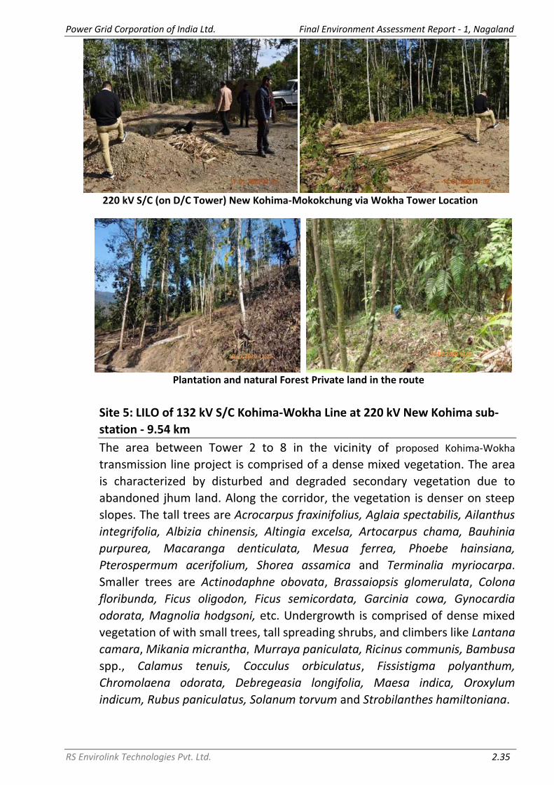
Power Grid Corporation of India Ltd. Final Environment Assessment Report - 1, Nagaland
RS Envirolink Technologies Pvt. Ltd. 2.35
220 kV S/C (on D/C Tower) New Kohima-Mokokchung via Wokha Tower Location
Plantation and natural Forest Private land in the route
Site 5: LILO of 132 kV S/C Kohima-Wokha Line at 220 kV New Kohima sub-
station - 9.54 km
The area between Tower 2 to 8 in the vicinity of proposed Kohima-Wokha
transmission line project is comprised of a dense mixed vegetation. The area
is characterized by disturbed and degraded secondary vegetation due to
abandoned jhum land. Along the corridor, the vegetation is denser on steep
slopes. The tall trees are Acrocarpus fraxinifolius, Aglaia spectabilis, Ailanthus
integrifolia, Albizia chinensis, Altingia excelsa, Artocarpus chama, Bauhinia
purpurea, Macaranga denticulata, Mesua ferrea, Phoebe hainsiana,
Pterospermum acerifolium, Shorea assamica and Terminalia myriocarpa.
Smaller trees are Actinodaphne obovata, Brassaiopsis glomerulata, Colona
floribunda, Ficus oligodon, Ficus semicordata, Garcinia cowa, Gynocardia
odorata, Magnolia hodgsoni, etc. Undergrowth is comprised of dense mixed
vegetation of with small trees, tall spreading shrubs, and climbers like Lantana
camara, Mikania micrantha, Murraya paniculata, Ricinus communis, Bambusa
spp., Calamus tenuis, Cocculus orbiculatus, Fissistigma polyanthum,
Chromolaena odorata, Debregeasia longifolia, Maesa indica, Oroxylum
indicum, Rubus paniculatus, Solanum torvum and Strobilanthes hamiltoniana.
10.01.2020 11:15 10.01.2020 11:44

Power Grid Corporation of India Ltd. Final Environment Assessment Report - 1, Nagaland
RS Envirolink Technologies Pvt. Ltd. 2.36
Transect Survey Along the corridor of
Forest Cover of 132 kV S/C Kohima-Wokha Line at 220 kV New Kohima sub-station
2.3.1.5 Economically Important Plant Species
The people of the area use wild plants in their daily life as food, medicine,
fibre, fodder, fuel wood, timber, vegetables, fruits and various minor forest
products. Agriculture is the major occupation in the project area and jhum
cultivation is prevalent. Jhum paddy, WRC paddy, maize, soybean, and
rapeseed/mustard are main crops cultivated. Among horticultural crops are
pineapple, banana, orange, passion fruit and litchi. Among vegetable chili,
colocasia, leafy vegetables, tapioca, pumpkin and ginger are common.
Wild Edible Plants
List of wild edible plants used by villagers in the study area was prepared from
Pradheed et al. (2016) and the same is given at Table 2.10.
Table 2.10: Wild Edible Plant Species Used by Tribes in Study Area
S. No. Family Name of species Parts used 1 Anacardiaceae Rhus chinensis Fruit 2 Apiaceae Centella asiatica Leafy vegetable 3 Apiaceae Eryngium foetidum Leafy vegetable 4 Araceae Colocasia esculenta Leafy vegetable 5 Arecaceae Calamus tenuis Fruit 6 Burseraceae Canarium strictum Fruit 7 Chenopodiaceae Chenopodium album Leafy vegetable
10.01.2020 14:15

Power Grid Corporation of India Ltd. Final Environment Assessment Report - 1, Nagaland
RS Envirolink Technologies Pvt. Ltd. 2.37
S. No. Family Name of species Parts used 8 Euphorbiaceae Phyllanthus emblica Fruit 9 Fabaceae Bauhinia variegata Flower bud
10 Lamiaceae Elsholtzia blanda Leafy vegetable 11 Moraceae Artocarpus chama Fruit 12 Moraceae Ficus auriculata Fruit 13 Rutaceae Zanthoxylum retusum Leafy vegetable 14 Solanaceae Solanum violaceum Unripe Fruit 15 Urticaceae Lecanthus peduncularis Leafy vegetable 16 Verbenaceae Clerodendrum glandulosum Leafy vegetable
Nagaland state is famous for Naga Mircha/Bhut Jolokia (Capsicum chinense)
known as world’s hottest chili, tree tomato (Solanum betaceum) consumed as
vegetable and naga pineapple (Ananas comosus).
Medicinal Plants
Plant species are used for various medicinal purposes for treating various
ailments by local tribal. The list of plant species used for various medicinal
purposes by locals and found in the study area was prepared from Imchen &
Jamir, 2011; Jamir & Tsurho, 2016 and the same is given at Table 2.11.
Table 2.11: Plant Species Used for Medicinal Purposes
S. No.
Family Name of species Parts used Disease/ailment
treated
1 Amaranthaceae Achyranthes aspera Entire plant Diuretic
2 Amaranthaceae Amaranthus spinosus Leaves, inflorescence
Weak womb in women
3 Amaranthaceae Celosia argentea Flower Gastric problems
4 Anacardiaceae Mangifera indica Leaves Jaundice, stomachache
5 Apiaceae Centella asiatica Entire plant Cough, malaria; improves hair growth
6 Apiaceae Coriandrum sativum Aerial part Blood purifier; indigestion
7 Apocynaceae Alstonia scholaris Seeds Constipation
8 Apocynaceae Catharanthus roseus Leaves, flower
Cancer, diabetes
9 Araceae Alocasia macrorrhiza Leaves, roots Inflammatory diseases; a vermifuge
10 Araceae Arisaema tortuosum Roots, seeds Gastritis, indigestion
11 Araceae Colocasia esculenta Leaves, stem, rhizome
Vermifuge, laxative
12 Araceae Lasia spinosa Aerial part Anthelmintic
13 Arecaceae Areca catechu Seeds A vermifuge
14 Asparagaceae Asparagus racemosus Root Diabetes, epilepsy
15 Asteraceae Ageratum conyzoides Leaves, roots Leaves in cuts & sores;

Power Grid Corporation of India Ltd. Final Environment Assessment Report - 1, Nagaland
RS Envirolink Technologies Pvt. Ltd. 2.38
S. No.
Family Name of species Parts used Disease/ailment
treated
roots anthelmintic, anti- allergic
16 Asteraceae Artemisia indica Stem Soothing sore throat; a source of vitamin
17 Asteraceae Artemisia nilagirica Entire plant Appetizer, source of vitamin; in dog bites
18 Asteraceae Mikania cordata Leaves, stem Insect bites, itches, wounds; stops bleeding
19 Asteraceae Spilanthes acmella Inflorescence Toothache; germicidal
20 Asteraceae Tagetes erecta Leaves Headache, boils, muscular pain
21 Begoniaceae Begonia palmata Leaves A febrifuge
22 Cannaceae Canna indica Leaves Treats toothache along with Solanum myriacanthum
23 Caryophyllaceae Drymaria cordata Leaves Snake and insect bites, sinus problem
24 Costaceae Cheilocostus speciosus Stem Jaundice, headache, fever; a germicide
25 Crassulaceae Bryophyllum pinnata Leaves Wounds, insect bites, gall bladder stone
26 Dioscoreaceae Dioscorea bulbifera Tubers Piles, dysentery
27 Equisetaceae Equisetum ramosissimum
Entire plant Rheumatic pain, hair
28 Euphorbiaceae Euphorbia royleana Latex Toothache, burns
29 Euphorbiaceae Jatropha curcas Branch stem Used for brushing during toothache
30 Euphorbiaceae Ricinus communis Leaves Rheumatic body parts, blood clotting, bone fracture
31 Fabaceae Albizia chinensis Bark Bark paste is wrapped around injured part that supports as bandage
32 Fabaceae Albizia lebbeck Leaves, seeds Improves womb weakness
33 Fabaceae Bauhinia glauca Roots Problems of womb in women
34 Fabaceae Crotalaria pallida Leaves, bark Jaundice
35 Fabaceae Mimosa pudica Leaves Wounds, insects’ bites, jaundice, urinary problem
36 Hypoxidaceae Curculigo orchioides Rhizome Gastric problem & venereal diseases
37 Lamiaceae Elsholtzia blanda Leaves Stomach-ache, nervous

Power Grid Corporation of India Ltd. Final Environment Assessment Report - 1, Nagaland
RS Envirolink Technologies Pvt. Ltd. 2.39
S. No.
Family Name of species Parts used Disease/ailment
treated
tension, constipation
38 Lamiaceae Ocimum basilicum Leaves Cough, skin diseases, insect stings
39 Malvaceae Gossypium arboreum Seeds Measles, allergies; refrigerant
40 Malvaceae Hibiscus rosa-sinensis Leaves Dysentery, gastric problems, indigestion
41 Meliaceae Azadirachta indica Leaves Heart problems
42 Moraceae Artocarpus heterophyllus
Seeds, bark Cancer, asthma
43 Moraceae Ficus altissima Fruits Appetizer
44 Moraceae Ficus carica Fruits Womb tumour
45 Musaceae Musa paradisiaca Latex Dysentery
46 Myrtaceae Psidium guajava Leaves Dysentery; germicidal
47 Oxalidaceae Oxalis corniculata Entire plant Jaundice, dysentery, diarrhoea
48 Phyllanthaceae Phyllanthus emblica Fruits Cough; source of vitamin improving eye sight
49 Piperaceae Piper betle Leaves As antiseptic in cuts and wounds; cough
50 Poaceae Bambusa tulda Shoot Piles
51 Pteridaceae Adiantum lunulatum Aerial part Fever, dysentery, malaria
52 Rosaceae Fragaria nilgerrensis Fruits Source of vitamin
53 Rutaceae Citrus limon Leaves, seeds Headache, dysentery
54 Solanaceae Brugmansia suaveolens Leaves Weak memory
55 Solanaceae Nicotiana tabacum Seeds Cough, fever
56 Solanaceae Solanum myriacanthum Seeds Toothache; germicidal
57 Zingiberaceae Curcuma aeruginosa Rhizome Tuberculosis, cancer
58 Zingiberaceae Curcuma angustifolia Rhizome Body ache, swelling body parts, cuts & wounds
59 Zingiberaceae Zingiber officinale Rhizome Rheumatic pain, womb tumour
Source: Imchen & Jamir, 2011; Jamir & Tsurho, 2016
Timber yielding Tree species
Some of the timber yielding trees found in the study area are Albizia procera, Chukrasia tabularis, Magnolia champaca, Actinodaphne obovata, Schima wallichii, Terminalia myriocarpa, Artocarpus heterophyllus and Mangifera sylvatica.

Power Grid Corporation of India Ltd. Final Environment Assessment Report - 1, Nagaland
RS Envirolink Technologies Pvt. Ltd. 2.40
2.3.2 Faunal Elements
While describing the faunal diversity in Nagaland, it would be imperative to
address the ethnic composition, and their rights and privileges on forests.
Forests in Nagaland are largely under the community and private forests. The
tribes of the region are closely associated with the forest resources not only
for their livelihood.
But on the other hands, hunting is considered as a serious activity among the
tribal community in Nagaland, therefore, many rituals are performed for the
successful hunting. Hunting and trapping of mammals and birds and slash and
burn practice (shifting cultivation) are common phenomena in the state,
which are one of the major threats to the biodiversity; therefore, scientists
and ecologists have been highlighting their consequences on biodiversity for
long back. Deforestation for shifting cultivation and hunting practices in the
state are resulting in degradation of wildlife habitat.
To study the wild mammalian fauna of the study area, transects and trails
were walked on same transects used for floral survey. During the field
surveys, not a single species encountered during the transect walk. As
informed by the local people, the wild mammals are found in upper reaches
having dense forests and have not human interference. Due to large number
of illegal hunting of these animals for the meat, medicine and other use like
home decoration etc. the number of mammal’s species was decreases
gradually in the area and they are seen very occasionally.
Therefore, the fauna of the state has been compiled with the help of
secondary sources. Data was compiled from published literature of National
Biodiversity Strategy and Action Plan (NBSAP), Zoological Survey of India (ZSI)
and Bhupathy et al. (2011). Nagaland harbours a variety of wildlife distributed
throughout the state. For management and preservation of wildlife in the
State, the Department of Forests, Environment & Ecology and Wildlife has a
full-fledged wildlife Wing under the Chief Wildlife Warden. 2.3.2.1 Mammals
As per the data compiled, 28 species of mammals belonging 17 families of 8
orders are reported from the project districts. As per the International Union
for Conservation of Nature (IUCN) Red List of Threatened Species, 2020-1, 5
species are in Endangered (EN) category, 5 species are in Vulnerable (VU)
category, 4 species are in Near Threatened (NT) category, 12 species are in
Least Concerned (LC) category and 2 species were Not Assessed (NA). List of

Power Grid Corporation of India Ltd. Final Environment Assessment Report - 1, Nagaland
RS Envirolink Technologies Pvt. Ltd. 2.41
important mammals found in the project districts along with their
conservation status is given in Table 2.12.
Table 2.12: List of Mammals
S. No.
Family Scientific Name Common Name Conservation Status (IUCN
2020.1) Order-Artiodactyla
1 Bovidae Bos frontalis Mithun NA 2 Bovidae Nemorhaedus goral Goral NT 3 Suidae Sus scrofa Wild Boar LC Order- Carnivora
4 Felidae Panthera tigris Tiger EN 5 Felidae Panthera pardus Leopard or Panther VU 6 Felidae Felis bengalensis Leopard Cat LC 7 Mustelidae Arctonyx collaris Hog-badger VU 8 Canidae Cuon alpinus Wild Dog EN 9 Ursidae Melursus urinus Sloth Bear VU
10 Mustelidae Lutra lutra Common Otter NT 11 Felidae Felis chaus Jungle Cat LC 12 Herpestidae Herpestes edwadsii Mongoose LC 13 Canidae Vulpes bengalensis Indian Fox LC
14 Mustelidae Martes foina intermedia, M. flavigula
Martins LC
15 Viverridae Paradoxums hermophroditus
Tody Cat LC
Order-Cetartiodactyla
16 Cervidae Muntiacus muntjak Barking Deer LC 17 Cervidae Cervus unicolor Sambar VU
Order- Lagomorpha
18 Leporidae Lepus nigricollis Common Hare LC Order- Pholidota
19 Manidae Monis crassicaudata Pangolin EN Order- Primates
20 Hylobatidae Hylobates hoolock Hoolock EN 21 Lorisidae Nycticebus coucang Slow Lorris VU 22 Cercopithecidae Macaca assamensis Assamese Macaque NT 23 Cercopithecidae Canis aureus Jackal NT
Order- Proboscidea
24 Elephantidae Elephas maximus Elephant EN Order- Rodentia
25 Sciuridae Petuarista petuarista Giant Flying Squirrel LC 26 Hystricidae Hystrix indica Porcupine LC 27 Sciuridae Ratufa indica Indian Giant Squirrel LC 28 Sciuridae Ratufa bicolor Black Giant Squirrel NA
Source: NBSAP & ZSI; Bhupathy et al. (2011)
2.3.2.2 Avifauna
As per the data compiled, 86 species of avifauna belonging 40 families of 15
orders are reported from the project districts. As per the IUCN Red List of

Power Grid Corporation of India Ltd. Final Environment Assessment Report - 1, Nagaland
RS Envirolink Technologies Pvt. Ltd. 2.42
Threatened species, 2020-1, 1 species is in Critically Endangered (CR)
category, 1 species is in VU category, 3 species are in NT category and 81
species are in LC category. List of important avifauna found in the project
districts along with their conservation status is given in Table 2.13.
Table 2.13: List of Avifauna
S. No.
Order/ Family Scientific Name Common Name Conservation Status (IUCN
2020.1) Accipitriformes
1 Accipitridae Gyps himalayensis Himalayan Griffon NT 2 Accipitridae Milvus migrans Black Kite LC Anseriformes
3 Anatidae Anas crecca Common Teal LC Apodiformes
4 Apodinae Aerodramus brevirostris Himalayan Swiftlet LC 5 Apodidae Apus affinis Little swift LC 6 Apodidae Apus nipalensis House Swift LC Bucerotiformes
7 Bucerotidae Buceros bicornis Great Hornbill VU 8 Bucerotidae Ocyceros birostris Indain Grey Hornbill LC 9 Upupidae Upupa epops Eurasian hoopoe LC Caprimulgiformes
10 Caprimulgidae Caprimulgus asiaticus Indian nightjar LC Charadriiformes
11 Charadriidae Vanellus indicus Red-wattled lapwing LC 12 Scolopacidae Gallinago gallinago Common snipe LC 13 Scolopacidae Tringa hypoleucos Common Sandpiper LC
Columbiformes
14 Columbidae Columba livia Rock Pigeon LC
15 Columbidae Ducula badia Mountain Imperial-Pigeon
LC
16 Columbidae Streptopelia chinensis Spotted Dove LC 17 Columbidae Streptopelia orientalis Oriental Turtle Dove LC
18 Columbidae Treron phoenicoptera Yellow-footed green pigeon
LC
Coraciiformes
19 Alcedinidae Alcedo atthis Common kingfisher LC 20 Coraciidae Coracias benghalensis Indian Roller LC 21 Meropidae Merops orientalis Green bee-eater LC
Cuculiformes
22 Phasianidae Arborophila torqueola Hill Partridge LC 23 Cuculidae Centropus bengalensis Lesser Coucal LC 24 Cuculidae Centropus sinensis Great Coucal LC 25 Cuculidae Eudynamys scolopaceus Asian Koel LC
Falconiformes 26 Falconidae Falco amurensis* Amur falcon LC
Galliformes
7 Ardeidae Ardea Cinerea Grey Heron LC 28 Ardeidae Bubulcus ibis Cattle Egret LC

Power Grid Corporation of India Ltd. Final Environment Assessment Report - 1, Nagaland
RS Envirolink Technologies Pvt. Ltd. 2.43
S. No.
Order/ Family Scientific Name Common Name Conservation Status (IUCN
2020.1) 29 Corvidae Corvus splendens House crow LC 30 Phasianidae Lophura leucomelanos Kalij Pheasant LC 31 Phasianidae Syrmaticus humiae Mrs Hume's Pheasant NT 32 Phasianidae Ophrysia superciliosa Himalayan Quail CR 33 Phasianidae Gallus gallus Red Jungle Fowl LC
34 Phasianidae Polyplectron bicalcaratum
Grey Peacock-pheasant
LC
35 Phasianidae Coturnix coturnix Common Quail LC 36 Odontophoridae Oreortyx pictus Mountain Quail LC
Passeriformes
37 Campephagidae Pericrocotus speciosus Scarlet Minivet LC 38 Corvidae Dendrocitta formosae Gray Treepie LC 39 Corvidae Dendrocitta vagabunda Rufous Treepie LC
40 Corvidae Urocissa erythroryncha Yellow-billed Blue Magpie
LC
41 Emberizidae Emberiza fucata Chestnut-eared Bunting
LC
42 Emberizidae Melophus lathami Crested Bunting LC 43 Leiothrichidae Heterophasia capistrata Rufous sibia LC 44 Leiothrichidae Turdoides caudatus Common Babbler LC
45 Monarchidae Streptopelia senegalensis
Paradise flycatcher bird
LC
46 Monarchidae Terpsiphone paradisi Indian Paradise-flycatcher
LC
47 Motacillidae Motacilla alba White wagtail LC
48 Muscicapidae Chaimarrornis leucocephalus
White-capped Water Redstart
LC
49 Muscicapidae Copsychus malabaricus White-rumped shama
LC
50 Muscicapidae Copsychus saularis Oriental Magpie Robin
LC
51 Muscicapidae Enicurus maculatus Spotted Forktail LC
52 Muscicapidae Myophonus caeruleus Blue Whistling Thrush
LC
53 Muscicapidae Rhyacornis fuliginosus Plumbeous Water Redstart
LC
54 Nectariniidae Aethopyga siparaja Crimson sunbird LC 55 Paridae Parus major Great Tit LC 56 Passeridae Dendronanthus indicus Forest Wagtail LC 57 Passeridae Motacilla cinerea Grey Wagtail LC 58 Passeridae Motacilla flava Yellow Wagtail LC
59 Passeridae Motacilla maderaspatensis
White-Browed Wagtail
LC
60 Passeridae Passer domesticus House Sparrow LC 61 Phasianidae Tragopan blythii Blyth's Tragopan LC 62 Phylloscopidae Phylloscopus fuscatus Dusky Warbler LC
63 Picidae Dendrocopos mahrattensis
Yellow Crowned Woodpecker
LC
64 Pnoepygidae Pnoepyga albiventer Scaly-breasted LC

Power Grid Corporation of India Ltd. Final Environment Assessment Report - 1, Nagaland
RS Envirolink Technologies Pvt. Ltd. 2.44
S. No.
Order/ Family Scientific Name Common Name Conservation Status (IUCN
2020.1) Cupwing
65 Pnoepygidae Pnoepyga pusilla Pygmy Cupwing LC
66 Pycnonotidae Hypsipetes leucocephalus
Black Bulbul LC
67 Pycnonotidae Hypsipetes madagascariensis
Madagascar bulbul LC
68 Pycnonotidae Pycnonotus cafer Red-Vented Bulbul LC 69 Pycnonotidae Pycnonotus jocosus Red-whiskered bulbul LC 70 Pycnonotidae Pycnonotus leucogenys Himalayan Bulbul LC 71 Pycnonotidae Pycnonotus melanicterus Black-crested Bulbul LC 72 Pycnonotidae Pycnonotus striatus Striated Bulbul LC
73 Stenostiridae Culicicapa ceylonensis Grey-headed Canary-Flycatcher
LC
74 Sturnidae Acridotheres tristis Common Myna LC 75 Sturnidae Gracula religiosa Hill Myna LC
76 Timaliidae Mixornis gularis Pin-striped Tit-Babbler
LC
77 Turdidae Turdus merula Common blackbird LC Pelecaniformes
78 Dicruridae Dicrurus adsimilis Fork Tail Drongo LC 79 Dicruridae Dicrurus macrocercus Black Drongo LC
80 Dicruridae Dicrurus remifer Lesser Racket-tailed Drongo
LC
Piciformes
81 Ardeidae Nycticorax nycticorax Black-crowned Night-heron
LC
82 Megalaimidae Psilopogon asiaticus Blue Throated Barbet LC Psittacifromes
83 Psittaciormes Psittacula krameri Rose-ringed parakeet LC
84 Psittacidae Psittacula roseata Blossom-headed Parakeet
NT
Strigiformes
85 Strigidae Otus lettia Collared Scops-Owl LC 86 Strigidae Otus spilocephalus Mountain Scops-Owl LC
Source: NBSAP & ZSI; Indian Birds Journal Vol. 6. No.2 (2010) Special Issue: Nagaland
*Falco amurensis (Amur falcons), the world’s longest travelling raptors was
also reported from the state. These amazing raptors travel one of the longest
migration routes of all birds, up to 22,000 km in a year. They arrive in north-
east India from Siberia en route to their destination at Somalia, Kenya and
South Africa.
In Nagaland state, Doyang Lake, Pangti village and nearby areas in Wokha
district is better known as a roosting site for the Amur falcons during their
annual migration from their breeding grounds to warmer South Africa. Thus,
Nagaland is also known as the “Falcon Capital of the World”.

Power Grid Corporation of India Ltd. Final Environment Assessment Report - 1, Nagaland
RS Envirolink Technologies Pvt. Ltd. 2.45
The birds are the least concern under the International Union for
Conservation of Nature (IUCN) Red List, and the species is categorized under
Schedule-IV of the Indian Wildlife Protection Act, 1972, and the Convention
on Migratory Species, to which India is a signatory (which means it is
mandatory to protect the birds).
Till 2013-14, hundreds of these migratory raptors were reportedly killed in
Nagaland when they arrived at Doyang reservoir in Wokha to roost every
winter. The efforts of the Nagaland forest department and villagers of Wokha
district ensured that not a single falcon was killed last year while on their way
to South Africa from Siberia.
During field survey it was observed that neither the location of any substation
nor any route of transmission line/ distribution line falls in migratory path of
Amur falcons.
2.3.2.3 Herpetofauna
As per the data compiled, 15 species of reptiles and 10 species of amphibians
are reported from the project districts. List of important herpetofauna found
in the project districts is given in Table 2.14.
Table 2.14: List of Herpetofauna S. No. Family Scientific Name Common Name Reptiles
Order-Squamata 1 Agamidae Calotis versicolor Common garden lizard 2 Agamidae Calotis emma Forest crested lizard 3 Agamidae Draco spilonotus Flying Lizard 4 Boidae Eryx johnii Indian sand boa 5 Colubridae Zamenis mucosus Common Rat Snake 6 Elapidae Ophiophagus hannah King Cobra 7 Elapidae Bungarus caeruleus Common krait 8 Elapidae Naja naja Indian cobra 9 Elapidae Bungarus niger Black krait
10 Gekkonidae Hemidactylus garnotii Gecko 11 Pythonidae Python reticulatus Reticulated Python 12 Scincidae Eutropis carinata Skink 13 Varanidae Varanus bengalensis Monitor Lizard 14 Viperidae Trimeresurus sp. Pit Viper
Order-Testudines 15 Testudinidae Testudo graeca Tortoise
Amphibians Order-Anura
16 Bufonidae Bufo melanostictus Asian Common Toad 17 Dicroglossidae Hoplobatrachus tigerinus Indian Bullfrog 18 Hylidae Hyla annectans Tree Frog 19 Megophryidae Megophrys glandulosa The Glandular Horned Toad 20 Ranidae Amolops gerbillus Stream frog

Power Grid Corporation of India Ltd. Final Environment Assessment Report - 1, Nagaland
RS Envirolink Technologies Pvt. Ltd. 2.46
21 Ranidae Pterorana khare Indian Flying Frog 22 Ranidae Rana humeralis Bhamo Frog 23 Ranidae Rana tytleri Yellow-striped Leaf Frog 24 Rhacophoridae Rhacophorus bipunctatus The twin-spotted Flying Frog 25 Rhacophoridae Rhacophorus maximus Giant Gliding Frog
Source: NBSAP & ZSI; Selvaraj (2013)
2.3.2.4 Butterflies
As per the data compiled, 62 species of butterflies belonging 5 families are
reported from the project districts. Of which, 34 species belong to
Nymphalidae family, followed by 11 species belonging to Lycaenidae family.
List of butterflies found in the project districts is given in Table 2.15.
Table 2.15: Butterflies in Nagaland S. No. Family Scientific name Common name
1 Hesperiidae Choaspes benjaminii Indian Awlking 2 Hesperiidae Gerosis bhagava Common Yellow Breasted Flat 3 Hesperiidae Hasora chromus Common Banded Awl 4 Hesperiidae Oriens goloides Common Dartlet 5 Hesperiidae Spialia galba Indian Skipper 6 Hesperiidae Tagiades japetus Common Snow Flat 7 Lycaenidae Abisara fyllla Dark Judy 8 Lycaenidae Acytolepis puspa Common Hedge Blue 9 Lycaenidae Castalius rosimon Common Pierrot
10 Lycaenidae Chilades lajus Lime Blue 11 Lycaenidae Heliophorus epicles Purple Sapphire 12 Lycaenidae Jamides bochus Dark Cerulean 13 Lycaenidae Jamides celeno Common Cerulean 14 Lycaenidae Leptotes plinius Zebra blue 15 Lycaenidae Neopithecops zalmora Quaker 16 Lycaenidae Talicada nyseus Red Pierrot 17 Lycaenidae Taraka hamada Forest Pierrot 18 Nymphalidae Aglais cashmiriensis Indian Tortoise Shell 19 Nymphalidae Apatura ambica Indian Purple Emperor 20 Nymphalidae Argyreus hyperbius Indian Fritillary 21 Nymphalidae Ariadne merione Common Castor 22 Nymphalidae Athyma perius Common Sergeant 23 Nymphalidae Cethosia cyane Leopard Lacewing 24 Nymphalidae Charaxes bernardus Tawny Rajah 25 Nymphalidae Childrena childreni Large Silverstripe 26 Nymphalidae Cirrochroa tyche Common Yeoman 27 Nymphalidae Cyrestis thyodamas Common Map 28 Nymphalidae Danaus chrysippus Plain Tiger 29 Nymphalidae Elymnias hypermnestra Common Palmfly 30 Nymphalidae Elymnias patna Blue-Striped Palmfly 31 Nymphalidae Euploea core Common Crow 32 Nymphalidae Euripus nyctelius Courtesan 33 Nymphalidae Fabriciana kamala Common Silverstripe 34 Nymphalidae Junonia lemonias Lemon Pansy 35 Nymphalidae Kallima inachus Orange Oakleaf 36 Nymphalidae Kaniska canace Blue Admiral 37 Nymphalidae Lethe bhairava Rusty Forester

Power Grid Corporation of India Ltd. Final Environment Assessment Report - 1, Nagaland
RS Envirolink Technologies Pvt. Ltd. 2.47
S. No. Family Scientific name Common name 38 Nymphalidae Lethe insane Common Forester 39 Nymphalidae Moduza procris Commander 40 Nymphalidae Mycalesis perseus Common Bushbrown 41 Nymphalidae Parantica aglea Glassy Tiger 42 Nymphalidae Phalanta phalantha Common Leopard 43 Nymphalidae Polyura athamas Common Nawab 44 Nymphalidae Sumalia daraxa Green Commodore 45 Nymphalidae Symbrenthia hippoclus Common Jester 46 Nymphalidae Symbrenthia hypselis Himalayan Jester 47 Nymphalidae Vagrans egista Vagrant 48 Nymphalidae Vanessa cardui Painted Lady 49 Nymphalidae Vanessa indica Indian Red Admiral 50 Nymphalidae Ypthima asterope Common Threering 51 Nymphalidae Ypthima baldus Common Fivering 52 Papilionidae Graphium cloanthus Glassy Bluebottle 53 Papilionidae Papilio alcmenor Red Breast 54 Papilionidae Papilio polyctor Common Peacock 55 Pieridae Catopsilia pomona Common Emigrant 56 Pieridae Colias fieldii Dark Clouded Yellow 57 Pieridae Delias pasithoe Red-Base Jezebel 58 Pieridae Eurema hecabe Common Grass Yellow 59 Pieridae Ixias pyrene Yellow Orange Tip 60 Pieridae Pareronia valeria Common Wanderer 61 Pieridae Pieris brassicae Large Cabbage White 62 Pieridae Pieris canidia Indian Cabbage White
Source: NBSAP & ZSI; Naro & Sondhi (2014), Bhupathy et al. (2011)
2.3.3 Protected Areas
The protected area network in Nagaland occupies 222.36 sq. km area, which
constitute about 1.34% of the state’s geographical area. The Protected Area
Network includes 1 National Park (NP) and 3 Wildlife Sanctuaries (WLS). Out
of these 4 protected areas, Puliebadze and Rangapahar WLS falls in project
districts. In the instant scheme, all such areas are completely avoided through
careful route selection. Details of the protected areas are presented below in
Table 2.16. Map showing location of all the protected areas in Nagaland is
given at Figure 2.6.
Table 2.16: Protected Area Network in Nagaland S.
No. Protected Areas
Area (sq km)
District Year of
Notification 1 Intaki National Park 202.02 Peren 1993 2 Fakim Wildlife Sanctuary 6.41 Kiphire 1980 3 Puliebadze Wildlife Sanctuary 9.23 Kohima 1980 4 Rangapahar Wildlife Sanctuary 4.70 Dimapur 1986
The nearest subproject from Puliebadze WLS is 132 kV DC New Kohima
(Zadhima) to Secretariat Complex Kohima (NU Campus) Transmission Line
(TL). The nearest component of the TL from the WLS is Nagaland University

Power Grid Corporation of India Ltd. Final Environment Assessment Report - 1, Nagaland
RS Envirolink Technologies Pvt. Ltd. 2.48
Campus Gantry, which is at a distance of approx. 7.66 km (refer Figure 2.7).
The nearest new 132/33 kV Sub-station from the WLS is at Secretariat
Complex Kohima, which is at a distance of approx. 7.66 km (refer Figure 2.7).
The nearest new 33/11 kV Sub-station from the WLS is at Lalmati (Zubza),
which is at a distance of approx. 6.48 km (refer Figure 2.7).
The nearest subproject from Rangapahar WLS is 33 kV Distribution Line (DL)
from Existing 132/66/33 kV Nagarjan Sub-station to New 33/11 kV
Padampukhri Sub-station. The nearest component of the DL from the WLS is
Pole no. 01, which is at a distance of approx. 2.66 km (refer Figure 2.8). The
nearest new 132/33 kV Sub-station from the WLS is at Secretariat Complex
Kohima, which is at a distance of approx. 39 km. The nearest new 33/11 kV
Sub-station from the WLS is at Padampukhri, which is at a distance of approx.
7 km.
2.3.4 Community Reserves
Community Reserves are the biodiversity abundant lands that are privately or
community-owned and are managed by the individual(s)/communities in
possession of the area. These reserves allow for extraction of natural
resources, the levels of which are governed by a multi-stakeholder Reserve
Management Committee. Community Reserve Management Committee is to
consist of five representatives nominated by the local Village Panchayat or the
Gram Sabha, and one representative each from the State Department of
Forest and Wildlife.
As per information available from State forest department and ENVIS Centre
on Wildlife & Protected Areas, the State Government of Nagaland had
Notified 57 Community Reserves (Table 2.17) under section 36C (1) of the
Wildlife Protection Act, 1972. In the instant scheme, all such areas have been
completely avoided through careful route selection.

Power Grid Corporation of India Ltd. Final Environment Assessment Report - 1, Nagaland
RS Envirolink Technologies Pvt. Ltd. 2.49
Figure 2.6: Protected Area Map of Nagaland

Power Grid Corporation of India Ltd. Final Environment Assessment Report - 1, Nagaland
RS Envirolink Technologies Pvt. Ltd. 2.50
Figure 2.7: Distance of Sub-Projects from Puliebadze Wildlife Sanctuary

Power Grid Corporation of India Ltd. Final Environment Assessment Report - 1, Nagaland
RS Envirolink Technologies Pvt. Ltd. 2.51
Figure 2.8: Distance of Sub-Projects from Rangapahar Wildlife Sanctuary

Power Grid Corporation of India Ltd. Final Environment Assessment Report - 1, Nagaland
RS Envirolink Technologies Pvt. Ltd. 2.52
Table 2.17: List of Community Reserves Notified Under section 36C (1) Wildlife
Protection Act 1972, in Nagaland
S.No. Name of Community Reserve Year of Establishment Area (km2)
1 Atoizu Community Reserve 2015 4.0
2 Benreu Community Reserve 2018 30.0
3 Bhumbak Community Reserve 2018 6.5
4 Bonchu Community Reserve 2009 9.05
5 Chemekong Community Reserve 2015 29.175
6 Chishilimi Community Reserve 2015 3.5
7 D. Khel, Kohima Village Community Reserve 2015 3.0
8 Dihoma Community Reserve 2015 2.0
9 Gariphema Community Reserve 2018 2.65
10 Hukphang Community Reserve 2018 3.0
11 Jotsoma Community Reserve 2018 5.0
12 Kanjang Community Reserve 2018 1.0
13 Kezoma Community Reserve 2018 2.65
14 Khekiye Community Reserve 2015 2.5
15 Khonoma Community Reserve 2018 2.65
16 Khrieyalienuomaiko Community Reserve 2018 2.65
17 Khrokhropfu – Lephori Community Reserve 2009 6.15
18 Khudei Community Reserve 2018 4.8
19 Khutur Community Reserve 2018 4.89
20 Khwuma Khel Jotsoma Community Reserve 2018 3.0
21 Kidema Community Reserve 2018 2.65
22 Kigwema Community Reserve 2015 2.65
23 Kikruma Community Reserve 2015 1.1
24 Kilo Old Community Reserve 2018 2.0
25 Kiyelho Community Reserve 2018 3.0
26 Litem Community Reserve 2018 1.6
27 Lizuto Community Reserve 2015 2.5
28 Longra Community Reserve 2018 2.275
29 Longtang Community Reserve 2018 5.8
30 Lotovi Community Reserve 2018 1.0
31 Luzaphuhu Community Reserve 2015 14.0
32 Mezoma Community Reserve 2015 2.85
33 Morakjo Community Reserve 2015 6.5
34 Mpai Namci Community Reserve 2018 20.0
35 Nerhema Perazatsa Community Reserve 2018 20.0
36 Nerhema Yaoke Community Reserve 2018 20.0
37 Nian Community Reserve 2018 2.0
38 Noksen Community Reserve 2018 1.0
39 Piphema “A” Community Reserve 2018 1.0
40 Piphema “B” Community Reserve 2018 2.8
41 Rangkang Community Reserve 2018 5.15
42 Sakhabama Community Reserve 2018 2.5

Power Grid Corporation of India Ltd. Final Environment Assessment Report - 1, Nagaland
RS Envirolink Technologies Pvt. Ltd. 2.53
S.No. Name of Community Reserve Year of Establishment Area (km2)
43 Sangdak Community Reserve 2018 5.09
44 Scaly-Mopungchuket Community Reserve 2009 15.0
45 Sitap Community Reserve 2018 1.5
46 Tamlu Community Reserve 2018 2.0
47 Thsuruhu Community Reserve 2015 2.7
48 Tsekhewelu Community Reserve 2015 8.0
49 Tsiepama Community Reserve 2015 3.325
50 Tuophema Village Community Reserve 2018 2.5.
51 Viswema Community Reserve 2018 2.65
52 Wakchin Chingla Community Reserve 2018 30.0
53 Yali Community Reserve 2018 14.0
54 Yangpi Community Reserve 2018 3.0007
55 Yaongyimchen Community Reserve 2018 8.0
56 Yongshei Community Reserve 2018 1.5
57 Yonyu Community Reserve 2018 4.8 Source: https://forest.nagaland.gov.in/introduction/ (accessed on 29April 2020)
http://www.wiienvis.nic.in/Database/Community%20Reserves_8228.aspx (accessed on 29April 2020)
2.3.5 Sacred Groves and Community Conserved Areas (CCA)
India is well known for nature’s worship, which plays an integral role in the
lives of many communities. Every aspect of religious and cultural practices is
deeply rooted with the forest that helps in nature conservation. These types
of forest bring the concept of “sacred groves”. Generally, sacred groves are a
tract of virgin forest, harbouring rich biodiversity and protected traditionally
by the local communities as a whole. The area of scared groves ranges from
few square meters to several hectares.
In Nagaland, various ethnic groups have preserved and protected several
forest patches and even individual trees or animals with the belief in nature’s
worship. As per available data, there are 33 sacred groves and community
conserved areas in the project districts (refer Table 2.18). In the instant
scheme, all such areas are completely avoided through careful route
selection.
The details of nearest distance i.e. less than 5 km of aerial distance between
any sacred groves or community conserved areas from any component of the
transmission line or distribution line are given below and shown if Figure 2.9
to Figure 2.11. From the map it is evident that though the distance is less than
1 km, route of lines is totally opposite to these sacred groves or community
conserved areas.

Power Grid Corporation of India Ltd. Final Environment Assessment Report - 1, Nagaland
RS Envirolink Technologies Pvt. Ltd. 2.54
• Chakasang Sacred Grove: Approx. 0.63 km from Tower No. 01 of LILO of
both circuit Kohima – Meluri (Kiphire) line at Pfutsero and Approx. 0.94 km
from Pole No. 12 of 33 kV line from New 132/33 kV Pfutsero S/S to New
33/11 kV Pfutsero S/S (refer Figure 2.9).
• Ngatipang Sacred Grove, Ungma Village: Approx. 0.24 km from Pole No.
66 of Existing 33 kV line from 66 kV Mokokchung to New 33/11 kV
Mokokchung Town Hospital Area Sub-station (refer Figure 2.10).
• Ngaza Sacred Grove, Ungma Village: Approx. 0.52 km from Pole No. 50 of
Existing 33 kV line from 66 kV Mokokchung to New 33/11 kV Mokokchung
Town Hospital Area Sub-station (refer Figure 2.10).
• Longkhum Community Conserved Area: Approx. 1 km from Tower No. 269
of 220 kV S/C (on D/C Tower) New Kohima - Mokokchung via Wokha TL
(refer Figure 2.11).
Table 2.18: List of Sacred Groves & Community Conserved Areas in Project Districts S.
No. Name of Sacred Groves/ Community
Conserved Areas Location
District: Mokokchung 1 Jangjalong, Waromung village 94°31'05.3” E 26°32'18.3” N 2 Yimchingkaba, Lakhuni village 94°25'15.10” E 26°32' 24.46” N 3 Ngatipang, Ungma village 94°30'11.73” E 26°17'46.73” N 4 Ngaza, Ungma village 94°30'05.784” E 26°17'42.72” N 5 Naginimora 94°49'30.36” E 26°48'33.78” N 6 Kaiviou CCA in Longwa 95°11'18.48” E 26°39'58.85” N 7 Kanglatu CCA in Changtongya 94°39'57.66” E 26°34'0.37” N 8 CCA in Longkhum 94°24'35.37” E 26°15'54.02” N 9 Meinkong CCA
10 CCA in Changki 94°23'20.23” E 26°25'25.76"N District: Wokha 11 Mount Tiyi 94°16’27.55” E 26°12’32.59” N 12 Potsow lan, between Mt. Totsu and Mt. Tiyi 94°07ˈ07.2” E 26°01ˈ31.9” N 13 Limyon (‘Red field’), Echuyonton 94° 09’1.6” E 26°02’06.9” N 14 Liko Emvu (‘Unclean land’), Yanphiso 94°19’1.4” E 26°04’05.4” N 15 Ali-Merum (‘Red Soil’), N. Longidang village 94°28’11.6” E 26°88’18.5” N 16 Sako-Selek, N. Longidang village 94°09’22.8” E 26°02’27.2” N 17 Doyang Reservoir 94°25’58” E 25°59’30” N 18 Baghty CCA 94°12'32.27” E 26°14'43.74” N District: Zunhebhoto 19 Yemetsu Lhove, Mishelili village 94°60’09” E 25°53’28.9” N 20 Sungato, Mishelimi village 94°15’42.1” E 25°53’8” N 21 Ghosu bird sanctuary, Ghukiye village 94°26’1.10” E 25°59’31.50” N 22 Tizu CCA 94°31'33.96” E 25°51'25.64” N 23 Chishilami CCA 94°22'21.11” E 25°53'38.61” N District: Mon 24 Oloanu, Zakho village 95°05’58” E 26°49’20.20” N 25 Naginimora 94°49'30.36” E 26°48'33.78” N

Power Grid Corporation of India Ltd. Final Environment Assessment Report - 1, Nagaland
RS Envirolink Technologies Pvt. Ltd. 2.55
S. No.
Name of Sacred Groves/ Community Conserved Areas Location
26 Kaiviou CCA in Longwa 95°11'18.48” E 26°39'58.85” N District: Phek 27 Chakasang area 94°17'56.42” E 25°34'42.91” N 28 CCA in Lazuphu 94°28'9.93” E 25°37'29.03” N 29 CCA in Chizami 94°22'57.52” E 25°36'3.47” N 30 CCA in Kikruma 94°14'13.42” E 25°35'39.76” N District: Kohima 31 Khonoma Sanctuary 94°00'04” E 25°37'35” N 32 Kigwema CCA 94°8'10.48” E 25°36'47.86” N 33 Sendenyu CCA 94°7'5.86” E 25°54'6.71” N
Source: https://shodhganga.inflibnet.ac.in/bitstream/10603/219638/13/13_chapter%204.pdf https://shodhganga.inflibnet.ac.in/bitstream/10603/125730/7/07%20chapter%203.pdf https://www.iccaconsortium.org/wp-content/uploads/2018/02/Documentation-of-Community-Conserved-
Areas-of-Nagaland-final.pdf
2.3.6 Important Bird & Biodiversity Areas (IBAs)
Bird Life International (www.birdlife.org) has identified 9 Important Bird &
Biodiversity Areas (IBAs) in Nagaland. These IBAs cover 606.25 sq km area,
which constitute about 3.66% of the state’s geographical area. Out of these 9
IBAs, only 5 IBAs falls in project districts. However, the proposed transmission
and distribution lines don’t pass through any IBAs. In the instant scheme, all
such areas are completely avoided through careful route selection. Details of
the IBAs are presented below in Table 2.19.
The IBAs which are nearest from subprojects i.e. within 10 km aerial distance
are Khonoma Nature Conservation & Tragopan Sanctuary and Puliebadze-
Dzukou-Zapfu IBA from 132 kV DC New Kohima (Zadhima) to Secretariat
Complex Kohima (NU Campus) TL and Pfutsero-Chizami IBA from LILO of both
Circuit of Kohima – Meluri (Kiphire) TL. The distance of IBAs with respect to
T&D network and sub-stations is given in Figure 2.12 and Figure 2.13.

Power Grid Corporation of India Ltd. Final Environment Assessment Report - 1, Nagaland
RS Envirolink Technologies Pvt. Ltd. 2.56
Figure 2.9: Distance of Chakasang Sacred Grove in Phek District w.r.t. to Sub-Projects

Power Grid Corporation of India Ltd. Final Environment Assessment Report - 1, Nagaland
RS Envirolink Technologies Pvt. Ltd. 2.57
Figure 2.10: Distance of Ngaza and Ngatipang Sacred Groves in Mokokchung District w.r.t. to Sub-Project

Power Grid Corporation of India Ltd. Final Environment Assessment Report - 1, Nagaland
RS Envirolink Technologies Pvt. Ltd. 2.58
Figure 2.11: Distance of Longkhum Community Conserved Area in Wokha District w.r.t. to Sub-Project

Power Grid Corporation of India Ltd. Final Environment Assessment Report - 1, Nagaland
RS Envirolink Technologies Pvt. Ltd. 2.59
Table 2.19: Important Bird & Biodiversity Areas in Nagaland
S. No.
IBA Code
IBA Name Criteria Important Species Area
(sq km) District
1 IN421 Fakim Wildlife Sanctuary and Saramati area
A1, A2 Tragopan blythii, Syrmaticus humiae, Aceros nipalensis
30.00 Kiphire
2 IN422 Intaki National Park A1, A3 Cairina scutulata, Aceros nipalensis
202.02 Peren
3 IN423 Khonoma Nature Conservation and Tragopan Sanctuary
A1, A2 Tragopan blythii, Apus acuticauda
25.00 Kohima
4 IN424 Mount Paona A1, A2 Tragopan blythii, Aceros nipalensis
30.00 Peren
5 IN425 Mount Zanibu A1, A2 Tragopan blythii, Syrmaticus humiae, Columba punicea, Aceros nipalensis
40.00 Phek
6 IN426 Mount Ziphu A1, A2 Tragopan blythii, Syrmaticus humiae, Gallinago nemoricola, Aceros nipalensis
50.00 Phek
7 IN427 Pfutsero-Chizami A1, A2 Tragopan blythii, Syrmaticus humiae
70.00 Phek
8 IN428 Puliebadze-Dzukou-Zapfu
A1, A2 Tragopan blythii, Apus acuticauda
109.23 Kohima
9 IN429 Satoi Range A1, A2 Tragopan blythii, Syrmaticus humiae, Aceros nipalensis
50.00 Kiphire
Source: http://www.birdlife.org/datazone/country/india. Checked on 2020-04-24
http://wiienvis.nic.in/Database/IBA_8463.aspx Checked on 2020-04-24
International Bird Areas are achieved through the application of quantitative ornithological criteria, grounded in up-to-date knowledge of the sizes and trends of bird populations. The Global criteria are as follows:
A1. Globally threatened species
Criterion: The site is known or thought regularly to hold significant numbers of
a globally threatened species, or other species of global conservation concern.
A2. Restricted-range species
Criterion: The site is known or thought to hold a significant component of a
group of species whose breeding distributions define an Endemic Bird Area
(EBA) or Secondary Area (SA).
A3. Biome-restricted species
Criterion: The site is known or thought to hold a significant component of the
group of species whose distributions are largely or wholly confined to one
biome.

Power Grid Corporation of India Ltd. Final Environment Assessment Report - 1, Nagaland
RS Envirolink Technologies Pvt. Ltd. 2.60
Figure 2.12: Distance of IBAs in Kohima District w.r.t. to Sub-Projects

Power Grid Corporation of India Ltd. Final Environment Assessment Report - 1, Nagaland
RS Envirolink Technologies Pvt. Ltd. 2.61
Figure 2.13: Distance of Sub-Projects in Phek District w.r.t. to Nearest IBA

Power Grid Corporation of India Ltd. Final Environment Assessment Report - 1, Nagaland
RS Envirolink Technologies Pvt. Ltd. 2.62
2.3.7 Wetland
As per the National Wetland Atlas of India, the estimated wetland area of the
state is 21544 ha area, which is 1.3% of total geographic area of the state. It
includes 267 small wetlands (<2.25 ha) also. Total number of wetlands present
in the State is 421, however, none of the wetlands is in the Ramsar list.
Doyang Lake, Chathe Reservoir, Shilloi Lake and parts of Tizu river are
important wetlands of the State. River/Stream is the single most dominant
wetland type of the state with 89.37% contribution. Among, other wetland
types, reservoir/barrage is the major one. Two reservoirs are mapped with
1547 ha area (7.18%). Only one natural lake/pond is mapped with 3 ha area.
Wetland map of the state is shown in Figure 2.14.
In the project districts, the estimated 15371 ha, which is 1.4% of total
geographic area of the project districts. It includes 232 small wetlands also.
District wise area of wetlands (type-wise) in project district is given in Table
2.17.
Figure 2.14: Wetland Area Map of Nagaland

Power Grid Corporation of India Ltd. Final Environment Assessment Report - 1, Nagaland
RS Envirolink Technologies Pvt. Ltd. 2.63
Table 2.20: District Wise Area of Wetlands (Type-Wise) in Project Districts
S. No.
Name of District
Geographical Area (sq km)
Wetland Type Area (ha) Sub
Total (ha)
Wetlands (<2.25 ha)
Total (ha)
Lake/ pond
Ox-bow lake/ Cut-off
meander
Waterlogged (Natural)
River/ Stream
Reservoir/ Barrage
Tank/ Pond
1 Dimapur 927 3 334 1494 11 41 1883 130 2013 2 Kohima 1463 3 1161 1164 9 1173 3 Mokokchung 1615 20 1713 1733 14 1747 4 Mon 1786 6 6 2792 2804 16 2820 5 Phek 2026 15 2394 2409 5 2414 6 Wokha 1628 32 1336 1536 2904 42 2946 7 Zunheboto 1255 2242 2242 16 2258 TOTAL 10700 3 9 407 13132 1547 41 15139 232 15371

Power Grid Corporation of India Ltd. Final Environment Assessment Report - 1, Nagaland
RS Envirolink Technologies Pvt. Ltd. 2.64
2.4 SOCIO-ECONOMIC ENVIRONMENT For sustainable development, it is important to understand social and
economic conditions of the community in the region, impacts of development
on the community, measures to mitigate negative impacts and enhance the
positive impacts. For new development initiatives, socio economic assessment
plays an important role to ensure community participation and their
acceptance of the development activity. It also helps in planning the activities
for local area development.
Nagaland has a high literacy rate of 80.1 per cent. Majority of the population
in the state speaks English, which is the official language of the state. The
state offers technical and medical education. Nevertheless, agriculture and
forestry contribute majority of Nagaland's Gross Domestic Product. Most of
state's population, about 68 per cent of the total, depends on rural
cultivation. The main crops of the state are rice, millet, maize, and pulses.
Cash crops, like sugarcane and potato, are also grown in some parts.
Plantation crops such as premium coffee, cardamom, and tea are grown in
hilly areas in small quantities, but a large growth potential. Most people
cultivate rice as it is the main staple diet of the people. About 80% of the
cropped area is dedicated to rice. Oil seeds is another, higher income crop
gaining ground in Nagaland. The farm productivity for all crops is low,
compared to other Indian states, suggesting significant opportunity for farmer
income increase. Currently the Jhum to Terraced cultivation ratio is 4:3;
where Jhum is local name for cut-and-burn shift farming. Jhum farming is
ancient, causes a lot of pollution and soil damage, yet accounts for majority of
farmed area. The state does not produce enough food and depends on trade
of food from others states of India. Forestry is also an important source of
income. Cottage industries such as weaving, woodwork, and pottery are also
an important source of revenue. Tourism has a lot of potential, but largely
limited due to insurgency and concern of violence over the last five decades.
Nagaland's gross state domestic product for 2004 is estimated at $1.4 billion
in current prices.
Dimapur is one of the main commercial hubs of Nagaland and is referred as
Gateway to Nagaland and Manipur. According to 2011 census, the district has
a population of 378,811 with a population density of 409 per sq. km. The sex
ratio of the district is 919 females for 1000 males. 59.1% of the total district
population is schedule tribe (Table 2.21). The district enjoys a good literacy
rate of around 84.8% (Table 2.22). Total working population of the district is
40%, of which 81% are main workers and 19% are marginal workers (Table
2.23). Of the main workers, 17% are cultivators, 4% are agricultural labour, 2%

Power Grid Corporation of India Ltd. Final Environment Assessment Report - 1, Nagaland
RS Envirolink Technologies Pvt. Ltd. 2.65
are household worker and the rest 77% are ‘other workers’ (Table 2.24). The
agriculture in the district is Terrace Rice Cultivation (TRC), rain fed and
traditional. By and large mono cropping is practiced in the district. The TRC
paddy alone covers an area of 32,900 ha where as Jhum covers about 7,800
ha. The second important crop in the district is Maize, which covers about
2500 ha. Important Pulses such as pea, lentil, black gram, beans, green gram,
pigeon pea and oilseeds such as groundnut, soybean, sesame, sunflower,
mustard, linseed, etc. are also grown in the district. Commercially viable crops
such as sugarcane, ginger, jute, turmeric, tea, potato etc. are also grown in
the district covering an area of 1,580 ha. Number of registered industrial units
belonging to MSE sectors is 575, while registered industrial units belonging to
Medium and large scale is 12.
The main indigenous inhabitants of Kohima District are the Angami Nagas and
the Rengma Nagas. But Kohima being the capital city, has a cosmopolitan
appearance. As of 2011 Census, Kohima district has a population of 267,988.
Out of this, male population numbers 138,966 while females’ numbers
129,022. Population density of the district is 213 per sq. km. The sex ratio of
the district is 928 females for 1000 males (Table 2.21). Kohima has an average
literacy rate of 85.2%, higher tha’n the national average of 74.04%: male
literacy is 88.7% and female literacy is 81.5% (Table 2.22). Total working
population of the district is 43%, of which 87% are main workers and 13% are
marginal workers (Table 2.23). Of the main workers, 38% are cultivators, 1%
are agricultural labour, 1% are household worker and the rest 60% are other
workers’ (Table 2.24). Though some minerals like sand, sandstone, boulder
stone etc. have been reported from the district, there are no Public Sector or
large-scale Industries are in the district. Total number of registered industrial
units in the district is 204, which are micro enterprises.
Mokokchung is the cultural center of the Ao people and is economically and
politically the most important urban center in Northern Nagaland. According
to the 2011 census, Mokokchung district has a population of 194,622 and a
sex ratio of 925 females for every 1000 males (Table 2.21). The district enjoys
a high literacy rate of 91.6% (Table 2.22). Total working population of the
district is 59%, of which 71% are main workers and 29% are marginal workers
(Table 2.23). Of the main workers, 52% are cultivators, 6% are agricultural
labour, 2% are household worker and the rest 40% are ‘other workers’ (Table
2.24). Agriculture is the main source of livelihood in the district with a total
cultivable area of 18433 Ha. Rice, Tuber, Maize, Soybean and Mustard the
main crops while Tea and Orange are the main cash crops. Total number of
registered Industrial units in the district is 95, while number of medium and
large industrial units is 6.

Power Grid Corporation of India Ltd. Final Environment Assessment Report - 1, Nagaland
RS Envirolink Technologies Pvt. Ltd. 2.66
Mon district’s main inhabitants belong to Konyak tribe of Nagas. According to
2011 census, the total population of the district is 250,260, with a population
density of 140. The sex ratio of the district is 899 females for 1000 males
(Table 2.21). The district has a literacy rate of 57.0%, which is lower than the
corresponding National figure (Table 2.22). Total working population of the
district is 51%, of which 81% are main workers and 19% are marginal workers
(Table 2.23). Of the main workers, 80% are cultivators, 4% are agricultural
labour, 1% are household worker and the rest 15% are ‘other workers’ (Table
2.24). The economic condition of the people lags behind when compared to
the living conditions of the people of other districts in Nagaland. As it is in the
remotest part of Nagaland, its economic development has not been
satisfactory. The recent trend in the District is tea-cultivation by the local
people. The gentle slopes of Mon provide ample scope for developing the
Mon District for the cultivation with all modern techniques. Only 121
registered small-scale industries are present in the district.
Phek district is the home to Chakhesangs and Pochurys tribes of Nagas. The
district has a population of 163,418 with a population density of 81 people/sq
km. Phek has a sex ratio of 951 females for every 1000 males (Table 2.21) and
a literacy rate of 78.1% (Table 2.22). Total working population of the district is
49%, of which 79% are main workers and 21% are marginal workers (Table
2.23). Of the main workers, 69% are cultivators, 2% are agricultural labour, 1%
are household worker and the rest 28% are ‘other workers’ (Table 2.24). TRC
is widely practiced. Besides agriculture, some allied activities like salt making,
weaving, bamboo and wood carving and fruit juice making also give
employment to a part of the population. Total number of registered industrial
units in the district is 22, while there is only one registered medium and large-
scale industrial unit.
Wokha district is primarily inhabited by Lothas tribe of Nagas. Total
population of the district is 166,343 with a population density of 103
people/sq km. The sex ratio of the district is 968 females per 1000 males
(Table 2.21). The district enjoys a high literacy rate of 87.7% (Table 2.22).
Total working population of the district is 47%, of which 81% are main
workers and 19% are marginal workers (Table 2.23). Of the main workers,
66% are cultivators, 4% are agricultural labour, 1% are household worker and
the rest 29% are ‘other workers’ (Table 2.24). Cultivation is one of the main
occupations of the people of this district. Jhum type of cultivation is widely
practiced. The other form of cultivation is terrace, which is done in a small
area. But as a result of Govt. efforts, the area under terrace is increasing.
Number of registered industrial units in the district is 250, all of which are

Power Grid Corporation of India Ltd. Final Environment Assessment Report - 1, Nagaland
RS Envirolink Technologies Pvt. Ltd. 2.67
small scale industries. Weaving, Poultry, Blacksmith, Carpentry and
handicrafts are the main cottage industries of the district.
Zunheboto district is the home of the Sumi Nagas. According to the 2011
census Zunheboto district has a population of 140,757 with a sex ratio of 976
females for every 1000 males (Table 2.21). The district has a healthy literacy
rate of 85.3% (Table 2.22). Total working population of the district is 57%, of
which 62% are main workers and 38% are marginal workers (Table 2.23). Of
the main workers, 62% are cultivators, 4% are agricultural labour, 1% are
household worker and the rest 33% are ‘other workers’ (Table 2.24).
Agriculture is the main stay of people’s livelihood. Both Jhum and Terrace
cultivation are practiced. Paddy, millet, maize, taro, French bean, potato,
pumpkin, cucumber, chilly and several varieties of gourd are mainly grown.
Total number of registered industrial units in the state is 95, all of which are
small scale industries.

Power Grid Corporation of India Ltd. Final Environment Assessment Report - 1, Nagaland
RS Envirolink Technologies Pvt. Ltd. 2.68
Table 2.21: Demographic Profile of Project Districts
Districts No. of Household Population
Sex Ratio Scheduled Caste Scheduled Tribe
Total Male Female Total Male Female Total Male Female % 1 2 3 4 5 6 = (5/4*1000) 7 8 9 10 11 12 13 = (10/3*100)
Dimapur 78,605 378,811 197,394 181,417 919 0 0 0 223989 110892 113097 59.1 Kohima 54,391 267,988 138,966 129,022 928 0 0 0 224738 110617 114121 83.9 Mokokchung 42,690 194,622 101,092 93,530 925 0 0 0 178431 90567 87864 91.7 Mon 41,978 250,260 131,753 118,507 899 0 0 0 238285 124343 113942 95.2 Phek 36,639 163,418 83,743 79,675 951 0 0 0 157146 79536 77610 96.2 Wokha 31,891 166,343 84,505 81,838 968 0 0 0 156621 78816 77805 94.2 Zunheboto 27,835 140,757 71,217 69,540 976 0 0 0 136561 68071 68490 97.0
TOTAL 314,029 1,562,199 808,670 753,529 932 0 0 0 1,315,771 662,842 652,929 84.2
Source: Census of India, 2011
Table 2.22: Literacy Profile of Project Districts
Districts Total population Population (above 6 years) Literate (Number) Literate Rate (%)
Total Male Female Total Male Female Total Male Female Total Male Female
1 2 3 4 5 6 7 8 9 10 11 =
(8/5*100)
12 =
(9/6*100)
13 =
(10/7*100)
Dimapur 378,811 197,394 181,417 327,913 171,505 156,408 278,037 150,142 127,895 84.8 87.5 81.8 Kohima 267,988 138,966 129,022 231,702 120,687 111,015 197,489 107,038 90,451 85.2 88.7 81.5 Mokokchung 194,622 101,092 93,530 174086 90558 83528 159494 83479 76015 91.6 92.2 91.0 Mon 250,260 131,753 118,507 209,918 110,654 99,264 119,626 67,432 52,194 57.0 60.9 52.6 Phek 163,418 83,743 79,675 135666 69238 66428 105893 57926 47967 78.1 83.7 72.2 Wokha 166,343 84,505 81,838 146205 74207 71998 128208 67385 60823 87.7 90.8 84.5 Zunheboto 140,757 71,217 69,540 120664 60901 59763 102881 53504 49377 85.3 87.9 82.6
TOTAL 1,562,199 808,670 753,529 1,346,154 697,750 648,404 1,091,628 586,906 504,722 81.1 84.1 77.8
Source: Census of India, 2011

Power Grid Corporation of India Ltd. Final Environment Assessment Report - 1, Nagaland
RS Envirolink Technologies Pvt. Ltd. 2.69
Table 2.23: Occupational Pattern of Project Districts
District Total
Population
Working Population Non-Worker
Total Worker Main Worker Marginal Worker
Total Male Female %* Total Male Female %** Total Male Female %*** Total Male Female %****
Dimapur 378,811 151350 99645 51705 40.0 122358 88055 34303 80.8 28992 11590 17402 19.2 227461 97749 129712 60.0
Kohima 267,988 114825 68140 46685 42.8 99408 60839 38569 86.6 15417 7301 8116 13.4 153163 70826 82337 57.2
Mokokchung 194622 100067 57084 42983 59.0 81046 48355 32691 71.1 19021 8729 10292 28.9 94555 44008 50547 41.0
Mon 250260 147654 79425 68229 51.4 104981 58695 46286 81.0 42673 20730 21943 19.0 102606 52328 50278 48.6
Phek 163418 80277 41556 38721 49.1 63645 34382 29263 79.3 16632 7174 9458 20.7 83141 42187 40954 50.9
Wokha 166343 78412 42096 36316 47.1 63512 35692 27820 81.0 14900 6404 8496 19.0 87931 42409 45522 52.9
Zunheboto 140757 79466 41178 38288 56.5 49382 27876 21506 62.1 30084 13302 16782 37.9 61291 30039 31252 43.5
TOTAL 1,562,199 752,051 429,124 322,927 48.1 584,332 353,894 230,438 77.7 167,719 75,230 92,489 22.3 810,148 379,546 430,602 51.9
Source: Census of India, 2011
Note: *Total Worker% = Total Worker/ Total Population x 100, **Main Worker% = Main Worker/ Total Worker x 100, *** Marginal Worker% = Marginal Worker/ Total Worker x 100,
**** Non-Worker% = Non-Worker/ Total Population x 100
Table 2.24: Main Worker Profile of Project Districts
Districts Main
Worker
Cultivators Agricultural Labour Household Industry Worker Other Workers
Total Male Female %* Total Male Female %** Total Male Female %*** Total Male Female %****
Dimapur 122358 20591 12140 8451 16.8 4506 2743 1763 3.7 2338 1190 1148 1.9 94923 71982 22941 77.6
Kohima 99408 38017 16525 21492 38.2 911 507 404 0.9 1131 622 509 1.1 59349 43185 16164 59.7
Mokokchung 81046 42236 21940 20296 52.1 4863 3013 1850 6.0 1939 777 1162 2.4 32008 22625 9383 39.5
Mon 104981 84402 43463 40939 80.4 3947 2111 1836 3.8 609 370 239 0.6 16023 12751 3272 15.3
Phek 63645 44069 19982 24087 69.2 1311 692 619 2.1 609 303 306 1.0 17656 13405 4251 27.7
Wokha 63512 41862 20233 21629 65.9 2375 1298 1077 3.7 874 409 465 1.4 18401 13752 4649 29.0
Zunheboto 49382 30738 14787 15951 62.2 1763 858 905 3.6 613 308 305 1.2 16268 11923 4345 32.9 584332 301915 149070 152845 51.7 19676 11222 8454 3.4 8113 3979 4134 1.4 254628 189623 65005 43.6
Source: Census of India, 2011
Note: *Total Cultivator% = Total Cultivator/ Main Worker x 100, **Total Agricultural Labour% = Total Agricultural Labour/ Main Worker x 100, ***Household Industry Worker% = Total
Household Industry Worker/ Main Worker x 100, **** Total Other Workers% = Total Other Workers/ Main Worker x 100

Power Grid Corporation of India Ltd. Final Environment Assessment Report - 1, Nagaland
RS Envirolink Technologies Pvt. Ltd. 3.1
3.1 INTRODUCTION Power transmission and distribution project activities by their inherent nature
and flexibility have negligible impacts on environmental and social attributes.
Indian laws relating to environmental and social issues have strengthened in
the last decade both due to local needs and international commitments. DPN,
IA and contractors are undertaking its activities within the purview of Indian
and State specific laws keeping in mind appropriate international obligations
and directives and guidelines with respect to environmental and social
considerations of World Bank’s Operational Policies.
3.2 CONSTITUTIONAL PROVISIONS Subsequent to the first United Nations Conference on Human Environment at
Stockholm in June, 1972, which emphasized the need to preserve and protect
the natural environment, the Constitution of India was amended through the
historical 42nd Amendment Act, 1976 by inserting Article 48-A and 51-A (g)
for protection and promotion of the environment under the Directive
Principles of State Policy and the Fundamental Duties respectively. The
amendment, inter alia provides:
"The State shall endeavor to protect and improve the environment and to
safeguard the forests and wildlife of the country". (New Article 48A)
"It shall be the duty of every citizen of India to protect and improve the
natural environment including forests, lakes, rivers and wildlife and to have
compassion for living creatures”. [New Article 51 A(g)]
Article 21 of the constitution provides, “no person shall be deprived of his life
or personal liberty except according to procedure established by law”.
Article 21 is the heart of the fundamental rights and has received expanded
meaning from time to time after the decision of the Supreme Court in 1978.
The Article 21 guarantees fundamental right to life – a life of dignity to be
lived in a proper environment, free of danger or disease or infection. Recently,
Supreme Court has broadly and liberally interpreted the Article 21,
transgressing into the area of protection of environment, and held that the
citizen’s right to live in an eco-friendly atmosphere is to be interpreted as the
basic right guaranteed under Article 21.
Chapter 3
POLICY, LEGAL AND REGULATORY FRAMEWORK

Power Grid Corporation of India Ltd. Final Environment Assessment Report - 1, Nagaland
RS Envirolink Technologies Pvt. Ltd. 3.2
Thus, the Indian Constitution now has a two folds provision:
(a) On the one hand, it gives directive to the State for the protection and
improvement of environment.
(b) On the other hand, the citizens owe a constitutional duty to protect and
improve the natural environment.
Article 371 A Provides special provision with respect to state of Nagaland
which states “no act of parliament in respect of religious and social practices
of the Naga, Naga customary laws and procedures, administration of civil and
criminal justices involving decisions according to Naga customary law and
ownership and transfer of land and its resources shall apply to the state of
Nagaland, unless Legislative Assembly of the state, by a resolution, so
decides”.
Constitutional provisions in regard to social safeguards are well enshrined in
the preamble such as JUSTICE, social, economic and political; LIBERTY of
thought, expression, belief, faith and worship; EQUALITY of status and of
opportunity; FRATERNITY assuring the dignity of the individual and the unity
and integrity of the Nation. Fundamental Rights and Directive Principles
guarantee the right to life and liberty. Health, safety and livelihood have been
interpreted as part of this larger right. Social safeguards provisions are dealt
in detail in different Article such as Article-14, 15 17, 23, 24, 25, 46, 330, 332
etc.
3.3 ENVIRONMENTAL PROVISIONS Environmental issues of T&D projects are manageable given the inherently
small ‘foot print’ of towers and flexibility in siting facilities within a relatively
large host area and are mostly localized to RoW. However, transmission line
project may have some adverse effects on natural resources. These impacts
can be minimized by careful route selection and siting of substations. The
applicable acts, rules, and relevant policies in the context of the project and
its status of compliance are presented in Table 3.1.
3.4 SOCIAL PROVISIONS The applicable acts, rules, and relevant policies in the context of the project
and its status of compliance are presented in Table 3.2.
Power Grid Corporation of India Ltd. Final Environment Assessment Report - 1, Nagaland
RS Envirolink Technologies Pvt. Ltd. 3.3
Table 3.1: Environmental Provisions S.
No. Acts, Notifications
and Policies Relevance Applicability to
the project Status of Compliance
1. Electricity Act, 2003 To consolidate the laws relating to generation, transmission, distribution, trading and use of electricity. Under the provisions of Section 68(1):- Prior approval of the Govt. of Nagaland (GoN) is a mandatory requirement to undertake any new transmission project 66kV upward and for distribution project of 33kV system in the State.
Applicable - Transmission line projects are constructed under the ambit of Electricity Act, 2003 following the provisions of Section 67 & 68 of act.
Complied with: MoP, GoI approved the NERPSIP comprehensive scheme for six North Eastern States including Nagaland under vide its Office Memorandum dated 1st December 2014.
2. Forest (Conservation) Act, 1980
To protect and conserve Forest Areas and Tree Cover. Any transmission/ distribution line traverses forest land, prior clearance is mandatorily required from Ministry of Environment, Forest & Climate Change (MoEFCC), GoI under the Forest (Conservation) Act, 1980. Government of Nagaland vide its Notification No. FOR-58/82 dated 03-07-1986 has extended the application of this Act to forest lands under the control of Forest Department. Natural forest under control of private individuals or community is not under the preview of the Act.
Not Applicable - No notified forest area is involved in any of the line routes or substations location.
Not Required
3. Environment (Protection) Act, 1986
To protect and improve the overall environment. It is umbrella legislation for the protection and improvement of environment.
Applicable – Though some limited compliance measures notified under this EPA, 1986 are to be adhered to relevant rules and regulations under the EPA, 1986 applicable to the operations of DPN.
Complied with: Though applicable as it is umbrella legislation, however, as such statutory permission/ license is not required.

Power Grid Corporation of India Ltd. Final Environment Assessment Report - 1, Nagaland
RS Envirolink Technologies Pvt. Ltd. 3.4
S. No.
Acts, Notifications and Policies
Relevance Applicability to the project
Status of Compliance
i)
Ozone Depleting Substances (Regulation and Control) Rules, 2000
Regulate and control manufacturing, import, export and use of Ozone Depleting Substances under Montreal Protocol adopted on 16th September 1987
Applicable - As per the notification, certain control and regulation has been imposed on manufacturing, import, export, and use of these compounds.
Complied with: Only CFC free equipments are being procured/ specified in tender document
ii) Batteries (Management and Handling) Rules, 2001
Provides certain restriction on disposal of used batteries and its handling and to file half yearly return in prescribed form to the concerned State Pollution Control Board.
Applicable during operation phase only – Used batteries to be disposed to dealers, manufacturer, registered recycler, reconditioners or at the designated collection centers only. A half-yearly return to be filed as per Form-8 to the Nagaland State Pollution Control Board
Batteries are used during operation phase. Hence, the issue of proper handling and disposal of batteries as per rules not an issue during construction stage.
iii) Hazardous Wastes (Management, Handling and Transboundary Movement) Rules, 2008
To ensure that the hazardous wastes are managed in a manner which shall protect the health and the environment against the adverse effects that may result from such waste. The used transformer oil has been declared as a hazardous waste vide this notification.
Applicable – Requires proper handling, storage and disposed only to authorized disposal facility (registered recyclers/ reprocessors). In case it is decided to outsource the process of recycle of used oil to registered recycler as per the provisions of notification then DPN shall submit the desired return in prescribed form to concerned State Pollution Control Board at the time of disposal of used oil.
Generally Used oil is generated after 10-15 years of operation of transformers and hence the issues of handling and disposals of hazardous transformer oil is not an issue at this stage.
iv) E-waste (Management and Handling) Rules, 2011
To ensure that e-waste is managed in a manner which shall protect health and the environment against the adverse effects that may result from hazardous substance contained in such wastes. It is the responsibility of the bulk consumer to ensure that e-waste generated is
Applicable – To dispose e-waste generated in environmentally sound manner by channelizing to authorized collection centres/ registered dismantler/ recyclers/ return to producers. DPN, being a bulk consumer of electrical and electronics equipment’s shall maintain record as per
E-waste disposal is not an issue during construction phase.

Power Grid Corporation of India Ltd. Final Environment Assessment Report - 1, Nagaland
RS Envirolink Technologies Pvt. Ltd. 3.5
S. No.
Acts, Notifications and Policies
Relevance Applicability to the project
Status of Compliance
channelized to authorized collection centre(s) or registered dismantler(s) or recycler(s) or is returned to the pick-up of take back services provided by the producer.
Form-2 for scrutiny by State Pollution Control Board.
4. The Biological Diversity Act, 2002
To provide for conservation of biological diversity, sustainable use of its components and fair and equitable sharing of the benefits arising out of the use of biological resources, knowledge and for matters connected therewith. All restrictions applicable to protected areas like National Park & Sanctuaries are also applicable to these reserves.
Not Applicable - The present project does not involve any biosphere reserves.
Not Required
5. The Nagaland Tree Felling Regulation, 2002
It deals with felling of trees from non-forest and registered plantation areas. Felling of trees for construction of transmission lines would be governed under this Act wherever it is applicable.
Applicable
6. The Scheduled Tribes & Other Traditional Forest Dwellers (Recognition of Forest Rights) Act, 2006
When transmission projects pass through forest land, NOC from DC has to be obtained before Stage-II approval in compliance to FRA Act as per MoEF&CC circular dated 5th February 2013
Not Applicable - No forest clearance is involved.
Not Required
7. Ancient Monuments & Archaeological Sites and Remains Act, 1958
To prevent damage to archaeological sites and its maintenance. It also places restriction on activities which can cause harm to the monument /property. The law is however applicable only in monuments identified by the Archaeological Survey of India.
Not Applicable - All such areas have been completely avoided.
Not Required

Power Grid Corporation of India Ltd. Final Environment Assessment Report - 1, Nagaland
RS Envirolink Technologies Pvt. Ltd. 3.6
Table 3.2: Social Provisions S.
No. Acts,
Notifications and Policies
Relevance Applicability to the project
Status of Compliance
1. The Right to Fair Compensation and Transparency in Land Acquisition, Rehabilitation and Resettlement Act, 2013
Act ensures appropriate identification of the affected families/ households, fair compensation and rehabilitation of titleholders and non-titleholders. The Act authorizes State Govt. (i.e. GoN) or its authorized Government agency to complete the whole process of acquisition of private land including Social Impact Assessment (SIA), Action Plan for R&R (i.e. Rehabilitation and Resettlement) & its implementation and the DPN responsibility is limited to identification and selection of suitable land based on technical requirement and ensuring budget allocation.
Not Applicable – Till the state legislative Assembly adopts a resolution in this regard, as per the provision of Article 371 A of the Constitution of India.
Not Required
2. Rights of Way (RoW) and Compensation
The Electricity Act, 2003 has a provision for notifying transmission company under section 164 (B) to avail benefits of eminent domain provided under the Indian Telegraph Act, 1885.
Applicable - DPN may seek for GoN authorization to exercise all the powers that the Telegraph authority possesses and can spot, construct and erect towers without acquiring the land. Moreover, all damages due to its activity shall be compensated at market rate. In case of agricultural or private land the provisions of section- 67 and or section-68 (5 & 6) of the Electricity Act, 2003 and section-10 of the Indian Telegraph Act, 1885 are followed for assessment and payment of compensation towards such damages.
Complied with: Implementing Agency has already been vested with powers of telegraph authority by GoI vide Gazette Notification dated Dec.24, 2003. However, compensation for all damages are being paid to the individual land owner as per the provision of Section-10 (d) of Indian Telegraph Act, 1885

Power Grid Corporation of India Ltd. Final Environment Assessment Report - 1, Nagaland
RS Envirolink Technologies Pvt. Ltd. 3.7
S. No.
Acts, Notifications and
Policies
Relevance Applicability to the project
Status of Compliance
3. The Right to Information Act, 2005
To provide for setting out the practical regime of right to information for citizens to secure access to information under the control of public authorities, in order to promote transparency and accountability in the working of every public authority, the constitution of a Central Information Commission and State Information Commissions and for matters connected therewith or incidental thereto.
Applicable - Designated authorities to be in place.
Complied with: Designated authorities are already in place in DPN.
4. Indian Treasure Trove Act, 1878 as amended in 1949
To provide for procedures to be followed in case of finding of any treasure, archaeological artifacts etc. during excavation.
Not Applicable - No such instances reported.
Not Required

Power Grid Corporation of India Ltd. Final Environment Assessment Report - 1, Nagaland
RS Envirolink Technologies Pvt. Ltd. 3.8
3.5 WORLD BANK OPERATIONAL POLICY When World Bank provide governments with financing to invest
in projects such as building a road, connecting people to electricity, or treating
waste water, World Bank we aim to ensure that the people and the
environment are protected from potential adverse impacts. World Bank do
this through policies that identify, avoid, and minimize harm to people and
the environment. These policies require the borrowing governments to
address certain environmental and social risks in order to receive World Bank
support for investment projects. The mandatory environment and social
requirements with respect to World Bank Operational Policies are presented
in Table 3.3.
3.6 STATUTORY PERMISSION/LICENSES/NOC OBTAINED The applicability of acts, notifications and policies have already been
described in above paragraphs and table. As per the applicability, necessary
permission/ licenses/ NOC so far obtained by IA or contractor are:
• Under the provisions of Section 68(1) of Electricity Act, 2003, prior
approval GoN is a mandatory requirement to undertake any new
transmission project 66kV upward and for distribution project of 33kV
system in the State. As a part of permission/ approval, GoI approved
the NERPSIP comprehensive scheme for six North Eastern States
including Nagaland under vide its Office Memorandum dated 1st
December 2014. In addition, Implementation/ Participation agreement
between DoP and PGCIL has been signed on 26th March, 2015.
• All the contractors are operating with valid labor license as per
provision under section – 12(1) of the Contract Labour (Regulation &
Abolition) Act, 1970 and also certified under Section- 7(3) of the
Building and Other Construction Workers (Regulation of Employment
and Condition of Service) Act, 1996 from Ministry of Labour &
Employment.
• All the contractors have obtained requisite insurance policy as per
provisions of Employee Compensation Act, 1923 for its employed
workforce.
• Since the tower locations are coming under various villages of 6
districts, No Objection Certificates (NoC) from concerned land owner/
Headman /Village Council are being obtained as per the progress of
work.

Power Grid Corporation of India Ltd. Final Environment Assessment Report - 1, Nagaland
RS Envirolink Technologies Pvt. Ltd. 3.9
Table 3.3: World Bank Operational Policy S.
No. Acts, Notifications
and Policies Relevance Applicability to
the project Status of Compliance
1. OP- 4.01: Environmental Assessment
To ensure the environmental and social and sustainability of investment projects. Support integration of environmental and social aspects of projects in the decision-making process.
Applicable - E & S aspects of the project have already been integrated into management procedures based on comprehensive environment assessment undertaken by IA.
Complied with: E & S aspects of the project have already been integrated into management procedures based on comprehensive environment assessment undertaken by IA during 2015.
2. OP- 4.04: Natural Habitats
To promote and supports natural habitat conservation and improved land use to integrate into national and regional development the conservation of natural habitats and the maintenance of ecological functions. Furthermore, to promote the rehabilitation of degraded natural habitats.
Not Applicable - The present project does not involve any natural habitats such as biodiversity area, protected area, sacred groves etc. However, NoC from village councils (Head man, Gram Burrah) and land owners are being obtained in this regard.
Not Required
3. OP-4.11: Physical Cultural Resources (PCR)
To preserve PCR and in avoiding their destruction or damage. PCR includes resources of archaeological, paleontological, historical, architectural, and religious (including graveyards and burial sites), aesthetic, or other cultural significance.
Not Applicable - The Present project does not encroach upon any such resources.
Not Required
4. OP-4.36: Forests
To harness the potential of forests to reduce poverty in a sustainable manner, integrate forests effectively into sustainable economic development, and protect the vital local and global environmental services and values of forests
Applicable – Though all line routes and substation locations successfully avoided encroachment into any Protected and Reserve forests. However, line routes pass through community and private forests. To minimise adverse impact on forests, management measure already provided in DPN’s ESPPF
Complied with: To minimise adverse impact on forests, management measure already provided in DPN’s ESPPF of June, 2015
5. WB EHS Guidelines for Electric Power Transmission and Distribution
The Environmental, Health, and Safety (EHS) Guidelines are technical reference documents with general and industry specific examples of Good International Industry Practice. The EHS
Applicable - EHS guidelines are being followed during project implementation.
Complied with: EHS guidelines are being followed during project implementation.

Power Grid Corporation of India Ltd. Final Environment Assessment Report - 1, Nagaland
RS Envirolink Technologies Pvt. Ltd. 3.10
S. No.
Acts, Notifications and Policies
Relevance Applicability to the project
Status of Compliance
Guidelines contain the performance levels and measures that are generally considered to be achievable in new facilities by existing technology at reasonable costs.
6. OP 4.12 – Involuntary Resettlement
Covers direct economic and social impacts both resulting from Bank-assisted investment projects and are caused by the involuntary taking of land. To avoid or minimize involuntary resettlement and, where this is not feasible, assist displaced persons in improving or at least restoring their livelihoods and standards of living in real terms relative to pre-displacement levels or to levels prevailing prior to the beginning of project implementation, whichever is higher.
Not Applicable - As no involuntary acquisition invoked for securing land for proposed substations. However, fresh land required for construction of 132/33 kV substation at Longnak, 132/33 kV substation at Pfutsero, 132/33 kV substation at Zunheboto and 33/11 kV substations at Padampukhri were secured through direct Purchase on Willing Buyer Willing Seller basis on negotiated rate
Not Required.
7. OP 4.10 – Indigenous Peoples
This policy contributes to the Bank’s mission of poverty reduction and sustainable development by ensuring that the development process fully respects the dignity, human rights, economies, and cultures of Indigenous Peoples. The objective is to design and implement projects in a way that fosters full respect for indigenous peoples so that they receive culturally compatible social and economic benefits, and do not suffer adverse effects during the development process. The project shall ascertain broad community support for the project based on social assessment and free prior and informed consultation with the affected Tribal community, if any.
Explicit consent from ADC and the Village Councils is required in the case of acquisition of lands which is not applicable in instant project. However, NoC of from village councils (Head man, Gram Burrah) and land owners obtained for community forest land/ADC area wherever applicable.
Complied with: NoC of from village councils (Head man, Gram Burrah) and land owners being obtained for community forest land/ADC area wherever applicable.

Power Grid Corporation of India Ltd. Final Environment Assessment Report - 1, Nagaland
RS Envirolink Technologies Pvt. Ltd. 4.1
4.1 INTRODUCTION Environmental impact of transmission and distribution (T&D) line projects are
not far reaching and are mostly localized to RoW. However, T&D project has
some effects on natural and socio-culture resources. These impacts can be
minimized by careful route selection. To minimize these possible impacts,
DPN & IA at the system planning stage itself try to avoid ecological sensitive
areas like forest. Wherever such infringements are substantial, different
alternative options are considered to select most viable route alignment. For
further optimization of route modern survey techniques/tools like GIS, GPS
aerial photography is also applied. Introduction of GIS and GPS in route
selection result in access to updated/latest information, through satellite
images and further optimization of route having minimal environmental
impact. Moreover, availability of various details, constraints like topographical
and geotechnical details, forest and environmental details etc. help in
planning the effective mitigate measures including engineering variations
depending upon the site situation/location. The route/site selection criteria
followed is detailed below in the ensuing paragraphs.
4.2 ENVIRONMENTAL CRITERIA FOR ROUTE SELECTION For selection of optimum route, the following points are taken into
consideration:
i. The route of the proposed lines does not involve any human
rehabilitation.
ii. Any monument of cultural or historical importance is not affected by the
route of the line.
iii. The proposed route does not create any threat to the survival of any
community with special reference to Tribal Community.
iv. The proposed route does not affect any public utility services like
playgrounds, schools, other establishments etc.
v. The line route does not pass through any sanctuaries, National Park etc.
vi. The line route does not infringe with area of natural resources.
In order to achieve this, DPN undertook route selection for individual
transmission & distribution lines in close consultation with representatives of
concerned Forest Department and the Department of Revenue. Although
under National law, DPN has the right of eminent domain, yet alternative
alignments are considered keeping in mind the above-mentioned factors
Chapter 4
MAJOR FEATURES OF FINAL ROUTE & ENVIRONMENT IMPACT

Power Grid Corporation of India Ltd. Final Environment Assessment Report - 1, Nagaland
RS Envirolink Technologies Pvt. Ltd. 4.2
during site selection, with minor alterations often added to avoid
environmentally sensitive areas and settlements at execution stage.
• As a rule, alignments are generally cited away from major towns,
whenever possible, to account for future urban expansion (refer Figure
4.1 to Figure 4.13 and Map 1 to Map 6 for final route of all T&D
network).
• Similarly, forests are avoided to the extent possible, and when it is not
possible, a route is selected in consultation with the local Divisional
Forest Officer, that causes minimum damage to existing forest
resources.
• Alignments are selected to avoid wetlands and unstable areas for both
financial and environmental reasons.
In addition, care is also taken to avoid National parks, Sanctuaries, Eco-
sensitive zones, Tiger reserves, Biosphere reserves, Elephant corridors and IBA
sites etc. Keeping above in mind the routes of proposed lines under the
project have been so aligned that it takes care of above factors. As such,
different alternatives for transmission lines were studied with the help of
Govt. published data like Forest atlas, Survey of India etc. and Google Maps to
arrive at the most optimum route, which can be taken up for detailed survey
and assessment of environmental & social impacts for their proper
management.
Similarly, the TOR for detailed survey using modern tool like GIS/GPS also
contained parameters to avoid/reduce environmental impact while deciding
the final route alignment. The major objectives for detailed survey that are
part of contract are summarized below:
(i) The alignment of transmission line shall be most economical from the
point of view of construction and maintenance.
(ii) Routing of transmission line through protected and reserved forest
area should be avoided. In case it is not possible to avoid the forest or
areas having large trees completely then keeping in view of the
overall economy, the route should be aligned in such a way that
cutting of trees is minimum.
(iii) The route should have minimum crossing of major rivers, railway lines,
and national/state highways, overhead EHP power lines and
communication lines.
(iv) The number of angle point shall be kept to a minimum.

Power Grid Corporation of India Ltd. Final Environment Assessment Report - 1, Nagaland
RS Envirolink Technologies Pvt. Ltd. 4.3
(v) The distance between the terminal points specified shall be kept
shortest possible, consistent with the terrain that is encountered.
(vi) Marshy and low line areas, river beds and earth slip zones shall be
avoided to minimum risk to the foundations.
(vii) It would be preferable to utilize level ground for the alignment.
(viii) Crossing of power line shall be minimal. Alignment will be kept at a
minimum distance of 300 meters from power lines to avoid induction
problems on the lower voltage lines.
(ix) Crossings of communication lines shall be minimized and it shall be
preferably at right angle, proximity and paralyses with telecom lines
shall be eliminated to avoid danger of induction to them.
(x) Area subjected to flooding searches streams shall be avoided.
(xi) Restricted areas such as civil and military airfield shall be avoided.
Care shall also be taken to avoid the aircraft landing approaches.
(xii) All alignment should be easily accessible both in dry and rainy seasons
to enable maintenance throughout the year.
(xiii) Certain areas such as query sites, tea, tobacco and saffron fields and
rich plantation, gardens and nurseries that will present the owner
problems in of right of way and leave clearance during construction
and maintenance should be avoided.
(xiv) Angle point should be selected such that shifting of the point within
100 m radius is possible at the time of construction of the line.
(xv) The line routing should avoid large habitation densely populated
areas to the extent possible.
(xvi) The area requires special foundations and those prone to flooding
should be avoided.
(xvii) For examination of the alternatives and identification of the most
appropriate route, besides making use of information/data/details
available/extracted through survey of India topographical maps and
computer aided processing of NRSA satellite imagery, the contractor
shall also carry out reconnaissance/preliminary survey as may be
required for the verification and collection of additional
information/data/details.
(xviii) The contractor shall submit his preliminary observation and suggestion
along with various information/data/details collected and also
processed satellite imagery data, topographical map data marked with
alternative routes etc. The final evaluation of the alternative routes

Power Grid Corporation of India Ltd. Final Environment Assessment Report - 1, Nagaland
RS Envirolink Technologies Pvt. Ltd. 4.4
shall be conducted by the contractor in consultation with owners’
representatives and optimal route alignment shall be proposed by the
contractor. Digital terrain modeling using contour data from
topographical maps as well as processed satellite data shall be done by
the contractor for the selected route. A flythrough perspective using
suitable software(s) shall be developed or further refinement of the
selected route. If required site visit and field verification shall be
conducted by the contractor jointly with the owners’ representatives
for the proposed route alignment.
(xix) Final digitized route alignment drawing with the latest topographical
and other details/features including all river railway lines, canals,
roads etc. up to 8 Kms on both side of selected route alignment shall
be submitted by the contractors for owner’s approval along with
report containing other information / details as mentioned above.
In the instant project also, criteria for route selection as mentioned above, has
been duly adhered to and the proposed 220 kV S/C (On D/C Tower) New
Kohima-Mokokchung via Wokha Transmission Line and 132 kV S/C (On D/C
Tower) Wokha-Zunheboto-Mokokchung (State) Transmission Line routes have
been selected from analysis of three (03) alternatives routes as described in
the IEAR. Subsequently, the proposed routes were considered for detail
survey by Contractor Agency (after awarding of contract). During detailed
survey minor alterations as well as geometrical corrections of the route have
been carried out which seems inevitable due to actual ground conditions with
prime objective of avoiding dense forest/private plantation areas,
settlements, Common Property Resource (CPR), and also considering the
technical feasibility of the route from operation and maintenance point of
view in consultation with the local village councils prevalent in the project
area. Therefore, following minor change in scope of work has been observed
with respect to IEAR scope which resulted due to the best effort of IA/DPN in
effectively integrating safeguard and engineering measures in successful
minimization of impact on forest and environment.
The proposed distribution lines connect 2 substations in close vicinity and are
having line length of less than 10 km (except one distribution line), thus,
having negligible environment and social impacts including no involvement of
any forest area. Hence, no alternative has been studied for the distribution
lines proposed under instant scheme.

Power Grid Corporation of India Ltd. Final Environment Assessment Report - 1, Nagaland
RS Envirolink Technologies Pvt. Ltd. 4.5
For changes in scope of work with respect to IEAR scope i.e. changes in the
route alignment based upon alternatives studies and detailed survey for
transmission and distribution line is given is Table 4.1.
For sub-station, site selection analysis of 2-3 alternatives sites is usually
carried out based on environment and social aspects and technical
requirement. Such analysis considers various site-specific parameters that
include availability of infrastructure facilities such as access roads, water,
distance from railheads, type of land (Government/ revenue/private land);
social impacts such as number of families getting affected; CPR including
feasibility of acquisition. The finalization of substation land is done based on
above analysis and site visit/verification. The social aspects are provided due
weightage after technical requirement in decision making for
selection/finalization of land for substation.
It may be noted that in the instant case land for all the proposed substations
are either in possession of DPN or identified for purchase on willing seller –
willing buyer basis and therefore, the said exercise is not so relevant for
proposed project as the consent of owner is major criteria in addition to
technical feasibility. However, as per the provisions of ESPPF, all land
donations and direct purchases will be subject to a review/ approval by a
broad-based committee comprising representatives of different sections
including those from the IA and GoN.
The finalized location of transmission and distribution substations is given
below in Table 4.2.
Table 4.1: Change in Scope of Work w.r.t. IEAR
S. No.
Scope as per IEAR Current Status with justification
Remarks Line Substation
Transmission Component 1 LILO of 132 kV
Mariani - Mokokchung Line at Longnak – 2.0 km
Establishment of 132/33 kV Sub-station at Longnak (New)
Final route is 0.804 km and line length is reduced by 1.2 km due to change in tapping point from existing TL.
Meticulous realignment during ground truthing survey has reduced line length further.
2 132 kV D/C New Kohima (Zadhima) to New Secretariat Complex (NU Campus) – 6.55 km
Establishment of 132/33 kV Sub-station at Secretariat Complex Kohima (New)
Final line route is 13.97 km and there is an increase of around 7.4 km. so that environment & social sensitive areas are avoided/ minimized. The location of sub-station was also changed from Thizama village to
• Complete avoidance of habitation areas.
• Avoidance of Reserved Forest areas.
• CPR are not impacted. • It does not pass
through any protected area and monuments of archaeological

Power Grid Corporation of India Ltd. Final Environment Assessment Report - 1, Nagaland
RS Envirolink Technologies Pvt. Ltd. 4.6
S. No.
Scope as per IEAR Current Status with justification
Remarks Line Substation
Tseisema village due to space constraints.
importance. • Tree cutting can also
be minimized in valley portions along the route.
3 LILO of both Circuit of Kohima – Meluri (Kiphire) Line at Pfutsero – 3.0 km
Establishment of 132/33 kV Sub-station at Pfutsero (New)
Final route is 2.411 km and line length is reduced by around 0.6 km due to further optimization during ground truthing survey.
Meticulous realignment during ground truthing survey has reduced line length further.
4
132 kV S/C (on D/C Tower) Wokha - Zunheboto -Mokokchung Line – 80.0 km
Bay extension of 132/33 kV Sub-station at Wokha
Final route is 50.293 km and line length is reduced by around 30 km due to further optimization during ground truthing survey considering construction difficulties and RoW issues.
Meticulous realignment during ground truthing survey has reduced line length further.
Establishment of 132/33 kV Sub-station at Zunheboto (New) Bay extension of 132/33 kV Sub-station at Mokokchung (State Owned)
5
220 kV S/C (on D/C Tower) New Kohima - Mokokchung via Wokha Line – 85.0 km
Bay extension of 220/132 kV existing Sub-station at Mokokchung (PGCIL owned)
Final line route is 86.637 km and there is a negligible increase of around 1.637 km. so that environment & social sensitive areas are avoided/ minimized. Preferred due to feasibility and lesser ROW problems.
• Complete avoidance of habitation areas.
• Avoidance of Reserved Forest areas.
• CPR are not impacted. • It does not pass
through any protected area and monuments of archaeological importance.
• All alignments will be easily approachable in dry and rainy seasons to enable maintenance throughout the year.
• No major river crossing, crossing over 3 minor rivers.
• Involves minimum tree felling
6 LILO of 132 kV S/C Kohima -Wokha Line at 220 kV New Kohima Sub-
Bay extension of 220/132 kV existing sub-station at New Kohima
9.218 km

Power Grid Corporation of India Ltd. Final Environment Assessment Report - 1, Nagaland
RS Envirolink Technologies Pvt. Ltd. 4.7
S. No.
Scope as per IEAR Current Status with justification
Remarks Line Substation
station – 0.5 km Distribution Component 1 33 kV line from
tapping point of existing 33/11 kV Mokokchung - Mariani Line at Longtho Sub-station – 0.5 km
Establishment of 33/11 kV Sub-station at Longtho (New)
Final route is 1.2 km and line length is increased by 0.7 km due to further optimization during ground truthing survey.
Meticulous realignment during ground truthing survey has reduced line length further.
2 33 kV line from 132/33 kV Zunheboto (new) to 33/11 kV Zunheboto South Point (new) Sub-station – 6.6 km
Establishment of 33/11 kV Sub-station at Zunheboto South Point (New)
Final route is 5.53 km and line length is reduced by around 1 km due to further optimization during ground truthing survey.
Meticulous realignment during ground truthing survey has reduced line length further.
3 33 kV line from 66 kV Mokokchung (existing) to 33/11 kV Mokokchung Town Power House (new) Sub-station – 8.7 km
Establishment of 33/11 kV Sub-station at Mokokchung Power House (New)
Final route is 9 km and line length is increased by around 0.3 km due to further optimization during ground truthing survey.
Meticulous realignment during ground truthing survey has reduced line length further.
4 33 kV line from 66 kV Mokokchung (existing) to 33/11 kV Mokokchung Town Hospital Area (new) Sub-station – 7.42 km
Establishment of 33/11 kV Sub-station at Mokokchung Town Hospital Area (New)
Final route is 3 km and line length is reduced by around 4.4 km due to further optimization during ground truthing survey.
Meticulous realignment during ground truthing survey has reduced line length further.
5 33 kV line from 132/33 kV Kohima (new) Sub-station to 33/11 kV Zhadima (new) Sub-station (Within the 220/132/33 kV New Kohima Campus which is under construction by State Govt.)
Establishment of 33/11 kV Sub-station at Zhadima (Chiephobozou) (New)
Final route is 0.54 km
6 33 kV line from
Establishment of 33/11 kV Sub-
After detailed survey final route approved is of
• It does not affect any public utility services.

Power Grid Corporation of India Ltd. Final Environment Assessment Report - 1, Nagaland
RS Envirolink Technologies Pvt. Ltd. 4.8
S. No.
Scope as per IEAR Current Status with justification
Remarks Line Substation
132/33 kV Pfutsero (new) to 33/11 kV Pfutsero (new) Sub-station (Within the proposed 132/33 kV Campus of Pfutsero new substation.)
station at Pfutsero (New)
length 3.6 km with total 25 poles. The final route avoids market area, habitation and a patch of dense forest.
• As far as possible agriculture fields have been avoided.
• It does not pass through any protected area and monuments of archaeological importance
7 33 kV line from existing 132/66/33 kV Nagarjan Sub-station to new 33/11 kV Padampukhri (new) Sub-station - 4.34 km
Bay extension of 132/66/33 kV Sub-station at Nagarjan
Final line route is 6.15 km km and there is an increase of around 2 km so as to avoid human habitation and private property.
• Human habitation and private property have been completely avoided.
• It does not pass through any protected area and monuments of archaeological importance
Establishment of 33/11 kV Sub-station at Padampukhri (New)
8
33 kV line from 33/11 Akuloto (existing) Sub-station to 33/11 kV Suruhuto (existing) Sub-station – 9.5 km
Bay extension of 33/11 kV (Existing) Sub-station at Akuloto
Final line route is 23.29 km and there is an increase of around 14 km so that environment & social sensitive areas are avoided/ minimized. Preferred due to feasibility and lesser ROW problems.
• Complete avoidance of habitation areas.
• Avoidance of Reserved Forest areas.
• CPR are not impacted. • It does not pass
through any protected area and monuments of archaeological importance.
• Involves minimum tree felling
Bay extension of 33/11 kV (Existing) Sub-station at Suruhoto
9 33 kV line from existing 33/11 kV Pughoboto Sub-station to existing 33/11 kV Torogonyu Sub-station – 9 km
Bay extension of 33/11 kV (Existing) Sub-station at Pughoboto
Final route is 2.27 km and line length is reduced by around 7 km due to further optimization during ground truthing survey
Meticulous realignment during ground truthing survey has reduced line length further.
Source: Detailed Survey of POWERGRID/ Contractor
Table 4.2: Finalized Location of Transmission & Distribution Substation
S.No. Name of Substation Earlier Identified Land as
per IEAR Finalized Land (Actual)
Reason for Change
A Transmission Substation
1 132/33 KV at Longnak (New)
Changki Village located on Longnak- Mangkolemba road
Changki village located on Longnak - Mangkolemba road
Remain Unchanged
2 132/33 KV at Zunheboto (New)
Lizu Village around 4 km from Zunheboto town
Lizu Village around 4 Km from Zunheboto town
Remain Unchanged

Power Grid Corporation of India Ltd. Final Environment Assessment Report - 1, Nagaland
RS Envirolink Technologies Pvt. Ltd. 4.9
S.No. Name of Substation Earlier Identified Land as
per IEAR Finalized Land (Actual)
Reason for Change
3 132/33 KV at Secretariat Complex Kohima (New)
Thizama village within the State police dept. Near the campus of Nagaland state Secretariat.
Tseisema village located near NH 2 (61) Road near Nagaland University
Changed due to space constraints
4 132/33 KV at Pfutsero (New)
Rukizu Colony Pfutsero owned by Phusachodumi Baptist Church trust
Pfutsero - Phek Bypass Road
Remain Unchanged
5 132/33 KV Mokokchung (State) (Extension)
Within existing campus of 132/33 KV Mokokchung S/S of DoP, Nagaland
Within existing campus of 132/33 KV Mokokchung S/S of DoP, Nagaland
Remain Unchanged
6 220/132 KV at Mokokchung (PGCIL) (Extension)
Within existing campus of 220 kV Mokokchung S/S of POWERGRID
Within existing campus of 220 KV Mokokchung S/S of POWERGRID.
Remain Unchanged
7 220/132/33 KV at New Kohima (Extension)
Within existing campus of 220/132kV New Kohima S/S of DoP, Nagaland
Within existing campus of 220/132/ KV New Kohima S/S of DoP, Nagaland
Remain Unchanged
8 132/33 KV at Wokha (Extension)
Within existing campus of 132/33 KV Wokha S/S of DoP, Nagaland
Within existing campus of 132/33 KV Wokha S/S of DoP, Nagaland
Remain Unchanged
A Distribution Substation
9 33/11 KV at Longtho (New)
Longtho village near Timber / Plywood factory adjacent to Mokokchung - Mariani PWD road
Longtho village near Timber / Plywood factory adjacent to Mokokchung - Mariani PWD road
Remain Unchanged
10 33/11 KV at Mokokchung Power House (New)
Within existing 33/11 KV Substation, Mokokchung
Within existing 33/11 KV Substation, Mokokchung
Remain Unchanged
11 33/11 KV at Mokokchung Hospital Area (New)
Imkongliba Memorial District Hospital Mokokchung
Imkongliba Memorial District Hospital Mokokchung
Remain Unchanged
12 33/11 KV at Zunheboto South Point (New)
Within existing campus of 66/33 KV Zunheboto Substation, Alahuto Colony
Within existing campus of 66/33 KV Zunheboto Substation, Alahuto Colony
Remain Unchanged
13 33/11 KV at Lalmati (Zubza) (New)
Within campus of Power Deptt, near SDO (Civil), Zubza Office
Within campus of Power Deptt, near SDO (Civil), Zubza Office
Slightly Changed 30 to 40 m
14
33/11 KV at Zhadima (Chiephobozou) (New)
Within existing 220/132 KV New Kohima (Zhadima) Campus at Chiephobozou
Within existing 220/132 KV New Kohima (Zhadima) Campus at Chiephobozou
Slightly Changed as per instruction of DoP
15 33/11 KV at Pfutsero (New)
Within the same plot identified for 132/33kV Pfutsero Substation
Adjacent plot of existing 33/11 Kv Pfutsero S/s of DoP, Nagaland
Slightly Changed as per instruction of DoP
16 33/11 KV at Tizit (New)
Within existing 66/33 KV substation at ADC Colony Tizit HQ
Within existing 66/33 KV substation at ADC Colony Tizit HQ
Remain Unchanged
17 33/11 KV at Near the Ao Church, Near the Ao Church, Remain

Power Grid Corporation of India Ltd. Final Environment Assessment Report - 1, Nagaland
RS Envirolink Technologies Pvt. Ltd. 4.10
S.No. Name of Substation Earlier Identified Land as
per IEAR Finalized Land (Actual)
Reason for Change
Padampukhri (New) Padampukhri. Approx. 1.6 Km from the Dimapur - Kohima PWD Road
Padampukhri. Approx. 1.6 Km from the Dimapur - Kohima PWD Road
Unchanged
18 33/11 KV Changtongya (Augmentation)
Within existing campus of 33/11 KV Changtongya Substation
Within existing campus of 33/11 KV Changtongya Substation
Remain Unchanged
19 33/11 KV Mangkolemba (Augmentation)
Within existing campus of 33/11 KV Mangkolemba Substation
Within existing campus of 33/11 KV Mangkolemba Substation
Remain Unchanged
20 33/11 KV Suruhuto (Augmentation)
Within existing campus of 33/11 KV Suruhuto Substation
Within existing campus of 33/11 KV Suruhuto Substation
Remain Unchanged
21 33/11 KV Wokha Power House (Augmentation)
Within existing campus of 33/11 KV Wokha Power House
Within existing campus of 33/11 KV Wokha Power House
Remain Unchanged
22 33/11 KV Chukitong (Augmentation)
Within existing campus of 33/11 KV Chukitong Substation
Within existing campus of 33/11 KV Chukitong Substation
Remain Unchanged
23 33/11 KV Tseminyu (Augmentation)
Within existing campus of 33/11 KV Tseminyu Substation
Within existing campus of 33/11 KV Tseminyu Substation
Remain Unchanged
24 33/11 KV Pughoboto (Augmentation)
Within existing campus of 33/11 KV Pughoboto Substation
Within existing campus of 33/11 KV Pughoboto Substation
Remain Unchanged
25 33/11 KV Botsa (Augmentation)
Within existing campus of 33/11 KV Botsa Substation
Within existing campus of 33/11 KV Botsa Substation
Remain Unchanged
26 33/11 KV ITI Kohima (Augmentation)
Within existing campus of 33/11 KV ITI Kohima Substation
Within existing campus of 33/11 KV ITI Kohima Substation
Remain Unchanged
27 33/11 KV Chakabama (Augmentation)
Within existing campus of 33/11 KV Chakabama Substation
Within existing campus of 33/11 KV Chakabama Substation
Remain Unchanged
28 33/11 KV Industrial Estate (Augmentation)
Within existing campus of 33/11 KV Industrial Estate Substation
Within existing campus of 33/11 KV Industrial Estate Substation
Remain Unchanged
29 33/11 KV Referral Hospital (Augmentation)
Within existing campus of 33/11 KV Referral Hospital Substation
Within existing campus of 33/11 KV Referral Hospital Substation
Remain Unchanged
30 132/66/33 KV Nagarjan (Augmentation)
Within existing campus of 132/66/33 KV Nagarjan Substation
Within existing campus of 132/66/33 KV Nagarjan Substation
Remain Unchanged
31 33/11 KV Akuloto (Augmentation)
Within existing campus of 33/11 KV Akuloto Substation
Within existing campus of 33/11 KV Akuloto Substation
Remain Unchanged
Source: Detailed Survey of POWERGRID/ Contractor

Power Grid Corporation of India Ltd. Final Environment Assessment Report - 1, Nagaland
RS Envirolink Technologies Pvt. Ltd. 4.11
Figure 4.1: Satellite Imagery Showing Route of LILO of 132kV S/C Mokokchung-Mariani at Longnak
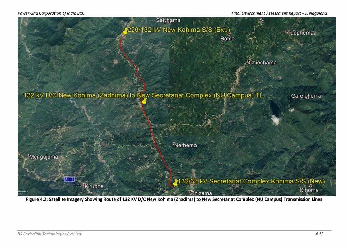
Power Grid Corporation of India Ltd. Final Environment Assessment Report - 1, Nagaland
RS Envirolink Technologies Pvt. Ltd. 4.12
Figure 4.2: Satellite Imagery Showing Route of 132 KV D/C New Kohima (Zhadima) to New Secretariat Complex (NU Campus) Transmission Lines

Power Grid Corporation of India Ltd. Final Environment Assessment Report - 1, Nagaland
RS Envirolink Technologies Pvt. Ltd. 4.13
Figure 4.3: Satellite Imagery Showing Route of LILO of both ckts of 132kV D/C Kohima-Meluri (Kiphire) Line at Pfutsero Transmission Line

Power Grid Corporation of India Ltd. Final Environment Assessment Report - 1, Nagaland
RS Envirolink Technologies Pvt. Ltd. 4.14
Figure 4.4: Satellite Imagery Showing Final and Alternative Routes of 132 kV S/C (on D/C tower) Wokha-Zunheboto-Mokokchung Transmission Line

Power Grid Corporation of India Ltd. Final Environment Assessment Report - 1, Nagaland
RS Envirolink Technologies Pvt. Ltd. 4.15
Figure 4.5: Satellite Imagery Showing Final and Alternative Route of 220 KV S/C (On D/C Tower) New Kohima-Mokokchung via Wokha Transmission Line

Power Grid Corporation of India Ltd. Final Environment Assessment Report - 1, Nagaland
RS Envirolink Technologies Pvt. Ltd. 4.16
Figure 4.6: Satellite Imagery Showing Route of LILO of 132kV S/C Kohima-Wokha at New Kohima Transmission Line

Power Grid Corporation of India Ltd. Final Environment Assessment Report - 1, Nagaland
RS Envirolink Technologies Pvt. Ltd. 4.17
Figure 4.7: Satellite Imagery Showing Route of Existing 33 kV Mokokchung - Mariani Line to Proposed 33/11 kV Longtho S/s Distribution Line
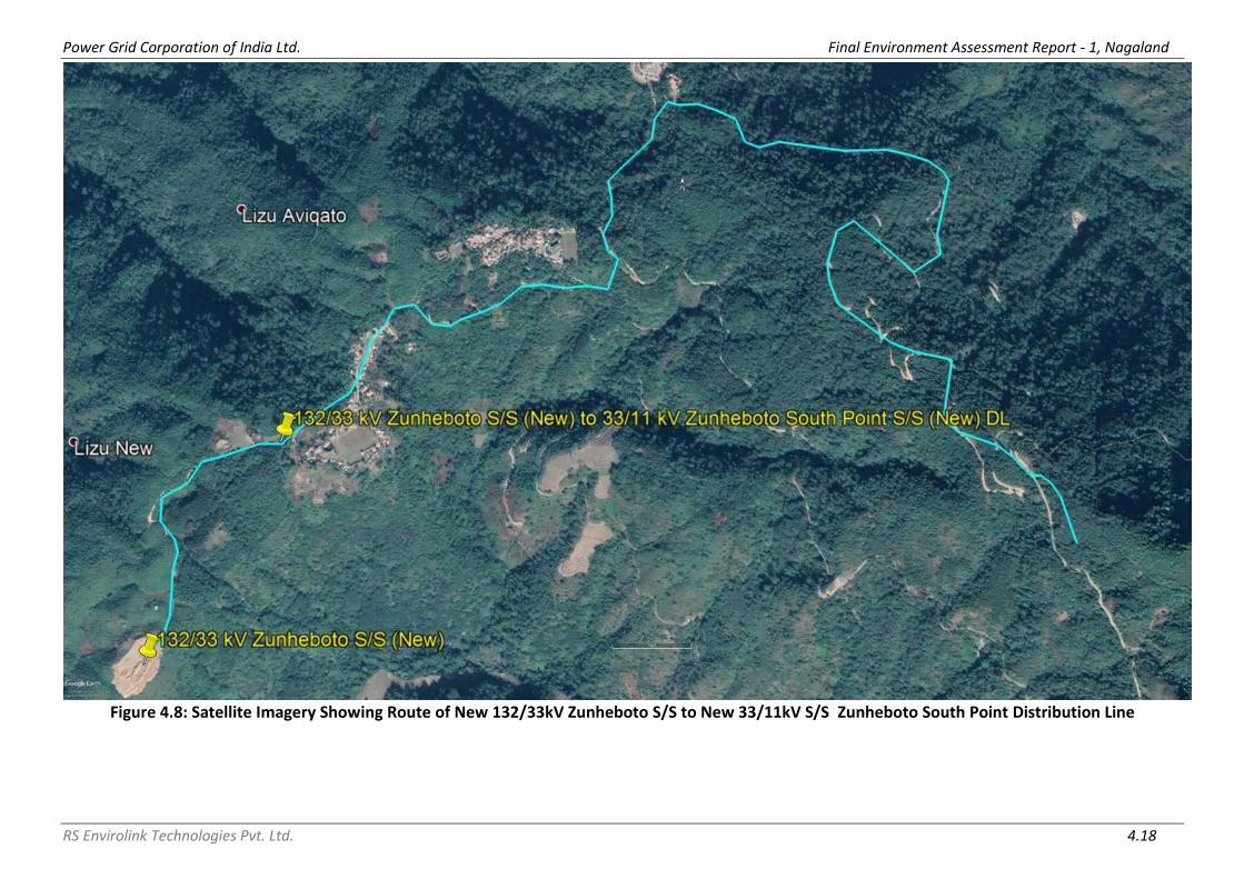
Power Grid Corporation of India Ltd. Final Environment Assessment Report - 1, Nagaland
RS Envirolink Technologies Pvt. Ltd. 4.18
Figure 4.8: Satellite Imagery Showing Route of New 132/33kV Zunheboto S/S to New 33/11kV S/S Zunheboto South Point Distribution Line

Power Grid Corporation of India Ltd. Final Environment Assessment Report - 1, Nagaland
RS Envirolink Technologies Pvt. Ltd. 4.19
Figure 4.9: Satellite Imagery Showing Route of Existing 66/33kV Mokokchung S/S to New 33/11kV S/S Mokokchung Town Power House and Existing
66/33kV Mokokchung S/S to New 33/11kV S/S Mokokchung Town Hospital Area Distribution Lines

Power Grid Corporation of India Ltd. Final Environment Assessment Report - 1, Nagaland
RS Envirolink Technologies Pvt. Ltd. 4.20
Figure 4.10: Satellite Imagery Showing Route of New 132/33kV Pfutsero S/S to New 33/11kV Pfutsero Distribution Line

Power Grid Corporation of India Ltd. Final Environment Assessment Report - 1, Nagaland
RS Envirolink Technologies Pvt. Ltd. 4.21
Figure 4.11: Satellite Imagery Showing Route of Existing 132/66/33kV Nagarjan S/S to New 33/11kV S/S Padam Pukhri Distribution Line

Power Grid Corporation of India Ltd. Final Environment Assessment Report - 1, Nagaland
RS Envirolink Technologies Pvt. Ltd. 4.22
Figure 4.12: Satellite Imagery Showing Route of Existing 33/11kV Suruhuto S/S to Existing 33/11kV S/S Akuloto Distribution Line

Power Grid Corporation of India Ltd. Final Environment Assessment Report - 1, Nagaland
RS Envirolink Technologies Pvt. Ltd. 4.23
Figure 4.13: Satellite Imagery Showing Route of Existing 33/11kV Pughoboto S/S to Existing 33/11kV S/S Torogonyu Distribution Line

Power Grid Corporation of India Ltd. Final Environment Assessment Report - 1, Nagaland
RS Envirolink Technologies Pvt. Ltd. 4.24
132/33 kV Substation at Longnak (New)
132/33 kV Substation at Zunheboto (New)
132/33 kV Substation at Secretariat Complex (New)
132/33 kV Substation at Pfutsero (New)

Power Grid Corporation of India Ltd. Final Environment Assessment Report - 1, Nagaland
RS Envirolink Technologies Pvt. Ltd. 4.25
132/33 kV Substation at Mokokchung (State) (Extension)
132/33 kV Substation at Wokha (Extension)
33/11 kV Substation at Longtho (New)
33/11 kV Substation at Mokokchung Power House (New)

Power Grid Corporation of India Ltd. Final Environment Assessment Report - 1, Nagaland
RS Envirolink Technologies Pvt. Ltd. 4.26
33/11 kV Substation at Mokokchung Hospital Area (New)
33/11 kV Substation at Zunheboto South Point (New)
33/11 kV Substation at Lalmati (Zubza) (New)
33/11 kV Substation at Pfutsero (New)

Power Grid Corporation of India Ltd. Final Environment Assessment Report - 1, Nagaland
RS Envirolink Technologies Pvt. Ltd. 4.27
33/11 kV Substation at Padampukhri (New)
33/11 kV Substation at Changtongya (Augmentation)
33/11 kV Substation at Chukitong (Augmentation)
33/11 kV Substation at Tseminyu (Augmentation)

Power Grid Corporation of India Ltd. Final Environment Assessment Report - 1, Nagaland
RS Envirolink Technologies Pvt. Ltd. 4.28
33/11 kV Substation at Botsa (Augmentation)
33/11 kV Substation at ITI Kohima (Augmentation)
33/11 kV Substation at Chakabama (Augmentation)
33/11 kV Substation at Industrial Estate (Augmentation)

Power Grid Corporation of India Ltd. Final Environment Assessment Report - 1, Nagaland
RS Envirolink Technologies Pvt. Ltd. 4.29
33/11 kV Substation at Nagarjan (Bay Extension)
4.3 MAJOR FEATURES OF FINAL ROUTE
4.3.1 Transmission Lines
Of the total 6 transmission lines, 5 lines are passing through hilly terrain and
rest 1 line is passing through plains. These lines mostly pass through private
plantation/ lands owned by village council and Govt. lands (refer Figure 4.1-
4.6). The lines do not pass through any Railway crossings and Settlement. The
lines route doesn’t involve any notified forest land which would necessitate
forest clearance under Forest (Conservation) Act, 1980. Besides all protected
areas like National Parks, Wildlife Sanctuaries, Biosphere Reserve etc.; Natural
habitats, IBAs, Sacred groves, Wetlands etc. have been completely avoided. It
has been observed that there are some variations in final route length of lines
from earlier routes so that environment & social sensitive areas are avoided/
minimized. However, decrease in total line length by 13.717 km for all lines
(from earlier 177.05 km to 163.333 km) without any change in land use and
other base line data, no additional impacts of any kind apart from earlier
identified impacts in IEAR/EMP are anticipated. A total of around 547 towers
are being/to be erected for all 6 proposed transmission lines having a total
line length of 163.333 km.
4.3.1.1 LILO of 132 kV Mariani - Mokokchung Line at Longnak
The transmission line passes through plain paddy fields and private
plantation/ lands owned by village council. The selected line does not pass
through any National Highway, Power line, Railway crossings and Settlement.
However, the line is crossing a ditch, village road, footpath and one stream,
which do not require any special towers.
The line length of final route (Table 4.1) has been reduced by approx. 1.2 km
i.e. from 2.0 km to 0.804 km due to change in tapping point from existing 132
kV Mariani - Mokokchung TL. Since there is a significant reduction in line

Power Grid Corporation of India Ltd. Final Environment Assessment Report - 1, Nagaland
RS Envirolink Technologies Pvt. Ltd. 4.30
length it is expected that the resultant environmental footprints will be
further reduced. Moreover, in order to avoid tower in private plantation area
and therefore minimizing tree cutting, tower AP-3 is scheduled at a distance
of 226 m from tower AP-2 and tower AP-4 is scheduled at a distance of 114 m
from tower AP-3 (Figure 4.14). The line has a total 5 towers without any
National Highway (NH), railways and major river crossings. The types of
towers used are double circuit (DC and DD) towers. All the tower locations are
easily accessible through existing road to carryout construction and
maintenance activity and construction of new approach road is not required.
Details of tower schedule of final route alignment describing important
features of line route are placed as Annexure II.
Figure 4.14: Major Features en route of LILO of 132kV S/C Mokokchung-Mariani at Longnak
4.3.1.2 132 kV D/C New Kohima (Zadhima) to New Secretariat Complex
(NU Campus)
The transmission line passes through hilly terrain, comprises of agricultural
field, private plantation/ lands owned by village council and Govt. land. Major
crossing en route of the line are National Highway between tower 29 and
tower 30, Proposed 400 kV D/C Imphal to Kohima TL between tower 31 and
tower 31AO, Proposed 132 kV S/C Kohima – Wokha TL between tower 35 and
tower 36, 33kV lines, nalas, unmetalled roads, metaled roads, village roads
and footpaths.
The line length of final route (Table 4.1) has been increased by approx. 7 km
i.e. from 6.55 km to 13.97 km due to change in sub-station from Thizama

Power Grid Corporation of India Ltd. Final Environment Assessment Report - 1, Nagaland
RS Envirolink Technologies Pvt. Ltd. 4.31
village to Tseisema village as there was space constraints at Thizama village,
also, so that environment & social sensitive areas are avoided/ minimized
(refer Figure 4.15 to Figure 4.18). Though there is an increase in line length,
no additional impacts of any kind apart from earlier identified impacts in
IEAR/EMP are anticipated. Moreover, environment & social safeguard issues
which have been taken care off are: -
• Habitation areas along the route (villages namely Ziezou, Zhadima,
Phehza, Chieswama) have been completely avoided
• Reserved Forest areas have been completely avoided
• It is ensured that common property resources (CPR) are not impacted.
• Any areas/monuments of archaeological importance are also not
encountered along the route.
• The tree cutting has also been minimized in valley portions along the
route.
The line has a total 48 angle towers. Since the terrain is hilly, leg extension is
being utilized in towers to minimize/avoid benching/ revetment and to
provide great stability. Out of the total 48 angle towers, 14 towers are
provided with leg extension. In addition to that retaining wall has been
proposed AP-08 and AP-18 so as to eliminate the chances of soil erosion. The
types of towers used are double circuit (DB, DC and DD) towers. All the tower
locations are easily accessible through existing road to carryout construction
and maintenance activity and construction of new approach road is not
required. Details of tower schedule of final route alignment describing
important features of line route are placed as Annexure II.
Figure 4.15: Avoidance of Habitation Area in Zadhima Village

Power Grid Corporation of India Ltd. Final Environment Assessment Report - 1, Nagaland
RS Envirolink Technologies Pvt. Ltd. 4.32
Figure 4.16: Avoidance of Habitation Area in Phenza Village
Figure 4.17: Avoidance of Habitation Area in Chieswama Village

Power Grid Corporation of India Ltd. Final Environment Assessment Report - 1, Nagaland
RS Envirolink Technologies Pvt. Ltd. 4.33
Figure 4.18: Avoidance of Agricultural Land and Institutional Area
4.3.1.3 LILO of both Circuit of Kohima – Meluri (Kiphire) Line at Pfutsero
The transmission line passes through hilly private plantation/ lands owned by
village council. Major crossing en route of the line are National Highway
between tower 90 of already existing 132 kV Kohima – Meluri (Kiphire) line
and tower 01, 11 kV line between tower 3 and tower 4, nala between tower 7
and tower 8, and village road at 3 location.
The line length of final route (Table 4.1) has been reduced by approx. 0.6 km
i.e. from 3.0 km to 2.411 km due to further optimization during ground
truthing survey. Since there is a slight reduction in line length it is expected
that the resultant environmental footprints will be further reduced.
Moreover, in order to minimize tree cutting, span length has been increased
in valley between tower 7 and tower 8 (refer Figure 4.19). The line has a total
10 towers. The types of towers used are double circuit (DB, DC and DD)
towers. Since the terrain is hilly, leg extension is being utilized in towers to
minimize/avoid benching/ revetment and to provide great stability. Out of the
total 10 towers, 7 towers are provided with leg extension. In addition to that
retaining wall has been proposed for 6 towers so as to eliminate the chances
of soil erosion. All the tower locations are easily accessible through existing
road to carryout construction and maintenance activity and construction of
new approach road is not required. Details of tower schedule of final route
alignment describing important features of line route are placed as Annexure
II.

Power Grid Corporation of India Ltd. Final Environment Assessment Report - 1, Nagaland
RS Envirolink Technologies Pvt. Ltd. 4.34
Figure 4.19: Increase in Length of Span Between Tower 07 and Tower 08
4.3.1.4 132 kV S/C (on D/C Tower) Wokha - Zunheboto - Mokokchung
Line
The transmission line passes through hilly agricultural land, private plantation/
lands owned by village council and Govt. land. Major crossing en route of the
line are National Highway 702A, twice between tower 46 and tower 47, twice
between tower 51 and tower 52, twice between tower 56 and tower 57,
between tower 58 and tower 59, between tower 62 and tower 63, twice
between tower 63 and tower 64, between tower 68 and tower 69; Proposed
220 kV D/C New Kohima to Mokokchung TL between tower 11 and tower 12;
66/33/11 kV lines; LT lines; nalas; unmetalled roads; metaled road; village
roads; rain cuts; ponds; sheds and footpaths/ foot tracks.
The line length of final route (Table 4.1) has been reduced by approx. 30 km
i.e. from 80.0 km to 50.293 km due to further optimization during ground
truthing survey considering construction difficulties and RoW issues. Since
there is a significant reduction in line length it is expected that the resultant
environmental footprints will be further reduced. Moreover, environment &
social safeguard issues which have been taken care off are: -
• Habitation areas along the route (villages namely Philimi, Rotomi,
Akuhaito, Emlomi, Litsami, Lizu New, Yesholtomi, Asukhuto, Atoizu,
Kitsakita, Aotsakilimi, Lokobomi, Akuluto, Lumthsami, Alaphumi,
Lumami, Zaphumi New & Old, Shitsumi, Sumi-Settsu, Settsu, Aolijen)
have been completely avoided

Power Grid Corporation of India Ltd. Final Environment Assessment Report - 1, Nagaland
RS Envirolink Technologies Pvt. Ltd. 4.35
• Reserved Forest areas have been completely avoided
• It is ensured that common property resources (CPR) are not impacted.
• Any areas/monuments of archaeological importance are also not
encountered along the route.
• The tree cutting has also been minimized in valley portions along the
route.
The line has a total 166 towers. Since the terrain is hilly, leg extension is being
utilized in towers to minimize/avoid benching/ revetment and to provide
great stability. The types of towers used are double circuit (DB, DC and DD)
towers. Out of the total 166 towers, 101 towers are provided with leg
extension. To carryout construction and maintenance activity, construction of
new approach road is not required. Details of tower schedule of final route
alignment describing important features of line route are placed as Annexure
II.
4.3.1.5 220 kV S/C (on D/C Tower) New Kohima - Mokokchung via
Wokha Line
The transmission line passes through hilly agricultural land, private plantation/
lands owned by village council and Govt. land. Major crossing en route of the
line are National Highway 2 at several locations; Proposed 132 kV D/C Wokha
to Zunheboto TL between tower 190 and tower 191; 66/33/11 kV lines; LT
lines; Doyang river between tower 152 and tower 154, between tower 201
and tower 202; Tulo river between tower 176 and tower 177; nalas; drains;
unmetalled roads; metaled road; village roads; rain cuts; ponds; rubber, tea &
coffee garden; sheds and footpaths/ foot tracks.
The line length of final route (Table 4.1) has been increased by approx. 1.5
km, which is very negligible considering the change in total length of line i.e.
from 85.0 km to 86.637 km. The line length has been increased so that
environment & social sensitive areas are avoided/ minimized and the route
was preferred due to feasibility and lesser ROW problems (refer Figure 4.20
and Figure 4.21). Though there is an increase in line length, no additional
impacts of any kind apart from earlier identified impacts in IEAR/EMP are
anticipated. Moreover, environment & social safeguard issues which have
been taken care off are: -
• Habitation areas of 23 villages (namely Zhadima, Tetzama,
Tsiemekhuma, Botsa, Terogunye, Phenwehyu, Zunpha, Tseminyu,
Tesophenyunew, Sishunu, Gokhunyu, Asukiqa, Kitami, Council Hall,
Sana old, Phlimi, Doyang, V.K.Town, Sasanu, Lohgkhum, Alchcn, Sehsu)
along the route have been completely avoided.
• Reserved Forest areas have been completely avoided
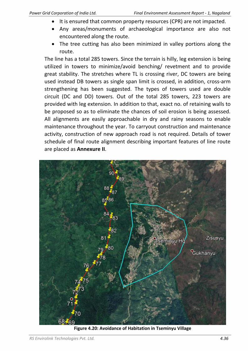
Power Grid Corporation of India Ltd. Final Environment Assessment Report - 1, Nagaland
RS Envirolink Technologies Pvt. Ltd. 4.36
• It is ensured that common property resources (CPR) are not impacted.
• Any areas/monuments of archaeological importance are also not
encountered along the route.
• The tree cutting has also been minimized in valley portions along the
route.
The line has a total 285 towers. Since the terrain is hilly, leg extension is being
utilized in towers to minimize/avoid benching/ revetment and to provide
great stability. The stretches where TL is crossing river, DC towers are being
used instead DB towers as single span limit is crossed, in addition, cross-arm
strengthening has been suggested. The types of towers used are double
circuit (DC and DD) towers. Out of the total 285 towers, 223 towers are
provided with leg extension. In addition to that, exact no. of retaining walls to
be proposed so as to eliminate the chances of soil erosion is being assessed.
All alignments are easily approachable in dry and rainy seasons to enable
maintenance throughout the year. To carryout construction and maintenance
activity, construction of new approach road is not required. Details of tower
schedule of final route alignment describing important features of line route
are placed as Annexure II.
Figure 4.20: Avoidance of Habitation in Tseminyu Village

Power Grid Corporation of India Ltd. Final Environment Assessment Report - 1, Nagaland
RS Envirolink Technologies Pvt. Ltd. 4.37
Figure 4.21: Avoidance of Agricultural Field
4.3.1.6 LILO of 132 kV S/C Kohima - Wokha Line at 220 kV New Kohima
Sub-station
The transmission line passes through hilly agricultural land, private plantation/
lands owned by village council and Govt. land. The selected line does not pass
through any National Highway, Power line, Railway crossings and Settlement.
However, the line is crossing unmetaled roads, nalas and foot track/ footpath,
which do not require any special towers. The line route doesn’t involve any
notified forest land which would necessitate forest clearance under Forest
(Conservation) Act, 1980. Besides all protected areas like National Parks,
Wildlife Sanctuaries, Biosphere Reserve etc.; Natural habitats, IBAs, Sacred
groves, Wetlands etc. have been completely avoided.
The line length of final route (Table 4.1) has been increased by approx. 8.7 km
i.e. from 0.5 km to 9.218 km. The line length has been increased so that
environment & social sensitive areas are avoided/ minimized and the route
was preferred due to feasibility and lesser ROW problems. Though there is an
increase in line length, no additional impacts of any kind apart from earlier
identified impacts in IEAR/EMP are anticipated. Moreover, environment &
social safeguard issues which have been taken care off are: -
• Habitation areas along the route have been completely avoided.
• Reserved Forest areas have been completely avoided
• It is ensured that common property resources (CPR) are not impacted.
• Any areas/monuments of archaeological importance are also not
encountered along the route.

Power Grid Corporation of India Ltd. Final Environment Assessment Report - 1, Nagaland
RS Envirolink Technologies Pvt. Ltd. 4.38
• The tree cutting has also been minimized in valley portions along the
route.
The line has a total 33 towers. Since the terrain is hilly, leg extension is being
utilized in towers to minimize/avoid benching/ revetment and to provide
great stability. The types of towers used are double circuit (DB, DC and DD)
towers. Out of the total 33 towers, 14 towers are provided with leg extension.
All alignments are easily approachable in dry and rainy seasons to enable
maintenance throughout the year. All the tower locations are easily accessible
through existing road to carryout construction and maintenance activity and
construction of new approach road is not required. Details of tower schedule
of final route alignment describing important features of line route are placed
as Annexure II.
4.3.2 Distribution Lines
About 80% of the lines are passing through hilly terrain and 20% through
plains i.e. out of the total 9 distribution lines, 7 are in hilly terrain and rest 2
are in plains. These lines mostly pass through private plantation and Govt.
lands along existing roads and do not involve any reserve/protected forest
land (refer Figure 4.7- 4.13). It has been observed that there are some
variations in final route length of lines from earlier routes so that environment
& social sensitive areas are avoided/ minimized. However, considering that
distribution line has minimum environmental footprints and increase in total
line length by 8.52 km for all lines (from earlier 46.06 km to 54.58 km) without
any change in land use and other base line data, no additional impacts of any
kind apart from earlier identified impacts in IEAR/EMP are anticipated. A total
of around 848 poles are being/to be erected for all 9 proposed distribution
lines having a total line length of 54.58 km.
4.3.2.1 33 kV line from tapping point of existing 33/11 kV Mokokchung
- Mariani Line at Longtho Sub-station
The line passes through plain terrain comprising of Govt. land. The selected
line does not pass through any National Highway, Railway crossings and
Settlement. However, the line is crossing a 11 kV line between pole 1 and pole
2, between pole 4/1 and pole 5 and between pole 12 and pole 13; Chering
river between pole 4 and pole 4/1; nala; village road; foot track and shed.
The line length of final route (Table 4.1) has been increased by 0.7 km i.e.
from 0.5 km to 1.2 km due to further optimization during ground truthing
survey. The line length is increased so that environment & social sensitive
areas are avoided/ minimized. Moreover, in order to cross Chering river, pole
5/0 is scheduled at a distance of 135 m from pole 4 (refer Figure 4.22). It may

Power Grid Corporation of India Ltd. Final Environment Assessment Report - 1, Nagaland
RS Envirolink Technologies Pvt. Ltd. 4.39
be noted that no special provision is envisaged in DL or pole in terms of river
crossing. The line has a total 44 poles. The types of poles used are Single Pole
(SP), Double Pole (DP) and Four Pole (FP). All the pole locations are easily
accessible through existing road to carryout construction and maintenance
activity and construction of new approach road is not required.
Figure 4.22: Increase in Length of Span Between Pole 4 and Pole 5 over Chering River
4.3.2.2 33 kV line from 132/33 kV Zunheboto (new) to 33/11 kV
Zunheboto South Point (new) Sub-station
The line passes through hilly terrain, comprises of private plantation/ lands
owned by village council and Govt. land. The selected line does not pass
through any Railway crossings and Settlement. However, the line is crossing
National Highway between pole 89 and pole 90; 11 kV line between pole 22
and pole 23, between pole 35 and pole 36 and between pole 44 and pole 45;
village road and foot track.
The line length of final route (Table 4.1) has been reduced by approx. 1 km i.e.
from 6.6 km to 5.53 km due to further optimization during ground truthing
survey. Since there is a reduction in line length it is expected that the
resultant environmental footprints will be further reduced. The line has a total
93 poles. The types of poles used are Double Circuit Double Pole (DC DP) and
Double Circuit Four Pole (DC FP). All the pole locations are easily accessible
through existing road to carryout construction and maintenance activity and
construction of new approach road is not required.

Power Grid Corporation of India Ltd. Final Environment Assessment Report - 1, Nagaland
RS Envirolink Technologies Pvt. Ltd. 4.40
4.3.2.3 33 kV line from 66 kV Mokokchung (existing) to 33/11 kV
Mokokchung Town Power House (new) Sub-station
The line passes through hilly terrain, comprises of agricultural land, private
plantation/ lands owned by village council and Govt. land. The selected line
does not pass through any Railway crossings and Settlement. However, the
line is crossing National Highway between pole 133 and pole 134; 33 kV line
between pole 138 and pole 139 and between pole 144 and pole 145; 11 kV
line between pole 96 and pole 97, between pole 130 and pole 131, between
pole 133 and pole 134 and between pole 145 and pole 146; nalas; village
road, metaled roads; footpath and LT line.
The line length of final route (Table 4.1) has been negligible increased by
approx. 0.3 km i.e. from 8.7 km to 9 km due to further optimization during
ground truthing survey. Since there is a negligible increase in line length it is
expected that the resultant environmental footprints will not increase. The
line has a total 55 poles without any railways and major river crossings. The
types of poles used are SP, DP and FP. All the pole locations are easily
accessible through existing road to carryout construction and maintenance
activity and construction of new approach road is not required.
4.3.2.4 33 kV line from 66 kV Mokokchung (existing) to 33/11 kV
Mokokchung Town Hospital (new) Sub-station
The line passes through hilly terrain, comprises of private plantation/ lands
owned by village council and Govt. land. The selected line does not pass
through any Railway crossings and Settlement. However, the line is crossing
National Highway; 33/11 kV line; nalas; village road, metaled roads and LT line
at several locations.
The line length of final route (Table 4.1) has been reduced by approx. 4.4 km
i.e. from 7.42 km to 3 km due to further optimization during ground truthing
survey. Since there is a significant reduction in line length it is expected that
the resultant environmental footprints will be further reduced. The line has a
total 132 poles without any railways and major river crossings. The types of
poles used are SP, DP, FP, Double Circuit Single Pole (DC SP), DC DP and DC FP.
All the pole locations are easily accessible through existing road to carryout
construction and maintenance activity and construction of new approach road
is not required.

Power Grid Corporation of India Ltd. Final Environment Assessment Report - 1, Nagaland
RS Envirolink Technologies Pvt. Ltd. 4.41
4.3.2.5 33 kV line from 132/33 kV Pfutsero (new) to 33/11 kV Pfutsero
(New) Sub-station
The line passes through hilly terrain, comprises of private plantation/ lands
owned by village council. The selected line does not pass through any National
Highway, Power line, Railway crossings and Settlement. However, the line is
crossing a ditch, village road, footpath and one stream, which do not require
any special towers.
The line length of final route (Table 4.1) is 3.6 km. The final route avoids
market area, habitation and a patch of dense forest. In order to avoid pole in
private plantation area and therefore minimizing tree cutting, pole 13 is
scheduled at a distance of 713 m from tower pole 12 (refer Figure 4.23).
Market area has been avoided from pole 18 to pole 21 and human habitation
has been avoided from pole 1 to pole 12 (refer Figure 4.24). The line has a
total 25 poles without any National Highway (NH), railways and major river
crossings. The types of poles used are DC DP and DC FP. All the pole locations
are easily accessible through existing road to carryout construction and
maintenance activity and construction of new approach road is not required.
Figure 4.23: Increase in Length of Span Between Pole 12 and Pole 13

Power Grid Corporation of India Ltd. Final Environment Assessment Report - 1, Nagaland
RS Envirolink Technologies Pvt. Ltd. 4.42
Figure 4.24: Avoidance of Habitation Area at Pfutsero
4.3.2.6 33 kV line from existing 132/66/33 kV Nagarjan Sub-station to
new 33/11 kV Padampukhri Sub-station
The line passes through plain terrain, comprises of private plantation/ lands
owned by village council and Govt. land. The selected line does not pass
through any Railway crossings and Settlement. However, the line travels along
NH 129A from pole 90 to 98; from existing 66 kV Nagarjan sub-station to pole
89 it travels along the existing road in Nagarjan area and from pole 90 to
proposed new 33/11 kV Padampukhri substation in Padampukhri area. The
line does not require any special towers.
The line length of final route (Table 4.1) has been increased by approx. 2 km
i.e. from 4.34 km to 6.15 km so as to avoid human habitation and private
property (refer Figure 4.25 to Figure 4.27). Though there is a significant
increase in line length it is expected that the resultant environmental and
social footprints will be nil as it travels along existing road and no felling of
tree will required, only lopping of tree branches will suffice for ROW
clearance. The line has a total 192 poles without any railways and major river
crossings. The types of poles used are SP, DP and FP. All the pole locations are
easily accessible through existing road to carryout construction and
maintenance activity and construction of new approach road is not required.

Power Grid Corporation of India Ltd. Final Environment Assessment Report - 1, Nagaland
RS Envirolink Technologies Pvt. Ltd. 4.43
Figure 4.25: Route along the existing Road to Avoid Habitation Area at Nagarjan
Figure 4.26: Route along the existing Road to Avoid Habitation Area at Naharbari

Power Grid Corporation of India Ltd. Final Environment Assessment Report - 1, Nagaland
RS Envirolink Technologies Pvt. Ltd. 4.44
Figure 4.27: Route along the existing Road to Avoid Habitation Area at Padampukhri
4.3.2.7 33 kV line from 33/11 Akuloto (existing) Sub-station to 33/11 kV
Suruhuto (existing) Sub-station
The line passes through hilly terrain, comprises of agricultural land, private
plantation/ lands owned by village council and Govt. land. The selected line
does not pass through any Railway crossings and Settlement. However, the
line is crossing National Highway 702A; 33/11 kV line; nalas; village road,
metaled roads, hut, tea garden and LT line at several locations.
The line length of final route (Table 4.1) has been increased by approx. 14 km
i.e. from 9.5 km to 23.29 km so that environment & social sensitive areas are
avoided/ minimized. This route has been preferred due to feasibility and
lesser ROW problems. This is the only line which is more than 10 km in length
as it travels along the village road and National Highway 702A. The line has a
total 252 poles (though checking of the survey going on due to excessive
number of poles/ km) without any railways and major river crossings. The
types of poles used are SP, DP and FP. All the pole locations are easily
accessible through existing road to carryout construction and maintenance
activity and construction of new approach road is not required.
4.3.2.8 33 kV line from existing 33/11 kV Pughoboto Sub-station to
existing 33/11 kV Torogonyu Sub-station
The line passes through hilly terrain, comprises of agricultural land and private
plantation/ lands owned by village council. The selected line does not pass
through any Railway crossings and Settlement. However, the line is crossing

Power Grid Corporation of India Ltd. Final Environment Assessment Report - 1, Nagaland
RS Envirolink Technologies Pvt. Ltd. 4.45
National Highway 2 at several locations; 33 kV line between pole 38 and pole
39; village road; LT line; foot track and metaled road.
The line length of final route (Table 4.1) has been reduced by approx. 7 km i.e.
from 9 km to 2.27 km due to further optimization during ground truthing
survey. Since there is a significant reduction in line length it is expected that
the resultant environmental footprints will be further reduced. Moreover, in
order to avoid tower in private plantation area and therefore minimizing tree
cutting, pole 10 is scheduled at a distance of 163 m from pole 9. The line has a
total 42 poles without any railways and major river crossings. The types of
poles used are SP, DP and FP. All the pole locations are easily accessible
through existing road to carryout construction and maintenance activity and
construction of new approach road is not required.
4.4 PROJECT IMPACTS Based on the project details and the baseline environmental status, potential
impacts due to the construction/ bay extension of sub-stations and along the
final route of transmission and distribution lines have been assessed.
4.4.1 Impact of Transmission & Distribution Lines
The project does not require any private land acquisition for construction of
transmission/distribution lines. Therefore, no physical displacement is
foreseen in the project. However, there are some social impacts due to
construction of lines/placing of towers & poles which are temporary in nature
i.e. impacts in terms of loss of standing crops/trees/structures in the RoW,
which lasts during construction phase only. The construction phase itself is
very limited. Detailed survey has been carried out for
transmission/distribution line to estimate/ arrive at impacts.
4.4.1.1 Type and Use of Land within Corridor Right of Way
The line corridor will pass through mixed land uses which are generally
agricultural land, private plantation, government land etc. The calculations are
based on detailed survey/ investigation carried out along the route of
transmission/distribution lines and considering the total line length of the line
and its right of way. The total line length is 217.91 km which will impact an
estimated of 1463.25 acre of land. These include 19.11 km of line passing
through agricultural land (137.82 acre of agricultural land), 186.72 km of
private plantation (1261.28 acre of private plantation land) and 11.99 km of
government land (61.16 acre of government/ barren land). A brief description
about the type and use of land in the corridor is given in Table 4.3.

Power Grid Corporation of India Ltd. Final Environment Assessment Report - 1, Nagaland
RS Envirolink Technologies Pvt. Ltd. 4.46
Table 4.3: Type and Use of Land within Corridor of RoW
S. No.
Name of Line RoW
Width (m)
Agricultural Land
Private Plantation
Forest Land Govt. Land Total
Length (km)
Area (acre)
Length (km)
Area (acre)
Length (km)
Area (acre)
Length (km)
Area (acre)
Length (km)
Area (acre)
A Transmission Lines
1 132 KV D/C New Kohima (Zhadima) to New Secretariat Complex (NU campus)
27 1.5 10.01 11.97 79.86 Nil Nil 0.5 3.34 13.97 93.20
2 220 KV S/C (On D/C Tower) New Kohima-Mokokchung via Wokha
35 8.637 74.70 76 657.28 Nil Nil 2 17.30 86.637 749.27
3 132 kV S/C (on D/C tower) Wokha-Zunheboto-Mokokchung
27 5 33.36 42.993 286.83 Nil Nil 2.3 15.34 50.293 335.54
4 LILO of 132kV S/C Mokokchung-Mariani at Longnak
27 Nil Nil 0.804 5.36 Nil Nil Nil Nil 0.804 5.36
5 LILO of both ckts of 132kV D/C Kohima-Meluri (Kiphire) line at Pfutsero
27 Nil Nil 2.411 16.09 Nil Nil Nil Nil 2.411 16.09
6 LILO of 132kV S/C Kohima-Wokha at new Kohima
27 1.7 11.34 7 46.70 Nil Nil 0.518 3.46 9.218 61.50
Sub Total 16.837 129.40 141.18 1092.12 Nil Nil 5.318 39.43 163.333 1260.96 B Distribution Lines
7 Existing 33 kV Mok -Mariani line to prop. 33/11 kV Longtho S/s
15 Nil Nil Nil Nil Nil Nil 1.2 4.45 1.2 4.45
8 Existing 66/33kV Mokokchung S/s to New 33/11kV s/s Mokokchung Town Power House
15 1 3.71 7 25.95 Nil Nil 1 3.71 9 33.36
9 Existing 66/33kV Mokokchung S/s to New 33/11kV s/s Mokokchung Town Hospital Area
15 Nil Nil 2.5 9.27 Nil Nil 0.5 1.85 3 11.12
10 New 132/33kV Zunheboto S/s to New 33/11kV s/s Zunheboto South Point
15 Nil Nil 5 18.53 Nil Nil 0.53 1.96 5.53 20.50
11 Existing 33/11kV Suruhuto S/s to Exist. 33/11kV s/s Akuloto
15 1 3.71 20 74.13 Nil Nil 2.29 8.49 23.29 86.32
12 Existing 33/11kV Pughoboto S/s to Exist. 33/11kV s/s Torogonyu
15 0.27 1.00 2 7.41 Nil Nil Nil Nil 2.27 8.41
13 132/33kV Kohima (New) SS to 33/11kV 15 Nil Nil 0.54 2.00 Nil Nil Nil Nil 0.54 2.00

Power Grid Corporation of India Ltd. Final Environment Assessment Report - 1, Nagaland
RS Envirolink Technologies Pvt. Ltd. 4.47
S. No.
Name of Line RoW
Width (m)
Agricultural Land
Private Plantation
Forest Land Govt. Land Total
Length (km)
Area (acre)
Length (km)
Area (acre)
Length (km)
Area (acre)
Length (km)
Area (acre)
Length (km)
Area (acre)
Zhadima
14 New 132/33kV Pfutsero SS to New 33/11kV Pfutsero
15 Nil Nil 3.6 13.34 Nil Nil Nil Nil 3.6 13.34
15 Existing 132/66/33kV Nagarjan s/s to New 33/11kV s/s Padam Pukhri
15 Nil Nil 5 18.53 Nil Nil 1.15 4.26 6.15 22.79
Sub Total 2.27 8.41 45.64 169.16 Nil Nil 6.67 24.722 54.58 202.3 TOTAL 19.11 137.82 186.82 1261.28 0.00 0.00 11.99 64.16 217.91 1463.25
Source: Detailed Survey of POWERGRID/ Contractor

Power Grid Corporation of India Ltd. Final Environment Assessment Report - 1, Nagaland
RS Envirolink Technologies Pvt. Ltd. 4.48
4.4.1.2 Impact on Soil & Surface Geology
In plain areas impact on soil & geology is almost negligible as the excavated
pit material is stacked properly and back filled as well as used for resurfacing
the area. On hill slopes where soil is disturbed and prone to erosion is suitably
protected by revetment, breast walls, and proper drainage. Besides extensive
leg /chimney extension is being used to avoid benching or cutting of slopes to
minimize the impact on slope stability. In all there are 542 towers proposed
under 5 transmission lines to be constructed in hilly terrain. Of these 542
towers, around 66% of the towers i.e. 359 are being provided with leg
extension/ chimney extension.
4.4.1.3 Impact on Land for Tower Base & Pole
As per the assessment carried out in Compensation Plan for Temporary Damages (CPTD) by PGCIL, the land requirement for erection of tower legs is very small i.e. for each leg of tower actual construction is done on a small square area with side length ranging from 0.20 to 0.30 meter depending on the types of tower. Four such square pieces of land will be required to place the legs of tower. The area that becomes unavailable because of the erection of tower legs for an average 132 kV D/c transmission tower ranges from 0.16-0.36 sq m of land. Thus, the actual impact is restricted to 4 legs of the tower and agriculture can continue as clearly depicted in the Figure 4.28. In case of 33 kV distribution line area that becomes unavailable because of the erection of pole is insignificant as approx. 1 sq. ft. land area is occupied for one pole (refer Figure 4.29). Due diligence confirms that land is either agricultural or barren, and current land use is not altered and resumed after construction. As already explained, the impact of transmission line is restricted to 4 legs of the tower and agriculture can continue after construction activity is over. The average land area will be unavailable for agriculture after erection of one 220kV/132 kV T/L tower and one pole for 33 kV D/L is approx. 0.25 sq m & 0.092 sq m, respectively. Based on above, total land loss for construction 86.637 km of 220kV transmission line, construction of 76.696 km of 132 kV transmission line and 54.58 km of 33 kV distribution line proposed under the present scheme is estimated 0.053 acre. However, compensation toward loss land shall be provided to APs which is part of RoW compensation. Details of land loss for tower base & pole are given in Table 4.4.

Power Grid Corporation of India Ltd. Final Environment Assessment Report - 1, Nagaland
RS Envirolink Technologies Pvt. Ltd. 4.49
Figure 4.28: Typical Plan of Transmission Line Tower Footing

Power Grid Corporation of India Ltd. Final Environment Assessment Report - 1, Nagaland
RS Envirolink Technologies Pvt. Ltd. 4.50
Figure 4.29: 33 kV Lines (Single & H Pole) Depicting Base Area Impact

Power Grid Corporation of India Ltd. Final Environment Assessment Report - 1, Nagaland
RS Envirolink Technologies Pvt. Ltd. 4.51
Table 4.4: Estimation of Actual Loss of Land for Tower Base & Pole
S. No.
Name of Line Line
Length (Kms.)
Total Tower/
Pole (Nos.)
Land loss per tower/ pole base
(sq m)
Total land loss area for tower & pole base (sq m)
A Transmission Lines
1 132 KV D/C New Kohima (Zhadima) to New Secretariat Complex (NU campus)
13.97 48 0.25 12
2 220 KV S/C (On D/C Tower) New Kohima-Mokokchung via Wokha
86.637 285 0.25 71.25
3 132 kV S/C (on D/C tower) Wokha-Zunheboto-Mokokchung
50.293 166 0.25 41.5
4 LILO of 132kV S/C Mokokchung-Mariani at Longnak
0.804 5 0.25 1.25
5 LILO of both ckts of 132kV D/C Kohima-Meluri (Kiphire) line at Pfutsero
2.411 10 0.25 2.5
6 LILO of 132kV S/C Kohima-Wokha at new Kohima
9.218 33 0.25 8.25
TOTAL - A 163.333 547 136.75 ≅
0.034 acre B Distribution Lines
7 Existing 33 kV Mok -Mariani line to prop. 33/11 kV Longtho S/s
1.2 44 0.092 4.048
8 Existing 66/33kV Mokokchung S/s to New 33/11kV s/s Mokokchung Town Power House
9 55 0.092 5.06
9 Existing 66/33kV Mokokchung S/s to New 33/11kV s/s Mokokchung Town Hospital Area
3 132 0.092 12.144
10 New 132/33kV Zunheboto S/s to New 33/11kV s/s Zunheboto South Point
5.53 93 0.092 8.56
11 Existing 33/11kV Suruhuto S/s to Exist. 33/11kV s/s Akuloto
23.29 252 0.092 23.184
12 Existing 33/11kV Pughoboto S/s to Exist. 33/11kV s/s Torogonyu
2.27 42 0.092 3.864
13 132/33kV Kohima (New) SS to 33/11kV Zhadima
0.54 13 0.092 1.196
14 New 132/33kV Pfutsero SS to New 33/11kV Pfutsero
3.6 25 0.092 2.3
15 Existing 132/66/33kV Nagarjan s/s to New 33/11kV s/s Padam Pukhri
6.15 192 0.092 17.67
TOTAL - B 54.58 848 78.026 ≅
0.019 acre
TOTAL A+B 217.913 1395 214.776 ≅
0.053 acre Source: Detailed Survey of POWERGRID/ Contractor

Power Grid Corporation of India Ltd. Final Environment Assessment Report - 1, Nagaland
RS Envirolink Technologies Pvt. Ltd. 4.52
4.4.1.4 Impact on Crop Area (RoW Corridor & Tower/Pole)
Construction of line in crop season is avoided as far as possible. In case when installation of towers/poles impacts on agricultural activity, detailed assessment/survey is conducted looking at existing crops, general crop patterns, seasonal particulars, nature and extent of yield. This data is compiled and analysed to study the extent and nature of impact. For the temporary loss of crops, only agricultural land and private plantation land are considered for estimation. The damages are not done in complete RoW of line (35m for 220kV D/c & 27 m for 132 kV D/c) but mostly restricted to tip to tip of the conductor and tower base area where average affected width/corridor would be limited to 27 & 20 meter (maximum). In 33 kV distribution lines, damages are minimal (mostly near bi-pole/quad-pole structure) however, 10 m corridor is considered for accessing the damages. Moreover, all efforts are made to reduce the damages to crops and to minimize the impacts whatsoever. One of the reasons is that schedules of construction activities are undertaken in lean season or post-harvest periods. Assets of any sorts will not be acquired but during construction, only temporary damages will occur. Based on the above estimation, the total land considered for crop damage for transmission/distribution line corridor and tower/pole foundation for the entire subproject is 1056.99 acre. Details of estimated impacted area for crop damages are given in Table 4.5.
4.4.1.5 Impact on Trees
Construction of line in fruit bearing season is avoided as far as possible. Tree
compensation is calculated on the basis of tree enumeration, tree species and
an estimate of the compensation will be calculated on the basis of 8 years
yield (assessed by revenue/horticulture department).
Total numbers of trees likely to be affected due to construction of 163.333 km
of 220kV/132 kV line and for 54.58 km of 33 kV distribution line is approx.
16096 nos., out of which 14104 are private trees and 1996 trees in govt. land.
Additionally, 5100 nos. bamboo trees are also likely to be affected. The major
species to be affected are Bamboo (Bambusa balcooa), Orange tree (Citrus x
sinensis), Banana (Musa acuminata), Tiksung (Tectona grandis) & Gooseberry
(Phyllanthus emblica). As per the conservation status by IUCN 2020.1, all the
species falls under LC category. Details on number of trees for each line are
given in Table 4.6.

Power Grid Corporation of India Ltd. Final Environment Assessment Report - 1, Nagaland
RS Envirolink Technologies Pvt. Ltd. 4.53
Table 4.5: Estimation on Loss of Land for Crop Damage due to Overhead Lines
S. No.
Name of Line
Width Considered for Estimation of Loss of Crops and other impacts (m)
Total Agricultural Land (km)
Total Private
Plantation (km)
Total Line Length Considered for Crop Compensation (km)
Total Land Area considered for Crop
Compensation (acre)
A Transmission Lines
1 132 KV D/C New Kohima (Zhadima) to New Secretariat Complex (NU campus)
20 1.5 11.97 13.47 66.57
2 220 KV S/C (On D/C Tower) New Kohima-Mokokchung via Wokha
27 8.637 76 84.637 564.66
3 132 kV S/C (on D/C tower) Wokha-Zunheboto-Mokokchung
20 5 45.293 50.293 248.54
4 LILO of 132kV S/C Mokokchung-Mariani at Longnak 20 Nil 0.804 0.804 3.97
5 LILO of both ckts of 132kV D/C Kohima-Meluri (Kiphire) line at Pfutsero
20 Nil 2.41 2.41 11.91
6 LILO of 132kV S/C Kohima-Wokha at new Kohima 20 1.7 7 8.7 42.99 TOTAL - A 16.83 143.48 160.31 938.64
B Distribution Lines
7 Existing 33 kV Mok -Mariani line to prop. 33/11 kV Longtho S/s
10 Nil Nil Nil Nil
8 LILO of Existing 33kV Mok -Mariani line at Exist. 33/11 kV Longnak S/s
10 Nil Nil Nil Nil
9 Existing 66/33kV Mokokchung S/s to New 33/11kV s/s Mokokchung Town Power House
10 1 7 8 19.76
10 Existing 66/33kV Mokokchung S/s to New 33/11kV s/s Mokokchung Town Hospital Area
10 Nil 2.5 2.5 6.18
11 New 132/33kV Zunheboto S/s to New 33/11kV s/s Zunheboto South Point
10 Nil 5 5 12.35
12 Existing 33/11kV Suruhuto S/s to Exist. 33/11kV s/s Akuloto
10 1 20 21 51.89
13 Existing 33/11kV Pughoboto S/s to Exist. 33/11kV s/s Torogonyu
10 0.27 2 2.27 5.60
14 132/33kV Kohima (New) SS to 33/11kV Zhadima 10 Nil 0.54 0.54 1.33 15 New 132/33kV Pfutsero SS to New 33/11kV Pfutsero 10 Nil 3.6 3.6 8.89
16 Existing 132/66/33kV Nagarjan s/s to New 33/11kV s/s Padam Pukhri
10 Nil 5 5 12.35
TOTAL - B 2.27 45.64 47.91 118.35 Source: Detailed Survey of POWERGRID/ Contractor

Power Grid Corporation of India Ltd. Final Environment Assessment Report - 1, Nagaland
RS Envirolink Technologies Pvt. Ltd. 4.54
Table 4.6: Loss of Trees
S. No.
Name of Line Trees in Private
Area (No.)
Trees in Govt.
Area (No.)
Total Trees (No.)
A Transmission Lines
1 132 KV D/C New Kohima (Zhadima) to New Secretariat Complex (NU campus)
1304+400 Bamboo
280+100 Bamboo
1584+500 Bamboo
2 220 KV S/C (On D/C Tower) New Kohima-Mokokchung via Wokha
5000+2200 Bamboo
700+380 Bamboo
5700+2580 Bamboo
3 132 kV S/C (on D/C tower) Wokha-Zunheboto-Mokokchung
4400+1200 Bamboo
580+300 Bamboo
4980+1500 Bamboo
4 LILO of 132kV S/C Mokokchung-Mariani at Longnak
140 10 150
5 LILO of both ckts of 132kV D/C Kohima-Meluri (Kiphire) line at Pfutsero
300 20 320
6 LILO of 132kV S/C Kohima-Wokha at new Kohima 1000+200 Bamboo
152+70 Bamboo
1152+270 Bamboo
TOTAL - A 12144+4000
Bamboo 1742+850 Bamboo
13886+4850 Bamboo
B Distribution Lines
7 Existing 33 kV Mok -Mariani line to prop. 33/11 kV Longtho S/s
20 10 30
8 LILO of Existing 33kV Mok -Mariani line at Exist. 33/11 kV Longnak S/s
20 10 30
9 Existing 66/33kV Mokokchung S/s to New 33/11kV s/s Mokokchung Town Power House
250 30 280
10 Existing 66/33kV Mokokchung S/s to New 33/11kV s/s Mokokchung Town Hospital Area
90 10 100
11 New 132/33kV Zunheboto S/s to New 33/11kV s/s Zunheboto South Point
250 30 280
12 Existing 33/11kV Suruhuto S/s to Exist. 33/11kV s/s Akuloto
920+200 Bamboo
100+50 Bamboo
1020+250 Bamboo
13 Existing 33/11kV Pughoboto S/s to Exist. 33/11kV s/s Torogonyu
70 NIL 70
14 132/33kV Kohima (New) SS to 33/11kV Zhadima 30 NIL 30
15 New 132/33kV Pfutsero SS to New 33/11kV Pfutsero
160 10 170
16 Existing 132/66/33kV Nagarjan s/s to New 33/11kV s/s Padam Pukhri
150 50 200
TOTAL - B 1960+200 Bamboo
250+50 Bamboo
2210+250 Bamboo
TOTAL A+B 14104+4200
Bamboo 1992+900 Bamboo
16096+5100 Bamboo
Source: Detailed Survey of POWERGRID/ Contractor
4.4.1.6 Impact on Other Assets (Small Shed in Agriculture Fields)
It has been observed during survey that approximately 10 numbers of small
structures exist along the right of way of proposed transmission lines. No such
structures exist along the right of way of distribution lines. These are small
storage sheds/huts which are mostly temporary structure associated with the

Power Grid Corporation of India Ltd. Final Environment Assessment Report - 1, Nagaland
RS Envirolink Technologies Pvt. Ltd. 4.55
agricultural fields. People do not use these small structures/sheds for
residential purpose and they use it as storage of agricultural purpose only.
Details on impacts on small structures are given in Table 4.7.
Table 4.7: Loss of Other Assets S.
No. Name of Line
No. of Storage Sheds/ Huts
A Transmission Lines 1 132 KV D/C New Kohima (Zhadima) to New Secretariat Complex (NU campus) 8 2 220 KV S/C (On D/C Tower) New Kohima-Mokokchung via Wokha 2 3 132 kV S/C (on D/C tower) Wokha-Zunheboto-Mokokchung 0 4 LILO of 132kV S/C Mokokchung-Mariani at Longnak 0 5 LILO of both ckts of 132kV D/C Kohima-Meluri (Kiphire) line at Pfutsero 0 6 LILO of 132kV S/C Kohima-Wokha at new Kohima 0 TOTAL 10
Source: Detailed Survey of POWERGRID/ Contractor
4.4.1.7 Other Damages
Other damages like bunds, water bodies, fish ponds, approach paths, drainage and irrigation canals etc. are at best avoided. However, if damaged, the Revenue Department assesses the cost of damage as per State Govt. norms. The total estimate is submitted for approval to the competent authority. Payments are made to owners in the presence of local revenue authorities or village head/ Sarpanch and respective acknowledgements are obtained and POWERGRID/ DPN pays the compensation. Hindrances to power, telecom carrier & communication lines etc. shall be paid as per Govt. norms.
4.4.2 Impact Due to Construction of New Substation and Bay Extension The project component consists of establishment/ bay extension of eight 132/33 kV sub-stations i.e. at Longnak, New Secretariat Complex Kohima, Pfutsero and Zunheboto and twenty three 33/11 kV sub-stations However, only in case of 5 substations, fresh lands were secured through private purchased on negotiated rates based on “willing buyer-willing seller basis”. For remaining new sub-stations and bay extensions of the EHV and DMS substations land is already available with DPN. Since involuntary acquisition is involved, R&R will not be an issue in the instant project. The details are provided in Table 1.6 of Chapter 1. The other environmental impacts that impact environment due to construction/ bay extension of sub-station are uncontrolled silt runoff, nuisance to nearby area, inadequate resurfacing for erosion control, inadequate disposition of borrow area, workers health/ safety. All these impacts and their management are discussed in detail in Chapter 5.

Power Grid Corporation of India Ltd. Final Environment Assessment Report - 1, Nagaland
RS Envirolink Technologies Pvt. Ltd. 4.56
Another impact is construction of access road. Access to all the new/ existing sub-stations will be along existing roads or village paths; minor improvements to paths may be made where necessary, but no major construction of roads, except, 132/33 kV sub-stations at Zunheboto, Secretariat Complex and Pfutsero where approach road of 2 km, 300 m and 200 m respectively is proposed/ under implementation will be necessary during construction.
The approach road at Secretariat Complex and Pfutsero is proposed/ being
constructed on already acquired land for the construction of sub-station. The
approach road of 2 km for 132/33 kV Zunheboto sub-station is proposed from
Lizo old village to sub-station. Presently, it is an existing foot path only on
community land, being used by villagers for movement from their home to
agricultural field. Since the approach road will be utilized during construction
phase only, whereas for villagers it will be a permanent upgradation of their
footpath to road, therefore, villagers have given their consent for this
expansion. In many areas such improvement in the access road is highly
appreciated by the local population. Since none of these segments require
any additional land and thus have insignificant environmental and social
impacts, these would fall in low risk category as per E & S screening criteria. However, Construction of road may lead to soil erosion, increase the airborne dust particles, nuisance to nearby area, require land for temporary accessibility etc. Impacts due to road construction and its management are discussed in detail in Chapter 5.
4.4.3 Impact on Indigenous People
Government of India, under Article 342 of the Constitution, considers the
following characteristics to define indigenous peoples [Scheduled Tribes (ST)]:
i. tribes’ primitive traits;
ii. distinctive culture;
iii. shyness with the public at large;
iv. geographical isolation; and
v. social and economic backwardness before notifying them as a
Scheduled Tribe. Essentially, indigenous people have a social and cultural identity distinct from the ‘mainstream’ society that makes them vulnerable to being overlooked or marginalized in the development processes. STs, who have no modern means of subsistence, with distinctive culture and are characterized by socio-economic backwardness, could be identified as Indigenous Peoples. Indigenous people are also characterized by cultural continuity. Constitution of India identifies schedule areas which are predominately inhabited by such people.

Power Grid Corporation of India Ltd. Final Environment Assessment Report - 1, Nagaland
RS Envirolink Technologies Pvt. Ltd. 4.57
The State of Nagaland is pre-dominantly a tribal state with > 89% population, inhabited by 16 major tribes under the umbrella term of the 'Naga', and along with a number of sub-tribes. Accordingly, special provision has extended to the State under Article 371 A of the Constitution of India which provides “no act of parliament in respect of religious and social practices of the Naga, Naga customary laws and procedures, administration of civil and criminal justices involving decisions according to Naga customary law and ownership and transfer of land and its resources shall apply to the state of Nagaland, unless Legislative Assembly of the state, by a resolution, so decides. Since, the project under NERPSIP is envisaged for economic uplifting of the NE region, hence, no indigenous population will be negatively impacted in the project area. However, It may be noted that all social issues shall be dealt separately in accordance with the provisions of Social Management Framework (SMF, A-C) placed in the Further, It may be noted that all social issues shall be dealt separately in accordance with the provisions of Social Management Framework (SMF, A-C), placed in the ESPPF of DPN”.
4.4.4 Summary of Impacts Based on the above analysis of final route of transmission and distribution lines and location of EHV and DMS sub-stations, the summarized environmental & social impact matrix is presented below in Table 4.8.
Table 4.8: Summary of Impacts S. No. PARAMETERS EXTENT OF IMPACT 1. A. Total Line length -
(TL -163.333 km, DL- 54.58 km)
The TL length has reduced by approx. 14 km, while the DL length has increased by approx. 8.5 km. Due to significant reduction in final route of 220/ 132kV line length, it is expected that resultant environmental footprints will be less as envisaged earlier. Though final route length of DL has increased, still no additional impacts of any kind apart from earlier identified impacts in IEAR/ EMP are anticipated as there is no change in land use and other base line data. Moreover, changes in the final route length have been made so as to avoid/ minimize environment & social sensitive areas.
As compared to IEAR, no additional impacts are anticipated. B. Terrain: Plain
area- 0.804 km (TL)+ 7.35 km (DL); Hilly area- 162.529 km (TL)+ 47.23 (DL)
Almost entire (approx. 96%) of lines are passing through hilly area and remaining approx. 4% through plains Similarly, around 80% of sub-stations to be constructed/ augmented are in hilly areas and the remaining 20% are in plains. Hence, provisions for revetment, breast walls, and proper drainage etc. have been made. Besides extensive leg /chimney extension is being used to avoid benching or cutting of slopes to minimize the impact on slope stability.
2. Forest land traversed (km)
No notified forest. Only private plantation of approx. 190 km of total line length having vegetation encountered. It is estimated that maximum 16906 trees and 5100 bamboo will be felled. Further, in hilly area due to additional height gain of towers and availability of adequate clearance tree felling will be further minimized.

Power Grid Corporation of India Ltd. Final Environment Assessment Report - 1, Nagaland
RS Envirolink Technologies Pvt. Ltd. 4.58
3. Forest type NA 4. Forest density NA 5. Rare/endangered
flora No rare/endangered flora found in project area.
6. Rare/ endangered fauna
No rare/endangered flora found in project area.
7. Migrating Wildlife/ breeding ground
NA
8. National Park / sanctuaries
No protected areas involved
9. Wet land traversed
None
10. Soil erodibility Low 11. Historical /
Cultural monuments
None
12. Total Affected Persons (APs)
As per assessment carried out under CPTD, total APs are 1149, of which 568 are due to TLs and 581 are due to DLs. All APs will be compensated as per the Govt. norms.
13. Relocation of villagers
None
14. Area of actual land loss under Tower Base
Total 0.053 acre of actual loss of land will be taking place under tower/ pole base, of which 0.034 will be under tower base and 0.019 under tower. This loss is temporary in nature i.e. during construction time only. APs will be compensated for actual land loss.
15. Affected Structures
10 small sheds being used for agricultural purpose shall be affected due to TLs. APs will be compensated for affected structures.
16. Temporary Damage to Crop
Total 1056.99 acre of area has been estimated to come under temporary damage to crop. This loss is temporary in nature i.e. during construction time only. APs will be compensated for actual land loss.
17. Loss/ Hindrance to Public Utilities
Negligible, restricted to construction phase only.

Power Grid Corporation of India Ltd. Final Environment Assessment Report - 1, Nagaland
RS Envirolink Technologies Pvt. Ltd. 5.1
5.1 INTRODUCTION Environmental impacts of Transmission & Distribution (T & D) projects are not
far reaching and are mostly localized to RoW (refer Table 5.1). However, T & D
projects have some effects on natural and socio-culture resources. All possible
measures have been taken during the finalization of route alignment as
described in the earlier chapter for the proposed transmission/distribution
system, however, due to the peculiarity of terrain where project is being
implemented, some environmental impacts may be there. The explanations in
brief with regard to possible environmental impact and measures taken to
minimize the same are given in ensuing paragraph.
Table 5.1: RoW Width & Clearance between Conductors and Trees
Transmission Voltage Max. RoW (m) Min. Clearance (m) between
conductor & Trees 220 kV 35 4.6 132 kV 27 4.0 33 kV 15 2.8
5.2 IMPACT DUE TO PROJECT LOCATION AND DESIGN
5.2.1 Resettlement Land is required for a) erection of towers/ pole for transmission and distribution lines and b) construction of substations. As explained in previous chapter during line routing stage itself all measures have been undertaken by IA to avoid settlements such as cities, villages etc. in line with the guiding principle of avoidance as per ESPPF. During detail survey modern techniques/tools like GIS, GPS, and aerial photography were utilized to further optimization the final route alignment avoiding human habitation and other ecological and socially sensitive areas. Moreover, the project does not require any resettlement of villagers as no land is acquired for tower/pole foundation as per existing law. The present project involves construction of 3 new 132/33 kV sub-stations at Longnak, Pfutsero and Zunheboto; one new 33/11 kV sub-stations at Padam Pukhri and Capacity augmentation of one existing 33/11 kV sub-station at
Chapter 5
POTENTIAL ENVIRONMENTAL IMPACTS, EVALUATION AND ITS
MANAGEMENT

Power Grid Corporation of India Ltd. Final Environment Assessment Report - 1, Nagaland
RS Envirolink Technologies Pvt. Ltd. 5.2
Wokha Power House for which fresh lands have been secured through private purchase on willing–buyer and willing-seller basis on negotiated/market rate. A total of 25.49 acre land has been secured for these sub-stations from 15 private persons who willing sold their land. Apart from this, for the construction of new 132/33 kV sub-station at New Secretariat and 33/11 kV sub-stations at Longtho, Zunheboto South Point, Mokokchung Power House, Mokokchung Town Hospital Area, Zhadima (Chiephobozou), Pfutsero, Tizit and Lalmati (Zubza), 6.91 acre of Govt. land has been provided by DPN. In addition, the augmentation/extension work at sub-stations are being undertaken in the already existing DPN sub-stations premise and no acquisition of fresh land was required for this purpose. Since, no involuntary acquisition was involved and fresh lands were secured only through private purchase there is no R & R and resettlement issues.
5.2.2 Land Value Depreciation It is evident that electric power being an enabler sector acts as a catalyst for the growth and development of areas having accessibility to it. Based on past experience land prices are generally expected to rise in the areas receiving power. In the present project, transmission lines pass through agriculture fields, private plantation area and govt. land (mostly uninhabited and scrub land), where the land-use is not going to change in foreseeable future. Therefore, the value of land is not adversely affected to a significant degree. Moreover, distribution lines are primarily intended to provide power supply to populated area which boost the economic status as well as land price of the area, thus, outweighing possible negative impacts, if any.
5.2.3 Historical/Cultural Monuments/Value Final routes of transmission and distribution line and sites for construction of new sub-stations don’t involve any monuments of historical or cultural significance.
5.2.4 Encroachment into Precious Ecological Areas In accordance with the policy of route selection, IA/Utility have taken all precautions right from the planning stage itself to avoid routing of line through forest, protected areas like national park, wildlife sanctuary, biosphere reserve/ biodiversity hotspot and other ecological sensitive areas. In the instant scheme, forest area covered under Forest (Conservation) Act, 1980 has been completely avoided with careful selection of route alignment, therefore, provisions of the Forest (Conservation) Act, 1980 shall not prevail. However, in case of felling of trees in non-designated forest areas i.e. areas under the control of individual/community/village councils, mitigation measures as referred in ESPPF shall be undertaken. The mitigation measure as suggested in ESPPF for minimizing adverse impact on forests in non-designated forest areas states that DPN/IA shall provide fund for

Power Grid Corporation of India Ltd. Final Environment Assessment Report - 1, Nagaland
RS Envirolink Technologies Pvt. Ltd. 5.3
compensatory afforestation for planting 3 trees for every tree to be felled subject to availability of land. Accordingly, provision of Rs. 177 lakhs (@ 1 lakh/km) has been kept in budget towards voluntary afforestation program in the ratio of 1:3. The estimated no. of tree to be felled are 16096, additionally 5100 bamboo trees are also likely to be affected. In addition, suitable management measures like minimizing RoW requirement, use of tall or extended tower (3-9 m) etc., wherever feasible, is being undertaken to minimize the loss of vegetation.
5.2.5 Encroachment into Other Valuable Lands The final route of transmission and distribution line passes through agricultural land (approximately 9%), most through private plantation (approximately 87%) and the remaining approximately 4% passes through government land. As per existing law, land for tower/pole & right of way is not acquired and ownership of land remains with the owner and agricultural activities are allowed to continue after construction activity. However, as per existing laws, compensation for all damages (tree/crop) are paid to the individual land owner. Additionally, land compensation @100% land value for tower base is also paid to land owner as per prevailing practices. In case of 33 kV distribution line, area that becomes unavailable because of the erection of pole is insignificant as approximately one sq. ft. land area is occupied for one pole. As already mentioned in Table 4.4, total land loss area for 848 poles is only 0.019 acre, therefore, land value for pole base is not considered for land compensation. In the instant case, all the 547 tower locations are falling either on private land or community land or government land. Since the tower locations are falling under various villages of 6 districts, No Objection Certificates (NoC) from concerned land owner/ Headman /Village Council are being obtained as per the progress of work (Annexure III highlights the NoCs already obtained). The agriculture, horticulture departments have been approached to determine the rates of compensation for the paddy fields and rubber/ tea/ coffee respectively. Similarly, for land compensation, the land rate has been fixed by District Collector/ ADCs. In line with the compensation procedures laid down in ESPPF & CPTD, compensation towards damage to tree/crop and land diminution value have been paid to affected persons after assessment of actual damage based on market rate and verification by concerned revenue authorities. A sample case of compensation payment including notice to land owner, assessment and verification by revenue authority and payment to affected person etc. is enclosed as Annexure IV. The status of crop & tree compensation and land compensation for tower base and corridor plan up to March 2020 has been given in Table 5.2 and Table 5.3 respectively.

Power Grid Corporation of India Ltd. Final Environment Assessment Report - 1, Nagaland
RS Envirolink Technologies Pvt. Ltd. 5.4
Table 5.2: Status of Crop & Tree Compensation
Name of the Line 220 kV S/C New Kohima-Wokha-
Mokokchung
132 kV D/C Kohima-New Sec. Complex
132 kV S/C Wokha-Zunheboto-
Mokokchung
LILO132 kV S/C Mokokchung-
Mariani
LILO 132kV S/c Kohima-
Wokha
LILO 132 kV D/c Kohima-
Meluri Total
Affected Persons (APs) issued with notice (No.)
95 21 0 5 14 10 145
Compensation already paid to APs (No.) 53 16 0 5 0 0 74 Compensation for APs under progress
(No.) 42 5 0 0 14 10 71
Affected Land Area (ha) 0.668 0.148 0 0.038 0.121 0.038 1.01
3
Compensation Paid for crop damages (Rs. Lakhs)
Foundation 0 0 0 0 0 0 0 Erection 0 0 0 0 0 0 0 Stringing 0 0 0 0 0 0 0
Total Tree Affected (No.) 2349 283 0 43 944 0 3619 Compensation Paid for Tree damages (Rs. in
Lakh)
Foundation 6.75 1.05 0 0.07 0.00 0.00 7.87 Erection 0 0 0 0 0 0 0 Stringing 0 0 0 0 0 0 0
No. of Pending cases/ non-eligible cases with details thereof (e.g. Govt land/title
disputes/ any other reasons) NIL
Table 5.3: Status of Land Compensation for Tower Base and Corridor
Name of the Line 220 kV S/C New Kohima-Wokha-
Mokokchung
132 kV D/C Kohima-New Sec. Complex
132 kV S/C Wokha-Zunheboto-
Mokokchung
LILO132 kV S/C Mokokchung-
Mariani
LILO 132kV S/c Kohima-
Wokha
LILO 132 kV D/c Kohima-
Meluri Total
Total Foundation Completed (No.) 73 23 10 5 14 8 133 Total Affected Persons for Tower Foundation (No.)
95 25 12 5 14 10 166
Compensation already paid to Affected Persons (No.)
53 16 0 5 0 10 84
Compensation for APs under progress (No.)
42 5 10 0 14 0 71
Total Compensation paid for Tower 68.40 14.40 0 21.25 0 10.09 114.14
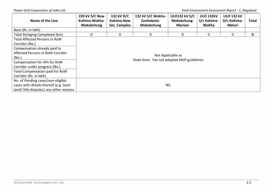
Power Grid Corporation of India Ltd. Final Environment Assessment Report - 1, Nagaland
RS Envirolink Technologies Pvt. Ltd. 5.5
Name of the Line 220 kV S/C New Kohima-Wokha-
Mokokchung
132 kV D/C Kohima-New Sec. Complex
132 kV S/C Wokha-Zunheboto-
Mokokchung
LILO132 kV S/C Mokokchung-
Mariani
LILO 132kV S/c Kohima-
Wokha
LILO 132 kV D/c Kohima-
Meluri Total
Base (Rs. in lakh) Total Stringing Completed (km) 0 0 0 0 0 0 0 Total Affected Persons in RoW Corridor (No.)
Not Applicable as State Govt. has not adopted MoP guidelines
Compensation already paid to Affected Persons in RoW Corridor (No.) Compensation for APs for RoW Corridor under progress (No.) Total Compensation paid for RoW Corridor (Rs. in lakh) No. of Pending cases/non-eligible cases with details thereof (e.g. Govt land/ title disputes/ any other reasons
NIL
Power Grid Corporation of India Ltd. Final Environment Assessment Report - 1, Nagaland
RS Envirolink Technologies Pvt. Ltd. 5.6
5.2.6 Interference with other Utilities and Traffic
As per regulations, it is mandatory for IA/Utility to seek clearance prior to
construction from department of Railways, Telecommunications and
wherever necessary from aviation authorities that are likely to be affected by
the construction of transmission lines. The transmission and distribution lines
do not interfere with telecommunication towers. Further, railway lines and
aviation routes are not present in the project locations. It is therefore not
required to avail clearances from Department of Railways, Department of
Telecommunications, and the Ministry of Aviation.
As regard inference with traffic, it is to may be noted that National Highway-
61 (NH-61) and National Highway-39 (NH-39) are the main roads which
connect various subproject areas including the sub-station sites through
various state roads, district roads and village roads. Traffic on NH-39 is
comparatively more than traffic on NH-61. However, as expected that
execution of the projects covered in this report has not resulted in any steep
rise in traffic volume. Further, the present project requires very less vehicular
movement and that too restricted to construction period only. Hence, no
steep rise in traffic volume is anticipated/ observed.
5.2.7 Interference with Drainage Pattern
As the transmission lines are constructed aerially and the blockage of ground
surface is limited to area of tower footings, which is very small, there is little
possibility of affecting drainage pattern. The transmission & distribution lines
proposed under this scheme don’t involve any tower/ pole to be placed in
river bed which could interfere with existing drainage patterns. Further, to
avoid any interfere, DC towers are being used instead DB tower as single span
limit is crossed in the stretches where TL/ DL is crossing river, cross-arm
strengthening has been suggested. Also, as mentioned in previous chapter,
use of leg extension is being made in towers to minimize/avoid benching/
revetment, to minimize/ avoid chances of soil erosion, to minimize/ avoid
sedimentation of river, to provide great stability. Another measure already
suggested in EMP and in place is to avoid dumping of fill materials in sensitive
drainage area. In case of substations, all drainage channels along or inside
substations are being trained and connected to main or existing drainage to
avoid any erosion due to uncontrolled flow of water. Same can be observed
from the photographs placed below.

Power Grid Corporation of India Ltd. Final Environment Assessment Report - 1, Nagaland
RS Envirolink Technologies Pvt. Ltd. 5.7
Protection/ Boundary Wall along the Irrigation Canal and Stream
5.3 ENVIRONMENTAL PROBLEMS DUE TO DESIGN
5.3.1 Escape of Polluting Materials The equipment installed on lines and substations are static in nature and do not generate any fumes or waste materials. However, detailed specification with respect to equipment design and substation drainage and sewage design has been included in tender document to avoid any incidence of land and water contamination. Transformers have been designed with oil spill containment systems having sump of capacity of 200% of oil volume of largest transformer, and purpose-built oil, lubricant and fuel storage system, complete with spill cleanup equipment. Substations include drainage and sewage disposal systems to avoid offsite land and water pollution. Apart from this, solid waste like packing materials, cables, aluminum conductor, sand, aggregate material, cements and steel generated during construction is carefully handled and removed from the sites periodically to avoid any contamination. Same can be figured out with the help of photographs placed below. Also, the system helps in avoiding accidents through contamination, spills and fire.
Drainage and Sewage system within the Lalmati (Zubza) Substation
Drainage Irrigation Canal

Power Grid Corporation of India Ltd. Final Environment Assessment Report - 1, Nagaland
RS Envirolink Technologies Pvt. Ltd. 5.8
Arrangement to avoid contamination and accidents
Sectional Detail of Switchyard Open Drain & Plinth Protection Drain
Details of Soak Pit & Septic Tank

Power Grid Corporation of India Ltd. Final Environment Assessment Report - 1, Nagaland
RS Envirolink Technologies Pvt. Ltd. 5.9
5.3.2 Explosion/Fire Hazards
During the survey and site selection for transmission lines, and substations, it
has been ensured that these are kept away from oil/gas pipelines and other
sites with potential for creating explosions or fires. Fires due to flashover from
lines can be a more serious problem in forest. However, adequate safety
measures are taken to avoid such incidence. In the present project, the route
line routes and substations are not located close to the vicinity of oil/gas
pipelines or other installations with potential fire/ explosion hazard. Apart
from this, automatic tripping mechanism for transmission/distribution and
substations are being installed so that line gets disconnected in fraction of
seconds to prevent fire hazards. Also, fire wall between transformers are
being constructed to prevent fire from spreading. Firefighting instruments
including fire extinguishers are kept in appropriate place for immediate action
in case of any fire hazard.
The only substation which is surrounded by residential area is 33/11 kV New
Lalmati substation. It may be noted that sub-stations are being constructed on
the land provided by DPN after considering all the risks and after following
ESPPF. Lalmati was an existing sub-station, however, it is being considered as
new as it was totally dismantled before construction. Measures taken at
Lalmati substation to avoid any such hazard are construction of fire wall
between transformers and the boundary wall of the substation is high as
compared to other substations. Apart from Lalmati substation there is no sub-
station that needs such additional attention.
Fire Wall at ITI, Kohima Fire Wall at Padampukhri
5.3.3 Erosion Hazards due to Inadequate Provision for Resurfacing of Exposed Area
Construction of 220/132kV line involves only small-scale excavation of area
i.e. 3m L x 3m W x 3m H for tower footing that may result in generation of 108
m3 of excavated material from each tower. In case of 220/132/33 kV
substation foundation, excavation of soil to the tune of 7500 m3 is required

Power Grid Corporation of India Ltd. Final Environment Assessment Report - 1, Nagaland
RS Envirolink Technologies Pvt. Ltd. 5.10
depending on site condition. Similarly, in case of 33 kV line, soil excavation is
limited to 0.72 m3 for each pole, and for 33/11 kV sub-station, excavation of
around 2000 m3 is required. It has been worked out that a total of
approximately 1,07,678 m3 (547x108 + 4x7500 + 848x0.72 + 9x2000) of
excavated materials gets generated for construction of 547 nos. of tower, 4
nos. of 220/132 kV substations, 848 nos. of poles and 9 nos. of 33/11 KV
substations proposed under present scheme. However, all the soil excavated
for tower/pole footings and substations construction are optimally (about 80-
90%) utilized for backfilling and the remaining soil being spread evenly and
compacted. Top soil disturbed during the development of sites are used to
restore the surface of the platform. Infertile and rocky material are dumped at
carefully selected dumping areas and used as fill for substation/ and
tower/pole foundations. Hence, possibility of erosion of exposed area due to
construction activity is negligible.
5.3.4 Environmental Aesthetics
Since spacing between the towers/poles in case of 220/132 kV transmission &
33 kV distribution lines is approximately 300 meters and 100 meters,
respectively, these don’t affect the visual aesthetics of the localities
particularly when it is ensured to route the lines as far away from the
localities as possible. DPN takes up plantation of trees to buffer the visual
effect around its substations and to provide better living conditions.
Wherever DPN feels it appropriate, discussions are held with local Forest
Department officials to determine feasibility of planting trees along roads
running parallel to transmission lines to buffer visual effect in these areas. In
addition, towers are painted grey or green to merge with the background.
5.3.5 Noise/Vibration Nuisances
The equipment installed at substation are mostly static and are so designed
that the noise level always remains within permissible limits i.e. 85 dB as per
Indian standards. Transformers with maximum noise emitting level of 75 dB
and DG set with proper enclosures are part of equipment specification/ design
criteria. Some noise is unavoidable during construction phase like noise
produced by concrete mixing equipment and excavators which are temporary
and only in day time. However, regular monitoring by IA/Contractors and due
maintenance of equipment are ensured to keep the noise level well within the
prescribed limit. Further, to contain the noise level within the permissible
limits whenever noise level increases beyond permissible limits, measures like
providing sound and vibration dampers and rectification of equipment are
undertaken. In addition, plantations of sound absorbing species like
Casuarinas, Tamarind, and Neem are raised at the substations that reduce the
sound level appreciably.

Power Grid Corporation of India Ltd. Final Environment Assessment Report - 1, Nagaland
RS Envirolink Technologies Pvt. Ltd. 5.11
5.3.6 Blockage of Wildlife Passage/ Impact on Avifauna
The proposed transmission & distribution lines are not passing through any
forest area, wildlife area. Since there is no protected area or demarcated/
documented migration path of wildlife like elephant corridor existing near to
subproject locations, hence, possibility of any disturbance to wildlife is not
imminent.
Avian hazards mostly encountered in bird sanctuaries area, IBAs and fly path
of migratory bird predominantly related to nesting site. Since in the instant
case due to routing of line away from such areas, bird hit/electrocution is not
anticipated. Although the incidence of avian hazards is rare due to the
distance between the conductors, however, as an additional measure to
prevent any avian hazards, bird guards/ anti perch devices are part of BoQ
and also integral part of tower design (drawing attached as Annexure V).
5.4 ENVIRONMENTAL PROBLEMS DURING CONSTRUCTION PHASE
5.4.1 Uncontrolled Silt Runoff
Majority of tower/pole locations are on hilly terrain; therefore, tower/ poles
have been positioned on hilltops and where ever positioning of tower on hill
top is not possible leg extension is being utilized so as to minimize/ avoid
benching/ revetment and to provide great stability. Retaining walls are also
being constructed to eliminate the chances of silt runoff/ soil erosion. Out of
total 542 towers being/ to be erected approx. 66% (359 no.) are with leg
extension. The excavated material has been backfilled and any remaining
earth, if any have been spread around the base and compacted. In case of
distribution lines all the excavated soil is backfilled and compacted after
erection of tubular poles.
In case of sub-station, existing one are located on flat land and adjacent to
existing road and new ones are also being constructed on flat land after site
clearing and leveling. It is also being ensured that new sub-stations are close
to existing road and construction of approach road is avoided as far as
possible, however, in some cases i.e. 132/33 kV sub-stations at Zunheboto,
Secretariat Complex and Pfutsero approach road of 2 km, 300 m and 200 m
respectively is proposed/ under implementation.
As already explained, during construction limited quantity of excavated
material is generated from tower/pole foundations and sub-station
foundation. However, adequate measures have been taken to store excavated
materials properly for refilling after construction is over. Further, excavation
in the hilly areas is avoided in rainy days. Hence, uncontrolled silt run off is not

Power Grid Corporation of India Ltd. Final Environment Assessment Report - 1, Nagaland
RS Envirolink Technologies Pvt. Ltd. 5.12
anticipated. However, during construction, precautions are being taken by
contractors, boundary/ retaining/ breast walls are being constructed to avoid
any such runoff of excavated material from the construction sites. Moreover,
sub-stations are being constructed above the high flood level (HFL) by raising
the foundation pad, therefore, are not prone to flooding/ erosive losses of
soil.
So far there are no instances with potential of erosion during construction of
above said lines. Similarly, there are no instances of erosion/losses of soils
into adjoining area as all the overburden are being backfilled within the
substation boundary walls and properly managed. The substations are not
located in the vicinity of water bodies or ecologically sensitive areas. Refilling
and levelling of excavated material at substations and tower foundation &
erection works have been demonstrated with the help of following
photographs taken during the field visit.
Earth cutting and Levelling at 132/33kV Secretariat Complex Kohima
Surplus Earth labelling at Lalmati S/S

Power Grid Corporation of India Ltd. Final Environment Assessment Report - 1, Nagaland
RS Envirolink Technologies Pvt. Ltd. 5.13
Refilling and leveling of excavated material at Chiephobozou Substation
Cutting and leveling of excavated material at Zunheboto Substation
Refilling and leveling of excavated material at Longleng DMS and Pfutsero Substations
Refilling and leveling of excavated material after tower foundation and erection work

Power Grid Corporation of India Ltd. Final Environment Assessment Report - 1, Nagaland
RS Envirolink Technologies Pvt. Ltd. 5.14
Refilling and leveling of excavated material after tower foundation and erection work
5.4.2 Nuisance to Nearby Properties
During site selection due care is taken to keep the transmission & distribution
lines and substations away from settlements. Further, all the construction
activities are undertaken through the use of small mechanical devices e.g.
tractors and manual labour, therefore, nuisance to the nearby properties if
any, is not expected. The construction activities are normally undertaken in
lean period and post harvesting to avoid/minimize such impact. All
construction sites of new sub-station are prohibited for general public both
due to its separation/demarcation by boundary wall and also due to statutory
provisions. Hence, any adverse impact arising during the construction of
substation is temporary i.e. will last during construction phase only, and
limited to the boundaries of proposed substation only and neither impacts
nearby habitat/property nor health & safety of neighboring community.
132/33 kV Wokha S/S Boundary Wall & Gate 33/11 kV Padampukhri S/S B. Wall & Gate

Power Grid Corporation of India Ltd. Final Environment Assessment Report - 1, Nagaland
RS Envirolink Technologies Pvt. Ltd. 5.15
33/11 kV Chiephobozou S/S Boundary Wall 33/11 kV ITI, Kohima S/S Gate
33/11 kV Lalmati (Zubza) S/S Boundary Wall 132/33 kV Longnak S/S Boundary Wall
33/11 kV Pfutsero S/S Boundary Wall 33/11 kV Chukitong S/S Boundary Wall
5.4.3 Interference with Utilities and Traffic and Blockage of Access Way
Since all the locations of subprojects are not well connected through rail link,
transportation of construction materials will be mostly through road network.
Access to the site will be along existing roads or village paths; minor
improvements to paths may be made where necessary, but no major
construction of roads, except, 132/33 kV sub-stations at Zunheboto,
Secretariat Complex and Pfutsero where approach road of 2 km, 300 m and
200 m respectively is proposed/ under implementation will be necessary
either during construction.

Power Grid Corporation of India Ltd. Final Environment Assessment Report - 1, Nagaland
RS Envirolink Technologies Pvt. Ltd. 5.16
The approach road at Secretariat Complex and Pfutsero is proposed/ being
constructed on already acquired land for the construction of sub-station
therefore, neither it will interfere with utilities and traffic and block the access
way nor compensation for any damage to crop or field will be paid to the
owner. The approach road of 2 km for 132/33 kV Zunheboto sub-station is
proposed from Lizo old village to sub-station. Presently, it is existing foot path
only being used by villagers for movement from their home to agricultural
field. Since it is a foot path which leads to nothing but agricultural field
therefore, interfere with utilities and traffic and block the access way is not at
all expected. In many areas such improvement in the access road is highly
appreciated by the local population. Moreover, since none of these segments
require any additional land and thus have insignificant environmental and
social impacts, these would fall in low risk category as per E & S screening
criteria.
The transmission and distribution lines do not interfere with
telecommunication towers. Further, railway lines and aviation routes are not
present in the project locations. Therefore, interfere with utilities and block
the access way in this regard is also not at all expected. As and when a
transmission line crosses any road, the short span angle (DT) towers are
located at a distance so as not to cause any hindrance to the movement of
traffic. Stringing at the construction stage is carried out during lean traffic
period in consultation with the concerned authorities and angle towers are
planted to facilitate execution of work in different stages.
5.4.4 Inadequate Resurfacing for Erosion Control
As explained earlier, majority of tower/pole locations hilly terrain, therefore,
tower/ poles have been positioned on hilltops and where ever positioning of
tower on hill top is not possible leg extension is being utilized so as to
minimize/ avoid benching/ revetment and to provide great stability. Retaining
walls are also being constructed to eliminate the chances of silt runoff/ soil
erosion. However, till date no instances with potential of erosion observed
during construction of above said lines. Further, construction is generally
undertaken in dry/non- monsoon period.
Similarly, existing sub-stations are located on flat land but new sub-stations
are being constructed on flat land after site clearing and leveling. Further, due
to undulating terrain and for slope protection, retaining / RRM walls have
been planned/ being implemented as erosion protection measure in the sub-
stations mentioned in Table 5.4. Typical section of retaining wall for various
depth is shown as figure below.

Power Grid Corporation of India Ltd. Final Environment Assessment Report - 1, Nagaland
RS Envirolink Technologies Pvt. Ltd. 5.17
Table 5.4: Details of Slope Protection Measures
S. No.
Location Measure
Type Purpose of Measure
Present Status
1 Establishment of 132/33 kV Sub-station at Zunheboto (New)
RCC Retaining Wall
To avoid landslide/ soil erosion
Yet to start
2 Establishment of 132/33 kV Sub-station at Secretariat Complex Kohima (New)
RCC Retaining Wall
To avoid landslide/ soil erosion
Completed up to 42 m length and
2.2 m height
3 Establishment of 132/33 kV Sub-station at Pfutsero (New)
RCC Retaining Wall
To avoid landslide/ soil erosion
Under Progress
4 Bay extension of 132/33 kV Sub-station at Wokha
RRM Wall
To avoid landslide/ soil erosion
Completed. (13.3 m + 9.6 m
length)
5 Bay extension of 132/33 kV Sub-station at Mokokchung (State Owned)
RRM Wall To avoid landslide/
soil erosion Completed up to
8 m
6 Establishment of 33/11 kV Sub-station at Pfutsero (New)
RRM Wall To avoid landslide/
soil erosion
Under construction
(approx. 40m)
7 Capacity augmentation of 33/11 kV (Existing) Sub-station at Botsa
RRM Wall To avoid landslide/
soil erosion Completed
(approx. 18m)
8 Capacity augmentation of 33/11 kV (Existing) Sub-station at Chakabama
RRM Wall To avoid landslide/
soil erosion Completed
(approx. 12m)
9 Mostly in all sub-stations Stone Pitching To retain the soil Shall be provided
Typical Section of Retaining Wall for Various Depth
For tower/ pole and sub-station located on flat terrain, problem of soil erosion
is not envisaged. Few such instances have been demonstrated with the help
of following photographs.

Power Grid Corporation of India Ltd. Final Environment Assessment Report - 1, Nagaland
RS Envirolink Technologies Pvt. Ltd. 5.18
Pole erection work from Nagarjan to Padampukhri
Pole erection work from Zunheboto South Point to Zunheboto
Tower Foundation work at Pfutsero
Tower Erection work at Longnak Tower Foundation at Mokokchung

Power Grid Corporation of India Ltd. Final Environment Assessment Report - 1, Nagaland
RS Envirolink Technologies Pvt. Ltd. 5.19
RCC Retaining Wall at 132/33kV New Secretariat Complex Sub-station
RRM Wall at 132/33kV Wokha Sub-station
RRM Wall at 132/33 kV Mokokchung Sub-station
RRM Wall at 33/11 kV Pfutsero S/S RRM Wall 33/11 kV Botsa S/S

Power Grid Corporation of India Ltd. Final Environment Assessment Report - 1, Nagaland
RS Envirolink Technologies Pvt. Ltd. 5.20
RRM Wall at 33/11 kV Chakabama S/S
During field visit, it was observed that:
• At few construction sites, there is a possibility of erosion along the
slopes getting triggered by excavated soils dumped without protection/
retaining wall. Tseminyu DMS Site has been left unattended after
excavation work without any protection around the construction site.
• Similarly, at DMS Mokokchung Hospital area, excavated soil mass has
blocked a seasonal drain, However, IA staff/ engineers assured that as per approved design protection
wall will be constructed all along the boundary of DMS at the right bank of
nala.
Approach Road 133/33 kV Sub Station Sec. Complex, Kohima
Tseminyu DMS Site Mokokchung Hospital Area DMS Site
Drainage Line

Power Grid Corporation of India Ltd. Final Environment Assessment Report - 1, Nagaland
RS Envirolink Technologies Pvt. Ltd. 5.21
Also, it was observed that during construction at 132/33 kV Lognak substation
site, huge number of boulders were excavated. (Refer photographs shown
below). Such quantity of boulders was not anticipated during planning stage.
The contractor has sought advice from IA regarding the disposal of these
boulders. Since the quantity of boulders excavated are much more than the
required quantity for filling within sub-station therefore, a suitable disposal
site needs to be identified and provided to contractor in order to ensure
systematic disposal of excavated boulders.
Unexpected excavation of boulders from 132/33 kV Lognak substation site
5.4.5 Inadequate Disposition of Borrow Area
As mentioned earlier the tower/pole foundations involve excavations on small
scale basis and the excavated soil is utilized for back filling. In case of
substations, generally the sites are selected in such a manner that the volume
of cutting is equal to volume of filling avoiding borrowing of the area. In the
instant project also, the excavated material is disposed off in the same sub-
station premises only. However, a quantity of 1066.215 m3 earth/ soil is
required in 33/11 kV Padampukhri sub-station for which borrow area is yet to
be finalized. If found suitable i.e. physical and financially viable than surplus
boulders to be disposed off at 132/33 kV Longnak sub-station can be utilized
at 33/11 kV Padampukhri sub-station.

Power Grid Corporation of India Ltd. Final Environment Assessment Report - 1, Nagaland
RS Envirolink Technologies Pvt. Ltd. 5.22
5.4.6 Protection of Worker's Health/Safety
All health & safety issues and their management aspects are integral part of
project/contract specific safety plan (Annexure VI), which is also part of
contract conditions. Various aspects such as, work and safety regulations,
workmen's compensation, insurance are adequately covered under the
General Conditions of Contract (GCC), a part of bidding documents. Project is
being executed as per the approved plan and is regularly monitored by
dedicated Safety personnel. Moreover, for strict compliance of safety
standard/plan a special provision as a deterrent has been added in the
contract which provides for a heavy penalty of Rs.10 lakhs for each accidental
death and Rs 1.0 lakh for each injury and is deducted from the contractor’s
payment and paid to the deceased/affected family (Annexure VII).
Additionally, work and safety regulations, workmen's compensation,
insurance are adequately covered under the General Conditions of Contract
(GCC), a part of bidding documents. The project authority ensures that all
contractors are operating with valid labor license as per provision under
section – 12(1) of the Contract Labour (Regulation & Abolition) Act, 1970 and
also certified under Section- 7(3) of the Building and Other Construction
Workers (Regulation of Employment and Condition of Service) Act, 1996 from
Ministry of Labour & Employment. Besides, the contractors have obtained
requisite insurance policy as per provisions of Employee Compensation Act,
1923 for its employed workforce. Sample copy of labor license and insurance
policy for workers is attached as Annexure VIII. During construction work, safety guidelines/checklists including work permits
and safety precautions are being strictly followed which are also regularly
monitored by site in-charge. Sample copy of filled checklist is enclosed as
Annexure IX. Efforts are being made to hire labourers locally to the extent possible, else
same have been outsourced. The workers have been provided with PPEs such
as boots and helmets. Mock drills such as fire safety, first aid etc. are
conducted periodically to enhance the preparedness level of the workforce.
Safety induction & awareness programme including HIV/AID are also
conducted at every active site. Safety film for transmission project in local
language is shown to workers for better awareness. Proper drinking water has
also been provided. First aid boxes and provisions for treatment in case of
emergencies were arranged locally/ nearby towns.

Power Grid Corporation of India Ltd. Final Environment Assessment Report - 1, Nagaland
RS Envirolink Technologies Pvt. Ltd. 5.23
Protection of Workers Health and Safety at various construction sites
Lalmati (Zubza) Substation
Secretariat Complex Substation
Mokokchung (State) Substation Longtho Substation

Power Grid Corporation of India Ltd. Final Environment Assessment Report - 1, Nagaland
RS Envirolink Technologies Pvt. Ltd. 5.24
Wokha Substation
Longnak Substation
Padampukhri Substation

Power Grid Corporation of India Ltd. Final Environment Assessment Report - 1, Nagaland
RS Envirolink Technologies Pvt. Ltd. 5.25
Labour Camps at various Construction Sites
Chiephobozou Substation Chukitong Substation
Longnak Substation
Secretariat Complex Substation Zunheboto Substation

Power Grid Corporation of India Ltd. Final Environment Assessment Report - 1, Nagaland
RS Envirolink Technologies Pvt. Ltd. 5.26
Health and Saftey Training
Tool box talk at Padampukhri S/s Toll Box talk at Lalmati S/s Toll Box Talk at Pfutsero S/s
Firefighting Training at Dimapur
Training on Emergency preparedness Training on material handling
Chiepobouzo S/s on 05.06.2018 World Environment Day Celebration
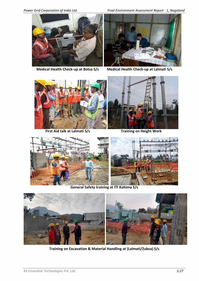
Power Grid Corporation of India Ltd. Final Environment Assessment Report - 1, Nagaland
RS Envirolink Technologies Pvt. Ltd. 5.27
Medical Health Check-up at Botsa S/s Medical Health Check-up at Lalmati S/s
First Aid talk at Lalmati S/s Training on Height Work
General Safety training at ITI Kohima S/s
Training on Excavation & Material Handling at (Lalmati/Zubza) S/s

Power Grid Corporation of India Ltd. Final Environment Assessment Report - 1, Nagaland
RS Envirolink Technologies Pvt. Ltd. 5.28
SAFETY INDUCTION TRAINING
220 kV S/C on D/C Tower New Kohima – Mokokchung T/L
Longtho S/S
132 kV line at Zhadima

Power Grid Corporation of India Ltd. Final Environment Assessment Report - 1, Nagaland
RS Envirolink Technologies Pvt. Ltd. 5.29
NATIONAL SAFETY WEEK CELEBRATION
CBIS TRAINING

Power Grid Corporation of India Ltd. Final Environment Assessment Report - 1, Nagaland
RS Envirolink Technologies Pvt. Ltd. 5.30
During site visit, it was observed that at some sites, condition of labour camps needs to be improved. It was observed at Chukitong site that labour camps are also being used for storing cement bags and other construction material which can cause serious respiratory problems to the labours. At Secretariat Complex and Longnak sites, lack of awareness regarding cleanliness of surrounding and lack of mechanism of disposal of solid waste was observed. Following photographs have been taken to highlight same.
At all construction sites, supervisors/ engineers of contractor as well as IA
staff were seen without any PPEs during construction and monitoring of the
works. During consultation with labours and IA staff it was observed that
workers at the site were not aware about their health and safety during
construction. Also, it was observed at few places that labours avoid usage of
PPEs as they consider it as hindrance in smooth conduction of construction
activities. Labours were not aware about availability of first aid box at
construction site. Similarly, records of labours’ health checkup were missing at
most of the sites. These are due to the lack of induction and training
programme as committed in Health and Safety Plan. IA staff and contractor
informed that the group of labours/ gangs gets change frequently therefore it
becomes difficult to impart with induction and training at regular basis as well
provide with PPEs. Following photographs taken during the field visit
demonstrate lack of use of PPEs at work sites.

Power Grid Corporation of India Ltd. Final Environment Assessment Report - 1, Nagaland
RS Envirolink Technologies Pvt. Ltd. 5.31
Lack of use of PPEs
Safety Plan (Annexure VI), an action plan to mitigate and manage such issues
already forms an integral part of agreement/ contract conditions signed by
the respective contractors. It is the duty of safety officer/ site in-charge/ IA to
ensure that safety plan is being strictly followed to avoid any untoward
incidence. The IA on their part carries out routine safety check/ audits,
informs the contractor and seeks their compliance on the same.
Similarly, based upon the field visit for the FEAR study and observations
pertaining to safety related and other aspects made by the team, IA issued
letter and sought clarifications from concerned contractor as reproduced
below. It was observed that safety plan signed and submitted by contractor is

Power Grid Corporation of India Ltd. Final Environment Assessment Report - 1, Nagaland
RS Envirolink Technologies Pvt. Ltd. 5.32
sufficient enough to avoid any untoward incidence and thus, any other
additional action plan to mitigate and manage such issues may not be needed.
Typical Letters/notices being issued by IA to Contractors

Power Grid Corporation of India Ltd. Final Environment Assessment Report - 1, Nagaland
RS Envirolink Technologies Pvt. Ltd. 5.33
5.5 ENVIRONMENTAL PROBLEMS RESULTING FROM OPERATION
5.5.1 O&M Staff/Skills Less Than Acceptable Resulting in Variety of Adverse Effects
The O& M program is normally implemented by substation personnel for both
the lines as well as substations. Monitoring measures employed include
patrolling and thermo-vision scanning. The supervisors and managers
entrusted with O&M responsibilities are intensively trained for necessary skills
and expertise for handling these aspects. A monthly preventive maintenance
program is carried out to disclose problems related to cooling oil, gaskets,
circuit breakers, vibration measurements, contact resistance, condensers, air
handling units, electrical panels and compressors. Any sign of soil erosion is
also reported and rectified. Monthly monitoring reports are generated and
appraised to Management, including a report of corrective action taken and a
schedule for future action.
DPN follows the best international practices while designing its system to
maintain acceptable prescribed Electro Magnetic Field (EMF) level. The ICNIRP
guideline for acceptable EMF level for the general public (up to 24 hours a
day) is a maximum exposure level of 1,000 mG or 100T. Further, because of
health and safety issues such as fire safety, safe voltages on metallic parts of
buildings, and safety clearances to avoid flashover, the transmission lines do
not pass directly over any residential properties and as such the potential for
EMF effects to occur is further diminished.
Poly Chlorinated Biphenyls (PCBs) due to their high heat capacity, low
flammability and low electrical conductivity were extensively used as
insulating material in capacitors and transformers. But after the finding that
these PCBs are non-biodegradable and have carcinogenic tendency, their use
in electrical equipment as insulating medium has been banned all over the
world long back. However, it has been reported in some studies that chances
of contamination of oil with PCB is possible. Keeping that in mind, DPN has
discontinued procurement of electrical equipment containing PCB more than
2 mg/kg and specification (as per IEC 61619 or ASTM D4059) is being stated in
the tender document. Moreover, the subject scheme doesn’t involve
replacement of any PCB containing equipment, hence no disposal of such
equipment is anticipated.

Power Grid Corporation of India Ltd. Final Environment Assessment Report - 1, Nagaland
RS Envirolink Technologies Pvt. Ltd. 5.34
5.6 CRITICAL ENVIRONMENTAL REVIEW CRITERIA
5.6.1 Loss of Irreplaceable Resources
In the instant project none of the project elements encroach upon any forest
area, protected areas, and ecologically sensitive areas hence, the problem of
losing natural resources is not anticipated.
5.6.2 Accelerated Use of Resources for Short-term Gains
The subprojects are not making use of any natural resources occurring in the
area during construction and are not utilizing the same during maintenance
phases. The construction material such as tower members, cement etc. are
being sourced from factories while the excavated soil is being reused for
backfilling to restore the surface. During construction of transmission line,
very small quantity of water is required which is met from nearby existing
source or through tankers. However, for substation water requirement is met
mostly by ground water derived by digging a borewell during construction as
well as for operational stage. Moreover, provision of rain water harvesting in
all proposed substations under the present scheme has been made to
conserve precious water resources and enhance the ground water level. The
aggregates used for construction are already available within sub-station area
due to cutting, thus no new borrow area will be created. Hence, it may be
seen that the activities associated with implementation of subject project
shall not cause any accelerated use of resources for short term gain.
5.6.3 Endangering of Species
As described earlier, no endangered species of flora and fauna exist in the
subprojects area is getting affected and considering aerial nature of
transmission and distribution project, there is no possibility of endangering/
causing extinction of any species.
5.6.4 Promoting Undesirable Rural-to Urban Migration
The subprojects will not cause loss of land holdings that normally trigger
migration. It also does not involve resettlement due to acquisition of any
private land holdings. Hence, there is no possibility of any migration.
5.7 PUBLIC CONSULTATION Public consultation/ information dissemination is a continuous process
starting with the project conception and continues during project
implementation and even during O&M stage. Public is informed about the
project at every stage of execution. During survey, DPN & POWERGRID site
officials met people and informed them about the routing of transmission and

Power Grid Corporation of India Ltd. Final Environment Assessment Report - 1, Nagaland
RS Envirolink Technologies Pvt. Ltd. 5.35
distribution lines. During the construction, every individual, on whose land
tower is erected and people affected by RoW, were consulted. Apart from
this, Public consultation using different technique like Public Meeting, Small
Group Meeting, informal Meeting have been carried out during different
activities of project cycle. During such consultation, the public is informed
about the project in general and in particular about the following:
• Complete project plan (i.e. its route and terminating point and
substations, if any, in between);
• Design standards in relation to approved international standards;
• Health impacts in relation to EMF;
• Measures taken to avoid public utilities such as school, hospitals, etc.;
• Other impacts associated with transmission & distribution lines and
DPN approach to minimizing and solving them;
• Trees and crop compensation process.
In the instant project also, many group meetings were organized (informally
and formally) by IA & DPN in all villages where the interventions are
happening. These meetings were attended by Village Panchayat members,
senior/respected person of village, interested villagers/general public and
representatives from DPN & IA. To ensure maximum participation, prior
intimation in local language was given and such notices were also displayed at
prominent places/panchayat office etc. During consultations/interaction
processes with people of the localized areas, DPN field staffs explained
benefit of the project, impacts of transmission line, payment of compensation
for damaged of crops, trees, huts etc. as per The Indian Electricity Act, 2003
and The Indian Telegraph Act, 1885 and measures to avoid public utilities such
as schools, hospital etc. People more or less welcomed the construction of the
proposed project. Various issues inter alia raised by the people during public
consultation and informal group meetings are as follows;
• To involve village headman during survey work/finalization of line
corridor;
• To engage local people in various works associated with construction of
line and if required proper training may be provided to engage them.
• To provide flexibility in disbursement of compensation;
• Direct payment of compensation to affected land owners and
expeditious disbursement of compensation.
Also, during site visits, consultations were conducted with various stake
holders belonging to community and affected people. Target group included
contractor, contractor’s labor, IA & DPN Staff and villagers as well as
Municipal Corporation, Pfutsero. These consultations were carried out to
capture the views of stakeholders about the project plan, design and layout of

Power Grid Corporation of India Ltd. Final Environment Assessment Report - 1, Nagaland
RS Envirolink Technologies Pvt. Ltd. 5.36
the project, environmental and social impacts, compensation process,
benefits or drawback of the project etc.
It needs to be emphasized that public consultation was kept restricted due to
the apprehensions of IA and contractors for security and other law & order
related issues which were communicated and advised to field team at onset
of field surveys itself and hence limited stakeholder consultations have been
carried out. However, it was ensured that consultations representatively
covered most stakeholders involved.
Major findings of the consultations are summarized below:
• People are well aware about the project, its various components and
confirmed that IA & DPN informs about the project at every stage of
execution.
• Considering that the state of electricity supply in the state is very weak,
people welcomed the project as it will not only improve overall power
supply situation but will also improve reliability, quality, security and
enhancement of power supply of the state.
• People confirmed that IA & DPN are taking every step possible to avoid/
minimize the environmental and social impacts along the route of
transmission lines and at site of sub stations.
• People confirmed that community reserves, sacred groves and
community conserved areas are completely avoided while finalizing the
route of lines.
• People also confirmed that their common property resources such as
cemetery, school, community hall, habitation areas etc. have been
completely avoided while finalizing the route of lines.
• People informed that staff of IA/ contractor are easily approachable
and are very open to address their grievances. As a result, no written
grievance has been received till date.
• People are very much happy with the rate of compensation being given
to them and they are being involved in the process of deciding the rate
of compensation.
• People confirmed that there is no disturbance of any sort to their life/
livelihood due to the construction or various other activities being
carried out under the project.
• Stakeholder at Longnak informed that due to the construction of new
substation, a small irrigation channel from nearby nala to their
agricultural field was getting affected. However, on their request, IA
assured that not only construction activities avoid disturbance to
irrigation channel; it also ensures to train the channel.

Power Grid Corporation of India Ltd. Final Environment Assessment Report - 1, Nagaland
RS Envirolink Technologies Pvt. Ltd. 5.37
• Stakeholder at Old Lizo village near Zunheboto informed that they
welcomed the proposal of IA to upgrade the existing footpath to
approach road. This upgradation will provide them with better
accessibility to their agricultural fields.
• No cases of conflict between migrant and local population has been
reported till date.
• Execution of project work provides opportunities to local contractors to
get involved in construction, fabrication, transportation etc. activities.
• Most of the sub-contracts are awarded/ being awarded to local
peoples.
• Contractor prefer and engage local peoples for skilled and unskilled
works
• Local villagers rented out their buildings to contractor and IA for
temporary offices and staff quarters in local that helps in income
generation
• Wherever possible contractor and IA purchase daily need requirements
for local vendors and shopkeepers that helps in economic upliftment of
the area
• The contractor labor informed that they have been provided with PPEs
such as boots and helmets.
• Mock drills such as fire safety, first aid etc. are conducted periodically to
enhance the preparedness level. Safety induction & awareness
programme including HIV/AID are also conducted. Safety film for
transmission project in local language is shown for better awareness.
• Migrant labors confirmed that they have been provided with camps and
all basic facilities such as food, fuel, proper drinking water etc. They also
confirmed that they do not source fuel wood from the forest areas.
• First aid boxes and provisions for treatment in case of emergencies are
arranged locally/ nearby towns.
• It was revealed that contractor and IA work with close coordination
with village heads and community to avoid any misunderstanding
during work
Details of public consultation meetings carried out during site visit and public
consultation using different technique like Public Meeting, Small Group
Meeting, informal Meeting undertaken by IA & DPN including minutes of
meeting, list of participants and photographs are enclosed as Annexure X.
5.8 COMPLIANCE OF EMP The IA has a continuous monitoring mechanism of the project w.r.t.
compliance of the mandatory requirements as stipulated in the IEAR. As many

Power Grid Corporation of India Ltd. Final Environment Assessment Report - 1, Nagaland
RS Envirolink Technologies Pvt. Ltd. 5.38
provisions of EMP related to construction contractor, EMP has been made
integral part of contract document for its proper implementation by
contractor/sub-contractor. Thus, the adherence to the clauses by the
contractor is regularly monitored especially in respect of various
implementation E & S measures including health and safety aspects. As part of
the present study, mitigation measures as stipulated in the IEAR have been
critically assessed/evaluated for compliance through physical inspection,
verification of record/ documents/ drawing, interaction with project
officials/contractor/ villagers/construction workers and PRA etc. Based on
above, a detailed compliance status w.r.t. each identified impacts enlisted in
EMP have been prepared and is presented in Table 5.5.

Power Grid Corporation of India Ltd. Final Environment Assessment Report - 1, Nagaland
RS Envirolink Technologies Pvt. Ltd. 5.39
Table 5.5: Environment Monitoring Plan Cl. No.
Project activity/ stage Potential impact Proposed mitigation measures Compliance Status
Pre-Construction
1
Location of overhead line towers/ poles/ underground distribution lines and alignment & design
Exposure to safety related risks
Setback of dwellings to overhead line route designed in accordance with permitted level of power frequency and the regulation of supervision at sites.
Complied with. Route alignment criterion is part of survey contract wherein all statutory Electrical clearances as stipulated under CEA’s regulations, 2010 (Measures related to safety & electric supply) are considered/ ensured.
2 Equipment specifications and design parameters
Release of chemicals and gases in receptors (air, water, land)
PCBs not used in substation transformers or other project facilities or equipment.
Complied with. Part of technical specification of transformer. PCB is not used or non-detectable level (i.e. less than 2mg/kg) as per IEC 61619 or ASTM D4059
Processes, equipment and systems not to use chlorofluorocarbons (CFCs), including halon, and their use, if any, in existing processes and systems should be phased out and to be disposed of in a manner consistent with the requirements of the Government
Complied with. CFC free equipment is part of tender specifications
3 Transmission/ Distribution line design
Exposure to electromagnetic interference
Line design to comply with the limits of electromagnetic interference from overhead power lines
Complied with. DPN follows the best international practices while designing its system to maintain acceptable prescribed Electro Magnetic Field (EMF) level. The ICNIRP guideline for acceptable EMF level for the general public (up to 24 hours a day) is a maximum exposure level of 1,000 mG or 100T.
4 Substation location and design Exposure to noise Design of plant enclosures to comply with noise regulations.
Complied with. Transformers with maximum noise emitting level of 75 dB specified in tender specifications. Sound proof enclosures used for D.G sets

Power Grid Corporation of India Ltd. Final Environment Assessment Report - 1, Nagaland
RS Envirolink Technologies Pvt. Ltd. 5.40
Cl. No.
Project activity/ stage Potential impact Proposed mitigation measures Compliance Status
Social inequities
Careful selection of site to avoid encroachment of socially, culturally and archaeological sensitive areas (i. g. sacred groves, graveyard, religious worship place, monuments etc.)
Complied with. No encroachment of any socially sensitive areas due to proposed substations.
5
Location of overhead line towers/poles/ laying of underground distribution line & alignment and design
Impact on water bodies
Avoidance of such water bodies to the extent possible. Avoidance of placement of tower inside water bodies to the extent of possible
Complied with. Part of detailed alignment survey and design. No tower/pole located in water bodies.
Social inequities
Careful route selection to avoid existing settlements and sensitive locations
Complied with. Part of detailed tower/pole alignment survey design.
Minimise impact on agricultural land
Complied with. Though major section of proposed lines are routed through agricultural land in order to avoid impact on environmentally/ socially sensitive areas, efforts such as scheduling of construction lean/ post-harvest period, consultation with local authorities/ autonomous councils etc. are being made to minimize impacts on agricultural land/produce to the extent possible
Careful selection of site and route alignment to avoid encroachment of socially, culturally and archaeological sensitive areas (i. e. sacred groves, graveyard, religious worship place, monuments etc.)
Complied with. All settlements & ecologically sensitive areas avoided.
6 Involuntary acquisition or permanent land acquisition for substation.
Social inequities Compensation and R&R measures as per provision of RFCTLARRA, 2013
Since no involuntary acquisition of land is involved, there is no R&R issue.
7 Line through protected area/ Loss of precious Avoid siting into such areas by careful site Complied with.

Power Grid Corporation of India Ltd. Final Environment Assessment Report - 1, Nagaland
RS Envirolink Technologies Pvt. Ltd. 5.41
Cl. No.
Project activity/ stage Potential impact Proposed mitigation measures Compliance Status
precious ecological area ecological values/ damage to precious species
and alignment selection (National Parks, Wildlife Sanctuary, Biosphere Reserves/ Biodiversity Hotspots)
Part of detailed siting and alignment survey/design. All such areas are avoided
Minimize the need by using RoW wherever possible
8 Line through identified Elephant corridor / Migratory bird
Damage to the Wildlife/ Birds and also to line
Study of earmarked elephant corridors to avoid such corridors, Adequate ground clearance, Fault clearing by Circuit Breaker, Barbed wire wrapping on towers, reduced spans etc., if applicable
Not Applicable as there are no wildlife corridors
Avoidance of established/ identified migration path (Birds & Bats). Provision of flight diverter/reflectors, Bird guard, elevated perches, insulating jumper loops, obstructive perch deterrents, raptor hoods etc., if applicable
Complied with. Bird guard/ anti perch devices are part of BoQ and also integral part of tower design.
9 Line through forestland Deforestation and loss of biodiversity, edge effect
Avoid siting of line by careful site and alignment selection
Complied with. As part of detailed siting and alignment survey, forest areas have been completely avoided.
Minimise the need by using existing towers, tall towers and RoW, wherever possible
Complied with. Tower extensions of 3-9 m have been provided to reduce tree felling, wherever needed
Measures to avoid invasion of alien species Invasion of alien species not anticipated Obtain statutory clearances from the Government
Not applicable as there is no involvement of forest land
Consultation with autonomous councils wherever required
Complied with.
10 Lines through farmland Loss of agricultural production/ change in cropping pattern
Use existing tower or footings wherever possible
Not applicable
Avoid siting new towers on farmland wherever feasible
Complied with. Part of detailed sitting and alignment survey. Though it is unavoidable but efforts have

Power Grid Corporation of India Ltd. Final Environment Assessment Report - 1, Nagaland
RS Envirolink Technologies Pvt. Ltd. 5.42
Cl. No.
Project activity/ stage Potential impact Proposed mitigation measures Compliance Status
been made to minimized the impact/loss of production
11 Noise related Nuisance to neighbouring properties
Substations sited and designed to ensure noise will not be a nuisance
Complied with. Part of detailed equipment design. Substations are appropriately sited and away from settlement area. Transformers with maximum noise emitting level of 75 dB and DG set with proper enclosures are part of equipment specification/ design criteria.
12 Interference with drainage patterns/Irrigation channels
Flooding hazards/ loss of agricultural production
Appropriate sitting of towers to avoid channel interference
Complied with. Part of detailed alignment survey, Interference with drainage patterns/ irrigation channels not anticipated
13 Escape of polluting materials Environmental pollution
Transformers designed with oil spill containment systems, and purpose-built oil, lubricant and fuel storage system, complete with spill cleanup equipment.
Complied with. Part of detailed equipment design /drawings. Designed with oil spill containment systems having sump of capacity of 200% of oil volume of largest transformer
Substations to include drainage and sewage disposal systems to avoid offsite land and water pollution.
Complied with. Proper drainage and sewage system are part of detailed substation layout and design /drawings based on site condition.
14 Equipment submerged under flood
Contamination of receptors
Substations constructed above the high flood level (HFL) by raising the foundation pad
Complied with. Part of detailed substation layout and design /drawings. All substations are being constructed above HFL.
15 Explosions /Fire
Hazards to life
Design of substations to include modern firefighting equipment
Complied with. Part of detailed substation layout and design /drawings. Compliance assured by site manager
Provision of firefighting equipment to be located close to transformers
Complied with. Part of detailed substation layout and design /drawings. Compliance assured by site

Power Grid Corporation of India Ltd. Final Environment Assessment Report - 1, Nagaland
RS Envirolink Technologies Pvt. Ltd. 5.43
Cl. No.
Project activity/ stage Potential impact Proposed mitigation measures Compliance Status
manager Construction
16 Equipment layout and installation
Noise and vibrations Construction techniques and machinery selection seeking to minimize ground disturbance.
Complied with (Refer Section 5.3.5). Noise produced by concrete mixing equipment and excavators are temporary and confined to day time only. No ground disturbance observed.
17 Physical construction Disturbed farming activity
Construction activities on cropping land timed to avoid disturbance of field crops (within one month of harvest wherever possible).
Complied with (Refer Section 5.2.5). Excavations not done during monsoon which is the cropping period. However, full compensation as per assessment of revenue authorities are being paid to land owner/ farmer by IA/DPN in case of inevitable damages. Till date no grievance has been received in this regard
18 Mechanized construction
Noise, vibration and operator safety, efficient operation
Construction equipment to be well maintained.
Complied with (Refer Section 5.3.5). Some noise is unavoidable during day time but no noise at night as no work is being undertaken at night. Noise levels’ measurements are done regularly by IA & Construction contractor. Noise level measured during site visits to all active sites found to be within permissible limits (<75 dB).
Noise, vibration, equipment wear and
Turning off plant not in use. Complied with.

Power Grid Corporation of India Ltd. Final Environment Assessment Report - 1, Nagaland
RS Envirolink Technologies Pvt. Ltd. 5.44
Cl. No.
Project activity/ stage Potential impact Proposed mitigation measures Compliance Status
tear
19 Construction of roads for accessibility
Increase in airborne dust particles
Existing roads and tracks used for construction and maintenance access to the line wherever possible.
Complied with. Existing roads and tracks are being used for construction and maintenance. However, only road widening works is needed from Old Lizo village to New 132/33 kV Substation Zunheboto. Water sprinkling will be done whenever required.
Increased land requirement for temporary accessibility
New access ways restricted to a single carriageway width within the RoW.
Complied with. Most of the tower locations are easily accessible through existing roads/ paths. All substations sites are located close to existing road. However, only road widening works is needed from Old Lizo village to New 132/33 kV Substation Zunheboto.
20 Construction activities
Safety of local villagers
Coordination with local communities for construction schedules, Barricading the construction area and spreading awareness among locals
Complied with (Refer Section 5.4.2). Excavated areas are barricaded and restriction to enter work site during construction strictly followed at most of the sites.
Local traffic obstruction Coordination with local authority/ requisite permission for smooth flow of traffic
Complied with. Most of the tower/pole locations are in farm/barren land. Hence, no traffic obstruction is witnessed. For substation location, smooth traffic flow is ensured by project authorities/contractor in close co-ordination with local authorities wherever

Power Grid Corporation of India Ltd. Final Environment Assessment Report - 1, Nagaland
RS Envirolink Technologies Pvt. Ltd. 5.45
Cl. No.
Project activity/ stage Potential impact Proposed mitigation measures Compliance Status
necessary.
21 Temporary blockage of utilities Overflows, reduced discharge
Measure in place to avoid dumping of fill materials in sensitive drainage area
Complied with (Refer Section 5.3.5). No dumping is observed. All overburden is managed optimally by reutilizing it as fill materials. However, a seasonal nala is being blocked during construction of 33/11 kV S/s at Mokokchung Hospital Area as a repercussion of dumping. However, IA assured that as proposed in design, a retaining wall will be constructed along the S/s boundary at the right bank of nala.
22 Site clearance Vegetation
Marking of vegetation to be removed prior to clearance, and strict control on clearing activities to ensure minimal clearance.
Prior to undertaking clearance, marking has been undertaken to ensure minimal removal of vegetation during detailed survey. Minimum trees will be felled for construction of T&D network and new DMS and Transmission S/s. (Refer Section 4.6.4)
No use of herbicides and pesticides Not Applicable
23 Trimming /cutting of trees within RoW
Fire hazards
Trees allowed growing up to a height within the RoW by maintaining adequate clearance between the top of tree and the conductor as per the regulations.
The work is yet to start. To be complied during stringing work to maintain safe electrical clearance as per applicable norms (CEA’s regulations, 2010 (Measures related to safety & electric supply)).
Loss of vegetation and deforestation
Trees that can survive pruning to comply should be pruned instead of cleared.
Felled trees and other cleared or pruned vegetation to be disposed of as authorized by the statutory bodies.
Felled trees are handed over to land owner. IA/DPN have no role in storage or disposal of felled trees/wood

Power Grid Corporation of India Ltd. Final Environment Assessment Report - 1, Nagaland
RS Envirolink Technologies Pvt. Ltd. 5.46
Cl. No.
Project activity/ stage Potential impact Proposed mitigation measures Compliance Status
24 Wood/ vegetation harvesting Loss of vegetation and deforestation
Construction workers prohibited from harvesting wood in the project area during their employment, (apart from locally employed staff continuing current legal activities)
Not fully complied with. Cooking Gas/ fuel wood is being provided by the Contractor. However, workers use felled trees/shrubs also.
25 Surplus earthwork/soil Runoff to cause water pollution, solid waste disposal
Soil excavated from tower footings/ substation foundation disposed of by placement along roadsides, or at nearby house blocks if requested by landowners
Complied with (Refer Section 5.4.1). Soil backfilled and excess spread out evenly and compacted. Excavated soil was properly stored and no dumping observed in visited sites/ location.
26 Substation construction
Loss of soil
Loss of soil is not a major issue as excavated soil will be mostly reused for filling. However, in case of requirement of excess soil the same will be met from existing quarry or through deep excavation of existing pond or other nearby barren land with agreement of local communities
Complied with (Refer Section 5.4.1 & 5.4.4). Excavated soil used optimally for backfilling and distribution within the substations’ boundary is adequate. No additional requirements of soil observed for any substations.
Water pollution
Construction activities involving significant ground disturbance (i.e. substation land forming) not undertaken during the monsoon season
Complied with No construction during monsoons. No seepage or water pollution observed
27 Site clearance Vegetation
Tree clearances for easement establishment to only involve cutting trees off at ground level or pruning as appropriate, with tree stumps and roots left in place and ground cover left undisturbed
Complied with/to be complied
28 Substation foundation/ Tower erection disposal of surplus earthwork/fill
Waste disposal Excess fill from substation/tower foundation excavation disposed of next to roads or around houses, in agreement with the local
Complied/ to be complied (Refer Section 5.4.1 & 5.4.4)

Power Grid Corporation of India Ltd. Final Environment Assessment Report - 1, Nagaland
RS Envirolink Technologies Pvt. Ltd. 5.47
Cl. No.
Project activity/ stage Potential impact Proposed mitigation measures Compliance Status
community or landowner Excavated soil optimally used. Backfilling and spreading of excess soil within substation area assured by project authorities.
29 Storage of chemicals and materials
Contamination of receptors (land, water, air)
Fuel and other hazardous materials securely stored above high flood level.
Proper compliance to be ensured. To be stored in designated area inside the premise at most sites.
30 Construction schedules Noise nuisance to neighbouring properties
Construction activities only undertaken during the day and local communities informed of the construction schedule.
Complied with Construction in day time only
31 Provision of facilities for construction workers
Contamination of receptors (land, water, air)
Construction workforce facilities to include proper sanitation, water supply and waste disposal facilities.
Complied with (Refer Section 5.4.6). However, there is scope for further improvement in improving the living conditions of workers
32 Influx of migratory workers Conflict with local population to share local resources
Using local workers for appropriate asks
Complied with (Refer Section 5.4.6). Local workforces have been given preference based on skill levels.
33 Lines through farmland
Loss of agricultural productivity
Use existing access roads wherever possible Complied with. Observation already provided at Clause no 19 above. Repair/restoration done immediately wherever required. Till date no grievance has been received in this regard.
Ensure existing irrigation facilities are maintained in working condition Protect /preserve tops soil and reinstate after construction completed
Repair /reinstate damaged bunds etc. after construction completed
Social inequities Land owners/ Farmers compensated for any
temporary loss of productive land as per Compensation for land and damage to crop/tree etc. is being paid to land owner

Power Grid Corporation of India Ltd. Final Environment Assessment Report - 1, Nagaland
RS Envirolink Technologies Pvt. Ltd. 5.48
Cl. No.
Project activity/ stage Potential impact Proposed mitigation measures Compliance Status
existing regulation. after assessment by revenue authorities. It is suggested that project authorities expedite process for early payment
34 Uncontrolled erosion/silt runoff
Soil loss, downstream siltation
Need for access tracks minimised, use of existing roads.
Complied with (Refer Section 5.4.1). Observation already provided at Clause no 19 above. Construction during monsoon avoided as far as possible.
Limit site clearing to work areas Regeneration of vegetation to stabilise works areas on completion (where applicable) Avoidance of excavation in wet season Water courses protected from siltation through use of bunds and sediment ponds
35 Nuisance to nearby properties
Losses to neighbouring land uses/ values
Contract clauses specifying careful construction practices.
Complied with (Refer Section 5.4.2). Good construction practices with proper scheduling of construction activities observed in all active sites. No major deviation with respect to contract conditions by the contractor found/reported
As much as possible existing access ways will be used
Productive land will be reinstated following completion of construction
Social inequities Compensation will be paid for loss of production, if any.
Observation already provided at Clause no 34 above.
36 Flooding hazards due to construction impediments of natural drainage
Flooding and loss of soils, contamination of receptors (land, water)
Avoid natural drainage pattern/ facilities being disturbed/blocked/ diverted by ongoing construction activities
Observation already provided at Clause no 21 above.
37 Equipment submerged under flood
Contamination of receptors (land, water)
Equipment stored at secure place above the high flood level (HFL)
Complied with Substations are constructed above HFL
38 Inadequate siting of borrow areas (quarry areas)
Loss of land values Existing borrow sites will be used to source aggregates, therefore, no need to develop new sources of aggregates
Complied with. No new site is being developed for aggregates.

Power Grid Corporation of India Ltd. Final Environment Assessment Report - 1, Nagaland
RS Envirolink Technologies Pvt. Ltd. 5.49
Cl. No.
Project activity/ stage Potential impact Proposed mitigation measures Compliance Status
39 Health and safety Injury and sickness of workers and members of the public
Safety equipment’s (PPEs) for construction workers
Not fully complied with (Refer Section 5.4.6) Safety equipment available but often not used by workers. Worker facilities/camp available but needs further improvement with respect to sanitation. Health & safety plan in place, however proper implementation needs to be ensured. No major accident/incident reported for any site till date. More training to be conducted to create awareness on use of PPEs /safety gear.
Contract provisions specifying minimum requirements for construction camps Contractor to prepare and implement a health and safety plan.
Contractor to arrange for health and safety training sessions
40 Inadequate construction stage monitoring
Likely to maximise damages
Training of environmental monitoring personnel
More specific and periodic awareness/ training on IEAR, ESPPF etc. requirements for effective implementation/ monitoring of provisions of IEAR, ESPPF and contract conditions to achieve 100% compliance. It is suggested to deploy more environmental professionals for effective environmental monitoring and reporting system.
Implementation of effective environmental monitoring and reporting system using checklist of all contractual environmental requirements Appropriate contact clauses to ensure satisfactory implementation of contractual environmental mitigation measures.
Operation and Maintenance 41 Location of line towers/poles
and overhead/ underground line alignment & design
Exposure to safety related risks
Setback of dwellings to overhead line route designed in accordance with permitted level of power frequency and the regulation of supervision at sites.
Not applicable at present. Pertain to Operation & Maintenance period only
42 Line through identified bird flyways, migratory path
Injury/ mortality to birds, bats etc. due to collision and electrocution
Avoidance of established/ identified migration path (Birds & Bats). Provision of flight diverter/reflectors, elevated perches, insulating jumper loops, obstructive perch deterrents, raptor hoods etc., if applicable
43 Equipment submerged under flood
Contamination of receptors (land, water)
Equipment installed above the high flood level (HFL) by raising the foundation pad.

Power Grid Corporation of India Ltd. Final Environment Assessment Report - 1, Nagaland
RS Envirolink Technologies Pvt. Ltd. 5.50
Cl. No.
Project activity/ stage Potential impact Proposed mitigation measures Compliance Status
44 Oil spillage Contamination of land/nearby water bodies
Substation transformers located within secure and impervious sump areas with a storage capacity of at least 100% of the capacity of oil in transformers and associated reserve tanks.
45 SF6 management
Emission of most potent GHG causing climate change
Reduction of SF6 emission through awareness, replacement of old seals, proper handling & storage by controlled inventory and use, enhance recovery and applying new technologies to reduce leakage
46 Inadequate provision of staff/workers health and safety during operations
Injury and sickness of staff /workers
Careful design using appropriate technologies to minimise hazards Safety awareness raising for staff. Preparation of fire emergency action plan and training given to staff on implementing emergency action plan Provide adequate sanitation and water supply facilities
47 Electric Shock Hazards Injury/ mortality to staff and public
Careful design using appropriate technologies to minimise hazards Security fences around substations Barriers to prevent climbing on/ dismantling of transmission Appropriate warning signs on facilities Electricity safety awareness raising in project areas
48 Operations and maintenance staff skills less than acceptable
Unnecessary environmental losses of various types
Adequate training in O&M to all relevant staff of substations & transmission/ distribution line maintenance crews. Preparation and training in the use of O&M manuals and standard operating practices
49 Inadequate periodic environmental monitoring.
Diminished ecological and social values.
Staff to receive training in environmental monitoring of project operations and

Power Grid Corporation of India Ltd. Final Environment Assessment Report - 1, Nagaland
RS Envirolink Technologies Pvt. Ltd. 5.51
Cl. No.
Project activity/ stage Potential impact Proposed mitigation measures Compliance Status
maintenance activities. 50 Equipment specifications and
design parameters Release of chemicals and gases in receptors (air, water, land)
Processes, equipment and systems using cholofluorocarbons (CFCs), including halon, should be phased out and to be disposed of in a manner consistent with the requirements of the Govt.
51 Transmission/ distribution line maintenance
Exposure to electromagnetic interference
Transmission/ distribution line design to comply with the limits of electromagnetic interference from overhead power lines
52 Uncontrolled growth of vegetation
Fire hazard due to growth of tree/shrub /bamboo along RoW
Periodic pruning of vegetation to maintain requisite electrical clearance. No use of herbicides/ pesticides
53 Noise related Nuisance to neighbouring properties
Substations sited and designed to ensure noise will not be a nuisance.

Power Grid Corporation of India Ltd. Final Environment Assessment Report - 1, Nagaland
RS Envirolink Technologies Pvt. Ltd. 5.52
5.9 CONCLUSIONS It is vivid from the above discussion that all transmission & distribution line
routes and substations location have been selected judiciously by considering
the technical, environmental, socio-economic aspects. Though some changes
in line length & route alignment have been observed in transmission
/distribution lines as compared to IEAR scope but as a result careful route
selection IA could able to avoid ecologically & socially sensitive areas including
forest, protected areas, PCR etc. completely in all the lines and substations
being implemented under this project.
The provisions of IEAR & EMP are being implemented at ground level and
strict compliance by construction contractors is ensured through regular
monitoring by IA. So far, no major impacts apart from earlier identified
impacts are anticipated due to such changes in scope. Besides, all other
applicable laws/rules/regulations of the country & funding agencies are being
complied with and till date no violation/ penalty with respect to contravention
of any regulations has been reported. During assessment, it has also been
observed that so far, the project has achieved zero fatality with no major non-
compliance of EMP/Contract provisions as stipulated in IEAR, which is an
indicative of the strict vigil of the IA.
It has also emerged from the survey & PRA exercise that the PAPs were
appreciative of the project and hoped that the power scenario would improve
after commissioning of the project. Local people also benefited through
project related employment that was being generated. However, following
suggestions may be considered to further improve the safeguard measures
and also enhance the environmental sustainability of project.
• During the construction phase, the implementing agency needs to ensure
strict compliance of the contract provisions/EMP by Contractor especially
in respect of workers health and safety.
• Along with labours, supervisors, engineers and Staff of Implementing
Agency (IA) should also need to follow the health and safety precautions.
• Need of regular induction and training program for labours and engineers
at all sites.
• Training for PMU staff regarding monitoring and implantation of EMP as
proposed in IEAR. It is suggested to deploy more environmental
professionals for effective environmental monitoring and reporting
system.
• Lack of coordination between IA officers and contractors regarding
implementation of Health and Safety Plan.

Power Grid Corporation of India Ltd. Final Environment Assessment Report - 1, Nagaland
RS Envirolink Technologies Pvt. Ltd. 5.53
• Records of labour registration, health checkup of labours and other
working staff need to be maintained at all sites and strictly monitoring to
avoid engagement of child labour.
• Training and awareness regarding cleanliness and solid waste disposal to
maintain the hygiene in the labour camps and construction sites.
• Demarcation and protection for sites where work has been on hold due to
various reasons to avoid accidents and runoff of excavated soil from
construction sites
• Project staff of the implementing agency should be well versed with the
contents of the IEAR so as to ensure proper compliance by the contractors.
Overall, the commissioning of the project will augment the power distribution
and availability in the region which will further catalyze economic activity and
development of the area/region.

Power Grid Corporation of India Ltd. Final Environment Assessment Report - 1, Nagaland
RS Envirolink Technologies Pvt. Ltd. 6.1
For smooth implementation of this project, following administrative and
functional set up have been institutionalized for project implementation,
review and monitoring etc.
6.1 ADMINISTRATIVE ARRANGEMENT FOR PROJECT IMPLEMENTATION Central Project Implementation Unit (CPIU) - A body responsible for
coordinating the preparation and implementation of the project housed
within the IA’s offices at Guwahati. The “Project-In-Charge” of IA & Head of
each of the SPCU shall be a member of CPIU.
State Project Coordination Unit (SPCU) – A body formed by the State Utility
and responsible for coordinating with IA in preparing and implementing the
project at the State level. It consists of experts across different areas from the
Utility headed by an officer of the rank not below Chief Engineer, from the
Utility.
Project Implementation Unit (PIU) – A body formed by the IA, including
members of Utility on deputation, and responsible for implementing the
Project across the State, with its personnel being distributed over the work
site/s & operating in close association with the SPCU/ CPIU. PIU reports to the
State level “Project Manager” nominated by the Project-in-Charge of IA. The
IA has a Core team stationed at the CPIU on a permanent basis, and other IA
officers (with required skills) make visits as and when required by this core
team. This team represents IA is responsible for all coordination with SPCU,
PIU, within IA and MoP, GoI. CPIU also assists MoP, GoI in monitoring project
progress and coordination with The Bank.
6.2 REVIEW OF PROJECT IMPLEMENTATION PROGRESS To enable timely implementation of the project/subprojects, following
committee has been set up to review the progress;
A. Joint Co-ordination Committee (JCC): IA and SPCU nominate their
representatives in a body called JCC to review the project. IA specifies
quarterly milestones or targets, which are reviewed by JCC through a
formal monthly review meeting. This meeting forum is called as Joint Co-
ordination Committee Meeting (JCCM). The IA convenes & keeps record of
every meeting. MoP, GoI and The Bank join in as and when needed.
Chapter 6
MONITORING AND ORGANIZATION SUPPORT STRUCTURE

Power Grid Corporation of India Ltd. Final Environment Assessment Report - 1, Nagaland
RS Envirolink Technologies Pvt. Ltd. 6.2
B. High Power Committee (HPC): The Utility in consultation with its State
Government has constituted a High Power Committee (HPC) consisting of
high level officials from the Utility, State/ District Administration, Law
enforcement agencies, Forest Department, etc. so that various permission/
approvals/ consents/ clearances etc. are processed expeditiously so as to
reach the benefits of the Project to the end consumers. HPC meets on
bimonthly basis or earlier, as per requirement. This forum is called as High
Power Committee Meeting (HPCM) and the SPCU keeps records of every
meeting. Minutes of the meeting will be shared with all concerned and if
required, with GoI and The Bank.
C. Contractor’s Review Meeting (CRM): Periodic Review Meeting is held by
officials of PIU with Contractors at field offices, State Head Quarters (PIU
location) and if required with core team of IA at Guwahati. These meetings
are called “Contractor’s Review Meeting” (CRM). PIU shall keep a record of
all CRMs, which shall be shared with all concerned and if required, with GoI
and The Bank.
D. Review meetings are held among MoP, GoI, The Bank, State Government,
Utility and IA, at four (4) months interval or earlier if needed, primarily to
maintain oversight at the top level, and also to debottleneck issues that
require intervention at GoI/ State Government level. Minutes of the
meeting shall be prepared by IA and shared with all concerned.
6.3 E&S MONITORING The arrangement for monitoring and reviewing of project from the
perspective of environment and social management forms part of overall
arrangements for project management and implementation environment.
Environmental monitoring is a continuous process throughout the Project life
cycle starting from site selection to construction and maintenance stage. As
IA, POWERGRID endeavours to implement the project in close coordination
with the respective state power utilities and departments. POWERGRID has
been implementing the project based on the Implementation/Participation
agreements that were signed separately between POWERGRID and the Power
utilities.
The IA has appointed dedicated Environment Officer in each state including
Nagaland to oversee the E&S management. Besides, DPN also has a separate
cell at the Circle office level namely Environment and Social Management Unit
(ESMU) headed by Chief Engineer (Power) for proper implementation and

Power Grid Corporation of India Ltd. Final Environment Assessment Report - 1, Nagaland
RS Envirolink Technologies Pvt. Ltd. 6.3
monitoring of environmental & social management measures. Apart from day
to day E&S monitoring other major responsibilities are;
• Coordinating environmental and social commitments and initiatives
with various multilateral agencies, MoEF&CC and Govt. of Nagaland.
• Coordination of all environmental activities related to a project from
conceptualization to operation and maintenance stage.
• Advising site offices to follow-up with the state forest offices and other
state departments for expediting forest clearances and other E&S issues
of various projects.
• Providing a focal point for interaction with the MoEF&CC for expediting
forest clearances
• Training of Circle and Site officials on E&S issues arising out of
Transmission/Distribution projects and their management plan.
• Training of other departments to familiarize them with the ESPP
document.
Additionally, Field In-Charge reviews the progress on daily basis and periodic review by higher management including review by Heads of SPCU and CPIU undertaken wherein apart from construction issues the environmental aspects of the projects are discussed and remedial measures taken wherever required. Besides, Periodic Contractor’s Review Meeting (CRM) are being held by officials of PIU with Contractors at field offices, State Head Quarters (PIU location) and with CPIU at Guwahati for better co-ordination and resolution any pending issues. The World Bank mission team also visits various sites every six months to review the progress status including ground level implementation of safeguard measures. Any observation/agreed action plan suggested by the Bank is religiously complied in time bound manner. Additionally, review meeting among MoP, GoI, The Bank, State Governments., Utility and IA being held periodically to maintain oversight at the top level and also to debottleneck issues that require intervention at GoI/ State Government level.
The Capacity building and Institutional Strengthening program of the IA is held intermittently to enhance the skills of the project officials. Besides, separate E&S training are also organized for Official of State Utility under Capacity Building & Institutional Strengthening (CBIS) programme. Further, State utility meetings between IA and DPN are held on a monthly/ bimonthly basis to assess the work progress and difficulties encountered in respect of land acquisition, RoW and compensation if any. The IA has a continuous monitoring mechanism of the project w.r.t. compliance of the mitigation measures as stipulated in the IEAR. Thus, the

Power Grid Corporation of India Ltd. Final Environment Assessment Report - 1, Nagaland
RS Envirolink Technologies Pvt. Ltd. 6.4
adherences to the clauses by the contractors are regularly monitored especially in respect of various implementations of E&S measures including health and safety aspects. Due to such strong institutional support structure coupled with monitoring mechanism in place, no major non-compliance was observed/reported during the implementation of projects till date. The project has so far had zero fatality which is indicative of the strict vigil of the IA. During the present study, it was observed that mitigation measures as suggested in IEAR are mostly complied with even though some gaps were found with respect to proper documentation and condition of labour camp at one of the DMS sub-station.
6.4 GRIEVANCE REDRESSAL MECHANISM (GRM) Grievance Redress Mechanism (GRM) is an integral and important mechanism for addressing/resolving the concern and grievances in a transparent and swift manner. In accordance with the provision in ESPPF, Grievance Redress Committees (GRC) have to be constituted in Nagaland both at the project/site level and at Corporate/HQ. This GRC is aimed to provide a trusted way to voice and resolve environment & social concerns of the project, and to address the concerns of the affected person/community in a time bound manner without impacting project implementation. The flow chart showing Grievance Redressal Mechanism is presented below.
The above referred GRCs are meant to act as supplement/ complement and in no way
substitute the legal systems, especially embedded within RFCTLARR Act 2013, The Electricity
Act, 2003, and Right to Information Act.
Complainant/ Appellant
Project/ Site Office
Grievance Redressal
Committee Grievance Addressed
DC/ DM
HQ GRC
Court of Law
Not Addressed On the spot/minor
Grievance Resolution
Grievance Resolution

Power Grid Corporation of India Ltd. Final Environment Assessment Report - 1, Nagaland
RS Envirolink Technologies Pvt. Ltd. 6.5
However, till date, Corporate/HQ level GRC have not been constituted by
SPCU. Similarly, out of the required 7 site level GRCs in the sub-project
districts only 2 site level GRCs have been constituted by SPCU. Moreover,
these 2-site level GRC don’t have representatives from local administration,
village panchayat, affected persons representatives, reputed persons from the
society etc. PIU vide its Letter No. NERPSIP/KOH/5000/08/2018-18/1316
dated 22/03/2019 has requested SPCU for formation of all the GRCs with
required members. Letter regarding constitution of site level GRC is given as
Figure 6.1.
Figure 6.1: Constitution of Site Level GRC, NERPSIP, Nagaland

Power Grid Corporation of India Ltd. Final Environment Assessment Report - 1, Nagaland
RS Envirolink Technologies Pvt. Ltd. 6.6
Apart from above, grievance redressal is in built in crop/tree/tower footing
compensation process where affected persons are given a chance to place
their grievances after issuance of notice by revenue officials on the basis of
assessment of actual damages. Grievances received towards compensation
are generally addressed in open forum and in the presence of many
witnesses. Process of spot verification and random checking by the district
collector/ its authorized representative also provides forum for raising the
grievance towards any irregularity/complain. Moreover, DPN & POWERGRID
officials also address to the complaints of affected farmers and the same are
forwarded to revenue official for doing the needful, if required.
It may also be noted that concerns of public are addressed regularly through
public consultation process which started from project planning to
construction and will be continued in operation and maintenance also.
Besides, many concerns/grievances from affected persons/public have been
received by Site Offices which are also regularly tracked for early resolution.
However, it has been observed that most of them were minor in nature and

Power Grid Corporation of India Ltd. Final Environment Assessment Report - 1, Nagaland
RS Envirolink Technologies Pvt. Ltd. 6.7
were resolved instantly and amicably by Site Officials after discussion &
deliberation with affected person/ in consultation of revenue/district officials.
6.4.1 Grievances Received & Resolved
Till date only verbal grievances have been received at site during project
execution. Details of grievances/ complaints received up to Jan., 2020 are
given in Table 6.1.
Table 6.1: Details of Grievances/ Complaints
S.
No.
Name of the
Subproject
/State
Location Name of
complainants
Date of
complaints
Main Issue of
Complaints
Status of
complaint
A. Court Cases
No Court Case has been registered so far against any subprojects under NERPSIP
B. Written Complaints
No written complaint has been received so far
C. Verbal Complaints
1
New 33/11 Kv
S/s at
Chiephobozou
Chiephobozou
Visakuolie
Kiewhuo
(Villager)
06.06.2018 Road Condition
Discussed
with DoP,
regarding
repairing the
road.
2
New 33/11 Kv
S/s at Sechu-
Zubza
Zubza
Nearest
Church
authorities
04.06.2018 Power cut
Issue
resolved
through
discussion
3
33/11 Kv
Aug./Ext. S/s at
Botsa
Botsa Dr. Ropfu Dolie
(PHC) 01.03.2018
Regarding Road
Block
Complain
resolved
within 3
hours.
4 Botsa Villagers of
Botsa 07.05.2018
Fencing the S/s
Surrounding
Discussed
with con.
Agency they
will take
necessary
action.
5
New 33/11Kv
S/s at
Padampukhri
Padampukhri 18.07.2018
Unpleasant
sound during
construction
Resolved
through
discussion
6
New 132Kv S/C
New Kohima-
New Secretariat
complex
Transmission
Line
Zhadima (AP-21) Neizolie Loueii 13.01.2019
Compensation
related issue
(for trees &
Land Area)
Resolved
through
discussion
(meeting)
7 33/11KV S/S at
Lalmati Lalmati
Local villagers
of Lalmati
(Zubza)
02.02.2019
Unpleasant
sound during
four-pole
structure
foundation
Resolved
through
discussion

Power Grid Corporation of India Ltd. Final Environment Assessment Report - 1, Nagaland
RS Envirolink Technologies Pvt. Ltd. 6.8
S.
No.
Name of the
Subproject
/State
Location Name of
complainants
Date of
complaints
Main Issue of
Complaints
Status of
complaint
casting (Night
time at 8PM).
8
New 132Kv S/C
New Kohima-
New Secretariat
complex
Transmission
Line
Zhadima
Concerned
land owners of
Loc no 01 to 28
of Zhadima
village
06.06.2019 Compensation
related issue
Proposal for
payment of
compensatio
n for 09
location has
forwarded to
Guwahati for
further
process
9
New 220kV New
Kohima to
Mokokchung via
Wokha NAG-
TW-01
Ehunny, AP-113
to 121
Village council
of Ehunnu
10.07.2019 Without
concern of land
owners
contractor
damage the
standing
property for
approach road
Resolved
through
discussion
(other than
RoW area
will be
compensated
by
contractor.
10
New 132Kv S/C
New Kohima-
New Secretariat
complex
Transmission
Line NAG-TW-05
Zhadima, AP-24 Concerned
land owners of
Loc 24 of
Zhadima
village
14.10.2019 Approach road
issue
Land owners
were assured
that the
approach
road making
will be
handled by
the M/S SPIL.
11
132kV Kohima
to Wokha NAG-
TW-06
Phezha AP-01 MEDOSAO
SEMOU
21.10.2019 RoW (not
allowing line to
pass through his
property)
Negotiation
under
Progress
12
New 132Kv S/C
New Kohima-
New Secretariat
complex
Transmission
Line NAG-TW-05
Zhadima, AP-
24,21,22,20,19
1. Visazolie
2.
Thekruneilhou
3. Neizelie
4.
Khriesamhalie
5. Neisakhotuo
6. Neizelie
08.11.2019 Approach road
issue
Land owners
were assured
that the
approach
road making
will be
handled by
the M/S SPIL.

ANNEXURE I List of Angiosperm

Annexure I
List of Angiosperms
Family Name of species
Acanthaceae Eranthemum pulchellum
Acanthaceae Justicia mollissima
Acanthaceae Strobilanthes coloratus
Acanthaceae Strobilanthes hamiltoniana
Acanthaceae Thunbergia coccinea
Altingiaceae Altingia excelsa
Amaranthaceae Achyranthes aspera
Amaranthaceae Amaranthus viridis
Amaranthaceae Chenopodium album
Anacardiaceae Mangifera indica
Anacardiaceae Rhus chinensis
Anacradiaceae Mangifera sylvatica
Annonaceae Fissistigma polyanthum
Apiaceae Centella asiatica
Apiaceae Eryngium foetidum
Araceae Alocasia fallax
Araceae Arisaema concinnum
Araceae Colocasia forniculata
Araceae Lasia spinosa
Araliaceae Brassaiopsis glomerulata
Araliaceae Brassaiopsis hainla
Arecaceae Areca catechu
Arecaceae Calamus erectus
Arecaceae Calamus floribundus
Arecaceae Calamus tenuis
Arecaceae Trachycarpus martianus
Asparagaceae Asparagus racemosus
Asteraceae Ageratum conyzoides
Asteraceae Artemisia nilagirica
Asteraceae Bidens pilosa
Asteraceae Chromolaena odoratum
Asteraceae Mikania micrantha
Asteraceae Parthenium hysteropharus
Balsaminaceae Impatiens bicornuta
Begoniaceae Begonia nepalensis
Begoniaceae Begonia palmata
Betulaceae Alnus nepalensis
Bignoniaceae Oroxylum indicum
Burseraceae Canarium bengalense
Burseraceae Canarium strictum
Calophyllaceae Mesua ferrea
Caryophyllaceae Drymaria cordata
Clusiaceae Garcinia cowa
Clusiaceae Garcinia lanceifolia
Combretaceae Combretum decandrum
Combretaceae Terminalia myriocarpa
Commelinaceae Commelina benghalensis
Commelinaceae Commelina paluda
Commelinaceae Pollia subumbellata
Family Name of species
Convolvulaceae Argyreia argentea
Cucurbitaceae Hodgsonia heteroclita
Cucurbitaceae Trichosanthes cordata
Cyperaceae Cyperus exaltatus
Cyperaceae Cyperus rotundus
Dilleniaceae Dillenia indica
Dioscoreaceae Dioscorea bulbifera
Dipterocarpaceae Shorea assamica
Euphorbiaceae Balakata baccatum
Euphorbiaceae Euphorbia hirta
Euphorbiaceae Euphorbia pulcherrima
Euphorbiaceae Macaranga denticulata
Euphorbiaceae Macaranga grandiflora
Euphorbiaceae Ricinus communis
Euphorbiaceae Sauropus androgynus
Euphorbiaceae Mallotus albus
Fabaceae Acacia pennata
Fabaceae Acrocarpus fraxinifolius
Fabaceae Albizia chinensis
Fabaceae Albizia lucidior
Fabaceae Albizia procera
Fabaceae Bauhinia purpurea
Fabaceae Bauhinia variegata
Fabaceae Crotalaria pallida
Fabaceae Dalbergia pinnata
Fabaceae Derris scandens
Fabaceae Entada rheedii
Fabaceae Erythrina variegata
Fabaceae Mimosa pudica
Fabaceae Parkia timoriana
Fagaceae Castanopsis indica
Juglandaceae Engelhardtia spicata
Lamiaceae Callicarpa arborea
Lamiaceae Elsholtzia blanda
Lamiaceae Gmelina arborea
Lamiaceae Tectona grandis
Lauraceae Actinodaphne obovata
Lauraceae Cinnamomum bejolghota
Lauraceae Cinnamomum glaucescens
Lauraceae Litsea salicifolia
Lauraceae Phoebe cooperiana
Lauraceae Phoebe hainesiana
Loranthaceae Scurrula gracilifolia
Lythraceae Duabanga grandiflora
Magnoliaceae Magnolia champaca
Magnoliaceae Magnolia hodgsonii
Malvaceae Bombax ceiba
Malvaceae Colona floribunda
Malvaceae Pterospermum acerifolium

Family Name of species
Malvaceae Sida rhombifolia
Malvaceae Urena lobata
Meliaceae Aglaia spectabilis
Meliaceae Chukrasia tabularis
Meliaceae Azadirachta indica
Meliaceae Toona hexandra
Menispermaceae Cocculus orbiculatus
Moraceae Artocarpus chama
Moraceae Artocarpus heterophyllus
Moraceae Ficus auriculata
Moraceae Ficus glomerata
Moraceae Ficus oligodon
Moraceae Ficus roxburghii
Moraceae Ficus semicordata
Musaceae Musa acuminata
Musaceae Musa balbisiana
Myrtaceae Syzygium tetragonum
Oleaceae Jasminum amplexicaule
Orchidaceae Aerides roseum
Orchidaceae Bulbophyllum dyerianum
Orchidaceae Bulbophyllum piluliferum
Orchidaceae Bulbophyllum reptans
Orchidaceae Bulbophyllum roxburghii
Orchidaceae Bulbophyllum wallichii
Orchidaceae Calanthe gracilis
Orchidaceae Ceratostylis teres
Orchidaceae Cleisostoma striatum
Orchidaceae Coelogyne cristata
Orchidaceae Coelogyne griffithii
Orchidaceae Dendrobium acinaciforme
Orchidaceae Dendrobium hookerianum
Orchidaceae Eria acervata
Orchidaceae Eria amica
Orchidaceae Eulophia nuda
Orchidaceae Liparis assamica
Orchidaceae Luisia teretifolia
Oxalidaceae Oxalis acetocella
Oxalidaceae Oxalis corniculata
Pandanaceae Pandanus odorifer
Phyllanthaceae Bischofia javanica
Phyllanthaceae Phyllanthus emblica
Piperaceae Piper betle
Poaceae Arundinaria hirsuta
Family Name of species
Poaceae Arundinaria suberecta
Poaceae Bambusa balcooa
Poaceae Bambusa khasiana
Poaceae Bambusa pallida
Poaceae Bambusa tulda
Poaceae Bambusa vulgaris
Poaceae Cynodon dactylon
Poaceae Dendrocalamus giganteus
Poaceae Dendrocalamus hamiltonii
Poaceae Dendrocalamus strictus
Poaceae Imperata cylindrica
Poaceae Phragmites karka
Poaceae Poa annua
Poaceae Saccharum spontaneum
Poaceae Themeda villosa
Poaceae Thysanolaena maxima
Polygonaceae Fagopyrum esculentum
Polygonaceae Persicaria capitata
Rosaceae Rubus paniculatus
Rutaceae Murraya paniculata
Sapindaceae Sapindus rarak
Simaroubaceae Ailanthus integrifolia
Simaroubaceae Alangium chinense
Solanaceae Capsicum annuum
Solanaceae Datura metel
Solanaceae Physalis minima
Solanaceae Solanum indicum
Solanaceae Solanum nigrum
Solanaceae Solanum xanthocarpum
Sterculiaceae Sterculia villosa
Theaceae Schima wallichii
Tiliaceae Triumfetta bartramia
Urticaceae Debregeasia longifolia
Urticaceae Elatostema sessile
Urticaceae Lecanthus peduncularis
Urticaceae Urtica dioica
Verbenaceae Lantana camara
Zingiberaceae Alpinia nigra
Zingiberaceae Curcuma angustifolia
Zingiberaceae Globba multiflora
Zingiberaceae Hedychium spicatum
Zingiberaceae Zingiber officinale
ANNEXURE II Details of Tower
Schedule of 132kV Lines

\toIrJ
to-
zz
F
Fz
s
ozF4z
P|-
L I
8 z
s! ,a
!:
z,t
zoz9)5
zoz9_j
zozo
t
z(,zoI
zozoj5
ozo
zozol-!.1
lEll;l
z(,2o
5z
UF-aA6-?
o o EzIt
< l!F ts
---J-
ql
F
EIt-
J
E.l*F I;
H!.o4F
,ix
,a Irll+t;ttRt
E^iir- <i
t-
,l
I
F()z
J-
. ',iv2;
_,,Q
z>a=
zqPo=izea
F
I
FL
Fd Fd
i')
Fd
L
FvN
EI
!l. EI
E6AF
6o oo oo o odFzo
IIBLl=
4
6z LlJ.l
6=zo
Q b e ia
EIqo<z
qz
oti] LlJa=
=5f!
E4,,coJqJF.E
=oEIE
oo=(JoY
IIooJizJ
q.lJfou'l
oaotllJ
=oFIJJ
EoolrJ
-JFgIo
-,qoo-FzuJJ()
l-l;!;ll:I lc
'q
r :.r
iI il
t;3IET
Ir;il
I
rt^
5

LIN
K 1
32 K
V D
/C N
EW
KO
HIM
A T
O N
U C
TR
AN
SI\4
ISS
ION
LI
NE
-117
245
16s2
35
42 5
2
-211
15
110
513
DE
TA
ILE
D
SU
RV
EY
T
OW
ER
SC
HE
DU
LE
597
317
229
,11S
5l
1421
5
390
53
-163
523
552
5437
12?5
30
3855
2336
516
-56
9169
32 3
9591
3715
1
15
228
9237
531
3AS
172
-147
2011
30 2
0
-35
30
0
255
762
129
251
2355
113
3623
471H
6)q
v<€
-L
a
l0o
0
293
55
AP
PR
OV
ED
BY
PG
CIL
,,* 056
2 N
d 3:
'l<vi
tlH
-2
.11!
!
!q2
!.q?.
q
350
!c 41 !21 p
.32
7253
235
595
a
6021
291
733
0o
57 9
542
150
2a
576,
1303
1751
3
g!
2,13
C55
1
0
1123
19
-!!s 2l!
41 327
\
3
5365
-353
,13
0
2135
57
T3
A2
5692
2711
66
= a
2
2421
1
4230
135
BE
.322
39
619
16.0
1
2317
34
BE
3 92
9 LT
,150
1
1217
60 a
B
-141
2,3
53 7
5
OD
-650
32
9
571
36
245
212
CLI
EN
TF
GC
IL
EE
ls'c
ot6.
firi+
tk.lf
ul
BB
,1 9
5r 1
000
BE
r^m
nEM
hdql
rddl
06
127
2a
7678
7651
3104
a5a7
oc
AB
53 9
3933
3
2a
EB
6595
1
17 3
7
350
36
42'5
151
11
I
2
2
542
lL gg ?!3
.u.q
BA
Lrl
r\
tr.
hs$ itr {1 1{ {rr
\t-/ t\
DE
; ;!9
?9
0
x.am
sr.
ruth
en'
n3 e
usse
n.d
t622
1
gLel
BB
!irF
'lirh
$ifN
d{
15
DB
\b.
21'1
43 L
J
BB
0
DB
19 2
252
Lr
d \
OD
J.'
Qy*
,rla
(n7l
l5
;
0
!E:_
\ 1
3
'IEC
KE
D B
Y:r
)P
Gcr
L.d"
l
532
1110
BB
15
oo
0
BB
5
DB
15
I
12
BB
15
EE
15/0
OD
EE
oo
AB
15
I
DB
BB
BB
BB
11'1
5231
1
DB
$
6
2A
BE
DD
BB
OD
BB
15'2
220
R7
BB
x am
srcm
rhen
'u
su88
e{cc
r6'0
3011
7
OB
xhsl
re4l
henn
gsu8
!.ned
BB
o3
22
22
OB
29n
25
DB
(
2S
DB
31/0
DC
DB
T 't \ a Y o st I{
32
DC
32
;35
SU
BM
SH
YA
MA
T
.x

CLI
EN
T:P
.G
C L
L
SL
NO 1
NO
2
TO
WE
Rt{
o
3
1
TY
PE
OF
TO
WE
R
GA
NT
RI
BA
Y
4
2
1t0
5
2t0
RE
MA
RK
S
DD
x-A
m S
t(nB
then
lna
suE
,6t
dlou
e to
wt,s
P.n
6
4
3t0
DC
/2,
Ure
d D
C ln
!t..d
ol
D0
due
toS
umot
Adj
spa
n(x-
Am
Str
enS
thed
.8 S
utg8
t d
AN
GLE
OF
DE
VIA
TIO
N
4t0
DC
x-A
m S
trcn
Sth
enln
ttu
grer
ted(
Due
to
wt.
sp..
6
5/0
n N
NE
xt-t
<A
-D'
DC
X-A
m S
r..n
gth.
nlng
sulg
sr.d
loue
to
wt.
span
14'4
',14'
RT
I
7
6/0
TIO
NF
RO
M
DB
10
12'1
3'44
Rr
x-A
mst
EnB
h.nl
na5u
t!.5t
d(D
u. t
owt
sp.D
BO
DY
EX
T.
8
710
11
DB
x-A
fr S
tr.D
dn.r
h8su
la6t
d(o
q. to
w' l
p.n
18'5
5',4
4"R
T
BB
I
12
LEG
EX
TE
NS
ION
8/0
DD
10
26"2
0',2
3'R
T
x-A
m S
trcn
arh.
Dln
tS
u.38
t.dlD
u.
to lr
^. s
p.n
BB
9/0
0
1l
B
14
DB
10/0
12
I
I-A
m s
lEn'
then
lng
5u!!6
i.dlD
u. to
wt
span
7'26
'50"
RT
BB
0
1110
DC
D
15
't3
CH
I[IN
EY
I
DC
I
12t0
I
BB
8'9'
,2g'
,17
DE
TA
ILE
D S
UR
VE
Y T
OW
ER
SC
HE
DU
LE
16
B
DC
I
14
13/0
I
0
17
50'5
7'10
"17
9
BB
DD
0
SP
AN
rN(M
)
0
't5
I
1410
0
18
DC
0
01"5
8'37
"RT
0
8B
0
0
16
x-A
rm S
tr€n
$hen
inS
0
0
15t0
0
0
sEc.
LEN
G.
DD
20'3
3',4
5',R
T
17
0
4a
0
B8
20
0
0
0
16/0
U..d
DD
ltut
..d o
l D
C d
s.to
sun
ot
Adl
. sp
.n(x
-am
Itrcn
tthen
lnt
Sug
g6t.d
l
18
zb-J
U 2
5 H
r
0
0
0
0
cuM
Lw.
LEN
GT
H
DB
17t0
226
3
21'.5
9'.1
4"LI
0
21
BB
0
0
0
19
48
DC
18/0
3
0
0
39''t
l'1
g'LT
0
565
BB
6
3
DC
0
0
0
20
226
19/0
R.L
8B
6
4A
3
0
DD
0
229
0
914.
55
6
BB
0
0
c.P
.D.
27'1
4',5
5'R
T
565
20t0
DD
214
6
6
0
0
B8
9!8
85
6
318
6
LEV
EL
DIF
F.
0
Uie
d oD
lnr.
..l o
t O
C d
u.to
Sum
olA
dJ.S
p.r
0
0
0
229
10'4
6',5
7',R
T
BB
0
6
DB
839
6
0
0
6
8117
4
347
29'5
4'12
',RT
0
3
6Rr\
$w-
SU
M O
FA
DJ.
1
0
0
318
BB
6
1068
0
229
3
0
0
27'1
8'3'
,17
0
765.
34
0
351
0
2
SU
BM
ITT
ED
BY
:S
HY
AM
A P
OW
ER
(I)
LTD
.
3
0
48 0
0
0
49'2
2'52
"Lr
0
347
-9E
11
BB
0
1386
0
0
3
LEF
T
0
0
0
835
98
550
274
00
0
28'4
2 59
',RT
B8
0
1
0
0
-54
40
0
1733
0
0
RIG
HT
0
0
BB
0
120
I
894
72
0
791
00
2
110
5
-62
518
9'46
',24'
RT
0
0
0
I
8B
560
0
7064
0
2084
155
TO
TA
L
@tK
fu
Lt.-
Ho-
0
0
I
941
38
I
3
0
900
25
794
00
-674
.3
15
BB
244
120
-62.
52
0
58.2
4
0
0
0
3
2644
0
408
1036
39
155
LEF
T
457
107
I
0
1010
.77
547.
00
0
5
1.5
I
107.
9
0
BB
3
0
257
244
49 6
6
2764
0
0
LIN
K:'1
32 K
V D
/C N
EW
KO
HIM
A T
O N
.U C
. T
RA
NS
MIS
SIO
N L
INE
3
2
#
3
RIG
HT
0
665
00
444I
408
2919
0
-217
15
3
673
9
165.
285
0
15
465
6
0
-117
285
97.5
1
0
17t0
.26
cot
D!
3163
6
0
257
4.5
0
-173
13
698.
00
-337
0'l
15
TO
TA
L
3
0
491
1
6
-117
2.6
0
3571
ttt2-
82
350
0
't398
6
0
90 0
2
465
-117
28
3
3
0
FO
UN
DA
TI
0
15
3828
11,r
135
0
911
00
-86.
03
27!
500.
78
-2 6
356
5
433-
0
ON
567
636
0
-5.6
5
1 56
3 88
0
15
71/5
1
45
4293
265
0
350
-328
29
0
DF
R
680
00
05
-3 4
4
405
10
679
3
1028
02
11r.
s
-799
016
0
0
MA
JOR
CR
OS
SIN
GD
ET
AIL
211
245
-604
96
100
22 5
3
0
0
275
00
DF
R
4643
-11
515
1-1"
1-
trfo
571
5
327
104
74
t2;
701.
37
100
30.4
5
-383
37
0
-801
.65
399
00
4854
1.05
245
0
DF
R
-36
80
-25
38
s94
145
38
652
00
667.
78
597.
317
12q
-250
317
51 1
9
350
Bou
ndar
y, U
n M
etal
Roa
d
327
644
65
37 2
5
)58
665
00
147
05
130
117
75
DF
R
5364
289
4
998.
203
716.
90
-647
.203
25
r00
VIL
L N
AM
E
722
00
594
451
05
45 4
5
5691
14 0
3
339
3
DF
R
VIL
L. Z
HA
OIM
A
.78
050
92 3
6
68 6
6
756
049
-196
049
815.
00
-131
.2
-49
89
84
6285
1.00
-8.2
0
5.17
388
17
VIL
L. Z
HA
OIM
A
Un
Met
al R
oad
GP
S C
O.O
RD
INA
TE
DF
R
136
-79
434
358.
11
150
11 0
3
-340
.99
lor
561.
00
199
43
802
15
806
EA
ST
NG
VIL
L. Z
HA
DIM
A
11.7
8
727
52
DF
R
94"0
3',0
2 3"
056
476
00
13-
050
wG
s{4
395
447
143.
22
4721
6
102
31
247.
7
955
48
47.1
7
510
00
94'0
3',0
4 02
'
-151
447
VIL
L Z
HA
OIM
A
?,
425
0't8
DF
R
NO
RT
HIN
G
050
150
.17
0183
572
00
25"5
0',1
2 9"
63 7
9
908
29
61 0
4
-295
55
-201
1
94'0
3'10
22'
,
VIL
L. Z
HA
DIM
A
208
DF
R
-139
67
552.
55
Foo
t T
rack
57 0
2
921
00
25'5
0'12
24'
126
6
1169
01
308
73
-704
012
378
43
118.
362
DF
R
94'0
3',2
3 9"
VIL
L- Z
HA
DIM
A
206
S8
738
00
977
57
425
1
-98
089
DF
R
293.
711
94'0
3',2
6.98
'
56 2
9
VIL
L. Z
HA
DIM
A
326
34
-999
56
DF
R
358
40
1781
04
25"4
9',5
4 00
'
235
6
28 5
5
DF
R
94"0
3',2
6 23
"
32 9
0
255
762
VIL
L. Z
HA
DIM
A
1225
.30
2 N
os F
oot
Tra
ck
Naa
CH
EC
KE
D B
Y:
P.G
.C t
.L
25'4
9'47
.19"
DF
R
57.9
6
783
49
129
257
924
94'O
3',2
3.21
'
VIL
L Z
HA
DIM
A
326
61
1'15
74
25'4
9',3
6 82
"
293.
55
DF
R
590
679
-263
679
187
U
VIL
L. Z
HA
DIM
A
94'0
3',2
2.59
'
371.
51
VIL
L. Z
HA
DIM
A
25'4
9'2s
.96'
,
DF
R
196
725
Vill
Roa
d
397
27
94'0
3',3
7.51
"
.lU 4
2
VIL
L Z
HA
DIM
A
2 N
os V
ill R
oad,
FP
DF
R
25'4
9'14
.36"
VIL
L. Z
HA
OIM
A
DF
R
94'0
3',4
0.62
',
49 0
7
987
95
Nal
a. V
ill R
oad
VIL
L, Z
HA
DIM
A
DF
R
94'0
3 42
9
25"4
9'02
77"
2457
9
94'0
3',4
2 5'
,
DF
R
2S'4
8',S
9 36
'
VIL
L. Z
HA
DIM
A
94'O
3',4
139"
o, .8
g#["
l$
25'4
8',5
4 8'
,
C{ r
df,-
*=*)
p-oi
wno
ntOD
FR
94'0
3',5
5 26
'
VIL
L. Z
HA
DIM
A
'$,H
7HW
ffi""
*,
*":ff
i"-:m
r'ir"
sa"n
o
25"4
8'46
9"
"H fi"
4_4.
E1
VIL
L. Z
HA
OIM
A
25"4
8',3
4 41
',
94'0
4'05
.01'
qr{{
F4-
s /
3 N
os F
P
VIL
L Z
HA
DIM
A
25'4
8',2
9 98
"
VIL
L. Z
HA
DIM
A
94"0
4'.0
6.87
"
PO
25'4
A'fi
A2'
,
94'0
4'06
49'
,
VIL
L. Z
HA
DIM
A
94'0
4',0
1.19
"
25"4
8',0
5 48
"
VIL
L, Z
HA
OIM
A
94'0
4'00
s7'
25'4
7',5
9.55
',
94'O
4'O
a 62
',
25"4
7'52
23'
25'4
1'44
.53'
,
94'0
4'14
45'
,
25"4
7',3
6 6a
',
25'4
7'18
r1'
,
P.G
.C.r
.L

1..
CLI
EN
T:P
.G.C
.l.L
DE
TA
ILE
D S
UR
VE
Y
ol D
C d
u6 l
o S
um
SP
AN
tr{(
M )
R S
CH
ED
ULE
LIN
K:L
ILO
of
both
ckt
s ot
132
W S
C K
ohim
a -
Mel
uri(K
iphi
re)
line
at P
FU
TS
ER
O
;HY
AM
A P
OW
ER
O L
TD
.'ii
F
M. K
trar
am
i. .n
7'ii
ienP
stP
t
)Tt:3
:'o*,
n,,,"
0
:ngl
neer
lt..
p-,
0 ,o
M Sr-
-- ffiP
.G.C
,l.L

7/ "r
,.r,,
o" ',
SL
NO
NO
I
TO
WE
RN
O
2
TY
PT
:O
FT
O\J
VE
R
AA
Y
2
GA
NT
RY
(ZU
NH
EB
OT
O)
1ta
(.O
NN
E
CT
WIT
H
2to
6
.1
3/0
CO
NN
EC
T W
ITH
NT
DD
5
4to
DD
8
510
DD
9
BB
8
7to
0
DB
BA
8/0
lt
DC
l0
BB
0
RE
!IAR
KS
9/0
t2
DB
BB
10/0
I3
DD
BB
t2
0
11tO
t4
DC
BB
l4
0
t2/o
t5
DB
BB
l6
!4lO
AN
GLE
orD
EV
IAT
ION
DB
AB
1
75lO
t1
DC
t8
BB
0
tTlO
DB
18
BB
I9
0
lalo
LEG
EX
TE
NS
ION
X-A
lm S
lreng
then
ing
Sug
gest
ed
l9
DC
2
BB
0
00"5
6'43
',RT
79/O
DE
TA
ILE
D S
UR
VE
Y
TO
V/E
,R I
JCH
ED
ULE
X-A
rm S
tren
gthe
ning
Sug
gest
ed
20
DC
12
BB
50'3
1',3
7"R
T
0
27lO
B
X-A
rm S
tren
gthe
nrng
S
ugge
sted
0
2l
DB
13
BB
0
42'1
2 00
"Rr
22/O
X-A
m S
tren
gthe
ning
Sug
gest
ed
c
22
0
DC
24
BB
I
0
06'1
6'52
"RT
23lo
X-A
rm S
tren
gthe
ning
Sug
gest
ed
2l
DC
D
0
BB
25
0
0
9
22"1
1'28
',LT
CH
IMN
EY
EX
TE
NS
ION
24/O
X-A
rm S
tren
glhe
ning
Sug
gest
ed
24
DB
26
BB
9
0
0
0
04'3
8',4
1"17
I
2slo
X-A
nn S
tren
glhe
ning
Sug
gest
ed
25
DB
BB
:8
3
B
't 5
0
9
0
37'1
9 22
"tT
9
26lO
X-A
rm S
tren
gthe
ning
Sug
gest
ed
26
DB
BA
29
0
3
c
15'0
31'4
"17
0
I
o
z\lO
0
X-A
rm S
lreng
lhen
ing
Sug
gesl
ed
27
DB
30
BB
0
SP
AN
IN(M )
0
07'2
8',5
8"17
o
3
0
9
0
29lA
0
28
DB
6
BB
3t
0
T
0
00'0
8'17
"17
3
30lO
0
5
0
0
0
2g
DD
6
BB
SE
C.
LEN
G.
32
1
0
6
16'4
1',4
2"R
T
0
5
3tlo
o
0
0
0
30
75
DB
3:l
6
BB
07"2
5 02
Rr
9
1
97
1210
CU
MLT
V
I,[N
(:T
H
0
5
0
0
0
DC
34
BB
7
3
9
75
17'2
5'35
',17
118
5
33lO
0
0
0
0
DD
45
BB
I
17"4
5',0
8' R
T
9
6
14lO
124
0
0
0
0
DC
4
BB
I
I
0
05"4
803
RT
6
5
R.l
0
0
0
0
DC
BB
6
0
s
I
17"4
5',5
7',R
T
3
185
0
I2,1
o
0
0
c.P
.D.
DC
1250
I
BB
I
0
6
20"4
0'07
'87
9
tuffi
ffi
529
0
0
0
0
LEY
EI,
DIF
F.
BB
6
0
s
10'5
1',1
1"1r
6
1236
9
0
0
0
X.A
rm S
lreng
then
ing
Sug
gest
ed
0
SU
BM
ITT
ED
BY
:S
HY
AM
A P
OW
ER
(I)
LTD
0
BB
0
6
75
't257
5
01'1
7',4
8"R
T
9
sUnt
OF
AD
J.
376
529
0
0
0
0
X-A
rm S
lreng
lhen
ing
Sug
gesl
ed
15
0
0
1246
1
6
00'0
8'6'
RT
347
I
0
0
0
X-A
rm S
lreng
lhen
ing
Sug
gesl
ed
0
-8 8
q
I
05
0
1276
3
0
12"0
0 00
Lr
ll tN
I)S
PA
N
6
237
0
o
0
0
97 0
0
t5 0
4
9
9
1295
2
\A'F
IGH
T S
PA
N I
N I
H()
'I i
08'5
9 20
'RT
0
0
603
0
0
0
0
15
?150
0
-5 8
9
I
l5
32'4
8',0
1',R
T
9
0
?76
1298
I,F,F
I
,18
50
0
0
0
0
0
26 6
5
?42
00
0
1294
1
03'5
4',5
9',R
]
9
565
I
I
0
603
0
0
l0?
50
0
l6 4
4
45r
00
0
0
1163
I
15"5
0'15
',RT
0
LIN
E!
132K
V
S/C
(O
N D
C T
OW
ER
) Z
UN
HE
BO
TO
TO
|\4
OK
OK
CH
UN
G
TL
I
I
394
0
0
0
t2t0
0
0
5l12
00
I
-|7
70
283
0
1007
5
l5
52'7
7'47
"1
0
776
0
0
TO
TA
L
0
2141
0
225
50
0
0
7t4
00
9
15
290
t4
I
893
79
I5l
19'0
3 12
RT
I
0
163
0
194
0
256
00
0
0
-129
78
-t12
t4
6
7,1.
1 00
05
932
61
-24
t4
9
28'1
7',5
9"R
T
2t41
0
6
464
0
LIF
'I
0
0
157
00
0
0
.155
73
148
14
5910
0
10i2
.93
6
3ll 3
0
6
I
374
0
-289
84
0
312
00
0
0
-111
25
RIG
IIT
I
723
00
I5 7
0
9
35
2516
5
1175
_6
3
330
0
0
418
28
295
50
0
0
-68
65
12 3
2
584
00
9
-122
9
1314
5',1
2142
0
I
l5
I
4U
3
0
0
3tq9
l
361
50
TO
TA
I-
0
0
-81:
l
15
254
80
a2 3
2
840
00
1361
92
I
416
46
t20l
I
9
I
747
I
0
:r30
0
242
64
292
00
0
0
-3t8
,16
1601
7
9,1
59
15
8?9
00
1354
19
-431
91
35
-78
67
I
319
9l
449
I
0
]\IA
JOR
CR
OS
SIN
GD
ET
AIL
0
420
00
508
45
0
0
202
61
8lr
94
t494
2
84t0
0
440
37
1410
99
40.1
85
0
I
255
9
3
t47
0
-54
t 31
439
50
168
80
0
0
941
17
.17
A5
16 9
0
959
00
1441
31
-778
61
l5
355
67
0
259
1
0
914
34
6?9
t2
420
50
0
0
5
-170
67
l0t5
67
-r4
23
570
00
428
77
280
34
7434
3
268
I
0
0
-156
52
479
50
5491
3
0
3
244
66
1712
3
57 3
0
3390
0
7437
26
67E
89
r28
57
2
462
2,(9
i75
30
285
00
0
23t
18
0
0
-402
89
38 3
4
E61
i
621
00
7444
08
-E34
16
25
796
59
55
6041
2
169
50
0
0
-231
59
l2t0
l6
-l t5
5 56
\,ILL
NA
III E
-1 5
3
778
00
7452
17
884
74
05
95
3li 5
0
366
77
25 8
9
0
1502
56
-1 0
4
-t34
6 59
7461
04
468
2l
I
424
VIL
L.LI
ZU
NE
W
tliS
74
3890
0
-292
2t
1583
59
714
00
6 32
.
l5
1459
6t
-76
82
5091
4
305
E6
668
39
322
00
VIL
L-LI
ZU
NE
W
239
82
93 6
6
l02t
2a
GP
S C
O.O
RD
INA
IE
551
00
753
1526
.71
05
455
95
424
592
53
428
0,1
3610
0
VIL
L.LI
ZU
NE
W
-145
28
t5 9
3
I:T
596
00
1525
76
1t22
03
805
trA
SIIN
G
378
4l
I5
)252
91
708
0l
215
50
-557
03
VIL
L LI
ZU
NE
W
\\ cs
-81
-61,
1:
-2 4
3
704
00
94'2
9 34
.85'
,
tu1
27
t320
09
)23
62
PG
CIL
0
-235
94
298
00
-64
77
VIL
L.LI
ZU
NE
W
-926
09
206
38
65 t
2
FI
514
00
7(46
77
708
89
I83
8l
5
94'2
9 32
73
NO
R I
'IIIN
(;
464
25
39r
52
352
00
VIL
L.LI
ZU
NE
W
-532
89
220
)3
l0t
53
521
00
1663
s4
-111
03
05
I5l
47
94'2
9',2
8 96
'.
?510
0
581
8r
195
94
25"0
2',1
158'
,
VIL
L.LI
ZU
NE
W
140
0l
24 9
5
710
00
254
9)
597
7t
2
94'2
9'29
08'
,
1431
5
263
50
141
20
VIL
L.LI
ZU
NE
W
-133
7r
26'0
2'73
7A
"
194
09
-2 6
0
527
rJO
518
60
240
79
94"2
9 37
0"
048
92
t19
4A
365
00
VIL
L,LI
ZU
NE
W
-204
60
26'0
2't6
31"
2 N
os F
P,
Nal
i
t4 2
t
l0 4
3
1610
0
tt2 4
9
97 4
3
94"2
9'42
69
"
-310
75
345
55
261
50
VIL
L.LI
ZU
NE
W
232
51
146
5l
26'0
2'20
.29'
520
00
57,1
65
t'721
9
94'2
9'52
71"
269
t2
193
tl
80 5
0
VIL
L.LI
ZU
NE
W
-306
65
2316
1
26'O
2',2
1 86
64t0
0
629
5l
200
82
94"2
9',5
5.43
',
187l
0
260
00
15t
l1
-t67
53
-53
82
VIL
L.E
i,ILO
IlI
26"0
2 31
59',
274
t6
?28
59
94"2
9'52
75
'
-t94
l6
320
50
:29
04
-663
59
174
84
VIL
L.E
MLO
MI
25',O
2 46
59^
3t25
0
94'2
9'45
91'
-l ll
VIL
L,Y
ES
HO
LTO
M
407
|
l18
56
25'0
2'52
81'
,
-57
50
256
6l
to1
12
94"2
9'42
-OO
'
VIL
L.Y
ES
HO
LTO
M
.34
06
375
66
t512
4
25"0
3',0
4 68
',
r67
39
853
58
94'2
9'29
49
'
825
7l
2t6
66
-585
5E
217
3l
25"0
3'14
73
',
3 N
os F
P.
Nal
a
881
8l
94'2
9'26
13"
VIL
L.A
SU
KH
UT
O
4691
9
I66
28
419
8l
26'0
3',2
0 94
',
I I6
9 2l
94'2
9 22
03
481
87
4119
2
VIL
L,A
SU
KH
UT
O
-t I
01 2
l
26'0
3',3
6 E
9'
-122
1
94'2
9',1
5 08
',
433
77
VIL
L,A
SU
KH
UT
O
W"*
''l,J
\
26'0
3',4
5 45
',
128
2l
2818
5
94'2
9',1
3 80
"
vrt-
frur
ruro
26'0
4 03
26"
t39
l5
94'2
913
44',
I T
nnes
Met
al R
oa4
2 N
os F
P,
2 N
os F
P
t297
44
VIL
L.A
SU
KH
UT
O
246
t9
26'0
4"r4
6s'
,
94',2
917
17"
VIL
L.A
SU
KH
UT
O
106
95
26'0
4'20
1g',
94"2
9 23
49"
5710
3
VIL
L,A
SU
KH
UT
O
26'0
4'25
40
',
33K
V,
FP
94"2
9281
3',
VIL
L-A
SU
KH
UT
O
26'0
4 40
16"
2 N
os F
P, vr
ll R
oa4
33K
V
94'2
9'U
02'
,
VIL
L-A
SU
KH
UT
O
26'0
4 48
61'
,
94'2
9',3
6 15
',
VIL
L.A
SU
KH
UT
O
26'0
4'58
45
',
94'2
9',3
9 69
"
26"0
5'10
43"
VIL
L.A
TO
IZU
94'2
9',4
3 08
"
26'0
5'14
77
"
VIL
L.A
TO
IZU
94'2
9'50
52"
26'O
5',2
9 14
'
VIL
L.A
TO
IZU
94'2
9',5
E 9
6',
26'0
5 36
64'
,
ViL
L.A
TO
IZU
94"3
0',1
5 06
"
26"0
5414
8
94'3
0',1
5 99
',
26"0
5 45
99"
94'3
018
50'
26'0
5 49
47'
94'3
0',3
3 06
',
26'0
5 51
46'
,
26'0
5 53
89'
,
26'0
5 57
92'
,
Tr{
Man
ager

CLI
EN
T:P
.G.C
l.L
OE
TA
ILE
D S
UR
VE
Y
TO
WE
R S
CH
ED
ULE
SU
BM
ITT
ED
BY
:S
HY
AM
A P
OW
ER
o LT
D
LIN
E:
1321
(V
SiC
(O
N D
C T
OW
ER
) Z
UN
HE
BO
TO
TO
MO
KO
KC
HU
NG
TL
8-.^
'--J.
,-J
wv'
. *l[Y
"ffr
rtffi
-"d
* fr
qr,,/
H-K
. (
r:*
m,'*
tl&m
',. 7
mn"
'*
L1
S F
*'#E
-u P
aow
{fus
/
,/HJ(
C|IT
s{.
trd
q.
rrr:
='F
r-,n
a'.

CLI
EN
T]P
G C
IL
SL
NO
NO
TO
\\ I]R
N()
62
TY
PE
OF
TO
WE
R
65/0
66/0
6tt
CO
NN
EC
T\IT
TH
61tO
DB
65
68/0
DD
70
CO
NN
EC
Tw
lTH
NT
69/0
DC
BB
70lo
DB
72
BB
71lO
oc
?l
BB
0
72tO
70
DB
BB
73tO
X-A
rm S
lreng
lhen
ing
Sug
gesl
ed
1t
DB
75
BB
0
RU
\1,\r
lis
74tO
12
DD
BB
0
7sto
X-A
rm S
tren
gthe
nrng
Sug
gest
ed
73
DB
71
BB
0
76lA
X-A
rm S
tren
gthe
ning
Sug
gesr
ed
74
DC
BB
?8
0
77lA
X-A
nn S
lreng
then
ng
Sug
gest
ed
15
DB
BB
19
AN
GLE
OF
DE
VIA
TIO
N
TA
ta
X-A
rm S
reng
lhen
ing
Sug
gest
ed
16
DD
BB
80
0
7gtl
X-A
rm S
tren
qlhe
ning
Sug
Oes
led
17
DB
BB
8
0
05'1
6 23
"RT
E0/
0
78
OD
BB
82
LEG
EX
TE
NS
ION
40'0
2'56
"17
E1/
0
X-A
rm S
tren
glhe
ning
Sug
gesi
ed
DB
BB
E3
21"t
8'24
"LT
B2t
O
8lA
8
45
DB
BB
0
09'3
5',4
2"R
]
B
83/0
DB
8l
BB
84
0
27"5
6',2
4"R
T
6
83L/
0
c
X-A
rm S
tren
gthe
ning
Sug
gest
ed
8l
DC
4
15
BB
85
05'5
8',1
6"R
T
5
3
84tO
D
X-A
rm S
tren
glhe
ning
Sug
gest
ed
CH
IMN
EY
EX
TE
NS
ION
8l
OD
BB
86
3
3
00'2
942'
RT
Use
d D
O lo
wer
ins
lead
of
DC
due
to S
um o
lAdi
Soa
n I
imil
Cm
ssed
0
3
85/0
DB
45
BB
87
3
35'1
1'36
',RT
3
0
86/0
0
OE
TA
ILE
D S
UR
VE
Y
TO
WE
R S
CH
ED
ULE
B
OB
45
BB
8ll
3
45
04"0
0'45
'LT
3
0
BT
lO
0
c
OB
BB
0
0
45
3
25'1
3',5
1"17
3
88/0
0
0
SP
AN
IN(M )
0
X-A
rm S
rleng
then
ing
Sug
gesl
ed
D
DB
BB
6
0
10'1
2',5
4"R
T
3
3
o
0
0
X-A
rm S
lreng
then
ing
Sug
gesl
ed
0
45
DC
BB
0
3
33'5
0 58
"17
0
3
0
0
SE
C.
LDN
G.
o
0
DD
BB
0
0
6
06'0
8'17
'LT
3
0
150
0
0
X-A
rm S
trcn
glhe
ning
Sug
gene
d
0
0
BB
0
0
24'2
23A
"Rr
0
3
3
443
0
0
X-A
rm S
r.en
grhe
ning
Sug
gesl
ed
0
0
45
BB
LEN
GT
H
0
00'0
637"
17
0
292
3
0
0
X-A
m S
lreng
lhen
ing
Sug
gesl
€d
0
0
0
3
11'4
5'26
'RT
0
240
0
0
o
0
0
ll
15
0
0
00"2
6'r7
'LT
lJse
d D
C t
ower
ins
lead
of
DB
due
to S
um.fA
di
SD
an I
imii
Chr
.ffl
0
5
294
0
0
0
0
0
45
0
1423
2
24'4
1'49
',Lr
0
Use
d D
D r
ow€r
insr
ead
ol D
C d
ueto
Sum
ofA
di S
Dan
Lim
it C
ross
d
(.P
.D.
363
0
0
0
0
0
44'3
800"
RT
0
1397
6
0
0
548
294
0
0
LEV
EL
DIF
F.
0
0
0
0
r332
6
00'0
4'28
'LT
0
I
0
265
0
0
0
0
45
OF
AD
J.
1
06'2
1 30
',17
0
I
0
5
1245
285
0
0
0
0
-24
51
0
6
06'3
8',4
6"17
1209
r
0
394
0
I
0
0
0
0
\\,IN
DS
PA
N
I
45
44r
00
0
1121
4
0
0
0
0
0
0
\\ E
t(;Il
1
.86
66
593
00
9
I
1009
7
2012
4
12'5
8',0
2',R
T
0
359
3
0
0
220
50
0
0
-35
88
LEF
T
9
715
00
I
28'3
4',3
6',1
7
l5
1031
I
I
0
484
0
0
296
50
SP
AN
IN
I H
Ol
I
0
0
SU
BM
ITT
ED
BY
:S
HY
AM
A
PO
WE
R(I
) LT
D
-88
8l
15
532
00
I
05
1078
7
I
34 4
5
449
I
0
0
Rt(
Jl't'
i67
50
0
0
-l l4
05
5i4
00
-270
4t
0
1076
9
218{
7
I
I
15
I
352
0
266
0o
0
0
4201
t
24 5
6
657
00
9
TO
TA
L
05
0
1046
I
-i2 2
6
0
I
340
3
267
0o
3
0
0
475
26
9lt0
0
-392
20
1084
I
I
0
260
0
1
3
454
85
328
50
0
5
0
684
20
,7 3
0
r,E
ft
-l5l
I r
813
00
05
992
94
15
I
403
0
0
204
86
455
50
0
0
391
ll
-21
62
550
00
400
80
05
964
06
-35
85
I
251
I
Rtc
H I
651
94
406
50
0
5
0
0
694
80
LIN
E:-
132
KV
S
/C (
ON
DC
TO
WE
R)
ZU
NH
EB
OT
O T
O M
OK
OK
CH
UN
G T
L
4t 0
l
6?90
0
-38E
27
967
97
-489
05
I
'183
0
0
2?5
00
0
0
-l
-95
l4
639
05
75t
71
838
00
-192
90
355
28
957
96
09
'TO
TA
L
I
326
251
543
69
339
50
0
0
0
-28
88
t92
72
Eoi
00
456
61
975
03
-132
a9
480
l
4r9
00
150
4?
15
601
20
0
1916
7
1024
89
84t
00
3 9l
MA
JOR
CR
OS
SIN
CD
ET
AIL
-322
73
685
19
l5
1471
5
361
,195
54
401
50
1168
5
0
-10
5l
562
73
188
95
933
00
-141
51
8514
3
69 8
1
I
42t
50
832
00
I6]
6I
t04
t 57
t24
ll
t1 5
1
EO
I O
O
927
A7
-748
94
389
58
0
-170
t6
466
50
615
62
lllr9
4
,85
84
54 4
1.
692
00
-302
I I
924
47
1573
4
1061
2
2
52:l
4201
8
400
50
? 88
+
-38
76
14r
28
600
00
u21E
133
79
66t
8?
2
t46
00
364
37
124
29
-196
87
3502
t
85 4
1
66t
00
432
31
240
29
2
t050
69
100
00
VIL
L N
AM
E
2t8l
5
2047
t
654
00
25
1218
5
846
51
-t0
60
NtI-
702A
l3t
50
4E !
0
VIL
L-LO
KO
BO
I\4I
985
-86
79
2301
5
434
00
495
61
924
52
26?
1t
FP
- 3]
KV
342
50
327
00
E80
22
VIL
L-LO
KO
BO
MI
-11
34
-5t
61
16 2
9
509
00
-606
91
4681
2
47t
25
2t1
00
VIL
L.LO
KO
BO
MI
r),\
( ()
-alR
Dr\
AT
r:
965
97
1281
2
I5
806
00
65 2
9
27 0
8
t1
254
50
t98
l4
VIL
L-LO
KO
BO
]\,II
-62
27
EA
ST
I\G
418
7l
3159
2
825
Ell
00
1424
0
2501
9
94'3
1047
'1
l46l
63
992
44
403
00
49t
80
VIL
L.A
KU
LUT
O
I98?
t
88.t
00
E' 5
8
97 4
5
94'3
103
26',
-t88
26
,92
8l
420
50
VIL
L.A
KU
LUT
O
264
42
85 5
5
1610
4
.319
79
NO
R'I'
HI\G
323
04
Rai
n C
ut,
FP
, V
ill R
lod
94'3
0'50
52
"
4617
?
4tl0
0
264
00
VIL
L.A
KU
LUT
O
6451
9
26'0
9',4
3 23
"
16 9
6
-847
1j
174
49
94"3
0 40
20"
828
36
l8l5
0
5t4
7t
VIL
L A
KU
LUT
O
tlo7
73
305
5l
26'0
9 47
85'
,
2567
t
Rai
i C
ut.
FP
94"3
0 32
47"
743
24
I04
54
VIL
L,A
KU
LUT
O
486
3l
26'0
9',5
6 30
',
1o12
9
ll33
57
54?
60
94'3
0',2
6 06
',
1430
76
-14
28
VIL
L-A
KU
LUT
O
-882
57
-24
60
26'0
9',5
8 81
"
l0l2
r
94'3
019
28',
VIL
L.LU
MT
HS
AII,
lI
-36t
40
2147
E
4
El7
9
26'1
0 02
03"
2 N
os R
an f
tI. v
l R
oad
425
4l
FT
, R
ain
Clt
\NW
94'3
0',0
9 12
',
-*H
ffi
VIL
L.LU
MT
HS
AM
I
.965
E9
232
fi
95t
4l
26'1
0',0
9 55
'
133
02
94'3
o',0
9 7'
1',
VIL
L.LU
MT
HS
AM
I
958
7t
1215
36
346
98
26'1
0'19
73
"
.sw
"v
30,r
95
94'3
0096
8',
I052
62
VIL
L-A
LAP
HU
MI
26'1
0',3
4 87
"
56 0
5
1281
0
94'3
0 3
57
-?14
4i
VIL
L,A
LAP
HU
MI
-205
70
26''1
0'43
64"
94'2
959
39"
t89
07
594
13
26'1
0',5
2 68
"
94'2
9'49
37
"
99 2
4
26'1
1422
94"2
9 34
80"
1322
A3
ffiC
HE
CK
ED
BY
PG
CIL
25"1
1',1
6 03
"
2 N
osN
ala
FP
94'2
9 26
26"
4 T
im6
FI.
Nal
a
26'1
1',2
5 69
"
94'2
9'19
50
'
26"1
1',3
4 50
"
94'2
9'r5
19"
26'1
1!6
42"
94'2
912
02"
26'1
1'56
48"
94'2
9',0
1 91
"
26'1
2',0
6 80
"
94"2
9',1
94'
,
26'1
214
69"
94"2
9',1
33"
VIL
L.
26'1
2'24
04
'
94'2
8',5
9 30
"
26"1
2321
9
94'2
4'54
27
',
26"1
2381
1
9a'2
8',5
0',6
4"
26'1
2',4
4 54
94"2
8'49
75"
26'1
3',0
3 61
"
26"1
3147
4',
26'1
3 31
88'
,
: T
6r9.
ir.t?
F,/
'
cr.
d. 3
rR. ff.
\T
.qr
fiFrs
/ |
r,;T
rI

CLI
EN
TP
GC
IL
SL
NO
NO
84
TO
rr D
RN
O
88
86 87
TY
PE
OF
TO
WE
R
88/0
89/0
t*
9l
CO
NN
EC
T\
ITH
DD
DB
91/0
93
CO
NN
E('
T \
\'IT
HN
T
92tO
DB
BB
93/0
DO
BB
94tO
95/0
DC
96
0
94
DB
BB
0
Use
d O
D lo
wer
rnsr
ead
of D
C d
uelo
Sum
otA
di S
Dan
Lam
it C
ross
ed
96/0
DC
98
AB
0
RE
]\IA
RK
S
'*
DD
99
BB
DB
I00
BB
0
99/0
98
l0l
DC
BB
100t
o
101/
0
X-A
rm S
lreng
then
ing
Sug
gest
ed
99
102
DD
BB
AN
CLE
OF
DE
\]-{T
ION
r00
DB
I0l
BB
lAZ
O
l0l
DB
104
BA
0
28"3
4',3
8"17
103/
0
102
t03
DC
105
BB
0
LEG
EX
TE
NS
ION
1041
0
10'1
E',4
3"17
X'A
rm S
tren
gthe
nrng
S
ugge
sied
DC
106
BB
0
05'0
4 54
"17
105/
0
106/
0
l0?
OD
BB
I
38'0
7',5
1"R
T
B
105
DC
DC
t08
BB
3
I
15'2
5 18
'RT
'107
10
109
BB
3
3
108/
0
109/
0
02'4
0 24
"L1
I
D
t01
DB
I I0
BB
CH
IMN
EY
EX
TE
NS
ION
0
3
28'2
71g"
Rr
3
I
I08
DC
I
BB
15
6
1'10
/0
34'4
4',5
4"R
T
3
3
0
DE
TA
ILE
D S
UR
VE
Y
TO
WE
R S
CH
ED
ULE
DC
B
t2
BB
0
Use
d D
D l
ower
nst
ead
ofD
C d
ue1o
Sum
ofA
di S
Dan
Lim
it C
6ssd
00'2
5'48
'LT
11' O
3
0
3
o
0
DB
c
BB
1
20"4
3'21
',17
1',l2
10
5
3
0
0
0
0
DC
SP
AN
rN(M )
BB
9 0
0
1
0
59"0
0'2o
"LT
0
5
3 ;
0
0
0
DC
8B
7
0
0
06'4
6',5
',RT
0
0
0 ;
sEc.
LEN
G.
OC
0
0
BB
0
9
9
00'2
5'04
"17
0
0
244
0
X-A
rm S
teng
lhen
ing
Sug
gest
ed
0
0
BB
45
20'5
9',4
8"R
T
CT
I]\IL
TV
I
6
0 ;
0
360
X-A
m S
lreng
then
ing
Sug
gesr
ed
0
0
0
BB
45
0
16'3
3 32
',17
LEN
(;T
II
I
2'10
345 ;
0 ;
0
0
0
0
0
0
2A'5
3'17
'LT
3
9
0
0
15
0
23'3
7'22
"Rr
0
R
0
2686
2
3
0
0
0
0
0
24"1
5 32
"Rr
0
0
924
52
0
231
0
C.P
.D.
X-A
rm S
lreng
then
ing
Sug
gest
ed
0
0
0
15
15
04'4
'l'06
"17
0
2743
2
888
12
0
366
108
0
0
LEV
EL
DIT
F.
0
0
15
0
23'1
5',5
E"1
7
0
891
91
45
0
366
0
0 ;
0
0
15
15
strl\
tO
FA
DJ.
25'1
9',5
5',R
T
0
1.5 o
0
901
89
268
I
259
166
0
0
1
-3E
90
13"4
6 36
"RT
15
0
9719
5
5
175
0
0
0
I
!YIN
DS
PA
N
6
19'5
2'50
"17
429
05
0
?6?
00
2932
0
146
916
7
0
0
0
0
9
I
28'1
s',1
4'LT
698
60,1
00
6
909
66
I5
0
438
0
t?5
0
0 ;
0
3815
0
0
23'5
1',1
4'R
T
I
7206
LEF
T
I
570
00
9110
8
05
291r
6
6
409
0
llq
SU
BM
ITT
ED
BY
:S
HY
AM
A P
OW
ER
0 LT
D
0
0
302
00
45
'1 5
9
555
00
960
38
9
0
423
541
60
0
0
0
285
00
RI(
;H I
0 ;
45
-6 5
,1
0
942
95
753
00
2971
7
30t7
3
05
9
15
431
409
!21
9L 3lJ
167l
l
0
0
217
50
0
3
639
00
092
928
A7
TO
TA
L
20t
6t
0
355
5
15 00
0
0
376
50
0
54 8
0
t583
9
597
00
3
l5
944
23
3
251
165
28
0
0
958
7l
\t E
t(;H
T S
PA
N r
N I
0
3t9
50
-14
9l
o
44
7120
0
3100
7
l.!.lJ
.!.
997
46
05
l,El
t'
3
551
26
232
0
0
0
0
72
298
50
-8 7
3
,19
88
-206
1a
6:14
00
992
36
290
0
-50
46
I
12E
70
0
0 ;
0
0
366
00
216'
,1:l
12 6
6
,158
16
143
00
LIN
E!
132K
V
S/C
(O
N D
C T
OW
ER
) Z
UN
HE
BO
TO
TO
|!,]
OK
OK
CH
UN
G
TL
1014
I
05
-r50
rl
0
6.1
0
317
00
0
-11
00
l6
53
r66
E4
594
t3
32t
00
05
1102
I
t8?
56
215
29
298
29!
'tol-A
L
0
1i
0
1009
74
22t
50
0
178,
14
-5 r
0
58,1
00
t417
1
I5
454
53
2031
i
198
1090
0
II6]8
0
160
50
r322
8l
2t 4
6
-88
53
ug 129t
4
84?
00
05
1098
4
651
79t
05
MA
JOR
CR
OS
SIN
GD
ET
AIL
231
32 9
7
292
00
24?
60
-205
42
0
215
0i
89 0
4
832
00
05
1464
7
-lt85
t
-2lL
54
263
.!9q
423
50
221
86
99 0
3
-12
85
619
5,1
291
5r
85.1
00
11'1
0 3
210
25
I
31 6
6
689
55
4r6
00
-242
62
263
3 T
imes
N
ala,
2 N
os F
I. S
hed
-84
25
t 99
3,1
786
00
793
3341
4
1364
5
1175
4
44t
46
I
t 90
,1,1
4210
0
3264
E
I4t0
60
-21
72
175
56
606
00
,3 4
6
1201
4
l8t
89
626
40
I
-202
76
393
00
3:90
8
-t2
20
260
40
221
|
48 5
8
481
00
1165
2
303
50
2
-30
98
303
00
226
79
2012
1
\ILI-
NT
IIIE
298
98
6,1
ltg 5
0
522
00
1149
'l
590
t4
-24a
92
I
l0
24t
50
668
57
Nal
a E
I
VIL
L-
159
I4
41i
92
612
00
t199
05
ln86
319
79
1'18
6
2610
0
30t
:18
925
38
VIL
L.Z
AP
HU
I\TII(
NE
W)
VIL
L.Z
AP
HU
M(N
EW
1V
ILL-
ZA
PH
LIM
IiNE
W\
-32
67
-l8i
79
741t
4
650
00
182
79
582
28
I
321
00
1,14
36
3919
4
-16
58
-r44
28
GP
S (
O.O
RD
INA
TE
68 2
l
496
00
-t00
68
I
161
51
325
00
833
29
-412
7 t
3t 8
6
f,AS
NG
332
68
24t
4a
429
00
444
79
16t
74
2 N
os N
ala
94'2
8 49
75"
21E
00
VIL
L,Z
JqP
HU
M(N
EW
)
1\ G
S-8
.r
I80
06
lE55
r
,158
79
61 2
6
494
00
506
24
4271
0
94'.2
4'45
2A
"
2t4
50
5t5
47
823
7l
-t54
24
-396
30
VIL
L.S
HIT
SU
MI
4t4
00
258
48
70 3
0
NO
RT
HI:{
G
94"2
8 36
81
-259
41
247
00
228
8l
284
70
VIL
L.S
HIT
SU
ITT
I
39 5
2
-200
22
26"1
3',3
1 E
E"
2t9
06,
94'2
8 31
47"
294
55
2t10
0
-34
56
398
22
VIL
L.S
HIT
SU
MI
3t 9
4
-23r
8.1
-14
66
26'1
3',3
E 5
5',
94'2
8',2
9 43
'
5451
6
l1l
r 99
VIL
L.zA
PH
UT
\4r(
OLD
)
ZA
PH
UM
(OLD
)V
ILL.
ZA
PH
UM
(OLD
)V
ILL.
ZA
PH
IJM
IIOT
D
\
245
66
469
E4
364
98
25'1
3',4
7 36
',
641
09
94'2
8',3
0 6T
"
6561
0
102
24
-351
09
,10t
98
26"1
3',5
1 93
',
?lJ
28
94"2
83'1
16
.ls
688
90
4E5
S0
,363
2E
26"1
4 03
07"
327
7a
94'2
4 38
72"
-116
64
-5E
8 93
-29
7E
26"
14'1
6 55
"
26'1
4 24
0A
"
-189
64
94',2
4 5'
t 07
"
-t20
9a
211
8l
587
64
VIL
L.S
UM
I.
-97
06
94'2
8 59
83"
685
50
328
06
VIL
L.S
UIV
-
SE
TT
SU
26'1
4 33
92"
5t27
1
94'2
9',0
4 09
',
66K
v (M
./C T
ow.r
, U
n M
ebl
9t5
4t
-249
71
26'1
4'38
27'
VIL
L.S
UM
I.S
ET
TS
T]
94'2
902
58"
-615
8
-441
6t
VIL
L.S
UM
I.S
ET
TS
U
26'1
4 42
04
94'2
8'59
57
"
-346
E3
26'1
4462
3"
VIL
L.S
UIlI
94'2
8 56
62'
,
,334
84
VIL
L.S
ET
TS
U
VIL
L.S
ET
TS
U
26'1
4',5
0 83
',
94"2
8 59
02"
w&
t-L-
26''1
5'04
72"
FI,
2 N
os P
ond.
33K
V
94'2
8'56
70"
26'1
5',1
7 55
"
VIL
L.S
ET
TS
U
94'2
E',4
8 61
"
N"'/
/
VIL
L.S
ET
TS
U
VIL
L.S
ET
TS
U
26'1
5',3
1 39
',
94'2
8'46
58
"
94',2
A'4
A 1
1"
26'1
5',4
5 08
"
VIL
L.A
OLI
JEN
26'1
5'54
22
"
94'2
E',4
8 63
"
VIL
L,A
OLI
JEN
26'1
6 02
12"
94'2
8'44
1A"
VIL
L.A
OLI
JEN
26'1
6096
5"
94'2
8451
2"
26'1
6',1
9 07
"
94"2
8'47
19'
^
26'1
6',2
9 55
"
94'2
8',4
6 E
5"
26'1
6 39
36"
94'2
8'41
89
"
26'1
6'45
53
',
26'1
6',5
3 11
"
26'1
7'O
O 26
"
rra
{cl
srD
-c

CLI
EN
T:P
GC
IL
SL
NQ
NO
l0ll
TO
WE
RN
O
'1'1
2
0
I I2
4
112t
0
TY
PE
()tr
TO
\\ER
'112
AtO
11U
A
CT
\1T
H
DD
CO
NN
EC
T W
ITH
NT
GA
NT
RY
(MO
KO
KC
HU
NG
)
DD
BB
BB
BB
0
X'A
m S
Uen
gthe
ning
Sug
gesl
ed
0
R[?
ltAR
XS
X.A
m S
tren
glhe
ning
Sug
gesl
ed
D/E
Tow
er
wdh
Aux
ialia
ry X
-Arm
(X-
Arm
Str
enot
henr
no S
uooe
sted
i
AN
CLE
OF
Df,V
I T
IO\
23'5
1'14
"RT
LEG
EX
TE
NS
ION
42'5
632"
RT
79'0
126
RT
0
B
I
0
c
6
6
0
D
CH
llvlN
EY
EX
TE
NS
ION
I
6
0
0
75
I
o
0
DE
TA
ILE
O
B
6
0
0
0
c
0
0
0
SP
AN
IN(M )
0
D
0
0
0
0
sEc.
LEN
G.
0
3
0
17'1
0
0
SC
HE
DU
LE
60
0
I,EN
GT
H
l7t
30
R(
PD
186
231
9
3416
9
LE\
EI,
DIF
F.
1255
.46
I
stll\
tO
FA
DJ.
1217
38
53 8
8
25
\\ I\D
SP
AN
20 0
8
434
00
0
\\'F
.t(:ll
l sP
A\
t\ r lt(
)t')
,2t
58
23t
00
2t7
0a
LEF
T
90 0
0
ll5 5
0
SU
BM
ITT
ED
BY
:S
HY
AM
A P
OW
ER
o LT
O
364
98
l0 0
0
RIC
HT
,15
00
-485
90
t5 0
0
TO
TA
L
6t6
9l
-516
9t
.120
93
l3 I
9 49
LEF
T
79 9
9
5t27
1
I956
40
RI(
;IIT
LIN
E:-
132
KV
S/C
(O
N D
C T
OW
ER
) Z
UN
HE
AO
TO
TO
MO
KO
KC
HU
NG
TL
I0l8
6l
,847
6l
t02t
09
TO
TA
L
,96
t 09
-2|5
25
-134
84
).t1
515
MA
JOR
CB
OS
SIN
GD
ET
AIL
51 5
2
3t66
74
-21r
5 25
33K
V,
rP, tN
Mei
al R
oad
LT L
ine
2 N
os F
P.
LT L
h.,S
hed,
S/S
VIL
L-A
OLI
JEN
VIL
L. A
OLI
JEN
(:P
S (
',()-
()R
I)t\1
I',t
VIL
L.A
OLI
JEN
EA
ST
Ir]C
VIL
L, A
OLI
JEN
94'2
8 41
89'
\\ G
S-8
{
94'?
E',4
0 96
"
NO
RI
Ht\C
94',2
8'42
28'
^
2A'1
7'00
26"
26''1
7 05
A7
WW
#--f
fi
26',1
7 07
44'
26"
17 0
7 05
CH
EC
KE
D B
Y:
PG
CIL
g!r.
q Y
rqr,
/
BY
:

CLI
E T
:P.G
c.l.
L
SL
NO
NO
I
TO
Wf,R
NO
2
TY
PE
OF
TO
WE
R
ErI
.BA
Y
3
I 2
1lo
GA
NT
RY
(woK
HA
s/s)
5
CO
NN
EC
T W
ITH
BB
3
2/o
6
4
3lo
OD
1
5
CO
NN
f,CT
WIT
H N
T
4lo
DD
8
s/0
9
DD
E
BB
7lo
l0
DA
9
BB
8lo
1l
DB
l0
BB
12
slo
DC
RT
]ltlA
RK
S
l1
BB
")3
10/o
DC
t2
BB
11/o
14
DC
ll
88
.Is
12lO
0
DD
t4
8a
1310
0
. 16
DD
AN
CLE
OF
DE
VIA
TIO
N
l5
BB
l7
14lo
0
DD
l6
BB
X-A
rm S
lreng
lhen
ing
Sug
gest
ed
4
lslo
0
DC
t7
X-A
rm S
lreng
lhen
ing
Sug
gesl
ed
BB
4e
16lO
LEG
EX
TE
NS
ION
DD
l8
BB
11lO
/20
0
03'3
9',3
9',1
7
DD
t9
BB
..,(
18lO
48'3
0'51
"RT
DB
20
B
0
BB
.4t
19lO
43'1
3'08
"RT
DC
2t
c
BB
0
.r'
0
20lo
0
10'3
2',3
0',R
T
DD
22
a8
D
0
0
jb/
21/o
0
CH
IMN
EY
EX
TE
NS
ION
10'2
0'39
"RT
DD
23
BB
A
\4'
0
0
22/O
0
0
0
15'5
4',5
9',R
T
DE
TA
ILE
O
SU
RV
EY
T
OW
ER
SC
HE
DU
LE
DD
24
BB
3
B
0
23lO
0
0
0
21"2
6',1
6',R
T
0
D8
25
BB
I
c
3
24/O
0
0
0
20'0
1'30
'LT
0
0
o8
26
BB
SP
AN
lN(M )
I
4.5
9
37'4
1',5
2"R
T
o
25tO
0
0
0
0
DD
AB
3
26lo
I
0
I
53'2
3'17
"t-T
3
0
0
0
DD
0
AB
15
SE
C.
LEN
C.
3
51'2
1',3
9"R
r
0
I
0
Use
d D
D l
ower
inst
ead
ol D
C d
uelo
Sum
ofA
di S
Dan
Lim
it C
ross
ed
0
DB
0
0
BB
45
0
0
3
22'2
4'@
"i
2A
I
CU
Iv!L
TV
LEN
GT
H
0
0
DD
0
0
BB
0
3
0
31'0
0'30
'Lr
0
3
84
0
0
0
0
BB
0
0
41'4
5',3
0',R
T
0
3
0
74
0
2E
0
0
0
BB
3
15
0
45
0
01'5
4'06
"17
R.L
221
0
0
0
0
0
3
0
0
0
349
Use
d D
D t
ower
ins
tead
of
DC
due
16 S
Im.fA
.li S
nan
I in
it C
r6cs
d
0
28
0
0
C,P
,D,
0
407.
39
45
3
0
0
36'5
9'47
'LT
0
321
227
0
0
0
0
LE}'E
LD
IFF
.
3
15
45
3
407.
46
27'1
1',5
3"17
400
t86
0
0
0
0
45
3
3
417
2a
15
44'2
4',0
6"17
330
413
0
SU
M or AD
J.
12t
0
0
0
***-
ww
'
0
45
05
473
22
3
3
02'1
6',1
2',1
r
274
0
400
0
l!p)it
0
0
-0 4
3
6
108:
l
425
23
0
3
WIN
DS
PA
N
14'1
2'47
',LI
1
3
247
310
0
0
0
0
2E 0
0
932
I
6
l5
498.
48
\vF
I(]H
T S
PA
\ IN
I II
O'I\
0
30"4
1'48
"RT
t4 8
l
3
106
0
0
0
0
456
112
00
I
05
I
617
06
27'4
6',0
8'R
T
I
l8 t
3
238
LEF
T
0
l4 0
0
0
0
0
t6 0
1
t5E
00
I
25,
I
660-
24
10'5
0'18
"RT
e
203t
I
211
06
0
0
0
56 0
0
0
RIC
HT
11 2
5
301
00
II
693
91
2
I
34'5
1',1
5',1
7
I
427
0
0
0
79 0
0
0
119
08
576
00
9
I
716
)_1
-13
85
I
2
9
)71
304
0
TO
TA
L
0
150
50
0
4l E
5
0
75
37 l
E
670
00
05
2412
t
I
740.
14
II
1.5
283
0
288
00
0
0
-159
2t
\!'}-
IT;II
T S
PA
N I
\ /
32 t
7
72t
00
6
9
722
07
-741
5
I
I
4t E
5
297
0
Lf,F
T
0
335
00
0
o
0
t4t
75
24
45
730
00
24t
40
l5
78 la
6
6
M3
0
'70
-173
06
0
360
50
0
0
-14
40
20 5
3
RIG
HT
548
00
5759
1
743-
63
3
0
6
291
349
0
3919
6
0
365
00
0
0
-226
9t
-16
51
465
00
t33
24
05
-31
4E
715.
73
3
764
0
0
-89
15
214
00
LIN
K:
132
KV
S/C
(O
N O
/C T
OW
ER
) w
oKH
A T
O Z
UN
HE
BO
TO
TR
.LIN
E
0
TO
TA
L
59 4
E
0
-512
24
23 6
t
l5l0
0
05
796.
69
368
56
370
58
295
349
0
0
232
50
0
t4 5
0
0
.2E
6 58
3l
,2 5
5
344
00
-115
49
34t1
9
824
08
I
264
268
59 4
8
MA
JOR
CR
OS
ST
NC
DE
TA
IL
0
176
50
63 6
1
0
0
2t9
49
-u 7
9
34 6
0
509
00
3t44
1
440.
91
122
37
0
501
295
-l tt
06
E64
.67
t72
00
0
0
-95
37
-96
47
2t96
69E
00
274
23
830
00
477.
29
l5
5250
26E
28S
156
7E
590
07
254
50
0
481
00
-27
23
25 8
9
731
00
J25e
0e
-230
48
926.
16
l5
5555
718
245
3l
,240
E5
149
00
-938
09
336
48
13 8
9
587
00
883.
19
298
90
4152
6
5823
I
287
24
,l5E
64
365
50
{0 9
0
42 a
2
-75
26
580
00
25.
453
69
866
58
118
44
6124
6t0
?l
- l0
E 0
9
293
50
-123
69
I52
56
50
YIL
L N
A!1
8
740
00
360
45
444
54
858
57
I
-291
18
97
290
00
I t8
l E
2
-226
54
42 0
7
66 5
5
792
00
25
283
00
894
02
369
65
4514
6
370
00
35t
57
VIL
L.P
HIL
IIUI
-t22
65
.l8ll
33K
V(
Wilh
Out
CoD
duct
or)
21 0
0
6lt
00
-409
93
307
40
412
31
I
396
00
184
99
227
16
515
93
-24
40
-6 5
l
559
00
GP
S (
-O.O
RD
INA
TT
'
VIL
L.P
HIL
IMI
t5
233
3t
915
56
4t27
8
3E14
5
306
50
t2l E
9
-114
78
33K
v( w
ith o
ur C
ondu
clor
)
63 6
9
31 9
5
563
00
EA
ST
ING
VIL
L-P
HIL
IMI
05
396
79
107
63
258
60
279
50
885
5E
WG
S8:
l
"r."
*Jo
,r,
P.G
O_t
.L
-20
71
163
31
94',2
2'56
28"
4621
769
00
VIL
L.P
HIL
IMI
439
t5
453
41
z
-584
1t
371
09
2815
0
-26
41
-90
35
18 7
5
VIL
L.P
HIL
IMI
?E6
00
.156
99
365
92
94'2
2'56
47'
,
NO
RT
HIN
G
384
50
279
52
Pm
pose
d 22
0Kv
D/C
Nd
K^l
iimr
rn M
Alrn
lr.ht
rho
TI
5761
4
-619
2
420
99
463
00
VIL
L-P
HIL
IMI
4124
2
16 t
7
94"2
2'56
73"
393
00
306
44
26'0
5 55
33"
8l l7
-t29
42
25E
E3
474
00
.287
00
VIL
L.P
HIL
IMI
89 9
5
94"2
2'54
92
"
231
50
391
54
860
3,1
lSK
V(
With
Out
Con
duct
orr,
26'0
5'56
28'
178
05
10 0
0
VIL
L.P
HIL
IMI
3661
5
507
75
94'2
3'07
15'
l0l 8
4
231
00
236
50
26'0
5',5
8 99
"
134
85
-647
5
VIL
L,P
HIL
IMI
607
00
to12
94"2
3',1
910"
214
22
422
42
-258
00
214
28
26'0
6'00
49"
VIL
L.P
HIL
IMI
-139
92
1012
94'2
3'29
21'
224
aO
222
25
-305
19
26'0
5'59
59'
,
603
92
VIL
L.P
HIL
IMI
-34
30
94'2
3',3
9 48
"
640
43
249
74
26'0
5',5
6 27
"
329
30
192
75
VIL
L.P
HIL
IMI
94"2
3'44
19'
,
62 0
6
-295
07
l2t0
93
26'0
5'51
14'
,
205
94
VIL
L-P
HIL
IMI
439
36
94"2
3'49
7'
,\"
203
47
-10
62
26'0
5'42
08'
,
6t 6
4
VIL
L-P
HIL
IMI
-127
0
94'2
3',5
0 68
"
t716
3
26"0
5'32
24
"
357
70
VIL
L.P
HIL
IMI
11K
V,3
3KV
-727
0
94'2
3'54
05'
,
t237
t
.555
69
26'0
5',2
7 20
"
VIL
L.P
HIL
IMI
94'2
3',5
5 32
'
M€i
al R
oad
(*"*
")"D
\
797
05
26'0
5'19
27'
254
95
VIL
L.P
HIL
IMI
94'2
4 0
23
IWffi
S*W
a'--
"'"
-628
39
26"0
5"17
51"
2 N
os F
P,l3
KV
VIL
L.P
HIL
IMI
94',2
413
As'
,
1822
5
26'0
5',o
9 96
"
VIL
L.P
HIL
IMI
94',2
4'17
53"
3lK
V
26'0
s',0
2 29
"
VIL
L.P
HIL
IMI
94'2
4'21
29"
26'0
4'55
73'
,
VIL
L.P
HIL
IMI
FP
94'2
4'21
7'
26"0
4'46
45
"
VIL
L,R
OT
O[II
94'2
4',3
1 96
"
VIL
L-R
OT
OM
I
94'2
4'43
47^
26',O
42A
29'
VIL
L.R
OT
OM
I
94'2
4',5
2 38
"
26'0
4',1
7 16
"
VIL
L.R
OT
OM
I
94'2
5',0
1 84
"
26'M
'12
72'
VIL
L.R
OT
OM
I
94'2
5',0
9 61
"
26'0
4'15
7'1"
94'2
5'27
43"
26'0
4'19
47"
94'2
537
24"
26'0
4'24
75'
,
94',2
5',4
2 60
"
26'0
4'26
77"
26',0
4'23
75^
26"0
4'20
67"
s{{
w.
q. v
rqf,
'qF
W-,
ttIf t'
olR
cr
/L.

-,{T
:P.G
.C.l.
L
SL
NO
NO
.46
TO
WE
RN
O
//21
26
4a
27
/zg
TY
Pf,
OF
TO
WE
R
2610
29
27lo
30
30
4
29lO
CO
NN
EC
T W
ITH
BB
DD
3l
4z
30/O
DD
32
31lo
,33
DC
CO
NN
EC
T.W
ITH
NT
33
BB
--a4
-
32/O
DD
14
BB
.{i
33/O
DB
t5
BB
46
34/o
0
DC
36
BB
237
3sl0
DB
31
BB
36/0
RE
NIA
RK
S
3?A
DB
BB
-g'
37lo
-16
0
DC
BB
31N
0
Js'
0
DC
39
BB
.rt
3S/0
0
39A
DD
BB
n
3910
AN
CLf
,O
FD
EV
IAT
ION
lJse
d D
C l
ower
insl
ead
of O
B d
uelo
Sum
ofA
di S
Dan
tim
il C
mss
e.l
DC
40
BB
39A
lO
0
43
DD
41
BB
40/O
0
34'5
1',1
5"17
44
DB
42
BB
41/O
LEG
EX
TE
NS
ION
0
42'0
4',3
9"17
45
DB
43
BB
X-A
rm S
tren
gthe
ning
S
ugge
sted
42lO
A
0
20'0
9'17
"RT
46
DC
44
BA
X-A
rm S
tren
glhe
ning
S
ugge
sted
6
43/O
0
30'0
9'31
"Rr
B
45
OD
X-A
rm S
ireng
then
ing
Sug
gest
ed
BB
1.5
45
44/o
o7'M
'15"
Lr
c
4E
DC
46
BB
X-A
rm S
tren
gthe
ning
S
ugge
sted
15
4slo
12'0
8',3
6"17
3
49
D
DC
47
CH
IUN
EY
EX
TE
NS
IO]{
BB
15
6
46lO
0
3
50
A
48
DB
DE
TA
ILE
O
SU
RV
EY
T
OW
ER
SC
HE
DU
LE
BA
X-A
rm S
keng
then
ing
Sug
gest
ed
41lO
6
09'4
5'59
'RT
0
0
0
DB
49
B
5l
BB
X-A
rm S
tren
gthe
ning
S
ugge
sted
6
4a/o
I
28'5
2',3
4',R
T
3
0
0
DB
0
c
BB
X-A
rm S
tren
gthe
ning
S
ugge
sied
50
6
49/O
0
17'0
3',3
6',R
T
3
0
DD
0
SP
AN
IN(M )
0
BB
D
45
15
75
0
6
32'0
0'04
'RT
s0/0
0
0
DB
0
0
BB
45
0
0
18'4
5',3
5',1
7
6
0
0
DB
SE
C.
LEN
G.
0
0
X-A
m S
tren
gthe
ning
S
ugge
sted
BB
75
3
0
3
30'4
9'35
',tT
0
189
0
0
0
0
8A
X-A
m S
tren
gthe
ning
S
ugge
sted
DD
4.5
CU
MLT
Y
LEN
CT
H
0
05'1
3'32
'LT
6
3
242
0
0
0
B8
0
I
0
3
3
440
6
189
0
0
0
0
X-A
rm S
tren
glhe
ning
S
ugge
sted
45
BB
0
0
25'4
4',5
4"17
3
11)
246
0
0
0
0
15
R.l.
0
0
46'4
6',5
1"R
T
I
501
3
0
0
0
0
15
0
915.
56
26'3
4',s
9"R
T
77 t
8
0
259
I
C,P
D.
28ar
0
0
0
0
0
X.A
rm S
tren
gthe
ning
S
ugge
sled
0
0
906.
82
15'3
3'44
',RT
0
Use
d D
D t
o /e
r in
stea
d of
OC
due
Sum
o, A
dj S
pan
Lim
it C
ross
ed
(X-
Arm
Str
engt
heni
ng
Sug
gest
ed)
501
399
0
0
LEV
EL
DIfF
.
0
0
15
SU
BM
ITT
ED
B
Y;
SH
YA
MA
PO
,VE
R(I
) LT
D
0
1.5
914.
58
08'2
4'48
',tT
0
2
79-
159
285
0
0
0
0
1.5
SU
MO
FA
DJ.
6
05
910
69
01'3
3'.3
5',1
7
0
84J5
0
232
0
0
0
0
-t0
24
9
6
05
934
45
04'3
6'55
',17
8704
0
0
285
267
0
0
0
3
WIN
DS
PA
N
I
474
00
776
I6
l5
945
47
34'2
5'20
"17
11)
0
214
0
0
0
0
\tr,F
Ii:H
T S
PA
N I
N I
IIr
rTT
75
-l 89
431
00
93s.
06
I
14'2
3',1
5'LT
0
6
200
0
0
0
237
00
0
28 2
6
Lf,T
I
682
00
II
15
6
975
4A
11'2
8',1
5'LT
I
598
0
0
215
50
0
0
726
00
9
952
9
6
9951
2
6
I
to12
200
111
0
25'2
6',5
7"R
T
0
RIG
II I
3410
0
0
0
-15
9t
s
787
00
05
9
9
00
942
g
6
-3 7
5
0
98
0
0
363
00
0
1927
5
4192
I
760
00
TO
TA
L
I
890.
29
l0't0
t
179
15
9
I
I
331
0
0
393
50
0
0
22 7
4
62 t
5
658
00
I
800
06
2t2
2t
9
9
3
385
I
0
98
!I'F
,I(lH
T S
P N
I\ /
0
2014
7
380
00
0
0
221
19
-55
92
LEF
T
684
00
122
t9
?831
2
I at
0
9
I
297
I
3:t
r
0
3
0
0
t29
00
59
0
,36
I9
-52
5l
5t7
00
l08
284
96
t0
-721
0
e
3
795
8
257
I
0
:t85
6
406
94
RIC
HT
0
342
00
0
5
2160
4
,E6
2l
499
00
848
99
I1,1
:19
l5
45 9
5
18 t
0
291
210
0
't.5
0
3
176
02
25E
50
0
LIN
K:
132
KV
S/C
(O
N D
/c T
OW
ER
) W
OK
HA
TO
ZU
NH
EB
OT
O T
R.L
|NE
2549
5
240
90
-23
84
48t
00
05
399
t2
2t5
96
889.
95
I182
4
TO
lAL
251
389
0
538
23
219
50
0
0
0
26 0
4
-0 t
2
414
00
l3 0
E
12tt5
287
20
201
28
960.
11
I
274
525
E6
240
50
0
0
tE2
25
0
232
72
52 6
9
-2 2
0
79E
00
MA
JOR
CR
OS
SIN
GD
ET
AIL
-321
u
1217
2
435
61
9961
3
2
294
207
00
-19
9t
0
t7 9
8
-t49
62
0
553
l1
39 9
6
1039
.87
?09
00
-223
l5
t264
2
106
71
I
379
396
92
448
68
399
00
490
t5
194
23
0
1t 1
6
209
00
1110
68
-623
71
05
1303
1
-52
42
840
30
292
354
50
57 6
6
8311
3
3| 4
2
42 5
2
429
00
-|6
tl
1114
5
525
4E
2
629
85
169
04
104
50
-t26
48
316
t7
45 2
4
716
00
1183
.96
FP
l5
3787
9
138
67
614
58
214
50
6181
9
292
259
31
6E 3
l
-931
9
6',7
6 00
FT
1154
52
-597
El
916
33
I
-301
56
-l ?8
90
358
00
YIL
L N
AM
E
-805
33
l3K
V
E29
EI
432
1094
59
54E
00
35.
-448
9l
7EE
45
1!,7
0
338
00
t43
t7
431
69
33K
V
'690
45
?t5
9l
69 9
6
VIL
L,R
OT
OiT
I
-r08
6 29
1039
66
521
00
555
37
I
466
66
1208
60
274
00
-224
31
-26
94
I300
29
VIL
L.R
OT
OM
I
659
00
FP
-253
00
)921
8
3
909.
36
(lPS
CG
OR
IIIN
AT
['
225
81
261
50
118 ll
453
00
-619
3
VIL
L.R
OT
OM
I
663
00
-7
05
363
7E
421
43
?8
3 N
os F
P
329
50
56-{
08
EA
ST
ING
851
38
-l16
43
2112
2
-52
43
VIL
L-R
OT
OLI
l
568
00
1461
24
6t05
2
94',2
5'42
60'
,
wcs
-E.r
I
541
59
2 N
os F
P
l
3315
0
-613
29
cHE
CK
p B
Y.
P.G
Clr.
L
,135
0 24
-353
52
VIL
L.R
OT
OM
I
673
00
-136
E0
\256
54
164
02
91"2
5'49
32
"
3 N
os F
P
256
35
284
00
-tt
?8
.l158
54
VIL
L-R
OT
OM
I
105
98
6710
0
NO
R'T
HI}
IG
520
64
E02
16
94'2
5'55
49"
336
50
-986
41
719t
VIL
L,A
KU
HA
ITO
.47
| t6
-t31
64
26'0
4'20
67"
FP
5t9
55
-41
30
94'2
6'09
81'
,
tt5 0
0
335
50
716
50
302
7l
VIL
L.A
KU
HA
ITO
-134
56
26',O
4'21
07
"
315
30
Nal
a
-235
00
605
90
94"2
6',1
9 94
"
7853
1
32 3
1
442
50
VIL
L.A
KU
HA
ITO
-314
90
Nal
a
529
00
26',O
4'26
82
"
915
61
-613
7
94'.2
6'37
75"
E35
95
667
60
VIL
L,A
KU
HA
ITO
{5t
64
4401
7
26'0
4',3
2 95
"
Nal
a
182
38
94'2
6',4
6 89
"
-703
60
481
10
204
67
VIL
L-A
KU
HA
ITO
995
60
26'0
4',3
2 09
',
t1 6
2
727
t0
94'.2
7'01
07'
,
205
31
VIL
L-A
KU
HA
ITO
-338
10
26'0
4 33
11"
-t54
t7
533
7E
94'2
7"11
48'
914
21
1003
26
VIL
L,A
KU
HA
ITO
424
t7
25'0
4'35
31"
416
tt
94.2
7',1
8 35
'
-155
72
-169
t2
770
8l
26"0
4',3
6 10
"
VIL
L E
MLO
MI
-220
18
94',2
7'24
47'
2 T
mes
FP
1155
27
26'0
4'35
19"
599
l8
VIL
L-E
MLO
MI
94'2
7'25
22"
-t24
t 4t
6t66
4
1533
4l
26"0
{'31
02'^
**-,
4'\-
.d%
ffin.
#:W
5/**
*
VIL
L,E
I'LO
MI
FP
91',2
7'24
51"
IIKY
,FP
122
36
26'0
4'24
34"
VII.
L.E
MLO
MI
Utr
Met
a.l
Roa
d
681
9E
u,27
'457
1"
l3l3
23
26'0
4"17
41
"
VIL
L.E
MLO
MI
94'2
7 49
23"
-557
43
26'0
4',1
1 63
',
VIL
L.LI
TS
AM
I
FP
94'2
7'52
27'
,
26'0
4'00
24"
VIL
L.LI
TS
AM
I
FP
94'2
8',0
3 85
"
3 T
imes
FP
26'0
3'58
39"
VIL
L.LI
TS
AM
I
94"2
8'11
58
"
2 N
os F
P
26'0
3',5
6 74
"
VIL
L,LI
TS
AM
I
94'2
4'13
02'
,
26'0
3',5
4 98
'
VIL
L.LI
TS
AM
I
94'2
8',1
' 64
'
26'0
3'44
48"
VIL
L.LI
TS
AM
I
94"2
8'12
07"
26'0
3',3
5 12
"
VIL
L.LI
TS
AM
I
94'2
813
02"
26"0
3'26
75"
VIL
L LI
TS
AM
I
94'2
4'14
7o',
26'0
3'18
18"
94',2
8 22
0a"
26'0
3',0
5 35
"
94'2
8',3
3 50
"
26'0
2'56
72"
94'2
4 43
24"
26'0
2'19
A7'
,
26'0
2',4
3 09
"
26'0
2'39
77'
c{.
g
vd c
. sr
qf,/
L.
{6rr
dtl6
,/ G
ene
srR
. fi.
cfl.
srT
d. f
f.
olB
ql :
il,T
rtlt/
kohi
ma
: N
agat
an8G
ttqf
iFrg
/ P
OW
ER
GR
ID^

,.iT
:P.G
.C.l.
L
SL
NO
NO
5l
TO
WE
RN
O
50
52 53
TY
PE
orT
(,\
ER
5l
solo
54
52
51tA
55
CO
NN
EC
53
52tO
T W
ITH
DD
56
54
53/0
DD
55
57
54/0
aa
WIT
H N
T
OB
55/0
DB
BB
BA
Y
DB
BB
SL
NO
0
DO
(zuN
HE
EoT
o s/
s)
BB
Use
d D
D l
ower
ins
tead
of
DC
due
AP
NO
0
RE
MA
RK
S
BB
1
ofA
di S
pan
Lim
il C
ross
ed
0
Arm
srr
engt
hent
ng
sugq
este
d)
TO
WE
RN
O
BB
X-A
rm S
tren
glhe
ning
S
ugge
sled
0
2
X-A
rm S
tren
glhe
ning
S
ugge
sted
BB
0
3
TY
PE
OF
TO
Wf,R
I
BA
Y
X-A
m S
reng
lhen
ing
Sug
ge6l
ed
0
I
X-A
rm S
tren
gthe
ning
S
ugge
sted
(i,qN
TR
Y(w
oKH
A
1/0
AN
GLE
or
X-A
m S
tren
gthe
ning
S
ugge
sled
14./0
T W
ITH
BB
25'2
6',5
7"R
T
DD
LEG
EX
TE
NS
ION
34'1
8',4
2"17
BB
DD
WIT
H N
T
A
14'1
8',2
0"R
T
D
BB
B
3
04'4
2',o
1"R
T
BB
c
3
3
BB
o
6
9
08.5
9',o
6'R
T
3
CH
ITrlT
{EY
EX
TE
NS
ION
RE
MA
RK
S
6
45
3
6
DE
TA
ILE
O
SU
RV
EY
45
B
6
0
6
6
6
c
3
3
0
6
0
45
SP
AN
lN(M )
/
o
3
0
3
0
0
AN
CLE
OF
45
15
0
0
0
0
SE
C,
LEN
G.
3
0
0
0
0
SC
HE
DU
LE
^,,-
.t -.
,
593
0
0
0
0
;;il.
02.1
6',3
1"R
T
313
0
o
0
35"4
8',0
2',R
T
593
B
0
0
0
18'3
2 30
"RT
R.L
295
c
0
0
0
l4l
75
D
C.P
.D,
0
0
61
909.
36
0
CH
IMI{
EY
EX
TE
NS
IOI.I
202
A
FO
R E
XT
. I3
2 K
V S
/C D
OY
AN
G T
O W
OK
HA
TR
.LIN
E
(A"e
q,yt
^)
0
0
0
LEV
f,L
0
4312
7
DIF
}"
0
B
iUB
MT
TT
ED
B'
iHY
Ati4
A P
OW
ER
O L
TD
.
0
0
I
0
987
25
SU
MO
FA
DJ.
202
0
C
1.5
0
OJ
1092
1
0
SP
AN
IN(M )
-11
59
t)
1220
14
0
0
l5
0
885
00
0
l5(
SP
AN
157
98
7E
1254
37
05
o
0
0
0
SE
C.
LEN
G.
102
85
906
00
0
442
50
LEF
T
1253
74
0
0
127
54
543
00
31
0
0
0
453
00
-703
60
35 2
3
525
00
81
LEN
GT
H
0
3?0
00
-3 6
3
34
59 2
2
TO
TA
L
533
78
277
00
1071
8t
R.L
185
00
-75E
El
925
94
-t69
82
202
00
LEF
T
138
50
407
37
.695
94
91 5
3
-699
59
416
53
l0t
00
DIT
T,
EE
9 35
407
375
87
-814
t5
0
414
53
LIN
K:
132
KV
S/C
(O
N D
/c T
OW
ER
) W
OK
HA
TO
ZU
I{H
EB
OT
O T
R.L
|NE
-90
9E
5UM
6E 4
l
289
40
683
98
or AD
J,
413
96
lt3 5
9
0
1651
22
ll7 t
9
437
05
t439
27
-s57
43
SP
AN
1022
94
MA
JOR
CR
OS
SIN
GD
ET
AIL
31 0
0
-t20
9 21
703
0
1421
84
-t 1
32 E
4
-0 0
7
I12
00
68 4
l
t428
58
Lf,F
T
t5 5
0
4419
4
1t5
00
56 0
0
4718
306
4l
t54
22
34 0
0
3 N
os N
ala
57 5
0
7426
-6 t
4
TO
TA
L
Jt 1
4
17 0
0
1582
E0
Nal
a
191
89
YIL
L IIA
}IE
-t l6
E9
471E
1321
31 t
4
LEF
T
VIL
L.LI
TS
AM
I
20 7
3
FP
-123
04
GP
S C
GO
RD
INA
TE
WG
S84
RIC
HT
VIL
L.LI
ZU
NE
W
zt8
62
VIL
L.LI
ZU
NE
W
f,AS
TIN
C
-t9
85
t3 2
7
50 E
5
W ""."
*.L
,r,
eccf
L
VIL
L.LI
ZU
NE
W
94'2
4 43
24"
297
52
-2t6
52
t0 9
0
94'2
8',5
7 98
',
50 E
5
MA
JOR
CR
OS
SIN
CD
ET
AIL
NO
RT
HIN
C
23 l
0
94'2
9'08
86"
-236
37
26'0
2'39
77"
VIL
L.LI
ZU
N
EW
94'2
9'16
11"
320
62
26'0
2'26
05"
S/S
Fcn
cing
, v
l R
oad
l0 9
0
26'0
2'23
74"
94'.2
927
57"
26"0
2'20
17
viil
Roa
d
94"2
9',3
3 56
"
VIL
L N
AM
E
26'0
2150
7"
VIL
L.P
HIL
IMI
26"0
2"10
29"
VIL
L.P
HIL
IIUI
vtLL
-PH
LtM
l
I]AS
I I
NGw
Gs-
84
VIL
L.P
HIL
I[,,lI
94"2
2 55
95"
94'2
2'55
A7"
NO
RT
HT
NC
94',2
2'55
82"
26"0
5',5
5 37
"
Yl/'
94'.2
2'56
64"
*.#'
mf
k1
26'0
5',5
6 52
"
*.ffi
f;fo'
e#fr
Fffi
*"
26'0
5',5
9 23
'
!r q
ftaF
dgq\
26'0
6'00
15"
S|S
,ffi
cr.r
y
s{.
qd c
. Y
rqtz
t,
crd{
D-s
l P
OW
ER
GR
6|ftq
1 ; cr
r6$s
7 6e
6;6r
,
rrgr
q.i[6
,/'sr
R.
4t. qs
. 3n
{

CLI
EN
T:P
G C
IL
SL
NO
NO
2
NO
3 ; 5
- aa /'9 ;
z0
BO
DY
EX
TE
NS
ION
DD
DO
1
DD
a
oo
11
10
OB
8/0
12
12
OD
13
Aur
il€ry
X-A
m S
ugge
sled
DD
J3
DC
15 16 ; 13
15
DC
16
X-A
m S
rcno
then
ina
Suo
oest
ed
15/!
DC
Sin
sel
Sp.
n U
mh
Cro
$ R
ere.
to
l8 ; 21
oc
19
Use
d O
C t
o@r
'nst
ead
ot D
e du
eto
srn
ole
sEn
L,ni
t cr
o$ed
DB
16/0
2A
LEG
EX
TE
NS
ION
Use
d O
C r
ower
rn
stea
d of
DB
due
r. s
uh 6
I ad
i sb
'n r
ihir
ch<
<.d
DS
21
oc
u$d
Dc
rMr
insr
sd o
t oB
due
to s
inor
e sp
€n u
mh
crcs
sed
(x,
Am
Sbe
nglh
enin
o S
uqoe
sted
)
4
2an
22
15
22
NO
NE
oc
2'1t
t)
_L
15
0
oa
X-A
m S
lrenq
rhen
ino
S@
oesr
ed
22tO
24
L
20"5
116'
L-r
1a
DB
x,A
m s
trE
noth
€nin
o su
ooes
red
21t0
0
3
CH
IMN
EY
EX
TE
NS
ION
25
s
NO
NE
__4
DC
0
3
03"s
038
R',T
3
26 ;26
3
75
DD
DE
TA
ILE
D S
UR
VE
Y T
OW
ER
SC
HE
DU
LE
x-A
m S
teno
then
ino
Suo
@sr
ed
25n
3
27
3
0
NO
NE
OB
3
2614
6
6
2A
3
45
03'2
712'
RT
OD
0
3
0
6
0
DB
X-A
m S
rEnq
ihen
ino
Suc
oest
ed
26n
3
0
rNlM
)
21'5
2',5
1',L
T
30
3
0
9
0
DB
X-A
m S
tren
Edr
6nho
Suo
oesi
ed
29lA
0
02'3
5 34
RT
15
75
0
15
0
DC
X-A
m S
hngl
heni
ng
Sug
qRst
Ed
sEc.
LEN
G
30/0
0
03'5
0 45
"LT
0
;
3
DC
x-A
m S
Een
glhe
ninO
S
uEE
esrE
d
0
I
0
19'0
11g"
LT
0
LEN
GT
H
NO
NE
0
OB
15
15
0
6
15'1
3 44
"RT
0
f2
6
0
26
0
NO
NE
OD
0
0
12.0
732
RT
0
0
6
NO
NE
0
6
,_12
_
0
s
10.0
0 46
"R1
o
0
26
0
Use
d O
C t
oEr
[El6
.d o
f D
B d
uelo
Sm
ole
SD
6n l
rml
Crc
ssed
0
6
0
247
21'.U
24',1
r
9
0
161
3
__1!
!_
0
0
3
0
36'1
3 32
"LT
0
0
I
247
3
0
IfVE
L
0
04'0
022"
LT
0
0
0
0
I
3
7eT
0
0
3
a a
0
0
0
05
I
0
5.91
08'5
9 05
LT
0
3
0
I
0
0
0
03.3
947
L',T
9
0
I
26 0
0
0
0
05
-'t 5
2
-36
41
0
0
11'3
3',5
3"R
T
0
603
0
LEF
I
89 0
0
I
0
1
0
0
0
25.1
4t8
LI
0
135
00
0
I
0
I
0
2413
0
35.4
39
0
RG
HT
306
o0
0
0
05
0
r8 5
8
I
0
3244
91
0
15
30'4
1',4
s"LT
0
197
67
339
00
0
15
0
0
0
0
0
0
392
00
425
0
3
-26
92
0
0
0
67 7
5301
-117
03
1012
00
-328
89
0
o
0
0
0
-75
t6
15
351
0333
0
0
224
23
0
902
00
15
0
1
LEF
T
0
0
137
588s
0
0
.J2a
72
x5 4
2
0
0
753
00
0
05
LIN
K.2
2O K
V S
/C O
N D
/C N
EW
KO
HII\
4A T
O M
OK
OK
CH
UN
G
TM
NS
MIS
SIO
N L
INE
0
607
7]1
0
342
85
3s52
8
118,
4 00
499
95
0
RG
HT
0
0
9051
05
3821
465
15
0
-110
26
2a s
5
2681
7
0
317
25n
8{10
0
55 3
0
0
1
o
-245
17
0
0
4461
09{
2
0
,216
33
4190
0
0
8122
0
-473
95
0
o5
190
551s
7A 9
9
0
660
11
6a 6
9
4503
3
600
o0
MA
JOR
CR
OS
SIN
G D
ET
AIL
o
294
7A
0
15
9J 4
2
-517
63
0
345
A5
691
00
r736
9
345
00
-452
997
0
3.49
39
{02
0
2
245
44
3U 5
2
30.{
6J)
550
04
222
926
o0
0
,t6s
037
71 5
8
-23t
3'1
33a
4a
3S04
3
400
00
0
-40
55
80 5
2158
45 3
7
491
!9
1',I
90
5190
0
735
99
65 8
922
Dr.
in u
n M
er6
Roa
d 33
Kv
Pon
d
110
A9
321
S
55S
l0
-127
20
357
00
459
52
93 3
2756
,84
95
630
56
1
119
82
744
A3
392
00
ra01
a21
15
4224
272
59
9336
3
601
11
331
79
429
o0
{95
68
-382
111
594
22
-1 3
4
563
50
{33
00
1553
8
MllR
o.d
U.
Mel
arR
Md
.425
A97
15
,56.
101
1412
501
05
393r
0
7636
5
516
m
-236
16
,529
643
-262
29
614
22
-642
63
1
25 A
A
577
@
317
6243
-144
22
1560
2
45',I
3
,338
60
0
1756
1
!69
67
909
00
Nal
a,3
Nos
U.m
el3r
R@
d
6015
996
l5
1399
107.
01
3394
770
A1
118
53
33 3
5
307
00
134
2t66
3
1601
23
809
69
923
208
93
21$
12
527
00
_'t
-590
69
n3 3
a
77 B
a
2421
2
6112
4
l/1lc
!
1062
25
435
30
-2U
13
302
5e
6590
1
201
00
-a!3
25
n94
76
-952
40
-,€3
67
1$ 4
2
221
19
'1'1
27 1
0
,533
05
544
70
83 5
1
1113
9
169
57
+!
31 4
3159
4010
5
r151
5
a7 6
6
-34
95
-112
46
2149
65
sEO
27
2414
1
1378
5
Unm
etal
R
oad,
l4l
r R
oad
2T41
5
-151
35
4219
306
85
56 7
l
2s'5
0215
1
3211
9
250
76
1573
5
193
g7
5A 2
4
11K
r', 2
Nos
Unm
tarR
@d
588
66
ffi
46 3
5
-2't4
U
600
73
-15
9T
CH
EC
KE
D B
Y:
PG
CI,L
25'5
010
51
€!q6
2616
25'5
0255
1
:l
PG
.CIL

CLI
EN
T:P
G.C
LL
NO
2A
NO
29
30
30
NO
31
31
30/0
32
31/O
DD
33/0
CO
NN
EC
TW
ITH
NT
DE
36
36
DS
35/0
3T
37
NO
NE
DC
36D
33
3A
DB
39
39
OB
3a/0
DC
39/0
41
DO
42
NO
NE
DC
4X
OB
OB
AN
GLE
45
oc OD
04'0
!'58"
RT
DD
LEG
EX
TE
NS
ION
0813
t3',R
T
DC
0
20'4
9 50
"LT
OB
X+
ft S
tren
gLhe
nn!
Sug
gesl
ed
15
09'1
2 28
"RT
0
oc
1',t'
2112
Ll
0
o
NO
NE
oa
0
14'3
317
LT
6
NO
NE
0
CH
IMN
EY
EX
TE
NS
ION
0
0
37'1
005"
RT
0
6
0
DE
TA
ILE
D S
UR
VE
Y T
OW
ER
SC
HE
DU
LE
0
0
16'1
016"
RI
0
NO
NE
0
3
15
0
0
0
0
15
0
01'2
1',4
6"17
0
0
0
X-A
m S
reng
rhen
ing
Sug
Oes
red
3
0
21'3
41o"
RT
3
0
0
rN{M
)
0
0
t5
0
1A'1
4 24
"L1
0
3
0
15
0
9
ag'2
1 16
"RT
0
3
0
sEc
LEN
G
3
0
0
0
16'3
510'
RT
0
0
0
3
LEN
GT
H
0
0
06.1
720,
RT
0
3
0
6
15
o
0
0
17.5
11g'
LT
0
3
6
0
0
0
05'5
734"
17
0
0
0
0
0
0
0
r5
0
0
0
0
3
0
15
0
0
3
0
150
LEV
EL
r5
0
0
0
0
0
050
6
12:1
117
,5
0
0
o
0
15
000
o
0
0
150
15
0
510
255
00
0
0
0
000
17 4
5
0
377
AO
0
o
0
100
35 6
9
0
t69
57
505
00
212
0
0
100
RIG
HT
0
357
86
877
0A
'170
0
000
,ll2
a6
36 9
.4
0
123
68
236
735
00
0
150
-6 8
6
2600
3
-1 A
8
579
00
0
100
59 5
5
122
91
3556
7
5671
511
00
050
102
56
133
33
365
98
2164
6
F
5390
0
000
LlN
Ki2
20 K
V S
/C O
N D
/C N
EW
KO
HIM
A T
O M
OK
OK
CH
UN
G
TR
AN
SI\r
|SS
|ON
LIN
E
246
A5
2146
194
A7
333
33
863
00
100
-95
24
393
36
26 A
5
462
6410
0
100
-16
90
379
A0
150
55
4172
452
o0
050
1255
sn
-27
90
289
r0
427
72
221
48
2855
558
S3
490
00
050
32 5
8
419
52
-61
a3
331
66
-15
97
394
00
000
-147
66
MA
JOR
CR
OS
SIN
G
DE
TA
IL
,311
r0
2517
5
454
5a
4412
8
92 2
3
301
342
00
000
123
60
6191
0
5540
1031
2
-167
5
s519
244
45
{56
00
247'
19
-641
2
17 8
2
3813
3
-91
94
155
633
00
303
94
-165
5s
1714
5
-203
25
950
76
3a5
02
706
0o
531
55
373
25
53 9
0
690
57
154
A3
192
62
7130
0
3 N
os M
etal
R
oed,
l1
KV
-r93
57
23t7
5
4136
3
574
57
297
a3
-508
12
241
31
FO
UN
DA
TIO
N
s6 6
3
2541
6
533
11
-131
a6
-76
0a
416
42
3591
2
4235
-175
93
313
46
92 2
A
3927
3
11K
v, M
erB
lR@
d,2
Nos
Mn
Roa
d
5184
7
387
93
1258
26
,r88
19
,195
55
-194
96
1655
5
5155
2
120
45
2$ 4
i
-r63
52
235
8.4
3196
3
2051
0
7316
-705
13
-2eT
sla
5a
419
29
,*(^
y1r'd
oolo
"'
CH
EC
KE
D B
Y:
P G
C,I,
L
25'5
1515
2'
AP
PR
OV
ED
BY
:P
GC
I,L

^/
CLI
EN
T:P
.G.C
I L
SL
NO
NO
TO
WE
RN
OT
OW
ER
UP
TO
51 52
50
DB
53
51
5210
CO
NN
EC
T
DO
52
DA
55
53
oc
56
DC
X-A
m S
lrenq
ihen
ing
Sug
gest
ed
56
DB
X-A
m S
lreng
lhen
ing
Suq
Aes
ted
5S
57 5A ;
DC
60
U*d
oC
toE
r rs
lead
of
DB
due
to S
insl
e S
pan
Lim
nCcs
ed(R
eter
DB
61
oc
Use
d O
C l
orer
insr
ead
of O
B d
ueto
Sin
sle
Spa
n Li
mil
Cos
sEd(
Ref
er
62
DE
AN
GLE
63
61
OD
62n
62
oc
63/n
65
63
DD
X A
m S
lrEnB
hsJn
g S
ugge
sted
66
64
LEG
EX
IEN
SIO
N
DC
65D
0
NO
NE
DB
6A
6
NO
NE
OB
T5
NO
NE
15
OB
68/0
0
NO
NE
DB
6
15
CH
IMN
EY
EX
TE
NS
ION
__L
15
DO
0
6
DE
TA
ILE
D S
UR
VE
Y T
OW
ER
SC
HE
DU
LE
0
4
DB
3
0
0
0
a-,
,!L
0
0
0
0
X.A
rh S
trE
nolh
€nin
g S
uooe
sted
0
0
0
__-L
15
0
0
0
rN(M
)
0
3
0
0
15
0
3
0
0
3
sEc_
I-E
NG
0
15
e
0
0
s
0
6
LEN
GT
Ti
362
12'5
956"
RT
9
0
0
0
3
0
0
o
0
I
9
0
0
0
o ; ;
0
0
3
0
I
0
362
0
0
0
0
15
0
227
0
0
0
799
0
139A
2
0
0
3
0
0
0
0
0
000
15
0
LEV
EL
0
3
D
0
050
0
3
1.5 0
0
0
o
0
1-5
050
0
0
0
: 0
0
15
3
0
-25
93
55.2
1
500
0
o
7130
0
0
3
0
0
216
0
100
3
3
0
2541
6
0
0
n5 a
o
24 5
1
15
100
0
FIG
HT
7963
5
0
0
1161
00
0
050
-15
89
0
-442
45
0
112
07
0
0
1026
00
-0 7
3
300
s3
112 ; ;
0
4103
9
150
-23
A0
0
-1S
A 1
9
-43
39
4-49
00
0
300
0
353
30
-961
9
1097
29
1l?
15
369
00
LEF
T
2.@
o50
4A 4
T
LIN
K 2
20 K
V S
/C O
N D
/C N
EW
KO
HIM
A T
O M
OK
OK
CH
UN
G
TR
AN
SM
ISS
ION
LIN
E
245
U
601
00
6367
0
421
!z!!!
.
lzg
21A
79
-26
90
1059
13
106
05
R G
HT
916
00
3s6
09
050
-165
93
5 3.
1
-705
13
845
00
72 0
A
100
3129
3
159
5,99
00
423
00
5071
2
11A
a 25
100
-101
2
-145
72
12A
16
5{5
67
4192
9
409
050
333
70
4539
1
418
96
MA
JOR
CR
OS
SIN
G D
ET
AIL
050
a5 a
6
466
00
455
30
100
1.97
-154
2
; -t6.
34
291
14
3797
5
-36
46
523
o0
-73
72
1122
12
100
62 2
4
1039
6
1150
5
67.3
3
376
00
973
02
o50
-267
51
305
23
113
0.4
7073
237
6
050
-226
Ae
1s31
9
1862
7
13{
A5
326
00
20 0
6
-96
49
1291
5
630
33
122
74
al 5
9
533
00
5{€
{9
-127
&
1659
2
303
32
459
o0
5144
6
FO
UN
OA
TIO
N
252
6
-378
79
199
A3
413
37
127
00
5/9
79
124'
10
50 o
a
67 0
5
s1 9
7
3216
1
301
0a
210
03
375_
60
45 8
o
255
47
-174
08
1360
6
a51
93
2 N
os V
ill R
o.d,
2N
os N
.l.
9112
-134
76
71.2
0
127
U
151
06
252
96
-ztl€
62
1210
,39
06
3331
6
372
21
333
62
1737
1
WG
S-3
,1
7431
1
60 5
7
97 0
0
1018
7
2711
3
.274
07
574
52
sa 9
8
-310
70
-214
31
1160
6s
-r,"
d
l I I
CH
EC
KE
D B
Y,
P G
C.I.
L
0411
0121
'
2J'5
320
r3"
"'a*a
*'
6Pry
o a
AP
PR
OV
ED
BY
:P
GC
I,L

CLI
EN
T:P
.G C
lL
NO
NO
65 66
NO
63 69
63
TA
6S
T3
T1
DB
o6
CO
NN
EC
T
72
DC
73
DC oc
75
OB
DC
DA
7A
DB
79
33
DB
a0
X-A
m S
lEng
lhen
ing
Suq
qest
ed
DC
al
DB
AN
GLE
82
36
OB
33
X-A
m S
tren
glhe
ning
SLg
gesl
ed
DB
X-A
m S
h.ng
lhen
hO S
ugs€
sted
NO
NE
OD
LEG
EX
TE
NS
ION
DD
0 ;
_L
DB
DB
_-L
3
6
DC
3
0
_L
0
DD
75
0
15
CH
IMN
EY
EX
TE
NS
ION
o
4
15
6
DE
TA
ILE
D S
UR
VI
Y T
OW
ER
SC
HE
DU
LE
0
NO
NE
0
0
0
3
0
3
0
0
0
s
0
0 ; ;
X-A
rn S
vEng
then
ing
Sug
gesr
ed
0
3
0
0
3
0321
21LI
9
0
0
1a
rN{M
)
0
15
0
0
0
3
0
0
0
3
0
sEc.
LEN
G.
0
0 ;
6
0
0 ;
0
0
0 ;
0
0
0
3
CLI
MLT
vLE
NG
TH
0
0
0
3
12'r0
$'L
T
0
0
0
15
0 : : 0 ; ; ; ; ;
0
r5
0
45
0
0
0
0
0
41"1
216'
LT
0
0
0
0
0
0
.E?!
q
0
0
3
0
0
0
,5
050
6
LEV
EL
0
0
0
0
1235
11
15
150
0
3
o
0
o
000
0
0
: 0 ;
0
3
150
r5
a
0
SH
YA
MA
327
00
0
150
5
6073
0
s03
00
0
000
0
6170
0
301
03
0
0
52 0
6
0
tu
698
00
124
AA
5s1
R G
HT
0
0
-50
35
0 ;
T1T
OA
385
45
050
112A
-23
e7
050
,32
45
7
0 ;
-133
90
4191
4
6S3
00
100
372
2T
602
00
u21
-35
18
100
46 3
5
x7/
-u 7
3
393
00
3912
1
100
251
55
1410
1
LIN
K:2
20 K
V S
/C O
N D
/C N
EW
KO
HIM
A T
O M
OK
OK
CH
UN
G
TR
AN
SM
TS
ST
ON
LtN
E
25 8
9
390
73
6$ A
2
200
4127
2
-'175
RIG
HT
-283
51
636
00
275
9A
316
39
100
18 7
3
53 9
a
-342
09
6390
0
4,43
51
050
5113
2
-141
71
13'1
7
1750
6
475
A9
766
00
050
2412
5
,73
65
-257
32
290
63
460
85
13A
94
5n o
a
609
53
150
125
73
317e
iilA
JOR
CR
OS
SIN
G
DE
TA
IL
12X
U
629
00
81 3
2
1915
3
-124
9A
100
1T 5
2
305
96
775
00
143
36
2031
5
050
21 4
A
430
93
39 9
6
282
S
530
00
1930
4
246
3A
,153
!5
43 9
5
1004
30
-211
$
155
00
-515
45
718
95
355
2a
476
55
600
00
325
39
3166
9
142
T2
195
54
-101
39
346
53
9100
335
09
1312
8
3 N
os V
il R
oad
llKV
,Unm
eta
-€0
5a
759
51
36 9
1
-328
A3
3887
5
-26
94
3299
1
147
54
-3U
'17
62 2
5
244
82
2196
3
172
4a
-322
T1
57 7
0
1084
432
63
5.10
13
415
93
561
34
23A
55
561
20
4456
3
l9'l
s3
720
-179
68
6,19
02
-500
02
{530
1
-202
11
-7 0
1
---=
;iiiG
---r
-G;;n
i-
1S11
0
642
01
6491
1
,tyrp
-ru4
grlo
rlra
CH
EC
KE
D B
Y:
25'5
5574
5
25'5
6 00
02
25'5
6 t1
26
25's
6313
2"

CLI
EN
T:P
G C
lL
SL
NO
a5 a6 e1
DO
90
CO
NN
EC
T
DA
DE oc
93
oc DD
95
DB
DD oc
9A
oc
Use
d O
C t
Mer
insl
ead
ol O
B d
ue
99
DB
llscd
nD
low
er m
slea
d.l
DC
due
100
AN
GLE
DD
101
DC
102
OB
__L
6
LEG
EX
IEN
SIO
N
OB
oe
__L
3
DD
6
;
DC
3
6
15
NO
NE
DB
_L 6
Xnm
Sbe
noin
enin
g S
ulge
sled
3
CH
IMN
EY
EX
TE
NS
ION
3
DC
3
3
3
DE
TA
ILE
D S
UR
VE
Y T
OW
ER
SC
HE
DU
LE
0
3
X-A
m S
reng
ituni
ng S
ogge
sted
0
3
0
0
3
0
0
I
0
0
45
0
3
15
0
0
I
75
0
rNlM
)
0
0
3
X-a
m S
trE
nldE
nLng
Suq
qesl
ed
0
0
9
0
6
0
0
3
0
15
sEc
LEN
G
I
0
6
0
0
15
0
0
6
LEN
GT
H
I
0
0
75
0
0
0
6
0
0
0
0
I
0
0
15
6
RL
0
0
I
0
I
0
0
0
15
0
0
I
45
0
0
0
0
I
0
0
45
0s0
0
LEV
EL
fl
0
6
0
0
0
050
0
0
3
0
SU
M O
F
703
00
100
0
6
325
0
0
0
-7 5
1
3
0
050
0
6
0
1310
0
0
150
0
0
6
100
0
0
-2 4
2
0
3337
5
508
o0
1237
s3
050
0
0
53!
0
34 5
5
594
00
1255
9?
0
000
0
0
2U A
a
476
00
0
000
29 2
2
0
920
00
0
050
25 6
1
0
106
52
r20
56
833
0o
5612
0
150
-291
6
3303
8
136
4A
793
00
3755
050
LIN
K:2
20 K
V S
/C o
N D
/C N
EW
KoH
IMA
TO
MoK
OK
CH
UN
G T
RA
NS
MIS
SIo
N
LIN
E
3026
2
1527
4
659
00
32t
56
200
-36
Aa
3552
6
1U 2
2
137
0a
366
91
R G
HT
65 9
0
500
26 6
9
279
A2
1947
4
594
00
257
25
191
10
200
15 3
6
526
00
2537
4
1002
5
050
-70
29
3121
s
3501
2
3,13
51
1001
7
200
97 2
6
-251
2
367
00
322
45
336
26
MA
JOR
CR
OS
SIN
G O
ET
AIL
fi2 A
3
100
-3t
35
2U 7
a
592
27
156
71
2$ 1
4
050
35!
50
-5 5
9
-27
70
-75
99
337
00
3891
0
130
29
100
396
53
39 1
3
227
99
690
83
6760
0
1619
0
396
90
'17
71
,16,
4 67
5992
3
7t5
g)
54 3
3
466
55
3596
7
512
7A
4291
2
3n o
a
357
62
313
61
2Nos
NN
2(K
ohim
a -
Mok
okch
unqh
2s12
5
5769
9
523
24
-159
20
-'tu
72
136
00
----
----
--89
!ELv
lLE
eEL
289
9J
2e27
5
365
02
-24
S
350
98
428
2A
703
76
2Nos
NH
-2{K
ohim
a -
Mok
okch
unqh
124
02
263
86
412
31
s393
-50
34
-127
6
,592
35
2924
e
357
92
-275
e1
127
23
307
86
-253
14
2371
6
643
45
NH
-2
757
62
791.
67
667
33
16A
n
239{
3
-121
95
-227
n
346
96
unm
etat
Roa
d,13
2KV
S/C
T/L
515
75
GP
S C
O-O
--iE
ni-
-
,210
96
648
09
16A
l
NH
,2 3
3KV
251e
l
T;]'
}lM
s95
05
v.,$
^C
HE
CK
ED
BY
:P
GC
I,L
25'5
3303
s
25'5
3313
s
@,s
r( =
Ek
PG
C-I
LB
Y:

CLI
EN
T:P
GC
IL
SL
NO
102
NO
105
NO
106
103
DC
109
CO
NN
EC
T
DE
110
112
DO
111
DD
1'1?
OB
113
DD
X-A
m S
lr€ng
then
nq
Sug
qesl
ed
DD
115
OB
116
OB
DC
113
OB
snqr
esp.
n Li
mi
cEss
ed R
erer
cd l
o
124
119
AN
GLE
DB
120
OE
X-a
m S
irenq
inen
inq
Suq
qest
ed
121
OD
123
OE
LEG
EX
TE
NS
ION
X-A
m S
rong
lhen
inQ
Sug
gesl
ed
oc
6
oc
6
0
6
oo
6
0
DB
75
CH
IMN
EY
EX
TE
N S
ION
a
6
x-A
m S
EE
ndhe
nng
Sug
g.sl
ed
0
DC
3
0
6
15
x-A
rfi
SE
Enq
lhen
ing
Sug
gesl
ed
3
15
Uss
d O
C t
er i
nste
.d o
r O
B d
wto
Snl
r€ S
pan
UE
it C
Gse
d(X
-Am
15
0
3
0
3
0
0
3
Srr
endn
enrn
a S
uoae
sted
t
DE
TA
ILE
D S
UR
VE
Y T
OW
ER
SC
HE
DU
LE
0
9
0
6
0
0
15
15
x{m
srr
engi
heni
nq
sugg
esre
d
T5
rNlM
)
0
6
0
0
3
X-A
m S
tren
glhe
ninO
S
ugge
sted
0
15
0
6
o
T5
0
sEc,
LEN
G
0921
21"1
7
0
0
0
0
0
0
0
0
0
0
0
LEN
G'T
H
0
0
3
3
a
0
0
0
6
45
0
15
0
0
o
0
6
0
3
0
0
0
0
0
6
6
0
0
3
0
0
0
0
3
0
6
0
0
0
100
6
LEV
EL
0
3
3
0
0
250
0
0
3
0
3
0
150
0
f:&
0
75
-62
A3
0
3
100
6
0
0
0
56 8
9
0
3960
0
6
100
0
13 4
3
0
0
150
0
$374
0
263
86
590
00
100
D
0
2337
6
RIG
HI
100
,19
30
0
,156
19
509
00
150
1014
1
o
2186
9
3530
0
0
000
1122
24
30 5
0
-22a
Oe
861
o0
8531
757
62
0
254
60 6
0
-241
71
366
00
2aa
13
0
100
aT2
2626
4
327
aA
,70
33
050
-152
4
7512
9
356
40
425
0t
-333
09
150
-509
29
4319
6
703
00
220
63
-243
12
100
,289
1
LIN
K]2
20 K
V S
/C O
N D
/C N
EW
KO
HIM
A T
O M
OK
OK
CH
UN
G
TM
NS
MIS
SIO
N L
INE
,307
96
550
50
673
00
r54
69
246
99
000
142
92
5691
2
-uT
50
1700
4
2466
3
362
00
-370
73
5T a
l
-69
22
200
995
05
1958
3
,4.4
3 33
5350
0
51 9
2
-337
99
MA
JOR
CR
OS
SIN
G D
ET
AIL
1410
3
-86
01
-235
55
29a
11
050
611
o0
2121
1
576
99
-226
12
,160
93
422
55
050
602
42
1013
7o
442
o0
44 0
0
376
29
e417
2
-250
00
3359
3
100
7767
4
533
92
55 9
2
206
26
-2e9
29
6100
0
6183
3
-.46
4 92
e4 0
2
36 3
1
7450
0
510
29
1951
5
-534
00
-53,
4 00
503
00
675
53
175
82
26 A
5
553
78
390
67
2910
0
FO
UN
OA
IION
294
29
-375
16
3101
9
142
33
502
71
50 9
2
-266
40
386
21
5621
6
T6T
A6
-294
74
579
77
-302
19
505
32
-284
77
46s
28
737
98
-209
97
99 9
3
716
2A
s821
3
66 2
4
213
97
9131
3
526
M
369
81
243
3.{
09 6
6
6710
6
-459
06
7U 0
2
-592
18
47X
A2
-323
4
t
-15
72
193
0,4
440
5a
25'5
3217
3
25 5
3 35
52
CH
EC
KE
D B
Y:
P.G
.C.r
.L

CLI
EN
T:P
G C
.l.L
NO
121
NO
123
NO
'124
125
126
127
124
DC
127t
0
129
CO
NN
EC
TW
TH
NT
DB oc
130
DD
131
oc
132
DD
133
x-A
m S
reng
hEni
ng
Suq
qest
ed
DC
DB
135
OB
136
DB
137
OD
13e
DD
AN
GLE
DD
DD oc
LEG
EX
TE
NS
ION
DO
€
oa
3
NO
NE
OB
6
I
3
DB
3
X-A
h st
renl
lieni
ns S
uqge
sled
CH
IMN
EY
EX
IEN
ST
ON
6
6
6
0
Use
d O
C lo
Er
hne3
d ol
DB
du.
lo
6
3
6
6
6
11"1
1314
7
3 g
DE
TA
ILE
D S
UR
VE
Y T
OW
ER
SC
HE
DU
LE
0
0
3
0
15
0
0
0
rN{M
)
0
3
0
0
3
0
0
15
6
22'2
2A7L
1
sEc.
LEN
G
6
0
3
0
0
3
0
6
0
0
6
LEN
GT
H
0
0
6
0
0
0
9
0
0
75
3
6
0
6
0
0
75
0
0
3
0
I
0
0
6
3
0
0
6
0
0
3
0
6
0
15
0
45
0
0
3
0
0
9
0
100
LEV
EL
3
0
0
0
6
1t23
13
0
100
0
0
0
0
3
20 4
5
0
0
0
0
0
61 6
6
0
0
0
0
0
100
o
4550
0
253
500
0
0
214
0
5690
0
200
0
0
8663
0
324
97
050
0
0
-294
3
0
,209
97
543
00
150
0
-26
94
0
-1a2
71
g l9
535
00
566
19
150
0
386
o0
132
27
150
369
31
0
,56
7l
549
57
55,4
00
1457
3
222
2a
200
-31
05
2U 5
7
-80
07
690
00
105
53
200
764
A2
-16
3€
6719
2
R G
HT
-17
03
-181
5
3317
4
766
00
-152
30
300
553
50
-323
44
13 0
7
LIN
K 2
20 K
V S
/C O
N D
iC N
EW
KO
HIM
A T
O M
OK
OK
CH
UN
G
TM
NS
MIS
SIO
N
LIN
E
1011
00
4161
5
899
65
200
213
50
-20
42
-314
63
43€
ll
627
00
257
61
137
90
000
-52A
e2
45 T
T
2426
2
433
63
2U 4
A
n501
150
100
10
MA
JOR
CR
OS
SIN
G D
ET
AIL
15'1
2
219
94
359
38
115
0A
,196
o0
419
96
-162
U
100
29 6
A
2052
0
729
00
-291
95
150
392
U
-122
4
457
92
-58
70
52 3
0
n3 0
a
-'1'1
0 28
-332
11
1039
-276
17
693m
536
5.4
-2?0
05
50a2
8
1167
35
2676
5781
7
530
m
r67
69
62 0
5
245
11
160
24
1101
{
459
90
173
00
266
3.4
59a4
2
2163
3
235A
6
123
7A
5191
7
375
66
85 6
3
224
30
176
79
,r15
93
237
52
243
37
324
X7
502
62
-125
19
121
2a 4
A
-947
7
33A
44
457
41
32r
19
5a9
71
239
36
7594
1
r061
1
3201
9
a3 4
7
1376
4
553
71
1015
1
262
53
634
22
2140
4
2504
9
,319
76
-36
04
wG
!
551
83
14A
58
333
96
\
65 4
6
362
63
11K
V
11K
V
*n,ff
'
25'5
8519
2'
CH
EC
KE
D B
Y:
P G
.C,I,
LP
GC
IL

CLI
EN
T:P
,G C
,I L
SL
NO
NO
TO
WE
RN
OT
OIII
IER
UP
TO
145
OE oc
CO
NN
EC
T
DE
DB
DC
150
0c
151
DE
DC
153
DC
15,1
oc
155
156
AN
GLE
DC
157
DD
158
U*d
Dc l
errs
tead
ol
os d
ue r
o
D9
159
U$d
DC
l*er
Gle
ad o
l O
B d
ue l
osm
oer
sp.n
Lim
n c6
ssed
(x-a
msr
c nq
ihen
r n
g su
gg.
sred
)
LEG
EX
TE
NS
ION
DB
0
DD
163
used
oc
l*r
insl
e.d
or o
B d
oe t
oS
ng.
l S
p.n
limh
CD
ss.d
(X-A
m$G
nofte
nln9
su
gg.s
red)
NO
NE
DB
0
DC
6
o
6
DD
6
x-am
srr
engi
heni
nq
sugq
.sre
d
CH
IMN
EY
EX
TE
NS
ION
DC
x,am
srE
nglh
enin
g su
qqen
ed
0
11'5
r52
LT
6
NO
NE
15
DB
0
3
0
15
X'A
nn S
leng
lhen
in0
Sug
gesl
8d
0
6
0
15
DE
TA
ILE
D S
UR
VE
Y T
OW
ER
SC
HE
DU
LE
0
0
0
0
0
0
15
15
0
0
0
0
0
0
15
0
0
0
o
sEc.
LEN
G
0
0
0
0
0
3
0
0
LEN
GT
H
0
0
0
0
0
3
0
0
3
15
0
0
0
15
0
15
0
0
3
0
0
0
0
3
0
0
6
0
0
0
0
0
6
3
0
150
LEV
EL
0
0
0
6
100
6
0
15
0
6
0
6
0
.,I B
B
6
0
15
0
054
531
6
0
6
0
0
6
000
0
0
,a 5
4
75
D
75
560
00
4357
5
132
LEF
T
100
0
0
0
75
52A
00
150
0
-19
52
0
331
0
0
122
9',1
R G
HT
499
00
150
0
,T0
23
0
0
-326
0
0
-309
5
0
3710
0
3756
0
628l
T
0
-,16
85
050
1721
6
545
00
320
A9
0
69 3
5
,1,(
5 31
7330
0
000
242
81
9530
0
51 2
4
-57
94
a9 5
6
142
76
1ET
12
653
00
1181
2
RG
HT
-39
AA
000
3051
3
142
53
179
A1
143
58
200
LlN
Kr2
20 K
V S
/C O
N D
/C N
EW
KO
HII\
4A T
O M
OK
oKC
HU
NG
TR
AN
SM
ISS
ION
LIN
E
3n 9
A
7AS
00
57U
36 9
5
67 6
5
39 6
5
472
A1
100
463
35
356
43
-255
T9
195
35
050
362
63
-59r
t 20
333
80
2367
3
726
20 ,
519
79
463
00
MA
JOR
CR
OS
SIN
G
DE
TA
IL
100
1026
0
5AT
37
23 3
5
237
2A
3737
3
6310
0
2s0
15 5
4
2122
-576
9
210
65
715
95
793
35
782
00
100
6614
26 3
3
,583
95
fi122
363
69
634
oO
050
7119
4re
83
-11Q
22
623
73
719
00
,16
30
-26
03
6517
-213
73
5AT
3A
-u6
T5
392
0.4
414
31
14't
22
1061
_00
259
00
5{5
73
3911
4
1006
31
FO
I'ND
AT
ION
451
04
,57
00
533
00
227
48
520
4J
453
53
!6f,2
3
65 9
5
{82
51
991
70
9900
1
507
11
$77
516
22
6,43
65
-659
70
3219
7
30 3
9
-{15
78
-312
65
4141
2
2416
3
507
80
4641
2
7217
e
&12
4
1971
2
-292
74
326
0!
670
05
2 N
os U
nmet
al R
oad,
Day
anE
R
iver
-121
U
179
53
553
10
-15
72
5213
,1,
603
13
-301
0
600
7,4
-701
3
314
32
306
60
502
62
,162
S6
CH
EC
KE
D B
Y:
P.G
.C.t
L
BY
:

CLI
EN
T:P
G C
l.L
SL
NO
159
NO
160
161
NO
162
163
165
DE
166
CO
NN
EC
T
DB
DB
163
D-r
169
DO
170
DA
x-am
slc
nqlh
enin
9 su
qqes
red
171
DB
o8
172
DB
173
DD
DC
17s
AN
GLE
180
DD
us.d
Do
low
er h
ne.d
oto
c do
e 10
sum
orad
i sD
an L
rmil
cEss
ed
oc
LEG
EX
TE
NS
ION
used
oc
rder
ins
erd
oi o
B d
ue b
suft
olA
0 sp
:n u
m,l
cEss
ed (x
,in s
lEng
heni
ng
Suq
qEn.
d)
DB
NO
NE
6
DD
3
OB
6
6
__-L
3
U*d
Dc
t@rin
n.€d
ot
DS
du.
roS
rno.
l S
p.n
UD
n C
@se
d (X
-Aft
sEng
lhE
ninq
su
qqes
reo
15
CH
IMN
EY
EX
TE
NS
ION
3
6
_L
6
0
6
3
B
x-4f
r 9r
cngr
h.ni
ng
sugo
€sr.
d
15
x-A
h S
lreno
lh€n
na s
uooe
ded
6
0
0
DE
TA
ILE
D S
UR
VE
Y T
OW
ER
SC
HE
DU
LE
0
0
0
0
0
rNtM
)
0
I
I
0
3
0
sEc
LEN
G
0
0
I
0
0
0
LEN
GT
H
0
3
0
I
0
0
3
3
0
0
I
0
15
3
0
0
0
6
0
0
3
0
0
0
15
6
0
6
0
0
050
0
LEV
EL
6
15
0
0
250
0
0
75
050
0
0
-14
A2
15
2AA
0
0
0
7150
0
100
663
0
0
55a
00
0
0
0
507
t1
5095
3
050
-7A
71
-64
63
735
00
100
-231
9
0
JIH
OT
050
-69
92
623
00
-24
9T
369
37
TO
TA
L
2A 9
2
52',t
T2
16{
73
3219
1
71.1
00
40 4
8
150
-201
77
2612
2
697
00
-167
12
526
77
574
00
3195
100
603
13
26 0
5
050
956
00
21?
25
59 l.
-129
6a
RIG
HT
't60
30
252
4A
691
55
-39
43
$4 2
F)
300
983
00
LIN
K 2
20 K
V S
/C O
N D
/C N
EW
KO
HIM
A T
O M
OK
OK
CH
UN
G
TR
AN
SIV
ISS
ION
LIN
E
61 3
0
2A 5
2
6'4
2a
445
26
-99
U
-27
51
765
00
100
35.t
30
492
76
1430
5
442
W
889
00
100
55 7
0
7113
1
3s6
32
l6 2
3
243
95
UA
JOR
CR
OS
SIN
G D
ET
A]L
315
67
157
4A
100
176
56
606
73
606
00
-117
1
1821
4
6413
2
333
53
9521
78 8
6
6500
1
152
06
315
71
139
10
132
24
563
06
824
3T
3167
6
1899
611t
L
2521
)1)
t061
197
31
-455
12
fie y
t
2091
5
550
35
1419
7
672
45
-300
13
596
63
1710
5
-293
24
618?
2A 0
3
-131
01
311
93
93 1
0
4.43
50
355
90
,115
63
a3a
52
4e1
52
1147
4
1019
07
343
92
-531
07
7jN
-5a3
41
544
38
-290
69
3071
5
474
68
505
70
2S'2
212"
W,
26'2
515
CH
EC
KE
D B
Y:
P G
,C I
.L
26'0
3 52
r5
qf
PG
CIL

CLI
EN
T:P
G.C
.l L
SL
NO
NO
176
NO
178
179
180
131
DE
CO
NN
EC
T
OE
DC
DB
145
DE
136
DE
141
x am
src
nglh
enin
q su
qqes
red
DE
133
DD
OD
190
DC
191
OB
'192
AN
GLE
DC
193
OD
OD
DC
LEG
EX
TE
NS
ION
DD
DA
0
DD
6
Use
oD
lo*e
nne
rd
or D
c du
€ lo
0
0
OD
lse
DD
r*e
r ns
l€ad
ol
DC
due
ro
PE
oose
d P
over
Li
nE c
mss
no
6
15
CH
IIMN
E
Y E
XT
EN
SIO
N
OB
75
x-am
snc
ngth
.nin
g su
ooen
ed
0
15
6
0
a
3
DE
TA
ILE
D S
UR
VE
Y T
OW
ER
SC
HE
DU
LE
15
3
rN t{
' )
0
0
3
I
15
0
0
0
sEc
LEN
G
3
T5
0
0
LEN
GT
H
1A
0
0
0
6
0
13
0
75
0
0
0
o
9
0
13
0
0
r5
6
15
0
6
0
0
15
13
0
0
0
6
o
0
100
0
0
LEV
EL
a
3
0
3
000
0
0
0
0
3
0
100
0
0
0
0
0
150
6
0
36 6
7
0
0
0
050
0
0
056
6
0
050
?03
596
63
556
0D
0
0
29!
050
.3€
92
0
0
050
0
0
-131
01
393
00
0
9!9E
g
150
4!
0
245
0
000
0
,10
3S
12e
3a
,(85
00
!!?93
-27
6A
13,4
96
rt95
00
294
27
e126
LEF
T
150
103
85
4630
4
561
00
796
3A
100
,5 5
9
135
15
1r6
a0
2159
6
q.g
250
-7 6
7
948
79 2
0
501
70
9T 2
3
2906
9
050
LlN
Kr2
2O K
V S
/C O
N D
/C N
EW
KO
HII\
rA T
O M
OK
OK
CH
UN
G
TM
NS
MIS
SIO
N L
INE
.qS
pL
5794
5
201n
-216
'l
522
0A
,121
61
136
06
019
150
-29
U
69 1
3
249
61
,31
A3
381
00
133
05
'119
42
126
94
100
505
70
245
88
318
57
3300
0
-306
70
9578
MA
JOR
CR
OS
SIN
G D
ET
AIL
100
3?4
0A
-41
11
1612
2
33 9
7
515
00
386
34
a6 6
1
510
70
150
-151
3
-11-
03
176
03
2212
4
180
92
at7
00
1241
6
202
39
2106
5
-971
1
{.19
2
9300
0
129
33
7'12
2
6301
2
57 9
1
,195
19
311
11
602
00
2114
2
9126
223
94
4610
0
2157
24 a
5
-90
81
356
26
1574
3
152
03
4920
3
273
00
304
81
3190
ua72
2619
1
399
0A
1751
0
1313
2
,237
65
1326
5
233
AT
299
24
19.4
50
213
54
5106
s
,183
70
243
54
3!29
334
63
397.
70
u2v
?T6
41
5160
0
-{5
53
33 6
5
630
7A
-32
26
2A5
29
224
26
4591
5
,396
39
P@
pos.
d 1
32K
v O
/C W
-Z T
L
252
gA
659
39
206
55
216?
2
343
97
-'179
67
NA
TE
\9\,\
CH
EC
KE
D B
Y:
P.G
C.t.
L\\
P.G
-C I
L
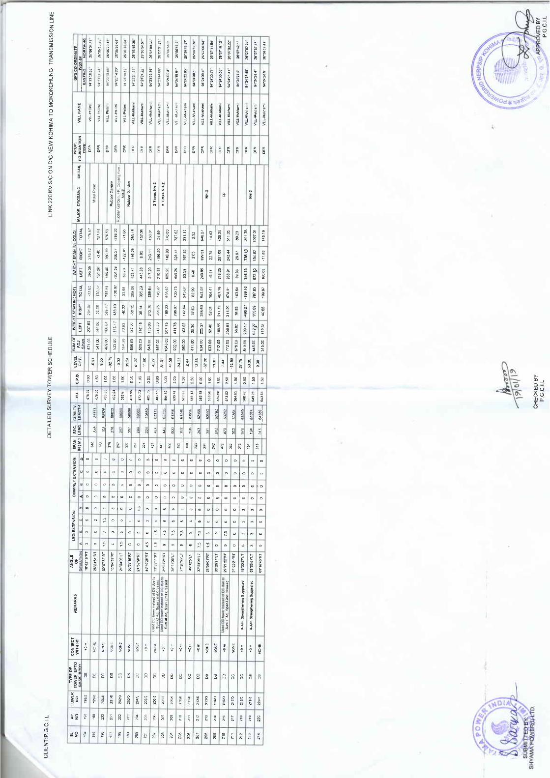
CLI
EN
T:P
.G C
.t.L
SL
NO
NO
1S5
196
NO
193
199
204
241
DB
242
DC
CO
NN
EC
I
DO
2U
DB
205
0c
206
DP
247
DC
203
DO
209
DC
DD
210
211
DD
212
DC
AN
GLE
DO
211
2'14
DD
21A
lsed
oc
l@r
'nst
ead
ol D
e du
e to
OB
__L
3
LEG
EX
TE
NS
ION
21A
n
DB
224
Sum
orad
r S
Dan
Lrm
icrc
ssed
--L 3
OD
0
DC
NO
NE
6
15
DC
NO
NE
0
__L
6
3
DB
0
15
CH
IMN
EY
EX
TE
NS
ION
0 ; ;
DA
l-
15
0
__-E
_0
0
0
sum
otA
dj S
pan
Um
itcm
*ed
0 ;
__-L 0
0
0
0
DE
TA
ILE
D S
UR
VE
Y T
OW
ER
SC
HE
DU
LE
x at
u st
r€ng
lhen
inq
sugg
esle
d
6
0 ;
---L 0
I
0 ;
0
,5
x-ah
stE
ndhe
nng
sugq
.rte
d
rN(M
)
0 ;
3
9
15
0
0
I
0
3
sEc
LEN
G-
6
; ;
0
?5
0
0
75
6
LEN
GT
H
o
6
3
;
6
15
75
0
: 6
0
0
6
3
0 ; ;0
I
0
0 ;
3 ;
0
;
0
0 ;
0
75
0
6
0
0 ;
0
0
0
6
3
LEV
EL
0
3 ;
0 ; ;o
0
0
0
150
6
0
3
0 ;
0 ;
0
0
3
0
100
!
0 ;
s00
0
0 ;
0 ; ;3
-821
9
WE
IGH
T S
PA
N I
N I
HO
TI
5.41
00
050
0
0
-s 3
3
0
2316
5
0
.469
00
100
39 5
4
0 ;
0
533
00
RIG
HT
000
I 0
1128
0
204
00
11 0
0
0
0
300
26 3
6
-o 2
2
o
523
00
0
5A91
1
300
-33
65
at 3
1
3472
2
1831
0
0
150
1TO
3T
357
15
467
00
254
40 2
2
755
A1
-24
23
1043
00
1358
6
58 1
5
000
-6 5
5
1312
8
__31
-L
2112
2
3314
3363
13 5
5
216
72
LIN
K:2
20 K
V S
/C O
N D
/C N
EW
KO
HIM
A T
O M
OK
OK
CH
UN
G
TM
NS
T\fl
SS
tON
Lt
NE
560
00
507
75
100
239
05
-xT
20
-5M
59
-_g-
a!g
,3,4
0
4117
8
s! 7
5
250
395
29
1110
50 7
3
7805
9
634
00
103
03
148
22
100
393
6!
429
41
206
27
MA
JOR
CR
OS
SIN
G D
ET
AIL
633
o0
127
AE
2AA
9T
2s&
000
145
26
-128
9
122
41
2053
7
s76S
9
1'12
00
150
6S5
97
217
20
-146
26
27 7
9
-298
32
7t2
0a
5214
3763
7ao7
5
150
210
Aa
5! 3
6
600
71 6
8
3336
0
1AS
99
678
00
245
67
629
2A
2131
1
038
2331
5
2538
1
5100
0
52 a
1
6299
4592
0
Rub
berG
arde
n
-136
20
452t
fi
2111
9
86 8
0
u39T
63 5
9
1408
0
2152
0
315
00
324
41
6322
7
76 8
3
401
13
240
95
167
52
7to
oa
19e
27
159
31
{31
245
TA
7 62
1556
9
163
6.!
219
26
399
31
231
',t1
-199
10
40 6
5
268
91
22 7
4
252
7E?
95
59 5
6
201
09
ua 2
T
1S99
7
3.1€
33
4721
0
29 6
T
:t20
35
1600
3
,73a
{)
GP
S C
OO
RD
INA
TE
wG
s.a4
511
35
154
92
a9 2
3
-11
89
3Sl
76
NH
.2
1027
01N
H.2
CH
EC
KE
D B
Y:
PG
CIL
P.G
CB
Y:
). t.
1

CLI
EN
T:P
G C
LL
SL
NO
214
215
216
TO
WE
RN
O
211
221
21A
219
22A
221
DB
222
OB
CO
NN
EC
T
226
DC
223
DD
225
DC
DC
226
DC
227
DD
224
DB
DC
23a
OD
231
DC
AN
GLE
2X2
X-a
m S
tEng
lhen
inq
sugq
esle
d
oc oo DB
LEG
EX
TE
NS
ION
DB
0
DD
0
0
oc
0
0
0
OB
x
15
3
DC
CH
IMN
EY
EX
TE
NS
ION
0
15
0
6
0
0
3
0
6
0
0
us.d
Dc
iturn
sead
oro
B d
u€ t
o
15
NO
NE
15
0
3
DE
TA
ILE
D S
UR
VE
Y T
OW
ER
SC
HE
DU
LE
45
o
0
0
0
3
sinq
€r s
p.n
umil
cEss
.d(x
-^m
3
0
rN(M
)
o
3
0
3
0
3
0
3
3
LEN
G
3
3
0
0
3
3
0
3
0
LEN
GT
H
3
0
3
3
0
3
3
75
0
0
3
15
0
0
0
0
3
3
75
0
0
0
0
15
0
0
3
0
6
c
6
3
0
3
0
3
6
0
6
0
0
150
0
LEl/E
L
3
15
0
6
0
0
100
6
15
0
o
3
050
6
0
2109
6
0
0
050
0
0
6
0
150
0
15
008
0
100
0
20 9
5
F?a
w
€46
00
159
31
200
0
c
2172
0
20a
35
-12
09
0
0
e;
179
68
353
o0
4065
0
3137
422
0A
-16
60
0
050
0
-36.
16
31,4
59
426
AA
3,11
32
TE
D B
Y:
1S9
97
t t0
150
0
257
2A
-139
59
530
00
2716
7
150
31n
29 2
8
5210
0
327
100
160
0a
17 3
1
643
00
190
73
152
a9
569
00
-35
02
235
30
000
221y
l1 8
9
36 1
5
LIN
K:2
20 K
V S
/C O
N D
/C N
EW
KO
HIIM
A T
O I
VIO
KO
KC
HU
NG
T
MN
SM
ISS
ION
LIN
E
2e26
1
612
00
7074
9
u1T
5
100
53 3
i
24',1
0
133
39
695
00
-411
51
421
5A
r50
u1 2
5
671
262
65
783
00
050
3140
3
-296
5A
-241
7
MA
JOR
CR
OS
SIN
G D
ET
AIL
2a2,
)B
595
00
129
35
6392
1,(8
37
-36
50
050
-90
08
351
97
156
03
605
00
101
1{
230
50
-18
89
100
4521
123
03
2716
9
971
O0
481e
2
1131
0
3314
6
104
33
978
o0
36 3
1
303
66
5{B
53
33t(
V
412
00
1786
7
146
95
1623
4
416
47
273
3?
383
23
294
92
-296
01
487
00
1283
07
203
80
4503
6
75 0
8
101
08
249
92
331
65
553
A6
1?56
3
$6 8
6
?14
4A
1216
2
6991
2
1471
3
-13
62
9312
Nal
a,2
Nos
Mll
R@
d, C
orle
e
11K
V
193
58
-3 8
2
422
113
A3
5012
6
321
62
386
91
1517
4
37 9
9
NH
-2
247
01
6A5
54
-193
5,1
147
92
NH
.2
EA
ST
ING
2291
9
7EA
27
-160
55
e141
3
CH
EC
KE
D B
Y:
26'1
115
93
\iq\=
-P
GC
IIBY
:

CLI
EN
T:P
GC
IL
SL
NO
233
NO
2U
TO
WE
RN
O
234
236
237
239
oc
244
CO
NN
EC
T
211
DB
242
DC
DB
243
DB
used
Dc
tow
er 'n
stea
d ol
oB
due
lo
S n
qer
span
Lrm
il c.
osse
dtx-
Am
Srr
enol
h€n
no s
uooe
rred
r
DC
245
DC
246
DA
247
252
2511
0
DB
244
DC
NO
NE
DA
250
NO
NE
AN
GLE
DC
251
DB
252
OB
254
DC
LEG
EX
IEN
SIO
N
OB
15
oc
3
NO
NE
DA
9 ;
OB
0
0
DA
CH
IMN
EY
EX
TE
NS
ION
6 ;
t5
15 0 ;
0
6
l5 ;
0
6
0
0 0
0 I
DE
TA
ILE
D S
UR
VE
Y T
OW
ER
SC
HE
DU
LE
0
0
0 ;
0
0
9
rNtM
)
15
0
0
0
0 6
0
6
0
6
0
0
sEc.
LEN
G
0
15
0
3
6
0 ;
0 ; ;0
3
3
0
LEN
GT
H
75
=
0
75
3
15
0
0
0
9
15
0 ;
0
3
6
0
0
0 ;
0
0 ;
3
0 ;
75
0
0
: 0
4a
;
75
0
0 0
IEV
EL
0
0
1
3 ;
0
6 0
0
0
6
0 ;
050
0
1 0
6 ;
o
75
150
11 6
0
0
0
100
5
31 2
9
0
0
663
00
0
050
0
-16
8l
LEF
T
0
050
-221
4
0
553
86
0
6150
0
0
150
Je 1
6
RIG
HT
0
424
aO
1t t
3
0
100
o
32 S
5
0
1AT
13
6590
0
107
06
295
0
100
35 5
6
0
324
94
0
000
23 4
1
605
00
2296
6
-131
8
0
100
79.9
4
551
00
1410
2
2541
A
313
A1
1
797
00
272
9A
336
T2
150
20 4
0
{06
452
00
050
2115
1
-531
9
658
00
36 1
3
-93
04
2598
0
100
2291
9
60 8
4
LIN
K:2
20 K
V S
/C O
N D
/C N
EW
KO
HIM
A T
O I
\TO
KO
KC
HU
NG
TM
NS
T\fl
SS
|ON
L|
NE
2069
6150
0
267
82
1415
9
050
-105
23
403
612
424
24
63.1
00
224
39
261
150
2AA
2A
9117
3
2521
2
607
00
607
87
000
MA
JOR
CR
OS
SIN
G D
ET
AIL
113
03
315
74
317
9T
4530
0
,46
33
33 7
9
150
300
97
35 7
6
1a 5
3
u912
263
55
509
0o
196
36
421
15
431
91
150
-141
T
214
46
r70
03
545
m
,184
91
12 9
7
230
23
530
00
150
01
68 9
7
593
36
316
97
107
99
517
00
63 9
9
219
07
-100
86
1912
6
3401
5
147
01
337
53
295
66
,90
15
2U 0
2
r03
36
-113
A3
217
69
337
03
a0 5
4
212
U
-306
9
NH
-2
1914
3
63 5
6
5371
1
4206
9
53 3
7
168
26
4T 5
2
508
30
2147
7
9122
4514
1669
2
NH
.2
271$
203
T8
3519
7
285
29
1814
3
237
21
2TA
3A
3720
4
i3 3
8
-90
20
l8 3
9
201S
1
2AA
7T
?6'1
2123
7
n.13
52
22
26'1
3',5
371"
#R
I
!\
P.G
C.t.
L

LIN
K:2
20 t
<V
S/C
ON
D/C
NE
W K
OH
IIVIA
TO
MO
KO
KC
HU
NG
T
RA
NS
MT
SS
TO
N
LIN
E
--i.;
in--
-r-n
;E;m
n;--
FO
UN
DA
TIO
NM
AJO
R C
RO
SS
ING
DE
TA
IL
91'2
520
22
26'1
6021
1'
3 N
os V
illR
o.d,
Tea
Gar
den
26'1
6125
3"
94?s
5112
'
LEF
TiF
IGH
TIT
oTA
L
3706
3
3375
1839
564
51
2?O
3A
3011
9915
523
99
M5
2A
256
61
245
92
57 9
3
2115
6
,2eT
2A
326
a0
119
23
R]G
HT
29 7
1
DE
TA
ILE
D S
UR
VE
Y T
OW
ER
SC
HE
DU
LE
458
50
I5.4
95
53 A
7
3467
2
1030
-224
6A
1056
4
494
2A
LEF
T
1 19
3 31
217
69
274
29
8363
,510
179
a9
203
32
-392
a0
221'
13
312
37
1812
4
-549
1
5530
1
66 3
2
-174
87
294
29
LEV
EI
6uv
109
6-l
4031
0
3613
7
s73
2AO
41
asry
622
0a
359,
(3
416
79
3507
6
53 0
2
15 2
9
c.P
o
4211
1
113
07
r31
01
982
00
10.4
20
-122
14
377
67
't25
25
-414
33
150
897
56
7390
0
2112
1
5570
431
97
1226
5
150
1931
0
515
00
266
93
345
24
301
90
LEN
GT
H
132
93
050
628
00
361
10
4064
5
438/
,
3ga
00
3T 7
6
530
A7
1666
5
5590
0
177
55
3,(2
30
,1 a
!4
100
17.6
7
22 7
6
a*a
-176
65
3n 1
0
2553
0
LEN
G.
637
00
305
38
491
ll
050
491
11
-94
90
-2U
15
35.4
06
6510
0
1160
3
000
rNlM
)
375
0u
-31
87
r54
81
-261
55
1253
3
100
17 9
2
61 3
3
-103
10
4079
5
3380
0
333
39
50 6
2
204
CH
IMN
EY
EX
TE
NS
ION
5720
0
357
53
;
242
2A
129
97
300
.24.
O2
-53
07
602
00
353
09
447
05
20 6
7
250
a
392
00
BY
I
305
5a
+7
39
200
0
-30
i5
114
0
392
00
3€51
7
39 2
0
000
0
0
.1.4
9 0o
000
51 9
5
-5.0
8
__4
0
6i
7020
o
-31
53
000
0
;
0
0
LEG
EX
TE
NS
ION
7B 0
A
..JJ.
150
0
0
-149
9
0
0
274
0A
0
150
0
0
0
om
o
0
-&.7
'1
0
3
0
250
0
0
1321
3{
0
0
200
122
0
0
0
AiIG
LE
0
0
0
100
3
0
0
0
0
0
0
3
15
0
0
0
0
0
0
0
3
0
0
0
3
0
6
3
0
3
0
3
6
0
_21!
_
6
0
0
6
6
0
Us€
d D
o ro
fr i
nsea
d of
Dc
due
rosu
m o
tadl
spa
n Li
mir
c6ss
€d
0
75
0
6
0
15
0
0
0
I
0
CO
NN
EC
T
I
o
0
0
0
15
0
0
0
I
0
3
0
0
0
0
15
15
0
0
0
0
t5
6
0
0
0
x A
m S
tcng
th.n
hg S
uqge
sl.d
0
0
75
DB
0
CLI
EN
T:P
.G C
.l L
0
o
X A
m S
tEnl
rhen
iig
Sug
qe$e
d
NO
0
DB
6
15
15
DB
0
I
DD
NO
0
0
DB
0
SL
NO
DE
DC
252
DB
253
DC
254
DB
255
NO
NE
oc DB
256
257
OE
DC
267
253
DC
260
DS
26'l
DB
CH
EC
KE
D B
Y:
P.G
C.r
.L
282
oc os ;
263
273
265
266
261
263
269
270
271
(D-<
"18"
>.

-C
LIE
NT
TP
G.C
I L
SL
NO
2?1
NO
272
NO
276
277
DE
274
DD
CO
NN
EC
T
DD
2AA
2A1
DD
237
DC
242
oc DD
2U 285
Use
d D
Dld
.r i
isle
ad o
t O
C d
u€ l
osh
gl.
span
Lim
cos
s.d
DO
DC
236
DC
DB
DA
2BA
OD
NO
NE
2A9
DD
294
LEG
EX
TE
NS
ION
291
DD
0
T-1
53
OD
293
T,1
59
9
0
x-am
sl€
nqih
eoin
g su
goes
red
293f
i
6
I
15
294n
x-am
slE
nglh
enn9
s!
99es
red
OB
6
BA
Y
DB
CH
I IN
EY
EX
TE
NS
ION
6
s
DD
6
75
DD
9
13
6
0
0
T5
l3
I
13
DE
TA
ILE
D S
UR
VE
Y T
OW
ER
SC
HE
DU
LE
0
6
13
0
13
0
0
,NIM
)
3
0
0
13
3
13
15
0
0
15
sEc
LEN
G.
3
0
1A
3
15
15
0
0
3
0
0
LEN
GIH
0
0
a
3
o
6
0
0
45
0
0
0
0
0
0
3
0
0
15
0
6'09
30
LT
0
0
0
0
116'
231J
LT
0
0
0
01'5
5 37
LT
13
a
0
0
LEV
EL
0
0
0
3
0
18
0
200
0
0
0
0
3
0
13
2AA
,!5 1
Q
9
0
0
19 0
5
124 ; ;
3
0
0
0
100
75
0
s
0
0
laa6
3
0
0
6
429
1!7
_0a
.L
200
-100
62
9
-31
53
0
57A
00
0
0
350
0
6
97 0
5
0
500
0
0
0
0
10tr
00
8.v
!!zgq
150
0
o
212
0
167
06
33.4
00
050
0
-5 9
6
0
353
39
-161
33
374
AO
104
0
17 0
0
0
106
30
317
?0
204
0
-r03
10
3& O
0
1121
6
2A1A
A
0
100
7315
,145
5
,r*
.1t*
2131
1
,369
68
628
00
224
150
547
00
163
59
-230
03
72
LIN
K:2
20 K
V S
/C O
N D
/C N
EW
KO
HIM
A T
O M
OK
OK
CH
UN
G
TR
AN
SM
ISS
ION
LIN
E
575
00
21',t
41
a2 4
A
274
37
211
00
r084
3
663
35
317
22
3171
3
343
00
4886
!
-155
37
1210
0
291
t3
MA
.'OR
CR
OS
SIN
G D
ET
AIL
3247
1
4663
7
-32
70
7291
a
1163
0
160
00
272
A3
000
a719
9
214
29
-{a7
ln--
]i;;;;
m--
3714
591
10
260
00
263
30
24s
2a
000
-536
99
95 5
3
s69
97
521
1a
157
00
132
KV
s/C
Doy
.ng
io A
olije
h
12'1
7 2
150
153
45
-6 5
3
15 5
0
-217
92
42 9
A
-112
1
-262
21
-2U
7/
000
320
92
181
00
6.43
_40
355
53
-50
70
230
00
3911
1
216
53
6051
t
124
317
0e
269
00
226
9A
,196
83
-17/
16
199
92
292
00
219
30
173.
45
8283
1
132
XV
S/C
Ooy
ang
to A
olije
n
3!3
83
216
00
,3r9
60
72 0
a
-2U
n
*a 3
0
-145
A9
r88
38
-2
62
3636
0
242
A9
943
99
926
1S 6
2
38 3
0
-367
68
434
23
-961
14
537
90
524
63
1031
19
137
03
2AS
34
-173
49
273
95
NH
.2 1
1KV
192
45
926
!65
59
wG
3
-367
63
,383
69
514
59
-2 0
8
-92
95
7AA
51
__!9
Br!
1!!L
1331
0
-309
60
-2 0
8
CH
EC
KE
D B
Y:
P.G
.C.I.
L
IoI
t9
BY
:

[ ".
,=rr
'r.n.
".,..
DE
TA
ILE
D
SU
RV
EY
TO
WE
R S
CH
ED
ULE
LIN
K:L
ILO
OF
132
KV
SC
KO
HIM
A T
O W
OK
HA
AT
NE
W K
OH
IMA
TR
.LIN
E
SL
NO
AP
NO
TO
WE
RN
O
TY
PE
OF
TO
WE
R
CO
NN
f,C
TW
ITH
BB
CO
IINE
CT
WIT
HN
T
RE
MA
RK
SA
NG
LEO
FLE
G E
XT
EN
SIO
NC
HIM
NE
YE
XT
EN
SIO
NS
PA
I{IN
(M )
SE
C.
LEN
G.
CU
MLT
Y
LEN
GT
HR
.LC
.P.D
.LE
VE
LD
IFF
.
SU
M,O
F
AD
J.S
PA
N
WIN
I)S
PA
N
WE
IGH
T S
PA
N I
N (
HO
T)
WE
IGI{
T S
PA
N I
N (
coLD
)F
OU
ND
AT
ION
TY
PE
MA
JOR
CR
OS
SIN
CD
ET
AIL
VIL
L N
AM
E
GP
S C
O-O
RD
INA
TE
LEF
TT
OT
AL
LEF
TT
OT
AL
wG
s;-8
4
Df,V
IAT
ION
RIG
HE
AS
TIN
GN
OR
TH
ING
AB
cD
AB
cD
20'5
3'19
"RT
00
0 3 ;
00
00
012
70.8
410
0.00
50.0
0-2
9s.8
3-2
95.8
3-5
14.7
4-5
14.7
4T
SIE
SE
MA
94'0
4'54
.54"
25"4
5'51
.07"
IE
XT
-Tow
ec
100
100
100
19.0
7F
P
60
00
012
87.4
10.
512
6.00
63.0
039
5.83
-485
.01
-89.
1861
4.74
-800
.25
-185
.51
TS
IES
EM
A94
'04'
55.0
6',
25"4
5',5
4.20
"2
I1/
0 (o
NI
INtr
\D
DB
B0
92'4
9',s
4"17
63
2626
126
7.14
Bou
ndar
y
60
00
012
94.5
50.
5| 39
.00
69.5
051
1.01
-280
.20
230.
8182
6.2s
493.
3333
2.92
TS
IES
EM
A94
'04'
53.8
9',
2s"4
5'54
.32"
32
2t0
DD
BB
056
'45'
27',R
T4.
53
113
394
394
239
633
20.9
82
Nos
I 1
KV
, B
orm
dary
, N
H-2
1 31
9.03
I50
7.00
2s3.
5039
3.20
143.
3224
9.87
606.
33-3
s8.7
624
7.57
TS
IES
EM
A94
'04'
51.9
2'25
'45'
57.5
0"4
33/
0D
BB
BX
-Arm
Str
engt
heni
ng
Sug
gest
ed4"
39'.g
',RT
00 3
0 3
00
00
073
.94
30
00
013
90.4
71.
567
s.00
337.
5053
7.32
-218
.84
318.
4975
2.76
-446
.31
306.
45T
SIE
SE
MA
94'0
4',4
5.91
"25
'46'
,09.
1 3'
,5 o
5 6
5/0
DD
BB
035
'8',4
1',R
T3
281
281
914
55.6
8
6/0
DB
BB
0s"
47'2
3"LT
o6
66
00
00
1443
.65
247
8.00
239.
0049
9.84
ls.4
751
5.31
727.
31-3
7.09
690.
21T
SIE
SE
MA
94"0
4'47
.56"
25"4
6'18
.'13"
197
392
t97
392
1503
9.02
1454
.17
0.5
589.
0029
4.50
18t
.53
61.0
524
2.59
234.
09-2
4.37
209.
72N
ER
HE
MA
94"0
4'48
.28"
25"4
6',2
4.43
"7
88/
0D
DB
B0
36'1
5'0"
174.
53
4.5 o
4.5
00
00
29.1
72
Nos
FP
, P
ond
I0
00
014
77.8
41
836.
0041
8.00
330.
9578
9.73
I 12
0.68
416.
371
149.
1 I
1565
.48
NE
RH
EM
A94
'04'
,41.
04',
25"4
6'35
.4"
8 9
9 10
9/0
DB
BB
0x-
Arm
Str
engt
heni
ng
Sug
gest
ed9'
1 2'
40"1
7I
I44
444
419
47-t
39.
002
Nos
FP
1 0/
0D
CB
B21
"36'
42"R
T0
00
00
00
013
47.8
4I
832.
0041
6.00
-345
.73
174.
70-1
7 1.
03-7
05.
I 1
162.
48-5
42.6
4N
ER
HE
MA
ZH
AD
IMA
94'0
4'30
.55"
94'0
4'2s
.90"
25'4
6'46
.30"
25'4
6's8
.17"
x-A
rm s
tren
gthe
ntng
Sug
gesl
eo38
838
823
354.
132
Nos
Foo
t T
rack
, N
ala
1011
11lO
DC
BB
0U
sed
DC
typ
e in
stea
d of
DB
typ
edu
e to
Sum
of
adj.
span
lim
itcr
osse
d.
1 3'
47'0
1'LT
4.5
33
30
00
013
4A.9
7I
720.
0036
0.00
213.
3042
3.71
637.
0122
5.52
586.
8481
2.37
332
332
2667
47.1
8N
ala,
1lK
V,
Fen
cing
, F
oot
Tra
ck
1 30
0.79
042
3.00
211.
50-9
t.71
234.
4214
2.71
-254
.84
354.
0199
.17
ZH
AD
IMA
25'4
7'07
.16"
t112
12t0
DB
BB
005
'28'
47"R
T6
63
30
00
0N
ala
9191
2758
-9.4
8
1295
.81
1.5
364.
00-1
43.4
298
.s7
44.8
5-2
63.0
174
.56
-188
.45
ZH
AD
IMA
2s"4
7'09
.65"
1213
1 3/
0D
CB
B23
"O4'
,44"
RT
00
00
00
00
182.
00N
ala
273
273
3031
5.71
't298
.02
151
5.00
257.
5011
4.43
288.
5646
2.99
198.
4439
4.63
593.
07Z
HA
DIM
A94
"04'
t6.7
8"25
'47'
78.4
7'13
1414
lOD
BB
B0
02"2
0'12
"LT
4.5
4.5
33
00
00
242
242
3273
-22.
36F
P
1278
.66
I54
1.00
270.
5046
.56
-122
.64
-169
.20
-152
.63
-294
.91
447.
54Z
HA
DIM
A94
'04'
15.6
8"25
'47'
26.3
4"t4
151 5/
0D
BB
B09
"03'
09"1
70
00
00
00
029
929
935
7244
.87
Nal
a
't321
.0s
1.5
407.
0020
3.50
421.
64-3
69.6
552
.00
593.
91-6
37.8
243
.91
ZH
AD
IMA
94'0
4'12
.57"
15 16
16 17
1 6/
0D
CB
B0
X-A
rm S
tren
gthe
ning
S
ugge
sted
't7'1
7'.4
8"LT
33
33
00
00
108
108
3680
2s.2
3
17lO
19lO
DC
BB
0U
sed
DC
typ
e in
stea
d of
DB
typ
e10
"2s'
24"R
T4.
53
34.
50
00
013
45.7
61
585.
0029
2.50
477.
6548
1.82
96s.
4774
5.82
645.
6s13
91.4
7Z
HA
DIM
A94
'04'
10.2
9"25
'47'
38.6
1'du
e to
sin
gle
span
lim
it cr
osse
d (X
-
Arm
Str
engt
heni
ng
Sug
gest
ed)
477
477
4157
-65.
58N
ala
DD
BB
1.5
1.5
00
00
00
1282
.68
0.5
711.
0035
5.50
-10.
8214
7 .ls
136.
32-1
68.6
516
6.23
-2.4
2Z
HA
DIM
A94
'04'
03.1
3"25
'47'
,52.
57"
t719
enot
neer
56"2
7'48
"R'
234
234
4391
-3.8
9N
ala
1276
.79
1.5
481.
0024
0.50
86.8
519
3.40
280.
2567
.77
237.
6430
5.41
ZH
AD
IMA
25'4
7'59
.23"
1820
20lo
DC
BB
021
"41'
s6"L
T4.
53
33
00
00
2 N
os F
oot
Tra
ck,
Nal
a24
7
407 ;
247
4638
-9.5
2
1266
.77
I65
4.00
327.
0053
.60
305.
803s
9.41
9.36
370.
s637
9.92
ZH
AD
IMA
94'0
4'09
.46'
,',25
'48'
06.8
2"19
2121
lOD
CB
B0
1 8'
38'3
2"17
33
33
00
00
407
. so
45-2
2.96
2 N
os F
oot
Tra
ck,
FP
1244
.31
1.5
613.
0030
6.50
101.
2079
5.90
897.
1036
.44
t234
.52
1270
.96
ZH
AD
IMA
94"0
4'08
.2r'
25'4
8'20
.10"
2023
23tO
DC
BB
0X
-Arm
Str
engt
heni
ng
Sug
gest
ed1 7"
31'5
5"LT
33
3 3 ; 0
30
00
0
206
5251
.78.
7 |
Foo
t T
rack
30
00
01
165.
10I
694.
0034
7.00
-589
.90
625.
0135
11-t
028.
5286
6.20
-162
.32
ZH
AD
IMA
94'0
4'05
.33"
25"4
8'26
.2t"
2124
24lO
DB
BB
0X
-Arm
Str
engt
heni
ng
Sug
gest
ed07
'56'
06',1
73
348
8s1
39-1
02.5
32
Nos
Nal
a
00
00
0I 06
5.57
164
7.00
323.
50-1
37.0
118
7.40
50.3
8-3
78.2
025
5.70
-122
.51
ZH
AD
IMA
94'0
3'56
.30"
2s'4
8'39
.79"
2224
A.
24N
OD
BB
B12
'53'
5',R
T1.
50
159
159
5898
-9.4
6
00
00
0 0
1055
.1 '
l0
508.
0025
4.00
-28.
407.
91-2
0.49
-96.
70-9
7.54
-194
.24
ZH
AD
IMA
94'0
3'54
.40"
25'4
8'44
.6t"
2325
25lO
DB
BB
09'2
7'35
'LT
1.5
1.5
349
349
125
6247
6372
32.0
6N
ala
1 08
0.1
72
4'.1
4.00
237.
0034
1.09
-80.
6926
0.40
446.
54-1
71.3
327
5.21
ZH
AD
IMA
94'0
3',4
8.52
"2s
'48'
54.5
1"24
2626
lOD
CB
B0
Use
d D
C t
ype
inst
ead
of D
B t
ype
14"1
0'0
9"17
9I 4.5
II
00
012
59.
87F
oot
Tra
ck
33
00
00
1 09
5.04
134
4.00
172.
0020
5.69
141.
2234
6.91
296.
3316
1.29
457.
63Z
HA
DIM
A94
'03'
45.5
0"2s
'48'
,57.
50"
2527
27lO
DB
BB
001
"43
'56'
,RT
3
SU
BM
ITT
ED
BY
:S
HY
AM
A
PO
WE
R(I
) LT
D.
@uw
CH
EC
KE
D
BY
:P
.G.C
.l.L
AP
PR
OV
ED
BY
:P
.G.C
.l.L
ffi;-
N"4
4.&
iJ'
,/!-\
{rA
l
RIG
HT
x-A
rm S
tren
gthe
ning
S
ugge
sted
11il
cL'o
L'17
7)'
25'4
7'3s
.62'
94"O
4'O
7.62
',
a
#HS
I

GLI
EN
T:P
.G.C
.l.L
DE
TA
ILE
D
SU
RV
EY
I'O
WE
R S
CH
ED
ULE
LIN
K:L
ILO
OF
132
KV
SC
KO
HIM
A T
O W
OK
HA
AT
NE
W K
OH
TM
A T
R.L
|NE
SL
NO
AP
NO
TO
WE
RN
O
TY
PE
OF
TO
WE
R
CO
NN
EC
TW
ITH
BB
CO
NN
EC
TW
ITH
NT
RE
MA
RK
SA
NG
LEO
FLE
G E
XT
EN
SIO
NC
HIi,
INE
YE
XT
EN
SIO
NS
PA
NIN
(M )
sEc.
LEN
G.
CU
MLT
VR
-LC
.P.D
.LE
VE
LD
IFF
.
SU
MO
FA
DJ.
SP
AN
WIN
DS
PA
N
WE
TG
HT
S
PA
N r
N (
HO
TW
EIG
HT
SP
AII
IN (
CO
LD)
FO
UN
DA
TIO
NT
YP
E
MA
JOR
CR
OS
SIN
GD
ET
AIL
VIL
L N
AM
E
GP
S C
O.O
RD
INA
TE
DE
YIA
TIO
NA
IBIC
LEN
GT
HLE
FT
RIG
HT
TO
TA
LLE
FT
RIG
HT
TO
TA
Lw
Gs-
84D
AB
CD
EA
ST
ING
NO
RT
HIN
G25
2727
t0D
BB
B0
01'4
3'56
"RT
34.
53
30
00
0'1
095.
041
344.
0017
2.00
20s.
6914
1.22
346.
9129
6.33
161.
2945
7.63
ZH
AD
IMA
2'19
219
6s91
-3.8
3F
P26
2828
10D
BB
B0
X-A
rm S
tren
othe
nino
S
uooe
sted
12'5
4'35
'LT
II
II
00
00
1084
.71
0.5
398.
00t 99
.00
77.7
840
7 .4
148
5.20
57.7
160
8.66
666.
37Z
HA
DIM
A17
917
967
70-3
1.38
94"0
3'40
.27"
25"4
9',0
2.99
"
2729
29lO
DD
BB
029
"30'
25"R
T3
63
30
00
01 06
0.83
2s9
0.00
295.
00-2
28.4
157
9.71
351.
3042
9.66
816.
5938
6.93
ZH
AD
IMA
94'0
3',3
s.17
',25
"49'
06.4
7"41
141
171
8l
-84.
812
Nos
Nal
a28
3030
/0D
CB
B0
X-A
rm S
tren
gthe
ning
S
ugge
sted
19'1
8',2
7',R
T6
4.5
34.
50
00
097
4.02
073
1.00
365.
50-1
68.7
172
6.77
558.
0640
5.59
1085
.54
679.
95Z
HA
DIM
A32
032
075
01-1
00.0
1F
oot
Tra
ck29
3131
t0D
BB
BX
-Arm
Str
engt
heni
ng
Suq
qest
ed05
'08'
36',R
T0
00
00
00
087
8.01
I58
6.00
293.
0040
6.77
166.
68-2
40.0
9-7
6s.s
418
8.00
-577
.s4
ZH
AD
IMA
266
266
7767
4.94
Nal
a30
3232
tOD
BB
B0
X-A
rm S
tren
gthe
ninq
S
uqqe
sted
04'4
8'54
"RT
33
33
00
00
870.
071
638.
0031
9.00
99.3
255
1.81
65 1
.14
78.0
078
3.38
861.
38Z
HA
DIM
A94
'O3'
.28.
44"
372
372
8l 3
9-'7
5.0
431
3333
/0D
DB
BX
-Arm
Str
engt
heni
ng
Sug
gest
ed37
"'tg'
,12"
Lr0
1.5
1.5
00
00
079
7.53
0.5
673.
0033
6.50
-179
.81
618.
0343
8.21
-41.
1.38
{tz.
st50
2.60
ZH
AD
IMA
301
3084
40-7
7.60
Um
etal
Roa
d32
3434
t0D
DB
B0
Use
d D
D t
ype
both
sid
e du
e to
lono
soa
n'1
1'5
0',5
7"17
67.
56
60
00
071
4.43
190
9.00
454.
50-3
17.0
3-1
48.5
0-4
6s.5
3-6
12.9
8-4
34.9
4-'t
047.
92Z
HA
DIM
A60
860
890
4815
1.71
Nal
a33
3535
/0D
DB
B0
Use
d D
D t
ype
both
sid
e du
e to
long
spa
n (X
-Arm
Str
enot
heni
nq16
"42'
.1s"
LT3
33
30
00
087
0.64
,568
7.00
343.
5075
6.50
466.
8928
9.6'
l10
42.9
4-7
87.4
52s
5.49
ZH
AD
IMA
94'0
3'08
.65"
25'5
0',t2
.26"
Sug
gest
ed)
7979
9127
22.0
634
3636
/0D
DB
B1
3'1
9'03
',17
00
00
00
00
893.
200
170.
0085
.00
545.
89-6
9.88
476.
0186
6.4s
-142
.92
723.
53
ilcm
g
ZH
AD
IMA
919l
9218
5.79
25'5
0',1
4.t7
',35
Bay
Gan
try
898.
990
91.0
045
.50
160.
8816
0.88
233.
9223
3.92
ZH
AD
IMA
94"0
3'03
.03'
SL
NO
AP
NO
TO
WE
RN
O
TY
PE
OF
TO
WE
R
CO
NN
EC
TW
ITH
BB
CO
NN
EC
TW
ITH
NT
RE
MA
RK
SA
NG
LEO
FD
EV
IAT
ION
LEG
EX
TE
NS
ION
AT
;TcT
;
CH
IMN
EY
EX
TE
NS
ION
SP
AN
IN(M )
SE
C.
LEN
G.
CU
MLT
VR
LC
.P.D
.LE
VE
LD
IFF
.
SU
MO
FA
DJ.
SP
AN
133.
00
WIN
DS
PA
N
WE
TG
HT
SP
AN
rN
( H
OT
)W
ET
GIIT
SP
AN
IN
(C
OLD
)F
OU
ND
AT
ION
TY
PE
MA
JOR
CR
OS
SIN
GD
ET
AIL
VIL
L N
AM
E
GP
S C
O.O
RD
INA
TE
LEN
GT
HLf
,FT
RIG
HT
TO
TA
LLE
FT
RIG
HT
TO
TA
Lw
GS
-84
EA
ST
ING
NO
RT
HIN
GI
11/
0 (o
NLI
NE
}D
DB
B0
33
33
00
00
1287
.41
0.5
83'3
2'25
',17
66.5
0-8
6.08
-86.
08-1
53.
87-1
53.8
7T
SIE
SE
MA
94'0
4'55
.06"
4242
422.
4825
"45'
,54.
20"
2E
XT
-Tow
ec
24'4
4',5
6',R
T0
00
00
00
012
92.3
90
42.0
021
.00
128.
0812
8.08
195.
8719
5.87
TS
IES
EM
A94
'04'
55.0
7',
2s'4
5'55
.6s"
63
36
SU
BM
ITT
ED
B
Y:
SH
YA
MA
P
OW
ER
O L
TD
.
@[*
,C
HE
CK
ED
B
Y:
P.G
.C.r
.L
dw-u
$'
94"0
3',4
5.50
',25
"48'
,57.
50'
25"4
9'78
.64'
,
25"4
9'.3
7.59
'
At,
cD
z -
t\igr
\l
*'r
P.G
.C.r
.L

ANNEXURE III NoC from Concerned
Land owner/ Headman/ Village
Council

OFFICE OF THETS MINYU VILLAGE VILLAGE COUNCIL
P.O TSEMINYU -797109 KOIIIMA: NAGALAND
NO OBJECTION CERTIFICATE
This is to certifu that construction of upcoming 220 Kv line from Ap -73/0 to Ap-E910
under the jurisdiction of rseminyu (ur) is well known from every location as proposed byyour company for the purpose, using my authority I have no objection towards the execufion
.
of work any time at yow own convenience.- Wish'ing the Project grand success.
4""P

OFFICE GF TI{E \rICE-CHAIRI\IANALICHEN COMPOUND COMMITTEESPO Alichen-?98607 Mokokchung Dist. Nagaland
I Emait [email protected] I Offce : -tgr-9,1366,1?08?
NOAC{1/1[isc-NOC/201 9/ l?
\r,(::##* itl44
3"e-\69
This is to certit/ that construction of upcoming 22OKV line from Ap-27710
to AP-288/0 under the jurisdiction of Alichen (ur) is well known from every location as
proposed by your company. For the purpose, using my authority I have no objection
towards the execution of work any time at your own conventence.
Wishing the project a grand success.
/Dated theAlichen L tnfe$ rc
i -i^i6ran(Kr MER)
(Name & Designation ofthe issuing anrhorit\')

OFFICE OF THEVIIIAGE COI'IICN UNGMA
MOKOKCIIT NG : NAGALAND P.O., MOKOKCHUNG- P,S. II MOKOKCHUNG
PIN - 798601
nate:.,.*.:. ?-:. k.t l,'1.,.,,.
.t1*.1 (?{v+Xc-o,t-l;Pvt \wPteo".ilY
^t +c &t..n'fyLrC V-ut Li r,.,r_ @ E?-2xn &r4 +p- Lql
tt^/x&eq * ".'vit-Qo.4e
L\NIMS \.4*.rgl 4tt-ut 4 wLL! l*q.+-tv.rte,4'(k.( Lcto.,j*at iq ,\ f""1 w-+o*t
J.as cl-t"lV il4r.o,
,\v
n
r9tu=
*w"',4 aS{ -fLi_ .4 r\ .L41'1 -t cu-u.{4
0'r rCar 12:-r\/e +'v1t-*ttZ.
9{trr^"4 .h* Vt.nlr-I er tr*""A &:utc t e y<.
wteu.
ilk3;#;.r!!!sri
3

OFFICEOFTIM
Nsuuyu Vu.,racE Gourclr,P.O/P.S. Tseminyu, Kohima - Nagatand - 297109
g"f x".
ilo A&rfa cTz o <t
o.n zaf.o7f.u-w...
s ic Sea)
.% 741a* 4o.
7t - v$l^de^.4 ex,1._^-,_1
G=
c) u.ttly,, ttb-'Jl

OFFIGE OF IHE
TEROGVUNVU VI1IAGE COUNGILP.O. TSEMINYI' .797109
Dist. Kohima : Nagaland
R{,Wo.t:al. (Date. I
,/vo oBSe-c_fto4 C€Kfr Frcnfz
7t '[n"ra 3-u^7. VU[en" /'a's qo
ubflrf"*- ; W 7" t*.-tr @;1i* % f"-u %*)'L7 tl- fu,^- # z-.-_oyt;-J'.- % /^da ^:A*V',fi, *'Jlp^tr. t-AL.6-n;"
-ft" ,r["n- c+''-"''-;t a dk^ at1-.-al"4y
t'^^d' 1* vu-x.- L-.----p ^& a-l( W Ar"t44
4---+1v6rrrn.\4+ e
-|--

ANNEXURE IV Sample Case of Compensation
Payment

user
Stamp

o
gtoZ
"oE,
l(o
q-*
(>
I
(!..Oo
oxo..\\i,f-, 1:
69!(o L iiiy: srg!= Y'='ii
:v .
, 'bX >'t', \) EI >'1.ll
O EEiv(-,'<J -1?,5 c/6,^ l+ /=6fS _ v
v-6
E
6
qs(-S<
7-\$
$Nf5s
t9
E
PgE
.9E
PAE4*3 PAE
s
PSEE+3 PAEq+3 PzE
_e
P
Pg
F;:c
E-
2=-Ei9:
!=i.
=z:!
i:
=E
-E
2-E E .E .E E .E
E
E
E
=:i!
E:_-E-ii-:
E
g-
_eEzz!,::5
,9i
Pzt-:
tc
!E
_6E2ZE_4
z*d,>
_eE
;.r€3
E€+3
_oE:,s
E!
.g
-6E2z3-:
-LI
z
zJz6
.Fz:z
-
?5
=3
3zi
>9<3
:t-o1=
i*>9ZP
6z
:1)o1A
i1>9z9z
z
z=>=.'l.6
e
zf;:;q9
a
o=d=z=6=z?o=s:6eo.i0=9!gE6
E33oo.
.\'E
E
!E
!
a2E
:]-;
-
-E
€-I

E
:
9&
.9i
d
(9
oo5i:
.E|:
.eE
=
.E
-
':F9iz]:
z
5z
z^
=28z
z
z
Co
F
-
=o.
-\ i
a4:;
:,6)- -t''t "1
i:)
i/2
6
6
@E
!.
\^c\rl-) --_***
l\
a$IE1
F<tE=z=Eto7=2ct<-z<=6tCL95=tJ-o:6=
=E: }=: =otq:
7J
i,2
==tiz
r
===;=
=:Ez

.ct
(o
(sz
:o,v
e
E
atl
F
;
\\(--s\ -\qc$s\--J{$f\
\iJv
EN
9;
6
b sE= 9<33S
.9
POqzE9-83
ri5,E
J
6-oe!
e E6s gE-:<:
:EiEBT.3'=
>9
=2 E
99
oF<=o:z=aEo:zZo<agoiG.=<ie! 5-: :G-
=3 E
ota-6
3
al
]4.E
B
E
E

E-
UoF<t.raz=r!9..tzio<F-<<=E<gf=;(r-cl
=
;:t:
=
g=
-.=it:
=:a
t
=i::
F:x, .9
E i b?a€; :E;E E; r >.n"<b; -oEo:<E ,E ;.I;
r', .o; Fil'"Ht'5 E 1656tsE
-,-t r - .lv tt& E EbE6nt! Attr 'lE
e
2=
a
l=l
E
ii '-c E .E ii dE
"t
-l
E!
-eE
3 -,:!:i
3
dHR
d<:J!
'.})-d
E
6d,
\{(-(<i-7\N$
qqi'15

:-r i0) "'l --
=v'z
3o-
Eto
AJ
CJ
crq
EqJ
\sc--\raE-{{P
\Nt
$CoY/(E
^O-=
= 6bz_=z
EFH-:c=.goG=-.<:r; l4 >_]S:i B:=:=F P:=- '
= .- =-:--.--_:
-q.)
+.='= ;)E - g-O(!(Jo-
a!m
O
c!NO) $
c!
lq df Nc^t,d) a!
>i;{-(U a! c!
ci.= -i.:f:
|.\ar;
a!.j
q n (\
;<AY--uqJ
F
.9-c
Ea)CJz
oI\J N
(!qEItaEO3qz-c oo
.lq .9or(^
=_r
.E
.gr!N
(!
P
.9
.: -J
XY
o?t! r_
oLJ-
0)
.YA
zoz
€zq.z.>o9.t:z=.n-\9<;-
=z_9bEz o-
(u
.E
c'6.2cEl!Fa)
U.o.D
AJ
3(uzto
=:<3uzUo
a!
a,c=c.9.2E
g
o.c
oo
FEllrl-ort
FFJZ<urd>z3,_ ul= rtt(J rrl24oztro<trE<R2El!l.rCo>ooG-9t9oE9{F-teo.ae
eIJ
!,
t

o
-:':x E
-& u):iJsFoz:EE:
i t >/,v.E
F
s -'\.A
6J-\I
F;6!+O)'= ;i UJ a\ |!a- 62=zi E :-:to " E--y Io,t YE',f EEi o - -r,'3 b
g ; 5 \ o-\F! Y €n i)I
1\ Lr.r s = ?tsr ':' ('; = 's=6!=-4 > I :-;l=_iz- \e a_ a/ ' 7
;: :?=,; =e
qJ
€qJ'ii 3-o
o.0 0)
aq o.
.n-oc;
OJ
ECJ
I'lo(U
oCoc!
q .:.Y d.
t>
a!an
o rnoO o (o O
f--
O)
-c.=)roo_
Oa! o O
LnO O
qoO
N c\
lqc)
a-'1
l'- r-.)
-c -i_: t'\ \o o)(\
LN
LN
Lr) (om a! (\
:op:=ro-\ln E OC)YxL
Ec.)AJz
o-c.9-E
E.o
o-c
-c.
-cCJ
-c-
:=ECJ
-gF
=CJ.cF
0.)Y,
o-c
-c
.! ao 19! oF.i
rg
F" i _- .'"1
>FO
c=(E--cN
-c=cJag
hc
o>0_)
=-_PttirloZ. l) t-)-
r.r 5Ut,.JEvC-d-r
-OQ-r4(q:-\,/
1@
0.)
o
zc.)
.U
z
: - '.\ N4>Ooe*?:-SqSt
Z'@ o(!
zCL
}.IIJT
o(/)FF =)z=d r.u
=> =>i =- ;i
63 =z< a
==<trnrr=d.z =to.UE
=oP ==\' =&.i ==F!EiXE z
,=
;z:
:

\4.
as
lbDlz(!roOJ
(E
EAJt
CJ >;
=^- - $ Ol-- -l
(o(/1J oc\ c! rnm |-\
(o
F
>EoLO c\
r- .= :{$Ic\
(o.i I
LN
r/)N-i
-=.P qJ.g
o-
(o
(!
rgco
.9
qJ
(!
,rro!ro-O.lu-.{sE;':,(o .9ou,
>E
c.o
N
=--(o..'-I >* oJ
:=E tr1\J S C
oJ,-v, A e=h;c.'E9;o>u==*€<'=^
: ) _t' +;ss"PE!(Efo(/)
Zu-
qJ
.uxo-\z.oz
,:z=Nozd..jz>>q8X=Xcr= rn < -.:i '
^r-{-J9:>>.9zzd
o>:z
z t--l
: d,-!<*PSr{- a.\\JdC) (F
:i .\b!trv)titr CE6 \s-(!!) (--;LJ)q\,i $s.
..1
Eo C p(/) :lu=c:
=v^Ex-l E i ht!^ 6'E uJ ? 6,2=2i36E<6;;Y O visg
-e! " -:eF5\ = =\
o-\)\ '- rc €:tr\l'; 1i .; cz v+^\ ;'1 . J-.ii Et4t ,Y ir-eE:
C-x- -t _y*Errr f,, l. ==
=i
6st$
(u
='6-9Ec(o
xq)
UG'
(u
0.)
(JCJ
=OJz(!
:z30)z(J
-:aNao
iic=
.9
.g
FqJ
qJ
(oz
UJtr|Iout
rZ<r!6>z36Hz<6ztro<FE<83XHOEdoEeg$lrr F6Eo.tE
CL
P(J
O

.=
.90
E
F-
o
e
,1 A Ii
3z
E
t
e
s!
E,=?5PoPz=z99;*-t
Za2
-9<
'r- !',.\ a??€b0ozg ..
pvd
d'a'-.:lJa
&di;EI t\ ,r\-(\\\\ro$-${\Y\5J\s
naFeK!-Ei;e F $??+d v
= \v (E
X v jsff Ex f t:nEt6 \OEoYE F\ O.\.l ,'lc '+ tr\M€ F,5 Ez na liI f9 _,h t:; 1si€tsF! rrBrF''3 w''6 *
to hI)
F' IE
oF
s=olz='rEo;zJio<-zEPo-P6=o6QE6!G.tr|qB5o!o.:
IE
P
E.E
d
.E
,:
E
E

(arFds{d|{firsqq)
POWER GRID CORPORATION OF INDIA LIMITED(A Government of India Enterprise)
NAGALAND: KOHIIVA
NORTH EASTERN REGION
TO WHOM IT MAY CONCERN
and surface damages incurred during the construction of 132kV New-Kohima (Zhadima) to NewSecretariat complexQ''lagaland university campus) Transmission Line under NERpsIp, Nagaland atlocation no.....+?7 of Zhadima Village, Kohima district measuring an Area of
lV5.l,.l?.6. . . ..ro.o.
(Sienature of landowner)
Registered office I B'9, Qutab lnstitutional Area, Katwaria sarai, New Dethi-1 10 016, Tel.: 26560121 Fax : 01 1-26560039 Gram . ,NATGRID'
strd ffiqqrqSave Energy for Benefit of Selfand Nation

qisinq qfaf6State Bank Of India
105301tt2383
CURREI{I AJC
PREFIX t
. 15150q!m2
tt.EB958 tnr ?51 ?OO ? lO tr: OOO5Elil d't
irna_ t ii:'i d ii.i ai., r \ rjrr rs? r $rrnjs ir.:?
\4

POWER GRID CORPORATION O" '*ffiffiTH qr-+aftf5(A Goyernmert of India Enterprise.l
NAGALAND: KoHIMANORTH EASTERN REGION
Witness(i).
(ii)
and surface damages incurred during the "o.rrt.u",io'or rrruu *".'*otin'u lZtua*f,t;:t*T
Transmission Line under NERPSIP, Nagaland atillage, Kohima district measuring an Area of
r(;f)qfs'|q1aq:fl-g.
Registered ofiice : B-9, eurab lnstirutionar Area, Kalwaria sar.t ,"- odl,#i$# . 26s6o121Fax . 0 j 1_26560039 Gram , ,NATGRTD,
Save Energy for Benefit of Self and Nation

ssrtrc rtr f6State Bank Of lndia
(002r4)-KOHtUA
E
:is4fi00002r| SW|FT:
E v,a /-rl c rt €
IrrgEg5g:ln. ?q?OO;tO?r: OOOSEIilT pC
4rii-j,F1;i ii i..,{ ia , {arr; fta j lrair,e ai,x..
\>/
,€.,J

ffi(rTFd sr6Tr6T sqc)
POWER GRID CORPORATION OF'INDIA LIMITED(A Government of India Ent€rprise)
(NORTH EASTERN REGION POWER SYSTEM IMPROVEMENT PROJECT)
NAGALAND: KOHIMA
NORTH EASTERN REGION
TO WHOM IT MAY CONCERN
....3u.r.v....Tt*:.o...TIte.'/..1.1dD....7!+1t>..ttzu..DgEA..E.l.F.f/..:|..1,ro.... has been duly
compensated to Sliii/lvls . . . A.N /.V/. :. Q. . for the land
and surface damages incurred during the construction of I 3 2kV New-Kohima (Zhadrma) to New
Secretariat ComplexQ.,lagaland University Campus) Transmission Line under NERPSIP, Nagaland at
location "o....*(.:.9......... of Zhadima Village, Kohima district measuring an Area of
.E 0.9.,.9. 1.(......... sq.n.
Witness(i)
(iD.
Grsolre-aflOIEBCRID)
riffqilsTqldq : fr-s. gil{.**qq(c|.rd yftqr, oeqRqrsqq. r{ftid-110016. {rqrs : 26560121fw : 011-26560039dx : iznrs-
Registered Office: B-9, Qutab Institutional Area, Katwaria Sarai, New Delhi110 016, Tel,: 26560121 Fax:01I-26560039 Gram : 'NATGRID'
sBncqrrvRnM{srcSave Energy for Benefit of Self and Nation

seEf,6$tate Bank Of India
il.EEgsBO|F ?q?oo?Ioer: ooo=*,". tq
?-<i r i.qr d 13, :;..!rr";,ri:,lrmJcai_y

ANNEXURE V Drawing of Bird
Guard/ Anti Perching Devises


ANNEXURE VI Signed Copy of Safety
Plan Submitted by Contractor

4
-
--t44
-
-
-4-
-4
--3
MOLLU VILLA, NEPALI BASTIP O. r DIMAPUR - 797 112
NAGAIANDPHONE: 234186
E-mail : ipepll,, yrnail com
Dt.t6./tr. lz1tg
, :e tresident
-?-
-hlt-
-:
-
-\-
-\a-
ftta
fa
:. IL-t-haI-ftir=5\-
NOA rrto. cc-cs/92-NER/REW-3661/l/G5/NOA_t/7595Dt.11.01,2018.{suppty of 6oods)CC-CS/92-NER/REW-t667ltlGSlNoA-tt/7G92Dt.11.01,2018(Suppty of Services)
Dear Sir,
With reference to above we are submitting herewith the following documentrelated to Environment & Health and Safety plan:
1) Safety Plan dt. 14.8.2018 on stamp paperfor NAG-DMS_02 pkg
Thanking you
Your5 faithfullyFor Techno Power Enterprlses pvt. Ltd.
\
a
P
NO POWER ENTERPRTSES (Pl rTD(ELECTRICAL ENGINEERS & CONTRACTORS}
1OTH FLOOR. PLOT. A3. BLOCK - GP SECTOR VSALI [-AKE CIry KOLKATA - 7OO 091. INDIAPHONE : 033 4063 6169.40€A 5703 I S7MWebsite : www.rausheenagroup.comCIN ; U45309NL2000frC006046
Our Ref :- TPEpL/pGCt L-NAG-DMS-01&02lStTE_18009
The . General Manager (NERpStp)
Power Grid Corporation of India Ltd.Kohima- 797001/Nagaland/Mob#94355G7082Kind. Attn. Mr.L.A.Sharma.
Sub: Submission of Safetv plan.
Packager NAG-DM$O2
CORPORATE & CORRESPONDENCE OFFICE :
INFINITY THINK TANK. TOWER . II

Table of contents
Contents
Safety Plan
Safe Work Procedures
PageSl-No.
1
2
3
I
l-13
t\*3aManpower DePloYment Plan 4o
t-ist of ttfting tvtachine & other T & P for Erectlon4t
5 Ust of Personal Protectfue Equlpment's & test
reportLt> - LtA
6 list of Earthlng EquiPment's q6
,
lt
tist of qualifled SafetY officer tr+ - 118
Envlrcnment, Heahh and Safety Policy qq
On Site Emergency Plan 5o-=E
51 - +2Safety Trainlng Module 1z- +tl JSafety fBl Tralning Record *- J
iolicy Schedule for Employees compensatlon
lnsurance'tc - fr
'Alabour Licence
+-t- 8o
ERECnON Att RlsK POLICY, (INCLUDING THIRD
PARW TIABILITIES, MARINE CARO INSURANE,
WORKMEN COMPESATION POLICY & BOCW
at -q6

-:,
qFsTsgar rTfuc Etrrrd v.Esr BENGAL
b!-eF-tt1I77i?-44-Fl'
-"
-- ta
-"
-'>.:t
-:
--a-
-
--t-F!-r
ul-;FF-I
AA 501505
SAFEW PLAN
THls sAFEw PLAN is made this 14 th day of August. 2o1B by Joint venture (JV) of M/s TechnoPower Enterprises private Ltd, Kolkata ( the lead partner) of JV), a company incorporated underthe law of companies A€t, 1956 h,aving its Principal place of business and Register€d office atInfinity think tank..,, Towerll, 10' Floor, Sector V, Salt lake City, Kolkata-7ooog1 and M/sRausheena Udyog Limited, Guwahati i the other Pafiner of JV), a company incorporated underthe law of companies Act, 1956 having its Principal place of business and Registered ofiice atTN Road, Guwahati-O1, (hereinafter called as 'Contracto/ which expression shall include itssuccessors and permitted assign) for approval of Power Grid corporation of India Limited, acompany incorporated under the Companies Act, 1956 having its Registered Office at ,B-9, eutabInstitutional area, Katwari, New delhi-110016 and its corporate office at saudamani, plot No.2,'Sector-29, Gurgaon(Haryana)-122001 for its Contract for package DMS-2 for NagalandAssociated with NER Power system tmprovement project specific€tion No.cc-csig2-NER/REW-3661/1/G5 WHREAS Power Grid corporation of India Ltd.(pcctL) has awarded to thecontractor the aforesaid contract vide its Notification of Award/contract No. cc-cslg2-NER/REW3661/1/G5/NOA-1117597 dt.11.01.2018( here in after called the Contract) in terms ofwhich the contractor is required to submit 'safety Plan' along with certain documents to theEngineer ln-charge/Projecl Manager of the Employer within sixty (60) days of Notification ofAward for its approyal.
Now THEREFORE, the contractor undertakes to execute the contract as per the safety plan asfollows:
1. THAT the Contractor shall execute the works as per provisions of Bidding Documentsincluding those in regard to safety Precautions / provisions as per statutory requirements,
2. THAT the Contraclor shall execute the works in a well planned manner from thecommencement of Conkact as per agreed mile stones of work completion

?
schedule so that planning and execution of construction works goes smoothly and
consistently through out the contract duration without handling pressure in last quarter of the
financial year/lasi months of the Contract and the shall be flnalized in association with
EMPLOYER Engineer In-charge/Project Manager from time to time as required'
THAT the Contractor has prepared the Safe work procedure for each activity i.e. foundation
works including civil works, erection, stringing (as applicable), testing & commissioning'
disposal of miterials at site / store etc. to be executed at site, which is enclosed at
Annexure - 1A (SP) for acceptance and approval of Engineer ln-charge/Project Manager.
The Ccntractor sirall ensure that cn app!-oval cf the same fl'om Engineer ln-charge/Project
Manager,theapprovedcopieswillbecircu|atedtoEmp|oyer,spersonne|atSite[SupJrvisor(s)/Executive(s)] and Contractor's personnel at site [Gang leader, supervisor(s)
etc.l in their local language / language understood by gang.
THAT the Contractor has prepared minimum manpower deployment plan, activity wise as
stated above, which is enclosed at Annexure - 1E} (SP) for approval of Engineer ln-
charge/Project Manager.
THAT the contractor shall ensure while executing works that they will deploy minimum 257o
of their own experienced work force who are on the permanent roll of the company and
'alance 75o/o can be a suitable mixed with the hired gangs / local workers / casual workers if
reouired. The above balance 75Vo work force should be provided with at least 10 days
training by the construction agencies at sites and shall be issued with a certificate. No
workeisnlll be engaged without a valid certificate. Hired gang workers shall also follow safe
working procedurei and sat-ety norms as is being followecj by company's workmen. lt should
also be ensured by the contractor that certified fitters who are climbing towers / doing
stringing operations can be easily identifiable with a system like issue of Badge /ldentific;tion cards (lD cards) etc. Colour identiflcation batches should be worn by the
workers. Contractor has to ensure that inexperience workers / unskilled workers should nol
be deployed for skilled .job.
THAT the Contractor's Gang leader / supervisor / senior most member available at every
construction site shall brief to each worker daily before start of work about safety
reouirement and warn about imminent dangers and precautions to be taken against the
imminent dangers (Daily safety Drill). This is to be ensured without fail by contractor ano
maintain record of each gang about daily safety instructions issued to workers and put up to
EMPLOYER site In-charge for his review and record
THAT the Contractor shall ensure that working Gangs at site should not be left at the
discretion of their Gang Leaders who are generally hired and having little knowledge about
safety. Gang l€ader should be experenced and ."vel! versed '"vith the safe working
pro"edur"" applicable for transmission line/ sub station works. ln case gang is having Gang
ieader not on permanent roll of the company then additional Supervisor from company's
own roll having thorough knowledge about the works would be deployed so as to percolate
safety instructions up to the grass root level in healthy spirits. Contractor has to ensure close
supervision while executing critical locations of transmission lines / sub stations and ensures
that all safety instructions are in place and are being followed'
THAT the contractor shall maintatn in healthy and working conditlon all kind of Equipments /
Machineries / Lifting tools / Lifting tackles / Lifting gears / All kind of Ropes including wire
ropes / Polypropylene ropes etc. used for Lifting purpose during execution ofthe project and
get them periodically examined and load tested for safe worktng load in accordance with
ielevant piovisions and requirement of Building & other construction workers Regulation of
Employment and conditions of services Act and central Rule 1998, Factories Act 1948,
Indian Electricity Act 2003 before start of the project. A register of such examinations and
tests shall be properly maintained by the contractor and will be promptly produced as and
6.
c.
7.

-34
-4-tFJtst
-l--t44
-t--trE t
-a
>, t-?b
-:
-
-
--!--h-
-Ii-'
L-b-
L-{
-t-3$,-
8.
when desired by the Engineer In-charge/Prolect Manager or by the person authorised byhim. The Contractor has to ensure to give special attention on the formation / condition ofeye splices of wire rope slings as per requirement of lS 2762 Specification for wire ropeslings and sling legs.
THAT the Contractor has prepared a list of all Lifting machines, lifting Tools / Lifting Tackles/ Lifting Gears etc. / All types of ropes and Slings which are subject to safe working load isenclosed at Annexure - 2 (SP) for review and approval of Engineer In-charge/projectManager.
THAT the Contractor has to procure sufficient quantity of Personal Protective Equipment(PPE)conforming to Indian / International standards and provide these equipment to everyworkman at site as per need and to the satisfaction of Engineer-in-charge/project Managerof EMPLOYER. The Contractor's Site Supervisor/ Project Manager has to ensure that allworkmen must use Personal Protective Equipment at site. The Contractor shall also ensurethat Industrial safety helmets are being used by all workmen at site irrespective of theirworking (at height or on ground). The Contractor shall further ensure use of safety shoes byall ground level workers and canvas shoes for all workers working at height, Rubber GumBoots for workers working in rainy season and concreting job, Use of Twin Lanyard Fullbody Safety Harness with attachment of light weight such as aluminium alloy etc. andhaving features of automatic locking arrangement of snap hook, by all workers working atheight for more than three meters and also for horizontal movement on tower shall beensured by contractor. The Contractor shall not use ordinary half body safety harness atsite. The contractor has to ensure use of Retractable type fall arrestors by workers forascenCing / descending on suspension insulator string and other similar works etc., Use cfMobile fall arrestor for ascending / descending from tower by all workers. The contractor hasto provide cotton / leather hand gloves as per requirement, Electrical Resistance Handgloves for operating electrical installations / switches, Face shietd for protecting eyes whitedoing welding works and Dust masks to workers as per requirement. The contractor willhave to take action against the workers not using Personal protective Equipment at site andthose workers shall be asked to rest for that day and also their salary be deducted for thatday. EMPLoYER may issue warning |etter to Project l\Ianager of contractor in violation ofabove norms.
THAT the Contractor shall prepare a detailed list of PPES, activity wise, to commensuratewith manpower deployed, which is enclosed at Annexure - 3 (Sp) for revjew and approvalof Engineer In-charge/Project Manager. lt shall also be ensured that the sample of theseequipment shall be got approved from EMPLOYER supervisory staff before beingdistributed to workers. The contractor shall submit relevant test certificates as oer lS 7International Standard as applicable to PPEs used during execution of work. All the ppE'sto be distributed to the workers shall be checked by EMpLoyER supervisory staff before jtsusage.
The Contractor also agrees for addition / modification to the list of ppE, if any, as advisedby Engineer ln-Charge/Project Manager.
THAT the Contractor shall procure, if required sufficient quantity of Earthing Equipment /Earthing Devices complving with requirements of relevant IEC standards (Generally lECsstandards for Earthing Equipments / Earthing Devices are - BSS, 1230, 1235 etc.) and tothe satisfaction of Engineer In-charge/ Project Manager and contractor to ensures tomaintained them in healthy condition.
THAT the Contractor has prepared / worked out minimum number of healthy EarthingEquipments with Earthing lead confirming to relevant lS / European standards per gangwise during stringing activityias per requirement, which is enclosed herewith.at Annexure
9.

E
E
Eu,trEljHt--
E
E
E
10.
- 4 (SP) for review and acceptance of Engineer In-Charge/ Project Manager prior
toexecution of work.
THAT the Contractor shall provide communication facilities i.e. Walky - Talkie / Mobile
Phone, Display of Flags / whistles for easy communication among workers during Tower
erection / stringing activity, as per requirement.THAT the Contractor undertakes to deploy qualifled safety personnel responsible for safety
as per requirements of Employer/Statutory Authorities.
THAT the Contractoi ernploying nrore than 250 workmen wheiher temporary, easual,probationer, regular or permanent or on contract, shall employ at least one full time officerexclusively as qualified safety officer having diploma in safety to supervise safety aspects ofthe equipment and workmen who will coordinate with Engineer In-charge /ProjectManager/Safety Coordinator of the Employer. In case of work being carried out through subcontractors the sub - contractor's workmen / employees will also be considered as thecontractor's employees / workmen for the above purpose. lf the number of workers are less
than 250 then one qualified safety officer is to be deployed for each contract. He will reportdirectly to his head of organization and not the Project Manager of contractor He shall alsonot be assigned any other work except assigning the work of safety. The curriculum vitae ofsuch person shall be got cleared from EMPLOYER Project Manager / Construction staff.
The name and address of such safety officers of contractor will be promptly informed in
writing to Engineer In-charge with a copy to safety officer - In-charge before start of work orimrnediately after any change of the incumbent is !'nade during the cu!'!'ency of the ccntract.The list is enclosed at Annexure - 5A (SP).
THAT the Contractor has atso prepared a tist inctuding details of Exptosive Operator (ifrequired), Saf€ty officer / Safety supervisor / nominated person for safuty for each erectioni stringing gang, list of personnel trained in First Aid Techniques as well as copy oforganrsation structure of the Contractor in regard to safety. The list is enclosed at Annexure
- sB (sP).
The Project Manager shall have the right at his sole discretion to stop the work, if in hisopinion the work is being carried out in such a way that it may cause accidents andendanger the safety of the persons and/or property, and/or equipment. In such cases, theContractor shall . be informed in writing about the nature of hazards and possible
injury/accident and he shall comply to remove shortcomings promptly. The Contractor afterstopping the specific work can, if felt necessary, appeal against the order of stoppage ofwork to the Project Manager within 3 days of such stoppage of work and decision of theProject Manager in this respect shall be conclusive and binding on the Contractor.
THAT, if, any Employer's Engineer/ supervisor at site observes that the Contractor is failingto provide safe working environment at site as per agreed Safety Plan / EMPLOYER SafetyRule/ Safety Instructions / Statutory safety requirement and creates hazardous conditions atsite and there is possibility of an accident to workmen or workmen of the other contractor orpublic or the work is being carried out in an un safe manner or he continues to work evenafter being instructed to stop the work by Engineer / Superviso!'at site / RHQ / Corp. Centre,the Contractor shall be bound to pay a penalty of Rs. '10,000/ - per incident per day till theinstructions are complied and as certified by Engineer/ Supervisor of Employer at site. The work will remainplace without compliance and obtaining clearance /Supervisor of the Employer to start the work.
suspended and no activity will takecertification of the Site Engineer /
11.
12.
13.

111
=-E
EhEh1-ljljljl--
E
EEE
E
14. THAT, if the investigation committee of Employer observes any accident or the Engineer In-
charge/Project Manager of the Emoloyer based on the report of the Engineer/supervisor of
the Employer at site observes any failure on the Contractor's part
to comply with safety requirement / safety rules/ safety standards/ safety instruction as
prescribed by the Employer or as prescribed under the applicable law for the safety of the
equipment, plant and personnel and the contractor does not take adequate steps to prevent
hazardous conditions which may cause injury to its own contractor's employees or
employee of any other contractors or Employer or any other person at site or adjacent
thereto. or oublic involvement because of the contractor's negligence of safety norms, the
contractor shall be iiabie to pay a compensation of Rs. 10,00,000/- (Rupees Ten Lakh only)per person affected causing death and Rs. 1,00,000^ (Rupees One Lakh only) per person
for serious injuries / 25o/o ot moe permanent disability to the Employer for further
disbursement to the deceased familyi Injured persons. The permanent disability has the
same meaning as indicated in Workmen's Compensation Act 1923. The above stipulationsis in addition to all other compensation payable to sufferer as per workmen compensation
Act / Rules
THAT as per the Employer's instructions, the Contractor agrees that this amount shall be
deducted from their running bill(s) immediately after the accident, That the Contractor
understands that this amount shall be over and above the compensation amount liable to bepaid as per the Workmen's Compensation Act /other statutory requiremenV provisions of theBidding Documents.
THAT the Contractor shall submit Near-Miss-Accident report along with action plan foravoidance such incidence /accidents to Engineer - In-charge/ Proiect Manager. Contractorshall also submit Monthly Safety Activities report to Engineer - In-charge/ Project Manager
and copy of the Monthly Safety Activities report also to be sent to Safety ln-charge at RHQ
of the Employer for his revi€w record and ifistructions.
16. THAT the Contractor is submitting a copy of Safety Policy/ Safety Documents of its
Company which is enclosed at Annexure - 6 (SP) and ensure that the safety Policy and
safety documents are implemented in healthy spirit.
THAT the Contractor shall make available of First Aid Box lcontents of which shall be as per
Building & other construction workers (Regulation of Employment and Conditions ofServices Act and Central Rule 1998 / EMPLOYER Guidelines)l to the satisfaction ofEngineer In-Charge/ Project Manager with each gang at site and not at camp and ensuresthat trained persons in First Aid Techniques with each gang before execution of work.
THAT the Contractor shall submit an 'Emergency Preparedness Plan' for differentincidences i.e. Fall from height, Electrocution, Sun Stroke, Collapse of pit, Collapse of
Tower, Snake bite, Fire in camp / Store, Flood, Storm, Earthquake, lMilitancy etc. whilecarrying out different activities under execution i.e. foundation works including civil works,erection, stringing (as applicable), testing I commissioflifig, disposal of matetials at site /store etc. which is enclosed at Annexure - 7 (SP) for approval of the Engineer In-Charge/Project Manager before start of work.
THAT the Contractor shall organise Safety Training Programs on Safety, Health and
Environment and for safe execution of different activities of works ie. foundation works
including civil works, erection, stringing (as applicable), testing & commissioning, disposal ofmaterials at site / store etc. for their own employees including sub contractor workers on
regular basis.
The Contractor, therefore, submits copy of the module of training program, enclosed at
Annexure - 9 (SP), to Engineer ln-charge/Project Manager for its acceptance andapproval
and records maintained.
15.
18.
19.

a?f"?ir-?.4
-444
--,
-ata
E a,h
a,
-?h ,a
-t-t--t-
-L-t:L.l-t:L-t:Lr'L
20. THAT the Contractor shall conduct safety audit, as per Safety Audit Check Lists encloseo arAnnexure - I (SP), by his Safety Office(s) every month during construction ofTransmission Lines / Sub Stations / any other work and copy of the safety audit report willbe foMarded to the Employer's Engineer In-charge / Site In-charge/Projeci Manager for hiscomments and feedback. During safety audit, healthiness of all Personal ProtectiveEquipments (PPEs) shall be checked individually by safety officer of contractor and issue acertificate of its healthiness or rejection of faulty PPES and contractor has to ensure that allfaulty PPEs and all faulty lifting tools and tackles should be destroyed in the presence ofEMPLOYER construction staff. Contractor has to ensure that each gang be safety audited atleast once in two months. During safety audit by the contractor, Safety officeis feedbackfrom EMPLOYER concerned shall be taken and recorded. The Employer's site officials shallalso conduct safety audit at their own from time to time when construction activities areunder progress. Apart from above, the Employer may also conduct surveillance safetyaudits. The Employer may take action against the person / persons as deemed fit undervarious statutory acts/provisions under the Contract for any violation of safety norms / safetystandards.
21. THAT the Contractor shall develop and dispiay Saf-ety Posters of construction activity at siteand also at camp where workers are generally residing.
22. THAT the Contractor shall ensure to provide potable and safe drinking water for workers atsite / at camp.
23. THAT the Contractor shall do health check up of all workers from competenl agencies andreports will be submitted to Engineer In-Char_oe within fifteen (15) days of health check up ofworkers as per statutory requirement.
24. THAT the Contractor shall submit information along with documentary evidences in regardto compliance to various statutory requirements as applicable which are enclosed atAnnexure - 10A (SP).
The Contractor shall also submit details of Insurance Policies taken by the Contractor forinsurance coverage against accident for all empto)/ees are enclosed at Annexure -108(SP).
25. THAT a checkJist in respect of aforesaid enclosures along with the Contractor's remarks,wherever required, is attached as Annexure - Check List herewith.
THE CONTRACTOR shall incorporate modifications/changes in this'safety Plan' necessitated onthe basis of review/comments of the Engineer In-Charge/Project Manager within fourteen(14) days of receipt of reviedcomments and on final approval of the Engineer In-Charge/ProjectManager of this 'Safety Plan', the Contractor shall execute the works under the Contract as perapproved 'Safety Plan'. Further, the Contractor has also noted that the flrst progressive paymenttowards Services Contract shall be made on submission of 'Safety Plan'along with all requisitedocuments and approval of the same by the Engineer In-Charge/Project Manager.lN wlrNESS WHEREOF, the contractor has hereunto set its hand through its authorisedrepresentative under the common seal of the Company, the day, month and year first abovementioned.
wlTNESS1. Signature.
For and on behaif of
rvvs zf*tlY 9 r Py* ?:y:'#!Lyf'
r.rame...ffi.1{df...9-: ."e4Address.frt+
t6w8LaS"r$,\arzr cityK"1y..p,.""R
OrJt

2. signature..f.4 *3"*,tly*fName.n{AMAIA ...D tu o a P tT
.inili[.1....I]io V T ot\k )n, sa.fll tal<ie dft , u"l- c(l
Note:All the annexure referred to in this "safety Plan" are required to be enclosed by the contractor asper the attached "Check List "
1. safety Plan is to be executed by the authorised person and (i) in case of contractingcompany under common sear of the company or (ii) having the power of attorney issuedunder common seal of the company with authority to execute such contract documents etc.,(iii) In case of (ii), the original Power of Attorney if it is specifically for this Contract or aPhotostat copy of the power of Attorney if it is Generar power of Attorney and suchdocuments should be attached to this Safety plan.
2. Fot all safety monitoring/ documentation, Engineer In-charge / Regional In-charge of safetyat RHQ will be the nodal Officers for communication.
(Common Seal)
(ln case of Company)
#ThE-( ttEiw

-I-?-
--t-
-
-
-
-
-
--t-
t
t
tb t
--
-aa-
=
=
=
=
=r-b
b
L
b
I)
br
CHECK LIST FOR SEFEry PLAN
Statusof Submissionof information/
documentsAnnexure - 1A (SP)
Safe work proce ctivity i.e.foundation works rks, erection,stringing (as appli commissioning,disposal of materi etc. to beexecuted at site.
Annexure - 1B (Sp)
Manpower deployment plan, activity wisefoundation works including civil works, erection.stringing (as applicable), testing & commissioning.disposal of materials at site / store erc.
Annexure - 2 (SP)
certificates-
Annexure - 3 (Sp)
List of Personal Protective Equipment (ppE),activity wise including the following along with iestcertificate of each as applicable:
'1 . Industrial Safety Helmet to all workmen
. .site. (EN 397 / iS 2925) with chin strap andback stay arrangement.2. Safety shoes without steel toe to all grounc
level workers and canvas shoes for workersworking on tower.
3. Rubber Gum Boot to workers working irarny season / concreting job.4. Twin lanyard Full Body Safety harness with
shock absorber and leg strapfor all workers working at height for

,44a'=;4?.-.
-41
=,t--L-It1-L-IL--l-.L-l--L--L--t--t-l--1_.l--1-l--l_-t_-
ts
S. N. Details of Enclosure Statusof Submissionof information/
documents
Remarks
with attachments of light weight such as ofaluminium alloy etc. and having a feature ofautomatic locking arrangement of snap hookand comply with EN 361 / lS 3521 standards.
5. Mobile fall arrestors for safety of workersduring their ascending / descending fromtower / on tower. EN 353 -2 (Guided type fallarresters on a flexible anchorage line.)
6. Retractable type fall arrestor (EN360: 2002)for ascending / descending on suspensloninsulator string etc.
7. Providing of good quality cotton hand gloves
/ leather hand gloves for workers engaged inhandling of tower parts or as per requirementat site.
8. Electrical Resistance hand gloves to workersfor handling electrical equipment / Electricalconnections. lS ; 4770
L Dust masks to workers handling cement asoer reouirement.
10. Face shield for welder and Grinders. lS
: 1179 / IS : 2553
1 1 . Other PPES, if any, as per requirement etc.
5. Annexure - 4 (SP)
List of Earthing Equipment / Earthing devices withEarthing lead conforming to lECs for earthingequipments are - (855, 1230, 1235 etc.) gang
wise for stringing activity/as per requirement
Yes/No
Y'x
b_ Annexure - 5A (SP)
List of Qualified Safety Office(s) along with their
contact details
Yes/No
/tz
7. Annexure - 58 (SP)
Details of Explosive Operator (if required), Safetyoffcer / Safety supervisor for every erection /stinging gang, any other person nominated forsafety, list of personnel trained in First Aid as wellas brief information about safety set up by theContractor alongwith copy of organisation of the
Contractor in regard to safety
Yes/No
o. Annexure - 6 (SP)

14
7r?a'-1ab,,
=4
=
=liLJLJl-l--L-,
hut--El--l_-l--E1_-
H
S. N. Details of Enclosure Statusof Submissionof information/
documents
Remarks
-Copy
of Safety Policy/ Safety Document of the
Contractor's comBany
Yes/No (.fL Annexure - 7 (SP)
'Emergency Preparedness Plan' for differentincidences i.e. Fall from height, Electrocution, SunStroke, Collapse of pit, Collapse of Tower, Snakebite. Fire in camD / Store, Flood, Storm.Earthquake, Militancy etc. while carrying outdifferent activities under execution i.e. foundationworks including civil works, erection, stringing (as
applicable), testing & commissioning, disposal of
materials at site / store etc.
Yes/No
Y"rt
10. Annexure - 8 (SP)
Safety Audit Check Lists ( Formats to be
enclosed)
Yes/No
l<fr
11 Annexure - 9 (SP)
Copy of the module of Safety Training Programson Safety, Health and Environment, safeexecution of different activities of works forContractor's own employees on regular basis and
sub contractor employees.
Yes/No
Y*
Annexure - 10A (SP)
lnformation along with documentary evidences inregard to the Contractor's compliance to various
statutory requirements including the following:
(i) Electricity Act 2003
lName of Documentary evidence in suppott ofcompliancel
Yes/No
V""
(ii) Factories Act 1 948
lName of Documentary evidence in suppoft ofcompliancel
Yes/No
Ye,<
(iii) Buildinq & other construction workers (Regulation Yes/No

-l-
Hl-
S. N. Details of Enclosure Statusof Submissionof information/
documents
and Central Act 1996) and Welfare Cess Act 1996with Rules.
lName of Documentary evidence in support ofcompliancel
(iv) Workmen Comoensation Act 1923 and Rules. Yes/No
YttlName of Documentary evidence in support ofcompliancel
(v) Public lnsurance Liabilities Act 1991 and Rules.
lName of Documentary evidenee in suppott ofcompliancel
Yes/No
'l"n
(vi) Indian Explosive Act 1948 and Rules. Yes/No
yq,lName of Documentary evidence in support ofcompliancel
(vii) lndian Petroleum Act 1934 and Rules. Yes/No
l</4lName of Documentary evidence in support ofcompliancel
(viii) Ltcense unoer tne conlract Laoour (Kegulallon 6Abolition) Act 1970 and Rules.
Yes/No
Y"rlName of Documentary evidence in support ofcompliancel
(ix)any, from time to time.
YeslNo
YnlName of Documentary evidence in suppott ofcompliancel
(x) The Environment (Protection) Act 1986 andRules.
Yes/No
?fr)
t:
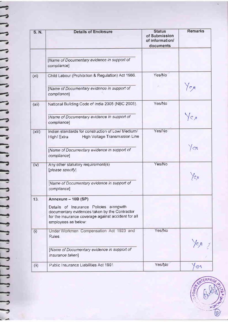
1--2
-t4
atst
4?a
-a-a?.
--a
-a
ttt
>, a-"h
-=
-
-
-
-
-h-
-I
-I-!I
I
;
--
s. N. Details of Enclosure Statusof Submissionof information/
documents
RemarKs
lName of Documentary evidence in suppott ofcompliancel
(xi) Child Labour (Prohibition & Regulation) Act '1986.
lName of Documentary evidence in support ofcompliancel
Yes/No
Y:o
(x i) National Building Code of India 2005 (NBC 2005).
lName of Documentary evidence in suppotl ofcornpliancel
Yes/No
Y.,(xiii) lndian standards tor constructlon oi Low Meolum/
High/ Extra High Voltage Transmission Line
lName of Documentary evidence in suppott ofcompliancel
Yes/No
)o.
(iv) Any otner statutory requrrement(s)
lplease specifl
lName of Documentary evidence in suppott ofcompliancel
Yes/No
Iet
13. Annexure - 108 (SP)
Details of Insurance Policies alongwithdocumentary evidences taken by the Contractorfor the insurance coverage against accident for all
emolovees as below:
(D
Rules.
lName of Documentary evidence in suppoft ofinsurance takenl
Yes/No
Y"t
(ii) Public Insurance Liabilities Act 1991 Yes/[o 'l e.t

/rE/8t
R,\
beurcfury evidene ift suryort oftakenl
Jer;lNo
[Name of Documentary evidence.in.suppori d

ANNEXURE VII Safety/Penalty
Provisions in Contract Conditions

0219
Section Vlll. partia-b. :
Replace the word 'may' in Iine no. 10 with ,is,.
Addition of New Clauses (pC21.3.5, pC21.3.6) afrer GC 21.3.4
Packing
The Contractor shall provide such packing of the Goods as it is requi:ai:::::1^,1"]i, o1-ig:
.or- deteriorario,i a*i"f-o^"srt ro rheir idestination as indicated in t' -."^'116 (rarrDrr tu tnelr E
withstand, withouL 6rrrir.l^lo"oucl The packing shall be sufficier
.,x'. ...,crr,. r^ ^_!_^*^ .^ ,nor, rough handling durrng traruit Iexposure to extreme te ,.". .i* --, _-^-Y.,------'o u..Dr( .rand open storage. p
t"t' salt and precipitation d"tl"g Fdconsirterari^- .^,L^-^ ^-,-_ .
case .slze and weights shall talie ioconsiderarion, where appropriate, rhe .;";;;t;;;:"";.
=destinarion and rhe absence of h.""y h;;;ii;f?"of** ut au poir,= I
ll^:,_^T*tlt:, marking and documenrarion wirhrn and ourside i:packages shall comply strictly with such special requirements as sha-l hexpressly provided for in the Conrrac .ia, -"rfrjJ,
ro any sutreqEeEil:::.ff1:aered
by the Employer .or,rirt",.,t *,tii rhe requiremen= iReplace the word ,materials,
in line no. 2 with,plant and Equipment,-
Add the word ,includine liabilities for port charges if any, after the rr:i:'clearance' in line no. 3_
fr.jtfilj s ub-Clauses (p c22.2.s.1, p c22.2.s.2, p c22.2.s.3, p c 22 2_3-s
Compliance with Labour Regula tions
s that may be passed or notificati._::law in future either by the State c:I authority. The employees of th:ln no case shall be treated as th:
il"'ii"Xt"?i,IiF;?Y"f"1'NAG-DMS-02'NAG-DMS-03'&,NAG-Dr,4s-04
PC 21,.3.4
PC 21.3.5
PC 2r.3.6
PC 21.4
PC 22.2.3.\
lmprovemenl ProjecL

PC 22.2.3.2
PC 22.2.3.3
PC 22.2.3.4
PC 22.4.r
employees of the Employer at any point of bime.
The Contractor shall keep the Employer indemnified in case any action istaken against the Employer by the competent authority on account ofcontravenLion of any of the provisions of any Act or rules madethereunder, regulations or notifications including amendments.
If ihe Employer is caused to pay under any law as principal employersuch amounts as may be necessary to cause or observe, or for nonobservance of the provisions " stipulated in the notifications/byelaws / Acts / Rules/ regulations including amendments, if any, on thepart of the Contractor, the Employer shall have the right to deduct anymoney due to the Contractor under this conbract or any other conhactwith the employer including his amount of performance security foradjusting the aforesaid payment. The Employer shall also have right torecover from the Conhactor any sum required or estimated to be requiredfor making good the loss or damage suffered by the Employer.
Salient features of some major laws applicable to establishments engagedin building and other construction works are indicated at Appendix-I toPC.
Addition of New Sub-Clauses (PC22.4.T to 22.4.3 including its sub-clauses) of GC 22.4
Protection of Environment
The Contractor shall take al1 reasonable steps to protect the environmenton and off the Site and to avoid damage or nuisance to persons or toproperty of the public or others resulting from pollution, noise or othercauses arising as consequence of his methods of operation.
During continuance of the Contract, the Contractor and his Sub-contractors shall abide at all times by all existing enactments onenvironmental protection and rules made there under, regulations,notifications and bye-laws of the State or Centrai Governrnent, or localauthorities and any other law, byeJaw, regulations that may be passed ornobification that may be issued in this respect in fuhrre by the State orCenLral Government or the local authority.
Salient feabures of some of the major laws that are applicable are givenbelon,:
:.-.:i' 028!Section Vlll. Particular Conditions
8-14
f* tn" pr"rr".,tion and control of water pollution and the maintaining an-d
rerto.ing of wholesomeness of water' 'Pollution' .rn:uttt. t,ttl
This provides
contamiiration of water or such alteration of the physical, chemical dt
biological properties of water or such discharge of any sewage or lrade
effl.,e"nt o, oi ur,y other liquid, gaseous or solid substance into wat6i
(whether directly or indirectly) as may, or is likely to, create a nulsance or
render such water trarmful or iniurious to public health or safety' or todomestic, commercial, industrial, agricultural or other legitimate uses/ or
to the life and health of animals or plants or of aquatic organisms'
This provides for
prevention, control and abatement of air pollution 'Air Pollution' means
th" pr"r"r,." in the atmosphere of any 'air pollutant', which means any
so[d, [quid or gaseous substance (including noise) present in the
atmosphere in such concentration as may be or tend to be iniurious to
human beings or other living creatures or plants or Property or
environment.
This provides for the Protectlonfor matters connected therewith,
PC 22.4.2
Packages NAG-DMS-0'1,lmprovement Project
NAG-DN,4S-02, NAG-DMS-03 &
and the prevention of hazards to human beings, other living creatures'
plants and property. 'Environment' includes water, air and land and the
inter-relationship which exists among and between water, air and land,
and human beings, other living creatures, plants, micro-organism and
properry.
The Public Liabilitv Insurance Act, 1991, This provides for public liabilityinsurance for the purpose of providing immediate relief to the persons
affected by accident occurring while handling hazardous substances and
for matters connected herewith or incidental thereto Hazardous substance
means any substance or preparation which is defined as hazardous
substance under Environment (Protechion) Act, 1986, and exceeding such
quantify as may be specified by notification by the Central Government'
(i) The Contractor shall (a) establish an operafional system of
managing envirorthental irnpacts, (b) carry out all the
monitoring and mihigation measures set forth in the
environment management plan attached to the Particular
Condihons as Appendix-Il, and (c) allocate the budget
required to ensure that such measures are carriecl out The
e Environment (Pro tectio4and improvement of environment and

.f';;.;;, 3282Section Vlll. Particular Conditions 8-15
l,I!
f.rurrrFt-'r(:
E'l-,=rr.uuLrrr8".r'l:"'|-t--l-:lJ-.l:r-l-l:"ljr:lj"
(ii)
(iii)
(i")
PC 22.4.3 Safety Precautions
PC22.4.3.1
PC22.4.3.2
Contractor shall submit to the Employer (quarterly) semi-armual) reports on the carrying out of such rneasures.
The Contractor shall adequately record the conditions of roads,agricultural Iand and other infrastructure prior to transport ofmaterial and construction commencement, and shall fultyreinstate road / pathways, other local infrastructure andagricultural land to atleast their pre-project condition uponconstruc tion completion.
The Contractor shall undertake detailed survey of the affectedpersons during transmission line alignment finalization underthe Project, where applicable. and
The Contractor shall conduct health and safety programme forworkers employed under the Conhact and shill includeinformation on the risk of sexually transrnitted diseases,including HIV/AIDS in such prograrns.
The Contractor shall observe all applicable regulationsregarding safety on the Site.
Unless otherwise agreed, the Contractor shall, from thecommencement of work on Site until taking over, provide:
a) fencing, lighting, guarding and watching of the Workswherever required, and
b) temporary roadways, footways, guards and fenceswhich may be necessary for the accommodation andprotection of Employer / his representatives andoccupiers of adjacent property, the public and others.
lleCeSSary.

:. rJ , t', 0283Section Vlll. Particutar Conditions
(
I(
(
(
1
(
(
C
(ai
t
at
I
t/\)\
a)tl(
Ib
d-
I
ilJ)
)J)
Jl1-l
PC 22.4.3.3 The Conhactor will notify well-in advance to the Engineer ofhis intention to bring to the _Site any container filled withliquid or gaseous fuel or expiosive or petroleurn substanceor such chernicals which may in..olve hazards. TheEngineer shall have the right to prescribe the conditions,under which such container is to be stored, handled andused during the perforrrpnce of the works and theConhactor shall strictly adhere to and comply with suchinstructions. The Engineer shall have the rigtrt at his solediscretion to inspect any such container or suchconshuction plant/equipment for which material in thecontainer is required to be used and if in his opiniory its aseis not safe, he may forbid its use. No claim due to suchprohibition shall be entertained by the Owner and theOwner shall not entertain any claim of the Contractortowards additional safety provisions/conditions to beprovided for/conshructed as per the Engineer,srnstructrons.
Further, any such decision of the Engineer shall no! in anyway, absolve the Contractor of his -responsibilities
and incase, use of such a container or en h_y thereof into the Sitearea is forbidden by the Engineer, the Contractor shall usealternative methods. with the approval of the Engineerwithout any cost implication io flIE EMpLOyiR orextension of work schedule.
PC22.4.3.4 Where it isprodu*s .iEjiiJ": TT'ffi:":f :ffiffii:'"ffiContractor shall be responsible for carryrng_out suchprovision and/or storage in accordance with the rules andregulations laicl down in petroleum Act 1934, ExplosivesAct, 7949 and petroleum and Carbide of Calcium'Manualpublished by the Chief Inspector of Explosives of India. Altsuch storage shall,have prior approvai of the Engineer. Incase/ any approvals are necessary from the Chief"Inspector(Explosives) or any statutory authorities, the contractorshall be responsible for obtaining the same. --
PC 22.4.3.5 All equipment usedConhactor shall meetwhere such standards
in construction and erection byIndian/ Interna tional Standards anddo not exist, the Contractor shall

0 284Particular Conditions
l:L'L'L-t:l.:rL:rL:L:l't'-
--
-,
ensure these to be absolutely safe. All equipment sl.rall bestrictly operated and marntained by the Contractor inaccordance with manufacfurer,s Operation Manual andsafety instructions and as per Gu idelines/ rules of THEEN{PLOYER in rhis regard.
PC 22'4'3 6 Periodicar examinatio.s ancr alr tes ts for all rif ting/hoisfingequipment & tackles shall be carried_out in accordancewith the relevant provisions of Factories Act 194g, IndianElechicity.Act 1910 and associated Laws/Rules in forcefrom time to time. A register of such exammations andtests shall be properly maintained by the Contractor andwill be promptly produced as and when desired by theEngineer or by the person authorised by him.
PC 22.4.3.7 The Contractor shall be fully responsible for the safestorage of his and his Sub-Contractor,s radioactive sourcesin accordance with BARC/DAE Rules and other applicableprovisions.
. . All precautionary measure, ,tip.riu ted by
BARC/DAE in connection with use, ,to.ug. ur,d handlingof such material n ill be taken by the ConLractor.
PC 22.4.3.8 The ConLractor shall provide suitable safety equipment ofprescribed standa rd to all employees and workmenaccording to the need, as may be Jlr".t"d by the Engineerwho will also have right to examine these safety equiimentto determine their suitability, reliability, acceptability andaclaptability.
PC 22.4.3.9 Where explosives are to be used, the same shall be usedI and supervision of an expert,rrd competent person strictlv ine of prachce/Rules frarnecl under
Indian Explosives Act pertaining to handling, storage andusc of erplosives.
PC 22.4.3.L0 The Contractor shall provide safe working conclitions to_a,lJ workmen and employees at tl_re Site including safemeans of access, railings, stairs, ladders, ;caffoldinls etc.Jhe scaffoldings shall be erected under the conuJ andsupervision of an expericnced and competent person. For*erection, good ancl standard qualiry of material only slia.U

o
i'i.>i.,.rl .''- 0285&18 Section Vlll. Parttcular Conditions
-be used by the Contractor.
PC 22.4.3.11 : The Contractor shall not interfere or disturb electric fuses,
- wiring and other electrical equipment belonging to the
- Owner or other Contractors under any circumstances,whatsoever, unless expressly permitted in writing by THE
--EMPLOIGR to handle such fuses, wiring or electricalequipment
PC22.4.3.12 Before the Contractor connects any electrical appliances toany plug or socket belonging to the other Contractor orOwner, he shall:
. a. Satisfy the Engineer that the appliance is in goodworking condition;
b. Inform the Engineer of the maximum current rating,voltage and phases of the appliances;
c. Obtain permission of the Engineer detailing the
" sockets to which the appliances may be connected.
The Engineer will not grant permission to connect until heis satisfied thaq
a. The appliance is in good condition and is fitted withsuitable plug;
b. The appliance is fitted with a suitable cable havingtwo earth conductors, one of which shall be anearthed metal sheath surrounding the cores.
No electric cable in use by the €onhactor/Owner will bedisturbed without prior permission. No weight of anydescription will be imposed on any table and no ladder orsimilar equipment will rest against or attached to it.
PC 22.4.3.15 No repair work shall be carried out on any live equipment.The equipment must be declared safe by the Engineer anda permit to work shall be issued by the Engineer before
. any repair work is carried out by the Contractor. While. working on electric lines/equipment, whether live or
dead, suitable type and sufficient quantity of tools willhave to he provided by the Contractor to
;jFcelr/)
I
I
PC22.4.3.13
PC22.4.3.1.4
& NAG-DMS-04 for Nagaland

0286Section Vlll Particular Conditions
t\Itk'L.kL-kt,ttTtttttLL-ftLL-rJLLLtjLu'I
B-19
PC 22.1.3.76
PC 22.4.3.17
PC 22.iI.3.18
PC 22.4.3.19
elechicians/ r,vorkmen/ officers
The Contractors shall employ ."."rrurf number ofqualified, full time electricians/ electrical sirpervisors tomaintain his temporary electrical installa tioi
purpose.
-t'[""%T]iF-?S? oI NAG-DMS-o2 NAG-DMS-o3 & NAG-Dt!4s 04 ror Nasaidnd aisqsigteo wnrr NER power system

c4 ..
of such stoppage of work and decision of the Engineer inthis respect shall be conclusive and binding on theContractor.
The Contractor shall not be - entitled for anydamages/compensation for stoppage of work due tosafety reasoru as provided in para GCC 22.4.3.19 aboveand the period of such stoppage of work will not be takenas an gxtension of time for completion of work and willnot be
'the ground for waiver of levy of liquidateddamages.
It is mandatory for the Contractor to observe during theexecution of the works, requirements of Srifety Ruleswhich would generally include but not limited to
PC22.4.3.20
PC22.4.3.21,
Safefy Rules
a) .Each employee shall be provided with initial- : indoctrination regarding safety by the Contractor, so
as to enable him to conhuct his work in a safemanner.
following:
c)
e)
b) No employee shall be given a new assignment ofwork unfamiliar to him without proper introductionas to the hazards incident thereto, both to himseHand his fellow enployees.
Under no circumstances shall an employee hurry ortake unnecessary chance when working underhazardous conditions.
Employees must not ledve naked fires unattended.Smoking shall not be permitted around fire proneareas and adequate fire fighting equipment shall beprovided at crucial location.
Employees under the influence of any intoxicatingbeverage, even to the slightest degree shall not bepermitted to remain at work.
d)

0 288
Section Vlll. Particular Conditions
I'l.Lt--
L:t-LJL:L:L:L:tjl,:L:t-L:t-L:L-LJL-L:L:LJL:L-L-L:L-L-t_L:L-L-L:Lj
f) There shall be a suitable arrangement at every worksite for relrdering prompt and sufficient first aid tothe injured.
g) The staircases and passageways shall be adequatelylighted. .-
h) The employees when working around movingmachinery, must not be permitted to wear loosegarments. Safety shoes are recommended whenworking in shops or places where materials or toolsare likely to fall. Only experienced workers shall bepermitted to go behind guard rails or to cleanaround energized or moving equipment.
i) The ernployees must use the standard protectionequipment intended for each job. Each piece ofequipment shall be inspected before and after it isused.
t) Requirements of ventilation in underwater workingto Licenced and experienced divers, use of gumboots for working in slushy or in inundatedconditions are essenLial requirements to be fulfilled.
In case of rock excavation, blasting shall invariablybe done through Licenced blasters and otherprecautions during blasting and storage/ transportof charge material shall be observed shictly.
The Contractor shall follow and comply with ali THEEMPLOYER Safely Rules, relevant provisions ofapplicable laws pertaining to the safety of workmen,ernployees, plant and equipment as may be prescribedfrom time to time without any dernur, protest or contestor reservations. In case of any 6li561spancy betweenstatutory requirement and THE EMPLOYER Safety Rulesreferred above, the laner shall be binding on the"--Conhactor unless the statutorv rrrovisions are morestringent.
safe work.ins
NER Power System
k)
PC22.4.3.22
PC22.4.3.23
Packages NAG-DMS-01. NAG-DMS-02,lmprovement Project
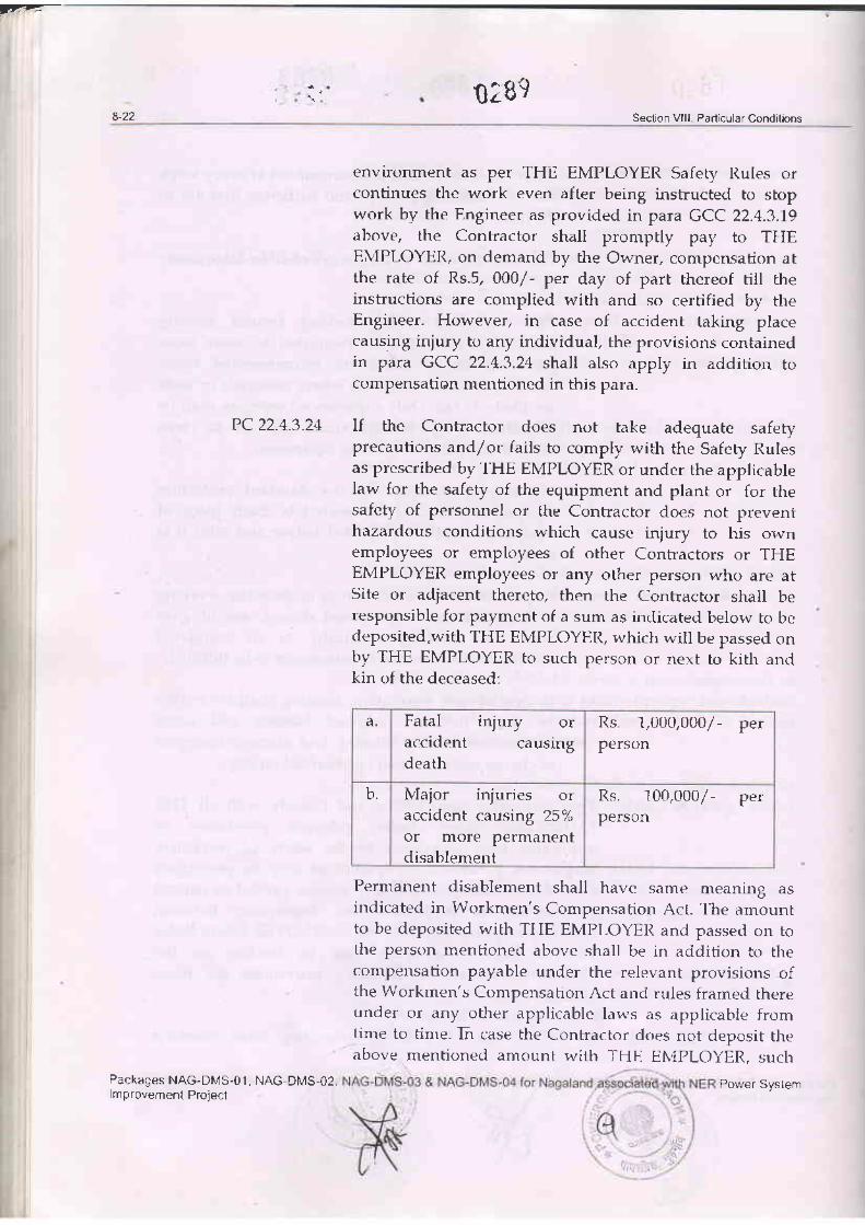
,7.-T
02898-22 Section Vlll. Particular Conditions
PC22.4.3.24
Packages NAG-DMS-01, NAG-DN,lS-02,lmprovement Prqect
environment as per THE EMPLOYER Safety Rules orcontinues the work even after being instructed to stopwork by the Engineer as provided in para GCC 22.4.3J9above, the Contractor shall promptly pay to THEEMPLOYER, on demand by the Owner, compensation atthe rate of Rs.5, 000/- per day of part thereof rill theinstructions are complied with and so cerlified by theEngineer. However, in case of accident taking placecausing injury to any individual, the provisions containedin para GCC 22.4.3.24 shall also apply in addition tocompensation mentioned in this para.
If the Contractor does not take adequate safetyprecautions and/or fails to cornply with the Safety Rulesas prescribed by THE EMPLOYER or under the applicablelaw for the safety of the equipment and plant or for thesafety of personnel or the Contractor does not preventhazardous conditions which cause injury to his ownemployees or employees of other Conlractors or THEEMPLOYER ernployees or any other person who are atSite or adjacent thereto, then the Contractor shail beresponsible for payment of a sum as indicated below to bedeposited"with THE EMPLOYER, which will be passed onby THE EMPLOYER to such person or next to kith andkin of the deceased:
a. Fatal injury oraccident causingdeath
Rs. 1,000,000/- perperson
b. Major injuries oraccident causing 25%or more permanentdisablement
Rs. 100,000/- perperson
Permanent disablement shall have same meaning asindicated in Workmen's Compensafion Act. The amountto be deposited with THE EMPLOYER and passed on tothe person mentioned above shall be in addition to thecompensation payable under the relevant provisions ofthe Workmen's Compensation Act and rules framed thereunder or any other applicable laws as applicable fromtime to time- In case the Contractor does not deposit theabove mentioned amount with THE EMPLOYER, such
Power System

Section Vlll. Particular Conditions
frLffETffff;I-rffuff
t't-lz.+-3-z)
PC22.4.3.26
amount shall be recoverecl by THE EMPLOYER from anymonies due or becoming due to the Conbractor under thecontract or any other on-going contract.
If the Contractor observes all the Safety Rules and Codes,Statutory Laws and Rules during the currency of Contractawarded by the Owner and no accident occurs then THEEMPLOYER may consider the performance of theContractor and award suitabie 'ACCIDENT FREESAFETY MERITORIOUS AWARD' as per scheme as maybe announced separately from time to time.
The Conhactor shall also submit 'Safety Plan' as perproforma specified in Section IX: Contract Forms, Part-3of Bidding Documents alongwith all the requisitedocuments mentioned therein and as per check-listcontained therein to the Engineer In-Charge for itsapproval within 60 days of award of Contract.
Further, one of the conditions for release of firstprogressive payment / subsequent payment towardsServices Contract shall be submission of 'Safety Pla4'alongwith all requisite documents and approval of thesame by the Engineer In-Charge.
PC 22.6
PC 23.3
PC23.7
Emergency Work (GC Clause 22.6)
Replace the words "Otherwise" with "In case such work is not in thescope of the Contractor", in the second last line of second paragraph of GCclause 22.6.
Supplementing sub-clause GC 23.3
For notification of testing, fo.r. *""k, shall be deemed as reasonableadvance notice.
Test and Inspection (GC Clause 23.7)
Replace the words "GC Sub-Clause 6.1" with "GC Sub-Clause 46.1", in thelast line of GC clause 23.7.

ANNEXURE VIII Approved Labour
License & Insurance Policy by Contractor

l7t- 2r/'r//t
MIN YMENTOFFICE OF THE SSIONER (CENTRAL)
COLLEGE ROAD, SIICHAR.788 OO4, ASSAME-mail [email protected]
TELEPHONE NO. 03842-267330
20r&s/A
I/3 FOWER MECH PROJECTS LIMITEDPOWEN OruO CONPORATION OF INDIA LIMITED CONTRACTOR
receipt of the same.
Yours faitlrfully,
Dated - 16. 04. 2018
REPRESENTED THROUGH:,ll Shri S. KISHORE BABU, CHARIMAN & MANAGING DIRECTOR
S/O SHESHAGIRI RAO SAJJAt2t Shri N. BHUPESH CHOWDARY, WHOLE TIME DIRECTOR & CEO
S/O STHIRA.IULU NAGINENIr3l Shri G.D.V.PRASADA RAO, INDEPENDENT DIRECTOR
S/O KRISHNA RAO GORIJAI"A14| Shri SANToSH KUMAR SINHA, ASSISTANT GENERAL MANAGER (AGM-SMX) & PowER oF
ATTORNEYS/O SHzuDHAR PRASAD SINHA
REGISTERED & CORPORATE OFFICE: PI,oT NO. 77, JUBILEE ENCI"AVE, OPPOSITE HITEX
VADIIAPUR, HYDERABAD - 5OOO81. E-matl lnfo@Powermech'net I M - O937llOSa42'
&ry- GnPat:t Labour (Regulation and. Abolition) Act, 1970 and Conttact Labour Regulation & Abolition
Central Ruleg 1971 , Issue of Licence to M/s POWER MECH PROJECTS LIMITED, POWER
GRID C)R?ORATI)N OF INDIA LIMIiED CONTRACTOR, REGISTERED & CORPoRATE oFFICE: PLOT
li2. 77, JUBILEE ENCLAVE, OPPOSITE HITEX, MADHAPUR' HMERABAD _ 5OOO81.
Dc-k-please refer to your Application for Licence No. PMPL/PGCIL/NAG/SS-PKG/2018- 19/06 dated-
IO-()i+J)18 atcsived at this office on to,o+.zots1 for issue of Licence under s€ction-12 (1) of the Contract l,abour
tRrgtu zr -{bolition) Act, 1970.I, in accordaice with the plovisions under Section-12 (1) of tne said Act under the Autholity vested
ur E 5 tb€ Ljcensing olhcer of the area hereby issue the Licence in FoRM-vI presc
firc *gnf"riott ar,'d Abolition) Central Rules, 1971 against the work "Supply of Se.eice
hcbGF-f$_SS.O4 including Transformer for (i) 132/33 KV Pfutsero (New) S/S and (ii) Iu-o&---rmission System for Nagaland State associated with NER Power System Improvement Project. Specification
\;o- cc-Cs 92-\-ER/SS-3622/ 1/c3 (NAG-SS-o4) & NoA No. cc-cS/92-NER/SS-3622/ 1/G3/NoAJI/7550 dated-
13.12-4-^7.Licence is issued without prejudice to the legal action taken or to be taken by the Department for not
ot aiE4 ii:ase in the Past.
\o. !6 ::3To
(11
12l
Eoe : O\El U
@-@-P:flc tupuvTtc Laburfrrn tle Contractor
Assistant l,abour C issioner (Centra.l)Goveinment of India
SILCHAR
(Central), GUWAHATI.'ral), LUMDING. A copA of the application for Licence in FI.]?M-II receiued
fi.ereuith uid.e Licence No. CLA/ 106/2018-5/A dated-16.O4.2018 ho.s been
gr@td to the Contrador for 50 (FIFTY) Iabours.-SrTi L A. Stwrma, Assistant General Manage1 Pouter Gid Cotporation of India Limited, IVERPSIP,
xqoland" IJpper chandmai Lane, PWD Road, Opposite P\lD central store, Kohima-7970o 1,
lqoland for information uide Licence No. CLA/ 106/2PfroJrcTE LIMITED for 50 (FIFTY) labours.
Assista,nGovernment of lndia
SIrcHAR
iir
6ovt.oftnd,,,'{i:r,itry o, irb;r,

FORM-VI(sEE RULE- 25(1)
GOVERNMENT OF INDIAMINISTRY OF LAIIOUR & EMPLOYMENTOFFICE OF THE LICENSING OFFICER
AND ASSISTANT LABOUR COMMISSIONER {CENTRAL)COLLEGE ROAD. SILCHAR-788004. DIST. CACI{AR. ASSAM
LICENCE NO. CLAI 106l20 18-S/A
The Licence shall remain in force
)ate:16.O4.2O18
DATE: 16.04.2018
LICENCEFEE PAID
Rs.38.00(RUPEES THIRTY EIGHT)ONLY
Deposited through bharatkosh. gov.in videTransaction Ref. No. 1004180001454dated - 10.04.201
LICENCE1. Licence is hereby granted to M/s POWER MECH PROJECTS LIMITED, POWER GRIDcoRPoRATIoN oF INDIA LIMITED coNTRAcroR, REPRESENTED THROUGHT (t) shri s. KISHOREBABU, CHARIMAN & MANAGING DIREcroR, s/o SHESHAGIRI RAo SAJJA (2) sbri N. BHUPESH
.- cHowDARY, wHoLE TIME DIRECToR & cEo, s/o ETHIRA"IULU NAGINENI (3) shri G.D.!.pRASADARAo, INDEPENDENT DIREcroR, s/o KRISHNA RAo coRIJAt A (4) shri sANTosH KUMAR srNHA,ASSISTANT GENERAL MIINAGER (AGM-SMX) & POWER OF ATTORNEY, S/O SHRIDTIAR PRASAD SIN}IA.REGISTERED & CORPoRATE OFFICE: PLOT NO. 77 , JUBILEE ENCLAVE, OPPOSITE HITEX, MADI{APUR;ITDERABAD - 500081 under Section 12 (l) of the Contract l,abour (Regulation and Abolition) Act, 19T6subject to the conditions specilied in the ANNEXURE.
2. Tbe Licence is for doing the work - 'supply of Services contract for Substation package-NAG-SS-04 including'Transformer for (4 132/33 KV Pfutsero (New) S/S and (ii) 132 Kv wokha s/s (Extn) under TransrnissionSystem for Nagaland State associated with NER Power System ImproveEent Project. Spicilicirtion No. CC-CS,/92-NER/SS-3622/ 1/G3 (NAG-sS-o4) & NoA No. CC-CS/92-NER/SS-3622/ 1/G3/NoA-it/75so dated-l3. r2.2orz, nthe establishment of Shri L. A. Sharma, Assistant General Manager, Power Grid Corporation of IndiaLimited, NERPSIP, Nagaland, upper chandmari Lane, pwD Road, opposite pwD central store, Kohima-79700l,Nagaland.
3.
2e)
J4o;;i;"

2.
A NNEXUR E
Ihe Licence slnll be non - Ttansferable.
m:XTffir##men"ewloaed as contract Labour in the est.,bristan'nr shalr not on ana d.a!,
?fr#n:ffiff:#:y"Hn;f.f"* paid forthe grant, or as the case tuts be, for reneuat of
not be less than the r.atesAq i94B (r 1 of 1948), andt settlement or award, not
tn rates,_hoMags, ltours of 1lo.rk and. anditions of seruice of the workmen'{, e such as mas be speci7ed tn tii" n"r,i}.is'r*"';;"d iTu#
^uo*Euery.Contract Labour sl.'.Il b. :l?U-"! tn all',,ances, beneft5 foritities etc. as prescibed in thecontact Labour (Resltration and Aboritioi ;;,1;;i;;;19201 and. Rur.es mnde there under.
No women shall be employed. by ang Contractor before 6 A.M. or after 7 p.M.
hovided that this clause shaflltot ap-p.!-!1 !"3 e19a.^ent of uorkmen in pit head baths, crdches _and canteen and as mid,_wiues and. nurses in HospitaLs rLnd DlspetTsanes.
tr #;"3# notifu ang clwnge in trle number of u.torkmen or the conditions of trork to the
t#;"y# :fnce shall be disptaged. prominenttg at the premises u'here te contract uork is
4.,
5.
(b)
10.
I t.

GOVERNMENT OF INDIAMINISTRY OF LABOUR & EMPLOYMENT
OFFICE OF THE ASSISTANT LABOUR COMMISSIONER (CENTRAL)
COLLEGE ROAD, SILCHAR-788 OO4, ASSAME-mail a]c. sil- agasov. in
TELEPHONE NO. 03842-267330
M/s POWER MECH PROJECTS LIMITEDPOWER GRID CORPORATION OF INDIA LIMITED CONTRACTOR
REPRESENTED THROUGH:{1) Shri S. KISHORE BABU, CHARIMAN & MANAGING DIRECTOR
S/O SHESHAGIzu RAO SAJJAOl Shri N. BHUPESH CHOWDARY, WHOLE TIME DIRECTOR & CEO
S/O gIHIRA.IULU NAGINENI{3) Shri G.D.V.PRASADA RAO, INDEPENDENT DIRECTOR
S/O KRISHNA RAO GORIJAI"A@I ShTi SANTOSH KUMAR SINHA, ASSISTANT GDNERAL MANAGER (AGM-SMX) & POWER OF
ATTORNEYS/O SHRIDHAR PRASAD SINHA
REGISTERED&CORPORATEOFFICE:PLOTNOTT,JUBILEEENCIj'VE'OPPOSITEHITEXMADHAPUR,HYDERABAD_5oOO81.E-matlinfo@powermech'netll'-o937||o5s42'
Subject: Buitding and Other Construction Worke I 1996
and Build.ing and Other Construction ruce)
Central tuttJs, 1998 - Issue of Registratio GPJD
C)RP)RATIC,N oF INDIA LIM.TED-CONTRACTOR, REGIS,IERED & CORPORATE OFFICE: PLOT NO. 77'
JUBILEE ENCLAVE, OPPOSITE HITEX, MADIIAPUR, HYDERABAD _ 5OOO8 1 '
Dear Sir,please refer to your Application for Registration No. PMPL/PGCIL/NAG/SS'PKG/ 2018'19/06 dated-
10.04.2018 (received at this office o.t-iO.O+.ZO1S1 in respect of Registration under Section 7(3) of the Building and
ottrer construction workers (Regulation of Employment and condition of service) Act, 1996.
I, in accordancJwith the provisions under Section-7 (3) of the said Act under the Authority vested to
me as the Registering Ofhcer of tlle area hereby issue the Registration in FORM-II prescribed under the Building ardOther Constriction Workers (Regulation of Emplo]'rnent rd Condition of Serrrice) Act, 1996 against the work "Supply
oi S"*i""" Contract for Substation Pactage-NAG-SS-04 including Transformer for (i) 132/33 KV Pfutsero (New) S/S
and (ii) 132 KV Wokha S/S {Extn) under Tiansmission System for Naga-latrd State associated with NER Power System
Improvement project. Specitication No. CC-CS/92-NER/SS-3622/ 1/G3 (NAG-SS-o4) & NOA No. CC-CS/92-NER/SS-
3622 / | lG3lNOA-ll/7550 dated- 13.12.20\7".
No. s7 (89 ) I 2ola-s/ATo
Thefor not obtaining
Please
Enclo: 1 (One)
9ep!-@e4E4-b.:(1)(2)
The Deputg ChiefThe Labour
Dated:16.04.2018
without prejudice to the legal action taten or to be taken by the Department
Yours faithfuily,
Assista-ntLabour issioner(Central)Govemment of India
SILCHAR
(Centrdl), GUWAHATL), LUMDING. A copA of the qpplication for Regi.strolion in FORM-I receiued
from the Contiactor is eniiosed. hereutith vide Registration No. REG/ BOCW 89/ 2O18-S/A dated - 16.04.2018
hos been granted to the Contractor for 5O (FIFTYI laboursSh.i L. A. Sharma, Assistant General Manager' Pou)er of India Limited, NERPSiP,
Nagaland, Upper Chandmai Lane, PWD Road"N ag atand for info rmati o n.
Assistant
rt,\\.r
n",i 5/;
:,v? t'1<\
\e;
"^::T"r,y:",,E"rl.y",",; e",;;.,., 4 ;,.".r o?rarru.-tf! ,r., - ^
_

FORM-N{See RuIe - 24(1)}
No. REG/ BOCW 89/ 2O1 8-S/ A Date: 16. 04. 2018GOVERNMENT OF INDIA
MINISTRY OF IABOUR & EMPLOYMENTOFFICE OF THE REGISTERING OFFICER &
ASSISTANT LABOUR COMMISSIONER (CENTRAL)
,A certiflcote of Regi.strqtian is herebg granted. under 's\,b-Section (3) of Section-7 of the Building and Other
Constnration Woiters lfizgutition of Emplogmeit and Condition of Service) Act, 1996 aail the rules m.ode there under to
M/s PowER MEcIl.PKa]EcTs LMTIDD, PowER GRID CORPORATION OF INDIA L]MITED CONTRACTOR,
REPRASEIyTED 'I'IIROUGH:(1) Shn S. KISIIORE BABU, CIIARIMAN & MANAGING DIREC'r1O?" S/O SHESI{AGIRI RAO
SAJJA (4 Slvi N. BHWESH CHOWDARY, WHOLEG.D.V.PRASADA RAA INDEPENDEI'IT DIREC"TOR, S/ASSTSfAI{r GEjVER4' MANAGER (AGM-SW) & POWER OF& CORPORATE OFFICE: PLOT NO. 77, JIJBILEE ENCLAW OPPOS0E HITEX, MADHAPUR' HWERABAD - 50OO81
having the follouing partiantars subiec.t to conditions laid, daun in the Annentre
(c)(d)
(e)
S(rue or provided, in these rules, tle fees paid for tle grant of registrolion certificate shalt be non-refwndable.Thc rates of uages paAable to building uorkers bg the emploAer slnll not be le-ss than tlLe rates prescibedunder tlg Minimum woges A4 1948 (E of 1948) for such enplogm.ent ullere awlic&le, atd where the ratestrolE been fixed bg agreenent, selllenent or award' natn@ emploger shail complg withthe Prouisiot],s ofttle Act
I Postal dddress / loution u.tterebuilding orother @nsfiuction work isto be carried on bg the furyrloger
M/s POWER MECH PROJECTS LIM0ED' POWER GRID CORPORATION OFINDIA LIMITED CONTRAC'IOR, work Site At - Seruices Corltract forSubstation Package-NAGSS-)4 inctuding Tlansformer for (i) 132/33 KvPfutserc (Neu) S/S dnd (ii) 132 KV Wokln S/S (Ertn) und.et TlansmissionSgstem for Nagaland Stdte Q.ssociated uith NER Pouer SgstemImDrovement Proied
2 Name and address of emploger itnluding locatiotl ofthe building & ottrer I As ahoue in Sl' No.l@nstrudion uorkName and, pemnnerLt address of thcestoblblv@nt.
M/ s POWER MECH PRAJECTS LIMITED, POWER GRID CORPORATION OFINDIA LIMITED CONTRACTOR, REGISTERED & CORNMTE OFFICE: PLOTNO. 77, JUBILEE ENCLAW, OPPOSITE HITEX, MADHAPUR, LIYDERABAD _,
5000814 Nature oJ uork in uhich buildirtg
uorkers arc emploged. or ore to beenptryed.
Supplg of Serui@s Coftlact for Substation Pocka4e-NAGSgO4 iacludingTtansfodner for (i) 132/ 33 Kv finselo (New) S/S ond (ii) 132 KV WokhaS/ S @rtd und.er Transmission fusten for Nagaland State a.ssociated uithNER Pouer Sqstem Inlprovenent Prcject. Specification No. CC-CS/ 92-NER/ 55-3622/ 1/G3 (NAG-SSO4) & NOA No. CC-CS/ 92-NER/SS-3622/ 1/ G3/ NOA-II/ 7550 dated-13.12.2O17
5 Maximum rutmber oJ building uorkersto be enqloged on artg dag bg tleefttDlouer
s0(Frrl'Y)Nos.
Probabte d.dte of cDmnencenent andclnDletion ofu)ork .#lR.
30. 1 1.2017 TO 30.05.2020
7 KPlace: SIrcHARDate: 16.04.2018
ri{:
[q(a)
h)The certificate of tThe rutmber of rutmaxitnum nurnbet
wDt!&frthe ct
'{iii7W1"7ir.-" in the estabtishmed 'l&'qJt-
n'80 gel,'#Mih",rtifcqt e of re gistration.

ANNEXURE IX Safety Checklists


NERPSIP, NAGALANDSafety Check List
EDName of Sub Contra,ctor: ..!./.-€. C l4a..,ma D
a /"d'
E: GENERAL POINTS CoMMoN FoR ALL ACTIVITIES DURINGCAS'I'ING OF FOUNDATION
Erection oJ[structures, laying oJ Conductor, storage and transportation 0f material:
Voltage Level: 32 .<r'
S.No.
EXCAVATION,
f e,t,
Yes / No
Ye^.
Description of Activitv
Check Supervisors / Wo.krr.,en- ha.,J be"nEouided withlequired healthy ppEs. Like 1 Safery tetm.r I iufeiyB_ef ts / Safety Shoes / Gum Boo! etc. as applicablecheck availabiliry o@medicines at site.
Yes / No
Checl< Sirc Ilstn:ction r.c is available at srte. Yes / No
bcfbrc stalt ofwork.
Ens're . S'pewi.o. @irnstructlon to the Worknten including contracior labourYes / No
Ensure supe.iso.y staf@slte dunng construction.
Yes / No
)4\r,-
Yt^
Check all driver and piont "p..r,"^;:;:;li;:J"
ano prant operators are holding valid Yes / No
CtreS! the vehicle tbilescueliavaijaUle ar site. Yes / Notrnsurc engaged labour are aware of the iob. Yes / NoEnsure supewiso. / .'vorknren- engagea-n tt,i neta are
aware ofFirst Aid Techniques (Such as in case ofEtectricShock,.fall fi.om the height, Snake Uite ana tnelersonrescued from buried under the debris, ."r.u" of p".rontiom drownins etc.
Check for_ava ilauility@Hgplq! lgqsf ir cele o1'emer.gcncies arises.
Yes / No
While transponingEW dmms from cen : to site by rhe use of Cr.anes,-fftrck.
Tr.actor.. The sati for construction and
Yes / No

NERPSIP, NAGALANDSafety Check List
failure of bruke [email protected] lcast one dly pshall be provided where explosrve or blastingagents are used for excavation. (If applicable)
Ycs / No
Check. the .corrpetenc.@superursor / gang leader of contracrcr.Yes / No
Wire mesh .olls shal@dangerous recoiling action.
Yes / No
load the material.After unloading tt.re m@matcrials has been caried out along with the ercctioncontractor to check that the tnaterial has not been
9]t 1 or not (G.alvanrzing rs proper or nor) As per
approved Field eualiry plan etc.
Lilt#xx"Tli:,-",m Yes / No
Chcck that thc [email protected] been provided for all work pla.e, a, fr. nsrcasonably practicablc and is bcing uscd by thc wor rs.
Ycs / No
!l':,19'oo.'iltu-in@and ltretr approaches including passage ways.Yes / No
Check that tte lum@gx€rds where necessaly to prevent danger, in case the
Yes r' No
Checkloose materi@not be placed or left so as dangerously to obstruct workplaces ol passage ways.
Yes / No
Checkall p.o_l"ctedn@lo pr-event iniur-v
Yes / No
)er

NERPSIP, NAGALANDSafety Check t-ist
S-=r.t.
Checkscr.ap,*u@accommodate on the site or lhe scrap mateflals has beenstored at the isolated place.
Yes / No
Chcck that thematerials, wastDy tlten] lo cause lnlury to
Yes / No
ChcofPdenldepl-r-- uL uus !r.ue. LnecK the quantrty ofppEs.
Yes / No
ctr"ctttratth"r@
Check rheother perso Yes / No
check constructi@unau thorized persons / animals.
Check rhar li
:::1 :: ip _ re is of ,ouno .u,".,"t ul,Tgood quality and is free from pi
trii*.';#ji"F:,,ffi :1"J.';:..1i;.*ii:Tffi T:i /uCheck str-ucpurpose for Yes / No
checkeguinmen@person.
Check poothelwlseand back ,u5b snal De equally braced.
Checl< unskiand only exp
Yes / No
Chcck 'crat lad@
elPqqgq ryg qqctrical equiprnenr.Ycs / No
Check one boMunicipal Co Yes / No
ct'.ctctraree@Yes / No
o sf't

-NERPSIP, NAGATAND
safety Check List
v
copy
i)2)3)
4)
38Yes / No w
39Yes / No
YztREMA
J.5

ANNEXURE X Details of Public
Consultation

ANNEXURE X
Details of Public Consultations with Various Stakeholders
Project Place of Consultation Persons Consulted 33/11 kV Substation at Lalmati (Zubza)
Substation at Lalmati (Zubza)
Contractor, Contractor labor IA Staff and Villagers
132/33 kV Substation New Secretariat Complex
Construction Site Contractor, Contractor labor IA Staff and Villagers
33/11 kV Substation at Pfutsero (New)
Construction Site and Power Grid office
IA Staff , Contractor labor, Villagers and Chairman Municipal Corporation, Pfutsero
133/33 kV Substation at Pfutsero (New) Transmission Line Pfutsero
33/11 kV Sub Station (New) Chiephobozou
Labour Camp and Construction Site 33/11 KV Sub Station (New) Chiephobozou
IA Staff , Contractor labor, Villagers
132 kV Substation (Existing) Wokha
Sub Station Construction Site
IA Staff , Contractor labor, Villagers
33/11 kV Chukitong Augmentation DMS
Labour Camp and Sub Station Construction Site
IA Staff , Villagers and Contractor staff & labor,
33/11 kV Augmentation Zunheboto
33/11 KV Substation Zunheboto
IA & DPN staff, Contractor staff & labor and Villagers
132/33 kV Substation (New) Zunheboto
Construction Site and Lizo Old Gram Budha residence
IA staff, Contractor staff & labor and Villagers
132/33 kV Mokokchung State Sub Station
Mokokchung State Sub Station Construction Site
IA & DPN staff, Contractor staff & labor and Villagers
33/11 kV Mokokchung Hospital DMS New
Mokokchung Hospital DMS Construction Site
IA staff and Contractor labor
33/11 kV Mokokchung Power House DMS
Mokokchung Power House Site
IA & DPN staff
132/33 kV Lognak Sub Station (New)
Lognak Sub Station Construction Site
IA & DPN staff, Contractor staff & labor and Villagers
33/11 kV Longtho Sub Station (New)
Longtho Sub Station Construction Site
IA staff, Contractor staff & labor and Villagers
33/11 kV Augmentation Industrial Estate, Dimapur
Industrial Estate, Dimapur
IA and Contractor staff
132/66/33 kV Nagarjan Subsation (Existing), Dimapur
Nagarjan Subsation IA and Contractor staff
33/11 kV Substation (New) Padam Pukhri
Padam Pukhri Substation Construction Site
IA staff, Contractor staff and labor

33/11 kV Substation at Lalmati (Zubza)
132/33 kV Substation at Secretariat Complex
Tower Erection Site and Site Office at Pfutsero
33/11 kV Substation at Chiephobozou

132/33 kV Substation at Wokha 33/11 kV Substation at Chukitong
33/11 kV Substation at Zunheboto 132/33 kV Substation at Zunheboto
Old Lizo Village, Zunheboto
33/11 kV Substation at Changtongya 132/33 kV Substation at Mokokchung (State)

33/11 kV Substation at Mokokchung Hospital Area 33/11 kV Substation at Longtho
132/33 kV Substation at Lognak
33/11 kV Substation at Industrial Estate 33/11 kV Substation at Nagarjan
33/11 kV Substation at Padampukhri Interaction with GM, POWERGRID at Kohima

Details of Public Consultation with Photographs
Project Date of Meeting
Venue of Meeting Mo. of
Persons Attended
Persons Attended
132 KV D/C New Kohima (Zhadima) to New Secretariat Complex (NU campus) Line
09.12.2014 Conference hall, DC Office, Kohima
16
Village head, Senior persons and general public, DPN Members, PGCIL representatives
220 KV S/C (On D/C Tower) New Kohima-Mokokchung via Wokha line
18.02.2015 Conference Hall, DC Office, Zunheboto
77 Land Owner, Village head & Residents of Zunheboto districts
18.03.2015 Conference hall, DC Office, Mokokchung
21 Land Owner, Village head & Residents of Mokokchung town
33/11kV S/s at Pfutsero (New)
20.11.2017 Office of the PD, SPCU NERPSIP, Pfutsero
07
Village head, Senior persons and general public, DPN Members, MSU members (Land owner) & PGCIL representatives.
132 KV D/C New Kohima (Zhadima) to New Secretariat Complex (NU campus) Line
19.04.2018 Conference hall, DC Office, Kohima
14
Village head, Senior persons and general public, DPN Members, PGCIL representatives
220 KV S/C (On D/C Tower) New Kohima-Mokokchung via Wokha line
27.06.2018 EAC Office, Botsa, Kohima
15 Village head, Senior persons and general public, Land owners
12.07.2018 Conference Hall, DC Office, Zunheboto
09 Village head, Senior persons and general public, Land owners
19.07.2018 Village council hall of Longkhum, Mokokchung
32 Village head, Senior persons and general public, Land owners
22.07.2018 Sattsu Village, Mokokchung
14 Project affected person, village headmen, PGCIL & SPIL Representatives.
28.07.2018 Tseminyu Village, Kohima
15 Project affected person, village headmen, PGCIL & SPIL Representatives.
22.11.2018 Tesophenyu village, Kohima
11 Project affected person, village headmen, PGCIL & SPIL Representatives.
24.11.2018 Alichan village, Mokokchung
15 Village headmen, farmers, PAPs etc.
07.12.2018 Tesophenyu village, Kohima
12
Village council members/ village headmen, project affected persons & PGCIL representatives.

Project Date of Meeting
Venue of Meeting Mo. of
Persons Attended
Persons Attended
220 KV S/C (On D/C Tower) New Kohima-Mokokchung via Wokha line
27.03.2019 Phisumi Village, Mokokchung
12 Project affected person, village headmen, PGCIL & SPIL Representatives
29.03.2019 Philimi Village, Mokokchung
11 Project affected person, village headmen, PGCIL & SPIL Representatives
Existing 132/66/33kV Nagarjan s/s to New 33/11kV s/s Padam Pukhri Line
30.05.2019 Office of the Executive Engineer, Dimapur.
12
Village Council Chairman/G. B’s of Nharbari & Phaipijan, PGCIL, sterling & Wilson Pvt. Ltd and DoP representatives.
LILO of both ckts of 132kV D/C Kohima-
26.07.2019 DC Office, Phek. 10 Village council members/ village headmen, farmers, project affected persons etc.
Meluri (kiphire) line at Pfutsero
02.08.2019 Additional Deputy Commissioner office Pfutsero.
16 Village head, Village chairman, Land Owners, ADC Phek & PGCIL officials.
132 kV S/C (on D/C tower) Wokha- Zunheboto- Mokokchung line
04.09.2019 Rotomi village, Zunheboto
08 Village council members/ village headmen, farmers, project affected persons etc.
04.09.2019 Philimi Village, Zunheboto.
15
Village council members/ village headmen, farmers, project affected persons PGCIL & SPIL representatives etc.
220 KV S/C (On D/C Tower) New Kohima-Mokokchung via Wokha line
07.09.2019 Botsa village GB’s house, Kohima.
16 Land Owners, Botsa village G.B’s SPIL & PGCIL officials
LILO of 132kV S/C Kohima- Wokha at new Kohima Line
22.09.2019 Phezha village, Kohima
09 Land Owners, Phezha village G.B’s SPIL & PGCIL officials
25.09.2019 Zhadima village council hall, Kohima
32
Land Owners, Zhadima village G.B’s, Village council members, SPIL & PGCIL officials
Establishment of 33/11 kV substation at Lalmati (Zubza)
25.09.2017 Zubza village community hall, Kohima
11 Village council members/ village headmen, farmers, PAPs
Establishment of 33/11 kV substation at Zhadima (Chiephobozou)
12.10.2017 Chiephobozou, Kohima
10 Villagers mostly women
132 KV D/C New Kohima
20.04.2018 Zhadima village head’s house,
10 Village council members/ village headmen, farmers,

Project Date of Meeting
Venue of Meeting Mo. of
Persons Attended
Persons Attended
(Zhadima) to New Secretariat Complex (NU campus) Line
Kohima PAPs
09.05.2018 Zhadima village head’s house, Kohima
18 Village council members/ village headmen, farmers, PAPs
220 KV S/C (On D/C Tower) New Kohima-Mokokchung via Wokha line
09.07.2018 Alichan village head’s house
5 Village headmen, PGCIL & SPIL Representatives.
14.07.2018 Teroguuvonou Village, Kohima
12 Project affected persons, village headmen, PGCIL & SPIL Representatives
25.07.2018 Nsunyu village, Kohima
10 Project affected persons, village headmen, PGCIL & SPIL Representatives
132 KV D/C New Kohima (Zhadima) to New Secretariat Complex (NU campus) Line
11.09.2018 Phezha village, Kohima
08 Project affected persons & PGCIL Representatives.
19.09.2018 Tsiesema Village, Kohima
06 Project affected persons & PGCIL Representatives.
220 KV S/C (On D/C Tower) New Kohima-Mokokchung via Wokha line
10.01.2019 Teichuma Village, Kohima
06 Project affected persons, PGCIL & SPIL Representatives
132 KV D/C New Kohima (Zhadima) to New Secretariat Complex (NU campus) Line
18.01.2019 Zhadima Village, Kohima
15 Project affected persons, PGCIL Representatives
20.01.2019 Tsiesema village, Kohima.
04 Project affected persons, PGCIL Representatives
24.01.2019 Zhadima Village, Kohima
15 Project affected persons, Village head, PGCIL Representatives
13.02.2019 Zhadima Village, Kohima
5 Project affected persons, Village head, PGCIL Representatives
15.02.2019 Zhadima Village, Kohima
6 Project affected persons, Village head, PGCIL Representatives
20.02.2019 Zhadima Village, Kohima
4 Project affected persons, Village head, PGCIL Representatives
10.04.2019 Zhadima Village, Kohima
4 Project affected persons, Village head, PGCIL Representatives
220 KV S/C (On D/C Tower) New Kohima-Mokokchung via Wokha line
25.04.2019 Teichuma village, Kohima
6 Project affected persons, PGCIL Representatives
132 KV D/C New Kohima (Zhadima) to New
06.05.2019 Zhadima Village, Kohima
03 Project affected persons, PGCIL Representatives

Project Date of Meeting
Venue of Meeting Mo. of
Persons Attended
Persons Attended
Secretariat Complex (NU campus) Line
220 KV S/C (On D/C Tower) New Kohima-Mokokchung via Wokha line
11.05.2019 Ehunnu Village, Kohima
06 Project affected persons, PGCIL Representatives
08.06.2019 Ehunnu Village, Kohima
04 Project affected persons, PGCIL Representatives
20.06.2019 Ehunnu Village, Kohima
05 Project affected persons, PGCIL Representatives
25.06.2019 Nsunyu Village, Kohima
10 Project affected persons, PGCIL & SPIL Representatives
11.07.2019 Nsunyu Village, Kohima
11 Project affected persons, PGCIL & SPIL Representatives
24.07.2019 Chiechama village, Kohima
10 Project affected persons, PGCIL & SPIL Representatives
26.07.2019 Chiechama village, Kohima
06 Project affected persons, PGCIL Representatives
132 KV D/C New Kohima (Zhadima) to New Secretariat Complex (NU campus) Line
29.07.2019 Zhadima village, Kohima
04 Project affected persons, PGCIL Representatives
08.08.2019 Phezha village, Kohima
04 Project affected persons, PGCIL Representatives
LILO of 132kV S/C Kohima- Wokha at new Kohima line
10.09.2019 Phezha village, Kohima.
04 Project affected persons, PGCIL Representatives
16.09.2019 Phezha village, Kohima
03 Project affected persons, PGCIL Representatives

DEPT. OF POWER, GOVT. OF NAGALAND
A.G. Colony, Kohima, Nagaland 797005
Minutes of Public Consultancy Meeting held on 09th Dec 2014 at DC Office Kohima, Nagaland
Subject - Construction of 132 KV D/C New Kohima- New Secretariat
Complex Transmission Line, and 220 KV New Kohima –
Mokokchung via Wokha Transmission Line and associated
Distribution Network under NERPSIP in Kohima, Nagaland.
Annexure - Members of the village council/general public and officials of Dept.
of Power, Govt. Of Nagaland and Power Grid Corporation of India
Limited (PGCIL) who attended the meeting.
The public and officials of Dept. of Power, Nagaland and PGCIL who attended the meeting is enclosed in Annexure.
Public relation Meeting matise at DC Court, Kohima dt : 09/12/2014, dangor manuh ADC aru Power Dept. Nagaland laga Superintendent Engineer Khose Sale Sir , tai khan meeting matise.
Ami khan basti laga GB(Gaun Bura), basti laga Chairman aru Secretary aru basti laga manuh vi ahise.
Power Dept. laga Sale Sahab eitu Project nimite pura kothatu basti manuh khan ke bujai dise aru tai khan koise e Project laga Poisa tu World Bank aru Central Government of India mili kena eitu Project banai ase.
Power Dept. laga Sale sahib Powergrid Dept. manuh ke ek bar Village manuh ke bujai dibole koise.

Powergrid laga Barman Sahab Village manuh khan ke sob khuli kini koise aru Village laga manuh pora Cooperation bisarise.
Barman sahib e Line laga pura Description Village manuh khan ke bujai dise je ekta 132 KV D/C New Kohima- New Secretariat Complex T/L hobo aru ekta 220 KV S/C New Kohima – Mokokchung via Wokha T/L hobo aru ekta dangor Substation 132 KV New Kohima te hobo.
Ei Project tu North Eastern Regional Power System Improvement Project (NERPSIP) for Nagaland laga hoi ase.
Ei line banabo time te manuh laga ghor olop man beya hobo pare, ami jiman ta pare manuh laga ghor te bachai kini jabo. Ghor karubar beya hole, Government laga niyomte POWERGRID poisa di dibo.
Alag alag Village laga GB, Chairman aru aha manuh khan eitu huni khena besi khusi hoise, aru village manuh khanke koise jiman paribo tai khan ke pura madad koribo, aru Poisa lagile vi ami khan Capacity te jiman paribo olop olop madad koribo.
ADC Village pora aha manuh khan ke dhonyabad dise, aru jiman pare Project laga help koribo koise, aru eitu Project te hole Nagaland Power Scenario bhal hobo buli koise.
Khose Sale Superintendent Engineer
Dept. of Power, Nagaland

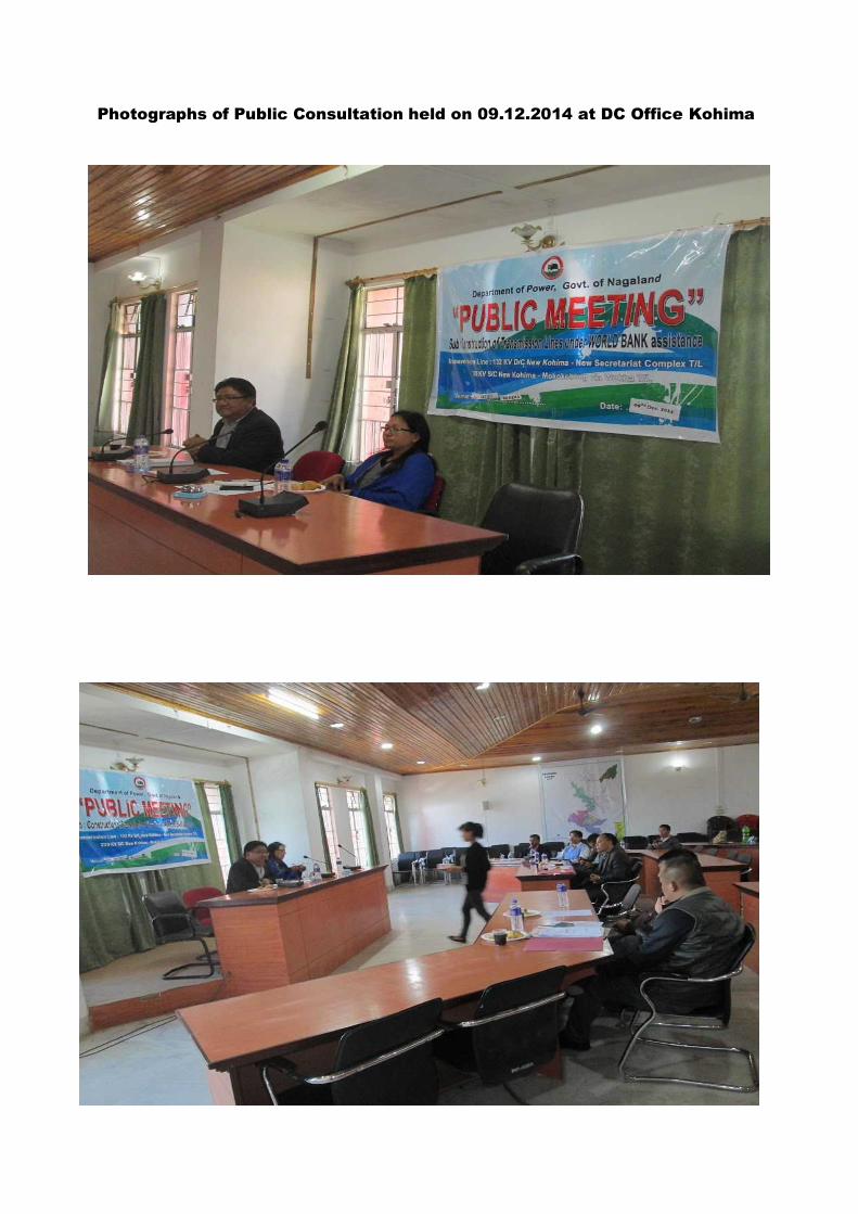
Photographs of Public Consultation held on 09.12.2014 at DC Office Kohima


DEPT. OF POWER, GOVT. OF NAGALAND
A.G. Colony, Kohima, Nagaland 797005
Minutes of Public Consultancy Meeting held on 18th Feb, 2015 at Conference Hall, DC Office Zunheboto, Nagaland
Subject - COSTRUCTION OF 132 KV WOKHA- ZUNHEBOTO- MOKOKCHUNG LINE AND
ASSOCIATED DISTRIBUTION LINES (WITH FINANCIAL ASSISTANCE OF WORLD BANK) UNDER NERPSIP PROJECT.
The meeting was presided over by –
Dept. of POWER, Govt. of Nagaland-
1. Sikato – Chief Engineer (Zunheboto Divison) 2. T. Lotha – SDO/Civil- TL (Zunheboto Divison)
NAGALAND GOVERNMENT
1. T. Longkumer – DC / Zunheboto 2. Shanavas C - SDO/Civil
POWERGRID OFFICIALS -
1. P.K.Sutradhar – Manager/ NERPSIP- Nagaland 2. Deep Sarkar – Engineer/ NERPSIP- Nagaland
INTRODUCTION -
The DC began the Proceedings by thanking the people for coming out in huge numbers to attend the Meeting.
After that Mr. Sikato Chief Engineer_Zunheboto of Power Dept./Nagaland, took over. A brief introduction was given to the assembled People about the details of the Project. The NORTH EASTERN REGION POWER SYSTEM IMPROVEMENT PROJECT (NERPSIP) details were given so as to make the people understand the need and urgency for setting up New Transmission Lines and Distribution Network to address the much existing Power Shortage in the Region thereby depleting their Social and Financial Growth.
Then Mr. Sutradhar, Manager/NERPSIP_Nagaland Of Powergrid, made the people aware of the Lines that will be drawn through Zunheboto, and the concerned Villages it will affect and appealed to their good sense for extended Cooperation for successful Implementation of the Project.

DC laga manuh nimite besi ke thanks koise, Public Meeting laga attend koribo ahise.
Tar pise Power Dept. laga Sikato Saheb e NERPSIP laga details manuk kahn ke bujai dise. Bujai se je amar Current laga Problem, solve koribo bisarise. Tar babe manuh Socially and Financially Independent hobo paribo.
Tar pise Powergrid laga Sutradhar Sahab e Zunheboto laga Transmission Lines aru Distribution Network bhal kine bujai dise.
===========================================================================
QUERIES -
The public were keen on the project, and also discussed about the earlier cases when such Projects were taken up by State Govt. and the general public related issues associated with it. someThe various concerns/issues raised by the public were as below:-
What will be the compensation policy adopted for this project? Whether land value compensation for tower footing will be paid. What will be the basis of tree/crop compensation for this Project?
Whether the proposed project will enhance the quality of power supply in the villages. Whether this project will help in reducing load shedding problem in the villages?
Whether local employment opportunity will be generated in this Project
Power Deptt. Nagaland /POWERGRID have addressed the various concerns of the public by explaining that a very transparent compensation policy have been adopted for any damages during the Project. For Tower footing, land compensation to the tune of market value of land as decided by the State Govt/DC will be paid. For other damages for tree/crops, adequate compensation will be paid as per the rate assessed by the District Authority. In all cases, the owner will be taken in to confidence and the concerned Village Council will be consulted. POWERGRID representative explained that the completion of the project will help in reliable power supply in the State and the construction of various distribution lines will help in reliable and uninterrupted power supply to the villages. It was also ensured by POWERGRID in the project, sufficient temporary employment opportunity will be generated for the local people during construction stage. Apart from the above, some of the retired govt. officials who were present in the meeting also raised the issue of safety and protection from transformer/line installed in habitated area and wanted assurance to be given to the public for periodic maintenance of transmission/distribution lines by Power Department Nagaland/POWERGRID in order to ensure reliability and safety. Officials of Power Deptt. Nagaland /POWERGRID appreciated his suggestion and informed that same shall be taken care through contract condition/safety plan.
Manuh khan Project laga kam karone bohut furti paise aru agote State Govt. pora aneka project laga ki ki kotha ase take koi ase. Manuh khan question hudha bilak tu tolote likhise.

Manuh khan hudhise je project laga compensation policy ki ase. Tower bonabo laga mati compensation dibo ki nidia. Mahuh laga gos/kheti compensation dibo ki nidia.
Transmission laga line bonale gaote power supply bhal hobo ki nai. Load shading problem thik ho ni nohobo.
Ai project laga local manuh khan ki ki sakori pabo/ gaor mahuh khan ki ki hubidha pabo.
Power Deptt. Nagaland /POWERGRID manhu khan hudha question bilake bhal kori explain korise aru take koise je Project laga compensation policy sobe bujibo porake bonua hoise aru project laga kiba mati/gos/kheti kharab hole take compensation dia hobo. Transmission Tower laga matir compensation, D/C sahib thik kori dia hisape dia hobo. Aru kheti/gos laga compensation bilak bhi D/C Office laga mahuh fix kori dia dhorone dia hobo. Matir malik bilak ke confidence te loi kine he compensation amount decide kora hobo. Aru dorokar hole village council ke bhi discuss kora hobo. POWERGRID manuh khan ke bujai dise je, ai project bhal kori complete hole Nagaland State laga bohut bhal hobo. Gao bilakte bhal power ahibo aru load shedding problem bilak komi jabo. POWERGRID aru koise je, ai project laga bohut temporary sakori ba kam ulabo aru gaor manuh khan take kori bo paribo. Kisuman retired employee laga manuch janibo bisarise je bosti laga jagate transformer aru line bonale manuh khanor kiba problemhobo pare niki. Tai khan bisarise je Power Deptt. /POWERGRID tai khan ke kotha dibo lagibo. Power Deptt. /POWERGRID tai khan raise kora kotha tuke bhal paise aru manuh khan ke koise je project laga sob kamote safety bilak loi kam kora hobo.
==========================================================================
CONCLUSION –
The Meeting ended on a very Positive Note with the Local People satisfied with the Queries being answered and happy that such Project was coming up, to address their needs.
They assured their full Cooperation in relation to the Project.
--------------------------------------------------------------------------------------------------------------------
Meeting te aha manuh besi khusi hoike jaise, tai khushi hoise je ami tai khan ke help koribo ahise. Tai khan ke e vi koise je kiba problem thakile tai khan kea ami khan ke Help koribo.
========================================================================


Photographs of Public Consultation held on 18.02.2015 at Zunheboto


MOM- PUBLIC CONSULTANCY MEETING_ MOKOKCHUNG /NAGALAND
COSTRUCTION OF :-
220 KV S/C (ON D/C TOWER) NEW KOHIMA- MOKOKCHUNG T/L 132 KV S/C (ON D/C TOWER) WOKHA – ZUNHEBOTO- MOKOKCHUNG T/L (LILO OF 132 KV S/C MOKOKCHUNG - MARIANI AT LONGNAK) T/L
VENUE- CONFERENCE HALL, DC OFFICE, MOKOKCHUNG, NAGALAND.
The meeting was presided over by –
Dept. of POWER, Govt. of Nagaland-
1. Shikato Sema – Executive Engineer/ TL (Mokokchung Division) 2. T. Lotha – SDO/Civil- TL (Mokokchung Division) 3. Shilu – SDO/TL (Mokokchung Division)
NAGALAND GOVERNMENT
1. Sushil Kumar Patel – DC / Mokokchung 2. Moa Aier - Executive Engineer/Electrical.
POWERGRID OFFICIALS -
1. P.K.Sutradhar – Manager/ NERPSIP- Nagaland 2. Deep Sarkar – Engineer/ NERPSIP- Nagaland
INTRODUCTION -
The DC began the Proceedings by thanking the people for coming out in huge numbers to attend the Meeting.
After that Mr. Sikhato Executive Engineer/Mokokchung of Power Dept./Nagaland, took over. A brief introduction was given to the assembled People about the details of the Project. The NORTH EASTERN REGION POWER SYSTEM IMPROVEMENT PROJECT (NERPSIP) details were given so as to make the people understand the need and urgency for setting up New Transmission Lines and Distribution Network to address the much existing Power Shortage in the Region thereby depleting their Social and Financial Growth.
Then Mr. Sutradhar, Manager/NERPSIP_Nagaland Of Powergrid, made the people aware of the Lines that will be drawn through Mokokchung, and the concerned Villages it will affect and appealed to their good sense for extended Cooperation for successful Implementation of the Project.
DC laga manuh nimite besi ke thanks koise, Public Meeting laga attend koribo ahise.
Tar pise Power Dept. laga Sikhato Saheb e NERPSIP laga details manuk kahn ke bujai dise. Bujai se je amar Current laga Problem, solve koribo bisarise. Tar babe manuh Socially and Financially Independent hobo paribo.

Tar pise Powergrid laga Sutradhar Sahab e Mokokchung laga Transmission Lines aru DISTRIBUTION Network bhal kine bujai dise.
===========================================================================
QUERIES -
People were keen, and discussed about the earlier cases when such Projects were taken up by State Govt. and the problems they faced.
Some QUESTIONS/ CONCERNS that were brought forward by the local public were –
1. How will the Power Supply benefit them ? 2. What is the Compensation Policy of the Organization for the Project ? 3. What are the Safety Measures that will be undertaken ?
THE POWERGRID OFFICIALS AND POWER DEPT./NAGALAND OFFICIALS addressed the Issues/Concerns in the following manner :
Mr. Sikato of POWER DEPT. had to explain them about the crisis they were facing in Power, and the MegaWatt requirement, that needs to be fulfilled for averting the frequent Power Cuts.
Mr. Sutradhar of POWERGRID explained that for the Trees and Crops that are damaged, Compensation will be given as per the Norms by District Revenue Authority.
Mr. Sutradhar stressed that Proper and Adequate Safety Measures like maintaining a Proper Ground Clearance, Safe Installation and Periodic Quality Maintenance will be taken up in the Project so that the People working in the nearby fields or dwellers do not face problem.
Manuh khan question vi hudise-
1. Transmission laga line Nobonale ki Problem ase? 2. Ami laga Compensation Laga Problem keneke solve koribi? 3. Ami laga Safety dibi ki nai ?
Manuh khan jobab bhal kine di dise sahib bilake –

Sikato sahib laga manuh khan ke bujai dise je Nagaland te Zunheboto laga aru baki District te besi Power laga shortage aru Load Shedding hoise. Heitu nimite amake better Future dibo.
Sutradhar, Powergrid laga Sahab e bujale je Compensation amount District
revenue laga Sahab bilake Offer koribo. Amar Trees aru Crops nimite damage Compensation dibo .
Sutradhar, Powergrid laga manuh khan ke bujai dise je, safety bhal pine sabo.... Ground pora sufficient distance ot Line tanibo, aru Tower laga area tu Protection , maintenance dibo.
==========================================================================
CONCLUSION –
The Meeting ended on a very Positive Note with the Local People satisfied with the Queries being answered and happy that such Project was coming up, to address their needs.
They assured their full Cooperation in relation to the Project.
--------------------------------------------------------------------------------------------------------------------
Meeting te aha manuh besi khusi hoike jaise, tai khushi hoise je ami tai khan ke help koribo ahise. Tai khan ke e vi koise je kiba problem thakile tai khan kea ami khan ke Help koribo.
========================================================================
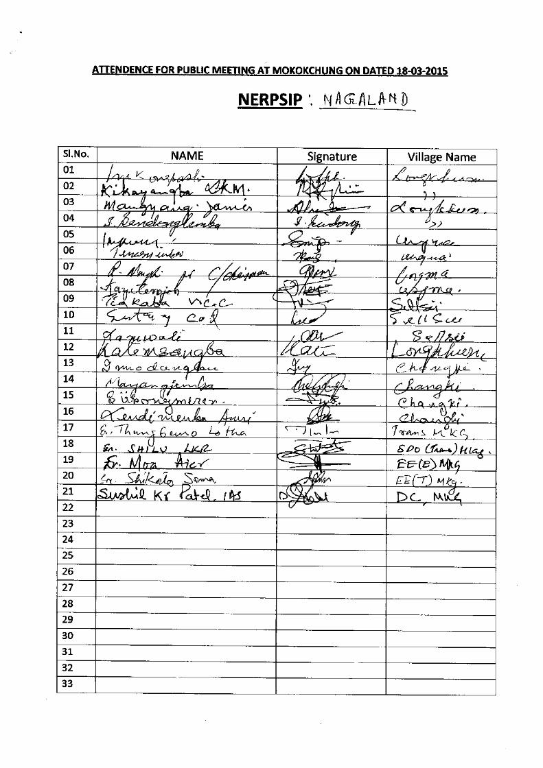


Photographs of Public Consultation held on 18.03.2015 at Mokokchung


Attendance of meeting held on 20.11.2017 at
Pfutsero
Attendance of meeting held on 20.11.2017
Public consultation with Land Owner at Pfutsero on 20.11.2017 Public awareness at Zubza
(Lalmati) SS on 25.09.207

Public awareness meeting held on 25.09.2017(list
of participants)
Public awareness meeting held on
12.10.2017(list of participants)
Public consultation at Chiepobouzo on 12.10.2017

Meeting Notice for 132kV TL at DC office, Kohima

Meeting Notice for 220kV TL at DC Zunheboto, Kohima

Page-1,MoM held on 19th
April 2018 at DC office, Kohima

Page-2 19
th April meeting Attendance sheet of 19
th April Meeting
Meeting held on 19
th April 2018 at DC office, Kohima

Meeting held on 20
th April for 132kV TL at Zhadima village to identify land owner
Attendance sheet of meeting held on 20.04.2018
Meeting held on 30th April 2018 for132kV at Tsiesema village
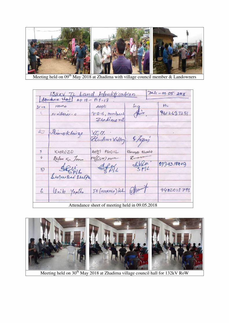
Meeting held on 09
th May 2018 at Zhadima with village council member & Landowners
Attendance sheet of meeting held in 09.05.2018
Meeting held on 30
th May 2018 at Zhadima village council hall for 132kV RoW

Meeting held on 27th
June at conference hall of EAC Botsa for 220kV TL.
Issuance of NOC by EAC, Botsa regarding 220kV TL

Attendance sheet of meeting held on 27.06.2018
Meeting held on 09
th July at longkhum, Mokokchung (220kV Land
identification)

Meeting held on.09.07.2018(220kV)

Circular Came after Meeting held on 12
th July2018

19
th July meeting held at Longkhum Village, Mokokchung
14
th July 2018 meeting held at Teroguuvonou Village, Kohima

22
nd July meeting held at Sattsu Village, Mokokchung

25
th July meeting held at Nsunyu Village, Kohima
28
th July meeting held at Tseminyu, Kohima
11
th Sep.2018 meeting held at Phezha Village, Kohima

19
th Sep.2018 meeting held at Tsiesema Village, Kohima
22
nd November 2018 meeting held at Tesophenyu, Kohima
24
th November 2018 meeting held at Alichan, Ungma village of Mokokchung
07
th December 2018 meeting held at Tesophenyu, Kohima


NOC From village council


NOC from Village Council

27
th March 2019 Public consultation meeting held
at Phisumi Village, Mokokchung. 29
th March 2019 Public consultation meeting
held at Philimi Village, Mokokchung.
20
th June 2019 Informal meeting held at
Ehunnu Village, Kohima.

24
th July 2019 Informal meeting held at Chiechama, Kohima
2nd
August 2019 formal meeting held at Additional Deputy Commissioner office Pfutsero.
4
th September 2019 formal meeting held at Rotomi village & Philimi Village, Zunheboto

7th September 2019 formal meeting held at Botsa, Kohima(NAG-TW-01)
10
th September 2019 Informal meeting held at Phezha, Kohima
Meeting held on 25.09.2019 at Zhadima village council hall, Kohima

MAPS