Doncaster Local Plan 2015-2035 Adopted Version - NET
386
-
Upload
khangminh22 -
Category
Documents
-
view
1 -
download
0
Transcript of Doncaster Local Plan 2015-2035 Adopted Version - NET


Document Summary.
Purpose The Local Plan sets out policies and proposals to meet Doncaster’s needs for housing, employment and other development: how much is required, where it should go and when it should happen. Together with the Government’s National Planning Policy Framework1 (NPPF), the Plan aims to deliver positive sustainable economic, social and environmental development. Planning law requires that applications for planning permission must be determined in accordance with the Development Plan unless material considerations, such as the NPPF, indicate otherwise. Doncaster’s Development Plan will include this Local Plan, the adopted Barnsley, Doncaster and Rotherham Joint Waste Plan and any made Neighbourhood Plans prepared by local communities.
Plan Period 2015-2035 Base Date 1 April 2015 (This is the date the Plan Period started – but some of the information in
the Local Plan for land requirement and supply (e.g. planning permissions) is as at 1 April 2018).
Settlement Hierarchy
Growth distributed and managed according to a 6 Level Settlement Hierarchy:
Doncaster Main Urban Area
10 Service Towns & Larger Villages
Countryside
7 Main Towns
40 Defined Villages
Green Belt Key Proposals
The key proposals in this Plan include:
Major new employment sites (total of 470 Hectares) to support ‘Doncaster Main Urban Area’ and 7 Main Towns; but also at locations attractive to the market associated with the Strategic Transport Network.
Ensuring the maintenance of a rolling 5 year supply of deliverable housing land.
At least 45% of new homes to go to the ‘Doncaster Main Urban Area’, about 40% to the ‘Main Towns’ and approx. 15% to the ‘Service Towns and Villages’.
A minimum of 15,640 net new homes over the remainder of the Plan Period (920 per year) from 1 April 2018.
Doncaster Town Centre to be main focus for most retail, offices, leisure, cultural and tourist facilities.
Flood sequential approach directing development not meeting local needs away from flood zones.
General extent of Green Belt will be maintained.
Major multi-modal transport hub centred on “Rossington iPort” and business parks between the M18 motorway and Doncaster Sheffield Airport.
Unity (major mixed-use urban extension between Hatfield & Stainforth).
Supporting the sustainable growth of Doncaster Sheffield Airport.
Further information on the Local Plan is available via:
Web: www.doncaster.gov.uk/localplan
Phone: 01302 734419
Email: [email protected]
Post: Planning Policy & Environment Team, Planning, Regeneration and Environment,
Doncaster Council, Civic Office, Waterdale, Doncaster, DN1 3BU
1 https://www.gov.uk/government/collections/planning-practice-guidance

Foreword This is Doncaster's Local Plan. I welcome its adoption and the role it will play in guiding the future of our communities by setting out what development is needed, how much is required, where it should go, and when it should happen. The Local Plan is based on the need to ensure sustainable development. It supports Doncaster's economic development by helping to meet the need for development within our Town and Borough. In doing so, it seeks to ensure that new development, and the necessary supporting infrastructure, such as open space, health facilities and schools, are improved and/ or delivered together. Doncaster has declared a Climate and Biodiversity Emergency in recognition of the fundamental challenges of Climate Change and the need for sustainability. The Local Plan will help tackle climate change and ensure that efforts to create a stronger economy do so in a way that supports a sustainable natural and built environment, and which delivers a better quality of life for residents and for future generations. Difficult decisions have been taken as part of the preparation of the Plan and I would like to thank everyone involved. I wish to give special thanks to those who responded to the various consultations that have taken place – these contributions have been invaluable.
Councillor Nigel Ball Cabinet Member for Public Health, Leisure, Culture and Planning Doncaster Council

Contents
Chapter 1: Introduction ................................................................................................................................................ 1
Chapter 2: About Doncaster ......................................................................................................................................... 6
Chapter 3: Our Vision for the Future .......................................................................................................................... 14
Chapter 4: Strategic approach .................................................................................................................................... 18
Policy 1: Settlement Hierarchy (Strategic Policy) ................................................................................................... 19
Policy 2: Level of Growth (Strategic Policy) ............................................................................................................ 25
Policy 3: Employment Allocations (Strategic Policy) .............................................................................................. 31
Policy 4: Employment Policy Areas (Strategic Policy) ............................................................................................. 34
Policy 5: Housing Allocations (Strategic Policy) ...................................................................................................... 35
Chapter 5: Doncaster Sheffield Airport ...................................................................................................................... 44
Policy 6: Doncaster Sheffield Airport Policy Area (Strategic Policy) ....................................................................... 45
Chapter 6: Meeting the Need for New Homes ........................................................................................................... 56
Policy 7: Delivering the Necessary Range of Housing (Strategic Policy) ................................................................. 56
Policy 8: Removal of Occupancy Conditions ........................................................................................................... 58
Policy 9: Houses in Multiple Occupation (HMOs) ................................................................................................... 59
Policy 10: Residential Policy Areas ......................................................................................................................... 60
Policy 11: Gypsies, Travellers and Travelling Show People (Strategic Policy) ........................................................ 61
Chapter 7: Transport, Access and Infrastructure ....................................................................................................... 65
Policy 12: Strategic Transport Network (Strategic Policy) ...................................................................................... 65
Policy 13: Promoting Sustainable Transport in New Developments (Strategic Policy) .......................................... 73
Policy 14: Doncaster Town Centre Car Parking (Strategic Policy) .......................................................................... 75
Policy 15: Lorry Parking (Strategic Policy) .............................................................................................................. 77
Policy 16: Cycling in Doncaster ............................................................................................................................... 78
Policy 17: Walking in Doncaster ............................................................................................................................. 79
Policy 18: Development Affecting Public Rights of Way ........................................................................................ 80
Policy 19: Access, Design and Layout of Public Rights of Way ............................................................................... 82
Policy 20: Public Rights of Way Crossing Roads, Railways, Canals and Rivers ....................................................... 83
Policy 21: Telecommunications and Utilities Infrastructure .................................................................................. 83
Chapter 8: Retail and Town Centres ........................................................................................................................... 86
Policy 22: Locating Main Town Centre Uses (Strategic Policy) ............................................................................... 86
Policy 23: Development within Town, District and Local Centres (Strategic Policy) .............................................. 89
Policy 24: Food and Drink Uses .............................................................................................................................. 91
Chapter 9: Countryside ............................................................................................................................................... 94

Policy 25: Development in the Countryside Policy Area ........................................................................................ 94
Chapter 10: Green Infrastructure ............................................................................................................................... 99
Policy 26: Green Infrastructure (Strategic Policy) .................................................................................................. 99
Policy 27: Protecting Open Space and Non Designated Open Space ................................................................... 103
Policy 28: Open Space Provision in New Developments ...................................................................................... 105
Policy 29: Ecological Networks (Strategic Policy) ................................................................................................. 108
Policy 30: Valuing Biodiversity and Geodiversity (Strategic Policy) ..................................................................... 111
Policy 31: Local Wildlife and Geological Sites ....................................................................................................... 114
Policy 32: Woodlands, Trees and Hedgerows ...................................................................................................... 114
Policy 33: Landscape (Strategic Policy) ................................................................................................................. 116
Chapter 11: The Historic Environment ..................................................................................................................... 119
Policy 34: Valuing our Historic Environment (Strategic Policy) ............................................................................ 119
Policy 35: Understanding and Recording the Historic Environment .................................................................... 122
Policy 36: Listed Buildings ..................................................................................................................................... 123
Policy 37: Conservation Areas .............................................................................................................................. 125
Policy 38: Historic Parks and Gardens .................................................................................................................. 126
Policy 39: Development Affecting Archaeology ................................................................................................... 127
Policy 40: Buildings or Structures of Local Historic Interest ................................................................................. 128
Chapter 12: Design and the Built Environment ........................................................................................................ 130
Policy 41: Character and Local Distinctiveness (Strategic Policy) ......................................................................... 130
Policy 42: Good Urban Design (Strategic Policy) .................................................................................................. 132
Policy 43: Views, Gateways and Taller Buildings .................................................................................................. 133
Policy 44: Residential Design (Strategic Policy) .................................................................................................... 135
Policy 45: Housing Design Standards (Strategic Policy) ........................................................................................ 137
Policy 46: Design of Non-Residential, Commercial and Employment Developments (Strategic Policy) .............. 139
Policy 47: Safe and Secure Places ......................................................................................................................... 141
Policy 48: Landscaping of New Developments ..................................................................................................... 142
Policy 49: Advertisements and Signage ................................................................................................................ 143
Chapter 13: Health, Wellbeing and Our Communities ............................................................................................. 146
Policy 50: Health (Strategic Policy) ....................................................................................................................... 146
Policy 51: Protection of Education, Community and Leisure Facilities ................................................................ 147
Policy 52: New Education facilities ....................................................................................................................... 148
Policy 53: Provision of New Indoor Recreation and Leisure Facilities ................................................................. 150
Policy 54: Pollution ............................................................................................................................................... 150
Policy 55: Contamination and Unstable Land ....................................................................................................... 152
Chapter 14: Climate Change, Mineral Resources & Energy ..................................................................................... 154

Policy 56: Drainage ............................................................................................................................................... 154
Policy 57: Flood Risk Management ....................................................................................................................... 155
Policy 58: Low Carbon and Renewable Energy (Strategic Policy) ......................................................................... 159
Policy 59: Wind Energy Developments (Strategic Policy) ..................................................................................... 161
Policy 60: Protecting and Enhancing Doncaster’s Soil and Water Resources ...................................................... 165
Minerals Policy...................................................................................................................................................... 167
Policy 61: Providing for and Safeguarding Mineral Resources (Strategic Policy) ................................................. 168
Policy 62: Minerals Development Proposals, Borrow Pits and Incidental Extraction .......................................... 178
Policy 63: Reclamation of Mineral Sites (Restoration and Aftercare) .................................................................. 179
Policy 64: Providing for Energy Minerals (On-Shore Gas and Oil (Hydrocarbons)) .............................................. 180
Chapter 15: Implementation and Monitoring .......................................................................................................... 183
Policy 65: Developer Contributions (Strategic Policy) .......................................................................................... 183
Policy 66: Development Viability (Strategic Policy) .............................................................................................. 184
Monitoring ............................................................................................................................................................ 186
Chapter 16: Spatial Proposals ................................................................................................................................... 188
Doncaster Main Urban Area (MUA) ..................................................................................................................... 188
Policy 67: Doncaster Town Centre (Strategic Policy)............................................................................................ 196
Policy 68: Key Doncaster Town Centre and Main Urban Area Mixed-Use Sites (Strategic Policy) ...................... 200
Main Towns .......................................................................................................................................................... 204
Policy 69: Unity Regeneration Project (Strategic Policy) ...................................................................................... 212
Policy 70: Mexborough Town Centre ................................................................................................................... 220
Policy 71: iPort (Strategic Policy) .......................................................................................................................... 224
Policy 72: Thorne Town Centre ............................................................................................................................ 228
Service Towns and Villages ................................................................................................................................... 230
Policy 73: Local Business Expansion Site: Polypipe ............................................................................................. 242
Appendix 1: Glossary ................................................................................................................................................ 248
Appendix 2: Development Requirements ................................................................................................................ 255
Appendix 3: Doncaster Sheffield Airport Policy Area ............................................................................................... 313
Appendix 4: Dwelling Mix and Type ......................................................................................................................... 316
Appendix 5: Affordable Housing Requirement Value Areas .................................................................................... 317
Appendix 6: Parking Standards ................................................................................................................................. 318
Appendix 7: Transport Statements, Assessments and Travel Plans ......................................................................... 323
Appendix 8: Local Wildlife and Geological Sites : Selection Guidelines ................................................................... 326
Appendix 9: Criteria for the Selection of Parks and Gardens of Local Historic Interest ........................................... 360
Appendix 10: Criteria for Locally Listing Buildings and Structures ........................................................................... 363
Appendix 11: Noise ................................................................................................................................................... 366

Appendix 12: Monitoring Indicators ......................................................................................................................... 370
Figure 1: Doncaster in Context ..................................................................................................................................... 7
Figure 2: Distribution of Centres ................................................................................................................................ 24
Figure 3: Local Plan Housing Trajectory...................................................................................................................... 37
Figure 4: Key Diagram ................................................................................................................................................. 42
Figure 5: Airport Operational Area ............................................................................................................................. 54
Figure 6: Strategic Transport Network ....................................................................................................................... 72
Figure 7: Transport Assessment of Planning Applications ......................................................................................... 74
Figure 8: Doncaster's Green Infrastructure Corridors .............................................................................................. 102
Figure 9: Biodiversity Opportunity Areas ................................................................................................................. 110
Figure 10: National and International Wildlife Sites ................................................................................................ 113
Figure 11: Designated Heritage Assets in Doncaster ................................................................................................ 121
Figure 12: Flood Risk ................................................................................................................................................. 158
Figure 13: Area of Search for Wind Energy Developments ...................................................................................... 164
Figure 14: Minerals Resources Key Diagram ............................................................................................................ 177
Figure 15: Doncaster Town Centre ........................................................................................................................... 199
Figure 16: Key Town Centre Sites and Main Urban Area Mixed-Use Sites .............................................................. 203
Figure 17: Unity Masterplan ..................................................................................................................................... 216
Figure 18: Map showing Hatfield Colliery and the Laydown Area ........................................................................... 217
Table 1: Doncaster's Strengths, Weaknesses, Challenges, Threats and Opportunities ............................................. 11
Table 2: Network (and Hierarchy) of Centres ............................................................................................................. 21
Table 3: Settlement Hierarchy and Distribution of Proposed Housing ...................................................................... 27
Table 4: Allocation of New Homes Across Settlement Hierarchy and Individual Settlements .................................. 29
Table 5: Employment Site Allocations ........................................................................................................................ 32
Table 6: Potential Employment Development Site .................................................................................................... 32
Table 7: Employment Allocations with Planning Permission ..................................................................................... 33
Table 8: Allocated Housing Supply Summary by Settlement ..................................................................................... 40
Table 9: Summary of Plan Period Housing Requirement and Supply......................................................................... 41
Table 10: Designated Gypsies, Travellers and Travelling Show People Sites ............................................................. 63
Table 11: Green Belt Traveller Sites ........................................................................................................................... 63
Table 12: Major Road Network Enhancement Priorities ............................................................................................ 68
Table 13: Children's Play Area Requirements........................................................................................................... 107
Table 14: Biodiversity Opportunity Areas and Priority Habitats .............................................................................. 109
Table 15: Locally Sourced Mineral Provision for the Plan Period ............................................................................. 170
Table 16: Existing Mineral Sites ................................................................................................................................ 172
Table 17: New Mineral Proposals (Preferred Areas) ................................................................................................ 172
Table 18: ‘Areas of Search’ for Minerals................................................................................................................... 173
Table 19: Safeguarded Minerals Transportation, Handling and Processing Infrastructure ..................................... 174
Table 20: Safeguarding Exemptions ......................................................................................................................... 175
Table 21: Mineral Safeguarding Area Proposals ....................................................................................................... 176
Table 22: Unity Indicative Area Schedule ................................................................................................................. 217

0 [go to Contents]

1 [go to Contents]
Chapter 1: Introduction
What is the Doncaster Local Plan?
1.1. Doncaster’s Local Plan sets out how Doncaster Borough will grow and develop from 2015 to 2035. It identifies where and how new jobs, homes and services will be located; its policies guide investment and development, encourage sustainable and inclusive economic growth, protect the environment and promote social inclusion.
1.2. The Local Plan forms a key part of the statutory “development plan” and informs decisions on planning applications. It is a matter of planning law that “planning decisions must be taken in accordance with the development plan unless material considerations indicate otherwise”.
1.3. The Local Plan has been positively prepared informed by public consultation and engagement and is based on cooperation with neighbouring authorities and public, voluntary and private sector organisations. Doncaster is a key player within the Sheffield City Region and is working closely with its partner authorities as part of the Combined Authority to deliver growth and regeneration across the city region. Discussions have not identified housing or other needs that would be more appropriately shared with other local authorities – the Borough’s development and infrastructure needs have been objectively assessed and will be met entirely within the Borough.
1.4. The Local Plan accords with national policy and will promote sustainable development in accordance with the Government’s National Planning Policy Framework (NPPF). It is based on an up-to-date and proportionate evidence base that demonstrates, amongst other things, that its proposals can be delivered within the plan period.
What does the Local Plan consist of?
1.5. The Local Plan sets out a vision for the Borough and objectives for meeting strategic priorities. It identifies specific sites for development (development allocations) and includes planning policies to ensure that the necessary new homes, jobs, shops, leisure and other development are of the right type and quality and are delivered in the right places. Policies also address new infrastructure, minerals, energy, health and other community infrastructure, climate change mitigation and adaptation, and conservation and enhancement of the natural and built environment. Some of the policies are (or will be) supported by Supplementary Planning Documents (SPDs) which set out more detailed advice.
1.6. A Key Diagram identifies the broad locations where growth will occur and illustrates the key elements of the Local Plan. This is accompanied by a Policies Map showing the location of allocated development sites for housing, employment and other uses.
1.7. Land use designations are also shown on the Policies Map including Green Belt, green space, policy areas for residential, industrial and business uses, retail centres, mixed use areas, community services and facilities and known environmental designations (such as nature conservation and historic sites).
1.8. The Council will maintain and make available, via the Council’s web page, an up to date electronic version of the Policies Map. This will enable individual allocations and designations to be viewed independently or collectively.
How does the Local Plan relate to other plans and strategies?
1.9. The Local Plan provides the spatial dimension for the Doncaster Growing Together’ (DGT) Borough Strategy that was agreed by the Council and its partners (Team Doncaster) in September 2017. Achieving inclusive growth is a fundamental priority in the Borough Strategy and Doncaster’s Inclusive Growth Strategy (IGS), sharpens the focus on this priority.

2 [go to Contents]
1.10. The Local Plan replaces the Core Strategy and the saved policies of the Unitary Development
Plan. The Joint Waste Plan (adopted jointly with Barnsley and Rotherham Councils) will be reviewed separately.
Neighbourhood plans will be prepared for some parts of the Borough by Parish and Town Councils (and other neighbourhood planning bodies in areas where local councils do not exist). They will sit alongside the Local Plan forming part of the Development Plan. The Council will continue to actively support2 neighbourhood planning bodies to ensure local communities have a greater influence in the planning of their areas. Neighbourhood plans may contain development allocations and non-strategic policies but must be in general conformity with the strategic policies of this Local Plan – these strategic policies are highlighted in the Plan. Once a neighbourhood plan has been ‘made’ (adopted), the policies it contains take precedence over existing non-strategic policies in the Local Plan for that neighbourhood where they are in conflict. The Local Plan’s Policies Map will be updated where necessary when new neighbourhood plans are made. Where neighbourhood plans have already been made, or are sufficiently advanced, the Local Plan has not duplicated their provisions. This is reflected on the Policies Map.
Looking further ahead
1.11. Following Local Plan adoption, economic, social and environmental issues will continue to be monitored and evidence updated. These will inform the statutory need to consider whether to review the Plan (in whole or part) at least every five years. Emerging issues and opportunities that may inform Local Plan review could include:
Major changes in how we live, work and how businesses trade are reshaping our economy and transforming communities. A technological revolution is underway making it easier to access services, support greener travel and enable firms to remain competitive in a global economy. Doncaster can seize the opportunities this presents by, for example, supporting growth in industries that can provide higher-skilled, more productive and better paid jobs.
Doncaster has a wide portfolio of development projects, either on-going or in the pipeline, and is emerging as an important player in the ‘Northern Powerhouse’, the Government’s strategy to rejuvenate the north of England. Ambitious plans include: further delivery of the Urban Centre Master Plan, including investing in quality office, student and residential accommodation; University City, an over-arching ambition for the future of higher education in Doncaster; airport growth, including more quality businesses and jobs securing a link to
2 See the Council’s website for information on the support available : http://www.doncaster.gov.uk/services/planning/neighbourhood-plans
The ‘Doncaster Growing Together’ (DGT) Borough Strategy is Doncaster’s key strategic document. Ambitions to prepare children and young people for a fulfilling life, create a stronger economy that benefits everyone and a borough that cares together for the most vulnerable, sit alongside ensuring Doncaster is vibrant and safe with clean and accessible parks and green spaces. To achieve this, the strategy aims to maximise the benefit from Doncaster’s assets and opportunities whilst addressing its challenges.

3 [go to Contents]
the East Coast Main Line; new or improved transport routes that would improve access to northern Doncaster; and the large-scale mixed-use Unity project (junction 5, M18).
The increasing number of neighbourhood plans could gradually replace some of the non-strategic policies of the Local Plan. National planning policy continues to evolve in response to climate change and the growing and changing needs of the population and economy.
A Yorkshire-wide Devolution Deal would provide Doncaster with the opportunity to play a significant role in increasing Yorkshire’s contribution to improving productivity, rebalancing the national economy and spreading wealth and prosperity. It would provide resources and powers to support jobs and growth by, for example, building new infrastructure.
The Government is promoting the construction of a completely new high speed railway from London to Birmingham and then onward via a western leg to Manchester and an eastern leg to Leeds passing through Doncaster Borough. The proposed route of the High Speed 2 rail line is shown on the Policies Map. This route is subject to a ‘Safeguarding Direction’ made by the Secretary of State for Transport to protect the line of the route from conflicting developments. These are not Council proposals and the route will not be determined through the Local Plan. They will be considered in Parliament under hybrid Bill procedures, which will provide opportunities for petitions to be made to parliament by those directly affected by the scheme. Construction is currently intended to begin within the Local Plan period, with the route potentially opening around 2032-33.
Improved understanding of residual flood risk to the Borough, especially at the Main Town of Thorne-Moorends, following completion of Hydraulic Modelling being finalised by the Environment Agency at time of Plan preparation. The lack of detailed modelling available prior to adoption of this version of the Local Plan limited the Plan’s local flood risk evidence base at that point.
The Plan has been drafted in the uncertain climate following the Brexit referendum in 2016. Brexit has posed a number of challenges in undertaking forecasting of economic growth and there are hugely opposing views on what the impacts will be on economic growth, trade and investment decisions at the national, regional and local levels.
Sustainability Appraisal
1.12. The purpose of the planning system is to contribute to achieving sustainable development. The Local Plan has been subject to Sustainability Appraisal throughout its preparation to assist in achieving the preservation, protection and improvement of the environmental, social and economic state of the Borough. The appraisal has met the requirements of Strategic Environmental Assessment (SEA).
1.13. The Sustainability Appraisal Report sets out issues that impact on sustainability, sets out the effects of “reasonable” alternatives to the Plan’s strategy and proposals, the reasons for discounting alternatives, and the likely significant effects of the Plan’s preferred sites and policies. The Report outlines mitigation which has been incorporated into the Plan to avoid, minimise and compensate for negative effects and maximise positive effects. It also proposes monitoring so that the effects of the Plan can be tracked and any unforeseen effects addressed.

4 [go to Contents]
How to use the Local Plan
1.14. All the policies in the Local Plan should be read together - individual policies do not necessarily refer to other relevant policies.
1.15. Policies should also be read in conjunction with other parts of the Development Plan (including neighbourhood plans and the Joint Waste Plan) and other material considerations (such as the National Planning Policy Framework (NPPF)3).
1.16. Policies are accompanied by an explanation to assist their interpretation and implementation. In order to minimise document length, text justifying their inclusion in the Plan is not given (as this is considered separately by the Plan’s examination). The document inevitably uses some technical terms – a Glossary is provided for explanation.
3 https://www.gov.uk/government/collections/planning-practice-guidance

5 [go to Contents]

6 [go to Contents]
Chapter 2: About Doncaster
2.1. This chapter provides a portrait of the Borough as it is now and outlines the issues and challenges it faces in the future.
Doncaster – the location
2.2. Doncaster is a metropolitan borough and is located in the heart of England in the county of South Yorkshire and the Yorkshire and Humber region, some 20 miles from Sheffield, 26 miles from Leeds, 30 miles from York and 47 miles from Hull (see Figure 1). The Borough lies to the south of Wakefield, Selby and East Riding, east of Rotherham, Barnsley and Sheffield and north and west of the rural districts of Bassetlaw and North Lincolnshire.
2.3. The town of Doncaster sits in the centre of the Borough on the river Don, with dispersed former mining settlements (Mexborough, Denaby and Conisbrough to the west, Stainforth to the east, Adwick and Carcroft to the north and Rossington to the south) and large tracks of open countryside surrounding it. There are a number of historic market towns (e.g. Thorne, Tickhill and Bawtry), commuter villages (e.g. Auckley and Finningley) and hamlets that serve the wider rural hinterland.
2.4. Doncaster is one of nine local authorities that make up the Sheffield City Region along with Barnsley, Bassetlaw, Bolsover, Chesterfield, Derbyshire Dales, North East Derbyshire, Rotherham and Sheffield.
Doncaster – the place
2.5. Doncaster (whose origins date back to Roman times) has evolved over the centuries from a market town into a major industrial centre, centred on engineering, coal and manufacturing, largely resulting from the expansion of trading routes and services (e.g. railways, canals and roads) and its location on the main north-to-south route, from London to Scotland. Surrounding towns, such as Bawtry, Thorne, Tickhill, Mexborough and Conisbrough, have traditionally acted as the main trading centres serving the surrounding rural hinterland.
2.6. The Borough of Doncaster covers 226 square miles and is the largest metropolitan borough in England. Much of the Borough is rural in nature and includes areas of attractive landscape and features, such as limestone gorges, woodlands, country parks and lowland moorland. Over two thirds of the Borough is in agricultural use, mainly in the eastern parts. Green Belt covers the western half of the Borough.
2.7. Doncaster is the second largest settlement in the City Region (after Sheffield) and is the main administrative, commercial and educational centre in the Borough.
2.8. Doncaster has over 300,000 inhabitants. Doncaster’s State of the Borough assessment shows that like many other areas, Doncaster’s population is getting bigger, older and more diverse. Doncaster’s working age population is expected to decline at a faster rate than the national average which has implications for Doncaster’s economic activity rates.

7 [go to Contents]
Figure 1: Doncaster in Context

8 [go to Contents]
Doncaster - assets and future opportunities
2.9. Doncaster is undergoing significant change and transformation in response to technology advances, economic restructuring, changing lifestyles and climate change, and is reasserting itself as a major economic centre within northern England. Much has been achieved in recent times through concerted efforts of our partners to increase prosperity and enhance the lives of those who live and work in the Borough but the agenda remains unfinished.
2.10. Considerable investment has been made in new infrastructure and environmental improvements (including public transport links, roads, tourist attractions and an international airport) and more is planned.
2.11. Doncaster’s economy is the second largest in the City Region and the seventh largest in the Yorkshire and Humber region in terms of the value of its goods and services. Doncaster continues its transition from a traditional industrial base to embrace a broader mix of business sectors, such as logistics, finance and professional services, retail, construction, advanced engineering and tourism.
2.12. Doncaster’s strategic position at the heart of the UK's communication network offers excellent access to major conurbations, coastal ports and other parts of the UK and beyond, linking east to west and north to south. Over 6 million people live within a 45-minute drive of the Borough. The Borough is well served across all regions via:
air (Doncaster Sheffield Airport is located some 5 miles from the centre of Doncaster and offers flights to destinations across Europe and the UK);
road and motorways (A1(M), M18 and M180), with links to the M1 and M62 motorways and major A roads, such as the A18, A638 and A630 – among the most busiest parts of the region’s network;
rail (e.g. Doncaster train station lies on the East Coast Mainline – which provides fast direct trains between London and Edinburgh – and serves the largest number of rail operators in the UK);
waterways (e.g. the South Yorkshire Canal runs through the centre of the Borough and the Stainforth-Keadby Canal passes close to the centre of Thorne and Stainforth); and
ports (with excellent links to the M1 and M62 motorways and international ports, particularly the Humber ports).
2.13. Although a metropolitan borough, Doncaster is largely rural and contains a wide variety of open
spaces, such as parks, woodland sites, golf courses, allotments, playing fields, green corridors and natural habitats. Many of these assets are linked via an extensive network of rivers (e.g. Don and Dearne), canals and other waterways, which extend well beyond the limits of the Borough. Other significant assets include:
over 300 miles of public rights-of-way (footpaths, bridleways and tracks);
a mixture of habitats such as wet grassland, crags, caves, lakes and lowland raised mire;
sites of national and international importance including sites of special scientific interest (e.g. Potteric Carr nature reserve) and special protection areas (Thorne and Hatfield Moors); and
large ground water aquifers (Sherwood Sandstone and Magnesium Limestone).
2.14. Doncaster town centre is a major sub-regional centre with a large retail offer. Mexborough and Thorne are the largest centres outside of Doncaster and provide a wide range of services (e.g. shops, banks, building societies, libraries and restaurants) serving a wide catchment area. The other centres (e.g. Bawtry, Armthorpe and Askern) within the Borough serve more day-to-day needs.
2.15. Doncaster is a major producer of minerals such as sand and gravel, coal and limestone, all of which have been worked over many years. Natural gas, clay, coalmine methane and oil are

9 [go to Contents]
also exploited.
2.16. Doncaster, one of Britain’s oldest boroughs, has a rich and diverse built environment. Some of its distinctive townscape and heritage assets include:
conservation areas ranging from Georgian and Victorian residential areas and historic town cores through to dispersed rural villages and towns such as Bawtry, Hatfield and Tickhill;
planned colliery villages (e.g. Brodsworth and Woodlands);
a nationally renowned racecourse;
archaeological sites, including a late Iron Age enclosure and Roman remains (e.g. Ermine Street);
a wealth of historic buildings, including medieval churches, former Georgian merchant houses and a Norman castle (Conisborough); and
nationally important historic parks and gardens (e.g. Brodsworth and Cusworth country parks).
2.17. The Trans-Pennine Trail passes through Doncaster and is integral to the extensive footpath and
cycle network that link the Borough’s communities with the countryside, jobs and recreation opportunities. Doncaster has many other recreation, tourism and retail opportunities, including Doncaster Dome and the Lakeside Sports Complex (major sporting and entertainment venues), Doncaster Rovers Football Club, Doncaster Rugby League Club (The Dons), Doncaster Knights Rugby Union Club, Doncaster Rovers Belles Women’s Football Club and many well established athletics clubs.
Doncaster - the challenges
2.18. Over recent years Doncaster businesses have led significant jobs growth which has been combined with record levels of business investment and house building. Employment levels have hit record highs, however Doncaster has a relatively low proportion of people employed in highly skilled occupations and wage rates are significantly lower than the national average. The benefits of growth are not yet reaching all people and places. Levels of unemployment and deprivation vary significantly across the Borough and there is still an overall need for economic regeneration across the Borough, balanced with the need to ensure the town centre is a greater driver for growth. The local economy is still underperforming compared with the regional and national averages in terms of business stock, the proportion of jobs in the knowledge economy and productivity per hour worked. Doncaster’s economy is relatively reliant on lower skilled sectors that are more sensitive to changes in local demand (e.g. local spending in the retail sector). Building an economy with a sectoral mix that contains a higher proportion of high value activities and jobs is a key challenge. Compared to Yorkshire and Humber, our economy is relatively inward facing and more reliant on jobs in health, retail, transport, construction and public administration. However, it does have significant jobs in a number of tradeable sectors, for example, manufacturing, engineering and financial and professional services. Overall, Doncaster’s economy remains relatively more sensitive to the impact of economic downturns.
2.19. Doncaster’s town and district centres face significant competition from established out-of-centre locations (e.g. retail warehouse parks and large superstores) and on-line shopping. However, the town centre is also relatively over reliant on retail and has considerably less office accommodation. Having fewer office workers in the town centre reduces the support available for retail which is already under pressure from on-line shopping.
2.20. Doncaster’s population distribution, which is rooted in Doncaster’s industrial past presents a significant challenge in connecting people, places and businesses to economic and social opportunities. This includes improving public transport access to outlying communities in order to better link residents to job opportunities as well as providing more active travel opportunities.
2.21. Healthy life expectancy in Doncaster has improved but remains lower than the national average. However, physical activity rates are improving. Local services, such as social care facilities,

10 [go to Contents]
face increasing demands from an ageing population and vulnerable people with complex needs.
2.22. Doncaster’s economy is still relatively self-contained, but more and more people are commuting in and out of the Borough and this trend is set to continue. Doncaster is developing stronger mutual labour market ties within the Sheffield City Region, but also with West Yorkshire, the Humber and North Lincolnshire.
2.23. The local housing market is self-contained and has a good balance of housing types and tenures. In line with the national picture, Doncaster has challenges in meeting the housing needs of the borough. The Borough needs to ensure that it delivers a range of house types, tenures and sizes moving forward, in order to meet the existing and projected needs of its population, including affordable housing.
2.24. A key challenge is to support residents of all ages to develop the knowledge and skills needed by local employers. This requires a blend of both academic and vocational skills. More Doncaster 5 year olds are experiencing a good level of development as a foundation for a fulfilling life, however, further improvement is needed in GCSE attainment. The proportion of the working age population qualified to Levels 3 or above is significantly lower than regional and national averages.
2.25. Air quality is generally good but specific areas face problems such as the main routes leading into the town centre and motorway junctions due to the volume and composition of traffic. Doncaster has reduced its CO2 emissions, but it still contributes more than the England average.
2.26. Over two fifths of the Borough is located within areas at a medium to high risk of flooding from both the river Don and Trent catchments. Areas at risk include Carcroft, Askern, Thorne, Moorends, Hatfield and Stainforth and large parts of the main urban area. All of these areas are very sustainable locations for development and are otherwise appropriate locations for growth in line with wider spatial planning objectives.
2.27. Doncaster’s highway network requires extra capacity to accommodate future traffic demand at key bottlenecks such as motorway junctions. In addition, former coalfield communities remain isolated from strategic transport routes and centres of employment because of inadequate infrastructure.
2.28. Table 1 sets out an analysis of the strengths, weaknesses, opportunities and challenges facing the Borough at time of plan preparation.

11 [go to Contents]
Table 1: Doncaster's Strengths, Weaknesses, Challenges, Threats and Opportunities
Strengths Weaknesses
Economic
Growing economy with more businesses and jobs
Growing population
Significant increase in the employment rate
Central, accessible location at the heart of the UK's communications network
Connectivity – roads, rail, air and waterways etc.
A nationally important logistics and distribution hub
Specialism in engineering, including rail and civil engineering.
Growing visitor economy
Doncaster town centre is a relatively strong retail destination.
Thriving market towns and villages
Substantial deposits of limestone, sand and gravel, clay and coal
Reliability of journey times along the motorways and major trunk roads
Lower than average skill levels
Relatively low levels of productivity
Some rural areas have poor access to services and facilities
Relatively low job / business density
Relatively high levels of unemployment and economically inactive residents
Parts of the Borough have low land and house values, making housing delivery difficult
Relatively low proportion of jobs in creative industries and the knowledge economy
Over supply of out-of-centre shopping provision
The town centre has lost ‘critical mass’ as investments across the Borough draw people and jobs away from the centre
Social
Increasingly physically active population
Strong sense of civic pride and place (surveys indicate that most people are proud to live or work in Doncaster)
Key foundation sectors such as health and education
Growing vocational education offer - National College for Advanced Transport & Infrastructure and University Technical College
Growing arts and cultural offer
A relatively good rate of house building
Well established partnerships and community groups
Friendly, resilient, open and determined people
Life expectancy in Doncaster is improving but still lags behind the national average with big differences between rich and poor areas.
Relatively high levels of obesity and ill health
Relatively low weekly earning and income levels
Pockets of digital exclusion especially in remote rural areas
Relatively low graduate numbers
Relatively high levels of deprivation with significant variations across the Borough
Generally limited or no spare capacity in some primary schools
Environmental
High quality environment – landscape, built heritage and biodiversity
A rich and diverse historic environment
A predominantly green landscape (two thirds of the Borough is open countryside)
Excellent access to the countryside
Internationally and nationally important wildlife habitats and species (e.g. Potteric Carr nature reserve and Thorne and Hatfield Moors)
Humberhead Peatlands – one of the largest ‘carbon sinks’ in the UK
Nationally important attractions (e.g. Doncaster racecourse, Yorkshire Wildlife Park, museums and country parks)
High levels of recycling
Presence of nationally important water aquifers (from which our drinking water is obtained)
Extensive footpath and cycle network (e.g. Trans Pennine Trail)
Higher than average carbon footprint, mainly due to transport uses
Low levels of satisfaction with the quality of parks
Extensive areas vulnerable to river and inland tidal flooding from both the Don and Trent river catchments.
Shortfall of publically accessible open space in most areas
Sport and recreation activity is below the national average
Certain areas in Doncaster suffer from congestion, particularly during peak hours.
Significant land use constraints (approximately 76.5% of the Borough lies within the Green Belt or medium or high flood risk areas).
A number of heritage assets are identified as being ‘at risk’

12 [go to Contents]
Opportunities Challenges
Economic
Availability of development sites with good access to the transport network
Maximising the economic benefits of the high-speed rail network (HS2 and HS3)
Re-development opportunities in and around Doncaster, including the town centre and older housing areas
Improving connections between Doncaster, outlying towns and major cities
Developing the town centre as a driver for growth
Embracing new technology to create high-skilled and well paid jobs, develop products and services and reach new markets.
Established industry specialisms with significant growth opportunities: Engineering & Technology; Future Mobility (road, rail & air)
Potential to create a specialism in the digital & creative industry at High Melton
Advanced Materials has the potential to become an industrial specialism
Potential to capitalise on the green sector (e.g. renewables)
Developing Doncaster’s airport and its aviation sector
Using the historic environment to create distinctive, attractive places
Increasing the employment rate and narrowing the prosperity gap with regional and national averages
Boosting productivity and diversification
Competing with other areas in attracting business services and other high value service sector jobs
Automation and the changing nature of jobs – and their specific impact on key sectors such as logistics (e.g. warehousing automation).
Improving economic links to other cities and towns (including Sheffield but also those outside the City Region, e.g. coastal ports)
Reducing unemployment and worklessness
Competition from out-of-centre locations and internet shopping
Supporting the agricultural sector and diversification of the rural economy
Promoting and enhancing the external image and perception of the Borough
Social
Improving internet and mobile phone access
Building on Doncaster’s education and skills offer to become a university city. Setting a benchmark for 21st century living and working
Improving public transport, walking and cycling facilities/services to help reduce car use
Promoting the evening and night-time economy
Maximising the benefits from infrastructure investment (e.g. high-speed rail and new links to the Airport and town centre
Reducing deprivation and health inequalities
Reinforcing the distinct identity and character of settlements
Bridging the digital divide between rich and poor areas
Improving education and skills
An ageing population
Accelerating the delivery of new homes (including affordable homes) to meet current and future needs
Reducing the fear of crime and anti-social behaviour
Supporting housing renewal in lower value areas to support regeneration
Making sure new housing can bring necessary community benefits
Encouraging more active and healthier lifestyles
Environment
Large, well-located brownfield land in urban areas and empty buildings
Doncaster's existing and expanding tourism and recreation offer
Increasing the climate resilience and energy efficiency of buildings and spaces
Integrating green infrastructure into urban areas (e.g. sustainable drainage schemes)
Maximising renewable energy opportunities, especially from carbon capture, solar power and district heating
Prioritising secondary and recycled aggregates over primary mineral extraction
Encouraging better quality design
Protecting and enhancing our biodiversity and geodiversity assets
Reducing carbon dioxide emissions
Balancing regeneration and place-making aspirations against the risk of flooding and air pollution
Adapting to and mitigating the effects of climate change (e.g. extreme weather events, flood risk and water scarcity)
Increasing the capacity of the floodplain and flows to accommodate more water during flood events and protect surrounding areas
Safeguarding historic environment for future generations
Improving air quality, especially around key junctions (e.g. M18, A1(M) and M180 motorways)

13 [go to Contents]
14 [go to Contents]
Chapter 3: Our Vision for the Future
What will Doncaster look and feel like in 2035?
3.1. ‘Doncaster Growing Together’ is the ‘Team Doncaster’4 strategy for our Borough. It is a set of ambitious plans and ideas for the future of the Borough. It has one Vision for Doncaster: “A thriving place to learn, work, live and care”
3.2. The Strategy has four themes to bring the vision to life:
Learning – that prepares all children and young people for a life that is fulfilling.
Working – in ways that create purpose and meaning, and allow more people to pursue their ambitions.
Living – in a place that is vibrant and full of opportunity, where people enjoy spending time.
Caring – together for the most vulnerable in our communities.
3.3. A key ambition of ‘Doncaster Growing Together’ is to use the economic growth already achieved to ensure all residents can participate in a strong and productive economy with higher living standards. This is also the focus of Doncaster’s ‘Inclusive Growth Strategy’ which aims to enhance our distinctive strengths and assets and better connect them within Doncaster and to other economies in the region, UK and globally. Together, both seek to ensure Doncaster is modern, well connected, attractive and environmentally sustainable with quality housing, leisure, environment and cultural offers.
3.4. This Vision is informed by the ambitions of the City Region, its Strategic Economic Plan as well the Northern Powerhouse ambitions. These include the potential for a growing northern economy with improving strategic transport infrastructure that will benefit Doncaster’s accessibility and build on our already excellent rail connectivity.
How will Doncaster grow and develop over the next 15 years?
4 http://www.teamdoncaster.org.uk
By 2035, Doncaster will:
be a more important economic hub with a stronger, more balanced and productive economy;
in line with Doncaster’s Inclusive Growth Strategy, have shaped economic success by
investing in our future, have encouraged existing businesses to expand, attracting new
businesses to the area and encouraged a low carbon economy to combat climate change;
have developed more inclusive labour markets by providing integrated support for residents to
access quality job opportunities;
become a University City and ensured residents have the education and skills businesses
need;
realise the potential of our key industry sectors to create more higher-skilled, better paid jobs in
engineering & technology, digital & creative, future mobility (via rail, road and air), advanced
materials (for manufacturing and construction); and supporting services;
harness the potential of the Airport, including linking to regional growth corridors and securing
support for a rail link between the Airport and the East Coast Main Line;

15 [go to Contents]
How will the vision be achieved?
3.5. To help achieve this vision and inform the Local Plan’s policies, a series of objectives have been developed in parallel with the Sustainability Appraisal process.
Supporting the conditions for attracting jobs and growth:
Regeneration and community pride:
Quality of place:
Transport and Accessibility:
meet our communities housing needs and aspirations focusing growth in the main urban area,
main towns, service towns and larger villages providing a diverse range of homes, services
and improved links in between;
ensure that new development and infrastructure requirements such as, roads, broadband,
open space, health facilities and schools are improved and/ or delivered together;
enhance the vitality of our existing town centres and the wider Borough making a more
attractive, healthier, safer and more active place to live, visit and work;
ensure the sustainability of villages and rural economy through appropriate development;
protect and enhance our natural and historic environment including our tourist attractions, with
new developments taking account of their local surroundings and character;
be a place where nature flourishes and wildlife can move easily across the Borough, through a
network of well-connected green infrastructure;
be a prosperous place to live, work and visit where growth will address health inequalities, and
community deprivation.
1. encourage and support a competitive diverse and stable economy focusing on our town and district centres, Doncaster Sheffield Airport growth corridor and strategic transport network.
2. create and improve access to high quality employment and training opportunities for everyone in Doncaster.
3. stimulate regeneration to tackle deprivation especially in the most disadvantaged areas and ensure an inclusive approach for those at risk of poverty, discrimination and social exclusion.
4. encourage the re-use of sites and buildings, especially well located and underused brownfield land (e.g. redundant / unused land and empty properties and underused floorspace) to help revitalise areas of low demand and stimulate growth.
5. ensure our towns, suburbs, villages and countryside benefit from high quality appropriate development that reinforces distinctive and vibrant places.
6. conserve and enhance those heritage assets that make up Doncaster’s historic and natural environment in a manner appropriate to their significance.
7. protect and enhance our green infrastructure especially our areas of green space for sport, recreation, play and nature.
8. improve travel choice within the Borough and beyond to improve access to services and jobs, between communities and along key transport corridors, reducing the need to travel by car and ensuring new development is accessible to everyone.

16 [go to Contents]
Homes and communities:
Health and well-being:
Countryside and natural environment:
Climate change (flood risk) and energy:
Natural Resources:
How will success against the vision and objectives be measured?
3.6. Ultimately, success will mean that all people in Doncaster are able to benefit from a thriving, resilient economy and a high quality built and natural environment. Doncaster’s annual State of the Borough assessment, provides an overview of the quality of life for people in Doncaster now, how it is changing and how it compares to other similar places across 4 themes: Living; Working; Learning; and Caring.
3.7. Most of the indicators are presented at a ‘whole borough / whole population’ level and therefore will be supplemented by more specific measures which could include, for example:
an increase in targeted housing provision
improved accessibility between Doncaster and major economic centres
improved quality of our town and district centres and natural environment
3.8. The success of the Local Plan will be monitored against indicators – see ’Chapter 15: Implementation and Monitoring’ for more detail.
9. ensure housing provision meets the housing need and aspirations by increasing the provision of new homes for all to meet current and future needs and create mixed and balanced communities.
10. focus new homes primarily within the main urban area of Doncaster and the Borough’s main towns, particularly in areas with access to services.
11. link the growth in homes and jobs to new and improved infrastructure to create healthier and more vibrant well connected neighbourhoods and communities.
12. promote healthy lifestyles and well-being of people of all ages and backgrounds and reduce inequalities and obesity levels across the Borough.
13. provide new or improved health, sport and recreation facilities and green infrastructure to create quality communities and address deficits in provision.
14. minimise pollution and improve air quality.
15. diversify and support the rural economy whilst protecting and enhancing the character, quality and appearance of the countryside and the natural environment, including areas of landscape and biodiversity value.
16. protect and enhance biodiversity and geodiversity and provide opportunities for people to access and appreciate wildlife and nature.
17. reduce dependency on fossil fuels to reduce locally produced greenhouse gas emissions and minimise the impacts of climate change in line with the Sheffield City Region and encourage the transition to a low carbon borough.
18. ensure that Doncaster adapts to the effects of climate change through careful planning and design of developments, avoiding more vulnerable development in flood risk areas and managing the risk of flooding from all sources, including through appropriate mitigation of development where avoidance is not possible.
19. encourage more efficient use of natural resources including water and secure and maintain a steady and adequate supply of mineral resources to facilitate development.
20. protect and enhance the quality of our water and soil resources (including high grade agricultural land).

17 [go to Contents]
18 [go to Contents]
Chapter 4: Strategic approach
Introduction
4.1. To meet the Local Plan’s Vision (see Chapter 3: Our Vision for the Future), this chapter sets out the overall strategy for meeting Doncaster’s needs for development and growth up to 2035. The strategic policies set the basis for the policies given in the rest of the Plan.
Spatial Strategy
Doncaster’s spatial strategy seeks to concentrate growth at the larger settlements of the Borough,
making the most of existing services and facilities and delivering new development to where it is most
needed. Remaining growth is delivered elsewhere in the Borough to support the function of other
sustainable settlements and to help meet more local needs. Policies 1 and 2 set out the supporting
settlement hierarchy and the levels and distribution of the anticipated growth.
Doncaster’s Spatial Strategy will focus on delivering sustainable growth, appropriate to the size of
individual settlements, that meets the needs for new homes and jobs, regenerates places and
communities, and supports necessary improvements to infrastructure, services and facilities.
Development should help create and maintain strong, sustainable, cohesive and inclusive communities,
making the most effective use of previously developed land (except where that land is of high
environmental value) and the best use of key transport corridors and existing infrastructure, enabling
people to access jobs, services and facilities locally.
New development (including homes, supporting services and associated jobs) will be focussed in and
around existing urban areas (primarily Doncaster’s ‘Main Urban Area’, its 7 ‘Main Towns’ and 10 ‘Service
Towns and Villages’).
At least 45% of new homes will go to the ‘Main Urban Area’, approximately 40% to the ‘Main Towns’ and
about 15% to the ‘Service Towns and Villages’.
Housing allocations and mixed-use allocations to meet local needs housing growth are distributed on a
pro-rata basis to the most sustainable and deliverable urban and urban extension sites and, in
accordance with a sequential approach to flood risk, to these settlements. Other development will only
be accommodated in flood zones where sites are safe or can be made safe, in accordance with Policy
57 and national policy.
Housing allocations and mixed-use allocations to accommodate economic-led housing growth are
largely directed to the most sustainable and deliverable urban and urban extension sites in the
Doncaster Main Urban Area and Main Towns in accordance with the spatial strategy and with a
sequential approach to flood risk.
Major new employment sites will be focused in locations accessible from the ‘Main Urban Area’ and
‘Main Towns’ at locations attractive to the market with good access to the Strategic Transport Network
as well as to Doncaster Sheffield Airport. Such sites should also be accessible via a range of transport
modes.
Retail, leisure, office, cultural and tourist developments will be located according to a ‘Network of
Centres’ based on a ‘Sub-Regional Centre’; 2 ‘Town Centres’; 9 ‘District Centres’ and a number of ‘Local
Centres’ and ‘Neighbourhood Shopping Parades’ (see Table 2). Proposals will be supported which
protect and enhance their vitality and viability and minimise unsustainable trip generation. Mixed-use
developments (including housing and other uses such as small-scale shops and leisure services) will be

19 [go to Contents]
actively encouraged in and around town and district centres and other areas of good public transport
accessibility. Within local centres and neighbourhood shopping parades a degree of flexibility in the mix
and range of uses and activities which can be permitted will be allowed, whilst securing adequate
protection of the existing retail function.
Policy 1: Settlement Hierarchy (Strategic Policy) Decisions on the location and scale of development should be informed by Doncaster’s Settlement Hierarchy as set out below which should be read in conjunction with Policy 2: Level of Growth. At least 45% of new homes will go to the ‘Main Urban Area’, approximately 40% to the ‘Main Towns’ and about 15% to the ‘Service Towns and Villages’. Major new employment sites will be focused in locations accessible from the ‘Main Urban Area’ and ‘Main Towns’ at locations attractive to the market with good access to the Strategic Transport Network as well as to Doncaster Sheffield Airport. Such sites should also be accessible via a range of transport modes. Development limits have been drawn around the Doncaster ‘Main Urban Area’, ‘Main Towns’, ‘Service Towns and Villages’ and the ‘Defined Villages’. Within development limits, proposals for new development will be supported provided it accords with both the Settlement Hierarchy and other policies in the Local Plan. 1) Doncaster Main Urban Area Doncaster Main Urban Area provides services for the whole Borough and beyond. To strengthen this role and to meet its growth objectives and regeneration needs, Doncaster Main Urban Area will be the main focus for development in the Borough, including housing, retail, leisure, cultural, office and other employment development. As a ‘Sub-Regional Centre’, Doncaster Town Centre will continue to provide the main focus for most new retail, offices, leisure, cultural and tourist facilities with the defined ‘District’ and ‘Local Centres’ serving more day-to-day needs. Additional growth on non-allocated sites within the Development Limits of the Doncaster Main Urban Area will also be considered favourably. The Main Urban Area is defined as the contiguous built-up area of Doncaster comprising a number of distinct but connected districts arranged around the town-centre, including Doncaster town centre, Balby/Woodfield, Belle Vue, Bentley, Bessacarr, Cantley, Clay Lane, Cusworth, Edenthorpe, Hexthorpe, Hyde Park, Kirk Sandall, Intake, Richmond Hill, Scawsby, Scawthorpe, Warmsworth and Wheatley. The Key Diagram provides an indicative representation of areas that are within the Main Urban Area – this should be read in conjunction with the Development Limits drawn on the Policies Map. 2) Main Towns To maintain and enhance their roles as main towns, which each provide a high number of services for their own needs and their wider catchment areas, and in order to aid economic growth and regeneration, these settlements will be the focus for substantial housing growth, supported by appropriate levels of employment and retail growth and wider service provision. After Doncaster Town Centre (see 1 above), priority will be given to improving the quality and diversity of Town Centre uses and facilities within the defined ’Town Centres’ of Mexborough and Thorne; with the defined ‘District and Local Centres’ serving more day-to-day needs. Additional growth on non-allocated sites within the Development Limits of the Main Towns will also be
considered favourably.

20 [go to Contents]
The Main Towns include 7 large coalfield or market towns comprising Adwick – Woodlands; Armthorpe;
Conisbrough & Denaby; Dunscroft, Dunsville, Hatfield & Stainforth; Mexborough; Rossington; and
Thorne & Moorends.
3) Service Towns and Villages
These service towns and villages provide a good range of services meeting their own needs and the local area. To maintain and enhance their role as service towns and villages which provide housing, employment, retail, and key services and facilities for the local area, these settlements will be a focus for accommodating an appropriate level of growth to meet their local needs, as well as renewing and regenerating any run-down neighbourhoods. Given the high levels of housing already being delivered in some of these settlements, such as at Askern, and associated increases in population and levels of service provision, some of these settlements may serve a role more in line with the ‘Main Towns’ in the future which would be identified through a review of the plan. Defined District and Local Centres will meet day-to-day needs for retail and other town-centre uses. Additional growth on non-allocated sites within the Development Limits of the Service Towns and Villages will also be considered favourably. The 10 Service Towns and Villages are Askern; Auckley – Hayfield Green; Barnburgh – Harlington; Barnby Dun; Bawtry; Carcroft – Skellow; Edlington; Finningley; Sprotbrough; and Tickhill. 4) Defined Villages These villages have a limited number of services and house commuters to destinations elsewhere. These villages do not have allocations for new development. Within their defined Development Limits, development proposaIs will be considered against other policies of the Plan as shown on the Policies Map. Non-residential development will be supported if justifiable to support a prosperous rural economy in accordance with national policy in the NPPF. The 40 Defined Villages are Adwick–upon–Dearne, Arksey, Austerfield, Blaxton, Braithwaite, Braithwell, Branton, Brodsworth, Burghwallis, Cadeby, Campsall, Clayton (with Frickley), Clifton, Fenwick, Fishlake, Hatfield Woodhouse, Hampole, Hickleton, Highfields, High Melton, Hooton Pagnell, Kirk Bramwith, Lindholme, Loversall, Marr, Micklebring, Moss, Norton, Old Cantley, Old Denaby, Old Edlington, Owston, Pickburn, Skelbrooke, Stainton, Sutton, Sykehouse, Toll Bar, Thorpe in Balne and Wadworth. 5) Countryside Policy Area Doncaster’s Countryside Policy Area is defined as that outside of the Green Belt and beyond defined ‘Development Limits’ as shown on the Policies Map. Proposals for new development in the Countryside Policy Area, including those which support the rural economy, will be supported where in accordance with Policy 25. If the Council is unable to demonstrate a deliverable five year housing land supply across the Borough
as a whole, or the Council fails the Government’s Housing Delivery Test, residential development will
also be supported in the Countryside Policy Area if all of the following criteria are met:
A) The site is adjacent to a Development Limit of a settlement in levels 1-3 above;
B) The development is consistent with the role and service function of the settlement in the
settlement hierarchy set out above;
C) The site is well related to the existing built form of the settlement and would represent a logical
extension to the built up area or is of a scale and nature that is in keeping with the core shape,
form and size of the settlement;

21 [go to Contents]
D) The development will not cause significant harm to a settlement’s character, setting and appearance (including partial or total coalescence with another settlement) or to the intrinsic character and beauty of the surrounding countryside; and
E) It accords with other policies in the Local Plan. 6) Green Belt The openness and permanence of Doncaster’s Green Belt (as indicated on the Key Diagram) and defined on the Policies Map will be preserved. The general extent of the Green Belt will be retained. Within the Green Belt, national planning policy will be applied including the presumption against inappropriate development except in very special circumstances. 7) Flood Risk The current and future challenges arising from having large areas at risk of flooding in the Borough must
be considered. National policy and guidance will be applied, including the flood risk sequential and
(where necessary) exception tests.
Table 2: Network (and Hierarchy) of Centres
Sub-Regional Centre: Doncaster town centre
Town Centres: Thorne and Mexborough.
District Centres: Adwick & Woodlands, Armthorpe, Askern, Bawtry, Bentley, Conisbrough, Edlington, Rossington, and Tickhill
Local Centres: Balby (Springwell Lane), Balby (Warmsworth Road), Bessacarr (Nostell Place), Cantley (Goodison Boulevard), Carcroft, Denaby Main, Dunscroft, Edenthorpe, Hatfield, Intake, Moorends, Scawsby, Scawthorpe, Skellow, Stainforth, Woodfield Plantation
Neighbourhood Shopping Parades: Small clusters or groups of shops and services within existing residential areas
Explanation
Settlement Hierarchy
4.2. Doncaster’s spatial strategy seeks to concentrate growth at the larger settlements of the Borough with remaining growth delivered elsewhere to support the function of other sustainable settlements and to help meet more local needs taking account of existing settlement size, demography, accessibility, facilities, issues and opportunities. This includes giving proportionate support to the Borough’s rural communities and rural economy.
4.3. This approach, informed by a Settlement Audit of service provision across the Borough, makes the most of existing services and facilities, delivering new development to where it is most needed. It provides new jobs and new homes in accessible locations, taking account of infrastructure improvements, and aids opportunities to regenerate urban areas.
Development Limits, Defined Villages and Countryside Policy Area
4.4. The Strategy gives priority to development proposals within the Development Limits of existing settlements, reflecting existing development with planning permission, and identifying new site allocations in Levels 1-3 of the Settlement Hierarchy. More limited development in Defined Villages may be allowed in accordance with this Policy.

22 [go to Contents]
4.5. The inclusion of land within a Development Limit does not automatically indicate that it is suitable for development. There may be areas of open space, woodland, areas at risk of flooding, areas that contribute to a settlement's local distinctiveness and other protected sites that would be inappropriate for development. Additionally, other material considerations may influence whether development within development limits is acceptable or not.
4.6. Doncaster’s Countryside Policy Area is defined as that outside of the Green Belt and beyond defined ‘Development Limits’ as shown on the Policies Map. Proposals for new development in the Countryside Policy Area, including those which support the rural economy, will be supported where in accordance with Policy 25.
4.7. Should the Council fail to demonstrate a five year Borough housing supply, or fail the Government’s Housing Delivery Test, this Policy also sets out circumstances in which proposals to develop land in the Countryside Policy Area around Level 1-3 settlements will be considered. In such circumstances the Council may be required to prepare an Action Plan; this Policy provides flexibility for delivery of sustainable development in appropriate locations under such circumstances. Other Local Plan policies will also need to be met.
Green Belt
4.8. The fundamental aim of Green Belt is to prevent urban sprawl by keeping land permanently open. Green Belt serves five purposes: to check the unrestricted sprawl of large built-up areas; to prevent neighbouring towns merging into one another; to assist in safeguarding the countryside from encroachment; to preserve the setting and special character of historic towns; and to assist in urban regeneration by encouraging the recycling of derelict and other urban land.
4.9. The Local Plan does not repeat national Green Belt policy set out in the NPPF. The Council will apply this when considering relevant planning applications. In summary, new buildings are inappropriate except for agriculture, forestry, outdoor sport and outdoor recreation, and cemeteries. Proportionate extension to, re-use of or replacement of, existing buildings, mineral extraction, engineering operations, necessary transport infrastructure, affordable housing in accordance with this and Policy 7, and redevelopment of brownfield land are all capable of being appropriate as long as they preserve the openness of the Green Belt and do not conflict with the purposes of including land within it. Inappropriate development is, by definition, harmful to the Green Belt and should not be approved except in ‘very special circumstances’ where harm is clearly outweighed by other considerations.
4.10. Doncaster’s Green Belt forms part of the wider South Yorkshire Green Belt which serves to prevent the merging of the large urban areas of Doncaster, Rotherham, Sheffield, Barnsley and Wakefield. The outer boundary of the Green Belt within Doncaster is largely defined by the East Coast Main Line and has been since adoption of the South Yorkshire Structure Plan in 1979. Doncaster’s Green Belt is thus limited to the countryside in the western “half” of the Borough.
Employment, Housing, Retail, Leisure and other Town Centre Uses
4.11. The Strategy and Settlement Hierarchy refers to the provision of new growth including employment, housing, retail and other uses. Further detail on the level and distribution of this growth is given in the Policy 2.
Flood Risk
4.12. Both plan-making and decision-taking (including implementation of the Plan’s Spatial Strategy and Settlement Hierarchy) should be based on a sequential risk based approach to avoid areas of flood risk through application of the sequential and, where necessary, exception tests. Where possible, development should be directed away from medium-high flood risk areas. Where this is not possible, the residual risks must be managed. Land should be safeguarded from development that is required for current and future flood management. Opportunities to reduce

23 [go to Contents]
the causes and impacts of flooding from new development should be sought. Where climate change is expected to increase flood risk to existing development, making it unsustainable in the long-term, opportunities to facilitate its relocation to more sustainable locations should be explored.
4.13. The Borough has extensive areas of land at risk from flooding from various sources, including the rivers Don and Dearne in the west and rivers Torne and Trent in the south, and the watercourses that feed to them, plus tidal flooding within the low lying Humberhead Levels. Large parts of the borough are therefore identified as being in medium and high flood risk based on the Environment Agency Flood Map for Planning. There are also areas of the Borough where surface water and groundwater flooding poses significant challenges. The Council has considered the need to avoid flood risk where possible when preparing the Local Plan (the sequential test). Where this is not possible, consistent with wider sustainability objectives, development must be safe for its lifetime and should not increase flood risk elsewhere (the exception test).
Hierarchy and Network of Centres
4.14. Doncaster has a dispersed network of town, district and local centres where shops, and in many cases, other services and facilities are concentrated (see Figure 2). They contribute to the sustainability of settlements, each having its distinct characteristics, strengths and opportunities. The Plan Strategy and supporting policies aim to ensure that these centres remain vibrant, attractive and welcoming places in which to visit, shop, do business and enjoy leisure.
4.15. Centres within the Borough vary greatly in size and function and have been classified according to the role and function they perform. Doncaster Town Centre is the main shopping and leisure destination in the Borough, serving a ‘sub-regional’ catchment area. Mexborough and Thorne are both important ‘town centres' which provide a wide range of facilities serving large catchment areas.
4.16. Doncaster’s ‘district centres’ provide a range of retail and non-retail services, such as restaurants, banks and convenience stores, as well as public facilities, such as a library/ community resource centre. Doncaster’s ‘local centres’ provide a smaller range of shops and services to meet the day-to-day needs of local communities. The extent of each centre is shown on the Policies Map.
4.17. ‘Neighbourhood shopping parades’ are small clusters or groups of shops and businesses that reside within existing residential areas, serving the everyday needs of the immediate neighbourhood. Although small-scale they have individually been identified and shown on the Policies Map.
4.18. The position of a centre within the network is based on a number of factors such as the size and type of shops and provision of other non-retail uses, catchment areas and proximity to other centres. The size and type of a retail, leisure and office or mixed-use proposal will determine which centre is the most appropriate place to locate it in. Policies set out in Chapter 8 provide more detail.

24 [go to Contents]
Figure 2: Distribution of Centres

25 [go to Contents]
Policy 2: Level of Growth (Strategic Policy) The Local Plan’s strategic aim is to facilitate the delivery of :
at least 481 hectares of employment land over the plan period (2015-2035) to help grow and diversify the Sheffield City Region economy, increase productivity, meet regeneration needs, and widen access to learning and training opportunities. The identified land will accommodate business, light industry and manufacturing and distribution and warehouse uses to meet future employment needs on sites with good access to the Strategic Transport Network which are attractive to market investment and which can be accessed via a range of transport modes.
a minimum of 15,640 net new homes in the remainder of the plan period 2018 – 2035 (920 per annum).
new retail, leisure, office, cultural and tourist developments in accordance with the defined Network of Centres. Doncaster Town Centre will be the main location for offices and commercial uses, further education, regional retailing centre, transport hub, civic uses and range of leisure uses.
Explanation
4.19. This policy establishes the levels and distribution of growth for employment, housing and town centre uses (such as retail, leisure, office, culture and tourism).
Employment
4.20. In order to support economic growth and regeneration whilst meeting the development needs of business and market signals the policy sets an ambitious but credible land requirement of 481 hectares. This policy will help to achieve growth by supporting the conditions and opportunities for attracting high quality inward investment and jobs as well as encouraging innovation, attracting more capital investment, raising skill and education levels, improving graduate retention and reducing deprivation.
4.21. The employment land requirement is evidenced in the Economic Forecasts and Housing Needs Assessment (Peter Brett Associates, June 2018) and the updated Employment Land Need Assessment (ELNA) (2020) where a 1% jobs growth rate has been factored in. Official Government forecasts for 2015 to 2032 predict a lower jobs growth of only 0.6% p.a. which translates to a very low land requirement. In order to boost productivity and provide the conditions for existing and new sectors to grow, Doncaster is keen to retain an ambitious growth target. It is considered, therefore, that there is sufficient previous evidence of investment, land development and analysis, in the Doncaster Employment Land Review (2018) (Colliers), that enough land should be allocated for a 1% jobs growth. This also allows for choice, flexibility and churn. The 481 ha figure is broken down into the following employment land requirement for the plan period 2015 – 2035:
Office – 14 ha
Business and industry – 124 ha
Non-strategic warehousing (B8) – 73 ha
Strategic warehousing (B8) – 271 ha
Total 482 ha (1 ha over the requirement).
4.22. The distribution of employment sites is required in market attractive locations but also ensuring that there is strong accessibility and connectivity between where people live and the employment opportunities. This is particularly important for the communities across the Borough that have high levels of deprivation. Policy 12 sets out in more detail transport proposals with an emphasis on public transport and road improvements to improve access to jobs.

26 [go to Contents]
4.23. In order to help meet the economic growth and regeneration needs of the Borough there are a
number of sites allocated through the Local Plan. These are important in achieving the Plan’s Strategy and are linked to major transport corridors across the Borough. There are already major schemes with permission such as at Doncaster Sheffield Airport, iPort, Unity and West Moor Park. It is imperative that all of the major schemes have economic growth and regeneration benefits which extend across the whole Borough. Some of these sites will extend beyond the end of the plan period. Many people no longer wish to live close to where they work and businesses often have locational needs meaning that they need to be located away from settlements. Providing employment sites immediately next to housing can lead to unacceptable impacts on residential areas and therefore careful screening and buffer zones may be needed. This policy should be read in conjunction with relevant transport policies.
4.24. The A1(M) within Doncaster currently suffers from high levels of congestion and Highways England has started the lengthy process of examining proposals to make improvements to help alleviate that congestion. Due to that, the A1(M) corridor could not currently sustain high levels of growth, although it may be able to towards the end of the plan depending upon the progress on the Highways England proposals. Therefore the M18 will continue to be the main location for larger scale new investment and growth including at Doncaster Sheffield Airport, iPort and Unity. There are also a number of existing employment sites which will continue to support the economy.
4.25. Doncaster urban centre has a range of sites reflecting previous development patterns from traditional industries and their requirements but they are often poorly located. Some sites have come under pressure for housing and other commercial uses. Existing established employment sites will continue where they serve the needs of modern business.
4.26. As well as supporting the M18 corridor, it is necessary that land in the north of Doncaster is identified to ensure economic growth and regeneration is spread across the Borough. Land in the north of Doncaster tends to have low value and poor accessibility as well as flood risk issues. Proposals for an A1 to A19 link road will unlock this potential by providing improved access to the A1(M). However, this will be towards the end of the plan period when there are clearer proposals for A1 improvements and funding for an A1-A19 link. Once these highway links are in place there are considerable prospects for the north of Doncaster including land at Carcroft Common of 54ha. Land is being brought forward with a new link road as part of the Unity mixed use scheme at Hatfield/Stainforth unlocking 66ha of employment land including re-using former colliery land. This is covered by Policy 69. Also in the north, Thorne has recently been attractive to a range of business developments alongside the M18 and continues to provide opportunities at Nimbus Park and Capitol Park with good links to the Humber Port and its town centre provides a range of commercial opportunities.
4.27. This Policy also supports the rail sector which is currently expanding in Doncaster. The National College for Advanced Transport and Infrastructure is located at Lakeside, close to rail companies such as DB Schenker, Volker Rail and Hitachi. The rail sector, through both engineering and offices, will bring higher-value jobs and support existing businesses. Doncaster is ideally placed to further expand its role. It is therefore critical that sites for rail companies are provided in the right locations. Work is also being undertaken on the National Institute for Infrastructure.
4.28. Although there are no strategic employment allocations within the Green Belt, the Local Plan supports the modest removal of Green Belt land in Edlington to support the expansion of an existing business on Broomhouse Lane. In the west of the Borough both Mexborough and Conisbrough are constrained by a lack of sites. Any existing sites within these settlements have been under pressure for other uses or do not always meet the needs of modern businesses. There is however access to business parks at Manvers (in Rotherham) as well as strong public transport routes, both bus and rail, and road connectivity to Doncaster and other City Region towns.

27 [go to Contents]
4.29. It should be noted that a strong, diverse economy is not solely built on providing land in the right place at the right time, there also needs to be other interventions to help deliver that land as well as the jobs and conditions for employees to secure a job. Other measures include marketing, promotion and branding of Doncaster and its available sites; work and skills plans; training plans; masterplanning; travel plans; and training and recruitment plans.
4.30. Reference should also be made to the Infrastructure Delivery Plan which includes details of the physical infrastructure being planned to help deliver sites and jobs.
Housing
4.31. Providing sufficient homes of the right type and quality and in the most appropriate places is a key element of the Plan’s vision and objectives. This also reflects the Government’s housing policy detailed in the NPPF.
4.32. Doncaster’s housing need is evidenced in the Economic Forecasts and Housing Needs Assessment (Peter Brett Associates, June 2018) and the earlier Doncaster Housing Need Assessment 2015 (partially updated 2016). Doncaster Borough functions as a self-contained housing market area but has important functional connections with other parts of the Sheffield City Region and East Midlands. An estimated 75-80% of workers travel to work within the Borough with a fifth travelling to work within the same electoral ward in which they live.
4.33. Using the Government’s Standard Housing Methodology as a starting point, national projections identify a housing need in the Borough for 585 homes per year (baseline growth) over the plan period. In addition, to meet planned economic growth over the plan period, an additional 327 homes per year (economic growth) is identified. This gives a total objectively assessed housing need (OAHN) of 920 new homes (net) per year for the Borough once economic growth is taken into account (and with a rounding up of the figure). This comprises both housing for sale and rent on the open market and affordable housing for those people who cannot afford to buy or rent on the open market.
4.34. The Plan’s Settlement Strategy proposes that new housing (derived from both baseline and economic growth) is distributed according to the Plan’s Settlement Hierarchy – see Policy 1 – summarised as follows.
Table 3: Settlement Hierarchy and Distribution of Proposed Housing
Doncaster Main Urban Area: Provision to meet local housing need and housing to meet the Borough’s economic aspirations. Total housing provision = at least 45% of the Borough total.
7 Main Towns: Provision to meet local housing need and a share of housing to meet the Borough’s economic aspirations. Total housing provision = about 40% of the Borough total.
10 Service Towns & Villages: Provision to predominantly meet local housing need in each town and village. Total housing provision = about 15% of Borough total.
40 Defined villages: Limited development in accordance with Policy 1 / other Plan policies
Green Belt and Green Belt settlements: development in accordance with Policy 1 and national Green Belt policy
‘Countryside Policy Area’: outside of Green Belt or Development Limits: Development in accordance with Policy 25 and, as defined in Policy 1.
4.35. Local housing need has been distributed pro-rata (based on current settlement size) to all
settlements with a “service function” to meet locally the housing growth needs of the existing population. A settlement with a service function is defined as having 4 or more of the 12 key services (of which at least two are primary key services) as set out in the Settlement Audit. The balance of the local need figure (that which relates to villages without a service function) has been distributed to higher order settlements in the Borough.
4.36. Housing to meet the Borough’s economic growth aspirations has been directed to the most sustainable and deliverable sites in the Doncaster Main Urban Area and Main Towns. The flood

28 [go to Contents]
sequential approach has been applied to sites across these settlements. The Settlement Audit shows that Doncaster and the seven Main Towns are larger and have a greater service function than other settlements in the Borough. The majority of housing to meet the Borough’s economic growth aspirations is directed to the Doncaster Main Urban Area in recognition of its status as a sub-regional centre that serves the whole Borough and a wider catchment, with a share also distributed to each of the seven Main Towns.
4.37. The exact distribution of housing across the Main Urban Area and Main Towns is in accordance with the site selection methodology. This comprises a sustainability appraisal of sites but also has regard to the findings of the Housing and Employment Land Availability Assessment (HELAA), the distribution of existing planning permissions (that are sustainable and deliverable), progress with neighbourhood plans, a sequential approach to flood risk and the need to demonstrate exceptional circumstances to justify taking land out of the Green Belt.
4.38. Housing Allocations must be demonstrably developable in the plan period. There are a number of potentially suitable urban sites (mainly in the Doncaster Main Urban Area and Mexborough) where deliverability issues (mainly associated with addressing flood risk mitigation and/or directly impacted by the safeguarding route of HS2) have prevented them coming forward and where their development in the plan period cannot at this time be demonstrated. Because they are otherwise suitable for residential (or mixed-use including residential) development the sites are designated as “Potential Development Sites” (Policy 5) to allow residential development to come forward, possibly within the plan period in which case this would be a housing land supply that would be additional to the allocations.
4.39. New urban edge allocations have of necessity required land previously designated in the UDP as Green Belt or Countryside. Table 4 identifies the overall plan period allocation that has been made to each of tiers 1-3 of the hierarchy, and to the respective settlements. The overall allocation accords with the distribution identified in Policy 1 for at least 45% of new homes to be directed to the Doncaster Main Urban Area, approximately 40% to the Main Towns, and about 15% to the Service Towns & Villages. Appendix 12 of the Local Plan identifies a number of indicators as part of Policy 5 (Housing Allocations) which will be monitored throughout the plan period to check progress on how the housing supply is coming forward in line with the settlement hierarchy and requirement. This will help to inform as to whether a review of the Plan is necessary. There are also other policies in the Plan (such as Policy 1 Part 5 – if a 5-year supply cannot be demonstrated), and/or the Housing Delivery Test, that could assist in ensuring there is a supply of housing at all times to meet the plan period requirement should sufficient sites not come forward as anticipated.

29 [go to Contents]
Table 4: Allocation of New Homes Across Settlement Hierarchy and Individual Settlements
Settlement Hierarchy
Settlement Total Allocation - Settlement
Total Allocation - Hierarchy (%)
Doncaster Main Urban Area
Doncaster Main Urban Area 7,182 7,182 (45%)
Main Towns Adwick-le-Street-Woodlands 482 6,343 (40%) Armthorpe 1,049
Conisbrough-Denaby 528
Dunscroft, Dunsville, Hatfield & Stainforth
1,968
Mexborough 310
Rossington 1,282
Thorne-Moorends 724
Service Towns & Villages
Askern 691 2,382 (15%) Auckley-Hayfield Green 255
Barnburgh-Harlington 66
Barnby Dun 104
Bawtry 90
Carcroft-Skellow 307
Edlington 665
Finningley 50
Sprotbrough 80
Tickhill 74
TOTAL 15,907
4.40. Within the development boundaries of these towns and villages there will also be opportunities
for quality “windfall” development (i.e. development outside the allocations) subject to other relevant policies of the Local Plan (design policies, Conservation Area policies, etc.). The vast majority of opportunities will be small infill sites within areas defined on the Policies Map as ‘Residential Policy Areas’ where new residential development is supported in principle subject to Policy 10. Windfall proposals on other designations (for example, land designated for employment) would be required to satisfy the relevant local plan policy.
4.41. There will also be limited development opportunities on a smaller scale in the 40 Defined Villages. Most of the land within the Defined Villages is designated as ‘Residential Policy Area’. All of these villages have poorer service provision than the eighteen settlements identified for housing growth.
4.42. Outside settlement Development Limits the land is designated Green Belt (in the western “half” of the Borough) or as Countryside Policy Area (in the eastern “half” of the Borough). This includes a number of small villages and hamlets without development boundaries that are covered by Green Belt or treated as Countryside Policy Area.
4.43. Within the Green Belt and the Countryside Policy Area development is restricted but will be supported in line with the NPPF and relevant Local Plan policies, including that permitted in Levels 5 and 6 of the Settlement Hierarchy, Policy 25 and other specialist land uses (such as gypsy and traveller accommodation (Policy 11).
Approach to Housing & Neighbourhood Plans
4.44. The Local Plan does not make specific housing requirements for individual areas. This is because the Local Plan identifies sufficient sites overall to meet its housing allocation requirements, and does not rely on neighbourhood plans making additional housing allocations therefore. Given national guidance is clear that the Council should seek to avoid conflicts where possible between respective plans, and avoid duplication of the process, a number of sites allocated in the Local Plan have already been identified as allocations in ‘made’ and

30 [go to Contents]
emerging neighbourhood plans. Whilst there is no requirement for neighbourhood plans to allocate housing sites, they are able to identify additional housing sites if they wish to do so, and provided that they are in general conformity with the strategic policies in the Local Plan.
Retail, Leisure, Office, Culture and Tourism
4.45. The Plan’s Spatial Strategy and Settlement Hierarchy includes a network of centres based on Doncaster as a ’Sub-Regional Centre’, Thorne and Mexborough as ‘Town Centres’, a series of ‘District Centres’ and ‘Local Centres’ and ‘Neighbourhood Shopping Parades’.
4.46. Some centres are struggling to adapt to the pace of change arising from the growth of internet shopping, competition from out-of-centre development and the emergence of new services and practices (e.g. click and collect) and face an uncertain future. In response, Doncaster’s centres need to reinvent and reposition themselves in order to remain viable and competitive.
4.47. GVA were appointed in 2015 to prepare the Retail, Leisure and Town Centre Study and it is used to help inform the Local Plan. The Study undertakes town centre checks; looks at shopping patterns; examines retail capacity; and makes strategic recommendations on future needs for both convenience and comparison goods.
4.48. The Doncaster Urban Centre Masterplan sets out the long term vision and guiding principles to maximise development opportunities within Doncaster Town Centre. There are a number of town centre sites which are capable of accommodating mixed use development including offices, education/training facilities and residential. These uses will help to support a vibrant diverse economy. Many town centre sites have a low land value and will require public investment to support both site development and infrastructure provision. For offices in particular, alternative locations such as the Airport and Lakeside are attractive. However, the sequential test set out in national policy (and Policy 22) will need to be undertaken before such developments can be supported (exceptions set out in Policy 6).
4.49. Retail, leisure, offices, culture and tourism will be directed according to the ‘network of centres’, as set out in Policies 1 and 2. Proposals will also be assessed against policies in Chapters 8 and 16. A new mixed use development at Doncaster Sheffield Airport (Policy 6) will, upon substantial completion, become a new town centre (subject to future assessment of the final scheme).
Economy, New Employment Allocations and Existing Employment Policy Areas
4.50. To help deliver the Spatial Strategy (Policy 1) and meet the level and distribution of employment growth (Policy 2), the following two policies allocate new site specific employment proposals (Policy 3) and designate and protect Employment Policy Areas (Policy 4) where existing employment uses will continue to be supported. Together the policies seek to ensure that enough land is provided in the right place to meet the employment land need requirement as well as helping to assist the Doncaster Inclusive Growth Strategy of enabling Doncaster people, places and businesses to enjoy improved prosperity by participating in a growing and productive economy. The policies, sites and schemes and projects build on the objectives of the Local Plan Vision, encouraging existing businesses to expand and/or modernise, and attracting inward investment to help grow and diversify Doncaster’s economy.
4.51. Doncaster has opportunities for major schemes arising from a range of assets as well as a determination to regenerate the Borough. These schemes include Unity; Doncaster Sheffield Airport and the Great Yorkshire Way corridor; and Main Urban Area mixed use sites. Specific policies are included in Chapters 5 and 16 to recognise their status in the Sheffield City Region Strategic Economic Plan, the levels of investment needed, and the requirement for these schemes to mitigate their impacts and improve the quality and range of job opportunities across the Borough. Not all new major opportunities are located where previous traditional industries existed – transport and access will play an important role in enabling the benefits of new opportunities to be retained within the existing settlements of the Borough.

31 [go to Contents]
Policy 3: Employment Allocations (Strategic Policy) In accordance with Policy 2, the sites shown in Table 5 below and set out in Tables E1 to E8, and on the Policies Map, will be allocated for employment uses in accordance with the following principles: A) Only research and development, light industrial, general industry and storage and distribution
uses will be permitted on these sites unless the proposal is ancillary to the employment use. B) The employment sites will be developed in accordance with the development requirements set
out in Appendix 2 and other relevant Local Plan policies. C) For employment or other developments that propose 20 or more direct jobs, the Council will
seek to enter into a local labour agreement with the developer/applicant that sets out the following:
1. An agreed percentage target for local labour; 2. A training and recruitment plan; 3. Commitment to an agreed target for the proportion of local procurement of services and
supplies. Table 6 identifies a site, as shown on the Policies Map, as a designated Potential Development Site. The site is suitable for employment development but not currently considered developable in the plan period. Employment development will be supported in accordance with policies of the Local Plan, and with regard to the developer requirements set out in Appendix 2, and will be additional to the allocated land supply. Proposals that would remove the anticipated employment potential will not normally be supported unless it is demonstrated that employment is unlikely to ever be viable.
Explanation
4.52. The Doncaster Inclusive Growth Strategy highlights the need for a focus on higher-skilled jobs including engineering and technology, digital and creative, future mobility (via rail, road and air), and advanced materials. This is also reflected in the Local Plan’s Vision and Objectives which emphasise that Doncaster should have a strong inclusive economy and be a leading centre in logistics, aviation, rail and civil engineering. Both also highlight the need for the development of more inclusive labour markets with integrated support for residents to access quality job opportunities. As well as existing businesses being encouraged to expand and/or modernise, new businesses are being attracted to the area. There is also support for a low carbon economy to help combat climate change.
4.53. The allocation of employment sites (including strategic sites) will help to stimulate employment opportunities, help to develop a diverse economy and assist in tackling deprivation through job creation and training. The sites make best use of road and rail links and other infrastructure to help stimulate business growth particularly in manufacturing, green and high-tech industries and logistics and rail sectors. The location of these sites will allow residents to benefit from easy access to employment. However, market interest and deliverability are also important considerations in the location of sites as well as a focus on sustainable locations including re-using brownfield land wherever possible. The allocated employment sites are as follows:

32 [go to Contents]
Table 5: Employment Site Allocations
Ref Address/ Location Gross Site Area (Ha)
Area Available for Employment Use (Ha)
Area to be Developed in Plan Period (Ha)
EMP01 Balby Carr Bank, Balby 11.25 11.25 8.60
EMP02 Land off Middle Bank, Balby 8.48 5.00 5.00
EMP03 Bankwood Lane, Rossington 17.68 17.68 17.68
EMP04 East of Selby Road, Thorne 73.63 73.63 51.54
EMP05 Land West of DSA, High Common Lane, Auckley & Hayfield Green
68.54 68.54 68.54
Table 6: Potential Employment Development Site
Ref Address/ Location Gross site area (Ha)
PED01 Carcroft Common, Carcroft 49.28
4.54. Larger sites are allocated to support sectors such as distribution warehousing and major manufacturing and engineering including rail related industries. These will utilise the Borough’s advantages, such as motorway access, and will meet the operational demands and market needs of the sectors set out in Policy 3 whilst also providing flexibility allowing investment to take place through any potential changing economic circumstances. Larger sites tend to need to be where business uses can operate efficiently especially those that require 24 hour operations, large footprints and easy access to the strategic highway networks including rail freight and air freight. These sites also generate large amounts of HGV traffic and will therefore be required to make provision for sufficient lorry parking in line with Policy 15.
4.55. The north of the Borough remains a priority for identifying new economic opportunities and careful consideration is required to make best use of existing non-Green Belt sites at and close to Carcroft Industrial Estate. These are linked to potential road improvements from the A1(M) and A19. A mixture of private and public investment would be needed over the long term to improve accessibility to new potential employment areas and mitigate flood-risk impacts. For this reason, the Local Plan identifies Carcroft Common as a Potential Development Site. Any development will be additional to the allocations capacity. Applications for employment uses will be approved where flood risk sequential test, as well as any other development requirements, can be satisfactorily addressed.
4.56. There are some allocated employment sites which are not suitable for large scale warehousing/ distribution but instead are attractive for light industry and manufacturing (including rail related) and smaller distribution. Together with existing sites, new sites are able to cater for both new demand and replacement sites which are needed if a business decides to relocate or expand for investment reasons.
4.57. In addition to new employment allocations, the employment land requirement also includes some sites that have already been developed between 2015 and 2018 and others with planning permission. The following provides links to Tables E1 to 8 of Chapter 16 which list the sites with planning permission. The sites have been assessed for their continued deliverability and this will be kept under review.

33 [go to Contents]
Table 7: Employment Allocations with Planning Permission
Settlement Employment Allocations with
Planning Permission
(as at 01/04/2018)
Number of Sites
Remaining Area for Employment Use
(Ha) (as at 01/04/2018)
Area to be Developed in the Remainder of the Plan Period (Ha)
Doncaster Main Urban Area
Table E1 5 18.81 18.81
Armthorpe Table E2 2 43.03 43.03
Dunscroft, Dunsville, Hatfield & Stainforth
Table E3 1 66.00 33.60
Rossington Table E4 1 79.00 79.00
Thorne & Moorends
Table E5 2 9.04 9.04
Askern Table E6 1 2.27 2.27
Auckley & Hayfield Green
Table E7 2 14.85 14.85
Edlington Table E8 1 0.74 0.74
BOROUGH TOTAL 15 233.75 201.35
4.58. The overall employment land supply to meet the requirement of 481 hectares comprises:
Land developed 2015 – 2018: 117 Hectares
Sites with planning permission: 201 Hectares
Allocated sites: 151 Hectares
Total: 470 Hectares*
* Total is 11 Ha below the requirement5
4.59. Employment use for the purposes of the policy are as follows – based on the Use Classes Order 1987 (as amended 1 September 2020):
B2: General Industrial; and B8: Storage and distribution. E(g): offices, research and development or light industrial.
4.60. Office uses are considered town centres uses within national policy. Therefore such proposals
must satisfy the requirements set out in Policy 22. However, in some cases (such as airport related offices and ancillary offices) they may be appropriately located on employment sites.
4.61. The Council will encourage partnership working between employers and local training providers to help develop the skills of the Borough’s work force and sections of the community that are disadvantaged in the labour market. Supplementary planning guidance will be adopted to support local labour agreements which will cover the area of Doncaster Borough and will include all job vacancies being advertised locally with the support of one of the Council’s Business Consultants.
5 The Local Plan Inspector’s Report concluded that the allocations in the Plan are justified, effective and consistent with national policy but that the take up and future demand for different types of employment land will need to be kept under review and the Plan updated if necessary.

34 [go to Contents]
Policy 4: Employment Policy Areas (Strategic Policy) Buildings or land, the use of which fall within Use Classes B2 and/or B8 within Employment Policy Areas, as defined on the Policies Map, will continue to be supported primarily for these uses. Where possible existing land and premises used for offices, research and development and light industrial (Use Class E(g)) will be retained. The Council will consider the use of planning conditions for applications which are for offices, research and development or light industrial uses (Use Class E(g)) to ensure that they remain within that use in perpetuity. Other uses will be supported within Employment Policy Areas provided the following criteria are satisfied: A) It can be clearly demonstrated they support the existing or permitted employment uses on the
site; or
B) They are a specialist use appropriate to the site; or
C) Are a mix of commercial and/or community uses that provide clear additional benefits to the community.
If one of the above criteria is satisfied, the following should be demonstrated: D) Alternative employment sites are accessible from the locality which are suitable in terms of
quality and quantity so as to ensure there is still easy access to employment uses; E) The proposed use is appropriate in terms of scale, design and location will not adversely affect
the operation of adjacent employment land or uses through environmental, amenity or traffic problems; and
F) There is compelling evidence that the buildings or land are no longer viable for B2, B8 or E(g).
Explanation
4.62. Employment Policy Areas play an important role in ensuring that there is a range of employment land and buildings available to meet employment needs. It is important that these sites are retained whilst having regard to the NPPF which states that employment land should not be protected for employment use if there is no reasonable prospect of the land being used for that purpose and that applications for alternative uses of land or buildings should be treated on their merits.
4.63. Any planning application on Employment Policy Areas will need to consider if a greater level of mitigation is required for new proposals to ensure the amenity of surrounding uses are taken into account. Similarly, new development proposals adjacent to or near Employment Policy Areas will need to take account of the existing business activities and ensure suitable mitigation measures are in place so that businesses can operate efficiently and that neighbouring uses are compatible.
4.64. This policy seeks to ensure that any loss of employment land or buildings still provides additional benefits to the community in which it is located. It is important that other uses are not granted permission on employment land just because the land values are more acceptable to the applicant.
4.65. It is imperative that there is compelling evidence that clearly shows that the building or land is no longer viable for employment use. The applicant will need to demonstrate that the building or land has been marketed to the Council’s satisfaction for at least 12 months. This should include traditional and web-based marketing as well as regular advertisement in local, regional

35 [go to Contents]
and national publications as appropriate. In addition to this, opportunities to re-let the building need to be fully explored. It should be demonstrated that the building or land have been marketed at a price commensurate with market values (based on evidence from recent and similar transactions and deals). It should also be demonstrated that the terms and conditions set out in the lease are reasonable and attractive to potential business and that no reasonable offer has been refused.
4.66. In the past the Borough has seen increased pressure on employment sites for community, leisure, specialist retail uses (such as car or caravan showrooms) and service uses which do not have specific allocations or which prefer to be on employment sites where business needs are met. However, these uses will only be permitted where relevant considerations have been addressed such as proving demand for the use, passing a sequential test (if relevant), addressing highways and parking issues and environmental health concerns. It is recognised that the changes to the Use Class Order which came into effect on 1 September 2020 now mean that some uses no longer require planning permission to change to a different use.
Housing Allocations
4.67. To help deliver the Spatial Strategy (Policy 1), meet the needs for housing (Policy 2) and support sustainable communities, the following policy allocates new site specific housing proposals. It should be read together with the policies in Chapter 6; and Chapter 16 where the site specific allocations are found at settlement level.
Policy 5: Housing Allocations (Strategic Policy) Housing Allocations to deliver the housing requirement and distribution set out in Policy 2 are shown on the Policies Map and set out in Tables H1(A-O) and Tables H2 (A-Q). Tables H1(A-O) of Chapter 16 identify sites with planning permission (as at 1/4/2018) as Housing (or Mixed-use including housing) Allocations that will help deliver the housing requirement.
Tables H2(A-Q) of Chapter 16 identify sites without planning permission (as at 1/4/2018) as Housing (or Mixed-use including housing) Allocations that will help deliver the housing requirement. They will be developed having regard to both the specified developer requirements set out at Appendix 2 and the indicative number of homes specified in Tables H2(A-Q) and at Appendix 2. Proposals for lower or higher densities will be supported where this would assist in the delivery of a better design solution.
Housing and Mixed-use Allocations will be developed primarily for residential uses (or in the case of mixed-use, the uses specified). Other uses will only be permitted on these sites where they: A) are small scale and ancillary to the housing; B) provide a service or other facility mainly for local residents; and C) would not harm residential amenity or undermine the delivery of housing.
Tables H3 (A-E) of Chapter 16 identify sites, shown on the Policies Map, as designated Potential Development Sites. They are suitable for housing (or mixed-use including housing) development but are not currently considered developable in the plan period. Housing (or mixed-use including housing) development will be supported in accordance with the policies of the Local Plan and will be additional to the allocated land supply. Proposals that would remove the anticipated housing potential will not normally be supported unless it is demonstrated that housing is unlikely to be viable.
Explanation
4.68. Policies 1 and 2 set the minimum housing requirement of 15,640 net new dwellings (or 920 net new dwellings per annum) over the remaining 17 year plan period (2018-2035), commits to

36 [go to Contents]
allocating housing sites to meet this requirement and sets out the distribution of these allocations. Allocations have been selected having regard to the Spatial Strategy and the findings of the site selection methodology.
4.69. The 2018 Doncaster Residential Land Availability Report identifies sites with planning
permission as at 1 April 2018 with a combined capacity for over 12,600 homes. Many of these sites have commenced development; their capacity is that which is remaining as at 1 April 2018. Sites with permission and remaining capacity of 5+ units are sufficiently large to consider as potential allocations towards the Borough’s housing requirement.
4.70. Of the settlements identified for an indicative housing allocation in line with the Spatial Strategy and Settlement Hierarchy, 127 sites with planning permission, with a combined capacity of 9,149 dwellings, have been found through the Housing and Employment Land Availability Assessment 2018 (HELAA) to be deliverable and/or developable in the first 15 years of the Plan Period. One very large permissioned site (Unity Regeneration Project – see Policy 69) has also been found to still be delivering in the last 2 years of the plan period (and beyond) with an additional supply of 140 dwellings. Permissions that had not formally commenced as at 1 April 2018 have all been assessed through the Site Selection Methodology (2019) as meeting the sustainability objectives and Local Plan objectives. They are therefore allocated to help deliver the housing requirement. In summary, the plan period supply from permissioned sites 5+ net units remaining equates to 9,289 dwellings (with a further supply beyond the plan period of 2,085 dwellings).
4.71. The remaining permissions on sites of 5+ units at the Defined Villages and those of 1-4 units throughout the Borough are not specifically allocated through the Plan, but have a combined capacity of 585 dwellings and is additional housing land supply to help address the plan period requirement.
4.72. The 2018 HELAA sets out the evidence for the potential supply of land for new housing in Doncaster. Of the supply not permissioned as at 1 April 2018, it identifies a deliverable / developable supply far greater than the 2018-2035 period requirement. However, much of the supply is not without constraints including Green Belt and high flood risk (Flood Risk Zone 3) so has needed to be considered in more detail through the wider evidence base and the relevant stages of the site selection methodology.
4.73. The Site Selection Methodology (2019) finds sufficient sites to generally make good the additional requirement for all of the settlements in the hierarchy where an allocation is being proposed. Additional to the supply from permissions, the Local Plan makes a further 52 housing allocations that equates to a total capacity of 6,825 dwellings, of which the vast majority (6,618 units) are developable within the plan period with the remaining 207 units falling beyond the plan period.
4.74. Combined with the supply from permissioned sites, including small sites across the Borough and larger sites at the Defined Villages, the Local Plan identifies 16,492 new dwellings in the plan period (2018-2035). Furthermore, there is a supply beyond the plan period of 2,292 units (usually very large sites that are estimated will not completely build out in the plan period) but it is possible that this additional capacity could come forward sooner. This supply does not however include an allowance for windfalls whereby a further 3,000 new homes are identified as contributing towards the requirement (see paragraph 4.80 for this). Table 9 identifies a plan period housing supply of 19,492 net new dwellings compared to a plan period requirement of 15,640 new homes (which is 3,852 dwellings greater, or a supply in excess of nearly 25% compared to the requirement).
4.75. Figure 3 shows the housing trajectory for the plan period based on allocated supply through the Local Plan and is exclusive therefore of any windfalls, supply from small permissioned sites across the borough, and any commitments at the Defined Villages, nor does it account for any housing in line with Policy 6 at the Airport.

37 [go to Contents]
Figure 3: Local Plan Housing Trajectory

38 [go to Contents]
2018/
2019
2019/
2020
2020/
2021
2021/
2022
2022/
2023
2023/
2024
2024/
2025
2025/
2026
2026/
2027
2027/
2028
2028/
2029
2029/
2030
2030/
2031
2031/
2032
2032/
2033
2033/
2034
2034/
2035 Total
Local Plan housing
requirement for plan
period (annualised
average of 920dpa)
920 920 920 920 920 920 920 920 920 920 920 920 920 920 920 920 920 15,640
5-Year requirement
with appropriate 10%
buffer 1 April 2019 – 31
March 2024 (985dpa)
985 985 985 985 985 4,923
Allocations with
planning permission on
1 April 2018 supply
(Tables H1) & other
sites with planning
permission not
allocated in the Plan
(small sites 1-4 units &
Defined Villages)
1,248 2,093 1,172 946 758 630 587 445 420 382 315 305 238 125 70 70 70 9,874
Allocations without
planning permission on
1 April 2018 supply
(Tables H2)
0 0 567 690 551 1,092 985 689 501 348 270 175 170 160 140 140 140 6,618
Windfall allowance
(200dpa)
0 0 200 200 200 200 200 200 200 200 200 200 200 200 200 200 200 3,000
Total 1,248 2,093 1,939 1,838 1,509 1,922 1,772 1,334 1,121 930 785 680 608 485 410 410 410 19,492

39 [go to Contents]
4.76. The sites allocated in Tables H1 and H2 have been found to be deliverable and/or developable through the HELAA and assessed through the site selection methodology to be the most sustainable and deliverable sites to meet the housing allocation requirement set out in Policy 2. Site capacities are indicative rather than minimums or maximums; where it is demonstrated that a different density could support a better design solution this will be supported.
4.77. Allocations will be expected to be delivered in accordance with their current permissions or the developer requirements set out at Appendix 2. They will also be required to comply with all other relevant policies of the Local Plan including those relating to the provision of affordable housing, design, provision of green space, addressing flood risk and so on.
4.78. The Allocations include a good range of sites in terms of spread across the Borough, Greenfield and Brownfield, urban and urban extensions and of different sizes including a number of smaller sites which, along with windfall opportunities, should encourage the small building firms to increase delivery in the Borough. National policy requires at least 10% of the housing requirement to be identified on sites up to 1 hectare in size in the Local Plan and Brownfield Land Registers. 96 of the allocations identified on the Policies Map are on sites up to 1 hectare in size and equate to 1,311 dwellings. The Local Plan’s housing requirement for the remainder of the plan period is 15,640 dwellings so this represents 8.4% of the requirement. Further to this, the 2019 Brownfield Land Register identifies an additional 65 sites totalling 1,009 units on sites less than 1 hectare in size which are not proposed as allocations. Collectively this equates to a total of 14.8% of the plan period requirement of 15,640 dwellings being on small sites less than 1 hectare in size.
4.79. Potential Development Sites have a capacity of 1,438 dwellings. This capacity is additional to the allocations capacity. These are sites where there is currently doubt about whether they could be developed in the plan period, due to HS2 Safeguarding Route, and/or where allocation cannot be justified in accordance with a sequential approach to addressing flood risk. The sites are however otherwise sustainably located within urban areas and development for housing (or mixed-use including housing) would be appropriate if flood risk and other issues can be overcome. New applications will be approved where flood risk sequential and exceptions tests and/or other development requirements can be satisfactorily addressed. Any completions on these sites will contribute to meeting the plan period housing requirement but have not been factored into housing supply.
4.80. The Council will maintain a 5-year deliverable housing land supply throughout the plan period with the requirement being based on the plan period’s 15,640 net new dwellings and taking into account any shortfall or over supply against the plan period requirement from the start of the plan period in 2018. Any shortfall since 2018 will be taken off the requirement for the remainder of the plan period and the five year requirement calculated from the residual requirement. Any shortfall since 2018 that needs to be made good will be added to the requirement for the next five years. The 5-year deliverable housing land supply will also have the appropriate buffer applied calculated by reference to national policy and guidance. In line with national policy, demonstration of a 5-year deliverable housing land supply (incorporating a 10% buffer) as part of the Local Plan examination and adoption process, allows for the supply to be fixed from the date of the Plan’s adoption for the appropriate period as set out in national policy. The Council has demonstrated through the examination process that there is a 5-year requirement for the period 1 April 2019 – 31 March 2024 of 4,923 dwellings (or 985 dpa). This includes the appropriate 10% buffer and factored in completions from year 1 of the plan period which were in excess of the 920dpa annualised average. Following robust discounting of supply first and foremost, followed by a generous non-implementation allowance of 10% across the supply, a 5-year supply of 6,929 dwellings were demonstrated as being deliverable. This included a total windfall allowance of 600 dwellings for the final 3 years of the period, and so as to avoid double counting with extant permissions. This equates to a 7.03 year deliverable housing land supply. Windfalls have been a significant supply of housing completions for many years (source: Residential Land Availability Reports) averaging 419 per year 1999-2011; 543 per year 2004-11; and 494 per year 2011-15. Excluding windfalls on garden land, windfalls 2011-15 averaged 424. The plan period supply has included an allowance for windfalls over the plan period of

40 [go to Contents]
3,000 dwellings, which is based on 200 per annum from 2020 to avoid double counting with the supply from small sites 1-4 units and at the Defined Villages already contributing towards the supply. Windfalls will also make a significant contribution to 5-year deliverable supply (although the calculation is also adjusted to avoid double counting with extant small permissions at the start of the 5 year period and to exclude windfalls on residential garden land).
4.81. It is considered that these additional sources of land supply will provide sufficient flexibility to deliver the housing land requirement for the plan period and beyond. The significant additional supply also justifies that the requirement has not been adjusted to allow for a specific lapse rate of permissions (either commitments as at 1 April 2018 or future lapses during the plan period). Likewise, there is no justification to provide an additional buffer to the allocated supply (20% is sometimes referred to as appropriate) to provide for non-delivery, choice, longer term housing needs, and so forth as the plan identifies such a buffer already through the allocations proposed and additional sources of supply. An arbitrary 20% on top would essentially be a buffer to an already buffered supply.
4.82. The National Planning Policy Framework encourages the development of suitable brownfield sites and a number of brownfield sites have been found to be sustainable and developable and so allocated. The overall allocation (plan period supply) that is on brownfield sites is 42% (6,608 dwellings). Viability issues, rather than sustainability, particularly those associated with mitigating flood risk, have prevented more brownfield sites forming part of the plan period allocated supply.
4.83. The following Table 8 sets out a summary of the allocated housing supply by settlement and
provides links to Tables H1, H2 and H3 which are set out in detail in Chapter 16.
Table 8: Allocated Housing Supply Summary by Settlement
Settlement Housing Allocations
with Planning
Permission (as at
01/04/2018)
Plan Period Supply from
Housing Allocations
with Planning
Permission (as at
01/04/2018)
Housing Allocations
without Planning
Permission (as at
01/04/2018)
Plan Period Supply from
Housing Allocations
without Planning
Permission (as at
01/04/2018)
Total Plan Period
Supply from Housing
Allocations with and without
Planning Permission
(as at 01/04/2018)
Potential Development
Sites
Doncaster Main Urban Area
Table H1(A) 3,489 Table H2(A) 3,693 7,182 Table H3(A)
Adwick & Woodlands
Table H1(B) 437 Table H2(B) 45 482 n/a
Armthorpe Table H1(C) 486 Table H2(C) 563 1,049 n/a
Conisbrough & Denaby
Table H1(D) 203 Table H2(D) 325 528 Table H3(B)
Dunscroft, Dunsville, Hatfield & Stainforth
Table H1(E) 1,860 Table H2(E) 108 1,968 n/a
Mexborough Table H1(F) 108 Table H2(F) 202 310 Table H3(C)
Rossington Table H1(G) 897 Table H2(G) 385 1,282 n/a
Thorne & Moorends
Table H1(H) 391 Table H2(H) 333 724 n/a
Askern Table H1(I) 564 Table H2(I) 127 691 Table H3(D)
Auckley & Hayfield Green
Table H1(J) 115 Table H2(J) 140 255 n/a

41 [go to Contents]
Settlement Housing Allocations
with Planning
Permission (as at
01/04/2018)
Plan Period Supply from
Housing Allocations
with Planning
Permission (as at
01/04/2018)
Housing Allocations
without Planning
Permission (as at
01/04/2018)
Plan Period Supply from
Housing Allocations
without Planning
Permission (as at
01/04/2018)
Total Plan Period
Supply from Housing
Allocations with and without
Planning Permission
(as at 01/04/2018)
Potential Development
Sites
Barnburgh & Harlington
n/a 0 Table H2(K) 66 66 n/a
Barnby Dun Table H1(K) 6 Table H2(L) 98 104 n/a
Bawtry Table H1(L) 54 Table H2(M) 36 90 n/a
Carcroft & Skellow
Table H1(M) 7 Table H2(N) 300 307 Table H3(E)
Edlington Table H1(N) 622 Table H2(O) 43 665 n/a
Finningley Table H1(O) 50 n/a 0 50 n/a
Sprotbrough n/a 0 Table H2(P) 80 80 n/a
Tickhill n/a 0 Table H2(Q) 74 74 n/a
BOROUGH TOTAL
n/a 9,289 n/a 6,618 15,907 n/a
Table 9: Summary of Plan Period Housing Requirement and Supply
Requirement
The housing requirement is a minimum of 15,640 new homes (net) over the plan period 2018 – 2035 or
an annualised average of 920 (net) dwellings.
Supply
Allocations with planning permission on 1 April 2018: 9,289
Other sites with planning permission on 1 April 2018: 585
Allocations without planning permission on 1 April 2018: 6,618
Windfalls: 3,000
Total supply expected 2018 to 2035: 19,492

42 [go to Contents]
Figure 4: Key Diagram

43 [go to Contents]

44 [go to Contents]
Chapter 5: Doncaster Sheffield Airport
Introduction
5.1. Since its closure in 1996, former RAF Finningley has been transformed into a significant regional airport. In the intervening years, Doncaster Sheffield Airport (DSA) has grown and expanded its passenger and cargo operations and is now recognised as an important asset for both the Borough and City Region.
5.2. DSA is often referred to as the ‘Gateway to the City Region’. The Airport now forms part of a corridor linking DSA to the M18, which incorporates along it the iPort initiative (an intermodal rail freight interchange), as well as the large housing redevelopment of the former Rossington colliery (1,200 new homes). Beyond this the M18 links to the A1 and the M1, including to the University of Sheffield Advanced Manufacturing Park in Rotherham, as well as the M180 and the Humber ports. Strategically, both the Airport and the Borough are therefore well connected, both on a local / regional level and to wider national and international routes.
5.3. The potential of this area and the transformational effect it could have on the local and regional
economy is acknowledged.
5.4. The Airport is an economic priority both for Doncaster and for the Sheffield City Region as a whole. The airport corridor is recognised regionally as a catalyst for business development, inward investment and job creation with regard to logistics, engineering and associated aviation activities. The Doncaster Inclusive Growth Strategy continues to support airport growth including expanding the enterprise sectors and linking to regional growth corridors (such as the aforementioned Advanced Manufacturing Park). Doncaster Sheffield Airport will play a key role in driving the local and regional economy forward.
5.5. In March 2018, DSA published its Growth Plan6, which is said to show “illustrative but realistic”
plans for development and growth at the Airport between 2018 and 2037. This document includes plans for:
Large passenger growth.
Growth in cargo operations.
The enhancement of the terminal building.
Airside development.
Development of the Maintenance, Repair and Overhaul (MRO) facility, linked to the Advanced Manufacturing Research Centre.
Ambitions for employment and housing growth around the Airport, as well as a plaza incorporating retail, leisure and hotel facilities.
A potential future railway station linking to the nearby East Coast Mainline.
5.6. Should the goals of the Growth Plan be realised, there can be little doubt that the Airport will be transformed by 2037.
5.7. The Council is broadly supportive of the ambitions for the Airport, and recognises the
importance of this unique asset. A successful airport brings economic benefits for the Borough and the City Region. It opens both up to enhanced business and employment opportunities, and
6 The published name of this growth plan is ‘Masterplan 2018 – 2037 Draft consultation report’

45 [go to Contents]
increases opportunities for international investment, as well as easy access to international markets for local businesses. It can make the Borough a more attractive place for both people and business to locate, and provides convenient tourism opportunities for the Borough’s residents, as well as opening the Borough and City Region up to, and catering for, in-bound visitors and trade.
5.8. The Council, and local planning policy, broadly supports the published Growth Plan and is
generally supportive of the aspirations included within it7; the following policy ensures the Council has sufficient overall policy input to ensure that the Airport delivers sustainable and carefully planned growth.
Policy 6: Doncaster Sheffield Airport Policy Area (Strategic Policy) Growth and investment at Doncaster Sheffield Airport (within the Airport Policy Area defined on the Policies Map) will be supported to enable its development and expansion in line with the following principles: A) Aviation uses and infrastructure required for the safe operation and growth of operational
passenger and freight at the Airport will be supported within the airport operational area, as defined on the Policies Map. Within the Airport Operational Area the following new or enhanced infrastructure will be supported:
1. an expanded passenger terminal; 2. additional taxiways, aprons and aircraft stands; 3. new air cargo transit sheds; 4. new aircraft ‘Maintenance, Repair and Overhaul’ (MRO) campus and advanced manufacturing research centre; 5. airside related retail and catering facilities; 6. public and staff car parking; 7. public transport facilities and enhanced services in accordance with an adopted airport travel plan; 8. training centres for airlines and related services; and 9. other facilities for general aviation and associated infrastructure.
B) Aviation related development will be permitted within the Airport Operational Area (as shown on
the Policies Map). C) Site DSA04 is allocated within the Airport Operational Area for new airside8 employment and
operational uses only, including:
1. new air cargo transit sheds; 2. a new aircraft ‘Maintenance, Repair and Overhaul’ (MRO) campus and advanced manufacturing research centre; and 3. other aviation related development, including aircraft hangars, necessary to be located within the Airport Operational Area.
D) Employment (airport related office only, research and development of product and processes,
industrial processes, general industrial and storage or distribution) will be supported on allocated Site EMP15 & research and development of products and processes, industrial processes, general industrial and storage or distribution on allocated Site EMP05 subject to the requirements of Policy 3.
E) Additionally, further employment development will be supported within Employment Policy Areas
within the Airport Policy Area for:
7 This document was produced independently and not subject to input from the Council prior to publication 8 ‘Airside’ refers to land within the Airport Operational Area

46 [go to Contents]
1. engineering and manufacturing for aerospace and automotive purposes; 2. supporting activities relating to the operation of the Airport or ancillary to employment
areas; and 3. offices where they are aviation related or meet the sequential test requirements of Policy
22. F) An area of 105.5 hectares (as shown on the Policies Map as Sites DSA01, DSA02 & DSA03 and
which includes existing woodlands) is identified for a mixed use development to support the growth of Doncaster Sheffield Airport, help the Airport to realise its economic potential and to create the sustainable co-location of employment uses, housing (linked to the delivery of jobs), and retail and commercial elements within the Airport Policy Area, as per Parts 1 – 3 below. These areas will form part of a masterplan exercise (see Part K below) ensuring a co-ordinated and integrated approach to place making which links the individual components together:
1. 10 hectares of land (as shown on the Policies Map as Site DSA01) is allocated as a
central area of retail, commercial and business uses, known as ‘the Plaza’. Within this area will be a new town centre, with approximately 8,500m2 of retail, food and drink and leisure floorspace; about 8,900m2 of hotel floorspace; approximately 13,600m2 of airport related office floorspace (or offices for businesses who wish to take advantage of being close to an airport); approximately 150 upper floor apartments as well as other community uses and ancillary development to serve the needs of existing and future residents, employment areas and users/staff of the Airport. This area will also include a carefully designed public realm, landscaping, public open spaces and pedestrianised areas to ensure a high quality and distinctive area which reflects the areas significance as an international gateway to Doncaster. Design will also ensure clear means by which this site will connect to, and can be accessed from, adjacent housing and employment sites to prevent piecemeal development or stand-alone retail development. The Plaza development should be the subject of a comprehensive planning application for the whole site, and this must be accompanied by a retail assessment to ensure the proposals do not have a significant adverse impact on the Borough’s other town centres. Should any subsequent planning application propose a material increase in the scale of proposals, it should be supported by a new retail assessment. Upon substantial completion, the Plaza will assume town centre status and will ultimately be designated as a town centre in accordance with Table 2.
2. 11 hectares of land (as shown on the Policies Map as Site DSA02) is allocated for housing to accommodate up to 280 dwellings to support initial phases of airport expansion and employment growth.
3. An additional area of approximately 70 hectares (as shown on the Policies Map as Site DSA03) is proposed as an Airport Reserve Housing Site and could accommodate up to 920 houses. The release of housing on this site is conditional, being strictly tied to the robustly evidenced delivery of jobs in line with the Airport Growth Plan and as set out in Part G below. G) Any release of housing in excess of the 280 dwellings allocated on Site DSA02 to support the
next phases of airport expansion and employment growth will only be permitted on Site DSA03 in line with the following principles and mechanisms:
1. The number of jobs created to trigger the release of housing will be on the ratio of 0.11
houses for every job created, up to a maximum of 1,200 houses. This will be net additional jobs in addition to the number of jobs identified by the Council as existing at the Airport as at 2018, plus an annualised share in lieu of the initial tranche of 280 houses, as below.

47 [go to Contents]
2. The allocation of 280 houses will be permitted on Site DSA02 in lieu of 2,5459 FTE jobs
in addition to the existing jobs at the Airport. The delivery of the 2,545 jobs to account for the initial housing allocation will be annualised out across the 17 year period (2018 – 2035, or a rate of 150 jobs expected per annum – this is called the annualised share). For further housing to be released, the applicant must clearly demonstrate that the level of jobs at the Airport as at April 2018 has been maintained, and on average, 150 net additional jobs per annum have been created and sustained in addition to this, at the point of application. If this can be demonstrated, then any jobs delivered above this figure will trigger a release of housing on the ratio of 0.11 houses per extra job above that owed in lieu on Site DSA03.
3. Evidence of the number of additional jobs created (releasing up to a maximum total of 920 houses in addition to the initial 280 houses – a maximum of 1,200 houses overall), must be submitted alongside any planning application for residential development within Site DSA03. This evidence will be reviewed in an independent report commissioned by the Council and paid for by the applicant. For further housing to be supported, the evidence will need to clearly demonstrate and quantify the provision of net additional full time equivalent jobs delivered within the Airport Policy Area, or via jobs specifically and clearly related to Doncaster Sheffield Airport within the Borough, over and above the number of jobs existing at the Airport as at 2018 plus the annualised share to account for the initial tranche of 280 dwellings, with clear evidence that the additional jobs have already been delivered. To be clear, jobs are net, and therefore based on a running total factoring in gains and losses. H) Development supporting aviation heritage and training will be located at land north of Hayfield
Lane (as shown on the Policies Map as ‘Community Facilities: Vulcan Hangar and Training Centre’).
I) Access to the Airport must be shown to be compatible with an up to date Airport Surface Access
Strategy (ASAS) to enable easy access through a range of travel modes from the Borough, City Region and the wider region. Any additional airport passenger car parking should be provided within the Airport Policy Area, having regard to improving opportunities to travel to the Airport by sustainable transport modes. There will be a presumption against provision of airport car parking in off-site locations outside the Airport Policy Area.
J) The community rail station (on the Lincoln Line and as shown on the Policies Map) will continue
to be protected for such uses. K) In the interests of ensuring a holistic approach to development, mitigating potential impacts and
achieving a high quality, well designed and sustainable place, development proposals must be informed by comprehensive airport area-wide masterplanning (henceforth known as the ‘masterplan exercise’). This must include production of an agreed design code for the housing areas (Sites DSA02 & DSA03), to be prepared in advance of any development on this land. The masterplan exercise and design code must be prepared in collaboration with the Council, landowners, airport operator, with the wider engagement of stakeholders and the local community, with further details about component parts provided in paragraphs 5.15 - 5.41 below.
L) Development proposals must satisfy the requirements of all other relevant policies of the
Development Plan and respect the following specific development guidelines:
9 280 houses = 2545 jobs using a ratio of 0.11:1

48 [go to Contents]
1. Within the following safeguarding areas planning applications are required to be the
subject of consultation with the Airport:
13 km radius bird strike hazard area for development proposals likely to attract birds (as shown on the Policies Map);
A building and structure height safeguarding area of 15km with some extensions to the north and south related to take offs and landings (as shown on the Policies Map)10, and
a 30 km radius circle of critical airspace centred on the Airport (which covers the whole of the Borough) that needs to be safeguarded against any harmful effects of wind farms11.
Within such areas, the height and location/design of development that creates a bird hazard and location of wind farms may be restricted. Development that could affect the operational integrity or safety of traffic services of the Airport or its surveillance systems will not be permitted.
2. A Strategic Delivery Plan will be required to enable a full assessment of the transport implications and identification of timely future interventions required to support and facilitate delivery of the masterplan. M) Development within the Airport Policy Area will be informed by a Green Infrastructure (GI)
Strategy which protects the component assets and enhances the GI network through planned interventions (e.g. habitat creation and restoration) and appropriate land management. The GI Strategy will be developed in conjunction with the Local Authority and other relevant stakeholders, alongside wider masterplanning as above. The GI Strategy will prevent the fragmentation and isolation of existing ecological assets, particularly established woodlands and grasslands, and allow and enable species movement through and around the Airport Policy Area. Development proposals must demonstrate how they deliver a net gain for biodiversity and enhance the ecological network in accordance with the Green Infrastructure Strategy.
Explanation
5.9. National policy12 recognises the importance of Airports and their potential to contribute to
economic growth at both national and regional level. The UK’s air links make it one of the best connected countries in the world, and the government is keen to continue this. The growth and importance of airports outside London is acknowledged and encouraged. However, national guidance also recognises the potential for airports to have both positive and negative impacts, with airport expansion to be “judged on their individual merits, taking careful account of all relevant considerations, particularly economic and environmental impacts”.
5.10. The primary function and purpose of the Airport is as a passenger and freight terminal. As such, of fundamental importance is the maintenance and improvement of this airport function itself. Development of “airside” land inside the Airport Operational Area is supported for aviation development and aviation infrastructure. Other functions solely related to the functionality of the Airport include airside operations and public safety.
10 This includes land both inside and outside of the Borough. The Policies Map only shows the portion of this radius within Doncaster. 11 As this covers and applies to the whole Borough, it is not shown on the Policies Map. 12 2013 Aviation Policy Framework

49 [go to Contents]
Airside Operations
5.11. Certain development within the Airport Operational Area boundary benefit from permitted development13. Development requiring planning permission related to the airport function is supported for the types listed on land within the Airport Operational Area boundary (see Figure 5).
Public Safety
5.12. Doncaster Sheffield Airport is protected through the process of aerodrome safeguarding14. Within this area, as defined on the Policies Map (for the parts falling within the Borough of Doncaster), the Airport must be consulted on planning applications. Safeguarding areas are maintained to allow the Airport to operate safely.
5.13. It is important that development at the Airport does not have an impact on the continuity of safe operations. These include: the maintenance of airspace through which aircraft fly; protecting the integrity of radar and other electronic aid from interference; protecting visual aids, such as runway lighting; and avoiding any increase in the risk of bird strike.
5.14. Land uses or tall structures which would prejudice air safety will not be permitted within the ‘safeguarding area’. Additionally, it is envisaged that a Public Safety Zone will be designated at each end of the runway over the course of the Plan Period, within which development will be restricted, in accordance with the approach set out within DfT Circular 1/2010 or any successor guidance, in order to control the number of people on the ground at risk of death or injury in the event of an aircraft accident on take–off or landing. It includes a general presumption against new or replacement development or change of use of existing buildings within Public Safety Zones, when defined. No new residential development will be permitted within these zones.
Airport Masterplan Exercise
5.15. The Council is keen to support the growth of Doncaster Sheffield Airport. However, it must also ensure this is done in a considered and balanced manner, in order that any growth is delivered in a sustainable way, and with potential negative impacts suitably mitigated.
5.16. In order to achieve this, the Council, through Policy 6, is supportive of the multi-use growth of the Airport, in line with the development of a comprehensive airport wide masterplan exercise, which will be prepared in collaboration between the Council, landowners, airport operator, with
wider engagement of stakeholders and the local community.15
5.17. The masterplan exercise will ensure a holistic approach to development at the Airport, and
ensure that the various elements are brought together in a carefully considered and well thought out manner, as opposed to a piecemeal approach which could result in a poorly integrated, disconnected series of developments. This is particularly important given the release mechanism for housing and the aspirations for a central plaza which will serve the needs of local residents.
5.18. The masterplan exercise will consist of an overall growth plan, and a well-considered place-
making vision and strategy covering areas identified for airport operations, employment development, the new local centre, transport infrastructure, green infrastructure, ecology areas, open space and new housing areas. It will need to demonstrate how the various land uses will be conceptually and physically integrated, particularly in terms of transport connectivity and the
13 General Permitted Development Order, 2015, Part 8, Classes F - M 14 Town and Country Planning (safeguarded aerodromes, technical sites and military explosive areas) direction 2002 15 To be clear, this is separate to the airports ‘Masterplan 2018 – 2037 Draft consultation report’, which was published by the airport owners and not subject to wider stakeholder involvement in its development.
50 [go to Contents]
creation of a high quality mixed use place. It will need to clearly establish a delivery framework and phasing plan in order to meet these requirements.
5.19. Of particular importance are the need to consider the following issues.
Archaeology
5.20. As part of satisfying other development policies within the Local Plan the impact on the heritage assets in the vicinity of the Airport will need to be assessed including the impact on any archaeology that may be present. A study of aerial photography and other archival sources has shown that there are likely to be archaeological remains present on the allocated airport sites south and west of the runway, of up to regional or higher significance. A detailed archaeological evaluation of these sites will be required to determine the extent, nature, date, and condition of any archaeological remains present, and to establish their significance which will then inform the layout and design of future proposals.
Design
5.21. The overriding intention of the proposed masterplan exercise is to provide a well-designed and carefully thought out scheme, however there are specific design requirements which must be taken into account.
5.22. Overall the scheme should achieve high quality development with distinctive design for all new buildings and spaces, reflective of the area’s significance as an international gateway to Doncaster, the Sheffield City Region, and beyond. This is especially important for the central plaza and all development adjacent to the Great Yorkshire Way.
5.23. A comprehensively connected scheme should be created for both the movement of people as
well as ecological movements. This includes connectivity through the individual developments and integration with existing local networks.
5.24. It must be ensured that the masterplan exercise and design code is designed, phased and
delivered to ensure that there is adequate opportunity for employment, living and community interaction, including recreation, nature and open space throughout the course of the development.
Environmental Management
5.25. The approved masterplan must include as a major element, a Green Infrastructure Strategy. The Green Infrastructure strategy should clearly set out how the important ecological and landscape features are identified in relation to biodiversity, landscape character and green space provision.
5.26. The ecological section of the Green Infrastructure Strategy shall identify how biodiversity will be protected and enhanced to deliver a biodiversity net gain. The application of the mitigation hierarchy will provide a means by which development impacts on biodiversity (habitats, species and ecological networks) will be accounted for, and avoided, mitigated, or, as a final resort, compensated, in line with the GI Strategy and within the context of the Airport Masterplan. Off-site biodiversity enhancement utilising the DEFRA biodiversity Metric, in line with Policy 29, will be required where a biodiversity net gain cannot be secured as part of a development proposal.
5.27. The direct, indirect and cumulative environmental impacts associated with the Airport’s
development and operation need to be understood and addressed, including those to human health (such as noise and air quality), biodiversity and wider environmental degradation. In particular, Thorne and Hatfield Moors are internationally important, rain-fed, wetland nature reserves and are inherently susceptible to degradation associated with pollution and poor air and water quality. Detailed consideration, including through a Habitat Regulation Assessment, will need to be given to the air quality impacts of future increases in flights and any other

51 [go to Contents]
activity. The land take of the Airport and its associated development will result in the significant loss of habitats, including priority habitats, impacts on priority species, and the functioning and connectivity of ecological networks. Proposals will need to account for their impacts, follow the mitigation hierarchy and deliver strategic biodiversity compensation in-line with an agreed airport Green Infrastructure Strategy that delivers the Lawton principles of ‘bigger, better, more and joined’ habitats16.
Employment
5.28. The allocated employment sites will provide opportunities for companies specialising in engineering and manufacturing for aerospace and automotive purposes to cluster around the Airport, providing highly skilled jobs and affirming the Airport’s key role within the city region innovation corridor. The Airport Plaza also offers an opportunity for aviation related office uses to locate there, or offices for businesses who wish to take advantage of being close to an airport. Outside of the plaza (Site DSA01), office proposals at the airport would need to show they are necessary to support aviation services or they can meet the sequential tests and impact assessments as set out in Policy 22. Regard should also be had to Policy 3 which requires the developer/ applicant to enter into a local labour agreement which will help to develop the skills of the Borough’s workforce.
5.29. The masterplan exercise must also take account of employment development and, as with housing, it should set out the design expectations, principles and parameters which new applications will need to follow. Regard will need to be given to issues such as public access including pedestrian links and cycle routes. There may also be a need for a lorry park in line with Policy 15.
Housing
5.30. In relation to the housing, the masterplan exercise will include a comprehensive design code which will clearly set out the design expectations, principles and parameters which new applications for housing will conform to. This is important to co-ordinate a large phased housing scheme which may be delivered by a number of developers. The design code must be produced and agreed by the Council prior to any application on Sites DSA02 and DSA03. In developing the masterplan exercise and design code, the applicants must adhere to other relevant Local Plan policies and Supplementary Planning Documents. As a gateway site to the region, it is important that the design of buildings and landscaping are of high quality. The housing will also be subject to wider Local Plan policies which will be important to ensure that a proportionate amount will be delivered as affordable housing given some airport related jobs will be lower paid.
5.31. Further information on the release mechanism for housing on Sites DSA02 and DSA03 is available in Appendix 3.
Retail and Commercial
5.32. To ensure the sustainable growth of the Airport and adjoining employment and housing areas, the provision within Site DSA01 of a central plaza to provide new services and community facilities is supported. This area will accommodate a mix of retail, leisure, food and drink, hotel provision, office space and community facilities to serve the needs primarily of existing and future residents, employees in the area and visitors, as well as the needs arising from the growth of the Airport. A modest amount of housing above retail units is supported in the interests of making good use of space, and supporting the vitality of the plaza, particularly the evening economy. Within any such development there should be opportunities to link the area to the wider network to ensure good public transport links and a safe and secure walking and
16 The Lawton Review, DEFRA, 2010

52 [go to Contents]
cycling routes are integrated where it would not lead to unsustainable trip generation for users and help develop a thriving community.
5.33. This area is allocated to serve the needs of local communities, employees and users of the Airport and its surrounding employment areas. As such, development within Site DSA01 akin to an out of town retail park facility will not be permitted.
5.34. The status of the plaza will be kept under review. Upon substantial completion, the plaza will assume town centre status and will be ultimately designated as a town centre in accordance with Table 2. The type of centre it is assessed as being will depend on how the scheme evolves over time.
Transport
5.35. Ensuring sustainable multi-modal access is a fundamental element of successful growth at the Airport. The masterplan exercise must consider transport requirements in relation to an up to date Airport Surface Access Strategy (ASAS). The ASAS should be regularly reviewed and looks to develop, implement and promote sustainable surface access to the Airport to facilitate long term growth and to maximise the opportunities for inclusive transport access.
5.36. Surface access to the site must consider both the impact of vehicle trips on the highway network and ensure access by sustainable modes. Prioritisation of modal access must be compliant with the NPPF, considering the needs of pedestrians and cyclists and public transport accessibility. The masterplan exercise should ensure opportunities for sustainable transport are maximised and provide safe and secure access by all modes. Car parking requirements should be line with an up to date ASAS and relevant standards set out in Appendix 6, considering the need for a balanced approach to ensure effective demand management and be justified by need as agreed by the Local Authority.
5.37. The masterplan exercise must include a full assessment of the transport implications and
identification of timely, future interventions required to support and facilitate delivery of the development. Significant impacts arising from the proposed development on the transport network may require mitigation measures.
5.38. A community station on the Lincoln Line (the extent of which is shown on the Policies Map) can
provide rail connectivity to the airport albeit requiring a shuttle connection. The land associated with this proposal has been protected to ensure delivery of a station can be achieved in line with the Section 106 Agreement for the airport which protects this site for such a use.
5.39. Doncaster Council is currently working with Doncaster Sheffield Airport, Sheffield City Region, Department for Transport, Network Rail and Transport for the North to further plans for a new station at Doncaster Sheffield Airport which connects to both the East Coast Main Line and the Lincoln Line. Emerging evidence shows that this is a preferred alternative to the Lincoln Line station, but the scheme is yet to secure funding at the point of Plan adoption.
5.40. The introduction of a new station, and associated improvements to the rail lines, will support the growth and investment at the Airport and beyond. This would provide transformational connectivity to the Airport, the wider Airport Policy Area and beyond, whilst also providing an alternative to Doncaster Central Station for passengers needing to access Mainline services. It will not only expand the travel catchment for air passengers, but also introduce a new sustainable mode of travel to access the Airport, with the potential to significantly reduce car usage. Should plans for the East Coast Main Line station be realised, relevant sections of the Local Plan related to this will be reviewed in light of the potential significance of this proposal. Likewise, the Council may be willing to agree a variation to the Section 106 Agreement with respect to the Lincoln Line community rail station, although there may be wider benefits still to retaining the site as a secondary station, including to support tram-train links to the Airport. See also Policy 12.

53 [go to Contents]
Other
5.41. It is likely that land will be required to be safeguarded for a primary school in this location, and the impact of development on schools will need to be monitored and managed accordingly.
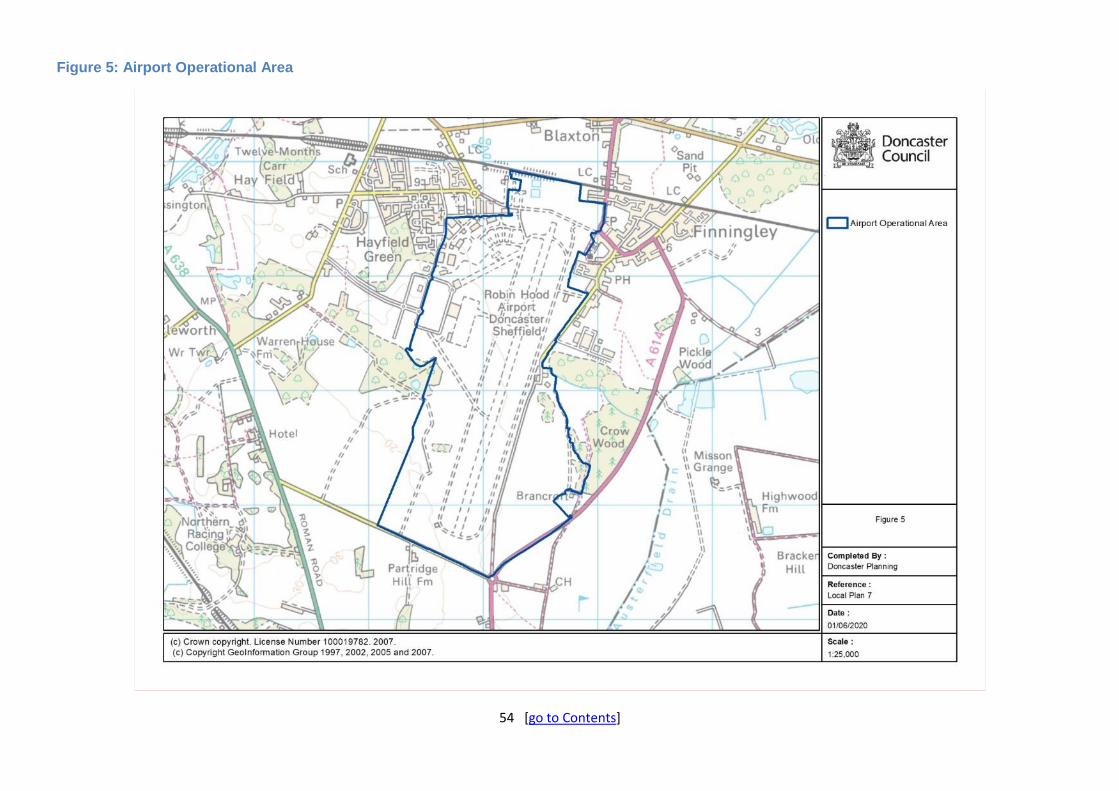
54 [go to Contents]
Figure 5: Airport Operational Area

55 [go to Contents]

56 [go to Contents]
Chapter 6: Meeting the Need for New Homes
Introduction
6.1. The policies and proposals in this chapter should be read alongside Policies 1 and 2, which set out the overall approach to meeting housing need and supporting sustainable communities, and Policy 5 which identifies specific new housing sites. Together they seek to ensure that enough homes are built within Doncaster, of the right type and in the right locations, to meet the ‘Objectively Assessed Need’ for new homes and other objectives of the Local Plan. Policies also address the management of new development within existing residential areas and the specific accommodation needs of Gypsies and Travellers.
6.2. The Local Plan will support and work alongside the Council’s Housing Strategy to: bring existing housing (council and private) up to decent homes standard; reduce the number of empty properties; deliver more housing and affordable housing on Council-owned land and, through a range of national and local housing delivery initiatives, ensure that vulnerable people have access to suitable housing and support services so they can live independently within their communities.
Policy 7: Delivering the Necessary Range of Housing (Strategic Policy) The delivery of a wider range and mix of housing types, sizes and tenures will be supported through the following measures: A) New housing developments will be required to deliver an appropriate mix of house size, type
and tenure to address housing needs and market demand, having regard to the Council’s latest Housing Needs Study or other robust and up-to-date evidence.
B) There is a clear requirement for the provision of affordable housing to meet local needs in the majority of the Borough’s communities. Housing sites of 15 or more homes (or 0.5 Ha or above) will normally be expected to include 23% affordable homes in the Borough’s high value housing market areas (as defined in explanatory text below), or a lower requirement of 15% elsewhere in the Borough (including starter homes / discounted market sales housing which meet the definition in the NPPF) on-site. Of this, there should be a tenure split of around 75% affordable homes for rent (including social rent) and 25% intermediate low-cost home ownership. Proposals for affordable housing on developments of less than 15 units will be supported where these meet other development plan policies.
C) Commuted sums in lieu of on-site affordable housing provision and of broadly equivalent value will only be accepted where this is robustly justified which would include where there is already an identified surplus of affordable housing within the community. These commuted sums will be used to target areas of need in the Borough in order to assist with rebalancing the housing market. They may also be combined with council house building programmes that would take place on land that the Council owns or subsequently needs to acquire.
D) In order to provide the necessary housing supply required for the changing needs of residents and to support independent living, new developments should include the provision of homes which are adaptable, accessible, and suitable for people with a wide range of needs in line with Policy 45. It must also be demonstrated how the provision of housing types suitable for older people can be increased, especially bungalows, extra care facilities and supported living accommodation. These will be supported on sites suitable for housing and which have good access to local services and facilities by means other than private car.
E) Specialist student accommodation will be supported on sites with walk/cycle and/or public transport access to Doncaster College or other training facilities. Wherever possible, commuted

57 [go to Contents]
sums relating to such accommodation will be used to target areas of need in the Borough.
The provision of opportunities to accommodate custom build and self-build homes will be encouraged on housing allocations and elsewhere.
Explanation
6.3. The NPPF aims to significantly boost the supply of homes. It requires that the needs of groups with specific housing requirements are addressed, including, amongst others, affordable housing, family housing, older persons housing, student accommodation, housing for people with disabilities, travellers (see Policy 11), and those who wish to self-build.
6.4. Delivering more homes, including more affordable homes, is a key Government priority which is also reflected within the City Region and in Doncaster. The need for more affordable homes is articulated through the Doncaster Housing Strategy 2015-2025 and reflected in the Living theme of Doncaster Growing Together (DGT). The Council has an existing programme of delivering affordable housing to meet local housing need through both direct delivery of new Council houses and an ongoing Housing Association Development Programme. In delivering these programmes the Council and its partners maximise external funding opportunities where applicable – primarily through our work with Homes England.
6.5. There remains, however, an unmet need for which we must plan over the coming years. It is essential that the future programme is informed by a detailed evidence base of affordable housing requirements, including types and locations, along with robust needs information. The future delivery programme will aim to meet the varied housing needs of our residents by delivering a range of property types including, but not limited to, accommodation for:
General needs
Older people
Care leavers
Adults with learning disabilities and autism
Physical disabilities linking to the Accessible Housing Register
Homeless / at risk of homelessness
6.6. The creation of the future programme will clearly articulate how the delivery programme will contribute to the wider Transformation Programme objectives across the Council.
6.7. The Economic Forecasts and Housing Need Assessment (June 2018) establishes the Borough’s housing requirement. Following on from this, the 2019 Housing Need Study identifies the size, types and tenures required across the Borough, and also identifies affordable housing need, older peoples housing needs, and the housing needs of people with disabilities. The Council is committed to keeping such evidence up-to-date to identify any changes in housing need during the plan period and will undertake a Housing Needs Assessment at least every 4 years to inform both planning applications and a review of the Plan itself.
6.8. With regards to type and size, this report finds that whilst proportions vary across the Borough, generally the greatest need identified is for 3 bed houses, followed by larger 4+ bed houses and 2 bed bungalows. Appendix 4 sets out the main findings from the Study in terms of dwelling type and mix by each of the settlements identified in the top 3 tiers of the settlement hierarchy. This evidence should help inform applicant’s drawing up planning applications of the need for certain house types and mix by area, including areas where there is already an oversupply of certain house types.
6.9. Affordable homes can be social rented, affordable rented, intermediate, starter and discounted market sales homes providing homes to eligible households whose needs are not met by the market. The 2019 Housing Need Study identified that overall, 209 affordable units are required per year over and above the Council’s own build programmes, which equates to 23% of the

58 [go to Contents]
Borough’s housing target. However, this assessment does not factor in what levels of affordable housing have been secured already through commitments as it is just a percentage of the annual housing target of 920 net new homes. Nor does it consider whether the target is appropriate to adopt as a policy requirement as it takes no account of viability where national policy is clear that whatever requirement set through policy must be justified in terms of whole plan viability. The ratio between affordable homes for rent and low cost home ownership is 75%:25%.
6.10. The Doncaster Local Plan Viability Testing (2016) evidence base assessed a series of hypothetical housing sites across the Borough’s housing market areas in line with national policy and the best practice guidance. The 2019 Viability Testing Update to this evidence also revised the typologies before modelling a number of actual Local Plan allocations. The conclusion being that development sites in the Borough’s high and medium value areas are generally viable with a 23% affordable housing requirement when considered in conjunction with other Local Plan policy asks. However, sites within the Borough’s low value areas come under greater viability pressure. The evidence therefore recommends that it is more appropriate to adopt a reduced affordable housing requirement of 15% in these parts of the Borough. Appendix 5 identifies the Borough’s two affordable housing requirement policy areas for the purposes of this policy.
6.11. Affordable housing should be provided on site, unless off-site provision or an appropriate financial contribution in lieu can be robustly justified, and the agreed approach contributes to the objective of creating mixed and balanced communities. Such justification could include where the Housing Needs Assessment, or other robust and up-to-date evidence, has identified that there is already a surplus of affordable housing in a community (see Appendix 4). Where a commuted sum is deemed appropriate, wherever possible this should be utilised to target areas of need in the borough in order to assist with rebalancing the housing market. This is to ensure that the policy provides much needed affordable housing to meet the needs of the area providing local housing for local people.
6.12. This policy seeks to ensure that the mix of house types and tenures addresses the particular needs of Doncaster residents; these are detailed in the 2019 Housing Needs Study but other assessments and evidence will emerge over the plan period. The most recent Housing Needs Study and Housing Design Standards Policy Evidence Paper 2019 shows there is a need for less bedrooms, more bungalows, homes suitable for older and/or disabled people or which are easily adaptable, supported living and extra care facilities and executive homes. Larger sites will be expected to include a good mix of house types to help create balanced communities and reflect identified needs, and should also consider whether parcels of land on such sites can be reserved for identified demand for self and custom build plots.
6.13. The provision of bespoke student accommodation to house expected increases in student numbers over the plan period is under active consideration and will also help reduce pressure on the existing housing stock.
Policy 8: Removal of Occupancy Conditions The removal of occupancy conditions on dwellings will only be permitted in exceptional circumstances where it can be demonstrated, via an independent report, that: A) There is no longer a long-term need for the dwelling on the particular enterprise on which the
dwelling is located; and B) Unsuccessful attempts have been made to sell or rent the dwelling at a price that takes account
of the occupancy condition.

59 [go to Contents]
Explanation
6.14. There may be instances where a dwelling for a rural worker, in either the Countryside Policy Area or Green Belt, is no longer needed. Proposals to remove occupancy conditions need to demonstrate there is no longer a need for the dwelling on the particular enterprise on which the dwelling is located, either due to changes in the nature of the business or that the business is no longer viable. Applications should be accompanied by an independent report to demonstrate that unsuccessful attempts have been made to sell or rent the dwelling at a reasonable price, for a continuous period of at least 12 months prior to the application being made to remove the condition. This should take into account the occupancy condition and include offering the property at a price based on the average of at least 3 written valuations and at a price at least 30% less than normal market value. Unless there are special circumstances to justify restricting the dwelling to the particular enterprise where the dwelling is located, an occupancy condition is likely to allow occupation by other workers in the locality. In this case it should be considered whether there is other demand locally, not just whether the demand for this particular enterprise has ceased.
Policy 9: Houses in Multiple Occupation (HMOs) The growth in the number of Houses in Multiple Occupation (HMOs) in parts of the Borough has led to significant impacts on existing communities linked to the over concentration of people and pressures on local infrastructure. There are also concerns around the quality of living for occupants of these dwellings. Proposals for HMOs will only be supported under very strict circumstances where:
A) the internal standards of the property are suitable for multiple occupation, including bedrooms with good soundproofing, privacy, outlook, light, ventilation and have good communal facilities for washing, preparation and consumption of food;
B) external communal areas and facilities are of sufficient size and standard to satisfactorily accommodate waste and recycling bins, safe and secure cycle storage and on-site parking (unless it can be demonstrated that the site is sustainably located and therefore justifies reduced levels of on-site parking);
C) the overall size of the dwelling is sufficient to provide proper and adequate accommodation and living space for the number of residents intended to be accommodated;
D) the existing dwelling or building is capable of conversion without causing harm to the area or the amenity of nearby residents particularly with noise and disturbances or over-looking and, in areas of flood risk, do not result in ground-floor or basement level self-contained rooms; and
E) the proposal would not result in an over-concentration of HMOs within a community/locality/street/row, or result in a significant adverse impact to local amenities. Proposals must not create:
1. more than two HMOs side by side; or 2. the sandwiching of a single self-contained house or flat between two HMOs; or 3. more than two HMOs within a run of twenty properties on one side of the road; or 4. more than one HMO in a road of fewer than twenty properties on one side of the road.
The Council will utilise all of its powers available, including licensing and enforcement, to ensure the negative impacts of HMOs are managed and that our communities are not negatively impacted by the provision of such accommodation.

60 [go to Contents]
Explanation
6.15. A House in Multiple Occupation (HMO) is defined as a house or flat occupied by a certain number of unrelated individuals who share basic amenities and is classified by the Use Class Order. HMOs can play an important role in meeting the housing need of a range of groups, including students, temporary work-training students, young professionals and individuals on low incomes. However, all too often such accommodation has unintended and unacceptable consequences for the established community as HMOs can have a high turnover of occupiers. Issues include insufficient car parking, problems with refuse disposal and collection, overcrowding, noise, and in some cases anti-social behaviour. This policy will be applied to known HMOs (be they licensed, non-licensed with planning permission or those created under permitted development) as well as others brought to the Council’s attention. Part E of the policy will be applied on a community-wide basis taking into account the impact on rows of houses, streets and the wider area. For the avoidance of doubt, this could include consideration of multiple streets and rows of properties including corner premises and need not be limited to one road at a time.
6.16. It is important that any proposals that do accord with this policy are delivered without detriment to existing communities, properties and businesses in the area. This can best be achieved through preventing the over concentration of such properties in particular areas and encouraging a more even distribution across the Borough. Proposals that lead to self-contained rooms at ground floor or basement level in areas at risk of flooding are unlikely to be supported as such accommodation must be able to provide satisfactory mitigation against residual flood risk and there are likely to be challenges around providing a safe point of refuge.
6.17. The Council is fully aware of the issues that HMOs can create, and the impact they can have on existing established communities when poorly managed. As such, the Council is committed to tackling and managing the problems that proliferation of such housing can cause. This includes various Council Departments, for example Planning, Enforcement and Licensing; the Licensing Scheme and Article 4 Direction that are utilising powers of the Housing Act and Town and Country Planning Order to address housing issues identified. The Council has given notice of the “making” of an Article 4 Direction on 9 August 2018. The Direction relates to developments comprising of changes of use from dwelling houses (Class C3) to HMOs (Class C4) and applies to land within the areas of Town, Town Fields, Wheatley, Hexthorpe, Balby, Wheatley Hills, Intake and Belle Vue (the exact boundary is shown on the Policies Map). The Direction comes into force 14 October 2019 (subject to confirmation), and removes permitted development rights for this type of development i.e. planning permission will be required. The Council has also introduced additional licensing, which applies to certain HMOs not already covered by mandatory HMO licensing, which came into effect 1 October 2018.
Policy 10: Residential Policy Areas Within Residential Policy Areas, as defined on the Policies Map:
A) New residential development will be supported provided:
1. the development would provide for an acceptable level of residential amenity for both new and existing residents; and
2. the development would help protect and enhance the qualities of the existing area and contribute to a safe, healthy and prosperous neighbourhood; and
3. the development would meet other development plan policies including those relating to flood risk, open space, design and sustainable construction.
The establishment or increase of non-residential uses of appropriate scale will be permitted provided they would not cause unacceptable loss of residential amenity through, for example, excessive traffic, noise, fumes, smells or unsightliness.

61 [go to Contents]
Explanation
6.18. The Policies Map defines not just housing allocations, the main locations for new homes, but also Residential Policy Areas which cover the majority of existing residential areas in the Borough and which continue to be locations for significant new housing infill and other forms of ‘windfall’ development. They are predominantly, but not exclusively, comprised of residential properties often including small businesses, shops, community facilities, residential institutions and other uses which can meet local needs in a sustainable way and contribute to the variety and attractiveness of residential areas.
6.19. Proposals for residential development are acceptable in principle subject to the criteria of this and other relevant development plan policy. For example, some small areas of open space are washed over by Residential Policy Area but can have an important amenity, biodiversity or play space function and will not be appropriate for development. Windfall proposals in Flood Zones 2 and 3 (as defined by the Environment Agency’s Maps) are, unlike housing allocations, required to pass a flood sequential test (see Policy 57).
Policy 11: Gypsies, Travellers and Travelling Show People (Strategic Policy) The assessed accommodation needs of Gypsies, Travellers and Travelling Show People should be met on existing sites / yards with capacity in the Borough, and by maintaining a five year supply of sites across the Plan Period: A) All sites listed in Table 10, and shown on the Policies Map, are sites with a capacity of 5 or
more pitches / yards, and are designated as Gypsy and Traveller or Travelling Showpeople sites. The establishment or re-establishment of pitches / yards on vacant plots or unused land within these designations will be supported.
B) Within the Plan’s defined development limits, proposals for new sites, or site extensions, will be
supported on sites suitable for residential development and, in the case of travelling show people, for storage of their equipment.
C) Proposals for new sites outside of development limits and the Green Belt will be supported
where there is an unmet need established in the latest Gypsy, Traveller and Travelling Showpeople’s Needs Assessment (GTANA / TSPANA), the sites are in accordance with the principles set out in D and F, and the proposal is for:
1. 5 or more pitches/yards (provided the scale of the site would not dominate the nearest
settled community); or 2. a smaller extension to, or intensification of, an existing well managed site; or 3. a smaller site that makes effective use of brownfield land.
Small extensions to, or intensification of, an existing well managed site may be supported where
there is no overall unmet need, if there is a demonstrable need specific to the family on site, and the proposal accords with all other relevant parts of the policy.
D) Proposals for new sites or pitches / yards will be required to demonstrate:
1. there will be no significant harm to the built or natural heritage including trees,
hedgerows, and biodiversity; 2. there will be no significant harm to local amenity, infrastructure or agriculture; 3. there is safe and convenient access to the highway network; 4. the site is close to, or has good public access to, key services including schools, medical
facilities and shops; 5. there is sufficient space for the planned number of caravans, commercial vehicles, play
space, amenity blocks, parking and the safe movement of vehicles; and 6. the site is within, or can be well integrated into, the local townscape in a manner in-
keeping with the local character, using boundary treatments and screening materials

62 [go to Contents]
which are sympathetic to the existing urban or rural form. High fences or large walls should be avoided wherever possible to prevent the impression that the site is being
deliberately separated from the rest of the community. E) Proposals for mixed residential and business use sites will be required to demonstrate that the
site is suitable having regard to the safety and amenity of the occupants and neighbouring residents
F) Proposals for transit Gypsy and Traveller facilities will be required to show that:
1. there is a demonstrable need for such facilities; 2. there is convenient access to the road network; and 3. the proposal meets the requirements of D 1), 2), 3) and 6).
Explanation
6.20. The Local Plan seeks to meet the housing need of all its residents including the specialist accommodation needs of those gypsies and travellers who have a traditional nomadic way of life requiring traveller caravan sites, which in turn requires a specific planning policy approach.
6.21. National Planning Policy for Traveller Sites (August 2015) highlights that the traditional and nomadic way of life of Gypsies, Travellers and Travelling Showpeople should be facilitated whilst respecting the interests of the settled community. Local Planning Authorities should make their own assessment of need and set targets for pitches and yards. A supply of specific deliverable sites should be identified to provide 5 years’ supply against the target.
6.22. This policy should be read in conjunction with the latest local evidence on Gypsies, Traveller and Travelling Showpeople. This can be found in the Doncaster Gypsy and Traveller Accommodation Needs Assessment (GTANA) and the Travelling Showpeople Accommodation Needs Assessment (TSPANA). The Council will monitor and periodically update this evidence across the plan period. The 2018 report identifies that the Borough has a surplus of 274 pitches by 2032 (due to existing supply and future supply from existing sites significantly outweighing the current (surplus) and future need from household growth). In relation to Travelling Showpeople, there is a small overall need by 2032 of 5 additional pitches, which can be met through existing sites, or via the mechanisms set out in this policy such as small extensions to sites, and therefore no new allocations are required.
6.23. Authorised sites in the Green Belt have been removed from the Green Belt and allocated as “Green Belt Traveller Sites” on the Policies Map, and in Table 11. These sites are allocated for this use only and no alternate uses other than as a Gypsy and Traveller site are acceptable.
6.24. Within the Green Belt, there will be a presumption against the development of new sites except in ‘very special circumstances’. In the ‘Countryside Policy Area’, that is, outside of the Green Belt and defined development limits, the designation takes preference.
6.25. Proposed new sites, or extensions to existing sites, within flood zones 2 or 3, will be subject to relevant local and national flood risk policy.
6.26. The GTANA indicates the average site size is 6.1 pitches in the Borough. It is the Council’s view that 20 pitches, in the form of 3 or 4 well located, well laid out and well managed sites, is both preferable to, and would have less impact than 20 single pitch sites which can be larger than pitches on multiple pitch sites and are likely to be relatively socially and environmentally unsustainable. The creation of new smaller sites within towns and villages would still be possible as would smaller extensions to existing sites in the Countryside Policy Area and, subject to exceptional circumstances, the Green Belt.

63 [go to Contents]
6.27. The designated Gypsy and Traveller, and Travelling Showpeople’s Sites (as per 11A) are as follows:
Table 10: Designated Gypsies, Travellers and Travelling Show People Sites
Ref. Name Ownership Settlement Capacity
GT1 White Towers Council (G&T) Armthorpe 23
GT2 Land’s End Council (G&T) Thorne & Moorends 22
GT3 Little Lane Council (G&T) MUA (Clay Lane) 10
GT4 Nursery Lane Council (G&T) Sprotbrough 10
GT5 Hacienda Private (G&T) Kirkhouse Green 56
GT6 Tilts Farm Private (G&T) Tilts Lane (near Toll Bar) 30
GT7 Millfield Private (G&T) Stainforth 15
GT8 Glen Bungalow Private (G&T) Sutton 30
GT9 Stockbridge Lane Private (G&T) Bentley 23
GT10 Meadow View Private (G&T) Thorne & Moorends 20
GT11 Whitegates Private (G&T) Dunscroft 20
GT12 The Stables & Dun Roaming Private (G&T) Thorne & Moorends 5
GT13 Holme Wood Lane Private (G&T) Armthorpe 11
GT14 Romany Way, Stockbridge Lane Private (G&T) Bentley 10
GT15 Pony Paddocks, Hall Villa Lane Private (G&T) Toll Bar 10
TSP1 Rhodes Fair Private (TSP) Stainforth 16
TSP2 Mosscroft Lane Private (TSP) Hatfield Woodhouse 18
TSP3 Land off Tudworth Road Private (TSP) Hatfield Woodhouse 6
TSP4 Fair View, Quarry Lane Private (TSP) Branton 6
It should also be noted that the GTANA/TSPANA considers a number of additional factors in relation to calculating the capacities of sites and yards, including smaller sites, unauthorised elements that are likely to get permission within a year, or sites which are immune from enforcement. These can count to the overall supply of sites and yards, but are not listed in the above table, which reflects permissions and sites above 5 plots only. For more information please refer to the GTANA/TSPANA.
Table 11: Green Belt Traveller Sites
Ref. Name Ownership Settlement Capacity
GT4 Nursery Lane Council (G&T) Sprotbrough 10
GT6 Tilts Farm Private (G&T) Tilts Lane (near Toll Bar) 30
GT8 Glen Bungalow Private (G&T) Sutton 30
GT9 Stockbridge Lane Private (G&T) Bentley 23
GT14 Romany Way, Stockbridge Lane Private (G&T) Bentley 10
GT15 Pony Paddocks, Hall Villa Lane Private (G&T) Toll Bar 10
GT16 Four Acres, Selby Road Private (G&T) Askern 1
GT17 Oak Dene, Doncaster Road Private (G&T) Askern 2
GT18 Willow Garth, Kings Road Private (G&T) Askern 2
GT19 Hobbies Paddock, Stockbridge Lane Private (G&T) Bentley 1
GT20 Land off Stockbridge Lane Private (G&T) Bentley 1
GT21 Ash Tree Cottage, Stockbridge Lane Private (G&T) Bentley 1
GT22 Apy Hill Private (G&T) Tickhill 2
GT23 Green Meadows, Hall Villa Lane (aka The Stables)
Private (G&T) Toll Bar 1

64 [go to Contents]

65 [go to Contents]
Chapter 7: Transport, Access and Infrastructure
Introduction
7.1. National policy indicates that access to jobs, shopping and leisure facilities should be available by all modes of travel, with an emphasis on public transport and other sustainable modes. It sets out an overall approach to addressing the needs of motorists, other road and public transport users and business by addressing congestion and pollution and achieving better access to development and facilities.
7.2. The Sheffield City Region Transport Strategy sets out an overarching transport vision to offer people a great place in which to live, work, invest and visit over the next 15 years. The goals of the Strategy are to support the economic growth of the Sheffield City Region whilst enhancing social inclusion and health, reducing emissions from vehicles and maximising safety to keep people and commerce moving efficiently.
7.3. The Local Plan and the Transport Strategy will mutually seek to alleviate existing transport issues, implement new road infrastructure (where required to support economic objectives) and improve public transport access and options for walking and cycling to facilitate sustainable transport choices. Whilst the Local Plan should be read as a whole, transport proposals are strongly linked to housing and employment (including retail) proposals, particularly where there are existing network constraints, to maximise opportunities to access employment opportunities from new and existing housing.
7.4. Policy is also provided to guide the provision of telecommunications and utilities infrastructure to both influence the reduced need to travel and its more general contribution towards achieving sustainable development.
Policy 12: Strategic Transport Network (Strategic Policy) Proposals will be supported which: A) Improve key routes and connections to the Strategic Road Network and effectively manage
traffic and relieve congestion, in particular at the following locations:
1. Hatfield Link Road. 2. West Moor Link (A630). 3. Improvements to M18. 4. North Nottinghamshire to A631 capacity improvements 5. A1(M) motorway (capacity improvements).
B) Improve rail transport, including:
Strategic Priorities for New Infrastructure Provision
1. The Community rail station site (on the Lincoln line and as shown on the Policies Map) will continue to be protected for such uses.
2. New rail station at Askern, with the site as shown on the Policies Map being protected, and rail links to towns and communities on the line serving Askern.
3. New, expanded or re-opened lines and stations and rail links to outlying towns and communities where feasible.
4. New high-speed rail opportunities in association with new and expanded interchanges. 5. Developing a tram train network to serve the Borough utilising where possible existing
heavy rail network.

66 [go to Contents]
Shorter-Term Improvements to Existing Infrastructure
6. Improvements to the sustainable access to all 8 of the Borough’s local train stations will be implemented. Within the station footprint these will include:
improved CCTV and lighting;
increased secure cycle parking;
upgraded displays and information; and
improved signage.
Longer-Term Improvements to Existing Infrastructure
7. Network Rail enhancements schemes to improve connectivity and capacity. 8. Upgrading of the East Coast Mainline (Leeds and York) and Trans Pennine links
(Manchester, Lincoln, Sheffield and Hull), including capacity improvements in the Doncaster Station area. C) Improve bus transport, including:
1. expanding / upgrading key bus routes and improvements to the bus network; and 2. the provision of additional and/or improved park and ride facilities.
D) Improve the efficiency of freight transport, and provide opportunities for alternatives to road
transport, where possible, including:
1. upgrades to freight lines between Immingham, Scunthorpe and Doncaster / Knottingley; 2. signalling and loading gauge improvements to allow deep-sea containers on key
intermodal arteries; 3. navigation and wharf facilities along key waterways; 4. secure lorry parking facilities and roadside service areas along the Strategic Road
Network to meet future demand, where appropriate; and 5. increased aviation and rail freight movements, including at the existing rail port at White
Rose Way and iPort, Rossington. Developments which generate large volumes of freight traffic or involve the transport of bulk materials should be located close to the strategic transport network, where this can be accommodated within the existing capacity of the network. The network capacity will need to be established through the submission of a Transport Assessment (TA). Routing agreements will be required where deemed appropriate.
Explanation
7.5. Doncaster’s position at the heart of the UK's strategic transport network offers excellent access to major conurbations, coastal ports and other parts of the UK and beyond, linking east to west and north to south. The Borough is well connected with strategic road and rail networks, access to waterways, has international links through Doncaster Sheffield Airport and to international ports via the M1 and M62 motorways.
7.6. Strategic transport infrastructure plays a key role in supporting the economic growth of the Borough and the wider Sheffield City Region. It provides the means by which residents can access employment, education, retail and leisure opportunities, as well as providing the mechanism for businesses to transport goods and services. Infrastructure is key to unlocking and driving the job creation set out in the Sheffield City Region (SCR) Economic Growth Plan. Ensuring investment in infrastructure is one of the six priorities for the Sheffield City Region Economic Growth Plan, as a mechanism to unlock key development opportunities, and to provide access to key markets, including those outside of the City Region.

67 [go to Contents]
7.7. The vision and objectives of the Local Plan seek to make efficient use of existing infrastructure to improve accessibility to jobs and services and to reduce the need to travel by car by ensuring all journeys are undertaken by the most sustainable mode of transport. These ambitions look to improve access to services and jobs and enable delivery of the growth strategy set out in the Local Plan.
7.8. Although Doncaster is well connected nationally and internationally, it is recognised that these connections need to be improved to meet future growth requirements. The Infrastructure Delivery Plan provides more detail on how these and other infrastructure projects will be delivered and implemented. This policy sets out the broad approach and key schemes for each transport mode – it is not exhaustive and other major schemes will come forward during the plan period. Where feasible and practical, large development sites should explore the potential for the use of alternatives to road transport for the supply of construction materials and aggregates to and from the site.
Road Network 7.9. Doncaster occupies a strategic location at the centre of the UK’s motorway network, with
access to M18, M180 and A1(M) motorways and links to the M1 and M62 motorways. The A1(M) provides direct access to the north (towards York and the north east of England) and the south (towards London). The M18 motorway provides direct links to the east coast ports via the M180 and M62 motorways as well as access to the other regional and national centres via the A1(M) and M1 motorways.
7.10. Improvements to key routes and connections to the Strategic Road Network will be required to effectively manage traffic, relieve congestion and ensure capacity to delivery future growth. Table 12 below shows the major enhancement scheme priorities on the road network in Doncaster. The Policy gives specific support to those road schemes which either have committed funding or are under construction at Plan adoption as well as other short-term strategic priorities which are in the process of securing funding and which have approval status and scheme design that will be delivered early within the plan period.
7.11. There are also a number of other road schemes which are potential longer term priorities that will be assessed in the context of national planning policy and guidance and taken into account in a future review of the Plan, including through the sustainability appraisal of reasonable alternatives. They are not needed to deliver development in the Plan. These schemes are at various stages of development including some with Strategic Outline Business Cases that have indicative scheme proposals with options considered, whereas other schemes are yet to start the full feasibility stage.

68 [go to Contents]
Table 12: Major Road Network Enhancement Priorities
Scheme Description
Committed Schemes
Hatfield Link Road scheme The scheme will connect the Hatfield/Stainforth area of the Borough to junction 5 of the M18 motorway/ junction 1 of the M180. The scheme will unlock up to 200 hectares of development land and improve access to the strategic transport network. The link road is an integral element of the Unity scheme, a 170 ha mixed used development that will transform and regenerate the communities of Hatfield, Stainforth, Dunscroft and Dunsville.
West Moor Link scheme The scheme involves improvements to the A630 between junction 4 of the M18 motorway to the A18 (Thorne Road) and between the A18 and A630 Wheatley Hall Road. The scheme may involve the widening of a rail bridge thereby removing a pinch point. Once complete, the scheme will increase the capacity of the network, facilitate the unlocking of housing development and employment land along the route, and support sustainable modes such as cycling.
Short-Term Priorities
Improvements to M18 Capacity improvements may be required along the M18 between junctions 2 and 6 to improve journey times, reduce congestion and accommodate future growth. Proposals are being explored in partnership with Highways England for improvements to junction 3 to increase capacity and reduce congestion.
North Nottinghamshire to A631 capacity improvements
Capacity improvements are required to improve access from North Nottinghamshire to Doncaster via the A631 in light of recent growth. Harworth and Bircotes, in the neighbouring district of Bassetlaw, has seen significant housing and employment development over recent years. This has impacted on the highway network in Doncaster along the A631 between Tickhill and Bawtry, particularly the A631 Stripe Road Junction. Improvement schemes are required along the A631 corridor to accommodate the recent growth and reduce congestion.
A1(M) capacity improvements
Highways England is looking to upgrade and increase the capacity of the A1 around Doncaster to improve safety and reliability of the network. Currently, the section of A1 through Doncaster has some of the highest levels of flow breakdown and the greatest level of accidents on the A1. The A1-M18-M62 scheme will see the upgrading of the A1 to 3 lanes from the junction with M18 to the junction with the M62. This will require improvement works to A1 junction 35 / M18 junction 2. Capacity improvements to the Strategic Road Network are subject to Highways England funding.
Longer-Term Priorities
Pan Northern Route (PNR) The PNR will provide a new strategic highway connecting Manchester and the proposed Trans-Pennine tunnel with the A1 and Humber Ports. The new highway will provide resilience, capacity, investment opportunities and growth across the Pennines, providing a strategic east-west link across the north of Doncaster, through Barnsley linking the Trans-Pennine Tunnel with the M1, A1(M), M180 and the M62 motorways to the East Coast Ports. As well as providing important Trans-Pennine connectivity benefits, the proposal will also build on and enhance the benefits of a number of local

69 [go to Contents]
Scheme Description
highway schemes to enhance connectivity across the region particularly improving links between Doncaster and Barnsley. It is envisaged that the proposed PNR will form part of a series of interlinking routes, between Manchester and the Humber Ports (via Barnsley and Doncaster). The PNR will deliver two key projects for Doncaster; the Hickleton and Marr bypass and the A1-A19 link road. It will also enable connection between the A19 and the M18. The PNR is subject to funding being approved and the precise route is yet to be finalised. If funding is not forthcoming the A1-A19 and the Hickleton and Marr bypasses will be delivered as stand-alone schemes.
North Doncaster A1-A19 link
The scheme will provide a link road from the A1 to the A19 at Bentley Moor Lane, north of Toll Bar. The existing link between the A1 and A19 via Skellow does not have sufficient spare capacity to accommodate the additional traffic arising from proposed growth opportunities in the wider area. The link road will help boost regeneration and economic development in Doncaster’s northern communities which have higher levels of deprivation. In particular, it is hoped that the improved access to the A1 will help release the long term potential of the Carcroft employment area and help to enable the development of land at Carcroft Common.
Dearne Valley to A1(M) Improvements (Hickleton and Marr Bypasses)
In light of significant recent development and further growth plans in the Dearne Valley area, connectivity improvements are required between the Dearne Valley and the A1(M). The A635, which forms the principle route between Dearne Valley and the A1(M), is currently a low capacity, single carriageway road. The high volumes of traffic experienced along the road cause severance issues as well as significant air quality challenges in the villages of Hickleton and Marr. Both villages are classified as conservation areas and Hickleton has been designated as an Air Quality Management Area. The Hickleton and Marr Bypasses look to divert traffic and congestion away from the villages, connecting the A635 Barnsley Road/ Doncaster Road with the A1(M). The Dearne Valley to A1(M) is also part of the wider Pan-Northern Route linking M1 to A1(M).
A19 – M18 Connectivity Connectivity improvements are sought between the A19 and M18 to increase accessibility for Doncaster’s northern communities and support regeneration priorities. Schemes look to provide a new east – west connection, increasing accessibility in the north of Doncaster and releasing capacity to support economic development. Schemes to improve A19 – M18 connectivity will support the Pan Northern Route objectives and deliver improved connections to the M180.
M18 / A1(M) interchange improvements
Due to limited interchange facilities between M18 and A1(M) congestion and queueing are frequent at peak times around junctions 2 and 3 of the M18 and junctions 35 and 36 of A1(M). Although plans are being explored by Highways England to increase the capacity of the A1(M), further work is required to increase the capacity of the M18 / A1(M) interchange to accommodate demand.
7.12. Improvements to the local highway network will support regeneration initiatives, especially within former coalfield areas, and allow demand management to influence travel choices. Development proposals will need to have access to the appropriate category of road to ensure that traffic can be accommodated safely and conveniently on the local highway network and ‘Strategic Road Network’.

70 [go to Contents]
Rail 7.13. Doncaster train station has good rail links to major towns and cities through its position on the
East Coast Mainline, with 104 stations directly served by trains from Doncaster. The Borough is also serviced by a range of local and regional services and boasts 8 local rail stations.
7.14. Rail passenger numbers are growing and the local rail network requires improvements to increase capacity, increase connectivity and improve frequency of services in order to increase access to jobs and facilities, particularly at peak times.
7.15. A community station on the Lincoln Line (the extent of which is shown on the Policies Map) can provide rail connectivity to the Airport albeit requiring a shuttle connection. The land associated with this proposal has been protected to ensure delivery of a station can be achieved in line with the Section 106 Agreement for the Airport which protects this site for such a use. Doncaster Council is working with Doncaster Sheffield Airport, Sheffield City Region, Network Rail and Transport for the North to further plans for a new station at Doncaster Sheffield Airport connected to both the East Coast Mainline and the Lincoln Line. Emerging evidence shows that this is a preferred alternative to the Lincoln Line station, but the scheme is yet to secure funding at the point of Plan adoption. The scheme will see a new station and associated improvements to the rail lines to support growth and investment at the Airport Priority Growth Area and beyond. The station will serve as an international gateway to the region and provide transformational connectivity to the Airport, the Airport Policy Area and beyond, by expanding the travel catchment for air passengers, and to the East Coast Main Line by providing a strategic park and ride facility.
7.16. There is an aspiration to enhance the local rail network through the introduction of new and re-
opened lines and stations alongside existing rail line improvements. Such schemes can help to relieve congestion on local roads by providing a sustainable alternative to car travel and can also significantly increase accessibility of existing or new developments. A number of opportunities are being explored, including a new station at Askern to the north of the Borough and associated improvement works to the line, to improve accessibility and reduce congestion. Land for the delivery of Askern Station has been secured to ensure that, subject to a successful funding bid, the station can be constructed and rail service to Askern re-opened. There is also an aspiration to explore reinstating the direct rail line between Doncaster and Barnsley to improve public transport connectivity between the two towns.
7.17. The station accessibility schemes will improve active travel links to local train stations around the Borough. The schemes will create new walking and new cycling infrastructure connecting people to the stations as well as improving existing facilities nearby. The works will enable more people to make multi modal journeys as part of their commute. This will see improvements made to footpaths, new segregated cycle facilities installed nearby and improvements made inside the stations to facilitate more active travel journeys. Additional cycle parking is to be installed within the stations to meet demand.
Bus 7.18. The South Yorkshire Passenger Transport Executive (SYPTE) has responsibility for supporting
public transport services throughout South Yorkshire. Doncaster has a comprehensive bus network serving urban and rural communities. The bus network helps to support areas that cannot be reached by other modes of public transport and can provide a vital lifeline to rural communities. However, bus patronage has been falling for a number of years with annual traffic surveys suggesting up to a 33% decrease in average passengers numbers over the last 10 years.
7.19. To address declining bus patronage, Doncaster Council has been working in alliance with SYPTE and service providers through the Doncaster Bus Partnership. Launched in 2016, the Bus Partnership looks to promote and deliver a high quality local alternative to car use in the Borough. The principle objectives of the partnership are to improve service delivery and ensure

71 [go to Contents]
efficiencies through a coordinated approach to ticketing, marketing and network delivery. There are a number of aspirations for expanded and/or upgraded key bus routes and improvements to the bus network to increase accessibility across the Borough, as well improve the current bus vehicle stock operating in the Borough to support air quality improvements. Additionally, provision of new and/ or improved park and ride facilities will be sought, including at locations such as Unity (Hatfield and Stainforth) and Doncaster Sheffield Airport.
Freight Transport 7.20. With strong links to the strategic transport network and to international ports to the east,
Doncaster has seen significant growth in the freight transport and logistics market over recent years. The development of iPort as a major multi-modal transport hub has further strengthened Doncaster’s role as a logistics centre of national significance. Doncaster is keen to support its role as a logistic hub. Improvements are required in the efficiency of freight transport to reduce the impact on the strategic and local road networks. Opportunities for alternatives to road transport will be supported, particularly in relation to rail, aviation and waterway improvements to support freight distribution.
7.21. Logistics and distribution businesses within Doncaster attract significant HGV traffic and new lorry park facilities will be required to meet demand and support growth. Requirements for lorry park provision are set out in Policy 15. New lorry parking facilities should be close to the Strategic Road Network.
7.22. Development which generates large volumes of HGV and other freight traffic, or involves the transport of bulk materials, should be located close to the strategic transport network (considering alternatives to road transport) where such movements can be accommodated within the existing capacity of the network to reduce the impact on local roads. Routing agreements will be required where deemed appropriate.

72 [go to Contents]
Figure 6: Strategic Transport Network

73 [go to Contents]
Policy 13: Promoting Sustainable Transport in New Developments (Strategic Policy) Proposals are required to meet the following requirements: A) New development shall make appropriate provision for access by sustainable modes of
transport to protect the highway network from residual vehicular impact. The Council will work with developers to ensure that: 1. access to the development can be made by a wide choice of transport modes, including
walking, cycling, and the private car, and public transport where appropriate; 2. site layouts and the street environment are designed to control traffic speed through an
appropriate network and street hierarchy that promotes road safety for all; 3. walking and cycling are encouraged within the development and beyond, through the
design of facilities and infrastructure within the site and provision of linkages to the wider network;
4. appropriate levels of parking provision are made in accordance with the standards contained within Appendix 6. A departure from these standards may be justified on a case by case basis, for example reduced parking levels for Town Centre residential developments where accessibility to public transport is more prevalent. Developments should also include provision for electric vehicle charging points, with fast charging infrastructure provided for use by short stay users where appropriate;
5. residential developments should provide dedicated cycle storage for each property. For houses, this could be in adequately sized garages or bike sheds. For flats or apartments, this may be shared dedicated secure facilities. Non-residential developments are required to provide cycle parking spaces to the equivalent of at least 10% of car parking spaces as set out in Appendix 6. Any departure from the standards for car parking provision should not be reflected in the reduction of cycle parking provision and, where appropriate, this should be increased in locations where cycling infrastructure encourages higher levels of cycling; and
6. development does not result in unacceptable impact on highway safety, or severe residual cumulative impacts on the road network. Developers must consider the impact of new development on the existing highway and transport infrastructure. Where necessary, developers will be required to mitigate (or contribute towards) any predicted adverse effects on the highway and the wider transport network. B) New developments will need to provide, as appropriate, Transport Statements, Transport
Assessments and Travel Plans to ensure the delivery of travel choice and sustainable opportunities for travel in line with the latest government guidance and best practice. Thresholds for when these documents are required are set out in Appendix 7.
New developments that are predicted to have an adverse impact on the transport network will be expected to contribute towards capacity and mitigation measures. Proposals that require new projects will be required to make a proportionate financial contribution.
In addition, proposals should include details of post-development monitoring of traffic and mitigation measures in the event that traffic levels agreed through the original permission are later exceeded.
Explanation
7.23. New developments shall be designed to ensure the efficient movement of people and goods and to maximise the use of sustainable forms of transport. All developments shall be designed and laid out in order to provide safe access by all forms of transport, in line with the relevant Supplementary Planning Documents and design guidance. Residential developments shall be linked to local centres in order to reduce journey lengths and encourage travel by walking, cycling and public transport.

74 [go to Contents]
7.24. New developments will need to provide, as appropriate, Transport Assessments, Transport Statements and Travel Plans to ensure the delivery of travel choice and sustainable opportunities for travel in line with the latest Government guidance and best practice. Consideration should be given to the future maintenance requirements on the road network as a result of the development. Construction management plans may also be required.
7.25. Where an application may raise transport implications, developers will be required to produce a Transport Assessment and Travel Plan. For proposals which have less of an implication a Transport Statement may suffice. The use of Travel Plans is an essential measure to mitigate the impact of development traffic. Thresholds for when these documents are required are set out in Appendix 7.
7.26. Figure 7 shows the various stages involved in the Transport Assessment process for planning applications.
Figure 7: Transport Assessment of Planning Applications
7.27. If new junctions onto the public highway are required to accommodate new development and considered acceptable in principle, these shall be designed in accordance with the current relevant design standards. This will ensure that there are no adverse effects on the safety and integrity of the existing highway network. Road safety audits will also be required to accompany any new junction proposals at the appropriate stage of the design and adoption process.
7.28. All developments will be expected to provide adequate car parking in safe, convenient and secure locations in line with the requirements set out above. Car parking spaces should be well

75 [go to Contents]
defined and integrated with good quality surfacing materials and landscaping within the public realm, whilst not letting parking dominate the residential environment. A Car Park Management Strategy may also be requested if deemed appropriate. Parking standards are contained in Appendix 6.
7.29. The Council has adopted minimum parking standards within residential developments in order to overcome issues associated with low parking provision. In determining the right levels of parking the Council will consider the anticipated demand from the type of housing proposed, the likely occupiers, the design of the public realm and highway, the proposed parking design solutions and any local restrictions.
Policy 14: Doncaster Town Centre Car Parking (Strategic Policy) Town centre car parks will be managed in favour of short stay car parking with supply aligned to meet operational demand. Off-street car parking in Doncaster town centre must comply with the following principles: A) Public off-street car parking in and around Doncaster Town Centre will be carefully controlled in
line with the recommendations set out in Doncaster Town Centre Parking Strategy and subsequent reviews. Development proposals will be supported that replace, consolidate and improve existing provision elsewhere in the town centre. Additional provision will only be acceptable to meet operational needs. Where proposals look to provide a net increase in the number of off-street public car parking spaces available at any given time, a strong demonstration of need must be provided, through a Transport Assessment / Statement.
B) Supply will be managed in favour of short stay car parking within the Inner Parking Zone (as
defined on the Policies Map). Long stay car parking will normally only be supported outside of the Inner Parking Zone where need is demonstrated.
C) Any new public off-street car parking, whether associated with development or not, will only be
permitted in and around Doncaster Town Centre where it:
1. provides efficient, high capacity parking which makes effective use of land; 2. improves the balance and distribution of car parking within the town centre; 3. operates with a tariff that encourages short and medium stay use, and which discourages
all day commuter car parking; 4. is of high quality and secure, with level surfacing and marked spaces, is properly lit, and
can demonstrate the facility will be well maintained and managed; 5. includes adequate and well-designed provision for disabled drivers with appropriate level
access to the surrounding area; 6. is easily accessible by car from a main road network; 7. is easily accessible on foot to the retail/leisure area(s) that it serves; and 8. includes provision for sustainable refuelling infrastructure, such as electric vehicle
charging points. Within the Inner Parking Zone, fast charging electric charging infrastructure will be supported to encourage use by short stay users and promote high turnover of charging spaces. Planning permission sought for temporary surface level car parking will only be supported where it is considered appropriate and where such use would not delay or prejudice beneficial redevelopment of a site. Such permissions will be strictly time limited.
Explanation
7.30. Car parking is an important asset within town centres, helping residents and visitors access businesses and services. However, oversupply of parking can be a problem as it can encourage traffic, which can have a negative impact on congestion and air quality. A surplus of

76 [go to Contents]
surface car parks can also hinder regeneration, contributing little to the visual fabric of the townscape.
7.31. The National Planning Policy Framework supports improvements to car parking in town centres provided it is safe, convenient and secure, alongside measures to promote accessibility for pedestrians and cyclists. A balanced approach is needed with respect to the provision of public car parking. It is important to take account of the need for the centre to be attractive to employers and visitors, while encouraging the use of public transport to reduce congestion and car related air quality impacts.
7.32. The Doncaster Town Centre Parking Strategy reviews parking in the town centre and presents a strategy for the future management of car parking provision to ensure equilibrium between parking provision and effective demand management. Annual monitoring of parking provision will be undertaken as part of this strategy to assess changes in demand and supply.
7.33. This policy sets out a proactive approach, based on the Parking Strategy, in which the demand for off-street parking within the town centre will be effectively managed to balance the needs of business and local economic growth alongside the protection of the environment. Our intention is to limit the amount of car trips being undertaken to the town centre whilst improving the range, quality and distribution of available on street parking. At the same time, long stay car parking will be directed to locations outside of the Inner Parking Zone, prioritising short stay parking in the town centre for shoppers and visitors.
7.34. For the purposes of this policy, public off-street car parking is defined as town centre car parking provision that is available for any member of the public to use. It specifically does not include any off-street parking related to a particular use (e.g. a private office car park). This type of parking provision is normally referred to as ‘private non-residential parking’.
7.35. Consideration will be given to allow more flexibility to accept the temporary use of town centre development sites for public car parking as a means of generating income to support the viability of redevelopment schemes.
7.36. Where public parking is proposed in the short term on a temporary basis, the use of a site for car parking should not result in unacceptable traffic impacts or delay or prejudice beneficial redevelopment. Permissions would need to be strictly time limited to ensure that permanent redevelopment was not unreasonably delayed. Proposals of this nature will therefore need to be assessed on a case-by-case basis, taking account of these impacts as well as the availability and quality of existing parking provision.
7.37. Outside of Doncaster Town Centre, each development will be assessed on its merits, taking into account the following:
The parking standards and requirements set out in Supplementary Planning Documents and design guidance;
The type mix and use of development;
Whether measures can be undertaken to significantly reduce the use of private car travel to and from the development through the use of a Travel Plan; and
The location of the development in relation to public transport interchanges or routes well served by public transport.
7.38. Improvements to cycle parking provision in Doncaster Town Centre will also be sought, which is covered in Policy 16.

77 [go to Contents]
Policy 15: Lorry Parking (Strategic Policy) Lorry parking provision (with proportionate levels of ancillary facilities) will be sought in line with the following principles: A) Development on sites which generate or are likely to generate significant HGV movements,
and/or other commercial vehicles used for distribution, such as new strategic employment sites, and/or lead to an associated demand for lorry parking which is not already provided for by an appropriate facility must:
1. accommodate suitable on-site lorry parking and turning facilities, along with welfare
facilities; or 2. contribute towards additional provision of formal lorry parking facilities, which could
include extending or providing an appropriate facility. B) Proposals for lorry parking facilities will be supported which:
1. are justified by evidence of need; 2. are of a size that is viable and makes a significant contribution to meeting the identified
need; 3. take account of their impact on the Strategic Road Network and local highway; 4. provide a level of on-site facilities for lorry drivers appropriate to the size of the scheme
(including overnight stay accommodation and toilet facilities, where possible); 5. incorporates suitable arrangements for the management and maintenance of the facility;
and 6. are well-designed, laid out to a high standard and give consideration to environmental,
anti-crime and design standards. Where unsecure and inappropriate lorry parking is deemed to be causing disruptions, consideration will be given to restricting where lorries can legally park in these areas through the introduction of Traffic Regulation Orders (TROs).
Explanation
7.39. Doncaster’s strategic location at the centre of the UK’s motorway network has helped the Borough to become a nationally important logistics and distribution hub. The significant growth in the logistics market over recent years is set to continue with the expansion and development of new and existing sites.
7.40. Doncaster is keen to support its role as a logistics centre of national significance. Logistics and distribution businesses within Doncaster attract significant HGV traffic and generate a need for lorry parking facilities. Lorry parks provide an essential service to the road freight industry. They are important in terms of road safety, preserving local amenities, reducing crime, and provide vital facilities to meet the needs of the lorry drivers. Lorry drivers require parking for use overnight as well as to wait for allocated delivery or collection slots.
7.41. Anecdotal evidence suggests a minority of lorry drivers are causing disruption to local residents and businesses from parking along the local highway network, notably within existing industrial estates and in some residential areas. It is also noted that such issues also arise from smaller commercial vehicles increasingly being used for the distribution of goods. Complaints range from dangerous parking, to noise and littering and waste. Closure of the A1 laybys has further exacerbated this problem. Additional provision of lorry parks could help to alleviate some of these issues. A lorry parking strategy is currently being prepared for Doncaster to explore how related issues can be addressed in the Borough.
7.42. National planning policy in the NPPF states that Local Plans should recognise the importance of providing adequate overnight lorry parking facilities and requires proposals for new or expanded

78 [go to Contents]
distribution centres to make provision for sufficient lorry parking to cater for their anticipated use.
7.43. Where new developments are likely to create a demand for such provision or exacerbate an existing problem, developers may be required to make suitable onsite provision or provide a financial contribution towards an appropriate facility. Ideally, lorry parking facilities should be provided within appropriate development. New lorry parking facilities should be close to the Strategic Road Network and should be located in areas justified by evidence of need for parking provision. Proposals which may damage the integrity of Thorne Moor SAC, Hatfield Moor SAC or Thorne and Hatfield Moors SPA will not be supported in line with Policy 30.
7.44. The Council will support the provision of lorry parking within development sites in order to manage the demand for both short stay and overnight lorry parking. Wherever possible, lorry park developments should include a range of facilities proportional to the size of the development, such as toilets, overnight facilities and refreshment facilities, with any ancillary uses being of a type and scale appropriate to the main use of the site as a lorry park. Additionally, Lorry parks must include effective measures to create a safe and secure environment which restricts opportunities for crime to be committed.
Policy 16: Cycling in Doncaster Cycling provision in Doncaster (including new routes and improved links to existing networks and to existing and new development) will be sought in line with the following principles: A) The Council will seek to implement a programme of cycle routes and facilities (including cycle
parking) improving accessibility to town, district and local centres, major employment area and tourist attractions. Developments will be expected to provide or contribute towards enhancements and/or links to these routes. Development proposals should identify, and seek to remedy, areas of deficiency, particularly in access to services.
B) The needs of cyclists will be supported in relation to new developments and in the design of
highways and traffic management schemes to ensure safety, accessibility and convenience. The Council will seek to:
1. protect, maintain and improve existing cycling infrastructure; 2. improve signing to encourage the use of safer routes; 3. encourage the provision of supporting facilities along principle cycle routes including the
Trans Pennine Trail and Sustrans routes; 4. make information available on safe routes and other facilities; and 5. make provision for secure cycle parking facilities in new developments and in town,
district and local centres across the Borough. C) To encourage cycling as a means of travel, proposals for new development will be supported
where they:
1. demonstrate that they will have a positive impact on the cycling network and its users; 2. are designed to encourage cycling and enhance cycling connectivity to the existing cycle
network and to key destinations such as to local services and town, district and local centres;
3. provide appropriate cycle access and sufficient secure cycle parking facilities in accordance with the latest Council standards and, for new development for employment uses, provide changing and showering facilities; and
4. ensure the provision of appropriate signposting and way-finding to encourage the use of the network.

79 [go to Contents]
Explanation
7.45. The benefits of increased cycling are significant. As a mode of sustainable travel, cycling offers the economic advantages of affordable transport while having the potential to reduce congestion and improve air quality through reduced car use.
7.46. Doncaster is committed to increasing the uptake of cycling, both as a leisure activity and as a form of active travel. As a borough with a range of health challenges including increasing obesity levels and increasing numbers of people with diabetes, the health and wellbeing benefits of cycling are of particular significance. Regular cycling has shown to reduce the risk of chronic illnesses such as heart disease, type 2 diabetes and stroke.
7.47. It is intended to implement a programme of on and off-highway cycle routes across the Borough, including cycle lanes, crossings, greenways and advanced stop lines. Such routes will be designed to provide direct, safer cycle journeys to the main urban facilities, particularly Doncaster town centre and other Town and District centres, as well as to key trip generators such as major employment area and tourist attractions. All measures will be in accordance with the adopted Doncaster Cycling Strategy, and accompanying documents, and the forthcoming South Yorkshire Local Cycling and Walking Infrastructure Plan. Priority will be given to those routes and junctions where:
there are gaps in the existing network (e.g. A630 Wheatley Hall Road (Holmes Market to Churchill Road));
they provide direct access to major trip generators such as Doncaster town centre and other town and district centres, major employment centres and tourist attractions; and
scheme opportunities arise (for example, links to new developments).
7.48. Additionally, existing greenways will be protected and enhanced and new links should be provided, where possible.
7.49. Where new developments take place, developers will be expected to provide for potential users including cyclists in line with the relevant Supplementary Planning Documents and design guidance. The design of new development should encourage cycling, considering cycling accessibility, wayfinding and connectivity to key destinations, as well as providing secure cycling parking and related facilities as appropriate in line with the latest Council standards.
7.50. Projects that may have an impact upon cycling will require a cycle audit. The audit will ensure that cycling is accommodated within the project as a safe and convenient travel option and will take the needs of cyclists into account at all stages of the design process. Cyclists are particularly vulnerable when accidents occur and new highway and traffic management schemes will ensure that cyclists are adequately catered for through a variety of appropriate measures.
Policy 17: Walking in Doncaster Walking will be promoted as a means of active travel as well as for recreation. Improvements will be sought to walking connectivity throughout the Borough in line with the following principles: A) Proposals will be supported which provide new or improved routes which enhance the existing
network and address identified gaps within that network. B) The needs of pedestrians will be supported and prioritised in relation to new developments, in
public realm improvements and in the design of highways and traffic management schemes. C) Development should maximise opportunities for walking through their design. Proposals will be
supported where they:

80 [go to Contents]
1. protect, maintain and improve existing pedestrian infrastructure; 2. provide high quality attractive pedestrian routes that are direct, legible and pleasant and
are integrated into the wider network; 3. ensure the provision of appropriate signposting and way-finding to encourage the use of
the network. 4. enhance pedestrian safety and security through considered design; 5. ensure pedestrian accessibility and permeability in line with the relevant Supplementary
Planning Documents; and 6. consider the needs of all users through inclusive design.
Explanation
7.51. Walking as a mode of transport has the potential to reduce the number of short car journeys undertaken in the Borough, helping to reduce congestion and improve air quality. As well as contributing to healthier lifestyles, walking supports the development of vibrant public spaces and encourages social cohesion.
7.52. Doncaster has a number of health challenges. The Borough has increasing numbers of people with diabetes and a slower fall in cardiovascular disease mortality than seen regionally or nationally. Doncaster has high levels of adult obesity and some of the lowest participation rates in physical activity in the country equating to 70,000 of our residents classed as inactive (Active People Survey, 2015).
7.53. Encouraging people to walk is central to creating sustainable communities. The provision of a safe and pleasant walking environment has a significant role to play in supporting quality of life, improving health and encouraging active travel. Providing environments that makes walking an easy choice of transport has a wide number of benefits. Such environments improve the ability of local communities (particularly disadvantaged or vulnerable groups) to access employment opportunities and important services including education, healthcare and greenspaces. Developments which maximise opportunities for walking through their design have the ability to reduce car dependency and reinforce sustainable travel patterns.
7.54. Where new developments take place, proposals must take account of the needs of pedestrians, in line with relevant safety and design standards and guidance. Developers will be expected to provide for walking provision in line with the relevant Supplementary Planning Documents and design guidance.
7.55. New developments should contribute to enhancing and developing integrated networks of continuous, attractive and safer routes for walking within the site and beyond. Consideration must be given to the quality of the walking environment to ensure routes are safer, legible and attractive. Development layouts must be fully accessible and be designed to encourage walking by providing direct pedestrian routes following future and existing desire lines. Proposals should take account of points of conflict with vehicular traffic, severance issues and the need for other pedestrian accessibility improvements.
7.56. New residential development should take account of street patterns and road hierarchy and demonstrate that they achieve the levels of accessibility in line with the relevant Supplementary Planning Documents and design guidance.
Policy 18: Development Affecting Public Rights of Way Proposals will be supported which improve the number and quality of opportunities for walking, cycling and riding and create multi-user routes through development sites, particularly in areas of the Borough where such opportunities are currently deficient. In such cases, the following principles should be considered:

81 [go to Contents]
A) Where new developments affect public rights of way, the public right of way should be retained and wherever possible be on the legally recorded alignment. Where a public right of way is affected the development should be designed to accommodate the route following the principles outlined in Policy 19.
B) Where development leads to the diversion of an existing right of way, a suitable alternative must be established, following the principles outlined in Policies 19 and 20.
C) Development will not normally be allowed to lead to the closure of a public right of way unless a suitable replacement can be established.
D) Developers will be expected to consider any unrecorded public paths that cross development sites and treat them in the same way as definitive public rights of way.
E) Proposals will be supported that enhance the Trans Pennine Trail, particularly those that create
off-road sections for all users.
Explanation
7.57. The public rights of way network is important not only as a means of accessing Doncaster’s countryside, but also in providing links between residential areas and local amenities, allowing residents, workers and visitors to make journeys along routes that are mainly traffic free.
7.58. Doncaster has over 500 kilometres of public rights of way (as shown on the Definitive Map and Statement). Of these, approximately 80% are public footpaths, 17% are bridleways and the remaining 3% are byways open to all traffic and restricted byways. Some areas of the Borough are well-connected to the public rights of way network, while other areas have limited or no access at all. The bridleway network across the entire Borough can be described as fragmented at best, making it impossible to travel great distances on horseback without travelling on the highway network.
7.59. Public rights of way are highways and are protected by law. Proposals to divert, extinguish, alter the status of or build over a public right of way will require an appropriate legal order under relevant legislation. However, early liaison between the developer and the appropriate planning and highway authorities and any other relevant party will be essential to ensure an acceptable scheme.
7.60. As highway authority, the Council has a legal duty to protect and assert the public’s use and enjoyment of and prevent as far as possible the closure or obstruction of the public rights of way network. The Council will work with developers and other interested parties to ensure that any public right of way affected by development is fully integrated into the wider network.
7.61. There are a number of unrecorded routes across the Borough that people are using on a regular basis providing useful links to the public rights of way network. Many of these may carry public rights. Unrecorded routes can cause undue delay to the development if they are not taken into consideration at an early stage. These routes will be clear and obvious on the ground, for example a clearly worn desire line linking public places or existing highways adjacent to the development site. Where necessary the appropriate legal procedures will be followed to ensure the public right of way is preserved and not permanently lost.
7.62. The Trans Pennine Trail is a popular recreational multi-user route that runs through the heart of the Borough from Harlington to Sykehouse and is part of a long distance east-to-west route between Southport and Hornsea, with links to Chesterfield, Leeds, Kirk Burton and York. The majority of the route through Doncaster is off road. There are also sections along the highway network in rural areas. On-going maintenance and improvements to the trail will ensure that it continues to be well used and remains a high quality asset.

82 [go to Contents]
Policy 19: Access, Design and Layout of Public Rights of Way Proposals will be expected to meet the following access, design and layout considerations in respect of public rights of way and highways network: A) Developers will be expected to incorporate the principles of least restrictive access in the design
and layout of public rights of way as part of the development.
B) Wherever possible, any existing or alternative route alignments through development sites should run through open, landscaped areas and should:
1. avoid the use of estate roads; 2. avoid alignments enclosed by fencing with little or no surveillance from adjacent buildings; 3. be free from sharp bends which could provide blind spots and hiding places; 4. be suitably surfaced to a specification agreed with highway authority; and 5. be free from barriers. Barriers should be considered as a last resort and will only be
authorised where there is clear justification. Agreed structures will need to be the least restrictive and conform to the British Standard for Gaps Gates and Stiles. C) Where paths are not enclosed, minimum widths of 2 metres for footpath and 4 metres for
bridleway and restricted byways should be provided. If it is necessary for the path to be enclosed by fencing, hedging or buildings, then minimum widths of 3 metres for footpaths, 5 metres for bridleways and 6 metres for restricted byways should be provided.
D) Any new routes or altered alignments through development should link into the surrounding public rights of way network or adopted highway network to maintain and improve connectivity and ease of movement.
E) New routes should have formal status and be recorded on the appropriate legal record. This will
secure the long-term protection of the route and formalise responsibility for maintenance.
Explanation
7.63. Proper integration of public rights of way within development sites will provide safe, convenient and attractive routes for users and should avoid scenarios whereby paths are physically constrained, poorly surfaced and harmful to the safety and amenity of the area. Poorly integrated routes can also potentially increase the risk of crime and anti-social behaviour and can substantially affect the quality of life for those who live and work in the area and those who use the public rights of way network.
7.64. Some users (for example, those with mobility problems or those with pushchairs) can experience difficulty using the public rights of way network. The type of surfaces and barriers (for example, natural stone or earth, stiles, gates and A-frames) along certain routes make some paths inaccessible. It is therefore important that the needs of all individuals and groups within the Borough are carefully considered within the design and layout of public rights of way within new development. It is also important to take into account the priorities and actions set out in Doncaster’s Rights of Way Improvement Plan.
7.65. In addition, the Council will consider dedication and creation agreements to record new paths on the legal record once we are satisfied that the new route is of public benefit and there is no initial additional expenditure required from our budget to bring a path into a fit condition to use.
83 [go to Contents]
Policy 20: Public Rights of Way Crossing Roads, Railways, Canals and Rivers Development proposals that are expected to give rise to significant increase in the use of public rights of way where they cross roads, railway lines, canals and rivers must show that all safety and accessibility considerations have been taken into account to ensure use of the crossing can be maintained. This should include consultation with the appropriate authority (for example, Network Rail). Where it is not possible to make an existing level crossing safe, a fully accessible (Equality Act compliant) underpass or bridge should be provided in close proximity to the original crossing point. Where necessary, existing structures (for example bridges or underpass) should be assessed and improvements made to meet the requirements of any projected increase in use of the public rights of way network. Lengthy diversions of a public right of way, as an alternative to either a bridge or underpass, will not be supported. Diversion of a public right of way may be considered as a last resort but only where it does not detract from its use and enjoyment. Where necessary, new crossing points should be provided across new roads, railway lines and waterways where there is a need to provide safe convenient access and to maintain connectivity.
Explanation
7.66. Appropriate crossing points where public rights of way cross new or existing roads, railways, canals and rivers are essential to ensure the safe operation of the transport network, whilst maintaining and improving the connectivity and character of the public rights of way network.
7.67. The ability for all users to safely use a crossing is a material consideration and the onus should be on the developer to provide a safe, fully accessible crossing point along the public right of way that is not to the detriment of the user or the network as a whole.
7.68. Developments close to public rights of way that cross railway lines at uncontrolled level crossings may increase the number of journeys across the crossing. Where this change could significantly increase usage there may be safety implications that need to be addressed at an early stage as part of the planning application process.
Policy 21: Telecommunications and Utilities Infrastructure Proposals to extend or improve access to telecommunication (including broadband services) and utility infrastructure networks and the siting of associated apparatus will be supported subject to meeting the following criteria: A) Essential utilities and telecommunications infrastructure will be protected unless it is no longer
required or can be adequately relocated and/or replaced.
B) All new housing and commercial developments must provide connectivity to the fastest technically available Broadband network unless it can be clearly demonstrated that this is not possible.
C) Utility and telecommunications infrastructure and connections must be designed into, integrated within, and included in, any new development. Works will need to be carefully managed and coordinated between different providers to minimise disruption to highways and residential amenity and ensure the safety of all users.
D) Wherever possible, new utility and telecommunications infrastructure such as transmission equipment should be placed underground.

84 [go to Contents]
E) It has been demonstrated that equipment/site sharing is not feasible and that telecommunications apparatus cannot be sited on an existing building or other appropriate structure where this represents the preferable environmental solution.
F) The size of the apparatus is kept to the minimum necessary to achieve their purpose and every effort has been made to minimise the visual impact of the proposal.
G) The telecommunication apparatus is positioned so as to minimise their effect on the external appearance of the building or structure to which they are attached, and is of a suitable colour which minimises visual impact and enables them to merge into the background.
H) The apparatus is not used primarily as a means of advertising. I) The apparatus would not harm an element which contributes to the significance of a designated
heritage asset. Antennae on listed buildings will be supported provided it can be hidden from public view (subject to adequate screening) and it is small in scale.
Explanation
7.69. The purpose of this policy is to ensure that businesses and residents have equal access to high quality communication services (e.g. high-speed broadband) and utilities (e.g. electricity, water and gas) in a way that keeps disruption and environmental impact to a minimum.
7.70. This policy also provides guidance on the design, siting and layout of telecommunications and utility apparatus so that the Council, relevant providers and lead agencies and developers can promote and encourage the provision and expansion of the communications network across the whole of the Borough whilst minimising adverse impacts and instead making positive contributions to the appearance of the area and enhancing a sense of place.
7.71. Certain types of telecommunications and utility infrastructure such as mobile masts and equipment cabinets do not require planning permission and have permitted development rights. In nearly all cases, developers must notify the Council of the intention to install telecommunications equipment. Control over the siting and appearance of such development can still be made, especially within conservation areas and nature conservation sites.

85 [go to Contents]

86 [go to Contents]
Chapter 8: Retail and Town Centres
Introduction
8.1. This chapter sets out policies to support the growth and development of Doncaster’s town and other retail centres to guide the provision of new shopping, leisure, commercial, cultural and entertainment facilities within the Borough. In supporting our town centres they in turn generate local employment, promote beneficial competition and create attractive, healthier and safer places where people want to live, visit and work.
8.2. Government policy requires that Local Plans promote competitive town centres as the heart of their communities and pursue policies to support their viability and vitality. Policies should provide customer choice and a diverse retail offer which reflects the individualities of town centres.
8.3. Based upon a defined network (or hierarchy) of town, district and local ‘centres’, strategic policies 1 and 2, and the following policies, seek to encourage a suitable mix of uses to reflect their character. The objective to direct Main Town Centre Uses to existing centres is because of their higher levels of accessibility and ability to support multiple purpose trips. Changes to the Use Classes Order in 2020 provide enhanced flexibility for the use of buildings to switch between commercial, business and service uses in Class E. They should be read in conjunction with area specific policies for Doncaster, Mexborough and Thorne town centres given in Chapter 16.
Policy 22: Locating Main Town Centre Uses (Strategic Policy) Main Town Centre Uses, including retail, leisure, office, cultural and tourist developments, will be located according to the ‘Network of Centres’ defined by Policy 1 and Policy 2. Proposals within centres (as defined on the Policies Map) will be assessed against Policy 23 below. Part 1: Sequential Approach Proposals for Main Town Centre Uses on the edge of, or outside of, designated centres will only be permitted where it can be demonstrated that: A) Sites within, and then on the edge of, town, district and local centres have been assessed and it
can be demonstrated that they are not available (or expected to become available within a reasonable period), suitable or viable for the proposed development, and then
B) In the case of bulky goods floorspace, the availability, suitability and viability of premises in out
of centre and retail parks to accommodate the proposed development has been assessed. For retail uses, sites are defined as in-centre where they lie within a defined centre boundary – except in Doncaster, Mexborough and Thorne where sites are defined as in-centre where they lie within a defined ‘primary shopping area’ (see Policy 23 below). For all other main town centre uses, all locations within the boundary of a centre are defined as in-centre. For retail uses, edge-of-centre is defined as a location that is well connected to, and up to 300m from, a defined centre boundary – except in Doncaster, Mexborough and Thorne, where it is up to 300m from a defined ‘primary shopping area’. For all other main town centre uses, edge-of-centre is defined as locations within 300m of a centre’s boundary. For office development, this includes only those locations within 500m of a public transport interchange e.g. bus, train stations.

87 [go to Contents]
Part 2: Impact Assessment Outside of Doncaster’s existing town, district and local centres, retail and leisure proposals (including extensions, creation of mezzanine floors and changes of use) that exceed the thresholds set out below must be accompanied by an assessment of: A) the impact of the proposal on existing, committed and planned public and private investment in
centres in the catchment area of the proposal; and B) the impact of the proposal on the vitality and viability of centres, including local consumer choice
and trade. Use Location Threshold Retail Edge of Doncaster Town Centre (Well connected to and up 750 sq. m or above of to 300m from the ‘primary shopping area’ boundary) gross floorspace All other Town Edge of Doncaster Town Centre (Up to 300m from the town 750 sq. m or above of Centre Uses centre boundary) gross floorspace All Town Centre All other locations 500 sq. m or above of Uses gross floorspace Part 3: Out of Centre Locations (including Retail Parks) Subject to meeting the above criteria, the following types of retail provision will be supported in principle within out-of-centre locations, with preference for accessible sites which are well connected to centres: A) Bulky-goods, non-food retail development within existing out of centre locations (as defined on
the Policies Map). B) Specialist shops (including car showrooms) and trade centre developments within local
employment sites (as shown the Policies Map). C) Small-scale shops and other ancillary uses which would complement the function and role of
existing or proposed employment, housing or mixed-use sites where they serve a local need. D) Limited and small-scale ancillary retail uses (e.g. farm shops) outside of Development Limits
and the Green Belt that satisfy Policy 25.
To ensure that development of main town centre uses in out-of-centre locations, and particularly retail parks, remain complementary to defined centres the impact of such development will be mitigated by imposing appropriate conditions including: on the use of land and premises; the scale of development; the sub-division of units; and the goods that can be sold from any retail outlet.
Explanation
8.4. This policy should be read in conjunction with Policy 1 and Policy 2 which together seek to direct shops and other Main Town Centre Uses , such as leisure, office, entertainment and cultural facilities, towards existing centres rather than unsustainable out-of-centre locations.
Sequential Approach
8.5. Under Government policy in the NPPF, proposals for new retail, leisure, cultural and office development must follow a ‘sequential approach’. This means that, where possible, such uses should be located in existing town, district or local centres. Where no central sites are available, edge-of-centre sites should be used in preference to out-of-centre sites. It is not necessary to

88 [go to Contents]
apply the sequential test approach to applications for small scale rural offices or other small scale rural development.
Impact Assessment
8.6. The impact assessment will be applied to applications for retail and leisure development in locations outside of town, district and local centres depending on (a) the amount of floorspace proposed; (b) the type of town centre use proposed; and (c) whether it is situated at an edge-of-centre or out-of-centre location.
8.7. In preparing these assessments, applicants should also have regard to the scale of the proposal relative to existing centres and the cumulative impacts of recent developments, particularly where the town, district or local centre is vulnerable.
8.8. Doncaster town centre is performing well as a shopping and leisure destination and offers a good range and mix of facilities. However, many of the secondary areas within the town centre are in decline and require significant investment and redevelopment. Convenience provision in the town centre is also relatively limited. In these circumstances, even relatively modest trade diversion from out-of-centre developments could have a significant adverse impact on the vitality and viability of the town centre.
Out-of-Centre Locations including Retail Parks
8.9. Doncaster has a high proportion of out-of-centre and out-of-town facilities (e.g. food stores and retail parks). Doncaster’s retail parks are gradually moving away from selling bulky goods (e.g. furniture, DIY, hardware, radio, electrical and other household appliances) towards the provision of town centre uses (e.g. food and clothing stores, restaurants, bingo halls and coffee shops). This puts them in direct competition with existing centres and is leading to significant trade diversion, especially in relation to food and grocery provision. It is therefore appropriate to ensure that any further significant detrimental impact from development of main town centre uses in out-of-centre locations is mitigated through appropriate conditions (see Part 3 of the policy).
8.10. Existing centres will continue to be the main focus of shopping, leisure, cultural and social activity within the Borough. Development will be particularly encouraged in those centres which face a significant shortfall of convenience and comparison shopping provision. Due to the dominance of out-of-centre food stores, there is limited capacity to support additional food shopping provision within the Borough during the lifetime of the plan. However, Doncaster and Mexborough town centres will require additional provision to help claw back trade from existing out-of-centre stores.
8.11. New urban extensions will need to ensure they have access to an appropriate range of shops and services within easy walking distance of new residents and workers. Shops and other ancillary uses (e.g. community facilities) will be supported on large mixed-use sites and urban extensions, so long as they do not detract from the vitality and viability of existing centres within the catchment area and offer good public transport, pedestrian and cycle links to the community they are intended to serve.
8.12 Small shops are defined as units having a gross floor area of 300m2 or less. Small-scale shops, such as newsagents and convenience stores, will be encouraged in appropriate locations where they meet a local need. Because they are intended to serve local needs, developments allowed under this policy should not include large dedicated car parks.

89 [go to Contents]
Policy 23: Development within Town, District and Local Centres (Strategic Policy) Part 1 : ‘Primary Shopping Areas’ ‘Primary shopping areas’ are the priority locations for new and existing shopping facilities. In Doncaster Borough, ‘primary shopping areas’ have been defined within the town centres of Doncaster, Mexborough and Thorne. Main town centre uses will be supported for the following uses at ground floor level in the Primary Shopping Areas:
Shops and food and drink outlets
Financial and professional services; and
Other uses to which pedestrians may be expected to visit in the course of a shopping, leisure, entertainment or tourist trip,
provided that:
A) the proposal retains an active frontage and entrance; or where the proposal relates to a
premises with an existing shop front, the shop windows will continue to be used for display purposes;
B) the proposal is compatible with adjoining uses; and C) proposals for food and drink uses also comply with Policy 24. Proposals for new development will be supported on the upper floors of buildings within the ‘primary shopping area’ except where their presence would be seriously detrimental to the amenity of neighbouring activities and/or would have a negative impact upon the successful running of the ground floor commercial unit and/or the living conditions of future users/ occupiers. Part 2 : Other Centres Proposals for development in town, district and local centres, outside of any defined ‘primary shopping area’, will be acceptable in principle for a wider range of Main Town Centres Uses, such as restaurants, pubs, hotels and cinemas and financial and professional services. Non-town centre uses will be resisted unless it can be demonstrated that they will not negatively impact upon the vitality and viability of the town centre, with particular regard to the amenity of existing businesses and residents. Part 3 : Betting Shops, Amusement Arcades, Pay Day Loan Units and Pawnbrokers Subject to the above criteria, proposals to change the use to a betting shop, amusement arcade, pay day loan unit and pawnbroker will only be supported where it can be demonstrated that: A) the property is vacant and/or has been marketed unsuccessfully for at least one year and the
rent value has been set at a realistic rate; B) the new use would generate footfall within the shopping frontage; and C) there is no clustering or cumulative impact resulting from an over concentration of such uses in
an area. Clustering will occur where more than 10% of units, in a parade of Main Town Centre Uses, will be used (in any combination) for betting shops, amusement arcades, pay day loan units and/or pawnbrokers.

90 [go to Contents]
Explanation
‘Primary Shopping Areas’
8.13. Policy 1 defines a network of town, district and local centres across the Borough. Each town centre contains a ‘primary shopping area’ – the place where shopping activity is concentrated. These boundaries are shown on the Policies Map. For district and local centres, the ‘primary shopping area’ constitutes the boundary of that centre.
8.14. For Doncaster, Mexborough and Thorne ‘Town Centres’, ‘primary shopping areas’ are defined
in recognition that these higher order settlements are the priority locations for new retail, offices, leisure, cultural and tourist facilities in the Borough and require specific policy for the protection and promotion of their core shopping areas.
8.15. ‘Primary shopping areas’ contain a high proportion of shops such as food, clothing and
household goods. In Doncaster town centre, the area is located along Baxtergate, Frenchgate, St Sepulchre Gate, Printing Office Street, Market Place and Scot Lane. In Thorne and Mexborough town centres, the retail areas are mainly concentrated along pedestrianised streets and include existing market areas.
8.16. These areas are under increasing pressure from changes of use, amalgamation of services
(e.g. post offices in general stores, pharmacies in health centres etc.) and conversions to other uses (e.g. coffee shops, financial and professional services, betting shops and housing). Competition from online shopping is also increasing in its effects.
8.17. This policy seeks to protect and maintain the existing character and function of these core retail
areas and manage the mix and balance of uses within them. At the same time, it is important to ensure that non-retail uses do not unacceptably dilute or erode the shopping function of the ‘Primary Shopping Area’.
8.18. The boundaries of these areas will be subject to change over the life of the plan and will be kept
under review through regular town centre monitoring and surveys. 8.19. Where new outlets cannot be accommodated within the ‘primary shopping area’ the main town
centre boundaries should be preferable and used in the first instance. If this is not possible, then sites on the edge of these areas should be used before out-of-centre sites are considered (see Policy 22 Part 1 – sequential approach).
8.20. New development (including changes of use, conversions and extensions) within primary
shopping areas will be expected to maintain and provide good quality active frontages at the ground floor level to enliven the street scene and promote a safer and more secure environment. Active frontages should be provided along the length of the street frontage of the site or unit through the use of extensive glazing and display space. In addition, frontages should be provided up to the street edge wherever possible.
8.21. Empty space above shop units represents a significant waste of floorspace and an untapped
resource. Non-retail uses such as offices and homes will generally be supported on the upper floors of buildings within existing centres provided that they do not have a negative impact upon the operation of the existing ground floor business or the amenities of potential future occupants.
Other Centres
8.22. Part 2 of the Policy allows greater flexibility where non-shopping uses, in areas of town centres outside of the ‘primary shopping areas’ of Doncaster, Mexborough and Thorne, would make a positive contribution to the role of the ‘primary shopping area’.

91 [go to Contents]
Betting Shops, Amusement Arcades, Pay Day Loan Units and Pawnbrokers
8.23. The provision of quality town centres plays a huge part in people’s perceptions and sense of place, and it is vital to our residents and visitors that they are attractive and comfortable. The over-concentration of the uses defined in Policy 24, Part 3, is not seen as a positive element of a vibrant and diverse retail centre or wider neighbourhood. A clustering of these particular uses within parades (rows or frontages) of Main Town Centre Uses in town, district and local centres, and neighbourhood shopping parades, can negatively affect their vitality and viability. Outlets of this nature tend to cluster in areas of deprivation where the population is largely made up of people most at risk of utilising such services. Given the clustering and over-concentration of these uses within existing retail areas, the Council will limit further growth.
Policy 24: Food and Drink Uses Food and Drink Uses such as restaurants, cafes, pubs, bars and hot food takeaways will be directed towards town, district and local centres (as identified on the Policies Map). Food and Drink Uses will be supported so long as they: A) satisfy the requirements of the sequential approach set out in Policy 22 above;
B) do not have a negative impact upon the amenity and safety of residents and other businesses in
the area; to include highway safety and parking, hours of operation, control of odours and cooking smells and litter and waste disposal; and
C) do not undermine the vitality and viability of the centre, in particular where there would be an over concentration of inactive units within a parade of Main Town Centre Uses.
Subject to first meeting the above criteria, where the proposal is solely for a hot food takeaway, development will only be supported where: D) there is no clustering or cumulative impact resulting from an over concentration of hot food
takeaways in an area. Clustering will occur where more than 10% of units, in a parade of Main Town Centre Uses, will be used as a hot food takeaway; and
E) the number of approved hot food takeaways within the ward is less than the UK national average of hot food takeaways per 1,000 population;
Proposals solely for a hot food takeaway, which are located within 400 metres of a school, sixth form college, community centre or playground will not be supported unless the opening hours are restricted until after 1700 during weekdays and there are no over the counter sales before that time.
Explanation
8.24. The definition of ‘Food and Drink Uses’ is set out in the Local Plan’s Glossary at Appendix 1. Whilst these uses serve a useful function they have potential to undermine the role of centres where the concentration of such leads to loss of variety in the shopping offer available, particularly when evening opening hours result in shuttered premises during the day, making the high street less appealing to visitors during the day. The policy aims to ensure town centres have a suitable mix of uses to create a balance along parades (rows or frontages) of Main Town Centre Uses within designated town, district, local centres and neighbourhood shopping parades so that they provide a greater mix of uses, increase footfall, and bring community uses closer to communities. Such uses can affect the local amenity of a centre through extended opening hours, increased traffic and on-street parking, generation of cooking odours, smells, litter and discarded food waste, produce night time noise and general disturbances and other community safety issues. Appropriate conditions will be applied to the granting of planning permission in the interests of protecting the amenity of surrounding occupants and the vitality

92 [go to Contents]
and viability of the immediate area.
8.25. Food and drink uses should be located within easily accessible locations, preferably within or next to existing centres which can be reached on foot, or on bike and via public transport. Such uses are generally not acceptable within residential areas and there will be some instances where it will be appropriate to resist them on existing frontages where there are residential uses above them.
8.26. Unhealthy diets, inactivity and the availability of high energy foods are major factors in the rise of obesity across the UK. Obesity is a complex issue and not solely affected by individual behaviours but influenced by a number of social and environmental issues. There are around 260 existing hot food takeaways across Doncaster (2017 data) with 89.3% of the population living within 1 km of a takeaway. As such, there are concerns regarding the combination of the proliferation of hot food takeaways in the Borough and the Borough’s high levels of obesity. Planning permission will not be granted for new hot food takeaways where the number of approved establishments, within the ward, equals or exceeds the UK national average per 1,000 population. The information on hot food takeaways is regularly monitored by Doncaster Public Health and Planning. When assessing planning applications the most up to date data will be used; this can be found on the Council’s website.
8.27. Childhood obesity is a growing threat to children’s health and Doncaster’s proportion of children identified at risk of obesity is a cause for concern. Unhealthy weight gradually increases throughout people’s lives, and almost three quarters (74.8%) of Doncaster’s adult population have an unhealthy weight, which is the second highest in England. This policy seeks to manage and control the provision of hot food takeaways particularly within specific areas (i.e. within a 400 metre walking distance of a school, college or playground).
8.28. The numbers of hot food takeaway establishments are particularly high within district, local centres and neighbourhood shopping parades where people seek easy access to such food. In order to support other Borough strategies, planning permission will not be granted for hot food takeaways where it would result in a clustering and proliferation of such uses to the detriment of the character and function, or vitality and viability, of a centre, or if it would have an adverse impact on the standard of amenity (living conditions) for existing and future occupants of land and buildings. In order to avoid clustering and proliferation, hot food takeaways should balance out the mix of uses within the parade (row or frontage) and not dominate the centre. In order to assess future applications for such uses the policy sets out the appropriate criteria and thresholds to achieve the objective of not saturating centres with one particular use as well as helping to achieve the Borough’s healthy eating objective.

93 [go to Contents]

94 [go to Contents]
Chapter 9: Countryside Introduction
9.1. The Local Plan’s Spatial Strategy and Settlement Hierarchy (Policy 1) directs the majority of new development towards the Borough’s more sustainable settlements and in doing so defines settlement Development Limits within which policy for the Strategy’s top 4 levels of the settlement hierarchy apply, namely Doncaster Main Urban Area; the 7 Main Towns; the 10 Service Towns and Larger Villages; and the Defined Villages.
9.2. For the purposes of planning policy, the remainder of the Borough is either Green Belt or
“Countryside Policy Area”. There is a clear difference between the two – see Policy 1.
9.3. The Local Plan does not repeat national Green Belt policy in the NPPF. So in accordance with
Policy 1 within the Green Belt national planning policy will be applied. 9.4. Proposals for new development in the Countryside Policy Area will be supported if in
accordance with the following Policy.
Policy 25: Development in the Countryside Policy Area Part 1: Re-use and Conversion of Buildings Proposals for the conversion of rural buildings in the Countryside Policy Area will be supported provided that: A) the original building is of permanent construction, structurally sound (demonstrated by an
appropriate structural assessment) and suitable for conversion without significant works, extension or alteration (demonstrated by an appropriate conversion method statement);
B) the form, bulk and general design of the buildings are in keeping with the surroundings and the proposal is commensurate with the local building style and the materials used;
C) development would lead to an enhancement of its immediate setting;
D) the proposal does not adversely affect neighbouring residential amenity;
E) the rural location of non-residential development is justifiable to support a prosperous rural economy in accordance with national policy in the NPPF; and
F) residential development is not isolated unless in accordance with national rural housing policy in
the NPPF. Part 2: Replacement of a Dwelling and Extensions to Existing Dwellings Proposals for the replacement of a dwelling in the Countryside Policy Area will be supported provided that: A) the original building is permanent and is not the result of a temporary permission;
B) the original building has not become derelict or previous residential use abandoned; C) replacement dwellings are positioned on a comparable footprint, and in close proximity, to the
original building unless it can be demonstrated that the re-positioning would be significantly more beneficial (to, for example, the character and appearance of the site and locality). Any increase in volume should not exceed 40% above that of the original building where it will have

95 [go to Contents]
a significant impact on the character of the countryside;
D) the proposal does not adversely affect neighbouring residential amenity; and E) it would not undermine the retention of any occupancy condition. Proposals to extend existing dwellings in the Countryside Policy Area, or any other building within its curtilage, will be supported provided that Criteria A, B, D & E above are satisfied; and that: F) increases in volume should not exceed 40% above that of the existing building; and G) would not have a visual impact prejudicial to the character of the building or the amenity of the
countryside. Part 3: New dwellings In the Countryside Policy Area, planning permission will be granted for dwellings to meet the essential needs of an existing agriculture, forestry, or other enterprise which justifies a rural location, where it can be demonstrated that: A) there is a demonstrable functional need which relates to a full-time worker that cannot be
fulfilled by an existing dwelling in the area; and
B) the enterprise has been established for at least three years, is financially sound, and has a clear prospect of remaining so.
If a new dwelling is essential to support the essential needs of a new agriculture, forestry or other enterprise which justifies a rural location, it should normally, for the first three years, be provided by temporary accommodation that can demonstrate: C) there is a demonstrable functional need which relates to a full-time worker that cannot be
fulfilled by an existing dwelling in the area; and D) there is clear evidence of a firm intention and ability to develop the enterprise concerned and
that the proposed enterprise has been planned on a sound financial basis. Any such development will be subject to a restrictive occupancy condition. Applications for temporary and mobile homes will be considered favourably where needed during the construction of a permanent dwelling on site or on a nearby site. Permission granted for temporary accommodation will be subject to time restrictions. Other proposals for new dwellings in the Countryside Policy Area will be supported in line with national policy for ‘entry level’ exception sites for housing, rural exception sites for housing and for isolated homes of exceptional design quality. Part 4: New Non-Residential Development Proposals for non-residential developments will be supported in the Countryside Policy Area provided that: A) the rural location of the enterprise is justifiable to support a prosperous rural economy in
accordance with national policy in the NPPF;

96 [go to Contents]
B) the location of the enterprise would not have a significant adverse effect on neighbouring uses or on highway safety;
C) the development is of a size (including floorspace) and scale commensurate with an existing use, or that reasonably required for a new use, and with the rural character of the location; and
D) the scale and design of the proposal would not have a significant adverse impact on the landscape.
Explanation
9.5. This policy applies to relevant proposals in the Countryside Policy Area - as defined by Policy 1. Proposals which may damage the integrity of Thorne Moor SAC, Hatfield Moor SAC or Thorne
and Hatfield Moors SPA will not be supported in line with Policy 30.
Re-use and Conversion of Buildings
9.6. Part 1 of the Policy is supportive of appropriate proposals to bring back into use buildings which are redundant or no longer suitable for their original purpose where the building makes a positive contribution by safeguarding the building’s future and enhancing the immediate setting of the building.
Replacement of a Dwelling, and Extensions to Existing Dwellings
9.7. National policy seeks to avoid new inappropriate isolated dwellings in the Countryside so proposals to replace or extend dwellings in the Countryside Policy Area will be subject to Part 2 of the Policy to assess the proposal against the impact of the 'original' existing development.
9.8. This is defined as the floorspace and volume of the dwelling when it was first constructed; or for older homes constructed prior to July 1 1948, when the Town and Country Planning Act was first introduced, the 'original dwelling' refers to the floorspace and volume of the dwelling as it was on this date.
9.9. Proposals will be required to provide clear evidence, through volume calculations, that the total floorspace of the proposal, together with any previous extensions, alterations and outbuildings would not result in an increase of more than 40% above the volume of the original building (measured externally and inclusive of any permitted development) including outbuildings within the curtilage of the existing building.
9.10. Planning permission is unlikely to be granted for a replacement dwelling which exceeds this amount unless the design is of exceptional quality or innovative in nature in terms of it design, use and materials and levels of energy efficiency in order to justify the deviation from the policy limit and does not significantly harm the openness or character of the policy area. This is regardless of whether it is replacing a building of poor quality or not.
New dwellings
9.11. National Policy advises local planning authorities to avoid new isolated homes in the Countryside unless there are special circumstances, such as the essential need for a rural worker to live permanently at or near their place of work in the Countryside. Part 3 provides policy to assess such proposals.
9.12. There is limited extant national guidance on how to assess essential need but it has become accepted, as part of determining various Appeals by the Planning Inspectorate, that former Annex A to the cancelled Planning Policy Statement 7 (Sustainable Development in Rural Areas), which gave guidance on ‘Agricultural, Forestry and Other Occupational Dwellings’, remains relevant guidance to consideration of this issue. In practice this is likely to require the

97 [go to Contents]
commissioning of a suitably qualified or experienced adviser to demonstrate that the requirements of the policy can be satisfied.
New Non-Residential Development
9.13. The NPPF gives clear guidance that planning policies should support economic growth in rural areas, and together with other policies in the Plan, Part 4 of this policy provides support for appropriate proposals for new non-residential development in the Countryside Policy Area. These uses may include the growth and expansion of rural businesses, the development and diversification of agricultural and land-based rural businesses and sustainable tourism and leisure developments.
9.14. Wherever possible development should be located within existing settlements or new Development Allocations. Nevertheless Part 4 recognises that sites to meet local business and community needs in rural areas may need to be located adjacent to, or beyond existing settlement limits, where they can demonstrate that there is an overriding benefit to the local economy and/or community and/or environment for locating development away from built up areas.

98 [go to Contents]

99 [go to Contents]
Chapter 10: Green Infrastructure
Introduction
10.1. Green infrastructure is the network of green spaces, corridors and ecological networks within, around and between towns and villages which can be designed, maintained and improved to meet the needs of local communities, wildlife and the environment. The network is made up of open spaces for sport, recreation and children’s play, wildlife and geological sites, woodlands, waterways, cycle routes, public rights of way, street trees, allotments, private gardens and floodplains. The green infrastructure network in Doncaster provides multiple functions and benefits to communities and the environment at a local, neighbourhood and regional level. We recognise the role of green infrastructure in supporting healthy communities, cultural value, a buoyant economy and aiding resilience to climate change. Not all green infrastructure assets are publicly accessible, for example, privately owned gardens and some local wildlife sites contribute toward green infrastructure, but are not open to the public.
10.2. The policies within this chapter seek to maintain, protect, enhance and extend all assets in the green infrastructure network in Doncaster. Development proposals will be supported which contribute to an attractive and connected environment including creating and enhancing green corridors that link urban areas to countryside. The policies provide the detail on how our green infrastructure visions and objectives will be achieved through the planning system by providing a network of well-connected habitats and an attractive, healthier, safer and more active place to live and work.
Policy 26: Green Infrastructure (Strategic Policy) The Council will protect, maintain, enhance and, where possible, extend or create Doncaster’s green infrastructure (GI), including landscapes, ecological networks, natural environment, open spaces, public rights of way, geodiversity, biodiversity, navigable river and waterway assets, through the following principles: A) Proposals will be supported which contribute toward green infrastructure and have regard to the
latest Council GI audits and strategies. The green infrastructure should principally benefit the development but also connect to the wider network. All major development proposals of 1 hectare or more (see also Policy 42 Part C) will be required to demonstrate how the development:
1. contributes toward delivering identified opportunities, priorities and address local need; 2. creates or enhances green corridors, including rights of way; 3. provides specific and dedicated spaces for wildlife to encourage a more robust and
connected network of habitats; 4. considers tranquillity and provide for generous biodiversity rich open spaces; 5. provides well designed and accessible, sport, recreation and children’s play space and
food growing opportunities; 6. avoids loss or damage or deterioration to green infrastructure assets; 7. defines and softens the edges of settlements to provide a high quality transition between
urban and rural areas particularly at urban greenfield extensions; 8. meets the Council’s requirements in terms of type, detailed siting, size, shape and design; 9. helps people and wildlife adapt to the impacts of climate change by including naturalised
forms of flood storage and/or incorporating additional tree planting within developments; and
10. provides for long term protection and climate change resilience through smart developments, management and maintenance.

100 [go to Contents]
B) Proposals adjacent or near to waterways, including those which contribute towards delivering identified opportunities and priorities, such as at the Doncaster Waterfront and Stainforth Marina, will be supported which:
1. take account of the different existing or potential roles, characteristics and functions of
waterways such as for sustainable transport for water borne freight; for recreational use for walking or cycling; and/or for value as a wildlife corridor;
2. safeguard and improve environmental quality and amenity; 3. enhance the local environment and access to and along waterway corridors; 4. take into account the needs of all users; and 5. avoid loss, damage or deterioration of waterways assets and ensure they are an integral
part of the development.
Explanation
10.3. National planning policy requires new development to protect, restore, maintain, create, enhance and extend green infrastructure and improve connectivity within the network. Development is also required to be sustainable and compensate for damage to the environment whilst expecting the natural environment to function as an integrated network of habitats. Access to high quality green infrastructure, including open space for sport, recreation, biodiversity and food growing (such as allotments, community gardens or orchards) makes an important contribution to the health and well-being of communities. The policy provides for economic, social and environmental benefits, and help address local GI needs, implement and deliver targets set out in our various local strategies.
10.4. As an example, there are a number of strategic and local priorities identified and included in the 2014 Green Infrastructure Strategy including:
The Humberhead Peatlands NNR (Nature Improvement Area)
Dearne Valley Green Heart (Nature Improvement Area)
The river Don (including the Don Gorge)
The Magnesian Limestone ridge
10.5. The Government’s 25-Year Environment Plan17 commits to the development of a national ‘Nature Recovery Network’, intended to improve, expand and connect habitats to address wildlife decline and provide wider environmental benefits for people. The Network will be delivered in partnership, including those of the above and be informed by their strategic plans. Whilst the local conservation objectives and priorities for the Network are broadly understood, the 25-Year Environment Plan states that initially opportunities for nature recovery will be explored through the national priorities of: peatland restoration, natural flood management and woodland planting, all of which can be delivered as part of Doncaster’s ecological network (see Policy 29).
10.6. Green infrastructure provision requires consideration at the outset and should be addressed as an integral part of any new development. Proposals that benefit strategic and local priorities will be supported. Assessing provision and addressing local GI needs are an essential requirement for any housing proposal especially when providing family homes, which for the purpose of these policies are 2 bedroomed units capable of supporting families. Green infrastructure should be considered as an integral part of any new development and include landscaping, well designed sustainable drainage systems, providing quality habitat, accessible amenity areas, nature conservation areas and play space which meet the Council’s requirements in terms of detailed siting, size, shape and design. GI should form an integral part of the design of major planning applications as set out in Policy 42 Part C.
17 https://www.gov.uk/government/publications/25-year-environment-plan

101 [go to Contents]
10.7. Developers should refer to the most recent strategies for guidance and information and take account of the Local Plan’s health and well-being, design and built environment policies, as well as available environmental audits and strategies.
10.8. Development proposals will be supported that include considerations for green infrastructure within which developers should evaluate all the GI assets and facilities in the vicinity of the proposal, taking account of quantity, accessibility, quality and value to the local community. This will identify priorities in the area and allow for their inclusion in the development scheme. Green Infrastructure considerations will therefore have their own defined principles and objectives dependent on the nature and location of the development.
10.9. The real benefit of green infrastructure to planning is that it can help deliver other local, regional and national planning policy objectives, not just those related to green space. The challenge is ensuring that green infrastructure is capable of providing functions which will meet numerous planning objectives through careful design, planning and management. The green infrastructure corridors identified in the Green Infrastructure (GI) Strategy will help provide the evidence to achieve this. Green infrastructure provision should be linked to the size, scale and location of the proposed development. Where appropriate such provision will include ecological networks, biodiversity, trees and open space and sustainable transport links covered by other policies within this Plan.
10.10. A number of Doncaster’s green infrastructure assets are identified on the Policies Map linked to specific policies such as open space, local wildlife and geological sites, woodlands, tree and hedgerows. A hierarchy of Green Infrastructure corridors, identifying key nodes, assets and project areas, has been developed in conjunction with Natural England. These connect or are capable of connecting green spaces to improve green infrastructure and wildlife connectivity (see Figure 8).
10.11. The multi-functional nature of waterways presents planning challenges and opportunities. The policy emphasises the importance of providing for economic, social and environmental benefits of waterways development, including and emphasising leisure, recreation and sustainable transport. As places where people live, work and relax, it is important therefore to avoid any unnecessary pressure on existing waterways infrastructure. As such, any new development proposal should put the waterway at the ‘heart’ of the development, with the proposal incorporating the characteristics of the area into the design proposal.
10.12. The impacts of climate change are far reaching, with one of the simplest solutions being the incorporation of additional tree planting within new developments to alleviate temperature fluctuations and improve flood storage capacity. The additional tree planting will contribute toward achieving a low carbon borough by aspiring toward a tree canopy cover of 20% from 12.2% in 201818. In its role in reducing flood risk, the policy should be read in conjunction with policies in Chapter 14.
18 DMBC (2019) Tree Policy and Tree Risk Management Plan for Doncaster Council’s Trees and Woodlands

102 [go to Contents]
Figure 8: Doncaster's Green Infrastructure Corridors

103 [go to Contents]
Policy 27: Protecting Open Space and Non Designated Open Space The Council will protect open spaces which provide important opportunities for formal and informal recreation as well as those which provide a social, cultural and ecological role. Development on open spaces will only be acceptable which accord to the following principles: A) Within the open space policy areas, as defined on the Policies Map, proposals for the creation
and enhancement of sports and recreation facilities will be supported, where:
1. there is no loss of open space such as playing fields or sports pitches; 2. visual amenity is retained and enhanced; and 3. the environmental and ecological value is retained and enhanced.
B) Within non-designated open space, development proposals will only be supported where:
1. casual playing space is unaffected; 2. buffers between incompatible uses are unaffected; 3. visual amenity is retained and enhanced; 4. nature conservation improvements are the key driver; 5. green infrastructure connections are retained; and 6. the space does not contribute to the character of a Conservation Area or the setting of a
designated heritage asset. C) Development proposals on ‘Local Green Space’, defined on the Policies Map, will be
considered in accordance with national policy and guidance. D) Proposals involving the loss of open space policy areas, recreational buildings and non-
designated open space, such as playing fields, will only be supported:
1. in accordance with national policy, and 2. where community support can be demonstrated through public consultation.
Explanation
10.13. Open space is an important part of green infrastructure provision. Identifying and protecting accessible open spaces will contribute toward creating an environment where access to activities is made easier and public health improved. Open space policy areas cover a wide range of existing recreation, amenity and other open space uses such as sports pitches, parks, playing fields and informal (casual children’s play areas), allotments, woodlands and nature conservation areas. Our urban open spaces are important resources offering a range of uses, with a value to local communities over and above their existing or primary use. As well as recreation and community resource open spaces can act as buffers between the urban edge and the countryside and screening between incompatible uses and of unattractive development.
10.14. Not all open spaces are afforded the same level of protection. Playing fields and sports pitches
are protected under national legislation; some allotments, woodlands and nature conservation areas are also protected by law. Remaining open space, including incidental informal open spaces and children’s play space, requires protection at a local level.
10.15. The recreational quality of open space can be eroded by insensitive development or
incremental loss of a site. This policy and the Policies Map identify which areas are protected. The provision of new ancillary sports facilities and play equipment may be supported on open space policy areas provided the development proposal improves the site and results in no significant loss of recreationally valuable open space. Appropriate development on open space may include a new play area, a multi-use games area (MUGA), a sports pavilion, or changing room improvements or extensions. Ultimately the development has to result in an overall

104 [go to Contents]
improvement to the site, be sensitive to the local situation, result in no significant loss of open space and provide significant benefits to the users.
10.16. It should be noted that urban areas include numerous open spaces which are too small to be
mapped. These areas (non-designated open spaces) tend to be amenity road verges, landscaped or grassed incidental open spaces around buildings and residential areas and may have little or no recreational value. They do however make an important contribution to the environmental quality of the area and contribute positively to the urban aesthetic. These areas also contribute to green infrastructure and as such are protected in accordance with Policy 26. Any new open space created after Plan adoption is covered by the Policy.
10.17. In line with national planning policy there are a number of areas identified as ‘local green
space’, identified by local communities as being important to them for a number of locally significant reasons including, proximity to the community, beauty, richness of wildlife, recreational value or adding to the local character of the area. These three sites (off Low Road West, Warmsworth; Sutton Road, Campsall; and Cardwell Court, Braithwell) are also identified on the Policies Map as ‘Local Green Space’ in line with the ‘Local Green Space Methodology and Sites’ evidence base document.
Proposals involving the loss of open space
10.18. National planning policy states that ‘existing open space, sports and recreational buildings and land, including playing fields, should not be built on, without prior consideration. Development proposals resulting in the permanent loss of the open space will therefore be required to:
demonstrate the land provides no benefit to the community and the local community supports alternative proposals;
demonstrate through an independent assessment that the land or buildings are surplus to requirement;
ensure the need for and benefits of the development outweighs the loss; and
provide compensation for loss of facilities.
10.19. The Council will resist any development proposals resulting in the permanent loss of open space, especially in deficient areas. However, we also acknowledge that not all open space is of value to the local community - in such cases community consultation will be carried out and an assessment will be required to identify whether the site is suitable for a different type of open space use in the first instance or a beneficial local community use in the second instance. Permanent loss of open space will require careful consideration as this can result in increased pressure on remaining facilities.
10.20. Visual amenity, environmental and ecological value of the open space should also be retained and where possible enhanced through the protection of existing trees and other important habitats and through appropriate landscaping of important areas, vistas and frontages and careful attention to detailed design and layout.

105 [go to Contents]
Policy 28: Open Space Provision in New Developments To address local green (open) space needs development proposals: A) of 20 family dwellings19 or more will be supported which contribute 10% to 15% of the site as
on-site open space to benefit the development itself – the nature and type of which will be determined by having regard to the Council’s Green Space Audit and Playing Pitch Strategy.
B) of 20 family dwellings or more, adjacent or close to a large open space (such as a public park or
recreation area) alternatively may be asked to provide a commuted sum of 10% to 15% of the market land value20 of the development site. The open space / GI requirements will be determined by having regard to the Council’s Green Space audits and strategies.
C) of between 10 and 20 family dwellings will be supported which provide for a commuted sum of
10% to 15% of the market land value20 of the development site to improve existing open spaces
within the vicinity of the development. D) for retirement living schemes and / or aftercare facilities will be required to provide good quality
on-site amenity spaces equating to 16m2 of open space per person. E) providing on-site open space will be required to provide for sustainable open space
management and maintenance to be determined in discussion with the planning authority.
Explanation
10.21. National planning policy states access to high quality open spaces and opportunities for sport and recreation makes an important contribution to health and well-being. The policy is supported by a robust and up-to-date Playing Pitch Strategy and Green Space Audit, which identifies open space, sport and recreation facilities and opportunities for new provision. Open spaces within or adjacent to residential areas is the most regularly and intensively used type of open space. The provision of open space in residential proposals can be quite complex as the varied types of open space provide different functions and benefits to the local community. It can take the form of informal, unequipped playing fields and kick-about areas, equipped play areas or multi-use games areas, a local park, and even a recreational sports ground. Woodlands, nature conservation areas, green corridors, allotments and community gardens are also important open spaces which form an integral part of an area’s green infrastructure. Doncaster’s Green Space Audit document is a useful starting point to identify the type of open space required, but we also recommend early discussions with the Planning Authority for individual sites.
10.22. The policy indicates that proposals must address open space needs with developments of 20 family dwellings or more, providing 10% to 15% of the red line boundary as onsite open space. In areas that need children’s play space (informal open space) this provision will be the highest priority. On smaller development proposals the emphasis may wholly be on the provision of children’s play space (see paragraph 10.32). On larger applications, where green space provision will equate to 0.4 hectares or more, the type of open space to be provided should include children’s play, in the first instance, with the remainder taking the form of recreational sports fields, woodlands, nature conservation areas, allotments, or green infrastructure corridors, depending on the type of identified need in the area. Alternatively very large developments could consider open space provision such as a public park with integrated children’s play. Ultimately the nature and type of open space will be determined by having regard to most up to date Green Space Audit, Playing Pitch Strategy and Green Infrastructure
19 “Family dwelling” for the purposes of this policy means a dwelling with 2 or more bedrooms. This includes flats. 20 The commuted sum will be 10% to 15% of the market land value of the development site as defined by the red line boundary of the planning application

106 [go to Contents]
Strategy.
10.23. The Green Space Audit identifies a number of different standards and associated open space needs within our communities, taking account of five different open space types including: formal and informal open space, allotments, public parks, woodlands and nature conservation areas. On-site open space provision within new development proposals will have direct regard to these open space types. The provision of green (open) space around the Borough varies greatly both by type and by community. It is important therefore to look at local provision, accessibility, quality and value of green space when determining a community’s needs and requirements as part of a new development.
10.24. The Playing Pitch Strategy (adopted by the Council in September 2018) sets out actions and recommendations to maintain and improve the future delivery of sports pitches (playing fields) and associated sports facilities between 2018 and 2033. The Strategy covers the sports of football, cricket, hockey, bowls, rugby union and rugby league and should be used by developers to identify needs and requirements as a result of the development proposal.
10.25. Development proposals of between 10 to 20 family dwellings will be required to provide a commuted sum. The market value of a site will be established by the Council’s in-house property surveyors, taking account of any information provided by the applicant, and this will be used to determine the amount of commuted sum, to be agreed through a Section 106 agreement. Development proposals of 20 dwellings or more, adjacent to or in the vicinity of a large open space or recreation area, may alternatively be required to provide a commuted sum for open space improvements or a combination of commuted sum and on-site provision if the evidence in the Green Space Audit supports the need for improvements over new open space. In assessing the exact amount of commuted sum and/or on-site provision to be provided, the Council will have regard to the nature and location of the development and existing open space needs within the community (see paragraph 10.30). The commuted sum will be 10% to 15% of the market land value of the development site as defined by the red-line boundary of the planning application.
10.26. It is important that proposals for retirement living schemes and aftercare facilities provide for good quality on-site amenity open space as research shows that people aged 65 and over are more likely to suffer from poor health and, as a group, may be the least likely to benefit from green infrastructure because they may be more susceptible to environmental stressors.
10.27. Please note, where larger development proposals or areas are broken down into multiple applications or phases of less than ten units, and a new application is received within 3 years, the policy will be applied as if it is one single development and address the open space requirements as a whole.
Open Space Considerations in New Developments
10.28. Within new developments open space provision should be an integral part of the planning application – see Policy 26. It is important to identify priorities in the area and allow for their inclusion within the development scheme.
10.29. To ensure the delivery of appropriate type of open space (outdoor sport, informal play and recreation provision) planning applications should:
identify types of open spaces, their locations and define the uses;
include areas of natural play (where appropriate);
identify movement patterns for pedestrians, cycles and motor vehicles;
identify how the streets and open space are connected; and
identify relationships between buildings (including indoor sports facilities) and public and private spaces.
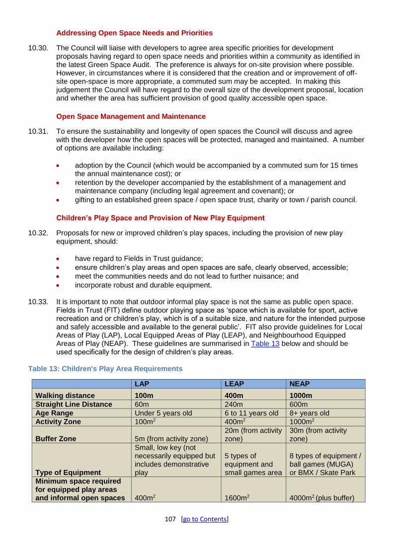
107 [go to Contents]
Addressing Open Space Needs and Priorities
10.30. The Council will liaise with developers to agree area specific priorities for development proposals having regard to open space needs and priorities within a community as identified in the latest Green Space Audit. The preference is always for on-site provision where possible. However, in circumstances where it is considered that the creation and or improvement of off-site open-space is more appropriate, a commuted sum may be accepted. In making this judgement the Council will have regard to the overall size of the development proposal, location and whether the area has sufficient provision of good quality accessible open space.
Open Space Management and Maintenance
10.31. To ensure the sustainability and longevity of open spaces the Council will discuss and agree with the developer how the open spaces will be protected, managed and maintained. A number of options are available including:
adoption by the Council (which would be accompanied by a commuted sum for 15 times the annual maintenance cost); or
retention by the developer accompanied by the establishment of a management and maintenance company (including legal agreement and covenant); or
gifting to an established green space / open space trust, charity or town / parish council.
Children’s Play Space and Provision of New Play Equipment
10.32. Proposals for new or improved children’s play spaces, including the provision of new play equipment, should:
have regard to Fields in Trust guidance;
ensure children’s play areas and open spaces are safe, clearly observed, accessible;
meet the communities needs and do not lead to further nuisance; and
incorporate robust and durable equipment.
10.33. It is important to note that outdoor informal play space is not the same as public open space. Fields in Trust (FIT) define outdoor playing space as ‘space which is available for sport, active recreation and or children’s play, which is of a suitable size, and nature for the intended purpose and safely accessible and available to the general public’. FIT also provide guidelines for Local Areas of Play (LAP), Local Equipped Areas of Play (LEAP), and Neighbourhood Equipped Areas of Play (NEAP). These guidelines are summarised in Table 13 below and should be used specifically for the design of children’s play areas.
Table 13: Children's Play Area Requirements
LAP LEAP NEAP
Walking distance 100m 400m 1000m
Straight Line Distance 60m 240m 600m
Age Range Under 5 years old 6 to 11 years old 8+ years old
Activity Zone 100m2 400m2 1000m2
Buffer Zone 5m (from activity zone) 20m (from activity zone)
30m (from activity zone)
Type of Equipment
Small, low key (not necessarily equipped but includes demonstrative play
5 types of equipment and small games area
8 types of equipment / ball games (MUGA) or BMX / Skate Park
Minimum space required for equipped play areas and informal open spaces 400m2 1600m2 4000m2 (plus buffer)

108 [go to Contents]
10.34. A play area proposal should be accompanied by ‘Risk Benefit Analysis’ (HSE Children’s Play and Leisure – Promoting a balanced approach). This will help to ensure all equipped play areas are safe, easily observed, accessible, provide challenges and do not lead to further nuisance.
10.35. To avoid undue financial burden on the Council, and to ensure ready access to the parts and materials to ensure equipment is maintained to an acceptable and safe standard, developers should ensure the equipment is robust and sustainable. Equipment will not be considered for adoption by the Council if it is considered to incur excessive maintenance and management costs, or is deemed unsuitable for the community. It is therefore important for developers to liaise with the Council prior to design and costings being commissioned.
10.36. The applicant should also provide the Council with a copy of the post installation inspection certificate certifying the play equipment meets the required safety standard. The inspection must be carried out by an independent registered Playground Equipment Inspector. The Council’s Play Equipment Inspector must also inspect the play area, if the Local Authority is to adopt it.
Policy 29: Ecological Networks (Strategic Policy) Proposals will only be supported which deliver a net gain for biodiversity and protect, create, maintain and enhance the Borough's ecological networks by: A) being of an appropriate size, scale and type in relation to their location within and impact on the
ecological network;
B) maintaining, strengthening and bridging gaps in existing habitat networks;
C) planting native species and creating new, or restoring existing, national and local priority habitats and/or species; and
D) working with strategic partnerships to deliver conservation projects at a landscape scale where
appropriate.
Explanation
10.37. The emphasis of nature conservation is shifting from protecting wildlife solely within discrete sites to establishing a network of core areas of habitat that are robustly linked together through habitat corridors resilient to environmental change and human pressure. An independent review21 of England’s wildlife sites and ecological network made five key recommendations: to improve management of existing wildlife sites; to increase the size of existing wildlife sites; to improve the connections between sites; to create new sites; and to reduce the pressure on wildlife by improving the wider environment. While the responsibility for achieving this does not solely lie with the development sector, it does have an important role to play. National planning policy requires development to be sustainable and compensate for damage to the environment as well as expecting the natural environment to function as an integrated network of habitats.
10.38. To assist with the vision of having a coherent ecological network the Council has identified a series of Biodiversity Opportunity Areas (See Figure 9). Development proposals within these areas can deliver the most for the ecological network by directing compensation or enhancement measures towards the creation or restoration of habitats that are particularly important for that part of the ecological network (as shown in Table 14). Landscape scale conservation partnerships, including Nature Improvements Areas (NIAs) and River Catchment Partnerships operate within the Biodiversity Opportunity Areas and plan and deliver strategic conservation objectives. The Dearne Valley Green Heart NIA and Humberhead levels NIA both
21 Making Space for Nature: A Review of England’s Wildlife Sites and Ecological Network. 2010

109 [go to Contents]
fall partly within Doncaster. Development proposals in proximity to these areas should look to contribute towards these initiatives, which will be key contributors to Doncaster’s ‘Nature Recovery Network’.
10.39. Doncaster’s Biodiversity Opportunity Areas have been selected based on regional level studies
to identify priority landscape scale project areas for conservation work, but adapted locally reflecting geological data or locally available habitat data, and split into smaller sections where this helps to target the types of habitat that the Council would like to see in an area more precisely. An additional two opportunity areas have been identified that encompass areas that are important locally in the ecological network.
Table 14: Biodiversity Opportunity Areas and Priority Habitats
UK BAP Priority Habitat
Landscape Scale Biodiversity Opportunity Area
Hed
gero
ws
Low
lan
d M
ixed
D
ecid
uo
us
Wo
od
lan
d
We
t W
oo
dla
nd
Low
lan
d C
alca
reo
us
Gra
ssla
nd
Low
lan
d M
ead
ow
s
Low
lan
d D
ry A
cid
Gra
ssla
nd
Low
lan
d H
eath
lan
d
Low
lan
d R
aise
d B
og
Low
lan
d F
en a
nd
Fl
oo
dp
lain
Gra
zin
g M
arsh
P
on
ds
Humberhead Peatlands - Thorne and Hatfield Moors
Humberhead Peatlands - River Torne
Finningley Cover Sands
Southern Magnesian -Limestone Ridge North Doncaster
Southern Magnesian -Limestone Ridge South Doncaster
Dearne Valley Doncaster
Ea Beck Washlands
Living Don - Mexborough and Denaby
Living Don - Don Gorge
Living Don - North Doncaster Levels

110 [go to Contents]
Figure 9: Biodiversity Opportunity Areas

111 [go to Contents]
Policy 30: Valuing Biodiversity and Geodiversity (Strategic Policy) The Borough has a range of internationally, nationally, and locally important habitats, sites and species that will be protected through the following principles: A) All proposals shall be considered in light of the mitigation hierarchy in accordance with National
Policy. B) Proposals which may harm designated Local Wildlife Sites, Local Geological Sites, Priority
Habitats, Priority Species, protected species or non-designated sites or features of biodiversity interest, will only be supported where:
1. they use the DEFRA biodiversity metric to demonstrate that a proposal will deliver a
minimum 10% net gain for biodiversity; 2. they protect, restore, enhance and provide appropriate buffers around wildlife and
geological features and bridge gaps to link these to the wider ecological network; 3. they produce and deliver appropriate long term management plans for local wildlife and
geological sites as well as newly created or restored habitats; 4. they can demonstrate that the need for a proposal outweighs the value of any features to
be lost; and 5. if the permanent loss of a geological site is unavoidable, then provision will be made for
the site to first be recorded by a suitably qualified expert. C) Proposals which may impact Special Areas of Conservation, Special Protection Areas or
RAMSAR Sites will only be supported where it can be demonstrated that there will be no likely significant effects and no adverse effects on the integrity of European sites, unless there are no alternative solutions and it is justified by an “imperative reasons of overriding public interest” (IROPI) assessment under the Habitats Directives.
D) Proposals that may either directly or indirectly negatively impact Sites of Special Scientific Interest will not normally be supported. Proposals should seek to protect and enhance Sites of Special Scientific Interest and maintain, strengthen, and bridge gaps to link them to the wider ecological network wherever possible.
E) In order to ensure development does not negatively impact on nightjar populations, proposals
located within 3km of Thorne and Hatfield Moors Special Protection Area, that impact habitats that nightjars may use for feeding on, will only be supported where they deliver a net gain in nightjar foraging habitat.
Explanation
10.40. National planning policies and legislation protect international sites, such as Thorne and Hatfield Moors Special Area of Conservation and Special Protection Area, and Doncaster's 15 Sites of Special Scientific Interest Figure 10). The Council will work in partnership with other agencies to ensure the interests of all these sites are protected and enhanced. Thorne and Hatfield Moors Special Protection Area is designated as it supports more than 1% of Great Britain’s population of breeding pairs of nightjar. While the breeding habitat of nightjar is protected by the boundary of the Special Protection Area birds fly several kilometres from their nesting sites to find food. It is therefore important that their feeding habitats, which cover a large area in the east of the Borough, are protected. In addition the Borough has approximately 350 local wildlife and geological sites, many of which are in private ownership. As well as their biodiversity or geodiversity value local sites contribute to the distinctive character of an area making the Borough a pleasant place to live and work. This policy will help ensure these sites are protected during development and managed appropriately for the features for which they are designated.

112 [go to Contents]
10.41. The use of the mitigation hierarchy will ensure that the most valuable ecological features of a site are protected and harm to biodiversity is minimised. In line with best practice, the provision of compensation to account for residual biodiversity impacts will not be allowed unless the prior steps of the mitigation hierarchy have been followed, and all opportunities to avoid and then minimise negative impacts have first been pursued. Impacts on irreplaceable habitats such as ancient woodland and lowland raised mire will not be supported and cannot be accounted through a Net Gain approach. Using the latest DEFRA biodiversity metric is an effective way of accounting for the impacts of a proposal on biodiversity and demonstrating that a net gain will be delivered. It also provides flexibility and encourages projects to consider biodiversity from the outset. Use of the metric rewards schemes that minimise their impacts but also gives options to developers in terms of whether necessary mitigation is delivered on or off site. A minimum 10% net gain will be expected unless national standards increase this in the future. In order to properly inform applications, surveys will be required in line with the latest British Standard (BS42020 2013 or its replacement). It is expected that compensation will be directed towards projects that contribute to Doncaster’s Nature Recovery Network and other biodiversity and landscape scale conservation priorities. Proposals can sometimes affect land surrounding, or neighbouring, local sites as well as impacting them directly. Proposals can sometimes affect land surrounding, or neighbouring, local sites as well as impacting them directly. The policy therefore requires that appropriate buffers are provided around Local Sites to ensure that the features of interest for which a site is designated are not lost. Where necessary the Council will also seek planning obligations to help to bring a greater number of Doncaster's local sites into good management and secure their long term sustainability. This is important as it will not only preserve the extent of the ecological network but also improve the quality of the habitats present.
10.42. The policy will also protect breeding populations of nightjar on Thorne and Hatfield Moors. Nightjar feed on insects such as moths so habitats such as hedgerows, scrub, grassland, ditches and ponds are therefore important. This policy will ensure no net loss of these types of habitat and hence protect this important internationally designated site. In line with the aim of supporting jobs and growth in the Borough of Doncaster the policy gives flexibility in terms of whether sites retain existing habitats or choose instead to create new habitats nearby in compensation for those that will be lost (all offsite habitat creation must still be within 3km of the SPA). Developments that do not result in the loss of, or damage to, nightjar foraging habitat would not trigger the policy and therefore would not be required to create new nightjar foraging habitat.
10.43. The Local Biodiversity Action Plan and Geodiversity Action Plan describe Doncaster's biodiversity and geodiversity resource and Doncaster’s Green Infrastructure Strategy 2014 sets targets to focus their conservation. The Council has also set out criteria defining why an area will be designated as a local wildlife or geological site. The location of Local Sites are shown on the Policies Map. Together with published information on nationally and internationally designated sites these resources tell us where many of Doncaster's important habitats and species are located. The Council’s website also provides a Biodiversity Map22 that collates all the latest information on biodiversity and geodiversity designations and nature conservation areas such as Nature Improvement Areas and Biodiversity Opportunity Areas.
22 https://www.doncaster.gov.uk/services/planning/local-wildlife-and-geological-sites

113 [go to Contents]
Figure 10: National and International Wildlife Sites

114 [go to Contents]
Policy 31: Local Wildlife and Geological Sites Local Wildlife and Geological Sites will be identified and designated by the Council and are shown on the Policies Map. Other sites, including those awaiting designation, which can be demonstrated to meet the selection guidelines for Local Sites will be afforded the same level of protection.
Explanation
10.44. Local Sites are areas of land that support recognised and valued attributes concerning habitats, species or geological features, which by definition (as set out within the site selection guidelines in Appendix 8) are of substantive local biodiversity or geodiversity importance. Local Sites therefore represent the core biodiversity components of local ecological networks, and complement statutory sites such as Sites of Special Scientific Interest which are designated to protect the best examples of the UKs flora, fauna and geological features. This policy is the mechanism by which these important core sites are identified and their substantive interests can be taken into account as part of development proposals. Protecting and maintaining a functioning ecological network which includes these biodiverse Local Sites, enables the natural environment to effectively deliver ecosystem services and adapt to pressures such as climate change and development. Enhancing, buffering and connecting Local Sites will contribute to the Borough’s ‘Nature Recovery Network’.
10.45. The designations shown on the Policies Map represent our knowledge and assessment of Local Sites at a fixed point in time and it is important to note that this is a snapshot of an ongoing process of review. The Council works with conservation partners to continuously collect and record environmental information and assess sites against the Local Site selection guidelines. The conservation value of existing Local Sites as well as non-designated sites may change over time and it is expected that new sites will come forward for designation whilst others will need to be removed from the series. It is therefore necessary for the Local Site series to be updated, using the Local Site selection guidelines, to ensure that all sites can be demonstrated to be of substantive biodiversity and geodiversity interest. Any site that can be shown to meet the Local Sites selection guidelines will receive the same level of protection as a designated site but may not be shown on the Policies Map until it is updated.
10.46. The environmental information we hold about Local Sites is managed by the Doncaster Local Records Centre and forms the primary evidence base for the implementation of this policy. Information supporting development proposals is therefore expected to consider this information and address how the biodiversity and/or geodiversity features underpinning a site’s reasons for designation will be protected and enhanced to provide a net biodiversity gain. In some scenarios Local Sites may offer appropriate receptor areas for biodiversity compensation measures resulting from development elsewhere, i.e. through an agreed Biodiversity enhancement scheme.
Policy 32: Woodlands, Trees and Hedgerows Proposals will be supported where it can be demonstrated that woodlands, trees and hedgerows have been adequately considered during the design process, so that a significant adverse impact upon public amenity or ecological interest has been avoided. There will be presumption against development that results in the loss or deterioration of ancient woodland and/or veteran trees. Proposals will need to include: A) the submission of survey information of woodland, trees and hedgerows, as appropriate, to a
recognised professional and fit for purpose standard which is able to demonstrate evaluation of these features for realistic long-term retention, and how this has positively informed the design process;
B) demonstration of how retained features are to be protected during development;

115 [go to Contents]
C) an adequate landscape buffer (which excludes built development and residential gardens)
adjacent to existing woodlands, wildlife sites and at settlement edges;
D) sufficient provision of appropriate replacement planting where it is intended to remove trees and
hedgerows; and E) avoidance of the loss or deterioration of woodland.
Explanation
10.47. A pleasant and attractive environment including woodlands, trees, shrubs and other green assets contributes to maintaining and improving the quality of life for people living and working in Doncaster and is significant in helping to attract new investment into the Borough. The evaluation of these existing assets is an important part of the design process for development proposals. Retaining positive green infrastructure assets wherever possible ensures the environment is not damaged and that these assets are available for the benefit of future generations. This is particularly important for woodlands, especially ancient woodlands which have an unbroken history of tree cover and are uniquely valuable and irreplaceable habitats, with no effective form of compensation for their loss or deterioration.
10.48. Trees can also confer economic benefits to Doncaster through the provision of ‘ecosystem services’. Such services include the production of oxygen, the capture and storage of carbon, the removal of pollutants from the air and the slowing of storm water run-off. Trees are an essential component of urban biodiversity providing food and shelter to many important native and migratory birds and animals and provide a vital resource of deadwood for many invertebrates.
10.49. The retention of trees and hedgerows that are present on or adjacent to a site is a consideration whether or not they are protected. New tree planting should be recognised from the outset as an integral part of any development scheme, not just those where it is proposed to remove existing trees. Development layouts should be designed to ensure that retained and newly planted trees have sufficient space to flourish and mature and deliver their full range of environmental benefits without causing harmful nuisance. Trees, which are poorly related to buildings, can cause structural problems, distress or financial loss to occupants. In order to deliver the greatest environmental benefits, the use of native tree and hedgerow species will be encouraged where appropriate.
10.50. In no circumstances should woodland be included within residential curtilage and an appropriate buffer zone will normally be required between the woodland edge and development, although it may be possible to locate non-amenity uses within these areas (e.g. service roads or garages), subject to other constraints. Maintaining the ecological connectivity of woodlands via green corridors is a key consideration, and the function of hedgerows is particularly important in this respect. Proposals that either directly or indirectly result in the loss or deterioration of ancient woodland will not be supported unless the need for and benefits of the development at that location clearly outweigh the loss. When considering the planning balance in these cases compensation proposals must not be considered as part of the benefits resulting from a development.
10.51. There are nationally recognised surveying methods (for example, the current version of British Standards Institute 5837: Trees in relation to design, demolition and construction – Recommendations; Defra (2007) and the Hedgerow Survey Handbook, a standard procedure for local surveys in the UK). These are readily available online to aid the planning process. The Borough’s Green Infrastructure Strategy sets out the key principles that ensure that the provision of green assets is embedded in to the design of development, adding value to the place-making process. Supplementary Planning Documents may be prepared to support this policy.

116 [go to Contents]
Policy 33: Landscape (Strategic Policy) Proposals will be supported that take account of the quality, local distinctiveness and the sensitivity to change of distinctive landscape character areas and individual landscape features, in particular Thorne and Hatfield Moors. Development will be permitted provided that it conserves, enhances and, where possible, restores: A) the landscape character and local distinctiveness of the area including its historical, biodiversity,
cultural character and its tranquillity;
B) the distinctive setting of, and relationship between, settlements and buildings and the landscape including important views;
C) the nature conservation value of the area including the pattern of woodland, forests, trees, field boundaries, vegetation and other features;
D) the special qualities of rivers, waterways, wetlands and their surroundings; and
E) the topography of the area including sensitive skylines, hillsides and geological features.
Where development proposals will most likely result in a significant impact on the Borough’s landscape the proposals should assess the potential impact (including cumulative impact) and propose how any negative effects will be minimised. In doing so consideration should be given to: F) alternative site selection;
G) the scale, massing, design, form, layout, orientation and/ or operation of the development;
H) the incorporation of suitable mitigation measures; or
I) where suitable mitigation measures are not achievable on site, then development should
provide appropriate compensation off site. Landscape works shall be appropriate to the scale of the development in accordance with Policy 48 (Landscaping of New Developments).
Explanation
10.52. Landscape setting is an important element contributing to local character and quality of life. It is concerned with the positive, distinct, recognisable and consistent pattern of elements that make each landscape and settlement different. These elements are defined by geology, landform, drainage, vegetation cover, settlement pattern and land use. The policy is needed to protect, maintain and enhance the distinct character, identity and setting of existing settlements. This in turn will help to support local distinctiveness, regeneration and foster community pride by maintaining and enhancing a sense of place for people living in different areas. This policy will help the Borough to grow but in a manner that is sensitive to its landscape.
10.53. The landscape character and quality of the Borough’s countryside varies considerably. To the west and south lies the attractive belt of Magnesian limestone country bisected by the Don and Went Gorges, well wooded and mostly intensively farmed. To the east is the Bunter sandstone, less hilly and quite extensively farmed. To the north-east lies a much larger and generally flat landscape, criss-crossed by drainage ditches and with extensive peat moors. Distinctive local elements such as hedgerows, trees, copses, woodlands, river valleys, ponds, watercourses, historical sites, estate features, enclosure landscapes, stone walls and other built heritage features all contribute to the overall character. The tranquillity of significant areas of

117 [go to Contents]
undisturbed countryside also contributes substantially to the quality of the countryside and its enjoyment.
10.54. The Landscape Character and Capacity studies in Doncaster describe variations in the landscape, which make one area distinctive from another, and assess landscape sensitivity and the capacity of the landscape to accommodate various types of development without adverse effects. These will be material considerations in the determination of relevant planning applications.
10.55. Support will be given to initiatives, strategies and projects working towards or contributing to landscape scale conservation, implementing an integrated approach to managing the environment and all its functions.
10.56. Landscape scheme preparation shall be appropriate to the scale of the development and its impact, and shall have regard to appropriate technical standards. Consideration shall be given to:
potential future climate change
existing soil resource and the requirements for ground preparation
retention of existing vegetation
appropriate species selection and spatial requirements
site utilities, services and circulation
tree planting sizes, specifications and accessories
sustainable drainage, including use of green roofs, rain gardens and rainwater harvesting
community involvement, access and safety issues
maintenance and management including replacements of failed stock.

118 [go to Contents]

119 [go to Contents]
Chapter 11: The Historic Environment
Introduction
11.1. Doncaster's rich and diverse heritage assets include evidence of early settlements, castles, country houses and estates, nationally significant parks and gardens, historic market towns and villages, ecclesiastical, agricultural, civic and industrial buildings, railway and canal structures, twentieth-century suburbs and planned colliery settlements. The geology of the Borough gives rise to an interesting variety of vernacular building materials from sandstone buildings to the west, through limestone buildings, to brick and timber-framed buildings to the east. Stone slate, Welsh slate and clay pantile roofs are distinctive characteristics of parts of the Borough. Policy 34 identifies those heritage assets that are of particular importance to the distinctive character of Doncaster and the enjoyment of its historic environment and how those assets will be conserved for the future.
11.2. The development management policies which apply to the historic environment of the Borough follow the significance led approach of national policy in the NPPF. An adequate analysis of the significance of heritage assets affected by proposals is essential for understanding the impact of any such proposals so Policy 35 and its supporting text is fundamental to good decision making. This is followed by more detailed policies for all types of applications affecting designated and non-designated heritage assets within Doncaster so that applicants may make more successful applications. These policies either expand on those within the NP `PF or develop on areas where the NPPF is silent.
11.3. The benefits of these policies should contribute towards improving the quality of the historic built and landscaped environment and, in conjunction with other design policies, the stimulation of high architectural quality in new buildings, the creation of a stronger local identity and sense of place, increased sustainability, and the encouragement of local building craft skills.
Policy 34: Valuing our Historic Environment (Strategic Policy) Doncaster’s historic environment will be conserved in accordance with the following principles: A) Proposals and initiatives will be supported which preserve and, where appropriate, enhance the
heritage significance and setting of the Borough’s heritage assets (including locally identified undesignated heritage assets), and especially those elements which contribute to the distinct identity of the Borough. These include:
1. the nationally-important waterlogged archaeological remains at Sutton Common, Thorne
Moor, and Hatfield Moor; 2. the Roman camps and settlements, motte and bailey castles, historic houses, historic
parks and gardens and villages, with special regard to those along the Southern Magnesian Limestone Ridge;
3. the Georgian townscape and the railway heritage of Doncaster, its historic grain, including its street layouts and plot sizes and key views and vistas especially of the spires and towers of Doncaster’s churches;
4. the Borough’s historic market towns such as Thorne, Hatfield, Bawtry, and Tickhill; 5. early twentieth century suburban developments, including planned colliery villages; and 6. sites and structures associated with aviation history including the heritage of the second
world war and cold war. B) Proposals and initiatives will be supported which improve the accessibility and enjoyment of the
Borough’s existing and potential local, regional and national historic attractions in keeping with their heritage significance. These include:

120 [go to Contents]
1. The Mansion House 2. Cusworth Hall and its parkland 3. Doncaster Minster (St. George’s Church) 4. Conisbrough Castle 5. Brodsworth Hall and parkland.
C) Proposals and initiatives will be supported which identify, promote and secure the long term
future of Doncaster’s heritage assets. These include:
1. increasing and making publically available our knowledge and understanding of the historic environment gained through the planning process;
2. continuing to review existing and prospective parks and gardens of local historic interest and consideration of the designation of buildings of local architectural and historic interest;
3. the identification of heritage assets at risk and implementing strategies and initiatives to reduce their number through positive management;
4. supporting the re-use of sites and buildings of heritage significance putting them to viable uses consistent with their conservation; and
5. supporting investment in the repair and maintenance of Doncaster’s historic buildings.
Explanation
11.4. The Borough has around 800 listed buildings, designated nationally. In addition, we have 4 nationally registered parks and gardens of special historic interest and 51 nationally designated scheduled monuments. These are detailed in The National List for England which is publically available. The Borough has designated 46 conservation areas reflecting the variety of heritage assets described in Policy 34 and their individual characteristics contribute to the distinctive character of the Borough.
11.5. Undesignated heritage assets also contribute to local character. There are 26 parks and gardens of various types we have identified as being worthy of designation as Parks and Gardens of Local Historic Interest. The Borough has a rich archaeological record which can be found in the Sites and Monuments Record held by the South Yorkshire Archaeology Service (SYAS). Outside conservation areas there are likely to be numbers of historic buildings and structures which while not meriting national listing also contribute to local distinctiveness. The process of identifying such buildings and structures is described under Policy 40 below.
11.6. Part A of this policy together with the supporting policies in this chapter explains how the Borough’s historic environment will be sustained and enhanced particularly with regard to reinforcing local distinctiveness. Part A identifies particularly important elements which contribute to the distinctive character of the Borough which is intended to give them additional weight in planning decisions. This policy places importance on identifying and protecting the distinctive local identity of the Borough’s heritage assets whether these be ‘designated’ (e.g. listed buildings, conservation areas or Scheduled Monuments) or ‘undesignated’ (e.g. local parks and gardens of historic interest or as yet unknown archaeological remains).
11.7. The purpose of Part B of this policy is to give increased weight in decision making to proposals that serve to increase the accessibility to, and enjoyment of, key buildings which are important to the heritage of the Borough and to encourage greater opportunities for use of the historic environment in education and increased levels of investment and tourism. Heritage assets of national significance are identified in the policy but the policy is intended to apply equally to other heritage assets of regional or local significance. How the long-term conservation of the Borough’s heritage assets can be achieved through the planning process is identified in Part C of the policy.

121 [go to Contents]
Figure 11: Designated Heritage Assets in Doncaster

122 [go to Contents]
Policy 35: Understanding and Recording the Historic Environment Proposals that affect known or potential heritage assets will require: A) The provision of a heritage statement (or its equivalent) that includes:
1. sufficient information to gain an understanding of the potential impact that the proposals will have on the significance of any heritage assets or historic environment likely to be affected; and
2. for heritage sites with archaeological interest, at least a desk-based assessment and, where appropriate, the results of a field evaluation.
B) In the exceptional circumstances where harm could be justified, detailed investigation and recording will be required to an agreed standard in advance of any alteration, demolition or groundwork to ensure that an understanding of the affected heritage asset is gained and that knowledge is widely publicised including deposition of the site archive with the relevant archive repository and deposition of a report on the results with the South Yorkshire Sites & Monuments Record (Historic Environment Record).
Explanation
11.8. Many proposals lack an adequate appraisal of their impact on the Borough’s historic environment and heritage assets23. Therefore, this policy reinforces national policy in requiring that proposals for such assets be supported by an adequate heritage statement so that the heritage significance referred to in other policies is clearly understood and informs decisions.
11.9. Part A of this policy explains what is required for proposals affecting all heritage assets. An adequate analysis of the heritage asset is essential for understanding the impact of any such proposals. The degree of information required should be proportionate to the significance of the heritage asset and, for minor applications, the heritage statement can be incorporated into a design and access statement (if this is also a requirement). A heritage statement should include details of how the assets and their significances will be affected by the proposed development, demonstrate a clear understanding of the significances, and show how the proposals will minimise any adverse impacts on the asset and its setting. Where the proposal is likely to result in harm to a heritage asset the justification for any harm (including any public benefits arising from the proposed development) should be set out in the heritage statement. As a starting point for any applications affecting heritage assets, particularly those of archaeological interest, the Sites and Monuments Record held by the South Yorkshire Archaeology Service should be consulted. A good understanding of the significance of the heritage asset is the foundation for applying all of the heritage policies below.
11.10. National Policy explains that there are exceptional circumstances, for example, where there would be benefits to the community or for sustainable development, that would decisively outweigh the historic value of the heritage asset, where loss or damage to heritage assets may be acceptable. In such circumstances Part B of this policy sets out the Council’s expectations that a developer will undertake an appropriate level of recording for the historic building or archaeological asset so that understanding of the contribution of that asset to local character is not completely lost but adds to our knowledge of the heritage of the Borough.
11.11. Where loss or damage has been agreed to a heritage asset, an appropriate record will need to be achieved through detailed recording. For historic buildings this may take the form of a photographic or drawn survey, depending on the building. This must be carried out in advance of any alteration or demolition works taking place. Where loss or damage has been agreed to historic landscape features or archaeological sites, detailed recording in the form of earthwork
23 defined in Glossary

123 [go to Contents]
survey and/or excavation will be carried out in advance of any groundworks (including removal of foundations and other clearance works) taking place. The Council can advise on the level of recording required for individual heritage assets.
11.12. Making such information publicly available is enshrined in the NPPF. Therefore, where such recording has been carried out, the results, and any ensuing analyses and research, must be written up and published and the resulting archive deposited with an appropriate archive repository. Opportunities should be sought for the results to be interpreted and displayed on site within the new development.
Policy 36: Listed Buildings Development proposals affecting a listed building or its setting will be assessed against the following principles: A) Proposals that enhance or better reveal the significance of a listed building or structure will be
supported. Proposals that harm the significance of a listed building or its setting will not be supported other than in circumstances where that harm is clearly outweighed by the public benefits of the proposal having regard to the significance of the heritage asset affected.
B) Alterations and extensions to a listed building will be considered acceptable where they are sympathetic to the historic proportions and massing of the building; make use of materials that complement the materials used on the building; and preserve and enhance its special interest.
C) Measures for improving the energy efficiency of a listed building will be supported where they do not conflict with its special interest as a listed building. Where there is a conflict of interest the Council will weigh the public benefits of the proposal against the harm to the listed building having regard to the significance of the heritage asset.
D) A proposal for a change of use to a listed building would be considered acceptable where it does not harm its heritage significance. Where a change of use requires significant alterations with potential harm to the listed building it will be necessary to demonstrate that the proposed alterations are necessary to secure the long term survival of the listed building.
E) Permission will not be granted for proposals which would result in substantial harm or total loss of a listed building or structure unless the building cannot reasonably be repaired and the Council is satisfied that every effort has been made to secure, repair, or reuse the building, to find an alternative use through maintenance, grant assistance, or offer for sale or lease, or, that there are substantial and demonstrable public benefits to be gained which outweighs the loss of the building.
Explanation
11.13. This policy expands on the requirements for proposals affecting listed buildings or their settings. The policy should be applied alongside Policy 35 which requires that proposals should be informed by an understanding of the heritage significance of the listed building.
11.14. That heritage significance can include the form of the building, its materials, its proportions and detailing, or other factors as may be revealed during the planning process. For example, traditional limestone buildings in the rural villages and countryside in the west of the Borough often use random coursed rubble limestone, clay pantile roof, and timber windows. Modern low cost or mass produced alternatives tend not to complement these and lead to erosion of character and local distinctiveness.
11.15. Understanding the heritage significance of a listed building includes assessing the contribution made by its setting. For example, the Borough contains a number of heritage assets of different designations in the form of great houses and associated formal gardens where the wider

124 [go to Contents]
landscape also forms part of the setting. Proposals affecting the setting of a listed building should contain sufficient information in the application to assess the impact of a proposal on that setting.
11.16. Where the significance of a listed building has been lost or eroded through inappropriate alterations, proposals which will restore the building may be supported but would need to be justified within a heritage statement. The considerations that would apply in any assessment include:
whether the significance of the elements that would be restored decisively outweigh those that would be lost;
the work proposed is justified by compelling evidence of the evolution of the building and is executed in accordance with that evidence;
the current form of the building is not the result of an historically significant event;
the work proposed respects previous forms of the place; and
the maintenance implications of the proposed restoration are considered to be sustainable.
11.17. Ensuring that extensions and alterations to listed buildings reflect the character of these buildings and encouraging the reversal of unsuitable alterations will contribute to retaining the distinctive local identity of the Borough.
11.18. It is recognised that the conservation of energy and the improvement of thermal efficiency of buildings will be of increasing importance in future years and that there is increasing pressure on listed buildings to adapt. Part C of this policy is intended to apply to proposals for small scale micro-generation equipment such as solar panels or for proposals for improving energy efficiency such as external cladding or upvc double glazing which require alteration to a listed building. Such proposals can have an adverse impact on its character as a listed building. For example, altering the external cladding of limestone buildings, solar panels against clay pantile roofs, or unsympathetic upvc frames can all impact adversely on some historic buildings whereas others can absorb a degree of change.
11.19. Such alterations to listed buildings require listed building consent and where planning approval or listed building consent is needed the proposal should balance the needs of the environment with the heritage value of the building. Where the special interest of a listed building precludes alterations that may be acceptable elsewhere other opportunities should be sought to improve the thermal efficiency of the building.
11.20. The demolition of a listed building should only be considered in exceptional circumstances which are outlined in national planning policy on substantial harm or total loss of significance to a heritage asset. The criteria for assessing such proposals are covered in Part E of this policy. Where such loss occurs, a degree of building recording proportionate to its heritage value as described in Policy 35 would be required.
11.21. Historic England, in conjunction with the Council, has developed databases of Grade I and II-star Listed Buildings at Risk and the Council has also prepared a list of Grade II Listed Buildings at Risk. Strategies and initiatives to reduce the number of buildings and areas at risk are being developed by the Council. Decision making through the planning process is an important part of this strategy and finding a sustainable use for a historic building ‘at risk’ would be considered a public benefit

125 [go to Contents]
Policy 37: Conservation Areas Development proposals affecting, or within the setting of, Conservation Areas will be assessed according to the following principles: A) Proposals should take fully into account the identified significance contained in the
Conservation Area Appraisal for the relevant designated area where published.
B) Proposals should not detract from the heritage significance of a conservation area by virtue of their location, layout, nature, height, density, form, scale, materials or design or by the removal of trees, the loss of important open spaces or other important landscape features, or through adverse impact on key views and vistas. Proposals that result in harm to a conservation area will be refused unless the harm is outweighed by public benefits arising from the development.
C) Proposals will be supported where it can be demonstrated that they will enhance or better reveal an element which can contribute to the character and appearance of the conservation area. Proposals within conservation areas requiring the demolition of buildings that make a positive contribution to the conservation area will not be supported unless the building is currently derelict and is incapable of rehabilitation; or the removal of the building, and/or the proposed redevelopment of the site, would result in demonstrable public benefits sufficient to outweigh the harm.
D) Any proposal for the demolition of a building or site in a conservation area will need to be
accompanied by an acceptable redevelopment scheme or a remedial scheme for making good the building or site which will be required to be implemented immediately following demolition.
Explanation
11.22. Conservation Areas are designated by the Council, as local planning authority, under national legislation and Councils are required to pay special attention to the desirability of preserving or enhancing their character and appearance. Conservation area appraisals and management proposals will be used to identify and assess local character and promote enhancement. There is an ongoing programme of appraisals for these designations which are now publicly available for all the Doncaster town conservation areas and most of the major settlements. In addition, the key characteristics of each of the Borough’s conservation areas are described in conservation area character summaries on the Council’s website.
11.23. Proposals will be expected to preserve and/or enhance the character and appearance of a conservation area. In identifying the key elements of character and appearance which contribute to the heritage significance of a conservation area, proposals should draw on published conservation area appraisals where these exist and use these to inform heritage statements. Enhancement can include the demolition of an unsightly building and/or sympathetic redevelopment of a site particularly where identified in conservation area appraisals and management plans as a site or building where change is encouraged.
11.24. Part B of the policy describes in detail the criteria by which proposals will be assessed in determining applications in or affecting conservation areas. The policy also explains exceptional circumstances where harm may be accepted. Harm may be localised to a part of the conservation area or (particularly in small conservation areas) may be substantial. Public benefits may be anything that delivers economic, social or environmental progress but should be of a nature or scale to be of benefit to the public at large and should not just be a private benefit.
11.25. Part C of this policy includes the criteria by which proposals for the demolition of buildings which
make a positive contribution to the character and appearance of a conservation area are assessed. It is important to note that the test for public benefits will be more stringent depending on the significance of the building and its impact. In the event that permission to

126 [go to Contents]
demolish a historic building is granted a degree of building recording proportionate to its heritage value as described in Policy 35 would be required.
11.26. Part D of the policy is intended to ensure that demolition proposals do not result in long term
unsightly gaps which detract from the character and appearance of a conservation area.
11.27. In conservation areas, where significant harm may be caused to its character and appearance through permitted development rights, the Council will consider the introduction of Article 4 directions to restrict such rights in order to preserve the character of the conservation area.
11.28. Sufficient information is required in an application to fully understand the impact of a proposal on a conservation area. Normally full planning permission would be required for proposals within conservation areas. Outline applications are unlikely to provide the degree of information required to properly assess a proposal affecting a conservation area.
11.29. This policy applies to all development within or affecting conservation areas. Ensuring that alterations to conservation areas retain the character of these areas will contribute to retaining the distinctive local character of the Borough.
Policy 38: Historic Parks and Gardens Development affecting Historic Parks and Gardens will be assessed against the following principles: A) Development proposals within, or affecting, Doncaster’s nationally registered parks and
gardens, and parks and gardens of local historic interest (as shown on the Policies Map), should preserve and, where appropriate, enhance the heritage significance of these parks and gardens.
B) Proposals affecting a historic park of local or national significance should not result in harm to the built or landscape features or key views or vistas which contribute to the significance of the historic park or garden, or which might prejudice future restoration.
C) Where proposals result in harm or substantial harm to the significance of a nationally designated historic park the proposal will be considered in relation to the extent of harm arising from the proposal, the relative significance of the historic park and garden, and any public benefits arising from the proposal. In the case of parks and gardens of local interest a balanced judgement will be taken weighing the scale of any harm against the significance of the park.
Explanation
11.30. Nationally registered parks and gardens are ‘designated heritage assets’ with the highest priority for protection and the Garden History Society will be consulted on applications affecting Historic Parks and Gardens on the national register.
11.31. A further 26 Parks and Gardens of local historic interest have been identified at the outset of this Plan. The heritage significance of these, the process of assessment, together with the criteria by which they were assessed is described in the document ‘Identification and Assessment of Parks and Gardens of Local Historic Interest’ which is on the Council’s website. The identification and assessment of these parks and gardens was subject to a process of public consultation explained in the document. The criteria by which these were selected are included as Appendix 9 which will be revised periodically, and amended and updated as necessary, in light of changes in national guidance and changing circumstances. The Council will continue to review existing and any prospective parks and gardens of local historic interest.
11.32. The merits of any proposal should be weighed against the impact on its relative heritage significance. In assessing proposals for these local designations the statement of their
127 [go to Contents]
significance is a material consideration.
11.33. Whilst some historic parks and gardens are in private ownership others are public parks used for recreation. Part B of the policy is required so that where there is development for recreation uses those features which contribute to the character of the park or garden are not overlooked and that the opportunity for restoration in future is not prejudiced.
11.34. Normally full planning permission would be required for proposals within a historic park and garden in order to fully understand the impact of the proposal on their heritage significance.
11.35. This policy applies to all development within national and locally designated historic parks and gardens. Ensuring that alterations to historic parks and gardens retain the character of these landscapes will contribute to retaining the distinctive local character of the Borough.
Policy 39: Development Affecting Archaeology Development affecting archaeological remains will be assessed against the following principles: A) Development that would result in harm to the significance of a scheduled monument or other
nationally important archaeological assets will not be permitted other than in exceptional circumstances.
B) Development affecting other archaeological assets will need to demonstrate how any benefits
will outweigh harm to the site. When development affecting such sites is justifiable, the Council will seek to ensure preservation of the remains in situ as a preferred solution. When in situ preservation is not justified, the developer will be required to make adequate provision for appropriate investigation and recording including excavation in accordance with Policy 35.
Explanation
11.36. Archaeological remains are a finite resource containing irreplaceable information about the past and are valuable in themselves and for their contribution towards education, recreation and the economic life of the Borough. The Council believes that archaeological and historic remains should not be needlessly destroyed and their presence is a material consideration in applications for new development. The purpose of this policy is to set out the principles by which development affecting archaeological remains will be assessed. As a first step in developing proposals it is important to understand the nature, significance, and physical extent of the archaeological remains present, and the impact on these of the proposal, as required in Policy 35.
11.37. Part A of the policy makes it clear that development proposals that would result in harm to the significance of scheduled monuments or other nationally important archaeological sites will not be permitted other than in exceptional circumstances, which are set out in the NPPF. This also adds that substantial harm or loss should not be permitted other than in wholly exceptional circumstances.
11.38. Part B of the policy sets out the approach that will be taken towards developments likely to affect archaeological sites of regional or local importance. In the case of such archaeological remains, there is a need to reconcile the relative importance of the remains with the need for the development. Developments should be located or designed to avoid archaeological remains, to ensure that these remains are preserved in situ. Where in situ preservation is not justified or feasible, and the development proposal is acceptable in principle, the developer will be required to make appropriate and satisfactory provision for the excavation and recording of the remains before planning permission is granted, as set out in Policy 35.
11.39. Archaeological sites of national and local importance are identified in South Yorkshire’s Sites and Monuments Record. More and more information about the Borough’s archaeological

128 [go to Contents]
record is being revealed through investigation and recording as a result of the planning process. Part B of this policy would lead to this information becoming more widely accessible and will inform future decision making.
Policy 40: Buildings or Structures of Local Historic Interest Development proposals affecting buildings that meet the criteria of buildings of local historic interest, either as part of a local list or as part of the planning application process, will be assessed against the following principles: A) Proposals which retain those elements of a building of local historic interest which have been
identified as contributing to its heritage significance, or proposals which better reveal its significance will be supported.
B) Proposals should seek to avoid harm to those features, including setting, which contribute to the significance of the building of local historic interest. Where proposals result in harm or substantial harm to the significance of a building of local historic interest a balanced judgement will be made taking into account the degree of harm and relative significance of the heritage asset.
Explanation
11.40. Many historic buildings are not of national significance but contribute to local character in various ways or have local historic interest. Outside conservation areas their historic character is not currently a planning consideration. As part of a positive strategy for the conservation and enjoyment of the historic environment required by the NPPF the Council will seek to identify unlisted buildings of heritage significance through a local list of buildings of architectural and historic interest with priority given to such buildings outside conservation areas. A set of criteria for compiling such a list is included in Appendix 10 and the process for establishing such a list will be subject to further public consultation. The criteria will be revised periodically and amended and updated as necessary in light of changes in national guidance and changing circumstances. Once a local list that has undergone public consultation is established the heritage significance of buildings or structures on the list would be a material consideration in planning applications.
11.41. Policy 40 establishes the policy framework to assess such applications. Where buildings have been identified by the Council as buildings of local architectural or historic interest proposals for alterations or extensions will be expected to retain the heritage significance of such buildings including their setting. The policy recognises that less weight would be given to these ‘undesignated’ heritage assets relative to ‘designated’ assets and that a balanced judgement would be required in assessing applications. Policy 40 would apply to local list buildings located outside conservation areas. Locally listed buildings within conservation areas would be subject to Policy 37 on conservation areas. Buildings that meet the local list criteria may also be revealed as part of the planning application process or through the neighbourhood plan process. Such buildings would also be subject to Policy 40 unless they are within a conservation area where Policy 37 would apply, or in the case of neighbourhood plan buildings of local heritage significance, are subject to specific neighbourhood plan policies.
11.42. This policy will contribute to the preservation and enhancement of Doncaster’s historic environment through conserving the heritage value of these buildings and this would also assist in retaining local distinctiveness particularly where such buildings are located outside conservation areas.

129 [go to Contents]

130 [go to Contents]
Chapter 12: Design and the Built Environment
Introduction
12.1. National planning policy requires new developments to be well designed and appropriate to the area in which they are located. The following policies focus on proposals within the urban environment and should be considered alongside the national requirements – they provide a framework for the assessment of the design aspects of proposals.
12.2. In meeting these policies development will help contribute to the Local Plan vision and objective of ensuring our towns, suburbs, villages and countryside benefit from high quality appropriate development that reinforces distinctive and vibrant places. The policies will help protect the amenity of existing residents and businesses whilst meeting the needs of local communities, and help foster local pride.
Policy 41: Character and Local Distinctiveness (Strategic Policy) Imaginative design and development solutions will be encouraged, including innovative and contemporary architecture and public art, to ensure that proposals respect and enhance identity, character and local distinctiveness through adherence to the following principles: A) Development proposals will be supported where they:
1. recognise and reinforce the character of local landscapes and building traditions; 2. are of a high quality design that contributes to local distinctiveness; 3. respond positively to their context, setting and existing site features, respecting and
enhancing the character of the locality; and 4. integrate visually and functionally with the immediate and surrounding area at a
settlement, neighbourhood, street and plot scale. B) Where an applicant wishes to utilise standardised or ‘off the shelf’ designs they should, where
necessary, be adapted to complement or re-interpret local character, or make them more distinctive by developing an appropriate locally inspired new identity and appearance for the development.
C) Neighbourhood plans and applications for development should consider the potential for inclusion
of public art policies and proposals which capture the imagination and identity of local communities, including modest or subtle works for smaller developments.
D) Major urban extensions, high profile and prominent developments (including those within areas
visited or seen by large numbers of people), and new public spaces will be expected to provide or make a contribution toward permanent public art. Key priority areas for art include, but are not limited to: Doncaster Town Centre (including the Market Place, Station Square, Retail Core, Civic Quarter, Waterfront and Minster Canalside), Thorne and Mexborough Town Centres, other local, district and out of town shopping centres, the Airport, and main transport corridors and key gateway locations identified on the Policies Map.
E) In all cases, applications and design proposals will need to demonstrate an understanding of the
context, history, character and appearance of the site, adjacent neighbourhood and the wider area, to inform the appropriate design approach. For major applications this understanding should be informed by the views of local communities affected by the proposal, and alongside the adopted design approach, is to be clearly explained and presented within the Design and Access Statement.

131 [go to Contents]
Explanation
12.3. Doncaster has a rich variety of urban environments, so there is no single vernacular or simple solution to reflecting local character. Moving forward we want to re-invent our townscape in a positive and distinctive way which meets modern needs, whilst not forgetting existing character or history. New development has an important role to play in delivering this and we are keen to encourage designers to be creative in proposing locally inspired and distinctive new places, spaces, art and buildings in collaboration with local communities. To do this, applicants must have a good understanding of the area in which their development will take place, its history and the design aspirations of local people. This includes undertaking an appraisal of the site characteristics, adjacent streets, the local settlement and neighbourhood, its movement network, landscape, open spaces, layout, building forms, siting, spacing, details and materials. Early discussion between applicants, the local planning authority and local community about the design and style of emerging schemes is important for clarifying expectations and reconciling local and commercial interests. Attempting to justify insensitive design by referencing adjoining ‘anywhere neighbourhoods’ as the local vernacular, which have little sense of place or justifying a design that has not been derived from a site responsive design process will not be looked upon favourably.
12.4. Anchoring new neighbourhoods and homes to the surrounding local context through their design enriches the area and evokes a strong visual identity to which people respond positively. This fosters a sense of ownership and helps to establish community self-recognition. The resulting place is equally attractive and appealing to the existing local community and new residents, as well as reflecting the vision of architects and planners. Local building forms and details in particular contribute to the distinctive qualities of a place. These can be successfully interpreted in new development without necessarily restricting the scope of the designer or significantly impacting viability. Standard solutions rarely create a distinctive identity or make best use of a particular site. It is not about creating pastiche developments which awkwardly reflect the past. It is about taking design cues from the vernacular of the settlement. The use of local materials, building methods and details can be an important factor in enhancing local distinctiveness when used in evolutionary local design, and can also be used in more contemporary design.
12.5. The Council recognises in its Public Art Strategy the inherent social, cultural and economic value public art has in reflecting culture, expressing the history and experiences of our Borough, and contributing toward and showcasing our unique identity. Public art brings our public spaces to life; it challenges our ideas and values and it creates an ongoing conversation between our past, present and future. Public art is free to experience and plays an important role in increasing the liveability and desirability of the Borough, which in turn has long term social and economic benefits. The Council will support applicants for new development to make a contribution to enhancing public art in the Borough commensurate in scale to the profile and size of development and with due consideration to other Local Plan policies, feasibility and viability.
12.6. Further sources of information regarding local character and more distinctive areas in Doncaster can be found in our Conservation Area Appraisals and Landscape Character Assessment documents. Similarly, the South Yorkshire Historic Environment Characterisation project is a good starting point as it sets out some of the key development types across the Borough and the distinctive characteristics and history of different areas which include:
Complex historic town cores – historic settlement cores with the presence of market places, castles and multi-phase medieval planning’.
Nucleated rural settlements – individual distinctive settlement cores often surrounded by later suburban development.
Turn of the 20th century villa suburbs – low density housing built for the wealthier middle classes in suburbs typified by spacious green environments.
Grid iron terraced housing – blocks of conjoined terraced housing related to historic industry, often with distinctive detailing and embellishments.

132 [go to Contents]
Industrial and post industrial zones – large-scale older employment buildings, sidings and yards. Modern large-scale pre-fabricated commercial buildings.
Planned industrial settlements – large, garden suburb influenced housing estates built for miners / industrial workers and their families.
Doncaster re-planned centre zone – modernist and contemporary redevelopments in re-planned areas around the edges of the historic town centre.
12.7. The full list of character descriptions and interactive map zones for the project are available at
www.sytimescapes.org.uk/zones/doncaster. Further design guidance on how to undertake local character assessments will be incorporated into reviews of relevant Supplementary Planning Documents.
Policy 42: Good Urban Design (Strategic Policy) High quality development that reflects the principles of good urban design will be supported. Proposals for new development will be expected to follow a best practice inclusive design process and where appropriate use established design tools to support good urban design. For major applications of over 0.5 hectares or 10 or more residential units, this should include making use of pre-application engagement with the Council and affected community, and utilising Design Review. Employing good design will help create quality places which are cherished, sustainable and stand the test of time. A) New development will be expected to optimise the potential of a site and make the most
efficient use of land whilst responding to location, local character, relevant spatial requirements and design standards. In appropriate instances, such as highly sustainable locations with good public transport accessibility, this could involve maximising the density of development to an appropriate level.
B) In all cases, the components of a development, including: use mix, layout (structure, movement
patterns, townscape, landscaping, open space and public realm), density (intensity of use), form (scale, height, massing), and appearance (architectural qualities, details, materials, boundary treatments), must be designed and assessed to ensure that the proposal is attractive and appropriate to the area, robustly designed, works functionally, and incorporates the following qualities of a successful place:
1. characterful, attractive and welcoming with its own identity appropriate to the area (refer
to Policy 41); 2. well integrated with the built, natural and historic environment; 3. continuous and enclosed streets and spaces, defined by buildings which incorporate
active frontages; 4. safe and secure private property, public areas and the adoptable highway ensuring
access points, street design, parking and operational highway requirements safely cater for pedestrians, cyclists and vehicles;
5. connected, walkable and easy for pedestrian and cycle movement with good access to local facilities and public transport services;
6. attractive and durable streets and public realm which prioritise people over vehicles, encourage social interaction and use good quality materials, landscaping, street furniture, lighting and signage;
7. legible, easy to understand and to navigate around; 8. adaptable, flexible and capable of changing over time; 9. inclusive and accessible, promote social cohesion and meet the needs of as much of the
population as possible; 10. vibrant and busy with a mix of uses where appropriate; 11. reduce carbon emissions, adapt to climate change and make efficient use of natural
resources during construction and operation through measures such as orientation, layout, inclusion of technology and material selection; and
12. include measures to ensure they are well managed and maintained.

133 [go to Contents]
C) The Council will require the use, submission, or preparation of urban design ‘tools’ to provide greater certainty over design intentions and secure development quality, particularly for major applications and multi-phase developments. The tools include masterplans, design guides, design codes, development briefs, and the use of planning conditions. The Council will also provide design guidance, including the use of Supplementary Planning Documents, and by preparing briefs where required.
Explanation
12.8. Employing good design will help create quality places which are cherished, sustainable and stand the test of time. Good urban design is a powerful approach for achieving many of the Local Plan’s aims. It is a matter of creating the right conditions to make places work and the Local Plan has a central role in achieving this. Making successful places depends upon getting the right mix of uses and physical form of development. Good urban design is relevant to all scales and types of development, particularly for major developments which have the greatest potential to improve a place and impact on people’s lives. Good design takes a long term view and aims to ensure that places are built which can accommodate change over long periods of time.
12.9. Successful streets, spaces, villages, towns and cities tend to have qualities in common. These fundamental qualities of successful places are reflected in the policy. The form of development is the physical expression of urban design. It consists of the relationships, shape and size of buildings, structures and spaces. It will influence the user’s activity and movement in a place and so is critical to the success of a place.
12.10. The Council expects applicants to follow a best practice design approach when developing proposals in Doncaster, particularly for major applications, in order to encourage better quality development and to ensure design quality is not materially diminished between permission and completion, or between outline permission and detailed applications. Also the Council encourages applicants to seek design advice and independent design review prior to submission of an application. The design approach should include:
a site analysis and a character and context assessment of the wider area and neighbourhood to inform the design (see also Policy 41);
development of outline concept designs and / or options for discussion (useful at pre-application stage);
community engagement and seeking pre-application advice from the Council and other key stakeholders;
undertake a Health Impact Assessment and implement findings (see Policy 50);
independent design review where appropriate (for example through Doncaster Design Review Panel);
submission of a Design and Access Statement detailing the outcomes of the above, and clearly explaining the proposal; and
commitment to the use of established design tools to help facilitate high quality design.
12.11. We may also request the use or submission of urban design ‘tools’ to provide greater certainty over design intentions and development quality, particularly for major applications and multi-phase developments. The tools include masterplans, design guides, design codes or the use of planning conditions. The Council will also provide design guidance through the use of Supplementary Planning Documents and by preparing briefs where required.
Policy 43: Views, Gateways and Taller Buildings Development that respects and improves the character, image and legibility of the Borough will be supported, particularly from the main transport corridors and key gateway locations identified on the Policies Map. There is to be an exceptional standard of design quality for buildings, spaces and environmental improvements at higher profile gateway locations including, where appropriate, providing

134 [go to Contents]
landmark or taller buildings and/or public art. A) Important views, panoramas and vistas are to be protected and enhanced, particularly where
these may be affected by a taller building. Developments should not create a crowding effect around, obstruct, or appear too close, dominant or high in relation to any significant heritage asset, particularly Doncaster Minster.
B) Taller buildings should be located where there is good public transport accessibility and they will
not harm the setting of heritage assets. Tall and landmark buildings must be of exceptional and unique design quality and make a positive contribution to the skyline and image of Doncaster. Potential locations for such buildings include, but are not limited to:
Balby Road / Cleveland Street roundabout and the adjacent corner of St Sepulchre Gate
West, parts of Waterfront and Waterdale. Areas of Marshgate and other gateway locations along the White Rose Way and Trafford
Way approach to the town centre. Buildings fronting North Bridge Road, Church Way and St Georges Gyratory. A638/A18 Bawtry Road/Leger Way roundabout on the racecourse side of the junction. Mexborough waterside.
C) New development at the edge of a settlement will be supported where it visually and physically
integrates with the existing settlement, is sensitive to adjacent uses, the existing landscape setting and where appropriate is well screened. Development should protect the character of the wider landscape and enhance views from existing areas, sensitive locations (including heritage assets) and the main transport corridors. It should be designed so as not to result in an inorganic or overly urban appearance adjacent the countryside or Green Belt. This can be achieved through a high standard of generous planting and careful attention to siting, scale, building form, boundaries and materials.
Explanation
12.12. This policy aims to retain and improve local character and create a legible, attractive, distinctive and successful borough leaving visitors and residents with a positive experience of travelling in and around the area. In order to help achieve this the Council will promote exceptional quality development and environmental improvements at higher profile locations. The Policies Map highlights significant transport corridors, gateways and arrival points.
12.13. It is also important to ensure that new development respects the existing historic character of
the Borough and key landmarks and views that help to make Doncaster distinctive, this includes conserving and enhancing the following strategic views:
view of Minster eastward from Cusworth Hall including panorama of town centre, and panorama of Cusworth Hall / Town Centre from A1;
view of Minster tower from Great North Road and Wheatley Hall Road approaches;
views to and from the town centre along South Parade; and
views of Conisbrough Castle including those from the railway.
12.14. At a local level, views and vistas should be identified through a character and context appraisal and explained in an applicant’s Design and Access Statement. The Council will also identify locally important views within Conservation Area Appraisals and through design guidance.
12.15. Doncaster historically has a relatively low-rise market town character, although in recent years some taller buildings have been developed in appropriate locations. Generally within the historic core of the town centre any building over 3-4 storeys could be considered tall in the context of existing building heights (5-6 storeys outside the conservation areas). Out of the town centre any building which is 2 storeys or greater than surrounding buildings could be considered tall. Taller buildings should receive particular design attention. The impact on

135 [go to Contents]
heritage assets such as listed buildings, conservation areas and their settings will be important design considerations. There are a number of locations with the potential to accommodate taller landmark buildings as set out in the policy. In all cases, applications for taller buildings must submit visual impact assessments, detailed photo-visualisations and, where appropriate, micro-climatic studies of the proposals. This helps to determine an appropriate height and allow the effects of the development to be properly assessed.
12.16. Whilst a large proportion of new development is planned to take place on existing brownfield
sites within settlements there is an identified need to build via urban extensions at the edge of settlements. It is therefore important that these sites create an appropriate transition between the urban and rural character of the Borough and protect the setting of settlements and places of interest. This can often be achieved through a well-considered layout and generous landscape buffering and tree planting to soften the urban edge and reduce the negative visual impacts of development on the wider landscape. Applicants may be expected to submit accurate photo-visualisations and visual impact assessments as part of any application for development in sensitive or edge of settlement locations. The Doncaster Landscape Character Assessment and Capacity Study are available to inform the design process.
Policy 44: Residential Design (Strategic Policy) New housing, extensions, alterations and changes of use to housing will be supported where they respond positively to the context and character of existing areas (see Policy 41), or the host property, and create high quality residential environments through good design. Proposals are therefore required to meet the following: A) Developments must protect existing amenity and not significantly impact on the living conditions
or privacy of neighbours or the host property (including their private gardens), be over-bearing, or result in an unacceptable loss of garden space.
B) Housing proposals will be supported where they meet the following key design objectives:
1. there is good access to (or the development provides at the earliest opportunity) local services, community facilities, open space and public transport via walkable neighbourhoods;
2. layout, density, siting, spacing, scale, massing, form, detailing and materials are sympathetic to the character of the area, or the existing host property;
3. layouts are easy to understand and move through, are well-structured, with secure perimeter blocks, active frontages and dual aspect corner properties;
4. designs result in a decent outlook for new homes, with adequate privacy, and good access to daylight and sunlight;
5. there is adequate provision of internal living space, storage space, amenity and garden space;
6. there is sufficient convenient, safe and secure allocated and visitor car parking space designed so as not to dominate the appearance of the residential street-scene or impact negatively on the function or character of new and existing streets;
7. layout and street design will result in attractive, landscaped public realm, which includes community focal spaces that foster social interaction and creates an inclusive, safe and secure environment for people and property;
8. access points, street design, parking and operational highway requirements are safe and provide adequate footpaths, encourage vehicle design speeds of 10-20mph or less, and complement the character of the existing street-scene and highway functions;
9. plot boundaries (front, back and side) are demarcated with robust boundary walls, fences, railings or hedges appropriate to the area;
10. satisfactory arrangements are made for the storage and collection of refuse, recyclable materials and garden waste; and
11. flood resistance and resilience measures with an allowance for climate change are incorporated if located in, or adjacent to, flood risk areas.

136 [go to Contents]
C) Backland and tandem housing development proposals will be supported where the loss of rear
domestic gardens is minimised due to the need to maintain local character, amenity, garden space, green infrastructure and biodiversity. In particular, the prevailing character of parts of Bessacarr, Sprotbrough and Thorne Road at Edenthorpe, as defined on the Policies Map, will be protected from further Backland and Tandem development. Modest redevelopment on backland sites may be considered acceptable, subject to proposals being subservient to the host property and meeting the criteria at A and B above. In addition such development should generally conform to existing plot sizes and not lead to overdevelopment and/or a cramped appearance.
D) Major applications (of over 0.5 hectares or 10 or more residential units) which include housing
should utilise Building for a Healthy Life throughout the design process, including at pre-application stage where the tool can be beneficial in helping shape high quality housing schemes.
Applicants will be expected to explain how these requirements have been met in their submitted Design and Access Statements, which should include a Building for a Healthy Life assessment where required.
Explanation
12.17. This policy sets out specific design requirements in relation to residential developments. The policy aims to encourage high quality housing that is sensitive to the character of the Borough and meets a range of different needs whilst managing change in existing areas. It covers both major and minor developments and a variety of different forms of housing including private or rented homes, communal forms of living and houses in multiple occupation.
12.18. Plot size, site layout, open space, landscape, garden space, building size and form, architectural style, materials, access, and car parking provision and arrangement are key design aspects of a development which will be considered in the assessment of proposals. The design quality of major schemes should be shaped and assessed by using the Building for a Healthy Life criteria (or any subsequent revised national standard) in addition to the policy criteria above. A high quality scheme will perform well against all of Building for a Healthy Life criteria.
12.19. New large-scale developments should follow a robust context responsive master-planning approach which includes community and stakeholder engagement throughout the process.
12.20. Backland is usually defined as development on land behind the rear building line of existing housing or other development, and is usually land that is formally used as gardens, or is partially enclosed by gardens. Where appropriate, backland development should largely be out of view and not dominate the frontage property but still be partly visible so people can find it. This however cannot be an excuse for poor design. Designers should usually ensure a backland development or tandem property is subservient (i.e. smaller in size, massing and scale) to the frontage property. Such development will also require particular care in its design and layout to avoid conflict with neighbouring residential development. Frontage development will be visible and will not be obscured by other dwellings, so it should respect the character of the surrounding area, immediate street-scene and the amenity of the neighbours. This is important in re-enforcing the local context and ensuring that the character of a street is not adversely compromised.
12.21. There are some residential areas within the Borough which have a special environmental character due to a relatively low density form of development comprising mainly larger properties with extensive gardens, often with mature trees. These include Bessacarr, Sprotbrough, and parts of Thorne Road at Edenthorpe, which have come under pressure for backland and tandem forms of development in recent years, changing the character of the area. The quality of residential amenity and green space provided by these areas will generally be

137 [go to Contents]
protected from backland development.
12.22. The Council will support car parking where appropriate provision is designed to be convenient, safe and secure, whilst not dominating the character, or impacting negatively on the function or appearance, of new and existing places. New development should also include electric car charging points where appropriate. Car parking should be located in safe, convenient and secure locations close to and overlooked by occupiers. Car parking spaces should be well defined and integrated with good quality surfacing materials and landscaping within the public realm whilst not letting parking dominate the residential street-scene.
12.23. Most developments will benefit from, and will be required to provide, a detailed scheme of hard and soft landscaping. Attractive public realm can be created through inclusion of tree planting and selection of robust, fit for purpose hard landscape materials, such as highway surfacing materials or paving which do not create onerous ongoing maintenance for the Council. Similarly, the impact of new buildings and car parking areas can be softened through landscape such as trees, shrubs and hedgerows.
12.24. Further detail relating to residential design will be set out in Supplementary Planning Documents.
Policy 45: Housing Design Standards (Strategic Policy) New housing proposals will be supported where they are designed to include sufficient space for the intended number of occupants, and are designed and constructed in a way that enables them to be easily adapted to meet existing and changing needs of residents in Doncaster over their lifetime. A) In order to ensure homes are large enough for the intended number of inhabitants, all new
housing should meet the Nationally Described Space Standard24 as a minimum.
B) In order to provide suitable and genuine housing choices for an ageing population and those with Limiting Long Term Illnesses or Disabilities, at least 65% of all new homes on housing developments of over 0.5 hectare or 10 or more units should meet Building Regulation requirement M4(2) ‘accessible and adaptable dwellings’.
C) In order to provide suitable and genuine housing choices for occupants with more specific needs, at least 5% of all new homes on housing developments of over 0.5 Hectare or 10 or more units should meet Building Regulations requirement M4(3) ‘wheelchair adaptable dwellings’.
Where the scale of development would generate more than one accessible home, based on the requirements of this policy, the mix of sizes, types and tenures of accessible housing should reflect the mix of sizes, types and tenures of the development as a whole as closely as possible (unless there is evidenced need for additional accessible housing in one particular size, type or tenure). In all cases, the above standards (or any subsequent equivalents or improved national mandatory minimum requirements) should be met. The required number and mix of accessible and Nationally Described Space Standard compliant homes should be clearly illustrated on submitted plans, and in the case of accessible homes will be controlled via planning condition. Exemptions to these requirements will only be considered where the applicant can robustly demonstrate, with appropriate evidence, that adhering to the standards is not feasible due to physical constraints (such as vulnerability to flooding, site topography, or where step free access cannot be achieved), or it is demonstrated that it is not viable to do so. Any deviation from the minimum space standards must be robustly justified and offset through
24 Department for Communities and Local Government, Technical housing standards – nationally described space standards https://assets.publishing.service.gov.uk/government/uploads/system/uploads/attachment_data/file/524531/160519_Nationally_Described_Space_Standard____Final_Web_version.pdf.

138 [go to Contents]
exceptional or innovative design. Further exemptions to B and C above will only be considered where the applicant can robustly demonstrate, with appropriate evidence, that site specific factors make the policy unfeasible or unviable.
Explanation
12.25. The Nationally Described Space Standard defines minimum floor areas and dimensions for key parts of dwellings, such as bedrooms and storage, as well as floor-to-ceiling height. The standard is set at a level that should not stifle development but which can be delivered without putting the quality of new homes at risk. Some recent developments in Doncaster have fallen short of providing adequate space and storage for the intended number of occupants according to their submitted planning application plans. In order to protect the living conditions and well-being of future occupants, applications for residential development must demonstrate how the proposed accommodation is functionally fit for purpose and has been designed to meet the specific needs of the occupants with reference to the national standard. It should demonstrate how the accommodation is large enough to provide sufficient space for privacy, socialising, studying, cooking, dining, sleeping, washing and storage of household goods and belongings for the intended number of residents for that dwelling.
12.26. To allow the Planning Authority body to check compliance of a development against the Nationally Described Space Standard it would be helpful if planning applications clearly state on all appropriate plans:
The internal area (m2) and width (m) of every bedroom and the number of intended occupants for each bedroom in each different type of dwelling on the site;
All specific storage spaces and its internal area (m2) in each different type of dwelling on the site; and
The overall gross internal area (m2) of each different type of dwelling on the site.
12.27. National planning policy makes it clear that the needs of groups with specific housing requirements should be addressed. To allow local authorities the policy tools required to meet this need, the Government established ‘Access to and use of buildings: Approved Document M’25 which sets out optional building regulations with specific accessibility and adaptability design features. These standards can be applied to a local plan when there is an evidenced need of such dwellings. The Council’s Housing Design Standards Policy Evidence Paper suggests that currently not enough housing is flexible and adaptable enough to provide a suitable living environment for people as their needs change to promote independent living. This problem is predicted to escalate as residents of Doncaster are living longer, bringing alongside it the health and disability issues that are associated with older age. Inclusive housing design is about ensuring that new housing is easily adaptable and capable of meeting the needs of a wide range of people, including those with a physical disability. In particular, inclusive design should make access possible for all potential occupants and visitors by making the entrance and ground floor step-free, making sure that doors and stairs are wide enough for disabled users and allowing easier and cheaper adaptations to take place.
12.28. To allow the Planning Authority and Building Control body to check the compliance of a development against the M4(2) and M4(3) wheelchair adaptable building regulations, it would be helpful if submitted drawings clearly state on all appropriate plans:
The required number and mix of M4(2) and M4(3) wheelchair adaptable dwellings;
25 The Building Regulations 2010 (2015 edition): Approved Document M: Access to and use of buildings, Volume 1: Dwellings https://assets.publishing.service.gov.uk/government/uploads/system/uploads/attachment_data/file/540330/BR_PDF_AD_M1_2015_with_2016_amendments_V3.pdf.

139 [go to Contents]
Provide measurements of the specific design requirements both regulations require, as outlined in the relevant sections of the established ‘Access to and use of buildings: Approved Document M’ in each different type of applicable dwelling on the site; and
For M4(3) adaptable dwellings, the combined floor area for living, dining and kitchen space (m2) in each different type of applicable dwelling on the site.
12.29. M4(2) and M4(3) adaptable dwellings compliance will be ensured by attaching conditions to planning permissions requiring evidence to be submitted of Building Control approval. Under National Planning Practice Guidance, local plan policies for M4(3) wheelchair accessible homes should be applied only to those dwellings where the local authority is responsible for allocating or nominating a person to live in that dwelling26. As such, only the M4(3) wheelchair adaptable category and its subsequent design requirements shall apply in the policy.
12.30. The policy allows for considerations to be taken into account where site specific factors such as vulnerability to flooding, site topography, and other circumstances which may make a specific site (or part of a site) less suitable for M4(2), or when step free access cannot be achieved. Where the policy affects dwellings accessed above the ground floor lift access would be required. The application of requirement M4(2) has particular implications for two and three storey blocks of flats, or stacked maisonettes, which historically have not been required to provide lifts. This requirement may be subject to development-specific viability assessments and consideration should be given to ongoing maintenance costs. Where multi storey flats or apartments are being developed without lift provision, ground floor flats will still be required to meet the optional accessibility standards. Therefore, the impact on overall scheme viability will be taken into consideration on a case by case basis. Any requests for exemptions must be clearly evidenced and justified.
12.31. Likewise any deviation from the Nationally Described Minimum Space Standard must be robustly justified, clearly evidenced and offset through exceptional and innovative design. Micro-homes (i.e. those that fall under the standard) will only be considered in exceptional and clearly evidenced situations where there is an identified and proven need and demand. Micro-housing developments must strike the right balance between providing privacy and social interaction. They must be: of a significant size that is capable of providing additional communal recreation, co-working and / or socialising space for the inhabitants within the building; be located in highly accessible locations close to exiting public transport services and local facilities; and include innovative space saving and liveability features such as large windows, high ceilings, adaptive and multi-use furniture and storage space.
Policy 46: Design of Non-Residential, Commercial and Employment Developments (Strategic Policy) All non-residential and commercial developments, including extensions and alterations to existing properties, must be designed to be high quality, attractive, and make a positive contribution to the area in which they are located by meeting the following requirements: A) Proposals will be supported where they are designed to:
1. be sympathetic to local character and/or the host property in terms of their layout, siting, height, massing, form, scale, detailing, materials, landscaping or, where appropriate, their heritage significance;
2. have no unacceptable negative effects upon the amenity of neighbouring land uses or the environment;
3. promote accessibility and way-finding for all travel modes through the layout of the
26 Ministry of Housing, Communities & Local Government, National Planning Practice Guidance: Housing optional technical standards, para 009, reference ID 56-009-20150327.

140 [go to Contents]
movement network, landscape strategy and building design; 4. meet functional requirements, whilst being architecturally appropriate, with interesting
and visually attractive elevations which convey a sense of permanence; 5. reduce the scale of bulky buildings and bland elevations by breaking down building mass
and using better quality human scale materials and detailing for prominent and heavily used parts of the building;
6. locating parking, servicing and storage areas unobtrusively and reducing their visual impact through landscaping and boundary treatments;
7. ensure parking areas do not reduce building line continuity and/or create large gaps in street frontages to an unacceptable extent; and
8. be well landscaped, include provision of amenity areas for occupiers, visitors or workers, and ensure good quality external works are coordinated across the site.
Retail, commercial and mixed use proposals will be supported where they also:
9. respect, and where appropriate enhance, the character and setting of existing street frontages in terms of active frontage, plot widths, established building lines, shop-front proportion and rhythm;
10. consider advertisements, signage, and security measures so they are not overly prominent or dominant and contribute to the visual character and vitality of the street- scene;
11. ensure shop-fronts relate well to the building in which they are located in terms of proportion, elevation design, relationship to upper storeys, fascia height and width, mullion treatment, materials, and colour; and
12. ensure that historic shop-fronts are retained unless their loss can be justified. B) New major non-domestic applications (1000m2 floorspace or more, or a site of 1 hectare or
above) must meet the BREEAM rating of at least ‘Very Good’, or any agreed equivalent standard, and secure at least 10% of their regulated energy from renewable sources (or equivalent carbon emission reductions). Large footprint buildings should ensure roofs are designed to accommodate the potential for solar panel arrays. This should be demonstrated through the submission of preliminary assessments at planning application stage.
Explanation
12.32. This policy sets out specific design requirements in relation to non-residential and commercial developments, including, but not limited to, employment buildings, retail developments, leisure facilities, education facilities, community buildings, and mixed use proposals. Successful implementation of this policy will make an impact on the performance of the businesses and staff that occupy new commercial premises and support high quality development for buildings used by the public. It will send a strong message to those who visit or pass through the Borough how attractive a place it is to live, work and invest.
12.33. New major developments (1000m2 floor-space or more, or a site of 1 hectare or above) will be required to meet the sustainable construction standards set out in the policy which address a wide range of environmental issues. BREEAM (Building Research Establishment Environmental Assessment Method) represents an established flexible assessment tool to do this. Renewable energy will form an important component of Doncaster’s future energy needs. However, it is recognised that viability and cost effectiveness is directly influenced by the site location and the specific energy demand of the development in question. New development will be expected to incorporate on site renewable energy technology to meet a proportion of its future energy demands such as, solar panels, ground source heat pumps, solar water heating, as well as biomass space heating. Where renewables are required, a feasibility analysis should be undertaken and information provided to us as part of any planning application. Large footprint buildings offer a specific opportunity to provide significant secure space for photo-voltaic renewable energy panels, and as such the Council will require the roofs of such buildings to be designed to enable the fitting of Photovoltaic arrays and facilitate renewable energy

141 [go to Contents]
generation. Where the use of renewable energy, or roof space for arrays, is not practicable or viable, robust evidence must demonstrate this is the case. Attempts to secure or exceed an equal equivalent reduction in carbon dioxide emissions (over the current Building Regulations Target Emission Rates) through other measures should be made – such as passive architectural design techniques or energy efficiency improvements.
Policy 47: Safe and Secure Places The Local Plan aims to create safe and accessible environments where crime and disorder, and the fear of crime, do not undermine quality of life or community cohesion. Developments will be supported which are designed in a way that reduces the risk of crime and the fear of crime by ensuring that they create: A) places which foster ownership and appropriate levels of human activity; B) access points and routes that are limited to only those necessary to create a convenient,
connected, and direct movement network; C) ground floor active frontage to public areas avoiding blank elevations and potential hiding
places; D) layouts and designs that encourage natural surveillance of streets, public spaces, parking
areas, cycle and pedestrian routes, and which are well lit to appropriate standards with good sight lines;
E) allocated residential car parking that is visible from the occupants home, or secured in garages; F) public, private and semi-private spaces that are defensible, clearly demarcated and well defined
through the use of robust boundary treatments appropriate to the level of risk and character of the area;
G) security fencing (where appropriate) that provides a robust and effective barrier, but does not
contribute to a hostile appearance; H) clearly defined ownerships and management and maintenance responsibilities for all external
areas; and I) CCTV (when required) which has good coverage whilst retaining privacy of adjacent private
property.
Explanation
12.34. To achieve high quality sustainable places where people will choose to live, work and invest emphasis needs to be placed on designing for community safety, helping to reduce crime and the fear of crime. The policy aims to achieve a good overall standard of security for buildings and the public and private spaces around them. Through facilitating natural surveillance and creating a sense of ownership and responsibility for every part of the development, criminal and anti-social behaviour can be deterred.
12.35. The principles in the policy should be followed when formulating development proposals in order to reduce opportunities for criminal behaviour and disorder, to increase the likelihood of detection and to reduce the fear of crime. The various relevant factors need to be balanced through the planning and design process to achieve a solution which satisfies the needs of the development in question and those of the wider community alongside other design objectives. Depending upon the location, scale of development proposed and level of crime in the local area, certain design features may be required for incorporation into a development, or ‘Secured by Design’ accreditation to be achieved. For higher profile developments, or those which will be used by large numbers of people, applicants should seek expert advice. For development

142 [go to Contents]
proposals relating to higher risk sites for malicious threats, applicants must take into account the most up to date information available and discussions with planning officers and security experts, such as Counter Terrorism Security Advisors, are recommended at an early stage in the design process. This will ensure that the Council and applicants share an understanding, ideally at the beginning of the design process, of the level of risk and the sort of measures available to mitigate the risk.
Policy 48: Landscaping of New Developments Development will be supported which protects landscape character, protects and enhances existing landscape features, and provides a high quality, comprehensive hard and soft landscape scheme that includes: A) maximising links to wider Green Infrastructure in line with Policy 26;
B) the provision of Sustainable Drainage Systems and designs that facilitate floodplain
compensation and preservation of flood flow routes where appropriate;
C) generous tree, shrub and hedgerow planting consisting of appropriate species and nursery stock specified for the location, role and prominence of the landscape feature, and to provide year round interest;
D) fit for purpose, attractive hard and soft landscaping including; planting, surfacing materials, boundary treatments and street furniture, for all external environments,
E) appropriate, robust, low maintenance surfacing materials for public areas and the adoptable highway, which should include more attractive finishes (including block paving) in key focal spaces and lightly trafficked carriageways; and
F) a long-term management and maintenance strategy with clear responsibilities and regimes for the upkeep of all external areas.
Explanation
12.36. High quality landscape design is an essential part of aiming to achieve a more attractive and environmentally friendly Doncaster. Many of the most attractive, sustainable and desirable areas to live and work are characterised by their green character and include mature trees and established plantings. Successful implementation of this policy will help to protect and improve existing areas whilst creating attractive and well-designed places that meet the needs of local residents.
12.37. Most developments will benefit from, and will be required to provide, a detailed scheme of hard and soft landscaping. Attractive public realm can be created through the inclusion of tree planting and careful selection of robust, fit for purpose hard landscape materials, such as highway surfacing materials or paving which do not create onerous ongoing maintenance for the Council. Contributions to future maintenance of materials and plantings within the adoptable highway may be sought via S106 agreements where appropriate. Soft landscape (such as trees, shrubs and hedgerows) can be used to soften the impact of new buildings and car parking and to screen service areas or unattractive views. New planting will be particularly important on development sites that abut the countryside to soften the urban edge (see Policy 43). Trees, and large canopied trees in particular, should be included in any scheme as they offer other key benefits for ecology, shading, air quality and sustainable drainage – as long as there is an adequate rooting environment provided for them to flourish.
12.38. In order to maximise the benefits of tree planting in housing areas, the Council aims for a minimum of 1 tree per dwelling, including street trees to be designed into the public realm. Tree planting should be considered as an integral part of the urban design and layout of all

143 [go to Contents]
development, not a cosmetic after thought. Where possible major schemes should include linear features, for example boulevards of large canopied specimen trees within the public realm/ adoptable highway. Feature planting at junctions, or community focal spaces, within adoptable streets will be encouraged as it can aid legibility and attractive place-making. New residential development should provide sufficient space to accommodate some tree planting within the public realm and adoptable highway, where trees will generally prosper longer term. See also Policy 32.
12.39. Further detailed guidance can be found in the Landscape Character Assessment and, where adopted, Supplementary Planning Documents.
Policy 49: Advertisements and Signage Advertisements and signage need to be well designed and managed to ensure they do not have a negative impact on buildings or their surroundings, quality of life, living conditions or public safety. To ensure this, advertisements and signage will be supported where they: A) respect the character and appearance of the area, site or host building being of appropriate
siting, location, design, size, scale, number, colour and method of illumination working with the architectural features of any buildings on which they may be situated (and not be a dominant feature of the elevation); and signage should not be located so as to obscure architectural details on historic buildings;
B) would not be the dominant feature of any location, leading to an excessive, visually cluttered or over bearing appearance;
C) do not contribute to an unsightly proliferation, commercialisation, or clutter of signage in the vicinity;
D) ensure that they do not interfere with footpath or highway safety, highway management regimes, block routes, cause light pollution or cause any other safety hazard;
E) ensure they do not have a negative effect on the living conditions of nearby residents; and F) do not harm the significance of any listed buildings, conservation areas, or other designated
heritage assets.
Explanation
12.40. National policy states that advertisements should be carefully managed in order to protect amenity, safety, buildings and surroundings. This policy expands on national requirements to help achieve the local vision to have a successful borough with vibrant attractive communities. It will help to ensure a balance between economic needs and the needs of people to live, work and do business in an attractive environment. The policy aims to set clear criteria to enable adverts to be placed in the right places without detriment to the amenity of the surrounding area. The policy recognises the benefits of displaying advertisements whilst protecting the built and natural environment and public health and safety.
12.41. The Borough has a mixture of different places from town centres to rural communities and countryside. The type of advertisements prevalent in these areas can vary greatly but often the concerns remain the same, to protect visual amenity and safety. However, there are also key differences between what may be accepted in a town centre and what will be appropriate in a rural settlement. Applicants should be aware of this when considering aspects such as scale and illumination.
12.42. Where advertisements are displayed on buildings they should complement the facade and must not obscure architectural features. On buildings with heritage value this will be particularly

144 [go to Contents]
critical where features contribute to heritage significance. Advertisements fixed to listed buildings will usually require listed building consent. Some commercial areas are set within places that contribute to the distinctive character of the Borough, such as the predominantly Georgian townscape of Bawtry and Tickhill and the historic character of Doncaster town centre and Thorne and Mexborough. The design of advertisements should not detract from the heritage value of these areas and where possible should be used as an opportunity to enhance their distinctive character and sense of place.
12.43. Applications for advertisements in areas where there are already a high number displayed will be considered in relation to existing advertisements, or signage for the same business. Where the need for additional controls over advertisements in particular areas can be demonstrated, for example through conservation area appraisals or neighbourhood plans, the Council will consider the introduction of Areas of Special Control of Advertisements.

145 [go to Contents]

146 [go to Contents]
Chapter 13: Health, Wellbeing and Our Communities
Introduction
13.1. Doncaster’s Health and Wellbeing Strategy sets out priorities for improving health in Doncaster. It identifies that health and wellbeing is improving but not as fast as in the rest of the country. The Borough’s most deprived wards have particular concentrations of poor general and mental health and lower life expectancy.
13.2. Improving our health and wellbeing requires more than improving access to medical treatment and services. A healthy community is a good place to grow up and old in; it should be one which supports healthy behaviours and supports reductions in health inequalities. By guiding the use of land, planning decisions influence the link between the physical and social environment and help create opportunities for improving both physical and mental health, in the ways we live, work and play.
13.3. This chapter contributes towards the promotion of improvements that can positively improve the health and wellbeing of the local community. Other policies guiding the quality and design of homes, buildings, public spaces, neighbourhoods and transport have a direct impact on factors, such as noise and air pollution, which can harm health.
Policy 50: Health (Strategic Policy) The Council will improve and promote strong, vibrant and healthy communities by ensuring a high quality environment is provided with local services to support health, social and cultural wellbeing. In order to help achieve this the Council will require: A) development to positively contribute to creating high quality places that support and promote
healthy communities and lifestyles, such as maximising access by walking and cycling;
B) provision of good access to leisure facilities, greenspace and the countryside; C) developments designed to encourage and support healthy lifestyles;
D) that the healthcare infrastructure implications of any relevant proposed development have been
considered and addressed when and where necessary;
E) controlling the location of, and access to, Food and Drink Uses, and F) that proposals for development or change of use will be assessed against the Health Impact
Assessment Screening Tool and, when determined if required, the developer will demonstrate they have undertaken, and responded to the findings of, a Health Impact Assessment (HIA).
Explanation
13.4. Health Impact Assessments (HIAs) are a combination of procedures, methods and tools by which developments may be judged to assess potential effects on the health of a population and the distribution of those effects within the population. The completion of HIAs for developments defined in the HIA Screening Tool will highlight any positive and/or negative effects of the development. Completion of the HIA Screening Tool will determine whether a HIA is required and, if so, whether it will be a Rapid or Comprehensive HIA. The process will contribute towards health priorities of the ‘Health and Wellbeing Board’ and partners to help reduce health inequalities across the Borough. Full guidance is available to improve the long established link between planning and health as almost every planning decision has a potential effect on human health. Good planning and development has a positive effect on healthy lifestyles; this could be through ensuring there is access to safe and convenient green spaces

147 [go to Contents]
or ensuring air quality levels remain at a safe level.
13.5. There are many references to health and wellbeing throughout the Local Plan and national policy and guidance. In consultation with our local healthcare providers who deliver health infrastructure facilities in the Borough, developers of large housing developments (or where there are cumulative effects from a number of smaller developments), should have regard to whether there is a need to deliver appropriate health care facilities. The need for healthcare facilities, or other health-promoting infrastructure such as segregated cycle lanes or leisure facilities, should be considered in-step with the demands from new development. This is particularly necessary for large sites that may develop out in multiple phases during which time the demands created from a development may change. The Council will continue to work collaboratively with local health care providers to assist with their service planning and to help ensure planned development through the Local Plan forms part of their strategic planning.
13.6. An important contributing factor to poor diet and health in Doncaster is the distribution and access to Food and Drink Uses, such as hot food takeaways, cafes and restaurants with a takeaway service. This is of particular relevance in areas of deprivation. In some locations there is an issue where such uses cluster together, reinforcing the ease of and access to unhealthy foods. Consideration will therefore be given to controlling the proliferation of, and therefore access to, such uses will be fully considered in line with Policy 24.
Policy 51: Protection of Education, Community and Leisure Facilities Areas defined on the Policies Map, or land and buildings currently used or last used for education (including school playing fields), community and leisure facilities, will be retained or developed for such purposes. Development resulting in the loss of an existing education, community or leisure facility, or land allocated for such purpose, will be assessed on merit and only be permitted where: A) the buildings or land are no longer fit for the purpose which they were being used due to size,
layout, design and condition and that no alternative community use can be found;
B) there is no longer a need or demand for the facility;
C) alternative provision can be made on another site to the same or higher standard in terms of quantity, quality and community benefit; or
D) the current use will be retained and enhanced by the development of a small part of the site.
Explanation
13.7. Community facilities contribute to sustainable communities. They play an important part in ensuring a good quality of life by supporting the needs of residents and workers in the Borough. They can provide services that help foster social cohesion. Many are playing an increasingly important role to support Doncaster’s growing and ageing population.
13.8. National planning policy in NPPF supports the guarding against the unnecessary loss of valued facilities and services, particularly where this would reduce the community’s ability to meet its day-to-day needs. There is a need to maintain a sufficient number and distribution of all community facilities and to safeguard them from alternative forms of development. However, some facilities will become surplus to requirements and subject to development pressure. Any proposal that would involve the loss of a community facility will need to be assessed against the policy.
13.9. Development proposals which involve the loss of key facilities will be assessed to ensure the Council is satisfied that adequate alternative provision has been made or where some overriding public benefit will result from the loss of the facility, or that the retention of the land or

148 [go to Contents]
buildings in community use is no longer viable, on the basis that:
the site or premises have been marketed to the Council's satisfaction for at least 12 months and included both traditional and web-based marketing, and regular advertisement in local, regional and/ or national publications as appropriate,
Consultation with the local community has been undertaken;
opportunities to re-let premises have been fully explored including the formation of a social enterprise or charitable group that can take over the premises;
the premises/ site have been marketed at a price which is commensurate with market values (based on evidence from recent and similar transactions and deals); and
it has been demonstrated that the terms and conditions set out in the lease are reasonable and attractive to potential businesses, and that no reasonable offer has been refused.
13.10. Any changes to education facilities should comply with relevant Government legislation and
guidance. Please refer to Government’s guidance on ‘involving the Secretry of State in school land transactions’27 for further information.
13.11. Community facilities include community centres, village halls, youth centres, medical facilities, places of worship, schools, nurseries, colleges, indoor sports and recreational facilities, local authority offices, police stations, libraries, theatres, arts venues and accommodation providing an element of care. Other types of facilities which offer benefits to the community may be assessed on a case by case basis. Facilities are not necessarily in public ownership and may be privately owned or managed. Existing education facilities will be shown on the Policies Map; other community facilities may not be specifically identified and instead “washed over” by designations such as ‘Residential Policy Area’ (Policy 10). However, relevant proposals affecting these should still be assessed against the policy.
Policy 52: New Education facilities It is important that the ever diversifying needs and requirements of education provision can be met. A) A new or improved education facility will be supported where:
1. the scale, range, quality and accessibility of education facilities are improved; 2. it meets a recognised need in the area it is expected to serve in line with the Council’s
legal responsibility to provide sufficient school places; 3. the proposed development is of a scale and design appropriate to the location; 4. an area of open space and playing fields sufficient to meet the needs of pupils is
incorporated; 5. the development is capable of a joint or dual use for community benefit, in agreement
with the school/academy and this has been incorporated into the design; 6. proposals that involve the relocation of existing education facilities outside settlement
boundaries (and redevelopment of the original site for alternative use) will only be supported where the new site would demonstrably better meet the identified education needs and is acceptable in terms of its impacts on the countryside;
7. the proposal is readily accessible by the community or served well with public transport and by means other than the car; and
27 https://www.gov.uk/guidance/submit-a-school-land-transaction-proposal

149 [go to Contents]
8. sufficient car parking, drop off zones, pedestrian crossings and the provision of safe and secure cycle parking are provided. B) Where housing proposals of 20 or more family dwellings28 will create or exacerbate a shortfall in
the number of local school places, mitigation will be required, either through an appropriate contribution to off-site provision or, in the case of larger sites, on-site provision.
Explanation
13.12. The Council is committed to supporting high quality, convenient and appropriate local education services in all parts of Doncaster and in particular in areas of population growth. National planning policies give great weight to the need to create, expand and alter schools to better education provision in our communities. Easy access to good quality educational provision is important for supporting economic growth, developing strong sustainable communities, promoting economic prosperity and sustaining quality of life.
13.13. The dual use of existing facilities and the joint provision and sharing of new facilities provides an opportunity to address open space deficiencies. It also makes good economic sense. Educational facilities, such as sports halls, playing pitches and changing rooms can serve the community and are often under-utilised outside school hours. Where there is scope for extending and promoting the dual use of these and other school facilities, this will be welcomed. The Council will also look to opportunities for dual use of indoor sports facilities in the design of new, or the improvement of existing, school buildings.
13.14. All proposed education facilities should comply with the latest relevant Government legislation and Council guidance that informs the need for and manner of education provision, such as pupil place planning. The Council, as education authority, will need to be consulted where appropriate.
13.15. New housing development has the potential to create demand and increase pressure on existing education facilities in the Borough. National policy expects local authorities to plan positively for the provision and use of shared space, community facilities and other local services to enhance the sustainability of communities and residential environments. It also expects local authorities to take a proactive, positive and collaborative approach to meeting the need for school places. Our duty is to ensure that sufficient school places are available to meet the needs of existing and new communities. It is therefore important that new housing development does not create or exacerbate shortfalls in available school places, and developments may therefore be required to contribute to the provision of additional places.
13.16. In many cases, local schools will be able to accept children from new housing developments. However, there may be cases where the school cannot accept any more children because they are full. In these cases, developers will be required to make a contribution towards the provision of new school facilities to meet the needs arising from new housing development. In most instances such contributions will be secured to provide additional facilities at existing schools but on occasions some individual or mixed-use development proposals (e.g. urban extensions) could be large enough to generate the need for new schools. The need for school places arising from development both within and immediately adjacent to the relevant catchment area will be considered on a site by site basis having regard to the capacity of existing education provision within the area. Financial contributions relating to education facilities will apply to residential development comprising 20 or more family units. The Council will continue to work with other authorities and providers to monitor the capacity of education facilities and their ability to meet forecasted demands during the plan period.
28 “Family dwelling” for the purposes of this policy means a dwelling with 2 or more bedrooms. This includes flats.

150 [go to Contents]
Policy 53: Provision of New Indoor Recreation and Leisure Facilities The provision of new indoor recreation and leisure facilities will be encouraged in appropriate locations, particularly where they: A) are associated with identified needs of the community;
B) offer greatest accessibility to the public;
C) involve the use of derelict or degraded land particularly where they revitalise communities and
lessen disadvantage;
D) provide alternative or specialist sports and recreational provision.
E) are of a scale appropriate to the type and size of settlement; and
F) are located in the larger urban areas if they attract large numbers of people and are accessible by walking, cycling and public transport links.
Explanation
13.17. National planning policies and local strategies (such as the ‘Doncaster Physical Activity and Sport Strategy)’ support opportunities for sport and recreation and identify them as having an important contribution to the health and wellbeing of communities. New and improved indoor and recreation leisure facilities will be supported in appropriate locations such as where the need is identified in the Built Sport Facility Strategy and Playing Pitch Strategy where they are consistent with this and other plan policies.
13.18. The provision of high quality, well maintained facilities improves health and wellbeing, promotes social inclusion and community cohesion and is essential to the quality of life of the Borough’s residents. To be sustainable, suitable facilities must be provided locally, whilst ensuring those which attract larger numbers of visitors are accessible by walking, cycling and public transport. On occasion leisure or recreation facilities need to be provided where a particular attraction or feature is located. In these cases attention has to be paid to possible conflicts with environmental objectives.
Policy 54: Pollution Development proposals that are likely to cause pollution, or be exposed to pollution, will only be permitted where it can be demonstrated that pollution can be avoided, or where mitigation measures (such as those incorporated into the design and layout of development) will minimise significantly harmful impacts to acceptable levels that protect health, environmental quality and amenity. When determining planning applications, the agent of change principle will be applied, and particular consideration will be given to: A) an assessment of the risks to public health and the impact of cumulative effects and where
necessary that the provision for mitigation against the total effects has been provided.
B) the presence of noise generating uses close to the site, and the potential noise likely to be generated by the proposed development. A Noise Assessment will be required to enable clear decision-making on any relevant planning application. Proposals will need to have regard to the standards identified in Appendix 11 to establish is the proposal is acceptable in noise impact terms.
C) the impact on national air quality; especially but not limited to Air Quality Management Areas, areas potentially close to the EU limit value, other sensitive areas and the aims and objectives of the Air Quality Action Plan. An Air Quality Assessment will be required to enable clear

151 [go to Contents]
decision making on any relevant planning application.
D) any adverse effects on the quantity, quality and ecology features of water bodies and groundwater resources, including contamination to Source Protection Zones.
E) the impact of artificial lighting. Artificial lighting has the potential to cause unacceptable light pollution in the form of sky-glow, glare or intrusion onto other property and land. Development proposals should ensure that adequate and reasonable controls to protect dwellings and other sensitive property, the rural night-sky, observatories, road-users, and designated sites for conservation of biodiversity and protected species are included within the proposals.
Explanation
13.19. National planning policy in the NPPF aims to minimise pollution and other adverse effects on the local and natural environment. It seeks to prevent unacceptable risks from pollution and ensures that new development is appropriate to its location, taking into account direct and cumulative effects on health, the natural environment, general amenity, and the potential sensitivity of the area or proposed development.
13.20. Due to the mixed urban and rural nature of Doncaster pollution varies across the Borough. However, the Council has a duty to ensure that everyone is safe to enjoy the environment in which they live, work and play. For these reasons it is fundamental that the relationship between sources of pollution and sensitive development is effectively and appropriately managed when making planning decisions.
13.21. Noise levels vary from relatively quiet areas within Doncaster’s parks to much noisier areas close to the A1(M), M18 and Doncaster Sheffield Airport. Unacceptable levels of noise can be a cause of health and stress related problems, create amenity issues, and can result in negative impacts on productivity and learning. For these reasons, it is fundamental that the relationship between noise sources and noise sensitive development is effectively and appropriately managed. Key to this approach will be a methodology for separating noise sensitive developments from noise generating sources.
13.22. To assist in the interpretation of Part B of the policy, guidance is set out to assist with preparing successful planning applications and to inform decision-making. When assessing and interpreting the likely impact of noise associated with, or likely to affect, the development, guidance in Appendix 11 (Noise) and Planning Practice Guidance standards should be applied. Where required, good acoustic design through careful planning and layout can appropriately mitigate noise impacts.
13.23. The quality of the air we breathe is affected by many factors. These include emissions from local industry, domestic sources and exhaust gases from traffic. Poor air quality is a serious public health risk and locally is a major factor in the reduction of life expectancy. National and local planning policy seek to sustain compliance with, and contributions towards meeting, EU limit values or national objectives for pollutants. Air Quality Management Areas are declared locally where particular action needs to be taken to improve air quality objectives and standards. However, protecting air quality is as important beyond AQMAs. Even when development has only a minor influence, it is important to consider cumulative effects and require mitigation against the total emissions.
13.24. The impacts of artificial lighting (light pollution) are comprehensively considered in national guidance and best practice including, for example, the use of the most up to date ‘Bats and Artificial Lighting Guidance Note’. These measures are of particular importance in the areas such as Thorne and Hatfield Moors Special Protection Area’s (SPA).

152 [go to Contents]
Policy 55: Contamination and Unstable Land Development on land that is unstable, currently contaminated or suspected of being contaminated due to its previous history or geology, or that will potentially become contaminated as a result of the development, will require the submission of an appropriate Preliminary Risk Assessment. Proposals will be required to mitigate contamination or land stability by: A) demonstrating there is no significant harm, or risk of significant harm, to human health, or land,
natural environment, pollution of soil or any watercourse or ground water;
B) ensuring necessary remedial action is undertaken to safeguard users or occupiers of the site or neighbouring land and protect the environment and any buildings or services from contamination during development and in the future;
C) demonstrating that adverse ground conditions have been properly identified and safely treated; and
D) clearly demonstrating to the satisfaction of the Local Planning Authority, that the land is suitable for its proposed use.
Explanation
13.25. Groundwater is an important resource that we rely on everyday and provides the majority of drinking water, sustains baseflow and ecology in our rivers, and supports lakes and wetland ecosystems. Contamination in or on land can present unacceptable risks to human health and the wider environment, including to groundwater. Doncaster’s water supply depends on groundwater abstractions in the Principal aquifer which has high permeability and needs to be protected to avoid any kind of contamination. The protection is given by buffer zones around the source of drinking water called Source Protection Zones which are divided into 3 zones (inner, outer, and source catchment protection). The Environment Agency provides further guidance on what activities are possible in these zones – see also Policy 60.
13.26. The Council will encourage the full and effective use of land in an environmentally acceptable manner. However, failing to deal adequately with contamination and land instability could cause harm to human health, property and the wider environment. National planning policy states that any potentially contaminated or unstable land being assessed for development through the planning process should be dealt with at this stage ensuring that it poses no unacceptable risk to future occupiers or the wider environment. Adequate site investigation information, prepared by a competent person, is required to consider the requirements of Policy 55. Should any proposed site, currently or previously, have been subject to land-use(s) which have the potential to have caused contamination of the underlying soils and groundwater then any planning application must be supported by a Preliminary Risk Assessment to demonstrate that the risks posed to ‘controlled waters’ by any contamination are understood by the applicant and can be safely managed. It is recommended that developers consider using the National Quality Mark Scheme for Land Contamination Management which involves the use of competent persons to ensure that land contamination risks are appropriately managed and refer to the contaminated land pages on www.gov.uk for more information.

153 [go to Contents]

154 [go to Contents]
Chapter 14: Climate Change, Mineral Resources & Energy
Introduction
14.1. Although it is difficult to predict exactly what the long-term impacts will be in the future from climate change, it is generally accepted that increased burning of fossil fuels and greenhouse gas emissions are leading to global warming and rising sea levels. There is expected to be increased incidents of extreme weather, such as heat waves, and prolonged periods of intense rainfall resulting in flooding which brings expensive damage and disruption to property, and potentially even resulting in loss of life.
14.2. The policies in this chapter, and throughout the Local Plan, set out how we will ensure that we:
address and adapt to climate change, including the changes likely to arise through increased flooding arising from more frequent incidents of extreme weather;
follow a risk-based approach to the location of development to avoid flood risk where possible, and ensure the residual risks to people and property are properly managed where development is necessary in areas at risk from flooding for wider sustainability benefits;
increase the supply of low carbon and renewable energy;
protect best and most versatile agricultural land which is an important asset given 67% of the Borough’s area is classified as being in ‘agricultural land use’; and
make the best use of our mineral resources and ensure restoration proposals on new mineral workings deliver climate change mitigation where possible.
14.3. The policies in this chapter reflect national planning policy and will also help support the economy, ensure the environment is adequately considered and protected, and address the need to provide local, regional and national demand for minerals.
Policy 56: Drainage Development sites must incorporate satisfactory measures for dealing with their drainage impacts to ensure waste water and surface water run-off are managed appropriately and to reduce flood risk to existing communities. Proposals will be supported therefore in line with the following requirements: A) There is adequate means of foul sewage disposal and treatment or that capacity can be made
available in time to serve the development.
B) They will not increase flood risk on site and ensure no flooding to land or buildings elsewhere.
C) They achieve a reduction in surface water run off on brownfield sites, and no increase on existing rates for greenfield sites.
D) They secure the removal of culverting and avoid building over a culvert or new culverting of
watercourses and a 10 metre buffer zone is left free from development from the water’s edge;
E) They make use of Sustainable Drainage Systems unless it can be shown to be technically unfeasible.
F) They dispose of surface water appropriately according to the following networks in order of preference:
1. to an infiltration based system wherever possible (such as soakaways). 2. discharge into a watercourse with the prior approval of the landowner and navigation
authority (following treatment where necessary).

155 [go to Contents]
3. discharge to a public water sewer or highway drain.
Explanation
14.4. The effective management and disposal of surface water plays a role in reducing the risk of flooding as well as ensuring that excessive strain is not placed upon existing infrastructure.
14.5. Proposals on brownfield sites will be supported which achieve a reduction in surface water run-off. The Council will look for a reduction of 30% on brownfield sites, but will consider each case on its merits having regard to what is practical. The policy supports sustainable drainage systems and all major development proposals (10+ dwellings or 0.5 hectares for commercial developments) are now expected to make use of them unless there is clear evidence that this would be inappropriate. Careful consideration of the various techniques will be required in order to take account of potential land contamination or groundwater sensitivities. The Council expects developers to discharge surface water as high as possible within the surface water hierarchy; where disposed of to an existing surface water sewer there must be no detriment to the existing users of the sewer. The Council, as ‘Lead Local Flood Authority’, is now a statutory consultee on planning applications for the management of surface water. To assist applicants, the Council has jointly prepared guidance for developers to ensure appropriate information is submitted (South Yorkshire Interim Local Guidance for Sustainable Drainage Systems June 2015 and Doncaster Council’s Guidance for Developers Producing Drainage Strategies - Appendix A - 2018). In addition to this, the Environment Agency has published a series of position statements which outline their approach to the management and protection of groundwater which must be adhered to in addition to planning requirements.
Policy 57: Flood Risk Management A) All development proposals will be considered against the NPPF, including application of the
sequential test and, if necessary, the exception test.
B) The extent and detailed boundaries of the functional flood plain (flood zone 3b) are identified through the Council’s Strategic Flood Risk Assessment, in agreement with the Environment Agency, where national policy will be applied.
C) All windfall development proposals outside of Development Allocations in Flood Zones 2 and 3a
will be supported as follows:
Housing; some commercial, and business and service and general industrial (E(c), E(g) (except for E(g(i)) Offices) & B2 use classes) for proposals at Tiers 1 to 3 of the settlement hierarchy (as defined in Policy 1): will be required to pass a sequential test with an area of search normally confined to elsewhere within the same settlement.
Office: will be required to pass a sequential test with an area of search normally confined to elsewhere within the Town Centre where the development is being proposed.
Retail: will be required to pass a sequential test with an area of search normally confined to:
1. elsewhere within the settlement’s town/ district/ local centre; or 2. where a settlement does not have a retail area defined on the Policies Map, elsewhere
within the same settlement as per the proposal itself. Mixed use: will need to provide justification that the scheme should be considered as a single proposal or otherwise consider whether it is more appropriate to separate out the individual component proposals of the scheme and assess against the land uses as above.
All other proposals: will normally require a borough-wide area of search unless a case can be made to narrow the search area due to certain locational needs of the development or specific
156 [go to Contents]
catchment requirements. D) The Council’s Strategic Flood Risk Assessment identifies a number of residual flood risk areas
and details development planning advice for these which should be considered when looking to develop in these areas. The Council will ensure it keeps its evidence base on flood risk up-to-date, including commissioning a Level 2 Strategic Flood Risk Assessment at the earliest opportunity, so that proposals outside of Development Allocations have the best available evidence on which to prepare their own site specific flood risk assessments and appropriate mitigation and to assist with successful pass of the sequential and exceptions tests.
Explanation
14.6. The Functional Flood Plain boundaries are identified through the Council’s evidence base, in agreement with the Environment Agency, and is also known as flood zone 3b or washlands. National planning policy in the NPPF seeks to protect and increase the capacity of the functional flood plain to store water during times of flood which will protect surrounding areas from flooding. The Strategic Flood Risk Assessment (Level 1) 2015 sets out more detail on the methodology and approach employed for identifying the functional flood plain.
14.7. As development allocations have been made in accordance with the sequential approach, an application for a use that accords with the allocation will be deemed to have passed a sequential test, although any ‘more vulnerable’ uses on employment and mixed use allocations will still need to pass a sequential test at planning application stage. For clarity, ‘Potential Development Sites’ (see Policy 5) are generally sites that failed the Sequential Test at plan-making stage so any future development proposals on these sites still need to demonstrate a successful pass of the Sequential Test as part of any future application.
14.8. Given that significant areas of the Borough are constrained by flood risk, including some of our largest and otherwise most sustainable towns and villages, there will always be development proposals on windfall sites coming forward during the plan period. These are sites that are not allocated through the Local Plan but where investors, landowners, and developers wish to bring forward proposals in line with relevant Local Plan policies and being mindful that all the policies in the Local Plan should be read together. Proposals in flood zones 2 or 3a (or other significant sources of flood risk such a surface water flooding) outside of Development Allocations will need to identify whether there are any alternative and reasonably available sites, normally in the areas specified in the policy, that are sequentially preferable to satisfy the Sequential Test. Any sites identified in the same flood risk zone should also be considered further as there could still be instances where the site(s) identified may be sequentially preferable to the application site, for example speed of onset, duration, velocity, or depths. Sites with planning permission can be discounted as no longer being reasonably available. The applicant need only look for sites of a similar size to that of the proposal. The Council’s Housing & Economic Land Availability Assessment (HELAA) and 5-Year Housing Land Supply Statement, both normally updated annually, detail alternative sites for proposals of 5+ dwellings, or above 0.25 hectares for employment land. Proposals below this site size threshold will need to undertake a review of the market to ascertain whether there are any sites available, for example individual development plots. Proposals that cannot pass the Sequential Test should normally be refused and do not proceed to the exception tests stage. As such, developers are advised to consider the Sequential Test requirements at the earliest opportunity to avoid unnecessary expense being incurred through progressing an application/commissioning wider planning surveys and assessments unnecessarily.
14.9. The Exception Test may be required depending on the vulnerability of the proposed use. It is important that new developments are made safe (including, where appropriate, resilient to any flooding which may occur and that the residual risk of breach and/or over topping of any defences does not pose significant danger to people and /or property) and that they do not increase the likelihood or impact of flooding on surrounding land or properties. A site specific Flood Risk Assessment will be required in line with national planning policy. This will form the

157 [go to Contents]
basis of understanding what the residual risks to the development are and what may be the most appropriate form of mitigation to take. These will be considered in conjunction with the Environment Agency and the Council’s Lead Local Flood Authority Team as part of determining the planning application. Proposals are likely to fall into at least one of six residual flood risk areas as identified through the Strategic Flood Risk Assessment. Proposals that fall into more than one residual flood risk area will need to manage the residual risks relating to the greatest risk posed. Evidence for the Exceptions Test should be proportionate to the scale of the proposal.
14.10. Following Local Plan adoption, the Council will consider whether a Development & Flood Risk Supplementary Planning Document is necessary to support implementation of this Policy. The Council will continue to work with the Environment Agency and other flood risk management organisations to keep the evidence base on flood risk up-to-date and manage the residual risks to the Borough from all sources to the best of our ability and with the resources available.

158 [go to Contents]
Figure 12: Flood Risk

159 [go to Contents]
Policy 58: Low Carbon and Renewable Energy (Strategic Policy) The Council aims to increase the supply of low carbon and renewable energy generated in the Borough, in accordance with the principles set out below: A) Proposals will be supported which give priority to:
1. community energy schemes that are in full or part community ownership; 2. biomass and energy crop schemes especially to the north and south east of the main
urban area, for example mixed woodland, single species short rotation forestry and large- scale forestry, outside of areas of high quality arable farmland;
3. heat or power generation from light, water, waste and other low carbon heat sources; 4. landfill and sewage gas energy generation schemes; 5. wind power projects which meet the criteria of Policy 59; and 6. micro-renewable energy technologies and decentralised heat and power systems within
new development. B) In all cases, low carbon and renewable energy proposals will be supported where they:
1. have undertaken community engagement and demonstrate how they will deliver environmental, social and economic benefits;
2. have no unacceptable adverse effects on local amenity and air quality, and include appropriate stand-off distances between technologies and sensitive receptors, such as residential areas;
3. allow the continued safe and efficient operation of Doncaster Sheffield Airport; 4. would have no unacceptable adverse effects on highway safety and infrastructure; 5. have no unacceptable adverse impacts, including cumulative impacts, on the built and
natural environment (including landscape character, and historic and nature conservation assets, such as Thorne and Hatfield Moors); and
6. reclaim the site to a suitable and safe condition and use (such as agriculture or nature conservation) within a defined and agreed period should the development cease to be operational. C) Proposals will be supported which facilitate the delivery of combined heat and power (CHP),
combined cooling, heat and power (CCHP) and district heating networks where there is sufficient heat density/demand or anchor loads. Development within or adjacent to Heat Opportunity Areas will be expected to incorporate infrastructure for district heating where feasible, and to connect to existing systems where available.
Explanation
14.11. National policy requires us to plan for renewable energy provision. Renewable energy offers a viable alternative to fossil fuels and nuclear sources and includes the energy generated from wind turbines, hydro (e.g. rivers), solar power, biomass, energy crops, waste facilities, landfill sites and sewage gas. Renewable and low carbon sources of energy are central to achieving our commitments on both reducing carbon emissions and combating the effects of climate change. This is in line with our aspirations to become a low carbon borough. However, the potential negative effects of these sources need to be carefully assessed and managed on a case by case basis. The type of technology proposed will influence the potential impacts on the built and natural environment which all need to be adequately considered. To guide developers the Doncaster Renewable and Low Carbon Study highlights the key opportunities for different forms of renewable energy in the Borough. The Landscape Character and Capacity Study also assesses the potential of the landscape to accommodate wind energy developments and biomass / woodland crops.
14.12. The above policy seeks to balance the need to provide a continuous supply of renewable energy and encourage sources of low cost energy whilst protecting the interests of local

160 [go to Contents]
communities, historical, cultural and environmental assets. The policy sets out the main criteria that will be used to assess renewable energy proposals. Whilst the policy is not specific on which renewable energy technologies will be acceptable, it highlights key opportunities and challenges and explains how renewable energy projects can support wider policy aspirations.
14.13. The Doncaster Renewable and Low Carbon Energy Study (2012) shows that Doncaster makes a significant contribution to renewable energy generation in the Yorkshire and Humber Region. It was ranked the second highest authority producing 12.8% of the Region’s total in 2012. The Study also assessed the technical potential for renewable and low carbon energy resources within the Borough. It found that although environmental constraints such as landscape character reduce the overall opportunities for wind development, there is still significant potential to capitalise on wind resources. The Study showed that the Borough has significant biomass resource potential that could fuel district heating networks. In addition, there are opportunities to accommodate biomass planting schemes within lower lying areas and existing woodland areas. The history of coal mining in the Borough increases the potential to generate energy from coal mine methane or use mine water heat pumps. Micro-renewable also offers significant potential to supplement energy demands and help alleviate fuel poverty. In particular there is a significant opportunity for solar power schemes to be installed on the roofs of existing and planned large scale commercial and employment developments across the Borough.
14.14. The Study found that Doncaster also has major opportunities to benefit from developing heat networks and establish new decentralised energy networks (for example combined heat and power schemes). These could be established by new development and extended into existing areas to leverage the benefits. A number of urban areas in the Borough generate high energy loads in terms of electricity and heat due to the intensity of development and the range of uses, particularly Doncaster town centre. In other locations, large-scale developments could benefit from decentralised energy systems due to their anticipated heat and power loads.
14.15. The Policies Map shows Heat Opportunity Areas where there is potential to develop heat and power networks, due to: the existing heat demand of the building stock; the presence of key anchor ‘heat loads’ (for example hospitals) or public sector ownerships (for example social housing estates or leisure centres); heat generators (power stations, industrial sites or energy from waste facilities); new potential development sites; or a combination of these factors. Significant new development proposals within or adjacent to the Heat Opportunity Areas will be expected to undertake a feasibility analysis to assess the potential to develop these networks, in accordance with the heat hierarchy. Where appropriate they may be required to provide the necessary infrastructure to support development of such networks. Generally, all developments should consider their heating and cooling strategy in accordance with the following heat hierarchy: 1. Connection to existing Combined Heat and Power (CHP) / Combined Cooling Heat and
Power (CCHP) distribution networks; 2. Site-wide renewable CHP / CCHP; 3. Site-wide gas-fired CHP / CCHP; 4. Site-wide renewable community heating/cooling; 5. Site-wide gas-fired community heating/cooling; and 6. Individual building renewable heating.

161 [go to Contents]
Policy 59: Wind Energy Developments (Strategic Policy) Applications for wind energy developments involving one or more wind turbines will be permitted where: A) medium to large-scale proposals are located within the Area of Search for Wind Energy
Developments as shown on the Policies Map;
B) small to medium scale wind power schemes are directed away from sensitive areas, views and uses;
C) proposals satisfy the requirements of Policy 58 and any other relevant Local Plan policy;
D) development would not lead to unacceptable coalescence of areas dominated by wind energy development;
E) development achieves a net gain in biodiversity and has no unacceptable adverse impacts, including cumulative impacts, on the historic, built, natural environment and biodiversity (particularly flight paths for birds and bats and, within 3km of Thorne and Hatfield Moors Special Protection Areas, foraging or migratory flight paths for nightjar);
F) any proposed turbine would be located at a sufficient distance from any residential property to demonstrate that it would not cause unacceptable effects on amenity, living conditions, or be overbearing;
G) any proposed turbine would be sited away from a susceptible dwelling house, community facility or workplace, so as not to cause shadow flicker;
H) any adverse impacts on radar systems (including the operation and growth of Doncaster Sheffield Airport), TV reception, communications links, or telecommunications systems are capable of being acceptably mitigated;
I) any proposed turbine would be setback from any highway boundary, railway line, canal or other waterway, public footpath or bridleway by a sufficient distance to be safe; and
J) following community engagement, it can be demonstrated that the planning impacts identified by affected local communities have been fully addressed and therefore the proposal has their backing.
Explanation
14.16. The Local Plan aims to encourage the transition to a low carbon economy, part of which is maximising the use of renewable energy. Wind energy developments are potentially an important supply of renewable energy, but the scale and operation of turbines can have negative effects if poorly located. They are often controversial proposals which can split local opinion and generate strong community feelings.
14.17. The Doncaster Renewable and Low Carbon Energy Study explored the technical potential for ‘large scale’ wind energy developments. The term ‘large scale wind’ describes the development of commercial scale wind turbines and wind farms. These typically comprise turbines of 1 MW or more with hub heights of circa 80-100m or more. To be considered commercially viable, wind speeds greater than 6.0m/s at 100m are needed. The majority of Doncaster has high enough average annual wind speed to exceed this. However, there are a number of other practical, social and environment constraints that need to be considered. The process of physical constraint mapping has been used to identify which sites are likely to have potential for locating large-scale wind turbines. Renewable UK define small-medium wind turbines as those that power many UK homes, farms and businesses with heights up to 55m tall including the

162 [go to Contents]
blades.
14.18. Landscape character is important as it often informs much of the debate around wind development. There are two principal landscape types in Doncaster: the South Magnesian Limestone and the Humberhead Levels. The Doncaster Landscape Character Assessment and the 2020 update highlights potential areas of low and medium landscape sensitivity where wind power schemes may be more suitable. It also highlights areas that will be sensitive to such development, particularly areas in the far west of the Borough and along the Don Valley. Green Belt has been excluded from the Area of Search as development within this designation is only permitted under ‘very special circumstances’.
14.19. Therefore, the designated ‘Area of Search for Wind Energy Developments’ shown on the Policies Map (see also Figure 13) focuses on directing medium-scale to large-scale wind turbines to the less sensitive locations within the Borough. In Flood Zone 3b (functional floodplain) essential infrastructure such as wind turbines has to pass the exceptions test to show that it will provide wider sustainability benefits to the community that outweigh flood risk. Proposals will need to show how the development will remain operational at times of flood, and that it will be safe for its lifetime, without increasing flood risk elsewhere in line with the requirements of Policy 57. Although this area of search is preferred, further detailed feasibility studies would have to consider a number of additional siting constraints as part of any planning application and meet the criteria of Policy 59.
14.20. There is some potential for small-to medium-scale wind energy generation in individual developments or adjacent less sensitive places such as employment areas. Smaller scale turbines with a hub height of circa 11–15m can often be found installed in homes, commercial sites, schools, and rural locations, and, like micro renewables, can (subject to certain criteria) be installed through permitted development rights. Applications for small – medium scale turbines may be permitted anywhere in the Borough but will be judged on a case by case basis by this policy.
14.21. Medium and small scale turbines are much less effective and potentially correspondingly more expensive than large commercial turbines. The comparison with large scale wind is important when considering cumulative impact. For example, around 800 6 kW turbines would be required to displace a single 2.5 MW turbine. The low energy output per turbine, poorer performance, and correspondingly higher cost, means that medium and small scale wind is unlikely to be delivered on a commercial energy generation export to the grid basis.
14.22. This policy sets out the main criteria that will be used to assess all wind energy developments that require planning permission. Within 3km of Thorne and Hatfield Moors Special Protection Areas applications will need to demonstrate through an appropriate assessment that there will be no adverse impact on the integrity of nightjar populations. This assessment should consider factors such as the following, both in terms of collision risk and displacement: potential for direct impacts on nightjar within the designated sites boundary; impacts on feeding habitat outside the designated site; impacts on flight paths between the designated site and feeding habitats; and impacts on migration routes.
14.23. Applicants will need to demonstrate how proposals will not cause an unacceptable impact on local residents and businesses and the built and natural environment. When proposing a wind development, consultation with members of the local community and statutory agencies (e.g. the aviation and highway authorities, and the operator of Robin Hood Airport) on the potential benefits and adverse effects will be required. However, the viability of schemes will not only depend on economic and environmental factors such as the sensitivity of the landscape, but also the availability of suitable infrastructure, such as grid connection points and transmission lines. Where locational and policy requirements are considered to have been met, taking into account the environmental, social, economic impacts. The Council will look favourably upon applications for wind energy within the Area of Search, if it can be demonstrated that the concerns that have been raised by the affected local community (the area of which is agreed in

163 [go to Contents]
consultation with the Council and community) have been, or can be overcome, through mitigation whether this be design, construction or operational mitigation.

164 [go to Contents]
Figure 13: Area of Search for Wind Energy Developments
165 [go to Contents]
Policy 60: Protecting and Enhancing Doncaster’s Soil and Water Resources Proposals affecting land and water resources will be expected to comply with the following criteria: A) Proposals on non-allocated sites that involve the significant loss of the best and most versatile
agricultural land (grades 1, 2 and 3a) will only be supported where:
1. there are no other suitable alternative locations on lower quality agricultural land (or non- agricultural land) available; or
2. the land can be reinstated back to its previous state (where possible).
B) Developers will need to demonstrate through an on-site assessment the actual grading where
significant development takes place on agricultural land.
C) Proposals will need to demonstrate that all practicable steps have been taken for soil resources to be conserved and managed in a sustainable way.
D) Development which would disturb or damage any soils of high environmental value (e.g. peats
and other soils contributing to ecological connectivity, carbon stores such as peatlands and flood risk alleviation etc.) will not normally be permitted.
E) Proposals will be supported which will:
1. make positive progress towards achieving ‘good’ status or potential under the Water Framework Directive in the Borough’s surface and ground waterbodies; and
2. promote water efficiency measures which take account of current water availability (e.g.
informed by Catchment Abstraction Management Strategies) and future demand. F) Proposals will not be supported which would:
1. have an adverse impact on the ecological status or recreational value of rivers and other water bodies such as flood storage areas;
2. lead to the deterioration in the quality of surface and ground waters; and 3. lead to a reduction in ground water levels (or reduced flows in water courses).
Explanation
14.24. This policy seeks to conserve, protect and enhance the quality of Doncaster’s land, soil and water resources and minimise the loss of high quality arable farmland and ground water within the nationally important aquifers as far as possible, whilst preventing unacceptable risks from pollution. Soil and water are finite resources that provide vital functions (known as ecosystem services) such as food production, carbon storage, water filtration, flood management and support for biodiversity and wildlife. Yet these resources are coming under increasing pressure from a variety of sources, especially flooding from rivers and surface water run-off from new development, air pollution, wildlife fragmentation and land intensification.
14.25. Agriculture is the main land use within the Borough making up nearly two thirds of the total land area. The soils found in the Borough vary in quality from high-grade arable farmland (grades 2 and 3) and its extensive network of drains and channels in the east of the Borough, land reclamation on former colliery sites, through to remediated brownfield sites within former industrial areas. The low-lying agricultural landscape of the Humberhead Levels requires careful management to avoid flooding or prevent harm to property and natural ecosystems such as wetland habitat. Around half of the land area of the Borough is given over to arable farming. Doncaster’s high quality agricultural land needs to be protected from inappropriate development so that we can maximise its economic benefits such as local food production, whilst encouraging compatible land management practices such as extending field margins to encourage wildlife creation and recreation in these areas. Developers will need to take full

166 [go to Contents]
account of the potential impact of development on the quality of agricultural land and soil and water resources, especially during construction phases.
14.26. Where significant development is unavoidable, preference will be given to the use of poorer quality agricultural land in preference to higher quality land. Care should also be taken to avoid damage or disturbance to soils of high environmental value and other soils that contribute significantly to ecosystem services. Proposals for other uses of agricultural land for purposes such as flood storage and biomass planting schemes (e.g. reed bed creation) will be supported where they avoid the loss of high quality agricultural land.
14.27. Development should demonstrate the sustainable use of soils during construction and operation stages where appropriate. Applicants should demonstrate, in their proposals, that there are feasible and appropriate methods, locations and receptors for the temporary storage and reuse of high quality soils. Built development should be designed and sited with an appreciation of the relative functional capacity of soil resources and threats to soils with the aim of preserving or enhancing identified soil functions.
14.28. Measures to incorporate green space and sustainable drainage elements that retain permeable surfaces, allow water filtration, reduce solid erosion and maintain natural soil functions will be supported. Measures that waste soil resource, reduce soil quality, compact or pollute soils or that create a predominantly impermeable surface should be avoided.
14.29. The Borough of Doncaster overlies two principal aquifers: Sherwood Sandstone (from which drinking water is obtained) and the Magnesian Limestone (from which drinking water can be obtained). Sherwood Sandstone is the second most important source of ground water in the UK. However, ground water supplies within both aquifers are relatively low due to over abstraction. Aquifers replenish over time through percolating rainwater so they are also at risk from changing weather patterns due to climate change. The quality of groundwater is at risk from nitrate pollution, particularly within the vicinity of Thorne and Hatfield Moors. Doncaster has a number of source protection zones, including at Hatfield, Dunscroft, Edenthorpe, Cantley, Rossington, Bessacarr and Austerfield, where development might cause pollution or undermine ground water sources, such as wells and springs. In these areas, proposals will only be allowed where they can demonstrate that any pollution risks can be mitigated during its construction and operation. The Environment Agency will generally refuse new abstraction licenses in these areas.
14.30. In this context, it is important that new development does not impact on water quantity or harm water quality within the aquifers, either from increased abstraction or increased pollution. The Council will work closely with the Environment Agency to ensure that development does not pose an unacceptable risk to water quality and quantity and will generally support proposals that result in an improvement of water quality and the capacity of surface waters to support wildlife.
14.31. The European Water Framework Directive seeks to improve the ecological status of all water bodies and protect drinking water sources and nature conservation sites (Habitats Directive Sites and Sites of Specific Scientific Interest). Where development would indirectly or directly affects the quality of a water body in a river basin management plan, applicants will be expected to explain how they propose to mitigate these impacts. In all cases, the information should be proportionate to the nature and scale of the proposed development and the level of concern about water quality. Where a proposal is likely to have a significant adverse impact on water quality a more detailed assessment will be required as part of the environmental statement.
14.32. Proposals which may affect the integrity of the internationally designated Thorne and Hatfield Moors will be expected to demonstrate that they will have no significant adverse impact on water quality, hydrology and nature conservation interests. The onus will be on the applicant or developer to screen potential impacts, provide appropriate mitigation measures and deliver biodiversity gain.

167 [go to Contents]
14.33. In the face of climate change there is also a need to store flood water within the landscape to irrigate farmland during dry summers and ensure that wetland habitats do not dry out. This will bring opportunities to restore or create wetland habitat and reduce the risk of flooding, which may also contribute to the delivery of Policies 26 and 30.
Minerals Policy
14.34. Minerals, such as sand and gravel, limestone and clay are essential to meeting society’s needs for economic growth and development. Others, such as gas and oil, are important in helping meet our needs for energy. Planning for minerals have a number of specialist characteristics not found in other sorts of development. For example:
they can only be worked where they are found occurring naturally, which leads to a limited number of locations where it is both economically viable and environmentally acceptable for extraction;
working minerals is a temporary land-use, although it can take place over a very long period of time;
working minerals may have adverse effects but most can be mitigated;
extraction of minerals is a continuous process of development; therefore there is a requirement for routine monitoring, and if necessary, enforcement to ensure conditions that mitigate negative impacts are complied with; and
at the end of extraction the surface land should be restored to a suitable beneficial after-use.
14.35. Two principal aggregate minerals are currently extracted in Doncaster: limestone; and sand and
gravel; with sharp sand and gravel becoming much more limited in occurrence due to depletion of resources. Doncaster is also underlain by significant deep coal reserves, although this is not worked at present. Clay is sometimes worked alongside the extraction of sand and gravel resources and gas is stored underground in former hydrocarbon reservoirs at Hatfield and Trumfleet. Industrial limestone is also extracted in the area.
14.36. The Local Plan will indicate specific areas where existing and future mineral extraction will take place. It will identify ‘areas of search’ and ‘safeguarding areas’ using information sourced from local operators and the British Geological Survey. With limited proposals coming forward ‘areas of search’ for sand and gravel will guide industry toward what the Council considers the best options for potentially working and winning the mineral.
14.37. As part of the evidence base, the Council commissioned the British Geological Survey to produce a Geodiversity Assessment, and Local Aggregates Assessments are produced annually, providing information on monitoring, supply and demand for aggregate minerals. Additional evidence on site selection, areas of search, mineral safeguarding and aggregate forecasting has also been produced and can be found on the Council’s website (Local Plan Evidence Base).
14.38. All proposals for mineral development should accord with legislation, national policy and the Local Plan.

168 [go to Contents]
Policy 61: Providing for and Safeguarding Mineral Resources (Strategic Policy) The extraction and production of aggregate, industrial, building stone and energy minerals that contribute to infrastructure and construction projects will be supported through the following principles: A) The Council will aim to plan for a steady, adequate, efficiently and sustainably sourced minerals
during the plan period by:
1. encouraging the use of suitable secondary and recycled material in the first instance, minimising the need for primary extraction;
2. providing for sufficient industrial and energy minerals that balance both the economic and environmental benefits;
3. contributing toward local provision by maintaining, where possible, a landbank of permitted reserves for at least seven years for sand and gravel and, with Rotherham Council, at least ten years for aggregate limestone;
4. monitoring and reviewing the permitted reserves of sand and gravel, and aggregate limestone and producing an annual aggregate assessment;
5. requiring proposals for sand and gravel to demonstrate that the mineral resource includes at least 20% sharp sand and gravel;
6. identifying on the Policies Map existing mineral sites with extant permission (see Table 16 below), new mineral proposals (preferred areas (see Table 17 below)) and ‘Areas of Search’ (see Table 18 below) (see also Policy 62);
7. identifying on the Policies Map Minerals Safeguarding Areas; 8. identifying on the Policies Map and safeguarding minerals transportation, handling and
processing infrastructure from non-minerals development during and beyond the plan period which may adversely impact on the operation of the site in accordance with NPPF paragraph 182 (Table 19). B) Proposals for non-mineral development within Mineral Safeguarding Areas (see Table 21), and
the 250m buffer zone, will be supported where it can be demonstrated that:
1. consideration has been given to the long term economic value of the mineral; or 2. non-mineral development can take place without preventing the economically viable
mineral resource from being extracted in the future; or 3. the proposal can feasibly incorporate the prior extraction of any minerals of economic
value in an environmentally acceptable way; or 4. the need for the development outweighs the need to safeguard the area for future
minerals extraction; or 5. the development is permitted, minor or temporary in nature (see safeguarding exemptions
in Table 20). C) Development proposals within the sand and gravel Safeguarding Area and Airport Policy Area
which comply with Policy 6 (Doncaster Sheffield Airport and Business Park), are exempt from Part B of this Policy for the duration of the Local Plan.
Explanation
14.39. Doncaster produces South Yorkshire’s aggregate, industry and energy minerals and contributes towards meeting the local, regional and national demand for resources to support infrastructure and construction projects. The provision of adequate mineral resources is one of the Council’s strategic priorities. National planning policy identifies how important minerals are to the local economy and advocates the need for sustainable mineral extraction. The Council is required to provide for an adequate and steady supply of construction aggregate for industry by maintaining a landbank of mineral planning permissions equating to seven years for sand and gravel and ten years for crushed rock (limestone). National planning policy also advocates promoting the use of secondary and recycled aggregates, the provision of a steady supply of all minerals, and

169 [go to Contents]
the allocation of sufficient land to meet our sub-regional mineral share.
14.40. The challenge is to ensure our minerals are worked efficiently and sustainably whilst encouraging the use of suitable secondary aggregates and minerals to minimise the need for primary extraction. The environmental impacts associated with mineral extraction should be minimised whilst ensuring the industry can still contribute toward new development, the local economy and employment provision. Proposals which may damage the integrity of Thorne Moor SAC, Hatfield Moor SAC or Thorne and Hatfield Moors SPA will not be supported in line with Policy 30.
14.41. Reliance on primary aggregate will be reduced by requiring development at the demolition phase to contribute towards recycling on site material and incorporating recycled material such as ‘construction demolition waste’ or secondary minerals at the construction phase. Complementary policies relating to the reuse and recycling of demolition and construction waste can be found in the ‘Barnsley, Doncaster & Rotherham Joint Waste Plan’.
14.42. The Government also acknowledges the need to reduce the reliance on imported fossil fuels and explore for on-shore gas and oil from conventional and unconventional sources. Our approach to supporting the need for industrial and energy minerals will have regard to both the local economy and environment.
14.43. The policy implements a planned tiered approach to the exploration and extraction of aggregate minerals by identifying existing sites, allocated site extensions (‘preferred areas’), ‘areas of search’ and ‘safeguarded areas’. Policy 62 provides the policy detail for delivering sharp sand and gravel proposals within ‘preferred areas’, ‘areas of search’ and other locations.
14.44. With regard to aggregate, the amount of extraction planned for is informed by the ‘Yorkshire and Humber Aggregate Working Party (Y&HAWP) Annual Monitoring Report’ and the Doncaster and Rotherham ‘Local Aggregates Assessment’ (LAA) which monitors supply and demand within the Borough and provides evidence for the calculation of landbanks. Local requirement is also evidenced further through the ‘Forecasting the Demand for Aggregates’ evidence base paper.
14.45. Doncaster produces and exports the aggregate minerals to other authorities within the South and West Yorkshire sub-regions and will continue to do so, should conditions allow. The aggregate forecasting evidence base paper identifies South Yorkshire will require approximately 3.7Mt of combined sand, gravel and crushed rock aggregate annually to meet with combined Local Plan proposals. This is approximately 27% more than previous annual consumption. Doncaster also exports aggregate to the West Yorkshire market, which will require approximately 4.4Mt per annum to meet Local Plan proposals. Table 15 identifies what Doncaster can plan for to contribute toward these requirements, South and West Yorkshire will be reliant on imports from other areas, such as Derbyshire, Nottinghamshire, East Riding and North Yorkshire, as well as Doncaster to meet aggregate needs for Local Plan proposals.
14.46. Table 15 identifies the mineral requirements Doncaster can supply during the Local Plan period using the 2018 LAA (and 2017 data). The table shows a reserve of 5.6Mt (at 2017), plus additional sand and gravel provision from the Local Plan allocations (see Table 17).

170 [go to Contents]
Table 15: Locally Sourced Mineral Provision for the Plan Period
Mineral Reserve at 2017
(Mt)
Average Sales at
10 Years and 3 Years*
(Mt)
Landbank of Permissions
at 2017 (years)
(D=B/C)
Remaining Plan
Period (years)
Plan
Period 2015 to
2035
Local Provision 18 Year
Remaining Plan
Period (Mt)
(F=CxE)
Additional Provision
(Local Plan Allocations)
Mt)
Additional Years on Landbank
(H=G/C)
A B C D E F G H
Undifferentiated sand and gravel (based on 10 year average)
5.6 0.31 18.1 18 5.58 1.9 6.1
Undifferentiated sand and gravel (based on 3 year average sales)
5.6 0.5* 11.2* 18 9** 1.9 3.8
Limestone (crushed rock) (based on 10 year average)
51.7 1.7 30.2 18 30.6 0 /
Limestone (crushed rock) (based on 3 year average)
51.7 2.3* 22.5* 18 41.4 0 /
Doncaster Local Plan Annual Provision:
Sand and Gravel local provision = 5.6Mt + 1.9Mt = 7.5Mt / 18 = 0.42Mt per annum
Crushed Rock local provision = 2Mt per annum (based on historic extraction figures)
* For information only (as required by the PPG paragraph 064) ** not achievable as the landbank depletes after 11.2 years; Local Plan allocations will provide an additional 3.8 years provision at this rate of extraction Notes: 1. The reserve at 2017 (column B) is taken from the 2018 LAA, which reports on minerals monitoring for the
year 2017. 2. The landbank of permissions at 2017 (column D) is taken from the 2018 LAA. 3. The ‘Local Provision’ (column F) for the plan period is based on ten year average sales (as required by
national planning policy and identified in the 2018 LAA) multiplied by the remaining life of the Plan (in this case 18 years).
4. Note - figures are also given based on three year annual sales for comparison (required for consideration by national policy to gauge short term fluctuations).
5. Mt = Million tonnes.
Sand and Gravel
14.47. Figures from the 2018 LAA (see Table 15 above) indicates that the Council may not be able maintain a supply of sand and gravel to meet our provision up to the end of the plan period. Based on 10 year average extraction levels (of 0.31Mt), the reserve of 5.6Mt and the landbank of permissions equates to 18 years in 2017. Should extraction levels continue at three year average sales (of 0.5Mt), the 5.6Mt reserve will last 11.2 years. Two allocations in the Local Plan (see Table 17) will provide for an additional 1.9Mt of sand and gravel during the plan period. The allocations will provide an additional six years of supply, based on ten year average

171 [go to Contents]
sales or 3.8 years supply based on three year average sales. Doncaster’s local provision will equate to 0.42Mt of sharp sand and gravel during the plan period in accordance with the figures in Table 15. Given only a small number of sand and gravel submissions were received for the Local Plan and subsequent limited suitable allocations have been proposed, it is still essential that ‘Areas of Search’ are accounted for in the Local Plan and considered as viable options by operators. Please note, the LAA also identifies minerals from quarries in north Nottinghamshire, Lincolnshire and the East Riding which also provide sand and gravel to support development in Doncaster and the wider South Yorkshire region.
14.48. Previous monitoring reports and aggregate assessments identify that sharp sand and gravel essential for concreting products is a declining resource in our area and will become increasingly difficult to find in the future. The Aggregate Minerals Survey collects monitoring figures as part of a four yearly survey; this Survey confirms that in 2009 84% of the sand and gravel landbank was made up of soft sand, which has a small but on-going demand. Paragraph 3.9 of the 2014 Annual Monitoring Report also confirms that that the reserves of sand and gravel in South Yorkshire are almost exclusively made up of soft sand deposits. The Y&HAWP annual monitoring reports also confirm that only a small proportion of the remaining permitted reserve in Doncaster is sharp sand suitable for use as concreting aggregate. Any new proposals for sand and gravel within areas of search should therefore demonstrate that the mineral resource includes at least 20% sharp sand and gravel to support local development. Recent historic applications demonstrate that sites are extracting an average of approximately 22% sharp sand and gravel; therefore the target of 20% is considered realistic as it takes account of local circumstances and offers some flexibility. Applications outside areas of search that can demonstrate a high yield of sharp sand and gravel will also be considered favourably, subject to the consideration of other planning policies and constraints within the Local Plan. Additional applications for mineral development, not identified in the plan will be considered against the need for the mineral, taking account of the current landbank, economic considerations, strategic projects, and localised housing requirement and build out rates. Limestone
14.49. The 2018 LAA identifies the limestone apportionment for Doncaster is healthy with a 51.7 Mt reserve and a 30 year landbank (based on ten year average sales), or 22 years provision based on three year average sales. Based on historic extraction figures, Doncaster’s Local Provision will equate to 2Mt of crushed rock during the plan period. The Council acknowledges there may be an issue with the number of working quarries during the plan period with regard to maintaining competition. However, there are quarries in North Yorkshire, Wakefield and Derbyshire that can and do provide minerals and competition. A joint position statement between Rotherham Metropolitan Borough Council, Doncaster Metropolitan Borough Council, Nottinghamshire County Council and Derbyshire County Council identifies that Derbyshire has a 80 year landbank and exports 75% of its production to other areas and could, if necessary, contribute toward supplying aggregate mineral to meet the development requirements identified in the Doncaster Local Plan. When considering planning applications the Council will however take into account the number of sites making up the landbank to ensure reasonable competition is maintained.
14.50. The mineral sites shown in Table 16 below have extant permissions and contribute towards the aggregate landbank. The new mineral allocations (preferred areas) listed in Table 17 are Doncaster’s best options for increasing the landbank of permissions during the plan period. The ‘preferred areas’ will potentially provide 1.9Mt of sand and gravel increasing the land bank by 6 years based on ten year average extraction rates of 0.33Mt, or 3.8 years based on the three year average extraction rate of 0.5Mt.

172 [go to Contents]
Table 16: Existing Mineral Sites
Ref. No.
Site / Area and Location Mineral Type
MIN01 58's Road, Finningley
Sand and Gravel Mineral site contributing to the
landbank of permissions (Active in 2017)
MIN02 Austerfield Quarry
MIN03 Dunsville Quarry
MIN04 Finningley Quarry (at 58's Road) (extraction ceased July 2019)
MIN05 Partridge Hill (High Common Lane, Austerfield)
MIN06 Wroot Road Quarry
MIN07 Glen Quarry, Stainton
Limestone MIN08 Hazel Lane Quarry, Hampole
MIN09 Holme Hall Quarry, Stainton
MIN10 Cadeby Quarry Limestone Dimension Stone
MIN11 Warmsworth Quarry Limestone
Industrial Mineral site contributing to the landbank of permissions (Active in 2017)
MIN12 Hurst Plantation Sand and Gravel
Inactive sites MIN13 Bank End Quarry
MIN14 Blaxton Quarry
MIN15 Sutton Quarry, Suttonfield Road, Sutton
Limestone Site awaiting restoration
Table 17: New Mineral Proposals (Preferred Areas)
Ref. No Site / Area and Location Mineral Type
MIN16 Johnson Field, off Holmewood Lane, Armthorpe Approximately 1.99Mt
of Sand and Gravel New mineral proposals (Preferred Areas)
MIN17 Land at Grange Farm, Finningley
Areas of Search
14.51. The Areas of Search (see Table 18) have been selected as being those that are most likely to produce the required quantity and quality of aggregate mineral with the least impact on local amenity and the environment. The Y&HAWP Annual Monitoring Report and our Local Aggregate Assessment identifies that good quality sharp sand and gravel deposits are increasingly in short supply, not only in Doncaster but also around the region. The Council therefore recognises the need to identify areas of land where aggregate minerals are likely to be available and extraction may be acceptable during the plan period. The allocated ‘Areas of Search’ are the most suitable and sustainable options for the aggregate industry to explore for, and possibly win and work, minerals during the life of the plan. These areas will assist the extractive industry by guiding the development of mineral resources toward what the Council considers our best options for exploration. Applicants are therefore encouraged to look at these areas first to help address the shortfall in the required amount of sharp sand and gravel required to meet the sub-regional apportionment. Any resulting applications contributing toward sharp sand and gravel reserves will be dealt with positively in accordance with current policy and legislation. Applications for mineral extraction outside these areas will be required to provide evidence on the quality and quantity of material to be extracted, economic need for the product and show how the material will contribute toward known sharp sand and gravel shortfalls. Applications with innovative approaches to the manufacture of sharp sand using recycled material and soft sand will also be favourably received. It will be assumed the applicant has made every effort to secure mineral and surface rights prior to submission of a proposal. All

173 [go to Contents]
new sites in ‘Areas of Search’ will be required to submit a valid application for mineral extraction and any associated development.
Table 18: ‘Areas of Search’ for Minerals
Ref. No.
Site / Area and Location Mineral Type
MIN18 Land to the west of Bawtry (north of the A631 and west of the A638)
Sand and Gravel
Extensive Areas of Search MIN19 Land between the M18 and Gatewood
Lane (north east of junction 4)
MIN20 Land to the East of the M18 (south of junction 4)
MIN21 Land adjacent to Warmsworth Quarry off Doncaster Road between Warmsworth and Conisbrough
Industrial Limestone (Dolomite)
Area of Search (industrial mineral)
Industrial Minerals and Building Stone
14.52. The Council will ensure a steady and adequate supply of industrial minerals by supporting applications that contribute to the local and national economy, but they must still address and mitigate all identified local impacts. The Council will also support small scale building stone extraction as part of larger aggregate quarries, or relic quarries especially where the material is required to support local or national heritage projects. Safeguarded Minerals Transportation, Handling and Processing Infrastructure
14.53. The Local Plan is required to safeguard existing or potential infrastructure support facilities used for transport, storage, handling and processing of minerals. There is currently one working wharf in Doncaster which is used on an ad-hoc basis for the transport of magnesian limestone. This wharf is located on the River Don at Cadeby Quarry. Government policy also states that consideration should be given to sites which are needed for the processing and re-distribution of aggregate. Sites (with extant permission) have therefore been identified on the Policies Map. These sites will be safeguarded from other forms of development that may lead to pressure to impose unreasonable restrictions on site operations in line with the ‘agent of change principle’ (currently set out in NPPF paragraph 182). Consideration will be given as to whether a site still functions as intended and alternative uses may be considered if it outweighs the existing benefits and there is no reasonable prospect of the site being used for ancillary minerals infrastructure in the foreseeable future.

174 [go to Contents]
Table 19: Safeguarded Minerals Transportation, Handling and Processing Infrastructure
Ref. No. Location
Type (Safeguarded Minerals Transportation, Handling and Processing Infrastructure) Notes
MIN22 Kirk Sandall Handling and Processing Located within existing employment policy area
MIN23 Auckley Concrete Production Located within former mineral site
MIN24 Finningley Handling and Processing – Bagging Plant
Adjacent Finningley Quarry
MIN25 Finningley Handling and Processing – Recycling
Located within Finningley Quarry mineral site
MIN26 Kirk Sandall Concrete Batching Located within existing employment policy area
MIN27 Stainton Concrete Products, Batching and Processing
Located within Holme Hall Quarry mineral site (Green Belt)
MIN28 Rossington Concrete Production Located within existing employment policy area
MIN29 Ten Pound Walk, Doncaster
Handling and Processing - recycled rail ballast
Located within existing employment policy area
MIN30 Cadeby Quarry Wharf Located within existing permitted quarry boundary
Mineral Safeguarding Areas
14.54. Mineral Safeguarding Areas (see Table 21) are areas of known mineral resources that are considered to be of sufficient economic or conservation value to warrant protection beyond the plan period. The purpose of the Mineral Safeguarding Areas is to protect potentially important known mineral deposits from sterilisation by non-mineral surface development. Development proposals for mineral extraction, housing and employment allocated within the Local Plan are considered to be of economic and social importance in line with the objectives of the NPPF and have therefore been removed from the Mineral Safeguarding Area to deliver the immediate development needs of the Local Plan. The Council acknowledges it is still an important requirement through national planning policy to consider and safeguard the remaining minerals that are an important national, regional and local resource. These minerals have a fundamental role in underpinning the local economy by providing aggregate for construction, dimension stone for prestige buildings and minerals for industry. Mineral resources are finite; therefore it is essential that a sustainable approach is used to ensure that there is sufficient supply in the future.
14.55. The entire Borough is underlain by minerals of varying economic value. Doncaster has
considerable mineral resources within the Magnesian Limestone ridge – between Barnsdale Bar in the north and Stainton in the south. The east of Doncaster, between Thorne and Bawtry, sits on the Sherwood sandstone bedrock and contains deposits of both alluvial and post-glacial sands and gravels as well as soft sand. Shallow coal is found in the western part of the Borough near Mexborough.
175 [go to Contents]
14.56. Mineral Safeguarding Areas (and the 250m buffer zones where relevant) are identified to prevent the sterilisation of shallow coal, crushed rock aggregate, sand and gravel and industrial limestone resources during and beyond the plan period. They are also identified under some developed / sterilised areas to allow for the consideration of prior extraction of mineral should this be appropriate as part of the redevelopment scheme. Doncaster’s Mineral Safeguarding Areas have been developed using an agreed methodology which assesses the best available geological and mineral resource information against a variety of issues and constraints modified from our sustainability appraisal criteria. Within these safeguarded areas non-mineral development proposals will be required to comply with Policy 61 Part B points 1 to 5 by providing a geological report / mineral survey identifying the extent and quality of the mineral and primarily consider realistic opportunities for mineral extraction prior to development. Proposals for temporary, permitted or minor development (see below), and aviation related development within the airport operational area, are not required to consider the impact of mineral sterilisation.
Table 20: Safeguarding Exemptions
Safeguarding Exemptions
infilling within a settlement
householder applications within the curtilage of a property
advertisement applications
reserved matters applications
applications for new and/or improved access
minor extensions and temporary development
agricultural buildings adjacent to farmsteads
minor works such as fences, bus shelters, walls, gates and access
amendments to current permissions
changes of use
listed building consent
applications for trees or hedgerow removal
prior notification for telecommunications, forestry, agriculture and demolition
certificates of lawfulness of existing development and
certificate of lawfulness of proposed use development
14.57. Development proposals in urban Mineral Safeguarding Areas should always assess the viability
of pre-development pre-extraction. A good example is Mexborough, a Main Town that sits on safeguarded shallow coal field. Development proposals may find it financially beneficial to pre-extract shallow coal as part of ground preparation and civil engineering works. Importantly, however projects proposing incidental extraction should always include interim reclamation proposals in case the primary development is delayed or fails to be delivered.
14.58. Although there is no presumption in favour of extraction of coal the Local Plan designates a
safeguarding area around the shallow coal reserves to the west of the Borough in line with national guidance.
Industrial Minerals Safeguarded Area
14.59. The ‘British Geological Survey’ places considerable economic importance on industrial dolomite due to its restricted distribution – with working quarries located in Durham, South Yorkshire (Doncaster) and Derbyshire. The British Geological Survey regard ‘Permian dolomites as the main source of dolomite in the UK and are a resource of national and regional importance. Ensuring supply during and beyond the plan period is therefore of strategic importance’. As a mineral planning authority (in line with national policy) the Council will plan for industrial minerals by cooperating with other authorities to ensure a steady and adequate provision, support safeguarding / stockpiling important locally sourced minerals and encourage investment in existing plant equipment by allowing for the maintenance of reserves to support appropriate
176 [go to Contents]
investment. An ‘Industrial Mineral’ ‘area of search’ (see Table 18) and safeguarding area (see Table 21) is identified on the area of land to west of Warmsworth Quarry. Building Stone Safeguarded Area
14.60. National planning policy requires us to consider small scale building and roofing stone sources, including their need for the repair of heritage assets. In Doncaster building stone (dimension stone) is produced as a by-product of the aggregate industry, with one site producing both dimension stone and aggregate and another site solely producing dimension stone, but with extant permission for aggregate. The production of hand-worked quality building stone is increasingly rare; therefore dormant / disused quarries (with extant permission) have been identified and safeguarded on the Policies Map. Importantly these sites have historically produced material for use in prestige and restoration projects. Where appropriate the Council will support re-opening of historic building stone quarries that are required to facilitate the conservation of a heritage asset, subject to other policy considerations.
Table 21: Mineral Safeguarding Area Proposals
Site / Area and Location Mineral Type
Land to the east of Doncaster between Thorne and Bawtry
Sand and Gravel
Safeguarded Area The Limestone Ridge between Skelbrooke to the north and Stainton in the south
Magnesian Limestone
Land in the vicinity of Mexborough, between Clayton in the north and Maltby in the south
Shallow coal
Land to the west of Warmsworth quarry, off Doncaster Road between Warmsworth and Conisbrough
Industrial Limestone (Dolomite)
Industrial mineral Safeguarded Area
Cadeby Quarry Cadeby Stone (Magnesian Limestone) Building Stone
Safeguarded area Hazel Lane Quarry Magnesian Limestone Park Nook Quarry
14.61. The policy will ensure that minerals are considered and safeguarded from inappropriate
development beyond the plan period. There is no presumption that the extraction of minerals in mineral safeguarding areas is, or will be, environmentally acceptable, now or in the near future, but that a resource is accounted for during and beyond the plan period. Applications for mineral extraction within the Mineral Safeguarding Area will be required to provide evidence justifying the exceptional economic, environmental and social benefits of the proposal. Non-mineral development allocations, proposals and regeneration projects in urban areas with known mineral resources will be required to consider realistic opportunities for extraction prior to development.
14.62. Within the shallow coal mineral safeguarding area proposals for coal washing schemes, or prior extraction of shallow coal reserves as part of other development proposals, will be supported in line with national policy.

177 [go to Contents]
Figure 14: Minerals Resources Key Diagram

178 [go to Contents]
Policy 62: Minerals Development Proposals, Borrow Pits and Incidental Extraction Proposals for mineral development including aggregate extraction, underground mining and hydrocarbon exploration, appraisal and development (including production) will be supported where all impacts are addressed and appropriately mitigated in accordance with policies in the Local Plan, national policy and planning practice guidance29. To manage the supply and delivery of sand and gravel, proposals within ‘preferred areas’ and ‘areas of search’ will be considered positively subject to meeting all the relevant mitigation requirements of this policy and proving a significant sharp sand and gravel resource in line with Policy 61 A Part 5. All other proposals for sand and gravel extraction will be determined on their merits including the provision of information on the quality and quantity of material to be extracted and economic need for the product. Incidental mineral extraction and borrow pits will be supported where it can be demonstrated that: A) the use of reclaimed, recycled or waste material is considered in the first instance and is not
practical or suitable and the use of the mineral would not constitute an inappropriate use of high quality material;
B) the borrow pit is short term and will ultimately provide either a clear amenity, environmental or
local economic benefit; C) the borrow pit is geographically well related to the project so the mineral can be transported with
minimal use of the public highway; D) the borrow pit it restored to an approved restoration scheme within project timescale and inert
waste arisings extracted from the construction project are utilised in restoration works; and, E) incidental extraction will only be supported where mineral is extracted consistent with the
purpose of development and there is a proven need for the mineral.
Explanation
14.63. As minerals development is complex it is recommended applicants seek advice from the planning authority prior to submitting an application. ‘A Good Practice Guide for Developers and Agents’30 is available to help navigate the development management process. All applications for mineral extraction will be assessed on their merits, including assessing whether there is a need for the mineral. Pre-application discussions will help identify if the proposal is acceptable in principle, ensure policy compliance, identify what is required as part of a scheme of working and help identify if an Environmental Assessment is required. Applicants should refer to all the requirements in the online planning practice guidance notes, especially the ones relating to assessing environmental impacts from minerals extraction, and adequately mitigate all the impacts identified. It should be noted there are areas in Doncaster where minerals extraction, quarrying, and oil and gas exploitation may not be permitted by the Environment Agency (EA) - applicants should contact the EA in parallel with a submitted planning application to ensure the appropriate licenses and permits are in place.
14.64. The numerous policies within the Local Plan, associated national policy and planning practice guidance, will ensure minerals development takes account of the location, siting and design of surface development and provide for a high degree of protection for the environment and local communities. Proposals which may damage the integrity of Thorne Moor SAC, Hatfield Moor SAC or Thorne and Hatfield Moors SPA will not be supported in line with Policy 30.
29 https://www.gov.uk/guidance/minerals 30 https://www.doncaster.gov.uk/services/planning/standard-minerals-application-form

179 [go to Contents]
14.65. Borrow pits are temporary mineral workings located adjacent to a major construction site and used to supply a specific project. They can be an appropriate way of providing locally sourced material for major construction projects without the need for long distance transportation. However, other sources of bulk fill material, such as construction and demolition waste or colliery spoil, should always be considered in the first instance.
14.66. Incidental mineral extraction involves removal of mineral as a secondary part of ‘Non-mineral’ development. Incidental extraction promotes the sustainable use of minerals that may otherwise be lost or sterilised. Proposals for borrow pits and incidental extraction should aim to use the material in a sustainable manner and extract the minimum amount of mineral consistent with the nature of development. Proposals for borrow pits or incidental mineral extraction will generally be supported subject to accordance with other relevant Local Plan policies.
Policy 63: Reclamation of Mineral Sites (Restoration and Aftercare) Proposals for mineral extraction will be supported where they include a phased sequence of extraction, restoration, reclamation, and implementation of the planned aftercare, specifically benefitting climate change mitigation, biodiversity, our green infrastructure network, informal recreation, local agriculture land and/or geodiversity. Mineral extraction sites within biodiversity opportunity areas will be expected to direct reclamation towards the UK Biodiversity Action Plan priority habitats indicated in Policy 29 as a priority for that area. Proposals will need to demonstrate that: A) the surrounding landform and landscape impacts are taken into account and appropriately
mitigated; B) the requirements for the reinstatement of the lost or damaged habitat / landscape type, or
provision of new habitat types have been fully considered; C) an appropriate aftercare period is in place in order to ensure successful restoration; D) consideration has been given to long term after-use of the site when designing the restoration
proposals; E) are in place to ensure that the restoration is technically and economically feasible, and can be
successfully completed; and F) feasible geological features are retained for scientific study and local appreciation.
Explanation
14.67. The policy is designed to ensure restoration proposals maintain or enhance the quality of the land providing long term community and environmental benefit and achieve a net gain in biodiversity in line with Policies 29 and 30. Minerals operators should also ensure the land is reclaimed at the earliest opportunity.
14.68. Restoration and aftercare proposals should take into account the phases of working and long term after use of the site in order to determine the best approach to maintain or enhance the long term quality of the land and surrounding landscape. The restored land should provide for a long term living asset. Reclamation provides an ideal opportunity to create or enhance sites for nature by delivering UK BAP priority habitats and re-establishing ecological networks and locally important and nationally protected species. National planning policy stipulates that restoration proposals should be carried out to a high environmental standard and also ensures the provision of new habitats contributes towards an integrated biodiversity network. Alternative restoration proposals that conform to other Local Plan policy designations and the surrounding

180 [go to Contents]
landscape will be considered on their merits. Minerals restoration proposals involving water bodies within the 13km bird strike hazard area will be subject to consultation with the Airport in line with Policy 6.
14.69. The aftercare scheme should cover the appropriate steps required to ensure successful restoration for the determined period. The scheme will need to be agreed with the Council and include:
a map identifying all the areas subject to aftercare management.
a strategy of commitments (including soils and vegetation establishment and management, secondary treatments, drainage, irrigation and watering) for the determined period.
14.70. Although the guidance to national policy stipulates the requirement for the provision of an outline strategy of commitments for a five year aftercare period, and a detailed programme for the forthcoming year, there may be some circumstances where specialised habitats may require longer periods to become established. Where necessary the Council will require an additional aftercare period secured by a planning obligation rather than a condition. It may also therefore benefit the mineral company to find partners from local wildlife trusts or organisations to ensure the long term success of the restoration.
Policy 64: Providing for Energy Minerals31 (On-Shore Gas and Oil (Hydrocarbons)) ‘Petroleum Exploration and Development Licence’ (PEDL) areas and hydrocarbon sites are identified on the Policies Map for information. Applications for the exploration, appraisal and development (including production) of on-shore gas and oil in licenced areas will be determined in line with National Policy, Guidance and relevant policies within the Local Plan.
Explanation
14.71. In line with national guidance ‘Petroleum Exploration and Development Licences’ and permitted hydrocarbon sites will be shown on the Policies Map for information.
14.72. The Government awards PEDLs to operators to give exclusive access to operators to ‘search, bore for and get’ oil and gas resources which are owned by the Crown. The award of the licence is to help ensure maximum use of a natural resource. Operators are still required to get landowner consent, planning permission and other regulatory consents as necessary. The online ‘Onshore Oil and Gas Activity’ interactive map provides information on licence references, ownership, start date, status, size, and licence end date.
14.73. National planning policy states that both conventional and unconventional hydrocarbons (gas and oil) are minerals of national and local importance and that Minerals Plans (i.e. the Local Plan) should include policies for their extraction. This includes applications for both conventional and unconventional hydrocarbons32. Applications for hydrocarbon exploration, appraisal or production, will only be acceptable in areas where the Oil and Gas Authority33 have issued a (PEDL) licence under the Petroleum Act 1998 (a Petroleum Licence). Hydrocarbon applications will be determined in line with national policy, planning practice guidance and relevant policies in this plan. Applicants are encouraged to engage with the planning authority and local community at the earliest opportunity to ensure all potential impacts are addressed and mitigated at each separate planning application stage. Applications which include (or may
31 NPPG Paragraph: 106 Reference ID: 27-106-20140306. Paragraph: 107 Reference ID: 27-107-20140306 32 National Planning Policy Framework paragraphs 209 to 211 33 Formerly Department of Energy and Climate Change

181 [go to Contents]
include) proposals for hydraulic fracturing will also be required to produce an Environmental Impact Assessment (EIA). Proposals which may damage the integrity of Thorne Moor SAC, Hatfield Moor SAC or Thorne and Hatfield Moors SPA will not be supported in line with Policy 30.
14.74. When determining applications the Council will consult and work with all the relevant key regulators and organisations.
14.75. Applications for underground gas storage and carbon storage will also be considered against national policy and guidance, and relevant policies within the Local Plan. Peat and other minerals
14.76. Peat is an economically important mineral resource and Thorne and Hatfield Moors are the largest lowland peat resources in the country. These deposits, however, occur within internationally designated conservation areas where, in line with national guidance, peat extraction (other than as part of on-site restoration) will not be supported. However, where peat is found in areas outside the moors, such as the land to the north of the West Moor link road at junction 4 of the M18, pre-development extraction may be considered as part of a development, re-development / regeneration project.
14.77. Applications for the extraction of other minerals (for example, coal and clay) will be considered on their merits in line with national policy, guidance, relevant policies within this Plan and the need for the mineral.

182 [go to Contents]

183 [go to Contents]
Chapter 15: Implementation and Monitoring
Introduction
15.1. National planning policy highlights that pursuing sustainable development requires careful attention to viability and costs in plan-making and decision-taking. In preparing the Local Plan care has been taken to ensure it is deliverable. This chapter sets out the Local Plan’s approach to seeking developer contributions required to ensure mitigation of harm to make otherwise unacceptable development acceptable in planning terms. Policy is also presented to stress that the sites and the scale of development identified in the Plan should not be subject to such a scale of obligations and policy requirements that their ability to be developed viably is threatened.
15.2. Review and monitoring are key aspects of the planning system with emphasis on delivering sustainable development and sustainable communities. They are crucial to the successful delivery of the vision and strategic objectives set out for the Local Plan. Monitoring and reviewing proposals set out in the Local Plan will indicate what impact the policies are having in respect of national, regional and local policy targets and other specific targets set out in the Local Plan. They will also indicate whether policies need adjusting or replacing because they are not working as intended, or whether they need to be changed in the light of changes to national or regional policy.
Policy 65: Developer Contributions (Strategic Policy) It is important that new proposals are planned in step with the necessary supporting infrastructure, and can make appropriate contributions towards new infrastructure as required, in order to deliver sustainable development. However, developments should not be subject to such a scale of developer contributions or policy requirements that development viability is put at risk. To help ensure this balance is achieved, proposals will be expected to accord with the following: A) Where necessary, directly related to the development, and fair and reasonable in scale and
kind, developer contributions will be sought to mitigate the impacts of development through:
1. direct provision on site (e.g. for on-site affordable housing, education facilities, biodiversity net gain, open space, or sustainable drainage schemes);
2. provision off site, to ensure the development can be delivered in line with other policy objectives, and to a safe and satisfactory standard (such as off-site affordable housing, education facilities, biodiversity net gain, flood mitigation, or highways improvements);
3. contributions towards softer interventions to ensure the benefits of the development are maximised by local communities (such as skills and training programmes including local labour agreements); and
4. pooled contributions for schemes necessitated as a result of the cumulative impact of a number of developments. B) Where infrastructure is to be provided either on or off site, provision for its long-term
maintenance will be required (which may include its adoption either by the Council or a third party, subject to the provision of appropriate maintenance funding from the developer).
C) To address developer requirements as a whole, where development proposals on a large
composite or naturally defined area are sub divided into multiple applications (or phases) over time, planning applications which form part of a more substantial proposed development, on the same or adjoining land will be treated as one application for the whole development.

184 [go to Contents]
Explanation
15.3. Developer contributions (sometimes referred to as ‘planning obligations’) assist in mitigating the impact of unacceptable development to make it acceptable in planning terms. It is important that developments adequately deal with the resultant impact on our physical, social and green infrastructure. Developers may be asked to provide contributions for infrastructure in several ways. This may be by way of the Community Infrastructure Levy (although not being progressed by the Council at the time of Plan adoption) and/or planning obligations in the form of Section 106 agreements and section 278 highway agreements. Developers will also have to comply with any conditions attached to their planning permission.
15.4. Should the Council choose to implement the Community Infrastructure Levy in the future, then the approach to developer contributions towards site specific mitigation, and more general infrastructure funding, will need to be clarified through the annual Infrastructure Funding Statement that the Council is required to publish. Section 106 planning obligations will remain in force for regulating development, on-site mitigation, delivering affordable housing and mitigating the impacts of development that does not fall into the Levy. They cannot be used for general contributions to infrastructure funding; such an approach would require the introduction of the Levy.
15.5. Given developer contributions under Section 106 are negotiated based on certain site size thresholds, for example affordable housing contributions are normally sought from residential schemes of 15+ units, it is important to safeguard against larger sites being split into smaller phases and therefore below a certain contribution requirement as an attempt to circumnavigate the policy. This also applies to contributions for public open space and education.
15.6. Section 278 Agreements, under the Highways Act 1980, are an agreement for highway works to be delivered by the developer respective of the highways and transport works needed as a result of the development. The management and payment for such projects is either by the developer contracting the Council or private works operator, provided that suitable permission and inspections are sought and paid for by the developer and provided by the Council. Section 278 works will continue to play an important role in the delivery of development highways infrastructure, particularly for single scheme and financer projects.
15.7. Mechanisms must be provided for appropriate highway maintenance for an agreed time period after the development has been implemented, to include traffic signal and highway funding which may be via developer contributions, appropriate to the scale and location of the development. Likewise, other policies in the Local Plan require provision of Public Open Space or Sustainable Drainage Systems where their long term maintenance will need to be managed.
Policy 66: Development Viability (Strategic Policy) Where the applicant can demonstrate that particular circumstances justify the need for a Viability Appraisal, the Council will take a pragmatic and flexible approach to planning obligations and consider their genuine impact on viability of development proposals on an independent and case by case basis, at the applicant’s expense, and in line with the following principles: A) Development which is unable to make the full contribution at the point at which the application is
submitted may be supported where:
1. a robust and fit for purpose viability assessment shows that the full contribution would make the development unviable;
2. the possibilities for reduced, deferred or phased contributions have been fully explored; and,
3. it can be demonstrated that the wider benefits of the scheme outweigh its lower level of contribution.

185 [go to Contents]
B) Where a lower level of contribution is agreed initially for large-scale sites which will develop out over multiple phases, this may be subject to reassessment once the development commences and/or any other suitable trigger point(s) as appropriate and agreed between the Council and the applicant.
Explanation
15.8. National policy states that contributions expected from developers towards infrastructure should be set out in local plans and that such policy requirements should not undermine the deliverability of the plan. This upfront approach therefore ensures costs associated with providing infrastructure and other development costs can be factored into land transactions between developers and landowners and therefore negating the likely occurrences of viability being at issue. Testing policies as part of the plan-making stage therefore negates the need for site specific viability assessments as part of subsequent planning applications in the majority of circumstances.
15.9. The Council is therefore required to assess the cumulative impact on development viability in the Borough from national and local standards as well as any Local Plan policies which require a cost to the developer. The Council’s evidence base on viability (Doncaster Local Plan Viability Testing 2016 and 2019 Update) has been independently prepared in accordance with all the relevant guidance. The findings have led to direct changes to some of the policies in the Local Plan, such as the affordable housing policy requirement, in the interests of ensuring viability and deliverability of the plan.
15.10. The applicant should refer back to the Council’s viability testing that informed the Local Plan and provide evidence for what circumstances have changed since then that justify a site specific appraisal to be undertaken as part of the planning application. Any viability appraisal is to be prepared at the applicant’s expense and will be published as part of the planning file. The Council has protocols in place to ensure that they are then independently verified. Where an applicant is able to demonstrate to the satisfaction of the Council that the planning obligation(s) would cause the development to be unviable, the Council may need to be flexible. Assessing viability should lead to an understanding of the scale of planning obligations which are appropriate. However, national planning policy is clear that where safeguards are necessary to make a particular scheme acceptable in planning terms, and these safeguards cannot be secured, planning permission should not be granted for unacceptable development.
15.11. The viability of any development may change in the future given the time lapse often seen between a planning application being determined, and a start on site, but especially so for larger development proposals which may take many years to commence and build out over a timeframe when invariably market conditions will be different and/or infrastructure needs may have changed. The policy allows for the necessary ‘checks and balances’ to be put in place to review the viability at suitable trigger points over the lifetime of the build to ensure any contributions not viable at the point of determination, can be realised should the viability of the development prove to be different to that set out in the initial appraisal. This is considered to be in line with best practice and provides the flexibility to ensure development is not put at risk and can be delivered now, but that the benefits to the wider community may still be achieved at some point in the future.
186 [go to Contents]
Monitoring The Council will regularly assess the performance and effectiveness of the Local Plan based on relevant indicators. The Council will produce an Annual Monitoring Report which will be used to inform any change to policies or additional actions considered to be required. All information will be made publically available. The Annual Monitoring Report will A) Monitor Progress of the Local Plan against a set of indicators. B) Report any activity in relation to the duty to co-operate. C) Provide up to date details of the implementation of neighbourhood plans. D) Provide details of any updates to evidence base documents. E) Determine if there is any need to undertake a partial or full review of the Local Plan.
15.12. The Council will produce an ‘Annual Monitoring Report’ that will assess the progress of the
Local Plan against the milestones set out in the ‘Local Development Scheme’ and the extent to which the policies are being achieved and targets met.
15.13. It is likely that during the course of the Local Plan circumstances that have a bearing on development will change. The economy will evolve and there may be new laws and advice from central Government. It is essential that the Local Plan is flexible and able to respond to changed circumstances. It is important that the Council undertakes regular monitoring of the effectiveness of the Local Plan to identify any actions required to retain its currency and validity. The Annual Monitoring Report will track the progress of the Local Plan in meeting the Plan’s objectives and the implementation of its policies.
15.14. Regulation 34 of the Town and Country Planning (Local Planning) (England) Regulations 2012 sets out what information the reports must contain. The Local Plan’s monitoring indicators are set out in Appendix 12 have been developed to conform with national guidance and local relevance.

187 [go to Contents]

188 [go to Contents]
Chapter 16: Spatial Proposals Introduction
16.1. This Chapter sets out proposals for new land-use allocations in the Borough’s settlements and growth areas together with any area specific policies. It follows the sequence of the Local Plan’s Settlement Hierarchy (see Policy 1).
Doncaster Main Urban Area: including Doncaster town centre, Balby/ Woodfield, Belle Vue, Bentley, Bessacarr, Cantley, Clay Lane, Cusworth, Edenthorpe, Hexthorpe, Hyde Park, Kirk Sandall, Intake, Richmond Hill, Scawsby, Scawthorpe, Warmsworth and Wheatley.
Main Towns: Adwick & Woodlands Mexborough Armthorpe Rossington Conisbrough & Denaby Thorne & Moorends Dunscroft, Dunsville, Hatfield & Stainforth
Service Towns and Villages: Askern Carcroft & Skellow Auckley & Hayfield Green Edlington Barnburgh & Harlington Finningley Barnby Dun Sprotbrough Bawtry Tickhill
Doncaster Main Urban Area (MUA)
Settlement Profile
16.2. Policy 1 defines this area as the contiguous built-up area of Doncaster comprising the town centre and a number of distinct but connected surrounding districts including Balby/ Woodfield, Belle Vue, Bentley, Bessacarr, Cantley, Clay Lane, Cusworth, Edenthorpe, Hexthorpe, Hyde Park, Kirk Sandall, Intake, Richmond Hill, Scawsby, Scawthorpe, Warmsworth and Wheatley. With the exception of the boundary between Warmsworth (MUA) and Edlington, this Main Urban Area is separated and disconnected from other settlements by parts of the Green Belt in the west, or the Countryside Policy Area in the east.
16.3. The Main Urban Area has the largest population and best service provision in the borough. Doncaster town centre is a significant sub regional centre with excellent shopping provision, including the Frenchgate Centre (a modern indoor shopping centre), Doncaster’s markets and high street shopping – as well as a number of bars and restaurants.
16.4. The Main Urban Area, outside of the town centre, is comprised of a number of separate ‘districts’ which each have their own provision of services, in addition to being within convenient travelling distance of the town centre.
16.5. Central Doncaster is home to Doncaster railway station, the Borough’s main railway station, with trains serving local, regional and national stations including Sheffield, Rotherham, Leeds, Hull, York, Newcastle, Edinburgh and London. Additionally, two districts (Bentley and Kirk Sandall) also have local train stations which are served by local stopping services. Doncaster bus interchange is also located here, with regular local and regional services, as well as being served by national coach carriers.
16.6. The Borough’s main roads, which lead out to various surrounding settlements, converge in the Main Urban Area, whilst the M18 and A1(M) largely circumvent the settlement, with numerous

189 [go to Contents]
easily accessible points. From here, there is access to the national motorway network, including the M1, M62 and M180. The M18 also connects the Main Urban Area to the Airport via the Great Yorkshire Way.
16.7. The Main Urban Area is the location of a number of important open spaces, entertainment and leisure venues. This includes Doncaster Common, Town Fields, Sandall Beat Wood, Cantley Park and Lakeside – a successful mixed residential, commercial, leisure and retail development built around a man-made lake - where Doncaster Dome, Lakeside Village shopping outlet, the HS2 College and the Keepmoat Stadium (home to Doncaster Rovers F.C.) are also located. Additionally, Doncaster Racecourse, home to the renowned classic horse race, the St Ledger, and the Yorkshire Wildlife Park are also located in or on the edge of the Main Urban Area.
16.8. Recent investment has been made in the town centre to develop a Civic and Cultural Quarter, which will comprise of the restaurants / bars, a cinema, the Cast theatre, and a new museum, innovatively designed to house an existing former girls school within it. A number of significant infrastructure projects have recently completed or are under construction including widening of White Rose Way (the main route into town from J3 of the M18) and the Great Yorkshire Way, which links J3 of the M18 to Auckley – Hayfield Green (and consequently, Doncaster – Sheffield Airport).
16.9. Current large scale housing developments include Manor Farm, Bessacarr; Carr Lodge, Woodfield; McCormicks, Wheatley Hall Road; and Lakeside/Belle Vue. Despite the decline in heavy industry and the trend in recent years for new employment sites (particularly logistics) to be developed closer to motorway junctions, the Main Urban Area continues to provide major employment opportunities particularly in retail and public services but also in industrial and commercial premises such as those at Doncaster Carr, Balby Carr, Lakeside, Kirk Sandal and Wheatley Hall Road.
16.10. There are a number of constraints in the Main Urban Area, which surrounds the urban area to the west, and areas of flood risk along the River Don and to the north in the Bentley area in particularly.
Settlement Role and Function (in the Local Plan)
16.11. The Local Plan aims to strengthen this area’s role in providing services for the whole Borough and beyond. It will be the main focus for development in the Borough (Policy 1), including housing, retail, leisure, cultural, office and other employment development with stronger links to national transport networks and enhanced public transport provision to better connect the town centre transport interchanges with the rest of the Borough and beyond.
16.12. The town centre is recognised as a sub-regionally important centre at the top of Doncaster’s retail hierarchy. Policies seek to protect its vibrancy and vitality and to increase its attractiveness, accessibility and the range and quality of its businesses, homes, cultural, education and entertainment services. Other centres across the area are also protected and supported.
16.13. Reflecting its role as the most sustainable location in the Borough with the largest amount of the Borough’s population, the Main Urban Area will be the main location for housing growth in the plan period. In total, the area will deliver 45% of the Borough’s overall housing requirement in a variety of locations. In order to meet this requirement, a number of urban sites are allocated, as well as some greenfield extension sites. This is necessary given some of the aforementioned constraints on land in this location. Viability, particularly in respect of housing requiring flood mitigation, continues to be an issue. Due to flood risk on otherwise suitable sites, some ‘Potential Development Sites’ will also be earmarked in this location, which are suitable subject to constraints being overcome (but not part of the allocated supply).
16.14. The Main Urban Area straddles the East Coast Main Line and so its western edge is bounded by Green Belt whilst its eastern edge is bounded by countryside outside the Green Belt. The

190 [go to Contents]
river corridor and northern parts of the area lie within Environment Agency designated flood zones 2 and 3 but with existing flood defences. The river and navigation, rail lines, motorways, common land and other important open spaces and nationally important habitats provide physical constraints to outward expansion of the Main Urban Area in a number of directions. Therefore, it is necessary for urban expansions into land previously designated as Green Belt and/or in the Countryside Policy Area in order to accommodate fully the planned level of housing growth. Opportunities for urban extensions have been identified at Warmsworth, Balby, Edenthorpe, Wheatley and Cantley in addition to the on-going urban extensions at Bessacarr (Manor Farm) and Balby (Carr Lodge).
16.15. Major employment sites in the area include Balby Carr, Doncaster Carr, Kirk Sandal, Lakeside, Shaw Lane, Wheatley Hall Road and York Road, which will all be protected and supported for employment uses.
Neighbourhood Planning
16.16. At the time of writing, the Edenthorpe Neighbourhood Plan is being prepared, as is a Neighbourhood Plan for Sprotbrough, which includes in its neighbourhood area land east of the A1(M), which is part of the Main Urban Area.
Employment Allocations (Policy 3)
16.17. Policy 2 includes a target for at least 481 hectares of employment land to be developed in the Borough. Table 5 allocates two sites in the Main Urban Area totalling 14 hectares, both in Balby.
16.18. As at the 1 April 2018, there is 19.81 ha with permission in the Main Urban Area.
Table E1: Allocations with planning permission (as at 1 April 2018)
Site Ref
Address/Location Gross Site Area (Ha)
Permission Use Area Remaining for Employment Use (Ha)
Area (Ha) to be Developed in the Remainder of the Plan Period (2018-2035)
MIX01 Former McCormick Tractors International, Wheatley Hall Road,
Wheatley
41.41 Outline for a mixed use scheme
B1/B2/B8/Other 9.50 9.50
EMP06 Land at Marshgate, Doncaster
5.13 Outline B1/B2/B8 2.40 2.40
EMP07 Marshgate Depot, Doncaster
2.82 Full B1/B2 1.45 1.45
EMP08 Parkside Industrial Estate, Wheatley Hall
Road, Wheatley
5.94 Full B2 3.93 3.93
EMP09 Land off Little Lane, Doncaster
2.53 Outline B2 2.53 2.53
191 [go to Contents]
Employment Policy Areas (Policy 4)
16.19. Existing employment sites in this area include:
Doncaster and Balby Carr including Lakeside – established and growing employment areas with a range of sites still to be developed. The area benefits from access to the urban area and the strategic road network.
Wheatley Hall Road – mix of existing uses including car showrooms and storage. Some brownfield sites, including the former McCormick Tractors site which has planning permission for a mixed use scheme.
Kirk Sandall Industrial Estate – established area with a mix of small and medium sized businesses with good local access.
Shaw Lane Industrial Estate – established area with a mix of small and medium sized businesses with good local access.
Bentley Road – established area with a mix of smaller businesses.
Clayfield Industrial Estate – established area with a mix of small and medium sized businesses with good local access
Housing Allocations (Policy 5)
16.20. Policy 2 includes a target that at least 45% of the Borough totalis allocated to this area. Actual allocations for the Main Urban Area equate to 7,182 new dwellings which is made up as per the following.
16.21. As at 1 April 2018 there are permissions for 3,489 dwellings. All of this capacity is deliverable and/or achievable in the plan period and follows some discounting of capacity for specific permissions where necessary for non-delivery. Additional allocations are made totalling 3,844 new houses, although a small element of this supply (151 dwellings) is on a very large urban extension site (Carr Lodge, Balby) which will still be developing beyond the plan period. Anticipated delivery from these allocations by the end of the plan period equates to 3,693 new homes. The Plan therefore identifies specific sites as allocations totalling 7,182 by the end of the plan period in 2035.
16.22. Potential Development Sites could contribute an additional supply of 749 new homes for the settlement (all in the Bentley area) providing viable flood risk mitigation solutions can be identified and in accordance with Policy 57 including the requirement to pass the flood risk sequential and exceptions tests. Further significant and additional housing supply is anticipated from residential elements of Brownfield sites contained in the Urban Centre Masterplan and as per Policy 68 which are likely to include some high density residential schemes.
Table H1(A): Allocations with planning permission (as at 1 April 2018)
Site Ref Address Site Area (Ha)
Permission Capacity (Net) Achievability (deliverable & developable)
Type Status Total Units Remaining
0-5 Yrs
6-10 Yrs
11-15 Yrs
15-17 Yrs
Beyond Plan Period
MIX01 Former McCormick Tractors International, Wheatley Hall Road, Wheatley
41.41 Outline Not Started
600 600 280 320 0 0 0
MIX02 Waterdale, Doncaster
12.20 Full Started 132 46 46 0 0 0 0
MUA01 The Maltings Timber Limited, Doncaster Road, Kirk Sandall
1.17 Full Started 92 61 61 0 0 0 0

192 [go to Contents]
Site Ref Address Site Area (Ha)
Permission Capacity (Net) Achievability (deliverable & developable)
Type Status Total Units Remaining
0-5 Yrs
6-10 Yrs
11-15 Yrs
15-17 Yrs
Beyond Plan Period
MUA02 Land Off Grove Road, Kirk Sandall
2.59 Full Started 96 96 96 0 0 0 0
MUA03 123 - 131 Balby Road, Balby
0.02 Full Started 15 15 15 0 0 0 0
MUA04 12 Avenue Road, Wheatley
0.12 Full Started 13 6 6 0 0 0 0
MUA05 Land to the Rear of Eden Grove Road, Edenthorpe
0.27 Full Not Started
9 9 9 0 0 0 0
MUA06 Land At Doncaster Football Ground, Bawtry Road, Doncaster
3.38 Full Started 152 60 60 0 0 0 0
MUA07 Kirk Street/Ramsden Road/Eden Grove
21.30 Full Started 671 671 140 350 181 0 0
MUA08 Manor Farm, Bessacarr
72.08 Full Started 1,106 965 350 350 265 0 0
MUA09 Hill Crest, Barnsley Road, Scawsby
0.18 Full Started 5 5 5 0 0 0 0
MUA10 Oswin Avenue, Balby
0.25 Full Not Started
22 22 22 0 0 0 0
MUA11 Princegate House, Princegate, Doncaster
0.07 Full Not Started
8 8 8 0 0 0 0
MUA12 Snooker Club, 21 - 27 St Sepulchre Gate, Doncaster
0.05 Full Not Started
6 6 6 0 0 0 0
MUA13 Denison House, 15 South Parade, Doncaster
0.16 Full Not Started
11 11 11 0 0 0 0
MUA14 Belmont Works, 3 Havelock Road, Balby
0.10 Outline Not Started
8 8 8 0 0 0 0
MUA15 DMBC, Nether Hall, Nether Hall Road, Doncaster
0.28 Full Started 14 12 12 0 0 0 0
MUA16 Electricity Sub Station, Young Street, Doncaster
0.03 Full Not Started
10 10 10 0 0 0 0
MUA17 Doncaster Industry Park, Scawthorpe
5.78 Full Started 203 128 128 0 0 0 0
MUA18 Plots 13 And 14 Lakeside Boulevard, Lakeside
5.55 Full Started 147 147 147 0 0 0 0
MUA19 13 - 17 Cleveland Street, Doncaster
0.03 Full Not Started
9 9 9 0 0 0 0
MUA20 Danum House, St Sepulchre
0.23 Full Started 78 78 78 0 0 0 0

193 [go to Contents]
Site Ref Address Site Area (Ha)
Permission Capacity (Net) Achievability (deliverable & developable)
Type Status Total Units Remaining
0-5 Yrs
6-10 Yrs
11-15 Yrs
15-17 Yrs
Beyond Plan Period
Gate, Doncaster
MUA21 Land To North Of Gowdall Green, Bentley
0.12 Full Not Started
10 10 10 0 0 0 0
MUA22 Diamond Carwash, Carr House Road, Hyde Park,
0.17 Full Started 8 8 8 0 0 0 0
MUA23 Units 1 To 3, Scawthorpe Hall, The Sycamores, Scawthorpe
0.35 Full Not Started
5 5 5 0 0 0 0
MUA24 Doncaster Racecourse, Leger Way, Intake
2.38 Outline Not Started
80 80 80 0 0 0 0
MUA25 4-29 Bristol Grove, 4-18 (evens) Exeter Road, 6-12 (evens) Parkway South, 4-18 And 24-30 (evens) Winchester Avenue, Wheatley
1.93 Full Started 80 70 70 0 0 0 0
MUA26 4 Kings Road, Wheatley
0.04 COU Not Started
5 5 5 0 0 0 0
MUA27 170 Beckett Road, Wheatley
0.05 Full Started 8 8 8 0 0 0 0
MUA28 Ivor Grove, Balby
1.48 Full Not Started
50 50 50 0 0 0 0
MUA29 Crystals, 20 Market Place, Doncaster
0.05 Full Started 9 9 9 0 0 0 0
MUA30 Cherry Grange, Pickering Road, Bentley
0.34 Full Not Started
16 16 16 0 0 0 0
MUA31 Rosedene Services, Sunnyside, Edenthorpe
0.35 Full Started 14 8 8 0 0 0 0
MUA32 24 Avenue Road, Wheatley
0.06 Full Not Started
11 11 11 0 0 0 0
MUA33 1 Scot Lane, Doncaster
0.03 COU Not Started
10 10 10 0 0 0 0
MUA34 St Peters House, Princes Street, Doncaster
0.09 Prior Not Started
51 51 51 0 0 0 0
MUA35 Land At End of Layden Drive, Scawsby
0.45 Full Not Started
9 9 9 0 0 0 0
MUA36 Units 1 To 2 Queens Court, Rowan Garth, Bentley
0.23 Full Not Started
9 9 9 0 0 0 0
MUA37 Cedar Adult Centre, Warde Avenue, Balby
0.71 Full Not Started
25 25 25 0 0 0 0

194 [go to Contents]
Site Ref Address Site Area (Ha)
Permission Capacity (Net) Achievability (deliverable & developable)
Type Status Total Units Remaining
0-5 Yrs
6-10 Yrs
11-15 Yrs
15-17 Yrs
Beyond Plan Period
MUA38 72 & 74 Thorne Road, Edenthorpe
0.45 Full Started 8 8 8 0 0 0 0
MUA39 Prudential Chambers, 4 Silver Street, Doncaster
0.01 Prior Not Started
6 6 6 0 0 0 0
MUA40 7 - 9 Scot Lane, Doncaster
0.03 COU Not Started
9 9 9 0 0 0 0
MUA41 Site Of Former Westminster Club, Westminster Crescent, Intake
0.49 Full Not Started
23 23 23 0 0 0 0
MUA42 1 Albion Place, South Parade, Doncaster
0.04 Prior Started 5 5 5 0 0 0 0
MUA43 Consort House, Waterdale, Doncaster
0.10 Prior Not Started
65 65 65 0 0 0 0
MUA44 Old Guildhall Yard Building, Old Guildhall Yard, Doncaster
0.04 Prior Not Started
10 10 10 0 0 0 0
MUA45 1 Thorne Road, Doncaster
0.03 Prior Not Started
6 6 6 0 0 0 0
TOTALS 3,939 3,489 2,023 1,020 446 0 0
Table H2(A): Allocations without planning permission (as at 1 April 2018)
Site Ref
Address Site Area (Ha)
Indicative Capacity (No of houses)
Achievability (deliverable & developable)
0-5 Yrs
6-10 Yrs
11-15 Yrs
15-17 Yrs
Beyond Plan Period
MUA46 Between Sheffield Road and Warmsworth Halt, Warmsworth
4.39 112 0 112 0 0 0
MUA47 Stevens Road, Balby 2.47 69 0 69 0 0 0
MUA48 South of Alverley Lane, Balby 6.74 150 0 150 0 0 0
MUA49 Weston Road, Balby 3.29 92 70 22 0 0 0
MUA50 East of Warning Tongue Lane 11.06 275 70 175 30 0 0
MUA51 East of Mere Lane, Edenthorpe 31.21 600 210 350 40 0 0
MUA52 Former Bloodstock Sales Site, Carr House Road
1.74 66 66 0 0 0 0
MUA53 Hungerhill, North of Thorne Road, Edenthorpe
20.87 542 0 350 192 0 0
MUA54 East of Carolina Way, Lakeside (Plot 5A)
1.99 53 53 0 0 0 0
MUA55 West of Lakeside Boulevard, Lakeside (Plot 6)
3.11 123 70 53 0 0 0
MUA56 Rose Hill, Cantley 6.71 166 70 96 0 0 0
MUA57 Former Wheatley Hills Middle School, Leger Way
5.41 134 70 64 0 0 0
MUA58 West of Sandy Lane, Doncaster 1.30 39 39 0 0 0 0
MUA59 Former Warmsworth Reservoir, Warmsworth
0.6 23 23 0 0 0 0
MUA60 Woodfield Way, Woodfield 45.72 1,131 140 350 350 140 151
MUA61 Balby Archives, King Edward Road, Balby
0.47 15 15 0 0 0 0
MUA62 Former Nightingale School Site, North of Cedar Road, Balby
1.64 49 49 0 0 0 0

195 [go to Contents]
Site Ref
Address Site Area (Ha)
Indicative Capacity (No of houses)
Achievability (deliverable & developable)
0-5 Yrs
6-10 Yrs
11-15 Yrs
15-17 Yrs
Beyond Plan Period
MUA63 Cross Bank, Balby 4.89 137 70 67 0 0 0
MUA64 Cusworth Centre, North of Cusworth Lane, Cusworth
0.86 26 26 0 0 0 0
MUA65 Between Tickhill Road and May Avenue, Balby
0.89 26 26 0 0 0 0
MUA66 South of Thellusson Avenue, Scawsby 0.5 16 16 0 0 0 0
TOTALS 3,844 1,083 1,858 612 140 151
Table H3(A): Potential Development Sites
Site Ref Address Site Area (Ha) Indicative Capacity (No of houses)
PHD01 Pickering Road, Bentley 1.33 36
PHD02 Rostholme, Bentley 25.14 622
PHD03 Former Dons Rugby Ground, West of Bentley Road, Bentley
3.25 91
TOTAL 749
Town and Other Centres
16.23. As a ‘Sub-Regional Centre’, Doncaster Town Centre will continue to provide the main focus for most new retail, offices, leisure, cultural and tourist facilities. Doncaster town centre will continue to be developed as a thriving and accessible shopping, commercial and leisure destination of regional importance with a broader range of high order services, businesses, homes and cultural, entertainment and education facilities. The historic core of the town will be protected and enhanced, including the character and the setting of its heritage assets such as the Mansion House, St. George’s Minster, Christ Church and the Corn Exchange. Linkages between the main shopping areas (e.g. Frenchgate Centre) and the historic waterfront will be enhanced.
16.24. Shops and services to meet day-to-day needs will be directed towards the defined ‘District Centre’ of Bentley and the ‘Local Centres’ at Balby, Bessacarr, Cantley, Edenthorpe, Intake, Scawsby, Scawthorpe and Woodfield Plantation will serve more day-to-day needs for each community.
16.25. The emerging education and training hub around the town centre and Lakeside will have developed into a centre of excellence, offering a diverse range of academic and vocational qualifications across priority sectors such as rail engineering.
16.26. Proposals in Doncaster Town Centre will be considered against the following policy.

196 [go to Contents]
Policy 67: Doncaster Town Centre (Strategic Policy) New development in Doncaster town centre will be supported where it helps improve the centre as a thriving and accessible shopping, commercial and leisure destination of regional importance with a broader range of high quality services and businesses, homes and excellent cultural, entertainment and education facilities. Major development opportunities will be directed towards Waterfront, Marshgate, Civic and Business District, Waterdale, Minster Canalside, the Markets and St Sepulchre Gate West areas of the town centre, as defined on the Policies Map. Proposals will be supported where relevant, which: A) revitalise the Waterdale shopping centre as a predominately retail-led, mixed-use development
complementary to the existing retail provision in the town centre, acting as a strong axis between the Civic and Cultural Quarter and primary shopping frontages.
B) transform the Colonnades shopping centre into a vibrant commercial destination (including an upgrade of the existing built fabric to provide high quality office and retail space, public space and improved linkages to other parts of the town centre).
C) support the expansion and growth of education and research facilities particularly at Waterfront and the Civic and Business District, with a view to achieving independent university status and developing strong links with knowledge-based facilities (e.g. Doncaster College) and industries, such as rail engineering.
D) transform the Minster canalside and waterfront area into a vibrant mixed-use destination in its own right, framed with higher density development, a hierarchy of greenspaces and a mix of small-scale ancillary uses focused around the marina and canalside.
E) provide better opportunities for the independent and specialist retail and commercial sectors, particularly around Hallgate, the market and in the Lower Wheatley, Copley Road and Nether Hall Road areas.
F) create high-quality streets, public spaces and routes which are safe to walk and cycle between key destinations, particularly at Doncaster Waterfront, Waterdale, Doncaster Market, Marshgate, Doncaster Minster and St Sepulchre Gate West, including where appropriate tree-lined boulevards, parks and canal-side walkways.
G) bring about environmental improvements to the character and appearance of the streetscape, especially at the station gateway, Hall Gate Triangle, Copley Road/Nether Hall Road, Spring Gardens/Duke Street, Silver Street and the Minster quarter.
H) create inviting and safe places for pedestrians, cyclists and disabled people, with special emphasis on reducing the severance caused by the Trafford Way/Church Way/Cleveland Street corridor and improving links to Balby Island, Doncaster Minister, St Sepulchre Gate West (including the railway station), Doncaster Waterfront, Lower Wheatley, Hyde Park and Doncaster Lakeside.
I) create a more attractive mix of day time, evening and night time uses such as restaurants, bars, cafes and cultural facilities, with special emphasis on supporting tourism, particularly at the Markets and in the Civic and Business Quarter and Waterdale areas.
J) encourage the retention and restoration of traditional shop fronts in the interests of preserving and enhancing the historical character of the town centre, using original features where possible.

197 [go to Contents]
New development should seek to create a traditional street environment around Trafford Way/Church Way (A630) with surrounding streets engaging with the highway and public realm, enhanced tree planting, crossing facilities, footway widening, public realm improvements and buildings lining the street. To allow greater ease of movement across the town centre and reduce the severance caused by the A630, especially at key nodal points, such as the Minister quarter, railway station, waterfront and dual carriageway roundabouts.
Explanation
16.27. Doncaster is an important sub-regional centre and serves a wide catchment area. Its continued success is vital to the future prosperity of the borough and the sub-region as a whole.
16.28. Doncaster town centre remains the focal point of the Borough and fulfils an important role as a centre of employment and community life. It is centrally located in the heart of the Borough and offers frequent bus and rail services to other major sub-regional centres such as Sheffield, Barnsley, Rotherham, York, Leeds and surrounding communities.
16.29. Policies 1 and 2 of the Local Plan’s Strategy seeks to focus major growth and new development (including high-density housing, high quality office accommodation and retail and leisure developments and other travel-generating uses) within and around the town centre to support its role as a major sub-regional centre and promote the regeneration of brownfield sites.
16.30. Figure 15 below shows the general extent of the town centre. It also identifies some of its key assets (e.g. railway station, waterways and shopping centres) and development and opportunity sites. Detailed boundaries are shown on the Policies Map
16.31. Doncaster town centre is relatively healthy with a good mix of national multiples, independent businesses and retail services such as department stores, market trading and wholesalers.
16.32. The primary shopping area is reasonably compact, pedestrian-friendly and has good public transport connections. However, there is a spatial imbalance in performance across the town centre with the primary shopping area focused in the west around the Frenchgate Centre and surrounding pedestrianised streets (St Sepulchre Gate West, Frenchgate, High Street, Baxtergate and Market Place), with a considerably lower level of activity within the secondary shopping frontages in the east and south around Waterdale and surrounding streets. Other challenges include falling pedestrian footfall outside of the Frenchgate Centre, high vacancy rates within secondary shopping areas, shortage of greenspace, limited convenience provision (e.g. national foodstore operators), lack of large floorplates and an over concentration of pubs and bars in certain areas. There is also an under-representation of high quality restaurants, cafes and national food and beverage operators.
16.33. Immediately beyond the Primary Shopping Area are significant areas of brownfield and underused land (including Doncaster Waterfront, Marshgate and St Sepulchre Gate West) offering significant redevelopment potential in line with the principles set out in Policy 67.
16.34. The overall aim of the policy is to ensure that the town centre remains vibrant, attractive, accessible and welcoming place to everyone with a more diverse mix of uses and activities throughout the day, evening and night (including independent shops and businesses). The aim is to have a coherent pattern of streets and spaces framed with high quality buildings and greenspaces, consistent with its role as a major sub-regional centre.
16.35. Doncaster town centre has retained much of its historic street fabric, including the medieval street pattern around High Street, Hall Gate, French Gate and the Market Place and a number of Georgian and early Victorian streets, such as South Parade and Priory Place. Notable historic buildings include the grade 1 listed St George’s Church (known as Doncaster Minster) which was built on the site of the original Roman fort/castle and the grade 1 listed Mansion

198 [go to Contents]
House, one of only three surviving examples in England.
16.36. Policy 67 also proposes the development of a great urban street along Trafford Way/Church Way lined with high quality buildings that front onto the street, allowing ease of movement of traffic and pedestrians and the release of development parcels along its edge, whilst retaining existing capacity within the strategic road network. The downgrading of Church Way/Trafford Way present opportunities to overcome the severance of the inner ring road and re-connect the town centre with outlying areas, such as Waterfront, Marshgate, St Sepulchre Gate West, Balby Island/Hexthorpe and the railway station. Improvement measures could include enhanced signposting, multi-functional spaces and pedestrian priority crossing measures. Trafford Way/Church Way is heavily trafficked and often congested, creating a hostile pedestrian environment. In addition, other public realm improvements will be sought at key gateways such as public art / sculptures / civic spaces.
16.37. This policy will help implement the proposals outlined in the Doncaster Urban Centre Masterplan Framework, which sets out a long term vision and a set of guiding principles to maximise development opportunities within the town centre over the plan period.

199 [go to Contents]
Figure 15: Doncaster Town Centre

200 [go to Contents]
Policy 68: Key Doncaster Town Centre and Main Urban Area Mixed-Use Sites (Strategic Policy) The following key sites (as identified on the Policies Map) will be developed in accordance with the principles below, the development requirements set out in Appendix 2 and other relevant Local Plan policies:
1 Doncaster Markets
The markets area will be remodelled and refurbished to create a more outward-facing development and improve links to other parts of the town centre such as Copley Road and Netherhall Road. This will involve the rationalisation of existing market stalls, the introduction of multi-purpose internal and external space and the creation of new enterprise space including pop-up shops. A new urban walkway will be created through the existing surface car park and along High Fishergate to connect the markets with the Minster riverside and waterfront. The remainder of the site will be retained primarily as a surface-level car park. New development will frame/enclose High Fishergate and the northern side of the markets square. Live frontages along the new street will accommodate flexible enterprise space, shops and restaurants.
2 Minster Canalside
The aim is to transform this area into a vibrant waterside quarter that reinforces and celebrates the minster (St George’s Church) and its relationship with the waterfront and the rest of the town centre, acting as the gateway between the retail core, transport interchange and canal-side. New development and public routes will be located on both sides of the canal and linkages improved between the Minster and the canal. Housing and commercial uses such as offices and small scale retail and leisure facilities such as bars and restaurants will be supported. The public realm will be enhanced to improve linkages to the canalside and waterfront, in particular Church View and Grey Friars Road will be re-classified to create a more attractive pedestrian environment.
3 Waterdale Precinct
The site will be refurbished and redeveloped as a predominantly retail location, alongside a broader mix of leisure and tourism uses such as restaurants, cafes and bars, befitting its location adjacent to the Civic and Business District and primary shopping area. Redevelopment could deliver a new anchor supermarket along with complementary uses such as leisure, offices and shops and a reconfigured street pattern. Residential uses above the ground-floor will be supported
4 Civic and Business District
The area will become a focus of major new civic, cultural, educational, office and commercial investment. The aim is for the area to become a ‘central business district’ that will build on existing civic developments and bring the Waterdale Shopping Centre into the area. The design of the public realm should be of the highest quality. Future development will include:
grade-A office facilities;
education facilities;
a new central library and resource centre;
complementary leisure uses, such as bars and restaurants;
a mix of high-density housing; and
additional parking provision. Hotel and conferencing facilities will also be supported within this location.

201 [go to Contents]
Development will be expected to follow the high architectural standard and quality public realm delivered in the earlier phases of the scheme.
5 Doncaster Waterfront
The waterfront area will become a thriving and attractive high density waterside neighbourhood, representing a natural extension of the town centre. It will support a variety of uses and activities such as modern waterfront living, student accommodation, employment, education and learning, centred on the marina and a high quality public realm. New and improved pedestrian and cycle links, crossing facilities and greenspaces (including a new urban park and, where feasible, a footbridge over the river Don) will also be created, connecting the waterfront with the rest of the town centre. Small-scale retail and leisure facilities serving the day-to-day needs of the neighbourhood will be supported (especially around the marina), so long as they do not compete with existing retail uses within the primary shopping area or harm the vitality and viability of the town centre. Accepted uses also include commercial, health, recreation and community facilities.
6 Doncaster Waterfront Phase 2 (Waterfront West)
This area will become a longer term extension to Waterfront Phase 1 which connects well to the town centre. Proposals for commercial, health, recreational facilities, residential and associated waterside developments will provide additional capacity for growth following development of Phase 1.
7 Marshgate This area will become a well-integrated, high-density mixed-use development that rediscovers its role as a gateway to Doncaster town centre and improves access to the waterside, with good quality architecture, safe and attractive streets and public spaces. Housing and commercial uses such as offices and small-scale retail and community facilities will be supported. Leisure uses may also be supported provided they complement the existing town centre offer and do not harm its vitality and viability. Development of the site will also support ecological networks alongside the waterways and provide informal recreation routes offering excellent access to the nearby countryside.
8 St Sepulchre Gate West
This opportunity area will become a town gateway with new landmark mixed-use development which capitalise upon its location close to the retail core and railway station. A reinvigorated and bustling, high-density urban quarter will be created with safe and vibrant streets and spaces. This will involve the relocation of existing car parking, the provision of a new station forecourt public space (including new pedestrian routes) and enhancements to the façades/entrances to Frenchgate shopping centre and other key buildings along St Sepulchre Gate West. The station forecourt will be transformed into a dynamic urban square which will provide a strong sense of arrival and directs visitors to the primary shopping area across an improved Trafford Way (A630). New office and hotel development will be sought around this gateway space. High-density housing and greenspaces will be supported to create activity and focus around St James’s Church.

202 [go to Contents]
Existing buildings and facilities such as shops, pubs and other community uses which contribute to the vitality and character of this area will be retained and, where possible, enhanced. Any significant redevelopment of this area will need to explore opportunities to improve connections to and from the town centre across the dual carriageway (Trafford Way/Church Way) and the railway station.
9 Wheatley Hall Road
This area is the former McCormick Tractor site and will become well-integrated and designed mixed-use development that recognises its important role along one of the main routes into Doncaster town centre. Housing and commercial uses such as employment (excluding offices) and community uses will be supported including small scale retail and leisure facilities such as a foodstore, bars and restaurants and health related uses such as health centre, doctor, crèche. Smaller scale trade counter/roadside uses will be acceptable. New development should seek to provide high quality open space, improve access to the canal and have regard to the ecological issues on the site particularly alongside the waterway.
Explanation
16.38. This policy identifies the key development sites within the main urban area of Doncaster and its town centre (as shown on the Policies Map) where significant redevelopment and mixed-use regeneration is planned and outlines the uses and activities that will be supported within these locations.
16.39. The town centre masterplan aims to re-connect the Waterfront with the rest of the town centre, transforming the areas along the banks of the river Don and South Yorkshire Navigation Canal into vibrant and distinctive mixed-use neighbourhoods where people can come to live, work, learn and relax. Developments within Marshgate and Waterfront (see Figure 16 below) will be focussed on high-density urban living, education and learning and business space with associated open space alongside the waterfront and ancillary services such as local shops and businesses. These facilities will help Doncaster to become an education hub of regional and national significance.
16.40. There are a number of other opportunities to redevelop run down and underutilised areas on the fringes of the town centre such as the market car park, former Council land (Civic and Business Quarter) and the area around the railway station and bus interchange (St Sepulchre Gate West). In addition, major interventions are needed to improve links between the town centre and neighbouring open spaces (e.g. Doncaster Racecourse) and key gateway sites leading into the urban centre from the motorway network.
16.41. The Civic and Business District (as shown on Figure 16) will become Doncaster’s new central business district, inviting major office occupiers and entrepreneurs back into the town centre to benefit from proximity to shopping, leisure and other amenities. There are also opportunities for other major cultural and education facilities in this area.
16.42. These sites are at various stages of preparation and development and will require careful
management over the 15 years and beyond. Many of these sites have firm commitments in terms of planning permission and public and private sector investment decisions.
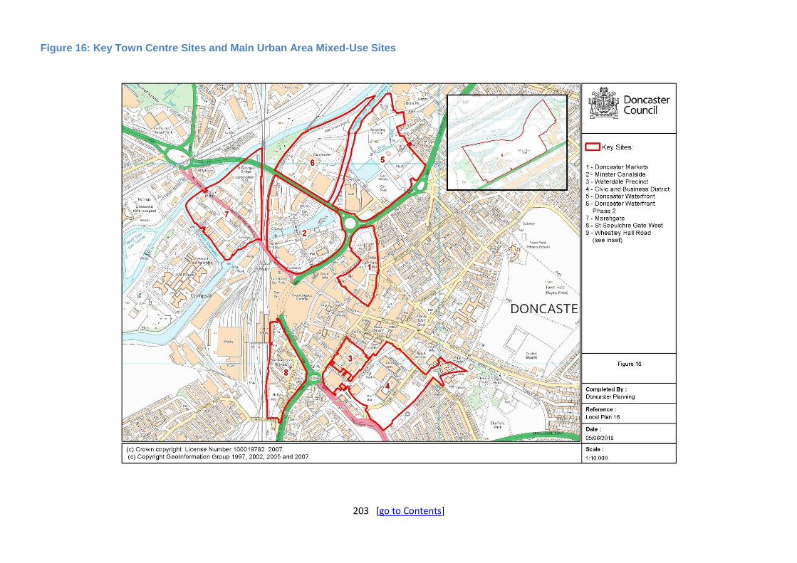
203 [go to Contents]
Figure 16: Key Town Centre Sites and Main Urban Area Mixed-Use Sites
204 [go to Contents]
Main Towns
Role and Function
16.43. The seven Main Towns are the largest settlements in terms of size and population, and also have an excellent range of services for both their own populations and those of surrounding smaller settlements. Geographically, the Main Towns are spread across the Borough. These settlements are expected to be able to deliver local housing need as well as some of the housing needed to meet the Borough’s economic aspirations over the plan period. Collectively, these settlements will deliver 40% of the overall Borough supply.
Adwick & Woodlands
Settlement Profile
16.44. Situated towards the north-west of the Borough, Adwick-le-Street grew considerably in the twentieth century from its original rural form to its current suburban form. A striking feature of this twentieth century development is Woodlands to the west of the settlement, which is an early example of a garden city layout, modelled on Ebenezer Howard’s ‘Garden Cities of Tomorrow’. Woodlands, to the west of Adwick, contains notable examples of early twentieth century domestic suburban architecture and is notable for its uniquely integrated open spaces.
16.45. Woodlands was developed for the workers of the nearby Brodsworth Colliery, which closed in 1990 and has since become part of a community woodland, as well as more recently seeing a housing site come forward on part of the land. The north-west of the settlement is now home to the large Redhouse Interchange distribution park, which, as with the rest of Adwick – Woodlands, has excellent access to the A1(M) (and links into the wider motorway network) at Junction 38. Adwick – Woodlands benefits from its own train station, situated on the Leeds to Doncaster line, with regular trains to Doncaster, Leeds and Sheffield.
Settlement Role and Function (in the Local Plan)
16.46. Adwick and Woodlands is designated as a Main Town. Land will be allocated which can accommodate 482 new dwellings. The former Brodsworth Colliery site provides a significant proportion (342 new homes or 71%) of the town’s housing supply and is under construction. Smaller permissioned sites and a new allocation of a Greenfield urban site provide the remainder of the town’s housing allocation.
16.47. In the retail hierarchy Adwick and Woodlands has a District Centre; proposals will be supported which protect, maintain and enhance its vitality and viability.
Employment Policy Areas (Policy 4)
16.48. Existing employment sites in this area include:
Redhouse Interchange – large, now established area with mainly large distribution uses with excellent access on to the A1(M).
Housing Allocations (Policy 5)
16.49. As at 1 April 2018 there are permissions for 437 dwellings on sites large enough to be allocated through the Local Plan (5+ units remaining). A further allocation for 45 new homes on a greenfield urban site brings the town’s housing supply up to 482 new homes without extensions on land designated as Green Belt and/or at risk of flooding.

205 [go to Contents]
Table H1(B): Allocations with planning permission (as at 1 April 2018)
Site Ref
Address Site Area (Ha)
Permission Capacity (Net) Achievability (deliverable & developable)
Type Status Total Units Remaining
0-5 Yrs
6-10 Yrs
11-15 Yrs
15-17 Yrs
Beyond Plan
Period
ADW01 Land At Fern Bank, Adwick Le Street
0.16 Full Started 8 8 8 0 0 0 0
ADW02 Land South Of Malton Way, Adwick Le Street
2.50 Full Started 85 24 24 0 0 0 0
ADW03 Land On Part Of Former Brodsworth Colliery Site, Long Lands Lane, Adwick Le Street
13.04 Full Started 342 342 175 167 0 0 0
ADW04 Former Yorkshire Water Reservoir Site, Ridge Balk Lane, Woodlands
0.59 Full Not Started
12 12 12 0 0 0 0
ADW05 Land Adjoining 71/73 Bosworth Road, Adwick Le Street
0.11 Full Not Started
6 6 6 0 0 0 0
ADW06 Land Off Malton Way, South Of Mc Donald's And North Of Destiny Phase One, Stretton Street, Adwick Le Street
1.34 Full Started 31 31 31 0 0 0 0
ADW07 Junction Of Chadwick Road, Edwin Road, Quarry Lane, Woodlands
0.35 Full Not Started
14 14 14 0 0 0 0
TOTALS 498 437 270 167 0 0 0
Table H2(B): Allocations without planning permission (as at 1 April 2018)
Site Ref Address Site Area (Ha)
Indicative Capacity (No of houses)
Achievability (deliverable & developable)
0-5 Yrs 6-10 Yrs
11-15 Yrs
15-17 Yrs Beyond Plan Period
ADW08 Lutterworth Drive, Adwick Le Street
1.68 45 45 0 0 0 0
TOTALS 45 45 0 0 0 0

206 [go to Contents]
Armthorpe
Settlement Profile
16.50. The former mining town of Armthorpe lies immediately to the east of the Main Urban Area. Originally an area dominated by agriculture, the settlement expanded in the late nineteenth and twentieth century around Markham Main pit, which closed in 1996. This has been superseded to some degree by new distribution centres which have been developed to the east of Armthorpe, at West Moor Park next to Junction 4 of the M18. The settlement has good access to the M18, and this will be further enhanced by proposed improvements to the West Moor Link road north of the settlement. The settlement retains good road links to central Doncaster.
16.51. Despite its close proximity to the Main Urban Area it has a strong independent community spirit reflected in the considerable work that has gone into the Armthorpe Neighbourhood Plan, which has now been adopted. Armthorpe has a thriving shopping centre and good quality leisure facilities and has been a popular housing market in recent years. This includes the former colliery, which was redeveloped for housing and formal and informal open space.
Settlement Role and Function (in the Local Plan)
16.52. Armthorpe is designated as a Main Town. The Armthorpe Neighbourhood Plan allocated up to 985 dwellings. These allocated neighbourhood plan sites will be reflected in the Local Plan in addition to other site commitments in the area, which equal 1,049 in totality. The allocations are on both urban sites and greenfield extension sites.
16.53. In the retail hierarchy Armthorpe is a District Centre; proposals will be supported which protect, maintain and enhance its vitality and viability. There are two existing employment areas to the east of Armthorpe which are West Moor Park and Rands Lane. Employment uses will be supported on both sites.
Neighbourhood Planning
16.54. The Armthorpe Neighbourhood Plan was adopted in the context of the previous Core Strategy. Given Armthorpe has a recently adopted neighbourhood plan, the Local Plan will reflect the allocations made in that document.
Employment Allocations (Policy 3)
16.55. Policy 2 includes a target for at least 481 hectares of employment land to be developed in the Borough.
16.56. As at 1 April 2018, there are 43 ha with permission in Armthorpe.
Table E2: Allocations with planning permission (as at 1 April 2018)
Site Ref
Address/Location Gross Site Area (Ha)
Permission Use Area Remaining for Employment Use (Ha)
Area to be Developed in the Remainder of the Plan Period (2018-2035) (Ha)
EMP10 Land off Hatfield Lane, Armthorpe
12.61 Outline B2 12.61 12.61
EMP11 Land South of Holme Wood Lane, Armthorpe
30.43 Outline B8 30.43 30.43
Employment Policy Areas (Policy 4)
16.57. There are a number of existing employment sites including:
West Moor Park – an expanding employment area with a range of businesses including nationally significant distribution warehousing and retail companies

207 [go to Contents]
Rands Lane – adjacent to West Moor Park, established area with a mix of business uses.
Housing Allocations (Policy 5)
16.58. As at 1 April 2018, there are permissions for 486 dwellings on sites large enough to be allocated through the Local Plan (5+ units remaining). This supply includes some of the sites identified as allocations through the Armthorpe Neighbourhood Plan. A further 563 units are proposed as allocations and reflect the balance of supply from the other two neighbourhood plan allocations which equate to 563 new dwellings bringing the town’s identified housing supply up to 1,049 new homes.
Table H1(C): Allocations with planning permission (as at 1 April 2018)
Site Ref
Address Site Area (Ha)
Permission Capacity (Net) Achievability (deliverable & developable)
Type Status Total Units Remaining
0-5 Yrs
6-10 Yrs
11-15 Yrs
15-17 Yrs
Beyond Plan
Period
ARM01 28 Cow House Lane, Armthorpe
0.26 Full Not Started
7 7 7 0 0 0 0
ARM02 Land Adjacent 2 Mill Street, Armthorpe
0.27 Full Not Started
11 11 11 0 0 0 0
ARM03 Land North Of Armthorpe Shopping Centre, Mill Street, Armthorpe
0.18 Outline Not Started
8 8 8 0 0 0 0
ARM04 Tadcaster Arms Hotel, Doncaster Road, Armthorpe
0.33 Full Not Started
22 22 22 0 0 0 0
ARM05 Former Blacks Equipment Limited, Barton Lane, Armthorpe
0.71 Full Not Started
22 22 22 0 0 0 0
ARM06 Viking Reclamations, Cow House Lane, Armthorpe
0.17 Outline Not Started
10 10 10 0 0 0 0
ARM07 Land On The East Side Of Hatfield Lane, Armthorpe
17.83 Outline Not Started
400 400 280 120 0 0 0
ARM08 Armthorpe Shopping Centre, Mill Street, Armthorpe
0.82 Full Not Started
6 6 6 0 0 0 0
TOTALS 486 486 366 120 0 0 0
Table H2(C): Allocations without planning permission (as at 1 April 2018)
Site Ref
Address Site Area (Ha)
Indicative Capacity (No of houses) Achievability (deliverable & developable)
0-5 Yrs
6-10 Yrs
11-15 Yrs
15-17 Yrs
Beyond Plan
Period
ARM09 West of Hatfield Lane, Armthorpe
24.47 400 140 260 0 0 0
ARM10 Barton Lane, Armthorpe
4.95 163 (capacity reduced from Armthorpe
Neighbourhood Plan capacity of 185 units to reflect part of the allocation is covered by an
extant permission (Ref: ARM05) and therefore included in the table above)
0 163 0 0 0
TOTALS 563 140 423 0 0 0

208 [go to Contents]
Conisbrough & Denaby
Settlement Profile
16.59. Conisbrough and Denaby are two adjacent settlements located in the Dearne Valley in the west of the Borough along the River Don. Conisbrough is famous for its medieval fortification, Conisbrough Castle, which dates back to the twelfth century and is now a major tourist attraction in the Borough. The settlement has grown from this historic centre, including notable twentieth century development to the west of Conisbrough.
16.60. Denaby, which lies between Conisbrough and Mexborough, developed as a settlement for workers of the nearby Denaby Main and Cadeby Main collieries. Since their closures in the later twentieth century, the settlement has been extensively redeveloped, with older terraced housing associated with the colliery replaced with more modern dwellings.
16.61. To the west of the settlement is the large Denaby Main industrial estate, which is one of the only employment areas of its type in this part of the Borough. The settlement also benefits from its own train station, with regular services to Doncaster, Rotherham and Sheffield, as well as frequent bus services, including an express service between Doncaster and Sheffield, via Rotherham.
Settlement Role and Function (in the Local Plan)
16.62. Conisbrough & Denaby is a Main Town. Land will be allocated to deliver 325 dwellings, in addition to existing commitments of 203 (528 in total).
16.63. The Green Belt is tightly drawn around Conisbrough & Denaby, including on land between the two, known as The Crags. Amongst the allocations in this location is an allocation for 200 dwellings at Sheffield Road / Old Road on former Green Belt land.
16.64. In the retail hierarchy Conisbrough is a District Centre and Denaby Main a Local Centre. Proposals will be supported which protect, maintain and enhance the vitality and viability of these centres.
16.65. Denaby Industrial Estate, which previously benefited from Enterprise Zone status, is designated as an employment policy area (Policy 4).
Employment Policy Areas (Policy 4)
16.66. Existing employment sites in the area include:
Denaby Industrial Estate – established industrial area with a mix of large and medium businesses serving the local area as well as across the local authority area.
Housing Allocations (Policy 5)
16.67. As at 1 April 2018, there are permissions for 203 dwellings on sites large enough to be allocated through the plan (5+ units remaining). Two additional housing allocations are made on greenfield urban extensions to the settlement at Hill Top Road, Denaby and Sheffield Road, Conisbrough. The latter provides 200 new homes on land that was formerly designated as Green Belt. Collectively these allocations provide a further housing supply for the town of 325 dwellings and an overall plan period housing supply of 528 new homes. A large brownfield Potential Development Site capable of accommodating 325 further dwellings is identified at the former Earth Centre, Conisbrough, and adjacent to the housing scheme under construction at time of Plan preparation on the former car park. The site is not within the Green Belt and any development will need to comply with Policy 57 including a successful pass of the flood risk

209 [go to Contents]
sequential and exceptions tests as part of any planning application as the tests have not been passed through the plan-making stage.
Table H1(D): Allocations with planning permission (as at 1 April 2018)
Site Ref
Address Site Area (Ha)
Permission Capacity (Net) Achievability (deliverable & developable)
Type Status Total Units Remaining
0-5 Yrs
6-10 Yrs
11-15 Yrs
15-17 Yrs
Beyond Plan
Period
CD01 Former Earth Centre Car Park, Kilners Bridge, Denaby Main
6.63 Full Started 175 144 144 0 0 0 0
CD02 Land Adj Balby Street Junior And Infant School, Crags Road, Denaby Main
0.76 Full Started 36 8 8 0 0 0 0
CD03 Conisbrough Methodist Church, Chapel Lane, Conisbrough
0.08 Full Not Started
5 5 5 0 0 0 0
CD04 Land At The Talisman, Chestnut Grove, Conisbrough
0.19 Full Not Started
5 5 5 0 0 0 0
CD05 Conisbrough Social Education Centre, Old Road, Conisbrough
1.18 Full Not Started
41 41 41 0 0 0 0
TOTALS 262 203 203 0 0 0 0
Table H2(D): Allocations without planning permission (as at 1 April 2018)
Site Ref
Address Site Area (Ha)
Indicative Capacity (No of houses)
Achievability (deliverable & developable)
0-5 Yrs
6-10 Yrs
11-15 Yrs
15-17 Yrs
Beyond Plan Period
CD06 Between Sheffield Road and Old Road, Conisbrough
8.91 200 0 175 25 0 0
CD07 East of Hill Top Road, Conisbrough
6.12 125 0 125 0 0 0
TOTALS 325 0 300 25 0 0
Table H3(B): Potential Development Sites
Site Ref Address Site Area (Ha) Indicative Capacity (No of houses)
PHD04 East of Dearne Valley Leisure Centre, Denaby 13.14 325
TOTAL 325

210 [go to Contents]
Dunscroft, Dunsville, Hatfield & Stainforth
Settlement Profile
16.68. Dunscroft, Dunsville, Hatfield & Stainforth are four contiguous settlements to the east of the Borough. Collectively, they have the largest population in the Borough outside of the Main Urban Area, and the settlement is assessed as being one of the most sustainable in Doncaster. The settlement lies to the west of the M18, although currently has no direct access to the nearby Junction 5. This is proposed to be remedied as part of the Unity development – a 3,100 house mixed use development that has been granted outline permission on land which wraps around land associated with Hatfield Colliery, which last operated in 2015 (see Policy 69).
16.69. In terms of geography, Stainforth lies to the north of the railway line and Hatfield station, with the other three settlements lying south of this. The Unity scheme when developed will lead to the settlement becoming more rounded in shape, and when fully developed will provide new housing, employment and other opportunities for the benefit of the wider community. There is one train station which serves the settlement, Hatfield station, with trains running to Doncaster, Sheffield and Hull via Scunthorpe.
16.70. Aside from the Main Urban Area, the settlement is the best provided for in terms of primary schools, and the settlement also has a good range of other services, including three centres and a number of neighbourhood shopping parades.
Settlement Role and Function (in the Local Plan)
16.71. Dunscroft, Dunsville, Hatfield & Stainforth are designated as a Main Town. The settlement already has planning approvals and consents for a plan period supply of 1,860 from permissions, and a total supply of 4,053 units once allocations and supply beyond 2035 are factored in.
16.72. The main focus for both housing and employment growth in this location will be the Unity scheme, which when fully developed will deliver 3,100 new homes and 66 ha of employment land, as well as a link road to Junction 5 of the M18, which will connect the area to the national motorway network and open up numerous opportunities for the settlement. This scheme is projected to be delivering beyond the current plan period, such is its scale, and this has been factored in to allocation calculations.
16.73. In addition to existing commitments in the settlement, there will also be new allocations on a greenfield site at Doncaster Road, and brownfield land at Cuckoo Lane – sites which are not constrained by flood risk or otherwise have extant permission.
16.74. In the retail hierarchy Hatfield, Stainforth and Dunscroft are Local Centres; proposals will be supported which protect, maintain and enhance their vitality and viability.
Neighbourhood Planning
16.75. Stainforth Parish Council are in the process of preparing a neighbourhood plan for the area. This is unlikely to be adopted before Local Plan adoption.
Employment Allocations (Policy 3)
16.76. Policy 2 includes a target for at least 481 hectares of employment land to be developed in the Borough.
16.77. As at 1 April 2018, there are 66 ha with permission in Dunscroft, Dunsville, Hatfield & Stainforth which is the Unity regeneration scheme.

211 [go to Contents]
Table E3: Allocations with planning permission (as at 1 April 2018)
Site Ref
Address/Location Gross Site Area (Ha)
Permission Use Area Remaining for Employment Use (Ha)
Area to be Developed in the Remainder of the Plan Period (2018-2035) (Ha)
MIX03 The Unity Project, Hatfield-Stainforth
428.37 Outline as part of a wider mixed use scheme
B1/B2/B8 66.00 33.60
Employment Policy Areas (Policy 4)
16.78. There are a number of existing employment sites including:
Bootham Lane – established and area with a mix of business uses. Eco Park (off Bootham Lane) – more recent development of primarily industrial units.
Housing Allocations (Policy 5)
16.79. As at 1 April 2018, there are permissions for 3,945 dwellings although a significant element of this (3,100 new homes) is on the mixed use Unity Project scheme which will still be developing long beyond this current plan period. Discounted plan period supply is therefore 1,860 new homes from permissioned schemes. Two additional allocations contribute a further 108 new homes for the town on sustainable sites that are within the existing settlement limit, or on land no longer defendable as countryside given planning decisions already taken on sites immediately adjacent and contributing towards the Borough’s housing requirement already. At the end of the plan period, housing delivery on allocated sites will have equated to 1,968 new homes.
Table H1(E): Allocations with planning permission (as at 1 April 2018)
Site Ref Address Site Area (Ha)
Permission Capacity (Net) Achievability (deliverable & developable)
Type Status Total Units Remaining
0-5 Yrs
6-10 Yrs
11-15 Yrs
15-17 Yrs
Beyond Plan
Period
MIX03 The Unity Project, Hatfield-Stainforth
428.4 Outline Not Started
3,100 3,100 175 350 350 140 2,085
DDHS01 Land at Former Industrial Estate, Briars Lane, Stainforth
4.1 Full Started 152 152 105 47 0 0 0
DDHS02 Land rear of 67 - 79 South End, Station Road, Dunscroft
0.2 Full Not Started
7 7 7 0 0 0 0
DDHS03 East Lane House, 60 East Lane, Stainforth
0.2 Full Not Started
10 10 10 0 0 0 0
DDHS04 Land Off Station Road, Dunscroft
0.1 Outline Not Started
5 5 5 0 0 0 0
DDHS05 Land At Kingsway, Stainforth
5.4 Full Started 170 132 132 0 0 0 0
DDHS06 Land Off Doncaster Road, Hatfield
17.8 Outline Not Started
400 400 245 155 0 0 0
DDHS07 Church Road, Stainforth
0.1 Full Started 9 9 9 0 0 0 0
DDHS08 Millcroft House, Adjacent 5 Mill Croft, Stainforth
0.1 Full Not Started
6 6 6 0 0 0 0
DDHS09 Land Off Westminster Drive, Dunsville
3.4 Outline Not Started
97 97 97 0 0 0 0
DDHS10 Land At Former The Warrenne
0.3 Full Not Started
14 14 14 0 0 0 0

212 [go to Contents]
Site Ref Address Site Area (Ha)
Permission Capacity (Net) Achievability (deliverable & developable)
Type Status Total Units Remaining
0-5 Yrs
6-10 Yrs
11-15 Yrs
15-17 Yrs
Beyond Plan
Period
Youth Centre, Broadway, Dunscroft
DDHS11 Spar Stores, 7 High Street, Hatfield
0.1 Full Not Started
5 5 5 0 0 0 0
DDHS12 Land Off Bootham Lane, Dunscroft
1.7 Full Started 59 8 8 0 0 0 0
TOTALS 4,034 3,945 818 552 350 140 2,085
Table H2(E): Allocations without planning permission (as at 1 April 2018)
Site Ref Address Site Area (Ha)
Indicative Capacity (No of houses)
Achievability (deliverable & developable)
0-5 Yrs
6-10 Yrs
11-15 Yrs
15-17 Yrs
Beyond Plan Period
DDHS13 West of Lings Lane, Hatfield
2 72 72 0 0 0 0
DDHS14 East of Cuckoo Lane, Hatfield
1.2 36 36 0 0 0 0
TOTALS 108 108 0 0 0 0
Policy 69: Unity Regeneration Project (Strategic Policy) New mixed use development, between Stainforth, Dunsville, Dunscroft and Hatfield, known as Unity and as shown on the Policies Map and Figure 18, will be supported requiring a co-ordinated, master planned approach to guide the delivery of new development and supporting infrastructure in accordance with the requirements set out below: A) The on-going development of the Unity project will be in accordance with its planning
permission and the requirements set out below to provide:
1. a minimum of 1,015 new homes over the plan period, and up to 3,100 homes over the life of the development, with a minimum of 0.4 hectares of land made available for self-build homes*;
2. a minimum of 33.6 hectares over the plan period, and approximately 66 hectares over the life of the development, of land for business, general industrial and storage and distribution uses, a training centre and energy related developments and associated education, technological and research facilities;
3. a new local centre next to the railway station within which retail, education, commercial, healthcare/retirement uses, and community facilities will be supported;
4. a new 2 form entry primary school on a 2.9 hectare sized site; 5. green infrastructure delivering over 80 hectares of green space, retaining all existing
watercourses and public rights of way and providing enhanced connections to the wider green space and rights of way network where practical;
6. a landscape and biodiversity strategy that retains and enhances most existing landscape features and provides net gain for impacts on habitats;
7. a new marina on the Stainforth and Keadby Canal with ancillary development; 8. continued protection for, and enhancement of, the Hopyard Hay Meadow local wildlife
site with appropriate landscape buffers connecting it to the wider countryside and with developments in its vicinity;
9. a link road from junction 5 of the M18 motorway to serve the development and provide wider connectivity, its development coordinated with the delivery of new homes and employment; and
10. improvements to Hatfield and Stainforth railway station through contributions facilitating the delivery of improvements to passenger facilities, transport links and pedestrian

213 [go to Contents]
facilities. B) The visual openness of the Bootham Lane landfill site and surrounding area will be safeguarded
and promoted; proposals that would enhance its landscape, amenity, countryside recreation, and biodiversity will be supported.
C) The lay-down area (as shown on Figure 18) will be a source of spoil to create development platforms (subject to satisfactory contamination investigations) and will then be subject to a restoration and after care scheme.
D) To secure regeneration of the former Hatfield Colliery site (as shown on Figure 18) the site is potentially suitable for:
1. employment/industrial uses such as business, light industry and distribution/ warehousing; 2. technological, manufacturing or research uses; 3. ancillary uses including local facilities provided that they are of a scale that is needed to
serve the occupiers of the former Hatfield Colliery site; 4. other uses, including leisure.
All uses will need to relate well to the emerging surrounding master plan for the Unity project and meet other relevant policies and requirements as set out in the plan.
E) No development shall take place that will prevent occupation of the gypsy and traveller sites
located to the north of Station Road, Dunscroft before an appropriate site of similar size, proportion and equivalent standard has been laid out and serviced to accommodate 20 gypsy and traveller pitches, and transferred to the Council or its nominee.
F) Development of the site should help to secure the long-term conservation of the Grade II Listed
headstocks. Detailed Masterplanning should seek to maximise the potential of the headstocks as a focal point for the development and place-shaping.
*The submission of the Reserved Matters application that includes the 500th home shall be accompanied by a proposal which identifies a site of at least 0.4 hectares suitable for the development of self-build houses and a design guide for the development of such plots.
Explanation
16.80. Unity (formerly known as the DN7 Initiative) will be developed as a major mixed-use regeneration scheme (as shown in the indicative masterplan (Figure 17), indicative area schedule (Table 22) and Policies Map) over the next 30 years and will be supported with the principles set out above. The policy also seeks to assist the regeneration of the former colliery site including the listed headstocks to bring about the most sustainable and beneficial use of the area and compliment the development activities, investment and growth taking place in the adjacent Unity project areas. The quality of any development proposals must also be commensurate with the requirements of the wider project.
16.81. This policy forms part of a longer term vision to deliver significant growth and regeneration within the local communities of Hatfield, Stainforth, Dunscroft and Dunsville, both within the plan period and beyond.
16.82. The detailed planning and delivery of the project will be co-ordinated through a public/private partnership arrangement through Planning Performance Agreements and implemented through outline planning permission 15/01300/OUTA, including its conditions and agreed Section 106 obligations, as well as associated environmental statements, strategies and masterplans.
16.83. This project is the culmination of successful partnership working between developers, landowners, local community, elected members and government agencies. The scale of the

214 [go to Contents]
project is such that it will not develop out entirely within the plan period but will continue to provide new homes and jobs well beyond. The project is identified within the Sheffield City Region Growth Plan as a 'priority site'.
16.84. A suite of obligations, contributions and incentives will be delivered through the Section 106 agreement with a regular review mechanism built in over the lifetime of the project. Such contributions include affordable housing, a new 2 form entry primary school, bus levy, park and ride facilities, a pedestrian footbridge over the railway line, train station upgrades, and a training centre and revenue for a centre manager over a period of 10 years.
16.85. Unity will provide a total of 3,100 homes but delivery is currently conditioned to no more than 1200 homes up to 2028 in line with the previous Development Plan for Doncaster. The Local Plan assumes a build-out rate for the project of 1,015 new homes within the plan period to 2035 (and 595 by 2028) so is significantly less than the condition allows for at present by around 50%. Nevertheless, we would support applications to vary this condition (and so increase the supply of land to address the target) provided:
there is evidence (primarily from completions) that the number of houses sought could be delivered in the proposed new timescale; and
the proposed amendment would not undermine delivery against Local Plan targets for other towns and villages. We would expect any such amendments to be incremental as development progresses.
16.86. The principle and timing of the housing will be dependent upon the coordinated delivery of the proposed infrastructure (including the new link road) and the provision of jobs and services within the boundary of the scheme. There are also significant opportunities for further green infrastructure and leisure uses (such as a country park) on land to the south of the railway line, around the Bootham Lane Landfill Site, and north of the railway line (Colliery Tip), which was not subject to the outline planning application, or identified on the Masterplan, and is therefore additional to the 80 hectares as referenced in the Policy.
16.87. Any future development within the Unity/DN7 policy area must be subject to and include:
a feasibility study to identify the opportunities and constraints for any proposed uses;
a heritage assessment of the potential impact of the development on the significance of any heritage assets affected (including an assessment of archaeological potential within the policy area and the setting of any heritage assets outside the policy area that might be impacted) and mitigation measures to address or reduce the identified heritage impacts
a phase 1 desktop study which will be required in support of any development where there is a risk of potential contamination;
a full ecological assessment of the entire site;
mitigation measures to improve accessibility to local services and public transport, for which developer contributions will be required; and
a travel plan alongside the transport assessment for this site in order to minimise the impact upon the strategic road network.
16.88. Located north of the railway line, adjacent to the former Hatfield Colliery, Unity Energy will provide 20.2 hectares of land for employment, potentially including energy focused employment uses. Details of proposals to be worked up and subject to possible energy sector partnership arrangements, access to funding and further viability/feasibility work.
16.89. Unity Energy has the potential to incorporate world-leading technology and associated research facilities and could help deliver a step change in the transition towards a low carbon economy and a more diverse workforce. The Council will seek to secure these opportunities as far as possible. With the closure of Hatfield Colliery, access to employment and skills and training for local people, businesses and inward investors are essential to the success of the area.

215 [go to Contents]
16.90. Part of the site has been used for coal mining activity. Due consideration will have to be given to this aspect and any required remediation measures will be identified and implemented in consultation with statutory bodies to ensure that the development is safe and stable for use. As the site is developed, updated ecological assessments and further detailed mitigation proposals will be required. It is also essential the existing bund between the development proposal and Stainforth is retained and appropriately enhanced to buffer the former colliery site from the adjacent community.
16.91. The headstocks of the former colliery are grade II listed and are of historic and technological interest due to their rarity and intactness as well as being a visual reminder of the former uses of the site. However, their security and upkeep is costly and at this point in time they do not have an obvious end use. They are considered heritage assets ‘at risk’. Imaginative proposals that secured the long term conservation of these heritage assets will be encouraged and supported.
16.92. Development proposals, including the design guides for the Unity development subject to further detailed planning applications, will be expected to make use of opportunities to enhance or better reveal the significance of the heritage assets affected by, for example, incorporating sight-lines towards the listed headstocks or, in the case of the listed lock cottages, introduce a ‘canalside’ character to the adjacent Unity Life development.
16.93. The details of transport mitigation measures, funding, triggers and implementation will need to be agreed between partners prior to development.
16.94. The ownership and associated liabilities of the former Hatfield Colliery is currently with the Crown until formally claimed and therefore any delivery of development cannot be assured in the plan period and will not form part of the employment land requirement. Any potential land owner/applicant will be required to ensure that any proposed development seeks to conform to the guiding principles set out by this policy.

216 [go to Contents]
Figure 17: Unity Masterplan
Source: Unity Approved Outline Planning Application Reference: 15/01300/OUTA.
See below for Map showing area of Hatfield Colliery for the purposes of Policy 69.
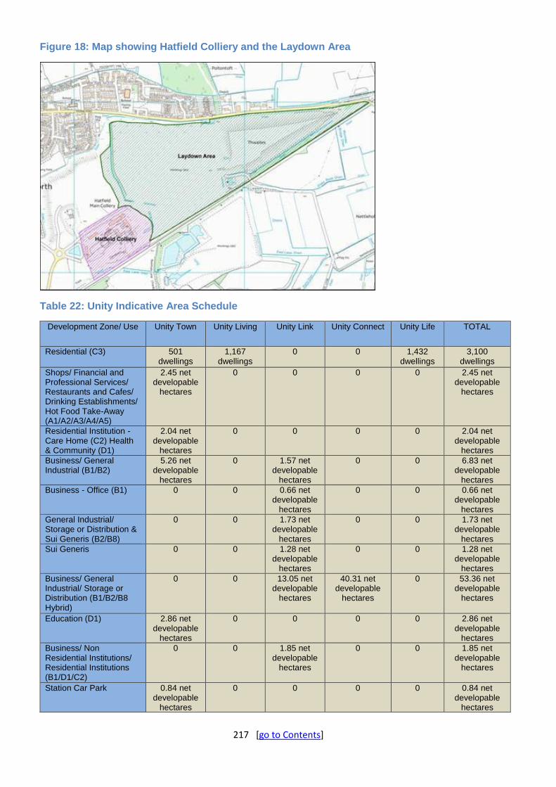
217 [go to Contents]
Figure 18: Map showing Hatfield Colliery and the Laydown Area
Table 22: Unity Indicative Area Schedule
Development Zone/ Use Unity Town Unity Living Unity Link Unity Connect Unity Life TOTAL
Residential (C3) 501 dwellings
1,167 dwellings
0 0 1,432 dwellings
3,100 dwellings
Shops/ Financial and Professional Services/ Restaurants and Cafes/ Drinking Establishments/ Hot Food Take-Away (A1/A2/A3/A4/A5)
2.45 net developable
hectares
0 0 0 0 2.45 net developable
hectares
Residential Institution - Care Home (C2) Health & Community (D1)
2.04 net developable
hectares
0 0 0 0 2.04 net developable
hectares
Business/ General Industrial (B1/B2)
5.26 net developable
hectares
0 1.57 net developable
hectares
0 0 6.83 net developable
hectares
Business - Office (B1) 0 0 0.66 net developable
hectares
0 0 0.66 net developable
hectares
General Industrial/ Storage or Distribution & Sui Generis (B2/B8)
0 0 1.73 net developable
hectares
0 0 1.73 net developable
hectares
Sui Generis 0 0 1.28 net developable
hectares
0 0 1.28 net developable
hectares
Business/ General Industrial/ Storage or Distribution (B1/B2/B8 Hybrid)
0 0 13.05 net developable
hectares
40.31 net developable
hectares
0 53.36 net developable
hectares
Education (D1) 2.86 net developable
hectares
0 0 0 0 2.86 net developable
hectares
Business/ Non Residential Institutions/ Residential Institutions (B1/D1/C2)
0 0 1.85 net developable
hectares
0 0 1.85 net developable
hectares
Station Car Park 0.84 net developable
hectares
0 0 0 0 0.84 net developable
hectares

218 [go to Contents]
Mexborough
Settlement Profile
16.95. Mexborough is a large market town on the western edge of the Borough, on the north side of the River Don / New Cut Canal and south of the River Dearne. The town grew mainly in the 18th – 20th centuries as the result of coal mining, quarrying, brickworks and the production of ceramics and was a busy railway junction. The settlement has a ‘town centre’, one of only three in the Borough (along with Doncaster and Thorne), and whilst this has relatively high vacancy levels, it serves an important wider catchment than just the town itself, including parts of the Dearne Valley outside the Borough. It is particularly closely related to the neighbouring Dearne towns of Conisbrough & Denaby, Swinton and Wath.
16.96. Higher order services include the Mexborough-Montagu Hospital which is one of the key hospitals in the Borough and also serves a much wider catchment. Mexborough also has a railway station on the Sheffield-Doncaster railway line with regular trains between the two, as well as to Rotherham and Meadowhall in between, and is served by a bus station.
16.97. Mexborough is a generally self-contained housing market and a number of smaller housing developments including housing renewal schemes have taken place in recent years. The only two large scale recent housing developments are those on the eastern edge of the town at Pastures Road and the Shimmer development at the former Mexborough Power Station. Both are under construction but affected by the proposed new route of HS2, which was announced in 2016. This is currently proposed to run across the east of the settlement, with the proposed HS2 line safeguarded as per the Government directive, thus constraining further development in this location at this time.
16.98. Additionally, Mexborough is surrounded by Green Belt, as well as the Borough boundary to the west and south west, and River Don / Don navigation to the south. This collectively means that if Mexborough is to deliver its housing requirement, the only considerable land is either a limited pool of urban sites, or the potential of Green Belt release to the north.
Settlement Role and Function (in the Local Plan)
16.99. Mexborough is designated as a Main Town. However, given the aforementioned constraints to growth and given the importance of the Green Belt to the west of the settlement in preventing Mexborough and Swinton (and consequently Doncaster and Rotherham) from merging, no urban extension is proposed. Mexborough is therefore only projected to deliver 310 new homes over the plan period.
16.100. There is currently a possibility of a HS2 parkway station in Mexborough which, if realised, future local plans may wish to consider the opportunities that this would prevent for an urban extension associated with this transport hub. However, at present this remains an unknown.
16.101. In the retail hierarchy Mexborough is a Town Centre; proposals will be supported which protect, maintain and enhance its vitality and viability (Policy 70). The town has capacity to be extended and enhanced, including retail facilities and new office development along the canalside with improved links to the railway station.
Employment Policy Areas (Policy 4)
16.102. There are two existing employment sites in Mexborough:
Whitelea Grove – a range of businesses serving the local area.
Cliff Street – a range of businesses serving the local area.
16.103. There are also a number of sites across the Doncaster boundary in Wath-upon-Dearne.

219 [go to Contents]
Housing Allocations (Policy 5)
16.104. As at 1 April 2018, there are permissions for 108 dwellings on sites large enough to allocate through the Local Plan (5+ units remaining). This is following the discounting of some permissioned capacity in light of HS2 Safeguarding Route and non-delivery of remaining supply on the Shimmer Estate. Three additional allocations provide the town with a housing supply of 202 dwellings bringing the settlement’s plan period allocated housing supply up to 310 new homes.
16.105. Nationally there is some political uncertainty in respect to the HS2 and whether or not the infrastructure project will be delivered. Despite this, the Safeguarding Direction has to be respected until or unless instructed otherwise. Therefore, the plan identifies 3 additional Potential Development Sites which are directly constrained by the proposed route of HS2. Were it not for this Direction it is likely they would have been allocated. These sites have potential capacity for a further 242 new homes for the town. Their identification as Potential Development Sites provides flexibility and a level of planning policy certainty should the route of HS2 not be confirmed as progressing at some point during the plan period.
Table H1(F): Allocations with planning permission (as at 1 April 2018)
Site Ref
Address Site Area (Ha)
Permission Capacity (Net) Achievability (deliverable & developable)
Type Status Total Units Remaining
0-5 Yrs
6-10 Yrs
11-15 Yrs
15-17 Yrs
Beyond Plan
Period
MEX01 North Gate Working Mens Club, North Gate, Mexborough
0.1 Full Started 6 6 6 0 0 0 0
MEX02 Land Off Pastures Road, Mexborough
1.22 Full Started 55 5 5 0 0 0 0
MEX03 The Embankment, Leach Lane Industrial Estate, Leach Lane, Mexborough
0.55 Full Not Started
24 24 24 0 0 0 0
MEX04 Land At Alagu Close, Off Highwoods Road, Mexborough
0.24 Outline Not Started
9 9 9 0 0 0 0
MEX05 Former Nurses Home, Cemetery Road, Mexborough
0.29 Outline Not Started
9 9 9 0 0 0 0
MEX06 Garage Site, Maple Road, Mexborough
0.21 Full Not Started
5 5 5 0 0 0 0
MEX07 Land On The North West Side Of Pastures Road, Mexborough
4.56 Full Started 147 37 37 0 0 0 0
MEX08 The Highwoods, Elm Road, Mexborough
0.17 Full Not Started
13 13 13 0 0 0 0
TOTALS 268 108 108 0 0 0 0
Table H2(F): Allocations without planning permission (as at 1 April 2018)
Site Ref
Address Site Area (Ha)
Indicative Capacity (No of houses)
Achievability (deliverable & developable)
0-5 Yrs
6-10 Yrs
11-15 Yrs
15-17 Yrs
Beyond Plan Period
MEX09 Leach Lane, Mexborough
0.58 16 16 0 0 0 0
MEX10 Windhill Avenue, Mexborough
3.33 112 0 112 0 0 0
MEX11 West of Schofield Street, Mexborough
2.45 74 0 74 0 0 0
TOTALS 202 16 186 0 0 0

220 [go to Contents]
Table H3(C): Potential Development Sites
Site Ref Address Site Area (Ha)
Indicative Capacity (No of houses)
PHD05 East of Clayfield Avenue, Mexborough 6.1 151
PHD06 East of Church Street, Mexborough 1.78 52
PHD07 Mexborough Power Station, Mexborough 4.99 39
TOTAL 242
Policy 70: Mexborough Town Centre Mexborough town centre will be a thriving and distinctive shopping and leisure destination serving the south-west of Doncaster and adjoining parts of the Dearne Valley and beyond. The town centre will be extended and enhanced to accommodate new and improved retail facilities, new office accommodation, canal-side housing development and better links to Mexborough railway station, with clearly defined spaces. The historic character of the town centre will be preserved and enhanced through high quality infill development. Within Mexborough town centre, as defined on the Policies Map, proposals will be supported where relevant, which: A. explore opportunities to create a more enclosed, dense and compact urban form, especially
within close proximity to key routes (e.g. A6023) and the primary shopping area;
B. improve existing retail provision, including a new retail supermarket anchor in the heart of the centre;
C. bring about environmental improvements (including tree planting, street furniture, signage and new public spaces) to enhance the streetscape and encourage social interaction, particularly at High Street, Bank Street and York Square;
D. retain and sympathetically restore, Mexborough’s historic buildings (particularly in the Conservation Area);
E. encourage the retention and restoration of traditional shop fronts in the interests of preserving and enhancing the historical character of the town centre, using original features where possible;
F. improve pedestrian/cycle links between the primary shopping area and surrounding areas, particularly the bus and railway stations, Montagu Hospital and Sheffield and South Yorkshire Navigation Canal;
G. open up public access and promote active travel to key views to the waterfront/canal side, particularly across the dual carriageway (Greens Way);
H. introduce traffic calming measures along Greens Way to reduce and control vehicle speeds and protect the safety of pedestrians and cyclists;
I. provide active frontages at ground floor level, particularly along Greens Way, Station Road, John Street and West Street, wherever possible;
J. enhance the sense of arrival at key gateway sites around the edges and entry points into the town centre such as the Greens Way (Doncaster Road), A6022 (Bridge Street), Adwick Road and Station Road; and

221 [go to Contents]
K. support the rationalisation of existing car parks and refurbishment of the multi-storey car park and adjoining sites through sensitive redevelopment.
Proposals to change the use of a unit from a shop to a residential, community or business use within the conservation area (as shown on the Policies Map) should be designed in a way that is sympathetic to the design of the original building and, as far as possible, should retain its original features.
Explanation
16.106. Mexborough is the second largest commercial and shopping centre in the Borough (after Doncaster) and fulfils a wider role in meeting the local shopping and service needs of the Dearne Valley area. The town centre offers good access to a range of transport modes (including public transport, walking and cycling) and is well connected to surrounding settlements in the Dearne Valley such as Swinton, Conisbrough and Wath upon Dearne.
16.107. Mexborough is mentioned in the Domesday Book as Mechesburg and there are remains of a motte and bailey castle, which is a scheduled monument, within Castle Park about a mile to the east of the town centre. Mexborough lies at the confluence of the rivers Don and Dearne, and a market has reportedly been held here for 800 years. The settlement expanded rapidly in the Victorian period, mainly as a colliery town, although other industries were also developed. The area that is now designated as Mexborough Conservation Area was developed at this time, serving as part of the main retail area along Bank Street, a role it still serves today.
16.108. Mexborough has a relatively linear centre extending from Hartley Street in the west, along Main Street, High Street and Bank Street, to the former Royal Electric Theatre in the east. The centre offers a good range of shops and services (including high street banks, building societies, cafes, pubs and clothes shops) serving everyday needs. The key strengths of the centre are its historic setting, high pedestrian flows, strong independent offer, availability of parking/public transport and good quality markets.
16.109. The ‘Main Shopping Area’ (as defined on the Policies Map) of the town centre extends along the pedestrianised area on High Street and along sections of Garden Street and Bank Street. It also includes the indoor and outdoor markets.
16.110. Mexborough continues to perform an important role as a retail and commercial designation but remains in a precarious position. Particular concerns include the lack of national retail representation, limited unit size, empty properties, narrow pavements (beyond High Street) and a declining environment. There is also a shortage of high quality leisure and entertainment uses (e.g. cafes and restaurants) and food retailers in the town centre. Mexborough needs a new large supermarket and anchor store that offers a full range of food and grocery products to help claw back trade from out-of-centre stores and encourage more linked trips. Restaurants, cafes and coffee bars are also under-represented.
16.111. Much of the centre is inward-facing, with a high proportion of blank spaces, unattractive infill plots and surface car parking, especially along Greens Way (A6023), Hartley Street Roundabout and Station Road. The dual carriageway (Greens Way) splits the retail core and conservation area from the old historic centre of the town based around the church, river/canalside and railway station, thus reinforcing the isolated nature of the area.

222 [go to Contents]
Rossington
Settlement Profile
16.112. Rossington is a large former mining village which is currently the focus of significant new infrastructure and development. The village lies 5 miles south of central Doncaster, west of the A638 Great North Road immediately south of the M18, and straddles the East Coast Main Rail line (although there is no railway station). The settlement expanded greatly in the twentieth century due to housing development associated with the colliery, in what is known as ‘New Rossington’.
16.113. The colliery closed in 2007 and is now being redeveloped for housing-led mixed-use including 1,200 new homes. In April 2016, phase 1 of the Great Yorkshire Way (formerly the Finningley and Rossington Regeneration Route Scheme or FARRRS) was completed between the A638 and the M18 (at Junction 3) providing Rossington with a direct motorway connection for the first time. There are clear signs of increased investment levels in the village following this significant improvement in connectivity which has also provided a local traffic alternative to the East Coast Main Line level crossing which is the cause of regular traffic queues. Phase 2 of FARRRS, linking directly to the Airport, was completed in 2018.
16.114. To the west of Rossington is Doncaster iPort, a 136 ha logistics park, which is under construction, with a number of companies already on site. It includes a 14 ha rail freight intermodal terminal (the largest in Yorkshire). When complete, it will provide 6 million square feet of warehousing and is expected to provide up to 5,000 new jobs, as well as local training opportunities.
16.115. At the time of plan preparation, a planning application for the Rossington Hall Professional Golf Association European Tour Golf Destination is under consideration. The site covers around 194 hectares and is located to the south and east of Rossington between the A638 Great North Road (Bawtry Road) and the East Coast Main Railway Line. The proposal would be one of only two venues in the UK that form part of the European Tour and one of only eleven such courses located throughout Europe and Asia. The proposal could bring significant economic benefits to the local area and wider economy.
Settlement Role and Function (in the Local Plan)
16.116. Rossington is designated as a Main Town. Given the scale of the housing redevelopment on the former Rossington Colliery, the Town has a significant supply of hosuing on this commitment alone. However, some additional urban sites will also be allocated in this location. Therefore, its housing allocation is 1,282 new homes in the plan period to 2035 (although some of this is projected to be delivered towards the back end of the plan period). An additional urban site is also proposed on the former playing fields of Tornedale School including the adjacent Gattisson House site.
16.117. Rossington’s retail centre is designated as a District Centre in the retail hierarchy; shops will be protected and will continue to be the dominant use in this area. The new area of housing also sees development of a large supermarket and the inclusion of a small parade of shops serving local needs.
16.118. The East Coast Main Line forms the outer boundary of Doncaster’s Green Belt and so land to the west of Rossington lies in the Green Belt and land to the east is Countryside Policy Area. The Green Belt has been amended to reflect the iPort development and Colliery development. The Green Belt in this location has also been extended to cover the area of the country park, enhancing the Green Belt and securing Green Belt improvements including environmental and biodiversity enhancement, improved accessibility, recreational benefits, landscape and visual enhancements and the improvement and greening of degraded land. This also helps to compensate for the loss of Green Belt at other locations across the Borough.

223 [go to Contents]
Neighbourhood Planning
16.119. The Rossington community is preparing a Rossington Neighbourhood Plan but adoption is unlikely before adoption of the Local Plan.
Employment Allocations (Policy 3)
16.120. Policy 2 includes a target for at least 481 hectares of employment land to be developed in the Borough. Table 5 allocates one site in Rossington totalling 18 hectares on Bankwood Lane.
16.121. As at 1 April 2018, there are 79 ha with permission in Rossington at the iPort development (see Policy 71: iPort).
Table E4: Allocations with planning permission (as at 1 April 2018)
Site Ref
Address/Location Gross Site Area (Ha)
Permission Use Area Remaining for Employment Use (Ha)
Area to be Developed in the Remainder of the Plan Period (2018-2035) (Ha)
EMP12 iPort, Rossington 178.72 Full B8 with rail connectivity
79.00 79.00
Employment Policy Areas (Policy 4)
16.122. There is one existing employment site:
Bankwood Lane, Rossington – Due to the opening of Great Yorkshire Way, this site now has excellent access to the motorway network and this will help it to realise its potential as an employment site.
Housing Allocations (Policy 5)
16.123. The Local Plan identifies a total supply from allocated sites of 1,282 new homes in the plan period.
16.124. As at 1 April 2018, there is one large site with permission for 897 new homes which is large enough to allocate (5+ units remaining) with all of this supply being on the former colliery site. Latest evidence on build-out of the colliery demonstrates that the 1,200 units permissioned are not going to be achieved within the existing boundary so this site has been discounted to reflect a more realistic capacity for the site of 984 new dwellings with 897 units remaining to be built on the site as at 1 April 2018. The Local Plan identifies an additional phase therefore for the colliery to make good the balance of 1,200 units and realise the opportunity to make full and effective use of the former colliery land. A further allocation is made on the former playing fields of Tornedale School and the adjacent Gattisson House site which will provide a further supply of 92 houses for the town on a sustainable site now surplus to requirements.
Table H1(G): Allocations with planning permission (as at 1 April 2018)
Site Ref
Address Site Area (Ha)
Permission Capacity (Net) Achievability (deliverable & developable)
Type Status Total Units Remaining
0-5 Yrs
6-10 Yrs
11-15 Yrs
15-17 Yrs
Beyond Plan
Period
ROS01 Site of Former Rossington Colliery, West End Lane, New Rossington
51.7 Outline/Full Started 984 897 350 350 197 0 0
TOTALS 984 897 350 350 197 0 0

224 [go to Contents]
Table H2(G): Allocations without planning permission (as at 1 April 2018)
Policy 71: iPort (Strategic Policy) A Strategic Rail Freight Interchange (SRFI) together with ancillary infrastructure and operational development, known as iPort, will be developed at Rossington as shown on the Policies Map. A. The on-going development of iPort will be in accordance with the principles set out in its planning
permission as set out below:
1. an intermodal terminal and rail and road served distribution units (562,000m2) in Use Class B8 (including ancillary B1/B2 floorspace); 2. road, rail access and other infrastructure facilities and works; and 3. the realignment of water courses, provision of landscaping, ecological networks and improvements and flood mitigation and enhancement.
B. Units in Use Class B2 will also be acceptable, subject to meeting other policies in the Local Plan.
Explanation
16.125. iPort, as shown on the Policies Map, will be developed as a strategic rail freight interchange supported by the principles shown above, which are in line with planning permission 09/00190/OUTA. The policy recognises the contribution that iPort, a nationally significant infrastructure project, will have to the wider economy.
16.126. Doncaster is promoted, both nationally and regionally, as a key location for the logistics and distribution industries including through various Sheffield City Region strategic and investment plans such as the Strategic Economic Plan (SCR SEP) and the Transport Strategy. The site at Rossington offers quick and effective links to national and international freight networks and will lead to a significant net reduction in HGV traffic and emissions due to the transfer of freight from road to rail. The scheme is under construction and is approximately 60% complete. Further development at the site is important to ensure that the Local Plan Spatial Strategy of major new employment sites being accessible by a range of transport modes is implemented by providing rail-access for freight movements.
16.127. The National Policy Statement for National Networks states (footnote 42) that SRFI may include manufacturing and processing activities, in addition to warehousing and container handling facilities so, although iPort has been granted permission specifically for rail related strategic warehousing, there may be instances where an alternative use maybe appropriate such as those within Use Class B2. Each case will be considered on its merits and will need to meet the requirements set out in other Local Plan policies such as parking standards and design standards. Based on the best information on market potential currently available, it is anticipated that around 15% of the overall employment floorspace will be for B2 uses.
Site Ref
Address Site Area (Ha)
Indicative Capacity (No of houses)
Achievability (deliverable & developable)
0-5 Yrs
6-10 Yrs
11-15 Yrs
15-17 Yrs
Beyond Plan Period
ROS02 Former Rossington Colliery (south), Rossington
14.1 349 0 0 153 140 56
ROS03 West of Gattison Lane, Rossington
3.5 92 0 92 0 0 0
TOTALS 441 0 92 153 140 56

225 [go to Contents]
Thorne & Moorends
Settlement Profile
16.128. Thorne is an historic market town in the north-east of the Borough lying east of the River Don and on the Stainforth and Keadby Canal. Peel Hill Motte ancient monument sits at the heart of an extensive conservation area. The former mining village of Moorends is immediately to the north of Thorne separated by only a small rural gap. The combined population is 17,295 and the settlement is one of only three in the Borough to have a town centre (together with the Main Urban Area and Mexborough) which serves a wider catchment than just the town itself. The relative isolation of the settlements supports a proud community spirit and a sense of independence from Doncaster. Despite excellent connectivity by rail and road (to the motorway network), this relative isolation has resulted in under-investment in recent years and both places are in need of regeneration.
16.129. Thorne is served by the A614 and the M18 Junction 6 immediately next to the town. It is also served by two railway stations (the best provision in Doncaster aside from the Main Urban Area) with services to Doncaster, Goole and Scunthorpe. The canal is under-used but is capable of accommodating large commercial traffic to and from the Humber Ports. Between the motorway and the edge of Thorne are large scale logistics and other commercial uses benefitting from motorway access and proximity to the Humber ports and providing an important supply of local jobs. East of the settlements are Thorne and Hatfield Moors, an extensive area of former peat workings and an internationally important wildlife habitat and national nature reserve.
Settlement Role and Function (in the Local Plan)
16.130. Thorne & Moorends is designated as a Main Town. Flood risk constraints in Thorne make the allocation of land challenging in this location. However, the total amount of land identified in Thorne via permissions (391 units) and allocations (333 units), means that Thorne is contributing a not insignificant 724 units towards the Borough’s allocated supply.
16.131. Whilst Thorne is a very sustainable settlement, national policy and Local Plan strategy for a sequential approach to flood risk mean that at the time of Plan preparation it was not appropriate to allocate any further housing given that all the remaining available sites are at high risk of flooding. On-going work by the Environment Agency may establish opportunities for future additional allocations through a review of the Local Plan and/or Thorne and Moorends Neighbourhood Plan.
16.132. In the retail hierarchy, Thorne is a Town Centre and Moorends is a Local Centre; proposals will be supported which protect, maintain and enhance their vitality and viability (Policy 72). Opportunities exist to improve the connectivity between Finkle Street and King Street and for Market Place to act as a focal point.
16.133. There are 3 successful existing employment sites serving the local area and wider area with a mix of businesses and units.
Neighbourhood Planning
16.134. A neighbourhood plan for Thorne and Moorends is in preparation (Regulation 14 Pre-submission draft published October 2016). The intention is that this plan will make allocations on sites in Flood Zone 1 due to the flood risk constraints of the area. At the time of drafting, it is understood that the neighbourhood plan is now looking to also identify additional housing allocations which will require land that is at risk of flooding.

226 [go to Contents]
Employment Allocations (Policy 3)
16.135. Policy 2 includes a target for at least 481 hectares of employment land to be developed in the Borough. Table 5 allocates one site in Thorne totalling 52 hectares at Junction 6, M18.
16.136. As at 1 April 2018, there are 9 ha with permission in Thorne.
Table E5: Allocations with planning permission (as at 1 April 2018)
Site Ref
Address/Location Gross Site Area (Ha)
Permission Use Area remaining for Employment Use (Ha)
Area to be Developed in the Remainder of the Plan Period (2018-2035) (Ha)
EMP13 Capitol Park, Thorne
8.94 Full. B2 (as part of a wider mixed use development)
2.20 2.20
EMP14 Lands End Road, Thorne
7.28 Full B8 7.28 7.28
Employment Policy Areas (Policy 4)
16.137. There are a number of existing employment sites including:
Nimbus Park – A large distribution warehouse development to the north of Thorne with good access to the M18.
Capitol Park – established mixed use business area including potential rail connectivity. The area has access to motorways and Thorne North rail station.
Coulman Road, Thorne – established area with a mix of small and medium sized businesses with good local access.
Housing Allocations (Policy 5)
16.138. As at 1 April 2018, there are permissions for 391 dwellings. The Local Plan identifies a further 333 units as allocations which provides the settlement with a housing supply of 724 new dwellings.
16.139. The Local Plan housing allocation at the Main Town of Thorne-Moorends is constrained by a lack of potential development sites not at high risk of flooding. Although sufficient sites have been identified, were it not for this physical constraint to plan-making then the Main Town would have seen a higher allocation. This is due to the town’s size and population as being one of our largest communities outside of the Main Urban Area with strong sustainability credentials, for example: 2 train stations; frequent bus links; large town centre with excellent range of services and facilities; and no Green Belt constraints to growth.

227 [go to Contents]
Table H1(H): Allocations with planning permission (as at 1 April 2018)
Site Ref
Address Site Area (Ha)
Permission Capacity (Net) Achievability (deliverable & developable)
Type Status Total Units Remaining
0-5 Yrs
6-10 Yrs
11-15 Yrs
15-17 Yrs
Beyond Plan Period
TM01 Land off Lock Lane, Thorne
0.15 Full Started 5 5 5 0 0 0 0
TM02 The Old Vicarage, Stonegate, Thorne
0.11 Full Started 11 11 11 0 0 0 0
TM03 Willow Grove, Thorne 1.18 Full Started 35 17 17 0 0 0 0
TM04 Milton House, 67 Ellison Street, Thorne
0.11 Full Started 10 6 6 0 0 0 0
TM05 Land North East Of Industrial Park, King Edward Road, Thorne
1.97 Full Not Started
70 70 70 0 0 0 0
TM06 Land Off Site Of Former Rising Sun Public House, Hatfield Road, Thorne
0.50 Full Not Started
12 12 12 0 0 0 0
TM07 Land On The North East Side Of Alexandra Street, Thorne
0.68 Full Not Started
28 28 28 0 0 0 0
TM08 Open Land At Corona Drive, Thorne
0.33 Full Not Started
14 14 14 0 0 0 0
TM09 Land Off White Lane, Thorne
2.82 Full Not Started
79 79 79 0 0 0 0
TM10 Amenity Grass Area, St Georges Close, Thorne
0.22 Full Started 9 9 9 0 0 0 0
TM11 Land Off Coulman Road, Thorne
1.39 Full Started 59 55 55 0 0 0 0
TM12 Land Adjacent Peel Hill Motte, Church Street, Thorne
1.61 Full Started 72 72 72 0 0 0 0
TM13 Land To The Rear Of 98 North Eastern Road, Thorne
0.78 Full Not Started
13 13 13 0 0 0 0
TOTALS 417 391 391 0 0 0 0
Table H2(H): Allocations without planning permission (as at 1 April 2018)
Site Ref Address Site Area (Ha)
Indicative Capacity (No of houses)
Achievability (deliverable & developable)
0-5 Yrs 6-10 Yrs
11-15 Yrs
15-17 Yrs
Beyond Plan Period
TM14 South of Alexandra Street, Thorne
8.37 207 70 137 0 0 0
TM15 South-West of St Nicholas Road, Thorne
0.84 12 12 0 0 0 0
TM16 North of Millcroft Close, Thorne
2.48 53 53 0 0 0 0
TM17 West of Marshlands Road, Moorends
0.53 23 23 0 0 0 0
TM18 North of Thorne South Station, South End, Thorne
1.54 25 25 0 0 0 0
TM19 East of South End, Thorne 0.49 13 13 0 0 0 0
TOTALS 333 196 137 0 0 0
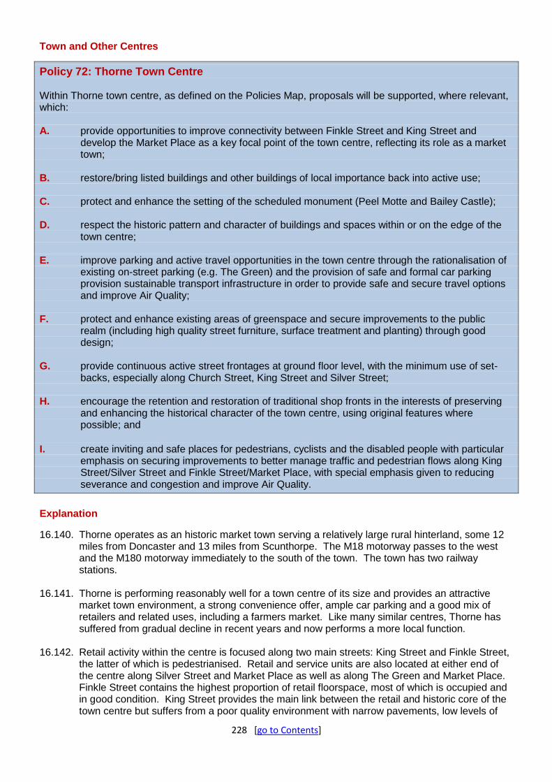
228 [go to Contents]
Town and Other Centres
Policy 72: Thorne Town Centre Within Thorne town centre, as defined on the Policies Map, proposals will be supported, where relevant, which: A. provide opportunities to improve connectivity between Finkle Street and King Street and
develop the Market Place as a key focal point of the town centre, reflecting its role as a market town;
B. restore/bring listed buildings and other buildings of local importance back into active use;
C. protect and enhance the setting of the scheduled monument (Peel Motte and Bailey Castle);
D. respect the historic pattern and character of buildings and spaces within or on the edge of the town centre;
E. improve parking and active travel opportunities in the town centre through the rationalisation of existing on-street parking (e.g. The Green) and the provision of safe and formal car parking provision sustainable transport infrastructure in order to provide safe and secure travel options and improve Air Quality;
F. protect and enhance existing areas of greenspace and secure improvements to the public realm (including high quality street furniture, surface treatment and planting) through good design;
G. provide continuous active street frontages at ground floor level, with the minimum use of set-backs, especially along Church Street, King Street and Silver Street;
H. encourage the retention and restoration of traditional shop fronts in the interests of preserving and enhancing the historical character of the town centre, using original features where possible; and
I. create inviting and safe places for pedestrians, cyclists and the disabled people with particular
emphasis on securing improvements to better manage traffic and pedestrian flows along King Street/Silver Street and Finkle Street/Market Place, with special emphasis given to reducing severance and congestion and improve Air Quality.
Explanation
16.140. Thorne operates as an historic market town serving a relatively large rural hinterland, some 12 miles from Doncaster and 13 miles from Scunthorpe. The M18 motorway passes to the west and the M180 motorway immediately to the south of the town. The town has two railway stations.
16.141. Thorne is performing reasonably well for a town centre of its size and provides an attractive market town environment, a strong convenience offer, ample car parking and a good mix of retailers and related uses, including a farmers market. Like many similar centres, Thorne has suffered from gradual decline in recent years and now performs a more local function.
16.142. Retail activity within the centre is focused along two main streets: King Street and Finkle Street, the latter of which is pedestrianised. Retail and service units are also located at either end of the centre along Silver Street and Market Place as well as along The Green and Market Place. Finkle Street contains the highest proportion of retail floorspace, most of which is occupied and in good condition. King Street provides the main link between the retail and historic core of the town centre but suffers from a poor quality environment with narrow pavements, low levels of

229 [go to Contents]
pedestrian activity and heavy traffic movements.
16.143. Much of the town centre lies within a conservation area. The area includes a wealth of small-scale residential and commercial properties, mainly dating back to the eighteenth and nineteenth centuries, although a few significant buildings survive from earlier periods. Thorne’s street pattern has evolved from a typically medieval pattern of narrow properties, with some set at right angles to the principal streets of King Street, Queen Street and Finkle Street. The market area (which dates back to the 1600s, when Charles II granted it a royal charter) lies within the historic town and acts as strong anchor point. However, there are several gap sites (including parking lots), unsympathetic modern developments and vacant/ underused buildings which currently detract from the setting and character of the conservation area and effectively sever the grade one listed parish church (St Nicholas) and scheduled monument (Peel Motte) from the rest of the town centre. Some of the listed buildings around Market Place and Stonegate are at risk of further decay and neglect. Redeveloping these sites will help reinvigorate the appeal of the conversation area and improve the attractiveness and vitality of the town centre as a whole.
16.144. The public realm (streets, spaces and squares) within the town centre is of varied quality and lacks coherence. Problems include blank and insecure spaces, a lack of greenery, poor pedestrian crossings, poor quality shop frontages and uncoordinated street furniture. Several opportunities exist to bring enhancements to existing public spaces and the streetscape such as seating, signage, planting, shared surfacing/crossings and more functional and attractive paving, especially at key arrival points, such as Market Place and King Street. Many of the shop fronts are in poor condition and make use of external roller shutters and grills that currently detract from the appearance of the streetscape and create a hostile environment. Appropriate contributions will be sought from developers and other funding sources towards the provision of public realm and traffic management improvements within the town centre.
16.145. In addition, surface and on-street car parking should be rationalised within parts of the town centre to maximise the use of the space and improve pedestrian circulation (e.g. The Green) and prioritise local residents (e.g. Queen Street). There is scope to make use of underused upper floors of buildings either as office or residential accommodation.
16.146. Thorne’s heritage assets such as Market Place, Peel Hill Motte and Thorne Hall have the potential to act as a driver of revitalisation within the town centre. New development within the town centre will need to be sympathetically designed and in harmony with the scale and character of the townscape, using traditional materials, wherever possible.

230 [go to Contents]
Service Towns and Villages
Role and Function
16.147. The ten Service Towns and Villages are comprised of smaller towns and villages in the Borough that have good service levels and existing population, and are therefore capable of supporting some local growth. This growth predominantly relates to meeting local housing needs. This means that every settlement has a housing allocation. Collectively, these settlements will deliver up to 15% of the Borough’s housing supply.
Askern
Settlement Profile
16.148. Askern is a former mining town in the north of the Borough. It lies along the A19 between Doncaster and Selby, and is equidistant between Doncaster town centre and Junction 34 of the M62. It has a direct road link to both along the A19. In the eighteenth and nineteenth centuries, Askern developed as a successful spa town with far reaching popularity to the extent that it became a destination for visitors from far and wide. This was also the main driver for the railway being built to the Town which was on the back of Askern’s growing reputation for its bathhouses and their healing waters. However, since the establishment of a colliery in 1911, the settlement, like many others in Doncaster, has become associated with coal mining. After 80 years, the colliery closed in 1991 and was being redeveloped for housing at time of Plan preparation.
16.149. Askern railway station closed in 1947, but there is a longstanding ambition for a rail service to be reintroduced with some initial feasibility work being undertaken. To the north and west of Askern are the closely related villages of Norton, Campsall and Sutton, meaning Askern also has an important role as a Service Town for these settlements, as well as the more outlying villages of Moss and Fenwick.
16.150. The settlement is inset within the Green Belt, and has areas within Flood Zone 2. There are, brownfield / urban redevelopment opportunities within the town, and this is reflected in the fact that the number of sites available, both via existing commitments and new allocations, mean Askern can far surpass its housing target and has a housing supply far more in line with the Borough’s Main Towns.
Settlement Role and Function (in the Local Plan)
16.151. Askern is designated as a Service Town. Existing permissions and other suitable urban sites meansthere is no need for additional urban extensions into the Green Belt, with the exception of a single site which has now been granted planning permission post April 2018 at the Askern Miners Welfare. Askern is projected to deliver the most new dwellings in the Service Town and Village tier and will also deliver more new dwellings than some of the larger Main Towns which are more constrained. Given the Town is currently experiencing a significant level of growth, especially in respect to housing, coupled with the role Askern plays in supporting smaller villages in the area, then the Town’s population and service provision is likely to increase even further in the near future. A review of the Local Plan may therefore identify Askern as having the higher population and service provision more characterised by a ‘Main Town’ in the future.
16.152. In the retail hierarchy Askern is a District Centre; acknowledging it serves a wider catchment, proposals will, therefore, be supported which protect, maintain and enhance its vitality and viability.

231 [go to Contents]
Employment Allocations (Policy 3)
16.153. Policy 2 includes a target for at least 481 hectares of employment land to be developed in the Borough.
16.154. As at 1 April 2018, there are 2.27 ha with permission in Askern.
Table E6: Allocations with planning permission (as at 1 April 2018)
Site Ref
Address/Location Gross Site Area (Ha)
Permission Use Area Remaining for Employment Use (Ha)
Area to be Developed in the Remainder of the Plan Period (2018-2035) (Ha)
MIX04 Askern Saw Mills, High Street, Askern
15.08 Outline for mixed use
B2/B8 2.27 2.27
Employment Policy Areas (Policy 4)
16.155. Existing employment sites include:
Askern Saw Mills – two small established employment sites supporting local businesses.
Selby Road – two separate sites on either side of A19 supporting a regional company with some vacant land and a supermarket.
Askern Industrial Estate – existing site with a mix of small units providing local jobs.
Housing Allocations (Policy 5)
16.156. As at 1 April 2018, there are permissions for 564 dwellings on sites large enough to allocate (5+ units). A further 127 new homes are allocated across three sites. Two of these are sustainable urban sites and the third is a brownfield Green Belt site which is now permissioned post April 2018; all of which provides housing supply for Askern totalling 691 new homes. A relatively small Potential Development Site (29 dwellings) could provide further new housing for the town if flood risk challenges can be addressed in line with Policy 57, including the need to pass the sequential and exceptions tests.
Table H1(I): Allocations with planning permission (as at 1 April 2018)
Site Ref
Address Site Area (Ha)
Permission Capacity (Net) Achievability (deliverable & developable)
Type Status Total Units Remaining
0-5 Yrs
6-10 Yrs
11-15 Yrs
15-17 Yrs
Beyond Plan
Period
MIX04 Askern Saw Mills, Askern
15.08 Outline Not Started
220 220 140 80 0 0 0
ASK01 Land Adjacent Acorn Park, Rushy Moor Lane, Askern
0.4 Full Started 7 7 7 0 0 0 0
ASK02 Freeman Builders Ltd, Marlborough Road, Askern
0.23 Full Started 9 5 5 0 0 0 0
ASK03 Land at Former Colliery, Campsall Road, Askern
8.01 Full Started 227 157 157 0 0 0 0
ASK04 Land Off Highfield Road, Askern
1.78 Outline Not Started
62 62 62 0 0 0 0
ASK05 Land East Of Selby Road, Askern
2.56 Full Started 76 66 66 0 0 0 0
ASK06 Former Askern Selby Road Youth Club, Selby Road, Askern
0.3 Outline Not Started
16 16 16 0 0 0 0
ASK07 Premier House, Selby Road, Askern
0.42 Outline Not Started
16 16 16 0 0 0 0

232 [go to Contents]
Site Ref
Address Site Area (Ha)
Permission Capacity (Net) Achievability (deliverable & developable)
Type Status Total Units Remaining
0-5 Yrs
6-10 Yrs
11-15 Yrs
15-17 Yrs
Beyond Plan
Period
ASK08 1 Spa Terrace, Askern
0.58 Full Not Started
15 15 15 0 0 0 0
TOTALS 648 564 484 80 0 0 0
Table H2(I): Allocations without planning permission (as at 1 April 2018)
Site Ref
Address Site Area (Ha)
Indicative Capacity (No of houses)
Achievability (deliverable & developable)
0-5 Yrs
6-10 Yrs
11-15 Yrs
15-17 Yrs
Beyond Plan Period
ASK09 Askern Industrial Estate, Moss Road, Askern
1.5 44 44 0 0 0 0
ASK10 Askern Miners Welfare, Manor Way, Askern
2.67 49 49 0 0 0 0
ASK11 East of Avenue Road, Instoneville
1.21 34 34 0 0 0 0
TOTALS 127 127 0 0 0 0
Table H3(D): Potential Development Sites
Site Ref Address Site Area (Ha) Indicative Capacity (No of houses)
PHD08 Highfield Road, Askern 0.98 29
TOTAL 29

233 [go to Contents]
Auckley & Hayfield Green
Settlement Profile
16.157. Auckley – Hayfield Green are two contiguous settlements under one parish to the east of the Borough, which are closely related to Doncaster – Sheffield Airport. The settlement (particularly Hayfield Green) expanded around RAF Finningley (now Doncaster – Sheffield Airport) in the 1960s, and more recently there have been further housing developments close to this.
16.158. The settlement is currently undergoing a transformative period, as the Airport seeks to expand
its operations. Key to this has been the completion of the Great Yorkshire Way, which links the Airport to the M18, providing residents, commuters and goods quick and convenient access to the motorway network and central Doncaster. In March 2018, the Airport Masterplan was published which proposed an increase in airport operations, employment sites and housing around the Airport. The Local Plan has a separate policy (Policy 6) related to the Airport.
16.159. Auckley – Hayfield Green is closely related to other villages in the east of the Borough, which
occur along and off the B1396. These include Branton, Blaxton and Finningley, and therefore these settlements have some service interdependence. This road also leads towards the Main Urban Area, meaning residents have reasonably straight forward and good access to services here too.
Settlement Role and Function (in the Local Plan)
16.160. Auckley – Hayfield Green is designated as a Service Town and Village. Between existing permissions (115 units) and new allocations (140 units), the settlement can deliver 255 new units in the plan period. Additionally, as per Policy 6, there will be 280 houses allocated on land adjacent to Doncaster Sheffield Airport, which will be additional to the housing requirement for the Borough and which will not be counted towards the overall housing supply. Further housing up to 920 additional units may also be permissible, subject to the proven delivery of jobs in this location. For more information please refer to Policy 6 and Appendix 3.
16.161. As part of its overall development, the Local Plan also supports new employment and retail
development at the Airport. 16.162. The area does not have a designated retail centre but provides some smaller shops and
services within shopping parades. Policy 6 proposes a new mixed use development at the Airport which will, upon substantial completion, become a new town centre (subject to future assessment of the final scheme).
Neighbourhood Planning
16.163. The local community are currently preparing a neighbourhood plan for the area, but this is unlikely to precede the Local Plan.
Employment Allocations (Policy 3)
16.164. Policy 2 includes a target for at least 481 hectares of employment land to be developed in the Borough.
16.165. Table 5 allocates one site in Auckley & Hayfield Green totalling 69 hectares which is at the Airport and will form part of Aero Centre Yorkshire.
16.166. As at 1 April 2018, there are 14.85 ha with permission in Auckley & Hayfield Green, one of which is at the Airport and is part of the business park offer.

234 [go to Contents]
Table E7: Allocations with planning permission (as at 1 April 2018)
Site Ref
Address/Location Gross Site Area (Ha)
Permission Use Area Remaining for Employment Use (Ha)
Area to be Developed in the Remainder of the Plan Period (2015-2035) (Ha)
EMP15 West of DSA Terminal, First Avenue, Auckley
13.17 Outline B1/B2/B8 11.85 11.85
EMP16 Blaxton Quarry, Mosham Road, Auckley
9.47 Outline B2/B8 3.00 3.00
Employment Policy Areas (Policy 4)
16.167. There are a number of existing employment sites at the Airport including:
Workpods, Fountains Court – a site with a number of small office units. Sky Business Park, Delta Court – a mix of small business units. Hayfield Lane Business Park – a mix of office units of differing sizes.
Housing Allocations (Policy 5)
16.168. As at 1 April 2018, there are permissions for 115 dwellings on a single site large enough to allocate through the Local Plan (5+ units). A single additional allocation is made on a greenfield urban site capable of accommodating 140 new homes. This brings the settlement’s housing supply up to 255 new homes across the plan period. There is no justification, therefore, for any additional allocations that would require land currently designated as Countryside, with the exception of any housing at the settlement in accordance with Policy 6 which sits outside of the settlement strategy and forms an additional potential source of housing supply.
Table H1(J): Allocations with planning permission (as at 1 April 2018)
Site Ref
Address Site Area (Ha)
Permission Capacity (Net) Achievability (deliverable & developable)
Type Status Total Units Remaining
0-5 Yrs
6-10 Yrs
11-15 Yrs
15-17 Yrs
Beyond Plan Period
AHG01 Hurst Lane, Hayfield Green
18.88 Full Started 450 115 115 0 0 0 0
TOTALS 450 115 115 0 0 0 0
Table H2(J): Allocations without planning permission (as at 1 April 2018)
Site Ref Address Site Area (Ha)
Indicative Capacity (No of houses)
Achievability (deliverable & developable)
0-5 Yrs
6-10 Yrs
11-15 Yrs
15-17 Yrs
Beyond Plan
Period
AHG02 North of Hayfield Lane, Hayfield Green
5.59 140 70 70 0 0 0
TOTALS 140 70 70 0 0 0

235 [go to Contents]
Barnburgh & Harlington
Settlement Profile
16.169. Made up of two adjacent settlements with a strong sense of a shared identity, Barnburgh – Harlington, which has its origins in Anglo – Saxon times, is one of the smaller and more rural settlements in the Borough.
16.170. Despite both settlements being of a similar size, the majority of services are found within Barnburgh. Lying to the west of Doncaster, the settlement is well related to both Mexborough, in Doncaster, and Goldthorpe and Bolton upon Dearne, in Barnsley. As Mexborough and Goldthorpe both have railway stations, there are close by links to Doncaster and Sheffield as well as the Leeds line at Goldthorpe and Bolton. Barnburgh – Harlington does have a smaller population and lower service levels than other settlements with allocated housing, and this is reflected in the modest requirement for 60 new plan period homes.
16.171. The Green Belt is tightly drawn to the settlement boundary and, coupled with a lack of urban sites in this location, this means that there are very limited opportunities for development without considering suitable Green Belt release. This is reflected in the low level of existing permissions in this settlement.
Settlement Role and Function (in the Local Plan)
16.172. Barnburgh – Harlington is designated as a Service Town. As there are no existing permissions in this location, the settlement requires a new site allocation.
Housing Allocations (Policy 5)
16.173. As at 1 April 2018, there are no permissions on sites large enough to allocate through the Local Plan (5+ units). A single urban extension for 66 new houses is made on land that was formerly Green Belt to the south of Harlington on a site east of Mill Lane and south of Doncaster Road.
Table H2(K): Allocations without planning permission (as at 1 April 2018)
Site Ref
Address Site Area (Ha)
Indicative Capacity (No of houses)
Achievability (deliverable & developable)
0-5 Yrs
6-10 Yrs
11-15 Yrs
15-17 Yrs
Beyond Plan
Period
BH01 South of Doncaster Road, Harlington
2.35 66 0 66 0 0 0
TOTALS 66 0 66 0 0 0
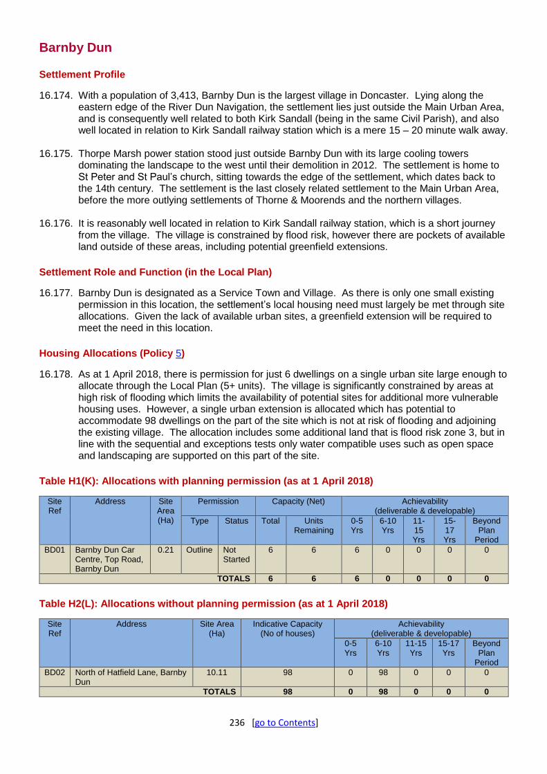
236 [go to Contents]
Barnby Dun
Settlement Profile
16.174. With a population of 3,413, Barnby Dun is the largest village in Doncaster. Lying along the eastern edge of the River Dun Navigation, the settlement lies just outside the Main Urban Area, and is consequently well related to both Kirk Sandall (being in the same Civil Parish), and also well located in relation to Kirk Sandall railway station which is a mere 15 – 20 minute walk away.
16.175. Thorpe Marsh power station stood just outside Barnby Dun with its large cooling towers dominating the landscape to the west until their demolition in 2012. The settlement is home to St Peter and St Paul’s church, sitting towards the edge of the settlement, which dates back to the 14th century. The settlement is the last closely related settlement to the Main Urban Area, before the more outlying settlements of Thorne & Moorends and the northern villages.
16.176. It is reasonably well located in relation to Kirk Sandall railway station, which is a short journey from the village. The village is constrained by flood risk, however there are pockets of available land outside of these areas, including potential greenfield extensions.
Settlement Role and Function (in the Local Plan)
16.177. Barnby Dun is designated as a Service Town and Village. As there is only one small existing permission in this location, the settlement’s local housing need must largely be met through site allocations. Given the lack of available urban sites, a greenfield extension will be required to meet the need in this location.
Housing Allocations (Policy 5)
16.178. As at 1 April 2018, there is permission for just 6 dwellings on a single urban site large enough to allocate through the Local Plan (5+ units). The village is significantly constrained by areas at high risk of flooding which limits the availability of potential sites for additional more vulnerable housing uses. However, a single urban extension is allocated which has potential to accommodate 98 dwellings on the part of the site which is not at risk of flooding and adjoining the existing village. The allocation includes some additional land that is flood risk zone 3, but in line with the sequential and exceptions tests only water compatible uses such as open space and landscaping are supported on this part of the site.
Table H1(K): Allocations with planning permission (as at 1 April 2018)
Site Ref
Address Site Area (Ha)
Permission Capacity (Net) Achievability (deliverable & developable)
Type Status Total Units Remaining
0-5 Yrs
6-10 Yrs
11-15 Yrs
15-17 Yrs
Beyond Plan
Period
BD01 Barnby Dun Car Centre, Top Road, Barnby Dun
0.21 Outline Not Started
6 6 6 0 0 0 0
TOTALS 6 6 6 0 0 0 0
Table H2(L): Allocations without planning permission (as at 1 April 2018)
Site Ref
Address Site Area (Ha)
Indicative Capacity (No of houses)
Achievability (deliverable & developable)
0-5 Yrs
6-10 Yrs
11-15 Yrs
15-17 Yrs
Beyond Plan
Period
BD02 North of Hatfield Lane, Barnby Dun
10.11 98 0 98 0 0 0
TOTALS 98 0 98 0 0 0

237 [go to Contents]
Bawtry
Settlement Profile
16.179. Bawtry is an attractive historic market town just inside the Borough’s southern boundary with Nottinghamshire. Originally a river port, in the eighteenth and nineteenth centuries Bawtry’s prominence as a coaching stop increased, which corresponded with a period of prosperity for the town. Today, the settlement is an attractive and sought after area with a good level of services and a vibrant social offering.
16.180. Bawtry is situated along the intersection of the A638 and A631, which means the settlement has good local access. The A1(M) lies approximately 3 miles to the east and south of the settlement, with access achievable at Junction 34 near Blyth in Bassetlaw. Bawtry also lies about 5 miles south of the Airport, with access via the A638, which also continues towards central Doncaster. Despite the East Coast Mainline passing through the east of the town, as with other settlements to the south-east of the Borough, there is no local train station.
16.181. At its core, Bawtry has a good range of shops, restaurants, pubs and bars, as well as office space, with residential areas surrounding this. The settlement is relatively isolated in relation to central Doncaster but does however lie close to the market town of Tickhill, as well as Harworth and Bircotes in Bassetlaw. Its location means the Nottinghamshire towns of Worksop and Retford are not much further away than central Doncaster. Slightly east of Bawtry is the Defined Village of Austerfield, which can utilise Bawtry’s services.
Settlement Role and Function (in the Local Plan)
16.182. Bawtry is designated as a Service Town and Village. The supply will be made up by a mix of permissions (54 units) and allocations (36 units), which will include a small former Green Belt site, and a further urban site.
16.183. In the retail hierarchy Bawtry is a District Centre; proposals will be supported which protect, maintain and enhance its vitality and viability.
Neighbourhood Planning
16.184. The Bawtry Neighbourhood Plan was adopted in November 2019.
Employment Policy Areas (Policy 4)
16.185. There are two existing employment sites, which are:
Hudsons Yard, Bawtry Road – a local site with a haulage business.
Station Road Industrial Estate – small businesses serving the local area.
Housing Allocations (Policy 5)
16.186. As at 1 April 2018, there are permissions for 54 dwellings on sites large enough to allocate through the Local Plan (5+ units remaining). An additional two relatively small allocations are made through the plan; one being a greenfield urban site and the other a greenfield extension on land formerly designated as Green Belt. These two sites have a combined capacity of 36 new homes and bring the settlement’s housing allocation up to 90 dwellings for the plan period. Any additional allocations would require large urban extensions on land currently designated as Green Belt where it is not considered exceptional circumstances exist to remove further sites.

238 [go to Contents]
Table H1(L): Allocations with planning permission (as at 1 April 2018)
Site Ref
Address Site Area (Ha)
Permission Capacity (Net) Achievability (deliverable & developable)
Type Status Total Units Remaining
0-5 Yrs
6-10 Yrs
11-15 Yrs
15-17 Yrs
Beyond Plan
Period
BAW01 Station Hotel, 93 Station Road, Bawtry
0.14 Full Not Started
12 12 12 0 0 0 0
BAW02 Bawtry Hall, South Parade, Bawtry
0.37 Full Not Started
8 8 8 0 0 0 0
BAW03 Land and Buildings on the West Side of Top Street, Bawtry
0.47 Full Started 34 34 34 0 0 0 0
TOTALS 54 54 54 0 0 0 0
Table H2(M): Allocations without planning permission (as at 1 April 2018)
Site Ref
Address Site Area (Ha)
Indicative Capacity (No of houses)
Achievability (deliverable & developable)
0-5 Yrs
6-10 Yrs
11-15 Yrs
15-17 Yrs
Beyond Plan Period
BAW04 Westwood Road, Bawtry
0.75 20 0 20 0 0 0
BAW05 North of North Avenue, Bawtry
0.53 16 16 0 0 0 0
TOTALS 36 16 20 0 0 0

239 [go to Contents]
Carcroft & Skellow
Settlement Profile
16.187. Carcroft and Skellow are two contiguous settlements lying towards the north-east of Doncaster. The settlement expanded with the mining industry in the twentieth century, with Bullcroft Colliery operating in the settlement until 1968. Today it is the largest of the Service Towns and Villages in the Borough in terms of population and households and has a good level of services, and access to services in neighbouring Adwick – Woodlands.
16.188. Between Carcroft – Skellow and Adwick – Woodands is Carcroft Industrial Estate, and the Redhouse Logistics Park is also located within Adwick, both providing good employment opportunities to local residents. Adwick railway station is situated towards the boundary of the settlements and is therefore also well placed for residents of Carcroft – Skellow. The small villages of Burghwallis and Owston lie in close proximity to the settlement and can utilise services here. There are two southbound access points to the A1, which lies to the west of the settlement; however, northbound access is only via Junction 38 at Adwick.
16.189. The settlement is tightly bounded by the Green Belt and extensive areas are also covered by flood zone.
Settlement Role and Function (in the Local Plan)
16.190. Carcroft – Skellow is designated as a Service Town and Village. Due to the aforementioned constraints on land, and a lack of available existing permissions and unconstrained urban opportunities in the area, a greenfield extension is allocated on former Green Belt land.
16.191. In the retail hierarchy Carcroft and Skellow each have a Local Centre; proposals will be supported which protect, maintain and enhance its vitality and viability.
Employment Allocations (Policy 3)
16.192. Policy 2 includes a target for at least 481 hectares of employment land to be developed in the Borough.
16.193. Table 6 allocates a Potential Development Site in Carcroft & Skellow which is at Carcroft Common. Any development on this site will be additional supply above the employment land requirement for the plan period,
Employment Policy Areas (Policy 4)
16.194. There is one existing employment site:
Carcroft Industrial Estate – large established site with small and medium businesses serving the local area.
Housing Allocations (Policy 5)
16.195. As at 1 April 2018, there is just one single site with permission for 7 dwellings meaning the majority of the town’s housing need is still to be identified through new allocations. Much of the land available is constrained by Green Belt and/or Flood Risk. The Local Plan allocates a single urban extension on land formerly designated as Green Belt which has capacity for 300 new homes following some generous discounting of the total potential site capacity in order to provide extensive green buffering between the development and the adjacent A1(M) to the west of the site. Collectively these two allocations provide 307 new homes for the town.
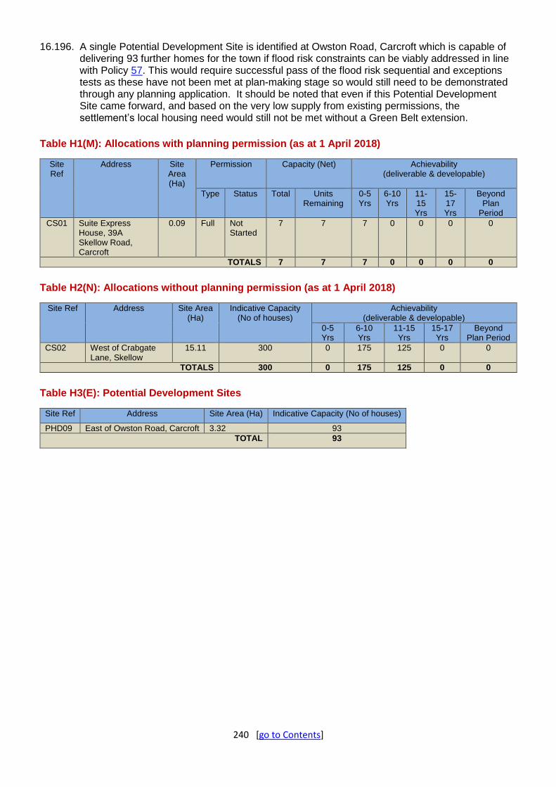
240 [go to Contents]
16.196. A single Potential Development Site is identified at Owston Road, Carcroft which is capable of delivering 93 further homes for the town if flood risk constraints can be viably addressed in line with Policy 57. This would require successful pass of the flood risk sequential and exceptions tests as these have not been met at plan-making stage so would still need to be demonstrated through any planning application. It should be noted that even if this Potential Development Site came forward, and based on the very low supply from existing permissions, the settlement’s local housing need would still not be met without a Green Belt extension.
Table H1(M): Allocations with planning permission (as at 1 April 2018)
Site Ref
Address Site Area (Ha)
Permission Capacity (Net) Achievability (deliverable & developable)
Type Status Total Units Remaining
0-5 Yrs
6-10 Yrs
11-15 Yrs
15-17 Yrs
Beyond Plan
Period
CS01 Suite Express House, 39A Skellow Road, Carcroft
0.09 Full Not Started
7 7 7 0 0 0 0
TOTALS 7 7 7 0 0 0 0
Table H2(N): Allocations without planning permission (as at 1 April 2018)
Site Ref Address Site Area (Ha)
Indicative Capacity (No of houses)
Achievability (deliverable & developable)
0-5 Yrs
6-10 Yrs
11-15 Yrs
15-17 Yrs
Beyond Plan Period
CS02 West of Crabgate Lane, Skellow
15.11 300 0 175 125 0 0
TOTALS 300 0 175 125 0 0
Table H3(E): Potential Development Sites
Site Ref Address Site Area (Ha) Indicative Capacity (No of houses)
PHD09 East of Owston Road, Carcroft 3.32 93
TOTAL 93

241 [go to Contents]
Edlington
Settlement Profile
16.197. Edlington is a former mining town located to the south-west of the Main Urban Area, from which it is separated by Warmsworth Halt Industrial estate, and lying to the east of Conisbrough. Like many towns in Doncaster, the formerly rural settlement expanded around coal mining, to house workers for the nearby Yorkshire Main Colliery, which was first sunk in 1909, and closed in 1985.
16.198. Edlington is well placed in relation to the road network, lying close to the A630 which leads to central Doncaster, and also close to the A1(M) at Junction 36 (Warmsworth), which is also one junction north of where the A1(M) intersects the M18.
16.199. Edlington is one of the best scoring settlements in the Borough in the Settlement Audit, having service provision akin to larger settlements. It is also extremely well placed to utilise the high levels of services in the Main Urban Area and Mexborough, as well as its excellent accessibility to the wider road network. Although the settlement is surrounded by Green Belt numerous development opportunities exist outside this designation.
Settlement Role and Function (in the Local Plan)
16.200. Edlington is designated as a Service Town and Village. Existing permissions and other suitable urban site capacity (including the housing renewal sites at Thompson and Dixon Roads and the Granby estate) means there is no need for additional urban extensions into the Green Belt.
16.201. In the retail hierarchy Edlington is a District Centre; proposals will be supported which protect,
maintain and enhance its vitality and viability.
Neighbourhood Planning
16.202. The Edlington Neighbourhood Plan was successful at referendum and was ‘made’ in July 2018 but does not concern itself with development plan allocations instead focussing on detailed policies to guide decision making.
Employment Allocations (Policy 3)
16.203. Policy 2 includes a target for at least 481 hectares of employment land to be developed in the Borough.
16.204. As at 1 April 2018, there is 1 Ha with permission in Edlington.
Table E8: Allocations with planning permission (as at 1 April 2018)
Site Ref
Address/Location Gross Site Area (Ha)
Permission Use Area Remaining for Employment Use (Ha)
Area to be Developed in the Remainder of the Plan Period (2018-3035) (Ha)
EMP17 Broomhouse Lane Industrial Estate, Wood View, Edlington
0.74 Full B2 0.74 0.74
Employment Policy Areas (Policy 4)
16.205. There are a number of existing employment sites including:
Broomhouse Lane – established area with some key large employers with national significance.

242 [go to Contents]
Warmsworth Halt – established area with small and medium businesses serving the local area.
Housing Allocations (Policy 5)
16.206. As at 1 April 2018, there are permissions for 622 dwellings on sites large enough to allocate through the Local Plan (5+ units remaining). An additional 2 sustainable urban sites are allocated which provide a further supply of 43 new homes and will help provide sites in order for some of the aspirations set out in the Neighbourhood Plan to be realised, such as affordable housing and dwelling mix, given all the other sites are existing permissions which were determined in advance of the Neighbourhood Plan being ‘made’.
Table H1(N): Allocations with planning permission (as at 1 April 2018)
Site Ref
Address Site Area (Ha)
Permission Capacity (Net) Achievability (deliverable & developable)
Type Status Total Units Remaining
0-5 Yrs
6-10 Yrs
11-15 Yrs
15-17 Yrs
Beyond Plan
Period
EDL01 Land North Of Stubbins Hill, Edlington
10.97 Full Started 387 118 118 0 0 0 0
EDL02 Thompson Avenue / Dixon Road, Edlington
3.31 Full Started 173 107 107 0 0 0 0
EDL03 Site At Former Yorkshire Main Colliery , Broomhouse Lane, Balby
17.6 Outline Not Started
375 375 140 175 60 0 0
EDL04 Land Of The Former Cinema, Edlington Lane, Edlington
0.11 Full Not Started
16 16 16 0 0 0 0
EDL05 Land Off Howbeck Drive, Edlington
0.06 Outline Not Started
6 6 6 0 0 0 0
TOTALS 957 622 387 175 60 0 0
Table H2(O): Allocations without planning permission (as at 1 April 2018)
Site Ref
Address Site Area (Ha)
Indicative Capacity (No of houses)
Achievability (deliverable & developable)
0-5 Yrs
6-10 Yrs
11-15 Yrs
15-17 Yrs
Beyond Plan Period
EDL06 North of Edlington Lane, Edlington
0.24 7 7 0 0 0 0
EDL07 West of Howbeck Drive, Edlington
1.34 36 0 36 0 0 0
TOTALS 43 7 36 0 0 0
Policy 73: Local Business Expansion Site: Polypipe Land south of Broomhouse Lane, Edlington, as shown on the Policies Map, is allocated as Local Business Expansion Site (BES01) to allow for the expansion of Polypipe in line with the following principles: A. Development of the site for office and ancillary uses is supported to allow the existing Polypipe site
north of Broomhouse Lane to remain for, and expand its, operational purposes;
243 [go to Contents]
B. Development of this site should be accompanied by the enhancement of the remaining open space to the south of the site and/or a compensatory contribution to the replacement of play equipment elsewhere in the vicinity; and
C. Compensatory improvements must be provided to the Green Belt land in proximity of the site.
Explanation
16.207. Polypipe, located in Edlington, is one of the largest, and most well established employers within Doncaster Borough. In order for Polypipe to expand and continue to operate efficiently there is the need to provide extra capacity for the company to remodel and allow the head offices to be relocated. Land to the south of Broomhouse Lane provides such an opportunity and has been removed from the Green Belt specifically for this purpose.
16.208. Development on this site will result in the loss of existing open space including the loss of play equipment. Therefore it is important that the open space to the south is improved and enhanced. There may also be the requirement for the compensatory replacement of play equipment elsewhere in the vicinity.
16.209. Due to the removal of the site from the Green Belt it is necessary that there are compensatory improvements to the Green Belt within the local area. This may include Edlington Ancient Woodland or Edlington Pit Wood.

244 [go to Contents]
Finningley
Settlement Profile
16.210. Lying to the east of Doncaster, Finningley is one of the smaller Service Towns and Villages in the Borough. Physically and historically, the settlement is closely related to the now Doncaster – Sheffield Airport (formerly RAF Finningley), which lies immediately adjacent to the settlement. This airbase, with a 2,700m long runway, was home to a V-Force of Vulcan bombers in the latter twentieth century. However, the airbase closed in 1996 following the end of the Cold War, fully reopening to passengers as a commercial airport in 2005 – although now considered to relate to the neighbouring village of Auckley – Hayfield Green.
16.211. Finningley is part of a cluster of villages to the east of the Borough, also including Auckley - Hayfield Green and the Defined Villages of Branton and Blaxton. In particular, the settlements of Finningley and Auckley – Hayfield Green provide a service function for these villages.
16.212. Links to central Doncaster have improved recently following the completion of the Great Yorkshire Way in 2018 between the M18 near Rossington and the Airport, although residents still have to travel around the Airport via Blaxton to reach this. Despite the Doncaster – Lincoln railway line lying to the north of the settlement, there has not been a passenger service to the settlement since 1961; although the 2018 Doncaster – Sheffield Airport Masterplan states its ambition for a train line and station to be developed at the Airport which would also serve residents of Finningley. The Local Plan has a separate policy (Policy 6) related to the Airport.
Settlement Role and Function (in the Local Plan)
16.213. Finningley is designated as a Service Town and Village. Existing commitments remaining to be delivered in the settlement from permissions (50 units remaining), means it is not deemed necessary to allocate any further land in this settlement.
Housing Allocations (Policy 5)
16.214. As at 1 April 2018, there are permissions for 50 dwellings on sites large enough to allocate through the Local Plan (5+ units remaining). Any additional allocations would require land currently designated as countryside which is not justified.
Table H1(O): Allocations with planning permission (as at 1 April 2018)
Site Ref
Address Site Area (Ha)
Permission Capacity (Net) Achievability (deliverable & developable)
Type Status Total Units Remaining
0-5 Yrs
6-10 Yrs
11-15 Yrs
15-17 Yrs
Beyond Plan
Period
FIN01 Land to the South West Side of St Oswalds Drive, Finningley
0.77 Full Started 14 5 5 0 0 0 0
FIN02 Units 1 and 2, Old Bawtry Road, Finningley
1.6 Full Started 45 37 37 0 0 0 0
FIN03 White and Carter, Station Road, Finningley
0.23 Full Started 8 8 8 0 0 0 0
TOTALS 67 50 50 0 0 0 0

245 [go to Contents]
Sprotbrough
Settlement Profile
16.215. Sprotbrough Village is a settlement immediately to the west of Doncaster, separated from the Main Urban Area to the east by the A1(M). Travelling through the settlement represents a transition from urban to rural, and beyond Sprotbrough lies swathes of rural Green Belt, which is tightly drawn around the settlement.
16.216. The village has excellent access to central Doncaster via Melton Road. However, despite lying immediately adjacent to the A1(M), there is no direct access to this. The River Don passes to the south of the village, providing a picturesque waterside setting for the settlement, including the seventeenth century Boat Inn.
16.217. For the purposes of the Local Plan, Sprotbrough Village refers to the settlement west of the A1(M), with dwellings to the east of this falling within the Main Urban Area.
Settlement Role and Function (in the Local Plan)
16.218. Sprotbrough is designated as a Service Town and Village. There are no planning permissions with units remaining in this location and a lack of potential urban and non-Green Belt sites, meaning greenfield Green Belt land needs to be considered for release.
Neighbourhood Planning
16.219. The local community are currently preparing a neighbourhood plan which will cover the village and land within the parish boundary to the east of the A1(M).
Housing Allocations (Policy 5)
16.220. As at 1 April 2018, there are no permissions for the village on sites large enough to allocate through the Local Pan (5+ units remaining). A single greenfield urban extension, on land formerly designated as Green Belt, to the north of Cadeby Road and to the west of the village is allocated for 80 new homes. Any further allocations would require an additional, and very substantial, Green Belt site which is not justified, nor can exceptional circumstances be demonstrated for further Green Belt.
Table H2(P): Allocations without planning permission (as at 1 April 2018)
Site Ref
Address Site Area (Ha)
Indicative Capacity (No of houses)
Achievability (deliverable & developable)
0-5 Yrs
6-10 Yrs
11-15 Yrs
15-17 Yrs
Beyond Plan Period
SPR01 Between Cadeby Road and Melton Road, Sprotbrough
2.85 80 0 80 0 0 0
TOTALS 80 0 80 0 0 0

246 [go to Contents]
Tickhill
Settlement Profile
16.221. Tickhill is an attractive market town lying towards the south-east of the Borough, close to the Borough boundary with Nottinghamshire. It is physically isolated from urban Doncaster, with access via Rossington on the B643 or Wadworth and Loversall on the A60. It lies close to the settlement of Bawtry, as well as the Harworth and Bircotes in Nottinghamshire (to the South East) and has access to Maltby in Rotherham, approximately four miles to the west via the A631. The A1(M) runs to the east of the settlement, however this completely bypasses Tickhill.
16.222. The settlement is relatively nucleated and has its origins in Norman times when a castle was constructed here in the eleventh century. The main built from of the settlement lies to the north of the castle and expanded in the later twentieth century.
Settlement Role and Function (in the Local Plan)
16.223. Tickhill is designated as a Service Town and Village. There are no planning permissions with capacity remaining and a lack of suitable urban sites in the settlement. Additionally, aside from a tightly drawn Green Belt boundary, many site options in the settlement are restricted due to access issues which result from Tickhill’s more rural elements. That said, a single allocation of 74 units has been identified on land in the settlement which was formerly Green Belt.
16.224. In the retail hierarchy Tickhill is a District Centre; proposals will be supported which protect, maintain and enhance its vitality and viability.
Neighbourhood Planning
16.225. The Tickhill Neighbourhood Plan was adopted in the context of the previous Core Strategy and so proposes no housing allocations.
Employment Policy Areas (Policy 4)
16.226. There is one existing employment site close to Tickhill:
Stripe Road Industrial Estate – a site with predominately warehousing uses situated within countryside in the Green Belt.
Housing Allocations (Policy 5)
16.227. As at 1 April 2018, there are no permissions large enough to allocate and only a single site, equating to 74 units, has been assessed through the Local Plan site selection methodology as being supportable for allocation. Other sites were dismissed either due to importance to Green Belt purposes or problems with creating a safe and viable access, from a Highways Development Management perspective, given the very rural nature of some of the road network around the settlement. Some sites are ruled out for both of these reasons.
Table H2(Q): Allocations without planning permission (as at 1 April 2018)
Site Ref
Address Site Area (Ha)
Indicative Capacity (No of houses)
Achievability (deliverable & developable)
0-5 Yrs
6-10 Yrs
11-15 Yrs
15-17 Yrs
Beyond Plan Period
TIC01 South of Sunderland Street, Tickhill
2.69 74 0 74 0 0 0
TOTALS 74 0 74 0 0 0

247 [go to Contents]

248 [go to Contents]
Appendix 1: Glossary
(Annex 2 to the National Planning Policy Framework34 also includes useful definitions of terms used in national planning policy).
Abbreviation/Term Definition
Affordable Housing Housing for sale or rent, for those whose needs are not met by the market (including housing that provides a subsidised route to home ownership and/or if for essential local workers); and which complies with
one or more of the detailed definitions set out in NPPF. See Policy 7.
Aggregate Limestone Crushed rock for the construction industry.
Aggregates Particles of rock (including sand, gravel, crushed stone) or inorganic manufactured material (slag or recycled crushed concrete) used in construction.
Air Quality Management Area (AQMA)
An area where the national air quality objectives cannot be met, from this the local authority will put together a plan to improve the air quality called a ‘Local Air Quality Action Plan’.
Allocations / Site Allocations
Sites to meet future development.
Annual Monitoring Report (AMR)
Assessed the implementation of the Local Development Scheme and the extent to which policies in local development documents are being successfully implemented.
Appropriate Assessment A mechanism for assessing the effects of development on the integrity of sites of international importance in respect of rare, endangered or vulnerable natural habitats or species and identifying mitigation measures which will reduce and where possible eliminate these effects.
Area of Search An identified area used to guide mineral companies toward sustainable locations for mineral exploration, appraisal and possible development
Best and Most Versatile Agricultural Land
Land in grades 1, 2 and 3a of the Agricultural Land Classification.
Biodiversity The variety of different life forms found in an area including all types of plants and animals.
Biodiversity Action Plan (BAP)
A plan which sets out proposals to protect and improve the places where trees, plants, animals and insects live.
Biodiversity Net Gain An approach to development that leaves biodiversity in a better state than before development. Biodiversity net gain still relies on the application of the mitigation hierarchy to avoid, mitigate or compensate for biodiversity losses and uses a calculation metric to recognise the negative impacts on habitats arising from a development and calculate how much new or restored habitat, and of what types is required to deliver sufficient net gain.
Biodiversity Opportunity Area
An area where the creation of new habitats or wildlife features, and the restoration of existing ones, is expected to deliver the greatest benefit for biodiversity.
Biomass Plant materials and animal waste used as fuel.
Building Research Establishment Environmental Assessment Method (BREEAM)
A tool designed to assess the environmental performance of non-domestic buildings.
Brownfield Land See Previously developed land.
Building for a Healthy Life A national design standard for measuring the quality of major housing proposals. ‘Building for a Healthy Life: A Design Toolkit for neighbourhoods, streets, homes and public spaces’. D Birkbeck, S
34 https://www.gov.uk/government/collections/planning-practice-guidance

249 [go to Contents]
Abbreviation/Term Definition
Kruczkowski, P Jones, D Singleton and S McGlynn 2020.
Building Stone Naturally occurring rock suitable to be cut, split, or shaped into blocks for the construction industry (e.g. buildings, walls, pavements or roofs).
Bulky goods Retail categories that include furniture, white goods, electrical equipment, bedding, lighting, automotive parts, camping and outdoor equipment, tools, building materials and DIY and homemaker products.
Comparison goods Goods that consumers buy at infrequent intervals and normally would compare prices before buying e.g. TV, fridges, clothes etc.
Conservation Area An area, usually part of a settlement, designated by a local planning authority for preservation or enhancement because of its special architectural or historic interest under the Planning (Listed Buildings and Conservation Areas) Act, 1990.
Convenience goods A consumer item that is widely-available, purchased frequently and with minimal effort. Examples of convenience goods include newspapers and sweets.
Conventional Hydrocarbons Reservoir
A reservoir in which buoyant forces keep hydrocarbons in place below a sealing caprock. Reservoir and fluid characteristics of conventional reservoirs typically permit oil or natural gas to flow readily into wellbores. The term is used to make a distinction from shale and other unconventional reservoirs, in which gas might be distributed throughout the reservoir at the basin scale, and in which buoyant forces or the influence of a water column on the location of hydrocarbons within the reservoir are not significant. (Sourced from the Schlumberger Oilfield Glossary. https://www.glossary.oilfield.slb.com)
Core Strategy Part of the statutory development plan superseded when the Local Plan is adopted.
Countryside Policy Area As defined by Policy 1, for Local Plan purposes this is defined as land outside of the Green Belt and beyond defined ‘Development Limits’ as shown on the Policies Map.
Civic Quarter The new development in Doncaster Town Centre to house all council offices along with major new development uses such as housing, leisure and open space.
Decentralised Energy Systems
The generation of energy from dispersed sources such as micro-renewable technologies, as opposed to large centralised systems (e.g. power stations).
Density The number of buildings in a given area. In the Local Plan it is used mainly in relation to housing, being expressed as dwellings per hectare or ‘dph’.
Designations Areas of land where specific policies apply.
Development Plan Sets out the Local Planning Authority’s policies and proposals for the development and use of land and buildings in the authority’s area. In Doncaster will be comprised of the Local Plan and the Joint Waste Local Plan.
Development Limits See Policy 1.
Dolomite A sedimentary rock forming mineral – calcium magnesium carbonate (CaMg(CO3)2.
Doncaster Biodiversity Action Plan
A plan that outlines wildlife and conservation priorities and provides guidance on how we can protect and enhance biodiversity.
Ecosystem Services The benefits that we derive from the natural world and its constituent ecosystems, including products like food, fibre, wood and water; services like pollination, nutrient cycling, soil formation, water purification, flood defence and opportunities for reflection and recreation.
Energy Minerals Hydrocarbons such as coal, oil and natural gas used as a fuel to produce electricity and heat.
Fields in Trust (FIT) Independent national organisation responsible for acquiring, protecting

250 [go to Contents]
Abbreviation/Term Definition
and improving playing fields including playgrounds and provides an advisory service for play, sport and recreation.
Food and Drink Uses The sale of food and drink for consumption mostly on the premises (cafes & restaurants), hot food takeaways and pubs, wine bars, and, drinking establishments including with expanded food provision.
Geodiversity The variety of different minerals, rocks, fossils and landforms that determine the landscape and character of our natural environment.
Green Belt Development restraint policy area covering the western “half” of Doncaster’s countryside; it includes brownfield as well as greenfield land. See also ‘Countryside Policy Area’ above.
Greenfield Land which has not been previously developed. (Not to be confused with Green Belt.)
Green Space Land which is used for recreation, amenity, nature conservation, allotments, woodlands and other open space uses; it is usually but not necessarily Greenfield.
Green Corridor A type of open space that includes river and canal banks, cycleways, rights of way and other linear features such as disused railway lines and span mostly urban areas.
Green infrastructure (GI) The network of multi-functional green space, both new and existing, both rural and urban, which supports the natural and ecological processes and is integral to the health and quality of life of sustainable communities.
Green Infrastructure corridor
A number of interlinked functions such as open space, land productivity, flood risk mitigation and wildlife that connect different green infrastructure assets such as parks, woodlands and floodplains across the wider network of green infrastructure
Health impact assessment (HIA)
The process by which a policy, program or project may be judged as to its potential effects on the health of a population, and the distribution of those effects within the population.
Hectare (Ha) A metric unit of measurement equivalent to 100 metres x 100 metres or 2.47 acres (i.e. approximately one and a half football fields).
Heritage Asset A building, monument, site, place, area or landscape identified as having a degree of significance meriting consideration in planning decisions because of its heritage interest (including local listing).
Heritage significance The value of a heritage asset to this and future generations because of its heritage interest. That interest may be archaeological, architectural, artistic or historic. Significance derives not only from a heritage asset’s physical presence but also from its setting.
Historic environment All aspects of the environment resulting from the interaction between people and places through time, including all surviving physical remains of past human activity, whether visible, buried or submerged, and landscaped and planted or managed flora. Those elements of the historic environment that hold significance are called heritage assets.
Housing and Economic Land Availability Assessment (HELAA).
An assessment of land availability to identify a future supply of land which is suitable, available and achievable for housing and economic development uses over the plan period. The assessment of land availability includes the Strategic Housing Land Availability Assessment.
Housing Trajectory A means of showing past and future housing performance by identifying the predicted provision of housing over the lifespan of the Local Plan.
See Figure 3
Hydraulic Fracturing (commonly known as fracking)
The definition of hydraulic fracturing is contained in Part 6 of the 2015 Infrastructure Act paragraph 50, Section 4B, Subsection 4A.
Industrial Mineral (including magnesian limestone (dolostone))
A commercial term for minerals used for non-construction purposes where the chemical properties are of key importance. Dolostone is an important raw material in iron and steel making and glass manufacture.
251 [go to Contents]
Abbreviation/Term Definition
Infrastructure Physical services including water, gas, electricity, telecommunications supply and sewerage. It can also refer to community facilities, for example, schools, shops and public transport.
Joint Waste Plan Produced jointly by Barnsley, Doncaster and Rotherham councils and adopted on 8 March 2012, this provides a detailed planning framework to manage all types of waste in the three boroughs. It forms part of Doncaster's Development Plan.
Key Diagram This is required by planning legislation to be included in the Local Plan.
It shows the key elements of the plan. See Figure 4.
Landscape Character Area A unique geographic area with a consistent character and identity, defined by geology, land form, soils, vegetation, land use, settlement and field pattern
Landscape Character Assessment
A way of assessing the appearance and essential characteristics of a landscape in terms of particular combinations of geology, landform, soils, vegetation, land use and human settlement.
Listed Building A building that has been placed on the Statutory List of Buildings of Special Architectural or Historic Interest.
Local Development Framework (LDF)
See Local Plan.
Local Development Scheme (LDS)
Sets out the programme for preparing the Development Plan.
Local Enterprise Partnership (LEP)
A body, designated by the Secretary of State for Housing, Communities and Local Government, established for the purpose of creating or improving the conditions for economic growth in the Sheffield City Region.
Local Housing Need Assessment
The number of new homes identified as being needed through the application of the standard method set out in national planning guidance, or a justified alternative approach.
Local Geological Site Area designated by the local authority for its geological interest.
Local Wildlife Site Area designated by the local authority for its wildlife interest.
Local Planning Authority (LPA)
A body that develops planning policies and decides on planning applications for new development and land uses (e.g. Doncaster Council)
Magnesian Limestone (Dolostone)
A sedimentary rock formed by the dolomitisation of limestones. See also Dolomite.
Main Doncaster Urban Area
Defined in Policy 1.
Main Town Centre Uses Retail development (including warehouse clubs and factory outlet centres); leisure, entertainment and more intensive sport and recreation uses (including cinemas, restaurants, drive-through restaurants, bars and pubs, nightclubs, casinos, health and fitness centres, indoor bowling centres and bingo halls); offices; and arts, culture and tourism development (including theatres, museums, galleries and concert halls, hotels and conference facilities). The Use Classes Order also identifies many of these uses as falling into Use Classes E (Commercial, Business and Service) F (Local Community and Learning) and Sui Generis.
Micro-Renewable Energy Smaller scale generation of renewable energy using technologies such as solar panels or ground source heat pumps.
Mineral (as defined in Planning legislation)
All substances in, on or under land of a kind ordinarily worked for removal by underground or surface working’.
Mineral Resources A mineral that is known to have some economic value.
Mineral Planning Authority (MPA)
A body that, in relation to minerals, develops planning policies and decides on planning applications for new development and land uses (e.g. Doncaster Council).
National Planning Policy Framework (NPPF)
Sets out the Government’s social, economic and environmental priorities relating to planning and articulates the Government’s vision of

252 [go to Contents]
Abbreviation/Term Definition
sustainable development.
Nature Recovery Network An expanding, increasingly connected, network of wildlife rich habitats
supporting species recovery, alongside wider benefits such as carbon
capture, water quality improvements, natural flood risk management and
recreation. It includes the existing network of protected sites and other
wildlife rich habitats as well as and landscape or catchment scale
recovery areas where there is coordinated action for species and
habitats.
Neighbourhood Plan(ning) Introduced by Localism Act 2011. A plan prepared by a parish council or
neighbourhood forum for a designated neighbourhood area setting out
local planning policy to help determine planning applications. In law this
is described as a neighbourhood development plan in the Planning and
Compulsory Purchase Act 2004. Must be in general conformity with
Strategic Policies of the Local Plan. See Chapter 1.
Non-bulky goods Includes items such as clothes and footwear.
Permitted Reserves (Minerals)
Mineral deposits with the benefit of planning permission for extraction.
Plan, Monitor and Manage Approach to housing delivery replacing predict and provide, housing sites are released (i.e. granted planning permission) only as and when they are needed so as to avoid an oversupply of land and so that development can be tied to planned infrastructure improvements and meet sustainability objectives such as ensuring brownfield sites are developed before greenfield sites.
Plan Period 2015-2035.
Policy Area An area of land that is covered by a particular policy.
Policies Map This shows formal allocations and designations made through the Local Plan. Formerly known as Proposals Map.
Previously Developed Land
Land which is or was occupied by a permanent structure, including the curtilage of the developed land (although it should not be assumed that the whole of the curtilage should be developed) and any associated fixed surface infrastructure. This excludes: land that is or was last occupied by agricultural or forestry buildings; land that has been developed for minerals extraction or waste disposal by landfill, where provision for restoration has been made through development management procedures; land in built-up areas such as residential gardens, parks, recreation grounds and allotments; and land that was previously developed but where the remains of the permanent structure or fixed surface structure have blended into the landscape.
Regional Aggregate Working Party (RAWP)
A technical working group consisting of council officers, representatives of the aggregates industry and central government established to consider the supply and demand for aggregate minerals across the region
Recycled Aggregates Material sourced from processing inorganic construction and demolition waste.
Registered Social Landlords (RSL)
Not for profit housing providers (e.g. Housing Associations) approved and regulated by the Government.
Renewable Energy Includes energy for heating and cooling as well as generating electricity. Renewable energy covers those energy flows that occur naturally and repeatedly in the environment – from the wind, the fall of water, the movement of the oceans, from the sun and also from biomass and deep geothermal heat.
Scheduled Monuments These are ‘nationally important’ archaeological sites or historic buildings given protection against unauthorised change.
Secondary Aggregates By product mineral waste (e.g. colliery spoil) and soft rock (e.g. shale) used (with or without processing) for construction purposes.

253 [go to Contents]
Abbreviation/Term Definition
Sequential approach Considering options for sites for development in a particular order. For example, in terms of new shops, we would first look for sites within a shopping centre and then for sites on the edge of the shopping centre before looking at sites outside the centre. The same approach is applied to finding land at lowest risk of flooding for most types of development before support is given to sites at medium-high risk.
Settlement hierarchy A way in which towns, villages and hamlets are categorised depending on their size and role. It can help make decisions about the amount and location of new development. See Policy 1.
Sharp Sand and Gravel Silica rich mineral comprised of particles between 4mm and 80mm (suitable for concrete applications).
Sheffield City Region (SCR)
This covers an area spanned by local authorities within South Yorkshire and the northern part of the East Midlands region. Over recent years, the Sheffield City Region Forum has overseen work in the City Region to increase the pace of economic growth through collaboration via a Local Enterprise Partnership (LEP).
Sites of Special Scientific Interest (SSSI)
Representative examples of nationally important wildlife and geology. SSSI are notified by Natural England under Section 28 of the Wildlife and Countryside Act 1981 as being of special value for nature conservation and are legally protected under the Wildlife and Countryside Act, as amended by the Countryside and Rights of Way (CROW) Act 2000 and the Natural Environment and Rural Communities (NERC) Act 2006.
Soft Sand Silica rich mineral comprised of particles finer than 4mm but courser than 0.063mm (suitable for mortar and asphalt applications).
Spatial Planning Goes beyond traditional land use planning to bring together and integrate policies for the development and use of land with other policies and programmes that influence the nature of places and how they function. Spatial planning includes policies that can impact on land use, for example by influencing the demands on, or needs for, development, but that are not capable of being delivered solely or mainly through the granting or refusal of planning permission.
Special Area of Conservation (SAC)
This is a designation designed to conserve habitats and species that are rare or threatened in Europe.
Special Protection Area (SPA)
This is a designation designed to safeguard the habitats of vulnerable, threatened or migratory birds.
Statement of Community Involvement (SCI)
Sets out the standards that authorities will work to by involving local communities in the preparation of local development documents and development control decisions.
Strategic Environmental Assessment (SEA)
A procedure (set out in the Environmental Assessment of Plans and Programmes Regulations 2004) which requires the formal environmental assessment of certain plans and programmes which are likely to have significant effects on the environment. See Sustainability Appraisal. See Sustainability Appraisal.
Strategic Flood Risk Assessment (SFRA)
These form a basis for preparing appropriate policies from flood risk management at local level.
Strategic Housing Land Availability Assessment (SHLAA)
Assessment of potential housing land in Doncaster. Produced by a stakeholder group. Forms part of the Housing and Economic Land Availability Assessment.
Strategic Housing Market Assessment (SHMA)
Assessment of the Doncaster Housing market including the demand and need for housing. Produced 2008.
Strategic Policy Policies and site allocations which address strategic priorities in line with the requirements of Section 19 (1B-E) of the Planning and Compulsory Purchase Act 2004.
Strategic Road Network (SRN)
Consists of motorways and significant A roads (dual and single carriageways). See Policy 12.

254 [go to Contents]
Abbreviation/Term Definition
Strategic Transport Network (STN)
Consists of: the motorways and significant A roads; Doncaster Sheffield Airport; the rail network; 3 Park & Ride facilities; and, a number of navigable waterways. See Figure 6
Supplementary Planning Document (SPD)
Documents which add further detail to the policies in the Development Plan. They can be used to provide further guidance for development on specific sites, or on particular issues, such as design. Supplementary planning documents are capable of being a material consideration in planning decisions but are not part of the Development Plan.
Sustainability Appraisal (SA)
The Government requires Local Plans to be subjected to this to evaluate social, economic and environmental impacts. Incorporates Strategic Environmental Assessment (SEA).
Sustainable Development Development that has an acceptable or positive effect on the economy, the environment and social conditions, and which uses natural resources carefully. Development that meets the needs of the present without compromising the ability of future generations to meet their own needs. This concept offers the prospect of reconciling the pressures for growth with the need for conservation.
Target Emission Rates Target emissions are the minimum energy performance of a building type required to meet the Building Regulations.
The British Geological Survey (BGS)
An organisation supplying objective, impartial and up-to-date geological expertise and information for governmental, commercial and individual users.
Tree Preservation Order (TPO)
These are used to protect specific trees or a particular area, group or woodland from deliberate damage and destruction.
Unconventional Hydrocarbons Resource
An umbrella term for oil and natural gas that is produced by means that do not meet the criteria for conventional production. What has qualified as unconventional at any particular time is a complex function of resource characteristics, the available exploration and production technologies, the economic environment, and the scale, frequency and duration of production from the resource. Perceptions of these factors inevitably change over time and often differ among users of the term. At present, the term is used in reference to oil and gas resources whose porosity, permeability, fluid trapping mechanism, or other characteristics differ from conventional sandstone and carbonate reservoirs. Coalbed methane, gas hydrates, shale gas, fractured reservoirs, and tight gas sands are considered unconventional resources. (Sourced from the Schlumberger Oilfield Glossary. https://www.glossary.oilfield.slb.com).
Unitary Development Plan (UDP)
Part of the statutory Development Plan which will be superseded when the Local Plan is adopted.
Windfalls Sites not specifically identified in the Development Plan.

255 [go to Contents]
Appendix 2: Development Requirements
The Site Development Requirements set out various and specific requirements for the development of the allocated sites and identify any necessary additional work or studies that need to be undertaken or where specific developer contributions may be required. The requirements cover issues such as archaeology, design, education contributions, etc., but they are not an exclusive list. If there is dispute as to the protection of identified on-site features or specific land use requirements, or about the need to submit particular assessments or details, it will be the responsibility of the developer to produce robust and proportionate evidence to justify a departure from the stated requirements. Site Development Requirements have not been identified where sites have been granted planning permission or development has commenced, or where a site does not require specific development guidelines.
Housing Sites ............................................................................................................................................................ 257
Site MUA46; Land Between Sheffield Road and Warmsworth Halt, Warmsworth; MUA ................................... 257
Site MUA47; Stevens Road, Balby; MUA .............................................................................................................. 258
Site MUA48; South of Alverley Lane, Balby; MUA ................................................................................................ 259
Site MUA49; Weston Road, Balby; MUA .............................................................................................................. 260
Site MUA50; East of Warning Tongue Lane; MUA ............................................................................................... 261
Site MUA52; Former Bloodstock Sales Site, Carr House Road; MUA ................................................................... 262
Site MUA53; Hungerhill, North of Thorne Road, Edenthorpe; MUA.................................................................... 263
Site MUA54; East of Carolina Way, Lakeside (Plot 5A); MUA .............................................................................. 264
Site MUA55; West of Lakeside Boulevard, Lakeside (Plot 6); MUA ..................................................................... 265
Site MUA56; Rosehill, Cantley; MUA .................................................................................................................... 267
Site MUA57; Former Wheatley Hills Middle School, Leger Way, Wheatley; MUA .............................................. 268
Site MUA58; West of Sandy Lane, Doncaster; MUA ............................................................................................ 270
Site MUA60; Woodfield Way, Balby; MUA ........................................................................................................... 271
Site MUA61; Balby Archives, King Edward Road, Balby; MUA ............................................................................. 272
Site MUA62; Former Nightingale School Site, North of Cedar Road, Balby; MUA ............................................... 273
Site MUA63; Cross Bank, Balby; MUA .................................................................................................................. 274
Site MUA64; Cusworth Centre, North of Cusworth Lane, Cusworth; MUA ......................................................... 275
Site MUA65; Between Tickhill Road and May Avenue, Balby; MUA .................................................................... 276
Site MUA66; South of Thelluson Avenue, Scawsby; MUA .................................................................................... 277
Site ADW08; Lutterworth Drive, Adwick; Adwick - Woodlands ........................................................................... 278
Site ARM09; West of Hatfield Lane, Armthorpe; Armthorpe ............................................................................... 279
Site CD06; Between Sheffield Road and Old Road, Conisbrough; Conisbrough & Denaby ................................. 280
Site CD07; East of Hill Top Road, Conisbrough; Conisbrough & Denaby .............................................................. 281
Site DDHS13; West of Lings Lane, Hatfield; Dunscroft, Dunsville, Hatfield, Stainforth........................................ 282
Site DDHS14; East of Cuckoo Lane, Hatfield; Dunscroft, Dunsville, Hatfield, Stainforth ..................................... 283
Site MEX09; Leach Lane, Mexborough; Mexborough .......................................................................................... 284

256 [go to Contents]
Site MEX10; Windhill Avenue, Mexborough; Mexborough ................................................................................. 285
Site MEX11; West of Schofield Street; Mexborough ............................................................................................ 286
Site ROS02; Former Rossington Colliery, (south), Rossington; Rossington .......................................................... 287
Site ROS03; West of Gattison Lane, Rossington; Rossington ............................................................................... 288
Site TM14; South of Alexandra Street, Thorne; Thorne & Moorends .................................................................. 289
Site TM15; South-West of St Nicholas Road, Thorne; Thorne & Moorends ........................................................ 290
Site TM16; North of Millcroft Close, Thorne; Thorne & Moorends ..................................................................... 291
Site TM18; North of Thorne South Station, South End, Thorne; Thorne & Moorends ........................................ 292
Site TM19; East of South End, Thorne; Thorne & Moorends ............................................................................... 293
Site ASK09; Askern Industrial Estate, Moss Road, Askern; Askern ....................................................................... 294
Site ASK11; East of Avenue Road, Insoneville, Askern; Askern ............................................................................ 295
Site AHG02; North of Hayfield Lane; Auckley – Hayfield Green ........................................................................... 296
Site BH01; South of Doncaster Road, Harlington; Barnburgh - Harlington .......................................................... 297
Site BD02; North of Hatfield Lane, Barnby Dun; Barnby Dun ............................................................................... 298
Site BAW04; Westwood Road, Bawtry; Bawtry .................................................................................................... 299
Site BAW05; North of North Avenue, Bawtry; Bawtry ......................................................................................... 300
Site CS02; West of Crabgate Lane, Skellow; Carcroft - Skellow ............................................................................ 301
Site EDL06; North of Edlington Lane, Edlington; Edlington .................................................................................. 302
Site EDL07; West of Howbeck Drive; Edlington .................................................................................................... 303
Site SPR01; Between Cadeby Road and Melton Road, Sprotbrough; Sprotbrough ............................................. 304
Site TIC01; South of Sunderland Street, Tickhill; Tickhill ...................................................................................... 305
Sites DSA02 (Initial Airport Housing) & DSA03 (Airport Reserve Housing); Auckley – Hayfield Green ................ 307
Employment Sites ..................................................................................................................................................... 309
Site EMP03; East of Selby Road, Thorne; Thorne & Moorends ............................................................................ 309
Site EMP06; Land West of DSA, Auckley; Auckley – Hayfield Green .................................................................... 310
Site PED01; Carcroft Common, Carcroft; Carcroft - Skellow ................................................................................ 311
Other Allocated Sites ................................................................................................................................................ 312

257 [go to Contents]
Housing Sites
Site MUA46; Land Between Sheffield Road and Warmsworth Halt, Warmsworth; MUA
Indicative Site Capacity: 112 dwellings
Archaeology The site has been fields since at least 1854. Apart from the entrance to a former
tunnel in the southwest part of the site, the potential for the survival of unrecorded buried archaeological remains below the plough zone is considered to be moderate. Further archaeological investigation may be required if the site is brought forward for development.
Biodiversity Development should retain and buffer mature trees, hedgerows and copses. Biodiversity enhancements should be focused on extending the habitat (grassland/scrub mosaic) corridor that runs along the western side of the site and south along Warmsworth Halt.
Compensatory Green Belt Improvements
As the site allocation results in the loss of Green Belt land, this must be compensated for by contributing to improving the environmental quality and accessibility of remaining Green Belt land within the vicinity of the site. Details of specific sites and projects will be established in discussion with the Council.
Design The scheme should develop pedestrian and cycle connections through the site between Sheffield Road and Warmsworth Halt. Properties fronting Sheffield Road must be set back along similar building lines to the existing housing, with private drives to the front. The layout must ensure existing private boundaries are locked together on the eastern edge of the site to ensure security. Landscaped buffers should be included along the western and southern edges of the site to soften the settlement edge and provide a buffer between adjacent uses. In the interests of creating a new strong, defensible, and likely to be permanent Green Belt boundary in this location, a clearly defined site boundary should be formed to the western limit of the site, using suitably tall, dense and continuous hedgerow or tree planting. This could form the periphery to wider on site efforts to provide a visual softening between countryside and urban forms, or be used as plot boundaries, but must define the actual site limits in a clear and linear fashion.
Education A contribution towards education will be required.
Public Open Space On site open space will be required.

258 [go to Contents]
Site MUA46; Land Between Sheffield Road and Warmsworth Halt, Warmsworth; MUA
Transport There are possible access issues serving site from A630 due to proximity to the quarry entrance. It may be possible to serve the site from Warmsworth Halt in accordance with Manual for Streets. The site will require an extension to the existing provision to serve the site frontage. There is bus service provision but it is likely to require infrastructure for additional stops. A Transport Assessment & Travel Plan will be required. The site may require a routing agreement during construction.
Trees & Hedgerows The northern (hedge developing into mostly trees) and western (solid hedge) boundaries are recorded as far back as 1838 and provide important wildlife corridors from the open countryside, whilst the southern boundary is more fragmented. Development should retain and buffer mature trees, hedgerows and copses.
Site MUA47; Stevens Road, Balby; MUA
Indicative Site Capacity: 69 dwellings
Archaeology Remains associated with the demolished late C19th / early C20th wagon works are likely
to be considered of local archaeological significance. The construction of the works is likely to have truncated any earlier buried remains below their footprint, and the potential for survival of buried remains pre-dating the wagon works is considered to be low to moderate. Further archaeological investigation may be required if the site is brought forward for development. The nature and extent of investigation should be discussed with South Yorkshire Archaeology Service.
Biodiversity The site is adjacent to Balby Littlemoor Local Wildlife Site. The habitats on the site would need to be assessed by appropriate surveys. The development should provide a wooded corridor along the railway line and a buffer to the local wildlife site as well as compensation for any habitat losses. Ideally the established tree line should be retained.
Design New development should create a green corridor and pedestrian route through the site along the axis of the existing Public Right of Way to link the site to the west with Stevens Road. New gardens should back onto existing properties to lock rear gardens together in a secure layout.
Education A contribution towards education will be required.

259 [go to Contents]
Site MUA47; Stevens Road, Balby; MUA
Public Open Space Open space should be provided on site.
Transport Access via Stevens Road. There are a number of Section 106 agreements as a result of previous applications on this site. Improvements are required to Stevens Road / Littlemoor Lane / Florence Avenue Junction as part of the Section 278 agreement.
Trees & Hedgerows The established tree line would make use and permeability of the site more problematic. A decision on retention will need to be based upon arboricultural merit determined by a BS5837 survey.
Site MUA48; South of Alverley Lane, Balby; MUA
Indicative Site Capacity: 150 dwellings
Archaeology The potential for the survival of previously unrecorded buried archaeological
remains is considered to be moderate. Further archaeological investigations may be required to inform development proposals.
Biodiversity A habitat buffer should be provided to the south of the site to protect and enhance the adjacent local wildlife site (2.24) and the wider ecological corridor.
Compensatory Green Belt Improvements
As the site allocation results in the loss of Green Belt land, this must be compensated for by contributing to improving the environmental quality and accessibility of remaining Green Belt land within the vicinity of the site. Details of specific sites and projects will be established in discussion with the Council.
Design New development should front toward Alverley Lane and ensure existing private boundaries are locked together on the eastern edge of the site to guarantee security. New development should explore opportunities to create pedestrian and cycle linkages to the greenway to the southern edge of the site. Sufficient separation should be maintained by new homes from the southern boundary to minimise overshadowing and impact on existing trees.
Education A contribution towards education will be required.
Public Open Space The site will require a comprehensive GI plan with green space and play provision.
Transport There are likely capacity issues and the junction of Alverley Lane and A60 due to width of Alverley Lane and the geometry of the junction. There are traffic

260 [go to Contents]
Site MUA48; South of Alverley Lane, Balby; MUA
calming measures along Alverley Lane and therefore the development will need to look at designing out existing excessive speed issues along the site frontage, although frontage development to Alverley Lane will assist in doing this naturally. The site should be accessed from Alverley Lane in accordance with Manual for Streets. A new footway along the site frontage will be required. The site should provide pedestrian / cycle access to Conisbrough - Woodfield cycle route from the south eastern corner of the site. A Transport Assessment & Travel Plan are required and the site may require a routing agreement during construction.
Trees & Hedgerows The densely treed Trans Pennine Trail forms the southern boundary; there should be an adequate buffer zone to avoid tree felling and encroachment in this location.
Site MUA49; Weston Road, Balby; MUA
Indicative Site Capacity: 92 dwellings
Archaeology Loversall Hospital had been built over the entire site by 1972, and is likely to have
caused substantial sub-surface disturbance. As such, the potential for the survival of unrecorded buried archaeological remains on the site is considered to be low. Further archaeological investigation is unlikely to be required.
Biodiversity Substantial habitat losses would require compensation. Biodiversity net gain should be ensured. As much possible of the boundary vegetation to the site should be retained, particularly along the northern and eastern boundary.
Conservation & Heritage
Retention or some new planting of trees on the allocation site would complement the site as a whole and the heritage assets nearby.
Design New development should front toward the access road. Overlooked pedestrian and cycle connections are required in the north and south east corners of the site to connect to the adjacent footpaths. Sufficient separation should be maintained from the boundaries to minimise overshadowing and impact on existing trees.
Education A contribution towards education will be required.
Public Open Space The site will require a Green Infrastructure plan with green space and play provision.

261 [go to Contents]
Site MUA49; Weston Road, Balby; MUA
Transport Layout must provide linkages to the shared footway / cycleway to the East of the site, providing access to the existing Woodfield development. These linkages should be an integral part of the planning layout. Access from Weston Road to the development becomes heavily congested with associated parking during school term time. This limits the available carriageway space and may inhibit two-way traffic from the development at times. Furthermore, there is only a footway on one side of the carriageway along part of this road. As such, it is requested that a scheme to widen and improve this section is included in the application. It should be noted that the land (verge) to the east of the road is public highway. The site may require a routing agreement during construction.
Trees & Hedgerows To the south of the site is an offsite tree with a TPO (potential shading/dominance issues); The site benefits from a good strong green eastern boundary hedge line providing definition and separating off Farnley Road to the east. Layouts must be informed by a tree survey.
Site MUA50; East of Warning Tongue Lane; MUA
Indicative Site Capacity: 275 dwellings
Archaeology The site has been fields from at least 1854. Ploughing may have truncated sub-surface
archaeological features but deep ground disturbance within the site is limited. The potential for buried archaeological remains below the level impacted by ploughing is therefore considered to be moderate to high. The site is of uncertain archaeological significance and therefore further archaeological investigations are likely to be required to inform development proposals.
Biodiversity There are local wildlife sites to the north west and south east of this site. Woodland planting/landscaping (including a woodland edge margin) should aim to try and establish a corridor between these sites.
Design New development must front toward Warning Tongue Lane set back behind frontage cul-de-sac streets and landscaping mirroring the layout of existing homes to the west side of Warning Tongue Lane opposite the site. Development should front toward Doncaster Road

262 [go to Contents]
Site MUA50; East of Warning Tongue Lane; MUA
set back behind private drives where the site is at similar level to Doncaster Road. The site layout should enable potential pedestrian and cycle connection points to the neighbouring site to the north and east adjacent to the roundabout as this is likely to be developed in the future. Sufficient separation should be maintained from the southern boundary and M18 to minimise noise, air pollution, overshadowing and impact on existing trees.
Education A contribution towards education will be required.
Public Open Space The site will require a Green Infrastructure plan with green space and play provision.
Transport Access to B1396 / Doncaster Road designed in accordance with DMRB standards. Visibility to 85%ile WWS. Part of site frontage to B1396 / Doncaster Road is along embankment to road bridge. There are possible access issues due to site frontage on the inside of bend on Warning Tongue Lane creating visibility problems, and accessibility issues due to location. There are also sustainability issues to be overcome with location – there is poor access to local centre, services and amenities, and limited bus service provision. A Transport Assessment & Travel Plan will be required. The site may require a routing agreement during construction.
Trees & Hedgerows The hedge across the centre of the site (running north to south) is present on an 1842 map of 'Brampton in the Parish of Cantley'. Depending upon its condition it should be considered for retention and enhancement and linked to an enhanced network of internal green corridors. Trees are restricted to the boundaries and a BS5837 survey will be required, the findings of which should inform, amongst other constraints, the design process.
Site MUA52; Former Bloodstock Sales Site, Carr House Road; MUA
Indicative Site Capacity: 66 dwellings
Archaeology The extent of sub-surface disturbance within the site may be limited. The potential for
the preservation of unrecorded buried archaeology is considered to be moderate. The possible route of a Roman road is depicted on historic mapping within the

263 [go to Contents]
Site MUA52; Former Bloodstock Sales Site, Carr House Road; MUA
southern part of the buffer, though is not recorded in the SMR. Further archaeological investigations may be required to inform development proposals.
Conservation & Heritage New development should be 2 storey to retain subservience to listed buildings. Retention of limestone boundary walls would retain local character.
Design New development should front toward Carr House Road and seek to create pedestrian linkages through the site between Carr House Road and Bennetthorpe. New properties should back onto existing rear gardens to lock them together with appropriate separation distances between existing properties.
Education A contribution towards education will be required.
Public Open Space Due to the site being severed from other local open spaces, on-site open space suitable for play provision would be required.
Transport There will be a need for a closure to the gap in the central reserve on Bennetthorpe located opposite the new access. There should be closure of the redundant vehicular access into the site. Access from both Bennetthorpe and Carr House Road to be left in left out only. Access should be from Carr House Road (access adjacent to toilet block is preferred). This access should be redesigned with visibility requirements in accordance with Design Manual for Roads and Bridges. A routing agreement will be required during construction; a Transport Assessment and Travel Plan will also be required due to proximity and potential impact on Racecourse Roundabout (capacity assessment will be required).
Site MUA53; Hungerhill, North of Thorne Road, Edenthorpe; MUA
Indicative Site Capacity: 542 dwellings
Archaeology Potential archaeological impacts. The application area is of archaeological interest but
work must be done to inform this. A geophysical survey of the site is recommended.
Biodiversity An overall ecological survey of the site is required to assess ecological impacts and ensure species protection, no net biodiversity loss, and the application of a mitigation hierarchy.
Design New homes should front towards Barnby Dun Road, Hungerhill Lane and Thorne Road – with the existing character of the latter (TPO’d trees and set back houses) reflected on this site. Depending on the access solution from Thorne Road, it will be important to create
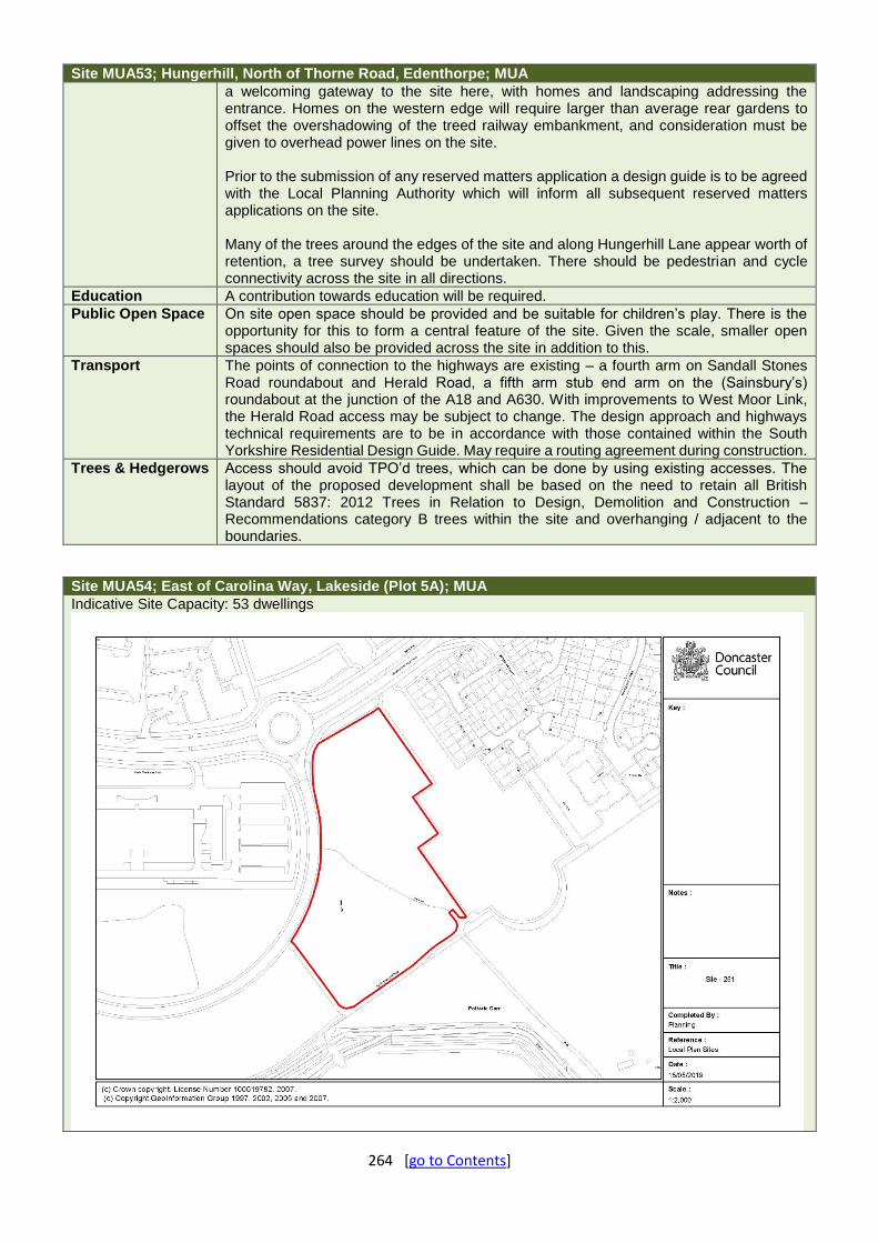
264 [go to Contents]
Site MUA53; Hungerhill, North of Thorne Road, Edenthorpe; MUA
a welcoming gateway to the site here, with homes and landscaping addressing the entrance. Homes on the western edge will require larger than average rear gardens to offset the overshadowing of the treed railway embankment, and consideration must be given to overhead power lines on the site. Prior to the submission of any reserved matters application a design guide is to be agreed with the Local Planning Authority which will inform all subsequent reserved matters applications on the site. Many of the trees around the edges of the site and along Hungerhill Lane appear worth of retention, a tree survey should be undertaken. There should be pedestrian and cycle connectivity across the site in all directions.
Education A contribution towards education will be required.
Public Open Space On site open space should be provided and be suitable for children’s play. There is the opportunity for this to form a central feature of the site. Given the scale, smaller open spaces should also be provided across the site in addition to this.
Transport The points of connection to the highways are existing – a fourth arm on Sandall Stones Road roundabout and Herald Road, a fifth arm stub end arm on the (Sainsbury’s) roundabout at the junction of the A18 and A630. With improvements to West Moor Link, the Herald Road access may be subject to change. The design approach and highways technical requirements are to be in accordance with those contained within the South Yorkshire Residential Design Guide. May require a routing agreement during construction.
Trees & Hedgerows Access should avoid TPO’d trees, which can be done by using existing accesses. The layout of the proposed development shall be based on the need to retain all British Standard 5837: 2012 Trees in Relation to Design, Demolition and Construction – Recommendations category B trees within the site and overhanging / adjacent to the boundaries.
Site MUA54; East of Carolina Way, Lakeside (Plot 5A); MUA
Indicative Site Capacity: 53 dwellings

265 [go to Contents]
Site MUA54; East of Carolina Way, Lakeside (Plot 5A); MUA
Archaeology Uncertain archaeological significance. Further archaeological investigations are likely to be required to inform development proposals.
Biodiversity The site has biodiversity value and forms part of a wider network of connected and biodiverse greenspaces Habitat losses would need to be accounted for and would require compensation, which should contribute to the quality of the ecological network. This could potentially be delivered via a biodiversity net gain approach, subject to assessment of the habitats being lost and availability of suitable receptor sites
Design Proposals on this site should reflect the requirements of the Development Brief which has been prepared by the Local Planning Authority. Existing pedestrian desire lines and routes should be accommodated in the layout. New development must be outward looking on all sides of the site, fronting toward Carolina Way, Lakeside Boulevard, the lake basin and footpaths / greenways to the west and southern edges. A landmark development response to the Lakeside Boulevard / Carolina Way roundabout corner is desirable. Homes should be set back from the existing landscaped edges by sufficient distance and existing vegetation with trees subject to survey and retained where ever possible.
Education A contribution towards education will be required.
Public Open Space The site will require onsite open space; consideration should be given to the likely needs of the residents based on the type of development delivered.
Transport Access to be taken from Carolina Way, designed in accordance with the technical requirements contained in the South Yorkshire Residential Design Guide. Visibility splay – 2.4m x 43m required and appears achievable. Linkages to existing network of footpaths required as part of any forthcoming application. Design of access junction to consider existing bus stop location.
Trees & Hedgerows The advance planted avenue of trees along Carolina Way should be retained and allowed adequate tree-to-development distances for future growth.
Site MUA55; West of Lakeside Boulevard, Lakeside (Plot 6); MUA
Indicative Site Capacity: 123 dwellings
266 [go to Contents]
Site MUA55; West of Lakeside Boulevard, Lakeside (Plot 6); MUA
Archaeology The site is assessed as having ‘Uncertain archaeological constraint’. Further archaeological investigation may be required when the site is brought forward for development. The assessment summarised that the site was part of fields in 1779, and by the 1930s the site was located on the eastern edge of Doncaster Airport. Modern aerial photographs show that a lake was constructed around the turn of the century, immediately outside the western site boundary. In order to clarify the likelihood that buried archaeological features survive here, it is recommended that a more detailed desk-based assessment be prepared in the first instance, taking into consideration both information on the construction of the lake and associated land-forming, as well as an archaeological review of any ground investigation works. This assessment should then be discussed with South Yorkshire Archaeology Service to determine the need for and scope of any further archaeological investigation that may be required in relation to any planning proposal.
Biodiversity The site has biodiversity value and forms part of a wider network of connected and biodiverse greenspaces. Habitat losses would need to be accounted for and would require compensation, which should contribute to the quality of the ecological network. This could potentially be delivered via a biodiversity net gain approach, subject to assessment of the habitats being lost and availability of suitable receptor sites.
Conservation & Heritage No conservation requirements.
Design Proposals on this site should reflect the requirements of the Development Brief which has been prepared by the Local Planning Authority. The central part of the site should be laid out as an area of public open space. The open space should be overlooked by development and meet relevant guidance and standards. In addition there may need to be further open space contribution in the local area. Existing footpaths through the centre of the site and around the edges of the plots / lake should be retained and overlooked by the fronts of new development with new footpath / cycle linkages provided connecting to these from within the new development parcels at convenient points. The layout should provide properties fronting outward on all sides of the two main development parcels creating a robust block structure. Fronting Lakeside Boulevard, properties should echo the scale, siting, building lines and enclosure of those homes and apartments on the opposite side of the street. Properties must front toward the lake, exploiting the attractive views in that direction and providing active frontage and surveillance to the lakeside promenade.
Education A contribution towards education will be required.
Public Open Space On site open space should be provided, with consideration given to the likely users (based on the types of dwellings delivered) and their likely needs. The pre-existing central section gives opportunity for this. An additional contribution to an offsite open space may also be required.
Transport Pre- formed accesses to the site. Transport Statement required. May require a routing agreement during construction.
Trees & Hedgerows The advance planted boundary landscaping and tree planting should be retained and allowed adequate tree-to-development distances for future growth; the same goes for the advance planted avenue of trees along Carolina Way. Tree surveys should inform the layout.

267 [go to Contents]
Site MUA56; Rosehill, Cantley; MUA
Indicative Site Capacity: 166 dwellings
Archaeology This site has a high potential for the survival of significant archaeological remains
associated with Roman period pottery production and associated settlement, agriculture and pottery production. Given this evidence, further consideration of the impact on these will be required to establish the site’s capacity for development. A programme of archaeological evaluation (expected to be a combination of geophysical survey and trial trenching) will need to be discussed and agreed with the South Yorkshire Archaeology Service at an early stage. It will be key that this evaluation is completed at the design stage. The evaluation will characterise the nature, extent and state of preservation of the archaeological remains present on the site and provide information to ensure the design minimises any impact upon significant archaeological areas. A Heritage Statement detailing how the results of the evaluation have informed the design of the scheme can then be submitted alongside any planning application. This Heritage Strategy will also detail the proposed mitigation measures where less significant archaeological evidence will be impacted by the proposed scheme. The proposed mitigation will be designed to ensure that an understanding of the archaeological evidence affected is gained before that evidence is lost or damaged.
Biodiversity The woodland / Local Wildlife Site to the northern part of the site should be protected with a buffer zone of planting. Similarly the corridor along the railway line could be enhanced with additional planting. The site has biodiversity value and forms part of a wider network of connected and biodiverse greenspaces. Habitat losses would need to be accounted for and would require compensation, which should contribute to the quality of the ecological network. This could potentially be delivered via a biodiversity net gain approach, subject to assessment of the habitats being lost and availability of suitable receptor sites
Design Proposals on this site should reflect the requirements of the Development Brief which has been prepared by the Local Planning Authority. New development should connect to the Avenue. Existing informal footpath routes, desire lines and connections should be incorporated into the layout. Buildings should front toward the racecourse set back behind a soft landscaped edge. Sufficient separation should be maintained from the northern boundary to reduce overshadowing and impact on existing trees, and from the eastern /

268 [go to Contents]
Site MUA56; Rosehill, Cantley; MUA
southern boundary to minimise noise from the railway. Existing properties at site edges should be backed onto with sufficient separation and rear gardens locked together for security. Public open space should be located to the north of the site adjacent to the woodland.
Education A contribution towards education will be required.
Public Open Space On site open space including play should be provided, given severance from other open spaces in the area.
Transport The site is potentially accessed through the existing Rose Hill Rise and The Avenue cul-de-sacs. A Transport Assessment & Travel Plan will be required. Section 6.6 of the disposal brief states that the concentration of outbound traffic at peak times is likely to result in excessive queuing on Rose Hill and potential unacceptable queuing and delays for motorists. The Transport Assessment will assess the operational capacity of the network and identify any measures required to mitigate against this. A residential travel plan will be required, and a routing agreement may be required during construction.
Trees & Hedgerows The existing site boundaries include mixed species hedgerows with numerous mature trees within them. It will be a requirement of the development that these hedgerows and trees are retained and enhanced through additional and appropriate planting. Boundary oaks should be designed in as per the design brief. Layout should be informed by a tree survey.
Site MUA57; Former Wheatley Hills Middle School, Leger Way, Wheatley; MUA
Indicative Site Capacity: 134 dwellings
Archaeology The site has been assessed as of ‘Uncertain archaeological constraint’ to future allocation.
Further discussion with South Yorkshire Archaeology Service, archaeological advisers to Doncaster MBC, suggests that the area of the former school (the western portion of the site) can be considered to have a low archaeological potential but that the area of former playing fields (the eastern portion of the site) can be considered to have an unknown archaeological potential. As the site lies close to the projected route of the Cantley spur, the Roman road running north towards Long Sandall, further consideration of the archaeological potential of this part of the site will be required. South Yorkshire

269 [go to Contents]
Site MUA57; Former Wheatley Hills Middle School, Leger Way, Wheatley; MUA
Archaeology Service advise that archaeological evaluation will help to establish the presence/absence, significance and condition of any archaeological heritage assets surviving on the site and should be undertaken prior to the submission of any planning application. Any planning application can then be supported by a report that discusses the results of the evaluation and outlines the impact of the development proposal on any identified archaeological evidence, as well as any mitigation measures proposed. Evaluation is expected to take the form of trial trenching.
Biodiversity The site borders a designated local wildlife site. Landscaping should be used to buffer this. Biodiversity compensation for habitat losses should be steered towards enhancing the quality of neighbouring Local Wildlife Site.
Design Proposals on this site should reflect the requirements of the Development Brief which has been prepared by the Local Planning Authority. New development should front toward Leger Way and out from the site in a southerly and easterly direction toward the Golf Course. Development should be set back from existing trees and hedgerows at the edges of the site. Rear gardens should lock together with boundaries to the employment area to the north. Pedestrian linkages should be provided between Leger Way and Shaw Wood Way. Properties should either front or be side on to Shaw Wood Way to help enliven this street with a mixed use character.
Education A contribution towards education will be required.
Public Open Space On site open space should be provided. Sport England have also suggested a sum in the region of £255,000 should be provided to mitigate the loss of the playing fields, with the money to go to improving other local playing fields.
Transport It is expected that access from Leger Way will need to be more than just a simple priority junction. Access to sites to the east of Leger Way have prohibited right turns and therefore consideration needs to be given to the most appropriate type of junction and the potential issues in proving an acceptable design should not be underestimated. Access may be possible from Shaw Wood Way subject to agreement with the landowner, and the road being brought up to adoptable standards. Any access proposals are to be supported by a full technical operation analysis using the most appropriate methodology, considering the local context and level of congestion that occurs on this part of the network at times. The access(s) shall also be subject to Road Safety audits in accordance with DMRB HD 19/15. The development will need to ensure that safe, secure pedestrian and cycle linkages are provided within and to the existing local network. A robust Transport Assessment and Travel Plan will be required. A cumulative developer contribution will be sought for the A630 Westmoor Link Improvement scheme.
Trees & Hedgerows There are few internal trees – a decent pine and two squat young-mature oaks; the more notable features would appear to be the mature boundary trees which should, as appropriate, be straightforwardly retained within any scheme. Very important are the highways’ trees on the verge – these are an important feature of a larger landscaping scheme and efforts to minimise their loss and maximise mitigation/compensation will need to be demonstrated. All should be subject to BS5837 tree surveys.

270 [go to Contents]
Site MUA58; West of Sandy Lane, Doncaster; MUA
Indicative Site Capacity: 39 dwellings
Archaeology The potential for survival of significant buried archaeology within the site is
considered to be low. Further archaeological investigations are unlikely to be required.
Biodiversity Habitat losses would require compensation. This could be delivered via biodiversity offsetting. The site is part of a large network of greenspace which includes the lakeside POS and LWS, parcels of woodland and allotments. Development on this site should retain the mature treeline along the southern and eastern boundaries, and possibly others subject to site survey. Biodiversity Offsetting could be used to deliver necessary compensation.
Conservation & Heritage The heritage assets on site should be subject to a historic and architectural analysis. This should in particular include the two pumping station and piers and railings to the entrance. Any scheme should look in depth at the potential to retain all or some of these heritage assets and full justification provided for the final form of the development.
Design New development should seek to retain the existing frontage composition of trees and boundary railings / pillars. The layout should include provision for east west pedestrian and cycle linkages to enable routes to be created to the land and development sites to the west.
Education A contribution towards education will be required.
Public Open Space A commuted sum will be required to improve open space at Rufford Road.
Transport Issues with right turning vehicles from Sandy Lane to Carr House Road and associated capacity / road safety concerns. Access from Sandy Lane designed in accordance with Manual for Streets. Major congestion issues along Sandy Lane due to the proximity of 2 primary schools. Transport Assessment & Travel Plan may be required due to proximity to school. Routing agreement during construction required.
Trees & Hedgerows The site contains linear plantings of mature trees along the eastern and southern boundaries and part of the northern boundary, which should be retained. The siting and orientation of dwellings and size of gardens should take account of shading issues from trees and allow adequate tree-to-development distances.

271 [go to Contents]
Site MUA60; Woodfield Way, Balby; MUA
Indicative Site Capacity: 1,131 dwellings
Archaeology The site has been drained and in agricultural use since probably the 17th century, and this
may have impacted on the preservation of archaeological remains, though excavation within the western part of the site has indicated that buried archaeology does survive below the zone impacted by ploughing. Further remains are likely to survive within the undisturbed areas of the site. The footings of Carr Lodge may also survive. Some archaeological evaluation has already been undertaken within the site, and it is highly likely that further archaeological investigation will be required when the site is brought forward for development.
Biodiversity This site represents a substantial proportion of the green corridor that runs through to Potteric Carr SSSI. Important wildlife features include the numerous hedgerows, woodlands, Division drain and extensive grasslands. Biodiversity impacts will need to be accounted for and compensation provided. Ecological buffers will be required along Division drain and along retained woodlands, and mature tree lines and hedgerows.
Design The Carr Lodge Design Code Supplementary Planning Document (SPD) exists for this site and seeks to maintain the high quality design principles secured in a now lapsed outline consent. In order to co-ordinate the delivery of community facilities, the local centre, parks and areas of public open space a refreshed masterplan and delivery strategy for the remaining phases of development shall be developed in consultation with the local community and Council, and approved by the Local Planning Authority prior to the determination of any further applications for development on this site. Unless otherwise agreed by the LPA, the refreshed Masterplan and Delivery Strategy should accord with the main design and layout principles for the site contained within the adopted Carr Lodge SPD.
Education A contribution towards education will be required.
Public Open Space On site open space will be required across the site.
Transport Subject to outline approval and subsequent reserved matters applications. There may be issues to resolve from the first phase related to development platforms and the size of ditches running through the site. A Transport Assessment and Travel Plan will be required. Links onto Woodfield Greenway should be provided. Bus accessibility is a concern which must be addressed. Development may require a routing agreement during construction.

272 [go to Contents]
Site MUA60; Woodfield Way, Balby; MUA
Trees & Hedgerows The network of numerous hedgerows and woodlands predates the Loversall tithe map of 1816 (with some elements present on the 1782 ‘Plan of Rivers, Cuts, Drains drawn for the Trustees of Potteric). Any reserved matters applications must be informed by tree surveys.
Other The site has a Supplementary Planning Document – please refer to this for further information.
Site MUA61; Balby Archives, King Edward Road, Balby; MUA
Indicative Site Capacity: 15 dwellings
Biodiversity A bat survey may be required, no constraints otherwise.
Conservation & Heritage The buildings on site are considered to be of local interest and add to the current townscape. Retention and sensitive conversion of these should be undertaken.
Design Ideally new development will re-use, adapt or partially redevelop the existing on-site buildings and retain existing boundary walls in whole or part. If this is unfeasible, new development should front toward King Edward Road, Victoria Road and Florence Avenue to complete the block, with buildings positioned and designed to respect existing building lines of surrounding streets, property heights, boundary treatments and local character.
Education An education contribution may be required.
Public Open Space A contribution to a local open space may be required.
Transport The site is currently served by 3 sub-standard vehicular accesses which require rationalising. No real issues identified. Access to be designed in accordance with technical requirements of South Yorkshire Residential Design Guide – Visibility splays of 2.4m x 43m.

273 [go to Contents]
Site MUA62; Former Nightingale School Site, North of Cedar Road, Balby; MUA
Indicative Site Capacity: 49 dwellings
Archaeology The presence or otherwise of significant archaeology on the site is unknown. Contact
the South Yorkshire Archaeological Service (SYAS) as to whether any further archaeological investigations are required if the site is brought forward for development.
Biodiversity Habitat losses should be accounted for and appropriate compensation provided. Mature trees on site should be retained where possible subject to the results of a tree survey. The buildings proposed for demolition would require bat surveys.
Conservation & Heritage Due to its elevated location the distinctive white tower and dome of the listed church of St Peter is visible from Cedar Road across the open grounds of the site. Maintaining some open space and/or building in sightlines from Cedar Road towards the church above and around any new buildings should mitigate any impact on views.
Design New development should be of a suburban character appropriate to the area. The layout should incorporate semi-detached properties fronting Cedar Road. Rear gardens of new homes should back onto existing rear gardens to the north and west in a secure layout.
Education A contribution towards education may be required.
Public Open Space On site open space would be preferred on this site.
Transport Access from Cedar Road in accordance with South Yorkshire Residential Design Guide – splay required – 2.4m x 43m.
Trees & Hedgerows Turkey Oak is subject to T1 of the Doncaster Borough Council Tree Preservation Order (No.267) Mallard Primary School, Cedar Road, Balby, Doncaster 2004 on the site (along with other trees on the frontage, lining the access and NW corner). Layout proposals should be informed by a tree survey.

274 [go to Contents]
Site MUA63; Cross Bank, Balby; MUA
Indicative Site Capacity: 137 dwellings
Archaeology The layout and design should be informed by a programme of archaeological evaluation
to be agreed with South Yorkshire Archaeology and undertaken at an early stage.
Biodiversity Along the southern / south-western boundary of the site there should be a significant wildlife corridor, a minimum of 25-30m in width. This should form part of the public space on the site rather than being enclosed in gardens so that wildlife value can be maximised. The loss of wildlife on the site should be assessed using a biodiversity net gain calcuation metric in order to quantify the habitat loss and calculate an appropriate amount of compensation. Given the size of the site it is expected that a good proportion of the compensation would be delivered off site.
Design A development brief has been produced for the part of the site owned by the Council. Access to the site should predominantly be from Sandringham Road, with a secondary connection northward to Cross Bank and to access the northern part of the site. The northern side of the access road will require landscape screening to the rear of the existing terrace properties alleyway. There is the potential for this site to provide access to neighbouring sites to the east and the layout should make provision for this. The southern part of the site should be laid out as an area of public open space to meet local requirements and to act as a buffer to the sewage works. Although the green infrastructure corridor of 25-30m width which should be developed along the site’s southern / south-western edge. This buffer should include informal recreation routes which provide potential future linkages to the land to the east through the green wedge to Carr Lodge. The open space should be overlooked by development. It should provide screening along the southern edge as part of the ecological corridor along this edge. There is a need to provide appropriate stand-off distances from existing residential development along the northern and southern edges of the site. New housing should provide a frontage to Cross Bank.
Education A contribution towards education will be required.
Public Open Space On site open space is required with the potential to locate this to the adjacent open space to create a larger area.
Transport Vehicular access should be taken from Sandford Road / Sunningdale Road by extending the existing turning head into the site. The principle of this is considered acceptable subject to pedestrian / cycle connectivity to Cross Bank, and a satisfactory technical assessment

275 [go to Contents]
Site MUA63; Cross Bank, Balby; MUA
being undertaken. Street layout should follow guidance in the South Yorkshire Residential Design Guide. There should also be convenient linkages from the site to the adjacent footway and cycleway networks including retaining the potential for connection to the informal footpaths across land to the east of the site.
Trees & Hedgerows A tree survey is required. This site includes a potentially valuable piece of urban woodland. Tree loss is only justifiable if the trees survey poorly.
Other Yorkshire Water are unlikely to support residential development within 200m of the Sewage Works due to the potential for odour nuisance and loss of amenity. Therefore any application for this use should be informed by an odour assessment and include suitable mitigation where appropriate. New development would need to accommodate or divert the existing sewers and overhead power lines which cross the site, and the ditches at the edges, with suitable easements provided if retained in situ. Potentially a landscape / acoustic barrier may be required adjacent the employment uses, subject to surveys.
Site MUA64; Cusworth Centre, North of Cusworth Lane, Cusworth; MUA
Indicative Site Capacity: 26 dwellings
Biodiversity Habitat losses should be accounted for and appropriate compensation provided. Mature
trees on site should be retained where possible subject to the results of a tree survey. The buildings proposed for demolition would require bat surveys.
Design New development should back rear gardens onto existing rear gardens and the adjacent school to create a secure layout. The site layout lends itself to the creation of a small area off POS in the centre of the site as a focal point for new homes around the edges.
Education A contribution towards education will be required.
Public Open Space On site open space would be the preference for this site.
Transport A 2.4m x 43m visibility splay would be required at the junction with Cusworth Lane. Access into the site could be via a footway crossover (similar to what is there now for a relatively minor development) and the width for a conventional residential street would be 5.5m wide carriageway with 2m wide footways. For the access into the site this could be reduced to a 5.5m carriageway, 2m wide footway to one side and a 700mm wide hard

276 [go to Contents]
Site MUA64; Cusworth Centre, North of Cusworth Lane, Cusworth; MUA
margin to the other. Vehicle tracking would be needed to determine if standards are met with consideration given to the amount of traffic on Cusworth Lane itself. See extract from South Yorkshire Residential Design guide below: “B.3.3.12 Junctions with 30mpg streets:
Design vehicle to be determined based on local land use considerations.
Where the average 2 way peak hour traffic flows on both the major and minor arm are less than 500vph, the design vehicle should be able to turn with the vehicle body leaving a 0.5 metres clearance to the carriageway edge on both the major and minor arms.
Where average peak hour 2 way traffic flow on the major arm exceeds 500 vph, the design vehicle should be able to turn without crossing into the opposing lane on the major arm.
When the average peak hour 2 way traffic flow on both arms exceeds 500 vph, the design vehicle should be able to turn without crossing into the opposing lane on both arms.”
Trees & Hedgerows There is a valuable tree belt in the SW corner and on / adjacent to the southern boundary. Layouts should be informed by a tree survey.
Site MUA65; Between Tickhill Road and May Avenue, Balby; MUA
Indicative Site Capacity: 26 dwellings
Biodiversity Habitat losses should be accounted for and appropriate compensation provided. Mature
trees on site should be retained where possible subject to the results of a tree survey. The buildings proposed for demolition would require bat surveys.
Design New development should front toward May Avenue and Tickhill Road, with properties set back from Tickhill Road to respect established building lines and front boundaries retained as far as possible. A pedestrian / cycle route should be developed through the site between May Ave and Tickhill Road to improve pedestrian permeability and movement in the local area. The layout could also enable potential access to the land to the south which may

277 [go to Contents]
Site MUA65; Between Tickhill Road and May Avenue, Balby; MUA
come forward for future development. The mature trees are a key characteristic of this site and any layout must be informed by a tree survey and shaped by any retained trees.
Education A contribution towards education will be required.
Public Open Space A contribution to improve an offsite open space would be required.
Transport Access to Tickhill Road in accordance with South Yorkshire Residential Design guide. Visibility splays of 2.4m x 43m required in line with posted speed limit. This may not be achievable due to neighbouring boundary treatments / existing trees. If not, a pedestrian linkage is required. Access from May Avenue would be achievable by upgrading the existing vehicular access.
Trees & Hedgerows The lime tree on the Tickhill Road frontage is subject to Doncaster Borough Council Tree Preservation Order (No.393) 2017 Stanley House 18 Tickhill Road Balby and there are other mature skyline trees around the periphery of the site that contribute to the locality. Layout should be informed by a tree survey.
Site MUA66; South of Thelluson Avenue, Scawsby; MUA
Indicative Site Capacity: 16 dwellings
Biodiversity Habitat losses should be accounted for and appropriate compensation provided.
Mature trees on site should be retained where possible subject to the results of a tree survey. The site layout should provide an appropriate buffer from the woodland corridor to the south of the site.
Conservation & Heritage There is a thick belt of trees to the west and south boundaries of the proposed allocation site and these should be retained and buildings kept to a maximum of two storeys to ensure there is no impact on the neighbouring Park and Garden of Local Historic Interest – Cusworth Hall and its historic parkland/grounds.
Design New development must front toward Thelluson Avenue. The mature trees are a key characteristic of this site and any layout must be informed by a tree survey and shaped by any retained trees with appropriate stand-off distances where required. The potential to create a pedestrian / cycle link to the adjacent Roman Ridge bridleway should be explored.

278 [go to Contents]
Site MUA66; South of Thelluson Avenue, Scawsby; MUA
Education A contribution towards education may be required.
Public Open Space A contribution to an off-site open space would be required.
Transport The location of the existing access appears suitable although will need updating / upgrading in accordance with South Yorkshire Residential Design Guide. Splays of 2.4m x 43m required. Prudent to include a link to the existing public right of way to the south of the site.
Trees & Hedgerows Doncaster Borough Council Tree Preservation Order (No.392) 2017 Site of Don View 22 Thellusson Avenue Scawsby covers all of the trees at the site. Layout should be informed by a tree survey.
Site ADW08; Lutterworth Drive, Adwick; Adwick - Woodlands
Indicative Site Capacity: 45 dwellings
Archaeology The site is of uncertain archaeological significance. Further archaeological investigations
are likely to be required to inform development proposals.
Biodiversity Mature trees should be retained where possible. Habitat losses, would require compensation, and depending on the number of units proposed this may need to be offsite. Biodiversity net gain should be demonstrated.
Design New development should back onto rear gardens of existing houses on all the boundaries of the site to ensure rear gardens are locked together. Properties should front onto Lutterworth Drive on the currently open part of the northern edge.
Education A contribution towards education will be required.
Public Open Space On site open space should be provided or potentially a contribution towards improving an off-site open space.
Transport Access can be taken from Lutterworth Drive. Design in accordance with Manual for Streets. There may need to be re-location of the existing bus stop. Development may require a routing agreement during construction.
Trees & Hedgerows
The trees require surveying in accordance with BS5837, the findings of which should have been shown to inform the design process.

279 [go to Contents]
Site ARM09; West of Hatfield Lane, Armthorpe; Armthorpe
Indicative Site Capacity: 400 dwellings
Archaeology Below the plough zone the potential for the survival of buried archaeological remains is
considered to be high. Further archaeological investigations may be required to inform development proposals. The extent and scope of any requirement should be discussed with South Yorkshire Archaeology Service.
Biodiversity The layout and design of the development should provide for a broad green corridor with diverse vegetation structure, including tree cover, to enhance the connectivity of Shaw wood (8.23) and Long Plantation (8.20) Local Wildlife Sites, both of which are publically accessible.
Design New development should create a substantial well defined, multi-functional high quality, green wedge POS to the northern half of the site adjacent West Moor Link Road. A high quality gateway area consisting of higher density housing should be formed around the access from Hatfield Lane. The layout should ensure convenient and overlooked pedestrian / cycle linkages to the existing housing areas to the south via connections to the existing pedestrian routes at Holly Dene, Fernbank Drive and Mere Lane. It should be designed to create a legible and secure block structure with a hierarchy of streets including a generously landscaped main loop street with treed verges and focal spaces at key nodes. Rear gardens of new properties should lock together with existing rear gardens along the southern edge to provide a secure layout, albeit this may include landscape buffering / screening along this edge. New homes must front toward Hatfield Lane, Mere Lane and the Green Wedge POS.
Education A contribution towards education will be required.
Public Open Space The site will require on site open space suitable for children’s play.
Transport This site was approved subject to S106 Agreement (16/02224/OUTM – Outline for up to 400 dwellings). Access is to be taken from a new roundabout on Hatfield Lane to serve this site and land to the East of Hatfield Lane (granted under 12/00188/OUTM). Based on the 400 dwellings there is a S106 contribution requirement towards the West Moor Link Improvement Scheme totalling £387,855. Furthermore there is a travel plan bond amount of £42,020

280 [go to Contents]
Site ARM09; West of Hatfield Lane, Armthorpe; Armthorpe
Trees & Hedgerows
There should be a strong landscape buffer zone to the A630 and the retention of the central trees.
Site CD06; Between Sheffield Road and Old Road, Conisbrough; Conisbrough & Denaby
Indicative Site Capacity: 200 dwellings
Archaeology Due to the relative lack of deep ground disturbance, the potential for the
survival of unrecorded buried archaeological remains on the site is considered to be moderate. Further archaeological investigations may be required to inform development proposals.
Biodiversity Refer to design section in terms of landscaping. Species-rich hedgerows and/or a woodland belt should be incorporated into the landscaping to support nearby hedgerow networks some of which are Local Wildlife Sites, and the wooded corridor that stretches from Ravenfield Lakes through to Conisbrough North Cliff and Denaby Wood Local Wildlife Sites.
Compensatory Green Belt Improvements
As the site allocation results in the loss of Green Belt land, this must be compensated for by contributing to improving the environmental quality and accessibility of remaining Green Belt land within the vicinity of the site. Details of specific sites and projects will be established in discussion with the Council.
Design Considering the site's prominent location in the landscape, new development should front toward both Sheffield Road and Old Road but be set back behind landscaped frontages. Buildings should have appropriate separation distances between existing properties on the edges of the site. The layout should seek to develop footpath connections to existing streets to the north where possible. Pedestrian and cycle connections through the site should be developed between Sheffield Road and Old Road. Building heights should be limited to 2-2.5 storey.
Education A contribution towards education will be required.
Public Open Space On site Green Infrastructure and children’s play space will be required, including play equipment.
Transport Access from C762 Old Road designed in accordance with DMRB resulting in loss of hedgerow. A footway will be required along the site frontage together

281 [go to Contents]
Site CD06; Between Sheffield Road and Old Road, Conisbrough; Conisbrough & Denaby
with new street lighting. A Transport Assessment & Travel Plan will be required. The site may require a routing agreement during construction.
Trees & Hedgerows No tree issues.
Site CD07; East of Hill Top Road, Conisbrough; Conisbrough & Denaby
Indicative Site Capacity: 125 dwellings
Archaeology Due to the relative lack of deep ground disturbance across the site, the potential for the
survival of unrecorded buried archaeological remains is considered to be moderate. Further archaeological assessment may be required to inform development proposals.
Biodiversity The site forms part of a local wildlife site and the Dearne Valley Nature Improvement Area and development will be required to provide significant mitigation and compensation for any habitat and ecological connectivity losses. In addition the existing woodland needs to be retained and buffered from built development by at least 10m. The design of this site also needs to include a significant wide grassland/habitat corridor through the development connecting the habitat in the north to the wider countryside. Biodiversity net gain should be demonstrated.
Design Properties should front toward Hill Top Road and Bolton Street. The site is crossed by pedestrian routes and desire lines which should be taken into account in the layout and fronted by new development. New homes should back onto existing bungalows at Hill Top Gardens and lock together rear gardens in a secure layout. Properties should front outward on the sites northern and eastern edges.
Education A contribution towards education will be required.
Public Open Space The skate park which is currently on site should be retained, and this requires a 30 buffer to be maintained around it. Properties will need to front this to provide some surveillance. Additional on-site open space, or improving / making the space within the skate park buffer useable would also be welcome – consideration would need to be given in this case to any additional buffers.
Transport Access should not be taken from Hill Top Road, rather it should be taken from Bolton Street. This would require a footway along the site frontage. Visibility requirements in

282 [go to Contents]
Site CD07; East of Hill Top Road, Conisbrough; Conisbrough & Denaby
accordance with 85%ile WWS. A Transport Assessment & Travel Plan are required, and the site may require a routing agreement during construction.
Trees & Hedgerows The site contains linear plantings of mature trees along the eastern and southern boundaries and part of the northern boundary, which should be retained. The siting and orientation of dwellings and size of gardens should take account of shading issues from trees and allow adequate tree-to-development distances and the PROW needs to retain its green character to both sides. Layout to be informed by a tree survey.
Site DDHS13; West of Lings Lane, Hatfield; Dunscroft, Dunsville, Hatfield, Stainforth
Indicative Site Capacity: 72 dwellings
Archaeology The remains of a mediaeval windmill are present as a grassy mound and is of local
archaeological significance; otherwise there is uncertain archaeological significance. Further archaeological investigations are likely to be required to inform development proposals.
Biodiversity Compensation should be directed towards the boundaries of the site that border the wider countryside.
Design Development should provide a set back frontage to Doncaster Road as per approved site to the south. Houses should back onto existing gardens along Lings Lane to create a secure layout with rear gardens locked together. Open space and footpath linkages should be provided along the southern boundary. Footpath / cycle links should connect to open space to south on the adjacent site.
Education A contribution towards education may be required.
Public Open Space The site should provide onsite open space, and there is also an opportunity to link this to the proposed open space on the adjacent site.
Transport Access on to Doncaster Road. A transport statement required.
Trees & Hedgerows A good quality 1825 Hatfield, Thorne, Fishlake, Sykehouse & Stainforth Enclosure Award hedgerow is recorded as forming the south western boundary of the site. TPO'd trees are directly adjacent to the site on the Doncaster Road frontage (directly to the west of the

283 [go to Contents]
Site DDHS13; West of Lings Lane, Hatfield; Dunscroft, Dunsville, Hatfield, Stainforth
site); these features are likely to be required to inform development proposals (subject to appropriate survey data).
Site DDHS14; East of Cuckoo Lane, Hatfield; Dunscroft, Dunsville, Hatfield, Stainforth
Indicative Site Capacity: 36 dwellings
Archaeology Due to the relative lack of deep ground disturbance on the site, the potential for the
survival of any previously unrecorded buried archaeological remains is considered to be moderate in the eastern part of the site. Within the footprint of the factory at the western end of the site, the survival of any previously unrecorded buried archaeology is considered to be low. Further archaeological investigations are likely to be required to inform development proposals.
Biodiversity Habitat losses would require compensation. The boundary hedgerows, particularly to the north and east of the site should be retained and enhanced. Biodiversity net gain should be demonstrated.
Conservation & Heritage
To mitigate any adverse impact on heritage assets new development should retain and reinforce the historic boundaries and its green character to the field side; be set back to the line of the adjacent bungalow; and maintain green character and trees to the front of the site. Buildings should be no higher than 2 storeys and take into account local building materials (brick/pantile).
Design New development should front toward Cuckoo Lane. Pedestrian and cycle linkages should run through the site and connect to the Public Footpath which runs along the eastern edge.
Education A contribution towards education may be required.
Public Open Space A commuted sum will be required, to be used on the adjacent open space Jubilee Park.
Transport Access should be in accordance with Manual for Streets / South Yorkshire Residential Design Guide. There is some concern over additional traffic loading onto the Station Road / Cuckoo Lane junction to its poor horizontal alignment. The site is in close proximity to a school so a robust Construction Traffic Management Plan is

284 [go to Contents]
Site DDHS14; East of Cuckoo Lane, Hatfield; Dunscroft, Dunsville, Hatfield, Stainforth
required. A Transport Assessment will be required due to the proximity of a number of schools and the potential impact on vulnerable users. The site may require a routing agreement during construction.
Trees & Hedgerows The historic eastern & northern boundaries are present on the 1843 tithe map for the parishes of Hatfield and Thorne; the east hedge line appearing to be fairly intact (unlike the north hedge line). No real tree issues subject to findings of a tree survey.
Site MEX09; Leach Lane, Mexborough; Mexborough
Indicative Site Capacity: 16 dwellings
Archaeology Within the majority of the site, there is the potential for the survival of buried features
relating to the former works. The site’s location on the alluvial plain suggests that there is also the potential for earlier (prehistoric to medieval) remains to survive at a significant depth below the current ground levels. Further archaeological investigations are likely to be required to inform development proposals. Assessment of the historic character and significance of the derelict warehouse may also be required.
Biodiversity The existing poor habitat corridor along the river needs to be enhanced by development on this site, thus improving the existing ecological network.
Conservation & Heritage The development should improve the setting of the conservation area and the approach to and from the station. It should also provide an attractive waterside frontage to the canal.
Design New development should respond to and turn the corner of Station Road and Greens Way. Development should respond to the canal and open up the potential for public access to the waterside. Where possible it should provide pedestrian links to the adjacent housing area to the east. The site is potentially suitable for a taller building and should provide an attractive outlook adjacent the canal. The site is supported above the canal by an existing retaining structure. The final design and layout shall incorporate measures to prevent any increase in risk to land instability caused by loading onto any existing or new retaining structures on site.
Education A contribution towards education may be required.

285 [go to Contents]
Site MEX09; Leach Lane, Mexborough; Mexborough
Public Open Space A commuted sum is required to improve local Public Open Space. There is the opportunity to open up the waterside to public access as part of the development.
Transport Access should be taken from Leach Lane. The site may require a routing agreement during construction.
Trees & Hedgerows Aside from some outwardly pleasing canal side Weeping Willows no real tree issues, hence waterway corridor enhancement required.
Site MEX10; Windhill Avenue, Mexborough; Mexborough
Indicative Site Capacity: 112 dwellings
Biodiversity An area of potential value for invertebrates. Compensatory habitat should be provided to
account for losses.
Design Proposals on this site should reflect the requirements of the Development Brief which has been prepared by the Local Planning Authority. New development should respect the established street pattern, pedestrian routes and desire lines. New properties should front toward Windhill Avenue, Pitt Street and Clayfield View. Homes should provide high levels of natural surveillance over the pedestrian route through the site from Windhill Crescent. Rear gardens of new homes should back onto existing rear gardens at the site edges with appropriate separation distances to enable a secure layout. New homes should be arranged in a stepped format which reflects the underlying topography of the site. Any proposed POS should be located in an accessible, prominent and well surveyed location to safely serve existing and new residents.
Education A contribution towards education will be required.
Public Open Space On site open space would be preferred, although given the site is adjacent to Pitt Street Park, there may be opportunity to contribute towards improving this open space as well.
Transport The site layout should be designed to maximise and encourage safe, sustainable movement through walking and cycling, maintaining existing links or providing new links to the wider networks. Existing or new roads on the development must be constructed to / or brought up to adoptable standard and any roads damaged by site construction vehicles reinstated to an acceptable condition. Street design should follow the guiding principles and technical requirements of the South Yorkshire Design Guide.

286 [go to Contents]
Site MEX10; Windhill Avenue, Mexborough; Mexborough
There are also Public Rights of Way on site. A Transport Assessment & Travel Plan will be required.
Trees & Hedgerows
The only tree issues are those on the extreme southern boundary.
Site MEX11; West of Schofield Street; Mexborough
Indicative Site Capacity: 74 dwellings
Archaeology The layout and design should be informed by a programme of archaeological evaluation
to be agreed with South Yorkshire Archaeology and undertaken at an early stage;
Biodiversity A strong landscaping scheme must be developed that is designed with to deliver the best possible outcome for wildlife. Biodiversity net gain can be used to deliver some off site compensation for the habitat losses.
Design A development brief has been produced for this site by the Council. A pedestrian / cycle route should be created through the site linking the POS to Willow Drive. The layout should create a robust block structure with properties fronting toward streets, providing dual aspect at corner locations, and creating houses backing onto or side onto adjacent residential edges and the allotment gardens. There is a need to provide appropriate stand-off distances from existing residential development along the northern, eastern and western edges of the site New homes should front toward the POS to the south in order to improve natural surveillance of this area and provide outlook.
Education A contribution towards education may be required.
Public Open Space It is apparent this western part of the site has not been used as an allotment for a number of years, and as such in principal the Local Planning Authority do not have an issue with this derelict open space being lost if this can be of benefit to the local community. Given the number of local open spaces in the vicinity of this site, a commuted sum should be provided to improve these as part of an application.
Transport Vehicular access to the site should be from Willow Drive. May require a routing agreement during construction.
Trees & Hedgerows Any proposal needs to be subject to a tree survey following the guidance in BS5837:2012 Tree works recommendations carried out by a suitably qualified and competent arborist.

287 [go to Contents]
Site MEX11; West of Schofield Street; Mexborough
The survey should be carried out on the site at the feasibility stage of any development and create a survey report, a categorization of the trees on and adjacent to the site and a tree constraints plan. This information should then be carried forward and used to inform the design brief and design of the subsequent development.
Site ROS02; Former Rossington Colliery, (south), Rossington; Rossington
Indicative Site Capacity: 349 dwellings
Biodiversity The development should protect and enhance the wetland habitat corridor along the River
Torne and contribute to local priorities identified in the Torne Catchment Plan. Wet woodland interests in Holmes Carr Wood should also be protected and enhanced. Holmes Carr Wood should be separated from the development by an appropriate buffer zone of landscape planting. This should include retention of the woodland area within the proposed allocation. Opportunities to deliver habitat connectivity between Holmes Carr Wood and the river Torne should also be explored.
Design Further development to the south of the permitted Rossington Colliery development / Torne Park must ensure integration with the approved illustrative masterplan and design code for the area to the north. These documents and plans must be updated and accompany the submission of any planning application for this site (ROS02). The layout for this area must ensure housing is locked together with the proposed housing to the north to create a secure block structure. Landscaped pedestrian and cycle links will need to be created through the site to link the permitted Torne Park housing area to the proposed country park to the south. Preferably this will be a continuation of the route provided adjacent to the drain. New housing along the southern boundary of the site should integrate with and front southward toward the country park. Housing should be set away from Holmes Carr Wood with appropriate separation distances between new development and the woodland. The southern site boundary will be delineated by the point at which the new development platform meets the sloping hill, however, in the interests of creating a new strong, defensible, and likely to be permanent Green Belt boundary in this location, opportunities should be explored for enhancing this and forming a clearly defined site boundary, using suitably tall, dense and continuous hedgerow or tree planting.
Education A contribution towards education will be required.

288 [go to Contents]
Site ROS02; Former Rossington Colliery, (south), Rossington; Rossington
Public Open Space On site open space will be required, with linkages to adjacent open spaces, and consideration as to how this interacts with the larger site.
Transport Access to be taken from Residential Development Cell C (shown on Harworth Colliery Masterplan under 12/01107/OUTA). NB: Part of this area was shown as a potential development site on the masterplan. The accesses to West End Lane from ROS01 were previously implemented under the FARRRS scheme.
Trees & Hedgerows The main body of Holmes Carr Great Wood is subject to W1 of Doncaster Borough Council Tree Preservation Order (No.26) 1986 Holmes Carr Great Wood, Rossington. However, the TPO does not include the narrow band of trees to the west of the wayleave for the HV cables; however, substantial trees appear to be in this narrow strip. Layout proposals to be informed by a tree survey.
Site ROS03; West of Gattison Lane, Rossington; Rossington
Indicative Site Capacity: 92 dwellings
Archaeology The presence or otherwise of significant archaeology on the site is unknown. Contact the
South Yorkshire Archaeological Service (SYAS) as to whether any further archaeological investigations are required if the site is brought forward for development.
Biodiversity Habitat losses should be accounted for and appropriate compensation provided. The buildings proposed for demolition would require bat surveys.
Design New development should be accessed from and front toward Gattison Lane with semi-detached properties along the frontage. Rear gardens of new housing to back onto existing gardens along north, west and southern edges to create a secure layout, with appropriate separation distances from rear elevations. Public Open Space should be laid out ideally as a centralised area with a regular useable shape.
Education A contribution towards education will be required.
Public Open Space Open space should be provided on site.
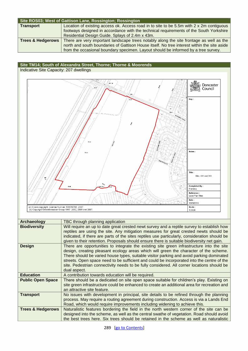
289 [go to Contents]
Site ROS03; West of Gattison Lane, Rossington; Rossington
Transport Location of existing access ok. Access road in to site to be 5.5m with 2 x 2m contiguous footways designed in accordance with the technical requirements of the South Yorkshire Residential Design Guide. Splays of 2.4m x 43m.
Trees & Hedgerows There are very important landscape trees notably along the site frontage as well as the north and south boundaries of Gattison House itself. No tree interest within the site aside from the occasional boundary specimen. Layout should be informed by a tree survey.
Site TM14; South of Alexandra Street, Thorne; Thorne & Moorends
Indicative Site Capacity: 207 dwellings
Archaeology TBC through planning application
Biodiversity Will require an up to date great crested newt survey and a reptile survey to establish how reptiles are using the site. Any mitigation measures for great crested newts should be indicated, if there are parts of the sites reptiles use particularly, consideration should be given to their retention. Proposals should ensure there is suitable biodiversity net gain.
Design There are opportunities to integrate the existing site green infrastructure into the site design, creating pleasant ecology areas which will green the character of the scheme. There should be varied house types, suitable visitor parking and avoid parking dominated streets. Open space need to be sufficient and could be incorporated into the centre of the site. Pedestrian connectivity needs to be fully considered. All corner locations should be dual aspect.
Education A contribution towards education will be required.
Public Open Space There should be a dedicated on site open space suitable for children’s play. Existing on site green infrastructure could be enhanced to create an additional area for recreation and an attractive site feature.
Transport No issues with development in principal, site details to be refined through the planning process. May require a routing agreement during construction. Access is via a Lands End Road, which would require improvements including widening to achieve this.
Trees & Hedgerows Naturalistic features bordering the field in the north western corner of the site can be designed into the scheme, as well as the central swathe of vegetation. Road should avoid the best trees here. Six trees should be retained in the scheme as well as naturalistic

290 [go to Contents]
Site TM15; South-West of St Nicholas Road, Thorne; Thorne & Moorends
Indicative Site Capacity: 12 dwellings
Archaeology Due to the lack of deep ground disturbance, the potential for the survival of any
previously unrecorded buried archaeology is considered to be moderate to high. Archaeological investigations within the buffer zone have identified evidence relating to the historical development of Thorne from the medieval to the modern periods, and the site represents land to the rear of medieval burgage plots on King Street. Further archaeological investigations are likely to be required.
Biodiversity Layout and design will need to be informed by a tree survey and bat survey. Mature trees should be retained where possible and compensation provided for habitat losses.
Conservation & Heritage Appropriate tree planting and landscaping should be incorporated into the development contribute to the green wedge through the area and filter existing poor-quality views towards the retail units on Darley Road. Low density development would be expected towards St Nicholas Road. The reinstatement of the stone boundary wall onto St Nicholas Road to its former height would also be expected. The existing stone and brick wall boundaries to Thorne House where they adjoin the site should be retained. The existing mature trees providing enclosure to the western boundary of Thorne House should be retained. Development should be set back from the sites eastern boundary and be of appropriate scale so as to avoid visual impacts on views out from Thorne Conservation Area, including the grounds of Thorne House.
Design The feeling of openness of the site shall be retained by providing a central open space within the site, reinforcing the visual edge of the conservation area. The site is suitable for a low density scheme. Pedestrian / cycle connections are to be provided through the site to link St Nicholas Road and Darley Road to provide and improve pedestrian connectivity to local services and facilities.
Education A contribution towards education will be required.
groups. The frontage should be replaced and re-landscaped. Need to consider the relationship between the chance site levels will be raised and the trees, particularly in root protection areas. Will require a tree survey.
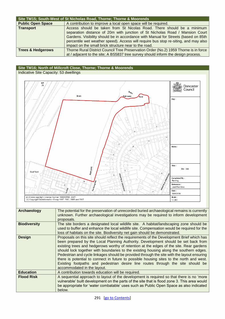
291 [go to Contents]
Site TM15; South-West of St Nicholas Road, Thorne; Thorne & Moorends
Public Open Space A contribution to improve a local open space will be required.
Transport Access should be taken from St Nicolas Road. There should be a minimum separation distance of 20m with junction of St Nicholas Road / Mansion Court Gardens. Visibility should be in accordance with Manual for Streets (based on 85th percentile wet weather speed). Access will require bus stop re-siting, and may also impact on the small brick structure near to the road.
Trees & Hedgerows Thorne Rural District Council Tree Preservation Order (No.2) 1959 Thorne is in force at / adjacent to the site; A BS5837 tree survey should inform the design process.
Site TM16; North of Millcroft Close, Thorne; Thorne & Moorends
Indicative Site Capacity: 53 dwellings
Archaeology The potential for the preservation of unrecorded buried archaeological remains is currently
unknown. Further archaeological investigations may be required to inform development proposals.
Biodiversity The site borders a designated local wildlife site. A habitat/landscaping zone should be used to buffer and enhance the local wildlife site. Compensation would be required for the loss of habitats on the site. Biodiversity net gain should be demonstrated.
Design Proposals on this site should reflect the requirements of the Development Brief which has been prepared by the Local Planning Authority. Development should be set back from existing trees and hedgerows worthy of retention at the edges of the site. Rear gardens should lock together with boundaries to the existing housing along the southern edges. Pedestrian and cycle linkages should be provided through the site with the layout ensuring there is potential to connect in future to possible housing sites to the north and west. Existing footpaths and pedestrian desire line routes through the site should be accommodated in the layout.
Education A contribution towards education will be required.
Flood Risk A sequential approach to layout of the development is required so that there is no ‘more vulnerable’ built development on the parts of the site that is flood zone 3. This area would be appropriate for ‘water combatable’ uses such as Public Open Space as also indicated below.

292 [go to Contents]
Site TM16; North of Millcroft Close, Thorne; Thorne & Moorends
Public Open Space A commuted sum is required to improve local Public Open Space.
Transport A Transport Statement will be required. The site has good links to the Railway Station and should improve the route to this on foot. There is only a single point of access via the end of cul-de-sac on Millcroft Close. May require a routing agreement during construction.
Trees & Hedgerows No arboricultural issues; the site is characterised by degraded field boundaries to the South and East.
Site TM18; North of Thorne South Station, South End, Thorne; Thorne & Moorends
Indicative Site Capacity: 25 dwellings
Archaeology No further archaeological investigation is likely to be required if this site is brought forward
for development.
Biodiversity Development should seek to retain and enhance the ecological connectivity along the railway corridor and the boundary hedgerow at the north of the site. Any unavoidable habitat losses should be accounted for and biodiversity net gain should be demonstrated.
Design Opportunity exists to connect the scheme to the station, which will also provide natural surveillance and make it more attractive to pedestrians.
Education A contribution towards education may be required.
Public Open Space A commuted sum is required to improve local Public Open Space.
Transport The site area includes Thorne South Station, access road and parking area. Visibility splays for the site entrance are to be in accordance with Manual for Streets (30mph) or recorded 85th percentile wet weather speeds. Furthermore, forward visibility along South End Road is of concern and there is a need to ensure adequate visibility exists along South End Road. These are to be provided as part of any forthcoming application. The site could possibly be served by Southfield Close, subject to a minimum carriageway width of 5.5m being achieved. This may require footway narrowing to achieve. An existing public footway linking Southfield Road and rail station may require stopping up under Section 247 of TCPA to facilitate the development.
Trees & Hedgerows The retention of the hedgerows, whilst preferred, may be problematic in reality. The best approach is therefore to seek ecological compensation.

293 [go to Contents]
Site TM18; North of Thorne South Station, South End, Thorne; Thorne & Moorends
The site will require some good amenity tree planting at the entrance and lining the street, ideally within the public realm. If the applicant wishes to avoid pre-commencement condition that would be used with any future consent then landscaping should be given early consideration.
Site TM19; East of South End, Thorne; Thorne & Moorends
Indicative Site Capacity: 13 dwellings
Archaeology The site can be assessed as having uncertain archaeological constraint and if brought
forward for development further archaeological investigation may be required. The scope and nature of any archaeological investigation, if required, should be discussed with the South Yorkshire Archaeology Service (SYAS).
Biodiversity Development will result in the loss of an area of habitat used by a range of species. Prospective developers will need to show how this can be compensated ensuring biodiversity net gain. Any application should be supported by an ecological appraisal.
Design There is an opportunity to open up access to the station with a pedestrian / cycle footway connection to the existing footway to the east of this site and the adjacent Site TM18. Natural surveillance over the adjacent footpath and the station access road to the south should be improved through the siting of new homes on the site.
Education A contribution to education will be required.
Public Open Space A commuted sum will be required to contribute towards improving a local open space.
Transport Access will need to be taken from South End, via Site TM18, or potentially via Southfield Close, subject to a minimum carriageway width being achieved. Both access options via either South End Road or Southfield Close will require land outside the potential development plot to deliver a new access road and therefore will probably require 3rd party land to facilitate this. Visibility splays for the site entrance are to be in accordance with Manual for Streets (30mph) or recorded 85th percentile wet weather speeds. Furthermore, forward visibility along South End Road is of concern and there is a need to ensure adequate visibility exists along South End Road. These are to be provided as part of any forthcoming application.

294 [go to Contents]
Site TM19; East of South End, Thorne; Thorne & Moorends
Trees & Hedgerows The retention of the hedgerows, whilst preferred, may be problematic in reality. The best approach is therefore to seek ecological compensation.
Site ASK09; Askern Industrial Estate, Moss Road, Askern; Askern
Indicative Site Capacity: 44 dwellings
Archaeology Any remaining standing buildings or buried remains associated with the World War II
barracks are likely to be of local archaeological significance. The extent of sub-surface disturbance caused by the construction of the barracks is currently unclear, therefore the potential for the survival of unrecorded buried archaeological remains pre-dating the mid-20th century is considered to be low to moderate. Further archaeological investigations may be required when the site is brought forward for development.
Biodiversity Habitat losses should be accounted for and appropriate compensation provided. The buildings proposed for demolition would require bat surveys.
Design New development should front toward Moss Road and Newmarche Drive, with properties set back from Moss Road to respect established building lines and front boundaries created as per the existing street character. A pedestrian / cycle route should be developed through the site between Moss Road and Newmarche Drive to improve pedestrian permeability and movement in the local area. The pedestrian route to the west of the site should benefit from natural surveillance from new properties with a connection made from the site. A landscaped and acoustic buffer may be required along the eastern edge as attenuation from adjacent potential employment uses.
Education A contribution towards education will be required.
Public Open Space A contribution towards Improving the adjacent open space at Coniston Road will be required.
Transport New access from Moss Road will likely result in loss of hedgerow. The design standard will be determined by recorded 85th percentile WWS. Development may lead to increased queueing and delay at Station Road level crossing. The site should provide for pedestrian linkage to south for access to bus service. A Transport Statement will be required. The site may require a routing agreement during construction.

295 [go to Contents]
Site ASK09; Askern Industrial Estate, Moss Road, Askern; Askern
Trees & Hedgerows No tree issues, but the site has valuable boundary and frontage hedgerows. Retention of the site frontage hedge on Moss Road is preferable, but dependent on visibility splays.
Site ASK11; East of Avenue Road, Insoneville, Askern; Askern
Indicative Site Capacity: 34 dwellings
Archaeology The potential for the preservation of unrecorded buried archaeological remains is
considered to be moderate. Further archaeological investigations may to be required to inform development proposals.
Biodiversity Habitat losses should be compensated for and any ecological compensation should be situated to the northern part of the site bordering the wider countryside to enhance ecological networks
Design New development should integrate with the street pattern and access points provided by the Keepmoat development taking place to the east and south. Rear of new houses should back onto existing homes on east south and western edges with appropriate separation distances from existing properties. Footpath routes and desire lines through the site should be maintained. Landscape buffering is required on the northern edge of the site with properties set back and fronting in that direction.
Education A contribution towards education may be required.
Public Open Space The site is adjacent to Warren House Park. Green Infrastructure is required linking to Public Open Space plus commuted sum specifically for improvements to adjacent site.
Transport The approved layout for the Askern colliery site protected pedestrian and vehicular access to this land. Concerns over access by construction traffic through an existing residential estate, CTMP required. The site may require a routing agreement during construction.
Trees & Hedgerows
No real arboricultural issues. The northern boundary of the site derives from the Campsall, Askern and Norton Enclosure Award of 1818. The remnant vegetation here is under HV wires.

296 [go to Contents]
Site AHG02; North of Hayfield Lane; Auckley – Hayfield Green
Indicative Site Capacity: 140 dwellings
Biodiversity Habitat and species impacts would need to be fully assessed to avoid, mitigate and
compensate for biodiversity losses. Retaining ecological connectivity to the land to the north of the site beyond the railway line and along the development edge alongside the railway line, would deliver the greatest benefits for biodiversity. Reptile populations are present in the area and replacement habitat would need to be provided. Biodiversity net gain should be demonstrated.
Design New development should front toward the main access Street from Hayfield Lane. Houses should back toward existing properties on the eastern edge locking rear gardens together. Likewise the response should be the same backing onto Hayfield Business Park. Pedestrian and cycle connections are required to Hayfield Lane and the adjacent open space facilities. Layout should seek to provide some surveillance over land to north as this is identified as a location for a rail station and associated parking area.
Education A contribution towards education will be required.
Public Open Space On site open space should be provided as well as links to the proposed open space on the adjacent land to the south west of the site.
Transport The site benefits from pre-formed access points. Off-site improvements are needed to the footways on the north of Hayfield Lane between Walnut Ave and Hawthorne Road (where there is currently no footway) to improve access to facilities. The site may require a routing agreement during construction.
Trees & Hedgerows The frontage trees form an attractive and visually coherent ‘boulevard’ feature consistent with much of the street scene of Hayfield Lane; whilst the condition of these trees remains to be assessed, frontage trees should be considered as a desirable design feature in this location and be subject to tree surveys.

297 [go to Contents]
Site BH01; South of Doncaster Road, Harlington; Barnburgh - Harlington
Indicative Site Capacity: 66 dwellings
Archaeology The lack of substantial sub-surface development indicates that the potential for
the survival of unrecorded buried remains is high. Further archaeological investigations are likely to be required to inform development proposals.
Biodiversity From a wildlife point of view habitat compensation should be provided along the southern boundary of the site. To enhance the wildlife corridor that runs further to the south along the River Dearne.
Compensatory Green Belt Improvements
As the site allocation results in the loss of Green Belt land, this must be compensated for by contributing to improving the environmental quality and accessibility of remaining Green Belt land within the vicinity of the site. Details of specific sites and projects will be established in discussion with the Council.
Design New development should front toward Doncaster Road echoing building lines opposite. New houses should back onto existing houses along the eastern and western edges with rear gardens locked together. Houses should front southward. In the interests of creating a new strong, defensible, and likely to be permanent Green Belt boundary in this location, a clearly defined site boundary should be formed to the southern limit of the site, using suitably tall, dense and continuous hedgerow or tree planting. This could form the periphery to wider on site efforts to provide a visual softening between countryside and urban forms, or be used as plot boundaries, but must define the actual site limits in a clear and linear fashion. The design of the southern boundary will also need to take account of the electricity pylons and the required stand-off needed.
Education A contribution towards education will be required.
Public Open Space On site open space provision suitable for children's play will be required, including play equipment.
Transport The site can be directly accessed from Church Lane. Access should be designed to Manual for Streets. Any private accesses to classified routes require turning facilities within the site curtilage. A footway is required along the site frontage. There is currently limited bus service provision in this location. A

298 [go to Contents]
Site BH01; South of Doncaster Road, Harlington; Barnburgh - Harlington
Transport Statement will be required, and development may require a routing agreement during construction.
Trees & Hedgerows The site is bordered by hedgerows deriving from the 1822 Barnburgh cum Harlington Enclosure Award with the ‘light’ N-S internal hedge of similar vintage; composition, structural and cultural surveys required.
Site BD02; North of Hatfield Lane, Barnby Dun; Barnby Dun
Indicative Site Capacity: 98 dwellings
Archaeology Cropmarks showing a track way of probable Iron Age to Roman date have been
recorded within the site, and associated field boundaries and enclosures are recorded in the surrounding area, suggesting there is a good potential for similar remains to extend into the site. Further archaeological investigations will be required to inform development proposals.
Biodiversity Support design comments in terms of location of landscape planting. Woodland planting within the layout design would enhance an area where woodland cover and quality has been eroded. It would improve ecological connectivity – particularly if focused towards the northern and eastern edges of the site adjoining the railway corridor.
Design New development should be outward looking and front toward Hatfield Lane and countryside to the north. Buildings should back onto existing Parkhill Road and Brosley Avenue properties to lock rear gardens together, with appropriate separation distances to existing properties. Landscape planting and buffering is required to the northern and eastern edges of the site, to soften the visual impact adjacent the countryside.
Education A contribution towards education will be required.
Flood Risk A sequential approach to layout of the development is required so that there is no ‘more vulnerable’ built development on the parts of the site that is flood zone 3. This area would be appropriate for ‘water combatable’ uses such as Public Open Space as also indicated below.
Public Open Space On site open space can be brought forward in parts of the site which cannot be developed due to being in flood zone 3. Connectivity between these and adjacent open space off

299 [go to Contents]
Site BD02; North of Hatfield Lane, Barnby Dun; Barnby Dun
Brosley Avenue should be considered. The preference would be for informal open space with play equipment.
Transport Access from Hatfield Lane (part) bridleway extends east of Meadowfield Road would require major improvement / adoption works to extend Hatfield Lane and turning head. There is poor bus service provision. A Transport Assessment & Travel Plan will be required. Development may require a routing agreement during construction.
Trees & Hedgerows Parts of the site are traversed and bordered by 1807 Barnby Dun Enclosure Award hedgerows; these will need to be assessed in terms of composition and structure as well as culturally.
Site BAW04; Westwood Road, Bawtry; Bawtry
Indicative Site Capacity: 20 dwellings
Archaeology The potential for the survival of unrecorded buried archaeology is
considered to be moderate to high. Further archaeological investigations may be required to inform development proposals.
Biodiversity Habitat losses on this site would require compensation. If this cannot be accommodated within the site boundaries then offsite compensation would be required. Biodiversity net gain should be demonstrated. Woodland planting would be required along the southern boundary of the site to link the woodlands to the west and east.
Compensatory Green Belt Improvements
As the site allocation results in the loss of Green Belt land, this must be compensated for by contributing to improving the environmental quality and accessibility of remaining Green Belt land within the vicinity of the site. Details of specific sites and projects will be established in discussion with the Council.
Conservation & Heritage Landscape planting to the southern and western edges of the site and soft buffer to the countryside which will protect long distance views towards the tree edge of the conservation area.
Design The southern and western edges of the site should include landscape planting as a soft buffer adjacent the countryside.
Education A contribution towards education will be required.

300 [go to Contents]
Site BAW04; Westwood Road, Bawtry; Bawtry
Public Open Space A commuted sum is required to improve local Public Open Space.
Transport No real issues. Routing agreement during construction required.
Trees & Hedgerows There is good hedgerow and tree cover on the site frontage; these features follow the road line to create a natural green edge delineating the open countryside from the built environment. There should be landscape planting to the southern and western edges.
Site BAW05; North of North Avenue, Bawtry; Bawtry
Indicative Site Capacity: 16 dwellings
Archaeology Uncertain archaeological significance. Further archaeological investigations are likely to
be required to inform development proposals.
Biodiversity Layout and design will need to be informed by appropriate tree and ecology surveys, to retain existing features of substantive biodiversity interest. Off-site compensation for biodiversity losses may be appropriate. Biodiversity net gain should be demonstrated.
Design New development should back onto rear gardens of existing houses on the north, east and south boundaries of the site to ensure rear gardens are locked together. Properties should front westward onto Great North Road possibly set back from the edge of the site behind frontage private drives and any retained trees / hedgerows along that edge.
Education A contribution towards education will be required.
Public Open Space A commuted sum is required to improve local Public Open Space. If possible, integrate some green infrastructure to link to Galley fields and Kings wood, plus enhance landscape buffer adjacent to A638.
Transport Site can be accessed from Brewsters Walk. The adoption plan shows how the existing shared space street could be extended, although there may be a potential ransom strip.
Trees & Hedgerows Little obvious arboricultural interest; whilst the Great North Road frontage is nicely green, much is dead/declining elm.

301 [go to Contents]
Site CS02; West of Crabgate Lane, Skellow; Carcroft - Skellow
Indicative Site Capacity: 300 dwellings
Archaeology The potential for buried archaeological remains below the level impacted by
ploughing is considered to be high. Further archaeological investigation will be required to inform development proposals.
Biodiversity Habitat creation and a buffer zone is best positioned along the northern boundary and north eastern corner of the site. This should aim to help strengthen links between the Skelbrooke Rein and Harry Wood Local Wildlife Site and Burghwallis Grange Banks candidate Local Wildlife Site and Skellow Mill Pond Local Wildlife Site. The planting corridor along the A1 should also be retained.
Compensatory Green Belt Improvements
As the site allocation results in the loss of Green Belt land, this must be compensated for by contributing to improving the environmental quality and accessibility of remaining Green Belt land within the vicinity of the site. Details of specific sites and projects will be established in discussion with the Council.
Design New development should be set back from the western edge of the site with an appropriate substantial visual and acoustic buffer adjacent the A1. Buildings should front toward Green Lane and Crabgate Lane, and toward the A1 set back behind the buffer .
Education A contribution towards education will be required.
Public Open Space On site Green Infrastructure (including buffer) and children's play space will be required. Buffer to the A1 does not constitute open space provision.
Transport Access to be taken from Crabgate Lane. Visibility standards to be in accordance with Manual for Streets. Any private accesses to classified routes require turning facilities within the site curtilage. There is no vehicular access to Green Lane. There is currently a sustainability issue with the site location, given distance to local centre, services and amenities, as well as limited bus service provision / infrastructure which must be overcome. Development would require bus provision. A Transport Assessment & Travel Plan will be required. A routing agreement during construction will be required.
Trees & Hedgerows Mature boundary trees dotted around site along with ex-hedgerow trees within defunct central East-West hedgerow; these will require a BS5837 survey to assess for retention; the A1 buffer screen planting is a feature that it is crucial

302 [go to Contents]
Site CS02; West of Crabgate Lane, Skellow; Carcroft - Skellow
to retain and enhance; whilst these trees may be off-site, they will be within BS5837 survey parameters and it would be prudent for these to be included (as a group designation) in the survey.
Other A significant visual and acoustic buffer to the A1 is required.
Site EDL06; North of Edlington Lane, Edlington; Edlington
Indicative Site Capacity: 7 dwellings
Archaeology The foundations of buildings are likely to have caused significant below-ground
disturbance and as such, the potential for the survival of unrecorded buried archaeological remains on the site is considered to be low. Further archaeological investigation is unlikely to be required.
Conservation & Heritage
The adjacent park to the south contains a war memorial which is of local heritage significance and currently being assessed for listed status. It would complement the park and the setting of the memorial if the green edge and the trees at the front of the allocation site were retained.
Design New development should front toward Edlington Lane with appropriate stand-off distances from the frontage trees. The rear of any new properties should lock together existing rear gardens on the western edge with appropriate separation distances from existing properties.
Education A contribution towards education will be required.
Public Open Space A commuted sum is required to improve local Public Open Space.
Transport The access point / points need careful consideration to prevent conflict with existing opposing access to filling station / supermarket. The site may require a routing agreement during construction.
Trees & Hedgerows There are prominent frontage trees along with a prominent tree at the north eastern end of the site. Subject to BS5837 survey information, these should be retained as appropriate. Taking account of below and above ground constraints would be expected.

303 [go to Contents]
Site EDL07; West of Howbeck Drive; Edlington
Indicative Site Capacity: 36 dwellings
Archaeology No development or significant ground disturbance has been recorded within the site. The
potential for the survival of unrecorded buried archaeological remains is considered to be moderate. Further archaeological investigation may be required.
Biodiversity The site appears to have biodiversity value and forms an extension to Edlington Brick Pond LWS and the new community woodland/park, forming a series of connected habitat parcels of biodiversity interest. The loss of habitats on site and ecological connectivity through the landscape would require compensation. It is likely that compensation would be required off site in order to deliver the net gain in biodiversity required by national policy. Biodiversity net gain should be demonstrated.
Design Development layout should maintain a green edge and buffer to Howbeck Dike, with development fronted outward in a westerly direction toward this edge set back from the existing trees and hedgerows. Rear gardens of new properties should lock together existing rear gardens on the eastern edge with appropriate separation distances from existing properties.
Education A contribution towards education will be required.
Public Open Space A commuted sum is required to improve local Public Open Space.
Transport There are only 2 possible access points to this land via Church View and Lake Close - potential issue as the roads are fairly narrow and this will require access through a sheltered housing scheme, this will need careful consideration. Edenthorpe Neighbourhood Plan raised issues about traffic calming measures along Howbeck Drive. May require a routing agreement during construction.
Trees & Hedgerows Within the site it would appear to be predominantly scrub; the main feature is the mature field boundary separating the site from the agricultural land to the west. It will be important in the landscape for this feature to be retained to screen/soften development from views across the open countryside (subject to a BS5837 tree survey).

304 [go to Contents]
Site SPR01; Between Cadeby Road and Melton Road, Sprotbrough; Sprotbrough
Indicative Site Capacity: 80 dwellings
Archaeology The presence or otherwise of significant archaeology on the site is unknown.
Contact the South Yorkshire Archaeological Service (SYAS) as to whether any further archaeological investigations are required if the site is brought forward for development.
Biodiversity The hedgerows on site should be retained where possible and landscaping should buffer the western site boundary. Biodiversity net gain should be demonstrated.
Compensatory Green Belt Improvements
As the site allocation results in the loss of Green Belt land, this must be compensated for by contributing to improving the environmental quality and accessibility of remaining Green Belt land within the vicinity of the site. Details of specific sites and projects will be established in discussion with the Council.
Design New development should front toward Cadeby Road and Melton Road with building set back to reflect existing street frontages and building lines. New homes should provide surveillance over the open space to the east through properties fronting toward it set back behind private drives and any retained trees / hedgerows. Pedestrian and cycle connections should be provided between Melton Road and Cadeby Road and the open space. The layout should be informal. In the interests of creating a new strong, defensible, and likely to be permanent Green Belt boundary in this location, a clearly defined site boundary should be formed to the western limit of the site, using suitably tall, dense and continuous hedgerow or tree planting. This could form the periphery to wider on site efforts to provide a visual softening between countryside and urban forms, or be used as plot boundaries, but must define the actual site limits in a clear and linear fashion.
Education A contribution towards education will be required.
Public Open Space Given the site is adjacent to an existing open space, a commuted sum would be required to improve this. Green infrastructure should be present on the site itself, with access to the adjacent open space provided.
Transport Access to be designed to DMRB standards with visibility to 85%ile WWS resulting in loss of hedgerow. There is a need to provide a footway along site

305 [go to Contents]
Site SPR01; Between Cadeby Road and Melton Road, Sprotbrough; Sprotbrough
frontage to connect to existing to the west of the site (circa 100m). There may be a need to alter the TRO to move change in speed limit and gateway feature (currently in middle of site frontage to Melton Road. Secondary access from Cadeby Road can be considered although visibility to 85%ile WWS may prove difficult to achieve and result in loss of hedgerow (if achievable). There will need to be an extension of the existing footway to site access Melton Road and/or Cadeby Road, latter is quite narrow. Cadeby Road is busy at school start and finish times/proximity to Copley Junior School. A Transport Assessment & Travel Plan is required. Development may require a routing agreement during construction.
Trees & Hedgerows The eastern boundary (light) hedgerow can be traced back to an untitled late 18th-early 19th century estate plan; the north and western boundaries can be traced back to the much earlier (1711) wider estate plan for Bilham, Marr, Scawsby, Cusworth, Newton, Sprotbrough and Cadeby. Whilst the N hedgerow appears rather 'flimsy', the western hedgerow appears bulkier. No arboricultural issues. Boundary hedgerow retention dependent on structural condition, highway visibility and secure boundaries. The western boundary should be retained and enhanced.
Site TIC01; South of Sunderland Street, Tickhill; Tickhill
Indicative Site Capacity: 74 dwellings
Archaeology The presence or otherwise of significant archaeology on the site is
unknown. Contact the South Yorkshire Archaeological Service (SYAS) as to whether any further archaeological investigations are required if the site is brought forward for development.
Biodiversity The field boundaries and wooded strip along the motorway edge should be protected and enhanced. Habitat losses should be accounted for and compensation should contribute to local priorities identified in the Torne Catchment Plan in which the Paper Mill Dyke corridor to the south of the site is
306 [go to Contents]
Site TIC01; South of Sunderland Street, Tickhill; Tickhill
identified. The southern boundary of the site should include native hedgerow planting as a buffer to the wider countryside.
Compensatory Green Belt Improvements
As the site allocation results in the loss of Green Belt land, this must be compensated for by contributing to improving the environmental quality and accessibility of remaining Green Belt land within the vicinity of the site. Details of specific sites and projects will be established in discussion with the Council
Conservation & Heritage The northern tip of the site contributes to the wider setting of Sunderland Farm and the modern development of 7 cottages here has taken this into account in terms of design and materials. Careful consideration of the form and character of the buildings as seen from Sunderland Street and the approach to the listed farm would be required. Reinforcing green/open character here would also help. Provided buildings are no more than 2 storeys high there would be no conservation constraints on development to the rear of these 7 cottages.
Design New development should incorporate appropriate stand-off from the Motorway edge and include noise attenuation measures. If open space is to be provided it may be appropriate to locate POS along this edge. Rear gardens of new homes should back onto existing rear gardens to the north and west in a secure layout. In the interests of creating a new strong, defensible, and likely to be permanent Green Belt boundary in this location, a clearly defined site boundary should be formed to the southern limit of the site, using suitably tall, dense and continuous hedgerow or tree planting. This could form the periphery to wider on site efforts to provide a visual softening between countryside and urban forms, or be used as plot boundaries, but must define the actual site limits in a clear and linear fashion.
Education A contribution towards education will be required.
Public Open Space A dedicated on site open space will be required.
Transport Access to Sunderland Street is possible, but ultimately may require the relocation of the existing garages to accommodate suitable access on to this site. Development may require a routing agreement during construction.
Trees & Hedgerows As Tickhill would appear to have been enclosed prior to the main period of parliamentary enclosure acts (mid-18th to mid-19th centuries) the hedgerows that bisect/surround the site may be considered as ancient hedgerows. Hedgerow planting should be undertaken on the southern boundary.

307 [go to Contents]
Sites DSA02 (Initial Airport Housing) & DSA03 (Airport Reserve Housing); Auckley – Hayfield Green
Indicative Site Capacity: 1,200 dwellings
Archaeology There has been little recorded below-ground disturbance within the site. As such, the
survival of any previously unrecorded heritage assets within the site is considered to be moderate. Consequently, further archaeological investigations are likely to be required. The site has not been assessed separately but was assessed in the archaeological scoping report as part of the wider site, and the following would still apply if allocated. Due to the lack of deep ground disturbance the likely survival of buried archaeological remains associated with the complex of Iron Age to Romano-British field systems and settlement is considered to be high. Areas where quarrying has taken place have no potential for the survival of archaeological remains. Given the evidence for extensive buried archaeological remains on this site, further consideration of the impact on these would be required to establish whether there was capacity for housing on this site. The extent and scope of any further investigation for all parts of the site should be discussed with the South Yorkshire Archaeology Service
Biodiversity Habitat losses would need to be accounted for and an application would need to demonstrate how it would deliver a net gain for biodiversity. Also of exceptional importance in this area is the habitat network and connectivity of this would need to be enhanced through very careful design. New planting would be required to strengthen connections between the matrix of woodlands. Currently, while much of the site is agricultural, wildlife will still be able to use this to move between the woodland sites. Once housing is built this will provide a much bigger barrier to dispersal of species. This is why improving the existing habitat connectivity would be essential component of the design. The site spans the area between two Local Wildlife Sites (Hurst Plantation, Savage Brooks, and Marr Flatts Wood (4.32) and Hurst Wood (4.31b), and woodland is a valuable biodiversity feature of the wider landscape. In particular, the wet woodland components of these neighbouring sites need to be protected from loss or degradation as a result of the development. All woodlands and wetland features on or adjacent to the site (whether

308 [go to Contents]
Sites DSA02 (Initial Airport Housing) & DSA03 (Airport Reserve Housing); Auckley – Hayfield Green
designated or not) would need protecting thorough the provision of appropriate landscape buffer zones. Similar principles will need to be applied to further phases of development to protect and enhance the ecological connectivity and quality of the woodlands and their individual features of interest.
Design Development proposals for this site must be informed by comprehensive airport area-wide masterplanning as required by Policy 6. This must include production of an agreed design code for this site and further potential housing areas south of the Airport Access Road / Great Yorkshire Way. The design must meet the quality aspirations of Policy 6 and Local Plan design policies. The masterplan and code are to be prepared and agreed with the Local Planning Authority in advance of any development on this land. The design code and layout for this site must ensure pedestrian and cycle connectivity through this site, to the proposed Plaza and existing community to the north. This must include links to the proposed railway station to the north if this comes forward. The layout should ensure a high quality gateway is provided on arrival to the site from the north, which may include provision of a primary school. It should be designed to create a legible and secure block structure with a hierarchy of streets. The principal spine road access must be designed to incorporate a high quality tree lined avenue in verge treatment and be fronted by new development. New development must also front toward Hurst Lane, albeit development could be set back behind a green edge to reflect the existing character. New homes should be set away from existing woodland by sufficient distance.
Education A contribution towards education will be required. The wider site if it comes forward is projected to require at least one new school.
Public Open Space The site will require onsite open space, and consideration will need to be given as to how this can connect with and relate to the wider master plan area, and open spaces which will be required as part of this.
Transport The Doncaster Sheffield Airport draft masterplan (Plan 6) shows access to residential development via new roundabouts at the junctions of A638 / Hurst Lane and A638 / High Common Lane. If it is intended that the orange shaded area is to be served by priority junction on to Hurst Lane, design is to be in accordance DMRB with visibility splay of 4.5m x 215m. Due to the visibility constraint caused by the bend at the northern end of the site, the location of the access may conflict with the position of the existing bus stop which therefore may need moving. M18 junction 3 capacity constraints raised by Highways England as part of nearby current application (currently unresolved).
Trees & Hedgerows There are major woodland blocks connected by remnant hedgerows deriving from the 1778 Blaxton, Auckley with Finningley Enclosure Award. Any layout proposals will,need to be informed by tree surveys and include appropriate stand-off from woodland where required.
Other This site needs to be considered in the wider context of the Airport and other proposed airport development, and will form part of the Airport Masterplan and residential design code required under Policy 6.

309 [go to Contents]
Employment Sites
Site EMP03; East of Selby Road, Thorne; Thorne & Moorends
Archaeology The potential for the survival of buried archaeology below the zone impacted by ploughing
is considered to be moderate to high. Further archaeological investigation is likely to be required if the site is brought forward for development.
Biodiversity New habitat creation landscaping should be provided along the eastern boundary of the site to enhance the ecological corridor along the nearby River Don. Given the proximity of Thorne Moors habitats attractive to foraging nightjar would be beneficial.
Design A masterplan and design guide will need to be developed with the Council prior to submission of a planning application. The existing Public Right Of Way from North Common Road should be extended westward from its southern end to link with Selby Road. The site layout should be led by a robust landscape and visual impact assessment of the surrounding environment. Views and viewpoints to be agreed with the Council. There is a requirement for significant landscape buffering around the edges of the site and / or the locating of smaller buildings adjacent the open countryside. Likewise green corridors through the site are desirable to create a ‘green grid’ GI framework utilising existing drains where possible. Buildings should front onto public roads and create a high quality appearance from the motorway. Any large floor plate / large volume buildings should include quality architectural detailing which seeks to either break down the scale of the building or celebrate its prominence as a landmark building. Highest quality materials and detailing should be focused on the active, publicly viewable building elements, particularly those elevations that are visible from the motorway.
Transport A Transport Assessment will be required. Previous comments have been made to the planning application on this site. Depending on whether this iteration of the scheme comes forward, these either need to be taken account of, or revised comments will be given as part of any future application.
Trees & Hedgerows A prairie-type landscape where the vast majority of the 1825 Enclosure hedgerows have been removed. Layout should be informed by a tree survey.

310 [go to Contents]
Site EMP06; Land West of DSA, Auckley; Auckley – Hayfield Green
Archaeology Given the evidence for extensive buried archaeological remains on this site, further
consideration of the impact on these would be required to establish whether there was capacity for housing on this site. There has been little recorded below-ground disturbance within the purple site which was assessed in the archaeological scoping report as site 753; as such, the survival of any previously unrecorded heritage assets within the site is considered to be moderate. Consequently, further archaeological investigations are likely to be required. The extent and scope of any further investigation for all parts of the site should be discussed with the South Yorkshire Archaeology Service. Archaeological implications – a written scheme of investigation must be approved by the Local Authority prior to development.
Biodiversity Further survey work will be required related to badgers which are using the site and the status of their sett. Would not like any access or pipelines to go through Finningley Big Wood. Green Infrastructure Plan is required which considers relationships with the wider ecological network. Would wish to see new woodland planting as compensation for any woodland loss. Need to demonstrate biodiversity net gain on this site and how it can be delivered.
Design Need to integrate the scheme within the wider proposals at the Airport and this site should form part of the proposed masterplanning in this location, including firm commitments to routes and connections with the wider proposed site. There needs to be suitable routes to encourage movement on foot or bike between the wider site. Assessment must be made of opportunities and constraints. Need to consider the impact of building heights given the countryside location of the site, including views on to the site. Landscape buffers are required to the edges of the site.
Transport No objections in principle to site, but technical details will need to be discussed and refined through the application process.
Trees & Hedgerows Information about precise access arrangements and their impact on trees / the TPO’d woodland will be required. Layout should be informed by a tree survey. Trees at the northern tip of the site are deemed to be the best trees and should be considered for retention. Would wish to see woodland W50 preserved. No development through the most

311 [go to Contents]
Site EMP06; Land West of DSA, Auckley; Auckley – Hayfield Green
valuable woodland. Internal woodland group of very high value, these should be retained as an internal woodland block.
Site PED01; Carcroft Common, Carcroft; Carcroft - Skellow
Archaeology The construction of Bentley Grange may have destroyed any sub-surface archaeological
deposits associated with the mid-19th-century brick kiln at that site. The site of Bentley Grange has not been redeveloped and the likely survival of sub-surface assets associated with the building is considered to be high. The excavation of the clay pit will have destroyed any sub-surface archaeological deposits that may have been present at that location. Due to the lack of deep-ground disturbance in the remainder of the site, the likely survival of any previously unrecorded heritage assets is considered to be moderate. Further archaeological investigation may be required if the site is brought forward for development.
Biodiversity The site is close to a network of Local Wildlife Sites (to the north) and proposals should seek to enhance the wildlife corridor extending south and west along the Old Ea beck and along any connecting drains within the site. The impact of proposals on farmland birds should be accounted and compensated for.
Design A masterplan and design guide will need to be developed with the Council prior to submission of a planning application. New pedestrian routes should be developed through the site to link up to recreation routes and existing footpaths at the edges. This should include a diagonal pedestrian / cycle route through the site from Tollbar to link to Bentley Moor Lane near the bridge. The site layout should be led by a robust landscape and visual impact assessment of the surrounding environment. Views and viewpoints to be agreed with the Council. This will likely result in a requirement for significant landscape buffering around the edges of the site and / or the locating of smaller buildings adjacent the open countryside. Likewise green corridors through the site are desirable to create a ‘green grid’ GI framework utilising existing hedgerows, drains and waterbodies where possible. Highest quality materials and detailing should be focused on the active, publicly viewable building elements, particularly those elevations that are visible from the Bentley Moor Lane,

312 [go to Contents]
Site PED01; Carcroft Common, Carcroft; Carcroft - Skellow
Adwick Lane, and the A19. Quality landmark buildings should mark the corner of Bentley Moor Lane / Doncaster Road
Transport Accessed from Bentley Moor Lane - Derestricted speed limit therefore access to be designed in accordance with DMRB requirements. There is a need to widen footways top the site frontage. Transport Assessment & Travel Plan required.
Trees & Hedgerows Few remnant internal hedgerows traceable back to 1839 Dun Drainage Award; there is a valuable pond and surrounding woodland area abutting Bentley Moor Lane which would be an excellent hub for the required biodiversity connectivity. Layout should be informed by a tree survey.
Other Allocated Sites
Site no Site Name Notes
MUA51 East of Mere Lane, Edenthorpe Planning application granted on appeal.
MUA59 Former Warmsworth Reservoir, Warmsworth Planning application granted.
ARM10 Barton Lane, Armthorpe Armthorpe Neighbourhood Plan allocation.
TM17 West of Marshlands Road, Moorends Planning application granted on appeal.
ASK10 Askern Miners Welfare, Manor Way, Askern Planning application approved at committee.

313 [go to Contents]
Appendix 3: Doncaster Sheffield Airport Policy Area
Policy 6 proposes the release of housing linked to delivery of jobs within the Airport Policy Area or jobs closely related to airport functions. This Appendix clarifies how this is calculated.
Site DSA02 is allocated for a development of 280 houses on land adjacent to the Airport. A Reserve Housing Site is earmarked for up to a maximum of 920 houses on land adjacent to this (Site DSA03) meaning a total of 1,200 homes could be brought forward overall at the Airport. (Both sites are shown on the Policies Map).
The release of houses on Site DSA03 will be strictly controlled and linked to the proven delivery of jobs within the Airport Policy Area (or jobs closely related to airport functions).
In the following example, it is assumed that in 2018 the Airport employed approximately 1,000 people.
The ratio of jobs : houses (i.e. the number of houses allowed per job created) for calculation purposes is 1: 0.11. For clarification, 500 jobs, 1,000 jobs or 2,000 jobs would result in 55, 110 and 220 houses respectively (jobs number x 0.11). The delivery of approximately 9 jobs would therefore result in 1 house.
To support the economic expansion of the Airport, 280 of the 1,200 houses will be allocated ‘up front’ (Site DSA02) in lieu of delivery of jobs. However, the Council will expect the jobs related to this initial tranche to be delivered. Therefore, before any of the remaining 920 houses are permitted on Site DSA03, it must be evidenced that a number of jobs equivalent to the 280 houses has actually been delivered:
Using the ratio of 1 : 0.11, 2545 jobs is the equivalent of 280 houses.
The base date for this policy is 2018. The Local Plan runs to 2035, which is 17 years from 2018. The 2,545 jobs equivalent to the up-front 280 houses will be split between the 17 years. 2,545 / 17 = 150 (rounded);
Before any further release of land is permitted for housing development beyond the 280 upfront houses, the applicant must demonstrate, at the time of an application for planning permission, that: a) the level of airport related jobs existing in 2018 has been maintained; and b) an additional 150 net jobs per annum (based on the number of years since 2018 at the point of
application) have been delivered.
Should the applicant be able to robustly evidence that this has been achieved, then a calculation can be made to determine how much housing can be permitted. Any net full time equivalent (FTE) jobs delivered above this figure at that point in time will allow housing to be permitted at a rate of 0.11 houses per additional job.
𝑈𝑛𝑖𝑡𝑠 𝑃𝑒𝑟𝑚𝑖𝑠𝑠𝑖𝑏𝑙𝑒 =
(
𝑁𝑜. 𝑜𝑓 𝑗𝑜𝑏𝑠 (150𝑎𝑡 𝑡ℎ𝑒 𝑁𝑜. 𝑜𝑓 𝑒𝑥𝑖𝑠𝑡𝑖𝑛𝑔 𝑥
𝐴𝑖𝑟𝑝𝑜𝑟𝑡 𝑎𝑡 − 𝐴𝑖𝑟𝑝𝑜𝑟𝑡 − 𝑁𝑜. 𝑜𝑓𝑡ℎ𝑒 𝑝𝑜𝑖𝑛𝑡 𝑟𝑒𝑙𝑎𝑡𝑒𝑑 𝑗𝑜𝑏𝑠 𝑦𝑒𝑎𝑟𝑠 𝑜𝑓 𝑎𝑡 2018 𝑠𝑖𝑛𝑐𝑒
𝑎𝑝𝑝𝑙𝑖𝑐𝑎𝑡𝑖𝑜𝑛 2018))
x 0.11
For example, should an applicant wish to apply for housing on Site DSA03 in 2028, the amount permissible would be calculated as follows:

314 [go to Contents]
A B C D E
Year of application
Existing jobs at 2018 (indicative estimate for illustrative purposes)
Jobs in lieu (years since 2018 x 150)
Minimum FTE jobs delivered before additional housing released (B + C)
Rate of housing release for any jobs delivered above figure in column D
2028 (10 years)
1,000 1,500 2,500 0.11 per job
Using this example, should an applicant wish to apply for housing on Site DSA03 in 2028, they must show that the number of jobs at the Airport is over 2,500, or in other words, since the policy base date of 2018, 1,500 new jobs have been delivered in addition to the agreed number of existing jobs as at 2018. For any jobs over 2,500 jobs, houses would be permitted at a rate of 0.11 houses per additional job.
Using the table above, the figures below are presented to illustrate how the calculation would work:
In 2028, the applicant robustly proves that the Airport is directly responsible for the employment of 8,000 people within the Airport Policy Area (or via jobs in the Borough closely related to airport functions).
1000 jobs (actual number to be confirmed at Local Plan adoption) must be deducted as they already existed at 2018 (8,000 – 1,000 = 7,000).
10 years’ (2018 – 2028) worth of jobs related to the split of the upfront housing allocation (Site DSA02) must also be subtracted to account for houses already delivered up front (150 x 10 = 1,500; 7,000 – 1,500 = 5,500 jobs).
5,500 net additional jobs must then be translated into houses using the ratio of 1 job : 0.11 houses. (5,500 x 0.11 = 605 houses).
In this scenario 605 houses would therefore be permitted on Site DSA03. This is in addition to the 280 which were permitted up front on Site DSA02.
The overall site (Sites DSA02 & DSA03) would therefore, at this point, be capable of delivering 885 houses out of a maximum of 1200 (605 + 280).
The remaining 315 (1,200 – 885) houses could only come forward on the remainder of Site DSA03 were an applicant to be demonstrate delivery of any further net additional jobs beyond those assumed above, and using the calculation above.
There are some very important caveats to this policy:
The maximum number of up-front houses permitted in the initial tranche on Site DSA02 is 280.
The 2,545 jobs that would otherwise result in 280 houses on Site DSA02 (using the ratio of 1 : 0.11) must be delivered in lieu of this. This must be taken into account when an application for additional housing comes forward on Site DSA03.
The maximum number of houses that may come forward dependent on the delivery of jobs is 920 on Site DSA03 - in addition to the initial 280 on Site DSA02. This means there will be a maximum of 1,200 houses permitted on Sites DSA02 & DSA03 related to the proven delivery of jobs. Should the number of jobs exceed the related equivalent number of houses (10,910 jobs (1,200 / 0.11)), no further housing will be permitted related to the additional jobs.
Jobs figures are net. They factor in gains and losses over time. They must be robustly evidenced and shown as actually delivered before housing release related to this can be considered.
The final list of the types of directly related jobs that it is acceptable to count towards this calculation will be agreed following discussions between the Council and the Airport. However: o Jobs created must be within Doncaster Borough. o Jobs must be Full Time Equivalent (FTE). o Jobs must be directly related to the Airport Policy Area (or jobs closely related to airport
functions). For example, new FTE jobs at an off-site Doncaster based supplier of specialist air related goods directly procured by Doncaster Sheffield Airport.

315 [go to Contents]
The Council considers that this strikes the right balance between supporting the Airport and its economic aspirations, which are also important to the Borough and the City Region, and capturing the benefits for Doncaster. Additional housing acts as both support for the Airport’s development and an incentive to deliver jobs to boost the local economy.
The initial tranche of housing is designed to help the Airport begin to realise its economic ambitions and potential. However, the jobs related to this must be delivered. This is the only time that housing will come before jobs in this location. For subsequent applications, jobs delivery must be clearly demonstrated before housing is released. This means the impetus is with the Airport operator, if it wishes to enable housing development, to deliver its economic ambitions, which are also important for the Borough.

316 [go to Contents]
Appendix 4: Dwelling Mix and Type
(Source: Housing Needs Study 2019)
Notes:
This Appendix should be read in conjunction with Policy 7.
The table provides an indicative breakdown of house type and mix by area based on the findings from the household survey conducted as part of the
Housing Needs Study (2019).
These figures are annual and based on a share of the annual housing requirement of 920 dwellings per annum.
The data is a snapshot in time and intended to provide a starting point for applicants looking to determine an appropriate mix when drawing up planning
applications – although it does not account for what may have already been secured through schemes already consented.

317 [go to Contents]
Appendix 5: Affordable Housing Requirement Value Areas
318 [go to Contents]
Appendix 6: Parking Standards
The parking standards set in this appendix have been developed in line with the overarching objectives of the Sheffield City Region Transport Strategy (2018-2040) and aligned to those developed by other local authorities within South Yorkshire.
The Council recognises that parking requirements vary based on location and land use. In particular, it is important to acknowledge that accessibility, in terms of travel distances and availability of public transport, have a significant impact on the need for car use and parking. To reflect this, parking standards have been set for the Borough based on different land use classes and location of development. In line with the NPPF, it is also acknowledged there is a need to reflect local circumstances, context and requirements of individual developments when assessing applications.
Minimum parking standards have been set for residential developments in order to overcome issues associated with low parking provision. In determining the right levels of parking we will consider the anticipated demand from the type of housing proposed, the likely occupiers, the design of the public realm and highway, the proposed parking design solutions, and any local restrictions will be considered.
Although uniform standards have been established for the whole borough, residential developments within Doncaster Town Centre will be assessed on a case by case basis, taking into account accessibility, context and the requirements of individual development. As highlighted in the 2018 Parking Strategy, Doncaster Town Centre is highly accessible with good public transport connections. As such, lower parking provision may be acceptable in some circumstances in residential development within Doncaster Town Centre.
Conversions of existing dwellings or non-residential into Houses in Multiple Occupation (HMOs) can have the potential to increase the demand for parking in an area, particularly on-street provision. Where planning permission is required, adequate parking provision should be provided, taking account of the standards set below alongside guidance set in relevant Supplementary Planning Documents.
A zoned approach has been adopted for non-residential development with maximum parking standards for Doncaster Town Centre and set parking standard requirements for the rest of the Borough. This approach reflects need to ensure functional developments which maximises opportunities for use of sustainable modes of transport in urban locations well served by public transport.
The NPPF states that maximum parking standards for development should only be set where there is a clear and compelling justification for adoption. The 2018 Doncaster Town Centre Car Parking Strategy contained a strategic review of parking consider current provision, occupancy, accessibility, car usage and future demand. The review found a surplus of parking provision in the town centre when considering average occupancy and bench marking. The Strategy highlighted the need to ensure a balanced approach with respect to the provision of car parking in Doncaster Town Centres as an area well served by public transport with congestion and car related air quality challenges.
The use of maximum parking standards in Doncaster Town Centre is justified by the findings of the Car Parking Strategy and looks to optimise the density of development in the town centres and encourage sustainable travel choices in line with the NPPF. To ensure this approach remains appropriate in light of regeneration and development in the town centre, reviews of demand and supply will be carried out annually to monitor changes. The approach adopted by the parking strategy will be reviewed in line with these changes to ensure Doncaster has adequate provision.
A set parking standard requirement has been set for the rest of the Borough to ensure appropriate parking provision. Where a development looks to provide more or less parking than the set standard, robust justification for such variation would need to be provided by the applicant, which would be subject to rigorous assessment.
Where proposals look to depart from the parking standards, Transport Statements and Assessments would be expected to include the following items:

319 [go to Contents]
Surveys of parking capacity and occupancy levels on surrounding streets and parking areas.
Consideration of likely trip generation and parking accumulations for the proposed development evidenced as appropriate.
Details of how the parking will be managed and how that will mitigate any under or over-provision.
These above items are not an exhaustive list and in cases where proposals look to depart from the standards, applicants would be encouraged to discuss specific requirements with the Council.
Parking and access requirements for service and delivery vehicles shall be additional to the requirements set out within these standards. Where required, the quantity and design of Heavy Commercial Vehicles (HCV’s) will be assessed on a site by site basis.
Non-Residential Development
Land Use Doncaster Town Centre Other parts of the Borough Threshold above which standard applies
Standard Type Maximum parking standards Required parking standards
Food retail 1 space per 14-25 m2 1 space per 14-20 m2 1000 m2
1 space per 25 m2
1 space per 20 m2 All development below 1000 m2
Non-food retail 1 space per 25-60 m2 1 space per 20-30 m2 1000 m2
1 space per 50 m2
1 space per 30 m2 All development below 1000 m2
Offices 1 space per 35-60 m2 1 space per 35 m2 2500 m2
1 space per 60 m2 1 space per 35 m2 All development below 2500 m2
Restaurants and cafes Drinking establishment Hot food takeaway
1 space per 4 m2 gross floor area for customers 1 space per residential staff 1 space per 3 non-residential staff on duty at the busiest time. Where there are fixed seating areas for diners 1 space per 3 diners can be considered
1 space per 4 m2 gross floor area for customers 1 space per residential staff 1 space per 3 non-residential staff on duty at the busiest time. Where there are fixed seating areas for diners 1 space per 3 diners can be considered
All development
Business (including offices)
1 space per 30-60 m2 1 space per 30 m2 2500 m2
1 space per 50 m2 1 space per 30m2 All development below 2500 m2
General industrial
1 space per 50-75 m2 1 space per 30-50 m2 2500 m2
1 space per 60 m2 1 space per 50 m2 All development between 500 m2 and 2500 m2
1 space per 75 m2 1 space per 50 m2 All development below 500 m2

320 [go to Contents]
Land Use Doncaster Town Centre Other parts of the Borough Threshold above which standard applies
Storage or distribution
1 space per 3 staff or 1 space per 60m2 gross floor area up to 300 m2 then 1 space per 100 m2 up to 1000 m2 and 1 space per 150 m2 thereafter Individual assessment of the lorry parking facilities to be provided where necessary, including those sites where the overnight parking of vehicles can be anticipated.
1 space per 3 staff or 1 space per 60m2 gross floor area up to 300 m2 then 1 space per 100 m2 up to 1000 m2 and 1 space per 150 m2 thereafter Individual assessment of the lorry parking facilities to be provided where necessary, including those sites where the overnight parking of vehicles can be anticipated.
All development
Hotels 1 space per bedroom plus provision in accordance with class restaurants/cafes and/or drinking establishments where applicable
1 space per bedroom plus provision in accordance with class restaurants/cafes and/or drinking establishments where applicable
All Development
Residential institutions
1 space per 4 staff + 1 space per 4 daily visitors
1 space per 2 staff + 1 space per 3 daily visitors
All Development
Non-residential institutions
1 space per 2 staff + 1 space per 15 students
1 space per 2 staff + 1 space per 15 students
All Development
Day nurseries 1 space per 2 full time staff + pick up/drop off provision
1 space per 2 full time staff + pick up/drop off provision
All Development
Medical facilities / Doctors / Dentists / Healthcare / Clinics
1 space per medical practitioner on duty at the busiest time (to include nurses, counsellors, chiropodists etc.) 1 space per 2 non-medical staff 3 spaces per consulting room (to include all rooms occupied by a medical practitioner as defined above)
1 space per medical practitioner on duty at the busiest time (to include nurses, counsellors, chiropodists etc.) 1 space per 2 non-medical staff 3 spaces per consulting room (to include all rooms occupied by a medical practitioner as defined above)
All Development
Places of worship 1 space per 2 staff Visitor provision to be assessed on each individual application
1 space per 2 staff Visitor provision to be assessed on each individual application
All development
Schools 1 space per 3 teaching staff 1 space per 3 non-teaching staff 1 space per 15 students
1 space per 3 teaching staff 1 space per 3 non-teaching staff 1 space per 15 students
All development
Local community and outdoor sport and recreation (excluding cinemas, conference centres and stadia)
1 space per 22-100 m2 1 space per 22-25 m2 2500 m2
Clubs/concert halls 1 space per 5 seats 1 space per 5 seats All development
Sports facilities 1 space per 200 m2 1 space per 200 m2 All development

321 [go to Contents]
Land Use Doncaster Town Centre Other parts of the Borough Threshold above which standard applies
Some facilities such as private gyms etc. may be assessed on membership/number of participants
Some facilities such as private gyms etc. may be assessed on membership/number of participants
Cinemas and conference centres
1 space per 5-10 seats 1 space per 5 seats All development
Stadia
1 space per 15 seats 1 space per 15 seats 1500 seats
Residential Development
The following minimum parking standards will be applied to new residential developments.
Apartments 1.5 spaces, where 1 space is allocated and another is provided for every 2 dwellings in communal parking areas.
2+ bed units
2 allocated spaces per dwelling, plus 1 visitor space per 4 dwellings unallocated and provided in defined bays within the public highway or private drive.
Integral or standalone garages will not be counted as a parking space unless they are an adequate size (currently 3 x 6 metres minimum clear internal dimensions).
Residential developments within Doncaster Town Centre will be assessed on an individual basis, taking into account accessibility, context and individual development requirements. Lower parking provision may be acceptable in some circumstances in residential development within Doncaster Town Centre.
Additional Standards
The following standards will be applied for other parking users.
Disabled motorists
The recommended spaces for disabled motorist parking are contained within the latest guidance from the department of transport. The recommended proportions of spaces for blue badge holders are as follows. For car parks associated with new development premises, 5% of the total parking capacity should be designated (includes both employees and visitors). For car parks associated with shopping areas, leisure or recreational facilities and places open to the general public, a minimum of one spaces per disabled employee, plus 6% of the total capacity for visiting disabled motorists.
Pedal cycles For residential developments, dedicated cycle storage for each property should be provided. For houses this could be in adequately sized garages or bike sheds and for flats or apartments this may be shared dedicated secure facilities. For non-residential developments, a minimum ratio of 1 cycle space per 10 parking spaces should be applied. Any departure from the standards for car parking provision should not be reflected in the reduction of cycle parking provision and, where appropriate, this should be increased in locations where cycling infrastructure encourages higher levels of cycling. For schools, cycle parking will be determined by an agreed school travel plan which will set out targets for cycling. The most appropriate facility for cycle parking will be a ‘Sheffield stand’. The siting of the stand should be in a location that is convenient, under cover and secure through natural observation. for example, at entrance to the building. Location of pedal cycle parking facilities should be agreed in writing by the Local Planning Authority.

322 [go to Contents]
Motorcycles A ratio of 1 motorcycle space per 20 parking spaces should be applied. Anchor points should be provided and the space should be convenient and secure through natural observation.
Electric vehicles
For residential developments, 1 charging point should be provided per unit (dwelling with dedicated parking for private usage). For any public usage (such as retail) 1 charging unit per 20 parking spaces. For business/staff usage 1 charging point per 10 staff parking spaces. These ratios may change as electric vehicle usage increases where there is an increased demand for vehicle recharging. In developments where short stay parking is likely, fast charging infrastructure should be used to promote high turnover of charging spaces. Grants may be available through the Office of Low Emission Vehicles.

323 [go to Contents]
Appendix 7: Transport Statements, Assessments and Travel Plans
New developments will need to provide, as appropriate, Transport Statements (TS), Transport Assessments (TA) and Travel Plans (TP) to ensure the delivery of travel choice and sustainable opportunities for travel in line with the latest government guidance and best practice. Thresholds for when these documents are required are demonstrated in the table below:
Land Use Use/description of development Size No assessment
TS TA/TP
Food retail Retail sale of food goods to the public- food superstores, supermarkets, convenience food stores
GFA <250 m2 >250 <800 m2
>800 m2
Non-food retail Retail sale of non-food goods to the public; but includes sandwich bars- sandwiches or other cold food purchased and consumed off the premises, internet café
GFA <800 m2 >800 <1500 m2
>1500 m2
Financial and professional services
Financial services- banks, building societies and bureaux de change, professional services (other than health or medical services)- estate agents and employment agencies , other services – betting shops, principally where services are provided to visiting members of the public
GFA <1000 m2 >1000 <2500 m2
>2500 m2
Sale of food amd drink (Restaurants and cafes)
Sale of food and drink for consumption (mostly) on the premises
GFA <300 m2 >300 <2500 m2
>2500 m2
Drinking establishment
Use as a public house, wine-bar or other drinking establishment
GFA <300 m2 >300 <600 m2
>600 m2
Hot food takeaway
Use for sale of hot food for consumption on or off the premises
GFA <250 m2 >250 <500 m2
>500 m2
Offices, research and development or light industrial
a. Offices other than in use within Financial and professional services)
b. Research and development-
laboratories, studies
GFA <1500 m2 >1500 < 2500 m2
> 2500 m2
Land Use Use/description of development Size No assessment
TS TA/TP
General industrial
Industrial processes not classed as being light industrial uses (excluding incineration purposes, chemical treatment or landfill or hazardous waste)
GFA <2500 m2 >2500 <4000 m2
>4000 m2
Storage or distribution
Storage or distribution centres including open air storage
GFA <3000 m2 >3000 <5000 m2
>5000 m2
Hotels Hotels, boarding houses and guest houses, development falls within this class if ‘no significant element of care is provided’
Bedroom <75 beds >75 <100 bedrooms
>100 bedrooms
Residential institutions- hospitals, nursing homes
Used for the provision of residential accommodation and care to people in need of care
Beds <30 beds >30 <50 beds
>50 beds

324 [go to Contents]
Land Use Use/description of development Size No assessment
TS TA/TP
Residential institutions- residential education
Boarding schools and training centres
Student <50 students >50 <150 students
>150 students
Residential institutions- hostels
Homeless shelters, accommodation for people with learning difficulties and people on probation
Resident <250 residents
>250 <400 residents
>400 residents
Dwelling houses Dwellings for individuals, families or not more than 6 people living together as a single household. Not more than 6 people living together includes- students or young people sharing a dwelling and small group homes for disabled or handicapped people living together in the community
Dwelling unit
<50 units >50 < 80 units
>80 units
Medical or Health Services & Learning and Non-residential Institutions
Medical and health services- clinics and health centres, crèches, day nurseries, day centres and consulting rooms (not attached to the consultant’s or doctors house) museums, public libraries, art galleries, exhibition halls, non-residential education and training centres, places of worship, religious instruction and church halls
GFA <500 m2 >500 <1000 m2
>1000 m2
Indoor Sport, Recreation or Fitness, Local Community & Sui Generis
Cinemas, dance and concert halls, sports halls, swimming baths, skating rinks, gymnasiums, bingo halls and casinos, other indoor and outdoor sports and leisure uses not involving motorised vehicles or firearms
GFA <500 m2 >500 <1500 m2
>1500 m2
Others (Sui Generis)
For example: stadium, retail warehouse clubs, amusement arcades, laundrettes, petrol filling stations, taxi businesses, car/vehicle hire businesses and the selling and displaying of motor vehicles, nightclubs, theatres, hostels, builders’ yard, garden centres, POs, travel and ticket agencies, hairdressers, funeral directors, hire shops, dry cleaners
TBD Discuss with highway authority
Discuss with highway authority
Discuss with highway authority
The Transport Assessment is a technical assessment which considers how the development will impact on the existing transportation conditions at the year of opening/occupation and under future year conditions. The assessment of the development impact should use existing site information together with network conditions at the year of planning application submission, to establish a baseline. On top of this, potential person trips to and from the development by individual modes of transport are estimated and applied to the baseline and future year conditions. Analysis of public transport, walking / cycling and the road network, together with safety considerations and accident analysis is undertaken. The Transport Assessment must consider sustainable modes of travel to link in with the site specific initiatives within the Travel Plan in order to carry out a full assessment of the relevant infrastructure and provision. This should be compared against a future year assessment of plus 10 years. The Local Planning Authority may in some instances ask for the Transport Assessment to demonstrate more extensive future year’s network conditions. These requests are in line with DfT circular 02/2013 The Strategic Road Network and the Delivery of Sustainable Development.
325 [go to Contents]
The Transport Statement is a simplified Transport Assessment; it can be used where transport issues arising from a development may not require a full Transport Assessment. A Transport Statement will include an audit and appraisal of the existing conditions, baseline traffic data and existing site use and means of access. The statement should also provide information on the proposed land use and scale of development, means of access, person trip generation and distribution of trips by mode. It should also consider proposed improvements to site accessibility by sustainable travel modes, proposed parking and residual vehicle trip impact. The use of Travel Plans is an essential measure to mitigate the impact of development traffic. Travel Plans must feature alongside any Transport Assessment prepared in support of a planning application. The Transport Assessment and Travel Plan provide a basis for the travel forecasts, as set out in the government’s latest guidance. Thus, enhancements to sustainable transport networks and services need to be considered before the implications of car trip forecasts are considered. Travel Plans should form a stand-alone document and should include:
a clear commitment by developers and occupiers to reduce the number of single occupancy vehicle trips generated by, or attracted to, the site;
accessibility details, setting out options for travel by all modes available for travel to the site; and
clear objectives and targets. Targets should be set out both in terms of mode share and number of vehicle trips.
The Travel Plan should set out the baseline situation as well as the target so it is clear what reduction in vehicle trips is being sought. Clear timescales for the achievement of targets should also be included, with a clear programme of measures that will be implemented, setting out how the developer will fund them. It should also include clear details on how the Travel Plan will be delivered and how the Travel Plan Coordinator role will be provided by the developer and a monitoring strategy setting out what will be monitored, by whom and what reporting processes will be in place. The Travel Plan should be very clear on the process to be followed if targets are not met, and set out what additional measures will be funded by the developer. The Travel Plan should include monitoring proposals based on twice yearly counts at each vehicular entrance point, or annually, where an automatic traffic count is undertaken in a neutral month for a period of 5 years. A Bond will be required to mitigate any traffic in the event that targets are not met. The purpose of the TP Bond is to ensure that the targets within the Travel Plan towards sustainable travel (bus, walk, cycle etc.) can be met, and if not met the Council would step in with sustainable measures using the Bond. The Council needs to be assured that the Travel Plan is effective and has reasonable targets that can be met. The standard formula for calculating the bond is as follows:
Residential Development: No. of dwellings x the current cost of a 28 day SY Connect+ ticket x 1.1.
Non-Residential Development: No. of employees x the current cost of a 28 day SY Connect+ ticket x 1.1.
Applicants are strongly encouraged to discuss and agree the scope of Transport Assessments, Travel Plans and related work with The Council before any assessments are undertaken to avoid abortive work. There will be a need for early engagement with Highways England in the development of Transport Assessments and Travel Plans for sites which are likely to have a material impact on the Strategic Road Network. Proposals which impact on the strategic transport network and require new projects will be expected to make a proportionate financial contribution. Further details can be found in Policy 65.

326 [go to Contents]
Appendix 8: Local Wildlife and Geological Sites : Selection Guidelines
First published in August 2009.
Revised and abridged for the Doncaster Local Plan 2019.
The unabridged version is available on the Doncaster Council website.
List of Contents
1. Introduction ...................................................................................................................................................... 327
2. Wildlife Site Selection Guidelines: Habitats ..................................................................................................... 327
3. Woodland and Scrub Habitats .......................................................................................................................... 328
4. Parkland and Wood Pasture Habitats............................................................................................................... 332
5. Hedgerow Habitats ........................................................................................................................................... 333
6. Grassland Habitats, including Lowland Heathland / Acid Grassland Mosaics .................................................. 336
7. Fen and Mire Habitats ...................................................................................................................................... 342
8. Standing Water Habitats .................................................................................................................................. 345
9. Flowing Water Habitats .................................................................................................................................... 347
10. Mixed Habitats and Structural Mosaics ........................................................................................................ 350
11. Habitats of Artificial Substrates .................................................................................................................... 352
12. Wildlife Site Selection Guidelines: Species ................................................................................................... 355
13. Site Selection Criteria – Mammals ................................................................................................................ 355
14. Site Selection Criteria – Birds ........................................................................................................................ 356
15. Site Selection Criteria - Reptiles ................................................................................................................... 357
16. Site Selection Criteria - Amphibians ............................................................................................................. 357
17. Site Selection Criteria - Multiple Species Groups ......................................................................................... 357
18. Geological / Geomorphological Selection Guidelines .................................................................................. 359
List of Tables
Table 3.2. Habitat Character list: Lowland Heathy Oak Woodland .......................................................................... 330
Table 3.3. Habitat Character list: Limestone Woodland........................................................................................... 331
Table 3.4. Habitat Character list: Wet Woodland .................................................................................................... 331
Table 3.5. Habitat Character list: Scrub .................................................................................................................... 332
Table 5.2. Habitat Character list: Ancient and/or Species Rich hedgerows (woody species) .................................. 334
Table 5.3. Habitat Character list: Ancient and/or Species Rich hedgerows (non-woody species) ........................... 335
Table 6.2. Habitat Character list: Neutral and wet grassland ................................................................................... 339
Table 6.3. Habitat Character list: Limestone grassland ............................................................................................ 340

327 [go to Contents]
Table 6.4. Habitat Character list: Acid Grassland/Lowland Heathland .................................................................... 341
Table 7.3. Habitat Character list: Lowland Raised Mire ........................................................................................... 343
Table 7.4. Habitat Character list: Mixed Fen ............................................................................................................ 344
Table 8.2. Habitat Character list: Standing Water .................................................................................................... 346
Table 9.2. Habitat Character list: Flowing water ...................................................................................................... 349
Table 10.2. Habitat Mosaics ..................................................................................................................................... 351
Table 10.3. Bryophyte Species list ............................................................................................................................ 352
Table 11.1. Species of Artificial Substrates (Coal mine, spoil disposal, or coking/processing sites) ........................ 353
Table 11.2. Species of Artificial Substrates (Settlement lagoons and waste sites of the glass processing industry)
.................................................................................................................................................................................. 353
Table 11.3. Species of Artificial Substrates (Foundry sand and resins sites) ............................................................ 354
Table 13.1 Numbers of bats that indicate a significant breeding roost in Doncaster. ............................................. 356
1. Introduction
These guidelines underpin the selection of Local Wildlife and Geological Sites in Doncaster Borough, in support of Policy 31 of the Local Plan.
The guidelines are divided into three parts based upon; habitat; species and geological selection criteria. Each of the three parts includes the relevant site selection criteria, guidance on how they should be applied and a rationale for the significance of the feature in the context of Doncaster’s biological and geological resource.
It is only necessary for one criterion to be met, for a site to be designated and Local Sites can be selected based on both wildlife and geological interests.
2. Wildlife Site Selection Guidelines: Habitats
Both quantitative and qualitative features are used as a basis for assessing Local Wildlife Sites and these are incorporated into criteria based upon habitat and species attributes.
The habitat criteria are broadly based on those defined by Ratcliffe35 for designating Sites of Special Scientific Interest, but adapted to include notable features of the Borough’s local biodiversity. The habitats and features reflect those identified in Doncaster’s Local Biodiversity Action Plan36, which include locally occurring Priority Habitats for England37 as well as local biodiversity priorities. Species highlighted in bold (see unabridged document) within the descriptive text for each habitat chapter, are those of conservation importance identified in Doncaster’s Species Audit38.
National Vegetation Classification (NVC)39 and Phase 1 Habitat Survey40 data, is used as a basis for identifying, mapping, measuring and classifying semi-natural habitats. Some selection criteria may also include a minimum habitat size attribute, which may be associated with survey methodology and standards.
35 Ratcliffe, D.A. (ed). 1977. A Nature Conservation Review. 2 vols. Cambridge University Press 36 Doncaster Biodiversity Action Partnership, 2007, Doncaster Local Biodiversity Action Plan 37 Natural Environment and Rural Communities Act, 2006, Section 41. 38 Doncaster Biodiversity Action Partnership, 2007, A Species Audit for Doncaster Borough 39 Rodwell, J.S, (2006), NVC Users' Handbook, 68 pages, ISBN 978 1 86107 574 1 40 JNCC, (2010), Handbook for Phase 1 habitat survey - a technique for environmental audit, ISBN 0 86139 636 7

328 [go to Contents]
Local ‘Habitat Character’ lists have also been created to assess habitat quality. These lists for key communities, help to define local habitat typicality and provide a means of assessing their quality through a measure of species diversity. The lists consist of indicator species; more typical community components (the presence of which scores one point) and rarities and/or indicators (locally) of high quality and highly distinctive habitat (these score 2 points). To qualify for Local Site status, sites must achieve the threshold score for the habitat being assessed.
Site assessment makes use of the entire dataset managed by Doncaster’s Local Records Centre. The data used is both site-specific and attached to 1km grid squares and attributed to sites by location names.
3. Woodland and Scrub Habitats
Doncaster Borough supports a diversity of woodland and scrub habitats. The following guidelines are for the selection of sites of broadleaf semi-natural woodland and scrub, and broadleaf and coniferous plantations on former ancient, or long-standing semi-natural woodland sites.
Site Selection Criteria – Woodland and Scrub
Sites that meet one or more of the following criteria will be eligible for Local Wildlife Site designation.
WD1 Stands of semi-natural woodland or scrub larger than 0.25ha that have an affinity to the following National Vegetation Classification communities:
W1 Grey Willow – Marsh Bedstraw Woodland
(Salix cinerea - Galium palustre)
W2 Grey Willow – Downy Birch – Common Reed Woodland
(Salix cinerea - Betula pubescens - Phragmites australis)
W7 Common Alder – Ash – Yellow Pimpernel Woodland
(Alnus glutinosa - Fraxinus excelsior - Lysimachia nemorum)
Application
This criterion selects sites exceeding the minimum area requirement for the habitat unit and demonstrating an affinity to the above listed National Vegetation Classification communities. The minimum area is based upon knowledge of the existing habitat resource. As site data is not generally recorded on a habitat compartment basis, the site boundary should relate to recognisable management units for the selection attribute and to semi-natural landscape features.
Rationale
This criterion is designed to identify semi-natural woodland communities of a nationally recognised type that are rare in Doncaster. Their rare and fragmented distribution locally necessitates appropriate protection, and this is also reflected in the minimum area requirement. Sites supporting more commonly occurring National Vegetation Classification communities i.e. W8, W10 and W16, along with non-assignable habitats will be assessed using alternative woodland criteria.

329 [go to Contents]
WD2 Woodland sites of 0.5ha or more that support field evidence of features of ancient or long-standing woodland. Evidence includes:
(a) If it is an acidic woodland a score of 14 or more derived from the ‘Lowland heathy oak woodland’ habitat character list (Table 3.2)
(b) If it is a calcareous woodland a score of 20 or more derived from the ‘Limestone woodland’ habitat character’ list (Table 3.3)
(c) If it is a wet woodland a score of 16 or more derived from the ‘Wet woodland’ habitat character list, (Table 3.4)
(d) If it is a scrub community a score of 18 or more derived from the ‘Scrub’ habitat character list, (Tables 3.5), and a scrub stand of 0.5ha.
Application
This criterion selects woodland sites, including semi-natural and plantation woodland, scrub and habitat mosaics, which exceed the minimum area requirement for the site unit. Sites must attain or exceed the specified score for the corresponding Habitat Character lists. The species listed do not have to be present throughout the entire woodland and the site boundary should relate to recognisable management units and to semi-natural landscape features. The minimum site area is based upon knowledge of the existing woodland. For sites qualifying under (WD2d) the scrub habitat stand should be at least 0.5ha, to discount small patches of scrub, that are not part of a larger woodland site.
Rationale
This criterion assesses sites in terms of botanical diversity and local habitat typicality and provides a basic measure of the diversity of the Borough’s woodland resource. Sites that are long-standing and therefore potentially species-rich, due to longevity or traditional management should score highly. This criterion should identify ancient woodlands and replanted ancient woodland sites where associated botanical features and diversity have prevailed and need to be protected from further degradation or loss. The species lists for the woodland types have varying scoring thresholds, based upon the differing nature of the habitats and their botanical attributes. A sample of sites of varying quality but representing each of the woodland types has been assessed to establish an appropriate scoring threshold for each.
WD3 Areas of woodland that support:
(a) 68+ species of native woodland vascular plants or (b) 5+ species of fern, or (c) ‘notable’, old or veteran trees
Application
This criterion selects areas of woodland and scrub that support the special attributes identified. A minimum habitat area has not been specified as some attributes are associated with individual features. Site boundaries should relate to recognisable management units for the qualifying selection attribute, where this is not part of a larger designated site. A notable tree is defined by being of great age for its species, a rare species or of particularly high visual amenity and this will be subject to assessment by a local expert.
Rationale
The habitat features identified in this criterion provide an indication of woodland diversity, rarity and naturalness. Some of the features, such as veteran trees, provide specialist microhabitats supporting niche biodiversity and are therefore important in their own right. Generally habitat communities that reflect such characteristics are long-standing and species-rich.
WD4 Bluebell woodlands (locally usually NVC W10, and sometimes W8 and W16) greater than 0.5ha.

330 [go to Contents]
Application
This criterion selects semi-natural woodland, scrub and habitat mosaics, exceeding the minimum area requirement for the habitat unit and supporting a significant bluebell population. As a guide, the ground cover of bluebell should be 40% or greater in at least 10% of the woodland area. Site boundaries should relate to recognisable management units and to semi-natural landscape features.
Rationale
The UK supports a significant proportion of the European population of bluebell and, as such, has a particular duty to ensure the survival of this species through the protection of bluebell woodlands.
WD5 Woodland sites of 0.5ha or more, which have a score within 20% of the scoring threshold for any of the different local woodland types (see WD2) and which adjoin, or lie within 0.5km of an existing woodland, scrub or hedgerow statutory site or Local Wildlife Site.
Application
This criterion selects sites supporting woodland, scrub and hedgerow habitats, and mosaics of the above, exceeding the minimum area requirement for the habitat unit. This is a multi-factor assessment, based upon the identification of sites of lesser, yet substantive biodiversity value, which function as an effective wildlife corridor based upon their proximity to other statutory and Local Wildlife Sites of a similar type. In accordance with Defra’s Local Sites guidance41, where a site has a number of small fragments of semi-natural habitats that together could be managed to provide linkages for natural colonisation or movement, a local site boundary can be defined to take in a wider area and include discontinous patches.
Rationale
This criterion is designed to identify sites with substantive biodiversity value, which themselves may reflect the former extent of an area of continuous semi-natural woodland, and which through their relative position are capable of supporting a wider network of statutory and non-statutory sites. The relative position of sites within the wider ecological unit is essential in supporting the effective functioning of habitats and in facilitating the natural population dynamics of species that live and move within and between them. This criterion is designed to support the maintenance of networks of natural habitats.
Table 3.2. Habitat Character list: Lowland Heathy Oak Woodland
Scientific Name Common Name
Asplenium scolopendrium
Hart's-tongue
Athyrium filix-femina Lady Fern
Betula pendula Silver Birch
Betula pubescens Downy Birch
Blechnum spicant Hard Fern
Calluna vulgaris Heather
Ceratocapnos claviculata
(White) Climbing-corydalis
Deschampsia flexuosa Wavy Hair-grass
Digitalis purpurea Foxglove
Dryopteris dilatata Broad buckler fern
Dryopteris filix-mas Male ferns
Galium saxatile Heath Bedstraw
Holcus mollis Creeping Soft-grass
41 Defra, 2006, Local Sites - guidance on their identification, selection and management
Scientific Name Common Name
Hyacinthoides non-scripta
Native bluebell
Ilex aquifolium Holly
Lonicera periclymenum Honeysuckle
Luzula sylvatica Great Wood-rush
Melampyrum pratense Common Cow-wheat
Oxalis acetosella Wood-Sorrel
Potentilla erecta Tormentil
Quercus petraea Sessile Oak
Quercus x rosacea
Sorbus aucuparia Rowan
Teucrium scorodonia Wood Sage
Ulex europaeus (Common) Gorse / Forze
Vaccinium myrtillus Bilberry
Species below score 2
Adoxa moschatellina Moschatel

331 [go to Contents]
Scientific Name Common Name
Dryopteris affinis Scaly Male-fern
Polypodium interjectum Intermediate Polypody
Table 3.3. Habitat Character list: Limestone Woodland
Scientific Name Common Name
Acer campestre Field Maple
Arum maculatum Lords-and-Ladies / Cuckoo Pint
Brachypodium sylvaticum
(Wood) False-brome
Bromopsis ramosa Hairy Brome
Bryonia dioica White Bryony
Carex sylvatica Wood Sedge
Circaea lutetiana Enchanter's Nightshade
Clematis vitalba Traveller's-joy
Cornus sanguinea Dogwood
Fragaria vesca Wild Strawberry
Fraxinus excelsior Ash
Geranium robertianum
Herb-Robert
Geum urbanum Wood Avens / Herb Bennet
Hyacinthoides non-scripta
Bluebell
Hypericum hirsutum Hairy St. John’s Wort
Ligustrum vulgare Wild Privet
Melica uniflora Wood Melick
Mercurialis perennis Dog's Mercury
Narcissus pseudonarcissus
Wild daffodil
Phyllitis scolopendrium
Hart's-tongue Fern
Poa nemoralis Wood Meadow-grass
Primula vulgaris Primrose
Sanicula europaea Sanicle
Tamus communis Black Bryony
Tilia platyphyllos Large-leaved Lime
Viola hirta Hairy Violet
Viola odorata Sweet Violet
Viola reichenbachiana Early Dog Violet
Viola riviniana
Common Dog-violet
Species below score 2
Adoxa moschatellina Moschatel
Allium scorodoprasum Sand Leek
Aquilegia vulgaris Columbine
Campanula latifolia Gnt Bellflower
Cardamine impatiens Narrow-leaved Bitter-cress
Carex digitata Fingered Sedge
Scientific Name Common Name
Carex divulsa subsp. divulsa
Grey Sedge
Carex pallescens Pale Sedge
Chrysosplenium oppositifolium
Opposite-leaved Golden-saxifrage
Convallaria majalis Lily-of-the-Valley
Crataegus laevigata Midland Hawthorn
Daphne laureola Spurge-laurel
Dryopteris affinis Scaly Male-fern
Epipactis phyllanthes Green-flowered Helleborine
Equisetum telmateia Giant Horsetail
Euonymus europaeus Spindle
Gagea lutea Yellow Star-of-Bethlehem
Galium odoratum Sweet Woodruff / Woodruff
Helleborus foetidus Stinking hellebore
Hordelymus europaeus
Wood barley
Hypericum pulchrum Slender St John's-wort
Listera ovata Common Twayblade
Lonicera xylosteum Fly Honeysuckle
Luzula pilosa Hairy Wood-rush
Malus sylvestris Crab Apple
Melica nutans Mountain Melick
Neottia nidus-avis Bird's-nest Orchid
Orchis mascula Early Purple-orchid
Polystichum aculeatum
Hard Shield-fern
Polystichum setiferum Soft Shield-fern
Primula x polyantha False Oxlip
Ranunculus auricomus
Goldilocks Buttercup
Rhamnus cathartica (Purging) Buckthorn
Rorippa amphibia Great Yellow-cress
Sorbus torminalis Wild Service-tree
Tilia cordata Small-leaved Lime
Viburnum lantana Wayfaring-tree
Table 3.4. Habitat Character list: Wet Woodland
Scientific Name Common Name
Ajuga reptans Bugle
Alnus glutinosa Alder
Angelica sylvestris Wild Angelica
Asplenium scolopendrium
Hart's-tongue
Betula pubescens Downy Birch
Calamagrostis epigejos Wood Small-Reed
Caltha palustris Marsh Marigold
Cardamine flexuosa Wavy Bittercress
Carex remota Remote Sedge
Epilobium palustre Marsh Willowherb

332 [go to Contents]
Scientific Name Common Name
Fraxinus excelsior Ash
Juncus bulbosus Bulbous Rush
Molinia caerulea Purple moor grass
Populus tremula Aspen
Ranunculus repens Creeping Buttercup
Rumex sanguineus Wood Dock
Salix aurita Eared Willow
Salix cinerea Grey (Sallow) Willow
Salix fragilis Crack Willow
Salix viminalis Osier
Scutellaria galericulata
(Common) Skullcap
Solanum dulcamara Bittersweet / Woody Nightshade
Valeriana officinalis Common Valerian
Viburnum opulus
Guelder Rose
Species below score 2
Calamagrostis canescens
Purple Small-reed
Carex acutiformis Lesser Pond-sedge
Carex divulsa subsp. divulsa
Grey Sedge
Carex elongata Elongated Sedge
Carex pallescens Pale Sedge
Carex paniculata Greater Tussock-sedge
Carex riparia Great(er) Pond-sedge
Chrysosplenium oppositifolium
Opposite-leaved Golden-saxifrage
Dryopteris affinis Scaly Male-fern
Dryopteris carthusiana Narrow Buckler-fern
Eupatorium cannabinum
Hemp-agrimony
Frangula alnus Alder Buckthorn
Populus nigra subsp. betulifolia
Black Poplar
Thelypteris palustris Marsh Fern
Table 3.5. Habitat Character list: Scrub
Scientific Name Common Name
Acer campestre Field Maple
Betula pendula Silver Birch
Bryonia dioica White bryony
Clematis vitalba Traveller's Joy
Corylus avellana Hazel
Crataegus monogyna Hawthorn
Fraxinus excelsior Ash
Hedera helix Ivy
Humulus lupulus Hop
Ilex aquifolium Holly
Ligustrum vulgare Wild Privet
Lonicera periclymenum Honeysuckle
Prunus spinosa Blackthorn
Quercus robur Pedunculate Oak
Rosa arvensis Field Rose
Rosa canina agg. Dog Rose
Rubus fruticosus agg. Bramble
Salix cinerea Grey (Sallow) Willow
Sambucus nigra Elder
Tamus communis Black Bryony
Ulex europaeus (Common) Gorse
Ulmus glabra
Wych Elm
Species below score 2
Berberis vulgaris (European) Barberry
Cornus sanguinea Dogwood
Crataegus laevigata Midland Hawthorn
Dryopteris affinis Scaly Male-fern
Euonymus europaeus Spindle
Viburnum lantana Wayfaring-tree
Rosa rubiginosa Sweet-briar
Rosa tomentosa agg. Rose
4. Parkland and Wood Pasture Habitats
Historic, formal and pastoral landscapes supporting assemblages of semi-natural habitats are scattered across Doncaster Borough. The following guidelines are for the selection of sites supporting parkland and lowland wood pasture habitats (along with their associated features).
Site Selection Criteria – Parkland and Wood Pasture
Sites that meet one or more of the following criteria will be eligible for Local Wildlife Site designation.
PK1 Parkland or wood pasture sites greater than 5 ha that support habitats and species traditionally associated with parkland or wood pasture and/or support individual, groupings or scattered old, notable or veteran trees.

333 [go to Contents]
Application
This criterion selects parkland and wood pasture sites exceeding the minimum area requirement for the site unit, irrespective of designation or listing. The site should exhibit a combination of semi-natural habitats or man-made features (see unabridged document), supporting related biodiversity interest. Site boundaries should reflect landscape and habitat management units and features and may therefore incorporate estate buildings and infrastructure. Arable land units should be excluded from site area assessments, but may be included within the site boundary.
Rationale
Parkland sites supporting traditionally associated habitats provide a diverse range of biodiversity features. As a result of relative habitat continuity, lack of modification and traditional land management practices they can support a range of species that may no longer occur in the wider countryside or that are specifically associated with niche habitats related with long standing features. Of particular significance are old and veteran trees, which themselves provide stable habitats at a micro-habitat and landscape-scale.
PK2 Groupings of relatively old and/or veteran trees in former parkland, wood pasture or similar sites, and known to support fungi and/or invertebrates and/or lichens which are either characteristic or specialist species of veteran trees.
Application
This criterion selects former and existing parkland and wood pasture sites, irrespective of condition, altered use, management or fragmented nature. Eligible sites are required to support groupings of relatively old42 and/or veteran trees (either native or exotic) and their associated specialist biodiversity. Site boundaries will reflect landscape and habitat management units for the feature of interest.
Rationale
Veteran trees characteristically support features including; cavities and crevices, rot holes and hollows, pools, dead wood and sap runs, and such provide microhabitats and resources for a range of specialist species. Long-standing groupings of such can support a significant variety of wildlife and afford greater stability than individual specimens.
5. Hedgerow Habitats
The following guidelines are for the selection of sites supporting ancient and/or species rich hedgerows.
Site Selection Criteria - Hedgerows
Sites that meet one or more of the following criteria will be eligible for Local Wildlife Site designation.
HD1 A hedgerow that is at least 30 metres in length, pre-dates 1845 and supports;
(a) 5 or more species (per 30 metre sample), of native hedgerow trees and shrubs listed in the ‘Ancient and/or Species Rich hedgerows’ character list for woody species (Table 5.2), or
(b) 4 or more species (per 30 metre sample), of native hedgerow trees and shrubs (Table 4.2), and has a score of 5 or more from the ‘Ancient and/or Species Rich hedgerows’ character list for non-woody species (Table 5.3), or
(c) Supports ‘notable’43, old or veteran tree/s, or (d) Is remnant ancient woodland of hedgerow dimension
42 Read, H. (2000) Veteran Trees: A guide to good management. Peterborough: English Nature.
43 Pretty E., et al. (2001), Notable and Venerable Trees in the Doncaster Borough, Doncaster Metropolitan Council.

334 [go to Contents]
Application
This criterion selects hedgerows exceeding 30m in length and believed to pre-date 1845, as determined by map and field evidence. This milestone is taken to represent the pre-dating of enclosure acts (irrespective of the existence of the Act), as supported by the Amended Hedgerow Regulations 199744. This criterion is in many provisions compatible with the hedgerow regulations, but focuses on biodiversity value. The minimum linear site length is 30m, although site boundaries will relate to recognisable management units and semi-natural landscape features. In this instance, species scoring two points on the hedgerow species lists, also include those species associated with hedgerows on limestone substrates, which are considered to be of particular local biodiversity value.
Rationale
Pre-enclosure Act hedgerows are considered to be ancient hedgerows by the UK Habitat Action Plan for Hedgerows. Such long-established semi-natural features of the landscape can exhibit great structural diversity, support features of great biodiversity value, such as veteran trees and even represent remnants of the original wildwoods. Particular emphasis has been awarded to hedgerows with an associated limestone flora, which tend to be more botanically diverse, are of limited distribution and have suffered more from degradation and removal on the fertile limestone plateau and river valley areas. Despite this a geographical weighting has not been adopted, and sites will be required to meet the criterion on age and biodiversity attributes.
HD2 Hedgerow/s connecting statutory sites or Local Wildlife Sites, which are at least 30 metres in length, 0.5km or less apart and support 3 or more native tree and shrub species (Table 5.2) and/or has a score of 3 or more for non woody species (Table 5.3).
Application
This criterion selects any stretch of ‘connecting’ hedgerow of a more or less continuous nature, where gaps should not account collectively for more than 25% of the hedge line. The criterion targets hedgerows of lesser, yet substantive biodiversity value, which can to function as an effective wildlife corridor based upon their proximity to other statutory and Local Wildlife Sites. Sites meeting the above assessment criteria will be proposed for Local Wildlife Site designation, with boundaries based upon habitat management units and semi-natural landscape features.
Rationale
Hedgerows are a significant wildlife habitat in their own right, and also provide a network of structured vegetation corridors across the wider landscape. The connectivity and relative position of habitat features within a wider ecological unit is important in supporting the effective functioning of particular habitats and the natural population dynamics of the species that live and move within and between them. Hedgerows themselves may reflect the former extent of semi-natural woodland, however their value as a wildlife corridor linking a range of habitats is extremely important, particularly when the sites are statutory or other Local Wildlife Sites. This criterion is designed to support the maintenance of networks of natural habitats. Table 5.2. Habitat Character list: Ancient and/or Species Rich hedgerows (woody species)
Scientific Name Common Name
Acer campestre Field Maple
Alnus glutinosa Alder
44 The Hedgerow Regulations (1997) Amended, & Amendment to the Hedgerow Regulations 1997: A guide to the Law and
Good Practice (page 27)
Scientific Name Common Name
Betula sp. Birch sp
Cornus sanguinea Dogwood
Corylus avellana Hazel
Crataegus monogyna Hawthorn

335 [go to Contents]
Scientific Name Common Name
Cytisus scoparius Broom
Euonymus europaeus Spindle
Fraxinus excelsior Ash
Ilex aquifolium Holly
Ligustrum vulgare Wild privet
Malus sylvestris Crab Apple
Populus tremula Aspen
Prunus avium Wild Cherry
Prunus spinosa Blackthorn
Quercus robur Pedunculate Oak
Quercus x rosacea Hybrid Oak
Rosa arvensis Field Rose
Rosa canina agg. Dog Rose
Salix sp. Willow sp
Sambucus nigra Elder
Sorbus aucuparia Whitebeam
Tilia platyphyllos Large-leaved Lime
Ulex europaeus Gorse
Ulmus glabra Wych Elm
Ulmus procera English Elm
Viburnum opulus
Guelder Rose
Species below score 2
Berberis vulgaris Barberry
Crataegus laevigata Midland Hawthorn
Daphne laureola Spurge-laurel
Frangula alnus Alder Buckthorn
Prunus padus Bird Cherry
Rhamnus cathartica Buckthorn
Rosa rubiginosa Sweet-briar
Rosa tomentosa agg. Rose
Sorbus torminalis Wild Service-tree
Tilia cordata Small-leaved Lime
Viburnum lantana Wayfaring-tree
Table 5.3. Habitat Character list: Ancient and/or Species Rich hedgerows (non-woody species)
Scientific Name Common Name
Adoxa moschatellina Moschatel
Agrostis capillaries Common bent
Allium ursinum Ramsons
Anemone nemorosa Wood anemone
Anisantha sterilis Barren brome
Scientific Name Common Name
Arum maculatum Lords-and-ladies
Athyrium filix-femina Lady fern
Brachypodium pinnatum Tor grass
Brachypodium sylvaticum Wood false-brome
Bromopsis erecta Upright brome
Bromopsis ramose Hairy brome
Bromus hordeaceus Soft brome
Bryonia dioica White bryony
Campanula latifolia Great bell-flower
Chaerophyllum temulum Rough Chervil
Circaea lutetiana Enchanter's nightshade
Conopodium majus Pignut
Dactylis glomerata Cocksfoot
Deschampsia cespitosa Tufted hair-grass
Dryopteris dilatata Broad buckler fern
Dryopteris filix-mas Male fern
Equisetum arvense Horsetail
Festuca gigantean Giant fescue
Festuca rubra Red fescue
Fragaria vesca Wild strawberry
Galium odoratum Woodruff
Geranium robertianum Herb robert
Geum urbanum Wood avens/Herb bennet
Glechoma hederacea Ground ivy
Hedera helix English Ivy
Holcus lanatus Yorkshire fog
Holcus mollis Creeping soft grass
Humulus lupulus Golden hop
Hyacinthoides non-scripta Bluebell
Hypericum hirsutum Hairy St-John's wort
Lamiastrum galeobdolon Yellow archangel
Lonicera periclymenum Honeysuckle
Lysimachia nemorum Yellow pimpernel
Melica uniflora Wood melick
Mercurialis perennis Dog's mercury
Oxalis acetosella Wood sorrel
Poa nemoralis Wood meadow-grass
Poa pratensis Smooth meadow-grass
Poa trivialis Rough meadow-grass
Potentilla erecta Tormentil
Potentilla sterilis Barren strawberry
Primula vulgaris Primrose
Ranunculus ficaria Lesser celandine
Ranunculus repens Creeping buttercup

336 [go to Contents]
Scientific Name Common Name
Rubus fruticosus agg. Blackberry/ Bramble
Sanicula europaea Sanicle
Silene dioica Red campion
Stellaria holostea Greater stitchwort
Tamus communis Black bryony
Teucrium scorodonia Wood sage
Veronica Montana Wood speedwell
Viola odorata Sweet violet
Viola reichenbachiana Early dog violet
Viola riviniana
Common dog violet
Species below score 2
Asplenium adiantum-nigrum Black spleenwort
Asplenium ruta-muraria Wall Rue fern
Asplenium trichomanes Maidenhair spleenwort
Carex spicata Spiked sedge
Scientific Name Common Name
Carex sylvatica Wood sedge
Ceterach officinarum Rustyback fern
Cystopteris fragilis Brittle bladder fern
Deschampsia flexuosa Wavy hair-grass
Dryopteris affinis Scaly male-fern
Helleborus foetidus Stinking hellebore
Narcissus pseudonarcissus Wild daffodil
Paris quadrifolia Herb paris
Phyllitis scolopendrium Hart's tongue fern
Polypodium interjectum Intermediate Polypody
Polypodium vulgare Common polypody
Polystichum aculeatum Hard shield fern
Ranunculus auricomus Goldilocks buttercup
Sison amomum Stone Parsley
6. Grassland Habitats, including Lowland Heathland / Acid Grassland Mosaics
Doncaster Borough supports a diversity of grassland habitats ranging from vegetated limestone crags, through to lowland heath and scrub communities.
Site Selection Criteria – Grassland and Heathland
Sites that meet one or more of the following criteria will be eligible for Local Wildlife Site designation.
GR1 Areas of ancient or long established semi-natural grassland of at least 0.1ha in size, or at least 50m in length if along a linear feature (drain, verge, bank, hedge, way leave), that support stands of one or more of the following National Vegetation Classification community types:
U1 sheep’s fescue – common bent – sheep’s sorrel grassland
(Festuca ovina-Agrostis capillaris-Rumex acetosella)
U2 wavy hair-grass grassland
(Deschampsia flexuosa)
U4 sheep’s fescue – common bent – heath bedstraw grassland
(Festuca ovina-Agrostis capillaris-Galium saxatile)
MG4 meadow foxtail – greater burnet grassland
(Alopecurus pratensis-Sanguisorba officinalis)
MG5 crested dog’s-tail – common knapweed grassland
(Cynosurus cristatus-Centaurea nigra)

337 [go to Contents]
CG3 upright brome grassland
(Bromus erectus)
CG4 tor grass grassland
(Brachypodium pinnatum)
CG5 upright brome – tor grass grassland
(Bromus erectus-Brachypodium pinnatum) Application
This criterion selects grasslands exceeding the minimum area or length requirement for the habitat unit and supporting grassland with an affinity to the above listed National Vegetation Classification communities. The minimum dimensions have been based upon knowledge of the existing habitat resource, however as site data is not generally recorded on a habitat compartment basis, the boundary will relate to recognisable management units for the selection attribute and to semi-natural landscape features. This criterion excludes recently created grasslands.
Rationale
This criterion is designed to identify semi-natural grassland communities of a nationally recognised type that are rare in Doncaster. Their rarity and limited extent, both in terms of size and isolation, necessitates appropriate protection and this is also reflected in the relatively small minimum area requirement. Determination of an appropriate site boundary should correspond with management units, rather than distinct habitat types, as this is likely to be fragmented or of varying NVC affinity. The designation of a broader management unit will also ensure that the valuable associated bryophyte interest is protected. Affinity to a characteristic NVC assemblage should reflect relative long-standing and therefore identify established and often species-rich grasslands, which are not of recent origin. Sites supporting more commonly occurring NVC communities and non-assignable habitats will be assessed using alternative grassland criteria.
GR2 Areas of semi-natural grassland of at least 0.25ha or 50m if along a linear feature (drain, verge, bank, hedge, way leave), scoring:
a) 45 or more from the ‘Neutral and wet grassland habitat character’ list (Table 6.2) or, b) 26 or more from the ‘Limestone grassland habitat character’ list (Table 6.3) or, c) 20 or more from the ‘Lowland heathland/Acid grassland mosaic habitat character’ list
(Table 6.4).
Application
This criterion selects grassland and heathland mosaic sites including composite areas of bryophyte turf, scrub, bare ground and habitat mosaics, which exceed the minimum area or length requirement for the habitat unit. Habitats are required to attain the score specified for each of the corresponding Habitat Character lists. The species listed do not have to be present throughout the entire grassland. The species lists combine indicators of both local habitat typicality and quality, though do include rarities, which are highlighted in bold and generate a double score. Grasslands should not have been recently created. The minimum site dimensions have been based upon knowledge of the existing habitat resource. Site boundaries should relate to recognisable management units and to semi-natural landscape features.
Rationale
This criterion assesses sites in terms of botanical diversity and local habitat typicality and provides a basic measure of the biodiversity of the Borough’s grassland and heathland mosaic resource. Sites that are long-standing and therefore potentially species-rich, due to longevity or traditional management should rank highly. The species lists for the grassland types have varying scoring thresholds, based

338 [go to Contents]
upon the differing nature of the habitats and their botanical attributes. A sample of sites of varying quality but representing each of the grassland types has been assessed to establish an appropriate scoring threshold for each.
GR3 Areas of semi-natural grassland of at least 0.25ha or 50m if along a linear feature (drain, verge, bank, hedge, way leave), which have a score within 20% of the qualifying threshold for any of the different local grassland types (see GR2) and which adjoin or lie within 500m of an existing grassland, heathland, or fen statutory site or Local Wildlife Site.
Application
This criterion selects sites supporting grassland habitats and heathland mosaics, exceeding the minimum dimensions for the habitat unit. This is a multi-factor assessment, based upon the identification of sites of lesser, yet substantive biodiversity value i.e. assessed as within 20% of the scores specified for qualification, and which can function as an effective wildlife corridor due to their proximity to other statutory and Local Wildlife Sites of a similar type. In accordance with Defra’s Local Sites guidance45, where a site has a number of small fragments of semi-natural habitats that together could be managed to provide linkages for natural colonisation or movement, a site boundary can be defined to take in a wider area and include discontinous patches. Sites meeting the above assessment criteria will be proposed for Local Wildlife Site designation.
Rationale
Sites identified for selection using this criterion have substantive biodiversity value, and support the ecological functions of the wider network of statutory and non-statutory sites. The relative position of sites within the wider landscape is essential in supporting networks of similar habitats and their communities. The retention and enhancement of wildlife corridors and linking of fragmented habitats is extremely significant when the sites are statutory or other Local Sites of a similar type.
LH1 Areas greater than 0.1ha of dry or wet heath, which score 14 or more from the ‘Lowland heathland/Acid grassland mosaic habitat character’ list (Table 6.4).
Application
This criterion selects heathland sites wet or dry, exceeding the minimum area requirement for the habitat unit and attaining the score specified from the corresponding Habitat Character list. The species list reflects the ecological character of Doncaster’s heathland communities in light of their geographical, geological and landscape context, rather than assigned NVC categories. The species listed are not required to be present throughout the entire site. The site boundary may include other habitats considered to support the integrity and management of the heathland feature.
Rationale
This criterion targets sites in terms of their botanical diversity and local habitat typicality. These sites are important due to the rarity of the habitat within the region. In addition, this habitat type supports a large number of species of conservation importance, many of which are uniquely associated with these habitats. The relatively small area requirement has been assigned to stress the rarity of the habitat in size and distribution.
LH2 Areas greater than 0.1ha of dry or wet heath, which have a score within 20% of the qualifying threshold for LH1 and which adjoin or lie within 500m of an existing grassland, heathland, or fen statutory site or Local Wildlife Site.
Application
This criterion selects sites supporting heathland habitats, which exceed the minimum area requirement for the habitat unit, attain a score within 20% of the qualifying threshold for heathland sites and is in close proximity to other statutory sites or Local Wildlife Sites of specified type. The site boundary can be
45 Defra, 2006, Local Sites: Guidance on their Identification, Selection and Management

339 [go to Contents]
defined to take in a wider area and include discontinous patches. The site boundary should be drawn to protect the sites interest as part of a management unit, and consider means of physical connectivity to neighbouring wildlife sites.
Rationale
Sites identified for selection using this criterion have substantive biodiversity value, and through their intrinsic value and relative position, can support the wider network of statutory and non-statutory sites. Due to the rarity of heathland habitats within the region it is important to identify sites that exhibit some biodiversity interest and can also be targeted for enhancement and restoration.
Table 6.2. Habitat Character list: Neutral and wet grassland
Scientific Name Common Name
Achillea millefolium Yarrow
Agrostis capillaris Common Bent
Agrostis stolonifera Creeping Bent / Fiorin
Allium oleraceum Field Garlic
Alopecurus geniculatus
Marsh foxtail
Alopecurus pratensis
Meadow foxtail
Angelica sylvestris Wild Angelica
Anthoxanthum odoratum
Sweet Vernal-grass
Bellis perennis Daisy
Briza media Quaking Grass
Bromus commutatus Meadow Brome
Bromus hordeaceus Soft-brome
Campanula rotundifolia
Harebell
Cardamine pratensis
Cuckooflower/ lady's smock
Carex flacca Glaucous Sedge
Carex hirta Hairy Sedge
Carex ovalis Oval Sedge
Centaurea nigra (Black) Common Knapweed
Cerastium fontanum Common Mouse-ear
Chaerophyllum temulum
Rough Chervil
Cirsium palustre Marsh Thistle
Conopodium majus Pignut
Cynosurus cristatus Crested Dog's-tail
Dactylis glomerata Cock's-foot
Dactylorhiza fuchsii Common Spotted-Orchid
Dactylorhiza praetermissa Southern Marsh-Orchid
Danthonia decumbens
Heath Grass
Deschampsia cespitosa
Tufted-hairgrass
Festuca ovina Sheep's Fescue
Festuca rubra Red Fescue
Scientific Name Common Name
Filipendula ulmaria Meadowsweet
Hypochaeris radicata
Cat's-ear
Juncus effusus Soft Rush
Lathyrus pratensis Meadow Vetchling
Leontodon autumnalis
Autumn Hawkbit
Leucanthemum vulgare
Oxeye Daisy
Lolium perenne Perennial Rye-Grass
Lotus corniculatus Bird's-foot Trefoil
Lotus uliginosus Greater Birdsfoot Trefoil
Luzula campestris Field Wood-rush
Plantago lanceolata Ribwort Plantain
Poa pratensis Smooth(-stalked) Meadow-Grass
Poa trivialis Rough(-stalked) Meadow-Grass
Potentilla erecta Tormentil
Prunella vulgaris Self-heal
Ranunculus acris Meadow Buttercup
Ranunculus bulbosus
Bulbous Buttercup
Ranunculus repens Creeping Buttercup
Rumex acetosa Common Sorrel
Stellaria graminea Lesser Stitchwort
Taraxacum officinale agg.
Dandelions
Trifolium dubium Lesser (Yellow-)Trefoil
Trifolium pratense Red Clover
Trifolium repens White Clover
Veronica chamaedrys
Germander Speedwell
Vicia cracca
Tufted Vetch
Species below score 2
Alchemilla glabra (Smooth) Lady's-mantle
Alchemilla xanthochlora
(Intermediate) Lady's-mantle
Carex caryophyllea Spring Sedge
Carex elongata Elongated Sedge

340 [go to Contents]
Scientific Name Common Name
Fritillaria meleagris Fritillary (excluding planted stock)
Hordeum secalinum Meadow Barley
Juncus compressus Round-fruited Rush
Knautia arvensis Field Scabious
Lathyrus nissolia Grass Vetchling
Leontodon hispidus Rough Hawkbit
Ophioglossum vulgatum
Adder's-Tongue (Fern)
Primula veris Cowslip
Rhinanthus minor Yellow Rattle
Sanguisorba officinalis
Great Burnet
Silaum silaus Pepper-Saxifrage
Sison amomum Stone Parsley
Stachys officinalis Betony
Stellaria palustris Marsh Stitchwort
Succisa pratensis Devil's-bit Scabious
Table 6.3. Habitat Character list: Limestone grassland
Scientific Name Common Name
Agrimonia eupatoria (Common) Agrimony
Allium oleraceum Field Garlic
Allium vineale Wild Onion
Anthyllis vulneraria Kidney Vetch
Betonica officinalis Betony
Brachypodium pinnatum
Tor-Grass
Briza media Quaking-Grass
Bromopsis erecta Upright Brome
Campanula rotundifolia
Harebell
Carex caryophyllea Spring Sedge
Carex flacca Glaucous Sedge
Centaurea scabiosa Greater Knapweed
Centaurium erythraea Common Centaury
Chaerophyllum temulum
Rough Chervil
Galium verum Lady’s Bedstraw
Helictotrichon pubescens
Downy Oat-Grass
Leontodon hispidus Rough Hawkbit
Linum catharticum (Purging) Fairy Flax
Pilosella officinarum Mouse-ear Hawkweed
Pimpinella saxifraga Burnet-saxifrage
Polygala vulgaris (Common) Milkwort
Primula veris Cowslip
Sanguisorba minor Salad Burnet
Thymus polytrichus Wild Thyme
Trisetum flavescens
Yellow Oat-Grass
Scientific Name Common Name
Species below score 2
Anacamptis pyramidalis
Pyramidal Orchid
Aquilegia vulgaris Columbine
Asperula cynanchica Squinancywort
Astragalus danicus Purple Milk-vetch
Avenula pratensis Meadow Oat-grass
Blackstonia perfoliata Yellow-Wort
Bromopsis benekenii Lesser Hairy-brome
Campanula glomerata Clustered Bellflower
Carlina vulgaris Carline Thistle
Cirsium acaule Dwarf Thistle
Cirsium dissectum Meadow Thistle
Cirsium eriophorum Woolly Thistle
Clinopodium acinos Basil Thyme
Clinopodium ascendens
Common Calamint
Clinopodium vulgare Wild Basil
Dactylorhiza fuchsii Common Spotted-Orchid
Danthonia decumbens
Heath-grass
Equisetum variegatum Variegated Horsetail
Erigeron acer Blue Fleabane
Euphrasia Eyebrights
Euphrasia anglica Eyebrights
Euphrasia cambrica Eyebrights
Euphrasia confusa Eyebrights
Euphrasia nemorosa Eyebrights
Euphrasia officinalis agg.
Eyebrights
Filipendula vulgaris Dropwort
Fritillaria meleagris Fritillary (excluding planted stock)
Genista tinctoria Dyer’s Greenweed
Gentianella amarella Autumn Gentian
Glycyrrhiza glabra Liquorice
Gymnadenia conopsea
Fragrant Orchid
Helianthemum nummularium
Common Rock-rose
Helictotrichon pratense
Meadow Oat-Grass
Hippocrepis comosa Horseshoe Vetch
Hypericum montanum Pale St John’s-Wort
Inula conyzae Ploughman’s-Spikenard
Koeleria macrantha Crested Hair-Grass
Leontodon saxatilis Lesser Hawkbit
Ononis repens (Common) Restharrow
Ophrys apifera Bee Orchid
Orchis mascula Early Purple-orchid
Origanum vulgare (Wild) Marjoram
Parnassia palustris Grass-of-Parnassus
Phleum bertolonii Smaller Cat’s-tail
Plantago media Hoary Plantain

341 [go to Contents]
Scientific Name Common Name
Platanthera chlorantha
Greater Butterfly-orchid
Potentilla tabernaemontani
Spring Cinquefoil
Rosa pimpinellifolia Burnet Rose
Saxifraga granulata Meadow Saxifrage
Scabiosa columbaria Small Scabious
Spiranthes spiralis Autumn Lady's-tresses
Stellaria alsine Bog Stitchwort
Viola hirta Hairy Violet
Table 6.4. Habitat Character list: Acid Grassland/Lowland Heathland
Scientific Name Common Name
Agrostis canina Velvet Bent
Agrostis capillaris Common Bent
Anchusa arvensis Bugloss
Blechnum spicant Hard Fern
Calluna vulgaris Heather
Campanula rotundifolia
Harebell
Carex nigra Common Sedge
Carex pilulifera Pill Sedge
Cerastium fontanum Common Mouse-ear
Chaerophyllum temulum
Rough Chervil
Dactylorhiza maculata (White Sedge) Heath Spotted-Orchid
Dactylorhiza maculata ericetorum
(White Sedge) Heath Spotted-Orchid
Deschampsia flexuosa Wavy Hair-grass
Eriophorum angustifolium
Common Cottongrass
Filago vulgaris Common Cudweed
Galium saxatile Heath Bedstraw
Gnaphalium uliginosum
Marsh Cudweed
Hydrocotyle vulgaris Marsh Pennywort
Juncus bulbosus Bulbous Rush
Lathyrus linifolius Bitter-vetch
Myosotis discolor Changing Forget-Me-Not
Myrica gale Bog Myrtle
Pinguicula vulgaris Common Butterwort
Potentilla erecta Tormentil
Pteridium aquilinum Brake / Bracken
Rumex acetosella Sheep Sorrel agg.
Salix repens Creeping Willow
Teucrium scorodonia Wood Sage
Ulex europaeus (Common) Gorse
Veronica officinalis
Heath Speedwell
Scientific Name Common Name
Species below score 2
Aira caryophyllea Silver Hair-grass
Aira praecox Early Hair-grass
Calamagrostis canescens
Purple Small-Reed
Calamagrostis epigejos
Wood Small-reed
Carex arenaria Sand Sedge
Carex binervis Moor Sedge
Cerastium semidecandrum
Scarious Chickweed
Cerastium arvense Field Mouse-ear
Danthonia decumbens Heath-Grass
Empetrum nigrum Crowberry
Empetrum nigrum nigrum
Crowberry
Erica cinerea Bell Heather
Erica tetralix Cross-leaved Heath
Erodium cicutarium Common Stork's-bill
Filago minima Small Cudweed
Genista anglica Petty Whin
Gnaphalium sylvaticum
Heath Cudweed
Hypericum pulchrum Slender St. John's-Wort
Hypochaeris glabra Smooth Cat's-ear
Juncus squarrosus Heath Rush
Luzula multiflora Heath Wood-Rush
Luzula multiflora congesta
Heath Wood-Rush
Luzula multiflora multiflora
Heath Wood-Rush
Mentha pulegium Pennyroyal
Molinia caerulea Purple Moor-Grass
Myosotis ramosissima Early Forget-Me-Not
Nardus stricta Mat-Grass
Ornithopus perpusillus Bird's-Foot
Plantago coronopus Buck's-Horn Plantain
Polygala serpyllifolia Heath Milkwort
Potentilla anglica Trailing Tormentil
Scleranthus annuus Knawel
Stellaria pallida Lesser Chickweed
Teesdalia nudicaulis Shepherd’s Cress
Trifolium striatum Knotted Clover
Ulex minor Dwarf Gorse
Vaccinium myrtillus Bilberry
Vicia lathyroides Spring Vetch
Viola canina Heath Dog-violet
Viola tricolor Wild Pansy
Vulpia bromoides Squirrel-Tail Fescue
Vulpia myuros Rat's-Tail Fescue

342 [go to Contents]
7. Fen and Mire Habitats A range of fen and mire habitats are present throughout the borough, supporting a rich diversity of aquatic and terrestrial communities.
Site Selection Criteria – Fen and Mires
Sites that meet one or more of the following criteria will be eligible for Local Wildlife Site designation.
LM1 Lowland raised mire sites greater than 0.1 ha that support at least 1 species from the following indicator list and a further 3 species from the ‘Lowland raised mire habitat character’ list (Table 7.3);
Erica tetralix – Cross-leaved heath
Eriophorum angustifolium – Common cottongrass
Vaccinium oxycoccos - Cranberry
Drosera rotundifolia – Common sundew
Narthecium ossifragum – Bog asphodel Sphagnum species
Molinia caerulea – Purple moor grass
Calamagrostis canescens – Purple small reed
Application
This criterion selects sites exceeding the minimum area requirement for the site unit and supporting 1 lowland raised mire indicator species (listed above) as well as at least 3 species associated with the community type as listed in Table 7.3. The minimum area requirement is based upon knowledge of the existing resource and allows for the inclusion of associated habitats, which support mire development and ecology. Determination of the site boundary should consider hydrological function and relate to recognisable management units and to semi-natural landscape features.
Rationale
Doncaster’s lowland raised mires are not in pristine condition and therefore are unlikely to be detected using NVC community definitions. This criterion has therefore been adapted to use a series of key indicator species, rather than community assemblages, to avoid discounting valuable sites. This criterion is designed to identify a nationally rare habitat, present in Doncaster Borough. The rare and fragmented distribution of this habitat outside statutory sites necessitates appropriate protection for the site itself and habitat network supporting Natura 2000 sites and this is reflected in the small site area and inclusion of supporting habitats.
FE1 Stands of tall-herb fen and/or reedbed that are greater than 0.25ha in area and are predominantly comprised of one or more of the following NVC communities: S4 Common reed (Phragmites australis) swamp and reed-bed. S25 Common reed – Hemp agrimony (Phragmites australis - Eupatorium cannabinum)
tall-herb fen S26 Common reed – Common nettle (Phragmites australis - Urtica dioica) tall-herb fen S28 Reed canary grass (Phalaris arundinacea) tall-herb fen M27 Meadowsweet – Wild angelica (Filipendula ulmaria - Angelica sylvestris) mire
(Doncaster’s ‘Fenny Fields’)

343 [go to Contents]
Application
This criterion selects sites supporting fen habitats that have been established for more than 5 years. Sites of this age are more likely to exhibit enhanced habitat structure (normally associated with larger sites), and may support a diverse faunal interest. The transient nature of the habitat should be taken into account in establishing an appropriate site boundary, which can include a combination of other fen, swamp, mire, grassland, scrub, wet woodland and open water communities. Site eligibility based upon minimum area, should however be based upon the area of fen habitat rather than that of the entire site.
Rationale
This criterion is designed to identify characteristic National Vegetation Classification habitat types that are locally and regionally rare. The minimum area requirement reflects the limited extent of local habitats exhibiting this character, which have suffered fragmentation and isolation. This criterion specifically targets the inclusion of local peculiarities.
FE2 Mixed fen sites greater than 0.25 ha scoring 23 or more from the ‘Mixed fen habitat character’ list (Table 7.4):
Application
This criterion selects sites exceeding the minimum area requirement for the site unit, and supporting fen habitat (rich or poor) that exhibit a characteristic species assemblage and attain a diversity score above the qualification threshold. The site can comprise a combination of fen and associated habitats, and the boundary should relate to recognisable management units and to semi-natural landscape features.
Rationale
Fen sites have suffered fragmentation and degradation, largely as a result of changes in landuse and land management. Existing fen sites greater than 0.25ha exhibiting a typical and diverse fen species assemblage should be selected to help protect their integrity and continuity.
Table 7.3. Habitat Character list: Lowland Raised Mire
Scientific Name Common Name
Achillea ptarmica Sneezewort
Anagallis tenella Bog Pimpernel
Carex nigra Common Sedge
Drosera rotundifolia Round-Leaved Sundew
Dryopteris carthusiana Narrow Buckler-Fern
Empetrum nigrum Crowberry
Erica tetralix Cross-Leaved Heath
Eriophorum angustifolium Common Cottongrass
Eriophorum vaginatum Hare's-Tail Cottongrass
Hydrocotyle vulgaris Marsh Pennywort
Juncus bulbosus Bulbous Rush
Juncus squarrosus Heath Rush
Menyanthes trifoliata Bogbean
Molinia caerulea Purple Moor-Grass
Myrica gale Bog Myrtle
Pedicularis palustris Marsh Lousewort
Pedicularis sylvatica (Common) Lousewort
Potamogeton polygonifolius
Bog Pondweed
Salix repens Creeping Willow
Scientific Name Common Name
Scutellaria minor Lesser Skullcap
Sphagnum balticum Baltic Bog-Moss
Sphagnum capillifolium Red Bog-moss
Sphagnum recurvum a bog moss
Tolypella intricata Tassel Stonewort
Trichophorum cespitosum Deergrass
Vaccinium oxycoccos
Cranberry
Species below score 2
Andromeda polifolia Bog-Rosemary
Calamagrostis canescens Purple Small-Reed
Carex curta White Sedge
Comarum palustre Marsh Cinquefoil
Dactylorhiza maculata ericetorum
Heath Spotted-Orchid
Dactylorhiza traunsteinerioides
Narrow-leaved Marsh-orchid
Osmunda regalis Royal Fern
Rhinanthus angustifolius Greater Yellow-Rattle
Utricularia australis Bladderwort

344 [go to Contents]
Table 7.4. Habitat Character list: Mixed Fen
Scientific Name Common Name
Achillea ptarmica Sneezewort
Agrostis stolonifera Creeping Bent / Fiorin
Angelica sylvestris Wild Angelica
Bidens tripartita Trifid Bur-Marigold
Caltha palustris Marsh Marigold
Carex acutiformis Lesser Pond-Sedge
Carex disticha Brown Sedge
Carex otrubae False Fox-Sedge
Dactylorhiza purpurella Northern Marsh Orchid
Deschampsia caespitosa Tufted Hair Grass
Dryopteris carthusiana Narrow Buckler Fern
Dryopteris cristata Crested Buckler Fern
Eleocharis palustris Common Spike-Rush
Epilobium palustre Marsh Willowherb
Equisetum palustre Marsh Horsetail
Eupatorium cannabinum
Hemp-agrimony
Filipendula ulmaria Meadowsweet
Galium palustre Marsh Bedstraw
Galium uliginosum Fen Bedstraw
Glyceria declinata Small Sweet-Grass
Glyceria maxima (Reed Sweet-grass) Great Water Grass
Glyceria notata Plicate Sweet-Grass
Hydrocotyle vulgaris Marsh Pennywort
Hypericum tetrapterum
Square-stemmed St John's-wort
Iris pseudacorus Yellow (Flag) Iris
Isolepis setacea Bristle Club-Rush
Juncus acutiflorus Sharp-flowered Rush
Juncus articulatus Jointed Rush
Juncus bufonius agg.
Toad Rush
Juncus bulbosus Bulbous Rush
Juncus conglomeratus
Compact Rush
Juncus effusus Soft Rush
Juncus inflexus Hard Rush
Lotus pedunculatus Greater Bird's-foot Trefoil
Lychnis flos-cuculi Ragged Robin
Lycopus europaeus Gipsywort
Lysimachia vulgaris Yellow Loosestrife
Lythrum portula Water Purslane
Lythrum salicaria Purple-loosestrife
Mentha aquatica Water Mint
Montia fontana Blinks
Myosotis laxa Tufted Forget-Me-Not
Myosotis scorpioides Water Forget-Me-Not
Myosoton aquaticum Water Chickweed
Myrrhis odorata Sweet Cicily
Scientific Name Common Name
Oenanthe crocata Hemlock Water-Dropwort
Persicaria amphibia Amphibious Bistort
Persicaria hydropiper
Water-Pepper
Petasites hybridus Butterbur
Phalaris arundinacea
Reed Canary-Grass
Phragmites australis Common Reed
Pulicaria dysenterica Common Fleabane
Ranunculus flammula
Lesser Spearwort
Ranunculus sceleratus
Celery-Leaved Buttercup
Rorippa nasturtium-aquaticum
Water-Cress
Scrophularia auriculata
Water Figwort
Scutellaria galericulata
(Common) Skullcap
Solanum dulcamara Bittersweet / Woody Nightshade
Stachys palustris Marsh Woundwort
Stellaria uliginosa Bog Stitchwort
Typha latifolia (Bulrush) / Great Reedmace
Valeriana officinalis Common Valerian
Veronica beccabunga
Brooklime
Viola palustris
Marsh Violet
Species below score 2
Calamagrostis canescens
Purple Small-reed
Calamagrostis stricta
Narrow Small-reed
Carex acuta Slender Tufted-Sedge
Carex elata Tufted sedge
Carex elongata Elongated Sedge
Carex paniculata Greater Tussock-Sedge
Carex pseudocyperus
Cyperus Sedge
Carex riparia Greater Pond-Sedge
Carex rostrata Bottle Sedge
Carex vesicaria Bladder-sedge
Carex vulpina True Fox Sedge
Cladium mariscus Great Fen-sedge
Eleocharis acicularis Needle Spike-Rush
Equisetum telmateia Giant Horsetail
Juncus subnodulosus
Blunt-Flowered Rush
Lathyrus palustris Marsh Pea
Oenanthe fistulosa Tubular Water-Dropwort
Oenanthe lachenalii Parsley Water-Dropwort
Osmunda regalis Royal Fern
Pinguicula vulgaris Common Butterwort
345 [go to Contents]
Scientific Name Common Name
Potentilla palustris Marsh Cinquefoil
Ranunculus aquatilis Common Water-Crowfoot
Ranunculus lingua Greater Spearwort
Rumex hydrolapathum
(Great) Water Dock
Scientific Name Common Name
Samolus valerandi Brookweed
Thalictrum flavum Common Meadow-rue
Typha angustifolia Lesser Bulrush
8. Standing Water Habitats Standing waters include both natural and man-made features, such as lakes, ponds, drains, and gravel pits. Whilst many of Doncaster’s standing water habitats appear quite natural, they owe their origin to activities such as mineral extraction, industrial processes, construction of canal, railway and road embankments, fishing, power generation, stock watering, and ornament. They include the sluggish waters of canals, features formerly part of flowing waters, i.e. oxbow lakes and also drains, where they dry out or have an intermittent flow or are reliant on pumping.
Site Selection Criteria – Standing Water
Sites that meet one or more of the following criteria will be eligible for Local Wildlife Site designation.
SW1 Eutrophic and mesotrophic standing water, that scores 25 or more from the ‘Standing water habitat character’ list (Table 8.2).
Application
This criterion selects sites which exhibit a neutral to nutrient enriched water quality and attain the score specified for the corresponding Habitat Character list. The species listed do not have to be present throughout the entire waterbody. Site boundaries should relate to recognisable management units and to semi-natural landscape features. They should include areas of marginal vegetation fringing the waterbody, for which the associated species are included in the Habitat Character list, although bordering semi-natural habitats should be considered under the Mixed Habitats and Structural Mosaic criteria. For linear waterbodies species diversity should be assessed over a 30m stretch of habitat, although the site boundary may extend beyond the survey section to clear landmarks. This is particularly important within drain networks, where individual channels are subject to routine vegetation clearance, justifying the designation of a greater area of eligible habitat to support their biodiverse regeneration.
Rationale
This criterion is designed to identify sites in terms of their botanical diversity and local habitat typicality. The species listed in the Habitat Character list are indicative of the vegetation found in good quality standing open water habitat. A minimum area requirement has not been assigned in reflection of the rarity of species rich standing water habitats, particularly small ponds.
SW2 Standing water that supports one of the known rare aquatic habitats in Doncaster, as listed below:
a) Mesotrophic standing water
b) Oligotrophic standing water
c) 5 or more submerged native aquatic species
d) Stable charophyte communities
e) Inland brackish waters and saltmarsh
f) Spring-fed calcareous waterbodies

346 [go to Contents]
Application
This criterion selects sites known to support the listed features, and again should include areas of marginal vegetation fringing the waterbody.
Rationale
These habitat attributes are considered locally rare and worthy of protection through site designation. Biodiversity interest for selected features will also be entomological and therefore sites will be identified through nomination rather than Habitat Character lists.
Table 8.2. Habitat Character list: Standing Water
Scientific Name Common Name
Agrostis stolonifera Creeping Bent / Fiorin
Alisma plantago-aquatica
Water-plantain
Apium nodiflorum Fool's Water-Cress
Berula erecta Lesser Water-Parsnip
Callitriche stagnalis Common Water-Starwort
Caltha palustris Marsh Marigold
Carex acutiformis Lesser Pond-Sedge
Carex otrubae False Fox-Sedge
Chara Stonewort sp.
Chara globularis Fragile Stonewort
Chara hispida Bristly Stonewort
Chara pedunculata Hedgehog Stonewort
Chara vulgaris agg. Common Stonewort
Chara vulgaris longibracteata Common Stonewort
Eleocharis palustris Common Spike-Rush
Equisetum fluviatile Water Horsetail
Equisetum palustre Marsh Horsetail
Glyceria declinata Small Sweet-Grass
Glyceria fluitans Floating Sweet-Grass
Glyceria maxima (Reed Sweet-grass) Great Water Grass
Glyceria notata Plicate Sweet-Grass
Hydrocotyle vulgaris Marsh Pennywort
Iris pseudacorus Yellow (Flag) Iris
Isolepis setacea Bristle Club-Rush
Juncus acutiflorus Sharp-flowered Rush
Juncus articulatus Jointed Rush
Juncus bufonius agg. Toad Rush
Juncus bulbosus Bulbous Rush
Juncus conglomeratus
Compact Rush
Juncus effusus Soft Rush
Juncus inflexus Hard Rush
Lemna minor Common Duckweed
Lycopus europaeus Gipsywort
Lysimachia vulgaris Yellow Loosestrife
Lythrum salicaria Purple-Loosestrife
Mentha aquatica Water Mint
Scientific Name Common Name
Myosotis laxa Tufted Forget-Me-Not
Myosotis scorpioides Water Forget-Me-Not
Myosoton aquaticum Water Chickweed
Myriophyllum spicatum
Spiked Water-Milfoil
Nuphar lutea Yellow Water-Lily
Nymphaea alba White Water-Lily
Oenanthe crocata Hemlock Water-Dropwort
Persicaria amphibia Amphibious Bistort
Persicaria hydropiper Water-Pepper
Petasites hybridus Butterbur
Phalaris arundinacea Reed Canary-Grass
Phragmites australis Common Reed
Potamogeton berchtoldii
Small Pondweed
Potamogeton crispus Curled Pondweed
Potamogeton natans Broad-Leaved Pondweed
Potamogeton pectinatus
Fennel Pondweed
Potamogeton perfoliatus
Perfoliate Pondweed
Ranunculus flammula Lesser Spearwort
Ranunculus peltatus Pond Water-Crowfoot
Ranunculus sceleratus
Celery-Leaved Buttercup
Rorippa nasturtium-aquaticum
Water-Cress
Schoenoplectus lacustris
Common Club-Rush
Schoenoplectus tabernaemontani
Grey Club-Rush
Scrophularia auriculata
Water Figwort
Solanum dulcamara Bittersweet / Woody Nightshade
Sparganium erectum Branched Bur-reed
Spirodela polyrhiza Great Duckweed
Typha latifolia (Bulrush) / Great Reedmace
Veronica beccabunga Brooklime
Viola palustris
Marsh Violet

347 [go to Contents]
Scientific Name Common Name
Species below score 2
Alisma lanceolatum Narrow-leaved Water-plantain
Baldellia ranunculoides
Lesser Water-Plantain
Bidens cernua Nodding Bur-marigold
Butomus umbellatus Flowering Rush
Callitriche hermaphroditica
Autumnal Water-starwort
Callitriche obtusangula
Blunt-fruited Water-starwort
Callitriche platycarpa Various-Leaved Water-Starwort
Carex acuta Slender Tufted-Sedge
Carex elata Tufted Sedge
Carex elongate Elongated Sedge
Carex paniculata Greater Tussock-Sedge
Carex pseudocyperus Cyperus Sedge
Carex riparia Greater Pond-Sedge
Carex rostrata Bottle Sedge
Carex vesicaria Bladder-sedge
Ceratophyllum demersum
Rigid Hornwort
Cladium mariscus Great Fen-sedge
Eleocharis acicularis Needle Spike-Rush
Eleogiton fluitans Floating Club-Rush
Equisetum variegatum
Variegated Horsetail
Groenlandia densa Opposite-leaved Pondweed
Hippuris vulgaris Mare's-Tail
Hottonia palustris Water-violet
Hydrocharis morsus-ranae
Frogbit
Juncus subnodulosus Blunt-Flowered Rush
Lythrum portula Water Purslane
Lemna gibba Fat Duckweed
Lemna trisulca Ivy-Leaved Duckweed
Menyanthes trifoliata Bogbean
Montia fontana Blinks
Myriophyllum verticillatum
Whorled Water-Milfoil
Scientific Name Common Name
Oenanthe aquatica Fine-Leaved Water-Dropwort
Oenanthe fistulosa Tubular Water-Dropwort
Oenanthe lachenalii Parsley Water-Dropwort
Persicaria mitis Tasteless Water-pepper
Potamogeton coloratus
Fen Pondweed
Potamogeton obtusifolius
Blunt-Leaved Pondweed
Potamogeton polygonifolius
Bog Pondweed
Potamogeton pusillus Lesser Pondweed
Potamogeton trichoides
Hairlike Pondweed
Ranunculus aquatilis Common Water-Crowfoot
Ranunculus baudotii Brackish Water-crowfoot
Ranunculus circinatus Fan-Leaved Water-Crowfoot
Ranunculus lingua Greater Spearwort
Ranunculus trichophyllus
Thread-Leaved Water-Crowfoot
Rumex hydrolapathum
(Great) Water Dock
Rumex maritimus Golden Dock
Rumex palustris Marsh Dock
Sagittaria sagittifolia Arrowhead
Samolus valerandi Brookweed
Sium latifolium Greater water-parsnip
Sparganium emersum Unbranched Bur-reed
Typha angustifolia Lesser Bulrush
Utricularia australis Bladderwort
Utricularia minor Lesser Bladderwort
Utricularia vulgaris Greater Bladderwort
Utricularia vulgaris sens.lat. Greater Bladderwort
Utricularia vulgaris sens.str. Greater Bladderwort
Veronica anagallis-aquatica Water Speedwell
Veronica catenata Pink Water-Speedwell
Veronica scutellata Marsh Speedwell
9. Flowing Water Habitats Natural rivers and flowing waters are dynamic, biodiverse systems, undergoing constant modification of course and form. They form vital wildlife corridors and their associated floodplain wetlands support a mosaic of aquatic habitats including; swift and slow flowing open waters, marshes, fen, damp grassland, wet woodland and swamp. They also exhibit characteristic physical features associated with hydrological processes, e.g. riffles and pools, which support a range of aquatic species, and exposed sediments (whether tidal or draw-down), shingle beds and sand bars, which are important for a number of invertebrates. Doncaster borough supports a number of biodiverse flowing water and associated habitats. These guidelines may also be applied to drains with a determinable flow.

348 [go to Contents]
Site Selection Criteria – Flowing Water
Sites that meet one or more of the following criteria will be eligible for Local Wildlife Site designation.
FW1 A stretch of river or smaller water course that supports 2 or more of the following a)-d):
a) regularly supports a high and/or near natural water quality as determined by Biological General Quality Assessment methodology used by the Environment Agency,
b) a suite of 3 or more features of natural river habitats, that should normally occur in the stretch of watercourse being evaluated from those listed below:
i. Cascades ii. Islands iii. Oxbows iv. Pools v. Rapids vi. Riffle and run systems vii. River cliffs (earth or rock) viii. Exposed estuarine sand or mud banks ix. Shingle banks/gravel shoals x. Unmodified bank profiles xi. Unvegetated point bars xii. Vegetated point bars xiii. Accumulations of coarse woody debris
c) A score of 20 or more from the ‘Flowing water habitat character’ list (Table 9.2)
d) Significant water-crowfoot beds
Application
This criterion selects flowing water sites and associated wetland habitats of natural and artificial origin. There is no minimum area requirement, however the linear nature of flowing water habitats necessitates that assessments should be undertaken in sections between landmark features. Botanical diversity should be measured across a sample distance of 30m within the designated stretch.
Rationale
Rivers play a vital role in providing habitats, feeding grounds and wildlife corridors on a major scale, yet their semi-natural character and water quality has been eroded by external pressures. Flowing water sites exhibiting the features listed above are eligible for designation. The features listed in b) can offer specific conditions for a variety of fauna and d) is of locally restricted distribution and associated with base-rich substrates and indicative of unpolluted water.
FW2 Any stream or spring originating from calcareous substrata in the Southern Magnesian Limestone Natural Area that supports a characteristic calcareous invertebrate fauna as verified by an invertebrate ecologist.
Application
This criterion selects streams or springs originating from the Southern Magnesian Limestone Natural Area, which supports a characteristic calcareous invertebrate assemblage. There is no minimum area requirement, and the site boundary should contain a distinct management unit between landmark features.
Rationale
It is difficult to specify a characteristic calcareous stream flora for Doncaster, although possible indicators include water-crowfoot. Therefore calcareous invertebrate fauna should be used as an indicator of appropriate and favourable condition, for this locally notable habitat.

349 [go to Contents]
Table 9.2. Habitat Character list: Flowing water
Scientific Name Common Name
Agrostis stolonifera Creeping Bent / Fiorin
Alisma plantago-aquatica
Water-plantain
Apium nodiflorum Fool's Water-Cress
Berula erecta Lesser Water-Parsnip
Callitriche stagnalis Common Water-Starwort
Caltha palustris Marsh Marigold
Carex acutiformis Lesser Pond-Sedge
Carex otrubae False Fox-Sedge
Chara Stonewort sp.
Chara globularis Fragile Stonewort
Chara hispida Bristly Stonewort
Chara pedunculata Hedgehog Stonewort
Chara vulgaris agg. Common Stonewort
Chara vulgaris longibracteata Common Stonewort
Eleocharis palustris Common Spike-Rush
Equisetum fluviatile Water Horsetail
Equisetum palustre Marsh Horsetail
Glyceria declinata Small Sweet-Grass
Glyceria fluitans Floating Sweet-Grass
Glyceria maxima (Reed Sweet-grass) Great Water Grass
Glyceria notata Plicate Sweet-Grass
Hydrocotyle vulgaris Marsh Pennywort
Iris pseudacorus Yellow (Flag) Iris
Isolepis setacea Bristle Club-Rush
Juncus acutiflorus Sharp-flowered Rush
Juncus articulatus Jointed Rush
Juncus bufonius agg. Toad Rush
Juncus bulbosus Bulbous Rush
Juncus conglomeratus Compact Rush
Juncus effusus Soft Rush
Juncus inflexus Hard Rush
Lemna minor Common Duckweed
Lycopus europaeus Gipsywort
Lysimachia vulgaris Yellow Loosestrife
Lythrum portula Water Purslane
Lythrum salicaria Purple-Loosestrife
Mentha aquatica Water Mint
Montia fontana Blinks
Myosotis laxa Tufted Forget-Me-Not
Myosotis scorpioides Water Forget-Me-Not
Myosoton aquaticum Water Chickweed
Myriophyllum spicatum Spiked Water-Milfoil
Nuphar lutea Yellow Water-Lily
Nymphaea alba White Water-Lily
Oenanthe crocata Hemlock Water-Dropwort
Persicaria amphibia Amphibious Bistort
Persicaria hydropiper Water-Pepper
Petasites hybridus Butterbur
Phalaris arundinacea Reed Canary-Grass
Phragmites australis Common Reed
Scientific Name Common Name
Potamogeton berchtoldii Small Pondweed
Potamogeton crispus Curled Pondweed
Potamogeton natans Broad-Leaved Pondweed
Potamogeton pectinatus Fennel Pondweed
Potamogeton perfoliatus Perfoliate Pondweed
Ranunculus flammula Lesser Spearwort
Ranunculus peltatus Pond Water-Crowfoot
Ranunculus sceleratus Celery-Leaved Buttercup
Rorippa nasturtium-aquaticum
Water-Cress
Schoenoplectus lacustris
Common Club-Rush
Schoenoplectus tabernaemontani
Grey Club-Rush
Scrophularia auriculata Water Figwort
Solanum dulcamara Bittersweet / Woody Nightshade
Sparganium erectum Branched Bur-reed
Typha latifolia (Bulrush) / Great Reedmace
Veronica beccabunga Brooklime
Viola palustris
Marsh Violet
Species below score 2
Baldellia ranunculoides Lesser Water-Plantain
Butomus umbellatus Flowering Rush
Callitriche platycarpa Various-Leaved Water-Starwort
Carex acuta Slender Tufted-Sedge
Carex elata Tufted Sedge
Carex elongata Elongated Sedge
Carex paniculata Greater Tussock-Sedge
Carex pseudocyperus Cyperus Sedge
Carex riparia Greater Pond-Sedge
Carex rostrata Bottle Sedge
Ceratophyllum demersum
Rigid Hornwort
Cladium mariscus Great Fen-sedge
Eleocharis acicularis Needle Spike-Rush
Eleogiton fluitans Floating Club-Rush
Equisetum variegatum Variegated Horsetail
Hippuris vulgaris Mare's-Tail
Hottonia palustris Water-violet
Hydrocharis morsus-ranae
Frogbit
Juncus subnodulosus Blunt-Flowered Rush
Lemna gibba Fat Duckweed
Lemna trisulca Ivy-Leaved Duckweed
Menyanthes trifoliata Bogbean
Myriophyllum verticillatum
Whorled Water-Milfoil
Oenanthe aquatica Fine-Leaved Water-Dropwort
Oenanthe fistulosa Tubular Water-Dropwort
Oenanthe lachenalii Parsley Water-Dropwort
Potamogeton coloratus Fen Pondweed
Potamogeton obtusifolius
Blunt-Leaved Pondweed

350 [go to Contents]
Scientific Name Common Name
Potamogeton polygonifolius
Bog Pondweed
Potamogeton pusillus Lesser Pondweed
Potamogeton trichoides Hairlike Pondweed
Ranunculus aquatilis Common Water-Crowfoot
Ranunculus circinatus Fan-Leaved Water-Crowfoot
Ranunculus lingua Greater Spearwort
Ranunculus trichophyllus
Thread-Leaved Water-Crowfoot
Rumex hydrolapathum (Great) Water Dock
Rumex maritimus Golden Dock
Sagittaria sagittifolia Arrowhead
Samolus valerandi Brookweed
Scientific Name Common Name
Sium latifolium Greater water-parsnip
Sparganium emersum Unbranched Bur-reed
Typha angustifolia Lesser Bulrush
Utricularia australis Bladderwort
Utricularia minor Lesser Bladderwort
Utricularia vulgaris Greater Bladderwort
Utricularia vulgaris sens.lat. Greater Bladderwort
Utricularia vulgaris sens.str. Greater Bladderwort
Veronica catenata Pink Water-Speedwell
10. Mixed Habitats and Structural Mosaics
Wildlife sites rarely comprise vegetation of homogenous type, cover or structure, but exhibit variation within and between habitats at all scales. At a macro-scale habitat mosaics and structural features can significantly contribute to the overall biodiversity of an area, whilst at a micro-scale they can provide specific ecological requirements to support the different life stages and habits of a particular species. Mixed habitats and structural mosaics are therefore considered particularly important for invertebrate species and assemblages, as the structural heterogeneity they provide within a small area supports greater species-richness and opportunities for specialist and niche diversity.
The following guidelines are for the selection and designation of Local Wildlife Sites supporting habitats and features that are both individually and collectively of conservation value. The guidelines aim to identify:
Sites supporting habitats of substantive nature conservation value, which just fail to meet the selection criteria for their specific habitat components, yet which together with other features, present an enhanced array of ecological resources for biological communities. This includes areas adjoining, or in close proximity to other Local Wildlife Sites or statutory sites.
Sites that support varied macro-habitats and provide more structural variation than individual habitats in isolation.
Site Selection Criteria – Mixed Habitats and Structural Mosaics
Sites that meet one or more of the following criteria will be eligible for Local Wildlife Site designation.
SM1 Sites of 0.5ha or more in size, or 50m if along a linear feature, where the predominant habitat is of borderline Local Wildlife Site quality and adjoins or lies within 500m of an existing Local Wildlife Site or statutory site.
Application
This criterion selects mixed habitat sites exceeding the minimum area requirement for the site unit, where the predominant habitat is of borderline Local Wildlife Site quality. Habitat quality is based upon attainment of a score within 20% of the qualifying threshold set for any of the various Habitat Character lists. The site should lie within 500m of an existing Local Wildlife Site or statutory type of any habitat type. The site boundary should relate to landscape features associated with the mosaic, which can include contributing artificial structures.
Rationale
This criterion is designed to identify sites that due to component habitat size or quality are ineligible for Local Wildlife Site designation on their own merit, yet whose substantive nature conservation value is

351 [go to Contents]
elevated given their proximity to other Local Wildlife Sites and statutory sites. Such sites support connectivity within the wider landscape and provide features of interest, which attract and support the species ecology of neighbouring wildlife sites of recognised value.
SM2 Sites of 5ha or more in size that support a mosaic of the semi-natural habitats listed in Table 10.2, which collectively have a habitat mosaic score of 6 or more.
Application
This criterion selects sites exceeding the minimum area requirement for the site unit that support a mosaic of semi-natural habitats, including geological features such as rock faces, and therefore potentially incorporating Local Geological Sites. Two of the habitats present should in combination cover at least 25% of the total site area, to ensure adequate semi-natural habitat coverage, although the site may incorporate other artificial habitats. Individual habitats have been attributed a score based upon their local significance, considering status, distribution and quality. Site boundaries relate to landscape features associated with the mosaic, which can include contributing artificial structures.
Rationale
Sites supporting mixed semi-natural habitats and structural mosaics on this scale and exceeding the habitat mosaic score make a significant contribution to the borough’s biodiversity. Such sites play an important role in providing opportunity and resources to protect and conserve the biodiversity and character associated with their respective Natural Area. Large expanses of semi-natural and other habitats are particularly important for their faunal interest, especially where animal species require an extended territory to provide for and play-out different aspects of their life cycle.
Table 10.2. Habitat Mosaics46
Habitat Score
Neutral Grassland 4 points
Calcareous Grassland 4 points
Acid Grassland 4 points
Wet Heath & Acid Grassland mosaic 4 points
Dry Heath & Acid Grassland mosaic 3 points
Scrub communities 2 points
Open Water and Swamp (flowing or standing) 2 points
Marsh & Fen 2 points
Semi-Natural Woodland 2 points
Other habitat types covered by these guidelines 1 point
SM3 Sites supporting 10 or more species of bryophyte listed in Table 10.3
Application
This criterion selects sites that support at least 10 bryophyte species from those listed in Table 10.3. The site can include geological and artificial features and site boundaries should relate to habitat and landscape features associated with the mosaic.
Rationale
Bryophytes are non-vascular plants which grow in mats or cushions on rocks, soil, or as epiphytes on the trunks and leaves of trees, generally flourishing in moist conditions. Mosses, liverworts and hornworts provide structural diversity on a micro-scale, provide seed beds for larger plants, they capture and recycle soluble nutrients and bind the soil to keep it from eroding. Sphagnum mosses are particularly important bryophyte components of peatland and wetland communities. Sites supporting a variety of
46 Adapted from: North Yorkshire SINC Panel, 2002, Guidelines for Site Selection

352 [go to Contents]
bryophytes are likely to be structurally diverse and exhibit a range of conditions and habitats that may similarly be favorable for the niche ecology of invertebrates.
Table 10.3. Bryophyte Species list
Scientific Name Common Name
Aulacomnium palustre Bog Groove-moss
Blasia pusilla
Brachythecium albicans Whitish Feather-moss
Bryum pseudotriquetrum
Bryum subapiculatum
Calypogeia fissa
Calypogeia muelleriana
Campylopus flexuosus
Campylopus introflexus Heath Star Moss
Campylopus pyriformis Dwarf Swan-neck Moss
Cephalozia bicuspidata
Cephalozia connivens Forcipated Pincerwort
Cephaloziella rubella
Ceratodon purpureus Redshank
Dicranella cerviculata Red-neck Forklet-moss
Dicranella heteromalla Silky Forklet-moss
Dicranum polysetum
Dicranum scoparium Broom Fork-moss
Diplophyllum albicans
Fossombronia incurva Weedy Frillwort
Gymnocolea inflata
Hypnum jutlandicum
Scientific Name Common Name
Jungermannia gracillima
Lepidozia reptans
Lophocolea semiteres Southern Crestwort
Lophozia excisa
Mylia anomala
Nardia scalaris
Orthodontium
Pleuridium subulatum
Pleurozium schreberi
Pohlia annotina Pale-fruited Thread-moss
Pohlia camptotrachela
Pohlia nutans Nodding Thread-moss
Polytrichum commune Common Haircap
Polytrichum formosum Bank Haircap
Polytrichum juniperinum Juniper Haircap
Polytrichum longisetum Slender Haircap
Polytrichum piliferum Bristly Haircap
Ptilidium ciliare
Rhytidiadelphus squarrosus Springy Turf-moss
Scleropodium purum Neat Feather-moss
Sphagnum subnitens
Thuidium tamariscinum
Warnstorfia fluitans
11. Habitats of Artificial Substrates The following guidelines are for the selection and designation of Local Wildlife Sites supporting distinct habitats of biodiversity interest and value associated with artificial substrates.
Site Selection Criteria – Artificial Substrates
Sites that meet one or more of the following criteria will be eligible for Local Wildlife Site designation.
AS1 A former coal mine, spoil disposal, or coking/processing site of at least 0.25ha that scores 10 or more from the ‘Species of Artificial Substrates’ list (Table 11.1).
AS2 Settlement lagoons and waste sites of the glass processing industry of 0.25ha or more in size, scoring 10 or more from the ‘Species of Artificial Substrates’ list (Table 11.2).
AS3 Sites greater than 0.25ha where foundry sand and resins have been used in industrial moulding processes, and which score 10 or more from the ‘Species of Artificial Substrates’ list (Table 11.3).
Application
These criteria select the relevant industrial sites of at least 0.25ha, attaining the associated species diversity and habitat typicality score. There should be a good distribution of the species present from the

353 [go to Contents]
‘Species of Artificial Substrates’ throughout the designated areas. Site boundaries can include a combination of habitats of semi-natural and artificial substrates and other man-made features, if the qualifying habitats are dispersed across large or mixed character sites.
Rationale
The Artificial Substrates criteria tend to focus on sites of selected historical industrial processes, where distinctive wildlife communities associated with specific industrial wastes are supported. These sites are diminishing in number and their habitats are inherently susceptible to transition, which could result in the loss of an element of their biodiversity interest, therefore their localised and special characteristics should be recognised through site designation.
Table 11.1. Species of Artificial Substrates (Coal mine, spoil disposal, or coking/processing sites)
Scientific Name Common Name
Agrostis capillaris Common Bent
Aira praecox Early Hair-Grass
Anagallis arvensis Scarlet Pimpernel
Asplenium adiantum-nigrum sensu stricto Black Spleenwort
Betula pendula Silver Birch
Betula pubescens Downy Birch
Blackstonia perfoliata Yellow-wort
Calluna vulgaris Heather
Carex arenaria Sand Sedge
Centaurium erythraea Common Centaury
Cotula coronopifolia
Cytisus scoparius Broom
Daucus carota Wild Carrot
Deschampsia flexuosa Wavy Hair-Grass
Erodium cicutarium agg Common Stork's-Bill
Euphorbia helioscopia Sun Spurge
Hieracium Hawkweed
Hypericum humifusum Trailing St. John's-Wort
Hypericum perforatum Perforate St. John's-Wort
Juncus effusus Soft Rush
Juncus gerardii Saltmarsh Rush
Leucanthemum vulgare Oxeye Daisy
Linaria vulgaris Common Toadflax
Linum catharticum Fairy Flax
Melilotus albus White Melilot
Melilotus altissimus Tall Melilot
Myosotis discolor Changing Forget-Me-Not
Myosotis ramosissima Early Forget-Me-Not
Ornithopus perpusillus Bird's-Foot
Pilosella officinarum Mouse-Ear-Hawkweed
Potentilla erecta Tormentil
Reseda lutea Wild Mignonette
Rhinanthus minor Yellow-Rattle
Rumex acetosella acetosella Sheep's Sorrel
Scientific Name Common Name
Salix caprea Goat Willow
Salix cinerea Grey Willow
Schoenoplectus tabernaemontani Grey Club-Rush
Silene uniflora Sea Campion
Spergularia rubra Sand Spurrey
Ulex europaeus Gorse
Vulpia myuros Rat's-tail Fescue
Table 11.2. Species of Artificial Substrates (Settlement lagoons and waste sites of the glass processing industry)
Scientific Name Common Name
Anthyllis vulneraria Kidney Vetch
Artemisia absinthium Wormwood
Asplenium adiantum-nigrum sensu stricto Black Spleenwort
Betula pendula Silver Birch
Blackstonia perfoliata Yellow-wort
Centaurium erythraea Common Centaury
Cytisus scoparius Broom
Dactylorhiza fuchsii Common Spotted-Orchid
Dactylorhiza praetermissa Southern Marsh-Orchid
Erigeron acer Blue Fleabane
Hieracium Hawkweed
Hypericum perforatum Perforate St. John's-Wort
Inula conyzae Ploughman’s Spikenard
Juncus inflexus Hard Rush
Lepidium draba Hoary Cress
354 [go to Contents]
Scientific Name Common Name
Leucanthemum vulgare Oxeye Daisy
Linaria vulgaris Common Toadflax
Linum catharticum Fairy Flax
Odontites vernus Red Bartsia
Oenothera biennis Common Evening-Primrose
Oenothera glazioviana
Large-flowered Evening -Primrose
Ononis repens Common Restharrow
Picris echioides Bristly Oxtongue
Pilosella aurantiaca Fox-and-Cubs
Pilosella officinarum Mouse-Ear-Hawkweed
Potentilla erecta Tormentil
Puccinellia distans Reflexed Saltmarsh-grass
Reseda lutea Wild Mignonette
Rhinanthus minor Yellow-Rattle
Salix caprea Goat Willow
Salix cinerea Grey Willow
Trifolium arvense Hare’s foot clover
Ulex europaeus Gorse
Table 11.3. Species of Artificial Substrates (Foundry sand and resins sites)
Scientific Name Common Name
Agrostis capillaris Common Bent
Aira caryophyllea Silver Hair-Grass
Amsinckia micrantha Common Fiddleneck
Anagallis arvensis Scarlet Pimpernel
Anchusa arvensis Bugloss
Artemisia absinthium Wormwood
Asplenium adiantum- Black Spleenwort
Scientific Name Common Name
nigrum sensu stricto
Betula pendula Silver Birch
Blackstonia perfoliata Yellow-wort
Centaurium erythraea Common Centaury
Cytisus scoparius Broom
Erigeron acer Blue Fleabane
Erodium cicutarium agg Common Stork's-Bill
Festuca ovina agg. Sheep's Fescue agg.
Filago minima Small Cudweed
Filago vulgaris Common Cudweed
Geranium molle Dove's-Foot Crane's-Bill
Gnaphalium uliginosum Marsh Cudweed
Hypericum perforatum Perforate St. John's-Wort
Linaria vulgaris Common Toadflax
Myosotis discolor Changing Forget-Me-Not
Myosotis ramosissima Early Forget-Me-Not
Oenothera biennis Common Evening-Primrose
Oenothera fallax Intermediate Evening-Primrose
Oenothera glazioviana
Large-Flowered Evening-Primrose
Ornithopus perpusillus Bird's-Foot
Pilosella officinarum Mouse-Ear-Hawkweed
Rhinanthus minor Yellow-Rattle
Rumex acetosella acetosella Sheep's Sorrel
Sedum acre Biting Stonecrop
Verbascum thapsus Great Mullein
Vulpia bromoides Squirrel-Tail Fescue
Vulpia myuros Rat's-tail Fescue

355 [go to Contents]
12. Wildlife Site Selection Guidelines: Species
Background
The designation of Local Sites on the basis of qualifying habitats will result in the protection of a wide range of species of conservation importance and interest. However, not all sites of importance for key species will qualify for Local Site designation based on their habitats alone. It’s also important to recognise the biodiversity interests of individual sites to conserve them appropriately – especially if these relate to a specific species. A set of criteria have therefore been developed, to help assess sites that may be of importance for the conservation of particular species.
Use of the Doncaster Biodiversity Audit
Doncaster’s Species Audit47 was originally compiled as part of Doncaster’s Local Biodiversity Action Plan, to highlight species of conservation concern and interest in the Borough. These species were identified using a series of national, regional and local selection criteria agreed by Doncaster Biodiversity Action Partnership. The criteria were based upon published conservation listings, reflecting the known distribution and abundance of species and changing population trends, and therefore included the most threatened species requiring conservation action.
The Species Audit is designed to be updated to reflect species status changes and this will ensure the continued relevance of the document in highlighting species of local and national conservation interest and concern. Using the Audit to underpin the species-based selection criteria provides an opportunity to designate Local Sites that support relatively stable populations of key species.
Population size assessment
Several of the species criteria use the term ‘significant’ in relation to population size, when determining if a Local Site should be designated. The significance of a population on a particular site will be determined through consultation with an appropriate expert, e.g. relevant county recorder for a species group or an advisor from Natural England. This approach allows for consideration of both discrete and meta-populations in determining the importance of the site, based on expert knowledge of the area and species in question. It also allows for a more flexible consideration of data availability, recording effort limitations and potential population shifts linked to climate change etc.
Population data
Local Sites designated on account of their species interest should ideally be evidenced by population data recorded within the last five years, that has been provided by, or verified by, a reliable source and indicate a stable presence of the species concerned. Stability will be inferred when a species has been recorded at a site in at least two of the previous five years. For a site to qualify, the species population should be considered to be of significant size, for one of the two recording events. If it is deemed that the population on a site has declined between survey visits, but that this is as a result of inappropriate management, then efforts will be focused on bringing the site into appropriate management and achieving favourable condition (in accordance with Defra guidelines). Similarly, a site will not be automatically de-designated due to lack of data. Instead, sites will only be assessed for de-designation if sufficient survey effort has established that the species is no longer present.
13. Site Selection Criteria – Mammals
M1 (a) Any single hibernation roost that regularly supports 2 or more species of bat and/or 15 or more individuals.
(b) Any series of smaller bat hibernation roosts that while individually would not qualify under criteria M1(a) are together considered of significance.
(c) Any roost that regularly supports three or more species of bat.
47 A Species Audit of Doncaster Borough (2007)
356 [go to Contents]
(d) Any breeding roost that regularly supports a significant population of a bat species.
Application
These criteria will be used to select sites that support significant populations of bats within Doncaster. The criteria will not be applied to industrial buildings, agricultural buildings or domestic dwellings. Other man-made structures such as bridges, tunnels and mine shafts will be eligible for designation, as well as natural features such as trees and caves. Foraging areas, which have been identified by surveys as supporting the roost site, will also be eligible for inclusion within the designated area. Sites considered for inclusion under criterion M1(b) will be assessed through appropriate consultation.
Rationale
All species of bat found within the UK are protected by legislation (Wildlife and Countryside Act 1981 and The Conservation (Natural Habitats, &c.) Regulations. This protection has stemmed from the serious declines that these species have undergone in the last 50 years. Bats have a slow reproductive rate, females having only one offspring in a year, and hence are vulnerable to population crashes if breeding colonies are destroyed or damaged. An ideal breeding roost may be used repeated over many years and hence is appropriate for designation as a conservation site. Hibernation roosts can also be used repeatedly over many years. A good roost has to provide a variety of environmental conditions and be suitable in a range of prevailing weather conditions. Roosts that support large numbers of bats or a variety of species are therefore particularly important. In addition, sites with a series of smaller roosts, that may provide differing environmental conditions, are equally important.
Table 13.1 Numbers of bats that indicate a significant breeding roost in Doncaster.
Bat Species Significant roost
Barbastella barbastellus 30 or more animals
Myotis brandtii 30 or more animals
Myotis daubentonii 30 or more animals
Myotis mystacinus 30 or more animals
Myotis nattereri 30 or more animals
Nyctalus leisleri 30 or more animals
Nyctalus noctula 30 or more animals
Pipistrellus pipistrellus 100 or more animals
Pipistrellus pygmaeus 100 or more animals
Plecotus auritus 30 or more animals
M2 Any site known to support an otter breeding holt.
Application
This criterion will be used to designate sections of watercourse and surrounding habitat that show evidence of use by breeding otter.
Rationale
Protection of otter breeding sites is important to ensure conservation of the species.
14. Site Selection Criteria – Birds
B1 Any cliff, crag or sand bank that supports a breeding bird species present on the Doncaster Species Audit.
Application
This criterion will be used to identify any geological features, such as cliff faces resulting from minerals extraction works, which support a breeding bird species present on the Audit. The criterion may result in the identification of areas within active minerals sites. Due to the industrial nature of these sites a

357 [go to Contents]
specific cliff face may be altered over time. It is envisaged that designation will be used as a tool to highlight the importance of the habitat for use by birds and ensure encourage its maintenance within a site as a whole rather than for the protection of one very specific area. It is also envisaged that this criterion will be used to protect sites important for breeding sand martins.
Rationale
Cliff faces provide important nesting habitat for bird species such as peregrine falcon. Highlighting the importance of the cliff habitat for such birds will be used to help guide quarry restoration as well as day to day management of these important sites.
B2 Wet meadows that support at least 3 species, or 6 pairs of breeding wader.
Application
This criterion will be used to protect wet areas that are important for breeding wader species.
Rationale
Wet meadows can provide important habitat for a variety of wading birds.
15. Site Selection Criteria - Reptiles R1 Any site that regularly supports a population of two or more reptile species.
Rationale
Four species of reptile are recorded in Doncaster: Grass Snake - Natrix natrix Adder - Vipus berus Common Lizard - Lacerta vivipara Slow Worm - Anguis fragilis The presence of two or more reptile species is considered a good reptile site.
16. Site Selection Criteria - Amphibians A1 Any site that regularly supports four or more species of amphibian native to Doncaster.
Rationale
Five species of amphibian are known to be present within Doncaster. A site containing four of these five therefore represents a good amphibian assemblage.
17. Site Selection Criteria - Multiple Species Groups
Sites that meet the following criteria will be eligible for Local Site designation.
MS1 Any site that supports a significant population of a species included on one of the following lists within the Doncaster Biodiversity Audit:
Amphibians
Birds

358 [go to Contents]
Reptiles
Mammals (not including bats)
Ants
Bees
Wasps
Beetles
Butterflies
Crickets/Grasshoppers
Moths
Fungi
Fish
Crustaceans and Molluscs
Vascular Plants
Mosses and Liverworts
Lichens
Stoneworts
Application
The presence of a species on the site should ideally be verified in at least two of the preceding five years to indicate a stable population; however variable recording effort and data availability mean that this is not always possible. Appropriate advice will be sought to determine whether the site contains a significant population either in terms of the number of individuals present or in terms of the sites contribution to the distribution of the species across a wider area. For species where population size is difficult to assess, such as many invertebrates, then records that simply indicate the presence of a species on site will be sufficient to allow the site to be designated. The boundaries of the site will be determined by considering the ecological requirements of the species concerned, alongside the size of the relevant habitat management units.
Rationale
The species listed on Doncaster’s Species Audit are selected on the basis of national, regional and local conservation priorities. Sites that support significant populations of these species are worthy of protection.
MS2 Any site that supports a good population of a species that has undergone a significant decline, documented at a national, regional or local level.
Application
This criterion is designed to apply to all species groups and to species not present on the Audit. It will be used to identify sites that are important for declining species. The decline must be documented, either nationally regionally or locally.
Rationale
Species undergoing significant declines are at risk of extinction unless action is taken now to help address the problems they face. Identifying and protecting strongholds for these species is an important

359 [go to Contents]
aspect of species conservation. For example, many farmland birds have undergone serious declines over the last 30 years as a result of changing agricultural practises 48 The protection of sites that support a range of farmland species is therefore important.
18. Geological / Geomorphological Selection Guidelines
An area’s geodiversity can be considered against a number of natural features including its geology, landform, soils and processes creating the features evident today. Geodiversity features can encompass:
Important sites or natural features worthy of designation or protection for the quality of the earth heritage feature.
Sites or natural features where a representative example of an earth heritage feature can be seen.
Sites or features currently used for interpreting earth science.
Areas or features with a potential for geo-tourism and education.
The whereabouts and nature of past and present mineral products and workings.
How earth science can influence the shaping of the man-made environment, urban landscape, and architecture.
Hazard management.
Inter-relationships and inter-dependence between other areas of interest such as biodiversity, archaeology and history.
Site Selection Criteria – Geodiversity
In accordance with Defra guidance49 the resurvey criteria used in the 2007 resurvey was the (RIGS) Regionally Important Geological / Geomorphological Sites criteria, which incorporates the ‘Geological Conservation Review’ (GCR) criteria developed for identifying nationally important sites. The overarching emphasis of the GCR and RIGS criteria is the value of the site for education, research and aesthetics.
G1 Local Geological Sites, including RIGS, are currently selected on the local and regional basis using four nationally agreed criteria (1990):
The value of the site for educational purposes
The value of the site for study for both professional and amateur earth scientists
The historical value of the site in terms of important advances in earth science knowledge, events or human exploitation
The aesthetic value of the site in the landscape, particularly in relation to promoting public awareness and appreciation of earth sciences
The UK RIGS site assessment form incorporates all the above criteria.
48 The Second Silent Spring (1999) Krebs et al. Nature. Vol 400:611-612. 49 Local Sites: Guidance on their Identification, Selection and Management

360 [go to Contents]
Appendix 9: Criteria for the Selection of Parks and Gardens of Local Historic Interest Evidence Base Summary
Title:
Parks and Gardens of Local Historic Interest
Date Produced: To be produced
Author: DMBC/external specialist consultants
Key Messages
13 Parks and Gardens of Local Historic Interest were identified within the Doncaster UDP
The character and significance of these and of any other potential entries will be analysed to justify inclusion.
Criteria will be established through consultation.
Additional nominations will be invited through public consultation.
Boundaries will be identified on a map.
The database will be used as a material consideration in the determination of planning applications.
It will be subject to periodic review.
Summary of Methodology
The methodology will involve, for each park and garden:
a brief description.
a summary analysis of its historical development (based on information obtained from desk-top research, consultations and site visits).
where relevant, written and cartographic identification of the wider historic designed landscape setting of Registered Parks and Gardens and of Parks and Gardens of Local Historic Interest.
an assessment of the significance of the park or garden, based on relevant established criteria..
The database will be prefaced by a succinct, overarching statement of significance setting out local historic distinctiveness in parks and gardens.
The criteria for inclusion will reflect those for the national Register of Parks and Gardens of Special Historic Interest in England, but adapted for the local historic environment. They will also take into account advice contained in English Heritage’s Good Practice Guide for Local Listing: Identifying and Managing Significant Local Heritage Assets (Consultation Draft, February 2011).
The criteria, which are not mutually exclusive, are likely to be: -

361 [go to Contents]
Age
(Complex sites may meet more than one criterion, and dates should not be too rigidly interpreted. Interest may derive from a single period or from a series of phases of development varying in their impact on the landscape and in their degree of interest. With sites of multiple phases, it is the sum of the developments as seen in the landscape today which is considered. The value of a site can rest in the fact that its present form is the outcome of a series of phases of development or of a more or less continuous sequence of change).
1. Sites formed before about 1750 where at least a proportion of the original layout is evident 2. Sites laid out between about 1750 and about 1840 where enough of the layout survives to
reflect the original design 3. Sites with a significant phase of development dating from after about 1840 which are of
interest and which are relatively intact, the degree of interest and integrity needing to be greater as the site becomes closer in time
4. Careful selection of sites from the period after 1945 5. Sites less than 30 years old, normally only where they are of special quality or interest
Aesthetic Value
6. The intrinsic design value of the park or garden relating to local styles or any other distinctive local characteristics
Landscape or Horticultural Interest
7. Parks and gardens which are of importance locally for the interest of their landscape or garden design, or style, including layout and form
8. Parks and gardens which include designed associated structures (such as ha-has, statuary, follies etc.)
9. Woodland, tree belts, stands, clumps or landscape features identified as part of the wider designed historic estate setting of a park or garden
10. Parks and gardens which are important locally for their tradition of planting or plantsmanship 11. Locally important examples of parks or gardens of a particular type or having a particular
function (NB: omit unless distinct from 7 or 16) 12. Parks or gardens displaying interesting or unusual trees or plants
Designer
13. Parks or gardens laid out by landscape architects, designers, gardeners or plantsmen of national or local renown with their original form surviving to an extent which makes them of interest
14. Rarity as judged against local characteristics
Group Value
15. Parks and gardens which are important to the setting of Listed buildings, buildings of local historic interest, or Scheduled Monuments, or which form a wider part of a Registered Park or Garden, or which contribute positively to the character or appearance of a Conservation Area, having a clear visual, design or historic relationship

362 [go to Contents]
Historic Interest
16. Parks or gardens which illustrate or commemorate important aspects of local economic, cultural, social or military history (e.g. public parks, town squares, cemeteries, parks incorporating public memorials, grounds of institutions)
Historical Association
17. Parks and gardens having strong associations with nationally or locally important figures or events. The links will need to be documented or supported by a strong local tradition
Social and Communal Value
18. Parks and gardens perceived as a source of local identity, distinctiveness, social interaction or coherence; often residing in intangible aspects of heritage contributing to the “collective memory” of a place
Evidential Value
19. The significance of a park or garden may be enhanced by a significant contemporary or historic written, drawn or photographic record.
Consultations
Consultation on the draft criteria will be carried out with professional colleagues, Doncaster Civic Trust, the Local History Society, the South Yorkshire Archaeology Service (HER), the Yorkshire Gardens Trust, the Garden History Society, Friends of Hyde Park Cemetery, Friends of Cusworth Park, English Heritage and other interested parties.
363 [go to Contents]
Appendix 10: Criteria for Locally Listing Buildings and Structures
The following criteria are for assessing unlisted buildings and structures for inclusion in a Doncaster list of buildings or structures of local historic interest.
Any locally listed building must meet following ‘exclusive’ criteria before it can be assessed against the ‘inclusive criteria’ below. The purpose of this is to exclude any nominations of candidates that would not qualify as an ‘undesignated heritage asset’ under the definition of the NPPF or buildings that have no more than personal significance. In addition it is to exclude buildings already of national significance i.e. listed buildings. If a building is suspected of, or, can be deemed to have national significance it should be submitted to the listing branch of Historic England for assessment as such.
Exclusive criteria
For any nominated candidate to be considered for inclusion in the local list;
1. It must be capable of being a heritage asset within definition of National Planning Policy Framework. This defines a heritage asset as ‘A building, monument, site, place, area or landscape identified as having a degree of significance meriting consideration in planning decisions, because of its heritage interest. Heritage asset includes designated heritage assets and assets identified by the local planning authority (including local listing)’.
2. It must have heritage interest that can be conserved and enjoyed.
3. It must have value for the local character and identity of the Borough beyond family or personal connections.
4. Its significance must be greater than the general positive value of its surroundings.
5. It must not be a building of national significance (listed building).
6. The building is not a dangerous structure.
If a building or structure which meets these ‘Exclusive Criteria’ it will be considered against the following Inclusive criteria;
Age / Rarity / Integrity / Authenticity
There should be elements of the building or structure that it is desirable to conserve; consequently the building or structure must be able to be placed in one of the following categories.
1. The building or structure reflects the earliest phase of development of one of Doncaster’s communities.
2. The building or structure is a rare or important surviving example of a particular type or form, material, or style.
3. The building or structure survives in something like its original form i.e. its style, form and construction are easily identifiable.
In addition it must also be shown that it contributes to the character of an area and is valued by local people in accordance with at least one of the criteria detailed below. These criteria broadly reflect the different types of heritage significance identified by Historic England.
Historic interest
(a) Historical Association

364 [go to Contents]
i. The building or structure has a well authenticated historical association with a notable person(s) or event of national significance.
ii. The building or structure has a prolonged and direct association with figures or events of local interest.
(b) Social Importance
The building or structure has played an influential role in the development of an area or the life of one of Doncaster’s communities. Such buildings may include churches, schools, village and town halls, chapels, public houses, memorials, places of employment and workhouses, which formed a focal point or key social role in the historical development of the area.
(c) Industrial Importance
The building or structure clearly relates to traditional or historic industrial processes or important businesses or the products of such industrial processes or businesses in the history of Doncaster, for example the mining or railway industry, or are intact industrial structures, for example bridges.
Architectural interest
(a) Sense of place
i. The building or structure is representative of a style that is characteristic of settlements in Doncaster borough, for example, limestone barns.
(b) Innovation and Virtuosity
i. The building or structure has a noteworthy quality of workmanship and materials.
ii. The building or structure is the work of a notable local/national architect/engineer/builder.
iii. The building or structure shows innovation in materials, technique, architectural style or engineering.
(c) Group Value
i. The buildings/structures form a group which as a whole has a unified architectural or historic value to the local area for example terraces, uniform rows, farmsteads.
ii. The buildings/structures are an example of deliberate town planning from before 1947, for example, planned colliery settlements
Townscape Value / Landmark status
(a) Buildings which contribute significantly to townscape appearance e.g. pubs, churches, factories, cinemas, banks, etc.
(b) The buildings/structures have prominence and a landmark quality that is fundamental to the sense of a particular locality or form a landmark, from within or from outside an area.
(c) Buildings that are a focal point of social or visual interest e.g. prominent corner sites.

365 [go to Contents]
Archaeological interest
Some existing buildings have older foundations, which have evidential significance, and such buildings can be included on the list. Archaeological interest may include the presence of features of evidential value within a later building such as mullioned windows. For the purposes of the local list archaeological interest would excluded conventional below ground archaeology which cannot be defined as a building or structure.
Notes
(a) The significance of a local historic asset of any kind may be enhanced by a significant contemporary or historic record
(b) Whilst local listing provides no additional planning controls, the fact that a building or site is on a local list means that its conservation as a heritage asset is an objective of the NPPF and a material consideration when determining the outcome of a planning application (NPPF, paragraph 17).
(c) If consideration is given to withdrawing permitted development rights then local heritage assets located outside conservation areas may enjoy relatively strong protection from demolition.
(d) A Neighbourhood Plan may indicate buildings and sites which merit inclusion on the local list.

366 [go to Contents]
Appendix 11: Noise
Understanding When Noise Could Become a Concern
Planning Practice Guidance: Noise identifies a noise exposure hierarchy which provides broad guidance on the levels at which noise exposure could become a concern.
At the lowest extreme, when noise is not noticeable, there is by definition no effect. As noise exposure increases, it crosses the No Observed Effect Level. This is the stage at which noise becomes noticeable, though it has no adverse effect as it does not cause any change in behaviour or attitude. If the noise level is at this level, no specific measures are required to manage the acoustic environment.
As noise exposure increase it crossed the Lowest Observed Adverse Effect Level, and may reach the Observed Adverse Effect Level. At this level noise can start to cause small changes in behaviour and attitude. For example, this could cause people to turn up the volume on the television or needing to speak more loudly to be hard. The noise level starts to have an adverse effect where consideration needs to be given to mitigating and minimising those effects.
Continued increase in noise exposure will at some point cause the Significant Observed Adverse Effect Level to be crossed. Above this level, noise causes a material change in behaviour, for example necessitating that windows are kept closed most of the time. If noise exposure is above this level, the planning process should be used to prevent this effect occurring through the use of appropriate mitigation such as design and layout.
At the highest extreme noise exposure would cause extensive and sustained changes in behaviour, without an ability to mitigate the effect of noise. At this level the impacts on health and quality of life are such that, regardless of the benefits of the activity causing the noise, the situation should be prevented from occurring.
Managing Noise in Doncaster: Guidance to Support Local Plan Policy 54
Noise Sensitive Development Affected by Noise from Transport Sources
Local Plan Policy 54 outlines that noise sensitive uses will only be permitted where users of the development will not be exposed to unacceptable noise disturbance from existing or proposed uses.
This section provides guidance to determine the threshold at which noise exposure from transport-based sources (air, road, rail and mixed sources) is considered to become significant or unacceptable in a Doncaster context.
Building on the noise exposure hierarchy identified in Planning Practice Guidance: Noise, and using the guidance of PPG24, the Annex identifies measurable local values through which to determine the acceptability of noise sensitive proposals where noise exposure from transport is a factor.
In particular, it identifies a measurable threshold for the Significant Observed Adverse Effect Level (SOAEL), i.e. the noise level at which significant adverse effects on health and quality of life occur. It also outlines a measureable threshold to identify the level at which noise exposure is considered to become unacceptable.
In determining the acceptability of noise sensitive proposals where noise exposure from transport sources is a factor, the standards set out in Table 1 below should be applied;

367 [go to Contents]
Table 1: Standards for Noise Sensitive Development Affected by Noise from Transport Sources.
Examples of Outcomes Daytime (07:00 – 23:00) Threshold
Night time (23:00 – 07:00) threshold
No Observed Adverse Effect Level (NOAEL)
Noticeable but not intrusive: Noise can be heard but does not cause any change in behaviour or attitude. Can slightly affect the acoustic character of the area but not such that there is a perceived change in quality of life.
Below 55dB LAeq,16hr
Below 45dB LAeq,8hr
Below 60dB LAmax
Lowest Observed Adverse Effect Level (LOAEL)
55dB LAeq,16hr
for road traffic, rail noise and mixed sources
57dB LAeq,16hr
for air traffic noise.
45dB LAeq,8hr
for road traffic, rail noise and mixed sources
48dB LAeq,8hr for air traffic noise. 60dB LAmax
Observed Effect Level
Noticeable and intrusive: Noise can be heard and cause small changes in behaviour and/or attitude e.g. turning up volume of television, speaking more loudly, closing windows occasionally because of noise. Potential for non-awakening sleep disturbance. Affects the acoustic character of the area such that there is a perceived change in quality of life.
Between 55dB and 63dB LAeq,16hr for road traffic and mixed sources Between 57dB and 63dB LAeq,16hr for air traffic noise Between 55dB and 66dB LAeq,16hr for rail noise
Between 45dB and 57dB LAeq,8hr for road traffic and mixed sources
Between 48dB and 57dB LAeq,8hr for air traffic noise
Between 45dB and 59dB LAeq,8hr for rail noise
Greater than 60dB LAmax
Significant Observed Adverse Effect Level (SOAEL)
Noticeable and disruptive: Noise causes a material change in behaviour and/or attitude e.g. having to keep windows closed most of the time, avoiding certain activities during periods of intrusion. Potential for sleep disturbance resulting in difficulty in getting to sleep, premature awakening, and difficulty getting back to sleep. Quality of life diminished due to change in acoustic character of the area.
Between 63dB and 72dB LAeq,16hr for road traffic and mixed sources Between 66dB and 72dB LAeq,16hr for aircraft Between 66dB and 74dB LAeq,16hr for rail noise
Between 57dB and 66dB LAeq,8hr for road traffic and mixed sources Between 57dB and 66dB LAeq,8hr for air traffic noise
Between 59dB and 66dB LAeq,8hr for rail noise
60dB to 82dB LAmax

368 [go to Contents]
Examples of Outcomes Daytime (07:00 – 23:00) Threshold
Night time (23:00 – 07:00) threshold
Unacceptable Adverse Effect
Noticeable and very disruptive: Extensive and regular changes in behaviour and/or an inability to mitigate effect of noise leading to psychological stress or physiological effects e.g. regular sleep deprivation/awakening, loss of appetite, significant medically definable harm.
Greater than 72dB LAeq,16hr
Greater than 66dB LAeq,8hr
Greater than 82dB LAmax
N.B. All figures quotes above are free-field levels.
In interpreting the categories for the purposes of Local Plan Policy 55 noise exposure is considered to be significant at the Significant Observed Effect Level (SOAEL) of between 63dB LAeq,16hr and 72dB LAeq,16hr daytime and between 57dB and 66dB LAeq,8hr at night.
Unacceptable Adverse Effect is considered to occur where noise exposure is above 72dB LAeq,16hr
daytime and 66dB LAeq,8hr at night.
For private amenity areas (private and communal gardens), Unacceptable Adverse Effect is considered to occur at 55dB LAeq,16hr for roads, and 60dB LAeq,16hr for aircraft and rail noise. This is so that they can be enjoyed as intended.
Where noise exposure is significant (SOAEL) a Noise Impact Assessment will be required in support of planning applications to demonstrate how noise impact will be made acceptable. For further information on the requirements of a Noise Impact Assessment please see section 5 of this Annex.
Noise Sensitive Development Affected by Industrial or Commercial Noise Sources
Local Plan Policy 54 outlines that noise sensitive uses proposed in areas that are exposed to noise from existing or planned industrial or commercial sources, will only be permitted where future users will not be exposed to an unacceptable noise impact that would result in a poor standard of amenity or the creation of a statutory nuisance.
This is based on the recognition that to introduce new noise sensitive receptors into locations where they may be affected by noise from established businesses can create conflict between those two uses.
NPPF paragraph 123 expands upon this recognising that development will often create some noise and outlining that existing businesses wanting to develop in continuance of their business should not have unreasonable restrictions put on them because of changes in nearby land uses since they were established.
It is also recognised that some industrial or commercial uses may be planned in the sense that they are subject to extant planning permission, or have been identified for economic use through the Local Plan. For this reason, the policy approach also has regard to future planned developments.
To ensure that proposed noise sensitive uses do not conflict with existing or planned industrial/commercial uses, noise sensitive development will only be considered acceptable where future users would not be exposed to noise impact that would result in a poor standard of amenity or in a statutory nuisance. In determining the acceptability of noise sensitive proposals where noise exposure from industrial or commercial sources are a factor the standards set out in Table 2 will be applied;
Table 2: BS4142 Assessment Criteria and Thresholds
BS4142 Rating Level Threshold
Comparable Effect level Threshold
Action Required Above this Level
Equal to baseline L90 level NOAEL No specific measures required
Baseline level +5dB LOAEL Mitigate and reduce to below +5dB
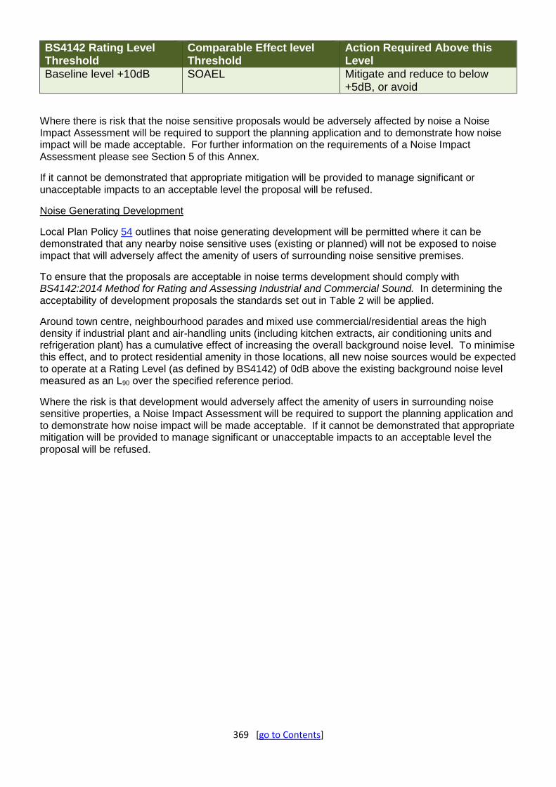
369 [go to Contents]
BS4142 Rating Level Threshold
Comparable Effect level Threshold
Action Required Above this Level
Baseline level +10dB SOAEL Mitigate and reduce to below +5dB, or avoid
Where there is risk that the noise sensitive proposals would be adversely affected by noise a Noise Impact Assessment will be required to support the planning application and to demonstrate how noise impact will be made acceptable. For further information on the requirements of a Noise Impact Assessment please see Section 5 of this Annex.
If it cannot be demonstrated that appropriate mitigation will be provided to manage significant or unacceptable impacts to an acceptable level the proposal will be refused.
Noise Generating Development
Local Plan Policy 54 outlines that noise generating development will be permitted where it can be demonstrated that any nearby noise sensitive uses (existing or planned) will not be exposed to noise impact that will adversely affect the amenity of users of surrounding noise sensitive premises.
To ensure that the proposals are acceptable in noise terms development should comply with BS4142:2014 Method for Rating and Assessing Industrial and Commercial Sound. In determining the acceptability of development proposals the standards set out in Table 2 will be applied.
Around town centre, neighbourhood parades and mixed use commercial/residential areas the high density if industrial plant and air-handling units (including kitchen extracts, air conditioning units and refrigeration plant) has a cumulative effect of increasing the overall background noise level. To minimise this effect, and to protect residential amenity in those locations, all new noise sources would be expected to operate at a Rating Level (as defined by BS4142) of 0dB above the existing background noise level measured as an L90 over the specified reference period.
Where the risk is that development would adversely affect the amenity of users in surrounding noise sensitive properties, a Noise Impact Assessment will be required to support the planning application and to demonstrate how noise impact will be made acceptable. If it cannot be demonstrated that appropriate mitigation will be provided to manage significant or unacceptable impacts to an acceptable level the proposal will be refused.

370 [go to Contents]
Appendix 12: Monitoring Indicators
Chapter Objective / Policy Relevant Local Plan Strategic Objectives
Indicator Target/ Direction of Travel
Reporting/Assessment Other Relevant Strategies
Key Delivery Partners
Chapter 3: Our Vision for the Future – Vision & Objectives
Supporting the Conditions for Attracting Jobs and Growth
1,2,15 Total Enterprises per 1,000 population Increase Team Doncaster State of the Borough Report
Northern Powerhouse Strategy, Sheffield City Region Strategic Economic Plan & Integrated Infrastructure Plan, Doncaster Inclusive Growth Strategy
Team Doncaster, Developers, Investors, Landowners
Number of Jobs Increase
Percentage of Working Age Population Employed Increase
Exports per Job Increase
Median Wage Rate (£/week) Increase
Gross Value Added per Worker Increase
Percentage of People who are Qualified to Level 3 or Above (16 - 64)
Increase
Regeneration and Community Pride
3&4 Indices of Multiple Deprivation Reduce MHCLG
Percentage of Development on Brownfield/ Previously Developed Land
Increase AMR/ Residential Land Availability Report/ Employment Land Availability Report
N/A
Quality of Place 5,6,7 See Chapter 12 Policy Monitoring Indicators
Transport and Accessibility
8 Travel to Work – Numbers of Commuting and Mode Monitor Census, ONS, MOMIS Official Labour Market Statistics
Sheffield City Region Transport Strategy, Sheffield City Region Integrated Infrastructure Plan
DMBC Strategic Transportation Team, Highways England, South Yorkshire Passenger Transport Executive, Network Rail
Homes and Communities
9,10,11 Population Size & Age Cohort Increase/ Monitor
Team Doncaster State of the Borough Report
Housing Strategy
Team Doncaster, Developers, Investors, Landowners
Housing Affordability Ratio (median workplace-based) Monitor
Number of Net Homes Built (Per 1,000 Population) Increase
Number of Homeless in Priority Need Reduce
Health and Well-being 12,13,14 Healthy Life Expectancy at Birth Increase Health & Wellbeing Strategy, Doncaster Physical Activity & Sport Strategy
Percentage of Population who Achieve 150 Minutes of Physical Activity per Week
Increase
Children Living in Workless Households Reduce
Child Poverty Reduce
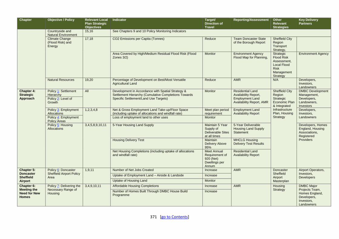
371 [go to Contents]
Chapter Objective / Policy Relevant Local Plan Strategic Objectives
Indicator Target/ Direction of Travel
Reporting/Assessment Other Relevant Strategies
Key Delivery Partners
Countryside and Natural Environment
15,16 See Chapters 9 and 10 Policy Monitoring Indicators
Climate Change (Flood Risk) and Energy
17,18 CO2 Emissions per Capita (Tonnes) Reduce Team Doncaster State of the Borough Report
Sheffield City Region Transport Strategy,
Area Covered by High/Medium Residual Flood Risk (Flood Zones 3/2)
Monitor Environment Agency Flood Map for Planning,
Strategic Flood Risk Assessment, Local Flood Risk Management Strategy
Environment Agency
Natural Resources 19,20 Percentage of Development on Best/Most Versatile Agricultural Land
Reduce AMR N/A Developers, Investors, Landowners
Chapter 4: Strategic Approach
Policy 1: Settlement Hierarchy
All Development in Accordance with Spatial Strategy & Settlement Hierarchy (Cumulative Completions Towards Specific Settlement/Land Use Targets)
Monitor Residential Land Availability Report, Employment Land Availability Report, AMR
Sheffield City Region Strategic Economic Plan & Integrated Infrastructure Plan, Housing Strategy
DMBC Development Management, Developers, Landowners, Investors
Policy 2: Level of Growth
Policy 3: Employment Allocations
1,2,3,4,8 Net & Gross Employment Land Take-up/Floor Space (including uptake of allocations and windfall rate)
Meet plan period requirement
Employment Land Availability Report
Developers, Investors, Landowners Policy 4: Employment
Policy Areas Loss of employment land to other uses Monitor
Policy 5: Housing Allocations
3,4,5,8,9,10,11 5-Year Housing Land Supply Maintain 5 Year Supply of Deliverable Sites at all times
5-Year Deliverable Housing Land Supply Statement
Developers, Homes England, Housing Associations, Registered Providers Housing Delivery Test Maintain
Delivery Above 95%
MHCLG Housing Delivery Test Results
Net Housing Completions (including uptake of allocations and windfall rate)
Meet Annual Requirement of 920 (Net) Dwellings per Annum
Residential Land Availability Report
Chapter 5: Doncaster Sheffield Airport
Policy 6: Doncaster Sheffield Airport Policy Area
1,9,11 Number of Net Jobs Created Increase AMR Doncaster Sheffield Airport Masterplan
Airport Operators, Investors, Developers
Uptake of Employment Land – Airside & Landside Increase
Uptake of Housing Land Monitor
Chapter 6: Meeting the Need for New Homes
Policy 7: Delivering the Necessary Range of Housing
3,4,9,10,11 Affordable Housing Completions Increase AMR Housing Strategy
DMBC Major Projects Team, Homes England, Developers, Investors, Landowners
Number of Homes Built Through DMBC House Build Programme
Increase

372 [go to Contents]
Chapter Objective / Policy Relevant Local Plan Strategic Objectives
Indicator Target/ Direction of Travel
Reporting/Assessment Other Relevant Strategies
Key Delivery Partners
Custom Build/ Self Build Register Monitor Entrants on Register
Custom Build/ Self Build Register
N/A Developers, Investors, Landowners
Policy 8: Removal of Occupancy Conditions
15 Number of Planning Applications for Removal of Occupancy Conditions and number allowed
No Specific Target
AMR N/A Landowners
Policy 9: Houses in Multiple Occupation
9 Number of Houses in Multiple Occupation Granted Avoid Over Concentration in Article 4 Designated Boundary
AMR Housing Strategy
DMBC Licencing and Planning Teams, Landlords and Developers
Policy 10: Residential Policy Areas
3,4,9,10,11 N/A
Policy 11: Gypsies, Travellers and Travelling Show People
9 Net Additional Pitches/Yards Delivered Meet Identified Need
AMR Housing Strategy, Gypsy & Traveller Needs Assessment
Various including Gypsy & Traveller communities
Chapter 7: Transport, Access & Infrastructure
Policy 12: Strategic Transport Network
7,8,11,14,17,19 Progress in Delivery of Named Schemes Monitor AMR Sheffield City Region Transport Strategy, Sheffield City Region Integrated Infrastructure Plan
Highways England, Network Rail, Transport for the North, Sheffield City Region, South Yorkshire Passenger Transport Executive, DMBC Transportation Team
Policy 13: Promoting Sustainable Transport in New Developments
5,8,12,14 Number of Planning Applications Refused on Transport Grounds
Monitor AMR Sheffield City Region Transport Strategy, Get Doncaster Walking Strategy, Doncaster Cycle Strategy
DMBC Transportation Team, South Yorkshire Passenger Transport Executive, Doncaster Active Travel Alliance
Number of Planning Applications with Transport Assessments/ Transport Statements
Monitor
Number of Agreed Travel Plans in Operation Monitor
Policy 14: Doncaster Town Centre Car Parking
5,8,12,17 Number of Car Parking Spaces in Doncaster Town Centre Monitor Doncaster Car Parking Strategy, Annual Health Check Review
Doncaster Town Centre Parking Strategy, Sheffield City Region Transport Strategy
DMBC Transportation Team, DMBC Parking Services
Number of Long Stay Parking Spaces in Doncaster Town Centre
Reduce
Number of Electric Charging Points in Public Car Parks in Doncaster Town Centre
Increase
Policy 15: Lorry Parking
2,8,14 Number of Developments Containing Lorry Parking Provision Monitor AMR Sheffield City Region
Highways England, Sheffield City Region, DMBC
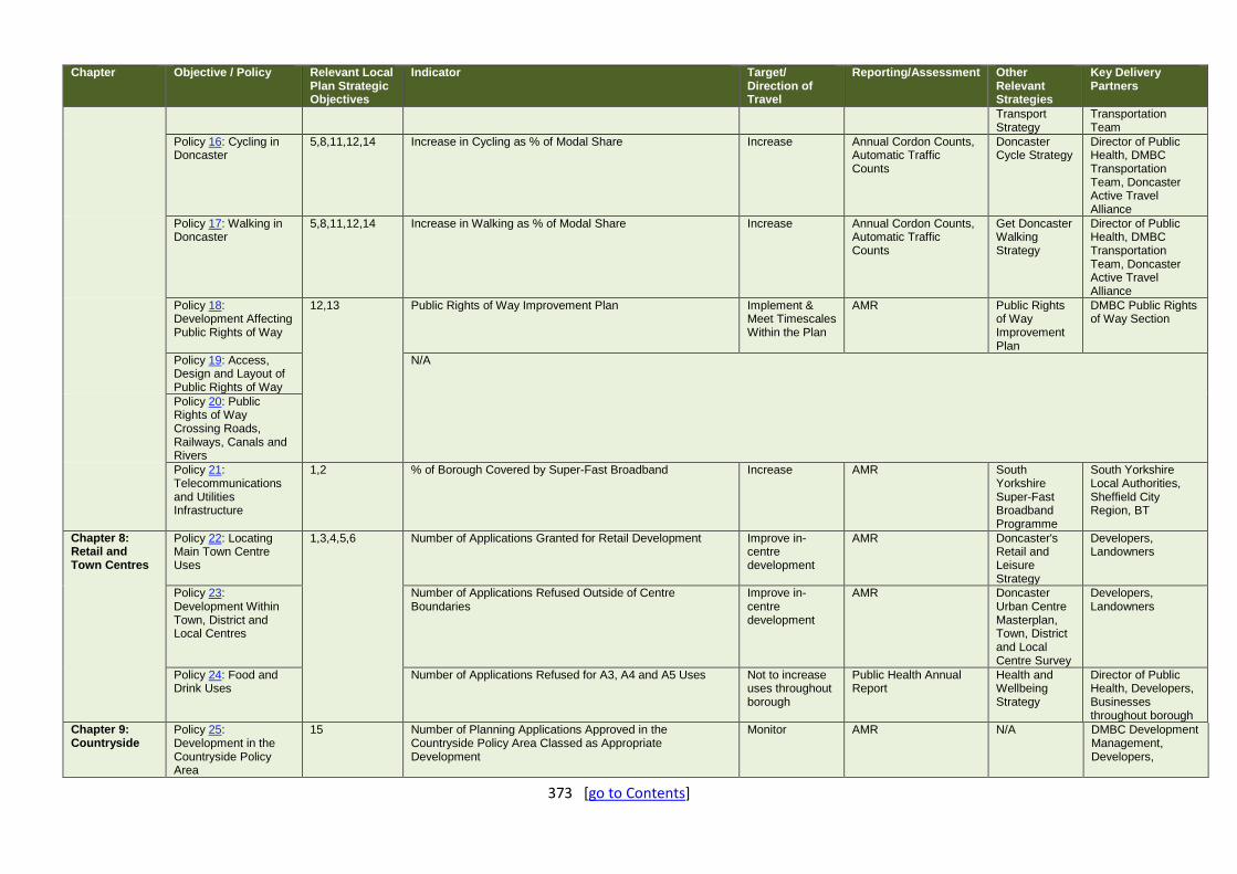
373 [go to Contents]
Chapter Objective / Policy Relevant Local Plan Strategic Objectives
Indicator Target/ Direction of Travel
Reporting/Assessment Other Relevant Strategies
Key Delivery Partners
Transport Strategy
Transportation Team
Policy 16: Cycling in Doncaster
5,8,11,12,14 Increase in Cycling as % of Modal Share Increase Annual Cordon Counts, Automatic Traffic Counts
Doncaster Cycle Strategy
Director of Public Health, DMBC Transportation Team, Doncaster Active Travel Alliance
Policy 17: Walking in Doncaster
5,8,11,12,14 Increase in Walking as % of Modal Share Increase Annual Cordon Counts, Automatic Traffic Counts
Get Doncaster Walking Strategy
Director of Public Health, DMBC Transportation Team, Doncaster Active Travel Alliance
Policy 18: Development Affecting Public Rights of Way
12,13 Public Rights of Way Improvement Plan Implement & Meet Timescales Within the Plan
AMR Public Rights of Way Improvement Plan
DMBC Public Rights of Way Section
Policy 19: Access, Design and Layout of Public Rights of Way
N/A
Policy 20: Public Rights of Way Crossing Roads, Railways, Canals and Rivers
Policy 21: Telecommunications and Utilities Infrastructure
1,2 % of Borough Covered by Super-Fast Broadband Increase AMR South Yorkshire Super-Fast Broadband Programme
South Yorkshire Local Authorities, Sheffield City Region, BT
Chapter 8: Retail and Town Centres
Policy 22: Locating Main Town Centre Uses
1,3,4,5,6 Number of Applications Granted for Retail Development Improve in-centre development
AMR Doncaster's Retail and Leisure Strategy
Developers, Landowners
Policy 23: Development Within Town, District and Local Centres
Number of Applications Refused Outside of Centre Boundaries
Improve in-centre development
AMR Doncaster Urban Centre Masterplan, Town, District and Local Centre Survey
Developers, Landowners
Policy 24: Food and Drink Uses
Number of Applications Refused for A3, A4 and A5 Uses Not to increase uses throughout borough
Public Health Annual Report
Health and Wellbeing Strategy
Director of Public Health, Developers, Businesses throughout borough
Chapter 9: Countryside
Policy 25: Development in the Countryside Policy Area
15 Number of Planning Applications Approved in the Countryside Policy Area Classed as Appropriate Development
Monitor AMR N/A DMBC Development Management, Developers,

374 [go to Contents]
Chapter Objective / Policy Relevant Local Plan Strategic Objectives
Indicator Target/ Direction of Travel
Reporting/Assessment Other Relevant Strategies
Key Delivery Partners
Landowners, Investors
Chapter 10: Green Infrastructure
Policy 26: Green Infrastructure
6, 7,8,12,13, 15,16,18
N/A – see other Policy Monitoring Indicators
Policy 27: Protecting Open Space and Non Designated Open Space
Amount of Public Open Space Meet Identified Need
Greenspace Strategy Doncaster Playing Pitch Strategy
DMBC Neighbourhoods and Street Scene and Leisure Services Teams, Relevant Sports Associations and Boards, Sport England
Policy 28: Open Space Provision in New Developments
Amount of Public Open Space Secured Through Section 106 Meet Identified Need
Section 106 AMR N/A Developers, landowners, investors
Policy 29: Ecological Networks
Number of Planning Applications Approved Where Demonstrating Net Gain in Biodiversity Proportion of Local Sites where Positive Conservation Management is being Achieved
Increase
AMR Biodiversity & Geodiversity Action Plan
Natural England, Strategic Partnerships, DMBC Planning Policy & Environment Team
Policy 30: Valuing Biodiversity and Geodiversity
Policy 31: Local Wildlife and Geological Sites
Policy 32: Woodlands, Trees and Hedgerows
Number of Planning Applications Approved per Annum Maintain high quality green borough
Green Infrastructure Strategy
Doncaster Growth Strategy
DMBC Street Scene, Developers, Residents,
Policy 33: Landscape N/A
Chapter 11: The Historic Environment
Policy 34: Valuing our Historic Environment
4,5,6 Heritage at Risk Reduce Historic England Heritage at Risk Register (includes Scheduled Monuments, Grade I & II* listed buildings, places of worship at risk) DMBC Numbers of Grade II listed buildings at risk
DMBC Heritage Strategy
English Heritage, South Yorkshire Archaeology Service, Doncaster Civic Trust, Developers, Landowners, Investors
Policy 35: Understanding and Recording the Historic Environment
N/A
Policy 36: Listed Buildings
Number of Listed Buildings at Risk Reduce
Policy 37: Conservation Areas
Number of Conservation Areas at Risk Not Increasing
Policy 38: Historic Parks and Gardens
N/A
Policy 39: Development affecting Archaeology
Scheduled Monuments at Risk Reduce
Policy 40: Buildings or Structures of Local Historic Interest
Local List Create a List of Local Buildings or Structures of Heritage Interest

375 [go to Contents]
Chapter Objective / Policy Relevant Local Plan Strategic Objectives
Indicator Target/ Direction of Travel
Reporting/Assessment Other Relevant Strategies
Key Delivery Partners
Chapter 12: Design and the Built Environment
Policy 41: Character and Local Distinctiveness
1,2,5,6,7,9,10, 12,13
Number of Planning Applications with Design as Being Ground(s) for Refusal
Decrease AMR Supplementary Planning Documents
DMBC Urban Design & Development Management, Developers, Investors, Landowners
Policy 42: Good Urban Design
Number of Planning Applications Including Public Art Proposals
Increase
Policy 43: Views Gateways and Taller Buildings
N/A
Policy 44: Residential Design
Number of Planning Applications Achieving 10 or More 'Green's using Building for Life as a Measuring Framework
Increase AMR Supplementary Planning Documents
DMBC Urban Design & Development Management, Developers, Investors, Landowners
Policy 45: Housing Design Standards
Number of New Homes That Meet Nationally Described Space Standards Approved
Number of New Adaptable Homes Approved
Policy 46: Design of Non–Residential , Commercial and Employment Developments
Number of new Major Non-Residential Applications that have BREEM Rating (or equivalent) of Very Good
Number of new Major Non-Domestic Applications that Secure at Least 10% of Energy Through Renewables
Policy 47: Safe and Secure Places
N/A
Policy 48: Landscaping of New Developments
Policy 49: Advertisements & Signage
Chapter 13: Health, Wellbeing and Our Communities
Policy 50: Health 3,12,13,14 Health Inequalities Reduce Joint Strategic Needs Assessment
Health & Wellbeing Strategy, Doncaster Physical Activity & Sport Strategy,
Directorate of Public Health, HNS, Clinical Commissioning Group
Personal Well-being - Happiness/Anxiety Increase/Reduce Health Impact Assessment for Major applications or where deemed necessary
Policy 51: Protection of Education, Community and Leisure Facilities
N/A
Policy 52: New Education Facilities
Number of Applications for New Educational Facilities Granted
Increase Annual School Capacity Return (SCAP) to Department of Education
N/A Department of Education, DMBC School Place Admissions Team
Policy 53: Provision of New Indoor Recreation and Leisure Facilities
N/A
Policy 54: Pollution Air Quality Within Air Quality Management Areas Reduce Nitrogen Oxide Levels
Air Quality Annual Status Report
Air Quality Action Plan
DMBC Pollution Control,

376 [go to Contents]
Chapter Objective / Policy Relevant Local Plan Strategic Objectives
Indicator Target/ Direction of Travel
Reporting/Assessment Other Relevant Strategies
Key Delivery Partners
Within Air Quality Management Area
Environment Agency, Developers, Investors, Landowners
Policy 55: Contaminated and Unstable Land
Amount of contaminated land reclaimed and brought back into effective use
Increase Contaminated Land Register
Doncaster Contaminated Land Inspection Strategy
Chapter 14: Climate Change, Minerals, Resources & Energy
Policy 56: Drainage 17,18,19,20 Number of Applications to the Lead Local Flood Authority for SuDS Approval
Monitor AMR Doncaster Council Preliminary Flood Risk Assessment
DMBC Lead Local Flood Authority
Policy 57: Flood Risk Management
Number of Planning Applications Granted with a Sustained Objection from the Environment Agency
Reduce Environment Agency Catchment Flood Management Plans, Doncaster Council Flood Risk Management Strategy
Environment Agency, Lead Local Flood Authority, Internal Drainage Boards, Water Companies
Number of Planning Applications Granted Within Flood Risk Zone 2/3
Monitor Doncaster Strategic Flood Risk Assessment
DMBC Development Management, Environment Agency, Lead Local Flood Authority, Developers, Investors, Landowners
Policy 58: Low Carbon and Renewable Energy
Number of Applications for Low Carbon and Renewable Energy Schemes Granted
Increase N/A Developers, Investors, Landowners
Policy 59: Wind Energy Developments
Policy 60: Protecting and Enhancing Doncaster’s Soil and Water Resources
Development that Results in Groundwater abstraction in Source Protection Zones
Decrease Humber River Basin Management Plan
Environment Agency, Investors, Developers, Landowners
Permissions granted contrary to sustained objection from the Environment Agency on water quality grounds
Policy 61: Providing for and Safeguarding Mineral Resources
Production of primary land won aggregates, secondary and recycled aggregates by mineral planning authority
Provide for sustainably sourced minerals
AMR and Local Aggregates Assessment Mineral Operators, Aggregates Working Party
Policy 62: Minerals Development Proposals, Borrow Pits
Number of applications approved for development

377 [go to Contents]
Chapter Objective / Policy Relevant Local Plan Strategic Objectives
Indicator Target/ Direction of Travel
Reporting/Assessment Other Relevant Strategies
Key Delivery Partners
and Incidental Extraction
Policy 63: Reclamation of Mineral Sites (Restoration, Aftercare and After-use)
Number of application with conditions for appropriate restoration
Increasing priority UK BAP Habitats and benefitting climate change mitigation and green infrastructure and/or agriculture
Green Infrastructure Strategy, Biodiversity Action Plan
DMBC Development Management
Policy 64: Providing for Energy Minerals (On-Shore Gas and Oil (Hydrocarbons))
Number of applications approved for development Recognising the benefits of hydrocarbons N/A Mineral Operators
Chapter 15: Implementation & Monitoring
Policy 65: Developer Contributions
2,8,11,13 Section 106 Developer Contributions Received Maximise Section 106 Annual Monitoring Report
N/A DMBC Development Management, Investors, Developers, Landowners
Policy 66: Development Viability
Number of Viability Appraisals Submitted as part of a Planning Application
Reduce Section 106 Annual Monitoring Report and/or AMR
N/A
Chapter 16: Spatial Proposals
Policy 67: Doncaster Town Centre
1,2,4,5,6,8,9,10, 11,
Percentage of Vacancy Rates in Town Centre Reduce Town Centre Survey N/A Investors, Developers, Landowners
Policy 68: Key Doncaster Town Centre and Main Urban Area Mixed-use Sites
Implementation of the Doncaster Urban Centre Masterplan Monitor AMR Doncaster Urban Centre Masterplan
DMBC, Investors, Developers, Landowners
Policy 69: Unity Regeneration Project
Number of Reserved Matters Planning Applications Submitted/Determined within Unity Project Allocation
Monitor Unity Masterplan
DMBC Development Management, Landowners, Developers
Policy 70: Mexborough Town Centre
Percentage of Vacancy Rates in Mexborough Town Centre Reduce Town Centre Survey N/A Investors, Developers, Landowners
Policy 71: iPort Employment Land Take-up/Floor Space Monitor Employment Land Availability Report
N/A Inverstors, Developers, Landowners
Policy 72: Thorne Town Centre
Percentage of Vacancy Rates in Thorne Town Centre Reduce Town Centre Survey N/A Investors, Developers, Landowners
Policy 73: Local Business Expansion Site: Polypipe
Employment Land Take-up/Floor Space Monitor Employment Land Availability Report
N/A Inverstors, Developers, Landowners