Camaho Inlet Southern Brazil - Instability Causes and User Conflicts
8
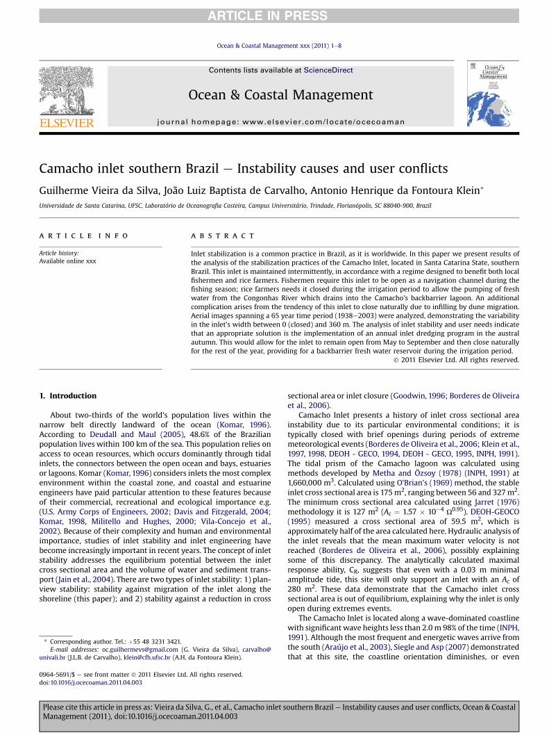
Camacho inlet southern Brazil e Instability causes and user conflicts Guilherme Vieira da Silva, João Luiz Baptista de Carvalho, Antonio Henrique da Fontoura Klein * Universidade de Santa Catarina, UFSC, Laboratório de Oceanografia Costeira, Campus Universitário, Trindade, Florianópolis, SC 88040-900, Brazil article info Article history: Available online xxx abstract Inlet stabilization is a common practice in Brazil, as it is worldwide. In this paper we present results of the analysis of the stabilization practices of the Camacho Inlet, located in Santa Catarina State, southern Brazil. This inlet is maintained intermittently, in accordance with a regime designed to benefit both local fishermen and rice farmers. Fishermen require this inlet to be open as a navigation channel during the fishing season; rice farmers needs it closed during the irrigation period to allow the pumping of fresh water from the Congonhas River which drains into the Camacho’s backbarrier lagoon. An additional complication arises from the tendency of this inlet to close naturally due to infilling by dune migration. Aerial images spanning a 65 year time period (1938e2003) were analyzed, demonstrating the variability in the inlet’s width between 0 (closed) and 360 m. The analysis of inlet stability and user needs indicate that an appropriate solution is the implementation of an annual inlet dredging program in the austral autumn. This would allow for the inlet to remain open from May to September and then close naturally for the rest of the year, providing for a backbarrier fresh water reservoir during the irrigation period. Ó 2011 Elsevier Ltd. All rights reserved. 1. Introduction About two-thirds of the world’s population lives within the narrow belt directly landward of the ocean (Komar, 1996). According to Deudall and Maul (2005), 48.6% of the Brazilian population lives within 100 km of the sea. This population relies on access to ocean resources, which occurs dominantly through tidal inlets, the connectors between the open ocean and bays, estuaries or lagoons. Komar (Komar, 1996) considers inlets the most complex environment within the coastal zone, and coastal and estuarine engineers have paid particular attention to these features because of their commercial, recreational and ecological importance e.g. (U.S. Army Corps of Engineers, 2002; Davis and Fitzgerald, 2004; Komar, 1998, Militello and Hughes, 2000; Vila-Concejo et al., 2002). Because of their complexity and human and environmental importance, studies of inlet stability and inlet engineering have become increasingly important in recent years. The concept of inlet stability addresses the equilibrium potential between the inlet cross sectional area and the volume of water and sediment trans- port (Jain et al., 2004). There are two types of inlet stability: 1) plan- view stability: stability against migration of the inlet along the shoreline (this paper); and 2) stability against a reduction in cross sectional area or inlet closure (Goodwin, 1996; Borderes de Oliveira et al., 2006). Camacho Inlet presents a history of inlet cross sectional area instability due to its particular environmental conditions; it is typically closed with brief openings during periods of extreme meteorological events (Borderes de Oliveira et al., 2006; Klein et al., 1997, 1998, DEOH - GECO, 1994, DEOH - GECO, 1995, INPH, 1991). The tidal prism of the Camacho lagoon was calculated using methods developed by Metha and Özsoy (1978) (INPH, 1991) at 1,660,000 m 3 . Calculated using O’Brian’s (1969) method, the stable inlet cross sectional area is 175 m 2 , ranging between 56 and 327 m 2 . The minimum cross sectional area calculated using Jarret (1976) methodology it is 127 m 2 (A c ¼ 1.57 10 4 U 0.95 ). DEOH-GEOCO (1995) measured a cross sectional area of 59.5 m 2 , which is approximately half of the area calculated here. Hydraulic analysis of the inlet reveals that the mean maximum water velocity is not reached (Borderes de Oliveira et al., 2006), possibly explaining some of this discrepancy. The analytically calculated maximal response ability, C R , suggests that even with a 0.03 m minimal amplitude tide, this site will only support an inlet with an A c of 280 m 2 . These data demonstrate that the Camacho inlet cross sectional area is out of equilibrium, explaining why the inlet is only open during extremes events. The Camacho Inlet is located along a wave-dominated coastline with significant wave heights less than 2.0 m 98% of the time (INPH, 1991). Although the most frequent and energetic waves arrive from the south (Araújo et al., 2003), Siegle and Asp (2007) demonstrated that at this site, the coastline orientation diminishes, or even * Corresponding author. Tel.: þ55 48 3231 3421. E-mail addresses: [email protected] (G. Vieira da Silva), carvalho@ univali.br (J.L.B. de Carvalho), [email protected] (A.H. da Fontoura Klein). Contents lists available at ScienceDirect Ocean & Coastal Management journal homepage: www.elsevier.com/locate/ocecoaman 0964-5691/$ e see front matter Ó 2011 Elsevier Ltd. All rights reserved. doi:10.1016/j.ocecoaman.2011.04.003 Ocean & Coastal Management xxx (2011) 1e8 Please cite this article in press as: Vieira da Silva, G., et al., Camacho inlet southern Brazil e Instability causes and user conflicts, Ocean & Coastal Management (2011), doi:10.1016/j.ocecoaman.2011.04.003
Transcript of Camaho Inlet Southern Brazil - Instability Causes and User Conflicts
lable at ScienceDirect
Ocean & Coastal Management xxx (2011) 1e8
Contents lists avai
Ocean & Coastal Management
journal homepage: www.elsevier .com/locate/ocecoaman
Camacho inlet southern Brazil e Instability causes and user conflicts
Guilherme Vieira da Silva, João Luiz Baptista de Carvalho, Antonio Henrique da Fontoura Klein*
Universidade de Santa Catarina, UFSC, Laboratório de Oceanografia Costeira, Campus Universitário, Trindade, Florianópolis, SC 88040-900, Brazil
a r t i c l e i n f o
Article history:Available online xxx
* Corresponding author. Tel.: þ55 48 3231 3421.E-mail addresses: [email protected] (G.
univali.br (J.L.B. de Carvalho), [email protected] (A.H.
0964-5691/$ e see front matter � 2011 Elsevier Ltd.doi:10.1016/j.ocecoaman.2011.04.003
Please cite this article in press as: Vieira da SManagement (2011), doi:10.1016/j.ocecoama
a b s t r a c t
Inlet stabilization is a common practice in Brazil, as it is worldwide. In this paper we present results ofthe analysis of the stabilization practices of the Camacho Inlet, located in Santa Catarina State, southernBrazil. This inlet is maintained intermittently, in accordance with a regime designed to benefit both localfishermen and rice farmers. Fishermen require this inlet to be open as a navigation channel during thefishing season; rice farmers needs it closed during the irrigation period to allow the pumping of freshwater from the Congonhas River which drains into the Camacho’s backbarrier lagoon. An additionalcomplication arises from the tendency of this inlet to close naturally due to infilling by dune migration.Aerial images spanning a 65 year time period (1938e2003) were analyzed, demonstrating the variabilityin the inlet’s width between 0 (closed) and 360 m. The analysis of inlet stability and user needs indicatethat an appropriate solution is the implementation of an annual inlet dredging program in the australautumn. This would allow for the inlet to remain open from May to September and then close naturallyfor the rest of the year, providing for a backbarrier fresh water reservoir during the irrigation period.
� 2011 Elsevier Ltd. All rights reserved.
1. Introduction
About two-thirds of the world’s population lives within thenarrow belt directly landward of the ocean (Komar, 1996).According to Deudall and Maul (2005), 48.6% of the Brazilianpopulation lives within 100 km of the sea. This population relies onaccess to ocean resources, which occurs dominantly through tidalinlets, the connectors between the open ocean and bays, estuariesor lagoons. Komar (Komar, 1996) considers inlets the most complexenvironment within the coastal zone, and coastal and estuarineengineers have paid particular attention to these features becauseof their commercial, recreational and ecological importance e.g.(U.S. Army Corps of Engineers, 2002; Davis and Fitzgerald, 2004;Komar, 1998, Militello and Hughes, 2000; Vila-Concejo et al.,2002). Because of their complexity and human and environmentalimportance, studies of inlet stability and inlet engineering havebecome increasingly important in recent years. The concept of inletstability addresses the equilibrium potential between the inletcross sectional area and the volume of water and sediment trans-port (Jain et al., 2004). There are two types of inlet stability: 1) plan-view stability: stability against migration of the inlet along theshoreline (this paper); and 2) stability against a reduction in cross
Vieira da Silva), carvalho@da Fontoura Klein).
All rights reserved.
ilva, G., et al., Camacho inlet sn.2011.04.003
sectional area or inlet closure (Goodwin, 1996; Borderes de Oliveiraet al., 2006).
Camacho Inlet presents a history of inlet cross sectional areainstability due to its particular environmental conditions; it istypically closed with brief openings during periods of extrememeteorological events (Borderes de Oliveira et al., 2006; Klein et al.,1997, 1998, DEOH - GECO, 1994, DEOH - GECO, 1995, INPH, 1991).The tidal prism of the Camacho lagoon was calculated usingmethods developed by Metha and Özsoy (1978) (INPH, 1991) at1,660,000 m3. Calculated using O’Brian’s (1969) method, the stableinlet cross sectional area is 175m2, ranging between 56 and 327m2.The minimum cross sectional area calculated using Jarret (1976)methodology it is 127 m2 (Ac ¼ 1.57 � 10�4 U0.95). DEOH-GEOCO(1995) measured a cross sectional area of 59.5 m2, which isapproximately half of the area calculated here. Hydraulic analysis ofthe inlet reveals that the mean maximum water velocity is notreached (Borderes de Oliveira et al., 2006), possibly explainingsome of this discrepancy. The analytically calculated maximalresponse ability, CR, suggests that even with a 0.03 m minimalamplitude tide, this site will only support an inlet with an Ac of280 m2. These data demonstrate that the Camacho inlet crosssectional area is out of equilibrium, explaining why the inlet is onlyopen during extremes events.
The Camacho Inlet is located along a wave-dominated coastlinewith significant wave heights less than 2.0 m 98% of the time (INPH,1991). Although the most frequent and energetic waves arrive fromthe south (Araújo et al., 2003), Siegle and Asp (2007) demonstratedthat at this site, the coastline orientation diminishes, or even
outhern Brazil e Instability causes and user conflicts, Ocean & Coastal
G. Vieira da Silva et al. / Ocean & Coastal Management xxx (2011) 1e82
inverts, the northerly longshore current. Mean spring tidal range isabout 0.6 m, but mean sea level may exceed a þ1.0 m tide duringstorm surges. Together, these factors result in sporadic opening ofthe inlet resulting from wave action and fresh water dischargeduring high energy events (Siegle and Asp, 2007). In 1938,1957 and1978, it is possible to identify periods when the inlet was open.Furthermore, active ebb and flood tidal deltas are visible in photosfrom 1978 and abandoned deltas are seen in 1938 and 1957 (Fig. 2)imagery, providing further evidence for natural inlet openingbefore these years.
Proximal to Camacho Inlet, transverse dunes are quasi-perpendicular to the coast (Gianini, 1993). Interdune depressionsare directly connected to the beach. These depressions may serve asadditional channels during storm surges. According to Gianini(Gianini, 1993), the northwestern winds are responsible for themigration of these dunes, filling the channel with sediment trans-ported from the east side of the inlet (Fig. 3). The migration is moreactive during summer (39%) and winter (27%) (Gianini, 1993). Theeolian deposits are more sparse to the southwest due to proximityto the ocean and the backbarrier lagoon and channels. When theinlet is open, the channel interrupts eolian transport, and deliverssediment directly to both the ocean and the lagoon.
Fishermen and rice croppers are dependent on the CamachoInlet and its backbarrier lagoon. Fishermen rely on occasional inletopenings to provide for the necessary flow of salt water to thelagoon for the development of commercial fisheries, including fishand crustaceans (e.g. mullet, shrimp, blue crab, etc). On the otherhand, rice croppers need the lagoon to remain fresh as a watersource of for rice culture (DEOH - GECO, 1994). Therefore, thetiming and frequency of opening of the Camacho Inlet is an issue ofgreat import.
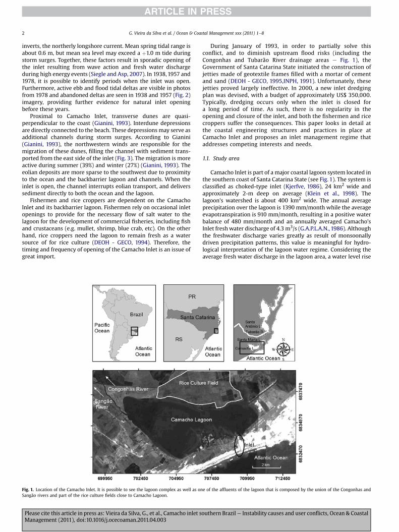
Fig. 1. Location of the Camacho Inlet. It is possible to see the lagoon complex as well as onSangão rivers and part of the rice culture fields close to Camacho Lagoon.
Please cite this article in press as: Vieira da Silva, G., et al., Camacho inlet sManagement (2011), doi:10.1016/j.ocecoaman.2011.04.003
During January of 1993, in order to partially solve thisconflict, and to diminish upstream flood risks (including theCongonhas and Tubarão River drainage areas e Fig. 1), theGovernment of Santa Catarina State initiated the construction ofjetties made of geotextile frames filled with a mortar of cementand sand (DEOH - GECO, 1995,INPH, 1991). Unfortunately, thesejetties proved largely ineffective. In 2000, a new inlet dredgingplan was devised, with a budget of approximately US$ 350,000.Typically, dredging occurs only when the inlet is closed fora long period of time. As such, there is no regularity in theopening and closure of the inlet, and both the fishermen and ricecroppers suffer the consequences. This paper looks in detail atthe coastal engineering structures and practices in place atCamacho Inlet and proposes an inlet management regime thataddresses competing interests and needs.
1.1. Study area
Camacho Inlet is part of a major coastal lagoon system located inthe southern coast of Santa Catarina State (see Fig. 1). The system isclassified as choked-type inlet (Kjerfve, 1986), 24 km2 wide andapproximately 2-m deep on average (Klein et al., 1998). Thelagoon’s watershed is about 400 km2 wide. The annual averageprecipitation over the lagoon is 1390 mm/month while the averageevapotranspiration is 910 mm/month, resulting in a positive waterbalance of 480 mm/month and an annually averaged Camacho’sInlet freshwater discharge of 4.3 m3/s (G.A.P.L.A.N., 1986). Althoughthe freshwater discharge varies greatly as result of monsoonallydriven precipitation patterns, this value is meaningful for hydro-logical interpretation of the lagoon water regime. Considering theaverage fresh water discharge in the lagoon area, a water level rise
e of the affluents of the lagoon that is composed by the union of the Congonhas and
outhern Brazil e Instability causes and user conflicts, Ocean & Coastal
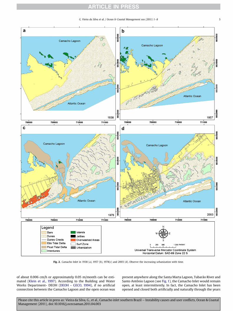
Fig. 2. Camacho Inlet in 1938 (a), 1957 (b), 1978(c) and 2003 (d). Observe the increasing urbanization with time.
G. Vieira da Silva et al. / Ocean & Coastal Management xxx (2011) 1e8 3
of about 0.006 cm/h or approximately 0.05 m/month can be esti-mated (Klein et al., 1997). According to the Building and WaterWorks Department- DEOH (DEOH - GECO, 1994), if no artificialconnection between the Camacho Lagoon and the open ocean was
Please cite this article in press as: Vieira da Silva, G., et al., Camacho inlet sManagement (2011), doi:10.1016/j.ocecoaman.2011.04.003
present anywhere along the SantaMarta Lagoon, Tubarão River andSanto Antônio Lagoon (see Fig. 1), the Camacho Inlet would remainopen, at least intermittently. In fact, the Camacho Inlet has beenopened and closed both artificially and naturally through the years
outhern Brazil e Instability causes and user conflicts, Ocean & Coastal
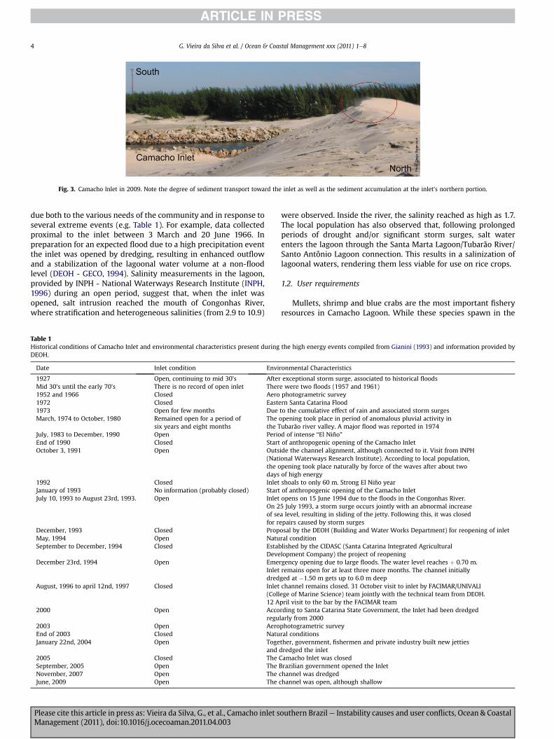
Fig. 3. Camacho Inlet in 2009. Note the degree of sediment transport toward the inlet as well as the sediment accumulation at the inlet’s northern portion.
G. Vieira da Silva et al. / Ocean & Coastal Management xxx (2011) 1e84
due both to the various needs of the community and in response toseveral extreme events (e.g. Table 1). For example, data collectedproximal to the inlet between 3 March and 20 June 1966. Inpreparation for an expected flood due to a high precipitation eventthe inlet was opened by dredging, resulting in enhanced outflowand a stabilization of the lagoonal water volume at a non-floodlevel (DEOH - GECO, 1994). Salinity measurements in the lagoon,provided by INPH - National Waterways Research Institute (INPH,1996) during an open period, suggest that, when the inlet wasopened, salt intrusion reached the mouth of Congonhas River,where stratification and heterogeneous salinities (from 2.9 to 10.9)
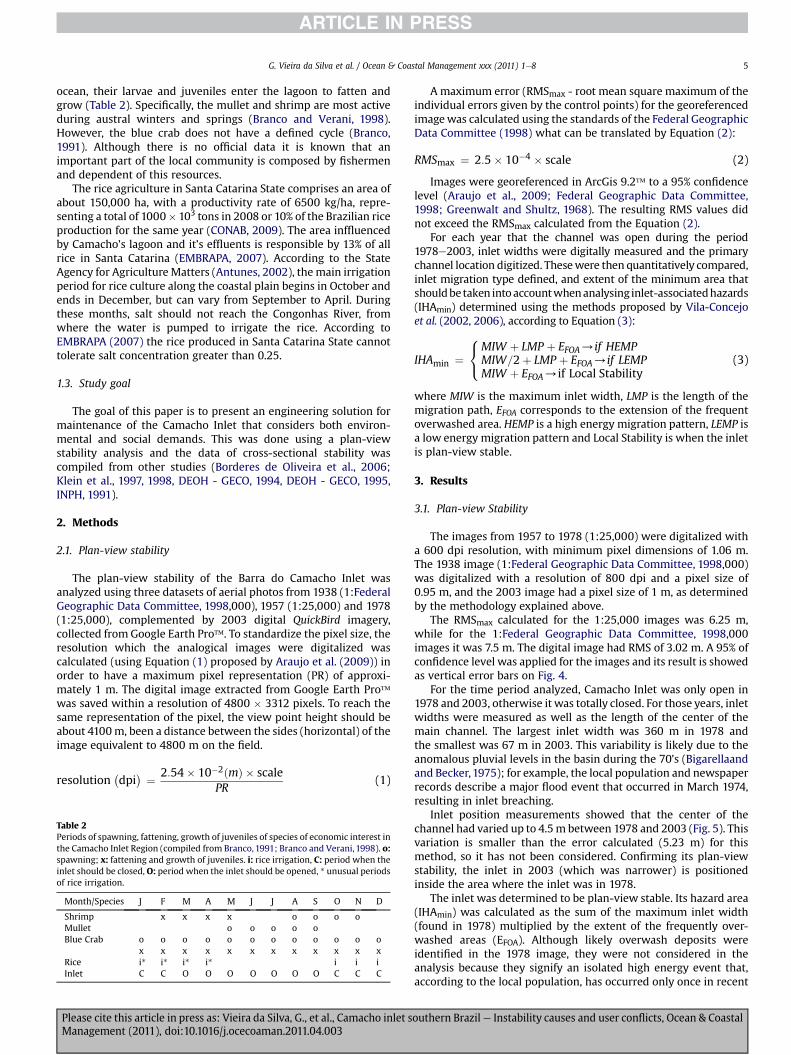
Table 1Historical conditions of Camacho Inlet and environmental characteristics present duringDEOH.
Date Inlet condition Envi
1927 Open, continuing to mid 30’s AfterMid 30’s until the early 70’s There is no record of open inlet Ther1952 and 1966 Closed Aero1972 Closed Easte1973 Open for few months DueMarch, 1974 to October, 1980 Remained open for a period of
six years and eight monthsThethe T
July, 1983 to December, 1990 Open PerioEnd of 1990 Closed StartOctober 3, 1991 Open Outs
(Natthe odays
1992 Closed InletJanuary of 1993 No information (probably closed) StartJuly 10, 1993 to August 23rd, 1993. Open Inlet
On 2of sefor r
December, 1993 Closed PropMay, 1994 Open NatuSeptember to December, 1994 Closed Estab
DeveDecember 23rd, 1994 Open Eme
Inletdred
August, 1996 to april 12nd, 1997 Closed Inlet(Coll12 A
2000 Open Accoregu
2003 Open AeroEnd of 2003 Closed NatuJanuary 22nd, 2004 Open Toge
and2005 Closed TheSeptember, 2005 Open TheNovember, 2007 Open TheJune, 2009 Open The
Please cite this article in press as: Vieira da Silva, G., et al., Camacho inlet sManagement (2011), doi:10.1016/j.ocecoaman.2011.04.003
were observed. Inside the river, the salinity reached as high as 1.7.The local population has also observed that, following prolongedperiods of drought and/or significant storm surges, salt waterenters the lagoon through the Santa Marta Lagoon/Tubarão River/Santo Antônio Lagoon connection. This results in a salinization oflagoonal waters, rendering them less viable for use on rice crops.
1.2. User requirements
Mullets, shrimp and blue crabs are the most important fisheryresources in Camacho Lagoon. While these species spawn in the
the high energy events compiled from Gianini (1993) and information provided by
ronmental Characteristics
exceptional storm surge, associated to historical floodse were two floods (1957 and 1961)photogrametric surveyrn Santa Catarina Floodto the cumulative effect of rain and associated storm surgesopening took place in period of anomalous pluvial activity inubarão river valley. A major flood was reported in 1974d of intense “El Niño”of anthropogenic opening of the Camacho Inletide the channel alignment, although connected to it. Visit from INPHional Waterways Research Institute). According to local population,pening took place naturally by force of the waves after about twoof high energyshoals to only 60 m. Strong El Niño yearof anthropogenic opening of the Camacho Inletopens on 15 June 1994 due to the floods in the Congonhas River.5 July 1993, a storm surge occurs jointly with an abnormal increasea level, resulting in sliding of the jetty. Following this, it was closedepairs caused by storm surgesosal by the DEOH (Building and Water Works Department) for reopening of inletral conditionlished by the CIDASC (Santa Catarina Integrated Agriculturallopment Company) the project of reopeningrgency opening due to large floods. The water level reaches þ 0.70 m.remains open for at least three more months. The channel initiallyged at �1.50 m gets up to 6.0 m deepchannel remains closed. 31 October visit to inlet by FACIMAR/UNIVALIege of Marine Science) team jointly with the technical team from DEOH.pril visit to the bar by the FACIMAR teamrding to Santa Catarina State Government, the Inlet had been dredgedlarly from 2000photogrametric surveyral conditionsther, government, fishermen and private industry built new jettiesdredged the inletCamacho Inlet was closedBrazilian government opened the Inletchannel was dredgedchannel was open, although shallow
outhern Brazil e Instability causes and user conflicts, Ocean & Coastal
G. Vieira da Silva et al. / Ocean & Coastal Management xxx (2011) 1e8 5
ocean, their larvae and juveniles enter the lagoon to fatten andgrow (Table 2). Specifically, the mullet and shrimp are most activeduring austral winters and springs (Branco and Verani, 1998).However, the blue crab does not have a defined cycle (Branco,1991). Although there is no official data it is known that animportant part of the local community is composed by fishermenand dependent of this resources.
The rice agriculture in Santa Catarina State comprises an area ofabout 150,000 ha, with a productivity rate of 6500 kg/ha, repre-senting a total of 1000� 103 tons in 2008 or 10% of the Brazilian riceproduction for the same year (CONAB, 2009). The area inffluencedby Camacho’s lagoon and it’s effluents is responsible by 13% of allrice in Santa Catarina (EMBRAPA, 2007). According to the StateAgency for Agriculture Matters (Antunes, 2002), the main irrigationperiod for rice culture along the coastal plain begins in October andends in December, but can vary from September to April. Duringthese months, salt should not reach the Congonhas River, fromwhere the water is pumped to irrigate the rice. According toEMBRAPA (2007) the rice produced in Santa Catarina State cannottolerate salt concentration greater than 0.25.
1.3. Study goal
The goal of this paper is to present an engineering solution formaintenance of the Camacho Inlet that considers both environ-mental and social demands. This was done using a plan-viewstability analysis and the data of cross-sectional stability wascompiled from other studies (Borderes de Oliveira et al., 2006;Klein et al., 1997, 1998, DEOH - GECO, 1994, DEOH - GECO, 1995,INPH, 1991).
2. Methods
2.1. Plan-view stability
The plan-view stability of the Barra do Camacho Inlet wasanalyzed using three datasets of aerial photos from 1938 (1:FederalGeographic Data Committee, 1998,000), 1957 (1:25,000) and 1978(1:25,000), complemented by 2003 digital QuickBird imagery,collected from Google Earth Pro�. To standardize the pixel size, theresolution which the analogical images were digitalized wascalculated (using Equation (1) proposed by Araujo et al. (2009)) inorder to have a maximum pixel representation (PR) of approxi-mately 1 m. The digital image extracted from Google Earth Pro�was saved within a resolution of 4800 � 3312 pixels. To reach thesame representation of the pixel, the view point height should beabout 4100m, been a distance between the sides (horizontal) of theimage equivalent to 4800 m on the field.
resolution�dpi
� ¼ 2:54� 10�2ðmÞ � scalePR
(1)
Table 2Periods of spawning, fattening, growth of juveniles of species of economic interest inthe Camacho Inlet Region (compiled from Branco,1991; Branco and Verani, 1998). o:spawning; x: fattening and growth of juveniles. i: rice irrigation, C: period when theinlet should be closed,O: period when the inlet should be opened, * unusual periodsof rice irrigation.
Month/Species J F M A M J J A S O N D
Shrimp x x x x o o o oMullet o o o o oBlue Crab o o o o o o o o o o o o
x x x x x x x x x x x xRice i* i* i* i* i i iInlet C C O O O O O O O C C C
Please cite this article in press as: Vieira da Silva, G., et al., Camacho inlet sManagement (2011), doi:10.1016/j.ocecoaman.2011.04.003
Amaximum error (RMSmax - root mean square maximum of theindividual errors given by the control points) for the georeferencedimagewas calculated using the standards of the Federal GeographicData Committee (1998) what can be translated by Equation (2):
RMSmax ¼ 2:5� 10�4 � scale (2)
Images were georeferenced in ArcGis 9.2� to a 95% confidencelevel (Araujo et al., 2009; Federal Geographic Data Committee,1998; Greenwalt and Shultz, 1968). The resulting RMS values didnot exceed the RMSmax calculated from the Equation (2).
For each year that the channel was open during the period1978e2003, inlet widths were digitally measured and the primarychannel location digitized. Thesewere then quantitatively compared,inlet migration type defined, and extent of the minimum area thatshouldbetaken intoaccountwhenanalysing inlet-associatedhazards(IHAmin) determined using the methods proposed by Vila-Concejoet al. (2002, 2006), according to Equation (3):
IHAmin ¼8<:
MIW þ LMP þ EFOA/if HEMPMIW=2þ LMP þ EFOA/if LEMPMIW þ EFOA/if Local Stability
(3)
where MIW is the maximum inlet width, LMP is the length of themigration path, EFOA corresponds to the extension of the frequentoverwashed area. HEMP is a high energy migration pattern, LEMP isa low energy migration pattern and Local Stability is when the inletis plan-view stable.
3. Results
3.1. Plan-view Stability
The images from 1957 to 1978 (1:25,000) were digitalized witha 600 dpi resolution, with minimum pixel dimensions of 1.06 m.The 1938 image (1:Federal Geographic Data Committee, 1998,000)was digitalized with a resolution of 800 dpi and a pixel size of0.95 m, and the 2003 image had a pixel size of 1 m, as determinedby the methodology explained above.
The RMSmax calculated for the 1:25,000 images was 6.25 m,while for the 1:Federal Geographic Data Committee, 1998,000images it was 7.5 m. The digital image had RMS of 3.02 m. A 95% ofconfidence level was applied for the images and its result is showedas vertical error bars on Fig. 4.
For the time period analyzed, Camacho Inlet was only open in1978 and 2003, otherwise it was totally closed. For those years, inletwidths were measured as well as the length of the center of themain channel. The largest inlet width was 360 m in 1978 andthe smallest was 67 m in 2003. This variability is likely due to theanomalous pluvial levels in the basin during the 70’s (Bigarellaandand Becker,1975); for example, the local population and newspaperrecords describe a major flood event that occurred in March 1974,resulting in inlet breaching.
Inlet position measurements showed that the center of thechannel had varied up to 4.5m between 1978 and 2003 (Fig. 5). Thisvariation is smaller than the error calculated (5.23 m) for thismethod, so it has not been considered. Confirming its plan-viewstability, the inlet in 2003 (which was narrower) is positionedinside the area where the inlet was in 1978.
The inlet was determined to be plan-view stable. Its hazard area(IHAmin) was calculated as the sum of the maximum inlet width(found in 1978) multiplied by the extent of the frequently over-washed areas (EFOA). Although likely overwash deposits wereidentified in the 1978 image, they were not considered in theanalysis because they signify an isolated high energy event that,according to the local population, has occurred only once in recent
outhern Brazil e Instability causes and user conflicts, Ocean & Coastal
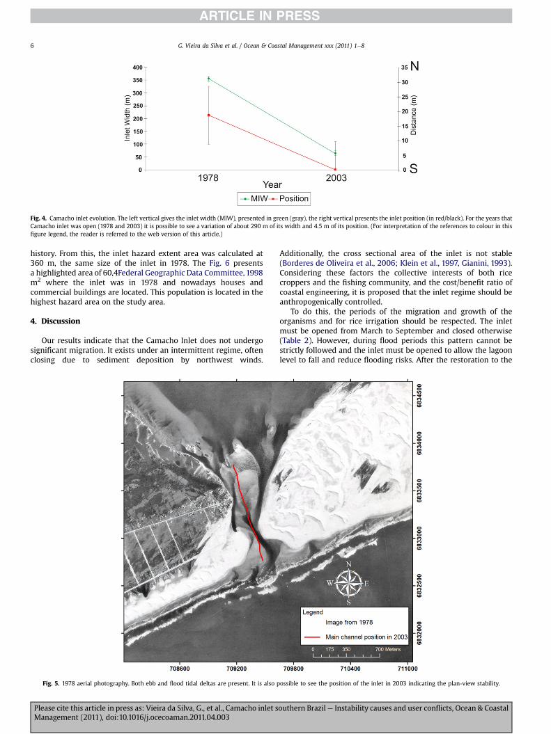
Fig. 4. Camacho inlet evolution. The left vertical gives the inlet width (MIW), presented in green (gray), the right vertical presents the inlet position (in red/black). For the years thatCamacho inlet was open (1978 and 2003) it is possible to see a variation of about 290 m of its width and 4.5 m of its position. (For interpretation of the references to colour in thisfigure legend, the reader is referred to the web version of this article.)
G. Vieira da Silva et al. / Ocean & Coastal Management xxx (2011) 1e86
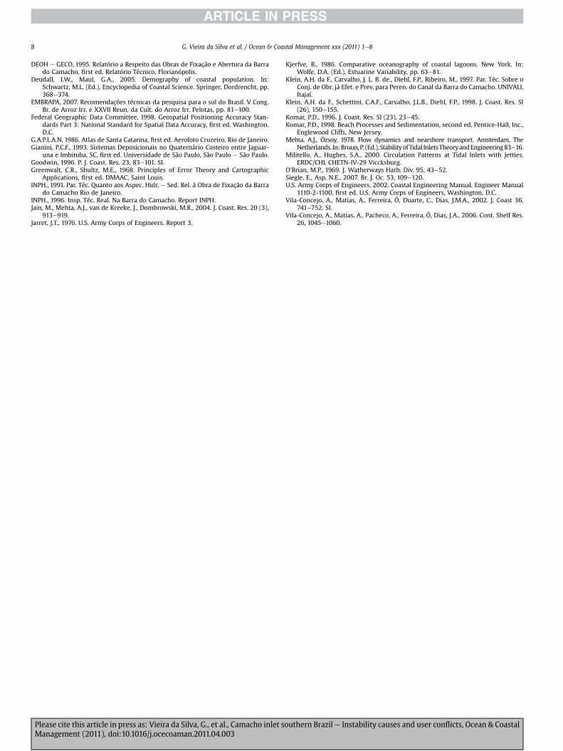
history. From this, the inlet hazard extent area was calculated at360 m, the same size of the inlet in 1978. The Fig. 6 presentsa highlighted area of 60,4Federal Geographic Data Committee, 1998m2 where the inlet was in 1978 and nowadays houses andcommercial buildings are located. This population is located in thehighest hazard area on the study area.
4. Discussion
Our results indicate that the Camacho Inlet does not undergosignificant migration. It exists under an intermittent regime, oftenclosing due to sediment deposition by northwest winds.
Fig. 5. 1978 aerial photography. Both ebb and flood tidal deltas are present. It is also p
Please cite this article in press as: Vieira da Silva, G., et al., Camacho inlet sManagement (2011), doi:10.1016/j.ocecoaman.2011.04.003
Additionally, the cross sectional area of the inlet is not stable(Borderes de Oliveira et al., 2006; Klein et al., 1997, Gianini, 1993).Considering these factors the collective interests of both ricecroppers and the fishing community, and the cost/benefit ratio ofcoastal engineering, it is proposed that the inlet regime should beanthropogenically controlled.
To do this, the periods of the migration and growth of theorganisms and for rice irrigation should be respected. The inletmust be opened from March to September and closed otherwise(Table 2). However, during flood periods this pattern cannot bestrictly followed and the inlet must be opened to allow the lagoonlevel to fall and reduce flooding risks. After the restoration to the
ossible to see the position of the inlet in 2003 indicating the plan-view stability.
outhern Brazil e Instability causes and user conflicts, Ocean & Coastal
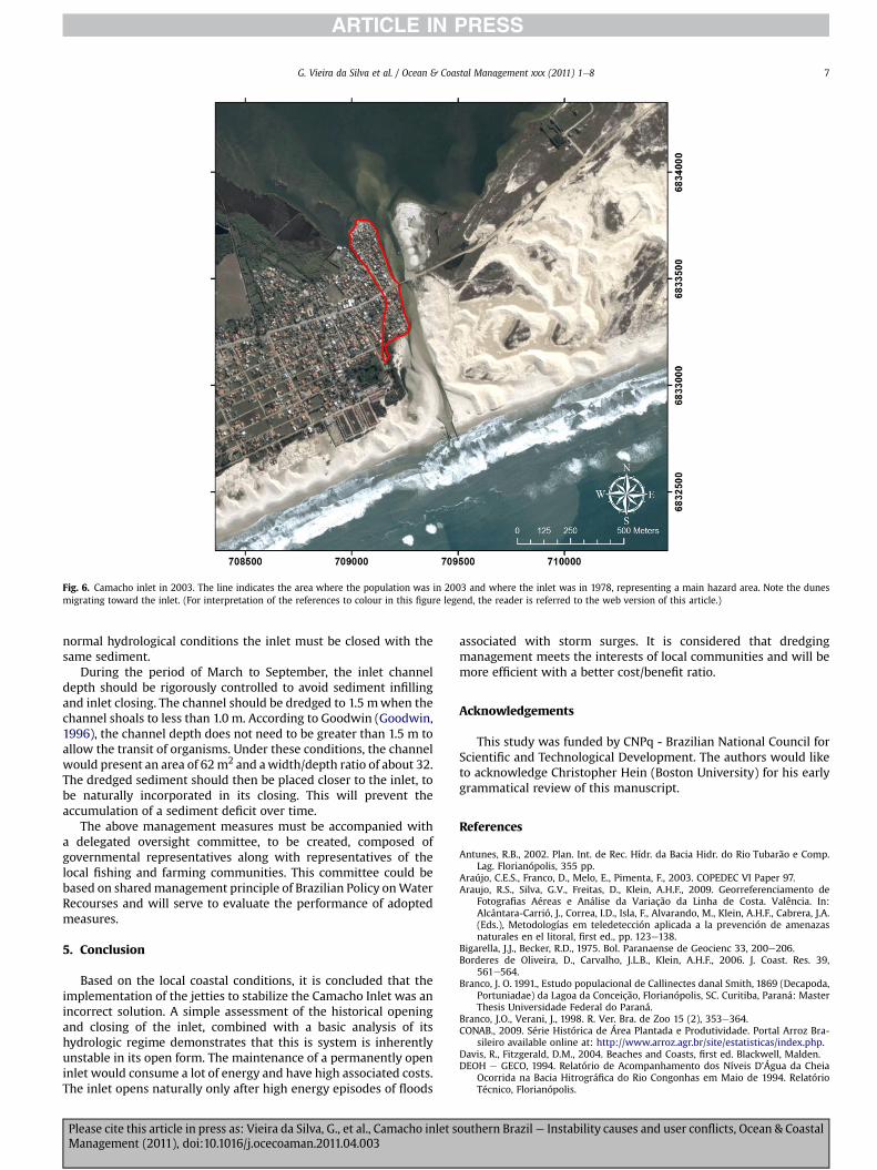
Fig. 6. Camacho inlet in 2003. The line indicates the area where the population was in 2003 and where the inlet was in 1978, representing a main hazard area. Note the dunesmigrating toward the inlet. (For interpretation of the references to colour in this figure legend, the reader is referred to the web version of this article.)
G. Vieira da Silva et al. / Ocean & Coastal Management xxx (2011) 1e8 7
normal hydrological conditions the inlet must be closed with thesame sediment.
During the period of March to September, the inlet channeldepth should be rigorously controlled to avoid sediment infillingand inlet closing. The channel should be dredged to 1.5 mwhen thechannel shoals to less than 1.0 m. According to Goodwin (Goodwin,1996), the channel depth does not need to be greater than 1.5 m toallow the transit of organisms. Under these conditions, the channelwould present an area of 62m2 and awidth/depth ratio of about 32.The dredged sediment should then be placed closer to the inlet, tobe naturally incorporated in its closing. This will prevent theaccumulation of a sediment deficit over time.
The above management measures must be accompanied witha delegated oversight committee, to be created, composed ofgovernmental representatives along with representatives of thelocal fishing and farming communities. This committee could bebased on sharedmanagement principle of Brazilian Policy onWaterRecourses and will serve to evaluate the performance of adoptedmeasures.
5. Conclusion
Based on the local coastal conditions, it is concluded that theimplementation of the jetties to stabilize the Camacho Inlet was anincorrect solution. A simple assessment of the historical openingand closing of the inlet, combined with a basic analysis of itshydrologic regime demonstrates that this is system is inherentlyunstable in its open form. The maintenance of a permanently openinlet would consume a lot of energy and have high associated costs.The inlet opens naturally only after high energy episodes of floods
Please cite this article in press as: Vieira da Silva, G., et al., Camacho inlet sManagement (2011), doi:10.1016/j.ocecoaman.2011.04.003
associated with storm surges. It is considered that dredgingmanagement meets the interests of local communities and will bemore efficient with a better cost/benefit ratio.
Acknowledgements
This study was funded by CNPq - Brazilian National Council forScientific and Technological Development. The authors would liketo acknowledge Christopher Hein (Boston University) for his earlygrammatical review of this manuscript.
References
Antunes, R.B., 2002. Plan. Int. de Rec. Hídr. da Bacia Hidr. do Rio Tubarão e Comp.Lag. Florianópolis, 355 pp.
Araújo, C.E.S., Franco, D., Melo, E., Pimenta, F., 2003. COPEDEC VI Paper 97.Araujo, R.S., Silva, G.V., Freitas, D., Klein, A.H.F., 2009. Georreferenciamento de
Fotografias Aéreas e Análise da Variação da Linha de Costa. Valência. In:Alcántara-Carrió, J., Correa, I.D., Isla, F., Alvarando, M., Klein, A.H.F., Cabrera, J.A.(Eds.), Metodologías em teledetección aplicada a la prevención de amenazasnaturales en el litoral, first ed., pp. 123e138.
Bigarella, J.J., Becker, R.D., 1975. Bol. Paranaense de Geocienc 33, 200e206.Borderes de Oliveira, D., Carvalho, J.L.B., Klein, A.H.F., 2006. J. Coast. Res. 39,
561e564.Branco, J. O. 1991., Estudo populacional de Callinectes danal Smith, 1869 (Decapoda,
Portuniadae) da Lagoa da Conceição, Florianópolis, SC. Curitiba, Paraná: MasterThesis Universidade Federal do Paraná.
Branco, J.O., Verani, J., 1998. R. Ver. Bra. de Zoo 15 (2), 353e364.CONAB., 2009. Série Histórica de Área Plantada e Produtividade. Portal Arroz Bra-
sileiro available online at: http://www.arroz.agr.br/site/estatisticas/index.php.Davis, R., Fitzgerald, D.M., 2004. Beaches and Coasts, first ed. Blackwell, Malden.DEOH e GECO, 1994. Relatório de Acompanhamento dos Níveis D’Água da Cheia
Ocorrida na Bacia Hitrográfica do Rio Congonhas em Maio de 1994. RelatórioTécnico, Florianópolis.
outhern Brazil e Instability causes and user conflicts, Ocean & Coastal
G. Vieira da Silva et al. / Ocean & Coastal Management xxx (2011) 1e88
DEOH e GECO, 1995. Relatório a Respeito das Obras de Fixação e Abertura da Barrado Camacho, first ed. Relatório Técnico, Florianópolis.
Deudall, I.W., Maul, G.A., 2005. Demography of coastal population. In:Schwartz, M.L. (Ed.), Encyclopedia of Coastal Science. Springer, Dordrencht, pp.368e374.
EMBRAPA, 2007. Recomendações técnicas da pesquisa para o sul do Brasil. V Cong.Br. de Arroz Irr. e XXVII Reun. da Cult. do Arroz Irr. Pelotas, pp. 81e100.
Federal Geographic Data Committee, 1998. Geospatial Positioning Accuracy Stan-dards Part 3: National Standard for Spatial Data Accuracy, first ed. Washington.D.C.
G.A.P.L.A.N, 1986. Atlas de Santa Catarina, first ed. Aerofoto Cruzeiro, Rio de Janeiro.Gianini, P.C.F., 1993. Sistemas Deposicionais no Quaternário Costeiro entre Jaguar-
una e Imbituba, SC, first ed. Universidade de São Paulo, São Paulo e São Paulo.Goodwin, 1996. P. J. Coast. Res. 23, 83e101. SI.Greenwalt, C.R., Shultz, M.E., 1968. Principles of Error Theory and Cartographic
Applications, first ed. DMAAC, Saint Louis.INPH., 1991. Par. Téc. Quanto aos Aspec. Hidr. e Sed. Rel. à Obra de Fixação da Barra
do Camacho Rio de Janeiro.INPH., 1996. Insp. Téc. Real. Na Barra do Camacho. Report INPH.Jain, M., Mehta, A.J., van de Kreeke, J., Dombrowski, M.R., 2004. J. Coast. Res. 20 (3),
913e919.Jarret, J.T., 1976. U.S. Army Corps of Engineers. Report 3.
Please cite this article in press as: Vieira da Silva, G., et al., Camacho inlet sManagement (2011), doi:10.1016/j.ocecoaman.2011.04.003
Kjerfve, B., 1986. Comparative oceanography of coastal lagoons. New York. In:Wolfe, D.A. (Ed.), Estuarine Variability, pp. 63e81.
Klein, A.H. da F., Carvalho, J. L. B. de., Diehl, F.P., Ribeiro, M., 1997. Par. Téc. Sobre oConj. de Obr. já Efet. e Prev. para Peren. do Canal da Barra do Camacho. UNIVALI,Itajaí.
Klein, A.H. da F., Schettini, C.A.F., Carvalho, J.L.B., Diehl, F.P., 1998. J. Coast. Res. SI(26), 150e155.
Komar, P.D., 1996. J. Coast. Res. SI (23), 23e45.Komar, P.D., 1998. Beach Processes and Sedimentation, second ed. Pentice-Hall, Inc.,
Englewood Cliffs, New Jersey.Mehta, A.J., Özsoy, 1978. Flow dynamics and nearshore transport. Amsterdam, The
Netherlands. In:Bruun,P. (Ed.), StabilityofTidal InletsTheoryandEngineering83e16.Militello, A., Hughes, S.A., 2000. Circulation Patterns at Tidal Inlets with Jetties.
ERDC/CHL CHETN-IV-29 Viccksburg.O’Brian, M.P., 1969. J. Watherways Harb. Div. 95, 43e52.Siegle, E., Asp, N.E., 2007. Br. J. Oc. 53, 109e120.U.S. Army Corps of Engineers, 2002. Coastal Engineering Manual. Engineer Manual
1110-2-1100, first ed. U.S. Army Corps of Engineers, Washington, D.C.Vila-Concejo, A., Matias, A., Ferreira, Ó, Duarte, C., Dias, J.M.A., 2002. J. Coast 36,
741e752. SI.Vila-Concejo, A., Matias, A., Pacheco, A., Ferreira, Ó, Dias, J.A., 2006. Cont. Shelf Res.
26, 1045e1060.
outhern Brazil e Instability causes and user conflicts, Ocean & Coastal