Calderdale Local Plan - Calderdale Council
20
Calderdale Local Plan LOCAL PLAN EXAMINATION: DOCUMENTS PUBLISHED FOR FURTHER COMMENT COMMENTS ON CC114 - ASSESSMENT OF NON-MINOR GREEN BELT DELETIONS AGAINST GREEN BELT PURPOSES Calderdale Metropolitan Borough Council April 2021
-
Upload
khangminh22 -
Category
Documents
-
view
4 -
download
0
Transcript of Calderdale Local Plan - Calderdale Council
Calderdale Local Plan
LOCAL PLAN EXAMINATION: DOCUMENTS
PUBLISHED FOR FURTHER COMMENT
COMMENTS ON CC114 - ASSESSMENT OF
NON-MINOR GREEN BELT DELETIONS
AGAINST GREEN BELT PURPOSES
Calderdale Metropolitan Borough Council
April 2021

1
From: Sam Booth Sent: 09 April 2021 09:57To: Spatial Planning; Miny SchofieldSubject: Calderdale Council - Additional Local Plan Consultation: CC114Attachments: Local Plan Consultation CC114 - Green Belt.pdf
CAUTION: This email originated from outside of the organisation. Do not click links or open attachments unless you recognise the sender and know the content is safe.
Good Morning, Please find attached a copy of my response to Calderdale Council's Consultation of non-minor Green Belt changes, for the attention of Calderdale Council and the Local Plan Inspector Katie Child. This is a response to the specific documentation: CC114 Please can you provide me with a confirmation of receipt and acceptance at your earliest convenience. Kindest Regards Mr Booth.
This email has been checked by the Council's content checker

Consultation Response to list of non-minor Green Belt Changes 9th April 2021
Documentation: CC114
1
Calderdale Local Plan Consultation: CC114
In line with the National Planning Policy Framework (NPPF), land should only be released from Green
Belt under exceptional circumstances (NPPF, 2019).
I accept that the loss of some Green Belt will be necessary in order to meet the housing needs of
Calderdale.
However, I fail to understand how the Local Authority can legally demonstrate the exceptional
circumstances in releasing some of the highest scoring land that meets 3-5 purposes of Green Belt, as
assessed in the Council’s Green Belt Review. Especially when low scoring Green Belt, meeting only 0-
2 purposes has been completely omitted from development in the submitted Local Plan.
Not only does this approach disproportionately treat Calderdale residents and fails to be strategically
or policy led. It will result in the loss of some of the most meaningful Green Belt across the borough.
Furthermore, once the Green Belt is removed and developed it is lost forever, thus negatively
impacting current and future generations.
In order for the Local Authority to ensure that their Local Plan has a greater likelihood of being found
sound and legally compliant, all land meeting only 0-2 purposes of Green Belt, that is suitable for
development should be brought forward before higher scoring Green Belt can be released under
Exceptional Circumstances and set out in the NPPF.

1
From: Julie Bullen Sent: 09 April 2021 15:26To: Spatial PlanningCc: Miny SchofieldSubject: CC110 WRA submissions - CC114, CC110, CC120, CC121, CC116/SS35 Attachments: CC110 Consultation (2) WRA CC114 Assessment of Non Green Belt Sites.pdf; CC110
Consultation(2) WRA CC111 Open Space Standards .pdf; CC110 Consultation(2) WRA CC120 Woodhouse GS Primary School Feasibility .pdf; CC110(2) Consultation WRA CC121 School Projection Figures and Delivery.pdf; CC110(2) Consultation WRA CC116 Historic Environment Matters and SS35 -LP1451 LVIA.pdf
CAUTION: This email originated from outside of the organisation. Do not click links or open attachments unless you recognise the sender and know the content is safe. Please find attached the Woodhouse Residents Association submission documents for:-
CC114 – Assessment of Non-Green Belt Sites CC110 – Open Space Standards CC120 – Woodhouse Primary School Feasibility CC121 – School Projection Figures and Delivery CC116 and SS35 – Historic Environment Matters and LP1451 LVIA
Kind regards Julie Bullen Sent on behalf of Woodhouse Residents Association Sent from Mail for Windows 10
This email has been checked by the Council's content checker
CALDERDALE LOCAL PLAN EXAMINATION - STAGE 2/3
CC110 Consultation Documents – Phase 2
COMMENTS ON: CC114 – Assessment of Non-minor Green Belt Deletions
Woodhouse Residents Association
April 2021

2
1.0 INTRODUCTION
1.1 This representation has been prepared by the Woodhouse Residents Association
(WRA) and is submitted by Julie Bullen on their behalf. It responds to the CC110 Stage
2 Consultation - CC114 document regarding non-minor green belt deletions.
1.2 It should be read in conjunction with our previous statements and comments at the hearings on Matters 12, 13, 15 and 26, as well as comments on CC110 documents CC116, HS15.1 and CC48.1.
1.3 The WRA was formed and constituted in September 2019 following the Stage 1 Inquiry
to collectively respond to the Local Plan process. The WRA continues to grow and
currently has 236 members drawn from the local residential and business community
and representing a large proportion of properties in the area.
1.4 Having completed Stage 1 of this three-stage consultation, we express strong concern about the suitability of the Council’s approach to this consultation. It has been shaped to drip feed new information without an assessment of how these documents interconnect. We find ourselves responding on one item in the first stage only to find the information has then been updated in the next. This is uncoordinated, piecemeal, confusing and critically, very wasteful of our time and no doubt the Inspector’s.
1.5 We thank the Inspector for the opportunity to comment on this new document.
2.0 GBDMIQ02 – Land off Huddersfield Road, Brighouse
2.1 We agree it would be anomalous to retain GBDMIQ02 within the green belt IF both
the Woodhouse GS LP1451 and employment site LP1618 go forward as allocations
within any approved plan.
2.2 However, we maintain that the application of Purpose IV is flawed. We refer back to
the Green Belt Review 2017 para 5.36 which provides details of how the assessment
criteria is applied.
The assessment enabled a conclusion to be made as to whether development of the parcel would have no effect on the setting and special character of historic features or would have an effect on the setting and special character of historic features, which could be mitigated against through appropriate detailed design or would have a significant effect on the setting and special character of historic features.
2.3 As outlined in our CC116 statement, the Heritage Impact Assessments (HIA) were not
undertaken until after the green belt assessment was completed. The critical
information needed and identified in the HIA to inform this Purpose was not therefore
available and thus was disregarded.
2.4 The outcome of Purpose IV for this green belt modification is provided below. It
indicates that development of this green belt land would not adversely affect the
special character of a historic place or reduce its significance.

3
2.5 We refer to the HIA included in CC116 at Appendix 4 and EV28.1/CC68. The
development of the majority of this green belt modification covers the formal gardens
and former parkland setting of Toothill Hall, the listed Grade II Lodge and the HaHa
which forms the southern boundary. It also covers the formal gardens of the historic
Gatehouse, a well-defined unit with mature planting to its boundary, the character of
the immediate setting being fairly, self-contained by the boundary of the gardens (See
LP1451 HIA in CC68). Development within these areas would most certainly affect the
special character of the heritage assets and reduce the significance of place.
Mitigation would not be possible. Whilst we accept that the small triangular site to
the west, adjacent to the old Toothill Lane and proposed to be included in LP1618,
might be able to accept some development, this is not sufficient to conclude it does
not fulfil Purpose IV. On this basis the assessment is incorrect. We have similar
concerns on LP1618 and LP1451 with regard to the consideration of this Purpose.
3.0 GBD297 – Land to South East of Woodhouse Gardens, Brighouse
3.1 We agree it would be anomalous to retain GBD297 within the green belt IF the
Woodhouse GS LP1451 is accepted as an allocation within any approved plan. We do
note however that a HaHa crosses this site which has not been considered.
4.0 Conclusion
4.1 The Council’s failure to observe due process has led them to a wrong and
unsupportable conclusion with regard to this Assessment.
1
From:Sent: 09 April 2021 15:07To: Spatial PlanningSubject: Stage three, phase two submissionsAttachments: Carlton,. Jason - CC111.pdf; Carlton,. Jason - CC119-120.pdf; Carlton,. Jason - CC114
- non-minor greenbelt deletions.pdf
CAUTION: This email originated from outside of the organisation. Do not click links or open attachments unless you recognise the sender and know the content is safe. Hello, Please find attached three documents regarding stage three, phase two consultations. Thanks Jason ----------------------------------------------------------- This email has been checked by the Council's content scanner -----------------------------------------------------------
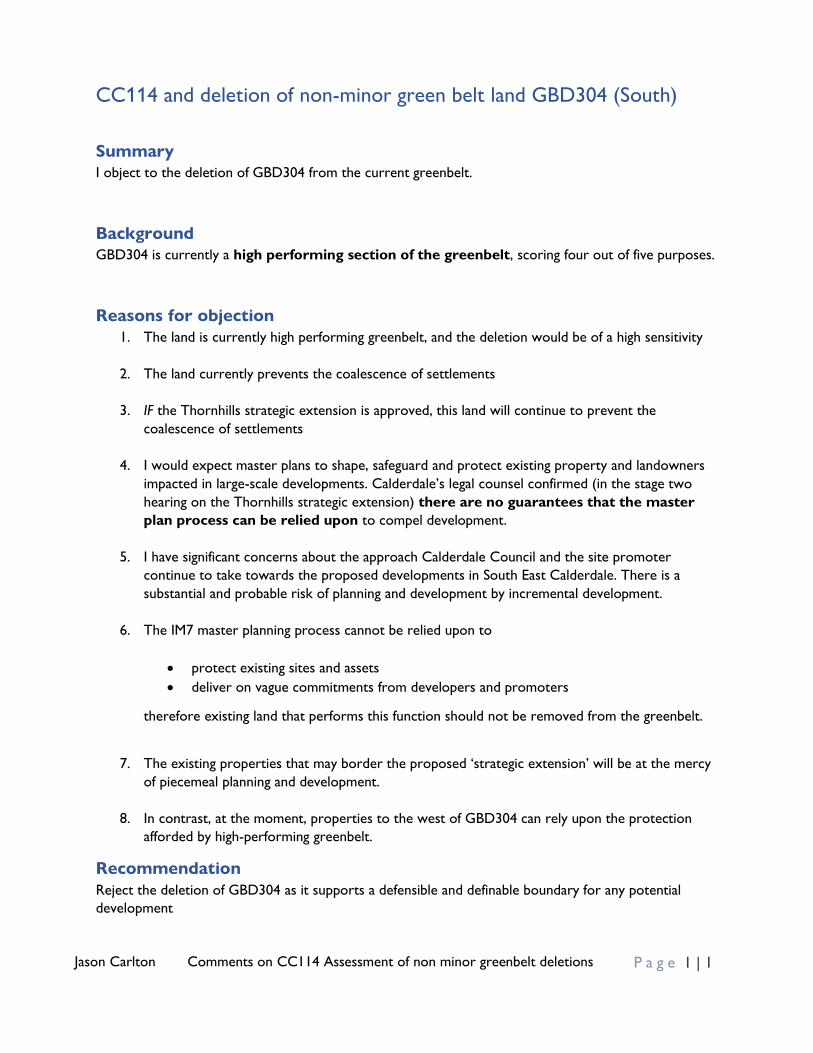
Jason Carlton Comments on CC114 Assessment of non minor greenbelt deletions P a g e 1 | 1
CC114 and deletion of non-minor green belt land GBD304 (South)
Summary
I object to the deletion of GBD304 from the current greenbelt.
Background
GBD304 is currently a high performing section of the greenbelt, scoring four out of five purposes.
Reasons for objection
1. The land is currently high performing greenbelt, and the deletion would be of a high sensitivity
2. The land currently prevents the coalescence of settlements
3. IF the Thornhills strategic extension is approved, this land will continue to prevent the
coalescence of settlements
4. I would expect master plans to shape, safeguard and protect existing property and landowners
impacted in large-scale developments. Calderdale’s legal counsel confirmed (in the stage two
hearing on the Thornhills strategic extension) there are no guarantees that the master
plan process can be relied upon to compel development.
5. I have significant concerns about the approach Calderdale Council and the site promoter
continue to take towards the proposed developments in South East Calderdale. There is a
substantial and probable risk of planning and development by incremental development.
6. The IM7 master planning process cannot be relied upon to
• protect existing sites and assets
• deliver on vague commitments from developers and promoters
therefore existing land that performs this function should not be removed from the greenbelt.
7. The existing properties that may border the proposed ‘strategic extension’ will be at the mercy
of piecemeal planning and development.
8. In contrast, at the moment, properties to the west of GBD304 can rely upon the protection
afforded by high-performing greenbelt.
Recommendation
Reject the deletion of GBD304 as it supports a defensible and definable boundary for any potential
development

1
From: Martin Hey Sent: 09 April 2021 15:38To: Spatial PlanningSubject: Re: Calderdale Local Plan - Consultation (Stage 2)Attachments: Calderdale Local Plan Examination - Martin Hey 090421.pdf
CAUTION: This email originated from outside of the organisation. Do not click links or open attachments unless you recognise the sender and know the content is safe.
Please find my comments on the Stage 2 Consultation documents. Best wishes Martin Hey
From: Spatial Planning <[email protected]> Sent: 12 March 2021 11:22 To: Spatial Planning <[email protected]> Subject: Calderdale Local Plan - Consultation Dear Sir / Madam, You are receiving this email because you have either expressed an interest to be kept informed about the Calderdale Local Plan or have previously made comment on it. Following the Local Plan Examination Hearings held between October and December 2020, the Inspector wrote to the Council and requested that it sought further comments on the documents published where interested parties had not previously had the opportunity to comment (INS 18 - Stage 2 - Inspectors Post Hearings Letter to the Council). The Council has undertaken a “Stage 1 Consultation” which began on 12th February and finishes at 5pm 12th March 2021. The attached document contains various tables setting out the documents which the Council is currently seeking comments on and where documents are yet to be published, the indicative timetable for these consultations. The consultation for documents marked “Stage 2 Consultation”, will end at 5pm on Friday 9th April 2021. Comments should be emailed to the Spatial Planning Team at [email protected] and should clearly indicate which document the comments relate to. Please note that your comments and name will be sent to the Local Plan Inspector and published on the Council’s website. No personal contact details such as telephone numbers or emails will be published. Anonymous comments will not be accepted. If you have any queries regarding this consultation, please do not hesitate to contact the Spatial Planning Team at [email protected]. For further information about the Local Plan please visit: www.calderdale.gov.uk/localplan. Spatial Planning Spatial Planning, Calderdale Council, Town Hall, Crossley Street, Halifax, West Yorkshire, HX1 1UJ.
********************************************************************************* Warning Please note that whilst this e-mail and any attachments originate from Calderdale MBC, the views expressed may not necessarily represent the views of Calderdale MBC. This e-mail and any attachments may contain information that is privileged, confidential or otherwise protected from disclosure. They must not be used by, or copied or disclosed to persons other than the intended recipient. Any

2
liability (in negligence or otherwise) arising from any third party acting, or refraining from acting, on any information contained in this e-mail is excluded. If you have received this e-mail in error please inform the sender and delete the e-mail. E-mail can never be 100% secure. Please bear this in mind and carry out such virus and other checks, as you consider appropriate. Calderdale MBC accepts no responsibility in this regard. Copyright of this e-mail and any attachments belongs to Calderdale MBC. Should you communicate with anyone at Calderdale MBC by e-mail, you consent to the Council monitoring and reading any such correspondence. This email message has been scanned for viruses and its content cleared.
This email has been checked by the Council's content checker
Calderdale Local Plan Examination
STAGE 2 - HEARINGS
Participant Responses – 09/04/2021
CC123 – List of Interventions in the Road Network
• I note that no schemes are being proposed for Northowram and Shelf, despite the huge
amount of building that is being proposed in an area with known traffic issues. This confirms
local residents’ belief that large amounts of housing are being placed in the area to support
the Policy-On approach, without any consideration of the impact on local life in terms of
traffic, pollution, strain on infrastructure, etc.
CC114 – Assessment of Non-Minor Green Belt Changes
• I would seriously question how the council can determine that 4 sites are of High Deletion
Sensitivity, and then propose no change to their plans. I would like to ask what assessment
could have actually lead to a change. Residents of Calderdale want proper engagement with
these issues, otherwise what is the point of these assessments.
CC116 (LP0766)
• I note the revised proposals for Hall Lane. I would question the appropriateness of the
extension. At present, one can stand on the hills behind Marsh Hall and look down on the
Hall itself and the landscape beyond. This will be lost – a few small screening trees will make
little difference. Residents remain very unhappy that heritage, wildlife and flooding
considerations aren’t being properly considered by the council – a 10m ecological buffer is
particularly risible, given the richness of wildlife on the site at present.
CC – 116 (LP1523)
• I welcome the reduction in the size of the site, but question whether it is enough. Given the
need to protect the semi-rural nature of Westercroft Hamlet, it would be good if the council
could confirm the exact distance from the new development to the hamlet in the new
proposal – it still looks close to zero from the maps in the document.
CC – 116 (LP1036)
• The risk that a new road will be built over Shelf Cricket pitch really is disappointing. If this
happens, any subsequent campaigns by the council relating to Public Health and the fight
against pollution will inevitably have a hollow ring to them.
Martin Hey
Calderdale Green Party

1
From: Amanda Tattersall Sent: 09 April 2021 16:56To: Spatial PlanningSubject: Comment submitted for CC114 tattersallAttachments: Comment submitted on CC114 Tattersall.pdf
CAUTION: This email originated from outside of the organisation. Do not click links or open attachments unless you recognise the sender and know the content is safe. Dear Spatial Planning Please find attached our comment submitted against document CC114 Non-Minor Green Belt Deletions If there is no automatic email acknowledgement would you please kindly acknowledge receipt? Many thanks. Kind regards Amanda & Mark Tattersall
This email has been checked by the Council's content checker
1
Document CC114 - Assessment of Non-Minor Green Belt Deletions Against Green Belt Purposes Comment submitted by Amanda & Mark Tattersall 9 April 2021 Proposed removal of Green Belt - Reference GBD 096
We appreciate the opportunity to comment once again on this proposed removal of Green Belt,
especially as the discussion on it had to be abandoned at the online Stage 2 Hearings, due to Council
technical difficulties.
We can see no justification for the removal of this additional Green Belt and ask that the Green Belt
is not removed in this location for the following reasons:
Main Points
• The Council are proposing to change the Green Belt boundary out from the farm buildings to
an undefined and long-existing farm track, which is part of a wide area of Green Belt. This
would create an irregular undefined boundary and one which could vary year to year. To
alter the Green Belt boundary further here would, in fact, make it less defined and less
defensible, which the Council say is the purpose of removing the Green Belt in CC48 and
CC114.
• The Green Belt boundary that the Council proposes to change once again in this location was
previously changed in the last Local Plan, the RCUDP (under Minor Changes to the Green
Belt). Back then, the boundary was altered to follow the developed area which is to the
right of the area now proposed to be removed (please see Appendix 1 below, which includes
the RCUDP documents from this time which confirms this action.) Importantly, this includes
a copy of the Council’s map, which shows the Green Belt boundary drawn to follow the
buildings and a paragraph confirming the Green Belt change is to recognise the developed
area.
• The Green Belt which is proposed to be removed is on the western edge of the village of
Stainland and is part of a wide area of Green Belt (the Green Belt Site Survey form has
omitted the locality of Stainland and has recorded the area as Elland town)
• If the Green Belt boundary is changed here again to a weaker undefined farm track
boundary, it will most likely be said that it will need changing again at the next review. The
removal would undermine the Green Belt and its purposes in this location and the
exceptional circumstances required to remove it.
• The Council’s overall reasoning and approach for deleting or adding Green Belt is not
provided within Documents CC48 and CC48.1. Instead, decisions for each piece of Green
Belt are provided in a list.
• We note the 2 tables in CC114 that assess the Green Belt purposes and that the Council
makes no alteration to their decision based on these. The approach to considering the
Green Belt purposes was not mentioned in documents CC48 and CC48.1 for the other Green
Belt alterations, so we make no comment on this (including our disagreement with some of
the conclusions).

2
• We therefore ask that the Green Belt boundary is not removed and changed further in this
location.
• We would welcome a discussion at a hearing, if the Council are still mindful to remove this
area of undefined farm track from the Green Belt following the points we have made here
and because we did not have the opportunity to discuss the matter fully at the Stage 2
Hearings because of potential technical problems.
Additional Points
The Council have now altered their reason for deleting the area of Green Belt. Below is a screenshot
of the original reason for deletion of the Green Belt in document CC48 and below that is a
screenshot from Document CC114.
Document CC48
Document CC114
The Council are now saying the deletion is partly in relation to property boundaries. However, it is
the Council who are proposing to remove the Green Belt back from the more permanent and
defined property boundary it created when it altered the Green Belt boundary here last time, in the
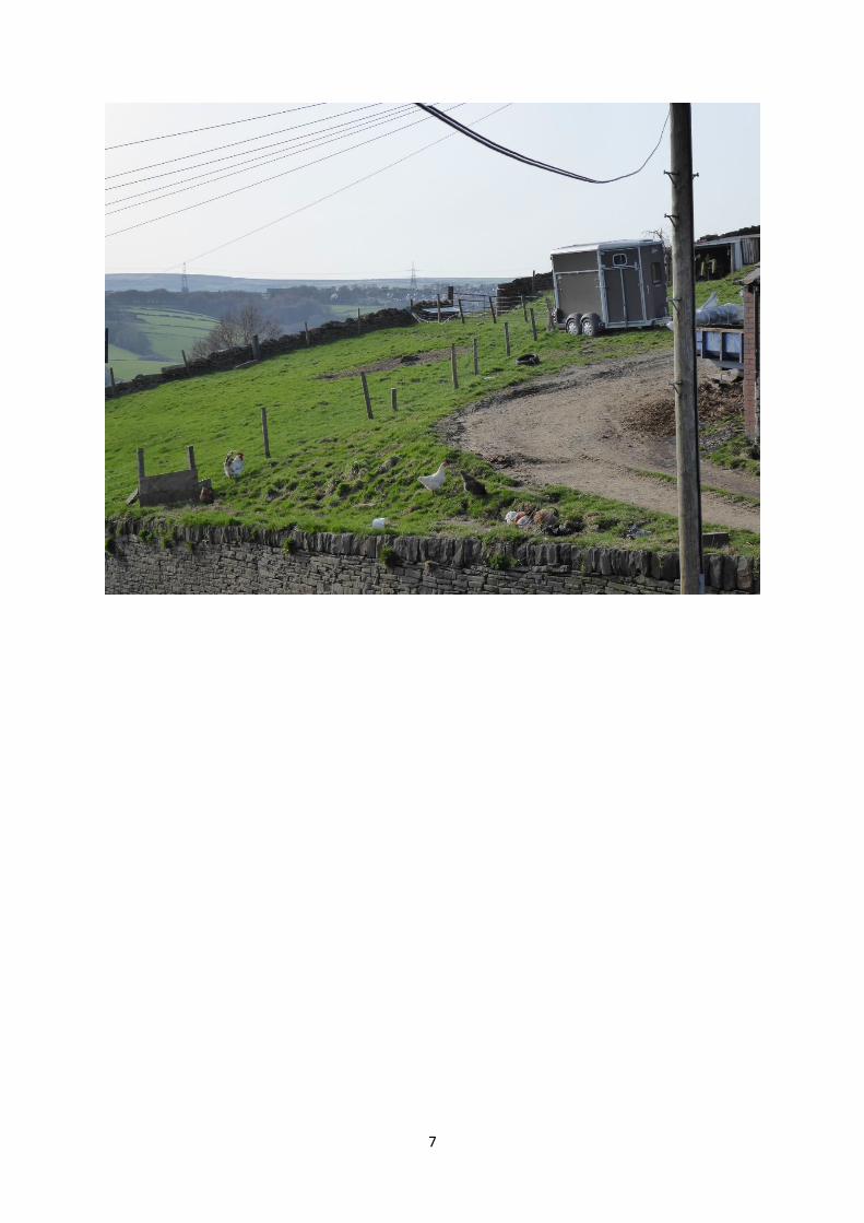
RCUDP. A copy of the proposed removal of Green Belt from CC49 Map of Minor Boundary Changes
below clearly shows that the area to be removed is the long-existing undefined farm track. The farm
sometimes uses temporary storage containers for waste adjacent to the area. Again, to alter the
Green Belt boundary further here would make the Green Belt less defined and less defensible, which
is the opposite of what the Council say is the purpose of the removal in CC114 and CC48 above.

3
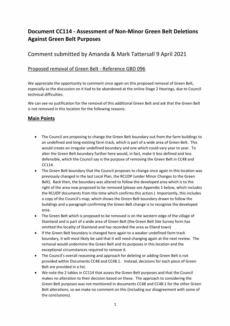
Appendix 1
RCUDP Map and information showing previous removal of Green Belt – DHG5

4
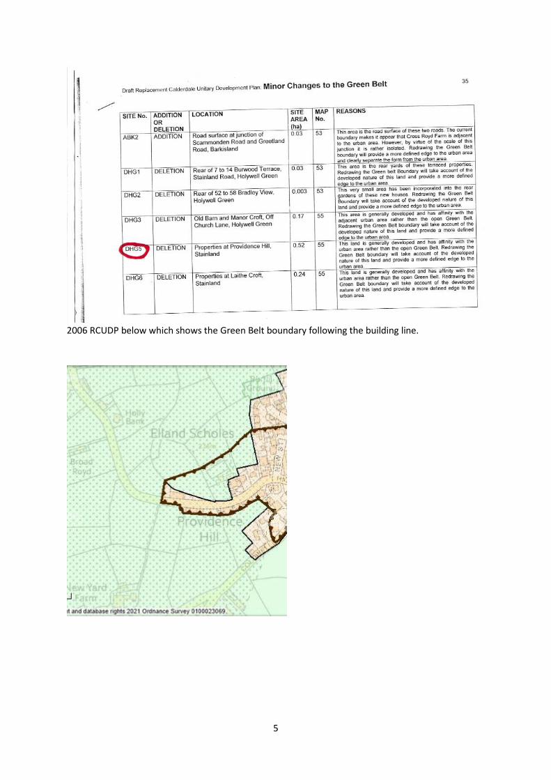
5
2006 RCUDP below which shows the Green Belt boundary following the building line.
6
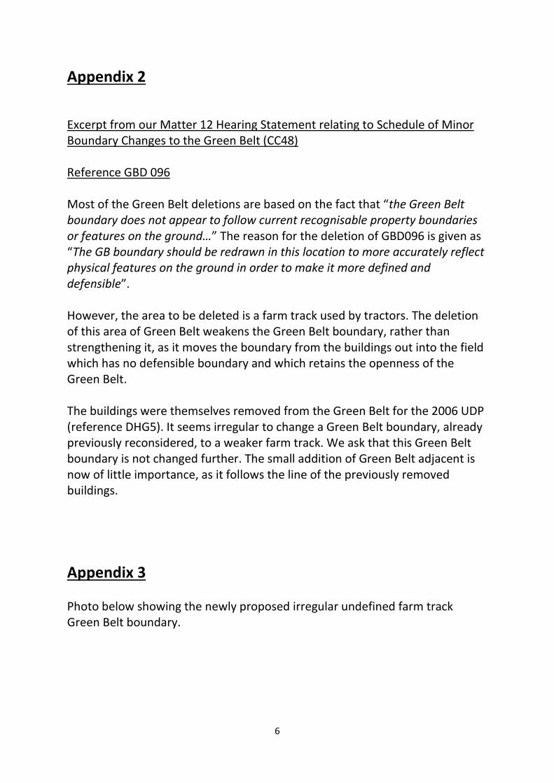
Appendix 2
Excerpt from our Matter 12 Hearing Statement relating to Schedule of Minor Boundary Changes to the Green Belt (CC48) Reference GBD 096 Most of the Green Belt deletions are based on the fact that “the Green Belt boundary does not appear to follow current recognisable property boundaries or features on the ground…” The reason for the deletion of GBD096 is given as “The GB boundary should be redrawn in this location to more accurately reflect physical features on the ground in order to make it more defined and defensible”. However, the area to be deleted is a farm track used by tractors. The deletion of this area of Green Belt weakens the Green Belt boundary, rather than strengthening it, as it moves the boundary from the buildings out into the field which has no defensible boundary and which retains the openness of the Green Belt. The buildings were themselves removed from the Green Belt for the 2006 UDP (reference DHG5). It seems irregular to change a Green Belt boundary, already previously reconsidered, to a weaker farm track. We ask that this Green Belt boundary is not changed further. The small addition of Green Belt adjacent is now of little importance, as it follows the line of the previously removed buildings.
Appendix 3 Photo below showing the newly proposed irregular undefined farm track Green Belt boundary.
7