Surface water management plan - Southwark Council
120
SURFACE WATER MANAGEMENT PLAN DRAIN LONDON LONDON BOROUGH OF SOUTHWARK
-
Upload
khangminh22 -
Category
Documents
-
view
0 -
download
0
Transcript of Surface water management plan - Southwark Council

SURFACE WATER MANAGEMENT PLAN
DRAIN LONDON
LONDON
BOROUGH OF
SOUTHWARK

Quality Management
Quality Management
DOCUMENT INFORMATION
Title: SWMP for London Borough of Southwark
Owner: John Kissi
Version: 1.0
Status: Final
Project Number: D134785
File Name: DLT2-GP7-SWMP-SOUTHWARK-Report-v1pt0-FINAL.doc
REVISION HISTORY
Summary of Changes Completed By Date of
Issue Version
Draft Report (v0.1) updated with Southwark
Borough Council, GLA and Peer Review Comments Sarah Kelly 31/08/2011 1.0
AUTHOR
Name Organisation and Role
Sarah Kelly URS Scott Wilson – Water Specialist
Gemma Hoad URS Scott Wilson – Assistant Water Scientist
APPROVALS
Name Title Signature Date
Jon Robinson PD of URS Scott Wilson
23-09-2011
Sarah Kelly PM of URS Scott Wilson
23-09-2011
Kevin Reid GLA PM
07-06-2011
Mathew Graham URS Scott Wilson Reviewer
17-04-2011
Jon Robinson URS Scott Wilson Approver
27-05-2011
DISTRIBUTION
Name Organisation and Role
Kevin Reid Drain London Project Manager, Greater London Authority
RELATED DOCUMENTS
Doc Ref Document Title Author Date of
Issue Version
GP7-PFRA-
SOUTHWARK
PFRA for London Borough of
Southwark URS Scott Wilson June 2011 1.0

Executive Summary
Version 1.0 – Final Report
August 2011
Page i
Executive Summary
This document forms the Surface Water Management Plan (SWMP) for the London Borough of
Southwark which has been delivered as part of the Tier 2 package of works of the Drain London
Project. This document is a plan which outlines the preferred surface water management strategy for
London Borough of Southwark and includes consideration of flooding from sewers, drains,
groundwater and runoff from land, small watercourses and ditches that occurs as a result of heavy
rainfall.
The SWMP builds upon previous work undertaken at part of the Drain London Tier 1 package of works
and has been undertaken following a four phase approach; Phase 1 – Preparation; Phase 2 – Risk
Assessment; Phase 3 – Options; and Phase 4 – Implementation and Review.
Phase 1 Preparation
Phase 1 builds upon work formerly undertaken during Tier 1 of the Drain London Project to collect and
review surface water data from key stakeholders and build partnerships between stakeholders
responsible for local flood risk management. As part of the Drain London project, the London Borough
of Southwark has been grouped with the London Boroughs of Lambeth, Merton and Wandsworth to
undertake Tier 2 of the project and work together to understand local flood risk.
The London Borough of Southwark has begun to establish a broader partnership with the
neighbouring London Borough of Lambeth, through the establishment of the South Central London
Strategic Flood Group, in order for these local authorities to pool best practice and resources to enable
each authority to discharge their responsibilities as Lead Local Flood Authority (LLFA) under the Flood
and Water Management Act (FWMA) 2010.
Phase 2 Risk Assessment
As part of Phase 2 Risk Assessment, direct rainfall modelling has been undertaken across the entire
Borough for five specified return periods. The results of this modelling have been used to identify Local
Flood Risk Zones (LFRZs) where flooding affects houses, businesses and/or infrastructure. Those
areas identified to be at more significant risk have been delineated into Critical Drainage Areas (CDAs)
representing one or several LFRZs as well as the contributing catchment area and features that
influence the predicted flood extent.
Within the London Borough of Southwark, 5 CDAs have been identified; these are shown in Figure 1.

Executive Summary
Version 1.0 – Final Report
August 2011
Page ii
The chief mechanisms for flooding in the London Borough of Southwark can be broadly divided into
the following categories:
• River Valleys - Across the study area, the areas particularly susceptible to overland flow are
formed by narrow corridors associated with topographical valleys which represent the routes
of the ‘lost’ rivers of London including the River Peck and River Effra. This results in large
areas of deep surface water ponding in the Herne Hill and Peckham areas;
• Low Lying Areas - areas such as underpasses, subways and lowered roads beneath railway
lines are more susceptible to surface water flooding;
• Railway Embankments and Cuttings - discrete surface water flooding locations along the up-
stream side of the raised network rail embankment (running roughly west to east through the
centre of the Borough) and several railway cuttings throughout the Borough including railway
lines near to Denmark Hill and Surrey Quays Stations;
• Borough Central Belt – the most extensive and deepest areas of surface water flooding in
the Borough are located along the central belt of the Borough north of the A202 (e.g.
Camberwell and Old Kent Road); this coincides with the southern extent the River Thames
Flood Zone 3; and,
• Sewer Flood Risk – areas where extensive and deep surface water flooding or historical
flood records indicate that surface water flooding is likely to be the influence of sewer
flooding mechanisms alongside pluvial and groundwater sources (Herne Hill and Dulwich).
Analysis of the number of properties at risk of flooding has been undertaken for the rainfall event with
a 1 in 100 probability of occurrence in any given year (1% Annual Exceedance Probability, AEP). A
review of the results demonstrate that 30,280 residential properties and 2,530 non-residential
properties in the London Borough of Southwark could be at risk of surface water flooding of greater
than 0.03m depth during the 1% AEP rainfall event. Of those, 230 residential properties and 45 non-
residential properties could be at risk of flooding to a depth of greater than 0.5m during the same
modelled rainfall event.
A review of these statistics coupled with local knowledge of the study area identifies that the following
CDAs are at greatest risk of significant flooding (greater than 0.5m deep) from the 1% AEP rainfall
event:
Table 1 - CDAs at Greatest Risk of Surface Water Flooding in (or interacting with) the London Borough of Southwark
Flooded Receptors (>0.03m) Flooded Receptors (>0.5m)
CDA
Residential Non-
Residential Total Residential
Non-Residential
Total
Group7_032 (Herne Hill) 6,201 339 6,540 158 33 191
Group7_037 (Central Southwark) 5,709 363 6,072 71 2 73
Group7_038 (East Southwark) 7,940 303 8,243 57 3 60
Group7_036 (Camberwell) 2,962 160 3,122 56 1 57
Group7_035 (London Bridge) 410 396 806 0 2 2
Within the London Borough of Southwark, the greatest number of receptors are at risk from significant
surface water flooding (>0.5m) along the route of the ‘hidden’ River Effra (Group7_032) and the River
Peck and tributaries (Group7_037 and Group7_038), which run south to north through the Borough.
Significant ponding of surface water is also modelled along the central belt of Southwark in the
Camberwell (Group7_036, Group7_037) and Peckham (Group7_038) areas. Historic surface water
flooding records (supplied by Southwark Borough Council and Thames Water) support the pluvial

Executive Summary
Version 1.0 – Final Report
August 2011
Page iii
modelling flooding in the Herne Hill area, and indicate sewer flooding risk in the Dulwich area. Surface
water flows from the London Borough of Southwark and impacts downstream surface water flooding in
the London Borough of Lambeth in the south Brixton area (Group7_033); it will therefore be important
that the flood risk is managed at a catchment scale by both Councils.
Two CDAs within the London Borough of Southwark cross the adjoining London Borough of Lambeth
administrative boundary; Group7_032 (Herne Hill) CDA and Group7_036 (Camberwell) CDA. The
Group7_032 CDA is being jointly managed with the London Borough of Lambeth, whilst the London
Borough of Southwark are identified as the ‘Lead’ Borough’ for the Group7_036 CDA. As a significant
amount of surface water flooding occurs along much of the Southwark / Lambeth border it will be
important that the two Boroughs work closely to manage surface water flood risk and the
implementation of any flood mitigation measures in these areas.
Phase 3 Options Assessment
There are a number of opportunities for measures to be implemented across the Borough to tackle
surface water flood risk. Ongoing maintenance of the drainage network and small scale improvements
are already undertaken as part of the operations of the Borough. In addition, opportunities to raise
community awareness of the risks and responsibilities for residents should be sought, and London
Borough of Southwark may wish to consider the implementation of a Communication Plan to assist
with this.
It is important to recognise that flooding within the Borough is not confined to just the CDAs, and
therefore, throughout the Borough there are opportunities for generic measures to be implemented
through the establishment of a policy position on issues including the widespread use of water
conservation measures such as water butts and rainwater harvesting technology, use of soakaways,
permeable paving and green roofs. In addition, there are Borough-wide opportunities to raise
community awareness.
For each of the CDAs identified within the Borough, site-specific measures have been identified that
could be considered to help alleviate surface water flooding. These measures were subsequently
short listed to identify a potential preferred option for each CDA alongside recommendations for further
investigation where appropriate.
Pluvial modelling undertaken as part of the SWMP has identified that flooding within the London
Borough of Southwark is typically shallow and widely dispersed across much of the Borough, but
deeper flooding is predicted across the central belt of the Borough (north of the A202), which is
typically heavily urbanised. There is also significant flood risk predicted to impact the Herne Hill area.
Historical records indicate that flooding is largely a result of the local drainage network and Thames
Water sewer capacity; the majority of the Borough is served by combined sewers which, in many
cases, were designed and built in the late 1800s, and subsequent urbanisation and cross-connection
means that it is likely that the sewers across the London Borough of Southwark will have varying
standards of capacities, particularly in the north of the Borough. As such, in the short to medium-term,
it is recommended that the London Borough of Southwark:
• Undertake a Catchment-wide Drainage Capacity Study for the Herne Hill (Group7_032) (and
downstream Brixton (Group7_033)) CDAs in conjunction with the London Borough of
Lambeth and Thames Water to determine local drainage capacity and identify flood
mitigation options through detailed modelling;
• Undertake a feasibility study for providing source control / localised ‘greening’ measures in
the Comber Grove area (Group7_036) as a demonstration for how similar measures can be
taken forward in other parts of the Borough;

Executive Summary
Version 1.0 – Final Report
August 2011
Page iv
• Support the London Borough of Lambeth in undertaking a feasibility study for providing
source control measures in Ruskin Park to mitigate surface water flooding to the railway line
to the west of Denmark Hill Station and King’s College Hospital (Group7_036); and,
• Engage with Network Rail regarding the surface water flood risk along major railway lines
and to railway stations identified to flood throughout the Borough, and confirm the drainage
assumptions used within the SWMP pluvial modelling. In particular this should focus on
infrastructure along the railway line to the west of Denmark Hill Station (Group7_036).
‘Quick Wins’ for the Borough include:
• Improve maintenance regimes, and target those areas identified to regular flood or known to
have blocked gullies;
• Produce a Community Flood Plan for the Herne Hill area (Group7_032) to assist
communities in preparing and dealing with surface water flooding;
• Undertake a feasibility study for providing source control measures in Peckham Rye to
mitigate surface water flooding downstream in the Peckham area (Group7_038); and,
• Support the London Borough of Lambeth in taking forward measures to improve resilience at
King’s College Hospital.
Borough wide, it is recommended that Southwark Borough Council:
• Engage with residents regarding the flood risk in the Borough, to make them aware of their
responsibilities for property drainage (especially in the CDAs) and steps that can be taken to
improve flood resilience;
• Provide an ‘Information Portal’ via the London Borough of Southwark website, for local flood
risk information and measures that can be taken by residents to mitigate surface water
flooding to / around their property; and,
• Prepare a Communication Plan to effectively communicate and raise awareness of surface
water flood risk to different audiences using a clearly defined process for internal and
external communication with stakeholders and the public
Phase 4 Implementation & Review
Phase 4 establishes a long-term Action Plan for London Borough of Southwark to assist in their role
under the FWMA 2010 to lead in the management of surface water flood risk across the Borough. The
purpose of the Action Plan is to:
• Outline the actions required to implement the preferred options identified in Phase 3;
• Identify the partners or stakeholders responsible for implementing the action;
• Provide an indication of the priority of the actions and a timescale for delivery; and,
• Outline actions required to meet the requirements for London Borough of Southwark as
LLFA under the FWMA 2010.
The SWMP Action Plan is a ‘living’ document, and as such, should be reviewed and updated regularly,
particularly following the occurrence of a surface water flood event, when additional data or modelling
becomes available, following the outcome of investment decisions by partners and following any
additional major development or changes in the catchment which may affect the surface water flood
risk.

Glossary
Version 1.0 – Final Report
August 2011
Page v
Glossary Term Definition
AEP Annual Exceedance Probability
Aquifer A source of groundwater comprising water bearing rock, sand or gravel capable of yielding significant quantities of water.
AMP Asset Management Plan
Asset Management Plan
A plan for managing water and sewerage company (WaSC) infrastructure and other assets in order to deliver an agreed standard of service.
AStSWF Areas Susceptible to Surface Water Flooding
Catchment Flood Management Plan
A high-level planning strategy through which the Environment Agency works with their key decision makers within a river catchment to identify and agree policies to secure the long-term sustainable management of flood risk.
CDA Critical Drainage Area
Critical Drainage Area
A discrete geographic area (usually a hydrological catchment) where multiple and interlinked sources of flood risk (surface water, groundwater, sewer, main river and/or tidal) cause flooding in one or more Local Flood Risk Zones during severe weather thereby affecting people, property or local infrastructure.
CFMP Catchment Flood Management Plan
CIRIA Construction Industry Research and Information Association
Civil Contingencies Act
This Act delivers a single framework for civil protection in the UK. As part of the Act, Local Resilience Forums must put into place emergency plans for a range of circumstances including flooding.
CLG Government Department for Communities and Local Government
Climate Change Long term variations in global temperature and weather patterns caused by natural and human actions.
Culvert A channel or pipe that carries water below the level of the ground.
Defra Department for Environment, Food and Rural Affairs
DEM Digital Elevation Model
DG5 Register A water-company held register of properties which have experienced sewer flooding due to hydraulic overload, or properties which are 'at risk' of sewer flooding more frequently than once in 20 years.
DTM Digital Terrain Model
EA Environment Agency
Indicative Flood Risk Areas
Areas determined by the Environment Agency as indicatively having a significant flood risk, based on guidance published by Defra and WAG and the use of certain national datasets. These indicative areas are intended to provide a starting point for the determination of Flood Risk Areas by LLFAs.
FALP Further Alterations to the London Plan
FCERM Flood and Costal Erosion Risk Management
FMfSW Flood Map for Surface Water
Flood defence Infrastructure used to protect an area against floods as floodwalls and embankments; they are designed to a specific standard of protection (design standard).
Flood Risk Area An area determined as having a significant risk of flooding in accordance with guidance published by Defra and WAG.
Flood Risk Regulations
Transposition of the EU Floods Directive into UK law. The EU Floods Directive is a piece of European Community (EC) legislation to specifically address flood risk by prescribing a common framework for its measurement and management.
Floods and Water Management Act
Part of the UK Government's response to Sir Michael Pitt's Report on the Summer 2007 floods, the aim of which is to clarify the legislative framework for managing surface water flood risk in England.
Fluvial Flooding Flooding resulting from water levels exceeding the bank level of a main river
FRR Flood Risk Regulations
IDB Internal Drainage Board
iPEG (Area of) Increased Potential for Elevated Groundwater
IUD Integrated Urban Drainage
LB London Borough
LDF Local Development Framework

Glossary
Version 1.0 – Final Report
August 2011
Page vi
Term Definition
LFRZ Local Flood Risk Zone
Local Flood Risk Zone
Local Flood Risk Zones are defined as discrete areas of flooding that do not exceed the national criteria for a ‘Flood Risk Area’ but still affect houses, businesses or infrastructure. A LFRZ is defined as the actual spatial extent of predicted flooding in a single location
Lead Local Flood Authority
Local Authority responsible for taking the lead on local flood risk management
LiDAR Light Detection and Ranging
LLFA Lead Local Flood Authority
Local Resilience Forum
A multi-agency forum, bringing together all the organisations that have a duty to cooperate under the Civil Contingencies Act, and those involved in responding to emergencies. They prepare emergency plans in a co-ordinated manner.
LPA Local Planning Authority
LRF Local Resilience Forum
MAFP Multi-Agency Flood Plan
Main River A watercourse shown as such on the Main River Map, and for which the Environment Agency has responsibilities and powers
MoU Memorandum of Understanding
NRD National Receptor Dataset – a collection of risk receptors produced by the Environment Agency
Ordinary Watercourse
All watercourses that are not designated Main River, and which are the responsibility of Local Authorities or, where they exist, IDBs
Partner A person or organisation with responsibility for the decision or actions that need to be taken.
PFRA Preliminary Flood Risk Assessment
Pitt Review Comprehensive independent review of the 2007 summer floods by Sir Michael Pitt, which provided recommendations to improve flood risk management in England.
Pluvial Flooding Flooding from water flowing over the surface of the ground; often occurs when the soil is saturated and natural drainage channels or artificial drainage systems have insufficient capacity to cope with additional flow.
PPS25 Planning and Policy Statement 25: Development and Flood Risk
PA Policy Area
Policy Area One or more Critical Drainage Areas linked together to provide a planning policy tool for the end users. Primarily defined on a hydrological basis, but can also accommodate geological concerns where these significantly influence the implementation of SuDS
Resilience Measures
Measures designed to reduce the impact of water that enters property and businesses; could include measures such as raising electrical appliances.
Resistance Measures
Measures designed to keep flood water out of properties and businesses; could include flood guards for example.
Risk In flood risk management, risk is defined as a product of the probability or likelihood of a flood occurring, and the consequence of the flood.
Risk Management Authority
As defined by the Floods and Water Management Act
RMA Risk Management Authority
Sewer flooding Flooding caused by a blockage or overflowing in a sewer or urban drainage system.
SFRA Strategic Flood Risk Assessment
SLA Service Level Agreement
SMP Shoreline Management Plan
Stakeholder A person or organisation affected by the problem or solution, or interested in the problem or solution. They can be individuals or organisations, includes the public and communities.
SuDS Sustainable Drainage Systems
Sustainable Drainage Systems
Methods of management practices and control structures that are designed to drain surface water in a more sustainable manner than some conventional techniques.
Surface water Rainwater (including snow and other precipitation) which is on the surface of the ground (whether or not it is moving), and has not entered a watercourse, drainage system or public sewer.
SWMP Surface Water Management Plan
TfL Transport for London
TWUL Thames Water Utilities Ltd
WaSC Water and Sewerage Company

Table of Contents
Version 1.0 –Final Report
August 2011
Page vii
Table of Contents
Executive Summary i
Glossary v
1. Introduction 1 1.1 What is a Surface Water Management Plan? 1 1.2 Background 1 1.3 Objectives 3 1.4 Study Area 4 1.5 Flooding Interactions 6 1.6 Linkages with Other Plans 7 1.7 Existing Legislation 9 1.8 Peer Review 12
2. Phase 1: Preparation 14 2.1 Partnership 14 2.2 Data Collection 18 2.3 Data Review 18 2.4 Asset Register 21 2.5 Phase 1 Summary 22
3. Phase 2: Risk Assessment 23 3.1 Intermediate Assessment 23 3.2 Risk Overview 24 3.3 Surface Water Flooding 28 3.4 Ordinary Watercourse Flooding 31 3.5 Groundwater Flooding 32 3.6 Sewers 38 3.7 Other Influences 40 3.8 Critical Drainage Areas 41 3.9 Summary of Risk 48
4. Phase 3: Options 53 4.1 Objectives 53 4.2 Methodology 53 4.3 Preferred Options 60 4.4 Preferred Options Summary 82 4.5 Option Prioritisation 84 4.6 Recommendations For Next Steps and Quick Wins 87
5. Phase 4: Implementation and Review 89 5.1 Action Plan 89 5.2 Summary of key Actions 90 5.3 Review Timeframe and Responsibilities 96 5.4 Ongoing Monitoring 96 5.5 Updating SWMP Reports and Figures 96
6. References 97
Limitations 99

Appendices
Version 1.0 –Final Report
August 2011
Page viii
Appendices
Appendix A - Data Review A-1
Appendix B - Asset Register Recommendation B-1
Appendix C - Risk Assessment: Technical Details C-1
Appendix D - Maps D-1
Appendix E - Options Assessment Details E-1
Appendix F - Peer Review F-1
Appendix G - Spatial Planning Information Pack G-1
Appendix H - Resilience Forum and Emergency Planner Information Pack H-1
Appendix I - Action Plan I-1
List of Figures Figure 1.2.1 - Drain London Project ‘Tier’ Structure................................................................................ 2
Figure 1.2.2 - Drain London Management Groups ................................................................................. 3
Figure 1.4.1 - LiDAR Topographic Survey .............................................................................................. 4
Figure 1.4.2 - Land Use Areas ................................................................................................................ 4
Figure 1.6.1 - Schematic Diagram of Development of LFRM Strategies ................................................ 9
Figure 1.7.1 - Delivery of Local Flood and Coastal Risk Management................................................. 11
Figure 2.1.1 - Suggested South Central Strategic Flood Group Membership ...................................... 16
Figure 3.2.1 - Scale of Flood Risk Hierarchy......................................................................................... 26
Figure 3.3.1 - Surface Water Flood Depth (1% AEP) ........................................................................... 28
Figure 3.3.2 - Surface Water Flood Hazard (1% AEP) ......................................................................... 28
Figure 3.4.1- Environment Agency Flood Map and Fluvial Flood Incidents.......................................... 31
Figure 3.5.1 - Groundwater Flooding Records & Increased Potential for Elevated Groundwater Map 34
Figure 3.6.1 - Surface Water Drainage Responsibility .......................................................................... 39 Figure 3.8.1a - Group7_032 (Herne Hill) - Surface Water Flood Depth (1% AEP)............................... 43 Figure 3.8.1b - Group7_032 (Herne Hill) - Surface Water Flood Hazard (1% AEP)............................. 43 Figure 3.8.2a - Group7_035 (London Bridge) - Surface Water Flood Depth (1% AEP) ....................... 44 Figure 3.8.2b - Group7_035 (London Bridge) - Surface Water Flood Hazard (1% AEP) ..................... 44 Figure 3.8.3a - Group7_036 (Camberwell) - Surface Water Flood Depth (1% AEP)............................ 45 Figure 3.8.3b - Group7_036 (Camberwell) - Surface Water Flood Hazard (1% AEP).......................... 45 Figure 3.8.4a - Group7_037 (Central Southwark) - Surface Water Flood Depth (1% AEP)................. 46 Figure 3.8.4b - Group7_037 (Central Southwark) - Surface Water Flood Hazard (1% AEP)............... 46 Figure 3.8.5a - Group7_038 (East Southwark) - Surface Water Flood Depth (1% AEP) ..................... 47 Figure 3.8.5b - Group7_038 (East Southwark) - Surface Water Flood Hazard (1% AEP) ................... 47
Figure 3.9.1 - Southwark Historic Watercourses and Surface Water Flood Depth (1% AEP).............. 48
Figure 3.9.2 - Southwark Future Development and Surface Water Flood Depth (1% AEP) ............... 51
Figure 4.2.1 - Source-Pathway-Receptor Model ('adapted from SWMP Technical Guidance, 2010) .. 54
Figure 4.3.1 - Example Newsletter (URS / Scott Wilson, 2011)............................................................ 61
Figure 4.3.2 - Examples of Permeable Front Gardens Allowing for Parking ........................................ 63
Figure 4.3.3 - Example Rainwater Harvesting System in a Commercial Property................................ 67
Figure 4.3.4 - Example of a 100L Water Butt Retrofitted to Existing Development .............................. 68

Appendices
Version 1.0 –Final Report
August 2011
Page ix
Figure 4.3.5 - Example of Raised Property Thresholds ........................................................................ 69
Figure 4.3.7 - Opportunities for Flood Storage in Dulwich Park............................................................ 72
Figure 4.3.8 - Sports Field South of Turney Road ................................................................................ 72
Figure 4.3.9 - Opportunities for Flood Storage in Sports Field South of Turney Road (black hatching
indicates land reconfigurement area) .................................................................................................... 72 Figure 4.3.10 - Opportunities for Online Flood Storage along Giant Arches Road and Example of
Railway Drainage Downpipe along Giant Arches Road Requiring Maintenance.................................. 73 Figure 4.3.6 - Example Flood Storage Area Location and Park Entrance Re-configurement (black
hatching) ................................................................................................................................................ 74 Figure 4.3.11 - Example of existing green (left) and compacted bare earth (right) areas in Comber
Grove ..................................................................................................................................................... 76 Figure 4.3.12 - Opportunities for Soft Landscaping in Comber Grove Area ......................................... 76
Figure 4.3.13 - Example of Potential Location for Flood Storage Area (blue hatching) to Mitigate
Surface Water Flooding to Kings College Hospital ............................................................................... 77 Figure 4.3.14 - Example of Potential Location for Upstream Flood Storage in Group7_036 CDA ....... 78
Figure 4.3.15 - Potential Opportunity for ‘Urban Greening’ - St Georges Church of England Primary
School Playground ................................................................................................................................ 78 Figure 4.3.16 - Example of Potential Flood Storage Area in Peckham Rye ......................................... 80
Figure 4.3.17 - Opportunities for Flood Storage Measures in Peckham Rye Common........................ 81
Figure 4.3.18 - Opportunities for Flood Storage Measures in Caroline Gardens (left) and Increased
Permeability Measures in Car Parks along Old Kent Road (junction with Asylum Road, right) ........... 81
List of Tables Table 1.2.1 - Summary of Drain London ‘Tier’ Activities ......................................................................... 2
Table 1.7.1 - LLFA Responsibilities under FWMA 2010 ....................................................................... 11
Table 2.1.1 - Identified Members and Potential Roles for the Southwark Internal Flood Risk
Management Partnership ...................................................................................................................... 14 Table 2.3.1 - Data Sources.................................................................................................................... 19
Table 2.4.1 - Asset Register Requirements .......................................................................................... 21
Table 3.1.1 - SWMP Study Levels of Assessment [Defra 2010]........................................................... 23
Table 3.2.1 - SWMP Flooding Source Classification ............................................................................ 25
Table 3.2.2 - SWMP Flood Risk Management Areas ........................................................................... 27
Table 3.3.1 - Modelled Return Periods and Suggested Use................................................................. 29
Table 3.3.2 - Areas Prone to Surface Water Flooding in the London Borough of Southwark .............. 30
Table 3.5.1 - Potential Groundwater Flooding Mechanisms in Southwark ........................................... 32
Table 3.5.2 - Current Groundwater Susceptibility Flooding Mechanisms ............................................. 35
Table 3.8.1 - Cross Boundary CDAs in London Borough of Southwark ............................................... 41
Table 3.9.1 - Borough-Wide Summary of Flood Risk for 1% AEP Rainfall Event................................. 49
Table 3.9.2 - Summary of Surface Water Flood Risk (based on pluvial modelling results for the 1%
AEP rainfall event) ................................................................................................................................. 50 Table 3.9.3 - Infrastructure Sub-Categories .......................................................................................... 50
Table 3.9.4 - Household and Basement Sub-Categories...................................................................... 50
Table 4.2.1 - Drain London Structural and Non-Structural Measures for Consideration ...................... 54
Table 4.2.2 - Measures Opportunity Assessment ................................................................................. 55

Appendices
Version 1.0 –Final Report
August 2011
Page x
Table 4.2.3 - Potential Options.............................................................................................................. 57
Table 4.2.4 - Options Assessment Short Listing Criteria ...................................................................... 58
Table 4.4.1 - Preferred Options Summary ............................................................................................ 83
Table 4.6.1 - CDA & Option Prioritisation.............................................................................................. 84
Table 4.6.1 - Phase 3 Summary of Preferred Options (For input to the Drain London Prioritisation
Matrix).................................................................................................................................................... 86 Table 4.6.1 - Recommendations for Next Steps and Quick Wins......................................................... 87
Table 5.1.1 - Types of Action within the London Borough of Southwark Action Plan........................... 90
Table 6.2.1 - High Priority Actions from London Borough of Southwark SWMP .................................. 93

1 Introduction
Version 1.0 – Final Report
August 2011
Page 1
1. Introduction 1.1 WHAT IS A SURFACE WATER MANAGEMENT PLAN?
1.1.1 A Surface Water Management Plan (SWMP) outlines the preferred surface water
management strategy in a given location. In this context surface water flooding describes
flooding from sewers, drains, groundwater, and runoff from land, ordinary watercourses and
ditches that occurs as a result of heavy rainfall.
1.1.2 This SWMP study has been undertaken as part of the Drain London Project1 in consultation
with key local partners who are responsible for surface water management and drainage in
the London area. These include the Greater London Authority, Thames Water, the
Environment Agency and Transport for London. The Partners have worked together to
understand the causes and effects of surface water flooding so that they can agree the most
cost effective way of managing surface water flood risk for the long term.
1.1.3 This document also establishes a starting point for a long-term action plan to manage
surface water and will influence future capital investment, maintenance, public engagement
and understanding, land-use planning, emergency planning and future developments.
1.2 BACKGROUND
1.2.1 In May 2007 the Mayor of London consulted on a draft Regional Flood Risk Appraisal
(RFRA). One of the key conclusions was that the threat of surface water flooding in London
was poorly understood. This was primarily because there were relatively few records of
surface water flooding and those that did exist were neither comprehensive nor consistent.
Furthermore the responsibility for managing flood risk is split between Boroughs and other
organisations such as Transport for London, London Underground, Network Rail, the
Environment Agency and Thames Water. Relationships between surface water flooding and
other sources of flood risk were also found to be unclear. To give the issue even greater
urgency it is widely expected that heavy storms will increase in frequency with climate
change.
1.2.2 The Greater London Authority, London Councils, Environment Agency and Thames Water
commissioned a scoping study to test these findings and found that this was an accurate
reflection of the situation. The conclusions were brought into sharp focus later in the summer
of 2007 when heavy rainfall resulted in extensive surface water flooding in parts of the UK
such as Gloucestershire, Sheffield and Hull causing considerable damage and disruption.
Whilst not as severe as the flooding within Hull, Sheffield and Gloucestershire, significant
disruption was caused within a number of areas of London. The Pitt Review examined the
flooding of 2007 and made a range of recommendations for future flood management, most
of these have been enacted through the Flood and Water Management Act (FWMA) 2010.
1.2.3 The Department for Environment, Food and Rural Affairs (Defra) recognised the importance
of addressing surface water flooding in London and fully funded the Drain London project.
1.2.4 The Drain London project is being delivered using a ‘tier’ based approach as shown in Figure
1.2.1.
1 Further information on the Drain London Project can be found here: http://www.london.gov.uk/drain-london

1 Introduction
Version 1.0 – Final Report
August 2011
Page 2
Figure 1.2.1 - Drain London Project ‘Tier’ Structure
1.2.5 Table 1.2.1 further describes the activities undertaken in each of the Tiers. The management
groups for Tier 2 of the Drain London project are shown in Figure 1.2.2; the London Borough
of Southwark is within Group 7 of the Drain London management group, and is grouped with
the London Boroughs of Lambeth, Merton and Wandsworth. This SWMP is a direct output
from Tier 2.
Table 1.2.1 - Summary of Drain London ‘Tier’ Activities
Tier Summary
Tier 1
a) A high level strategic investigation to group the 33 separate boroughs into a smaller number of more manageable units for further study under Tiers 2 and 3.
b) Collection and collation of relevant information across all London Boroughs and strategic stakeholders including the Environment Agency, Thames Water and Transport for London.
c) Development of a web based ‘Portal’ to provide data management, data storage and access to the various data sets and information across the ‘Drain London Forum’ (DLF) participants and to consultants engaged to deliver Tiers 2 and 3.
d) Develop technical framework documents and prioritisation tools to guide delivery of Tiers 2 and 3.
Tier 2
a) Delivery of 33 Borough-level intermediate Surface Water Management Plans (SWMPs) within the management groups to define and map Local Flood Risk Zones, Critical Drainage Areas and flood policy areas and produce an Action Plan for each borough.
b) Delivery of 33 Borough-level Preliminary Flood Risk Assessments to comply with the Flood Risk Regulations 2009 requirements for Lead Local Flood Authorities (LLFAs).
c) Define a list of prioritised Critical Drainage Areas for potential further study or capital works in Tier 3, using the prioritisation tool developed in Tier 1.
Tier 3
d) Further investigations into high priority Local Flood Risk Zones/Critical Drainage Areas to further develop and prioritise mitigation options.
e) Delivery of demonstration projects of surface water flood mitigation solutions identified in Tier 2 SWMPs.
f) Funding or co-funding within the London area for green roofs and other types of sustainable urban drainage (SUDS).
g) Set up of at least 2 community flood plans in local communities at risk from flooding
Tier 1 Subdivide London
Collate Strategic Data
Drain London Data Portal
Create Frameworks
Overall Management
Tier 2 London Borough Level SWMP
London Borough Level PFRA
Identification of Projects for Tier 3
Tier 3 Detailed Investigations
Delivery of Projects

1 Introduction
Version 1.0 – Final Report
August 2011
Page 3
Figure 1.2.2 - Drain London Management Groups
1.3 OBJECTIVES
1.3.1 The objectives of the SWMP are to:
• Develop a robust understanding of surface water flood risk in and around the study
area, taking into account the challenges of climate change, population and
demographic change and increasing urbanisation in London;
• Identify, define and prioritise Critical Drainage Areas (CDAs), including further
definition of existing Local Flood Risk Zones and mapping new areas of potential flood
risk;
• Make holistic and multifunctional recommendations for surface water management
which improve emergency and land use planning, and enable better flood risk and
drainage infrastructure investments;
• Establish and consolidate partnerships between key drainage stakeholders to facilitate
a collaborative culture of data, skills, resource and learning sharing and exchange,
and closer coordination to utilise cross boundary working opportunities;
• Undertake engagement with stakeholders to raise awareness of surface water
flooding, identify flood risks and assets, and agree mitigation measures and actions;
• Deliver outputs to enable a real change on the ground rather than just reports and
models, whereby partners and stakeholders take ownership of their flood risk and
commit to delivery and maintenance of the recommended mitigation measures and
actions; and
• Facilitate discussions and report implications relating to wider issues falling outside
the remit of this Tier 2 work, but deemed important by partners and stakeholders for
1
2
3
4
5
6 7
8

1 Introduction
Version 1.0 – Final Report
August 2011
Page 4
effectively fulfilling their responsibilities and delivering future aspects of flood risk
management, for example, providing guidance on Southwark Borough Council’s
responsibilities as Lead Local Flood Authority (LLFA) under the FWMA 2010.
1.4 STUDY AREA
TOPOGRAPHY AND LANDUSE
1.4.1 The study area is defined by the administrative boundary of the London Borough of
Southwark, which is which is located in central London, extending from the River Thames in
the north to Dulwich in the south and covers an area of approximately 29km2. The River
Thames forms the northern boundary of the London Borough of Southwark, with the London
Borough of Lambeth bordering to the west, the London Boroughs of Croydon and Bromley to
the south and the London Borough of Lewisham to the east.
1.4.2 The study area topography is characterised by a distinct line (approximated by the A202),
with a basin of low lying land to the north, and relatively undulating land, rising away in the
south of the Borough (Figure 1.4.1). The underlying geology is divided, with London Clay in
the south and River Terrace deposits present in the north of the Borough.
1.4.3 Southwark is a large inner city Borough, with many distinct districts including Bermondsey,
Borough and Bankside, Camberwell, Dulwich, Nunhead and Peckham Rye, Peckham,
Rotherhithe and Walworth (Figure 1.4.2). The Borough is heavily urbanised, with the
northern districts having a strong tourism economy, whilst towards the south of the Borough
is largely suburban. The Borough has a total population of approximately 285,000, and
around 117,000 households, of which almost half comprise public sector housing. Southwark
is one of the greenest Boroughs in London containing more than 130 green areas including
Dulwich and Southwark Park, Burgess Park, Peckham Rye Common and many sports
grounds and squares.
1.4.4 Strategic road and rail networks, controlled by the Mayor for London via Transport for
London (TfL) and rail operators, traverse the Borough, which include, thirteen ‘red routes’
(including A205, A202, A2, A200, A3200, A201 and A100) classed as major routes through
London which are managed by TfL, nine tube stations connecting to the Jubilee, Northern
and Bakerloo lines, London Bridge overland rail station which is the fourth busiest rail
terminal in London serving over 54 million people a year and a comprehensive bus network.
Guy’s Hospital is located in the north of the Borough.
1.4.5 The study area falls into the Thames River Basin District (RBD) (as defined by the
Environment Agency) and is located in the Environment Agency Thames Region. The water
utility provider is Thames Water Utilities Ltd.
Figure 1.4.1 – LiDAR Topographic Survey
Figure 1.4.2 – Land Use Areas
1 Introduction
Version 1.0 – Final Report
August 2011
Page 5
FLOOD RISK OVERVIEW
1.4.6 According to the Environment Agency‘s property count for their national Flood Map for
Surface Water (FMfSW) dataset, it is estimated that 54,600 residential properties and 6,100
non-residential properties in the London Borough of Southwark could be at risk of surface
water flooding of greater than 0.1m depth during a rainfall event a 1 in 200 probability of
occurrence in any given year (0.5% Annual Exceedance Probability (AEP). Of those, 11,700
residential properties and 1,600 non-residential properties are estimated to be at risk of
flooding to a depth of greater than 0.3m during the same modelled rainfall event. Figure D-1
in Appendix D shows the FMfSW dataset for the London Borough of Southwark.
1.4.7 The most recent, significant surface water flooding event in the London Borough of
Southwark occurred in April 2004 affecting the Herne Hill and Dulwich area. Flooding was
attributed to the intensity of the rainstorm (with a reported probability of less than a 1 in 300
of the rainfall event occurring in any given year (0.3% AEP)) and the topography of the area,
causing runoff to accumulate in a natural valley and the Thames Water sewer system
surcharging.
1.4.8 Under UKCP09, predictions for future rainfall in the UK up to 2080 are that there could be
around three times as many days in winter with heavy rainfall (defined as more than 25mm
in a day). It is plausible that the amount of rain in extreme storms (with a 1 in 5 probability of
occurrence in any given year (20% AEP) or rarer) could increase locally by 40%.
1.4.9 Within the Thames River Basin District, if emissions follow a medium future scenario,
UKCP09 projected changes by the 2050s relative to the recent past are:
• Winter precipitation increases of around 15% (very likely to be between 2 and
32%);
• Precipitation on the wettest day in winter up by around 15% (very unlikely to be
more than 31%);
• Relative sea level at Sheerness very likely to be up between 10 and 40cm from
1990 levels (not including extra potential rises from polar ice sheet loss);
• Peak river flows in a typical catchment likely to increase between 8 and 18%.
1.4.10 The risk of exceedance of the urban drainage system and surface water flooding in the
Borough is therefore likely to increase into the future unless steps are taken to manage and
mitigate this form of flooding.
FUTURE DEVELOPMENT
1.4.11 The London Borough of Southwark Core Strategy was adopted by the Council Assembly on
the 6th April 2011. The document outlines the Councils broad vision for future development
within the Borough.
1.4.12 The London Borough of Southwark Core Strategy details how the Borough will meet the
housing needs for the next 15 years, by delivering 24,450 homes before 2026.
1.4.13 Growth is concentrated in the following areas:
• Bankside, Borough and London Bridge Opportunity Area – at least 1,900 extra
homes and 75,000m2 of additional commercial space for new businesses, shops
and cultural facilities;

1 Introduction
Version 1.0 – Final Report
August 2011
Page 6
• Elephant and Castle Opportunity Area – at least 4,000 extra homes and 400,000 –
500,000m2 of additional commercial space for new shopping, leisure and cultural
facilities;
• Canada Water (and Rotherhithe) Action Area – at least 2,500 extra new homes
and at least 35,000m2 of additional commercial space for expanded retail facilities;
• Aylesbury Action Area – phased redevelopment of the Aylesbury estate between
2009 and 2027 will provide 4,500 new homes (1,450 more than currently in area);
• Peckham and Nunhead Action Area – at least 2,000 extra homes and 20,000m2 of
additional commercial space; and,
• Camberwell Action Area – lesser amount of development expected compared to
other Action Areas; and,
• Old Kent Road Action Area – no specific housing and commercial development
figures agreed.
1.4.14 Plans for urbanisation and redevelopment within the London Borough of Southwark may
present a challenge to the existing drainage systems. However, it is also affords an
important opportunity to address long-standing issues and problems relating to surface water
flooding and pressure points on the drainage system through strategic improvements and
upgrades to the drainage system.
1.4.15 The SWMP for the London Borough of Southwark should afford a particular focus on areas
allocated for further development and urbanisation and identify any potential locations for
strategic improvements and upgrades to the existing drainage systems.
1.5 FLOODING INTERACTIONS
1.5.1 In the context of SWMPs, surface water flooding incorporates flooding from sewers, drains,
groundwater, and runoff from land, small watercourses (often referred to as ordinary
watercourses) and ditches occurring as a result of heavy rainfall. These sources may
operate independently or through a more complex interaction of several sources.
1.5.2 An initial overview of the flooding issues in the London Borough of Southwark, based on the
Environment Agency’s FMfSW and historic flooding records in the Borough, indicate that
several areas, including Dulwich, Herne Hill, Peckham and Camberwell are affected by
multiple sources of flood risk. These include complex interactions between urban
watercourse routes, direct surface water ponding, overland flow paths, groundwater springs
and the combined sewer system. There are also several cross-boundary surface water
flooding issues, particularly with the Boroughs of Lambeth (Herne Hill and Camberwell
areas) and Lewisham (near Honour Oak). Surface water from West Dulwich (in Lambeth)
flows into Southwark along Turney Road and then flows back into Lambeth from Southwark
along Half Moon Lane / Dulwich Road. There is some, but less significant, flow of surface
water between Lambeth and Southwark in the Camberwell (Ruskin Park) area, and
Lewisham and Southwark near Brockley and along the administrative boundary.
1.5.3 In order for these flooding mechanisms to be adequately assessed, a holistic approach to
surface water management is required. The SWMP approach will seek to ensure that all
sources and mechanisms of surface water flood risk are assessed and that solutions are
considered in a holistic manner so that measures are not adopted that reduce the risk of
flooding from one source to the detriment of another.

1 Introduction
Version 1.0 – Final Report
August 2011
Page 7
1.6 LINKAGES WITH OTHER PLANS
1.6.1 The increased focus on flood risk over recent years is an important element of adaptation to
climate change. It is important that the SWMP is not viewed as an isolated document, but
one that connects with other strategic and local plans. Drain London links into a number of
regional and local plans which are discussed in more detail below.
REGIONAL FLOOD RISK ASSESSMENT (RFRA)
1.6.2 The GLA as the regional planning body have produced a RFRA to accompany the London
Plan. The purpose of the RFRA is to provide a broad regional understanding of the flood
risks across Greater London from all sources. The RFRA is a descriptive document,
intended to feed into the Strategic Sustainability Assessment (SSA) in order to help
determine broad regionally significant locations for development. The regional appraisal of
flood risk concludes that there are five major flood sources - tidal, fluvial, groundwater,
surface water and sewers that influence the Greater London area.
1.6.3 The London Borough of Southwark falls within the City Reach of the River Thames
(Hammersmith Bridge to Thames Barrier). This reach is currently defended to the 0.1% AEP
(1 in 1000 probability of occurring in any given year) design standard in 2030, however the
Environment Agency has identified that further actions may be needed to provide an
acceptable level of risk management beyond this time, and recommends that development
should:
• Pursue options for small scale set back of development from river walls to enable
river walls to be modified, raised and maintained in a sustainable, aesthetically
acceptable and cost effective way.
1.6.4 The RFRA will be updated in 2012 to reflect the additional information on local sources of
flood risk (surface water, groundwater and ordinary watercourses) from Drain London. This
may also generate new policies that would be incorporated into the London Plan when it is
reviewed.
THAMES CATCHMENT FLOOD MANAGEMENT PLAN
1.6.5 The Thames Catchment Flood Management Plan was published in 2008 and sets out
policies for the sustainable management of flood risk across the whole catchment over the
long-term (50 to 100 years) taking climate change into account.
1.6.6 The Plan emphasises the role of the floodplain as an important asset for the management of
flood risk, the significant opportunities provided by new development and regeneration to
manage risk, and the need to re-create river corridors so that rivers can flow and flood more
naturally. More detailed flood risk management strategies for individual rivers or sections of
river may sit under these.
1.6.7 This Plan will be periodically reviewed, approximately five years from when it was published,
to ensure that it continues to reflect any changes in the catchment. There are links to Drain
London where there are known interactions between surface water and fluvial flooding.

1 Introduction
Version 1.0 – Final Report
August 2011
Page 8
PRELIMINARY FLOOD RISK ASSESSMENT (PFRAS)
1.6.8 PFRAs are required as part of the Flood Risk Regulations which implement the requirements
of the European Floods Directive. The PFRA is a high level assessment of flood risk, based
on existing information on both historical floods and future flood risk from the sources of
flooding other than main rivers, the sea and reservoirs, and their potential consequences on
human health, economic activity, cultural heritage and the environment.
1.6.9 As part of the Drain London Project, a PFRA has been produced for each London Borough
(LLFA), to give an overview of all local sources of flood risk. In London PFRAs will benefit
from an increased level of information relating to surface water from the Drain London
SWMPs. Boroughs will need to review these PFRAs every 6 years.
1.6.10 The PFRA for the London Borough of Southwark was completed and submitted to the
Environment Agency in June 2011.
SURFACE WATER MANAGEMENT PLANS (SWMPS)
1.6.11 Drain London is producing an SWMP for each London Borough. They provide much
improved probabilistic 2-dimensional modelling and data on what has been made available
at a national scale by the Environment Agency. In addition they contain an Action Plan that
has been developed in conjunction with both the Borough and relevant other Risk
Management Authorities. This data and actions and associated policy interventions will
need to feed directly into the operational level of the Borough across many departments, in
particular into spatial and emergency planning policies and designations and into the
management of local authority controlled land.
1.6.12 This document forms the SWMP for the London Borough of Southwark. This should be read
in conjunction with the SWMP for the London Borough of Lambeth, due to the cross-
boundary nature of the surface water flood risk across the adjoining Borough.
STRATEGIC FLOOD RISK ASSESSMENTS (SFRAS)
1.6.13 Each local planning authority is required to produce a SFRA under Planning Policy
Statement 25 (PPS25). This provides an important tool to guide planning policies and land
use decisions. Current SFRAs have a strong emphasis on flooding from main rivers and the
sea and are relatively weak in evaluating flooding from other local sources including surface
water, groundwater and ordinary watercourses. The information from Drain London will
improve this understanding.
1.6.14 A Level 1 SFRA (February 2008) has been completed for the London Borough of Southwark.
LOCAL FLOOD RISK MANAGEMENT STRATEGIES
1.6.15 The FWMA 2010 requires each LLFA to produce a Local Flood Risk Management (LFRM)
Strategy. Whilst Drain London will not actually produce these, the SWMPs, PFRAs and their
associated risk maps will provide the necessary evidence base to support the development
of LFRM Strategies. No new modelling is anticipated to produce these strategies.
1.6.16 Figure 1.6.1 illustrates how the CFMP, PFRA, SWMP and SFRA link to and underpin the
development of a LFRM Strategy.

1 Introduction
Version 1.0 – Final Report
August 2011
Page 9
Figure 1.6.1 - Schematic Diagram of Development of LFRM Strategies
RIVER BASIN MANAGEMENT PLAN (RBMPS)
1.6.17 The River Basin Management Plan for the Thames River Basin District addresses the
pressures facing the water environment in the district and the actions required to protect and
improve the water environment. This plan has been developed in consultation with a wide
range of organisations and individuals and is the first of a series of six-year planning cycles.
The first cycle will end in 2015 when, following further planning and consultation, this plan
will be updated and reissued.
LOCAL DEVELOPMENT DOCUMENTS (LDDS)
1.6.18 LDDs including the Core Strategy and relevant Area Action Plans (AAPs) will need to reflect
the results from Drain London. This may include policies for the whole Borough, specific
parts of Boroughs, for example CDAs, or cross Borough issues. There may also be a need
to review AAPs where surface water flood risk is a particular issue. The SFRA and SWMP
will assist with this as will the reviewed RFRA and any updated London Plan policies. In
producing Opportunity Area Planning Frameworks, the GLA and Boroughs will also examine
surface water flood risk more closely.
1.6.19 The London Borough of Southwark’s Core Strategy has been through public consultation
and examination and was adopted in April 2011.
1.7 EXISTING LEGISLATION
1.7.1 The FWMA 2010 presents a number of challenges for policy makers and the flood and
coastal risk management authorities identified to co-ordinate and deliver local flood risk
management (surface water, groundwater and flooding from ordinary watercourses). ‘Upper
Tier’ local authorities have been empowered to manage local flood risk through new
responsibilities for flooding from surface and groundwater.
1.7.2 The FWMA 2010 reinforces the need to manage flooding holistically and in a sustainable
manner. This has grown from the key principles within Defra’s ‘Making Space for Water’ and
was further reinforced by the summer 2007 floods and the Pitt Review. It implements several
key recommendations of Sir Michael Pitt’s Review of the Summer 2007 floods, whilst also
protecting water supplies to consumers and protecting community groups from excessive
charges for surface water drainage.
LFRM Strategies
CFMP PFRA SWMP SFRA
Documents Delivered by
Drain London

1 Introduction
Version 1.0 – Final Report
August 2011
Page 10
1.7.3 The FWMA 2010 must also be considered in the context of the EU Floods Directive, which
was transposed into law by the Flood Risk Regulations 2009 (FRR) on 10 December 2009.
The FRR 2009 requires three main types of assessment / plan:
• PFRAs (maps and reports for surface water, ordinary watercourses and groundwater
(LLFA) and Main Rivers, Sea and Reservoirs (Environment Agency) flooding- to be
completed by the 22 December 2011. Flood Risk Areas, at potentially significant risk
of flooding, will also be identified. Maps and management plans will be developed on
the basis of these flood risk areas.
• Flood Hazard Maps and Flood Risk Maps - the Environment Agency and LLFAs are
required to produce Hazard and Risk maps for surface water, ordinary watercourses
and groundwater (LLFAs) and Sea, Main River and Reservoir (Environment Agency)
flooding as well as ‘other’ relevant sources by 22 December 2013.
• Flood Risk Management Plans - the Environment Agency and LLFAs are required to
produce Flood Risk Management Plans for surface water, ordinary watercourses and
groundwater (LLFAs) and Sea, Main River and Reservoir (Environment Agency)
flooding as well as ‘other’ relevant sources by 22 December 2015.
1.7.4 Figure 1.7.1 illustrates how this SWMP fits into the delivery of local flood and coastal risk
management, and where the responsibilities for this lie.

1 Introduction
Version 1.0 – Final Report
August 2011
Page 11
Figure 1.7.1 - Delivery of Local Flood and Coastal Risk Management
1.7.5 Aside from forging partnerships and coordinating and leading on local flood management,
there are a number of other key responsibilities that have arisen for LLFAs from the FWMA
2010, and the Flood Risk Regulations 2009. These responsibilities include those listed in
Table 1.7.1.
Table 1.7.1 - LLFA Responsibilities under FWMA 2010
Responsibility Description
Forge Partnerships &
Coordinate and Lead on Local
Flood Management
LLFAs have a duty to lead on local flood risk management,
including establishing effective partnerships within their local
authority as well as with external stakeholders such as the
Environment Agency, Thames Water Utilities Ltd, Transport for
London, Network Rail and London Underground as well as others.
Investigate Flood Incidents LLFAs have a duty to investigate and record details of significant
flood events within their area. This duty includes identifying which
authorities have flood risk management functions and what they
have done or intend to do with respect to the incident, notifying
Environment Agency (National Strategy)
Produce a National Strategy for Flood and Coastal Erosion
Risk Management (FCERM) as part of full strategic overview
role for all FCERM (Main river, ordinary watercourse, sea water,
surface run-off, groundwater, coastal erosion and flood risk from
reservoirs). Support LLFAs and others in FCERM by providing
information and guidance on fulfilling their roles.
Defra Flood and Coastal Erosion Risk Policy
Lead Local Flood Authorities – Local Strategies
surface water, groundwater, ordinary
watercourses
Overview
Planning PFRAs SWMPs CFMPs SMPs
Delivery LLFAs - surface water
and groundwater
EA – Main River and
the Sea
Water companies, reservoir owners, highways
authorities
Third Party assets

1 Introduction
Version 1.0 – Final Report
August 2011
Page 12
Responsibility Description
risk management authorities where necessary and publishing the
results of any investigations carried out.
Maintain Asset Register LLFAs also have a duty to maintain a register of structures or
features which are considered to have an effect on flood risk,
including details on ownership and condition as a minimum. The
register must be available for inspection and the Secretary of
State will be able to make regulations about the content of the
register and records.
SuDS Approving Body LLFAs are designated the Sustainable Drainage Systems (SuDS)
Approving Body (SAB) for any new drainage system, and
therefore must approve, adopt and maintain any new SuDS within
their area. This responsibility is anticipated to commence from
April 2012.
Local Flood Risk Management
(LFRM) strategies
LLFAs are required to develop, maintain, apply and monitor a
strategy for local flood risk management in its area. The LFRM
strategy will build upon information such as national risk
assessments and will use consistent risk based approaches
across different local authority areas and catchments.
Works Powers LLFAs have powers to undertake works to manage flood risk from
surface runoff and groundwater, consistent with the LFRM
strategy for the area.
Designation powers LLFAs, as well as district councils and the Environment Agency
have powers to designate structures and features that affect
flooding in order to safeguard assets that are relied upon for flood
risk management. Once a feature is designated, the owner must
seek consent from the authority to alter, remove or replace it.
1.7.6 The partnerships forged and outcomes of the SWMP will assist Southwark, as an LLFA, in
starting to deliver their requirements under the FWMA 2010 and Flood Risk Regulations
2009. In particular, through the SWMP production and Drain London project, Southwark will
have established both internal and external partnerships in managing local flood risk, put in
place the structures for recording flooding incidents and producing an asset register, and,
through the delivery of an SWMP and PFRA (and associated flood risk depth and hazard
maps), provided the necessary evidence base to support the development of LFRM
Strategies.
1.8 PEER REVIEW
1.8.1 It is essential for the Drain London Project that SWMPs are consistent and comparable
across Greater London. This is to facilitate:
• Fair, transparent and rapid allocation of funds to identified high priority flood risk areas
within London;
• Collaborative working practices between stakeholders; and
• Building of local capability (Council officers and consultants doing work in the future
will be able to make use of outputs regardless of who produced them for each
Borough).
Recommendation 1: Continue to work towards fulfilling the requirements under
the Flood and Water Management Act 2010 and Flood Risk Regulation 2009

1 Introduction
Version 1.0 – Final Report
August 2011
Page 13
1.8.2 To ensure consistency and comparability between London Borough SWMPs produced, a
Peer Review process has been used. The process involved the four consultant teams
working on the Drain London SWMPs independently reviewing each others work. This has
ensured that all outputs result from a consistent technical approach, are of a high technical
quality and are communicated in the specified formats. The peer review report for this
SWMP is included in Appendix F.

2 Phase 1: Preparation
Version 1.0 – Final Report
August 2011
Page 14
2. Phase 1: Preparation
2.1 PARTNERSHIP
2.1.1 In order for the SWMP study and future flood risk management more generally within the
London Borough of Southwark to be successful, it is essential that relevant partners and
stakeholders, who share the responsibility for necessary decisions and actions, work
collaboratively to understand existing and future surface water flood risk in the Borough.
2.1.2 The FWMA 2010 defines the unitary authority, in this instance the London Borough of
Southwark, as the LLFA. As such, Southwark Borough Council is responsible for leading
local flood risk management, including establishing effective partnerships within their local
authority as well as with external stakeholders such as the Environment Agency, Thames
Water Utilities Ltd, Transport for London, Network Rail and London Underground as well as
others. Ideally these working arrangements should be formalised to ensure clear lines of
communication, mutual co-operation and management through the provision of Service
Level Agreements (SLA) or Memorandums of Understanding (MoU).
EXISTING FLOOD RISK MANAGEMENT WITHIN THE LONDON BOROUGH OF SOUTHWARK
2.1.3 Southwark Borough Council does not have a dedicated ‘flood group’. Therefore a
partnership that includes representatives from both internal and external stakeholders
including the Environment Agency, Thames Water and Natural England, Network Rail,
Transport for London (TfL), as well as representatives from Southwark’s highways, drainage,
housing, parks, spatial planning and emergency planning teams should be established.
2.1.4 A Southwark Borough Council Internal Flood Risk Management Partnership is in the process
of being formed. A meeting was held by the Southwark Council on 1st April to form the
internal partnership and raise the awareness of LLFA FWMA 2010 responsibilities within the
council. Table 2.1.1 provides details of departments that attended the meeting and the
potential roles they may fill in the Flood Risk Management Partnership. The formation of the
partnership is ongoing and will be taken forward by the council over the coming months.
Table 2.1.1 - Identified Members and Potential Roles for the Southwark Internal Flood
Risk Management Partnership
Department Possible Role / Impact
Asset Management
• Maintain and update inventory of drainage assets.
• Stewardship of the drainage infrastructure including Thames River
walls.
• Currently leading on Flood Risk Management.
Emergency Planning
and Resilience
• Develop and maintain Southwark's Multi-Agency Flood Plan (MAFP) in
line with Defra guidance for the response and recovery to a flooding
incident, and in consultation with the emergency services partners and
other relevant organisations.
• Help raise awareness, warn and prepare high risk communities to
minimise the impact of risk should it occur
Development Planning
and Control
• Adopt policies to control development in high risk areas in order not to
increase flood risk.
Parks and Open
Spaces
• Possible to have ponds in the parks to store water instead of draining
into the sewer network whilst ensuring the safety of users.

2 Phase 1: Preparation
Version 1.0 – Final Report
August 2011
Page 15
Department Possible Role / Impact
GIS/Data Management
• Help to prepare the register/record of assets that could have significant
effect on local flood risk.
• Storage of all flood incident investigations data.
Capital Projects
• Undertake innovative projects that could incorporate SuDS in the
highway.
• Increase the use of permeable paving (where appropriate)
Communication
• Support efforts to raise awareness among residents through Southwark
Life and other channels
Corporate Risk
• Need to be aware of potential claims against the Council should there
be an event
Legal
• To provide legal advice and ensure the Council meets its obligations
under the FWMA 2010 and the FRR 2009.
Regeneration &
Neighbourhoods
• To promote innovative schemes that reduce surface water run-off.
Housing • To advise on possibility of providing soft landscaping on some Council
Estates to reduce surface run-off.
Sustainability and
Climate Change • To promote sustainability and ensure climate change impacts are
considered in all proposed flood risk management schemes.
SOUTH CENTRAL LONDON STRATEGIC FLOOD GROUP
2.1.5 As part of the Drain London Project, the London Borough of Southwark has been working
closely with neighbouring Boroughs to forge partnerships with respect to local flood risk
management. The London Borough of Southwark’s SWMP study will establish a number of
essential partners, and will seek to incorporate additional partners and stakeholders as they
are identified throughout the SWMP study.
2.1.6 A review of surface water flood risk in Southwark indicates that it is a wide spread problem,
shared along much of its western border with the London Borough of Lambeth. Discussions
between the Boroughs of Lambeth and Southwark are currently ongoing with regards to
forming a joint-working partnership approach to manage local flood risk. As part of these
discussions, it has been suggested that a South Central London Flood Partnership be
formed (comprising of the London Boroughs of Lambeth and Southwark and strategic
partners) that would report to the Thames Regional Flood and Coastal Committee through
Councillor Hargrove at the London Borough of Southwark. A potential structure is shown in
Figure 2.1.1.
Recommendation 3: Ensure required skills and capacity is in place within (or
between) LLFA(s) to deliver FWMA and Local Flood Risk Management
requirements
Recommendation 2: Establish a Flood Risk Management Group for the London
Borough of Southwark (as LLFA) to take forward FWMA and SWMP actions and
Local Flood Risk Management

2 Phase 1: Preparation
Version 1.0 – Final Report
August 2011
Page 16
Figure 2.1.1 - Suggested South Central Strategic Flood Group Membership
BENEFITS OF COLLABORATIVE WORKING
2.1.7 A number of benefits will arise from the collaborative working between members of the South
Central London Strategic Flood Group, including:
• Greater understanding of urban drainage by a range of organisations;
• A shared understanding of flood risk across the Council, Thames Water and the
Environment Agency;
• Efficiency savings for ‘essential partners’ though achieving outcomes;
• Appraisal of surface water drainage options;
• Greater certainty for developers concerning appropriate drainage;
• Quicker, more certain decisions on development and infrastructure provision; and
• Overall reduction in flood risk to the London Borough of Southwark (primarily driven
through Phases 3 and 4of the SWMP and dependent upon available funding).
PROJECT GOVERNANCE FRAMEWORK
2.1.8 It is suggested that in the future, the South Central Strategic Flood Group (through the
Technical Working Groups) addresses four main functions within each council:
• A strategic function to contribute to the delivery of the SWMP by establishing a shared
understanding of flood risk and agreeing a coordinated approach to reduce the risk;
• An operational function to improve the co-ordination of flood incident management and
emergency response and post event data collection;
• An operational function to improve the management of surface water assets, including
identifying where they are located, their condition, and implementing maintenance
regimes; and
• Assigns clear roles and responsibilities within the partnership.
Recommendation 4: Formalise Governance Structure and Terms of Reference for
Central London Strategic Flood Management Group
Thames Regional Flood and Coastal Committee
Councillor Hargrove Environment Agency
Southwark-Lambeth Strategic Flood Group
Directors for Southwark and Lambeth Environment Agency Thames Water Greater London Authority
Technical Working Groups
Representatives from Southwark, Lambeth and Greater London Authority (where appropriate)
Highways Strategic Planning Drainage Emergency Planning Parks & Open Spaces
Climate Change GIS

2 Phase 1: Preparation
Version 1.0 – Final Report
August 2011
Page 17
STAKEHOLDER ENGAGEMENT
2.1.9 As part of the preparation of PFRAs and SWMPs across London, stakeholders have been
engaged representing the following organisations and authorities:
• Environment Agency
• Thames Water Utilities Ltd
• Neighbouring London
Boroughs
• British Waterways
• London Fire Brigade
• British Geological Society
• Network Rail
• London Underground
• Transport for London
• Highways Agency
• Natural England
• British Airports Authority
PUBLIC ENGAGEMENT
2.1.10 Members of the public may also have valuable information to contribute to the SWMP and to
an improved understanding and management of local flood risk within the study area. Public
engagement can afford significant benefits to local flood risk management including building
trust, gaining access to additional local knowledge and increasing the probability of
stakeholder acceptance of options and decisions proposed in future flood risk management
plans.
2.1.11 However, it is also recognised that it is crucial to plan the level and timing of engagement
with communities predicted to be at risk of flooding from surface water, groundwater and
ordinary watercourses. This is to ensure that the potential for future management options
and actions is adequately understood and costed without raising expectations before
solutions can reasonably be implemented.
2.1.12 It is important to undertake some public engagement when formulating local flood risk
management plans (including LFRM Strategies) as this will help to inform future levels of
public engagement. It is recommended that Southwark Borough Council follow the
guidelines outlined in the Environment Agency’s “Building Trust with Communities” which
provides a useful process of how to communicate risk including the causes, probability and
consequences to the general public and professional forums such as local resilience forums.
Recommendation 5: Actively engage with members of the public regarding local
flood risk management and formulation of the LFRM Strategy

2 Phase 1: Preparation
Version 1.0 – Final Report
August 2011
Page 18
2.2 DATA COLLECTION
2.2.1 One of the key components of a shared understanding of flood risk is the sharing of flood
risk data between and across organisations. The collection and collation of strategic level
data was undertaken as part of the Tier 1 work and disseminated to Tier 2 consultants by the
GLA. Data was collected from each of the following organisations:
• Southwark Borough Council
• Lambeth Borough Council
• British Airports Authority
• British Geological Survey
• British Waterways
• Environment Agency
• Greater London Authority
• Highways Agency
• London Underground
• Network Rail
• Thames Water
• Transport for London
2.2.2 A comprehensive data set was passed onto Tier 2 consultants and in some cases additional
supplemental data was provided by individual organisations.
2.3 DATA REVIEW
2.3.1 Table 2.3.1 provides a summary of the main data sources held by partner organisations
used in the preparation of the SWMP. Further information regarding the datasets used as
part of this SWMP are provided in Appendix A.
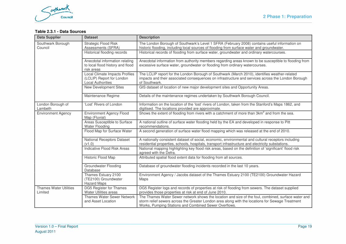
2 Phase 1: Preparation
Version 1.0 – Final Report
August 2011
Page 19
Table 2.3.1 - Data Sources
Data Supplier Dataset Description
Strategic Flood Risk Assessments (SFRA)
The London Borough of Southwark’s Level 1 SFRA (February 2008) contains useful information on historic flooding, including local sources of flooding from surface water and groundwater.
Historical flooding records Historical records of flooding from surface water, groundwater and ordinary watercourses.
Anecdotal information relating to local flood history and flood risk areas
Anecdotal information from authority members regarding areas known to be susceptible to flooding from excessive surface water, groundwater or flooding from ordinary watercourses.
Local Climate Impacts Profiles (LCLIP) Report for London Local Authorities
The LCLIP report for the London Borough of Southwark (March 2010), identifies weather-related impacts and their associated consequences on infrastructure and services across the London Borough of Southwark.
New Development Sites GIS dataset of location of new major development sites and Opportunity Areas.
Southwark Borough Council
Maintenance Regime Details of the maintenance regimes undertaken by Southwark Borough Council.
London Borough of Lambeth
‘Lost’ Rivers of London Information on the location of the ‘lost’ rivers of London, taken from the Stanford’s Maps 1862, and digitised. The locations provided are approximate.
Environment Agency Flood Map (Fluvial)
Shows the extent of flooding from rivers with a catchment of more than 3km2 and from the sea.
Areas Susceptible to Surface Water Flooding
A national outline of surface water flooding held by the EA and developed in response to Pitt recommendations.
Flood Map for Surface Water A second generation of surface water flood mapping which was released at the end of 2010.
National Receptors Dataset (v1.0)
A nationally consistent dataset of social, economic, environmental and cultural receptors including residential properties, schools, hospitals, transport infrastructure and electricity substations.
Indicative Flood Risk Areas National mapping highlighting key flood risk areas, based on the definition of ‘significant’ flood risk agreed with the Defra.
Historic Flood Map Attributed spatial flood extent data for flooding from all sources.
Groundwater Flooding Database
Database of groundwater flooding incidents recorded in the last 10 years.
Environment Agency
Thames Estuary 2100 (TE2100) Groundwater Hazard Maps
Environment Agency / Jacobs dataset of the Thames Estuary 2100 (TE2100) Groundwater Hazard Maps
DG5 Register for Thames Water Utilities areas
DG5 Register logs and records of properties at risk of flooding from sewers. The dataset supplied provides those properties at risk at end of June 2010.
Thames Water Utilities Limited
Thames Water Sewer Network and Asset Location
The Thames Water Sewer network shows the location and size of the foul, combined, surface water and storm relief sewers across the Greater London area along with the locations for Sewage Treatment Works, Pumping Stations and Combined Sewer Overflows.

2 Phase 1: Preparation
Version 1.0 – Final Report
August 2011
Page 20
Data Supplier Dataset Description
Greater London Authority Ordnance Survey Mapping (1:10k, 1:50k, Mastermap)
Ordnance Survey Mapping for the Greater London Area for the 1:10k and 1:50k scale and Mastermap dataset.
London Fire Brigade Historical flooding call-out records
Records of all London Fire Brigade callouts for ‘flooding’ events since 2000. However, no flooding source is provided, so could be a result of water mains bursting as well as heavy rainfall / surface water flooding.
Network Rail Areas Prone To Flooding A list of areas prone to flooding across their South East Territory.
TfL Red Routes Pdf of the TfL Red Routes for the Greater London area
TfL Gullies GIS dataset of the TfL owned / managed gullies along the Red Routes for the Greater London area
Transport for London (TfL)
TfL Pumps Location and pump regimes for TfL owned / managed gullies in the Greater London area
London Underground Flooding records – July 2007 Records relating to station closures (location and duration) on 20th
July 2007 due to heavy rainfall.
British Geological Survey Groundwater Flooding Susceptibility Map
GIS dataset of areas susceptible to groundwater flooding
Groundwater Emergence Maps (GEMs)
GIS dataset of areas of groundwater emergence (GEMs)
Groundwater Flood Map GIS dataset of groundwater flood map
Jacobs / JBA
Increased Potential for Elevated Groundwater (iPEG)
GIS dataset of areas of increased potential for elevated groundwater (iPEG), produced using existing Environment Agency, BGS and Jacobs / JBA datasets, produced for the Greater London area for the purpose of assessing groundwater flood risk as part of the Drain London project.

2 Phase 1: Preparation
Version 1.0 – Final Report
August 2011
Page 21
SECURITY, LICENSING AND USE RESTRICTIONS
2.3.2 A number of datasets used in the preparation of this SWMP are subject to licensing
agreements and use restrictions.
2.3.3 The following national datasets provided by the Environment Agency are available to local
authorities and their consultants for emergency planning and strategic planning purposes:
• Flood Map for Rivers and the Sea
• Areas Susceptible to Surface Water Flooding
• Flood Map for Surface Water
• National Receptor Database
2.3.4 A number of the data sources used are publicly available documents, such as:
• Strategic Flood Risk Assessment
• Catchment Flood Management Plan
2.3.5 The use of some of the datasets made available for the SWMP has been restricted and is
time limited, licensed to Southwark Borough Council via the Greater London Authority for
use under the Drain London project, which includes the production of a SWMP for the
London Borough of Southwark. The restricted datasets include records of property flooding
held by the Council and by Thames Water Utilities Ltd, and data licensed by the Environment
Agency. Necessary precautions must be taken to ensure that all information given to third
parties is treated as confidential. The information must not be used for anything other than
the purpose stated in the agreement. No information may be copied, reproduced or reduced
to writing, other than what is necessary for the purpose stated in the agreement.
2.4 ASSET REGISTER
2.4.1 Section 21 of the FWMA 2010 sets a duty on LLFAs to maintain a register of structures or
features, and a record of information about each of those structures or features, which, in the
opinion of the authority, are likely to have a significant effect on flood risk in its area. From
the 6th April 2011 all LLFAs have a duty to maintain a register. The legal characteristics of
the register and record are in Table 2.4.1.
Table 2.4.1 - Asset Register Requirements
Register Record
a. Must be made available for inspection at all
reasonable times.
Up to the LLFA to decide if they wish to make
it available for inspection
b. Must contain a list of structures or features
which in the opinion of the authority, are likely
to have a significant effect on a local flood
risk.
For each structure or feature listed on the
register, the record must contain information
about its ownership and state of repair.
c. s.21 (2) of the Act allows for further regulations to be made about the content of the register
and record. There is currently no plan to provide such regulations therefore their content
should be decided on by the LLFA depending on what information will be useful to them.
d. There is no legal requirement to have a separate register and record although as indicated
above, only the register needs to be made available for public inspection.

2 Phase 1: Preparation
Version 1.0 – Final Report
August 2011
Page 22
2.4.2 Defra have provided each LLFA with templates to demonstrate what information should be
contained in the asset register. Although these templates are not intended as a working tool,
they provide a good example of how an asset register might be structured.
2.4.3 Populating the asset register is outside the scope of the Drain London project and is the
responsibility of each London Borough. The expectation from Defra is that LLFAs will utilise
a risk-based approach to populate the register and record with those structures or features
considered the most significant first, for example, those within identified Local Flood Risk
Zones and / or Critical Drainage Areas. It is also important to note that the register will be a
‘living’ asset register and grow over time, as more structures and features are identified and
added, and asset information is updated through further information, for example through
surveys of the structures, being made available.
2.4.4 Appendix B contains further information on the Asset Register recommendations for the
London Borough of Southwark.
2.5 PHASE 1 SUMMARY
2.5.1 Phase 1 of the SWMP has:
• Engaged key stakeholders including the Environment Agency and Thames Water, and
the London Boroughs of Merton, Wandsworth and Lambeth, to discuss and agree on
local flood risk management within the London Borough of Southwark in the future;
• Established a local flood risk partnership working approach within the London Borough
of Southwark for managing local flood risk in the future;
• Established a sub-regional flood risk partnership structure for the London Boroughs of
Southwark and Lambeth (along with other key stakeholders) to take forward and
manage flood risk in the future;
• Collected and reviewed flood risk data and knowledge from key stakeholders and
partner organisations;
• Set out recommendations for the London Borough of Southwark’s Asset Register, as
required under the FWMA 2010; and
• Set out the objectives and governance for the Phase 2 – Risk Assessment, Phase 3 –
Options Assessment, and Phase 4- Action Plan phases of the Southwark SWMP.
Recommendation 6: Implement and populate a standardised Asset Register
structure for London Borough of Southwark

3 Phase 2: Risk Assessment
Version 1.0 – Final Report
August 2011
Page 23
3. Phase 2: Risk Assessment 3.1 INTERMEDIATE ASSESSMENT
3.1.1 The aim of the Phase 2 Intermediate Risk Assessment is to identify the sources and
mechanisms of surface water flooding across the study area which will be achieved through
an intermediate assessment of pluvial flooding, sewer flooding, groundwater flooding and
flooding from ordinary watercourses along with the interactions with main rivers and the sea.
The modelling outputs will then be mapped using GIS software.
3.1.2 Table 3.1.1 defines the potential levels of assessment within an SWMP. This SWMP has
been prepared at the ‘Borough’ scale and fulfils the objectives of a second level
‘Intermediate Assessment’.
Table 3.1.1 - SWMP Study Levels of Assessment [Defra 2010]
Level of Assessment Appropriate Scale Outputs
1. Strategic Assessment Greater London
Broad understanding of locations that are more
vulnerable to surface water flooding.
Prioritised list for further assessment.
Outline maps to inform spatial and emergency
planning.
2. Intermediate Assessment Borough wide
Identify flood hotspots which might require
further analysis through detailed
assessment.
Identify immediate mitigation measures
which can be implemented.
Inform spatial and emergency planning.
3. Detailed Assessment Known flooding
hotspots
Detailed assessment of cause and
consequences of flooding.
Use to understand the mechanisms and test
mitigation measures, through modelling of
surface and sub-surface drainage systems.
3.1.3 As shown in Table 3.1.1, the intermediate assessment is applicable across a large town, city
or Borough. In the light of extensive and severe historical flooding and the results from the
over-arching national pluvial modelling2 suggesting that there are 60,700 properties at risk
across the Borough for a rainfall event with a 1 in 200 probability of occurrence in any given
year, it is appropriate to adopt this level of assessment to further quantify the risks.
3.1.4 The purpose of this intermediate assessment will be to further identify those parts of the
Borough that are likely to be at greater risk of surface water flooding and require more
detailed assessment. The methodology used for this SWMP is summarised below and
further detail of the methodology is provided in Appendix C.
• 2-Dimensional Pluvial modelling (using TuFLOW software) has been undertaken
following a Direct Rainfall approach. Rainfall events of known probability are applied
directly to the ground surface and water is routed overland to provide an indication of
2 Source: Environment Agency National Property Count for the Flood map for Surface Water (FMfSW) dataset.

3 Phase 2: Risk Assessment
Version 1.0 – Final Report
August 2011
Page 24
potential flow path directions, velocities and depths and areas where surface water will
pond;
• The 2-Dimensional pluvial modelling has been supported by field visits and visual
surveys have been undertaken in conjunction with Southwark Borough Council staff
and/or Environment Agency staff; and
• The outputs from the pluvial modelling are verified (where possible) against historic
surface water flood records and local knowledge.
3.2 RISK OVERVIEW
MAPPING OF SURFACE WATER FLOOD RISK
3.2.1 The mapping shown within this report is suitable to identify broad areas which are more likely
to be vulnerable to surface water flooding. This allows Southwark Borough Council and its
partners to undertake more detailed analysis in areas which are most vulnerable to surface
water flooding.
3.2.2 In addition, the mapping can also be used as an evidence base to support the spatial
planning to ensure that surface water flooding is appropriately considered when allocating
land for housing development. The map can be used to assist emergency planners in
preparing their Multi-Agency response plans.
3.2.3 Please note that the mapping only shows the predicted likelihood of surface water flooding
(this includes flooding from drains, small watercourses and ditches that occurs in heavy
rainfall in urban areas) for defined areas, and due to the coarse nature of the source data
used, are not detailed enough to account for precise addresses. Individual properties
therefore may not always face the same probability of flooding as the areas that surround
them.
3.2.4 There may also be particular occasions when flooding occurs and the observed pattern of
flooding does not in reality match the predicted patterns shown on these maps. We have
done all we can to ensure that the maps reflect all the data we possess and have applied our
expert knowledge to create conclusions that are as reliable as possible. It is essential that
anyone using these maps fully understands the complexity of the data utilised in production
of the maps, is aware of the limitations and does not use the maps in isolation.
3.2.5 The Greater London Authority, Southwark Borough Council and Tier 1 and Tier 2 Drain
London Consultants cannot be held responsible for misuse or misunderstanding of the maps
provided as part of the SWMP.
FLOODING CLASSIFICATION
3.2.6 Flood risk within the London Borough of Southwark has been classified based on the source
of flooding (surface water, groundwater, fluvial / tidal and/or sewer) and scale (Local Flood
Risk Zones (LFRZs), Critical Drainage Areas (CDA), Policy Areas (PA) and Indicative Flood
Risk Zones). These categories are discussed in more detail below.
Source of Flood Risk
3.2.7 A range of classifications have been devised for use in the SWMP to identify the primary
source(s) of flood risk to areas throughout the Borough identified through the SWMP Phase
2 Risk Assessment to be at a greater risk of surface water flooding (Table 3.2.1). These
classifications have been used to inform the SWMP Action Plan (Section 5) as they also
define probable areas of flood mitigation and management responsibility.

3 Phase 2: Risk Assessment
Version 1.0 – Final Report
August 2011
Page 25
Table 3.2.1 - SWMP Flooding Source Classification
Flood Source
Classification
Output from
Pluvial
Modelling
Output from
Groundwater
Flood Risk
Assessment
EA Flood Map –
Zone 3 – Areas
not benefiting
from defences
DG5
Records
only
Surface Water* ����
Groundwater ����
Fluvial / Tidal ����
Sewer ����
Surface Water and
Groundwater ���� ����
Groundwater and Fluvial /
Tidal** ���� ����
Surface Water and Sewer ���� ����
Surface Water
and Fluvial / Tidal ����*** ����
Surface Water, Groundwater
and Fluvial / Tidal** ����*** ���� ����
Surface Water, Groundwater
and Sewer ���� ���� ����
All Sources ���� ���� ���� ����
Notes:
* Surface Water = Surface Water and / or Ordinary Watercourse
** Areas where surface water and / or groundwater flooding are fully within the EA Zone 3 (areas not
benefiting from defences) are highlighted as having a primary influence from Fluvial / Tidal flooding.
*** Where pluvial modelling outputs demonstrate flooding significantly greater than Flood Zone 3,
these areas should be classified as ‘pluvial flooding areas’.
Scale of Flood Risk
3.2.8 As part of the Drain London Project, the scale of flooding has been classified as follows, from
smallest to largest:
1. Local Flood Risk Zone (LFRZ, managed at the local scale)
2. Critical Drainage Area (CDA, containing one or more Local Flood Risk Zones –
managed at the local scale)
3. Policy Areas (PA, containing one or more Critical Drainage Areas and covering the
entire Borough)
4. Indicative Flood Risk Area (as defined by the Environment Agency / Defra Indicative
Flood Risk Areas – an area approximately covering the entire Greater London Area
and managed at a strategic scale)
3.2.9 The flood risk hierarchy is illustrated in Figure 3.2.1. Further information on the scale of
flooding and flood risk management areas identified in the London Borough of Southwark
are provided in Table 3.2.2.

3 Phase 2: Risk Assessment
Version 1.0 – Final Report
August 2011
Page 26
Figure 3.2.1 - Scale of Flood Risk Hierarchy
Local Flood Risk Zone (LFRZ)
Indicative Flood Risk Area Policy Area Critical Drainage Area

3 Phase 2: Risk Assessment
Version 1.0 – Final Report
August 2011
Page 27
Table 3.2.2 - SWMP Flood Risk Management Areas
Scale Definition Description Southwark-Specific Areas
Local
Flood Risk
Zone
(LFRZ)
“Discrete areas of flooding that
affect houses, businesses or
infrastructure”.
The LFRZ is defined as the actual spatial extent of predicted flooding in a
single location. Related LFRZs can be grouped together as a Critical
Drainage Area or left in isolation and considered within the larger Policy
Areas.
• Herne Hill
• Dulwich
• London Bridge Station & Guy’s Hospital
• Comber Grove
• Brunswick Park
• King’s College Hospital (Lambeth)
• Railway Cutting West of Denmark Hill
Station
• Coleman Road / Newent
• South Old Kent Road Area
Critical
Drainage
Area
(CDA)
“A discrete geographic area (usually
a hydrological catchment) where
multiple and interlinked sources of
flood risk (surface water,
groundwater, sewer, main river
and/or tidal) cause flooding in one
or more Local Flood Risk Zones
during severe weather thereby
affecting people, property or local
infrastructure.”
CDA units are larger than LFRZs and denote an area or catchment where
mitigation measures may be implemented to reduce flooding experienced
in the flood risk zone. The CDA comprises the upstream ‘contributing’
catchment, the influencing drainage catchments, surface water catchments
and, where appropriate, a downstream area if this can have an influence on
the LFRZ. CDA units should be used for site specific detailed planning and
capital works schemes and may contain one or more LFRZs.
Note: CDAs have been given an identification number, based on the Drain
London Sub-Regional Partnership Group Number, and have been defined
across the group. Therefore, CDA numbers start at 032 for the London
Borough of Southwark.
• Group7_032 (Herne Hill)
• Group7_035 (London Bridge)
• Group7_036 (Camberwell)
• Group7_037 (Central Southwark)
• Group7_038 (East Southwark)
Policy
Area (PA)
“A discrete area within an
administrative area where
appropriate planning policy can be
applied to manage flood risk.”
Policy Areas contain one or more CDAs and cover the entire study area.
Policy Areas are primarily based on hydrological catchments but may also
accommodate geological concerns and other factors as appropriate. Policy
areas may be used to provide guidance on general policy across the study
area e.g. the use of soakaways in new development.
Given the complex and interlinked surface
water flooding within the London Borough of
Southwark, it has been agreed that only one
Policy Area should be defined in the London
Borough of Southwark, covering the entire
administrative area.
Indicative
Flood Risk
Area
“Areas determined by the
Environment Agency as indicatively
having a significant flood risk, based
on guidance published by Defra and
WAG and the use of certain national
datasets.”
Indicative Flood Risk Areas are defined by the Environment Agency / Defra
primarily for the purposes of the preparation of PFRAs. The Greater London Area has been
identified as an Indicative Flood Risk Area,
with 696,805 people at risk from surface
water flooding deeper than 0.3 metres during
a 0.5% AEP rainfall event (based on FMfSW
outputs).

3 Phase 2: Risk Assessment
Version 1.0 – Final Report
August 2011
Page 28
3.3 SURFACE WATER FLOODING
MECHANISM OF FLOODING
3.3.1 Pluvial flooding occurs when high intensity rainfall generates runoff which flows over the
surface of the ground and ponds in low lying areas, before the runoff enters any watercourse
of sewer. It is usually associated with high intensity rainfall events and can be exacerbated
when the soil is saturated and natural drainage channels or artificial drainage systems have
insufficient capacity to cope with the additional flow.
3.3.2 No single organisation has overall responsibility for surface water flooding with different
aspects of the drainage system falling to either The Highway Authority (in this case
Southwark Borough Council), Thames Water, riparian owners and Transport for London (red
routes including the A205, A202 and A2).
BOROUGH-WIDE PLUVIAL MODELLING – DIRECT RAINFALL APPROACH
3.3.3 In order to continue developing an understanding of the causes and consequences of
surface water flooding in the study area, intermediate level hydraulic modelling has been
undertaken for a range of rainfall event probabilities. This hydraulic modelling has been
designed to provide additional information where local knowledge is lacking and forms a
basis for future detailed assessments in areas identified as high risk.
3.3.4 A Direct Rainfall approach using TuFLOW software has been selected whereby rainfall
events of known probability are applied directly to the ground surface and is routed overland
to provide an indication of potential flow path directions and velocities and areas where
surface water will pond. A full methodology of the hydraulic modelling undertaken is
included in Appendix C.
3.3.5 Figures 3.3.1 and 3.3.2 show the modelling results for London Borough of Southwark for the
1% AEP rainfall event for depth and hazard3, respectively.
3 Flood Hazard has been defined based upon the joint Environment Agency and Defra Research and Development Technical
Report FD2320 (January 2006) and uses surface water flood depths and velocities to categorise the flood hazard. The degree
of flood hazard can be interpreted as follows: (a) Caution: Flood zone with shallow flowing water or deep standing water; (b)
Moderate: Flood zone with deep or fast flowing water. Dangerous for children, the elderly and the infirm; (c) Significant: Flood
zone with deep fast flowing water. Dangerous for most people; and, (d) Extreme: Flood zone with deep fast flowing water.
Dangerous for all (including emergency services)
Figure 3.3.1 – Surface Water Flood Depth (1% AEP)
Figure 3.3.2 – Surface Water Flood Hazard (1% AEP)

3 Phase 2: Risk Assessment
Version 1.0 – Final Report
August 2011
Page 29
3.3.6 Figures for the other modelled return periods are included in Appendix D (Figures D9 - D16).
A summary of the suggested use for each mapped output is provided Table 3.3.1.
Table 3.3.1 - Modelled Return Periods and Suggested Use
Modelled Return Period Suggested Use
1 in 30 probability of rainfall event
occurring in any given year (3.3% AEP)
Since 1980, with the introduction of Sewers for
Adoption, Thames Water sewers are required to be
designed to accommodate 3.3% AEP rainfall event or
less. However, many of the sewers in London were
built pre-1980 and as such, are likely to have a lower
capacity. This layer will identify areas that are prone to
regular flooding and could be used by highway teams
to inform maintenance regimes.
1 in 75 probability of rainfall event
occurring in any given year (1.3% AEP)
In areas where the likelihood of flooding is 1 in 75
years or greater insurers will not guarantee to provide
cover to property should it be affected by flooding. This
GIS layer should be used to inform spatial planning as
if property can not be guaranteed insurance, the
development may not be viable.
1 in 100 probability of rainfall event
occurring in any given year (1% AEP)
Can be overlaid with Environment Agency Flood Zone
3 GIS layer to show areas at risk under the same event
from both sources. Can be used to advise planning
teams.
1 in 100 probability of rainfall event
occurring in any given year (1% AEP)
plus 30% climate change
PPS25 requires that the impact of climate change is
fully assessed. Reference should be made to this flood
outline by the spatial planning teams to assess the
sustainability of developments.
1 in 200 probability of rainfall event
occurring in any given year (0.5% AEP)
To be used by emergency planning teams when
formulating emergency evacuation plans from areas at
risk of flooding.
HYDROLOGICAL SITE INSPECTIONS
3.3.7 To support the pluvial modelling results and historical records, hydrological site inspections
were undertaken on 25th January 2011 and then on 17
th March 2011 with a member of the
Asset Management team from Southwark Borough Council to provide detailed knowledge on
the sources and mechanisms of flooding at these locations as well as information regarding
the improvement works that have been implemented. Site photographs were taken, and are
included in this report where necessary.
HISTORICAL FLOODING
3.3.8 Southwark Borough Council has provided a GIS dataset of historical surface water flood
events. These records are shown in Figure D-2 in Appendix D. However, it should be noted
that historically, flooding incidents have not been recorded centrally within the council, and
as such, the records provided are fairly sparse. It should also be noted, that, in many cases
the historic flooding information provided is anecdotal and does not include records of
antecedent conditions giving rise to the flooding (therefore typically not attributed to a flood
source) or reference to a flood return period.

3 Phase 2: Risk Assessment
Version 1.0 – Final Report
August 2011
Page 30
3.3.9 Table 3.3.2 provides a summary of past flood incidents in the study area, and those areas
prone to surface water flooding during periods of heavy rainfall based on historical records
collected as part of Drain London Tier 1, and discussions with the key stakeholders as part
of the Tier 2 study.
Table 3.3.2 - Areas Prone to Surface Water Flooding in the London Borough of
Southwark
Flood Event Description
Intense periods of rainfall in the south of the Borough caused extensive
surface water flooding which inflicted damage on residents and their
homes, public services and private businesses in the Dulwich, East
Dulwich and Herne Hill. A reported 60mm of rain fell in just under one
hour.
Residential properties flooded (some residents could not return to their
properties for 6 months)
Commercial properties flooded (some commercial properties remained
closed for 3 months)
Local schools were closed including Chester School in Dulwich which was
closed on Wednesday 28th April.
Severe traffic disruptions were reported, particularly on East Dulwich
Road and Lordship Lane where the majority of the flooding occurred.
Drivers in Dulwich Village had to abandon their cars as roads became
rivers deeper than 300mm.
Fire engines had to pump out water from flooded cellars and basements.
27th
April 2004
(Surface Water Flooding)
Costs of flooding in 2004 have been put at a minimum of £1 million
pounds (according to Floods in Southwark Report March 2005 as
referenced in Southwark LCLIP Report)
14th
June 2006
(Surface Water Flooding)
Heavy rainfall (40mm in an hour) caused surface water flooding in some
parts of the Borough and the closure of Rotherhithe Station (Source:
Southwark LCLIP report)
20th
July 2007
(Surface Water Flooding)
Heavy rainfall caused Surrey Quays railway station to be closed for 3
hours due to flooding on 20th July 2007. (Source: Network Rail)
3.3.10 The most recent significant flood event occurred during April 2004, when intense periods of
rainfall exceeded the capacity of existing drainage systems, causing significant overland flow
and ponding of surface water in low lying areas. In the recent floods of 2007 which affected
many neighbouring Boroughs, no significant flooding incidents were recorded in the
Borough.
Recommendation 7: Implement a standardised Flood Incident Log to record and
investigate future flooding incidents within the London Borough of Southwark

3 Phase 2: Risk Assessment
Version 1.0 – Final Report
August 2011
Page 31
3.4 ORDINARY WATERCOURSE FLOODING
3.4.1 Ordinary watercourse flooding includes flooding from small open channels and culverted
urban watercourses4. These small channels often receive most of their flow from inside the
urban area and perform an urban drainage function.
3.4.2 The Environment Agency has responsibility over flooding from designated Main Rivers,
however the responsibility for maintenance of small open channels and culverted urban
watercourses which are not designated as ‘main river’ falls to Southwark Borough Council
and riparian owners who own land on either bank i.e. Southwark Borough Council is only
responsible for ordinary watercourses where land on either bank is in council ownership, or
where historical agreements have been made.
3.4.3 The Detailed River Network (DRN) has been provided by the Environment Agency and
identifies any non-main rivers within the London Borough of Southwark (Figure 3.4.1). This
shows that there are three ordinary watercourses to the northeast of the Borough in the
Rotherhithe area (tributaries of the River Thames). Though the dataset does not identify any
further ordinary watercourses in the Borough it is thought there are several hidden
watercourses, which have been culverted or routed underground, though no further
information relating to these is available at the time of this study.
4 All watercourses that are not designated Main River, and which are the responsibility of Local Authorities
Recommendation 8: Identify and map (in GIS) all Ordinary and Hidden
Watercourses within the London Borough of Southwark, including their condition
and function where known
Figure 3.4.1 – Environment Agency Flood Map and Fluvial Flood Incidents

3 Phase 2: Risk Assessment
Version 1.0 – Final Report
August 2011
Page 32
3.5 GROUNDWATER FLOODING
MECHANISM OF FLOODING
3.5.1 Groundwater flooding occurs as a result of water rising up from the underlying aquifer or
from water flowing from abnormal springs. This tends to occur after much longer periods of
sustained high rainfall, and the areas at most risk are often low-lying where the water table is
likely to be at shallow depth. Groundwater flooding is known to occur in areas underlain by
principal aquifers, although increasingly it is also being associated with more localised
floodplain sands and gravels.
3.5.2 Groundwater flooding tends to occur sporadically in both location and time, and tends to last
longer than fluvial, pluvial or sewer flooding. When groundwater flooding occurs, basements
and tunnels can flood, buried services may be damaged, and storm sewers may become
ineffective, exacerbating the risk of surface water flooding. Groundwater flooding can also
lead to the inundation of farmland, roads, commercial, residential and amenity areas.
3.5.3 It is also important to consider the impact of groundwater level conditions on other types of
flooding e.g. fluvial, pluvial and sewer. High groundwater level conditions may not lead to
widespread groundwater flooding. However, they have the potential to exacerbate the risk of
pluvial and fluvial flooding by reducing rainfall infiltration capacity, and to increase the risk of
sewer flooding through sewer / groundwater interactions.
3.5.4 The need to improve the management of groundwater flood risk in the UK was identified
through Defra’s Making Space for Water strategy. The review of the July 2007 floods
undertaken by Sir Michael Pitt highlighted that at the time no organisation had responsibility
for groundwater flooding. The FWMA 2010 identified new statutory responsibilities for
managing groundwater flood risk, in addition to other sources of flooding and has a
significant component which addresses groundwater flooding.
3.5.5 Based on the hydrogeological conceptual understanding of the London Borough of
Southwark study area, the potential groundwater flooding mechanisms that may exist are
provided in Table 3.5.1.
Table 3.5.1 - Potential Groundwater Flooding Mechanisms in Southwark
Potential Flooding Mechanism Description
Claygate Member (bedrock)
outcrop in Dulwich / Crystal
Palace area
Water levels within the outcropping Claygate Member will be
perched on top of the London Clay Formation aquiclude. This
means that basements / cellars in this area may be at risk from
groundwater flooding following periods of prolonged rainfall,
increased utilisation of infiltration SuDS and / or artificial
recharge from leaking pipes.
Chalk Formation, Thanet Sand
Formation and Lambeth Group
outcrop where overlying
superficial deposits are
permeable and ground
elevations are low (e.g.
Southwark Park area)
Groundwater flooding is often associated with Chalk catchments,
which allow groundwater levels to rise to the near surface
through permeable subsoil following long periods of wet weather
and / or reductions in historic abstractions. Therefore,
basements / cellars in this area may be at risk from groundwater
flooding following periods of prolonged rainfall, decreased
abstraction, increased utilisation of infiltration SuDS and / or
artificial recharge from leaking pipes.
Superficial aquifers along the
River Thames
Groundwater flooding may be associated with the substantial
sand and gravel River Terrace Deposits, or to a lesser degree
with Head and Alluvium deposits, where they are in hydraulic

3 Phase 2: Risk Assessment
Version 1.0 – Final Report
August 2011
Page 33
Potential Flooding Mechanism Description
continuity with surface watercourses. River levels may rise
following high rainfall events but still remain ‘in-bank’, and this
can trigger a rise in groundwater levels in the associated
superficial deposits. The properties at risk from this type of
groundwater flooding are probably limited to those with
basements / cellars, which have been constructed within the
superficial deposits. It is noted that groundwater / surface water
interactions will be limited by defence works to the River
Thames. However, without evidence in the form of groundwater
levels, this groundwater flooding mechanism cannot be ruled
out.
Superficial aquifers not in
hydraulic continuity with surface
watercourses (various locations)
Groundwater flooding is associated with substantial River
Terrace Deposits (gravel and sand), Head deposits and Sand
and Gravel of Uncertain age, but occurs where they are not
hydraulically connected to surface watercourses. Perched
groundwater tables can exist within these deposits, developed
through a combination of natural rainfall recharge and artificial
recharge e.g. leaking water mains. The properties at risk from
this type of groundwater flooding are probably limited to those
with basements / cellars. It is also worth noting that groundwater
levels are likely to be closer to ground level in those areas where
historic / lost rivers were located i.e. where ground elevation is
lower.
Impermeable (silt and clay)
areas downslope of superficial
aquifers
Groundwater flooding may occur where groundwater springs /
seepages form minor flows and ponding over impermeable
strata where there is poor drainage. This mechanism may occur
as a result of natural (e.g. rainfall) or artificial (e.g. water main
leakage) recharge.
Artificial ground in various
locations
Groundwater flooding may occur where the ground has been
artificially modified to a significant degree. If this artificial ground
is of substantial thickness and permeability, then a shallow
perched water table may exist. This could potentially result in
groundwater flooding at properties with basements, or may
equally be considered a drainage issue. Areas mapped by the
BGS as containing artificial ground are shown in Figures D-7
and D-8 in Appendix D. Artificial ground deposits over the
London Clay Formation in the south, or Alluvium in the
Rotherhithe area, may allow for the development of a perched
aquifer depending on the composition of the artificial ground.

3 Phase 2: Risk Assessment
Version 1.0 – Final Report
August 2011
Page 34
HISTORICAL FLOODING
3.5.6 Figure 3.5.1 shows the locations of a number of groundwater flooding incidents between
2000 and 2010 within the study area that have been reported by the Environment Agency
and Southwark Borough Council. Further details are presented in Appendix C2.
3.5.7 It should be noted that there has not been a statutory obligation to record incidences of
groundwater flooding in the past. It is therefore likely that this list of groundwater flooding
incidents is not exhaustive.
3.5.8 The historical records show that many of the flooding incidents are referenced as flooding of
cellars / basements, which is a common outcome of a rising water table following a period of
heavy or persistent rainfall, particularly in shallow aquifers often associated with superficial
deposits.
3.5.9 Each recorded incident has been appraised based on the underlying geology and the
potential groundwater flooding mechanisms identified. Further information on the appraisal of
the records are provided in Appendix C2.
Figure 3.5.1 – Groundwater Flooding Records & Increased Potential for Elevated
Groundwater Map

3 Phase 2: Risk Assessment
Version 1.0 – Final Report
August 2011
Page 35
INCREASED POTENTIAL FOR ELEVATED GROUNDWATER
3.5.10 Areas where there is increased potential for groundwater levels to rise within 2m of ground
surface, following periods of higher than average recharge, are shown in Figure 3.5.1. These
are separated into permeable superficial deposits and bedrock (consolidated) aquifers. The
data set was produced for the whole of the Drain London project area, derived from four
individual data sources:
• British Geological Survey (BGS). Groundwater Flood Susceptibility maps;
• Environment Agency (EA). Thames Estuary, 2100 groundwater hazard maps;
• Jacobs. Groundwater emergence maps; and
• JBA. Groundwater flood maps.
3.5.11 Owing to the presence of the London Clay Formation aquiclude across much of the
Southwark BC area and suppressed bedrock groundwater levels, the main groundwater
flooding mechanisms are associated with perched groundwater tables within permeable
superficial deposits.
3.5.12 Figure 3.5.1 shows that within the London Borough of Southwark area, the increased
potential for elevated groundwater is associated with permeable superficial deposits, and to
a lesser degree bedrock (consolidated) aquifers where the Thanet Sand Formation outcrops
and the Langley Silt Member is absent. This is in broad agreement with the groundwater
flooding mechanisms identified. The permeable superficial deposits that have been identified
as having an increased potential for elevated groundwater are the River Terrace Deposits
and Head. In addition, some areas of artificial ground such as those in Rotherhithe or Honor
Oak are also identified as having an increased potential for elevated groundwater.
3.5.13 In general, the areas identified by the data as having an increased potential for elevated
groundwater are sensible. There is a good correlation with reported groundwater flooding
incidents in the northern half of the Southwark. Although there is a poor correlation in the
southern half of the Borough, it is possible that many of the groundwater incidents in the
southern area are misreported i.e. they may not be related to groundwater conditions.
SUMMARY OF GROUNDWATER FLOODING SUSCEPTIBILITY
3.5.14 The current susceptibility to groundwater flooding is provided in Table 3.5.2.
Table 3.5.2 - Current Groundwater Susceptibility Flooding Mechanisms
Flooding Mechanism Description
Locations where Lambeth Group
/ Thanet Sand Formation (Basal
Sands) are overlain by
permeable River Terrace
Deposits in the Bermondsey and
Camberwell area
The Lambeth Group and Thanet Sand Formation are both
secondary aquifers and are water bearing. The mapping (Figure
3.5.1) suggests that there is increased potential for elevated
groundwater levels in the Camberwell area where these aquifers
are overlain by the permeable Kempton Park Gravel Formation
deposits. In addition, the Environment Agency water level data
for the Chalk aquifer suggests that there is increased potential
for elevated groundwater in the Bermondsey area near
Southwark Park. Groundwater levels in the Lambeth Group and
Thanet Sand Formation will be, in part, dependent on the degree
of hydraulic continuity with the Chalk aquifer and the presence of
clay horizons. Site specific investigations should therefore be

3 Phase 2: Risk Assessment
Version 1.0 – Final Report
August 2011
Page 36
Flooding Mechanism Description
carried out to confirm the depth to groundwater and monitor
seasonal fluctuations before development takes place.
Locations where the Chalk
Formation is overlain by
Alluvium in the Bermondsey and
Camberwell area
The Upper Chalk is a principal aquifer and is therefore water
bearing. The aquifer outcrops beneath the superficial deposits in
a small area between Bermondsey and Camberwell. However,
the outcrop is mostly confined by Alluvium superficial deposits,
which are understood to act as an aquitard. Therefore, Figure
3.5.1 largely indicates that there is a reduced potential for
elevated groundwater levels. Nonetheless, site specific
investigations should be carried out to confirm the depth to
groundwater and the thickness and permeability of the overlying
superficial deposits before development takes place. Deeper
structures, such as basements, may still be vulnerable to
groundwater flooding, as Chalk groundwater levels are possibly
only a few metres below ground level.
Locations where London Clay
Formation outcrops at surface in
the southern half of Southwark
The London Clay Formation is an aquiclude and does not permit
groundwater flow. Therefore in areas where there are no
overlying superficial deposits and the London Clay Formation is
of an appreciable thickness, the potential for elevated
groundwater levels is considered to be negligible. However,
where the London Clay Formation has been removed and
replaced with more permeable artificial ground, there may be
increased potential of elevated groundwater as groundwater
becomes trapped in these deposits. Finally, it is possible that
groundwater springs could emerge from permeable superficial
deposits and flow over the London Clay Formation, contributing
to flood waters. However, surface water flooding is likely to be
the main source of flooding in these areas.
Locations where London Clay
Formation is overlain by River
Terrace Deposits in the
northwest of Southwark
Figure 3.5.1 shows that the River Terrace Deposits in this area
have an increased potential for elevated groundwater. Whilst no
groundwater level data are available for the superficial deposits,
where groundwater tables exist they are expected to be close to
or at ground level. Therefore basements and cellars may be at
risk from groundwater flooding and use of structures such as
sheet piling may exacerbate the problem if they intercept the
water table. Superficial deposits are likely to be variable in
composition across the Southwark area. Site investigation will be
key for any proposed development sites, to understand the local
groundwater conditions, particularly those areas located near to
lost rivers (where topographic lows exist).
Locations where Claygate
Member is underlain by London
Clay Formation (Crystal Palace
area)
The Claygate Member is classified as a secondary aquifer and is
water bearing, with potential for a perched groundwater table(s)
on the London Clay Formation aquiclude. Consequently, site
specific investigations will be important for any proposed
development sites, particularly those considering basements /
underground structures such as soakaways
3.5.15 Susceptibility to groundwater flooding in the Southwark area may change as a result of
climate change, changes to water management or groundwater abstraction. Further data
collection and development / use of a numerical groundwater model would be useful in
estimating the relative importance of these factors as part of a more detailed study.

3 Phase 2: Risk Assessment
Version 1.0 – Final Report
August 2011
Page 37
3.5.16 One of the climate change predictions includes an increase of high rainfall events. This could
lead to further groundwater flooding in the Southwark area due to increased perched
groundwater levels and associated spring flows. It is also noted that a shift in drainage
policy, with increased infiltration SUDS, may also lead to increased incidents of groundwater
flooding. The small perched superficial deposit aquifers will be sensitive to increased
recharge due to their limited storage capacity.
GROUNDWATER RISK ASSESSMENT CONCLUSIONS
3.5.17 Based on the Groundwater Assessment undertaken as part of this SWMP (Appendix C2),
the following conclusions can be drawn:
• The London Clay Formation hydraulically separates the underlying Chalk principal
aquifer and Basal Sands (Thanet Sand Formation and Lambeth Group) secondary
aquifers from the overlying superficial deposits in the majority of the southern half and
northwest area of Southwark. However, in the Camberwell and Bermondsey area the
London Clay Formation is absent and hydraulic continuity between bedrock and
superficial deposit aquifers may exist. Whilst there is good monitoring of Chalk
groundwater levels in the area, the Environment Agency / Southwark council do not
currently monitor groundwater levels in the superficial deposits or Basal Sands
aquifer.
• A perched water table(s) may exist within the Claygate Member in the south east
(near to Crystal Palace). However, there is no monitoring of this unit by either the
Environment Agency or Southwark council.
• A number of potential groundwater flooding mechanisms have been identified. Of
significance are those associated with (i) elevated groundwater levels in the Chalk
and Thanet Sand Formation aquifers in the Bermondsey and Camberwell area and
hydraulic interactions with the superficial deposits, (ii) superficial aquifers not in
hydraulic continuity with surface watercourses or bedrock aquifers (iii) superficial
aquifers in hydraulic continuity with the River Thames. Underground structures
including basements and cellars are at most risk from groundwater flooding.
• Areas with increased potential for elevated groundwater have been identified using a
number of data sets, including the BGS groundwater flooding susceptibility data set.
These appear to be sensible; they are in broad agreement with the identified
groundwater flooding mechanisms i.e. they highlight areas of low ground level with
permeable bedrock and superficial aquifers.
• Groundwater flooding incident data provided by the Environment Agency have been
assessed and a reasonable correlation exists with areas mapped as having an
increased potential for elevated groundwater; the correlation is good in the northern
half of Southwark BC and poor in the southern half. However, the incidents in the
southern half are thought to be related to poor drainage over impermeable strata i.e.
they are not groundwater flooding incidents. Although there is a small likelihood they
are a result of (i) the BGS groundwater flooding susceptibility data set not taking into
account groundwater springs / seepages from superficial deposits that flow onto the
impermeable London Clay Formation, or (ii) the increased potential for elevated
groundwater data set needing to be refined.
• The majority of the Southwark BC area has been identified as potentially unsuitable
for infiltration SUDS owing to the impermeable London Clay Formation. Where the

3 Phase 2: Risk Assessment
Version 1.0 – Final Report
August 2011
Page 38
London Clay Formation is absent or where River Terrace Deposits exist, enhanced
site investigation is required to confirm that infiltration SUDS are suitable.
• The assessment of increased potential for elevated groundwater and suitability for
infiltration SUDS could be improved by additional groundwater level / river stage
monitoring and the development / use of a numerical groundwater model.
3.6 SEWERS
FLOODING MECHANISM
3.6.1 During heavy rainfall, flooding from the sewer system may occur if:
1. The rainfall event exceeds the capacity of the sewer system / drainage system
Since the late 1970s, and with the publication of Sewers for Adoption5 in 1980, sewer
systems have typically been designed constructed to accommodate a rainfall event with a 1
in 30 probability of occurrence in any given year (3.3%) or less. Therefore, rainfall events
with a rainfall probability of greater than 3.3% AEP would be expected to result in
surcharging of some of the sewer system. While Thames Water is concerned about the
frequency of extreme events, it is not economically viable to build sewers that could cope
with every extreme. It is important to note that most of the sewer system in London was built
prior to the 1970s, and in many cases has a capacity of far less than 3.3% AEP. The London
Borough of Southwark is served by a combined sewer system and it is thought that many
parts of the system are only designed to accommodate a rainfall event with a 1 in 15
probability of occurring in any given year (6.6% AEP).
2. The system becomes blocked by debris or sediment
Over time there is potential that road gullies can become blocked from fallen leaves, build up
of sediment and debris (e.g. litter).
3. The system surcharges due to high water levels in receiving watercourses
Within the Borough there is potential for sewer outfalls to rivers to become submerged during
high water levels (either fluvial or tidal). When this happens, water is unable to escape into
the river and flows back along the sewer. Once storage capacity within the sewer itself is
exceeded, the water will overflow into streets and houses.
RESPONSIBLE ORGANISATIONS
3.6.2 The Highway Authority (Southwark Borough Council and TfL in the case of red routes
including the A205, A202 and A2) are responsible for the effectual drainage of roads in so far
as ensuring that drains, including kerbs, road gullies and the pipe network which connects to
the trunk sewers are maintained (Figure 3.6.1).
5 The Sewers for Adoption guide was first issued in 1980 by WRc. Since then the document has become the standard for the
design and construction of sewers to adoptable standards in England and Wales. It acts as a guide to assist developers in
preparing their submission to a sewerage undertaker before they enter into an Adoption Agreement under Section 104 of the
Water Industry Act 1991
Recommendation 9: Work with the Environment Agency to record and investigate
groundwater flooding incidents and mechanisms

3 Phase 2: Risk Assessment
Version 1.0 – Final Report
August 2011
Page 39
3.6.3 Thames Water are responsible for surface water drainage from development via adopted
sewers and are responsible for maintaining trunk sewers into which much of Southwark’s
highway drainage connects.
3.6.4 Riparian owners are responsible for private drainage networks and receiving watercourses
where they are small open channels and culverted urban watercourses.
Figure 3.6.1 - Surface Water Drainage Responsibility
3.6.5 In addition to the Thames Water network, there are also some sewers and drains which are
in private ownership. Most of these private systems connect to the Thames Water public
sewerage system for treatment; however private owners can also connect foul water to
septic tanks and storm water to soakaways.
THAMES WATER DATA
DG5 Register
3.6.6 Thames Water has provided their DG5 database which details the total number of properties
at risk of sewer flooding (both externally and internally) at the end of June 2010. The DG5
dataset is provided on a four-digit postcode area, which makes it difficult to determine more
precisely where sewer flooding risk is greatest. The number of records for each postcode
district have been summed to provide area-based sewer flooding risk dataset (Figure D-5 –
Appendix D). In addition, Thames Water focus their efforts on removing properties from the
DG5 register, and therefore this dataset may no longer accurately represent those properties
which are currently at risk.
3.6.7 The sewer flooding records highlight the following areas as being at a higher risk of sewer
flooding (numbers in brackets indicate number of records of sewer flooding incidents):
• Dulwich (including Dulwich Village) – Postcode Districts SE21 7 (105);
• East Dulwich – Postcode Districts SE22 0 (30) and SE22 8 (31); and
• Herne Hill (including Half Moon Lane) – Postcode District SE24 9 (53).
Sewer Network Location
3.6.8 Thames Water has also provided details of their utility infrastructure including sewers,
pumping stations and outfalls. This information has been overlaid onto CDAs to inform
potential mitigation options for each location. Thames Water is keen to work with Councils in
order to mitigate flood risk issues. Where required to inform detailed design of mitigation
options, Thames Water have agreed to make network models available. Figure D-4 shows
the Thames Water sewer network serving the London Borough of Southwark.
Gully
chamber
Road crown Grated inlet Kerb Footpath
Connection
Carrier pipe (e.g. 600mm sewer)
Water Company Local Authority
0.2% 0.2%
Local Authority

3 Phase 2: Risk Assessment
Version 1.0 – Final Report
August 2011
Page 40
3.6.9 The majority of Southwark is served by combined sewers which, in many cases which were
designed and built to accommodate an approximate rainfall event with a 1 in 15 probability of
occurring in any given year (6.6% AEP) in the late 1800s. In many locations, this has
decreased due to urbanisation and cross-connection and, as such, it is likely that the sewers
across the London Borough of Southwark will have varying standards of capacities,
particularly in the north of the Borough. The Rotherhithe area, in the northeast of the
Borough is served by a separate surface and foul water sewer system.
3.6.10 Several sewer upgrades have taken place in the Borough over the past 10 years, including a
£20 million scheme in the Tulse Hill / Herne Hill / Camberwell area in 2008 aimed at
alleviating flooding to more than 400 homes and business. This included the laying of 2.5
miles of new pipes.
Planned Sewer Upgrades
3.6.11 As part of their AMP5 Business Plan (2010 – 2015), Thames Water are planning to develop
catchment solutions within the adjacent London Borough of Lambeth to address sewer
flooding. However the proposed catchment solutions extend beyond the Lambeth Borough
boundary and into the Boroughs of Southwark and Wandsworth and, as such, details of the
study have been provided in this SWMP.
3.6.12 Thames Water report in their Business Plan6 that there are currently 323 properties recorded
in 56 separate clusters on the Sewer Flooding History Database that have experienced
sewer flooding in the Lambeth catchment. The sizeable area stretches from Clapham
Common in the west to Streatham Common in the south of Lambeth across to Peckham Rye
Park in east Southwark. Preliminary modelling results indicate that in addition to the 323
properties already recorded on the Sewer Flooding History Database, a further 4,139
properties are potentially at risk of flooding. As such, Thames Water have included planning
and investment expenditure to develop their preferred option throughout AMP5, which
comprises a new storm relief tunnel to Greenwich sewage pumping station, where storm flow
can discharge to Tideway when there is spare capacity to do so7.
3.7 OTHER INFLUENCES
3.7.1 The Environment Agency has responsibility over flooding from designated Main Rivers and
flooding from this source has been further assessed as part of the previously completed
Level 1 Strategic Flood Risk Assessment for the London Borough of Southwark.
3.7.2 The River Thames runs along the northern boundary of the London Borough of Southwark
but there are no main watercourses within the Borough itself. The River Thames is the only
sources of fluvial / tidal flooding in the London Borough of Southwark, with the northern part
of the Borough within Flood Zone 3 of the River Thames; however, the area is defended to
the 0.1% AEP (1 in 1000 probability of occurring in any year) design standard in 2030.
6 Thames Water AMP5 Business Plan, http://www.thameswater.co.uk/cps/rde/xbcr/corp/archived-business-plan-b6-3.1.pdf
7 See here for information relating to sewer flooding alleviation: http://www.thameswater.co.uk/cps/rde/xchg/corp/hs.xsl/7637.htm
Recommendation 10: Work with Thames Water Utilities to identify areas where
sewer flooding impacts surface water flooding

3 Phase 2: Risk Assessment
Version 1.0 – Final Report
August 2011
Page 41
3.7.3 Considerable flooding was experienced throughout the study area during 1928, 1937 and
1968 as a result of fluvial / tidal flooding. The northern boundary of Southwark was also
flooded in December 2005 when the Thames Barrier, which normally protects the London
Borough of Southwark from tidal flooding, was not shut, and sufficient warning was not
provided to local residents close to the floodgates prior to the onset of flooding, causing
flooding along the Southwark frontage and into some basements to a depth of between
100mm and 150mm (according to Report on Planning 188 Southwark Council March 2009
as referenced in Southwark LCLIP Report).
3.7.4 Figure D-3 in Appendix D shows the main rivers and Flood Zones covering the London
Borough of Southwark, using the Environment Agency Flood Map.
3.7.5 The effects of Main River flooding have not been assessed as part of this study.
3.8 CRITICAL DRAINAGE AREAS
3.8.1 As shown in Figure 3.3.1, five CDAs have been identified within or crossing the
administrative boundary of the London Borough of Southwark. The London Borough of
Southwark has been identified as the ‘lead’ Borough in terms of managing flood risk for four
of the CDAs. For the remaining CDA (Group7_032 (Herne Hill)) Southwark and Lambeth
have been identified as joint ‘lead’ Boroughs due to the severity and spatial extent of the
surface water flooding, and the requirement for joint implementation of actions to address
this flooding.
3.8.2 Table 3.8.1 identifies the cross boundary CDAs in the London Borough of Southwark and the
‘lead’ and ‘supporting’ Boroughs.
Table 3.8.1 - Cross Boundary CDAs in London Borough of Southwark
CDA Lead Borough Supporting Borough
Group 7_032 (Herne Hill) Lambeth & Southwark N/A
Group 7_036 (Camberwell) Southwark Lambeth
Group6_022 (Honour Oak) Lewisham Southwark
3.8.3 The remainder of this Chapter provides a description of each CDA including details of the
flooding mechanisms and interaction between flooding locations within the CDA, the level of
validation, any specific assumptions made, and the number and types of receptors identified
to be at risk.
PROPERTY COUNTS
3.8.4 Surface water modelling completed as part of Phase 2 of the Drain London Project affords
an improved understanding of the level of flood risk facing the London Borough of
Southwark. In order to provide a quantitative indication of potential risks, a property count
has been undertaken for the 1% AEP rainfall event for the London Borough of Southwark.
This has been undertaken using the Environment Agency’s National Receptors Dataset
(NRD) and follows the methodology defined in the Drain London Data and Modelling
Framework. The property counts have been undertaken for two scenarios:
Recommendation 11: Work with the Environment Agency to incorporate any
findings from the SWMP into SFRA and other fluvial / pluvial modelling projects

3 Phase 2: Risk Assessment
Version 1.0 – Final Report
August 2011
Page 42
• Those buildings where the average depth of flooding across the building footprint is
greater than 0.03m (30mm), reflecting that the building stubs have been modelled as
100mm above the recorded ground level to represent building thresholds; and
• Those buildings where the average depth of flooding across the building footprint is
greater than 0.5m.
3.8.5 To provide an indication of the spatial flood risk across the Borough, a property count has
been undertaken for each of the CDAs in the London Borough of Southwark for the 1% AEP
rainfall event. These values are included in the following Sections for each CDA and a full
summary provided in Section 3.9.
3.8.6 It is important to note that the counts have been undertaken on a CDA basis, and therefore,
for those cross boundary CDAs, not all flooded properties will lie within the London Borough
of Southwark administrative area.
MAPPING OUTPUTS
3.8.7 Figures 3.8.1a – 3.8.5b show the modelling results for each CDA; two maps for each CDA
have been included which show the surface water depth and surface water flood hazard
rating (and general flow direction) during the 1% AEP rainfall event.

3 Phase 2: Risk Assessment
Version 1.0 – Final Report
August 2011
Page 43
CDA: Group7_032 (Herne Hill)
London Borough of Southwark (Joint Lead) London Borough:
London Borough of Lambeth (Joint Lead)
Flood Risk Categorisation: Surface Water, Groundwater and Sewer
Description:
• Surface water from Dulwich Village (Southwark) is directed towards Herne
Hill at which point it backs up as it tries to pass through the railway
underpass. The modelled flood depths here are greater than 1.5m for the 1%
AEP rainfall event and this area is known to have experienced flooding.
There is also a flow path from West Dulwich (Lambeth) north along the route
of the hidden ‘River Effra’ watercourse which flows to Herne Hill.
• There are a significant number of sewer flooding incidents within the CDA.
• An area of iPEG in permeable superficial deposits is located in the centre of
the CDA, as well as to the north.
Critical Infrastructure8: • Elm Lodge Surgery
• Half Moon Dental Centre
• Locally important shops along Half Moon Lane
Property Count9: • 6,201 residential and 339 non-residential properties flood to a depth >0.03m
• 158 residential and 33 non-residential properties flood to a depth >0.5m
Validation: • There are historical records of surface water flooding in West Dulwich and
Herne Hill areas.
• There are over 100 records of sewer flooding within the CDA.
Local Flood Risk Zones10
: • Herne Hill - pluvial modelling indicates that surface water from Dulwich and
West Dulwich (London Borough of Lambeth) flows south and ponds (to a
depth of greater than 1.5m during the 1% AEP rainfall event) to the east of
the railway underpass along Half Moon Lane.
• Dulwich - pluvial modelling shows some surface water flooding in this area.
However, this area experienced surface water flooding in April 2004, when
heavy rainfall caused localised flooding and sewers to surcharge
Half Moon Lane (looking west towards Railway Underpass) and Turney Road (looking east)
Figure 3.8.1a - Group7_032 (Herne Hill) - Surface Water Flood Depth (1% AEP)
Figure 3.8.1b - Group7_032 (Herne Hill) - Surface Water Flood Hazard (1% AEP)
8 Critical infrastructure that is predicted to flood during the 1% AEP rainfall event within the London Borough of Southwark.
9 Property count for the entire CDA – including properties within both the London Borough of Southwark and London Borough of
Lambeth. 10
Local Flood Risk Zones within the London Borough of Southwark.

3 Phase 2: Risk Assessment
Version 1.0 – Final Report
August 2011
Page 44
CDA: Group7_035 (London Bridge)
London Borough: London Borough of Southwark (Lead)
Flood Risk Categorisation: All Sources
Description:
• Surface water ponds around the periphery of London Bridge Station with
depths over 1m, potentially causing issues accessing and exiting the station
during heavy rainfall. Surface water flows off the roof and tracks of the
station and flows to the south east along Bermondsey Street. Surface water
also flows west from the station causing some flooding and ponding to the
entrance and exit of Guy's Hospital.
• The east of the CDA falls within an area of iPEG in permeable superficial
deposits.
Critical Infrastructure11
: • London Bridge Station
• Guy’s Hospital
Property Count: • 410 residential and 396 non-residential properties flood to a depth >0.03m
• 2 non-residential properties flood to a depth >0.5m
Validation: • There are some records of surface water flooding in the CDA as a result of
blocked drains and gullies (Tooley Street) and localised ponding (Junction of
St Thomas St and London Bridge) in 2006.
• There are no records of groundwater flooding.
• There are some records of sewer flooding in the north of the CDA.
Local Flood Risk Zones: • London Bridge Station & Guy’s Hospital – surface water is modelled to
pond around the station and entrances/exits to/from Guy’s Hospital.
London Bridge Station Entrance (from Tooley Street) and St. Thomas Street (A206, looking west)
Figure 3.8.2a - Group7_035 (London Bridge) - Surface Water Flood Depth (1% AEP)
Figure 3.8.2b - Group7_035 (London Bridge) - Surface Water Flood Hazard (1% AEP)
11
Critical infrastructure that is predicted to flood during the 1% AEP rainfall event.

3 Phase 2: Risk Assessment
Version 1.0 – Final Report
August 2011
Page 45
CDA: Group7_036 (Camberwell)
London Borough of Southwark (Lead) London Borough:
London Borough of Lambeth (Supporting)
Flood Risk Categorisation: Surface Water, Groundwater and Sewer
Description:
• This CDA includes Maudsley Hospital and King's College Hospital to the
south of the CDA and Camberwell centre. The most significant areas of
flooding are to the west of the railway line on Comber Grove and to the north
of Brunswick Park. Flood depths in these locations have been modelled to
be up to 1m for the 1% AEP rainfall event. The flooding near Brunswick
Park is routed there via roads from the south and west.
• The CDA area is divided from west to east by an iPEG area, whilst areas in
the north of the CDA are also covered by iPEG areas.
Critical Infrastructure12
: • Maudsley Hospital
• King’s College Hospital (Lambeth)
• Comber Grove Primary School
• Railway cutting to the west of Denmark Hill Station
Property Count: • 2,962 residential and 160 non-residential properties flood to a depth >0.03m
• 56 residential and 1 non-residential properties flood to a depth >0.5m
Validation: • There are records of surface water flooding along Camberwell Church Street
in 2006 and 2007 as a result of blocked gullies resulting in localised ponding.
Camberwell New Road (to west of Borough) also has records of localised
ponding through blocked gullies in 2006.
• There are a number of sewer flooding incidents in the south and west of CDA.
Local Flood Risk Zones: • Comber Grove - pluvial modelling indicates that deeper areas of flooding
along Comber Grove / Wyndham Road to west of the railway line, and there
are historic records of flooding along Camberwell Church Street and
Camberwell new Road.
• Brunswick Park – pluvial modelling indicates that surface water will pond in
the park and the surrounding residential area during heavy rainfall events.
• King’s College Hospital (Lambeth) - pluvial modelling and anecdotal
evidence indicates that during heavy rainfall surface water ponds around the
entrances of King’s College Hospital, with surface water flows from Ruskin
Park.
• Railway Cutting West of Denmark Hill Station – pluvial modelling and
local topography (the cutting is located below ground level) indicate that the
railway cutting is at risk from deep flooding.
Comber Grove (left) and Brunswick Park (right)
Figure 3.8.3a - Group7_036 (Camberwell) - Surface Water Flood Depth (1% AEP)
Figure 3.8.3b - Group7_036 (Camberwell) - Surface Water Flood Hazard (1% AEP)
12
Critical infrastructure that is predicted to flood during the 1% AEP rainfall event.

3 Phase 2: Risk Assessment
Version 1.0 – Final Report
August 2011
Page 46
CDA: Group7_037 (Central Southwark)
London Borough: London Borough of Southwark (Lead)
Flood Risk Categorisation: Surface Water, Groundwater and Sewer
Description:
• This CDA is dominated by central flow path from south to north down
Bellenden Road. It originates in two areas; one on the west of the railway
line near Dulwich Hamlet Football Club which is routed to central Southwark
through a railway underpass; the second flow path originates on the east of
the railway line near Alleyn's School. Both flow paths join and flow into
central Southwark and are routed under the railway to the north of Bellenden
Road. It is believed that the flow paths follow the route of an historic
watercourse, as evidenced by local topography (e.g. Oglander Road).
Surface water also ponds along St. George’s Way, to the south of Burgess
Park which contributes surface water flows to this area.
• The northern boundary of the CDA falls within an area of iPEG in permeable
superficial deposits, with some small localised iPEG areas in the south of the
CDA.
Critical Infrastructure13
: • St Georges Church of England Primary School
• Gloucester Primary School
• The Grove Childrens Centre
• Notre Dame Roman Catholic Girls School
• East Dulwich Railway Station Entrance (via Grove Dale)
Property Count: • 5,709 residential and 363 non-residential properties flood to a depth >0.03m
• 71 residential and 2 non-residential properties flood to a depth >0.5m
Validation: • There are a number of sewer flooding incidents in the south of the CDA.
• There is one record of Groundwater flooding within the CDA.
Local Flood Risk Zones: • Coleman Road / Newent Close - pluvial modelling shows an area of deeper
ponding around this area, where surface water from East Dulwich flows
north along Bellenden Road and ponds in the Coleman Road / Newent
Close area.
Bellenden Road (looking south west from Choumert Road, left), Oglander Road (centre) and St
George’s Way (right)
Figure 3.8.4a - Group7_037 (Central Southwark) - Surface Water Flood Depth (1% AEP)
Figure 3.8.4b - Group7_037 (Central Southwark) - Surface Water Flood Hazard (1% AEP)
13
Critical infrastructure that is predicted to flood during the 1% AEP rainfall event.

3 Phase 2: Risk Assessment
Version 1.0 – Final Report
August 2011
Page 47
CDA: Group7_038 (East Southwark)
London Borough: London Borough of Southwark (Lead)
Flood Risk Categorisation: Surface Water, Groundwater and Sewer
Description:
• This CDA covers much of the east of the Borough and a small area to the
south covers the London Borough of Lewisham. The general flow path is
from south to north and follows the old watercourse of the River Peck. A
substantial amount of ponding occurs in the Brimmington Park area near the
Gas Holder Station, and also around Commercial Way, Naylor Road, Asylum
Road and Clifton Avenue. The railway embankment worsens flooding in
some areas
• The northwest of the CDA falls within two areas of iPEG in consolidated
aquifers and contains some small localised areas of iPEG in permeable
superficial deposits within the CDA.
Critical Infrastructure14
: • Pilgrims Way Primary School
• Camelot Primary School
• Peckham police Station (Entrance)
Property Count: • 7,940 residential and 303 non-residential properties flood to a depth >0.03m
• 57 residential and 3 non-residential properties flood to a depth >0.5m
Validation: • Surface water flooding was reported in the southeast of the CDA (near
Alleyn's School and along Melbourne Grove) on 27 April 2004 which the only
significant surface water is flooding event recorded in the last 10 years.
Local Flood Risk Zones: • South Old Kent Road Area – pluvial modelling indicates an area of deeper
ponding to the south of Old Kent Road. Surface water from Peckham Rye
flows north along the course of the ‘lost’ River Peck, to this area, with depths
of flooding up to 1m for the 1% AEP rainfall event.
Commercial Way (right) and Asylum Road (looking north, centre) and Clifton Avenue (looking east, right)
Figure 3.8.5a - Group7_038 (East Southwark) - Surface Water Flood Depth (1% AEP)
Figure 3.8.5b - Group7_038 (East Southwark) - Surface Water Flood Hazard (1% AEP)
14
Critical infrastructure that is predicted to flood during the 1% AEP rainfall event.

3 Phase 2: Risk Assessment
Version 1.0 – Final Report
August 2011
Page 48
3.9 SUMMARY OF RISK
OVERVIEW OF SURFACE WATER FLOODING IN SOUTHWARK
3.9.1 The results of the intermediate level 2D pluvial modelling combined with site visits and
review of historical flood records provided by the Council, Thames Water and the
Environment Agency indicate that pluvial flooding in the London Borough of Southwark is
widely dispersed across the entire Borough, but the deeper areas of flooding are located in
the centre of the Borough.
3.9.2 There are three key features associated with surface water flooding in the Borough, as
follows:
• The outputs from the intermediate level 2D pluvial modelling revealed that the most
significant surface water flooding and higher risk areas are along narrow corridors
associated with topographical valleys which represent the routes of the ‘lost’ rivers of
London including the River Peck and River Effra (and tributaries) (Figure 3.9.1). The
majority of these flow south to north through the Borough;
• A combination of pluvial, groundwater and sewer flooding sources are likely to impact:
� Herne Hill / Half Moon Lane - the pluvial modelling shows this area to
experience significant flooding during the 1% AEP rainfall event along the
route of the ‘lost’ River Effra. Additionally, the DG5 sewer flooding database
records over 50 sewer flooding incidents in this vicinity, whilst the area is
identified as having an increased potential for elevated groundwater; and,
� Dulwich - the pluvial modelling shows this area to experience some flooding
during the 1% AEP rainfall event. However, historical events and the DG5
sewer flooding database records over 100 sewer flooding incidents in this
vicinity, whilst some of the area is identified as having an increased potential
for elevated groundwater.
• There are several areas where railway embankments, cuttings and infrastructure are
shown to flood and may require further investigation with Network Rail and/or London
Underground including:
� Rotherhithe Tunnel approach;
� East London Line rail cutting near Surrey Quays Station;
� Railway cutting to the west of Denmark Hill Station; and,
� Entrances to Underground stations.
3.9.3 Within the London Borough of Southwark, the main surface water flooding occurs in the
Herne Hill area (along the route of the ‘lost’ River Effra, which runs south to north through the
western boundary of the Borough, Group7_032) and within the Borough central belt through
Camberwell and Old Kent Road, north of the A202; this coincides with the southern extent of
the River Thames Flood Zone 3. Significant ponding of surface water is modelled to impact
Herne Hill, Camberwell and north Peckham. The area of Herne Hill and downstream Dulwich
Road area (in the London Borough of Lambeth) are impacted from upstream surface water
flows from Dulwich, and it will therefore be important that the flood risk is managed at a
catchment scale by both councils.
Figure 3.9.1 –Southwark Historic Watercourses and Surface Water Flood Depth (1%
AEP)

3 Phase 2: Risk Assessment
Version 1.0 – Final Report
August 2011
Page 49
RISK TO EXISTING PROPERTIES & INFRASTRUCTURE
3.9.4 As part of the Phase 2 assessment, a quantitative assessment of the number of properties at
risk of flooding has been undertaken for each CDA. The 1% AEP rainfall event has been
used to inform this assessment, as specified in the Drain London Data and Modelling
Framework.
3.9.5 The Borough-wide quantitative assessment is provided in Table 3.9.1. Table 3.9.2 provides a
summary of the flooded properties for each identified CDA within the London Borough of
Southwark alongside information on the various property categories used, and methodology
for defining these. The property count has been calculated for infrastructure, households and
commercial/industrial properties for the 1% AEP rainfall event.
Table 3.9.1 - Borough-Wide Summary of Flood Risk for 1% AEP Rainfall Event
Property Type Sub Category No. of properties
flooded >0.03m15
No. of properties
flooded >0.5m15
Essential Infrastructure 49 0
Highly Vulnerable 10 0
More Vulnerable 114 1
Infrastructure
Other Infrastructure 87 1
Deprived (All) 13,677 82
Deprived (Basements) 2,117 32
Non-Deprived (All) 16,601 145
Households
Non-Deprived (Basements) 3,214 88
Commercial/Industrial (All) 2,240 41 Commercial /
Industrial Commercial/Industrial Basements 1,095 33
Other 27 0
TOTAL 32,805 270
3.9.6 The figures in Table 3.9.2 identify that the 1% AEP rainfall is likely to have the greatest
impact, in terms of number of properties affected, in the Herne Hill, Central Southwark and
East Southwark areas (Group7_032, Group7_037 and Group7_038 CDAs). Approximately
325 properties are predicted to flood to depths greater than 0.5m in these areas (including
those areas within the London Borough of Lambeth).
15
The Basement Counts are subsets of the previous dataset (e.g. Deprived, Non Deprived or Commercial / Industrial), and are
therefore not included in the total Borough count
Recommendation 12: Validate SWMP Model Outputs through engagement with
the public and confirming outputs and drainage capacity assumptions with key
stakeholders including Thames Water, Network Rail, Transport for London and
London Underground

3 Phase 2: Risk Assessment
Version 1.0 – Final Report
August 2011
Page 50
Table 3.9.2 - Summary of Surface Water Flood Risk (based on pluvial modelling results for the 1% AEP rainfall event)
Infrastructure Households Commercial / Industrial
Essential Highly
Vulnerable More Vulnerable
Non-Deprived (All)
Non-Deprived (Basements)
Deprived (All) Deprived
(Basements) All Basements Only
Total
CDA ID CDA Name
>0.03m > 0.5m >0.03m > 0.5m >0.03m > 0.5m >0.03m > 0.5m >0.03m > 0.5m >0.03m > 0.5m >0.03m > 0.5m >0.03m > 0.5m >0.03m > 0.5m >0.03m > 0.5m
Group7_032 Herne Hill 5 0 1 0 21 1 4,964 117 611 31 1,237 41 158 7 312 32 140 27 6,540 191
Group7_035 London Bridge 3 0 1 0 8 0 410 0 143 0 0 0 0 0 384 2 243 2 806 2
Group7_036 Camberwell 0 0 1 0 18 0 1,525 50 396 42 1,437 6 424 6 141 1 68 0 3,122 57
Group7_037 Central Southwark 6 0 2 0 19 0 4,023 51 909 26 1,686 20 393 9 336 2 171 0 6,072 73
Group7_038 East Southwark 5 0 1 0 14 0 2,610 20 503 9 5,330 37 669 7 283 3 82 0 8,243 60
Notes: The summary of risk table is populated by calculating the total number of units from each sub-category that are affected by surface water flooding from the 1% AEP rainfall event. The Infrastructure and Household Sub-
Categories are described Table 3.9.3 and Table 3.9.4; further information on these categories and their use is available in the Drain London Data and Modelling Framework and Prioritisation Matrix Guidance.
Table 3.9.4 - Household and Basement Sub-Categories
Category Description
Households • All residential dwellings
• Caravans, mobile homes and park homes
intended for permanent residential use
• Student halls of residence, residential care
homes, children’s homes, social services homes
and hostels
Deprived Households • Those households falling into the lowest 20% of
ranks by the Office of National Statistics’ Indices
of Multiple Deprivation.
Non-Deprived Households • Those households not falling into the lowest 20%
of ranks by the Office of National Statistics’
Indices of Multiple Deprivation
Basements • All basement properties, dwellings and vulnerable
below ground structures (where identified in
existing dataset including those provided by
Thames Water and Environment Agency’s
National Receptor Database).
Table 3.9.3 - Infrastructure Sub-Categories
Category Description
Essential
Infrastructure • Essential transport infrastructure which has to cross the area at
risk
• Mass evacuation routes
• Tube stations and entrances
• Essential utility infrastructure which has to be located in a flood
risk area for operation reasons
• Electricity generating power stations and grid and primary
substations
• Water treatment works
Highly
Vulnerable • Police stations, Ambulance stations, Fire stations, Command
Centres and telecommunications installations
• Emergency disposal points
• Installations requiring hazardous substances consent
More
Vulnerable
• Hospitals
• Health Services
• Education establishments, nurseries
• Landfill, waste treatment and waste management facilities for
hazardous waste
• Sewage treatment works
• Prisons

3 Phase 2: Risk Assessment
Version 1.0 – Final Report
August 2011
Page 51
RISK TO FUTURE DEVELOPMENT
3.9.7 The Core Strategy identifies that the Council will make provision for the Borough’s share of
London’s housing needs and for local needs of at least 24,450 net additional dwellings by
2026. The London Plan designated two areas (Bankside, Borough and London Bridge and
Elephant and Castle) within the London Borough of Southwark as Opportunity Areas,
promoted to accommodate both new jobs and new homes with a mixed and intensive use of
land. Figure 3.9.2 shows the identified Opportunity Areas within the London Borough of
Southwark along with Action Areas and major proposal sites identified through the Core
Strategy (2011).
3.9.8 Land available for development is scarce within the Borough and is being put under
increasing pressure due to the demand for new housing. It is essential that decisions are
made through the spatial planning process which guarantees that land is used efficiently.
However, it is also essential that the impact of future development on existing infrastructure,
including the drainage systems, is assessed and adequately managed.
3.9.9 Findings from the Risk Assessment (Phase II) of the SWMP identify that parts of Southwark,
namely Herne Hill, Peckham and Camberwell are at significant risk of flooding from pluvial
and groundwater sources. Given the residential and non-residential growth proposed for
these areas, it is important that the risk of surface water flooding is clearly understood in
order that measures to mitigate this risk can be adopted.
COMMUNICATE RISK
Professional Stakeholders
3.9.10 There are various professional stakeholders which are interested in increasing their
knowledge of risks from surface water flooding. It is essential that the SWMP partnership
actively engages with these groups, where appropriate, to share the findings of this report.
This will ensure that emerging plans and policies are informed by the latest evidence
contributing to an improved understanding of surface water flood risk issues.
3.9.11 Appendix G – Spatial Planning Information Pack and Appendix H – Resilience Forum and
Emergency Planner Information Pack provide guidance on how the SWMP outputs should
be used in updating existing planning documents, such as Strategic Flood Risk Assessments
(SFRAs) and Multi-Agency Flood Plans (MAFPs), and informing emerging planning policy
and spatial planning decisions.
Recommendation 13: Actively engage with professional stakeholders to
communicate findings of SWMP and local flood risk management
Figure 3.9.2 – Southwark Future Development and Surface Water Flood Depth (1%
AEP)

3 Phase 2: Risk Assessment
Version 1.0 – Final Report
August 2011
Page 52
Local Resilience Forums
3.9.12 In line with the SWMP Technical Guidance it is strongly recommended that the information
provided in the Phase 2 SWMP is issued to the Local Resilience Forum. Surface water flood
maps and knowledge of historic flood events should be used to update Incident Management
Plans, Community Risk Registers and Multi-Agency Flood Plans for the area. It is
recommended that the results of the intermediate pluvial modelling are used to identify likely
flow-paths and locations of ponding of surface water. This information can be used in
parallel with Extreme Rainfall Alert (ERA) service provided by the Flood Forecasting
Centre16
. In addition, maps showing the depth of pluvial flooding during a range of return
period rainfall events can be used to inform operations undertaken by emergency response
teams especially near public buildings and major routes through the Borough.
Communication and Engagement Plan
3.9.13 It is recommended that a Communication and Engagement Plan should be produced for the
London Borough of Southwark to effectively communicate and raise awareness of surface
water flood risk to different audiences using a clearly defined process for internal and
external communication with stakeholders and the public.
3.9.14 The Plan should:
• Develop clear key messages from the SWMP (and PFRA) relating to local surface
water flood risk and management;
• Create simplified maps and meaningful data for communications materials;
• Clearly define a structure for internal and external (multi-agency) partnership working
(based on the partnership structure identified in Phase 1 of the SWMP); and
• Provide a strategy for communicating the SWMP findings to political stakeholders,
local resilience forum members, Regional Flood and Coastal Defence Committee
members and the general public and engaging these parties in future local flood risk
management actions.
16
The Flood Forecasting Centre was set up in 2008 by the Met Office and the Environment Agency to provide services to
emergency and professional partners.
Recommendation 14: Design and gain buy-in to a Communication and
Engagement Plan to identify how to effectively communicate and raise awareness
of local flood risk to different audiences

4 Phase 3: Options
Version 1.0 – Final Report
August 2011
Page 53
4. Phase 3: Options 4.1 OBJECTIVES
4.1.1 The purpose of Phase 3 is to identify a range of structural and non-structural measures for
alleviating flood risk in the London Borough of Southwark and assess them to eliminate
those that are not feasible or cost beneficial. The remaining options are then developed and
tested against their relative effectiveness, benefits and costs.
4.1.2 To maintain continuity within the report and to reflect the flooding mechanisms within the
Borough the option identification has taken place on an area-by-area (site-by-site) basis
following the process established in Phase 2. Therefore, the options assessment undertaken
as part of the SWMP assesses and short lists the measures for each CDA and identifies any
non-standard measures available.
4.1.3 Phase 3 delivers a high level option assessment for each of the CDAs identified in Phase 2.
No monetised damages have been calculated and flood mitigation costs have been
determined using engineering judgement, but have not undergone detailed analysis. As
such, the costs provided as part of this study have been assigned to cost bands17
to reflect
that the costs presented are estimates and not based upon detailed analysis; this will be
undertaken as part of feasibility studies and/or through Tier 3 of the Drain London project.
The options assessment presented here follows that described in the Defra SWMP
Guidance but is focussed on highlighting areas for further detailed analysis and immediate
‘quick win’ actions. Further detailed analysis may occur for high priority CDAs as defined by
the London-wide Prioritisation Matrix in the next Tier (Tier 3) of the Drain London project
(see Section 4.5).
4.2 METHODOLOGY
4.2.1 Phase 3 has been undertaken in four stages as summarised below and discussed in more
detail in proceeding Sections:
• Stage 1 – Identify Potential Measures (structural and non-structural) based on the
standard measures identified by Tier 1 of the Drain London project for all CDAs
irrespective of the costs or benefits associated with these;
• Stage 2 – Identify Potential Options based on those measures identified in Stage 1
– these may be a single measure or a combination of measures. This stage may also
identify that further investigation or confirmation of existing drainage infrastructure is
required prior to taking forward options;
• Stage 3 – Short List Potential Options based on a range of social, environmental
technical and economic criteria to determine the preferred schemes for consideration
in Stage 4; and,
• Stage 4 – Determine High-level Costs & Benefits for short listed potential options
using unit costs provided by Tier 1 of the Drain London project and estimating
potential benefits to LFRZs
17
As defined by Drain London Prioritisation Matrix Guidance, the cost bands to be used are: <£25k, £26k - £50k, £51k - £100k,
£101k - £250k, £251k - £500k, £501k - £1m, £1m - £10m and >£10m.

4 Phase 3: Options
Version 1.0 – Final Report
August 2011
Page 54
STAGE 1 - IDENTIFY POTENTIAL MEASURES
4.2.2 This stage aims to identify a number of measures that have the potential to alleviate surface
water flooding in all CDAs identified through Phase 2 of the SWMP within the London
Borough of Southwark. It has been informed by the knowledge gained as part of the Phase 1
and Phase 2 assessment. At this stage the option identification pays no attention to
constraints, such as funding or delivery mechanisms, to enable a robust assessment.
4.2.3 A standard set of structural18
and non-structural19
measures have been specified by the
Drain London Board for consideration within each CDA (Table 4.2.1) and follow the source-
pathway-receptor model (Figure 4.2.1).
Table 4.2.1 - Drain London Structural and Non-Structural Measures for Consideration
Source Pathway Receptor
• Green roof
• Soakaways
• Swales
• Permeable Paving
• Rainwater Harvesting
• Detention Basins
• Increasing capacity in drainage systems
• Separation of foul and surface water sewers
• Improved maintenance regimes
• Managing overland flows
• Land management practices
• Improved weather warning
• Planning policies to influence development
• Temporary or demountable flood defences
• Social change, education and awareness
• Improved resilience and
resistance measures
Figure 4.2.1 - Source-Pathway-Receptor Model ('adapted from SWMP Technical
Guidance, 2010)
4.2.4 An opportunity assessment was undertaken for each CDA to evaluate where there were
opportunities for the implementation of structural and non-structural measures identified by
the Drain London Board and through consultation with relevant stakeholders. The results
from the Opportunity Assessment are summarised for each CDA in Table 4.2.2; ; further
details from the full assessment are included in Appendix E.
18
Structural measures are considered to be those which require fixed or permanent assets to mitigate flood risks. 19
Non-structural measures are those which are responses to urban flood risk that may not involve fixed or permanent facilities,
and whose positive contribution to the reduction of flood risk is most likely through a process of influencing behaviour.
Source Reduce Flows Entering
the System
Pathway Manage Overland Flow Paths Ensure Existing
Capacity is Utilised
Receptor Improve Flood Resilience
and Awareness

4 Phase 3: Options
Version 1.0 – Final Report
August 2011
Page 55
Table 4.2.2 - Measures Opportunity Assessment
Source Pathway Receptor CDA ID CDA Name
Gre
en
Ro
of
So
akaw
ays
Sw
ale
s
Perm
eab
le P
avin
g
Rain
wate
r H
arv
esti
ng
Dete
nti
on
Basin
s
Po
nd
s a
nd
Wetl
an
ds
Oth
er
'So
urc
e' M
easu
res
Incre
asin
g C
ap
acit
y i
n
Dra
inag
e S
yste
ms
Sep
ara
tio
n o
f F
ou
l an
d
Su
rface W
ate
r S
ew
ers
Imp
roved
Main
ten
an
ce
Reg
imes
Man
ag
ing
Overl
an
d F
low
s
(On
lin
e S
tora
ge)
Man
ag
ing
Overl
an
d F
low
s
(Pre
fere
nti
al F
low
path
s)
Lan
d M
an
ag
em
en
t P
racti
ces
Decu
lvert
ing
W
ate
rco
urs
e(s
)
Oth
er
'Path
way' M
easu
res
Imp
roved
Weath
er
Warn
ing
Pla
nn
ing
Po
licie
s t
o
Infl
uen
ce D
evelo
pm
en
t
Tem
po
rary
or
Dem
ou
nta
ble
F
loo
d D
efe
nces
So
cia
l C
han
ge, E
du
cati
on
an
d A
ware
ness
Imp
roved
Resilie
nce a
nd
R
esis
tan
ce M
easu
res
Oth
er
'Recep
tor'
Measu
res
Group7_032 Herne Hill � � � � � � � � � � � � � � � � � � �
Group7_035 London Bridge � � � � � � � � � � � � � � � � � � � �
Group7_036 Camberwell � � � � � � � � � � � � � � � � � � � � �
Group7_037 Central Southwark � � � � � � � � � � � � � � � � � � � �
Group7_038 East Southwark � � � � � � � � � � � � � � � � � � �
Measures Opportunity Assessment Criteria
� There are opportunities for implementation of this mitigation measure within the CDA. Measure should be considered in the Options Assessment.
� There may be some, but limited opportunities for implementation of this mitigation measure within the CDA. Measures should be considered in the Options Assessment
but would likely be limited in effectiveness or be subject to site-specific investigations prior to consideration.
� There are no opportunities for implementation of measure within CDA. The measure it not suitable or required to address the surface water flood risk within the CDA.
N/A Not applicable - to be used where not other measures are identified.

4 Phase 3: Options
Version 1.0 – Final Report
August 2011
Page 56
STAGE 2 – IDENTIFY POTENTIAL OPTIONS
4.2.5 Following Stage 1 a series of options have been identified based on a standard list of
potential options defined by the Drain London Board (Table 4.2.3), which include20
:
• Options that change the source of risk;
• Options that modify the pathway or change the probability of flooding;
• Options that manage or modify receptors to reduce the consequences;
• Temporary as well as permanent options;
• Options that work with the natural processes wherever possible;
• Options that are adaptable to future changes in flood risk;
• Options that require actions to be taken to deliver the predicted benefits (for example,
closing a barrier, erecting a temporary defence or moving contents on receiving a
flood warning);
• Innovative options tailored to the specific needs of the project; and,
• Options that can deliver opportunities and wider benefits, through partnership working
where possible.
4.2.6 Each of the Standard Measures identified in Stage 1 have been categorised within an option.
4.2.7 Where possible options have been identified that have multiple benefits, for example to
alleviate flooding from other sources, or provide environmental benefits such as water
quality, biodiversity and amenity benefits.
20
Environment Agency (March 2010) ‘Flood and Coastal Flood Risk Management Appraisal Guidance’, Environment Agency:
Bristol.

4 Phase 3: Options
Version 1.0 – Final Report
August 2011
Page 57
Table 4.2.3 - Potential Options
Description Standard Measures Considered
Do Nothing Make no intervention / maintenance • None Do Minimum Continue existing maintenance regime • None Improved Maintenance Improve existing maintenance regimes e.g. target improved maintenance
to critical points in the system. • Improved Maintenance Regimes
Planning Policy Use forthcoming development control policies to direct development away from areas of surface water flood risk or implement flood risk reduction measures.
• Planning Policies to Influence Development
Source Control, Attenuation and SUDS
Source control methods aimed to reduce the rate and volume of surface water runoff through infiltration or storage, and therefore reduce the impact on receiving drainage systems.
• Green Roof • Soakaways • Swales • Permeable paving • Rainwater harvesting • Detention Basins • Ponds and Wetlands • Land Management Practices
Flood Storage / Permeability Large-scale SUDS that have the potential to control the volume of surface water runoff entering the urban area, typically making use of large areas of green space. Upstream flood storage areas can reduce flows along major overland flow paths by attenuating excess water upstream.
• Detention Basins • Ponds and Wetlands • Managing Overland Flows (Online Storage) • Land Management Practices
Separate Surface Water and Foul Water Sewer Systems
Where the CDA is served by a combined drainage network separation of the surface water from the combined system should be considered. In growth areas separation creates capacity for new connections.
• Separation of Foul and Surface Water Sewers
De-culvert / Increase Conveyance Deculverting of watercourses and improving in-stream conveyance of water.
• Deculverting Watercourse(s)
Preferential / Designated Overland Flow Routes
Managing overland flow routes through the urban environment to improve conveyance and routing water to watercourses or storage locations.
• Managing Overland Flows (Preferential Flow paths) • Temporary or Demountable Flood Defences
Community Resilience Improve community resilience and resistance of existing and new buildings to reduce damages from flooding, through, predominantly, non-structural measures.
• Improved Weather Warning • Temporary or Demountable Flood Defences • Social Change, Education and Awareness • Improved Resilience and Resistance Measures
Infrastructure Resilience Improve resilience of critical infrastructure in the CDA that is likely to be impacted by surface water flooding e.g. electricity substations, pump houses.
• Improved Resilience and Resistance Measures
Other - Improvement to Drainage Infrastructure
Add storage to, or increase the capacity of, underground sewers and drains and improving the efficiency or number of road gullies.
• Increasing Capacity in Drainage Systems
Other or Combination of Above Any alternative options that do not fit into above categories and any combination of the above options where it is considered that multiple options would be required to address the surface water flooding issues.

4 Phase 3: Options
Version 1.0 – Final Report
August 2011
Page 58
STAGE 3 – SHORT LIST POTENTIAL OPTIONS
4.2.8 This stage takes the options identified through Stage 2 and short lists them based on a range
of technical, economic, social, environmental and flood mitigation success criteria. A high-level
scoring system has been developed based on the guidance in the Environment Agency’s
Flood and Coastal Flood Risk Management Appraisal Guidance and Defra’s SWMP Technical
Guidance. The scoring criteria are provided in Table 4.2.4.
Table 4.2.4 - Options Assessment Short Listing Criteria
Criteria Description Score
Technical • Is it technically possible and buildable? • Will it be robust and reliable? • Would it require the development of a new
technique for its implementation?
Economic • Will benefits exceed costs? • Is the measure within the available budget? • Estimate the whole life costs of the option
including asset replacement, operation and maintenance. The scoring of this measure will depend on the budget available from the local authority although it should be remembered that alternative routes of funding could be available such as Thames Region Flood Defence Committee.
Social • Will the community benefit or suffer from implementation of the measure?
• Does the option promote social cohesion or provide an improved access to recreation/open space?
• Does the option result in opposition from local communities for example if an option involves the displacement of houses?
Environmental • Will the environment benefit or suffer from implementation of the measure?
• Would the option have a positive or negative effect on the environment for example, water quality and biodiversity?
Objectives • Will it help to achieve the objectives of the SWMP partnership?
• Does the option meet the overall objective of alleviating flood risk?
U: Unacceptable (measure
eliminated from further
consideration)
-2: Severe negative
outcome
-1: Moderate negative
outcome
0: Neutral
+1: Moderate positive
outcome
+2: High positive outcome
4.2.9 An Options Workshop was held with Southwark Borough Council on 1st April 2011 to discuss
and agree the short listed options identified for each CDA through the options assessment.
The process aimed to ensure that inappropriate measures were eliminated early in the
process to avoid investigation of options that are not acceptable to stakeholders. The agreed
short listed options have been progressed to the Preferred Options stage where they have
been further developed.
4.2.10 Appendix E provides the short listed options that have been identified for each CDA and the
associated scoring criteria.
STAGE 4 – DETERMINE HIGH-LEVEL COSTS AND BENEFITS
4.2.11 Following the Options Workshop and consultation with relevant stakeholders, the preferred
options have been identified for each CDA and further assessed to:
• Estimate benefits; and
• Estimate the approximate implementation costs.

4 Phase 3: Options
Version 1.0 – Final Report
August 2011
Page 59
4.2.12 A detailed appraisal of cost and benefits of each of the options is not deemed to be practical
for the strategic level of this study and should be carried out as part of a more detailed
cost:benefit appraisal for individual CDAs and/or options, potentially as part of a feasibility
study.
Benefits
4.2.13 For the purpose of the Drain London Prioritisation Matrix, it is necessary to determine the
benefits of each preferred option:
• The potential benefits of the scheme are measured using an estimated percentage of
units removed from the predicted floodplain (eliminated) or where flood frequency is
reduced (mitigated).
• The percentage has been determined by calculating the number of flooded units within
the LFRZ that the particular scheme has been designed to mitigate, as a percentage of
the number of flooded units within the CDA as a whole.
• The input is restricted to multiples of five percent.
• The information has been calculated purely for input into the Drain London Prioritisation
Matrix and should be treated as such. Further modelling would be required to determine
more accurately the potential benefits of the suggested schemes.
Costs
4.2.14 An estimated cost for the preferred flood mitigation option for each identified CDA has been
calculated based on standard unit costs provided as part of Tier 1 of the Drain London Project
(as provided in Appendix E). No monetised damages have been calculated, and flood
mitigation costs have been determined using engineering judgement, but have not undergone
detailed analysis. The following standard assumptions have been applied, as determined in
the Drain London Prioritisation Matrix Guidance:
• The costs are the capital costs for implementation of the scheme only;
• Costs do not include provisions for consultancy, design, supervision, planning process,
permits, environmental assessment or optimum bias;
• No provision is made for weather (e.g. winter working);
• No provision is made for access constraints;
• Where required, it will be stated if costs include approximate land acquisition
components;
• No operational or maintenance costs are included; and,
• No provision is made for disposal of materials (e.g. for flood storage or soakaway
clearance).
4.2.15 As a result, costs have been provided as cost bands21
, reflecting the strategic nature of the
SWMP study and options identification.
21
As defined by Drain London Prioritisation Matrix Guidance, the cost bands to be used are: <£25k, £26k - £50k, £51k - £100k,
£101k - £250k, £251k - £500k, £501k - £1m, £1m - £10m and >£10m.

4 Phase 3: Options
Version 1.0 – Final Report
August 2011
Page 60
4.3 PREFERRED OPTIONS
4.3.1 The preferred options have been identified through Stages 1 – 4 of the Options Assessment
and are discussed in further detail within this Section.
SOUTHWARK WIDE PREFERRED OPTIONS
4.3.2 The Options Assessment identified a number of measures that were common to all CDAs, and
should be considered across the London Borough of Southwark Policy Area
(Group7PA_00422
) which covers the Borough administrative area. The Council and relevant
stakeholders may consider adopting these as part of their responsibility as LLFA for local flood
risk management.
4.3.3 The preferred Borough-wide options include:
• Raising Community Awareness;
• Ongoing Improvements to Maintenance of Drainage Network;
• Planning and Development Policies;
• Water Conservation; and,
• Improving Resilience to Flooding.
CDA SPECIFIC PREFERRED OPTIONS
4.3.4 For most CDAs, a range of options / measures have been identified to help alleviate flooding
alongside further studies for Southwark Borough Council to take forward. Details of these are
presented within this Section and included within the London Borough of Southwark’s draft
Action Plan (see Section 5.1 and Appendix I).
4.3.5 Where it is considered that further investigation / collaboration with third parties such as
Thames Water or Network Rail is required before determining the preferred capital option for a
CDA this has been highlighted, with the potential options for consideration and ‘Quick Wins’
highlighted where appropriate, based on those short-listed through the Options Assessment.
4.3.6 Where the preferred option and/or a ‘Quick Win’ capital scheme has been identified for a CDA,
these have been included within the London-wide Prioritisation Matrix (Section 4.5).
4.3.7 It is expected that the preferred options presented within this Section will be developed and/or
altered as further information, potentially through on-site investigation and /or third party
collaborations, becomes available.
Cross Boundary Working
4.3.8 A significant amount of surface water flood risk in the London Borough of Southwark is shared
along the majority of its western boundary with the London Borough of Lambeth. As such, two
of the five CDAs identified for the London Borough of Southwark are cross boundary and will
require close working between the two Boroughs to implement flood mitigation measures. The
reader should refer to the London Borough of Lambeth’s SWMP for further information relating
to cross boundary CDAs and proposed flood mitigation measures.
22
As part of Phase 2 of the SWMP Policy Areas have been defined across the Borough within which appropriate planning policies
should be applied to manage flood risk. These Policy Areas cover the entire Borough and are not limited to CDA extents. The
reason for the inclusion of these areas is to highlight the fact that even if an area does not fall within a CDA it does not mean
that surface water discharge from these areas can be uncontrolled, merely that the need for considering direct options for the
area are not so critical.

4 Phase 3: Options
Version 1.0 – Final Report
August 2011
Page 61
Southwark-Wide Options: Raising Community Awareness
A ‘quick win’ action that should be implemented in the short-term is to increase awareness of flooding within
communities at risk, and across the Borough as a whole. This could be achieved through a number of
measures including:
• Newsletters (Figure 4.3.1);
• Drop-in surgeries;
• Promotion on Southwark Council’s website; and/or
• Community Flood Plan.
The aim of this action is to raise the risks and consequences of surface water flooding amongst local
communities and, through this, encourage residents to take up measures to combat flooding, such as
installation of water butts to capture roof runoff and consideration to the extent and materials used when
replacing permeable areas with hard standing areas within their property e.g. through the installation of
driveways and patios.
Figure 4.3.1 - Example Newsletter (URS / Scott Wilson, 2011)
Recommendation 15: Consider and implement options for raising community awareness including
letter drop, public meeting and/or preparation of a Community Flood Plan
Option A Undertake a letter drop to highlight the improvement works that have been implemented as well as
works that are planned for the future.
Option B
Hold a public meeting following the letter drop where residents can highlight any issues. This
could include a talk from the key partner organisations – Environment Agency, Thames Water and
Southwark Borough Council – on the work that is being undertaken and who is responsible. Such
a meeting should also outline how residents can help themselves and highlight their responsibility
for maintaining private drainage, soakaways, driveway drainage etc.
Option C Consider preparing a Community Flood Plan for those communities identified to be at high risk.

4 Phase 3: Options
Version 1.0 – Final Report
August 2011
Page 62
Southwark-Wide Option: Ongoing Improvements to Maintenance of Drainage Network
The management and maintenance of urban drainage network in the London Borough of Southwark is the
responsibility of a number of organisations:
• Southwark Borough Council – highway drainage including gully pots, non-main river channel
maintenance and surface water;
• Thames Water - main sewers and lateral sewers;
• Environment Agency - flood risk management assets including culverts, raised defences, trash screens,
Main River channel;
• TfL – highway drainage along the ‘Red Routes’; and
• Network Rail - railway drainage.
Effective cleansing of gully pots is fundamental to the drainage across the Borough and Southwark Borough
Council operates a regular maintenance regime for gully cleansing. There are approximately 16,665 road
drainage gully pots on Public Highways within the Council boundaries. Gully pots are fundamental to integrated
urban drainage in that during intense precipitation events, surface water runoff is routed off roadways and other
hard-standing and into gully pots and then into the public sewer system. In essence, gully pots are a critical link
in the performance of the overall drainage network.
A summary of the identified drainage maintenance issues in the London Borough of Southwark are:
• Level of Service - The current Southwark Borough Council Highways Department maintenance cycle is
on a twice a year maintenance regime for cleaning gully pots.
• Development Pressures and Urban Creep - During site visits, the conversion of front gardens to
paved areas for car parking was observed. This gradual increase in hard-standing (impervious area)
results in cumulative impacts and additional pressure on the drainage system to cope with increased
runoff.
• Blocked Gullies - Southwark Borough Council have reported that fallen leaves are the main cause of
blockages in the highway drainage network in the south of the Borough.
• Weaknesses in Data Systems - Improvement in the management of the Council’s Highway
Department drainage system is needed. While it appears that Southwark Borough Council’s Highways
Department has made some minor improvements to the management of its drainage assets, further
improvement is recommended.
Recommendation 16: Consider opportunities for ongoing improvements to the maintenance of the
drainage network
Option A Gullies that are known to flood could be painted yellow to encourage residents to check if they are
blocked and to avoid parking directly over them thereby preventing access for gully clearing team.
Option B Encourage gully cleansing contractors to use powers to enforce movement of parked cars to
ensure all gullies are regularly cleared.
Option C Coordinate timing of gully cleansing rounds to ensure that they do not coincide with school opening
and closing times and other peak times that would prevent gaining access to gullies.
Option D Focus attention on the maintenance of gully pots in the identified CDAs which are considered to be
high risk and on those areas identified as being at risk from blocked gullies
Option E Build on existing gulley database to develop a GIS database of all Council-owned flood / drainage
assets (in line with FWMA 2010 requirements).
Option F As LLFA, the Council must record and investigate incidents of flooding. It is recommended that the
source of flooding be recorded, e.g. gully surcharging, to inform maintenance priorities.
Option G Aerating sports grounds and football pitches to reduce compaction of ground and improve
infiltration potential.

4 Phase 3: Options
Version 1.0 – Final Report
August 2011
Page 63
Southwark-Wide Options: Planning & Development Policies
A number of options and policies have been identified for the study area that Southwark Borough Council and
relevant stakeholders may consider adopting as part of their responsibility as LLFA for local flood risk
management. The majority of the following options are common across the Borough; however the way in which
they are implemented may vary.
Paved Gardens
Impermeable paving in gardens can significantly increase surface water runoff entering the local drainage
network. From the 1st October 2008 the permitted development rights that allow householders to pave their
front garden with hard standing without planning permission was removed. Residents should be encouraged to
design their gardens in a way that optimises drainage and reduces runoff. The Council should publicise this
issue and refer to standard guidance on the surfacing of front gardens provided by the CLG and Environment
Agency in September 2008.
Figure 4.3.2 - Examples of Permeable Front Gardens Allowing for Parking (Source: CLG/EA Guidance on the permeable surfacing of front gardens 2008; Richmond Scrutiny Report 2008)
Recommendation 17: Ensure appropriate Development Control Policy for repaving of gardens or
driveways and explore education / awareness opportunities for general public regarding SuDS guidance
and ‘best practice’
Option A Council could encourage residents to ensure that paved areas in front gardens drain onto flower
beds rather than running onto the highway.
Option B The council could aim to raise awareness of the options for installation and maintenance of
permeable surfaces within property grounds.
Option C The council could aim to provide an information portal that residents can consult for further
information on permeable paving and other SuDS measures, including links to other organisations
(e.g. Environment Agency) who can provide ‘best practice’ guidance and examples
Option D
The Council could aim to educate/train their staff to ensure that planning officers:
• are aware of the existing planning permissions, guidance and best practice;
• are in a position to educate the public if enquiries are made regarding planning permission to
change their drive/garden; and
• can identify/enforce for non-compliance or non permitted conversion (in particular in CDAs
where it exacerbates the problem).
Sustainable Drainage Systems (SuDS)
A number of policies have already been implemented within the London Borough of Southwark to ensure that
new development incorporates Sustainable Drainage Systems (SuDS) wherever possible. It is recommended
that these are reviewed and updated where necessary in the light of the Groundwater Assessment (Appendix
C2) and the SuDS Suitability Map shown in Figure D-6. A summary of the type of SuDS that could be utilised
is provided below.

4 Phase 3: Options
Version 1.0 – Final Report
August 2011
Page 64
Southwark-Wide Options: Planning & Development Policies
SuDS techniques can be used to reduce the rate and volume and improve the water quality of surface water
discharges from sites to the receiving environment (i.e. natural watercourse or public sewer etc). Various SuDS
techniques are available and operate on two main principles; attenuation and infiltration. All systems generally
fall into one of these two categories, or a combination of the two.
Infiltration SuDS
This type of SuDS relies on discharges to ground, where suitable ground conditions exist or are appropriate.
Therefore, infiltration SuDS are reliant on the local ground conditions (i.e. permeability of soils and geology, the
groundwater table depth and the importance of underlying aquifers as a potable resource) for their successful
operation.
Development pressures and maximisation of the developable area may reduce the area available for infiltration
systems. This can be overcome through the use of a combined approach with both attenuation and infiltration
techniques e.g. attenuation storage may be provided in the sub-base of a permeable surface, within the
chamber of a soakaway or as a pond/water feature.
Permeable surfaces are designed to intercept rainfall and allow water to drain through to a sub-base. The use
of a permeable sub-base can be used to temporarily store infiltrated run-off underneath the surface and allows
the water to percolate into the underlying soils. Alternatively, stored water within the sub-base may be collected
at a low point and discharged from the site at an agreed rate.
Permeable paving prevents runoff during low intensity rainfall, however, during intense rainfall events some
runoff may occur from these surfaces.
Programmes should be implemented to ensure that permeable surfaces are kept well maintained to ensure the
performance of these systems is not reduced. The use of grit and salt during winter months may adversely
affect the drainage potential of certain permeable surfaces.
Types of permeable surfaces include:
• Grass/landscaped areas
• Gravel
• Solid Paving with Void Spaces
• Permeable Pavements
Where permeable surfaces are not a practical option more defined infiltration systems are available. In order to
infiltrate the generated run-off to ground, a storage system is provided that allows the infiltration of the stored
water into the surrounding ground through both the sides and base of the storage. These systems are
constructed below ground and therefore may be advantageous with regards to the developable area of the site.
Consideration needs to be given to construction methods, maintenance access and depth to the water table.
The provision of large volumes of infiltration/sub-surface storage has potential cost implications. In addition,
these systems should not be built within 5m of buildings, beneath roads or in soil that may dissolve or erode.
Various methods for providing infiltration below the ground include:
• Geocellular Systems
• Filter Drain
• Soakaway (Chamber)
• Soakaway (Trench)
• Soakaway (Granular Soakaway)
The infiltration SuDS suitability assessment shown in Figure D-6 is based on minimum permeability data
obtained from the BGS. There also exist maximum permeability data, however, only the minimum permeability

4 Phase 3: Options
Version 1.0 – Final Report
August 2011
Page 65
Southwark-Wide Options: Planning & Development Policies
is used, as this is understood to be more representative of the bulk permeability.
Three permeability zones have been identified:
• Infiltration SuDS potentially suitable: Minimum permeability is high or very high for bedrock (and
superficial deposits if they exist).
• Infiltration SuDS potentially unsuitable: Minimum permeability is low or very low for bedrock (and
superficial deposits if they exist).
• Infiltration SuDS suitability uncertain: Minimum permeability is low or very low for bedrock and high
or very high for superficial deposits OR minimum permeability is low or very low for superficial deposits
and high or very high for bedrock.
Figure D-6 shows that much of the London Borough of Southwark is potentially unsuitable for infiltration SUDS;
this is where the impermeable London Clay Formation is at surface. The suitability of infiltration SUDS in those
areas with River Terrace Deposits in uncertain i.e. the ability of the River Terrace Deposits to store and transmit
groundwater without causing flooding / drainage issues is uncertain and requires further investigation.
It is noted that this is a high level assessment and only forms an approximate guide to infiltration SUDS
suitability; a site investigation is required in all cases to confirm local conditions.
Attenuation SuDS
If ground conditions are not suitable for infiltration techniques then management of surface water runoff prior to
discharge should be undertaken using attenuation techniques. This technique attenuates discharge from a site
to reduce flood risk both within and to the surrounding area. It is important to assess the volume of water
required to be stored prior to discharge to ensure adequate provision is made for storage. The amount of
storage required should be calculated prior to detailed design of the development to ensure that surface water
flooding issues are not created within the site.
The rate of discharge from the site should be agreed with the Local Planning Authority and the Environment
Agency. If surface water cannot be discharged to a local watercourse then liaison with the Sewer Undertaker
should be undertaken to agree rates of discharge and the adoption of the SuDS system.
Large volumes of water may be required to be stored on site. Storage areas may be constructed above or
below ground. Depending on the attenuation/storage systems implemented, appropriate maintenance
procedures should be implemented to ensure continued performance of the system. On-site storage measures
include basins, ponds, and other engineered forms consisting of underground storage.
Basins are areas that have been contoured (or alternatively embanked) to allow for the temporary storage of
run-off from a developed site. Basins are designed to drain free of water and remain waterless in dry weather.
These may form areas of public open space or recreational areas. Basins also provide areas for treatment of
water by settlement of solids in ponded water and the absorption of pollutants by aquatic vegetation or
biological activity. The construction of basins uses relatively simple techniques. Local varieties of vegetation
should be used wherever possible and should be fully established before the basins are used. Access to the
basin should be provided so that inspection and maintenance is not restricted. This may include inspections,
regular cutting of grass, annual clearance of aquatic vegetation and silt removal as required.
Ponds are designed to hold the additional surface water run-off generated by the site during rainfall events. The
ponds are designed to control discharge rates by storing the collected run-off and releasing it slowly once the
risk of flooding has passed. Ponds can provide wildlife habitats, water features to enhance the urban landscape
and, where water quality and flooding risks are acceptable, they can be used for recreation. It may be possible
to integrate ponds and wetlands into public areas to create new community ponds. Ponds and wetlands trap silt
that may need to be removed periodically. Ideally, the contaminants should be removed at source to prevent silt
from reaching the pond or wetland in the first place. In situations where this is not possible, consideration
should be given to a small detention basin placed at the inlet to the pond in order to trap and subsequently
remove the silt. Depending on the setting of a pond, health and safety issues may be important issues that
need to be taken into consideration. The design of the pond can help to minimise any health and safety issues

4 Phase 3: Options
Version 1.0 – Final Report
August 2011
Page 66
Southwark-Wide Options: Planning & Development Policies
(i.e. shallower margins to the pond reduce the danger of falling in, fenced margins).
Various types of ponds are available for utilising as SuDS measures. These include:
• Balancing/Attenuating Ponds
• Flood Storage Reservoirs
• Lagoons
• Retention Ponds
• Wetlands
Site constraints and limitations such as developable area, economic viability and contamination may require
engineered solutions to be implemented. These methods predominantly require the provision of storage
beneath the ground surface, which may be advantageous with regards to the developable area of the site but
should be used only if methods discussed above cannot be used. When implementing such approaches,
consideration needs to be given to construction methods, maintenance access and to any development that
takes place over the storage facility. The provision of large volumes of storage underground also has potential
cost implications.
Methods for providing alternative attenuation include:
• Deep Shafts
• Geocellular Systems
• Oversized Pipes
• Rainwater Harvesting
• Tanks
• Green and Brown Biodiverse Roofs
In some situations it may be preferable to combine infiltration and attenuation systems to maximise the
management of surface water runoff, developable area and green open space.
Recommendation 18: Ensure Development Control Policy incorporates surface water flood risk
conditions and the latest available surface water flooding information including runoff rates, SuDS,
driveway repaving etc.

4 Phase 3: Options
Version 1.0 – Final Report
August 2011
Page 67
Southwark-Wide Options: Water Conservation
Water conservation is a key option for reducing peak discharges and in turn downstream flood risk. This can
be applied using a number of options including planning led encouragement of the use of rainfall in rainwater
harvesting systems and property level use of water butts. Both are described in more detail below.
Rainwater Harvesting
The potential for the use of rainwater should be jointly led by Thames Water and the council. Promotion of the
benefits of such schemes could be rolled out across multiple Boroughs to reduce costs. The principle of
rainwater harvesting in both domestic and commercial property is the same. Rainwater from roof areas is
passed through a filter and stored within large underground tanks. When water is required, it is delivered from
the storage tank to toilets, washing machines and garden taps for use. If the tank becomes low on stored
water, demand is topped up from the mains supply. Any excess water can be discharged via an overflow to a
soakaway or local drainage network.
Rainwater harvesting systems could be retrofitted to local schools within the Borough. A case study for
Southampton University Student Services Building is described below, with an example layout of a system
illustrated in Figure 4.3.323
:
• Roof Area: 1000m2
• Underground storage tank: 15,000 litres
• Building occupancy: 150 people
• Planned usage: 21 WCs and 3 urinals
• Expected annual rainwater collection: 410,000 litres
• Capital cost: £4,325
• Expected pay back time 5.3 years (based on Southern Water 2006 tariff)
Figure 4.3.3 - Example Rainwater Harvesting System in a Commercial Property
23
Source: Rainwaterharvesting systems UK

4 Phase 3: Options
Version 1.0 – Final Report
August 2011
Page 68
Southwark-Wide Options: Water Conservation
Recommendation 19: Consider opportunities to promote rainwater harvesting in both new and existing
development throughout the London Borough of Southwark
Option A The Council could consider providing an incentive scheme for the use of rainwater harvesting
systems across the Borough. This may be linked to the Council’s sustainability checklist.
Option B
The Council could consider retrofitting rainwater harvesting systems on Council owned properties,
such as schools, for example, which offer educational opportunities as well as local surface water
flood mitigation.
Option C
The Council could explore potential opportunities for the installation of rainwater harvesting
systems on new or regenerated development areas (in particular where there is high footfall /
potential for use)
Water Butts
One of the preferred measures to reduce peak discharges and downstream flood risk, is the robust
implementation of water butts on all new development within Southwark, and where possible and higher
surface water flooding risk has been identified, retrofitting these to existing properties. Given the constraints
associated with infiltration in much of the Borough, the wholesale implementation of water butts can
significantly reduce peak discharges.
Water butts often have limited storage capacity given that when a catchment is in flood, water butts are often
full, however it is still considered that they have a role to play in the sustainable use of water and there is
potential to provide overflow devices to soakaways (where geology permits) or landscaped areas to ensure that
there is always a volume of storage available.
Whether to construct formal spill pipes to soakaways, or to allow simple overspill to the adjacent ground are
detailed decisions that will need to be based on a site-by-site basis; this will have only minor significance on the
proposals with respect to the surface water drainage.
Figure 4.3.4 - Example of a 100L Water Butt Retrofitted to Existing Development
Recommendation 20: Consider opportunities to promote use of water butts in both new and existing
development throughout the London Borough of Southwark
Option D
Consider installation of water butts for all new development. This ties in with the SuDS hierarchy
and reduces peak discharges to surface water and is likely to have positive impacts to
sustainability and water re-use
Option E
Consider retrofitting water butts on all existing development (as shown on Figure 4.3.4). This
provides supplementary benefits beyond regeneration and redevelopment sites (volumetric
reduction with opportunity for complimentary water quality improvements). However there are
Currently no available incentives to encourage homeowners to install water butts.
Option F
It is recommended that the Council promote the use of water butts across the Borough and provide
information (either directly or through links to external websites) on potential costs, installation and
benefits.

4 Phase 3: Options
Version 1.0 – Final Report
August 2011
Page 69
Southwark-Wide Options: Improving Resilience to Flooding
Property Resilient Measures (Increasing Property or Gate Thresholds)
One method to reduce the risk of surface water flooding to properties is raising property thresholds. Raising the
threshold of entrances to property land, i.e. where there are currently gates adjacent to paved walls (Figure
4.3.5) may offer flood resilience benefits, especially where the property contains a basement. Property level
thresholds could also be increased where possible to improve resilience to surface water flooding, and
especially where roads are predicted to flood and the properties contain no front gardens (Figure 4.3.5).
Thresholds as shown in Figure 4.3.5 are a useful and an accepted method of defending property against
flooding, although this can conflict with possible accessibility issues within Part M, Section 6 of the Building
Regulations 2004 and the requirements of the Disability Discrimination Act 1996 (DDA). Until such time as
national guidance or best practice is available Southwark will, when required, work with residents to realise
suitable, sensible and cost effective solutions which allow access and deliver mitigation against possible
flooding.
Figure 4.3.5 - Example of Raised Property Thresholds
(Gate Threshold on Dulwich Road and Property Threshold on Robson Road, London Borough of Lambeth)
Recommendation 21: Consider opportunities to promote awareness of property level thresholds
throughout the London Borough of Southwark, particularly in area of higher flood risk
Option A It is recommended that the Council aim to raise the awareness of the options for increasing
property thresholds
Option B
It is recommended that the Council work with residents to realise suitable, sensible and cost
effective property level resilience to potential flooding (through, for example raising property
thresholds to 100mm), particularly in areas where roads / properties are known / identified to be
susceptible to surface water flooding.
Community Flood Plans
Completing a Community Flood Plan will help communities decide what practical actions to take before and
during a flood, which may help reduce the damage flooding could cause. The flood planning process makes
use of local knowledge and experience to produce a plan that caters for (a) preparing for a flood, (b) during a
flood, and (c) after a flood, and should aim to complement the authorities’ emergency plans and to provide
essential information to help manage a flood event.
Working together as a community or group has multiple benefits, including:
• Sharing information on what to expect and what to do before, during and after a flood incident;
• Identify and clarify the responsibilities of all those involved (this avoids duplication, saving time and
money);
• Clarifying the responsibilities of all those involved;

4 Phase 3: Options
Version 1.0 – Final Report
August 2011
Page 70
Southwark-Wide Options: Improving Resilience to Flooding
Property Resilient Measures (Increasing Property or Gate Thresholds)
• Improving communication throughout the community and with the organisations involved before, during
and after a flood;
• Help share local knowledge and that of people who have been flooded with professional organisations
and ensure people’s concerns are heard;
• Increasing preparedness to reduce the damage and distress of a flood;
• Being involved in flood planning will enable a community or group to take control and help during a
flood, when other organisations could be overstretched or unable to reach them; and,
• Increasing community resilience.
Further information regarding Community Flood Plans (including a Community Flood Plan Pack) is available on
the Environment Agency’s website: http://www.environment-agency.gov.uk/homeandleisure/floods/38329.aspx.
Recommendation 22: Identify areas where Community Flood Plans my be effective and consider
opportunities to develop these, in conjunction with the local community

4 Phase 3: Options
Version 1.0 – Final Report
August 2011
Page 71
CDA: Group7_032 (Herne Hill)
Preferred Option: Surface Water Drainage Catchment Study
It is recommended that a catchment-wide study of the Herne Hill (Group7_032) and Brixton (Group7_033) CDAs
should be undertaken as a high priority ‘Quick Win’ action for the London Borough of Lambeth and Southwark.
This study should be undertaken in conjunction with the London Borough of Lambeth, Thames Water and TfL.
Across the London Boroughs of Southwark and Lambeth, the Herne Hill and Brixton CDAs have the greatest
significant flood risk identified through the 2D pluvial modelling work undertaken as part of the Drain London
project. These CDAs have both the deepest and largest areas of surface water ponding, as well as identified flow
paths to these areas. It is recommended that further investigation into the potential flooding mechanisms and
drainage capacity throughout these two CDAs is undertaken, particularly with regard to the capacity and function
of the Storm Relief sewers that convey the ‘hidden’ River Effra. Detailed surface water modelling (and
interactions with the sewer system) should be undertaken to gain a better understanding of risk and
viability/effectiveness of potential options within the CDAs.
It is recommended that the study should build on the work undertaken as part of this SWMP and consider the
following:
• Determining the capacity in the existing sewer network, and likely spill volumes during different rainfall
event;
• Undertaking detailed pluvial modelling of the area, incorporating updated drainage capacity assumptions
including sewer capacity information from Thames Water, where available;
• Identifying and recording surface water assets including their asset type, location and condition (required
as part of the Asset Register);
• Determining the current condition of gullies and carrier pipes;
• Determining the capacity of gullies and carrier pipes;
• Determining the connections to Thames Water surface water sewers and assets;
• Undertaking CCTV surveys for those areas where there are known blockages in the local pipes and/or
surface water sewers;
• Clearing those gullies or pipes identified as blocked during investigations (as part of annual maintenance
routine);
• Determining upgrade requirements and costs for the local drainage infrastructure and seek funding
opportunities to implement these; and
• Providing updates to the Drain London pluvial models, to update the Flood Depth and Hazard maps for
these areas with local drainage capacity information;
• Following the updated modelling, assess the options for flood alleviation in the catchment including
consideration of upgrades to the local and/or sewer drainage network, flood storage and/or source control
SuDS, and model and cost these options to identify the most cost / beneficial option(s) for mitigating
surface water flood risk in the catchment.
Any identified options should be agreed by all stakeholders. Potential Options are discussed below.
Approximate Costs £26k - £50k
Potential Benefits • Improved understanding of flood risk and flooding mechanisms to inform decision
making.
• Potential for identifying those schemes that provide environmental and socio-
economic benefits such as water quality and amenity within the catchment as part
of a range of measures to be taken forward.
• Provision of sufficient information to undertake a cost / benefit analysis to identify
those measures to be taken forward.

4 Phase 3: Options
Version 1.0 – Final Report
August 2011
Page 72
CDA: Group7_032 (Herne Hill)
Potential Options for Consideration As Part of Drainage Catchment Study
Option A (Southwark)
Source Control
(Dulwich Park)
A boating lake is located at the western (downstream) end of Dulwich
Park. By increasing the area of the pond and/or increasing the depth by
100mm, surface water in the upper part of the CDA can be attenuated.
The pond is currently approximately 9,500m2 in area, and there is the
potential to increase this up to 15,300m2 by increasing the area of the
pond (Figure 4.3.6). This could offer a potential 1,530m3 of flood storage.
Alternatively, increasing the existing depth by 100mm could provide
950m3. The approximate cost for this scheme is £26k - £50k.
© Crown Copyright. All rights reserved. GLA (LA100032379) 2011.
Figure 4.3.6 - Opportunities for Flood Storage in Dulwich Park
Option B (Southwark)
Online Flood
Storage (Sports
Field South of
Turney Road)
Online storage could be provided through using the Sports Field south of
Turney Road to provide online storage and mitigate flood risk in the local
area. The area identified in Figure 4.3.8 covers an area of 50,000m2, and
is already lowered by approximately 0.25m (Figure 4.3.7). It is
recommended that this is lowered a further 0.75m to offer 50,000m3 of
storage. The cost of this would be approximately £501k - £1m and provide
up to 10% flood risk mitigation in the CDA. The entrance to park from
Turney Road would also need to be reconfigured to allow flows from
Turney Road to be diverted to the sports field, and ensure that flows are
contained within the field (Figure 4.3.7).
Figure 4.3.7 - Sports Field South of Turney Road
© Crown Copyright. All rights reserved. GLA (LA100032379) 2011.
Figure 4.3.8 - Opportunities for Flood Storage in Sports Field South
of Turney Road (black hatching indicates land reconfigurement area)

4 Phase 3: Options
Version 1.0 – Final Report
August 2011
Page 73
CDA: Group7_032 (Herne Hill)
Option C (Southwark)
Online Flood
Storage (Railway
Land Adjacent to
Giant Arches Road)
Investigate opportunities to utilise areas adjacent to the railway along
Burbage Road / Giant Arches Road. Land in this location could be utilised
to store flood water from railway tracks and diverted from Burbage Road
(Figure 4.3.9). This option would need to be discussed within Network Rail
and agreement made regarding use of their land. As part of this option,
there is also the opportunity to address maintenance of drainage from
railway infrastructure (which in some locations was observed as damaged
during the site visit (Figure 4.3.9)).
Figure 4.3.9 - Opportunities for Online Flood Storage along Giant
Arches Road and Example of Railway Drainage Downpipe along
Giant Arches Road Requiring Maintenance
Option D (Southwark)
Flood Storage
(Belair Park)
Investigate opportunities to utilise Belair Park for flood storage. A potential
flood storage area of 23,000m3 could be utilised through relandscaping of
the park (to a depth of 1m) and/or installing swales.
Option E (Southwark)
Community
Resilience
Measures (Herne
Hill)
Southwark Borough Council could encourage residents in the Herne Hill
area to implement community-level and property-level flood resilience
measures, e.g. raising property entry thresholds and property-level source
control measures, e.g. installing water butts. Particular focus should be
given to basement properties in the area. The majority of the area
predicted to be at greatest risk of surface water flooding is comprised of
commercial development and therefore demountable flood barriers may
be appropriate in these areas.
Option F (Southwark)
Flood Storage
(Velodrome
Redevelopment)
Opportunities for flood storage as part of the Velodrome redevelopment
could be investigated by the council. Where feasible, flood storage within
the development should be encouraged, and may offer some mitigation to
flooding in the area.
Option G (Lambeth)
Define Flow Paths
(Norwood Road)
The flow paths to/from Brockwell Park could be reconfigured to ensure
that surface water flows from the park reaching Norwood Road / Herne
Hill Underpass are minimised. By reconfiguring the flow paths into and out
of Brockwell Park, for example at the entrance to/from Brockwell Park (to
restrict flow entering Herne Hill - Figure 4.3.10) surface water flood risk
downstream could be mitigated. It is recommended that this is undertaken
in conjunction with adding Flood Storage in Brockwell Park.

4 Phase 3: Options
Version 1.0 – Final Report
August 2011
Page 74
CDA: Group7_032 (Herne Hill)
Option H (Lambeth)
Source Control,
Attenuation and
SuDS (Brockwell
Park)
Brockwell Park offers the best opportunity for providing flood alleviation to
Herne Hill. Historically ponds used to be located along the eastern edge of
the park (adjacent to Norwood Road) and these areas still collect surface
water when it rains. Although the ponds are no longer there, it is
recommended that the eastern edge of the park is considered as a flood
storage area to restrict surface water flows from Brockwell Park flowing to
Norwood Road and thereby alleviating flooding in the Herne Hill area
(Figure 4.3.10). A potential 5,565m3 of storage volume could be provided,
at a cost of £101k - £250k.
<0.1m
0.1m to 0.25m
0.25m to 0.5m
0.5m to 1.0m
1.0m to 1.5m
>1.5m
Flood Depth (1% AEP)
Potential Flood Storage Areas
Critical Drainage Area
© Crown Copyright. All rights reserved. GLA (LA100032379) 2011.
Figure 4.3.10 - Example Flood Storage Area Location and Park
Entrance Re-configurement (black hatching)
Option I (Lambeth)
Improve
Community
Resilience in West
Dulwich
A number of measures could be considered to improve community
resilience in the West Dulwich area where deep ponding is predicted to
occur, due to the topographical river valley characteristics of the roads in
this area. Measures include installation of receptors (such as sub-surface
storage with permeable pavement, which could incorporate a cellular
storage system such as ‘Rainstore’) under roads in West Dulwich to
attenuate flows and grass crete/roadside verges/roadside gardens to
alleviate flooding. It is recommended that further onsite investigations are
undertaken to assess the feasibility of the different measures before a
preferred option is agreed for this area.
Option J (Lambeth)
Investigate
Drainage Capacity
in West Dulwich
It is recommended that further investigation is undertaken to investigate
the Lambeth Borough Council drainage system and gully capacity in the
West Dulwich area through CCTV surveys. A better understanding of the
local drainage infrastructure will enable the development of better flood
risk management and identification of where improvements in capacity
may be required.
Option K (Lambeth)
Topographical
Survey (Auckland
Hill)
A long-term action for the CDA, is to undertake a detailed topographical
survey in the Auckland Hill area to determine local topography and
flooding mechanisms. There is some known history of surface water
flooding in this area but without further investigation and understanding of
topography it is not possible to determine the best mitigation options for
flooding in this area.
Potential ‘Quick Win’ - Community Flood Plan (Herne Hill)
Southwark Borough Council (in conjunction with Lambeth Borough Council) could consider undertaking a
Community Flood Plan for the Herne Hill area as a ‘Quick Win’ option. Residential and commercial properties to
the east of the Southwark / Lambeth administrative boundary (along Half Moon Lane) are predicted to flood to
depths of greater than 1m during a 1% AEP rainfall event and experienced flooding in April 2004. Producing a
Community Flood plan for this area could improve preparedness for future flood events and ensure that
measures are in place to deal with any future flooding events. This could be undertaken in conjunction with a
Community Flood Plan for the Dulwich Road area (within Group7_033 (Brixton) CDA) led by the London
Borough of Lambeth.

4 Phase 3: Options
Version 1.0 – Final Report
August 2011
Page 75
CDA: Group7_035 (London Bridge)
Preferred Option: Further Investigate Flooding Mechanisms
Pluvial modelling shows that there is a risk of deep flooding in the vicinity of London Bridge Station and Guy’s
Hospital. However, there a few recorded flooding incidents at this location, and Guy’s Hospital has already
taken flood resilience measures. The area around the station is currently being redeveloped and it is
considered that further investigation of the flooding mechanisms in required prior to the further consideration of
any flood mitigation measures. This could involve undertaking a topographical survey to enable more detailed
surface water modelling of the roads and entrances to/from the station and hospital, confirming the existing
drainage network serving this area and its capacity, and undertaking community engagement with local
residents / businesses to identify any known ‘problem’ areas for surface water flooding in the LFRZ. It is
recommended that the investigations are undertaken in collaboration with Network Rail, TfL and London
Underground (where appropriate).
Approximate Costs <£25k
Potential Benefits • Improved understanding of risk to critical infrastructure
• Improved evidence for prioritising third-party localised drainage improvements
• Provision of further information to inform decision making
Potential ‘Quick Win’ – Bankside, Borough and London Bridge AAP
Surface water management planning policies (including those in PPS25 or the replacement National Planning
Policy Framework) could be included within the Bankside, Borough and London Bridge AAP to ensure that due
consideration is given to surface water flooding to or from any development site, and opportunities are identified
for any additional surface water mitigation measures at the earliest opportunity.

4 Phase 3: Options
Version 1.0 – Final Report
August 2011
Page 76
CDA: Group7_036 (Camberwell)
Preferred Option: Combined Measures:
• Urban Greening (Comber Grove)
• Flow Diversion and Flood Storage (Ruskin Park)
The preferred option in this CDA is to provide ‘Urban Greening’ / soft landscaping in the Comber Grove area
alongside providing flood storage and flow diversion in Ruskin Park.
Urban Greening in Comber Grove Area
There are limited opportunities within the north of the CDA to mitigate flood risk to the Comber Grove area
where significant surface water flooding has been identified through pluvial modelling. Therefore, the preferred
option for this area is to provide soft landscaping throughout the Comber Grove area which is currently
predominantly hard standing. Existing green areas are currently raised above the existing road/property level
and therefore offer little mitigation to surface water flooding (Figure 4.3.11). Additionally, areas that are already
landscaped in many instances are no longer grassed and/or compacted, offering no infiltration for surface
water. It is therefore recommended that the green spaces within this district are relandscaped (lowered and
swales implemented where feasible) to mitigate surface water flooding. Figure 4.3.12 provides an indication of
areas where ‘soft landscaping’ could be applied. These could offer a potential 2,350m3 of storage, at a cost of
£101k - £250k, and provide up to 50% mitigation in the local area.
Figure 4.3.11 - Example of existing green (left) and compacted bare earth (right) areas in Comber Grove
© Crown Copyright. All rights reserved. GLA (LA100032379) 2011.
Figure 4.3.12 - Opportunities for Soft Landscaping in Comber Grove Area

4 Phase 3: Options
Version 1.0 – Final Report
August 2011
Page 77
CDA: Group7_036 (Camberwell)
Flow Diversion, Flood Storage (Ruskin Park) and Confirmation of Railway Infrastructure Drainage
Capacity (London Borough of Lambeth, Network Rail)
Pluvial modelling shows that both King’s College Hospital and the railway line to the west of Denmark Hill
Station (to the south of the Hospital) are at risk of deep surface water flooding during the 1% AEP rainfall event.
Local topography (the railway line is below ground level) dictates surface water flows in this area, and Ruskin
Park has been identified as a possible contributor to the flooding with surface water flows modelled to flow from
here onto the railway line and also potentially impact King’s College Hospital.
It is therefore recommended that opportunities are investigated to, where possible, change the existing surface
water flow paths to ensure that surface water stays within Ruskin Park rather than flow overland onto the
railway track and subsequently King’s College Hospital grounds. Flood Storage measures in Ruskin Park could
be implemented to attenuate flows and restrict them flowing across the railway line and to the hospital site. It is
recommended that the flood storage area covers the area illustrated in Figure 4.3.13, which could offer
approximately 4,250m3 of storage. The indicative cost of this scheme is estimated to be £51k - £100k. A
feasibility study should be undertaken prior to taking this option forward and use evidence gathered from
consultations with Network Rail regarding the current drainage infrastructure and capacity along the railway line
running to the north of the Park.
© Crown Copyright. All rights reserved. GLA (LA100032379) 2011.
Figure 4.3.13 - Example of Potential Location for Flood Storage Area (blue hatching) to Mitigate Surface
Water Flooding to Kings College Hospital
Approximate Costs £101k - £250k
Potential Benefits • Potential to provide flood mitigation to 20% of the infrastructure, 20% of the
households and 15% of the commercial properties predicted to flood during the
1% AEP rainfall event.
• Improved amenity / social benefits in Comber Grove area
• Improved resilience of critical infrastructure to surface water flooding
• Improved evidence for prioritising third-party localised drainage
improvements
Potential ‘Quick Win’ - Improve Resilience at King’s College Hospital (London Borough of Lambeth)
Lambeth Borough Council should ensure that King’s College Hospital have an Emergency Plan in place for
surface water flooding, and that resilience measures are taken, such as ensuring there are no key assets,
services or power generators on the basement or ground level. It is also recommended that the hospital
undergo a ‘flooding exercise’ to ensure they are prepared and have emergency plans in place to deal with flood
events.

4 Phase 3: Options
Version 1.0 – Final Report
August 2011
Page 78
CDA: Group7_037 (Central Southwark)
Preferred Option: Combined Measures:
• Source Control / Attenuation (South of CDA)
• ‘Urban Greening’ (North of CDA)
Surface Water flooding within this CDA is concentrated along a narrow topographical valley (likely to be an
historical watercourse route) and ponds to the south of Burgess Park. As such, it is recognised that no single
scheme will be able to provide flood alleviation to all of the CDA, and the measures required throughout the
CDA vary significantly in the north and south of the CDA due to the land use type and opportunities to
implement measures. Therefore, the preferred option in this CDA is to provide source control / flood attenuation
measures in the south of the CDA alongside soft measures, such as ‘Urban Greening’ in the Coleman Road
area to the north of the CDA.
Source Control / Attenuation (South of CDA)
Three existing green spaces in the south of the CDA have been identified as potential areas for flood
attenuation (Figure 4.3.14); Goose’s Green (1,650m3 potential storage volume), Alleyn’s School playing fields
(2,250m3) and Green Dale playing fields (2,800m
3). The exact storage requirements and capacity will need to
be determined through a feasibility study.
© Crown Copyright. All rights reserved. GLA (LA100032379) 2011. Figure 4.3.14 - Example of Potential Location for Upstream Flood Storage in Group7_036 CDA
‘Urban Greening’ (North of CDA)
The Coleman Road area is heavily urbanised, with the majority of areas being hard standing and property
entrances being at the roadside. There is therefore little opportunity for implementing larger scale SuDS
solutions. However, the St Georges Church of England Primary School playground, to the north of Coleman
Road is a large hard standing area (approximately 1,300m2) and could provide opportunities for mitigating local
flood risk by being relandscaped to, for example, receive surface water flows in the area (by lowering the
playground) and/or providing soft landscaping to potentially improve permeability (where geology is suitable)
(Figure 4.3.15). Similarly other hardstanding areas in the Coleman Road area could be ‘greened’ to provide
local flood mitigation benefits and improve amenity. Further investigation of this option would be required before
being taken forward.
Figure 4.3.15 - Potential Opportunity for ‘Urban Greening’ - St Georges Church of England Primary
School Playground

4 Phase 3: Options
Version 1.0 – Final Report
August 2011
Page 79
CDA: Group7_037 (Central Southwark)
Approximate Costs £251k - £500k
Potential Benefits • Potential to provide flood mitigation to 15% of the infrastructure and 20% of the
households and commercial properties predicted to flood during the 1% AEP
rainfall event.
• Improved amenity / social benefits where ‘soft’ measures are implemented in north
of CDA.

4 Phase 3: Options
Version 1.0 – Final Report
August 2011
Page 80
CDA: Group7_038 (East Southwark)
Preferred Option: Combined Measures:
• Source Control / Attenuation (South of CDA)
• Small Scale SuDS Schemes (North of CDA)
As with the Central Southwark CDA (Group7_037), surface water flooding within this CDA is concentrated
along a narrow topographical valley (along the historic River Peck watercourse) and ponds to the south of Old
Kent Road. As such, it is recognised that no single scheme will be able to provide flood alleviation to all of the
CDA, and the measures required throughout the CDA vary significantly in the north and south of the CDA due
to the land use type and opportunities to implement measures. Therefore, the preferred option in this CDA is to
provide source control / flood attenuation measures in the south of the CDA alongside providing small SuDS
schemes in the north of the CDA.
Source Control / Attenuation (South of CDA – Peckham Rye)
The preferred option for the south of the CDA is to utilise Peckham Rye as a flood storage area, and attenuate
flows in the upper part of the catchment, to alleviate flooding in the downstream area. Pluvial modelling shows
deep flooding here during the 1% AEP rainfall event and the Rye acts as a flow path for surface water flowing
to the north of the CDA. It is recommended that options are investigated to construct a pond or wetland in the
vicinity to provide improved amenity and environmental benefits, as well as a flood storage area during heavy
rainfall.
Additionally consideration should be given to opportunities to deculvert the River Peck in this vicinity and / or
utilise or enhance the open section of watercourse in southern part of Peckham Rye, south of Strakers Road,
as possible channel storage. This could offer flood mitigation and amenity benefits. This option should be
considered in combination with the preferred flood storage area as part of any feasibility study in the vicinity of
Peckham Rye.
Two areas, north and south of the A2214 have been identified as potential areas of the flood storage area,
based on the pluvial modelling results and existing topography (Figure 4.3.16, Figure 4.3.17). It is
recommended that the southern site is used, and flow attenuated to avoid disruption to the A2214. The
southern site is estimated to offer potential storage of up to 5,000m3 and could cost £101k - £250k to
implement. In terms of local flood risk mitigation, it would reduce surface water flooding along the A2214 and
A2215 (both red routes).
© Crown Copyright. All rights reserved. GLA (LA100032379) 2011. Figure 4.3.16 - Example of Potential Flood Storage Area in Peckham Rye

4 Phase 3: Options
Version 1.0 – Final Report
August 2011
Page 81
CDA: Group7_038 (East Southwark)
Figure 4.3.17 - Opportunities for Flood Storage Measures in Peckham Rye Common
Small Scale SuDS Measures (North of CDA)
Opportunities for the implementation of small scale SuDS schemes in the Brimmington Park and in Caroline
Gardens should be investigated to offer localised surface water flooding mitigation in the area south of Old Kent
Road (Figure 4.3.18). Additionally, opportunities to provide flood storage / increase permeability in large hard
standing areas such as car parks in the area along Old Kent Road should be investigated (Figure 4.3.18).
Figure 4.3.18 - Opportunities for Flood Storage Measures in Caroline Gardens (left) and Increased
Permeability Measures in Car Parks along Old Kent Road (junction with Asylum Road, right)
Approximate Costs £101k - £250k
Potential Benefits • Potential to provide flood mitigation to 20% of the infrastructure, 20% of the
households and 35% of the commercial properties predicted to flood during the
1% AEP rainfall event.
• Potential for improved amenity on Peckham Rye
Potential ‘Quick Win’ - Nunhead and Peckham AAP
Surface water management planning policies (including those in PPS25 or the replacement National Planning
Policy Framework) could be included within the Nunhead and Peckham AAP to ensure that due consideration
is given to surface water flooding to or from any development site, and opportunities are identified for any
additional surface water mitigation measures at the earliest opportunity.

4 Phase 3: Options
Version 1.0 – Final Report
August 2011
Page 82
4.4 PREFERRED OPTIONS SUMMARY
4.4.1 Table 4.4.1 summarises the preferred options identified through the Phase 3 - Options
Assessment for addressing surface water flood risk in CDAs.

4 Phase 3: Options
Version 1.0 – Final Report
August 2011
Page 83
Table 4.4.1 - Preferred Options Summary
Costing & Storage Volumes
CDA ID Option Category Option Description Combination
Scheme?
Potential Quick Win? Measures Cost (£) Unit Description Unit Area Depth Volume
Drain London Cost Band
Cost Band for Combination
Scheme
Drainage Capacity Study
Undertake Surface Water Drainage Catchment Study and incorporate CDA Group7_033 (Brixton). Undertake study in conjunction with London Borough of Lambeth and Thames Water.
� Investigation - - - - - - £26k - £25k -
Group7_032 (Herne Hill)
Community Resilience Production of a Community Flood Plan for the Herne Hill area to assist communities in preparing and dealing with surface water flooding.
� �
Social Change, Education and
Awareness - - - - - - <£25k -
Further Investigate Flooding Mechanisms
Further investigation of flooding mechanisms in the London Bridge Station and Guy's Hospital LFRZ.
� Investigation - - - - - - <£25k - Group7_035 (London Bridge) Planning Policy
Ensure surface water policies included in Bankside, Borough and London Bridge AAP
� � Planning Policies to
Influence Development - - - - - - <£25k -
Source Control, Attenuation and SUDS
Provision of swales in existing raised grass areas - would also require earth and concrete holding wall removing and lowering of ground.
� Swales 16 m2 of swale area m
2 4700 0.5 2350 £51k - £100k
Source Control, Attenuation and SUDS
Soft Landscaping - adding grass on hard standing and compacted earth areas and aerating soils.
� Other 'Source' Measures 16 m2 of 'soft' landscaping m
2 4700 - - £51k - £100k
Flood Storage / Permeability
Flood Storage (flood detention basin) along northern boundary of Ruskin Park.
� Detention Basins 22 m3 of detention volume m
3 8500 0.5 4250 £51k - £100k
Group7_036 (Camberwell)
Confirm Drainage Capacity
Confirm drainage capacity for Network Rail Infrastructure along railway line west of Denmark Hill Station.
� Investigation - - - - - - <£25k
£101k - £250k
Infrastructure Resilience Ensure surface water flooding resilience measures are in place at King’s College Hospital.
� � Improved Resilience and
Resistance Measures - - - - - - <£25k -
Source Control, Attenuation and SUDS
Flood Storage in Goose's Green � Swales 16 m2 of swale area m
2 3300 0.5 1650 £51k - £100k
Source Control, Attenuation and SUDS
Flood Storage in Alleyn's School Playing Fields � Swales 16 m2
of swale area m2 4500 0.5 2250 £51k - £100k
Source Control, Attenuation and SUDS
Flood Storage in Green Dale Playing Fields � Swales 16 m2 of swale area m
2 5600 0.5 2800 £51k - £100k
Group7_037 (Central
Southwark)
Source Control, Attenuation and SUDS
‘Urban Greening’ in St Georges Church of England Primary School Playground and area near Coleman Road
� Other 'Source' Measures 16 m2 of 'soft' landscaping m
2 3000 £26k - £50k
£251k - £500k
Source Control, Attenuation and SUDS
Provision of small scale SuDS measures in Brimmington Park
� Swales 16 m2 of swale area m
2 1000 0.5 500 <£25k
Source Control, Attenuation and SUDS
Provision of small scale SuDS measures in Caroline Gardens
� Swales 16 m2 of swale area m
2 6000 0.5 3000 £51k - £100k
Source Control, Attenuation and SUDS
Provision of SuDS measures in hard standing areas in vicinity of Old Kent Road to increase permeability, e.g. car parks.
� Permeable Paving 44 m2 of surface m
2 Unknown - - Unknown
Flood Storage / Permeability
Flood storage (detention basin) in Peckham Rye Common (northern boundary with A2214)
� � Detention Basins 22 m3 of detention volume m
3 15000 0.5 5000 £101k - £250k
£101k - £250k Group7_038 (East
Southwark)
Planning Policy Ensure surface water policies included in the Nunhead and Peckham AAP
� � Planning Policies to
Influence Development - - - - - - <£25k -
Note: This table has been produced to assist with the preliminary cost estimates as part of the SWMP for London Borough of Southwark. All dimensions and costs are indicative and should only be used for preliminary estimates due to the generalised nature of the information
used to compile it. An estimated cost for the preferred flood mitigation option for each identified CDA has been calculated based on standard unit costs provided as part of Tier 1 of the Drain London Project. No monetised damages have been calculated, and flood mitigation
costs have been determined using engineering judgement, but have not undergone detailed analysis. The following standard assumptions have been applied, as determined in the Drain London Prioritisation Matrix Guidance:
• The costs are the capital costs for implementation of the scheme only. • Costs do not include provisions for consultancy, design, supervision, planning process, permits, environmental assessment or optimum bias. • No provision is made for weather (e.g. winter working). • No provision is made for access constraints • Where required, it will be stated if costs include approximate land acquisition components. • No operational or maintenance costs are included. • No provision is made for disposal of materials (e.g. for flood storage or soakaway clearance).
As a result, costs have been provided as cost bands, reflecting the strategic nature of the SWMP study and options identification.

4 Phase 3: Options
Version 1.0 – Final Report
August 2011
Page 84
4.5 OPTION PRIORITISATION
PRIORITISATION SUMMARY
4.5.1 It is recognised that a number of CDAs have been identified throughout the Borough, and it
will not be possible, with available resources and funds, to address identified surface water
flood risk within all of these in the short to medium term. It is therefore important to prioritise
those schemes that are deemed to be most beneficial and address those areas known to
experience surface water flooding within the London Borough of Southwark. Discussions
with Southwark Borough Council through the Options Workshop and throughout the study
have confirmed that priority should be assigned to addressing surface water flooding risk in
those areas that:
• Experience regular or significant surface water / groundwater / sewer flooding;
• Contain basement properties;
• Contain critical infrastructure; and / or
• Through the pluvial modelling undertaken, are predicted to face significant surface
water flooding depths (>0.5m) and hazard (high flow velocities and depth) for the 1%
AEP rainfall event.
4.5.2 Table 4.5.1 uses the above criteria to identify the CDAs that could be prioritised in terms of
taking forward the preferred options. However, it is important to note that the number of
flooded properties is dependent on the CDA size, is based on predicted flood risk and
contains no historical flooding information; therefore the information presented in Table 4.5.1
is provided as an indication only of where the Council may wish to focus their efforts and is
subject to change following further investigations.
Table 4.5.1 - CDA Prioritisation
Flooded Buildings (>0.5m)
Flooded Basements
(>0.5m)
Flooded Deprived
Properties (>0.5m)
CDA
Rank CDA Name
Total CDA Rank
Total CDA Rank
Total CDA Rank
Critical Infra-
structure
Average
CDA
Rank
1 Group7_032
(Herne Hill) 191 1 65 1 41 1 1.00
2 Group7_037
(Central Southwark) 73 2 35 3 20 3 2.67
3 Group7_038
(East Southwark) 60 3 16 4 37 2 3.00
4 Group7_036
(Camberwell) 57 4 48 2 6 4 � 3.33
5 Group7_035
(London Bridge) 2 5 2 5 0 5 � 5.00

4 Phase 3: Options
Version 1.0 – Final Report
August 2011
Page 85
DRAIN LONDON PRIORITISATION MATRIX
4.5.3 The Prioritisation Matrix was developed out of the need for a robust, simple and transparent
methodology to prioritise the allocation of funding for surface water management schemes
across the 33 London Boroughs by the Drain London Programme Board. As such, the
prioritisation should be understood in the high-level decision-making context it was designed
for. It is not intended to constitute a detailed cost-benefit analysis of individual surface water
flood alleviation schemes. A summary of the preferred capital options discussed in Section
4.3 are presented in Table 4.5.2. The information within this table will be input into the
Prioritisation Matrix by the Drain London Programme Board. It is important to note that the
table includes the preferred ‘Capital’ scheme, and in many cases within the London Borough
of Southwark the preferred option is not a capital scheme.

4 Phase 3: Options
Version 1.0 – Final Report
August 2011
Page 86
Table 4.5.2 - Phase 3 Summary of Preferred Options (For input to the Drain London Prioritisation Matrix)
Infrastructure Households Commercial / Industrial
Essential Highly Vulnerable More Vulnerable Non-Deprived (All) Deprived (All) All CDA ID Scheme Location Scheme Category
Eliminated
(%)
Mitigated
(%)
Eliminated
(%)
Mitigated
(%)
Eliminated
(%)
Mitigated
(%)
Eliminated
(%)
Mitigated
(%)
Eliminated
(%)
Mitigated
(%)
Eliminated
(%)
Mitigated
(%)
Capital Cost
Band
Group7_036 Ruskin Park and Comber Grove
Other or Combination
0 0 0 0 0 20% 0 10% 0 10% 0 15% £101k - £250k
Group7_037 East Dulwich and Coleman Road
Other or Combination
0 15% 0 0 0 15% 0 25% 0 20% 0 20% £251k - £500k
Group7_038
Peckham Rye Common, Brimmington Park and Caroline Gardens
Other or Combination
0 20% 0 0 0 20% 0 10% 0 25% 0 35% £101k - £250k
Note: The Drain London Prioritisation Matrix requires an estimation of the percentage of total number of units that have the potential to benefit from the proposed scheme. This has been determined by calculating the number of units within the LFRZ that the
scheme has been designed to mitigate, as a percentage of the number of units within the CDA as a whole. The input is restricted to multiples of five percent. It should be noted that the information within this table is purely for input into the Drain London
Prioritisation Matrix and should be treated as such.

4 Phase 3: Options
Version 1.0 – Final Report
August 2011
Page 87
4.6 RECOMMENDATIONS FOR NEXT STEPS AND QUICK WINS
4.6.1 Taking into account the nature of the surface water flooding in the London Borough of
Southwark, the options identified through the Phase 3 – Options Assessment it is considered
that the following options should be prioritised in the short to medium-term:
Table 4.6.1 - Recommendations for Next Steps and Quick Wins
Recommendation 15:
Consider and implement options for raising community
awareness including letter drop, information portal and/or
preparation of a Community Flood Plan.
Recommendation 16: Consider opportunities for ongoing improvements to the
maintenance of the drainage network.
Recommendation 17:
Ensure appropriate Development Control Policy for repaving of
gardens or driveways and explore education / awareness
opportunities for general public regarding SuDS guidance and
‘best practice’.
Recommendation 18:
Ensure Development Control Policy incorporates surface water
flood risk conditions and the latest available surface water
flooding information including runoff rates, SuDS, driveway
repaving etc.
Recommendation 19:
Consider opportunities to promote rainwater harvesting in both
new and existing development throughout the London Borough
of Southwark.
Recommendation 20:
Consider opportunities to promote use of water butts in both new
and existing development throughout the London Borough of
Southwark.
Recommendation 21:
Consider opportunities to promote awareness of property level
thresholds throughout the London Borough of Southwark,
particularly in areas of higher flood risk.
Bo
rou
gh
-Wid
e
Recommendation 22:
Identify areas where Community Flood Plans my be effective
and consider opportunities to develop these, in conjunction with
the local community.
Recommendation 23:
Undertake a Drainage Capacity Study (in conjunction with the
London Borough of Lambeth and Thames Water) for the Herne
Hill (Group7_032) CDA (and Brixton (Group7_033) CDA in the
London Borough of Lambeth), to determine local drainage
capacity and future management options. This should include an
assessment of the options for flood alleviation in the catchment
including consideration of upgrades to the local and/or sewer
drainage network, flood storage and/or source control SuDS,
and model and cost these options to identify the most
cost:beneficial option(s) for mitigating surface water flood risk in
the catchment.
Recommendation 24:
Undertake a feasibility study for providing source control /
localised ‘greening’ measures in the Comber Grove area
(Group7_036) as a demonstration for how similar measures can
be taken forward in other parts of the Borough. CD
A S
pe
cif
ic In
ve
sti
ga
tio
ns
Recommendation 25:
Support the London Borough of Lambeth in undertaking a
feasibility study for providing source control measures in Ruskin
Park to mitigate surface water flooding to the railway line to the
west of Denmark Hill Station and King’s College Hospital
(Group7_036).

4 Phase 3: Options
Version 1.0 – Final Report
August 2011
Page 88
Th
ird
-Pa
rty
C
oll
ab
ora
tio
n/
Inv
es
tig
ati
on
s
Recommendation 26:
Engage with Network Rail regarding the surface water flood risk
along major railway lines and to railway stations identified to
flood throughout the Borough, and confirm the drainage
assumptions used within the SWMP pluvial modelling. In
particular this should focus on infrastructure along the railway
line to the west of Denmark Hill Station (Group7_036).
Recommendation 27:
Produce a Community Flood Plan for the Herne Hill area
(Group7_032) to assist communities in preparing and dealing
with surface water flooding.
Recommendation 28:
Undertake a feasibility study for providing source control
measures in Peckham Rye to mitigate surface water flooding
downstream in the Peckham area (Group7_038).
Recommendation 29:
Ensure surface water management planning policies area
included within the emerging Bankside, Borough and London
Bridge AAP (Group7_035) and Nunhead and Peckham AAP
(Group7_037).
‘Qu
ick
Win
s’
Recommendation 30: Support the London Borough of Lambeth in taking forward
measures to improve resilience at King’s College Hospital.

5 Phase 4: Implementation and Review
Version 1.0 – Final Report
August 2011
Page 89
5. Phase 4: Implementation and Review
5.1 ACTION PLAN
5.1.1 The purpose of Phase 4 of the SWMP is to clearly identify actions and responsibilities for the
ongoing management of surface water flood risk within the London Borough of Southwark
that have been identified throughout the work undertaken in Phases 1 to 3. These build on
the recommendations identified throughout the SWMP and options developed through
Phase 3.
5.1.2 A draft Action Plan has been created for the London Borough of Southwark and is located
within Appendix I. The draft Action Plan, is a simple summary spreadsheet that has been
formulated by reviewing the previous phases of the SWMP in order to create a useful set of
actions relating to the management and investigation of surface water flooding going
forward. It is the intention that the Action Plan is a live document, maintained and regularly
updated by the Borough, as actions are progressed and investigated, and as such has been
issued as a draft Action Plan. It should be understood that following further detailed
investigation the preferred option in each CDA, and even in some cases the need for any
action other than basic investigation in a particular CDA may be discounted. Likewise new
actions may be identified by the Borough, or may be required by changing legislation and
guidance over time.
5.1.3 The Action Plan identifies:
• Actions required to meet the requirements for Southwark Borough Council as LLFA
under the FWMA 2010 and Flood Risk Regulations 2009;
• Future studies and consultations for investigation and confirming the level of flood risk
within the Borough;
• An estimation of costs for investigations and optioneering works – including possible
sources of funding – for the CDAs within the Borough, as identified in Phase 3 of the
SWMP;
• The partners or stakeholders responsible for implementing and supporting the actions;
• An indication of when the actions should be undertaken, reviewed and updated (these
should be confirmed by the London Borough of Southwark upon adoption of the draft
Action Plan);
• An indication of the priority of the actions – high, medium or low to aid the London
Borough of Southwark in prioritising the actions; and
• Linkage between actions.
5.1.4 Actions within the Action Plan have been categorised as summarised in Table 5.1.1.

5 Phase 4: Implementation and Review
Version 1.0 – Final Report
August 2011
Page 90
Table 5.1.1 - Types of Action within the London Borough of Southwark Action Plan
Definition Description
FWMA 2010 / Flood Risk
Regulations 2009
Duties and actions as required under the Flood Risk Regulations
and FWMA - Refer to Appendix A of the LGG 'Preliminary
Framework to assist the development of the Local Strategy for
Flood Risk Management' (February 2011) for minimum
requirements.
Policy Action Spatial planning or development control actions.
Communication / Partnerships Actions to communicate risk internally or externally to LLFA or
create / improve flood risk related partnerships.
Financial / Resourcing Actions to secure funding internally / externally to support works
or additional resources to deliver actions.
Investigation / Feasibility /
Design Further investigation / feasibility study / Design of mitigation.
Flooding Mitigation Action Maintenance or capital works undertaken to mitigate flood risk.
5.1.5 As part of the preparation of the draft Action Plan and the SWMP, the requirement for a
Strategic Environmental Assessment (SEA), an Appropriate Assessment (required by the
Habitats Directive) or an Article 4.7 assessment (under the Water Framework Directive) was
considered. A ‘screening decision’ was made which suggested that the SWMP alone does
not require any of the environmental assessments described above. However, it is possible
that any actions which are taken forward will require such assessments and it is envisaged
that the requirement for this will form part of feasibility studies for individual schemes.
5.2 SUMMARY OF KEY ACTIONS
5.2.1 The key (high priority) actions for the London Borough of Southwark over the short- to
medium-term, on the whole, relate to requirements under the FWMA 2010 and Flood Risk
Regulations 2009, and general actions and investigations that apply to the wider Borough
and include the identified CDAs and consultation with professional and political stakeholders
and the public.
5.2.2 Proposed actions have been classified into the following timeframes:
• Short term - Actions to be undertaken within the next year;
• Medium term - Actions to be undertaken within the next year to five years; and
• Long term - Actions to be undertaken beyond the next five years.
5.2.3 A number of recommendations have been identified throughout the report and have been
incorporated within the draft Action Plan Table 5.2.1. Alongside these, the preferred options
and ‘quick wins’ identified for each CDA have been included in the draft Action Plan. All
actions included within Table 5.2.1 have been identified as ‘High Priority’ actions. The reader
is referred to the draft Action Plan in Appendix I for all actions identified for the London
Borough of Southwark.
Recommendation 31: Develop, update and maintain the draft Action Plan to meet
the London Borough of Southwark’s local flood risk management priorities

5 Phase 4: Implementation and Review
Version 1.0 – Final Report
August 2011
Page 91
5.2.4 It should be noted that the London Borough of Southwark is identified as the ‘lead
organisation’ for the majority of the actions identified within the draft Action Plan. It is
envisaged that though many of the actions should be taken forward in collaboration with
third-parties such as Thames Water, the Environment Agency or Network Rail, for example,
and could be funded by these parties, the initial emphasis is likely to come from the Borough
as the ‘lead’ organisation for local flood risk management. It will therefore be essential that
responsibility and funding opportunities for any potential actions are identified at the earliest
opportunity.
5.2.5 A summary of the key actions are:
• FWMA 2010 / Flood Risk Regulations 2009 Actions - A number of the key actions
for Southwark Borough Council relate to duties and responsibilities under the FWMA
2010 and the Flood Risk Regulations 2009 outlined in Section 1.7. It is likely that
these actions may require consideration of internal Borough functions, roles of specific
personnel, and adopting new systems of data collection and asset management. For
clarity it is noted that the FWMA places immediate or in some cases imminent new
responsibilities on LLFAs.
• Financial / Resourcing Actions - To deliver the requirements of the FWMA 2010 and,
to a lesser extent, the Flood Risk Regulations 2009, alongside local flood risk
management actions as identified in this SWMP, the London Borough of Southwark is
likely to require additional resources and funding over the long-term.
• Communication / Partnerships Actions - As our understanding about surface water
flood risk improves and more information is made available, it becomes increasingly
important to be able to communicate the risk effectively both within Southwark Borough
Council and to other stakeholders and members of the public. To this end a number of
actions relate to the future communication of flood risk and Southwark Borough
Council may wish to consider the implementation of a Communication Plan to deliver
this action. Building on the relationships developed through the Drain London Project
and continuing to forge partnerships with neighbouring London Boroughs through the
establishment of the South Central London Strategic Flood Group will be essential to
the continued management of surface water across this area in a joined-up manner.
Collaboration with neighbouring London Boroughs is also likely to aid each local
authority in meeting the requirements of the Flood Risk Regulations 2009 and taking
on new roles and responsibilities under the FWMA 2010.
• Policy Actions - Actions that will need to be delivered through policy include policies
or strategies for influencing the use of rainwater harvesting techniques, managing
driveway resurfacing and associated drainage, and the use of SuDS. These may be
delivered across the Borough or for specific CDAs within the Borough.
• Investigation / Feasibility / Design Actions - As well as these Borough-wide actions,
a number of actions have been identified for specific CDAs based upon the preferred
options identified for each CDA. Within the London Borough of Southwark, these are
predominantly either capital works in the form of SuDS and creation of flood storage
areas, or further investigation through more detailed modelling and initial surveys or,
where appropriate, feasibility studies.
• Flooding Mitigation Actions - There are some flooding mitigation actions which can
be can be progressed immediately without any further investigation to assist in the
Recommendation 32: Identify local flood risk management funding opportunities
through internal, external, existing and future funding initiatives and mechanisms

5 Phase 4: Implementation and Review
Version 1.0 – Final Report
August 2011
Page 92
delivery of flood risk management and mitigation across the Borough, or within
specified CDAs or LFRZs. It is recommended that improved and targeted maintenance
of the drainage network is one of the key actions over the next 1-2 years, whilst longer-
term flood mitigation options and schemes are investigated and designed.

5 Phase 4: Implementation and Review
Version 1.0 – Final Report
August 2011
Page 93
Table 5.2.1 - High Priority Actions from London Borough of Southwark SWMP
Responsibility24
Recommendation Action Type Timeframe
Lead Other
Action Plan IDs
1 Continue to work towards fulfilling the requirements under the Flood and Water Management Act 2010 and Flood Risk Regulation 2009
FWMA 2010 / FRR 2009
Short LBS All SOU1 - SOU14
2 Establish a Flood Risk Management Group for the London Borough of Southwark (as LLFA) to take forward FWMA and SWMP actions and Local Flood Risk Management
FWMA 2010 / FRR 2009
Short LBS - SOU5
3 Ensure required skills and capacity are in place within (or between) LLFA(s) to deliver FWMA and Local Flood Risk Management requirements
Financial / Resourcing
Medium LBS - SOU16
4 Formalise Governance Structure and Terms of Reference for South Central London Strategic Flood Management Group
FWMA 2010 / FRR 2009
Short LBS, LBL - SOU6
5 Actively engage with members of the public regarding local flood risk management and formulation of the LFRM Strategy
Communication / Partnerships
Short LBS LC, GLA, EA, Com
SOU7, SOU18
6 Implement and populate a standardised Asset Register for the London Borough of Southwark, prioritising surface water assets in those areas that are known to regularly flood
FWMA 2010 / FRR 2009
Short LBS - SOU1
7 Implement a standardised Flood Incident Log to record and investigate future flooding incidents within the London Borough of Southwark
FWMA 2010 / FRR 2009
Short LBS - SOU3
8 Identify and map (in GIS) all Ordinary Watercourses within the London Borough of Southwark, including their condition and function
FWMA 2010 / FRR 2009
Short LBS EA SOU11
9 Work with the Environment Agency to record and investigate groundwater flooding incidents and mechanisms
FWMA 2010 / FRR 2009
Medium LBS EA SOU12
10 Work with Thames Water Utilities to identify areas where sewer flooding impacts surface water flooding
FWMA 2010 / FRR 2009
Medium LBS TWUL SOU13
11 Work with the Environment Agency to incorporate any findings from the SWMP into SFRA and other fluvial / pluvial modelling projects
Communication / Partnerships
Medium LBS EA SOU14
12 Validate SWMP model outputs through engagement with the public and confirming outputs and drainage capacity assumptions with key stakeholders including Thames Water, Network Rail, Transport for London and London Underground
Investigation / Feasibility / Design
Medium LBS EA, TWUL,
NR, TfL, LU
SOU26 – SOU32
24
Abbreviations for Organisations: LBS = London Borough of Southwark; LBL = London Borough of Lambeth; EA = Environment Agency; TWUL = Thames Water Utilities Limited; GLA =
Greater London Authority; NR = Network Rail; TfL = Transport for London; LU = London Underground; LC = London Councils; Com = Communities / General Public; All = All third parties
involved in local flood risk management

5 Phase 4: Implementation and Review
Version 1.0 – Final Report
August 2011
Page 94
Responsibility24
Recommendation Action Type Timeframe
Lead Other
Action Plan IDs
13 Actively engage with professional stakeholders to communicate findings of SWMP and local flood risk management
Communication / Partnerships
Short LBS LC, GLA SOU19, SOU20
14 Design and gain buy-in to a Communication and Engagement Plan to identify how to effectively communicate and raise awareness of local flood risk to different audiences
Communication / Partnerships
Short LBS LC, EA SOU18
15 Consider and implement options for raising community awareness including letter drop, information portal and/or preparation of a Community Flood Plan
Communication / Partnerships
Medium LBS EA, Com SOU34
16 Consider opportunities for ongoing improvements to the maintenance of the drainage network
Flooding Mitigation Action
Medium LBS - SOU39
17 Ensure appropriate Development Control Policy for repaving of gardens or driveways and explore education / awareness opportunities for general public regarding SuDS guidance and ‘best practice’
Policy Action Medium LBS EA SOU45
18 Ensure Development Control Policy incorporates surface water flood risk conditions and the latest available surface water flooding information including runoff rates, SuDS, driveway repaving etc.
Policy Action Medium LBS EA SOU50
19 Consider opportunities to promote rainwater harvesting in both new and existing development throughout the London Borough of Southwark
Flooding Mitigation Action
Medium LBS - SOU51
20 Consider opportunities to promote use of water butts in both new and existing development throughout the London Borough of Southwark
Flooding Mitigation Action
Medium LBS - SOU55
21 Consider opportunities to promote awareness of property level thresholds throughout the London Borough of Southwark, particularly in areas of higher flood risk
Flooding Mitigation Action
Medium LBS - SOU59
22 Identify areas where Community Flood Plans my be effective and consider opportunities to develop these, in conjunction with the local community
Flooding Mitigation Action
Medium LBS EA, Com SOU34
23
Undertake a Drainage Capacity Study (in conjunction with the London Borough of Lambeth and Thames Water) for the Herne Hill (Group7_032) CDA (and Brixton (Group7_033) CDA in the London Borough of Lambeth), to determine local drainage capacity and future management options. This should include an assessment of the options for flood alleviation in the catchment including consideration of upgrades to the local and/or sewer drainage network, flood storage and/or source control SuDS, and model and cost these options to identify the most cost:beneficial option(s) for mitigating surface water flood risk in the catchment.
Investigation / Feasibility / Design
Short LBS /
LBL TWUL
SOU61 /
LAM63

5 Phase 4: Implementation and Review
Version 1.0 – Final Report
August 2011
Page 95
Responsibility24
Recommendation Action Type Timeframe
Lead Other
Action Plan IDs
24 Undertake a feasibility study for providing source control / localised ‘greening’ measures in the Comber Grove area (Group7_036) as a demonstration for how similar measures can be taken forward in other parts of the Borough.
Investigation / Feasibility / Design
Medium LBS - SOU76
25
Support the London Borough of Lambeth in undertaking a feasibility study for providing source control measures in Ruskin Park to mitigate surface water flooding to the railway line to the west of Denmark Hill Station and King’s College Hospital (Group7_036).
Investigation / Feasibility / Design
Medium LBL LBS, NR SOU77 /
LAM76
26
Engage with Network Rail regarding the surface water flood risk along major railway lines and to railway stations identified to flood throughout the Borough, and confirm the drainage assumptions used within the SWMP pluvial modelling. In particular this should focus on infrastructure along the railway line to the west of Denmark Hill Station (Group7_036).
Investigation / Feasibility / Design
Medium LBS LBL, NR SOU28 /
LAM28
27 Produce a Community Flood Plan for the Herne Hill area (Group7_032) to assist communities in preparing and dealing with surface water flooding.
Communication / Partnerships
Short LBS LBL SOU73 /
LAM75
28 Undertake a feasibility study for providing source control measures in Peckham Rye to mitigate surface water flooding downstream in the Peckham area (Group7_038).
Investigation / Feasibility / Design
Medium LBS - SOU81
29 Ensure surface water management planning policies area included within the emerging Bankside, Borough and London Bridge AAP (Group7_035) and Nunhead and Peckham AAP (Group7_037).
Policy Action Short LBS - SOU75,
SOU83
30 Support the London Borough of Lambeth in taking forward measures to improve resilience at King’s College Hospital.
Flooding Mitigation Action
Medium LBL LBS SOU78 /
LAM77
31 Develop, update and maintain the draft Action Plan to meet the London Borough of Southwark’s local flood risk management priorities
FWMA 2010 / FRR 2009
Short LBS - SOU15
32 Identify local flood risk management funding opportunities through internal, external, existing and future funding initiatives and mechanisms
Financial / Resourcing
Short LBS - SOU17

5 Phase 4: Implementation and Review
Version 1.0 – Final Report
August 2011
Page 96
5.3 REVIEW TIMEFRAME AND RESPONSIBILITIES
5.3.1 The draft Action Plan identifies the relevant internal departments and external partnerships
that should be consulted and asked to participate when addressing an action, though these
should be checked and confirmed by the London Borough of Southwark as the first stage in
taking forward their Action Plan recommendations. After an action has been addressed, it is
recommended that the responsible department (responsible for completing the action)
review the Action Plan and update it to reflect any issues (communication or stakeholder
participation) which arose during the completion of an action and whether or not additional
actions are required.
5.3.2 It is recommended that the Action Plan is reviewed and updated on a quarterly basis to
reflect any necessary amendments. In order to capture the works undertaken by the Council
and other stakeholders, it is recommended that the Action Plan review should not be greater
than an annual basis.
5.4 ONGOING MONITORING
5.4.1 The partnership arrangements established as part of the SWMP process (e.g., proposed
South Central London Strategic Flood Group, Drain London Group 7 Working Group,
Environment Agency, and Thames Water) should continue beyond the completion of the
SWMP in order to discuss the implementation of the proposed actions, review opportunities
for operational efficiency and to review any legislative changes.
5.4.2 The SWMP draft Action Plan should be reviewed and updated annually as a minimum, but
there may be circumstances which might trigger a review and/or an update of the Action
Plan in the interim, for example:
• Occurrence of a surface water flood event;
• Additional data or modelling becoming available, which may alter the
understanding of risk within the study area;
• If the outcome of an investment decision by partners is different to the preferred
option, which may require a revision to the action plan, and;
• Additional (major) development or other changes in the catchment which may
affect the surface water flood risk.
5.5 UPDATING SWMP REPORTS AND FIGURES
5.5.1 In recognition that the SWMP will be updated in the future, the report has been structured in
chapters according to the SWMP guidance provided by Defra. By structuring the report in
this way, it is possible to undertake further analyses on a particular source of flooding and
only have to supersede the relevant chapter, whilst keeping the remaining chapters
unaffected.
5.5.2 In keeping with this principle, the following tasks should be undertaken when updating
SWMP reports and figures:
• Undertake further analyses as required after SWMP review;
• Document all new technical analyses by rewriting and replacing relevant chapter(s)
and appendices;
• Amend and replace relevant SWMP Maps; and,
• Reissue to departments within the London Borough of Southwark and other
stakeholders.

References
Version 1.0 – Final Report
August 2011
Page 97
6. References
Cabinet Office, June 2008, The Pitt Review - Learning Lessons from the 2007 Floods
Defra, 2006, Flood and Coastal Defence Appraisal Guidance, FCDPAG3 Economic Appraisal,
Supplementary Note to Operating Authorities – Climate Change Impacts October 2006.
http://www.defra.gov.uk/environment/flooding/documents/policy/guidance/fcdpag/fcd3climate.pdf
Defra, March 2005, Making Space for Water - Taking forward a new Government strategy for Flood
and Coastal Erosion Risk Management in England
Defra, 2008, The Government’s Response to Sir Michael Pitt’s Review of the Summer 2007 Floods
http://www.defra.gov.uk/environment/flooding/documents/risk/govtresptopitt.pdf
Defra, March 2010, Surface Water Management Plan Guidance
Defra, March 2010, Surface Water Management Plan Technical Appendices
Department for Communities and Local Government, 2008, Guidance on the Permeable Surfacing of
Front Gardens
http://www.communities.gov.uk/documents/planningandbuilding/pdf/pavingfrontgardens.pdf
Department for Communities and Local Government, 2010, Planning Policy Statement 25:
Development and Flood Risk
Environment Agency, Building Trust with Communities - A Guide for Staff. Available from:
http://www.ncl.ac.uk/ihs/research/environment/rehmarc/pdfs/workingwithothers.pdf
Environment Agency, 2008, Thames Catchment Flood Management Plan
Environment Agency, December 2009, Thames River Basin District River Basin Management Plan
Environment Agency, 2008, Thames Catchment Flood Management Plan
Environment Agency, December 2009, Thames River Basin District River Basin Management Plan
Environment Agency, March 2010, Flood and Coastal Flood Risk Management Appraisal Guidance
Greater London Authority, 2004, The London Plan
Greater London Authority, February 2008, The London Plan (consolidated with changes since 2004)
Greater London Authority, 2007, Draft Regional Flood Risk Assessment
Greater London Authority, October 2009, Regional Flood Risk Appraisal for the London Plan
Greater London Authority, 2010, Drain London: Data and Modelling Framework
Greater London Authority, 2010, Drain London: Data Gap Register
Greater London Authority, 2011, Preliminary Flood Risk Assessment for London Borough of
Southwark
Greater London Authority, 2011, Surface Water Management Plan for the London Borough of
Lambeth
Jacobs, February 2008, Strategic Flood Risk Assessment for the London Borough of Southwark
London Borough of Southwark, 2011, Southwark Core Strategy (adopted April 2011)

References
Version 1.0 – Final Report
August 2011
Page 98
S J Brown, M Beswick, E Buonomo, R Clark, D Fereday, D Hollis, R G Jones, E J Kennett, M Perry, J
Prior and A A Scaife, 2008, Met Office Submission to the Pitt Review - Executive Summary, The
extreme rainfall of Summer 2007 and future extreme rainfall in a changing climate. 08/01/2008
Scott Wilson, 2010, Local Climate Impacts Profiles for London Local Authorities: London Borough of
Southwark Report
Solomon, S., D. Qin, M. Manning, Z. Chen, M. Marquis, K.B. Avery, M. Tignor and H.L. Miller (eds.).,
2007, Summary for Policymakers. Climate Change 2007: The Physical Science Basis. Contribution of
Working Group I to the Fourth Assessment Report of the Intergovernmental Panel on Climate Change
Cambridge University Press, Cambridge, United Kingdom and New York, NY, USA. 9. Available for
download from http://www.ipcc.ch/ipccreports/ar4-wg1.htm
S J Brown, M Beswick, E Buonomo, R Clark, D Fereday, D Hollis, R G Jones, E J Kennett, M Perry, J
Prior and A A Scaife, 2008, Met Office Submission to the Pitt Review - Executive Summary, The
extreme rainfall of Summer 2007 and future extreme rainfall in a changing climate. 08/01/2008
Water Research Centre (WRC), 2006, Sewers for Adoption (6th Edition)

Limitations
Version 1.0 – Final Report
August 2011
Page 99
Limitations
URS Scott Wilson Ltd (“URS Scott Wilson”), acting solely in its capacity as sub-consultant to Capita Symonds Ltd,
has prepared this Report for the sole use of the Greater London Authority (“Client”) in accordance with the
Agreement under which our services were performed (Drain London Tier 2 Quotation of Services 13 September
2010)]. No other warranty, expressed or implied, is made as to the professional advice included in this Report or
any other services provided by URS Scott Wilson. This Report is confidential and may not be disclosed by the
Client nor relied upon by any other party without the prior and express written agreement of URS Scott Wilson.
The conclusions and recommendations contained in this Report are based upon information provided by others
and upon the assumption that all relevant information has been provided by those parties from whom it has been
requested and that such information is accurate. Information obtained by URS Scott Wilson has not been
independently verified by URS Scott Wilson, unless otherwise stated in the Report.
The methodology adopted and the sources of information used by URS Scott Wilson in providing its services are
outlined in this Report. The work described in this Report was undertaken between September 2010 and June
2011 and is based on the conditions encountered and the information available during the said period of time. The
scope of this Report and the services are accordingly factually limited by these circumstances.
Where assessments of works or costs identified in this Report are made, such assessments are based upon the
information available at the time and where appropriate are subject to further investigations or information which
may become available.
URS Scott Wilson disclaim any undertaking or obligation to advise any person of any change in any matter
affecting the Report, which may come or be brought to URS Scott Wilson’s attention after the date of the Report.
Certain statements made in the Report that are not historical facts may constitute estimates, projections or other
forward-looking statements and even though they are based on reasonable assumptions as of the date of the
Report, such forward-looking statements by their nature involve risks and uncertainties that could cause actual
results to differ materially from the results predicted. URS Scott Wilson specifically does not guarantee or warrant
any estimate or projections contained in this Report.
Where field investigations are carried out, these have been restricted to a level of detail required to meet the
stated objectives of the services.
Costs may vary outside the ranges quoted. Whilst cost estimates are provided for individual issues in this Report
these are based upon information at the time which can be incomplete. Cost estimates for such issues may
therefore vary from those provided. Where costs are supplied, these estimates should be considered in aggregate
only. No reliance should be made in relation to any division of aggregate costs, including in relation to any issue,
site or other subdivision.
No allowance has been made for changes in prices or exchange rates or changes in any other conditions which
may result in price fluctuations in the future. Where assessments of works or costs necessary to achieve
compliance have been made, these are based upon measures which, in URS Scott Wilson’s experience, could
normally be negotiated with the relevant authorities under present legislation and enforcement practice, assuming
a pro-active and reasonable approach by site management.
Forecast cost estimates do not include such costs associated with any negotiations, appeals or other non-
technical actions associated with the agreement on measures to meet the requirements of the authorities, nor are
potential business loss and interruption costs considered that may be incurred as part of any technical measures.
Copyright
© This Report is the copyright of Southwark Borough Council and the Greater London Authority. Any
unauthorised reproduction or usage by any person other than the addressee is strictly prohibited.

Appendix A - Data Review
Version 1.0 – Final Report
August 2011
Page A-1
Appendix A - Data Review
A review of the data provided as part of Drain London Tier 1 package of works and that used within
this SWMP has been undertaken and is provided electronically alongside this report.
Appendix A: DLT2-GP7-SOUTHWARK-AppendixA-DataReview_v1pt0.pdf

Appendix B - Asset Register Recommendation
Version 1.0 – Final Report
August 2011
Page B-1
Appendix B - Asset Register Recommendation A review of the existing Council-held asset information and systems and recommendations for
compliance with the Flood and Water Management Act 2010 Asset Register requirements has been
undertaken for the London Borough of Southwark and is provided electronically alongside this report.
Appendix B: DLT2-GP7-SOUTHWARK-AppendixB-AssetRegister_v1pt0.pdf

Appendix C - Risk Assessment: Technical Details
Version 1.0 – Final Report
August 2011
Page C-1
Appendix C - Risk Assessment: Technical Details
Appendix C1 – Pluvial Modelling Methodology
Appendix C2 – Intermediate Assessment of Groundwater Flooding Susceptibility
Appendix C2: DLT2-GP7-SWMP-SOUTHWARK-AppendixC2-GWAssessment_v1pt0.pdf
Appendix C1: DLT2-GP7-SOUTHWARK-AppendixC1-ModellingMethod_v1pt0.pdf

Appendix D - Maps
Version 1.0 – Final Report
August 2011
Page D-1
Appendix D - Maps
D-1 Environment Agency Flood Map for Surface Water
D-2 Maximum Flood Depth (1 in 100 year Rainfall Event) & Recorded Surface Water
Flooding Incidents
D-3 Environment Agency Flood Map and Fluvial Flooding Incidents
D-4 Thames Water Sewer Network
D-5 Recorded Incidents of Sewer Flooding
D-6 Infiltration SuDS Suitability Map
D-7 Geological Map - Bedrock
D-8 Geological Map - Bedrock and Superficial
D-9 1 in 30 year Rainfall Event: Maximum Flood Depth
D-10 1 in 30 year Rainfall Event: Hazard Rating
D-11 1 in 75 year Rainfall Event: Maximum Flood Depth
D-12 1 in 75 year Rainfall Event: Hazard Rating
D-13 1 in 100 year Rainfall Event plus Climate Change: Maximum Flood Depth
D-14 1 in 100 year Rainfall Event plus Climate Change: Hazard Rating
D-15 1 in 200 year Rainfall Event: Maximum Flood Depth
D-16 1 in 200 year Rainfall Event: Hazard Rating

Appendix E - Options Assessment Details
Version 1.0 – Final Report
August 2011
Page E-1
Appendix E - Options Assessment Details
The Options Assessments for each CDA have been provided electronically as part of this report.
Appendix E: DLT2-GP7-SWMP-SOUTHWARK-AppendixE-Options_v1pt0.pdf

Appendix F - Peer Review
Version 1.0 – Final Report
August 2011
Page F-1
Appendix F - Peer Review The Peer Review undertaken as part of this SWMP is provided electronically alongside this report.
Appendix F: DLT2-GP7-SOUTHWARK-AppendixF-PeerReview_v1pt0.pdf

Appendix G - Spatial Planning Information Pack
Version 1.0 – Final Report
August 2011
Page G-1
Appendix G - Spatial Planning Information Pack
A Spatial Planning Information Pack has been produced as part of the SWMP and is provided
electronically alongside this report.
Appendix G: DLT2-GP7-SOUTHWARK-AppendixG-SpatialPlanning_v1pt0.pdf

Appendix H - Resilience Forum and Emergency Planner Information Pack
Version 1.0 – Final Report
August 2011
Page H-1
Appendix H - Resilience Forum and Emergency Planner Information Pack
A Resilience Forum and Emergency Planner Information Pack has been produced as part of the
SWMP and is provided electronically alongside this report.
Appendix H: DLT2-GP7-SOUTHWARK-AppendixH-EmergencyPlanning_v1pt0.pdf

Appendix I - Action Plan
Version 1.0 – Final Report
August 2011
Page I-1
Appendix I - Action Plan
The draft Action Plan for the London Borough of Southwark has been provided as an Excel
Worksheet alongside this report.
Appendix I: DLT2-GP7-SWMP-SOUTHWARK-AppendixI-ActionPlan-v1pt0-DRAFT.xls