South East and East of England Regional Air Services Study ...
Upload
khangminh22Category
view
0download
0
2018local development plan


EAST LOTHIAN LOCAL DEVELOPMENT PLAN 2018
Adopted by resolution of East Lothian Council on
27th September 2018
This plan was produced by East Lothian Planning ServiceEast Lothian Council
John Muir HouseHaddington EH41 3HA
The Ordnance Survey mapping included within this publication is provided by East Lothian Council under licence fromthe Ordnance Survey in order to fulfil its public function as planning authority. Persons viewing this mapping should contact
Ordnance Survey Copyright for advice where they wish to licence Ordnance Survey mapping for their own use. All maps are reproduced from the Ordnance Survey with the permission of the Controller of Her Majesty’s
Stationary Office, Crown Copyright 201 7. Unauthorised reproduction of the maps in this local plan infringes Crown Copyright.

forewordEast Lothian is a very attractive place to live, work, do business, recreate and visit. The area has attractive countryside and coast and a vast amount of cultural and natural heritage as well as settlements of different sizes and character. Yet East Lothian is facing great change in its population, economy and way of life, which will affect all of us who live here and the towns and villages we live in.
It is vitally important that we conserve East Lothian’s special qualities for future generations. But at the same time it is also important to embrace change and to provide appropriate opportunities to help grow and diversify East Lothian’s economy and to create more jobs in the area. Significant population growth is expected to continue in East Lothian and we need to help ensure that the Scottish Government’s requirement to provide sufficient land for new homes can be met whilst delivering more affordable homes. We also need to maintain high quality services and infrastructure, taking into account the needs of our growing communities.
This Local Development Plan sets out the Council’s planning strategy and policies to help stimulate, guide and manage future development within East Lothian. It has to be reviewed at least every five years to update the Council’s planning strategy and policies, and to identify any appropriate additional land for new development.
Whilst there are elements we must include in our new Local Development Plan, as required by the Scottish Government, there are also important aims we have for East Lothian, such as growing our local economy, providing more jobs and homes and addressing infrastructure challenges and inequality.
The Council’s aims, objectives and outcomes for East Lothian are set out in the Council Plan and its Single Outcome Agreement as well as in its other plans, policies and strategies. This Local Development Plan provides a complementary land use strategy to help us achieve our ambitions for the future of the area.
Councillor Norman HampshireSpokesperson for Environment

contents1 Introduction
The Development Plan 2East Lothian: The Place 3TheNational,Regional&LocalPolicyContext 8Vision,Aims,Objectives&Outcomes 10
2 A spatial strategy for East LothianMainStrategyDiagram 16SpatialStrategyfortheMusselburghCluster 18SpatialStrategyforthePrestonpans/ Cockenzie/PortSeton/LongniddryCluster 26 SpatialStrategyfortheBlindwellsCluster 30SpatialStrategyfortheTranentCluster 34SpatialStrategyfortheHaddingtonCluster 40SpatialStrategyfortheDunbarCluster 46SpatialStrategyfortheNorthBerwickCluster 52
3 Growing our economy and communitiesGeneralUrbanDevelopmentPolicies 60PlanningforEmployment 63Tourism 66PlanningforHousing 67Education,Community&HealthandSocialCareFacilities 77
4 Infrastructure and resourcesConnections:Transportation, Digital&OtherNetworks 92EnergyGeneration,Distribution&Transmission 105Waste 115Minerals 117
5 Diverse countryside and coastal areasDevelopmentintheCountryside 124 DevelopmentinCoastalAreas 127SpecialRuralLandscapes 128GreenNetwork 129RoadsideAdvertisements 130
6 Our natural environment & cultural heritageNaturalHeritage 132 CulturalHeritage 140
7 DesignDesignofNewDevelopment 146HousingDensity 148MajorDevelopmentSites 148ExtensionandAlterationstoExistingBuildings 149Infill,BacklandandGardenGroundDevelopment 150DesignStandardsforNewHousingAreas 150DevelopmentBriefs 150
8 DeliveryContext,FundingandDeliveryMechanisms 152

A spatial strategy for East Lothian
Musselburgh ClusterPROPMH1 LandatCraighall,Musselburgh 20PROPMH2 LandatOldCraighallVillage 21PROPMH3 LandatOldCraighallJunctionSouthWest 21PROPMH4 LandatOldCraighallJunction 21PROPMH5 FormerEdenhallHospitalSite 22PROPMH6 PinkieMains 22PROPMH7 PinkieMains(Intensification) 22PROPMH8 Levenhall 22PROPMH9 LandatWallyford 23PROPMH10 LandatDolphingstone 23PROPMH11 NewSecondarySchoolEstablishment 23PROPMH12 Barbachlaw,Wallyford 24PROPMH13 LandatWhitecraigSouth 24PROPMH14 LandatWhitecraigNorth 24PROPMH15 WhitecraigPrimarySchoolExpansionLand 24PROPMH16 LevenhallLinkstoPrestonpans:
AreaforHabitatImprovement 25
Prestonpans/Cockenzie/Port Seton/Longniddry Cluster PROPPS1 LongniddrySouth 28PROPPS2 LandatDolphingstoneNorth,Prestonpans 28
Blindwells Cluster PROPBW1 BlindwellsNewSettlement 31PROPBW2 SafeguardingBlindwellsExpansionArea 33PolicyBW3 BlindwellsAreaDesignFramework 33
Tranent Cluster PROPTT1 HousingatWindygoulSouth,Tranent 36PROPTT2 WindygoulPrimarySchoolExpansionLand 36PROPTT3 EmploymentatWindygoulSouth,Tranent 36PROPTT4 LammermoorTerrace,Tranent 36PROPTT5 BankparkGrove,Tranent 37PROPTT6 Kingslaw,Tranent 37PROPTT7 MacmerryNorth 37PROPTT8 MacmerryBusinessParkEast 37PROPTT9 GladsmuirEast 37PROPTT10 LimeylandsRoad,Ormiston 38PROPTT11 ElphinstoneWest 38PROPTT12 WoodhallRoad,WesterPencaitland 38PROPTT13 LempockwellsRoad,WesterPencaitland 38PROPTT14 ParkView,EasterPencaitland 39
Haddington Cluster PROPHN1 LethamMains,Haddington 42PROPHN2 LethamMainsExpansion,Haddington 42PROPHN3 LandatDovecot,Haddington 42PROPHN4 LandatGatesideEast,Haddington 43PROPHN5 LandatGatesideWest,Haddington 43PROPHN6 GatesideWest,Haddington 43PROPHN7 LandatAlderstonRoad,Haddington 43PROPHN8 LandatPeppercraigEast,Haddington 43
proposals & policies

Dunbar ClusterPROPDR1 HallhillSouthWest,Dunbar 48PROPDR2 HallhillNorth,Dunbar 48PROPDR3 HallhillHealthyLivingCentreExpansionLand 48PROPDR4 BrodieRoad,Dunbar 48PROPDR5 LandatNewtonlees,Dunbar 49PROPDR6 BeveridgeRoadBelhaven,Dunbar 49PROPDR7 LandatSpottRoad,Dunbar 49PROPDR8 PencraigHill,EastLinton 49PROPDR9 LandatEastLintonAuctionMart 50PROPDR10 InnerwickEast,Innerwick 50PROPDR11 StJohn’sStreet,Spott 50PROPDR12 LandatNewtonleesFarm,Dunbar 50
North Berwick Cluster PROPNK1 MainsFarm,NorthBerwick 54PROPNK2 NorthBerwickhighSchoolandLaw
PrimarySchoolExpansionLand 54PROPNK3 Gilsland,NorthBerwick 54PROPNK4 LandatTantallonroad,NorthBerwick 54PROPNK5 LandatFarrygateFarm,NorthBerwick 55PROPNK6 FormerFireTrainingSchool,Gullane 55PROPNK7 Saltcoats,Gullane 55PROPNK8 FentonGaitEast,Gullane 56PROPNK9 FentonGaitSouth,Gullane 56PROPNK10 AberladyWest,Aberlady 56PROPNK11 CastlemainsDirleton 56
Growing our economy & communities
General Urban Development PoliciesPolicyTC1 TownCentreFirstPrinciple 61PolicyTC2 TownandLocalCentre 61PolicyTC3 ProtectionofLocalFacilities 62PolicyTC4 HotFoodOutlets 62PolicyRCA1 ResidentialCharacterandAmenity 62
Planning for Employment PolicyEMP1 BusinessandEmploymentLocations 63PolicyEMP2 OperationalHarbours 63
Tourism PolicyTOUR1 Archerfield 66PolicyTOUR2 Belhavenchalets 66PolicyTOUR3 DunbarCastleVaults 66PolicyTOUR4 HotelsandGuestHouses 66
Planning for Housing HOU1 EstablishedHousingLand 67PolicyHOU2 MaintaininganAdequate5-yearEffective
HousingLandSupply 72PolicyHOU3 AffordableHousingQuota 73PolicyHOU4 AffordableHousingTenureMix 74PolicyHOU5 ResidentialCare&NursingHomes-
ChangeofUse 75PolicyHOU6 ResidentialCare&NursingHomes-Location 75PolicyHOU7 HousinginMultipleOccupation 75PolicyHOU8 Gypsy/TravellersSite 76

Education, Community & Health and Social Care Facilities PolicySECF1 SafeguardedEducationandCommunityFacilities 77PROPED1 MusselburghClusterEducationProposals 78PROPED2 PrestonpansClusterEducationProposals 79PROPED3 BlindwellsClusterEducationProposals 79PROPED4 TranentClusterEducationProposals 80PROPED5 HaddingtonClusterEducationProposals 81PROPED6 DunbarClusterEducationProposals 82PROPED7 NorthBerwickClusterEducationProposals 82PROPCF1 ProvisionofNewSportsPitchesand
ChangingAccommodation 84PolicyHSC1 HealthCareSites 85PROPHSC2 HealthCareFacilitiesProposals 85
Open Space and Play Provision PolicyOS1 ProtectionofOpenSpace 86PolicyOS2 ChangeofusetoGardenGround 86PolicyOS3 MinimumOpenSpaceStandardfor
NewGeneralNeedsHousingDevelopment 88PolicyOS4 PlaySpaceProvisioninnewGeneralNeeds
HousingDevelopment 89PolicyOS5 AllotmentProvision 90PROPOS6 AllotmentSites 90
Our infrastructure & resources
Transportation, Digital & Other NetworksPolicyT1 DevelopmentLocationandAccessibility 94PolicyT2 GeneralTransportImpact 94PROPT3 SegregatedActiveTravelCorridor 94PolicyT4 ActiveTravelRoutesandCorePaths
aspartoftheGreenNetworkStrategy 94PROPT5 CycleRouteNetwork 95PolicyT6 ReallocationofRoadSpaceandPedestrian
CrossingPoints 95PolicyT7 InformationTechnology 95PolicyT8 BusNetworkImprovements 95PROPT9 SafeguardingofLandforStation
CarParks–Musselburgh,Longniddry,Drem 96PROPT10 SafeguardingofLandforPlatform
Lengthening–Musselburgh,Prestonpans, Longniddry,DremandDunbar 96
PROPT11 SafeguardLandforImprovements toMusselburghStation 96
PROPT12 RailwayStationSafeguardingatEastLinton 97PROPT13 EastCoastMainline;Fourtracksection,
newRailstationandoverbridge 97PolicyT14 Longniddry–HaddingtonRouteSafeguard 97PROPT15 OldCraighallJunctionImprovements 98PROPT16 JunctionImprovementQueenMargaretDrive 98PROPT17 A1InterchangeImprovements(SaltersRoad,
DolphintstoneInterchange,Bankton InterchangeandGladsmuir) 98
PROPT18 LandSafeguardforTrunkRoadInterchangeatAdnistonandEasternTranentBypass 99
PolicyT19 TransportImprovementsatMusselburgh TownCentre 99

Transportation, Digital & Other Networks cont.PROPT20 TransportRelatedAirQualityMeasures:
RelocationofBusStops 99PROPT21 MusselburghUrbanTrafficControlSystem 99PROPT22 ReopenlinktoVehicleAccessatQueen
MargaretDrive/WhitehallFarmRoad 99PolicyT23 TransportImprovementsatA19,Madowmill
Roundabout&BanktonInterchange 100PROPT24 LandSafeguardforA198/B1361Meadowmill
RoundaboutImprovements 100PROPT25 LandSafeguardingforDuallingofA198
andReconfigurationofBanktonInterchange 100PolicyT26 TransportImprovementsatTranent
TownCentre 100PROPT27 TranentTownCentreOne-WaySystem 100PROPT28 JunctionImprovementsatElphinstone
RoadandEdinburghroad 101PolicyT29 TownCentreParkingStrategy 101PolicyT30 RoadSafetyand20mphLimits 101PolicyT31 ElectricCar&BusChargingPoints 101PolicyT32 TransportInfrastructureDeliveryFund 102
Digital Communication Networks PolicyDCN1 DigitalCommunicationsNetworks 103PolicyDCN2 ProvisionforBroadbandConnectivityin
NewDevelopment 103PolicyOI1 PipelineConsultationZone 104PolicyOI2 TornessConsultationZone 104PolicyOI3 EdinburghAirportSafeguardingZone 104
Energy generation, distribution & transmission
Sustainable Use of Energy and Heat in New Development PolicySEH1 SustainableEnergyandHeat 106PolicySEH2 LowandZeroCarbonGenerating
Technologies 106Wind Turbines PolicyWD1 WindFarms 107PolicyWD2 SmallerScaleWindTurbineDevelopment 107PolicyWD3 AllWindTurbines 110PolicyWD4 AccessTracks 111PolicyWD5 Re-powering 111PolicyWD6 DecommissioningandSiteRestoration 111PROPEGT1 LandatFormerCockenziePowerStation 112PROPEGT2 TornessPowerStation 112PROPEGT3 ForthCoastAreaofCo-ordinatedAction 113PolicyEGT4 EnhancedHighVoltageElectricity
TransmissionNetworks 113Waste PolicyW1 WasteManagementSafeguards 115PolicyW2 WasteManagementDevelopments 115PolicyW3 WasteSeparationandCollection 116PolicyW4 ConstructionWaste 116
Minerals PolicyMIN1 ProtectionofMineralReserves 117PROPMIN2 SafeguardOxwellmainsLimestoneQuarry 117PROPMIN3 SafeguardLoongyesterandSkaterawSand
andGravelQuarries 117PROPMIN4 SafeguardingBangleyandMarkleMains
HardRockQuarries 117PolicyMIN5 MineralResources 119PolicyMIN6 OpencastCoalExtraction 119PolicyMIN7 OnshoreOilandGas 119PolicyMIN8 MineralExtractionCriteria 120PolicyMIN9 SupportingInformation 121PolicyMIN10 RestorationandAftercare 121PolicyMIN11 PriorExtractionofShallowCoal 122

Diverse countryside and coastal areas Education, Community & Health and Social Care Facilities PolicyDC1 RuralDiversification 124PolicyDC2 ConversionofRuralBuildingtoHousing 126PolicyDC3 ReplacementDwellingintheCountryside 126PolicyDC4 NewBuildHousingintheCountryside 127PolicyDC5 HousingasEnablingDevelopment 127PolicyDC6 DevelopmentinCoastalAreas 128PolicyDC7 DevelopmentinEdinburghGreenBelt 128PolicyDC8 CountrysideAroundTowns 129PolicyDC9 SpecialLandscapeAreas 129PolicyDC10 TheGreenNetwork 130PolicyDC11 RoadsideAdvertisements 130
Our natural and cultural heritage
Natural HeritagePolicyNH1 InternationallyDesignatedSites(RAMSAR) 133PolicyNH2 ProtectionofSitesofSpecialScientificInterest
andGeologicalConservationReviewSites 133PolicyNH3 ProtectionofLocalSiteandAreas 133PolicyNH4 EuropeanProtectedSpecies 134PolicyNH5 BiodiversityandGeodiversityInterests,
includingNationallyProtectedSpecies 134PolicyNH6 GeodiversityRecordingandAlternative
Exposures 134PolicyNH7 ProtectingSoils 135PolicyNH8 TreesandDevelopment 136PolicyNH9 WaterEnvironment 136PolicyNH10 SustainableUrbanDrainageSystems 137PolicyNH11 FloodRisk 138PolicyNH12 AirQuality 139PolicyNH13 Noise 139
Cultural Heritage PolicyCH1 ListedBuildings 140PolicyCH2 DevelopmentConservationAreas 141PolicyCH3 DemolitionofanUnlistedBuildingina
ConservationArea 141PolicyCH4 ScheduledMonumentsandArchaeological
sites 141PolicyCH5 Battlefields 142PolicyCH6 Gardens&DesignedLandscapes 143PolicyCH7 Greywalls 143PolicyCH8 WestfieldRoadField,Haddington 143PolicyCH9 HighSt/InchViewPrestonpans 143
Design PolicyDP1 LandscapeCharacter 147PolicyDP2 Design 147PolicyDP3 HousingDensity 148PolicyDP4 MajorDevelopmentSites 148PolicyDP5 ExtensionsandAlterationstoExisting
Buildings 149PolicyDP6 ExternalSecurity(UnlistedBuildingand
BuildingsOutwithconservationAreas) 150PolicyDP7 Infill,BacklandandGardenGround
Development 150PolicyDP8 DesignstandardsforNewHousingAreas 150PolicyDP9 DevelopmentBriefs 150
DeliveryDEL1 InfrastructureandFacilitiesProvision 154

introduction
1

2
INTRODUCTION
The Development Plan
1.1 Planning authorities are required to prepare a Development Plan to set out a planning strategy and policies to guide the future development of their area. The Development Plan explains where new developments such as housing, business and retail are likely to be supported and where certain types of development should not occur. It provides a framework against which development proposals can be prepared and assessed.
East Lothian’s Development Plan
1.2 The Development Plan for East Lothian has two components: the first part is the high level Strategic Development Plan (SDP) for Edinburgh and South East Scotland, which is prepared by SESplan1 and approved by Scottish Ministers; the second part is this Local Development Plan (LDP), which has been prepared by East Lothian Council. By law, this LDP must conform to SESplan’s first Strategic Development Plan (June 2013).
1.3 The SDP sets out the broad strategic planning vision, strategy and policies as well as development requirements for the city region, including East Lothian. It was approved with modifications by Scottish Ministers on the 27th June 2013. This approval was subject to the preparation of Supplementary Guidance on Housing Land, which was adopted as part of the SDP on 28th October 2014. The SDP and its Supplementary Guidance set out specific land requirements to be planned for by LDPs for the periods up to 2019 and 2024. The SDP is also accompanied by an Action Programme which identifies actions associated with the delivery of the SDP. Some of these actions are specific to East Lothian while others have cross local authority boundary implications including for East Lothian.
1.4 The LDP sets out where and how the SDPs development requirements can be delivered in East Lothian. It is a site specific plan that contains proposals that show where the Council wants to stimulate development as well as the policies it will use to manage development in East Lothian. The LDP is supported by topic based statutory Supplementary Guidance or non-statutory Supplementary Planning Guidance where policy material would be too detailed for inclusion in the LDP itself. The LDP Action Programme sets out actions that will be required to deliver the LDP, including infrastructure provision, and who will be responsible for them and the anticipated timescale. It will be reviewed at least biennially as the LDP is operative to monitor progress on delivery and to identify any further actions.
1 Strategic Development Planning Authority for Edinburgh and South East Scotland (SESplan)
Format of this Local Development Plan
1.5 The LDP comprises a Written Statement and a Proposals Map which are to be read together. The Written Statement explains the spatial strategy and sets out detailed policies and proposals. Broadly, the spatial strategy explains the development strategy for the area, including where development is planned, and the policies explain the Council’s approach to particular types of development in particular locations, and how development should be designed and perform once complete. The proposals identify sites where development or land use change is proposed, or where land is safeguarded so as not to prejudice a certain type of development occurring or an existing use continuing, or to ensure an area can be considered as a potential future development location.
1.6 The Written Statement is presented in topic chapters. It sets out East Lothian’s principal physical, social and economic characteristics, and the Plan’s vision, aims and objectives. The spatial strategy for East Lothian and for each of its cluster areas is then described and illustrated, including the main development proposals. Subsequent chapters set out the Plan’s policies and proposals in relation to growing our communities, infrastructure and resources, diverse countryside and coast, natural and cultural heritage, and on design and delivery. Where statutory Supplementary Guidance is intended to form part of the LDP this is clearly indicated in the Written Statement as well as the scope of policy material to be included in the guidance. Some policies or proposals are relevant to the whole plan area irrespective of the type or location of proposals.
1.7 The Proposals Map illustrates and is the principal reference point for where site specific or area based policies or proposals will apply. It is divided in to a series of Inset Maps to allow the plan’s policies and proposals to be examined clearly at an appropriate map scale.
1.8 All applications for planning permission will be determined in accordance with the Development Plan, unless material considerations indicate otherwise. It will be for the decision maker to establish which Development Plan policies or proposals are relevant, and the weight to be attached to them, in the specific circumstances of each case.
Review of the Development Plan
1.9 The Development Plan should be reviewed at least every five years. This is to update the planning policy and strategy approach and to identify any additional and appropriate land for development. The first stage in this will be a review of SESplan’s Strategic Development Plan (June 2013), which will be followed by a review of this Local Development Plan. The stages of and timescales for these review processes are set out in the respective Development Plan Schemes for these plans, which are updated at least annually.
I
N
T
R
O
D
U
C
T
I
O
N

3
East Lothian: The Place
Spatial Context
1.10 East Lothian is part of the Edinburgh city region. It is located to the east of Edinburgh’s suburban edge. East Lothian measures approximately 270 square miles in area, and includes 43 miles of coastline. The area has six main towns and extends from Musselburgh in the west to Dunbar and beyond to the area’s administrative boundary with Scottish Borders in the east. Although Musselburgh is the largest town, Haddington is the area’s administrative centre. To the south are the Lammermuir Hills and to the west are the Midlothian and City of Edinburgh Council areas. The Firth of Forth and East Lothian’s attractive coastline are to the north.
Landscape, Natural and Cultural Heritage
1.11 East Lothian has a varied and attractive landscape character comprising countryside and coast with a central agricultural plain framed by the backdrop of the Lammermuir Hills. These features combine to create an environment of considerable interest and quality. It also includes large and generally flat fields that provide long distance views across the countryside and coastal plain and its landmarks to the Lammermuir Hills, the Firth of Forth and beyond. The A1 and the East Coast Main Line pass west to east through the centre of the area with the North Berwick branch line to the north.
1.12 Aberlady, Gullane and Belhaven Bays, together with the beaches along the coastal strip, are attractive landscape features that provide important amenity as well as visitor and leisure tourism attractions. They are also significant habitat resources for protected species and biodiversity of national and international significance. The Firth of Forth shoreline and islands are Special Protection Areas (SPAs), and the inland area to the south is an important feeding ground for protected species. East Lothian has many Sites of Special Scientific Interest (SSSIs), Local Nature Conservation Sites and other areas of natural and cultural heritage value.
1.13 The Tyne and Esk rivers and smaller isolated water courses drain the area. The main water courses and the Biel Water have a history of flooding of agricultural and non-agricultural land. While the quality of the water environment is generally good, there is scope for improvement, particularly because of agricultural run-off or where morphological improvement would be of benefit. Much of the agricultural land in the area is prime quality, and there are carbon rich and rare soils such as peat. There are few locations where further landscape improvement would be beneficial, with most industrial landscape scars from mining in the western coal field rehabilitated. The network of former railway routes is included as part of the area’s core path network and they offer access and active travel opportunities for residents and visitors through the countryside and green belt.
1.14 East Lothian has an extensive cultural heritage including listed buildings, conservation areas, scheduled and unscheduled archaeology, designed landscapes and historic battlefields. It played a key role during World Wars I and II through its wartime airfields at East Fortune, Macmerry and Drem. Its history of agricultural improvement has left a legacy of fine rural buildings and a cultivated landscape. The area’s settlements established, grew and evolved in this context, whether because of harbours or minerals or the quality of agriculture or environmental constraints. Other settlements located at river crossings or where fast moving water offered energy for industry. Smaller settlements developed around farmsteads, fortifications, parish churches and manses, while some were planned by estates to house workers during agricultural improvement.
1.15 The landscape is interspersed with these historic settlements and features and other prominent physical landmarks such as the Garleton Hills and North Berwick and Traprain Laws. Retaining a setting for them and ensuring appropriate urban edge treatment has helped maintain landscape character and settlement identity. The Edinburgh Green Belt has a role in managing this in the west of the area. However, some areas of green belt land will make a more limited contribution to related objectives considering development plans for adjoining local authority areas. Parts of the green belt are highly accessible by a range of transport modes, including public transport, and adjoin urban areas with regeneration potential. Settlements further east are also near the limit of what can be achieved in the way of expansion without significantly changing their character, setting and identity.

4
1.16 The diversity of settlements in East Lothian developed in harmony with their surroundings and in response to the area’s economic activities and connections to areas around it. This is reflected in the layout of the settlements, their architectural styles and in the indigenous materials used for building. These characteristics and built and natural heritage assets are all integral to East Lothian’s sense of place, distinctiveness and identity.
Population & Households
1.17 The 2011 Census indicates that East Lothian’s total usually resident population was 99,717, an increase of 10.7% per cent over the equivalent 90,100 figure at 2001. This confirms a trend of steadily increasing population evident since the mid/late 1980’s. This is largely as a result of the area’s proximity to Edinburgh and because it is part of the wider Edinburgh labour market as well as housing market areas.
1.18 The 2011 Census indicates that Musselburgh is East Lothian’s largest settlement (pop. 19,133 (incl Wallyford 22,264)). Although closest to Edinburgh, Musselburgh had the slowest rate of population growth (7%) between 2001 and 2011 in comparison to the rest of East Lothian (10.7%). The other main settlements in the west of East Lothian are Tranent (11,565), Prestonpans (9,140), Cockenzie / Port Seton (5,545) and Longniddry (2,488). The western part of East Lothian contains more than half of the area’s population. Based on 2009 data, the Scottish Indices of Multiple Deprivation (SIMD) shows that parts of Musselburgh, Prestonpans, Tranent and Haddington are among the most deprived 15% in Scotland in relation to one or more of the SIMD indicators of education, health, housing, crime, income or employment. The main towns further east are Haddington (8,978), Dunbar (8,293) and North Berwick (6,455). The settlement pattern in the east is more dispersed than in the west and there are fewer regeneration opportunities.
1.19 The National Records of Scotland 2010 population projection (published 2012) anticipates that by 2035 East Lothian’s population will increase by 33% to around 129,229, the highest percentage rate of growth in Scotland during this period. Around 30% of this is expected to be natural change, whereas 70% is expected to be net in-migration. East Lothian is expected to experience the greatest increase in the 0-15 age group in Scotland, with an increase of 38%. The working age population is also expected to increase at the highest rate in Scotland, with growth of 29%. The pensionable age population is expected to increase by 43%, and the number of people aged over 75 is expected to increase by 95%.
1.20 The 2011 Census indicates that East Lothian has 42,910 households. Compared to the Scottish average, East Lothian has a significantly smaller proportion of single person households but a greater proportion of all others. The 2010 household projection indicates that by 2035 there will be a 70% increase in single person households with 33% of all
2 SESplan Housing Market Area Assessment October 2013
households being single person. The proportion of other households are anticipated to be 7% with one or more children, 33% with two adult and two or more children, 21% with two or more adults and one or more children and 7% with 3 or more adults.
1.21 In terms of East Lothian’s housing market, the area has 3 sub-housing market areas2. These are 1) Musselburgh to Haddington in the west; 2) Dunbar and surroundings in the east; and 3) North Berwick and coastal settlements to the north. In the five years between 2006 -2011 around 7,500 house sales took place in East Lothian and around 70% of these occurred in the western sub-market area alone. Additionally, around 75% of all purchasers moving from Edinburgh to East Lothian (mobile demand) bought a home in the western sub-market area. In the same period around 15% of house sales in East Lothian occurred in each of the North Berwick and coastal settlements and Dunbar and surroundings sub-market areas. The scale of mobile demand moving to the eastern and northern sub- market areas is significantly less than in the west, representing around 15% and 10% of all house sales in those sub-market areas respectively.
1.22 This population growth (across all age groups) and household growth will significantly increase need and demand for homes as well as infrastructure, facilities and services such as education, road, rail, public transport as well as health and social care and community services etc. Welfare reform is also likely to result in a need for more smaller affordable homes.

5
Economy & Town Centres 1.23 East Lothian’s economy was built on agriculture, fishing, coal mining and manufacturing.
Whilst agricultural activity continues throughout the area, reflecting the quality of agricultural land, East Lothian’s local economy is diversifying. Small to medium size enterprise is a strength in the area, but when compared to other parts of the region in terms of connections and relative accessibility via national and international modes of transport, East Lothian is currently a less preferential location for attracting large scale economic development and employment opportunities. However, Queen Margaret University to the west of Musselburgh is a real asset and associated spin off opportunities are emerging. Edinburgh College has an aspiration to establish a presence in East Lothian.
1.24 The Annual Business Inquiry shows that between 1998 and 2008 the area experienced growth in the service, construction and tourism sectors, but a decline in manufacturing. Between 2008 and 2012 the Annual Business Survey (updated August 2014) indicated there has been increased activity in manufacturing (+4.5%), wholesale and retail trade (+8.4%) and in the tourism sector. Importantly, notwithstanding growth in other sectors, there was a significant decline in construction over the same period (-35%). Out of work benefits issued in the area (Job Seekers Allowance) at 2010 stood at 3.3%, below the Scottish average of 4.3%. The 2006 claimant count showed that the area had a low unemployment rate at 1.7% and ranked 28th out of Scotland’s 32 local authority areas at that time, but by 2011 this figure increased to 4.1% and was ranked 17th.
1.25 The availability of jobs relative to the population (job density) is lower in East Lothian (0.5)
than in other local authority areas and the rest of Scotland (0.78). While many people are attracted to live in East Lothian, around half of its working residents elect to travel out of the area to access the wider range of jobs (often higher value), goods and services on offer elsewhere in the region. This demonstrates the link between the size of the working age population, the availability of jobs, and the commuting travel pattern towards the regional core and the capacity issues in the strategic and local transport network. These issues also manifest in the need for affordable housing and in the limited capacity in public transport services. Vehicle emissions are a key factor in the existence of an Air Quality Management Area at Musselburgh High Street. Air quality is being monitored at Tranent High Street.
1.26 Whilst many of the area’s residents are highly qualified, there are areas of deprivation, and
regeneration opportunities continue to exist particularly in the west of East Lothian. It can be difficult for some residents to access employment and services if they are at distance from them, particularly if they do not have access to good public transport options or to a car. There are also significant challenges to bringing about an increase in the job density in the area and realising the associated benefits. Employment land delivery, and thus the
provision of new jobs, is a significant issue. This is particularly so given the projections for increased population / need for housing and because the area is an attractive place to live. These factors influence the availability of land for economic development, including allocated land, because much of it is controlled by those wishing to build homes rather than provide employment opportunities.
1.27 East Lothian currently has six main towns and many smaller settlements with their own individual character. The main towns acts as service hubs for the smaller satellite settlements around them and each has its own role in the hierarchy of settlements / centres. The settlements are well consolidated and they have few meaningful remaining urban brownfield re-development opportunities. Many East Lothian town and village centres are historic areas that benefit from a legacy of attractive buildings and spaces that offer a unique trading environment. However, this influences the type and scale of development, including commercial and retail development, that can be accommodated within them and their town centres. The trend towards travelling longer distances (and possibly online retailing) has also influenced shopping habits, impacting on the role, vitality and viability of town centres and the range of amenities available locally. These factors combine to restrict access to amenities and opportunities for some residents and this places them at a disadvantage.
Infrastructure & Resources
Transport
1.28 The A1, the East Coast Main Line and the North Berwick Branch Line are East Lothian’s main transport corridors. The A1 has a junction with the A720 Edinburgh City Bypass at Old Craighall and a number of interchanges along its length that provide access to settlements, other destinations and routes. The dualling of the A1 to create an Expressway between Haddington and Dunbar has increased accessibility and reduced journey times for road based transport to settlements in the east of East Lothian. However, more could be done to improve cross border connections, including dualling the A1 to the Scotland – England border, which is being considered south of the border.
1.29 The west of East Lothian is currently its most accessible part in terms of connections to the wider city region, including via public transport. While East Lothian is relatively well served by the strategic transport network, particularly west / east, there is an underlying problem of limited capacity in transport infrastructure and services. These factors are particularly relevant because travel demand is expected to increase in the coming years, issues that will exist without factoring the impacts of planned growth that is yet to be delivered. Trunk road and local road network capacity is already an issue, particularly in the west of East Lothian. Existing issues have been highlighted at Old Craighall Junction and in general at

6
interchanges west of the Gladsmuir Interchange. Strategic issues have also been identified on the local road network, including at Musselburgh and Tranent High Streets where there are air quality concerns. Limited route options to and from East Lothian and the regional core means road based commuting contributes to amenity and capacity issues in west East Lothian where routes converge.
1.30 The rail network through East Lothian currently has limited capacity. Utilisation of the East Coast Main Line for intercity connections affects scheduling for local services on it as well as those from the North Berwick Branch Line. A study has confirmed the potential for another local service, but its introduction is dependent on the operation of the east coast rail franchise. In addition to the potential for improvements of the East Coast Main Line, including a four track section, any confirmed longer term vision for high speed rail on other lines may release additional capacity on the East Coast Main Line. Currently, six rail stations are located on the main line at Musselburgh, Wallyford, Prestonpans, Longniddry, Drem and Dunbar, with North Berwick Station on the branch. There is potential for new stations at East Linton and Blindwells. A bid is being progressed by the Council to seek part funding from the Scottish Government to deliver a new station at East Linton. Notwithstanding this, local trains are often full at peak times and while more carriages would help the situation this will require the lengthening of station platforms (particularly in the west of the area) for longer trains as well as the expansion of station car parks.
1.31 A route for Tram Line Three adjacent to the proposed Craighall Business Park west of Musselburgh is safeguarded in the City of Edinburgh Council’s Second Proposed Local Development Plan (with the potential to be extended further), but little progress has been
made on that project. Commuting bus services are busy at peak times and those to the city are more numerous and frequent in the west of East Lothian than in the east, as Lothian Buses only operate in the west of the area. Local bus services serve the main settlements and those in the countryside, and their number, frequency and integration with other public transport modes are continually being improved. Whilst the Council subsidises bus services, in a deregulated transport system it is limited in what it can do to further assist service provision.
1.32 There are also core paths and other routes that provide a network of active travel options within and between settlements, including across local authority boundaries. There is scope for continued extension and improvement of the active travel network, particularly as part of the Green Network, and to better integrate active travel routes with other sustainable modes of travel. This is particularly true where there is scope to access public transport nodes via the active travel network and also in the west of the area where cross local authority boundary active travel could be made more attractive for some commuting journeys. The Council’s Local Transport Strategy is aligned with the LDP and both strategies seek to integrate land use and transport, and encourage more sustainable travel choices.
1.33 East Lothian’s transport network and services are experiencing capacity issues which are
compounded in the west by commuting travel patterns from the east causing issues ‘down line’ in the morning and afternoon peak times. These existing capacity issues have been caused by the cumulative impact of population growth in, and commuting through and from, the area. It is the west of East Lothian that is best served by public transport and where there may be greatest potential for a modal shift to more sustainable modes of transport. Nonetheless, further impacts are anticipated from development planned in East Lothian and in areas around it, requiring the delivery of suitable mitigating interventions.
Education & Community Facilities
1.34 East Lothian has been the subject of strategic development pressure for many years. This has resulted in the expansion of settlements and an increase in demand for education and community services, which has impacted on the capacity of facilities. The opportunity to make use of any available capacity in the area’s existing facilities, or to provide additional capacity at them, has now been largely utilised. As further demands are placed on the areas facilities and infrastructure it will be essential to ensure that adequate local service provision and infrastructure capacity is maintained. A further increase in capacity at some existing facilities is possible in some locations, but the provision of new facilities will be needed to bring forward further development in most locations. In view of the scale of growth the area has accommodated, the lack of available education capacity is now a very significant issue to be resolved to accommodate additional development. Additional education capacity and new facilities at primary and secondary level will be required.

7
Water & Drainage
1.35 There is some available strategic water and drainage capacity in the west of East Lothian,
but further capacity in many areas will need to be provided to accommodate additional development. Where capacity is available in strategic assets there has been a preference to utilise it if appropriate as part of the spatial strategy before distributing development to locations where additional capacity would need to be provided. If new strategic capacity is required to bring forward development, it is also necessary to consider how long it will take to deliver it to enable development. In these circumstances, early discussion with Scottish Water to discuss the phasing of development will be required.
Energy & Resources Energy
1.36 East Lothian is home to Torness Nuclear Power Station. Whilst Cockenzie Power Station
has been decommissioned, deemed planning permission was granted to replace it with a gas fired power station. In line with National Planning Framework 3, there is potential for thermal energy generation and carbon capture and storage at Cockenzie, including the former power station site. Major electricity and gas distribution networks cross East Lothian. Locations on the coastline from Cockenzie to Torness may have potential to service or provide on-shore grid connections to off-shore renewable energy projects.
1.37 On shore wind energy development has taken place in East Lothian and a pattern of such development is established. Wind farm development is located in the Lammermuir Hills. It has been set back from the ridgeline, off the northern down slope and away from this and other highly sensitive landscape areas. It has been developed in locations where the landscape provides visual containment. There is now very limited remaining strategic capacity for further wind farm development in the area without significantly harming its character and appearance, although in identified areas of strategic capacity there may be opportunities to repower exiting wind farm sites with appropriate proposals. Development of individual and small groups of wind turbines has taken place in the lowland areas where it can be accommodated without harming the character of the local area.
1.38 There may be potential for heat networks to develop within and also to be extended into
the area. Examples of this are at Craighall and at Oxwellmains (adjacent to sites that have planning permission for energy from waste plants), and potentially at Cockenzie where waste heat from any thermal power station may be utilised. Other renewable energy projects have taken place, including hydro schemes, and there are also consents for solar energy parks within the area but none have yet been implemented.
Resources
1.39 East Lothian is underlain by a range of minerals and aggregates. There are a number of
hard rock and sand and gravel extractions sites which are operational or have planning permission. The west of the area is underlain by shallow coal and there is also potential shale oil and gas as well as coal bed methane in the west of the area.
Digital Connectivity & Communications
1.40 High speed digital networks (240mb and above) are programmed for expansion across almost all of East Lothian by 2018. This means that 90% of properties will be served by this broadband speed and all remaining ones (likely to be in the countryside) are programmed to have at least 2mb provision in the same period.
Summary 1.41 East Lothian is part of the Edinburgh city region. It has a relationship with this wider
regional area and its settlements and centres, but it also offers something different. East Lothian has wide variety of high quality built and natural environmental capital and, with countryside and coast in the area, an abundance of leisure tourism opportunities. All this is within easy access of Edinburgh and places East Lothian in high demand as a place to live, work, recreate and to visit. However, the very characteristics that attract people to East Lothian are also those that are at risk of being lost if new development is not introduced sensitively. Introducing new development to East Lothian in a way that recognises the area’s strengths and opportunities while helping to address its weaknesses will help ensure that the future development of the area occurs in a sustainable way.
1.42 East Lothian has been subject to strategic development pressure for many years. This is
largely as a result of the area’s proximity to Edinburgh and because it is part of the wider Edinburgh labour market and housing market areas. Previous plans have largely exhausted opportunities to utilise existing assets to provide infrastructure capacity in support of development. To accommodate further new development, significant investment will be required to overcome the transport, education and other infrastructure constraints in the area. This is at a time when the availability of funds may restrict the ability to deliver the increased capacity that is necessary to deliver growth. Nonetheless, capacity constraints could prevent further development from being delivered until there is commitment to deliver solutions. Funding commitment will be essential, and developer contributions will have a significant role to play. If funding commitment is in place to allow constraints to be overcome, in some circumstances development may be allowed to proceed before a capacity solution is delivered. However, in some cases the timescale for the provision of additional infrastructure capacity will impact on when development can commence.

8
The National, Regional & Local Policy Context
1.43 The LDP must conform to the SDP and take account of the National Planning Framework (NPF), Scottish Planning Policy (SPP) and Advice (PANs). Other relevant plans, policies and strategies have also been taken in to account as appropriate.
National Planning Framework & Scottish Planning Policy
1.44 NPF3 sets out the long term development strategy for Scotland and identifies National Developments that should be included in development plans. South east Scotland, including East Lothian, is to continue as the driver of the Scottish economy. NPF3 notes a need to deliver land for new homes and to invest in associated infrastructure, including where cross local authority boundary impacts are expected, such as on the trunk road network including the A720 city by-pass. Opportunities for regeneration are to be maximised. The importance of towns in the city region is also recognised.
1.45 NPF3 acknowledges that infrastructure capacity in general is a significant issue: in some cases new facilities will be needed, but best use should first be made of existing capacity and facilities where appropriate; innovation and joint working will be needed to secure funding and delivery mechanisms for more capacity. Into the longer term the spatial strategy for the city region will need to acknowledge regional infrastructure constraints.
1.46 Key economic sectors to be supported in the city region include financial services, life
sciences and universities, food and drink, tourism and energy related development. Cockenzie Power Station has National Development status and the Forth coast to Torness is recognised as a potentially important energy hub. NPF3 recognises the need for infrastructure that allows electricity from off shore wind projects to be connected to the grid. Electricity transmission network infrastructure is also a National Development relevant to East Lothian. In relation to Cockenzie, the LDP is to (i) continue to support its status as a location for non-nuclear baseload electricity generating capacity and associated infrastructure, potentially including facilities for carbon capture and storage (ii) recognise its potential for renewable energy related development as well as (iii) its potential for energy related port development. If competing proposals emerge, those with greatest economic benefits and which make best use of the location’s assets are to be prioritised.
1.47 NPF3 does not support development of new nuclear power stations, but an extension to
the operational life of Torness is not ruled out. The Central Scotland Green Network is also a National Development which extends into East Lothian. It is to help maintain the environmental quality of the area, tackle vacant and derelict land, and promote active travel and healthier lifestyles.
1.48 The Climate Change (Scotland) Act 2009 promotes an 80% reduction in greenhouse gas emissions by 2050 with a target of at least 42% by 2020. The Town & Country Planning (Scotland) Act 1997 (as amended) requires plans to contribute towards sustainable development, taking account of Scottish Planning Policy (SPP). SPP has two principal policies, one on ‘sustainability’ and one on ‘placemaking’. Due weight is to be given to net economic benefit in planning decisions, and Scottish Government advice on this is awaited. SPP expects plans to be tailored to their area, contribute towards the delivery of economic strategies and Single Outcome Agreements and complement the work of the Community Planning Partnership. Placemaking means linking the planning strategy with design tools and other processes and decisions to achieve positive, design-led outcomes on the ground that help create better places. SPP also contains subject policies on matters such as natural and cultural heritage, rural development and coastal planning, and on town centres, business and employment and housing as well as energy, resources and infrastructure.
The Strategic Development Plan (SESplan)
1.49 The SDP sets out a spatial strategy which broadly continues that of previous plans. The SDP is clear that land allocations made by previous plans are to be carried forward and must be complemented and not undermined by land allocations made by LDPs. The SDP identifies Strategic Development Areas (SDAs) to prioritise as locations to accommodate the SDPs housing and employment land requirements. The East Coast SDA follows the key transport corridor of the A1 and East Coast railway line from Musselburgh to Dunbar.
1.50 The SDP sets an overall housing requirement for the SESplan area of 107,545 homes up to 2024. To meet this total, land capable of delivering 74,835 homes is to be available in the short term up to 2019, with land capable of delivering a further 32,710 homes to be available up to 2024. The distribution of this housing land across the region has been confirmed by Ministerial approval of SESplan’s Supplementary Guidance on Housing Land. Of this regional total, SESplan’s Supplementary Guidance on Housing Land identifies that, for East Lothian, land capable of delivering 10,050 homes will be needed up to 2024, with an interim requirement for land capable of delivering 6,250 homes up to 2019. An adequate five year effective housing land supply is to be maintained at all times.
1.51 A further requirement of the SDP is to maintain 76 hectares of employment land in East
Lothian. It identifies four strategic employment locations in the area where employment land is to be provided. These are at Craighall, Macmerry, Blindwells and at Spott Road Dunbar. The SDP establishes a policy framework on matters such as employment, housing, town centres and retailing, minerals, energy and waste, transportation and infrastructure, water and flooding, and on green belts, countryside around towns and green networks. The LDP must conform to the strategy, development requirements and policies of the SDP.

9
Council Plan, Single Outcome Agreement & other Plans, Policies & Strategies
1.52 The Council’s overall aim, expanded upon in the Council Plan 2012 - 2017, is to create a prosperous, safe and sustainable East Lothian that will allow its people and communities to flourish3. The Council Plan has four objectives, namely to grow:
1. our economy; 2. our communities; 3. our people; and 4. the capacity of our Council.
The outcomes that the Council would wish to achieve stem from the Council Plan aims and objectives and are reflected in the Single Outcome Agreement4 2013 – 2023, prepared by the East Lothian Partnership.
1.53 The Partnerships statement of intent is that “we will work in partnership to build an East Lothian where everyone has the opportunity to lead a fulfilling life and which contributes to a fair and sustainable future”. The Partnerships overarching priority is to reduce inequalities both within and between East Lothian’s communities. To work towards this strategic objective the Partnership has set 10 outcomes which it would wish to achieve. The ability of the LDP to contribute to the outcomes is highlighted in the following section on the Vision, Aims, and Objectives for the LDP.
1.54 The Council’s Economic Development Strategy5 2012 – 2022 identifies the strengths which East Lothian has and can exploit to maximise its sustainable economic competitiveness. It recognises many of the opportunities and challenges facing the area as highlighted in the previous section on East Lothian: The Place. The Council’s Local Housing Strategy 2012 - 2017 is approved. It highlights, amongst many other issues, a significant need for additional housing, including affordable housing. It is being refreshed in parallel with the LDP for the period 2017-23. Along with the LDP, the LHS will reflect the overall position as regards the SDPs Housing Requirements and the significant need for a range of affordable housing types, sizes and tenures to help deliver positive outcomes.
1.55 SEStran’s Regional Transport Strategy (2015 – 2025) was approved by Scottish Ministers in July 2015. East Lothian’s Local Transport Strategy 2017 is being developed in parallel with the LDP. There are a range of other plans, policies and strategies to which this LDP has regard. These include the Council’s Draft Open Space and Sports Pitch Strategy, its Biodiversity Action Plan and its Core Path Plan. Adjoining planning authorities have been consulted in the preparation of the LDP and account has been taken of their emerging LDPs. Cross boundary opportunities and constraints have also been explored.
3 Council Plan 2012-2017, East Lothian Council 4 Single Outcome Agreement 2013 - 2023, East Lothian Council
1.56 The Scottish Government published the National Marine Plan in March 2015. It is consistent with SPP and NPF3 and provides for National Developments and for integration with other plans, including River Basin Management Plans. Marine plans and development plans are to be compatible. Regional Marine Plans will be adopted by Scottish Minsters, compatible with the national plan and will be prepared by Marine Planning Partnerships. Partnerships will not issue marine licenses or consents, but will be consulted on them. East Lothian is adjacent to the Forth and Tay marine region. The responsibilities of planning and marine authorities overlap in the intertidal zone and there may be a need for both marine licences and planning permission. Any public body taking authorisation or enforcement decisions or any decision that will or may affect the Scottish or UK marine areas must do so in accordance with the UK Marine Policy Statement, the National Marine Plan and any regional marine plan once adopted, unless relevant considerations indicate otherwise. The affect of terrestrial planning applications or enforcement action should be considered in this way. Early dialogue between applicants and authorities is essential, including where multi-regime consents are needed and to co-ordinate any environmental assessment.
1.57 For planning purposes the Zero Waste Plan constitutes the National Waste Management
Plan along with NPF3, SPP, PANs and SEPA waste data sources, including Waste Data Digests and Waste Infrastructure Maps and Thermal Treatment of Waste Guidelines 2009. River Basin Management Plans for Scotland are in place. Flood risk management plans are due to be published by 2016, and this Plan has been informed by a strategic Flood Risk Assessment. Related considerations of these plans, policies and strategies are reflected in the LDP as relevant. The European Directive on the control of major accident hazards involving dangerous substances has been taken in to account by the LDP, including through controls on the siting of new establishments, modifications to existing establishments and new developments (transport links, residential areas, etc.) in the vicinity of existing establishments. There is a need to ensure that appropriate distances are maintained or created between establishments and residential areas. There are a number of gas pipelines throughout East Lothian as well as Torness Nuclear Power Station and LDP policies address related issues.
1.58 Other relevant plans, polices and strategies are reflected in the LDP as appropriate and
required. The full range of plans, policies and strategies that have been taken in to account as relevant to the Strategic Environmental Assessment (SEA) process are highlighted in the Environmental Report which has been published alongside this LDP. Consideration of these related plans, polices and strategies has helped shape the aims and objectives for as well as the spatial strategy, policies and proposals of the LDP.
5 Economic Strategy 2012 – 2022, East Lothian Council

10
Vision, Aims, Objectives & Outcomes
Development Plan Vision
1.59 Being a part of the Edinburgh City Region the planning vision for East Lothian has already been set by SESplan’s SDP, namely that: “By 2032, the Edinburgh City Region is a healthier, more prosperous and sustainable place which continues to be internationally recognised as an outstanding area in which to live, work and do business.”
1.60 This vision statement is relevant to East Lothian and the way in which it will be interpreted and applied in the area is reflected in the strategy, proposals and policies of this LDP.
Aims, Objectives & Outcomes
1.61 The following are the aims and objectives of the LDP, taking into account those Council Plan objectives that are directly relevant to land use planning. In addition, the references in brackets indicate which of the ELCPP Single Outcome Agreement outcomes the aim or objective supports: Aims and Strategy Drivers [SOA: 1, 2, 3, 4, 5, 6, 7, 8, 9 and 10]
1. To recognise that East Lothian is part of the wider city region and has a significant
role to play in accommodating and providing for the city region’s, as well as its own, economic, population and household growth, while safeguarding where appropriate assets that are irreplaceable and facilitating change in a sustainable way;
2. To identify locations where development of different types associated with these
aims can take place, where relevant within the appropriate timescales, as well as where certain types of development should not occur;
3. To provide an appropriate framework of policies and proposals that promote and
manage development in the area towards these aims whilst securing the right development in the right place and that do not allow development at any cost.
Objectives & Outcomes
Promote sustainable development [SOA: 1, 2, 3, 4, 5, 6, 7, 8, 9 and 10]
To ensure that new development, and the locations where and the way in which it is delivered, contributes to climate change and regeneration objectives, including reducing inequalities, the need to travel, green house gas emissions as well as energy consumption and waste, and to provide for appropriate renewable energy generation opportunities;
To make efficient use of land, buildings and infrastructure, prioritising the development of previously developed land over greenfield land where appropriate, while recognising that the nature of East Lothian and the scale of strategic development requirements will likely require significant amounts of greenfield land, including prime quality agricultural land, to be used;
To integrate land use and transport by selecting locations for new development that help to minimises the need to travel and that are well-served by a range of transport modes, particularly public transport and active travel opportunities, including the development of a multifunctional green network in the area, and to help reduce CO2 emissions;
Help grow the economy, increase housing supply and reduce inequalities [SOA: 1, 2, 3, 4, 5, 6, 7, 8, 9 and 10]
To meet economic and housing land requirements in appropriate marketable locations so new housing, including affordable housing, and opportunities for economic growth and job creation can be delivered;
In so doing, to promote regeneration and the creation of mixed communities which provide opportunities for employment and housing, including affordable homes, and areas for leisure and recreation and other services and amenities locally, recognising the town centres first principle;
To recognise the important role that town and local centres and other mixed use areas have in providing services locally and to protect them from inappropriate development while identifying where and how appropriate new beneficial development opportunities may be realised;
To encourage the diversification of the rural economy by supporting appropriate economic development and tourism, while recognising the pressures the area is under for new housing development, and to maximise the re-use of appropriate traditional buildings;

11
Protect and enhance the area’s high quality environment and its special identity [SOA: 1, 2, 3, 4, 5, 6, 7, 8, 9 and 10]
To ensure that new development respects the character, appearance and amenity of the area, including its settlements and their settings;
To ensure a strategic approach to managing landscape change when accommodating new development, including delivering green network measures with new development, and by avoiding inappropriate development in locations where this is important to protect the character, setting and identity of the local area;
To ensure that the area’s significant international, national and local cultural and natural heritage assets, including green network assets, are protected and conserved, and where appropriate enhanced, including biodiversity, flora and fauna as well as soil, water and air quality;
To direct development, particularly vulnerable uses, away from areas of flood risk to appropriate locations, and to design new development so it will be resilient to the effects of climate change and helps to reduce or avoid flood risk;
To ensure that the design of new development reflects the sense of place and identity of the local area, and is properly integrated with its surroundings in terms of movement as well as form, appearance and use of materials, while contributing to wider sustainability and place making objectives;
Ensure adequate infrastructure capacity and an appropriate use of resources [SOA: 1, 2, 3, 4, 5, 6, 7, 8, 9 and 10]
To ensure that all new development is capable of being served by available infrastructure capacity, or that additional capacity will be provided to allow the development to take place, while maintaining appropriate levels of service;
To make use of existing and promote the expansion of digital networks throughout the area;
To minimise energy consumption, safeguard mineral deposits where appropriate and reduce waste arisings.


a spatial strategy for east lothian
2

14
2 A SPATIAL STRATEGY FOR EAST LOTHIAN
2.1 Change will need to occur in East Lothian to accommodate the development requirements of the SDP. It is important that change is managed positively and guided by the principles of sustainable development, greenhouse gas emissions reduction and the vision, aims and objectives for this Plan. To meet the SDPs requirements this Plan prioritises the East Coast Strategic Development Area (SDA) as the area that will provide sustainable locations for new development and for identifying development sites. Environmental and infrastructure opportunities and constraints and the resources available to implement the strategy have been taken into account. The main proposals of the LDP spatial strategy are identified on the Main Strategy Diagram and on the separate diagrams for each cluster area or chapter.
2.2 A key consideration is how the spatial strategy of this Plan contributes to placemaking objectives at the strategic and site specific level. It makes provision as appropriate for the expectations of higher level plans, policies and strategies, such the NPF, SPP and the SDP. It also reflects important local considerations and promotes a pattern of development that will allow East Lothian to move towards the aspirations set out in the Council Plan as well as the Council’s Single Outcome Agreement. These wider plans, policies and strategies, and East Lothian’s principal social, economic, environmental and physical characteristics, have shaped the long term spatial strategy of this land use plan for the area, which seeks to help make East Lothian a better place for future generations. The spatial strategy is supported by Development Briefs that set out local area or site specific placemaking objectives.
2.3 The spatial strategy is a compact one, as it focuses the majority of new development in the west of East Lothian. This is where the best opportunities are to locate new housing and economic development in the most accessible part of the area. Appropriate development sites that are or can be integrated with sustainable transport options are allocated. This is so new development will have good access via sustainable transport modes to existing or new employment locations or community facilities that are or will become available locally and regionally. This will help minimise the need to travel by car as well as travel distances and associated C02 emissions. The sites selected also provide opportunities to further the regeneration of communities in East Lothian’s former western coal field. However, not all new development is to be located in the west of the area. Some additional development has been distributed further east. This is in recognition of the need and demand for new homes and economic development opportunities in other appropriate and accessible parts of East Lothian where local service provision and sustainable transport options are good.
2.4 As such, the strategy consolidates the existing distribution of population and households in the area. It reflects that East Lothian is part of the wider Edinburgh labour market area and that the likelihood of delivering large scale economic development opportunities reduces as distance from the regional core increases. It acknowledges how the housing market operates across and within East Lothian. The west of the area is where there is likely to be
the greatest need and demand for new homes, including affordable homes, taking in to account population distribution and mobile housing demand. It is also most likely that in the west of the area new housing can be delivered in the significant volumes expected, especially since mobile demand dissipates as distance from the regional core increases.
2.5 Careful consideration has been given to environmental and infrastructure opportunities and constraints in the area and if, how, where and when constraints can be overcome by whom. Development in the west of the area will maximise use of existing public transport options, minimise journey times and distances and encourage active travel to the regional core. This will encourage less private car use and minimise the associated road network capacity and C02 emissions issues. An air quality management plan for Musselburgh town centre will be prepared to mitigate existing issues and development impacts. Allocated sites will make use of existing infrastructure, or are in locations and are of a scale that will justify new facilities or infrastructure provision. The compact strategy brings a need for focused interventions and creates economies of scale. The development of allocated sites in the Musselburgh area will support delivery of the transformational secondary education capacity solution that is needed to deliver the SDPs housing requirements for East Lothian. In parts of East Lothian where population and development is more dispersed, such transformational solutions are difficult to identify and justify. Decisions on where to locate development and where and when to provide education capacity are and will be integrated to support regeneration and an appropriate pattern and phasing of growth.
2.6 The spatial strategy reinforces the existing compact settlement pattern in the west of the area and complements the more dispersed settlement pattern in the east. The form and structure of settlements as well as the boundaries of the green belt will need to change to deliver new development in the most appropriate way. However, the selective changes to the green belt will be mitigated by the introduction of a Green Network to East Lothian. It will introduce woodland planting and will be used to provide a setting for settlements as well as enhance opportunities for leisure and recreation around them. The Green Network will also be used to safeguard and link important open spaces and natural habitats, and to improve opportunities for active travel within and beyond East Lothian. It complements the compact spatial strategy and will be an important mitigating factor which could help improve community health and well-being. The Green Network will extend across all of East Lothian and will be integrated with the countryside and settlements further east.
2.7 This strategic approach to managing landscape change combined with resisting some types and scales of development in the most sensitive locations will help conserve the character and appearance of the area. Another important factor will be ensuring that development sites are designed and delivered appropriately and contribute to or provide infrastructure and Green Network mitigation. Whilst settlements in the west of the area have the green belt to protect their setting and identity, those further east are also near the limit of what can be achieved in the way of their expansion beyond which significant changes to their landscape setting, character and infrastructure would be required. Countryside Around
S
P
A
T
I
A
L
S
T
R
A
T
E
G
Y

15
Town areas are introduced to protect the character and setting of places beyond the green belt from certain types and scales of development. Green belt and Countryside Around Town areas are also opportunities for Green Network provision. As with the green belt, the extent of Countryside Around Town areas will be reviewed with this LDP.
2.8 East Lothian’s six main towns and smaller settlements have their own distinct identity and character. Their historic character means they are well consolidated with few remaining meaningful urban brownfield re-development opportunities. This means a significant amount of greenfield and prime quality agricultural land has been allocated to meet the SDPs requirements. Expansion of existing settlements is promoted where infrastructure solutions have been found and where landscape capacity allows. However, the historic form, character and appearance of existing settlements as well as other key factors, such as accessibility and environmental and infrastructure constraints, means the scope for further significant expansion of existing settlements in future LDPs is likely to be limited.
2.9 Blindwells new settlement is a large scale development opportunity. The current mixed use allocation including circa 1,600 homes, 10 hectares of employment land and a new local centre prioritises the reuse of previously developed land with degraded landscape character. In future the Council has a vision to expand the new settlement further east to a size of around 6,000 homes with more employment land and other mixed land uses including a town centre. This Plan safeguards a potential Blindwells Expansion Area. However, an appropriate comprehensive solution that could deliver the Council’s vision for a larger single new settlement at Blindwells has not yet been found and this will continue to be sought during the life of this Plan. Finding an appropriate comprehensive solution with an appropriate phasing and timing of development and provision of infrastructure, services and facilities will be essential if expansion beyond the current allocation is to be justified.
2.10 East Lothian’s main towns act as service hubs for the smaller satellite settlements around them, and each has its own role in the hierarchy of settlements / centres. Their historic nature influences the type and scale of development, including commercial and retail development, which can be accommodated in their town centres. Consolidating the main settlements and modestly growing appropriate smaller ones will help reinforce the vibrancy and vitality of their town or local centres or mixed use areas, and help ensure continued local access to services and facilities. However, many people from East Lothian travel to shop at other settlements and centres elsewhere in the city region. The strategy identifies that proposals for land uses that generate significant footfall within East Lothian will be best located by following the town centre first principle. If the Council adopts an appropriate comprehensive solution to deliver a larger new settlement at Blindwells, it will include a new town centre for East Lothian.
2.11 Into the longer term, environmental and infrastructure constraints in the west of East Lothian are expected to result from the implementation of the compact spatial strategy. In future these constraints may dictate that settlements in the east of East Lothian need to play a more prominent role as part of a more dispersed spatial strategy: there may also be a need to consider if more than one new settlement in the area is required. Confirmation of any longer term spatial strategy will be dependent on the scale and nature of any future strategic development requirements. Notwithstanding this, land has been safeguarded by this LDP so as not to prejudice the Council’s future consideration of its future development potential. Investors may choose to explore with service and infrastructure providers if and how such safeguarded land may be developed in future should there be a need.
2.12 Alongside the need to plan for housing and economic development and attractive settlements with vibrant cores and high standards of amenity, there is also a need to support appropriate development that enables East Lothian’s countryside and coastal areas to thrive and diversify. This Plan provides clear policy support for appropriate development that is suitable in different countryside or coastal locations to support associated economic activities and way of life. However, the policy approach to such areas also acknowledges the special characteristics of the area as a whole and the pressure it faces for development. There is a need to manage such pressures in an appropriate way and the Plan’s policies provide the appropriate balance. Most new development is guided by the spatial strategy to locations within or on the edge of existing settlements. It is also in countryside or in coastal locations where certain renewable energy opportunities or minerals exist. The Plan’s policies allow for the responsible extraction of resources or deployment of renewable energy technologies in appropriate circumstances. The spatial framework for wind farm development is an important part of this. Key considerations overall will be a need to ensure that the special characteristics and amenity of the area will be conserved or enhanced, with provision for restoration a priority where appropriate. Energy, heat and digital communications networks and other essential infrastructure development is also supported in appropriate circumstances to ensure that the area’s material assets can support sustainable economic growth.
2.13 A further important task for the spatial strategy is to reflect the role that East Lothian is expected to play in Scotland’s future. The strategy provides for the National Development status set out in the Scottish Government’s NPF3 in relation to land at Cockenzie Power Station and the other possibilities set out in that document for the area. The strategy reflects the need for an Area of Co-ordinated Action along the Forth coast from Cockenzie to Torness, and supports the principle of an enhanced high voltage electricity transmission grid as another National Development relevant to East Lothian. The indicative strategy diagrams and maps within this written statement illustrate the main strategy intentions for East Lothian, for each of its local areas and for certain policy topics. The Proposals Map (including insets) is the reference for where policies or proposals will apply.

16
Main Strategy Diagram
MAIN SPATIAL STRATEGY DRIVERS
GROWING OUR COMMUNITIES a. Town Centres
b. Blindwells Development Area
c. Areas with Regeneration Potential
d. Education / Community Facilities
e. Community Growth Areas
i. Employment
ii. Housing
iii. Mixed Use
INFRASTRUCTURE & RESOURCES a. Transport Proposals
b. Water / Drainage Infrastructure
c. Energy Generation / Networks
d. High Pressure Gas Pipelines
e. Digital Communications
f. Waste Installations
g. Mineral Working / Resources
COUNTRYSIDE & COAST a. Green Belt
b. Countryside Around Towns
c. Special Landscape Areas
d. Green Network
NATURAL & CULTURAL HERITAGE a. Key Natural Heritage Sites
b. Key Cultural Heritage Sites
LIST OF MAIN PROPOSALS
Musselburgh Cluster:
1. Mixed Use: Land at Craighall, Musselburgh
2. Housing: Land at Old Craighall Village
3. Employment: Land at Old Craighall Junction South West
4. Employment: Land at Old Craighall Junction
5. Housing: Former Edenhall Hospital, Musselburgh
6. Mixed Use: Pinkie Mains, Musselburgh
7. Housing: Pinkie Mains, Musselburgh (Intensification)
8. Housing: Levenhall, Musselburgh
9. Mixed Use Regeneration: Land at Wallyford
10. Mixed Use Regeneration: Land at Dolphinstone
11. Education: New Secondary Education Establishment, Wallyford
12. Mixed Use: Barbachlaw, Wallyford
13. Mixed Use Regeneration: Land at Whitecraig South
14. Housing: Land at Whitecraig North
15. Education: Whitecraig Primary School Expansion Land
Prestonpans Cluster:
16. Mixed Use: Longniddry South
17. Housing: Land at Dolphinstone North, Prestonpans
18. Energy: Land at Former Cockenzie Power Station
Blindwells Development Area:
19. Mixed Use: Blindwells New Settlement
20. Land Safeguard: Safeguarded Blindwells Expansion Area
Tranent Cluster:
21. Housing: Housing at Windygoul South , Tranent
22. Education: Windygoul Primary School Expansion Land
23. Employment: Employment at Windygoul South, Tranent
24. Housing: Lammermoor Terrace, Tranent
25. Housing: Bankpark Grove, Tranent
26. Employment: Kingslaw, Tranent
27. Housing: Macmerry North
28. Employment: Macmerry Business Park East
29. Housing: Gladsmuir East
30. Housing: Limeylands Road, Ormiston
31. Housing: Elphinstone West
32. Housing: Woodhall Road, Wester Pencaitland
33. Housing: Lempockwells Road, Wester Pencaitland
34. Housing: Parkview, Easter Pencaitland
LIST OF MAIN PROPOSALS
Haddington Cluster:
35. Mixed Use: Letham Mains, Haddington
36. Housing: Letham Mains Expansion, Haddington
37. Housing: Land at Dovecot, Haddington
38. Mixed Use: Land at Gateside East, Haddington
39. Mixed Use: Gateside West, Haddington
40. Retail: Supermarket at Gateside West, Haddington
41. Housing: Land at Alderston, Haddington
42. Employment: Land at Peppercraig, Haddington
Dunbar Cluster:
43. Housing: Hallhill South West, Dunbar
44. Housing Hallhil North, Dunbar
45. Community: Healthy Living Centre Expansion Land Safeguard
46. Housing: Brodie Road, Dunbar
47. Housing: Land at Newtonlees, Dunbar
48. Housing: Land at Newtonlees Farm, Dunbar
49. Housing: Beveridge Row Belhaven, Dunbar
50. Employment: Land at Spott Road, Dunbar
51. Housing: Pencraig Hill, East Linton
52. Employment: Land at East Linton Auction Mart
53. Housing: Innerwick East
54. Housing: St John’s Street, Spott
55. Land at Newtonlees Farm, Dunbar
North Berwick Cluster:
56. Mixed Use: Mains Farm, North Berwick
57. Education: North Berwick High and Law Primary School
Safeguarded Expansion Land
58. Housing: Gilsland, North Berwick
59. Mixed Use: Land at Tantallon Road, North Berwick
60. Housing: Land at Ferrygate Farm, North Berwick
61. Housing: Former Fire Training School, Gullane
62. Housing: Saltcoats, Gullane
63. Housing: Fentoun Gait East, Gullane
64. Housing: Fentoun Gait South, Gullane
65. Housing: Aberlady West
66. Housing: Castlemains Dirleton

17
Main Strategy Diagram

18
Spatial Strategy for the Musselburgh Cluster

19
Introduction
2.14 The Musselburgh cluster is within the western and most accessible part of the Strategic Development Area. Sites identified for development in this area by the Plan will deliver the compact spatial strategy. The area is highly accessible, including by public transport.
Growing Our Communities
2.15 Musselburgh Town Centre will continue to be the focus for active land uses in this cluster, such as retail, commercial and business uses, particularly where the reuse of urban brownfield land or existing buildings is proposed: local centres at Pinkie, Delta Drive, Olivebank, and at Stoneybank / Eskview Terraces will also be important locations for such uses but will be subservient to the town centre. Yet there are few such urban brownfield opportunities available, particularly in these centres. While recognising the town centre first principle, the spatial strategy carries forward existing allocations and the established housing land supply and seeks to deliver additional employment and housing opportunities as well as any necessary additional supporting infrastructure capacity. New local centres will also be introduced at Craighall, Wallyford and Whitecraig.
2.16 Land at Craighall is allocated for a significant mixed use development, including a new local centre. Land for employment will be focused around Queen Margaret University (QMU), a modified junction with the A1 and Musselburgh station: land is safeguarded to improve the station in recognition of the scale of development. The Craighall site is also nearby Newcraighall Station, Shawfair Station on the Borders Railway and the potential route of Tramline 3 as set out in the City of Edinburgh’s Second Proposed LDP. Employment land to the west of QMU is located in the middle of these assets and will be developed for uses that support the key sectors of learning, life sciences and food and drink that are clustering in the area. Land to the east of Millerhill Marshalling Yards is allocated for mixed use development. Land around Old Craighall Village and to the east of QMU is also allocated for homes. Housing in the Craighall site will enable the servicing of the employment land in that site. Separate housing and employment sites are allocated to the south east of Old Craighall. Development in the area will support the reintroduction of bus services to Old Craighall, and a new primary school and local centre that should be located in the Craighall site adjacent to and north of the existing village. The allocated housing site at Pinkie Mains will be intensified to deliver more homes. The former Edenhall hospital site is allocated for housing. Land at Levenhall to the east of Musselburgh is allocated for homes.
2.17 Wallyford and Whitecraig are well served by public transport and will provide locations for new development and local centres to contribute to the on-going regeneration of these settlements. At Wallyford land allocated for mixed use development is under construction, including a distributor road that will link the A199 and A6094. A replacement primary school will be provided at expanded Wallyford. At Dolphingstone, land is allocated for housing as a further expansion of the original Wallyford allocation; prior completion of the
link road through the original allocation and the replacement primary school there will be expected prior to the commencement of housing development at the Dolphingstone site. The new secondary education establishment needed to support all new development in the Musselburgh area will be delivered at expanded Wallyford. Land at Howe Mire, Wallyford is allocated for housing and employment. Land at Whitecraig south is allocated for mixed use development, including a local centre and expansion of Whitecraig Primary School and adjacent parkland. Land to the north of Whitecraig is allocated for housing.
Infrastructure and Resources
2.18 Improvements are proposed at Musselburgh and Wallyford stations, including car park expansions and platform lengthening. Mitigation of development related impacts on the trunk road will be required, including at Old Craighall Junction and at Salter’s Road and potentially Dolphingstone Interchanges. Mitigation of transport and air quality issues at Musselburgh High Street will be required. Additional education capacity, new education facilities and school’s consultation will be necessary. Strategic water and drainage capacity exists for allocated sites, but additional foul capacity may be required in the long term. Any ground conditions constraints will need to be addressed and mitigation provided.
Strategic Landscape Mitigation
2.19 The Plan modifies green belt boundaries within East Lothian to accommodate strategic development requirements where appropriate sites are accessible by a variety of transport modes, particularly public transport, and / or to realise regeneration opportunities. The remaining green belt is important to maintaining green belt objectives and to safeguard the setting and identity of settlements and will be vigorously defended. These areas include the land to the east of the A720 and south of the A1 as well as land to the north of the A1, including that which provides for the setting of the well-defined, established and visible southern edges of Musselburgh and Inveresk. Land around Edenhall and towards Pinkie Braes provides a setting for and buffer between the latter and Wallyford as well as views to prominent regional landmarks. Land to the west of Wallyford contributes to the setting of settlements in this area and is also the core of the Battle of Pinkie site. The remaining open land between Musselburgh and Prestonpans contributes to the setting and separation of these settlements.
2.20 Strategic Green Network opportunities will be delivered with new development to ensure that Old Craighall Village, Musselburgh, Wallyford and Prestonpans retain their separate identities. This will also provide active travel opportunities to link communities, growth areas and places beyond them together. Opportunities for recreation and habitat creation and connection will be delivered as part of this multifunctional Green Network.
Natural and Cultural Heritage
2.21 The site of the Battle of Pinkie Cleugh is designated, as identified by the National Inventory. The Council manages the coast, including for habitat improvement at Levenhall.

20
Musselburgh Cluster: Main Development Proposals
Mixed Use Economic Development Proposal: Land at Craighall, Musselburgh
2.22 Land at Craighall will provide an economic development location of regional importance and a new mixed use, housing-led urban neighbourhood around Old Craighall. This site is one of the most accessible in East Lothian and is well served by public transport, and there are opportunities to improve this in the development of the site. New or improved connections, including for active travel, through the site and between existing or proposed development areas or transport routes or nodes (including in adjoining local authority areas) must be provided as part of this development. This, in combination with a modified A1 junction providing an underpass of the A1 at Queen Margaret Drive (PROP T16) and the link to Whitehill Farm Road (PROP T22), will improve access in the area, including for bus based public transport. Land is safeguarded as part of this development to improve Musselburgh station as a transport interchange (PROP T11). To ensure a comprehensive solution for the delivery of the Craighall mixed use area the servicing of economic land must be enabled by housing development on other parts of the Craighall site. Economic land to the west of Queen Margaret University will be developed to support the key sectors of learning, life sciences and food and drink that are clustering in the area.
2.23 Development of the Craighall site will support existing communities, including Musselburgh and Old Craighall. As well as providing land for employment and homes, including affordable homes, a new local centre at Old Craighall village will be introduced as part of the Craighall development. The local centre will provide the focal point for a mix of land uses of an appropriate local scale and character. It will include a new primary school and community sports facilities in line with PROP ED1 and PROP CF1. The primary school must have a minimum campus area of 3.1ha and it must be delivered as a first phase of development at Craighall. It should be located adjacent to and north of the Old Craighall village. The community pitches should be adjacent to the school campus. The location and design of the local centre will allow it to be conveniently accessed, including by active travel modes and by bus, to ensure it is connected to other places, including nearby rail stations, Musselburgh town centre and regional employment and community facilities. To ensure an appropriate environment is created in the local centre and for the community, a realignment of the B6415 through the Craighall site must be investigated by the applicant.
2.24 Development of this prominent site presents important design considerations, including the need to incorporate and blend zones of development that will have different scales and characters. Appropriate gateway design treatment for the approach to Edinburgh and Musselburgh that complements the massing of Queen Margaret University is required. Yet proposals must also recognise the need to integrate with the smaller scale of buildings at Old Craighall while developing at an appropriate higher density that makes efficient use of this accessible land, consistent with Policy DP3. Any noise mitigation must be acceptable in landscape terms. An assessment of flood risk and of any effects of land remediation works
on the water environment will be necessary. Proposals must be accompanied by a masterplan and project specific information to inform the Habitats Regulation Appraisal and if necessary Appropriate Assessment. The competent authority will need to be satisfied that there are no adverse effects on the integrity of the Firth of Forth SPA, either alone or in combination with other plans or projects. A high quality green network including landscaping, multifunctional open space (with allotments in line PROP OS6) and a movement framework that integrates development across the site and with the surrounding area will be required.
PROP MH1: Land at Craighall, Musselburgh
Land at Craighall is allocated for a mixed use development including 1,500 homes, around 41 ha employment land, a new local centre, a new primary school and community uses as well as infrastructure and associated works. Approximately 21ha of land to the north west of Queen Margaret University is allocated for economic uses that support the key sectors of learning, life sciences and food and drink. The servicing of this land will be enabled by housing development on other parts of the Craighall site and this will be a subject of a legal agreement associated with the entire site. The 55ha of land to the east of Millerhill Marshalling Yards between the freight rail loop and south of the A1 is allocated for mixed use development including circa 800 homes and around 20ha of employment land to which Policy EMP1 will apply: access to this land will be from the A1 via a modified junction with an underpass of the A1 at Queen Margaret Drive. This, in combination with existing bridges of the east coast rail line and rail freight loop, and bus access from land at Newcraighall and the transport network within the Craighall site, must significantly improve connections to the site and through it to the surrounding area, particularly for bus based public transport. Approximately 1.5ha of land to the north west of Queen Margaret University, south of Musselburgh Station, is safeguarded as part of this proposal for any future improvement of Musselburgh rail station, which shall become more accessible and able to be better served by bus as a result of the improved connections. The 21ha of land to the south of the A1 at Old Craighall is allocated for a mixed use, predominantly housing development which has capacity for circa 350 homes once sufficient land for the required local centre and primary school is identified. The 15ha of land to the east of Queen Margaret University and north of the A1 is allocated for housing and has capacity for circa 350 homes: access to these sites will be from the local road network.

21
The 3ha of land to the north east of Queen Margaret University is allocated for mixed use development, potentially including housing and employment uses. A comprehensive masterplan for the entire allocated site that conforms to relevant Development Brief will be required as part of any planning application for the allocated land, accompanied by a single legal agreement for the entire allocated site. A Habitats Regulation Appraisal and if necessary Appropriate Assessment of the proposal will also be necessary, in accordance with Policy NH1 of this Plan. Any development here is subject to the mitigation of any development related impacts, including on a proportionate basis for any cumulative impacts with other proposals including on the transport network, on education and community facilities, and on air quality as appropriate. Housing Proposal: Land at Old Craighall Village 2.25 Land at Old Craighall Village obtained planning permission on appeal and is allocated for
circa 50 homes. To the south of this site land at Newton Farm is also allocated for circa 50 homes. The preference is for a joint masterplan to be prepared in respect of both sites: however, in recognition of the appeal decision, any masterplan for either site must demonstrate how development of one site will complement and not undermine the development of the other, including in terms of access, and ensure that development will be integrated, including with its surroundings. Land to the north east of this site adjacent to the A720 and beyond the category A-listed Monkton House and its setting, can be developed without harming cultural heritage assets. Developers must consider the impact of any land remediation works on the water environment. Noise mitigation must be acceptable in landscape terms. Significant landscape planting is required to define new defensible green belt boundaries and to contribute towards green network objectives.
PROP MH2: Land at Old Craighall Village Land at Old Craighall is allocated for circa 100 homes. A masterplan for the entire site will be required as part of any planning application, which must complement and not undermine the committed element of the proposal. Any development proposals for the site must include a comprehensive masterplan that integrates development with the surroundings. The safeguarding of the setting of the category A Listed Monkton House and category B listed Monkton Gardens should be a consideration in the development of a masterplan or proposals for this site. Any development here is subject to the mitigation of any development related impacts, including on a proportionate basis for any cumulative impacts with other proposals including on the transport network, on education and community facilities, and on air quality as appropriate.
Employment Proposal: Land at Old Craighall Junction South West 2.26 Land to the south west of Old Craighall Junction between the A720 and Old Craighall Road
is allocated for employment use. A Flood Risk Assessment and a masterplan for the entire allocated site will be required with any planning application for the allocated land.
PROP MH3: Land at Old Craighall Junction South West
Approximately 5ha of land at Old Craighall Junction South West is allocated for employment uses. A design solution for this site that conforms to the Council’s Development Brief will be required. Any development here is subject to the mitigation of any development related impacts, including on a proportionate basis for any cumulative impacts with other proposals including on the transport network and on air quality as appropriate. Policy EMP1 applies. Employment Proposal: Land at Old Craighall Junction 2.27 Land to the north of Old Craighall Junction between the A720 and Old Craighall Road was
allocated by the previous local plan for employment. Planning permission was approved for employment uses and a hotel, but this proposal was not implemented and planning permission has now lapsed, although a suitable design solution was proposed. The site continues to be allocated for employment use by this plan. An assessment of any land remediation works on the water environment will be required. A Flood Risk Assessment will be necessary. A masterplan for the entire allocated site will be required to accompany any planning application for the allocated site.
PROP MH4: Land at Old Craighall Junction
Approximately 5ha of land at Old Craighall Junction is allocated for employment uses. A design solution for this site that integrates with the surroundings will be required. Any development here is subject to the mitigation of any development related impacts, including on a proportionate basis for any cumulative impacts with other proposals including on the transport network and on air quality as appropriate. Policy EMP1 applies. Housing Proposal: Former Edenhall Hospital Site, Musselburgh
2.28 NHS operations have now ceased at the former Edenhall Hospital site and it is brownfield land. It is allocated for a residential development of circa 100 homes, subject to the mitigation of any development related impacts including on listed buildings within the site and landscape and visual impacts more widely. A Flood Risk Assessment will be necessary. A masterpan for the entire allocated site will be required to accompany any planning application for the allocated land.

22
PROP MH5: Former Edenhall Hospital Site, Musselburgh
Land at the former Edenhall Hospital site is allocated for a residential development of circa 100 homes. Any development proposals for the site must include a comprehensive masterplan for the entire allocated site that integrates development with the surroundings. Any development here is subject to the mitigation of any development related impacts, including on a proportionate basis for any cumulative impacts with other proposals including on the transport network, on education and community facilities, and on air quality as appropriate.
Mixed Use Proposal: Pinkie Mains, Musselburgh
2.29 Land at Pinkie Mains, Musselburgh was allocated by the previous local plan for a mixed use residential development including circa 450 homes, community and small scale retail facilities, infrastructure and associated works. It will include new community sports facilities in line with PROP CF1. The Council has approved planning permissions including for 473 dwellings and a shop on part of the allocated land, including detailed proposals, and the development is under construction. Developers must consider the impact of any land remediation works on the water environment. The Council continues to support the principle of development as set out in the approved masterplan for the site.
PROP MH6: Pinkie Mains, Musselburgh
Land at Pinkie Mains, Musselburgh is allocated for a mixed use residential development including circa 450 homes, community uses, infrastructure and associated works. Planning permission has been approved for this development, which is under construction. The Council has approved an associated masterplan, to which any associated detailed development proposal for the allocated land must conform. Housing Proposal: Pinkie Mains, Musselburgh (Intensification)
2.30 There is a further area of land to the south of and within the original Pinkie Mains allocation (PROP MH6), which has capacity for additional housing development as shown on the approved masterplan for the site. This land has capacity for circa 130 homes. An assessment of any land remediation works on the water environment will be required. A Flood Risk Assessment is required. The principle of developing this allocated land for housing is supported provided proposals conform to the approved masterplan for the site.
PROP MH7: Pinkie Mains, Musselburgh (Intensification)
The principle of intensifying the capacity for housing development at Pinkie Mains, Musselburgh by approximately a further 130 homes is supported provided proposals conform to the Council approved masterplan for the site which is under construction. Any development here is subject to the mitigation of any development related impacts, including on a proportionate basis for any
cumulative impacts with other proposals including on the transport network, on education and community facilities, and on air quality as appropriate. Housing Proposal: Levenhall, Musselburgh 2.31 Land at Levenhall is allocated for circa 65 houses, subject to the mitigation of any
development related impacts on a cumulative basis as appropriate, including transportation and any air quality impacts. A Flood Risk Assessment will be necessary. A masterpan for the entire allocated site will be required to accompany any planning application for the allocated land.
PROP MH8: Levenhall, Musselburgh Land at Levenhall is allocated for a residential development of circa 65 homes. A comprehensive masterplan for the entire allocated site that conforms to the Council’s Development Brief will be required. Any development here is subject to the mitigation of any development related impacts, including on a proportionate basis for any cumulative impacts with other proposals including on the transport network, on education and community facilities, and on air quality as appropriate. Mixed Use Regeneration Proposal: Land at Wallyford 2.32 Land at Wallyford was allocated by the previous local plan for a mixed use development
including approximately 1,000 homes, a new local centre, new education facilities in line with PROP ED1, community facilities in line with PROP CF1 and PROP OS6, infrastructure and associated works. The site is nearby Wallyford Station and is well served by public transport. It shall be developed at an appropriate higher density to make good use of this accessible land, consistent with Policy DP3. A key objective of this proposal is to bring about a regeneration of Wallyford, including the grouping of education and community facilities as part of a local centre to be provided at the centre of the expanded settlement, adjacent to the existing urban area, within the allocated site subject to this proposal.
2.33 Key development requirements for the Wallyford development area are the provision of a replacement primary school for the settlement and the delivery of a new link road through the site to reduce or remove through traffic from Salter’s Road. The development requirements for the site are detailed in the Council’s Development Framework for the site, which must be conformed to in the preparation of any masterplan. The Council has approved planning permission and a masterplan for the allocated land, and continues to support the principles of development as set out in the approved masterplan for the site.
2.34 The latest masterplan and planning permission for the site has increased its capacity for
residential development from circa 1,050 homes to circa 1,450 homes. Detailed associated

23
infrastructure proposals have been approved. Developers must consider the impact of any land remediation works on the water environment. Remedial ground work to prepare the land for built development has commenced and the site is now under construction, including the distributor road that will link the A199 and A6094.
PROP MH9: Land at Wallyford
Land at Wallyford is allocated for a mixed use development including circa 1,450 homes, a new local centre, a new primary school as well as other community uses, infrastructure and associated works. Planning permission has been approved for this development and the Council has approved an associated masterplan, to which any associated detailed development proposal for the allocated land must conform. Any new development proposals for the site must include a comprehensive masterplan for the entire allocated site that integrates development with the surroundings, and conforms with the adopted Development Framework for the site. A Habitats Regulation Appraisal and if necessary Appropriate Assessment of the proposal will also be necessary, in accordance with Policy NH1 of this Plan. Any development here is subject to the mitigation of any development related impacts, including on a proportionate basis for any cumulative impacts with other proposals including on the transport network, on education and community facilities, and on air quality as appropriate. Mixed Use Regeneration Proposal: Land at Dolphingstone 2.35 There is the opportunity to expand Wallyford further east beyond the area of the original
Wallyford allocation (PROP MH9) towards the Dolphingstone A1(T) Interchange. Land at Dolphingstone is allocated for housing and mixed use development including community facilities in line with PROP CF1 and PROP OS6. A vehicular link between MH9 and MH10 will be required to provide permeability, but vehicle speeds and flows will be limited between the sites by appropriate traffic calming measures. The site has capacity for circa 600 homes and careful consideration of landscape, visual and noise impacts will be required. An assessment of any land remediation works on the water environment will be required. A Flood Risk Assessment will be necessary. In line with PROP ED1, primary education capacity for site MH10 shall be provided at the new Wallyford Primary School once delivered: it may be that to ensure additional primary education capacity can be provided for development of site MH10, current proposals for land around the proposed primary school campus within site MH9 may need to be modified to provide additional campus land; alternatively, development of site MH10 will be delayed unless and until capacity becomes available at the new Wallyford Primary School. Prior to the commencement of housing development at the Dolphingstone site the Council expects the new link road and primary school at the original Wallyford allocation to be ready for use.
PROP MH10: Land at Dolphingstone
Land at Dolphingstone is allocated for mixed use development including circa 600 homes, community uses, infrastructure and associated works. Prior to the commencement of housing development at the Dolphingstone site the Council expects the new link road and primary school at the original Wallyford allocation to be in place. A comprehensive masterplan for the entire allocated site that conforms to the Council’s Development Brief will be required. A Habitats Regulation Appraisal and if necessary Appropriate Assessment of the proposal will also be necessary, in accordance with Policy NH1 of this Plan. Any development here is subject to the mitigation of any development related impacts, including on a proportionate basis for any cumulative impacts with other proposals including on the transport network, on education and community facilities, and on air quality as appropriate.
New Secondary School Establishment
2.36 A new secondary school establishment is required in the east of the existing Musselburgh cluster in association with the spatial strategy for the area. The new secondary school establishment will be provided as part of the Wallyford expansion, either within PROP MH9 or PROP MH10, but preferably within PROP MH9. A minimum campus area of 6.2 hectares will be required for this facility. To ensure that the ability to service other housing land in the Musselburgh area with secondary education capacity is not prejudiced by, or dependant on the prior development of the Wallyford expansion or its development to a particular stage, land shall be provided for the secondary school establishment to be delivered separately from and in advance of the development of other parts of this expansion area. The preferred site for the secondary school establishment within the Wallyford expansion area is shown by proposal (PROP MH11). A Flood Risk Assessment will be required for this site.
PROP MH11: New Secondary School Establishment
The site for a new secondary education establishment to serve the Musselburgh area will be at expanded Wallyford within PROP MH9 or MH10, and preferably within PROP MH9 as shown on the Proposals Map. A minimum campus area of 6.2 hectares will be required for this facility. Any development here is subject to the mitigation of any development related impacts, including on a proportionate basis for any cumulative impacts with other proposals including on the transport network, on education and community facilities, and on air quality as appropriate. Policy SECF1 will apply.
Mixed Use Proposal: Barbachlaw, Wallyford
2.37 Land at Barbachlaw, Wallyford, is allocated for circa 94 homes and a stadium. This reflects a planning appeal decision. Housing will be located to the south east of the site as allowed on appeal. The stadium will be to the north west of the site where originally approved. For the avoidance of doubt the completion of the stadium facility is to be cross-funded by the

24
residential development on the other part of this site. To secure this objective, no work (other than preliminary site preparation works) shall be begun on the houses until a binding contract has been put in place to complete the adjacent stadium for use. The developer must consider the impact of any land remediation works on the water environment. A Flood Risk Assessment is required.
PROP MH12: Barbachlaw, Wallyford
Land at Barbachlaw, Wallyford is allocated for circa 94 homes and a stadium to reflect a planning appeal decision. No work (other than preliminary site preparation works) shall be begun on the houses until a binding contract has been put in place to complete the adjacent stadium for use. Any new design solution for this site must integrate with the surroundings. Any development here is subject to the mitigation of any development related impacts, including on a proportionate basis for any cumulative impacts with other proposals including on the transport network, on education and community facilities, and on air quality as appropriate. Mixed Use Regeneration Proposals: Land at Whitecraig 2.38 Two sites at Whitecraig are proposed for development to help regenerate the settlement.
Land to the south of Whitecraig is adjacent to the primary school campus and open space and is allocated for circa 300 homes. It will include new education and community facilities in line with PROP ED1 and PROP CF1. This allocation provides land to expand these facilities and to provide a small local centre. A road connection between Whitecraig Avenue through this site to Salter’s Road will be required as part of this development. An assessment of any land remediation works on the water environment will be required. A Flood Risk Assessment will be necessary. New defensible green belt boundaries must be formed at the western and southern site boundaries.
PROP MH13: Land at Whitecraig South
Land at Whitecraig south is allocated for a mixed use development including circa 300 homes, a small local centre, the expansion of the primary school campus and provision of other community uses, infrastructure and associated works as required. A road connection between Whitecraig Avenue through this site to Salter’s Road must be provided. A comprehensive masterplan for this site that conforms to the Council’s Development Brief will be required. Any development here is subject to the mitigation of any development related impacts, including on a proportionate basis for any cumulative impacts with other proposals including on the transport network, on education and community facilities, and on air quality as appropriate. 2.39 Land at Whitecraig North is allocated for circa 200 homes. In line with PROP ED1, primary
education capacity for site MH15 shall be provided at Whitecraig Primary School. To ensure additional primary education capacity can be provided for development of site
MH14, contributions towards the expansion of that school will be required, including towards the additional safeguarded campus land; alternatively, development of site MH14 will be delayed unless and until capacity becomes available at Whitecraig Primary School. The site can be accessed from the local road network. An assessment of any land remediation works on the water environment will be required. A Flood Risk Assessment is required. New defensible green belt boundaries must be formed at the northern, western and eastern site boundaries.
PROP MH14: Land at Whitecraig North Land at Whitecraig North is allocated for residential development including circa 200 homes and the provision of infrastructure and associated works. A comprehensive masterplan for this site that conforms to the Council’s Development Brief will be required. Any development here is subject to the mitigation of any development related impacts, including on a proportionate basis for any cumulative impacts with other proposals including on the transport network, on education and community facilities, and on air quality as appropriate. 2.40 Whitecraig Primary School will become landlocked once the Whitecraig South site is
complete. As part of this housing land allocation land within site MH13 is safeguarded for an expansion of Whitecraig Primary School campus. This is to make provision for additional primary education capacity in the schools’ catchment area.
PROP MH15: Whitecraig Primary School Expansion Land Land to the south-west of the current Whitecraig Primary School campus is safeguarded for the future expansion of the school campus. Policy SECF1 applies. Other Employment or Housing Sites in the Musselburgh Area 2.41 There are a number of other employment or housing sites in the Musselburgh area that
although are important are nonetheless of a scale that does not justify a specific proposal as part of the main spatial strategy. Some of these development sites were allocated by previous local plans or form part of the established housing or economic land supply because they are windfall proposals that have planning permission. Some of these sites are also under construction but not yet complete. The Council continues to support the development of these sites in accordance with Policy HOU1 and EMP1.
2.42 As such, Table EMP1: Employment Proposals by Cluster Area (page no. 61 – 62) and Table HOU1: Housing Proposals by Cluster (page no. 65 – 66) set out the full range of sites the development of which is supported for economic or residential development respectively in each cluster. These sites are also illustrated on the relevant inset map of the Proposals

25
Map where relevant. Since they were previously allocated, these sites may be affected by legislative and regulatory changes, as well as identified changes to the physical environment including updated flood risk mapping. Up to date information, including flood risk assessment where necessary, will require to be submitted to ensure compliance with current legislation and the policy provisions of the plan. Sites that are included within these tables may also be subject to Development Briefs and this is indicated in the relevant table, together with the Local Development Plan policies that apply to the site where relevant. Table MH1 below summarises this information for this cluster.
Table MH1: Musselburgh Cluster Established Housing & Employment Sites Summary
Site Name Use Capacity Policy / Planning Permission
Brunton Wireworks Housing 140 Units HOU1
Monktonhall Terrace Housing 12 Units HOU1
Drummohr Avenue Housing 10 Units HOU1
Balcarres Road Housing 44 Units HOU1
Drummohr House Housing 10 Units HOU1
Salters Road Housing 46 Units HOU1
Chalkieside Steading Housing 9 Units Planning permission 05/00992/FUL
Newhailes Industrial Estate Employment 6.3 Ha EMP1
Fisherrow Employment 1.7 Ha EMP1
Inveresk Industrial Estate Employment 9.0 Ha EMP1
Wallyford Industrial Estate Employment 3.3 Ha EMP1
Olivebank Employment 4.4 Ha EMP1
Kirk Park Employment 4.0Ha EMP1
Development Briefs 2.43 The Council has adopted as supplementary planning guidance development briefs for
allocated sites that set out design principles to inform development proposals. Where there is a need for a site to conform to the relevant development brief this is indicated in the respective proposal.
Levenhall Links to Prestonpans: Area for Habitat Improvement
2.44 Land to the east of the mouth of the River Esk, Musselburgh was claimed using pulverised fuel ash from Cockenzie Power Station. Lagoon 8 is part of the SPA and has an agreed restoration plan. The six shallow pools known as the ‘wader scrapes’ also form part of the SPA and can be enlarged to provide more expansive habitat suitable for the qualifying
interests. A plan for Lagoon 6 is being developed to provide a quality wildlife habitat. As part of this restoration, and the management of the wider area, there are also further opportunities for habitat improvements, particularly for the benefit of bird species that form a qualifying interest of the Firth of Forth SPA.
2.45 The area of land to which this proposal relates is illustrated on the Proposals Map. The Council already has an extensive ownership of land in this area. Land that it does not currently control will revert to its ownership in future once the restoration of the claimed land is complete. Since they were previously allocated, these sites may be affected by legislative and regulatory changes, as well as identified changes to the physical environment including updated flood risk mapping. Up to date information, including flood risk assessment where necessary, will require to be submitted to ensure compliance with current legislation and the policy provisions of the plan. The Council will continue to manage this land to improve the availability of suitable habitat for qualifying interests of the Firth of Forth SPA.
PROP MH16: Levenhall Links to Prestonpans: Area for Habitat Improvement The Council will continue to manage the land at Levenhall Links to Prestonpans to improve the
availability of suitable habitat for qualifying interests of the Firth of Forth SPA. The area of land to
which this proposal relates is illustrated on the Proposals Map.

26
Spatial Strategy for the Prestonpans / Cockenzie / Port Seton / Longniddry Cluster
27
Introduction 2.46 The Prestonpans cluster is within the western and highly accessible part of the Strategic
Development Area. Sites identified for development in this area by the Plan will deliver the compact spatial strategy. The area is highly accessible, including via public transport.
Growing Our Communities 2.47 Prestonpans Town Centre will continue to be the focus for active land uses in the cluster,
such as retail, commercial and business uses: local centres at Hawthorn Road, Prestonpans, and at Cockenzie, Port Seton and Longniddry will also be important locations for such uses but will be subservient to the town centre. The reuse of urban brownfield land or existing buildings will be prioritised, yet there are few such opportunities available, particularly in these centres. While recognising the town centre first principle, the spatial strategy carries forward existing allocations and the established housing land supply and seeks to deliver additional employment and housing opportunities as well as any necessary additional supporting infrastructure capacity. A small new local centre will be introduced at Longniddry South.
2.48 National Planning Framework 3 recognises that the Cockenzie and Torness area is a
potentially important energy hub and therefore Cockenzie is safeguarded as a site for future thermal generation. It is acknowledged within NPF3 that Cockenzie may present significant opportunities for renewable energy related investment. As a result, NPF3 expects developers, the council and the key agencies to work together to ensure that best use is made of the existing land and infrastructure in the area. In accordance with NPF3, given the particular assets of Cockenzie, the plan requires that if there is insufficient land for competing proposals, that priority is given to those which make the best use of Cockenzies assets and which will bring the greatest economic benefits.
2.49 Land at Dolphingstone North, to the west of Prestonpans, is allocated for housing, with
part of the site also safeguarded for a cemetery. Land at Longniddry, south of the rail line, is allocated for circa 450 homes plus associated employment development, community facilities and infrastructure. It must deliver connections for pedestrians and cyclists underneath the rail line to Longniddry via an existing underpass to the north. The underpass to the west must be made capable of accommodating increased vehicular trips, including bus access. The first phase of development at Longniddry South must provide vehicular and active travel access routes to the existing settlement and the southern platforms of Longniddry Station from the B6363, and provide sufficient land for the expansion the station car park and any needed to lengthen station platforms.
Infrastructure and Resources 2.50 Improvements are proposed at Prestonpans and Longniddry stations, including car park
expansions and platform lengthening. Strategic mitigation of development related impacts on the trunk road will be required, including at Old Craighall junction and at Bankton and Gladsmuir Interchanges, and on the local road network, including at Meadowmill Roundabout. Additional education capacity will be required, as might school’s consultation to accommodate development in other clusters. Strategic water and drainage capacity exists for allocated sites, but additional foul capacity may be required in the long term. Any ground conditions constraints will need to be addressed and mitigation provided.
Strategic Landscape Mitigation 2.51 The green belt extends to the west and south of Prestonpans, between it, Tranent and
Musselburgh. Other than to accommodate a new housing proposal at Dolphingstone North, this Plan does not modify green belt boundaries in this cluster in order to safeguard the setting and identity of these settlements and to prevent coalescence. The remaining green belt is important to retaining green belt objectives and will be vigorously defended.
2.52 There are areas of land outwith the green belt that are also under development pressure.
These are between Prestonpans, Cockenzie, the allocated land at Blindwells and Tranent. Development in these locations would lead to the coalescence of settlements, undermine their character and setting, compromise cultural heritage assets, including battlefields, and / or lead to the loss of the best prime quality agricultural land. The combination of these environmental constraints points to a need to restrain further built development here which, individually or cumulatively, would undermine related objectives. A Countryside Around Town Designation applies to land between these neighbouring settlements.
2.53 Strategic Green Network opportunities will be delivered, including within the Countryside
Around Town Designation, to ensure Prestonpans, Cockenzie, Tranent, Blindwells and Longniddry retain their separate identities. This will provide active travel opportunities to link communities, growth areas and places beyond them together. Opportunities for recreation and habitat creation and connection will be delivered as part of the multifunctional Green Network.
Natural and Cultural Heritage 2.54 The site of the Battle of Prestonpans is designated, as identified by the National Inventory.

28
Prestonpans Cluster: Main Development Proposals Mixed Use Proposal: Longniddry South 2.55 Land at Longniddry South is allocated for a settlement expansion of around 450 homes
plus associated employment development, a small local centre, community facilities in line with PROP CF1, infrastructure and associated works. Longniddry Primary School has limited available capacity and this listed building has scope for some expansion on its current site which could be made sufficient to accommodate the proposed allocation at Longniddry South. The site is focused around existing listed buildings at Longniddry Farm, which must be retained and reused. The site benefits from good accessibility to the rail network, and proposals should maximise the potential for pedestrian and cycle links from the site to the railway station. It shall be developed at an appropriate higher density to make good use of this accessible land, consistent with Policy DP3. The site’s development shall also make provision for vehicular and active travel access to the southern platforms of the station from the B6363 and additional station car parking and other station improvements and land shall be safeguard for this as part of the development.
2.56 A masterplan for the site will be required, which shall conform to the relevant
Development Brief. It shall illustrate how opportunities to promote community integration with the existing settlement have been maximised, including upgrading of existing connections under the railway to allow for pedestrian and cycle movement, as well as appropriate upgrades to the road junction of the A198 and B6363 including for bus access. There will also be a need to ensure delivery of strategic Green Network objectives, including to help secure an appropriate landscape setting for the expanded settlement. A Flood Risk Assessment will be necessary. Development is subject to mitigation of development related impacts, including transportation and education capacity. Subject to the programming of development the existing primary school should be able to accommodate the educational impacts of this proposal. Traffic calming and associated environmental works on the A198 through the village will be necessary, including provision of suitable pedestrian crossing points to integrate the new development with Longniddry.
PROP PS1: Longniddry South Land at Longniddry South is allocated for a mixed use development of circa 450 homes plus associated employment development, a small local centre, community facilities and infrastructure. A masterplan for the entire site will be required as part of any planning application, which must conform to the relevant Development Brief. Any development here is subject to the mitigation of any development related impacts, including on a proportionate basis for any cumulative impacts with other proposals including on the transport network, on education and community facilities, and on air quality as appropriate.
Housing Proposal: Land at Dolphingstone North, Prestonpans 2.57 Land at Dolphingstone North, Prestonpans is allocated for circa 140 homes. The Council
has approved planning permission and a masterplan for the allocated land, and continues to support the principles of development as set out in the approved masterplan. A Flood Risk Assessment will be necessary for this site.
PROP PS2: Land at Dolphingstone North, Prestonpans Land at Dolphingstone North, Prestonpans is allocated for circa 140 homes. Any new development proposals for the site must include a comprehensive masterplan for the entire allocated site that integrates development with the surroundings. Any development here is subject to the mitigation of any development related impacts, including on a proportionate basis for any cumulative impacts with other proposals including on the transport network, on education and community facilities, and on air quality as appropriate. Other Employment or Housing Sites in the Prestonpans Area 2.58 There are a number of other employment or housing sites in the Prestonpans area that
although are important are nonetheless of a scale that does not justify a specific proposal as part of the main spatial strategy. Some of these development sites were allocated by previous local plans or form part of the established housing or economic land supply because they are windfall proposals that have planning permission. Some of these sites are also under construction but not yet complete. The Council continues to support the development of these sites in accordance with Policy HOU1 and EMP1.
2.59 As such, Table EMP1: Employment Proposals by Cluster Area (page no. 61 – 62) and Table
HOU1: Housing Proposals by Cluster (page no. 65 – 66) set out the full range of sites the development of which is supported for economic or residential development respectively in each cluster. These sites are also illustrated on the relevant inset map of the Proposals Map where relevant. Since they were previously allocated, these sites may be affected by legislative and regulatory changes, as well as identified changes to the physical environment including updated flood risk mapping. Up to date information, including flood risk assessment where necessary, will require to be submitted to ensure compliance with current legislation and the policy provisions of the plan. Sites that are included within these tables may also be subject to Development Briefs and this is indicated in the relevant table, together with the Local Development Plan policies that apply to the site where relevant. Table PS1 below summarises this information for this cluster.

29
Table PS1: Prestonpans Cluster Established Housing & Employment Sites Summary
Site Name Use Capacity Policy / Planning Permission
Edinburgh Road Housing 31 Units HOU1
West Seaside Housing 9 Units HOU1
Cockenzie House Housing 20 Units HOU1
Seton East Steading Housing 9 Units Planning permission 11/00248/P
Mid Road Industrial Estate
Employment 4.1 Ha EMP1
Whin Park/Cockenzie Business Park
Employment 1.4 Ha EMP1
Other Relevant Proposals
2.60 Proposal EGT1 in the Energy section of the Plan safeguards land at Cockenzie Power Station, consistent with the Scottish Government’s National Planning Framework 3.
Development Briefs
2.61 The Council has adopted as supplementary planning guidance development briefs for allocated sites that set out design principles to inform development proposals. Where there is a need for a site to conform to the relevant development brief this is indicated in the respective proposal.

30
Spatial Strategy for the Blindwells Cluster

31
Introduction 2.62 The Blindwells new settlement is within the western and highly accessible part of the
Strategic Development Area. It is a key component of the first Strategic Development Plan’s spatial strategy and the compact spatial strategy of this Plan. The area is highly accessible via public transport and this provision can be extended into the site.
Growing Our Communities 2.63 The SDP confirms an ongoing commitment to the Blindwells allocation as a site for a new
settlement during the SDP period and beyond. The site is allocated for a mixed use new community including 1,600 homes, 10 hectares of employment land, a new mixed use local centre, education and community facilities in line with PROP ED3, PROP CF1, PROP OS6 and PROP HSC2, as well as infrastructure and associated works. It shall be developed at an appropriate higher density to make good use of this accessible land, consistent with Policy DP3. This site is an opportunity to use previously developed land with degraded landscape character. The principles for a strategy to remediate previously developed land within the allocated site are accepted by the Council. The developer must consider the impact of any land remediation works on the water environment. A west to east phasing of development for the new settlement is required.
2.64 The allocated site will be accessed from the A198 and the northern roundabout of the
Bankton A1(T) Interchange. Signalisation of the Bankton south roundabout, and signalisation of either the A1 (T) off-ramp at Bankton north or possible signalisation of the entire roundabout, will be necessary. Provision of a parallel A1(T) diverge at Bankton (eastbound) and a parallel merge at Bankton (westbound) will be required. Traffic calming at Church Street Tranent as well as the remediation to entry widths and flare lengths on two approaches to the A198/ B6371 roundabout will be necessary. Strategic mitigation of development related impacts on the trunk road will also be required, including at Old Craighall Junction. Opportunities for potential rail access into the site must be safeguarded as part of the development (PROP T13).
2.65 Provision must also be made within the site (PROP BW1) for the realignment and widening
of the A198 and the repositioning of the Bankton north roundabout (PROP T17, PROP T24 and PROP T25). Land is also safeguarded within this allocation as well as the Blindwells Expansion area so the potential opportunity to deliver a new A1(T) Interchange at Adniston is not prejudiced (PROP T18). This is required so the design for the current allocation does not prejudice a potential future expansion of Blindwells by allowing for additional trunk and local road network capacity to be provided in future and to ensure best use could be made of existing infrastructure.
2.66 A key requirement for any proposal and masterplan for the current allocation is that it provides a solution that demonstrably allows the Council to consider and does not undermine a potential further eastward expansion of the new settlement in future.
PROP BW1: Blindwells New Settlement Land at Blindwells is allocated for a mixed development including circa 1,600 homes, no less than 10 hectares of serviced employment land, a local centre, education and community facilities, infrastructure and associated works. Any proposals for the site must include a comprehensive masterplan for the entire allocated site, accompanied by a single legal agreement, which will integrate development with the surroundings and conform to the adopted Development Framework for the site. A Flood Risk Assessment will be necessary. Any proposal that undermines the potential ability to expand Blindwells will not be supported. A Habitats Regulation Appraisal and if necessary Appropriate Assessment of the proposal will also be necessary, in accordance with Policy NH1 of this Plan. Any development is subject to the mitigation of any development related impacts, including on a proportionate basis for any cumulative impacts with other proposals including on the transport network, on education and community facilities, and on air quality as appropriate. Land Safeguard: Potential Blindwells Expansion Area 2.67 There is potential for a significant eastward expansion of Blindwells new settlement
beyond the eastern boundary of the allocated site onto other previously developed land, and beyond this onto greenfield land. Any ground conditions constraints and mitigation will need to be identified. A Flood Risk Assessment will be necessary. An assessment of any land remediation work on the water environment will be required. If capable of expansion, Blindwells could accommodate a significant amount of any further growth directed to East Lothian by a future SDP. This may help minimise any need to direct any such additional strategic development to East Lothian’s existing settlements, some of which are nearing the limit of expansion beyond which significant changes to their landscape setting, character and infrastructure would be required. These are important reasons for selecting the Blindwells site for development and for considering its potential for expansion.
2.68 As well as providing a location for potential population growth in East Lothian, a confirmed
ability to expand Blindwells would provide a number of other important opportunities for the area. One of these could be to provide a town centre in a larger Blindwells that is of a scale that would serve surrounding communities. This could improve the availability of local amenities and help regenerate nearby settlements whose economic base has declined and that have limited if any scope for further expansion. Located in the highly accessible western part of East Lothian, where most of the area’s population is, a larger

32
Blindwells would be a suitable location to promote future strategic employment and inward investment opportunities. Provision of new jobs, services and potentially further education facilities at Blindwells would improve their availability and proximity to East Lothian’s communities. There is also scope to use this site to significantly improve public transport provision in the area. All of this could help reduce the need to travel as well as travel distances and related C02 emissions. In recognition of the significant development potential offered by a larger new settlement at Blindwells, and the long term opportunities and benefits it could bring in future for East Lothian, the Council has safeguarded land to the east of the current Blindwells allocation as a potential Blindwells Expansion Area. The Council’s vision is to realise these opportunities by fully developing the allocated site and Blindwells Expansion Area to create a large scale new mixed community for East Lothian.
2.69 The SDP predicates any expansion of Blindwells on comprehensive solutions that will
deliver an entire, single and larger new settlement at Blindwells: it ‘signposts’ a vision for a larger new settlement there, but does not require it to be delivered. The Council does not need to and will not support any sub-optimal or piecemeal solution for the development of any larger area at or around Blindwells, even if homes may be delivered faster than with only the current Blindwells allocation. The Council will not support any solution for a larger Blindwells that may lead to the creation of separate new settlements. Similarly, it will not support any solution for a larger Blindwells that, as a prerequisite of making development land available that may deliver the Council’s vision for Blindwells, would be conditional on the allocation of land outwith the allocated Blindwells site or safeguarded Blindwells Expansion Area for a development that is separate from the Council’s vision for a larger Blindwells. If a comprehensive solution is found that would deliver the Council’s vision for Blindwells, it may be possible and appropriate to develop parts of the new settlement earlier than with a continuation of the west to east phasing pattern. Yet an appropriate comprehensive solution for a larger Blindwells has not yet been found.
2.70 The allocated Blindwells site and the safeguarded Blindwells Expansion Area together
identify the area of land for which the Council will seek an appropriate comprehensive solution for the delivery of a single larger new settlement. This area shall be known as the Blindwells Development Area. As a step towards finding a comprehensive solution for this area, the Council intends to prepare an Area Design Framework as supplementary planning guidance. It will be subject to Habitats Regulation Appraisal and if necessary Appropriate Assessment. The competent authority will need to be satisfied that there are no adverse effects on the integrity of the Firth of Forth SPA, either alone or in combination with other plans or projects. The design framework will be the spatial expression of the Council’s vision for a larger Blindwells and will establish infrastructure requirements. It will provide the basis against which the Council will seek to confirm, including with relevant landowners, if there is an appropriate comprehensive solution for a larger Blindwells.
2.71 Finding such a comprehensive solution will first require the focus of all relevant landowners to agree and demonstrate to the Council that they are all willing and committed together to deliver the Council’s vision for a larger Blindwells. This will include their joint agreement and commitment to a single funding and delivery mechanism for the provision of shared infrastructure, including the education and community facilities set out in PROP ED3, PROP CF1, PROP OS6 and PROP HSC2, and associated land as necessary to enable an appropriate phasing and timing of development for a larger new settlement. This will require school’s consultations and the Council to agree and identify how, where and when to provide new education facilities and capacity relative to the development to ensure land can be made effective on an appropriate phased basis. This will be a collaborative process, and the commitment and ability to deliver a larger new settlement at Blindwells must be demonstrated to and accepted by the Council before it will consider allocating the Blindwells Development Area for the development of a larger new settlement.
2.72 If, following this exercise, a comprehensive solution for the Blindwells Development Area
is found, it will be detailed in a Development Brief, the preparation of which will be led by the Council. This Development Brief will also need to specify the delivery mechanisms for the provision of shared infrastructure as necessary to enable an appropriate phasing and timing of development for a larger new settlement. The Development Brief will be prepared working collaboratively with others, including relevant landowners and the Key Agencies. It will be subject to Habitats Regulation Appraisal and if necessary Appropriate Assessment. The competent authority will need to be satisfied that there are no adverse effects on the integrity of the Firth of Forth SPA, either alone or in combination with other plans or projects.
2.73 To avoid undermining the potential for a larger new settlement at Blindwells, the Council
will not consider any strategic expansion at east Tranent unless and until an appropriate comprehensive solution for all of the Blindwells Development Area is found and its development is well advanced. As a minimum the Council will require the completion of a suitable link road through the whole of the Blindwells Development Area between the A198 and B6363, the provision of other essential infrastructure, utilities and services to and through this area that will be required to enable its development, and the transfer to the Council of suitable serviced land for all required education and community facilities necessary to deliver the larger new settlement. Additionally, this Plan safeguards land for a potential new trunk road interchange at Adniston within the Blindwells allocated site and the safeguarded Blindwells Expansion Area so, in the development of a comprehensive solution for a larger new settlement at Blindwells, the Council’s long term ability to consider the potential for an eastern Tranent by-pass is not prejudiced (PROP T18). It is also likely that improvements to the Gladsmuir A1(T) interchange would be necessary in association with any proposal to expand Blindwells (PROPT17).

33
2.74 In the absence of comprehensive solutions and an agreed phasing and timing strategy for how a single larger new settlement could be delivered at Blindwells, there will need to be a review of the contribution that the location may make to the spatial strategy for south east Scotland and East Lothian. For the clear avoidance of doubt, if comprehensive solutions are not found within a reasonable timeframe, it may be that the concept of expanding Blindwells need be deleted from any spatial strategy for East Lothian.
PROP BW2: Safeguarded Blindwells Expansion Area Land is safeguarded to the east of the Blindwells allocated site for a potential expansion of Blindwells new settlement. This safeguarded land in combination with the allocated Blindwells site is known as the Blindwells Development Area. The Blindwells Development Area is the area for which the Council has a vision to develop a larger new settlement at Blindwells.
The Council will prepare a Design Framework for the Blindwells Development Area to express its vision for this larger new settlement spatially, including its associated infrastructure requirements. This Design Framework will be the basis against which the Council will seek to confirm if a comprehensive solution for the development of that entire area exists, including with relevant landowners who must demonstrate to the Council’s satisfaction that they agree and are all willing and committed together to deliver the Council’s vision for a single larger new settlement at Blindwells, including in respect of delivery mechanisms for the provision and phasing of shared infrastructure as necessary to enable an appropriate phasing and timing of development.
If a comprehensive solution for the development of the entire area is found, it will be detailed in a Development Brief. This brief will also detail the delivery mechanisms for the provision of shared infrastructure as necessary to enable an appropriate phasing and timing of development, including the identification of areas of land to which the associated legal agreement would relate. The preparation of this brief will be led by the Council working collaboratively with others, including relevant landowners, the Key Agencies and other stakeholders.
Any development proposal for all or part of the safeguarded Blindwells Expansion Area that would undermine a single comprehensive solution or the Council’s visions for a larger new settlement will not be supported: this will include proposals submitted in advance of the adoption by the Council of a Development Brief for the land. Any development proposal that would undermine the ability to expand Blindwells new settlement will not be supported.
Any development here would be subject to the mitigation of any development related impacts, including on a proportionate basis for any cumulative impacts with other proposals including on the transport network, on education and community facilities, and on air quality as appropriate.
Strategic Landscape Mitigation
2.75 As shown on the Proposals Map, a Countryside Around Town Designation applies to land between the neighbouring settlements of Prestonpans, Cockenzie, Blindwells and Tranent. Strategic Green Network opportunities will be delivered, including within the Countryside Around Town Designation, to ensure these settlements retain their separate identities and to provide active travel opportunities to link communities, growth areas and places beyond them together. Opportunities for recreation and habitat creation and connection will be delivered as part of the multifunctional Green Network.
Natural and Cultural Heritage
2.76 The site of the Battle of Prestonpans is designated, as identified by the National Inventory. Blindwells Area Design Framework
2.77 As a first step towards finding comprehensive solutions for a larger new settlement at Blindwells, the Council will prepare and adopt a Design Framework for the Blindwells area as supplementary planning guidance. The Design Framework will cover the allocated site as well as the Blindwells Safeguarded Expansion Area – i.e. the Blindwells Development Area. For the avoidance of doubt, this non-statutory supplementary planning guidance will be additional to the Development Framework already adopted for Proposal BW1.
2.78 The Design Framework will provide the spatial expression of the Council’s vision for how a
larger new settlement at Blindwells should be developed. It will provide the basis against which the Council will seek to work collaboratively with relevant landowners, Key Agencies and other stakeholders as relevant to find a solution for the development of a larger new settlement at Blindwells as described above. If found, this comprehensive solution will be specified in a Development Brief for the area.
Policy BW3: Blindwells Area Design Framework
The Council intends to prepare a Design Framework for a larger Blindwells new settlement as non-statutory supplementary planning guidance, covering the Blindwells Development Area. For the avoidance of doubt, this non-statutory supplementary planning guidance will be additional to the Development Framework already adopted for Proposal BW1. The Design Framework will express the Council’s spatial vision for a larger new settlement at Blindwells and, once adopted by the Council, will provide the context against which it will seek to engage and collaborate with relevant landowners, Key Agencies and other stakeholders as relevant to prepare a Development Brief that sets out the comprehensive solution as described in PROP BW2.

34
Spatial Strategy for the Tranent Cluster

35
Introduction 2.79 In this cluster Tranent and Macmerry are the main settlements within the highly accessible
part of the Strategic Development Area, including via public transport. Sites identified for development in this area by the Plan will deliver the compact spatial strategy. The settlements of Ormiston, Elphinstone, Pencaitland, New Winton, East and West Saltoun and Humbie are all outwith the SDA.
Growing Our Communities 2.80 Tranent Town Centre will continue to be the focus for active land uses in the cluster,
including retail, commercial and business uses: local centres at Macmerry and Ormiston will be important locations for such uses but will be subservient to the town centre. The reuse of urban brownfield land or existing buildings will be prioritised, yet other than those opportunities identified through a Tranent town centre charrette there are few such opportunities in these centres. The other smaller settlements benefit from mixed use areas or local shops that will be protected. While recognising the town centre first principle, the spatial strategy carries forward existing allocations and the established housing land supply and seeks to deliver additional employment and housing opportunities as well as any necessary additional supporting infrastructure capacity.
2.81 A southern expansion of Tranent is allocated for housing and to provide for the expansion of Windygoul Primary School campus to a size that will be sufficient once expanded to accommodate the cumulative impact of new housing allocations in the schools’ catchment area. Suitable separation between the housing site and the operational employment land to the south will also be required. To the west of the housing site, employment land is allocated. The opportunity for or provision of a link road between the B6371 and the B6414 must not be prejudiced through the development of either of these sites. This is required so there is potential for the road through these sites to link to and form part of any eastern Tranent by-pass.
2.82 The Plan identifies that there may be the potential for a new trunk road interchange to be
provided at Adniston which could support the provision of the Tranent eastern bypass. The Council is investigating the feasibility of the interchange and the bypass. To ensure that the long-term ability to effectively consider potential delivery is not prejudiced, land is safeguarded for a new trunk road interchange at Adniston and for potential road alignment from it to the A199, B6371 and B6414.
2.83 Smaller sites are allocated for housing at Bankpark Grove and Lammermoor Terrace, Tranent. Land is allocated to the east of Macmerry to expand Macmerry Industrial Estate and to the north of the settlement for housing. The settlements of Gladsmuir, Elphinstone,
Ormiston and Pencaitland, East Saltoun and Humbie will also accommodate housing allocations in keeping with the scale and character of these settlements.
Infrastructure and Resources 2.84 Strategic mitigation of development related impacts on the trunk road will be required,
including at Old Craighall Junction, Dolphingstone, Bankton and Gladsmuir Interchanges, and on the local road network. Similarly, mitigation of transport and potential air quality issues at Tranent High Street will also be required. Additional education capacity will be required, as might school’s consultation to accommodate development in other clusters. The implications of the preferred sites at Tranent can be accommodated by Scottish Water. It has indicated that capacity exists in its strategic assets to accommodate the allocated sites here in the short term. Any ground conditions constraints will need to be addressed and mitigation provided.
Strategic Landscape Mitigation 2.85 The Green Belt extends to the western fringes of Tranent. Open land to the north of the
settlement is outwith the Green Belt but provides a setting for the town. The lack of built development allows views to nearby settlements and the city and regional landmarks, such as Arthur’s Seat and the Firth of Forth. A Countryside Around Town designation has been applied here to complement the objectives discussed above for the Prestonpans/Port Seton/Cockenzie/Longniddry cluster for the land between Tranent, the coastal settlements and the Blindwells site. The village of Ormiston has its own unique historic character and a landscape setting that merits a Countryside Around Town designation for the most sensitive parts of its landscape setting. Strategic Green Network opportunities will be delivered, including within the Countryside Around Town Designations, to ensure the settlements of Prestonpans, Cockenzie, Tranent, Blindwells and Longniddry retain their separate identities. As part of a multifunctional Green Network active travel opportunities to link communities, growth areas and places beyond them together will be provided as well as opportunities for recreation and habitat creation and connection.
Natural and Cultural Heritage 2.86 The sites of the Battles of Prestonpans and Pinkie Cleugh are designated, as identified by
the National Inventory.

36
Tranent Cluster: Main Development Proposals
Housing Proposal: Housing at Windygoul South, Tranent
2.87 Windygoul South, Tranent is allocated for circa 550 homes. As a result of the location of the site, in accordance with Policy DP3, the density of the housing development should make efficient use of land, reflecting its accessibility to services and facilities without compromising the character and appearance of the development. Two points of access to the land will be required and traffic shall be encouraged to route to Edinburgh Road (A199) rather than High Street. This will assist in minimising the volume of through traffic and air quality impacts at High Street. Detailed traffic modelling of traffic and air quality impacts will be required. Road safety adjacent to Windygoul Primary School shall be maintained.
2.88 The opportunity for, or provision of vehicular and active travel connections between the B6371 and the B6414 through this site and the adjacent site proposed for employment (PROP – TT3) must be secured. Suitable separation between the operational employment land to the south is also necessary. A Flood Risk Assessment is required. This should be achieved in the delivery of adequate open space as well as meeting Green Network objectives at site boundaries. A masterplan demonstrating how the design for this site could be integrated with the new employment land (PROP – TT3) to the south of the town and with the surrounding area will be required.
PROP TT1: Housing at Windygoul South, Tranent Land at Windygoul South is allocated for circa 550 homes, the expansion of Windygoul Primary School campus as well as other community uses, infrastructure and associated works. A comprehensive masterplan for the entire allocated site that conforms to the Council’s Development Brief will be required. Any development here is subject to the mitigation of any development related impacts, including on a proportionate basis for any cumulative impacts with other proposals including on the transport network, on education and community facilities, and on air quality as appropriate. 2.89 PROP TT2 will provide for the expansion of Windygoul Primary School campus in line with
PROP ED4, to accommodate the impacts generated by PROP TT1 and other housing sites in the school’s catchment area. It will also provide community facilities in line with PROP CF1 and PROP OS6.
PROP TT2: Windygoul Primary School Expansion Land Approximately 1.12 ha of land to the south of the current Windygoul Primary School campus is safeguarded for the future expansion of the school campus. Policy SECF1 applies.
Employment Proposal: Employment at Windygoul South, Tranent 2.90 Approximately 8.6ha of land at Windygoul South West adjacent to Elphinstone Road and
the road to Fleets Industrial Estate is allocated for employment uses, taking advantage of the site’s good access and proximity to other proposed residential development and employment land. A Flood Risk Assessment is required. Structural planting will be required at the site boundaries. A masterplan demonstrating how the design for this site could be integrated with the new housing land (PROP – TT1) to the south of the town and with the surrounding area will be required.
PROP TT3: Employment at Windygoul South, Tranent Approximately 8.6 ha of land at Windygoul South West is allocated for employment use, infrastructure and associated works. A comprehensive masterplan for the entire allocated site that conforms to the Council’s Development Brief will be required. Any development here is subject to the mitigation of any development related impacts, including on a proportionate basis for any cumulative impacts with other proposals including on the transport network and on air quality as appropriate. Policy EMP1 applies. Housing Proposal: Lammermoor Terrace, Tranent 2.91 Land at Lammermoor Terrace, Tranent is allocated for circa 120 homes. In line with PROP
ED3, primary education capacity for site TT4 shall be provided at the Windygoul Primary School. To ensure additional primary education capacity can be provided for development of site TT4, contributions towards the expansion of that school will be required, including towards the additional safeguarded campus land; alternatively, development of site TT4 will be delayed unless and until capacity becomes available at Windygoul Primary School. The cumulative impacts on the capacity of the Edinburgh Road junction and on and wider traffic and air quality considerations will require mitigation. Access to the site from the local road network is possible. A Flood Risk Assessment will be necessary. Structural landscape planting and open space provision is required to integrate this site with the surroundings.
PROP TT4: Lammermoor Terrace, Tranent Land at Lammermoor Terrace, Tranent is allocated for circa 120 homes. A design solution for the entire allocated site that conforms to the Council’s Development Brief will be required. Any development here is subject to the mitigation of any development related impacts, including on a proportionate basis for any cumulative impacts with other proposals including on the transport network, on education and community facilities, and on air quality as appropriate.

37
Housing Proposal: Bankpark Grove, Tranent 2.92 Land at Bankpark Grove, Tranent, is allocated for circa 80 homes. Cumulative impacts on
the capacity of signals at the Edinburgh Road junction and on education capacity including at Sanderson’s Wynd Primary School, and wider traffic and air quality considerations will require mitigation. A Flood Risk Assessment will be necessary. Structural landscape planting and open space provision would be required to integrate this site with the surroundings.
PROP TT5: Bankpark Grove, Tranent
Land at Bankpark Grove, Tranent is allocated for a residential development of circa 80 homes. A comprehensive masterplan for the entire allocated site that conforms to the Council’s Development Brief will be required. Any development here is subject to the mitigation of any development related impacts, including on a proportionate basis for any cumulative impacts with other proposals including on the transport network, on education and community facilities, and on air quality as appropriate. Employment Proposal: Kingslaw, Tranent 2.93 Approximately 4.4ha of land at Kingslaw is allocated for employment on the east side of
Tranent. A Flood Risk Assessment will be necessary. Landscaping will be required at the site boundaries to integrate this development with the surroundings as well as the new urban edge created by the Muirpark affordable housing site opposite, which has provided a roundabout access to the Kingslaw site.
PROP TT6: Kingslaw, Tranent
Approximately 4.4ha of land at Kingslaw, Tranent is allocated for employment uses. A design solution for the site that conforms to the Council’s Development Brief will be required. Any development here is subject to the mitigation of any development related impacts, including on a proportionate basis for any cumulative impacts with other proposals including on the transport network and on air quality as appropriate. Policy EMP1 applies. Housing Proposal: Macmerry North 2.94 Land at Macmerry North is allocated for around 150 homes. Development of this site will
continue the northern expansion of the settlement but retain a setting between it and the A1(T). The allocation is subject to suitable landscape proposals and mitigation of any development related impacts as appropriate, including cumulative impact on Tranent High Street (including air quality) and education capacity. Connections should be made to
Greendykes Road and Chesterhall Avenue. A Flood Risk Assessment is required. Structural landscape planting and open space provision will be required to integrate this site with the surroundings and to provide a setting for the settlement.
PROP TT7: Macmerry North
Land at Macmerry North is allocated for circa 150 homes. A design solution for the site that conforms to the Council’s Development Brief will be required. Any development here is subject to the mitigation of any development related impacts, including on a proportionate basis for any cumulative impacts with other proposals including on the transport network, on education and community facilities, and on air quality as appropriate. Employment Proposal: Macmerry Business Park East 2.95 Approximately 15ha of land is allocated for employment on the east side of Macmerry
Industrial Estate to provide a new business park close to the Gladsmuir junction of the A1(T). The site would be suitable for business uses, including general industrial uses, subject to confirmation of ground conditions, access and suitable landscape treatment. A Flood Risk Assessment is required.
PROP TT8: Macmerry Business Park East
Approximately 15ha of land at Macmerry Business Park East is allocated for employment. A design solution for the site that conforms to the Council’s Development Brief will be required. Any development here is subject to the mitigation of any development related impacts, including on a proportionate basis for any cumulative impacts with other proposals including on the transport network and on air quality as appropriate. Policy EMP1 applies. Housing Proposal: Gladsmuir East
2.96 Land to the east of Gladsmuir is allocated for around 20 homes. The site represents a logical expansion of the village and is bounded to the east by a tree belt. The land to the north closer to the A1(T) should remain open and undeveloped to retain a separation between the village and the road. A Flood Risk Assessment is required. The masterplan for the site must integrate the development with the village and the surrounding landscape.
PROP TT9: Gladsmuir East
Land at Gladsmuir is allocated for circa 20 homes. A design solution for the site that conforms to the Council’s Development Brief will be required. Any development here is subject to the mitigation of any development related impacts, including on a proportionate basis for any cumulative impacts with other proposals including on the transport network, on education and community facilities, and on air quality as appropriate.

38
Housing Proposal: Limeylands Road, Ormiston
2.97 Land at Limeylands Road, Ormiston, is allocated for around 140 homes, subject to access and cumulative impacts on education, traffic and air quality. The previous local plan allocated land to the west of this site and planning permission has been approved for 56 homes, and serviced land for a further 17 affordable homes is committed. This development has commenced. This Plan expands the original allocation to complete a logical westwards expansion of the village. A Flood Risk Assessment is required. A suitable masterplan to integrate this development, including with the wider area will be required. Site access to the local road network is possible. Structural landscape planting and open space is required to integrate this development with the surroundings, particularly at the western boundary to emulate the existing urban edge to the south.
PROP TT10: Limeylands Road, Ormiston
Land at Limeylands Road, Ormiston is allocated for circa 140 homes. Any new proposals for the site must include a comprehensive masterplan for the entire allocated site that that conforms to the Council’s Development Brief and integrates development with the surroundings. Any development here is subject to the mitigation of any development related impacts, including on a proportionate basis for any cumulative impacts with other proposals including on the transport network, on education and community facilities, and on air quality as appropriate. Housing Proposal: Elphinstone West
2.98 Land at Elphinstone West is allocated for around 80 houses. The encroachment of built development on to the rising land to the north must be minimised where woodland planting must be provided to expand the existing shelter belt to the east and to contribute to Green Network objectives. There is also scope to accommodate open space to the north of the site and to ensure it connects with the existing open space on Main Street and the adjacent playing field. Provision should also be made within the site for turning and parking areas for the existing playing field to the west of the site in line with PROP CF1. There may be a need to expand Elphinstone Primary School campus as a result of this development in line with PROP ED4. A Flood Risk Assessment is required. Structural landscape planting will be required to integrate this site with the surroundings.
PROP TT11: Elphinstone West
Land at Elphinstone West is allocated for circa 80 homes. A design solution for the site that conforms to the Council’s Development Brief will be required. Any development here is subject to the mitigation of any development related impacts, including on a proportionate basis for any cumulative impacts with other proposals including on the transport network, on education and community facilities, and on air quality as appropriate.
Housing Proposal: Woodhall Road, Wester Pencaitland 2.99 Land at Woodhall Road, Wester Pencaitland, is allocated for around 16 homes as a small
scale development to the west of the existing housing area. This would be subject to provision of additional education capacity if required. A Flood Risk Assessment will be necessary. A suitable masterplan to integrate this site with its surroundings will be required.
PROP TT12: Woodhall Road, Wester Pencaitland Land at Woodhall Road, Wester Pencaitland is allocated for circa 16 homes. A design solution for the site that conforms to the Council’s Development Brief will be required. Any development here is subject to the mitigation of any development related impacts, including on a proportionate basis for any cumulative impacts with other proposals including on the transport network, on education and community facilities, and on air quality as appropriate. Housing Proposal: Lempockwells Road, Wester Pencaitland 2.100 Land at Lempockwells Road, to the south of Wester Pencaitland, is allocated for around
115 homes to reflect a planning appeal decision. Site access to the local road network is possible. A Flood Risk Assessment is required. A suitable masterplan will be required to integrate development with the surrounding area, particularly on the eastern boundary.
PROP TT13: Lempockwells Road, Wester Pencaitland
Land at Lempockwells Road, Wester Pencaitland is allocated for circa 115 homes to reflect a planning appeal decision. Any new development proposals for the site must include a comprehensive masterplan for the entire allocated site that integrates development with the surroundings. A Flood Risk Assessment will be necessary. Any development here is subject to the mitigation of any development related impacts, including on a proportionate basis for any cumulative impacts with other proposals including on the transport network, on education and community facilities, and on air quality as appropriate. Housing Proposal: Park View, Easter Pencaitland 2.101 Land at Park View, to the north of Easter Pencaitland, was allocated by the previous local
plan for 30 homes. Further feasibility work suggests the allocated site has capacity for circa 55 homes. Sensitive design will be required to minimise impacts on the Winton House Designed Landscape and Pencaitland Conservation Area. The site is largely in the Council’s ownership and it will seek to maximise the amount of affordable housing that is delivered on the site. A masterplan for the site will be required.

39
PROP TT14: Park View, Easter Pencaitland
Land at Park View, Easter Pencaitland is allocated for circa 55 homes. A design solution for the site that conforms to the Council’s Development Brief will be required. Any development here is subject to the mitigation of any development related impacts, including on a proportionate basis for any cumulative impacts with other proposals including on the transport network, on education and community facilities, and on air quality as appropriate. Other Employment or Housing Sites in the Tranent Area 2.102 There are a number of other employment or housing sites in the Tranent area that
although are important are nonetheless of a scale that does not justify a specific proposal as part of the main spatial strategy. Some of these development sites were allocated by previous local plans or form part of the established housing or economic land supply because they are windfall proposals that have planning permission. Some of these sites are also under construction but not yet complete. The Council continues to support the development of these sites in accordance with Policy HOU1 and EMP1.
2.103 As such, Table EMP1: Employment Proposals by Cluster Area (page no. 61 – 62) and Table
HOU1: Housing Proposals by Cluster (page no. 65 – 66) set out the full range of sites the development of which is supported for economic or residential development respectively in each cluster. These sites are also illustrated on the relevant inset map of the Proposals Map where relevant. Since they were previously allocated, these sites may be affected by legislative and regulatory changes, as well as identified changes to the physical environment including updated flood risk mapping. Up to date information, including flood risk assessment where necessary, will require to be submitted to ensure compliance with current legislation and the policy provisions of the plan. Sites that are included within these tables may also be subject to Development Briefs and this is indicated in the relevant table, together with the Local Development Plan policies that apply to the site where relevant. Table TT1 below summarises this information for this cluster.
Table TT1: Tranent Cluster Established Housing & Employment Sites Summary
Site Name Use Capacity Policy / Planning Permission
Westbank Steading Macmerry
Housing 6 Units HOU1
Westbank Road Macmerry
Housing 21 Units HOU1
73-77 High Street Tranent
Housing 16 Units HOU1
22-24 Bridge St Tranent Housing 7 Units HOU1
North Elphinstone Farm
Housing 1 Unit Planning Permission 02/00290/FUL
Land to South of Tranent Mains Farm
Housing 17 Units Planning Permission 06/01309/OUT & 13/00946/AMC
Highlea Steading Humbie
Housing 5 Units Planning permission 03/00752/FUL
Highlea Farm Humbie Housing 6 Units 06/00387/FUL
Land at Elder Street Housing 12 Units HOU1
Elphinstone Road Employment 2.2 Ha EMP1
Macmerry Industrial Estate
Employment 20.3 Ha EMP1
Macmerry Business Park (Greendykes)
Employment 5.8Ha EMP1
Fleets and Charles Rivers
Employment 15.8 Ha EMP1
Development Briefs 2.104 The Council has adopted as supplementary planning guidance development briefs for
allocated sites that set out design principles to inform development proposals. Where there is a need for a site to conform to the relevant development brief this is indicated in the respective proposal.

40
Spatial Strategy for the Haddington Cluster

41
Introduction 2.105 Haddington is within the eastern part of the Strategic Development Area, and is the most
accessible settlement within the cluster. The remaining settlements within the cluster are not within the East Lothian SDA.
Growing Our Communities 2.106 Haddington Town Centre will continue to be the focus for active land uses in the cluster,
such as retail, commercial and business uses: the local centre at Gifford will also be an important location for such uses but will be subservient to the town centre. The reuse of urban brownfield land or existing buildings will be prioritised, yet there are few such opportunities, particularly in the centres. The other smaller settlements benefit from mixed use areas or local shops that will be protected. While recognising the town centre first principle, the spatial strategy carries forward existing allocations and the established housing land supply and seeks to deliver additional sites for employment and housing as well as any necessary additional supporting infrastructure capacity. A new local centre will also be introduced at Letham Mains.
2.107 At Haddington, the mixed use site at Letham Mains will be the focus for strategic scale
development. This allocation will provide a new distributor road linking the B6471 and A6093 to ensure traffic does not route through the town centre to access the A1(T). A new primary school will be provided at the site for the development, and school’s consultation will be required to include within its catchment area the Letham Mains expansion land. The approved masterplan for the site may also need to be modified to accommodate a westward expansion of the new primary school campus: alternatively, development of the expansion land may need to be delayed until capacity becomes available at the new primary school. Development of the Letham expansion area will only be supported following completion of the primary school and distributor road through the wider site.
2.108 Two further housing sites are also allocated, one at Dovecot and one at Alderston. A
further two mixed use employment and housing sites are allocated at Gateside East and Gateside West. A new employment site is allocated at Peppercraig East, bringing the town’s northern urban boundary to the A1(T) to complement that created by the Alderston site to the west. The redevelopment of the site of Herdmanflatt Hospital and former Hopetoun Unit for housing would also be supported if these previously developed sites become surplus to NHS requirements during the life of this Plan.
2.109 Education capacity in Haddington, particularly at primary level, is very constrained. Any
further development at Dovecot beyond the allocation of this Plan would need to find an education solution. The scale of development necessary to justify this would generate
significant additional vehicle trips onto the road network. Whilst the new link road through the adjacent Letham Mains site once in place may help mitigate this, the ability to fully mitigate all transport impacts would need to be demonstrated to the Council’s satisfaction.
Infrastructure and Resources 2.110 NHS Lothian will provide a new Community Hospital at Haddington on the site of the
current Roodlands Hospital. Strategic mitigation of development related impacts on the trunk road will be required, including at Old Craighall Junction. The cumulative impact of development sites in the west of Haddington may result in significant traffic impact on the west Haddington/B6471 corridor and this will require to be modelled by developers wishing to develop on this corridor. Additional education capacity, new education facilities and school’s consultations will be required. The implications of allocated sites in this area could be accommodated by Scottish Water, but enhancements will be required to strategic waste water assets to bring forward any additional development in the area. Any ground conditions constraints will need to be addressed and mitigation provided.
Strategic Landscape Mitigation 2.111 Haddington developed on low-lying land beside a crossing of the River Tyne. This feature is
intrinsic to the settlement’s character and landscape setting. The A1(T) provides a robust boundary to the north; to the north-west the tree-lined access to Letham House provides a strong edge to the Letham Mains allocation, and is linked to other tree belts; to the south Clerkington is a designed landscape of regional or local importance that contributes to the setting of Haddington. The south-west edge of the town has now been extended into the Dovecot area. The land south of the Tyne from Clerkington to Seggarsdean, and land to the south and east of the Amisfield Estate, and the open land north of the Tyne are important areas to the town’s character and setting. Land allocations for development now largely meet the boundaries within which the character and setting of the town can be conserved. A Countryside Around Town designation at Haddington has been introduced.
2.112 Strategic Green Network opportunities will be delivered, including within the Countryside Around Town Designation, to ensure Haddington retains its character and setting. This will also provide active travel opportunities to link Haddington to other places, including Longniddry Station. Opportunities for recreation and habitat creation and connection will be delivered as part of the multifunctional Green Network.
42
Haddington Cluster: Main Development Proposals Mixed Use Proposal: Letham Mains, Haddington 2.113 Land at Letham Mains was allocated by the previous local plan for mixed use development
including around 750 homes plus associated education and community facilities in line with PROP ED5 and PROP CF1, a local centre, a new primary school and sports facilities, a developer contribution towards expansion of Aubigny Sport Centre, infrastructure and associated works. It shall be developed at an appropriate density to make good use of this accessible land, consistent with Policy DP3. A new distributor road linking Haddington Road and Pencaitland Road will be required as part of the development. A Flood Risk Assessment will be necessary. The Council is minded to grant detailed proposals for the site that indicate that the site has capacity for circa 800 homes. The Council continues to support the principles of development set out in the adopted Development Framework for the site and the masterplan it is minded to grant in association with the detailed proposals.
PROP HN1: Letham Mains, Haddington
Land at Letham Mains is allocated for a mixed use development of circa 800 homes plus education and community facilities, a local centre and infrastructure and associated works. The Council is minded to grant planning permission for this development and an associated masterplan, to which any associated detailed proposal for the allocated land must conform. Any new proposals for the allocated site must conform to the adopted Development Framework for it and include a comprehensive masterplan for the entire allocated site that integrates development with the surroundings. Any development here is subject to the mitigation of any development related impacts, including on a proportionate basis for any cumulative impacts with other proposals including on the transport network and on education and community facilities as appropriate. Housing Proposal: Letham Mains Expansion, Haddington
2.114 The ‘South West Field’ at Letham Mains is allocated for circa 275 homes. It shall be developed at an appropriate density to make good use of this accessible land, consistent with Policy DP3. This will form an extension of the original Letham Mains allocation (PROP HN1). In line with PROP ED5, education capacity for site HN2 shall be provided at the new Letham Mains Primary School once delivered and at Knox Academy: it may be that to ensure additional primary education capacity can be provided for development of site HN2, current proposals for land to the west of the proposed primary school campus within site HN1 may need to be modified to provide additional campus land; alternatively, development of site HN2 will be delayed unless and until capacity becomes available at the new primary school. Access shall be provided from the road layout internal to site HN1 and related proposals should allow for this. Development of the Letham expansion area will
only be supported following completion of the primary school at and distributor road through site HN1. A seven-a-side sports pitch in line with PROP CF1 shall be provided and structural landscape planting and open space provision will integrate this site with the surroundings and provide a setting for the settlement and adjacent Letham Mains Smallholdings. A Flood Risk Assessment will be necessary at this site. A masterplan will be required which integrates the development with its surroundings and complements and does not undermine site HN1 or any associated masterplan or planning permission.
PROP HN2: Letham Mains Expansion, Haddington
Land at Letham Mains ‘South West Field’ is allocated for a development of circa 275 homes. A masterplan for the entire site will be required as part of any planning application, which must complement and not undermine the adjacent original Letham Mains allocation (PROP HN1) as well as conform to the relevant Development Brief. Any development here is subject to the mitigation of any development related impacts, including on a proportionate basis for any cumulative impacts with other proposals including on the transport network and on education and community facilities as appropriate. Housing Proposal: Dovecot, Haddington
2.115 Land at Dovecot on the south west of Haddington is allocated for circa 193 homes. The eastern part of this site already has planning permission for 113 homes and groundworks have commenced. The remainder of the site to the west can accommodate around 80 additional homes. Proposals for the western part of the site should complement and not undermine the development that has planning permission and is underway on the eastern part of the site. A Flood Risk Assessment will be necessary. A complementary masterplan for the balance of the site will be required.
PROP HN3: Land at Dovecot, Haddington
Land at Dovecot is allocated for a development of circa 193 homes. Any new development proposals for the site must include a comprehensive masterplan for the entire allocated site that integrates development with the surroundings. Any development here is subject to the mitigation of any development related impacts, including on a proportionate basis for any cumulative impacts with other proposals including on the transport network and on education and community facilities as appropriate. Mixed Use Proposal: Gateside East, Haddington
2.116 Land at Gateside East in the west of Haddington is allocated for a mixed use housing and employment development, including circa 80 homes and around 1ha of employment land, to reflect existing planning permissions. Part of the development is now under construction.
43
PROP HN4: Land at Gateside East, Haddington Land at Gateside East, west of Gateside Road, is allocated for a mixed use development, including circa 80 homes and around 1ha employment land, to reflect existing planning permissions. Any new development proposals for the site must include a comprehensive masterplan for the entire allocated site that integrates development with the surroundings. Any development here is subject to the mitigation of any development related impacts, including on a proportionate basis for any cumulative impacts with other proposals including on the transport network and on education and community facilities as appropriate. Mixed Use Proposal: Gateside West, Haddington 2.117 Land at Gateside West at the former Gateside Commerce Park in the west of Haddington is
allocated for a mixed use housing and employment development, including circa 112 homes and employment generating uses. A Flood Risk Assessment will be necessary at this site.
PROP HN5: Land at Gateside West, Haddington Land at Gateside West is allocated for a mixed use development, including circa 112 homes and employment generating uses, to reflect existing planning permissions. Any new development proposals for the site must include a comprehensive masterplan for the entire allocated site that integrates development with the surroundings. Any development here is subject to the mitigation of any development related impacts, including on a proportionate basis for any cumulative impacts with other proposals including on the transport network and on education and community facilities as appropriate. Retail Proposal: Supermarket at Gateside West Haddington 2.118 Land at Gateside West is allocated for retail development. Planning permission is
approved for a retail supermarket and associated development and this is included for information only.
PROP HN6: Gateside West, Haddington Land at Gateside West is allocated for retail and associated development. Any new development proposals for the site must include a comprehensive masterplan for the entire allocated site that integrates development with the surroundings. Any development here is subject to the mitigation of any development related impacts, including on a proportionate basis for any cumulative impacts with other proposals including on the transport network as appropriate. Policy EMP1 applies.
Housing Proposal: Alderston, Haddington 2.119 Land at Alderston on the north of Haddington, to the west of Aberlady Road, is allocated
for circa 89 homes to reflect a planning appeal decision. PROP HN7: Land at Alderston, Haddington Land at Alderston is allocated for a development of circa 89 homes to reflect a planning appeal decision. Any new development proposals for the site must include a comprehensive masterplan for the entire allocated site that integrates development with the surroundings. Any development here is subject to the mitigation of any development related impacts, including on a proportionate basis for any cumulative impacts with other proposals including on the transport network and on education and community facilities as appropriate. Employment Proposal: Peppercraig East, Haddington 2.120 Land at Peppercraig East, between Aberlady Road and the slip road on to the A1 at the
Abbot’s view junction, is allocated for employment uses. Policy EMP1 will apply. Access should be taken from the A199 and some improvements will be required including provision of a footway, crossing facilities, street lighting and a reduced speed limit on the A199. This site would be suitable for business, hotel and leisure uses. The site will require a programme of archaeological works prior to development and shelterbelt planting to mitigate the visual impact of development on the site.
PROP HN8: Land at Peppercraig East, Haddington Approximately 7ha of land is allocated at Peppercraig East for employment uses. Any new development proposals for the site must include a comprehensive masterplan for the entire allocated site that conforms to the Council’s Development Brief. Any development here is subject to the mitigation of any development related impacts, including on a proportionate basis for any cumulative impacts with other proposals including on the transport network as appropriate. Policy EMP1 applies. Other Employment or Housing Sites in the Haddington Area 2.121 There are a number of other employment or housing sites in the Haddington area that
although are important are nonetheless of a scale that does not justify a specific proposal as part of the main spatial strategy. Some of these development sites were allocated by previous local plans or form part of the established housing or economic land supply because they are windfall proposals that have planning permission. Some of these sites are
44
also under construction but not yet complete. The Council continues to support the development of these sites in accordance with Policy HOU1 and EMP1.
2.122 As such, Table EMP1: Employment Proposals by Cluster Area (page no. 61 – 62) and Table
HOU1: Housing Proposals by Cluster (page no. 65 – 66) set out the full range of sites the development of which is supported for economic or residential development respectively in each cluster. These sites are also illustrated on the relevant inset map of the Proposals Map where relevant. Since they were previously allocated, these sites may be affected by legislative and regulatory changes, as well as identified changes to the physical environment including updated flood risk mapping. Up to date information, including flood risk assessment where necessary, will require to be submitted to ensure compliance with current legislation and the policy provisions of the plan. Sites that are included within these tables may also be subject to Development Briefs and this is indicated in the relevant table, together with the Local Development Plan policies that apply to the site where relevant. Table HN1 below summarises this information for this cluster.
Table HN1: Haddington Cluster Established Housing & Employment Sites Summary
Site Name Use Capacity Policy / Planning Permission
Gifford Garage Housing 10 Units HOU1
Mill Wynd Housing 49 Units HOU1
Under Bolton Steading
Housing 17 Units Planning Permission 06/00415/FUL
Chesters Farm Housing 11 Units Planning permission 08/00188/FUL
Begbie Farm Housing 15 Units Planning permission 11/00663/P
Pure Malt Employment 1.9 Ha EMP1
Tyne Close Employment 0.2 Ha EMP1
Station Yard Employment 0.7 Ha EMP1
Peppercraig Quarry Employment 0.6 Ha EMP1
Hospital Road Employment 1.7Ha EMP1
Alderston Haddington 3.3Ha EMP1
Development Briefs 2.123 The Council has adopted as supplementary planning guidance development briefs for
allocated sites that set out design principles to inform development proposals. Where there is a need for a site to conform to the relevant development brief this is indicated in the respective proposal.

45

46
Spatial Strategy for the Dunbar Cluster

47
Introduction
2.124 Dunbar / Belhaven, West Barns, East Linton are the most accessible settlements within the cluster. These settlements together with Innerwick are within the eastern part of the East Lothian Strategic Development Area. The remaining settlements are not within the East Lothian SDA.
Growing Our Communities
2.125 Dunbar Town Centre will continue to be the focus for active land uses in the cluster, such as retail, commercial and business uses: local centres at East Linton and Spott Road will be important locations for such uses but will be subservient to the town centre. The reuse of urban brownfield land or existing buildings will be prioritised, yet there are few such opportunities, particularly in the centres. The other smaller settlements benefit from mixed use areas or local shops that will be protected. While recognising the town centre first principle, the spatial strategy carries forward existing allocations and the established housing land supply and seeks to deliver additional sites for employment and housing as well as any necessary additional supporting infrastructure capacity.
2.126 At Dunbar, the Hallhill South West site will be the focus for strategic housing development. This site will provide a northern extension of Brodie Road to link to Spott Road and the A1(T). This is to ensure traffic does not route through the town. This road will connect to the Hallhill North housing site, which can be developed when the new link road is complete. The re-opening of an existing underpass will be required to the west of the town in association with development at Hallhill North. Land will also be safeguarded in the Hallhill North site for an extension of Dunbar Primary School. Land at Brodie Road is also allocated for housing. To the east, land at Newtonlees North is allocated for housing and its southern part would also be suitable for some employment or community use, and a pedestrian connection underneath the rail line will be provided from this site through the Spott Road employment allocation. Approximately 21ha of employment land at Spott Road will be retained for employment use, with a part of the wider site also designated as a local centre. Land at Beveridge Row is allocated for housing. At East Linton, the former Auction Mart site is a brownfield site allocated for employment uses and land at Pencraig Hill is allocated for housing. At Innerwick, land is allocated for housing at Kirk Brae. At Spott, land is allocated for housing at St John’s Road.
2.127 In to the longer term, land at Eweford Farm may be considered suitable as a mixed use
expansion area. Matters to be resolved include the means of access to the site, in particular how this might be provided without adding additional vehicle journeys to Spott Road. Additional connections may be considered to Thistly Cross roundabout. A second vehicle access may need to be provided over the East Coast Main Line where it is in cutting. This would provide a vehicular access into Dunbar from the A1 Expressway over
the East Coast Main Line to connect with Edinburgh Road. In terms of education provision, solutions would need to be found, and these may offer scope for such a new road alignment. Dunbar Grammar would also require to be expanded. To allow for this the relocation of sports pitches south of the rail line to the Dunbar Healthy Living Centre or adjacent to Dunbar Primary School is likely.
Infrastructure and Resources
2.128 At East Linton land is safeguarded for a new rail station and car park expansions and platform improvements at Dunbar Station are supported. Strategic mitigation of development related impacts on the trunk road will be required, including at Old Craighall Junction. There are also concerns about the capacity of Spott Road and Queens Road junction in Dunbar. The provision of additional pedestrian and cycle access between the northern and southern parts of the town separated by the rail line will be required: the re-opening of an existing underpass will be required to the west of the town in association with development at Hallhill North; a new foot and cycle path shall be provided through the Spott Road employment site in association with development at Newtonlees. Additional education capacity will be required. The implications of the allocated sites on this area could be accommodated by Scottish Water, which has initiated a growth project, but enhancements will be required to strategic waste water assets to bring forward any additional development in the area. Any ground conditions constraints will need to be addressed and mitigation provided.
Strategic Landscape Mitigation
2.129 In terms of the setting and separate identities of settlements, some physical and visual separation between Dunbar / Belhaven and West Barns must be retained. This is particularly important in respect of the remaining open land between Beveridge Row, Dunbar / Belhaven and West Barns. Similarly, East Linton developed in a low topographical feature / river valley and recent housing allocations there have sought to contain the settlement within this landscape feature. As such, Countryside Around Town designations are made in these locations.
2.130 Strategic Green Network opportunities will be delivered, including within Countryside Around Town Designations, to ensure Dunbar / Belhaven and West Barns retain their special character and identities and to enable the landscape setting of East Linton to be conserved. This will also provide active travel opportunities to provide links to other places. Opportunities for recreation and habitat creation and connection will be delivered as part of the multifunctional Green Network.
Natural and Cultural Heritage
2.131 The sites of the Battles of Dunbar 1 and 2 are designated, as identified by the National Inventory.

48
Dunbar Cluster: Main Development Proposals Housing Proposal: Hallhill South West, Dunbar 2.132 Land at Hallhill South West, Dunbar was allocated by the previous local plan for a housing
development incorporating approximately 500 homes, infrastructure and associated works. It shall be developed at an appropriate density to make good use of this accessible land, consistent with Policy DP3. The Council has approved planning permissions for a large proportion of the allocated land, including detailed proposals and development is under construction. The Council continues to support the principles of development as set out in the approved masterplan for the Hallhill South West site.
PROP DR1: Hallhill South West, Dunbar
Land at Hallhill South West, Dunbar is allocated for a housing development incorporating circa 500 homes, infrastructure and associated works. Planning permission has been approved for this development, which is under construction. The Council has approved an associated masterplan, to which any associated detailed development proposal for the allocated land must conform. Housing Proposals: Hallhill North, Dunbar 2.133 Land at Hallhill North is allocated for circa 250 homes as an extension to the existing
allocated site at Hallhill South West. It shall be developed at an appropriate density to make good use of this accessible land, consistent with Policy DP3. Its adjacency to the north of the Hallhill South West site makes it a logical extension and continuation of that development area. Vehicular access to the Hallhill North site must only be taken from the distributor road through the Hallhill South West site. Pedestrian and cycle routes must also be provided to connect the site to other parts of the wider Hallhill development area, and to parts of the town to the north of the rail line, including re-opening of an underpass to the west of the town towards which contributions from the developer of this site will be required. A Flood Risk Assessment will be necessary.
PROP DR2: Hallhill North, Dunbar
Land at Hallhill North is allocated for a housing development incorporating circa 250 homes, the expansion of Dunbar Primary School campus as well as other community uses, infrastructure and associated works. A comprehensive masterplan for this site that conforms to the relevant Development Brief will be required. Any development here is subject to the mitigation of any development related impacts, including on a proportionate basis for any cumulative impacts with other proposals including on the transport network and on education and community facilities as appropriate.
2.134 Land adjacent to the Hallhill North housing site is safeguarded for an expansion of the Hallhill Healthy Living Centre in line with PROP CF1. This is to make provision for an additional sports pitch for community use to compensate for additional education use of the Healthy Living Centre’s facilities. Should any culverted watercourses be found on the site, there should be no development on top of them. Advice should be sought from SEPA in respect of any planning applications.
PROP DR3: Hallhill Healthy Living Centre Expansion Land Land to the south of the current Hallhill Healthy Living Centre is safeguarded for the provision of an additional community sports pitch, the use of which shall also provide for delivery of physical education in the education curriculum. Policy SECF1 applies. Housing Proposal: Brodie Road, Dunbar 2.135 Land at Brodie Road is allocated for circa 50 homes. The site is located between Brodie
Road and the A1 and would be a logical addition to the existing allocated housing site at to the north and west at Hallhill. Vehicular access should be taken from Brodie Road and pedestrian and active travel links with the surrounding area should be made. Any requirement for noise mitigation to address noise from the A1 must be investigated. A Flood Risk Assessment is required.
PROP DR4: Brodie Road, Dunbar Land at Brodie is allocated for a residential development of circa 50 homes. A comprehensive masterplan for the entire allocated site that conforms to the relevant Development Brief will be required. Any development here is subject to the mitigation of any development related impacts, including on a proportionate basis for any cumulative impacts with other proposals including on the transport network and on education and community facilities as appropriate. Housing Proposal: Land at Newtonlees, Dunbar 2.136 Land at Newtonlees North is allocated for circa 250 homes and its southern part would
also be suitable for some employment or community use. Vehicular access is possible off A1087. Mitigation of development related impacts, including on the local road network, particularly on the Spott Road and Queens Road junction, will be required. Provision must be made by any proposal for the delivery of a footpath across the adjacent employment land at Spott Road via the underpass of the East Coast Main Rail line. A Flood Risk Assessment is required. Structural landscape planting and open space provision is required to integrate this site with the surroundings and provide a setting for the settlement and minimise the visual impact of development.

49
PROP DR5: Land at Newtonlees, Dunbar
Land at Newtonlees is allocated for a residential development of circa 250 homes and its southern part would also be suitable for some employment or community use. Any development proposals for the site must include a comprehensive masterplan for the entire allocated site that integrates development with the surroundings. Any development here is subject to the mitigation of any development related impacts, including on a proportionate basis for any cumulative impacts with other proposals including on the transport network and on education and community facilities as appropriate. Housing Proposal: Beveridge Row Belhaven, Dunbar 2.137 Planning permission has been approved on appeal for a residential development of circa
90 homes on land at Beveridge Row Belhaven, Dunbar. This allocation reflects that appeal decision. A substantial liner parkland must be provided at the western boundary of the site to ensure a separation is retained between Belhaven and West Barns; this area shall be included within a Countryside Around Town designation. Access should be taken from the A1087 Edinburgh Road, but suitable pedestrian routes to the schools and the town beyond must be provided. A Flood Risk Assessment will be necessary.
PROP DR6: Beveridge Row Belhaven, Dunbar
Land at Beveridge Row is allocated for a residential development of circa 90 homes. Any new development proposals for the site must include a comprehensive masterplan for the entire allocated site that integrates development with the surroundings. Any development here is subject to the mitigation of any development related impacts, including on a proportionate basis for any cumulative impacts with other proposals including on the transport network and on education and community facilities as appropriate. Employment Proposal: Spott Road, Dunbar 2.138 Land at Spott Road between Spott Road and the East Coast Main Line is allocated for
employment uses. It extends from the older employment area immediately to its north. Part of the site was previously granted planning permission for a solar array which has since lapsed. The site is a strategic employment site as identified in the SDP. This land excludes the area used as a motorists service centre and including the supermarket and garden centre which is designated as a local centre. A Flood Risk Assessment is required. Appropriate landscape treatment will be required to the boundaries of the site to ensure the site fits into the wider landscape setting of the town.
PROP DR7: Land at Spott Road, Dunbar Approximately 21 ha of land at Spott Road Dunbar is allocated for employment uses. Access will be from the existing access spur from Spott Road adjacent to the supermarket and garden centre. A comprehensive masterplan for the entire allocated site that conforms to the relevant Development Brief will be required. Any development here is subject to the mitigation of any development related impacts, including on a proportionate basis for any cumulative impacts with other proposals including on the transport network as appropriate. Policy EMP1 applies. Housing Proposal: Pencraig Hill, East Linton 2.139 Land at Pencraig Hill, East Linton, is allocated for circa 100 homes. The previous local plan
allocated approximately 4 ha of land to the east of this site for housing and as part of that proposal safeguarded land for the delivery of a new rail station at East Linton. The Council has approved planning permissions, including detailed proposals, for the housing component of that scheme and it is complete. A Flood Risk Assessment will be necessary. Structural landscape planting and open space provision is required to integrate the Pencraighill site with the surroundings and to provide and conserve a setting for the settlement.
PROP DR8: Pencraig Hill, East Linton Land at Pencraig Hill, East Linton is allocated for a residential development of circa 100 homes. Any development proposals for the site must include a comprehensive masterplan for the entire allocated site that integrates development with the surroundings. Any development here is subject to the mitigation of any development related impacts, including on a proportionate basis for any cumulative impacts with other proposals including on the transport network and on education and community facilities as appropriate.
Note: Land capable of accommodating a new railway station, car park and access is safeguarded adjacent to the East Coast Main Line at East Linton in accordance with Proposal T12: Railway Station Safeguarding at East Linton of this Plan. Development that would prevent the use of this land for a station will not be permitted.
Employment Proposal: Auction Mart, Haddington Road, East Linton 2.140 Approximately 1 ha of land at the Old Auction Mart, Haddington Road, East Linton is
allocated for employment and community uses. The site contains the former animal auction mart, a category B listed building and the last of its kind in Scotland which should be restored and re-used as part of the development of the site. Policy EMP1 will apply.

50
PROP DR9: Land at East Linton Auction Mart Approximately 1 ha of land at Haddington Road East Linton is allocated for employment and community uses. The category B listed old auction mart building must be restored and views of it from Haddington Road must be retained. Any new development proposals for the site must include a comprehensive masterplan for the entire allocated site that integrates development with the surroundings. Any development here is subject to the mitigation of any development related impacts, including on a proportionate basis for any cumulative impacts with other proposals including on the transport network as appropriate. Policy EMP1 applies. Housing Proposal: Innerwick East, Innerwick 2.141 Land at Innerwick East is allocated for circa 18 homes. The allocation of land for
approximately 18 houses immediately north of Kirk Brae, Innerwick. Access can be achieved from C125 with existing 30mph extended southwards. The site has good accessibility to the primary school. A suitable design to integrate this site as part of the settlement and local area would be required as would a masterplan.
PROP DR10: Innerwick East, Innerwick Land at Innerwick East is allocated for a residential development of circa 18 homes. A comprehensive masterplan for the entire allocated site that conforms to the relevant Development Brief will be required. Any development here is subject to the mitigation of any development related impacts, including on a proportionate basis for any cumulative impacts with other proposals including on the transport network as appropriate. Housing Proposal: St John’s Street, Spott 2.142 Land at St John's Street, Spott is allocated for circa 6 houses. Access should be achieved via
St John's Street. A suitable masterplan design to integrate this site as part of the settlement and local area will be required.
PROP DR11: St John’s Street, Spott Land at St John’s Street, Spott is allocated for a residential development of circa 6 homes. Any new development proposals for the site must include a comprehensive masterplan for the entire allocated site that integrates development with the surroundings. Any development here is subject to the mitigation of any development related impacts, including on a proportionate basis for any cumulative impacts with other proposals including on the transport network as appropriate.
Housing Proposal: Land at Newtonlees Farm, Dunbar
2.143 Land at Newtonlees Farm, Dunbar is allocated for residential development incorporating circa 115 homes and cemetery, with associated access, infrastructure, landscape and open space.
PROP DR12: Land at Newtonlees Farm, Dunbar Land at Newtonlees Farm, Dunbar is allocated for residential development incorporating circa 115 homes and cemetery, with associated access, infrastructure, landscape and open space. Other Employment or Housing Sites in the Dunbar Area 2.144 There are a number of other employment or housing sites in the Dunbar area that
although are important are nonetheless of a scale that does not justify a specific proposal as part of the main spatial strategy. Some of these development sites were allocated by previous local plans or form part of the established housing or economic land supply because they are windfall proposals that have planning permission. Some of these sites are also under construction but not yet complete. The Council continues to support the development of these sites in accordance with Policy HOU1 and EMP1.
2.145 As such, Table EMP1: Employment Proposals by Cluster Area (page no. 61 – 62) and Table
HOU1: Housing Proposals by Cluster (page no. 65 – 66) set out the full range of sites the development of which is supported for economic or residential development respectively in each cluster. These sites are also illustrated on the relevant inset map of the Proposals Map where relevant. Since they were previously allocated, these sites may be affected by legislative and regulatory changes, as well as identified changes to the physical environment including updated flood risk mapping. Up-to-date information, including flood risk assessment where necessary, will require to be submitted to ensure compliance with current legislation and the policy provisions of the plan. Sites that are included within these tables may also be subject to Development Briefs and this is indicated in the relevant table, together with the Local Development Plan policies that apply to the site where relevant. Table DR1 below summarises this information for this cluster.
Table DR1: Dunbar Cluster Established Housing & Employment Sites Summary
Site Name Use Capacity Policy / Planning Permission
Abbeylands Housing 16 Units HOU1
Abbeylands Garage Housing 8 Units HOU1
Bayswell Road Housing 18 Units HOU1

51
Coastguard Site Housing 8 Units HOU1
Assembly Rooms Housing 8 Units HOU1
Station Road Field Housing 17 Units HOU1
Belhaven Hospital Road Field
Housing 40 Units HOU1
Former Gasworks Housing 3 Units HOU1
Belhaven Road Housing 29 Units HOU1
Tyninghame Links Housing 7 Units Planning permission 11/00732/P
Little Spott Housing 10 Units Planning permission 06/00656/FUL
Pleasance Farm Housing 19 Units Planning permission 06/00839/FUL
Dairy Cottage Thurston Housing 11 Units Planning permission 06/01151/FUL
Spott Road Employment 8.0 Ha EMP1
Dunbar Road Industrial Estate
Employment 1.1 Ha EMP1
Beltonford, West Barns Employment 1.7 Ha EMP1
Industrial Estate East Linton
Employment 0.6 Ha EMP1
Development Briefs 2.146 The Council has adopted as supplementary planning guidance development briefs for
allocated sites that set out design principles to inform development proposals. Where there is a need for a site to conform to the relevant development brief this is indicated in the respective proposal.

52
Spatial Strategy for the North Berwick Cluster
53
Introduction 2.147 North Berwick is the largest settlement in the cluster and it benefits from a rail station.
Other than the very small settlement of Drem, which also has a rail station, North Berwick, Gullane, Aberlady, Dirleton and the other settlements in the cluster are not within the Strategic Development Area.
Growing Our Communities 2.148 North Berwick Town Centre will continue to be the focus for active land uses in the cluster,
such as retail, commercial and business uses: the local centre at Gullane will be an important location for such uses but will be subservient to the town centre. The reuse of urban brownfield land or existing buildings will be prioritised, yet there are few such opportunities, particularly in the centres. The other smaller settlements benefit from mixed use areas or local shops that will be protected. While recognising the town centre first principle, the spatial strategy carries forward existing allocations and the established housing land supply and seeks to deliver additional sites for employment and housing as well as any necessary additional supporting infrastructure capacity. A new local centre will be introduced at Mains Farm.
2.149 At North Berwick, the mixed use site at Mains Farm will be the focus for strategic scale development in the town, including the introduction of a new local centre. Land to the east of this site is safeguarded for an expansion of North Berwick High School. A housing site at Ferrygate Farm is allocated and a mixed use employment and housing site is allocated at Tantallon Road. At Gullane, the former Fire Service College site is a brownfield housing site. Land at Saltcoats Field is allocated for housing, and Gullane Primary School campus and the adjoining public open space could be expanded in to the western part of this site. On the eastern edge of Gullane, two sites are allocated for housing at Fentoun Gait South and East. At Aberlady, a housing allocation to the west will provide a road through the site to the A198 to allow traffic from housing areas to route away from Aberlady Primary School. A small site for housing is allocated at Castlemains Place, Dirleton, to the south of which land will remain free of built development to safeguard the setting of and views to and from Dirleton Castle.
2.150 Drem is within the SDA and benefits from a railway station on the East Coast Main Line,
but this is served only by local train services. It also has very limited public transport accessibility by other modes, and very limited facilities. The local road network at Drem is inadequate for significant growth.
Infrastructure and Resources 2.151 In North Berwick foul drainage capacity is a significant issue beyond existing commitments
in the drainage catchment area, which includes Dirleton. There is a considerable funding requirement and lead-in timescale to secure the delivery of a solution that would allow further significant development in this area. Additional education capacity will also be required. In North Berwick, Haddington Road has been realigned in association with the Mains Farm development and to provide additional capacity at Law Primary School to accommodate committed development, and the land required for this is safeguarded for these purposes. Land is also safeguarded for an expansion of North Berwick High School.
2.152 North Berwick experiences significant visitor numbers, particularly during summer months
and traffic and parking management measures are being considered. However, the most significant issue is the impact that additional development in the area would have on the local road network. A number of these roads also provide access to and through coastal and inland settlements. The impact of through traffic is a related concern. Strategic mitigation of development related impacts on the road network will be required, including at Old Craighall Junction. Any ground conditions constraints will need to be addressed and mitigation provided.
Strategic Landscape Mitigation 2.153 Separation between North Berwick Law and the southern urban edge of the town will be
retained. This is to reflect the recreational value of the Law, that it is a landmark, that parts of it are a Scheduled Monument and a Site of Special Scientific Interest and to complement the large area of parkland to be provided to the south of the nearby Mains Farm site. This, in combination with the network of core paths and rights of way, is an opportunity to promote an extended area with long term recreational value. The eastern approach to North Berwick includes coastal and countryside views, including of the Law that are part of the landscape setting of the town. The coastal villages of Aberlady, Dirleton and Gullane also have their own unique character and sensitive landscape settings. As such, Countryside Around Town designations have been made in these locations.
2.154 Strategic Green Network opportunities will be delivered, including within the Countryside
Around Town Designations, to ensure the character and setting of these areas is retained. This will also provide active travel opportunities to link these settlements to other places, including Drem Station. Opportunities for recreation and habitat creation and connection will be delivered as part of the multifunctional Green Network.

54
North Berwick Cluster: Main Development Proposals Mixed Use Proposal: Mains Farm, North Berwick 2.155 Land at Mains Farm, North Berwick was allocated by the previous local plan for a mixed
use development including circa 420 homes, a local centre, community facilities, employment uses, infrastructure and associated works. The site shall be developed at an appropriate density to make good use of this accessible land, consistent with Policy DP3. A key requirement of this proposal is the realignment of Haddington Road to allow for the expansion of the Law Primary School campus, and land is safeguarded for these purposes. To the east of the Mains Farm site land is safeguarded for an expansion of North Berwick High School, part of which will be required to deliver sites allocated by previous plans.
2.156 The Council has approved planning permissions and a masterplan for the land at Mains
Farm as well as detailed proposals for part of the site, which are now under construction. In line with PROP HSC2 there may be an opportunity for new GP health care services to be provided either in the local centre or in areas identified by the masterplan for employment uses. To the south of the Mains Farm site the masterplan provides land for employment as well as a large park that this Plan designates as open space. The Council continues to support the development principles of the approved masterplan for the Mains Farm site.
PROP NK1: Mains Farm, North Berwick
Land at Mains Farm, North Berwick is allocated for a mixed use development including circa 420 homes, a local centre, circa 1 ha of land for employment uses, community uses, infrastructure and associated works, including the realignment of Haddington Road. Planning permission has been approved for this development, which is under construction. The Council has approved an associated masterplan, to which any associated detailed proposal for the site must conform. 2.157 North Berwick High School and Law Primary School will become landlocked once the Mains
Farm site and Haddington Road realignment are complete. North Berwick High School may experience more future demand for pupil places beyond that needed to accommodate known housing commitments, and further expansion land may be required. Land to the west of North Berwick High School is safeguarded for a potential further future expansion of the school and its campus. Land to the south of Law Primary School is safeguarded for a realignment of Haddington Road and for the expansion of the Law Primary School campus.
PROP NK2: North Berwick High School and Law Primary School Expansion Land Land to the west of the current North Berwick High School campus is safeguarded for potential further future expansion of North Berwick High School. Land to the south of Law Primary School is
safeguarded for expansion of Law Primary School, and for the realignment of Haddington Road. Policy SECF1 applies. Development that would undermine the Haddington Road realignment will not be supported. Housing Proposal: Gilsland, North Berwick 2.158 Land at Gilsland, North Berwick was allocated by the previous local plan for a residential
development including circa 120 homes, infrastructure and associated works. The Council has approved planning permissions and a masterplan for the land at Gilsland as well as detailed proposals for parts of the site, which are now under construction and are nearing completion. The Council continues to support the principle of development as set out in the approved masterplan for the Gilsland site.
PROP NK3: Gilsland, North Berwick
Land at Gilsland, North Berwick is allocated for residential development including circa 120 homes, community uses, infrastructure and associated works. Planning permission has been approved for this development, which is under construction. The Council has approved a masterplan for the site, to which any associated detailed development proposal for the allocated land must conform. Mixed Use Proposal: Tantallon Road, North Berwick 2.159 Land at Tantallon Road on the eastern edge of North Berwick is allocated for a mixed use
housing and economic development, incorporating circa 125 homes and employment and commercial land. The housing development should be used to enable the servicing of the employment and commercial land. The site is adjacent to an existing employment area and the disposition of land uses within the site must allow for an extension of the operational employment land. The means of site access for the employment and commercial land must be resolved. Landscape and visual impact and impacts on the setting of the settlement and on North Berwick Law are also key considerations.
PROP NK4: Land at Tantallon Road, North Berwick Land at Tantallon Road, North Berwick is allocated for a mixed use development incorporating circa 125 homes, approximately 1 ha of land for employment and commercial uses, infrastructure and associated works. Any new development proposals for the site must include a comprehensive masterplan for the entire allocated site that integrates development with the surroundings. Any development here is subject to the mitigation of any development related impacts, including on a proportionate basis for any cumulative impacts with other proposals including on the transport network and on education and community facilities as appropriate.

55
Housing Proposal: Ferrygate Farm, North Berwick 2.160 Planning permission has been approved on appeal for a residential development of 140
homes on land at Ferrygate farm, North Berwick. The outcome of another planning appeal proposing a residential development of 140 dwellings on the site in a different form of development than the allowed appeal is also awaited. Access can be taken from the A198. Suitable active travel routes to school and rail station will be required.
PROP NK5: Land at Ferrygate Farm, North Berwick Land at Ferrygate Farm, North Berwick is allocated for a residential development including circa 140 homes, infrastructure and associated works. Any new development proposals for the site must include a comprehensive masterplan for the entire allocated site that integrates development with the surroundings. Any development here is subject to the mitigation of any development related impacts, including on a proportionate basis for any cumulative impacts with other proposals including on the transport network and on education and community facilities as appropriate. Housing Proposal: Former Fire Training School, Gullane 2.161 Operations have now ceased at the former Fire Service Training School in Gullane and it is
brownfield land. The site is allocated for circa 100 homes, and is additionally suitable for some employment and tourism uses which may form part of a mixed use, housing-led proposal. Muirfield Lodge, formally the Marine Hotel, is located within the site and dates from the early 20th century. It is important to the character of the local area and is of architectural and historic merit, and may accommodate some mixed use development. Proposals for the redevelopment of this site must seek to retain and reuse this attractive building, which may be appropriate for some commercial, tourism or employment use as well as residential. A Flood Risk Assessment is required. A masterpan for the entire site will be required to accompany any planning application for the allocated land.
PROP NK6: Former Fire Training School, Gullane The closure of the Gullane Fire Training School presents a brownfield redevelopment opportunity for circa 100 homes and is additionally suitable for some commercial, employment or tourism uses. A vehicular route between the C111 and Muirfield Drive must be provided through the site. Any new development proposals for the site must include a comprehensive masterplan for the entire allocated site that integrates development with the surroundings. Any development here is subject to the mitigation of any development related impacts, including on a proportionate basis for any cumulative impacts with other proposals including on the transport network and on education and community facilities as appropriate.
Housing Proposal: Saltcoats, Gullane
2.162 Land at Saltcoats Gullane is allocated for circa 130 homes. This site allows for a southern expansion of the settlement, and for provision of expanded education and open space facilities. Development to the south of the existing housing areas here would mirror the settlement pattern to the north of High Street. Land to the west of this allocation will provide for open space including seven-a-side sports pitch in accordance with Proposal CF1 and could provide for expansion of the primary school. Access to the housing site may be taken from the existing unclassified road to the east, and pedestrian links provided from the site’s northern boundary to the existing urban area, including to the open space and primary school. Proposals must be accompanied by a masterplan and project specific information to inform the Habitats Regulation Appraisal and if necessary Appropriate Assessment. The competent authority will need to be satisfied that there are no adverse effects on the integrity of the Firth of Forth SPA, either alone or in combination with other plans or projects including sites NK8 and NK9. Appropriate structural landscape planting and open space provision would be required to integrate this site with the surroundings and to provide a setting for the settlement, particularly at the western, southern and eastern boundaries.
PROP NK7: Saltcoats, Gullane
Land at Saltcoats, Gullane is allocated for a residential development of circa 130 homes and the expansion of the primary school campus and provision of other community uses, infrastructure and associated works as required. A comprehensive masterplan for the entire allocated site that conforms to the relevant Development Brief will be required. A Habitats Regulation Appraisal and if necessary Appropriate Assessment of the proposal will also be necessary, in accordance with Policy NH1 of this Plan. This shall include the in combination effects of other proposals including but not necessarily limited to sites NK8 and NK9. Any development here is subject to the mitigation of any development related impacts, including on a proportionate basis for any cumulative impacts with other proposals including on the transport network and on education and community facilities as appropriate. Housing Proposal: Fenton Gait East, Gullane 2.163 Land at Fentoun Gait East, Gullane is allocated for housing development of circa 50 homes.
The land is important to the setting of Gullane, and is located to the south of Greywalls Garden and Designed Landscape and a number of Category A listed buildings. Open views southwards from these gardens and buildings over the site and across it to the Garleton and Lammermuir hills were intentionally framed to form their principal vistas. However, a limited scale of housing development would be possible without adversely affecting these views. This would only be the case if new development were to read as a continuation of the existing housing to the west at Fenton Gait, and if it were to align with the existing

56
settlement edge to the north of the A198 at Duncur Road. An appropriately designed access to the site must also be provided. Proposals must be accompanied by a masterplan and project specific information to inform the Habitats Regulation Appraisal and if necessary Appropriate Assessment. The competent authority will need to be satisfied that there are no adverse effects on the integrity of the Firth of Forth SPA, either alone or in combination with other plans or projects including sites NK7 and NK9. Structural landscape planting will be required to help integrate development with the surroundings, as will a substantial linear parkland to the east of the site.
PROP NK8: Fenton Gait East, Gullane
Land at Fenton Gait East, Gullane is allocated for a residential development of circa 50 homes. A comprehensive masterplan for the entire allocated site that conforms to the relevant Development Brief will be required. A Habitats Regulation Appraisal and if necessary Appropriate Assessment of the proposal will also be necessary, in accordance with Policy NH1 of this Plan. This shall include the in combination effects of other proposals including but not necessarily limited to sites NK7 and NK9. Any development here is subject to the mitigation of any development related impacts, including on a proportionate basis for any cumulative impacts with other proposals including on the transport network and on education and community facilities as appropriate. Housing Proposal: Fenton Gait South, Gullane
2.164 Land at Fentoun Gait South to the east of Gullane is allocated for a residential development of circa 15 homes. This site would be a continuation of the existing development, set back from the Greywalls key view corridor (see preamble to PROP NK8). Access issues would need to be resolved. Proposals must be accompanied by a masterplan and project specific information to inform the Habitats Regulation Appraisal and if necessary Appropriate Assessment. The competent authority will need to be satisfied that there are no adverse effects on the integrity of the Firth of Forth SPA, either alone or in combination with other plans or projects including sites NK7 and NK8. Structural landscape planting would be required to help integrate development with the surroundings.
PROP NK9: Fenton Gait South, Gullane
Land at Fenton Gait East, Gullane is allocated for a residential development of circa 15 homes. A comprehensive masterplan for the entire allocated site that conforms to the relevant Development Brief will be required. A Habitats Regulation Appraisal and if necessary Appropriate Assessment of the proposal will also be necessary, in accordance with Policy NH1 of this Plan. This shall include the in combination effects of other proposals including but not necessarily limited to sites NK7 and NK8. Any development here is subject to the mitigation of any development related impacts, including on a proportionate basis for any cumulative impacts with other proposals including on the transport network and on education and community facilities as appropriate.
Housing Proposal: Aberlady West, Aberlady 2.165 Aberlady West is allocated for circa 100 homes. A prerequisite of this proposal is to
provide a new link road though the site to connect Kirk Road with the A198, utilising the exiting priority junction at The Pleasance to avoid traffic passing the primary school from the new housing area. This will minimise the disruption to protected trees along the roadside boundary, which are an important part of the character of the coastal route and the approach to the settlement. Structural landscape planting is required to help integrate development with the surroundings.
PROP NK10: Aberlady West, Aberlady Land at Aberlady West, Gullane is allocated for a residential development of circa 100 homes. A comprehensive masterplan for the entire allocated site that conforms to the relevant Development Brief will be required. Any development here is subject to the mitigation of any development related impacts, including on a proportionate basis for any cumulative impacts with other proposals including on the transport network and on education and community facilities as appropriate. Housing Proposal: Castlemains, Dirleton 2.166 Land at Castemains Place Dirleton is allocated for a residential development of circa 30
homes. Vehicular access can be provided from Castlemains Place or from Station Road. While this area is open, is part of the setting of the settlement and provides for open views to Dirleton castle on approach to the settlement, the allocated site can be developed without harming these characteristics. However, appropriate design and landscape planting and open space provision will be required to integrate development on this site with the surroundings and to provide a setting for the settlement, including the retention of views to and from Dirleton Castle.
PROP NK11: Castlemains, Dirleton Land at Castlemains, Dirleton is allocated for a residential development of circa 30 homes. A comprehensive masterplan for the entire allocated site that conforms to the relevant Development Brief will be required. Any development here is subject to the mitigation of any development related impacts, including on a proportionate basis for any cumulative impacts with other proposals including on the transport network and on education and community facilities as appropriate.

57
Other Employment or Housing Sites in the North Berwick Area 2.167 There are other employment or housing sites in the North Berwick area that although are
important are nonetheless of a scale that does not justify a specific proposal as part of the main spatial strategy. Some of these development sites were allocated by previous local plans or form part of the established housing or economic land supply because they are windfall proposals that have planning permission. Some of these sites are also under construction but not yet complete. The Council continues to support the development of these sites in accordance with Policy HOU1 and EMP1.
2.168 As such, Table EMP1: Employment Proposals by Cluster Area (page no. 61 – 62) and Table
HOU1: Housing Proposals by Cluster (page no. 65 – 66) set out the full range of sites the development of which is supported for economic or residential development respectively in each cluster. These sites are also illustrated on the relevant inset map of the Proposals Map where relevant. Since they were previously allocated, these sites may be affected by legislative and regulatory changes, as well as identified changes to the physical environment including updated flood risk mapping. Up to date information, including flood risk assessment where necessary, will require to be submitted to ensure compliance with current legislation and the policy provisions of the plan. Sites that are included within these tables may also be subject to Development Briefs and this is indicated in the relevant table, together with the Local Development Plan policies that apply to the site where relevant. Table NK1 below summarises this information for this cluster.
Table NK1: North Berwick Established Housing & Employment Sites Summary
Site Name Use Capacity Policy / Planning Permission
Athelstaneford Housing 19 Units HOU1
Dirleton Court Housing 7 Units HOU1
New Mains Housing 6 Units Planning permission 10/00527/P
Camptoun Steading Housing 14 Units Planning permission 04/01059/FUL
Kingston Farm Housing 20 Units Planning permission 09/00494/FUL
Tantallon Road/Mill Walk
Employment 2.0 Ha EMP1
Development Briefs 2.169 The Council has adopted as supplementary planning guidance development briefs for
allocated sites that set out design principles to inform development proposals. Where
there is a need for a site to conform to the relevant development brief this is indicated in the respective proposal.


growing our economy & communities
3

60
GROWING OUR ECONOMY & COMMUNITIES
General Urban Development Policies
Background 3.1 One of the ways this plan seeks to grow East Lothian’s economy is by encouraging
employment generating development in town centres and on existing and proposed employment and business sites. Delivery of such development is key to securing economic growth and job creation. The plan takes a practical and flexible approach to support a wide range of appropriate economic development uses in suitable locations whilst safeguarding existing business uses.
Town and Village Centres, Other Retail or Mixed Use Areas
3.2 East Lothian’s town centres are a key element of the area’s economic and social fabric, acting as service hubs for the areas around them and contributing to local identity. The Council supports the ‘town centre first’ principle, which promotes an approach to decision-making that considers the health and vibrancy of town centres. A key aim for the planning system is to ensure that new development (including changes of use) contributes to providing a range of uses within town centres that supports their vibrancy, vitality, and viability.
3.3 Six town centres are identified by the Plan on the Proposals Map: Musselburgh, Prestonpans,
Tranent, Haddington, Dunbar, and North Berwick. A number of smaller local centres are also identified by the Plan on the Proposals Map; these perform a more localised and subsidiary role serving smaller catchments in villages or in more peripheral locations within settlements: Pinkie, Delta Drive, Olivebank and Stoneybank/Eskview Terraces at Musselburgh; Salter’s Road, Wallyford; Hawthorn Road and the eastern end of High Street, Prestonpans; Cockenzie and Port Seton; Longniddry; Haddington Road, Tranent; Ormiston; Gifford; East Linton; Spott Rd at Dunbar; and Gullane. New local centres are promoted by the Plan at Craighall, Musselburgh, Wallyford, Whitecraig, Letham Mains at Haddington, and at Dunbar Road, Tantallon Road and Mains Farm at North Berwick which are included in large scale committed developments. Blindwells will also have a local centre within the allocation for 1,600 homes.
3.4 A sequential ‘town centre first’ approach will be applied where appropriate to development
proposals that would attract significant footfall. Such uses could include retail, commercial leisure uses, offices (class 2), community and cultural facilities, and, where appropriate, other public buildings such as libraries, education and healthcare facilities. In the context of the sequential approach, ‘town centres’ also includes local centres, however all proposals will be considered in the context of the scale of the settlement where it is proposed and the role and
function of the centre. Large-scale developments are unlikely to be appropriate in smaller local centres and should be directed to town centres. Where relevant, the scope for disaggregating specific parts of a retail or leisure development onto separate, sequentially preferable, sites should be addressed by applicants.
3.5 Where a sequentially preferable site is suggested to be unviable (either for the application proposal in its entirety or for a disaggregated element of it), the applicant will be expected to provide evidence of this. For example, such submissions could follow a standardised viability appraisal format in line with the Royal Institute of Chartered Surveyors 'Red Book'.
3.6 A flexible and realistic approach will be taken to the application of this policy. Regard will be given to the scale of a proposed development and its intended catchment area when determining whether it is appropriate to apply the sequential approach, as well as to other planning objectives. The town centre first principle will not be used to resist new shops or appropriate facilities proposed within other areas such as suburban areas or smaller villages if they would be of an appropriate scale to provide for local needs.
3.7 The sequential approach will not normally be applied to proposals for Class 5, and 6
employment uses as these uses are not usually visited by members of the public and hence do not attract significant footfall. Class 4 office proposals will normally be expected to locate in town centres, where appropriate in scale and character, however some Class 4 proposals may be located on land specifically allocated by the plan for such use. Proposals for Class 4, 5, and 6 uses within town, village and local centres will be assessed on their merits and will be supported where their impacts will be acceptable, taking account of other relevant Plan policies.
3.8 The impact of development proposals on the vibrancy, viability and vitality of town centres
will be taken into account. Retail and commercial leisure developments over 1000m2 gross floorpsace outwith town/local centres will require a retail impact assessment to be carried out. New public buildings or offices with over 2500m2 gross floorspace outwith town/local centres and on land not allocated for this purpose will require an analysis of their impact on relevant centres. Smaller proposals may also require impact assessment where the Council considers there may be a threat to existing centres. A more flexible approach will be applied to community, education and healthcare facilities, for example to ensure they are appropriately located for and easily accessible to the communities that they will serve.
3.9 The Council has concluded a retail capacity study for East Lothian. It identifies the primary
catchment areas of the six town centres, provides evidence of quantitative and qualitative shortfalls in retail provision in different parts of East Lothian and on the potential for claw-back of expenditure currently ‘leaking’ to locations outwith East Lothian. This evidence will be used by the Council where relevant in the assessment of retail proposals.
E
C
O
N
O
M
Y
&
C
O
M
M
U
N
I
T
I
E
S

61
Policy TC1: ‘Town Centre First’ Principle A sequential ‘town centre first’ approach will be applied where appropriate to retail, commercial leisure, office and other development proposals that would attract significant footfall. Applicants should provide evidence that locations have been considered in the following order of preference: 1. Town centre or local centre as shown on the Proposals Map; 2. Edge of town centre or local centre 3. Other commercial centre; 4. Out-of-centre locations that are, or can be made, easily accessible by a choice of transport
modes. Out-of-centre locations will only be considered where an applicant can demonstrate that: • all town or local centre, edge of centre and other commercial centre options have been
assessed and discounted as unsuitable or unavailable; • the scale of development proposed is appropriate, it cannot reasonably be altered or
reduced in scale to allow it to be accommodated at a sequentially preferable location; • the proposal will help to meet qualitative or quantitative deficiencies; and • there will be no significant adverse effect on the vitality and viability of existing centres. In all cases the scale of development proposed should be appropriate to the scale of settlement and the role and function of the centre where it is proposed. Large scale developments will not normally be appropriate in local centres. In determining whether it is appropriate to apply the sequential approach to a particular proposal, the Council will have regard to the scale of development and its intended catchment area as well as to other planning objectives. Some Class 4, 5 and 6 proposals may be better located on land allocated by the Plan for such use. Any proposals for such uses will be assessed on their merits and will be supported in town centres where their impacts will be acceptable, taking account of other relevant Plan policies. A more flexible approach will be applied to community, education and healthcare facilities. Changes of use in town and local centres
3.10 The Council seeks to ensure that expansions or changes of use within town centres and local centres will not compromise the centre’s vibrancy, vitality and viability. In principle, changes of use from one town centre use to another will normally be acceptable. Changes of use from a ground floor town centre use to residential use will be permitted only where there is
evidence that the premises is no longer viable as a town centre use. In practice this will mean an applicant providing evidence of a formal marketing campaign for town centre uses at a reasonable price for a minimum of six months, including details of methods of marketing, relevant dates, copies of particulars, and details of all interest and offers received. ‘Town centre uses’ in the context of this policy will include uses within classes 1, 2, 3, 10, and 11, and any other uses with similar characteristics that generates significant footfall.
3.11 New buildings within town or local centres will be expected to reflect the prevailing vertical
mix of land uses by providing town centre uses on the ground floor and residential or other town centre use above where this would be appropriate in their context.
Policy TC2: Town and Local Centres Within a town or local centre, uses that will be acceptable in principle include retailing, business and office use, restaurants, leisure and entertainment, and the principle of a change of use from one of these uses to another will be supported. Residential use may also be acceptable, particularly in a backland or above ground floor location. However, changes of use from a ground floor town or local centre use to residential use will only be permitted where there is evidence that the premises is no longer viable as a town or local centre use. New buildings within a town or local centre will be expected to reflect the prevailing vertical mix of land uses in the area by providing town or local centre uses at the ground floor where appropriate in their context. Proposals that would have a significant environmental impact, particularly on housing, will not be permitted.
Protection of Local Facilities
3.12 To maintain resilient and vibrant communities the Council will seek to protect shops and public houses in smaller villages. These perform an important role within communities and contribute significantly to their ongoing sustainability.
3.13 Changes of use of such facilities will only be permitted where there is evidence that the
premises are no longer viable. In practice this will mean an applicant providing evidence of a formal marketing campaign at a reasonable price for a minimum of a year, including details of methods of marketing, relevant dates, copies of particulars, and details of all interest and offers received.

62
3.14 For the purposes of this policy, ‘smaller villages’ means settlements defined as such in this Plan that do not have a defined town or local centre, i.e. Garvald, Humbie, East Saltoun, Aberlady, Dirleton, Whitekirk, Elphinstone, Gladsmuir, Macmerry, West Barns, and Pencaitland.
Policy TC3: Protection of Local Facilities Within smaller villages changes of use of the last shop or public house will only be permitted where there is evidence that the premises is no longer viable. Town centre strategies and Health Checks 3.15 A town centre strategy has been already prepared for Musselburgh covering the period to
2019. The Council will prepare individual town centre strategies for Tranent, Prestonpans, Haddington, Dunbar, and North Berwick town centres. These will be progressed once the Plan is operative and will be taken forward as statutory supplementary guidance. Strategies will be reviewed and updated as appropriate based on regular health checks. The town centre strategies will provide a vision for each town centre to help address local environmental issues as well as their vibrancy, vitality, and viability. They will also be informed by the findings of a retail capacity study for East Lothian.
Hot food outlets 3.16 Hot food take-aways have the potential to raise particular issues for local residential amenity
due to noise and smell, and road safety resulting from parking impacts. Cumulative impacts are an important consideration, particularly in town centres that already have a number of hot food take take-aways.
3.17 Hours of operation will normally be limited to times between 7.30am and midnight; in some
circumstances more restrictive times will be appropriate Policy TC4: Hot Food Outlets Proposals for hot food take-aways will be supported in the locations identified below provided they will not result in significant impacts on local amenity, including cumulatively with other existing or consented take-aways in the area, and are consistent with other relevant Plan policies, including in relation to parking and road safety: • Town or local centres; or • Designated employment areas where the development is intended to meet demand from
employees of business within the site and not to attract customers from outwith the site.
Siting of mobile snack bars may also be permitted on suitable car park or lay-by sites adjacent to main transport routes, subject to other Plan policies including consideration of visual and landscape impact.
Residential Character & Amenity
3.18 The LDP seeks to grow East Lothian’s economy and communities but also protect and, where possible, enhance their residential character and amenity. Uses such as shops, offices and certain businesses uses can be suitable in residential areas where the predominantly residential use and character and amenity of the area is maintained. However, development that could cause unacceptable levels of noise, smells, traffic movement or other adverse environmental impacts will not be permitted. For the avoidance of doubt, the inclusion of a site or building within an RCA1 policy area does not imply that a proposed new residential development will be acceptable. While the principle of residential use is likely to be compatible with the terms of this policy, any such proposals must first be assessed against other policies.
Policy RCA1: Residential Character and Amenity The predominantly residential character and amenity of existing or proposed housing areas will be safeguarded from the adverse impacts of uses other than housing. Development incompatible with the residential character and amenity of an area will not be permitted. Proposals for new development will be assessed against appropriate local plan policies. In the case of infill, backland and garden ground development, this will include assessment against Policy DP7.

63
Planning for Employment
Background
3.19 A significant challenge for the Council is to increase job density in East Lothian and to ensure that opportunities for job creation and economic growth are generated alongside an increase in population and the delivery of new homes. The LDP has a key role in this. Scottish Planning Policy notes that LDPs should promote a range and choice of sites to meet the needs of different business sectors.
3.20 The approved Strategic Development Plan requires the LDP to retain at least 76 hectares of
allocated employment land. It identifies four strategic employment locations in East Lothian which the LDP is to retain. These are the allocated sites at Craighall, Musselburgh and at Blindwells, Macmerry and at Spott Road Dunbar. The LDP is to justify any mixed use proposals for the development of these important strategic sites. The Council also supports the principle of home-working, live-work units, micro-businesses and community business hubs.
Employment Locations 3.21 The Council supports proposals for employment generating economic development on all
operational and allocated business and employment sites. However, much existing allocated employment land in East Lothian is in the control of parties seeking to develop the land for alternative uses. In addition, the scale of demand and potential users associated with traditional Class 4, 5 and 6 uses may not be sufficient to deliver the investment needed to achieve the servicing and delivery of many employment sites.
3.22 In recognition of these issues, and following a review of the existing employment land supply
in East Lothian, the Plan proposes a flexible policy approach whereby other employment generating uses could play an enabling role on employment sites to ensure that serviced employment land is released for employment growth and job creation. The plan therefore allocates land for Class 4, 5 and 6 uses, but other employment generating uses may also be supported on these sites. This would be subject to the town centre first principle and provided the proposal would generate no amenity conflicts and could co-exist satisfactorily with existing or proposed uses on the site and in the surrounding area.
3.23 The Council also recognises that within existing business and industrial locations there will be a
periodic need for redevelopment of premises to help regenerate and improve these employment areas. In considering proposals for such development it is important to ensure not only that new employment opportunities arise but that the uses proposed do not prejudice or inhibit the activities of a nearby employment use.
Policy EMP1: Business and Employment Locations
Within areas allocated for business and employment, uses within Use Classes 4, 5 and 6 of the Town and Country Planning (Use Classes) (Scotland) Order 1997 are supported.
Other employment generating uses may also be supported in these locations subject to the town centre first principle (policy TC1) and provided there would be no amenity conflicts or other unacceptable impacts. Proposals to redevelop employment sites or premises for other employment generating uses will only be supported where the uses proposed do not prejudice or inhibit the activities of a nearby employment use.
Waste management facilities will also be supported provided they are compatible with employment use (See Policy W2).
Proposals must not adversely affect amenity and must be able to co-exist satisfactorily with existing or proposed uses on the site and in the surrounding area.
This policy applies to the employment element of all sites in the plan which are allocated for employment use, including mixed use sites that include employment use.
Operational Harbours
3.24 East Lothian has a number of operational harbours, which are mixed use areas. They make a positive contribution to the character of towns in which they are located and have a mix of commercial and leisure uses. These are often serviced by other buildings and facilities which require a harbour location. Commercial fishing remains a significant feature of the harbours at Cockenzie / Port Seton and Dunbar. The diversification of East Lothian harbours could be supported by the Forth Fisheries Local Action Group (FLAG). The harbours are within the Area of Co-ordinated Actions (PROP EGT3) and may have potential to service offshore windfarms.
Policy EMP2: Operational Harbours Within harbours areas the Council will give preference to uses that relate to fishing or other industry connected with the harbour. The Council will consider other uses provided they do not prejudice these uses.
Local Development Employment Land Proposals
3.25 Table EMP1: Employment Proposals by Cluster Area lists the sites within East Lothian that are allocated for Class 4, 5 and 6 employment uses or for a mix of employment generating uses in accordance with Policy EMP1 above. Most new land for employment purposes is allocated in the west of East Lothian in line with the spatial strategy but sites in the eastern area are also allocated to allow for employment growth throughout East Lothian.
P
L
A
N
N
I
N
G
F
O
R
E
M
P
L
O
Y
M
E
N
T

64
Table EMP1: Employment Sites and Proposals by Cluster Area
MUSSELBURGH PROPOSAL REF
SITE NAME OPERATIONAL LAND (HA)
UNDEVELOPED SITES (HA)
NEW ALLOCATIONS (HA)
DEVELOPMENT BRIEF
COMMENTS POLICY / PROPOSAL APPLYING TO SITE
Newhailes Industrial Estate 6.3 Existing employment location; part of established employment land supply EMP1
Fisherrow Industrial Estate 1.7 Existing employment location; part of established employment land supply EMP1
Inveresk Industrial Estate/Eskmills Park 9.0 Existing employment location; part of established employment land supply EMP1
Wallyford Industrial Estate 3.3 Existing employment location; part of established employment land supply EMP1
Olivebank 4.4 Existing employment/retail location; part of established employment land supply
EMP1
Kirk Park, Inveresk 4.0 Care village previously approved, subject to legal agreement EMP1
MH1 Craighall , North West of QMU 21.5 Strategic employment site MH1
MH1 Craighall, South west of QMU 20.0 Strategic employment site; new employment allocation EMP1
MH3 Old Craighall Junction South West 5.0 New employment allocation EMP1
MH4 Old Craighall Junction North 5.0 Permission previously granted for office and hotel development EMP1
TOTAL 24.7 30.5 25.0 80.2 ha
PRESTONPANS PROPOSAL REF
SITE NAME OPERATIONAL LAND (HA)
UNDEVELOPED SITES (HA)
NEW ALLOCATIONS (HA)
DEVELOPMENT BRIEF
COMMENTS POLICY / PROPOSAL APPLYING TO SITE
Mid Road Industrial Estate 4.1 Existing employment location; part of established employment land supply EMP1
Whin Park/ Cockenzie Business Centre 1.4 Existing employment location; part of established employment land supply EMP1
Mid Road Industrial Estate West 1.0 Yes Permission granted for 6 business units on part of site EMP1
TOTAL 5.5 1.0 6.5 ha
BLINDWELLS PROPOSAL REF
SITE NAME OPERATIONAL LAND (HA)
UNDEVELOPED SITES (HA)
NEW ALLOCATIONS (HA)
DEVELOPMENT BRIEF
COMMENTS POLICY / PROPOSAL APPLYING TO SITE
BW1 Blindwells employment allocation 10.0 Yes Strategic employment site; new employment allocation. Part of the new
settlement. EMP1
TOTAL 10.0 10.0 ha
TRANENT PROPOSAL REF
SITE NAME OPERATIONAL LAND (HA)
UNDEVELOPED SITES (HA)
NEW ALLOCATIONS (HA)
DEVELOPMENT BRIEF
COMMENTS POLICY / PROPOSAL APPLYING TO SITE
TT3 Windygoul South West 8.6 New employment allocation EMP1
TT6 Kingslaw 4.4 Existing allocation undeveloped; new roundabout provides vehicular access to site; part of established land supply
EMP1
TT8 Macmerry Business Park East 15.0 Strategic employment site; new employment allocation EMP1
Macmerry Business Park, Greendykes 5.8 Existing allocation undeveloped; site adjacent to databank facility; part of established land supply
EMP1
Elphinstone Road 2.2 Existing employment location; part of established employment land supply EMP1
Macmerry Industrial Estate 20.3 Strategic employment site; part of established land supply EMP1
Fleets+Charles Rivers 15.8 Existing employment location; part of established employment land supply EMP1
TOTAL 38.3 10.2 23.6 72.1 ha

65
HADDINGTON PROPOSAL REF
SITE NAME OPERATIONAL LAND (HA)
UNDEVELOPED SITES (HA)
NEW ALLOCATIONS (HA)
DEVELOPMENT BRIEF
COMMENTS POLICY / PROPOSAL APPLYING TO SITE
HN4 Gateside East 1.0 Planning permission granted subject to legal agreement EMP1
HN5 Gateside West 5.3 Permission granted for mixed uses including housing, Class 4 uses and pub/restaurant development
EMP1
HN8 Peppercraig East 7.0 Allocated for mixed use development including, business, tourism, hotel and leisure uses.
EMP1
Hospital Road 2.7 1.5 Existing employment location; part of established employment land supply EMP1
Pure Malt, Whittingehame Drive 1.9 Existing employment location; part of established employment land supply EMP1
Peppercraig Quarry 0.6 Existing employment location; part of established employment land supply EMP1
Alderston 1.8 1.5 Existing employment location; part of established employment land supply EMP1
Tyne Close 0.2 Existing employment location; part of established employment land supply EMP1
Station Yard 0.7 Existing employment location; part of established employment land supply EMP1
TOTAL 7.9 4.0 12.3 24.2 ha
DUNBAR PROPOSAL REF
SITE NAME OPERATIONAL LAND (HA)
UNDEVELOPED SITES (HA)
NEW ALLOCATIONS (HA)
DEVELOPMENT BRIEF
COMMENTS POLICY / PROPOSAL APPLYING TO SITE
Spott Road, Dunbar 8.0 Existing employment location; part of established employment land supply EMP1
DR7 Spott Road, Dunbar 21.6 Strategic employment site EMP1
Beltonford, West Barns 1.7 Existing employment location; part of established employment land supply EMP1
Dunbar Road, East Linton 1.1 Existing employment location; part of established employment land supply. Planning permission granted for 11 Class 4 business units
EMP1
Industrial Estate, East Linton 0.6 Existing employment location; part of established employment land supply EMP1
DR9 Auction Mart, East Linton 1.0 New employment and community use allocation EMP1 / DR9
TOTAL 11.4 21.6 1.0 34.0 ha
NORTH BERWICK
PROPOSAL REF
SITE NAME OPERATIONAL LAND (HA)
UNDEVELOPED SITES (HA)
NEW ALLOCATIONS (HA)
DEVELOPMENT BRIEF
COMMENTS POLICY / PROPOSAL APPLYING TO SITE
Tantallon Road/Mill Walk 2.0 Existing employment location; part of established employment land supply EMP1
NK4 Tantallon Road South 1.0 Employment as part of mixed use development, including housing EMP1
NK1 Mains Farm South 1.0 Employment as part of mixed use development, including housing NK1
TOTAL 2.0 2.0 4.0 ha
GRAND TOTAL 89.8 77.3 63.9 231
Note: There are areas within the countryside where employment uses operate or where planning permission has been approved for employment uses on the basis that such development is acceptable in the context of policies that manage development within the countryside. These areas include Fenton Barns, Halflandbarns, Gilmerton and others. These areas will continue to be subject to Development in the Countryside policies to ensure that the nature and scale of employment use that can take place would be appropriate.

66
Tourism
Background 3.26 The East Lothian Economic Development Strategy 2012-22 identifies tourism as one of the
strengths of the East Lothian economy and a source of employment opportunities in the future. The local development plan’s policies and proposals seek to ensure that a balance is found between encouragement of tourism, including activity based tourism (e.g. walking and cycling) and the economic benefits that it provides and the protection of for example, important landscape and nature conservation interests. All leisure and tourism related development proposals, including visitor attractions, hotels and holiday accommodation, will be assessed against all relevant Local Development Plan policies.
Tourism Policies 3.27 At Dirleton the Archerfield estate has been developed for golf based leisure and tourism
development with housing justified as enabling development. Any new development proposed in the estate must be either golf based hotel, leisure and recreation development or a form of development consistent with the policies for the control of development in the countryside or on the coast. At Archerfield the extensive area of sand dunes in the north west section of the estate is designated as part of the Firth of Forth SSSI and it is important that the natural and cultural heritage of the area is protected. Proposals that affect a designated area of natural heritage will be assessed against natural heritage policies of the plan. Housing development at Archerfield was provided to enable the other tourism related developments as an exception to the normal presumption against housing development in the countryside. It follows therefore that additional housing development within these new housing areas should not be permitted to avoid intensifying the effect of development in the rural area.
Policy TOUR1: Archerfield Estate, Dirleton The Council continues to support the principle of high quality golf based hotel, leisure and recreation development at Archerfield Estate, near Dirleton, provided these will not have an adverse effect upon the integrity of the Firth of Forth SPA either alone or in combination with other projects and plans. There will be no infill housing development in Archerfield Estate either as new build or the conversion of existing buildings. 3.28 At Belhaven, the continued use of the chalets as holiday accommodation is supported but
they are not considered suitable for permanent residential accommodation; any proposals for permanent residential accommodation will not therefore be permitted.
Policy TOUR2: Belhaven Chalets The Council supports the continued use of the Belhaven chalets as holiday accommodation. Planning permission will not be granted for alterations or other development that would permit the chalets to be converted to permanent residential occupation. 3.29 At Dunbar the former Dunbar Castle Vaults, located underground to the south of Victoria
Harbour quayside, is considered as a potential tourist attraction as part of a commercial or tourism related facility, for example, a restaurant, hostel or gallery.
Policy TOUR3: Dunbar Castle Vaults The Council will support the principle of proposals for a commercial or tourist related development on the south side of Victoria Quay if it enables the underground vaults to be opened up to public view and provided these will not have an adverse effect upon the integrity of the Firth of Forth SPA either alone or in combination with other projects and plans. 3.30 A range of hotel, guest house and other accommodation attracts visitors and encourages
them to stay and benefit the economy of East Lothian. There is a need to encourage high quality hotel accommodation. Proposals that will result in the loss of hotel or guest house will be resisted unless it can be clearly demonstrated that the continued use of the building as a hotel or guest house is not practical. This will mean an applicant providing evidence of a formal marketing campaign at a reasonable price for a minimum of a year, including details of methods of marketing, relevant dates, copies of particulars, and details of all interest and offers received. Policy TOUR 4 will not apply to tourism accommodation that required a change of use of an existing building within three years of the date of its permission. This exemption will not apply to new build tourism accommodation.
Policy TOUR4: Hotels and Guest Houses Proposals for the change of use of hotels and guest houses will be resisted unless it can be clearly demonstrated that all reasonable efforts have been made to retain the property in use as a hotel or guest house, including evidence that it has been marketed as such and no reasonable offers received.
T
O
U
R
I
S
M

67
Planning for Housing
The Housing & Housing Land Requirement
3.31 The SDP with its Supplementary Guidance on Housing Land requires the LDP to ensure sufficient housing land is available that can deliver 6,250 homes in the period 2009 to 2019 and a further 3,800 homes in the period 2019 to 20246. In total, sufficient housing land is needed so 10,050 homes can be developed in the period 2009 - 2024. Provision also needs to be made for specialist housing and for other specific housing needs.
3.32 The LDP continues to support the development of housing sites in the established housing land supply. This includes allocations committed by previous plans7, the development of which will be complemented and not undermined by the new allocations of this LDP. The amount of established housing land that can be developed through time to satisfy the SDPs requirements has been assessed. The resultant housing land shortfall has informed the amount of additional housing land needed and new site allocations made by this LDP, as has the start date and rate of development that can be anticipated for the new housing land allocations proposed by this Plan at the point of adoption.
3.33 The overall capacity of all the sites in the Local Development Plan housing land supply is in excess of the 10,050 home Housing Requirement set by the SDP. This takes into account the amount of development that could take place on sites within the plan periods and to provide a generous supply of housing land so the SDPs requirements can be met, in line with Scottish Planning Policy. It is also reflects that the allocations selected would allow development to take place in the most appropriate locations, even if their capacity means development could continue into the longer term. As such, some sites may not be fully developed within the plan period and may continue to be developed beyond 2024. However, as economic conditions improve, all sites could be developed faster if market demand, infrastructure, resources and the capacity in the construction sector permit.
3.34 The LDP provides a generous supply of housing land that is or can become effective during the plan period. However, achieving the SDPs requirements will be dependent on the rate and volume of housing that can be built on sites within the plan period. The LDP strategy focuses on where and how this can take place, and what actions will be needed by whom to make development happen. Yet the rate of housing delivery that will take place may be dependent on many factors not related to the SDP requirement, or the LDP or its Action Programme. These include the strength of the housing market, the ability to fund infrastructure and the ability and will to make development happen and to construct, complete and sell homes at the rate needed to meet SDP requirements.
6 SESplan SDP Policy 5 & SG on Housing Land Table 3.1
Spatial Strategy
3.35 The LDP strategy directs the majority of new housing land to the main settlements in the west of East Lothian. This is most likely where there will be greatest demand for housing in the short to medium term and where new homes could be built in the significant volumes expected. However, the LDP also reflects that there is need and demand for new homes further east, and also that mobile demand dissipates as distance from the regional core increases. The SDA is prioritised as the location for new housing, but a range and choice of smaller site allocations are made outwith the SDA in other marketable locations where need could also be met. This range and choice of site types, sizes and locations will also help to ensure that an adequate five-year effective housing land supply can be maintained, consistent with SDP Policy 6. All housing land will contribute to meeting SDP requirements.
Blindwells’ Role in Meeting Housing Land Requirements
3.36 The vision for Blindwells new settlement is the creation of a large scale mixed community that contributes to Housing Land Requirements up to 2032 and beyond. The SDP requires the LDP to seek a comprehensive solution that may allow Blindwells to expand, which has not been found during the preparation of this LDP. The SDP expects that Blindwells need only contribute housing land to its spatial strategy after 2019. If solutions for delivery of a larger new settlement are found before then the SDP would not prevent more housing being developed there in the short or medium term.
Consideration of Housing Development Beyond 2024
3.37 The SESplan HNDA signposts that there may be need and demand for a further 3,820 dwellings in East Lothian for the period 2024 – 2032. The SDP does not require the LDP to allocate housing land for that period, but the LDP does identify and safeguard potential opportunities. These include allocated sites that are not expected to be fully developed by 2024. Blindwells is intended to have such a role, which may be enhanced if a suitable comprehensive solution for development of a larger new settlement is found.
Established Housing Land Supply
3.38 The Council continues to support the development of the established housing land supply in East Lothian, including the effective land supply as well as unconstrained and constrained sites, as set out in Housing Land Audit 2015.
Policy HOU1: Established Housing Land
The Council continues to support the principle of appropriate residential development on sites of the established housing land supply as set out in Housing Land Audit 2017.
7 SESplan SDP paragraph 108 and 55
P
L
A
N
N
I
N
G
F
O
R
H
O
U
S
I
N
G

68
Table HOU1: Housing Proposals by Cluster Area
3.39 Table HOU1: Housing Proposals by Cluster Area identifies additional sites over and above the sites in the established housing land supply that this LDP allocates to meet the SDPs Housing Requirements. Table HOU1 also identifies the land the LDP safeguards so the opportunity to consider it for potential future development is not prejudiced.
CLUSTER
MUSSELBURGH ESTABLISHED SUPPLY SITE REF ADDITIONAL LDP ALLOCATIONS CAPACITY SITE REF LDP SAFEGUARDS CAPACITY TOTAL SUPPLY
Including: MH6: Pinkie Mains, Musselburgh MH9: Land at Wallyford
MH1 Land at Craighall 1,500
MH2 Land at Old Craighall Village 100
MH5 Former Edenhall Hospital Site, Musselburgh 100
MH7* Pinkie Mains (Intensification), Musselburgh 130
MH8** Levenhall, Musselburgh 65
MH9*** Wallyford (Intensification) 400
MH10 Land at Dolphingstone 600
MH12*** Barbachlaw, Wallyford 94
MH13 Whitecraig South 300
MH14 Whitecraig North 200
TOTAL 1,542 3,439 0 4,981 *2017 HLA shows 32 fewer units at this site than the number allocated to it; **2017 HLA shows 18 fewer units at this site than the number allocated to it; *** A total of 494 homes has been deducted from the established supply and added to the capacity of new allocations to reflect the 2017 HLA and to avoid double counting.
PRESTONPANS ESTABLISHED SUPPLY SITE REF ADDITIONAL LDP ALLOCATIONS CAPACITY SITE REF LDP SAFEGUARDS CAPACITY TOTAL SUPPLY
PS1 Longniddry South 450
PS2* Land at Dolphingstone North, Prestonpans 140
TOTAL 69 610 0 679 * 2017 HLA shows 20 more homes (160) at this site than the number allocated to it; Note: A site at West Seaside (9 homes), Prestonpans is shown as constrained in the 2017 HLA so is not counted in this table.
BLINDWELLS ESTABLISHED SUPPLY* SITE REF ADDITIONAL LDP ALLOCATIONS CAPACITY SITE REF LDP SAFEGUARDS CAPACITY TOTAL SUPPLY
Including: BW1: Blindwells N/A N/A N/A BW2 Blindwells Expansion Area N/A
TOTAL 1,600 0 0 1,600
TRANENT ESTABLISHED SUPPLY SITE REF ADDITIONAL LDP ALLOCATIONS CAPACITY SITE REF LDP SAFEGUARDS CAPACITY TOTAL SUPPLY
Including:
Proposal TT14: 30 units at Park View
already in Established Supply
Committed 73 units at Limeylands
Road, Ormiston as part of Proposal
TT10
TT1 Windygoul South, Tranent 550
TT4 Lammermoor Terrace, Tranent 120
TT5 Bankpark Grove, Tranent 80
TT7 Macmerry North, Macmerry 150
TT9 Gladsmuir East 20
TT10*** Limeylands Road, Ormiston 70
TT11* Elphinstone West, Elphinstone 80
TT12 Woodhall Road, Pencaitland 16
TT13** Lemmpockwells Road, Pencaitland 115
TT14*** Park View, Pencaitland (Intensification) 25
TOTAL 272 1,241 0 1,513 * 2017 HLA shows 10 more homes (90) at this site than the number allocated to it; **2017 HLA shows 5 more homes (120) at this site than the number allocated to it; ***A total of 40 homes has been deducted from the established supply (15 homes from TT10 and 25 homes from TT14) and added to the capacity of new allocations to reflect the 2017 HLA and to avoid double counting; Note: A site at 54 Bridge Street, Tranent is shown as constrained in the 2017 HLA so the 8 homes there are not counted in this table.

69
HADDINGTON ESTABLISHED SUPPLY* SITE REF ADDITIONAL LDP ALLOCATIONS CAPACITY SITE REF LDP SAFEGUARDS CAPACITY TOTAL SUPPLY
Including:
HN1: Letham Mains, Haddington
HN2 Letham Mains Expansion, Haddington 275
HN3* Dovecot, Haddington 193
HN4* Gateside East, Haddington 79
HN5* Gateside West, Haddington 112
HN7* Alderston, Haddington 89
TOTAL 805 748 0 1,553 *A total of 393 homes has been deducted from the established supply and added to the capacity of new allocations to avoid double counting (at Dovecot this includes 113 committed units of 193 unit allocation); Note: Sites at Gifford Garage (10 homes) and Lennoxlove Sawmill (8 homes) are shown as constrained in the 2017 HLA so are not counted in this table.
DUNBAR ESTABLISHED SUPPLY* SITE REF ADDITIONAL LDP ALLOCATIONS CAPACITY SITE REF LDP SAFEGUARDS CAPACITY TOTAL SUPPLY
Including:
DR1: Hallhill South West, Dunbar
DR2 Hallhill North, Dunbar 250
DR4 Brodie Road, Dunbar 50
DR5* Newtonlees North, Dunbar 250
DR6 Beveridge Row, West Barns 90
DR8** Pencraig Hill, East Linton 100
DR10 Innerwick East, Innerwick 18
DR11 St John Street, Spott 6
DR12 Land at Newtonlees Farm, Dunbar 115
TOTAL 468 882 0 1,350 * 2017 HLA shows 10 less homes (240) at this site than the number allocated to it; ** 2017 HLA shows 13 more homes (113) at this site than the number allocated to it; Note: Sites at Former Gasworks, Belhaven Road, Dunbar (3 homes); East Beach Amusements, Dunbar (7 homes); 67B High Street Dunbar (5 homes); Abbylands 44 High Street (16 homes) Dunbar; Abbylands (Former Hughes Garage) (8 homes), Dunbar; and Meiklerig Steading (7 homes), Stenton are all shown as constrained in the 2017 HLA so are not counted in this table.
NORTH BERWICK
ESTABLISHED SUPPLY* SITE REF ADDITIONAL LDP ALLOCATIONS CAPACITY SITE REF LDP SAFEGUARDS CAPACITY TOTAL SUPPLY
Including:
NK1: Mains Farm, North Berwick
NK3: Gilsland, North Berwick
NK4 Tantallon Road, North Berwick 125
NK5 Ferrygate Farm, North Berwick 140
NK6* Fire Service College Gullane 100
NK7** Saltcoats Field, Gullane 130
NK8*** Fentoun Gait East, Gullane 50
NK9 Fentoun Gait South, Gullane 15
NK10**** Aberlady West, Aberlady 100
NK11 Castlemains Dirleton 30
TOTAL 482 738 0 1,220 *2017 HLA shows 25 more homes (125) at this site than the number allocated to it; **2017 HLA shows 20 more homes (150) at this site than the number allocated to it; ***2017 HLA shows 2 less homes (48) at this site than the number allocated to it; ****2017 HLA shows 7 more homes (107) at this site than the number allocated to it; Note: At Ferrygate Farm (NK5) 2 completions occurred but were not recorded during the 2017 audit period; Note: sites at New Mains (6 homes), Dirleton and at Athelstaneford – Mansfield (19 homes) are shown as constrained in the 2017 HLA so are not counted in this table.
LDP SUPPLY Completions Achieved 2009-2017 Windfall Assumption 2017 -2032 Small Sites Allowance 2017 - 2022 Demolitions 2009 -2032 Total Supply 2009 - 2032
12,896
3,064
257
176
-23
16,370 *Based on 2017 Housing Land Audit

70
Table HOU2: Housing Land Requirements and Supply
3.40 Based on the rate of development anticipated for all sources of housing land at the point of LDP adoption, Table HOU2: Housing Land Requirements and Supply shows that the timeous development of homes on this land could meet the SDPs requirements, and that some sites may continue to deliver homes into the longer term.
2009/19 2019/24 2009/24 2024/32 Beyond 2032 Total
Housing Requirement and Housing Land Requirement 2009 to 2024 Housing Need and Demand (vi)
SESplan Housing Requirement 6,250 3,800 10,050 3,820 0 13,870
Housing Land Requirement 7,350 4,469 11,819 n/a n/a n/a
Housing Supply 2009 to 2024
Housing Completions 2009/17 3,064 0 3,064 0 0 3,064
Contribution from Established Supply(i) 1,144 3,003 4,147 594 0 4,741
Contribution from New Allocations(ii) 470 3,711 4,181 2,225 325 6,731
Contribution from Blindwells(iii) 0 291 291 801 508 1,600
Contribution from Future Windfall sites(iv) 42 105 147 110 0 257
Loss of Supply to Dwelling Demolitions(v) -3 -8 -11 -12 0 -23
Total Housing Land Supply 4,717 7,102 11,819 3,718 833 16,370
Generosity 17.6%
(i) Based on 2017 Housing Land Audit including contribution of 70 dwellings from small sites (less than 5 units) programmed 2017/19 and 106 units 2019/24 as per audit;
(ii) Based on 2017 Housing Land Audit [adjusted for deletion of MH13, TT15 and TT16 and the addition of Land at Newtonlees Farm, Dunbar];
(iii) Based on 2017 Housing Land Audit;
(iv) SESplan’s windfall assumption for East Lothian;
(v) Based on demolitions from information from ELC Building Standards;
(vi) Estimate of need and demand for housing from SESplan HNDA (not part of SESplan Housing Requirement).

71
Maintaining an Adequate Effective Five-Year Housing Land Supply
3.41 This Plan makes available a generous supply of housing land that is effective or is able to be made effective during the plan period. A full range and choice of site types and sizes are allocated in a range of marketable locations so homes can be built on appropriate sites at the rate and in the significant volumes expected to meet the SDPs requirements. However, building new homes at the rates and in the volumes expected by the SDP will be extremely challenging, including for housing providers. Even though a generous housing land supply has been made available by the plan at the point of adoption, an inability to build homes on the land supply at the rate expected to meet SDP requirements when the plan is operative could lead to calls to release additional sites for alternative housing proposals on land not identified as suitable in principle for that purpose by the plan, and thus a very serious and unjustified threat to the delivery of the plan’s strategy and sites.
3.42 The timing and rate of housing building that can occur during the plan period will be dependent on many factors, including demand for housing and the will and ability of landowners and developers to make development happen. It will be influenced by the extent to which necessary actions required to implement the strategy and develop sites have been carried out, including an ability to fund and provide any further infrastructure capacity to enable development. Collaborative working, the prompt submission of sound proposals and masterplans and their efficient handling and determination will be important. However, if unconstrained sites that are effective or capable of being made effective do not start or are developed slower than envisaged than at the point of LDP adoption, it does not follow that the reason for slower rates of delivery is a shortage of developable land. Delays in the submission of proposals or site starts or lower than expected rates of delivery may indicate that in reality fewer homes can be completed during the plan period than the amount needed to match the HNDA estimates of need and demand that were transposed directly into the SDP to set Housing Requirements.
3.43 Delivery of the SDPs requirements assumes that annual completion rates of more than
double the highest level delivered in East Lothian can be achieved (in some years more than quadruple the annual average since 2001/02), and that such a rate and volume of delivery can be sustained throughout the plan period. This unprecedented rate and volume of housing building is planned for during a period of infrastructure and funding constraint. It is a time when clarity and certainty will be essential so significant decisions can be taken with confidence on how, where and when to direct scarce resources so the wider outcomes of this plan’s strategy can be delivered. The same clarity and certainty will be essential if investment decisions that will deliver allocated sites are to be encouraged. Maintaining the focus on delivering the plan’s strategy and sites, and ensuring attention and resources are not distracted from them, and that they are not undermined by windfall proposals, will be a very significant issue for those who have a role in delivering the plan.
3.44 However, if the supply of effective housing land is not ‘enough’ for the next five years, Scottish Government planning policy would expect this plan’s policies on the supply of housing land to be considered out-of-date, and a presumption in favour of development that contributes to sustainable development to be a significant material consideration. When this plan is operative there may be situations when the Council needs to consider if the principle of housing development on land not identified as suitable in principle for that purpose by the LDP should be supported. The starting point for considering if any such action is justified (based on SPP taken together with PAN 2/2010) will be if there is a shortfall of dwelling completions programmed from the effective housing land supply over the next five years if measured against the Housing Requirement, which should be recalculated annually to take account of dwelling completions achieved. Current Scottish Government planning advice is that a site, or a relevant part of it, can only be considered effective if it is programmed to be built in the next five years. This will be monitored by the Council, based on annual updates of its housing land audit. The calculation the Council will use to assess whether there is a numerical shortfall of effective housing land is set out in Advice Box 1 below, unless and until an alternative approach should be followed consequent on any review of SPP or PAN 2/2010.
Advice Box 1: Calculating the Adequacy of the Five-Year Effective Housing Land Supply Method to assess the numerical adequacy of the 5-year effective housing land supply: 1. If more than five years of the first plan period remain, a pro-rata figure of the remaining
Housing Requirement for that period shall be calculated by subtracting the completions achieved since the base date of the SDP from the Housing Requirement for the first plan period, then dividing the net figure by the number of years remaining in the first plan period, and multiplying the annualised figure by 5; or
2. If less than five years of the first plan period remain, a pro-rata figure of the annualised Housing Requirement for the second plan period shall be added to any shortfall figure from the first (calculated by subtracting completions achieved since the base date of the SDP form the Housing Requirement in the first plan period); or
3. If less than five years of the second plan period remain, a pro-rata figure of the annualised housing need and demand estimate for the signpost period shall be added to any shortfall figure (calculated by subtracting completions achieved since the base date of the SDP form the Housing Requirement for the plan period);
4. The recalculated Housing Requirement figure derived, as appropriate, from step 1), 2) or 3) above shall be compared to the amount of homes programmed to be developed in the next five years, based on the latest housing land audit to assess if there is a surplus or shortfall of homes programmed to be developed in the next five years;
5. To establish how many years of effective housing land supply these programming assumptions would yield, step 4) will be divided by step 1), 2) or 3) as appropriate and multiplied by 5.

72
3.45 The PAN 2/2010 approach to assessing the numerical adequacy of the five-year effective housing land supply monitors the number of homes that are programmed to be built: it does not monitor the amount of land that is effective or that could be made effective and available for the construction of homes if there were a will and ability to build homes on it faster. Assumptions on the programming of completions are a snap shot in time, and are widely recognised as challenging to predict accurately, and can vary considerably from year to year. The start date and rate of development from any site can be influenced by many factors outwith the control of the planning system, including the aspirations of landowners, the demand for housing, the decisions of others on where and when to invest and make development happen, and the availability of mortgages, resources in general and capacity in the construction sector. As such, the extent to which the rate and volume of house completions can be increased during the plan period will likely be related more to these factors than any need to meet the SDPs requirements. Nonetheless, SPP expects enough effective housing land to be available for the next five years at all times.
3.46 However, the PAN 2/2010 definition of ‘marketability’ as a constraint to site effectiveness
influences how quickly a site, or part of a site, may be programmed to be built in a housing land audit, and thus how many homes from any site may be anticipated to complete and be counted as ‘effective’ during any five year period. Yet such ‘market constraints’ can be affected by low levels of demand or the availability of mortgages, which can result in delayed site starts and reduce the rate and volume of house building that can take place on land that is otherwise effective. When this is applied the land supply overall, it can significantly reduce the number of homes programmed to be built, thus the amount of ‘land’ that can be counted ‘effective’. This can result in a numerical shortfall of effective housing land, but it is not a reliable indicator of the amount of effective land that could be available if there were a will or ability to build homes faster. In such circumstances, there may be little if anything to be gained by automatically accepting that there is a need to support the principle of housing development on land not identified by the Plan as suitable in principle for that purpose.
3.47 The LDP aims to secure housing development in the right place, not to allow it at any cost.
If a programmed shortfall of house completions from the effective housing land supply arises, the cost of continually following an unplanned approach to delivering housing on land not identified by the plan as suitable in principle for that purpose would be to dilute capacity and resources and to distract them and the focus from delivering the outcomes associated with the LDP strategy and sites. It could generate risk and uncertainty around associated funding and investment decisions, and undermine the ability and will to deliver LDP sites and further delay their development, thus compound the plan’s delivery issues. Such an approach would undermine the consultation undertaken in the preparation of the LDP strategy and sites and plan-led system.
3.48 However, there is also a significant need and demand for new homes in the area. If a programmed shortfall of dwelling completions from the effective housing land supply arises, this will be considered by the Council as it decides whether the principle of housing development on land not identified by this plan as suitable in principle for that purpose should be supported. Such a shortfall will be given significant weight by the Council if the amount of such constrained housing land would prevent the SDP requirements being met, since this would suggest a genuine need to increase the supply of unconstrained housing land in the area. The Council will monitor this through the housing land audit and Action Programme.
3.49 In line with the Scottish Government’s current national planning policy and advice, if there is not ‘enough’ effective housing land in East Lothian for the next five years, a presumption in favour of development that contributes to sustainable development will be a significant material consideration in the determination of proposals for housing development on land not identified by this Plan as suitable in principle for that purpose. Any such proposals will be assessed against all relevant policies of the development plan, including SDP Policy 7, Policy HOU2 below and any other relevant material considerations.
Policy HOU2: Maintaining an Adequate 5-Year Effective Housing Land Supply
If an adequate five year effective housing land supply is not being maintained in East Lothian, the Council may accept the principle of housing development on land not identified by the LDP as suitable in principle for that purpose. Any such proposals must comply with SDP Policy 7, the criteria below, and all other relevant plan policies, including Policy NH1 and those on design: 1. Effectiveness - it must be proven that the site would be immediately effective and capable of
making a meaningful contribution to reducing the identified shortfall; 2. Scale – the scale of the proposal must not predetermine or prejudice the Council’s subsequent
flexibility to consider and determine where any housing land allocation should occur through a future review of this plan, and it must also be appropriate to the scale and character of the specific settlement and local area;
3. Timing – evidence will be expected of housebuilder interest in the site to demonstrate that it can reasonably be followed through and early dwelling completions can be anticipated;
4. Development plan strategy – the proposal must not prejudice the delivery of the development plan strategy by using infrastructure capacity needed for existing housing commitments or allocations, or compromise the ability to provide infrastructure capacity for them, and it must not be dependent on the prior provision of infrastructure to be provided by existing allocations where these have not yet started and delivered the necessary infrastructure;
5. Any additional infrastructure capacity required as a result of the development is either committed or will be funded by the developer and can be delivered.

73
Affordable Housing
3.50 Affordable housing is broadly defined as housing of reasonable quality that is affordable to people on modest incomes8. The need for affordable housing should be met as close as possible to where it arises. The LDP seeks to address this in its spatial strategy, policies and proposals, taking into account local characteristics and the need for affordable housing9. This is done in line with SPP and the findings of the SESplan Housing Need and Demand Assessment (HNDA). The LDP and Local Housing Strategy are also aligned. The LDP sets out the planning policy approach for increasing the supply of affordable housing in the area.
3.51 Development Plans are expected to address the need for affordable housing in their policies and proposals, if supported by a Housing Need and Demand Assessment (HNDA). The SESplan HNDA provides the analysis of housing need and demand in East Lothian and it has been signed off by the Scottish Government as robust and credible. It identifies that there is an ongoing need for affordable housing in the area and that this need continues to grow. The SESplan HNDA provides evidence to show that between 2009 and 2032, 33% of the total housing supply should be provided as affordable housing. In the short term up to 2019, the SESplan HNDA demonstrates that the affordable housing need will be more acute with a 41% annual requirement10. SPP suggests that the level of contribution for affordable housing expected from a market site should generally be no more than 25% of the total number of units. Higher affordable housing requirements may be justified in relation to particular sites, including where land is publically owned.
3.52 The affordable housing quota of the previous local plan was 25%, other than at Blindwells (site Ref: BW1) and at Letham Mains, Haddington (site Ref: HN1) where 30% and 17% quotas were set respectively. To allow for the transition between plans, the affordable housing quotas for those sites will remain as set by the previous local plan. Other than these exceptions, the quota for the provision serviced affordable housing land that will be required from any housing proposal submitted under this plan will be 25% of the total number of dwellings. Delivery mechanisms for provision of the affordable housing must be agreed with the Council. The trigger at which the transfer of serviced land for affordable housing provision will be sought shall be proposals consisting of 5 or more dwellings.
3.53 Developers will be expected to work in partnership with the Council, and where relevant RSLs, to ensure housing needs are met including in terms of tenure and house type and size. There will be a need to work collaboratively on master planning. The Council will be flexible with developers who wish to build affordable homes themselves to be transferred to the Council if costs and values are acceptable. The affordable housing requirement must be provided in full on-site, unless the Council is satisfied that exceptional circumstances
8 Scottish Planning Policy paragraph 126 9 SESplan SDP paragraph 117
justify off site provision. Commuted sums will rarely be acceptable, but may be considered if neither on-site or off-site provision is appropriate, such as in farm steading conversions. The value of a commuted sum payment will be the value equivalent to the cost of providing the percentage of serviced land required by the policy. Developers must seek early discussions with the Council on matters related to delivery, including the number, type, tenure, density and design of affordable housing and the delivery method.
3.54 The Council has approved supplementary planning guidance to assist with the implementation of this policy and to allow developers and landowners to assess the implications of providing for affordable housing at an early stage. The supplementary planning guidance will commit to a review of the commuted sum value at least every 2 years, although the guidance itself will not be reviewed this frequently.
Policy HOU3: Affordable Housing Quota Development proposals (including conversions) that in their totality will bring forward five or more dwellings must make provision for affordable housing as part of the proposal. The required proportion of affordable housing to be provided will be 25% of the total number of dwellings proposed for the site. In all circumstances the approach to delivering affordable housing must be agreed with the Council, including the affordable housing provider where on site provision is required. This will also include the mix of affordable house types, sizes and tenures, and the areas of land or buildings to be used to accommodate the affordable housing. Agreement must be reached between the applicant and the Council that the affordable housing is proposed to be provided in an appropriate layout and form of development which will allow needs to be met. These matters should be agreed during pre-application discussions so they can be included in development appraisals before land is acquired, alongside any need to provide for any other planning obligations. Planning permission will not be approved unless an agreed mechanism is in place to secure the delivery of affordable housing. Section 75 Legal Agreements will be used including for the transfer or delivery of serviced affordable housing land, or to ensure tenures of affordable housing will be delivered as agreed, or in exceptional circumstances if the Council agrees to the transfer of an agreed commuted sum. Advice on all cost and valuation matters will be sought from the District Valuer, or if required in another way consistent with paragraph 22 of PAN 2/2010 or any revision.
10 SES Plan Housing Technical Note November 2011 (Table 4 - Demand for New Houses Net of Turnover, page 9)
http://www.sesplan.gov.uk/assets/files/docs/proposed-plan/technical/Housing%20Technical%20Note%20Final.pdf
74
Affordable Housing Tenure Mix
3.55 A wide range of housing tenures can be affordable. These include homes for social and mid-market rent including National Housing Trust and unsubsidised, subsidised shared ownership models and Scottish Government shared equity models, and discounted sale unsubsidised low cost home ownership. There are a variety of delivery mechanisms for such housing provision.
3.56 A wide tenure mix and delivery partners can help ensure housing, including affordable housing, is delivered. The LDP’s policies and proposals take this and the need for affordable housing into account. The appropriateness of the site, development viability and the strength of the housing market may impact on the delivery of affordable housing on small sites, and off-site provision and commuted sums may be considered in these circumstances. However, because there is support for a wide tenure mix this means a lack of public funding will not normally prevent affordable housing quotas being met.
3.57 The Council has approved more detailed supplementary planning guidance that will allow developers and landowners to assess at an early stage the options and implications of providing for the expected affordable housing tenures.
Policy HOU4: Affordable Housing Tenure Mix
A wide range of affordable housing tenure models are supported, including social rent, shared ownership and shared equity models, homes for mid-market and intermediate rent, and subsidised and unsubsidised low cost housing for market sale and self build plots. The Council will seek to ensure that as part of the provision of affordable housing on any site, that provision is made where appropriate for specialist housing, in line with the Council’s Local Housing Strategy and the Supplementary Planning Guidance: Affordable Housing Quota and Tenure Mix. The Council has specified in supplementary planning guidance the affordable housing tenures that will be supported, including the requirement for social rent as well as targets for the proportional split between other acceptable tenures and how the tenure models should be delivered. The availability of any funds to support delivery will be set out in the Council’s Local Housing Strategy and Strategic Housing Investment Plan. The location and size of the site, the form of development to be delivered and the availability of subsidy will help inform the mix of tenures to be provided. The tenure mix and delivery mechanisms must be agreed with the Council before approval of any planning permission. Advice on all cost and valuation matters will be sought from the District Valuer, or if required in another way consistent with paragraph 22 of PAN 2/2010 or any revision.
Specialist Housing Provision & Other Specific Needs
3.58 The LDP supports the principle of specialist housing provision and provision for other specific housing needs. For Local Housing Strategy purposes, the HNDA will be supplemented by further study on the need and demand for specialist housing including accessible and adapted housing, wheelchair housing and supported accommodation, such as sheltered and extra care housing. This is to help inform the needs to be met through the affordable housing policy of this plan as well as other forms of delivery in the area. East Lothian housing providers are also committed to the Scottish Government aims to help older and disable people to live safely, independently and comfortably in their own homes. The Council supports the principle of adaptations to dwellings to facilitate more independent living.
Residential Care & Nursing Homes
3.59 There have been a number of closures of nursing and residential homes in East Lothian, resulting in a significant reduction in the number of places available. Several financial and regulatory factors have contributed to closures that have included establishments in Musselburgh, Haddington, Dunbar, Gullane and Aberlady. Property prices in the Edinburgh area has meant that other uses for these buildings can generate higher values. At the same time the number of very elderly people in East Lothian is rising and this is projected to grow over the plan period. The fall in provision of such accommodation coupled with the rise in demand means that unless there is a positive policy context for provision of accommodation for older people, they may have to wait longer for placements.
3.60 East Lothian’s Health and Social Care Partnership is examining ways in which the supply of care places can be increased. Until new provision is available however, the Council must ensure, as far as it is able, that no more homes close. The Council will take this into account in the interests of the community when it assesses the potential loss of a residential care home. Consideration will be given to the availability of existing and committed residential care home places, the operational viability of the care home and to the proposed alternative use (for example sheltered housing might be acceptable).
3.61 Change of use will not be supported unless continued use as a care home is not operationally viable, and it is impossible to make it so either by investment or sale to another operator. However, the Council does not seek to prevent alternative uses where care home use is no longer viable, including where the cost of meeting new registration standards is prohibitive. Any application for change of use of a care home will therefore be required to submit evidence of lack of viability of the current use. In practice this will mean an applicant providing evidence of a formal marketing campaign for the current use at a reasonable price for a minimum of six months, including details of methods of marketing, relevant dates, copies of particulars, and details of all interest and offers received.

75
Policy HOU5: Residential Care & Nursing Homes – Change of Use Proposals for the change of use of a residential care or nursing home will only be permitted where, on the advice of the Director of East Lothian’s Health and Social Care Partnership: 1. the loss of places will not harm the residential care interests of the people of East
Lothian; or 2. the Council is satisfied that for operational reasons there is no prospect of the care or
nursing home continuing as a viable concern. Clear evidence to this effect must accompany any application for a change of use, including full details of its marketing as a care or nursing home and all offers received.
3.62 Ensuring the suitable location of residential care and nursing homes is also a specific land
use planning issue. The Council is responsible for the registration and inspection of residential care homes for the elderly, and NHS Lothian is similarly responsible for nursing homes. Both organisations use similar criteria in respect of location, recognising the importance that the home is located within the community that it serves, that it should not be isolated, and that it be served by public transport. In the context of any assessment by the Council of need and demand, planning applications for such uses will be assessed against the following policy.
Policy HOU6: Residential Care and Nursing Homes – Location Developers of residential care and nursing homes are encouraged to use sites within settlements. Proposals must have reasonable access to the normal range of community services and be acceptable in terms of impact on amenity and the environment. The Director of East Lothian’s Health and Social Care Partnership will be consulted on proposals for residential care homes and NHS Lothian for nursing homes.
Housing in Multiple Occupation
3.63 The Housing (Scotland) Act 2000 requires that housing in multiple occupation (HMO) must
be licensed for such use. An HMO is defined as the only or principal residence of three or more qualifying persons from three or more families, and occupied by them as their only main residence (or in some other manner specified by Scottish Ministers by order) and is either a house, premises or a group of houses owned by the same person with shared basic amenities (or some other type of accommodation specified by Scottish Ministers by order). The matter of whether planning permission would be required depends on the existing use of the property, the number of occupants and if they are a family or not.
3.64 Under planning use classes regulations, a house can include up to 5 unrelated people living together. Consequently, the use of a house as one licensed as an HMO with up to five occupants does not require planning permission. Only where the HMO involves more than 5 occupants who are not a family will planning permission be required for a change of use. Proposals for flats to be used for multiple occupation (for which there is no prescribed threshold) must be assessed on an individual basis. However, in practice the Council will treat these in the same way it does houses. The principal planning concern in terms of proposals for HMO is the need to protect residential amenity.
Policy HOU7: Housing in Multiple Occupation Where planning permission for a change of use to a House in Multiple Occupation is required, this will be supported provided that: 1. nearby dwellings experience no significant loss of amenity, and 2. there is no harm to wider residential amenity as a result of increased pressure for the
provision of services, including car parking or refuse areas.
Gypsy/Travellers’ sites
3.65 The LDP and LHS are to address any need for sites for Gypsy/Travellers and Travelling
Showpeople. In comparison to the wider housing needs of the settled community, the scale of the accommodation required by the Gypsy/Traveller community may be small, but it cannot be overlooked.
3.66 There are three types of Gypsy/Traveller site: permanent sites, transit sites, and stopping
places. Permanent sites provide residents with permanent accommodation and can be run by local authorities or registered social landlords, or privately owned by their residents. Gypsy/Travellers typically stay on-site for the majority of the year, only travelling for a few weeks. Transit sites are permanent developments that are only used temporarily by their residents, usually when they are travelling between more long-term locations. They provide more basic amenities than permanent sites. Stopping places are pieces of land where Gypsy/Travellers have traditionally stayed for short periods of time.
3.67 In terms of permanent sites, there is currently one local authority-run site jointly managed by East Lothian and Midlothian Councils, located on the boundary between the two local authorities near Whitecraig, and a small number of small, privately-owned sites. The need for any additional local authority provision for permanent Gypsy/traveller sites, transit sites and stopping places will be considered by the LHS review process. An assessment of the current level of site and pitch provision will be made and will address issues such as

76
the long term viability of the existing permanent site. In addition, an assessment will be made of whether sites and pitches currently provided are of the right type.
3.68 The Council is supportive of the principle of further small, privately-owned Gypsy/Traveller sites. Such sites tend to have 1-5 pitches and can accommodate one or two families, though can be larger. Applications for such sites will be assessed against the criteria in the policy below. There is no requirement to establish a need when considering such proposals. Each pitch can have one principal caravan with potential for siting up to two further caravans for additional accommodation and visitor accommodation if necessary. Pitches can be served by a utility unit with kitchen facilities and separate shower facilities. Limited ancillary class 4 (business) and class 6 (storage and distribution) use will also be acceptable in principle.
3.69 This policy applies equally within areas designated as countryside, Countryside Around Towns, or Green Belt. Temporary permissions should not normally be necessary, however occupancy restrictions may be appropriate. For the avoidance of doubt, permanent dwellinghouses will not be permitted within Gypsy/Traveller sites.
3.70 The need for any additional local authority provision for permanent Gypsy/Traveller sites, transit sites and stopping places will be considered through the LHS review processes. Any such proposals would also be assessed against the criteria in the policy as relevant. The policy will also apply in the case of proposals for permanent sites for Travelling Showpeople, and account will be taken of the need for storage and maintenance of equipment.
Policy HOU8: Gypsy / Travellers’ Sites
The Council will assess applications for small, privately-owned Gypsy/Travellers’ sites on their merits and will support the development of such sites where all of the following criteria can be met: 1. the site is in a location readily accessible to the main strategic road network; 2. the site is within reasonable proximity of community facilities and schools; 3. the site will not adversely affect or impact on any areas of recognised nature
conservation, landscape, or built heritage interest, or any existing surrounding uses; 4. the site can be safely and acceptably accessed and serviced; 5. the site will be adequately landscaped to the satisfaction of the Council; 6. the site benefits from adequate levels of amenity; and 7. the development will not result in any loss of amenity to neighbouring uses including
nearby residential properties. Proposals which do not meet all these criteria will not be supported by the Council. Proposals on land specifically allocated for another purpose will not be permitted.

77
Education, Community & Health and Social Care Facilities
Background
3.71 The Council must ensure provision is and can be made for the education of children in its area and must consult on certain changes in such arrangements before it can commit to delivering them, including if required to make sites effective. The Local Government (Scotland) Act 1994 requires the Council to provide adequate community services. NHS Lothian provides primary, community-based and hospital services for the area. East Lothian Council and NHS Lothian have also formed an Integration Joint Board to co-ordinate services delivered by GPs, hospitals, health workers, social care staff and others.
3.72 Anticipated demographic changes and new housing development in the area will generate
demand for education, community and health and social care services and for provision of more capacity. In order to accommodate these demands the expansion of facilities and the provision of new ones will be required so service delivery can be maintained. The spatial strategy distributes development to locations where such capacity exists or can be provided. As part of the strategy, consideration has been given to where best use can be made of existing facilities and where and how new facilities can be provided to support a sustainable pattern of development and local service provision in the area.
3.73 The following section identifies where education, community and health and social care facilities exist and will be provided to support the LDP strategy and sites. The LDP policies safeguard existing facilities where relevant and its proposals identify where new facilities will be located or increases in capacity will be provided. The availability or ability to provide further capacity for windfall proposals over and above LDP sites will be assessed on a cumulative case by case basis as appropriate. Developer contributions will be sought in all relevant circumstances and commitment to fund and deliver solutions to increase capacity where necessary will be essential prior to approval of any planning permission.
Safeguarding Existing Education and Community Facilities
Policy SECF1: Safeguarded Education and Community Facilities The continued use of land currently occupied by education and community facilities is supported. This policy will also apply where planning permission has been approved for the expansion of existing or provision of new education facilities. Shared use of these facilities by relevant service providers will be encouraged where appropriate. Proposals for the alternative use of such sites will not be supported unless the Council is satisfied that they are surplus to requirements.
New Education Provision Musselburgh Cluster
3.74 This cluster currently comprises Musselburgh Grammar School and seven associated
primary schools. The primary schools in Musselburgh are Stoneyhill Primary School, Campie Primary School, Musselburgh Burgh Primary School, Pinkie St Peter’s Primary School and Loretto R.C. Primary School. The settlements of Wallyford and Whitecraig are served by their own primary schools and pupils from Old Craighall Village attend Campie Primary School. Musselburgh Grammar is located at the centre of Musselburgh.
3.75 Whilst the cluster is highly accessible, some settlements around Musselburgh are
separated from the town as well as each other by busy roads and rail lines. Consequently, the Council provides school transport for primary and secondary pupils from Wallyford, Whitecraig and Old Craighall. Some settlements in the cluster have regeneration potential and education facilities could play a significant role in helping to realise opportunities and deliver on related outcomes. The scale and location of the proposed development sites in this cluster will help support provision of new education facilities with viable pupil rolls in appropriate locations and allow for the formation of logical new school catchment areas.
3.76 Significant additional education capacity at primary and secondary level is needed to support the new housing development proposed in the cluster. A replacement primary school is committed at Wallyford but it has not yet been delivered and it will require to be extended to support any further housing in its catchment area. A new primary school will also be required in association with the site at Craighall (Proposal MH1). To allow this new primary school to be developed and thus to enable the delivery of mixed use development on the wider Craighall site, subject to agreement with the Council, pre-school and primary school pupils from the Cragihall site could be hosted at Stoneyhill Primary School on a temporary basis until the new Craighall Primary School is complete: it is envisaged that this period shall be no longer than 24 months and will be subject to an acceptable start date and programming for development at the Craighall site and an acceptable comprehensive solution for the Craighall site as a whole. The expansion of existing primary schools will also be required. In future there will be eight primary schools in the cluster, one of which will be a denominational primary school. Together they will support the transformational solution needed to provide additional secondary education capacity for the cluster area.
3.77 To provide the additional secondary school capacity that will be necessary in the area, a second secondary school will be delivered at expanded Wallyford. This new school could be expanded over time as appropriate to accommodate an increasing pupil roll; provision of the new facility will also release capacity at Musselburgh Grammar School so it can
E
D
U
C
A
T
I
O
N
&
C
O
M
M
U
N
I
T
Y

78
accommodate pupils from housing development elsewhere in the Musselburgh area. Until the new secondary school facility is complete, pupils who will attend it shall be hosted on a temporary basis within the Musselburgh Grammar School building. Once development of the new secondary school begins it shall be completed within 24 months to ensure the Musselburgh Grammar School building can provide sufficient accommodation for all pupils during that period. This strategy will ensure the timescale for the provision of additional secondary education capacity in the Musselburgh area does not constrain the delivery of housing land in the area; however, the implementation of this strategy will be predicated on the requirement that developer contributions must be provided from all proposals of five or more homes within the Proposed Musselburgh Secondary Education Contribution Zone, as specified in the Supplementary Guidance: Developer Contributions Framework.
PROP ED1: Musselburgh Cluster Education Proposals
Part A
The Council will provide new secondary school establishment on land at expanded Wallyford to meet the need arising from proposed new housing development in the cluster. Developer contributions will be sought from the developers of housing land to fund the costs of this permanent provision, including for the provision of the campus land, which will be the subject of legal agreements with relevant landowners. Part B
The Council will provide new permanent pre-school and primary school facilities and campus land at:
i. Craighall; and ii. Wallyford;
Developer contributions will be sought from the developers of relevant sites to fund the costs of this permanent provision, including for the provision of campus land, which will be the subject of legal agreement with relevant landowners.
Part C
The Council will provide additional pre-school and primary school campus land at Whitecraig Primary School as part of the allocation to the west of the existing campus. Developer contributions will be sought from the developers of relevant sites to fund the costs of providing this campus land, which will also be the subject of legal agreement with the relevant landowners.
Part D
The Council will provide additional phased permanent extension to secondary, primary and pre-school facilities as required to meet the need arising as a direct result of new housing development. Developer contributions will be sought from the developers of housing land to fund the costs of this permanent provision, which will be the subject of legal agreements.
3.78 The LDP has established development related impacts on education capacity based on a
cumulative assessment of impact and the need for mitigation. The costs for interventions needed to deliver the LDP strategy and sites are identified and apportioned in line with Circular 3/2012. These are set out in the Supplementary Guidance: Developer Contributions Framework for specified scales of residential development within the contribution zones that are identified at Appendix 1 of this Plan.
3.79 The Council has and will carry out schools consultation to confirm how the new pre-school,
primary and secondary education capacity and facilities and the necessary modifications to catchment areas as described above will be delivered in this cluster. Appropriate school catchment areas will be formed.
Prestonpans Cluster
3.80 This cluster comprises Preston Lodge High School and five associated primary schools. The
primary schools are Prestonpans Infant School and Prestonpans Primary School, Cockenzie Primary School, Longniddry Primary School and St Gabriel’s R.C. Primary School. Preston Lodge High School is located in the centre of Prestonpans.
3.81 An extension to Preston Lodge High School will help enable the development of the
current allocation for Blindwells new settlement (Proposal BW1), which is a priority of SDP1. It will also enable the development of Longniddry South (PROP PS1). This arrangement may be used to provide capacity until an on-site permanent secondary education facility at Blindwells is delivered in association with any further expansion of the new settlement; however, Preston Lodge High School may provide the permanent secondary education solution for the new settlement if Blindwells cannot grow any larger than the current allocation. Depending on the outcome of feasibility work to test the potential for an expansion of Blindwells, into the medium or longer term a new secondary school facility may be provided in any expansion area. Provision of a secondary facility at Blindwells may then allow Preston Lodge High School to provide capacity in future for further growth in its catchment beyond the housing land allocation this plan makes in its catchment area.

79
3.82 Prestonpans Infant and Primary schools have reached the limit of capacity that can be provided within their current organisational and delivery structures. To allow the new primary school at Blindwells (Proposal BW1) to be developed and thus to enable the delivery of mixed use development at the site, subject to agreement with the Council, pre-school and primary school pupils from that site could be hosted at Cockenzie Primary School on a temporary basis until the new primary school on the site completes: it is envisaged that this period shall be no longer than 24 months and will be subject to an acceptable start date and programming for development at the Blindwells site as well as an acceptable comprehensive solution for Proposal BW1 as a whole. This also means that no further capacity will be available at Cockenzie Primary School during this period.
3.83 Longniddry Primary School has limited available capacity and this listed building has scope for some expansion on its current site which could be made sufficient to accommodate the proposed allocation of housing land south of the East Coast Main Line at Longniddry. However, it is likely that further significant growth at Longniddry beyond the housing land allocated by this plan would require a new primary school facility to be provided as part of any development, either as a new primary school or as a lower or upper school to the existing facility. This would require schools consultation and would also require sufficient secondary school capacity to become available at Preston Lodge High School.
PROP ED2: Prestonpans Cluster Education Proposals
Part A
The Council will provide additional phased permanent extension to Preston Lodge High School to meet the need arising from proposed new housing development in the cluster including the current Blindwells allocation (Proposal BW1). Developer contributions will be sought from the developers of housing land to fund the costs of this permanent provision, which will be the subject of legal agreements.
Part B
The Council will provide additional phased permanent extension to pre-school and primary schools as required to meet the need arising as a direct result of new housing development. Developer contributions will be sought from the developers of housing land to fund the costs of this permanent provision, which will be the subject of legal agreements.
3.84 The LDP has established development related impacts on education capacity based on a cumulative assessment of impact and the need for mitigation. The costs for interventions needed to deliver the LDP strategy and sites are identified and apportioned in line with Circular 3/2012. These are set out in the Supplementary Guidance: Developer Contributions Framework for specified scales of residential development within the contribution zones that are identified at Appendix 1 of this Plan.
3.85 The Council has and will carry out schools consultation to confirm how the new pre-school, primary and secondary education capacity and facilities and the necessary modifications to catchment areas as described above will be delivered for Blindwells, if necessary on a phased basis. Appropriate catchment areas will be formed. If further new education facilities were to be provided in this cluster, additional schools consultation would be required and the outcome of any such consultation cannot be predetermined.
Blindwells Cluster
3.86 The pre-school, primary school and secondary school catchment boundaries for this cluster are currently defined by the site boundaries of the current Blindwells allocation (Proposal BW1), but the site currently contains no education facilities. The approach for the provision of education capacity for the current allocation is described at paragraph 3.81 and 3.82 above. This approach will allow viable pupil rolls to develop at pre-school, primary and secondary school level in association with housing development at the new settlement.
3.87 If the potential for a significant expansion of Blindwells new settlement as set out in
Proposal BW2 is confirmed, into the medium or longer term a new secondary school facility and further new pre-school and primary school facilities will be required for the Blindwells Development Area. The location, phasing and timing for the provision of these facilities and the formation of catchment areas for them needs to be confirmed by the Council and will reflect the Council’s intentions for the phasing of development across the Blindwells Development Area and the nature of the comprehensive solutions for the development of the Blindwells Development Area.
PROP ED3: Blindwells Cluster Education Proposals Part A To accommodate the pupil product from the current Blindwells allocation (Proposal BW1), the Council will provide education capacity as follows: i. Secondary school capacity at Preston Lodge High School; and ii. Temporary pre-school and primary school capacity at Cockenzie Primary School; until iii. Permanent pre-school and primary school capacity at Blindwells is delivered. Developer contributions will be sought from the developers of the allocated site, including for the provision of campus land, to deliver this provision which will be the subject of legal agreement.

80
Part B
If Blindwells is able to expand beyond the current allocation (Proposal BW1) to provide circa 6,000+ homes in accordance with Proposal BW2, to meet the need arising from the development the Council would require the provision of the following on an appropriate phased basis:
i. a new secondary school; ii. at least three new primary schools and pre-school facilities;
Developer contributions will be sought from the developers of housing land to fund the costs of this permanent provision, including for campus land, which will be the subject of legal agreements including with the landowners of the relevant campus land.
3.88 The LDP has established development related impacts on education capacity from
Proposal BW1, based on a cumulative assessment of impact and the need for mitigation. The costs for interventions needed to deliver the LDP strategy and sites are identified and apportioned in line with Circular 3/2012. These are set out in the Supplementary Guidance: Developer Contributions Framework for specified scales of residential development within the contribution zones that are identified at Appendix 1 of this Plan.
3.89 The Council has and will carry out schools consultation to confirm how the phased
provision of new pre-school, primary and secondary school education capacity and facilities as well as the necessary modifications to catchment areas as described above can be delivered for Proposal BW1 and potentially also for Proposal BW2. Appropriate pre-school and primary school catchment areas, and potentially new secondary school catchment areas, will be formed by the Council on an appropriate phased basis.
Tranent Cluster
3.90 This cluster comprises Ross High School and nine associated primary schools. The primary schools in Tranent are Windygoul Primary School, Sanderson’s Wynd Primary School and St Martin’s R.C. Primary School. The settlements of Macmerry, Ormiston, Pencaitland, Elphinstone, Humbie and East Saltoun are served by their own primary schools. Ross High School is located in the centre of Tranent.
3.91 There is a need for significant additional education capacity at primary and secondary level to support the housing development proposed in the Tranent cluster. The cumulative impact of the proposed sites is anticipated to utilise the full expansion potential of Ross High School, and will require the relocation of its existing car parking facilities.
3.92 Windygoul Primary School south of Tranent requires more campus capacity to
accommodate the current anticipated pupil roll. The proposed housing site Windygoul South at Tranent (PROP TT1) will provide additional campus land for this facility so it can expand to meet these demands and to enable the provision of capacity to accommodate other proposed sites in the schools’ catchment area. Similar considerations may exist in relation to Elphinstone primary school, where expansion land may be required to the south of the existing campuses of that facility too.
3.93 Elsewhere the proposed sites are likely to utilise the vast majority of any available pre-school and primary school capacity or additional pre-school and primary school capacity that could be provided, and this is particularly true at Ormiston Primary School which is a listed building.
PROP ED4: Tranent Cluster Education Proposals Part A The Council will provide additional phased permanent extension to Ross High School to meet the need arising from proposed new housing development in the Tranent cluster. Developer contributions will be sought from the developers of housing land to fund the costs of this permanent provision, which will be the subject of legal agreements. Part B The Council will provide additional pre-school and primary school campus land at:
i. Windygoul Primary School, Tranent; ii. Potentially Elphinstone and Macmerry primary schools;
Developer contributions will be sought from the developers of relevant sites to fund the costs of providing this campus land, which will also be the subject of legal agreements including with the landowners of the relevant campus land. Part C The Council will provide additional phased permanent extension to pre-schools and primary schools as required to meet the need arising as a direct result of new housing development. Developer contributions will be sought from the developers of housing land to fund the costs of this permanent provision, which will be the subject of legal agreements.
3.94 The LDP has established development related impacts on education capacity based on a

81
cumulative assessment of impact and the need for mitigation. The costs for interventions needed to deliver the LDP strategy and sites are identified and apportioned in line with Circular 3/2012. These are set out in the Supplementary Guidance: Developer Contributions Framework for specified scales of residential development within the contribution zones that are identified at Appendix 1 of this Plan.
3.95 The Council has and will carry out schools consultation to confirm how new secondary and primary school catchment areas will be formed in the Tranent cluster. Such changes are required to respond to the phased amendment of primary and secondary school catchment boundaries required in association with development in other clusters. If new education facilities were to be provided in the Tranent cluster, schools consultation would be required and the outcome of any such consultation cannot be predetermined.
Haddington Cluster
3.96 This cluster currently comprises Knox Academy and five associated primary schools. The
primary schools are Haddington Infant School and Kings Meadow Primary School, Yester Primary School and St Mary’s R.C. Primary School. A fifth associated primary school is proposed in association with the strategic housing site (Proposal HN1) at Letham Mains, Haddington. The provision of additional capacity at Knox Academy to support the proposed sites will be required, including the reprovison of school sports pitch capacity.
3.97 At Haddington the significant constraint is primary education capacity. Haddington Infant School and Kings Meadow Primary School have significant capacity constraints beyond that needed to accommodate the proposed sites. At Gifford, Yester Primary School has capacity to accommodate the housing site allocated by the previous local plan in its catchment area. The school has potential for further expansion beyond its current capacity but the school roll makes good use of this capacity and is stable.
3.98 Whilst a new primary school is planned at Letham Mains (Proposal HN1), it has not yet been delivered and it is required to enable that development. To allow the new primary school at Letham Mains to be developed and thus to enable the delivery of mixed use development on the wider site, subject to agreement with the Council, pre-school and primary school pupils from the Letham Mains site could be hosted at another Haddington school on a temporary basis until the new Letham Mains Primary School is complete: it is envisaged that this period shall be no longer than 24 months and will be subject to an acceptable start date and programming for housing development at the Letham Mains site as well as an acceptable comprehensive solution for the Letham Mains site as a whole. The Letham Mains Primary School will need to be further extended to accommodate (Proposal HN2) and additional campus may also be required than currently anticipated to accommodate the proposed expansion of the Letham Mains allocation (Proposal HN2).
School catchment reviews will also be needed. Schools consultation has and will be carried out to establish how new pre-school and primary school education facilities and capacity and amended school catchment boundaries will be delivered by the Council.
PROP ED5: Haddington Cluster Education Proposals
Part A
The Council will provide additional phased permanent extension to Knox Academy to meet the need arising from proposed new housing development in the Haddington cluster. Developer contributions will be sought from the developers of housing land to fund the costs of this permanent provision, which will be the subject of legal agreements.
Part B
The Council will provide new permanent pre-school and primary school facilities on land at Letham Mains. Developer contributions will be sought from the developers of the relevant sites to fund the costs of this permanent provision, including for campus land, which will also be the subject of legal agreement with the relevant landowners of the campus land. Part C
The Council will provide additional phased permanent extension to pre-school and primary schools as required to meet the need arising as a direct result of new housing development in their catchment areas. Developer contributions will be sought from the developers of housing land to fund the costs of this permanent provision, which will be the subject of legal agreements.
3.99 The LDP has established development related impacts on education capacity based on a cumulative assessment of impact and the need for mitigation. The costs for interventions needed to deliver the LDP strategy and sites are identified and apportioned in line with Circular 3/2012. These are set out in the Supplementary Guidance: Developer Contributions Framework for specified scales of residential development within the contribution zones that are identified at Appendix 1 of this Plan.
3.100 If further new education facilities were to be provided in this cluster, schools consultation would be required and the outcome of any such consultation cannot be predetermined. However, at this stage it is not clear how further new primary school catchment areas could be formed in Haddington while making efficient use of existing facilities. Similar considerations may apply in respect of provision of any additional secondary school facilities in the cluster.
82
Dunbar Cluster
3.101 This cluster currently comprises Dunbar Grammar and five associated primary schools. The
primary schools are Dunbar Primary School (P1-P3) / Dunbar Primary School (P4-P7), West Barns Primary School, East Linton Primary School, Innerwick Primary School and Stenton Primary School. The provision of additional capacity at Dunbar Grammar will be required to accommodate proposed sites, including school sports pitch capacity. An extension to East Linton Primary School will also be required.
3.102 Dunbar Primary School can be expanded to accommodate proposed sites. However, whilst
this school may be able to expand further it is very large and will have an even larger pupil roll once proposed sites are developed. Such a further expansion of the school would require more campus land and potentially different school management and delivery structures. In view of the significant housing expansions that have been completed and are proposed at Dunbar, the further expansion of Dunbar Primary School beyond that needed to accommodate proposed sites is not supported by the Education Authority.
3.103 Elsewhere proposed sites are likely to utilise the vast majority of available capacity or additional capacity that could be provided at existing primary schools in the cluster.
PROP ED6: Dunbar Cluster Education Proposals Part A The Council will provide additional phased permanent extension to Dunbar Grammar to meet the need arising from proposed new housing development in the Dunbar cluster. Developer contributions will be sought from the developers of housing land to fund the costs of this permanent provision, which will be the subject of legal agreements. Part B The Council will provide additional phased permanent extension to pre-school and primary schools as required to meet the need arising as a direct result of new housing development in their catchment areas. Developer contributions will be sought from the developers of housing land to fund the costs of this permanent provision, which will be the subject of legal agreements.
3.104 The LDP has established development related impacts on education capacity based on a
cumulative assessment of impact and the need for mitigation. The costs for interventions needed to deliver the LDP strategy and sites are identified and apportioned in line with Circular 3/2012. These are set out in the Supplementary Guidance: Developer
Contributions Framework for specified scales of residential development within the contribution zones that are identified at Appendix 1 of this Plan.
3.105 If new education facilities were to be provided in this cluster, schools consultation would
be required. The outcome of any such consultation cannot be predetermined. New education facilities would be required and appropriate catchment areas would also need to be formed.
North Berwick Cluster
3.106 This cluster currently comprises North Berwick High School and five associated primary
schools. Law Primary School is in North Berwick and the settlements of Aberlady, Athelstaneford, Dirleton and Gullane all have their own primary schools. North Berwick High School is in North Berwick.
3.107 An expansion of North Berwick High School is committed to accommodate sites allocated by the previous local plan. The LDP continues to safeguard land adjacent to the Mains Farm site to the west of the high school campus for the further expansion of the high school facility. Expansion of Law Primary School is also committed to accommodate sites allocated by the previous local plan, but the school is highly unlikely to be able to provide any more capacity on its expanded campus beyond that needed to accommodate proposed sites. The expansion of Law Primary School is contained by a realignment of the Haddington Road and this has been delivered on land in the Council’s control.
3.108 Elsewhere the proposed sites are likely to utilise the vast majority of any available primary school capacity or additional primary school capacity that could be provided.
PROP ED7: North Berwick Cluster Education Proposals Part A The Council will provide additional phased permanent extension to North Berwick High School to meet the need arising from proposed new housing development in the North Berwick cluster. Developer contributions will be sought from the developers of housing land to fund the costs of this permanent provision, which will be the subject of legal agreements. Part B The Council will provide additional campus land at:

83
i. North Berwick High School; ii. Law Primary School; iii. Potentially Gullane Primary School;
Developer contributions will be sought from the developers of relevant sites to fund the costs of providing this campus land, which will also be the subject of legal agreement including with the landowners of the relevant campus land. Part C The Council will provide phased permanent extension to pre-school and primary schools as required to meet the need arising as a direct result of new housing development in their catchment areas. Developer contributions will be sought from the developers of housing land to fund the costs of this permanent provision, which will be the subject of legal agreements.
3.109 The LDP has established development related impacts on education capacity based on a cumulative assessment of impact and the need for mitigation. The costs for interventions needed to deliver the LDP strategy and sites are identified and apportioned in line with Circular 3/2012. These are set out in the Supplementary Guidance: Developer Contributions Framework for specified scales of residential development within the contribution zones that are identified at Appendix 1 of this Plan.
3.110 If new education facilities were to be provided in this cluster, schools consultation would
be required and the outcome of any such consultation cannot be predetermined. However, it is not clear how new primary school catchment areas could be formed in North Berwick while making efficient use of existing facilities. Similar considerations may apply in respect of provision of any additional secondary school facilities in the cluster.
Community Facilities
3.111 The Council operates a range of community facilities from which a range of services are delivered. The Council recognises the importance of conducting an active and healthy lifestyle and has a number of leisure facilities the majority of which are run by enjoyleisure, a charitable trust. The Mercat Gait Centre in Prestonpans is managed by a third party on behalf of the Council. The Council also provides sports pitches and changing accommodation within its communities. The Council has assessed the impact of new development proposed by the LDP on the need for additional capacity to be provided at its community facilities and indoor and outdoor sport and recreation facilities.
3.112 To meet the demand generated by the new development proposed by this Plan, best use
will be made of existing assets, including shared use of facilities wherever possible and appropriate. This will help deliver and maximise the affordability, efficiencies and benefits of the strategy. In this context, there will be a key role for education facilities in future. Out of school hours they will provide a focus for wider community use. Sports halls and sports pitches, changing facilities and general purpose rooms in some school campuses will be available for community use in addition to facilities in existing sports centres or community facilities. Other than where there is to be an expansion of an existing school, or provision of a new school, no additional accommodation will be required to meet the anticipated demand for indoor sports or community use.
3.113 Notwithstanding this shared use of facilities, there will be a need to provide additional sports pitches and changing accommodation capacity to meet the additional demand that will be generated by the new development proposed by this Plan. To deliver this, existing assets will be improved or modified as appropriate, including the provision of synthetic playing surfaces or improved drainage to increase the playing capacity of pitches. In some circumstances new facilities will be required to meet additional demands, in particular to compensate for the shared use of pitches for education as well as community use. New facilities will be delivered on the major development sites identified in Proposal CF1 and located adjacent to existing or new education or community facilities to provide a focus for such uses. This will also help ensure opportunities for shared use and efficiencies in future.
3.114 The land for new sports pitches and changing accommodation will be provided as part of the open space requirements of the identified sites, and developer contributions towards the capital costs of these facilities will be sought on a cumulative pro-rata basis from all relevant sites in the relevant contribution zone. These zones reflect the distance that users of the facilities would normally be expected to travel to access them, and is the basis for the relevant Council accessibility standard to such facilities. The contribution zones for sports pitches and changing accommodation are identified at Appendix 1 of this Plan and in the Supplementary Guidance: Developer Contributions Framework.

84
PROP CF1: Provision of New Sports Pitches and Changing Accommodation
Development proposals for 5 or more homes must make provision for the delivery of new sports pitches and changing accommodation in the relevant contribution zone as set out at Appendix 1 of this Plan and in the Supplementary Guidance: Developer Contributions Framework. Part A Developer contributions towards the capital costs of the new facilities listed below will be sought on a pro-rata basis from all relevant sites in the relevant contribution zone. The land for new sports pitches and changing accommodation will be provided as part of the open space area required by Policy OS3: Minimum Open Space Standards for New General needs Housing. The new facilities to be provided, and the sites within which they will be delivered, are identified below:
Proposal MH1: Land at Craighall – three full size grass sports pitches and a six team changing
facility;
Proposal MH6: Pinkie Mains Musselburgh – one seven-a-side grass playing pitch;
Proposal MH9: Land at Wallyford – one full size 3G sports pitch and one full size grass pitch
and four team changing facility;
Proposal MH10: Land at Dolphingstone - one full size grass pitch (as close as possible to
pitches in MH9) and two team changing (extension of changing facility in MH9);
Proposal MH14: Land at Whitecraig South – one full size grass pitch and two team changing
facility;
Proposal PS1: Longniddry South – one full size grass pitch and to utilise changing
accommodation at Recreation Park a safe crossing of the A198 must be provided;
Proposal BW1: Blindwells New Settlement – three full size grass pitches and six team
changing facility, four tennis courts and a cricket wicket;
Proposal BW2: Blindwells Safeguarded Expansion Area - one full size 3G sports pitch and
seven full size grass pitches and eighteen team changing facility (community would have
access to 2G pitch at secondary facility too);
Proposal TT1: Housing at Windygoul South – one full size grass pitch with changing facilities
to be provided as part of the expansion of Windygoul Primary School;
Proposal TT11: Provision for turning and parking areas for the existing playing field and
contribution towards refurbishment of existing changing pavilion (see Part B below);
Proposal HN1: Letham Mains, Haddington – one full size grass pitch and two team changing
facility;
Proposal HN2: Letham Mains Expansion, Haddington – one seven-a-side grass playing pitch;
Proposal DR2: Hallhill North, Dunbar – one full size grass pitch and two team changing room
extension to Hallhill Healthy Living Centre;
Proposal NK7: Saltcoats, Gullane – one seven-a-side grass playing pitch.
New sports pitches and changing accommodation shall be located adjacent to existing or new
education or community facilities wherever possible and appropriate.
Part B
Development proposals for 5 or more homes in the relevant contribution zone must make
provision for the capital cost of improving the existing sports pitches or changing facilities below:
Tranent, Polson Park: improvement of existing grass pitch and utilise existing changing
facility;
Elphinstone Playing Field: utilise existing grass pitch and contribute towards refurbishment
of existing changing facility;
Gullane, Recreation Park: improve existing grass pitch at Recreation Park and utilise existing
changing facility;
Aberlady, School Road Park: Improve existing sports pitch utilise existing changing facility.
Developer contributions towards the improvement of these facilities will be sought on a pro-rata
basis from all relevant sites in the relevant contribution zone as set out at Appendix 1 of this Plan
and in the Supplementary Guidance: Developer Contributions Framework.

85
Health and Social Care Facilities
Primary Health Care
3.115 The primary care services provided by NHS Lothian have a major role in meeting the health care needs of an increased population. The NHS board has a duty to ensure all residents can register with a General Practice, through which they will access Primary Care Services. Health Improvement in its wider sense is being addressed through the Community Planning Partnership and the Integration Joint Board. The LDP identifies and safeguards the land for the continued operation of existing or provision of new facilities as appropriate and necessary. Where facilities are demonstrated as being surplus to requirements, provision is made for alternative uses to come forward at those sites as appropriate.
3.116 East Lothian Council supports the wider provision of locally accessible health care facilities through the retention of adequate land for health care use. Where land was last used for public health care, alternative uses will not be considered unless the Council is satisfied the land is no longer needed. The following policy applies to sites occupied by medical facilities such as hospitals and health centres.
Policy HSC1: Health Care Sites
The continued use of land currently occupied by public health care facilities is supported. This policy will also apply where planning permission has been approved for the expansion of existing or provision of new health care facilities. A change of use will only be permitted if the Council, in consultation with NHS Lothian and the East Lothian Health and Social Care Partnership, is satisfied that the existing use is no longer required and its loss will not prejudice the availability of land for health care in East Lothian.
Provision of New Health Care Facilities
3.117 In addition to safeguarding existing health care facilities where required, the NHS Lothian Strategic Plan 2014 – 2024 sets out how NHS Lothian intends to address the health needs of the growing and aging population while improving quality of care, the health of the population and securing better value and financial sustainability. The strategic plan is also supported by a number of other strategies and documents11. The Integration Joint Board Strategic Plan for Health and Social Care 2016 – 2019 includes access to primary care as one of its priorities for the Health and Social Care Partnership. Together these documents identify that anticipated demographic changes and population growth in the area will require the provision of new facilities as well as the reprovision and repatriation of health care services across a modernised NHS Lothian estate. NHS Lothian and the East Lothian Health and Social Care Partnership have identified proposals to help address demand for
11 NHS Lothian: Our Health, Our Care, Our Future - Primary Care Premises: Strategic Overview; Primary Care Strategy: Demand Capacity and Access; Property and Asset management Investment Programme 2014 – 19.
services and additional projects may also be identified in future. Nearly all GP practices in the county are run by GPs as independent contractors and developer contributions for expansion of existing premises will not be sought. However, NHS Lothian will require new premises for GP services at Blindwells, and developer contributions will be required.
PROP HSC2: Health Care Facilities Proposals
NHS Lothian has identified the following proposals within East Lothian as part of its modernisation agenda and the delivery of these is supported by East Lothian Council:
A new East Lothian Community Hospital and Campus at the site of Roodlands Hospital in Haddington. It is scheduled to open in 2020 and will provide an Integrated Care Facility which will re-provide and repatriate health care services, including from Herdmanflat Hospital in Haddington, and provision could also be made for additional GP services capacity;
The Health and Social Care Partnership is considering the remodelling of care services for the frail and elderly at Belhaven Hospital, Dunbar and at Edington Hospital, North Berwick. It is also considering the remodelling of the social care services in Belhaven Hospital, Dunbar, the Abbey Care Home in North Berwick and the Eskgreen Care Home in Musselburgh;
To service current demand for access to primary care, provision of additional GP capacity is already planned at Prestonpans and Cockenzie/Port Seton. Recent increases in capacity have been delivered in Ormiston, Tranent and Musselburgh;
In addition, the expansion or reprovision of the existing GP premises at Tranent (adjacent to existing facility), Haddington (potentially at Roodlands Hospital), North Berwick (potentially within the Mains Farm site, Edington hospital or elsewhere) will be provided and no developer contributions will be required;
At Blindwells a further new GP practice and a new facility will be required to serve the current allocation and developer contributions (land and capital) for this will be required from that development: if Blindwells expands, additional developer contributions will be required (capital and land) to further increase capacity to serve any expansion area;
Significant increases in care home capacity are unlikely to be required in the future as the Partnership increases capacity to care for people at home. However, significant increases in housing with care capacity to meet higher level needs will be required;
The Partnership will support provision of facilities such as ‘community hubs’ or multi-use areas where such activities can take place for all age groups and client groups.
3.118 A significant amount of work is being undertaken to identify the optimal form of housing provision for all ages of people with health and social care needs. This may have a significant impact on the supply and form of accommodation needed to accommodate around 500 people.
H
E
A
L
T
H
&
S
O
C
I
A
L
C
A
R
E

86
Open Space and Play Provision 3.119 The best open spaces are parts of wider networks and are designed to complement
surrounding places, buildings and land uses. High quality open spaces are multifunctional and contribute to an area’s sense of place and identity. Multifunctional open spaces can help to create better places, for example by including provision for a range of formal and informal leisure activities, by integrating with active travel networks, by including provision for biodiversity as well as forestry and woodland planting. Where appropriate open space may contribute towards flood management. Future management and maintenance arrangements for all types of open space are essential and arrangements for this must also be agreed as part of any planning permission.
3.120 Open space and play facilities are essential to the attractiveness of East Lothian’s towns and villages. Opportunities to take part in organised sport and informal recreation are essential to the quality of life enjoyed in the area. It is the Council’s objective to ensure recreational facilities and open spaces form part of the green network, are well designed, easily accessible and meet the needs of all in the community. This is essential to healthy lifestyles, community integration, physical and mental well being, and for general amenity, and can contribute towards objectives for biodiversity and resilience to climate change.
3.121 The LDP seeks to protect, enhance and promote the provision of new open space and play
provision. The approach is informed by the Council’s open space audit and strategy, which includes an assessment of playing field provision. The need for additional open space and playing fields in association with LDP strategy and sites has been based on this work. These documents assess how well the needs of East Lothian’s communities are being met against the Council’s standards and help to identify the new provision needed to meet increased demands while maintaining associated quantitative, qualitative and accessibility standards.
Protection of Open Space
3.122 The loss of areas of open space that have significant amenity or recreational value will be
resisted by the Council, unless their function is not harmed or appropriate alternative provision can be made locally. The enhancement of existing open spaces is supported where this would address need in an area or lead to them becoming more multifunctional. The Proposals Map identifies larger areas of value as open space subject to Policy OS1.
3.123 However, it has not been possible to identify all areas that have very local value either as
areas for informal recreation or play, or as a setting for built development. Where an area with recreational, amenity or landscape open space potential not designated as such by Policy OS1 is proposed as a development site, the Council will consider its value as open
space based on the open space audit and strategy and its contribution to the amenity of the area against Policy OS1.
Policy OS1: Protection of Open Space Recreational, leisure and amenity open space and facilities, including outdoor sports facilities, will be safeguarded to meet the recreational needs of the community or protect the amenity or landscape setting of an area. Alternative uses will only be considered where there is no significant loss of amenity or impact on the landscape setting and: i. the loss of a part of the land would not affect its recreational, amenity or landscape
function, or ii. alternative provision of equal community benefit and accessibility would be made
available, or iii. provision is clearly in excess of existing and predicted requirements.
Change of use to Garden Ground
3.124 The Council receives a number of applications for the change of use of land to garden
ground. In the countryside, this can have visual and landscape effects in domesticating the appearance of the countryside. Within settlements, housing estates are often laid out with the landscaping as an integral part of the design, to bring visual amenity to the scheme. These schemes can suffer from the incremental loss of this landscaping. While an individual piece of land can seem small and unimportant, the cumulative effect of several such permissions could make a considerable impact on the amenity of the area. Once one planning permission is granted, it is difficult to resist further applications, which could lead to a gradual erosion of the visual or recreational amenity of housing areas. If permission is granted, the land for which a change of use is approved may be subject to a legal agreement to prevent the development of a new dwelling on the land.
Policy OS2: Change of Use to Garden Ground
Provided other policies of the plan are met, change of use of public open space to garden ground will be supported if it would not result in unacceptable loss of visual or recreational amenity or harm the integrity of a landscaping scheme, or set a precedent that if followed would do so. In the case of a change of use of an area of countryside to garden ground any well-defined settlement boundary or landscaped edge must not be prejudiced. In all cases the area of the change of use must be small in scale and must not harm the character or appearance of the surrounding area.
O
P
E
N
S
P
A
C
E
&
P
L
A
Y

87
Provision of New Open Space and Play Facilities
Minimum Open Space Standards for General Needs Housing Development
3.125 The provision and distribution of new open space must be design-led and considered early
in the design process. A network and hierarchy of open space should be provided to create a structured and understandable framework for development. In line with Policies DP1, DP2 and DP4 proposed open space networks for development sites must respond to the context and qualities of the site, using key natural and physical features, such as views, watercourses and woodland, as the basis for the position and/or alignment of new open space as well as the hierarchy and type(s) proposed. New open spaces should complement, extend and connect existing open spaces wherever possible, and links to the countryside and between habitats should be created so they also form part of the wider multifunctional Green Network. Local and town parks and civic spaces will be focal points for public access and they should be most easily accessible from higher density development.
3.126 The Council’s open space quantity standard is 60m2 per dwelling. Provision of formal and informal open space is expected. Open spaces should be multifunctional and can include district, town and local parks, sports pitches, civic space and community growing space. Civic spaces will have quality hard and soft landscaping of clear amenity value, providing public space to complement adjoining land uses and movement through them. Informal amenity open space should be part of parks and also include active travel routes, green corridors linking open spaces, woodlands and meadowlands, and areas with biodiversity value and areas for seating and rest. When assessed against Green Space Scotland’s Quality Criteria the Council expects district, town and local parks to achieve a minimum score of 70% and amenity green space to achieve a minimum score of 60%. The Council has set maximum catchments for facilities, including 2km for district parks, 1.2km for sports pitches and town parks, 400m for local parks and 800m for NEAPs, 400m for LEAPs and 240m for LAPs. New development will normally be expected to meet these standards. Each home should also normally be within 300m of the Green Network.
3.127 Where required by the Council, provision of open space for equipped play areas and
allotments will be included within the overall open space requirement. SUDs areas may form part of informal open spaces subject to their design and provided they contribute to and do not harm the amenity value of the wider open space. Hard and soft landscaped areas must be provided. Incidental landscaped areas or areas of planting, footways, roads, private gardens, and allotments, will not contribute to open space requirements. Housing developments will normally be expected to provide open space on-site simultaneously with homes. The Council has set out its minimum open space requirement in Policy OS3 to
be met through the provision of multifunctional open space networks. New settlements and significant urban extensions may be expected to provide civic space to complement any mixed use areas. In deciding what type of open space is to be provided, guidance must be taken from the Guidance for Open Space and Play Provision in Advice Box 2 below.
Advice Box 2: Guidance for Open Space and Play Provision
Number of
Dwellings
Open Space and Equipped
Play Area Requirement
Indicative Types of Open Space
Provision
10 – 49 60m2 per dwelling Formal / Informal
50-159 60m2 per dwelling
Play area(s) (20 - 30m buffer)
Possibly Allotments
Formal / Informal
LAP(s) (100m2) possibly LEAP (400m2)
Local Park (approx. 0.2 - 0.5 hectares)
160 – 499 60m2 per dwelling
Play areas (20 - 30m buffer)
Possibly Allotments
Possibly Sports Facilities
Community Event Space
Car Parking
Formal / Informal
LAP(s), LEAP(s) possibly NEAP(s)
(1000m2)
Local Parks (approx. 0.2 – 0.5 hectares)
Town Park (approx. 0.5 – 1.0 hectares)
Possibly Civic Space
500
upwards
60m2 per dwelling:
Play area (20 - 30m buffer)
Possibly Allotments
Formal Sports Facilities
Community Event Space
Car Parking
Formal / Informal
LAP(s), LEAP(s) NEAP(s)
Local Parks (approx. 0.2 – 0.5 hectares)
Town Park(s) (approx. 0.5 – 1.0 hectare)
Possibly District Park
Possibly Civic Space
3.128 The Council’s Open Space and Sports Pitch Strategy 2012 assesses the supply of
recreational facilities and open space against existing and anticipated demand. This has informed the Council’s site-specific development requirements for such facilities (e.g. sports pitches and changing facilities). The land take for such requirements will contribute towards the overall open space requirement of Policy OS3. The site specific requirements are detailed in the site briefs adopted as Supplementary Planning Guidance to the LDP.

88
3.129 The Council’s Open Space and Sports Pitch Strategy 2012 also identifies areas of deficiency in standards of open space provision, in terms of type, quantity and quality. The Council uses this strategy to guide its Environmental Improvements Programme to ensure it can maintain its standards. It will also use this as a basis against which to negotiate appropriate developer contributions toward the maintenance of existing areas of open space where necessary. In exceptional circumstances it may be desirable to develop housing with reduced on-site open space provision. Such cases might include:
brownfield sites where development costs are exceptional and there is a public interest in the development of the site;
conversions of existing buildings where there is insufficient land available;
infill/backland developments where there will be particular townscape advantages to be gained from reducing the requirement;
developments catering for special needs groups, such as the elderly;
housing in areas where provision in terms of quality, quantity, type and location will clearly be sufficient for new residents; and
where there is sufficient open space in terms of quantity and accessibility, although, development may generate requirements for contributions to improve quality elsewhere.
Policy OS3: Minimum Open Space Standard for New General Needs Housing Development Developments of 20 and more dwellings must provide open space in line with Section 1. On-site provision of open space is encouraged for developments of less than 20 dwellings but is not required. The Council will require developer contributions in lieu of on-site provision of open space in line with Section 2. Developers must make provision for the future management and maintenance of open space to the satisfaction of the Council. Section 1: On-site provision For developments of 20 and more dwellings the minimum requirement for on-site provision of open space is 60m2 per dwelling. This will consist of provision of formal and informal open space as well as space for equipped play areas in accordance with Policy OS4. Proposal shall also make provision for natural green space, which will provide suitable recreational opportunities close to home, and where possible will link these areas to wider networks including core paths and recreational routes. Arrangements must be in place for management and maintenance of all types of open space to the satisfaction of the Council.
Where a development forms part of an area for which there is a masterplan approved by the Council, open space must be provided in accordance with the approved masterplan; this may require greater provision than that described above. Where developers justify an exceptional circumstance that is acceptable to the Council it may reduce the minimum standard. Section 2: Off-site enhancement The Council will require developer contributions toward off-site enhancement of existing open space in circumstances where: i. The open space to be enhanced is easily accessible from the development and is
of a size that can accommodate increased use generated by the development; and ii. The fabric of the open space requires enhancement as a direct consequence of
the development. Arrangements must be in place for management and maintenance to the satisfaction of the Council.
Play Space in General Needs Housing Development
3.130 In providing for play, the needs of children of all ages and abilities should be taken into
account. Opportunities for play should be provided as an integral part of the layout and design of development. This should include both equipped and informal provision. For larger housing developments, there should also be areas particularly laid out to encourage children’s play close to where they live. Ensuring that the location of these areas takes into account the ability to safely access them from the housing areas they are intended to serve will also be important.
3.131 To ensure that play needs are met, the developer should agree with the Council’s Healthy
Living Manager the location, amount and type of equipment, benches, surfacing, layout and boundary treatment of play areas forming part of the network of open spaces to be provided. Equipment will not always be required and in consultation with the Council it may be agreed that an area should be laid out for informal recreation. In exceptional circumstances it may be desirable to develop housing without on-site equipped play space. Such cases may include those detailed for open space provision at paragraph 3.117 above.

89
Policy OS4: Play Space Provision in new General Needs Housing Development Developments of 50 and more dwellings must provide play space in line with Section 1. The Council will require developer contributions in lieu of on-site play space provision in line with Section 2. In all cases Section 3 must be satisfied. Section 1: On-site play space provision For developments of 50 - 159 dwellings a play area suitable for children aged 0 – 8 will be required. For developments of 160 dwellings and more a play area, or areas, suitable for children aged 0 – 15 will be required. Where a development forms part of an area for which there is a masterplan approved by the Council, play space must be provided in accordance with the masterplan; this may require greater provision than that described above. Where developers justify an exceptional circumstance that is acceptable to the Council it may reduce the play space requirement. Section 2: Off-site play space enhancement The Council will require developer contributions toward off-site enhancement of existing play space in circumstances where: i. The play space to be enhanced is easily accessible from the development and is of a size that can accommodate increased use generated by the development; and ii. The play space requires enhancement as a direct consequence of the development. Section 3: General requirements Play areas must: i. Be of at least the sizes with a suitable buffer set out in Advice Box 2; ii. Be easy and safe to reach on foot; iii. Be well overlooked by surrounding dwellings; iv. Be equipped and laid out to a design as agreed with the Council; v. Be provided by the developer; and vi. Have arrangements in place for maintenance to the satisfaction of the Council.
Cemeteries
3.132 The Council has a statutory duty to provide burial grounds under the provisions of the
Burial Grounds (Scotland) Act 1855, the Church of Scotland (Properties & Endowment) Act 1925, and the Local Government (Scotland) Act 1973 and the Local Government (Scotland) Act 1994. As provision of burial space is a statutory duty, the Council must plan for future provision.
3.133 The Council adopted its Burial Ground Strategy in March 2015 and this prioritises the provision of burial space within each individual town and large village. In the event such local provision is not possible the Council will provide burial space at cluster level.
3.134 Proposals for new cemeteries or cemetery extensions will be assessed on their merits and
in particular with regard to the impact of such use on the Water Environment, in accordance with SEPA Guidance on Assessing the Impacts of Cemeteries on Groundwater - Land Use Planning System: Guidance Note 32.

90
Allotments
3.135 The enactment of the Community Empowerment Bill means that the Council will have a
statutory duty to provide allotment ground according to demand. It will be obliged to create, maintain, report on and address the needs of waiting lists and will be required to ensure that no individual will sit on a waiting list for more than 5 years without offer of a fit for purpose plot. As provision of allotment space is a statutory duty, the Council must plan for future provision.
3.136 The National Society of Allotment and Leisure Gardeners suggest a national standard of 20 allotments per 1,000 households. Overall demand in East Lothian is currently lower than this and is highest in the main towns. The area currently has 152 allotment plots with a further 36 planned (188). There are around 300 people on the waiting list. This means that for every one hundred households there is currently demand for around one allotment plot in East Lothian. Allotment sites should have a minimum of twenty plots for efficient management and maintenance. As such, applicants or developers for larger housing sites should, in consultation with the Council’s Healthy Living Manager, consider providing land for allotment plots as part of the mix of open space to be provided on their sites consistent with Policy OS3 and Advice Box 2.
Policy OS5: Allotment Provision
New housing proposals of 500 or more dwellings should, if agreed with the Council’s Healthy Living Manager, make provision for land within their masterplans for the delivery of allotments as part of the mix of open space types to be provided on such sites in line with Advice Box 2 and Policy OS3. The Council may seek land to meet backlog demand or ensure sufficient scale of allotment provision for appropriate site management and maintenance reasons. Provision of such land would be part of the open space requirement to be provided in accordance with Policy OS3.
3.137 The Council’s allotment strategy will seek to prioritise provision of allotment space for
each cluster area within each cluster area as deemed necessary. In the event cluster provision is not possible the Council will provide allotment space at local authority level. In line with Policy OS5, applicants or developers should give particular consideration to the provision of allotments as part of the mix of open space types to be provided on their sites in the locations indicated in Proposal OS6 below.
PROP OS6: Allotment Sites
Applicants or developers should give particular consideration to the provision of allotments as part of the mix of open space types to be provided on their sites in the following locations: • Musselburgh Cluster: PROP MH1 - Land at Craighall, PROP MH9 - Land at Wallyford and
PROP MH10 – Land at Dolphingstone; • Blindwells Cluster: PROP BW1 – Blindwells New Settlement, and potentially PROP BW2:
Blindwells Expansion Area; • Tranent Cluster: PROPTT1 – Windygoul South

infrastructure & resources
4

92
OUR INFRASTRUCTURE & RESOURCES
Connections: Transportation, Digital & Other Networks
Background
4.1 Effective and efficient transport and digital communications networks are fundamental to today’s lifestyle and to supporting sustainable economic growth. The transport network is needed to attract economic development and encourage job creation, to conveniently access work, education, services, leisure and recreation opportunities, and to allow for the delivery of goods and services. Digital communications can help reduce the need to travel and provide new ways to work, learn and to access information, goods and services. Investment in these networks, including with new development, will be required to maintain and enhance their performance and the area’s competitiveness. This will help to ensure the need to travel is minimised, encourage the use of sustainable transport modes, and contribute towards the transition to a low carbon economy.
4.2 The LDP takes the Council’s Local Transport Strategy 2015 – 2025 into account. The LDP
seeks to integrate new development with East Lothian’s existing transport networks and services and the LTS’s vision for how these will change and be improved in future. The LTS promotes an enhanced active travel network that is integrated as part of East Lothian’s Green Network and public transport options: this could provide a realistic alternative to the private car for some journeys, including longer ones, and may in time form part of the national walking and cycling network. The LTS vision includes improvements to the road and rail networks, including the enlargement of station car parks and platforms (for larger trains), the potential provision of new rail stations, and improvements to the trunk and local road network, including to junctions and interchanges. Real time travel information systems and integrated timetabling and ticketing are also promoted. The LTS will discuss where in the area there may be opportunities to support additional freight or passenger transport, including the potential for a new port related to energy development.
4.3 East Lothian is a relatively well connected place, but its transport and digital networks could be improved to reflect that it is a part of Edinburgh’s housing and labour market areas. The majority of new development is planned in parts of East Lothian that are, or will become, connected via high speed digital networks or that are, or can become, accessible, including by public transport. Nodes where interchange between different modes of travel can occur are to be enhanced and provide a focus for new development. Promoting local services and new development alongside sustainable transport options will help maximise accessibility and social inclusion. In areas of significant change, or in the design of sites, the Council will ensure that digital networks can be provided and that the order of travel priority can be walking, cycling, public transport then private cars where possible.
Transportation Location of New Development 4.4 The location of new development has a major impact on transport systems and how
people travel. New development should be located so as to allow choice of means of travel and to encourage the use of sustainable transport modes. The Council’s policies seek to integrate land use and transport to encourage a reduction in traffic growth, minimise the length of journeys people are obliged to make and promote sustainable alternatives to the private car – public transport, cycling and walking. This is to be achieved by seeking to:
support the town centre first principle by maintaining town and local centre facilities that are well served by public transport and accessible on foot or by cycle;
direct major travel generating uses to locations that reduce the need to travel and that are or can be made highly accessible by public transport, pedestrians and cyclists;
resist proposals for out-of-centre developments where their siting would encourage longer journeys, especially by private car;
increase public transport options and their frequency at transport interchanges, and make these nodes more accessible via an enhanced active travel network;
encourage a more mixed pattern of higher density development in highly accessible locations where appropriate, consistent with design, amenity and environmental standards, where this could help reduce the need to travel and support viable public transport services;
introduce or contribute to traffic management and restraint measures which favour public transport, walking and cycling where appropriate;
maximise the use of information technology and introduce real time travel information systems as well as integrated timetabling and ticketing.
4.5 If a significant travel generating development would be reliant on private car use it should not be supported unless there is a way to provide sustainable transport options, including active travel. Travel Plans encourage better practice and set targets for use of sustainable transport modes and measures to discourage private car use. Information technology can be used to encourage use of public transport and in some cases it may be appropriate to limit car parking for a development. Yet there may be situations when some types of development in less accessible locations is acceptable, such as in the countryside in line with LDP policy or where the nature of a proposal requires a specific location, including forestry or mineral operations. Notwithstanding this, improvements to the transport network to make locations more accessible particularly by public transport and active travel modes could help reduce reliance on the car, including the introduction of small park and ride sites on rural bus routes and development of the strategic path network.
I
N
F
R
A
S
T
R
U
C
T
U
R
E
&
R
E
S
O
U
R
C
E
S

93
Strategy Diagram 2: Transport
Potential new rail stations
94
4.6 For development proposals that are expected to generate a significant number of trips a Transportation Assessment will be required. Where new development creates travel demands, the Council will seek provision of, or a contribution towards, necessary improvements to the transport network required as a direct result of it, including provision for public transport and the enhancement of active travel networks consistent with promoting an appropriate order of travel priority. Where specific improvements to the transport network are necessary, developers will provide these improvements, including contributions pro rata towards strategic mitigation in line with Policy T32. The Council will secure this mitigation by planning condition and / or legal agreement, as appropriate.
Policy T1: Development Location and Accessibility New developments shall be located on sites that are capable of being conveniently and safely accessed on foot and by cycle, by public transport as well as by private vehicle, including adequate car parking provision in accordance with the Council’s standards. The submission of Travel Plans may also be required in support of certain proposals. Policy T2 : General Transport Impact New development must have no significant adverse impact on:
Road safety;
The convenience, safety and attractiveness of walking and cycling in the surrounding area;
Public transport operations in the surrounding area, both existing and planned, including convenience of access to these and their travel times;
The capacity of the surrounding road network to deal with traffic unrelated to the proposed development; and
Residential amenity as a consequence of an increase in motorised traffic. Where the impact of development on the transport network requires mitigation this will be provided by the developer and secured by the Council by planning condition and / or legal agreement where appropriate.
Active Travel Networks
4.7 The LTS promotes an enhanced active travel network that is integrated as part of the Green Network and with public transport options. The Council seeks to encourage walking and cycling as modes of transport to promote sustainable travel, improve health and well being, and to maximise accessibility and social inclusion, particularly for those who do not own a car. Some parts of East Lothian are relatively well connected via roads and foot and cycle paths, including via repurposed railway routes and paths along river banks. Many of
these routes are included in the Council’s Core Paths Plan and its Green Network Strategy. These provide active travel options which should be enhanced in association with new development in the area to provide extensions of and connections to the active travel network. The Council will ensure that new development does not obstruct or damage existing foot or cycle paths, or other routes for public access, and that new development mitigates its impact and does not prejudice the future implementation of enhancements to the network within East Lothian. Wherever appropriate, extensions to the network of active travel routes shall be provided or contributed to as part of new developments, particularly routes set out in the Core Path Plan as part of the Green Network Strategy.
4.8 As part of this approach the Council proposes a Segregated Active Travel Corridor for East
Lothian which aims to promote a priority route for pedestrians and cyclists. This is so active travel can provide a realistic alternative to the private car, including for longer journeys. In time this may form part of the national walking and cycling network. The route will generally follow the A199 corridor (former A1) and link the western boundary of East Lothian with Edinburgh through to Dunbar. The section of the route from Wallyford to Edinburgh will deviate from the road and continue westwards to the East Lothian Council boundary by closely following the main East Coast rail line route. This route will provide a safe, better connected active travel route and facilities through East Lothian, and will link to other active travel corridors that lead to key destinations, including town centres, transport interchanges and routes.
4.9 Provision for the creation of the active travel network Segregated Active Travel Corridor
must be made by developments that generate a need for them as set out in the Developer Contributions Framework Supplementary Guidance in accordance with Policy T32 and Policy DEL1.
PROP T3: Segregated Active Travel Corridor
The Council will develop a new segregated active travel corridor within East Lothian and will work in partnership with local communities, public, developers and the private sector to secure funding mechanisms. Relevant development proposals will be required to provide or contribute to the provision of the Segregated Active Travel Corridor for East Lothian as set out in the Developer Contributions Framework Supplementary Guidance in accordance with Policy T32. An indicative route is illustrated on the Proposals Map. A finalised route will be confirmed subject to HRA. Policy T4: Active Travel Routes and Core Paths as part of the Green Network Strategy
The Council will protect its existing core path and active travel networks and ensure that new development does not undermine them, including the convenience, safety and enjoyment of their use.
95
4.10 The Scottish Government published in 2010 its Cycle Action Plan for Scotland (CAPS). It has a vision that by 2020 10% of everyday journeys taken in Scotland will be by bicycle. This involves working in partnership with local communities, public and private sectors to achieve this vision. The main objectives are to:
Place a greater emphasis on cycle education for young people and adults;
Create a strong emphasis on the need for local cycling strategies and plans;
Extend and improve cycling infrastructure together with more 20mph areas;
Promote policy documents such as Cycling by Design and Designing Streets;
Develop a “Respect” campaign aimed at all road users;
Increase funding from across a range of sources;
Rigorously monitor cycle modal share. 4.11 SEStran’s Strategic Cross Boundary Cycle Development document was approved by the
SEStran board in 2015. The Council recognises that provision for walking and cycling to rail stations, including cycle parking at stations, town centres and employment areas could be improved. Proposal T9 safeguards land for station car park expansions to increase their capacity for cars and to increase the provision for cyclists, including cycle racks and stores.
PROP T5: Cycle Route Network
The Council will continue to develop and enhance the cycle route network within a Cycling Strategy for East Lothian which is linked to regional and national strategies. This shall complement wider work to deliver and support the development of East Lothian’s Green Network. 4.12 A further specific priority for the Council is to ensure that people have access to safe
walking routes within urban areas, including to transport interchanges. The Council will continue to implement a range of measures to deliver these routes by applying the principles of the Scottish Government’s “Designing Streets” to new developments and when retrofitting existing areas.
Policy T6: Reallocation of Road Space and Pedestrian Crossing Points The Council shall explore opportunities to reallocate road space to pedestrians and cyclists where this can be achieved without significant adverse impacts on the efficiency of the road network. The Council shall also review existing pedestrian crossings points to ensure that desire lines are being catered for and new crossing locations shall be introduced as necessary. New development proposals will be expected to adhere to these principles in their design and layout, and developers will be expected delivery of such measures as part of their development design.
Public Transport 4.13 The affordability of public transport has a particular impact on the 23.5% (2011 Census) of
East Lothian households that do not have access to a private car. Additionally, not all members of a household may have access to a car and there can be issues in areas of high car ownership or where public transport services tend to be less frequent.
4.14 Information technology and social media have increased the distribution and consumption
of real-time public transport and travel information. The majority of transport operators now keep people informed about their journeys in this way. Further opportunities to develop these technologies are promoted to encourage greater use of sustainable transport options.
Policy T7: Information Technology The Council will explore further opportunities to use Information Technology to improve and encourage use of sustainable travel options and supports the principle of related infrastructure provision, including as part of new development on a case by case basis. Bus Services 4.15 Bus services are provided on a commercial basis by bus operators, with some services
subsidised by the Council for social inclusion and accessibility reasons. The Council is committed to maintaining bus services throughout the county. Where new development is located within a less accessible location, or where a development would support provision of a new service that is not currently viable, the developer may be required to make a financial contribution towards an agreed level of service for a period of time.
4.16 New developments should be conveniently accessible to bus services. The roads authority
standard states that, ideally, no house or workplace should be more than 400 metres from the nearest bus stop. In areas of significant change, or in the development of a new settlement, there may be opportunities to make bus network enhancements, including the provision of new routes and stops or places for layover or waiting. These should be located where this would be of benefit to the development and wider area and to allow for integration with exiting or proposed provision of other transport modes where possible.
Policy T8: Bus Network Improvements The Council will continue to liaise closely with bus operators to ensure the bus network has adequate coverage and is fit for purpose, including where new development is proposed. Where

96
the need arises as a direct consequence of development, developers will be required to make provision for infrastructure associated with bus network improvements and / or to make contributions towards an agreed level of service on a case by case basis to ensure that their development benefits from sustainable transport options. This will include and may not be limited to the following bus infrastructure within or in proximity to their sites:
Bus Stop & Shelters;
Waiting facilities;
Real Time Information at certain locations;
Bus Lay over facilities (if appropriate);
‘Kassel’ kerbing;
Electric charging points (If appropriate). Existing Rail Stations
4.17 The Council recognises the importance of rail travel, particularly for accessing the centre of
Edinburgh. There are currently two rail services to and from Edinburgh that stop at stations in East Lothian: a local service to North Berwick, and Dunbar is served by the operator of the East Coast franchise. Cross Country Trains and Scotrail now stop some trains at Dunbar, providing a two-hour frequency to Edinburgh and also offering services to a range of destinations in England.
4.18 Rail studies commissioned in 2004 and 2012 by East Lothian and Scottish Borders Councils
concluded that a local service to Dunbar is feasible, which could make stops at other stations in the area. Both Councils are currently discussing with stakeholders how to progress matters. The Council will continue to seek capacity improvements on the east coast rail line for new stations, including at East Linton (which is subject to a STAG2 Appraisal), and for service improvements, particularly to Dunbar and North Berwick.
4.19 The East Lothian Transport Appraisal and model identifies that the additional trips to and
from new development in the area will increase demand for capacity on the rail network. This could be met by longer trains being brought into use. Platform lengthening at North Berwick station is already complete and a new platform is committed at Dunbar station. Other relevant station platforms will also require to be extended. The appraisal identifies the proportional impacts of development in specific zones that will generate a need for interventions assessed as necessary to provide the required capacity increases. The cumulative impacts of development mainly converge in the west of East Lothian, particularly in the short term. Provision for the interventions set out below must be made by developments that generate a need for them as set out in the Developer Contributions Framework Supplementary Guidance in accord with Policy T32 and Policy DEL1.
4.20 Land is safeguard adjacent to existing stations at Musselburgh, Prestonpans, Longniddry and Drem (as shown on the Proposals Map) to construct additional car and cycle parking spaces or platform extensions for longer trains or platform improvements as appropriate.
PROP T9: Larger Station Car Parks
Land is safeguarded adjacent to Musselburgh (see also Proposal T11), Longniddry (circa 80 spaces) and Drem (circa 12 spaces) stations to allow additional car and cycle parking spaces / storage facilities to be provided, as shown on the Proposals Map. Other than for Proposal T11, relevant proposals will be required to contribute to these interventions as set out in the Developer Contributions Framework Supplementary Guidance in accord with Policy T32 and Policy DEL1. The location of all proposals will be subject to HRA.
PROP T10: Platform Lengthening
Land is safeguarded adjacent to the existing stations at Musselburgh, Wallyford, Prestonpans, Longniddry, Drem and Dunbar to allow additional platform capacity to be provided for longer eight car trains as a minimum, as shown on the Proposals Map. Other than for platform capacity at Dunbar, relevant proposals will be required to contribute to these interventions as set out in the Developer Contributions Framework Supplementary Guidance in accord with Policy T32 and Policy DEL1. All proposals will be subject to HRA to ensure that effects on the qualifying interests of the Firth of Forth SPA are avoided during construction.
Land Safeguard for Improvements to Musselburgh Station
4.21 The Council supports the principle of improvements to Musselburgh station. This would be a rail-related public transport and active travel hub with park & ride and terminal-style facilities with good access by bus and also to the strategic road and active travel network. Such a facility there would improve the accessibility of the Craighall mixed use expansion area including Queen Margaret University as well as the west sector of East Lothian, north-east Midlothian and east Edinburgh to main line rail services. The proposed site is adjacent to the existing Musselburgh rail station and is well related to road and public transport links. It could be accessed from the A1 using a modified junction to be provided at Queen Margaret Drive and would benefit from provision of bus routes to be provided as part of developments at Craighall and sites in adjacent local authority areas. The delivery of such a proposal will be dependent upon external funding and support. An appropriate area of land is safeguarded for the car park and buildings, south of the rail line and west of Queen Margaret University, as shown on the Proposals Map.
PROP T11: Safeguard Land for Improvements to Musselburgh Station
Approximately 1.5 hectares of land is safeguarded adjacent to Musselburgh station to reflect the Council’s aspiration that a rail related transport hub with car parking, bus and active travel access be delivered to the south-west of the Mucklets Road, as shown on the Proposals Map. A HRA will be required of possible locations.
97
New Rail Station at East Linton 4.22 The rail study commissioned by the Council in 2004 identified a potential site for a new rail
station at East Linton on land accessed from Andrew Meikle Grove. The Council supports the introduction of a new railway station at East Linton which would promote further sustainable transport options from eastern East Lothian to Edinburgh. The Council is committed to seeking funding for the construction of the station and will continue to seek that the train operator provides a service. The delivery of such a proposal would be dependent upon external funding and support. Land and access for a station at East Linton is safeguarded for a new rail halt as shown on the Proposals Map.
PROP T12: Railway Station Safeguarding at East Linton Land capable of accommodating a new railway station, car park and access is safeguarded adjacent to the East Coast Main Line at East Linton as shown on the Proposals Map. Development of the new station is subject to further assessment, including HRA. Provision for road access to this potential station site has been made through the adjoining housing area. Development that would prevent the use of this land for a station will not be permitted. The Council will maintain its efforts to source appropriate funding and the provision of a service. Longer Term East Coast Main Line Improvements: Four Track, New Rail Station and Overbridge 4.23 The East Coast Main Line as it passes through East Lothian currently only has a single track
for north and south bound trains. This limits the capacity of the main line to accommodate train pathways for local train services as well as higher speed intercity train services. To provide additional capacity on the main rail line, in the longer term a four track section could be provided in East Lothian to allow local services to wait off the main line so high speed trains can pass; associated improvements to the Portobello Junction may also be required. If these interventions or similar were delivered, a new station could be introduced within East Lothian in association with the new four track section.
4.24 Network Rail has been investigating where a four track section could best be provided in
East Lothian. The section of the East Coast Main Line between Prestonpans and Drem Stations has been identified as the most desirable section of the line for this. This would include works to Prestonpans, Longniddry and Drem stations. Land adjacent to Blindwells new settlement could provide a location for a new station. This may avoid replacement of existing structures and minimise engineering operations as well as improve safety and make use of available land and existing assets. To the south of this section of the existing rail line former mineral sidings exist within the land allocation for Blindwells new settlement (PROP BW1); to the north the local road network includes a length of dual carriageway that is not needed to accommodate anticipated vehicle flows.
4.25 Importantly, a four track section of the main line and a new station with vehicular and pedestrian overbridge if provided adjacent to Blindwells could serve the new settlement and the wider area. The overbridge would provide a connection between the A198, Blindwells and the new station, as well as another route to the A1 and Tranent from the A198 through Blindwells and the opportunity to extend bus services. These connections could help overcome community severance issues caused by the existing road and rail lines and allow for the improvement of bus access in the area, connect communities and amenities as well as link public transport services and hubs. It would also allow the exiting level crossing at St Germains to be removed to improve safety on the East Coast Main Line.
4.26 The delivery of such a project would be dependent upon external funding and support as
well as further assessment and appraisal. The section of the East Coast Main Linw where a four track section as well as any new station and overbridge may be provided is shown indicatively on the Proposals Map.
PROP T13: East Coast Main Line: Four Track Section, New Rail Station and Vehicular Overbridge
Subject to further assessment and appraisal, land to the north and south of the East Coast Main Line that could be capable of accommodating the potential alignment of a new four track section of track and a potential location for a new railway station, car park, access and overbridge of the rail line is shown indicatively on the Proposals Map. A proposed route will be identified if and when required and which will be subject to further assessment, including HRA. Safeguard of Former Longniddry-Haddington Branch Rail Line
4.27 The Council recognises the potential of the former Longniddry-Haddington branch rail line to be re-used as a public transport link between Haddington, western East Lothian and Edinburgh in the longer term. The track bed is in Council ownership and will be protected from development and retained in use as a route for walking, cycling and horse riding.
Policy T14: Longniddry- Haddington Route Safeguard
The route of the former Longniddry-Haddington railway line is safeguarded for future public transport use and shall be retained in use as a cycle-walkway route during the plan period. This route now forms part of the core path network. Should this route be used for public transport in future then suitable alternative provision must be made for the core path. If the required studies confirm that provision of a public transport service is both technically feasible, including any effect upon the integrity of the Firth of Forth SPA either alone or in combination with other projects and plans, and economically viable the Council, in consultation with stakeholders, will identify and safeguard land for any necessary supporting infrastructure, including a station or halt facility appropriate to the chosen scheme. Stakeholders would include Network Rail, the train operator, Transport Scotland, the Local Access Forum and SEStran.

98
Trunk and Local Road Network
4.28 East Lothian has two main route choices when travelling to and from Edinburgh by road, namely the A1(T) and the A199 corridors. The A198 corridor accommodates the majority of traffic from coastal settlements before it joins the A1(T) via Meadowmill Roundabout and Bankton Interchange or A199 at Musselburgh. The cumulative impact of development will mainly converge on these corridors and become most acute at key nodes in the west of East Lothian, including at Tranent, Musselburgh and at the Old Craighall A1(T) / A720 Junction. Whilst some cumulative impacts are anticipated on other road corridors these can largely be accommodated within the capacity of the existing road network.
Trunk Road Network
4.29 The East Lothian Transport Appraisal and model identifies that the additional trips to and from new development in the area will increase demand for capacity on the trunk road network. It identifies the proportional impacts of development in specific zones that will generate a need for interventions assessed as necessary to provide the required capacity increases. Provision for the interventions set out below must be made by developments that generate a need for them as set out in the Developer Contributions Framework Supplementary Guidance in accord with Policy T32 and Policy DEL1.
4.30 Interventions will be required at the Old Craighall Junction and at the Salter’s Road and Bankton Interchanges, and should Blindwells expand potentially also at Gladsmuir Interchange (see PROP T17). Although not part of the trunk road network, the Queen Margaret Drive A1 Junction will require improvement to enable development at Craighall (PROPMH1). Accordingly, land is safeguarded for the delivery of these interventions.
PROP T15: Old Craighall A1(T) Junction Improvements
Relevant proposals will contribute to improvements at the A1(T) / A720 Old Craighall Junction, including signalisation and improvement of the roundabout and slip roads, to provide additional network capacity to meet the demands that will be generated by new development in the area, as set out in the Developer Contributions Framework Supplementary Guidance in accord with Policy T32 and Policy DEL1. The feasibility of delivering this intervention will continue to be investigated, including HRA, and land is safeguarded for it as shown on the Proposals Map.
PROP T16: A1 Junction Improvements at Queen Margret Drive Interchange
The developer of the land at Craighall (PROP MH1) must provide to an adoptable standard junction improvements to the A1 Interchange at Queen Margaret Drive. This will include provision of a new underpass of the A1 for all modes of travel and north bound on and off slip roads to the A1. This will provide a site access for land at Craighall to the south of the A1 and, in combination with PROP T22 and the road network in the wider Craighall site, shall connect the land at Craighall to Musselburgh, allow bus services to be extended through the site and link public transport options. Land is safeguarded for the delivery of this intervention, as shown on the Proposals Map.
PROP T17: A1(T) Interchange Improvements
Relevant proposals will be required to provide, or contribute towards, improvements at the following A1(T) interchanges:
Salter’s Road Interchange, including as a minimum provision of capacity improvements and full signalisation and potentially lane widening and / or potential full signalisation of the Dolphingstone Interchange;
Bankton Interchange, as a minimum signalisation and lane reconfiguration (see also paragraph 2.65); and
Gladsmuir, if required in association with any expansion of Blindwells;
to provide additional network capacity to meet the demands that will be generated by new development in the area, as set out in the Developer Contributions Framework Supplementary Guidance in accord with Policy T32 and Policy DEL1. The feasibility of delivering these interventions will continue to be investigated, including HRA. Land is safeguarded for the delivery of these interventions, as shown on the Proposals Map.
Potential New Trunk Road Interchange at Adniston and Eastern Tranent By-pass
4.31 There may be potential for a new trunk road interchange to be provided at Adniston which could allow an eastern by-pass of Tranent to be provided. When the A1(T) was constructed the site at Blindwells was operating as an open cast mine: an underpass at Adniston was provided to allow heavy vehicle movement between the mine and A199. The underpass is not currently linked to the road network, but it may accommodate two way movement of high vehicles. It may be possible in future to use the underpass to create a new trunk road interchange with the A1(T). The main structure exists, and only roundabouts and slip roads would be required. When considered in association with Proposal T13 and the road network within the Blindwells new settlement such an interchange could help overcome community severance issues caused by road and rail lines in the area and allow for improved bus access to connect communities and public transport options.
4.32 However, an underpass at Adniston connecting a new settlement at Blindwells to the A199 for use by all types of vehicle without a new interchange providing direct access to the A1(T) is not supported. This would increase vehicle flows at Tranent High Street, where there are capacity issues and potential air quality concerns. Consideration may be given to the use of the underpass to provide a bus only link between the A199 and Blindwells.
4.33 The Council will continue to investigate the feasibility of a new trunk road interchange at Adniston and an eastern Tranent by-pass, including further assessment and modelling work. So the long term ability to consider the potential delivery of this is not prejudiced, land is safeguarded for a new trunk road interchange at Adniston (including land in the Blindwells allocated site and the safeguarded Blindwells Expansion Area) and for a potential road alignment from it to the A199, B6371 and B6414. As part of Proposal T18

99
the council will explore the economic and regeneration case for a new junction, how this would need to be designed and its resultant impacts on safety and operational performance of the A1(T).
PROP T18: Land Safeguard for Trunk Road Interchange at Adniston and Eastern Tranent By-pass
Land for a potential new trunk road interchange at Adniston and potential eastern Tranent by-pass is safeguarded and the feasibility of delivering these interventions will continue to be investigated, including HRA. Land is safeguarded for the delivery of this intervention, as shown on the Proposals Map. Any development that would undermine the Council’s ability to consider a future eastern Tranent by-pass with new A1(T) interchange at Adniston will not be supported.
Local Road Network
4.34 The East Lothian Transport Appraisal and model identifies that the additional trips to and from new development in the area will increase demand for capacity on the local road network. It identifies the proportional impacts of development in specific zones that will generate a need for interventions assessed as necessary to provide the required capacity increases. Provision for the interventions set out below must be made by developments that generate a need for them as set out in the Developer Contributions Framework Supplementary Guidance in accord with Policy T32 and Policy DEL1.
Mitigation of Cumulative Impacts in Musselburgh
4.35 The A199 passes through Musselburgh and over the river Esk. There are three road bridges over the river: the A199 “Rennie Bridge” and the A6095 “Olivebank Road Bridge” are open permanently; the New Street / James Street “Electricity Bridge” can be opened for events. The access routes to the A199 “Rennie Bridge” and the A6095 “Olivebank Road Bridge” merge at the High Street / Bridge Street / Mall Avenue signalised junction. During peak times the convergence of traffic at this location can cause congestion in the town centre.
4.36 Musselburgh High Street has been a designated Air Quality Management Area since 2013 due to the high levels of Nitrogen Dioxide recorded, mainly from road traffic and queuing vehicles. The current issues can be addressed by improvements to the bus fleet and by relocating bus stops so the impact of queuing vehicles on air quality can be reduced. However, additional development related traffic from new development sites will exacerbate these issues unless further mitigation is provided.
4.37 Further traffic management measures will be required to manage cumulative impact on the local road network as well as air quality concerns because of the additional trips that will be generated by new development in the area. The Council has assessed mitigation measures necessary to address the associated impacts of new development. To manage
traffic flow and air quality issues, and to minimise congestion at the High Street / Bridge Street / Mall Avenue junction, the junctions of the A199 and New Street, A199 Linkfield Road and Millhill and Inveresk Road and Newbigging will be signalised as part of an Urban Traffic Control system.
4.38 Provision must be made for these interventions by developments that generate a need for them as set out in the Developer Contributions Framework Supplementary Guidance in accord with Policy T32 and Policy DEL1.
Policy T19: Transport Improvements at Musselburgh Town Centre
The Council will support and encourage a programme of transport improvements at Musselburgh town centre to improve traffic flow and air quality, including the management of vehicles, parking provision, public transport improvements and enhanced pedestrian and cycle routes and will promote Traffic Regulation Orders where necessary.
PROP T20: Transport Related Air Quality Measures: Relocation of Bus Stops
The Council will investigate the relocation of bus stops within the Musselburgh Air Quality Management Area to mitigate existing air quality issues and will monitor and manage the situation as required to ensure air quality is maintained to an acceptable standard in association with new development. PROP T21: Musselburgh Urban Traffic Control System
Relevant proposals will be required to contribute to the provision of an Urban Traffic Control system and the signalisation of the junctions at the A199 and New Street, the A199 Linkfield Road and Millhill, and Inveresk Road and Newbigging junctions to an adoptable standard to manage the vehicle flows through Musselburgh town centre to acceptable levels, as set out in the Developer Contributions Framework Supplementary Guidance in accord with Policy T32 and Policy DEL1. 4.39 To ensure that access to and from the existing urban area for the Craighall development
area will be maximised, the developer working with the Council shall investigate the reopening of the existing link road between Queen Margaret Drive and Whitehill Farm Road (over the East Coast Rail Line) for two way movement of vehicles. If the Council requires this intervention to be provided it shall be delivered only once the Queen Margaret Drive A1 interchange is complete (PROP T16). This link will be modified to provide a signal controlled contra-flow over the railway bridge.
PROP T22: Reopen link to Vehicle Access at Queen Margaret Drive / Whitehill Farm Road
The developer of the land at Craighall (PROP MH1) shall investigate, and if necessary provide, a modification to the current bus only link at Queen Margaret Drive / Whitehill Farm Road to an

100
adoptable standard to provide additional network capacity and route choice for development related trip demands. In combination with PROPT16 and the road network within the wider Craighall site, this will connect the Craighall site to Musselburgh, allow bus services to be extended through the site and link public transport options. Land is safeguarded for the delivery of this intervention, as shown on the Proposals Map. Land Safeguards: Improvment of the A198 and Meadowmill Roundabout
4.40 The A198 corridor accommodates the majority of traffic from the coastal settlements
before it joins the A1(T) via Meadowmill Roundabout and Bankton Interchange or A199 at Musselburgh. Improvements to Bankton Interchange (see Proposal T17 and para 2.6) can accommodate the anticipated increase in vehicle flows from LDP sites, including Blindwells (Proposals BW1).
4.41 However, should Blindwells be capable of expansion (see Proposal BW2) further additional
road network capacity will be required. Land is safeguarded adjacent to Meadowmill Roundabout and the A198 link road and to the Bankton A1(T) Interchange. This land is safeguard to allow for a potential resizing of the Meadowmill Roundabout, dualling of the A198 link road and reconfiguring of the Bankton Interchange. These interventions may be promoted in association with others and will be the subject of further assessment.
Policy T23: Transport Improvements at A198, Meadowmill Roundabout & Bankton Interchange The Council will support and encourage a programme of transport improvements at the A198 and Meadowmill Roundabout if required to improve traffic flow, public transport provision and enhanced pedestrian and cycle routes, and will promote Traffic Regulation Orders where necessary. PROP T24: Land Safeguard for A198 / B1361 Meadowmill Roundabout Improvements Land is safeguarded to provide for junction improvements at the A198 / B1361 Meadowmill Roundabout to provide additional network capacity for any future housing and employment demands should additional network capacity be required to accommodate any further expansion of Blindwells in accordance with Proposal BW2. PROP T25: Land Safeguard for Dualling of A198 and Reconfiguration of Bankton Interchange Land is safeguarded to provide for:
the dualling of the A198 between the Bankton North and Meadowmill Roundabouts; and
the reconfiguration of the Bankton A1(T) Interchange;
to provide additional network capacity for any future housing and employment demands should additional network capacity be required to accommodate any further expansion of Blindwells in accordance with Proposal BW2. Mitigation of Cumulative Impacts at Tranent High Street
4.42 Tranent High Street currently experiences high levels of through traffic and has associated air quality issues, although no Air Quality Management Area is designated. Tranent High Street is a route to the Bankton Interchange and the Dolphinstone Interchange with the A1(T) for drivers who want to access the trunk road.
4.43 Many of the vehicle trips that generate issues at Tranent High Street (A199) originate from development along the B6414 (e.g. Elphinstone), the B6371 (e.g. Ormiston) and the B6355 (e.g. Pencaitland) road corridors. Trips also originate from further east along the A199 (e.g. Macmerry) although the Gladsmuir A1(T) Interchange provides an alternative route to access the trunk road for trips that originate further east. The cumulative impact of new development in these areas will introduce a significant amount of additional vehicle trips to Tranent High Street and to the Bankton and Dolphinstone A1(T) Interchanges.
4.44 Mitigating this increase in vehicle flows will require improvements at Tranent High Street, including the introduction of a one-way system using Loch Road, High Street and Bridge Street by linking Loch Road to High Street. Additionally, the introduction of a left hand turn filter at the junction of Elphinstone Road and Edinburgh Road will also be required as well as improvements to the Bankton A1(T) Interchange (see also Proposal T17).
4.45 Provision must be made for these interventions by developments that generate a need for them as set out in the Developer Contributions Framework Supplementary Guidance in accordance with Policy T32 and Policy DEL1.
Policy T26: Transport Improvements at Tranent Town Centre
The Council will support and encourage a programme of transport improvements at Tranent town centre to improve traffic flow and maintain air quality, including the management of vehicles, parking provision, public transport improvements and enhanced pedestrian and cycle routes and will promote Traffic Regulation Orders where necessary.
PROP T27: Tranent Town Centre One-Way System
Relevant proposals will be required to contribute to the introduction of a one way system incorporating Loch Road and High Street and Bridge Street by linking Loch Road to High Street to increase capacity, improve traffic flow and maintain air quality in Tranent town centre, as set out in the Developer Contributions Framework Supplementary Guidance in accordance with Policy T32 and Policy DEL1.

101
PROP T28: Junction Improvements at Elphinstone Road and Edinburgh Road
Relevant proposals will be required to contribute to the introduction of a left hand turn filter at the junction of Elphinstone Road and Edinburgh Road to increase capacity, improve traffic flow and maintain air quality in Tranent town centre, as set out in the Developer Contributions Framework Supplementary Guidance in accordance with Policy T32 and Policy DEL1.
Town Centre Car Parking Strategy
4.46 East Lothian Council has prepared a comprehensive parking strategy to improve efficiency of the current supply of car parking bays and reduce the negative impacts of parking on communities. The key areas that the strategy examined were parking management, parking supply, enforcement and demand management.
Policy T29: Town Centre Parking Strategy
The Council will implement its parking strategy to improve efficiency of the current supply and reduce the negative impacts of parking within settlements.
Improving Road Safety and 20mph Limits
4.47 The Council will develop, implement, monitor and review a Road Safety Plan which shall help to prioritise investment in road safety measures. Analysis of road traffic collision data will be undertaken to identify where interventions are required. The introduction of 20mph speed limits and zones in residential areas is an ongoing commitment of the Council and this initiative shall be extended further where supported by local residents.
Policy T30: Road Safety and 20mph Limits
The Council shall develop a road safety plan to further invest in road safety and further introduce 20mph speed limits and zones in residential areas.
Electric Car & Bus Charging Points
4.48 The advancement of technology and greater life expectancy of batteries has seen an increase in the use of electric vehicles, which do not produce any harmful emissions. The Council recognises the potential of electric vehicles and how they can help reduce emissions within Air Quality Management Areas. Public Transport providers are now considering hybrid buses that can switch to electric running in Air Quality Management Areas. This can reduce emissions and improve air quality and appropriate provision for such vehicles must be made if they are to be introduced. The Council supports the principle of the provision of electric vehicle charging points where necessary and appropriate, including as part of new developments.
Policy T31: Electric Car & Bus Charging Points
The Council will encourage and supports the principle of introducing electric vehicle charging points around both existing and proposed community facilities such as schools and retail areas, including from developers as part of new developments that contain such facilities or areas.
Transport Infrastructure Delivery Fund 4.49 The LDP has been informed by an East Lothian wide transport appraisal and model. The
model predicts changes in travel patterns, separating the impact of baseline growth from committed and uncommitted development on an individual and on a cumulative basis. It predicts the proportional impacts from these sources of demand on different parts of the transport network that will arise from different transport corridors in East Lothian. Based on this, a more detailed traffic model has been developed for the western part of the area as this is where there will be the greatest cumulative impact on the transport network.
4.50 Based on this assessment and modelling work, a package of interventions has been developed that when delivered will adequately maintain the performance and safety of the transport network with the introduction of new development. The full list of these interventions is set out in proposals above and in the Action Programme and land is safeguarded for them by this Plan where necessary.
4.51 The interventions towards which developer contributions will be sought are set out in the
relevant proposals above. Detail on the scale and nature of contribution required is set out in Developer Contributions Framework Supplementary Guidance. It identifies contribution zones in East Lothian that are based on the transport corridors and required interventions, and these are shown at Appendix 1 of this plan. The cost of delivering the interventions has been identified and apportioned pro-rata in line with the scale and kind of impact anticipated to be generated by different types and scales of development within each contribution zone.
4.52 Where the Council or Transport Scotland has identified that the need for transport
infrastructure arises from the cumulative impact of development in the area, in accordance with Circular 3/2012, developer contributions to a Transport Infrastructure Delivery Fund held by the Council and Transport Scotland will be required, as set out in the Developer Contributions Framework Supplementary Guidance. Within this fund separate accounts will be created for each of the separate infrastructure projects, and developer contributions will always be used to deliver the intervention for which they were originally intended. Further site specific transport requirements where known at this stage are set out in sites briefs.

102
Policy T32: Transport Infrastructure Delivery Fund A package of transportation interventions to mitigate the cumulative impact of development on the transport network has been identified by the Council in consultation with Transport Scotland. Consistent with Policy DEL1: Infrastructure and Facilities Provision, relevant development proposals will be required to contribute to the delivery of these transportation interventions, on a proportionate, cumulative pro-rata basis, as set out in Developer Contributions Framework Supplementary Guidance. Within this overall Transport Infrastructure Delivery Fund separate funds and accounts will be created, monitored and managed by the Council as appropriate for each of the infrastructure projects. Developer contributions will always be used by the Council as relevant to deliver the mitigation for which they were originally intended.

103
Digital Communications Networks
4.53 Our economy and social networks depend heavily on high-quality digital infrastructure. Access to affordable broadband is a key Council priority and is in direct support of the Council Plan, Economic Development Strategy, Single Outcome Agreement and Digital Inclusion objectives. The East Lothian Next Generation Internet Connectivity Strategy defines priorities to improve the provision of internet connectivity across the Council area.
4.54 The best broadband provision is currently in the west of East Lothian and in Dunbar, with improvements expected to focus initially on the west before extending to other areas. East Lothian is targeted to reach 95% Next Generation Access (NGA) by 2017 through the Scottish Government ‘Step Change’ programme, however this focuses on providing basic broadband (minimum 2 Mbps). Not all premises having access to NGA are likely to benefit from superfast broadband speeds (greater than 24Mbps) but following commercial investment East Lothian is expected to achieve superfast broadband to 67% of premises. The four UK mobile operators in the UK, (Vodafone, O2, EE and Three) have 2G/3G presence in East Lothian. Some coverage of 4G services is available in the area close to Edinburgh. Most mobile networks offer poor coverage throughout the rural area, with 2G and 3G “not-spots” evident.
4.55 Planning has an important role to play in supporting digital communications capacity and coverage. The Council supports proposals for digital communications infrastructure in principle provided they will not have unacceptable environmental impacts. For proposals that would deliver entirely new connectivity – for example, mobile connectivity in a “not spot” – consideration will be given to the benefits of this connectivity for communities and the local economy. All components of equipment should be considered together and designed and positioned as sensitively as possible, though technical requirements and constraints may limit the possibilities. Developments should not physically obstruct aerodrome operations, technical sites or existing transmitter/receiver facilities. The cumulative visual effects of equipment should be taken into account. Emissions of radiofrequency radiation are controlled and regulated under other legislation and radiofrequency radiation is not a material planning consideration.
Policy DCN1: Digital Communications Networks The Council supports digital communications infrastructure in principle provided it will not have unacceptable environmental impacts. For proposals that would deliver entirely new connectivity, consideration will be given to the benefits of this connectivity for communities and the local economy. Planning applications for digital communications equipment should demonstrate how the
following options have been considered: • mast or site sharing; • installation on buildings or other existing structures; • installing the smallest suitable equipment, commensurate with technological requirements; • concealing or disguising masts, antennas, equipment housing and cable runs using design and
camouflage techniques where appropriate; and • installation of ground-based masts. Applicants should also provide the following supporting information, where relevant: • an explanation of how the proposed equipment fits into the wider network; • a description of the siting options (primarily for new sites) and design options which satisfy
operational requirements, alternatives considered, and the reasons for the proposed solution; • details of the design, including height, materials and all components of the proposal; • details of any proposed landscaping and screen planting, where appropriate; • an assessment of the cumulative effects of the proposed development in combination with
existing equipment in the area; • a declaration that the equipment and installation is designed to be in full compliance with the
appropriate ICNIRP guidelines for public exposure to radiofrequency radiation; and • an assessment of visual impact, if relevant. 4.56 High speed digital networks (240mb and above) are programmed for expansion across
almost all of East Lothian by 2018. This means that 90% of properties will be served by this broadband speed and all remaining ones (likely to be in the countryside) will have at least 2mb provision.
4.57 Developers of new homes and business premises shall respond to the infrastructure roll-
out plans of digital communications operators by exploring with them and providing for digital infrastructure connectivity to new homes and business premises as an integral part of new development, particularly making provision for ducting and fibre or wiring for broadband connectivity. This must be done in consultation with service providers so that appropriate, universal and future proofed infrastructure is installed.
Policy DCN2: Provision for Broadband Connectivity in New Development Development proposals of 5 or more homes, or proposals for employment generating uses with a floor area of 100m2 or larger, shall as part of the development make provision for deliverable opportunities for digital infrastructure to the proposed new homes or business premises as relevant, particularly provision for ducting and fibre or wiring for broadband connectivity.
D
I
G
I
T
A
L
C
O
M
M
U
N
I
C
A
T
I
O
N
S

104
Other Infrastructure: Major Hazard Sites & Pipelines
Major Hazard Sites and Pipelines 4.58 East Lothian contains a number of major accident hazard pipelines, as well as one licensed
nuclear site and major hazard site. The Health and Safety Executive (HSE) has defined consultation zones around these sites and pipelines based on risk assessments and will be consulted on all relevant development proposals within these zones that are likely to lead to an increased population around the major hazard. Current HSE pipeline consultation zones are set out in Advice Box 3 below and indicated on the Proposals Map for information.
Policy OI1: Pipeline Consultation Zone All planning applications that are within the consultation distance of a notable installation will be referred to the Health and Safety Executive for their observations before determining the application.
Advice Box 3: HSE Pipeline Consultation Zones
HSE Ref. Transco Ref. Pipeline Name Outer Cons distance (m)
7919 2176 13 Feeder Drumeldrie Simprim 370
7967 2224 Pathhead/Pencaitland (L11) 37
7974 2232 Whitehill Farm/Musselburgh (L05) 16
7975 2233 Pencaitland/Haddington (L06) 20
7976 2234 Gladsmuir/Aberlady (L07) 20
7982 2240 Supply to Pencaitland (L08) 15
8391 2668 Pencaitland to Penston (L12) 36
4.59 All consultation zones could be subject to change during the lifetime of the Plan. Similarly,
the types and scale of development proposals within consultation zones that will require to be referred to HSE or ONR are set out in detailed guidance published by them, which could be subject to review during the Plan period. Applicants should therefore confirm the up-to-date position with the Council.
4.60 The Office for Nuclear Regulation (ONR) will also be consulted on relevant development
proposals within the consultation zone around Torness nuclear power station. The consultation zone corresponds to the Detailed Emergency Planning Zone which extends to 3km from the site.
Policy OI2: Tonrness Consultation Zone All relevant planning applications received within a 3km radius of the Torness Generating Station will be referred to the Office Nuclear Regulation for its observations.
Edinburgh Airport Safeguarding Zone 4.61 A 30km ‘official safeguarding zone’ has been designated around Edinburgh Airport. This
covers the western part of East Lothian, extending as far as Longniddry, Macmerry, and Pencaitland. Within this zone some types of development proposals will require consultation with the airport operator, for example wind turbines or other tall structures, or developments with the potential to interfere with the operation of navigational aids, radio aids and telecommunication systems. The extent of the Edinburgh Airport Safeguarding Zone is indicated on the Proposals Map.
Policy OI3: Edinburgh Airport Safeguarding Zone All planning applications for wind turbine developments within the Edinburgh Airport Safeguarding Zone as identified on the proposals map will be notified to the operators of Edinburgh Airport for their observations and their response considered before determining the application.
O
T
H
E
R
I
N
F
R
A
S
T
R
U
C
T
U
R
E

105
Energy Generation, Distribution & Transmission Background
4.62 The LDP helps facilitate the transition to a low carbon economy by supporting means of energy generation that help to reduce greenhouse gas emissions. It seeks to support a diverse range of renewable and low carbon energy generation in appropriate locations as well as the development of heat networks, taking environmental, community and cumulative issues into account. Related Scottish Government objectives include:
30% of overall energy demand from renewable sources by 2020;
11% of heat demand from renewable sources; and
the equivalent of 100% of electricity demand from renewable sources by 2020.
4.63 Proposals for non-renewable energy generation may be acceptable where carbon capture and storage or other emissions reduction infrastructure is in place or committed within the development’s timeline and good environmental standards are secured. NPF3 supports the continued use of the Cockenzie Power Station site for thermal energy generation and carbon capture and storage and identifies it as a National Development.
4.64 Torness nuclear power station continues to operate with two reactors, and a British Energy Consultation Zone exists around the facility. There are no confirmed plans or timescale for decommissioning the station and the current generating licence there extends to 2030. If Torness Power Station were decommissioned this would bring significant implications for the planning process both in terms of the decommissioning itself, but also in terms of restoration, waste disposal and the after use of the site.
4.65 As with Cockenzie, a significant attribute of the Torness site is its location at the mouth of the Forth, its access to the trunk road and nearby rail network. It also has deep water harbouring facilities. NPF3 notes that the coastline between Cockenzie and Torness is an area of co-ordinated action and has potential to be a renewable energy hub: both locations also have high voltage grid connections. However, sections of the coastline between Cockenzie and Torness have international, national and local natural heritage assets and environmental assessment, including project level Habitats Regulation Appraisal may be required. The principle of an enhanced high voltage electricity transmission grid is supported in principle as National Development relevant to East Lothian.
4.66 The Scottish Government seeks to generate the equivalent of 100% of Scotland’s gross annual electricity consumption from renewables by 2020 to achieve climate change targets. Most renewable energy proposals can be considered against relevant policies of the Plan but wind turbines raise particular planning issues and require their own policy.
Sustainable Use of Energy and Heat in New Development
4.67 The Council supports the principles of the ‘energy hierarchy’ in planning for new development: seeking to reduce the demand for energy in the first instance, then looking to maximise the energy efficiency of buildings, and then considering energy generation from renewable or low carbon sources. The spatial strategy of the LDP aims to reduce energy demand by minimising the need to travel. Energy efficiency is promoted through Scottish Building Standards, which are gradually increasing building energy performance standards over time, but planning can also have a role, for example in promoting use of Combined Heat and Power (CHP) schemes and other sustainable energy sources, and in identifying and supporting potential district heating schemes.
4.68 The Scottish Government’s Heat Policy Statement seeks to promote reduction in the need for heat, efficiency of supply, and increased proportions of low carbon and renewable heat. Scotland’s Heat Map highlights where there may be opportunities for decentralised energy projects across Scotland. The Council will support the principle of proposals for district heating networks based on low carbon or renewable sources, or that facilitate the more efficient use of waste heat from existing or committed heat generators. There may also be situations where there is potential for heat distribution from non-renewable sources with the potential to switch to renewable sources within the lifetime of the development. Where heat networks are not viable, the Council supports heat recovery technologies associated with individual properties.
4.69 Those parts of the Council area considered to have greatest potential for district heating
networks from waste heat are Millerhill/Craighall (from a proposed Energy from Waste plant in Midlothian), Oxwellmains, Dunbar (from a consented Energy from Waste plant), and Cockenzie (from any future thermal power generation or other uses on the former power station site). These locations are illustrated on Strategy Diagram 3. Around these areas in particular, the Council expects that developers will evaluate the feasibility of delivering district heating, connecting to any existing schemes, and the potential to extend such a system to adjacent uses/sites, as part of a local heat network. This should be incorporated into the design of proposals where viable.
4.70 Other opportunities may arise from other heat producers. Proposals for significant heat
producing uses should provide for use of excess heat where practicable, or ensure that the potential to use this in future is not prejudiced. In the specific areas identified above, or in any other areas where a district heat network exists or is planned during the lifetime of this Plan, developments should include appropriate infrastructure for connection, providing the option to use heat from the network. To ensure ‘future-proofing’ of developments in these areas, as a minimum pipe runs within developments should be safeguarded for later connection, including to the curtilage of the development site.

106
4.71 The Council has also been working with the Heat Network Partnership to prepare a heat strategy for the area. Outcomes from this work with relevance to planning may be reflected in supplementary planning guidance or in a review of the LDP, as appropriate.
Policy SEH1: Sustainable Energy and Heat The Council supports the principles of the ‘energy hierarchy’ and promotes energy-efficient design in new development. Community heating schemes are encouraged where they would not harm amenity and could co-exist satisfactorily with existing or proposed uses in the area. Applicants are encouraged to submit an Energy Statement indicating how such matters have been addressed. Where a district heat network exists or is planned, developments should include appropriate infrastructure for connection or safeguards to allow future connection. In particular, the Council supports the principle of the creation of district heat networks at Millerhill/Craighall, at Oxwellmains, Dunbar and at Cockenzie provided they would not harm amenity and could co-exist satisfactorily with existing or proposed uses in the area. Proposals in these areas must not prejudice the potential for heat networks to be developed. The council supports the principle of combined heat and power schemes and energy generation from renewable or low carbon sources. Low and Zero Carbon Generating Technologies
4.72 The Council is legally obliged to include a policy in the LDP that requires all new development to be designed to ensure new buildings ‘avoid a specified and rising proportion of the projected greenhouse gas emissions’ through use of low and zero-carbon generating technologies (LZCGT). The policy should cover three main elements: a proportion of emissions to be saved; at least one increase in the proportion of emissions to be saved; and a requirement that the savings should be achieved through the use of LZCGT (rather than energy efficiency measures).
4.73 Building Standards promote a ‘fabric first’ approach for new construction and do not
mandate the use of LZCGT, while ‘active’ sustainability labels merely indicate that minimum standards have been met partly through the use of LZCGT. An ‘active’ label does not demonstrate that a ‘specified proportion’ of emissions are avoided through use of LZCGT; indeed it does not imply any emissions reductions beyond minimum standards and may in fact result in less energy efficient buildings compared with other ways of meeting minimum standards.
4.74 The Council considers that it is desirable to avoid duplication with Scottish Building Standards. It will therefore require ‘active’ sustainability labels to be obtained for all relevant developments, with the most effective and proportionate way of implementing this in practice to be the use of suspensive planning conditions, which will require evidence of the ‘active’ label to be submitted prior to occupation of the building.
4.75 For applicants to demonstrate the proportion of emissions that will be saved through LZCGT, calculations should be provided based on the Standard Assessment Procedure for Energy Rating (SAP 2009) in the case of dwellings, or the Simplified Building Energy Model (SBEM) for other buildings. These SAP or SBEM calculations should indicate the Dwelling Emissions Rate (DER) or Building Emissions Rate (BER), as appropriate, with the use of LZCGT, and compare this with calculations for the same building without LZCGT. These calculations will also be the subject of suspensive planning conditions, requiring details to be submitted and agreed prior to occupation of a building. LZCGT could include the technologies set out in Advice Box 4.
Advice Box 4: LZCGT Technologies
wind turbines solar thermal panels fuel cells
water turbines photovoltaic panels biomass boilers/stoves
heat pumps (all varieties) combined heat and power units (fired by low emission sources)
biogas
4.76 It is likely to be more efficient for larger developments to incorporate site-wide LZCGT rather than providing individual solutions on each separate building.
Policy SEH2: Low and Zero Carbon Generating Technologies All new buildings must include Low and Zero Carbon Generating Technologies (LZCGT) to meet the energy requirements of Scottish Building Standards, except for the following: • Alterations and extensions to buildings; • Changes of use or conversion of buildings; • An ancillary building that is stand-alone, having an area less than 50 square metres; • Buildings which will not be heated or cooled other than by heating provided solely for the
purpose of frost protection; • Buildings which have an intended life of less than two years; • Any other buildings exempt from Building Standards. Compliance with this requirement shall be demonstrated through obtaining an ‘active’ sustainability label through Building Standards and submission of calculations indicating the SAP Dwelling Emissions Rate (DER) or SBEM Buildings Emissions Rate (BER) with and without the use of the LZCGT. LZCGT shall reduce the DER/BER by at least 10%, rising to at least 15% for applications validated on or after 1 April 2019. For larger developments, encouragement is given to site-wide LZCGT rather than individual solutions on each separate building.
E
N
E
R
G
Y
107
Wind Turbines
4.77 East Lothian already includes a number of wind farms and individual turbines. Large scale wind farm development is located in the expansive landscape of the Lammermuirs, while smaller scale wind turbine development is located throughout the more intimate landscapes of the lowlands and normally consists of individual and smaller turbines, or small groups of these.
4.78 Scottish Planning Policy requires the Council to produce a spatial framework for onshore wind farm development in accordance with a prescribed methodology, dividing the area into three groups as below, and to identify areas of strategic capacity. The spatial framework provides a strategic overview of the location of key constraints that may inhibit wind farm development and guides communities and developers towards areas where there is likely to be the greatest potential for wind farms.
Group 1 areas comprise National Parks and National Scenic Areas, where wind turbine development is unacceptable, however these designations do not exist in East Lothian.
Group 2 areas include certain international and national designations, carbon rich soils, and areas within 2km of communities where separation is required for consideration of visual impact. Within Group 2 areas SPP indicates wind farms may be appropriate in some circumstances but overall the need for significant protection is recognised.
Group 3 areas are all other areas. Within Group 3 areas wind farms are likely to be acceptable in principle, particularly in areas where there is identified capacity in landscape terms, subject to detailed consideration and cumulative issues.
The Spatial Framework Plan for Wind Farms including the Area of Strategic Capacity are shown on the Wind Farm Spatial Framework below.
4.79 The Council will consider all wind farm proposals against the spatial framework and will very carefully assess proposals against their impacts on relevant constraints within Group 2 areas. The boundaries of the designations informing the extent of Group 2 areas may change during the lifetime of the Plan and any such change would be taken into account. All proposals will also be considered against the full range of criteria in Policy WD3.
Policy WD1: Wind Farms
Wind farms are considered to be groups of four or more turbines over 42m12 in height to blade tip and will be assessed against the spatial framework for wind farms as illustrated on the Spatial Framework Plan for Wind Turbines including Areas of Strategic Capacity.
12 For avoidance of doubt, to be considered a wind farm a proposal must consist of 4 or more turbines and all of them must be over 42m to blade tip height.
Wind farms within Group 2 areas will only be supported where the Council is satisfied that siting, design or other mitigation can substantially overcome any significant effects on the qualities of the relevant designation(s) that justify inclusion in the Group 2 area. Proposals will only be supported where they will not have an adverse effect on the integrity of European sites either alone or in combination with other projects and plans.
Appropriate provision will be required to secure financial provision for decommissioning and restoration.
4.80 Proposals for smaller scale wind development will generally have more local impacts and the spatial framework will not be relevant in guiding developers. The Locational Guide for Smaller Scale Wind Energy Proposal below shows areas where there may be potential for different heights of turbines, based on the East Lothian Supplementary Landscape Capacity Study for Smaller Wind Turbines. The study finds that turbines over 42 metres in height to blade tip would have adverse landscape and visual impacts within the lowland landscapes of East Lothian. This consideration would form part of an overall planning assessment of any proposal. The Council may publish supplementary planning guidance for wind energy proposals during the Plan period. Proposals below 12m in height will generally be acceptable where they have a clear visual or operational relationship with other development.
Policy WD2: Smaller Scale Wind Turbine Development
Smaller scale wind turbine development includes all non-windfarm development, namely development of 1 to 3 turbines of any height and developments of 4 or more turbines under 42 metres in height to blade tip. Smaller scale wind turbines 12m and over will be supported where: a) they are consistent with the Locational Guide for Smaller Scale Wind Energy Proposal; b) the proposed means of connection to the grid is underground; and c) proposals must not have an adverse effect on the integrity of integrity of European sites
either alone or in combination with other projects and plans. Wind turbines up to 12m will be acceptable in principle where they visually relate to dwellings, farm buildings or other similar development, or are operationally related to land drainage.

108
Spatial Framework Plan for Wind Farms including Area of Strategic Capacity
Key to Wind Farm Spatial
Framework
Group One Areas
None
Group Two Areas:
Areas of Significant Protection
Group Three Areas:
Area with Potential for Wind farm
Development
Area of Strategic Capacity

109
Locational Guide for Smaller Scale Wind Energy Proposals
Key to Landscape Capacity Areas
Areas with potential for wind
turbines up to 42m in height
Areas with potential for wind
turbines up to 30m in height
Areas with potential for wind
turbines up to 20m in height if
visually associated with an
existing appropriate building,
such as a dwelling or farm
building
Areas with potential for wind
turbines up to 12m in height if
visually associated with an
existing appropriate building,
such as a dwelling or farm
building

110
4.81 All freestanding wind turbine and wind farm proposals require to be considered against a number of factors as detailed below, in addition to policies WD1 or WD2 and other relevant Plan policies, to ensure their impacts will be acceptable:
a) Cumulative impacts with other development, including with reference to the
cumulative issues identified in Appendix 2; b) Impacts on communities or individual dwellings, including from visual impact
(including where wind turbine (s) would become dominant or overbearing in views from principal rooms of dwellings, or be present in such number, size or proximity that it is likely that a dwelling would become widely regarded as an unattractive place in which to live) noise, shadow flicker, or any other residential amenity issues;
c) Landscape and visual impacts, including on the setting of settlements, the coast, important public views to or from settlements, long distance views, and views identified in the Landscape Character Area review or the Statement of Importance for Special Landscape Areas. For turbines of 20m or over, the Council expects landscape and visual impacts to be assessed in accord with SNH guidance ‘Visual Representation of Wind Farms (December 2014)’. The design and colour of turbines must minimise visual intrusion and logos on them will be unacceptable. Information on landscape capacity and sensitivity and likely landscape issues is set out in the Landscape Capacity Study for Wind Turbine Development in East Lothian as supplemented;
d) Impacts on natural and cultural heritage assets including their settings where relevant; e) Impacts on tourism or recreation, including on golf courses, the coast, and key
landmark features including North Berwick and Traprain Laws and the Garleton Hills or Lammermuir skyline;
f) Impact on the recreational value of public access routes; g) Impacts on aviation, defence interests, seismological monitoring and
telecommunications and broadcasting installations, especially transmission links; h) Impacts on the water environment, including drinking water quality; i) The ‘carbon calculator’ must have been completed to assess the impact of
development on carbon rich or peat soils so the effects on greenhouse gas emissions can be taken into consideration as appropriate;
j) Where abnormal loads will be required on the road network in relation to the proposal, a route must be agreed, and a Traffic Management Plan and mitigation strategy should be agreed with the Council at the time of application; and
k) Where the development is intended to be connected to the electricity grid, a feasible and acceptable route must be included at the time of application, where relevant such as for EIA projects or where consent is required;
l) Proposals within an Area of Strategic Capacity should maximise the generating potential of the site while recognising the landscape and other constraints.
4.82 Benefits to communities and the economy arising directly from proposals will be taken into account where relevant. However, certain ‘community benefits’ will not be a material consideration in the planning process, for example voluntary monetary payments or other benefits in kind provided by developers that are not direct mitigation for impacts of the development. The document ‘Scottish Government Good Practice Principles for Community Benefits from Onshore Renewable Energy Developments’ provides guidance for developers and communities.
Policy WD3: All Wind Turbines Applications for freestanding (as against roof-mounted or wall-mounted) wind turbine development will be supported subject to policies WD1 and WD 2 and provided the impact of turbines, access tracks, and any other ancillary development is acceptable in terms of the following considerations: a) Cumulative issues with other development; b) Impacts on communities or individual dwellings; c) Landscape and/or visual impacts; d) Impacts on natural and cultural heritage assets including their settings where relevant; e) Impact on tourism or recreation; f) Impact on the recreational value of public access routes; g) Impacts on aviation, defence interests, seismological monitoring; h) Impacts on the water environment, including drinking water quality; i) Impacts on telecommunications and broadcasting installations, especially transmission links; j) The ‘carbon calculator’ must have been completed; k) Feasible and acceptable routes and proposals for accommodating any abnormal loads and
mitigating impacts on road network; l) Feasible and acceptable connection to the electricity grid, where relevant; m) The generating potential of an Area of Strategic Capacity would not be undermined; and n) There is no adverse effect on the integrity of European sites either alone or in combination
with other projects and plans.
The economic impact of proposals including local and community socio-economic benefit, the scale of contribution to renewable energy targets, and effects on greenhouse gas emissions will be taken into consideration as appropriate. 4.83 Access tracks serving wind turbines can sometimes be visually intrusive and can raise
issues of drainage, including from lack of maintenance. Such impacts will also require to be assessed.

111
Policy WD4: Access Tracks
Proposals for access and other tracks serving wind turbines must:
a) be integrated satisfactorily into the landscape; b) minimise engineering and road-related earthworks; c) minimise any detrimental impact, such as soil erosion, on the environment including habitats
and water bodies; d) have regard to existing paths or historic trackways; and e) demonstrate that a maintenance programme to the satisfaction of the planning authority
will be put in place. 4.84 Wind turbines typically have a lifespan of around 25-30 years, and technology is improving
all the time. Proposals to repower existing wind turbine or wind farm sites are likely to emerge as existing turbines near the end of their operational life. Such proposals will be assessed against policy WD3 and either policy WD1 or WD2 as appropriate, and will also be expected to use existing infrastructure where possible. The council may publish supplementary planning guidance on re-powering.
4.85 An indicative Decommissioning Strategy will be expected to be submitted at the time of
application to show how decommissioning could be carried out, and this should not rule out a complete restoration of the site to its previous condition in a suitable timescale and this will be secured by planning condition.
Policy WD5: Re-powering Subject to compliance with Policies WD3 and WD1 or WD2 as appropriate, proposals for re-powering of existing wind turbine and wind farm sites will only be supported if they use existing infrastructure where possible. If it is demonstrated that it is not possible to do so, appropriate provision must be made for restoration of relevant parts of the site to the Council’s satisfaction. Policy WD6: Decommissioning and Site Restoration All wind turbines must be decommissioned and the site restored to an appropriate condition within an agreed timescale after the earliest of: (a) expiry of planning consent; or (b) the failure of the wind turbine to produce electricity for a continuous period of 12 months, unless otherwise
agreed in writing by the planning authority. This will be secured by a condition of planning consent. The applicant must demonstrate how decommissioning and restoration could be achieved at the time of application. For any wind farm or development of wind turbines over 42 metres in height to blade tip, before works commence, the council will require the submission for its prior written approval of an
outline strategy for appropriate decommissioning and restoration of the site and any relevant offsite works, together with the delivery of a sufficient bond or other financial guarantee to secure their implementation, to avoid the risk of decommissioning and restoration costs falling to the council. To inform the decision on the level of financial guarantee required, the applicant may be required to commission advice from an independent, suitably qualified contractor, the selection and terms of reference of which must be agreed with the Council.
Energy Generation and Transmission 4.86 The Scottish Government’s Electricity Generation Policy Statement seeks to achieve a
minimum of 2.5 gigawatts of thermal generation progressively fitted with carbon capture and storage technology. In the long term the Scottish Government expects that a carbon capture and storage network may emerge around the Forth because of the clustering of industrial and energy generation activities as well as the potential to link into existing pipeline infrastructure.
4.87 National Planning Framework 3 designates Cockenzie as part of National Development 3 ‘Carbon Capture and Storage Network and Thermal Generation’. While it safeguards the former Cockenzie Power Station site for future thermal power generation it notes that there may be opportunities for renewable energy-related investment and also that there may be potential for associated port-related development. If there is insufficient land available for competing proposals at Cockenzie, priority should be given to those proposals that make best use of the location’s assets and bring greatest economic benefits. The Council considers the site’s assets to include those related to the potential for thermal energy generation at the site, including brownfield land which is the site of the former power station building and the former coal handling yard, electricity grid connections, pylons and power lines, as well as its rail connection. Additional benefits include the site’s proximity to the strategic road network and to the Forth.
4.88 The council endorses the support expressed in NPF3 for onshore links to offshore renewable energy installations, including at Cockenzie and the Forth coast extending to Torness, as part of National Development 4: High Voltage Energy Transmission Network.
4.89 Consent was granted in 2011 for conversion of Cockenzie Power Station from coal-fired to gas-fired generation. A new gas pipeline from East Fortune to the site was also consented in 2011. The gas-fired generation station proposal covered only part of the site around the former power station building itself; other parts of the site, including the former coal store, would no longer have been required for electricity generation under that scheme and would have be appropriate for redevelopment in line with NPF3’s aspirations for renewable-energy related investment, making best use of the site’s remaining assets.

112
4.90 However, Scottish Power, the current owner of the site, confirmed in 2015 that it will not go ahead with the planned gas-fired power station and will instead demolish the original power station building.
4.91 However, within the lifetime of this LDP, the National Planning Framework will be reviewed by the Scottish Government and the status of or aspiration for the former Cockenzie Power Station site could change. While the outcome of any such review is unknown at this stage, it may be that the thermal power generation safeguard is removed by Scottish Government, and/or that a more flexible approach to the redevelopment of the site is taken. In such circumstances it would be appropriate for the Council to prepare Supplementary Guidance during the lifetime of this Plan to guide the redevelopment of the site for other purposes, in consultation with stakeholders and the community. It would also be appropriate to prepare Supplementary Guidance in the event that a thermal power generation proposal is implemented on the site during the lifetime of this Plan to address the redevelopment of any remaining surplus land.
4.92 The site also includes important areas of public open space, such as the ‘Greenhills’, and parts of the battle landscape of the Battle of Prestonpans as well as scheduled archaeology the historic Wagonway as well as cabling and roads. The council wishes to protect these assets as far as possible. Impacts on communities and on natural heritage interests would also be very important considerations.
4.93 There may also be potential for intermediate proposals on the site, such as temporary greening. The Council would support such proposals, which may also have potential benefits in terms of site remediation. A Flood Risk Assessment is required.
PROP EGT1: Land at Former Cockenzie Power Station
Land at the above site will be safeguarded for future thermal power generation and carbon
capture and storage consistent with National Development 3. Land at Cockenzie may also present
significant opportunities for renewable energy-related investment. The council will work together
with developers, the landowner, the relevant agencies, local organisations and interested parties,
including local residents to ensure that the best use is made of the existing land and infrastructure
in this area.
If there is insufficient land for competing proposals, priority will be given to those which make best
use of the location’s assets and which will bring the greatest economic benefits.
Development proposals must avoid unacceptable impact on the amenity of the surrounding area,
including residential development.
Proposals will be subject to a Habitats Regulations Appraisal and an Appropriate Assessment
under the Habitats Regulations as required.
Torness Power Station
4.94 Torness Power Station is a major employer within East Lothian. It is expected to remain operational until at least 2030 and continues to be safeguarded for power generation. The Office for Nuclear Regulation will be consulted on relevant planning applications within the consultation zones around the site. If power generation ceases during the lifetime of this LDP the Council will seek to facilitate necessary works associated with the site’s decommissioning and restoration as appropriate. Decommissioning would take many years and the site’s long-term future can be considered in a review of the LDP.
PROP EGT2: Torness Power Station Torness Power Station is expected to remain operational until at least 2030 and continues to be safeguarded for power generation. If power generation ceases during the lifetime of this LDP, the council will seek to facilitate necessary works associated with the site’s decommissioning and restoration, including mitigation of impacts on communities and the character of the local area. Forth Coast Area of Co-ordinated Action 4.95 Cockenzie and the Forth Coast area extending to Torness is identified in NPF3 as an ‘area
of co-ordinated action’ and considered to be a potentially important energy hub within the NPF3 strategy, helping to deliver a low carbon Scotland. While Cockenzie is safeguarded for thermal power generation, it is noted in NPF3 as a location with potential for energy-related development and potentially for associated port-related development. As an area of co-ordinated action, an expectation of partnership working is placed on the Council, developers, and key agencies, to make best use of the land and infrastructure in the area and take forward a planned approach to development.
4.96 There are significant plans for offshore wind to the east of the Firths of Forth and Tay.
Proposals for grid connections for these projects are emerging, requiring undersea cabling connecting with converter stations and substations. The existing high voltage transmission network infrastructure at Cockenzie and Torness, and that serving Crystal Rig Wind Farm in the Lammermuirs, present opportunities for new grid connections. However, sections of the coastline between Cockenzie and Torness have significant natural heritage assets. One new substation is consented near the former Cockenzie Power Station to serve the proposed Inch Cape offshore wind farm. NPF3 expects developers to work together to minimise impacts by combining infrastructure where possible. Opportunities for new grid connections in proximity to existing electricity grid infrastructure at Cockenzie and Torness

113
should be prioritised before the use of any other location on the coast is considered. There are also operational harbours within the Area of Co-ordinated Actions (Policy EMP2) and these may have potential to service offshore windfarms.
4.97 Proposals with both onshore and offshore elements will need to coordinate between land-based and marine planning systems. A marine license is likely to be required in addition to planning permission. Any environmental assessment processes should be aligned, ideally with combined screening, scoping and reporting covering all relevant consenting regimes. The coastline has a number of important natural and cultural heritage assets that must be taken into account.
PROP EGT3: Forth Coast Area of Co-ordinated Action The Council supports the principle of electricity grid connections on the Forth coast from Cockenzie to Torness in order to facilitate off-shore energy generation, provided the following criteria are met:
infrastructure is combined wherever possible;
connection to existing infrastructure at Cockenzie and Torness is prioritised; and
proposals must not have an adverse effect on the integrity of the Firth of Forth SPA or any other European site either alone or in combination with other projects and plans.
Proposals must be accompanied by project-specific information to inform a Habitats Regulations Appraisal and, if necessary, an Appropriate Assessment under the Habitats Regulations. Enhanced High Voltage Electricity Transmission Network
4.98 East Lothian includes parts of the existing high voltage electricity transmission network. National Planning Framework 3 gives national development status to enhancing the high voltage transmission network in order to facilitate offshore renewable energy development and the export of electricity. The Council supports this in principle in appropriate locations. The environmental impacts of any proposals for new or upgraded high voltage onshore transmission lines will need to be carefully assessed and appropriate mitigation provided, including potential undergrounding cables. Proposals should minimise the landscape and visual impact, as well as impacts on communities, and the natural and built heritage.
Policy EGT4: Enhanced High Voltage Electricity Transmission Network The council supports enhancement of the high voltage electricity transmission network in locations defined by operational requirements, subject to acceptable impacts on the landscape,
visual amenity, communities, natural and cultural heritage and the provision of appropriate mitigation where required. The network infrastructure is identified on Strategy Diagram 3 elements of which, including strategic reinforcement points, will likely be subject of some upgrading during the lifetime of this plan. Development consisting of new and/or upgraded transmission lines, substations and transformer stations to enhance the network is designated as a national development in National Planning Framework 3. The council will not support development proposals which could prejudice the implementation of the enhancements. The council will expect the removal of power lines which become redundant as a consequence of enhancements to the network.

114
Strategy Diagram 3: Energy Generation, Distribution and Transmission and Waste Facilities

115
Waste
Background 4.99 The Scottish Government’s Zero Waste Plan (ZWP) contains ambitious targets for recycling
of waste in Scotland and requires local authorities to plan for all waste streams and promote the waste hierarchy. Scottish Planning Policy confirms the Scottish Government’s position regarding proximity and need and establishes a ‘national’ need for additional waste management facilities in the context of a current shortfall in provision.
Waste Management Safeguards and Policies 4.100 Existing and committed waste management sites are safeguarded by the Plan. Proposals
that would compromise their operation will be resisted. The Council supports the principle of additional waste management developments on land designated for employment uses, subject to site-specific considerations; however, sites allocated for class 4 (business) uses may not be appropriate for certain technologies, depending on their impacts. A key consideration in applying the policy in all cases will be compatibility with surrounding uses. The origin of waste is unlikely to be a material consideration.
4.101 Proposals for waste management developments in other locations, including in the countryside, will be assessed against other relevant Plan policies. Potentially suitable locations might include:
industrial and employment areas
degraded, contaminated or derelict land
working and worked out quarries
sites that have the potential to maximise the potential for the re-use of waste heat through co-location with potential heat users
existing or redundant sites or buildings that can be easily adapted
existing waste management sites, or sites that were previously occupied by waste management facilities
sites accessible to railways, waterways or the trunk and principal road network junctions
4.102 There is currently no need for more landfill capacity during the plan period, unless justified
in the context of the Zero Waste Plan and the latest SEPA Landfill Capacity Reports.
Policy W1: Waste Management Safeguards The following existing and consented waste management sites are identified on the Proposals Map and are safeguarded for waste management purposes. Development proposals that would compromise the operation of any of these sites will be resisted. Proposals for additional complementary waste management uses on these sites will be supported in principle. The terms of this policy will also apply to any additional waste management sites consented during the lifetime of the Plan. Site name Waste activity West Fortune Transfer Station & Landfill, N Berwick Landfill / Transfer station West Fortune Farm Steading, N Berwick Transfer station Cockenzie Ash Lagoons, nr Musselburgh Landfill Viridor EfW Plant, Oxwell Mains Landfill, Dunbar Incineration Dunbar Landfill, Oxwell Mains, Dunbar Landfill Land at Pure Malt Products, Haddington Transfer station East Coast Skips, Macmerry Industrial Estate Transfer station North Berwick CA Site, Heugh Road, Civic amenity Macmerry Depot, Macmerry Ind Est Transfer station 18 Greenburn, East Fortune, N Berwick Metal recycler Finlayson Autosalvage, Market St, Musselburgh Metal recycler Dunbar Recycling Facility (CA Site), Dunbar Civic amenity Macmerry CA Site, Macmerry Civic amenity Kinwegar Recycling Centre & WTS, Wallyford Civic amenity / Transfer station Edinburgh & Lothian's Pet Crematorium, Dunbar Pet Crematoria East Fenton Composting Site, N Berwick Civic amenity / Composting Smeaton Bing, Whitecraigs, Metal Recycler / Transfer station Unit 6G, Wallyford Ind Est Metal recycler / Transfer station Drylawhill Composting Site Civic amenity / Composting Policy W2: Waste Management Developments Waste management development will be supported in principle on sites allocated for employment uses under policy EMP1, subject to site-specific considerations including compatibility with surrounding uses. Proposals in other locations, including in the countryside, will be assessed against relevant Plan policies. Any proposals for ‘Energy from Waste’ facilities should enable links to be made to potential users of renewable heat and energy, consistent with Policy SEH1. Proposals should indicate how the waste hierarchy has been addressed.
W
A
S
T
E

116
4.103 The good design and layout of new buildings are crucial to effective waste management. Specific provision should be made for space to allow for the segregation and storage of waste. In this regard, innovation within business environments will be encouraged. Waste management should be integrated to avoid adverse impact on the street scene. New streets should not need to accommodate larger waste collection vehicles than can be used within existing streets in the area and swept-path analysis can be used to assess layouts, but quality of place should not be undermined by provision for vehicles.
Policy W3: Waste Separation and Collection All new development including residential, commercial and industrial properties should include appropriate provision for waste separation and collection to meet the requirements of the Waste (Scotland) Regulations and address the waste hierarchy. This should include: a. For all scales of residential development, appropriate and well-designed provision for
storage of domestic kerbside collection bins and boxes; b. For all major residential, industrial or commercial developments, recycling facilities of an
appropriate scale and at a suitable location; c. Appropriate access roads and sufficient space for servicing by collection vehicles. Supplementary planning guidance will provide more detailed guidance on integrating sustainable waste management measures into new development. Policy W4: Construction Waste Site waste management plans should be submitted with all planning applications for major developments and should detail the following, having regard to the waste hierarchy: a. Waste expected to be produced and how materials will be recycled/reclaimed; b. Steps to minimise waste and maximise the use of recyclates; c. Management of waste on site and leaving the site; and d. Relevant evidence of waste carrier/waste transfer.

117
Minerals
Background 4.104 Scottish Planning Policy (SPP) requires development plans to identify, review and
safeguard areas of search for mineral extraction. Planning authorities are also to ensure a minimum 10 year land bank of permitted reserves for construction aggregates. A review has been undertaken at SESplan level insofar as the available landbank is concerned. SPP also requires development plans to minimise significant negative impacts from mineral extraction on the amenity of local communities, the natural heritage and historic environment, and other economic sectors important to the local economy.
4.105 SESplan requires the LDP to (i) safeguard minerals from sterilisation where the deposits
are of a sufficient scale and quality to be of potential commercial interest and their extraction is technically feasible and may be carried out in an environmentally and socially acceptable way; (ii) identify areas of search for mineral extraction, including aggregates and coal; (iii) have a criteria-based policy to assess proposals against for mineral extraction including restoration and enhancement of sites; and (iv) encourage the use of secondary / recycled aggregates where appropriate.
4.106 It is also recognised that the area contains reserves of onshore gas including coal bed
methane and that LDPs should support extraction subject to local planning considerations.
Protection of Mineral Reserves 4.107 Mineral reserves should be protected from sterilisation. This may occur where planning
permission is granted for permanent development overlying the mineral deposits or some other use of land that would preclude mineral working in the vicinity. Although the Local Development Plan does not identify an area of search for opencast coal, it is possible that future technologies may be able to extract coal in ways that can be accommodated within more sensitive areas. Additionally, there may also be scope for prior extraction of shallow coal before permanent development takes place and Policy MIN 10 would apply.
Policy MIN1: Protection of Mineral Reserves Proposals for permanent development will not be permitted where this would result in the sterilisation of mineral deposits that have, or can be shown to have, a real prospect of being extracted economically and in conformity with development plan policies. The only exception to this will be in circumstances where the development is to meet the development requirements of the Strategic Development Plan.
Limestone
4.108 A Limestone quarry is active at Oxwellmains providing raw materials for cement manufacture. The LDP safeguards this resource to ensure its continued working.
PROP MIN2: Safeguard Oxwellmains Limestone Quarry The existing operational Limestone Quarry at Oxwellmains is safeguarded for the continued extraction of this mineral resource. Sand and Gravel
4.109 East Lothian has extensive deposits of good quality sand and gravel. These tend to be located within East Lothian’s more sensitive landscape areas – river banks and foothills – and often comprise prominent landscape features in their own right. Planning policy must seek to manage extraction in a sustainable and environmentally acceptable way. The established quarry at Longyester has operated as East Lothian’s only sand and gravel quarry of any size for a number of years. In 2011 planning permission was granted for an extension to that quarry and it permits the extraction of sand and gravel over a 21 year period. The LDP will safeguard this area of extension to ensure its continued working. The LDP will also safeguard the sand and gravel quarry at Skateraw.
PROP MIN3: Safeguard Longyester and Skateraw Sand and Gravel Quarries The existing operational sand and gravel Quarries at Longyester and Skateraw are safeguarded for the continued extraction of this mineral resource. The consented extension to Longyester sand and gravel quarry is also included within this safeguard designation. Hard Rock
4.110 There is no shortage of hardrock in the SESplan area as the land bank is greater than 10 years. In East Lothian Bangley hard rock quarry is currently inactive, but has a reserve of around 14 years remaining, as does Markle Mains hard rock quarry, which is active. The LDP does not identify any new areas within East Lothian where extraction would be suitable in principle and, consistent with SESplan policy, adopts a presumption against proposals for new workings. In exceptional cases, for example where building stone of a particular type or quality is required and is not available from any suitable alternative operating site, consent may be granted to work a quarry for that specific purpose.
PROP MIN4: Safeguard Bangley and Markle Mains Hard Rock Quarries The existing hard rock quarries at Bangley and Markle Mains are safeguarded for the continued extraction of this mineral resource.
M
I
N
E
R
A
L
S

118
Strategy Diagram 4: Minerals

119
4.111 Scottish Planning Policy requires planning authorities to ensure a landbank of permitted reserves of construction aggregates for a minimum of 10 years extraction, to be available at all times and in all market areas. A Minerals Technical Note published by SESplan in September 2011 acknowledged difficulties in estimating reserves of construction aggregates in the region, but concluded that the lower of its two estimates of permitted reserves of sand and gravel – 4.5 years supply - was more realistic, but that there was no shortfall in the landbank for hard rock. Since then, within East Lothian, an extension to the sand and gravel quarry at Longyester has been implemented and the permission at Skateraw has expired. If a shortfall of permitted reserves is demonstrated, the presumption against such development in Policy MIN5 may not apply, provided the preference to extend existing workings before opening new ones expressed in the policy and the provisions of other relevant plan policies can be satisfied. Any proposal for extraction of construction aggregates, including sand and gravel, will be assessed against Policies MIN5, MIN8, MIN9 and MIN10.
Policy MIN5: Mineral Resources Proposals for the winning and working of minerals including hard rock, sand and gravel and limestone will not normally be permitted except (a) where related to existing workings or in exceptional cases, where resources of a particular type or quality are unavailable from an alternative source within a reasonable distance, and (b) where they are proven to be acceptable having regard to Policy MIN8 and other relevant development plan policies.
Opencast Coal 4.112 East Lothian has an extensive coal resource as illustrated on Strategy Diagram 4. However,
there are currently no operational coal mines of any kind in East Lothian. Previous operations have ceased at Blindwells with British Geological Survey plans illustrating the current allocated site and land to the east of it as a “worked area”. A previous planning appeal for further opencast coal workings around Tranent and Elphinstone was dismissed due to the proximity of the proposed workings to established communities as well as the associated landscape and amenity impacts.
4.113 The East Lothian coalfield is subject to considerable constraints that militate against
opencast coal extraction. These include: the scattering of communities throughout the coalfield, the intervisibility of these settlements (particularly in the Tranent, Ormiston and Elphinstone area) and any potential workings, and the potential for multiple applications for mineral extraction. The landscape that is underlain by shallow coal is attractive and open, lacking tree cover and an ability to absorb surface mineral workings without them appearing as intrusive features. Consequently, any area where opencast coal extraction
may be acceptable is extremely limited and an area of search has not been identified. Yet, the East Lothian coal field has been identified on Strategy Diagram 4. The impacts of any extraction on communities, the environment and the built and natural heritage must be minimised and mitigated. The sustainable restoration/aftercare of any extraction site to beneficial use must also be secured and financially guaranteed.
4.114 Only if it can be demonstrated that there would be no significant adverse environmental
impacts on communities, the environment and built and natural heritage would proposals for surface coal mineral extraction be supported. Any proposal would be assessed against minerals Policy MIN8.
Policy MIN6: Opencast Coal Extraction Proposals for opencast coal extraction will be supported where they are proven to be acceptable having regard to Policy MIN8 and other relevant development plan policies.
Onshore Oil and Gas 4.115 At 2015 there were no Petroleum Exploration and Development Licences (PEDL) issued
within East Lothian for the exploration or development of Onshore Oil and Gas, including coal bed methane. However, the British Geological Survey has recently produced plans indicating that areas in the west of East Lothian have potential for the working of shale oil and gas including coal bed methane.
4.116 If any licences were to be granted during the plan period then the criteria-based minerals
Policy MIN8 will be used to assess any proposals for the extraction of onshore oil and gas, including coal bed methane, and any associated infrastructure. Factors in the assessment of any proposals for the extraction of onshore shale oil and gas will include the impact on neighbouring uses, communities and the environment, including the water environment, as well as on health and on amenity in general.
Policy MIN7: Onshore Oil and Gas The extraction of onshore oil and gas, including coal bed methane, and associated infrastructure will only be supported where it is proven to be acceptable having regard to Policy MIN8 and other relevant development plan policies.

120
Assessment of Minerals Proposals 4.117 Applications for mineral extraction, including the extraction of onshore oil and gas and coal
bed methane, will be assessed against the criteria in Policy MIN8. In respect of dust the Council will apply the framework proposed in the Newcastle Study and require that mineral operators demonstrate that any increase in PM10 levels in communities up to 1,000 metres from the site will not be significant. It will be for the planning authority to consider whether any such impact merits refusal on the grounds of air quality.
4.118 In respect of noise, the acceptability of any proposed surface mineral workings will be
assessed in accordance with the provisions of PAN 50. If considered necessary, conditions will be attached to any grant of planning permission in accordance with the advice contained in the annex. Audible reversing alarms will only be permitted where it can be demonstrated that this is a legal requirement in terms of health and safety legislation. In these circumstances an acceptable audible reversing alarm system will require to be the subject of prior approval of the planning authority, taking into account the advice of the Senior Environmental and Consumer Services Officer.
4.119 Blasting will only be permitted if the developer can satisfy the planning authority that
mineral extraction is not viable without blasting due to the diggability rating. If blasting is accepted as necessary, ground vibration and air overpressure from such blasting operations will be controlled by strict adherence to good blasting practice as contained in PAN 50. Where blasting is proposed, the planning authority will consider the need to agree or specify planning conditions relating to ground vibration.
Policy MIN8: Mineral Extraction Criteria Proposals for surface mineral extraction or for the extraction of onshore oil or gas or coal bed methane will only be permitted where there will be no significant adverse impact on the environment or the local community. Proposals will be assessed against other relevant LDP policies and must meet all the following criteria: 1. There would be no unacceptable environmental impacts, including from disturbance,
disruption, noise, dust, vibration, seismic activity, blasting, traffic, visual intrusion, landscape impact, or pollution, on any of the following:
a. the character, setting, appearance and amenity of the area, including any settlements; b. natural heritage interests, including biodiversity and geodiversity; c. all land, but especially prime agricultural land, carbon rich and rare soils;
d. the water environment; e. air quality; f. cultural heritage; or g. any other sensitive receptors.
2. There would be no significant loss of public access to or enjoyment of the countryside,
including the use of rights of way, the core path network and the John Muir Way;
3. The development would not be conspicuous when viewed from any of the following major transportation corridors and tourist routes:
a. any part of the A1 trunk road b. the A199 between Macmerry and Dunbar c. the Coastal, Hilllfoots and Saltire tourist trails d. the East Coast Main Line railway and North Berwick branch line;
4. The development would not have a significantly adverse cumulative impact on the
environment or on local communities when combined with the effects of other existing or consented mineral workings;
5. In the case of surface coal extraction, where there is a material risk of disturbance or
environmental damage, this is outweighed by demonstrable and significant local or community benefits related to the proposal;
6. In the case of proposals for surface minerals extraction, the proposal is for a specific type, quality and quantity of minerals required to meet an established need, and which are not available from:
a. sites with existing permissions; or b. through the use of suitable secondary or recycled materials.

121
Supporting Information Policy MIN9: Supporting Information Proposals for surface mineral extraction and for the extraction of onshore oil and gas including coal bed methane must be supported by the following detailed information on the proposals: 1. A detailed assessment of the expected environmental impacts of the proposals on landscape
and built heritage features, including flora, fauna, the water environment, drainage, archaeology, local communities and residential property, and agricultural land.
2. The use of photomontages is required to assist in the assessment of landscape impact; 3. The benefits that would result from the development locally, including details of any
employment benefits; 4. Any other information required in line with Policy NH1 of this Plan. Applications must also be accompanied by a Method Statement. The Statement must include details of the following, where relevant: i. the estimated total volume of the reserve to be worked; ii. the type(s) of mineral to be worked, expected quality and the market need for the mineral at
the local, regional or national level; iii. the rate of extraction and timescale for working the reserve; iv. details of the proposed working methods, including details of any overburden storage,
estimated noise levels and any proposals for blasting; v. proposed hours of operation; vi. an assessment of traffic generation resulting from the proposal, including details of the
proposed volume, frequency and routing of traffic; vii. an explanation of measures to prevent the deposition by vehicles of mud and other materials
on the public road; viii. details of mitigation measures proposed; and ix. details of restoration, aftercare and afteruse proposals, including details of finished ground
levels, landscaping and drainage proposals. In the case of prime quality agricultural land, applicants must demonstrate that the site will be reinstated to agricultural land of a similar quality to that existing prior to mineral working, other than in exceptional circumstances where restoration to an alternative afteruse can be demonstrated to have greater benefits.
In respect of proposals for the extraction of onshore oil and gas reserves including coal bed methane the following information must also be submitted: i. A risk assessment of the proposal and details of any appropriate buffer zone as specified in
Scottish Planning Policy (2014); and
ii. Information on the extent of operations for each relevant phase of the development, including exploration, appraisal and production.
Restoration and Aftercare 4.120 The quality of restoration and the after use of minerals sites are key considerations that
will be taken into account before planning applications for mineral working are determined. Land used for mineral working must be restored to the highest possible standard at the earliest opportunity following the completion of mineral working. Cover against the possible financial failure of an operator will require a guarantee or bond.
Policy MIN10: Restoration and Aftercare Planning applications for the extraction of minerals, including the extraction of onshore gas and oil and coal bed methane, must be accompanied by a fully costed and appropriately phased scheme for the restoration and/or after use of the site, including provision for its long term management and maintenance. Unless satisfied that a suitable restoration fund is available, the Council will seek to conclude an agreement with applicants under section 75 of the Town and Country Planning (Scotland) Act 1997, or other appropriate legislation, to provide a restoration guarantee or bond adequate to cover the cost of restoration in the event of failure of the operator to carry out the agreed works.
122
Prior Extraction of Shallow Coal 4.121 Where possible, the extraction of coal prior to permanent development above workable
coal reserves should be secured. New built development within the East Lothian Coalfield should not result in the unnecessary permanent sterilisation of known reserves of shallow coal, unless there is an overriding need for the development.
4.122 The removal of mineral resources at or close to the surface as part of any ground
preparation works for new development is known as ‘prior extraction’. Prior extraction normally takes a matter of weeks or months to complete as part of the ground works for a site, and may be completed on a phased basis. It has the potential to provide a positive income stream to the development and assist in the remediation of land.
4.123 Early consultation with the planning authority is recommended to explain the nature of
any prior extraction proposals and to establish any need for separate planning applications. Any requirement for prior extraction would normally be incorporated as a planning condition. The environmental impacts of such works are not normally dissimilar to those of other ground works or construction activities, but there may be a need for environmental assessments. It may also be that prior extraction is only possible or economically viable in a small part of a site, or is not possible or economically viable on any part of a site.
4.124 Prior extraction must be considered early in the design and master-planning stage of the
development, and well in advance of any planning application. Early engagement with regulators and warranty providers is also recommended. Development proposals involving prior extraction will be assessed again Policy MIN11 and all other relevant development plan policies.
Policy MIN11: Prior Extraction of Shallow Coal Proposals for new built development within the East Lothian Coalfield that would result in the unnecessary permanent sterilisation of known workable reserves of shallow coal will only be permitted if there is an overriding need for the development. In assessing if there is an overriding need for the development, the economic viability of extracting the coal will be taken into account. Unless extracting the coal is shown not to be economically viable, it will be necessary to consider the prior extraction of the coal before development takes place. Without prior extraction, development will only be permitted where it is demonstrated that prior extraction of the coal is not feasible. Any proposal for prior extraction must not have a significant adverse effect on local communities or the environment and be consistent with all relevant development plan policies.

diverse countryside & coastal areas
5

124
DIVERSE COUNTRYSIDE & COASTAL AREAS
Background 5.1 While the LDP’s spatial strategy guides the majority of new development to existing
settlements in the interests of promoting sustainable travel patterns, it also seeks to support the diversification of the rural economy and the ongoing sustainability of the countryside and coast. The Plan supports development for agriculture, horticulture, forestry, and countryside recreation, as well as other forms of appropriate rural development with a need for a countryside or coastal location, including business, leisure and tourism developments. New homes in the countryside may also be supported in certain circumstances such as conversions of attractive rural buildings or affordable homes to meet local needs.
5.2 New rural development should be introduced sensitively to avoid harming the characteristics that attract people to live, work and visit East Lothian’s countryside and coast. The Plan seeks to strike the appropriate balance between meeting the needs of the countryside to diversify and develop, while resisting the significant pressure for less sustainable development that would promote car-based travel patterns, would suburbanise the countryside, or would harm the character or appearance of the rural area.
5.3 The Council has carried out a review of its rural landscapes, the Landscape Character Area (LCA) Review, based on SNH’s Landscape Character Assessment 1998. The Council will have regard to the LCA Review in assessing planning applications. East Lothian’s landscape is one of its key assets and its most significant, sensitive and attractive areas deserve enhanced protection, for example the landscape settings of some settlements, or landscapes of particularly special quality.
5.4 East Lothian contains a wide range of attractive, vernacular rural buildings, which contribute to local character and distinctiveness. Some of these are no longer required for their original purpose and present opportunities for positive re-use. The Plan supports the restoration of architecturally important rural buildings. This should be done in a way that maintains or complements the layout and appearance of traditional rural buildings or groups of buildings. Advice can be found in the Council’s Farm Steadings Design guidance as supplementary planning guidance.
Advice Box 5: Defining the ‘Countryside’ and ‘Coastal Areas’ For the purposes of this LDP:
Countryside is defined as all areas of East Lothian outwith existing defined settlement boundaries or other land specifically allocated for development (as defined or allocated by this
Plan). This includes the coast (except the Developed Coast), Green Belt, Countryside Around Towns and Special Landscape Areas;
All relevant Plan polices will be applied, including those in the Design Chapter.
Development in the Countryside
Rural Diversification
5.5 Appropriate development in the countryside traditionally includes agriculture, horticulture, forestry and countryside recreation. New businesses may also seek to establish in East Lothian’s countryside and coast, including tourism uses that could diversify the local economy. The Plan supports the principle of new built development in the countryside to accommodate an appropriate countryside use or other business, tourism or leisure development. Existing leisure, tourism or employment uses in countryside or coastal locations will not be expected to demonstrate an operational requirement to justify the principle of further development or expansion.
5.6 New build retail uses, such as farm shops in the countryside, may only be supported where there is an operational requirement for a countryside location, there is no opportunity to reuse an existing building, and where it would not be more appropriately located in a town centre.
5.7 Countryside or coastal sites may be needed to provide infrastructure for operational
reasons, or may be appropriate to work minerals or for proposals related to renewable energy.
Policy DC1: Rural Diversification
Development in the countryside, including changes of use or conversions of existing buildings, will be supported in principle where it is for:
a) agriculture, horticulture, forestry, infrastructure or countryside recreation; or b) other businesses that have an operational requirement for a countryside location, including
tourism and leisure uses.
Proposals must also satisfy the terms of Policy NH1 and other relevant plan policies including Policy DC6.
Proposals for mineral extraction and renewable energy will be assessed against the other relevant policies of the Plan.
Any proposals for the restoration or conversion of vernacular buildings to accommodate uses supported in principle by this policy should be of an appropriate scale and character and designed in such a way that maintains or complements their layout and appearance.
D
I
V
E
R
S
E
C
O
U
N
R
T
S
I
D
E
&
C
O
A
S
T
125
Spatial Strategy Diagram 5: Countryside and Coast

126
Housing in the Countryside 5.8 In general, East Lothian’s countryside and coast is not an area that requires regeneration,
renewal or action to address population decline. Few, if any, locations are more than an hour’s drive time from Edinburgh or 30 minutes drive time from Musselburgh or Tranent, towns of over 10,000 people. As an accessible area where mobile demand for housing from Edinburgh will continue, it is important to protect against unsustainable growth in car-based commuting and the suburbanisation of the countryside. Most new housing development is therefore directed to towns and villages or planned extensions of these. However, as an exception to this general presumption against new housing in the countryside, the conversion of attractive rural buildings to housing may be supported.
Policy DC2: Conversion of Rural Buildings to Housing Conversion of appropriate buildings in the countryside to residential use will be supported where: (i) The existing building is worthy of retention by virtue of its architectural or historic character; (ii) The building is physically suitable for the proposed use and any extensions or alterations are
compatible with and do not harm any significant architectural or historic features of the building and are in keeping with its size, form, scale, proportion, massing and architectural character; and
(iii) The building stands substantially intact (normally to at least wallhead height) and requires no significant demolition. To be satisfied that the existing structure is suitable for the conversion without significant demolition the Council must be provided with credible evidence of the building’s structural stability at the time of the planning application.
In the case of a change of use of agricultural buildings to housing, the change of use must involve the whole building group. In the case of a farm steading conversion, a limited amount of new build may be acceptable where: a) it reinstates a part of the original steading group demolished or altered by later
development alien to its character and appearance, where there is clear physical and/or historic evidence of the original form; or
b) it is a logical extension to an existing part of the steading that would provide a completeness to the steading’s overall composition that is in keeping with its scale, form and character.
In all cases, the external finishes used must be sympathetic to those of the existing buildings proposed for conversion.
5.9 As a further exception to the general presumption against new housing in the countryside, replacement of an existing permanent dwelling may be supported in some limited circumstances such as where a house has been significantly damaged by accidental fire, or where a dwelling is constructed in such a way as to be incapable of renovation or improvement. If the replacement dwelling would be better located on a different part of the same plot (e.g. for landscape reasons or ground conditions) the Council will require as a condition of any planning permission that the original dwelling will be demolished on completion of the replacement.
Policy DC3: Replacement Dwellings in the Countryside Proposals for replacement dwellings in the countryside will be supported in principle where they would:
(i) be a like for like replacement of a dwelling recently rendered uninhabitable by unforeseen circumstances, such as a demonstrable and accidental fire, provided there is compelling evidence that the loss of the original habitable dwelling was recent and that it benefited from lawful use as a dwelling immediately prior to the loss; or
(ii) replace an existing dwelling with lawful use rights as such (not the plot of a previous, now demolished house) that the Council accepts that due to the construction of the building it is incapable of retention for habitation and that all reasonable efforts have been made to maintain the building.
Applicants must submit credible evidence at the time of the planning application to demonstrate compliance with this policy as relevant. Any replacement dwelling must be similar in size, scale and massing to the original and would be of an appropriate character for its location.
5.10 The Plan has a general presumption against new housing in the countryside, but exceptionally a new house may be justified on the basis of an operational requirement of a rural business. Appropriate evidence clearly demonstrating the need for a new dwelling on the particular site in association with the business will be required. This will include evidence that no suitable existing dwelling has been recently made unavailable for that purpose and that there is no existing building that could be converted to a house. Where a house is sought on the basis of an operational requirement in conjunction with a business that is not yet established (e.g. in association with a proposal that is consistent with criterion b of Policy DC1), a business case that supports the proposal will also be required to be submitted as part of the planning application. In the first instance, the Council will normally grant temporary planning permission for temporary accommodation. Permanent accommodation will only be permitted once the business is established and the Council is satisfied that it is viable and that permanent accommodation is justified.

127
5.11 Where there is no existing building worthy of conversion in the locality in line with policy DC2, as a further exception to the normal policy presumption against new housing in the countryside, the Plan also allows for small-scale affordable housing developments that would meet the needs of small and less accessible rural communities. In such communities, the cost of rural housing is often unaffordable to many who need to live or work in the countryside, and there are fewer housing opportunities in these localities. Such proposals must adjoin an existing small-scale settlement identified by this Plan and be subordinate in scale to that settlement. To demonstrate that the new housing is justified, the registered affordable housing provider shall provide evidence that there is a clear need in the locality and ensure that the development can fulfil this need for the longer term. Proposals must be for a very small number of homes.
Policy DC4: New Build Housing in the Countryside
New build housing development will only be supported in the countryside outwith the constrained coast where there is no existing house or no appropriate existing building suitable for conversion to a house is available in the locality and:
(i) In the case of a single house, the Council is satisfied that it is a direct operational requirement of a viable agricultural, horticultural, forestry, countryside recreation or other business, leisure or tourism use supported in principle by Policy DC1. The Council will obtain independent advice from an Agricultural and Rural Advisor on whether there is a direct operational requirement for an associated house; or
(ii) In the case of other small scale housing proposals, it is for affordable housing and evidence of need is provided, and the registered affordable housing provider will ensure that the dwellings will remain affordable for the longer term. Proposals should be very small scale and form a logical addition to an existing small-scale rural settlement identified by this plan.
(iii) The proposal satisfies the terms of Policy NH1. Enabling Housing Development
5.12 The Council may exceptionally be willing to support an element of new build housing as enabling development to help deliver another form of development (other than for residential development or infrastructure) that is supported in principle in a countryside location under policy DC1, or where it would fund the restoration of a listed building or one that has recognised heritage value including being recorded on the national Buildings at Risk Register or other significant feature of the built or natural environment, the retention of which is desirable. Proposals must also protect or enhance the setting of such features. Such an approach would only be supported if the wider benefits of the main proposal outweigh the normal policy presumption against new build housing in the countryside. Any such enabling development must be essential, the minimum necessary to achieve the primary
use, and not a substitute for normal development funding, including borrowing. Additionally, such proposals would not be expected to provide affordable housing for this reason.
Policy DC5: Housing as Enabling Development
Housing in the countryside may exceptionally be supported as enabling development where it will:
a) enable a desirable primary use supported in principle by criterion b of Policy DC1 and the benefits of the primary use outweighs the normal presumption against new build housing in the countryside; or
b) fund the restoration of a listed building or other building with recognised heritage value, or other significant designated feature of the built or natural environment, the retention of which is desirable. Proposals must also protect or enhance the setting of such features and satisfy the terms of Policies CH1 and where relevant, CH6. Enabling development will only be acceptable where it can be clearly demonstrated to be the only means of preventing loss of the asset and securing its long-term future;
c) the proposal satisfies the terms of Policy NH1.
Any enabling development must be on the same site as and part of the main proposal. Where the proposal will fund the restoration of a listed building, the priority is for enabling development to take place on the same site as the listed building. Any enabling development proposed off site must be clearly justified with strong evidence to demonstrate why the enabling development could not take place on the site.
In all cases, the benefits of the proposed development must outweigh the normal presumption against new build housing development in the countryside.
The Council will obtain independent advice on the extent of enabling development to ensure that it is the minimum necessary to achieve the primary use and it is not a substitute for normal development funding including borrowing.
Development in Coastal Areas
5.13 Scottish Planning Policy expects development plans to promote the developed coast as the focus for new developments requiring a coastal location. In East Lothian such areas are where settlements intersect with the coastline and these locations should continue to be the focus for most coastal economic and recreational activity on the coast.
5.14 Between coastal settlements there are generally undeveloped areas where new coastal development should generally be avoided. In such constrained areas new development may be acceptable in certain circumstances where there is an operational requirement for a coastal location, for example appropriate tourism proposals or infrastructure, including flood defences or on-shore development proposed in association with off-shore energy projects. The constrained coastline includes local variations: there are parts that are not intensively

128
developed and parts that are remote. There will be an expectation that new development is well-related to parts of the constrained coastline where there is already some development. The character of more remote areas should be retained and new development in these locations should generally be avoided. The Forth islands and Bass Rock are parts of East Lothian’s coastline that are unspoiled and there will be a general presumption against development in those locations.
5.15 The three different types of coastal areas – developed, constrained and unspoilt – are
defined on the Strategy Diagram 5 and on inset map 4. Development proposals in coastal locations will be assessed against the qualities of the coastal area and other relevant Plan policies for the location, including those on development in the countryside where relevant. Sections of the coastline also have significant international, national and local natural heritage assets. If a development proposal is likely to have a significant effect on a Natura 2000 or Ramsar site either individually or cumulatively with other projects (and is not directly connected to its nature conservation management) Appropriate Assessment will be required and information to allow this to be carried out must be provided if requested by the planning authority.
Policy DC6: Development in the Coastal Area
Development proposals in the coastal area will be assessed against the relevant qualities of the coastal area in addition to all other relevant Plan policies. Where it is proposed on the:
Developed Coast it will be supported in principle if it complies with other relevant Plan policies;
Constrained Coast it will only be supported if it requires a coastal location;
Unspoiled Coast it will only be supported if there is an established need for the development and a specific need for that particular coastal location.
Coastal developments are likely to be subject to Habitats Regulation Appraisal (unless these are directly related to the management of the nature conservation interests of the Natura 2000 sites). Where a development proposal has a likely significant effect on a Natura 2000 or a Ramsar site either alone or in combination with other plans or projects then proposals must be accompanied by project specific information to inform an Appropriate Assessment. This will allow the competent authority to complete and Appropriate Assessment to determine if there are any adverse effects on the integrity of a Natura 2000 or Ramsar site.
The siting and design of new development must respect the qualities of the particular coastal location.
Special Rural Landscapes 5.16 Certain parts of East Lothian’s landscape are of particular importance and merit a degree of
enhanced protection. The following policies set out particular considerations that will apply in certain locations as defined on the Proposals Map or in supplementary planning guidance. In all cases, where the principle of particular types of development is supported, the Council expects the highest quality of siting, layout, landscape treatment and design to ensure that new development makes a positive contribution to the qualities of the area.
Green Belt 5.17 The green belt in the west of East Lothian is part of a wider Edinburgh Green Belt. Its
purpose is to maintain the setting, character and identity of Edinburgh and its neighbouring settlements, including Musselburgh, Wallyford and Whitecraig. The green belt can take a number of forms, including wedges, corridors and buffers between settlements. It will continue to have an important role in protecting the landscape setting of Musselburgh / Inveresk and the western edges of Prestonpans and Tranent and in ensuring that residents have access to open spaces and the countryside.
5.18 The Strategic Development Plan requires that the green belt is retained but recognises that
its boundaries may require to be modified to accommodate the regional growth strategy. The LDP has modified green belt boundaries to allocate land for development to the south west of Musselburgh at Craighall, to the east of Musselburgh and around Wallyford, and north and south of Whitecraig. The development of the Green Network in association with the development of relevant sites will help to mitigate the impact of these green belt abstractions and also provide for enhanced access to the countryside for recreation.
5.19 To ensure that the benefits of the green belt are maintained new development is generally
restricted to limited circumstances. Proposals will also be assessed against relevant countryside or coastal policies.
Policy DC7: Development in the Edinburgh Green Belt New built development will only be permitted in the Edinburgh Green Belt where necessary for:
agricultural, horticultural or forestry operations, including community woodlands;
an extension or alteration to an existing building, or ancillary development within its curtilage;
a national requirement or established need, if no other suitable site is available;
a replacement house (supported under Policy DC3); or
essential infrastructure.

129
Proposals should be of a size, scale and nature that do not harm green belt objectives or the character or appearance of the local area. Changes of use will be acceptable in principle subject to other relevant Plan policies. Countryside Around Towns 5.20 There are a number of areas beyond the Edinburgh Green Belt that are also subject to
development pressure but should be retained as open or undeveloped. Countryside Around Towns designations will apply and their objectives are to:
to conserve the landscape setting, character or identity of the particular settlement;
and /or
to prevent the coalescence of settlements; and/or
where it can provide opportunity for green network and recreation purposes.
5.21 The remaining open or undeveloped areas of land between certain settlements in the west of East Lothian will have a key role in maintaining their separate identities. The introduction of the new settlement at Blindwells means land between it and Tranent and certain coastal settlements also merits protection from significant built development. There are community uses operating in the countryside here, and cultural heritage assets of national and more local importance, and the Plan should support development of these uses that allows the cultural heritage assets to be maintained or enhanced.
5.22 Land between Belhaven and West Barns also has a role in maintaining their separate
identities. In other parts of East Lothian settlement coalescence is generally less of an issue but the character and identity of certain settlements could be compromised by development affecting their landscape setting. There is also scope to provide new, or extend or improve existing, active travel routes in Countryside Around Towns areas as part of the wider green network. Details of the particular importance of each designated area will be set out in supplementary planning guidance on Countryside Around Towns when the plan is operative.
Policy DC8: Countryside Around Towns Development that would harm the objectives of the specific Countryside Around Town area, as defined in supplementary planning guidance, will not be permitted. New development within areas designated as Countryside Around Towns will be supported in principle only where: i) it is required to implement part of the green network strategy as defined by that strategy;
ii) it is required for community uses; iii) it is required for rural business, tourism or leisure related use; iv) it is essential infrastructure that has a clear operational requirement for that particular
location and there is no other suitable site available; or Any new development must not harm the landscape setting of the countryside location and must be of a scale, size and form that would not harm the objectives for the countryside around towns designation. Special Landscape Areas
5.23 The Council has assessed the East Lothian landscape in accordance with Guidance on Local
Landscape Designations produced by Scottish Natural Heritage and Historic Scotland. The Plan designates Special Landscape Areas and the boundaries of these areas are shown on the Proposals Map. Supplementary planning guidance on Special Landscape Areas will identify the boundaries of these areas, describe each Special Landscape Area and include a Statement of Importance for each. Development should accord with this supplementary planning guidance.
Policy DC9: Special Landscape Areas Areas are designated as Special Landscape Areas as identified within supplementary planning guidance on Special Landscape Areas. Development within or affecting Special Landscape Areas will only be permitted where: 1. it accords with the Statement of Importance and does not harm the special character of the
area; or 2. the public benefits of the development clearly outweigh any adverse impact and the
development is designed, sited and landscaped to minimise such adverse impacts. The Council will refer to the Statement of Importance of the relevant site in assessing planning applications.
Green Network 5.24 The Green Network seeks to integrate biodiversity, landscaping, active travel, flood
mitigation, open space and climate change adaptation and other relevant interests. It will be made up of green spaces (parks, public spaces, woodland spaces etc) and blue spaces (rivers, streams wetlands and SUDS etc). Although the Green Network will not compensate for the loss of flood plains, it can provide some mitigation for flooding and some adaptation for

130
climate change. It aims to maintain and improve quality of place, including in relation to the setting and identity of settlements, and address environmental inequalities, promote active travel and enhance health and well being. The development of the Green Network over time will help improve the quality of life in the area and connections for people and biodiversity.
5.25 East Lothian’s Green Network extends within and between settlements and into the
countryside and along the coast. Existing green network assets include protected natural heritage sites, active travel routes, beaches, parks, woodlands. The Council intends to adopt a Green Network Strategy as supplementary planning guidance to this plan. Once adopted the Green Network Strategy will identify, describe and illustrate where and how to deliver new or improved green infrastructure, including as part of new development. The Council will have regard to its Green Network Strategy when assessing planning applications.
5.26 For sites allocated for development by this Plan the Council has adopted Development Briefs that identify Green Network measures that must be delivered or provided for as part site development. Where new development is permitted that would adversely affect any existing element of the Green Network, alternative provision must be made. There may also be opportunities to introduce temporary greening of sites to contribute to the green network prior to development.
Policy DC10: The Green Network All relevant development must make provision for the Green Network in accordance with the relevant Development Brief and the Council’s Green Network Strategy supplementary planning guidance once adopted. This will include the provision of off-site Green Network measures where identified in the Green Network Strategy, and where relevant as set out in a Development Brief. Where loss or reduction in quality to any element of the Green Network is required to facilitate development, alternative provision to the satisfaction of the Council must be provided.
Roadside Advertisements
5.27 The display of advertisements in the countryside has the potential to harm its character and appearance, and it is therefore necessary to control such development. One of the main demands for signs in the countryside come from businesses located there which seek to advertise on the roadside. Businesses that have a roadside boundary are permitted advertisements inside or on the boundary, within prescribed limits, above which advertisement consent is required.
5.28 On the roadside verge, the roads authority has control, and the legislation relating to advertisement consent is not applicable. In this situation, businesses that are a tourist attraction may be allowed a Scottish Tourist Board directional sign, subject to satisfying the necessary criteria (Transport Scotland Trunk Road and Motorway Tourist Signposting Policy and Guidance: 2006, and SODD Circular 27/95). For signs in the countryside, the following policy will be applied.
Policy DC11: Roadside Advertisements Consent for roadside advertisements in the countryside will only be granted if: 1) The sign, by virtue of its siting, size, and appearance, does not harm the amenity of the area;
and 2) The sign is primarily directional, and does not advertise particular products or facilities; and 3) The premises to be signed are not clearly visible from a major road and cannot already be
reasonably identified by means of an existing directional sign advising of the place name of the locality within which it is located; and
4) No more than one sign is proposed at the nearest junction of the public road and the access road to the premises; and
5) Road safety will not be compromised. In the case of two or more neighbouring premises, a series of individual signs will not be permitted, and composite signs will be encouraged as an alternative, where appropriate.

our natural environment & cultural heritage
6

132
OUR NATURAL & CULTURAL HERITAGE
Natural Heritage
Background
6.1 Protecting, conserving and, where appropriate, enhancing the natural heritage is an important aspect of sustainable development. The LDP has an important role in protecting sites designated for their biodiversity or geodiversity interest at international, national or local level, with the level of protection reflecting sites’ relative importance. The Plan also ensures protected species and other natural heritage interests beyond designated sites are taken into account in planning decisions, including the potential for enhancement.
6.2 Where a development may have a negative impact on biodiversity or geodiversity, the ‘mitigation hierarchy’ must be followed, whereby preventing or avoiding the impact is considered in the first instance; if this is not possible reducing impacts can be considered, then finally offsetting. The ‘precautionary principle’ applies to European protected sites and means consent can only be given where it is demonstrated there will be no adverse effect on the integrity of the designated site.
6.3 Environmental assessments may be needed for some proposals. Assessment under the Habitats Regulations may be required where a proposal may affect a Natura 2000 site or Ramsar site. Other specialist studies may be required. To establish where there is a need for environmental assessment, applicants should seek early advice from the Council and any other relevant bodies. This will be particularly relevant where proposals would benefit from a co-ordinated assessment of any potential terrestrial and marine impacts.
6.4 Developers should also be aware that a planning permission does not over-ride the protection given to certain species under other legislation such as the Habitats Regulations 1994 and the Nature Conservation (Scotland) Act 2004 and that damage to protected species may be a criminal offence. Developers should therefore make early site investigations to establish whether any protected species may be present on a proposed development site
Biodiversity and Geodiversity International Sites 6.5 At international level two main series of sites have been designated to protect biodiversity.
Under the Ramsar Convention, sites are designated to protect wetlands of international importance. The Natura 2000 series was designated at European level to protect Europe’s
most valuable and threatened species and habitats. The Natura 2000 series comprises Special Protection Areas (SPAs), which protect birds, and Special Areas of Conservation (SACs), which protect habitats and species. The network includes both terrestrial and marine protected sites. In policy terms Ramsar and Nautra 2000 sites will be treated in the same way.
6.6 The Firth of Forth and Forth Islands are both designated SPAs, and the Firth of Forth is also a
Ramsar site. Development may have the potential to directly or indirectly affect the conservation interests of these sites, for example through permanent habitat loss, disturbance from people or machinery, reduced water quality, lighting, or changes to coastal processes. The Council manages much of the coastline, including at Levenhall Musselburgh where it will improve habitat for qualifying interests of the SPA. In addition, some parts of the Lammermuir Hills within East Lothian drain into the River Tweed SAC and development could also affect this site, particularly through siltation impacting on water quality.
6.7 Some types of development could also have indirect impacts on a Natura 2000 site or
Ramsar site outwith East Lothian if there is ‘connectivity’ with the site, i.e. a clear route for development to affect a species or habitat in another location. For example, the water or marine environment may act as a pathway for development-related impacts to affect locations distant from the development site. Wind turbine development could not only affect sites within East Lothian and the River Tweed SAC, but also SPAs in other local authority areas. For example, in Midlothian the interest of both Fala Flow and Gladhouse Reservoir SPAs is the pink footed goose, whose roosting and feeding sites in East Lothian also benefit from protection. Offshore, the Firth of Forth Banks Complex is a Nature Conservation Marine Protected Area (MPA). The Outer Firth of Forth and St Andrews Bay Complex is a marine proposed Special Protection Area (SPA).
6.8 If a development proposal is likely to have a significant effect on a Natura 2000 or Ramsar
site either individually or cumulatively with other projects (and is not directly connected to its nature conservation management), the Council must carry out an Appropriate Assessment under the Habitats Regulations to establish the implications for site’s conservation interest and whether there would be any adverse effect on the integrity of the Natura 2000 site. To allow the Council to make such an assessment, the commissioning of any studies to support it should be agreed with the Council at an early stage. Proposals unconnected with the conservation management of the Natura 2000 site that would have an adverse effect on the integrity of a Natura 2000 site or Ramsar can only be approved for reasons of over-riding public interest. Such proposals require to be referred to Scottish Ministers prior to issuing any planning permission, and may be called in by them for their determination.
N
A
T
U
R
A
L
&
C
U
L
T
U
R
A
L
H
E
R
I
T
A
G
E

133
Policy NH1: Protection of Internationally Designated Sites
Development proposals unconnected to the conservation management of a Natura 2000 or
Ramsar site, that are assessed by the competent authority as likely to have a significant effect on
the integrity of a Natura 2000 site or Ramsar site (including proposals outwith the boundary of the
designated site) will be subject to Appropriate Assessment. Applicants for such development must
provide any information requested by the competent authority to enable it to carry out the
Appropriate Assessment, including any project specific information and masterplan.
Where the Appropriate Assessment cannot rule out adverse effects upon the integrity of a Natura
2000 or Ramsar site, the proposal will only be permitted where:
a) there are imperative reasons of over-riding public interest and there are no alternative solutions; and
b) compensatory measures are provided to ensure that the overall coherence of the Natura 2000 network is protected.
Candidate Natura 2000 sites will be treated as if they were already designated.
National Sites
6.9 At national level Sites of Special Scientific Interest (SSSIs) provide protection to areas of biological and geological value. There are 15 such sites in East Lothian. The Geological Conservation Review (GCR) additionally identified sites of geological importance and these sites will be treated in the same way as SSSIs. As SSSI’s and GCR sites protect nationally important elements of the natural heritage, development proposals which would harm that interest should seek alternative solutions where possible. Where a proposal unavoidably harms the natural heritage interest, appropriate mitigation with the aim of conserving biodiversity or geodiversity interest overall should be provided.
6.10 Within these sites there may be features of biological or geological importance that are not part of the citation. Nevertheless they provide a level of ecological, geological and landscape context to the site. Impacts on these features will be considered under Policy NH3 and are considered to have greater significance because they form part of the designated site.
Policy NH2: Protection of Sites of Special Scientific Interest and Geological Conservation Review Sites Development that would adversely affect a Site of Special Scientific Interest or Geological Conservation Review site will only be permitted where it can be demonstrated that:
a) the objectives of designation and overall integrity of the site will not be compromised; b) any significant adverse effects on the qualities for which the area has been designated are
clearly outweighed by social, economic or environmental benefits of national importance; c) there are no alternative solutions; and d) appropriate mitigation will be provided. Where proposals affect non-notified features within a site, this will be considered against criteria in Policy NH3. Local Nature Conservation Sites, Local Nature Reserves, and Country Parks 6.11 Local Biodiversity Sites are designated by this Plan. The new Local Biodiversity Sites, and the
methodology and summary site statements for them are set out in a technical note published alongside this Plan. The sites in the Geodiversity Audit by the British Geological Survey are also included in the technical note. Together with the Local Biodiversity sites these are Local Nature Conservation Sites, which are shown on the Proposals Map.
6.12 In addition to these sites, other local designations that are of biodiversity value are Local
Nature Reserves and country parks; the Council currently has one of each at Aberlady Bay and John Muir Country Park respectively. These areas are also of value for compatible recreation, which will be considered alongside their natural heritage value in the assessment of any planning applications. Proposals for development in these areas will also be assessed against the policy below.
Policy NH3: Protection of Local Sites and Areas Local Biodiversity Sites and Local Geodiversity Sites are designated as Local Nature Conservation
Sites, as shown on the Proposals Map. Details of these sites are set out in Technical Note 10:
Planning for Biodiversity (2016) and Technical Note 11: Planning for Geodiversity (2016).
Development that would adversely affect the interest of a Local Nature Conservation Site, Local Nature Reserve or Country Park will only be permitted where it is demonstrated that any damage to the natural heritage interest or public enjoyment of the site is outweighed by the economic, social or environmental benefits of the development and suitable mitigation will be secured. Biodiversity and Geodiversity Interests, including Protected Species 6.13 Biodiversity and geodiversity interests are not restricted to designated sites and the Council
will seek to protect and enhance all biodiversity, including habits and species, and

134
geodiversity features, whether designated or not, proportionate to their natural heritage value. The Council has a duty under the Nature Conservation (Scotland) Act 2004 to further the conservation of biodiversity where consistent with the exercise of its functions. Certain species are protected by European and/or national legislation, such as bats, otters, and great crested newts; where development may affect them this will be a material planning consideration. Other species are of importance in the local context.
6.14 The East Lothian Biodiversity Action Plan (ELBAP) sets out the Council’s aims for conserving
biodiversity in the area, and this will be referred to in considering planning applications where relevant. New development should avoid detracting from the biodiversity value of its site or the surrounding area and the Council encourages enhancements. Particular regard will also be paid to the potential effect on European protected species, ELBAP priority habitats and losses of a significant portion of the East Lothian population of a species listed in the ELBAP. The Council will also consider impacts on areas of ancient woodland and groundwater-dependent terrestrial ecosystems.
6.15 Geodiversity can only be seen and appreciated where it is found, and features of interest
should be incorporated into development design wherever possible. If this is not possible, recording of the geodiversity interest should be carried out prior to development. Where there is a significant geological feature within a site, provision of access to and interpretation of the feature appropriate to the scale of development may be required.
6.16 The design of developments should consider at an early stage impacts on protected species
and how biodiversity and geodiversity can be incorporated in a positive way. This should be based on surveys where necessary to establish the significance of the natural heritage resource of the site and in its immediate surroundings. Consideration should extend to placemaking objectives, including built environment measures, landscaping, and opportunities for enjoying and learning about the natural environment. Habitat linkages within the site and to features outwith the site as well as the use of native species in landscape planting are particularly important. Advice is available from the Council and, where relevant, Scottish Natural Heritage (http://www.snh.gov.uk/protecting-scotlands-nature/safeguarding-geodiversity/) and Lothian and Borders Geoconservation.
Policy NH4: European Protected Species Proposals that may have an impact on European protected species will only be permitted where: a) there are imperative reasons of overriding public interest or for public health and safety; b) there is no satisfactory alternative; c) favourable conservation status of the species can be maintained; and
d) A species protection plan has been submitted, which is based on survey results and includes details of the status of European protected species on site and how possible adverse effects are to be mitigated.
Policy NH5: Biodiversity and Geodiversity Interests, including Nationally Protected Species Developers must demonstrate, where relevant, how impacts on biodiversity and geodiversity have been addressed as part of their proposals. Sufficient supporting information should be submitted. New development that would result in: a. an adverse impact to nationally protected species; b. an adverse impact to the biodiversity value of the development site or the surrounding area
(for example through fragmentation or loss of habitat); or c. serious damage to or destruction of a significant geodiversity feature; will only be permitted where the loss is clearly outweighed by the public benefit of the development and suitable mitigation has been proposed and will be secured. Proposals should indicate how they have had regard to the mitigation hierarchy, the potential for incorporating biodiversity or geodiversity features within the site into the proposal in a positive way where appropriate, and for providing on-site or off-site enhancements. Where relevant, a species protection plan based on survey results must be submitted including details of the status of nationally protected species on site and how possible adverse effects will be mitigated. Geodiversity Recording 6.17 Where it is not possible to retain a significant geodiversity feature in situ, it should be
recorded prior to development. Where such an exposure will be lost and it is practicable to provide an alternative, this may be required. For example, any mineral workings could include alternative exposures on restoration of the site.
Policy NH6: Geodiversity Recording and Alternative Exposures Where physical preservation of a significant geodiversity features cannot reasonably be achieved, the recording of exposures, and submission of the record to the National Records Archive and East Lothian Council, will normally be required. The developer must also demonstrate that they have sought and, where practicable, will provide alternative exposures.

135
Soil Quality 6.18 East Lothian’s soils provide many ecosystems services, not least for food production and
forestry, which depend on their sustainable use. Soils have a role in absorbing contaminants, storing carbon, retaining water and reducing its overland flow. They are also a source of minerals and contain varied biodiversity. Pressures on soils include climate change and loss of soil organic matter, as well as threats related to development such as soil sealing and changes to hydrology. Disturbance of carbon rich soils, including through development, can lead to the release of CO2, adding to climate change risk.
6.19 Particularly sensitive soil types are prime agricultural land and carbon rich and rare soils. Prime agricultural land is the most versatile land for food production, and is a non-renewable resource. The Council aims to reduce adverse impacts on soils, avoid where possible development on prime agricultural land, and consider climate changes impacts of developing certain soil types.
Policy NH7: Protecting Soils Development on prime quality agricultural land or rare or carbon rich soils, such as peat, will not be permitted unless:
It is to implement a proposal of this plan, or
It is necessary to meet an established need and no other suitable site is available; or
It is for an appropriate development in the countryside, including that which is directly linked to a rural business or an existing house; and
The layout, design and construction methods of development minimises the amount of such land that is affected, taking into account the design policies of the plan.
Proposals for renewable energy generation or mineral extraction on prime quality agricultural land may also be acceptable where provision is made for restoration of the land to its former status and if soil will be reused where feasible. In the case of carbon rich soils, in order that the Council may assess the merits of the proposal, applicants must demonstrate the effect it would have on CO2 emissions as a result of its construction and where relevant operation.
Trees and Woodland
6.20 Trees can improve the quality of the environment and provide a range of benefits, including contributing to green network objectives. They often contribute significantly to the character and amenity of an area, are both a setting and resource for recreation, and are valuable for biodiversity. With a changing climate, trees may become more important to regulate temperatures in towns and provide shade, as well as having an important role in mitigation of climate change. Significant trees may have particular biodiversity, landscape and cultural value, including trees subject to Tree Preservation Orders, trees in Conservation Areas or veteran trees, and these should be retained where possible and public access encouraged.
6.21 Ancient woodland is an irreplaceable resource and should be protected from adverse effects
arising from development. The Scottish Government’s Control of Woodland Removal policy sets out national policy on woodland removal and replacement planting. Its aims include support for the maintenance and expansion of forest cover in Scotland and achieving an appropriate balance between forested and non-forested land. It contains a strong presumption in favour of protecting Scotland’s woodland resources. East Lothian has relatively sparse tree cover, increasing the importance of protecting existing trees, and increasing woodland cover where possible. Developers are encouraged to engage early with Forestry Commission Scotland to investigate opportunities that could be facilitated through its Forestry Grant Scheme.
6.22 Some development sites contain groups of trees, for example shelter belts, or relict
hedgerows. If these are incorporated into private gardens, they tend to suffer from varied pressures and maintenance, and the overall appearance and value as a linear feature for biodiversity and landscaping can be reduced. Wherever possible, such features should be integrated into areas of public open space, with access for maintenance and suitable space for replacement planting, and developments should avoid backing onto or enclosing them.
6.23 Trees on and adjacent to development sites should be retained where possible, and
protected in line with British Standard 5837. Trees adjacent to development sites can be affected by changes in drainage patterns or damage to their root systems. Impacts on trees outwith a development site are also a consideration, including for development design. The Council will use planning conditions to protect any tree that makes a significant contribution to the setting and amenity of an area. Work on trees should be carried out in accordance with relevant British Standards 3998. Where the tree is located on a site proposed for development, ensuring that development and any works to the tree or trees are carried out appropriately will be a condition of planning permission.
6.24 The aim of policy on trees is to give protection to trees and woodland, in fulfilment of the
Council’s biodiversity duty and as an important part of promoting sustainable development.

136
Policy NH8: Trees and Development There is a strong presumption in favour of protecting East Lothian’s woodland resources. Development affecting trees, groups of trees or areas of woodland will only be permitted where: a. any tree, group of trees or woodland that makes a significant positive contribution to the
setting, amenity of the area has been incorporated into the development through design and layout, and wherever possible such trees and hedges should be incorporated into public open space and not into private gardens or areas; or
b. (i) in the case of woodland, its loss is essential to facilitate development that would achieve
significant and clearly defined additional public benefits in line with the Scottish Governments Policy on Control of Woodland Removal; in particular the loss of Ancient Woodland will not be supported; or
(ii) in the case of individual trees or groups of trees, their loss is essential to facilitate development that would contribute more to the good planning of the area than would retaining the trees or group of trees.
Development (including extensions to buildings) must conform to British Standard 5837:2012 Guide for Trees in Relation to Design, Demolition and Construction, or any subsequent revisions.
Protecting and Enhancing the Water Environment 6.25 The second River Basin Management Plan 2015-2021 will be published during 2015. The
plans’ main objective is to achieve good ecological status of the water environment. The term ‘water environment’ encompasses watercourses, wetlands, lochs, coastal, estuarine and ground water. ‘Ecological status’ is a combined measure of the plants and animals present, the quantity of water available to sustain species, the physical structure of the waterbody which provides habitat and the chemical water quality. Additional objectives apply in certain protected areas, for example in relation to designated bathing waters and drinking water supply. RBMP2 will set out key pressures, objectives and measures for the water environment and will replace the first plan when it is published.
6.26 The planning regime is a key tool assisting the delivery of River Basin Management Plans
(RBMP), protecting and restoring the water environment through influencing developments. This will help increase the environment’s capacity to cope with and support future developments, for example through the protection of existing flood plains or wetlands and the use of Sustainable Drainage Systems (SuDS).
Advice Box 6: Water Environment To ensure that a proposed development protects and enhances the water environment, the following principles should be observed:
Developments should be connected to the public sewer where possible (rather than private treatment systems) and should be capable of being served by an adequate water supply.
Buffer strips should be provided between development and waterbodies both for maintenance and for protecting and enhancing water and habitat quality.
There will be a presumption against unnecessary engineering activities in the water environment.
Where development presents an opportunity for morphological improvements (for example, the removal of fish barriers) these will be encouraged, subject to flood risk assessments.
Water conservation measures are encouraged in all developments in order to reduce the impact of new development in terms of water supply, and to promote climate change adaptation. Such measures could include rainwater collection, ‘grey’ water recycling, and the use of low or dual flush toilets, spray taps, supply restrictor valves in water systems, and water efficient heating and cooling systems.
Policy NH9: Water Environment Where relevant, new development should protect and, where appropriate, enhance the water environment, in line with the Water Framework Directive 2000 (WFD) and the Water Environment and Water Services (Scotland) Act 2003 (WEWS). Development proposals that would have a detrimental impact on the water environment will not be supported.
Sustainable Drainage Systems (SuDS) 6.27 Sustainable Drainage Systems (SuDS) return excess surface water to the water cycle with
minimal adverse impact on people and the environment. SuDS contribute to alleviation of flood risk and reduce discharge of diffuse pollutants through a range of measures aimed at managing water run-off from a site. SuDS manage surface water run-off by treating it as near to source as possible, slowing down the rate of water run-off, and treating water naturally and releasing good quality water to watercourses or groundwater.
6.28 The Water Environment (Controlled Activities) (Scotland) Regulations 2011 (as amended) make SuDS a legal requirement for new development, as well as requiring that surface water discharges must not result in pollution of the water environment. The only exceptions to

137
this legal requirement are proposals for (i) single dwellings and (ii) direct discharges to coastal waters but only where there is no or a low risk to designated bathing sites and identified Shellfish Waters. While the regulations make SuDS a legal requirement, their location, design and type are planning issues. SuDS should be considered at the outset of project design in order that the benefits to the creation of green networks, flood risk management, water quality, amenity, biodiversity, climate change adaptation and economic gain are maximised. No additional land take is required for certain types of SuDS such as green roofs and permeable paving, but other forms of SUDS may require significant areas of land. Sufficient space for SuDS must be safeguarded in site layouts and appropriate long-term maintenance arrangements must be put in place.
6.29 SuDS should be designed in accordance with the CIRIA SUDS Manual (C753) or any revision,
the current edition of Sewers for Scotland Manual where the scheme is to be adopted by Scottish Water, and the SUDS for Roads manual where the proposals include roads, or any subsequent revisions of these documents. SuDS should have a neutral or better effect on the risk of flooding both on and off the site, taking account of rain falling on the site and run-off from adjacent areas. A development site must control and release runoff rates at greenfield rates over a range of rainfall events including the 1 in 30 year event and the 1 in 200 year event in agreement with East Lothian Council as flood prevention authority. This helps manage flood risk within the development site and also ensures there is no increase in flood risk to adjacent and downstream sites. The SEPA surface water flood map shows areas that may be subjected to ponding from either pluvial or sewer flooding and can be used to indicate areas where further assessments are required, such as a flood risk assessment. This map does not show flow path direction. Pre development flow paths through the site should be maintained after the completion of the development.
6.30 Each individual type of SuDS feature, such as a filter drain, detention basin, permeable paving or swale, provides one level of treatment. For example, surface water treated by permeable paving then in turn by a detention basin, i.e. runoff passing through both features in series (not in parallel), would be classed as receiving two levels of treatment, whereas surface water treated by two detention basins would be classed as receiving one level of treatment. One level of treatment should normally be source control such as the use of permeable paving. The following levels of treatment represent best practice and for mixed use developments the level of treatment required will be determined by the use with the highest sensitivity within the development.
Advice Box 7: Sustainable Drainage Systems
Residential developments of up to 49 houses and retail/commercial/business parks with car parks of up to 49 spaces should provide one level of treatment for all hardstanding areas including roads. This first level of SUDS should be source control.
Residential developments of 50 or more houses and retail/ commercial/ business parks with car parks of 50 or more spaces should provide two levels of treatment for all hardstanding areas including roads. An exception is run-off from roofs, which would need only one level of treatment. The second level of treatment should be a basin or pond designed in accordance with Sewers for Scotland Second Edition. Please also refer to point e) below.
Industrial developments should provide three levels of treatment for hard standing areas and two levels of treatment for roads. An exception is run-off from roofs, which would need only one level of treatment. The second level of treatment should be a basin or pond designed in accordance with Sewers for Scotland Second Edition. Please also refer to the last bullet point below.
All roads schemes should typically provide two levels of treatment, except for small scale developments as detailed in point a) above. For technical guidance on SuDS techniques and treatment for roads please refer to the SUDS for Roads manual.
For all developments, run-off from areas subject to particularly high pollution risk (e.g. yard areas, service bays, fuelling areas, pressure washing areas, oil or chemical storage, handling and delivery areas) should be i) minimised and ii) directed to the foul sewer. Where run-off from high risk areas cannot be directed to the foul sewer SEPA may be able to provide further site specific advice on what would be the best environmental solution.
Policy NH10: Sustainable Drainage Systems All development proposals must demonstrate that appropriate provision for Sustainable Drainage Systems (SuDS) has been made at the time of submitting a planning application, except for single dwellings or developments in coastal locations that discharge directly to coastal waters where there is no or a low risk to designated bathing sites and identified Shellfish Waters. Sufficient space for proposed SuDS provision, including the level and type of treatment appropriate to the scheme of proposed development, must be safeguarded in site layouts. Provision must also be made for appropriate long-term maintenance arrangements to the satisfaction of the Council. A drainage assessment may also be required to show the impact of a 1 in 200-year rainstorm event. SuDS schemes should be designed with an allowance for climate change. Proposals must also demonstrate through a design-led approach how SuDS proposals are appropriate to place and designed to promote wider benefits such as placemaking, green networks and biodiversity enhancement.

138
Flood Risk 6.31 The Flood Risk Management (Scotland) Act 2009 places responsibilities on local authorities
to reduce overall flood risk and promote sustainable flood risk management. The Council promotes a precautionary approach to flood risk from all sources through avoidance as a first principle, working towards sustainable flood management. Flooding can occur from pluvial (rainfall), fluvial (watercourses), coastal, drainage and ground water sources and from infrastructure failure, or from a combination of these sources.
Advice Box 8: Flood Risk Scottish Environment Protection Agency (SEPA) publishes flood mapping, and Scottish Planning Policy sets out a detailed flood risk framework to guide development. Areas where the annual probability of coastal or watercourse flooding is less than 0.1% are classed as ‘little or no risk’ areas and are considered to be unconstrained. Areas where the annual probability is between 0.1% and 0.5% are classed as ‘low to medium risk’ areas and are likely to be suitable for most development apart from civil infrastructure. Where civil infrastructure must be located in these areas or is being substantially extended, it should be designed to be capable of remaining operational and accessible during extreme flood events. Flood risk assessments may be required for essential infrastructure and the most vulnerable uses, such as residential institutions, hospitals and educational establishments. Development should generally be avoided in areas of greater than 0.5% annual probability of coastal or watercourse flooding (‘medium to high risk’ areas) but the following uses may be appropriate:
residential, institutional, commercial and industrial development within built-up areas provided flood protection measures to the appropriate standard already exist and are maintained, are under construction, or are a planned measure in a current flood risk management plan;
essential infrastructure within built-up areas, designed and constructed to remain operational during floods and not impede water flow;
some recreational, sport, amenity and nature conservation uses, provided appropriate evacuation procedures are in place; and
job-related accommodation, e.g. for caretakers or operational staff. Medium to high risk areas are generally unsuitable for:
civil infrastructure and the most vulnerable uses;
additional development in undeveloped and sparsely developed areas, unless a location is essential for operational reasons, e.g. for navigation and water-based recreation, agriculture, transport or utilities infrastructure (which should be designed and constructed to be operational during floods and not impede water flow), and an alternative, lower risk location is not available; and
new caravan and camping sites. 6.32 A precautionary approach should be taken to proposed development behind any flood
prevention scheme, as they are temporary in nature, have a finite design life and there is a residual risk from failure, and potential climate change impacts. Redevelopment of brownfield sites within built up areas can provide an opportunity to reduce overall flood risk through a reduction in the vulnerability of the use, numbers of properties and improved design. Where built development is permitted in areas of flood risk, measures to protect against or manage flood risk and any loss of flood storage capacity will be required to achieve a neutral or better outcome. However, the avoidance principle should be applied whenever possible in compliance with Scottish Planning Policy. Brownfield redevelopment within the floodplain will only be permitted where this does not materially increase the probability of onsite or offsite flooding. Water-resistant materials and construction should be used as appropriate.
Policy NH11: Flood Risk Development that would be at unacceptable risk of flooding will not be permitted. New development within areas of medium to high risk of coastal or watercourse flooding (with greater than 0.5% annual probability of flooding) should generally be avoided In accordance with the provisions set out in Advice Box 8. All relevant development proposals will be assessed based on the probability of a flood affecting the site and the nature and vulnerability of the proposed use, taking into account the following: a) the characteristics of the site and any existing or previous development on it; b) the design and use of the proposed development, including use of water resistant materials
and construction; c) the size of the area likely to flood; d) depth of flood water, likely flow rate and path, and rate of rise and duration; e) the vulnerability and risk of wave action for coastal sites; f) committed and existing flood protection methods: extent, standard and maintenance
regime; g) the effects of climate change, including an appropriate allowance for freeboard; h) surface water run-off from adjoining land;

139
i) culverted watercourses, drains and field drainage; j) cumulative effects, especially the loss of storage capacity; k) cross-boundary effects and the need for consultation with adjacent authorities; l) effects of flood on access including by emergency services; and m) effects of flood on proposed open spaces including gardens. Flood Risk Assessments will normally be required for proposals within the medium to high risk category of flood risk. They may also be required in the low to medium category in certain circumstances, for example at the upper end of the probability range or for essential infrastructure and the most vulnerable uses. Development proposals will not be supported if they would increase the probability of flooding elsewhere. Piecemeal reduction of the functional floodplain will be resisted given the cumulative effects of reducing storage capacity.
Areas of land that contribute to sustainable flood management, or have the potential to do so, will also be safeguarded from inappropriate development by this policy. These areas will include locations where the Council will promote flood defences in Musselburgh and Haddington once solutions are identified through the outputs of its Local Flood Risk Management Plan.
Air Quality
6.33 Air quality is an important element in sustainable placemaking, contributing to health and well-being, as well as environmental protection. The main source of air pollution in East Lothian is emissions from road traffic. An Air Quality Management Area (AQMA) was declared in Musselburgh High Street in November 2013 due to annual mean levels of Nitrogen Dioxide resulting from road traffic emissions; an Action Plan is currently being prepared. Air quality continues to be monitored at other locations, including Tranent High Street, though currently meets National Air Quality Standards in these other locations.
6.34 The Council is preparing an Air Quality Management Plan for the area, to set measures for improving air quality, likely including improvements to the bus fleet and the relocation of bus stops. This takes into account the effects of proposed LDP sites, such as increased traffic flow and emissions, and identifies strategic air quality mitigation measures. It is based on transport modelling work and assessment of the likely impact vehicle movements on air quality, including from new development. Developers of major development sites in these areas will be expected to make appropriate and proportionate financial contributions towards air quality mitigation measures. This excludes measures described in Proposal T20. Policy T8 and its supporting text describe the circumstances in which developer contributions may be sought towards improvements to the bus network as a consequence of new development. This requirement will apply to allocated sites and also to any relevant windfall or other unplanned developments.
6.35 It is important that new development and associated road traffic does not exacerbate air quality issues at the existing AQMA or lead to deterioration in air quality at other locations that would breach National Air Quality Standards. Air Quality Assessments will be required for certain types of development. The need for assessment will be confirmed on a case-by-case basis. Applicants are encouraged to contact the Council’s Environmental Health Service at an early stage to confirm whether an Air Quality Assessment will be needed. Where such an assessment indicates that air quality is likely to be an issue, there will be a need for mitigation. Additional air quality mitigation measures can be incorporated within developments, for example using green infrastructure (e.g. trees) to absorb pollutants, or providing infrastructure to support modes of transport with low impact on air quality (e.g. electric vehicle charging points).
Policy NH12: Air Quality
Impacts on air quality will be taken into account in assessing development proposals, particularly within and close to any Air Quality Management Area (AQMA). An Air Quality Assessment may be required for developments that are within an AQMA or where the proposed development may cause or exacerbate a breach of National Air Quality Standards.
Development proposals that would result in either a breach of National Air Quality Standards or a significant increase in concentrations of air pollution within an existing AQMA will not be supported unless appropriate mitigation measures can be put in place. Financial contributions to strategic air quality mitigation measures will be necessary in these circumstances.
Noise
6.36 Noise can adversely affect amenity, public health and environmental quality. Such noise impacts are to be mitigated in new development. The Scottish Government’s Strategic Noise Maps show that East Lothian has a number of noise sources, including the A1(T) and operational railway lines. Some types of development can also generate significant noise levels, including on a temporary basis such as during construction. Applicants are encouraged to contact the Council’s Environmental Protection Service at an early stage to confirm whether a Noise Impact Assessment, consistent with PAN 1/2011: Planning and Noise (or any revision) is required as part of their proposal. Where such an assessment indicates that noise is likely to be an issue there will be a need for appropriate mitigation.
Policy NH13: Noise
The impact of noise will be taken into account when assessing relevant development proposals, particularly those that are close to or could become a source of noise. A noise impact assessment will be required where the proposed development may cause or exacerbate existing noise levels or be sensitive to levels of noise in the area. The assessment must specify suitable and appropriate mitigation measures that would make the proposal acceptable. Development proposals that would either result in or be subject to unacceptable levels of noise will not be supported.

140
Cultural Heritage
Background 6.37 East Lothian is rich in cultural heritage, which gives the area a strong identity and appeal to
residents and visitors alike. This includes scheduled monuments, listed buildings, conservation areas, designed landscapes, battlefields and archaeological sites, as well as the context in which these features sit and the patterns of past use in the landscape and in settlements. The Council seeks to protect, conserve and where appropriate enhance these historic assets for future generations to enjoy while at the same time permitting beneficial development.
Development Affecting Listed Buildings 6.38 East Lothian contains around 2,700 properties and structures that are listed either
individually or as part of a group. Each is classified as category ‘A’, ‘B’ or ‘C’ according to its relative importance. Listed building consent is required for any works or alterations that affect the character of a listed building, including the interior of the building and the removal of any object or structure fixed to it, such as plasterwork or a chimneypiece. Planning permission will also normally be required for external (but not internal) works.
6.39 Successful work to listed buildings is as a result of a full understanding of the historic asset,
its special interest and character. Proposed alterations or extensions to listed buildings should ensure that the value of the building is not lost or its character undermined by insensitive changes. They should be complementary and of a high quality, both in design and use of materials. Planning decisions will be taken in accordance with the advice contained in national historic environment policies and guidance.
6.40 No listed building should be lost unless it has been demonstrated beyond reasonable doubt
that every effort has been made to find practical ways of keeping it. Historic Environment Scotland Policy Statement outlines the tests against which proposed demolition of a listed building will be assessed.
6.41 The setting of a listed building can be affected by new development proposed within its
curtilage, adjacent to it or visible from it. Development proposals should not interrupt key views of, from or to a listed building and should ensure that the presence of new development does not dominate or detract from the listed building in a way that affects understanding and appreciation of it.
6.42 Historic Environment Scotland will be consulted on planning applications that would affect a category A listed building or its setting, and on applications for listed building consent for works to category A and B listed buildings.
Policy CH1: Listed Buildings Internal or external alterations or extensions to listed buildings will only be permitted where they do not harm the architectural or historic character of the building. The demolition of a listed building will not be permitted unless the building is no longer of special interest, is incapable of repair or there are overriding environmental or economic reasons, and it must be satisfactorily demonstrated that every effort has been made to continue the present use or to find a suitable new use. New development that harms the setting of a listed building will not be permitted.
Development Affecting Conservation Areas
6.43 Conservation Area designation is used to identify areas of special architectural or historic interest. Planning decisions must ensure that the character or appearance of a Conservation Area is preserved or enhanced. There are currently 30 designated Conservation Areas in East Lothian and each has its own distinctive character.
6.44 Supplementary planning guidance will be published when this Plan is operative that will
contain the Conservation Area Character Statements for 29 Conservation Areas and the more comprehensive Conservation Area Character Appraisal for Inveresk Conservation Area. The guidance will be a material consideration in planning decisions. In due course Character Statements will be replaced by more comprehensive Conservation Area Character Appraisals and Management Plans. The guidance also expands on the circumstances in which proposals for external wall treatment, alterations to shop fronts, external security, and advertisements will be supported within conservation areas. It also allows for reduced parking standards where positive townscape benefits can be demonstrated. These policies will also be material considerations in planning decisions. Proposed work affecting trees within Conservations Areas also requires the prior approval of the Council.
6.45 Design Statements can be used to describe and illustrate the design principles and design
concepts of development proposals, including how these have been informed by relevant Conservation Area character statements or appraisals, and how the proposal would preserve or enhance the character or appearance of the Conservation Area. The circumstances where such statements will be required are set out in the Design chapter of this plan. Brief statements would be useful even for minor developments.
C
U
L
T
U
R
A
L
H
E
R
I
T
A
G
E

141
Policy CH2: Development Affecting Conservation Areas All development proposals within or affecting a Conservation Area or its setting must be located and designed to preserve or enhance the special architectural or historic character or appearance of the Conservation Area. Proposals for new development should accord with the size, proportions, orientation, alignment, density, materials, and boundary treatment of nearby buildings and public and private spaces. Parking requirements of new developments must accord with the Council’s adopted parking standards unless it can be demonstrated that a reduced level of parking (which in exceptional circumstances could be no parking provision) will achieve positive townscape benefits without compromising road safety. The Council will set out in supplementary planning guidance more detailed policies on the circumstances in which it would support proposals for alterations to shop fronts, external security, external wall treatment and the display or installation of advertisements in Conservation Areas. Demolition of Unlisted Buildings 6.46 Demolition of an unlisted building within a Conservation Area requires Conservation Area
Consent. Where a building makes a positive contribution to the area it should be retained. As with a listed building, every effort should be made to retain it and find a new use for it before demolition can be considered. Proposals for demolition of an unlisted building that makes a positive contribution to a Conservation Area must therefore make a similar case to that for the demolition of a listed building. Demolition can also be considered in the case of emergency where serious structural damage caused by unexpected event leaves no alternative. Any replacement building should preserve or enhance the character or appearance of the area, making reference to the relevant character statement/appraisal. Historic Environment Scotland will be consulted on proposals to demolish unlisted buildings in a Conservation Area.
Policy CH3: Demolition of an Unlisted Building in a Conservation Area Proposals for Conservation Area Consent will be supported provided that there are appropriate proposals for redevelopment or intermediate treatment and: (i) the building to be demolished is incapable of reasonably beneficial use by virtue of its
location, physical form or state of disrepair; (ii) the structural condition of the building is such that it cannot be adapted to accommodate
alterations or extensions without material loss to its character; or (iii) the building does not positively contribute to the character or appearance of the
conservation area and its removal or replacement would not adversely affect the character of the conservation area or it would facilitate positive townscape benefits.
Proposals for redevelopment or intermediate treatment must preserve or enhance the character or appearance of the conservation area. Demolition will not be allowed to proceed until acceptable alternative treatment of the site has been approved and a contract for the replacement development or for an alternative means of treating the cleared site has been agreed. In the case of an emergency, proposal for redevelopment or intermediate treatment may not be required.
Development Affecting Scheduled Monuments and Archaeological Sites 6.47 Scheduled Monuments are sites or structures of national importance scheduled by Historic
Environment Scotland for legal protection. Scheduled Monument Consent is required from HES for any work affecting them, including repairs. Their setting is often very important to both the understanding of and the appearance of the monument. There are around 295 Scheduled Monuments in East Lothian, including well-known landmarks such as Traprain and North Berwick Laws.
6.48 The vast majority of archaeological sites within East Lothian are not scheduled and have no
statutory protection at national level but are nevertheless of regional or local importance. The East Lothian Historic Environment Record lists these as ‘archaeological sites’ and contains approximately 8,000 entries. All sites and monuments, whether scheduled or not, are fragile and irreplaceable and they are a material consideration in the planning process.
6.49 The preservation in situ of important archaeological remains will always be preferred.
Where development is proposed within areas of archaeological potential the developer must commission and make available to the Planning Authority, an archaeological assessment as part of any planning proposals. If significant archaeological remains are uncovered, the developer is encouraged to make provision for public accessibility and community involvement, e.g. through local media involvement, school visits, talks, open days, or exhibitions.
Policy CH4: Scheduled Monuments and Archaeological Sites Where a proposed development might affect any Scheduled Monument or archaeological site (of known or suspected archaeological interest), the developer must undertake and make available to the planning authority a professional archaeological assessment and, if necessary, a field evaluation.

142
Development that adversely impacts on a scheduled monument, or its setting, will not be permitted. Development that would harm a site of regional or local archaeological interest, or its setting, will only be permitted in exceptional circumstances, where the Council accepts that archaeological advice that the significance of the remains is not sufficient to justify their physical preservation in situ when weighed against other material considerations (including the benefits of the proposed development). In such situations, the developer must make proper provision for the excavation, recording and analysis of the archaeological remains in advance of the commencement of development, the results of which must be reported and any subsequent post-excavation work undertaken should also be reported and, if warranted, published. Appropriate conditions may be applied to any planning permission to achieve this. Where it is feasible within a proposed development to accommodate, preserve or enhance a Scheduled Monument or archaeological remains, interpretation and integration of these features and where appropriate, public access, will be expected.
Development Affecting a Nationally Important Historic Battlefield
6.50 The Inventory of Historic Battlefields is a list of nationally important battlefields designated by Historic Environment Scotland for their association with key historical events or figures, for the physical remains and/or archaeological potential they contain, or for their landscape context. Designated areas associated with battlefields can be extensive. There are currently four battlefields in East Lothian included in the Inventory of Historic Battlefields: Battle of Pinkie Cleugh (1547), Battle of Prestonpans (1745), Battle of Dunbar l (1296), and Battle of Dunbar ll (1650). An Overview and Statement of Significance for each site is published by Historic Environment Scotland.
6.51 The effect of proposed development on the historical and archaeological significance of designated battlefield areas is a material planning consideration. Development should not adversely impact on the archaeological resource or the landscape context, including key views to from or within the battlefield. The cumulative effect of new development in addition to past or current developments should not adversely impact on the battlefield. Historic Environment Scotland will be consulted on development proposals within an Inventory Battlefield site, other than proposals for householder development.
6.52 East Lothian also has other battlefields that are of regional or local significance that are not included on the national Inventory. These will be treated as archaeological sites and assessed under Policy CH4. In due course the Council will prepare supplementary planning guidance on Battlefields.
Policy CH5: Battlefields Development within a site listed in the Inventory of Historic Battlefields will not be permitted where it would have a significant adverse affect on the key features of the battlefield, including its key landscape characteristics and special qualities, unless it can be demonstrated that the overall integrity and character of the battlefield area will not be compromised. Any new development supported in such areas must provide appropriate mitigation that conserves or enhances the key features of the battlefield, including through siting, scale, design and landscape treatment and, where relevant, contributes to the understanding of the battle and historic assets, particularly with respect to any archaeological deposits found in situ (See Policy CH4).
Development Affecting Gardens and Designed Landscapes 6.53 Gardens and Designed Landscapes make a significant contribution to East Lothian’s historic
environment and landscape. There are currently 27 gardens and designed landscapes in East Lothian that are of national importance and are included in Historic Environment Scotland’s National Inventory of Gardens and Designed Landscapes. There are also many more gardens and designed landscapes of local or regional importance that are identified on East Lothian’s Historic Environment Record; the assessment of these is an ongoing process.
6.54 Scottish Planning Policy requires that gardens and designed landscapes of national, regional or local importance are protected and, where appropriate, enhanced. They can have different qualities and are assessed under the following value-based criteria, although do not have to be of value under all of them:
Value as an individual work of art
Historic value
Horticultural, arboricultural, silvicultural value
Architectural value
Scenic value
Nature conservation value
Archaeological value 6.55 Impacts of development proposals on gardens and designed landscapes will be a material
planning consideration. Planning applications that may affect a garden or designed landscape on the National Inventory will be referred to Historic Environment Scotland for its comments.

143
Policy CH6: Gardens and Designed Landscapes
Development that would significantly harm the elements justifying designation of sites of national importance listed in the Inventory of Gardens and Designed Landscapes, or sites of local or regional importance included in historic gardens and designed landscape records, will not be permitted.
Area Based Cultural Heritage Policies Greywalls, Gullane 6.56 The particular importance of the landscape setting of category A listed Greywalls and its
associated Designed Landscape is recognised. Greywalls should remain the focus of its setting at all times and with reference to the framed view from the garden, the eye should never be distracted by the presence of new development.
Policy CH7: Greywalls , Gullane Development that harms the landscape setting of Greywalls and its associated Designed Landscape will not be permitted. West Road Field, Haddington 6.57 This greenfield land forms a prominent open area on the approaches to the town centre,
framing the housing surrounding it on three sides and allowing for expansive southern views. In so doing it contributes to the character and appearance of the Conservation Area. It may be possible to accommodate some limited, carefully located and well-designed housing, appropriate to its site and location, on the downslope towards Pencaitland Road. Any such development must not interrupt the middle and longer distance southern views and, through design, scale, materials and layout, must preserve or enhance the character and appearance of the Conservation Area. Such development must also provide, at the developer’s expense, the laying out and landscaping of the remainder of the West Road field as a public park. The latter will be secured by a legal agreement.
Policy CH8: West Road Field, Haddington The contribution that the West Road field makes to the character and appearance of the Haddington Conservation Area is recognised. The Council will support a limited residential development on its down slope to Pencaitland Road provided that (1) this can be accommodated without harming the character and appearance of the Conservation Area and (2) the developer lays out and appropriately landscapes the balance of the field as a public park.
High Street, Inchview, Prestonpans 6.58 In Prestonpans, there remains scope for further improvement to the High Street and Inch
View streetscapes and to important public spaces, using consistent materials to promote a coordinated approach. Part of the character of the street is that, in following the shoreline, it allows occasional glimpses of the sea on the north. Several locations where sea views are available are landscaped and open to the public but other undeveloped sites also make a significant contribution to the character of the street. Such sites also allow views into the High Street from the coastal walkway. In assessing any development proposals on these sites, the Council must be satisfied that they would not harm the character and amenity of the area by closing off important views of the Forth.
Policy CH9: High Street/Inch View, Prestonpans In considering development proposals on vacant or underused land on the coastal side of High Street / Inch View, the Council must be satisfied that the overall amenity of the area will not be harmed by the loss of important seaward views. Any proposals will need to be accompanied by project specific information to inform an assessment under the Habitats Regulation Appraisal that will be undertaken by the competent authority. Only projects that do not have an adverse effect on the integrity of the Firth of Forth SPA will be permitted.


design
7

146
DESIGN
Background
7.1 The location and quality of development directly affects everyone in society by influencing the quality of our environment and how it can be used now and in future. SPP has two principal polices, one on Sustainability and another on Placemaking. These principal policies aim to create high quality places by requiring a design led approach to new development to ensure it exhibits the six qualities of successful places:
Advice Box 9: Qualities of Successful Places
1. Distinctive 4. Welcoming
2. Safe and pleasant 5. Adaptable
3. Easy to move around 6. Resource efficient
7.2 Securing a high quality of development is the responsibility of everyone in the planning and
development process and collaborative working is required, including taking account of public consultation where this is necessary in association with a proposal. Different design approaches and solutions, and attention to detail will be required based on the proposal and character of the local area. Scottish Planning Policy, the Scottish Government’s Architecture Policy for Scotland and Designing Streets set out key stages of the design process. The following ‘design tools’ are identified as key considerations for improving design quality through these stages.
Advice Box 10: The Design Toolkit
Design Frameworks Wider areas of change Planning Authority
Development Briefs / Guidelines Place or site specific Planning Authority
Masterplans Site specific Normally Developer
Design Codes Sets ‘rules’ for design Normally Developer
Design Statements Explain design response Developer
7.3 The LDP has an important role in delivering the placemaking design agenda by setting a local
policy context for improving design quality. Supplementary planning guidance has been or will be prepared to set out design principles and objectives for sites or topics, as set out in Policies DP8 and DP9. Additional guidance will be prepared as and when required when the plan is operative. Developers will be expected to prepare masterplans and design statements for major sites, and can also consider submitting other elements of the Design Toolkit in support of their proposals. Design statements should explain the design approach and solutions, with reference to the Scottish Government Place Standard.
7.4 Design quality is a material consideration when assessing proposals and planning permission can be refused solely on design grounds. The policies of this chapter promote high quality development and design and will apply to all development proposals in East Lothian, both within settlements and within the countryside.
Design of New Development
7.5 East Lothian has a varied and attractive townscape and landscape character. It contains many compact, vibrant and distinctive historic towns and villages as well as fine rural buildings with their own character and identity. The layout and variety of settlements, public spaces and buildings often reflects their historic function and provides their distinctiveness and identity. Settlements have vibrant cores where an appropriate mix of land uses allows appropriate activity during the day and evening. Active built frontages in these places and in other parts of urban areas ensures they have a sense of safety, security and welcome. East Lothian’s best buildings and places have evolved to a compact human scale and are well-proportioned and attractive places.
7.6 The siting and layout of development in its surroundings influences the way that buildings
work together to create well proportioned and attractive public spaces. By connecting multifunctional public spaces together the urban structure can contribute to a higher quality of life as well as ease of movement: the best public spaces also prioritise the needs of people over vehicles where possible. Views to prominent landmark buildings or landward features consolidate settlement identity and the sense of place, and make it easy for people to find their way around. Traditional buildings, including steadings, add significantly to the character and appearance of the countryside. High quality buildings and places reflect the history and context of the area and their physical and visual relationship with their surroundings.
7.7 Designs for new development must evolve from and respond to an analysis of the proposed development site and its wider context. Proposals must respect the existing character and quality of place and take opportunities to reinforce and enhance this where relevant. New development will be expected to integrate with the existing urban form, street pattern, and the plots sizes, building lines, and the form, scale and massing of development in the local area. In the countryside, new development will be expected to complement the character of the area by integrating with existing buildings or woodland or other well-contained setting, and respect and make use of landform or existing landscape features. The designs, materials and finishes proposed must complement those of existing buildings and in the local area.
7.8 Consideration must be given to how a development's resource consumption can be minimised, including making provision where appropriate for decentralised energy or heat networks. An efficient use of resources can be achieved by building at higher density. This
D
E
S
I
G
N

147
can also be achieved in the layout, design and materials used for buildings, as well as their relationship to one another and the landform, landscape and sun path characteristics of an area. However, a rigid application of such design principles would compromise the Plan’s other design requirements. A balance must be made between competing design objectives, and measures to reduce resource consumption must be incorporated whenever possible. Active travel and public transport opportunities are to be prioritised in designs and provided in new development to encourage their use as alternatives to the private car.
7.9 In the development of a new settlement, in areas of significant change, or where there is potential to regenerate or improve the character and appearance of an area, there may be opportunities to create or enhance an areas character and identity. Settlement expansions and new settlements should be developed at higher densities to make efficient use of land without causing overcrowding, congestion or loss of amenity. These new mixed communities should support a mix of land uses, a range of house types, sizes and tenures as well as local service provision. Development in areas of significant change must ensure that East Lothian’s special qualities are maintained and enhanced. The design of these new places should be based on the best examples of East Lothian’s existing buildings and places as well as the best examples from further afield that can be adapted to an East Lothian context.
7.10 New development must integrate with the existing landscape and townscape of the area,
maximise the potential to make connections with the surroundings and reflect local vernacular architectural styles. It should create a sense of place, safety and welcome, be easy to navigate and must maximise accessibility to all in the community as well as be energy efficient and adaptable. Ensuring this will maintain the setting, character, identity and amenity of the area as well as create high quality new places. Standardised buildings and layouts designed or those designed primarily for the needs of vehicles and that reflect nothing of their surroundings will not be acceptable.
Policy DP1: Landscape Character All new development, with the exception of changes of use and alterations and extensions to existing buildings, must: 1. Be well integrated into its surroundings by responding to and respecting landform, and by
retaining and where appropriate enhancing existing natural and physical features at the site, including water bodies, that make a significant contribution to the character and appearance of the area and incorporate these into the development design in a positive way;
2. Include appropriate landscaping and multifunctional green infrastructure and open spaces that enhance, provides structure to and unifies the development and assists its integration with the surroundings and extends the wider green network where appropriate.
Policy DP2: Design The design of all new development, with the exception of changes of use and alterations and extensions to existing buildings, must: 1. Be appropriate to its location in terms of its positioning, size, form, massing, proportion and
scale and use of a limited palate of materials and colours that complement its surroundings; 2. By its siting, density and design create a coherent structure of streets, public spaces and
buildings that respect and complement the site’s context, and create a sense of identity within the development;
3. Position and orientate buildings to articulate, overlook, properly enclose and provide active frontages to public spaces or, where this is not possible, have appropriate high quality architectural or landscape treatment to create a sense of welcome, safety and security;
4. Provide a well connected network of paths and roads within the site that are direct and will connect with existing networks, including green networks, in the wider area ensuring access for all in the community, favouring, where appropriate, active travel and public transport then cars as forms of movement;
5. Clearly distinguish public space from private space using appropriate boundary treatments; 6. Ensure privacy and amenity, with particular regard to levels of sunlight, daylight and
overlooking, including for the occupants of neighbouring properties; 7. Retain physical or natural features that are important to the amenity of the area or provide
adequate replacements where appropriate; 8. Be able to be suitably serviced and accessed with no significant traffic or other environmental
impacts. 7.11 The Council will prepare design guidance and, where appropriate, Development Briefs and
guides to assist the operation of these policies as appropriate. Advice Box 11: Design Statements All planning applications for national or major developments types must be accompanied by a design and access statement. All planning applications for development of a local development type where the land to which the application relates is listed in Section 13(2) of Part 3 of The Town and Country Planning (Development Management Procedure) (Scotland) Regulations 2013, including in a conservation area, historic garden or designed landscape, the site of a scheduled monument or the curtilage of a category A listed building must be accompanied by a Design Statement. This does not apply to applications made under section 42 of the Act, for engineering or mining operations, householder development or where a change of use to land is proposed.

148
Housing Density 7.12 Housing is the largest single urban land use. In line with national policy new residential
development must ensure efficient use of land and other resources and create mixed communities with a full range and choice of house types and sizes. The density of housing development can help secure this aim. Low density development (less than 30 dwellings per hectare net (dph) makes an inefficient use of land, places greater dependence on use of private cars and usually results in mostly detached housing. Density levels achieved from many volume house building developments in East Lothian have been approximately 19 - 20 dph net, although increases in housing density have been achieved in more recent years since this policy has been in use.
7.13 Increasing new residential development density to an average of 30 dph net is a move
towards promoting a higher density of development at a level appropriate to the character of the area. It is possible to accommodate such a higher density of development in building forms common to East Lothian. Such a density of development already exists in the area and has been achieved using a full range and mix of housing types and sizes, including detached, semi-detached, terraces, tenements and flatted developments of an appropriate height. This releases land for other uses, including quality multifunctional public open space. Developing at higher densities by using such buildings also requires fewer resources to construct, heat, service and maintain buildings.
7.14 Increasing residential density to 30 dph net must be a product of the design process, including an assessment of how best a site can absorb such development to create an interesting and distinctive housing area that respects and responds to its context. Certain locations may be developed at higher density, provided all relevant local plan policies can be satisfied. On larger housing sites it will be possible to achieve 30 dph net through provision of the full range of house types and sizes and the various residential environments and character areas required from such developments. On smaller housing sites it may not always be possible to achieve 30 dph net as they may present fewer opportunities to absorb the required density of development while providing an appropriate range of house types and sizes in a form that complements the townscape and landscape setting of the area.
Policy DP3: Housing Density All new housing sites will be expected to achieve a minimum average density of 30 dwellings per hectare (net) using a full range of housing types and sizes. Where appropriate this density may be increased to respect and respond to the particular circumstances of its location, in particular the accessibility of the site to public transport and other relevant services, and the need to encourage and support the provision of local facilities necessary to high quality urban living. This should be
achieved by using a full range of house types and sizes: however, if an appropriate range of house types and sizes cannot be provided in a form of development that complements the townscape and landscape setting of the local area in which the development is to be located then lower densities may be acceptable; this must be justified by developers to the satisfaction of the Council through masterplans and design statements, and justification based only on demand considerations of a particular market sector will not be accepted.
Major Development Sites 7.15 Where major housing, employment or mixed use development is proposed, the developer
must provide sufficient information from the outset to allow the design quality of the whole development to be assessed and secured. Different developers may develop certain phases or land parcels and a clear design strategy for the entire allocated site must be established and agreed to ensure that a comprehensive solution can be delivered.
7.16 This must be secured by submission of a masterplan accompanied by relevant supporting
information for the entire allocated site. The masterplan must conform to relevant policies and guidance and establish a clear long-term three dimensional development strategy for the entire allocated site and set out the costs, phasing and timing of development. It must ensure the new development respects and responds to its context and direct the urban design strategy for the entire site to ensure a cohesive built environment is produced.
7.17 The approved masterplan and its supporting information must communicate the level of
detail necessary to provide the context, clarity and certainty to inform and control future planning applications under it. All proposals of a major development type as defined by The Town and County Planning (Hierarchy of Developments) (Scotland) 2009 require the submission of a masterplan for the entire site and an accompanying supporting statement.
Policy DP4: Major Development Sites All housing and employment proposals of a major development type as defined by the provisions of The Town and Country Planning (Hierarchy of Developments) (Scotland) Regulations 2009, require the submission of a masterplan for the entire allocated site and an accompanying supporting statement. Masterplans must be submitted prior to or as part of an application for planning permission in principle or full planning permission. As a minimum, the masterplan submission must describe and illustrate all the following information:

149
1. How the masterplan design will be informed by and responds to the contextual analysis of the site and its surroundings;
2. The development strategy, including the access and transportation requirements, the use of building types, the location and nature of proposed land uses, the landscape, green network and open space strategy for the site, and any key public views as well as the nodes and focal points that must be retained and created;
3. How the proposal will be implemented setting out the phasing, timing and basic economic assumptions of development;
4. How the various development phases will be brought forward to ensure an overall consistency of design and layout with provision for the delivery of shared infrastructure;
5. Points of access to and within the site and any required off site road improvements, and how opportunities to maximise connections between the site, its surroundings and different development phases will be realised, including by pedestrian and cycle routes;
6. The hierarchy of the movement framework, including the streets to be treated as Home Zones / shared surface spaces and the safe routes to school;
7. A well connected network of multifunctional public spaces that have been designed together with the layout of buildings, accessed by a movement framework (road, cycle and footway network) that presumes in favour of walking and cycling in appropriate areas, and optimises the potential for integrated transport;
8. Indicative building lines and aspects of buildings adjacent to main thoroughfares and the public open space network that will ensure the creation of a sequence of welcoming, distinctive principal public spaces and a series of views through them;
9. Indicative cross sections of the principal thoroughfares and open spaces illustrating the relationships between buildings, public spaces and the use of public realm landscaping;
10. The locations for taller buildings and their maximum height; 11. The locations for higher, medium and low density areas with the density range; 12. How the design seeks to minimise resource consumption in its response to the contextual
analysis through layout and building design, while complementing other requirements; 13. Indicative building design, colours and materials to be used on buildings to secure cohesive
and harmonising development areas; 14. For housing development, the proportion and location of dwelling types, sizes and tenures,
including the integration of affordable housing and the provision, location and means of integrating housing with any other proposed uses;
15. The size, shape and development capacity of the individual phasing land parcels; 16. The type, location and incorporation of Sustainable Urban Drainage Systems and the required
provision of waste recycling facilities; 17. The anticipated location for visible utilities infrastructure housings, including electrical sub-
stations and gas compressor stations.
Extension and Alterations to Existing Buildings 7.18 Extensions and alterations must be well designed and respect the character of the existing
building and its surroundings. Generally, any alteration or extensions of, an existing building should be designed to appear as an integral part of the original building. For example, if the original building has a pitched roof then it is likely that an extension will require a roof of similar pitch, particularly on prominent public elevations. Furthermore, the size of the extension should be such that it is not seen to overwhelm the existing building, leading to the existing building appearing subservient to the extension.
7.19 The scale and positioning of an extension should minimise any adverse effects on the privacy
and amenity, including the effects of sunlighting and daylighting, of neighbouring properties. The amount of accommodation relative to the plot size, including the area of garden ground remaining, and the extension’s proximity to property boundaries will also be considered. Such requirements will be most relevant for housing. Extensions to business and industrial premises are likely to reflect the more functional requirements of their use and location.
Policy DP5: Extensions and Alterations to Existing Buildings All alterations and extensions to existing buildings must be well integrated into their surroundings, and must be in keeping with the original building or complementary to its character and appearance. Accordingly such development must satisfy all of the following criteria: 1. It must not result in a loss of amenity with neighbouring uses or be harmful to existing
residential amenity through loss of privacy from overlooking, or from loss of sunlight or daylight;
2. For an extension or alteration to a house, it must be of a size, form, proportion and scale appropriate to the existing house, and must be subservient to and either in keeping with or complementary to the existing house;
3. For an extension or alteration to all other buildings, it must be of a size, form, proportion and scale appropriate to its surroundings and, where the existing building has architectural merit be in keeping with or complement that existing building;
Development that does not comply with any of the above criteria will only be permitted where other positive planning and design benefits can be demonstrated.
7.20 The Town and County Planning (General Permitted Development) Scotland) Amendment Order 2014 extended permitted development rights for alterations to unlisted buildings outwith a conservation area to all classes of development other than buildings within Class 7 (Hotels and Hostels) and Class 11 (Assembly and Leisure). Consequently planning permission

150
is still required for any alterations, including the installation of security shutters, on buildings in either Class 7 or Class 11 use. To safeguard the character and appearance of the area it is important to control the installation of shutters on these buildings.
PolicyDP6: External Security (Unlisted Buildings and Buildings Outwith a Conservation Area) External security should be designed to allow the frontage and display area of the building to remain visible. Where they would have a neutral affect on the character and appearance of the area in which they would be located or where it can be demonstrated that alternative security measures are not practical, solid roller shutters may be acceptable. It will be a condition of planning permission that shutters and grilles on a street frontage of a building will be open or removed whilst trading. Note: For listed buildings or buildings within a conservation area see Policy CH2 and associated supplementary planning guidance.
Infill, Backland and Garden Ground Development
7.21 In built up areas, infill sites (where the site has a direct frontage on to a road) and backland sites (where access to a road requires to cross adjoining land) can be suitable for new development. Their proximity to existing services and the avoidance of the use of greenfield sites can have positive environmental benefits. Proposals for development within residential areas often involve the subdivision of garden ground to form a new house plot. All proposals for infill and backland development must be consistent with the general development policies outlined in DP1 and DP2 above. Such development will not be permitted on existing areas of open space such as parks, playing fields and informal open space that make a positive contribution to the leisure, recreation or amenity needs of an area.
7.22 Throughout East Lothian there are a number of urban areas characterised by housing set in substantial areas of garden ground with mature planting. These often fall within Conservation Areas and may be Listed Buildings or in close proximity to such buildings. There is significant pressure to develop new houses in garden ground and in certain situations this may be detrimental to the character of these areas. Such development must satisfy the following criteria, in addition to the design policies contained elsewhere in this chapter.
Policy DP7: Infill, Backland and Garden Ground Development Outwith greenbelt and countryside and coastal locations, the principle of development within infill and backland locations including the subdivision of garden ground will be supported where:
1. The site can accommodate the entire development, including an appropriate amount of open space, satisfactory vehicle and pedestrian access, car parking and where necessary vehicle turning space; and
2. The occupants of existing neighbouring development experience no significant loss of privacy and amenity and occupants of any new development must also enjoy privacy and amenity; and
3. The scale, design and density of the proposed development will be sympathetic to its surroundings, overdevelopment of the site will be unacceptable and landscape and boundary features important to the character of the area must be retained where possible; and
4. There will be no material loss of greenfield land or open space important to the character or recreation and amenity requirements of the area, and no loss of important physical or natural features.
Design Standards for New Housing Areas
7.23 East Lothian Council requires that high quality design principles are incorporated into the design and layout of all new developments. Scottish Planning Policy and Designing Streets support this. These policy documents also promote the use of shared space streets in new development. High quality design is at the heart of making places safe, legible and welcoming and supporting integrated land use and transport. Designing better places to live, work and play that improve the integration of places, people and their movement needs represents a move towards realising such objectives. The Council’s Design Standards for New Housing Areas will provide supplementary planning guidance.
Policy DP8: Design Standards for New Housing Areas The principles of the Council’s supplementary planning guidance Design Standards for New Housing Areas must be incorporated into the design and layout of all new relevant developments. All Home Zone / shared surface street designs must also be consistent with this document.
Development Briefs 7.24 The Council has adopted Briefs for the sites allocated by this plan. It may prepare or adopt
additional guidance as the plan is operative to set out key design objectives and requirements for the development of allocated land.
Policy DP9: Development Briefs
Proposals for the development of sites that are subject to a development framework or brief that
has been adopted by the Council must conform to the relevant framework or brief.

delivery
8

152
DELIVERY
Background
8.1 It is the role of the LDP (consistent with Scottish Government Circulars 6/2013 and 3/2012) to identify the key additional infrastructure capacity, new facilities or other interventions that will be required in association with the development of LDP sites, and to ensure that applicants or developers make provision for the delivery of these as appropriate. Such provision is normally referred to as ‘developer contributions’.
8.2 The SDP and its Action Programme set out strategic interventions. The LDP and its Action Programme identify further key local interventions and where provision must be made for their delivery, including land safeguards, to enable the development of LDP sites. The LDP Action Programme identifies the anticipated cost of the key interventions and who will be required to lead on their delivery and expected delivery timescales. The Action Programme also identifies allocated sites that will be dependent on the delivery of key interventions.
8.3 The need for the key interventions is based on assessment of the impact of planned
development on an individual and cumulative basis as appropriate. Based on assessment, the LDP also defines developer contribution zones, such as for education or transport interventions, within which developer contributions will be required towards the delivery of the key interventions on a proportionate and pro-rata basis as appropriate. The LDP policies also require that provision is made for other interventions, such as affordable housing. Commit to provide for the delivery of interventions necessary in association with a development will be required before planning permission will be approved for appropriate proposals.
8.4 Further detail on the likely nature and scale of developer contributions is set out within Supplementary Guidance: Developer Contributions Framework. The exact nature and scale of developer contributions required will be assessed on a case by case basis, based on the same approach used in the preparation of the Supplementary Guidance: Developer Contributions Framework. Applicants and developers must commit to provide for their developer contributions before planning permission will be approved for appropriate proposals.
Context, Funding and Delivery Mechanisms
8.5 The LDP and Action Programme set out an ambitious and proactive strategy for new development across East Lothian while ensuring that associated impacts can be addressed. These documents and the associated Supplementary Guidance: Developer Contributions Framework specify the key requirements for additional infrastructure capacity or facilities or other interventions, and the types and scales of new development that will be expected to make provision for them. This is so developers and communities have early sight of the need
for additional infrastructure and the likely nature and scale of associated developer contributions that will be required from new planned development in the area. The LDP, Action Programme and Supplementary Guidance: Developer Contributions Framework are consistent with Scottish Government Circulars 6/2013 and 3/2012. The Supplementary Guidance supports the LDP and provides more detail on the:
policy and procedural approach associated with the guidance;
types and scales of planned development from which developer contributions will be required;
likely, nature and scale of developer contributions that will be required from planned development to deliver the key interventions necessary to implement the plan;
contribution zones for specific interventions within which proposals must provide contributions towards the intervention (see Appendix 1 of this Plan);
preferred manner in which these developer contributions should be provided for by applicants or developers; and
mechanisms for delivery.
8.6 Applicants or developers will be expected to provide contributions for the delivery of all interventions required as a result of their development. Such contributions will be in keeping in scale and kind with the impact generated by the development, on an individual or cumulative and pro-rata basis as appropriate. Developer contributions can be secured by legal agreement (planning obligation) under Section 75 of the Town & Country Planning (Scotland) Act 1997 (as amended), although the use of planning conditions or alternative legal agreements should also be explored. The use of a planning obligation is normally only necessary if successors in title to the land need to be bound by an obligation, for example, if phased contributions towards provision of additional infrastructure capacity is agreed.
8.7 Developers are not required to provide more mitigation than necessary to address the impact
of their development; similarly, the mitigation of development related impacts need not be funded or provided by certain service or infrastructure providers, including the Council. Applicants are not expected to resolve existing deficiencies in provision. The purpose for which any developer contribution is required must be specified, including the mitigation to be provided, and it must be used for the purpose originally intended.
8.8 Any developer contribution must serve a planning purpose, be directly, fairly and reasonably
related in scale and kind to the development, be necessary to make the development acceptable in planning terms, and be reasonable in all other respects. Developer contributions can be gathered and held in accumulated contribution funds when more than one development is to contribute to an intervention or take the form of financial contributions, in-kind contributions or commuted sums. A development can impact on a number of different
D
E
L
I
V
E
R
Y

153
types of infrastructure or facilities. This means that it may need to mitigate its impact on infrastructure or facilities on a cumulative basis as well as be the sole provider of mitigation where it is needed only for that development.
8.9 The LDP policies and proposals that provide the basis for seeking developer contributions are set out in Table DEL1 below.
Table DEL1: Developer Contributions Policies / Proposals
Planning for Housing
Policy HOU3: Affordable Housing Quota
Policy HOU4: Affordable Housing Tenure Mix
New Education Provision
PROP ED1: Musselburgh Cluster
PROP ED2: Prestonpans Cluster
PROP ED3: Blindwells Cluster
PROP ED4: Tranent Cluster
PROP ED5: Haddington Cluster
PROP ED6: Dunbar Cluster
PROP ED7: North Berwick Cluster
Community Facilities
PROP CF1: Provision of New Sports Pitches and Changing Accommodation
Health & Social Care Provision
PROP HSC2: Health Care Facilities Proposals
Open Space and Play Provision
Policy OS3: Minimum Open Space Standard for New General Needs Housing
Development
Policy OS4: Play Space Provision in new General Needs housing Development
Transportation
PROP T3: Segregated Active Travel Corridor
Policy T8: Bus Network Improvements
PROP T9: Safeguarding Land for Larger Station Car Parks
PROP T10: Safeguarding Land for Platform Lengthening
PROP T15: Old Craighall A1(T) Junction Improvements
PROP T17: A1(T) Interchange Improvements
PROP T21: Musselburgh Urban Traffic Control System
PROP T27: Tranent Town Centre One-Way System
PROP T28: Junction Improvements Elphinstone Road and Edinburgh Road
Policy T32: Transport Infrastructure Delivery Fund
Our Natural & Cultural Heritage
Policy NH12: Air Quality
Delivery
Policy DEL1: Infrastructure and Facilities Provision
8.10 In terms of delivering mitigation, there may be situations where interventions need to be provided or committed before development can commence. In these situations the timescales for gathering developer contributions to deliver mitigation when it would be required to serve the development may need to be aligned with the costs and cash flow of the intervention it depends on. However, to enable development, there may be situations where, if a planning obligation is used, an agreement to provide developer contributions on a staged or phased basis can be reached in order to align the provision of contributions with the cash flow of the development.
8.11 In some cases, service or infrastructure providers could give consideration to the possibility of infrastructure being front funded, and thus enable development, through other mechanisms, with costs being recovered through planning obligations with staged payments as developments progress. This will be particularly beneficial where a number of developments are dependent on a shared infrastructure solution that would address their cumulative impact: for example, where it would overcome the need for all developers to wait until full funding for the infrastructure project has been committed or gathered, and thus allow each developer to progress independently of the others. However, this would only be possible because the applicants or developers that would benefit from it will be required to commit to contribute to the infrastructure project on a cumulative pro-rata basis by contributing into a fund that accumulates for the relevant infrastructure solution, as specified by the Supplementary Guidance: Developer Contributions Framework.
8.12 It has not been possible to identify all circumstances in which a developer contribution will be required in the preparation of this Plan. This will be identified as early as possible in the Development Management process, as will the exact nature and scale of all the required contributions. The availability or ability to provide additional capacity for windfall proposals in addition to planned development will also be assessed on a case by case basis. Such proposals will not be supported if they would undermine LDP sites. Similarly, if windfall proposals are dependent on the provision of infrastructure capacity from uncommitted projects, a lack of certainty over the timing for provision of such capacity may make windfall proposals unacceptable in planning terms.

154
8.13 The Council expects pre-application discussions to take place between applicants and service or infrastructure providers to agree the nature, scale and timing of developer contributions and how they will be fulfilled, including the scope of any planning obligation. This will be particularly true where there is a need to resolve complex issues, such as the phasing and timing for the funding and delivery of additional infrastructure capacity or facilities relative to the phased development of a site. Early clarity on these issues will be essential for sound development appraisals, proposals and masterplans, and to help ensure the planning authority’s target timescales for determining planning applications can be met. Proposals submitted without such prior agreement risk refusal of planning permission against Policy DEL1 below solely on these grounds.
Policy DEL1: Infrastructure and Facilities Provision
New development will only be permitted where the developer makes appropriate provision for infrastructure and community facilities required as a consequence of their development in accordance with Scottish Government Circular 3/2012 or any revision. Any necessary provision for interventions must be phased as required with the new development.
Developer contributions will be required from all new development proposals that meet or exceed the scale thresholds below, including windfall proposals:
Proposals of 5 or more dwellings, including affordable homes; and
Employment, retail, leisure or tourism proposals of 100 square metres gross floor space or larger.
The items for which developer contributions will be required shall include but not be limited to the key interventions identified by the LDP and its Action Programme. Developer contributions will be required where a development proposal would generate a need for an intervention and the proposed development is within a contribution zone that applies to that intervention.
The likely nature and scale of developer contributions required in association with the developments that are planned for by this LDP is set out within the Supplementary Guidance: Developer Contributions Framework.
The exact nature and scale of developer contributions required in association with all relevant new development proposals, including windfall proposals, will be assessed on a case by case basis.
Developer contributions will always be used to deliver the mitigation for which they were originally intended. Planning conditions and/or legal agreements will be used as appropriate and required to secure any necessary provision from developers, which could include land and/or a capital contribution.

155
Appendix 1 - Developer Contribution Zones
Developer Contribution Zones: Education

156
Proposed Musselburgh Secondary Education Contribution Zone

157
Proposed Craighall Primary Education Contribution Zone

158
Proposed Campie Primary Education Contribution Zone

159
Proposed Stoneyhill Primary Education Contribution Zone

160
Proposed Musselburgh Burgh Primary Education Contribution Zone

161
Proposed Pinkie St Peters Primary Education Contribution Zone

162
Proposed Wallyford Primary Education Contribution Zone

163
Proposed Whitecraig Primary Education Contribution Zone
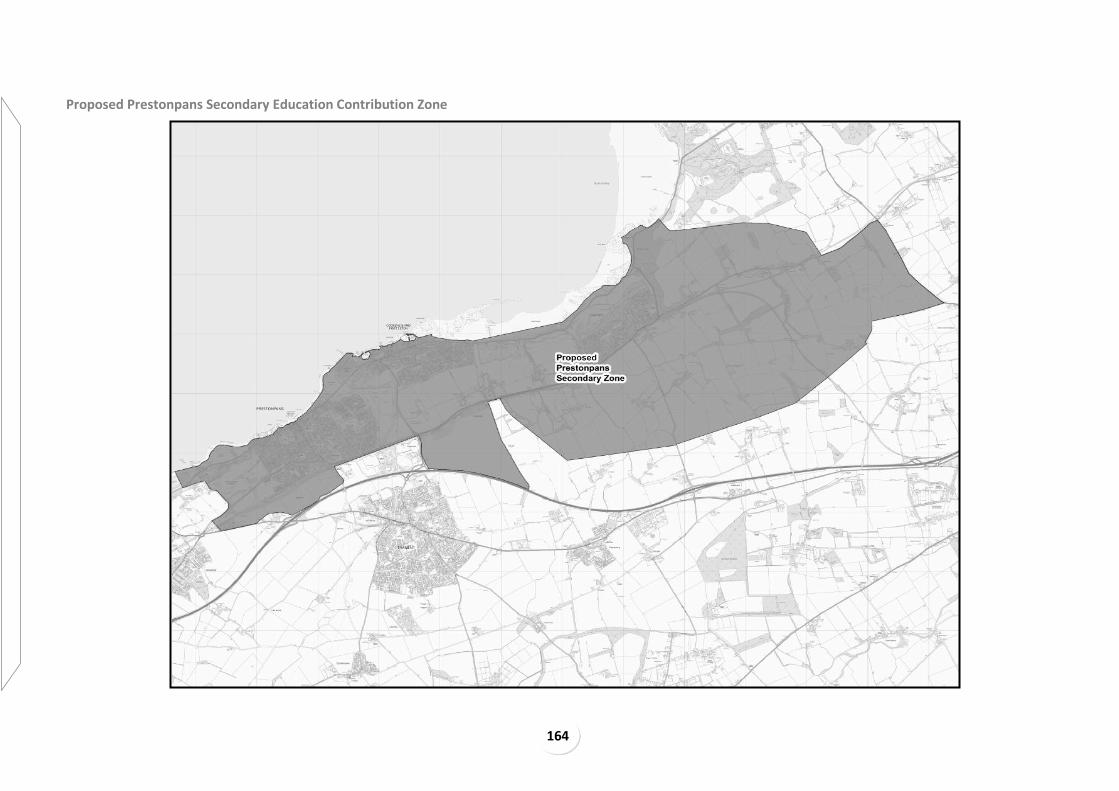
164
Proposed Prestonpans Secondary Education Contribution Zone

165
Proposed Prestonpans and Cockenzie Primary Education Contribution Zone

166
Proposed Longniddry Primary Education Contribution Zone

167
Proposed Blindwells Education Contribution Zone

168
Proposed Tranent Secondary Education Contribution Zone

169
Proposed Sandersons Wynd Primary Education Contribution Zone

170
Proposed Windygoul Primary Education Contribution Zone

171
Proposed Macmerry Primary Education Contribution Zone

172
Proposed Elphinstone Primary Education Contribution Zone

173
Proposed Ormiston Primary Education Contribution Zone

174
Proposed Pencaitland Primary Education Contribution Zone
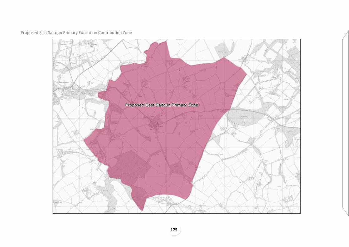
175
Proposed East Saltoun Primary Education Contribution Zone

176
Proposed Humbie Primary Education Contribution Zone

177
Proposed Haddington Secondary Education Contribution Zone

178
Proposed Haddington and Letham Mains Primary Education Contribution Zone

179
Proposed Yester Primary Education Contribution Zone

180
Proposed Dunbar Secondary Education Contribution Zone

181
Proposed Dunbar and West Barns Primary Education Contribution Zones

182
Proposed East Linton Primary Education Contribution Zone
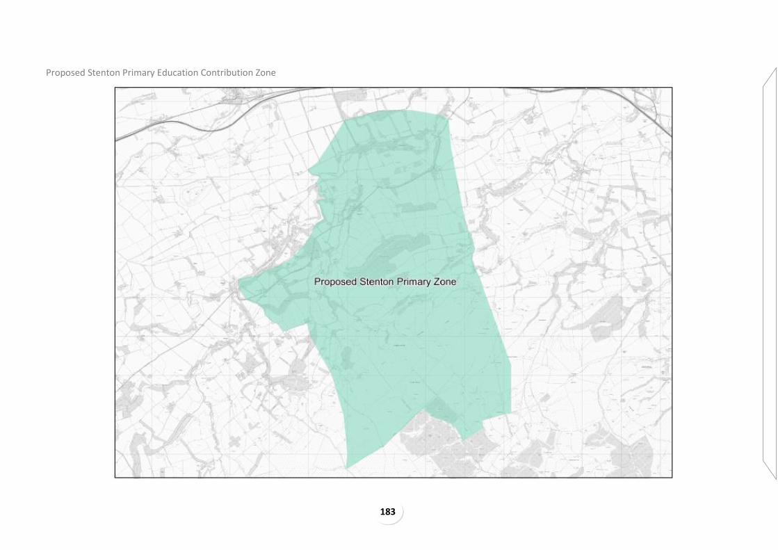
183
Proposed Stenton Primary Education Contribution Zone

184
Proposed Innerwick Primary Education Contribution Zone

185
Proposed North Berwick Secondary Education Contribution Zone

186
Proposed Law Primary Education Contribution Zone

187
Proposed Dirleton, Gullane and Aberlady Primary Education Contribution Zones

188
Proposed Athelstaneford Primary Education Contribution Zone

189
Developer Contribution Zones: Transportation

190
Segregated Active Travel Corridor Contribution Zones

191
Segregated Active Travel Corridor Contribution Zones Inset

192
Rail Network Contribution Zones

193
Rail Network Contribution Zones Inset

194
Old Craighall A1(T) / A720 Junction Developer Contribution Zones

195
Old Craighall A1(T) / A720 Junction Developer Contribution Zones Inset

196
Salter’s Road Interchange A1(T) Contribution Zones

197
Salter’s Road Interchange A1(T) Contribution Zones Inset

198
Bankton Interchange A1(T) Contribution Zones

199
Bankton Interchange A1(T) Contribution Zones Inset

200
Mitigation of Cumulative Impacts in Musselburgh Contribution Zones

201
Mitigation of Cumulative Impacts in Musselburgh Contribution Zones Inset

202
Mitigation of Cumulative Impacts at Tranent Contribution Zones

203
Mitigation of Cumulative Impacts at Tranent Contribution Zones

204
Developer Contribution Zones: Sports Facilities

205
Proposed Musselburgh Sports Facilities Contribution Zones

206
Proposed Prestonpans Sports Facilities Contribution Zone

207
Proposed Blindwells Sports Facilities Contribution Zone

208
Proposed Tranent Sports Facilities Contribution Zone

209
Proposed Haddington Sports Facilities Contribution Zone

210
Proposed Dunbar Sports Facilities Contribution Zone

211
Proposed North Berwick Sports Facilities Contribution Zone

212
Appendix 2- Cumulative Wind Turbine Issues
Cumulative issues will be considered with regard to SNH Guidance ‘Siting and Designing of Windfarms in the Landscape 2014’, ‘Siting and Design of Small Scale Wind Turbines of between 15 and 50 metres in height - March 2012’ and ‘Assessing the Cumulative Impact of Onshore Wind Energy Development’ and successor guidance. Cumulative issues will also be considered with regard to the following: Proposals in or near Areas of Strategic Capacity: Areas of Strategic Capacity are those with long-
term potential for generation of wind energy at strategic scale. It is important that the potential
for large scale development with significant energy generation benefits in these areas is not
compromised by smaller scale proposals which take up or impact on the landscape capacity of
these areas.
Retention of distinctiveness of lowland and upland areas: there is a strong, established pattern of
wind turbine development in East Lothian, with clustered large scale development in the
expansive upland landscapes, and smaller scale development in the lowlands. Wind development
at the wrong scale would reduce this distinctive pattern: this applies to large scale (in terms of
height) development in the lowlands, and smaller scale development in the Lammermuir areas.
Large scale development in the lowlands as well as the uplands could lead to East Lothian being
defined by wind development instead of wind turbines being a component of the landscape.
Retention of distinctiveness within Scotland: it is important for the different landscapes of
Scotland to remain distinctive both within their locale as well as regionally and nationally. The
existing pattern of development in East Lothian is different from the other similar east coast
landscapes of Fife, Scottish Borders and Moray. This distinction should be retained. The Lothian
Edge provides a boundary between the central belt and the upland areas within the Scottish
Borders, with panoramic views at the fault line across central lowland Scotland. The distinction of
these different landscapes is obvious to walkers and road travellers alike. This distinction would be
compromised by larger scale wind development in the lowlands of East Lothian.
Pattern of existing development and Relief from development: existing large scale windfarms in
the Lammermuirs around East Lothian are set back from the East Lothian edge of the Lammermuir
Hills and have some degree of containment. They are in a ‘cluster and space’ pattern. Further wind
farm development within the Lammermuir area, especially stand alone development, risks there
being few or no areas within the East Lothian Lammermuirs which are not significantly impacted
on or dominated by windfarm development. It is important that some part of the landscape is
retained free from windfarm development for existing and future generations to enjoy. The
Lammermuirs contain some of East Lothian’s wildest land in terms of remoteness, naturalness and
lack of modern artefacts, which could be lost by further wind turbine development between
existing turbines.
Visual relief is provided by a general lack of visibility of windfarm development at the Whiteadder
and Hopes valleys and this should be retained. Most if not all of the summits in the East Lothian
Lammermuirs have been affected by views of windfarms, with some summits being overlooked by
turbines or having them in very close proximity, including Wester Dod, Heart Law, Bransly Hill,
Meikle Says Law and Spartleton. It is therefore important that some summits should remain which
are relatively unaffected by wind development and that the main summits which have wind
development in close proximity retain some of their character and clear views outwards. Further
encroachment towards the summits of Wester Dod, Bransly Hill, Meikle Says Law, Spartleton,
Lammer Law, Harestane Hill, and Moss Law in particular should therefore be carefully considered.
Visual relief is also important in the lowland context.
Containment of existing windfarm development: this applies particularly to development at Dun
Law/Pogbie where the rim of the scarp is an important ‘edge’ and Aikengall/Crystal Rig and
Fallago, where the East Lothian edge of the Lammermuir Hills provides some containment.
Lammermuir Skyline: windfarm development on the skyline can be prominent. From parts of the
East Lothian Plain a considerable proportion (over half) of the skyline is affected by wind
development. There are three main issues; firstly, the horizontal skyline should continue to appear
as the dominant feature; secondly, wind development should continue to appear set back from
the East Lothian edge of the Lammermuir Hills; and thirdly, physical and visual spacing between
windfarms should be maintained. Different design, scale and speed of turbines on a prominent or
important skyline can become a visual distraction and affect visual amenity.
Oldhamstocks Conservation Area: the area in and around Oldhamstocks Conservation Area is
affected by existing and consented wind development. Cumulative impact on this village is a
matter of concern and the Council is seeking to resist further proposals that would have an
adverse effect on the setting of the Conservation Area.
Clutter: capacity for visual clutter in association with large and complex industrial buildings such as
the cement works, or Torness Power Station, quarries, power lines and transmission masts (such

213
as on the Garleton Hills, Blackcastle Hill or at Stevenson) and related impact on the landscape
pattern and scenic attraction of the area. This could occur with an individual wind turbine in
association with other existing development or if turbines were associated with the majority of
land holdings.
Domination of local character: effect on the scenic attraction of different character areas: e.g. the
simplicity and openness of the agricultural plain, intricacy of river valleys; or on pattern of
woodland and trees within the North Lammermuir Platform. The larger the turbine, the harder it is
likely to be to accommodate a number of them without them becoming the dominant features.
Inter-visibility of developments limits capacity in open and highly visible areas. The Tyne valley
between Haddington and Pencaitland now contains several medium scale clearly visible turbines
which are widely visible in the local area. The coastal plain around Dirleton/Gullane/Drem has
several different design, scale and speed of turbine as well as visibility of turbines in the
Lammermuirs and Fife. The cumulative impact of further development here must be carefully
considered.
Fragmentation of existing pattern of development: Where turbines do not relate well to existing
buildings and point features in the landscape this affects the robust, recognisable, consistent and
characteristic pattern of built development. Turbine siting can affect the appearance of spread of
built development; for example turbine development in the open spaces north of the A1 in the
Musselburgh Prestonpans fringe and along the A1 corridor could affect the perception of where
built/industrial development ends.
Sequential effects: there are potential sequential effects on the experience of travelling
throughout East Lothian, including the A1 corridor, the East Coast Mainline Railway and the John
Muir Way.
Noise: Some noise sensitive receptors both in East Lothian and Scottish Borders area are affected by noise from one or more East Lothian windfarms. These are in particular dwellings close to Crystal Rig and Aikengall cluster of wind turbines. Conditions are in place to secure acceptable levels of noise however a small number of these properties are approaching the limit of what is considered acceptable. Guidance “The assessment and rating of noise from windfarms” Final Report, 1996, DTI gives a base for considering noise impacts, including cumulatively. With multiple windfarms the position can become complex, and conditions will be carefully worded so it is clear what the responsibilities of each windfarm in relation to noise are.
Black Grouse: Black grouse are one of the species which can be significantly impacted by wind turbine development. Black grouse are a priority species under the UKBAP, and area also on the
Scottish Biodiversity List. It is also one of only four birds on SNH’s species action list. Wind turbine development in East Lothian has restricted the amount of habitat available for the Black Grouse, in particular potential lek sites. While several areas within East Lothian contain suitable habitat for Black Grouse, development within an area in the east of the Plateau Grassland Landscape Character Areal (south of Stobshiel) would effectively mean the Black Grouse becoming extinct from East Lothian, and this is undesirable.

214
Appendix 3 - Glossary
A
ACCESSIBILITY
Having access to goods, services, employment and other facilities.
ACTION PROGRAMME
A document which identifies the timescale, roles, responsibilities and actions of those partners
and stakeholders involved in implementing the Local Development Plan spatial strategy.
ACTIVE TRAVEL
Travel characterised by physical activity such as walking and cycling
ACTIVE FRONTAGE
Ground Floor building frontage designed to allow people to see and walk inside and out.
AFFORDABLE HOUSING
Housing of a reasonable quality that is affordable to people on relatively modest incomes.
AGGREGRATES
Sand and gravel, crushed rock and other bulk materials used in construction industry for purposes
such as the making of concrete, mortar and asphalt for roadstone, drainage or bulk filling.
AIR QUALITY MANAGEMENT AREAS (AQMA)
Designated parts of East Lothian where the Council considers that air quality objectives are
unlikely to be achieved.
ALLOCATION
Areas of land or sites identified in the Local Development Plan for development.
ANCIENT WOODLAND
Woodland and related habitat identified and included in the Forestry Commissions ‘Native
Woodland Survey of Scotland’ and/or SNH’s Ancient Woodland Inventory.
APPROPRIATE ASSESSMENT
An assessment carried out by the Competent Authority required under the Conservation (Natural
Habitats &c) Regulations 1994 (as amended), where there is a Likely Significant Effect on a Natura
2000 site.
AREA OF STRATEGIC CAPACITY
Area where there is long term potential for large scale wind development
B
EAST LOTHIAN BIODIVERSITY ACTION PLAN (ELBAP) HABITAT
UK BAP habitats that occur in East Lothian, along with habitats of local significance. See the East
Lothian Biodiversity Action Plan for details of which habitats are included.
BATTLEFIELD (see Historic Battlefield, below)
BIODIVERSITY The range and extent of animal and plant species within an area.
BROWNFIELD LAND Land which has been previously developed. The term may cover vacant or derelict land, infill land
or land occupied by redundant or unused buildings and developed land within the settlement
boundary where redevelopment is acceptable.
BUSINESS USE Class 4 of the Town and Country Planning (Use Classes) (Scotland) Order 1997 which includes
general office, light industry or research and development which can be carried out without
detriment to the amenity of any residential area.
C
CARBON CAPTURE AND STORAGE
Carbon capture and storage (CCS) (or carbon capture and sequestration) is the process of
capturing waste carbon dioxide (CO2) from large point sources, such as fossil fuel power plants,
transporting it to a storage site, and depositing it where it will not enter the atmosphere, normally
215
an underground geological formation. The aim is to prevent the release of large quantities of CO2
into the atmosphere (from fossil fuel use in power generation and other industries).
CENTRAL SCOTLAND GREEN NETWORK
Programme intended to deliver a step change in environmental quality, woodland cover and
recreational opportunities, comprising a strategic network or woodland and other habitats, active
travel routes, greenspace links, watercourses and waterways, providing an enhanced setting for
development and other land uses and improved opportunities for outdoor recreational and
cultural activity.
COALESCENCE
When development occurs to make settlements no longer physically or visually separate from
each other.
COMMITTED DEVELOPMENT
Development proposals that are contained in previous Local Plans and are carried forward to the
Local Development Plan or have received Council support through subsequent planning
permissions.
CONSERVATION AREA An area designated under the Planning (Listed Buildings and Conservation Areas) (Scotland) Act
1997 as being of special architectural or historic interest, the character and interest of which it is
desirable to preserve or enhance.
CONSTRAINED (NON EFFECTIVE SITE)
A site within an established housing land supply that at the time of any audit is not assessed as
being effective, that is, it will not be programmed to contribute housing completions in that audit.
COMPETENT AUTHORITY
Any Minister, Government Department, public or statutory undertaker, public body of any
description or person holding a public office responsible for carrying out Appropriate Assessment
under the Conservation (Natural Habitats, &c) Regulations 1994
CORE PATHS Under the terms of the Land Reform (Scotland) Act 2003, the Council has prepared a plan for a
system of ‘core paths’ to give people reasonable access throughout their area for walking, cycling,
horse riding and to inland water.
COUNTRYSIDE AROUND TOWNS
A planning policy applied to countryside adjacent to a settlement to protect the character of the
settlement (including its landscape setting) and the local area or to prevent coalescence between
settlements.
COUNTRYSIDE RECREATION Passive or active outdoor recreational pursuits or land uses, which do not, of themselves, harm the
character or amenity of the countryside (or neighbouring urban area) or threaten the character or
appearance of the landscape and its enjoyment by others.
CIVIL INFRASTRUCTURE
Hospitals, fire stations, emergency depots, schools, care homes, ground- based electrical and
telecommunications equipment.
CLIMATE CHANGE ADAPTION
The adjustment in economic, social or natural systems in response to actual or expected climatic
change, to limit harmful consequences and exploit beneficial opportunities.
CLIMATE CHANGE MITIGATION
Reducing the amount of greenhouse gases in the atmosphere and reducing activities which emit
greenhouse gases to help slow down or make less severe the impacts of future climate change.
CUMULATIVE IMPACT
A developments impact in combination with other development(s). That includes existing
developments of the kind proposed, those which have permission, and valid applications which
have not been determined. The weight attached to undetermined applications should reflect their
position in the application process.

216
D
DENSITY AND MIXED USE Development density relates to the amount of development on a given piece of land, and mixed use the variety of land uses on it. Density influences the intensity of development and, when combined with the mix of land uses, can affect a place’s vitality and viability. For the purposes of this local plan, a net dwelling per hectare density measure (dph) will be used. The net dwelling per hectare density level is calculated by dividing the total number of houses to be developed on the site by the area of land that will accommodate housing and directly associated development. Directly associated development will include: secondary and tertiary access roads; private gardens; car parking areas; incidental open space and landscaping, such as roadside verges. It will exclude land required to provide for: primary roads; schools and other non-housing land uses; open spaces serving a wider area, such as local, town and linear parks and play areas etc; large SUDS features, including attenuation ponds; and significant landscape buffer strips at site boundaries and within sites. In situations where one side of a road has a developed frontage, only half of that road should be included in the area to be measured. Where dwellings are to be provided above commercial premises they can contribute towards the net density measure without incorporating the land area they occupy. Some sites may be subject to minor constraints unknown at the time of allocation and the exact area of land suitable for development will only be known after any such areas are subtracted from the total site area, leaving only land to be developed for housing and directly associated development. For this reason a degree of flexibility is built in to the allocated site areas.
Use of a net density measurement is more refined than gross. It ensures that the effect of any such
undevelopable land will not be to increase housing density beyond the minimum requirement, as
would be the case if a gross density measurement were to be used.
DEVELOPMENT BRIEF OR FRAMEWORK A document approved by the Council providing guidance on how a specific site of significant size
or sensitivity should be developed in line with the relevant planning and design policies. It will
usually contain some indicative vision of future development form.
DEVELOPMENT PLAN
A document(s) that sets out how places should change and what they could be like in the future. It
stipulates what type of development should take place where, and which areas should not be
developed. In the Edinburgh City Region the development plan is made up of the Strategic
Development Plan, Local Development Plans and any Supplementary Guidance.
DEVELOPER CONTRIBUTION
Payments made or work in kind, to help improve the infrastructure (e.g. roads, open space, waste-
water treatment works) or provide other necessary mitigation so that development can go ahead.
E
EFFECTIVE HOUSING LAND SUPPLY
Effective housing land supply is the part of the established housing land supply (see below) which
is free or expected to be free of development constraints in the period under consideration, and
will therefore be available for the construction of housing.
EMPLOYMENT USE Generally businesses, general industry or storage and distribution uses, as defined in the Town
and Country Planning (Use Classes)(Scotland) Order 1997.
ENVIRONMENTAL REPORT
A document required under the Environmental Assessment (Scotland) Act 2005 which describes
and evaluates the likely significant environmental impact on implementing a plan or programme.
ESTABLISHED HOUSING LAND SUPPLY
The total housing land supply including both unconstrained and constrained sites, plus the
remaining capacity for sites under construction, sites with planning consent, sites in adopted local
development plans and where appropriate other buildings and land with agreed potential for
housing development.
ESSENTIAL INFRASTRUCTURE (IN A FLOOD RISK ARE FOR OPERATION REASONS)
Defined in SEPA guidance on vulnerability as ‘essential transport infrastructure and essential utility
infrastructure which may have to be located in a flood risk area for operational reasons. This
includes electricity generating stations, power stations and grid and primary sub stations, water
treatments works and sewage treatment works and wind turbines’.

217
EUROPEAN PROTECTED SPECIES
Species listed on Schedules 2 (animals) and 4 (plants) of the Conservation (Natural Habitats, &c.)
Regulations 1994, as amended; in East Lothian the animal species which might be found are bats
(all species are EPS) otter, great crested newt.
EUROPEAN SITES
A European site is one defined as set out in Section 10 (1) of the Conservation (Natural Habitats
etc) Regulations 1994 as amended. They comprise Special Areas of Conservation and Special
Protection Areas designated by the Habitats and Birds Directives respectively. They can also be
referred to as Natura sites (see also Natura 2000 sites). Ramsar sites, classified under the Ramsar
Convention on Wetlands of International Importance also form part of the Natura 2000 network
of European sites, either as a Special Protection Area or Special Area of Conservation. The Scottish
Government requires authorities to afford the same level of protection to proposed Special Areas
of Conservation and Special Protection Areas as they do to sites which have been designated. In
Scotland, European sites are given protection through The Conservation (Natural Habitats &c,)
Regulations 1994 as amended.
F
FLOOD
The temporary covering by water from any source of land not normally covered by water, but not
including the overflow of a sewage system.
FLOOD PLAIN
The generally flat areas adjacent to a watercourse or the sea where water flows in time of flood or
would flow but for the presence of flood prevention measures. The limits of a flood plain are
defined by the peak water level of an appropriate return period event. See also ‘Functional flood
plain’.
FREEBOARD ALLOWANCE
A height added to the predicted level of a flood to take account of the height of waves or
turbulence and uncertainty in estimating the probability of the flooding.
FUNCTIONAL FLOOD PLAIN
The areas of land where water flows in times of flood which should be safeguarded from further
development because of their function as flood water storage areas. For planning purposes the
functional floodplain will generally have a greater than 0.5% (1:200) probability of flooding in any
year.
FLOOD RISK
A measure of the likelihood of flooding occurring and the associated impacts on people, the
economy and the environment.
G
GARDEN AND DESIGNED LANDSCAPE
Area on the Inventory of Historic Gardens and Designed Landscapes kept by Historic Environment
Scotland; local and regional Gardens and Designed Landscapes also exist and these will be
identified in supplementary planning guidance.
GREEN BELT An area defined in the development plan which can encircle settlements as well as act as buffers,
green corridors or wedges. It can prevent the merging of settlements and provide clarity on where
development will or will not take place.
GREENFIELD LAND
Land which has not previously been developed.
GREEN NETWORK Connected areas of green infrastructure and open space that together form an integrated and
multi-functional network.
H
HABITATS REGULATIONS
General term for the Conservation (Natural Habitats, &c) Regulations 1994, as amended, which
translated into UK law the EU Habitats and Wild Birds Directive.

218
HISTORIC BATTLEFIELD
Site within Historic Environment Scotland’s Inventory of Historic Battlefields.
HOUSING IN MULTIPLE OCCUPATION (HMO)
The term ‘house in multiple occupancy’ in relation to houses, means accommodation which is the
only or principle residence of three or more (unrelated) people who share a bathroom, toilet and
kitchen. It can also be known as a house share.
HOUSING LAND AUDIT Assessment of housing land across East Lothian, as at 31 March each year.
HOUSING LAND REQUIREMENT
The amount of land required to be allocated for housing (including generosity) to meet the
identified housing requirement.
HOUSING NEED AND DEMAND ASSESSMENT (HNDA)
The evidence base used to identify future housing requirements to ensure suitable land is
allocated through development plans.
HOUSING REQUIREMENT
Housing requirement is the total amount and type of housing necessary to accommodate a given
or projected population at appropriate minimum standards. This includes both housing need and
demand.
I
IMPERATIVE REASONS OF OVER-RIDING PUBLIC IMPORTANCE (IROPI) Where a competent authority concludes through an appropriate assessment that a proposal or
plan will have an adverse effect on the integrity of a Natura 2000 or Ramsar site, that proposal or
plan can only be consented if there are no alternative solutions and there are Imperative Reasons
of Over-Riding Public Importance. For sites that host a priority habitat type, these reasons can
only be related to human health, public safety or beneficial consequences of primary importance
to the environment, or other reasons which in the opinion of the European Commission are
imperative reasons of overriding public interest. Where the proposal does not involve a Priority
habitat, then reasons of a social or economic nature may also be considered.
INFRASTRUCTURE Physical networks which serve development such as roads, paths, street lighting, supplies of
water, gas, electricity and waste water drainage and services for occupants of developments such
as public transport measures, schools and healthcare.
J
K
L
LIFE SCIENCES
The scientific study of living things – plants, animals and humans.
LIKELY SIGNIFICANT EFFECT
In the context of Natura 2000 Sites, an effect of a plan or project where it cannot be excluded on
the basis of objective information, that the plan or project will have a significant effect, with
reference to the Conservation Objectives of the site.
LISTED BUILDING
A building identified by Historic Environment Scotland as being of special architectural or historical
interest as set out in the Planning (Listed Buildings and Conservation Areas) (Scotland) Act 1997.
Categorised A, B, C(s) to reflect their relative importance.
LOCAL HOUSING STRATEGY
Sets out the housing needs of the area (both the privately owned and rented sectors) and outlines
plans to address those needs over a 5 year period.
LOCAL NATURE CONSERVATION SITES Sites designated by the Council through this Local Development Plan for their local or regional importance for biodiversity or geodiversity interest.
LOCAL CENTRE For the purposes of this Plan a local centre is a local shopping centre as identified by this Plan.
LOW AND ZERO CARBON GENERATING TECHNOLOGY Equipment provided on-site or integrated into buildings and which use solely renewable sources,
resulting in zero carbon dioxide emissions, or which include use of fossil fuels but with significantly

219
lower carbon dioxide emissions overall, which may include combined heat and power (CHP)
and/or a range of other methods.
M
MASTER PLAN
A detailed document that explains how a site or sites will be developed, usually prepared by or on
behalf of the landowner, including a representation of the three-dimensional form of proposals
and an implementation programme.
MATERIAL CONSIDERATION Any consideration relevant to the use and development of land taken into account when
determining a planning application.
MOST VULNERABLE USES
Basement dwellings, isolated dwellings in sparsely populated areas, dwelling houses behind
informal embankments, residential institutions such as residential care homes/prisons, nurseries,
children’s homes and educational establishments, caravans, mobile homes and park homes
intended for permanent residential use, sites used for holiday or short-let caravans and camping,
installations requiring hazardous substance consent.
N
NATIONAL PLANNING FRAMEWORK (NPF)
The Scottish Government’s vision and strategy for Scotland’s long term spatial development.
NATIONAL GEOLOGICAL RECORDS CENTRE (NGRC)
A ‘place of deposit’ under the terms of the Public Records Act holding a wide range of geological
records including site investigation records, borehole logs, mine plans and more.
NATURA 2000 SITE
Natura sites represent the very best of Scotland’s nature. Natura is the term given to Special Areas
of Conservation (SACs) and Special Protection Areas (SPAs). These internationally important sites
are designated under two of the most influential pieces of European legislation relating to nature
conservation, the Habitats and Birds Directives. The network of sites across the European
Community is known as Natura 2000.
O
OPEN SPACE Space within and on the edge of settlements comprising green infrastructure and/or civic areas
such as squares, market places and other paved or hard landscaped areas with a civic function.
Detailed typologies of open space are included in PAN65.
P
PLACEMAKING
An approach to creating better places, and places that people enjoy being in. It is achieved
through linking the planning strategy with design tools and other processes and decisions to
achieve positive, design-led outcomes on the ground that help create better places.
PLANNING CONDITIONS
Conditions attached to planning permissions that are enforced through planning legislation.
PRIME QUALITY AGRICULTURAL LAND
Class 1, 2 and 3.1 agricultural land as defined by the James Hutton Institute.
PRIORITY HABITAT
Natural habitat types in danger of disappearance which are mainly or exclusively found within the
European Union and the UK and listed in Annex 1 of the Habitats Directive.
R
RAMSAR SITE
Ramsar sites are wetlands of international importance, which provides for the conservation and
good use of wetlands designated under the Ramsar Convention.
RENEWABLE ENERGY Natural energy from sources which will never run out such as sunlight, wind, hydro, wave, tidal,
biomass, solar and geothermal.

220
S
SCHEDULED MONUMENT
An archaeological monument of national importance that is legally protected under the Ancient
Monuments and Archaeological Areas Act 1979.
SCOTTISH PLANNING POLICY (SPP)
Scottish Government’s policy statement on nationally important land use planning matters.
SETTING
Is more than the immediate surroundings of a site or building, and may be related to the function
or use of a place, or how it was intended to fit into the landscape or townscape, the view from it
or how it is seen from areas round about, or areas that are important to the protection of the
place, site or building
SITE OF SPECIAL SCIENTIFIC INTEREST (SSSI) SSSI’s are those areas of land and water (to the Mean Low Water Springs) that best represent our
natural heritage – its diversity of plants, animals and habitats, rocks and landforms, or a
combination of such natural features. Designated by SNH under the Nature Conservation
(Scotland) Act 2004, it is an offence to intentionally or recklessly damage their protected natural
features.
SPECIAL AREAS OF CONSERVATION (SAC)
An internationally important site designated under the Habitats Directive to protect threatened
habitats and species, both terrestrial and marine. Together with SPA’s these sites make up the
Natura site series.
SPECIAL PROTECTION AREA (SPA)
An internationally important site designated under the EU Birds Directive to give protection to
specific rare, threatened or vulnerable bird species, or to regularly occurring migratory species.
Together with SAC’s these sites make up the Natura site series
SPECIAL LANDSCAPE AREAS (SLA) An area designated by the Council through this local development plan as being of special
landscape character requiring special protection against inappropriate forms of development.
STRATEGIC DEVELOPMENT PLAN In Scotland’s four city regions, Strategic Development Plans provide a long term vision, a spatial
strategy and strategic policies and proposals, setting clear parameters for Local Development
Plans.
SUPPLEMENTARY GUIDANCE (SG)
Guidance and detailed criteria prepared by the Council which deals with further information or
detail in respect of particular LDP issues. Supplementary guidance must be expressly identified in
the LDP and be submitted to Scottish Ministers before it can be approved by Council.. Once
adopted, supplementary guidance forms part of the development plan.
SUPPLEMENTARY PLANNING GUIDANCE (SPG)
Supplementary planning guidance is to be prepared to provide additional information and
guidelines to enable certain policies of the Local Development Plan to be implemented. It does not
form part of the plan but sits beside it as a non statutory document and a material consideration.
SUSTAINABLE DEVELOPMENT
Development that meets the needs of the present without compromising the ability of future
generations to meet their own needs. The Brundtland Definition. Our Common Future, The
World Commission on Environment and Development, 1987.
SUSTAINABLE FLOOD RISK MANAGEMENT
Partnership working to provide the maximum possible resilience against flooding from all sources
through various techniques and systems, protecting and enhancing the environment in a way
which is fair and affordable, both now and in the future.
SUSTAINABLE URBAN DRAINAGE SYSTEMS (SUDS)
A range of techniques to manage the flow of water runoff from a site by allowing water control
and treatment on-site, reducing the impact on existing drainage systems.
T

221
THERMAL GENERATION
The process of generating electricity from heat. There are four thermal energy fuels: coal, natural
gas, wood waste and geo-thermal. Strictly speaking, nuclear power is also thermal energy fuel, but
it is set aside in a class of its own because of its unique traits.
TOWN CENTRE
Centres that provide a diverse and sustainable mix of activities and land uses which create an
identity that signals the function and wider role.
TOWNSCAPE
The urban equivalent of landscape; for example, the appearance of streets.
TRAVEL PLAN
A site based tool for an organisation to manage its transport needs to encourage safe, healthy and
sustainable travel options, reflecting the different needs and problems of different locations. The
principal objective of a plan is typically to minimise car use associated with a development.
U
V
VITALITY AND VIABILITY (OF TOWN CENTRES)
Vitality is a measure of how lively and busy a town centre is. Viability is a measure of its capacity to
attract ongoing investment, for maintenance, improvement and adaptation to changing needs.
WASTE/WASTE MANAGEMENT
Includes any substance that constitutes a scrap material or an effluent or other unwanted surplus
substance arising from the application of any process; and any substance or article that requires to
be disposed of as being broken, worn out, contaminated or otherwise spoiled (but does not
include explosives).
WINDFALL A site which becomes available for development during the plan period which was not anticipated
when the plan was being prepared.
Z

222
Appendix 4 – Schedule of Council Owned Land
Description of Land Owned by Planning Authority Reference to policies, proposals or views contained in the Plan which relate to the occurrence of development of the land
Land between Whitehall Road and South of the A1 and land
between the A1 and Newcraighall Public Park, Musselburgh
PROP MH1: Land at Craighall, Musselburgh
PROP CF1: Provision of New Sports Pitches and Changing Accommodation
PROP OS6: Allotment Sites
Policy DP9: Development Briefs
Section of the A1 South of QMU
Land to the west of Old Craighall
Land to the north of Birchlea and section of A1 west of B6415 PROP MH3: Land at Old Craighall Junction South West Policy DP9: Development Briefs
Land along the A1 North of the Motel and west of the B6415 PROP MH4: Land at Old Craighall Junction
Land between Wallyford Industrial Estate and the A1 and land
west of Inchview Road
PROP MH9: Land at Wallyford
PROP CF1: Provision of New Sports Pitches and Changing Accommodation
Rail track to the east of the site PROP MH14: Land at Whitecraig South Policy DP9: Development Briefs
Land north east of the boundary PROP MH16: Whitecraig Primary School Expansion Land
Policy DP9: Development Briefs
Part of Land at Inveresk Industrial Estate
Land at Fisher Row Industrial Estate
Land at Newhails Road
Land at Wallyford Industrial Estate
Land at Recycle Centre, Wallyford
Land at Carberry LS, Whitecraig
Land at Whin/Cockenzie Business park
Land at Macmerry Business Park
Land at Macmerry Industrial Estate
Land at Easter Alderston, Haddinton
Land to the west of Peppercraig Quarry Industrial Site, Haddington
Land at Station Road, south of Hospital Road, Haddington
Land at Industrial Estate, East Linton
Land at Dunbar Trading Estate
Land at Tantallon Road, south of the cemetery, North Berwick
EMP1: Business and Employment Locations
Land to the north east of PS1 and runs parallel to the B1377 west. Prop PS1: Longniddry South
PROP CF1: Provision of New Sports Pitches and Changing Accommodation
PROP T9: Safeguarding Land for larger Station Car Parks

223
PROP T10: Safeguarding Land for platform Lengthening
Policy DP9: Development Briefs
Land east of Dolphinstone Court
Land north and south of Bankton Terrace and east of Prestonpans
Station
Land at B6371
Land South of Seton West Mains on the B6371
Land north of St Germains
Land south west of Cantyhall Bridge
Small linear sections of land north along the A198
Land to the north east of PS1 and runs parallel to the B1377 west
Land north of the B1377 at Drem
PROP T13: East Coast Main Line: Four Track Section, New Rail Station and Vehicular Overbridge.
Dismantled Railway Track west of the site PROP TT10: Limeylands Road, Ormiston
Policy DP9: Development Briefs
Part land at Park View, Easter Pencaitland PROP TT14: Park View, Easter Pencaitland
Policy DP9: Development Briefs
Land to the north at the industrial estate PROP DR7: Land at Spott Road, Dunbar Policy DP9: Development Briefs
Land at North Berwick High School and North Berwick Law Primary
School, North Berwick
PROP NK2: North Berwick High School and Law Primary School Expansion Land
PROP ED7: North Berwick Education Proposals
Land to the East of Preston Crescent, Cockenzie
Path/track running from B1361 north east to B6371
PROP EGT1: Land at Former Cockenzie Power Station
Cockenzie Ash lagoon near Musselburgh
Kingwegar Recycling Centre, & WTS, Wallyford
Macmerry Depot, Macmerry Industrial Estate
Macmerry CA Site, Macmerry
Dunbar Recycle Facility, Dunbar
North Berwick CA Site, North Berwick
Carberry LS, Whitecraig,
Policy W1: Waste Management Safeguards
Land at Brunton Wireworks, Musselburgh
Land at Dolphingstone Edinburgh Road, Prestonpans
Policy HOU1: Established Housing Land
Land south of QMU
Land at Whitecraig Primary School, Whitecraig
Land at Prestonpans, Primary School, Prestonpans
Land at Prestonpans Infant School, Prestonpans
PROP ED1: Musselburgh Cluster Education Proposals
PROP ED2: Prestonpans Cluster Education Proposals
PROP ED3: Blindwells Cluster Education Proposals
PROP ED4: Tranent Cluster Education Proposals
224
Land at Preston Lodge High School, Prestonpans
Land at Cockenzie Primary School, Prestonpans
Land at Longniddry Primary School, Longniddry
Land at Knox Academy, Haddington
Land at Dunbar Grammar School, Dunbar
Land at Ross High School, Tranent
Land at Windygoul Primary School, Trantent
Land at Elphinstone Primary School, Elphinstone
PROP ED5: Haddington Cluster Education Proposals
PROP ED6: Dunbar Cluster Education Proposals
Policy SECF1: Safeguarded Education and Community Facilities
Land at Elphinstone Football ground, Elphinstone
Land at Gullane Football Ground, Gullane
Land at Aberlady School Road Park, Aberlady
PROP CF1: Provision of New Sports Pitches and Changing Accommodation
Land at Abbey Care Home, North Berwick
Land at Eskgreen Care Home, Musselburgh
Land at Cockenzie/Port Seton Medical Centre
PROP HSC2: Health Care Facilitates Proposals
Land along the Longniddry Haddington Route Policy T14: Longniddry – Haddington Route Safeguard
Land to the north of Birchlea and section of A1 west of B6415 PROP T15: Old Craighall A1(T) Junction Improvements
Land along the A1 North of the Motel and west of the B6415
Land between Whitehall Road and South of the A1 and land
between the A1 and Newcraighall Public Park, Musselburgh
PROP T16: A1 Junction Improvements at Queen Margaret Drive Interchange
Section of the A1 South of QMU
Land at A198 Meadowmill Roundabout Policy T23: Transport improvements to A198, Meadowmill Roundabout and Bankton Interchange
Land at A198 Meadowmill Roundabout PROP T24: Land Safeguard for A198 / B1361 Meadowmill Roundabout Improvements
Land at Tranent Town Centre Policy T26: Transport Improvements to Tranent Town Centre
Land at Tranent Town Centre PROP T27: Tranent Town Centre One-Way System
Land at Tranent Town Centre PROP T28: Junction Improvements at Elphinstone Road and Edinburgh Road
Land at Prestonpans High Street Policy CH9: High Street/Inch View, Prestonpans

225
BLANK

EAST LOTHIAN LOCAL DEVELOPMENT PLAN 2018ADOPTED BY RESOLUTION OF EAST LOTHIAN COUNCIL ON 27/09/2018
Plan produced by East Lothian Council’s Planning ServiceEast Lothian CouncilJohn Muir HouseHaddington EH41 3HA
To make a comment, suggestion or complaint about a council service, download a feedback form online at www.eastlothian.gov.uk or pick one up at your local office.
Versions of this publication can be supplied in Braille, large print, audiotape or in your own language. Please phone Customer Services if you require assistance on 01620 827199
Copyright © 2022 FDOKUMEN