Enfield Local Plan Integrated Impact Assessment Appendices
411
x Enfield Council Enfield Local Plan Integrated Impact Assessment Appendices Final report Prepared by LUC June 2021
-
Upload
khangminh22 -
Category
Documents
-
view
0 -
download
0
Transcript of Enfield Local Plan Integrated Impact Assessment Appendices

x
Enfield Council
Enfield Local Plan Integrated Impact Assessment AppendicesFinal report Prepared by LUC June 2021

Contents
Contents
Enfield Local Plan June 2021
LUC I i
Appendix A IIA Scoping Report A-1
Appendix B Site assessment assumptions B-1
Appendix C IIA findings for the Issues and Options Local Plan 2018 C-1
Introduction C-1IIA findings for the 2018 draft vision and growth objectives C-1
Explanation of IIA findings for the 2018 draft vision and growth objectives C-4
IIA findings for the growth options considered in the 2018 Issues and Options consultation document C-6
IIA1: Climate change mitigation C-9IIA2: Climate change adaption C-9IIA3: Housing C-10IIA4: Health and wellbeing C-10IIA5: Services and facilities C-11IIA6: Social inclusion C-11IIA7: Crime and community safety C-12IIA8: Road safety C-12IIA9: Economy C-12IIA10: Town and locan centres C-13IIA11: Air pollution C-13IIA12: Sustainable transport C-14IIA13: Biodiversity C-15IIA14: Historic environment C-15IIA15: Landscape and townscape C-16IIA16: Efficient use of land and materials C-16IIA17: Flooding C-16IIA18: Water C-17
IIA findings for the policy approaches considered in the 2018 Issues and Options document C-17
Historic environment policy options C-17Design policy options C-19Housing policy options C-21Economy policy options C-23Town centre policy options C-25Social infrastructure policy options C-28Green infrastructure policy options C-30Transport policy options C-33Sustainable infrastructure policy options C-35
Appendix D IIA findings for the spatial options 2021 D-1
Introduction D-1D-8D-8D-8D-9
D-10D-10D-10D-11D-11D-11D-12D-12D-12D-13D-13D-14D-14
IIA1: Climate change mitigation IIA2: Climate change adaption IIA3: Housing IIA4: Health and wellbeing IIA5: Services and facilities IIA6: Social inclusion IIA7: Crime and community safety IIA8: Road safety IIA9: Economy IIA10: Town and local centres IIA11: Air pollution IIA12: Sustainable transport IIA13 Biodiversity IIA14: Historic environment IIA15: Landscape and townscape IIA16: Efficient use of land and materials IIA17: Flooding IIA18: Water D-14
Appendix E IIA findings for the site options 2021 E-1
IIA1: Climate change mitigation E-12IIA2: Climate change adaption E-12IIA3: Housing E-12IIA4: Health and wellbeing E-13IIA5: Services and facilities E-14IIA6: Social inclusion E-14IIA7: Crime and community safety E-15IIA8: Road safety E-15IIA9: Economy E-16IIA10: Town and local centres E-16IIA11: Air pollution E-17IIA12: Sustainable transport E-17IIA13: Biodiversity E-18IIA14: Historic environment E-19IIA15: Landscape and townscape E-20IIA16: Efficient use of land E-20IIA17: Flooding E-21IIA18: Water E-22Other sites E-22
Allocation Site Appraisal Matrices E-25Enfield Town (SP PL1) E-26
SA1: St Anne's Catholic High School for Girls (housing site) – formerly referred to as GRC1/LP1105, LP652, CFS040 and CFS060 E-26
Contents
Contents
Contents
Enfield Local Plan June 2021
LUC I ii
SA2: Palace Gardens Shopping Centre (mixed-use site) – formerly referred to as GRC12/LP603 and CFS197 E-27 SA3: 100 Church Street (housing site) – formerly referred to as GRC3/LP1117 E-29 SA4: Enfield Town Station and Former Enfield Arms, Genotin Road (mixed-use site) – formerly referred to as CFS183 E-32 SA5: Enfield Civic Centre (mixed-use site) – formerly referred to as CFS191 E-35 SA6: Southbury Road Superstore Area (mixed-use site) – formerly referred to as SBC4/LP1131 E-37 SA7: Oak House, 43 Baker Street (housing site) – formerly referred to as CFS178 E-39
Southbury (SP PL2) E-40 SA8: Sainsburys Baird Road (mixed-use site) – formerly referred to as SBC35/LP653 E-40 SA9: Colosseum Retail Park (mixed-use site) – formerly referred to as SBC7/LP659 E-42 SA10: Morrisons, Southbury Road (mixed-use site) – formerly referred to as SBC36/LP1104 E-44 SA11: Southbury Leisure Park (mixed-use site) – formerly referred to as CFS253 E-47 SA12: Tesco, Ponders End, 288 High Street (mixed-use site) – formerly referred to as CFS166 E-50 SA46: Crown Road Lorry Park (industrial site) – formerly referred to as CFS151 E-51
Edmonton Green (SP PL3) E-53 SA13: Edmonton Green Shopping Centre (mixed-use site) – formerly referred to as EDC2/LP1137 E-53 SA14: Chiswick Road Estate (Osward and Newdales) (housing site) – formerly referred to as LOC1/LP1108 E-55
Angel Edmonton (SP PL4) E-57 SA15: Joyce Avenue and Snells Park Estate (housing site) – formerly referred to as UPM1 E-57 SA16: Public House, 50-56 Fore Street (housing site) – formerly referred to as UPP9 (10/00760/FUL) E-59 SA17: Upton Road and Raynham Road (housing site) – formerly referred to as UPS21/17100372 E-61 SA18: South east corner of North Middlesex University Hospital Trust of Sterling Way (housing site) – formerly referred to as CFS165 E-63
Meridian Water (SP PL5) E-65 SA19: IKEA store; Tesco Extra, 1 Glover Drive; Meridian Water, Willoughby Lane and Meridian Way (mixed-use site) – formerly referred to as UPP32, UPC2, UPC1 and UPP24 E-65 SA47: Ravenside Retail Park (industrial site) – formerly referred to as NA001 E-67
Southgate (SP PL6) E-68 SA20: Asda Southgate, 130 Chase Side, Southgate (mixed-use site) – formerly referred to as CFS209 E-68
SA21: Southgate Office Village, 286 Chase Road (mixed-use site) – formerly referred to as SPO35 (19/01941/FUL) E-70 SA22: M&S Food (mixed-use site) – formerly referred to as SOS11/CFS157 E-73 SA23: Minchenden Car Park and Alan Pullinger Centre (housing site) – formerly referred to as CFS150 and CFS189 E-75
New Southgate (SP PL7) E-77 SA24: Arnos Grove Station Car Park (housing site) – formerly referred to as SGC4/LP608_2 E-77 SA25: Site between North Circular Road and Station Road (mixed-use site) – formerly referred to as SGC1/LP1145 E-79 SA26: Station Road, New Southgate (mixed-use site) – formerly referred to as SGS14/17100370 E-82
Crews Hill (SP PL9) E-85 SA27: Land at Crews Hill (housing site) – formerly referred to as CHC2, CHC10, CHC17, CHC1, CFS159, CFS169, CFS132 and CHC18 E-85 SA48: Land at 135 Theobalds Park Road (industrial site) – formerly referred to as CFS132 E-87
Chase Park (SP PL10) E-89 SA28: Land at Chase Park (housing site) – formerly referred to as HIC10, HIC11, HIC6 and HIC9 E-89 SA29: Arnold House (housing site) – formerly referred to as CFS162_B and CFS162_C E-91
Other proposed site allocations outside of the place making areas (urban areas) E-93
SA30: Claverings, Centre Way (mixed-use site) – formerly referred to as CFS152 E-93 SA31: Cockfosters Station Car Park (Parcels a and b), Cockfosters Road, Barnet (housing site) – formerly referred to as COC9a and COC9b/LP608_1 E-95 SA32: Sainsburys Green Lanes (mixed-use site) – formerly referred to as PA39/LP654 E-97 SA33: Blackhorse Tower, Holbrook House and Churchwood House, 116 Cockfosters Road (housing site) – formerly referred to as COP10 (20/03200/PRJ) E-98 SA34: 241 Green Street (mixed-use site) – formerly referred to as EHP34 (18/04935/FUL) E-101 SA35: Land at former Wessex Hall Building (housing site) – formerly referred to as POC6/LP1196 E-104 SA36: 188-200 Bowes Road (housing site) – formerly referred to as SGP13 (18/00388/OUT) E-105 SA37: Main Avenue Site (housing site) – formerly referred to as SBC2/LP1107 E-107 SA38: Land at Ritz Parade (mixed-use site) – formerly referred to as SGC2/LP1159 E-109 SA39: Travis Perkins Palmers Green, Bridge Drive, Bloomfield Lane (mixed-use site) – formerly referred to as PAC8/LP656 E-111

Contents
Contents
Enfield Local Plan June 2021
LUC I iii
SA40: Land known as Brimsdown Sports Ground (mixed-use site) – formerly referred to as CFS217 E-113 SA41: Albany Leisure Centre and Car Park, 55 Albany Road (housing site) – formerly referred to as CFS207 E-115 SA42: Fords Grove Car Park (housing site) – formerly referred to as CFS223 E-117 SA43: Lodge Drive Car Park (inl. Depot) (housing site) – formerly referred to as CFS226 E-119
Other proposed site allocations outside of the place making areas (outside urban areas) E-121
SA44: Land opposite Enfield Crematorium (known as The Dell), Great Cambridge Road (mixed-use site) – formerly referred to as CHC5/LP1138 E-121 SA45: Land between Camlet Way and Crescent Way, Hadley (housing site) – formerly referred to as COC8/LP465 E-126
Employment and growth site allocations outside of the placemaking areas (SP E1) E-128
SA49: Land to the south of Millmarsh Lane, Brimsdown Industrial Estate (industrial site) – formerly referred to as CFS134 E-128 SA50: 6 Morson Road (industrial site) – formerly referred to as CFS136 E-129 SA51: Montagu Ind Estate (industrial site) – formerly referred to as CFS153 E-131 SA52: Land West of Ramney Marsh (industrial site) – formerly referred to as ELC3/LP606 E-133 SA53: Car Park Site, Wharf Road (industrial site) – formerly referred to as POC5/LP694/CFS135 E-134 SA54: Land East of Junction 24 (industrial site) – formerly referred to as CFS155 E-136 SA55: Land to the North West of Innova Park (industrial site) – formerly referred to as CFS148 E-138
Policy SP CL4: Promoting sporting excellence E-140 SA56: Picketts Lock/Lee Valley Leisure Centre (leisure uses site) – formerly referred to as LOC2/LP675 E-140 SA62: Tottenham Hotspur's training centre (sport and recreation site) – formerly referred to as CFS218 E-142
Policy DM BG19: Burial and crematorium spaces E-144 SA58: Alma Road Open Space (cemetery) – formerly referred to as CFS167 E-144 SA59: Firs Farm Recreation Ground (Part) (crematorium) – formerly referred to as CFS168 E-146 SA60: Sloemans Farm (natural burial site) – formerly referred to as CFS171 E-148 SA61: Church Street Recreation Ground (crematorium) – formerly referred to as CFS230 E-150
Nature recovery site E-152 SA57: Whitewebbs Golf Course, Beggar's Hollow (nature recovery site) – formerly referred to as CFS161 E-152
Site options appraised but not allocated E-154 Housing sites E-154 Mixed-use sites E-175
Appendix F Audit trail of site selection 2021 F-1

DRAFT
LUC I A-1
-
Appendix A IIA Scoping Report

New Enfield Local Plan 2041: Integrated Impact Assessment
Scoping Report
May 2020
Enfield Local Plan IIA Scoping Report
AECOM
Quality information
Prepared by Checked by Approved by
Michael Aquilina
Consultant
Amelia Kent
Senior Ecologist
Mark Fessey
Associate Director
Max Wade
Technical Director
Steve Smith
Technical Director
James Riley
Technical Director
Revision history
Revision Revision date Details Authorised Name Position
V1 January 2020 Initial draft for client review
Yes Mark Fessey Associate Director
V2 February 2020 Report published for consultation
Yes Mark Fessey Associate Director
V3 May 2020 Report updated post consultation
Yes Mark Fessey Associate Director
Prepared for:
London Borough of Enfield
Prepared by:
AECOM Limited
Aldgate Tower
2 Leman Street
London E1 8FA
United Kingdom
aecom.com
© 2020 AECOM Limited. All Rights Reserved.
This document has been prepared by AECOM Infrastructure & Environment UK Limited (“AECOM”) in accordance
with its contract with London Borough of Enfield (the “Client”) and in accordance with generally accepted
consultancy principles and the established budget. Any information provided by third parties and referred to herein
has not been checked or verified by AECOM, unless otherwise expressly stated in the document. AECOM shall
have no liability to any third party that makes use of or relies upon this document.
Enfield Local Plan IIA Scoping Report
AECOM
Table of contents
Non-technical Summary
1. Introduction ...................................................................................................... 1
2. Air quality ......................................................................................................... 5
3. Biodiversity .................................................................................................... 13
4. Climate change adaptation ............................................................................ 23
5. Climate change mitigation ............................................................................. 32
6. Communities .................................................................................................. 42
7. Crime and community safety ......................................................................... 51
8. Economy and employment ............................................................................ 56
9. Health ............................................................................................................ 65
10. Heritage and townscape ................................................................................ 72
11. Housing ......................................................................................................... 77
12. Landscape and green infrastructure .............................................................. 84
13. Transport ....................................................................................................... 93
14. Water ........................................................................................................... 101
15. Next steps ................................................................................................... 107
Appendix I: Consultation responses ....................................................................... 108
Appendix II: HRA scoping ........................................................................................ 117
Appendix III: Meeting notes .................................................................................... 129
Enfield Local Plan IIA Scoping Report
AECOM
Figures and tables
Figure 1.1 Overview of London Borough of Enfield ........................................................................................................................ 3
Figure 1.2 LBE in the sub-regional context ..................................................................................................................................... 4
Figure 2.1: Focus areas LAEI 2013 in Enfield – December 2016 update ..................................................................................... 11
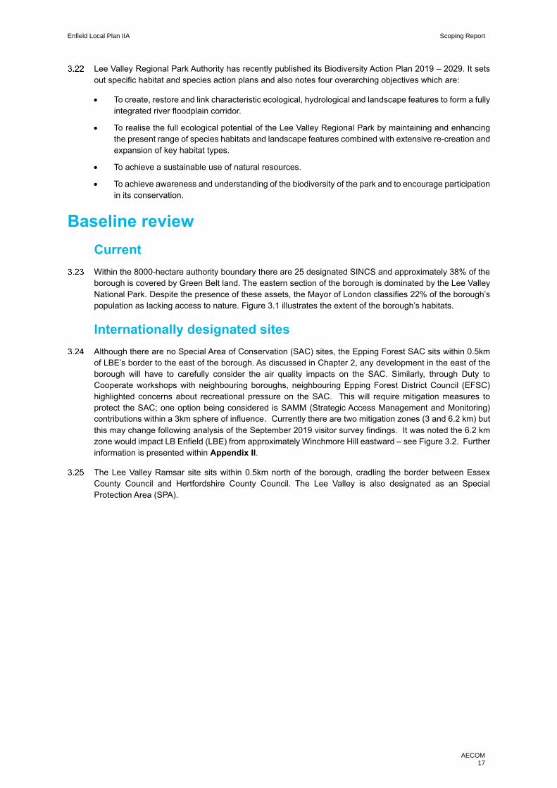
Figure 3.1 Broad habitats in Enfield’s open spaces ...................................................................................................................... 18
Figure 3.2: Epping Forest SAC: recreational zones of influence .................................................................................................. 19
Figure 4.1: UKCP18 projected summer and winter changes by the 2070s .................................................................................. 23
Figure 4.1: Land Sat image of land surface temperature in June 2011 in London ....................................................................... 29
Figure 4.2: Flood risk in LBE ......................................................................................................................................................... 31
Figure 5.1: The London Plan’s energy hierarchy and associated targets ..................................................................................... 34
Figure 5.2: London-wide 2015 greenhouse gas emissions by sector ........................................................................................... 35
Table 5.1: Local authority CO2 emissions estimates within the scope of influence of local authorities 2005-2016 ...................... 37
Figure 5.3: Proportion of energy demand and CO2 emissions from different building types within Enfield ................................. 39
Table 6.1: Population growth 2011 – 2018 ................................................................................................................................... 45
Table 6.2: Age structure in 2011 ................................................................................................................................................... 45
Table 6.3: Age structure in 2018 – mid-year ................................................................................................................................. 45
Figure 6.1: 2011 Census prevalence of non-white ethnic groups in Enfield ................................................................................. 46
Figure 6.2: Enfield multiple indices of deprivation map (2015) ..................................................................................................... 47
Figure 6.3: Indictors of deprivation in comparison to the London average and the national median rank .................................... 47
Table 6.4: Relative household deprivation dimensions (2011) ..................................................................................................... 48
Table 6.5: Educational Qualifications, 2011 Census .................................................................................................................... 49
Figure 7.1: Enfield crime breakdown April 2018 – 2019 .............................................................................................................. 53
Figure 7.2: Serious youth violence in Enfield, May 2018 – April 2019 .......................................................................................... 54
Figure 8.1: UK productivity relative to other G7 countries ............................................................................................................ 56
Figure 8.2: Overview of the Industrial Strategy ............................................................................................................................. 57
Table 8.1: Spatial Distribution of New Jobs .................................................................................................................................. 58
Figure 8.3: Population estimates 2018-male/female age pyramid ................................................................................................ 59
Figure 8.4: Age profiles, Enfield and comparators ........................................................................................................................ 60
Figure 8.5: LBE claimant count by middle super output area, December 2013............................................................................ 61
Table 8.1: Highest level qualifications (2011 Census) .................................................................................................................. 62
Figure 8.6: Area Action Plans and Regeneration Areas ............................................................................................................... 63
Figure 9.1 Percentage of children aged 10-11 years old who are overweight or obese in LBE ................................................... 67
Figure 9.2: General health status (2011 Census) ......................................................................................................................... 68
Table 9.1 Long term health category ............................................................................................................................................ 68
Table 9.2 Life expectancy at birth 2009 – 2013 ........................................................................................................................... 69
Figure 9.3 Percentage of residents completing 2 x 10 minutes of active travel per day ............................................................... 70
Figure 10.1: Listed buildings and registered parks and gardens .................................................................................................. 75
Figure 11.1: Enfield housing trajectory (2019) .............................................................................................................................. 80
Table 11.1: Weekly rent levels across tenure (Enfield House and Growth Strategy 2020-2030) ................................................. 80
Table 11.2: Homelessness in Enfield ............................................................................................................................................ 81
Table 11.3: Affordable housing completions (AMR) .................................................................................................................... 81
Figure 12.1: Green infrastructure and policy priorities .................................................................................................................. 86
Figure 12.2: A map of LBE’s green spaces .................................................................................................................................. 90
Figure 12.3: LBE’s Important Local Longer Distance Views ......................................................................................................... 91
Figure 13.1: The 10 indicators to the Healthy Street approach .................................................................................................... 94
Figure 13.2: Established cycle routes within LBE ........................................................................................................................ 97
Figure 13.3 Car and van ownership .............................................................................................................................................. 98
Figure 13.4: Method of travel to work ........................................................................................................................................... 98
Table 14.1: LBE watercourses and regulatory status ................................................................................................................. 104
Box 1: The legislative basis for Appropriate Assessment ........................................................................................................... 117
Figure 1: Four Stage Approach to Habitats Regulations Assessment. Source MHCLG, 2006. ................................................. 119
Enfield Local Plan IIA Scoping Report
AECOM i
Non-technical Summary AECOM has been commissioned by the London Borough of Enfield (LBE) to lead on the Integrated Impact
Assessment (IIA) in support of the emerging New Enfield Local Plan 2041.
The Local Plan, once adopted, will establish a spatial strategy, in respect of housing, employment and other forms
of development, up to 2041, allocate sites to deliver that strategy and establish policies to guide the planning
application process. The new Local Plan will replace the Core Strategy (2010), the Development Management
Document (2014) and several Area Action Plans. Importantly, the new Local Plan will be in accordance with the
Draft New London Plan, which is currently at an advanced stage of preparation.
IIA involves undertaking the legally required Sustainability Appraisal (SA) process alongside: Equality Impact
Assessment (EqIA), which is undertaken in order to discharge the Public Sector Equality Duty; Community Safety
Impact Assessment (CSIA), in line with the Council’s duty to do all that reasonably can be done to prevent crime
and disorder; and Health Impact Assessment (HIA) to promote health equality and have regard to the health effects
of planning policies.
As a first step in the Local Plan IIA process there is a need to establish the ‘scope’ of issues and objectives that
should be a focus of subsequent assessment stages. As such, a draft version of this Scoping Report was published
for consultation in early 2020, and then this report was then updated to reflect consultation responses received.
Appendix I of this report presents a summary of consultation responses received and resulting updates.
This report is structured under a series of broad topic headings, with the headings selected in order to reflect the
breadth of IIA. Each topic-specific chapter presents a review of evidence before arriving at a shortlist of key issues
that should be a focus of future assessment work, with the list of key issues then distilled to one or more objectives.
The list of topics and objectives is collectively known as the IIA framework, and is presented in the table below.
The IIA framework will be used to guide and focus forthcoming assessment work, although it is naturally the case
that the scope of the IIA is not ‘set in stone’, but rather will evolve over time in response to emerging evidence and
evolving understanding of the key issues of relevance to Local Plan decision-making.
Also, please note that Appendix II of this report presents a discussion of the scope of forthcoming Habitats
Regulations Assessment (HRA). HRA is a separate process focused on avoiding impacts to internationally
designated biodiversity sites, and there is no formal requirement to ‘scope’; however, an early discussion of HRA
scope is considered appropriate. In short, the discussion within Appendix II concludes that the HRA of the Local
Plan is likely to require a focus on the risk of adverse effects on Epping Forest, although impacts on Lee Valley
SPA/Ramsar site and Wormley Hoddesdon Park Woods SAC will also need to be a consideration.
Finally, please note that a range of initial engagement activities were undertaken in order to inform preparation of
this Scoping Report (in addition to the formal consultation), as discussed within Appendix III of this report.

Enfield Local Plan IIA Scoping Report
AECOM ii
The IIA framework
Topic Objective(s)
Air quality
• Minimise air pollution, support reduced air pollution in existing hotspots and avoid the creation of new air pollution hotspots, contributing to the achievement of the national and London-wide targets.
Biodiversity
• Deliver biodiversity net gain at an ambitious scale through individual development contributions and a wider strategic focus on avoiding/mitigating impacts to valued habitats and land that contributes to ecological connectivity and delivering targeted enhancements that improve the functioning of networks and are supportive of established conservation objectives.
Climate change adaptation
• Ensure resilience to climate change particularly mindful of the likelihood of climate change leading to problematic high temperatures, worsened flood risk and increased risk of drought.
Climate change mitigation • Ensure the Local Plan serves to minimise LBE’s per capita CO2 emissions
such that the borough is on track to achieve carbon neutrality by 2030.
Communities
• Support good access to services, facilities and wider community infrastructure, for new and existing residents, mindful of the potential for community needs to change over time.
• Develop social cohesion through good urban design, using the healthy streets indicators and community spaces that act as a catalyst for community cohesion.
• Seek to ensure new developments provide for existing communities delivering targeted actions including in respect of housing needs, community infrastructure and urban realm.
Crime and community safety
• Support targeted interventions to reduce crime and increase community safety, guided by LBE’s Crime and Community Safety team, and ensure high quality new developments that are future proofed.
• Focus on delivering the ‘Vision Zero’ target for road safety; through safe street design using healthy streets principles to ensure pedestrians and cyclists can travel safely.
Economy and employment
• Support a strong, diverse and resilient economy that provides opportunities for all, including by supporting strategic industrial locations, the vitality of the borough’s town and local centres and a diversification of the employment opportunities locally, including employment within the social enterprise, voluntary and community sectors and a growing higher wage economy.
Health
• Improve the physical and mental health and wellbeing of Enfield residents and reduce health inequalities between local communities within the borough.
Heritage and townscape
• Sustain and enhance the significance of heritage assets, support the integrity, special interest, character, appearance and historic setting of historic settlements and heritage assets, both designated and non-designated; facilitate enhancements to the fabric and setting of the historic environment; and support access to, interpretation and understanding of the historic environment (including through investigations and studies which better reveal the significance of archaeological assets).
Housing
• Deliver housing to meet agreed targets and support an appropriate mix of housing types and tenures, including affordable and specialist housing, including housing for the elderly and disabled people.
Landscape and green
infrastructure
• Protect and enhance the character, quality and diversity of the borough’s landscapes and townscapes through appropriate location, layout and design of new development, including the preservation of important open gaps and key views, and contribute to London-wide Green Infrastructure objectives including in respect of the Lea Valley Regional Park.
Transport
• Minimise the need to travel, support modal shift away from the private car and address traffic congestion within the borough and along key routes through neighbouring areas, with a focus on emission reduction, health impacts and the delivery of pedestrian friendly urban design.
Water
• Minimise water use in new developments through innovative design measures and ensure that development is directed to locations with sufficient wastewater infrastructure capacity.

Enfield Local Plan IIA Scoping Report
AECOM 1
1. Introduction
Background
AECOM has been commissioned by the London Borough of Enfield (LBE) to lead on the Integrated Impact
Assessment (IIA) in support of the emerging New Enfield Local Plan 2041.
The Local Plan, once adopted, will establish a spatial strategy, in respect of housing, employment and other
forms of development, up to 2041, allocate sites to deliver that strategy and establish policies to guide the
planning application process. The new Local Plan will replace the Core Strategy (2010), the Development
Management Document (2014) and several Area Action Plans. Importantly, the new Local Plan will be in
accordance with the Draft New London Plan, which is currently at an advanced stage of preparation.
IIA involves undertaking the legally required Sustainability Appraisal (SA) process alongside: Equality
Impact Assessment (EqIA), which is undertaken in order to discharge the Public Sector Equality Duty;
Community Safety Impact Assessment (CSIA), in line with the Council’s duty to do all that reasonably can
be done to prevent crime and disorder; and Health Impact Assessment (HIA) to promote the reduction of
health inequality and have regard to the health effects of planning policies.
IIA must be undertaken in accordance with the procedural requirements set out by the Environmental
Assessment of Plans and Programmes (‘SEA’) Regulations 2004. The process involves four steps:
IIA Stage Description
1) Scoping Establish the key issues/objectives that will (and will not) be
a focus of the assessment stages.
2) Establish and assess reasonable alternatives Explore alternative ways of achieving plan objectives in time
to inform the preparation of the Draft Plan.
3) Assess the emerging Draft Plan
Scrutinise the performance of the emerging plan in respect of
the framework of issues/objectives established at the scoping
stage and make recommendations to the plan-maker.
4) Publish the IIA Report
Publish a report alongside the Draft Plan that presents a
range of required information, but fundamentally an
assessment of ‘the plan and reasonable alternatives’ in order
to inform the consultation and plan finalisation.
This Scoping Report
As a first step in the Local Plan IIA process there is a need to establish the ‘scope’ of issues and objectives
that should be a focus of subsequent assessment stages. As such, a draft version of this Scoping Report
was published for consultation in early 2020, and then this report was then updated to reflect consultation
responses received.1 Appendix I of this report presents a summary of consultation responses received
and resulting updates.
This report is structured under a series of broad topic headings, with the headings selected in order to reflect
the breadth of IIA. Each topic-specific chapter presents a review of evidence before arriving at a shortlist
of key issues that should be a focus of future assessment work, with the list of key issues then distilled to
one or more objectives. The resulting list of topics and objectives, collectively known as the IIA framework,
will be used to guide and focus forthcoming assessment work.
1 The SEA Regulations require that: “When deciding on the scope and level of detail of the information that must be included in the Environmental Report [i.e. the SA scope], the responsible authority shall consult the consultation bodies”. In England, the consultation bodies are the Environment Agency, Historic England and Natural England. In-line with Article 6(3) of the SEA Directive [the forerunner to the SEA Regulations], these bodies were selected because “by reason of their specific environmental responsibilities, [they] are likely to be concerned by the environmental effects of implementing plans...”
Enfield Local Plan IIA Scoping Report
AECOM 2
A note on integrating EqIA
The Equality Act 2010 (the Act) introduced a public sector equality duty. It covers the following protected
characteristics: age, disability, gender reassignment, marriage and civil partnership, pregnancy and
maternity, race, religion or belief, sex and sexual orientation. Under the duty the Council must, in the
exercise of its functions, have due regard to the need to: eliminate unlawful discrimination, harassment and
victimisation and other conduct prohibited by the Act; advance equality of opportunity between people who
share a protected characteristic and those who do not; and foster good relations between people who share
a protected characteristic and those who do not.
Equalities issues are highly cross-cutting, and hence the aim at the outset of the Enfield Local Plan IIA
scoping process, was to explore equalities issues as necessary under all thematic topic headings, rather
than under a single, dedicated topic heading. It follows that assessment work will involve exploring
equalities as necessary under thematic headings, in a fully integrated manner, although there will also be a
need to present a stand-alone discussion of equalities-related assessment findings.
Finally, it is important to note the evidence-base limitations that exist. In many cases there is a lack of
evidence to show how protected characteristic groups are geographically spread/concentrated, or to show
that groups have a particular association with one or more of the types of land use. Evidence gathering and
engagement to understand strategic spatial equalities issues will continue throughout the Local Plan / IIA
process; however, it is important to recognise that some equalities issues are appropriately considered at
the development management / planning application stage of planning, when detailed decisions are made
on matters including masterplanning and design, and detailed evidence-gathering can be undertaken.
A note on integrating HRA
AECOM is also leading on a further legally required assessment process, namely Habitats Regulations
Assessment (HRA); however, HRA involves distinct procedural steps, and hence is undertaken as a stand-
alone process. Further information on HRA is presented within Appendix II.
A note on evidence
In addition to formal consultation, this Scoping Report was informed by a series of meetings with specialist
teams within London Borough of Enfield. Further to this, a workshop was held with neighbouring local
authorities and key external stakeholders to gain an appreciation of cross-boundary and strategic issues for
the sub-region. Meeting notes are presented in Appendix III.
Enfield Local Plan IIA Scoping Report
AECOM 3
Introduction to the plan area
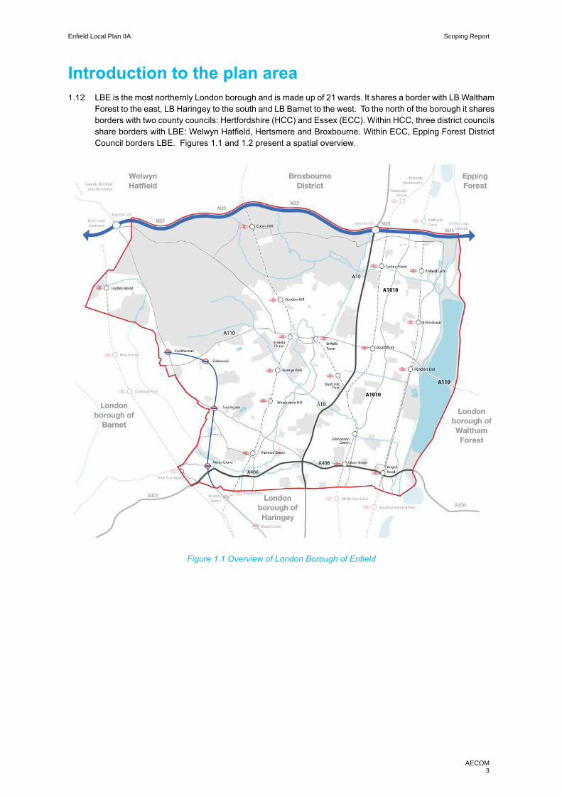
LBE is the most northernly London borough and is made up of 21 wards. It shares a border with LB Waltham
Forest to the east, LB Haringey to the south and LB Barnet to the west. To the north of the borough it shares
borders with two county councils: Hertfordshire (HCC) and Essex (ECC). Within HCC, three district councils
share borders with LBE: Welwyn Hatfield, Hertsmere and Broxbourne. Within ECC, Epping Forest District
Council borders LBE. Figures 1.1 and 1.2 present a spatial overview.
Figure 1.1 Overview of London Borough of Enfield

Enfield Local Plan IIA Scoping Report
AECOM 4
Figure 1.2 LBE in the sub-regional context

Enfield Local Plan IIA Scoping Report
AECOM 5
2. Air quality
Introduction
Air pollution is the top environmental risk to human health in the UK, and the fourth greatest threat to public
health after cancer, heart disease and obesity. A recent report from The Lancet Commission on pollution
and health (2017), estimates that within the UK, air pollution is linked to 50,000 deaths each year.2 Recent
research commissioned by Public Health England has found that the health and social care costs of two
key pollutants (PM2.5 and NO2) in England could reach £5.3 billion by 2035.3 Furthermore, in a recent
report published by Public Health England, long term exposure to air pollution is estimated to attribute to
between 28,000 – 36,000 deaths per annum.4
This is a cumulative cost for diseases where there is a strong association with air pollution: coronary heart
disease; stroke; lung cancer; and child asthma. When diseases with weaker evidence of association are
also added, including dementia, the costs could reach to £18.6 billion by 2035. When all diseases are
included, air pollution is expected to cause 2.4 million new cases of disease in England between now and
2035. Small changes can make a big difference – just a 1µg/m3 reduction in PM2.5 could prevent 50,000
cases of heart disease by 2035.
Air pollution also harms the natural environment, with many ecosystems known to be impacted significantly
by current levels of pollution.
In the London context, the key driver of air pollution is transport, this link will be explored in greater detail
within this chapter and chapter 13. The primary source of pollution varies from pollutant to pollutant but for
the purposes of the this report it is considered appropriate to focus primarily on pollution from transport, with
the main pollutant being nitrogen dioxide (NO2) and Particulate Matter (PM2.5 and PM10).
Context review
National
The European Union has driven air quality regulation and standards in the UK. The Air Quality Standards
Regulations 2010 transpose into UK law the EU Ambient Air Quality Directive (2008/50/EC) which sets
legally binding limits for outdoor concentrations of major air pollutants which impact public health. Although
Brexit is imminent, the Government has been clear that there are no plans to change air quality standards
and limits and therefore it is likely air quality legislation will be converted to domestic law.
The European Union has set legally binding concentration limits on Particulate Matter (PM10 and PM2.5) and
Nitrogen Dioxide (NO2).
Defra has set national emission reduction targets for five air pollutants: Fine particulate Matter (PM2.5), ammonia (NH3), Nitrogen Oxides (NOx), Sulphur Dioxide (SO2) and non-methane volatile organic compounds (NMVOCs).5
2 www.thelancet.com/commissions/pollution-and-health 3 www.gov.uk/government/news/new-tool-calculates-nhs-and-social-care-costs-of-air-pollution 4 Public Health England (2019) ‘Review of interventions to improve outdoor air quality and public health’ [online], avaialble at: https://assets.publishing.service.gov.uk/government/uploads/system/uploads/attachment_data/file/795185/Review_of_interventions_to_improve_air_quality.pdf 5 Defra (2019) Clean Air Strategy 2019 [online] available at: https://assets.publishing.service.gov.uk/government/uploads/system/uploads/attachment_data/file/770715/clean-air-strategy-2019.pdf

Enfield Local Plan IIA Scoping Report
AECOM 6
The UK published its Clean Air Strategy in 2019, setting out the comprehensive action that is required from
across all parts of government and society to meet air quality goals. It aims to complement the Clean
Growth Strategy (2017) and the Industrial Strategy (2017), which itself notably supported the £1.7bn
Transforming Cities Fund which aims to invest in new public and sustainable transport connectivity to boost
productivity.6 Key statements in respect of transport, clean growth and protecting the environment are as
follows:
• “Transport is a significant source of emissions of air pollution. The immediate air quality challenge is
to reduce emissions of nitrogen oxides in the areas where concentrations of these harmful gases
currently exceed legal limits. The government has already committed more than £3.5 billion to tackle
poor air quality through cleaner road transport and is working closely with local authorities and Local
Economic Partnerships to make progress. Alongside this, the government is committed to cutting air
pollution from all forms of transport”
• “Action to clean up the air will boost productivity and economic growth. We will make the UK a world
leader in the development, use and export of goods and services focused on tackling air pollution.”
• “This strategy is a key part of delivering our 25 Year Environment Plan. Air pollution has direct impacts
on the natural environment... Cleaner air will directly benefit animals and habitats as well as creating
a better environment for everyone to live, work and thrive in.”
Key messages from the National Planning Policy Framework (NPPF) 7 with respect to air quality include:
• Planning policies and decisions should sustain and contribute towards compliance with relevant limit
values or national objectives for pollutants, considering the presence of Air Quality Management Areas
(AQMAs) and Clean Air Zones, and the cumulative impacts from individual sites in local areas.
• Opportunities to improve air quality or mitigate impacts should be identified, such as through traffic
and travel management, and green infrastructure provision and enhancement. So far as possible
these opportunities should be considered at the plan-making stage, to ensure a strategic approach
and limit the need for issues to be reconsidered when determining individual applications. Planning
decisions should ensure that any new development in Air Quality Management Areas and Clean Air
Zones is consistent with the local air quality action plan.
• Significant development should be focused on locations which are or can be made sustainable,
through limiting the need to travel and offering a genuine choice of transport modes. This can help to
reduce congestion and emissions and improve air quality and public health.
• New and existing developments should be prevented from contributing to, being put at unacceptable
risk from, or being adversely affected by unacceptable levels of air pollution.
The government published the ‘UK plan for tackling roadside nitrogen dioxide concentrations’ in July 2017.8
This is the air quality plan for bringing nitrogen dioxide within statutory limits in the shortest possible time.
The plan identifies that “the link between improving air quality and reducing carbon emissions is particularly
important” and that consequently the UK government is determined to be at the forefront of vehicle
innovation by making motoring cleaner.
6 www.consult.defra.gov.uk/environmental-quality/clean-air-strategy-consultation/user_uploads/clean-air-strategy-2018-consultation.pdf 7 MHCLG (2018) National Planning Policy Framework [online] available at: https://assets.publishing.service.gov.uk/government/uploads/system/uploads/attachment_data/file/728643/Revised_NPPF_2018.pdf [accessed 03/08/18] 8 DEFRA (2017) ‘UK plan for tackling nitrogen dioxide concentrations’ [online], available at: https://assets.publishing.service.gov.uk/government/uploads/system/uploads/attachment_data/file/633269/air-quality-plan-overview.pdf

Enfield Local Plan IIA Scoping Report
AECOM 7
Regional
Key messages with respect to air quality from the Draft London Plan (2017)9 include:
• Policy SI1 Improving air quality: which states that development proposals should not: lead to further
deterioration of existing poor air quality; create new areas which exceed air quality limits; reduce air
quality benefits from activities or initiatives at borough-level, and; create unacceptable risk of high
levels of exposure to poor air quality.
• Policy SI2 Minimising greenhouse gas emissions: says that major development should be net zero-
carbon to support London becoming a zero-carbon city.
• Policy SI8 Waste Capacity and net waste self-sufficiency: details how development proposals for new
or extensions to waste facilities should be evaluated, including: “where a site is likely to produce
significant air quality, dust or noise impacts, it should be fully enclosed”.
• Policy GG3 Creating a healthy city: seeks to “improve London’s air quality, reduce public exposure to
poor air quality and minimise inequalities in levels of exposure to air pollution.”
The London Environment Strategy (2018) (MES)10 ambitiously aims to transform London’s air quality from
“illegally poor” to “the best air quality of any major world city” by 2050. Key message from Chapter 4 (Air
Quality) include:
• Trends for NO2, PM10 and PM2.5 all show a reduction in emissions at a London-wide scale, though NO2
emissions continue to breach mean EU limits.
Some of the main policies for air quality in the MES are:
• Policy 4.1.1 Make sure that London and its communities, particularly the most disadvantaged and
those in priority locations, are empowered to reduce their exposure to poor air quality
• Policy 4.2.1 Reduce emissions from London’s road transport network by phasing out fossil fuelled
vehicles, prioritising action on diesel, and enabling Londoners to switch to more sustainable forms of
transport
• Policy 4.2.3 Reduce emissions from non-transport sources, including by phasing out fossil fuels
• Policy 4.3.2 The Mayor will encourage the take up of ultra-low and zero emission technologies to make
sure London’s entire transport system is zero emission by 2050 to further reduce levels of pollution
and achieve WHO air quality guidelines
The Mayors Transport Strategy (2018) also sets out strong recommendations to resolve air quality in
London. In particular the Ultra Low Emission Zone (ULEZ) is the key programme proposed to tackle this,
stating that road traffic is the key source of air quality issues in areas where people live and work. Proposal
21 within the MTS states the timeline and growth of the programme form central to inner London:
• Proposal 21: The Mayor, through TfL, will seek to introduce the central London Ultra Low Emission
Zone (ULEZ) standards and charges in 2019, tighter emissions standards London-wide for heavy
vehicles in 2020, and an expanded ULEZ covering inner London in 2021.
Air quality is also one the 10 Healthy Streets indicators ‘Clean Air – Improving air quality delivers benefits
for everyone and reduces unfair health inequalities. An essential part of this programme is the ‘Liveable
Neighbourhoods’ programme, which through local measures aims to address pollution from transport in
local air quality hotspots.11
9 Mayor of London (2017) The Draft London Plan [online] available at: https://www.london.gov.uk/sites/default/files/new_london_plan_december_2017.pdf 10 Mayor of London (20180 London Environment Strategy [online] available at: https://www.london.gov.uk/what-we-do/environment/london-environment-strategy 11 Transport for London (2018) MTS [online] available at: https://www.london.gov.uk/sites/default/files/mayors-transport-strategy-2018.pdf
Enfield Local Plan IIA Scoping Report
AECOM 8
Local
LBE’s most recent Air Quality Action Plan was published in 2015. It shows that problems of air pollution are particularly marked alongside the borough’s major roads, including the A406, A10 and Bullsmoor Lane. The action plan is a working document and focuses on NO2 and PM10 objectives.
The key messages from the current Local Plan (the 2010 Core strategy) are:
• Core Policy 32: The policy notes that air pollution needs to be addressed and any new development
will be required to improve air quality by reducing pollutant emissions and public exposure to pollution.
The policy notes that this should be a particular focus on areas identified as having poor air quality in
the borough’s Air Quality Action Plan.
• The Air Quality Action Plan Local Planning Authorities are required to publish annual Air Quality Annual
Status Reports (ASRs) to discharge their monitoring obligations under Part IV of the Environment Act
(1995). This requires local authorities to review air quality in their areas and designate air quality
management areas (AQMA) if improvements are necessary. Where an AQMA is designated, an air
quality action plan (AQAP) must then be put in place with a five-year time horizon. LBE published its
most recent AQAP in 2015 to cover the period to 2020.
LBE’s adopted Development Management Document (2014) guides decisions on planning applications
within Enfield, the policies set out within this document are linked to one or more of the Core Strategy (2010)
policies, the policies specifically related to air quality are:
• DMD 65: Air Quality: Notes that planning applications will only be accepted if air quality impacts are
neutral and major developments located near air quality hotspots will have to be accompanied by an
air quality assessment.
LBE has three Area Action Plans, all of which support the Core Strategy Policy 32 and DMD 65, given that
the entirety of the borough has been declared an Air Quality Management Area. Notably, the North Circular
Area Action Plan has a policy focused on air quality:12
• Policy 9: Environmental Mitigation – Air quality and Pollution: New development design and
landscaping of the development can support the borough’s expectations that new developments are
at least ‘air quality’ neutral’.
Baseline review
Current
Following detailed assessments, LBE as a whole has been declared an Air Quality Management Area
(AQMA) for N02 and PM10. This was due to the 2011 air quality assessments showing that the 1 hour mean
objective of 200 µg m-3 (not to be exceeded more than 18 times a year) for NO2 and 24 hour mean objective
of 50 µg m-3 (not to be exceeded more than 35 days in one year) for PM10 were exceeded in parts of the
borough.
The Council has four real time air quality monitoring stations; two road side and two background sites, to
assess levels of NO2, PM10 and PM2.5, located at the following sites:
• Prince of Wales School;
• Bush Hill Park;
• Bowes Primary School; and
• Derby Road.
12 LBE (2013) North Circular Area Action Plan [online] available at: https://new.enfield.gov.uk/services/planning/area-action-plans/#4

Enfield Local Plan IIA Scoping Report
AECOM 9
There are also recently install monitoring stations as part of the Breathe London initiative13, located at:
• Hertford Road; and
• Southbury Road.
LBE’s Air Quality Action Plan 2012 showed that the problems of air pollution are mainly caused by road
traffic and are particularly marked alongside the borough’s major roads, including the A406, A10 and A1055
Mollison Avenue and Bullsmoor Lane. The M25 and A10 connection is an area which experiences a regular
build-up of Heavy Goods Vehicles (HGVs) leading to high levels of air pollution.
The borough’s AQAP notes that whilst NO2 decreases have plateaued in recent years; PM pollution is
continuing to decline.
In 2016, the London Atmospheric Emissions Inventory (LAEI) provided updated datasets which establishes
seven AQFAs in the borough, identified in Figure 2.1 below. These seven AQFAs are generally concentrated
around the A406, A10 and Bullsmoor Lane; which LBE has identified as the air quality hotspots.
Areas of poor air quality are strongly correlated with areas of relative deprivation and tend to be located in
key corridors connecting east and west and north and south. This is evident in figure 2.1 where the greatest
concentrations of NOx are concentrated in the south east of the borough, whereas the more affluent north
west does not suffer the same problem.
• LBE note that this is extenuated by the physical and natural barriers in the east of the borough, which
is characterised by arterial roads, railways and waterways, leading to communities that are located
between sources of emissions and therefore pollution concentration zones.
Future
ULEZ will be expanded up to the A406 as of October 2021, which will result in the southern section of the
borough being within the ULEZ which should help mitigate the air quality issues experienced in the south of
the borough.
• In October 2019 the Mayor of London reported that since the introduction of ULEZ, NO2 emissions
within the zone had been reduced by 36% between February 2017 – September 2019. None of the air
quality monitoring sites located on ULEZ boundary roads have measured an increase in NO2 pollution
levels since the scheme was introduced in April 2019 and that 13,5000 fewer polluting cars were being
driven through London on a daily basis, six months after ULEZ’s introduction14.
Figure 2.1 demonstrates that Bullsmore Lane is a key air quality hotspot, which is particularly affected by
the build-up of HGVs accessing the M25 at Junction 25.
There is growing concern from local stakeholders about the impact of air pollution on the Epping Forest
Special Area of Conservation (SAC)15 from traffic movements along the A406. With key development sites
such as Meridian water with LBE’s boundary, the borough must carefully consider the impacts any
development brings with regards to increased traffic on road infrastructure and the knock-on effect this may
have on the SAC.
13 The Breathe London Initiative is a multi-partner project which aims to better understand the exposure to air pollution in London. It uses state-of-the-art air quality sensors to inform an interactive map of real time air quality data. 14 Mayor of London (2019) ULEZ reduces 13,500 cars daily & cuts toxic air pollution by a third [online] available at: https://www.london.gov.uk/press-releases/mayoral/ulez-reduces-polluting-cars-by-13500-every-day 15 Epping Forest District Council (2019) Habitats Regulations Assessment of Epping Forest District Council Local Plan [online] available at: http://www.efdclocalplan.org/wp-content/uploads/2019/01/EB209-Epping-Forest-Local-Plan-HRA-2019-FINAL.pdf
Enfield Local Plan IIA Scoping Report
AECOM 10
However, new development will likely present opportunities to place increasing focus on sustainable means
of transport, particularly through densifying development at more sustainable locations such as near to
transport hubs, particularly rail. This will help mitigate against future air quality concerns. Within LBE there
are already two such programmes which are helping to deliver this objective:
• Cycle Enfield has been granted a £9 million Liveable Neighbourhood fund from TfLi; and
• Lee Valley Rail Programme has delivered a new train station at Meridian Water and 5.5km of new track
to enable two more trains per hour to run between Stratford and Meridian Water.
• Despite this approach, care should be taken to avoid intensifying development in areas of heavy
industrial history, where land contamination may be a conflicting material consideration.
Broxbourne District Council is in the process of declaring a Clean Air Zone, which will charge road users to drive within the zone. This may have an impact on the future baseline situation due to traffic using other routes, as road users look to avoid charges.
A changing private vehicle fleet mix will also have its influence on air quality in the borough. LBE are
installing five new rapid electric vehicle charges, to add to the borough’s current crop of 20 charging points.
It is also important to note that as a city London expects the number of electric vehicles on the road to
increase from 20,000 to 330,0000 by 2025.16
Given that Edmonton Eco-Park sits within the borough’s boundary, the North London Heat and Power
project could result in increased air pollution from waste facilities. However, the project claims that the new
facilities will perform 60% better than the permitted levels of NOx, in comparison to the current facilities
which perform 20% better.17
16 Mayor of London (2019) Mayor sets out plans for London’s electric vehicle future [online] available at: https://www.london.gov.uk/press-releases/mayoral/mayor-sets-out-londons-electric-vehicle-future 17 NLWA (2020) Modernising Edmonton EcoPark [online] available at: http://northlondonheatandpower.london/project/
Case Study: Waltham Forest’s Mini-Holland programme delivered cycling and walking routes across the
borough. Since 2015, 22km of segregated cycle lanes have been constructed as well as 104 new pedestrian
road crossings. In 2018, the borough commissioned Kings College London to study the impacts this
programme had on air quality exposure between. The study focused on exposure in 2013, 2020 without
cycling segregation, and 2020 with cycling segregation at seven of the introduced segregated cycle lanes
and found that exposure reduced by between 15-25% for NO2, and 6-13% for PM2.5.
https://walthamforest.gov.uk/sites/default/files/WalthamForest_Kings%20Report_310718.pdf

Enfield Local Plan IIA Scoping Report
AECOM 11
Figure 2.1: Focus areas LAEI 2013 in Enfield – December 2016 update18
18 LAEI (2016) Air Quality Data [online] available at: https://data.london.gov.uk/air-quality/

Enfield Local Plan IIA Scoping Report
AECOM 12
Key issues and objectives
The following key issues emerge from the context and baseline review:
• The entire borough has been declared an AQMA and there are seven AQFAs focused on the three
main roads; A10, A406 and Bullsmoor Lane.
• The east and west equalities divide is mirrored in air quality issues within the borough, and there is
also a broad concentration of poor air quality in the south of the borough.
• The ULEZ will be active in the southern section of the borough from 2021 leading to benefits but also
potentially knock on implications for other areas due to traffic re-routing.
• As per the Draft New London Plan policy, consideration should be given to the impacts of unenclosed
waste facilities on dust and particulate pollution, this is particularly important where facilities are located
in less industrialised areas.
• The borough is supportive of the ambitious London-wide air quality targets emphasised in the MES.
• Spatial strategy and policy must be set so as to direct development away from areas of poor air quality;
direct development to locations where there will be lowest reliance on the private car and lowest
likelihood of leading to problematic traffic congestion; and support low emission technologies and
improvements to ‘sustainable transport’ infrastructure. Growing concerns over the impact of air
pollution from development in LBE on Epping Forest SAC illustrate the importance of dealing with this
issue.
In light of the key issues discussed above it is proposed that the IIA should include the following objective:
Minimise air pollution, support reduced air pollution in existing hotspots and avoid the creation of new
air pollution hotspots, contributing to the achievement of the national and London-wide targets.

Enfield Local Plan IIA Scoping Report
AECOM 13
3. Biodiversity
Introduction
‘Biodiversity’ describes the biotic variation, from the level of genes to whole ecosystems, within a given area.
Losing biodiversity erodes the functioning of our environment, which is critical for our economy and
wellbeing: everything from flood mitigation and clean water, to crop pollination, climate regulation and good
mental health can be related to biodiversity.
These benefits can be framed as ecosystem services flowing from a stock of ‘natural capital’ assets.
Notwithstanding the limits of the metaphor, this ‘Ecosystems Approach’ is extremely important in public
policy and has been mainstreamed through the international Convention on Biological Diversity (2000).19
Despite being so important for sustainable development, biodiversity has declined rapidly over the course
of the last 50 years, both nationally and internationally. The Organisation for Economic Co-operation and
Development (OECD) predicts - that biodiversity will continue decreasing by a further 10% by 2050.20 The
cost implications of this are significant, estimated at €14 trillion (equivalent to 7% of the world’s GDP) by
2050.21
The loss of biodiversity in the UK has been significant, rapid, and continues. The most recent State of
Nature report looks at trends in our species from around 1970 to 2013 (the ‘long term’) and 2002 to 2013
(the ‘short term’).22 The index of change in abundance and occupancy of terrestrial and freshwater species
has fallen by 0.4% each year over the long-term period, resulting in a statistically significant decline of 16%
in total. Over the short-term period, the decline was 0.18% per year, and 3% in total. Although the rate of
decline does appear to have slowed, the difference between long-term and short-term trends is not
statistically significant.
The main causes of biodiversity loss in the UK include:
• Land use change (including direct land-take through urbanisation, or changes in land management,
such as intensification of agriculture);
• Climate change;
• Hydrological change (e.g. drainage of wetlands or over-abstraction);
• Pollution (including nutrient-loading from air pollution);
• Invasive species, pests and disease;
• Disturbance including through recreational use; and
• Direct mortality (e.g. road casualties or predation from domestic cats).
Planning for new developments in LBE will have implications for a number of these causes of biodiversity
loss, recognising that impacts will be both direct and indirect.
It is also the case that biodiversity gains through development can and should be achieved both at the scale
of individual developments, and at wider functional scales. For example, a decision to focus development
in the east of the borough, in close proximity to the Lee Valley Regional Park might lead to a business case
for delivering habitat corridors through the developments, to help strengthen biodiversity connections within
the borough.
19 Convention on Biological Diversity (2000) COP Decisions [online] available at: https://www.cbd.int/decisions/cop/default.shtml?m=cop-05 20 OECD (2012) Environmental Outlook to 2050:The consequences of Inaction [online] available at: www.oecd.org/env/indicators-modelling-outlooks/49897175.pdf 21 IEEP (2008) The cost of policy inaction; The case of not meeting the 2010 biodiversity targets [online] available at: https://ieep.eu/uploads/articles/attachments/137ae972-0286-4ae2-a965-5984664ae2f2/copi_final_report_jun.pdf?v=63664509715 22 RSPB (2016) State of Nature 2016 [online] available at: www.rspb.org.uk/globalassets/downloads/documents/conservation-projects/state-of-nature/state-of-nature-uk-report-2016.pdf

Enfield Local Plan IIA Scoping Report
AECOM 14
Context review
National
Key messages from the NPPF in relation to biodiversity include:
• One of the three overarching objectives of the NPPF is to ‘contribute to protecting and enhancing our
natural, built and historic environment’ including by ‘helping to improve biodiversity’.
• Plans should: distinguish between the hierarchy of international, national and locally designated
[wildlife] sites; allocate land with the least environmental or amenity value, take a strategic approach
to maintaining and enhancing networks of habitats and green infrastructure; and plan for the
enhancement of natural capital at a catchment or landscape scape across local authority boundaries.
• Planning policies and decisions should contribute to and enhance the natural and local environment
by: protecting and enhancing valued landscapes, sites of biodiversity or geological value and soils (in
a manner commensurate with the statutory status or identified quality in the development plan); and
minimising impacts on and providing net gains for biodiversity, including establishing coherent
ecological networks that are more resilient to current and future pressures.
• To protect and enhance biodiversity and geodiversity, plans should:
─ Identify, map and safeguard components of local wildlife-rich habitats and wider ecological
networks, including the hierarchy of international, national and locally designated sites of
importance for biodiversity; wildlife corridors and stepping stones that connect them; and areas
identified by national and local partnerships for habitat management, enhancement, restoration
or creation;
─ Consider River Basin Management Plans when developing planning policies as a means to
protect water habitats that support water and land-based wildlife.
─ Promote the conservation, restoration and enhancement of priority habitats, ecological
networks and the protection and recovery of priority species; and identify and pursue
opportunities for securing measurable net gains for biodiversity; and
─ Take a proactive approach to mitigating and adapting to climate change, considering the long-
term implications for biodiversity.
The Government’s 25 Year Environment Plan includes a commitment to “Embed an ‘environmental net gain’
principle for development, including housing and infrastructure.” The Plan goes onto say that this should
be done through partnership working between local planning authorities and developers “… to mainstream
the use of existing biodiversity net gain approaches within the planning system…”.
Biodiversity 2020: A strategy for England’s wildlife and ecosystem services’ is Defra’s national guidance on
delivering the EU biodiversity commitments and sets out the strategic direction for biodiversity policy until
2020.
The UK Biodiversity Action Plan (BAP) identifies priority species and habitats requiring conservation action.
Although the UK BAP has been superseded, BAP priority species and habitats have been used to draw up
statutory lists of priority species and habitats in England.
Local authorities across the UK have a ‘biodiversity duty’ which means conserving biodiversity should be
considered in all plan and policy making processes.
Enfield Local Plan IIA Scoping Report
AECOM 15
Regional
Key messages with respect to biodiversity from the Draft London Plan (2017) include:
• Policy G1 Green Infrastructure (GI) and the Natural Environment: This policy notes that a GI approach
has a wide range of benefits, including conserving and enhancing biodiversity and ecological
resilience. 23
• Policy G6 Biodiversity and access to nature: Sites of Importance to Nature Conservation (SINCs)
should be protected but also stresses that development plan policies should “support the protection
and conservation of priority species and habitats that sit outside of the SINC network”.
• Policy G7 Trees and woodlands: Highlights the importance of trees within the urban environment, with
biodiversity functions being delivered through the provision of “extensive areas of habitat for wildlife,
especially mature trees”.
One of the four main aims of the MES (2018) is for London to “be the world’s first National Park City where
more than half of its area is green, where the natural environment is protected, and where the network of
green infrastructure is managed to benefit all Londoners”. Part of this approach is to support local authorities
and community groups in managing and valuing biodiversity better. There are a number of relevant
proposals within the MES the contribute to meeting this overall aim:
• Proposal 5.2.1a The London Plan includes policies on the protection of SINCs (see above) and
Regionally Important Geological Sites (RIGS);
• Proposal 5.2.1b The Mayor will develop a biodiversity net gain approach for London, and promote
wildlife-friendly landscaping in new developments and regeneration projects; and
• Proposal 5.2.1d The Mayor will work with key partners to establish a cost-effective monitoring
framework, to ensure important natural environment data is collected consistently to inform future
decision making.
The Mayor’s All London Green Grid Supplementary Planning Guidance (2012) (ALGG) is the Mayor’s green
infrastructure strategy, which includes a section dedicated to conserving and enhancing biodiversity.24 Many
of the approaches set out in the ALGG also outline their importance in delivering biodiversity enhancements.
The relevant sections of the ALGG will be explored in greater detail in Chapter 12 of this document.
LBE is covered by the Thames River Basin Management Plan (RBMP), a particular purpose of this
document is to set out aims and actions to deliver the EU’s Water Framework Directive objective that all
water bodies should reach ‘Good Ecological Status/Potential’ by 2027. Therefore, the aims of the Thames
RBMP should be considered to support delivering biodiversity improvements across the borough. For
instance, the Thames RBMP notes measures to be taken in the Lower Lea catchment, to achieve improved
environmental outcomes, including:
• Install reed beds on the Lee Navigation and at Grovelands Park in the Salmon Brook Catchment.
These projects will contribute to improvements in water quality elements.
Local
The borough’s Core Strategy (2010) notes a key issue is: “enhancing biodiversity and linking habitats via
wildlife corridors particularly in areas deficient in open space in the east and south of the Borough”. There
are a number of policies that seek to deliver this:
• Core Policy 35: Lee Valley Regional Park and Waterways. The policy seeks to work with all riparian
stakeholders to restore and enhance the waterways.
• Core Policy 36: Biodiversity. The policy focuses on protecting, enhancing and restoring biodiversity
interests within the borough, including parks, playing fields and other sports spaces, green corridors,
waterways, sites, habitats and species identified at a European, national, London or local level as
being of importance for nature conservation.
23 The draft London Plan notes that a GI approach takes a strategic, integrated approach to conserving, managing and delivering, green spaces, green roofs, urban trees and other natural an semi natural features to deliver a range of objectives. 24 GLA (2012) ALGG [online] available at: https://www.london.gov.uk/file/2390

Enfield Local Plan IIA Scoping Report
AECOM 16
LBE’s adopted Development Management Document (2014) guides decisions on planning applications
within Enfield, the policies set out within this document are linked to one or more of the Core Strategy (2010)
policies, the policies specifically related to biodiversity are:
• DMD 63: Protection and Improvements of Watercourses and Flood Management: Requires that new
developments should be set back from watercourses and maintain a minimum 8 metre buffer strip that
should be naturalised. This policy should ignite watercourse habitat improvements and offers an
important opportunity to enhance biodiversity and habitat connectivity.
• DMD 78: Nature Conservation: Notes that development that has a direct or indirect impact on important
ecological assets will only be granted permission if sufficient mitigation measures are demonstrated.
• DMD 79 Ecological Enhancements: Developments resulting in the creating of 100m2 of floorspace or
one net dwelling should provide on site ecological enhancements.
• DMD 80: Trees on Development Sites: Notes certain stipulations when working with tress that exist on
a site including the protection of trees with significant biodiversity benefits or covered by Tree
Preservation Orders.
• DMD 81: Landscaping: Proposed developments must provide high quality landscaping that enhances
the local environment.
LBE’s three area action plans follow the lead of the Core Strategy (2011) and the Development Management
Document , noting the importance of protecting and enhancing the borough’s natural, for instance:
• North East Enfield Area Action Plan includes as a chapter titled ‘Green Network and Food Growing’
noting the importance to connect the area’s significant green spaces, including enhancing biodiversity
by providing wildlife corridors.25
The borough published a Local Biodiversity Action Plan in 2011. The document sets out the framework to
delivering conservation, enhancement and increased access to nature and sets out 27 objectives in order
to achieve this, including:
• Objective 1: To review our Local Wildlife Sites regularly and designate and re-design;
• Objective 2: To implement ecological management plans for all Council managed Local Wildlife Sites
by 2015, and to encourage other landowners to implement management plans on sites not managed
by the Council;
• Objective 9: To ensure that new developments result in a net biodiversity gain; and
• Objective 12: To ensure that policies and plans refer to biodiversity conservation and the Biodiversity
Action Plan where appropriate.
Lee Valley Regional Park Authority has a 2011 Development Framework that sets out the vision and
objectives for the park. One of the six aims of the framework is biodiversity conservation and enhancement.
The framework has five area proposals two of which are relevant and should be considered through the
Local Plan evolution:
• Area 4: The Waterlands: Banbury Reservoir to Pickett’s Lock. This proposes to protect existing
ecological value of the reservoir, create a key public waterside route and wildlife corridor, through
schemes such as fringe habitats and reedbed enhancements. It also highlights a number of sites for
new wildlife habitats across the area.
• Area 5: The Waterlands King George V Reservoir to Rammey Marsh. This proposes to restore river
and wetland habitat on land south of Lea Valley Road including habitat provision for water vole. As
above it notes the need to enhance public access to the park and protect existing wildlife such as
nationally important wintering, moulting and feeding site for waterbirds at King George V reservoir.
25 LBE (2016) North East Enfield Area Action Plan [online] available at: https://new.enfield.gov.uk/services/planning/area-action-plans/#4
Enfield Local Plan IIA Scoping Report
AECOM 17
Lee Valley Regional Park Authority has recently published its Biodiversity Action Plan 2019 – 2029. It sets
out specific habitat and species action plans and also notes four overarching objectives which are:
• To create, restore and link characteristic ecological, hydrological and landscape features to form a fully
integrated river floodplain corridor.
• To realise the full ecological potential of the Lee Valley Regional Park by maintaining and enhancing
the present range of species habitats and landscape features combined with extensive re-creation and
expansion of key habitat types.
• To achieve a sustainable use of natural resources.
• To achieve awareness and understanding of the biodiversity of the park and to encourage participation
in its conservation.
Baseline review
Current
Within the 8000-hectare authority boundary there are 25 designated SINCS and approximately 38% of the
borough is covered by Green Belt land. The eastern section of the borough is dominated by the Lee Valley
National Park. Despite the presence of these assets, the Mayor of London classifies 22% of the borough’s
population as lacking access to nature. Figure 3.1 illustrates the extent of the borough’s habitats.
Internationally designated sites
Although there are no Special Area of Conservation (SAC) sites, the Epping Forest SAC sits within 0.5km
of LBE’s border to the east of the borough. As discussed in Chapter 2, any development in the east of the
borough will have to carefully consider the air quality impacts on the SAC. Similarly, through Duty to
Cooperate workshops with neighbouring boroughs, neighbouring Epping Forest District Council (EFSC)
highlighted concerns about recreational pressure on the SAC. This will require mitigation measures to
protect the SAC; one option being considered is SAMM (Strategic Access Management and Monitoring)
contributions within a 3km sphere of influence. Currently there are two mitigation zones (3 and 6.2 km) but
this may change following analysis of the September 2019 visitor survey findings. It was noted the 6.2 km
zone would impact LB Enfield (LBE) from approximately Winchmore Hill eastward – see Figure 3.2. Further
information is presented within Appendix II.
The Lee Valley Ramsar site sits within 0.5km north of the borough, cradling the border between Essex
County Council and Hertfordshire County Council. The Lee Valley is also designated as an Special
Protection Area (SPA).
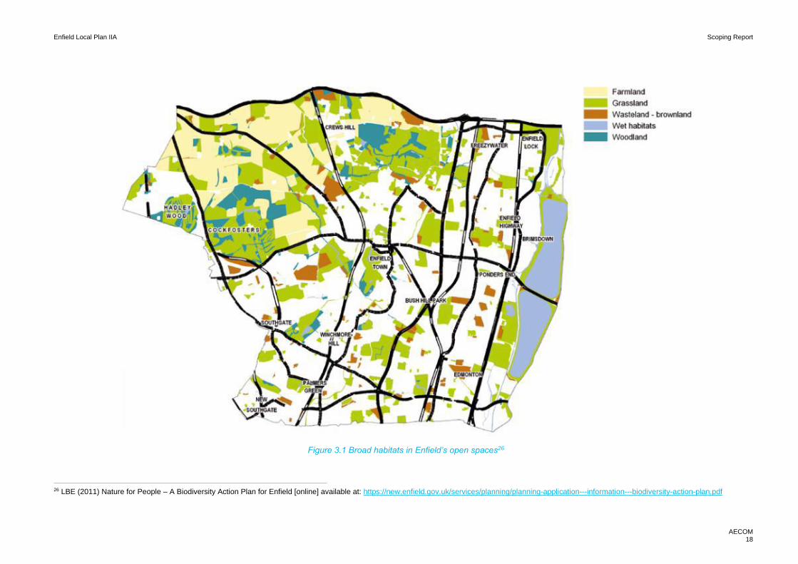
Enfield Local Plan IIA Scoping Report
AECOM 18
Figure 3.1 Broad habitats in Enfield’s open spaces26
26 LBE (2011) Nature for People – A Biodiversity Action Plan for Enfield [online] available at: https://new.enfield.gov.uk/services/planning/planning-application---information---biodiversity-action-plan.pdf
Enfield Local Plan IIA Scoping Report
AECOM 19
Figure 3.2: Epping Forest SAC: recreational zones of influence27
Nationally designated sites
The borough has one large SSSI, Chingford Reservoirs. The entire SSSI is 386.67ha all of which is
considered to be in ‘Unfavourable – Recovering’ condition.
It should be noted that there are a number of SSSIs in close proximity to the borough:
• Walthamstow Reservoir SSSI – within 1km south of LBE;
• Epping Forest SSSI – within 0.5km to the east of LBE;
• Cornmill Stream and Old River Lea SSSI – within 1km north east of LBE;
• Waltham Abbey SSSI – within 1km north east of LBE; and
• Northaw Great Wood SSSI – within 2km north west of LBE.
There are no National Nature Reserves within or in close proximity to LBE. However, there are pockets of
Ancient Woodland sites in the north east of the borough in the Enfield Chase area:
• Whitewebbs Wood;
• Little Beachhill Wood;
• Vault Hill Hood;
• Rough Lot & Moat Wood; and
• Oak Wood;
27 Natural England (2018) Interim Advice Letter to MOU Oversight Group [online] available at: https://walthamforest.gov.uk/sites/default/files/Epping%20Forest%20-%20Interim%20Advice%20Letter%20to%20MOU%20Oversight%20Group%20Final.pdf

Enfield Local Plan IIA Scoping Report
AECOM 20
There are a number of Biodiversity Action Plan (BAP) Priority Habitats spread throughout the borough, 28
(see Figure 3.1) which mainly consist of:
• Wood Pasture and Parkland;
• Good Quality Semi-Improved Grassland;
• Wet Woodland;
• Traditional Orchard; and
• Lowland Meadows.
Locally designated sites
Sites of Importance for Nature Conservation (SINCs) are local wildlife designations which collectively cover
nearly 20% of London’s area.29 Within London there are three tiers of SINCs. Sites of Metropolitan
Importance are the highest value, followed by Sites of Borough Importance and then Sites of Local
Importance.
LBE has in total 41 SINCs30:
• 7 Sites of Metropolitan Importance;
• 19 Sites of Borough Importance; and
• 15 Sites of Local Importance.
Future
Habitats and species have the potential to come under increasing pressure from the provision of new
housing, employment and infrastructure in LBE, including at designated sites. This could include through
increased disturbance (from recreation, noise and light) and atmospheric pollution as well as the loss of
habitats and fragmentation of biodiversity networks. Habitat loss and fragmentation could be exacerbated
by the effects of climate change, which has the potential to lead to changes in the distribution and abundance
of species and changes to the composition and character of habitats.
The air quality impacts of any new development on the Chingford Reservoirs SSSI and neighbouring designated sites, particularly Epping Forest SAC will need to be considered carefully.
With LBE’s aim to reduce severance between the Lee Valley Regional Park and the borough’s communities,
recreational impacts on the Chingford SSSI will need to be carefully assessed and managed. Similarly, with
EFDC raising concerns about the recreational impacts on Epping Forest, LBE should consider mitigation
options to relieve such pressure.
• The designations of SANGs (Suitable Alternative Natural Greenspace) 31 in LBE’s Green Belt could
provide a mitigation option to relive the pressure on Epping Forest. There is also potential to mitigate
through non-SANG strategic GI enhancements throughout the borough.
28 LBE (2011) Nature for People: A Biodiversity Action Plan for Enfield [online] available at: https://new.enfield.gov.uk/services/planning/planning-application---information---biodiversity-action-plan.pdf 29 https://www.london.gov.uk/what-we-do/environment/parks-green-spaces-and-biodiversity/biodiversity 30 LBE (2013) Sites of Importance for Nature Conservation Citations [online] available at: https://new.enfield.gov.uk/services/planning/planning-policy-information-review-of-enfields-sites-of-importance-for-conservation-march-2013.pdf 31 A SANG is an area of open space that can be designated for enhancement, designed to attract visitors to enjoy the natural environment as an alternative to a SPA. The primary aim of a SANG is to protect the biodiversity within the SPA, which usually results in a levy being charged to new developments in the area of the SANG.

Enfield Local Plan IIA Scoping Report
AECOM 21
Future growth can also provide opportunities to increase integration of biodiversity habitats and networks
into new development at a strategic scale. Therefore, new development could potentially unlock
opportunities to protect and enhance important habitats and also enhance the connections between them,
particularly through the provision and enhancement of green infrastructure. Opportunity mapping could be
utilised to identify areas that would provide the most benefit from improved connectivity. These could also
be used to highlight areas of high value for future connectivity and ensure they are adequately protected,
the below case study illustrates how this is possible in a London setting.
Restorations and enhancements to LBE’s waterways will provide an important opportunity to support the
objective of overall net-gain across LBE. Years of industrial use and the pressures of urban development
left the watercourses of the Lower Lee in poor condition; resulting in poor water quality and destruction of
habitat for wildlife.32
With London’s commitment to becoming the world’s first ‘National Park City’, the MES states the city’s
intentions to improve ecological networks, connectivity and resilience across the city. It should, therefore,
be expected that biodiversity related policies will be increasingly to the fore.
32 Environment Agency (2020) Catchment Data Explorer - Lee Lower Rivers and Lakes – Summary [online] available at: https://environment.data.gov.uk/catchment-planning/OperationalCatchment/3275/Summary
Case Study: Woodbury Wetlands Reservoir. The site which is located in the London Borough of Hackney opened in May
2016 following large scale regeneration of the Woodbury Down Estate. The 11-acre site is now a thriving habitat for
migratory birds. Newly planted reedbed extensions provide a haven for waterfowl. The reservoir is now designated a site
of Metropolitan Importance for Nature Conservation and crucially provides access to high quality natural environment
within a densely built urban area.

Enfield Local Plan IIA Scoping Report
AECOM 22
Key issues and objectives
The following key issues emerge from the context and baseline review:
• The borough has one SSSI, Chingford Reservoirs, and 41 SINCs within its boundaries.
• The borough has a mosaic of BAP habitats, with particular concentrations in the north of the borough.
• The Lee Valley is a key strategic asset, with there being a need to improve access and appreciation
alongside responsible management of sensitive wetland habitats.
• Epping Forest SAC is experiencing recreational use pressures and poor air quality which is putting the designated site’s biodiversity under pressure.
• There is a clear opportunity to deliver biodiversity improvements through efforts to improve the
ecological status of theses watercourses through restoration and enhancement efforts.
• Spatial strategy and policy must be set so as to direct development away from sensitive habitats,
including areas of non-designated habitat that contribute to ecological connectivity; support the
achievement of strategic objectives in respect of habitat creation/enhancement and improved
ecological connectivity; and ensure that development is delivered in such a way that impacts to
biodiversity are avoided, mitigated and compensated for in order to ensure that the Local Plan leads
to a biodiversity net gain overall, i.e. at an agreed strategic scale that takes in the extent of landscape
units / ecological networks that extend beyond LBE.
In light of the key issues discussed above it is proposed that the IIA should include the following objective:
Deliver biodiversity net gain at an ambitious scale through individual development contributions
and a wider strategic focus on avoiding/mitigating impacts to valued habitats and land that
contributes to ecological connectivity and delivering targeted enhancements that improve the
functioning of networks and are supportive of established conservation objectives.

Enfield Local Plan IIA Scoping Report
AECOM 23
4. Climate change adaptation
Introduction
The UK Committee on Climate Change introduces the situation nationally as follows:33
“Some degree of climate change is inevitable because of past and present greenhouse gas emissions. And
even with strong international action to curb emissions, global temperatures still have a fifty percent chance
of rising above 2°C by the end of the century.
In England temperatures are, on average, between 0.5 – 1°C higher than they were in the 1970s. Sea
levels have risen by an average of 3 mm each year in recent decades and could increase by 12-76 cm by
the end of the century (compared to 1990 levels).
Extreme weather events already cause damage and disruption. Around two thousand people across the
UK died as a result of the 2003 heatwave. Insured losses from flooding and severe weather events have
cost an average £1.5 billion per year over the past twenty years. In 2007 widespread flooding affected
55,000 homes, killed 13 people and cost the economy £3.2 billion. Events such as these are likely to
become more frequent and severe as the climate changes, as demonstrated ina four month period between
2019-2020 where the UK suffered consistent flooding, which cumulated in significant damage caused by
Storms Ciara and Dennis, in total this is estimated to have cost the insurance industry between £435 million
- £535 million34 . Preparing for climate change today in many instances will reduce the impact of future
costs and damages and enable organisations and individuals to take advantage of any potential
opportunities.”
The most recent climate projections for the UK (UKCP18), suggest that all areas of the country are projected
to experience warmer wetter winters, hotter drier summers and more severe weather events. The projected
changes in temperature and precipitation are summarised in Figure 4.1. Over the next few decades,
changes in UK average temperatures are projected to be similar for the lowest and highest carbon emission
scenarios. Therefore, regardless of mitigation progress, climate adaptation should be considered in all
future planning.
Figure 4.1: UKCP18 projected summer and winter changes by the 2070s
In the context of exploring strategic options for LBE’s New Local Plan, key climate change adaption issues
relate to flooding, heating and drought. Each of these topic headings be explored within this chapter.
33 https://www.theccc.org.uk/tackling-climate-change/preparing-for-climate-change/ 34 UK Parliament (2020) Autumn and winter floods, 2019 – 20 [online] available at: https://commonslibrary.parliament.uk/research-briefings/cbp-8803/

Enfield Local Plan IIA Scoping Report
AECOM 24
Climate change will also impact on the baseline situation in respect of all other topics that are assigned a
chapter within this report, including climate change mitigation. As such, climate change impacts/adaptation
considerations will be considered in a number of chapters in this report.
Context review
National
Key messages from the NPPF in relation to climate change adaptation include:
• Plans should take a proactive approach to mitigating and adapting to climate change, taking into
account the long-term implications for flood risk, coastal change, water supply, biodiversity and
landscapes, and the risk of overheating from rising temperatures. Policies should support appropriate
measures to ensure the future resilience of communities and infrastructure to climate change impacts,
such as providing space for physical protection measures, or making provision for the possible future
relocation of vulnerable development and infrastructure.
• Inappropriate development in areas at high risk of flooding should be avoided by directing development
away from areas of highest risk (whether existing or future).
• Strategic policies should be informed by a strategic flood risk assessment and should manage flood
risk from all sources.
• Plans should take account of the effects of climate change in the long term, taking into account a range
of factors including flooding. Plans should also adopt proactive strategies to adaptation and manage
risks through adaptation measures including well planned green infrastructure.
• Plans should reduce risk from coastal change by avoiding inappropriate development in vulnerable
areas and not exacerbate the impacts of physical changes to the coast.
The UK Climate Change Risk Assessment is published on a 5-yearly cycle in accordance with the
requirements of the Climate Change Act 2008. The Act requires the Government to compile an assessment
of the risks for the UK arising from climate change, and then to develop an adaptation programme to address
those risks and deliver resilience to climate change on the ground. For 2017 UK Climate Change Risk
Assessment (CCRA), the Adaptation Sub-Committee of the Committee on Climate Change commissioned
an evidence report 35 containing six priority risk areas requiring additional action in the next five years:
• Flooding and coastal change risks to communities, businesses and infrastructure;
• Risks to health, well-being and productivity from high temperatures;
• Risk of shortages in the public water supply, and for agriculture, energy generation and industry;
• Risks to natural capital, including terrestrial, coastal, marine and freshwater ecosystems, soils and
biodiversity;
• Risks to domestic and international food production and trade; and
• New and emerging pests and diseases, and invasive non-native species, affecting people, plants
and animals.
In 2018, Defra published the National Adaptation Programme (NAP)36, in response the 2017 CCRA. The
NAP mirrors the evidence report in terms of the key issues listed above. The NAP explains the range of
climate risks which affect the natural environment, critical infrastructure services, communities and
buildings, local government and businesses. The importance of adapting to these climate challenges and
transitioning to a low carbon economy are also set out.
35 Defra (2017): ‘UK Climate Change Risk Assessment Report January 2017’, [online] available to download from: <https://www.gov.uk/government/publications/uk-climate-change-risk-assessment-2017> 36 Defra (2018) ‘National Adaptation Programme: Making the country resilient to a changing climate July 2018’ [online] available at https://assets.publishing.service.gov.uk/government/uploads/system/uploads/attachment_data/file/727252/national-adaptation-programme-2018.pdf

Enfield Local Plan IIA Scoping Report
AECOM 25
Defra has published a report 2019 entitled ‘Preparing for a changing climate: Good Practice Guidance for
Local Government’. The document sets out guidance on how local authorities can lead on climate change
adaptation. The guidance sets out a range of actions that need to be taken in six key areas37:
• Corporate plans, policies and performance;
• Business and industry;
• Natural Capital and GI;
• Infrastructure;
• Land use planning and the built environment; and
• Public health, social care and community resilience.
The Ministry of Housing, Communities & Local Government has produced a guidance document ‘Flood Risk
and coastal change’. This document advises Local Planning Authorities how to take account of and address
the risks associated with flooding and coastal change, This includes guidance on taking into account flood
risk in the preparation of Local Plans.38
The Flood and Water Management Act (2010)39 sets out measures to ensure that risk from all sources of
flooding, not just rivers and seas, are managed more effectively. This includes: incorporating greater
resilience measures into the design of new buildings; utilising the environment in order to reduce flooding;
identifying areas suitable for inundation and water storage to reduce the risk of flooding elsewhere; rolling
back development in coastal areas to avoid damage from flooding or coastal erosion; and creating
sustainable drainage systems (SuDS).
The Committee of Climate Change published a 2012 report entitled ‘How Local Authorities Can Reduce
Emissions and Manage Climate Change Risk’ 40 which emphasises the crucial role councils have in helping
the UK meet its carbon targets and preparing for the impacts of climate change. It outlines specific
opportunities for reducing emissions and highlights good practice examples from a number of local
authorities.
Regional
The London Environment Strategy (2018) (Chapter 8: Adapting to Climate Change) identifies a range of
issues likely to be affected by climate change. It sets out the key threats, which are:
• Heat
• Flooding
• Drought
The chapter’s main aim is that ‘London and Londoners will be resilient to severe weather and longer-term
climate change impacts. This will include flooding, heat risk and drought’. It goes on to set out potential
adaptations and mitigation measures to tackle these threats, including:41
• Policy 8.2.1 Reduce the risk and manage the impacts of surface water, sewer, fluvial, reservoir and
groundwater flooding in London
• Policy 8.2.3 Increase the amount of sustainable drainage, prioritising greener systems across London
in new development, and also retrofit solutions
• Policy 8.4.1 Ensure Londoners can prepare, respond to, and recover from the impacts of extreme heat
and cold events in London
37 ADEPT (2019) ‘Preparing for a changing climate: Good Practice for Local Government’ [online] available at: https://adeptnet.org.uk/system/files/documents/Good%20Practice%20Guide%20ADEPT%202019f.pdf 38 Ministry of Housing, Communities & Local Government (2014) Flood risk and coastal change [online] available at: https://www.gov.uk/guidance/flood-risk-and-coastal-change 39 Flood and Water Management Act (2010) [online] available at: http://www.legislation.gov.uk/ukpga/2010/29/contents Accessed Aug 2017 40 CCC (2012), ‘How local authorities can reduce emissions and manage climate risks’, [online]; available at: https://www.theccc.org.uk/publication/how-local-authorities-can-reduce-emissions-and-manage-climate-risks/ 41 Mayor of London (2018), ‘London Environment Strategy’ [online], available at: https://www.london.gov.uk/sites/default/files/london_environment_strategy_0.pdf

Enfield Local Plan IIA Scoping Report
AECOM 26
• Policy 8.4.3 Minimise the risk of new development overheating
Although there are no glaring policies solely dedicated to climate change adaptation, climate change and
the consequences of it have been considered through the Draft London Plan (2017) and, as such, there are
a plethora of polices that directly and indirectly cover climate change, a section have been highlighted:
• Policy GG6: Resilience: states the need to design infrastructure and buildings so that they are able to
adapt to the changing climate.
• Policy D7: Public Realm: highlights the need for development proposals to consider local micro
climates caused by Urban Heat island (UHI) effect as well as supporting rainwater management
• Policy G5: Urban Greening: focuses on the need for site and building development to incorporate
green strategies as an important element to mitigate against extreme weather conditions caused by
climate change
• Policy SI5: Water Infrastructure: discusses the need to have infrastructure that can secure a water
supply in times of water restrictions and highlights the need for sustainable drainage measures to
reduce the risk of flooding
• Policy SI17: Protecting London’s waterways: Sets out an objective to protect rivers and restore
modified rivers to a more natural state, which would provide a number of flood risk benefits as well as
environmental benefits.
The MTS recognises the detrimental impact Climate Change will have on the city’s transport system and
therefore has a section dedicated to the Natural Environment and Climate Change Resilience. It notes the
key challenges to the transport system will be protecting rail assets and streets from flooding, managing
heat on public transport and maintaining services during periods of extreme weather.
Local
LBE’s Core Strategy (2010) emphasises the need to respond to the local causes and impacts of climate
change. It highlights the flood risk at Upper Lee Valley as a particular example, the core policies which
emphasise the Council’s response to climate change adaptation are:
• Core Policy 20: Sustainable Energy Use and Energy Infrastructure: focusing on the need to retrofit
developments to address the causes and impacts of climate change; and
• Core Policy 21: Delivering Sustainable Water Supply, Drainage and Sewerage Infrastructure:
recognising the water stress climate change may cause in the borough, the policy seeks to ensure
water infrastructure is managed effectively.
• Core Policy 28: Managing Flood Risk Through Development: directs development to areas of lowest
risk.
A Level 1 Strategic Flood Risk Assessment (SFRA) (2008) and Level 2 SFRA (2013) were commissioned
by LBE. The Level 1 SFRA examined borough-wide flood risk and identified the requirement for more
detailed analysis of flood risk in two priority regeneration areas, Meridian Water and Ponders End. The Level
2 SFRA is a more detailed assessment which makes specific spatial planning and development
management recommendations for future development, it also maps out the distribution of flood risk and
reviews the condition of flood defences in the borough.42 These studies are currently being updated.
The Enfield Surface Water Management Plan (2011) sets out “the preferred surface water management
strategy for the borough. In this context surface water flooding from sewers, drains, groundwater and runoff
from land, small watercourses and ditches that occurs as a result of heavy rainfall”.43
42 LBE (2013) Level 2 Strategic Flood Risk Assessment [online] available at: https://new.enfield.gov.uk/services/planning/planning-information-level-2-lb-enfield-strategic-flood-risk-assessment.pdf 43 LBE (2011) Surface Water Management Plan [online] available at: https://new.enfield.gov.uk/services/environment/flooding---information---surface-water-management-plan.pdf

Enfield Local Plan IIA Scoping Report
AECOM 27
LBE’s Local Flood Risk Strategy (2016) sets out how the borough and local partnerships can improve the
management of local flood risk. It acknowledges that the rise of extreme weather conditions and urban
creep means that existing drainage systems and flood defences are under constant pressure. It states that
“Continual maintenance and improvements of flood defences are required just to keep flood risk at existing
levels.”. 44
LBE’s adopted Development Management Document’s (2014) ‘Chapter 8 Tackling Climate Change’ set out
a number of adaptation related policies around the topic areas:
• Sustainable Design;
• Conserving water;
• Flood risk and
• Watercourse accessibility.
The borough’s area action plans do have a greater focus ion mitigation than adaptation. However, there are
a number of references to adapting to flood risk and future climate risks, for instance:
• The Edmonton Leeside Area Action Plan Policy EL8 acknowledges the need for development
proposals to incorporate SuDS to increase climate resilience at Meridian Water.45
Baseline review
Current
Given there are three main adaptation areas, the borough’s current baseline will be reviewed through these
issues: heat, flooding, and drought.
Heat (UHI):
• UHI results in summer temperatures in the centre of London reaching 10oC warmer than rural areas
around the city.46 This poses health risks to the vulnerable in society, particularly older people.
• UHI is primarily caused by the magnification of heat caused by the high density of buildings,
impermeable materials and waste heat generated by transport and buildings. This should be taken
into consideration when spatial development options, especially when focusing on town centre
opportunity areas.
• Figure 4.1, below, demonstrates how Enfield is affected by summer heating in comparison to the rest
of London. It demonstrates that the east of the borough is more adversely affected by heat.
44 LBE (2016) Local Flood Risk Strategy [online] available at: https://new.enfield.gov.uk/services/environment/flooding-information-local-flood-risk-management-strategy-2016.pdf 45 LBE (2017) Edmonton Leeside Proposed Submission Area Action Plan [online] available at: https://new.enfield.gov.uk/services/planning/area-action-plans/#4 46 Mayor of London (2018) Mayor’s Environment Strategy [online] available at: https://www.london.gov.uk/sites/default/files/london_environment_strategy_0.pdf

Enfield Local Plan IIA Scoping Report
AECOM 28
Flooding:
• The River Lea is the borough’s primary watercourse, which runs north to south along the eastern
boundary of the borough. It should be noted that the catchment for the river is highly urbanised.
• The main tributaries to the River Lea that flow through LBE are: Pymmes Brook, Salmons Brooks and
Turkey Brook. They generally flow eastwards through Enfield towards the River Lea. The topography
of Enfield follows that of these tributaries, with the borough generally sloping in an easterly direction
towards the River Lea.47
• Fluvial Flood Risk mapping provided in the LBE Level 1 SFRA shows that immediate land adjacent to
the three main River Lea tributaries is catagorised as fluvial flood zones 2 and 3. The area most at risk
is the eastern length of the borough which follows the Lee Valley. This includes key urban development
areas including Ponders Ends and Meridian Water.
• The Borough’s Surface Water Management Plan (SWMP) identifies 18 Critical Drainage Areas. The
borough’s Level 2 SFRA notes that approximately 9,000 residential properties are at risk of a 1:1000-
year surface water flood event.
Drought:
• London is considered to be one of the eleven most at risk cities to suffer from droughts. The MES
highlights issues with the city’s water infrastructure, despite heavy investment leakage targets have
not been met.
47 LBE (2008) Preliminary Flood Risk Assessment [online] available at: https://new.enfield.gov.uk/services/environment/flooding---information---preliminary-flood-risk-assessment.pdf

Enfield Local Plan IIA Scoping Report
AECOM 29
Figure 4.1: Land Sat image of land surface temperature in June 2011 in London48
48 Arup (2014) Reducing Urban Heat Risk [online]

Enfield Local Plan IIA Scoping Report
AECOM 30
Future
Heat:
• The MES highlights the fact that poorer Londoners will be more adversely affected by UHI, given that
Figure 4.1 demonstrates heat is more of an issue in the east of the borough, LBE will need to carefully
consider the spatial distribution of development, it’s impacts on heat and the social and economic
east/west divide in the borough.
• The UHI will only be exacerbated by the hotter and drier summers that the UK will experience in the
future. This will make record breaking heatwaves such as the one experienced in 2018, 30x more
likely.49
• New developments must take into consideration design standards as set out in the London Plan’s
cooling hierarchy50, as well as the use of green infrastructure and nature based urban design strategies
to mitigate against the impacts of UHI.
Flooding:
• New development could have the potential to increase flood risk, especially in the east of the borough
which has medium to high fluvial flood risk.
• Factors such as changing surface and ground water flows, overloading existing inputs to the drainage
and wastewater networks or increasing the number of residents exposed to areas of existing flood risk.
• Widespread implementation of SuDS could help reduce the risk from surface water runoff, though it
will continue to be important that new development avoids introducing large new areas of non-
permeable hardstanding where possible. Whilst the protection of open spaces and green infrastructure
in the east of the borough cannot be understated to help manage the risk of fluvial flooding from the
River Lea.
• SuDs do not only bring flood risk mitigation but multiple benefits, including potentially helping to tackle
the limited access to open spaces in the borough as well as physical and mental health benefits
provided by such green infrastructure.
• Natural Flood Management (NFM) techniques such as holding water upstream can provide alternative
methods of preparing for climate change and flood risk, as well as delivering co-benefits, these should
be considered where appropriate.
Drought:
• With the Met Office predicting hotter and drier summers and London being located in the driest region
of the UK, the environmental impacts may include low flows in rivers and impacts on wetlands. This
can also cause a reduction in water quality and damage to aquatic ecosystems.
• With a rising population and the need to explore new water sources, the MES forecasts London will
have a water resource gap; of over 100m litres per day by 2040.
49 Met Office (2018) https://www.metoffice.gov.uk/about-us/press-office/news/weather-and-climate/2018/2018-uk-summer-heatwave 50 In order to manage heat risk in London. The Draft London Plan (2017)sets out a six-point cooling hierarchy which major development proposals will have to be in accordance with: 1) Minimise internal heat generation through energy efficient design 2) Reduce the amount of heat entering a building through orientation, shading, albedo, fenestration, insulation and the provision of green roofs and walls 3) Manage the heat within the building through exposed internal thermal mass and high ceilings 4) Provide passive ventilation 5) Provide mechanical ventilation 6) Provide active cooling systems

Enfield Local Plan IIA Scoping Report
AECOM 31
Key issues and objectives
The following key issues emerge from the context and baseline review:
• Without leadership from LBE on adapting to the climate emergency, the threat posed by flooding, heat
and drought will only amplify.
• The urban heat island effect results in summer temperatures in the centre of London up to10oC warmer
than more rural areas around the city, with the effects of heat more pronounced in the east of LBE,
and the problem could worsen due to increased urbanisation.
• Fluvial flood risk provides the greatest flood risk concern, this is concentrated in the east of the borough
along the River Lea.
• The risk of drought is only likely to increase across London given the growing demand for water and
the impacts of climate change.
In light of the key issues discussed above it is proposed that the IIA should include the following objective:
Ensure resilience to climate change particularly mindful of the likelihood of climate change leading to
problematic high temperatures, worsened flood risk and increased risk of drought.
Figure 4.2: Flood risk in LBE51
51 LBE (2019) Towards a New Local Plan 2036; Issues and Options [online] available at: https://new.enfield.gov.uk/services/planning/enfield-draft-local-plan-2036-planning.pdf

Enfield Local Plan IIA Scoping Report
AECOM 32
5. Climate change mitigation
Introduction
Anthropogenic climate change poses a serious threat to the society around the world, including the UK.
Since the 1970’s, global temperatures have risen by almost one degree centigrade, with eight of the
warmest years on record occurring since 200252. This increase in surface temperature has been primarily
driven by a rise in atmospheric carbon emissions.
According to a report by the IPCC53, serious global impacts would occur from global warming in excess of
1.5 degrees. The report finds limiting warming to 1.5 degrees would require urgent, far reaching mitigation
actions across all sectors, in order to reach net zero emissions by around 2050. Despite current UK
emissions being 43% below 1990 levels in 2017, achieving net zero emissions is a huge challenge that
must be addressed by national government and local authority alike. In order to effectively mitigate climate
change, planning efforts must ensure that growth is planned with a view to minimising emissions from both
transport and the built environment.
Effective spatial planning is an essential aspect of how cities respond to climate change—successful
responses by local planning authorities can protect both the local and global environment by controlling the
emissions of greenhouse gases and identifying ways of minimising the locality’s carbon footprint. The role
of local authority in climate change mitigation is not to be undermined—as per a report by the UNDP, over
70% of climate change reduction measures and up to 90% of climate change adaptation measures are
undertaken by local government. This is because local policies reflect local circumstances and thus, local
authorities can offer customised solutions to the most urgent local problems. Furthermore, in addition to
aiding mitigation efforts, local planning can also improve resilience to climate change through well-planned
development.
Context review
National
One of the three overarching objectives of the NPPF is an environmental objective to ‘contribute to
protecting and enhancing our natural, built and historic environment’ including by ‘mitigating and adapting
to climate change’ and ‘moving to a low carbon economy.’ ‘The planning system should support the
transition to a low carbon future in a changing climate, taking full account of flood risk and coastal change.
It should help to: shape places in ways that contribute to radical reductions in greenhouse gas emissions,
minimise vulnerability and improve resilience; encourage the reuse of existing resources, including the
conversion of existing buildings; and support renewable and low carbon energy and associated
infrastructure.
Local Plans should take a proactive approach to mitigating and adapting to climate change, taking into
account the long-term implications for flood risk, coastal change, water supply, biodiversity and landscapes,
and the risk of overheating from rising temperatures. Policies should support appropriate measures to
ensure the future resilience of communities and infrastructure to climate change impacts, such as providing
space for physical protection measures, or making provision for the possible future relocation of vulnerable
development and infrastructure.
Local planning authorities should support community-led initiatives for renewable and low carbon energy,
including developments outside areas identified in local plans or other strategic policies that are being taken
forward through neighbourhood planning.
52 www.theccc.org.uk/tackling-climate-change/preparing-for-climate-change/uk-climate- change-risk-assessment-2017 53 www.ipcc.ch/report/sr15
Enfield Local Plan IIA Scoping Report
AECOM 33
The UK Climate Change Risk Assessment is published on a 5-yearly cycle in accordance with the
requirements of the Climate Change Act 2008. It required the Government to compile an assessment of the
risks for the UK arising from climate change, and then to develop an adaptation programme to address
those risks and deliver resilience to climate change on the ground. For both the 2012 and the 2017 UK
Climate Change Risk Assessment, the Adaptation Sub-Committee commissioned an evidence report 54
containing six priority risk areas requiring additional action in the next five years:
• Flooding and coastal change risks to communities, businesses and infrastructure;
• Risks to health, well-being and productivity from high temperatures;
• Risk of shortages in the public water supply, and for agriculture, energy generation and industry;
• Risks to natural capital, including terrestrial, coastal, marine and freshwater ecosystems, soils and
biodiversity;
• Risks to domestic and international food production and trade; and
• New and emerging pests and diseases, and invasive non-native species, affecting people, plants
and animals.
The UK Climate Change Act55 was passed in 2008 and established a framework to develop an economically
credible emissions reduction path. It also highlighted the role it would take in contributing to collective action
to tackle climate change under the Kyoto Protocol, and more recently as part of the UN-led Paris Agreement.
The Committee of Climate Change published a 2012 report entitled ‘How Local Authorities can Reduce
Emissions and Manage Climate Change Risk’ 56 which emphasises the crucial role councils have in helping
the UK meet its carbon targets and preparing for the impacts of climate change. It outlines specific
opportunities for reducing emissions and highlights good practice examples from a number of local
authorities.
The Committee on Climate Change’s (CCC) 2019 report: ‘Net Zero: The UKs contribution to stopping global
warming’ sets out the UKS roadmap to net zero by 2050. The report assesses the country’s ability and the
policy roadmap needed to reach zero carbon by 2050. The report recognises the important role local
authorities play in reaching this target:
“They have important roles on transport planning, including providing high-quality infrastructure for walking
and cycling, provision of charging infrastructure for electric vehicles, and ensuring that new housing
developments are designed for access to public transport. They can improve health outcomes for people
who live and work in the area by implementing clean-air zones that discourage use of polluting vehicles and
other technologies.”57
The Committee of Climate Change published a 2012 report entitled ‘How Local Authorities Can Reduce
Emissions and Manage Climate Change Risk’ 58 which emphasises the crucial role councils have in helping
the UK meet its carbon targets and preparing for the impacts of climate change. It outlines specific
opportunities for reducing emissions, concluding that local authorities can lead on:
• Reducing emissions in buildings, surface transport and waste, which together account for 40% of the
UK’s GHG emissions;
• Improve energy efficiency of residential buildings and sustainable transport options;
• Support the decarbonisation of the power sector;
• Support investment in EV charging infrastructure;
• Reduce local authority estate emissions; and
54 DEFRA (2017): ‘UK Climate Change Risk Assessment Report January 2017’, [online] available at: <https://www.gov.uk/government/publications/uk-climate-change-risk-assessment-2017> 55 HM Government (2008): ‘Climate Change Act 2008’, [online] accessible via <http://www.legislation.gov.uk/ukpga/2008/27/contents 56 CCC (2012), ‘How local authorities can reduce emissions and manage climate risks’, [online]; available at: https://www.theccc.org.uk/publication/how-local-authorities-can-reduce-emissions-and-manage-climate-risks/ 57 CCC (2019) Net Zero: The UKs contribution to stopping global warming [online] available at: file:///C:/Users/michael.aquilina/Downloads/Net-Zero-The-UKs-contribution-to-stopping-global-warming%20(1).pdf 58 CCC (2012), ‘How local authorities can reduce emissions and manage climate risks’, [online]; available at: https://www.theccc.org.uk/publication/how-local-authorities-can-reduce-emissions-and-manage-climate-risks/
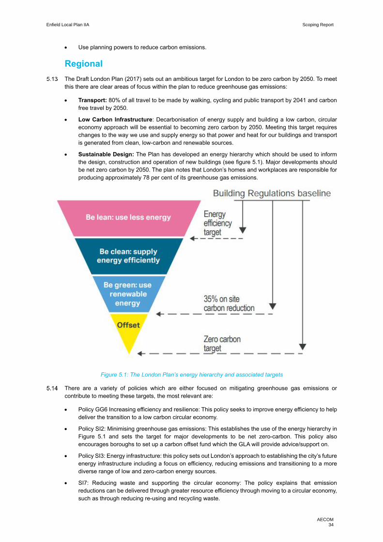
Enfield Local Plan IIA Scoping Report
AECOM 34
• Use planning powers to reduce carbon emissions.
Regional
The Draft London Plan (2017) sets out an ambitious target for London to be zero carbon by 2050. To meet
this there are clear areas of focus within the plan to reduce greenhouse gas emissions:
• Transport: 80% of all travel to be made by walking, cycling and public transport by 2041 and carbon
free travel by 2050.
• Low Carbon Infrastructure: Decarbonisation of energy supply and building a low carbon, circular
economy approach will be essential to becoming zero carbon by 2050. Meeting this target requires
changes to the way we use and supply energy so that power and heat for our buildings and transport
is generated from clean, low-carbon and renewable sources.
• Sustainable Design: The Plan has developed an energy hierarchy which should be used to inform
the design, construction and operation of new buildings (see figure 5.1). Major developments should
be net zero carbon by 2050. The plan notes that London’s homes and workplaces are responsible for
producing approximately 78 per cent of its greenhouse gas emissions.
Figure 5.1: The London Plan’s energy hierarchy and associated targets
There are a variety of policies which are either focused on mitigating greenhouse gas emissions or
contribute to meeting these targets, the most relevant are:
• Policy GG6 Increasing efficiency and resilience: This policy seeks to improve energy efficiency to help
deliver the transition to a low carbon circular economy.
• Policy SI2: Minimising greenhouse gas emissions: This establishes the use of the energy hierarchy in
Figure 5.1 and sets the target for major developments to be net zero-carbon. This policy also
encourages boroughs to set up a carbon offset fund which the GLA will provide advice/support on.
• Policy SI3: Energy infrastructure: this policy sets out London’s approach to establishing the city’s future
energy infrastructure including a focus on efficiency, reducing emissions and transitioning to a more
diverse range of low and zero-carbon energy sources.
• SI7: Reducing waste and supporting the circular economy: The policy explains that emission
reductions can be delivered through greater resource efficiency through moving to a circular economy,
such as through reducing re-using and recycling waste.

Enfield Local Plan IIA Scoping Report
AECOM 35
• Policy T1: Strategic approach to transport: this sets out the overall approach to transport, with an aim
to reduce dependency on cars.
• Policy T2: Healthy streets: Although not focused on emissions reduction, its aim is to get the public
walking, cycling and using public transport more, which, in turn will result in emissions reductions.
• Policy T7: Freight and servicing: seek to reduce emissions from freight through sustainable last mile
schemes and the provision of rapid electric vehicle charging points.
The Mayor’s Transport Strategy (MTS) provides greater detail on the city transport system’s contribution to
reducing emissions. The MTS will be explored in greater detail in Chapter 13: Transport. However, the
policies relevant to this chapter which include actions on greenhouse gas emission reductions are:
• Policy 6: The Mayor will work towards reducing emissions of all types, promoting electrification, traffic
restrictions/regulations and road charging.
• Policy 7: Which focuses on the role of transport in London becoming a zero carbon city by 2050
• Policy 23: This policy covers a wide range the mayor will explore and manage new transport services
in London so they support the healthy streets approach, encourage sustainable modes of transport
and reduce carbon emissions
Chapter 6 of the MES is titled “Climate change mitigation and energy”. This provides greater detail on the
road map to becoming zero carbon in 2050 set out in the Draft London Plan (2017). Figure 5.2 is extracted
from the MES and demonstrates the sources of greenhouse gas emissions in London, to provide some
insight into the sectors that contribute most to London’s emissions.
Figure 5.2: London-wide 2015 greenhouse gas emissions by sector

Enfield Local Plan IIA Scoping Report
AECOM 36
Local
LBE’s Core Strategy 2010 includes a number of climate change mitigation related policies:
• Core Policy 20: Sustainable Energy Use and Energy Infrastructure: The policy describes a range of
measures to reduce greenhouse gas emissions from ensure new developments and retrofitting
existing developments by minimising energy use, using renewable energy sources and providing an
efficient energy supply. It also notes the need to diversify the borough’s energy supply including low
carbon energy and decentralised energy infrastructure.
• Core Policy 24: The Road Network: Part of this policy emphasises the need to encourage sustainable
transport and supports the use of low carbon and electric vehicles.
LBE’s adopted Development Management Document’s (2014) ‘Chapter 8 Tackling Climate Change’ sets
out a number of mitigation related policies around the following topic areas:
• Sustainable Design and Construction;
• Low Carbon Energy and Technology and
• Green Procurement and Waste Minimisation.
The three area action plans support the borough’s wider approach to climate change mitigation, mainly
through energy efficiencies and technologies. For instance:
• The Edmonton Leeside Area Action Plan has ‘Chapter 6 Sustainable Energy’ and ‘Chapter 12
Promoting a Low Carbon Future’
As part of the Core Strategy’s evidence base, LBE produce a “Renewable Energy and Low Carbon
Development Study”. Its role is to support the reduction of greenhouse gas emissions from residential and
non-residential buildings as well as proposing planning policies to help reduce emissions.
LBE are currently developing a Climate Action Strategy, which will set out the borough’s approach to
becoming carbon neutral. Although not yet published, this will set a new direction for borough in terms of
climate mitigation, the main themes the strategy is focusing on are:
• Organisational emission reductions;
• The natural environment and climate resilience; and
• Borough wide emissions.
Baseline review
Current
Between 1990 and 2016 there was a 41% reduction in UK greenhouse gas emissions, which is encouraging,
although accounting is complicated by the fact that polluting activities can be ‘exported’ to other countries.59
In line with the key sectors for greenhouse gas reductions set out above, the description of the current and
future baselines will focus on the themes of: Transport, Low Carbon Infrastructure and Sustainable Design.
To provide an overview, emissions are monitored and recorded at Local Authority level to enable high-
emitting areas to identify and mitigate sources of emissions. This data also gives an insight into the current
performance of LBE in comparison to London and the rest of country. This data is presented in Table 5.1
below, which illustrates that Enfield’s CO2 emissions since 2005 have fallen in line with trends also evident
in Greater London and England as a whole. Total combined per capita emissions from all sources from
Enfield are lower than the averages for Greater London and for England as a whole. However, this is
expected for local authorities in urban areas, as per capita, urban areas are less energy intensive, are in
close proximity to employment, infrastructure and services which further reduce individual energy demands.
59 www.gov.uk/government/statistics/final-uk-greenhouse-gas-emissions-national-statistics-1990-2016
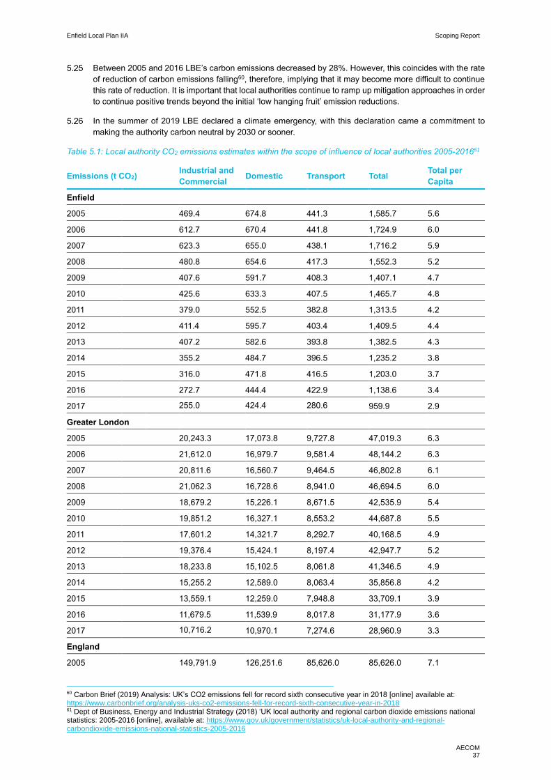
Enfield Local Plan IIA Scoping Report
AECOM 37
Between 2005 and 2016 LBE’s carbon emissions decreased by 28%. However, this coincides with the rate
of reduction of carbon emissions falling60, therefore, implying that it may become more difficult to continue
this rate of reduction. It is important that local authorities continue to ramp up mitigation approaches in order
to continue positive trends beyond the initial ‘low hanging fruit’ emission reductions.
In the summer of 2019 LBE declared a climate emergency, with this declaration came a commitment to
making the authority carbon neutral by 2030 or sooner.
Table 5.1: Local authority CO2 emissions estimates within the scope of influence of local authorities 2005-201661
Emissions (t CO2) Industrial and
Commercial Domestic Transport Total
Total per
Capita
Enfield
2005 469.4 674.8 441.3 1,585.7 5.6
2006 612.7 670.4 441.8 1,724.9 6.0
2007 623.3 655.0 438.1 1,716.2 5.9
2008 480.8 654.6 417.3 1,552.3 5.2
2009 407.6 591.7 408.3 1,407.1 4.7
2010 425.6 633.3 407.5 1,465.7 4.8
2011 379.0 552.5 382.8 1,313.5 4.2
2012 411.4 595.7 403.4 1,409.5 4.4
2013 407.2 582.6 393.8 1,382.5 4.3
2014 355.2 484.7 396.5 1,235.2 3.8
2015 316.0 471.8 416.5 1,203.0 3.7
2016 272.7 444.4 422.9 1,138.6 3.4
2017 255.0 424.4 280.6 959.9 2.9
Greater London
2005 20,243.3 17,073.8 9,727.8 47,019.3 6.3
2006 21,612.0 16,979.7 9,581.4 48,144.2 6.3
2007 20,811.6 16,560.7 9,464.5 46,802.8 6.1
2008 21,062.3 16,728.6 8,941.0 46,694.5 6.0
2009 18,679.2 15,226.1 8,671.5 42,535.9 5.4
2010 19,851.2 16,327.1 8,553.2 44,687.8 5.5
2011 17,601.2 14,321.7 8,292.7 40,168.5 4.9
2012 19,376.4 15,424.1 8,197.4 42,947.7 5.2
2013 18,233.8 15,102.5 8,061.8 41,346.5 4.9
2014 15,255.2 12,589.0 8,063.4 35,856.8 4.2
2015 13,559.1 12,259.0 7,948.8 33,709.1 3.9
2016 11,679.5 11,539.9 8,017.8 31,177.9 3.6
2017 10,716.2 10,970.1 7,274.6 28,960.9 3.3
England
2005 149,791.9 126,251.6 85,626.0 85,626.0 7.1
60 Carbon Brief (2019) Analysis: UK’s CO2 emissions fell for record sixth consecutive year in 2018 [online] available at: https://www.carbonbrief.org/analysis-uks-co2-emissions-fell-for-record-sixth-consecutive-year-in-2018 61 Dept of Business, Energy and Industrial Strategy (2018) ‘UK local authority and regional carbon dioxide emissions national statistics: 2005-2016 [online], available at: https://www.gov.uk/government/statistics/uk-local-authority-and-regional-carbondioxide-emissions-national-statistics-2005-2016
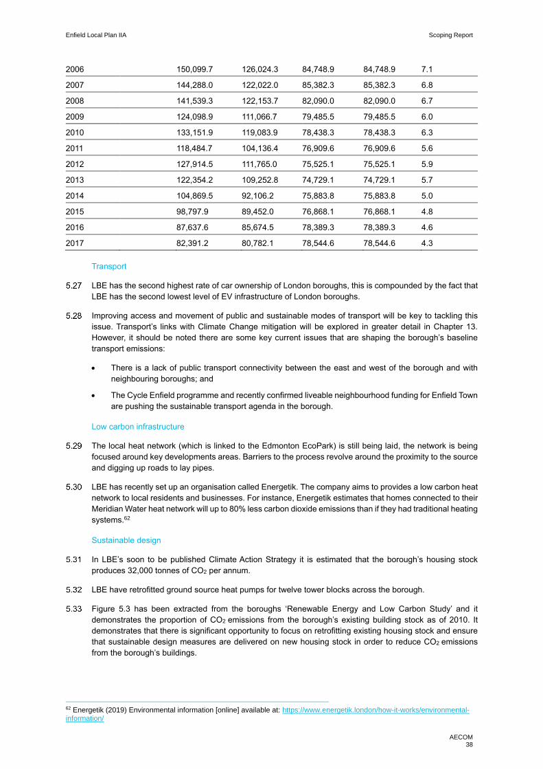
Enfield Local Plan IIA Scoping Report
AECOM 38
2006 150,099.7 126,024.3 84,748.9 84,748.9 7.1
2007 144,288.0 122,022.0 85,382.3 85,382.3 6.8
2008 141,539.3 122,153.7 82,090.0 82,090.0 6.7
2009 124,098.9 111,066.7 79,485.5 79,485.5 6.0
2010 133,151.9 119,083.9 78,438.3 78,438.3 6.3
2011 118,484.7 104,136.4 76,909.6 76,909.6 5.6
2012 127,914.5 111,765.0 75,525.1 75,525.1 5.9
2013 122,354.2 109,252.8 74,729.1 74,729.1 5.7
2014 104,869.5 92,106.2 75,883.8 75,883.8 5.0
2015 98,797.9 89,452.0 76,868.1 76,868.1 4.8
2016 87,637.6 85,674.5 78,389.3 78,389.3 4.6
2017 82,391.2 80,782.1 78,544.6 78,544.6 4.3
Transport
LBE has the second highest rate of car ownership of London boroughs, this is compounded by the fact that
LBE has the second lowest level of EV infrastructure of London boroughs.
Improving access and movement of public and sustainable modes of transport will be key to tackling this
issue. Transport’s links with Climate Change mitigation will be explored in greater detail in Chapter 13.
However, it should be noted there are some key current issues that are shaping the borough’s baseline
transport emissions:
• There is a lack of public transport connectivity between the east and west of the borough and with
neighbouring boroughs; and
• The Cycle Enfield programme and recently confirmed liveable neighbourhood funding for Enfield Town
are pushing the sustainable transport agenda in the borough.
Low carbon infrastructure
The local heat network (which is linked to the Edmonton EcoPark) is still being laid, the network is being
focused around key developments areas. Barriers to the process revolve around the proximity to the source
and digging up roads to lay pipes.
LBE has recently set up an organisation called Energetik. The company aims to provides a low carbon heat
network to local residents and businesses. For instance, Energetik estimates that homes connected to their
Meridian Water heat network will up to 80% less carbon dioxide emissions than if they had traditional heating
systems.62
Sustainable design
In LBE’s soon to be published Climate Action Strategy it is estimated that the borough’s housing stock
produces 32,000 tonnes of CO2 per annum.
LBE have retrofitted ground source heat pumps for twelve tower blocks across the borough.
Figure 5.3 has been extracted from the boroughs ‘Renewable Energy and Low Carbon Study’ and it
demonstrates the proportion of CO2 emissions from the borough’s existing building stock as of 2010. It
demonstrates that there is significant opportunity to focus on retrofitting existing housing stock and ensure
that sustainable design measures are delivered on new housing stock in order to reduce CO2 emissions
from the borough’s buildings.
62 Energetik (2019) Environmental information [online] available at: https://www.energetik.london/how-it-works/environmental-information/

Enfield Local Plan IIA Scoping Report
AECOM 39
Figure 5.3: Proportion of energy demand and CO2 emissions from different building types within Enfield
Future
In general, there is more of a public focus on climate change and reducing emissions, this has been evident
through the climate school strikes and Extinction Rebellion action. Such focus resulted in the ’green
industrial deal’ being central to the Labour party’s recent election manifesto. This demonstrates the greater
political attention and public pressure there is to deliver on climate action.
The key London-wide targets that LBE will have contributary role in achieving are:
• To become a zero-carbon city by 2050; and
• A zero-carbon transport network by 2050.
As an organisation are targeting carbon neutrality by 2030 in their vehicle fleet and electricity supply.
LBE have met previous carbon reduction targets of 40% by 2020 and have renewed targets to meet 60%
reductions by 2025. However, as noted in paragraph 5.21, LBE will have to be conscious that future carbon
dioxide emissions reductions are likely to be harder to achieve, as many of the ‘quick wins’ have already
been made.
Transport
LBE’s central focus in relation to transport emission reductions is delivering transport infrastructure to
support a move to mixed model share and further EV infrastructure
• As set out in Chapter 2 LBE are installing five new rapid EV charging points, to add to the borough’s
current crop of 20 charging points. It is also important to note that as a city London expects the number
of electric vehicles on the road to increase from 20,000 to 330,0000 by 2025.63
The London-wide focus on improving sustainable transport options should continue to grow, LBE should
support this as an approach to deliver transport emission reduction. Additionally, the creation of Cycle
Enfield shows that sustainable transport will be a key future consideration for the borough.
63 Mayor of London (2019) Mayor sets out plans for London’s electric vehicle future [online] available at: https://www.london.gov.uk/press-releases/mayoral/mayor-sets-out-londons-electric-vehicle-future

Enfield Local Plan IIA Scoping Report
AECOM 40
Low carbon infrastructure
Per capita emissions in LBE are likely to continue to decrease as energy efficiency measures, renewable
energy production and new technologies become more widely adopted at a national scale. However, it
should be noted that moving to renewable energy is likely to impact LBE with higher costs for heating the
grid at an individual level. Therefore, the local plan will need to consider how this impacts the inequality in
the borough in terms of fuel poverty. whilst per capital emissions may reduce, population increase will
challenge overall emission reductions.
The growing influence of Energetik on LBE’s housing stock should deliver heat and energy efficiency and
therefore provide further emission reductions, however, this is reliant on residents signing up to the scheme.
The Edmonton Eco park which provides North London’s energy to waste facilities is being replaced to
provide cleaner energy, it is expected that the new facility will have the carbon impact of saving the
equivalent of 215,000 tonnes of carbon dioxide each year by diverting waste from landfill and generate low
carbon heat and power to supply up to 127,000 homes.64
Sustainable design
The Future Homes Standard will be introduced by 2025, this will require new build homes to be future-
proofed with low carbon heating and world-leading levels of energy efficiency.
LBE’s Climate Action Strategy is exploring an ‘energy-as-a-service’ model for the borough’s housing stock.
There are a variety of approaches to this model, in essence it is a low carbon refurbishment model based
on delivering a particular standard of energy service for a housing type. Housing types will buy a standard
of energy rather than purchasing it on an individual basis, therefore delivering energy and cost efficiency.
Despite a city-wide focus on decentralised heat and power networks to deliver energy efficiency and
emission improvements in new developments, there is further scope for greater delivery of sustainable
design, as out lined in the case study below.
The environmental impact of developments should be minimised through sustainable design and
management of resource consumption. For example, reducing water consumption to 105 litres per head
per day or less, in line with the London Plan, and setting water efficiency standards for commercial
development in line with BREEAM (the BRE Environmental Assessment Method).
64 NLHPP (2019) NLHPP Briefing note [online] available at: http://northlondonheatandpower.london/media/mcfdcowb/nlhpp-project-briefing-note.pdf
Case Study: Passivehaus: Passivehaus is a low carbon design approach driven by air quality and comfort.
The approach is a leading international energy efficient design standard for buildings, although it is uncommon
in the UK. Key features of a Passivehaus are:
• Very high levels of insulation;
• Extremely high-performance windows with insulated frames;
• An airtight building fabric; and
• A mechanical ventilation system with highly efficient heat recovery.
The aim is to make houses more energy efficient, therefore reducing energy demands and costs. In Germany
monitoring of past performance indicates that the average energy saving of a passive house is 88%.
https://ecoarc.co.uk/passive-house-architect/

Enfield Local Plan IIA Scoping Report
AECOM 41
Key issues and objectives
The following key issues emerge from the context and baseline review: ·
• Falling CO2 emissions in LBE broadly reflect a UK-wide trend, though emissions per capita in Enfield
are lower in relation to those of Greater London overall and of England as a whole.
• Climate action has taken centre stage politically across the nation and this has resulted in many local
authorities including LBE declaring a climate emergency and setting a carbon neutrality objective.
• The Local Plan must focus on minimising per capita emissions from both transport and the built
environment, including by minimising need to travel, supporting modal shift away from the private care,
supporting investment in strategic ‘sustainable transport’ infrastructure including mass transit routes
and electric vehicle charging points, supporting decentralised low carbon heat/power generation
including heat networks and supporting standards of ‘sustainable design and construction’ that exceed
the requirements of building regulations.
• There is also a role to play in respect of supporting carbon sequestration through tree planting and
other natural environment interventions, and in respect of supporting the green economy.
In light of the key issues discussed above it is proposed that the IIA should include the following objective:
Ensure the Local Plan serves to minimise LBE’s per capita CO2 emissions such that the borough is on
track to achieve carbon neutrality by 2030.
Enfield Local Plan IIA Scoping Report
AECOM 42
6. Communities
Introduction
A Local Plan aims to deliver a growth strategy that tackles concerns and provides benefits for all residents.
Through delivering housing, infrastructure, services and design a Local Plan can provide the tools to resolve
challenges faced by a local authority. As such it is important to understand the socio-economic issues faced
in a local authority.
Between 2001 – 2018 Enfield’s population has grown significantly by 6.8%. High growth is predicted to
continue with the population predicted to grow by a further 51,000 to around 390,000 by 2036. This increase
in population will provide challenges in keeping up with the demand for homes, community and physical
infrastructure and jobs. An ageing population will likely create more complex challenges through the
requirement of bespoke housing solutions and a different type of environment, additional demand on health
care facilities. The Local Plan will have to consider these future requirements as well as providing solutions
to current issues faced, such as growing inequality.
LBE faces similar issues present throughout London, in particular social inequality and deprivation. LBE is
ranked as the 12th most deprived borough in London, 50% of the borough’s wards are among the 20%
most deprived in England. To work towards minimise these inequalities, understanding the borough’s
demographic is an essential element to any Local Plan.
Social inclusion is a key aspect of sustainable communities and many interlinked factors are important in
ensuring that both individuals and areas are able to fully participate in society. Poor housing, for example,
can be compounded by unemployment, low incomes, poor health, high crime, discrimination, and other
social factors. Inclusive design can be a tool to support the integration of communities and reduce issues of
isolation. Furthermore, given LBE’s rich diversity in ethnicity and communities, the Local Plan will need to
be mindful of the differing needs of all groups in society; from ensuring there is a range of religious facilities
within the borough to enhancing accessibility and engagement within the Local Plan process through
language considerations
Context review
National
The NPPF (2018) discusses communities under the headings ‘Delivering a sufficient supply of homes’,
‘Ensuring the vitality of town centres’ and ‘Promoting healthy and safe communities’. Key messages from
the NPPF include that planning policies should:
• Provide the social, recreational and cultural facilities and services the community needs, such as local
shops, meeting places, sports venues, open space, cultural buildings, public houses and places of
worship, whilst guarding against the unnecessary loss of community facilities and services.
• Retain and develop accessible local services and community facilities in rural areas.
• Ensure that developments create safe and accessible environments where crime and disorder, and
the fear of crime, do not undermine quality of life or community cohesion. Places should contain clear
and legible pedestrian routes, and high-quality public spaces, which encourage the active and
continual use of public areas.
• Enable and support health lifestyles through provision of green infrastructure, sports facilities, local
shops, access to healthier food, allotments and layouts that encourage walking and cycling.
• Ensure that there is a ‘sufficient choice of school places’ and take a ‘proactive, positive and
collaborative approach’ to bringing forward ‘development that will widen choice in education’.
Enfield Local Plan IIA Scoping Report
AECOM 43
The Equality Act (2010) was brought in to reduce inequality and discrimination and ensure all members of
the public are provided with equal opportunities. The Act covers nine protected characteristics - age,
disability, gender reassignment, pregnancy and maternity, race, religion or belief, sex, sexual orientation,
marriage and civil partnership. The public sector equality duty, set out in Section 149 of the Equality Act,
requires public bodies to give due regard to the need to: promote equality of opportunity; tackle unfair
discrimination and to promote good relations between different groups.
The Health and Social Care Act 2012 transferred responsibility for public health from the NHS to local
government, giving local authorities a duty to improve the health of the people who live in their areas, and
requiring a more holistic approach to health across all local government functions.
The 2018 National Adaptation Programme (NAP) explains that: “Climate change will impact areas that
support our wellbeing and health, including planning, community development, emergency response, health
and social care system, historic places and cultural heritage.”
The 25 Year Environment Plan includes a focus on connecting people with the environment to improve
health and wellbeing. One stated aim is to “help people improve their health and wellbeing by using green
spaces including through mental health services”, whilst another is to “encourage children to be close to
nature, in and out of school, with particular focus on disadvantaged areas.”.
The Government’s 2019 Integrated Communities Strategy focuses on improving community cohesion
through tackling inequalities experienced through education and employment and supporting cultural
sharing and cohesion. In order to address discrimination, disparity between sections of the community must
be addressed65. This is supported by the Local Government Association’s guidance document to local
authorities ‘Building cohesive communities’.66
Regional
The Draft London Plan (2017) notes that a key principle in the development of policies was to deliver equality
for all Londoners and tackle rising inequality in the city. There are a number of polices focused on delivering
a London for all and thus having a focus on communities:
• GG1: Building strong and inclusive communities: This is focused on ensuring educational and
economic opportunities are available for all Londoners. It notes that a significant problem is the uneven
distribution of wealth across the city. It also notes that urban design plays a role in developing
community centres that are accessible and benefit all.
• Policy SD6: Town centres and high streets: London’s town centres should encourage “strong, resilient,
accessible and inclusive hubs with a diverse range of uses that meet the needs of Londoners” including
civic, community and social uses. The policy stresses the importance of town centres in “building
sustainable, health and walkable neighbourhoods”.
• Policy SD10: Strategic and local regeneration: The policy seeks to focus on delivering development
that is sensitive of the local context and using regeneration as a tool to tackle spatial inequalities.
• Policy S1: Developing London’s social Infrastructure: This policy focuses on the need for
developments to contribute towards infrastructure that supports good quality of life, which is listed to
include health provision, education, community, play, youth, recreation, sports, faith, and emergency
facilities.
The Mayor of London has published an ‘Equality, Diversity and Inclusion Strategy’ (2018)67 which sets out
the Mayor’s approach to creating a fairer, more equal and integrated city. It sets about the approach to
tackling London’s high levels of inequality and discrimination. The strategy explores this through six key
themes:
• A great place to live;
• A great place for young people;
65 Ministry of Housing, Community and Local Government (2019) Integrated Communities Strategy green paper [online] available at: https://www.gov.uk/government/consultations/integrated-communities-strategy-green-paper 66 LGA (2019) Building cohesive communities [online] available at: https://local.gov.uk/sites/default/files/documents/10.31%20Community%20cohesion%20guidance_04.2.pdf 67 Mayor of London (2018) The Mayor’s equality, diversity and inclusion strategy [online] available at: https://www.london.gov.uk/what-we-do/communities/mayors-strategy-equality-diversity-inclusion
Enfield Local Plan IIA Scoping Report
AECOM 44
• A great place to work and do business;
• Getting around;
• A safe, healthy and enjoyable city; and
• Leading by example.
Local
LBE’s Core Strategy (2010) focuses on communities in the section ‘Core Policies for Housing and Services’.
The strategy acknowledges the rises in deprivation in the borough since 2001, with health inequality,
deprivation and child poverty having all risen. It notes that, at the time, the east and south of the borough
were faring significantly worse than the rest of Enfield, with some neighbourhoods amongst the most
deprived in Britain. Additionally, Enfield had the 3rd highest level of inequality in London. This resulted in a
policy focus on communities and inequality, a selection of the most relevant are:
• Core Policy 8: Education: This seeks to improve the health, lives and prosperity of LBE’s youth through
investment in education facilities that meet the needs of existing and new communities.
• Core Policy 9: Supporting Community Cohesion: This looks at tackling the misbalance of access to
public services across the borough and supporting area-based interventions to tackle social
disadvantage.
LBE’s Development Management Document (2014) has a chapter of policies dedicated to Community
Infrastructure. ‘Chapter 3: Community facilities’ focuses on the need to deliver public services, promote
inclusive communities and facilitate social interaction.
The three area action plans all consider the need to enhance community facilities to meet the needs of
LBE’s evolving population. For instance, a significant element of the North Circular Area Action plan’s vision
is to “promote social inclusion, tackle deprivation and provide new employment opportunities’.
In 2012, LBE published its strategy for valuing diversity and equal opportunity called ‘Equal Opportunity for
All’. This is currently being updated and will focus on three key areas:
• Fairness for all – focuses on reducing social inequalities and ensuring all residents have access to the
same opportunities.
• Growth and sustainability – focuses on the long terms objectives of the borough including
environmental objectives and transforming key areas and sectors in the borough.
• Strong communities: focuses on delivering high quality services to the borough’s communities and
valuing diversity and promoting community cohesion.
Baseline review
Current
The discussion below is set out under a series of thematic sub-headings. One central issue that will become
evident throughout this section is the pattern of spatial deprivation through an east -west divide, his is
visually evident through figures 6.1 and 6.2.
Population
Census data and 2018 mid-year population data indicate the extent of population growth in the borough in
comparison to London and England, see Table 6.1.
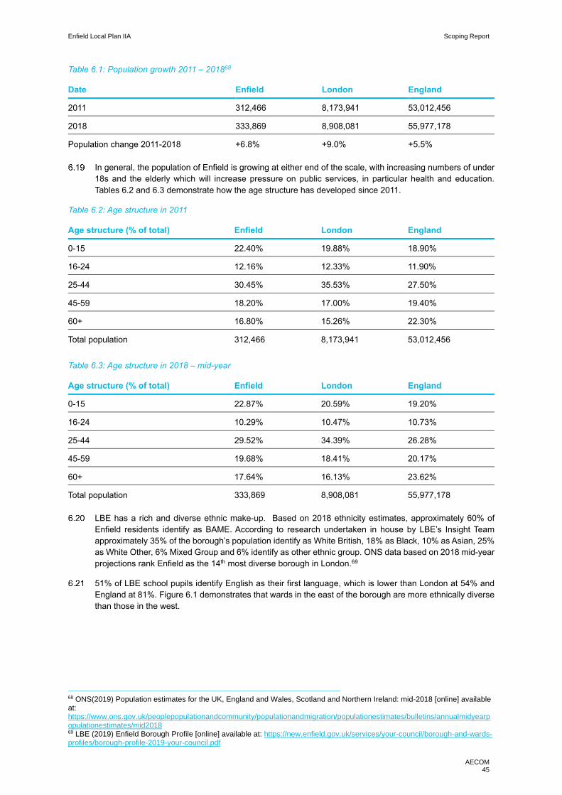
Enfield Local Plan IIA Scoping Report
AECOM 45
Table 6.1: Population growth 2011 – 201868
Date Enfield London England
2011 312,466 8,173,941 53,012,456
2018 333,869 8,908,081 55,977,178
Population change 2011-2018 +6.8% +9.0% +5.5%
In general, the population of Enfield is growing at either end of the scale, with increasing numbers of under
18s and the elderly which will increase pressure on public services, in particular health and education.
Tables 6.2 and 6.3 demonstrate how the age structure has developed since 2011.
Table 6.2: Age structure in 2011
Age structure (% of total) Enfield London England
0-15 22.40% 19.88% 18.90%
16-24 12.16% 12.33% 11.90%
25-44 30.45% 35.53% 27.50%
45-59 18.20% 17.00% 19.40%
60+ 16.80% 15.26% 22.30%
Total population 312,466 8,173,941 53,012,456
Table 6.3: Age structure in 2018 – mid-year
Age structure (% of total) Enfield London England
0-15 22.87% 20.59% 19.20%
16-24 10.29% 10.47% 10.73%
25-44 29.52% 34.39% 26.28%
45-59 19.68% 18.41% 20.17%
60+ 17.64% 16.13% 23.62%
Total population 333,869 8,908,081 55,977,178
LBE has a rich and diverse ethnic make-up. Based on 2018 ethnicity estimates, approximately 60% of
Enfield residents identify as BAME. According to research undertaken in house by LBE’s Insight Team
approximately 35% of the borough’s population identify as White British, 18% as Black, 10% as Asian, 25%
as White Other, 6% Mixed Group and 6% identify as other ethnic group. ONS data based on 2018 mid-year
projections rank Enfield as the 14th most diverse borough in London.69
51% of LBE school pupils identify English as their first language, which is lower than London at 54% and
England at 81%. Figure 6.1 demonstrates that wards in the east of the borough are more ethnically diverse
than those in the west.
68 ONS(2019) Population estimates for the UK, England and Wales, Scotland and Northern Ireland: mid-2018 [online] available at: https://www.ons.gov.uk/peoplepopulationandcommunity/populationandmigration/populationestimates/bulletins/annualmidyearpopulationestimates/mid2018 69 LBE (2019) Enfield Borough Profile [online] available at: https://new.enfield.gov.uk/services/your-council/borough-and-wards-profiles/borough-profile-2019-your-council.pdf

Enfield Local Plan IIA Scoping Report
AECOM 46
Figure 6.1: 2011 Census prevalence of non-white ethnic groups in Enfield
Deprivation and inequality
LBE ranks as one of the most deprived local authorities in the country with pockets of extreme deprivation
in the east of the area, where the Lower Super Output Areas (LSOA) are among the 10% most deprived in
England. Enfield is the 64th most deprived borough in England and the 12th most deprived in London.
Figure 6.3 presents the indices of multiple deprivation (IMD) (2015), which measure deprivation using nine
indicators:
• Income deprivation;
• Employment deprivation;
• Education, skills and training;
• Health deprivation and disability;
• Crime;
• Barriers to housing and services;
• Living environment deprivation;
• Income deprivation affecting children; and
• Income deprivation affecting older people.

Enfield Local Plan IIA Scoping Report
AECOM 47
Figure 6.2: Enfield multiple indices of deprivation map (2015)70
Figure 6.3 goes into greater detail to show the borough’s ranking on all nine IMD indicators demonstrating
that Enfield ranks higher in all, but one (Living Environment), indicators of deprivation than the London
average and the national median rank, indicating the severity of deprivation in the borough.
Figure 6.3: Indictors of deprivation in comparison to the London average and the national median rank
70 DCLG (2019) Indices of Deprivation 2015-2019 [online] available at: http://dclgapps.communities.gov.uk/imd/iod_index.html

Enfield Local Plan IIA Scoping Report
AECOM 48
Throughout this report there is reference to the east and west divide that characterises LBE. This divide is
evident across a number of IIA themes and can be traced back to underlying inequality and deprivation. The
divide is partly driven by certain infrastructure – the A10 - and the nature of the housing stock on either side
of this.
Census statistics provide an alternative framing by which to measure deprivation across four ‘dimensions’
of deprivation, summarised below: ·
• Employment: Any person in the household (not a full-time student) that is either unemployed or long-
term sick.
• Education: No person in the household has at least a level 2 qualification and no person aged 16-18
is a full-time student.
• Health and disability: Any person in the household that has generally ‘bad’ or ‘very bad’ health or has
a long-term health problem.
• Housing: The household accommodation is either overcrowded (with an occupancy rating of -1 or
less), in a shared dwelling or has no central heating.
Table 6.4: Relative household deprivation dimensions (2011)
Household deprivation (% of total) Enfield London England
Household not deprived in any dimension 36.12% 39.42% 42.50%
Deprived in 1 dimension 34.26% 34.23% 32.70%
Deprived in 2 dimensions 21.82% 19.19% 19.10%
Deprived in 3 dimensions 6.81% 6.26% 5.10%
Deprived in 4 dimensions 0.99% 0.91% 0.50%
Table 6.4 presents the census data of relative deprivation in LBE, by calculating the deprivation by
household. It demonstrates that a lower percentage of households in LBE demonstrate zero dimensions of
deprivation in comparison to London and England. As one adds dimensions of deprivation LBE
demonstrates slightly higher percentages than London and England. This infers that LBE in general suffers
from greater household deprivation than London and England.
However, this does not consider and demonstrate is the unequal distribution of deprivation across the
borough, the below case study puts a lens on this, through a study exploring deprivation in Upper Edmonton.
Case Study: Multiple indicators of inequality in Upper Edmonton: It should be noted that this case study
has been extracted from a research paper commissioned by the Enfield Racial Equality Council and
undertaken by Middlesex University’s Social Policy Research Centre.
Upper Edmonton is the most south easterly ward in the borough. It is predominantly populated by a young
BAME population with high birth rates and is amongst the 10% most deprived wards in England. As of 2013,
unemployment was at a rate of 6.7% and crime levels were amongst the highest in the borough. Life
expectancy again highlights the relative inequality in comparison to the rest of the borough, with male life
expectancy at 75.5 years and female at 76.7 years, whereas as a borough the life expectancy of a man was
80.2 years and 83.0 years for a woman. The report goes on to note that health indictors such as obesity,
smoking and prevalence of premature deaths are above borough average. It also notes that transport
infrastructure is weak; tube and rail services are sparse and so the area relies almost exclusively on bus
services.
http://sprc.info/wp-content/uploads/2014/10/Health-inequalities-in-Enfield-.pdf
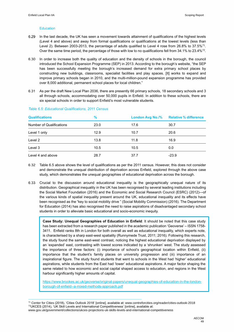
Enfield Local Plan IIA Scoping Report
AECOM 49
Education
In the last decade, the UK has seen a movement towards attainment of qualifications of the highest levels
(Level 4 and above) and away from formal qualifications or qualifications at the lowest levels (less than
Level 2). Between 2003-2013, the percentage of adults qualified to Level 4 rose from 26.8% to 37.5%71.
Over the same time period, the percentage of those with low to no qualifications fell from 34.1% to 23.4%72.
In order to increase both the quality of education and the density of schools in the borough, the council
introduced the School Expansion Programme (SEP) in 2013. According to the borough’s website, “the SEP
has been successfully meeting the borough’s increased demand for extra primary school places by
constructing new buildings, classrooms, specialist facilities and play spaces. [It] works to expand and
improve primary schools began in 2010, and the multi-million-pound expansion programme has provided
over 8,000 additional, permanent school places for local children.”
As per the draft New Local Plan 2036, there are presently 66 primary schools, 18 secondary schools and 3
all through schools, accommodating over 50,000 pupils in Enfield. In addition to these schools, there are
six special schools in order to support Enfield’s most vulnerable students.
Table 6.5: Educational Qualifications, 2011 Census
Qualifications % London Avg No./% Relative % difference
Number of Qualifications 23.0 17.6 30.7
Level 1 only 12.9 10.7 20.6
Level 2 13.8 11.8 16.9
Level 3 10.5 10.5 0.0
Level 4 and above 28.7 37.7 -23.9
Table 6.5 above shows the level of qualifications as per the 2011 census. However, this does not consider
and demonstrate the unequal distribution of deprivation across Enfield, explored through the above case
study, which demonstrates the unequal geographies of educational deprivation across the borough.
Crucial to the discussion around educational inequality is the geographically unequal nature of its
distribution. Geographical inequality in the UK has been recognised by several leading institutions including
the Social Market Foundation (2016) and the Economic and Social Research Council (ESRC) (2012)—of
the various kinds of spatial inequality present around the UK, educational inequality and its effects have
been recognised as the “key to social mobility drive ” (Social Mobility Commission) (2016). The Department
for Education (2014) has also recognised the need to raise aspirations of disadvantaged secondary school
students in order to alleviate basic educational and socio-economic inequity.
71 Center for Cities (2018), ‘Cities Outlook 2018’ [online], available at: www.centreforcities.org/reader/cities-outlook-2018 72UKCES (2014), ‘UK Skill Levels and International Competitiveness’ [online], available at: www.gov.uk/government/collections/ukces-projections-uk-skills-levels-and-international-competitiveness
Case Study: Unequal Geographies of Education in Enfield: It should be noted that this case study
has been extracted from a research paper published in the academic publication ‘Geoverse’ – ISSN 1758-
3411. Enfield ranks 8th in London for both overall as well as educational inequality, which experts note,
is characterised by a sharp east-west spatiality (Runnymede Trust, 2011; 2016). Following this research,
the study found the same east-west contrast, noticing the highest educational deprivation displayed by
an ‘expanded’ east, contrasting with lowest scores indicated by a ‘shrunken’ west. The study assessed
the importance of three factors: (i) importance of school’s geographical location within Enfield, (ii)
importance that the student’s family places on university progression and (iii) importance of an
inspirational figure. The study found students that went to schools in the West had ‘higher’ educational
aspirations, while students from the East had ‘lower’ educational aspirations. A major factor shaping the
same related to how economic and social capital shaped access to education, and regions in the West
harbour significantly higher amounts of capital.
https://www.brookes.ac.uk/geoverse/original-papers/unequal-geographies-of-education-in-the-london-
borough-of-enfield--a-mixed-methods-approach.pdf
Enfield Local Plan IIA Scoping Report
AECOM 50
Future
The Council would like to re-establish the equalities ‘excellence’ status by 2021. This is a priority for the
chief executive and leader of the Council.
Enfield Poverty and Inequality Commission (EPIC) have recently published the ‘All things being equal’
report73. The report examines a wide range of local data to understand the key issues faced by the borough.
The report provides a list of 27 recommendations to tackle the growing inequalities, based on three
interconnected themes:
• Living: To what extent does who we are and where we live affect our life changes and services we can
access;
• Learning: What barriers prevent local people from accessing opportunities through education; and
• Earning: How can people form low income backgrounds be better supported to secure long-term
economic prosperity.
New development could potentially provide opportunities to deliver enhancements to the borough’s green
infrastructure and public transport networks, improving linkages between areas of greater deprivation and
surrounding services and facilities.
LBE are focusing efforts to tackle the clear inequality divide in the borough, however given the multiple
indices of deprivation that need to be resolved, this will require significant investment and action by multiple
partners and stakeholders. LBE want to see a focus on retaining skills and jobs within the borough
boundaries, this would help bring growth and inward investment to the borough which could be used to help
tackle inequality.
New developments will bring in the opportunity to invest in public services and programmes that can help
reduce the borough’s levels of inequality through CIL and S106 funding, however there are competing usage
for this type of funding and other channels of investment will also be required.
LBE is updating its equality and diversity strategy which has an overriding aim to support community
cohesion by enabling people to live side by side without segregation is perhaps an overriding priority.
Key issues and objectives
The following key issues emerge from the context and baseline review:
• LBE has a rich and diverse population in terms of ethnicity. It also has a growing population at either
end of the age spectrum, both in terms of younger and older people.
• The borough is characterised by an east-west divide in terms of inequality and deprivation and is this
is mirrored in a variety of indicators highlighted throughout this report.
• LBE is updating its equality and diversity strategy to deal with issues in the borough.
In light of these key issues, it is proposed that the IIA framework should focus on tackling the east-west
spatial disparity through the following objectives:
Support good access to services, facilities and wider community infrastructure, for new and existing
residents, mindful of the potential for community needs to change over time.
Develop social cohesion through good urban design, using the healthy streets indicators and
community spaces that act as a catalyst for community cohesion.
Seek to ensure new developments provide for existing communities delivering targeted actions including
in respect of housing needs, community infrastructure and urban realm.
73 EPIC (2020) All thing being equal – the final report and recommendations of the EPIC

Enfield Local Plan IIA Scoping Report
AECOM 51
7. Crime and community safety
Introduction
A Local Plan provides the blueprint for the design standards of a local authority. An authority’s approach to
design should aim to provide better quality living spaces which should take into consideration the safety of
residents and users. Issues of crime and safety should be considered from the earliest stages of plan-
making and development proposals, so that any potential crime and safety issues can be addressed, and
a safe and secure environment can be achieved. By considering crime and community safety through a
Local Plan a planning authority creates greater opportunities for its residents, which can result in greater
economic prosperity, social cohesion and quality of life.
As discussed in the above chapter, design consideration should be explored to support the integration of
communities. Through delivering inclusive design to support a diverse population, the built environment can
encourage community cohesion and reduce isolation, which are both important elements in improving
community safety.
Context
National
The NPPF discusses crime and community safety under the sections ‘Promoting healthy and safe
communities’ and ‘achieving well designed places’. Key messages from the NPPF include that planning
policies should aim to:
• Promote social interaction, including opportunities for meetings between people who might not
otherwise come into contact with each other – for example through mixed-use developments, strong
neighbourhood centres, street layouts that allow for easy pedestrian and cycle connections within and
between neighbourhoods, and active street frontages.
• Ensure places are safe and accessible so that crime and disorder and fear of crime do not undermine
community cohesion, which can be delivered through high quality public space, and clear, legible
pedestrian routes.
• Anticipate and address possible malicious threats and natural hazards. Appropriate design and layout
of developments should be informed by the most up to date information from the police and other
relevant agencies to improve the resilience of communities.
Strategic Framework for Road Safety (2011) - sets out the governments approach to continuing to reduce
killed and seriously injured casualties on roads.
Regional
The Draft London Plan (2017) emphasises the importance of designing out crime in order to contribute to
the delivery of safe public spaces across the city. There are some policies that directly engage with this
approach:
• Policy D2: Delivering Good Design: This policy includes a focus on ensuring that crime is taken into
the design making processes.
• Policy D10: Safety, Security and Resilience to Emergency: This policy focuses on measures to design
out crime and reducing the fear of crime, particularly at night.
• Policy HC6: Supporting the Night-Time Economy – although primarily focused on the growth of the
night-time economy this policy recognises that an important element is ensuring safety as many night-
time activities in the city involve the use of public space.
• Policy T2: Healthy Streets: An element of this policy is delivering public space that provides safety for
all users.
Enfield Local Plan IIA Scoping Report
AECOM 52
The Mayor’s Equality, Diversity and Inclusion Strategy sets out measures to ensure crime or fear of crime
does not deter the public from using London’s streets. It aims to focus on young people vulnerable to the
potential of being a victim or offender in order to prevent crime, in particular it references knife crime.
London’s Knife Crime Strategy (2017) sets out an approach to tackle the immediate threat of knife crime in
London. The strategy includes reference to designing out crime in key hotspots and vulnerable geographic
locations.
London’s Police and Crime Plan 2017-2021 sets out the city’s strategy to reduce crime and to improve
policing services, especially at neighbourhood level.
The MTS has a ‘Vision Zero’ pledge which aims to eliminate all deaths and serious injuries from the London
transport network by 2041. It is proposed that this will be delivered through safe speeds, safe streets, safe
behaviours, safe vehicles and post-collision response.
Local
A focus of the Core Strategy (2010) is to improve health and wellbeing and as part of that address the fear
of crime in vulnerable groups. Additionally, it notes that community cohesion is an important objective and
the need to tackle high crime environments is highlighted:
• Core Policy 9: Supporting Community Cohesion: through the contribution of reducing crime, fear of
crime and anti-social behaviour by using designing out crime through creating safe environments.
LBE’s Development Management Document (2014) has a number of policies related tackling crime and
improving community safety. It notes that in areas of high crime rate major developments will have to achieve
Secured by Design certification, to ensure the borough is delivering secure and safe places. Specific policies
related to this chapter include:
• DMD 35: Evening Economy: Notes that promoting a night time economy will need to be balanced with
associated problems, such as anti-social behaviour and fear of crime.
• DMD 69: Light Assessment Reports should include mitigation measures to secure safer access routes
and crime reduction.
LBE published a Community Safety Plan for 2017-2021. This sets out a strategy to tackle violent crime,
keep young people safe, reduce burglary, promote cohesion and deal with anti-social behaviour.
LBE’s Safeguarding Adolescents from Exploitation Strategy 2019-2022: states its role is to keep children
safe, confident and happy, with opportunities to achieve through learning and reaching their full potential.
Baseline review
Current
It is noted that the overall crime rate in LBE is lower than the London average. According to official crime
summary data published by the Metropolitan Police, the number of notifiable offences committed in Enfield
between April 2018 and March 2019 was 28,773. However, this was an increase of around 11% on the
previous 12-month period. Figure 7.1 presents the mix and types of crimes:
In general, crime is concentrated in the east of the borough, Southgate, Palmers Green and near the
boundary with Haringey as well as around transport hubs.

Enfield Local Plan IIA Scoping Report
AECOM 53
Figure 7.1: Enfield crime breakdown April 2018 – 2019 74
As noted above LBE is experiencing an increase in crimes across the board. Through the interview process
undertaken with LBE teams, as part of the context review, it was noted that there are three areas of particular
concern for the borough:
• Drug dealing;
• Prostitution; and
• Serious youth violence.
There were 379 serious youth violence incidents between May 2018 – April 2019. Which was a 5% decrease
on year before; despite this decrease, Enfield has the 3rd highest number of serious youth violence victims
in London boroughs. Figure 7.2 shows how this issue is skewed to the east of the borough, in particular the
south east.
74 LBE (2019) Enfield Borough Profile [online] available at: https://new.enfield.gov.uk/services/your-council/borough-and-wards-profiles/borough-profile-2019-your-council.pdf
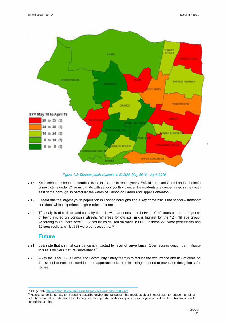
Enfield Local Plan IIA Scoping Report
AECOM 54
Figure 7.2: Serious youth violence in Enfield, May 2018 – April 2019
Knife crime has been the headline issue in London in recent years. Enfield is ranked 7th in London for knife
crime victims under 24 years old. As with serious youth violence, the incidents are concentrated in the south
east of the borough, in particular the wards of Edmonton Green and Upper Edmonton.
Enfield has the largest youth population in London boroughs and a key crime risk is the school – transport
corridors, which experience higher rates of crime.
TfL analysis of collision and casualty data shows that pedestrians between 0-19 years old are at high risk
of being injured on London’s Streets. Whereas for cyclists, risk is highest for the 12 - 19 age group.
According to TfL there were 1,192 casualties caused on roads in LBE. Of these 220 were pedestrians and
52 sere cyclists, whilst 668 were car occupants.75
Future
LBE note that criminal confidence is impacted by level of surveillance. Open access design can mitigate
this as it delivers ‘natural surveillance76’.
A key focus for LBE’s Crime and Community Safety team is to reduce the occurrence and risk of crime on
the ‘school to transport’ corridors, the approach includes minimising the need to travel and designing safer
routes.
75 TfL (2018) http://content.tfl.gov.uk/casualties-in-greater-london-2017.pdf 76 Natural surveillance is a term used to describe environmental design that provides clear lines of sight to reduce the risk of potential crime. It is understood that through creating greater visibility in public spaces you can reduce the attractiveness of committing a crime.
Enfield Local Plan IIA Scoping Report
AECOM 55
LBE are developing a road safety action plan to reduce the risk caused by road danger which will influence
the borough’s approach to streetscape design.
Key issues and objectives
Following a review of the context and baseline the key issues are:
• Crime, particularly serious youth violence and knife crime which is concentrated in the south east of
the borough. Drug dealing and prostitution are related serious issues in the borough.
• Road safety for pedestrians and cyclists is also a key issue to be addressed through the Local Plan.
• Key issues in respect of crime and community safety relate closely to those discussed above under
the ‘communities’ heading. There is a need to support high quality developments, improvements to
estates that suffer from poor quality housing and a high quality public realm that supports integration
of communities and natural surveillance including through the co-location of shops, services
community centres and green spaces.
In light of these key issues, it is proposed that the IIA framework should include the following objectives:
Support targeted interventions to reduce crime and increase community safety, guided by LBE’s Crime
and Community Safety team, and ensure high quality new developments that are future proofed.
Focus on delivering the ‘Vision Zero’ target for road safety; through safe street design using healthy
streets principles to ensure pedestrians and cyclists can travel safely.

Enfield Local Plan IIA Scoping Report
AECOM 56
8. Economy and employment
Introduction
The economy, economic growth and development, employment, innovation and productivity are crucial
aspects of a healthy, functional society. In order to raise the quality of life in any given place, the issues of
economic development and employment need to be carefully considered in the creation of local plans.
Despite being an outer London borough, Enfield experiences many of the same socio-economic issues
faced by inner London. While vibrant and diverse, Enfield's population makeup also presents several
challenges for the Council. As will be made evident by this chapter, economic issues should be addressed
alongside social issues in order to drive sustainable growth and encourage a socially inclusive borough.
Economic issues are crucial to plan creation and development since economic equity is an important aspect
of the overall socio-economic well-being of a community. A plan emphasising community economic
development simultaneously addresses interconnected social, environmental and economic issues
recognises the importance of the connections between the local, regional and national layers of the
economy.
Policy context
National
Key messages from the National Planning Policy Framework (NPPF) include:
• Planning policies should help build a strong, responsive and competitive economy by ensuring that
enough land of the right types is available in the right places and at the right time to support growth,
innovation and improved productivity; and by identifying and coordinating the provision of
infrastructure. Furthermore, it is recommended that local plans should:
─ Encourage sustainable economic growth within their clear economic vision and strategy.
─ Set criteria and identify sites for local investment to match the community needs.
─ Address investment barriers such as inadequate infrastructure, services/housing or poor
environment.
─ Incorporate flexibility to account for unanticipated circumstances, allow new working practices
and enable rapid responses to economic changes.
Figure 8.1: UK productivity relative to other G7 countries

Enfield Local Plan IIA Scoping Report
AECOM 57
Detailed insight on employment and economic growth is found in the UK Industrial Strategy (2017). The
government’s current economic strategy is to increase productivity whilst sustaining record employment
rates. The report states the importance of improving productivity while holding on to high employment
without which raising living standards and the quality of life will be impossible (Figure 8.1). The government
further stated its intent to strengthen the five foundations of productivity, further explaining the need to take
on four ‘grand challenges’ or “society-changing opportunities…where we can build on our emerging and
established strengths to become a world-leader” (Figure 8.2).
Figure 8.2: Overview of the Industrial Strategy
Regional
Important policies from the Draft London Plan (2017) include the following:
• Policy E4 (Land for industry, logistics and services to support London’s economic function) identifies
the importance of “maintaining a sufficient supply of land and premises in different parts of London to
meet current and future demands”. In the government’s plan for industrial property market area and
borough-level categorisations, Enfield is categorised under ‘provide capacity’, that is, it is an area
where strategic demand for industrial, logistics and related uses is anticipated to be the strongest.
• Policy E8 (Sector growth opportunities and clusters) involves the Strategic Outer London Development Centre (SOLDC) concept which targets the growth of business and employment opportunities beyond central London.
• Policy E11 (Skills and opportunities for all) seeks to promote inclusive access to training, skills and
employment opportunities for employees in the city. The policy notes the importance of “support
employment, skills development, apprenticeships, and other education and training opportunities in
both the construction and end-use phases.”
The Mayor’s Economic Development Strategy for London Implementation Plan (2018) presents a
framework for a fairer, more inclusive economy that “works for all”. The plan includes support to overcome
barriers to work; better access to affordable transport, housing, childcare, and other costs of living; fair pay
and employment practices amongst other things.
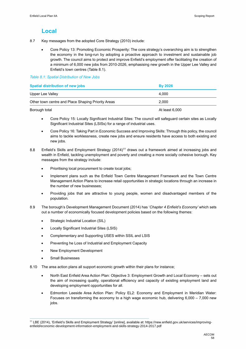
Enfield Local Plan IIA Scoping Report
AECOM 58
Local
Key messages from the adopted Core Strategy (2010) include:
• Core Policy 13: Promoting Economic Prosperity: The core strategy’s overarching aim is to strengthen
the economy in the long-run by adopting a proactive approach to investment and sustainable job
growth. The council aims to protect and improve Enfield’s employment offer facilitating the creation of
a minimum of 6,000 new jobs from 2010-2026, emphasising new growth in the Upper Lee Valley and
Enfield’s town centres (Table 8.1).
Table 8.1: Spatial Distribution of New Jobs
Spatial distribution of new jobs By 2026
Upper Lee Valley 4,000
Other town centre and Place Shaping Priority Areas 2,000
Borough total At least 6,000
• Core Policy 15: Locally Significant Industrial Sites: The council will safeguard certain sites as Locally
Significant Industrial Sites (LSISs) for a range of industrial uses.
• Core Policy 16: Taking Part in Economic Success and Improving Skills: Through this policy, the council
aims to tackle worklessness, create new jobs and ensure residents have access to both existing and
new jobs.
Enfield’s Skills and Employment Strategy (2014)77 draws out a framework aimed at increasing jobs and
wealth in Enfield, tackling unemployment and poverty and creating a more socially cohesive borough. Key
messages from the strategy include:
• Prioritising local procurement to create local jobs;
• Implement plans such as the Enfield Town Centre Management Framework and the Town Centre
Management Action Plans to increase retail opportunities in strategic locations through an increase in
the number of new businesses;
• Providing jobs that are attractive to young people, women and disadvantaged members of the
population.
The borough’s Development Management Document (2014) has ‘Chapter 4 Enfield’s Economy’ which sets
out a number of economically focused development policies based on the following themes:
• Strategic Industrial Location (SIL)
• Locally Significant Industrial Sites (LSIS)
• Complementary and Supporting USES within SSIL and LSIS
• Preventing he Loss of Industrial and Employment Capacity
• New Employment Development
• Small Businesses
The area action plans all support economic growth within their plans for instance;
• North East Enfield Area Action Plan: Objective 3: Employment Growth and Local Economy – sets out
the aim of increasing quality, operational efficiency and capacity of existing employment land and
developing employment opportunities for all.
• Edmonton Leeside Area Action Plan: Policy EL2: Economy and Employment in Meridian Water:
Focuses on transforming the economy to a high wage economic hub, delivering 6,000 – 7,000 new
jobs.
77 LBE (2014), ‘Enfield’s Skills and Employment Strategy’ [online], available at: https://new.enfield.gov.uk/services/improving-enfield/economic-development-information-employment-and-skills-strategy-2014-2017.pdf

Enfield Local Plan IIA Scoping Report
AECOM 59
Baseline review
Current
From the government policies and commitments highlighted above, it is evident that stagnant economic
growth and worklessness are two of the biggest challenges faced by the borough. Figures 8.3 and 8.4
present important population data. This information is important in order to understand the data that follows.
Figure 8.3: Population estimates 2018-male/female age pyramid
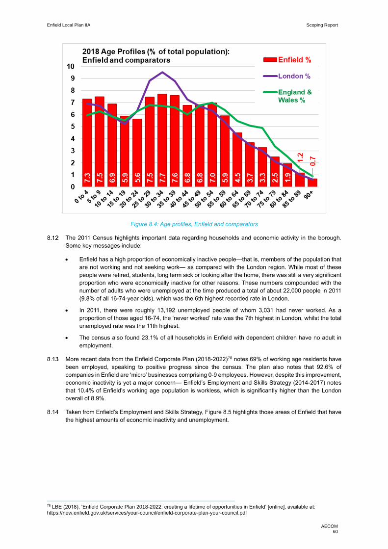
Enfield Local Plan IIA Scoping Report
AECOM 60
Figure 8.4: Age profiles, Enfield and comparators
The 2011 Census highlights important data regarding households and economic activity in the borough.
Some key messages include:
• Enfield has a high proportion of economically inactive people—that is, members of the population that
are not working and not seeking work— as compared with the London region. While most of these
people were retired, students, long term sick or looking after the home, there was still a very significant
proportion who were economically inactive for other reasons. These numbers compounded with the
number of adults who were unemployed at the time produced a total of about 22,000 people in 2011
(9.8% of all 16-74-year olds), which was the 6th highest recorded rate in London.
• In 2011, there were roughly 13,192 unemployed people of whom 3,031 had never worked. As a
proportion of those aged 16-74, the ‘never worked’ rate was the 7th highest in London, whilst the total
unemployed rate was the 11th highest.
• The census also found 23.1% of all households in Enfield with dependent children have no adult in
employment.
More recent data from the Enfield Corporate Plan (2018-2022)78 notes 69% of working age residents have
been employed, speaking to positive progress since the census. The plan also notes that 92.6% of
companies in Enfield are ‘micro’ businesses comprising 0-9 employees. However, despite this improvement,
economic inactivity is yet a major concern— Enfield’s Employment and Skills Strategy (2014-2017) notes
that 10.4% of Enfield’s working age population is workless, which is significantly higher than the London
overall of 8.9%.
Taken from Enfield’s Employment and Skills Strategy, Figure 8.5 highlights those areas of Enfield that have
the highest amounts of economic inactivity and unemployment.
78 LBE (2018), ‘Enfield Corporate Plan 2018-2022: creating a lifetime of opportunities in Enfield’ [online], available at: https://new.enfield.gov.uk/services/your-council/enfield-corporate-plan-your-council.pdf

Enfield Local Plan IIA Scoping Report
AECOM 61
Figure 8.5: LBE claimant count by middle super output area, December 2013

Enfield Local Plan IIA Scoping Report
AECOM 62
Other key messages from the Strategy include:
• Enfield has a long-term unemployment rate of 1.4%, which is higher than the rate for London as a
whole.
• Long-term unemployment amongst older people is increasing—43% people aged 50-64 remain
unemployment following a year out of work, compared to 35% people aged 25-49 and 18.5% aged
16-24.
• Enfield is one of the local authorities containing youth employment hotspots. In August 2013, the
recorded rate of NEET (not in Education Employment or Training) 16-19-year olds was 4.86%.
• Merely 72% of the working age population is economically active.
Table 8.1: Highest level qualifications (2011 Census)
Qualification and Students Count %
All usual residents aged 16 and over 242,465 100.0
No qualifications 55,736 23.0
Level 1 qualifications 31,158 12.9
Level 2 qualifications 33,389 13.9
Apprenticeship 4,715 1.9
Level 3 qualification 25,557 10.5
Level 4 qualification and above 69,627 28.7
Other qualifications 22,283 9.2
Schoolchildren and full-time students: Age 16 to 17 7,914 3.3
Schoolchildren and full-time students: Age 18 and over 16,901 7.0
Full-time students: Age 18 to 74: Economically active: In employment 5,325 2.2
Full-time students: Age 18 to 74: Economically active: Unemployed 1,976 0.8
Full-time students: Age 18 to 74: Economically inactive 9,556 3.9
Furthermore, skills and education are a key factor in driving economic growth. As per the table 8.1, the 2011
census indicates that Enfield has a higher proportion of residents with no qualifications (23%) and a lower
proportion of residents with level 4 qualifications (28.7%) than the average for London (17.6% and 37.72%).
The eight qualification levels in England are summarised below for context:
• Level 1 includes GCSE grades 3 to 1 or D to G;
• Level 2 includes GCSE grades 9 to 4 or grades A* to C;
• Level 3 includes AS levels and A levels;
• Levels 4 and 5 include NVQs at Level 4 and Level 5 respectively;
• Level 6 includes bachelor’s degrees;
• Level 7 includes master’s degrees;
• Level 8 includes doctoral degrees
Enfield’s Skill strategy notes that the proportion of the working age population with no qualifications has
declined by 30% since 2007. At 9.6% this was still higher than the London average of 8.4% at the time of
publication.

Enfield Local Plan IIA Scoping Report
AECOM 63
Future
LBE’s Towards a New Local Plan 203679 describes Enfield’s future as a borough “delivering a significant
amount of new housing, driving growth, supporting businesses to thrive, and creating a place people are
proud to live, work and visit.” Key plan objectives include:
• Directing new development opportunities back to main town centres;
• Relaxing retail policies and promoting development within individual residential curtilages; and
• Proactively managing and optimising low density industrial land to increase capacity for redevelopment
for both housing and employment promoting development above single storey retail, supermarkets
and other commercial uses.
• Managing significant change whilst protecting and enhancing the borough’s heritage and natural
environment.
Enfield’s Employment and Skills Strategy finds self-employment and entrepreneurship likely to rise in future
years, stating as many as 50% of construction workers and approximately 20% of transport and
communications workers were self-employed in 2005, meaning current figures are likely to be higher. The
Strategy also finds that despite having the tenth highest unemployment rate in London, Enfield has a higher
than average number of job vacancies compared to London—this highlights a mismatch in the labour market
and skill-set, which suggest a need to raise skill levels and ensure job vacancies are filled locally.
Furthermore, only 72% of Enfield’s working age population is active—this means that even if every individual
who is currently workless were to find employment, the Strategy notes, this would still fail to raise the
proportion of people in work in Enfield to the Europe 2020 target of 75%.
Regeneration programmes are estimated to create approximately 15,000 jobs in Enfield over the next
coming decades. Figure 8.6 taken from the strategy maps out the same.
Figure 8.6: Area Action Plans and Regeneration Areas
79 LBE (2018), ‘Enfield’s New Local Plan 2036 – Draft, Consultation 18’ [online], available at: https://new.enfield.gov.uk/services/planning/enfield-draft-local-plan-2036-planning.pdf
Enfield Local Plan IIA Scoping Report
AECOM 64
The Enfield Corporate Plan (2018-2022) similarly details several upcoming large-scale regeneration
schemes, such as the £6bn Meridian Water Masterplan Area which has the potential to provide up to 10,000
homes and thousands of jobs over a 20-year period.
It also serves this report to contextualise the above information in line with the broader aims outlined in the
U.K’s Industrial policy. Some meaningful quotes from the Strategy follow:
• “We are a nimble economy and we can move quickly to take advantage of innovations. We also have
smart consumers who reward entrepreneurs developing new products and services… We know that
the earliest adopters of new technologies are able to reap the greatest rewards in terms of additional
jobs and increased revenue.”
• “We have many strengths on which we can build, and some weaknesses we need to address. As we
leave the European Union, we need to raise our game at home and on the world stage. This can be
done if we seize the opportunities of the years ahead – and it is essential if the British people are to
enjoy prosperous lives with fulfilling work and high-quality public services.”
• “We will also direct the government’s convening power, promote exports and inward investments, and
build consumer trust in new technologies. Where appropriate, teams will develop ‘missions’ to tackle
the Grand Challenges...”
Thus, Enfield will continue to grow, and investments will include transport, infrastructure enhancement and
significant new employment and residential development. It will be important that this growth is matched by
associated infrastructure enhancements as necessary.
Key issues and objectives
The following key issues emerge from the context and baseline review:
• With the right interventions and investment, there is significant opportunity for growth and development
in Enfield, such that the borough can support the Government’s Industrial Strategy aim to boost the
productivity and earning power of people across the UK. Interventions should carefully consider the
environmental sensitivities within the borough and should be located in places which limits adverse
impacts on the environment, water quality, biodiversity and flood risk.
• There is a need to ensure that education and skills provision meet the needs of Enfield’s existing and
future labour market and improves life chances for all, including by enabling older people and people
with physical and mental health conditions to stay in employment.
In light of these key issues, it is proposed that the IIA framework should include the following objectives:
Support a strong, diverse and resilient economy that provides opportunities for all, including by
supporting strategic industrial locations, the vitality of the borough’s town and local centres and a
diversification of the employment opportunities locally, including employment within the social
enterprise, voluntary and community sectors and a growing higher wage economy.

Enfield Local Plan IIA Scoping Report
AECOM 65
9. Health
Introduction
Health status is a key aspect of sustainable communities and is known to be influenced by a range of
physical, social and economic factors including housing conditions and neighbourhood economic
conditions.
Health tends to deteriorate in poor quality environments resulting in premature mortality and increased
morbidity. Furthermore, there is a social gradient in health, with worse social position tending to be linked
to worse health. Whereas protection of and accessibility to green and open spaces provides both physical
and mental health benefits. Th Local Plan process can directly influence this through policies such as
ensuring new developments provide access to open spaces to mitigate against areas of open space
deficiency.
As will be evident throughout this chapter, health is a cross cutting theme that is influenced by wider
environmental and social determinants. For instance, there are clear linkages to promote physical activity
through access and availability of sports and recreation facilities (green and open spaces) and promoting
active modes of travel. National and regional policy documents acknowledge this fairly consistently and
there is significant awareness of the link between spatial planning and health. These impacts on health have
been explored in other areas of this scoping report. In particular within the following chapters:
• Air Quality;
• Climate Change Adaptation;
• Communities;
• Crime and Community Safety;
• Green Infrastructure and Landscape; and
• Transport.
Context review
National
Key messages from the National Planning Policy Framework (NPPF) include that planning policies should:
• Enable and support healthy lifestyles through provision of green infrastructure, sports facilities, local
shops, access to healthier food, allotments and layouts that encourage walking and cycling.
• Take into account and support the delivery of local strategies to improve health, social and cultural
well-being for all sections of the community.
• Help deliver access to high quality open spaces and opportunities for sport and physical activity to
contribute to the health and well-being of communities.
The 2010 Marmot Review ‘Fair Society and Healthy Life’ explored and provided evidence of health being
influenced by wider social determinants. As such, it set out policy recommendations to the national
government to reduce health inequalities, one of which was to “create and develop healthy and sustainable
places and communities”.80
80 Institute of Health Equity (2010) Fair Society Healthy Lives [online] available at: http://www.instituteofhealthequity.org/resources-reports/fair-society-healthy-lives-the-marmot-review

Enfield Local Plan IIA Scoping Report
AECOM 66
Public Health England has a key role in shaping health policy and practice across the country. In 2017 the
organisation published ‘Spatial Planning for Health: An evidence resource for planning and designing
healthier places’81. The review provides guidance on the role of the built and natural environment in shaping
health impacts. The review explores the impacts of neighbourhood design, provision of housing, transport
and the natural environment on public health. The Government’s 25 YEP also highlights the health impacts
of protecting and enhancing the natural environment. There is a particular focus on the physical and mental
wellbeing benefits that the environment provides. The strategy highlights spatial planning approaches that
can help deliver this, including planting one million trees in England’s towns and cities by 2022 and delivering
additional green infrastructure.
NHS guidance on healthy urban development focuses on four key themes: healthy housing, active travel,
healthy environment and vibrant neighbourhoods.82
Regional
The Draft London Plan (2017) Policy ‘GG3: Creating a healthy city’ recognises the cross-cutting nature of
both. healthcare provision and enabling healthy lifestyles, noting the significance at a London-wide scale of
ensuring that “wider determinants of health are addressed in an integrated and coordinated way, taking a
systematic approach to improving the mental and physical health of all Londoners and reducing health
inequalities.”
The MTS recognises the importance of transport impacts on health through the Healthy Streets approach,
which is explored in greater detail in Chapter 13. The MES acknowledges that air pollution, noise pollution,
climate change and access to green spaces all pose significant risk to health and wellbeing of Londoners.
Policies and proposals throughout the MES include a focus on the health outcomes.
The Health Inequalities Strategy (2018) presents a London-wide strategy for tackling identified ‘unfair
differences’ in health outcomes across the city, focussing on the five core themes of healthy children, healthy
minds, healthy places, healthy communities and healthy living.83
Local
LBE’s Core Strategy (2010) acknowledges that one of the borough’s key issues is reducing inequalities in
health and wellbeing, particularly in the south and the east of the borough. The document sets out an
overarching vision which is: “A healthy, prosperous and sustainable borough’.
Health and wellbeing is referenced throughout the Core Strategy, highlighting its cross-cutting nature. There
is a policy focused on health and its wider determinants:
• Core Policy 7: Health and social care facilities and the wider determinants of health: This focuses on
the health infrastructure in the borough. It also notes “A pattern of land uses will be promoted to
encourage healthier lifestyles including Core Policies 11 (recreation), 25 (pedestrians and cyclists), 30
(environmental quality), 34 and 35 (greater use of parks and open spaces) and Chapter 9 Core Polices
for Places”.
Similarly, health and wellbeing is referenced across LBE’s Development Management Document (2014), in
particular in the following chapters;
• Chapter 2: Housing: Notes the need to provide health care infrastructure specialist housing provisions
• Chapter 3: Community Facilities: To support the objective to make LBE a prosperous and healthy
borough, availability and accessibility to health care services is critical
• Chapter 10: Green Infrastructure: Notes the important health and wellbeing benefits provided by green
spaces and the borough’s natural assets.
81 Public Health England (2017) Spatial Planning for Health An evidence resource for planning and designing healthier places [online] available at: https://assets.publishing.service.gov.uk/government/uploads/system/uploads/attachment_data/file/729727/spatial_planning_for_health.pdf 82 NHS (2017) Healthy Urban Planning Checklist [online] available at: https://www.healthyurbandevelopment.nhs.uk/wp-content/uploads/2017/05/Healthy-Urban-Planning-Checklist-3rd-edition-April-2017.pdf 83 Mayor of London (2018), Health Inequalities Strategy [online], available at: https://www.london.gov.uk/what-wedo/health/health-inequalities-strategy
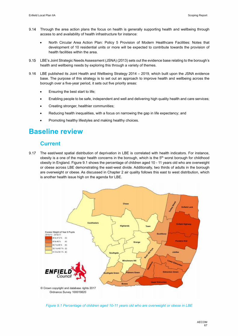
Enfield Local Plan IIA Scoping Report
AECOM 67
Through the area action plans the focus on health is generally supporting health and wellbeing through
access to and availability of health infrastructure for instance:
• North Circular Area Action Plan: Policy 5 Provision of Modern Healthcare Facilities: Notes that
development of 10 residential units or more will be expected to contribute towards the provision of
health facilities within the area.
LBE’s Joint Strategic Needs Assessment (JSNA) (2013) sets out the evidence base relating to the borough’s
health and wellbeing needs by exploring this through a variety of themes.
LBE published its Joint Health and Wellbeing Strategy 2014 – 2019, which built upon the JSNA evidence
base. The purpose of this strategy is to set out an approach to improve health and wellbeing across the
borough over a five-year period, it sets out five priority areas:
• Ensuring the best start to life;
• Enabling people to be safe, independent and well and delivering high quality health and care services;
• Creating stronger, healthier communities;
• Reducing health inequalities, with a focus on narrowing the gap in life expectancy; and
• Promoting healthy lifestyles and making healthy choices.
Baseline review
Current
The east/west spatial distribution of deprivation in LBE is correlated with health indicators. For instance,
obesity is a one of the major health concerns in the borough, which is the 5th worst borough for childhood
obesity in England. Figure 9.1 shows the percentage of children aged 10 - 11 years old who are overweight
or obese across LBE demonstrating the east-west divide. Additionally, two thirds of adults in the borough
are overweight or obese. As discussed in Chapter 2 air quality follows this east to west distribution, which
is another health issue high on the agenda for LBE.
Figure 9.1 Percentage of children aged 10-11 years old who are overweight or obese in LBE

Enfield Local Plan IIA Scoping Report
AECOM 68
The east of the borough experiences significant food related deprivation, including a concentration of food
banks and ‘food deserts’ (neighbourhoods that lack access to healthy food).
As of 2012 it was estimated that 18,769 people aged 16 and over were living with diabetes in LBE,
projections suggested this would rise by 9.5% in 202084. This is important as diabetes is a prime risk factor
leading to cardiovascular diseases.
Figure 9.2 indicates that general health outcomes in LBE are slightly lower than for London as a whole but
are broadly in line with figures for England. Overall 81.85% of residents in LBE report being in ‘Very good
health’ or ‘Good health’ compared to 83.84% for London and 81.4% for England. However, 5.45% of LBE
residents reported being in ‘bad health’ or ‘very bad health’, in comparison to 4.96% in London and 5.4%
across England.
Figure 9.2: General health status (2011 Census)
Table 9.1 shows that in terms of long-term health and disability LBE has better outcomes than England as
a whole and is slightly below the London wide region.
Table 9.1 Long term health category
Long term health category (% of total) Enfield London England
Day-to-day activities limited a lot 7.26% 6.75% 8.30%
Day-to-day activities limited a little 8.10% 7.41% 9.30%
Day-to-day activities not limited 84.65% 85.84% 82.40%
It is also noted in LBE’s JHWS (2014) that 95% of the population is not physically active enough to maximise
benefits to their health. Additionally, 18.5% of adults smoke and strikingly it was estimated that 4% of 11-
15-year olds smoke.85
84 LBE (2014) Enfield Joint Health and Wellbeing Strategy 2014-2019 [online] available at: https://new.enfield.gov.uk/healthandwellbeing/wp-content/uploads/2017/03/Enfield_Joint_Health_and_Wellbeing_Strategy_2014_19_FINAL_April_2014.pdf 85 LBE (2014) Joint Health and Wellbeing Strategy [online] available at: https://new.enfield.gov.uk/healthandwellbeing/wp-content/uploads/2017/03/Enfield_Joint_Health_and_Wellbeing_Strategy_2014_19_FINAL_April_2014.pdf
0%
10%
20%
30%
40%
50%
60%
Very goodhealth
Good health Fair health Bad health Very badhealth
Enfield
London
England

Enfield Local Plan IIA Scoping Report
AECOM 69
Table 9.2 Life expectancy at birth 2009 – 2013 86
England Enfield Upper Edmonton Cockfosters
Male 79.1 80.2 76.2 83.0
Female 83 83.9 78.7 86.2
Borough-wide inequalities are once again visible with figures of life expectancy at birth, demonstrated in
Table 9.2. Despite having better life expectancy rates than averages for males and females than for England
as whole, there is clear disparity between the east and west of the borough as demonstrated by comparison
between the western ward of Cockfosters and the eastern ward of Upper Edmonton.
Health is a cross-cutting topic and there are synergies with other IIA themes. This is particularly the case in
relation to green infrastructure and landscape, which is increasingly being evidenced as delivering health
and wellbeing benefits. In the context of LBE, a key concern is the access to green infrastructure and open
spaces for residents in the east of the borough, where access to the Lee Valley Regional Park is limited due
to the presence of industrial land, main roads and lack of public transport access. This is compounded by
safety concerns with respect to the open spaces that are available, which impacts the use of green spaces
in the borough.
Transport is a key determinant of health; London policy has a particular focus on delivering ‘Healthy Streets’.
IN addition, LBE have an active transport delivery group ‘Cycle Enfield’ which aims to deliver greater walking
and cycling facilities. These initiatives aim to encourage active lifestyles, reduce dependency on cars and
therefore concentration of harmful emission, thus delivering health benefits, which is explored in detail in
Chapter 13. Figure 9.3 demonstrates the scope for greater levels of active travel especially in the east of
the borough, given the proximity to the Lee Valley Regional Park.
Mental health is another challenge for the borough. According to research, Enfield has a higher percentage
of poor mental health amongst 16-34 years old and 55+ (23% and 18.5% respectively) in comparison to
London (16% and 13.3% respectively).
Accessibility to health services has an important role to play in determining health in the borough. As of
2014, there were 52 GP practices in the borough and two main hospitals:
• North Middlesex University Hospital; and
• Chase Farm Hospital.
However, it was noted in the scoping interviews with LBE officers that there are significant pressures on
health infrastructure namely:
• Too few GP practices on estates;
• An ageing GP service with inadequate facilities, 50% of practices are in old residential properties;
• There is a struggle to match adult social care availability with hospital out patients, resulting in delayed
discharge;
• Uneven distribution of private and public care homes between the west and the east of the borough
respectively; and
• Cross boundary movement of patients is putting increased pressure on facilities, in particular Chase
Farm Hospital.
86 ONS (2018) Health state life expectancy by 2011 Census wards in England and Wales’ [online], available at: https://www.ons.gov.uk/peoplepopulationandcommunity/healthandsocialcare/healthandlifeexpectancies/articles/healthstatelifeexpectancyby2011censuswardsenglandandwales/2009to2013#inequality-in-healthy-life-expectancy-at-birth-by-local-areas-in-england-and-wales

Enfield Local Plan IIA Scoping Report
AECOM 70
Figure 9.3 Percentage of residents completing 2 x 10 minutes of active travel per day87
87 LBE (2019) Enfield Transport Plan 2019 -2041 [online] available at: https://new.enfield.gov.uk/services/roads-and-transport/enfield-transport-plan-2019-2041-roads.pdf
Enfield Local Plan IIA Scoping Report
AECOM 71
Future
Wider determinants such as green infrastructure and active living are gaining more headline policy focus
and may lead to better health outcomes for the borough. An example of this is the prominence of Cycle
Enfield and the liveable neighbourhoods £9m funding that has been secured for Enfield Town, (explored
further in Chapter 13.
LBE is exploring ‘School Super Zones’; which is a Public Health England initiative to create a 400m radius
zone around schools which aim to reduce air pollution, gambling shops and unhealthy food options, see the
below case study for further detail. Therefore, focusing on two of the main health issues in LBE.
There is growing evidence of the link between high density development and the negative public health
impacts this has. Given the significant rise in housing targets through the Draft London Plan (2017), this will
pose a genuine risk to the borough.
However, it should be noted that new development schemes offer the opportunity to not only provide for
needs but also support shift in service delivery. Whilst LBE are exploring co locating health services under
one roof in strategic locations across the borough.
Key issues and objectives
The following key issues emerge from the context and baseline review:
• Health is a cross cutting theme that is influenced by wider environmental and social determinants and
policy positions on air quality, transport, communities, climate change adaption and transport will have
a direct impact on LBE’s future baseline on health.
• Health issues follow the east to west spatial deprivation trend in the borough illustrated by life
expectancy across wards. The flagship health issues revolve around: air quality, obesity and food
deprivation and access to green spaces.
• There are also deficiencies in the borough’s health infrastructure with inadequate GP facilities, cross
boundary pressure on health services and issues around primary health services.
• Development design has a clear bearing on health outcomes, with concerns in respect of high-density
development.
In light of the key issues discussed above it is proposed that the IIA should include the following objective:
Improve the physical and mental health and wellbeing of Enfield residents and reduce health inequalities
between local communities within the borough.
Case Study: School Super Zones
It is widely accepted that having exposure to healthy spaces and environments helps reduce health
inequalities and can have a lasting impact on the physical and mental wellbeing of children. The School
Super Zones is an initiative developed and being tested by 13 London borough’s including Enfield. Its aim is
to create zones within walking distance of schools which are healthier and safer for children to ‘live, learn
and play’. A variety of actions are being tested to deliver these super zones, including: Reducing traffic to
bring down air pollution; Restricting advertising of unhealthy foods; Improving pedestrian routes to school;
and Installing water fountains to supporting healthier drinking options.
https://www.planningofficers.org.uk/uploads/Superzones%20London%20planning%20network%20210918.
Enfield Local Plan IIA Scoping Report
AECOM 72
10. Heritage and townscape
Introduction
As per the NPPF, the term historic environment—a concept that encompasses the rich history and culture
of any given area—can be defined as including “all aspects of the environment resulting from the interaction
between people and places through time, including all surviving physical remains of past human activity,
whether visible, buried or submerged, and landscaped and planted or managed flora.” The relevance of
including a section on the same in a local plan is to facilitate in the drafting of plans which can both avoid
any impacts to the historic environment and find opportunities to deliver enhancements, for instance,
through enhancement access to and appreciation of historic environment assets.
Aside from being socio-culturally important to local communities, the heritage of a place can positively drive
regeneration and economic growth by attracting investment and draw visitors into neighbourhoods. For an
area that is rapidly changing like Enfield is how the heritage is managed and persevered is crucial. Heritage
management is indicative of how the council will develop new places, enhance existing neighbourhoods
and recognise the heritage of its communities.
Context review
National
Key messages from the National Planning Policy Framework (NPPF) include:
• Strategic policies should set out an overall strategy making provision for ‘conservation and
enhancement of the natural, built and historic environment, including landscapes and green
infrastructure.
• Planning policies and decisions should ensure that developments ‘are sympathetic to local character
and history, including the surrounding built environment and landscape setting, while not preventing
or discouraging appropriate innovation of change (such as increased densities).
• Heritage assets should be recognised as an ‘irreplaceable resource’ that should be conserved in a
‘manner appropriate to their significance’, taking account of ‘the wider social, cultural, economic and
environmental benefits’ of conservation, whilst also recognising the positive contribution new
development can make to local character and distinctiveness.
• Plans should set out a ‘positive strategy’ for the ‘conservation and enjoyment of the historic
environment’, including those heritage assets that are most at risk.
• When considering the impact of a proposed development on the significance of a designated heritage
asset, great weight should be given to the asset’s conservation (and the more important the asset, the
greater the weight should be). This is irrespective of whether any potential harm amounts to substantial
harm, total loss of less than substantial harm to its significance.
These messages are supported by the national Planning Practice Guidance (PPG)88 which itself includes
the key message that local authorities should set out in their Local Plans a positive strategy for the
conservation and enjoyment of the historic environment which recognises that conservation is not a passive
exercise and that identifies specific opportunities for the conservation and enhancement of heritage assets.
The Ancient Monuments & Archaeological Areas Act (1979) legislates to protect the archaeological heritage
of England, Wales and Scotland.
88 MHCLG (2019) National Planning Practice Guidance [online] available at: https://www.gov.uk/government/collections/planning-practice-guidance
Enfield Local Plan IIA Scoping Report
AECOM 73
The Planning (Listed Buildings and Conservation Areas) Act 199089 legislates on planning permission for building works, with a particular focus on listed buildings and conservation areas. It details special controls for any work related to the demolition, alteration or extension of buildings with architectural or historic interest, as well as conservation areas.
The Heritage Statement (2017)90 replaces the 2010 Statement on the Historic Environment for England and
sets out the Government’s vision for supporting the heritage sector to help it to protect and care for heritage
and the historic environment in the coming years, in order to maximise the economic and social impact of
heritage and to ensure that everyone can enjoy and benefit from it.
The Setting of Heritage Assets (2nd Edition) - published in December 2017 and provides good practice
advice on understanding how setting contributes to the significance of heritage assets, particularly focusing
on how setting allows the significance to be appreciated and how views contribute to setting. The guidance
is written primarily for local authorities for managing change within the settings of heritage assets, both
designated and non-designated.
The Governments 25 YEP also sets out a number of goals and policies in order to help the natural world
regain and retain good health. In this context, Goal 6 ‘Enhanced beauty, heritage and engagement with the
natural environment’ acknowledges the value of the historic environment.
Regional
The Draft London Plan (2017) has a chapter, ‘Chapter 7 Heritage and Culture’ sections of this are dedicated
to polices to protect and support the city’s rich matrix of historic buildings and landscapes:
• Policy HC1: Heritage and culture: sets out high level policy context for plan making and decision
making at borough-level with regards to heritage. It states boroughs should deliver local policies which
recognise and embed the role of heritage in place-making, utilise the heritage significance of a site,
integrate conservation with innovative architecture and enhance the historic environment.
• Policy HC3: Strategic and local views: heritage views and landscapes are an important element to the
character if London. This policy sets out an objective to protect certain views such as London
Panoramas, River Prospects and Townscape Views.
The MES does have a heritage focus in relation to protecting London’s historic parks, nature reserves and
natural habitats. The protection of natural heritage comes through in biodiversity and green infrastructure
polices within the strategy.
The Greater London Historic Environment Record (GLHER) is a comprehensive record of non-designated
historic sites and assets. It records over 87,000 entries across Greater London and captures sites of historic
interest ranging from the find locations of prehistoric implements to Victorian and 20th century sites .
Local
LBEs Core Strategy 2010, recognises that the boroughs heritage assets and historical environment is an
important contributor to the borough’s character and creating a sense of place. It notes the need to protect
historical assets whilst meeting growth targets. ’Section 8.3 Built and landscape heritage’ of the strategy is
There are a number of policies that consider the heritage and townscape:
• Core Policy 11: Recreation, Leisure, Culture and Arts: The policy emphasises the need to support
strategies which identify current and future needs of heritage and cultural significance in the borough.
• Core Policy 31: Built and Landscape Heritage: This policy is focused on implementing national and
regional policies in order to preserve and enhance historical assets; including stipulations that
development proposals will need to include a character appraisal which demonstrates the
development will respect and enhance assets in close proximity.
89 UK Government (1990) Planning (Listed Buildings and Conservation Areas) Act 1990 [online] available at: http://www.legislation.gov.uk/ukpga/1990/9/contents 90 Department for Digital, Culture, Media and Sport (2017) Heritage Statement [online], available at: https://assets.publishing.service.gov.uk/government/uploads/system/uploads/attachment_data/file/664657/Heritage_Statement _2017__final_-_web_version_.pdf

Enfield Local Plan IIA Scoping Report
AECOM 74
LBE’s Development Management Document (2014) has a section focused on design and heritage, in
particular the DMD 44 policy, which should be read in conjunction with Core Policy 31
• DMD 44: Conserving and Enhancing Heritage Assets: Sets out requirements for new developments in
terms of heritage considerations.
The borough’s area action plans do not delve in to great detail in relation to heritage and townscape,
however they all do note the need for new developments to consider the historic environment and heritage
assets identifies within each area, for instance:
• North East Area Action Plan: Objective 2: Notes “protect and enhance the historic environment, including non-designated buildings and sites of heritage value, for the benefit of residents and visitors alike”.
In 2019 LBE published the SPD ‘Making Enfield: Heritage Strategy: 2019 – 2024’. The strategy aims to
ensure that heritage is considered as part of the growth in the boroughs built and natural environment. It
aims to ensure that design of new places provides enhancements of the historic environment and there is
a focus on the heritage of cultural practices from different groups across the borough. The strategy is
informed by the following documents:
• Conservation Area Character Appraisals;
• Conservation Area Management Proposals;
• Local Heritage List; and
• Shopfront Design Guidance.
In 2011 LBE undertook the ‘Enfield Characterisation Study’ which reviewed the borough’s landscape and
evolution to identify key characteristics of the borough. It highlights key issues with the aim of helping build
upon and protect the existing identify of the borough. The document notes the importance of the borough’s
historical centres and series of historic connections that provide a sense of character.
LBEs Areas of Archaeological Importance Review (2011) was prepared by English Heritage and
recommends areas of the borough to be declared as Archaeological Priority Areas (APAs). APAs are
declared where there is a significant known archaeological interest or there is understood to be potential for
new archaeological discoveries.91
Baseline review
Current
The Borough has a number of historic assets designated at either a local and national scale, including:
• Five Scheduled Ancient Monuments;
• 22 conservation areas;
• 5 registered parks and gardens of special historic interest (Forty Hall, Trent Park, Broomfield,
Myddleton House and Grovelands);
• 479 statutorily listed buildings;
• 262 local landmarks and landscapes identified on the Local heritage list; and
• 25 areas of archaeological importance.
91 LBE (2011) Areas of Archaeological Importance Review [online] available at: https://new.enfield.gov.uk/services/planning/planning-policy-information-areas-of-archaeological-importance-review-2012.pdf

Enfield Local Plan IIA Scoping Report
AECOM 75
All 22 conservation areas in the borough have Conservation Area Character Appraisals, these documents highlight assets which make the areas distinctive and aim to protect the important historical and cultural features. Historic England defines conservation area management plans as “vehicles for reinforcing the positive character of a historic area as well as for avoiding, minimising and mitigating negative impacts identified as affecting the area”, noting that this may also help to “outline opportunities to better reveal or enhance significance, possibly through the location or design of new development” 92.
The borough has 479 statutorily listed buildings. 30 of these are Grade II* (buildings of particularly important interest), three are Grade I (buildings of exceptional interest) and 312 are Grade II (buildings of special interest). A key priority for the borough is the Grade II* Broomfield House which has experienced fire damage. In general, the listed buildings are clustered around town centre, following early patterns of settlements and transport routes. Figure 10.1 demonstrates the listed buildings and registered parks and gardens distribution.
Historic England maintains a nationwide Heritage at Risk (HAR) register, updated on an annual basis. The
2018 HAR register records 18 entries that are at risk within the borough. Of these, five are Grade II* listed
buildings, two are conservation areas (Church Street and Fore Street). Three are registered parks and
gardens (Grovelands, Broomfield and Trent Park) and eight are Grade II listed buildings.
LBEs Archaeological Priority Area Appraisal indicates that there are a total of 25 APAs, including significant
area in the north west of the borough and along the eastern border, the areas include:
• Enfield Chase & Camley Moat;
• Whitewebbs Hill, Bull Cross and Forty Hill;
• Lea Valley West Bank;
• Ermine Street;
• Lea Valley East Bank;
• Enfield Town centre Broomfield House.
Figure 10.1: Listed buildings and registered parks and gardens93
92 Historic England (2019), ‘Conservation Area Appraisal, Designation and Management’ [online], available from: https://historicengland.org.uk/images-books/publications/conservation-area-appraisal-designation-management-advice-note-1/ 93 LBE (2018) Making Enfield: Heritage Strategy: 2019 – 2024 [‘online] available at: https://new.enfield.gov.uk/services/planning/heritage-strategy-2019-24-planning.pdf

Enfield Local Plan IIA Scoping Report
AECOM 76
Future
New development within the borough has the potential to impact heritage assets and their settings through
inappropriate design and layout. The borough has a wide range of built heritage and this range of historic
context presents potential for a variety of negative effects from inappropriate development.
However, given the LBE’s policy to protect and, where applicable, enhance the historic environment; new
development will offer opportunities to improve the quality of the borough’s historic environment, either
through regeneration of a specific asset or through improvements to an asset’s setting and wider
environment. Development can also offer opportunities to improve access to or better reveal the significance
of a heritage asset.
Existing historic environment designations and the policies of the NPPF will continue to offer a degree of
protection to heritage assets and their settings.
Key issues and objectives
The following key issues emerge from the context and baseline review:
• LBE has recently published an updated heritage strategy which aims to ensure historic and heritage
assets and environments are given serious consideration and protection from any new developments,
it also notes the role of heritage in being a stimulant for economic growth and attracting visitors to the
borough.
• LBE has a rich variety of designated heritage assets, including five scheduled ancient monuments, 22
conservation areas, 25 APAs, 5 registered parks and gardens of special historic interest and 479
statutorily listed buildings.
• In general heritage assets are clustered around town centres and transport hubs, whilst buildings with
the highest gradings (II* or I) are prominently former private estates outside these town-centre
concentrations.
In light of these key issues, it is proposed that the IIA framework should include the following objectives:
Sustain and enhance the significance of heritage assets, support the integrity, special interest, character,
appearance and historic setting of historic settlements and heritage assets, both designated and non-
designated; facilitate enhancements to the fabric and setting of the historic environment; and support
access to, interpretation and understanding of the historic environment (including through investigations
and studies which better reveal the significance of archaeological assets).

Enfield Local Plan IIA Scoping Report
AECOM 77
11. Housing
Introduction
England has a shortage of housing, with fewer homes being built than the number of new households being
formed each year, while historically there has been a shortfall in building rates over many decades.94
Housing affordability has significantly worsened in 69 local authorities in England and Wales over the last
five years, with over three-quarters of these being in London.95 In 2017, average house prices in Britain
were 10 times the annual salary of residents. Nationally, over seven times people’s incomes are needed to
achieve home ownership and the average first-time buyer is estimated to be thirty-seven years of age.
Housing has thus become one of the most pressing issues faced by local authorities and should be
appropriately addressed in local plans. With very few affordable rented homes and a growing number of
people on low income living in the private rented sector, Enfield faces many of the same issues as the rest
of Britain.
While Enfield was consistent with the objectives set out in the London Plan (2008), the 2008 plan had a
housing target of 395 dwellings per annum, and London’s population has since continued to grow, changing
the borough tremendously. The London Plan adopted in 2011—considered with alterations made in 2016—
significantly raised Enfield’s housing targets from 560 to 798 dwellings per annum. As per the Draft Enfield
Local Plan, by 2036, Enfield’s population is likely to rise to 390,000. This will require the council to formulate
a Local Plan that can accommodate the future development needs of this rising population. With the same
in mind, the following sections provide a comprehensive overview of the factors and polices affecting
housing in Enfield.
Policy context
National
Key messages from the NPPF include:
• Support for strong, vibrant and healthy communities, by ensuring that a sufficient number and range
of homes can be provided to meet the needs of present and future generations; and by fostering a
well-designed and safe built environment, with accessible services and open spaces that reflect
current and future needs and support communities’ health, social and cultural wellbeing.
• To support the Government’s objective of significantly boosting the supply of housing, strategic policies
‘should be informed by a local housing need assessment, conducted using the standard method in
national planning guidance. In addition to the local housing need figure, any needs that cannot be met
within neighbouring areas should also be considered in establishing the amount of housing to be
planned for
• The size, type and tenure of housing needed for different groups in the community should be assessed
and reflected in planning policies. Where a need for affordable housing is identified, planning policies
should specify the type of affordable housing required and expect it to be met onsite where possible.
• Recognise the important contribution of small and medium sized development sites in meeting housing
needs. Local Plans should identify land to accommodate at least 10% of their housing requirement on
sites no larger than one hectare, and neighbourhood planning groups should also consider the
opportunities for allocating small and medium-sized sites.
• In rural areas, planning policies and decisions should be responsive to local circumstances and plan
housing development to reflect local needs, particularly for affordable housing, including through rural
exception sites where appropriate. Authorities should consider whether allowing some market housing
would facilitate the provision of affordable housing to meet local needs.
94 House of Commons (2018), ‘Tackling the under-supply of housing in England’ [online], available at: https://researchbriefings.parliament.uk/ResearchBriefing/Summary/CBP-7671 95 Ibid.

Enfield Local Plan IIA Scoping Report
AECOM 78
In February 2017, the government published the Housing White Paper96 titled ‘Fixing our broken housing
market’. Key messages regarding housing delivery include a proposed new standardised methodology for
calculating housing need and a drive to increase densities in the most sustainable locations, particularly
close to transport hubs like train stations.
Regional
The London Strategic Housing Market Assessment97 (SHMA) (2017) identifies a total annual housing
requirement for London to 2041 of 65,878 dwellings per annum, of which 47% should be either social rent
of affordable rent and a further 18% intermediate tenure, i.e. shared ownership or London Living Rent.
The ‘Intend to Publish’ version of the London Plan (2019)98 proposes a London-wide target of 522,870 new
homes for London from 2019 - 2029. For Enfield specifically, it sets a target of 12,460 between 2019 to
2029 equating to 1,26dwellings per annum. Other key policy messages from the plan include:
• Policy H1: Increasing housing supply: says that boroughs should prepare “delivery-focused
development plans” which “optimise the potential for housing delivery on all suitable and available
brownfield sites”.
• Policy H5: Delivering affordable housing: notes that the government’s strategic target is for 50 per cent
of all new homes delivered across London to be affordable.
• Policy H7: Affordable housing tenure: notes the Mayor’s commitment to delivering genuinely affordable
housing.
• Policy H13: Build to Rent: aims to make a positive contribution to increasing housing supply by
providing more houses to rent.
The Mayor’s Affordable Housing and Viability Supplementary Planning Guidance (SPG99) has introduced a
draft policy approach that sets a 50% affordable housing delivery target for long term delivery. The goal is
to increase affordability of housing delivered through the planning system.
Local
Enfield’s House and Growth Strategy (2020-2030)100 sets out the Council’s plan to deliver better homes in
order to address inequality, create a more balanced housing market and provide local people access to
good homes. Key messages from the strategy include:
• Plans to provide more affordable homes for local people: the Council plans on increasing the supply
of housing in Enfield by delivering on the targets set out for Enfield in the London plan and the core
strategy.
• Investing in Council homes: as part of a new council housing asset management strategy, the council
will provide new council-owned homes and ensure existing homes can provide quality, safety and
security, for now and for the future.
• Improving the quality and variety of private sector housing: while one of the council’s goals is to
increase the proportion of social and affordable homes, given that most homes in Enfield are in the
private sector, the council is also acting to deliver high-quality, fairer, more secure and more affordable
homes in the private sector.
• Building accessible houses and housing pathways: the council’s include plans to increase high quality,
flexible and accessible specialist housing with care options for adults with physical disabilities in line
with borough need.
96 MHCLG (2017), Housing White Paper [online], available from: https://www.gov.uk/government/collections/housing-whitepaper 97 Mayor of London (2017), London Strategic Housing Market Assessment [online], available at: https://www.london.gov.uk/sites/default/files/london_shma_2017.pdf 98 Mayor of London (2019) Intend to Publish London Plan 2019 [online] available at: https://www.london.gov.uk/what-we-do/planning/london-plan/new-london-plan/intend-publish-london-plan-2019 99 Mayor of London (2017), Affordable Housing and Vitality Supplementary Planning Guidance [online], available at: https://www.london.gov.uk/sites/default/files/ah_viability_spg_20170816.pdf 100 LBE (2019) More and better homes for Enfield – Housing and Growth Strategy 2020 – 2030 [online] available at: https://governance.enfield.gov.uk/documents/s79653/Enfield%20Housing%20and%20Growth%20Strategy%202020-2030_DRAFT%20for%20Cabinet%2022012020%20Cabinet.pdf

Enfield Local Plan IIA Scoping Report
AECOM 79
LBE’s Towards a New Local Plan 2036 report lists increasing housing availability, affordability and quality
as key priorities for the council. Since development levels have not kept pace with demand, housing supply
and affordability have been greatly limited. At present, roughly 53% of residents receiving housing benefits
depend on the private rented sector to meet their housing needs. Furthermore, given that not all
development in the past has met quality standards, it is important to address the issues of overall supply,
quality and affordability in the future. As per the plan, the Council will secure the necessary conditions
required to introduce an adequate supply of homes, meet the needs of both existing and future households
in the borough, and deliver at least 1,876 homes per year in the plan period. Some important draft policies
from the document are:
• Policy H5 (Private rented sector and build to rent): In order to maximise housing supply in the borough,
the council will support proposals for standalone build to rent developments or build to rent blocks on
large mixed tenure development, in appropriate locations.
• Policy H6 (Custom and self-build housing): the council aims to give interested residents the opportunity
to design and build their own homes. According to the council, a right to build initiative provides an
opportunity to not only increase the number of homes in the borough but also to deliver exemplar
homes of high-quality design.
• Policy H7 (Supported and specialist housing): the council will provide housing for vulnerable local
people, including specialist housing for the elderly and disabled.
The Development Management Document’s ’Chapter 2 Housing’ focuses on the delivery of housing in the
borough, there are multiple DMD policies, split between the following themes:
• Affordable housing;
• Housing size;
• Existing Housing Stock and Residential Conversions;
• Standards for New Development; and
• Residential Extensions.
The borough’s area action plans all provide dedicate detailed sections to the provision of housing within
their boundaries. They all provide key development areas and target housing numbers:
• North Circular Area Action Plan: 2,000 new homes largely in New Southgate and Ladderswood Estate.
• Edmonton Leeside Area Action Plan: 5,000 new homes, mainly delivered at Meridian Water.
• North East Area Action Plan: 1,000+ new homes shared across Enfield Lock, Ponders End, Turkey
Street, Southbury and Enfield Highway.
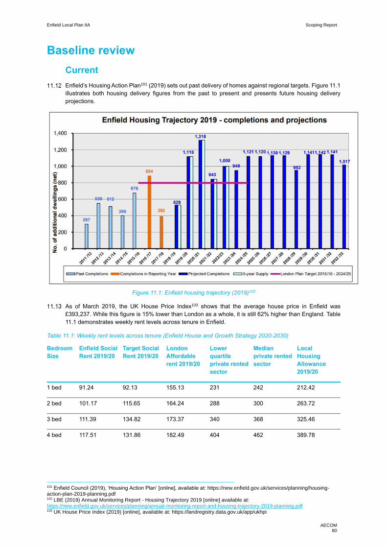
Enfield Local Plan IIA Scoping Report
AECOM 80
Baseline review
Current
Enfield’s Housing Action Plan101 (2019) sets out past delivery of homes against regional targets. Figure 11.1
illustrates both housing delivery figures from the past to present and presents future housing delivery
projections.
Figure 11.1: Enfield housing trajectory (2019)102
As of March 2019, the UK House Price Index103 shows that the average house price in Enfield was
£393,237. While this figure is 15% lower than London as a whole, it is still 62% higher than England. Table
11.1 demonstrates weekly rent levels across tenure in Enfield.
Table 11.1: Weekly rent levels across tenure (Enfield House and Growth Strategy 2020-2030)
Bedroom
Size
Enfield Social
Rent 2019/20
Target Social
Rent 2019/20
London
Affordable
rent 2019/20
Lower
quartile
private rented
sector
Median
private rented
sector
Local
Housing
Allowance
2019/20
1 bed 91.24 92.13 155.13 231 242 212.42
2 bed 101.17 115.65 164.24 288 300 263.72
3 bed 111.39 134.82 173.37 340 368 325.46
4 bed 117.51 131.86 182.49 404 462 389.78
101 Enfield Council (2019), ‘Housing Action Plan’ [online], available at: https://new.enfield.gov.uk/services/planning/housing-action-plan-2019-planning.pdf 102 LBE (2019) Annual Monitoring Report - Housing Trajectory 2019 [online] available at: https://new.enfield.gov.uk/services/planning/annual-monitoring-report-and-housing-trajectory-2019-planning.pdf 103 UK House Price Index (2019) [online], available at: https://landregistry.data.gov.uk/app/ukhpi

Enfield Local Plan IIA Scoping Report
AECOM 81
The London Borough of Enfield Local Housing Needs Assessment (LHNA) (2019) states that there exist
households in the borough who are unable to access both social/affordable rented housing and cannot buy
homes on the open market. The report reads, “lower quartile house prices in the borough are £301,000 and
median prices are £385,000. Assuming a 3.5x income multiple and a 10% deposit, households would need
an income of £77,400 to afford lower quartile prices and £99,000 afford median prices. Only around 7.6%
of households have an income exceeding in £75,000 in the borough but around 30% have an income
between £40,000 and £75,000.” Thus, at the current levels of rent, housing is largely unaffordable.
According to Enfield’s House and Growth Strategy 2020-2030, eviction from the Private Rented Sector is
the biggest cause of homelessness in Enfield. Additionally, the report also notes that Enfield is the second
highest provider of temporary accommodation in England. Figure 11.2 shows the rise in homelessness.
Table 11.2: Homelessness in Enfield
Homelessness Acceptances Households in temporary
accommodation
2015/16 1,131 2,987
2016/17 1,096 3,244
2017/18 786 3,276
The council has noted the importance of providing affordable housing in several policy documents including
the ones mentioned in this section—it is for this reason that the borough set an affordable housing policy
target of 40%.
The Annual Monitoring Report 2017/18 (AMR) (2019) records a total of 339 affordable homes built in
2016/17 and 2017/18, respectively. In the reporting years, an average of 22% of all conventional housing
was affordable. However, as seen in Table 11.3, the affordable housing policy target of 40% was not met—
the report states that this happened since several large schemes were under construction but not included
in the completed numbers. Table 11.3 presents the completion numbers along with a breakdown of the
tenure types.
Table 11.3: Affordable housing completions (AMR)
Year Total (gross)
completions
Total (net)
completions
Total affordable (all
tenures)
completion
Affordable break down %
2017/18 568 397 37
34 Social Rented
7%
3 Intermediate
2016/17 1,003 884 302
47 Social Rented
30% 127 Intermediate
128 Affordable Rent
Total over
reporting
period
1,571 1,281 339 22% (average
over 2 years)
Enfield Local Plan IIA Scoping Report
AECOM 82
Future
The Enfield Draft Local Plan Regulation 18 Publication (2018) is seeking to deliver at least 1,876 homes
each year in the plan period 2018-2036. The LHNA uses this figure as a base for the deprival of an
appropriate dwelling mix to be delivered. The LHNA has also considered the standard method for calculating
housing need which establishes an uncapped need for 3,750 dwellings each year and the council needs to
consider this in the light of the housing targets in the draft Local Plan.
Enfield’s draft Strategic Housing Market Assessment (SHMA) (2015) identified a need for 50% of affordable
rented and market housing in the borough. Furthermore, Enfield’s Local Housing Register indicated a
demand for 47.3% for family sized homes of affordable and social rented housing. These figures are part of
Enfield’s Draft Local housing needs assessment (2019) which sets forth clear plans for Enfield’s future.
Some of the council’s future aims follow:
• The council plans to support and provide a variety of both housing sizes, products and affordable
tenures to meet the borough’s need. This includes securing affordable homes from a range of council-
led initiatives.
• The council also seeks to achieve at least 30% of affordable housing delivery to be social rent and
London affordable rent; 30% intermediate affordable housing product including London Living Rent
and Shared Ownership and the remaining 40% to be determined by the council in line with identified
local need
• The council will also encourage infill development on small, vacant or underused sites and for the
redevelopment or upward extension of flats and non-residential buildings, in order to deliver additional
affordable housing.
Furthermore, Enfield has several development and regeneration projects on the horizon, the biggest of
which is the borough’s flagship Meridian Water regeneration programme in Upper Edmonton. Led by the
council, the programme is set to bring 10,000 new homes and create thousands of jobs in Enfield. Other
notable future projects as listed in the Housing Action Plan (2019) include:
• Estate regeneration of Ladderswood in New Southgate, listed in the North Circular Area Action Plan
(NCAAP);
• Estate Regeneration of the Alma Estate with 900+ homes in Ponders End, from the North East Enfield
Area Action Plan (NEAAP);
• Estate Regeneration of New Avenue (Southgate)
• The Council’s Phase 1 Small Sites programme across seven sites in 2019/20

Enfield Local Plan IIA Scoping Report
AECOM 83
Key issues and objectives
The following key issues emerge from the context and baseline review:
• The ‘Intend to Publish’ version of the London Plan (2019) significantly raised Enfield’s housing targets
to a ten year target of 12,460, which equates to 1,246 dwellings per annum.
• LBE has the potential to be a continued focus for housing delivery at scale; however, it will be important
to balance this with the delivery of a range of types and tenures in the area to meet localised needs,
specifically the needs of families that require affordable family sized homes.
• Development proposals should carefully consider the environmental sensitivities within the borough
and should be located in places which limits adverse impacts on the environment, water quality,
biodiversity and flood risk.
• While there is a need to provide more housing simply to match the growing population, it is imperative
that this housing be affordable: the 2015 SHMA identifies the need for 50% affordable (rented and
market) housing in the borough; however, recent affordable housing delivery is below policy target,
achieving 40% instead of the 50% target.
In light of these key issues, it is proposed that the IIA framework should include the following objectives:
Deliver housing to meet agreed targets and support an appropriate mix of housing types and tenures,
including affordable and specialist housing, including housing for the elderly and disabled people.

Enfield Local Plan IIA Scoping Report
AECOM 84
12. Landscape and green infrastructure
Introduction
As per the European Landscape Convention (ELC), the term landscape can be defined as, “an area, as
perceived by people, whose character is the result of the action and interaction of natural and/or human
factors”. Our understanding of landscape follows from the above definition as a diverse resource which
includes individual landscapes of distinct character, experienced at different scales, and defining distinctive
places. It further reinforces the point that all our landscapes matter for their individual and collective value
to society; and that landscape is a resource not only to be protected, but also managed and sometimes
created.
The European Environment Agency describe green infrastructure as “Strategically planned networks of
natural and semi-natural areas with other environmental features designed and managed to deliver a wide
range of ecosystem services”104. The multifunctionality of GI is widely accepted in the academic sector,
however it is only more recently that variety of ecosystem services GI has the potential to provide is being
realised in the UK policy context, figure 12.1 of this chapter demonstrates the multifunctionality that GI can
provide when implemented correctly.
Context review
National
Key messages from the National Planning Policy Framework105 (NPPF) include that planning policies
should:
• Great weight should be given to conserving and enhancing landscape and scenic beauty in National
Parks, the Broads and Areas of Outstanding Natural Beauty. The conservation and enhancement of
wildlife and cultural heritage are also important considerations in these areas, and should be given
great weight in National Parks and the Broads. The scale and extent of development within these
designated areas should be limited.
• Strategic policies should set out an overall strategy making provision for ‘conservation and
enhancement of the natural, built and historic environment, including landscapes and green
infrastructure.
• Planning policies and decisions should ensure that developments ‘are sympathetic to local character
and history, including the surrounding built environment and landscape setting, while not preventing
or discouraging appropriate innovation of change (such as increased densities).
• Planning policies and decisions should contribute to and enhance the natural and local environment
by:
─ protecting and enhancing valued landscapes, sites of biodiversity or geological value and soils;
─ recognising the intrinsic character and beauty of the countryside, and the wider benefits from
natural capital and ecosystem services – including the economic and other benefits of the best
and most versatile agricultural land, and of trees and woodland; and
─ remediating and mitigating despoiled, degraded, derelict, contaminated and unstable land,
where appropriate.
• Provide the social, recreational and cultural facilities and services the community needs, such as local
shops, meeting places, sports venues, open space, cultural buildings, public houses and places of
worship, whilst guarding against the unnecessary loss of community facilities and services.
104 European Environment Agency (2016) Urban adaptation to climate change in Europe 2016 [online] available at: eea.europa.eu/publications/urban-adaptation-2016 105 MHCLG (2018) National Planning Policy Framework [online] available at: https://assets.publishing.service.gov.uk/government/uploads/system/uploads/attachment_data/file/728643/Revised_NPPF_2018.pdf [accessed 03/08/18]
Enfield Local Plan IIA Scoping Report
AECOM 85
• Great weight should be given to conserving and enhancing landscape and scenic beauty in National
Parks, the Broads and Areas of Outstanding Natural Beauty, which have the highest status of
protection in relation to these issues.
• Retain and develop accessible local services and community facilities in rural areas.
• Ensure that developments create safe and accessible environments where crime and disorder, and
the fear of crime, do not undermine quality of life or community cohesion. Places should contain clear
and legible pedestrian routes, and high-quality public spaces, which encourage the active and
continual use of public areas.
• Enable and support health lifestyles through provision of green infrastructure (GI), sports facilities,
local shops, access to healthier food, allotments and layouts that encourage walking and cycling.
• Ensure that there is a ‘sufficient choice of school places’ and taking a ‘proactive, positive and
collaborative approach’ to bringing forward ‘development that will widen choice in education’.
• New Development should be planned in a way that avoids increased vulnerability arising from climate
change, including through the planning of GI.
• Plans should maintain and enhance networks of habitats and green infrastructure.
The Government’s 25 Year Environment Plan (2018) sets out a strategy for managing and enhancing the
natural environment. Chapter 2 is dedicated to recovering nature and enhancing the beauty of landscapes,
with the main focus on reviewing the National Park’s and Areas of Outstanding Natural Beauty (AONBs) in
order to better conserve and enhance landscapes.
Chapter 3 of the 25 Year Environmental Plan is focused on connecting people with the environment. A
significant proportion of this is geared towards greening towns and cities, to create more GI and plant more
trees in urban areas. It should be noted that the rhetoric is as much about delivering high quality GI as well
as high quantity.
Natural England have developed the ‘Green Infrastructure Guidance’ document which provides guidance to
decision makers about how to deliver and drive forward green infrastructure, especially at a plan making
level and the multifunctional value it provides. Figure 12.1 is extracted from the guidance and demonstrates
the variety of policy priorities green infrastructure can deliver.
National Character Area (NCA) Profiles are published by Natural England and divide England in 159 distinct
natural areas based on their landscape, biodiversity, geodiversity, historic, cultural and economic
characteristics.49 NCAs follow natural features in the landscape and are not aligned with administrative
boundaries. NCA profiles describe the features which shape each of these landscapes, providing a broad
context to its character. The Government’s 25 Year Environment Plan states the intention to work with
relevant authorities to deliver environmental enhancements within all 159 NCAs across England.

Enfield Local Plan IIA Scoping Report
AECOM 86
Figure 12.1: Green infrastructure and policy priorities106
106 Natural England (2014) Green Infrastructure Guidance [online] available at: http://publications.naturalengland.org.uk/publication/35033
Enfield Local Plan IIA Scoping Report
AECOM 87
Regional
The Draft London Plan (2017) references and considers landscapes and GI throughout. Chapter 8 in
particular is titled ‘Green Infrastructure and Natural Environment’. A selection of important policies that stand
out are:
• Policy GG2: Making the best use of land: the policy recognises the land pressures for the city but
highlights the need to protect open spaces included the Green Belt, Metropolitan Open Land (MOL)
and enhancing new GI.
• Policy GG3: Creating a healthy city: A big focus of London’s new round of strategies is the push
towards a healthy city. This policy recognises the significant benefit GI and landscapes provide for
physical and mental health and wellbeing.
• Policy G1: Green Infrastructure: This policy enforces the need to protect, plan and design in GI. It also
highlights the need to better understand the function and potential function of GI.
• Policy G2: London’s Green Belt: This focuses on protecting the green belt from inappropriate
development and enhancing its multifunctional uses.
• Policy G4: Local green and open spaces: Similarly, this is about protecting and enhancing green
space, as well as understanding the multifunctional aspect it highlights the importance of local and
green spaces being accessible.
• Policy G5: Urban Greening: The introduction of the Urban Greening Factor is identified, explaining that
this tool will push and enhance the implementation of high-quality GI in new developments.
The MES has a clear focus on landscapes and GI, the strategy’s vision is about making London greener,
cleaner and ready for the future, as such this scoping theme gets significant focus. Chapter five is dedicated
to green infrastructure, the chapter’s headline aim is:
• London will be the world’s first National Park City where more than half of its area is green; where the
natural environment is protected, and the network of green infrastructure is managed to benefit all
Londoners.
It is worth highlighting a number of the MES policies that will need to be considered through the Local Plan
process and serious consideration of these will help unlock the multifunctionality of open spaces,
landscapes and GI:
• Policy 5.1.1: Protect, enhance and increase green areas in the city, to provide green infrastructure
services and benefits that London needs now and in the future.
• Policy 5.1.2: Protect, conserve, and enhance the landscape and cultural value of London’s green
infrastructure.
• Policy 5.3.1: Address underinvestment, and improve the management of London’s green
infrastructure, by developing new business models and improving the awareness of the benefits of
London’s green infrastructure.
The MTS provides strong interlinkages particularly with GI, highlighting the need to protect GI when
developing transport schemes, seeking additional opportunities to build new GI into the transport estate.
Additionally, GI will play an important role in delivering the Healthy Streets approach which is the central
programme of the MTS’ vision.
The ALGG SPG provides the evidence base upon which the new London Plan seeks to build. Its aim was
to promote the shift from grey to green infrastructure and transform London into a green city rather than one
punctuated by open spaces, landscapes and GI. The SPG provides guidance on:
• Protect, conserve and enhance London’s strategic network of green and open natural and cultural
spaces, to connect the everyday life of the city to a range of experiences.
• Encourage greater use of, and engagement with, London’s green infrastructure; popularising key
destinations within the network and fostering a greater appreciation of London’s natural and cultural
landscapes.

Enfield Local Plan IIA Scoping Report
AECOM 88
• Secure a network of high quality, well designed and multifunctional green and open spaces to establish
a crucial component of urban infrastructure able to address the environmental challenges of the 21st
century – most notably climate change.
A key element the SPG is the emphasis on access and joining up the strategic network of GI and open
spaces. The SPG developed 11 green grids across London which identifies key connections, opportunities
and sets out the spatial distribution of London’s GI and landscapes.
• GGA1 Lee Valley and Finchley Ridge covers LBE and figure 12.2 demonstrates the strong baseline in
the borough.
Local
LBE’s Core Strategy (2010) has a set of core strategies titled: “Environmental Protection and Green
Infrastructure”. This chapter covers topic areas relevant to the theme of Landscapes and GI. A number of
relevant policies have been highlighted:
• Core Policy 31: Built and landscape heritage: This policy focuses on the need to protect and enhance
the heritage assets in the borough, including the area of Special character in the north west of the
borough.
• Core Policy 33: Green belt and the countryside: the policy sets out the need to protect and enhance
LBE’s green belt, it notes that following a strategic review of the green belt the area remains largely
unaltered.
• Core Policy 34: Parks, playing fields and other open spaces: the focus is on not only protecting and
enhance current open spaces but to provide high quality and accessible open spaces. This takes the
opportunity to provide links to the Lee Valley Regional Park and to the East London Green Grid.
• Coe Policy 35: Lee Valley Regional Park and waterways: the policy highlights the need to work with
stakeholders to realise the potential of the park and improve access to it.
As part of the borough’s Development Management Document evidence base as Open Space Review was
undertaken in 2013. This document reviewed and identified open space in the borough. The Development
Management document has a suite of policies related to GI, including:
• DMD 59: Avoiding and Reducing Flood Risk: Notes the need for new developments to prevent the loss
of permeable surfaces, and maximise the use of GI as potential sources of flood storage.
• DMD 71: Protection and Enhancement of Open Spaces: Development involving the loss of open space
will be resisted unless replacement areas are provided, or the open space is surplus to requirements.
• GDMD 77: Green Chains: New developments will e within a 5-minute walk or 400 metre radius from a
Green Chain.
• DMD 81: Landscaping: Proposed development must provide high quality landscaping that enhances
the local environment
In 2011 LBE undertook the ‘Enfield Characterisation Study” which reviewed the borough’s landscape and
evolution to identify key characteristics of the borough. It highlights key issues and opportunities with the
aim of helping build upon and protect the existing identify of the borough. One key element highlighted is
the landscape and urban interface.
Following on from this LBE have an evidence base document ‘Area of Special Character Boundary Review’
(2013). This identifies and sets the boundaries for areas of special character, which should be read in
conjunction with the above report.
Enfield Local Plan IIA Scoping Report
AECOM 89
The borough’s area action plans all have sections focusing on Landscape and GI oriented policies:
• Edmonton Leeside Area Action Plan: ‘Chapter 13 Watercourses, Green Spaces and Flood Risk’
• North East Enfield Area Action Plan: ‘Chapter 8 Green Network and food Growing’
• North Circular Area Action Plan: ‘3.6 Greening the north circular’
Baseline review
Current
Figure 12.2 demonstrates the extent of the borough’s baseline in terms of landscapes and greenspaces. It
is estimated that nearly a third of the borough is designated as green belt. Whilst figure 12.2 does
demonstrate the strong distribution of green spaces across the borough. Aside from the green belt in the
north west, Lee Valley Regional Park and the Chingford Reservoirs SSSI dominate the eastern stretch of
the borough’s landscape.
Despite being ranked the 9th greenest London borough, Enfield does currently have accessibility concerns,
especially to the Lee Valley Regional Park. Despite the Core Strategy’s focus on improving access,
severance in the east of the borough is still a concern. The Enfield Characterisation Study notes that
connections are restricted by physical barriers such as industrial land and the river.
LBE has 36 sites designated as MOL, which totals 249.07 hectares of land throughout the borough.
It should also be noted that for a London borough the green space uses are wide ranging. In the west of the
borough, farming has helped shape the agricultural, rural landscape. Whilst Lee Valley Regional Park is
associated with waterways and leisure activities.
LBE sits within the Norther Thames Basin NCA which is characterised by “a diverse landscape ranging from
the wooded Hertfordshire plateaux and river valleys, to the open landscape and predominantly arable area
of the Essex heathlands, with areas of urbanisation mixed in throughout107”. It is noted that the NCA has
come under increasing pressure from urban creep and the demands on land use this entails.
LBE has two designated Area of Special character (AOSC):
• The Enfield Chase AOSC; and
• The Lee Valley AOSC.
LBE’s green belt is part of the wider Lee Valley glasshouse industry. Despite being a key economic and
employment sector in the area, it is a declining practice. Neighbouring boroughs see it as a key industry
that should be protected and an appropriate land use designation, consideration will have to be given to the
future approach to this industry, in the Local Plan.
LBE’s topography is well defined with higher ground in the north west of the borough, gradually descending
into the Lee Valley in the east of the borough. The topography and the rural nature of the western side of
the borough has resulted in LBE identifying thirteen important local views. There are also ten shorter local
views which have been identified in Conservation Area Character Appraisals. Figure 12.2 identifies those
thirteen long distance views.
107 Natural England (2013) NCA Profile:111 Northern Thames Basin [online] available at: http://publications.naturalengland.org.uk/publication/4721112340496384?category=587130

Enfield Local Plan IIA Scoping Report
AECOM 90
Figure 12.2: A map of LBE’s green spaces108
108 Urban Practitioners (2011) Enfield Characterisation Study [online] available at: new.enfield.gov.uk/services/planning/planning-policy-information-enfield-characterisation-study-parts-1-4-february-2011.pdf

Enfield Local Plan IIA Scoping Report
AECOM 91
Figure 12.3: LBE’s Important Local Longer Distance Views109
Future
The MES has set an ambitious target to become the world’s first ‘National Park City’ where over 50% of the
city’s land will be designated to the natural environment. This will set a new emphasis on connecting
strategic green spaces and finding opportunities to provide greater urban greening, This chapter’s case
study highlights how urban greening can be provided alongside housing needs.
The London Plan’s proposal to introduce the UGF will push greater urban greening measures in new
developments to provide more multi-functional high-quality green infrastructure, to help mitigate against a
variety of issues such as heating, flooding and air quality. The long-term approach is for boroughs to
implement their own UGF as they are best placed to understand localised context.
As an outer London borough one of the key pressures posed by the need for housing is encroachment onto
the green belt. The borough will have to seriously consider all available land in order to meet housing targets.
However, this will have to be balanced with protecting the rural landscape that the green belt offers LBE.
This is not unique to LBE and neighbouring boroughs are under the same pressure, for instance EFDC are
releasing approximately 10ha of Green Belt in their Local Plan.
Despite a strong baseline of GI and landscapes the borough has significant accessibility issues to the Lee
Valley Reginal Park. Severance issues have knock on effects elsewhere. For instance, a key regional issue
is the recreational pressure on Epping Forest. Tackling this severance should be an essential consideration
for the Local Plan not only would this help realise the multiple benefits the Lee Valley Regional Park could
provide but is can also help relieve the pressure on a key regional environmental asset.
109 LBE (2012) Tall Buildings and Views Study [online] available at: https://new.enfield.gov.uk/services/planning/planning-policy-information-report-on-location-of-tall-buildings-and-important-local-views-in-enfield-2012.pdf

Enfield Local Plan IIA Scoping Report
AECOM 92
LBE are commissioning a green, blue and grey infrastructure study, which will help identify up to date
opportunities and issues for the borough.
LBE have secured woodland funding from the GLA, which is likely to be invested into Green belt land.
Key issues and objectives
The following key issues emerge from the context and baseline review:
• There is increasing policy focus on GI from the realisation of its co-benefits, the introduction of the
UGF and London’s National Park City objective. Capturing all of this will be a key issue for the Local
Plan.
• There is a need to protect valued landscapes, including designed landscapes and extensive semi-
rural landscape character areas in the north of the borough, and avoid loss of Green Belt that
contributes to the established Green Belt purposes.
• Increasing accessibility to the Lee Valley Reginal Park is an opportunity to deliver access to open
space in the east of the borough, helping to mitigate the east-west imbalance of availability of green
spaces.
In light of these key issues, it is proposed that the IIA framework should include the following objectives:
Protect and enhance the character, quality and diversity of the borough’s landscapes and townscapes
through appropriate location, layout and design of new development, including the preservation of
important open gaps and key views, and contribute to London-wide Green Infrastructure objectives
including in respect of the Lea Valley Regional Park.
Case Study: Kidbrooke Village is a large regeneration project in the Royal Borough of Greenwich, over a 20-
year period the new neighbourhood will deliver 4,800 new homes as well as 140 acres of new green space.
Overall that is an increase of 50% more housing as well as 50% more GI. A central aim is to deliver
biodiversity net gain on the project, whilst the GI is also providing climate resilience and flooding benefits
through the use of green roofs, SuDS. These accessible open spaces also provide amenity spaces for a local
community, to contribute to helping people live healthier lifestyles.
https://naturalengland.blog.gov.uk/2019/01/28/london-wildlife-trust-bringing-kidbrooke-alive-with-wildlife/

Enfield Local Plan IIA Scoping Report
AECOM 93
13. Transport
Introduction
Spatial planning and transport planning are intrinsically linked, the successful integration of the two areas
can help to deliver high density mixed urban form that will be essential to delivering London wide housing
targets.
LBE’s Local Plan will need to focus on transport as it provides multiple benefits for the borough, delivery
and access to public transport will have a significant role in reducing carbon emissions and air pollution
issues across the borough. Furthermore, making Enfield more accessible can provide greater spatial
options for housing deliver and economic opportunity. Finally, in recent times, a key focus in the delivery of
urban transport is promoting mixed methods, especially active modes of transport, which can also contribute
to environmental and health and wellbeing solutions.
Context review
National
Key messages from the National Planning Policy Framework (NPPF) include:
• Transport issues should be considered from the earliest stages of plan-making and development
proposals, so that:
─ The potential impacts of development on transport networks can be addressed;
─ Opportunities from existing or proposed transport infrastructure, and changing transport
technology and usage, are realised;
─ Opportunities to promote walking, cycling and public transport use are identified and pursued;
─ The environmental impacts of traffic and transport infrastructure can be identified, assessed
and taken into account; and
─ Patterns of movement, streets, parking and other transport considerations are integral to the
design of schemes and contribute to making high quality places.
• Significant development should be focused on locations which are or can be made sustainable,
through limiting the need to travel and offering a genuine choice of transport modes. This can help to
reduce congestion and emissions and improve air quality and public health. However, opportunities
to maximise sustainable transport solutions will vary between urban and rural areas, and this should
be taken into account in both plan-making and decision-making.
The Department for Transport published the ‘Future of Mobility: Urban Strategy’ in 2019, which sets out the
national approach to maximising transport innovation in cities and towns. It focuses on a model shift towards
sustainable modes of transport (walking, cycling and public transport) which are accessible to all, in order
to tackle pollution and reduce greenhouse gas emissions.110
Regional
The Draft London Plan (2017) includes ‘Chapter 10 – Transport’, it draws upon the MTS for its approach to
transport which is expanded on below. However, its key messages are: .
• 80% of all journeys by sustainable modes of transport by 2041.
• Carbon free travel by 2050.
110 DfT (2019), Future of Mobility: Urban Strategy [online] available at: https://www.gov.uk/government/publications/future-of-mobility-urban-strategy

Enfield Local Plan IIA Scoping Report
AECOM 94
• Healthy Streets: The headline approach to transport developed through the new London policy
roadmap. The approach aims to improve health and reduce health inequalities to initiate a model shift
from cars too sustainable modes of transport. It is proposed that this will take place through the
transformation of streets based on the 10 healthy street indicators, depicted in figure 13.1.
Figure 13.1: The 10 indicators to the Healthy Street approach
The Mayor’s Transport Strategy (2018) is the key high-level London-wide public transport strategy document
setting out regional transport objectives to 2030. As stated above the key messages focus on facilitating a
model shift, healthy streets and reducing pollution and greenhouse gas emission. The strategy has a raft of
relatable policies and proposals, a number of key aims, in addition to those set out above, are:
• ‘Vision Zero’ which aims to eliminate all deaths and serious injuries on London Transport systems;
• By 2041, for all Londoners to do at least the 20 minutes of active travel they need to stay healthy each
day;
• Reduce total London traffic by 10-15 per cent by 2041; and
• Open Crossrail 2 by 2030.
The healthy street focus should be of particular interest to LBE given the health inequality that the borough
currently experiences.
The key messages specifically in relation to LBE is the proposal to deliver Crossrail 2 as it would deliver
four new stations on the eastern side of the borough. The MTS states that “Crossrail 2 will support 200,000
new homes and 200,000 jobs along its route and has the potential to transform the accessibility and growth
potential of the Lee Valley and its local centres”.
Enfield Local Plan IIA Scoping Report
AECOM 95
The North London Sub-regional Transport Plan update (2016)111 is one of five sub-regional transport plans
published by Transport for London (TfL). The plan is a middle tier of transport planning in London, acting as
a ‘bridge’ between the Mayor’s Transport Strategy and the individual Local Implementation Plans. It
highlights the challenges specific to North London, which are as follows:
• Facilitate and respond to growth, especially in Brent Cross/Cricklewood and the Upper Lee Valley;
• Relieve crowding on the public transport network;
• Manage highway congestion and make more efficient use of the road network;
• Enhance connectivity and the attractiveness of orbital public transport; and
• Improve access to key locations and jobs and services.
Local
Despite being a number of years behind the London wide transport related policies, it is worth noting the
LBE’s Core strategy (2010) policies that have driven transport decisions in in the borough:
• Core Policy 24: The Road Network: This policy sets out the strategic need for improvements to the
road network, providing a list of priority roads for improvement including the A506, Bullsmore Lane and
the A10. Another priority was to improve access to Upper Lee Valley, which has previously been
highlighted in Chapters 3 and 12.
• Core Policy 25: Pedestrians and Cyclists: aiming to provide accessible, safe and convenient
sustainable transport routes across the borough.
• Core Policy 26: Public Transport: The borough set out a policy to deliver an efficient, accessible and
safe public transport network that could be supported by development proposals. This included
improving public interchanges, bus services and ensuring new developments demonstrate that
existing or proposed public transport levels can accommodate development proposals.
• Core Policy 27: Freight: Focused on the need to promote efficient and sustainable movement of freight
by road, with a particular focus on the strategic industrial sites I the Upper Lee Valley.
LBE has recently published its third Local Implementation Plan 112 which sets out the borough’s transport
plan from 2019 – 2041. The plan highlights the existing challenges to the borough and provides a number
of policies and programmes to help deliver accessible, sustainable and active travel options that mitigate
against environmental and social problems such as climate change air quality, health inequalities and safety.
The plan has seven key objectives in order to deliver that vision:
• Deliver Cycle Enfield and supporting measures which encourage more cycling and walking in the
borough;
• Promote safe, active and sustainable transport to and from schools;
• Monitor air quality and develop and deliver interventions which address local issues;
• Manage growing demand for on-street parking;
• Focus on and improve priority locations making them safer for vulnerable road users;
• Improve local reliability of and accessibility to the public transport network; and
• Maintain and improve the transport network in Enfield including developing potential interventions.
The Development Management Document (2014) primarily focuses on access to new transport of new
developments and parking and road standards of new developments . As with the policies in the Core
Strategy there is also a focus on supporting the delivery of active transport provisions .
All of the borough’s area action plans have sections dedicated to movement and transport requirements
and infrastructure, for instance:
111 TfL (2016) North London Sub-regional transport Plan [online] available at: http://content.tfl.gov.uk/north-story-of-growth-2016.pdf 112 LBE (2019) Enfield Transport Plan 2019-20141 [online] available at: https://new.enfield.gov.uk/services/roads-and-transport/enfield-transport-plan-2019-2041-roads.pdf
Enfield Local Plan IIA Scoping Report
AECOM 96
• The Edmonton Leeside Area Action Plan focuses on encouraging a model shift to active modes of
transport and explores options for improving public transport infrastructure.
• The North East Enfield Area Action Plan has a key focus on improving active transport routes and
infrastructure as well as enhancements to the West Anglia Mainline and improvement to bus services.
Baseline review
Current
The discussion below is set out under thematic sub-headings.
Strategic road network
According to LBE’s Transport Plan the borough’s road network is made up of approximately; 68km of
principal roads, 37km of the TfL road network, 51km of non- principal classified roads and 466km of
unclassified roads. There are three main roads. Firstly, the M25 which straddles the northern boundary of
the borough. The A10 (London to Cambridge) which runs straight up through the borough, slightly right of
centre. The A10 has also been described as the physical indicator of the east/west inequalities divide that
characterises LBE. Finally, the A406 (The North Circular) runs across the southern end of the borough.
Chapter 3 of this report highlights the air quality hotspots in the borough, which are focused on these three
main roads. There is a specific concern of HGV congestion at junction 25 where the M25 and A10 intersect.
The A10 is also characterised by an east/west divide in terms of type of traffic. It is accessed by residents
from the west and mainly industrial traffic from the east of the borough.
Rail network
Overall the borough has 22 train/tube stations. It serviced by four lines:
• The London Underground Piccadilly Line services the west of the borough with four stations, providing
a connecting to Heathrow;
• West Anglia Main line to London Liverpool Street to Hertford East;
• London Overground service from London Liverpool Street to Chestnut; and
• Govia Thameslink Railway from Moorgate to Hertford North and Wootton on Stone.
Network Rail have recently delivered the £170 million Lee Valley Rail programme, which increased capacity
on the West Anglia main line. A significant element of this is the delivery of a new four platform train station
at Meridian Water to service the new 10,000 home development in the area. LBE worked with the Mayor of
London to submit a forward funding bid to the Government’s Housing Infrastructure Fund (HIF). The
objective of the bid was to deliver a four Trains Per Hour service and road infrastructure to unlock the early
delivery of homes at Meridian Water.
Walking and cycling network
National Cycle Network (NCN) Routes 1 and 12 run through LBE. Route 1 is a long-distance cycle route
that connects Dover to Shetland. It runs through the east of the borough flowing the River Lea. Route 12 is
still under construction but when completed will connect Enfield Lock to Stevenage.
LBE have set up a programme ‘Cycle Enfield’ programme to deliver cycling and walking schemes across
the borough. The programme has three main aims:
• transforming our high streets and town centres;
• promoting more active forms of travel to improve our health; and
• creating safe and secure cycle routes for everyone.
The borough’s transport plan notes that Enfield is one of five Outer London boroughs identified as having
the greatest number of potentially cyclable trips, with nearly 80% of car trips in Enfield of cyclable length.
Figure 13.2 demonstrates the borough’s established cycle routes (in green).

Enfield Local Plan IIA Scoping Report
AECOM 97
Figure 13.2: Established cycle routes within LBE 113
113 Cycle Enfield (2019) http://cycleenfield.co.uk/

Enfield Local Plan IIA Scoping Report
AECOM 98
Bus network
The borough is served by a network of 38-day bus routes, 7 school-day only services and 8-night bus routes,
which all together service 547 bus stops in the borough. . The North London Sub-Regional Transport Plan
report states that travelling by bus accounts for 14% of all journeys made by LBE residents
Car and van accessibility
Figure 13.3 is taken from 2011 ONS Census data, it demonstrates that 32.47% of LBE residents do not own
a car or van. This is notable for being a significantly lower proportion than at a London regional level (where
41.55% of people do not own a car or van) but significantly higher than England as a whole (where 26% of
people do not own a car or van). This may reflect the level of public transport accessed in the borough.
However, given LBE’s issues around inequality and deprivation it is likely this is a result of affordability of
owning car, especially as TfL note that Londoners are more likely to own a car if they live in outer London.
Figure 13.3 Car and van ownership114
Figure 13.4: Method of travel to work115
114 ONS (2011), Census 2011: ‘Car or Van Availability 2011’ 115 ONS (2011), Census 2011 ‘Method of travel to work’
0.00%
5.00%
10.00%
15.00%
20.00%
25.00%
30.00%
35.00%
40.00%
45.00%
50.00%
No cars/vans 1 car/van inhousehold
2 cars/vans inhousehold
3 cars/vans inhousehold
4 or morecars/vans inhousehold
Enfield
London
England
0% 5% 10% 15% 20% 25% 30% 35% 40%
Work mainly at or from home
Underground, metro, light rail, tram
Train
Bus, minibus or coach
Taxi
Motorcycle, scooter or moped
Driving a car or van
Passenger in a car or van
Bicycle
On foot
Other method of travel to work
Enfield
London
England
Enfield Local Plan IIA Scoping Report
AECOM 99
Figure 13.4 stand out issue is that significantly more people from Enfield drive a car or van to work in
comparison to London. This may be due to the high level of access to the strategic road network, as
demonstrated earlier in the chapter. This may reflect poor accessibility to public transport options, although
it may also provide an insight into the spatial distribution of job opportunities for LBE residents, who may
seek work in neighbouring authorities outside of London.
This may explain why the number of LBE residents that use public transport to travel to work totals to
25.06%. whereas the corresponding number for London is 32.64%.
It is important to note that this data should be viewed in the context of LBE’s location within Greater London.
Statistical comparison with England as a whole should be caveated by the understanding that the public
transport model in London, as well as the extent, capacity and modal variety of the network is unique in
England. In this context it is likely to be more instructive to compare public transport use in LBE to that of
Greater London rather than to England as a whole.
Given London’s recent focus on the delivery of sustainable and active modes of transport and the
establishment of Cycle Enfield; this scoping report has not analysed the ONS Census 2011 figures for
walking and cycling. As it is likely that this would not give an accurate representation of the figures for those
residents who do travel to work using active modes.
Future
The Ultra-Low Emission Zone (ULEZ) will become active in the southern section of the borough, below the
A406 from 2021, which will have a bearing on traffic movements. There is also political support from the
borough to extend the ULEZ to cover the entirety of the borough.
The London wide transport objectives for a model shift from private vehicle and focus on the Healthy Streets
programme is supported within the borough’s transport plan 2019 – 2041. This should facilitate a move to
more sustainable modes of transport. TfL funding channels such as the Liveable Neighbourhood funds will
provide a catalyst towards more cycle and pedestrian orientated transport network. Cycle Enfield has won
£9m of Liveable Neighbourhood funding to deliver an active transport scheme in Enfield Town.
A business case for a Rapid Transit Study is underway (with TFL) in response to proposal 92 in the Mayor’s
Transport Strategy, which should be available in March 2020. There are 2 potential routes, which would
deliver a solution to the east/west transport severance in the borough:
• The A406, Meridian Water, New Southgate and connections through to Barnet and Waltham Forest.
• An A110 route via Enfield Town, industrial areas with potential for intensification and Cockfosters.
As LBE develops over time it is likely that built densities will increase, particularly around transport hubs
which are often the most sustainable locations for high density growth. This will inevitably introduce new
demand for services through an increased population. Improved capacity of suburban rail services over the
long term, as proposed in the MTS, could help to meet increased demand.
Highways England’s M25 Junction 25 Project (2020 -2023) will provide greater capacity but will not resolve
great local network congestion. The Council has worked with the Department of Transport, Highways
England, Transport for London and adjoining authorities assessing phased highway infrastructure
improvements, including the introduction of a new junction at the northern end of the A1055 to provide
access to and from the M25 via east-facing on and off slip roads. With this intervention in place, there would
be a strong case that the A1055 could fulfil its role as part of Highways England’s Major Road Network. This
proposal is the subject of a Road Investment Strategy 2 submission to Government. The borough has a
long-term aspiration to reduce commuting by developing a local higher wage economy. This would reduce
the need to travel by car, which is the dominate mode of transport to work in LBE.

Enfield Local Plan IIA Scoping Report
AECOM 100
Key issues and objectives
The following key issues emerge from the context and baseline review:
• Transport is integral to the success of sustainable approaches to spatial development. In order to
tackle the significant environmental threats and social inequalities faced in the borough, the approach
to transport must be carefully considered. The key issues uncovered through the scoping exercise
have been:
• A greater focus on sustainable and public transport at borough level as well as London wide, is being
driven by the links between health and transport. MTS targets in relation to this means LBE will need
to facilitate a model shift from borough’s heavy reliance on cars to active and public modes of transport.
• There is a transport infrastructure severance between the east and the west of the borough. This could
be resolved through bus rapid transit routes across LBE.
• Despite ULEZ’s expected introduction in 2021, air quality concerns caused by transport may not
subside given the focus of air quality problems on the three main roads and the limited scope of ULEZ
within the borough.
• Census data from 2011 suggests that the majority of residents use a car to get to work. Whilst lower
percentages of residents use public transport to get to work. This would imply that accessibility and
availability to active and public transport is an issue for the borough.
In light of these key issues, it is proposed that the IIA framework should include the following objectives:
Minimise the need to travel, support modal shift away from the private car and address traffic congestion
within the borough and along key routes through neighbouring areas, with a focus on emission reduction,
health impacts and the delivery of pedestrian friendly urban design.

Enfield Local Plan IIA Scoping Report
AECOM 101
14. Water
Introduction
This chapter will explore the water resource and quality context beyond flooding and drought which have
been explored through Chapter 4.
Water resource management is increasingly important topic, especially in the south east of England,
Although the impacts of climate change on water have been discussed in chapter 4. population and housing
growth alongside climate change leading to higher temperatures and altered rainfall regimes. Many
watercourses and aquifers in the South East are already under stress and require careful management to
ensure that there is a sustainable water supply in future.
Of the many environmental challenges Local Planning Authorities in the South of England are facing in
meeting housing demand, one certainty is that new development will generate additional wastewater, which
must be managed, treated and disposed of.
Disposal of treated wastewater has a knock-on effect on receiving waterbodies in a variety of biological and
chemical ways, combining with multiple other sources of pollution such as agricultural runoff, infiltration,
exisiting land contamination and urban runoff to impact on the overall quality of watercourses.
It is important to note the close links between water resources and water quality. Low flows in rivers leads
to increased concentration of pollutants and in turn lower water quality.
Context
National
The EU Water Framework Directive (WFD) requires that all member states work to achieve good ecological
status in all waterbodies by 2027. Over abstraction from waterbodies (groundwater and surface water) can
reduce the ecological status of a watercourse if there is insufficient water left in the watercourse to provide
the required habitat. Over abstraction of groundwater can result in ecological impacts by reducing river
baseflow; a reduction in flow which is particularly acute during dry weather conditions.
The Environment Agency (EA) is responsible for monitoring waterbody status across the UK. The effects
of abstraction on the ecological status of waterbodies is summarised in their Catchment Abstraction
Management Strategy (CAMS).
The principle users of abstracted water are water companies who use the abstracted water as a source of
drinking water for local populations but there is also a significant demand for water for agricultural use.
Defra and OfWAT are responsible for regulating water companies and ensuring that they maintain minimum
levels of service. Relevant legislation includes the Water Supply (Water Quality) Regulations 2010116 and
the Water Act (2003), which require water companies to produce a statutory Water Resource Management
Plan every five years setting out how they intend to meet demand for water in a sustainable way.
Water companies are also regulated in terms of their impact on the water environment. This includes a
requirement for ongoing abstraction licencing by the EA and consideration of the need to support water
habitat SSSIs in their area. Thames Water is the water company that supply LBE’s water.
The Water White Paper 2011 sets out the Government’s vision for a more resilient water sector. It states the
measures that will be taken to tackle issues such as poorly performing ecosystems, and the combined
impacts of climate change and population growth on stressed water resources
116 HMSO (2000); ‘The Water Supply (Water Quality) Regulations 2000’
Enfield Local Plan IIA Scoping Report
AECOM 102
As highlighted in Chapter 4; shortages in public water supply for agriculture, energy generation and industry
were one of the key climate risks identified in the NAP (2018). It refers to a ‘twin track’ approach to
maintaining water supplies, namely “the idea of reducing demand, whilst also working to strengthen the
resilience of supply in order to meet our goal of providing clean and plentiful water for future generations.”
It also notably states:
“Recognising that the scale of some of the infrastructure to provide transfers and additional new resources
will be significant, government is committed to delivering a National Policy Statement (NPS) for Water
Resources to streamline the planning process for large water resource infrastructure.”
The NPPF’s key message for Local Plans to consider in relation to water resources is:
• Take a proactive approach to mitigating and adapting to climate change, taking into account the long-
term implications for water supply.
Water quality
The WFD requires the UK to classify the current condition of key waterbodies (giving a ‘Status’ or
‘Potential’)117 and set objectives to either maintain the condition or improve it where a waterbody is failing
minimum targets. Any activities or developments that could cause deterioration within a nearby waterbody
or prevent the future ability of a waterbody to reach its target Status, must be mitigated so as to reduce the
potential for harm and allow the aims of the WFD to be realised.
River Basin Management Plans (RBMPs) have been produced by the Environment Agency at River Basin
District (RBD) scale in England. LBE is covered by the Thames River Basin Management Plan (RBMP)118.
The RBMPs assess the current state of the water environment, identify existing pressures and establish
objectives for protecting and improving waters. Some key findings from the Thames RBMP have been
discussed in the Current Baseline section of this chapter.
A number of specific UK regulations have been made to implement statutory European and national
legislation into law. These regulations include:
• Part 2A of the Environmental Protection Act 1990
• The Anti-Pollution Works Regulations 1999;
• The Environmental Damage Regulations 2009;
• The Water Resources Act (Amendment) (England and Wales) Regulations 2009;
• The Environmental Permitting (England and Wales) Regulations 2016 which control discharge of water
to surface water and groundwater;
• The Private Water Supply (England) Regulations 2016 and
• The Water Supply (Water Quality) Regulation 2018.
There are three key messages to highlight from the NPPF, in relation to water and associated land
contamination:
• Prevent new and existing development from contributing to, being put at unacceptable risk from, or
being adversely affected by unacceptable levels of water pollution.
• Ensure that, wherever possible development helps to improve local environmental conditions including
water quality, taking into account relevant information such as RBMPs.
• Planning policies should ensure that sites are assessed taking into account the ground conditions and
any risk from land instability and contamination. Remediation should be considered as a minimum.
This includes the potential adverse impacts to the natural environment that remediation could cause.
117 UK Technical Advisory Group Water Framework Directive Site, Available at: http://www.wfduk.org/ 118 Environment Agency (2016) Water for life and livelihoods; Part 1: Thames river basin district River basin management plan [online] available at: https://assets.publishing.service.gov.uk/government/uploads/system/uploads/attachment_data/file/718342/Thames_RBD_Part_1_river_basin_management_plan.pdf

Enfield Local Plan IIA Scoping Report
AECOM 103
Regional
The Draft London Plan (2017) focuses on water prominently in ‘Chapter 8 Green Infrastructure and Natural
Environment’ and ‘Chapter 9 Sustainable Infrastructure’, key policies that have a water resource or quality
focus are:
• Policy GG6: Increasing efficiency and resilience: this notes the importance to design infrastructure and
buildings that consider the efficient use of water, as an adaption response to Climate Change.
• Policy SI5: Water Infrastructure: presents a strategic approach to protecting water supply in London
through a number of measures including minimising leakage, reducing the water supply deficit,
promoting rainwater harvesting and upgrading water supply infrastructure.
Water Resource Management Plans (WRMP) are prepared by water companies to ensure supply continues
to meet demand into the future, even under water stressed conditions. WRMPs cover 25-year planning
periods to ensure that long term needs, trends and changes are considered appropriately at a strategic
level. Enfield is covered by the Thames Water WRMP 2015–2040.
River basin management plans (RBMPs) set out to protect and improve the water environment. It should
also be noted that development proposals will need to consider the requirements of the relevant RBMP.
LBE is covered by the Thames River Basin District RBMP. The focus is on delivering water quality in line
with the WFD. However, there are a number of additional environmental outcomes that the Thames RBMP
also commits to including reducing pollution from land management and improving ecological aspects of
the water resources covered.
Local
One of the key issues highlighted in LBE’s Core strategy (2010) is “Promote the protection and
enhancement of the Borough’s waterways by improving water quality and ecological diversity through the
River Basin Management Plan”. Although the document does not have specific resource and quality related
policies it is relevant to a number of policies, including:
• Core Policy 21: Delivering sustainable water supply, drainage and sewerage infrastructure: the policy
notes the need and aim to work with a variety of stakeholders to ensure the borough’s ’s future water
resource needs, wastewater treatment and drainage infrastructure are managed effectively.
• Core Policy 32: Pollution: the policy seeks to ensure that water quality is not compromised, and to
deliver water quality improvements.
The London Lea Catchment Plan is being delivered by a partnership of stakeholders led by Thames21. The
aim of the plan to improve water quality through reducing pollution and surface water management at
source. It also seeks to improve public engagement in the river’s management as well as focusing on
biodiversity to help improve the river’s quality and function.
The borough’s Development Management Document (2014) has a wide variety of water related polices
framed under tackling climate change, environmental protection and green infrastructure, a selection of
these policies are:
• DMD 58: Water Efficiency; In accordance with LBE’s Core Strategy Policy 21 and the objectives for
water efficiency set out in the London Plan all new development will be required to maximise its water
efficiency.
• DMD 63: Protection and Improvement of Watercourses and Flood Defences: This notes the need to
protect watercourses and ensure that new developments to not prevent the ability to achieve the
objectives of the Thames River basin Management Plan.
• DMD 66: Land Contamination and Instability: this policy makes reference to the link between land
contamination and water quality and sets out the planning stance on sites that show risk of
contamination and land instability. It notes that this should be read in conjunction with Core Policy 32.
• DMD 70: Water Quality: New development that adversely affects water quality, including waterways,
identified Source Protection Zones (SPZ) or Aquifers will not be permitted.

Enfield Local Plan IIA Scoping Report
AECOM 104
Baseline Review
Current
The River Lea is most significant watercourse running through the borough. It is the easternmost tributary
to the Thames, joining it at Tower Hamlets. The borough has over 100km of rivers and waterways. The
Pymmes Brook, Salmon Brook and Turkey Brook are the main River Lea tributaries that make up LBE’s
water network. The WFD requires all EU watercourses to achieve a ‘Good’ overall (ecological and chemical)
status by 2027. Table 14.1 below sets out the hydromorphilogical designation, current overall status and
reasons for not achieving ‘Good’ status for the main watercourses that run through LBE. As per the
Environment Agency data the River Lea has been separate into three different catchments, which all sit
within LBE’s boundary.
Table 14.1: LBE watercourses and regulatory status119
Watercourse Catchment
Area
Designation Overall Status
(2016)
Reasons for not achieving
‘Good’ status
Lea Navigation
(Fieldes Weir to
Enfield Lock)
45.48km2 Heavily modified Poor Urbanization
Surface water abstraction
Sewage discharge
Misconnection
Inland boating and structures
Invasive non-native species
Use of restricted substance
Lea Navigation
(Enfield Lock to
Tottenham Locks)
15.811km2 Heavily modified Bad Urbanisation
Transport drainage
Sewage discharge
Inland boating and structures
Misconnections
Flood protection structures
Invasive non-native species
Small River Lee
(and tributaries)
40.034km2 Not designated
artificial or
heavily modified
Moderate Urbanisation
Sewage discharge
Invasive non-native species
Misconnection
Land drainage
Pymmes Brook 40.778km2 Heavily modified Moderate Sewage discharge
Urbanisation
Transport drainage
Misconnections
Flood protection structures
119 Environment Agency (2020) Lee Lower Rivers and Lakes [online] available at: https://environment.data.gov.uk/catchment-planning/OperationalCatchment/3275

Enfield Local Plan IIA Scoping Report
AECOM 105
Salmon Brook 36.956km2 Heavily modified Moderate Urbanisation
Transport drainage
Trade/Industry discharge
Poor soil management
Poor livestock management
Flood protection structures
Misconnections
Turkeybrook 48.209km2 Not designated
artificial or
heavily modified
Poor Urbanisation
Transport drainage
Private sewage treatment & domestic sewage discharge
Poor nutrient management
LBE is covered entirely by the London Water Resource Zone (WRZ), the borough’s potable water and its
waste water services are supplied by Thames Water. The London supplied mostly by surface water
resources (80%) prominently by the River Thames and the River Lea. The remainder is delivered by
groundwater abstractions, a desalination plant in Beckton is also used to abstract and treat estuarine water.
The adopted Thames Water WRMP notes that the Thames Water supply area is “designated as seriously
water stressed” meaning that demand is very high in relation to available supply. The resilience of supply
could potentially be affected by extreme weather events and climate change patterns as well as technical
challenges such as leakage. Whilst it also notes that approximately 25% of the water put into supply is lost
through leakages.
Following consultation with the Environment Agency, it became clear that land contamination was a central
issue in LBE. Land contamination and water quality are closely linked and LBE has a long-established
history with industrial uses and is significantly affected by source protection zones (SPZs). This is
particularly noticeable in the east and centre of the borough. There are nine SPZ1s that run through the
borough, these are surrounded by and connected by three SPZ2s, there are no SPZ3s in the borough
boundaries.
• SPZ1 is defined as the 50-day travel time from any point below the water table to the source. SPZ2 is
defined by a 400-day travel time from a point below the water table. SPZ3 is defined as the area around
a source within which all groundwater recharge is presumed to be discharged at the source.
Wastewater services for LBE are provided by Thames Water. The Borough is served by the Deephams
Sewage Treatment Works (STW), this serves Enfield as well as the neighbouring boroughs of Epping,
Waltham, Forest and Haringey.

Enfield Local Plan IIA Scoping Report
AECOM 106
Nitrate Vulnerable Zones (NVZs) are areas designated as being at risk from agricultural nitrate pollution, in
accordance with the 2015 Nitrate Pollution Prevention Regulations. Waters are defined as polluted if they
contain nitrate concentrations greater than 50mg/l. The entirety of the borough is covered by the Lee
NVZS443.
Part of the borough is a Drinking Water Surface Water Protected Area, this is an area where ‘raw’ water is
extracted from rivers or reservoirs. Raw water requires protection to ensure that it is not polluted which could
lead to additional purification treatment. As with the majority of the south east of England, LBE is located
over a principal aquifer (Chalk), this is also protected for drinking water purposes under the WFD.120
Future
London and the south east is the most densely populated region in the UK, it is estimated that by 2040 the
population of this region is likely to rise by approximately 2 million people. This will have a significant impact
on water availability for LBE.
Climate change is expected to increase the frequency and severity of droughts and it is important to maintain
a longer term vision of adapting to change beyond water resource planning timetables. However, there is
considerable uncertainty about how climate change may impact average annual rainfall, with median current
estimates suggesting relatively little change.121 The most recent UKCP18 data122 predicts more frequent hot
summers even on a low emissions scenario with greater amounts of warming in southern England. More
detailed analysis of future rainfall patterns from UKCP18 are expected in 2019, which will be vital in
informing longer term resilience on a more regional scale.
The draft Thames Water WRMP 2019123 estimates that by 2100 there will be a shortfall of 864 million litres
a day for the Thames Water supply area. This shortfall is expected to start in the next 5 years and rising to
360 million litres of water per day by 2045, emphasising the severity of the issue and need for a joined up
strategic approach by all relevant authorities within the Thames Water supply area,
The Environment Agency is concerned about the quality of effluent being discharged into the River Lee
during storms and are setting new consents for the sewage treatment works. For Thames Water to meet
the new consents the sewage treatment works needs to be upgrade. Deephams STW currently treats the
sewage from about 885,000 people and the upgraded works will need to serve a future population of
941,000.124
This is not the only water quality issue of concern in LBE, as table 14.1 illustrates. In particular, urban
development has led to issues such as surface water diffuse issues, run-off and misconnections. Despite
urbanisation being a source of these issues, development also provides an opportunity to rectify these
issues and thus contribute to improving water quality in LBE.
In light of further engagement with the Environment Agency, the prevalence of SPZs is a significant issue
that development plans and policies will have to consider. In particular, this will be important with
development on land where a previous use of the site may have caused contamination and where potentially
contaminating development is proposed within a SPZ. The risk that new development creates a pollution
pathway between the two is high.
Future development is unlikely to directly affect the designated Nitrate Vulnerable Zone in LBE on the basis
that agricultural activity is a key source of nitrate pollution and development in Enfield is unlikely to introduce
new or intensified agricultural activity.
120 British Geological Society (2020) Principal aquifers in England and Wales [online] available at: https://www.bgs.ac.uk/research/groundwater/shaleGas/aquifersAndShales/maps/aquifers/home.html 121 www.metoffice.gov.uk/climate-guide/science/uk/obs-projections-impacts 122 https://www.metoffice.gov.uk/research/collaboration/ukcp 123 Thames Water (2019) Draft water resources management plan 2019 [online] available at: https://www.thameswater.co.uk/-/media/Site-Content/Your-water-future-2018/WRMP-Glossy.pdf 124 124 LBE (2014) Infrastructure Delivery Plan Review 2014 [online] available at: https://new.enfield.gov.uk/services/planning/community-infrastructure-levy/community-infrastructure-levy-supporting-documents/planning-policy-information-infrastructure-delivery-plan-review-2014.pdf

Enfield Local Plan IIA Scoping Report
AECOM 107
Key issues and objectives
The following key issues emerge from the context and baseline review: ·
• LBE is supplied by Thames Water for both potable and waste water services and sits within the London
WRZ.
• LBE is located within an area of water stress where demand is high and supply subject to constraints.
• The borough is covered by a number of Source Protection Zones (SPZs), meaning development in
some locations could have potential to contaminate water supplies without mitigation.
• The borough is serviced by the Deephams STW, however it has been highlighted, by the Environment
Agency and LBE, that this service will need significant upgrade in order to continue to service a growing
population.
• There are a number of water quality issues that impact the borough, with none of the main
watercourses currently meeting the WFD required ecological status of ‘Good’. There are a variety of
reasons for this including urbanisation and a history of industrial activity.
In light of these key issues, it is proposed that the IIA framework should include the following objectives:
Minimise water use in new developments through innovative design measures and ensure that
development is directed to locations with sufficient wastewater infrastructure capacity.
15. Next steps The next step in the required IIA process is to define and assess ‘reasonable alternatives’, with a view to
informing preparation of a draft (‘proposed submission’) version of the Enfield Local Plan. Once the
Proposed Submission Plan has been prepared it will then be subjected to assessment, and the formal IIA
Report prepared, presenting the information required by the Environmental Assessment of Plans and
Programmes (SEA) Regulations 2004. The Proposed Submission Plan and IIA Report will then be
published for consultation under Regulation 19 of the Local Planning Regulations 2012. The aim of the IIA
Report will be to inform the consultation, and the subsequent Examination in Public (EiP).
The IIA framework will be used to guide and focus assessment work, and assessment work will also be
undertaken of the detailed evidence review and analysis presented in this report. However, there will also
be a need to take account of new evidence as it emerges, and evolving understanding of the key issues of
relevance to Local Plan decision-making.

Enfield Local Plan IIA Scoping Report
AECOM 108
Appendix I: Consultation responses Set out below is a record of consultation responses received on a draft version of this Scoping Report and resulting
updates made to the report.
Consultee Chapter Comment Response Environment Agency
Chapter 2 – Air Quality
Consideration should be given to the impacts of unenclosed waste facilities on dust and particulate pollution, this is particularly important where facilities are located in less industrialised areas. We recommend that this be identified as a key issue and incorporated into the proposed air quality objective. London Plan Policy SI 8 (waste capacity and net waste self-sufficiency) should be referenced in the IIA Scoping Report.
London Plan Policy SI8 has been added as a bullet point in Paragraph 2.11 and within key issues. This has not been included in the chapter’s objective as the new facilities granted planning permission at Edmonton EcoPark are proposed to have an improved air quality performance than current facilities.
Paragraph 3.13 – Reference is made to air quality in error.
Amended to read ‘biodiversity’
Paragraph 3.17 – Enfield Development Management Document (DMD) Policy 63 requires that ‘new development should be set back from main rivers and ordinary watercourses … [and] maintain a minimum 8 metre buffer strip, which should be free of development and naturalised where feasible’. This policy should be included in the local context review, it presents an important opportunity to increase the health of watercourses in the borough, enhance biodiversity, and increase habitat connectivity.
DMD 63 has been added to paragraph 3.17: “DMD 63: Protection and Improvements of Watercourses and Flood Management: Requires that new developments should be set back from watercourses and maintain a minimum 8 metre buffer strip that should be naturalised, i.e. to support biodiversity and habitat connectivity. This policy should ignite watercourse habitat improvements and offers an important opportunity to enhance biodiversity and habitat connectivity.”
Paragraph 3.20 – The Lee Valley Biodiversity Action Plan has recently been released and should be considered as a key baseline document
See Paragraph 3.22 for the inclusion of the Lee Valley BAP.
Paragraph 3.33 – We welcome the reference to future growth opportunities and the application of biodiversity initiatives at a strategic scale. Opportunity mapping could be designed to identify areas where green space/ habitat creation would be most beneficial to generate connectivity and prevent habitat fragmentation. This could also be used to highlight areas of high value for future connectivity and ensure that they are adequately protected.
The following wording has been added to Paragraph 3.34: “Opportunity mapping could be utilised to identify areas that would provide the most benefit from improved connectivity. These could also bne used to highlight areas of high value for future connectivity and ensure they are adequately protected”.
Core Policy 35 is referenced previously under Paragraph 3.16, but the theme of waterway restoration and enhancement is not continued throughout this chapter. Watercourses provide habitat to support water and land based wildlife, while at the same time providing valuable recreational space. Under the Water Framework Directive the UK is required to prevent the deterioration of any water body. Additionally it requires each water body to reach ‘Good Ecological Status/ Potential’ by 2027. To achieve this, actions and measures have been identified through the Thames River Basin Management Plan. Both documents should be referenced in this chapter and the opportunities they present for biodiversity gains recognised. Paragraph 170 of the NPPF encourages the consideration of river basin management plans when putting planning policies and development proposals together. The Environment Agency’s Catchment Data Explorer provides access to the actions and measures needed across the waterbodies in the borough and should be referenced in this section. However, while we strongly support proposals to restore and enhance waterways, it is important to recognise the land contamination implications of restoring waterways and potential interaction with
groundwater quality and quantity.
Paragraph 3.8 a new bullet has been added to show NPPF consideration of watercourse habitats: “Consider river basin management plans when developing planning policies as a means to support an protect water habitats that support water and land based wildlife.” Paragraph 3.16 has been included for reference to the Thames RBMP which notes the river bed improvements on the River Lea to deliver improved biodiversity benefits. The Environment Agency’s Catchment Data Explorer has been utilised to develop Table 14.1 which lists the main watercourses in LBE, their ecological status and current water quality concerns.
Paragraph 3.35 sets out the emerging key issues from the context and baseline review. We believe
This is sufficiently covered by the preceding sentence:

that the final bullet point is ambiguous and should be reworded. It refers to ensuring that ‘the Local Plan leads to a biodiversity net gain overall’, which implies that it is not the responsibility of each individual development to achieve biodiversity net gain, inferring that others could be used to make up any short-fall. While on-site net gain may not always be possible it is the responsibility of each individual developer to apply the mitigation hierarchy and thereafter apply the principles of net gain on a site by site basis. This does not however prevent the Council from establishing some strategic borough-wide net gain aspirations for those developments which, after having correctly applied the mitigation hierarchy, must resort to off-site compensation to achieve measurable net gain.
“…ensure that development is delivered in such a way that impacts to biodiversity are avoided, mitigated and compensated for in order to ensure that the Local Plan leads to a biodiversity net gain overall”.
The condition of the borough’s main rivers and the opportunity presented by their improvement, both in terms of biodiversity and habitat connectivity, should be recognised as a key issue, in line with our comments above.
Paragraph 3.36 has been included to cover this issue, evidence has been taken from the EA’s Catchment Data Explorer to support this inclusion. A new bullet point under Paragraph 3.38 has been added: “There is a clear opportunity to deliver biodiversity improvements through efforts to improve the ecological status of theses watercourses through restoration and enhancement efforts.”.
We recommend that the wording of the objective be revisited and clarified for a number of reasons; - The objective puts emphasis on ‘land that contributes to ecological connectivity’, however biodiversity net gain should be applied much more widely, by individual developers and at wider functional scales (as referred to in Paragraph 3.7). - The objective (and the final bullet point of 3.35) implies that biodiversity net gain is to be achieved by avoiding and mitigating impacts on existing habitats. This will not in itself achieve measurable net gain. Policies must be designed to ensure that developments go above and beyond this to deliver habitat enhancements, only in this way can net gain, as opposed to no net loss, be achieved.
Objective wording changed to: Deliver biodiversity net gain at an ambitious scale through individual development contributions and a wider strategic focus on avoiding/mitigating impacts…..
Chapter 4 – Climate Change Adaptation
…in our response to the Regulation 18 consultation we raised concerns regarding the lack of a revised Strategic Flood Risk Assessment (SFRA) to support the new Enfield Local Plan, this should form a key part of the evidence base. We will likely find any future local plan submission unsound unless it is supported by up to date SFRAs sites. We will expect all updated SFRAs to include model reruns with the most up to date climate change allowances. Therefore our existing Lee model should be updated to reflect these allowances. We will be able to provide you with any modelling that we hold, including some modelling already including the most up to date climate change allowances for certain areas of Enfield (for example Meridian Water).
Noted – This comment has been passed onto LBE and the Borough will respond accordingly.
Paragraph 4.4. – Reference is made to the 2007 floods, as an example of the impacts of climate change, more recent flooding events (2019 and 2020) or those with a specific impact on Enfield (2014) may be more appropriate examples
Paragraph 4.4 has added text to incorporate the flooding of 2019-20: “Events such as these are likely to become more frequent and severe as the climate changes, as demonstrated in a four month period between 2019-2020 where the UK suffered consistent flooding, which cumulated in significant damage caused by Storms Ciara and Dennis, in total this is estimated to have cost the insurance industry
between £435 million - £535 million”.

Paragraph 4.8 – We are pleased to see that reference has been made to a number of key NPPF paragraphs aimed at mitigating and adapting to a changing climate however we feel that an important paragraph has been omitted. Therefore we recommend Paragraph 157 of the NPPF is included within the national context review for this section of the IIA.
The context review is a summary of the key policy documents, it give the reader an understanding of the rhetoric the policy – Paragraph 157 is sufficiently covered through the current wording.
Within the national context review section we also recommend referencing the Flood Risk and Coastal Change guidance, as found on the gov.uk website - https://www.gov.uk/guidance/flood-risk-and-coastal-change.
See paragraph 4.2 which has been added to include this reference.
We therefore recommend that the Draft London Plan (2017) Policy SI 17 is acknowledged within this section, and that any objective takes account of the measures set within it.
Paragraph 4.17 includes a bullet point for Policy SI17
Paragraph 4.18 – Two key local polices have been omitted from this section, which focuses predominantly on water and waste infrastructure. These are Core Policy 28 and DMD Policy 63, referring to the borough’s approach to flood risk (directing development to areas of lowest risk) and watercourse accessibility (providing an 8m setback from new developments for access and maintenance of flood defences).
See additional bullets added to Paragraph 4.19 (Core Policy 28) and Paragraph 4.23 has an additional bullet point: ‘Watercourse accessibility’.
Paragraph 4.19 – Reference has been made to a Level 1 SFRA (2008) and Level 2 SFRA (2013) within this section. As noted above these SFRAs are now out of date and require revising with the most up to date information to determine an accurate baseline to inform the new local plan.
Noted – This comment has been passed onto LBE and the Borough will respond accordingly.
It is important that other areas in the borough are not overlooked that are also at risk. This level of risk is likely to increase further as a result of climate change, therefore it is essential that the SFRAs are updated to reflect the most up to date climate change allowances, to establish an accurate baseline.
Noted – this will have to be considered by LBE under the development of an updated SFRA.
Section 4.29 recognises the benefits of using SuDs, however other measures such as holding water upstream through the use of NFM could also play a role in helping the Council to prepare for the effects of climate change. Therefore, these measures should also be explored where appropriate.
Paragraph 4.30: See the additional bullet point: “Natural Flood Management (NFM) techniques such as holding water upstream can provide alternative methods of preparing for climate change and flood risk, as well as delivering co-benefits, these should be considered where appropriate.”
We recommend that the proposed objective be separated into three, one for each of the main areas of concern – heat, flood risk and drought. This is because the resilience measures will vary significantly between these three areas, and therefore the assessment criteria and indicators for each will differ.
Noted – The objectives have been created as an overarching aim based on a summary of all the information collected through the Scoping Report. Therefore we understand the Environment Agency’s point, however, do not believe this will add any further value to the objective , given the purpose of it.
New local plan policies should be designed to ensure that not only is flood risk not increased but also aiming to reduce it overall. Policies should seek to ensure that development is steered to areas of the lowest flood risk and, where this is not possible, ensure that development is designed to cope with heightened future risk.
Noted – This information will be considered by LBE upon developing the draft Local Plan policies.
The following could be used to inform any assessment criteria for flood risk policies and site allocations: - Flood risk policies should firstly aim to steer any future development away from areas of greatest flood risk. In other words, development should be directed towards flood zone 1 first, then flood zone 2, and finally where all other options have been exhausted flood zone 3. This assessment criteria
Noted – This information will be considered by LBE upon developing the draft Local Plan policies and site allocations.

should also be applied to any site allocation document. It is essential that the current and future impacts of climate change are factored in to this assessment, therefore SFRAs must be updated. This element of the assessment criteria is supported by Paragraph 157 of the NPPF. - The sequential approach should be applied where all options to allocate development outside of areas of highest flood risk have been exhausted (as per part 1 of this assessment criteria). Therefore all policy and site allocations should aim to move more vulnerable development to areas of lowest flood risk within a site. This could involve locating more vulnerable development in areas of a site at lower risk of flooding (if a site has areas of flood zone 1 or 2). Other options include locating more vulnerable development, such as housing, above less vulnerable development, such as offices or shops. This part of the assessment criteria is supported by Paragraph 163a of the NPPF. - Should development be allowed to go ahead in areas at risk of flooding then it must be designed to be safe for its lifetime without increasing flood risk elsewhere. This is supported by Paragraph 160b of the NPPF. - Any flood risk policy must aim to reduce flood risk overall. Therefore, all policies should maximise opportunities to restore rivers to more natural states, aim to reconnect rivers with their floodplains, and promote development-free buffer strips around main rivers. This is a requirement of Paragraph 157b of the NPPF and Policy SI 17 of the Draft London Plan.
Chapter 5 – Climate Change Mitigation
The environmental impact of developments should be minimised through sustainable design and management of resource consumption. For example, reducing water consumption to 105 litres per head per day or less, in line with the London Plan, and setting water efficiency standards for commercial development in line with BREEAM (the BRE Environmental Assessment Method).
See the inclusion of Paragraph 5.46.
Proposals to improve sustainable modes of transport will require associated potentially contaminative infrastructure, e.g. refuelling stations or depots. It is important that these are appropriately located away from environmentally sensitive locations, for example away from Source Protection Zones (SPZs).
This is a very specific point, more appropriate for inclusion into a Local Plan policy. This point has been noted and will be considered in the development of Local Plan policies.
We strongly recommend encouraging the use of flood proofing and resilience measures. Physical barriers, raised electrical fittings and special construction materials are just some of the ways to help reduce flood damage. The Department for Communities and Local Government guidance ‘Preparing for floods’ and ‘Improving the flood performance of new buildings’ should be referred to.
Noted – This information will be considered by LBE upon developing the draft Local Plan policies and site allocations.
Paragraph 5.46 refers to carbon sequestration through tree planting and other environmental interventions. Enfield Council have already been very proactive with rewilding projects, especially in the upper Salmons and Turkey Brook catchments. This could be built into the assessment criteria or indicators for this topic
Noted – These examples can be considered as a case study to show how carbon sequestration efforts can be built on within the draft Local Plan policy.
Chapter 8 – Economy and employment
Growth, business, industry, and regeneration are key to this chapter of the IIA Scoping Report. However, this should not be at the expense of the environment. Care should be taken to cross-reference these aspirations with environmental
Paragraph 8.1.8 now has the additional bullet point below. This has been taken directly from the objectives if the Issues and Options 2036 document:

constraints, this should be included in the key objectives set out in Paragraph 8.18. It should also be raised in the key issues section under Paragraph 8.25. The ‘right interventions’ need to be located in the right place to limit adverse impacts on the environment, water quality, biodiversity and flood risk. There are a number of paragraphs in the NPPF that support this approach and should be incorporated into this chapter, for example those regarding the use of suitable brownfield land for homes (Paragraph 118.) These comments also apply to Topic 11 – housing
“Managing significant change whilst protecting and
enhancing the borough’s heritage and natural
environment.”
Paragraph 8.25 bullet point 1 now reads:
With the right interventions and investment, there
is significant opportunity for growth and
development in Enfield, such that the borough can
support the government’s Industrial Strategy aim to
boost the productivity and earning power of people
across the UK. Interventions should carefully
consider the environmental sensitivities within the
borough and should be located in places which
limits adverse impacts on the environment, water
quality, biodiversity and flood risk.
Chapter 11 – Housing
As above Paragraph 11.21 includes a third bullet point: “Furthermore, development proposals should carefully consider the environmental sensitivities within the borough and should be located in places which limits adverse impacts on the environment, water quality, biodiversity and flood risk.”.
Chapter 12 – Landscape and Green Infrastructure
Paragraph 12.32 refers to a green, blue, and grey infrastructure study, please let us know if this is something you would like Environment Agency input into.
Noted – LBE will be notified to consider this point.
Chapter 14 – Water
Land contamination and water quality are closely linked, and as outlined in our response to the Regulation 18 consultation we were disappointed that a draft land contamination policy was not provided. The London Borough of Enfield has a long-established history of industrial uses and a high prevalence of Source Protection Zones (SPZs).
Paragraph 14.23 has been amended to include this localised context: “Following consultation with the Environment Agency, it became clear that land contamination was a central issue in LBE. Land contamination and water quality are closely linked and LBE has a long-established history with industrial uses and is significantly affected by source protection zones (SPZs). This is particularly noticeable in the east and centre of the borough. There are nine SPZ1s that run through the borough, these are surrounded by and connected by three SPZ2s, there are no SPZ3s in the borough boundaries
Chapter 14 – Water
With regards to our remit we are particularly concerned with development on land where a previous use of the site may have caused contamination, and where potentially contaminating development is proposed within a SPZ. The risk that new development creates a pollution pathway between the two is high. We would therefore support a revised IIA Scoping Report where water quality and land contamination considerations are closely aligned and cross-referenced.
Paragraph 14.35 has been added to address this. No amendments have been made to the key issues as bullet point 3 (under Paragraph 14.32) covers this concern.
Paragraph 14.3 – 14.4 Disposal of treated wastewater has a knock-on effect on receiving waterbodies in a variety of biological and chemical ways, combining with multiple other sources of pollution such as agricultural runoff, infiltration, exisiting land contamination and urban runoff to impact on the overall quality of watercourses.
Paragraph 14.4 has been amended to read: “…multiple other sources of pollution such as agricultural runoff, infiltration, exisiting land contamination and urban runoff to impact on the overall quality of watercourses.”
Paragraph 14.12 –The following legislation should be clearly referenced in this section; Part 2A of the Environmental Protection Act 1990: Part 2A: Contaminated Land; The Water Supply (Water Quality) Regulation 2018; The Private Water Supply (England) Regulations 2016; and reference to NPPF Paragraph 178 regarding remediation of contaminated land
Paragraph 14.17 now includes references to all regulations stated in the comment. Paragraph 14.18 includes a bullet point summarising the Paragraph 178 of the NPPF.
Paragraphs 14.17 and 14.19 – We are pleased to see that DMD Policy 63 has been recognised
Core Policy 32 was already referenced in the scoping report.

relating to watercourse improvement and accessibility (providing an 8m setback from new developments for access and maintenance of flood defences). However, Core Policy 32 (water quality) and DMD Policy 66 (contamination and remediation) should also be referenced in this section. These policies reference the impacts of ‘high risk’ activities, highlighting the links between land contamination, SPZs, and water quality.
Paragraph 14.24 has a new bullet point summarising DMD 66.
Paragraph 14.20 – This section lists the main rivers that run through the London Borough of Enfield, however each has a different classification, status, and set of requirements under the Water Framework Directive (WFD). These should be clearly set out to form part of the baseline, outlining the generalised water quality issues that each river suffers from
See amendments to Paragraph 14.25 and the inclusion of table 14.1, which sets out the hydromorphilogical designation, current overall status and reasons for not achieving ‘Good’ status, for the main water courses that run through Enfield.
Paragraph 14.29 – It is highlighted here that the Environment Agency is concerned about the quality of discharged effluent from Deepham’s Sewage Treatment Works. … However it should be noted that this is not the only water quality issue prevalent in the borough. Development in London represents an opportunity to rectify a number of issues relating to water quality, including surface water diffuse issues, run-off and misconnections, none of which have been highlighted in the IIA Scoping Report baseline as existing issues.
Paragraph 14.35 has been included to respond to this comment.
We would like to see this section revised to put an emphasis on the borough’s industrial history and the implications of this in terms of land contamination and water quality. It should be recognised that part of the borough is a Drinking Water Surface Water Protected Area and is located over a principal aquifer (also protected for drinking water purposes under the WFD).
Paragraph 14.31 has been added to reference the Drinking Surface Water Protected Area and the principal aquifer. The industrial history of the borough has been sufficiently referenced in Paragraph 14.28.
We recommend, in light of our earlier comments that the key issues for this topic area be revised and expanded upon to include other water quality issues. Developments should be directed toward suitable locations to minimise the risk to the water environment (i.e. set back from watercourses and away from areas with heavily contaminated soils above protected groundwater assets).
A fifth bullet point has been added to the ‘Key Issues’ section to reference the further exploration into water quality issues. The second point about the location of developments has been noted and will be considered in the development of Local Plan policies
It should be highlighted, in light of the borough’s industrial history, that development in some areas could impact the underlying principal aquifer, waterways, and the associated potable/ drinking water supply. New local plan policies must be designed to ensure that development is correctly located so as to minimise impacts of water resources and current infrastructure must be retrofitted or upgraded to bring it in line with future water supply resilience targets. This will help to strengthen the scope of this chapter to include the wider water environment.
Noted – this point will be considered in the development of Local Plan policies.
Development adjacent to rivers, and above SPZs and aquifers, has the potential to adversely impact water resources and quality. Development in these areas also represents an opportunity to engage with stakeholders and ensure the actions of the WFD and RBMPs are carried out.
Noted – this detail is better suited in the development of Local Plan policies and will be considered through this process.
Natural England
Chapter 2 – Air Quality
NE agrees with the acknowledgement in para 2.29 of the impact of air pollution from development in Enfield Borough on Epping Forest SAC as an issue. We would suggest that this is further underlined as a key issue by adding it to the bullet point list in 2.33
This has been added to the sixth bullet point in Paragraph 2.34 as an example of why developments need to consider impacts on air quality caused by increased traffic flow.

Chapter 3 – Biodiversity
Paragraph 3.36 appears to aggregate avoidance and mitigation measures required to satisfy the Habitats Regulations with the NPPF commitment to ensure biodiversity net gain. Please note that biodiversity net gain is additional to measures taken for designated site i.e. measures cannot be double counted.
The statement is considered appropriate, as avoidance / mitigation is the first step in securing net gain.
We encourage Councils to incorporate biodiversity net gain into their strategic documents and Local Plans. Biodiversity net gain is strongly supported by the NPPF (paras 170, 174 and 175) and features prominently in the government’s 25 Year Environment Plan. When delivering the final Local Plan, we therefore recommend policy inclusion of biodiversity net gain and the use of an approach based on the Defra biodiversity metric.
Noted – this point will be considered in the development of Local Plan policies. It should also be noted that the policy documents highlighted and the focus on biodiversity net gain are key elements of Chapter 3’s content.
The Plan should set out a strategic approach, planning positively for the creation, protection, enhancement and management of networks of biodiversity. There should be consideration of geodiversity conservation in terms of any geological sites and features in the wider environment.
Noted – this is a consideration for the development of the Local Plan so has not resulted in amendments to the IIA Scoping report.
A strategic approach for networks of biodiversity should support a similar approach for green infrastructure. Planning policies and decisions should contribute and enhance the natural and local environment, as outlined in para 170 of the NPPF. Plans should set out the approach to delivering net gains for biodiversity. Net gain for biodiversity should be considered for all aspects of the plan and development types, including transport proposals, housing and community infrastructure.
Noted – this is a consideration for the development of the Local Plan so has not resulted in amendments to the IIA Scoping report. Furthermore, net gain at an individual development level has also been highlighted in Chapter 3’s objective.
Chapter 4 – Climate Change Adaptation
Plans should positively contribute to reducing flood risk by working with natural processes and where possible use Green Infrastructure policies and the provision of SUDs to achieve this. In addition factors which may lead to exacerbate climate change (through more greenhouse gases) should be avoided (e.g. pollution, habitat fragmentation, loss of biodiversity) and the natural environment’s resilience to change should be protected. Green Infrastructure and resilient ecological networks play an important role in aiding climate change adaptation. If creating a Green Infrastructure Strategy for the borough, there is opportunity to think of climate change within this strategy.
Noted – this is a consideration for the development of the Local Plan and SPDs so has not resulted in amendments to the IIA Scoping report.
Chapter 12 – Landscapes and green infrastructure
would be useful to further conceptually link biodiversity net gain (discussed in Section 3) and GI together, as they complement each other and can help deliver environmental net gains.
Figure 12.1 was used to demonstrate the plethora of co-benefits green infrastructure can provide, including the biodiversity benefits.
When delivering the Local Plan, a strategic approach for green infrastructure is required to ensure its protection and enhancement, as outlined in para 171 of the NPPF. Green Infrastructure should be incorporated into the plan as a strategic policy area, supported by appropriate detailed policies and proposals to ensure effective provision and delivery. Evidence of a strategic approach can be underpinned by Green Infrastructure Strategy. We encourage the provision of green infrastructure to be included as a specific policy or priority for the Local Plan or alternatively it can be integrated into relevant other policy areas, for example biodiversity, green space, flood risk, climate change, reflecting the multifunctional benefits of green infrastructure. Please see Chapter 8 of the draft London Plan for further policy guidance.
Noted – this is a consideration for the development of the Local Plan and SPDs so has not resulted in amendments to the IIA Scoping report.

Historic England
Chapter 10 – Heritage and townscape
the Planning (Listed Buildings and Conservation Areas) Act 1990 should be the principal point of reference in terms of the built heritage
Paragraph 10.6 has been added in the National context section of Chapter 10 to reference this piece of legislation.
Historic England has produced a number of other advice notes that should also be included here. These include (please see here)
• GPA 1 Local Plan Making
• GPA 3 Managing Significance in Decision Making in the Historic Environment
• HEAN 3 The Historic Environment and Site Allocations
• HEAN 4 Tall Buildings
As these are guide notes these resources have not been included in the policy baseline review. However the point has been acknowledged and these documents will be considered during the development of relevant Local Plan policies.
We note paragraph 10.23, and would agree that new development has the potential to affect heritage assets through inappropriate design and layout. However, potential adverse effects on the historic environment go much further than simply design – they could arise in other ways such as the inappropriate reuse of heritage assets, new development simply being located in the wrong place or the visual or noise effects of transport development.
Noted – this is a consideration for the development of the Local Plan policies so has not resulted in amendments to the IIA Scoping report.
We recommend that the concept of adverse effects on significance is therefore reflected in the objective for townscape and heritage – this could be done by inserting at the beginning ‘Sustain and enhance the significance of heritage assets, support a strong ….’ to reflect NPPF para 185.
This text has been added to the objective in Paragraph 10.28.

Enfield Local Plan IIA Scoping Report
AECOM 117
Appendix II: HRA scoping
Background AECOM is appointed by London Borough of Enfield Council to assist in undertaking a Habitats Regulations
Assessment (HRA) of the Regulation 18 Version of the London Borough of Enfield Local Plan (hereafter referred
to as the Local Plan or ‘Plan’). The objectives of the assessment are to be:
• Identify any aspects of the Local Plan that would cause any adverse effect on the integrity of Natura 2000
sites, otherwise known as European sites (Special Areas of Conservation (SACs), Special Protection Areas
(SPAs) and, as a matter of Government Policy, Ramsar Sites), either in isolation or in combination with other
plans and projects; and,
• To advise on appropriate policy mechanism for delivering mitigation where such effects were identified.
The aim of this appendix is to set out the legislative context, methodology, technical and physical scope and list of
other plans and projects to be considered ‘in combination’. It does not present any actual assessment.
Legislation The need for HRA is set out within Article 6 of the EC Habitats Directive 1992 and interpreted into British law by
the Conservation of Habitats & Species Regulations 2017 (Box 1). The ultimate aim of the Habitats Directive is to
“maintain or restore, at favourable conservation status, natural habitats and species of wild fauna and flora of
Community interest” (Habitats Directive, Article 2(2)). This aim relates to habitats and species, not the European
sites themselves, although the sites have a significant role in delivering favourable conservation status. European
sites (also called Natura 2000 sites) can be defined as actual or proposed/candidate Special Areas of Conservation
(SAC) or Special Protection Areas (SPA). It is also Government policy for sites designated under the Convention
on Wetlands of International Importance (Ramsar sites) to be treated as having equivalent status to Natura 2000
sites.
Box 1: The legislative basis for Appropriate Assessment
The Habitats Regulations applies the precautionary principle to Natura 2000 sites (SAC and SPA). As a matter of
UK Government policy, Ramsar sites are given equivalent status. For the purposes of this assessment candidate
SACs (cSACs), proposed SPAs (pSPAs) and proposed Ramsar (pRamsar) sites are all treated as fully designated
sites. In this report we use the term “European designated sites” to refer collectively to the sites listed in this
paragraph.
Habitats Directive 1992
Article 6 (3) states that:
“Any plan of project not directly connected with or necessary to the management of the site but likely to have a significant effect thereon, either individually or in combination with other plans or projects, shall be subject to appropriate assessment of its implications for the site in view of the site’s conservation objectives.”
Conservation of Habitats and Species Regulations 2017 (as amended)
The Regulations state that:
“A competent authority, before deciding to … give any consent for a plan or project which is likely to have a significant effect on a European site … must make an appropriate assessment of the implications for the plan or project in view of that site’s conservation objectives… The competent authority may agree to the plan or project only after having ascertained that it will not adversely affect the integrity of the European site.”

Enfield Local Plan IIA Scoping Report
AECOM 118
Plans and projects can only be permitted having ascertained that there will be no adverse effect on the integrity of
the site(s) in question. This contrasts with the SEA Directive which does not prescribe how plan or programme
proponents should respond to the findings of an environmental assessment; merely that the assessment findings
(as documented in the ‘environmental report’) should be ‘taken into account’ during preparation of the plan or
programme. In the case of the Habitats Directive, plans and projects may still be permitted if there are no
alternatives to them and there are Imperative Reasons of Overriding Public Interest (IROPI) as to why they should
go ahead. In such cases, compensation would be necessary to ensure the overall integrity of the site network.
In 2018, the ‘People Over Wind’ European Court of Justice (ECJ) ruling125 determined that ‘mitigation’ (i.e.
measures that are specifically introduced to avoid or reduce the harmful effects of a plan or project on European
sites) should not be taken into account when forming a view on likely significant effects. Mitigation should instead
only be considered at the appropriate assessment stage. In 2018 the Holohan ruling126 was also handed down by
the ECJ. Among other provisions paragraph 39 of the ruling states that ‘As regards other habitat types or species,
which are present on the site, but for which that site has not been listed, and with respect to habitat types and
species located outside that site, … typical habitats or species must be included in the appropriate assessment, if
they are necessary to the conservation of the habitat types and species listed for the protected area’ [emphasis
added]. Both rulings will be taken into account in the HRA process as necessary.
Over the years the phrase ‘Habitats Regulations Assessment’ has come into wide currency to describe the overall
process set out in the Conservation of Habitats and Species Regulations from screening through to Imperative
Reasons of Overriding Public Interest (IROPI). This has arisen in order to distinguish the process from the individual
stage described in the law as an ‘Appropriate Assessment’. Throughout this report we use the term Habitats
Regulations Assessment for the overall process.
Scope of the project There is no pre-defined guidance that dictates the physical scope of an HRA of a Plan document. Therefore, in
considering the physical scope of the assessment, we were guided primarily by the identified impact pathways
(called the source-pathway-receptor model) rather than by arbitrary ‘zones’. Current guidance suggests that the
following European sites be included in the scope of assessment:
• All European sites within 10km shown to be linked to development in Enfield through a known ‘pathway’
(discussed below).
Briefly defined, impact pathways are routes by which the implementation of a policy within a Local Plan document
can lead to an effect upon a European designated site. An example of this would be new residential development
resulting in an increased population and thus increased recreational pressure, which could then affect European
sites by, for example, disturbance of non-breeding or breeding birds. Guidance from the Ministry of Housing,
Communities and Local Government (MHCLG) states that the HRA should be ‘proportionate to the geographical
scope of the [plan policy]’ and that ‘an AA need not be done in any more detail, or using more resources, than is
useful for its purpose’ (MHCLG, 2006, p.6).
This basic principle has also been reflected in court rulings. The Court of Appeal127 has ruled that providing the
Council (competent authority) was duly satisfied that proposed mitigation could be ‘achieved in practice’ to satisfy
that the proposed development would have no adverse effect, then this would suffice. This ruling has since been
applied to a planning permission (rather than a Core Strategy document)128. In this case the High Court ruled that
for ‘a multistage process, so long as there is sufficient information at any particular stage to enable the authority to
be satisfied that the proposed mitigation can be achieved in practice it is not necessary for all matters concerning
mitigation to be fully resolved before a decision maker is able to conclude that a development will satisfy the
requirements of Reg 61 of the Habitats Regulations’.
Given an initial assessment of the relevant European sites and the impact pathways present, and referring to the
HRA work that was undertaken for the adopted Local Plan, this HRA will discuss (at least as far as the ToLSE) the
following European sites:
125 Case C-323/17 126 Case C-461/17 127No Adastral New Town Ltd (NANT) v Suffolk Coastal District Council Court of Appeal, 17th February 2015 128High Court case of R (Devon Wildlife Trust) v Teignbridge District Council, 28 July 2015

Enfield Local Plan IIA Scoping Report
AECOM 119
• Epping Forest SAC (the core of the SAC is in Epping Forest District, but significant areas lie in north London,
with the closest being in the London Borough of Waltham Forest, 300 m east of the Enfield borough boundary
and c. 1km east of the nearest developed area)
• Lee Valley SPA and Ramsar site (700 m south-east (Walthamstow Wetlands) and 1 km north-east (Turnford
& Cheshunt Pits) of the borough boundary). Note that the Lee Valley SPA and Ramsar site must not be
confused with the Lee Valley Regional Park. While parts of the SPA/Ramsar site do lie within the Regional
Park, it covers a much larger area and wider range of interests than just the SPA/Ramsar site.
• Wormley-Hoddensdonpark Woods SAC (4.3 km north of borough boundary in Broxbourne and East Herts)
Methodology
Introduction
The HRA will be carried out in the continuing absence of formal central Government guidance on HRA of plans,
although general EC guidance on HRA does exist129 and the UK government published general guidance on HRA
in July 2019130. The former Department for Communities and Local Government (now the Ministry of Housing
Communities and Local Government) released a consultation paper on the Appropriate Assessment of Plans in
2006131. Natural England has also produced its own internal guidance132 as has the RSPB133. All of these will be
referred to in undertaking this HRA. Figure 1 below outlines the stages of HRA of plans according to current draft
MHCLG guidance. The stages are essentially iterative, being revisited as necessary in response to more detailed
information, recommendations and any relevant changes to the plan until no significant adverse effects remain.
Figure 1: Four Stage Approach to Habitats Regulations Assessment. Source MHCLG, 2006.
A key technical study that will be undertaken to inform the HRA process is traffic and air quality modelling for Epping
Forest SAC. More detail is provided in the Pathways of Impact section.
129 European Commission (2001): Assessment of plans and projects significantly affecting Natura 2000 Sites: Methodological Guidance on the Provisions of Article 6(3) and 6(4) of the Habitats Directive. 130 https://www.gov.uk/guidance/appropriate-assessment 131 CLG (2006) Planning for the Protection of European Sites, Consultation Paper 132 http://www.ukmpas.org/pdf/practical_guidance/HRGN1.pdf 133 Dodd A.M., Cleary B.E., Dawkins J.S., Byron H.J., Palframan L.J. and Williams G.M. (2007) The Appropriate Assessment of Spatial Plans in England: a guide to why, when and how to do it. The RSPB, Sandy.
HRA Task 1: Likely significant effects (‘screening’) –identifying whether a
plan is ‘likely to have a significant effect’ on a European site
HRA Task 2: Ascertaining the effect on site integrity – assessing the effects
of the plan on the conservation objectives of any European sites ‘screened
in’ during HRA Task 1
HRA Task 3: Mitigation measures and alternative solutions – where
adverse effects are identified at HRA Task 2, the plan should be altered until
adverse effects are cancelled out fully
Evidence Gathering – collecting information on relevant European sites,
their conservation objectives and characteristics and other plans or projects.
Enfield Local Plan IIA Scoping Report
AECOM 120
HRA Task 1 – Likely Significant Effects (LSE)
Following evidence gathering, the first stage of any Habitats Regulations Assessment is a Likely Significant Effect
(LSE) test - essentially a risk assessment to decide whether the full subsequent stage known as Appropriate
Assessment is required. The essential question is:
“Is the Plan, either alone or in combination with other relevant projects and plans, likely to result in a significant
effect upon European sites?”
The objective is to ‘screen out’ those plans and projects that can, without any detailed appraisal, be said to be
unlikely to result in significant adverse effects upon European sites, usually because there is no mechanism for an
adverse interaction with European sites.
In evaluating significance, AECOM will rely on our professional judgement as well as the results of previous
stakeholder consultation regarding development impacts on the European sites.
The level of detail in land use plans concerning developments that will be permitted under the plans may not always
be sufficient to make a detailed quantification of adverse effects for all impact pathways. In these instances, a
precautionary approach (in the absence of more precise data) assuming as the default position that if a likely
significant effect (LSE) cannot be confidently ruled out, then the assessment must be taken to the next level of
assessment Task Two: Appropriate Assessment. This is in line with the April 2018 court ruling relating to ‘People
Over Wind’ where mitigation and avoidance measure are to be included at the next stage of assessment.
HRA Task 2 – Appropriate Assessment
European Site(s) which have been ‘screened in’ during the previous Task will have a detailed assessment
undertaken on the effect of the policies on the European site(s) site integrity. Avoidance and mitigation measures
to avoid adverse significant effects are taken into account or recommended where necessary.
As established by case law, ‘appropriate assessment’ is not a technical term; it simply means whatever further
assessment is necessary to confirm whether there would be adverse effects on the integrity of any European sites
that have not been dismissed at screening. Since it is not a technical term it has no firmly established methodology
except that it essentially involves repeating the analysis for the likely significant effects stage, but to a greater level
of detail on a smaller number of policies and sites, this time with a view to determining if there would be adverse
effects on integrity.
One of the key considerations during Appropriate Assessment is whether there is available mitigation that would
entirely address the potential effect. In practice, the Appropriate Assessment takes any policies or allocations that
could not be dismissed following the high-level Screening analysis and analyse the potential for an effect in more
detail, with a view to concluding whether there would actually be an adverse effect on integrity (in other words,
disruption of the coherent structure and function of the European site(s)).
‘In combination’ assessment
It is a requirement of the Regulations that the impacts of any land use plan being assessed are not considered in
isolation but in combination with other plans and project that may also be affecting the European site(s) in question.
For the purposes of this assessment we have determined that, due to the nature of the identified impacts, the other
plans and project with potential for in-combination likely significant effects are those that can result in recreational
pressure, loss of supporting habitats, reduced air quality, reduced water quality, or increased demand for water
resources.
For the purpose of this assessment the following documents will be considered in-combination with the Local Plan:
• London Plan (Intend to Publish) Spatial Development Strategy for Greater London December 2019134
• Epping Forest District Local Plan 2011 – 2033 (Submitted Version)
• Adopted London Borough of Redbridge Local Plan (2015 – 2030)
• London Borough of Waltham Draft Local Plan 2020 – 2035 (Consultation Version)
134 Including any commentary or Direction from the Secretary of State (expected by 17 February 2020).
Enfield Local Plan IIA Scoping Report
AECOM 121
• London Borough of Barking and Dagenham Draft Local Plan 2019 – 2034 (Regulation 18 Consultation
Version)
• Adopted London Borough of Newham Local Plan (2018 – 2033)
• London Brough of Tower Hamlets Draft Local Plan 2031
• London Borough of Hackney Draft Local Plan 2033
• Adopted London Borough of Haringey Strategic Policies 2013 (with alterations 2017)
• Adopted London Borough of Haringey Site Allocations DPD (2017)
• Harlow Draft Local Development Plan 2033 (currently preparing for modifications consultation)
• Adopted East Herts District Plan 2018
• Broxbourne Draft Local Plan 2018 2033 (currently undergoing Examination)
• Brentwood Draft Local Plan (Pre-Submission, Regulation 19 Version)
• Barnet, Hertsmere, Uttlesford and Welwyn Hatfield Local Plans (currently undergoing Examination)
This list of plans has been devised partly based on catchment data (such as regarding the recreational catchment
of Epping Forest SAC) and partly through an understanding of local authority connections around Epping Forest
and other European sites. For example, East Herts, Harlow and Uttlesford are included because they are part of
the West Essex/East Herts Strategic Housing Market Area and studies on Epping Forest SAC undertaken through
Epping Forest District Council have covered the entire HMA.
When undertaking this part of the assessment it is essential to bear in mind the principal intention behind the
legislation i.e. to ensure that those projects or plan which in themselves have minor impacts are not simply
dismissed on that basis but are evaluated for any significant cumulative contribution they may make to an overall
significant effect.
Pathways of impact
Introduction
In carrying out an HRA it is important to determine the various ways in which land use plan can impact on European
sites by following the pathways along which development can be connected with European sites, in some cases
many kilometres distant. Briefly defined, pathways are routes by which a change in activity associated with a
development can lead to an effect upon a European site.
Other Relevant Supporting Studies
In determining pathway-receptor potential for impacts of the Local Plan on European sites, the following data
sources will be interrogated:
• The UK Air Pollution Information System (www.apis.ac.uk);
• Visitor studies for relevant European designated sites, where available, notably those undertaken for Epping
Forest SAC;
• Multi-Agency Geographic Information for the Countryside (MAGIC) website (www.magic.defra.gov.uk) and its
links to SSSI citations (www.naturalengland.org.uk) and the JNCC website (www.jncc.gov.uk);
• Habitats Regulations Assessments of surrounding Local Plans, where available and appropriate to use; and,
• Bespoke traffic and air quality modelling work for Epping Forest SAC which will be undertaken specifically to
inform the Enfield Local Plan HRA and will focus on those north London links most likely to be used by traffic
originating in Enfield.
Recreational pressure and disturbance including from urbanisation
Recreational use of a European site has the potential to:
• Prevent appropriate management or exacerbate existing management difficulties;
• Cause damage through erosion and fragmentation;
Enfield Local Plan IIA Scoping Report
AECOM 122
• Cause eutrophication as a result of dog fouling; and
• Cause disturbance to sensitive species, particularly ground-nesting birds and wintering wildfowl.
Different types of internationally designated sites are subject to different types of recreational pressures and have
different vulnerabilities. Studies across a range of species have shown that the effects from recreation can be
complex.
Mechanical/abrasive damage and nutrient enrichment
Most types of land based internationally designated site can be affected by trampling, which in turn causes soil
compaction and erosion. Walkers with dogs contribute to pressure on sites through nutrient enrichment via dog
fouling and also have potential to cause greater disturbance to fauna as dogs are less likely to keep to marked
footpaths and move more erratically. Motorcycle scrambling and off-road vehicle use can cause serious erosion,
as well as disturbance to sensitive species.
There have been several papers published that empirically demonstrate that damage to vegetation in woodlands
and other habitats can be caused by vehicles, walkers, horses and cyclists:
• Wilson & Seney (1994)135 examined the degree of track erosion caused by hikers, motorcycles, horses and
cyclists from 108 plots along tracks in the Gallatin National Forest, Montana. Although the results proved
difficult to interpret, it was concluded that horses and hikers disturbed more sediment on wet tracks, and
therefore caused more erosion, than motorcycles and bicycles.
• Cole et al (1995a, b)136 conducted experimental off-track trampling in 18 closed forest, dwarf scrub and
meadow and grassland communities (each tramped between 0 – 500 times) over five mountain regions in
the US. Vegetation cover was assessed two weeks and one year after trampling, and an inverse relationship
with trampling intensity was discovered, although this relationship was weaker after one year than two weeks
indicating some recovery of the vegetation. Differences in plant morphological characteristics were found to
explain more variation in response between different vegetation types than soil and topographic factors. Low-
growing, mat-forming grasses regained their cover best after two weeks and were considered most resistant
to trampling, while tall forbs (non-woody vascular plants other than grasses, sedges, rushes and ferns) were
considered least resistant. Cover of hemicryptophytes and geophytes (plants with buds below the soil surface)
was heavily reduced after two weeks but had recovered well after one year and as such these were
considered most resilient to trampling. Chamaephytes (plants with buds above the soil surface) were least
resilient to trampling. It was concluded that these would be the least tolerant of a regular cycle of disturbance.
• Cole (1995c)137 conducted a follow-up study (in 4 vegetation types) in which shoe type (trainers or walking
boots) and trampler weight were varied. Although immediate damage was greater with walking boots, there
was no significant difference after one year. Heavier tramplers caused a greater reduction in vegetation height
than lighter tramplers, but there was no difference in effect on cover.
• Cole & Spildie (1998)138 experimentally compared the effects of off-track trampling by hiker and horse (at two
intensities – 25 and 150 passes) in two woodland vegetation types (one with an erect forb understorey and
one with a low shrub understorey). Horse traffic was found to cause the largest reduction in vegetation cover.
The forb-dominated vegetation suffered greatest disturbance but recovered rapidly. Higher trampling
intensities caused more disturbance.
135 Wilson, J.P. & J.P. Seney. 1994. Erosional impact of hikers, horses, motorcycles and off road bicycles on mountain trails in Montana. Mountain Research and Development 14:77-88 136 Cole, D.N. 1995a. Experimental trampling of vegetation. I. Relationship between trampling intensity and vegetation response. Journal of Applied Ecology 32: 203-214 Cole, D.N. 1995b. Experimental trampling of vegetation. II. Predictors of resistance and resilience. Journal of Applied Ecology 32: 215-224 137 Cole, D.N. (1995c) Recreational trampling experiments: effects of trampler weight and shoe type. Research Note INT-RN-425. U.S. Forest Service, Intermountain Research Station, Utah 138 Cole, D.N., Spildie, D.R. (1998) Hiker, horse and llama trampling effects on native vegetation in Montana, USA. Journal of Environmental Management 53: 61-71

Enfield Local Plan IIA Scoping Report
AECOM 123
The total volume of dog faeces deposited on sites can be surprisingly large. For example, at Burnham Beeches
National Nature Reserve over one year, Barnard139 estimated the total amounts of urine and faeces from dogs as
30,000 litres and 60 tonnes respectively. The specific impact on Epping Forest SAC has not been quantified from
local studies; however, the fact that habitats for which the SAC is designated appear to be subject already to
excessive nitrogen deposition, suggests that any additional source of nutrient enrichment (including uncollected
dog faeces) will make a cumulative contribution to overall enrichment. Any such contribution must then be
considered within the context of other recreational sources of impact on sites.
Disturbance
Concern regarding the effects of disturbance on birds stems from the fact that they are expending energy
unnecessarily and the time they spend responding to disturbance is time that is not spent feeding140. Disturbance
therefore risks increasing energetic output while reducing energetic input, which can adversely affect the ‘condition’
and ultimately the survival of the birds. In addition, displacement of birds from one feeding site to others can
increase the pressure on the resources available within the remaining sites, as they have to sustain a greater
number of birds141.
The potential for disturbance may be less in winter than in summer, in that there are often a smaller number of
recreational users. In addition, the consequences of disturbance at a population level may be reduced because
birds are not breeding. However, winter activity can still cause disturbance, especially as birds are particularly
vulnerable at this time of year due to food shortages, such that disturbance which results in abandonment of
suitable feeding areas can have severe consequences. Several empirical studies have, through correlative
analysis, demonstrated that out-of-season (October-March) recreational activity can result in quantifiable
disturbance:
• Underhill et al142 counted waterfowl and all disturbance events on 54 water bodies within the South West
London Water bodies Special Protection Area and clearly correlated disturbance with a decrease in bird
numbers at weekends in smaller sites and with the movement of birds within larger sites from disturbed to
less disturbed areas.
• Evans & Warrington143 found that on Sundays total water bird numbers (including shoveler and gadwall) were
19% higher on Stocker’s Lake LNR in Hertfordshire and attributed this to displacement of birds resulting from
greater recreational activity on surrounding water bodies at weekends relative to week days.
• Tuite et al144 used a large (379 site), long-term (10-year) dataset (September – March species counts) to
correlate seasonal changes in wildfowl abundance with the presence of various recreational activities. They
found that on inland water bodies shoveler was one of the most sensitive species to disturbance. The greatest
impact on winter wildfowl numbers was associated with sailing/windsurfing and rowing.
• Pease et al145 investigated the responses of seven species of dabbling ducks to a range of potential causes
of disturbance, ranging from pedestrians to vehicle movements. They determined that walking and biking
created greater disturbance than vehicles and that gadwall were among the most sensitive of the species
studied.
139 Barnard, A. (2003) Getting the Facts - Dog Walking and Visitor Number Surveys at Burnham Beeches and their Implications for the Management Process. Countryside Recreation, 11, 16 - 19 140 Riddington, R. et al. 1996. The impact of disturbance on the behaviour and energy budgets of Brent geese. Bird Study 43:269-279 141 Gill, J.A., Sutherland, W.J. & Norris, K. 1998. The consequences of human disturbance for estuarine birds. RSPB Conservation Review 12: 67-72 142 Underhill, M.C. et al. 1993. Use of Waterbodies in South West London by Waterfowl. An Investigation of the Factors Affecting Distribution, Abundance and Community Structure. Report to Thames Water Utilities Ltd. and English Nature. Wetlands Advisory Service, Slimbridge 143 Evans, D.M. & Warrington, S. 1997. The effects of recreational disturbance on wintering waterbirds on a mature gravel pit lake near London. International Journal of Environmental Studies 53: 167-182 144 Tuite, C.H., Hanson, P.R. & Owen, M. 1984. Some ecological factors affecting winter wildfowl distribution on inland waters in England and Wales and the influence of water-based recreation. Journal of Applied Ecology 21: 41-62 145 Pease, M.L., Rose, R.K. & Butler, M.J. 2005. Effects of human disturbances on the behavior of wintering ducks. Wildlife Society Bulletin 33 (1): 103-112.

Enfield Local Plan IIA Scoping Report
AECOM 124
• A three-year study of wetland birds at the Stour and Orwell SPA, Ravenscroft146 found that walkers, boats and
dogs were the most regular source of disturbance. Despite this, the greatest responses came from relatively
infrequent events, such as gun shots and aircraft noise Birds seemed to habituate to frequent ‘benign’ events
such as those involving vehicles, sailing and horses, but there was evidence that apparent habituation to
more disruptive events related to reduced bird numbers – i.e. birds were avoiding the most frequently
disturbed areas. Disturbance was greatest at high tide on the Orwell, but birds on the Stour showed greatest
sensitivity.
A number of studies have shown that birds are affected more by dogs and people with dogs than by people alone,
with birds flushing more readily, more frequently, at greater distances and for longer. In addition, dogs, rather than
people, tend to be the cause of many management difficulties, notably by worrying grazing animals, and can cause
eutrophication near paths. Nutrient-poor habitats such as heathland are particularly sensitive to the fertilising effect
of inputs of phosphates, nitrogen and potassium from dog faeces147 .
Underhill-Day148 summarises the results of visitor studies that have collected data on the use of semi-natural habitat
by dogs. In surveys where 100 observations or more were reported, the mean percentage of visitors who were
accompanied by dogs was 54.0%.
However, the outcomes of many of these studies need to be treated with care. For instance, the effect of
disturbance is not necessarily correlated with the impact of disturbance, i.e. the most easily disturbed species are
not necessarily those that will suffer the greatest impacts. It has been shown that, in some cases, the most easily
disturbed birds simply move to other feeding sites, whilst others may remain (possibly due to an absence of
alternative sites) and thus suffer greater impacts on their population149 . A literature review undertaken for the
RSPB150 also urges caution when extrapolating the results of one disturbance study because responses differ
between species and the response of one species may differ according to local environmental conditions. These
facts have to be taken into account when attempting to predict the impacts of future recreational pressure on
internationally designated sites.
Disturbing activities are on a continuum. The most disturbing activities are likely to be those that involve irregular,
infrequent, unpredictable loud noise events, movement or vibration of long duration (such as those often associated
with construction activities). Birds are least likely to be disturbed by activities that involve regular, frequent,
predictable, quiet patterns of sound or movement or minimal vibration. The further any activity is from the birds, the
less likely it is to result in disturbance.
The factors that influence a species response to a disturbance are numerous, but the three key factors are species
sensitivity, proximity of disturbance sources and timing/duration of the potentially disturbing activity.
It should be emphasised that recreational use is not inevitably a problem. Many internationally designated sites
are also nature reserves managed for conservation and public appreciation of nature. The Lee Valley Regional
Park that encompasses the SPA and Ramsar sites is such an example. At these sites access is encouraged, and
resources are available to ensure that recreational use is managed appropriately.
The following European designated sites included in the HRA of the Local Plan are potentially vulnerable to
recreational pressure and/or disturbance from the Plan either alone or in-combination with other plans and projects:
• Epping Forest SAC;
• Lee Valley SPA and Ramsar site; and
• Wormley-Hoddesdonpark Woods SAC.
146 Ravenscroft, N. (2005) Pilot study into disturbance of waders and wildfowl on the Stour-Orwell SPA: analysis of 2004/05 data.
Era report 44, Report to Suffolk Coast & Heaths Unit. 147 Shaw, P.J.A., K. Lankey and S.A. Hollingham (1995) – Impacts of trampling and dog fouling on vegetation and soil conditions on Headley Heath. The London Naturalist, 74, 77-82. 148 Underhill-Day, J.C. (2005). A literature review of urban effects on lowland heaths and their wildlife. Natural England Research Report 623. 149 Gill et al. (2001) - Why behavioural responses may not reflect the population consequences of human disturbance. Biological Conservation, 97, 265-268 150 Woodfield & Langston (2004) - Literature review on the impact on bird population of disturbance due to human access on foot. RSPB research report No. 9.
Enfield Local Plan IIA Scoping Report
AECOM 125
Urbanisation is closely related to recreational pressure, in that they both result from increased populations within
close proximity to sensitive sites. The two impact pathways (recreation and urbanisation) will therefore be discussed
together in the HRA process. The list of urbanisation impacts can be extensive, but the most significant for the
European sites considered in this HRA process (particularly Epping Forest SAC) is risk of increased fly-tipping.
The principal adverse ecological effect of tipping is the introduction of invasive non-native species with garden
waste. Non-native species can in some situations, lead to negative interactions with habitats or species for which
internationally designated sites may be designated. Garden waste results in the introduction of invasive non-native
species precisely because it is the ‘troublesome and over-exuberant’ garden plants that are typically thrown out151.
Non-native species may also be introduced deliberately or may be bird-sown from local gardens. For Epping Forest,
urbanisation effects are linked with recreational pressure effects and would potentially therefore arise from across
the core recreational catchment of the SAC.
The HRA of the Local Plan will incorporate a precautionary buffer of 10km around the borough boundary in order
to capture those European sites on which recreational pressure effects from the Local Plan are most likely to arise.
There does not appear to be specific visitor survey data for Lee Valley SPA and Ramsar site or Wormley-
Hoddesdonpark Woods SAC on which to draw on. However, visitor studies carried out for other inland European
sites have frequently determined that most visitors typically arise from within 10 km. Examples include:
• Epping Forest SAC, where visitor surveys have established a core catchment of c. 6km;
• The Thames Basin Heaths SPA, where a 5 km zone has been established in determining a partnership
approach to a Thames Basing Heaths Avoidance Strategy that requires mitigation for residential development
within that distance of the SPA;
• Oxford Meadows SAC, where over 80% of visitors arose from within 5 km; and
• Ashdown Forest, where a core catchment of 7km has been established.
There is also a precedent established in HRAs of surrounding Local Plans (such as those of East Herts, Harlow,
Broxbourne and Epping Forest District) regarding the likely distances from Lee Valley SPA/Ramsar site and
Wormley Hoddesdonpark Woods SAC at which recreational visits will arise and this will be considered in the HRA
of the Enfield Local Plan.
Regarding Lee Valley SPA/Ramsar site, Turnford & Cheshunt Pits SSSI straddles the boundary between Epping
Forest District and Broxbourne. Most of the site is owned by the Lee Valley Regional Park Authority and is managed
as a Country Park (River Lee Country Park). Thames Water’s flagship Walthamstow Wetlands project, which
opened in October 2017, aims to substantially increase public access to, and use of, Walthamstow Reservoirs, the
part of the SPA/Ramsar site south of the Enfield borough boundary. These were little used for recreation prior to
2017 as they were only accessible by prior arrangement. Clearly, Thames Water would not have embarked on the
Walthamstow Wetlands initiative (or have been permitted to do it by competent authorities) if it was expected that
by providing and promoting greater public access at this location, particularly since both species for which the SPA
is designated (gadwall and shoveler) are known to be able to habituate to shore-based human activity and the peak
of human recreational use of the Walthamstow Wetlands is likely to be in summer when numbers of gadwall and
shoveler are at their lowest. However, Walthamstow Reservoirs has only recently opened and monitoring of
recreational use of the site has only recently commenced. It is therefore not impossible that measures to manage
or restrict usage of the Walthamstow Wetlands may need to be introduced in the future by the site managers.
With regard to Wormley Hoddesdonpark Woods SAC, Natural England’s Site Improvement Plan (SIP)152 indicates
that the site is heavily used by the public for recreational purposes. However, it also indicates that recreational
activity is generally well-managed. Sensitive management of access points and routes by the site’s main owners
has been largely successful in mitigating the potential adverse effects of this high level of use. As such, general
recreational pressure is not indicated in the Site Improvement Plan as a current or future obstacle to achieving or
maintaining favourable conservation status and preserving the integrity of the SAC. Recreation is actively promoted
on this site and most recreation is concentrated on well-established paths. Most of the complex is covered by a
High Forest Zone Plan (Hertfordshire County Council 1996) which sets out a framework for woodland management
across the whole area. It aims to restore a varied age structure and natural stand types through sustainable forestry.
151 Gilbert, O. & Bevan, D. 1997. The effect of urbanisation on ancient woodlands. British Wildlife 8: 213-218. 152 http://publications.naturalengland.org.uk/file/6541134543192064 [accessed 12/08/16]
Enfield Local Plan IIA Scoping Report
AECOM 126
With regards to Epping Forest SAC a visitor study was undertaken in Autumn 2017 and identified that the site has
a core recreational catchment (the zone within which 75% of visitors derive) of 6.2 km. Any development within this
core recreational range is therefore considered to have a likely significant effect upon the SAC.
Natural England have provided advice to Local Authorities dated 6th March 2019, that states that large net new
housing developments (i.e. those delivering more than 100 dwellings) within 3-6.2 km of the SAC should deliver
greenspace to maximise their recreational self-sufficiency if possible. Where this is not possible, they can make a
financial contribution to access management in the SAC, as can smaller developments (those of less than 100
dwellings). Smaller developments may not need to provide any mitigation. A new visitor survey has been
undertaken and will be taken into consideration when the report is published if it reveals any significant change to
the core catchment for the SAC.
Increased water demand and impact on water quality
The London Borough of Enfield is supplied drinking water and sewerage services by Thames Water. The Thames
Water Draft Water Resource Management Plan Overview states that:
“We predict there will be a short fall between the amount of water available and the amount we need -unless we
take action. This shortfall will stat in the next five years and is forecast to grow to around 360 million litres of water
per day by 2045… The challenge is most severe in London.”
Two of the three European sites of consideration within the HRA are potentially vulnerable to water pollution and
water resource effects:
• Epping Forest SAC; and,
• Lee Valley SPA and Ramsar site.
In London 80% of the water supply is taken from the River Thames and the River Lee and water is held in reservoirs
such as the Walthamstow Reservoirs (part of the Lee Valley SPA and Ramsar site) to use when flow in the rivers
is low or of poor quality. The Thames Water reservoirs hold approximately 100 days supply of water.
The Walthamstow Reservoirs are a series of sealed reservoirs, as such the water levels are directly controlled by
the site manager (Thames Water) and they have been largely responsible for creating the circumstances that have
led to the site being of international importance for gadwall and shoveler.
Although this site is theoretically vulnerable to abstraction, a reduction in the levels of water present in the reservoirs
themselves, Thames Water has invested significantly in water supply infrastructure to ensure that London’s water
supply is resilient as possible. This includes the construction of an operational desalination plan at Beckton in the
north-east London.
With regards to water pollution to the SPA, Deephams WwTW serves north London and discharges into the Salmon
Brook, a tributary of the River Lee, but is not connected to the Lee Valley SPA and Ramsar site.
Although Epping Forest is potentially vulnerable to water pollution, the closest part of the borough is approximately
300 west of the SAC with two sealed reservoirs and the River Lee between. This means that any run off from sites
would more likely pass directly into the River Lee than Epping Forest SAC at this distance and so an effect is
unlikely from this impact pathway.
The HRA screening assessment of Thames Water’s revised draft 2019 Water Resource Management Plan
(WRMP19) concluded that of the 33 options included within the preferred programme, 26 options are not likely to
have any significant effect on any European site. A Stage 2 Appropriate Assessment was required for seven options
where it had not been possible at the screening stage to conclude no likely significant effects in order to determine
whether these would adversely affect the integrity of a European site(s) after the consideration of mitigation
measures. With the inclusion of the mitigation measures, Thames Water’s revised draft WRMP19 has been
assessed to have no adverse effects on the integrity of any European site, either alone or in-combination with other
plans or projects.
Therefore, it is considered likely that water resource and quality impacts can be screened out of the HRA.
Enfield Local Plan IIA Scoping Report
AECOM 127
Atmospheric pollution
The main pollutants of concern for European sites are oxides of nitrogen (NOx), ammonia (NH3) and sulphur
dioxide (SO2). NOx and ammonia can have a directly toxic effect upon vegetation. In addition, greater NOx or
ammonia concentrations within the atmosphere will lead to greater rates of nitrogen deposition to soils. An increase
in the deposition of nitrogen from the atmosphere to soils is generally regarded to lead to an increase in soil fertility,
which can have a serious deleterious effect on the quality of semi-natural, nitrogen-limited terrestrial habitats.
According to the Department of Transport’s Transport Analysis Guidance, “Beyond 200m, the contribution of vehicle
emissions from the roadside to local pollution levels is not significant”153. This is therefore the distance that has
been used throughout this HRA in order to determine whether European sites are likely to be significantly affected
by development under the Local Plan.
Epping Forest SAC is known to be adversely affected by relatively poor local air quality alongside the roads that
traverse the SAC, and this has been demonstrated to have negatively affected the epiphytic lichen communities of
the woodland.
Of the 73,555 residents that commute out of Enfield borough daily for work approximately 2,604 (3.5%) commute
via car, van or bus to either the borough of Waltham Forest or Epping Forest District, with the majority of those
commuting to Waltham Forest. Moreover, previous work undertaken for Meridian Water has identified that habitats
within 200 m of the A406, the major commuting route between Enfield and Waltham Forest and Redbridge, were
not the qualifying feature of the SAC (beech woodland) but were oak woodland.
The roads of principal relevance within the London Borough of Enfield regarding journeys to work arising traversing
Epping Forest SAC are considered to be:
• The M25, although flows on this road are a regional (south-east England) issue and a relatively small amount
of the SAC lies within 200m of the M25 outside Bell Common Tunnel, amounting to approximately 2-3ha (c.
0.2% of the SAC);
• The A406 – this is likely to be the principal route for journey to work movements between Enfield, Waltham
Forest, Redbridge and areas further afield, although botanical surveys undertaken for the Meridian Water
application identify that no habitats for which the SAC was designated (i.e. heathland or beech forest) actually
lie within 200m of this road; and
• Potentially, the A1009 and A110 in Waltham Forest and Redbridge – no heathland is identified as being
present within 200m of these links, but we propose collecting data, including a site visit as appropriate, to
confirm whether any SAC qualifying woodland (i.e. beech woodland) lies within 200m of these links. Traffic
data will also be obtained to determine whether development in Enfield will actually make any meaningful
journey to work contribution on those links.
Modelling undertaken for Epping Forest District Local Plan (and the wider East Herts/West Essex Strategic HMA)
covered different links within the body of Epping Forest SAC around Wake Arms Roundabout in Essex. However,
the modelling identified that the vast majority (over 98%) of the change in NOx concentrations on those links over
the Epping Forest Local Plan period was attributable to growth in Epping Forest District itself. For this reason, the
modelling for Enfield Local Plan will focus on links of more direct relevance to Enfield borough.
The general long-term trend for NOx has been one of improvement (particularly since 1990) despite an increase
in vehicles on the roads.154 Total nitrogen deposition155 to the UK decreased by 13% between 1988 and 2008,
while NOx concentrations decreased by 50% over the same time period156. However, it is important to look at this
improvement in terms of increased population growth within the borough and in-combination with other boroughs
as the increase in population and increase in cars on the road can retard, to a greater or lesser degree, the
improvement in NOx concentrations seen solely due to improvements in emissions technology.
153 http://www.dft.gov.uk/webtag/documents/expert/unit3.3.3.php#013; [Accessed 03/01/2020] 154 Emissions of nitrogen oxides fell by 69% between 1970 and 2015. Source: https://www.gov.uk/government/uploads/system/uploads/attachment_data/file/579200/Emissions_airpollutants_statisticalrelease_2016_final.pdf [accessed 04/07/18] 155 Nitrogen deposition consists of two components: oxidised nitrogen from combustion, such as vehicle exhausts, and reduced nitrogen from ammonia, primarily from agriculture. Total nitrogen deposition is both oxidised and reduced nitrogen combined. 156 Rowe EC, Jones L, Stevens CJ, Vieno M, Dore AJ, Hall J, Sutton M, Mills G, Evans CD, Helliwell RC, Britton AJ, Mitchell RJ, Caporn SJ, Dise NB, Field C & Emmett BA (2014) Measures to evaluate benefits to UK semi-natural habitats of reductions in nitrogen deposition. Final report on REBEND project (Defra AQ0823; CEH NEC04307)

Enfield Local Plan IIA Scoping Report
AECOM 128
Air quality modelling calculations would be consistent with work undertaken for Epping Forest District and would
examine levels of NOx, nitrogen deposition, and acid deposition for growth within Enfield borough and in-
combination with other plans and projects, where SAC qualifying habitat is confirmed to be present along the
modelled links.
Next steps The issues on which we would therefore intend to particularly focus in undertaking HRA of the Local Plan are:
• Recreational pressure and disturbance on Epping Forest; and
• Air Quality in relation to Epping Forest.
Although impacts on Lee Valley SPA/Ramsar site and Wormley Hoddesdonpark Woods SAC would also be
discussed.
We would welcome views on the proposed scope of the HRA as outlined above, and also on other plans and
projects that you consider need to be included in the HRA. We will then aim to consult with you on draft version of
the HRA, allowing amendments and any further work to be undertaken prior to consulting on an updated version
of the Local Plan.

Enfield Local Plan IIA Scoping Report
AECOM 129
Appendix III: Meeting notes Set out below are records of meetings held during the preparation of this Scoping Report.

Register of IIA Scoping Report Engagement
InternalTeam Type of Engagement Date Key OutcomesCommunity Safety Revolving door interview 14/11/2019 Meeting notes
An overview of the most significant crimeissues in LBEKey sources of evidence to provide boroughwide data
Air Quality Joint revolving doorinterview with theEnvironment team
14/11/2019 Meeting notesReview of the spatial distribution of air qualityissuesKey projects and policies to impact air qualityKey sources of up to date borough wideevidence
Environment Joint revolving doorinterview with the AirQuality team
14/11/2019 Meeting notesOverview of the most significant Environmentconcerns in the boroughKey focus on LBE’s approach to climate changeOverview of the LBE’s draft Climate ChangeStrategy
Communities andEqualities
Revolving door interview 14/11/2019 Meeting notesOverview of the most significant equalitiesissues in LBEOverview of LBE demographic figuresKey sources of up to date borough wideevidence
NHS Infrastructure Joint revolving doorinterview with the PublicHealth team
14/11/2019 Meeting notesOverview of current health infrastructure andfuture plans in LBEReview of pressures and opportunities onhealth infrastructure in LBE
Public Health Joint revolving doorinterview with the NHSInfrastructure Team
14/11/2019 Meeting notesOverview of current public health issues in LBEKey projects and policies to impact publichealth
ExternalOrganisation Type of Engagement Date Key OutcomesNatural England IIA & HRA Workshop 01/12/2019 Meeting notes
Review of key issues for Natural EnglandLondon Borough ofHaringey
IIA & HRA Workshop 01/12/2019 Meeting notesReview of key cross borough issues, namelyindustrial land
London Borough ofWaltham Forest
IIA & HRA Workshop 01/12/2019 Meeting NotesReview of key cross borough issues, namelytransport connections and recreational use ofEpping Forest
London Borough ofBarnet
IIA & HRA Workshop 01/12/2019 Meeting NotesReview of key cross borough issues, namelytransport connections and housing targets
Essex County Council IIA & HRA Workshop 01/12/2019 Meeting NotesHertfordshire CountyCouncil
IIA & HRA Workshop 01/12/2019 Meeting notesReview of key cross borough issues, namelytransport connections
Epping Forest DistrictCouncil
IIA & HRA Workshop 01/12/2019 Meeting notesReview of key cross borough issues, namelyrecreational and air quality pressures onEpping Forest
Historic England Email response toWorkshop
10/12/2019 Review of key issues to consider

Key sources of evidence to include in thescoping report
Environment Agency Email response toWorkshop
12/12/2019 Review of key issues to consider
GreengageEnvironmental
Conference Call 13/01/2020 Overview of LBE’s key climate change issuesand the draft Climate Change Strategy
Lee Valley RegionalPark Authority
Meeting 16/01/2020 Meeting notesOverview of key strategies and documents forthe authorityReview of key projects, threats andopportunities for the Park

MinutesEnfield IIA Preparation - LBE Crime and Community Safety
Meeting note
Meeting nameEnfield IIAPreparation - LBECrime andCommunity Safety
SubjectPreparation meeting withLBE's Crime and CommunitySafety team
AttendeesSteve Smith, AECOMMark Fessey, AECOMMichael Aquilina. AECOMIsmail Mulla, LBEHanan Osman, LBEAndrea Clemons, LBEMeeting date
14/11/2019Time17:00 – 18:00
LocationCivic Centre, EnfieldCouncil Officies, EN13XA
Project nameLB Enfield IIA
Headline key issues
· LBE is experiencing an increase in crimes across the board, the main crime areas are those that createan ‘atmosphere of fear’:
─ Drug Dealing
─ Prostitution
─ Serious youth violence
· Concentrations of crime in the east of the borough, Southgate, Palmers Green and near the boundarywith Haringey. However, there is also a creep from east to west.
Key Context
· LBE is second only to Westminster in London for serious youth violence. It should be noted thatWestminster experiences high levels of crime due to its transient nature.
─ LBE has the fourth highest youth population in London.
· Crimes that create an ‘atmosphere of fear’ are important as they reduce inward investment into an area.
· On average residents in the east of the borough will earn £1 million less in their working life thanresidents in the west.
· The risk of crime dissipates as you move further from the source of the crime, in both the temporal andspatial scales, which is a result of criminal confidence through working in the area.
· Transport hubs are key crime hubs, for the same reasons as above.
· Wider London gentrification is pushing crime to outer boroughs such as LBE.
· There was a discussion on the ‘school to transport hub’ corridor; these areas experience higher rates ofcrime.
─ Oasis Academy / Ponders End Park is a case study.
─ Minimising need to travel / safe routes to school critical.
· Croydon is mirror image re. crime moving out from central, except that more hate crime.
· Supporting a good mix of people in an area from the outset is key, as opposed to seeking to increasethe diversity of an established area.
· Croydon is the mirror image of LBE. However, that suffers from much greater levels of hate crime,which is not a big issue for LBE.

MinutesEnfield IIA Preparation - LBE Crime and Community Safety
Sources of evidence (policy context and baseline)
· Smith Institute report on poverty and crime.
· Article 4 HMO limits in place in LBE.
Sources of Evidence (baseline)
· LBE Crime Prevention Team GIS crime maps and datasets (however these are not to be used in thepublic domain).
· LBE knife crime hotspot mapping.
· Ward level crime datasets are available.
Future Baseline Situation
· Open access design leads to natural surveillance, this should be considered in regenerationapproaches.
Clarification Questions
· Please could you clarify the names of the five high crime estates in the borough. One of which (theLichett Estate) was highlighted as a good case study of good design leading to reduced crime.
· There was a discussion around data that can be drawn from LBE’s 2018 Strategic Assessment onCrime. However, due to sensitivity of the material, AECOMs exact data requirements needs to bediscussed further.
· Are there any local organisations that AECOM should be made aware of that could provide furtherdata?

MinutesEnfield IIA Preparation - LBE Environment and Air Quality
Meeting note
Meeting nameEnfield IIA Preparation -LBE Environment and AirQuality
SubjectPreparation meeting withLBE's Environment and AirQuality teams
AttendeesSteve Smith, AECOMMark Fessey, AECOMMichael Aquilina,AECOMIsmail Mulla, LBENed Johnson, LBEDominic Millen, LBEHanan Osman, LBE
Meeting date14/11/2019
Time14:30 - 15:30
LocationCivic Centre, EnfieldCouncil Officies, EN1 3XA
Project nameLB Enfield IIA
Headline key issues
· Many of the environmental and air quality issues are caused by road congestion on TfL roads, providinglittle scope of influence for the borough.
· Main roads associated with poor air quality are the A10, A406 and Bullsmoor Lane.
· ULEZ will be active in the southern section of the borough this will open up opportunities for high densitydevelopments and new communities.
Key Context
Air Quality (AQ)
· The M25 and A10 connection is an area which gets a build up of HGVs leading to high levels of airpollution.
· Highways England’s Northern Gateway Access Road is a long standing road upgrade option.
· East/West divide for transport use. The road network is accessed by the A10 of residents from the westand industrial transport from the east.
· NOx decreases have plateaued, whilst particulates have continued to decline.
§ New bus fleet part of the problem (direct emission of NOx)
· LBE lobbied the Mayor to extend ULEZ to the M25 border.
· Air quality has a strong correlation to levels of deprivation, this tends to be in key corridors linked to theEast/West divide. Poor transport links are also part of the problem.
· The eastern corridor is characterised by arterial roads, railways and waterways, leading to communitiesthat are stuck between emitters and therefore pollution concentration zones.
· Recent experience of Broxbourne (had to designate an AQMA).
· The council is concerned about the issue of housing growth and air pollution impacts on Epping Forest.
· Any housing development activity in Crews Hill would have negligible air quality impacts.
Climate Change
· In July 2019 the LBE declared Climate Emergency. They have now set up a Climate Change taskforce.
· Emissions are broken down into 3 types (scopes), LBE are undertaking baseline emissions exercisesfor all three scopes.
· The local heat network (which is linked to the Edmonton EcoPark) is still being laid, the network is beingfocused around key developments areas. Barriers to the process revolve around the proximity to thesource and digging up roads to lay pipes.

MinutesEnfield IIA Preparation - LBE Environment and Air Quality
Sources of Evidence (policy context and baseline)
· ULEZ extension consultation data sets.
· Draft Sustainable Enfield Plan (available January 2020).
· London Atmospheric Emissions Inventory.
· LBE AQ dispersion maps.
Sources of Evidence (baseline)
· Kings Cross Air Quality data sets for London.
· LBE Air Quality Management Plan (updated every five years, most recent version was 2015).
· Annual progress reports to GLA.
─ The council has four real time air quality monitoring stations – two road side and two backgroundsites.
· LBE are undertaking a baseline exercise on borough emissions (A draft can be made available toAECOM and a finalised version will be available by the end 2019).
· Cycle Enfield AQ dispersion modelling can be made available for AECOM.
Future Baseline Situation
· The borough should mirror the objectives of the Mayor’s Transport Strategy to reduce overall car flowsand an emphasis on model shift.
· Focus should be on active and sustainable modes of transport. Although EV charging points are alsobeing promoted with five new rapid electric vehicle chargers set to be installed within LBE.
· LBE have secured woodland funding from the GLA, which would be invested into Green Belt land.
· Aim to be carbon neutral for scope 1 and 2 emissions by 2030.
Research notes
· Communities worse impacted by air pollution tend to be fenced in by natural and physical borders –roads, waterways and industrial sites.
Key Groups to engage / explore as a source of evidence
· North London Air Quality Cluster Group.
· Lea Valley Regional Park Authority.
· Energetik – the local energy company set up to supply heat and hot water for approx. 15,000 homesacross North London.
Clarification Questions
· Two other heat networks have gone through planning permission, could LBE please provide the detailsof these planning permissions.

MinutesEnfield IIA Preparation - LBE Equalities
Meeting note
Meeting nameEnfield IIA Preparation -LBE Equalities
SubjectPreparation meeting withLBE's Equalities team
AttendeesSteve Smith, AECOMMark Fessey, AECOMMichael Aquilina.AECOMIsmail Mulla, LBEIihan Basharan, LBEJoanne Stacey, LBEHanan Osman, LBE
Meeting date14/11/2019
Time13:30 - 14:30
LocationCivic Centre, EnfieldCouncil Officies, EN1 3XA
Project nameLB Enfield IIA
Headline key issues
· Planning can address equality through housing, employment, education and reduced crime.
· Supporting community cohesion by enabling people to live side by side without segregation is perhapsan overriding priority.
· Many issues stem from inner London Boroughs exporting social rented housing to Enfield where rentsare lower.
Key Context
· Long-term east-west divide in the borough; A10 is the dividing line with New Southgate and PalmersGreen also deteriorating; the divide is partly driven by the nature of infrastructure and the housing stockon either side.
· LBE did have ‘excellent’ equalities status, however this was lost in 2017.
· A clear temporal trend over the past ten years, with major demographic change (increase in BAMEpopulation) and associated increases in socioeconomic deprivation, typical of outer London Boroughs(as inner gentrifies).
─ 60% of the borough identify as BME.
· There is also an increasing tendency for pockets of socio-economic deprivation and exclusion withinparts of the wealthier west of the borough, with Palmers Green and New Southgate having notablybegun to be affected by issues.
─ Type of housing in the Eastern Corridor contributes to the issue.
· Joyce and Snells estate is associated with notable issues, reflecting its proximity to TottenhamRegeneration. There has also been no positive ripple effect of the nearby Tottenham regeneration.
· A further contrast is the south east of the borough (densely populated) compared to the north west(Green belt communities). Any scenarios with development in the north west will result in NIMBYresponse and warn of the challenge this will create.
· Exporting of social housing – Enfield has received displaced communities over the years and is nowexporting to Harlow and Barnet. This is being compounded by an extensive housing waiting list.
· Aspirations of children – engagement completed during the recent consultation served to highlight muchlower in the east.
· Diverse priorities amongst children / young people – very evident, from those setting up youthparliaments at the one extreme, to those involved in gangs on the other.
· Childhood obesity is a major issue, as highlighted by recent stats: the borough is the 5th worst localauthority for childhood obesity in England.
· There is also an 8.5-year life expectancy difference between the east and the west of the borough.
· It is more challenging to draw on trends in respect of educational attainment, as children travel toschool. However, figures based on each individual school’s performance can be provided.

MinutesEnfield IIA Preparation - LBE Equalities
Sources of evidence (policy context and baseline)
· Equality and diversity policy (2012) is about to be updated.
· EqIA template (LBE to share).
· Website (although note is due an update).
· Predictive EqIAs that have been completed.
· The Equality and Diversity Annual Report 2018.
Sources of Evidence (baseline)
· Borough and ward profiles (these are regularly updated).
· Proportion of people in private rental sector (very high in Enfield).
· Income (can be measured by LSOA).
· Housing waiting lists.
· New Origins software (uses names).
· Education (by school).
· Experian income data.
Future Baseline Situation
· Increased regulation of private land lords is one anticipated step.
· Local initiatives / companies are supporting new social rented housing provision.
· The plan should focus on reducing the need to travel. LBE want to see a focus on retaining jobs, skillsand economy within the borough boundaries, so that it does not become a satellite town.
· The council would like to re-establish the equalities ‘excellence’ status by 2021. This is a priority for thechief executive and leader of the council.
Research notes
· TOR has been established for a new Equality Board comprising LBE Directors.
· LBE has historically completed three types of EqIA, namely ‘predictive’, ‘retrospective’ and ‘internal’.
· There is a recent renewed focus on EqIA with a view to taking a more proactive approach todisproportionate impacts and discrimination, as opposed to focusing only on impacts to those that arealready known to suffer.
· LBE’s approach to EqIA does include a focus on those groups at a socioeconomic disadvantage;however, it is recognised that it can become too easy to focus overly on this.
· Citizens Jury on climate change forthcoming.
Key Groups to engage / explore as a source of evidence
· Enfield Racial Equality Council
· Enfield Poverty and Inequality Commission
· Enfield Disability Action
· LBE’s ‘Equal Opportunity for All’ pdf as a list or relevant organisations.
Clarification Questions
· There was mention of work completed by Lambeth as a case-study, involving exploring the impact ofbudget cuts / austerity measures, and accounting for community churn?
· There was mention of a 78-page document on inequality being available, could the title of this documentbe clarified and the document shared?

MinutesEnfield IIA Preparation - LBE Equalities
· There was mention of the London Equality Network, could you confirm that the following link is theorganisation that was being referenced: https://hearequality.org.uk/about-hear

MinutesEnfield IIA Preparation - LBE's Public Health and NHS Infrastructure
Meeting note
Meeting nameEnfield IIAPreparation - LBE'sPublic Health andNHS Infrastructure
SubjectPreparation meeting withLBE's Public Health and NHSInfrastructure teams
AttendeesSteve Smith, AECOMMark Fessey, AECOMMichael Aquilina. AECOMIsmail Mulla, LBEDudu Sher-Arami, LBESarah Woodhall, LBEHanan Osman, LBEMargherita Sweetlove, LBEMalcolm Souch, NHSIan Sabini, NHS
Meeting date14/11/2019
Time15:30 -17:00
LocationCivic Centre, EnfieldCouncil Officies, EN13XA
Project nameLB Enfield IIA
Headline key issues
· LBE has high birth rates (5000 per year), higher than average under 18 population, whilst also having agrowing ageing population.
· Spatial trend of deprivation (east/west divide) is interlinked to public health issues
─ Chase estate in the north east of the borough demonstrates this pattern.
· Main public health concerns for LBE are obesity (the borough is the 5th worst local authority forchildhood obesity in England) and air quality. There are also high smoking rates.
· Health infrastructure and facilities: there is a need for housing and care options for the elderly andintegrating health and wellbeing hubs.
─ GP premises not always fit for purpose and discussion of integrated health and wellbeing hubs(these could be virtual hubs); 50% of GPs are in old residential properties.
Key Context
· Wards of highest levels of deprivation have a much younger age profile.
· Biggest focus of obesity is in the east of the borough.
· Eastern side of the borough has significant food related deprivation, including a concentration of foodbanks and ‘food deserts’ (neighbourhoods that lack access to healthy food).
· Three deficit areas for health services in LBE:
1. IT services for health
2. Number of practices on estates
3. Ageing GP service
· Enfield have lost their University status.
· There is a struggle to match adult social care availability with hospital out patients, resulting in delayeddischarge.
─ Linked to a disproportionate amount of private care homes in the west of the borough.
· ‘Primary care networks’ are an increased focus, including with a view to supporting social prescribing(research community groups already active in social prescribing).
· Chase Farm Hospital’s catchment is cross border this results in cross borough movement of patients;providing an additional layer of pressure on the service.
─ Haringey and Enfield is the other key border where this issue is prevalent.
· Green infrastructure in the east of the borough is often underused / inaccessible
MinutesEnfield IIA Preparation - LBE's Public Health and NHS Infrastructure
─ This is the gap in the Lee Valley Regional Park that has seen least investment
─ There is an issue with permeability / severance with respect to Enfield residents accessing the ParkGreen infrastructure severance mapping is being undertaken, which could be used by AECOMonce available.
─ Crossrail 2 could help to open up green infrastructure, e.g. undergrounding pylons.
─ There are parks in the east of the Borough where there are perceived personal safety risks.
─ Tower Hamlets / Hackney Green Grid is a good case study.
· LBE is exploring ‘School Super Zones’ – which is a Public Health England initiative to create a 400mradius zone around schools which aim to reduce air pollution, gambling shops and unhealthy foodoptions.
─ LBE transport team are also exploring the development of vehicle exclusion zones around schools.
· There was a concern about the negative public health impacts of high-density developments.
Sources of evidence (policy context and baseline)
· Chase Farm Options and Appraisal.
· HIA tool.
· LBE Transport Implementation Plan (LIP) is currently being drafted.
· Enfield Economy Strategy (this will include a focus on education and training).
Sources of Evidence (baseline)
· LBE can identify the best indicators of Health and Wellbeing in the borough and the corresponding datasets (some of these data sources will be available at a ward scale).
· National Child Measurement Programme.
· CCG locality planning GIS datasets.
Future Baseline Situation
· Assisted living facilities are as key as full-time care facilities.
· Health estate planning is focused on co locating health services under one roof in strategic locationsacross the borough.
· Development schemes offer the opportunity to not only provide for needs but also support shift inservice delivery.
· Enfield have received Liveable Neighbourhood funding, which is being used for a project in EnfieldTown.
· Car free developments in strategic locations (it was noted that LBE is a car dependent borough).
Research notes
· The Local Plan should look to influence the wider determinants of health: access to food, transport,environment and health facilities.
Key Groups to engage / explore as a source of evidence
· NHS Enfield Clinical Commissioning Group (CCG).
Clarification Questions
· A separate meeting to discuss mapping exercises in health service provision could be set up withMalcom Souch and Ian Sabini.
· It was agreed that AECOM and the Public Health team would follow up separately to understand theexact data sets AECOM require.

MinutesDuty to Cooperate Workshop: Local Plan HRA and IIA Scoping
Meeting note
Meeting name Duty to Cooperate Workshop
SubjectDuty to CooperateWorkshop: Local PlanHRA and IIA Scoping
AttendeesSteve Smith, AECOMMark Fessey, AECOMMichael Aquilina, AECOMJames Riley, AECOMIsmail Mulla, LB EnfieldMilena Petrovic, Natural EnglandPhilip Crouther, LB HaringeyDavid Sprunt, Essex County CouncilXavier Preston, Hertfordshire County CouncilAlex Ross, LB Waltham ForestKen Bean, LB BarnetAlison Blom-Cooper, Epping Forest District Council
Meeting date01/12/2019
Time14:00 - 16:00
LocationCivic Centre, Enfield CouncilOfficies, EN1 3XA
Project nameLB Enfield IIA
Key Issues
Epping Forest SAC recreational impacts
· Recreational pressure is a key local issue as such Epping Forest District Council (EPDC), alongside LBRedbridge and LB Waltham Forest are setting up a governance arrangement for the forest. Given thepotential growth in the east of LBE, the borough may need to be a part of this set up.
· EFDC have developed a mitigation strategy which Natural England are reviewing. One option is SAMM(Strategic Access Management and Monitoring) contributions within a 3km sphere of influence.
─ Currently there are two mitigation zones (3 and 6.2 km) but this may change following theSeptember 2019 visitor survey. It was noted the 6.2 km zone would impact LB Enfield (LBE) fromapproximately Winchmore Hill eastward.
─ Mitigation through SANG (Suitable Alternative Natural Greenspace) in the Enfield Green Belt willalso be an option to explore (potentially having a bearing on the spatial strategy towards housing).Although this can also be explored through the potential to mitigate through non-SANG strategicgreen infrastructure (GI) enhancements.
Epping Forest SAC air quality impacts
· The key issue is movements east along the A406 (North Circular) impacting southern outlier parts of theSAC in Waltham Forest.
· Given Meridian Water’s proximity (within 3km); the LBE Local Plan may need to consider the air qualityimpacts; transport modelling will provide a greater understanding of the Local Plan’s impacts on theforest.
· EPDC have undertaken detailed traffic modelling including an adjusted fleet mix which includesassumptions on electric vehicle and new emission standard vehicles increases. EPDC are awaitingconfirmation from Defra that this mix is OK to use.
· LB Waltham Forest and EFDC have growing concerns about HGV back log into Epping Forest and theair quality issues this brings.
Lee Valley SPA
· There are limited risks of Local Plan impacts, given the nearest site is Walthamstow Reservoirs.However, LBE should be aware of the impacts of recreational issues given the aspirations to reduceseverance between to Lee Valley Regional Park.
Green Infrastructure (GI)
· LBE are commissioning a green, blue and grey infrastructure study.
· If LBE are to meet housing targets this will require a consideration of all available land; it was suggestedthat Green Belt review may be needed. EFDC are releasing 10ha of Green Belt in their Local Plan.
· Natural England have developed a climate change adaption tool, to assist local authorities in makinglandscape scale decisions for issues such as green infrastructure designations.

MinutesDuty to Cooperate Workshop: Local Plan HRA and IIA Scoping
· Increasing access to the Enfield Lee Valley is a major opportunity; studies are being undertaken to explore the increasing recreational use of the Lee Valley reservoirs.
Air Quality
· The Broxbourne A10 CAZ (see https://www.bbc.com/news/uk-england-beds-bucks-herts-49675893), islikely to have an impact on the future baseline situation due to traffic using diversion routes, as road users look to avoid charges, this may also impact Epping Forest.
Transport
· Bus Rapid Transit Study is underway (with TFL) in response to proposal 92 in the Mayor’s TransportStrategy. Arup are leading on this business case which should be ready by March 2020
─ The A406 is a key route, given Meridian Water, New Southgate and elsewhere in Barnet andWaltham Forest (also access to Epping Forest is a good thing). LB Barnet and LB Waltham Forest showed support for potential routes that unlock access between boroughs.
─ Also explore an A110 route via Enfield Town, areas of industrial land with potential for intensification and Cockfosters.
─ LBE have been delivering 300 houses per annum on small sites, this will need to increase to 600 per annum. Strategic small site selection could play an important role in the case for rapid transit.
· Enfield Town has received £9m of Liveable Neighbourhood funds, this could be integrated into a Bus Rapid Transit business case.
· Crossrail 2 (CR2) is the other critical transport issue. Although it cannot be assumed for the Local Plan, LBE will need to bear this in mind and provide sensitivity testing.
· New Southgate Opportunity Area is a key location which could be an opportunity for a joint masterplan between LBE, LB Haringey and LB Barnet. Highway modelling and GLA capacity testing has takenplace around the Western Gateway and Barnet retail sites offer potential CR2 station sites.
─ Meeting between LBE and LB Barnet re the Opportunity Area is scheduled for February.
· Long term aspiration is to reduce commuting by developing a local higher wage economy, e.g. through being seen part of a strategic innovation corridor.
· Meridian Water - has HIF funding for four tracking, which will result in four trains per hour at the new Meridian Water station.
Other
· EFDC are seeking to protect ‘glass house industry, LBE has seen a decline in this area. It is viewed asan appropriate use of Green Belt land. Seen as a duty to cooperate issue given concerns over food security/food miles.
· LB Barnet has a potential 1000 dwellings per annum shortfall in housing (using the Government’s standard method) and has written to neighbouring authorities requesting assistance with meeting this.
· LBE is undertaken an economic study to look at the potential of transferring SIL targets to outer authorities.
· EFDC WAL.E8 (employment area allocation) may lead to employment implications in Enfield.
· Haringey - Pinkham Way allocated for waste; industrial land in use; nothing major will happen adjacentto Enfield ahead of CR2.
· The IIA Scoping Report should include an initial list of cross boundary infrastructure opportunities.
Sources of Evidence
· LB Barnet are willing to share their Local Plan IIA and SA work.
· Rodger Flowerday would be a useful contact at Hertfordshire County Council to discuss the A10 CAZ.
· EFDC are willing to share the transport modelling data that was used for their Local Plan.
· EFDC are publishing their GI Strategy in March 2020.

Response to meeting notesHistoric England
Historic England response to meeting note
Meeting nameResponse to IIA and HRA workshop
SubjectDuty to CooperateWorkshop: Local PlanHRA and IIA Scoping
RespondantTim Brennan, Histroic England
Response date10/12/2019
Project nameLB Enfield IIA
Key Issues
· Historic England advised that the report will need to identify all heritage assets in LBE as part of thebaseline review.
─ They advised that for scoping this can take the form of a list rather than any detailed context of theheritage assets
· Historic England advised that the baseline should also describe the current and future likely state of thehistoric environment so that this can be used to identify relevant sustainability issues, predict andmonitor effects and assist in compiling an effective evidence base for the plan.
· The overarching key question of a scoping exercise is – will the plan/policy/proposal conserve and/orenhance heritage assets, their setting and the wider historic environment?
Sources of Evidence
· Historic England highlighted an advice note the organisation has produced which provides guidance forSEA and SA scoping reports
─ https://historicengland.org.uk/images-books/publications/sustainability-appraisal-and-strategic-environmental-assessment-advice-note-8/heag036-sustainability-appraisal-strategic-environmental-assessment/
· The Greater London Archaeological Advisory Service (GLAAS) maintains the Greater London HistoricEnvironment Record
─ https://historicengland.org.uk/services-skills/our-planning-services/greater-london-archaeology-advisory-service/greater-london-historic-environment-record/
· Heritage at Risk – Historic England advised that this can be a helpful indicator for the historicenvironment.
─ https://historicengland.org.uk/advice/heritage-at-risk/
Response to meeting notesEnvironment Agency
Environment Agency response to meeting note
Meeting nameResponse to IIA and HRA workshop
SubjectDuty to CooperateWorkshop: Local PlanHRA and IIA Scoping
RespondantKatherine Dalton, Environment Agency
Response date12/12/2019
Project nameLB Enfield IIA
Key Issues
Climate Change Adaptation
· Concerns regarding justification of several policies based on proportionate evidence. While the Councilhave previously acknowledged the issue of flood risk in LBE, EA have requested the production of aStrategic Flood Risk Assessment, this should form a key piece of evidence for the IIA.
· EA requested extreme weather events to be considered and that the IIA will pose questions regardingthe avoidance of development in areas of medium and high flood risk from all sources,
─ The IIA should also consider how flood risk will be reduced and not increased elsewhere.
Water Resources
· Minimising the pressure that development places on resources and local infrastructure, particularlywaste water, is of high importance.
· Water resources, water efficiency and future pressures should be taken into consideration.
· The IIA should pose questions regarding the more efficient use of water (the London Plan sets arequirements of 105 litres per head per day or less), future capacity, and reduction of waterconsumption.
Green and blue infrastructure
· EA noted satisfaction that LBE will be undertaking a green infrastructure assessment and that blueinfrastructure will form a part of this.
· EA requested that cross boundary considerations and opportunities are addressed, and that the IIA willpose questions regarding the enhancement of biodiversity (to achieve net gain), how areas of highestvalue will be protected, and accessibility.
· The Water Framework Directive (WFD), and actions highlighted in the River Basin Management Planshould form part of the evidence base, information on the classification of rivers within the borough canbe found on our Catchment Data Explorer website.
· EA note that the WFD calls for all waterbodies to be of “good ecological classification” by 2027 and alsofor “no deterioration” in the ecological classification of a waterbody. The IIA will need to pose questionson how water quality of the waterbodies within the borough will be maintained and/or improved.
Pollution sources
· Air quality is of concern within the borough, not just as caused by increased transport infrastructure butalso that associated with waste sites and industry (noise, dust, odour, and transport related impacts).
· Impacts on public water abstractions should also be considered as a key issue (both underlying aquifersand Source Protection Zones).
· It is expected that the IIA will pose questions regarding maintaining or improving soil and water quality,the remediation of contaminated land, proximity to regulated sites, and limiting impacts on public waterabstraction.

MinutesLee Valley Regional Park
Meeting note
Meeting nameDuty to CooperateWorkshop: Lee ValleyRegional Park
SubjectDuty to CooperateWorkshop: Local PlanHRA and IIA Scoping
AttendeesSteve Smith, AECOMMark Fessey, AECOMIsmail Mulla, LB EnfieldClaire Martin, Lee Valley Regional Park (LVRP)
LocationConference Call
Project nameLB Enfield IIA
Key Notes
· The Lee Valley Regional Park Authority is not a planning authority, but it has a range of powers andduties in relation to the statutory planning process.
· LVRP noted that recreational pressures are a key concern, however they were not particularlyconcerned that the pressure was being caused by visitors from Enfield.
· Recreational pressure is definitely a concern north of the M25 from Epping Forest District Council,where development is proposed directly adjacent to the railway and the park.
· Flood risk management work at Meridian Water leads to a positive opportunity to open up new areas ofthe Park and deliver biodiversity benefits.
· There are areas of land (adjacent to the North Circular and within LBE’s red line boundary) that havelong sat in a poor state not contributing to Park objectives.
Sources of Evidence
· Lee Valley Regional Park Development Framework. The suite of documents sets out the authority’sstrategy for the Park. It is primarily made up of five area proposals
─ https://www.leevalleypark.org.uk/en/content/cms/corporate/enhancing-the-valley/park-development-framework/
· The Lee Valley Regional Park Biodiversity Action Plan 2019 – 2029
─ https://www.leevalleypark.org.uk/en/content/cms/corporate/enhancing-the-valley/biodiversity-action-plan-2019-/
· The Lee Valley Landscape Character Assessment and Landscape Strategy December 2018 (producedby LUC on behalf of LVRP). The strategy has been developed to provide landscape evidence to informthe Park’s Development Framework.
─ https://www.leevalleypark.org.uk/en/content/cms/corporate/about-us/meeting-documents/regeneration-planning-committe/

DRAFT
LUC I B-1
-
Appendix B Site assessment assumptions

Appendix B Site assessment assumptions
Enfield Local Plan: Integrated Impact Assessment June 2021
LUC I B-2
IIA Objective Assumptions
IIA objective 1: Ensure the Local Plan serves to minimise LBE’s per capita CO2 emissions such that the Council will become a carbon neutral organisation by 2030, and a carbon neutral Borough by 2040.
All types of site options
The location of development will not affect the achievement of this objective as effects will depend largely on the detailed proposals for sites and their design, which would be influenced by policies in the Local Plan and details submitted at the planning application stage. The policies in the Local Plan have been appraised separately to the site options. The extent to which the location of development sites would facilitate the use of sustainable modes of transport in place of cars is considered separately under IIA objective 12 below. The likely effects of all site options on this objective are therefore negligible (0).
IIA objective 2: Ensure resilience to climate change particularly mindful of the likelihood of climate change leading to problematic high temperatures, worsened flood risk and increased risk of drought.
All types of site options
The location of development will not affect the achievement of this objective as effects will depend largely on the detailed proposals for sites and their design, which would be influenced by policies in the Local Plan and details submitted at the planning application stage. The policies in the Local Plan have been appraised separately to the site options. The extent to which flood risk can be managed and reduced is considered separately under IIA objective 17 below. The likely effects of all site options on this objective are therefore negligible (0).
IIA objective 3: Deliver housing to meet agreed targets and support an appropriate mix of housing types and tenures, including affordable and specialist housing, including housing for the elderly and disabled people.
Residential site options
All of the residential site options are expected to have positive effects on this objective, due to the nature of the proposed development. Larger sites will provide opportunities for the development of a larger number of homes and so would have significant positive effects.
Sites with capacity for more than 100 housing units would have a significant positive (++) effect.
Sites with capacity for fewer than 100 housing units would have a minor positive (+) effect.
Industrial/employment/mixed-use (involving some commercial, retail and town centre uses) site options
The location of industrial/employment/mixed-use sites is not considered likely to affect this objective; therefore the effect for all industrial/employment/mixed-use site options will be negligible (0).
IIA objective 4: Improve the physical and mental health and wellbeing of Enfield residents and reduce health inequalities between local communities within the Borough.
Residential site options
Residential sites that are within close proximity of existing healthcare facilities (i.e. GP surgeries) will ensure that residents have good access to healthcare services. If a number of sites are allocated within close proximity of one another, this could lead to existing healthcare facilities becoming overloaded. If at any point information becomes available regarding the capacity of existing healthcare facilities, this will
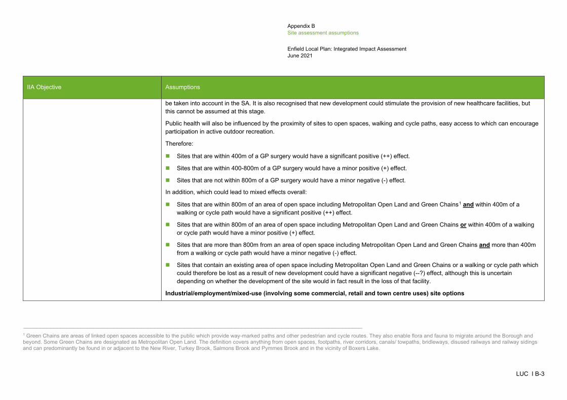
Appendix B Site assessment assumptions
Enfield Local Plan: Integrated Impact Assessment June 2021
LUC I B-3
IIA Objective Assumptions
be taken into account in the SA. It is also recognised that new development could stimulate the provision of new healthcare facilities, but this cannot be assumed at this stage.
Public health will also be influenced by the proximity of sites to open spaces, walking and cycle paths, easy access to which can encourage participation in active outdoor recreation.
Therefore:
Sites that are within 400m of a GP surgery would have a significant positive (++) effect.
Sites that are within 400-800m of a GP surgery would have a minor positive (+) effect.
Sites that are not within 800m of a GP surgery would have a minor negative (-) effect.
In addition, which could lead to mixed effects overall:
Sites that are within 800m of an area of open space including Metropolitan Open Land and Green Chains1 and within 400m of a walking or cycle path would have a significant positive (++) effect.
Sites that are within 800m of an area of open space including Metropolitan Open Land and Green Chains or within 400m of a walking or cycle path would have a minor positive (+) effect.
Sites that are more than 800m from an area of open space including Metropolitan Open Land and Green Chains and more than 400m from a walking or cycle path would have a minor negative (-) effect.
Sites that contain an existing area of open space including Metropolitan Open Land and Green Chains or a walking or cycle path which could therefore be lost as a result of new development could have a significant negative (--?) effect, although this is uncertain depending on whether the development of the site would in fact result in the loss of that facility.
Industrial/employment/mixed-use (involving some commercial, retail and town centre uses) site options
_____________________________________________________________________________________________________ 1 Green Chains are areas of linked open spaces accessible to the public which provide way-marked paths and other pedestrian and cycle routes. They also enable flora and fauna to migrate around the Borough and beyond. Some Green Chains are designated as Metropolitan Open Land. The definition covers anything from open spaces, footpaths, river corridors, canals/ towpaths, bridleways, disused railways and railway sidings and can predominantly be found in or adjacent to the New River, Turkey Brook, Salmons Brook and Pymmes Brook and in the vicinity of Boxers Lake.
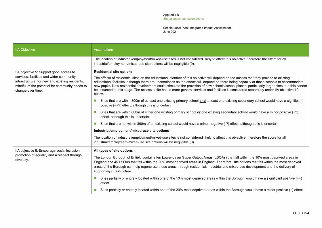
Appendix B Site assessment assumptions
Enfield Local Plan: Integrated Impact Assessment June 2021
LUC I B-4
IIA Objective Assumptions
The location of industrial/employment/mixed-use sites is not considered likely to affect this objective; therefore the effect for all industrial/employment/mixed-use site options will be negligible (0).
IIA objective 5: Support good access to services, facilities and wider community infrastructure, for new and existing residents, mindful of the potential for community needs to change over time.
Residential site options
The effects of residential sites on the educational element of this objective will depend on the access that they provide to existing educational facilities, although there are uncertainties as the effects will depend on there being capacity at those schools to accommodate new pupils. New residential development could stimulate the provision of new schools/school places, particularly larger sites, but this cannot be assumed at this stage. The access a site has to more general services and facilities is considered separately under IIA objective 10 below.
Sites that are within 800m of at least one existing primary school and at least one existing secondary school would have a significant positive (++?) effect, although this is uncertain.
Sites that are within 800m of either one existing primary school or one existing secondary school would have a minor positive (+?) effect, although this is uncertain.
Sites that are not within 800m of an existing school would have a minor negative (-?) effect, although this is uncertain.
Industrial/employment/mixed-use site options
The location of industrial/employment/mixed-use sites is not considered likely to affect this objective; therefore the score for all industrial/employment/mixed-use site options will be negligible (0).
IIA objective 6: Encourage social inclusion, promotion of equality and a respect through diversity.
All types of site options
The London Borough of Enfield contains ten Lower-Layer Super Output Areas (LSOAs) that fall within the 10% most deprived areas in England and 45 LSOAs that fall within the 20% most deprived areas in England. Therefore, site options that fall within the most deprived areas of the Borough can help regenerate those areas through residential, industrial and mixed-use development and the delivery of supporting infrastructure.
Sites partially or entirely located within one of the 10% most deprived areas within the Borough would have a significant positive (++) effect.
Sites partially or entirely located within one of the 20% most deprived areas within the Borough would have a minor positive (+) effect.
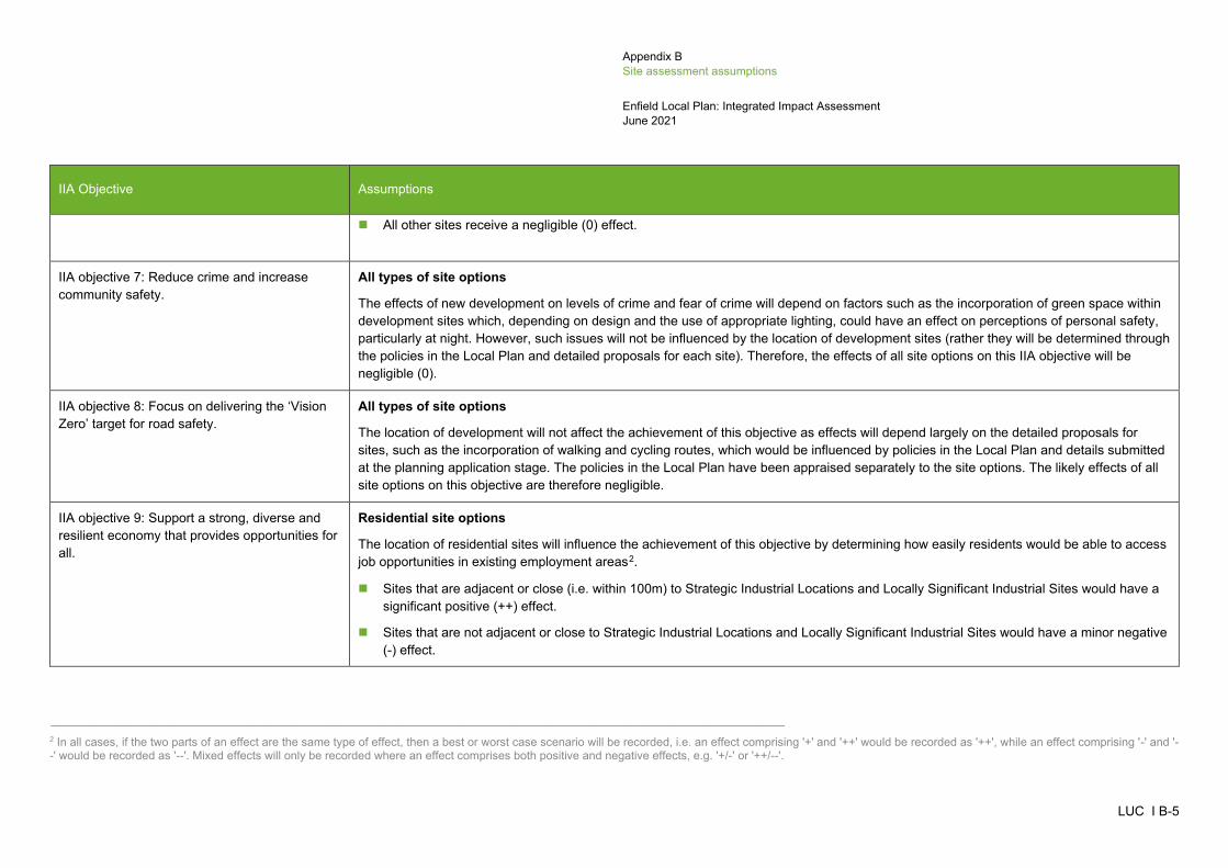
Appendix B Site assessment assumptions
Enfield Local Plan: Integrated Impact Assessment June 2021
LUC I B-5
IIA Objective Assumptions
All other sites receive a negligible (0) effect.
IIA objective 7: Reduce crime and increase community safety.
All types of site options
The effects of new development on levels of crime and fear of crime will depend on factors such as the incorporation of green space within development sites which, depending on design and the use of appropriate lighting, could have an effect on perceptions of personal safety, particularly at night. However, such issues will not be influenced by the location of development sites (rather they will be determined through the policies in the Local Plan and detailed proposals for each site). Therefore, the effects of all site options on this IIA objective will be negligible (0).
IIA objective 8: Focus on delivering the ‘Vision Zero’ target for road safety.
All types of site options
The location of development will not affect the achievement of this objective as effects will depend largely on the detailed proposals for sites, such as the incorporation of walking and cycling routes, which would be influenced by policies in the Local Plan and details submitted at the planning application stage. The policies in the Local Plan have been appraised separately to the site options. The likely effects of all site options on this objective are therefore negligible.
IIA objective 9: Support a strong, diverse and resilient economy that provides opportunities for all.
Residential site options
The location of residential sites will influence the achievement of this objective by determining how easily residents would be able to access job opportunities in existing employment areas2.
Sites that are adjacent or close (i.e. within 100m) to Strategic Industrial Locations and Locally Significant Industrial Sites would have a significant positive (++) effect.
Sites that are not adjacent or close to Strategic Industrial Locations and Locally Significant Industrial Sites would have a minor negative (-) effect.
_____________________________________________________________________________________________________ 2 In all cases, if the two parts of an effect are the same type of effect, then a best or worst case scenario will be recorded, i.e. an effect comprising '+' and '++' would be recorded as '++', while an effect comprising '-' and '--' would be recorded as '--'. Mixed effects will only be recorded where an effect comprises both positive and negative effects, e.g. '+/-' or '++/--'.

Appendix B Site assessment assumptions
Enfield Local Plan: Integrated Impact Assessment June 2021
LUC I B-6
IIA Objective Assumptions
If a site option would result in the loss of an existing employment area, an adverse effect would occur in relation to the protection of existing employment areas. Therefore:
Residential sites that fall within Strategic Industrial Locations and Locally Significant Industrial Sites would have a significant negative (--) effect.
Industrial/employment/mixed-use (involving some commercial, retail and town centre uses) site options
The provision of new industrial/employment/mixed-use sites in any location is likely to have a positive effect on this objective by ensuring that new job opportunities are provided to match the population growth that is being planned for within the Local Plan. Effects will be particularly positive where sites are large in size as they will result in more job creation. Therefore:
Large sites (those 10ha or larger) are likely to have a significant positive (++) effect.
Small sites (those under 10ha) are likely to have a minor positive (+) effect.
IIA objective 10: Support the vitality of the Borough’s town and local centres.
All types of site options
The London Borough of Enfield has identified a town centre hierarchy in the Regulation 18 Draft Local Plan under Policy SP11. This classifies settlements in the Borough as Major Centres, District Centres and Local Centres3. New development located within one of these centres has the potential contribute to the vitality of those centres. As each site is assessed individually, this contribution is considered to be minor rather than significant.
Residential sites, industrial/employment sites and/or mixed use sites that are within or adjacent to a Major, District and Local Centre would have a minor positive (+) effect.
Residential sites, industrial/employment sites and/or mixed use sites that are not within or adjacent to a Major, District and Local Centre would have a negligible (0) effect.
IIA objective 11: Minimise air pollution. All types of site options
WSP has undertaken an independent high level qualitative air quality appraisal, which has informed the findings of the IIA. For each site allocation, the appraisal has considered the estimated housing capacity of a site, or site area for non-residential site options, and if the site
_____________________________________________________________________________________________________ 3 Local Centres include Large Local Centres, Small Local Centres and Local Shopping Parades.
Appendix B Site assessment assumptions
Enfield Local Plan: Integrated Impact Assessment June 2021
LUC I B-7
IIA Objective Assumptions
is within 1km of an existing Air Quality Focus Area (AQFA)4. WSP used a simple scoring system to determine the potential future impact on air quality of each site. Site options with a housing capacity of 10 residential units or more scored 1, while sites with less than 10 residential units scored 0. Proposed non-residential site options, scored 1 where the site area is 1 hectare or more, while sites of less than 1 hectare scored 0. All site options within 1km of an AQFA were assigned an additional score of 1, while sites greater than 1km of an AFQA were scored 0. The two scores (residential capacity/site area and proximity to AFQAs) have then been added to give a total score, where:
2 indicates potential a significant negative (--?) effect with uncertainty.
1 indicates a potential minor negative (-?) effect with uncertainty.
0 indicates a potential negligible (0) effect .
It should be noted that there is some uncertainty associated with these findings at this stage, as the WSP assessment has not taken into account measures that will improve future air quality (such as the expansion of the Ultra-low Emissions Zone to the North Circular Road in 2021 or petrol and diesel car ban in 2030), or site specific mitigation. Detailed quantitative assessment of air quality impacts will be undertaken at the Regulation 19 stage.
IIA objective 12: Minimise the need to travel and support a modal shift away from the private car.
All types of site options
The proximity of development sites to sustainable transport links will affect the extent to which people are able to make use of non-car based modes of transport to access services, facilities and job opportunities, although the actual use of sustainable transport modes will depend on people’s behaviour. It is possible that new transport links such as bus routes or cycle paths may be provided as part of new developments, particularly at larger sites, but this cannot be assumed.
It is assumed that people would generally be willing to travel further to access a railway station than a bus stop. It is also recognised that many cyclists will travel on roads as well as dedicated cycle routes, and that the extent to which people choose to do so will depend on factors such as the availability of cycle storage facilities at their end destination, which are not determined by the location of sites. How safe or appealing particular roads are for cyclists cannot be determined at this strategic level of assessment. However, the proximity of site options to existing cycle routes can be taken as an indicator of how likely people are to cycle to or from a development site.
_____________________________________________________________________________________________________ 4 AQFAs not only exceed the EU annual limit for nitrogen dioxide but are also locations with high human exposure. AQFAs identify areas where currently planned measures to reduce air pollution may not fully resolve poor air quality issues.

Appendix B Site assessment assumptions
Enfield Local Plan: Integrated Impact Assessment June 2021
LUC I B-8
IIA Objective Assumptions
Sites that are within 1km of a railway/tube station and 350m of a bus stop (regardless of proximity to cycle routes) are likely to have a significant positive (++) effect.
Sites that are within either 1km of a railway/tube station or 350m of a bus stop (regardless of proximity to cycle routes) are likely to have a minor positive (+) effect.
Sites that are more than 1km from a railway/tube station and 350m from a bus stop but that have an existing cycle route passing the site could have a minor negative (-?) effect, although this is uncertain depending on whether the cycle route could be used for the purposes of commuting or undertaking day to day journeys.
Sites that are more than 1km from a railway/tube station and 350m from a bus stop and that do not have an existing cycle route passing the site are likely to have a minor negative (-) effect.
Furthermore, the proximity of sites to a Major, District or Local Centre will reduce the need for residents to travel long distances on a regular basis to access services and facilities. This could lead to mixed results:
Sites that are within 200m of a Major, District or Local Centre would have a significant positive (++) effect.
Sites that are within 201-400m of a Major, District or Local Centre would have a minor positive (+) effect.
Sites that are within 401-800m of a Major, District or Local Centre would have a minor negative (-) effect.
Sites that are more than 800m from a Major, District or Local Centre would have a significant negative (--) effect.
IIA objective 13: Deliver biodiversity net gain at an ambitious scale and avoid/mitigate impacts to valued habitats and ecological networks.
All types of site options
Sites that are within close proximity of an international, national or local designated conservation site have the potential to affect the biodiversity or geodiversity of those sites/features, e.g. through habitat damage/loss, fragmentation, disturbance to species, air pollution, increased recreation pressure etc.
Conversely, there may be opportunities to promote habitat connectivity if new developments include green infrastructure. Therefore, while proximity to designated sites provides an indication of the potential for an adverse effect, uncertainty exists, as appropriate mitigation may avoid adverse effects and may even result in beneficial effects. In addition, the potential impacts on biodiversity present on each site, or undesignated habitats and species adjacent to the potential development sites, cannot be determined at this strategic level of assessment. This would be determined once more specific proposals are developed and submitted as part of a planning application.
The HRA screening process has identified uncertain but likely significant negative effects for any of the development sites within the Borough, in relation to impacts of air pollution on the Epping Forest SAC. Therefore, for this IIA objective, the effects on national and local

Appendix B Site assessment assumptions
Enfield Local Plan: Integrated Impact Assessment June 2021
LUC I B-9
IIA Objective Assumptions
sites have only been identified. Open space, including Metropolitan Open Land and Green Chains, is addressed below under IIA objective 15.
Sites that are within 250m of one or more Sites of Special Scientific Interest or Sites of Importance for Nature Conservation would have a significant negative (--?) effect, although this is uncertain.
Sites that are 250-750m of one or more Sites of Special Scientific Interest or Sites of Importance for Nature Conservation and/or within 750m of a Local Nature Reserve would have a minor negative (-?) effect, although this is uncertain.
Sites that are beyond 750m of one or more Sites of Special Scientific Interest, Sites of Importance for Nature Conservation or Local Nature Reserves would have a negligible (0) effect.
In addition:
Sites that are less than 100m from a Priority Habitat or Ancient Woodland would have a significant negative (--?) effect, although this is uncertain.
Sites that are 100-250m from a Priority Habitat or Ancient Woodland would have a minor negative (-?) effect, although this is uncertain.
Sites that are 250m from a Priority Habitat or Ancient Woodland would have a negligible (0) effect.
IIA objective 14: Sustain and enhance the significance of heritage assets.
All types of site options
The NPPF states that "When considering the impact of a proposed development on the significance of a designated heritage asset, great weight should be given to the asset's conservation (and the more important the asset, the greater the weight should be)". However, development could also enhance the significance of the asset (provided that the development preserves those elements of the setting that make a positive contribution to or better reveal the significance of the asset).
In all cases, effects will be uncertain at this stage as the potential for negative or positive effects on historic and heritage assets will depend on the exact scale, design and layout of the new development and opportunities which may exist to enhance the setting of heritage features (e.g. where sympathetic development replaces a derelict brownfield site which is currently having an adverse effect).
As an indication of potential effects on historic and heritage assets from development of any of the site options, the following assumptions and evidence will be used:
Appendix B Site assessment assumptions
Enfield Local Plan: Integrated Impact Assessment June 2021
LUC I B-10
IIA Objective Assumptions
Where a site is more than 500m from the nearest designated heritage asset, it could have a negligible effect (0?), although this is uncertain as there is still some potential for impacts on non-designated heritage features and effects may extend beyond 500m in some cases.
Where an application site is within 500m of a designated heritage asset, professional judgement and evidence will be used to inform judgements. Where there are potential impacts on multiple heritage assets this will also be taken into account.
Sites which have potential for heritage assets to be enhanced and their significance to be better revealed could have a minor positive (+?) or significant positive (++?) effect on this objective.
Sites which are unlikely to cause adverse impacts on heritage assets could have a negligible (0?) effect on this objective.
Sites which have the potential to cause harm to heritage assets, but can be mitigated, would have a minor negative (-?) effect on this objective.
Sites which have the potential to cause harm to heritage assets where it is unlikely that these can be adequately mitigated would have a significant negative (--?) effect on this objective.
For the appraisal of site allocations, the Council's assessment of heritage considerations and impacts on Archaeological Priority Areas are considered. The effects are recorded as uncertain because the Site Proformas in Appendix B of the Local Plan require a Heritage Impact Assessment to be undertaken and mitigation to be provided, the outcomes of which will not be known until the planning application stage.
Sites that are recorded as 'Red' in either the Council's assessment of heritage considerations or impacts on Archaeological Priority Areas could have a significant negative (--?) effect on this objective.
Sites that are recorded as 'Amber' in either the Council's assessment of heritage considerations or impacts on Archaeological Priority Areas could have a minor negative (-?) effect on this objective.
Sites that are recorded as 'Green' in either the Council's assessment of heritage considerations or impacts on Archaeological Priority Areas could have a negligible (0?) effect on this objective.
Sites where no recordings have been made in the Council's assessment of heritage considerations or impacts on Archaeological Priority Areas are also given a negligible effect (0?) on this objective.
Appendix B Site assessment assumptions
Enfield Local Plan: Integrated Impact Assessment June 2021
LUC I B-11
IIA Objective Assumptions
IIA objective 15: Protect and enhance the character, quality and diversity of the Borough’s landscapes and townscapes.
All types of site options
All development could have some effect depending on the character and sensitivity of the surrounding landscape and/or townscape, which needs to be assessed in the field. Site options adjacent to the existing urban edge could be more easily integrated into existing built development, compared to more rural and isolated sites, particularly towards the west of the Borough. Larger scale sites may also have more of an impact and therefore sites above 3 hectares have been used as an indication of larger scale development. However, the actual effect on landscape/townscape will also depend on the design, scale and layout of development within the site, which may help mitigate any adverse effects on landscape and/or enhance effects on the existing townscape. Therefore, all effects are recorded as uncertain.
Sites that are located within a settlement and contain built development would have a minor positive (+?) effect on the townscape, although this is uncertain.
Sites that are located within a settlement but do not contain built development and/or sites that are not large in scale (i.e. <3ha), located on the edge of a settlement or within a relatively undeveloped area would have a minor negative (-?) effect on landscape, although this is uncertain.
Sites that are large in scale (i.e. >=3ha), located on the edge of a settlement or within a relatively undeveloped area would have a significant negative (--?) effect on landscape, although this is uncertain.
Sites that are not located near any settlements and are in rural areas, would also have a significant negative (--?) effect on landscape, although this is uncertain.
If a site option would result in the loss of open space, including Metropolitan Open Land and/or Green Chains, an adverse effect would occur. Therefore:
Sites that contain an open space, including Metropolitan Open Land and/or Green Chains, would have a significant negative (--) effect.
IIA objective 16: To achieve efficient use of land and materials.
All types of site options
Development on brownfield land represents a more efficient use of land in comparison to the development of greenfield sites. Larger scale sites may also have more of an impact and therefore sites above 3 hectares have been used as an indication of larger scale development. The effects of development on waste generation will depend largely on residents' behaviour. However, where development takes place on previously developed land there may be opportunities to reuse onsite buildings and materials, thereby reducing waste generation. Therefore:
Appendix B Site assessment assumptions
Enfield Local Plan: Integrated Impact Assessment June 2021
LUC I B-12
IIA Objective Assumptions
Sites that are relatively large in size (i.e. >=3h) and that are on greenfield land would have a significant negative (--) effect.
Sites that are relatively small in size (i.e. <3ha) and that are on greenfield land would have a minor negative (-) effect.
Sites that are relatively small in size (i.e. <3ha) and that are on brownfield land would have a minor positive (+) effect.
Sites that are relatively large in size (>=3ha) and that are on brownfield land would have a significant positive (++) effect.
In addition:
Sites that are on greenfield land classed as high quality agricultural land (Grades 1, 2 or 3a)5 would have a significant negative (--) effect regardless of size. This will be uncertain (--?) if the site is within Grade 3 land, as only Grade 3a is classed as high quality but the GIS data available does not distinguish between Grades 3a and 3b.
Furthermore, all new development will result in the increased consumption of minerals for construction but this will not be influenced by the location of the development. The location of development sites can influence the efficient use of minerals as development in Minerals Safeguarding Areas may sterilise mineral resources and restrict the availability of resources in the Borough. There are no Minerals Safeguarding Areas within LBE.
IIA objective 17: To manage and reduce the risk of flooding
All types of site options
The effects of new development on this IIA objective will depend to some extent on its design, for example whether it incorporates sustainable drainage systems (SuDS), which is unknown and cannot be addressed at this stage. Where site options are located in areas of high flood risk, it could increase the risk of flooding in those areas (particularly if the sites are not previously developed) and would increase the number of people and assets at risk from flooding. Therefore, drawing on the work undertaken by BMT, the effects are as follows:
Sites that are entirely or mainly (i.e. >=25%) within Flood Zone 3 would have a significant negative (--) effect.
Sites that are entirely or mainly within Flood Zone 2 or partially (i.e.<25%) within Flood Zone 3 would have a minor negative (-) effect.
Sites that are entirely or mainly within Flood Zone 1 would have a negligible (0) effect.
Furthermore:
_____________________________________________________________________________________________________ 5 LBE does not contain Grades 1 or 2 agricultural land.

Appendix B Site assessment assumptions
Enfield Local Plan: Integrated Impact Assessment June 2021
LUC I B-13
IIA Objective Assumptions
Sites that have a predicted peak flood depth of greater than 300m would have a significant negative (--) effect
Sites that have a predicted peak flood depth of greater than 150m would have a minor negative (-) effect.
Sites that are not at risk of surface water flooding would have a negligible (0) effect.
In addition:
Sites that are on greenfield land would have a minor negative (-) effect.
Sites that are on brownfield land would have a negligible (0) effect.
IIA objective 18: Minimise water use and protect water quality.
All types of site options
Levels of water consumption within new development will be determined by its design and onsite practices, rather than the location of the site. However, the location of development could affect water quality during construction depending on its proximity to watercourses, water bodies and Source Protection Zones. The extent to which water quality is affected would depend on construction techniques and the use of SuDS within the design, therefore effects are uncertain at this stage.
Development on sites which contain a watercourse, water body or fall within a Source Protection Zone could result in significant negative (--?) effects on water quality although this is uncertain at this stage of assessment.
Development on sites which do not contain a water body or fall within a Source Protection Zone would have a negligible (0) effect.
Appendix C IIA findings for the Issues and Options Local Plan 2018
Enfield Local Plan: Integrated Impact Assessment June 2021
LUC I C-1
Introduction C.1 This appendix sets out the IIA findings for the plan options that were presented in the 2018 Issues and Options consultation document for the Enfield Local Plan. The options in that document comprised the draft vision and growth objectives, a set of seven growth (spatial distribution) options and a number of policy approaches presented under nine themes:
Historic environment
Design
Housing
Economy
Town centre
Social infrastructure
Green infrastructure
Transport
Sustainable infrastructure
C.2 The options in the 2018 Issues and Options document have been appraised against the current IIA framework and the IIA findings presented in this IIA Report to help meet the SEA Regulations, which require the likely effects of the plan and ‘reasonable alternatives’ to be assessed and described. The IIA findings for the 2018 draft vision and growth objectives are discussed first, followed by the findings for the seven growth (or spatial distribution) options, and then the findings for each set of policy options in the order of the nine themes listed above.
IIA findings for the 2018 draft vision and growth objectives C.3 The draft vision in the 2018 Issues and Options document was as follows:
A Place for Affordability & Accessibility
By 2036, Enfield will be a borough that provides for its residents with a choice of homes and public services to meet actual need and affordability through the successful delivery of thriving neighbourhoods that are environmentally conscious and embrace active, resilient and healthy lifestyles.
A Place of Opportunity & Enterprise
New economies are secured to bring competitiveness of the borough’s employment areas to attract regional, national and international investors across all sectors to successfully deliver new jobs and assist in securing the provision of employment training opportunities for local residents.
Enfield will be a place of local entrepreneurs and ‘makers’ of craft and creativity where people want to innovate and do business; where levels of educational attainment, economic activity and entrepreneurship are the greatest in London; where people have access to jobs in sectors that enjoy prosperity and long-term growth; and where high-speed communications and smart technologies will lead the way in accommodating and being part of London’s growth sectors.
A Place for Diversity & Equality
Prosperity is shared across the whole borough to enable people to reach their potential through access to high quality schools and learning. Enfield residents will enjoy an opportunity for active and attractive places to live and work in healthy
-
Appendix C IIA findings for the Issues and Options Local Plan 2018
Appendix C IIA findings for the Issues and Options Local Plan 2018
Enfield Local Plan: Integrated Impact Assessment June 2021
LUC I C-2
environments. Our youth and most vulnerable residents will be supported through improved health, education and skill levels to enable everyone to fulfil their potential.
New and regenerated neighbourhoods will be safe and defined by the highest standards of well designed, affordable, accessible and eco-friendly homes and with access to public spaces.
Residents will have improved health and wellbeing and quality of life, improvements to open spaces, as well as new employment opportunities, ensuring that the benefits of growth, regeneration and investment reach everyone in the borough.
A Place that Delivers
Enfield will be an exemplar borough of how joined up partnerships, approaches to regeneration and investment can maximise opportunities to deliver for local people. The Council will deliver on several key regeneration schemes including our flagship Meridian Water project.
New transport infrastructure projects for rail, road and cycling will deliver reduced congestion and improved air quality. The early delivery of Four Tracking of the West Anglia Mainline as an early stage of Crossrail 2 will increase rail capacity, unlock and begin the accelerated regeneration of the eastern corridor and prepare for Crossrail 2.
C.4 The Council then set out a series of growth objectives to achieve the draft vision, under four overarching objectives:
1. Promoting and managing growth
To promote growth and help achieve sustainable patterns of development by focusing new development in the borough’s main town centres and areas around all stations, transport corridors, housing estate renewal and regeneration programmes, the eastern corridor and low density industrial areas, and through a strategic plan-led approach to the release of Green Belt land where they are accessible and sustainable;
To meet locally assessed housing need across the borough through the creation of high quality developments in a phased programme to help meet existing and future housing needs;
To build strong and inclusive communities by providing diversity of type, size and tenure of housing including affordable homes to meet local housing needs, tackle homelessness and to deliver as a minimum the annual housing target of at least 1,876 new homes as set out by the draft new London Plan;
Respect and enhance the character of the borough’s cultural, built heritage and neighbourhoods;
Encourage and maintain a mixture of town centre uses in Enfield Town, Angel Edmonton, Edmonton Green, Palmers Green and Southgate, and the borough’s local centres and local parades;
To improve the health and wellbeing of Enfield’s population and reduce health inequalities through promoting good growth and spatial planning, supporting healthier lifestyles and environmental improvements, as well as ensuring appropriate access to health facilities; and
To enhance the quantity, quality and density of the borough’s Strategic Industrial Locations (SIL) and Locally Significant Industrial Sites (LSIS), including the possibility for substitution and consolidation, to enable new and emerging businesses in sectors, whilst supporting opportunities for a mixture of uses and co-location.
2. Achieving design excellence
To promote high quality, safe and sustainable designed buildings, places and streets; and
To promote and protect high levels of amenity and quality of life to make Enfield an attractive, successful and vibrant place for all – residents, workers and people visiting.
3. Enhancing Enfield's assets
To enhance the unique historic environment of Enfield and the character, distinctiveness of the borough's conservation areas and other historic and valued buildings, cultural spaces and places;
To improve access to existing open spaces and manage open space deficiency; and
To protect conditions for biodiversity.
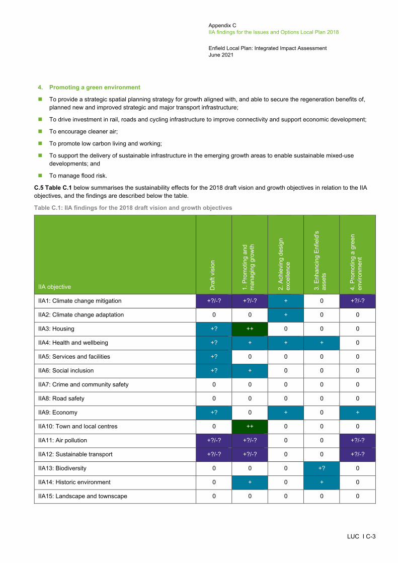
Appendix C IIA findings for the Issues and Options Local Plan 2018
Enfield Local Plan: Integrated Impact Assessment June 2021
LUC I C-3
4. Promoting a green environment
To provide a strategic spatial planning strategy for growth aligned with, and able to secure the regeneration benefits of, planned new and improved strategic and major transport infrastructure;
To drive investment in rail, roads and cycling infrastructure to improve connectivity and support economic development;
To encourage cleaner air;
To promote low carbon living and working;
To support the delivery of sustainable infrastructure in the emerging growth areas to enable sustainable mixed-use developments; and
To manage flood risk.
C.5 Table C.1 below summarises the sustainability effects for the 2018 draft vision and growth objectives in relation to the IIA objectives, and the findings are described below the table.
Table C.1: IIA findings for the 2018 draft vision and growth objectives
IIA objective Dra
ft vi
sion
1. P
rom
otin
g an
d m
anag
ing
grow
th
2. A
chie
ving
des
ign
exce
llenc
e
3. E
nhan
cing
Enf
ield
's
asse
ts
4. P
rom
otin
g a
gree
n en
viro
nmen
t
IIA1: Climate change mitigation +?/-? +?/-? + 0 +?/-?
IIA2: Climate change adaptation 0 0 + 0 0
IIA3: Housing +? ++ 0 0 0
IIA4: Health and wellbeing +? + + + 0
IIA5: Services and facilities +? 0 0 0 0
IIA6: Social inclusion +? + 0 0 0
IIA7: Crime and community safety 0 0 0 0 0
IIA8: Road safety 0 0 0 0 0
IIA9: Economy +? 0 + 0 +
IIA10: Town and local centres 0 ++ 0 0 0
IIA11: Air pollution +?/-? +?/-? 0 0 +?/-?
IIA12: Sustainable transport +?/-? +?/-? 0 0 +?/-?
IIA13: Biodiversity 0 0 0 +? 0
IIA14: Historic environment 0 + 0 + 0
IIA15: Landscape and townscape 0 0 0 0 0
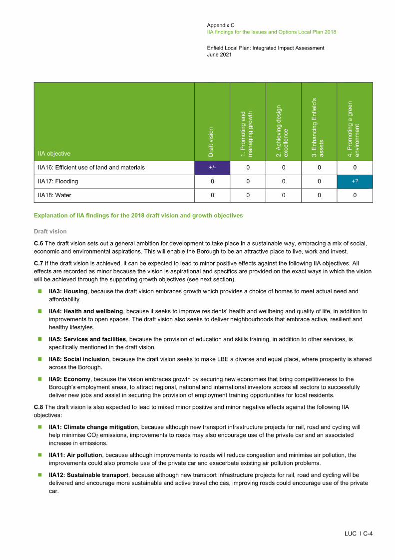
Appendix C IIA findings for the Issues and Options Local Plan 2018
Enfield Local Plan: Integrated Impact Assessment June 2021
LUC I C-4
IIA objective Dra
ft vi
sion
1. P
rom
otin
g an
d m
anag
ing
grow
th
2. A
chie
ving
des
ign
exce
llenc
e
3. E
nhan
cing
Enf
ield
's
asse
ts
4. P
rom
otin
g a
gree
n en
viro
nmen
t
IIA16: Efficient use of land and materials +/- 0 0 0 0
IIA17: Flooding 0 0 0 0 +?
IIA18: Water 0 0 0 0 0
Explanation of IIA findings for the 2018 draft vision and growth objectives
Draft vision
C.6 The draft vision sets out a general ambition for development to take place in a sustainable way, embracing a mix of social, economic and environmental aspirations. This will enable the Borough to be an attractive place to live, work and invest.
C.7 If the draft vision is achieved, it can be expected to lead to minor positive effects against the following IIA objectives. All effects are recorded as minor because the vision is aspirational and specifics are provided on the exact ways in which the vision will be achieved through the supporting growth objectives (see next section).
IIA3: Housing, because the draft vision embraces growth which provides a choice of homes to meet actual need and affordability.
IIA4: Health and wellbeing, because it seeks to improve residents' health and wellbeing and quality of life, in addition to improvements to open spaces. The draft vision also seeks to deliver neighbourhoods that embrace active, resilient and healthy lifestyles.
IIA5: Services and facilities, because the provision of education and skills training, in addition to other services, is specifically mentioned in the draft vision.
IIA6: Social inclusion, because the draft vision seeks to make LBE a diverse and equal place, where prosperity is shared across the Borough.
IIA9: Economy, because the vision embraces growth by securing new economies that bring competitiveness to the Borough's employment areas, to attract regional, national and international investors across all sectors to successfully deliver new jobs and assist in securing the provision of employment training opportunities for local residents.
C.8 The draft vision is also expected to lead to mixed minor positive and minor negative effects against the following IIA objectives:
IIA1: Climate change mitigation, because although new transport infrastructure projects for rail, road and cycling will help minimise CO2 emissions, improvements to roads may also encourage use of the private car and an associated increase in emissions.
IIA11: Air pollution, because although improvements to roads will reduce congestion and minimise air pollution, the improvements could also promote use of the private car and exacerbate existing air pollution problems.
IIA12: Sustainable transport, because although new transport infrastructure projects for rail, road and cycling will be delivered and encourage more sustainable and active travel choices, improving roads could encourage use of the private car.
Appendix C IIA findings for the Issues and Options Local Plan 2018
Enfield Local Plan: Integrated Impact Assessment June 2021
LUC I C-5
C.9 Due to the fact they are not specifically mentioned, the vision's contribution to the achievement of the following objectives is likely to be negligible: IIA2: Climate change adaptation, IIA7: Crime and community safety, IIA8: Road safety, IIA10: Town and local centres, IIA13: Biodiversity, IIA14: Historic environment, IIA15: Landscape and townscape, IIA16: Efficient use of land and materials, IIA17: Flooding and IIA18: Water.
C.10 All of the effects of the draft vision are subject to some uncertainty since their achievement will depend on the details of the Local Plan policies and site allocations which are designed to implement it.
Growth objectives
1. Promoting and managing growth
C.11 Growth objective 1 is expected to have a significant positive effect in relation to IIA3: Housing because it seeks to meet locally assessed housing needs across the Borough by providing a diversity of type, size and tenure of housing including affordable homes, in addition to tackling homelessness. For this reason, a minor positive effect is also expected in relation to IIA6: Social inclusion. A significant positive effect is expected against IIA10: Town and local centres because the objective focuses growth in the Borough's main town centres, whilst also maintaining a mixture of town centre uses in Enfield Town, Angel Edmonton, Edmonton Green, Palmers Green and Southgate, as well as the Borough's local centres and local parades.
C.12 Minor positive effects are expected in relation to IIA4: Health and wellbeing because the objective seeks to improve the health and wellbeing of Enfield's population and reduce health inequalities through promoting good growth and spatial planning, supporting healthier lifestyles and access to health facilities. A minor positive effect is expected against IIA14: Historic environment because the objective sets out that all development must respect and enhance the character of the Borough's cultural and built heritage. Mixed minor positive and minor negative but uncertain effects are expected in relation to IIA1: Climate change mitigation, IIA11: Air pollution and IIA12: Sustainable transport because although this objective supports growth at town centres and areas around stations, which may reduce use of the private car and associated emissions, it also promotes growth along transport corridors, namely Great Cambridge Road (A10) and North Circular Road (A406). Therefore, it may also encourage use of the private car and exacerbate existing air quality issues. Lastly, growth objective 1 is expected to have a mixed minor positive and minor negative effect in relation to IIA16: Efficient use of land and materials because although it supports development of previously developed land at town centres and areas around stations, it also supports development in the Green Belt, much of which is undeveloped.
2. Achieving design excellence
C.13 Growth objective 2 promotes sustainably designed buildings and may therefore help to mitigate the effects of climate change through reductions in CO2 emissions, whilst also adapting to climate change. Therefore, minor positive effects are expected in relation to IIA1: Climate change mitigation and IIA2: Climate change adaptation. This growth objective also seeks to protect amenity and quality of life, by making LBE an attractive, successful and vibrant place to be. Therefore, minor positive effects are also expected in relation to IIA4: Health and wellbeing and IIA9: Economy.
3. Enhancing Enfield's assets
C.14 Minor positive effects are expected in relation to IIA4: Health and wellbeing, IIA13: Biodiversity and IIA14: Historic environment because this objective seeks to enhance the historic environment in LBE, whilst also improving access to existing open spaces and managing open space deficiency, in addition to protecting conditions for biodiversity. The effect against IIA14 is recorded as uncertain because the objective does not specify in what ways biodiversity will be protected.
4. Promoting a green environment
C.15 Growth objective 4 supports the delivery of rail, road and cycling infrastructure improvements, which will support economic development. Therefore a minor positive effect is expected in relation to IIA9: Economy. However, due to the fact improvements will be made to roads so as to reduce congestion, people may be more inclined to use the car. Therefore, mixed minor positive and minor negative but uncertain effects are expected in relation to IIA1: Climate change mitigation, IIA11: Air pollution and IIA12: Sustainable transport. A minor positive but uncertain effect is expected in relation to IIA17: Flooding because the objective seeks to manage flood risk but does not set out in what ways this will be achieved.

Appendix C IIA findings for the Issues and Options Local Plan 2018
Enfield Local Plan: Integrated Impact Assessment June 2021
LUC I C-6
C.16 It is noted that none of the growth objectives explicitly address IIA7: Crime and community safety, IIA8: Road safety, IIA15: Landscape and townscape and IIA18: Water.
IIA findings for the growth options considered in the 2018 Issues and Options consultation document C.17 This section presents the IIA findings for the ‘growth’ (or spatial distribution) options that are set out in the Local Plan Issues and Options consultation document. Seven broad options for where new housing, employment and other land uses should go to meet the growth being planned for at the time (i.e. the draft London Plan target of 1,876 homes a year for the next 10 years from 2018), as follows:
Option 1: Main town centres and areas around all stations;
Option 2: Transport corridors;
Option 3; Existing estate renewal and regeneration programmes;
Option 4: Eastern corridor and low density industrial areas;
Option 5: Future Crossrail 2 Growth Corridor;
Option 6: The New Southgate and Upper Lee Valley Opportunity Areas; and
Option 7: Strategic plan-led approach to Green Belt.
C.18 It should be noted that these spatial distribution options are not mutually exclusive, and the Issues and Options consultation document recognised that individually they would not be able to deliver the overall growth required for the Borough, therefore choices would need to be made about which elements of these options would form the spatial strategy in the Enfield Local Plan. However, based on the potential development locations associated with each option as shown on the Strategic Growth Options diagram at Figure 2.2 in the Issues and Options consultation document, the IIA has assumed that more development would be able to be delivered under Options 1 and 2 than the remaining five options. In addition, it is noted that Option 5: Future Crossrail 2 Growth Corridor is no longer a reasonable alternative due to the Government’s decision in November 2020 and notice to Transport for London to end spending on Crossrail 2. However, it has been appraised and presented for completeness to reflect the point in time at which it was being considered as a growth option for the Enfield Local Plan.
C.19 Table C.2 summarises the IIA effects of the seven spatial distribution options and the findings are described below the table. Given the ‘mix and match’ nature of these spatial distribution options, there are sustainability pros and cons with each of them, and no one option comes out as performing the ‘best’ in sustainability terms. However, Option 1: Main town centres and areas around all stations has the most potentially significant positive effects, because it would provide the most opportunities for new residents to reach employment, education, services and facilities via active and/or sustainable transport modes, which has multiple benefits in terms of health, inclusivity, reducing inequalities, reducing car travel and CO2 emissions and maximising efficient use of land. This option would still have some potential negative effects on the more environmental IIA objectives in particular. Option 7: Strategic plan-led approach to Green Belt has the most potentially significant negative effects as although some are on the same IIA objectives as for Option 1 (e.g. biodiversity and historic environment), unlike Option 1, it would not provide new development in proximity to sustainable transport opportunities or existing services and facilities, resulting in negative effects on health, access to services, reducing car travel, CO2 emissions and also efficient use of land (due to the necessary reliance on greenfield sites).

Appendix C IIA findings for the Issues and Options Local Plan 2018
Enfield Local Plan: Integrated Impact Assessment June 2021
LUC I C-7
Table C.2: Summary of IIA effects for the growth options considered in the 2018 Issues and Options document
IIA objective
1. Main town centres and
areas around all stations
2. Transport corridors
3. Existing estate renewal and regeneration programmes
4. Eastern corridor and low density industrial
areas
5. Future Crossrail 2
Growth Corridor
6. New Southgate and Upper Lee
Valley Opportunity
Areas
7. Strategic plan-led approach to
Green Belt
IIA1: Climate change mitigation ++? --/+? +? +?/- ++? +? --?/+?
IIA2: Climate change adaptation 0 0 0 0 0 0 0
IIA3: Housing ++?/- ++?/- - +? +? +? +?
IIA4: Health and wellbeing ++/--? --/+ +/- +/- +/- +/- --/+
IIA5: Services and facilities ++/-? +/-? +? +? +? +? --
IIA6: Social inclusion +/- ++/- ++ ++ ++ ++ +
IIA7: Crime and community safety -? -? +? -? -? -? -?
IIA8: Road safety 0 0 0 0 0 0 0
IIA9: Economy ++ ++/- +? ++/--? ++/--? +/-? --?/+?
IIA10: Town and local centres ++ --/+ + + + + 0
IIA11: Air pollution ++?/-- --/+? +?/- --/+? ++?/-- +?/- --/+?
IIA12: Sustainable transport ++? --/+? +? +?/- ++? +? --/+?
IIA13: Biodiversity --? --? --? --? --? --? --?
IIA14: Historic environment --? -? 0? -? -? -? --?
IIA15: Landscape and townscape -- -- +? --/+? --/+? --/+? --

Appendix C IIA findings for the Issues and Options Local Plan 2018
Enfield Local Plan: Integrated Impact Assessment June 2021
LUC I C-8
IIA objective
1. Main town centres and
areas around all stations
2. Transport corridors
3. Existing estate renewal and regeneration programmes
4. Eastern corridor and low density industrial
areas
5. Future Crossrail 2
Growth Corridor
6. New Southgate and Upper Lee
Valley Opportunity
Areas
7. Strategic plan-led approach to
Green Belt
IIA16: Efficient use of land and materials ++ ++ ++ ++ ++ ++ -
IIA17: Flooding -? -? -? -? -? -? -?
IIA18: Water -? -? -? -? -? -? -?
Appendix C IIA findings for the Issues and Options Local Plan 2018
Enfield Local Plan: Integrated Impact Assessment June 2021
LUC I C-9
IIA1: Climate change mitigation
C.20 Options 1: Main town centres and areas around all stations and 5: Future Crossrail 2 Growth Corridor promote development around tube and railway stations, with Option 1 also supporting development at town centres where everyday services and facilities are located within walking distance of one another. The town centres are highly accessible and also contain multiple bus routes, whilst Crossrail 2 would provide a four train per hour service into the new Meridian Water, Ponders End, Brimsdown and Enfield Lock stations from 2028. These two options are therefore likely to reduce use of the private car and associated CO2 emissions, with significant positive effects expected in relation to IIA1: Climate change mitigation. However, the effects are recorded as uncertain because levels of walking and cycling within the Borough are not very high and in the case of Option 5, which promotes development along the proposed Crossrail 2 route, delivery of this strategic infrastructure project had not been confirmed at the time of the 2018 Issues and Options consultation. It is also unknown whether people will choose public transport in place of the private car, as this will depend on a number of factors such as cost, timing of services and proximity to their final destination. Options 3: Existing estate renewal and regeneration programmes and 6: New Southgate and Upper Lee Valley Opportunity Areas are expected to have minor positive effects in relation to this objective because the estates proposed for renewal/regeneration and Opportunity Areas are located within close proximity of some tube and railway stations and may therefore encourage use of public transport. These effects are recorded as uncertain because it is unknown whether people will choose public transport as a replacement to the private car, particularly because Census data from 2011 indicates that the majority of residents use a private car to get work instead of public transport.
C.21 Option 2: Transport corridors is expected to have a mixed significant negative and minor positive effect against IIA1 because it supports development along the transport corridors and partially falls within the built-up urban areas where a number of services and facilities are present. People can therefore easily walk to various amenities. However, the transport corridors comprise Great Cambridge Road (A10) and North Circular Road (A406) and this option would therefore support use of the private car, generating associated CO2 emissions. The positive effect is recorded as uncertain because levels of walking and cycling within the Borough are not very high, in addition to public transport use. Option 7: Strategic plan-led approach to Green Belt is also expected to have a mixed significant negative and minor positive effect in relation to this objective because the Green Belt in LBE is not located within close proximity to public transport, apart from the area around Crews Hill railway station. Therefore, depending on where development is located, this option would be likely to increase reliance on the private car. However, emphasis is placed on the Crews Hill area in the supporting text to this option, which would potentially reduce reliance on the private car and associated CO2 emissions. The effect is recorded as uncertain because it is unknown whether people would choose public transport in place of the private car and whether some areas within the Green Belt that are not close to the Crews Hill railway stations would be developed or not. Option 4: Eastern Corridor and low density industrial areas is expected to have a mixed minor positive and minor negative effect against IIA1: Climate change mitigation because although it supports development in the eastern corridor, which contains a number of railway stations and would be within close proximity of the proposed Crossrail 2 infrastructure project, it also contains some areas that are not within close proximity of public transport infrastructure, in addition to everyday services and facilities. Conversely, including industrial land in this growth option provides the opportunity for greater variety in employment, housing and density, reducing distances between homes, schools, the workplace, community and town centres. The positive effect for Option 4 is recorded as uncertain because it is unknown whether people will choose public transport in place of the private car.
IIA2: Climate change adaptation
C.22 Given the high-level nature of these seven options, it is not possible to distinguish between them with respect to climate change adaptation. The distribution of development is not likely to influence sustainable design and construction techniques in development or respond to extreme weather effects as a result of climate change, which will be dealt with through other policies in the plan. Flood risk is dealt with separately under IIA objective 17. All growth options are expected to have negligible effects in relation to this objective.

Appendix C IIA findings for the Issues and Options Local Plan 2018
Enfield Local Plan: Integrated Impact Assessment June 2021
LUC I C-10
IIA3: Housing
C.23 Options 1: Main town centres and areas around all stations and 2: Transport corridors are expected to deliver the highest amount of growth when compared to the other five options and would include a mix of housing and employment development, in addition to healthcare, schools, open space and social and community infrastructure. Options 1 and 2 would be achieved by increasing densities and building heights of new development. However, this would not provide the range of housing types needed in the Borough and instead deliver a high proportion of flats, studios and 1-bedroom apartments. This could discriminate against certain groups of people, such as large families or those with specialist housing requirements. For this reason, Options 1 and 2 are both expected to have a mixed significant positive and minor negative effect in relation to this objective. The positive effect is recorded as uncertain because it is unknown what number of new homes would be delivered. Options 4: Eastern corridor and low density industrial areas, 5: Future Crossrail 2 Growth Corridor, 6: New Southgate and Upper Lee Valley Opportunity Areas and 7: Strategic plan-led approach to the Green Belt are expected to have minor positive effects in relation to this objective because although they are not likely to deliver as much growth as Options 1 and 2, they are still expected to deliver a considerable number of new homes. The effects are recorded as uncertain because it is unknown exactly how many new homes will be provided under these four options. The Issues and Options document noted that the Council is currently running a programme of estate renewal and under Option 3: Existing estate renewal and regeneration programmes, would deliver 3,000 new homes in New Southgate, Ponders End and Edmonton. Therefore, although this option would deliver 3,000 new homes, it would not provide the total number of new homes required across the Borough. Option 3 is therefore expected to have a minor negative effect against this objective.
IIA4: Health and wellbeing
C.24 In LBE, there is an east-west divide in terms of inequality and this correlates with health indicators. According to ONS, LBE is the fifth worst Borough in England for obesity, with significantly high levels of obesity in the east when compared to the west. Option 1: Main town centres and areas around all stations focuses growth around tube and railway stations, as well as town centres, where a number of services and facilities are available, including primary healthcare facilities. Therefore, people would be within walking distance of a number of amenities, which may encourage more active travel choices. This would have beneficial effects on people's physical health and mental wellbeing. However, the amount of development that would be delivered under Option 1 would place a significant amount of pressure on existing services, particularly GP surgeries. Further to this, the supporting text to Option 1 states that the amount of development delivered under this option could potentially require a relaxation in standards for open space provision. This is particularly concerning following the COVID-19 pandemic which has highlighted significant inequalities in access to open space. For these reasons, Option 1 is expected to have a mixed significant positive and significant negative effect against this objective. The negative effect is recorded as uncertain because it is unknown whether open space would be lost or not.
C.25 Option 2: Transport corridors supports development along Great Cambridge Road (A10) and North Circular Road (A406), which partially fall within built up urban areas where a number of services and facilities are present. However, both corridors also include areas where a range of services are not available, which may limit access to healthcare and also discourage more active travel choices (i.e. walking and cycling). Locating development along these A roads is also problematic in that residents would be located adjacent to sources of air pollution, which can have adverse effects on people's health, particularly those who suffer from asthma. Therefore, Option 2 is expected to have a mixed significant negative and minor positive effect in relation to this objective. Option 7: Strategic plan-led approach to Green Belt is also expected to have a mixed significant negative and minor positive effect against IIA4: Health and wellbeing. This is due to the fact there are no GP surgeries located within the Green Belt in the north-west of the Borough and therefore residents would not have easy access to healthcare. However, large-scale development under this option offers an opportunity to provide new GP surgeries.
C.26 According to the IIA Scoping Report, there are very few GP surgeries on the estates within LBE. As such, the delivery of 3,000 new homes under Option 3: Existing estate renewal and regeneration programmes could place a considerable amount of pressure on the limited number of surgeries available. Therefore, Option 3 is expected to have a minor negative effect in relation to this objective. However, this is mixed with a minor positive effect because regenerating estates within the Borough offers an opportunity to deliver new healthcare facilities and improve quality of life through improved housing stock. Options 4: Eastern Corridor and low density industrial areas and 5: Future Crossrail 2 Growth Corridor are expected to have mixed minor positive

Appendix C IIA findings for the Issues and Options Local Plan 2018
Enfield Local Plan: Integrated Impact Assessment June 2021
LUC I C-11
and minor negative effects against this objective because both options contain areas that are located within close proximity of a number of services and facilities (e.g. primary healthcare facilities) and others that are not. Option 6 focuses development in the Opportunity Areas only and may therefore result in an increase in pressure on existing healthcare facilities in those areas, which are likely to experience considerable population growth. However, it is likely that development of these Opportunity Areas will provide an opportunity to deliver new healthcare facilities in order to meet the needs of a growing population. Therefore, Option 6 is expected to have a mixed minor positive and minor negative effect in relation to this objective.
IIA5: Services and facilities
C.27 Option 1 is expected to have a significant positive effect against IIA5: Services and facilities because it supports development in main town centres and around tube and railway stations, which are built up urban areas where a number of existing services and facilities are present. New residents would therefore not be required to travel far to reach these services, as they would be within walking distance of them. For example, there are a number of primary and secondary schools located within close proximity of most of the tube and railway stations. However, the amount of development likely to be delivered under this option would place increasing strain on services, such as schools, although this is uncertain. Therefore, Option 1 is also expected to have a minor negative but uncertain effect against this objective.
C.28 Option 7 is expected to have a significant negative effect in relation to IIA5 because the Green Belt in the north west of the Borough contains a very small number of schools which are located on the very edge of the Green Belt and not within close proximity of the Crews Hill area.
C.29 Options 2: Transport corridors, 3: Existing estate renewal and regeneration programmes, 4: Eastern corridor and low density industrial areas, 5: Future Crossrail 2 Growth Corridor and 6: New Southgate and Upper Lee Valley Opportunity Areas are expected to have minor positive effects in relation to this objective because although they tend to be located within built up urban areas where services and facilities are present, these options also contain areas that are not within close proximity of services (e.g. schools). For example, all five options propose development near Angel Road, where only one existing primary school is present and no secondary schools. Option 2 is also expected to have a minor negative effect in relation to this objective because the volume of development would place a lot of pressure on existing services, such as primary and secondary school places, although this is uncertain.
IIA6: Social inclusion
C.30 In LBE, there is an east-west divide in terms of inequality and deprivation. The eastern part of the Borough contains ten Lower Super Output Areas that fall within the 10% most deprived nationally. Options 3: Existing estate renewal and regeneration programmes, 4: Eastern corridor and low density industrial areas, 5: Future Crossrail 2 Growth Corridor and 6: New Southgate and Upper Lee Valley Opportunity Areas are expected to have significant positive effects in relation to IIA6: Social inclusion because they focus growth in the east of the Borough in some of the most deprived areas, including through estate renewal/regeneration and redevelopment of the Upper Lee Valley Opportunity Area. Option 2: Transport corridors is also expected to have a significant positive effect in relation to this objective because one of two transport corridors, Great Cambridge Road (A10), is located in the east of the Borough, and North Circular Road (A406) runs from east to west, also falling within some of the most deprived areas within the Borough. However, the effect is mixed with a minor negative effect because focusing growth along the transport corridors may exclude those who do not have access to a private car. Option 7: Strategic plan-led approach to Green Belt is expected to have a minor positive effect in relation to this objective because it focuses development in the Green Belt located in the north west of the Borough, and therefore does not address the east-west divide. However, this area of Metropolitan Green Belt does fall within the 30% most deprived areas nationally and is therefore still likely to address poverty and social exclusion to some extent. Option 1: Main town centres and areas around all stations is expected to have a mixed minor positive and minor negative effect against IIA6 because it supports development in the town centres and areas surrounding tube and railway stations, but due to the fact the town centres and tube/railway stations are spread fairly evenly across the majority of the Borough, development would not be directed solely into the more deprived areas. Therefore, although this option would, to an extent, help regenerate the more deprived areas of the Borough, it would also enhance the least deprived areas and not specifically address the gap in inequality between the east and west.

Appendix C IIA findings for the Issues and Options Local Plan 2018
Enfield Local Plan: Integrated Impact Assessment June 2021
LUC I C-12
IIA7: Crime and community safety
C.31 The spatial distribution of development is not likely to influence levels of crime, anti-social behaviour, fear of crime and perceptions of safety, which will be more influenced by policies which seek to deliver inclusive design. As set out in the IIA Scoping Report, crime is generally concentrated in the east of LBE and at Southgate, Palmers Green and the boundary LBE shares with Haringey Council, in addition to around public transport nodes. Crime levels have been rising in the area, partly due to the fact LBE has the largest youth population in Greater London, with some of the highest levels of crime recorded in the school-transport corridors. Option 3: Existing estate renewal and regeneration programmes supports the renewal and regeneration of existing estates across the Borough and may therefore help reduce levels of crime, anti-social behaviour and fear of crime at these estates. Therefore, Option 3 is expected to have a minor positive but uncertain effect against IIA7: Crime and community safety. Options 4: Eastern corridor and low density industrial areas, 5: Future Crossrail 2 Growth Corridor and 6: New Southgate and Upper Lee Valley Opportunity Areas focus development in the east of the Borough, with Option 6 also supporting development of the New Southgate Opportunity Area in the south west of the Borough. Option 2: Transport corridors promotes growth along the transport corridors and Option 1: Main town centres and areas around all stations promotes a more even spread of development across the Borough, including around the tube and railway stations of Southgate and Palmers Green, respectively. Option 7: Strategic plan-led approach to Green Belt, on the other hand, focuses development in the Green Belt in the north west of the Borough. These options are expected to have minor negative but uncertain effects in relation to IIA7: Crime and community safety, unless there are policies in place to support high quality development, in addition to a high quality public realm that supports the integration of communities and natural surveillance including through the co-location of shops, services, community centres and green spaces. Options 1 and 2 are expected to provide the largest amount of new development and may therefore have more of an adverse effect than others because the increase in population could result in higher levels of crime.
IIA8: Road safety
C.32 The distribution of development will not affect the achievement of this objective, which relates to healthy streets principles that encourage walking and cycling, and these could be encouraged through design policies. Therefore, all of the spatial distribution/growth options are likely to have negligible effects in relation to IIA8: Road safety.
IIA9: Economy
C.33 Option 1: Main town centres and areas around all stations promotes growth at the town centres within LBE, in addition to the tube and railway stations. The town centres offer job opportunities and locating growth around tube and railway stations ensures that people have good access to job opportunities elsewhere within and outside the Borough. Development under this option would not result in any loss of existing commercial and industrial floorspace and would instead provide more employment floorspace. According to the supporting text to this option, employment uses are often accommodated in single storey structures and with good design, most employment uses can be located alongside or below homes. Therefore, Option 1 is expected to have a significant positive effect in relation to this objective.
C.34 Options 4: Eastern corridor and low density industrial areas and 5: Future Crossrail 2 Growth Corridor support development within the east of the Borough, where most of Enfield's industrial land is located. A large amount of businesses are concentrated on the older low density industrial sites but due to the proximity of these sites to the proposed Crossrail 2 strategic infrastructure project, their future use may need to be reconsidered so as to make the best use of this land. Therefore, development under this option could potentially result in the loss of some industrial land, although this is uncertain. Conversely, the London Plan identifies LBE as a location where strategic demand for industrial logistics and related uses are anticipated to be strongest and a large number of jobs are expected to be provided under these options. As set out in the supporting text to these options, existing industrial land can be used more efficiently through the introduction of mezzanines, basements and smaller infill units. The proposed Crossrail 2 infrastructure project could also accelerate delivery of new development sites which would in turn deliver much-needed new homes, jobs and economic growth, whilst also improving connectivity into Central London. Therefore, both options are expected to have a mixed significant positive and significant negative effect, with uncertainty recorded against the negative effect.

Appendix C IIA findings for the Issues and Options Local Plan 2018
Enfield Local Plan: Integrated Impact Assessment June 2021
LUC I C-13
C.35 Under Option 2: Transport corridors, development would be delivered in similar ways to those described under Option 1. There are likely to be opportunities for intensification of large retail and employment uses, as well as highways land. However, not all of the available sites along the transport corridors are within close proximity of public transport. Therefore, people would not have as easy access to employment opportunities elsewhere within the Borough, unless they have access to a car. For this reason, Option 2 is expected to have a mixed significant positive and minor negative effect in relation to this objective.
C.36 Option 7: Strategic plan-led approach to the Green Belt is expected to have a mixed significant negative and minor positive but uncertain effect in relation to this objective because there is only one railway station located in the Green Belt in the north west of the Borough, at Crews Hill. Therefore, depending on where development would be located, residents may not have easy access to employment opportunities elsewhere within the Borough. The north west of the Borough is fairly isolated and not within walking distance of many workplaces. However, some job opportunities may be provided alongside housing development and support the rural economy, although this is uncertain.
C.37 Option 3: Estate renewal and regeneration programmes is expected to have a minor positive but uncertain effect in relation to this objective because the renewal and intensification of housing estates could contribute to new job opportunities, in addition to supporting the local economy by ensuring homes are available to working age people.
C.38 Option 6: New Southgate and Upper Lee Valley Opportunity Areas is expected to have a mixed minor positive and minor negative effect in relation to this objective, with uncertainty recorded against the negative effect. According to the supporting text to this option, the Upper Lee Valley Opportunity Area will require the reconfiguration, relocation, consolidation, intensification and optimisation of Strategic Industrial Land (SIL). Therefore, although not stated, this option could potentially result in some loss of SIL. However, both the Upper Lee Valley and New Southgate and Opportunity Areas are expected to deliver new employment opportunities, in addition to supporting the local economy through the provision of new homes. The Upper Lee Valley Opportunity Area will also be located within close proximity to Crossrail 2, which will drive economic growth.
IIA10: Town and local centres
C.39 Concentrating development at the town centres will increase footfall and enhance the vitality and vibrancy of LBE's Town, District and Local Centres. Option 1: Main town centres and areas around all stations is therefore expected to have a significant positive effect in relation to this objective. Option 3: Existing estate renewal and regeneration programmes is expected to have a minor positive effect against this objective because one of the estates proposed for regeneration is located around the Ponders End Local Centre. Therefore, the development of new homes would increase footfall, enhancing the vitality and vibrancy of this local centre. Options 4: Eastern Corridor and low density industrial areas, 5: Future Crossrail 2 Growth Corridor and 6: New Southgate and Upper Lee Valley Opportunity Areas focus development in the east of the Borough, with Option 6 also supporting development of the New Southgate Opportunity Area in the south west of the Borough. These three options contain areas that only fall within close proximity of Edmonton Green District Centre and Ponders End Local Centre. Therefore, Options 4, 5 and 6 are expected to have minor positive effects in relation to this objective. Option 2: Transport corridors supports development along Great Cambridge Road (A10) and North Circular Road (A406), and therefore only falls within close proximity of Palmers Green District Centre and Bush Hill Park Local Centre. According to the supporting text to this option, there may be an opportunity to intensify Colosseum Retail Park and Enfield Retail Park. However, this would take business away from the town centres. Therefore, Option 2 is also expected to have a mixed significant negative and minor positive effect in relation to this objective. Option 7: Strategic plan-led approach to Green Belt focuses growth away from the town centres, instead supporting growth in a more rural and isolated area. Therefore, Option 7 is expected to have a negligible effect against this objective.
IIA11: Air pollution
C.40 Options 1: Main town centres and areas around all stations and 5: Future Crossrail 2 Growth Corridor promote development around tube and railway stations, with Option 1 also supporting development at town centres where everyday services and facilities are located within walking distance of one another. The town centres are highly accessible and also contain multiple bus routes, whilst Crossrail 2 would provide a four train per hour service from 2028. These two options are therefore likely to reduce reliance on the private car, which could help minimise air pollution. However, the actual use of more active and sustainable modes of travel will depend on people's behaviour and Crossrail 2 had not been confirmed at the time of
Appendix C IIA findings for the Issues and Options Local Plan 2018
Enfield Local Plan: Integrated Impact Assessment June 2021
LUC I C-14
the 2018 Issues and Options consultation. The positive effects are therefore recorded as uncertain. Further to this, LBE experiences severe problems with air quality, especially between the east and west of the Borough, with the entire Borough being declared an Air Quality Management Area (AQMA). Therefore, although both options focus development within close proximity to sustainable travel modes, where services and facilities are within walking and cycling distance of one another, the amount of development that would be delivered under both options would have significant adverse effects on air quality through population increase and a higher presence of cars. However, walking and cycling could be encouraged through the design of new development and incorporation of Healthy Streets principles. Overall, both options are expected to have a mixed significant positive and significant negative effect.
C.41 Option 7: Strategic plan-led approach to Green Belt supports development within the Green Belt in the north west of the Borough, where only one railway station is located in the Crews Hill area. Bus services are less frequent and services and facilities are not within easy walking distance of one another. Therefore, new residents would be more reliant on the private car, contributing towards air pollution. The amount of development delivered under this option is also expected to increase the number of cars on the road. However, the supporting text to Option 7 focuses on the Crews Hill area, which is accessible via public transport. Overall, therefore, Option 7 is expected to have a mixed significant negative and minor positive effect against IIA11: Air pollution. Although Option 2: Transport corridors contains some areas that fall within the urban area where everyday amenities are available and within walking distance of one another, supporting development along Great Cambridge Road (A10) and North Circular Road (A406) would encourage use of the private car and result in an increase in air pollution, particularly if there are more cars on the road as a result of population increase. Option 2 is therefore also expected to have a mixed significant negative and minor positive effect in relation to this objective. Option 4: Eastern corridor and low density industrial areas is expected to have a mixed significant negative and minor positive effect against IIA11 because although it supports development in the eastern corridor where a number of railway stations are located, including the proposed Crossrail 2 infrastructure project, it also includes some areas that are not within close proximity of public transport infrastructure, in addition to everyday facilities. The development delivered under this option would also contribute to the number of cars on the road. All positive effects are recorded as uncertain because the actual use of more active and sustainable modes of travel will depend on people's behaviour.
C.42 Options 3: Existing estate renewal and regeneration programmes is expected to have a mixed minor positive and minor negative effect in relation to this objective because the estates proposed for redevelopment are located within close proximity of some tube and railway stations and may therefore reduce reliance on the private car. However, the provision of 3,000 new homes may increase the number of cars on the road, with adverse effects on air quality. Option 6: New Southgate and Upper Lee Valley Opportunity Areas also supports development in areas within close proximity of tube and railway stations and would also not result in as large amount of development as that proposed by the other options. Therefore, it is also expected to have a mixed minor positive and minor negative effect in relation to this objective. All positive effects are recorded as uncertain because the actual use of more active and sustainable modes of travel will depend on people's behaviour.
IIA12: Sustainable transport
C.43 Options 1: Main town centres and areas around all stations and 5: Future Crossrail 2 Growth Corridor promote development around tube and railway stations, with Option 1 also supporting development at town centres where everyday services and facilities are located within walking distance of one another. The town centres are highly accessible and also contain multiple bus routes, whilst Crossrail 2 would provide a four train per hour service from 2028. These two options are therefore likely to reduce reliance on the private car and increase more sustainable modes of transport. However, the use of more active and sustainable modes of transport will depend on people's behaviour, especially following the COVID-19 pandemic where there has been a significant reduction in people using public transport. The Crossrail 2 strategic infrastructure project had also not been confirmed at the time of the 2018 Issues and Options consultation. These two options are therefore expected to have a significant positive but uncertain effect in relation to this objective.
C.44 Option 2: Transport corridors contains some areas that fall within the urban area where everyday amenities are available and within walking distance of one another. However, it also supports development along Great Cambridge Road (A10) and North Circular Road (A406), which would encourage use of the private car. Option 2 is therefore expected to have a mixed significant negative and minor positive effect in relation to this objective. Option 7: Strategic plan-led approach to Green Belt
Appendix C IIA findings for the Issues and Options Local Plan 2018
Enfield Local Plan: Integrated Impact Assessment June 2021
LUC I C-15
supports development within the Green Belt in the north west of the Borough, where only one railway station is located in the Crews Hill area. Bus services are less frequent and services and facilities are not within easy walking distance. Therefore, new residents would be more reliant on the private car, which would prevent a modal shift away from the private car. However, the supporting text to Option 7 focuses on the Crews Hill area, which is accessible via public transport. Overall, Option 7 is expected to have a mixed minor positive and minor negative effect against this objective.
C.45 Options 3: Existing estate renewal and regeneration programmes and 6: New Southgate and Upper Lee Valley Opportunity Areas are expected to have minor positive but uncertain effects in relation to this objective because they are both located within close proximity of some tube and railway stations and may therefore reduce reliance on the private car, although this is dependent on people's travel behaviour. Option 4: Eastern corridor and low density industrial areas is expected to have a mixed minor positive and minor negative effect against IIA12 because although it supports development in the eastern corridor where a number of railway stations are located, including the proposed Crossrail 2 infrastructure project, it also includes some areas that are not within close proximity of public transport infrastructure, in addition to everyday facilities. All positive effects are recorded as uncertain because the actual use of more active and sustainable modes of travel will depend on people's behaviour.
IIA13: Biodiversity
C.46 LBE does not contain a Special Protection Area (SPA), Special Area of Conservation (SAC) or a Ramsar site. However, it is located within close proximity to the Lee Valley SPA and Ramsar site which is located to the north and south of the Borough in Lee Valley Regional Park, which runs along the eastern edge of LBE. The Epping Forest SAC is also located just outside of the Borough, to its east. The Chingford Reservoir Site of Special Scientific Interest (SSSI) is located within the Borough, along its eastern edge. There is also one Local Nature Reserve (LNR) within the Borough, known as Covert Way, located just south of Hadley Wood in the south west of the Borough. A large number of Sites of Importance in Nature Conservation (SINC) are spread across the Borough.
C.47 Options 4: Eastern corridors and low density industrial areas, 5: Future Crossrail 2 Growth Corridor and 6: New Southgate and Upper Lee Valley Opportunity Areas promote development within the east of the Borough, where the Chingford Reservoir SSSI is located, in addition to three SINCs. Therefore, all three options could potentially result in a significant negative but uncertain effect in relation to IIA13: Biodiversity due to the potential for new development to cause disturbance to species, habitat loss or fragmentation and other effects such as air pollution. Option 3: Existing estate renewal and regeneration programmes also supports development within the east of the Borough, in addition to around Arnos Grove tube station, where some additional SINCs are located. For this reason, Option 3 is also expected to have a significant negative but uncertain effect in relation to this objective. As mentioned already, SINCs are spread across the Borough and therefore Option 1: Main town centres and areas around all stations, which supports fairly even development across the Borough, is also expected to have a significant negative but uncertain effect. This is particularly due to the fact most SINCs contain or are located adjacent to a railway station, where development is supported under this option. The largest proportion of SINCs are located in the north west of the Borough, within the Green Belt, whilst the strategic transport corridors abut a number of SINCs. Options 2: Transport corridors and 7: Strategic plan-led approach to Green Belt and therefore also expected to have significant negative but uncertain effects in relation to this objective.
IIA14: Historic environment
C.48 The northern edge of LBE does not contain a large proportion of heritage assets whereas the remainder of the Borough does, especially the more built-up areas such as Enfield Town. A number of Conservation Areas are located along the periphery of the built-up area within the edge of the Green Belt, the largest being Trent Park which is also a Registered Park and Garden. Option 1: Main town centres and areas around all stations supports development within the main town centres and around tube and railway stations, which tend to be located within close proximity of a large number of Listed Buildings, whilst also falling within or close to Conservation Areas. Therefore, Option 1 is expected to have a significant negative but uncertain effect in relation to IIA14: Historic environment. Option 7: Strategic plan-led approach to Green Belt supports development within the Green Belt in the north west of the Borough, where a number of Conservation Areas, Listed Buildings, Scheduled Monuments and Registered Parks and Gardens are present. Option 7 is therefore also expected to have a significant negative but uncertain

Appendix C IIA findings for the Issues and Options Local Plan 2018
Enfield Local Plan: Integrated Impact Assessment June 2021
LUC I C-16
effect against this objective. Options 2: Transport corridors, 4: Eastern corridor and low density industrial areas, 5: Future Crossrail 2 Growth Corridor and 6: New Southgate and Upper Lee Valley Opportunity Areas are expected to have minor negative but uncertain effects in relation to this objective because they do not contain as many heritage assets as the other two options, and there are no Scheduled Monuments or Registered Parks and Gardens present. Option 3: Existing estate renewal and regeneration programmes is expected to have a negligible but uncertain effect in relation to this objective because it seeks to regenerate existing estates, with no adverse effects on the historic environment expected. However, the effect is recorded as uncertain because the actual effect will depend on the regeneration of the estate, such as the design, scale and layout of development.
IIA15: Landscape and townscape
C.49 Options 1: Main town centres and areas around all stations and 2: Transport corridors are expected to deliver the highest amount of growth compared to the other five options by increasing density and the building heights of new development, which would significantly alter the character of the urban area. Options 1 and 2 are therefore expected to have a significant negative effect in relation to this objective. Option 7: Strategic plan-led approach to Green Belt supports development within the Green Belt, which could potentially alter the landscape in the north west of the Borough. Therefore, Option 7 is also expected to have a significant negative effect in relation to this objective.
C.50 Options 4: Eastern corridor and low density industrial areas, 5: Future Crossrail 2 Growth Corridor and 6: New Southgate and Upper Lee Valley Opportunity Areas support development within the east of the Borough, with Option 6 also supporting development of the New Southgate Opportunity Area in the south west of the Borough. The east of the Borough contains a lot of Enfield's industrial land, most of which is low density. According to the Issues and Options document, if the Crossrail 2 strategic infrastructure project is confirmed, Enfield would need to provide a further 40,000 plus new homes out of the 200,000 homes to be realised through land released by Crossrail 2. However, LBE cannot meet this requirement without the strategic reconfiguration of land within the eastern corridor. Therefore, a significant amount of redevelopment would need to take place if Crossrail 2 were to be confirmed. This redevelopment would fundamentally alter the character of the area but could also potentially enhance any disused previously developed land. Options 4, 5 and 6 are therefore expected to have a mixed significant negative and minor positive effect against this objective, with uncertainty recorded against the positive effect.
C.51 Option 3 would deliver 3,000 new homes through the regeneration of existing estates within the Borough, which could potentially enhance the townscape. Therefore, Option 3 is expected to have a minor positive but uncertain effect in relation to this objective. The effect is recorded as uncertain because the actual effect will depend on the final design, scale and layout of development.
IIA16: Efficient use of land and materials
C.52 All options with the exception of one (Option 7) support development on previously developed land that is classified under the best and most versatile agricultural land system as land predominantly in urban use. All six options are therefore expected to have significant positive effects in relation to IIA16: Efficient use of land and materials. Option 7: Strategic plan-led approach to Green Belt promotes development within the Green Belt in the north west of the Borough, which comprises a mixture of both greenfield and brownfield sites, all of which are classified as Grade 3 agricultural land. Therefore, although this option would promote the development of previously developed land, it would also promote the development of greenfield land, which is not an efficient use of land. Therefore, Option 7 is expected to have a minor negative effect in relation to this objective.
IIA17: Flooding
C.53 The River Lee, in addition to King George's Reservoir and William Girling Reservoir located along the eastern edge of LBE create a flood risk. The immediate area surrounding these waterbodies falls within Flood Zones 3a and 3b, as well as Flood Zone 2. The NPPF discourages the development of housing within areas at the highest risk of flooding and major development should incorporate surface water management measures, such as sustainable drainage systems. Option 2: Transport corridors supports development along two transport corridors, one of which is the North Circular Road (A406). However, Pymme's Brook runs along this road, making it an area of high flood risk. Options 4: Eastern corridor and low density industrial areas, 5: Future

Appendix C IIA findings for the Issues and Options Local Plan 2018
Enfield Local Plan: Integrated Impact Assessment June 2021
LUC I C-17
Crossrail 2 Growth Corridor and 6: New Southgate and Upper Lee Valley Opportunity Areas focus development in the east of the Borough, whilst Option 3: Existing estate renewal and regeneration programmes supports the regeneration of existing estates. Option 7: Strategic plan-led approach to Green Belt supports development of Green Belt land in the north west of the Borough, some of which comprises greenfield land. As such, development would reduce the amount of permeable surface available and potentially contribute to surface water run-off, increasing flood risk. Option 1: Main town centres and areas around all stations promotes development within town centres and at tube and railway stations, some of which are located in the east of the Borough. The aforementioned flood zones also stretch to the west of the Borough along New River (Old Course) and a number of brooks, most of which are located within close proximity to tube and railway stations. Overall, all options are expected to have minor negative but uncertain effects in relation to IIA7: Flooding.
IIA18: Water
C.54 LBE is covered entirely by the London Water Resource Zone, with its potable water and waste water services supplied by Thames Water. Greater London is mostly supplied by surface water resources (80%), with the remainder delivered through groundwater abstractions. Given the high-level nature of these options, it is not possible to distinguish between them with respect to water resources, water quality and wastewater treatment capacity. Water resources is a key issue in LBE, given that the Thames Water Supply is designated as "seriously water stressed" and that climate change may lead to limited water availability in the future, particularly in the summer. The Borough contains a fairly high proportion of land covered by Source Protection Zones 1 and 26, and it is therefore unlikely that development would be able to avoid these Source Protection Zones. Development in some locations could therefore contaminate water supplies without mitigation. All options with the exception of one (Option 7) support development in existing built-up areas and therefore any effect on Source Protection Zones is likely to be limited. Due to the fact these options contain land that falls within Source Protection Zones 1 and 2 but already contain built development, minor negative but uncertain effects are expected. Although a large proportion of Green Belt land under Option 7: Strategic plan-led approach to Green Belt does not contain built development, only a very small proportion of Green Belt land falls within Source Protection Zones 1 and 2. For this reason, Option 7 is also expected to have a minor negative but uncertain effect in relation to this objective.
IIA findings for the policy approaches considered in the 2018 Issues and Options document C.55 This section presents the IIA findings for the reasonable alternative policy approaches that are set out in the 2018 Local Plan Issues and Options consultation document, under the same headings used within the consultation document.
Historic environment policy options
C.56 The likely sustainability effects of the historic environment policy approaches are set out in Table C.3 and described below the table.
_____________________________________________________________________________________________________ 6 There is no land in LBE covered by Source Protection Zone 3.
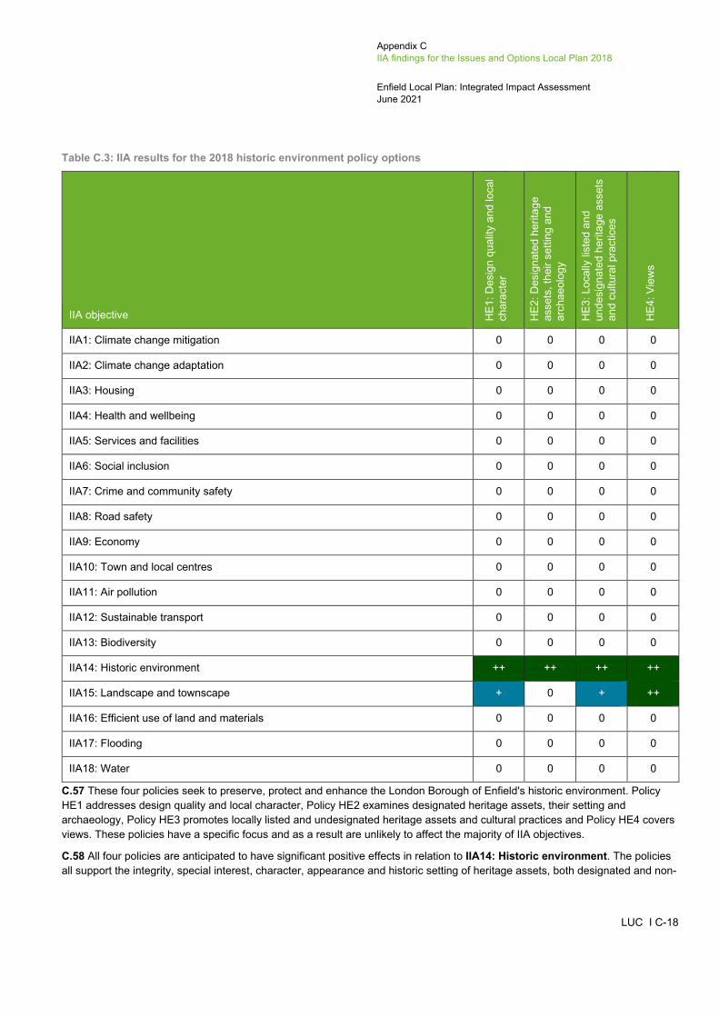
Appendix C IIA findings for the Issues and Options Local Plan 2018
Enfield Local Plan: Integrated Impact Assessment June 2021
LUC I C-18
Table C.3: IIA results for the 2018 historic environment policy options
IIA objective HE1
: Des
ign
qual
ity a
nd lo
cal
char
acte
r
HE2
: Des
igna
ted
herit
age
asse
ts, t
heir
setti
ng a
nd
arch
aeol
ogy
HE3
: Loc
ally
list
ed a
nd
unde
sign
ated
her
itage
ass
ets
and
cultu
ral p
ract
ices
HE4
: Vie
ws
IIA1: Climate change mitigation 0 0 0 0
IIA2: Climate change adaptation 0 0 0 0
IIA3: Housing 0 0 0 0
IIA4: Health and wellbeing 0 0 0 0
IIA5: Services and facilities 0 0 0 0
IIA6: Social inclusion 0 0 0 0
IIA7: Crime and community safety 0 0 0 0
IIA8: Road safety 0 0 0 0
IIA9: Economy 0 0 0 0
IIA10: Town and local centres 0 0 0 0
IIA11: Air pollution 0 0 0 0
IIA12: Sustainable transport 0 0 0 0
IIA13: Biodiversity 0 0 0 0
IIA14: Historic environment ++ ++ ++ ++
IIA15: Landscape and townscape + 0 + ++
IIA16: Efficient use of land and materials 0 0 0 0
IIA17: Flooding 0 0 0 0
IIA18: Water 0 0 0 0
C.57 These four policies seek to preserve, protect and enhance the London Borough of Enfield's historic environment. Policy HE1 addresses design quality and local character, Policy HE2 examines designated heritage assets, their setting and archaeology, Policy HE3 promotes locally listed and undesignated heritage assets and cultural practices and Policy HE4 covers views. These policies have a specific focus and as a result are unlikely to affect the majority of IIA objectives.
C.58 All four policies are anticipated to have significant positive effects in relation to IIA14: Historic environment. The policies all support the integrity, special interest, character, appearance and historic setting of heritage assets, both designated and non-

Appendix C IIA findings for the Issues and Options Local Plan 2018
Enfield Local Plan: Integrated Impact Assessment June 2021
LUC I C-19
designated. Policy HE2: Designated heritage assets, their setting and archaeology requires development proposals affecting a designated heritage asset, its setting or a property within a conservation area, to submit a Heritage Statement. Policies HE1: Design quality and local character and HE3: Locally listed and undesignated heritage assets and cultural practices also promote increasing access to and understanding of heritage, both in areas where heritage is underrepresented and with the general public. Furthermore, minor positive effects are anticipated for policies HE1: design quality and local character and HE3: Locally listed and undesignated heritage assets and cultural practices in relation to IIA15: Landscape and townscape as they both highlight the role that heritage assets play in forming and reinforcing a sense of local distinctiveness and character in Enfield Borough. A significant positive effect is also expected for Policy HE4: Views in relation to this objective as the policy seeks to protect strategic and local views. This is key as the view to and from natural or built assets enhances local distinctiveness and character.
C.59 Negligible effects are expected in relation to IIA1: Climate change mitigation, IIA2: Climate change adaptation, IIA3: Housing, IIA4: Health and wellbeing, IIA5: Services and facilities, IIA6: Social inclusion, IIA7: Crime and community safety, IIA8: Road safety, IIA9: Economy, IIA10: Town and local centres, IIA11: Air pollution, IIA12: Sustainable transport, IIA13: Biodiversity, IIA16: Efficient use of land and materials, IIA17: Flooding and IIA18: Water.
Design policy options
C.60 The likely sustainability effects of the design Policy approaches are set out in Table C.4 and described below the table.
Table C.4: IIA results for the 2018 design policy options
IIA objective D1:
Ach
ievi
ng d
esig
n ex
celle
nce
D2:
Cha
ract
er a
nd d
ensi
ty
D3:
Des
ign
for c
o-lo
catio
n an
d m
ixed
use
dev
elop
men
t
D4:
Des
igni
ng fo
r a
sust
aina
ble,
saf
e an
d in
clus
ive
Boro
ugh
IIA1: Climate change mitigation + 0 + ++
IIA2: Climate change adaptation 0 0 0 ++
IIA3: Housing ++ 0 ++ 0
IIA4: Health and wellbeing + 0 + ++
IIA5: Services and facilities 0 0 + 0
IIA6: Social inclusion + 0 0 0
IIA7: Crime and community safety + + 0 +
IIA8: Road safety 0 + 0 0
IIA9: Economy 0 0 0 0
IIA10: Town and local centres 0 0 0 0
IIA11: Air pollution + 0 + 0

Appendix C IIA findings for the Issues and Options Local Plan 2018
Enfield Local Plan: Integrated Impact Assessment June 2021
LUC I C-20
IIA objective D1:
Ach
ievi
ng d
esig
n ex
celle
nce
D2:
Cha
ract
er a
nd d
ensi
ty
D3:
Des
ign
for c
o-lo
catio
n an
d m
ixed
use
dev
elop
men
t
D4:
Des
igni
ng fo
r a
sust
aina
ble,
saf
e an
d in
clus
ive
Boro
ugh
IIA12: Sustainable transport ++ 0 ++ 0
IIA13: Biodiversity 0 0 0 0
IIA14: Historic environment 0 + 0 0
IIA15: Landscape and townscape ++ ++ 0 0
IIA16: Efficient use of land and materials + ++ ++ ++
IIA17: Flooding 0 0 0 +
IIA18: Water 0 0 0 0
C.61 These four policies seek to address good design in new developments. Policy D1 relates to achieving design excellence, Policy D2 covers character and density, Policy D3 addresses design for co-location and mixed use development and Policy D4 promotes design for a sustainable, safe, and inclusive Borough. These policies have a narrow focus and as a result are unlikely to adversely affect the IIA objectives.
C.62 Policy D4: Designing for a safe and inclusive Borough is expected to have significant positive effects in relation to IIA1: Climate change mitigation and IIA2: Climate change adaptation because it encourages use of the BRE Home Quality Mark, which could help reduce CO2 emissions associated with residential development, whilst directly promoting sustainable design and resilience to climate change environmental hazards and emergencies.
C.63 Policy D1: Achieving design excellence states that affordable homes must be designed to the same or higher standards as the private housing element of new developments, whilst also advocating the successful integration of different tenure types in new development. A significant positive effect is therefore expected for this policy in relation to IIA3: Housing. Further to this, the policy requires developments across the Borough to meet space standards, which will have beneficial effects on people's health and wellbeing. A minor positive effect is therefore expected in relation to IIA4: Health and wellbeing. Policy D3: Design for co-location and mixed use development promotes mixed use development and the co-location of different uses, which is an efficient use of space and also enables new homes to be built. A significant positive is therefore also expected for this policy in relation to IIA3: Housing. Policy D3: Design for co-location and mixed use development is also expected to have a minor positive effect in relation to IIA4: Health and wellbeing because when co-locating residential development or social infrastructure with industrial uses, consideration will be given to health and residential amenity. With the promotion of mixed use development, Policy D3: Design for co-location and mixed use development is also expected to have a minor positive effect in relation to IIA5: Services and facilities.
C.64 A minor positive effect is anticipated for Policy D1: Achieving design excellence in relation to IIA6: Social inclusion. Both the policy and its supporting text seek to improve design quality across all types of development and across all tenures, ensuring that affordable homes are designed to the same or higher standards as the private housing element of new developments. Through improving design quality in the Borough, it is anticipated that living standards will be improved for those in more deprived areas. Further to this, Policy D1: Achieving design excellence promotes pepper potting tenure mixes across

Appendix C IIA findings for the Issues and Options Local Plan 2018
Enfield Local Plan: Integrated Impact Assessment June 2021
LUC I C-21
housing sites to provide choice and opportunity for all. Policies D1: Achieving design excellence, D2: Character and density and D4: Designing for a safe and inclusive Borough are expected to have minor positive effects in relation to IIA7: Crime and community safety. This is because both policies D1 and D4 make reference to the role that design can play in creating sustainable and safe environments, whilst the supporting text to Policy D2 highlights the importance of ensuring tall, high rise buildings are safe from fire risk.
C.65 Significant positive effects are expected in relation to IIA12: Sustainable transport because policies D1: Achieving design excellence and D3: Design for co-location promote sustainable modes of transport. Policy D1 states that all developments must facilitate local movement, public access through sites, sustainable transport and easy way-finding, whilst Policy D3 and its supporting text promote mixed use development and co-location, as they can encourage healthier lifestyles through walking and cycling. Furthermore, encouraging more sustainable transport choices will help minimise air pollution and greenhouse gas emissions associated with use of the private car. As such, minor positive effects are expected for policies D1: Achieving design excellence and D3: Design for co-location and mixed use development in relation to IIA1: Climate change mitigation and IIA11: Air pollution. A minor positive effect is also anticipated with Policy D2: Character and density against IIA8: Road safety, as the policy states that the Council will refuse proposals which negatively impact road and pedestrian safety or traffic flow.
C.66 A significant positive is anticipated in relation to policies D1: Achieving design excellence and D2: Character and density in relation to IIA15: Landscape and townscape as both enhance the landscape and townscape in Enfield Borough. The supporting text of Policy D1: Achieving design excellence recognises the role that tall buildings play in generating a strong sense of place in the Borough, whilst Policy D2: Character and density states that the Council will seek to protect and build on the existing positive character and individual context of the Borough. Furthermore, Policy D2: Character and density also makes reference to protect Enfield Borough’s areas of historic value, therefore a minor positive is also expected in relation to Policy D2: Character and density and to IIA14: Historic Environment.
C.67 All four policies are expected to have positive effects in relation to IIA16: Efficient use of land and materials. Significant positive effects are expected for policies D2: Character and density, D3: Design for co-location and mixed use development and D4: Designing for a safe and inclusive Borough in relation to this objective, as all three policies promote efficient use of land. Policy D2: Character and density promotes small scale infill and extension developments, whilst Policy D3: Design for co-location and mixed use development promotes mixed use development, as well as the co-location of different uses. Policy D4: Designing for a safe and inclusive Borough encourages sustainable design policies and standards in development proposals, by maximising possibilities for the reuse of materials and minimise waste generated during the construction of development. The supporting text to Policy D1: Achieving design excellence states that brownfield land must be used efficiently through infill and extension development. A minor positive effect is therefore expected for Policy D1: Achieving design excellence in relation to IIA16: Efficient use of land and materials.
C.68 Finally, whilst the topic of flooding is not directly referenced in Policy D4: Designing for a safe and inclusive Borough, the promotion of sustainable and resilient design is likely to positively affect IIA17: Flooding. A minor positive is therefore expected in relation to this objective.
C.69 Negligible effects are expected in relation to IIA9: Economy, IIA10: Town and local centres, IIA13: Biodiversity and IIA18: Water.
Housing policy options
C.70 The likely sustainability effects of the housing policy approaches are set out in Table C.5 and described below the table.

Appendix C IIA findings for the Issues and Options Local Plan 2018
Enfield Local Plan: Integrated Impact Assessment June 2021
LUC I C-22
Table C.5: IIA results for the 2018 housing policy options
IIA objective H1:
Hou
sing
gro
wth
and
qu
ality
H2:
Affo
rdab
le h
ousi
ng
H3:
Sm
all s
ites
H4:
Hou
sing
mix
H5:
Priv
ate
rent
ed s
ecto
r and
bu
ild-to
-rent
H6:
Cus
tom
and
sel
f-bui
ld
hous
ing
H7:
Sup
porte
d an
d sp
ecia
list
hous
ing
H8:
Gyp
sy a
nd tr
avel
ler
acco
mm
odat
ion
IIA1: Climate change mitigation + 0 + 0 0 0 + 0
IIA2: Climate change adaptation 0 0 0 0 0 0 0 0
IIA3: Housing ++ ++ ++ ++ ++ ++ ++ ++
IIA4: Health and wellbeing 0 0 0 0 0 0 0 0
IIA5: Services and facilities 0 0 0 0 0 0 + +
IIA6: Social inclusion 0 + 0 0 0 + + 0
IIA7: Crime and community safety 0 0 0 0 0 0 0 0
IIA8: Road safety 0 0 0 0 0 0 0 0
IIA9: Economy + + + + + + + +
IIA10: Town and local centres 0 0 0 0 0 0 0 0
IIA11: Air pollution + 0 + 0 0 0 + 0
IIA12: Sustainable transport + 0 + 0 0 0 + 0
IIA13: Biodiversity + 0 0 0 0 0 0 0
IIA14: Historic environment + 0 0 0 0 0 0 0
IIA15: Landscape and townscape + 0 0 0 0 +?/-? 0 0
IIA16: Efficient use of land and materials ++ 0 ++ 0 0 0 0 0
IIA17: Flooding 0 0 0 0 0 0 0 +
IIA18: Water 0 0 0 0 0 0 0 0
C.71 All housing policy options will contribute to a sufficient supply of homes in the Borough and seek to ensure that the mixed demands of a growing population are met by a variety of housing sizes, types, tenures, and specialist accommodation. These policies would directly address the identified key sustainability issues of a deficiency in housing supply and availability of affordable housing across LBE and, therefore, significant positive effects are expected in relation to IIA3: Housing. These policies will also support the local economy by ensuring that opportunities for housing development and therefore commerce and employment are secured. Therefore, minor positive effects are expected in relation to IIA9: Economy.
Appendix C IIA findings for the Issues and Options Local Plan 2018
Enfield Local Plan: Integrated Impact Assessment June 2021
LUC I C-23
C.72 Policy H7: Supported and specialist housing will ensure that development contributes to the creation of inclusive and sustainable neighbourhoods and offers easy access to community facilities, public transport, and other services and facilities. Therefore, minor positive effects are expected against IIA5: Services and facilities and IIA6: Social inclusion in relation to this policy. A minor positive effect is also expected against IIA6: Social inclusion in relation to Policy H2: Affordable housing, as the policy is likely to improve social inclusion through mixed residential schemes that include both market and affordable housing. The provision of affordable housing will also help to address inequalities between different groups of people in the Borough, particularly in regard to the divide between the east and west of the Borough, which has been identified as a key sustainability issue. Policy H6: Custom and self-build housing is expected to have a minor positive effect in relation to IIA6: Social inclusion because it enables people to design a home to suit their needs, which may include specialist needs.
C.73 Policy H8: Gypsy and traveller accommodation will ensure that the development of new or existing gypsy and traveller accommodation has good access to services and facilities and supports development of these sites within Flood Zone 1, thereby reducing the risk of damage to people and property, resulting in minor positive effects against II5: Services and facilities and IIA17: Flooding.
C.74 Policy H1: Housing growth and quality seeks to prioritise the delivery of new homes around the emerging growth and investment areas outlined in Chapter 2 of the Issues and Options Local Plan. Therefore, the policy promotes more compact development where people will be located closer to other development including employment centres and may be able to walk or cycle to local services/facilities and workplaces. Policy H3: Small sites will encourage housing delivery and intensification on small sites with good accessibility to public transport and the Borough's town centres. In addition, Policy H7: Supported and specialist housing sets out the Council's approach to meeting the specialist needs of more vulnerable people such as the elderly. The policy seeks to ensure that development proposals are accessible to public transport, workplaces, shops, and other services and facilities. This is likely to reduce the reliance on private vehicles and encourage the use of public transport. These policies would therefore promote and facilitate the use of more sustainable modes of transport, including walking, cycling, and public transport, and reduce vehicular emissions in the Borough. As such, minor positive effects are expected against IIA1: Climate change mitigation, IIA11: Air pollution and IIA12: Sustainable transport in relation to these policies.
C.75 Individuals wishing to self/custom build their home rather than buy it from a traditional housebuilder are likely to be motivated by a desire to have greater influence on the design and layout, and to have the ability to create a home to suit their individual needs and aspirations. In seeking to provide the flexibility for this to happen, there is a risk that Policy H6: Custom and self-build housing, which facilitates provision of new homes via self and custom build, could result in inappropriate design and layout (e.g. inconsistent with surrounding landscape and townscape) with potential minor negative effects in relation to IIA15: Landscape and townscape. On the other hand, the variations in design may enhance the landscape and townscape. It is noted that these developments would also be subject to the requirements of the Design policies, which seek to avoid adverse impacts. Therefore, the effect is mixed with a minor positive effect and recorded as uncertain.
C.76 Policy H1: Housing growth and quality seeks to promote higher density development in suitable, accessible locations as well as ensure that vacant and new homes are occupied, while Policy H3: Small sites will encourage infill development on vacant or underused sites as well as the redevelopment of flats and non-residential buildings in order to deliver additional housing. As such, significant positive effects are expected against IIA16: Efficient use of land and materials.
C.77 Negligible effects are expected in relation to IIA2: Climate change adaptation, IIA4: Health and wellbeing, IIA7: Crime and community safety, IIA8: Road safety, IIA10: Town and local centres and IIA18: Water.
Economy policy options
C.78 The likely sustainability effects of the economy policy approaches are set out in Table C.6 and described below the table.
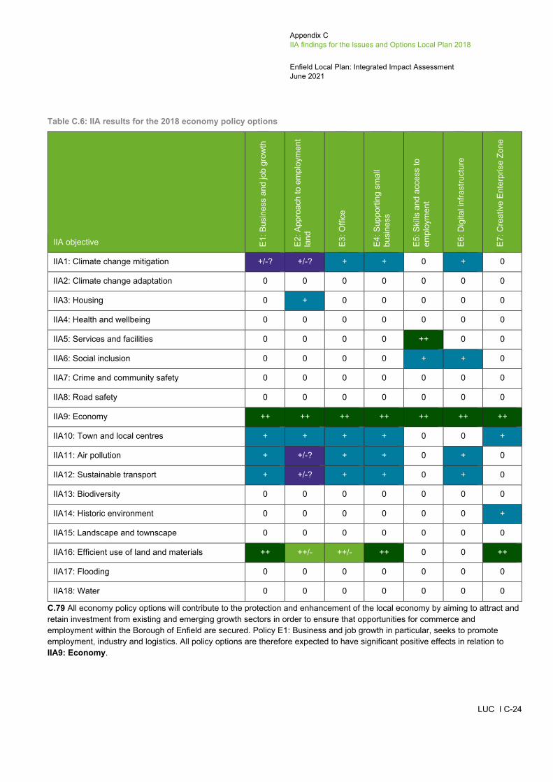
Appendix C IIA findings for the Issues and Options Local Plan 2018
Enfield Local Plan: Integrated Impact Assessment June 2021
LUC I C-24
Table C.6: IIA results for the 2018 economy policy options
IIA objective E1: B
usin
ess
and
job
grow
th
E2: A
ppro
ach
to e
mpl
oym
ent
land
E3: O
ffice
E4: S
uppo
rting
sm
all
busi
ness
E5: S
kills
and
acc
ess
to
empl
oym
ent
E6: D
igita
l inf
rast
ruct
ure
E7: C
reat
ive
Ente
rpris
e Zo
ne
IIA1: Climate change mitigation +/-? +/-? + + 0 + 0
IIA2: Climate change adaptation 0 0 0 0 0 0 0
IIA3: Housing 0 + 0 0 0 0 0
IIA4: Health and wellbeing 0 0 0 0 0 0 0
IIA5: Services and facilities 0 0 0 0 ++ 0 0
IIA6: Social inclusion 0 0 0 0 + + 0
IIA7: Crime and community safety 0 0 0 0 0 0 0
IIA8: Road safety 0 0 0 0 0 0 0
IIA9: Economy ++ ++ ++ ++ ++ ++ ++
IIA10: Town and local centres + + + + 0 0 +
IIA11: Air pollution + +/-? + + 0 + 0
IIA12: Sustainable transport + +/-? + + 0 + 0
IIA13: Biodiversity 0 0 0 0 0 0 0
IIA14: Historic environment 0 0 0 0 0 0 +
IIA15: Landscape and townscape 0 0 0 0 0 0 0
IIA16: Efficient use of land and materials ++ ++/- ++/- ++ 0 0 ++
IIA17: Flooding 0 0 0 0 0 0 0
IIA18: Water 0 0 0 0 0 0 0
C.79 All economy policy options will contribute to the protection and enhancement of the local economy by aiming to attract and retain investment from existing and emerging growth sectors in order to ensure that opportunities for commerce and employment within the Borough of Enfield are secured. Policy E1: Business and job growth in particular, seeks to promote employment, industry and logistics. All policy options are therefore expected to have significant positive effects in relation to IIA9: Economy.

Appendix C IIA findings for the Issues and Options Local Plan 2018
Enfield Local Plan: Integrated Impact Assessment June 2021
LUC I C-25
C.80 Policies E1: Business and job growth, E2: Approach to employment land and E3: Office will ensure that employment growth is focused on emerging growth and investment areas including town centres, as well as intensified at Strategic Industrial Land (SIL) and Locally Significant Industrial Sites (LSIS) in order to support economic growth and a higher job density and to achieve more efficient use of employment land. In addition, Policy E4: Supporting small business will support existing and new businesses in the Borough through the provision of new business floorspace in mixed use or commercial schemes with particular consideration for development within town centres, and Policy E7: Creative Enterprise Zone will encourage the temporary use of vacant buildings and sites for creative workspace and industries. These policies would therefore promote more compact development patterns and encourage the efficient use of land within the Borough, including within the town centres. As such, minor positive effects are expected against IIA10: Town and local centres and significant positive effects are expected against IIA16: Efficient use of land and materials. By supporting more compact development and proposals for mixed-use development, policies E1 to E4 would also reduce the need to travel within the Borough and are therefore likely to result in minor positive effects in relation to IIA1: Climate change mitigation and IIA11: Air pollution, as well as IIA12: Sustainable transport.
C.81 Policies E2: Approach to employment land and E3: Office state that they will support floorspace for new purpose built office and business accommodation throughout the Borough. Although this will be focused within growth and investment areas and other land previously identified for employment purposes, these policies may result in the use of previously unused land. As such, minor negative effects are expected in relation to IIA16: Efficient use of land and materials, resulting in mixed significant positive and minor negative effects for policies E2: Approach to employment land and E3: Office.
C.82 Policy E2: Approach to employment will support mixed-use, employment-led schemes which include housing, as long as the uses are compatible. As such, a minor positive effect is expected against IIA3: Housing in relation to this policy.
C.83 Policy E5: Skills and access to employment will seek to enhance the employability and long-term employment prospects for all residents, regardless of health or disability. The policy states that it will provide support for improvements to skills and educational attainment, as well as childcare and training provision. The policy also seeks to increase the proportion of under-represented groups within the construction industry workforce. In addition, the policy supports the development of educational facilities and the provision of new training opportunities, skills development and apprenticeships. Therefore, this policy is likely to provide a higher number of residents with access to services in the District, with a significant positive effect is expected against IIA5: Services and facilities in relation to this policy. In addition, Policy E6: Digital infrastructure sets out the approach of the Council to promote the development of high quality communications infrastructure in order to support economic growth and more accessible and inclusive communities. The policy is therefore likely to reduce social exclusion in the Borough, resulting in minor positive effects in relation to IIA6: Social inclusion.
C.84 In addition, Policy E5: Skills and access to employment states that the Council will work with their partners to enhance the employability and long-term employment prospects for all residents within Enfield, regardless of health or disability status. As such, a minor positive effect is expected against IIA6: Social inclusion in relation to this policy.
C.85 Policy E2: Approach to employment land states that the Council will support further development of Strategic Industrial Locations (SIL) and Locally Significant Industrial Sites (LSIS), as well as development at new locations that are accessible to the strategic road network. This could result in increased pressure on the transport system and potential traffic congestion, as well as potential impacts on air pollution which has been identified as a key sustainability issue in the Borough. As such, minor negative effects are expected against IIA1: Climate change mitigation, IIA11: Air pollution, and IIA12: Sustainable transport. However, the policy will also seek to ensure that impacts on the transport network as a result of development within LSIS are mitigated. As such, these effects are uncertain as the potential negative impacts are dependent on the implementation of mitigation measures. As a result, uncertain mixed minor positive and minor negative effects are expected against IIA1: Climate change mitigation, IIA11: Air pollution and IIA12: Sustainable transport in relation to Policy E2: Approach to employment land.
C.86 In addition, Policy E6: Digital infrastructure sets out the Council's approach to promoting the development of high quality communications infrastructure and will improve digital connectivity. The policy is therefore likely to encourage people to work from home, reducing the need to travel and the use of private vehicles. As such, minor positive effects are expected in relation to IIA1: Climate change mitigation, IIA11: Air pollution and IIA12: Sustainable transport.
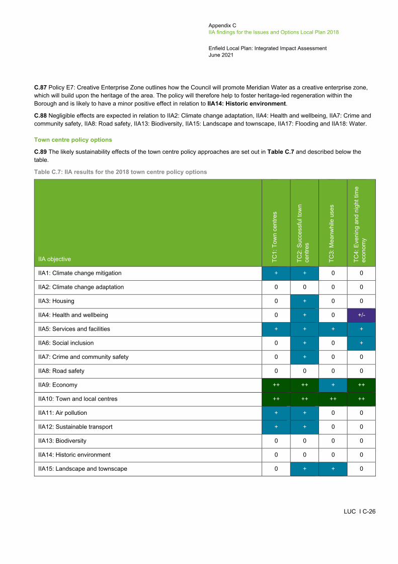
Appendix C IIA findings for the Issues and Options Local Plan 2018
Enfield Local Plan: Integrated Impact Assessment June 2021
LUC I C-26
C.87 Policy E7: Creative Enterprise Zone outlines how the Council will promote Meridian Water as a creative enterprise zone, which will build upon the heritage of the area. The policy will therefore help to foster heritage-led regeneration within the Borough and is likely to have a minor positive effect in relation to IIA14: Historic environment.
C.88 Negligible effects are expected in relation to IIA2: Climate change adaptation, IIA4: Health and wellbeing, IIA7: Crime and community safety, IIA8: Road safety, IIA13: Biodiversity, IIA15: Landscape and townscape, IIA17: Flooding and IIA18: Water.
Town centre policy options
C.89 The likely sustainability effects of the town centre policy approaches are set out in Table C.7 and described below the table.
Table C.7: IIA results for the 2018 town centre policy options
IIA objective TC1:
Tow
n ce
ntre
s
TC2:
Suc
cess
ful t
own
cent
res
TC3:
Mea
nwhi
le u
ses
TC4:
Eve
ning
and
nig
ht ti
me
econ
omy
IIA1: Climate change mitigation + + 0 0
IIA2: Climate change adaptation 0 0 0 0
IIA3: Housing 0 + 0 0
IIA4: Health and wellbeing 0 + 0 +/-
IIA5: Services and facilities + + + +
IIA6: Social inclusion 0 + 0 +
IIA7: Crime and community safety 0 + 0 0
IIA8: Road safety 0 0 0 0
IIA9: Economy ++ ++ + ++
IIA10: Town and local centres ++ ++ ++ ++
IIA11: Air pollution + + 0 0
IIA12: Sustainable transport + + 0 0
IIA13: Biodiversity 0 0 0 0
IIA14: Historic environment 0 0 0 0
IIA15: Landscape and townscape 0 + + 0
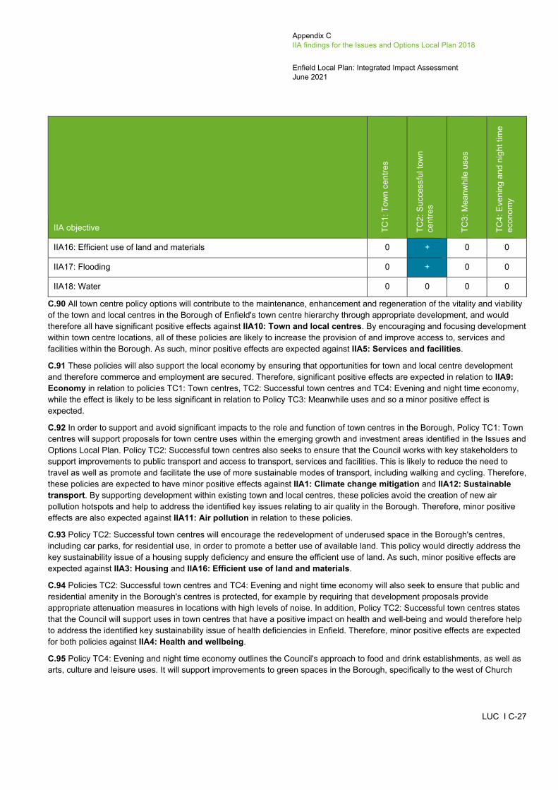
Appendix C IIA findings for the Issues and Options Local Plan 2018
Enfield Local Plan: Integrated Impact Assessment June 2021
LUC I C-27
IIA objective TC1:
Tow
n ce
ntre
s
TC2:
Suc
cess
ful t
own
cent
res
TC3:
Mea
nwhi
le u
ses
TC4:
Eve
ning
and
nig
ht ti
me
econ
omy
IIA16: Efficient use of land and materials 0 + 0 0
IIA17: Flooding 0 + 0 0
IIA18: Water 0 0 0 0
C.90 All town centre policy options will contribute to the maintenance, enhancement and regeneration of the vitality and viability of the town and local centres in the Borough of Enfield's town centre hierarchy through appropriate development, and would therefore all have significant positive effects against IIA10: Town and local centres. By encouraging and focusing development within town centre locations, all of these policies are likely to increase the provision of and improve access to, services and facilities within the Borough. As such, minor positive effects are expected against IIA5: Services and facilities.
C.91 These policies will also support the local economy by ensuring that opportunities for town and local centre development and therefore commerce and employment are secured. Therefore, significant positive effects are expected in relation to IIA9: Economy in relation to policies TC1: Town centres, TC2: Successful town centres and TC4: Evening and night time economy, while the effect is likely to be less significant in relation to Policy TC3: Meanwhile uses and so a minor positive effect is expected.
C.92 In order to support and avoid significant impacts to the role and function of town centres in the Borough, Policy TC1: Town centres will support proposals for town centre uses within the emerging growth and investment areas identified in the Issues and Options Local Plan. Policy TC2: Successful town centres also seeks to ensure that the Council works with key stakeholders to support improvements to public transport and access to transport, services and facilities. This is likely to reduce the need to travel as well as promote and facilitate the use of more sustainable modes of transport, including walking and cycling. Therefore, these policies are expected to have minor positive effects against IIA1: Climate change mitigation and IIA12: Sustainable transport. By supporting development within existing town and local centres, these policies avoid the creation of new air pollution hotspots and help to address the identified key issues relating to air quality in the Borough. Therefore, minor positive effects are also expected against IIA11: Air pollution in relation to these policies.
C.93 Policy TC2: Successful town centres will encourage the redevelopment of underused space in the Borough's centres, including car parks, for residential use, in order to promote a better use of available land. This policy would directly address the key sustainability issue of a housing supply deficiency and ensure the efficient use of land. As such, minor positive effects are expected against IIA3: Housing and IIA16: Efficient use of land and materials.
C.94 Policies TC2: Successful town centres and TC4: Evening and night time economy will also seek to ensure that public and residential amenity in the Borough's centres is protected, for example by requiring that development proposals provide appropriate attenuation measures in locations with high levels of noise. In addition, Policy TC2: Successful town centres states that the Council will support uses in town centres that have a positive impact on health and well-being and would therefore help to address the identified key sustainability issue of health deficiencies in Enfield. Therefore, minor positive effects are expected for both policies against IIA4: Health and wellbeing.
C.95 Policy TC4: Evening and night time economy outlines the Council's approach to food and drink establishments, as well as arts, culture and leisure uses. It will support improvements to green spaces in the Borough, specifically to the west of Church
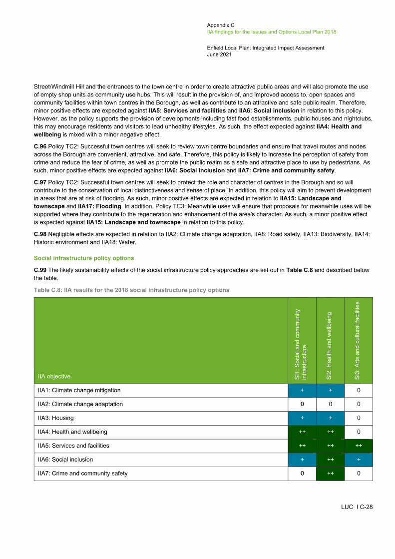
Appendix C IIA findings for the Issues and Options Local Plan 2018
Enfield Local Plan: Integrated Impact Assessment June 2021
LUC I C-28
Street/Windmill Hill and the entrances to the town centre in order to create attractive public areas and will also promote the use of empty shop units as community use hubs. This will result in the provision of, and improved access to, open spaces and community facilities within town centres in the Borough, as well as contribute to an attractive and safe public realm. Therefore, minor positive effects are expected against IIA5: Services and facilities and IIA6: Social inclusion in relation to this policy. However, as the policy supports the provision of developments including fast food establishments, public houses and nightclubs, this may encourage residents and visitors to lead unhealthy lifestyles. As such, the effect expected against IIA4: Health and wellbeing is mixed with a minor negative effect.
C.96 Policy TC2: Successful town centres will seek to review town centre boundaries and ensure that travel routes and nodes across the Borough are convenient, attractive, and safe. Therefore, this policy is likely to increase the perception of safety from crime and reduce the fear of crime, as well as promote the public realm as a safe and attractive place to use by pedestrians. As such, minor positive effects are expected against IIA6: Social inclusion and IIA7: Crime and community safety.
C.97 Policy TC2: Successful town centres will seek to protect the role and character of centres in the Borough and so will contribute to the conservation of local distinctiveness and sense of place. In addition, this policy will aim to prevent development in areas that are at risk of flooding. As such, minor positive effects are expected in relation to IIA15: Landscape and townscape and IIA17: Flooding. In addition, Policy TC3: Meanwhile uses will ensure that proposals for meanwhile uses will be supported where they contribute to the regeneration and enhancement of the area's character. As such, a minor positive effect is expected against IIA15: Landscape and townscape in relation to this policy.
C.98 Negligible effects are expected in relation to IIA2: Climate change adaptation, IIA8: Road safety, IIA13: Biodiversity, IIA14: Historic environment and IIA18: Water.
Social infrastructure policy options
C.99 The likely sustainability effects of the social infrastructure policy approaches are set out in Table C.8 and described below the table.
Table C.8: IIA results for the 2018 social infrastructure policy options
IIA objective SI1:
Soc
ial a
nd c
omm
unity
in
frast
ruct
ure
SI2:
Hea
lth a
nd w
ellb
eing
SI3:
Arts
and
cul
tura
l fac
ilitie
s
IIA1: Climate change mitigation + + 0
IIA2: Climate change adaptation 0 0 0
IIA3: Housing + + 0
IIA4: Health and wellbeing ++ ++ 0
IIA5: Services and facilities ++ ++ ++
IIA6: Social inclusion + ++ +
IIA7: Crime and community safety 0 ++ 0

Appendix C IIA findings for the Issues and Options Local Plan 2018
Enfield Local Plan: Integrated Impact Assessment June 2021
LUC I C-29
IIA objective SI1:
Soc
ial a
nd c
omm
unity
in
frast
ruct
ure
SI2:
Hea
lth a
nd w
ellb
eing
SI3:
Arts
and
cul
tura
l fac
ilitie
s
IIA8: Road safety 0 ++ 0
IIA9: Economy + + +
IIA10: Town and local centres ++ 0 +
IIA11: Air pollution + ++ 0
IIA12: Sustainable transport ++ + 0
IIA13: Biodiversity 0 + 0
IIA14: Historic environment 0 0 0
IIA15: Landscape and townscape + 0 0
IIA16: Efficient use of land and materials + 0 0
IIA17: Flooding 0 0 0
IIA18: Water 0 0 0
C.100 These three policies seek to increase the provision of social infrastructure in the Borough. Policy SI1 relates to social and community infrastructure, Policy SI2 covers health and wellbeing and Policy SI3 addresses arts and cultural facilities.
C.101 Policies SI1: Social and community infrastructure and SI2: Health and wellbeing are expected to have minor positive effects in relation to IIA3: Housing. This is because Policy SI1 encourages mixed use development, including housing to support viability, security and efficient land use, whilst Policy SI2 states that future development proposals must include measures to improve housing quality. Whilst this is in the context of improving health outcomes, it is thought that this policy will improve the general condition of housing stock in the Borough.
C.102 Policies SI1: Social and community infrastructure and SI2: Health and wellbeing are expected to have significant positive effects in relation to IIA4: Health and wellbeing. Policy SI1 seeks to prioritise the provision of community health facilities and services, whilst Policy SI2 states that development proposals must incorporate measures to improve public health i.e. promote healthy eating and create new/improved health facilities. Significant positive effects are also expected in relation to policies SI1: Social and community infrastructure, SI2: Health and wellbeing and SI3: Arts and cultural facilities in relation to IIA5: Services and facilities, as all three policies support improved access to services, facilities and wider community infrastructure. Policy SI1: Social and community infrastructure encourages development and modernisation of new and existing social infrastructure in the Borough, including educational facilities, as well as supporting the investment plans of educational bodies to expand and enhance their operations within the Borough. Policy SI2: Health and wellbeing highlights the key role that development proposals must play in recognising and promoting access to community facilities. Policy SI3: Arts and cultural facilities seeks to enhance existing arts, cultural, entertainment, leisure, recreation and sport uses in venues across the Borough.
Appendix C IIA findings for the Issues and Options Local Plan 2018
Enfield Local Plan: Integrated Impact Assessment June 2021
LUC I C-30
C.103 A minor positive effect is anticipated for policies SI1: Social and community infrastructure and SI3: Arts and cultural facilities in relation to IIA6: Social inclusion, as they both promote the need for community facilities to be accessible, welcoming, inclusive and open and available to all members of the local community. Policy SI2: Health and wellbeing is also expected to have a significant positive effect in relation to this objective because it requires development proposals to directly respond to issues surrounding poverty and inequality in the Borough. The policy also references the need for new or improved, or access to inclusive open space for local communities. Policy SI2: Health and wellbeing is also expected to have a significant positive in relation to IIA7: Crime and community safety because it highlights the role that development proposals must have in responding to issues surrounding crime through better urban design and housing mix.
C.104 Policy SI1: Social and community infrastructure and its supporting text highlight the need for community facilities to be located in places that are or will be accessible by a range of sustainable means of transport, including walking and cycling. They also promote the co-location of facilities and services, encouraging journeys to be undertaken by sustainable modes of transport. A significant positive effect is therefore expected in relation to IIA12: Sustainable transport. Similarly, Policy SI2: Health and wellbeing states that development proposals must recognise the importance of facilitating and promoting walking and cycling in future developments. As this policy promotes sustainable modes of transport in new developments, a minor positive effect is also expected in relation to IIA12: Sustainable transport. Furthermore, encouraging more sustainable transport choices will help minimise air pollution and greenhouse gas emissions associated with use of the private car. As such, minor positive effects can be expected for both policies in relation to IIA1: Climate change mitigation and for Policy SI1: Social and community infrastructure in relation to IIA11: Air pollution. Policy SI2: Health and wellbeing is anticipated to have a significant positive effect in relation to IIA11: Air pollution as the policy also includes reference to improving Enfield Borough's air quality and reducing exposure to airborne pollutants.
C.105 Minor positive effects are anticipated for all policies in relation to IIA9: Economy. Policy SI1: Social and community infrastructure promotes the development and retention of educational community facilities, which will help produce a skilled workforce with greater access to employment opportunities. Likewise, Policy SI2: Health and wellbeing states that development proposals must respond to issues surrounding improving employment in the Borough. This may subsequently result in the generation of new local employment. Further to this, Policy SI1: Social and community infrastructure states that town centres and areas with good accessibility will be prioritised for the location of community facilities, where they will help to promote access to services across the Borough. A significant positive effect is therefore expected for Policy SI1: Social and community infrastructure in relation to IIA10: Town and local centres. Policy SI3: Arts and cultural facilities also directly supports the development of arts, cultural, entertainment, leisure and sport uses in the Borough, which could have beneficial effects on the economy by attracting more visitors to the area. For this reason, a minor positive effect is expected in relation to IIA10: Town and local centres, as the policy promotes the protection and enhancement of locations for cultural activities in the Borough, which tend to be located within the town and local centres.
C.106 Whilst in the context of improving health outcomes, Policy SI2: Health and wellbeing encourages access to food growing and blue and green spaces in the Borough. The provision of such spaces would increase and strengthen LBE's ecological/green infrastructure networks. A minor positive is therefore expected in relation to IIA13: Biodiversity.
C.107 Policy SI1: Social and community infrastructure states that development proposals must be outwardly looking, address the street and neighbourhood in their design. A minor positive effect is therefore expected in relation to IIA15: Landscape and townscape, as the policy seeks to enhance the landscape and townscape of the Borough through appropriate layout and design. Finally, a minor positive effect is anticipated in relation to Policy SI1: Social and community infrastructure and IIA16: Efficient use of land and materials, as it supports the co-location of facilities and services in the Borough and encourages mixed use formats to support the viability, security and efficient use of land.
C.108 Negligible effects are expected in relation to IIA2: Climate change adaptation, IIA14: Historic environment, IIA17: Flooding and IIA18: Water.
Green infrastructure policy options
C.109 The likely sustainability effects of the green infrastructure policy approaches are set out in Table C.9 and described below the table.
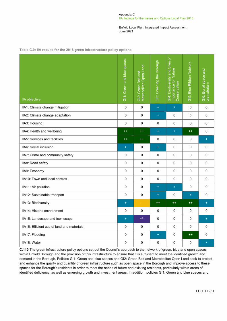
Appendix C IIA findings for the Issues and Options Local Plan 2018
Enfield Local Plan: Integrated Impact Assessment June 2021
LUC I C-31
Table C.9: IIA results for the 2018 green infrastructure policy options
IIA objective GI1
: Gre
en a
nd b
lue
spac
es
GI2
: Gre
en B
elt a
nd
Met
ropo
litan
Ope
n La
nd
GI3
: Gre
enin
g th
e Bo
roug
h
GI4
: Bio
dive
rsity
and
Site
s of
Im
porta
nce
for N
atur
e C
onse
rvat
ion
GI5
: Blu
e R
ibbo
n N
etw
ork
GI6
: Bur
ial s
pace
and
cr
emat
oriu
m
IIA1: Climate change mitigation 0 0 + + 0 0
IIA2: Climate change adaptation 0 0 + 0 0 0
IIA3: Housing 0 0 0 0 0 0
IIA4: Health and wellbeing ++ ++ + + ++ 0
IIA5: Services and facilities ++ ++ 0 0 0 +
IIA6: Social inclusion + 0 + 0 0 0
IIA7: Crime and community safety 0 0 0 0 0 0
IIA8: Road safety 0 0 0 0 0 0
IIA9: Economy 0 0 0 0 0 0
IIA10: Town and local centres 0 0 0 0 0 0
IIA11: Air pollution 0 0 + + 0 0
IIA12: Sustainable transport 0 0 + 0 + 0
IIA13: Biodiversity + - ++ ++ ++ +
IIA14: Historic environment 0 0 0 0 0 0
IIA15: Landscape and townscape + +/- 0 0 0 +
IIA16: Efficient use of land and materials 0 0 0 0 0 0
IIA17: Flooding 0 0 + 0 ++ 0
IIA18: Water 0 0 0 0 0 +
C.110 The green infrastructure policy options set out the Council's approach to the network of green, blue and open spaces within Enfield Borough and the provision of this infrastructure to ensure that it is sufficient to meet the identified growth and demand in the Borough. Policies GI1: Green and blue spaces and GI2: Green Belt and Metropolitan Open Land seek to protect and enhance the quality and quantity of green infrastructure such as open space in the Borough and improve access to these spaces for the Borough's residents in order to meet the needs of future and existing residents, particularly within areas of identified deficiency, as well as emerging growth and investment areas. In addition, policies GI1: Green and blue spaces and
Appendix C IIA findings for the Issues and Options Local Plan 2018
Enfield Local Plan: Integrated Impact Assessment June 2021
LUC I C-32
GI2: Green Belt and Metropolitan Open Land will seek to promote the multifunctional and shared use of open space and the provision of new outdoor leisure facilities, whilst also supporting development that improves access to the Green Belt for beneficial uses including outdoor sport and recreation. These policies would therefore promote sports, active recreation and more healthy lifestyles, and would enable development in the Borough to address identified key sustainability issues including the imbalance of green space availability between the east and west of the Borough and health issues relating to access to green spaces and obesity. As a result, these policies are expected to have significant positive effects against IIA4: Health and wellbeing and IIA5: Services and facilities. Policy GI1: Green and blue spaces also has the potential to increase spontaneous social interaction between members of the public in areas of public open space, with a minor positive effect expected against IIA6: Social inclusion.
C.111 Policies GI3: Greening the borough and GI4: Biodiversity and Sites of Importance for Nature Conservation outline the Council's approach to the protection and enhancement of the Borough's natural environment and will seek to enhance biodiversity through the retention and provision of trees, greening of the public realm, as well as improvements to access, connectivity and creation of new habitats. An increase in the quality and quantity of green infrastructure and vegetation would contribute to the improvement of local air quality in the Borough, bringing both physical and mental health benefits to residents. As such, minor positive effects are expected against IIA1: Climate change mitigation, IIA4: Health and wellbeing and IIA11: Air pollution, while significant positive effects are expected against IIA13: Biodiversity in relation to these policies. Policy GI1: Green and blue spaces is also expected to have a significant positive effect in relation to IIA13: Biodiversity because it seeks to enhance the quality of open space, which includes green open space. Policy GI2: Green Belt and Metropolitan Open Land, on the other hand, may have a minor negative effect in relation to IIA13: Biodiversity because supporting development which improves access to Green Belt areas could result in adverse effects on biodiversity as a result of increased recreational activity. The provision of green infrastructure such as trees, particularly at the roadside as set out within Policy GI3: Greening the borough, would contribute to the creation of attractive streets that encourage residents to walk and cycle. The supporting text to Policy GI3: Greening the borough also makes reference to softer landscaping and states that increasing the number of trees can help to reduce the impact of higher summer temperatures and reduce rainfall run-off rates, which will contribute to reducing the risk of surface water flooding. This policy will also maximise the provision of gardens and garden space, with the supporting text making a particular reference to community gardens and allotments, which play an important role in social cohesion. Therefore, minor positive effects are expected against IIA2: Climate change adaptation, IIA6: Social inclusion, IIA12: Sustainable transport and IIA17: Flooding in relation to Policy GI3: Greening the borough.
C.112 The Council's approach to the protection and enhancement of the Boroughs 'Blue Ribbon Network' is set out within Policy GI5: Blue Ribbon Network, which recognises the importance of the multi-functional role that rivers and waterways play and contribute to the Borough. The policy will seek to promote the enhancement of waterways and improve access to them through the provision of infrastructure that supports walking, cycling, leisure and recreation, as well as river-based transport, providing alternative modes of transport that may contribute to the alleviation of road traffic congestion. This policy is therefore likely to have a significant positive effect in relation to IIA4: Health and wellbeing and a minor positive effect in relation to IIA12: Sustainable transport. Policy GI5: Blue Ribbon Network recognises the role that the Blue Ribbon Network of waterbodies in the Borough plays in flood and surface water management by seeking to safeguard access to flood defences and promoting the use of sustainable drainage systems in new developments. The policy also recognises the importance of the network to biodiversity and will ensure that habitats in the network are protected and that adverse impacts on waterside environments and waterbodies in the Borough. As such, significant positive effects are expected in relation to IIA13: Biodiversity and IIA17: Flooding.
C.113 Policy GI6: Burial space and crematorium will seek to identify and meet the requirements of religious groups in regard to burial provision and ensure that burial space shortages are addressed where they are identified. The supporting text highlights the importance of these spaces in providing green, quiet areas for people, and in contributing to biodiversity within the Borough. Through the protection of existing land and the provision of new land for burial grounds and crematoriums, this policy will maintain and improve access to key facilities and religious places as well as provide opportunities for biodiversity enhancement in LBE. Therefore, minor positive effects are expected against IIA5: Services and facilities and IIA13: Biodiversity. A minor positive effect is also expected in relation to IIA15: Landscapes and townscapes because the policy seeks to maintain the landscape when providing new burial space.
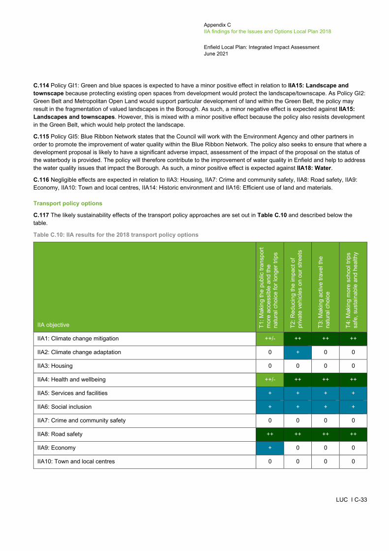
Appendix C IIA findings for the Issues and Options Local Plan 2018
Enfield Local Plan: Integrated Impact Assessment June 2021
LUC I C-33
C.114 Policy GI1: Green and blue spaces is expected to have a minor positive effect in relation to IIA15: Landscape and townscape because protecting existing open spaces from development would protect the landscape/townscape. As Policy GI2: Green Belt and Metropolitan Open Land would support particular development of land within the Green Belt, the policy may result in the fragmentation of valued landscapes in the Borough. As such, a minor negative effect is expected against IIA15: Landscapes and townscapes. However, this is mixed with a minor positive effect because the policy also resists development in the Green Belt, which would help protect the landscape.
C.115 Policy GI5: Blue Ribbon Network states that the Council will work with the Environment Agency and other partners in order to promote the improvement of water quality within the Blue Ribbon Network. The policy also seeks to ensure that where a development proposal is likely to have a significant adverse impact, assessment of the impact of the proposal on the status of the waterbody is provided. The policy will therefore contribute to the improvement of water quality in Enfield and help to address the water quality issues that impact the Borough. As such, a minor positive effect is expected against IIA18: Water.
C.116 Negligible effects are expected in relation to IIA3: Housing, IIA7: Crime and community safety, IIA8: Road safety, IIA9: Economy, IIA10: Town and local centres, IIA14: Historic environment and IIA16: Efficient use of land and materials.
Transport policy options
C.117 The likely sustainability effects of the transport policy approaches are set out in Table C.10 and described below the table.
Table C.10: IIA results for the 2018 transport policy options
IIA objective T1: M
akin
g th
e pu
blic
tran
spor
t m
ore
acce
ssib
le a
nd th
e na
tura
l cho
ice
for l
onge
r trip
s
T2: R
educ
ing
the
impa
ct o
f pr
ivat
e ve
hicl
es o
n ou
r stre
ets
T3: M
akin
g ac
tive
trave
l the
na
tura
l cho
ice
T4: M
akin
g m
ore
scho
ol tr
ips
safe
, sus
tain
able
and
hea
lthy
IIA1: Climate change mitigation ++/- ++ ++ ++
IIA2: Climate change adaptation 0 + 0 0
IIA3: Housing 0 0 0 0
IIA4: Health and wellbeing ++/- ++ ++ ++
IIA5: Services and facilities + + + +
IIA6: Social inclusion + + + +
IIA7: Crime and community safety 0 0 0 0
IIA8: Road safety ++ ++ ++ ++
IIA9: Economy + 0 0 0
IIA10: Town and local centres 0 0 0 0

Appendix C IIA findings for the Issues and Options Local Plan 2018
Enfield Local Plan: Integrated Impact Assessment June 2021
LUC I C-34
IIA objective T1: M
akin
g th
e pu
blic
tran
spor
t m
ore
acce
ssib
le a
nd th
e na
tura
l cho
ice
for l
onge
r trip
s
T2: R
educ
ing
the
impa
ct o
f pr
ivat
e ve
hicl
es o
n ou
r stre
ets
T3: M
akin
g ac
tive
trave
l the
na
tura
l cho
ice
T4: M
akin
g m
ore
scho
ol tr
ips
safe
, sus
tain
able
and
hea
lthy
IIA11: Air pollution ++/- ++ ++ ++
IIA12: Sustainable transport ++/- ++ ++ ++
IIA13: Biodiversity 0 0 0 0
IIA14: Historic environment 0 0 0 0
IIA15: Landscape and townscape - 0 0 0
IIA16: Efficient use of land and materials 0 0 0 0
IIA17: Flooding 0 + 0 0
IIA18: Water 0 0 0 0
C.118 All transport policy options will contribute to the improvement of access and movement in the Borough, particularly in regard to sustainable transport modes. As the reliance on private vehicles has been identified as a key sustainability issue in the Borough, the support of improvements to transport infrastructure and the promotion of more sustainable modes of transport set out within these policies will directly address this issue. In particular, Policy T1: Making the public transport more accessible and the natural choice for longer trips will support improvements to public transport infrastructure and the road network in order to reduce traffic congestion and improve connectivity between the east and west of the Borough. This will help to address the transport severance between these areas.
C.119 All of these policy options seek to directly address the use of more active and sustainable modes of transport including walking and cycling. Policies T1: Making the public transport more accessible and the natural choice for longer trips and T2: Reducing the impact of private vehicles on our streets both seek to promote and maximise opportunities for cycling and walking by creating well connected, high-quality and convenient, safe cycle and walking routes to support alternative, more sustainable modes of transport for access to employment, education and services. Policy T3: Making active travel the natural choice sets out the Council's approach to encouraging more sustainable and active modes of transport, including the facilitation of walking and increasing the use of bicycles. The policy seeks to enable and encourage more active modes of transport by requiring that developments protect and enhance existing footpaths and cycleways and make provision for the provision of new routes which are accessible, inclusive, safe, and linked to town centres, public transport infrastructure and green spaces. Policy T4: Making more school trips safe, sustainable and healthy seeks to ensure that new residential development includes the provision of convenient, safe and well connected cycle and walking routes that link to local schools in order to provide safe, sustainable and healthy school trips. Policies T1 and T2 will also seek to promote the use of public transport in the Borough through the enhancement and development of transport infrastructure that is accessible and well-connected, particularly between the eastern and western areas of the Borough. As a result, these policies are likely to reduce the use of private vehicles via the promotion of alternative transport methods that are more sustainable, active and safe, thereby reducing traffic congestion and associated emissions and contributing to the improvement of air quality, as well as physical and mental health in the Borough. Therefore, significant positive effects are expected against IIA1: Climate change mitigation, IIA4: Health and wellbeing, IIA8:

Appendix C IIA findings for the Issues and Options Local Plan 2018
Enfield Local Plan: Integrated Impact Assessment June 2021
LUC I C-35
Road safety, IIA11: Air pollution and IIA12: Sustainable transport in relation to these policies. Due to the fact Policy T1 will promote the development of strategic and major road network enhancements as well as localised improvements to the highway network, the policy may encourage the use of private cars. The effects against IIA1: Climate change mitigation, IIA4: Health and wellbeing, IIA11: Air pollution and IIA12: Sustainable transport are therefore mixed with minor negative effects. In addition, accessibility within the Borough of Enfield is likely to be improved through these policies by the development of transport routes that are well connected to local services and facilities. As such, minor positive effects are expected against IIA5: Services and facilities and IIA6: Social inclusion.
C.120 In addition to outlining the Council's approach to tackling climate change, Policy T2: Reducing the impact of private vehicles on our streets also sets out measures to mitigate and adapt to climate change in the Borough. Although the construction of transport infrastructure, which is supported by several policies, could result in a larger area of land covered in impermeable surfaces, Policy T2 seeks to ensure that development proposals within Enfield are sensitively designed to reduce the impact of expected changes in climate, including permeable surfaces that reduce surface water runoff. As such, minor positive effects are expected against IIA2: Climate change adaptation and IIA17: Flooding.
C.121 An improved transport system, including enhanced access throughout the Borough may improve accessibility to employment opportunities, and as such Policy T1: Making the public transport more accessible and the natural choice for longer trips may have a minor positive effect in relation to IIA9: Employment opportunities. The development of new transport infrastructure associated with these improvements may also result in the fragmentation of landscapes within the Borough. Therefore, a minor negative effect is expected against IIA15: Landscapes and townscapes. However, this depends on the location and extent of improvements and so the effect is uncertain.
C.122 Negligible effects are expected in relation to IIA3: Housing, IIA7: Crime and community safety, IIA10: Town and local centres, IIA13: Biodiversity, IIA14: Historic environment, IIA16: Efficient use of land and materials and IIA18: Water.
Sustainable infrastructure policy options
C.123 The likely sustainability effects of the sustainable infrastructure policy approaches are set out in Table C.11 and described below the table.
Table C.11: IIA results for the 2018 sustainable infrastructure policy options
IIA objective SUS1
: Sus
tain
able
bui
ldin
g
SUS2
: Sus
tain
able
livi
ng a
nd
wor
king
SUS3
: Sus
tain
able
in
frast
ruct
ure
SUS4
: Min
imis
ing
flood
risk
SUS5
: Sur
face
wat
er
man
agem
ent
IIA1: Climate change mitigation + ++ ++ 0 0
IIA2: Climate change adaptation ++ 0 ++ ++ ++
IIA3: Housing 0 0 0 0 0
IIA4: Health and wellbeing 0 + 0 0 +
IIA5: Services and facilities 0 0 0 0 0
IIA6: Social inclusion 0 0 + 0 0

Appendix C IIA findings for the Issues and Options Local Plan 2018
Enfield Local Plan: Integrated Impact Assessment June 2021
LUC I C-36
IIA objective SUS1
: Sus
tain
able
bui
ldin
g
SUS2
: Sus
tain
able
livi
ng a
nd
wor
king
SUS3
: Sus
tain
able
in
frast
ruct
ure
SUS4
: Min
imis
ing
flood
risk
SUS5
: Sur
face
wat
er
man
agem
ent
IIA7: Crime and community safety 0 0 0 0 0
IIA8: Road safety 0 0 0 0 0
IIA9: Economy 0 0 ++ 0 0
IIA10: Town and local centres 0 0 0 0 0
IIA11: Air pollution 0 ++ + 0 +
IIA12: Sustainable transport 0 ++ ++ 0 0
IIA13: Biodiversity ++ + 0 + +
IIA14: Historic environment 0 0 0 0 0
IIA15: Landscape and townscape 0 0 0 0 0
IIA16: Efficient use of land and materials + 0 0 0 0
IIA17: Flooding 0 0 0 ++ ++
IIA18: Water ++ ++ ++ 0 ++
C.124 These five policies seek to implement sustainable infrastructure networks in the Borough. Policy SUS1 relates to sustainable building, Policy SUS2 covers sustainable living and working, Policy SUS3 addresses sustainable infrastructure, Policy SUS4 covers minimising flood risk and policy SUS5 looks at surface water management.
C.125 Policy SUS1: Sustainable building promotes the use of existing and emerging standards and assessment methods such as BREEAM, Home Quality Mark One (HQM1) and Environmental Impact Assessments in climate change mitigation, which are expected to help reduce emissions associated with built development. As such, a minor positive effect is expected in relation to IIA1: Climate change mitigation. Policy SUS2: Sustainable living and working seeks to minimise energy demand and carbon emissions in new and refurbished buildings, with reference made to BREEAM, while Policy SUS3: Sustainable infrastructure promotes sustainable and reduced resource consumption relating to energy. A significant positive effect is therefore likely for both policies against IIA1: Climate change mitigation. Significant positive effects are largely expected against IIA2: Climate change adaptation in relation to policies SUS1: Sustainable building, SUS3: Sustainable infrastructure, SUS4: Minimising flood risk and SUS5: Surface water management. Policy SUS1: Sustainable building directly commits to higher standards of environmental sustainability in building practices, by minimising construction and operations waste, sourcing sustainable new materials and maximising reuse of recovered materials in line with circular economy principals. Policy SUS3: Sustainable infrastructure similarly promotes sustainable and reduced resource consumption in the Borough. Policy SUS4: Minimising flood risk requires developments to minimise current and future risk of flooding to people and property, whilst Policy SUS5: Surface water management states that development should be designed in a way that minimises flood risk and incorporates surface
Appendix C IIA findings for the Issues and Options Local Plan 2018
Enfield Local Plan: Integrated Impact Assessment June 2021
LUC I C-37
water drainage measures. All policies therefore promote the incorporation of sustainable design and construction techniques in development.
C.126 Minor positive effects are anticipated for both SUS2: Sustainable living and working and SUS5: Surface water management in relation to IIA4: Health and wellbeing. The supporting text of SUS2: Sustainable living and working outlines the crucial role that sustainable transport (i.e. walking and cycling) plays in increasing health and wellbeing in the Borough. Additionally, the policy seeks to reduce air pollution, which would have beneficial effects on people's health. Likewise, the supporting text to Policy SUS5: Surface water management promotes the use of Sustainable Drainage Systems (SuDS) in relation to the improved health and wellbeing of residents. The policy states that SuDS improve air quality, increase amenity space and create aesthetic improvements to the public realm, subsequently contributing to an increased quality of life for residents in the Borough. A minor positive effect can therefore be expected in relation to IIA4: Health and wellbeing.
C.127 A significant positive effect is also expected in relation to SUS3: Sustainable infrastructure against IIA9: Economy as the policy states that with respect to waste management facilities, development proposals will be expected to provide job creation and social value benefits, including skills, training and apprenticeship opportunities. This will subsequently promote socio-economic growth in Borough. The policy also notes that in areas of high deprivation, employers must match or exceed the London Living Wage. This will have a subsequent minor positive effect in relation to IIA6: Social inclusion, as it would work to reduce poverty and social exclusion in deprived areas.
C.128 Policy SUS2: Sustainable living and working seeks to address issues of air quality by monitoring and improving air quality and reducing congestion, with a focus on enabling use of sustainable, particularly active, modes of transport such as walking and cycling. A significant positive effect is therefore likely in relation to IIA11: Air pollution. As per above, the supporting text to Policy SUS5: Surface water management supports the incorporation of living roofs into new development, which would help improve air quality. This is therefore anticipated to result in a minor positive effect in relation to IIA11: Air pollution.
C.129 Policies SUS2: Sustainable living and working and SUS3: Sustainable infrastructure are anticipated to have a significant positive effect in relation to IIA12: Sustainable transport. This is because Policy SUS2: Sustainable living and working promotes the use of sustainable and particularly active modes of transport, whilst Policy SUS3 states that development proposals must provide access to high quality digital connectivity services from a range of providers. This would therefore reduce the need to travel and support smart city concepts. Policy SUS3 also states that development proposals must be supported by and connected to sufficient, up to date and distributed sustainable infrastructure for transport. For this reason, a minor positive effect is expected in relation to IIA11: Air pollution because supporting smart city concepts and promoting sustainable travel choices will help minimise air pollution.
C.130 Policy SUS1: Sustainable building states that development proposals must result in net gain to, or at minimum level no net loss of local environmental quality. Therefore, it is expected to have a significant positive effect in relation to IIA13: Biodiversity. Policy SUS2: Sustainable living and working on the other hand promotes the provision of and improvements in supply of green infrastructure, with a minor positive effect expected in relation to IIA13: Biodiversity. A minor positive is also anticipated for policies SUS4: Minimising flood risk and SUS5: Surface water management in relation to this objective; Policy SUS4: Minimising flood risk makes reference to improving the ecological functioning of river corridors, whilst SUS5: Surface water management promotes the use of SuDS which would result in increased urban greening in the Borough. With SuDS significantly reducing flood risk, this policy would be likely to have a significant positive effect in relation to IIA17: Flooding. Similarly, Policy SUS4: Minimising flood risk states that the Council will require developments to minimise current and future risk of flooding to people and property, taking into account climate change, without increasing flood risk elsewhere. A significant positive is also therefore anticipated for SUS4: Minimising flood risk and IIA17: Flooding. Policy SUS1: Sustainable building is expected to have a minor positive effect in relation to IIA16: Efficient use of land and materials because the policy states that development proposals are expected to assess, protect and improve soil quality.
C.131 Finally, significant positive effects are likely for policies SUS1: Sustainable building, SUS2: Sustainable living and working, SUS3: Sustainable infrastructure and SUS5: Surface water management in relation to IIA18: Water, as they address issues surrounding water quality. Policy SUS1: Sustainable building states that development proposals must assess, protect and improve groundwater quality, particularly where it occurs within an Inner Source Protection Zone or on sites where historic contamination is likely to present a significant risk to groundwater, whilst Policy SUS2: Sustainable living and working promotes

Appendix C IIA findings for the Issues and Options Local Plan 2018
Enfield Local Plan: Integrated Impact Assessment June 2021
LUC I C-38
the restriction of mains water to 105 litres per head per day or less. Policy SUS3: Sustainable infrastructure states that development proposals must deliver or improve sustainable water supply, drainage and sewerage infrastructure, while Policy SUS5: Surface water management encourages all major developments to implement SuDS.
C.132 Negligible effects are expected in relation to IIA3: Housing, IIA5: Services and facilities, IIA7: Crime and community safety, IIA8: Road safety, IIA10: Town and local centres, IIA14: Historic environment and IIA15: Landscape and townscape.

Appendix D IIA findings for the spatial strategy options 2021
Enfield Local Plan: Integrated Impact Assessment June 2021
LUC I D-1
Introduction D.1 This appendix sets out the IIA findings for the spatial strategy options referred to in Chapter 2 of the 2021 Regulation 18 Draft Local Plan and the reasonable alternatives considered by the Council, as shown in Table D.1. The findings are illustrated in Table D.2 and described below the table, by IIA objective.
Table D.1: Reasonable alternative spatial options considered during preparation of the Regulation 18 Enfield Local Plan
Spatial strategy options considered, as described in IIA Report
Appraised as reasonable alternative in IIA Report?
Enfield Council’s reason for selecting or discounting the option
Option 1A: Baseline growth
This is based on accommodating 17,000 new homes with some other land uses, including limited nature recovery and green and blue infrastructure improvements. Growth is distributed in the urban only.
Yes Discounted because it will not meet the required housing need that must be planned for, and would not deliver the mix of housing types needed (as it would require mostly flats in tall buildings).
Other land uses requirements will not be met.
Option 1B: Baseline growth
Similar to Option 1A, growth is distributed in the urban area and employment areas
Yes Discounted because it will not meet the required housing need that must be planned for, would not deliver the mix of housing types needed, and would require limited use of Strategic Industrial Locations (SILs) i so would not be in conformity with the London Plan.
Other land use requirements not met.
Option 2A: Medium growth [this is Medium Growth 2 in Table 2.2 of Draft Local Plan]
Medium growth in the urban area and employment areas
Yes Discounted because it would not deliver the mix of housing types needed and would require use of SILs so would not be in conformity with the London Plan.
Other land use requirements not met.
Option 2B: Medium growth
This is based on accommodating approximately 25,000 new homes with a full range of land uses, including extensive nature recovery and green and blue infrastructure investment with growth distributed in the urban area, employment areas and some release of the Green Belt. …
Yes Discounted because it would not deliver the mix of housing types needed, would require use of SILs so would not be in conformity with the London Plan, and Green Belt release which may be contrary to the NPPF.
Other land use requirements not met.
-
Appendix D IIA findings for the spatial strategy options 2021

Appendix D IIA findings for the spatial strategy options 2021
Enfield Local Plan: Integrated Impact Assessment June 2021
LUC I D-2
Spatial strategy options considered, as described in IIA Report
Appraised as reasonable alternative in IIA Report?
Enfield Council’s reason for selecting or discounting the option
Option 2C: Medium growth
Similar to Option 2B, this option looks to accommodate 25,000 new homes, largely focused in the urban area some release of Green Belt. Growth is largely focused in the seven urban placemaking areas and the two rural placemaking areas. A zoning approach is taken to most of the rural areas to facilitate development of multi-layered mosaic of sustainable rural land uses and creation of National Park city designation area. No release of SIL
Yes Selected as Preferred Option because it would meet the required housing need that must be planned for and mix of housing types. Although it involves some limited Green Belt release, it would not require use of SILs.
Other land use requirements met in full or close to full.
Positive enhancements to existing employment areas.
Option 2D: Medium growth
Similar to Options 2B and C, this option looks to accommodate 25,000 new homes focused in the urban area only.
Yes Discounted because it will not meet the required housing need that must be planned for and would not deliver the mix of housing types needed (as it would require mostly flats in tall buildings).
Other land use requirements not met.
Option 3A: High growth
This option is based on 55,000 homes, largely delivered in the urban area only.
Yes Discounted because it would result in very high density development and tall buildings in the urban area resulting in significant change to the Borough’s character and not deliver the mix of housing types needed.
Option 3B: High growth
Similar to Option 3A, but the focus is in the urban area and employment areas
Yes Discounted because it would result in very high density development and tall buildings in the urban area resulting in significant change to the Borough’s character and not deliver the mix of housing types needed. It would also require significant use of SILs contrary to London Plan policy.
Option 3C: High growth [this is High Growth in Table 2.2 of Draft Local Plan]
Similar to options 3B and C, this is widespread growth across the Borough including the urban area, employment areas and the Green Belt
Yes Discounted because it would result in very high density development and tall buildings in the urban area resulting in significant change to the Borough’s character and not deliver the mix of housing types needed. It would also require significant use of SILs and Green Belt release contrary to London Plan policy and the NPPF.
Option 3D: High growth
Similar to Option 3A, growth is focused in the urban area and Green Belt
Yes Discounted because it would result in very high density development and tall buildings in the urban area resulting in significant change to the Borough’s character and not deliver the mix of housing types needed. It would also require significant Green Belt release contrary to the NPPF.
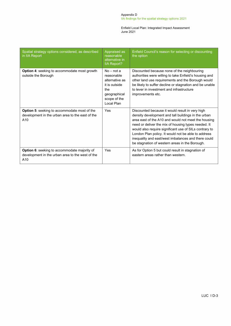
Appendix D IIA findings for the spatial strategy options 2021
Enfield Local Plan: Integrated Impact Assessment June 2021
LUC I D-3
Spatial strategy options considered, as described in IIA Report
Appraised as reasonable alternative in IIA Report?
Enfield Council’s reason for selecting or discounting the option
Option 4: seeking to accommodate most growth outside the Borough
No – not a reasonable alternative as it is outside the geographical scope of the Local Plan
Discounted because none of the neighbouring authorities were willing to take Enfield’s housing and other land use requirements and the Borough would be likely to suffer decline or stagnation and be unable to lever in investment and infrastructure improvements etc.
Option 5: seeking to accommodate most of the development in the urban area to the east of the A10
Yes Discounted because it would result in very high density development and tall buildings in the urban area east of the A10 and would not meet the housing need or deliver the mix of housing types needed. It would also require significant use of SILs contrary to London Plan policy. It would not be able to address inequality and east/west imbalances and there could be stagnation of western areas in the Borough.
Option 6: seeking to accommodate majority of development in the urban area to the west of the A10
Yes As for Option 5 but could result in stagnation of eastern areas rather than western.

Appendix D IIA findings for the spatial strategy options 2021
Enfield Local Plan: Integrated Impact Assessment June 2021
LUC I D-4
Table D.2: Summary of IIA effects for the spatial options
IIA objective
Option 1: Baseline growth Option 2: Medium growth Option 3: High growth Option 5 Option 6
1A: Focused in the urban area only
1B: Focused in the urban area and employ-ment areas
2A: Focused in the urban area and employ-ment areas
2B: Growth in the urban area, employ-ment areas and some release of Green Belt
2C: Focused in the urban area and Green Belt (this is the Preferred Option)
2D: Focused in the urban area only
3A: Focused in the urban area only
3B: Focused in the urban area and employ-ment areas
3C: Growth across the Borough including the urban area, employ-ment areas and the Green Belt
3D: Focused in the urban area and Green Belt
5: Focus growth in the urban area east of the A10
6: Focus growth in the urban area west of the A10
IIA1: Climate change mitigation
+? +?/- +? +?/- +?/- +? +? +? +?/- +?/- +? +?
IIA2: Climate change adaptation
0 0 0 0 0 0 0 0 0 0 0 0
IIA3: Housing +?/- +? ++? ++ ++? ++?/- ++/-- ++? ++ ++? +?/- +?/-
IIA4: Health and wellbeing
++ ++ ++/-? ++/-? ++/-? ++/-? ++/--? ++/--? ++/--? ++/--? ++/--? ++/--?

Appendix D IIA findings for the spatial strategy options 2021
Enfield Local Plan: Integrated Impact Assessment June 2021
LUC I D-5
IIA objective
Option 1: Baseline growth Option 2: Medium growth Option 3: High growth Option 5 Option 6
1A: Focused in the urban area only
1B: Focused in the urban area and employ-ment areas
2A: Focused in the urban area and employ-ment areas
2B: Growth in the urban area, employ-ment areas and some release of Green Belt
2C: Focused in the urban area and Green Belt (this is the Preferred Option)
2D: Focused in the urban area only
3A: Focused in the urban area only
3B: Focused in the urban area and employ-ment areas
3C: Growth across the Borough including the urban area, employ-ment areas and the Green Belt
3D: Focused in the urban area and Green Belt
5: Focus growth in the urban area east of the A10
6: Focus growth in the urban area west of the A10
IIA5: Services and facilities
++ ++ ++/-? ++/-? ++/-? ++/-? ++/-? ++/-? ++/-? ++/-? ++/-? ++/-?
IIA6: Social inclusion +?/-? +?/-? + + + +/- +/- +/- +/- +/- ++/- +/-
IIA7: Crime and community safety
-? -? -? -? -? -? --? --? --? --? -? -?
IIA8: Road safety 0 0 0 0 0 0 0 0 0 0 0 0
IIA9: Economy ++ ++/-? ++/-? ++/-? ++/-? ++ ++ ++/-? ++/--? ++/-? ++/-? ++/-?
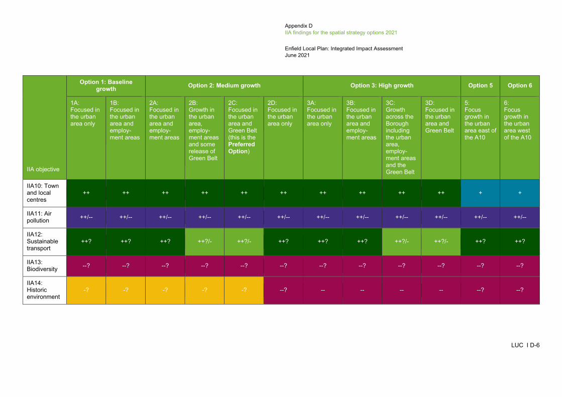
Appendix D IIA findings for the spatial strategy options 2021
Enfield Local Plan: Integrated Impact Assessment June 2021
LUC I D-6
IIA objective
Option 1: Baseline growth Option 2: Medium growth Option 3: High growth Option 5 Option 6
1A: Focused in the urban area only
1B: Focused in the urban area and employ-ment areas
2A: Focused in the urban area and employ-ment areas
2B: Growth in the urban area, employ-ment areas and some release of Green Belt
2C: Focused in the urban area and Green Belt (this is the Preferred Option)
2D: Focused in the urban area only
3A: Focused in the urban area only
3B: Focused in the urban area and employ-ment areas
3C: Growth across the Borough including the urban area, employ-ment areas and the Green Belt
3D: Focused in the urban area and Green Belt
5: Focus growth in the urban area east of the A10
6: Focus growth in the urban area west of the A10
IIA10: Town and local centres
++ ++ ++ ++ ++ ++ ++ ++ ++ ++ + +
IIA11: Air pollution ++/-- ++/-- ++/-- ++/-- ++/-- ++/-- ++/-- ++/-- ++/-- ++/-- ++/-- ++/--
IIA12: Sustainable transport
++? ++? ++? ++?/- ++?/- ++? ++? ++? ++?/- ++?/- ++? ++?
IIA13: Biodiversity --? --? --? --? --? --? --? --? --? --? --? --?
IIA14: Historic environment
-? -? -? -? -? --? -- -- -- -- --? --?
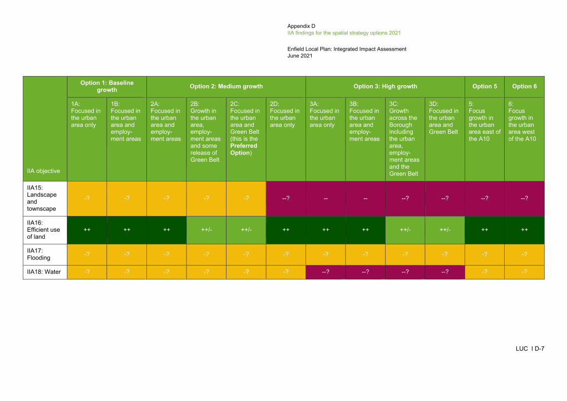
Appendix D IIA findings for the spatial strategy options 2021
Enfield Local Plan: Integrated Impact Assessment June 2021
LUC I D-7
IIA objective
Option 1: Baseline growth Option 2: Medium growth Option 3: High growth Option 5 Option 6
1A: Focused in the urban area only
1B: Focused in the urban area and employ-ment areas
2A: Focused in the urban area and employ-ment areas
2B: Growth in the urban area, employ-ment areas and some release of Green Belt
2C: Focused in the urban area and Green Belt (this is the Preferred Option)
2D: Focused in the urban area only
3A: Focused in the urban area only
3B: Focused in the urban area and employ-ment areas
3C: Growth across the Borough including the urban area, employ-ment areas and the Green Belt
3D: Focused in the urban area and Green Belt
5: Focus growth in the urban area east of the A10
6: Focus growth in the urban area west of the A10
IIA15: Landscape and townscape
-? -? -? -? -? --? -- -- --? --? --? --?
IIA16: Efficient use of land
++ ++ ++ ++/- ++/- ++ ++ ++ ++/- ++/- ++ ++
IIA17: Flooding -? -? -? -? -? -? -? -? -? -? -? -?
IIA18: Water -? -? -? -? -? -? --? --? --? --? -? -?
Appendix D IIA findings for the spatial strategy options 2021
Enfield Local Plan: Integrated Impact Assessment June 2021
LUC I D-8
IIA1: Climate change mitigation
D.2 All options within Options 1 to 3 focus development in urban areas around the transport nodes in the Borough, which consist of a mixture of railway stations and tube stations. It is unknown whether Options 5 and 6 would focus development around the transport nodes, however, given the number of nodes within the urban areas either side of the A10 it is assumed that development would be reasonably close to either a railway and/or tube station. These railway stations and tube stations are located in built up urban areas, where frequent bus services are also present, in addition to everyday services and facilities, including employment opportunities – all of which are within walking distance of one another. This element of all Options 1 to 3, 5 and 6 is therefore likely to reduce use of the private car and associated CO2 emissions, with minor positive effects expected in relation to IIA1: Climate change mitigation. However, these effects are recorded as uncertain because levels of walking and cycling within the Borough are not currently very high. For example, 95% of the Borough’s population is not physically active enough to maximise benefits to their health (see baseline information). Additionally, the sheer scale of developed proposed by these options would result in significant population growth, as well as an increase in the presence of cars. Options and 2B, 2C, 3C and 3D also support development of Green Belt land in the north west of the Borough, where very few railway stations are located (there are no tube stations), bus services are less frequent and services and facilities are not within easy walking distance of one another. Therefore, it is very likely that new residents in these locations would have to drive to their workplace, as well as everyday services and amenities, which would increase greenhouse gas emissions associated with transport. Options 2B, 2C, 3C and 3D are therefore also expected to result in minor negative effects in relation to this objective. The incorporation of energy efficient design in new developments could also help reduce greenhouse gas emissions, but this would be influenced by other policies in the Local Plan and determined at planning application stage.
IIA2: Climate change adaptation
D.3 Given the high-level nature of these spatial options, it is not possible to distinguish between them with respect to climate change adaptation. The spatial distribution of development is not likely to influence sustainable design and construction techniques in development or respond to extreme weather effects as a result of climate change. Flood risk is dealt with separately under IIA objective 17. All options are expected to have negligible effects in relation to this objective.
IIA3: Housing
D.4 The high growth options (3A to 3D) seek to meet the housing requirement identified in the London Plan for the first ten years7 and then apply the government's standard methodology for calculating housing need in the remaining period up to 2039. All four options would therefore deliver the number of new homes identified under the high growth scenario. As such, they are expected to have significant positive effects in relation to IIA3: Housing. Option 3A would result in a significant increase in the density of development around the transport nodes, involving the development of significantly taller buildings which would result in a very high proportion of flats, studios and 1-bedroom dwellings. Development would therefore not provide the range of housing types needed in the Borough, which could potentially discriminate against certain groups of people, such as larger families or those with specialist housing requirements. For this reason, Option 3A is also expected to have a significant negative effect in relation to this objective. Option 3C, on the other hand, supports development in employment areas and the Green Belt, in addition to transport nodes, which may help in the delivery of a greater mix of housing types. Options 3B and 3D also support development in either employment areas or the Green Belt (respectively), therefore they should help to deliver a greater mix of housing types, but the significant positive effect is uncertain.
D.5 The baseline growth options (1A and 1B) seek to meet the housing requirement identified in the London Plan for the first ten years in full and then deliver a significantly lower number of homes in the remaining Local Plan period. Therefore, although Options 1A and 1B would deliver the number of new homes identified under this baseline growth scenario, they may not meet future housing needs in full, although this is uncertain. Both options are therefore expected to have minor positive but uncertain effects in relation to this objective. Option 1A would result in an increase in the density of development around the transport
_____________________________________________________________________________________________________ 7 The London Plan covers the period up to 2041 but only provides housing targets for the first ten years of the London Plan period.

Appendix D IIA findings for the spatial strategy options 2021
Enfield Local Plan: Integrated Impact Assessment June 2021
LUC I D-9
nodes only but because it is not providing as much growth as Option 3A, it is expected to have a minor negative effect in relation to this objective in terms of meeting the Borough’s need for a range of housing sizes and types.
D.6 The medium growth options (2A to 2D) seek to meet the housing requirement identified in the London Plan and carry this same annual requirement forward, beyond the first ten years of the London Plan period. All four medium growth options would deliver the number of new homes identified under the medium growth scenario and are therefore expected to have significant positive effects in relation to this objective. The effects are recorded as uncertain because the Council has had to predict what their housing targets might be beyond the first ten years of the London Plan period. As was the case with Options 1A and 3A, Option 2D focuses development at the transport nodes only and is therefore expected to result in an increase in the density of development in these areas, which could potentially limit the availability of housing types in the Borough. Therefore, Option 2D is also expected to have a minor negative effect in relation to this objective. Option 2B, on the other hand, supports development in employment areas and the Green Belt, in addition to transport nodes, which may help in the delivery of a greater mix of housing types. Options 2A and 2C also support development in either employment areas or the Green Belt (respectively), therefore they should help to deliver a greater mix of housing types, but the significant positive effect is uncertain.
D.7 Options 5 and 6 (deliver housing in the urban areas east or west of the A10) would result in a significant increase in the density of development in the urban areas but are unlikely to be able to meet the full housing need of the Borough, resulting in a minor positive uncertain effect. In addition, due to development being focused in the urban areas either side of the A10, it is likely to involve the development of significantly taller buildings which would result in a very high proportion of flats, studios and 1-bedroom dwellings. Development would therefore not provide the range of housing types needed in the Borough, which could potentially discriminate against certain groups of people, such as larger families or those with specialist housing requirements. For this reason, Options 5 and 6 are also expected to have a minor negative effect in relation to this objective.
IIA4: Health and wellbeing
D.8 As set out in the baseline information in the IIA Scoping Report produced by AECOM, there is an east-west divide in terms of inequality in Enfield, and this correlates with health indicators. For example, Enfield is the fifth worst Borough in England for obesity, with significantly higher levels of obesity in the east when compared to the west. All options focus development in urban areas around the transport nodes in the Borough, which consist of a mixture of railway stations and tube stations. These railway stations and tube stations are located in built up urban areas, where existing primary healthcare facilities are available. New residents would also be located within very close proximity to other services and facilities, which may encourage them to walk or cycle to reach these services, with beneficial effects on their physical health. All options are therefore expected to have significant positive effects in relation to IIA4: Health and wellbeing. However, as set out in the baseline information, there are very few GP surgeries on the estates within Enfield and where GP surgeries are present, they are often outdated with inadequate facilities. Development does, however, offer an opportunity for new development to provide new GP surgeries and improve the design of existing GP surgeries, in the areas that need them the most. The volume of development proposed by the high and medium growth options would undoubtedly place a lot of pressure on existing services, particularly GP surgeries, whilst also potentially resulting in the loss of Metropolitan Open Land to make room for housing. Furthermore, higher density development can contribute to social isolation and poorer health. Indeed, there is growing evidence of the link between high density development and the negative public health impacts this has. Therefore, Options 3A to 3D are also expected to have significant negative but uncertain effects in relation to this objective, whilst Options 2A to 2D are expected to have minor negative but uncertain effects. In addition, Options 2B and 3C support more distributed growth across the Borough than the other options, supporting development within the Green Belt (as does Option 2C), but there are no GP surgeries located in the Green Belt to the north west of the Borough. The services and facilities that are present within the Green Belt are not close to potential development locations and would therefore discourage active travel choices (e.g. walking and cycling). Options 5 and 6 could also have a significant negative effect as Option 5 concentrates development to the east of the A10, which could place more pressure on the existing GP surgeries within the estates in the east of the Borough, while Option 6 would not support any development east of the A10 therefore opportunities to improve existing GP provision would be lost.

Appendix D IIA findings for the spatial strategy options 2021
Enfield Local Plan: Integrated Impact Assessment June 2021
LUC I D-10
IIA5: Services and facilities
D.9 All options focus development in urban areas around the transport nodes in the Borough, which consist of a mixture of railway stations and tube stations. These railway stations and tube stations are located in built up urban areas, where a number of existing services and facilities are present. New residents would therefore not be required to travel far to reach the services, as they would be within walking distance of them. For example, there are a number of primary schools located within close proximity of the transport nodes, in addition to secondary schools. Options 2B, 2C and 3C also support development of Green Belt land in the north west of the Borough. However, the majority of the Green Belt allocation sites are not located within close proximity of a primary or secondary school. Despite this, all options are expected to have significant positive effects in relation to this objective. The volume of development proposed by the high and medium growth scenario options, and the options that concentrate the development in the urban areas east or west of the A10 would be likely to place a lot of pressure on existing services, such as primary and secondary school places, although this is uncertain. Therefore, Options 2A to 2D, 3A to 3D and Options 5 and 6 are also expected to have minor negative but uncertain effects in relation to this objective.
IIA6: Social inclusion
D.10 Enfield is characterised by an east-west divide in terms of inequality and deprivation, with the eastern part of the Borough containing ten Lower Super Output Areas that fall within the 10% most deprived nationally. All options support development around the transport nodes, which are spread across the Borough but not towards the north west, which comprises Green Belt land. Development is expected to help regenerate the areas surrounding the transport nodes but due to the fact the transport nodes are spread fairly evenly across the majority of the Borough, development would not be directed into the more deprived areas only. Therefore, although all options would, to an extent, help regenerate the more deprived areas of the Borough, they would also enhance the less deprived areas and not specifically address the gap in inequality between the east and west. Moreover, the level of development proposed by the high growth options, and the concentration of development within urban areas particularly under Options 3A, 3B, 5 and 6, would result in a significant increase in the density of development around the transport nodes in LBE. As a result, there would be a significant increase in the height of existing tall buildings and new high-rise buildings, which would limit the mix of housing types available and potentially discriminate against certain groups of people such as those with specialist housing requirements. Open space within urban areas may also be lost to new housing, contributing to inequalities in access to open space. This is particularly important following the Covid-19 pandemic, which has highlighted the importance of public open space, particularly if people do not have access to a private garden. Therefore, the high growth options (3A to 3D) are expected to have mixed minor positive and minor negative effects in relation to this objective. Option 5 which concentrates development to the east of the A10 could have a significant positive effect on social inclusion by focusing development in the more deprived eastern part of the Borough, but it could have the same potential negative effects in terms of high density, tall buildings and pressure on open space. Option 6 which concentrates development to the west of the A10 would only have a minor positive effect as it would not address the gap in inequality between the east and west, and would have the same minor negative effects by requiring high density development in the western urban areas. Option 2D (medium growth in the urban area only) is also expected to have a mixed minor positive and minor negative effect because like Option 3A, it seeks to intensify land around transport nodes only and may therefore result in an over reliance on flats and a subsequent decrease in housing mix. The baseline growth options support the lowest number of new homes and would therefore contribute a lower amount of affordable housing than the medium and high growth options. Therefore, Options 1A and 1B are expected to have mixed minor positive and minor negative but uncertain effects in relation to this objective. The remaining options (2A to 2C) are expected to have minor positive effects in relation to IIA6: Social inclusion because they would provide more development than the baseline growth options, as well as a greater range of housing types due to more widespread growth.
IIA7: Crime and community safety
D.11 The spatial distribution of development is not likely to influence levels of crime, anti-social behaviour, fear of crime and perceptions of safety, which will be more influenced by policies which seek to deliver inclusive design. As set out in the IIA Scoping Report, crime is generally concentrated in the east of the Borough at Southgate, Palmers Green and the boundary the Borough shares with Haringey Council, in addition to around transport nodes. Crime levels have been rising in the area, partly due to the fact that the Borough has the largest youth population in Greater London, with some of the highest levels of crime

Appendix D IIA findings for the spatial strategy options 2021
Enfield Local Plan: Integrated Impact Assessment June 2021
LUC I D-11
recorded in the school-transport corridors. All options concentrate grown at the transport nodes, whilst Options 1B, 2A, 2B, 3B and 3C also support development at SIL and LSIS sites, located in the east of the Borough. Overall, all options are expected to have minor negative effects in relation to IIA7: Crime and community safety, although this is uncertain as there may be policies included in the Local Plan to support high quality developments, improvements to estates that suffer from poor quality housing and a high quality public realm that supports the integration of communities and natural surveillance including through the co-location of shops, services, community centres and green spaces. The higher growth options may have more of an adverse effect than the other options because the much higher level of growth proposed under Option 3 could result in higher levels of crime. Therefore, a significant negative but uncertain effect has been recorded for Options 3A to 3D.
IIA8: Road safety
D.12 The spatial distribution of development will not affect the achievement of this objective, which relates to healthy streets principles that encourage walking and cycling; these are more likely to be addressed through Local Plan policy. Therefore, all options are likely to have negligible effects in relation to IIA8: Road safety.
IIA9: Economy
D.13 Concentrating development at the transport nodes in the Borough which are very central and well-connected, is expected to encourage the retention and expansion of town and local centre commercial and retail uses. The transport nodes in the Borough contain a range of services and facilities, and therefore offer job opportunities. Options 1A, 2D and 3A seek to focus development at the transport nodes only. Concentrating new residential development in these central and well-connected areas would help boost the economy by increasing the available workforce and attracting investment to the area, whilst also helping improve these local economies. These three options (1A, 2D and 3A) are therefore expected to have significant positive effects in relation to this objective. An even larger proportion of job opportunities are provided at the SIL and LSIS sites and with Options 1B, 2A, 2B, 3B, 3C and 5 (and 6 to a lesser extent as there are just a few LSIS sites in the south of the Borough west of the A10) concentrating future residential development in the employment areas, as well as at the transport nodes, there would be a loss in SIL and LSIS land. Options 1B, 2A, 2B, 3B, 3C, 5 and 6 are therefore expected to have mixed significant positive and minor negative effects in relation to IIA9: Economy. The minor negative effects are recorded as uncertain because although there may be a loss in employment land, residential development may be provided as part of mixed-use schemes at the SIL and LSIS sites. In addition, Options 2B and 3C spread development more evenly across the Borough, including on Green Belt land. However, the areas of Green Belt land where intensification is proposed, are not located within the main urban centres of the Borough, where more job opportunities are available. Conversely, supporting development in these areas may have positive effects on the rural economy and jobs. Option 3C is therefore expected to have a mixed significant positive and significant negative effect in relation to this objective, whilst Option 2B is still expected to have a mixed significant positive and minor negative effect, because although both options may support the rural economy, they could also result in the loss of SIL and LSIS land. This is particularly the case for Option 3C, which proposes the highest number of new homes out of all options. The negative effects are recorded as uncertain because residential development may be provided as part of mixed-use schemes at the SIL and LSIS sites. Options 2C and 3D also allow for some development on Green Belt land, therefore they are expected to have a minor negative but uncertain effect for directing some residential development to areas of Green Belt land where there are less existing job opportunities, but a positive effect in terms of supporting the rural economy. They would both still have a significant positive effect however, as they both also support a significant amount of development in the urban areas at the transport nodes, which are well connected to employment opportunities.
IIA10: Town and local centres
D.14 Concentrating development at the transport nodes in the Borough which are very central and well-connected, is expected to encourage the retention and expansion of town and local centre commercial and retail uses. Options 1A, 2D and 3A are therefore expected to enhance the vitality and vibrancy of the town and local centres in the Borough, resulting in significant positive effects against IIA10: Town and local centres. Option 5 would only support the town and local centres to the east of the A10 and Option 6 would only support the town and local centres to the west of the A10, therefore both of these options would only have a minor positive effect. All the remaining options support development at the transport nodes in the Borough, but also

Appendix D IIA findings for the spatial strategy options 2021
Enfield Local Plan: Integrated Impact Assessment June 2021
LUC I D-12
support the development of SIL and LSIS sites (Options 1B, 2A, 2B, 3B and 3C) and/or intensification within the Green Belt (Options 2C, 2D, 3C and 3D). Although the SIL, LSIS and Green Belt sites are located on the edge and/or outside of the town and local centres and development under these options may not directly revitalise the town and local centres, these options still support development around the transport nodes, where the town and local centres are located. All remaining options are therefore also expected to have significant positive effects in relation to this objective.
IIA11: Air pollution
D.15 All options focus development in urban areas around the transport nodes in the Borough, which consist of a mixture of railway stations and tube stations. These railway stations and tube stations are located in built up urban areas, where frequent bus services are also present, in addition to everyday services and facilities that are within walking distance of one another. All options are therefore likely to reduce reliance on the private car, which would help minimise air pollution. However, the actual use of more active and sustainable modes of travel will depend on people's behaviour. Further to this, the Borough experiences severe problems with air quality, especially between the east and west of the Borough, with the entire Borough being declared an Air Quality Management Area (AQMA). Therefore, although all options focus development within close proximity to sustainable travel modes, where services and facilities are within easy walking and cycling distance of one another, the amount of development proposed by all options is expected to have significant adverse effects on air quality through population increase and a higher presence of cars. Having said that, walking and cycling could be encouraged through the design of new development and incorporation of Healthy Streets principles. Options 2B, 2C, 3C and 3D also support development of Green Belt land in the north west of the Borough, where very few railway stations are located (there are no tube stations), bus services are less frequent and services and facilities are not within easy walking distance of one another. Therefore, new residents in these locations would be more reliant on the private car, contributing towards air pollution. Overall, all options are expected to have mixed significant positive and significant negative effects in relation to IIA11: Air pollution.
IIA12: Sustainable transport
D.16 All options focus development in urban areas around the transport nodes in the Borough, which consist of a mixture of railway stations and tube stations. These railway stations and tube stations are located in built up urban areas, where frequent bus services are present, in addition to everyday services and facilities that are within walking distance of one another. These options are therefore likely to reduce reliance on the private car and increase more sustainable modes of transport. However, the use of more sustainable modes of transport will depend on people's behaviour, especially following the Covid-19 pandemic where there has been a significant reduction in people using public transport. Indeed, the majority of residents in the Borough use a private car to get to work instead of public transport. All options are therefore expected to have significant positive but uncertain effects in relation to IIA12: Sustainable transport. However, Options 2B, 2C, 3C and 3D also support development of Green Belt land in the north west of the Borough, where very few railway stations are located (there are no tube stations), bus services are less frequent and services and facilities are not within easy walking distance of one another. Therefore, residents in these locations are expected to be more reliant on the private car, particularly because they are within close proximity of the M25 which borders the northern edge of LBE. These four options are therefore also likely to result in minor negative effects in relation to this objective.
IIA13: Biodiversity
D.17 The Borough does not contain a Special Protection Area (SPA), Special Area of Conservation (SAC) or a Ramsar site. However, it is located within close proximity to the Lee Valley SPA and Ramsar site which is located to the north and south of the Borough in Lee Valley Regional Park, which runs along the eastern edge of Enfield. The Epping Forest SAC is also located just outside the Borough, to the east. The Chingford Reservoir Site of Special Scientific Interest (SSSI) is located within the Borough, along its eastern edge. There is also one Local Nature Reserve (LNR) within the Borough, known as Covert Way, located just south of Hadley Wood. A large number of Sites of Importance in Nature Conservation (SINC) are spread across the Borough.
D.18 All options would intensify development at transport nodes in the urban areas of the Borough, where no internationally designated biodiversity assets are present. Although there is one SSSI and one NNR present within the Borough, neither are
Appendix D IIA findings for the spatial strategy options 2021
Enfield Local Plan: Integrated Impact Assessment June 2021
LUC I D-13
located within close proximity to where development is proposed under all options. However, the zones of influence for some of the SACs, SPAs and Ramsar sites just outside the Borough extend into the Borough and indirect effects due to general population increase and pressure on any nature conservation sites, for example from recreation and increased air pollution, could still occur. The SINCs are spread relatively evenly across the Borough, with most containing a railway station. All options would therefore include land that falls within a SINC. Options 2B, 2C, 3C and 3D also promote development in the Green Belt in areas that comprise a mixture of both greenfield and brownfield sites. Greenfield and brownfield sites can have biodiversity interest which would be lost as a result of development. Overall, all options are expected to have significant negative effects in relation to IIA13: Biodiversity. The effects are recorded as uncertain because designated nature conservation sites could be avoided through site design, and there may be opportunities to promote habitat connectivity if new developments include green infrastructure.
IIA14: Historic environment
D.19 The northern edge of the Borough does not contain a large proportion of heritage assets whereas the remainder of the Borough does, especially the more built-up areas such as Enfield Town. A number of Conservation Areas are located along the periphery of the built-up area within the edge of the Green Belt, the largest being Trent Park which is also a Registered Park and Garden. All options seek to intensify the areas surrounding the railway and tube stations within the Borough, which tend to be located within close proximity to a large number of Listed Buildings, whilst also falling within or close to Conservation Areas. The high growth options (Options 3A to 3D) would provide the highest number of new homes at around 36,000. This is significantly higher than the remaining options and considering the fact that Option 3A seeks to concentrate development within the urban area only, effects on the historic environment would be substantial. All high growth options are expected to have significant negative effects in relation to IIA14: Historic environment due to the scale of development proposed.
D.20 Options 1A and 1B would support the lowest number of new homes in the Borough. Option 1A supports intensification around travel nodes in the urban area only, whereas Option 1B supports intensification of existing SIL and LSIS sites, in addition to travel nodes in the urban area. The SIL and LSIS sites identified for potential development contain very few heritage assets with some containing none at all, and therefore development within them is unlikely to result in adverse effects on the historic environment. Overall, Options 1A and 1B are expected to have minor negative but uncertain effects in relation to this objective. Option 2D is expected to have a significant negative effect in relation to this objective because it supports a medium number of new homes in the urban area only, where most historic assets are located. Options 2A, 2B and 2C on the other hand, are expected to have minor negative effects in relation to this objective because although they do not propose the lowest number of new homes when compared to the other growth scenarios, they do not solely focus development in the urban area and instead spread growth more widely across the Borough. Similar to Option 2D, Options 5 and 6 concentrate development within the urban areas to the east and west of the A10 respectively, but are unlikely to deliver the same level of growth as the high growth options, therefore they are expected to have significant negative effects also. The effects of all the options except 2D and 3A to 3D are recorded as uncertain because development could potentially reduce adverse impacts on the historic environment through mitigation and the design, scale and layout of development.
IIA15: Landscape and townscape
D.21 Options 3A to 3D would result in a significant increase in the density of development in the Borough around the transport nodes, as well as in SIL and LSIS sites under Options 3B and 3C. There would need to be a significant increase in the height of existing tall buildings, in addition to new high-rise buildings, both of which would fundamentally alter the character of the urban area and Borough as a whole. Option 3C would deliver the same number of new homes to Options 3A and 3B but would spread this development more evenly across the Borough, including areas that fall within the Green Belt. Option 3D would also direct some of the development to the Green Belt as well as the urban areas. However, the intensification of areas within the Green Belt under the high growth scenario could potentially alter the landscape in the north west of the Borough. All of the high growth options are therefore expected to have significant negative effects in relation to IIA15: Landscape and townscape. However, for Options 3C and 3D, the effect is recorded as uncertain because development within the Green Belt could be designed in a way that helps mitigate any adverse impacts on the character of the area.

Appendix D IIA findings for the spatial strategy options 2021
Enfield Local Plan: Integrated Impact Assessment June 2021
LUC I D-14
D.22 Options 1A and 1B would support the lowest number of new homes in the Borough. Option 1A supports intensification around travel nodes in the urban area and would therefore result in an increase in density within the urban area, whilst Option 1B would result in an increase in density within SIL and LSIS sites, as well as the urban area. However, this increase in density would not be comparable to that under the high growth scenario options. Overall, Options 1A and 1B are expected to have minor negative but uncertain effects in relation to this objective. The effects are recorded as uncertain as the actual effects would depend on the final design, scale and layout of development. Options 2A to 2D support a higher number of new homes than Options 1A and 1B and could therefore potentially result in more adverse effects on townscape and/or landscape character, particularly Option 2D which focuses development it the urban area only. Overall, Option 2D is expected to have a significant negative but uncertain effect again this objective, whilst Options 2A, 2B and 2C are expected to have minor negative but uncertain effects. Similar to Option 2D, Options 5 and 6 concentrate development within the urban areas to the east and west of the A10 respectively, therefore they are expected to have significant negative but uncertain effects also.
IIA16: Efficient use of land and materials
D.23 All options would result in intensification around transport nodes within the Borough, which fall on previously developed land that is classified as land predominantly in urban use. All options are therefore expected to have significant positive effects in relation to IIA16: Efficient use of land. However, Options 2B, 2C, 3C and 3D also promote development in the Green Belt in areas that comprise a mixture of both greenfield and brownfield sites, all of which are classified as Grade 3 agricultural land. Therefore, although these four options would promote the development of previously developed land, they would also promote the development of greenfield sites, which is not an efficient use of land. Therefore, Options 2B, 2C, 3C and 3D are also expected to have minor negative effects in relation to this objective.
IIA17: Flooding
D.24 The River Lee, in addition to King George's Reservoir and William Girling Reservoir located along the eastern edge of the Borough create a flood risk. The immediate area surrounding these waterbodies falls within Flood Zones 3a and 3b, as well as Flood Zone 2. All options promote development in urban areas around transport nodes within the Borough, a number of which are located in the east of the Borough. The above mentioned flood zones also stretch to the west of the Borough along New River (Old Course) and a number of brooks, most of which are also located within close proximity to transport nodes. The NPPF discourages the development of housing within areas at the highest risk of flooding. However, development may be able to incorporate surface water management measures, such as sustainable drainage systems to address the existing flood risk, as well as that generated by new development. It is also likely that under Options 1A, 1B, 2A, 2D, 3A, 3B, 5 and 6 housing would be delivered through an increase in height of existing buildings and would therefore not cause a reduction in permeable surfaces. Options 2B, 2C, 3C and 3D support development of Green Belt land in the north west of the Borough, some of which comprises greenfield land. As such, development would reduce the amount of permeable surface available and potentially contribute to surface water run-off, increasing flood risk. Overall, all options are expected to have minor negative but uncertain effects in relation to IIA17: Flooding.
IIA18: Water
D.25 The Borough is covered entirely by the London Water Resource Zone, with its potable water and waste water services supplied by Thames Water. Greater London is mostly supplied by surface water resources (80%), with the remainder delivered through groundwater abstractions. Availability of water resources is a key issue in the Borough, given that the Thames Water Supply is designated as "seriously water stressed" and that climate change may lead to limited water availability in the future, particularly in the summer. The Borough contains a fairly high proportion of land covered by Source Protection Zones 1 and 28, and it is therefore unlikely that development would be able to avoid these Source Protection Zones. Development in some locations could therefore contaminate water supplies without mitigation. However, all options support development in existing built-up areas and therefore any effect on Source Protection Zones is likely to be limited. Due to the fact all options contain land that falls within Source Protection Zones 1 and 2 but already contain built development, minor negative but uncertain effects are
_____________________________________________________________________________________________________ 8 There is no land in LBE covered by Source Protection Zone 3.

Appendix D IIA findings for the spatial strategy options 2021
Enfield Local Plan: Integrated Impact Assessment June 2021
LUC I D-15
expected. However, the level of growth anticipated under the higher growth options 3A to 3D would place more pressure on water resources and water treatment capacity, therefore significant negative but uncertain effects are expected for Options 3A to 3D.

Appendix E IIA findings for the site options 2021
Enfield Local Plan: Integrated Impact Assessment June 2021
LUC I E-1
Click to enter introduction.
E.1 This section presents the IIA findings for the reasonable alternative site options considered by the Council for allocation in the Enfield Local Plan, as well as an appraisal of the sites that have been selected for allocation. Overall, there are 22 allocated housing sites, 23 allocated mixed-use sites, 10 allocated industrial sites, 2 allocated leisure/sports and recreation sites, 4 burial/crematorium sites and a nature recovery site. There are also 19 housing site options and 4 mixed-use site options that were appraised but have not been allocated. Table E.1 contains a summary of the effects of all reasonable alternative site options in relation to the IIA objectives, with the findings summarised below the table.
E.2 Following this, are the separate appraisal matrices for each reasonable alternative site option. These matrices contain two columns that show the likely sustainability effect of the site option (and justification) without taking any mitigation into account. For those site options that were then selected for allocation in the 2021 Enfield Local Plan, the IIA appraisal matrix includes another two columns that show the likely effects of the site (and justification) with any mitigation provided in the Local Plan policies or site proformas taken into account. For site allocations where the proposed use changed from the initial reasonable alternative site option appraisal, an extra set of two columns are provided to show the appraisal of the site allocation with its revised use and without mitigation. Reasonable alternative site options that were not allocated by the Council, are shown in the section of this appendix entitled 'Site options appraised but not allocated'.
-
Appendix E IIA findings for the site options 2021

Appendix E IIA findings for the site options 2021
Enfield Local Plan: Integrated Impact Assessment June 2021
LUC I E-2
Table E.1: Summary of IIA effects for site options
Site Size Yield IIA1:
Clim
ate
chan
ge m
itiga
tion
IIA2:
Clim
ate
chan
ge a
dapt
atio
n
IIA3:
Hou
sing
IIA4:
Hea
lth a
nd
wel
lbei
ng
IIA5:
Ser
vice
s an
d fa
cilit
ies
IIA6:
Soc
ial i
nclu
sion
IIA7:
Crim
e an
d co
mm
unity
saf
ety
IIA8:
Roa
d sa
fety
IIA9:
Eco
nom
y
IIA10
: Tow
n an
d lo
cal c
entre
s
IIA11
: Air
pollu
tion
IIA12
: Sus
tain
able
tra
nspo
rt
IIA13
: Bio
dive
rsity
IIA14
: His
toric
en
viro
nmen
t IIA
15: L
ands
cape
an
d to
wns
cape
IIA
16: E
ffici
ent u
se
of la
nd a
nd
ti
l
IIA17
: Flo
odin
g
IIA18
: Wat
er
Housing sites
CHC1/LP031: Warmerdams Nursery, Cattlegate Road 3.04 345 0 0 ++ ++/- -? 0 0 0 - 0 -? ++/
-- --? -? +? ++ -- 0
CHC10/LP179: Site at Oak Farm and Homestead Nursery, Cattlegate Road
2.62 340 0 0 ++ +/- -? 0 0 0 - 0 -? --/+ --? -? -? + -- 0
CHC11/LP472 – Parcel 1: Land to the rear of Jesus Christ Church, Parcel 1
1.70 160 0 0 ++ ++/- ++? 0 0 0 - 0 -? --
/+ --? --? -? + -- --?
CHC12/LP472 – Parcel 2: Land to the south of Forty Hill Church of England School, Forty Hill, Parcel 2
2.15 399 0 0 ++ ++/- ++? 0 0 0 - 0 -? ++/
-- --? --? -? + - --?
CHC14/LP637: Land north of Goat Lane 0.46 60 0 0 + ++/- ++? 0 0 0 - 0 -? - --? -? -? + - --
?
CHC17/LP645: Towneley Nurseries, Theobalds Park 1.70 113 0 0 ++ ++/- -? 0 0 0 - 0 -? ++/
-- --? -? +? + -- --?
CHC18/LP649: Brown's Garden Village, Theobalds Park Road
0.94 62 0 0 + +/- -? 0 0 0 - 0 -? ++/-- -? -? +? + -- 0
CHC2/LP056: Wolden Garden Centre, Cattlegate Road 1.19 135 0 0 ++ +/- -? 0 0 0 - 0 -? ++/-- --? -? +? + -- 0
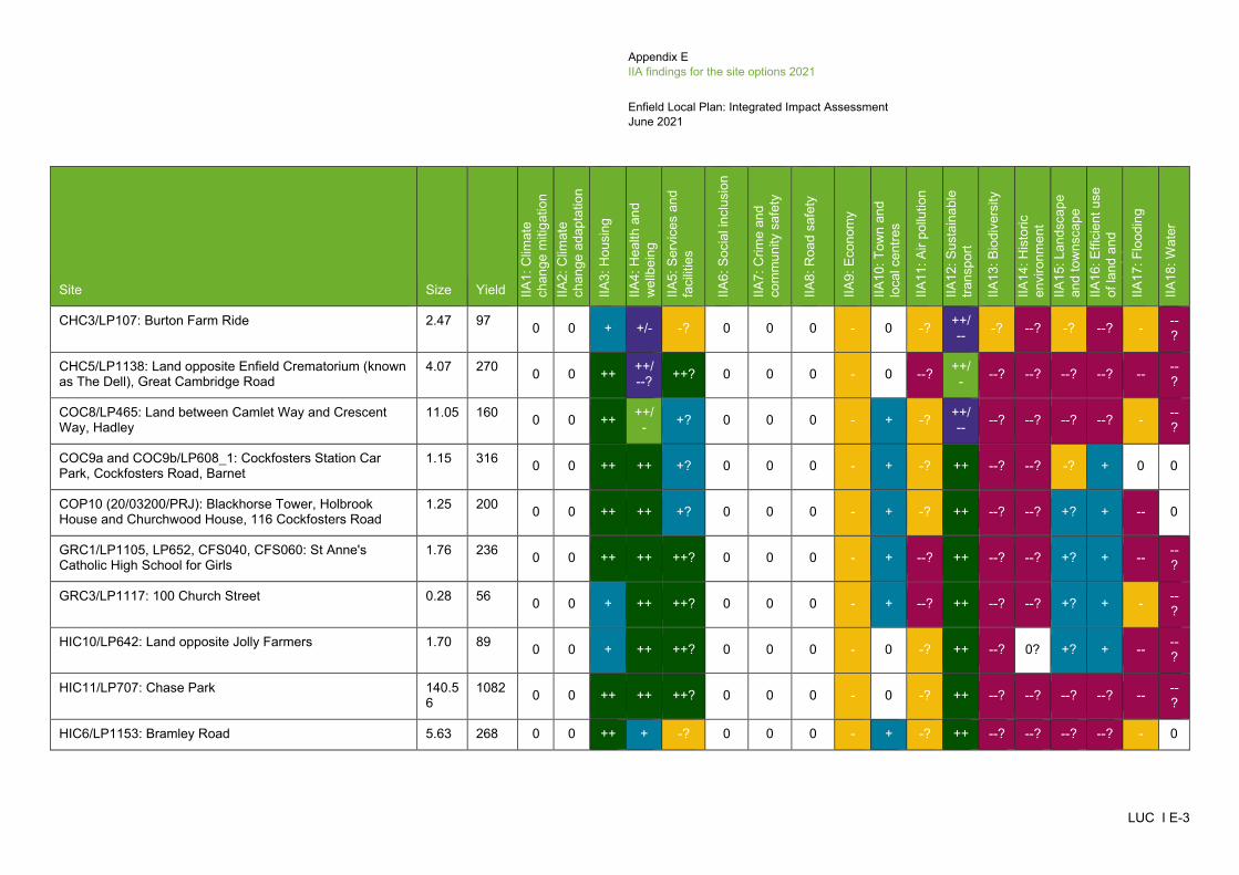
Appendix E IIA findings for the site options 2021
Enfield Local Plan: Integrated Impact Assessment June 2021
LUC I E-3
Site Size Yield IIA1:
Clim
ate
chan
ge m
itiga
tion
IIA2:
Clim
ate
chan
ge a
dapt
atio
n
IIA3:
Hou
sing
IIA4:
Hea
lth a
nd
wel
lbei
ng
IIA5:
Ser
vice
s an
d fa
cilit
ies
IIA6:
Soc
ial i
nclu
sion
IIA7:
Crim
e an
d co
mm
unity
saf
ety
IIA8:
Roa
d sa
fety
IIA9:
Eco
nom
y
IIA10
: Tow
n an
d lo
cal c
entre
s
IIA11
: Air
pollu
tion
IIA12
: Sus
tain
able
tra
nspo
rt
IIA13
: Bio
dive
rsity
IIA14
: His
toric
en
viro
nmen
t IIA
15: L
ands
cape
an
d to
wns
cape
IIA
16: E
ffici
ent u
se
of la
nd a
nd
ti
l
IIA17
: Flo
odin
g
IIA18
: Wat
er
CHC3/LP107: Burton Farm Ride 2.47 97 0 0 + +/- -? 0 0 0 - 0 -? ++/-- -? --? -? --? - --
?
CHC5/LP1138: Land opposite Enfield Crematorium (known as The Dell), Great Cambridge Road
4.07 270 0 0 ++ ++/--? ++? 0 0 0 - 0 --? ++/
- --? --? --? --? -- --?
COC8/LP465: Land between Camlet Way and Crescent Way, Hadley
11.05 160 0 0 ++ ++/- +? 0 0 0 - + -? ++/
-- --? --? --? --? - --?
COC9a and COC9b/LP608_1: Cockfosters Station Car Park, Cockfosters Road, Barnet
1.15 316 0 0 ++ ++ +? 0 0 0 - + -? ++ --? --? -? + 0 0
COP10 (20/03200/PRJ): Blackhorse Tower, Holbrook House and Churchwood House, 116 Cockfosters Road
1.25 200 0 0 ++ ++ +? 0 0 0 - + -? ++ --? --? +? + -- 0
GRC1/LP1105, LP652, CFS040, CFS060: St Anne's Catholic High School for Girls
1.76 236 0 0 ++ ++ ++? 0 0 0 - + --? ++ --? --? +? + -- --?
GRC3/LP1117: 100 Church Street 0.28 56 0 0 + ++ ++? 0 0 0 - + --? ++ --? --? +? + - --?
HIC10/LP642: Land opposite Jolly Farmers 1.70 89 0 0 + ++ ++? 0 0 0 - 0 -? ++ --? 0? +? + -- --?
HIC11/LP707: Chase Park 140.56
1082 0 0 ++ ++ ++? 0 0 0 - 0 -? ++ --? --? --? --? -- --?
HIC6/LP1153: Bramley Road 5.63 268 0 0 ++ + -? 0 0 0 - + -? ++ --? --? --? --? - 0
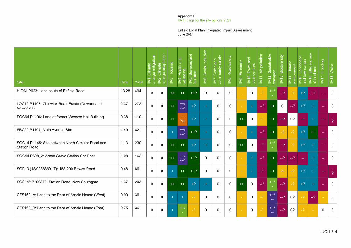
Appendix E IIA findings for the site options 2021
Enfield Local Plan: Integrated Impact Assessment June 2021
LUC I E-4
Site Size Yield IIA1:
Clim
ate
chan
ge m
itiga
tion
IIA2:
Clim
ate
chan
ge a
dapt
atio
n
IIA3:
Hou
sing
IIA4:
Hea
lth a
nd
wel
lbei
ng
IIA5:
Ser
vice
s an
d fa
cilit
ies
IIA6:
Soc
ial i
nclu
sion
IIA7:
Crim
e an
d co
mm
unity
saf
ety
IIA8:
Roa
d sa
fety
IIA9:
Eco
nom
y
IIA10
: Tow
n an
d lo
cal c
entre
s
IIA11
: Air
pollu
tion
IIA12
: Sus
tain
able
tra
nspo
rt
IIA13
: Bio
dive
rsity
IIA14
: His
toric
en
viro
nmen
t IIA
15: L
ands
cape
an
d to
wns
cape
IIA
16: E
ffici
ent u
se
of la
nd a
nd
ti
l
IIA17
: Flo
odin
g
IIA18
: Wat
er
HIC9/LP623: Land south of Enfield Road 13.28 494 0 0 ++ ++ ++? 0 0 0 - 0 -? ++/- --? -? +? --? -- 0
LOC1/LP1108: Chiswick Road Estate (Osward and Newdales)
2.37 272 0 0 ++ ++/--? +? + 0 0 - + --? ++ 0 --? +? + -- 0
POC6/LP1196: Land at former Wessex Hall Building 0.38 110 0 0 ++ --?/+ +? + 0 0 ++ 0 -? ++ --? 0? -- + -- --
?
SBC2/LP1107: Main Avenue Site 4.49 82 0 0 + ++/--? ++? + 0 0 - + --? ++ -? -? +? ++ -- 0
SGC1/LP1145: Site between North Circular Road and Station Road
1.13 230 0 0 ++ ++ +? + 0 0 ++ 0 --? ++/- --? -? +? + -- 0
SGC4/LP608_2: Arnos Grove Station Car Park 1.08 162 0 0 ++ ++/--? ++? 0 0 0 - + --? ++ --? --? -- + -- 0
SGP13 (18/00388/OUT): 188-200 Bowes Road 0.48 86 0 0 + ++ ++? 0 0 0 - + --? ++ -? -? +? + -- --?
SGS14/17100370: Station Road, New Southgate 1.37 203 0 0 ++ ++ +? + 0 0 ++ 0 --? ++/- --? -? +? + -- 0
CFS162_A: Land to the Rear of Arnold House (West) 0.90 36 0 0 + + -? 0 0 0 - 0 -? ++/-- --? 0? -? --? - 0
CFS162_B: Land to the Rear of Arnold House (East) 0.75 36 0 0 + ++/- -? 0 0 0 - 0 -? ++/
-- --? 0? -? - 0 0

Appendix E IIA findings for the site options 2021
Enfield Local Plan: Integrated Impact Assessment June 2021
LUC I E-5
Site Size Yield IIA1:
Clim
ate
chan
ge m
itiga
tion
IIA2:
Clim
ate
chan
ge a
dapt
atio
n
IIA3:
Hou
sing
IIA4:
Hea
lth a
nd
wel
lbei
ng
IIA5:
Ser
vice
s an
d fa
cilit
ies
IIA6:
Soc
ial i
nclu
sion
IIA7:
Crim
e an
d co
mm
unity
saf
ety
IIA8:
Roa
d sa
fety
IIA9:
Eco
nom
y
IIA10
: Tow
n an
d lo
cal c
entre
s
IIA11
: Air
pollu
tion
IIA12
: Sus
tain
able
tra
nspo
rt
IIA13
: Bio
dive
rsity
IIA14
: His
toric
en
viro
nmen
t IIA
15: L
ands
cape
an
d to
wns
cape
IIA
16: E
ffici
ent u
se
of la
nd a
nd
ti
l
IIA17
: Flo
odin
g
IIA18
: Wat
er
CFS162_C: Arnold House 0.60 36 0 0 + ++/- -? 0 0 0 - 0 -? ++/
-- --? 0? -? + - 0
UPM1: Joyce Avenue and Snells Park Estate 9.94 1217 0 0 ++ ++/--? +? 0 0 0 ++ + --? ++ --? --? -- ++ -- --
?
UPP9 (18/00760/FUL): Public House, 50-56 Fore Street 0.19 68 0 0 + ++ +? + 0 0 - + --? ++ -? --? +? + -- --?
UPS21/17100372: Upton Road and Raynham Road 1.92 198 0 0 ++ ++/--? +? + 0 0 - + --? ++ -? --? +? + -- --
?
CFS150 and CFS189: Minchenden Car Park and Alan Pullinger Centre
0.11 48 0 0 + ++/- +? 0 0 0 - + --? ++ --? -? +? + 0 0
CFS159: Wyevale Garden Centre, Cattlegate Road 2.00 260 0 0 ++ ++/- -? 0 0 0 - 0 -? ++/
-- --? -? +? + 0 0
CFS165: South east corner of North Middlesex University Hospital Trust of Sterling Way
1.35 400 0 0 ++ ++ +? 0 0 0 ++ 0 --? ++ --? -? +? + -- 0
CFS169: Kings Oak Equestrian Centre (Part) 4.23 127 0 0 ++ ++/- +? 0 0 0 - 0 -? ++/
-- --? -? -? ++ -- 0
CFS178: Oak House, 43 Baker Street 0.26 55 0 0 + ++ ++? 0 0 0 - + --? ++ --? --? +? + - --?
CFS183: Enfield Town Station and Former Enfield Arms, Genotin Road
0.07 6 0 0 + ++ ++? 0 0 0 - + -? ++ --? --? +? + -- --?
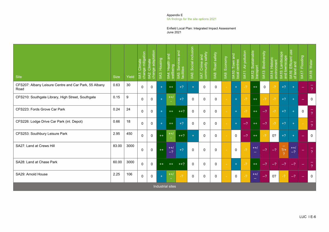
Appendix E IIA findings for the site options 2021
Enfield Local Plan: Integrated Impact Assessment June 2021
LUC I E-6
Site Size Yield IIA1:
Clim
ate
chan
ge m
itiga
tion
IIA2:
Clim
ate
chan
ge a
dapt
atio
n
IIA3:
Hou
sing
IIA4:
Hea
lth a
nd
wel
lbei
ng
IIA5:
Ser
vice
s an
d fa
cilit
ies
IIA6:
Soc
ial i
nclu
sion
IIA7:
Crim
e an
d co
mm
unity
saf
ety
IIA8:
Roa
d sa
fety
IIA9:
Eco
nom
y
IIA10
: Tow
n an
d lo
cal c
entre
s
IIA11
: Air
pollu
tion
IIA12
: Sus
tain
able
tra
nspo
rt
IIA13
: Bio
dive
rsity
IIA14
: His
toric
en
viro
nmen
t IIA
15: L
ands
cape
an
d to
wns
cape
IIA
16: E
ffici
ent u
se
of la
nd a
nd
ti
l
IIA17
: Flo
odin
g
IIA18
: Wat
er
CFS207: Albany Leisure Centre and Car Park, 55 Albany Road
0.63 30 0 0 + ++ +? + 0 0 - + -? ++ 0 -? +? + -- --?
CFS210: Southgate Library, High Street, Southgate 0.15 9 0 0 + ++/- +? 0 0 0 - + -? ++ -? -? +? + -- 0
CFS223: Fords Grove Car Park 0.24 24 0 0 + ++ ++? 0 0 0 - + -? ++ --? -? +? + 0 --?
CFS226: Lodge Drive Car Park (inl. Depot) 0.66 18 0 0 + ++ +? 0 0 0 - + --? ++ --? -? +? + - --?
CFS253: Southbury Leisure Park 2.95 450 0 0 ++ ++/- ++? + 0 0 - 0 --? ++ -? 0? +? + -- 0
SA27: Land at Crews Hill 83.00 3000 0 0 ++ ++/
--? +? 0 0 0 - 0 -? ++/-- --? --?
--?/+?
++/--? -- --
?
SA28: Land at Chase Park 60.00 3000 0 0 ++ ++ ++? 0 0 0 - + -? ++ --? --? --? --? -- --?
SA29: Arnold House 2.25 106 0 0 + ++/- -? 0 0 0 - 0 -? ++/
-- --? 0? -? --? -- 0
Industrial sites

Appendix E IIA findings for the site options 2021
Enfield Local Plan: Integrated Impact Assessment June 2021
LUC I E-7
Site Size Yield IIA1:
Clim
ate
chan
ge m
itiga
tion
IIA2:
Clim
ate
chan
ge a
dapt
atio
n
IIA3:
Hou
sing
IIA4:
Hea
lth a
nd
wel
lbei
ng
IIA5:
Ser
vice
s an
d fa
cilit
ies
IIA6:
Soc
ial i
nclu
sion
IIA7:
Crim
e an
d co
mm
unity
saf
ety
IIA8:
Roa
d sa
fety
IIA9:
Eco
nom
y
IIA10
: Tow
n an
d lo
cal c
entre
s
IIA11
: Air
pollu
tion
IIA12
: Sus
tain
able
tra
nspo
rt
IIA13
: Bio
dive
rsity
IIA14
: His
toric
en
viro
nmen
t IIA
15: L
ands
cape
an
d to
wns
cape
IIA
16: E
ffici
ent u
se
of la
nd a
nd
ti
l
IIA17
: Flo
odin
g
IIA18
: Wat
er
ELC3/LP606: Land West of Ramney Marsh 12.01 70,200 sq.m
0 0 0 0 0 0 0 0 ++ 0 --? ++/- --? --? +? ++ -- --
?
POC5/LP694/CFS135: Car Park Site, Wharf Road 0.79 5,115 sq.m 0 0 0 0 0 + 0 0 + 0 0 ++/
- --? --? -? + -- --?
CFS132: Land at 135 Theobalds Park Road 1.64 3,251 sq.m 0 0 0 0 0 0 0 0 + 0 -? ++/
-- --? -? +? + -- 0
CFS136: 6 Morson Road 0.83 2,600 sq.m
0 0 0 0 0 + 0 0 + 0 0 ++/- --? -? -? + - --
?
CFS148: Land to the North West of Innova Park 3.46 16,445 sq.m
0 0 0 0 0 0 0 0 + 0 --? ++/- --? 0? +? ++ -- --
?
CFS151: Crown Road Lorry Park 0.71 4,530 sq.m 0 0 0 0 0 + 0 0 + 0 -? ++ 0 -? +? + -- 0
CFS153: Montagu Ind Estate 5.68 6,613 sq.m 0 0 0 0 0 + 0 0 + 0 --? ++ --? --? +? ++ -- --
?
CFS155: Land East of Junction 24 5.16 30,000 sq.m
0 0 0 0 0 0 0 0 + 0 -? --/+ --? 0? --? --? -- --
?
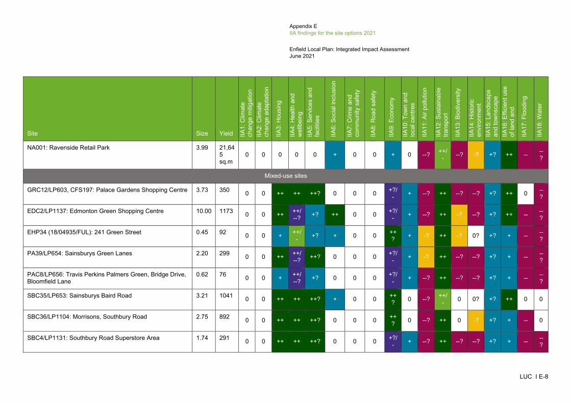
Appendix E IIA findings for the site options 2021
Enfield Local Plan: Integrated Impact Assessment June 2021
LUC I E-8
Site Size Yield IIA1:
Clim
ate
chan
ge m
itiga
tion
IIA2:
Clim
ate
chan
ge a
dapt
atio
n
IIA3:
Hou
sing
IIA4:
Hea
lth a
nd
wel
lbei
ng
IIA5:
Ser
vice
s an
d fa
cilit
ies
IIA6:
Soc
ial i
nclu
sion
IIA7:
Crim
e an
d co
mm
unity
saf
ety
IIA8:
Roa
d sa
fety
IIA9:
Eco
nom
y
IIA10
: Tow
n an
d lo
cal c
entre
s
IIA11
: Air
pollu
tion
IIA12
: Sus
tain
able
tra
nspo
rt
IIA13
: Bio
dive
rsity
IIA14
: His
toric
en
viro
nmen
t IIA
15: L
ands
cape
an
d to
wns
cape
IIA
16: E
ffici
ent u
se
of la
nd a
nd
ti
l
IIA17
: Flo
odin
g
IIA18
: Wat
er
NA001: Ravenside Retail Park 3.99 21,645 sq.m
0 0 0 0 0 + 0 0 + 0 --? ++/- --? -? +? ++ -- --
?
Mixed-use sites
GRC12/LP603, CFS197: Palace Gardens Shopping Centre 3.73 350 0 0 ++ ++ ++? 0 0 0 +?/- + --? ++ --? --? +? ++ 0 --
?
EDC2/LP1137: Edmonton Green Shopping Centre 10.00 1173 0 0 ++ ++/--? +? ++ 0 0 +?/
- + --? ++ -? --? +? ++ -- --?
EHP34 (18/04935/FUL): 241 Green Street 0.45 92 0 0 + ++/- +? + 0 0 ++
? + -? ++ -? 0? +? + -- --?
PA39/LP654: Sainsburys Green Lanes 2.20 299 0 0 ++ ++/--? ++? 0 0 0 +?/
- + -? ++ --? --? +? + -- --?
PAC8/LP656: Travis Perkins Palmers Green, Bridge Drive, Bloomfield Lane
0.62 76 0 0 + ++/--? +? 0 0 0 +?/
- + --? ++ --? --? +? + -- --?
SBC35/LP653: Sainsburys Baird Road 3.21 1041 0 0 ++ ++ ++? + 0 0 ++? 0 --? ++/
- 0 0? +? ++ 0 0
SBC36/LP1104: Morrisons, Southbury Road 2.75 892 0 0 ++ ++ ++? 0 0 0 ++? 0 --? ++ 0 -? +? + -- 0
SBC4/LP1131: Southbury Road Superstore Area 1.74 291 0 0 ++ ++ ++? 0 0 0 +?/- + --? ++ --? --? +? + -- --
?

Appendix E IIA findings for the site options 2021
Enfield Local Plan: Integrated Impact Assessment June 2021
LUC I E-9
Site Size Yield IIA1:
Clim
ate
chan
ge m
itiga
tion
IIA2:
Clim
ate
chan
ge a
dapt
atio
n
IIA3:
Hou
sing
IIA4:
Hea
lth a
nd
wel
lbei
ng
IIA5:
Ser
vice
s an
d fa
cilit
ies
IIA6:
Soc
ial i
nclu
sion
IIA7:
Crim
e an
d co
mm
unity
saf
ety
IIA8:
Roa
d sa
fety
IIA9:
Eco
nom
y
IIA10
: Tow
n an
d lo
cal c
entre
s
IIA11
: Air
pollu
tion
IIA12
: Sus
tain
able
tra
nspo
rt
IIA13
: Bio
dive
rsity
IIA14
: His
toric
en
viro
nmen
t IIA
15: L
ands
cape
an
d to
wns
cape
IIA
16: E
ffici
ent u
se
of la
nd a
nd
ti
l
IIA17
: Flo
odin
g
IIA18
: Wat
er
SBC7/LP659: Colosseum Retail Park 4.35 1587 0 0 ++ ++ ++? + 0 0 ++? 0 --? ++ 0 -? +? ++ -- 0
SGC2/LP1159: Land at Ritz Parade 0.65 79 0 0 + ++ ++? 0 0 0 +/- + --? ++ -? -? +? + -- --?
SOP35 (19/01941/FUL): Southgate Office Village, 286 Chase Road
0.55 125 0 0 ++ ++/- +? 0 0 0 +?/
- + --? ++ -? --? +? + -- 0
UPP24 (19/02718/RE3): Meridian Water Orbital Business Park (and adjoining land including Land South of Argon Road and Land Known as IKEA Clear and Gas Holder Leeside Road), 5 Argon Road
11.90 2300
0 0 ++ --? -? + 0 0 ++? 0 --? ++/
-- --? 0? --? ++ -- --?
UPP32 (16/01197/RE3): Meridian Water, Willoughby Lane and Meridian Way
8.13 725 0 0 ++ ++ +? + 0 0 ++? + --? ++ --? 0? +? ++ -- --
?
UPC2/LP1130: Tesco Extra, 1 Glover Drive 4.24 661 0 0 ++ ++/- -? + 0 0 ++
? 0 --? ++ -? 0? +? ++ -- --?
UPC1/LP1111: IKEA Meridian Water 8.43 854 0 0 ++ ++/- -? + 0 0 ++
? 0 --? ++ --? 0? +? ++ - --?
CFS152: Claverings, Centre Way 2.41 587 0 0 ++ ++ ++? + 0 0 ++? 0 -? + -? 0? -? ++ -- --
?
SOS11/CFS157: M&S Food 0.45 150 0 0 ++ ++/- +? 0 0 0 +?/
- + --? ++ --? --? +? + -- 0
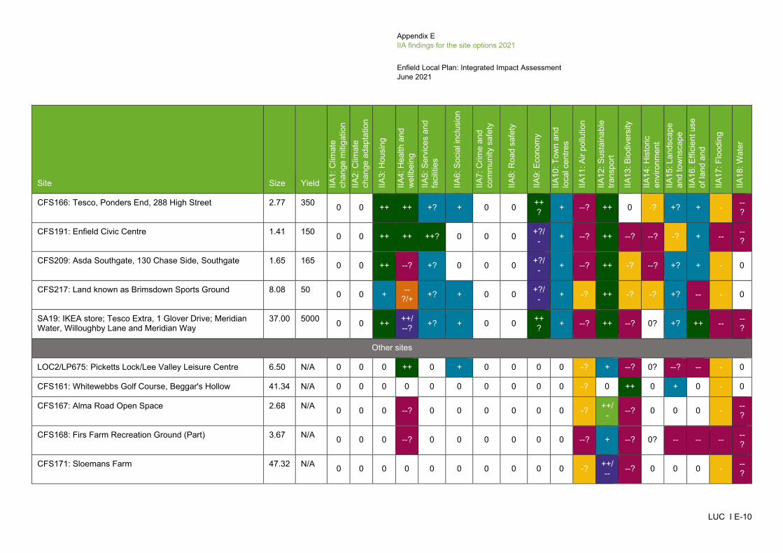
Appendix E IIA findings for the site options 2021
Enfield Local Plan: Integrated Impact Assessment June 2021
LUC I E-10
Site Size Yield IIA1:
Clim
ate
chan
ge m
itiga
tion
IIA2:
Clim
ate
chan
ge a
dapt
atio
n
IIA3:
Hou
sing
IIA4:
Hea
lth a
nd
wel
lbei
ng
IIA5:
Ser
vice
s an
d fa
cilit
ies
IIA6:
Soc
ial i
nclu
sion
IIA7:
Crim
e an
d co
mm
unity
saf
ety
IIA8:
Roa
d sa
fety
IIA9:
Eco
nom
y
IIA10
: Tow
n an
d lo
cal c
entre
s
IIA11
: Air
pollu
tion
IIA12
: Sus
tain
able
tra
nspo
rt
IIA13
: Bio
dive
rsity
IIA14
: His
toric
en
viro
nmen
t IIA
15: L
ands
cape
an
d to
wns
cape
IIA
16: E
ffici
ent u
se
of la
nd a
nd
ti
l
IIA17
: Flo
odin
g
IIA18
: Wat
er
CFS166: Tesco, Ponders End, 288 High Street 2.77 350 0 0 ++ ++ +? + 0 0 ++? + --? ++ 0 -? +? + - --
?
CFS191: Enfield Civic Centre 1.41 150 0 0 ++ ++ ++? 0 0 0 +?/- + --? ++ --? --? -? + -- --
?
CFS209: Asda Southgate, 130 Chase Side, Southgate 1.65 165 0 0 ++ --? +? 0 0 0 +?/- + --? ++ -? --? +? + - 0
CFS217: Land known as Brimsdown Sports Ground 8.08 50 0 0 + --?/+ +? + 0 0 +?/
- + -? ++ -? -? +? -- - 0
SA19: IKEA store; Tesco Extra, 1 Glover Drive; Meridian Water, Willoughby Lane and Meridian Way
37.00 5000 0 0 ++ ++/--? +? + 0 0 ++
? + --? ++ --? 0? +? ++ -- --?
Other sites
LOC2/LP675: Picketts Lock/Lee Valley Leisure Centre 6.50 N/A 0 0 0 ++ 0 + 0 0 0 0 -? + --? 0? --? -- - 0
CFS161: Whitewebbs Golf Course, Beggar's Hollow 41.34 N/A 0 0 0 0 0 0 0 0 0 0 -? 0 ++ 0 + 0 - 0
CFS167: Alma Road Open Space 2.68 N/A 0 0 0 --? 0 0 0 0 0 0 -? ++/- --? 0 0 0 - --
?
CFS168: Firs Farm Recreation Ground (Part) 3.67 N/A 0 0 0 --? 0 0 0 0 0 0 --? + --? 0? -- -- -- --?
CFS171: Sloemans Farm 47.32 N/A 0 0 0 0 0 0 0 0 0 0 -? ++/-- --? 0 0 0 - --
?

Appendix E IIA findings for the site options 2021
Enfield Local Plan: Integrated Impact Assessment June 2021
LUC I E-11
Site Size Yield IIA1:
Clim
ate
chan
ge m
itiga
tion
IIA2:
Clim
ate
chan
ge a
dapt
atio
n
IIA3:
Hou
sing
IIA4:
Hea
lth a
nd
wel
lbei
ng
IIA5:
Ser
vice
s an
d fa
cilit
ies
IIA6:
Soc
ial i
nclu
sion
IIA7:
Crim
e an
d co
mm
unity
saf
ety
IIA8:
Roa
d sa
fety
IIA9:
Eco
nom
y
IIA10
: Tow
n an
d lo
cal c
entre
s
IIA11
: Air
pollu
tion
IIA12
: Sus
tain
able
tra
nspo
rt
IIA13
: Bio
dive
rsity
IIA14
: His
toric
en
viro
nmen
t IIA
15: L
ands
cape
an
d to
wns
cape
IIA
16: E
ffici
ent u
se
of la
nd a
nd
ti
l
IIA17
: Flo
odin
g
IIA18
: Wat
er
CFS230: Church Street Recreation Ground 5.54 N/A 0 0 0 --? 0 0 0 0 0 0 --? + --? 0? -- -- - --?
CFS218: Tottenham Hotspur's training centre 42.25 N/A 0 0 0 ++ 0 0 0 0 0 0 --? +/- --? -? -? --? -- 0

Appendix E IIA findings for the site options 2021
Enfield Local Plan: Integrated Impact Assessment June 2021
LUC I E-12
IIA1: Climate change mitigation
Housing sites
E.3 All housing sites are expected to have negligible effects in relation to this objective. This is because the location of housing sites will not affect the achievement of this objective – effects will depend largely on the detailed proposals for sites and their design, which would be influenced by policies in the Local Plan and details submitted at the planning application stage.
Industrial sites
E.4 All industrial sites are expected to have negligible effects in relation to this objective. This is because the location of industrial sites will not affect the achievement of this objective – effects will depend largely on the detailed proposal for sites and their design, which would be influenced by policies in the Local Plan and details submitted at the planning application stage.
Mixed use sites
E.5 All mixed use sites are expected to have negligible effects in relation to this objective. This is because the location of mixed use sites will not affect the achievement of this objective – effects will depend largely on the detailed proposal for sites and their design, which would be influenced by policies in the Local Plan and details submitted at the planning application stage.
IIA2: Climate change adaptation
Housing sites
E.6 All housing sites are expected to have negligible effects in relation to this objective. This is because the location of housing sites will not affect the achievement of this objective – effects will depend largely on the detailed proposals for sites and their design, which would be influenced by policies in the Local Plan and details submitted at the planning application stage.
Industrial sites
E.7 All industrial sites are expected to have negligible effects in relation to this objective. This is because the location of industrial sites will not affect the achievement of this objective – effects will depend largely on the detailed proposal for sites and their design, which would be influenced by policies in the Local Plan and details submitted at the planning application stage.
Mixed use sites
E.8 All mixed use sites are expected to have negligible effects in relation to this objective. This is because the location of mixed use sites will not affect the achievement of this objective – effects will depend largely on the detailed proposal for sites and their design, which would be influenced by policies in the Local Plan and details submitted at the planning application stage.
IIA3: Housing
Housing sites
E.9 Around two thirds of the housing site options are expected to have significant positive effects against this objective because they have the capacity to deliver more than 100 housing units. Therefore, they will contribute significantly to the total housing need. The remaining housing site options are expected to have minor positive effects in relation to this objective because they have capacity to deliver fewer than 100 housing units.
Industrial sites
E.10 The location of industrial sites is not considered likely to affect this objective; therefore the effects of all industrial site options are negligible.

Appendix E IIA findings for the site options 2021
Enfield Local Plan: Integrated Impact Assessment June 2021
LUC I E-13
Mixed use sites
E.11 Most of the mixed use sites are expected to have significant positive effects against this objective because they have capacity to deliver more than 100 housing units as part of the mixed use development. Therefore, they will contribute significantly to the total housing need. The remaining four sites are anticipated to have minor positive effects in relation to this objective because they have capacity to deliver fewer than 100 housing units.
IIA4: Health and wellbeing
Housing sites
E.12 Around 40% of the housing sites are expected to have significant positive effects in relation to this objective because they are all located within 800m of an area of open space, with some of them also located within 400m of a GP surgery. Some of the sites are also within 400m of a walking or cycle path. Development of these sites is therefore expected to help improve people's physical health and mental well-being because they will have access to open space and/or easy access to primary healthcare facilities (i.e. GP surgeries). Access to open space is particularly important in LBE as there is an identified imbalance in open space between the east and west and the COVID-19 pandemic has highlighted the importance of access to open space.
E.13 Just under one third of the housing sites are expected to have a mixed significant positive and minor negative effect in relation to this objective because although they are within 800m of an area of open space, they are not within 800m of a GP surgery. Seven of the sites are expected to have a mixed significant positive and significant negative effect in relation to this objective because although they are within 800m of an area of open space and some are also within 400m of a GP surgery, they contain a walking or cycle path which could be lost as a result of development, although this is uncertain. Two of these sites also contain an area of open space, which could be lost as a result of development: (1) Arnos Park Metropolitan Open Land which is within site SGC4/LP608_2: Arnos Grove Station Car Park; and (2) a number of areas of Amenity Green Space within site UPM1: Joyce Avenue and Snells Park Estate.
E.14 One of the site options, POC6/LP1196: Land at former Wessex Hall Building, is expected to have a mixed significant negative and minor positive effect against this objective because although it is within 400-800m of a GP surgery, it partially overlaps Durants Park Metropolitan Open Land and so this area could be lost to new development, although this is uncertain. Two sites are expected to have minor positive effects in relation to this objective because they are within 400-800m of a GP surgery and 800m of an area of open space but are not within 400m of a walking or cycling path. Four sites are expected to have a mixed minor positive and minor negative effect because they are either within 800m of open space or within 400m of a walking or cycle path but are not within 800m of a GP surgery.
Industrial sites
E.15 The location of industrial sites is not considered likely to affect this objective; therefore the effects for all industrial site options are negligible.
Mixed use sites
E.16 Just under half of the mixed use sites are expected to have significant positive effects in relation to this objective because they are all located within 800m of an area of open space, with some of them also located within 400m of a GP surgery, and a walking or cycle path. Development of these sites is therefore expected to help improve people's physical health and mental wellbeing because they will have access to open space and/or easy access to primary healthcare facilities. One quarter of the sites are expected to have mixed significant positive and minor negative effects in relation to this objective because they are within 800m of an area of open space but are not within 800m of a GP surgery. Just one site, CFS217: Land known as Brimsdown Sports Ground, has a potential but uncertain mixed significant negative and minor positive effect against this objective because it contains a walking path that could be lost as a result of new development. However, the site is located within 400-800m of a GP surgery.
E.17 Four of the mixed use sites have potential but uncertain mixed significant positive and significant negative effects in relation to this objective: (1) EDC2/LP1137: Edmonton Green Shopping Centre; (2) PA39/LP654: Sainsburys Green Lanes; (3) PAC8/LP656: Travis Perkins Palmers Green, Bridge Drive, Bloomfield Lane; and (4) SA19: IKEA store; Tesco Extra, 1 Glover Drive; Meridian Water, Willoughby Lane and Meridian Way. One of these sites (EDC2/LP1137: Edmonton Green Shopping Centre) contains a walking path that could be lost as a result of development, whilst the other three contain cycling paths that

Appendix E IIA findings for the site options 2021
Enfield Local Plan: Integrated Impact Assessment June 2021
LUC I E-14
could be lost as a result of development. However, all three mixeduse site options fall within 400m of a GP surgery. These effects are recorded as uncertain because it is unknown whether these walking and cycling paths will definitely be lost as a result of development or not. Just two mixed use sites have potential but uncertain significant negative effects against this objective because they contain a walking or cycle path: (1) UPP24 (19/02718/RE3): Meridian Water Orbital Business Park, 5 Argon Road; and (2) CFS209: Asda Southgate.
IIA5: Services and facilities
Housing sites
E.18 Around two fifths of the housing site options could have significant positive effects in relation to this objective (although these are uncertain) because they are within 800m of an existing primary school and an existing secondary school. Development of these sites is therefore expected to improve people’s access to education facilities which will support raising attainment and the development of a skilled workforce within the Borough. A similar number of the housing site options could have minor positive effects in relation to this objective (although these effects are again uncertain) because they are within 800m of either one existing primary school or one existing secondary school, but not both. All effects are recorded as uncertain because it is unknown whether the schools in question will have capacity to accommodate new pupils or not. The remaining housing site options may have minor negative effects in relation to this objective as they do not fall within 800m of a primary school or a secondary school. These effects are also recorded as uncertain because new residential development could potentially stimulate the provision of new schools/school places.
Industrial Sites
E.19 The location of industrial sites is not considered likely to affect this objective; therefore the effects for all industrial site options are negligible.
Mixed use sites
E.20 Around two fifths of the mixed use site options could have significant positive effects in relation to this objective because they are within 800m of an existing primary school and an existing secondary school. Development of these sites is therefore expected to improve people’s access to education facilities which will support raising attainment and the development of a skilled workforce within the Borough. Just under half of the mixed use site options could have minor positive effects in relation to this objective because they are within 800m of either one existing primary school or one existing secondary school, but not both. As with the housing site options, all effects are recorded as uncertain because it is unknown whether the schools in question will have capacity to accommodate new pupils or not. The remaining mixed use site options could have minor negative effects in relation to this objective as they do not fall within 800m of a primary school or a secondary school. These effects are recorded as uncertain because new residential development as part of mixed use sites could potentially stimulate the provision of new schools/school places.
IIA6: Social inclusion
Housing sites
E.21 Only nine housing site options are expected to have minor positive effects in relation to this objective because they partially or entirely fall within one of the 20% most deprived areas in England. Although LBE contains ten Lower-Layer Super Output Areas (LSOAs) that fall within the 10% most deprived areas in England, none of the housing site options fall within them. Site options that fall within the most deprived areas of the Borough could help regenerate those areas through development and the delivery of supporting infrastructure. The remaining site options are expected to have negligible effects in relation to this objective as they do not fall within the 10% or 20% most deprived areas in England.
Industrial sites
E.22 Over half of the industrial sites are expected to have minor positive effects in relation to this objective because they are partially or entirely located within one of the 20% most deprived areas in England. Development of these sites would help to regenerate the surrounding areas through the delivery of supporting infrastructure. Although LBE contains ten Lower-Layer Super Output Areas (LSOAs) that fall within the 10% most deprived areas in England, none of the industrial site options fall

Appendix E IIA findings for the site options 2021
Enfield Local Plan: Integrated Impact Assessment June 2021
LUC I E-15
within them. The remaining industrial site options are expected to have negligible effects in relation to this objective as they do not fall within the 10% or 20% most deprived areas in England.
Mixed use sites
E.23 Just one mixed use site, EDC2/LP1137: Edmonton Green Shopping Centre, is expected to have a significant positive effect in relation to this objective because it is entirely located within one of the 10% most deprived areas in the Borough. Site options that fall within the most deprived areas of the Borough will help regenerate those areas through development and the delivery of supporting infrastructure. Just over half of the mixed use site options are expected to have minor positive effects in relation to this objective because they are partially or entirely located within one of the 20% most deprived areas within the Borough. The remaining sites are expected to have negligible effects in relation to this objective as they do not fall within the 10% or 20% most deprived areas in the England.
IIA7: Crime and community safety
Housing sites
E.24 All of the housing site options are expected to have negligible effects in relation to this objective. This is because the location of housing sites will not affect the achievement of this objective – effects will depend largely on the detailed proposals for sites and their design, which would be influenced by policies in the Local Plan and details submitted at the planning application stage.
Industrial sites
E.25 All of the industrial site options are expected to have negligible effects in relation to this objective. This is because the location of industrial sites will not affect the achievement of this objective – effects will depend largely on the detailed proposal for sites and their design, which would be influenced by policies in the Local Plan and details submitted at the planning application stage.
Mixed use sites
E.26 All of the mixed use site options are expected to have negligible effects in relation to this objective. This is because the location of mixed use sites will not affect the achievement of this objective – effects will depend largely on the detailed proposal for sites and their design, which would be influenced by policies in the Local Plan and details submitted at the planning application stage.
IIA8: Road safety
Housing sites
E.27 All of the housing site options are expected to have negligible effects in relation to this objective. This is because the location of housing sites will not affect the achievement of this objective – effects will depend largely on the detailed proposals for sites and their design, which would be influenced by policies in the Local Plan and details submitted at the planning application stage.
Industrial sites
E.28 All of the industrial site options are expected to have negligible effects in relation to this objective. This is because the location of industrial sites will not affect the achievement of this objective – effects will depend largely on the detailed proposals for sites and their design, which would be influenced by policies in the Local Plan and details submitted at the planning application stage.
Mixed use sites
E.29 All of the mixed use site options are expected to have negligible effects in relation to this objective. This is because the location of mixed use sites will not affect the achievement of this objective – effects will depend largely on the detailed proposals

Appendix E IIA findings for the site options 2021
Enfield Local Plan: Integrated Impact Assessment June 2021
LUC I E-16
for sites and their design, which would be influenced by policies in the Local Plan and details submitted at the planning application stage.
IIA9: Economy
Housing sites
E.30 Five of the housing site options are anticipated to have significant positive effects in relation to this objective as they are adjacent or close to (i.e. within 100m of) at least one Locally Significant Industrial Site. Therefore, these five sites provide easy access to job opportunities. The remaining site options are expected to have minor negative effects in relation to this objective because they are not adjacent or close to Strategic Industrial Locations or Locally Significant Industrial Sites. Development of these sites would therefore not provide good access to employment opportunities for local people, which could slow LBE’s economic recovery from the COVID-19 pandemic.
Industrial sites
E.31 One of the industrial sites, ELC3/LP606: Land West of Ramney Marsh, is expected to have a significant positive effect in relation to this objective because it falls into the ‘large sites’ category (sites that are 10ha or larger). Development of this site would result in the creation of a significant number of new job opportunities, which would support the population growth that is being planned for within the Local Plan. The remaining industrial sites are expected to have minor positive effects in relation to the objective because they fall into the ‘small sites’ category (sites that are under 10ha) and so would provide a smaller number of new jobs.
Mixed use sites
E.32 Half of the mixed use site options could have significant positive effects in relation to this objective because they are next to Strategic Industrial Locations and/or Locally Significant Industrial Sites and would therefore provide easy access to employment opportunities. Two of these sites, UPC1/LP1111: IKEA Meridian Water and SA19: Meridian Water area, are also over 10ha in size and would therefore contribute significantly towards new employment opportunities. All of these effects are recorded as uncertain because it is unknown what proportion of each mixed use site would comprise employment development. The remaining sites, with the exception of SGC2/LP1159: Land at Ritz Parade, are expected to have mixed minor positive and minor negative effects in relation to this objective because they will contribute towards employment development (although are under 10ha in size) but are not located adjacent or close to Strategic Industrial Locations or Locally Significant Industrial Sites. Site SGC2/LP1159: Land at Ritz Parade is expected to have a mixed minor positive and minor negative effect with no uncertainty because it re-provides existing retail uses on site.
IIA10: Town and local centres
Housing sites
E.33 Just under half of the housing site options are anticipated to have minor positive effects in relation to this objective as they are within or adjacent to a Major, District or Local Centre. New development located within or next to these centres will contribute to their vitality through an increase in footfall, whilst also encouraging the retention and expansion of town and local centre commercial and retail uses. The remaining site options are expected to have negligible effects in relation to the objective because they are not within or adjacent to a Major, District or Local Centre.
Industrial sites
E.34 All of the industrial site options are expected to have negligible effects in relation to this objective because they are not within or adjacent to a Major, District or Local Centre.
Mixed use sites
E.35 Around two thirds of the mixed use site options are expected to have minor positive effects in relation to this objective as they are within or adjacent to a Major, District or Local Centre. New development located within these centres will contribute to their vitality through an increase in footfall, whilst also encouraging the retention and expansion of town and local centre

Appendix E IIA findings for the site options 2021
Enfield Local Plan: Integrated Impact Assessment June 2021
LUC I E-17
commercial and retail uses. The remaining mixed use site options are expected to have negligible effects in relation to this objective because they are not within or adjacent to a Major, District or Local Centre.
IIA11: Air pollution
Housing sites
E.36 Around two fifths of the housing site options are expected to have significant negative effects in relation to this objective because they scored 2 in the air quality appraisal. The remaining housing site options are expected to have minor negative effects in relation to this objective because they scored 1 in the air quality appraisal. The air quality appraisal gave consideration to the estimated housing capacity of each of the housing site options and proximity to Air Quality Focus Areas (AQFAs)9, in order to determine the potential future impact on the air quality of each site. The effects are recorded as uncertain because the air quality appraisal does not take into account measures that will improve future air quality, such as the expansion of the Ultra-low Emissions Zone to the North Circular Road in 2021 or the petrol and diesel car ban in 2030.
Industrial sites
E.37 Two fifths of industrial site options are expected to have significant negative effects in relation to this objective because they scored 2 in the air quality appraisal, whilst another two fifths of industrial site options are expected to have minor negative effects in relation to this objective because they scored 1 in the air quality appraisal. The air quality appraisal gave consideration to the area of each industrial site option and proximity to Air Quality Focus Areas (AQFAs), in order to determine the potential future impact on the air quality of each site. The effects are recorded as uncertain because the air quality appraisal does not take into account measures that will improve future air quality, such as the expansion of the Ultra-low Emissions Zone to the North Circular Road in 2021 or the petrol and diesel car ban in 2030. The remaining industrial sites are expected to have negligible effects in relation to this objective because they scored 0 in the air quality appraisal.
Mixed use sites
E.38 Around 85% of mixed use site options are expected to have a significant negative effect in relation to this objective because they scored 2 in the air quality appraisal. The remaining mixed use sites are expected to have a minor negative effect in relation to this objective because they scored 1 in the air quality appraisal. The air quality appraisal gave consideration to the estimated housing capacity of each of the mixed use site options and proximity to Air Quality Focus Areas (AQFAs), in order to determine the potential future impact on the air quality of each site. The effects are recorded as uncertain because the air quality appraisal does not take into account measures that will improve future air quality, such as the expansion of the Ultra-low Emissions Zone to the North Circular Road in 2021 or the petrol and diesel car ban in 2030.
IIA12: Sustainable transport
Housing sites
E.39 Just over half of the housing site options are expected to have significant positive effects in relation to this objective because they are within 1km of a railway/tube station and 350m of at least one bus stop, and some of them fall within 200m of a Major, District or Local Centre. Development of these sites that are near to sustainable transport links will therefore help support a modal shift away from the private car. Just under one third of the housing site options are expected to have mixed significant positive and significant negative effects in relation to this objective, because although they are within 1km of a railway/tube station and 350m of a bus stop, they are more than 800m from a Major, District or Local Centre.
E.40 Four of the housing site options are anticipated to have mixed significant positive and minor negative effects in relation to this objective because, although they are all within 1km of a railway/tube station and 350m of at least one bus stop, they are within 401-800m of a Major, District or Local Centre. A further two housing site options are anticipated to have mixed significant negative and minor positive effects against this objective because they are more than 800m from a Major, District or Local Centre but are within 1km of a railway station. Finally, one site, CHC14/LP637: Land north of Goat Lane, is expected to have a
_____________________________________________________________________________________________________ 9 An AQFA is a location that has been identified as having high levels of pollution and human exposure.
Appendix E IIA findings for the site options 2021
Enfield Local Plan: Integrated Impact Assessment June 2021
LUC I E-18
minor negative effect in relation to this objective because it is within 401-800m of a Local Centre, more than 1km from a railway/tube station and 350m from a bus stop with no existing cycle route passing the site.
Industrial sites
E.41 Just two industrial site options, CFS151: Crown Road Lorry Park and CFS153: Montagu Ind Estate are expected to have significant positive effects in relation to this objective as they are within 1km of a railway/tube station and 350m of a bus stop. Site CFS151 is also within 200m of a Local Centre. Development of these sites near sustainable transport links will therefore help support a modal shift away from the private car. Over half of the industrial site options are expected to have mixed significant positive and minor negative effects in relation to this objective because they are located within 1km of a railway station and 350m of at least one bus stop but are only within 401-800m of a Major, District or Local Centre. Just one site, CFS155: Land East of Junction 24, will have a mixed significant negative and minor positive effect as the site is more than 800m from a Major, District and Local Centre, but is within 350m of at least one bus stop. One site, CFS132: Land at 135 Theobalds Park Road, is expected to have a mixed significant positive and significant negative effect in relation to this objective because it is within 1km of a railway station and 350m of at least one bus stop, but is more than 800m from a Major, District and Local Centre.
Mixed Use
E.42 Over 80% of the mixed use site options are expected to have significant positive effects in relation to IIA12: Sustainable transport because they are within 1km of a railway/tube station and 350m of at least one bus stop. Development of these sites near to sustainable transport links will therefore help support a modal shift away from the private car. Just one site option, CFS152: Claverings, Centre Way, is expected to have a minor positive effect in relation to this objective because it is within 350m of a bus stop and 201-400m of a Local Centre. Similarly, just one site, SBC35/LP653: Sainsbury’s Baird Road is expected to have a mixed significant positive and minor negative effect as it is within 1km of a railway station and 350m of a bus stop but is only within 401-800m of a Local Centre. Finally, one site, UPP24 (19/02718/RE3): Meridian Water Orbital Business Park, 5 Argon Road, is anticipated to have a mixed significant positive and significant negative effect in relation to this objective because it is within 1km of a railway station and 350m of at least one bus stop, but is more than 800m from a Major, District and Local Centre.
IIA13: Biodiversity
Housing sites
E.43 Over three quarters of the housing site options could have significant negative effects against this objective because they fall within 250m of one or more Sites of Special Scientific Interest or Sites of Importance for Nature Conservation and/or within 100m of a Priority Habitat or Ancient Woodland. Six of the residential site options contain a Priority Habitat: (1); COC9a and COC9b/LP608_1: Cockfosters Station Car Park (2); HIC10/LP642: Land opposite Jolly Farmers; (3) HIC11/LP707: Vicarage Farm, Land between Hadley Road and Enfield Road; (4) CFS162_B: Land to the Rear of Arnold House (East); (5) CFS162_C: Arnold House; and (6) SA29: Arnold House. Development of these sites will therefore place increased stress on the designated and non-designated biodiversity assets within the Borough which are already experiencing pressure from recreational use, as well as poor air quality. Eight of the housing site options could have minor negative effects against this objective, as they fall within 250-750m of a Sites of Special Scientific Interest or Sites of Importance for Nature Conservation and/or within 750m of a Local Nature Reserve, as well as 100-250m from a Priority Habitat or Ancient Woodland. All effects are recorded as uncertain because appropriate mitigation may avoid adverse effects and may even result in beneficial effects. The remaining site options, namely LOC1/LP1108: Chiswick Road Estate (Osward and Newdales) and CFS207: Albany Leisure Centre and Car Park, 55 Albany Road, are expected to have negligible effects in relation to this objective because they do not fall within 750m of any of these biodiversity assets.
Industrial sites
E.44 Almost all of the industrial site options could have significant negative effects in relation to this objective because they fall within 250m of one or more Sites of Special Scientific Interest or Sites of Importance for Nature Conservation and/or within 100m of a Priority Habitat or Ancient Woodland. One of the industrial sites, ELC3/LP606: Ramney Marsh Mollison Avenue, contains a Priority Habitat. Development of these sites will therefore place increased stress on the designated and non-

Appendix E IIA findings for the site options 2021
Enfield Local Plan: Integrated Impact Assessment June 2021
LUC I E-19
designated biodiversity assets within the Borough which are already experiencing pressure from recreational use, as well as poor air quality. The effects are uncertain because appropriate mitigation may avoid adverse effects and may even result in beneficial effects. The remaining site, CFS151: Crown Road Lorry Park is expected to have a negligible effect in relation to this objective because it does not fall within close proximity of a biodiversity asset.
Mixed use sites
E.45 Around two fifths of mixed use site options could have significant negative effects in relation to this objective because they fall within 250m of one or more Sites of Special Scientific Interest or Sites of Importance for Nature Conservation and/or within 100m of a Priority Habitat or Ancient Woodland. Three of the mixed use sites contain a Priority Habitat: (1) PA39/LP654: Sainsburys Green Lanes; (2) UPP32 (16/01197/RE3): Meridian Water; and (3) SA19: Meridian Water area. A further eight mixed use site options could have minor negative effects in relation to this objective because they fall within 250-750m of a Sites of Special Scientific Interest or Sites of Importance for Nature Conservation and/or within 750m of a Local Nature Reserve, as well as 100-250m from a Priority Habitat or Ancient Woodland. Development of these sites will therefore place increased stress on the designated and non-designated biodiversity assets within the Borough which are already experiencing pressure from recreational use, as well as poor air quality. The remaining sites are expected to have negligible effects in relation to this objective because they do not fall within 750m of any of these biodiversity assets.
IIA14: Historic environment
Housing sites
E.46 Just over two fifths of the housing site options could have significant negative but uncertain effects against this objective because they have the potential to cause harm to heritage assets where it is unlikely that these can be adequately mitigated. Development of these sites will therefore place increased pressure on the LBE’s rich variety of designated heritage assets which are already under stress from inappropriate development and activity affecting their setting and context. Another two fifths of housing site options could have minor negative but uncertain effects against this objective because they have the potential to cause harm to heritage assets, but this harm could potentially be mitigated. The remaining housing site options could have negligible but uncertain effects in relation to this objective as they are more than 500m from the nearest designated heritage asset but there is still some potential for impacts on non-designated heritage features and effects may extend beyond 500m in some cases.
Industrial sites
E.47 Three industrial site options, ELC3/LP606: Ramney Marsh Mollison Avenue, POC5/LP694/CFS135: Car Park Site and CFS153: Montagu Industrial Estate could have significant negative but uncertain effects against this objective because they have the potential to cause harm to heritage assets where it is unlikely that these can be adequately mitigated. Less than half of the industrial site options could have minor negative but uncertain effects in relation to this objective as they have the potential to cause harm to heritage assets, but this harm can potentially be mitigated. Development of these sites would therefore place increased pressure on the LBE’s rich variety of designated heritage assets which are already under stress from inappropriate development and activity affecting their setting and context. The remaining three site options could have negligible but uncertain effects in relation to this objective as they are more than 500m from the nearest designated heritage asset but there is still some potential for impacts on non-designated heritage features and effects may extend beyond 500m in some cases.
Mixed use sites
E.48 Two fifths of mixed use site options could have significant negative but uncertain effects in relation to this objective because they have the potential to cause harm to heritage assets where it is unlikely that these can be adequately mitigated. Development of these sites will therefore place increased pressure on the LBE’s rich variety of designated heritage assets which are already under stress from inappropriate development and activity affecting their setting and context. Approximately one quarter of site options could have minor negative but uncertain effects in relation to this objective because they have the potential to cause harm to heritage assets, but this harm could potentially be mitigated. The remaining eight sites could have negligible effects in relation to this objective as they are more than 500m from the nearest designated heritage asset but there is still some potential for impacts on non-designated heritage features and effects may extend beyond 500m in some cases.

Appendix E IIA findings for the site options 2021
Enfield Local Plan: Integrated Impact Assessment June 2021
LUC I E-20
IIA15: Landscape and townscape
Housing sites
E.49 Just under two thirds of the housing site options could have minor positive but uncertain effects in relation to this objective because they are located within a settlement and contain built development. Development of these sites is therefore expected to help improve the quality of the landscape and/or townscape within LBE, including designated landscapes and extensive semi-rural landscape character areas, all of which need to be protected. Just over one fifth of the housing site options could have minor negative but uncertain effects in relation to this objective because they are either located within a settlement but do not contain built development, are not large in scale (i.e. <3ha), located on the edge of a settlement or within a relatively undeveloped area. Five of the housing site options could have significant negative but uncertain effects in relation to this objective because they are large in scale (i.e. >=3ha), located on the edge of a settlement or within a relatively undeveloped area. Three site options could have significant negative effects against this objective because they contain open space, including Metropolitan Open Land and/or Green Chains: (1) Durants Park Metropolitan Open Land in site POC6/LP1196: Land at former Wessex Hall Building; (2) Arnos Park Metropolitan Open Land in site SGC4/LP608_2: Arnos Grove Station Car Park; and (3) a number of areas of Amenity Green Space within site UPM1: Joyce Avenue and Snells Park Estate. Only one of the site options, SA27: Land at Crews Hill, is expected to have a mixed significant negative and minor positive effect in relation to this objective. This is because it is large in scale and although it is partially located within the settlement of Crews Hill and contains built development, it is also partially located in an undeveloped area.
Industrial sites
E.50 Around two thirds of industrial site options could have minor positive effects in relation to this objective because they are located within a settlement and contain built development. Two industrial site options, POC5/LP694/CFS135: Car Park Site, Wharf Road and CFS136: 6 Morson Road, could have minor negative effects against this objective because although they are not large in scale (i.e. <3ha), they are located on the edge of Ponders End. The remaining site option, CFS155: Land East of Junction 24, is expected to have a significant negative effect against this objective because it is large in scale (>=3ha) and located in an undeveloped area. In all cases, effects in relation to this objective are uncertain as the potential for negative or positive effects on landscape will depend on the exact scale, design and layout of the new development and opportunities which may exist to enhance the setting of heritage features.
Mixed use sites
E.51 Just under 90% of the mixed use site options could have minor positive effects in relation to this objective because they are located within a settlement and contain built development. Development of these sites is therefore expected to help improve the quality of the landscape and/or townscape within LBE, including designated landscapes and extensive semi-rural landscape character areas, all of which need to be protected. Just one site option could have a significant negative effect in relation to this objective: UPP24 (19/02718/RE3): Meridian Water Orbital Business Park, 5 Argon Road. This is because the site is large in scale (i.e. >=3ha) and located on the edge of Upper Edmonton. The two remaining sites, CFS152: Claverings, Centre Way and CFS191: Enfield Civic Centre, are expected to have minor negative effects in relation to this objective because they are not large in scale but located on the edge of settlements. In all cases, effects in relation to this objective are uncertain as the potential for negative or positive effects on landscape will depend on the exact scale, design and layout of the new development and opportunities which may exist to enhance the setting of heritage features.
IIA16: Efficient use of land
Housing sites
E.52 Four of the housing site options are expected to have significant positive effects in relation to this objective because they are relatively large in size (i.e. >=3ha) and on brownfield land. Just under three quarters of the housing site options are anticipated to have minor positive effects in relation to the objective because they are relatively small in size (i.e. <3ha) and on brownfield land. Therefore, development of these sites would be an efficient use of previously developed land. However, nine housing site options are anticipated to have significant negative effects in relation to this objective as they are relatively large in size (i.e. >=3h) and on greenfield land, which is not an efficient use of land. The effects are recorded as uncertain because the GIS data available does not distinguish between Grades 3a and 3b agricultural land (Grade 3a is considered to be high quality,

Appendix E IIA findings for the site options 2021
Enfield Local Plan: Integrated Impact Assessment June 2021
LUC I E-21
while Grade 3b is not). Just one housing site option, CFS162_B: Land to the Rear of Arnold House (East), is expected to have a minor negative effect as it is relatively small in size (i.e. <3ha) but is on greenfield land. One housing site option, SA27: Land at Crews Hill, is expected to have a mixed significant positive and significant negative effect in relation to this objective, as it is relatively large in size and is located on Grade 3 agricultural quality greenfield land. The effect is recorded as uncertain because the GIS data available does not distinguish between Grades 3a and 3b agricultural land.
Industrial sites
E.53 Half of the industrial site options are expected to have significant positive effects in relation to this objective because they are relatively large in size (i.e. >=3ha) and on brownfield land. Four of the industrial site options are expected to have minor positive effects in relation to this objective because they are relatively small in size (i.e. <3ha) and on brownfield land; therefore development of these sites would be an efficient use of previously developed land. Just one industrial site option, CFS155: Land East of Junction 24 , is expected to have a significant negative effect against this objective because it is on greenfield land classed as Grade 3. The effect is recorded as uncertain because the GIS data available does not distinguish between Grades 3a and 3b agricultural land (Grade 3a is considered to be high quality, while Grade 3b is not).
Mixed use sites
E.54 Less than half of the mixed use site options are expected to have significant positive effects in relation to this objective because they are relatively large in size (i.e. >=3ha) and on brownfield land. Half of the sites are expected to have minor positive effects against this objective because they are relatively small in size (i.e. <3ha) and on brownfield land. However, one site, CFS217: Land known as Brimsdown Sports Ground, is expected to have a significant negative effect in relation to this objective as it is relatively large in size (i.e. >=3h) and on greenfield land. The effect is recorded as uncertain because the GIS data available does not distinguish between Grades 3a and 3b agricultural land (Grade 3a is considered to be high quality, while Grade 3b is not).
IIA17: Flooding
Housing sites
E.55 Just over two thirds of housing site options are expected to have significant negative effects in relation to this objective because they have a predicted peak flood depth of greater than 300mm. About one fifth of the housing site options are expected to have minor negative effects in relation to this objective because they partially fall within Flood Zone 3, mainly fall within Flood Zone 2 or have a predicted peak flood depth of greater than 150m, with some site options also located on greenfield land. The remaining five housing site options are expected to have negligible effects against this objective because they are on brownfield land, do not fall within Flood Zones 2 or 3 and are not at risk of surface water flooding.
Industrial sites
E.56 Almost all of the industrial site options are expected to have significant negative effects against this objective because they either fall mainly within Flood Zone 3 or have a predicted peak flood depth of greater than 300mm. Only one of the industrial site options, CFS136: 6 Morson Road, is expected to have a minor negative effect in relation to this objective because it partially falls within Flood Zone 3.
Mixed use sites
E.57 About three quarters of the mixed use site options are expected to have significant negative effects in relation to this objective because they either partially fall within Flood Zone 3 or have a predicted peak flood depth of greater than 300mm. The remaining two mixed use site options, namely GRC12/LP603, CFS197: Palace Gardens Shopping Centre and SBC35/LP653: Sainsburys Baird Road, are expected to have negligible effects against this objective because they are on brownfield land, do not fall within Flood Zones 2 or 3, and are not at risk of surface water flooding.
Appendix E IIA findings for the site options 2021
Enfield Local Plan: Integrated Impact Assessment June 2021
LUC I E-22
IIA18: Water
Housing sites
E.58 Half of the housing site options could have significant negative but uncertain effects in relation to this objective because they contain a watercourse, water body or fall within Source Protection Zones 1 or 210. Development of these sites may therefore exacerbate water quality issues that currently impact the Borough, such as not meeting the Water Framework Directive (WFD) required ecological status of ‘Good’. The remaining half of the housing site options are expected to have negligible effects in relation to this objective as they do not contain a watercourse, water body or fall within a Source Protection Zone.
Industrial sites
E.59 Four fifths of the industrial site options could have significant negative but uncertain effects in relation to this objective because they contain a watercourse, water body or fall within Source Protection Zones 1 or 2. Development of these sites may therefore exacerbate water quality issues that currently impact the Borough, such as not meeting the WFD required ecological status of ‘Good’. The remaining two industrial sites, CFS132: Land at 135 Theobalds Park Road and CFS151: Crown Road Lorry Park are expected to have negligible effects in relation to this objective as they do not contain a watercourse, water body or fall within a Source Protection Zone.
Mixed use sites
E.60 Just under three quarters of the mixed use site options could have significant negative but effects in relation to this objective because they contain a watercourse, water body or fall within Source Protection Zones 1 or 2. Development of these sites may therefore exacerbate water quality issues that currently impact the Borough, such as not meeting the WFD required ecological status of ‘Good’. The remaining mixed use site options are expected to have negligible effects in relation to this objective as they do not contain a watercourse, water body or fall within a Source Protection Zone.
Other sites
E.61 There are seven 'Other' sites and their uses are as follows:
LOC2/LP675: Picketts Lock/Lee Valley Leisure Centre: leisure uses site.
CFS161: Whitewebbs Golf Course, Beggar's Hollow: nature recovery site.
CFS167: Alma Road Open Space: cemetery.
CFS168: Firs Farm Recreation Ground (Part): crematorium.
CFS171: Sloemans Farm: natural burial site.
CFS230: Church Street Recreation Ground: crematorium.
CFS218: Land at and within the vicinity of Tottenham Hotspur Football Club Training Ground: sport and recreation site.
E.62 Two of these sites, LOC2/LP675: Picketts Lock/Lee Valley Leisure Centre and CFS218: Tottenham Hotspur's training centre, are expected to have significant positive effects in relation to IIA4: Health and wellbeing because the development of a leisure uses and sport and recreation site, respectively, would have beneficial effects on people's health and wellbeing. Three of the sites are expected to have significant negative effects in relation to this objective as they contain an area of open space that could be lost to the proposed site use: (1) Durants Park Metropolitan Open Land at site CFS167: Alma Road Open Space; (2) Firs Farm & Clowes Sportsgrounds Metropolitan Open Land at site CFS168: Firs Farm Recreation Ground (Part); and (3) Church Street Recreation Ground Metropolitan Open Land at site CFS230: Church Street Recreation Ground.
E.63 Three of these sites, (1) CFS168: Firs Farm Recreation Ground (Part); (2) CFS230: Church Street Recreation Ground; and (3) CFS218: Tottenham Hotspur's training centre, are expected to have a significant negative effect in relation to IIA11: Air
_____________________________________________________________________________________________________ 10 Source Protection Zone 3 is present within LBE.
Appendix E IIA findings for the site options 2021
Enfield Local Plan: Integrated Impact Assessment June 2021
LUC I E-23
pollution because they scored 2 in the air quality appraisal. The remaining four sites are expected to have minor negative effects against this objective because they scored 1 in the air quality appraisal. The air quality appraisal gave consideration to the area of each site and proximity to Air Quality Focus Areas (AQFAs), in order to determine the potential future impact on the air quality of each site. The effects are recorded as uncertain because the air quality appraisal does not take into account measures that will improve future air quality, such as the expansion of the Ultra-low Emissions Zone to the North Circular Road in 2021 or the petrol and diesel car ban in 2030.
E.64 Site CFS171: Sloemans Farm is expected to have a mixed significant positive and significant negative effect in relation to IIA12: Sustainable transport because although it is within 1km of a railway station and 350m of at least one bus stop, it is more than 800m from a Major, District and Local Centre. Site CFS167: Alma Road Open Space is expected to have a mixed significant positive and minor negative effect against this objective because it is located within 1km of a railway station and 350m of at least one bus stop but is only within 401-800m of a Local Centre. Site CFS218: Tottenham Hotspur's training centre is expected to have a mixed minor positive and minor negative effect in relation to this objective because it is within 1km of a railway station but not within 350m of a bus stop and only within 401-800m of a Local Centre. Three of the sites are expected to have minor positive effects in relation to IIA12 because they are all within 350m of at least one bus stop and 201-400m of a Local Centre. One site, CFS161: Whitewebbs Golf Course, Beggar's Hollow, is expected to have a negligible effect against this objective because the development of a nature recovery site will not affect the achievement of this objective.
E.65 All but one of the sites could have significant negative effects in relation to IIA13: Biodiversity because they are within 250m of one or more Sites of Special Scientific Interest or Sites of Importance for Nature Conservation and/or less than 100m from a Priority Habitat or Ancient Woodland. Three of the sites contain a Priority Habitat: (1) CFS171: Sloemans Farm; (2) CFS230: Church Street Recreation Ground; and (3) CFS218:Tottenham Hotspur's training centre. The effects are recorded as uncertain because appropriate mitigation may avoid any adverse effects and may even result in beneficial effects. Site CFS161: Whitewebbs Golf Course is expected to have a significant positive effect in relation to this objective because it is proposed as a nature recovery site and would therefore have beneficial effects on biodiversity.
E.66 Site CFS218: Tottenham Hotspur's training centre could have a minor negative but uncertain effect in relation to IIA14: Historic environment because over half of the site falls within Forty Hill Conservation Area, which contains a number of listed buildings, as well as Myddelton House Registered Park and Garden which falls partially within the site. Due to the fact this site is allocated as a sport and recreation site, future development could potentially take place with an adverse effect on the historic environment. Three of the sites could have negligible but uncertain effects in relation to this objective because although they are more than 500m from a designated heritage asset, they may have some potential for impacts on non-designated heritage features and effects may extend beyond the 500m distance threshold. The remaining sites are expected to have negligible effects against this objective as their development would not affect the achievement of this objective.
E.67 Two of the sites are expected to have significant negative effects against IIA15: Landscape and townscape, whilst one of the sites could have a significant negative effect but this is uncertain. The two sites that are expected to have significant negative effects against this objective contain an area of open space, that could be lost as a result of development: (1) Firs Farm & Clowes Sportsgrounds Metropolitan Open Land at site CFS168: Firs Farm Recreation Ground (Part); and (2) Church Street Recreation Ground Metropolitan Open Land at site CFS230: Church Street Recreation Ground. Although site CFS167: Alma Road Open Space also contains an open space, the development of a cemetery is not considered to have an adverse effect on the landscape. Site LOC2/LP675: Picketts Lock/Lee Valley Leisure Centre is expected to have a significant negative but uncertain effect against this objective because it is large in scale and located on the edge of Lower Edmonton. Therefore, the potential future development of this site could result in an adverse effect on the landscape. Site CFS161: Whitwewebbs Golf Course is expected to have a minor positive effect in relation to this objective because the development of a nature recovery site is expected to have beneficial effects on the landscape. Site CFS218: Tottenham Hotspur's training centre is expected to have a minor negative but uncertain effect in relation to this objective because it is large in scale and located in a relatively undeveloped area. Due to the fact the site is allocated as a sport and recreation site which could contain built development in the future, its development could affect the landscape.
E.68 Three of the sites are expected to have significant negative effects in relation to IIA16: Efficient use of land and materials because they are relatively large and on greenfield land, classed as Urban land. Therefore, if development were to take place on these sites, it would not be an efficient use of previously developed land. One of the sites could have a significant negative effect in relation to this objective because it is relatively large and on greenfield land which is classed as Grade 3 agricultural land. This effect is recorded as uncertain because the GIS data available does not distinguish between Grades 3a and 3b agricultural land.

Appendix E IIA findings for the site options 2021
Enfield Local Plan: Integrated Impact Assessment June 2021
LUC I E-24
E.69 Two of the sites, CFS168: Firs Farm Recreation Ground (Part) and CFS218: Tottenham Hotspur's training centre, are expected to have significant negative effects in relation to IIA17: Flooding because they both have a predicted peak flood depth of greater than 300mm. The remaining five site options are expected to have minor negative effects in relation to IIA17 because they partially within Flood Zone 3, have a predicted peak flood depth of greater than 150m and are on greenfield land Four of the sites could have significant negative effects in relation to IIA18: Water because they contain a watercourse, water body or fall within Source Protection Zones 1 or 2.
E.70 All eight sites are expected to have negligible effects against the remaining IIA objectives.

Appendix E IIA findings for the site options 2021
Enfield Local Plan: Integrated Impact Assessment June 2021
LUC I E-25
Allocated Site Appraisal Matrices
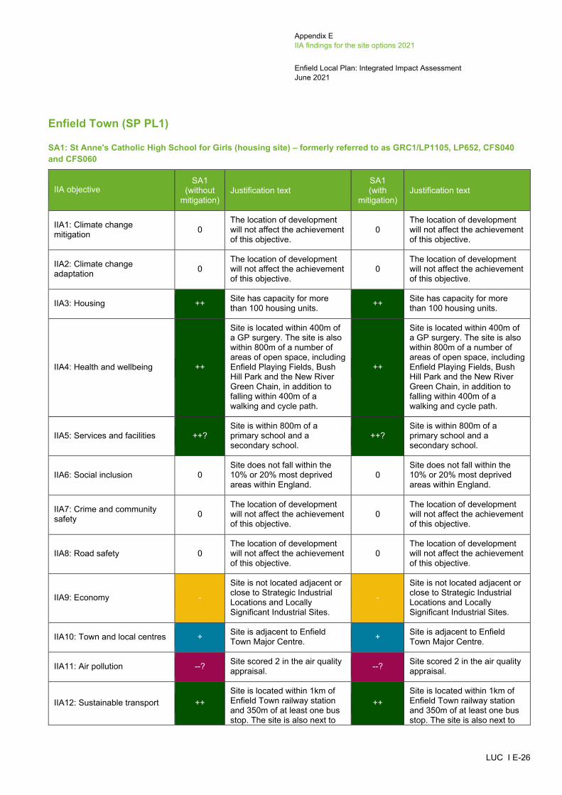
Appendix E IIA findings for the site options 2021
Enfield Local Plan: Integrated Impact Assessment June 2021
LUC I E-26
Enfield Town (SP PL1)
SA1: St Anne's Catholic High School for Girls (housing site) – formerly referred to as GRC1/LP1105, LP652, CFS040 and CFS060
IIA objective SA1
(without mitigation)
Justification text SA1 (with
mitigation) Justification text
IIA1: Climate change mitigation 0
The location of development will not affect the achievement of this objective.
0 The location of development will not affect the achievement of this objective.
IIA2: Climate change adaptation 0
The location of development will not affect the achievement of this objective.
0 The location of development will not affect the achievement of this objective.
IIA3: Housing ++ Site has capacity for more than 100 housing units. ++ Site has capacity for more
than 100 housing units.
IIA4: Health and wellbeing ++
Site is located within 400m of a GP surgery. The site is also within 800m of a number of areas of open space, including Enfield Playing Fields, Bush Hill Park and the New River Green Chain, in addition to falling within 400m of a walking and cycle path.
++
Site is located within 400m of a GP surgery. The site is also within 800m of a number of areas of open space, including Enfield Playing Fields, Bush Hill Park and the New River Green Chain, in addition to falling within 400m of a walking and cycle path.
IIA5: Services and facilities ++? Site is within 800m of a primary school and a secondary school.
++? Site is within 800m of a primary school and a secondary school.
IIA6: Social inclusion 0 Site does not fall within the 10% or 20% most deprived areas within England.
0 Site does not fall within the 10% or 20% most deprived areas within England.
IIA7: Crime and community safety 0
The location of development will not affect the achievement of this objective.
0 The location of development will not affect the achievement of this objective.
IIA8: Road safety 0 The location of development will not affect the achievement of this objective.
0 The location of development will not affect the achievement of this objective.
IIA9: Economy -
Site is not located adjacent or close to Strategic Industrial Locations and Locally Significant Industrial Sites.
-
Site is not located adjacent or close to Strategic Industrial Locations and Locally Significant Industrial Sites.
IIA10: Town and local centres + Site is adjacent to Enfield Town Major Centre. + Site is adjacent to Enfield
Town Major Centre.
IIA11: Air pollution --? Site scored 2 in the air quality appraisal. --? Site scored 2 in the air quality
appraisal.
IIA12: Sustainable transport ++ Site is located within 1km of Enfield Town railway station and 350m of at least one bus stop. The site is also next to
++ Site is located within 1km of Enfield Town railway station and 350m of at least one bus stop. The site is also next to

Appendix E IIA findings for the site options 2021
Enfield Local Plan: Integrated Impact Assessment June 2021
LUC I E-27
IIA objective SA1
(without mitigation)
Justification text SA1 (with
mitigation) Justification text
Enfield Town Major Centre and within 200m of Lincoln Court, London Road Local Centre.
Enfield Town Major Centre and within 200m of Lincoln Court, London Road Local Centre.
IIA13: Biodiversity --?
Site is located within 250m from Enfield Loop of the New River SINC and the New River SINC.
--?
Site is located within 250m from Enfield Loop of the New River SINC and the New River SINC.
IIA14: Historic environment --?
Site is adjacent to Enfield Town Conservation Area and is within 500m of two Grade II* listed buildings (Church of St Andrew Enfield Parish Church and North east Building of Enfield Grammar School) and a number of Grade II listed buildings. Due to the fact the site is adjacent to Enfield Town Conservation Area, its development could affect the setting of the heritage asset.
-?
The Council's assessment of heritage considerations records this site as 'Amber' and states that a Heritage Impact Assessment should be undertaken and mitigation provided.
IIA15: Landscape and townscape +?
Site is located within the settlement of Enfield Town and contains built development.
+?
Site is located within the settlement of Enfield Town and contains built development.
IIA16: Efficient use of land and materials + Site is relatively small in size
and on brownfield land. + Site is relatively small in size and on brownfield land.
IIA17: Flooding --
Site has a predicted peak flood depth of greater than 300mm. However, the site is on brownfield land and does not fall within Flood Zones 2 or 3.
--
Site has a predicted peak flood depth of greater than 300mm. However, the site is on brownfield land and does not fall within Flood Zones 2 or 3.
IIA18: Water --?
Site falls within Source Protection Zones 2 and its northern eastern boundary falls within Source Protection Zone 1.
--?
Site falls within Source Protection Zones 2 and its northern eastern boundary falls within Source Protection Zone 1.
SA2: Palace Gardens Shopping Centre (mixed-use site) – formerly referred to as GRC12/LP603 and CFS197
IIA objective SA2
(without mitigation)
Justification text SA2 (with
mitigation) Justification text
IIA1: Climate change mitigation 0
The location of development will not affect the achievement of this objective.
0 The location of development will not affect the achievement of this objective.
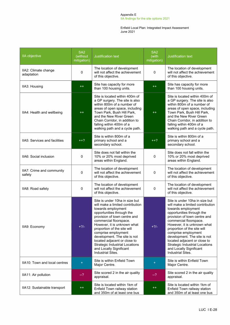
Appendix E IIA findings for the site options 2021
Enfield Local Plan: Integrated Impact Assessment June 2021
LUC I E-28
IIA objective SA2
(without mitigation)
Justification text SA2 (with
mitigation) Justification text
IIA2: Climate change adaptation 0
The location of development will not affect the achievement of this objective.
0 The location of development will not affect the achievement of this objective.
IIA3: Housing ++ Site has capacity for more than 100 housing units. ++ Site has capacity for more
than 100 housing units.
IIA4: Health and wellbeing ++
Site is located within 400m of a GP surgery. The site is also within 800m of a number of areas of open space, including Town Park, Bush Hill Park, and the New River Green Chain Corridor, in addition to falling within 400m of a walking path and a cycle path.
++
Site is located within 400m of a GP surgery. The site is also within 800m of a number of areas of open space, including Town Park, Bush Hill Park, and the New River Green Chain Corridor, in addition to falling within 400m of a walking path and a cycle path.
IIA5: Services and facilities ++? Site is within 800m of a primary school and a secondary school.
++? Site is within 800m of a primary school and a secondary school.
IIA6: Social inclusion 0 Site does not fall within the 10% or 20% most deprived areas within England.
0 Site does not fall within the 10% or 20% most deprived areas within England.
IIA7: Crime and community safety 0
The location of development will not affect the achievement of this objective.
0 The location of development will not affect the achievement of this objective.
IIA8: Road safety 0 The location of development will not affect the achievement of this objective.
0 The location of development will not affect the achievement of this objective.
IIA9: Economy +?/-
Site is under 10ha in size but will make a limited contribution towards employment opportunities through the provision of town centre and commercial floorspace. However, it is unknown what proportion of the site will comprise employment development. The site is not located adjacent or close to Strategic Industrial Locations and Locally Significant Industrial Sites.
+?/-
Site is under 10ha in size but will make a limited contribution towards employment opportunities through the provision of town centre and commercial floorspace. However, it is unknown what proportion of the site will comprise employment development. The site is not located adjacent or close to Strategic Industrial Locations and Locally Significant Industrial Sites.
IIA10: Town and local centres + Site is within Enfield Town Major Centre. + Site is within Enfield Town
Major Centre.
IIA11: Air pollution --? Site scored 2 in the air quality appraisal. --? Site scored 2 in the air quality
appraisal.
IIA12: Sustainable transport ++ Site is located within 1km of Enfield Town railway station and 350m of at least one bus
++ Site is located within 1km of Enfield Town railway station and 350m of at least one bus
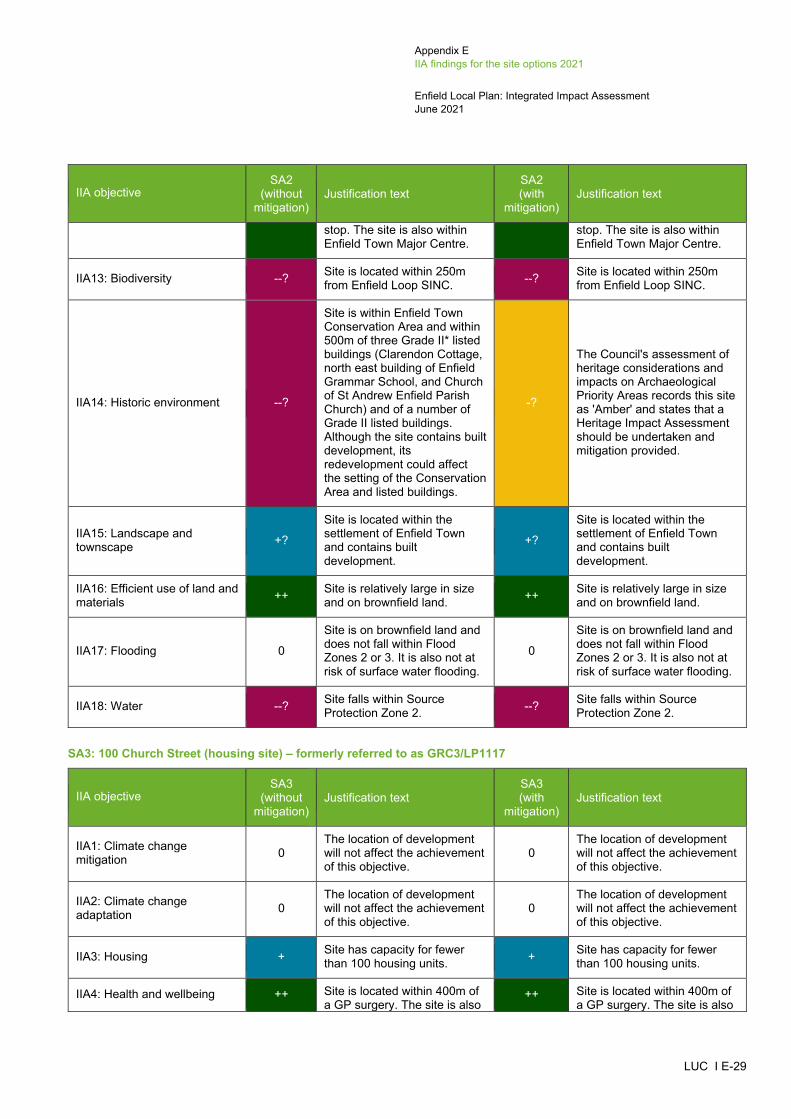
Appendix E IIA findings for the site options 2021
Enfield Local Plan: Integrated Impact Assessment June 2021
LUC I E-29
IIA objective SA2
(without mitigation)
Justification text SA2 (with
mitigation) Justification text
stop. The site is also within Enfield Town Major Centre.
stop. The site is also within Enfield Town Major Centre.
IIA13: Biodiversity --? Site is located within 250m from Enfield Loop SINC. --? Site is located within 250m
from Enfield Loop SINC.
IIA14: Historic environment --?
Site is within Enfield Town Conservation Area and within 500m of three Grade II* listed buildings (Clarendon Cottage, north east building of Enfield Grammar School, and Church of St Andrew Enfield Parish Church) and of a number of Grade II listed buildings. Although the site contains built development, its redevelopment could affect the setting of the Conservation Area and listed buildings.
-?
The Council's assessment of heritage considerations and impacts on Archaeological Priority Areas records this site as 'Amber' and states that a Heritage Impact Assessment should be undertaken and mitigation provided.
IIA15: Landscape and townscape +?
Site is located within the settlement of Enfield Town and contains built development.
+?
Site is located within the settlement of Enfield Town and contains built development.
IIA16: Efficient use of land and materials ++ Site is relatively large in size
and on brownfield land. ++ Site is relatively large in size and on brownfield land.
IIA17: Flooding 0
Site is on brownfield land and does not fall within Flood Zones 2 or 3. It is also not at risk of surface water flooding.
0
Site is on brownfield land and does not fall within Flood Zones 2 or 3. It is also not at risk of surface water flooding.
IIA18: Water --? Site falls within Source Protection Zone 2. --? Site falls within Source
Protection Zone 2.
SA3: 100 Church Street (housing site) – formerly referred to as GRC3/LP1117
IIA objective SA3
(without mitigation)
Justification text SA3 (with
mitigation) Justification text
IIA1: Climate change mitigation 0
The location of development will not affect the achievement of this objective.
0 The location of development will not affect the achievement of this objective.
IIA2: Climate change adaptation 0
The location of development will not affect the achievement of this objective.
0 The location of development will not affect the achievement of this objective.
IIA3: Housing + Site has capacity for fewer than 100 housing units. + Site has capacity for fewer
than 100 housing units.
IIA4: Health and wellbeing ++ Site is located within 400m of a GP surgery. The site is also
++ Site is located within 400m of a GP surgery. The site is also

Appendix E IIA findings for the site options 2021
Enfield Local Plan: Integrated Impact Assessment June 2021
LUC I E-30
IIA objective SA3
(without mitigation)
Justification text SA3 (with
mitigation) Justification text
within 800m of a number of areas of open space, including Chase Green, Town Park, Bush Hill Park, and Cheyne Walk Open Space, in addition to falling within 400m of a walking and cycling path.
within 800m of a number of areas of open space, including Chase Green, Town Park, Bush Hill Park, and Cheyne Walk Open Space, in addition to falling within 400m of a walking and cycling path.
IIA5: Services and facilities ++? Site is within 800m of a primary school and a secondary school.
++? Site is within 800m of a primary school and a secondary school.
IIA6: Social inclusion 0 Site does not fall within the 10% or 20% most deprived areas within England.
0 Site does not fall within the 10% or 20% most deprived areas within England.
IIA7: Crime and community safety 0
The location of development will not affect the achievement of this objective.
0 The location of development will not affect the achievement of this objective.
IIA8: Road safety 0 The location of development will not affect the achievement of this objective.
0 The location of development will not affect the achievement of this objective.
IIA9: Economy -
Site is not located adjacent or close to Strategic Industrial Locations and Locally Significant Industrial Sites.
-
Site is not located adjacent or close to Strategic Industrial Locations and Locally Significant Industrial Sites.
IIA10: Town and local centres + Site is adjacent to Enfield Town Major Centre. + Site is adjacent to Enfield
Town Major Centre.
IIA11: Air pollution --? Site scored 2 in the air quality appraisal. --? Site scored 2 in the air quality
appraisal.
IIA12: Sustainable transport ++
Site is located within 1km of Enfield Chase railway station and 350m of at least one bus stop. The site is also within 200m of Enfield Town Major Centre.
++
Site is located within 1km of Enfield Chase railway station and 350m of at least one bus stop. The site is also within 200m of Enfield Town Major Centre.
IIA13: Biodiversity --?
Site is located within 100m of a Priority Habitat and within 250m from Enfield Loop of the New River SINC and Crews Hill to Bowes Park Railsides SINC.
--?
Site is located within 100m of a Priority Habitat and within 250m from Enfield Loop of the New River SINC and Crews Hill to Bowes Park Railsides SINC.
IIA14: Historic environment --?
Site is within Enfield Town Conservation Area and within 500m of three Grade II* listed buildings (Clarendon Cottage, North East Building of Enfield Grammar School, and Church of St Andrew Enfield Parish Church) and a number of
-?
The Council's assessment of heritage considerations records this site as 'Amber' and states that a Heritage Impact Assessment should be undertaken and mitigation provided.

Appendix E IIA findings for the site options 2021
Enfield Local Plan: Integrated Impact Assessment June 2021
LUC I E-31
IIA objective SA3
(without mitigation)
Justification text SA3 (with
mitigation) Justification text
Grade II listed buildings. Although the site contains built development, its redevelopment could affect the setting of the Conservation Area and listed buildings.
IIA15: Landscape and townscape +?
Site is located within the settlement of Enfield Town and contains built development.
+?
Site is located within the settlement of Enfield Town and contains built development.
IIA16: Efficient use of land and materials + Site is relatively small in size
and on brownfield land. + Site is relatively small in size and on brownfield land.
IIA17: Flooding -
Site has a predicted peak flood depth of greater than 150mm. However, the site is on brownfield land and does not fall within Flood Zones 2 or 3.
-
Site has a predicted peak flood depth of greater than 150mm. However, the site is on brownfield land and does not fall within Flood Zones 2 or 3.
IIA18: Water --? Site falls within Source Protection Zone 2. --? Site falls within Source
Protection Zone 2.
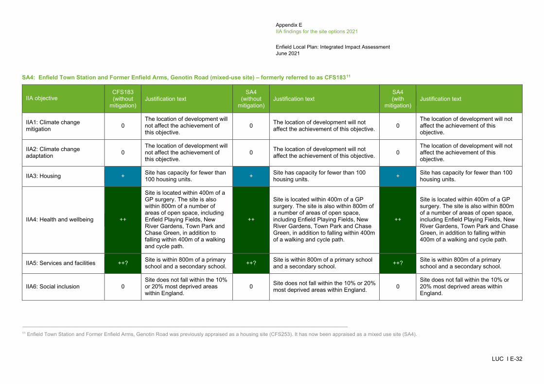
Appendix E IIA findings for the site options 2021
Enfield Local Plan: Integrated Impact Assessment June 2021
LUC I E-32
SA4: Enfield Town Station and Former Enfield Arms, Genotin Road (mixed-use site) – formerly referred to as CFS18311
IIA objective CFS183 (without
mitigation) Justification text
SA4 (without
mitigation) Justification text
SA4 (with
mitigation) Justification text
IIA1: Climate change mitigation 0
The location of development will not affect the achievement of this objective.
0 The location of development will not affect the achievement of this objective. 0
The location of development will not affect the achievement of this objective.
IIA2: Climate change adaptation 0
The location of development will not affect the achievement of this objective.
0 The location of development will not affect the achievement of this objective. 0
The location of development will not affect the achievement of this objective.
IIA3: Housing + Site has capacity for fewer than 100 housing units. + Site has capacity for fewer than 100
housing units. + Site has capacity for fewer than 100 housing units.
IIA4: Health and wellbeing ++
Site is located within 400m of a GP surgery. The site is also within 800m of a number of areas of open space, including Enfield Playing Fields, New River Gardens, Town Park and Chase Green, in addition to falling within 400m of a walking and cycle path.
++
Site is located within 400m of a GP surgery. The site is also within 800m of a number of areas of open space, including Enfield Playing Fields, New River Gardens, Town Park and Chase Green, in addition to falling within 400m of a walking and cycle path.
++
Site is located within 400m of a GP surgery. The site is also within 800m of a number of areas of open space, including Enfield Playing Fields, New River Gardens, Town Park and Chase Green, in addition to falling within 400m of a walking and cycle path.
IIA5: Services and facilities ++? Site is within 800m of a primary school and a secondary school. ++? Site is within 800m of a primary school
and a secondary school. ++? Site is within 800m of a primary school and a secondary school.
IIA6: Social inclusion 0 Site does not fall within the 10% or 20% most deprived areas within England.
0 Site does not fall within the 10% or 20% most deprived areas within England. 0
Site does not fall within the 10% or 20% most deprived areas within England.
_____________________________________________________________________________________________________ 11 Enfield Town Station and Former Enfield Arms, Genotin Road was previously appraised as a housing site (CFS253). It has now been appraised as a mixed use site (SA4).
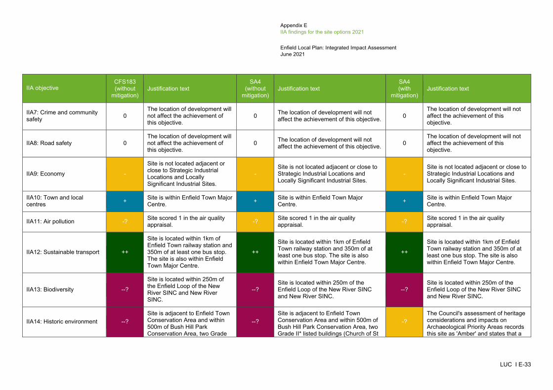
Appendix E IIA findings for the site options 2021
Enfield Local Plan: Integrated Impact Assessment June 2021
LUC I E-33
IIA objective CFS183 (without
mitigation) Justification text
SA4 (without
mitigation) Justification text
SA4 (with
mitigation) Justification text
IIA7: Crime and community safety 0
The location of development will not affect the achievement of this objective.
0 The location of development will not affect the achievement of this objective. 0
The location of development will not affect the achievement of this objective.
IIA8: Road safety 0 The location of development will not affect the achievement of this objective.
0 The location of development will not affect the achievement of this objective. 0
The location of development will not affect the achievement of this objective.
IIA9: Economy -
Site is not located adjacent or close to Strategic Industrial Locations and Locally Significant Industrial Sites.
- Site is not located adjacent or close to Strategic Industrial Locations and Locally Significant Industrial Sites.
- Site is not located adjacent or close to Strategic Industrial Locations and Locally Significant Industrial Sites.
IIA10: Town and local centres + Site is within Enfield Town Major
Centre. + Site is within Enfield Town Major Centre. + Site is within Enfield Town Major
Centre.
IIA11: Air pollution -? Site scored 1 in the air quality appraisal. -? Site scored 1 in the air quality
appraisal. -? Site scored 1 in the air quality appraisal.
IIA12: Sustainable transport ++
Site is located within 1km of Enfield Town railway station and 350m of at least one bus stop. The site is also within Enfield Town Major Centre.
++
Site is located within 1km of Enfield Town railway station and 350m of at least one bus stop. The site is also within Enfield Town Major Centre.
++
Site is located within 1km of Enfield Town railway station and 350m of at least one bus stop. The site is also within Enfield Town Major Centre.
IIA13: Biodiversity --?
Site is located within 250m of the Enfield Loop of the New River SINC and New River SINC.
--? Site is located within 250m of the Enfield Loop of the New River SINC and New River SINC.
--? Site is located within 250m of the Enfield Loop of the New River SINC and New River SINC.
IIA14: Historic environment --? Site is adjacent to Enfield Town Conservation Area and within 500m of Bush Hill Park Conservation Area, two Grade
--? Site is adjacent to Enfield Town Conservation Area and within 500m of Bush Hill Park Conservation Area, two Grade II* listed buildings (Church of St
-? The Council's assessment of heritage considerations and impacts on Archaeological Priority Areas records this site as 'Amber' and states that a

Appendix E IIA findings for the site options 2021
Enfield Local Plan: Integrated Impact Assessment June 2021
LUC I E-34
IIA objective CFS183 (without
mitigation) Justification text
SA4 (without
mitigation) Justification text
SA4 (with
mitigation) Justification text
II* listed buildings (Church of St Andrew Enfield Parish Church, and North East Building of Enfield Grammar School) and a number of Grade II listed buildings. Due to the fact that the site is adjacent to the Enfield Town Conservation Area (the western boundary of the site) which contains a number of listed buildings, its redevelopment could affect the setting of these heritage assets.
Andrew Enfield Parish Church, and North East Building of Enfield Grammar School) and a number of Grade II listed buildings. Due to the fact that the site is adjacent to the Enfield Town Conservation Area (the western boundary of the site) which contains a number of listed buildings, its redevelopment could affect the setting of these heritage assets.
Heritage Impact Assessment should be undertaken and mitigation provided.
IIA15: Landscape and townscape +?
Site is located within the settlement of Enfield Town and contains built development.
+? Site is located within the settlement of Enfield Town and contains built development.
+? Site is located within the settlement of Enfield Town and contains built development.
IIA16: Efficient use of land and materials + Site is relatively small in size
and on brownfield land. + Site is relatively small in size and on brownfield land. + Site is relatively small in size and on
brownfield land.
IIA17: Flooding --
Site has a predicted peak flood depth of greater than 300mm. However, the site is on brownfield land and does not fall within Flood Zones 2 or 3.
--
Site has a predicted peak flood depth of greater than 300mm. However, the site is on brownfield land and does not fall within Flood Zones 2 or 3.
--
Site has a predicted peak flood depth of greater than 300mm. However, the site is on brownfield land and does not fall within Flood Zones 2 or 3.
IIA18: Water --? Site falls within Source Protection Zones 1 and 2. --? Site falls within Source Protection
Zones 1 and 2. --? Site falls within Source Protection Zones 1 and 2.

Appendix E IIA findings for the site options 2021
Enfield Local Plan: Integrated Impact Assessment June 2021
LUC I E-35
SA5: Enfield Civic Centre (mixed-use site) – formerly referred to as CFS191
IIA objective SA5
(without mitigation)
Justification text SA5 (with
mitigation) Justification text
IIA1: Climate change mitigation 0
The location of development will not affect the achievement of this objective.
0 The location of development will not affect the achievement of this objective.
IIA2: Climate change adaptation 0
The location of development will not affect the achievement of this objective.
0 The location of development will not affect the achievement of this objective.
IIA3: Housing ++ Site has capacity for more than 100 housing units. ++ Site has capacity for more
than 100 housing units.
IIA4: Health and wellbeing ++
Site is located within 400m of a GP surgery. The site is also within 800m of a number of areas of open space, including Enfield Playing Fields, Town Park and the New River Green Chain , in addition to falling within 400m of a walking and cycle path.
++
Site is located within 400m of a GP surgery. The site is also within 800m of a number of areas of open space, including Enfield Playing Fields, Town Park and the New River Green Chain , in addition to falling within 400m of a walking and cycle path.
IIA5: Services and facilities ++? Site is within 800m of a primary school and a secondary school.
++? Site is within 800m of a primary school and a secondary school.
IIA6: Social inclusion 0 Site does not fall within the 10% or 20% most deprived areas within England.
0 Site does not fall within the 10% or 20% most deprived areas within England.
IIA7: Crime and community safety 0
The location of development will not affect the achievement of this objective.
0 The location of development will not affect the achievement of this objective.
IIA8: Road safety 0 The location of development will not affect the achievement of this objective.
0 The location of development will not affect the achievement of this objective.
IIA9: Economy +?/-
Site is under 10ha in size but will make a limited contribution towards employment opportunities through the provision of office floorspace. However, it is unknown what proportion of the site will comprise employment development. The site is not located adjacent or close to Strategic Industrial Locations and Locally Significant Industrial Sites.
+?/-
Site is under 10ha in size but will make a limited contribution towards employment opportunities through the provision of office floorspace. However, it is unknown what proportion of the site will comprise employment development. The site is not located adjacent or close to Strategic Industrial Locations and Locally Significant Industrial Sites.
IIA10: Town and local centres + Site is within Enfield Town Major Centre. + Site is within Enfield Town
Major Centre.

Appendix E IIA findings for the site options 2021
Enfield Local Plan: Integrated Impact Assessment June 2021
LUC I E-36
IIA objective SA5
(without mitigation)
Justification text SA5 (with
mitigation) Justification text
IIA11: Air pollution --? Site scored 2 in the air quality appraisal. --? Site scored 2 in the air quality
appraisal.
IIA12: Sustainable transport ++
Site is located within 1km of Enfield Town railway station and 350m of at least one bus stop. The site is also within Enfield Town Major Centre.
++
Site is located within 1km of Enfield Town railway station and 350m of at least one bus stop. The site is also within Enfield Town Major Centre.
IIA13: Biodiversity --?
Site is located within 250m of the Enfield Loop of the New River SINC and New River SINC.
--?
Site is located within 250m of the Enfield Loop of the New River SINC and New River SINC.
IIA14: Historic environment --?
Site is adjacent to Enfield Town Conservation Area, and within 500m from three Grade II* listed buildings (Church of St Andrew Enfield Parish Church, North east building of Enfield Grammar School, and Clarendon Cottage) and a number of Grade II listed buildings. Due to its location adjacent to Enfield Town Conservation Area and a number of Grade II listed buildings, its redevelopment could affect the setting of these heritage assets.
-?
The Council's assessment of heritage considerations and impacts on Archaeological Priority Areas records this site as 'Amber' and states that a Heritage Impact Assessment should be undertaken and mitigation provided.
IIA15: Landscape and townscape -?
Site not large in scale but is located on the edge of Enfield Town.
-? Site not large in scale but is located on the edge of Enfield Town.
IIA16: Efficient use of land and materials + Site is relatively small in size
and on brownfield land. + Site is relatively small in size and on brownfield land.
IIA17: Flooding --
Site has a predicted peak flood depth of greater than 300mm. However, the site is on brownfield land and does not fall within Flood Zones 2 or 3.
--
Site has a predicted peak flood depth of greater than 300mm. However, the site is on brownfield land and does not fall within Flood Zones 2 or 3.
IIA18: Water --? Site falls within Source Protection Zone 2. --? Site falls within Source
Protection Zone 2.
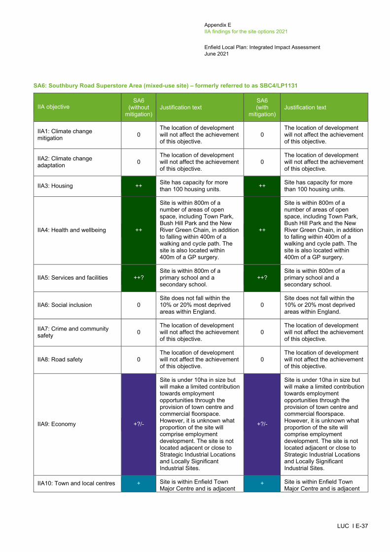
Appendix E IIA findings for the site options 2021
Enfield Local Plan: Integrated Impact Assessment June 2021
LUC I E-37
SA6: Southbury Road Superstore Area (mixed-use site) – formerly referred to as SBC4/LP1131
IIA objective SA6
(without mitigation)
Justification text SA6 (with
mitigation) Justification text
IIA1: Climate change mitigation 0
The location of development will not affect the achievement of this objective.
0 The location of development will not affect the achievement of this objective.
IIA2: Climate change adaptation 0
The location of development will not affect the achievement of this objective.
0 The location of development will not affect the achievement of this objective.
IIA3: Housing ++ Site has capacity for more than 100 housing units. ++ Site has capacity for more
than 100 housing units.
IIA4: Health and wellbeing ++
Site is within 800m of a number of areas of open space, including Town Park, Bush Hill Park and the New River Green Chain, in addition to falling within 400m of a walking and cycle path. The site is also located within 400m of a GP surgery.
++
Site is within 800m of a number of areas of open space, including Town Park, Bush Hill Park and the New River Green Chain, in addition to falling within 400m of a walking and cycle path. The site is also located within 400m of a GP surgery.
IIA5: Services and facilities ++? Site is within 800m of a primary school and a secondary school.
++? Site is within 800m of a primary school and a secondary school.
IIA6: Social inclusion 0 Site does not fall within the 10% or 20% most deprived areas within England.
0 Site does not fall within the 10% or 20% most deprived areas within England.
IIA7: Crime and community safety 0
The location of development will not affect the achievement of this objective.
0 The location of development will not affect the achievement of this objective.
IIA8: Road safety 0 The location of development will not affect the achievement of this objective.
0 The location of development will not affect the achievement of this objective.
IIA9: Economy +?/-
Site is under 10ha in size but will make a limited contribution towards employment opportunities through the provision of town centre and commercial floorspace. However, it is unknown what proportion of the site will comprise employment development. The site is not located adjacent or close to Strategic Industrial Locations and Locally Significant Industrial Sites.
+?/-
Site is under 10ha in size but will make a limited contribution towards employment opportunities through the provision of town centre and commercial floorspace. However, it is unknown what proportion of the site will comprise employment development. The site is not located adjacent or close to Strategic Industrial Locations and Locally Significant Industrial Sites.
IIA10: Town and local centres + Site is within Enfield Town Major Centre and is adjacent
+ Site is within Enfield Town Major Centre and is adjacent

Appendix E IIA findings for the site options 2021
Enfield Local Plan: Integrated Impact Assessment June 2021
LUC I E-38
IIA objective SA6
(without mitigation)
Justification text SA6 (with
mitigation) Justification text
to Southbury Road Local Centre.
to Southbury Road Local Centre.
IIA11: Air pollution --? Site scored 2 in the air quality appraisal. --? Site scored 2 in the air quality
appraisal.
IIA12: Sustainable transport ++
Site is located within 1km of Enfield Town railway station and 350m of at least one bus stop. The site is also within Enfield Town Major Centre.
++
Site is located within 1km of Enfield Town railway station and 350m of at least one bus stop. The site is also within Enfield Town Major Centre.
IIA13: Biodiversity --? Site is located within 250m of the Enfield Loop of the River SINC and New River SINC.
--? Site is located within 250m of the Enfield Loop of the River SINC and New River SINC.
IIA14: Historic environment --?
Site is adjacent to Enfield Town Conservation Area and within 500m from two Grade II* listed buildings (North east building from Enfield Grammar School, and Church of St Andrew Enfield Parish Church) and a number of Grade II listed buildings. Although the site contains built development, its redevelopment could affect the setting of these heritage assets.
-?
The Council's assessment of heritage considerations records this site as 'Amber' and states that a Heritage Impact Assessment should be undertaken and mitigation provided.
IIA15: Landscape and townscape +?
Site is located within the settlement of Enfield Town and contains built development.
+?
Site is located within the settlement of Enfield Town and contains built development.
IIA16: Efficient use of land and materials + Site is relatively small in size
and on brownfield land. + Site is relatively small in size and on brownfield land.
IIA17: Flooding --
Site has a predicted peak flood depth of greater than 300mm. However, the site is on brownfield land and does not fall within Flood Zones 2 or 3.
--
Site has a predicted peak flood depth of greater than 300mm. However, the site is on brownfield land and does not fall within Flood Zones 2 or 3.
IIA18: Water --? Site falls within Source Protection Zone 1. --? Site falls within Source
Protection Zone 1.

Appendix E IIA findings for the site options 2021
Enfield Local Plan: Integrated Impact Assessment June 2021
LUC I E-39
SA7: Oak House, 43 Baker Street (housing site) – formerly referred to as CFS178
IIA objective SA7
(without mitigation)
Justification text SA7 (with
mitigation) Justification text
IIA1: Climate change mitigation 0
The location of development will not affect the achievement of this objective.
0 The location of development will not affect the achievement of this objective.
IIA2: Climate change adaptation 0
The location of development will not affect the achievement of this objective.
0 The location of development will not affect the achievement of this objective.
IIA3: Housing + Site has capacity for fewer than 100 housing units. + Site has capacity for fewer
than 100 housing units.
IIA4: Health and wellbeing ++
Site is located within 400m of a GP surgery. The site is also within 800m of a number of areas of open space, including Enfield Playing Fields, New River Gardens, Town Park and Chase Green, in addition to falling within 400m of a walking path.
++
Site is located within 400m of a GP surgery. The site is also within 800m of a number of areas of open space, including Enfield Playing Fields, New River Gardens, Town Park and Chase Green, in addition to falling within 400m of a walking path.
IIA5: Services and facilities ++? Site is within 800m of a primary school and a secondary school.
++? Site is within 800m of a primary school and a secondary school.
IIA6: Social inclusion 0 Site does not fall within the 10% or 20% most deprived areas within England.
0 Site does not fall within the 10% or 20% most deprived areas within England.
IIA7: Crime and community safety 0
The location of development will not affect the achievement of this objective.
0 The location of development will not affect the achievement of this objective.
IIA8: Road safety 0 The location of development will not affect the achievement of this objective.
0 The location of development will not affect the achievement of this objective.
IIA9: Economy -
Site is not located adjacent or close to Strategic Industrial Locations and Locally Significant Industrial Sites.
-
Site is not located adjacent or close to Strategic Industrial Locations and Locally Significant Industrial Sites.
IIA10: Town and local centres + Site is partially within (southern edge of the site) Enfield Town Major Centre.
+ Site is partially within (southern edge of the site) Enfield Town Major Centre.
IIA11: Air pollution --? Site scored 2 in the air quality appraisal. --? Site scored 2 in the air quality
appraisal.
IIA12: Sustainable transport ++
Site is located within 1km of Enfield Town railway station and 350m of at least one bus stop. The site is also next to Enfield Town Major Centre.
++
Site is located within 1km of Enfield Town railway station and 350m of at least one bus stop. The site is also next to Enfield Town Major Centre.

Appendix E IIA findings for the site options 2021
Enfield Local Plan: Integrated Impact Assessment June 2021
LUC I E-40
IIA objective SA7
(without mitigation)
Justification text SA7 (with
mitigation) Justification text
IIA13: Biodiversity --? Site is located within 250m of the Enfield Loop of the New River SINC.
--? Site is located within 250m of the Enfield Loop of the New River SINC.
IIA14: Historic environment --?
Site is adjacent to Enfield Town Conservation Area which contains three Grade II* listed buildings (Church of St Andrew Enfield Parish Church, North East Building of Enfield Grammar School, and Clarendon Cottage) and a number of Grade II listed buildings. Due to the fact that the site is adjacent to Enfield Town Conservation Area (the western boundary of the site) and some listed buildings, its redevelopment could affect the setting of these heritage assets.
-?
The Council's assessment of heritage considerations records this site as 'Amber' and states that a Heritage Impact Assessment should be undertaken and mitigation provided.
IIA15: Landscape and townscape +?
Site is located within the settlement of Enfield Town and contains built development.
+?
Site is located within the settlement of Enfield Town and contains built development.
IIA16: Efficient use of land and materials + Site is relatively small in size
and on brownfield land. + Site is relatively small in size and on brownfield land.
IIA17: Flooding -
Site has a predicted peak flood depth of greater than 150mm. However, the site is on brownfield land and does not fall within Flood Zones 2 or 3.
-
Site has a predicted peak flood depth of greater than 150mm. However, the site is on brownfield land and does not fall within Flood Zones 2 or 3.
IIA18: Water --? Site falls within Source Protection Zone 2. --? Site falls within Source
Protection Zone 2.
Southbury (SP PL2)
SA8: Sainsburys Baird Road (mixed-use site) – formerly referred to as SBC35/LP653
IIA objective SA8
(without mitigation)
Justification text SA8 (with
mitigation) Justification text
IIA1: Climate change mitigation 0
The location of development will not affect the achievement of this objective.
0 The location of development will not affect the achievement of this objective.
IIA2: Climate change adaptation 0
The location of development will not affect the achievement of this objective.
0 The location of development will not affect the achievement of this objective.

Appendix E IIA findings for the site options 2021
Enfield Local Plan: Integrated Impact Assessment June 2021
LUC I E-41
IIA objective SA8
(without mitigation)
Justification text SA8 (with
mitigation) Justification text
IIA3: Housing ++ Site has capacity for more than 100 housing units. ++ Site has capacity for more
than 100 housing units.
IIA4: Health and wellbeing ++
Site is within 800m of a number of areas of open space, including Enfield Playing Fields, Bush Hill Park and the New River Green Chain, in addition to falling within 400m of a cycle path. The site is also located within 400-800m of a GP surgery.
++
Site is within 800m of a number of areas of open space, including Enfield Playing Fields, Bush Hill Park and the New River Green Chain, in addition to falling within 400m of a cycle path. The site is also located within 400-800m of a GP surgery.
IIA5: Services and facilities ++? Site is within 800m of a primary school and a secondary school.
++? Site is within 800m of a primary school and a secondary school.
IIA6: Social inclusion + Site falls within the 20% most deprived areas within England.
+ Site falls within the 20% most deprived areas within England.
IIA7: Crime and community safety 0
The location of development will not affect the achievement of this objective.
0 The location of development will not affect the achievement of this objective.
IIA8: Road safety 0 The location of development will not affect the achievement of this objective.
0 The location of development will not affect the achievement of this objective.
IIA9: Economy ++?
Site is next to a Strategic Industrial Location. The site is under 10ha in size but will contribute towards employment development. However, it is unknown what proportion of the site will comprise employment development.
++?
Site is next to a Strategic Industrial Location. The site is under 10ha in size but will contribute towards employment development. However, it is unknown what proportion of the site will comprise employment development.
IIA10: Town and local centres 0 Site is not within or adjacent to a Major, District and Local Centre.
0 Site is not within or adjacent to a Major, District and Local Centre.
IIA11: Air pollution --? Site scored 2 in the air quality appraisal. --? Site scored 2 in the air quality
appraisal.
IIA12: Sustainable transport ++/-
Site is located within 1km of Southbury railway station and 350m of at least one bus stop. However, the site is only within 401-800m of Southbury Road & Kingsdown, which is a Local Centre.
++/-
Site is located within 1km of Southbury railway station and 350m of at least one bus stop. However, the site is only within 401-800m of Southbury Road & Kingsdown, which is a Local Centre.

Appendix E IIA findings for the site options 2021
Enfield Local Plan: Integrated Impact Assessment June 2021
LUC I E-42
IIA objective SA8
(without mitigation)
Justification text SA8 (with
mitigation) Justification text
IIA13: Biodiversity 0 Site is not located within close proximity of any biodiversity assets.
0 Site is not located within close proximity of any biodiversity assets.
IIA14: Historic environment 0?
Although the site is located within 500m of a Grade II listed building (Enfield Technical College), it is unlikely to affect the setting of this heritage asset because there is a lot of built development between the two. However, the site could still have some potential for impacts on non-designated heritage features and effects may extend beyond 500m.
-?
The Council's assessment of impacts on Archaeological Priority Areas records this site as 'Amber' and states that a Heritage Impact Assessment should be undertaken and mitigation provided.
IIA15: Landscape and townscape +?
Site is located within the settlement of Southbury and contains built development.
+? Site is located within the settlement of Southbury and contains built development.
IIA16: Efficient use of land and materials ++ Site is relatively large in size
and on brownfield land. ++ Site is relatively large in size and on brownfield land.
IIA17: Flooding 0
Site is on brownfield land and does not fall within Flood Zones 2 or 3. It is also not at risk of surface water flooding.
0
Site is on brownfield land and does not fall within Flood Zones 2 or 3. It is also not at risk of surface water flooding.
IIA18: Water 0
Site does not fall within a Source Protection Zone or contain a watercourse or water body.
0
Site does not fall within a Source Protection Zone or contain a watercourse or water body.
SA9: Colosseum Retail Park (mixed-use site) – formerly referred to as SBC7/LP659
IIA objective SA9
(without mitigation)
Justification text SA9 (with
mitigation) Justification text
IIA1: Climate change mitigation 0
The location of development will not affect the achievement of this objective.
0 The location of development will not affect the achievement of this objective.
IIA2: Climate change adaptation 0
The location of development will not affect the achievement of this objective.
0 The location of development will not affect the achievement of this objective.
IIA3: Housing ++ Site has capacity for more than 100 housing units. ++ Site has capacity for more
than 100 housing units.
IIA4: Health and wellbeing ++ Site is within 800m of a number of areas of open space, including Enfield Playing Fields and Bush Hill
++ Site is within 800m of a number of areas of open space, including Enfield Playing Fields and Bush Hill

Appendix E IIA findings for the site options 2021
Enfield Local Plan: Integrated Impact Assessment June 2021
LUC I E-43
IIA objective SA9
(without mitigation)
Justification text SA9 (with
mitigation) Justification text
Park, in addition to falling within 400m of a cycle path. The site is also located within 400-800m of a GP surgery.
Park, in addition to falling within 400m of a cycle path. The site is also located within 400-800m of a GP surgery.
IIA5: Services and facilities ++? Site is within 800m of a primary school and a secondary school.
++? Site is within 800m of a primary school and a secondary school.
IIA6: Social inclusion + Site falls within the 20% most deprived areas within England.
+ Site falls within the 20% most deprived areas within England.
IIA7: Crime and community safety 0
The location of development will not affect the achievement of this objective.
0 The location of development will not affect the achievement of this objective.
IIA8: Road safety 0 The location of development will not affect the achievement of this objective.
0 The location of development will not affect the achievement of this objective.
IIA9: Economy ++?
Site is next to a Strategic Industrial Location. The site is under 10ha in size but will make a limited contribution towards employment opportunities through the provision of commercial floorspace. However, it is unknown what proportion of the site will comprise employment development.
++?
Site is next to a Strategic Industrial Location. The site is under 10ha in size but will make a limited contribution towards employment opportunities through the provision of commercial floorspace. However, it is unknown what proportion of the site will comprise employment development.
IIA10: Town and local centres 0 Site is not within or adjacent to a Major, District and Local Centre.
0 Site is not within or adjacent to a Major, District and Local Centre.
IIA11: Air pollution --? Site scored 2 in the air quality appraisal. --? Site scored 2 in the air quality
appraisal.
IIA12: Sustainable transport ++
Site is located within 1km of Southbury railway station and 350m of at least one bus stop. The site is also within 201-400m of Southbury Road & Kingsway, which is a Local Centre.
++
Site is located within 1km of Southbury railway station and 350m of at least one bus stop. The site is also within 201-400m of Southbury Road & Kingsway, which is a Local Centre.
IIA13: Biodiversity 0 Site is not located within close proximity of any biodiversity assets.
0 Site is not located within close proximity of any biodiversity assets.
IIA14: Historic environment -?
Site is within 500m of two Grade II listed buildings (Enfield Technical College,and and Ripaults Factory). Although the site contains built
-?
The Council's assessment of impacts on Archaeological Priority Areas records this site as 'Amber' and states that a Heritage Impact Assessment
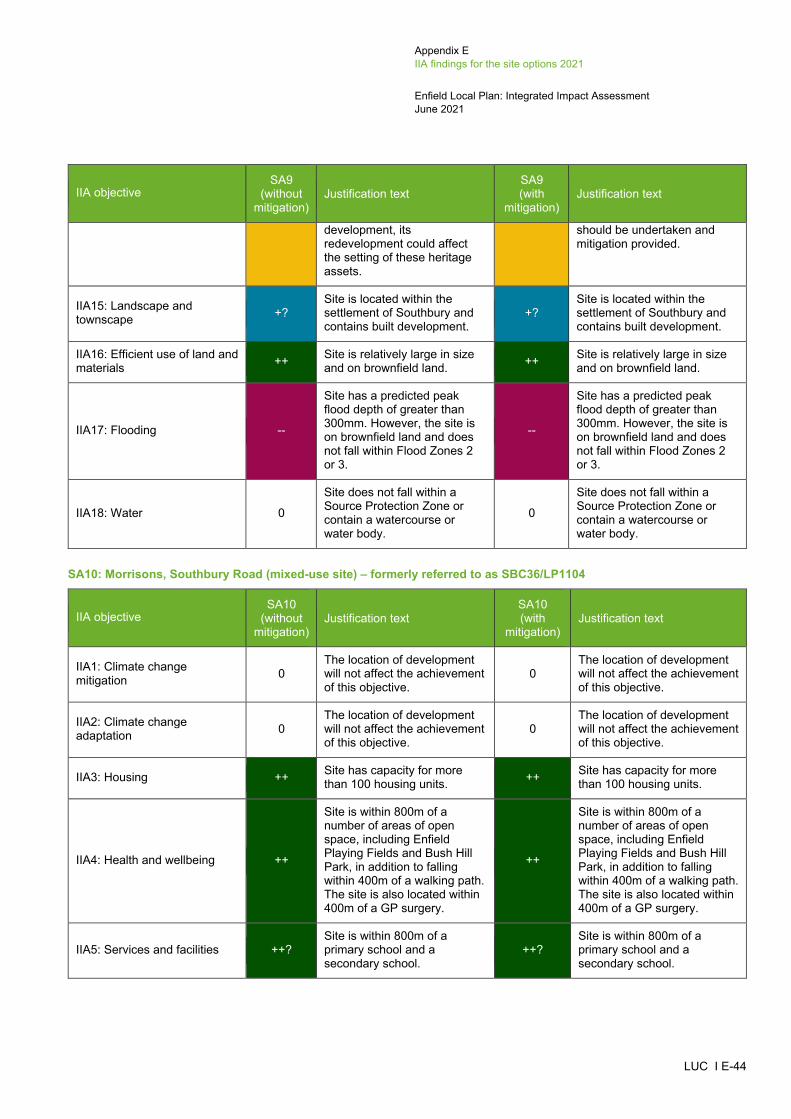
Appendix E IIA findings for the site options 2021
Enfield Local Plan: Integrated Impact Assessment June 2021
LUC I E-44
IIA objective SA9
(without mitigation)
Justification text SA9 (with
mitigation) Justification text
development, its redevelopment could affect the setting of these heritage assets.
should be undertaken and mitigation provided.
IIA15: Landscape and townscape +?
Site is located within the settlement of Southbury and contains built development.
+? Site is located within the settlement of Southbury and contains built development.
IIA16: Efficient use of land and materials ++ Site is relatively large in size
and on brownfield land. ++ Site is relatively large in size and on brownfield land.
IIA17: Flooding --
Site has a predicted peak flood depth of greater than 300mm. However, the site is on brownfield land and does not fall within Flood Zones 2 or 3.
--
Site has a predicted peak flood depth of greater than 300mm. However, the site is on brownfield land and does not fall within Flood Zones 2 or 3.
IIA18: Water 0
Site does not fall within a Source Protection Zone or contain a watercourse or water body.
0
Site does not fall within a Source Protection Zone or contain a watercourse or water body.
SA10: Morrisons, Southbury Road (mixed-use site) – formerly referred to as SBC36/LP1104
IIA objective SA10
(without mitigation)
Justification text SA10 (with
mitigation) Justification text
IIA1: Climate change mitigation 0
The location of development will not affect the achievement of this objective.
0 The location of development will not affect the achievement of this objective.
IIA2: Climate change adaptation 0
The location of development will not affect the achievement of this objective.
0 The location of development will not affect the achievement of this objective.
IIA3: Housing ++ Site has capacity for more than 100 housing units. ++ Site has capacity for more
than 100 housing units.
IIA4: Health and wellbeing ++
Site is within 800m of a number of areas of open space, including Enfield Playing Fields and Bush Hill Park, in addition to falling within 400m of a walking path. The site is also located within 400m of a GP surgery.
++
Site is within 800m of a number of areas of open space, including Enfield Playing Fields and Bush Hill Park, in addition to falling within 400m of a walking path. The site is also located within 400m of a GP surgery.
IIA5: Services and facilities ++? Site is within 800m of a primary school and a secondary school.
++? Site is within 800m of a primary school and a secondary school.

Appendix E IIA findings for the site options 2021
Enfield Local Plan: Integrated Impact Assessment June 2021
LUC I E-45
IIA objective SA10
(without mitigation)
Justification text SA10 (with
mitigation) Justification text
IIA6: Social inclusion 0 Site does not fall within the 10% or 20% most deprived areas within England.
0 Site does not fall within the 10% or 20% most deprived areas within England.
IIA7: Crime and community safety 0
The location of development will not affect the achievement of this objective.
0 The location of development will not affect the achievement of this objective.
IIA8: Road safety 0 The location of development will not affect the achievement of this objective.
0 The location of development will not affect the achievement of this objective.
IIA9: Economy ++?
Site is close to Strategic Industrial Locations. The site is under 10ha in size but will make a limited contribution towards employment opportunities through the provision of commercial floorspace. However, it is unknown what proportion of the site will comprise employment development.
++?
Site is close to Strategic Industrial Locations. The site is under 10ha in size but will make a limited contribution towards employment opportunities through the provision of commercial floorspace. However, it is unknown what proportion of the site will comprise employment development.
IIA10: Town and local centres 0 Site is not within or adjacent to a Major, District and Local Centre.
0 Site is not within or adjacent to a Major, District and Local Centre.
IIA11: Air pollution --? Site scored 2 in the air quality appraisal. --? Site scored 2 in the air quality
appraisal.
IIA12: Sustainable transport ++
Site is located within 1km of Southbury railway station and 350m of at least one bus stop. The site is also within 201-400m of Percival Road Enfield, which is a Local Centre.
++
Site is located within 1km of Southbury railway station and 350m of at least one bus stop. The site is also within 201-400m of Percival Road Enfield, which is a Local Centre.
IIA13: Biodiversity 0 Site is not located within close proximity of any biodiversity assets.
0 Site is not located within close proximity of any biodiversity assets.
IIA14: Historic environment -?
Site is within 500m from two Grade II listed buildings (Enfield Technical College, and Ripaults Factory). Although the site contains built development, its redevelopment could affect the setting of these heritage assets.
-?
The Council's assessment of impacts on Archaeological Priority Areas records this site as 'Amber' and states that a Heritage Impact Assessment should be undertaken and mitigation provided.
IIA15: Landscape and townscape +?
Site is located within the settlement of Southbury and contains built development.
+? Site is located within the settlement of Southbury and contains built development.
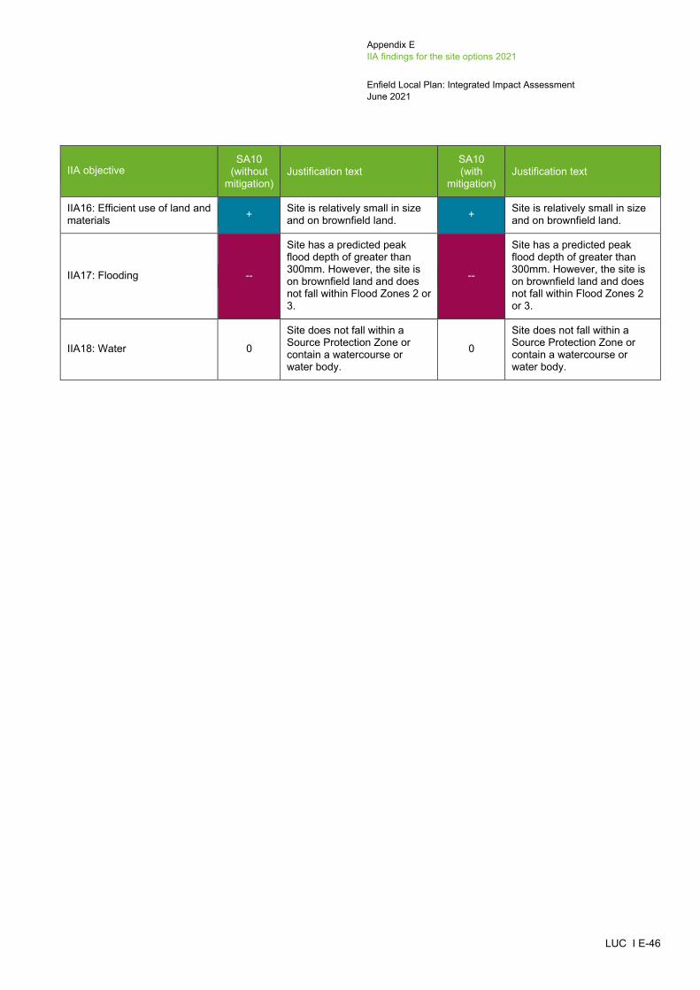
Appendix E IIA findings for the site options 2021
Enfield Local Plan: Integrated Impact Assessment June 2021
LUC I E-46
IIA objective SA10
(without mitigation)
Justification text SA10 (with
mitigation) Justification text
IIA16: Efficient use of land and materials + Site is relatively small in size
and on brownfield land. + Site is relatively small in size and on brownfield land.
IIA17: Flooding --
Site has a predicted peak flood depth of greater than 300mm. However, the site is on brownfield land and does not fall within Flood Zones 2 or 3.
--
Site has a predicted peak flood depth of greater than 300mm. However, the site is on brownfield land and does not fall within Flood Zones 2 or 3.
IIA18: Water 0
Site does not fall within a Source Protection Zone or contain a watercourse or water body.
0
Site does not fall within a Source Protection Zone or contain a watercourse or water body.

Appendix E IIA findings for the site options 2021
Enfield Local Plan: Integrated Impact Assessment June 2021
LUC I E-47
SA11: Southbury Leisure Park (mixed-use site) – formerly referred to as CFS25312
IIA objective CFS253 (without
mitigation) Justification text
SA11 (without
mitigation) Justification text
SA11 (with
mitigation) Justification text
IIA1: Climate change mitigation 0
The location of development will not affect the achievement of this objective.
0 The location of development will not affect the achievement of this objective. 0
The location of development will not affect the achievement of this objective.
IIA2: Climate change adaptation 0
The location of development will not affect the achievement of this objective.
0 The location of development will not affect the achievement of this objective. 0
The location of development will not affect the achievement of this objective.
IIA3: Housing ++ Site has capacity for more than 100 housing units. ++ Site has capacity for more than 100
housing units. ++ Site has capacity for more than 100 housing units.
IIA4: Health and wellbeing ++/-
Site is within 800m of a number of areas of open space, including Enfield Playing Fields and Bush Hill Park, in addition to falling within 400m of a cycle route. the site is not located within 800m of a GP surgery.
++/-
Site is within 800m of a number of areas of open space, including Enfield Playing Fields and Bush Hill Park, in addition to falling within 400m of a cycle route. the site is not located within 800m of a GP surgery.
++/-
Site is within 800m of a number of areas of open space, including Enfield Playing Fields and Bush Hill Park, in addition to falling within 400m of a cycle route. the site is not located within 800m of a GP surgery.
IIA5: Services and facilities ++? Site is within 800m of a primary school and a secondary school. ++? Site is within 800m of a primary school
and a secondary school. ++? Site is within 800m of a primary school and a secondary school.
IIA6: Social inclusion + Site falls within the 20% most deprived areas within England. + Site falls within the 20% most deprived
areas within England. + Site falls within the 20% most deprived areas within England.
IIA7: Crime and community safety 0
The location of development will not affect the achievement of this objective.
0 The location of development will not affect the achievement of this objective. 0
The location of development will not affect the achievement of this objective.
_____________________________________________________________________________________________________ 12 Southbury Leisure Park was previously appraised as a housing site (CFS253). It has now been appraised as a mixed use site (SA11).

Appendix E IIA findings for the site options 2021
Enfield Local Plan: Integrated Impact Assessment June 2021
LUC I E-48
IIA objective CFS253 (without
mitigation) Justification text
SA11 (without
mitigation) Justification text
SA11 (with
mitigation) Justification text
IIA8: Road safety 0 The location of development will not affect the achievement of this objective.
0 The location of development will not affect the achievement of this objective. 0
The location of development will not affect the achievement of this objective.
IIA9: Economy -
Site is not located adjacent or close to Strategic Industrial Locations and Locally Significant Industrial Sites.
+?/-
Site is under 10ha in size but will make a limited contribution towards employment opportunities through the provision of commercial floorspace. However, it is unknown what proportion of the site will comprise employment development. The site is not located adjacent or close to Strategic Industrial Locations and Locally Significant Industrial Sites.
IIA10: Town and local centres 0 Site is not within or adjacent to a Major, District and Local Centre. 0 Site is not within or adjacent to a Major,
District and Local Centre. 0 Site is not within or adjacent to a Major, District and Local Centre.
IIA11: Air pollution --? Site scored 2 in the air quality appraisal. --? Site scored 2 in the air quality
appraisal. --? Site scored 2 in the air quality appraisal.
IIA12: Sustainable transport ++
Site is located within 1km of Southbury railway station and 350m of at least one bus stop. The site is also within 201-400m of Percival Road Enfield, which is a Local Centre.
++
Site is located within 1km of Southbury railway station and 350m of at least one bus stop. The site is also within 201-400m of Percival Road Enfield, which is a Local Centre.
++
Site is located within 1km of Southbury railway station and 350m of at least one bus stop. The site is also within 201-400m of Percival Road Enfield, which is a Local Centre.
IIA13: Biodiversity -? Site is located within 250-750m of New River SINC and 100-250m of a Priority Habitat.
-? Site is located within 250-750m of New River SINC and 100-250m of a Priority Habitat.
-? Site is located within 250-750m of New River SINC and 100-250m of a Priority Habitat.
IIA14: Historic environment 0? Site is more than 500m from the nearest designated heritage
0? Site is more than 500m from the nearest designated heritage asset.
-? The Council's assessment of impacts on Archaeological Priority Areas

Appendix E IIA findings for the site options 2021
Enfield Local Plan: Integrated Impact Assessment June 2021
LUC I E-49
IIA objective CFS253 (without
mitigation) Justification text
SA11 (without
mitigation) Justification text
SA11 (with
mitigation) Justification text
asset. However, the site could still have some potential for impacts on non-designated heritage features and effects may extend beyond 500m.
However, the site could still have some potential for impacts on non-designated heritage features and effects may extend beyond 500m.
records this site as 'Amber' and states that a Heritage Impact Assessment should be undertaken and mitigation provided.
IIA15: Landscape and townscape +?
Site is located within the settlement of Enfield Town and contains built development.
+? Site is located within the settlement of Enfield Town and contains built development.
+? Site is located within the settlement of Enfield Town and contains built development.
IIA16: Efficient use of land and materials + Site is relatively small in size
and on brownfield land. + Site is relatively small in size and on brownfield land. + Site is relatively small in size and on
brownfield land.
IIA17: Flooding --
Site has a predicted peak flood depth of greater than 300mm. However, the site is on brownfield land and does not fall within Flood Zones 2 or 3.
--
Site has a predicted peak flood depth of greater than 300mm. However, the site is on brownfield land and does not fall within Flood Zones 2 or 3.
--
Site has a predicted peak flood depth of greater than 300mm. However, the site is on brownfield land and does not fall within Flood Zones 2 or 3.
IIA18: Water 0 Site does not fall within a Source Protection Zone or contain a watercourse or water body.
0 Site does not fall within a Source Protection Zone or contain a watercourse or water body.
0 Site does not fall within a Source Protection Zone or contain a watercourse or water body.

Appendix E IIA findings for the site options 2021
Enfield Local Plan: Integrated Impact Assessment June 2021
LUC I E-50
SA12: Tesco, Ponders End, 288 High Street (mixed-use site) – formerly referred to as CFS166
IIA objective SA12
(without mitigation)
Justification text SA12 (with
mitigation) Justification text
IIA1: Climate change mitigation 0
The location of development will not affect the achievement of this objective.
0 The location of development will not affect the achievement of this objective.
IIA2: Climate change adaptation 0
The location of development will not affect the achievement of this objective.
0 The location of development will not affect the achievement of this objective.
IIA3: Housing ++ Site has capacity for more than 100 housing units. ++ Site has capacity for more
than 100 housing units.
IIA4: Health and wellbeing ++
Site is located within 400m of a GP surgery. The site is also within 800m of a number of areas of open space, including Durants Park and Ponders End Recreation Ground, in addition to falling within 400m of a walking and cycle path.
++
Site is located within 400m of a GP surgery. The site is also within 800m of a number of areas of open space, including Durants Park and Ponders End Recreation Ground, in addition to falling within 400m of a walking and cycle path.
IIA5: Services and facilities +? Site is within 800m of a primary school. +? Site is within 800m of a
primary school.
IIA6: Social inclusion + Site falls within the 20% most deprived areas within England.
+ Site falls within the 20% most deprived areas within England.
IIA7: Crime and community safety 0
The location of development will not affect the achievement of this objective.
0 The location of development will not affect the achievement of this objective.
IIA8: Road safety 0 The location of development will not affect the achievement of this objective.
0 The location of development will not affect the achievement of this objective.
IIA9: Economy ++?
Site is next to a Locally Significant Industrial Site. The site is under 10ha in size but will make a limited contribution towards employment opportunities through the provision of town centre and commercial floorspace. However, it is unknown what proportion of the site will comprise employment development.
++?
Site is next to a Locally Significant Industrial Site. The site is under 10ha in size but will make a limited contribution towards employment opportunities through the provision of town centre and commercial floorspace. However, it is unknown what proportion of the site will comprise employment development.
IIA10: Town and local centres + Site is partially within (northern eastern part of the site) Ponders End Local Centre.
+
Site is partially within (northern eastern part of the site) Ponders End Local Centre.
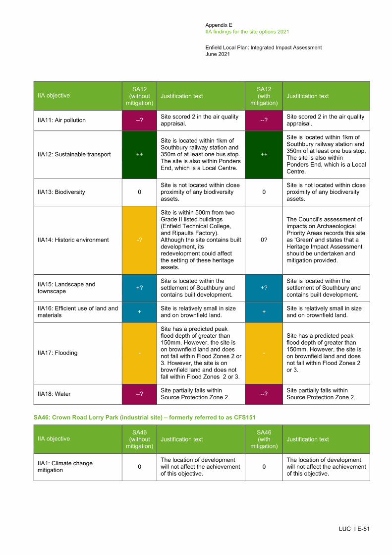
Appendix E IIA findings for the site options 2021
Enfield Local Plan: Integrated Impact Assessment June 2021
LUC I E-51
IIA objective SA12
(without mitigation)
Justification text SA12 (with
mitigation) Justification text
IIA11: Air pollution --? Site scored 2 in the air quality appraisal. --? Site scored 2 in the air quality
appraisal.
IIA12: Sustainable transport ++
Site is located within 1km of Southbury railway station and 350m of at least one bus stop. The site is also within Ponders End, which is a Local Centre.
++
Site is located within 1km of Southbury railway station and 350m of at least one bus stop. The site is also within Ponders End, which is a Local Centre.
IIA13: Biodiversity 0 Site is not located within close proximity of any biodiversity assets.
0 Site is not located within close proximity of any biodiversity assets.
IIA14: Historic environment -?
Site is within 500m from two Grade II listed buildings (Enfield Technical College, and Ripaults Factory). Although the site contains built development, its redevelopment could affect the setting of these heritage assets.
0?
The Council's assessment of impacts on Archaeological Priority Areas records this site as 'Green' and states that a Heritage Impact Assessment should be undertaken and mitigation provided.
IIA15: Landscape and townscape +?
Site is located within the settlement of Southbury and contains built development.
+? Site is located within the settlement of Southbury and contains built development.
IIA16: Efficient use of land and materials + Site is relatively small in size
and on brownfield land. + Site is relatively small in size and on brownfield land.
IIA17: Flooding -
Site has a predicted peak flood depth of greater than 150mm. However, the site is on brownfield land and does not fall within Flood Zones 2 or 3. However, the site is on brownfield land and does not fall within Flood Zones 2 or 3.
-
Site has a predicted peak flood depth of greater than 150mm. However, the site is on brownfield land and does not fall within Flood Zones 2 or 3.
IIA18: Water --? Site partially falls within Source Protection Zone 2. --? Site partially falls within
Source Protection Zone 2.
SA46: Crown Road Lorry Park (industrial site) – formerly referred to as CFS151
IIA objective SA46
(without mitigation)
Justification text SA46 (with
mitigation) Justification text
IIA1: Climate change mitigation 0
The location of development will not affect the achievement of this objective.
0 The location of development will not affect the achievement of this objective.

Appendix E IIA findings for the site options 2021
Enfield Local Plan: Integrated Impact Assessment June 2021
LUC I E-52
IIA objective SA46
(without mitigation)
Justification text SA46 (with
mitigation) Justification text
IIA2: Climate change adaptation 0
The location of development will not affect the achievement of this objective.
0 The location of development will not affect the achievement of this objective.
IIA3: Housing 0 Industrial development is not considered likely to affect this objective.
0 Industrial development is not considered likely to affect this objective.
IIA4: Health and wellbeing 0 The location of industrial development will not affect the achievement of this objective.
0
The location of industrial development will not affect the achievement of this objective.
IIA5: Services and facilities 0 Industrial development is not considered likely to affect this objective.
0 Industrial development is not considered likely to affect this objective.
IIA6: Social inclusion + Site falls within the 20% most deprived areas within England.
+ Site falls within the 20% most deprived areas within England.
IIA7: Crime and community safety 0
The location of development will not affect the achievement of this objective.
0 The location of development will not affect the achievement of this objective.
IIA8: Road safety 0 The location of development will not affect the achievement of this objective.
0 The location of development will not affect the achievement of this objective.
IIA9: Economy + The site is under 10ha in size. + The site is under 10ha in size.
IIA10: Town and local centres 0 Site is not within or adjacent to a Major, District and Local Centre.
0 Site is not within or adjacent to a Major, District and Local Centre.
IIA11: Air pollution -? Site scored 1 in the air quality appraisal. -? Site scored 1 in the air quality
appraisal.
IIA12: Sustainable transport ++
Site is located within 1km of Southgate tube station and 350m of at least one bus stop. The site is also next to Southbury Road & Kingsway, which is a Local Centre.
++
Site is located within 1km of Southgate tube station and 350m of at least one bus stop. The site is also next to Southbury Road & Kingsway, which is a Local Centre.
IIA13: Biodiversity 0 Site is not located within close proximity of any biodiversity assets.
0 Site is not located within close proximity of any biodiversity assets.
IIA14: Historic environment -?
Site is within 500m from two Grade II listed buildings (Ripaults Factory and Enfield Technical Collage). Although the site contains built development, its redevelopment could affect
-?
The Council's assessment of impacts on Archaeological Priority Areas records this site as 'Amber' and states that a Heritage Impact Assessment should be undertaken and mitigation provided.

Appendix E IIA findings for the site options 2021
Enfield Local Plan: Integrated Impact Assessment June 2021
LUC I E-53
IIA objective SA46
(without mitigation)
Justification text SA46 (with
mitigation) Justification text
the setting of these heritage assets
IIA15: Landscape and townscape +?
Site is located within the settlement of Southbury and contains built development.
+? Site is located within the settlement of Southbury and contains built development.
IIA16: Efficient use of land and materials + Site is relatively small in size
and on brownfield land. + Site is relatively small in size and on brownfield land.
IIA17: Flooding --
Site has a predicted peak flood depth of greater than 300mm. However, the site is on brownfield land and does not fall within Flood Zones 2 or 3.
--
Site has a predicted peak flood depth of greater than 300mm. However, the site is on brownfield land and does not fall within Flood Zones 2 or 3.
IIA18: Water 0
Site does not fall within a Source Protection Zone or contain a watercourse or water body.
0
Site does not fall within a Source Protection Zone or contain a watercourse or water body.
Edmonton Green (SP PL3)
SA13: Edmonton Green Shopping Centre (mixed-use site) – formerly referred to as EDC2/LP1137
IIA objective SA13
(without mitigation)
Justification text SA13 (with
mitigation) Justification text
IIA1: Climate change mitigation 0
The location of development will not affect the achievement of this objective.
0 The location of development will not affect the achievement of this objective.
IIA2: Climate change adaptation 0
The location of development will not affect the achievement of this objective.
0 The location of development will not affect the achievement of this objective.
IIA3: Housing ++ Site has capacity for more than 100 housing units. ++ Site has capacity for more
than 100 housing units.
IIA4: Health and wellbeing ++/--?
Site is located within 400m of a GP surgery. However, the site contains a walking path which could be lost as a result of new development.
++/--?
Site is located within 400m of a GP surgery. However, the site contains a walking path which could be lost as a result of new development.
IIA5: Services and facilities +? Site is within 800m of a primary school. +? Site is within 800m of a
primary school.
IIA6: Social inclusion ++ Site falls within the 10% most deprived areas within England.
++ Site falls within the 10% most deprived areas within England.

Appendix E IIA findings for the site options 2021
Enfield Local Plan: Integrated Impact Assessment June 2021
LUC I E-54
IIA objective SA13
(without mitigation)
Justification text SA13 (with
mitigation) Justification text
IIA7: Crime and community safety 0
The location of development will not affect the achievement of this objective.
0 The location of development will not affect the achievement of this objective.
IIA8: Road safety 0
The location of development will not affect the achievement of this objective.
0 The location of development will not affect the achievement of this objective.
IIA9: Economy +?/-
Site is under 10ha in size but will contribute towards employment opportunities through the provision of town centre and commercial floorspace. However, it is unknown what proportion of the site will comprise employment development. The site is not located adjacent or close to Strategic Industrial Locations and Locally Significant Industrial Sites.
+?/-
Site is under 10ha in size but will contribute towards employment opportunities through the provision of town centre and commercial floorspace. However, it is unknown what proportion of the site will comprise employment development. The site is not located adjacent or close to Strategic Industrial Locations and Locally Significant Industrial Sites.
IIA10: Town and local centres + Site is within Edmonton Green District Centre. + Site is within Edmonton Green
District Centre.
IIA11: Air pollution --? Site scored 2 in the air quality appraisal. --? Site scored 2 in the air quality
appraisal.
IIA12: Sustainable transport ++
Site is located within 1km of Edmonton Green railway station and 350m of at least one bus stop. The site is also within Edmonton Green, which is a District Centre.
++
Site is located within 1km of Edmonton Green railway station and 350m of at least one bus stop. The site is also within Edmonton Green, which is a District Centre.
IIA13: Biodiversity -? Site is located within 250-750m of Pymme’s Park SINC.
-? Site is located within 250-750m of Pymme’s Park SINC.
IIA14: Historic environment --?
Site is adjacent to four Conservation Areas (Montagu Cemeteries, Fore Street North, The Crescent, and Church Street Edmonton) and within 500m of two Grade II* listed buildings (Lamb’s cottage and Church of All Saints Edmonton Parish Church) and a number of Grade II listed buildings. Although the site contains built development, its redevelopment could affect
-?
The Council's assessment of heritage considerations records this site as 'Amber' and states that a Heritage Impact Assessment should be undertaken and mitigation provided.

Appendix E IIA findings for the site options 2021
Enfield Local Plan: Integrated Impact Assessment June 2021
LUC I E-55
IIA objective SA13
(without mitigation)
Justification text SA13 (with
mitigation) Justification text
the setting of all four conservation areas, in addition to the Grade II listed buildings.
IIA15: Landscape and townscape +?
Site is located within the settlement of Edmonton Green and contains built development.
+?
Site is located within the settlement of Edmonton Green and contains built development.
IIA16: Efficient use of land and materials ++ The site is relatively large in
size and on brownfield land. ++ The site is relatively large in size and on brownfield land.
IIA17: Flooding --
Site has a predicted peak flood depth of greater than 300mm and partially falls within Flood Zone 2. However, the site is on brownfield land.
--
Site has a predicted peak flood depth of greater than 300mm and partially falls within Flood Zone 2. However, the site is on brownfield land.
IIA18: Water --? Site partially falls within Source Protection Zone 2. --? Site partially falls within
Source Protection Zone 2.
SA14: Chiswick Road Estate (Osward and Newdales) (housing site) – formerly referred to as LOC1/LP1108
IIA objective SA14
(without mitigation)
Justification text SA14 (with
mitigation) Justification text
IIA1: Climate change mitigation 0
The location of development will not affect the achievement of this objective.
0 The location of development will not affect the achievement of this objective.
IIA2: Climate change adaptation 0
The location of development will not affect the achievement of this objective.
0 The location of development will not affect the achievement of this objective.
IIA3: Housing ++ Site has capacity for more than 100 housing units. ++ Site has capacity for more
than 100 housing units.
IIA4: Health and wellbeing ++/--?
Site is located within 400m of a GP surgery. The site is also located within 800m of a number of open spaces, including Edmonton Green Pocket Park. However, the site contains a walking path which could be lost as a result of new development.
++/--?
Site is located within 400m of a GP surgery. The site is also located within 800m of a number of open spaces, including Edmonton Green Pocket Park. However, the site contains a walking path which could be lost as a result of new development.
IIA5: Services and facilities +? Site is within 800m of a primary school. +? Site is within 800m of a
primary school.

Appendix E IIA findings for the site options 2021
Enfield Local Plan: Integrated Impact Assessment June 2021
LUC I E-56
IIA objective SA14
(without mitigation)
Justification text SA14 (with
mitigation) Justification text
IIA6: Social inclusion + Site falls within the 20% most deprived areas within England.
+ Site falls within the 20% most deprived areas within England.
IIA7: Crime and community safety 0
The location of development will not affect the achievement of this objective.
0 The location of development will not affect the achievement of this objective.
IIA8: Road safety 0
The location of development will not affect the achievement of this objective.
0 The location of development will not affect the achievement of this objective.
IIA9: Economy -
Site is not located adjacent or close to Strategic Industrial Locations and Locally Significant Industrial Sites.
-
Site is not located adjacent or close to Strategic Industrial Locations and Locally Significant Industrial Sites.
IIA10: Town and local centres + Site is adjacent to Edmonton Green District Centre. + Site is adjacent to Edmonton
Green District Centre.
IIA11: Air pollution --? Site scored 2 in the air quality appraisal. --? Site scored 2 in the air quality
appraisal.
IIA12: Sustainable transport ++
Site is located within 1km of Edmonton Green railway station and 350m of at least one bus stop. The site is also next to Edmonton Green, which is a District Centre.
++
Site is located within 1km of Edmonton Green railway station and 350m of at least one bus stop. The site is also next to Edmonton Green, which is a District Centre.
IIA13: Biodiversity 0 Site is not located within close proximity of any biodiversity assets.
0 Site is not located within close proximity of any biodiversity assets.
IIA14: Historic environment --?
Site is adjacent to The Crescent Conservation Area and is also within 500m of three Conservation Areas (Church Street Edmonton, Fore Street North, and Montagu Cemeteries). The site is also within 500m of two Grade II* listed buildings (Lamb’s Cottage and Church of All Saints Edmonton Parish Church) and a number of Grade II listed buildings. Due to the fact that the site is adjacent to the Crescent Conservation Area (the east boundary), its redevelopment could affect
-?
The Council's assessment of heritage considerations and impacts on Archaeological Priority Areas records this site as 'Amber' and states that a Heritage Impact Assessment should be undertaken and mitigation provided.
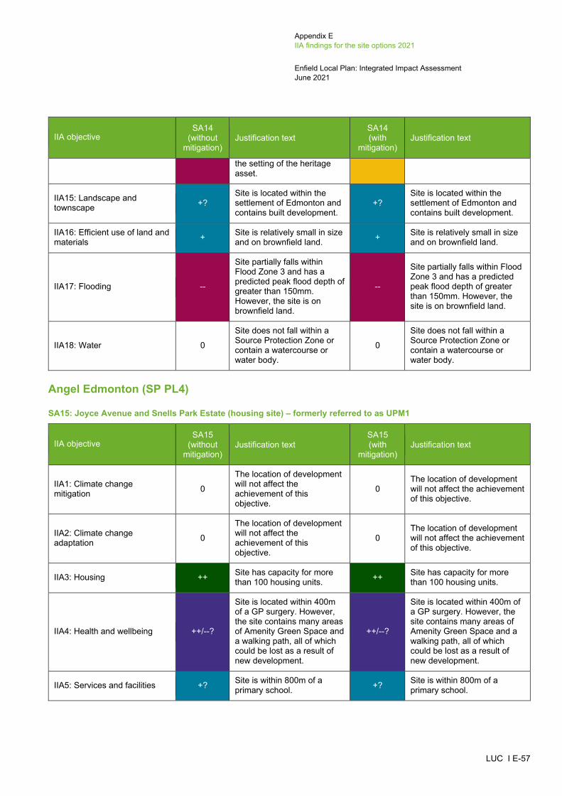
Appendix E IIA findings for the site options 2021
Enfield Local Plan: Integrated Impact Assessment June 2021
LUC I E-57
IIA objective SA14
(without mitigation)
Justification text SA14 (with
mitigation) Justification text
the setting of the heritage asset.
IIA15: Landscape and townscape +?
Site is located within the settlement of Edmonton and contains built development.
+? Site is located within the settlement of Edmonton and contains built development.
IIA16: Efficient use of land and materials + Site is relatively small in size
and on brownfield land. + Site is relatively small in size and on brownfield land.
IIA17: Flooding --
Site partially falls within Flood Zone 3 and has a predicted peak flood depth of greater than 150mm. However, the site is on brownfield land.
--
Site partially falls within Flood Zone 3 and has a predicted peak flood depth of greater than 150mm. However, the site is on brownfield land.
IIA18: Water 0
Site does not fall within a Source Protection Zone or contain a watercourse or water body.
0
Site does not fall within a Source Protection Zone or contain a watercourse or water body.
Angel Edmonton (SP PL4)
SA15: Joyce Avenue and Snells Park Estate (housing site) – formerly referred to as UPM1
IIA objective SA15
(without mitigation)
Justification text SA15 (with
mitigation) Justification text
IIA1: Climate change mitigation 0
The location of development will not affect the achievement of this objective.
0 The location of development will not affect the achievement of this objective.
IIA2: Climate change adaptation 0
The location of development will not affect the achievement of this objective.
0 The location of development will not affect the achievement of this objective.
IIA3: Housing ++ Site has capacity for more than 100 housing units. ++ Site has capacity for more
than 100 housing units.
IIA4: Health and wellbeing ++/--?
Site is located within 400m of a GP surgery. However, the site contains many areas of Amenity Green Space and a walking path, all of which could be lost as a result of new development.
++/--?
Site is located within 400m of a GP surgery. However, the site contains many areas of Amenity Green Space and a walking path, all of which could be lost as a result of new development.
IIA5: Services and facilities +? Site is within 800m of a primary school. +? Site is within 800m of a
primary school.
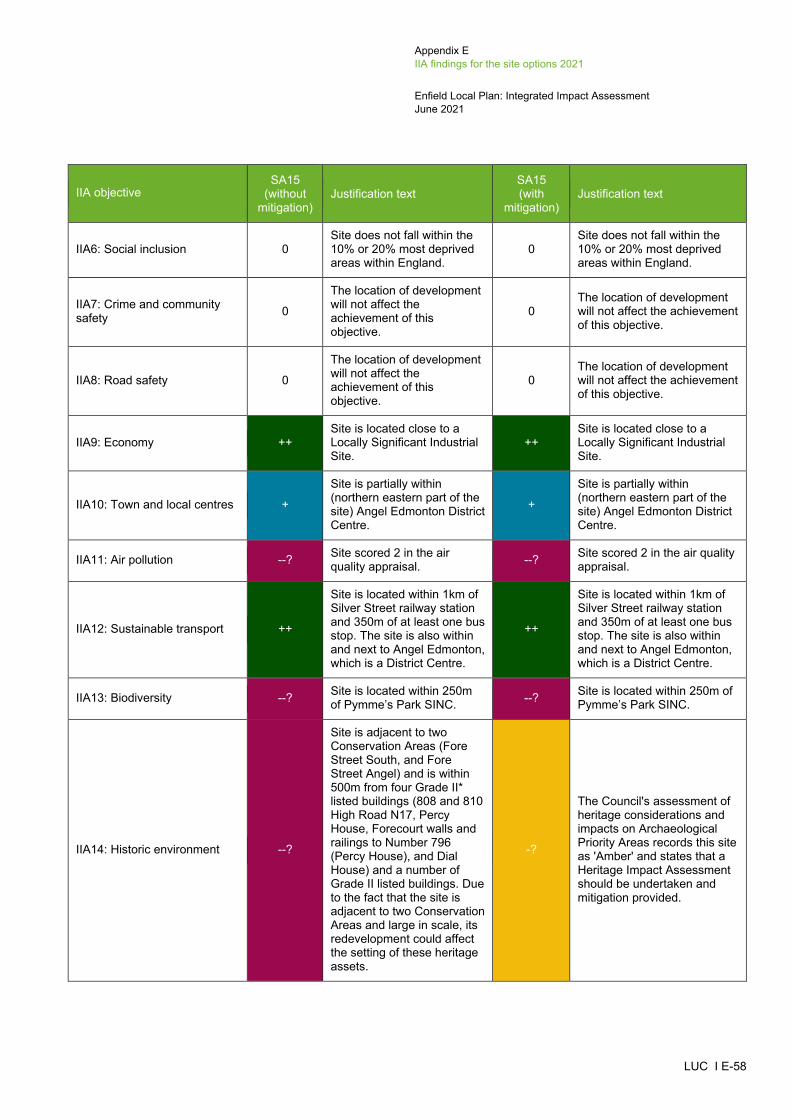
Appendix E IIA findings for the site options 2021
Enfield Local Plan: Integrated Impact Assessment June 2021
LUC I E-58
IIA objective SA15
(without mitigation)
Justification text SA15 (with
mitigation) Justification text
IIA6: Social inclusion 0 Site does not fall within the 10% or 20% most deprived areas within England.
0 Site does not fall within the 10% or 20% most deprived areas within England.
IIA7: Crime and community safety 0
The location of development will not affect the achievement of this objective.
0 The location of development will not affect the achievement of this objective.
IIA8: Road safety 0
The location of development will not affect the achievement of this objective.
0 The location of development will not affect the achievement of this objective.
IIA9: Economy ++ Site is located close to a Locally Significant Industrial Site.
++ Site is located close to a Locally Significant Industrial Site.
IIA10: Town and local centres +
Site is partially within (northern eastern part of the site) Angel Edmonton District Centre.
+
Site is partially within (northern eastern part of the site) Angel Edmonton District Centre.
IIA11: Air pollution --? Site scored 2 in the air quality appraisal. --? Site scored 2 in the air quality
appraisal.
IIA12: Sustainable transport ++
Site is located within 1km of Silver Street railway station and 350m of at least one bus stop. The site is also within and next to Angel Edmonton, which is a District Centre.
++
Site is located within 1km of Silver Street railway station and 350m of at least one bus stop. The site is also within and next to Angel Edmonton, which is a District Centre.
IIA13: Biodiversity --? Site is located within 250m of Pymme’s Park SINC. --? Site is located within 250m of
Pymme’s Park SINC.
IIA14: Historic environment --?
Site is adjacent to two Conservation Areas (Fore Street South, and Fore Street Angel) and is within 500m from four Grade II* listed buildings (808 and 810 High Road N17, Percy House, Forecourt walls and railings to Number 796 (Percy House), and Dial House) and a number of Grade II listed buildings. Due to the fact that the site is adjacent to two Conservation Areas and large in scale, its redevelopment could affect the setting of these heritage assets.
-?
The Council's assessment of heritage considerations and impacts on Archaeological Priority Areas records this site as 'Amber' and states that a Heritage Impact Assessment should be undertaken and mitigation provided.

Appendix E IIA findings for the site options 2021
Enfield Local Plan: Integrated Impact Assessment June 2021
LUC I E-59
IIA objective SA15
(without mitigation)
Justification text SA15 (with
mitigation) Justification text
IIA15: Landscape and townscape --
Development of this site would result in the loss of a number of areas of Amenity Green Space.
--
Development of this site would result in the loss of a number of areas of Amenity Green Space.
IIA16: Efficient use of land and materials ++ Site is relatively large in size
and on brownfield land. ++ Site is relatively large in size and on brownfield land.
IIA17: Flooding --
Site has a predicted peak flood depth of greater than 300mm. However, the site is on brownfield land and does not fall within Flood Zones 2 or 3.
--
Site has a predicted peak flood depth of greater than 300mm. However, the site is on brownfield land and does not fall within Flood Zones 2 or 3.
IIA18: Water --?
Site partially falls within Source Protection Zone 2 (the northern eastern part of the site).
--?
Site partially falls within Source Protection Zone 2 (the northern eastern part of the site).
SA16: Public House, 50-56 Fore Street (housing site) – formerly referred to as UPP9 (10/00760/FUL)
IIA objective SA16
(without mitigation)
Justification text SA16 (with
mitigation) Justification text
IIA1: Climate change mitigation 0
The location of development will not affect the achievement of this objective.
0 The location of development will not affect the achievement of this objective.
IIA2: Climate change adaptation 0
The location of development will not affect the achievement of this objective.
0 The location of development will not affect the achievement of this objective.
IIA3: Housing + Site has capacity for fewer than 100 housing units. + Site has capacity for fewer
than 100 housing units.
IIA4: Health and wellbeing ++
Site is located within 400m of a GP surgery. The site is also within 800m of a number of areas of open space, including Pymnes Park, Craig Park, Joyce Avenue Amenity Space and St James Open Space, in addition to falling within 400m of a walking path.
++
Site is located within 400m of a GP surgery. The site is also within 800m of a number of areas of open space, including Pymnes Park, Craig Park, Joyce Avenue Amenity Space and St James Open Space, in addition to falling within 400m of a walking path.
IIA5: Services and facilities +? Site is within 800m of a primary school. +? Site is within 800m of a
primary school.

Appendix E IIA findings for the site options 2021
Enfield Local Plan: Integrated Impact Assessment June 2021
LUC I E-60
IIA objective SA16
(without mitigation)
Justification text SA16 (with
mitigation) Justification text
IIA6: Social inclusion + Site falls within the 20% most deprived areas within England.
+ Site falls within the 20% most deprived areas within England.
IIA7: Crime and community safety 0
The location of development will not affect the achievement of this objective.
0 The location of development will not affect the achievement of this objective.
IIA8: Road safety 0
The location of development will not affect the achievement of this objective.
0 The location of development will not affect the achievement of this objective.
IIA9: Economy -
Site is not located adjacent or close to Strategic Industrial Locations and Locally Significant Industrial Sites.
-
Site is not located adjacent or close to Strategic Industrial Locations and Locally Significant Industrial Sites.
IIA10: Town and local centres + Site is within Angel Edmonton District Centre. + Site is within Angel Edmonton
District Centre.
IIA11: Air pollution --? Site scored 2 in the air quality appraisal. --? Site scored 2 in the air quality
appraisal.
IIA12: Sustainable transport ++
Site is located within 1km of Silver Street railway station and 350m of at least one bus stop. The site is also within Angel Edmonton, which is a District Centre.
++
Site is located within 1km of Silver Street railway station and 350m of at least one bus stop. The site is also within Angel Edmonton, which is a District Centre.
IIA13: Biodiversity -? Site located is within 250-750m of Pymme’s Park SINC.
-? Site located is within 250-750m of Pymme’s Park SINC.
IIA14: Historic environment --?
Site is adjacent to Fore Street South Conservation Area and within 500m of another Conservation Area (Fore Street Angel), one Grade II* listed building (808 and 801 High Road N17) and a number of Grade II listed buildings. Due to the fact the site is adjacent to Fore Street South Conservation Area (the northern boundary of the site), its redevelopment could affect the setting of this heritage asset.
-?
The Council's assessment of heritage considerations and impacts on Archaeological Priority Areas records this site as 'Amber' and states that a Heritage Impact Assessment should be undertaken and mitigation provided.
IIA15: Landscape and townscape +? Site is located within the
settlement of Upper +? Site is located within the
settlement of Upper
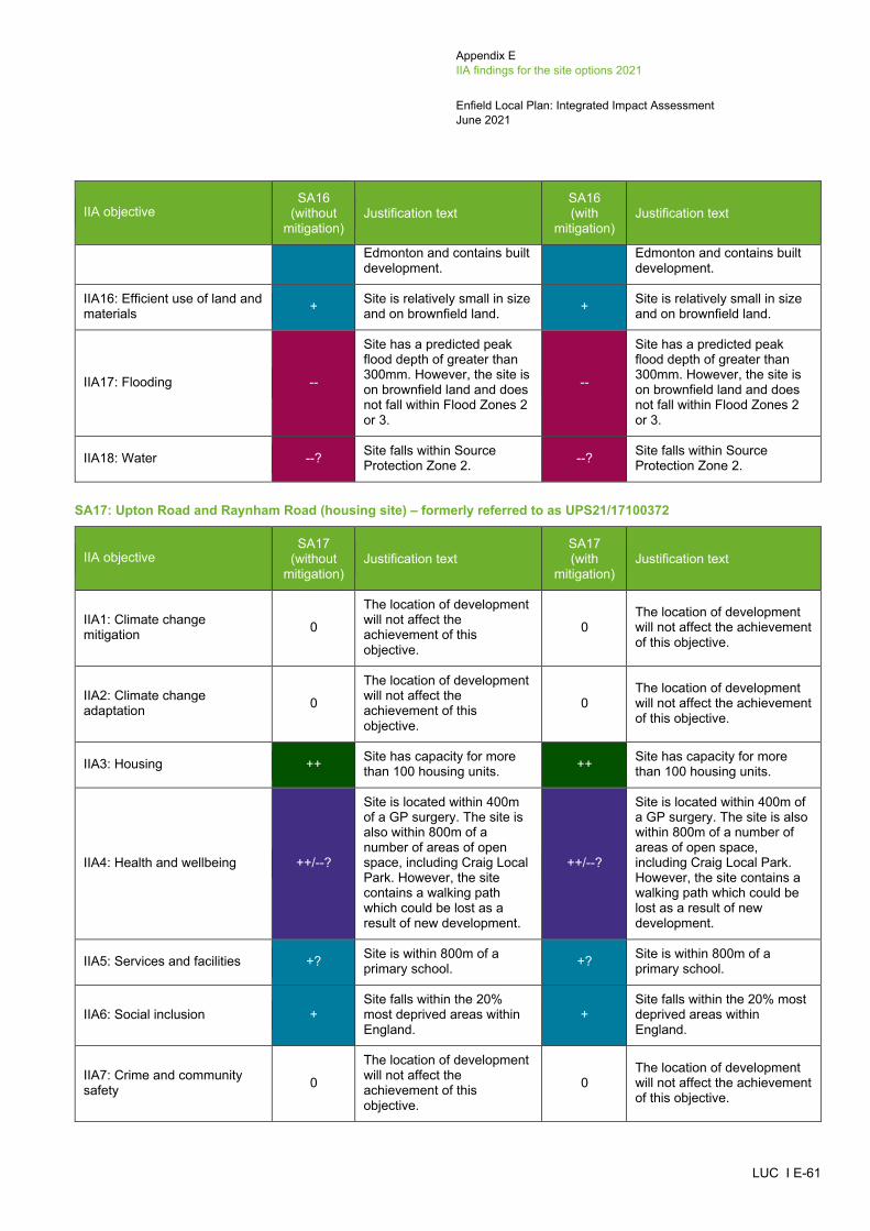
Appendix E IIA findings for the site options 2021
Enfield Local Plan: Integrated Impact Assessment June 2021
LUC I E-61
IIA objective SA16
(without mitigation)
Justification text SA16 (with
mitigation) Justification text
Edmonton and contains built development.
Edmonton and contains built development.
IIA16: Efficient use of land and materials + Site is relatively small in size
and on brownfield land. + Site is relatively small in size and on brownfield land.
IIA17: Flooding --
Site has a predicted peak flood depth of greater than 300mm. However, the site is on brownfield land and does not fall within Flood Zones 2 or 3.
--
Site has a predicted peak flood depth of greater than 300mm. However, the site is on brownfield land and does not fall within Flood Zones 2 or 3.
IIA18: Water --? Site falls within Source Protection Zone 2. --? Site falls within Source
Protection Zone 2.
SA17: Upton Road and Raynham Road (housing site) – formerly referred to as UPS21/17100372
IIA objective SA17
(without mitigation)
Justification text SA17 (with
mitigation) Justification text
IIA1: Climate change mitigation 0
The location of development will not affect the achievement of this objective.
0 The location of development will not affect the achievement of this objective.
IIA2: Climate change adaptation 0
The location of development will not affect the achievement of this objective.
0 The location of development will not affect the achievement of this objective.
IIA3: Housing ++ Site has capacity for more than 100 housing units. ++ Site has capacity for more
than 100 housing units.
IIA4: Health and wellbeing ++/--?
Site is located within 400m of a GP surgery. The site is also within 800m of a number of areas of open space, including Craig Local Park. However, the site contains a walking path which could be lost as a result of new development.
++/--?
Site is located within 400m of a GP surgery. The site is also within 800m of a number of areas of open space, including Craig Local Park. However, the site contains a walking path which could be lost as a result of new development.
IIA5: Services and facilities +? Site is within 800m of a primary school. +? Site is within 800m of a
primary school.
IIA6: Social inclusion + Site falls within the 20% most deprived areas within England.
+ Site falls within the 20% most deprived areas within England.
IIA7: Crime and community safety 0
The location of development will not affect the achievement of this objective.
0 The location of development will not affect the achievement of this objective.
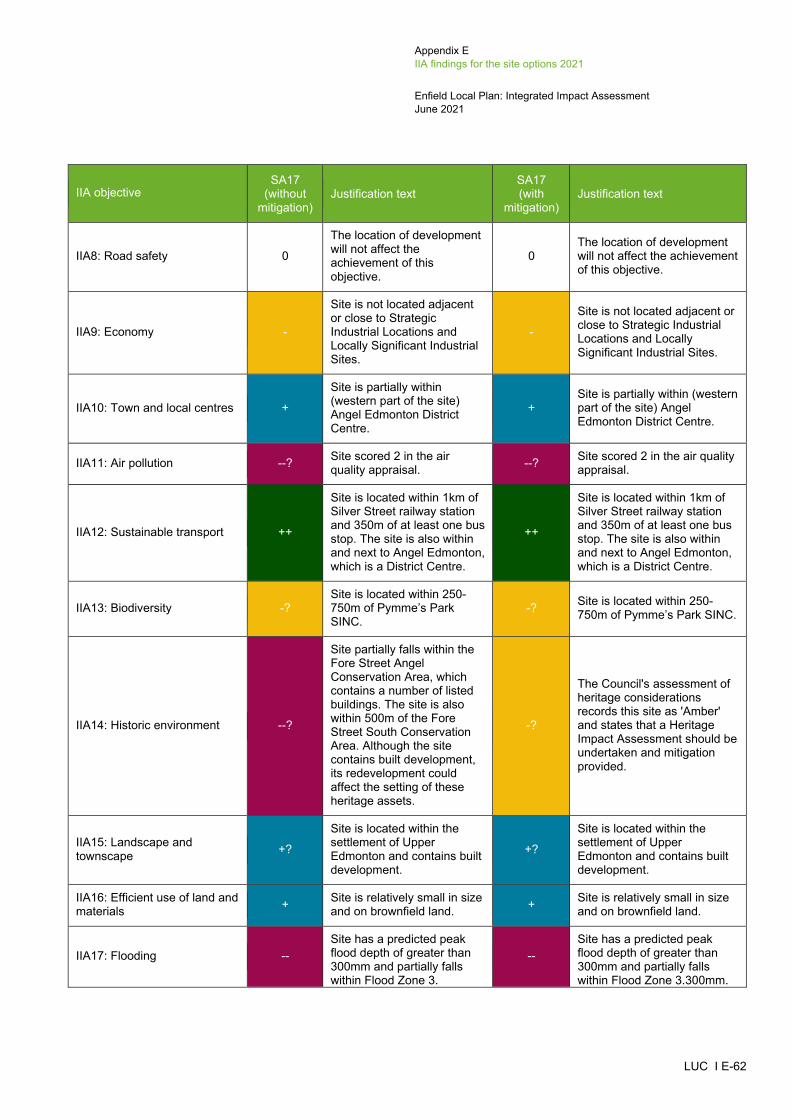
Appendix E IIA findings for the site options 2021
Enfield Local Plan: Integrated Impact Assessment June 2021
LUC I E-62
IIA objective SA17
(without mitigation)
Justification text SA17 (with
mitigation) Justification text
IIA8: Road safety 0
The location of development will not affect the achievement of this objective.
0 The location of development will not affect the achievement of this objective.
IIA9: Economy -
Site is not located adjacent or close to Strategic Industrial Locations and Locally Significant Industrial Sites.
-
Site is not located adjacent or close to Strategic Industrial Locations and Locally Significant Industrial Sites.
IIA10: Town and local centres +
Site is partially within (western part of the site) Angel Edmonton District Centre.
+ Site is partially within (western part of the site) Angel Edmonton District Centre.
IIA11: Air pollution --? Site scored 2 in the air quality appraisal. --? Site scored 2 in the air quality
appraisal.
IIA12: Sustainable transport ++
Site is located within 1km of Silver Street railway station and 350m of at least one bus stop. The site is also within and next to Angel Edmonton, which is a District Centre.
++
Site is located within 1km of Silver Street railway station and 350m of at least one bus stop. The site is also within and next to Angel Edmonton, which is a District Centre.
IIA13: Biodiversity -? Site is located within 250-750m of Pymme’s Park SINC.
-? Site is located within 250-750m of Pymme’s Park SINC.
IIA14: Historic environment --?
Site partially falls within the Fore Street Angel Conservation Area, which contains a number of listed buildings. The site is also within 500m of the Fore Street South Conservation Area. Although the site contains built development, its redevelopment could affect the setting of these heritage assets.
-?
The Council's assessment of heritage considerations records this site as 'Amber' and states that a Heritage Impact Assessment should be undertaken and mitigation provided.
IIA15: Landscape and townscape +?
Site is located within the settlement of Upper Edmonton and contains built development.
+?
Site is located within the settlement of Upper Edmonton and contains built development.
IIA16: Efficient use of land and materials + Site is relatively small in size
and on brownfield land. + Site is relatively small in size and on brownfield land.
IIA17: Flooding -- Site has a predicted peak flood depth of greater than 300mm and partially falls within Flood Zone 3.
-- Site has a predicted peak flood depth of greater than 300mm and partially falls within Flood Zone 3.300mm.
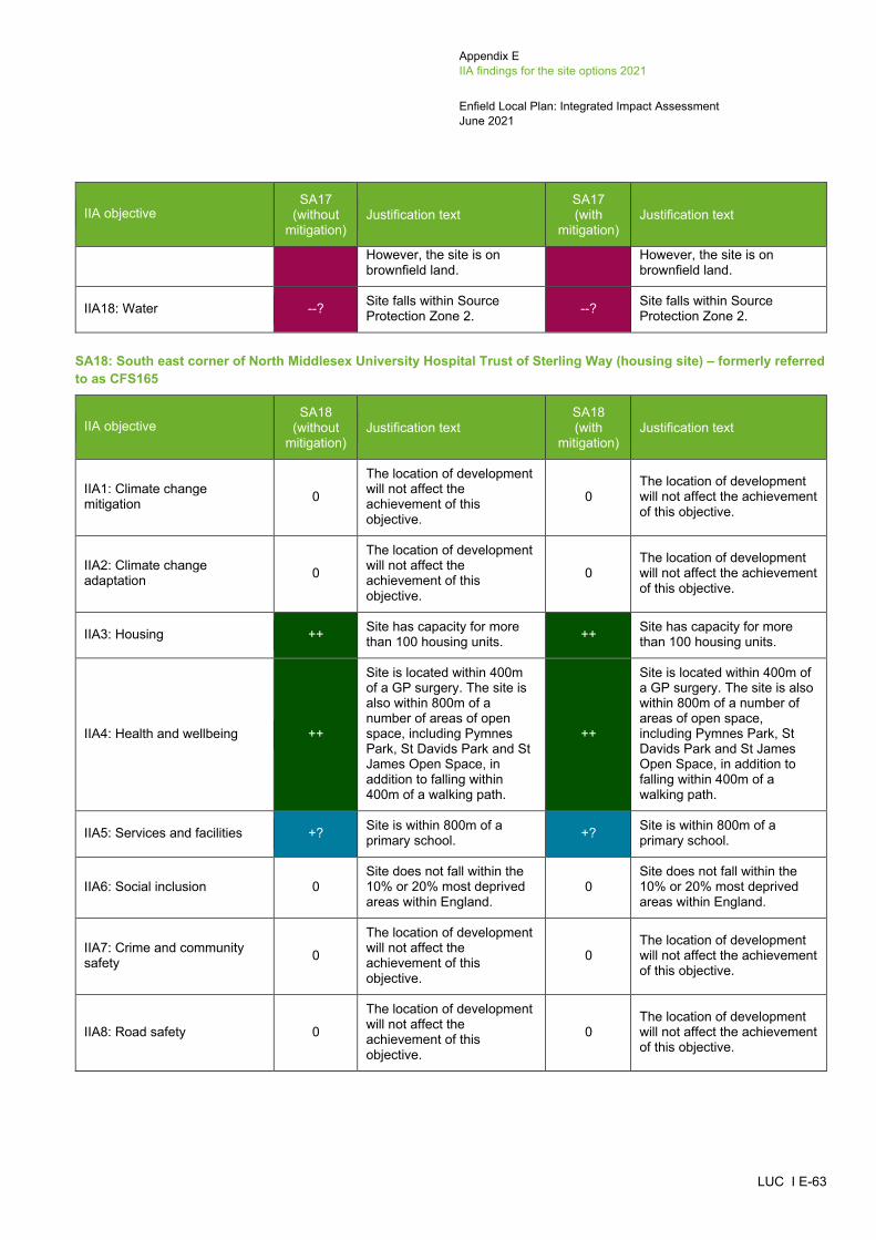
Appendix E IIA findings for the site options 2021
Enfield Local Plan: Integrated Impact Assessment June 2021
LUC I E-63
IIA objective SA17
(without mitigation)
Justification text SA17 (with
mitigation) Justification text
However, the site is on brownfield land.
However, the site is on brownfield land.
IIA18: Water --? Site falls within Source Protection Zone 2. --? Site falls within Source
Protection Zone 2.
SA18: South east corner of North Middlesex University Hospital Trust of Sterling Way (housing site) – formerly referred to as CFS165
IIA objective SA18
(without mitigation)
Justification text SA18 (with
mitigation) Justification text
IIA1: Climate change mitigation 0
The location of development will not affect the achievement of this objective.
0 The location of development will not affect the achievement of this objective.
IIA2: Climate change adaptation 0
The location of development will not affect the achievement of this objective.
0 The location of development will not affect the achievement of this objective.
IIA3: Housing ++ Site has capacity for more than 100 housing units. ++ Site has capacity for more
than 100 housing units.
IIA4: Health and wellbeing ++
Site is located within 400m of a GP surgery. The site is also within 800m of a number of areas of open space, including Pymnes Park, St Davids Park and St James Open Space, in addition to falling within 400m of a walking path.
++
Site is located within 400m of a GP surgery. The site is also within 800m of a number of areas of open space, including Pymnes Park, St Davids Park and St James Open Space, in addition to falling within 400m of a walking path.
IIA5: Services and facilities +? Site is within 800m of a primary school. +? Site is within 800m of a
primary school.
IIA6: Social inclusion 0 Site does not fall within the 10% or 20% most deprived areas within England.
0 Site does not fall within the 10% or 20% most deprived areas within England.
IIA7: Crime and community safety 0
The location of development will not affect the achievement of this objective.
0 The location of development will not affect the achievement of this objective.
IIA8: Road safety 0
The location of development will not affect the achievement of this objective.
0 The location of development will not affect the achievement of this objective.
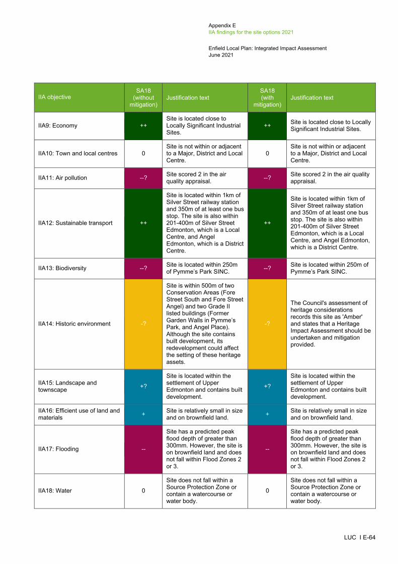
Appendix E IIA findings for the site options 2021
Enfield Local Plan: Integrated Impact Assessment June 2021
LUC I E-64
IIA objective SA18
(without mitigation)
Justification text SA18 (with
mitigation) Justification text
IIA9: Economy ++ Site is located close to Locally Significant Industrial Sites.
++ Site is located close to Locally Significant Industrial Sites.
IIA10: Town and local centres 0 Site is not within or adjacent to a Major, District and Local Centre.
0 Site is not within or adjacent to a Major, District and Local Centre.
IIA11: Air pollution --? Site scored 2 in the air quality appraisal. --? Site scored 2 in the air quality
appraisal.
IIA12: Sustainable transport ++
Site is located within 1km of Silver Street railway station and 350m of at least one bus stop. The site is also within 201-400m of Silver Street Edmonton, which is a Local Centre, and Angel Edmonton, which is a District Centre.
++
Site is located within 1km of Silver Street railway station and 350m of at least one bus stop. The site is also within 201-400m of Silver Street Edmonton, which is a Local Centre, and Angel Edmonton, which is a District Centre.
IIA13: Biodiversity --? Site is located within 250m of Pymme’s Park SINC. --? Site is located within 250m of
Pymme’s Park SINC.
IIA14: Historic environment -?
Site is within 500m of two Conservation Areas (Fore Street South and Fore Street Angel) and two Grade II listed buildings (Former Garden Walls in Pymme’s Park, and Angel Place). Although the site contains built development, its redevelopment could affect the setting of these heritage assets.
-?
The Council's assessment of heritage considerations records this site as 'Amber' and states that a Heritage Impact Assessment should be undertaken and mitigation provided.
IIA15: Landscape and townscape +?
Site is located within the settlement of Upper Edmonton and contains built development.
+?
Site is located within the settlement of Upper Edmonton and contains built development.
IIA16: Efficient use of land and materials + Site is relatively small in size
and on brownfield land. + Site is relatively small in size and on brownfield land.
IIA17: Flooding --
Site has a predicted peak flood depth of greater than 300mm. However, the site is on brownfield land and does not fall within Flood Zones 2 or 3.
--
Site has a predicted peak flood depth of greater than 300mm. However, the site is on brownfield land and does not fall within Flood Zones 2 or 3.
IIA18: Water 0
Site does not fall within a Source Protection Zone or contain a watercourse or water body.
0
Site does not fall within a Source Protection Zone or contain a watercourse or water body.

Appendix E IIA findings for the site options 2021
Enfield Local Plan: Integrated Impact Assessment June 2021
LUC I E-65
Meridian Water (SP PL5)
SA19: IKEA store; Tesco Extra, 1 Glover Drive; Meridian Water, Willoughby Lane and Meridian Way (mixed-use site) – formerly referred to as UPP32, UPC2, UPC1 and UPP24
IIA objective SA19
(without mitigation)
Justification text SA19 (with
mitigation) Justification text
IIA1: Climate change mitigation 0
The location of development will not affect the achievement of this objective.
0 The location of development will not affect the achievement of this objective.
IIA2: Climate change adaptation 0
The location of development will not affect the achievement of this objective.
0 The location of development will not affect the achievement of this objective.
IIA3: Housing ++ Site has capacity for more than 100 housing units. ++ Site has capacity for more
than 100 housing units.
IIA4: Health and wellbeing ++/--?
Site is within 800m of a number of areas of open space, including Kenninghall Amenity Green Space and Craig Local Park, in addition to falling within 400m of a walking and cycle path. The site is also located within 400-800m of a GP surgery. However, the site contains a cycle path which could be lost as a result of new development.
++/--?
Site is within 800m of a number of areas of open space, including Kenninghall Amenity Green Space and Craig Local Park, in addition to falling within 400m of a walking and cycle path. The site is also located within 400-800m of a GP surgery. However, the site contains a cycle path which could be lost as a result of new development.
IIA5: Services and facilities +? Site is within 800m of a primary school. +? Site is within 800m of a
primary school.
IIA6: Social inclusion + Site falls within the 20% most deprived areas within England
+ Site falls within the 20% most deprived areas within England
IIA7: Crime and community safety 0
The location of development will not affect the achievement of this objective.
0 The location of development will not affect the achievement of this objective.
IIA8: Road safety 0
The location of development will not affect the achievement of this objective.
0 The location of development will not affect the achievement of this objective.
IIA9: Economy ++?
Site is next to Strategic Industrial Locations and close to a Locally Significant Industrial Site, in addition to being over 10ha in size. The site will make a limited contribution towards employment opportunities
++?
Site is next to Strategic Industrial Locations and close to a Locally Significant Industrial Site, in addition to being over 10ha in size. The site will make a limited contribution towards employment opportunities

Appendix E IIA findings for the site options 2021
Enfield Local Plan: Integrated Impact Assessment June 2021
LUC I E-66
IIA objective SA19
(without mitigation)
Justification text SA19 (with
mitigation) Justification text
through the provision of non-residential uses including social and community infrastructure. However, it is unknown what proportion of the site will comprise employment development.
through the provision of non-residential uses including social and community infrastructure However, it is unknown what proportion of the site will comprise employment development.
IIA10: Town and local centres + Site is adjacent to Dysons Road Edmonton Local Centre.
+ Site is adjacent to Dysons Road Edmonton Local Centre.
IIA11: Air pollution --? Site scored 2 in the air quality appraisal. --? Site scored 2 in the air quality
appraisal.
IIA12: Sustainable transport ++
Site is located within 1km of Meridian Water Station railway station and 350m of at least one bus stop. The site is also next to Dysons Road Edmonton, which is a Local Centre.
++
Site is located within 1km of Meridian Water Station railway station and 350m of at least one bus stop. The site is also next to Dysons Road Edmonton, which is a Local Centre.
IIA13: Biodiversity --? Site contains a Priority Habitat and is within 250m of the Lea Valley SINC.
--? Site contains a Priority Habitat and is within 250m of the Lea Valley SINC.
IIA14: Historic environment 0?
Site is more than 500m from the nearest designated heritage asset. However, the site could still have some potential for impacts on non-designated heritage features and effects may extend beyond 500m.
-?
The Council's assessment of impacts on Archaeological Priority Areas records this site as 'Amber' and states that a Heritage Impact Assessment should be undertaken and mitigation provided.
IIA15: Landscape and townscape +?
Site is located within the settlement of Upper Edmonton and contains built development.
+?
Site is located within the settlement of Upper Edmonton and contains built development.
IIA16: Efficient use of land and materials ++ Site is relatively large in size
and on brownfield land. ++ Site is relatively large in size and on brownfield land.
IIA17: Flooding --
Site has a predicted peak flood depth of greater than 300m and partially falls within Flood Zone 3. However, the site is on brownfield land.
--
Site has a predicted peak flood depth of greater than 300m and partially falls within Flood Zone 3. However, the site is on brownfield land.
IIA18: Water --?
Site falls within Source Protection Zone 2 and partially within Source Protection Zone 1 (northern part of the site). The site also contains watercourses.
--?
Site falls within Source Protection Zone 2 and partially within Source Protection Zone 1 (northern part of the site). The site also contains watercourses.
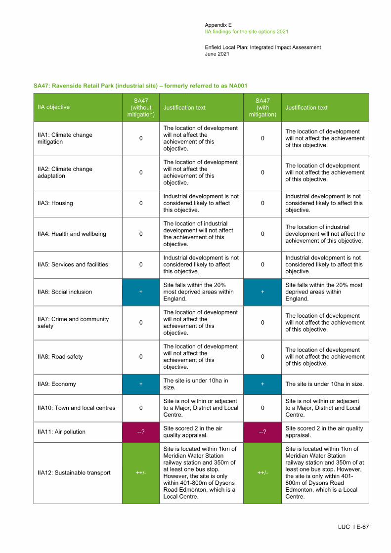
Appendix E IIA findings for the site options 2021
Enfield Local Plan: Integrated Impact Assessment June 2021
LUC I E-67
SA47: Ravenside Retail Park (industrial site) – formerly referred to as NA001
IIA objective SA47
(without mitigation)
Justification text SA47 (with
mitigation) Justification text
IIA1: Climate change mitigation 0
The location of development will not affect the achievement of this objective.
0 The location of development will not affect the achievement of this objective.
IIA2: Climate change adaptation 0
The location of development will not affect the achievement of this objective.
0 The location of development will not affect the achievement of this objective.
IIA3: Housing 0 Industrial development is not considered likely to affect this objective.
0 Industrial development is not considered likely to affect this objective.
IIA4: Health and wellbeing 0
The location of industrial development will not affect the achievement of this objective.
0 The location of industrial development will not affect the achievement of this objective.
IIA5: Services and facilities 0 Industrial development is not considered likely to affect this objective.
0 Industrial development is not considered likely to affect this objective.
IIA6: Social inclusion + Site falls within the 20% most deprived areas within England.
+ Site falls within the 20% most deprived areas within England.
IIA7: Crime and community safety 0
The location of development will not affect the achievement of this objective.
0 The location of development will not affect the achievement of this objective.
IIA8: Road safety 0
The location of development will not affect the achievement of this objective.
0 The location of development will not affect the achievement of this objective.
IIA9: Economy + The site is under 10ha in size. + The site is under 10ha in size.
IIA10: Town and local centres 0 Site is not within or adjacent to a Major, District and Local Centre.
0 Site is not within or adjacent to a Major, District and Local Centre.
IIA11: Air pollution --? Site scored 2 in the air quality appraisal. --? Site scored 2 in the air quality
appraisal.
IIA12: Sustainable transport ++/-
Site is located within 1km of Meridian Water Station railway station and 350m of at least one bus stop. However, the site is only within 401-800m of Dysons Road Edmonton, which is a Local Centre.
++/-
Site is located within 1km of Meridian Water Station railway station and 350m of at least one bus stop. However, the site is only within 401-800m of Dysons Road Edmonton, which is a Local Centre.

Appendix E IIA findings for the site options 2021
Enfield Local Plan: Integrated Impact Assessment June 2021
LUC I E-68
IIA objective SA47
(without mitigation)
Justification text SA47 (with
mitigation) Justification text
IIA13: Biodiversity --? Site is located within 250m of the Lea Valley SINC. --? Site is located within 250m of
the Lea Valley SINC.
IIA14: Historic environment -?
Site is within 500m from a Grade II listed building (Water Turbine House, Chingford Pumping Station). Although the site contains built development, its redevelopment could affect the setting of the heritage asset.
0?
The Council's assessment of heritage considerations and impacts on Archaeological Priority Areas has not recorded anything.
IIA15: Landscape and townscape +?
Site is located within the settlement of Upper Edmonton and contains built development.
+?
Site is located within the settlement of Upper Edmonton and contains built development.
IIA16: Efficient use of land and materials ++ The site is relatively large in
size and on brownfield land. ++ The site is relatively large in size and on brownfield land.
IIA17: Flooding --
Site has a predicted peak flood depth of greater than 300mm and partially falls within Flood Zone 3. However, the site is on brownfield land.
--
Site has a predicted peak flood depth of greater than 300mm and partially falls within Flood Zone 3300mm. However, the site is on brownfield land.
IIA18: Water --?
Site falls within Source Protection Zones 1 and 2 and there is a waterbody, as well as some brooks, within the boundary of the site.
--?
Site falls within Source Protection Zones 1 and 2 and there is a waterbody, as well as some brooks, within the boundary of the site.
Southgate (SP PL6)
SA20: Asda Southgate, 130 Chase Side, Southgate (mixed-use site) – formerly referred to as CFS209
IIA objective SA20
(without mitigation)
Justification text SA20 (with
mitigation) Justification text
IIA1: Climate change mitigation 0
The location of development will not affect the achievement of this objective.
0 The location of development will not affect the achievement of this objective.
IIA2: Climate change adaptation 0
The location of development will not affect the achievement of this objective.
0 The location of development will not affect the achievement of this objective.
IIA3: Housing ++ Site has capacity for more than 100 housing units. ++ Site has capacity for more
than 100 housing units.
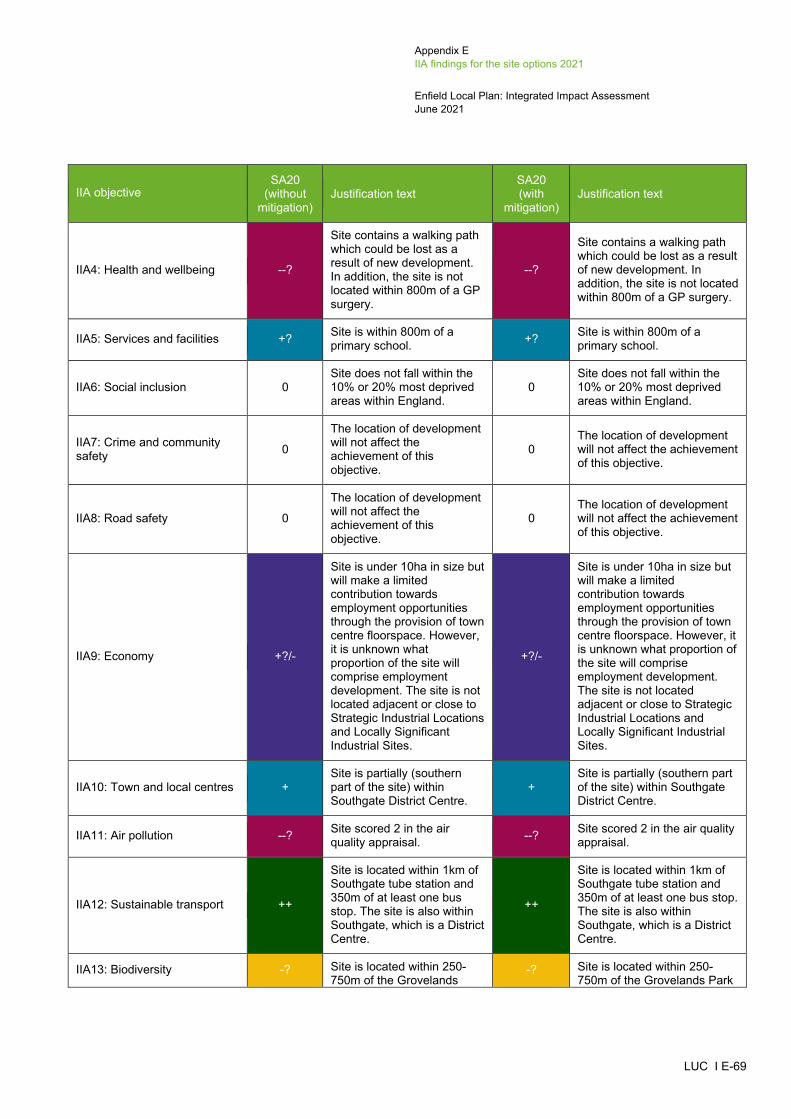
Appendix E IIA findings for the site options 2021
Enfield Local Plan: Integrated Impact Assessment June 2021
LUC I E-69
IIA objective SA20
(without mitigation)
Justification text SA20 (with
mitigation) Justification text
IIA4: Health and wellbeing --?
Site contains a walking path which could be lost as a result of new development. In addition, the site is not located within 800m of a GP surgery.
--?
Site contains a walking path which could be lost as a result of new development. In addition, the site is not located within 800m of a GP surgery.
IIA5: Services and facilities +? Site is within 800m of a primary school. +? Site is within 800m of a
primary school.
IIA6: Social inclusion 0 Site does not fall within the 10% or 20% most deprived areas within England.
0 Site does not fall within the 10% or 20% most deprived areas within England.
IIA7: Crime and community safety 0
The location of development will not affect the achievement of this objective.
0 The location of development will not affect the achievement of this objective.
IIA8: Road safety 0
The location of development will not affect the achievement of this objective.
0 The location of development will not affect the achievement of this objective.
IIA9: Economy +?/-
Site is under 10ha in size but will make a limited contribution towards employment opportunities through the provision of town centre floorspace. However, it is unknown what proportion of the site will comprise employment development. The site is not located adjacent or close to Strategic Industrial Locations and Locally Significant Industrial Sites.
+?/-
Site is under 10ha in size but will make a limited contribution towards employment opportunities through the provision of town centre floorspace. However, it is unknown what proportion of the site will comprise employment development. The site is not located adjacent or close to Strategic Industrial Locations and Locally Significant Industrial Sites.
IIA10: Town and local centres + Site is partially (southern part of the site) within Southgate District Centre.
+ Site is partially (southern part of the site) within Southgate District Centre.
IIA11: Air pollution --? Site scored 2 in the air quality appraisal. --? Site scored 2 in the air quality
appraisal.
IIA12: Sustainable transport ++
Site is located within 1km of Southgate tube station and 350m of at least one bus stop. The site is also within Southgate, which is a District Centre.
++
Site is located within 1km of Southgate tube station and 350m of at least one bus stop. The site is also within Southgate, which is a District Centre.
IIA13: Biodiversity -? Site is located within 250-750m of the Grovelands
-? Site is located within 250-750m of the Grovelands Park
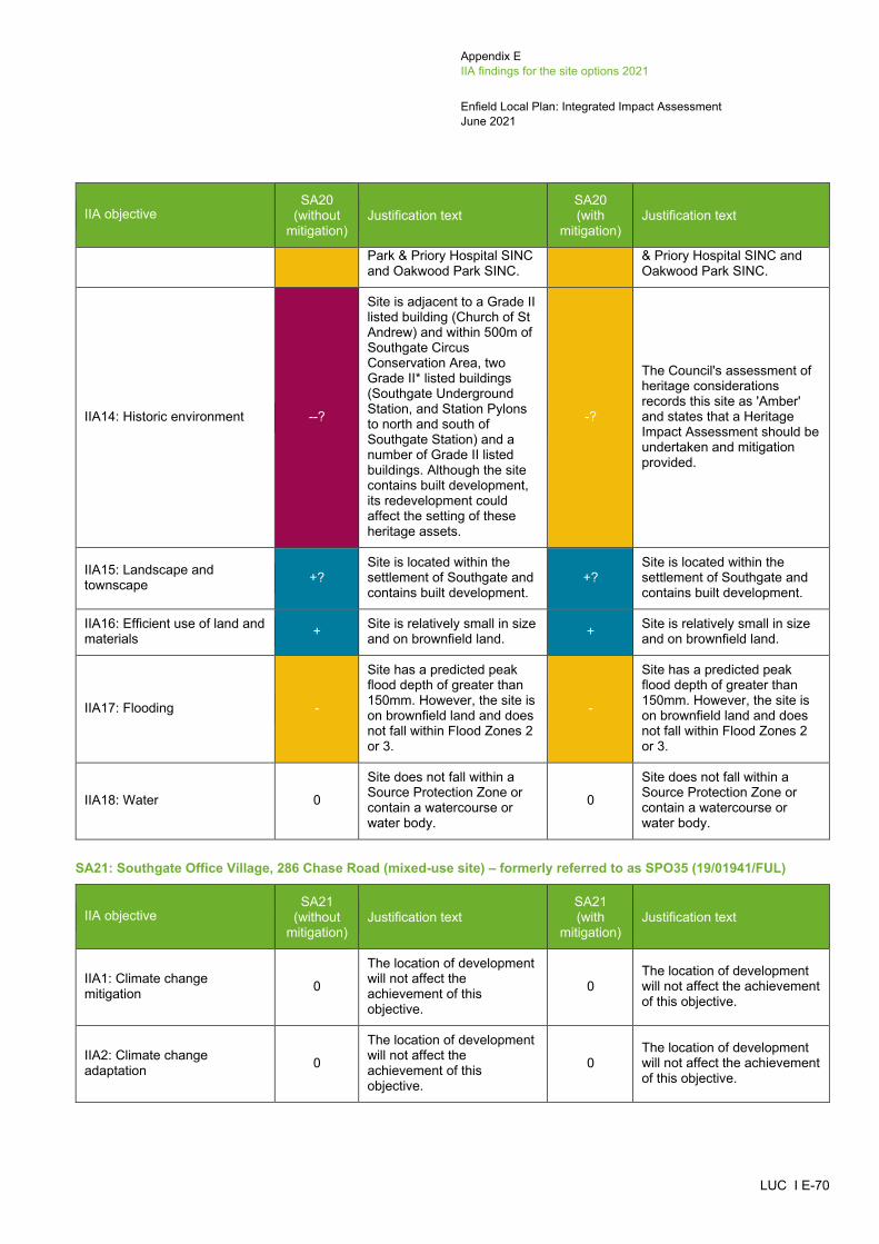
Appendix E IIA findings for the site options 2021
Enfield Local Plan: Integrated Impact Assessment June 2021
LUC I E-70
IIA objective SA20
(without mitigation)
Justification text SA20 (with
mitigation) Justification text
Park & Priory Hospital SINC and Oakwood Park SINC.
& Priory Hospital SINC and Oakwood Park SINC.
IIA14: Historic environment --?
Site is adjacent to a Grade II listed building (Church of St Andrew) and within 500m of Southgate Circus Conservation Area, two Grade II* listed buildings (Southgate Underground Station, and Station Pylons to north and south of Southgate Station) and a number of Grade II listed buildings. Although the site contains built development, its redevelopment could affect the setting of these heritage assets.
-?
The Council's assessment of heritage considerations records this site as 'Amber' and states that a Heritage Impact Assessment should be undertaken and mitigation provided.
IIA15: Landscape and townscape +?
Site is located within the settlement of Southgate and contains built development.
+? Site is located within the settlement of Southgate and contains built development.
IIA16: Efficient use of land and materials + Site is relatively small in size
and on brownfield land. + Site is relatively small in size and on brownfield land.
IIA17: Flooding -
Site has a predicted peak flood depth of greater than 150mm. However, the site is on brownfield land and does not fall within Flood Zones 2 or 3.
-
Site has a predicted peak flood depth of greater than 150mm. However, the site is on brownfield land and does not fall within Flood Zones 2 or 3.
IIA18: Water 0
Site does not fall within a Source Protection Zone or contain a watercourse or water body.
0
Site does not fall within a Source Protection Zone or contain a watercourse or water body.
SA21: Southgate Office Village, 286 Chase Road (mixed-use site) – formerly referred to as SPO35 (19/01941/FUL)
IIA objective SA21
(without mitigation)
Justification text SA21 (with
mitigation) Justification text
IIA1: Climate change mitigation 0
The location of development will not affect the achievement of this objective.
0 The location of development will not affect the achievement of this objective.
IIA2: Climate change adaptation 0
The location of development will not affect the achievement of this objective.
0 The location of development will not affect the achievement of this objective.
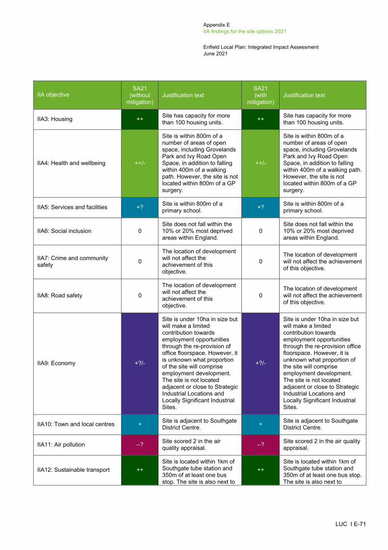
Appendix E IIA findings for the site options 2021
Enfield Local Plan: Integrated Impact Assessment June 2021
LUC I E-71
IIA objective SA21
(without mitigation)
Justification text SA21 (with
mitigation) Justification text
IIA3: Housing ++ Site has capacity for more than 100 housing units. ++ Site has capacity for more
than 100 housing units.
IIA4: Health and wellbeing ++/-
Site is within 800m of a number of areas of open space, including Grovelands Park and Ivy Road Open Space, in addition to falling within 400m of a walking path. However, the site is not located within 800m of a GP surgery.
++/-
Site is within 800m of a number of areas of open space, including Grovelands Park and Ivy Road Open Space, in addition to falling within 400m of a walking path. However, the site is not located within 800m of a GP surgery.
IIA5: Services and facilities +? Site is within 800m of a primary school. +? Site is within 800m of a
primary school.
IIA6: Social inclusion 0 Site does not fall within the 10% or 20% most deprived areas within England.
0 Site does not fall within the 10% or 20% most deprived areas within England.
IIA7: Crime and community safety 0
The location of development will not affect the achievement of this objective.
0 The location of development will not affect the achievement of this objective.
IIA8: Road safety 0
The location of development will not affect the achievement of this objective.
0 The location of development will not affect the achievement of this objective.
IIA9: Economy +?/-
Site is under 10ha in size but will make a limited contribution towards employment opportunities through the re-provision of office floorspace. However, it is unknown what proportion of the site will comprise employment development. The site is not located adjacent or close to Strategic Industrial Locations and Locally Significant Industrial Sites.
+?/-
Site is under 10ha in size but will make a limited contribution towards employment opportunities through the re-provision office floorspace. However, it is unknown what proportion of the site will comprise employment development. The site is not located adjacent or close to Strategic Industrial Locations and Locally Significant Industrial Sites.
IIA10: Town and local centres + Site is adjacent to Southgate District Centre. + Site is adjacent to Southgate
District Centre.
IIA11: Air pollution --? Site scored 2 in the air quality appraisal. --? Site scored 2 in the air quality
appraisal.
IIA12: Sustainable transport ++ Site is located within 1km of Southgate tube station and 350m of at least one bus stop. The site is also next to
++ Site is located within 1km of Southgate tube station and 350m of at least one bus stop. The site is also next to
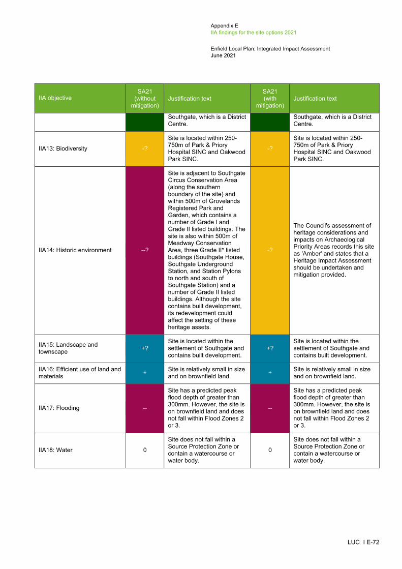
Appendix E IIA findings for the site options 2021
Enfield Local Plan: Integrated Impact Assessment June 2021
LUC I E-72
IIA objective SA21
(without mitigation)
Justification text SA21 (with
mitigation) Justification text
Southgate, which is a District Centre.
Southgate, which is a District Centre.
IIA13: Biodiversity -?
Site is located within 250-750m of Park & Priory Hospital SINC and Oakwood Park SINC.
-?
Site is located within 250-750m of Park & Priory Hospital SINC and Oakwood Park SINC.
IIA14: Historic environment --?
Site is adjacent to Southgate Circus Conservation Area (along the southern boundary of the site) and within 500m of Grovelands Registered Park and Garden, which contains a number of Grade I and Grade II listed buildings. The site is also within 500m of Meadway Conservation Area, three Grade II* listed buildings (Southgate House, Southgate Underground Station, and Station Pylons to north and south of Southgate Station) and a number of Grade II listed buildings. Although the site contains built development, its redevelopment could affect the setting of these heritage assets.
-?
The Council's assessment of heritage considerations and impacts on Archaeological Priority Areas records this site as 'Amber' and states that a Heritage Impact Assessment should be undertaken and mitigation provided.
IIA15: Landscape and townscape +?
Site is located within the settlement of Southgate and contains built development.
+? Site is located within the settlement of Southgate and contains built development.
IIA16: Efficient use of land and materials + Site is relatively small in size
and on brownfield land. + Site is relatively small in size and on brownfield land.
IIA17: Flooding --
Site has a predicted peak flood depth of greater than 300mm. However, the site is on brownfield land and does not fall within Flood Zones 2 or 3.
--
Site has a predicted peak flood depth of greater than 300mm. However, the site is on brownfield land and does not fall within Flood Zones 2 or 3.
IIA18: Water 0
Site does not fall within a Source Protection Zone or contain a watercourse or water body.
0
Site does not fall within a Source Protection Zone or contain a watercourse or water body.

Appendix E IIA findings for the site options 2021
Enfield Local Plan: Integrated Impact Assessment June 2021
LUC I E-73
SA22: M&S Food (mixed-use site) – formerly referred to as SOS11/CFS157
IIA objective SA22
(without mitigation)
Justification text SA22 (with
mitigation) Justification text
IIA1: Climate change mitigation 0
The location of development will not affect the achievement of this objective.
0 The location of development will not affect the achievement of this objective.
IIA2: Climate change adaptation 0
The location of development will not affect the achievement of this objective.
0 The location of development will not affect the achievement of this objective.
IIA3: Housing ++ Site has capacity for more than 100 housing units. ++ Site has capacity for more
than 100 housing units.
IIA4: Health and wellbeing ++/-
Site is within 800m of a number of areas of open space, including Grovelands Park and Ivy Road Open Space, in addition to falling within 400m of a walking path. However, the site is not located within 800m of a GP surgery.
++/-
Site is within 800m of a number of areas of open space, including Grovelands Park and Ivy Road Open Space, in addition to falling within 400m of a walking path. However, the site is not located within 800m of a GP surgery.
IIA5: Services and facilities +? Site is within 800m of a primary school. +? Site is within 800m of a
primary school.
IIA6: Social inclusion 0 Site does not fall within the 10% or 20% most deprived areas within England.
0 Site does not fall within the 10% or 20% most deprived areas within England.
IIA7: Crime and community safety 0
The location of development will not affect the achievement of this objective.
0 The location of development will not affect the achievement of this objective.
IIA8: Road safety 0
The location of development will not affect the achievement of this objective.
0 The location of development will not affect the achievement of this objective.
IIA9: Economy +?/-
Site is under 10ha in size but will make a limited contribution towards employment opportunities through the provision of non-residential floorspace. However, it is unknown what proportion of the site will comprise employment development. The site is not located adjacent or close to Strategic Industrial Locations and Locally Significant Industrial Sites.
+?/-
Site is under 10ha in size but will make a limited contribution towards employment opportunities through the provision of non-residential floorspace. However, it is unknown what proportion of the site will comprise employment development. The site is not located adjacent or close to Strategic Industrial Locations and Locally Significant Industrial Sites.

Appendix E IIA findings for the site options 2021
Enfield Local Plan: Integrated Impact Assessment June 2021
LUC I E-74
IIA objective SA22
(without mitigation)
Justification text SA22 (with
mitigation) Justification text
IIA10: Town and local centres +
Site is partially (southern eastern part of the site) within Southgate District Centre.
+ Site is partially (southern eastern part of the site) within Southgate District Centre.
IIA11: Air pollution --? Site scored 2 in the air quality appraisal. --? Site scored 2 in the air quality
appraisal.
IIA12: Sustainable transport ++
Site is located within 1km of Southgate tube station and 350m of at least one bus stop. The site is also within Southgate, which is a District Centre.
++
Site is located within 1km of Southgate tube station and 350m of at least one bus stop. The site is also within Southgate, which is a District Centre.
IIA13: Biodiversity --?
Site is located within 250m of the Grovelands Park & Priory Hospital SINC and 250-750m of the Oakwood Park SINC.
--?
Site is located within 250m of the Grovelands Park & Priory Hospital SINC and 250-750m of the Oakwood Park SINC.
IIA14: Historic environment --?
Site is adjacent to Southgate Circus Conservation Area and within 500m of Grovelands Registered Park and Garden, Meadway Conservation Area, three Grade II* listed buildings (Southgate House, Southgate Underground Station, and Station Pylons to north and south of Southgate Station) and a number of Grade II listed buildings. Although the site contains built development, its redevelopment could affect the setting of these heritage assets.
-?
The Council's assessment of heritage considerations and impacts on Archaeological Priority Areas records this site as 'Amber' and states that a Heritage Impact Assessment should be undertaken and mitigation provided.
IIA15: Landscape and townscape +?
Site is located within the settlement of Southgate and contains built development.
+? Site is located within the settlement of Southgate and contains built development.
IIA16: Efficient use of land and materials + Site is relatively small in size
and on brownfield land. + Site is relatively small in size and on brownfield land.
IIA17: Flooding --
Site has a predicted peak flood depth of greater than 300mm. However, the site is on brownfield land and does not fall within Flood Zones 2 or 3.
--
Site has a predicted peak flood depth of greater than 300mm. However, the site is on brownfield land and does not fall within Flood Zones 2 or 3.
IIA18: Water 0 Site does not fall within a Source Protection Zone or
0 Site does not fall within a Source Protection Zone or

Appendix E IIA findings for the site options 2021
Enfield Local Plan: Integrated Impact Assessment June 2021
LUC I E-75
IIA objective SA22
(without mitigation)
Justification text SA22 (with
mitigation) Justification text
contain a watercourse or water body.
contain a watercourse or water body.
SA23: Minchenden Car Park and Alan Pullinger Centre (housing site) – formerly referred to as CFS150 and CFS189
IIA objective SA23
(without mitigation)
Justification text SA23 (with
mitigation) Justification text
IIA1: Climate change mitigation 0
The location of development will not affect the achievement of this objective.
0 The location of development will not affect the achievement of this objective.
IIA2: Climate change adaptation 0
The location of development will not affect the achievement of this objective.
0 The location of development will not affect the achievement of this objective.
IIA3: Housing + Site has capacity for fewer than 100 housing units. + Site has capacity for fewer
than 100 housing units.
IIA4: Health and wellbeing ++/-
Site is within 800m of a number of areas of open space, including Grovelands Park and Ivy Road Open Space, in addition to falling within 400m of a walking path. However, the site is not located within 800m of a GP surgery.
++/-
Site is within 800m of a number of areas of open space, including Grovelands Park and Ivy Road Open Space, in addition to falling within 400m of a walking path. However, the site is not located within 800m of a GP surgery.
IIA5: Services and facilities +? Site is within 800m of a primary school. +? Site is within 800m of a
primary school.
IIA6: Social inclusion 0 Site does not fall within the 10% or 20% most deprived areas within England.
0 Site does not fall within the 10% or 20% most deprived areas within England.
IIA7: Crime and community safety 0
The location of development will not affect the achievement of this objective.
0 The location of development will not affect the achievement of this objective.
IIA8: Road safety 0
The location of development will not affect the achievement of this objective.
0 The location of development will not affect the achievement of this objective.
IIA9: Economy -
Site is not located adjacent or close to Strategic Industrial Locations and Locally Significant Industrial Sites.
-
Site is not located adjacent or close to Strategic Industrial Locations and Locally Significant Industrial Sites.

Appendix E IIA findings for the site options 2021
Enfield Local Plan: Integrated Impact Assessment June 2021
LUC I E-76
IIA objective SA23
(without mitigation)
Justification text SA23 (with
mitigation) Justification text
IIA10: Town and local centres + Site is adjacent to Southgate District Centre. + Site is adjacent to Southgate
District Centre.
IIA11: Air pollution --? Site scored 2 in the air quality appraisal. --? Site scored 2 in the air quality
appraisal.
IIA12: Sustainable transport ++
Site is located within 1km of Southgate tube station and 350m of at least one bus stop. The site is also next to Southgate, which is a District Centre.
++
Site is located within 1km of Southgate tube station and 350m of at least one bus stop. The site is also next to Southgate, which is a District Centre.
IIA13: Biodiversity --? Site is located within 250m of the Grovelands and Priory Hospital SINC.
--? Site is located within 250m of the Grovelands and Priory Hospital SINC.
IIA14: Historic environment -?
Site is within 500m of three Conservation Areas (Southgate Circus, Meadway, and Southgate Green), Grovelands Registered Park and Garden, three Grade II* listed buildings (Southgate House, Southgate Underground Station, and Station pylons to the north and south of Southgate Station), and a number of Grade II listed buildings. Although the site contains built development, its redevelopment could affect the setting of these heritage assets.
-?
The Council's assessment of heritage considerations and impacts on Archaeological Priority Areas records this site as 'Amber' and states that a Heritage Impact Assessment should be undertaken and mitigation provided.
IIA15: Landscape and townscape +?
Site is located within the settlement of Southgate and contains built development.
+? Site is located within the settlement of Southgate and contains built development.
IIA16: Efficient use of land and materials + Site is relatively small in size
and on brownfield land. + Site is relatively small in size and on brownfield land.
IIA17: Flooding 0
Site is located on brownfield land and does not fall within Flood Zones 2 or 3. It is also not at risk of surface water flooding.
0
Site is located on brownfield land and does not fall within Flood Zones 2 or 3. It is also not at risk of surface water flooding.
IIA18: Water 0
Site does not fall within a Source Protection Zone or contain a watercourse or water body.
0
Site does not fall within a Source Protection Zone or contain a watercourse or water body.

Appendix E IIA findings for the site options 2021
Enfield Local Plan: Integrated Impact Assessment June 2021
LUC I E-77
New Southgate (SP PL7)
SA24: Arnos Grove Station Car Park (housing site) – formerly referred to as SGC4/LP608_2
IIA objective SA24
(without mitigation)
Justification text SA24 (with
mitigation) Justification text
IIA1: Climate change mitigation 0
The location of development will not affect the achievement of this objective.
0 The location of development will not affect the achievement of this objective.
IIA2: Climate change adaptation 0
The location of development will not affect the achievement of this objective.
0 The location of development will not affect the achievement of this objective.
IIA3: Housing ++ Site has capacity for more than 100 housing units. ++ Site has capacity for more
than 100 housing units.
IIA4: Health and wellbeing ++/--?
Site is located within 400m of a GP surgery. However, the site partially overlaps Arnos Park Metropolitan Open Land and contains a walking path, both of which could be lost as a result of new development.
++/--?
Site is located within 400m of a GP surgery. However, the site partially overlaps Arnos Park Metropolitan Open Land and contains a walking path, both of which could be lost as a result of new development.
IIA5: Services and facilities ++? Site is within 800m of a primary school and a secondary school.
++? Site is within 800m of a primary school and a secondary school.
IIA6: Social inclusion 0 Site does not fall within the 10% or 20% most deprived areas within the Borough.
0 Site does not fall within the 10% or 20% most deprived areas within the Borough.
IIA7: Crime and community safety 0
The location of development will not affect the achievement of this objective.
0 The location of development will not affect the achievement of this objective.
IIA8: Road safety 0
The location of development will not affect the achievement of this objective.
0 The location of development will not affect the achievement of this objective.
IIA9: Economy -
Site is not located adjacent or close to Strategic Industrial Locations and Locally Significant Industrial Sites.
-
Site is not located adjacent or close to Strategic Industrial Locations and Locally Significant Industrial Sites.
IIA10: Town and local centres + Site is partially within (southern part of the site) Arnos Grove Local Centre.
+ Site is partially within (southern part of the site) Arnos Grove Local Centre.
IIA11: Air pollution --? Site scored 2 in the air quality appraisal. --? Site scored 2 in the air quality
appraisal.

Appendix E IIA findings for the site options 2021
Enfield Local Plan: Integrated Impact Assessment June 2021
LUC I E-78
IIA objective SA24
(without mitigation)
Justification text SA24 (with
mitigation) Justification text
IIA12: Sustainable transport ++
Site is located within 1km of Arnos Grove railway station and 350m of at least one bus stop. The site is also next to Arnos Grove, which is a Local Centre.
++
Site is located within 1km of Arnos Grove railway station and 350m of at least one bus stop. The site is also next to Arnos Grove, which is a Local Centre.
IIA13: Biodiversity --? Site is located within 100m of a Priority Habitat and 250m of Arnos Park SINC.
--? Site is located within 100m of a Priority Habitat and 250m of Arnos Park SINC.
IIA14: Historic environment --?
Site is adjacent to a Grade II* listed building (Arnos Grove Underground Station) and within 500m from Abbotshall Avenue Conservation Area, as well as two Grade II listed buildings (Bowes Road Clinic and Bowes Road Library and Arnos Pool). Due to the fact the site is adjacent to a Grade II* listed building (Arnos Grove Underground Station), its development could affect the setting of this heritage asset.
-?
The Council's assessment of heritage considerations records this site as 'Amber' and states that a Heritage Impact Assessment should be undertaken and mitigation provided.
IIA15: Landscape and townscape --
Development of this site would result in the partial loss of Arnos Park Metropolitan Open Land.
--
Development of this site would result in the partial loss of Arnos Park Metropolitan Open Land.
IIA16: Efficient use of land and materials + Site is relatively small in size
and on brownfield land. + Site is relatively small in size and on brownfield land.
IIA17: Flooding --
Site has a predicted peak flood depth of greater than 300mm. However, the site is on brownfield land and does not fall within Flood Zones 2 or 3.
--
Site has a predicted peak flood depth of greater than 300mm. However, the site is on brownfield land and does not fall within Flood Zones 2 or 3.
IIA18: Water 0
Site does not fall within a Source Protection Zone or contain a watercourse or water body.
0
Site does not fall within a Source Protection Zone or contain a watercourse or water body.

Appendix E IIA findings for the site options 2021
Enfield Local Plan: Integrated Impact Assessment June 2021
LUC I E-79
SA25: Site between North Circular Road and Station Road (mixed-use site) – formerly referred to as SGC1/LP114513
IIA objective SGC1/LP1
145 (without
mitigation)
Justification text SA25
(without mitigation)
Justification text SA25 (with
mitigation) Justification text
IIA1: Climate change mitigation 0
The location of development will not affect the achievement of this objective.
0 The location of development will not affect the achievement of this objective. 0
The location of development will not affect the achievement of this objective.
IIA2: Climate change adaptation 0
The location of development will not affect the achievement of this objective.
0 The location of development will not affect the achievement of this objective. 0
The location of development will not affect the achievement of this objective.
IIA3: Housing ++ Site has capacity for more than 100 housing units. ++ Site has capacity for more than 100
housing units. ++ Site has capacity for more than 100 housing units.
IIA4: Health and wellbeing ++
Site is within 800m of a number of areas of open space, including Arnos Park, Millenium Green New Southgate and High Road Open Space, in addition to falling within 400m of a walking path. The site is also located within 400-800m of a GP surgery.
++
Site is within 800m of a number of areas of open space, including Arnos Park, Millenium Green New Southgate and High Road Open Space, in addition to falling within 400m of a walking path. The site is also located within 400-800m of a GP surgery.
++
Site is within 800m of a number of areas of open space, including Arnos Park, Millenium Green New Southgate and High Road Open Space, in addition to falling within 400m of a walking path. The site is also located within 400-800m of a GP surgery.
IIA5: Services and facilities +? Site is within 800m of a primary school. +? Site is within 800m of a primary school. +? Site is within 800m of a primary
school.
IIA6: Social inclusion + Site falls within the 20% most deprived areas within England. + Site falls within the 20% most deprived
areas within England. + Site falls within the 20% most deprived areas within England.
_____________________________________________________________________________________________________ 13 Site between North Circular Road and Station Road was previously appraised as a housing site (SGC1/LP1145). It has now been appraised as a mixed use site (SA25).

Appendix E IIA findings for the site options 2021
Enfield Local Plan: Integrated Impact Assessment June 2021
LUC I E-80
IIA objective SGC1/LP1
145 (without
mitigation)
Justification text SA25
(without mitigation)
Justification text SA25 (with
mitigation) Justification text
IIA7: Crime and community safety 0
The location of development will not affect the achievement of this objective.
0 The location of development will not affect the achievement of this objective. 0
The location of development will not affect the achievement of this objective.
IIA8: Road safety 0 The location of development will not affect the achievement of this objective.
0 The location of development will not affect the achievement of this objective. 0
The location of development will not affect the achievement of this objective.
IIA9: Economy ++ Site is located close to a Locally Significant Industrial Site. ++?
Site is close to a Locally Significant Industrial Site. The site is under 10ha in size but will make a limited contribution towards employment opportunities through the provision of non-residential floorspace. However, it is unknown what proportion of the site will comprise employment development.
++?
Site is close to a Locally Significant Industrial Site. The site is under 10ha in size but will make a limited contribution towards employment opportunities through the provision of non-residential floorspace. However, it is unknown what proportion of the site will comprise employment development.
IIA10: Town and local centres 0 Site is not within or adjacent to a
Major, District and Local Centre. 0 Site is not within or adjacent to a Major, District and Local Centre. 0 Site is not within or adjacent to a
Major, District and Local Centre.
IIA11: Air pollution --? Site scored 2 in the air quality appraisal. --? Site scored 2 in the air quality
appraisal. --? Site scored 2 in the air quality appraisal.
IIA12: Sustainable transport ++/-
Site is located within 1km of Arnos Grove tube station and 350m of at least one bus stop. However, the site is only within 401-800m of Arnos Grove, Bowes Road West and New Southgate Barnet Road, which are Local Centres.
++/-
Site is located within 1km of Arnos Grove tube station and 350m of at least one bus stop. However, the site is only within 401-800m of Arnos Grove, Bowes Road West and New Southgate Barnet Road, which are Local Centres.
++/-
Site is located within 1km of Arnos Grove tube station and 350m of at least one bus stop. However, the site is only within 401-800m of Arnos Grove, Bowes Road West and New Southgate Barnet Road, which are Local Centres.

Appendix E IIA findings for the site options 2021
Enfield Local Plan: Integrated Impact Assessment June 2021
LUC I E-81
IIA objective SGC1/LP1
145 (without
mitigation)
Justification text SA25
(without mitigation)
Justification text SA25 (with
mitigation) Justification text
IIA13: Biodiversity --? Site is located within 100m of a Priority Habitat. --? Site is located within 100m of a Priority
Habitat. --? Site is located within 100m of a Priority Habitat.
IIA14: Historic environment -?
Site is within 500m of two Grade II listed buildings (Friern Hospital and Garden House of Friern Hospital). Although the site contains built development, its redevelopment could affect the setting of these heritage assets.
-?
Site is within 500m of two Grade II listed buildings (Friern Hospital and Garden House of Friern Hospital). Although the site contains built development, its redevelopment could affect the setting of these heritage assets.
-?
The Council's assessment of heritage considerations records this site as 'Amber' and states that a Heritage Impact Assessment should be undertaken and mitigation provided.
IIA15: Landscape and townscape +?
Site is located within the settlement of New Southgate and contains built development.
+? Site is located within the settlement of New Southgate and contains built development.
+? Site is located within the settlement of New Southgate and contains built development.
IIA16: Efficient use of land and materials + Site is relatively small in size
and on brownfield land. + Site is relatively small in size and on brownfield land. + Site is relatively small in size and on
brownfield land.
IIA17: Flooding --
Site has a predicted peak flood depth of greater than 300mm and partially falls within Flood Zone 3. However, the site is on brownfield land.
--
Site has a predicted peak flood depth of greater than 300mm and partially falls within Flood Zone 3. However, the site is on brownfield land.
--
Site has a predicted peak flood depth of greater than 300mm and partially falls within Flood Zone 3. 300mm. However, the site is on brownfield land.
IIA18: Water 0
Site does not fall within a Source Protection Zone or contain a watercourse or water body.
0 Site does not fall within a Source Protection Zone or contain a watercourse or water body.
0 Site does not fall within a Source Protection Zone or contain a watercourse or water body.
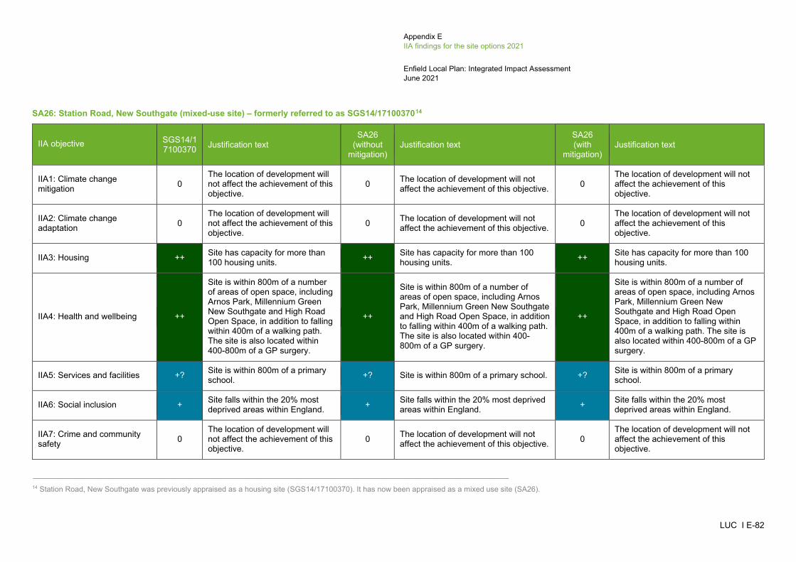
Appendix E IIA findings for the site options 2021
Enfield Local Plan: Integrated Impact Assessment June 2021
LUC I E-82
SA26: Station Road, New Southgate (mixed-use site) – formerly referred to as SGS14/1710037014
IIA objective SGS14/17100370 Justification text
SA26 (without
mitigation) Justification text
SA26 (with
mitigation) Justification text
IIA1: Climate change mitigation 0
The location of development will not affect the achievement of this objective.
0 The location of development will not affect the achievement of this objective. 0
The location of development will not affect the achievement of this objective.
IIA2: Climate change adaptation 0
The location of development will not affect the achievement of this objective.
0 The location of development will not affect the achievement of this objective. 0
The location of development will not affect the achievement of this objective.
IIA3: Housing ++ Site has capacity for more than 100 housing units. ++ Site has capacity for more than 100
housing units. ++ Site has capacity for more than 100 housing units.
IIA4: Health and wellbeing ++
Site is within 800m of a number of areas of open space, including Arnos Park, Millennium Green New Southgate and High Road Open Space, in addition to falling within 400m of a walking path. The site is also located within 400-800m of a GP surgery.
++
Site is within 800m of a number of areas of open space, including Arnos Park, Millennium Green New Southgate and High Road Open Space, in addition to falling within 400m of a walking path. The site is also located within 400-800m of a GP surgery.
++
Site is within 800m of a number of areas of open space, including Arnos Park, Millennium Green New Southgate and High Road Open Space, in addition to falling within 400m of a walking path. The site is also located within 400-800m of a GP surgery.
IIA5: Services and facilities +? Site is within 800m of a primary school. +? Site is within 800m of a primary school. +? Site is within 800m of a primary
school.
IIA6: Social inclusion + Site falls within the 20% most deprived areas within England. + Site falls within the 20% most deprived
areas within England. + Site falls within the 20% most deprived areas within England.
IIA7: Crime and community safety 0
The location of development will not affect the achievement of this objective.
0 The location of development will not affect the achievement of this objective. 0
The location of development will not affect the achievement of this objective.
_____________________________________________________________________________________________________ 14 Station Road, New Southgate was previously appraised as a housing site (SGS14/17100370). It has now been appraised as a mixed use site (SA26).

Appendix E IIA findings for the site options 2021
Enfield Local Plan: Integrated Impact Assessment June 2021
LUC I E-83
IIA objective SGS14/17100370 Justification text
SA26 (without
mitigation) Justification text
SA26 (with
mitigation) Justification text
IIA8: Road safety 0 The location of development will not affect the achievement of this objective.
0 The location of development will not affect the achievement of this objective. 0
The location of development will not affect the achievement of this objective.
IIA9: Economy ++ Site is located close to a Locally Significant Industrial Site. ++
Site is close to a Locally Significant Industrial Site. The site is under 10ha in size and will re-provide the existing store on site.
++
Site is close to a Locally Significant Industrial Site. The site is under 10ha in size and will re-provide the existing store on site.
IIA10: Town and local centres 0 Site is not within or adjacent to a Major, District and Local Centre. 0 Site is not within or adjacent to a Major,
District and Local Centre. 0 Site is not within or adjacent to a Major, District and Local Centre.
IIA11: Air pollution --? Site scored 2 in the air quality appraisal. --? Site scored 2 in the air quality
appraisal. --? Site scored 2 in the air quality appraisal.
IIA12: Sustainable transport ++/-
Site is located within 1km of Arnos Grove tube station and 350m of at least one bus stop. However, the site is only within 401-800m of Arnos Grove, Bowes Road West and New Southgate Road, which are Local Centres.
++/-
Site is located within 1km of Arnos Grove tube station and 350m of at least one bus stop. However, the site is only within 401-800m of Arnos Grove, Bowes Road West and New Southgate Road, which are Local Centres.
++/-
Site is located within 1km of Arnos Grove tube station and 350m of at least one bus stop. However, the site is only within 401-800m of Arnos Grove, Bowes Road West and New Southgate Road, which are Local Centres.
IIA13: Biodiversity --? Site is located within 100m of a Priority Habitat and within 250-750m of Arnos Park SINC.
--? Site is located within 100m of a Priority Habitat and within 250-750m of Arnos Park SINC.
--? Site is located within 100m of a Priority Habitat and within 250-750m of Arnos Park SINC.
IIA14: Historic environment 0?
Site is more than 500m from the nearest designated heritage asset. However, the site could still have some potential for impacts on non-designated
0?
Site is more than 500m from the nearest designated heritage asset. However, the site could still have some potential for impacts on non-designated heritage features and effects may extend beyond 500m.
0?
The Council's assessment of heritage considerations and impacts on Archaeological Priority Areas has not recorded anything..

Appendix E IIA findings for the site options 2021
Enfield Local Plan: Integrated Impact Assessment June 2021
LUC I E-84
IIA objective SGS14/17100370 Justification text
SA26 (without
mitigation) Justification text
SA26 (with
mitigation) Justification text
heritage features and effects may extend beyond 500m.
IIA15: Landscape and townscape +?
Site is located within the settlement of New Southgate and contains built development.
+? Site is located within the settlement of New Southgate and contains built development.
+? Site is located within the settlement of New Southgate and contains built development.
IIA16: Efficient use of land and materials + Site is relatively small in size and
on brownfield land. + Site is relatively small in size and on brownfield land. + Site is relatively small in size and on
brownfield land.
IIA17: Flooding --
Site has a predicted peak flood depth of greater than 300mm. However, the site is on brownfield land and does not fall within Flood Zones 2 or 3.
--
Site has a predicted peak flood depth of greater than 300mm. However, the site is on brownfield land and does not fall within Flood Zones 2 or 3.
--
Site has a predicted peak flood depth of greater than 300mm. However, the site is on brownfield land and does not fall within Flood Zones 2 or 3.
IIA18: Water 0 Site does not fall within a Source Protection Zone or contain a watercourse or water body.
0 Site does not fall within a Source Protection Zone or contain a watercourse or water body.
0 Site does not fall within a Source Protection Zone or contain a watercourse or water body.
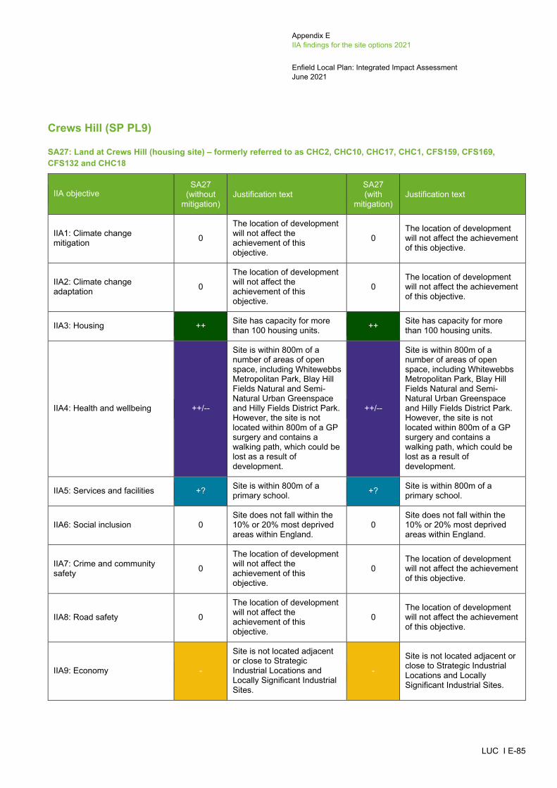
Appendix E IIA findings for the site options 2021
Enfield Local Plan: Integrated Impact Assessment June 2021
LUC I E-85
Crews Hill (SP PL9)
SA27: Land at Crews Hill (housing site) – formerly referred to as CHC2, CHC10, CHC17, CHC1, CFS159, CFS169, CFS132 and CHC18
IIA objective SA27
(without mitigation)
Justification text SA27 (with
mitigation) Justification text
IIA1: Climate change mitigation 0
The location of development will not affect the achievement of this objective.
0 The location of development will not affect the achievement of this objective.
IIA2: Climate change adaptation 0
The location of development will not affect the achievement of this objective.
0 The location of development will not affect the achievement of this objective.
IIA3: Housing ++ Site has capacity for more than 100 housing units. ++ Site has capacity for more
than 100 housing units.
IIA4: Health and wellbeing ++/--
Site is within 800m of a number of areas of open space, including Whitewebbs Metropolitan Park, Blay Hill Fields Natural and Semi-Natural Urban Greenspace and Hilly Fields District Park. However, the site is not located within 800m of a GP surgery and contains a walking path, which could be lost as a result of development.
++/--
Site is within 800m of a number of areas of open space, including Whitewebbs Metropolitan Park, Blay Hill Fields Natural and Semi-Natural Urban Greenspace and Hilly Fields District Park. However, the site is not located within 800m of a GP surgery and contains a walking path, which could be lost as a result of development.
IIA5: Services and facilities +? Site is within 800m of a primary school. +? Site is within 800m of a
primary school.
IIA6: Social inclusion 0 Site does not fall within the 10% or 20% most deprived areas within England.
0 Site does not fall within the 10% or 20% most deprived areas within England.
IIA7: Crime and community safety 0
The location of development will not affect the achievement of this objective.
0 The location of development will not affect the achievement of this objective.
IIA8: Road safety 0
The location of development will not affect the achievement of this objective.
0 The location of development will not affect the achievement of this objective.
IIA9: Economy -
Site is not located adjacent or close to Strategic Industrial Locations and Locally Significant Industrial Sites.
-
Site is not located adjacent or close to Strategic Industrial Locations and Locally Significant Industrial Sites.

Appendix E IIA findings for the site options 2021
Enfield Local Plan: Integrated Impact Assessment June 2021
LUC I E-86
IIA objective SA27
(without mitigation)
Justification text SA27 (with
mitigation) Justification text
IIA10: Town and local centres 0 Site is not within or adjacent to a Major, District and Local Centre.
0 Site is not within or adjacent to a Major, District and Local Centre.
IIA11: Air pollution -? Site scored 1 in the air quality appraisal. -? Site scored 1 in the air quality
appraisal.
IIA12: Sustainable transport ++/--
Site is located within 1km of Crews Hill railway station and 350m of at least one bus stop. However, the site is more than 800m from a Major, District and Local Centre.
++/--
Site is located within 1km of Crews Hill railway station and 350m of at least one bus stop. However, the site is more than 800m from a Major, District and Local Centre.
IIA13: Biodiversity --?
Site contains Priority Habitats, an area of Ancient Woodland, Crews Hill Golf Course SINC and Crews Hill Bowes Park Railsides SINC. The site is also located within 250m of Hily Fields Country Park SINC and Whitewebbs Wood SINC.
--?
Site contains Priority Habitats, an area of Ancient Woodland, Crews Hill Golf Course SINC and Crews Hill Bowes Park Railsides SINC. The site is also located within 250m of Hily Fields Country Park SINC and Whitewebbs Wood SINC.
IIA14: Historic environment --?
Site contains a Grade II* listed building (The Paddocks) and two Grade II listed buildings (2 Barns North West of Farmhouse at The Paddocks and Owls Hall). The site is also located within 500m of Clay Hill Conservation Area and further Grade II listed buildings. Due to the fact the site contains listed buildings, its development could affect the setting of these heritage assets.
-?
The Council's assessment of heritage considerations and impacts on Archaeological Priority Areas records this site as 'Amber' and states that a Heritage Impact Assessment should be undertaken and mitigation provided.
IIA15: Landscape and townscape --?/+?
Site is large in scale and although it is partially located within the settlement of Crews Hill and contains built development, it is also partially located in an undeveloped area.
--?/+?
Site is large in scale and although it is partially located within the settlement of Crews Hill and contains built development, it is also partially located in an undeveloped area.
IIA16: Efficient use of land and materials ++/--?
Site is relatively large in size and partially located on brownfield land and greenfield land, classed as Grade 3 agricultural land. The effect is recorded as uncertain because the GIS data available does not
++/--?
Site is relatively large in size and partially located on brownfield land and greenfield land, classed as Grade 3 agricultural land. The effect is recorded as uncertain because the GIS data available does not distinguish
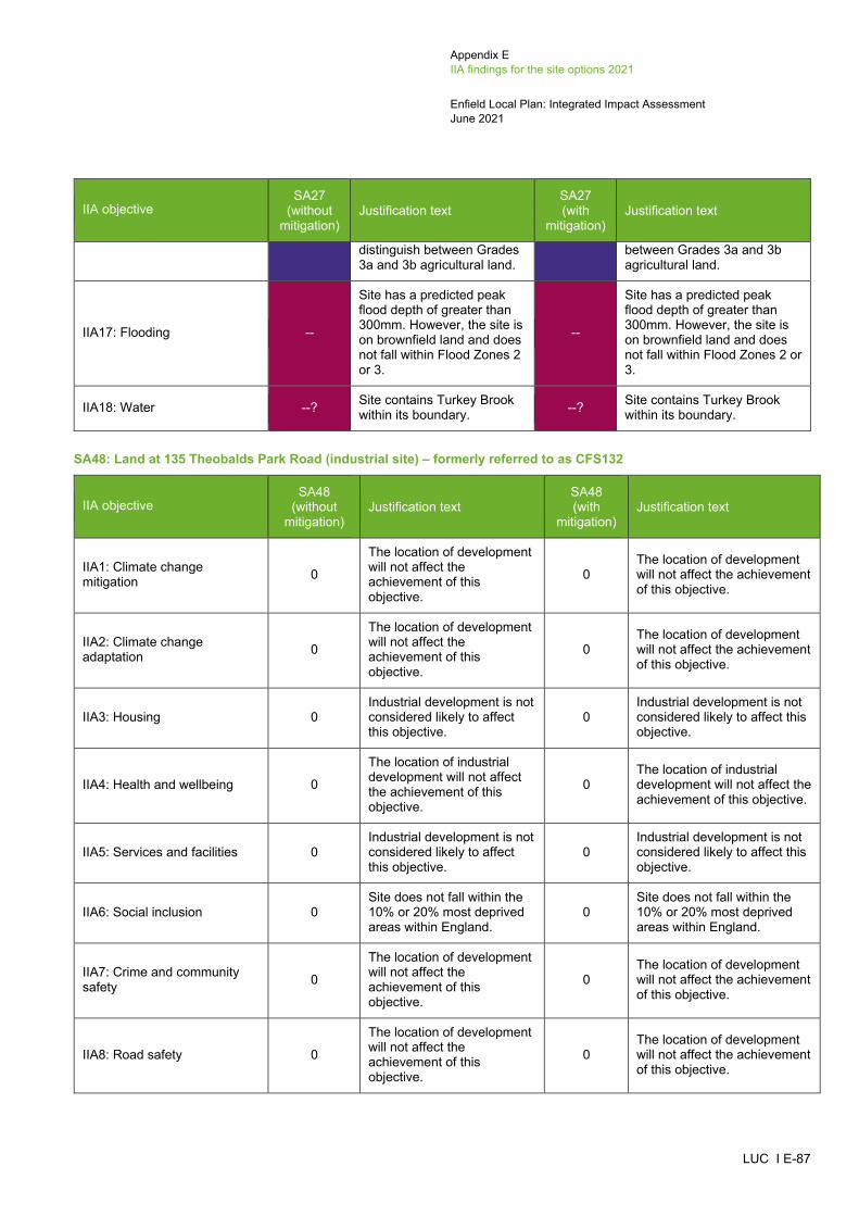
Appendix E IIA findings for the site options 2021
Enfield Local Plan: Integrated Impact Assessment June 2021
LUC I E-87
IIA objective SA27
(without mitigation)
Justification text SA27 (with
mitigation) Justification text
distinguish between Grades 3a and 3b agricultural land.
between Grades 3a and 3b agricultural land.
IIA17: Flooding --
Site has a predicted peak flood depth of greater than 300mm. However, the site is on brownfield land and does not fall within Flood Zones 2 or 3.
--
Site has a predicted peak flood depth of greater than 300mm. However, the site is on brownfield land and does not fall within Flood Zones 2 or 3.
IIA18: Water --? Site contains Turkey Brook within its boundary. --? Site contains Turkey Brook
within its boundary.
SA48: Land at 135 Theobalds Park Road (industrial site) – formerly referred to as CFS132
IIA objective SA48
(without mitigation)
Justification text SA48 (with
mitigation) Justification text
IIA1: Climate change mitigation 0
The location of development will not affect the achievement of this objective.
0 The location of development will not affect the achievement of this objective.
IIA2: Climate change adaptation 0
The location of development will not affect the achievement of this objective.
0 The location of development will not affect the achievement of this objective.
IIA3: Housing 0 Industrial development is not considered likely to affect this objective.
0 Industrial development is not considered likely to affect this objective.
IIA4: Health and wellbeing 0
The location of industrial development will not affect the achievement of this objective.
0 The location of industrial development will not affect the achievement of this objective.
IIA5: Services and facilities 0 Industrial development is not considered likely to affect this objective.
0 Industrial development is not considered likely to affect this objective.
IIA6: Social inclusion 0 Site does not fall within the 10% or 20% most deprived areas within England.
0 Site does not fall within the 10% or 20% most deprived areas within England.
IIA7: Crime and community safety 0
The location of development will not affect the achievement of this objective.
0 The location of development will not affect the achievement of this objective.
IIA8: Road safety 0
The location of development will not affect the achievement of this objective.
0 The location of development will not affect the achievement of this objective.

Appendix E IIA findings for the site options 2021
Enfield Local Plan: Integrated Impact Assessment June 2021
LUC I E-88
IIA objective SA48
(without mitigation)
Justification text SA48 (with
mitigation) Justification text
IIA9: Economy + The site is under 10ha in size. + The site is under 10ha in size.
IIA10: Town and local centres 0 Site is not within or adjacent to a Major, District and Local Centre.
0 Site is not within or adjacent to a Major, District and Local Centre.
IIA11: Air pollution -? Site scored 1 in the air quality appraisal. -? Site scored 1 in the air quality
appraisal.
IIA12: Sustainable transport ++/--
Site is within 1km of Turkey Street railway station and 350m of at least one bus stop. However, the site is more than 800m from a Major, District and Local Centre.
++/--
Site is within 1km of Turkey Street railway station and 350m of at least one bus stop. However, the site is more than 800m from a Major, District and Local Centre.
IIA13: Biodiversity --? Site is located within 250m of the Whitewebbs SINC. --? Site is located within 250m of
the Whitewebbs SINC.
IIA14: Historic environment -?
Site is within 500m from two Grade II listed buildings (Bridge at West End of Lane, Whitewebbs Wood, and Glasgow Stud Farmhouse). Although the site contains built development, its redevelopment could affect the setting of these heritage assets.
0?
The Council's assessment of heritage considerations and impacts on Archaeological Priority Areas has not recorded anything.
IIA15: Landscape and townscape +?
Site is located within the settlement of Crews Hill and contains built development.
+? Site is located within the settlement of Crews Hill and contains built development.
IIA16: Efficient use of land and materials + Site is relatively small and on
brownfield land. + Site is relatively small and on brownfield land.
IIA17: Flooding --
Site has a predicted peak flood depth of greater than 300mm. However, the site is on brownfield land and does not fall within Flood Zones 2 or 3.
--
Site has a predicted peak flood depth of greater than 300mm. However, the site is on brownfield land and does not fall within Flood Zones 2 or 3.
IIA18: Water 0
Site does not fall within a Source Protection Zone or contain a watercourse or water body.
0
Site does not fall within a Source Protection Zone or contain a watercourse or water body.

Appendix E IIA findings for the site options 2021
Enfield Local Plan: Integrated Impact Assessment June 2021
LUC I E-89
Chase Park (SP PL10)
SA28: Land at Chase Park (housing site) – formerly referred to as HIC10, HIC11, HIC6 and HIC9
IIA objective SA28
(without mitigation)
Justification text SA28 (with
mitigation) Justification text
IIA1: Climate change mitigation 0
The location of development will not affect the achievement of this objective.
0
The location of development will not affect the achievement of this objective.
IIA2: Climate change adaptation 0
The location of development will not affect the achievement of this objective.
0
The location of development will not affect the achievement of this objective.
IIA3: Housing ++ Site has capacity for more than 100 housing units. ++ Site has capacity for more
than 100 housing units.
IIA4: Health and wellbeing ++
Site is located within 400m of a GP surgery. The site is also within 800m of a number of areas of open space, including Trent Metropolitan Park, Lakeside Natural and Semi-Natural Urban Greenspace and Hilly Fields District Park, in addition to falling within 400m of a walking and cycle path.
++
Site is located within 400m of a GP surgery. The site is also within 800m of a number of areas of open space, including Trent Metropolitan Park, Lakeside Natural and Semi-Natural Urban Greenspace and Hilly Fields District Park, in addition to falling within 400m of a walking and cycle path.
IIA5: Services and facilities ++? Site is within 800m of a primary school and a secondary school.
++? Site is within 800m of a primary school and a secondary school.
IIA6: Social inclusion 0 Site does not fall within the 10% or 20% most deprived areas within England.
0 Site does not fall within the 10% or 20% most deprived areas within England.
IIA7: Crime and community safety 0
The location of development will not affect the achievement of this objective.
0
The location of development will not affect the achievement of this objective.
IIA8: Road safety 0
The location of development will not affect the achievement of this objective.
0
The location of development will not affect the achievement of this objective.
IIA9: Economy -
The site is not located adjacent or close to Strategic Industrial Locations and Locally Significant Industrial Sites.
-
The site is not located adjacent or close to Strategic Industrial Locations and Locally Significant Industrial Sites.
IIA10: Town and local centres + Site is close to Oakwood Local Centre. + Site is close to Oakwood
Local Centre.

Appendix E IIA findings for the site options 2021
Enfield Local Plan: Integrated Impact Assessment June 2021
LUC I E-90
IIA objective SA28
(without mitigation)
Justification text SA28 (with
mitigation) Justification text
IIA11: Air pollution -? Site scored 1 in the air quality appraisal. -? Site scored 1 in the air
quality appraisal.
IIA12: Sustainable transport ++
Site is located within 1km of Gordon Hill railway station and Oakwood tube station and 350m of at least one bus stop. The site is also next to Oakwood, which is a Local Centre.
++
Site is located within 1km of Gordon Hill railway station and Oakwood tube station and 350m of at least one bus stop. The site is also next to Oakwood, which is a Local Centre.
IIA13: Biodiversity --?
Site is located within 250m of Trent Park SINC, Trent Park Golf Course SINC, Lakeside SINC and Boxer's Lane & Lonsdale Drive Woods SINC, in addition to falling within 100m of Priority Habitats.
--?
Site is located within 250m of Trent Park SINC, Trent Park Golf Course SINC, Lakeside SINC and Boxer's Lane & Lonsdale Drive Woods SINC, in addition to falling within 100m of Priority Habitats.
IIA14: Historic environment --?
Site partially falls within Trent Park Conservation Area, which contains a number of Grade II listed buildings, Trent Park Registered Park and Garden and a Scheduled Monument (Moated site, Camlet Moat, Moat Wood). There is no built development between the site and the Conservation Area, listed buildings and Scheduled Monument. Its development could therefore adversely affect the setting of these heritage assets.
-?
The Council's assessment of heritage considerations records this site as 'Amber' and states that a Heritage Impact Assessment should be undertaken and mitigation provided.
IIA15: Landscape and townscape --?
Site is large in scale and located on the edge of World’s End.
--? Site is large in scale and located on the edge of World’s End.
IIA16: Efficient use of land and materials --?
Site is relatively large in size and on greenfield land, classed as Grade 3 agricultural land. The effect is recorded as uncertain because the GIS data available does not distinguish between Grades 3a and 3b agricultural land.
--?
Site is relatively large in size and on greenfield land, classed as Grade 3 agricultural land. The effect is recorded as uncertain because the GIS data available does not distinguish between Grades 3a and 3b agricultural land.
IIA17: Flooding -- Site has a predicted peak flood depth of greater than 300mm and partially falls within Flood Zone 3.
-- Site has a predicted peak flood depth of greater than 300mm and partially falls within Flood Zone 3.
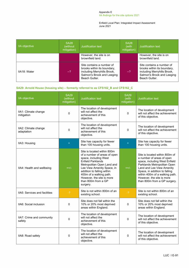
Appendix E IIA findings for the site options 2021
Enfield Local Plan: Integrated Impact Assessment June 2021
LUC I E-91
IIA objective SA28
(without mitigation)
Justification text SA28 (with
mitigation) Justification text
However, the site is on brownfield land.
However, the site is on brownfield land.
IIA18: Water --?
Site contains a number of brooks within its boundary, including Merryhills Brook, Salmon's Brook and Leeging Beach Gutter.
--?
Site contains a number of brooks within its boundary, including Merryhills Brook, Salmon's Brook and Leeging Beach Gutter.
SA29: Arnold House (housing site) – formerly referred to as CFS162_B and CFS162_C
IIA objective SA29
(without mitigation)
Justification text SA29 (with
mitigation) Justification text
IIA1: Climate change mitigation 0
The location of development will not affect the achievement of this objective.
0 The location of development will not affect the achievement of this objective.
IIA2: Climate change adaptation 0
The location of development will not affect the achievement of this objective.
0 The location of development will not affect the achievement of this objective.
IIA3: Housing + Site has capacity for fewer than 100 housing units. + Site has capacity for fewer
than 100 housing units.
IIA4: Health and wellbeing ++/-
Site is located within 800m of a number of areas of open space, including West Enfield Parklands Metropolitan Open Land and Lee View Amenity Space, in addition to falling within 400m of a walking path. However, the site is more than 800m from a GP surgery.
++/-
Site is located within 800m of a number of areas of open space, including West Enfield Parklands Metropolitan Open Land and Lee View Amenity Space, in addition to falling within 400m of a walking path. However, the site is more than 800m from a GP surgery.
IIA5: Services and facilities -? Site is not within 800m of an existing school. -? Site is not within 800m of an
existing school.
IIA6: Social inclusion 0 Site does not fall within the 10% or 20% most deprived areas within England.
0 Site does not fall within the 10% or 20% most deprived areas within England.
IIA7: Crime and community safety 0
The location of development will not affect the achievement of this objective.
0 The location of development will not affect the achievement of this objective.
IIA8: Road safety 0
The location of development will not affect the achievement of this objective.
0 The location of development will not affect the achievement of this objective.
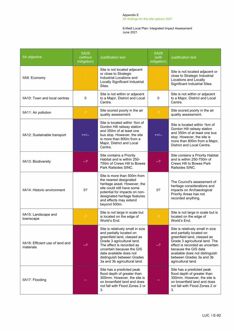
Appendix E IIA findings for the site options 2021
Enfield Local Plan: Integrated Impact Assessment June 2021
LUC I E-92
IIA objective SA29
(without mitigation)
Justification text SA29 (with
mitigation) Justification text
IIA9: Economy -
Site is not located adjacent or close to Strategic Industrial Locations and Locally Significant Industrial Sites.
-
Site is not located adjacent or close to Strategic Industrial Locations and Locally Significant Industrial Sites.
IIA10: Town and local centres 0 Site is not within or adjacent to a Major, District and Local Centre.
0 Site is not within or adjacent to a Major, District and Local Centre.
IIA11: Air pollution -? Site scored poorly in the air quality assessment. -? Site scored poorly in the air
quality assessment.
IIA12: Sustainable transport ++/--
Site is located within 1km of Gordon Hill railway station and 350m of at least one bus stop. However, the site is more than 800m from a Major, District and Local Centre.
++/--
Site is located within 1km of Gordon Hill railway station and 350m of at least one bus stop. However, the site is more than 800m from a Major, District and Local Centre.
IIA13: Biodiversity --?
Site contains a Priority Habitat and is within 250-750m of Crews Hill to Bowes Park Railsides SINC.
--?
Site contains a Priority Habitat and is within 250-750m of Crews Hill to Bowes Park Railsides SINC.
IIA14: Historic environment 0?
Site is more than 500m from the nearest designated heritage asset. However, the site could still have some potential for impacts on non-designated heritage features and effects may extend beyond 500m.
0?
The Council's assessment of heritage considerations and impacts on Archaeological Priority Areas has not recorded anything.
IIA15: Landscape and townscape -?
Site is not large in scale but is located on the edge of World’s End.
-? Site is not large in scale but is located on the edge of World’s End.
IIA16: Efficient use of land and materials --?
Site is relatively small in size and partially located on greenfield land, classed as Grade 3 agricultural land. The effect is recorded as uncertain because the GIS data available does not distinguish between Grades 3a and 3b agricultural land.
--?
Site is relatively small in size and partially located on greenfield land, classed as Grade 3 agricultural land. The effect is recorded as uncertain because the GIS data available does not distinguish between Grades 3a and 3b agricultural land.
IIA17: Flooding --
Site has a predicted peak flood depth of greater than 300mm. However, the site is on brownfield land and does not fall with Flood Zones 2 or 3.
--
Site has a predicted peak flood depth of greater than 300mm. However, the site is on brownfield land and does not fall with Flood Zones 2 or 3.

Appendix E IIA findings for the site options 2021
Enfield Local Plan: Integrated Impact Assessment June 2021
LUC I E-93
IIA objective SA29
(without mitigation)
Justification text SA29 (with
mitigation) Justification text
IIA18: Water 0
Site does not fall within a Source Protection Zone or contain a watercourse or water body.
0
Site does not fall within a Source Protection Zone or contain a watercourse or water body.
Other proposed site allocations outside of the place making areas (urban areas)
SA30: Claverings, Centre Way (mixed-use site) – formerly referred to as CFS152
IIA objective SA30
(without mitigation)
Justification text SA30 (with
mitigation) Justification text
IIA1: Climate change mitigation 0
The location of development will not affect the achievement of this objective.
0 The location of development will not affect the achievement of this objective.
IIA2: Climate change adaptation 0
The location of development will not affect the achievement of this objective.
0 The location of development will not affect the achievement of this objective.
IIA3: Housing ++ Site has capacity for more than 100 housing units. ++ Site has capacity for more
than 100 housing units.
IIA4: Health and wellbeing ++
Site is within 800m of a number of areas of open space, including Montagu Recreation Ground, in addition to falling within 400m of a walking path. The site is also located within 400-800m of a GP surgery.
++
Site is within 800m of a number of areas of open space, including Montagu Recreation Ground, in addition to falling within 400m of a walking path. The site is also located within 400-800m of a GP surgery.
IIA5: Services and facilities ++? Site is within 800m of a primary school and a secondary school.
++? Site is within 800m of a primary school and a secondary school.
IIA6: Social inclusion + Site falls within the 20% most deprived areas within England
+ Site falls within the 20% most deprived areas within England
IIA7: Crime and community safety 0
The location of development will not affect the achievement of this objective.
0 The location of development will not affect the achievement of this objective.
IIA8: Road safety 0
The location of development will not affect the achievement of this objective.
0 The location of development will not affect the achievement of this objective.
IIA9: Economy ++? Although the site falls within a Locally Significant
++? Although the site falls within a Locally Significant Industrial
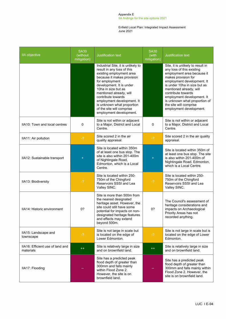
Appendix E IIA findings for the site options 2021
Enfield Local Plan: Integrated Impact Assessment June 2021
LUC I E-94
IIA objective SA30
(without mitigation)
Justification text SA30 (with
mitigation) Justification text
Industrial Site, it is unlikely to result in any loss of this existing employment area because it makes provision for employment development. It is under 10ha in size but as mentioned already, will contribute towards employment development. It is unknown what proportion of the site will comprise employment development.
Site, it is unlikely to result in any loss of this existing employment area because it makes provision for employment development. It is under 10ha in size but as mentioned already, will contribute towards employment development. It is unknown what proportion of the site will comprise employment development.
IIA10: Town and local centres 0 Site is not within or adjacent to a Major, District and Local Centre.
0 Site is not within or adjacent to a Major, District and Local Centre.
IIA11: Air pollution -? Site scored 2 in the air quality appraisal. -? Site scored 2 in the air quality
appraisal.
IIA12: Sustainable transport +
Site is located within 350m of at least one bus stop. The site is also within 201-400m of Nightingale Road, Edmonton, which is a Local Centre.
+
Site is located within 350m of at least one bus stop. The site is also within 201-400m of Nightingale Road, Edmonton, which is a Local Centre.
IIA13: Biodiversity -?
Site is located within 250-750m of the Chingford Reservoirs SSSI and Lea Valley SINC.
-?
Site is located within 250-750m of the Chingford Reservoirs SSSI and Lea Valley SINC.
IIA14: Historic environment 0?
Site is more than 500m from the nearest designated heritage asset. However, the site could still have some potential for impacts on non-designated heritage features and effects may extend beyond 500m.
0?
The Council's assessment of heritage considerations and impacts on Archaeological Priority Areas has not recorded anything.
IIA15: Landscape and townscape -?
Site is not large in scale but is located on the edge of Lower Edmonton.
-? Site is not large in scale but is located on the edge of Lower Edmonton.
IIA16: Efficient use of land and materials ++ Site is relatively large in size
and on brownfield land. ++ Site is relatively large in size and on brownfield land.
IIA17: Flooding --
Site has a predicted peak flood depth of greater than 300mm and falls mainly within Flood Zone 2. However, the site is on brownfield land.
--
Site has a predicted peak flood depth of greater than 300mm and falls mainly within Flood Zone 2. However, the site is on brownfield land.

Appendix E IIA findings for the site options 2021
Enfield Local Plan: Integrated Impact Assessment June 2021
LUC I E-95
IIA objective SA30
(without mitigation)
Justification text SA30 (with
mitigation) Justification text
IIA18: Water --? Southern edge of the site falls within Source Protection Zone 2.
--? Southern edge of the site falls within Source Protection Zone 2.
SA31: Cockfosters Station Car Park (Parcels a and b), Cockfosters Road, Barnet (housing site) – formerly referred to as COC9a and COC9b/LP608_1
IIA objective SA31
(without mitigation)
Justification text SA31 (with
mitigation) Justification text
IIA1: Climate change mitigation 0
The location of development will not affect the achievement of this objective.
0 The location of development will not affect the achievement of this objective.
IIA2: Climate change adaptation 0
The location of development will not affect the achievement of this objective.
0 The location of development will not affect the achievement of this objective.
IIA3: Housing ++ Site has capacity for more than 100 housing units. ++ Site has capacity for more
than 100 housing units.
IIA4: Health and wellbeing ++
Site is located within 400m of a GP surgery. The site is also within 800m of a number of areas of open space, including Trent Park, Cockfosters Sports Ground and Belmont Close, in addition to falling within 400m of a walking path.
++
Site is located within 400m of a GP surgery. The site is also within 800m of a number of areas of open space, including Trent Park, Cockfosters Sports Ground and Belmont Close, in addition to falling within 400m of a walking path.
IIA5: Services and facilities +? Site is within 800m of a secondary school. +? Site is within 800m of a
secondary school.
IIA6: Social inclusion 0 Site does not fall within the 10% or 20% most deprived areas within England.
0 Site does not fall within the 10% or 20% most deprived areas within England.
IIA7: Crime and community safety 0
The location of development will not affect the achievement of this objective.
0 The location of development will not affect the achievement of this objective.
IIA8: Road safety 0
The location of development will not affect the achievement of this objective.
0 The location of development will not affect the achievement of this objective.
IIA9: Economy - Site is not located adjacent or close to Strategic Industrial Locations and
-
Site is not located adjacent or close to Strategic Industrial Locations and Locally Significant Industrial Sites.
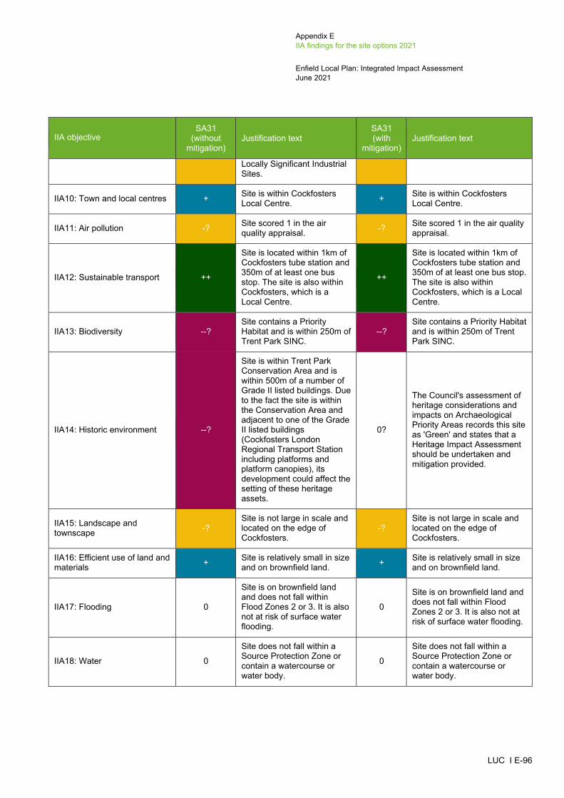
Appendix E IIA findings for the site options 2021
Enfield Local Plan: Integrated Impact Assessment June 2021
LUC I E-96
IIA objective SA31
(without mitigation)
Justification text SA31 (with
mitigation) Justification text
Locally Significant Industrial Sites.
IIA10: Town and local centres + Site is within Cockfosters Local Centre. + Site is within Cockfosters
Local Centre.
IIA11: Air pollution -? Site scored 1 in the air quality appraisal. -? Site scored 1 in the air quality
appraisal.
IIA12: Sustainable transport ++
Site is located within 1km of Cockfosters tube station and 350m of at least one bus stop. The site is also within Cockfosters, which is a Local Centre.
++
Site is located within 1km of Cockfosters tube station and 350m of at least one bus stop. The site is also within Cockfosters, which is a Local Centre.
IIA13: Biodiversity --? Site contains a Priority Habitat and is within 250m of Trent Park SINC.
--? Site contains a Priority Habitat and is within 250m of Trent Park SINC.
IIA14: Historic environment --?
Site is within Trent Park Conservation Area and is within 500m of a number of Grade II listed buildings. Due to the fact the site is within the Conservation Area and adjacent to one of the Grade II listed buildings (Cockfosters London Regional Transport Station including platforms and platform canopies), its development could affect the setting of these heritage assets.
0?
The Council's assessment of heritage considerations and impacts on Archaeological Priority Areas records this site as 'Green' and states that a Heritage Impact Assessment should be undertaken and mitigation provided.
IIA15: Landscape and townscape -?
Site is not large in scale and located on the edge of Cockfosters.
-? Site is not large in scale and located on the edge of Cockfosters.
IIA16: Efficient use of land and materials + Site is relatively small in size
and on brownfield land. + Site is relatively small in size and on brownfield land.
IIA17: Flooding 0
Site is on brownfield land and does not fall within Flood Zones 2 or 3. It is also not at risk of surface water flooding.
0
Site is on brownfield land and does not fall within Flood Zones 2 or 3. It is also not at risk of surface water flooding.
IIA18: Water 0
Site does not fall within a Source Protection Zone or contain a watercourse or water body.
0
Site does not fall within a Source Protection Zone or contain a watercourse or water body.
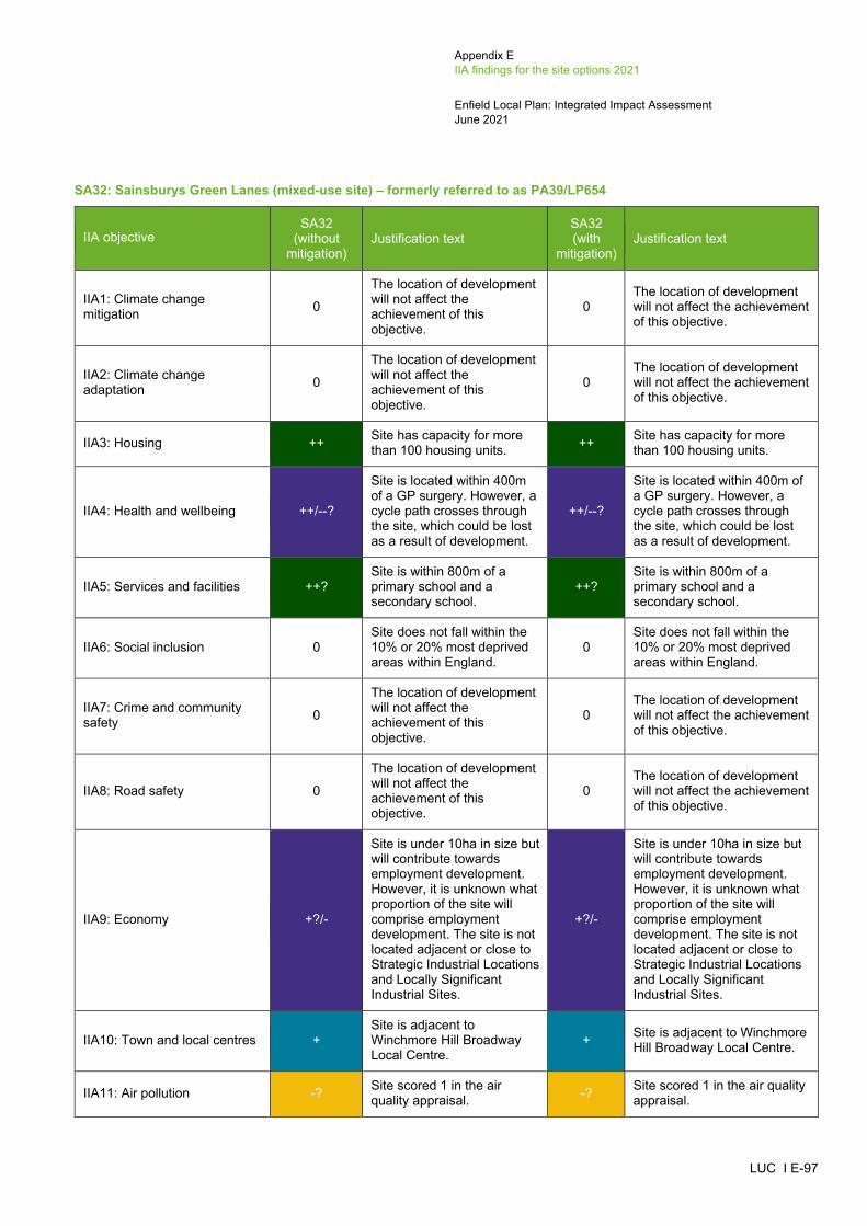
Appendix E IIA findings for the site options 2021
Enfield Local Plan: Integrated Impact Assessment June 2021
LUC I E-97
SA32: Sainsburys Green Lanes (mixed-use site) – formerly referred to as PA39/LP654
IIA objective SA32
(without mitigation)
Justification text SA32 (with
mitigation) Justification text
IIA1: Climate change mitigation 0
The location of development will not affect the achievement of this objective.
0 The location of development will not affect the achievement of this objective.
IIA2: Climate change adaptation 0
The location of development will not affect the achievement of this objective.
0 The location of development will not affect the achievement of this objective.
IIA3: Housing ++ Site has capacity for more than 100 housing units. ++ Site has capacity for more
than 100 housing units.
IIA4: Health and wellbeing ++/--?
Site is located within 400m of a GP surgery. However, a cycle path crosses through the site, which could be lost as a result of development.
++/--?
Site is located within 400m of a GP surgery. However, a cycle path crosses through the site, which could be lost as a result of development.
IIA5: Services and facilities ++? Site is within 800m of a primary school and a secondary school.
++? Site is within 800m of a primary school and a secondary school.
IIA6: Social inclusion 0 Site does not fall within the 10% or 20% most deprived areas within England.
0 Site does not fall within the 10% or 20% most deprived areas within England.
IIA7: Crime and community safety 0
The location of development will not affect the achievement of this objective.
0 The location of development will not affect the achievement of this objective.
IIA8: Road safety 0
The location of development will not affect the achievement of this objective.
0 The location of development will not affect the achievement of this objective.
IIA9: Economy +?/-
Site is under 10ha in size but will contribute towards employment development. However, it is unknown what proportion of the site will comprise employment development. The site is not located adjacent or close to Strategic Industrial Locations and Locally Significant Industrial Sites.
+?/-
Site is under 10ha in size but will contribute towards employment development. However, it is unknown what proportion of the site will comprise employment development. The site is not located adjacent or close to Strategic Industrial Locations and Locally Significant Industrial Sites.
IIA10: Town and local centres + Site is adjacent to Winchmore Hill Broadway Local Centre.
+ Site is adjacent to Winchmore Hill Broadway Local Centre.
IIA11: Air pollution -? Site scored 1 in the air quality appraisal. -? Site scored 1 in the air quality
appraisal.

Appendix E IIA findings for the site options 2021
Enfield Local Plan: Integrated Impact Assessment June 2021
LUC I E-98
IIA objective SA32
(without mitigation)
Justification text SA32 (with
mitigation) Justification text
IIA12: Sustainable transport ++
Site is located within 1km of Winchmore Hill railway station and 350m of at least one bus stop. The site is also next to Winchmore Hill Broadway, which is a Local Centre.
++
Site is located within 1km of Winchmore Hill railway station and 350m of at least one bus stop. The site is also next to Winchmore Hill Broadway, which is a Local Centre.
IIA13: Biodiversity --? Site contains a Priority Habitat and falls within 250m of New River SINC.
--? Site contains a Priority Habitat and falls within 250m of New River SINC.
IIA14: Historic environment --?
Site is within 500m of Winchmore Hill Green Conservation Area, which contains a number of Grade II listed buildings. The site is also located directly adjacent to another Grade II listed building (Police Station). Although the site contains built development, its redevelopment could affect the setting of these heritage assets.
0?
The Council's assessment of heritage considerations records this site as 'Green' and states that a Heritage Impact Assessment should be undertaken and mitigation provided.
IIA15: Landscape and townscape +?
Site is located within the settlement of Winchmore Hill and contains built development.
+?
Site is located within the settlement of Winchmore Hill and contains built development.
IIA16: Efficient use of land and materials + Site is relatively small and
on brownfield land. + Site is relatively small and on brownfield land.
IIA17: Flooding --
Site has a predicted peak flood depth of greater than 300mm. However, the site is on brownfield land and does not fall within Flood Zones 2 or 3.
--
Site has a predicted peak flood depth of greater than 300mm. However, the site is on brownfield land and does not fall within Flood Zones 2 or 3.
IIA18: Water --? Site falls within Source Protection Zone 1. --? Site falls within Source
Protection Zone 1.
SA33: Blackhorse Tower, Holbrook House and Churchwood House, 116 Cockfosters Road (housing site) – formerly referred to as COP10 (20/03200/PRJ)
IIA objective SA33
(without mitigation)
Justification text SA33 (with
mitigation) Justification text
IIA1: Climate change mitigation 0
The location of development will not affect the achievement of this objective.
0 The location of development will not affect the achievement of this objective.
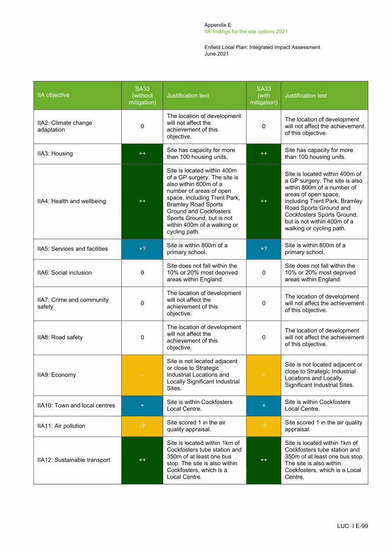
Appendix E IIA findings for the site options 2021
Enfield Local Plan: Integrated Impact Assessment June 2021
LUC I E-99
IIA objective SA33
(without mitigation)
Justification text SA33 (with
mitigation) Justification text
IIA2: Climate change adaptation 0
The location of development will not affect the achievement of this objective.
0 The location of development will not affect the achievement of this objective.
IIA3: Housing ++ Site has capacity for more than 100 housing units. ++ Site has capacity for more
than 100 housing units.
IIA4: Health and wellbeing ++
Site is located within 400m of a GP surgery. The site is also within 800m of a number of areas of open space, including Trent Park, Bramley Road Sports Ground and Cockfosters Sports Ground, but is not within 400m of a walking or cycling path.
++
Site is located within 400m of a GP surgery. The site is also within 800m of a number of areas of open space, including Trent Park, Bramley Road Sports Ground and Cockfosters Sports Ground, but is not within 400m of a walking or cycling path.
IIA5: Services and facilities +? Site is within 800m of a primary school. +? Site is within 800m of a
primary school.
IIA6: Social inclusion 0 Site does not fall within the 10% or 20% most deprived areas within England.
0 Site does not fall within the 10% or 20% most deprived areas within England.
IIA7: Crime and community safety 0
The location of development will not affect the achievement of this objective.
0 The location of development will not affect the achievement of this objective.
IIA8: Road safety 0
The location of development will not affect the achievement of this objective.
0 The location of development will not affect the achievement of this objective.
IIA9: Economy -
Site is not located adjacent or close to Strategic Industrial Locations and Locally Significant Industrial Sites.
-
Site is not located adjacent or close to Strategic Industrial Locations and Locally Significant Industrial Sites.
IIA10: Town and local centres + Site is within Cockfosters Local Centre. + Site is within Cockfosters
Local Centre.
IIA11: Air pollution -? Site scored 1 in the air quality appraisal. -? Site scored 1 in the air quality
appraisal.
IIA12: Sustainable transport ++
Site is located within 1km of Cockfosters tube station and 350m of at least one bus stop. The site is also within Cockfosters, which is a Local Centre.
++
Site is located within 1km of Cockfosters tube station and 350m of at least one bus stop. The site is also within Cockfosters, which is a Local Centre.

Appendix E IIA findings for the site options 2021
Enfield Local Plan: Integrated Impact Assessment June 2021
LUC I E-100
IIA objective SA33
(without mitigation)
Justification text SA33 (with
mitigation) Justification text
IIA13: Biodiversity --?
Site is located within 100m of a Priority Habitat and within 250m from Trent Park SINC.
--?
Site is located within 100m of a Priority Habitat and within 250m from Trent Park SINC.
IIA14: Historic environment --?
Site is within 500m of Trent Park Conservation Area and five Grade II listed buildings (Cockfosters London Regional Transport Station including platforms and platform canopies, West entrance gateway to Trent Park at Front Lodge, Bollards at entrance gateway to Trent Park, Front Lodge at Trent Park, and Cockfosters War Memorial). Due to the fact the site is adjacent to one of the Grade II listed buildings (Cockfosters London Regional Transport Station including platforms and platform canopies), its development could affect the setting of this heritage asset.
0?
The Council's assessment of heritage considerations and impacts on Archaeological Priority Areas records this site as 'Green' and states that a Heritage Impact Assessment should be undertaken and mitigation provided.
IIA15: Landscape and townscape +?
Site is located within the settlement of Cockfosters and contains built development.
+? Site is located within the settlement of Cockfosters and contains built development.
IIA16: Efficient use of land and materials + Site is relatively small in size
and on brownfield land. + Site is relatively small in size and on brownfield land.
IIA17: Flooding --
Site has a predicted peak flood depth of greater than 300mm. However, the site is on brownfield land and does not fall within Flood Zones 2 or 3.
--
Site has a predicted peak flood depth of greater than 300mm. However, the site is on brownfield land and does not fall within Flood Zones 2 or 3.
IIA18: Water 0
Site does not fall within a Source Protection Zone or contain a watercourse or water body.
0
Site does not fall within a Source Protection Zone or contain a watercourse or water body.

Appendix E IIA findings for the site options 2021
Enfield Local Plan: Integrated Impact Assessment June 2021
LUC I E-101
SA34: 241 Green Street (mixed-use site) – formerly referred to as EHP34 (18/04935/FUL)15
IIA objective
EHP34 (18/04935/
FUL) (without
mitigation)
Justification text SA34
(without mitigation)
Justification text SA34 (with
mitigation) Justification text
IIA1: Climate change mitigation 0
The location of development will not affect the achievement of this objective.
0 The location of development will not affect the achievement of this objective. 0 The location of development will not affect
the achievement of this objective.
IIA2: Climate change adaptation 0
The location of development will not affect the achievement of this objective.
0 The location of development will not affect the achievement of this objective. 0 The location of development will not affect
the achievement of this objective.
IIA3: Housing + Site has capacity for fewer than 100 housing units. ++ Site has capacity for more than 100
housing units. ++ Site has capacity for more than 100 housing units.
IIA4: Health and wellbeing ++/-
Site is within 800m of a number of areas of open space, including Durants Park and Alma Road Open Space, in addition to falling within 400m of a walking path. However, the site is not located within 800m of a GP surgery.
++/-
Site is within 800m of a number of areas of open space, including Durants Park and Alma Road Open Space, in addition to falling within 400m of a walking path. However, the site is not located within 800m of a GP surgery.
++/-
Site is within 800m of a number of areas of open space, including Durants Park and Alma Road Open Space, in addition to falling within 400m of a walking path. However, the site is not located within 800m of a GP surgery.
IIA5: Services and facilities +? Site is within 800m of a primary school. +? Site is within 800m of a primary school. +? Site is within 800m of a primary school.
IIA6: Social inclusion + Site falls within 20% most deprived areas within England. + Site falls within 20% most deprived
areas within England. + Site falls within 20% most deprived areas within England.
_____________________________________________________________________________________________________ 15 Green Street was previously appraised as delivering 92 housing units (EHP34 (18/04935/FUL)). It has now been appraised as delivering 148 housing units (SA34).
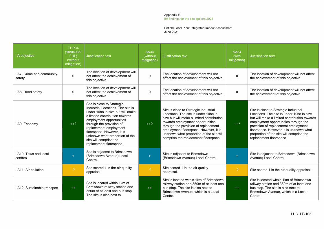
Appendix E IIA findings for the site options 2021
Enfield Local Plan: Integrated Impact Assessment June 2021
LUC I E-102
IIA objective
EHP34 (18/04935/
FUL) (without
mitigation)
Justification text SA34
(without mitigation)
Justification text SA34 (with
mitigation) Justification text
IIA7: Crime and community safety 0
The location of development will not affect the achievement of this objective.
0 The location of development will not affect the achievement of this objective. 0 The location of development will not affect
the achievement of this objective.
IIA8: Road safety 0 The location of development will not affect the achievement of this objective.
0 The location of development will not affect the achievement of this objective. 0 The location of development will not affect
the achievement of this objective.
IIA9: Economy ++?
Site is close to Strategic Industrial Locations. The site is under 10ha in size but will make a limited contribution towards employment opportunities through the provision of replacement employment floorspace. However, it is unknown what proportion of the site will comprise the replacement floorspace.
++?
Site is close to Strategic Industrial Locations. The site is under 10ha in size but will make a limited contribution towards employment opportunities through the provision of replacement employment floorspace. However, it is unknown what proportion of the site will comprise the replacement floorspace.
IIA10: Town and local centres +
Site is adjacent to Brimsdown (Brimsdown Avenue) Local Centre.
+ Site is adjacent to Brimsdown (Brimsdown Avenue) Local Centre. + Site is adjacent to Brimsdown (Brimsdown
Avenue) Local Centre.
IIA11: Air pollution -? Site scored 1 in the air quality appraisal. -? Site scored 1 in the air quality
appraisal. -? Site scored 1 in the air quality appraisal.
IIA12: Sustainable transport ++ Site is located within 1km of Brimsdown railway station and 350m of at least one bus stop. The site is also next to
++
Site is located within 1km of Brimsdown railway station and 350m of at least one bus stop. The site is also next to Brimsdown Avenue, which is a Local Centre.
++
Site is located within 1km of Brimsdown railway station and 350m of at least one bus stop. The site is also next to Brimsdown Avenue, which is a Local Centre.

Appendix E IIA findings for the site options 2021
Enfield Local Plan: Integrated Impact Assessment June 2021
LUC I E-103
IIA objective
EHP34 (18/04935/
FUL) (without
mitigation)
Justification text SA34
(without mitigation)
Justification text SA34 (with
mitigation) Justification text
Brimsdown Avenue, which is a Local Centre.
IIA13: Biodiversity -? Site is located within 250-750m of the Lea Valley SINC. -? Site is located within 250-750m of the
Lea Valley SINC. -? Site is located within 250-750m of the Lea Valley SINC.
IIA14: Historic environment 0?
Site is more than 500m from the nearest designated heritage asset. However, the site could still have some potential for impacts on non-designated heritage features and effects may extend beyond 500m.
0?
Site is more than 500m from the nearest designated heritage asset. However, the site could still have some potential for impacts on non-designated heritage features and effects may extend beyond 500m.
0?
The Council's assessment of heritage considerations and impacts on Archaeological Priority Areas has not recorded anything.
IIA15: Landscape and townscape +?
Site is located within the settlement of Brimsdown and contains built development.
+? Site is located within the settlement of Brimsdown and contains built development.
+? Site is located within the settlement of Brimsdown and contains built development.
IIA16: Efficient use of land and materials + Site is relatively small in size
and on brownfield land. + Site is relatively small in size and on brownfield land. + Site is relatively small in size and on
brownfield land.
IIA17: Flooding --
Site has a predicted peak flood depth of greater than 300mm and partially falls within Flood Zone 2. However, the site is on brownfield land.
--
Site has a predicted peak flood depth of greater than 300mm and partially falls within Flood Zone 2. However, the site is on brownfield land.
--
Site has a predicted peak flood depth of greater than 300mm and partially falls within Flood Zone 2. However, the site is on brownfield land.
IIA18: Water --? Site falls within Source Protection Zone 2. --? Site falls within Source Protection Zone
2. --? Site falls within Source Protection Zone 2.
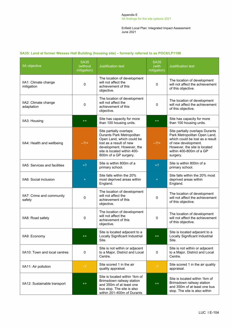
Appendix E IIA findings for the site options 2021
Enfield Local Plan: Integrated Impact Assessment June 2021
LUC I E-104
SA35: Land at former Wessex Hall Building (housing site) – formerly referred to as POC6/LP1196
IIA objective SA35
(without mitigation)
Justification text SA35 (with
mitigation) Justification text
IIA1: Climate change mitigation 0
The location of development will not affect the achievement of this objective.
0 The location of development will not affect the achievement of this objective.
IIA2: Climate change adaptation 0
The location of development will not affect the achievement of this objective.
0 The location of development will not affect the achievement of this objective.
IIA3: Housing ++ Site has capacity for more than 100 housing units. ++ Site has capacity for more
than 100 housing units.
IIA4: Health and wellbeing --?/+
Site partially overlaps Durants Park Metropolitan Open Land, which could be lost as a result of new development. However, the site is located within 400-800m of a GP surgery.
--?/+
Site partially overlaps Durants Park Metropolitan Open Land, which could be lost as a result of new development. However, the site is located within 400-800m of a GP surgery.
IIA5: Services and facilities +? Site is within 800m of a primary school. +? Site is within 800m of a
primary school.
IIA6: Social inclusion + Site falls within the 20% most deprived areas within England.
+ Site falls within the 20% most deprived areas within England.
IIA7: Crime and community safety 0
The location of development will not affect the achievement of this objective.
0 The location of development will not affect the achievement of this objective.
IIA8: Road safety 0
The location of development will not affect the achievement of this objective.
0 The location of development will not affect the achievement of this objective.
IIA9: Economy ++ Site is located adjacent to a Locally Significant Industrial Site.
++ Site is located adjacent to a Locally Significant Industrial Site.
IIA10: Town and local centres 0 Site is not within or adjacent to a Major, District and Local Centre.
0 Site is not within or adjacent to a Major, District and Local Centre.
IIA11: Air pollution -? Site scored 1 in the air quality appraisal. -? Site scored 1 in the air quality
appraisal.
IIA12: Sustainable transport ++
Site is located within 1km of Brimsdown railway station and 350m of at least one bus stop. The site is also within 201-400m of Durants
++ Site is located within 1km of Brimsdown railway station and 350m of at least one bus stop. The site is also within

Appendix E IIA findings for the site options 2021
Enfield Local Plan: Integrated Impact Assessment June 2021
LUC I E-105
IIA objective SA35
(without mitigation)
Justification text SA35 (with
mitigation) Justification text
Road, which is a Local Centre.
201-400m of Durants Road, which is a Local Centre.
IIA13: Biodiversity --? Site is located within 100m of a Priority Habitat. --? Site is located within 100m of
a Priority Habitat.
IIA14: Historic environment 0?
Site is more than 500m from the nearest designated heritage asset. However, the site could still have some potential for impacts on non-designated heritage features and effects may extend beyond 500m.
0?
The Council's assessment of heritage considerations and impacts on Archaeological Priority Areas has not recorded anything.
IIA15: Landscape and townscape --
Development of this site would result in the partial loss of Durants Park Metropolitan Open Land.
--
Development of this site would result in the partial loss of Durants Park Metropolitan Open Land.
IIA16: Efficient use of land and materials + Site is relatively small in size
and on brownfield land. + Site is relatively small in size and on brownfield land.
IIA17: Flooding --
Site has a predicted peak flood depth of greater than 300mm. However, the site is on brownfield land and does not fall within Flood Zones 2 or 3.
--
Site has a predicted peak flood depth of greater than 300mm. However, the site is on brownfield land and does not fall within Flood Zones 2 or 3.
IIA18: Water --? Site falls within Source Protection Zone 2. --? Site falls within Source
Protection Zone 2.
SA36: 188-200 Bowes Road (housing site) – formerly referred to as SGP13 (18/00388/OUT)
IIA objective SA36
(without mitigation)
Justification text SA36 (with
mitigation) Justification text
IIA1: Climate change mitigation 0
The location of development will not affect the achievement of this objective.
0 The location of development will not affect the achievement of this objective.
IIA2: Climate change adaptation 0
The location of development will not affect the achievement of this objective.
0 The location of development will not affect the achievement of this objective.
IIA3: Housing + Site has capacity for fewer than 100 units. + Site has capacity for fewer
than 100 units.
IIA4: Health and wellbeing ++ Site is located within 400m of a GP surgery. Site is also within 800m of a number of areas of open space,
++ Site is located within 400m of a GP surgery. Site is also within 800m of a number of areas of open space,
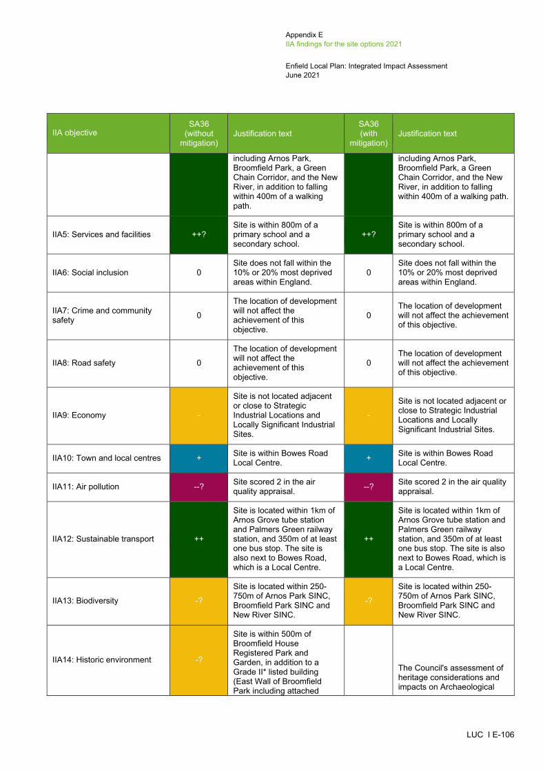
Appendix E IIA findings for the site options 2021
Enfield Local Plan: Integrated Impact Assessment June 2021
LUC I E-106
IIA objective SA36
(without mitigation)
Justification text SA36 (with
mitigation) Justification text
including Arnos Park, Broomfield Park, a Green Chain Corridor, and the New River, in addition to falling within 400m of a walking path.
including Arnos Park, Broomfield Park, a Green Chain Corridor, and the New River, in addition to falling within 400m of a walking path.
IIA5: Services and facilities ++? Site is within 800m of a primary school and a secondary school.
++? Site is within 800m of a primary school and a secondary school.
IIA6: Social inclusion 0 Site does not fall within the 10% or 20% most deprived areas within England.
0 Site does not fall within the 10% or 20% most deprived areas within England.
IIA7: Crime and community safety 0
The location of development will not affect the achievement of this objective.
0 The location of development will not affect the achievement of this objective.
IIA8: Road safety 0
The location of development will not affect the achievement of this objective.
0 The location of development will not affect the achievement of this objective.
IIA9: Economy -
Site is not located adjacent or close to Strategic Industrial Locations and Locally Significant Industrial Sites.
-
Site is not located adjacent or close to Strategic Industrial Locations and Locally Significant Industrial Sites.
IIA10: Town and local centres + Site is within Bowes Road Local Centre. + Site is within Bowes Road
Local Centre.
IIA11: Air pollution --? Site scored 2 in the air quality appraisal. --? Site scored 2 in the air quality
appraisal.
IIA12: Sustainable transport ++
Site is located within 1km of Arnos Grove tube station and Palmers Green railway station, and 350m of at least one bus stop. The site is also next to Bowes Road, which is a Local Centre.
++
Site is located within 1km of Arnos Grove tube station and Palmers Green railway station, and 350m of at least one bus stop. The site is also next to Bowes Road, which is a Local Centre.
IIA13: Biodiversity -?
Site is located within 250-750m of Arnos Park SINC, Broomfield Park SINC and New River SINC.
-?
Site is located within 250-750m of Arnos Park SINC, Broomfield Park SINC and New River SINC.
IIA14: Historic environment -?
Site is within 500m of Broomfield House Registered Park and Garden, in addition to a Grade II* listed building (East Wall of Broomfield Park including attached
0?
The Council's assessment of heritage considerations and impacts on Archaeological

Appendix E IIA findings for the site options 2021
Enfield Local Plan: Integrated Impact Assessment June 2021
LUC I E-107
IIA objective SA36
(without mitigation)
Justification text SA36 (with
mitigation) Justification text
garden house and stable block) and four Grade II listed buildings (Junior and Infant School, Bowes Road Library, Bowes Road Clinic, South Walls of Broomfield Park and inner garden walls). Although there is built development between the site and the Registered Park and Garden and listed buildings, its development could affect the setting of these heritage assets.
Priority Areas has not recorded anything.
IIA15: Landscape and townscape +?
Site is located within the settlement of New Southgate and contains built development.
+?
Site is located within the settlement of New Southgate and contains built development.
IIA16: Efficient use of land and materials + Site is relatively small in size
and on brownfield land. + Site is relatively small in size and on brownfield land.
IIA17: Flooding --
Site has a predicted peak flood depth of greater than 300mm and partially falls within Flood Zone 2. However, the site is on brownfield land.
--
Site has a predicted peak flood depth of greater than 300mm and partially falls within Flood Zone 2. However, the site is on brownfield land.
IIA18: Water --? Site falls within Source Protection Zone 2. --? Site falls within Source
Protection Zone 2.
SA37: Main Avenue Site (housing site) – formerly referred to as SBC2/LP1107
IIA objective SA37
(without mitigation)
Justification text SA37 (with
mitigation) Justification text
IIA1: Climate change mitigation 0
The location of development will not affect the achievement of this objective.
0 The location of development will not affect the achievement of this objective.
IIA2: Climate change adaptation 0
The location of development will not affect the achievement of this objective.
0 The location of development will not affect the achievement of this objective.
IIA3: Housing + Site has capacity for fewer than 100 housing units. + Site has capacity for fewer
than 100 housing units.
IIA4: Health and wellbeing ++/--? Site is located within 400m of a GP surgery. The site is also located within 800m of a number of open spaces,
++/--? Site is located within 400m of a GP surgery. The site is also located within 800m of a number of open spaces,

Appendix E IIA findings for the site options 2021
Enfield Local Plan: Integrated Impact Assessment June 2021
LUC I E-108
IIA objective SA37
(without mitigation)
Justification text SA37 (with
mitigation) Justification text
including Bush Hill Local Park. However, the site contains some walking paths which could be lost as a result of new development.
including Bush Hill Local Park. However, the site contains some walking paths which could be lost as a result of new development.
IIA5: Services and facilities ++? Site is within 800m of a primary school and a secondary school.
++? Site is within 800m of a primary school and a secondary school.
IIA6: Social inclusion + Site falls within the 20% most deprived areas within England.
+ Site falls within the 20% most deprived areas within England.
IIA7: Crime and community safety 0
The location of development will not affect the achievement of this objective.
0 The location of development will not affect the achievement of this objective.
IIA8: Road safety 0
The location of development will not affect the achievement of this objective.
0 The location of development will not affect the achievement of this objective.
IIA9: Economy -
Site is not located adjacent or close to Strategic Industrial Locations and Locally Significant Industrial Sites.
-
Site is not located adjacent or close to Strategic Industrial Locations and Locally Significant Industrial Sites.
IIA10: Town and local centres +
Site is adjacent to Main Avenue Bush Hill Park Local Centre and Percival Road Enfield Local Centre.
+
Site is adjacent to Main Avenue Bush Hill Park Local Centre and Percival Road Enfield Local Centre.
IIA11: Air pollution --? Site scored 2 in the air quality appraisal. --? Site scored 2 in the air quality
appraisal.
IIA12: Sustainable transport ++
Site is located within 1km of Enfield Town railway station, Bush Hill Park railway station and Southbury railway station, and 350m of at least one bus stop. The site is also next to Main Avenue Bush Hill Park and Percival Road Enfield, which are Local Centres.
++
Site is located within 1km of Enfield Town railway station, Bush Hill Park railway station and Southbury railway station, and 350m of at least one bus stop. The site is also next to Main Avenue Bush Hill Park and Percival Road Enfield, which are Local Centres.
IIA13: Biodiversity -? Site is within 250m of a Priority Habitat. -? Site is within 250m of a
Priority Habitat.
IIA14: Historic environment -?
Site is within 500m of Bush Hill Park Conservation Area, which contains a Grade II listed building (2 Queen Anne’s Place). Although the
-?
The Council's assessment of heritage considerations and impacts on Archaeological Priority Areas records this site as 'Amber' and states that a
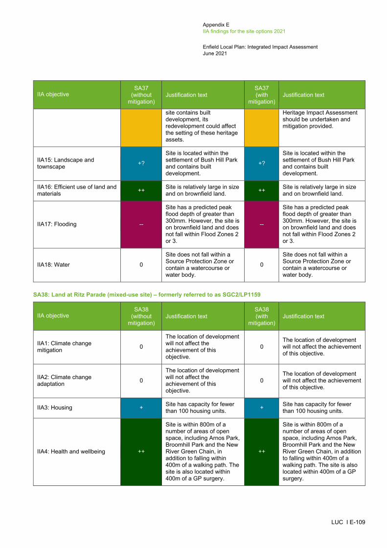
Appendix E IIA findings for the site options 2021
Enfield Local Plan: Integrated Impact Assessment June 2021
LUC I E-109
IIA objective SA37
(without mitigation)
Justification text SA37 (with
mitigation) Justification text
site contains built development, its redevelopment could affect the setting of these heritage assets.
Heritage Impact Assessment should be undertaken and mitigation provided.
IIA15: Landscape and townscape +?
Site is located within the settlement of Bush Hill Park and contains built development.
+?
Site is located within the settlement of Bush Hill Park and contains built development.
IIA16: Efficient use of land and materials ++ Site is relatively large in size
and on brownfield land. ++ Site is relatively large in size and on brownfield land.
IIA17: Flooding --
Site has a predicted peak flood depth of greater than 300mm. However, the site is on brownfield land and does not fall within Flood Zones 2 or 3.
--
Site has a predicted peak flood depth of greater than 300mm. However, the site is on brownfield land and does not fall within Flood Zones 2 or 3.
IIA18: Water 0
Site does not fall within a Source Protection Zone or contain a watercourse or water body.
0
Site does not fall within a Source Protection Zone or contain a watercourse or water body.
SA38: Land at Ritz Parade (mixed-use site) – formerly referred to as SGC2/LP1159
IIA objective SA38
(without mitigation)
Justification text SA38 (with
mitigation) Justification text
IIA1: Climate change mitigation 0
The location of development will not affect the achievement of this objective.
0 The location of development will not affect the achievement of this objective.
IIA2: Climate change adaptation 0
The location of development will not affect the achievement of this objective.
0 The location of development will not affect the achievement of this objective.
IIA3: Housing + Site has capacity for fewer than 100 housing units. + Site has capacity for fewer
than 100 housing units.
IIA4: Health and wellbeing ++
Site is within 800m of a number of areas of open space, including Arnos Park, Broomhill Park and the New River Green Chain, in addition to falling within 400m of a walking path. The site is also located within 400m of a GP surgery.
++
Site is within 800m of a number of areas of open space, including Arnos Park, Broomhill Park and the New River Green Chain, in addition to falling within 400m of a walking path. The site is also located within 400m of a GP surgery.

Appendix E IIA findings for the site options 2021
Enfield Local Plan: Integrated Impact Assessment June 2021
LUC I E-110
IIA objective SA38
(without mitigation)
Justification text SA38 (with
mitigation) Justification text
IIA5: Services and facilities ++? Site is within 800m of a primary school and a secondary school.
++? Site is within 800m of a primary school and a secondary school.
IIA6: Social inclusion 0 Site does not fall within the 10% or 20% most deprived areas within England.
0 Site does not fall within the 10% or 20% most deprived areas within England.
IIA7: Crime and community safety 0
The location of development will not affect the achievement of this objective.
0 The location of development will not affect the achievement of this objective.
IIA8: Road safety 0
The location of development will not affect the achievement of this objective.
0 The location of development will not affect the achievement of this objective.
IIA9: Economy +/-
Site is under 10ha in size but will make a limited contribution towards employment opportunities through the re-provision of existing retail uses on site. The site is not located adjacent or close to Strategic Industrial Locations and Locally Significant Industrial Sites.
+/-
Site is under 10ha in size but will make a limited contribution towards employment opportunities through the re-provision of existing retail uses on site. The site is not located adjacent or close to Strategic Industrial Locations and Locally Significant Industrial Sites.
IIA10: Town and local centres + Site is within Bowes Road Local Centre. + Site is within Bowes Road
Local Centre.
IIA11: Air pollution --? Site scored 2 in the air quality appraisal. --? Site scored 2 in the air quality
appraisal.
IIA12: Sustainable transport ++
Site is located within 1km of Arnos Grove tube station and Palmers Green railway station, and 350m of at least one bus stop. The site is also within Bowes Road, which is a Local Centre.
++
Site is located within 1km of Arnos Grove tube station and Palmers Green railway station, and 350m of at least one bus stop. The site is also within Bowes Road, which is a Local Centre.
IIA13: Biodiversity -?
Site is located within 250-750m of the Arnos Park SINC, Broomfield Park SINC and New River SINC.
-?
Site is located within 250-750m of the Arnos Park SINC, Broomfield Park SINC and New River SINC.
IIA14: Historic environment -?
Site is within 500m of Broomfield House Registered Park and Garden, which contains a number of Grade II* and Grade II listed buildings. The site is also within 500m of a two Grade II listed buildings
-?
The Council's assessment of heritage considerations records this site as 'Amber' and states that a Heritage Impact Assessment should be undertaken and mitigation provided.

Appendix E IIA findings for the site options 2021
Enfield Local Plan: Integrated Impact Assessment June 2021
LUC I E-111
IIA objective SA38
(without mitigation)
Justification text SA38 (with
mitigation) Justification text
(Junior and Infant School, and Bowes Road Library and Arnos Pool). Although there is built development between the site, Conservation Area and listed buildings, its development could affect the setting of these heritage assets.
IIA15: Landscape and townscape +?
Site is located within the settlement of New Southgate and contains built development.
+?
Site is located within the settlement of New Southgate and contains built development.
IIA16: Efficient use of land and materials + Site is relatively small in size
and on brownfield land. + Site is relatively small in size and on brownfield land.
IIA17: Flooding --
Site has a predicted peak flood depth of greater than 300mm and partially falls within Flood Zone 2. However, the site is on brownfield land.
--
Site has a predicted peak flood depth of greater than 300mm and partially falls within Flood Zone 2. However, the site is on brownfield land.
IIA18: Water --? Site falls within Source Protection Zone 2. --? Site falls within Source
Protection Zone 2.
SA39: Travis Perkins Palmers Green, Bridge Drive, Bloomfield Lane (mixed-use site) – formerly referred to as PAC8/LP656
IIA objective SA39
(without mitigation
Justification text SA39 (with
mitigation Justification text
IIA1: Climate change mitigation 0
The location of development will not affect the achievement of this objective.
0 The location of development will not affect the achievement of this objective.
IIA2: Climate change adaptation 0
The location of development will not affect the achievement of this objective.
0 The location of development will not affect the achievement of this objective.
IIA3: Housing + Site has capacity for fewer than 100 housing units. + Site has capacity for fewer
than 100 housing units.
IIA4: Health and wellbeing ++/--?
Site is located within 400m of a GP surgery. However, a cycle path crosses through the site, which could be lost as a result of development.
++/--?
Site is located within 400m of a GP surgery. However, a cycle path crosses through the site, which could be lost as a result of development.

Appendix E IIA findings for the site options 2021
Enfield Local Plan: Integrated Impact Assessment June 2021
LUC I E-112
IIA objective SA39
(without mitigation
Justification text SA39 (with
mitigation Justification text
IIA5: Services and facilities +? Site is within 800m of a primary school. +? Site is within 800m of a
primary school.
IIA6: Social inclusion 0 Site does not fall within the 10% or 20% most deprived areas within England.
0 Site does not fall within the 10% or 20% most deprived areas within England.
IIA7: Crime and community safety 0
The location of development will not affect the achievement of this objective.
0 The location of development will not affect the achievement of this objective.
IIA8: Road safety 0
The location of development will not affect the achievement of this objective.
0 The location of development will not affect the achievement of this objective.
IIA9: Economy +?/-
Site is under 10ha in size but will contribute towards employment development. However, it is unknown what proportion of the site will comprise employment development. The site is not located adjacent or close to Strategic Industrial Locations and Locally Significant Industrial Sites.
+?/-
Site is under 10ha in size but will contribute towards employment development. However, it is unknown what proportion of the site will comprise employment development. The site is not located adjacent or close to Strategic Industrial Locations and Locally Significant Industrial Sites.
IIA10: Town and local centres + Site is adjacent to Palmers Green District Centre. + Site is adjacent to Palmers
Green District Centre.
IIA11: Air pollution --? Site scored 2 in the air quality appraisal. --? Site scored 2 in the air quality
appraisal.
IIA12: Sustainable transport ++
Site is located within 1km of Palmers Green railway station and 350m of at least one bus stop. The site is also next to Palmers Green, which is a District Centre.
++
Site is located within 1km of Palmers Green railway station and 350m of at least one bus stop. The site is also next to Palmers Green, which is a District Centre.
IIA13: Biodiversity --?
Site is located within 100m of a Priority Habitat and within 250m of Broomfield Park SINC and New River SINC.
--?
Site is located within 100m of a Priority Habitat and within 250m of Broomfield Park SINC and New River SINC.
IIA14: Historic environment --?
Site is adjacent to The Lakes Estate Conservation Area and within 500m of Broomfield House Registered Park and Garden which contains a number of Grade II* and Grade II listed buildings and four Grade II listed buildings (Wall to the
0?
The Council's assessment of heritage considerations and impacts on Archaeological Priority Areas has not recorded anything.

Appendix E IIA findings for the site options 2021
Enfield Local Plan: Integrated Impact Assessment June 2021
LUC I E-113
IIA objective SA39
(without mitigation
Justification text SA39 (with
mitigation Justification text
north of number 176, Truro House, Front wall and gate piers to west of number 176, and National Westminster Bank). The site is also within 500m of some Grade II listed buildings outside of the Registered Park and Garden. Although the site contains built development, its redevelopment could affect the setting of these heritage assets.
IIA15: Landscape and townscape +?
Site is located within the settlement of Palmers Green and contains built development.
+?
Site is located within the settlement of Palmers Green and contains built development.
IIA16: Efficient use of land and materials + Site is relatively small in size
and on brownfield land. + Site is relatively small in size and on brownfield land.
IIA17: Flooding --
Site has a predicted peak flood depth of greater than 300mm. However, the site is on brownfield land and does not fall within Flood Zones 2 or 3.
--
Site has a predicted peak flood depth of greater than 300mm. However, the site is on brownfield land and does not fall within Flood Zones 2 or 3.
IIA18: Water --? Site falls within Source Protection Zone 1. --? Site falls within Source
Protection Zone 1.
SA40: Land known as Brimsdown Sports Ground (mixed-use site) – formerly referred to as CFS217
IIA objective SA40
(without mitigation)
Justification text SA40 (with
mitigation) Justification text
IIA1: Climate change mitigation 0
The location of development will not affect the achievement of this objective.
0 The location of development will not affect the achievement of this objective.
IIA2: Climate change adaptation 0
The location of development will not affect the achievement of this objective.
0 The location of development will not affect the achievement of this objective.
IIA3: Housing + Site has capacity for fewer than 100 housing units. + Site has capacity for fewer
than 100 housing units.
IIA4: Health and wellbeing --?/+ Site contains a walking path which could be lost as a result of new development. However, the site is located
--?/+ Site contains a walking path which could be lost as a result of new development. However, the site is located

Appendix E IIA findings for the site options 2021
Enfield Local Plan: Integrated Impact Assessment June 2021
LUC I E-114
IIA objective SA40
(without mitigation)
Justification text SA40 (with
mitigation) Justification text
within 400-800m of a GP surgery.
within 400-800m of a GP surgery.
IIA5: Services and facilities +? Site is within 800m of a primary school. +? Site is within 800m of a
primary school.
IIA6: Social inclusion + Site falls within the 20% most deprived areas within England.
+ Site falls within the 20% most deprived areas within England.
IIA7: Crime and community safety 0
The location of development will not affect the achievement of this objective.
0 The location of development will not affect the achievement of this objective.
IIA8: Road safety 0
The location of development will not affect the achievement of this objective.
0 The location of development will not affect the achievement of this objective.
IIA9: Economy +?/-
Site is under 10ha in size but will make a limited contribution towards employment opportunities through the provision of social and community infrastructure. However, it is unknown what proportion of the site will comprise employment development. The site is not located adjacent or close to Strategic Industrial Locations and Locally Significant Industrial Sites.
+?/-
Site is under 10ha in size but will make a limited contribution towards employment opportunities through the provision of social and community infrastructure. However, it is unknown what proportion of the site will comprise employment development. The site is not located adjacent or close to Strategic Industrial Locations and Locally Significant Industrial Sites.
IIA10: Town and local centres + Site is adjacent to Green Street & Mayfield Road Local Centre.
+ Site is adjacent to Green Street & Mayfield Road Local Centre.
IIA11: Air pollution -? Site scored 1 in the air quality appraisal. -? Site scored 1 in the air quality
appraisal.
IIA12: Sustainable transport ++
Site is located within 1km of Brimsdown railway station and 350m of at least one bus stop. The site is also next to Brimsdown Avenue and Green Street & Mayfield Road, which are Local Centres.
++
Site is located within 1km of Brimsdown railway station and 350m of at least one bus stop. The site is also next to Brimsdown Avenue and Green Street & Mayfield Road, which are Local Centres.
IIA13: Biodiversity -? Site is located within 250-750m of the Lea Valley SINC.
-? Site is located within 250-750m of the Lea Valley SINC.
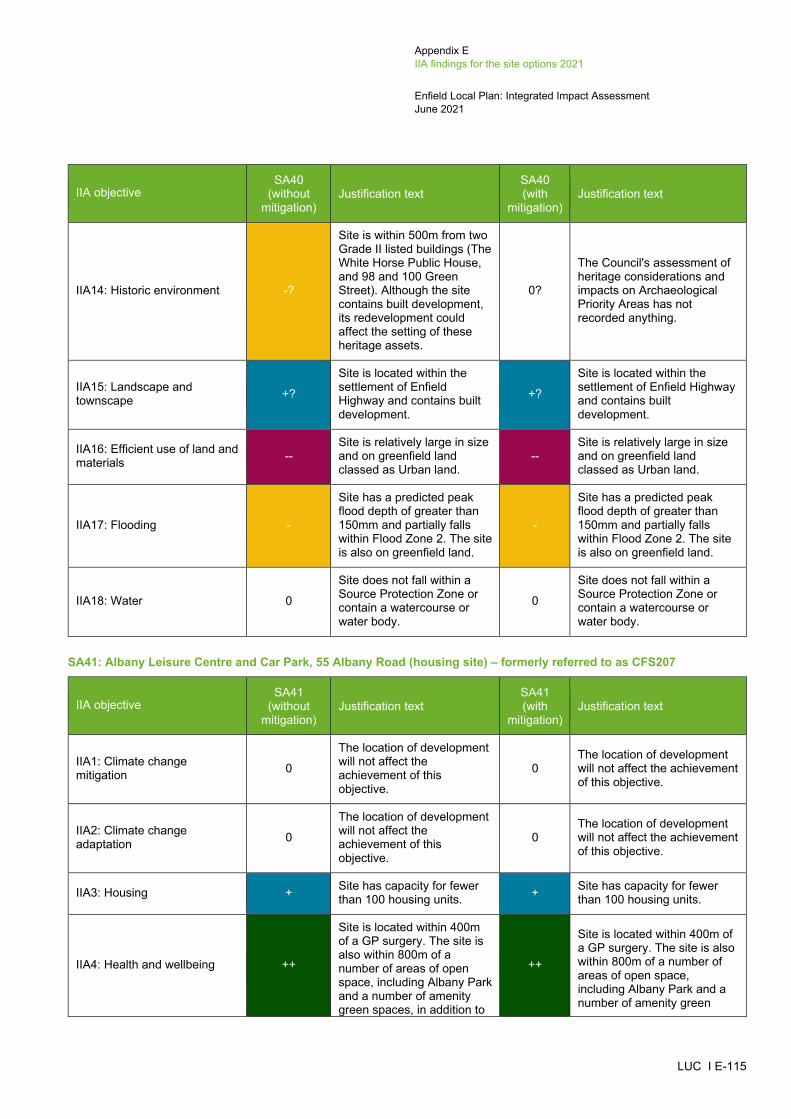
Appendix E IIA findings for the site options 2021
Enfield Local Plan: Integrated Impact Assessment June 2021
LUC I E-115
IIA objective SA40
(without mitigation)
Justification text SA40 (with
mitigation) Justification text
IIA14: Historic environment -?
Site is within 500m from two Grade II listed buildings (The White Horse Public House, and 98 and 100 Green Street). Although the site contains built development, its redevelopment could affect the setting of these heritage assets.
0?
The Council's assessment of heritage considerations and impacts on Archaeological Priority Areas has not recorded anything.
IIA15: Landscape and townscape +?
Site is located within the settlement of Enfield Highway and contains built development.
+?
Site is located within the settlement of Enfield Highway and contains built development.
IIA16: Efficient use of land and materials --
Site is relatively large in size and on greenfield land classed as Urban land.
-- Site is relatively large in size and on greenfield land classed as Urban land.
IIA17: Flooding -
Site has a predicted peak flood depth of greater than 150mm and partially falls within Flood Zone 2. The site is also on greenfield land.
-
Site has a predicted peak flood depth of greater than 150mm and partially falls within Flood Zone 2. The site is also on greenfield land.
IIA18: Water 0
Site does not fall within a Source Protection Zone or contain a watercourse or water body.
0
Site does not fall within a Source Protection Zone or contain a watercourse or water body.
SA41: Albany Leisure Centre and Car Park, 55 Albany Road (housing site) – formerly referred to as CFS207
IIA objective SA41
(without mitigation)
Justification text SA41 (with
mitigation) Justification text
IIA1: Climate change mitigation 0
The location of development will not affect the achievement of this objective.
0 The location of development will not affect the achievement of this objective.
IIA2: Climate change adaptation 0
The location of development will not affect the achievement of this objective.
0 The location of development will not affect the achievement of this objective.
IIA3: Housing + Site has capacity for fewer than 100 housing units. + Site has capacity for fewer
than 100 housing units.
IIA4: Health and wellbeing ++
Site is located within 400m of a GP surgery. The site is also within 800m of a number of areas of open space, including Albany Park and a number of amenity green spaces, in addition to
++
Site is located within 400m of a GP surgery. The site is also within 800m of a number of areas of open space, including Albany Park and a number of amenity green

Appendix E IIA findings for the site options 2021
Enfield Local Plan: Integrated Impact Assessment June 2021
LUC I E-116
IIA objective SA41
(without mitigation)
Justification text SA41 (with
mitigation) Justification text
falling within 400m of a cycle path.
spaces, in addition to falling within 400m of a cycle path.
IIA5: Services and facilities +? Site is within 800m of a primary school. +? Site is within 800m of a
primary school.
IIA6: Social inclusion + Site falls within the 20% most deprived areas within England.
+ Site falls within the 20% most deprived areas within England.
IIA7: Crime and community safety 0
The location of development will not affect the achievement of this objective.
0 The location of development will not affect the achievement of this objective.
IIA8: Road safety 0
The location of development will not affect the achievement of this objective.
0 The location of development will not affect the achievement of this objective.
IIA9: Economy -
Site is not located adjacent or close to Strategic Industrial Locations and Locally Significant Industrial Sites.
-
Site is not located adjacent or close to Strategic Industrial Locations and Locally Significant Industrial Sites.
IIA10: Town and local centres + Site is within Enfield Wash Local Centre. + Site is within Enfield Wash
Local Centre.
IIA11: Air pollution -? Site scored 1 in the air quality appraisal. -? Site scored 1 in the air quality
appraisal.
IIA12: Sustainable transport ++
Site is located within 1km of Turkey Street railway station and Enfield Lock railway station, and 350m of at least one bus stop. The site is also within Enfield Wash, which is a Local Centre.
++
Site is located within 1km of Turkey Street railway station and Enfield Lock railway station, and 350m of at least one bus stop. The site is also within Enfield Wash, which is a Local Centre.
IIA13: Biodiversity 0 Site is not located within close proximity of any biodiversity assets.
0 Site is not located within close proximity of any biodiversity assets.
IIA14: Historic environment -?
Site is within 500m of Turkey Street Conservation Area and two Grade II listed buildings (The Bell Inn, and 472-474 Hertford Road). Although the site contains built development, its redevelopment could affect the setting of these heritage assets.
0?
The Council's assessment of heritage considerations records this site as 'Green' and states that a Heritage Impact Assessment should be undertaken and mitigation provided.
IIA15: Landscape and townscape +? Site is located within the
settlement of Enfield Wash +? Site is located within the
settlement of Enfield Wash

Appendix E IIA findings for the site options 2021
Enfield Local Plan: Integrated Impact Assessment June 2021
LUC I E-117
IIA objective SA41
(without mitigation)
Justification text SA41 (with
mitigation) Justification text
and contains built development.
and contains built development.
IIA16: Efficient use of land and materials + Site is relatively small in size
and on brownfield land. + Site is relatively small in size and on brownfield land.
IIA17: Flooding --
Site has a predicted peak flood depth of greater than 300mm. However, the site is on brownfield land and does not fall within Flood Zones 2 or 3.
--
Site has a predicted peak flood depth of greater than 300mm. However, the site is on brownfield land and does not fall within Flood Zones 2 or 3.
IIA18: Water --? Site falls within Source Protection Zone 2. --? Site falls within Source
Protection Zone 2.
SA42: Fords Grove Car Park (housing site) – formerly referred to as CFS223
IIA objective SA42
(without mitigation)
Justification text SA42 (with
mitigation) Justification text
IIA1: Climate change mitigation 0
The location of development will not affect the achievement of this objective.
0 The location of development will not affect the achievement of this objective.
IIA2: Climate change adaptation 0
The location of development will not affect the achievement of this objective.
0 The location of development will not affect the achievement of this objective.
IIA3: Housing + Site has capacity for fewer than 100 housing units. + Site has capacity for fewer
than 100 housing units.
IIA4: Health and wellbeing ++
Site is located within 400m of a GP surgery. The site is also within 800m of a number of areas of open space, including Paulin Ground and the New River Green Chain Corridor, in addition to falling within 400m of a walking and cycle path.
++
Site is located within 400m of a GP surgery. The site is also within 800m of a number of areas of open space, including Paulin Ground and the New River Green Chain Corridor, in addition to falling within 400m of a walking and cycle path.
IIA5: Services and facilities ++? Site is within 800m of a primary school and a secondary school.
++? Site is within 800m of a primary school and a secondary school.
IIA6: Social inclusion 0 Site does not fall within the 10% or 20% most deprived areas within England.
0 Site does not fall within the 10% or 20% most deprived areas within England.

Appendix E IIA findings for the site options 2021
Enfield Local Plan: Integrated Impact Assessment June 2021
LUC I E-118
IIA objective SA42
(without mitigation)
Justification text SA42 (with
mitigation) Justification text
IIA7: Crime and community safety 0
The location of development will not affect the achievement of this objective.
0 The location of development will not affect the achievement of this objective.
IIA8: Road safety 0
The location of development will not affect the achievement of this objective.
0 The location of development will not affect the achievement of this objective.
IIA9: Economy -
Site is not located adjacent or close to Strategic Industrial Locations and Locally Significant Industrial Sites.
-
Site is not located adjacent or close to Strategic Industrial Locations and Locally Significant Industrial Sites.
IIA10: Town and local centres + Site is adjacent to Winchmore Hill Broadway Local Centre.
+ Site is adjacent to Winchmore Hill Broadway Local Centre.
IIA11: Air pollution -? Site scored 1 in the air quality appraisal. -? Site scored 1 in the air quality
appraisal.
IIA12: Sustainable transport ++
Site is located 1km of Winchmore Hill railway station and 350m of at least one bus stop. The site is also next to Winchmore Hill Broadway, which is a Local Centre.
++
Site is located 1km of Winchmore Hill railway station and 350m of at least one bus stop. The site is also next to Winchmore Hill Broadway, which is a Local Centre.
IIA13: Biodiversity --?
Site is located within 100m of a Priority Habitat and within 250m of the Paulin Ground Woods and New River SINC.
--?
Site is located within 100m of a Priority Habitat and within 250m of the Paulin Ground Woods and New River SINC.
IIA14: Historic environment -?
Site is within 500m of Winchmore Hill Green Conservation Area and three Grade II listed buildings (Police Station, Post Office Sorting Office, and forecourt railings to Post Office Sorting Office). Although there is built development between the site and the Conservation Area and the listed buildings, its development could affect the setting of these heritage assets.
0?
The Council's assessment of heritage considerations records this site as 'Green' and states that a Heritage Impact Assessment should be undertaken and mitigation provided.
IIA15: Landscape and townscape +? Site is located within the
settlement of Winchmore Hill +? Site is located within the
settlement of Winchmore Hill
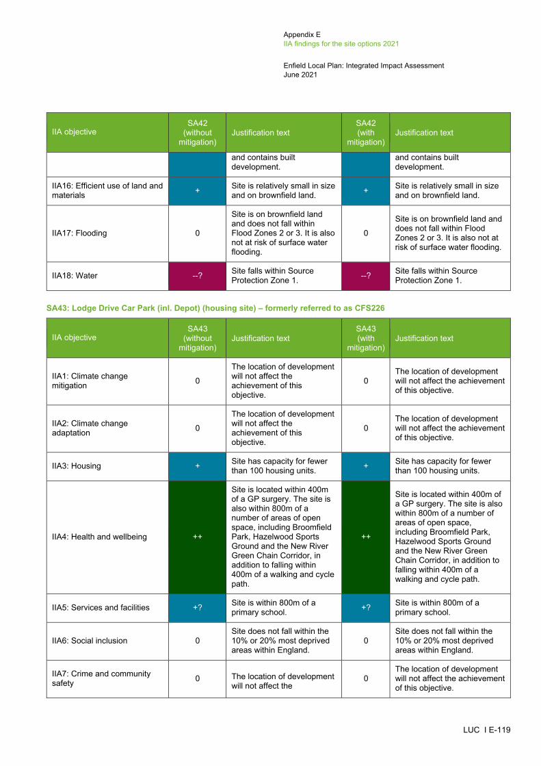
Appendix E IIA findings for the site options 2021
Enfield Local Plan: Integrated Impact Assessment June 2021
LUC I E-119
IIA objective SA42
(without mitigation)
Justification text SA42 (with
mitigation) Justification text
and contains built development.
and contains built development.
IIA16: Efficient use of land and materials + Site is relatively small in size
and on brownfield land. + Site is relatively small in size and on brownfield land.
IIA17: Flooding 0
Site is on brownfield land and does not fall within Flood Zones 2 or 3. It is also not at risk of surface water flooding.
0
Site is on brownfield land and does not fall within Flood Zones 2 or 3. It is also not at risk of surface water flooding.
IIA18: Water --? Site falls within Source Protection Zone 1. --? Site falls within Source
Protection Zone 1.
SA43: Lodge Drive Car Park (inl. Depot) (housing site) – formerly referred to as CFS226
IIA objective SA43
(without mitigation)
Justification text SA43 (with
mitigation) Justification text
IIA1: Climate change mitigation 0
The location of development will not affect the achievement of this objective.
0 The location of development will not affect the achievement of this objective.
IIA2: Climate change adaptation 0
The location of development will not affect the achievement of this objective.
0 The location of development will not affect the achievement of this objective.
IIA3: Housing + Site has capacity for fewer than 100 housing units. + Site has capacity for fewer
than 100 housing units.
IIA4: Health and wellbeing ++
Site is located within 400m of a GP surgery. The site is also within 800m of a number of areas of open space, including Broomfield Park, Hazelwood Sports Ground and the New River Green Chain Corridor, in addition to falling within 400m of a walking and cycle path.
++
Site is located within 400m of a GP surgery. The site is also within 800m of a number of areas of open space, including Broomfield Park, Hazelwood Sports Ground and the New River Green Chain Corridor, in addition to falling within 400m of a walking and cycle path.
IIA5: Services and facilities +? Site is within 800m of a primary school. +? Site is within 800m of a
primary school.
IIA6: Social inclusion 0 Site does not fall within the 10% or 20% most deprived areas within England.
0 Site does not fall within the 10% or 20% most deprived areas within England.
IIA7: Crime and community safety 0 The location of development
will not affect the 0
The location of development will not affect the achievement of this objective.

Appendix E IIA findings for the site options 2021
Enfield Local Plan: Integrated Impact Assessment June 2021
LUC I E-120
IIA objective SA43
(without mitigation)
Justification text SA43 (with
mitigation) Justification text
achievement of this objective.
IIA8: Road safety 0
The location of development will not affect the achievement of this objective.
0 The location of development will not affect the achievement of this objective.
IIA9: Economy -
Site is not located adjacent or close to Strategic Industrial Locations and Locally Significant Industrial Sites.
-
Site is not located adjacent or close to Strategic Industrial Locations and Locally Significant Industrial Sites.
IIA10: Town and local centres + Site is adjacent to Palmers Green District Centre. + Site is adjacent to Palmers
Green District Centre.
IIA11: Air pollution --? Site scored 2 in the air quality appraisal. --? Site scored 2 in the air quality
appraisal.
IIA12: Sustainable transport ++
Site is located within 1km of Palmers Green railway station and 350m of at least one bus stop. The site is also next to Palmers Green, which is a District Centre.
++
Site is located within 1km of Palmers Green railway station and 350m of at least one bus stop. The site is also next to Palmers Green, which is a District Centre.
IIA13: Biodiversity --? Site is located within 250m of the New River SINC. --? Site is located within 250m of
the New River SINC.
IIA14: Historic environment -?
Site is within 500m of The Lakes Estate Conservation Area, Broomfield House Registered Park and Garden and four Grade II listed buildings (Wall to North of Number 176, Truro House, Front Wall and Gate Piers to West of No 176, and National Westminster Bank). Although there is built development between the site, Conservation Area, Registered Park and Garden and listed buildings, its development could affect the setting of these heritage assets.
-?
The Council's assessment of heritage considerations records this site as 'Amber' and states that a Heritage Impact Assessment should be undertaken and mitigation provided.
IIA15: Landscape and townscape +?
Site is located within the settlement of Palmers Green and contains built development.
+?
Site is located within the settlement of Palmers Green and contains built development.
IIA16: Efficient use of land and materials + Site is relatively small in size
and on brownfield land. + Site is relatively small in size and on brownfield land.
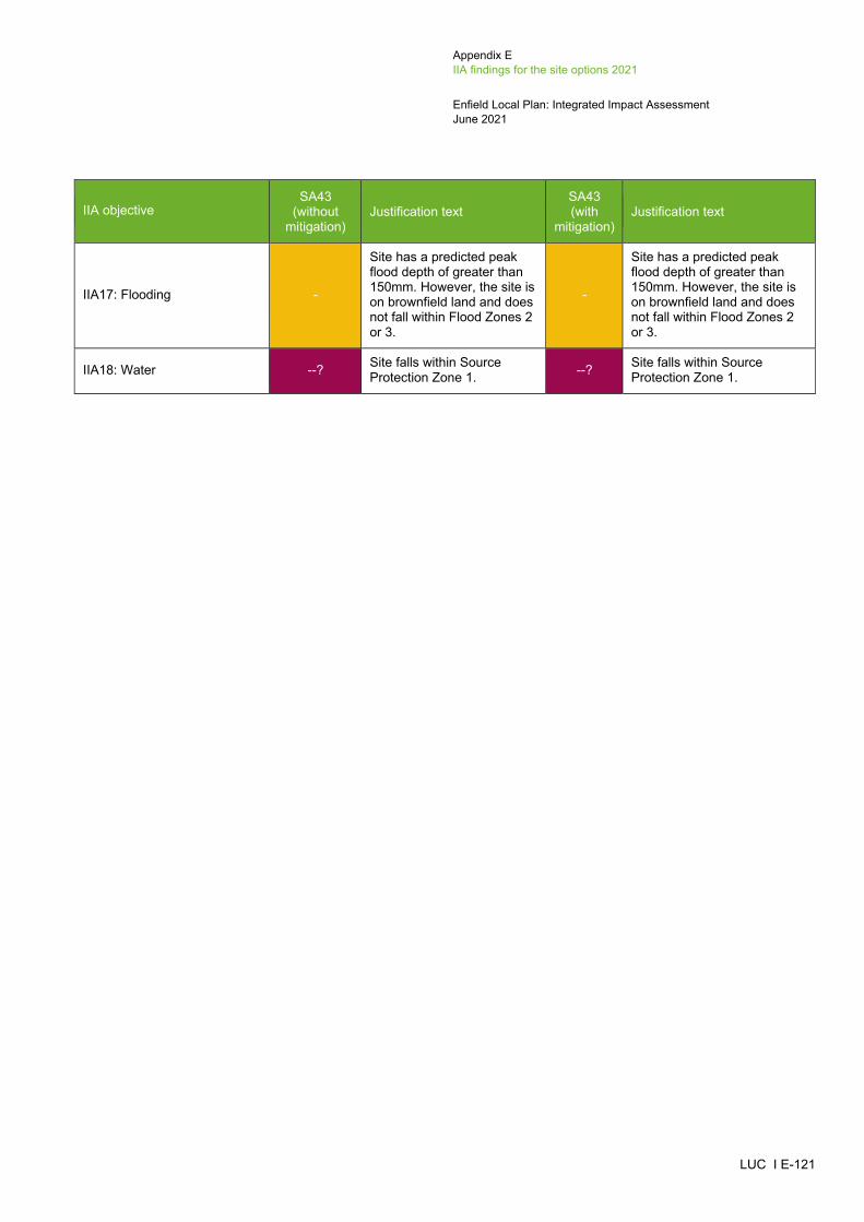
Appendix E IIA findings for the site options 2021
Enfield Local Plan: Integrated Impact Assessment June 2021
LUC I E-121
IIA objective SA43
(without mitigation)
Justification text SA43 (with
mitigation) Justification text
IIA17: Flooding -
Site has a predicted peak flood depth of greater than 150mm. However, the site is on brownfield land and does not fall within Flood Zones 2 or 3.
-
Site has a predicted peak flood depth of greater than 150mm. However, the site is on brownfield land and does not fall within Flood Zones 2 or 3.
IIA18: Water --? Site falls within Source Protection Zone 1. --? Site falls within Source
Protection Zone 1.

Appendix E IIA findings for the site options 2021
Enfield Local Plan: Integrated Impact Assessment June 2021
LUC I E-122
Other proposed site allocations outside of the place making areas (outside urban areas)
SA44: Land opposite Enfield Crematorium (known as The Dell), Great Cambridge Road (mixed-use site) – formerly referred to as CHC5/LP113816
IIA objective CHC5/LP1
138 (without
mitigation)
Justification text SA44
(without mitigation)
Justification text SA44 (with
mitigation) Justification text
IIA1: Climate change mitigation 0
The location of development will not affect the achievement of this objective.
0 The location of development will not affect the achievement of this objective. 0
The location of development will not affect the achievement of this objective.
IIA2: Climate change adaptation 0
The location of development will not affect the achievement of this objective.
0 The location of development will not affect the achievement of this objective. 0
The location of development will not affect the achievement of this objective.
IIA3: Housing ++ Site has capacity for more than 100 housing units. ++ Site has capacity for more than 100
housing units. ++ Site has capacity for more than 100 housing units.
IIA4: Health and wellbeing ++/--?
Site is within 800m of a number of areas of open space, including Forty Hall Park & Estate, The Dell, and the New River Green Chain. However, the site contains a cycle path which could be lost as a result of new development. Additionally, the site is not located within 800m of a GP surgery.
++/--?
Site is within 800m of a number of areas of open space, including Forty Hall Park & Estate, The Dell, and the New River Green Chain. However, the site contains a cycle path which could be lost as a result of new development. Additionally, the site is not located within 800m of a GP surgery.
++/--?
Site is within 800m of a number of areas of open space, including Forty Hall Park & Estate, The Dell, and the New River Green Chain. However, the site contains a cycle path which could be lost as a result of new development. Additionally, the site is not located within 800m of a GP surgery.
IIA5: Services and facilities ++? Site is within 800m of a primary school and a secondary school. ++? Site is within 800m of a primary school
and a secondary school. ++? Site is within 800m of a primary school and a secondary school.
_____________________________________________________________________________________________________ 16 Land opposite Enfield Crematorium (known as The Dell), Great Cambridge Road was previously appraised as a housing site (CHC5/LP1138). It has now been appraised as a mixed use site (SA45).
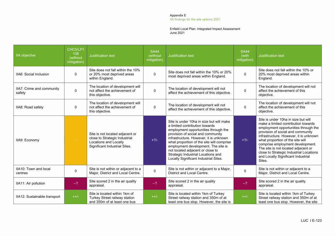
Appendix E IIA findings for the site options 2021
Enfield Local Plan: Integrated Impact Assessment June 2021
LUC I E-123
IIA objective CHC5/LP1
138 (without
mitigation)
Justification text SA44
(without mitigation)
Justification text SA44 (with
mitigation) Justification text
IIA6: Social inclusion 0 Site does not fall within the 10% or 20% most deprived areas within England.
0 Site does not fall within the 10% or 20% most deprived areas within England. 0
Site does not fall within the 10% or 20% most deprived areas within England.
IIA7: Crime and community safety 0
The location of development will not affect the achievement of this objective.
0 The location of development will not affect the achievement of this objective. 0
The location of development will not affect the achievement of this objective.
IIA8: Road safety 0 The location of development will not affect the achievement of this objective.
0 The location of development will not affect the achievement of this objective. 0
The location of development will not affect the achievement of this objective.
IIA9: Economy -
Site is not located adjacent or close to Strategic Industrial Locations and Locally Significant Industrial Sites.
+?/-
Site is under 10ha in size but will make a limited contribution towards employment opportunities through the provision of social and community infrastructure. However, it is unknown what proportion of the site will comprise employment development. The site is not located adjacent or close to Strategic Industrial Locations and Locally Significant Industrial Sites.
IIA10: Town and local centres 0 Site is not within or adjacent to a
Major, District and Local Centre. 0 Site is not within or adjacent to a Major, District and Local Centre. 0 Site is not within or adjacent to a
Major, District and Local Centre.
IIA11: Air pollution --? Site scored 2 in the air quality appraisal. --? Site scored 2 in the air quality
appraisal. --? Site scored 2 in the air quality appraisal.
IIA12: Sustainable transport ++/- Site is located within 1km of Turkey Street railway station and 350m of at least one bus
++/- Site is located within 1km of Turkey Street railway station and 350m of at least one bus stop. However, the site is
++/- Site is located within 1km of Turkey Street railway station and 350m of at least one bus stop. However, the site
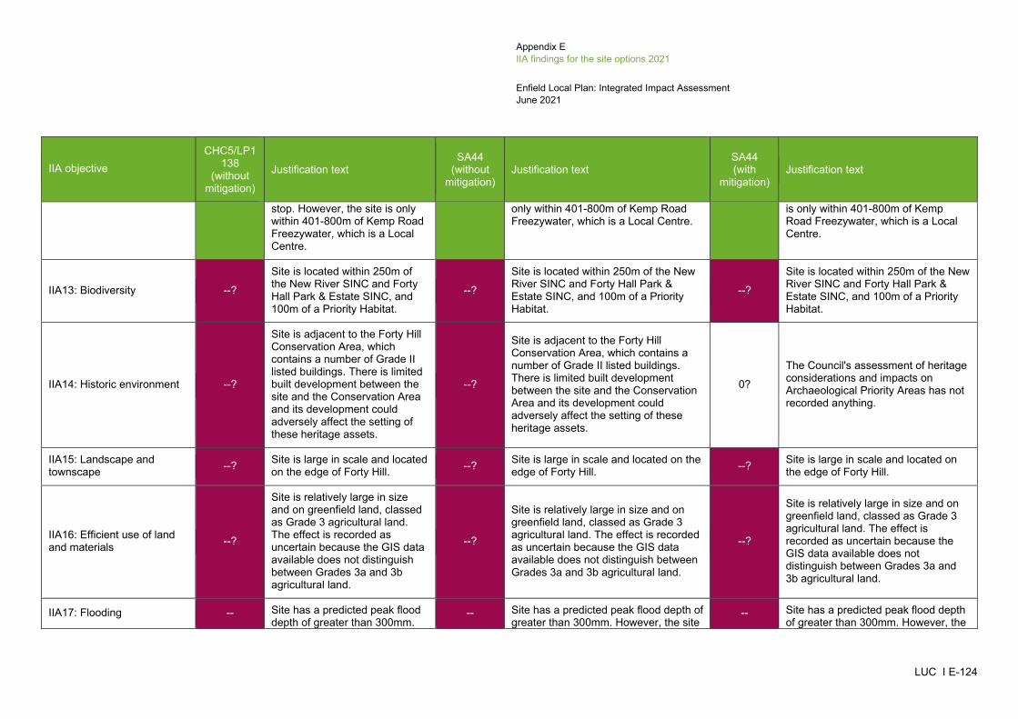
Appendix E IIA findings for the site options 2021
Enfield Local Plan: Integrated Impact Assessment June 2021
LUC I E-124
IIA objective CHC5/LP1
138 (without
mitigation)
Justification text SA44
(without mitigation)
Justification text SA44 (with
mitigation) Justification text
stop. However, the site is only within 401-800m of Kemp Road Freezywater, which is a Local Centre.
only within 401-800m of Kemp Road Freezywater, which is a Local Centre.
is only within 401-800m of Kemp Road Freezywater, which is a Local Centre.
IIA13: Biodiversity --?
Site is located within 250m of the New River SINC and Forty Hall Park & Estate SINC, and 100m of a Priority Habitat.
--?
Site is located within 250m of the New River SINC and Forty Hall Park & Estate SINC, and 100m of a Priority Habitat.
--?
Site is located within 250m of the New River SINC and Forty Hall Park & Estate SINC, and 100m of a Priority Habitat.
IIA14: Historic environment --?
Site is adjacent to the Forty Hill Conservation Area, which contains a number of Grade II listed buildings. There is limited built development between the site and the Conservation Area and its development could adversely affect the setting of these heritage assets.
--?
Site is adjacent to the Forty Hill Conservation Area, which contains a number of Grade II listed buildings. There is limited built development between the site and the Conservation Area and its development could adversely affect the setting of these heritage assets.
0?
The Council's assessment of heritage considerations and impacts on Archaeological Priority Areas has not recorded anything.
IIA15: Landscape and townscape --? Site is large in scale and located
on the edge of Forty Hill. --? Site is large in scale and located on the edge of Forty Hill. --? Site is large in scale and located on
the edge of Forty Hill.
IIA16: Efficient use of land and materials --?
Site is relatively large in size and on greenfield land, classed as Grade 3 agricultural land. The effect is recorded as uncertain because the GIS data available does not distinguish between Grades 3a and 3b agricultural land.
--?
Site is relatively large in size and on greenfield land, classed as Grade 3 agricultural land. The effect is recorded as uncertain because the GIS data available does not distinguish between Grades 3a and 3b agricultural land.
--?
Site is relatively large in size and on greenfield land, classed as Grade 3 agricultural land. The effect is recorded as uncertain because the GIS data available does not distinguish between Grades 3a and 3b agricultural land.
IIA17: Flooding -- Site has a predicted peak flood depth of greater than 300mm.
-- Site has a predicted peak flood depth of greater than 300mm. However, the site
-- Site has a predicted peak flood depth of greater than 300mm. However, the

Appendix E IIA findings for the site options 2021
Enfield Local Plan: Integrated Impact Assessment June 2021
LUC I E-125
IIA objective CHC5/LP1
138 (without
mitigation)
Justification text SA44
(without mitigation)
Justification text SA44 (with
mitigation) Justification text
However, the site is on brownfield land and does not fall within Flood Zones 2 or 3.
is on brownfield land and does not fall within Flood Zones 2 or 3.
site is on brownfield land and does not fall within Flood Zones 2 or 3.
IIA18: Water --?
Site falls within Source Protection Zone 1 and New River runs along its western boundary.
--? Site falls within Source Protection Zone 1 and New River runs along its western boundary.
--? Site falls within Source Protection Zone 1 and New River runs along its western boundary.
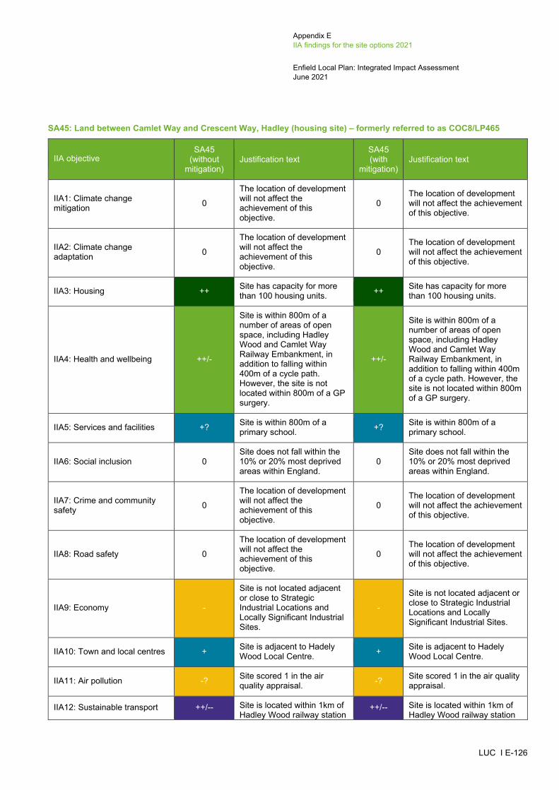
Appendix E IIA findings for the site options 2021
Enfield Local Plan: Integrated Impact Assessment June 2021
LUC I E-126
SA45: Land between Camlet Way and Crescent Way, Hadley (housing site) – formerly referred to as COC8/LP465
IIA objective SA45
(without mitigation)
Justification text SA45 (with
mitigation) Justification text
IIA1: Climate change mitigation 0
The location of development will not affect the achievement of this objective.
0 The location of development will not affect the achievement of this objective.
IIA2: Climate change adaptation 0
The location of development will not affect the achievement of this objective.
0 The location of development will not affect the achievement of this objective.
IIA3: Housing ++ Site has capacity for more than 100 housing units. ++ Site has capacity for more
than 100 housing units.
IIA4: Health and wellbeing ++/-
Site is within 800m of a number of areas of open space, including Hadley Wood and Camlet Way Railway Embankment, in addition to falling within 400m of a cycle path. However, the site is not located within 800m of a GP surgery.
++/-
Site is within 800m of a number of areas of open space, including Hadley Wood and Camlet Way Railway Embankment, in addition to falling within 400m of a cycle path. However, the site is not located within 800m of a GP surgery.
IIA5: Services and facilities +? Site is within 800m of a primary school. +? Site is within 800m of a
primary school.
IIA6: Social inclusion 0 Site does not fall within the 10% or 20% most deprived areas within England.
0 Site does not fall within the 10% or 20% most deprived areas within England.
IIA7: Crime and community safety 0
The location of development will not affect the achievement of this objective.
0 The location of development will not affect the achievement of this objective.
IIA8: Road safety 0
The location of development will not affect the achievement of this objective.
0 The location of development will not affect the achievement of this objective.
IIA9: Economy -
Site is not located adjacent or close to Strategic Industrial Locations and Locally Significant Industrial Sites.
-
Site is not located adjacent or close to Strategic Industrial Locations and Locally Significant Industrial Sites.
IIA10: Town and local centres + Site is adjacent to Hadely Wood Local Centre. + Site is adjacent to Hadely
Wood Local Centre.
IIA11: Air pollution -? Site scored 1 in the air quality appraisal. -? Site scored 1 in the air quality
appraisal.
IIA12: Sustainable transport ++/-- Site is located within 1km of Hadley Wood railway station
++/-- Site is located within 1km of Hadley Wood railway station
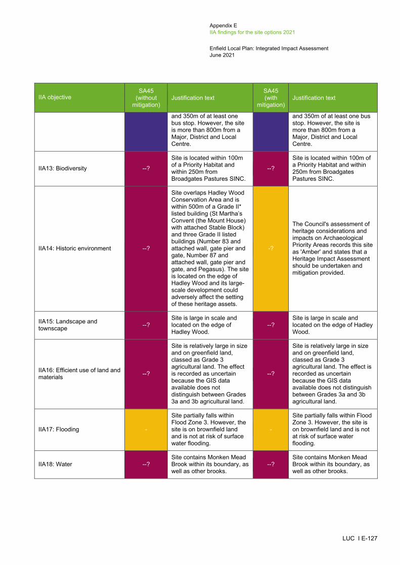
Appendix E IIA findings for the site options 2021
Enfield Local Plan: Integrated Impact Assessment June 2021
LUC I E-127
IIA objective SA45
(without mitigation)
Justification text SA45 (with
mitigation) Justification text
and 350m of at least one bus stop. However, the site is more than 800m from a Major, District and Local Centre.
and 350m of at least one bus stop. However, the site is more than 800m from a Major, District and Local Centre.
IIA13: Biodiversity --?
Site is located within 100m of a Priority Habitat and within 250m from Broadgates Pastures SINC.
--?
Site is located within 100m of a Priority Habitat and within 250m from Broadgates Pastures SINC.
IIA14: Historic environment --?
Site overlaps Hadley Wood Conservation Area and is within 500m of a Grade II* listed building (St Martha’s Convent (the Mount House) with attached Stable Block) and three Grade II listed buildings (Number 83 and attached wall, gate pier and gate, Number 87 and attached wall, gate pier and gate, and Pegasus). The site is located on the edge of Hadley Wood and its large-scale development could adversely affect the setting of these heritage assets.
-?
The Council's assessment of heritage considerations and impacts on Archaeological Priority Areas records this site as 'Amber' and states that a Heritage Impact Assessment should be undertaken and mitigation provided.
IIA15: Landscape and townscape --?
Site is large in scale and located on the edge of Hadley Wood.
--? Site is large in scale and located on the edge of Hadley Wood.
IIA16: Efficient use of land and materials --?
Site is relatively large in size and on greenfield land, classed as Grade 3 agricultural land. The effect is recorded as uncertain because the GIS data available does not distinguish between Grades 3a and 3b agricultural land.
--?
Site is relatively large in size and on greenfield land, classed as Grade 3 agricultural land. The effect is recorded as uncertain because the GIS data available does not distinguish between Grades 3a and 3b agricultural land.
IIA17: Flooding -
Site partially falls within Flood Zone 3. However, the site is on brownfield land and is not at risk of surface water flooding.
-
Site partially falls within Flood Zone 3. However, the site is on brownfield land and is not at risk of surface water flooding.
IIA18: Water --? Site contains Monken Mead Brook within its boundary, as well as other brooks.
--? Site contains Monken Mead Brook within its boundary, as well as other brooks.
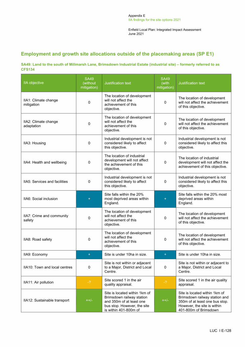
Appendix E IIA findings for the site options 2021
Enfield Local Plan: Integrated Impact Assessment June 2021
LUC I E-128
Employment and growth site allocations outside of the placemaking areas (SP E1)
SA49: Land to the south of Millmarsh Lane, Brimsdown Industrial Estate (industrial site) – formerly referred to as CFS134
IIA objective SA49
(without mitigation)
Justification text SA49 (with
mitigation) Justification text
IIA1: Climate change mitigation 0
The location of development will not affect the achievement of this objective.
0 The location of development will not affect the achievement of this objective.
IIA2: Climate change adaptation 0
The location of development will not affect the achievement of this objective.
0 The location of development will not affect the achievement of this objective.
IIA3: Housing 0 Industrial development is not considered likely to affect this objective.
0 Industrial development is not considered likely to affect this objective.
IIA4: Health and wellbeing 0
The location of industrial development will not affect the achievement of this objective.
0 The location of industrial development will not affect the achievement of this objective.
IIA5: Services and facilities 0 Industrial development is not considered likely to affect this objective.
0 Industrial development is not considered likely to affect this objective.
IIA6: Social inclusion + Site falls within the 20% most deprived areas within England.
+ Site falls within the 20% most deprived areas within England.
IIA7: Crime and community safety 0
The location of development will not affect the achievement of this objective.
0 The location of development will not affect the achievement of this objective.
IIA8: Road safety 0
The location of development will not affect the achievement of this objective.
0 The location of development will not affect the achievement of this objective.
IIA9: Economy + Site is under 10ha in size. + Site is under 10ha in size.
IIA10: Town and local centres 0 Site is not within or adjacent to a Major, District and Local Centre.
0 Site is not within or adjacent to a Major, District and Local Centre.
IIA11: Air pollution -? Site scored 1 in the air quality appraisal. -? Site scored 1 in the air quality
appraisal.
IIA12: Sustainable transport ++/-
Site is located within 1km of Brimsdown railway station and 350m of at least one bus stop. However, the site is within 401-800m of
++/-
Site is located within 1km of Brimsdown railway station and 350m of at least one bus stop. However, the site is within 401-800m of Brimsdown
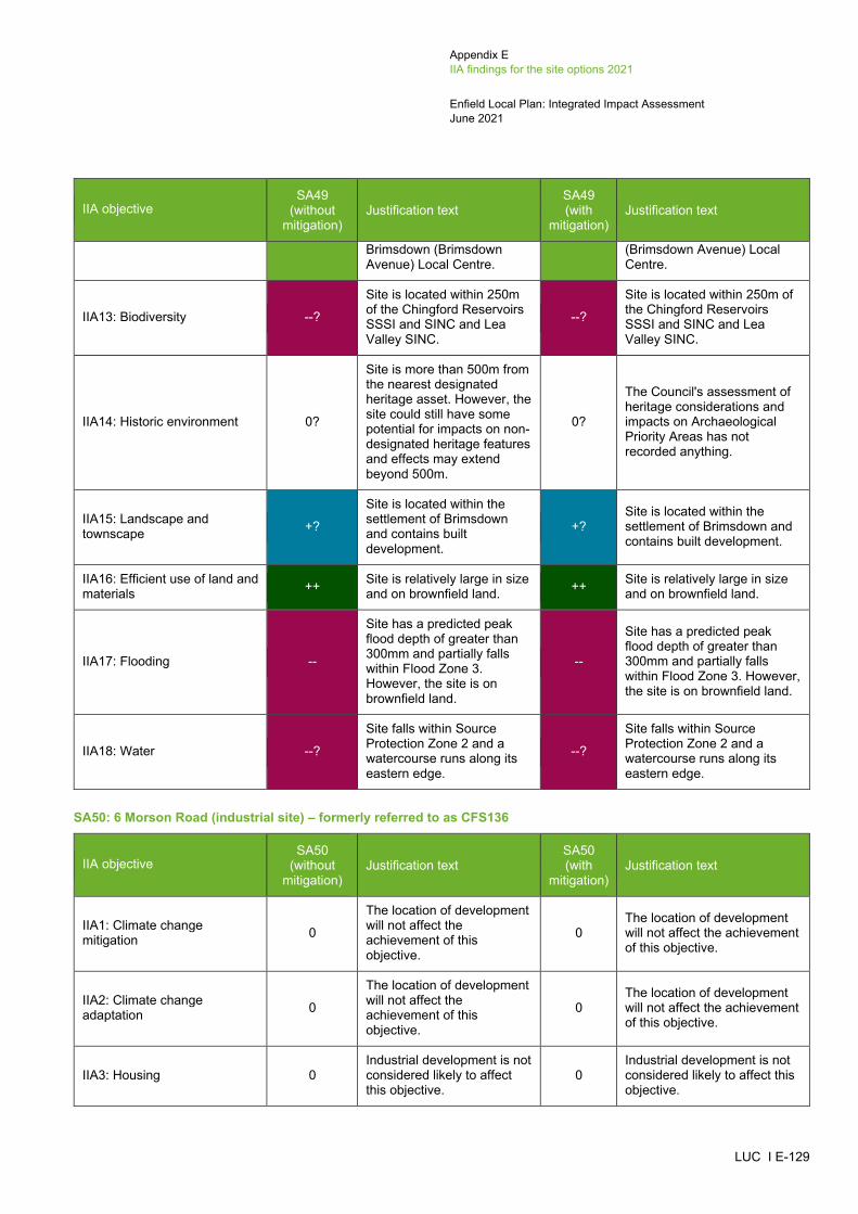
Appendix E IIA findings for the site options 2021
Enfield Local Plan: Integrated Impact Assessment June 2021
LUC I E-129
IIA objective SA49
(without mitigation)
Justification text SA49 (with
mitigation) Justification text
Brimsdown (Brimsdown Avenue) Local Centre.
(Brimsdown Avenue) Local Centre.
IIA13: Biodiversity --?
Site is located within 250m of the Chingford Reservoirs SSSI and SINC and Lea Valley SINC.
--?
Site is located within 250m of the Chingford Reservoirs SSSI and SINC and Lea Valley SINC.
IIA14: Historic environment 0?
Site is more than 500m from the nearest designated heritage asset. However, the site could still have some potential for impacts on non-designated heritage features and effects may extend beyond 500m.
0?
The Council's assessment of heritage considerations and impacts on Archaeological Priority Areas has not recorded anything.
IIA15: Landscape and townscape +?
Site is located within the settlement of Brimsdown and contains built development.
+? Site is located within the settlement of Brimsdown and contains built development.
IIA16: Efficient use of land and materials ++ Site is relatively large in size
and on brownfield land. ++ Site is relatively large in size and on brownfield land.
IIA17: Flooding --
Site has a predicted peak flood depth of greater than 300mm and partially falls within Flood Zone 3. However, the site is on brownfield land.
--
Site has a predicted peak flood depth of greater than 300mm and partially falls within Flood Zone 3. However, the site is on brownfield land.
IIA18: Water --?
Site falls within Source Protection Zone 2 and a watercourse runs along its eastern edge.
--?
Site falls within Source Protection Zone 2 and a watercourse runs along its eastern edge.
SA50: 6 Morson Road (industrial site) – formerly referred to as CFS136
IIA objective SA50
(without mitigation)
Justification text SA50 (with
mitigation) Justification text
IIA1: Climate change mitigation 0
The location of development will not affect the achievement of this objective.
0 The location of development will not affect the achievement of this objective.
IIA2: Climate change adaptation 0
The location of development will not affect the achievement of this objective.
0 The location of development will not affect the achievement of this objective.
IIA3: Housing 0 Industrial development is not considered likely to affect this objective.
0 Industrial development is not considered likely to affect this objective.
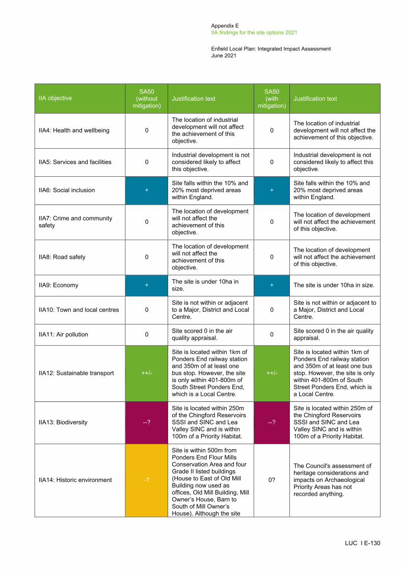
Appendix E IIA findings for the site options 2021
Enfield Local Plan: Integrated Impact Assessment June 2021
LUC I E-130
IIA objective SA50
(without mitigation)
Justification text SA50 (with
mitigation) Justification text
IIA4: Health and wellbeing 0
The location of industrial development will not affect the achievement of this objective.
0 The location of industrial development will not affect the achievement of this objective.
IIA5: Services and facilities 0 Industrial development is not considered likely to affect this objective.
0 Industrial development is not considered likely to affect this objective.
IIA6: Social inclusion + Site falls within the 10% and 20% most deprived areas within England.
+ Site falls within the 10% and 20% most deprived areas within England.
IIA7: Crime and community safety 0
The location of development will not affect the achievement of this objective.
0 The location of development will not affect the achievement of this objective.
IIA8: Road safety 0
The location of development will not affect the achievement of this objective.
0 The location of development will not affect the achievement of this objective.
IIA9: Economy + The site is under 10ha in size. + The site is under 10ha in size.
IIA10: Town and local centres 0 Site is not within or adjacent to a Major, District and Local Centre.
0 Site is not within or adjacent to a Major, District and Local Centre.
IIA11: Air pollution 0 Site scored 0 in the air quality appraisal. 0 Site scored 0 in the air quality
appraisal.
IIA12: Sustainable transport ++/-
Site is located within 1km of Ponders End railway station and 350m of at least one bus stop. However, the site is only within 401-800m of South Street Ponders End, which is a Local Centre.
++/-
Site is located within 1km of Ponders End railway station and 350m of at least one bus stop. However, the site is only within 401-800m of South Street Ponders End, which is a Local Centre.
IIA13: Biodiversity --?
Site is located within 250m of the Chingford Reservoirs SSSI and SINC and Lea Valley SINC and is within 100m of a Priority Habitat.
--?
Site is located within 250m of the Chingford Reservoirs SSSI and SINC and Lea Valley SINC and is within 100m of a Priority Habitat.
IIA14: Historic environment -?
Site is within 500m from Ponders End Flour Mills Conservation Area and four Grade II listed buildings (House to East of Old Mill Building now used as offices, Old Mill Building, Mill Owner’s House, Barn to South of Mill Owner’s House). Although the site
0?
The Council's assessment of heritage considerations and impacts on Archaeological Priority Areas has not recorded anything.

Appendix E IIA findings for the site options 2021
Enfield Local Plan: Integrated Impact Assessment June 2021
LUC I E-131
IIA objective SA50
(without mitigation)
Justification text SA50 (with
mitigation) Justification text
contains built development, its redevelopment could affect the setting of these heritage assets.
IIA15: Landscape and townscape -?
Site is not large in scale but is located on the edge of Ponders End.
-? Site is not large in scale but is located on the edge of Ponders End.
IIA16: Efficient use of land and materials + Site is relatively small and
on brownfield land. + Site is relatively small and on brownfield land.
IIA17: Flooding -
Site partially falls within Flood Zone 3. However, the site is on brownfield land and is not at risk of surface water flooding.
-
Site partially falls within Flood Zone 3. However, the site is on brownfield land and is not at risk of surface water flooding.
IIA18: Water --? Site is adjacent to a watercourse that runs along the eastern edge of the site.
--? Site is adjacent to a watercourse that runs along the eastern edge of the site.
SA51: Montagu Ind Estate (industrial site) – formerly referred to as CFS153
IIA objective SA51
(without mitigation)
Justification text SA51 (with
mitigation) Justification text
IIA1: Climate change mitigation 0
The location of development will not affect the achievement of this objective.
0 The location of development will not affect the achievement of this objective.
IIA2: Climate change adaptation 0
The location of development will not affect the achievement of this objective.
0 The location of development will not affect the achievement of this objective.
IIA3: Housing 0 Industrial development is not considered likely to affect this objective.
0 Industrial development is not considered likely to affect this objective.
IIA4: Health and wellbeing 0
The location of industrial development will not affect the achievement of this objective.
0 The location of industrial development will not affect the achievement of this objective.
IIA5: Services and facilities 0 Industrial development is not considered likely to affect this objective.
0 Industrial development is not considered likely to affect this objective.
IIA6: Social inclusion + Site falls within the 20% most deprived areas within England.
+ Site falls within the 20% most deprived areas within England.

Appendix E IIA findings for the site options 2021
Enfield Local Plan: Integrated Impact Assessment June 2021
LUC I E-132
IIA objective SA51
(without mitigation)
Justification text SA51 (with
mitigation) Justification text
IIA7: Crime and community safety 0
The location of development will not affect the achievement of this objective.
0 The location of development will not affect the achievement of this objective.
IIA8: Road safety 0
The location of development will not affect the achievement of this objective.
0 The location of development will not affect the achievement of this objective.
IIA9: Economy + The site is under 10ha in size. + The site is under 10ha in size.
IIA10: Town and local centres 0 Site is not within or adjacent to a Major, District and Local Centre.
0 Site is not within or adjacent to a Major, District and Local Centre.
IIA11: Air pollution --? Site scored 2 in the air quality appraisal. --? Site scored 2 in the air quality
appraisal.
IIA12: Sustainable transport ++
Site is located within 1km of Meridian Water Station railway station and 350m of at least one bus stop. The site is also within 201-400m of Craig Park Road, which is a Local Centre.
++
Site is located within 1km of Meridian Water Station railway station and 350m of at least one bus stop. The site is also within 201-400m of Craig Park Road, which is a Local Centre.
IIA13: Biodiversity --?
Site is located within 100m of a Priority Habitat and is 250m-750m within the Lea Valley SINC.
--?
Site is located within 100m of a Priority Habitat and is 250m-750m within the Lea Valley SINC.
IIA14: Historic environment --?
Site is adjacent to Montagu Cemeteries Conservation Area. Although the site contains built development, its redevelopment could affect the setting of the heritage asset.
0?
The Council's assessment of heritage considerations and impacts on Archaeological Priority Areas has not recorded anything.
IIA15: Landscape and townscape +?
Site is located within the settlement of Edmonton Green and contains built development.
+?
Site is located within the settlement of Edmonton Green and contains built development.
IIA16: Efficient use of land and materials ++ Site is relatively large in size
and on brownfield land. ++ Site is relatively large in size and on brownfield land.
IIA17: Flooding --
Site has a predicted peak flood depth of greater than 300mm and falls mainly within Flood Zone 3. However, the site is on brownfield land.
--
Site has a predicted peak flood depth of greater than 300mm and falls mainly within Flood Zone 3. However, the site is on brownfield land.

Appendix E IIA findings for the site options 2021
Enfield Local Plan: Integrated Impact Assessment June 2021
LUC I E-133
IIA objective SA51
(without mitigation)
Justification text SA51 (with
mitigation) Justification text
IIA18: Water --? Site falls within Source Protection Zones 1 and 2. --? Site falls within Source
Protection Zones 1 and 2.
SA52: Land West of Ramney Marsh (industrial site) – formerly referred to as ELC3/LP606
IIA objective SA52
(without mitigation)
Justification text SA52 (with
mitigation) Justification text
IIA1: Climate change mitigation 0
The location of development will not affect the achievement of this objective.
0 The location of development will not affect the achievement of this objective.
IIA2: Climate change adaptation 0
The location of development will not affect the achievement of this objective.
0 The location of development will not affect the achievement of this objective.
IIA3: Housing 0 Industrial development is not considered likely to affect this objective.
0 Industrial development is not considered likely to affect this objective.
IIA4: Health and wellbeing 0
The location of industrial development will not affect the achievement of this objective.
0 The location of industrial development will not affect the achievement of this objective.
IIA5: Services and facilities 0 Industrial development is not considered likely to affect this objective.
0 Industrial development is not considered likely to affect this objective.
IIA6: Social inclusion 0 Site does not fall within the 10% or 20% most deprived areas within England.
0 Site does not fall within the 10% or 20% most deprived areas within England.
IIA7: Crime and community safety 0
The location of development will not affect the achievement of this objective.
0 The location of development will not affect the achievement of this objective.
IIA8: Road safety 0
The location of development will not affect the achievement of this objective.
0 The location of development will not affect the achievement of this objective.
IIA9: Economy ++ Site is over 10ha in size. ++ Site is over 10ha in size.
IIA10: Town and local centres 0 Site is not within or adjacent to a Major, District and Local Centre.
0 Site is not within or adjacent to a Major, District and Local Centre.
IIA11: Air pollution --? Site scored 2 in the air quality appraisal. --? Site scored 2 in the air quality
appraisal.
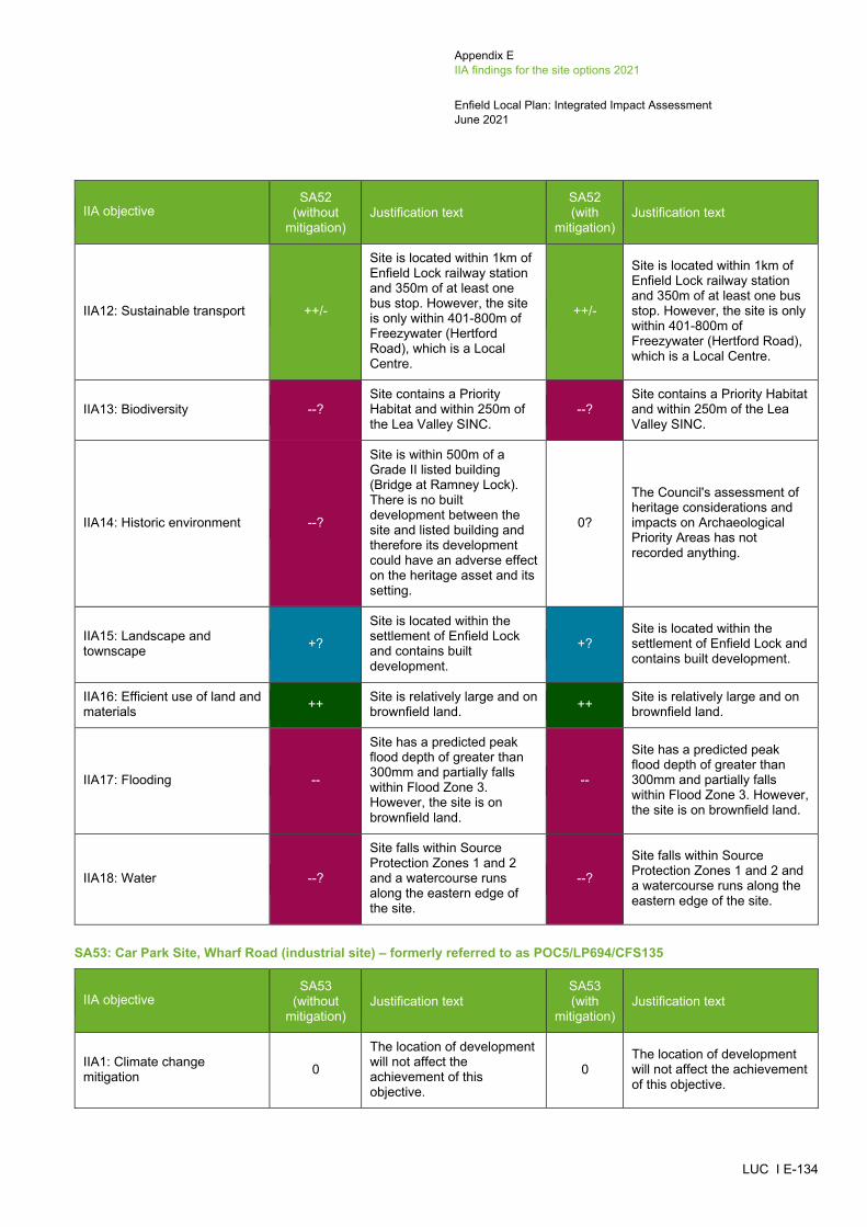
Appendix E IIA findings for the site options 2021
Enfield Local Plan: Integrated Impact Assessment June 2021
LUC I E-134
IIA objective SA52
(without mitigation)
Justification text SA52 (with
mitigation) Justification text
IIA12: Sustainable transport ++/-
Site is located within 1km of Enfield Lock railway station and 350m of at least one bus stop. However, the site is only within 401-800m of Freezywater (Hertford Road), which is a Local Centre.
++/-
Site is located within 1km of Enfield Lock railway station and 350m of at least one bus stop. However, the site is only within 401-800m of Freezywater (Hertford Road), which is a Local Centre.
IIA13: Biodiversity --? Site contains a Priority Habitat and within 250m of the Lea Valley SINC.
--? Site contains a Priority Habitat and within 250m of the Lea Valley SINC.
IIA14: Historic environment --?
Site is within 500m of a Grade II listed building (Bridge at Ramney Lock). There is no built development between the site and listed building and therefore its development could have an adverse effect on the heritage asset and its setting.
0?
The Council's assessment of heritage considerations and impacts on Archaeological Priority Areas has not recorded anything.
IIA15: Landscape and townscape +?
Site is located within the settlement of Enfield Lock and contains built development.
+? Site is located within the settlement of Enfield Lock and contains built development.
IIA16: Efficient use of land and materials ++ Site is relatively large and on
brownfield land. ++ Site is relatively large and on brownfield land.
IIA17: Flooding --
Site has a predicted peak flood depth of greater than 300mm and partially falls within Flood Zone 3. However, the site is on brownfield land.
--
Site has a predicted peak flood depth of greater than 300mm and partially falls within Flood Zone 3. However, the site is on brownfield land.
IIA18: Water --?
Site falls within Source Protection Zones 1 and 2 and a watercourse runs along the eastern edge of the site.
--?
Site falls within Source Protection Zones 1 and 2 and a watercourse runs along the eastern edge of the site.
SA53: Car Park Site, Wharf Road (industrial site) – formerly referred to as POC5/LP694/CFS135
IIA objective SA53
(without mitigation)
Justification text SA53 (with
mitigation) Justification text
IIA1: Climate change mitigation 0
The location of development will not affect the achievement of this objective.
0 The location of development will not affect the achievement of this objective.

Appendix E IIA findings for the site options 2021
Enfield Local Plan: Integrated Impact Assessment June 2021
LUC I E-135
IIA objective SA53
(without mitigation)
Justification text SA53 (with
mitigation) Justification text
IIA2: Climate change adaptation 0
The location of development will not affect the achievement of this objective.
0 The location of development will not affect the achievement of this objective.
IIA3: Housing 0 Industrial development is not considered likely to affect this objective.
0 Industrial development is not considered likely to affect this objective.
IIA4: Health and wellbeing 0
The location of industrial development will not affect the achievement of this objective.
0 The location of industrial development will not affect the achievement of this objective.
IIA5: Services and facilities 0 Industrial development is not considered likely to affect this objective.
0 Industrial development is not considered likely to affect this objective.
IIA6: Social inclusion + Site falls within the 20% most deprived areas within England.
+ Site falls within the 20% most deprived areas within England.
IIA7: Crime and community safety 0
The location of development will not affect the achievement of this objective.
0 The location of development will not affect the achievement of this objective.
IIA8: Road safety 0
The location of development will not affect the achievement of this objective.
0 The location of development will not affect the achievement of this objective.
IIA9: Economy + Site is under 10ha in size. + Site is under 10ha in size.
IIA10: Town and local centres 0 Site is not within or adjacent to a Major, District and Local Centre.
0 Site is not within or adjacent to a Major, District and Local Centre.
IIA11: Air pollution 0 Site scored 0 in the air quality appraisal. 0 Site scored 0 in the air quality
appraisal.
IIA12: Sustainable transport ++/-
Site is located within 1km of Ponders End railway station and 350m of at least one bus stop. However, the site is only within 401-800m of South Street Ponders End, which is a Local Centre.
++/-
Site is located within 1km of Ponders End railway station and 350m of at least one bus stop. However, the site is only within 401-800m of South Street Ponders End, which is a Local Centre.
IIA13: Biodiversity --?
Site is located within 100m of a Priority Habitat and is within 250m of the Chingford Reservoirs SSSI, Chingford Reservoirs SSSI and Lea Valley SINC.
--?
Site is located within 100m of a Priority Habitat and is within 250m of the Chingford Reservoirs SSSI, Chingford Reservoirs SSSI and Lea Valley SINC.
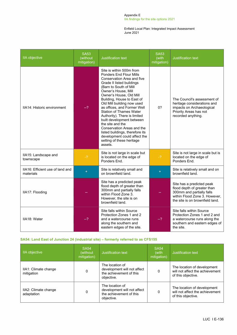
Appendix E IIA findings for the site options 2021
Enfield Local Plan: Integrated Impact Assessment June 2021
LUC I E-136
IIA objective SA53
(without mitigation)
Justification text SA53 (with
mitigation) Justification text
IIA14: Historic environment --?
Site is within 500m from Ponders End Flour Mills Conservation Area and five Grade II listed buildings (Barn to South of Mill Owner’s House, Mill Owner’s House, Old Mill Building, House to East of Old Mill building now used as offices, and Former Well Station of Thames Water Authority). There is limited built development between the site and the Conservation Areas and the listed buildings, therefore its development could affect the setting of these heritage assets.
0?
The Council's assessment of heritage considerations and impacts on Archaeological Priority Areas has not recorded anything.
IIA15: Landscape and townscape -?
Site is not large in scale but is located on the edge of Ponders End.
-? Site is not large in scale but is located on the edge of Ponders End.
IIA16: Efficient use of land and materials + Site is relatively small and
on brownfield land. + Site is relatively small and on brownfield land.
IIA17: Flooding --
Site has a predicted peak flood depth of greater than 300mm and partially falls within Flood Zone 3. However, the site is on brownfield land.
--
Site has a predicted peak flood depth of greater than 300mm and partially falls within Flood Zone 3. However, the site is on brownfield land.
IIA18: Water --?
Site falls within Source Protection Zones 1 and 2 and a watercourse runs along the southern and eastern edges of the site.
--?
Site falls within Source Protection Zones 1 and 2 and a watercourse runs along the southern and eastern edges of the site.
SA54: Land East of Junction 24 (industrial site) – formerly referred to as CFS155
IIA objective SA54
(without mitigation)
Justification text SA54 (with
mitigation) Justification text
IIA1: Climate change mitigation 0
The location of development will not affect the achievement of this objective.
0 The location of development will not affect the achievement of this objective.
IIA2: Climate change adaptation 0
The location of development will not affect the achievement of this objective.
0 The location of development will not affect the achievement of this objective.
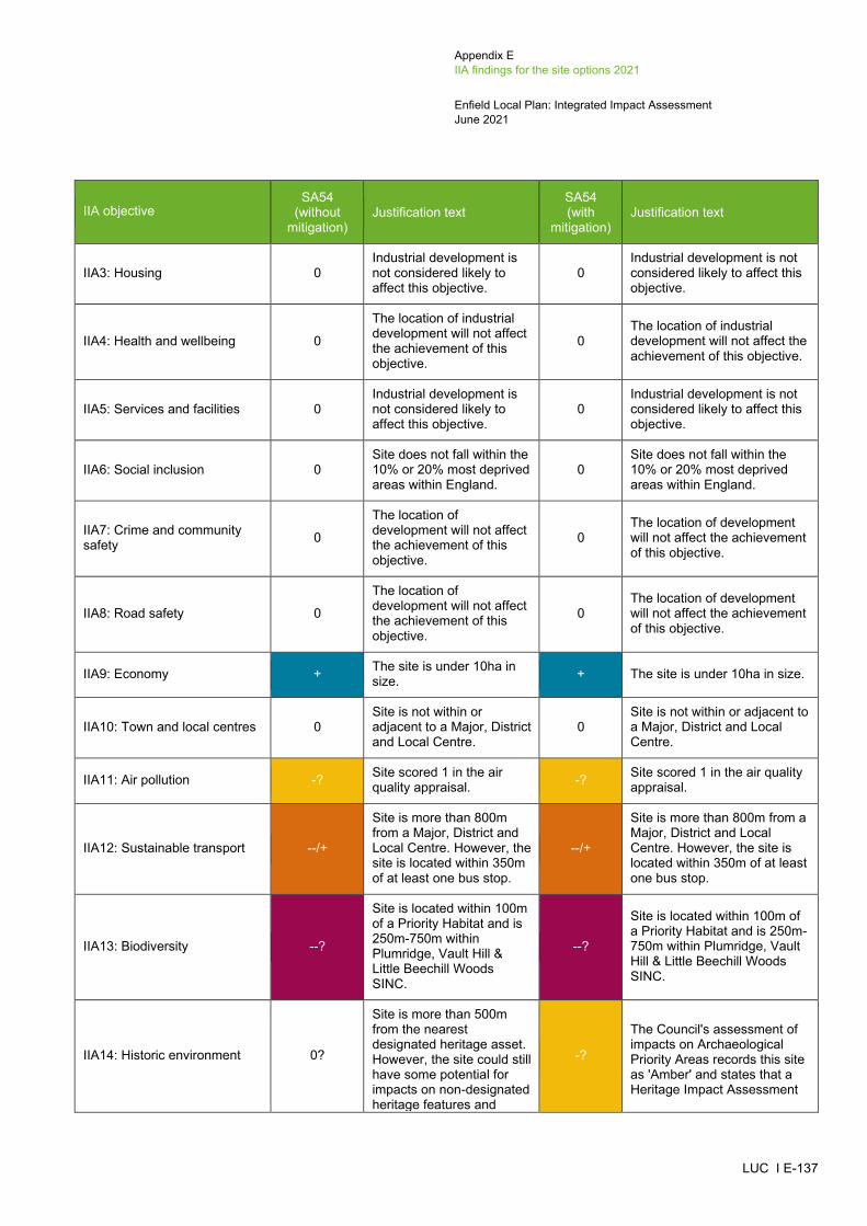
Appendix E IIA findings for the site options 2021
Enfield Local Plan: Integrated Impact Assessment June 2021
LUC I E-137
IIA objective SA54
(without mitigation)
Justification text SA54 (with
mitigation) Justification text
IIA3: Housing 0 Industrial development is not considered likely to affect this objective.
0 Industrial development is not considered likely to affect this objective.
IIA4: Health and wellbeing 0
The location of industrial development will not affect the achievement of this objective.
0 The location of industrial development will not affect the achievement of this objective.
IIA5: Services and facilities 0 Industrial development is not considered likely to affect this objective.
0 Industrial development is not considered likely to affect this objective.
IIA6: Social inclusion 0 Site does not fall within the 10% or 20% most deprived areas within England.
0 Site does not fall within the 10% or 20% most deprived areas within England.
IIA7: Crime and community safety 0
The location of development will not affect the achievement of this objective.
0 The location of development will not affect the achievement of this objective.
IIA8: Road safety 0
The location of development will not affect the achievement of this objective.
0 The location of development will not affect the achievement of this objective.
IIA9: Economy + The site is under 10ha in size. + The site is under 10ha in size.
IIA10: Town and local centres 0 Site is not within or adjacent to a Major, District and Local Centre.
0 Site is not within or adjacent to a Major, District and Local Centre.
IIA11: Air pollution -? Site scored 1 in the air quality appraisal. -? Site scored 1 in the air quality
appraisal.
IIA12: Sustainable transport --/+
Site is more than 800m from a Major, District and Local Centre. However, the site is located within 350m of at least one bus stop.
--/+
Site is more than 800m from a Major, District and Local Centre. However, the site is located within 350m of at least one bus stop.
IIA13: Biodiversity --?
Site is located within 100m of a Priority Habitat and is 250m-750m within Plumridge, Vault Hill & Little Beechill Woods SINC.
--?
Site is located within 100m of a Priority Habitat and is 250m-750m within Plumridge, Vault Hill & Little Beechill Woods SINC.
IIA14: Historic environment 0?
Site is more than 500m from the nearest designated heritage asset. However, the site could still have some potential for impacts on non-designated heritage features and
-?
The Council's assessment of impacts on Archaeological Priority Areas records this site as 'Amber' and states that a Heritage Impact Assessment

Appendix E IIA findings for the site options 2021
Enfield Local Plan: Integrated Impact Assessment June 2021
LUC I E-138
IIA objective SA54
(without mitigation)
Justification text SA54 (with
mitigation) Justification text
effects may extend beyond 500m.
should be undertaken and mitigation provided.
IIA15: Landscape and townscape --?
Site is large in scale and located in an undeveloped area.
--? Site is large in scale and located in an undeveloped area.
IIA16: Efficient use of land and materials --?
Site is relatively large in size and on greenfield land, classed as Grade 3 agricultural land. The effect is recorded as uncertain because the GIS data available does not distinguish between Grades 3a and 3b agricultural land.
--?
Site is relatively large in size and on greenfield land, classed as Grade 3 agricultural land. The effect is recorded as uncertain because the GIS data available does not distinguish between Grades 3a and 3b agricultural land.
IIA17: Flooding --
Site has a predicted peak flood depth of greater than 300mm. However, the site is on brownfield land and does not fall within Flood Zone 2 or 3.
--
Site has a predicted peak flood depth of greater than 300mm. However, the site is on brownfield land and does not fall within Flood Zone 2 or 3.
IIA18: Water --? Site contains a water body and a brook runs along its eastern edge.
--? Site contains a water body and a brook runs along its eastern edge.
SA55: Land to the North West of Innova Park (industrial site) – formerly referred to as CFS148
IIA objective SA55
(without mitigation)
Justification text SA55 (with
mitigation) Justification text
IIA1: Climate change mitigation 0
The location of development will not affect the achievement of this objective.
0 The location of development will not affect the achievement of this objective.
IIA2: Climate change adaptation 0
The location of development will not affect the achievement of this objective.
0 The location of development will not affect the achievement of this objective.
IIA3: Housing 0 Industrial development is not considered likely to affect this objective.
0 Industrial development is not considered likely to affect this objective.
IIA4: Health and wellbeing 0
The location of industrial development will not affect the achievement of this objective.
0 The location of industrial development will not affect the achievement of this objective.
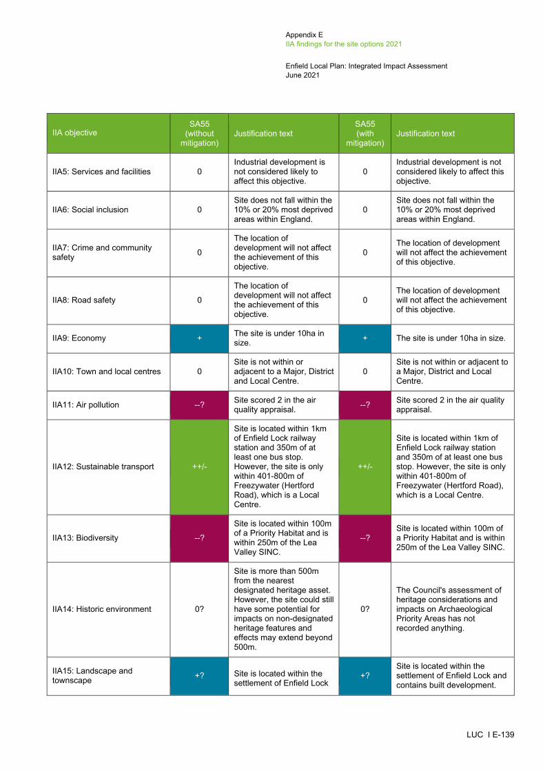
Appendix E IIA findings for the site options 2021
Enfield Local Plan: Integrated Impact Assessment June 2021
LUC I E-139
IIA objective SA55
(without mitigation)
Justification text SA55 (with
mitigation) Justification text
IIA5: Services and facilities 0 Industrial development is not considered likely to affect this objective.
0 Industrial development is not considered likely to affect this objective.
IIA6: Social inclusion 0 Site does not fall within the 10% or 20% most deprived areas within England.
0 Site does not fall within the 10% or 20% most deprived areas within England.
IIA7: Crime and community safety 0
The location of development will not affect the achievement of this objective.
0 The location of development will not affect the achievement of this objective.
IIA8: Road safety 0
The location of development will not affect the achievement of this objective.
0 The location of development will not affect the achievement of this objective.
IIA9: Economy + The site is under 10ha in size. + The site is under 10ha in size.
IIA10: Town and local centres 0 Site is not within or adjacent to a Major, District and Local Centre.
0 Site is not within or adjacent to a Major, District and Local Centre.
IIA11: Air pollution --? Site scored 2 in the air quality appraisal. --? Site scored 2 in the air quality
appraisal.
IIA12: Sustainable transport ++/-
Site is located within 1km of Enfield Lock railway station and 350m of at least one bus stop. However, the site is only within 401-800m of Freezywater (Hertford Road), which is a Local Centre.
++/-
Site is located within 1km of Enfield Lock railway station and 350m of at least one bus stop. However, the site is only within 401-800m of Freezywater (Hertford Road), which is a Local Centre.
IIA13: Biodiversity --?
Site is located within 100m of a Priority Habitat and is within 250m of the Lea Valley SINC.
--? Site is located within 100m of a Priority Habitat and is within 250m of the Lea Valley SINC.
IIA14: Historic environment 0?
Site is more than 500m from the nearest designated heritage asset. However, the site could still have some potential for impacts on non-designated heritage features and effects may extend beyond 500m.
0?
The Council's assessment of heritage considerations and impacts on Archaeological Priority Areas has not recorded anything.
IIA15: Landscape and townscape +? Site is located within the
settlement of Enfield Lock +?
Site is located within the settlement of Enfield Lock and contains built development.
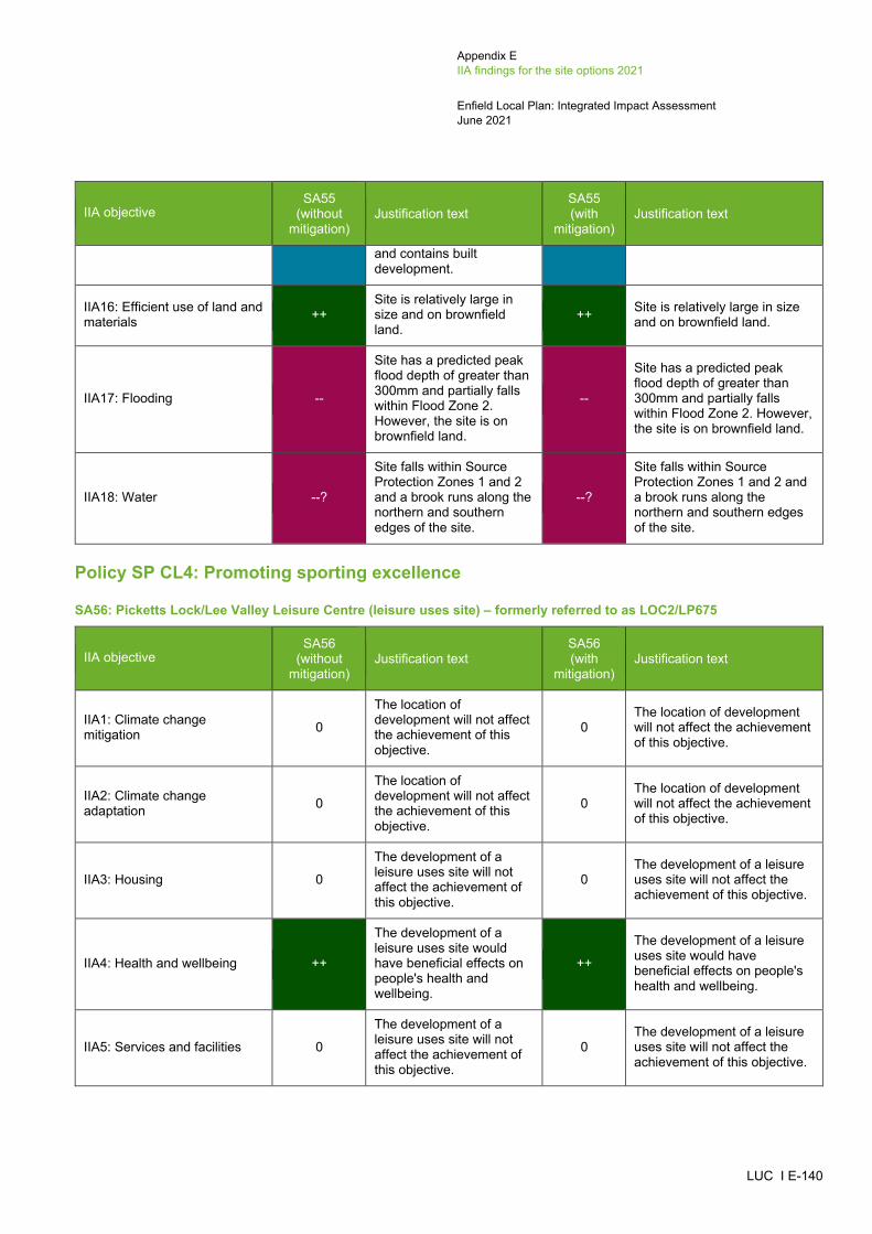
Appendix E IIA findings for the site options 2021
Enfield Local Plan: Integrated Impact Assessment June 2021
LUC I E-140
IIA objective SA55
(without mitigation)
Justification text SA55 (with
mitigation) Justification text
and contains built development.
IIA16: Efficient use of land and materials ++
Site is relatively large in size and on brownfield land.
++ Site is relatively large in size and on brownfield land.
IIA17: Flooding --
Site has a predicted peak flood depth of greater than 300mm and partially falls within Flood Zone 2. However, the site is on brownfield land.
--
Site has a predicted peak flood depth of greater than 300mm and partially falls within Flood Zone 2. However, the site is on brownfield land.
IIA18: Water --?
Site falls within Source Protection Zones 1 and 2 and a brook runs along the northern and southern edges of the site.
--?
Site falls within Source Protection Zones 1 and 2 and a brook runs along the northern and southern edges of the site.
Policy SP CL4: Promoting sporting excellence
SA56: Picketts Lock/Lee Valley Leisure Centre (leisure uses site) – formerly referred to as LOC2/LP675
IIA objective SA56
(without mitigation)
Justification text SA56 (with
mitigation) Justification text
IIA1: Climate change mitigation 0
The location of development will not affect the achievement of this objective.
0 The location of development will not affect the achievement of this objective.
IIA2: Climate change adaptation 0
The location of development will not affect the achievement of this objective.
0 The location of development will not affect the achievement of this objective.
IIA3: Housing 0
The development of a leisure uses site will not affect the achievement of this objective.
0 The development of a leisure uses site will not affect the achievement of this objective.
IIA4: Health and wellbeing ++
The development of a leisure uses site would have beneficial effects on people's health and wellbeing.
++
The development of a leisure uses site would have beneficial effects on people's health and wellbeing.
IIA5: Services and facilities 0
The development of a leisure uses site will not affect the achievement of this objective.
0 The development of a leisure uses site will not affect the achievement of this objective.

Appendix E IIA findings for the site options 2021
Enfield Local Plan: Integrated Impact Assessment June 2021
LUC I E-141
IIA objective SA56
(without mitigation)
Justification text SA56 (with
mitigation) Justification text
IIA6: Social inclusion + Site falls within the 20% most deprived areas within England.
+ Site falls within the 20% most deprived areas within England.
IIA7: Crime and community safety 0
The location of development will not affect the achievement of this objective.
0 The location of development will not affect the achievement of this objective.
IIA8: Road safety 0
The location of development will not affect the achievement of this objective.
0 The location of development will not affect the achievement of this objective.
IIA9: Economy 0
The development of a leisure uses site will not affect the achievement of this objective.
0 The development of a leisure uses site will not affect the achievement of this objective.
IIA10: Town and local centres 0 Site is not within or adjacent to a Major, District and Local Centre.
0 Site is not within or adjacent to a Major, District and Local Centre.
IIA11: Air pollution -? Site scored 1 in the air quality appraisal. -? Site scored 1 in the air quality
appraisal.
IIA12: Sustainable transport +
Site is located within 350m of at least one bus stop. The site is also within 201-400m of Nightingale Road, Edmonton, which is a Local Centre.
+
Site is located within 350m of at least one bus stop. The site is also within 201-400m of Nightingale Road, Edmonton, which is a Local Centre.
IIA13: Biodiversity --?
Site is located within 100m of a Priority Habitat and is within 250m of the Lea Valley SINC.
--? Site is located within 100m of a Priority Habitat and is within 250m of the Lea Valley SINC.
IIA14: Historic environment 0?
Site is more than 500m from the nearest designated heritage asset. However, the site could still have some potential for impacts on non-designated heritage features and effects may extend beyond 500m.
0?
The Council's assessment of heritage considerations and impacts on Archaeological Priority Areas has not recorded anything.
IIA15: Landscape and townscape --?
Site is large in scale and located on the edge of Lower Edmonton.
--? Site is large in scale and located on the edge of Lower Edmonton.
IIA16: Efficient use of land and materials --
Site is relatively large and on greenfield land classed as Urban land.
-- Site is relatively large and on greenfield land classed as Urban land.
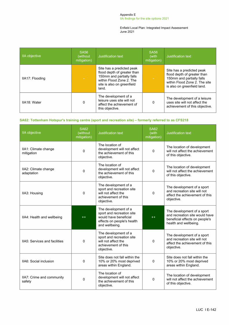
Appendix E IIA findings for the site options 2021
Enfield Local Plan: Integrated Impact Assessment June 2021
LUC I E-142
IIA objective SA56
(without mitigation)
Justification text SA56 (with
mitigation) Justification text
IIA17: Flooding -
Site has a predicted peak flood depth of greater than 150mm and partially falls within Flood Zone 2. The site is also on greenfield land.
-
Site has a predicted peak flood depth of greater than 150mm and partially falls within Flood Zone 2. The site is also on greenfield land.
IIA18: Water 0
The development of a leisure uses site will not affect the achievement of this objective.
0 The development of a leisure uses site will not affect the achievement of this objective.
SA62: Tottenham Hotspur's training centre (sport and recreation site) – formerly referred to as CFS218
IIA objective SA62
(without mitigation)
Justification text SA62 (with
mitigation) Justification text
IIA1: Climate change mitigation 0
The location of development will not affect the achievement of this objective.
0 The location of development will not affect the achievement of this objective.
IIA2: Climate change adaptation 0
The location of development will not affect the achievement of this objective.
0 The location of development will not affect the achievement of this objective.
IIA3: Housing 0
The development of a sport and recreation site will not affect the achievement of this objective.
0
The development of a sport and recreation site will not affect the achievement of this objective.
IIA4: Health and wellbeing ++
The development of a sport and recreation site would have beneficial effects on people's health and wellbeing.
++
The development of a sport and recreation site would have beneficial effects on people's health and wellbeing.
IIA5: Services and facilities 0
The development of a sport and recreation site will not affect the achievement of this objective.
0
The development of a sport and recreation site will not affect the achievement of this objective.
IIA6: Social inclusion 0 Site does not fall within the 10% or 20% most deprived areas within England.
0 Site does not fall within the 10% or 20% most deprived areas within England.
IIA7: Crime and community safety 0
The location of development will not affect the achievement of this objective.
0 The location of development will not affect the achievement of this objective.

Appendix E IIA findings for the site options 2021
Enfield Local Plan: Integrated Impact Assessment June 2021
LUC I E-143
IIA objective SA62
(without mitigation)
Justification text SA62 (with
mitigation) Justification text
IIA8: Road safety 0
The location of development will not affect the achievement of this objective.
0 The location of development will not affect the achievement of this objective.
IIA9: Economy 0
The development of a sport and recreation site will not affect the achievement of this objective.
0
The development of a sport and recreation site will not affect the achievement of this objective.
IIA10: Town and local centres 0 Site is not within or adjacent to a Major, District and Local Centre.
0 Site is not within or adjacent to a Major, District and Local Centre.
IIA11: Air pollution --? Site scored 2 in the air quality appraisal. --? Site scored 2 in the air quality
appraisal.
IIA12: Sustainable transport +/-
Site is within 1km of Turkey Street railway station but not within 350m of a bus stop. The site is only within 401-800m of Bullsmoor Lane/A10, which is a Local Centre.
+/-
Site is within 1km of Turkey Street railway station but not within 350m of a bus stop. The site is only within 401-800m of Bullsmoor Lane/A10, which is a Local Centre.
IIA13: Biodiversity --?
Site contains a Priority Habitat and is located within 250m of the New River SINC and Forty Hall Park & Estate SINC.
--?
Site contains a Priority Habitat and is located within 250m of the New River SINC and Forty Hall Park & Estate SINC.
IIA14: Historic environment -?
Over half of the site falls within Forty Hill Conservation Area, which contains a number of listed buildings as well as Myddelton House Registered Park and Garden. Myddelton House Registered Park and Garden falls partially within the site and the site is adjacent to a number of Grade II listed buildings. Due to the fact this site is allocated as a sport and recreation site which could contain limited development, its development could affect the setting of these heritage assets.
-?
The Council's assessment of heritage considerations and impacts on Archaeological Priority Areas records this site as 'Amber' and states that a Heritage Impact Assessment should be undertaken and mitigation provided.
IIA15: Landscape and townscape -?
Site is large in scale and located in a relatively undeveloped area. Due to
-? Site is large in scale and located in a relatively undeveloped area. Due to the
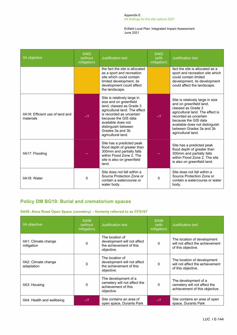
Appendix E IIA findings for the site options 2021
Enfield Local Plan: Integrated Impact Assessment June 2021
LUC I E-144
IIA objective SA62
(without mitigation)
Justification text SA62 (with
mitigation) Justification text
the fact the site is allocated as a sport and recreation site which could contain limited development, its development could affect the landscape.
fact the site is allocated as a sport and recreation site which could contain limited development, its development could affect the landscape.
IIA16: Efficient use of land and materials --?
Site is relatively large in size and on greenfield land, classed as Grade 3 agricultural land. The effect is recorded as uncertain because the GIS data available does not distinguish between Grades 3a and 3b agricultural land.
--?
Site is relatively large in size and on greenfield land, classed as Grade 3 agricultural land. The effect is recorded as uncertain because the GIS data available does not distinguish between Grades 3a and 3b agricultural land.
IIA17: Flooding --
Site has a predicted peak flood depth of greater than 300mm and partially falls within Flood Zone 2. The site is also on greenfield land.
--
Site has a predicted peak flood depth of greater than 300mm and partially falls within Flood Zone 2. The site is also on greenfield land.
IIA18: Water 0
Site does not fall within a Source Protection Zone or contain a watercourse or water body.
0
Site does not fall within a Source Protection Zone or contain a watercourse or water body.
Policy DM BG19: Burial and crematorium spaces
SA58: Alma Road Open Space (cemetery) – formerly referred to as CFS167
IIA objective SA58
(without mitigation)
Justification text SA58 (with
mitigation) Justification text
IIA1: Climate change mitigation 0
The location of development will not affect the achievement of this objective.
0 The location of development will not affect the achievement of this objective.
IIA2: Climate change adaptation 0
The location of development will not affect the achievement of this objective.
0 The location of development will not affect the achievement of this objective.
IIA3: Housing 0
The development of a cemetery will not affect the achievement of this objective.
0 The development of a cemetery will not affect the achievement of this objective.
IIA4: Health and wellbeing --? Site contains an area of open space, Durants Park
--? Site contains an area of open space, Durants Park

Appendix E IIA findings for the site options 2021
Enfield Local Plan: Integrated Impact Assessment June 2021
LUC I E-145
IIA objective SA58
(without mitigation)
Justification text SA58 (with
mitigation) Justification text
Metropolitan Open Land, which would be lost to the cemetery.
Metropolitan Open Land, which would be lost to the cemetery.
IIA5: Services and facilities 0
The development of a cemetery will not affect the achievement of this objective.
0 The development of a cemetery will not affect the achievement of this objective.
IIA6: Social inclusion 0
The development of a cemetery will not affect the achievement of this objective.
0 The development of a cemetery will not affect the achievement of this objective.
IIA7: Crime and community safety 0
The location of development will not affect the achievement of this objective.
0 The location of development will not affect the achievement of this objective.
IIA8: Road safety 0
The location of development will not affect the achievement of this objective.
0 The location of development will not affect the achievement of this objective.
IIA9: Economy 0
The development of a cemetery will not affect the achievement of this objective.
0 The development of a cemetery will not affect the achievement of this objective.
IIA10: Town and local centres 0
The development of a cemetery will not affect the achievement of this objective.
0 The development of a cemetery will not affect the achievement of this objective.
IIA11: Air pollution -?
Site scored 1 in the air quality appraisal. Site scored 0 in the air quality appraisal.
-? Site scored 1 in the air quality appraisal. Site scored 0 in the air quality appraisal.
IIA12: Sustainable transport ++/-
Site is located within 1km of Brimsdown railway station and 350m of at least one bus stop. However, the site is only within 401-800m of Brimsdown Avenue, which is a Local Centre.
++/-
Site is located within 1km of Brimsdown railway station and 350m of at least one bus stop. However, the site is only within 401-800m of Brimsdown Avenue, which is a Local Centre.
IIA13: Biodiversity --?
Site is located within 100m of a Priority Habitat and is 250-750m of the Lea Valley SINC and Chingford Reservoirs SSSI.
--?
Site is located within 100m of a Priority Habitat and is 250-750m of the Lea Valley SINC and Chingford Reservoirs SSSI.
IIA14: Historic environment 0 The development of a cemetery will not affect the
0 The Council's assessment of heritage considerations and impacts on Archaeological

Appendix E IIA findings for the site options 2021
Enfield Local Plan: Integrated Impact Assessment June 2021
LUC I E-146
IIA objective SA58
(without mitigation)
Justification text SA58 (with
mitigation) Justification text
achievement of this objective.
Priority Areas has not recorded anything.
IIA15: Landscape and townscape 0
The development of a cemetery will not affect the achievement of this objective.
0 The development of a cemetery will not affect the achievement of this objective.
IIA16: Efficient use of land and materials 0
The development of a cemetery will not affect the achievement of this objective.
0 The development of a cemetery will not affect the achievement of this objective.
IIA17: Flooding -
Site is on greenfield land. However, the site does not fall within Flood Zones 2 or 3 and is not at risk of surface water flooding.
-
Site is on greenfield land. However, the site does not fall within Flood Zones 2 or 3 and is not at risk of surface water flooding.
IIA18: Water --? Site falls within Source Protection Zone 2. --? Site falls within Source
Protection Zone 2.
SA59: Firs Farm Recreation Ground (Part) (crematorium) – formerly referred to as CFS168
IIA objective SA59
(without mitigation)
Justification text SA59 (with
mitigation) Justification text
IIA1: Climate change mitigation 0
The location of development will not affect the achievement of this objective.
0 The location of development will not affect the achievement of this objective.
IIA2: Climate change adaptation 0
The location of development will not affect the achievement of this objective.
0 The location of development will not affect the achievement of this objective.
IIA3: Housing 0
The development of a crematorium will not affect the achievement of this objective.
0 The development of a crematorium will not affect the achievement of this objective.
IIA4: Health and wellbeing --?
Site contains an area of open space, Firs Farm & Clowes Sportsgrounds Metropolitan Open Land, and a cycle path, both of which could be lost to the crematorium.
--?
Site contains an area of open space, Firs Farm & Clowes Sportsgrounds Metropolitan Open Land, and a cycle path, both of which could be lost to the crematorium.
IIA5: Services and facilities 0
The development of a crematorium will not affect the achievement of this objective.
0 The development of a crematorium will not affect the achievement of this objective.

Appendix E IIA findings for the site options 2021
Enfield Local Plan: Integrated Impact Assessment June 2021
LUC I E-147
IIA objective SA59
(without mitigation)
Justification text SA59 (with
mitigation) Justification text
IIA6: Social inclusion 0
The development of a crematorium will not affect the achievement of this objective.
0 The development of a crematorium will not affect the achievement of this objective.
IIA7: Crime and community safety 0
The location of development will not affect the achievement of this objective.
0 The location of development will not affect the achievement of this objective.
IIA8: Road safety 0
The location of development will not affect the achievement of this objective.
0 The location of development will not affect the achievement of this objective.
IIA9: Economy 0
The development of a crematorium will not affect the achievement of this objective.
0 The development of a crematorium will not affect the achievement of this objective.
IIA10: Town and local centres 0
The development of a crematorium will not affect the achievement of this objective.
0 The development of a crematorium will not affect the achievement of this objective.
IIA11: Air pollution --? Site scored 2 in the air quality appraisal. --? Site scored 2 in the air quality
appraisal.
IIA12: Sustainable transport +
Site is located within 350m of at least one bus stop. The site is also within 201-400m of Firs Lane, which is a Local Centre.
+
Site is located within 350m of at least one bus stop. The site is also within 201-400m of Firs Lane, which is a Local Centre.
IIA13: Biodiversity --?
Site is located within 100m of a Priority Habitat and is 250-750m of the Paulin Ground Woods SINC, Tatem Park SINC and New River SINC.
--?
Site is located within 100m of a Priority Habitat and is 250-750m of the Paulin Ground Woods SINC, Tatem Park SINC and New River SINC.
IIA14: Historic environment 0?
Site is more than 500m from the nearest designated heritage asset. However, the site could still have some potential for impacts on non-designated heritage features and effects may extend beyond 500m.
0?
The Council's assessment of heritage considerations and impacts on Archaeological Priority Areas has not recorded anything.
IIA15: Landscape and townscape --
Development of this site would result in the loss of Firs Farm & Clowes Sportsgrounds Metropolitan Open Land.
--
Development of this site would result in the loss of Firs Farm & Clowes Sportsgrounds Metropolitan Open Land.

Appendix E IIA findings for the site options 2021
Enfield Local Plan: Integrated Impact Assessment June 2021
LUC I E-148
IIA objective SA59
(without mitigation)
Justification text SA59 (with
mitigation) Justification text
IIA16: Efficient use of land and materials --
Site is relatively large and on greenfield land classed as Urban land.
-- Site is relatively large and on greenfield land classed as Urban land.
IIA17: Flooding --
Site has a predicted peak flood depth of greater than 300mm and is on greenfield land. However, the site does not fall within Flood Zones 2 or 3.
--
Site has a predicted peak flood depth of greater than 300mm and is on greenfield land. However, the site does not fall within Flood Zones 2 or 3.
IIA18: Water --? Site falls within Source Protection Zone 1. --? Site falls within Source
Protection Zone 1.
SA60: Sloemans Farm (natural burial site) – formerly referred to as CFS171
IIA objective SA60
(without mitigation)
Justification text SA60 (with
mitigation) Justification text
IIA1: Climate change mitigation 0
The location of development will not affect the achievement of this objective.
0 The location of development will not affect the achievement of this objective.
IIA2: Climate change adaptation 0
The location of development will not affect the achievement of this objective.
0 The location of development will not affect the achievement of this objective.
IIA3: Housing 0
The development of a natural burial site will not affect the achievement of this objective.
0 The development of a natural burial site will not affect the achievement of this objective.
IIA4: Health and wellbeing 0 Site does not comprise an open space. 0 Site does not comprise an
open space.
IIA5: Services and facilities 0
The development of a natural burial site will not affect the achievement of this objective.
0 The development of a natural burial site will not affect the achievement of this objective.
IIA6: Social inclusion 0 Site does not fall within the 10% or 20% most deprived areas within England.
0 Site does not fall within the 10% or 20% most deprived areas within England.
IIA7: Crime and community safety 0
The location of development will not affect the achievement of this objective.
0 The location of development will not affect the achievement of this objective.
IIA8: Road safety 0 The location of development will not affect
0 The location of development will not affect the achievement of this objective.
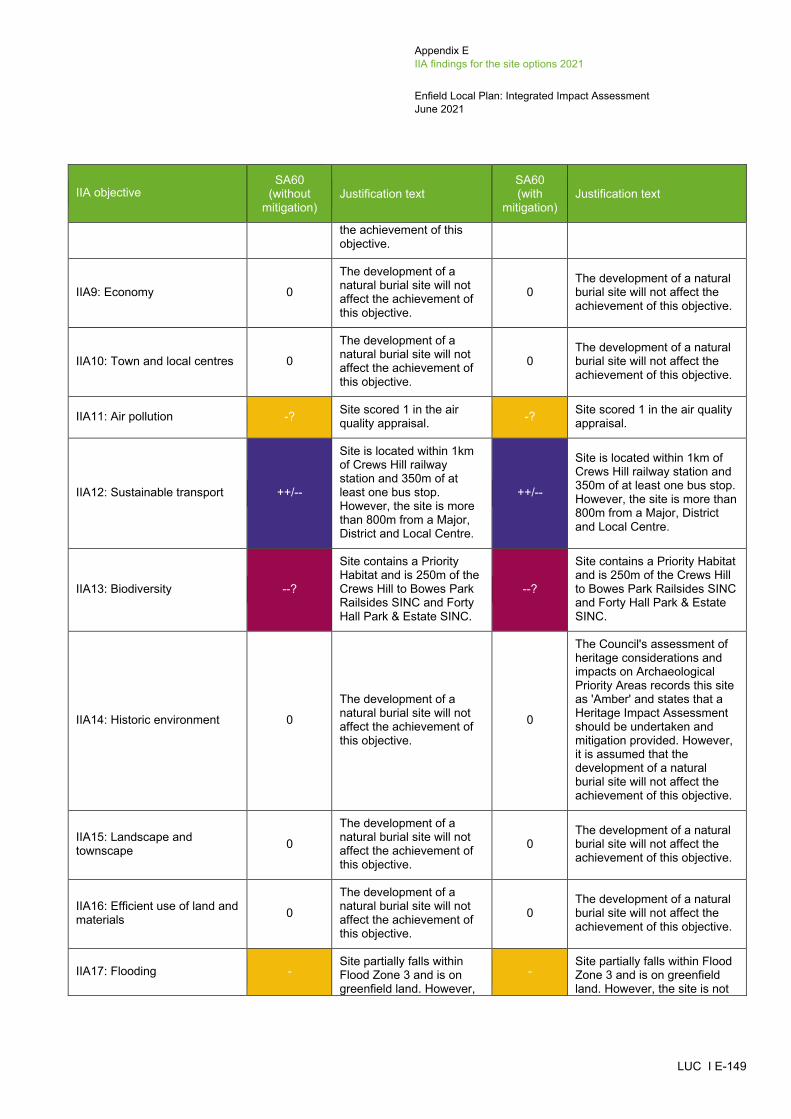
Appendix E IIA findings for the site options 2021
Enfield Local Plan: Integrated Impact Assessment June 2021
LUC I E-149
IIA objective SA60
(without mitigation)
Justification text SA60 (with
mitigation) Justification text
the achievement of this objective.
IIA9: Economy 0
The development of a natural burial site will not affect the achievement of this objective.
0 The development of a natural burial site will not affect the achievement of this objective.
IIA10: Town and local centres 0
The development of a natural burial site will not affect the achievement of this objective.
0 The development of a natural burial site will not affect the achievement of this objective.
IIA11: Air pollution -? Site scored 1 in the air quality appraisal. -? Site scored 1 in the air quality
appraisal.
IIA12: Sustainable transport ++/--
Site is located within 1km of Crews Hill railway station and 350m of at least one bus stop. However, the site is more than 800m from a Major, District and Local Centre.
++/--
Site is located within 1km of Crews Hill railway station and 350m of at least one bus stop. However, the site is more than 800m from a Major, District and Local Centre.
IIA13: Biodiversity --?
Site contains a Priority Habitat and is 250m of the Crews Hill to Bowes Park Railsides SINC and Forty Hall Park & Estate SINC.
--?
Site contains a Priority Habitat and is 250m of the Crews Hill to Bowes Park Railsides SINC and Forty Hall Park & Estate SINC.
IIA14: Historic environment 0
The development of a natural burial site will not affect the achievement of this objective.
0
The Council's assessment of heritage considerations and impacts on Archaeological Priority Areas records this site as 'Amber' and states that a Heritage Impact Assessment should be undertaken and mitigation provided. However, it is assumed that the development of a natural burial site will not affect the achievement of this objective.
IIA15: Landscape and townscape 0
The development of a natural burial site will not affect the achievement of this objective.
0 The development of a natural burial site will not affect the achievement of this objective.
IIA16: Efficient use of land and materials 0
The development of a natural burial site will not affect the achievement of this objective.
0 The development of a natural burial site will not affect the achievement of this objective.
IIA17: Flooding - Site partially falls within Flood Zone 3 and is on greenfield land. However,
- Site partially falls within Flood Zone 3 and is on greenfield land. However, the site is not

Appendix E IIA findings for the site options 2021
Enfield Local Plan: Integrated Impact Assessment June 2021
LUC I E-150
IIA objective SA60
(without mitigation)
Justification text SA60 (with
mitigation) Justification text
the site is not at risk of surface water flooding.
at risk of surface water flooding.
IIA18: Water --? Site contains three brooks within its boundary. --? Site contains three brooks
within its boundary.
SA61: Church Street Recreation Ground (crematorium) – formerly referred to as CFS230
IIA objective SA61
(without mitigation)
Justification text SA61 (with
mitigation) Justification text
IIA1: Climate change mitigation 0
The location of development will not affect the achievement of this objective.
0 The location of development will not affect the achievement of this objective.
IIA2: Climate change adaptation 0
The location of development will not affect the achievement of this objective.
0 The location of development will not affect the achievement of this objective.
IIA3: Housing 0
The development of a crematorium will not affect the achievement of this objective.
0 The development of a crematorium will not affect the achievement of this objective.
IIA4: Health and wellbeing --?
Site falls within Church Street Recreation Ground Metropolitan Open Land, which would be lost to the crematorium.
--?
Site falls within Church Street Recreation Ground Metropolitan Open Land, which would be lost to the crematorium.
IIA5: Services and facilities 0
The development of a crematorium will not affect the achievement of this objective.
0 The development of a crematorium will not affect the achievement of this objective.
IIA6: Social inclusion 0 Site does not fall within the 10% or 20% most deprived areas within England.
0 Site does not fall within the 10% or 20% most deprived areas within England.
IIA7: Crime and community safety 0
The location of development will not affect the achievement of this objective.
0 The location of development will not affect the achievement of this objective.
IIA8: Road safety 0
The location of development will not affect the achievement of this objective.
0 The location of development will not affect the achievement of this objective.
IIA9: Economy 0
The development of a crematorium will not affect the achievement of this objective.
0 The development of a crematorium will not affect the achievement of this objective.

Appendix E IIA findings for the site options 2021
Enfield Local Plan: Integrated Impact Assessment June 2021
LUC I E-151
IIA objective SA61
(without mitigation)
Justification text SA61 (with
mitigation) Justification text
IIA10: Town and local centres 0
The development of a crematorium will not affect the achievement of this objective.
0 The development of a crematorium will not affect the achievement of this objective.
IIA11: Air pollution --? Site scored 2 in the air quality appraisal. --? Site scored 2 in the air quality
appraisal.
IIA12: Sustainable transport +
Site is located within 350m of at least one bus stop. The site is also within 201-400m of Hazelbury Road Edmonton, which is a Local Centre.
+
Site is located within 350m of at least one bus stop. The site is also within 201-400m of Hazelbury Road Edmonton, which is a Local Centre.
IIA13: Biodiversity --? Site contains a Priority Habitat and is 250-750m of the Pymme’s Park SINC.
--? Site contains a Priority Habitat and is 250-750m of the Pymme’s Park SINC.
IIA14: Historic environment 0?
Site is more than 500m from the nearest designated heritage asset. However, the site could still have some potential for impacts on non-designated heritage features and effects may extend beyond 500m.
0?
The Council's assessment of heritage considerations and impacts on Archaeological Priority Areas has not recorded anything.
IIA15: Landscape and townscape --
Development of this site would result in the loss of Church Street Recreation Ground Metropolitan Open Land.
--
Development of this site would result in the loss of Church Street Recreation Ground Metropolitan Open Land.
IIA16: Efficient use of land and materials --
Site is relatively large in size and on greenfield land, classed as Urban land.
-- Site is relatively large in size and on greenfield land, classed as Urban land.
IIA17: Flooding -
Site has a predicted peak flood depth of greater than 300mm and is on greenfield land. However, the site does not fall within Flood Zones 2 or 3.
-
Site has a predicted peak flood depth of greater than 300mm and is on greenfield land. However, the site does not fall within Flood Zones 2 or 3.
IIA18: Water --? Site falls within Source Protection Zone 2. --? Site falls within Source
Protection Zone 2.

Appendix E IIA findings for the site options 2021
Enfield Local Plan: Integrated Impact Assessment June 2021
LUC I E-152
Nature recovery site
SA57: Whitewebbs Golf Course, Beggar's Hollow (nature recovery site) – formerly referred to as CFS161
IIA objective SA57
(without mitigation)
Justification text SA57 (with
mitigation) Justification text
IIA1: Climate change mitigation 0
The location of development will not affect the achievement of this objective.
0 The location of development will not affect the achievement of this objective.
IIA2: Climate change adaptation 0
The location of development will not affect the achievement of this objective.
0 The location of development will not affect the achievement of this objective.
IIA3: Housing 0
The development of a nature recovery site will not affect the achievement of this objective.
0 The development of a nature recovery site will not affect the achievement of this objective.
IIA4: Health and wellbeing 0
The development of a nature recovery site will not affect the achievement of this objective.
0 The development of a nature recovery site will not affect the achievement of this objective.
IIA5: Services and facilities 0
The development of a nature recovery site will not affect the achievement of this objective.
0 The development of a nature recovery site will not affect the achievement of this objective.
IIA6: Social inclusion 0
The development of a nature recovery site will not affect the achievement of this objective.
0 The development of a nature recovery site will not affect the achievement of this objective.
IIA7: Crime and community safety 0
The location of development will not affect the achievement of this objective.
0 The location of development will not affect the achievement of this objective.
IIA8: Road safety 0
The location of development will not affect the achievement of this objective.
0 The location of development will not affect the achievement of this objective.
IIA9: Economy 0
The development of a nature recovery site will not affect the achievement of this objective.
0 The development of a nature recovery site will not affect the achievement of this objective.
IIA10: Town and local centres 0
The development of a nature recovery site will not affect the achievement of this objective.
0 The development of a nature recovery site will not affect the achievement of this objective.
IIA11: Air pollution -? Site scored 1 in the air quality appraisal. -? Site scored 1 in the air quality
appraisal.

Appendix E IIA findings for the site options 2021
Enfield Local Plan: Integrated Impact Assessment June 2021
LUC I E-153
IIA objective SA57
(without mitigation)
Justification text SA57 (with
mitigation) Justification text
IIA12: Sustainable transport 0
The development of a nature recovery site will not affect the achievement of this objective.
0 The development of a nature recovery site will not affect the achievement of this objective.
IIA13: Biodiversity ++
The development of a nature recovery site would have a significant positive effect on biodiversity.
++
The development of a nature recovery site would have a significant positive effect on biodiversity.
IIA14: Historic environment 0
The development of a nature recovery site will not affect the achievement of this objective.
0
The Council's assessment of heritage considerations records this site as 'Red' and states that a Heritage Impact Assessment should be undertaken and mitigation provided. However, it is assumed that the development of a nature recovery site will not affect the achievement of this objective.
IIA15: Landscape and townscape +
The development of a nature recovery site would have a positive effect on the landscape.
+
The development of a nature recovery site would have a positive effect on the landscape.
IIA16: Efficient use of land and materials 0
The development of a nature recovery site will not affect the achievement of this objective.
0 The development of a nature recovery site will not affect the achievement of this objective.
IIA17: Flooding -
Site has a predicted peak flood depth of greater than 150m, partially falls within Flood Zone 3 and is on greenfield land.
-
Site has a predicted peak flood depth of greater than 150m, partially falls within Flood Zone 3 and is on greenfield land.
IIA18: Water 0
The development of a nature recovery site will not affect the achievement of this objective.
0 The development of a nature recovery site will not affect the achievement of this objective.

Appendix E IIA findings for the site options 2021
Enfield Local Plan: Integrated Impact Assessment June 2021
LUC I E-154
Site options appraised but not allocated Housing sites
CHC1/LP031: Warmerdams Nursery, Cattlegate Road
IIA objective Effect Justification text
IIA1: Climate change mitigation 0 The location of development will not affect the achievement of this objective.
IIA2: Climate change adaptation 0 The location of development will not affect the achievement of this objective.
IIA3: Housing ++ Site has capacity for more than 100 housing units.
IIA4: Health and wellbeing ++/- Site is within 800m of Whitewebbs Park and 400m of a walking path. However, the site is not located within 800m of a GP surgery.
IIA5: Services and facilities -? Site is not within 800m of an existing school.
IIA6: Social inclusion 0 Site does not fall within the 10% or 20% most deprived areas within England.
IIA7: Crime and community safety 0 The location of development will not affect the achievement of this objective.
IIA8: Road safety 0 The location of development will not affect the achievement of this objective.
IIA9: Economy - Site is not located adjacent or close to Strategic Industrial Locations and Locally Significant Industrial Sites.
IIA10: Town and local centres 0 Site is not within or adjacent to a Major, District and Local Centre.
IIA11: Air pollution -? Site scored 1 in the air quality appraisal.
IIA12: Sustainable transport ++/-- Site is located within 1km of Crews Hill railway station and 350m of at least one bus stop. However, the site is more than 800m from a Major, District and Local Centre.
IIA13: Biodiversity --? Site is located within 250m of Crews Hill Golf Course SINC and Crews Hill Bowes Park Railsides SINC, and 100m of a Priority Habitat.
IIA14: Historic environment -?
Site is within 500m of a Grade II* listed building (The Paddocks) and a Grade II listed building (Glasgow Stud Farmhouse). Although there is built development between the site and the listed buildings, its development could affect the setting of both heritage assets.
IIA15: Landscape and townscape +? Site is located within the settlement of Crews Hill and contains built development.
IIA16: Efficient use of land and materials ++ Site is relatively large in size and on brownfield land.
IIA17: Flooding -- Site has a predicted peak flood depth of greater than 300mm. However, the site is on brownfield land and does not fall with Flood Zones 2 or 3.
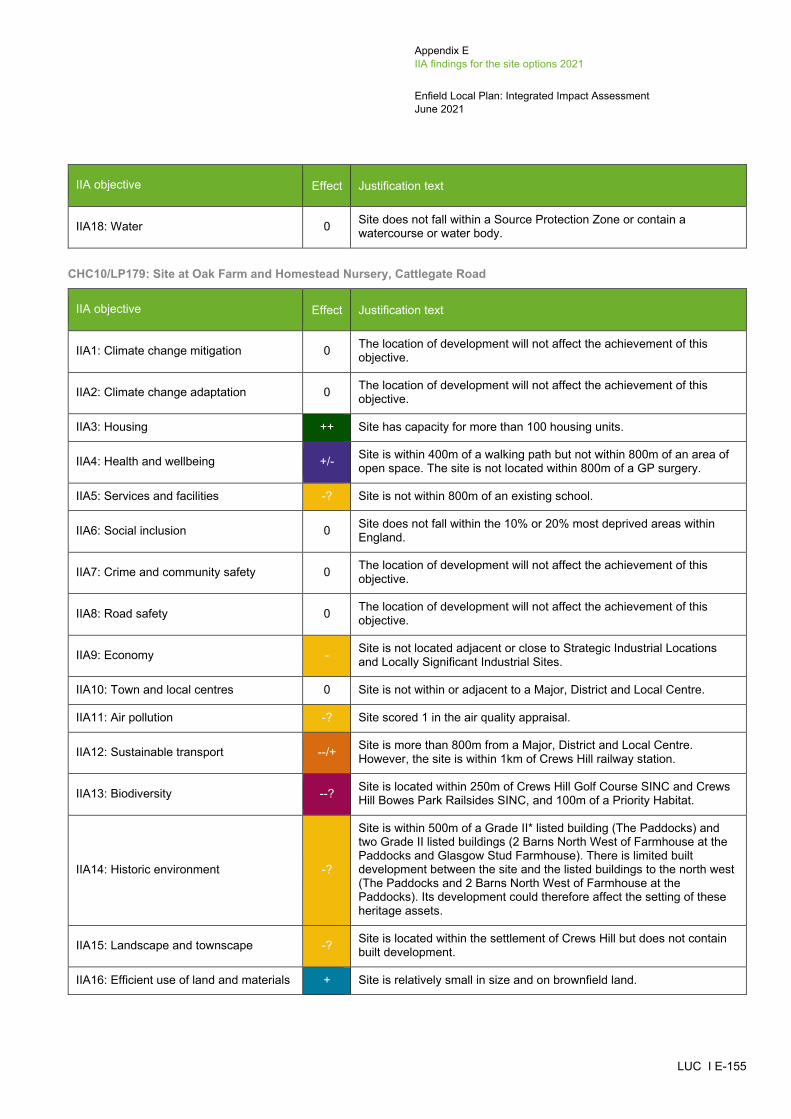
Appendix E IIA findings for the site options 2021
Enfield Local Plan: Integrated Impact Assessment June 2021
LUC I E-155
IIA objective Effect Justification text
IIA18: Water 0 Site does not fall within a Source Protection Zone or contain a watercourse or water body.
CHC10/LP179: Site at Oak Farm and Homestead Nursery, Cattlegate Road
IIA objective Effect Justification text
IIA1: Climate change mitigation 0 The location of development will not affect the achievement of this objective.
IIA2: Climate change adaptation 0 The location of development will not affect the achievement of this objective.
IIA3: Housing ++ Site has capacity for more than 100 housing units.
IIA4: Health and wellbeing +/- Site is within 400m of a walking path but not within 800m of an area of open space. The site is not located within 800m of a GP surgery.
IIA5: Services and facilities -? Site is not within 800m of an existing school.
IIA6: Social inclusion 0 Site does not fall within the 10% or 20% most deprived areas within England.
IIA7: Crime and community safety 0 The location of development will not affect the achievement of this objective.
IIA8: Road safety 0 The location of development will not affect the achievement of this objective.
IIA9: Economy - Site is not located adjacent or close to Strategic Industrial Locations and Locally Significant Industrial Sites.
IIA10: Town and local centres 0 Site is not within or adjacent to a Major, District and Local Centre.
IIA11: Air pollution -? Site scored 1 in the air quality appraisal.
IIA12: Sustainable transport --/+ Site is more than 800m from a Major, District and Local Centre. However, the site is within 1km of Crews Hill railway station.
IIA13: Biodiversity --? Site is located within 250m of Crews Hill Golf Course SINC and Crews Hill Bowes Park Railsides SINC, and 100m of a Priority Habitat.
IIA14: Historic environment -?
Site is within 500m of a Grade II* listed building (The Paddocks) and two Grade II listed buildings (2 Barns North West of Farmhouse at the Paddocks and Glasgow Stud Farmhouse). There is limited built development between the site and the listed buildings to the north west (The Paddocks and 2 Barns North West of Farmhouse at the Paddocks). Its development could therefore affect the setting of these heritage assets.
IIA15: Landscape and townscape -? Site is located within the settlement of Crews Hill but does not contain built development.
IIA16: Efficient use of land and materials + Site is relatively small in size and on brownfield land.
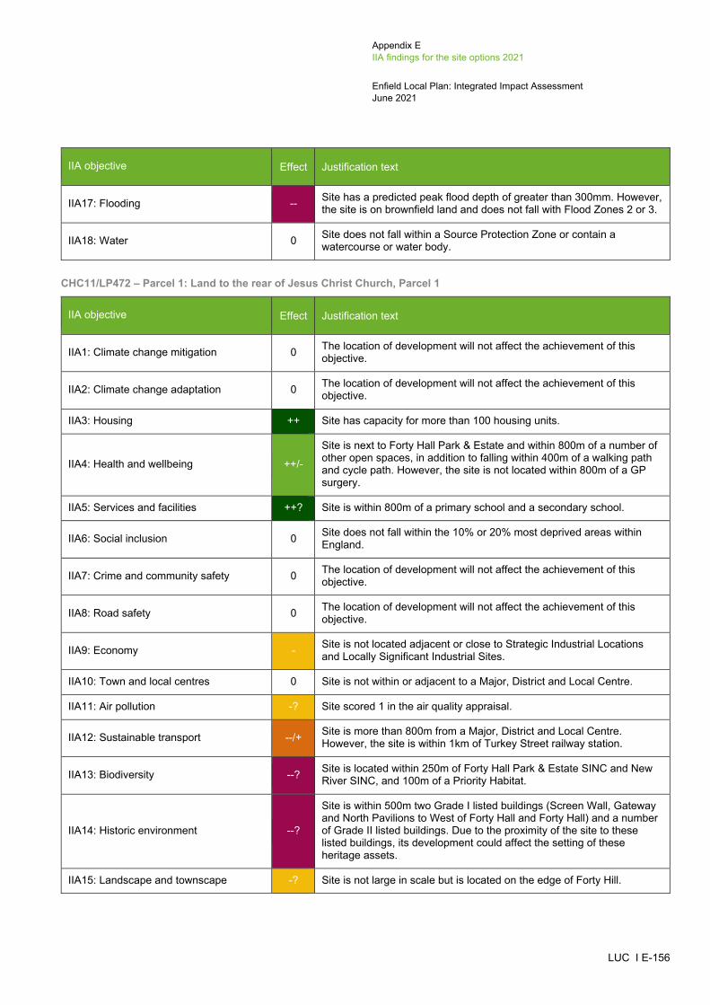
Appendix E IIA findings for the site options 2021
Enfield Local Plan: Integrated Impact Assessment June 2021
LUC I E-156
IIA objective Effect Justification text
IIA17: Flooding -- Site has a predicted peak flood depth of greater than 300mm. However, the site is on brownfield land and does not fall with Flood Zones 2 or 3.
IIA18: Water 0 Site does not fall within a Source Protection Zone or contain a watercourse or water body.
CHC11/LP472 – Parcel 1: Land to the rear of Jesus Christ Church, Parcel 1
IIA objective Effect Justification text
IIA1: Climate change mitigation 0 The location of development will not affect the achievement of this objective.
IIA2: Climate change adaptation 0 The location of development will not affect the achievement of this objective.
IIA3: Housing ++ Site has capacity for more than 100 housing units.
IIA4: Health and wellbeing ++/-
Site is next to Forty Hall Park & Estate and within 800m of a number of other open spaces, in addition to falling within 400m of a walking path and cycle path. However, the site is not located within 800m of a GP surgery.
IIA5: Services and facilities ++? Site is within 800m of a primary school and a secondary school.
IIA6: Social inclusion 0 Site does not fall within the 10% or 20% most deprived areas within England.
IIA7: Crime and community safety 0 The location of development will not affect the achievement of this objective.
IIA8: Road safety 0 The location of development will not affect the achievement of this objective.
IIA9: Economy - Site is not located adjacent or close to Strategic Industrial Locations and Locally Significant Industrial Sites.
IIA10: Town and local centres 0 Site is not within or adjacent to a Major, District and Local Centre.
IIA11: Air pollution -? Site scored 1 in the air quality appraisal.
IIA12: Sustainable transport --/+ Site is more than 800m from a Major, District and Local Centre. However, the site is within 1km of Turkey Street railway station.
IIA13: Biodiversity --? Site is located within 250m of Forty Hall Park & Estate SINC and New River SINC, and 100m of a Priority Habitat.
IIA14: Historic environment --?
Site is within 500m two Grade I listed buildings (Screen Wall, Gateway and North Pavilions to West of Forty Hall and Forty Hall) and a number of Grade II listed buildings. Due to the proximity of the site to these listed buildings, its development could affect the setting of these heritage assets.
IIA15: Landscape and townscape -? Site is not large in scale but is located on the edge of Forty Hill.
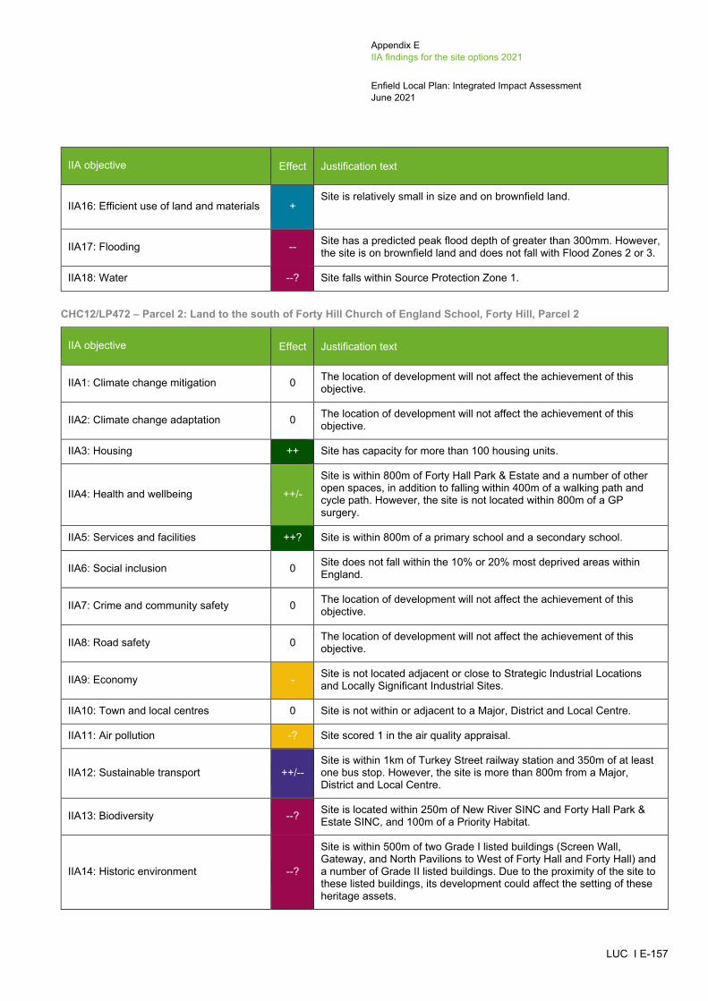
Appendix E IIA findings for the site options 2021
Enfield Local Plan: Integrated Impact Assessment June 2021
LUC I E-157
IIA objective Effect Justification text
IIA16: Efficient use of land and materials + Site is relatively small in size and on brownfield land.
IIA17: Flooding -- Site has a predicted peak flood depth of greater than 300mm. However, the site is on brownfield land and does not fall with Flood Zones 2 or 3.
IIA18: Water --? Site falls within Source Protection Zone 1.
CHC12/LP472 – Parcel 2: Land to the south of Forty Hill Church of England School, Forty Hill, Parcel 2
IIA objective Effect Justification text
IIA1: Climate change mitigation 0 The location of development will not affect the achievement of this objective.
IIA2: Climate change adaptation 0 The location of development will not affect the achievement of this objective.
IIA3: Housing ++ Site has capacity for more than 100 housing units.
IIA4: Health and wellbeing ++/-
Site is within 800m of Forty Hall Park & Estate and a number of other open spaces, in addition to falling within 400m of a walking path and cycle path. However, the site is not located within 800m of a GP surgery.
IIA5: Services and facilities ++? Site is within 800m of a primary school and a secondary school.
IIA6: Social inclusion 0 Site does not fall within the 10% or 20% most deprived areas within England.
IIA7: Crime and community safety 0 The location of development will not affect the achievement of this objective.
IIA8: Road safety 0 The location of development will not affect the achievement of this objective.
IIA9: Economy - Site is not located adjacent or close to Strategic Industrial Locations and Locally Significant Industrial Sites.
IIA10: Town and local centres 0 Site is not within or adjacent to a Major, District and Local Centre.
IIA11: Air pollution -? Site scored 1 in the air quality appraisal.
IIA12: Sustainable transport ++/-- Site is within 1km of Turkey Street railway station and 350m of at least one bus stop. However, the site is more than 800m from a Major, District and Local Centre.
IIA13: Biodiversity --? Site is located within 250m of New River SINC and Forty Hall Park & Estate SINC, and 100m of a Priority Habitat.
IIA14: Historic environment --?
Site is within 500m of two Grade I listed buildings (Screen Wall, Gateway, and North Pavilions to West of Forty Hall and Forty Hall) and a number of Grade II listed buildings. Due to the proximity of the site to these listed buildings, its development could affect the setting of these heritage assets.

Appendix E IIA findings for the site options 2021
Enfield Local Plan: Integrated Impact Assessment June 2021
LUC I E-158
IIA objective Effect Justification text
IIA15: Landscape and townscape -? Site is not large in scale but is located on the edge of Forty Hill.
IIA16: Efficient use of land and materials + Site is relatively small in size and on brownfield land.
IIA17: Flooding - Site has a predicted peak flood depth of greater than 150mm. However, the site is on brownfield land and does not fall with Flood Zones 2 or 3.
IIA18: Water --? Site falls within Source Protection Zone 1 and there is a brook along its south eastern boundary.
CHC14/LP637: Land north of Goat Lane
IIA objective Effect Justification text
IIA1: Climate change mitigation 0 The location of development will not affect the achievement of this objective.
IIA2: Climate change adaptation 0 The location of development will not affect the achievement of this objective.
IIA3: Housing + Site has capacity for fewer than 100 housing units.
IIA4: Health and wellbeing ++/-
Site is within 800m of a number of areas of open space, including Forty Hall Park & Estate and the New River Green Chain, in addition to falling within 400m of a walking path. However, the site is not located within 800m of a GP surgery.
IIA5: Services and facilities ++? Site is within 800m of a primary school and a secondary school.
IIA6: Social inclusion 0 Site does not fall within the 10% or 20% most deprived areas within England.
IIA7: Crime and community safety 0 The location of development will not affect the achievement of this objective.
IIA8: Road safety 0 The location of development will not affect the achievement of this objective.
IIA9: Economy - Site is not located adjacent or close to Strategic Industrial Locations and Locally Significant Industrial Sites.
IIA10: Town and local centres 0 Site is not within or adjacent to a Major, District and Local Centre.
IIA11: Air pollution -? Site scored 1 in the air quality appraisal.
IIA12: Sustainable transport - Site is within 401-800m of Carterhatch Lane/A10, which is a Local Centre. The site is more than 1km from a railway station and 350m from a bus stop and does not have an existing cycle route passing the site.
IIA13: Biodiversity --? Site is located within 250m of New River SINC and 100-250m of a Priority Habitat (deciduous woodland).
IIA14: Historic environment -? Site is within 500m of the Forty Hill Conservation Area (to the north west of the site), which contains a number of Grade II listed buildings. Although there is built development between the site and the

Appendix E IIA findings for the site options 2021
Enfield Local Plan: Integrated Impact Assessment June 2021
LUC I E-159
IIA objective Effect Justification text
Conservation Area, its development could affect the setting of these heritage assets.
IIA15: Landscape and townscape -? Site is not large in scale but is located on the edge of Forty Hill.
IIA16: Efficient use of land and materials + Site is relatively small in size and on brownfield land.
IIA17: Flooding - Site has a predicted peak flood depth of greater than 150mm. However, the site is on brownfield land and does not fall with Flood Zones 2 or 3.
IIA18: Water --? Site falls within Source Protection Zone 1 and New River runs along its eastern boundary.
CHC17/LP645: Towneley Nurseries, Theobalds Park
IIA objective Effect Justification text
IIA1: Climate change mitigation 0 The location of development will not affect the achievement of this objective.
IIA2: Climate change adaptation 0 The location of development will not affect the achievement of this objective.
IIA3: Housing ++ Site has capacity for more than 100 housing units.
IIA4: Health and wellbeing ++/- Site is within 800m of Whitewebbs Park and 400m of a walking path. However, the site is not located within 800m of a GP surgery.
IIA5: Services and facilities -? Site is not within 800m of an existing school.
IIA6: Social inclusion 0 Site does not fall within the 10% or 20% most deprived areas within England.
IIA7: Crime and community safety 0 The location of development will not affect the achievement of this objective.
IIA8: Road safety 0 The location of development will not affect the achievement of this objective.
IIA9: Economy - Site is not located adjacent or close to Strategic Industrial Locations and Locally Significant Industrial Sites.
IIA10: Town and local centres 0 Site is not within or adjacent to a Major, District and Local Centre.
IIA11: Air pollution -? Site scored 1 in the air quality appraisal.
IIA12: Sustainable transport ++/-- Site is located within 1km of Crews Hill railway station and 350m of at least one bus stop. However, the site is more than 800m from a Major, District and Local Centre.
IIA13: Biodiversity --? Site is located within 100m of a Priority Habitat and 250m-750m of Crews Hill Golfcourse SINC, Crews Hill to Bowes Park Railsides SINC and Whitewebbs Wood SINC.
IIA14: Historic environment -? Site is within 500m of a Grade II listed building (Glasgow Stud Farmhouse). Although there is built development between the site and
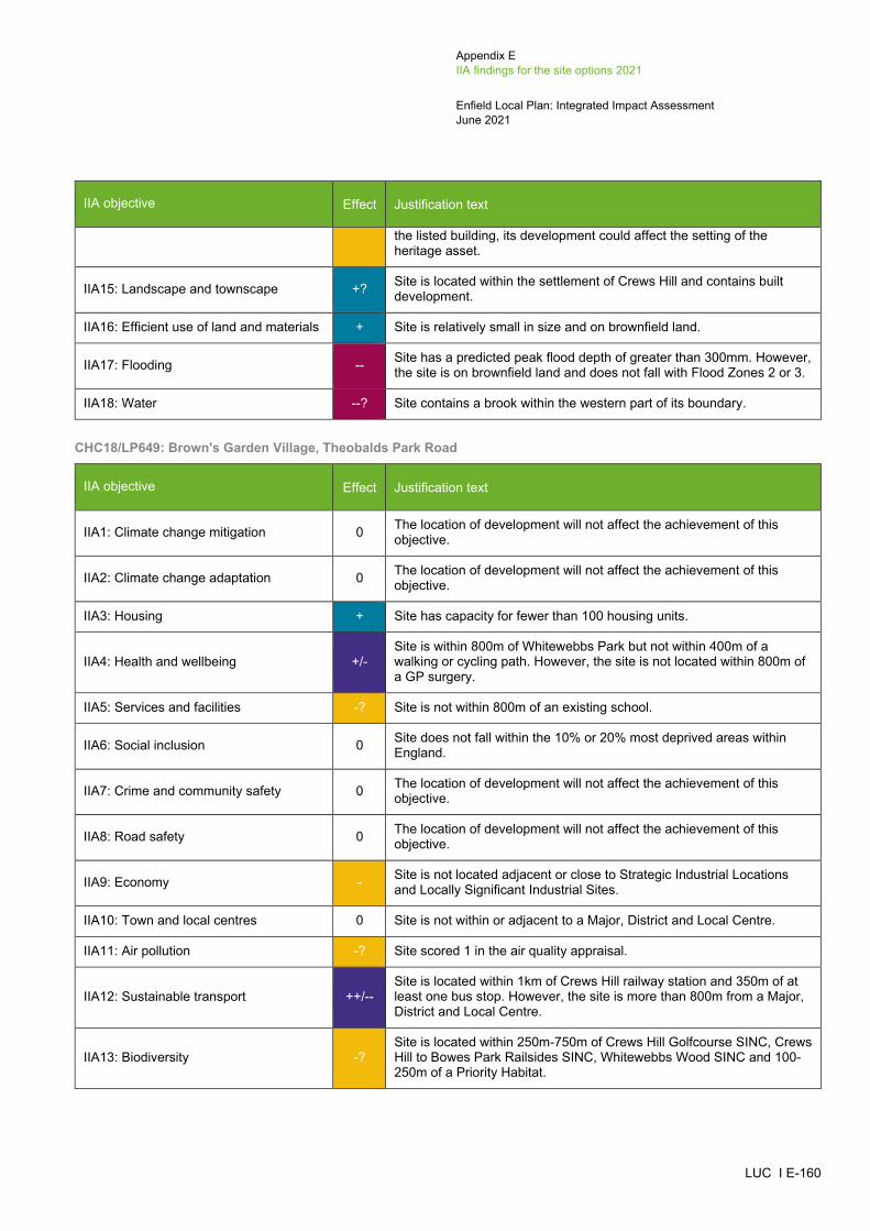
Appendix E IIA findings for the site options 2021
Enfield Local Plan: Integrated Impact Assessment June 2021
LUC I E-160
IIA objective Effect Justification text
the listed building, its development could affect the setting of the heritage asset.
IIA15: Landscape and townscape +? Site is located within the settlement of Crews Hill and contains built development.
IIA16: Efficient use of land and materials + Site is relatively small in size and on brownfield land.
IIA17: Flooding -- Site has a predicted peak flood depth of greater than 300mm. However, the site is on brownfield land and does not fall with Flood Zones 2 or 3.
IIA18: Water --? Site contains a brook within the western part of its boundary.
CHC18/LP649: Brown's Garden Village, Theobalds Park Road
IIA objective Effect Justification text
IIA1: Climate change mitigation 0 The location of development will not affect the achievement of this objective.
IIA2: Climate change adaptation 0 The location of development will not affect the achievement of this objective.
IIA3: Housing + Site has capacity for fewer than 100 housing units.
IIA4: Health and wellbeing +/- Site is within 800m of Whitewebbs Park but not within 400m of a walking or cycling path. However, the site is not located within 800m of a GP surgery.
IIA5: Services and facilities -? Site is not within 800m of an existing school.
IIA6: Social inclusion 0 Site does not fall within the 10% or 20% most deprived areas within England.
IIA7: Crime and community safety 0 The location of development will not affect the achievement of this objective.
IIA8: Road safety 0 The location of development will not affect the achievement of this objective.
IIA9: Economy - Site is not located adjacent or close to Strategic Industrial Locations and Locally Significant Industrial Sites.
IIA10: Town and local centres 0 Site is not within or adjacent to a Major, District and Local Centre.
IIA11: Air pollution -? Site scored 1 in the air quality appraisal.
IIA12: Sustainable transport ++/-- Site is located within 1km of Crews Hill railway station and 350m of at least one bus stop. However, the site is more than 800m from a Major, District and Local Centre.
IIA13: Biodiversity -? Site is located within 250m-750m of Crews Hill Golfcourse SINC, Crews Hill to Bowes Park Railsides SINC, Whitewebbs Wood SINC and 100-250m of a Priority Habitat.

Appendix E IIA findings for the site options 2021
Enfield Local Plan: Integrated Impact Assessment June 2021
LUC I E-161
IIA objective Effect Justification text
IIA14: Historic environment -?
Site is within 500m of a Grade II listed building (Glasgow Stud Farmhouse). Although there is built development between the site and the listed building, its development could affect the setting of the heritage asset.
IIA15: Landscape and townscape +? Site is located within the settlement of Crews Hill and contains built development.
IIA16: Efficient use of land and materials + Site is relatively small in size and on brownfield land.
IIA17: Flooding -- Site has a predicted peak flood depth of greater than 300mm. However, the site is on brownfield land and does not fall with Flood Zones 2 or 3.
IIA18: Water 0 Site does not fall within a Source Protection Zone or contain a watercourse or water body.
CHC2/LP056: Wolden Garden Centre, Cattlegate Road
IIA objective Effect Justification text
IIA1: Climate change mitigation 0 The location of development will not affect the achievement of this objective.
IIA2: Climate change adaptation 0 The location of development will not affect the achievement of this objective.
IIA3: Housing ++ Site has capacity for more than 100 housing units.
IIA4: Health and wellbeing +/- Site is within 400m of a walking path but not within 800m of an area of open space. The site is not located within 800m of a GP surgery.
IIA5: Services and facilities -? Site is not within 800m of an existing school.
IIA6: Social inclusion 0 Site does not fall within the 10% or 20% most deprived areas within England.
IIA7: Crime and community safety 0 The location of development will not affect the achievement of this objective.
IIA8: Road safety 0 The location of development will not affect the achievement of this objective.
IIA9: Economy - Site is not located adjacent or close to Strategic Industrial Locations and Locally Significant Industrial Sites.
IIA10: Town and local centres 0 Site is not within or adjacent to a Major, District and Local Centre.
IIA11: Air pollution -? Site scored 1 in the air quality appraisal.
IIA12: Sustainable transport ++/-- Site is located within 1km of Crews Hill railway station and 350m of at least one bus stop. However, the site is more than 800m from a Major, District and Local Centre.
IIA13: Biodiversity --? Site is located within 250m of Crews Hill Golf Course SINC and Crews Hill to Bowes Park Railsides SINC, and 100m of a Priority Habitat.

Appendix E IIA findings for the site options 2021
Enfield Local Plan: Integrated Impact Assessment June 2021
LUC I E-162
IIA objective Effect Justification text
IIA14: Historic environment -?
Site is within 500m of a Grade II* listed building (The Paddocks) and a Grade II listed building (Glasgow Stud Farmhouse). Although there is built development between the site and the listed buildings, its development could affect the setting of these heritage assets.
IIA15: Landscape and townscape +? Site is located within the settlement of Crews Hill and contains built development.
IIA16: Efficient use of land and materials + Site is relatively small in size and on brownfield land.
IIA17: Flooding -- Site has a predicted peak flood depth of greater than 300mm. However, the site is on brownfield land and does not fall with Flood Zones 2 or 3.
IIA18: Water 0 Site does not fall within a Source Protection Zone or contain a watercourse or water body.
CHC3/LP107: Burton Farm Ride
IIA objective Effect Justification text
IIA1: Climate change mitigation 0 The location of development will not affect the achievement of this objective.
IIA2: Climate change adaptation 0 The location of development will not affect the achievement of this objective.
IIA3: Housing + Site has capacity for fewer than 100 housing units.
IIA4: Health and wellbeing +/- Site is within 800m of Whitewebbs Park but not within 400m of a walking or cycling path. The site is not located within 800m of a GP surgery.
IIA5: Services and facilities -? Site is not within 800m of an existing school.
IIA6: Social inclusion 0 Site does not fall within the 10% or 20% most deprived areas within England.
IIA7: Crime and community safety 0 The location of development will not affect the achievement of this objective.
IIA8: Road safety 0 The location of development will not affect the achievement of this objective.
IIA9: Economy - Site is not located adjacent or close to Strategic Industrial Locations and Locally Significant Industrial Sites.
IIA10: Town and local centres 0 Site is not within or adjacent to a Major, District and Local Centre.
IIA11: Air pollution -? Site scored 1 in the air quality appraisal.
IIA12: Sustainable transport ++/-- Site is located within 1km of Crews Hill railway station and 350m of at least one bus stop. However, the site is more than 800m from a Major, District and Local Centre.
IIA13: Biodiversity -? Site is located within 250-750m of Whitewebbs Wood SINC.
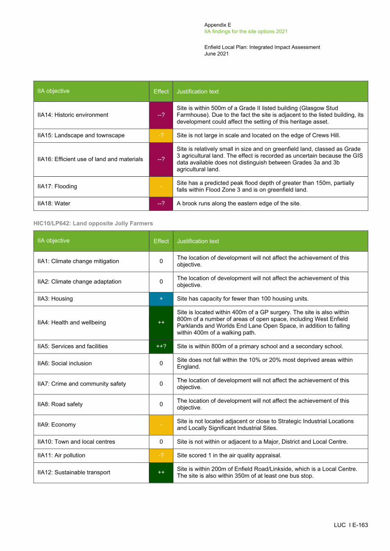
Appendix E IIA findings for the site options 2021
Enfield Local Plan: Integrated Impact Assessment June 2021
LUC I E-163
IIA objective Effect Justification text
IIA14: Historic environment --? Site is within 500m of a Grade II listed building (Glasgow Stud Farmhouse). Due to the fact the site is adjacent to the listed building, its development could affect the setting of this heritage asset.
IIA15: Landscape and townscape -? Site is not large in scale and located on the edge of Crews Hill.
IIA16: Efficient use of land and materials --?
Site is relatively small in size and on greenfield land, classed as Grade 3 agricultural land. The effect is recorded as uncertain because the GIS data available does not distinguish between Grades 3a and 3b agricultural land.
IIA17: Flooding - Site has a predicted peak flood depth of greater than 150m, partially falls within Flood Zone 3 and is on greenfield land.
IIA18: Water --? A brook runs along the eastern edge of the site.
HIC10/LP642: Land opposite Jolly Farmers
IIA objective Effect Justification text
IIA1: Climate change mitigation 0 The location of development will not affect the achievement of this objective.
IIA2: Climate change adaptation 0 The location of development will not affect the achievement of this objective.
IIA3: Housing + Site has capacity for fewer than 100 housing units.
IIA4: Health and wellbeing ++
Site is located within 400m of a GP surgery. The site is also within 800m of a number of areas of open space, including West Enfield Parklands and Worlds End Lane Open Space, in addition to falling within 400m of a walking path.
IIA5: Services and facilities ++? Site is within 800m of a primary school and a secondary school.
IIA6: Social inclusion 0 Site does not fall within the 10% or 20% most deprived areas within England.
IIA7: Crime and community safety 0 The location of development will not affect the achievement of this objective.
IIA8: Road safety 0 The location of development will not affect the achievement of this objective.
IIA9: Economy - Site is not located adjacent or close to Strategic Industrial Locations and Locally Significant Industrial Sites.
IIA10: Town and local centres 0 Site is not within or adjacent to a Major, District and Local Centre.
IIA11: Air pollution -? Site scored 1 in the air quality appraisal.
IIA12: Sustainable transport ++ Site is within 200m of Enfield Road/Linkside, which is a Local Centre. The site is also within 350m of at least one bus stop.

Appendix E IIA findings for the site options 2021
Enfield Local Plan: Integrated Impact Assessment June 2021
LUC I E-164
IIA objective Effect Justification text
IIA13: Biodiversity --? Site contains a Priority Habitat and within 250-750m from Boxer’s Lake and Lonsdale Drive Woods SINC.
IIA14: Historic environment 0? Site is more than 500m from the nearest designated heritage asset. However, the site could still have some potential for impacts on non-designated heritage features and effects may extend beyond 500m.
IIA15: Landscape and townscape +? Site is located within the settlement of World’s End and contains built development.
IIA16: Efficient use of land and materials + Site is relatively small in size and on brownfield land.
IIA17: Flooding -- Site has a predicted peak flood depth of greater than 300mm and partially falls within Flood Zone 3. However, the site is on brownfield land.
IIA18: Water --? Site contains a brook along its eastern boundary and another one cutting the site across from east to west.
HIC11/LP707: Vicarage Farm, Land between Hadley Road and Enfield Road
IIA objective Effect Justification text
IIA1: Climate change mitigation 0 The location of development will not affect the achievement of this objective.
IIA2: Climate change adaptation 0 The location of development will not affect the achievement of this objective.
IIA3: Housing ++ Site has capacity for more than 100 housing units.
IIA4: Health and wellbeing ++
Site is located within 400m of a GP surgery. The site is also within 800m of a number of areas of open space, including West Enfield Parklands, Trent Park and Lakeside, in addition to falling within 400m of a walking path.
IIA5: Services and facilities ++? Site is within 800m of a primary school and a secondary school.
IIA6: Social inclusion 0 Site does not fall within the 10% or 20% most deprived areas within England.
IIA7: Crime and community safety 0 The location of development will not affect the achievement of this objective.
IIA8: Road safety 0 The location of development will not affect the achievement of this objective.
IIA9: Economy - Site is not located adjacent or close to Strategic Industrial Locations and Locally Significant Industrial Sites.
IIA10: Town and local centres 0 Site is not within or adjacent to a Major, District and Local Centre.
IIA11: Air pollution -? Site scored 1 in the air quality appraisal.
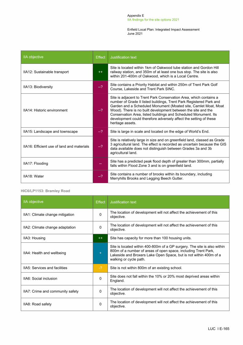
Appendix E IIA findings for the site options 2021
Enfield Local Plan: Integrated Impact Assessment June 2021
LUC I E-165
IIA objective Effect Justification text
IIA12: Sustainable transport ++ Site is located within 1km of Oakwood tube station and Gordon Hill railway station, and 350m of at least one bus stop. The site is also within 201-400m of Oakwood, which is a Local Centre.
IIA13: Biodiversity --? Site contains a Priority Habitat and within 250m of Trent Park Golf Course, Lakeside and Trent Park SINC.
IIA14: Historic environment --?
Site is adjacent to Trent Park Conservation Area, which contains a number of Grade II listed buildings, Trent Park Registered Park and Garden and a Scheduled Monument (Moated site, Camlet Moat, Moat Wood). There is no built development between the site and the Conservation Area, listed buildings and Scheduled Monument. Its development could therefore adversely affect the setting of these heritage assets.
IIA15: Landscape and townscape --? Site is large in scale and located on the edge of World’s End.
IIA16: Efficient use of land and materials --?
Site is relatively large in size and on greenfield land, classed as Grade 3 agricultural land. The effect is recorded as uncertain because the GIS data available does not distinguish between Grades 3a and 3b agricultural land.
IIA17: Flooding -- Site has a predicted peak flood depth of greater than 300mm, partially falls within Flood Zone 3 and is on greenfield land.
IIA18: Water --? Site contains a number of brooks within its boundary, including Merryhills Brooks and Legging Beech Gutter.
HIC6/LP1153: Bramley Road
IIA objective Effect Justification text
IIA1: Climate change mitigation 0 The location of development will not affect the achievement of this objective.
IIA2: Climate change adaptation 0 The location of development will not affect the achievement of this objective.
IIA3: Housing ++ Site has capacity for more than 100 housing units.
IIA4: Health and wellbeing +
Site is located within 400-800m of a GP surgery. The site is also within 800m of a number of areas of open space, including Trent Park, Lakeside and Broxers Lake Open Space, but is not within 400m of a walking or cycle path.
IIA5: Services and facilities -? Site is not within 800m of an existing school.
IIA6: Social inclusion 0 Site does not fall within the 10% or 20% most deprived areas within England.
IIA7: Crime and community safety 0 The location of development will not affect the achievement of this objective.
IIA8: Road safety 0 The location of development will not affect the achievement of this objective.

Appendix E IIA findings for the site options 2021
Enfield Local Plan: Integrated Impact Assessment June 2021
LUC I E-166
IIA objective Effect Justification text
IIA9: Economy - Site is not located adjacent or close to Strategic Industrial Locations and Locally Significant Industrial Sites.
IIA10: Town and local centres + Site is adjacent to Oakwood Local Centre.
IIA11: Air pollution -? Site scored 1 in the air quality appraisal.
IIA12: Sustainable transport ++ Site is located within 1km of Oakwood tube station and 350m of at least one bus stop. The site is also next to Oakwood, which is a Local Centre.
IIA13: Biodiversity --? Site is located within 100m of a Priority Habitat and within 250m of Trent Park Golf Course and Lakeside SINC.
IIA14: Historic environment --?
Site is within Trent Park Conservation Area and within 500m of a Grade II* listed building (Oakwood Underground Station) and a Grade II listed building (Station Sign to North of Oakwood Station). Due to the fact that the site is within the Trent Park Conservation Area, its development could affect the setting of these heritage assets.
IIA15: Landscape and townscape --? Site is large in scale and located on the edge of World’s End.
IIA16: Efficient use of land and materials --?
Site is relatively large in size and on greenfield land, classed as Grade 3 agricultural land. The effect is recorded as uncertain because the GIS data available does not distinguish between Grades 3a and 3b agricultural land.
IIA17: Flooding - Site has a predicted peak flood depth of greater than 150mm and is on greenfield land. However, the site does not fall within Flood Zones 2 or 3.
IIA18: Water 0 Site does not fall within a Source Protection Zone or contain a watercourse or water body.
HIC9/LP623: Land south of Enfield Road
IIA objective Effect Justification text
IIA1: Climate change mitigation 0 The location of development will not affect the achievement of this objective.
IIA2: Climate change adaptation 0 The location of development will not affect the achievement of this objective.
IIA3: Housing ++ Site has capacity for more than 100 housing units.
IIA4: Health and wellbeing ++
Site is located within 400m of a GP surgery. The site is also within 800m of a number of areas of open space, including Trent Park, Lakeside and West Enfield Parklands, in addition to falling within 400m of a walking path.
IIA5: Services and facilities ++? Site is within 800m of a primary school and a secondary school.
IIA6: Social inclusion 0 Site does not fall within the 10% or 20% most deprived areas within England.

Appendix E IIA findings for the site options 2021
Enfield Local Plan: Integrated Impact Assessment June 2021
LUC I E-167
IIA objective Effect Justification text
IIA7: Crime and community safety 0 The location of development will not affect the achievement of this objective.
IIA8: Road safety 0 The location of development will not affect the achievement of this objective.
IIA9: Economy - Site is not located adjacent or close to Strategic Industrial Locations and Locally Significant Industrial Sites.
IIA10: Town and local centres 0 Site is not within or adjacent to a Major, District and Local Centre.
IIA11: Air pollution -? Site scored 1 in the air quality appraisal.
IIA12: Sustainable transport ++/- Site is located within 1km of Gordon Hill railway station and 350m of at least one bus stop. However, the site is only within 401-800m of Highlands Village Grange Park, which is a Local Centre.
IIA13: Biodiversity --? Site is located within 100m of a Priority Habitat and within 250m of Boxer’s Lake and Lonsdale Drive Woods SINC and Lakeside SINC.
IIA14: Historic environment -?
Site is within 500m of Highlands Conservation , which contains a Grade II listed building (Former Ambulance Station at Highlands Hospital). Although there is built development between the Conservation Areas and the site, its development could affect the setting of these heritage assets.
IIA15: Landscape and townscape +? Site is located within the settlement of World’s End and contains built development.
IIA16: Efficient use of land and materials --?
Site is relatively large in size and on greenfield land, classed as Grade 3 agricultural land. The effect is recorded as uncertain because the GIS data available does not distinguish between Grades 3a and 3b agricultural land.
IIA17: Flooding -- Site has a predicted peak flood depth of greater than 300mm and is on greenfield land. However, the site does not fall within Flood Zones 2 or 3.
IIA18: Water 0 Site does not fall within a Source Protection Zone or contain a watercourse or water body.
CFS162_A: Land to the Rear of Arnold House (West)
IIA objective Effect Justification text
IIA1: Climate change mitigation 0 The location of development will not affect the achievement of this objective.
IIA2: Climate change adaptation 0 The location of development will not affect the achievement of this objective.
IIA3: Housing + Site has capacity for fewer than 100 units.

Appendix E IIA findings for the site options 2021
Enfield Local Plan: Integrated Impact Assessment June 2021
LUC I E-168
IIA objective Effect Justification text
IIA4: Health and wellbeing + Site is located within 400-800m of a GP surgery. The site is also within 800m of an area of open space, Lee View Amenity Space, but not within 400m of a walking or cycle path.
IIA5: Services and facilities -? Site is not within 800m of an existing school.
IIA6: Social inclusion 0 Site does not fall within the 10% or 20% most deprived areas within England.
IIA7: Crime and community safety 0 The location of development will not affect the achievement of this objective.
IIA8: Road safety 0 The location of development will not affect the achievement of this objective.
IIA9: Economy - Site is not located adjacent or close to Strategic Industrial Locations and Locally Significant Industrial Sites.
IIA10: Town and local centres 0 Site is not within or adjacent to a Major, District and Local Centre.
IIA11: Air pollution -? Site scored 1 in the air quality appraisal.
IIA12: Sustainable transport ++/-- Site is located within 1km of Gordon Hill railway station and 350m of at least one bus stop. However, the site is more than 800m from a Major, District and Local Centre.
IIA13: Biodiversity --? Site is located within 100m of a Priority Habitat and is within 250-750m of Crews Hill to Bowes Park Railsides SINC.
IIA14: Historic environment 0? Site is more than 500m from the nearest designated heritage asset. However, the site could still have some potential for impacts on non-designated heritage features and effects may extend beyond 500m.
IIA15: Landscape and townscape -? Site is not large in scale but is located on the edge of World’s End.
IIA16: Efficient use of land and materials --?
Site is relatively small in size and on greenfield land, classed as Grade 3 agricultural land. The effect is recorded as uncertain because the GIS data available does not distinguish between Grades 3a and 3b agricultural land.
IIA17: Flooding - Site has a predicted peak flood depth of greater than 150mm and is on greenfield land. However, the site does not fall within Flood Zones 2 or 3.
IIA18: Water 0 Site does not fall within a Source Protection Zone or contain a watercourse or water body.
CFS162_B: Land to the Rear of Arnold House (East)
IIA objective Effect Justification text
IIA1: Climate change mitigation 0 The location of development will not affect the achievement of this objective.
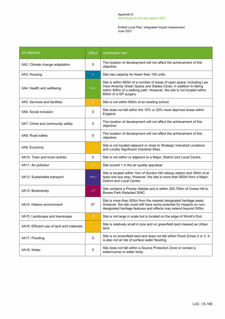
Appendix E IIA findings for the site options 2021
Enfield Local Plan: Integrated Impact Assessment June 2021
LUC I E-169
IIA objective Effect Justification text
IIA2: Climate change adaptation 0 The location of development will not affect the achievement of this objective.
IIA3: Housing + Site has capacity for fewer than 100 units.
IIA4: Health and wellbeing ++/-
Site is within 800m of a number of areas of open space, including Lee View Amenity Green Space and Slades Close, in addition to falling within 400m of a walking path. However, the site is not located within 800m of a GP surgery.
IIA5: Services and facilities -? Site is not within 800m of an existing school.
IIA6: Social inclusion 0 Site does not fall within the 10% or 20% most deprived areas within England.
IIA7: Crime and community safety 0 The location of development will not affect the achievement of this objective.
IIA8: Road safety 0 The location of development will not affect the achievement of this objective.
IIA9: Economy - Site is not located adjacent or close to Strategic Industrial Locations and Locally Significant Industrial Sites.
IIA10: Town and local centres 0 Site is not within or adjacent to a Major, District and Local Centre.
IIA11: Air pollution -? Site scored 1 in the air quality appraisal.
IIA12: Sustainable transport ++/-- Site is located within 1km of Gordon Hill railway station and 350m of at least one bus stop. However, the site is more than 800m from a Major, District and Local Centre.
IIA13: Biodiversity --? Site contains a Priority Habitat and is within 250-750m of Crews Hill to Bowes Park Railsides SINC.
IIA14: Historic environment 0? Site is more than 500m from the nearest designated heritage asset. However, the site could still have some potential for impacts on non-designated heritage features and effects may extend beyond 500m.
IIA15: Landscape and townscape -? Site is not large in scale but is located on the edge of World’s End.
IIA16: Efficient use of land and materials - Site is relatively small in size and on greenfield land classed as Urban land.
IIA17: Flooding 0 Site is on brownfield land and does not fall within Flood Zones 2 or 3. It is also not at risk of surface water flooding.
IIA18: Water 0 Site does not fall within a Source Protection Zone or contain a watercourse or water body.
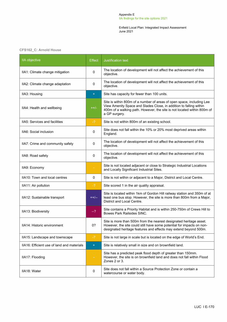
Appendix E IIA findings for the site options 2021
Enfield Local Plan: Integrated Impact Assessment June 2021
LUC I E-170
CFS162_C: Arnold House
IIA objective Effect Justification text
IIA1: Climate change mitigation 0 The location of development will not affect the achievement of this objective.
IIA2: Climate change adaptation 0 The location of development will not affect the achievement of this objective.
IIA3: Housing + Site has capacity for fewer than 100 units.
IIA4: Health and wellbeing ++/-
Site is within 800m of a number of areas of open space, including Lee View Amenity Space and Slades Close, in addition to falling within 400m of a walking path. However, the site is not located within 800m of a GP surgery.
IIA5: Services and facilities -? Site is not within 800m of an existing school.
IIA6: Social inclusion 0 Site does not fall within the 10% or 20% most deprived areas within England.
IIA7: Crime and community safety 0 The location of development will not affect the achievement of this objective.
IIA8: Road safety 0 The location of development will not affect the achievement of this objective.
IIA9: Economy - Site is not located adjacent or close to Strategic Industrial Locations and Locally Significant Industrial Sites.
IIA10: Town and local centres 0 Site is not within or adjacent to a Major, District and Local Centre.
IIA11: Air pollution -? Site scored 1 in the air quality appraisal.
IIA12: Sustainable transport ++/-- Site is located within 1km of Gordon Hill railway station and 350m of at least one bus stop. However, the site is more than 800m from a Major, District and Local Centre.
IIA13: Biodiversity --? Site contains a Priority Habitat and is within 250-750m of Crews Hill to Bowes Park Railsides SINC.
IIA14: Historic environment 0? Site is more than 500m from the nearest designated heritage asset. However, the site could still have some potential for impacts on non-designated heritage features and effects may extend beyond 500m.
IIA15: Landscape and townscape -? Site is not large in scale but is located on the edge of World’s End.
IIA16: Efficient use of land and materials + Site is relatively small in size and on brownfield land.
IIA17: Flooding - Site has a predicted peak flood depth of greater than 150mm. However, the site is on brownfield land and does not fall within Flood Zones 2 or 3.
IIA18: Water 0 Site does not fall within a Source Protection Zone or contain a watercourse or water body.

Appendix E IIA findings for the site options 2021
Enfield Local Plan: Integrated Impact Assessment June 2021
LUC I E-171
CFS159: Wyevale Garden Centre, Cattlegate Road
IIA objective Effect Justification text
IIA1: Climate change mitigation 0 The location of development will not affect the achievement of this objective.
IIA2: Climate change adaptation 0 The location of development will not affect the achievement of this objective.
IIA3: Housing ++ Site has capacity for more than 100 housing units.
IIA4: Health and wellbeing ++/- Site is within 800m of an area of open space, Whitewebbs Park, in addition to falling within 400m of a walking path. However, the site is not located within 800m of a GP surgery.
IIA5: Services and facilities -? Site is not within 800m of an existing school.
IIA6: Social inclusion 0 Site does not fall within the 10% or 20% most deprived areas within England.
IIA7: Crime and community safety 0 The location of development will not affect the achievement of this objective.
IIA8: Road safety 0 The location of development will not affect the achievement of this objective.
IIA9: Economy - Site is not located adjacent or close to Strategic Industrial Locations and Locally Significant Industrial Sites.
IIA10: Town and local centres 0 Site is not within or adjacent to a Major, District and Local Centre.
IIA11: Air pollution -? Site scored 1 in the air quality appraisal.
IIA12: Sustainable transport ++/-- Site is located within 1km of Crews Hill railway station and 350m of at least one bus stop. However, the site is more than 800m from a Major, District, and Local Centre.
IIA13: Biodiversity --? Site is located within 250m of Crews Hill Golf Course SINC and Crews Hill to Bowes Park Railsides SINC.
IIA14: Historic environment -?
Site is within 500m of a Grade II* listed building (The Paddocks) and two Grade II listed buildings (2 Barns North West of Farmhouse at the Paddocks, and Glasgow Stud Farmhouse). Although the site contains built development, its redevelopment could affect the setting of these heritage assets.
IIA15: Landscape and townscape +? Site is located within the settlement of Crews Hill and contains built development.
IIA16: Efficient use of land and materials + Site is relatively small in size and on brownfield land.
IIA17: Flooding 0 Site is on brownfield land and does not fall within Flood Zones 2 or 3. It is also not at risk of surface water flooding.
IIA18: Water 0 Site does not fall within a Source Protection Zone or contain a watercourse or water body.

Appendix E IIA findings for the site options 2021
Enfield Local Plan: Integrated Impact Assessment June 2021
LUC I E-172
CFS169: Kings Oak Equestrian Centre (Part)
IIA objective Effect Justification text
IIA1: Climate change mitigation 0 The location of development will not affect the achievement of this objective.
IIA2: Climate change adaptation 0 The location of development will not affect the achievement of this objective.
IIA3: Housing ++ Site has capacity for more than 100 housing units.
IIA4: Health and wellbeing ++/- Site is within 800m of Whitewebbs Park and Hilly Fields, in addition to falling within 400m of a walking and cycle path. However, the site is not located within 800m of a GP surgery.
IIA5: Services and facilities +? Site is within 800m of a primary school.
IIA6: Social inclusion 0 Site does not fall within the 10% or 20% most deprived areas within England.
IIA7: Crime and community safety 0 The location of development will not affect the achievement of this objective.
IIA8: Road safety 0 The location of development will not affect the achievement of this objective.
IIA9: Economy - Site is not located adjacent or close to Strategic Industrial Locations and Locally Significant Industrial Sites.
IIA10: Town and local centres 0 Site is not within or adjacent to a Major, District and Local Centre.
IIA11: Air pollution -? Site scored 1 in the air quality appraisal.
IIA12: Sustainable transport ++/-- Site is located within 1km of Crews Hill railway station and 350m of at least one bus stop. However, the site is more than 800m from a Major, District and Local Centre.
IIA13: Biodiversity --? Site is located within 100m of a Priority Habitat and is within 250-750m of Crews Hill Golf Course and Crews Hill to Bowes Park Railsides SINC.
IIA14: Historic environment -?
Site is within 500m of Clay Hill Conservation Area and a Grade II listed building (Bridge at West End of Lane, Whitewebbs Wood). Although the site contains built development, its redevelopment could affect the setting of these heritage assets.
IIA15: Landscape and townscape -? Site is not large in scale but is located on the edge of Crews Hill.
IIA16: Efficient use of land and materials ++ Site is relatively large in size and on brownfield land.
IIA17: Flooding -- Site has a predicted peak flood depth of greater than 300mm. However, the site is on brownfield land and does not fall within Flood Zones 2 or 3.
IIA18: Water 0 Site does not fall within a Source Protection Zone or contain a watercourse or water body.

Appendix E IIA findings for the site options 2021
Enfield Local Plan: Integrated Impact Assessment June 2021
LUC I E-173
CFS210: Southgate Library, High Street, Southgate
IIA objective Effect Justification text
IIA1: Climate change mitigation 0 The location of development will not affect the achievement of this objective.
IIA2: Climate change adaptation 0 The location of development will not affect the achievement of this objective.
IIA3: Housing + Site has capacity for fewer than 100 housing units.
IIA4: Health and wellbeing ++/-
Site is within 800m of a number of areas of open space, including Grovelands Park, Oakwood Park and Ivy Road Open Space, in addition to falling within 400m of a walking path. However, the site is not located within 800m of a GP surgery.
IIA5: Services and facilities +? Site is within 800m of a primary school.
IIA6: Social inclusion 0 Site does not fall within the 10% or 20% most deprived areas within England.
IIA7: Crime and community safety 0 The location of development will not affect the achievement of this objective.
IIA8: Road safety 0 The location of development will not affect the achievement of this objective.
IIA9: Economy - Site is not located adjacent or close to Strategic Industrial Locations and Locally Significant Industrial Sites.
IIA10: Town and local centres + Site is adjacent to Southgate District Centre.
IIA11: Air pollution -? Site scored 1 in the air quality appraisal.
IIA12: Sustainable transport ++ Site is located within 1km of Southgate tube station and 350m of at least one bus stop. The site is also next to Southgate, which is a District Centre.
IIA13: Biodiversity -? Site is located within 250-750m of the Grovelands Park and Priory Hospital SINC.
IIA14: Historic environment -?
Site is adjacent to a Grade II listed building (Avington Cottage) and within 500m of three Conservation Areas (Southgate Circus, Southgate Green, and Meadway), two Grade II* listed buildings (Southgate Underground Station and station pylons to north and south of Southgate Station) and a number of Grade II Listed buildings. Although the site contains built development, its redevelopment could affect the setting of these heritage assets.
IIA15: Landscape and townscape +? Site is located within the settlement of Southgate and contains built development.
IIA16: Efficient use of land and materials + Site is relatively small in size and on brownfield land.
IIA17: Flooding -- Site has a predicted peak flood depth of greater than 300mm. However, the site is on brownfield land and does not fall within Flood Zones 2 or 3.
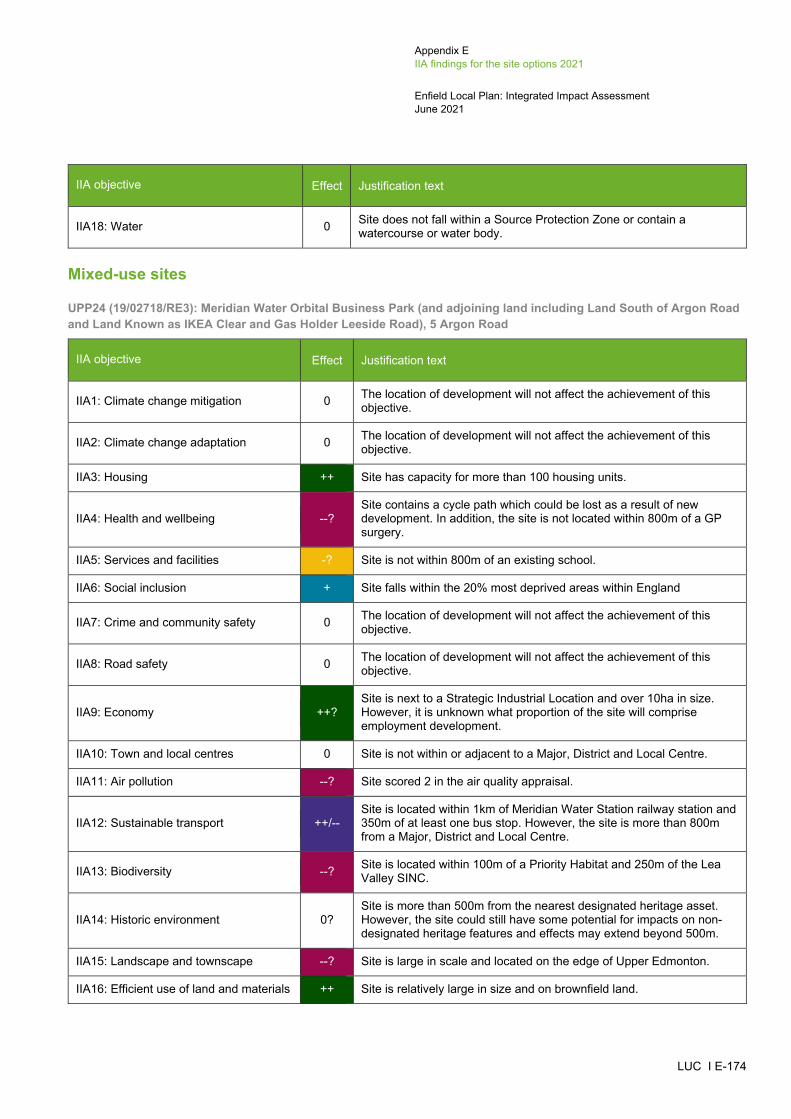
Appendix E IIA findings for the site options 2021
Enfield Local Plan: Integrated Impact Assessment June 2021
LUC I E-174
IIA objective Effect Justification text
IIA18: Water 0 Site does not fall within a Source Protection Zone or contain a watercourse or water body.
Mixed-use sites
UPP24 (19/02718/RE3): Meridian Water Orbital Business Park (and adjoining land including Land South of Argon Road and Land Known as IKEA Clear and Gas Holder Leeside Road), 5 Argon Road
IIA objective Effect Justification text
IIA1: Climate change mitigation 0 The location of development will not affect the achievement of this objective.
IIA2: Climate change adaptation 0 The location of development will not affect the achievement of this objective.
IIA3: Housing ++ Site has capacity for more than 100 housing units.
IIA4: Health and wellbeing --? Site contains a cycle path which could be lost as a result of new development. In addition, the site is not located within 800m of a GP surgery.
IIA5: Services and facilities -? Site is not within 800m of an existing school.
IIA6: Social inclusion + Site falls within the 20% most deprived areas within England
IIA7: Crime and community safety 0 The location of development will not affect the achievement of this objective.
IIA8: Road safety 0 The location of development will not affect the achievement of this objective.
IIA9: Economy ++? Site is next to a Strategic Industrial Location and over 10ha in size. However, it is unknown what proportion of the site will comprise employment development.
IIA10: Town and local centres 0 Site is not within or adjacent to a Major, District and Local Centre.
IIA11: Air pollution --? Site scored 2 in the air quality appraisal.
IIA12: Sustainable transport ++/-- Site is located within 1km of Meridian Water Station railway station and 350m of at least one bus stop. However, the site is more than 800m from a Major, District and Local Centre.
IIA13: Biodiversity --? Site is located within 100m of a Priority Habitat and 250m of the Lea Valley SINC.
IIA14: Historic environment 0? Site is more than 500m from the nearest designated heritage asset. However, the site could still have some potential for impacts on non-designated heritage features and effects may extend beyond 500m.
IIA15: Landscape and townscape --? Site is large in scale and located on the edge of Upper Edmonton.
IIA16: Efficient use of land and materials ++ Site is relatively large in size and on brownfield land.

Appendix E IIA findings for the site options 2021
Enfield Local Plan: Integrated Impact Assessment June 2021
LUC I E-175
IIA objective Effect Justification text
IIA17: Flooding -- Site mainly falls within Flood Zone 3 and has a predicted peak flood depth of greater than 300mm. However, the site is on brownfield land.
IIA18: Water --?
Site falls within Source Protection Zone 2 and partially within Source Protection Zone 1 (northern part of the site). The site also contains watercourses and waterbodies along its eastern and western boundaries.
UPP32 (16/01197/RE3): Meridian Water, Willoughby Lane and Meridian Way
IIA objective Effect Justification text
IIA1: Climate change mitigation 0 The location of development will not affect the achievement of this objective.
IIA2: Climate change adaptation 0 The location of development will not affect the achievement of this objective.
IIA3: Housing ++ Site has capacity for more than 100 housing units.
IIA4: Health and wellbeing ++
Site is within 800m of a number of areas of open space, including Kenninghall Open Space and Craig Park, in addition to falling within 400m of a walking and cycle path. The site is also located within 400-800m of a GP surgery.
IIA5: Services and facilities +? Site is within 800m of a primary school.
IIA6: Social inclusion + Site falls within the 20% most deprived areas within England.
IIA7: Crime and community safety 0 The location of development will not affect the achievement of this objective.
IIA8: Road safety 0 The location of development will not affect the achievement of this objective.
IIA9: Economy ++?
Site is close to Strategic Industrial Locations and Locally Significant Industrial Sites. The site is under 10ha in size but will contribute towards employment development. However, it is unknown what proportion of the site will comprise employment development.
IIA10: Town and local centres + Site is adjacent to Dysons Road Edmonton Local Centre.
IIA11: Air pollution --? Site scored 2 in the air quality appraisal.
IIA12: Sustainable transport ++ Site is located within 1km of Meridian Water Station railway station and 350m of at least one bus stop. The site is also next to Dysons Road Edmonton, which is a Local Centre.
IIA13: Biodiversity --? Site contains a Priority Habitat and is between 250-750m of the Lea Valley SINC.
IIA14: Historic environment 0? Site is more than 500m from the nearest designated heritage asset. However, the site could still have some potential for impacts on non-designated heritage features and effects may extend beyond 500m.

Appendix E IIA findings for the site options 2021
Enfield Local Plan: Integrated Impact Assessment June 2021
LUC I E-176
IIA objective Effect Justification text
IIA15: Landscape and townscape +? Site is located within the settlement of Upper Edmonton and contains built development.
IIA16: Efficient use of land and materials ++ Site is relatively large in size and on brownfield land.
IIA17: Flooding -- Site has a predicted peak flood depth of greater than 300mm and partially falls within Flood Zone 3. However, the site is on brownfield land.
IIA18: Water --? Site falls within Source Protection Zones 1 and 2 and is located adjacent to a brook along its northern boundary.
UPC2/LP1130: Tesco Extra, 1 Glover Drive
IIA objective Effect Justification text
IIA1: Climate change mitigation 0 The location of development will not affect the achievement of this objective.
IIA2: Climate change adaptation 0 The location of development will not affect the achievement of this objective.
IIA3: Housing ++ Site has capacity for more than 100 housing units.
IIA4: Health and wellbeing ++/-
Site is within 800m of a number of areas of open space, including Kenninghall Open Space and Craig Park, in addition to falling within 400m of a walking and cycle path. However, the site is not located within 800m of a GP surgery.
IIA5: Services and facilities -? Site is not within 800m of an existing school.
IIA6: Social inclusion + Site falls within the 20% most deprived areas within England.
IIA7: Crime and community safety 0 The location of development will not affect the achievement of this objective.
IIA8: Road safety 0 The location of development will not affect the achievement of this objective.
IIA9: Economy ++?
Site is close to Strategic Industrial Locations and Locally Significant Industrial Sites. The site is under 10ha in size but will contribute towards employment development. However, it is unknown what proportion of the site will comprise employment development.
IIA10: Town and local centres 0 Site is not within or adjacent to a Major, District and Local Centre.
IIA11: Air pollution --? Site scored 2 in the air quality appraisal.
IIA12: Sustainable transport ++ Site is located within 1km of Meridian Water Station railway station and 350m of at least one bus stop. The site is also within 201-400m of Dysons Road Edmonton, which is a Local Centre.
IIA13: Biodiversity -? Site is located within 250-750m of the Lea Valley SINC.
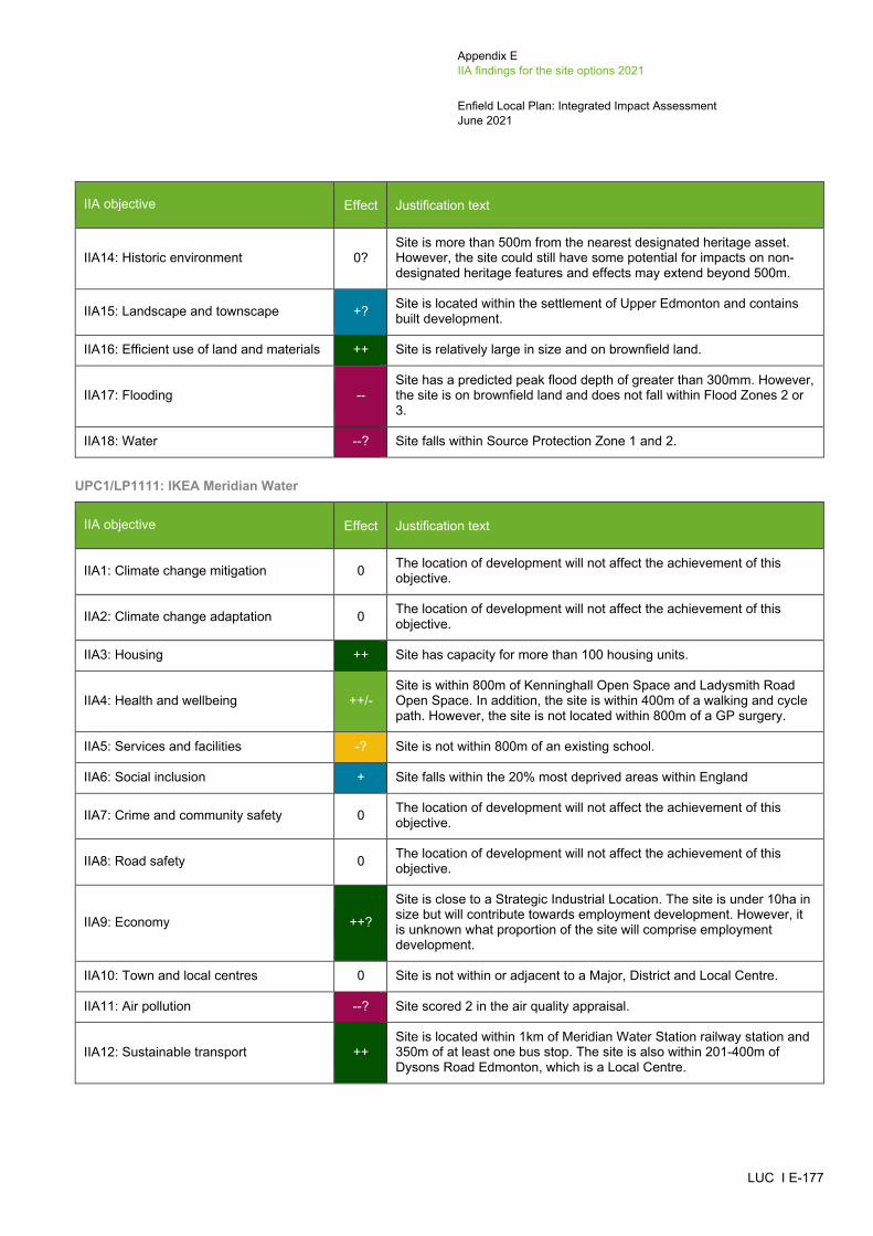
Appendix E IIA findings for the site options 2021
Enfield Local Plan: Integrated Impact Assessment June 2021
LUC I E-177
IIA objective Effect Justification text
IIA14: Historic environment 0? Site is more than 500m from the nearest designated heritage asset. However, the site could still have some potential for impacts on non-designated heritage features and effects may extend beyond 500m.
IIA15: Landscape and townscape +? Site is located within the settlement of Upper Edmonton and contains built development.
IIA16: Efficient use of land and materials ++ Site is relatively large in size and on brownfield land.
IIA17: Flooding -- Site has a predicted peak flood depth of greater than 300mm. However, the site is on brownfield land and does not fall within Flood Zones 2 or 3.
IIA18: Water --? Site falls within Source Protection Zone 1 and 2.
UPC1/LP1111: IKEA Meridian Water
IIA objective Effect Justification text
IIA1: Climate change mitigation 0 The location of development will not affect the achievement of this objective.
IIA2: Climate change adaptation 0 The location of development will not affect the achievement of this objective.
IIA3: Housing ++ Site has capacity for more than 100 housing units.
IIA4: Health and wellbeing ++/- Site is within 800m of Kenninghall Open Space and Ladysmith Road Open Space. In addition, the site is within 400m of a walking and cycle path. However, the site is not located within 800m of a GP surgery.
IIA5: Services and facilities -? Site is not within 800m of an existing school.
IIA6: Social inclusion + Site falls within the 20% most deprived areas within England
IIA7: Crime and community safety 0 The location of development will not affect the achievement of this objective.
IIA8: Road safety 0 The location of development will not affect the achievement of this objective.
IIA9: Economy ++?
Site is close to a Strategic Industrial Location. The site is under 10ha in size but will contribute towards employment development. However, it is unknown what proportion of the site will comprise employment development.
IIA10: Town and local centres 0 Site is not within or adjacent to a Major, District and Local Centre.
IIA11: Air pollution --? Site scored 2 in the air quality appraisal.
IIA12: Sustainable transport ++ Site is located within 1km of Meridian Water Station railway station and 350m of at least one bus stop. The site is also within 201-400m of Dysons Road Edmonton, which is a Local Centre.

Appendix E IIA findings for the site options 2021
Enfield Local Plan: Integrated Impact Assessment June 2021
LUC I E-178
IIA objective Effect Justification text
IIA13: Biodiversity --? Site is located within 250m of the Lea Valley SINC and between 250-750m of the Walthamstow Reservoirs SSSI.
IIA14: Historic environment 0? Site is more than 500m from the nearest designated heritage asset. However, the site could still have some potential for impacts on non-designated heritage features and effects may extend beyond 500m.
IIA15: Landscape and townscape +? Site is located within the settlement of Upper Edmonton and contains built development.
IIA16: Efficient use of land and materials ++ Site is relatively large in size and on brownfield land.
IIA17: Flooding - Site has a predicted peak flood depth of greater than 150mm and partially falls within Flood Zone 2. However, the site is on brownfield land.
IIA18: Water --? Site falls within Source Protection Zone 2 and the northern part of the site falls within Source Protection Zone 1. Some brooks are also located within the site boundary

Appendix F Audit trail of site selection 2021
Enfield Local Plan: Integrated Impact Assessment June 2021
LUC I F-1
-
Appendix F Audit trail of site selection 2021
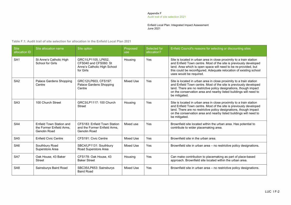
Appendix F Audit trail of site selection 2021
Enfield Local Plan: Integrated Impact Assessment June 2021
LUC I F-2
Table F.1: Audit trail of site selection for allocation in the Enfield Local Plan 2021
Site allocation ID
Site allocation name Site option Proposed use
Selected for allocation?
Enfield Council's reasons for selecting or discounting sites
SA1 St Anne’s Catholic High School for Girls
GRC1/LP1105, LP652, CFS040 and CFS060: St Anne’s Catholic High School for Girls
Housing Yes Site is located in urban area in close proximity to a train station and Enfield Town centre. Most of the site is previously developed land. Area which is open space will need to be re-provided, but this could be reconfigured. Adequate relocation of existing school uses would be required.
SA2 Palace Gardens Shopping Centre
GRC12/LP603, CFS197: Palace Gardens Shopping Centre
Mixed Use Yes Site is located in urban area in close proximity to a train station and Enfield Town centre. Most of the site is previously developed land. There are no restrictive policy designations, though impact on the conservation area and nearby listed buildings will need to be mitigated.
SA3 100 Church Street GRC3/LP1117: 100 Church Street
Housing Yes Site is located in urban area in close proximity to a train station and Enfield Town centre. Most of the site is previously developed land. There are no restrictive policy designations, though impact on the conservation area and nearby listed buildings will need to be mitigated.
SA4 Enfield Town Station and the Former Enfield Arms, Genotin Road
CFS183: Enfield Town Station and the Former Enfield Arms, Genotin Road
Mixed use Yes Brownfield site located within the urban area. Has potential to contribute to wider placemaking area.
SA5 Enfield Civic Centre CFS191: Civic Centre Mixed Use Yes Brownfield site in the urban area.
SA6 Southbury Road Superstore Area
SBC4/LP1131: Southbury Road Superstore Area
Mixed Use Yes Brownfield site in urban area – no restrictive policy designations.
SA7 Oak House, 43 Baker Street
CFS178: Oak House, 43 Baker Street
Housing Yes Can make contribution to placemaking as part of place-based approach. Brownfield site located within the urban area.
SA8 Sainsburys Baird Road SBC35/LP653: Sainsburys Baird Road
Mixed Use Yes Brownfield site in urban area – no restrictive policy designations.

Appendix F Audit trail of site selection 2021
Enfield Local Plan: Integrated Impact Assessment June 2021
LUC I F-3
Site allocation ID
Site allocation name Site option Proposed use
Selected for allocation?
Enfield Council's reasons for selecting or discounting sites
SA9 Colosseum Retail Park SBC7/LP659: Colosseum Retail Park
Mixed Use Yes To safeguard against future changes to permissions/live application.
SA10 Morrisons, Southbury Road SBC36/LP1104: Morrisons, Southbury Road
Mixed Use Yes Brownfield site in urban area – no restrictive policy designations.
SA11 Southbury Leisure Park CFS253: Southbury Leisure Park
Mixed Use Yes Brownfield site in urban area.
SA12 Tesco, Ponders End, 288 High Street
CFS166: Tesco, Ponders End, 288 High Street
Mixed Use Yes Brownfield site in urban area.
SA13 Edmonton Green Shopping Centre
EDC2/LP1137: Edmonton Green Shopping Centre
Mixed Use Yes To safeguard against future changes to permissions/live application.
SA14 Chiswick Road Estate (Osward and Newdales)
LOC1/LP1108: Chiswick Road Estate (Osward and Newdales)
Housing Yes Brownfield site in urban area – no restrictive policy designations.
SA15 Joyce Avenue and Snells Park Estate
UPM1: Joyce Avenue and Snells Park Estate
Housing Yes Brownfield site in urban area.
SA16 Public House, 50-56 Fore Street
UPP9 (10/00760/FUL): Public House, 50-56 Fore Street
Housing Yes Substantial potential future application.
SA17 Upton Road and Raynham Road
UPS21/17100372: Upton Road and Raynham Road
Housing Yes Brownfield site in urban area.
SA18 South east corner of the North Middlesex University Hospital Trust of Sterling Way
CFS165: South east corner of the North Middlesex University Hospital Trust of Sterling Way
Housing Yes Brownfield site in urban area – no restrictive policy designations.
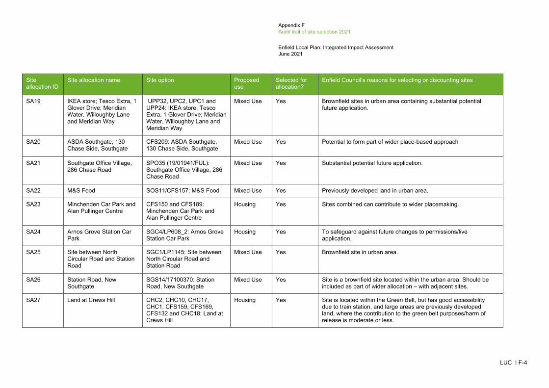
Appendix F Audit trail of site selection 2021
Enfield Local Plan: Integrated Impact Assessment June 2021
LUC I F-4
Site allocation ID
Site allocation name Site option Proposed use
Selected for allocation?
Enfield Council's reasons for selecting or discounting sites
SA19 IKEA store; Tesco Extra, 1 Glover Drive; Meridian Water, Willoughby Lane and Meridian Way
UPP32, UPC2, UPC1 and UPP24: IKEA store; Tesco Extra, 1 Glover Drive; Meridian Water, Willoughby Lane and Meridian Way
Mixed Use Yes Brownfield sites in urban area containing substantial potential future application.
SA20 ASDA Southgate, 130 Chase Side, Southgate
CFS209: ASDA Southgate, 130 Chase Side, Southgate
Mixed Use Yes Potential to form part of wider place-based approach
SA21 Southgate Office Village, 286 Chase Road
SPO35 (19/01941/FUL): Southgate Office Village, 286 Chase Road
Mixed Use Yes Substantial potential future application.
SA22 M&S Food SOS11/CFS157: M&S Food Mixed Use Yes Previously developed land in urban area.
SA23 Minchenden Car Park and Alan Pullinger Centre
CFS150 and CFS189: Minchenden Car Park and Alan Pullinger Centre
Housing Yes Sites combined can contribute to wider placemaking.
SA24 Arnos Grove Station Car Park
SGC4/LP608_2: Arnos Grove Station Car Park
Housing Yes To safeguard against future changes to permissions/live application.
SA25 Site between North Circular Road and Station Road
SGC1/LP1145: Site between North Circular Road and Station Road
Mixed Use Yes Brownfield site in urban area.
SA26 Station Road, New Southgate
SGS14/17100370: Station Road, New Southgate
Mixed Use Yes Site is a brownfield site located within the urban area. Should be included as part of wider allocation – with adjacent sites.
SA27 Land at Crews Hill CHC2, CHC10, CHC17, CHC1, CFS159, CFS169, CFS132 and CHC18: Land at Crews Hill
Housing Yes Site is located within the Green Belt, but has good accessibility due to train station, and large areas are previously developed land, where the contribution to the green belt purposes/harm of release is moderate or less.
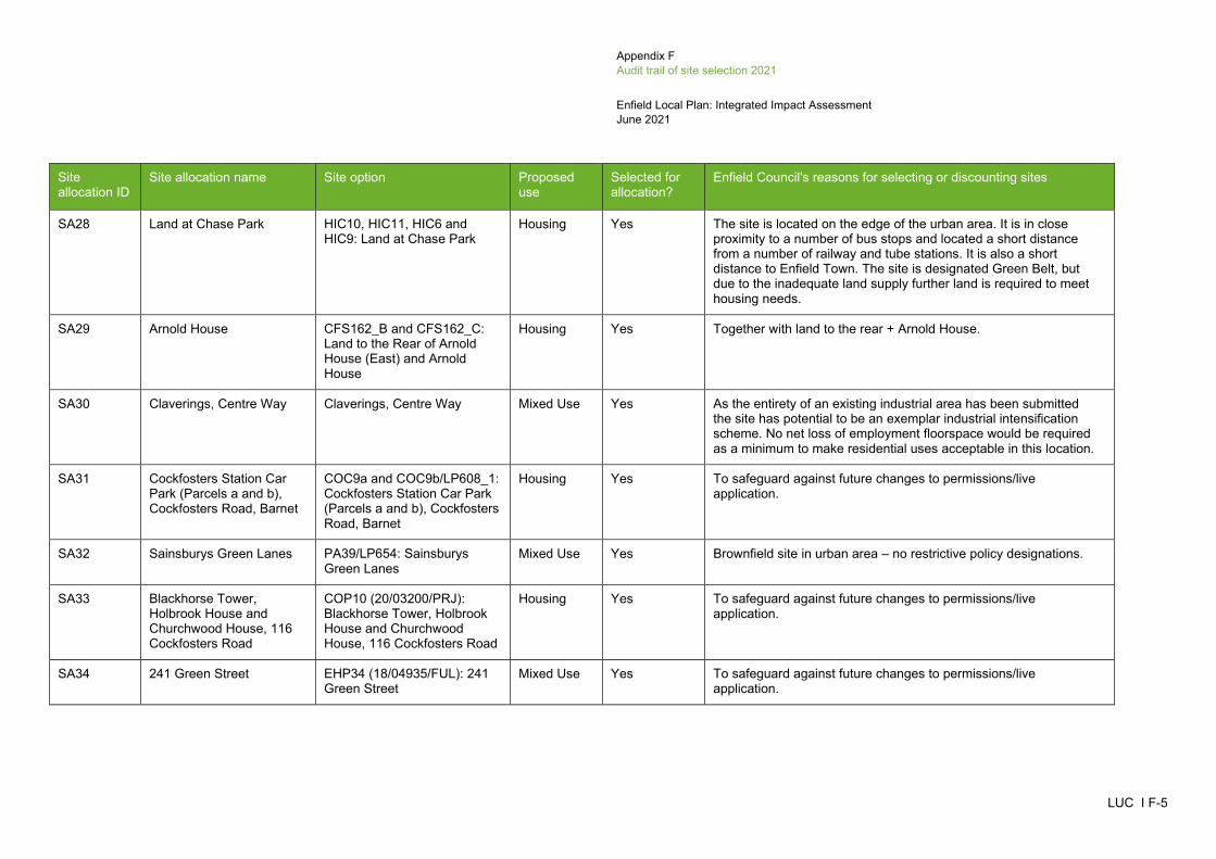
Appendix F Audit trail of site selection 2021
Enfield Local Plan: Integrated Impact Assessment June 2021
LUC I F-5
Site allocation ID
Site allocation name Site option Proposed use
Selected for allocation?
Enfield Council's reasons for selecting or discounting sites
SA28 Land at Chase Park HIC10, HIC11, HIC6 and HIC9: Land at Chase Park
Housing Yes The site is located on the edge of the urban area. It is in close proximity to a number of bus stops and located a short distance from a number of railway and tube stations. It is also a short distance to Enfield Town. The site is designated Green Belt, but due to the inadequate land supply further land is required to meet housing needs.
SA29 Arnold House CFS162_B and CFS162_C: Land to the Rear of Arnold House (East) and Arnold House
Housing Yes Together with land to the rear + Arnold House.
SA30 Claverings, Centre Way Claverings, Centre Way Mixed Use Yes As the entirety of an existing industrial area has been submitted the site has potential to be an exemplar industrial intensification scheme. No net loss of employment floorspace would be required as a minimum to make residential uses acceptable in this location.
SA31 Cockfosters Station Car Park (Parcels a and b), Cockfosters Road, Barnet
COC9a and COC9b/LP608_1: Cockfosters Station Car Park (Parcels a and b), Cockfosters Road, Barnet
Housing Yes To safeguard against future changes to permissions/live application.
SA32 Sainsburys Green Lanes PA39/LP654: Sainsburys Green Lanes
Mixed Use Yes Brownfield site in urban area – no restrictive policy designations.
SA33 Blackhorse Tower, Holbrook House and Churchwood House, 116 Cockfosters Road
COP10 (20/03200/PRJ): Blackhorse Tower, Holbrook House and Churchwood House, 116 Cockfosters Road
Housing Yes To safeguard against future changes to permissions/live application.
SA34 241 Green Street EHP34 (18/04935/FUL): 241 Green Street
Mixed Use Yes To safeguard against future changes to permissions/live application.
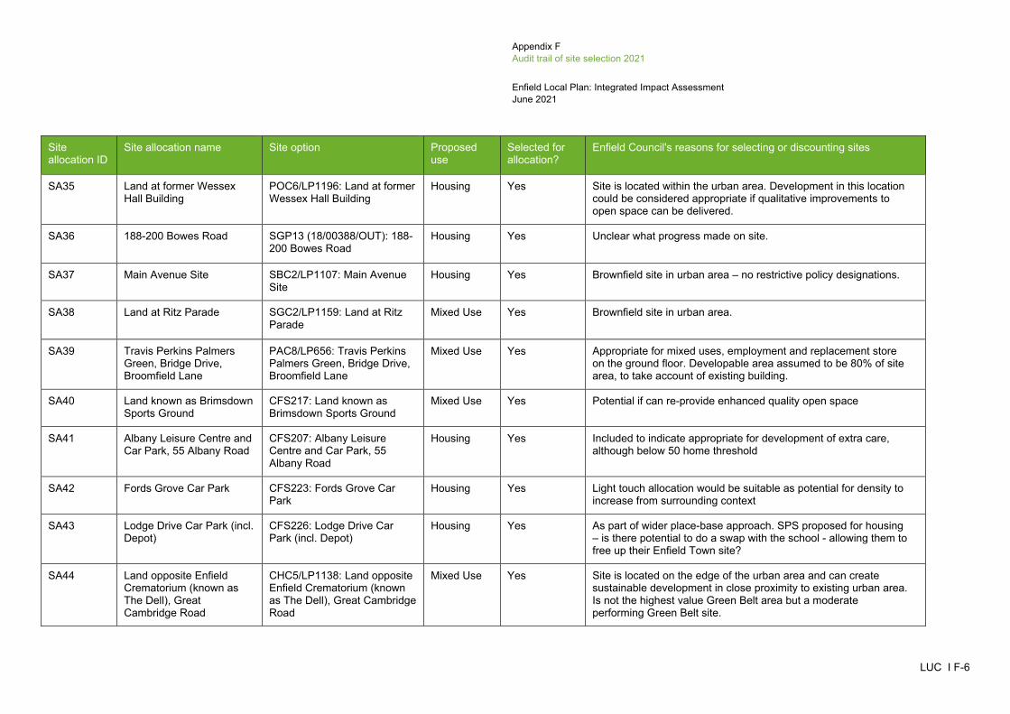
Appendix F Audit trail of site selection 2021
Enfield Local Plan: Integrated Impact Assessment June 2021
LUC I F-6
Site allocation ID
Site allocation name Site option Proposed use
Selected for allocation?
Enfield Council's reasons for selecting or discounting sites
SA35 Land at former Wessex Hall Building
POC6/LP1196: Land at former Wessex Hall Building
Housing Yes Site is located within the urban area. Development in this location could be considered appropriate if qualitative improvements to open space can be delivered.
SA36 188-200 Bowes Road SGP13 (18/00388/OUT): 188-200 Bowes Road
Housing Yes Unclear what progress made on site.
SA37 Main Avenue Site SBC2/LP1107: Main Avenue Site
Housing Yes Brownfield site in urban area – no restrictive policy designations.
SA38 Land at Ritz Parade SGC2/LP1159: Land at Ritz Parade
Mixed Use Yes Brownfield site in urban area.
SA39 Travis Perkins Palmers Green, Bridge Drive, Broomfield Lane
PAC8/LP656: Travis Perkins Palmers Green, Bridge Drive, Broomfield Lane
Mixed Use Yes Appropriate for mixed uses, employment and replacement store on the ground floor. Developable area assumed to be 80% of site area, to take account of existing building.
SA40 Land known as Brimsdown Sports Ground
CFS217: Land known as Brimsdown Sports Ground
Mixed Use Yes Potential if can re-provide enhanced quality open space
SA41 Albany Leisure Centre and Car Park, 55 Albany Road
CFS207: Albany Leisure Centre and Car Park, 55 Albany Road
Housing Yes Included to indicate appropriate for development of extra care, although below 50 home threshold
SA42 Fords Grove Car Park CFS223: Fords Grove Car Park
Housing Yes Light touch allocation would be suitable as potential for density to increase from surrounding context
SA43 Lodge Drive Car Park (incl. Depot)
CFS226: Lodge Drive Car Park (incl. Depot)
Housing Yes As part of wider place-base approach. SPS proposed for housing – is there potential to do a swap with the school - allowing them to free up their Enfield Town site?
SA44 Land opposite Enfield Crematorium (known as The Dell), Great Cambridge Road
CHC5/LP1138: Land opposite Enfield Crematorium (known as The Dell), Great Cambridge Road
Mixed Use Yes Site is located on the edge of the urban area and can create sustainable development in close proximity to existing urban area. Is not the highest value Green Belt area but a moderate performing Green Belt site.

Appendix F Audit trail of site selection 2021
Enfield Local Plan: Integrated Impact Assessment June 2021
LUC I F-7
Site allocation ID
Site allocation name Site option Proposed use
Selected for allocation?
Enfield Council's reasons for selecting or discounting sites
SA45 Land between Camlet Way and Crescent West, Hadley
COC8/LP465: Land between Camlet Way and Crescent West, Hadley
Housing Yes Site is located in the Green Belt but is in a highly sustainable location.
SA46 Crown Road Lorry Park CFS151: Crown Road Lorry Park
Industrial Yes Brownfield site in urban area.
SA47 Ravenside Retail Park NA001: Ravenside Retail Park Industrial Yes Brownfield site in urban area.
SA48 Land at 135 Theobalds Park Road
CFS132: Land at 135 Theobalds Park Road
Industrial Yes Depends on spatial strategy.
SA49 Land to the south of Millmarsh Lane, Brimsdown Industrial Estate
CFS134: Land to the south of Millmarsh Lane, Brimsdown Industrial Estate
Industrial Yes Potential for intensification.
SA50 6 Morson Road CFS136: 6 Morson Road Industrial Yes Brownfield site in urban area.
SA51 Montagu Industrial Estate CFS153: Montagu Industrial Estate
Industrial Yes Brownfield site in urban area.
SA52 Land West of Ramney Marsh
ELC3/LP606: Land West of Ramney Marsh
Industrial Yes If released from Green Belt, most of site could be developed for industry. However, potential access issues and open space designation. LBE and LVRPA aspirations for employment. Close to SIL. Eastern 10% excluded because of SINC and flood risk zone 3. Mitigation measures required on eastern part of the site as flood risk zone 2.
SA53 Car Park Site, Wharf Road POC5/LP694/CFS135: Car Park Site, Wharf Road
Industrial Yes Site is located within the Green Belt and in a sustainable location so potentially suitable for allocation.
SA54 Land East of Junction 24 CFS155: Land East of Junction 24
Industrial Yes Site is located within the Green Belt close to strategic road network so potentially suitable for allocation.
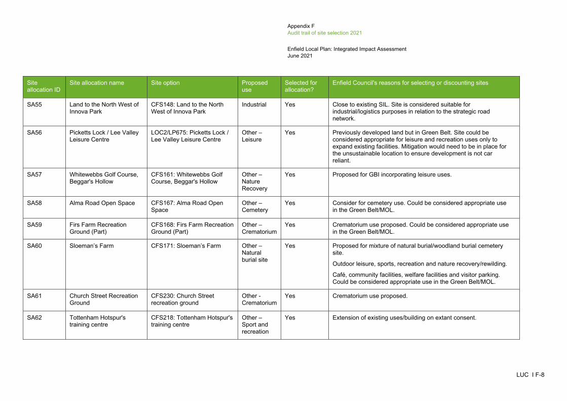
Appendix F Audit trail of site selection 2021
Enfield Local Plan: Integrated Impact Assessment June 2021
LUC I F-8
Site allocation ID
Site allocation name Site option Proposed use
Selected for allocation?
Enfield Council's reasons for selecting or discounting sites
SA55 Land to the North West of Innova Park
CFS148: Land to the North West of Innova Park
Industrial Yes Close to existing SIL. Site is considered suitable for industrial/logistics purposes in relation to the strategic road network.
SA56 Picketts Lock / Lee Valley Leisure Centre
LOC2/LP675: Picketts Lock / Lee Valley Leisure Centre
Other – Leisure
Yes Previously developed land but in Green Belt. Site could be considered appropriate for leisure and recreation uses only to expand existing facilities. Mitigation would need to be in place for the unsustainable location to ensure development is not car reliant.
SA57 Whitewebbs Golf Course, Beggar's Hollow
CFS161: Whitewebbs Golf Course, Beggar's Hollow
Other – Nature Recovery
Yes Proposed for GBI incorporating leisure uses.
SA58 Alma Road Open Space CFS167: Alma Road Open Space
Other – Cemetery
Yes Consider for cemetery use. Could be considered appropriate use in the Green Belt/MOL.
SA59 Firs Farm Recreation Ground (Part)
CFS168: Firs Farm Recreation Ground (Part)
Other – Crematorium
Yes Crematorium use proposed. Could be considered appropriate use in the Green Belt/MOL.
SA60 Sloeman’s Farm CFS171: Sloeman’s Farm Other – Natural burial site
Yes Proposed for mixture of natural burial/woodland burial cemetery site.
Outdoor leisure, sports, recreation and nature recovery/rewilding.
Café, community facilities, welfare facilities and visitor parking. Could be considered appropriate use in the Green Belt/MOL.
SA61 Church Street Recreation Ground
CFS230: Church Street recreation ground
Other - Crematorium
Yes Crematorium use proposed.
SA62 Tottenham Hotspur's training centre
CFS218: Tottenham Hotspur's training centre
Other – Sport and recreation
Yes Extension of existing uses/building on extant consent.

Appendix F Audit trail of site selection 2021
Enfield Local Plan: Integrated Impact Assessment June 2021
LUC I F-9
Site allocation ID
Site allocation name Site option Proposed use
Selected for allocation?
Enfield Council's reasons for selecting or discounting sites
N/A N/A CHC1/LP031: Warmerdams Nursery, Cattlegate Road
Housing Yes Subsumed within SA27
N/A N/A CHC10/LP179: Site at Oak Farm and Homestead Nursery, Cattlegate Road
Housing Yes Subsumed within SA27.
N/A N/A CHC11/LP472 – Parcel 1: Land to the rear of Jesus Christ Church, Parcel 1
Housing Yes Subsumed with SA27.
N/A N/A CHC12/LP472 – Parcel 2: Land to the south of Forty Hill Church of England School, Fort Hill, Parcel 2
Housing Yes Subsumed within SA27.
N/A N/A CHC14/LP637: Land north of Goat Lane
Housing No The site is Green Belt and is an isolated location. It is not considered appropriate for an allocation.
N/A N/A CHC17/LP645: Towneley Nurseries, Theobalds Park
Housing Yes Subsumed within SA27.
N/A N/A CHC18/LP649: Brown's Garden Village, Theobalds Park Road
Housing Yes Subsumed within SA27.
N/A N/A CHC2/LP056: Wolden Garden Centre, Cattlegate Road
Housing Yes Subsumed within SA27.
N/A N/A CHC3/LP107: Burton Farm Ride
Housing Yes Subsumed within SA27.

Appendix F Audit trail of site selection 2021
Enfield Local Plan: Integrated Impact Assessment June 2021
LUC I F-10
Site allocation ID
Site allocation name Site option Proposed use
Selected for allocation?
Enfield Council's reasons for selecting or discounting sites
N/A N/A HIC10/LP642: Land opposite Jolly Farmers
Housing Yes Subsumed within SA28.
N/A N/A HIC11/LP707: Vicarage Farm, Land between Hadley Road and Enfield Road
Housing Yes Subsumed within SA28.
N/A N/A HIC6/LP1153: Bramley Road Housing Yes Subsumed within SA28.
N/A N/A HIC9/LP623: Land south of Enfield Road
Housing Yes Subsumed within SA28.
N/A N/A CFS162_A: Land to the Rear of Arnold House (West)
Housing No Site is Green Belt and has biodiversity value (SINC).
N/A N/A CFS162_B: Land to the Rear of Arnold House (East)
Housing No Together with land to the rear + Arnold House.
N/A N/A CFS162_C: Arnold House Housing No Together with land to the rear + Arnold House.
N/A N/A CFS159: Wyevale Garden Centre, Cattlegate Road
Housing Yes Subsumed within wider Crews Hill allocation.
Brownfield site in Green Belt in accessible location.
N/A N/A CFS169: Kings Oak Equestrian Centre (Part)
Housing Yes Subsumed within wider Crews Hill allocation.
Brownfield site in Green Belt.
N/A N/A CFS210: Southgate Library, High Street, Southgate
Housing No Locally listed building.

Appendix F Audit trail of site selection 2021
Enfield Local Plan: Integrated Impact Assessment June 2021
LUC I F-11
Site allocation ID
Site allocation name Site option Proposed use
Selected for allocation?
Enfield Council's reasons for selecting or discounting sites
N/A N/A UPP24 (19/02718/RE3): Meridian Water Orbital Business Park (and adjoining land including Land South of Argon Road and Land Known as IKEA Clear and Gas Holder Leeside Road)
Mixed Use No Brownfield sites in urban area containing substantial potential future application.
N/A N/A UPP32 (16/01197/RE3): Meridian Water, Willoughby Lane and Meridian Way
Mixed Use No Substantial potential future application.
N/A N/A UPC2/LP1130: Tesco Extra, 1 Glover Drive
Mixed Use No Brownfield site in urban area.
N/A N/A UPC1/LP1111: IKEA Meridian Water
Mixed Use No Brownfield site in urban area.