

McMahons Point REF appendices
284
Appendix A Proposal design drawings Appendix A
-
Upload
khangminh22 -
Category
Documents
-
view
2 -
download
0
Transcript of McMahons Point REF appendices

Appendix A Proposal design drawings
Appendix A

PREL
IMIN
AR
Y
10 0
SCALE 1:1
10 20 @ A1
30 40 50
mm
2 Site Plan - Existing 1 : 500
L A W S O N
NEIGHBOURING RESTAURANT
NEW WAITING
AREA
NEW CONCRETE WAITING AREA AND JETTY
NEW WAITING AREA ROOF
EXISTING STRUCTURE DEMOLISHED
NEW GANGWAY (UNCOVERED)
PROTECTION PILES
© CONRAD GARGETT ANCHER MORTLOCK WOOLLEY [email protected] ABN 49 325 121 350 DO NOT SCALE DRAWING & VERIFY ALL DIMENSIONS AND LEVELS ON SITE REV DESCRIPTION DATE APPD
LIGHTING POSTS
S.O.
NEW MINI SERVICE POD
NEW 12x27 PONTOON
SEATS
METAL BALUSTRADE
PROJECT
Ferry Wharves Upgrade
McMahons Point Wharf
CLIENT
Roads & Maritime Services
1 Site Plan - Proposed 1 : 200
DRAWING
Proposed Wharf Site Plan
NORTH PROJECT No:
14214 STATUS
DD DRAWING No: REV: A1 SCALE
05-1000 As indicated
PREL
IMIN
AR
Y
3 05-3500
10 0
10 20
30 40 50
NEW CONCRETE WAITING AREA
05-3000 SCALE 1:1
@ A1 mm
NEW WAITING SHELTER- ROOF DASHED 2
© CONRAD GARGETT ANCHER MORTLOCK WOOLLEY [email protected] ABN 49 325 121 350 DO NOT SCALE DRAWING & VERIFY ALL DIMENSIONS AND LEVELS ON SITE REV DESCRIPTION DATE APPD
4 05-4101
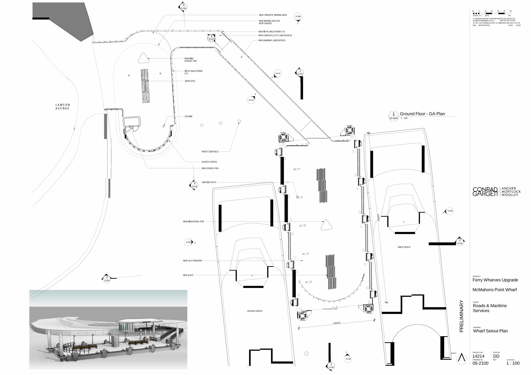
NEW METAL BALUSTRADE (T1)
NEW CONCRETE JETTY (UNCOVERED) NEW GANGWAY (UNCOVERED)
NEW MINI SERVICE POD
METAL BALUSTRADE (T1)
NEW SEATS
05-4101
2
1 05-3500
3
L A W S O N A V E N U E
COLUMN
05-4101
1 Ground Floor - GA Plan 00-3000 1 : 100
PROTECTION PILES
GLAZED SCREEN
NEW SERVICE POD
3 05-3500
LIGHTING POSTS
05-3000 4
NEW MINI SERVICE POD
05-3000 3
SWEEP BERTH
2 05-3500
NEW 12x17 PONTOON
2 05-3500
NEW SEATS PROJECT
Ferry Wharves Upgrade McMahons Point Wharf
REVERSE BERTH
CLIENT
Roads & Maritime Services
DRAWING
Wharf Setout Plan
1 NORTH PROJECT No:
14214 STATUS
DD 05-3000 DRAWING No: REV: A1 SCALE
1 05-3500
05-2100 1 : 100

PREL
IMIN
AR
Y
10 0 10 20 30 40 50
SCALE 1:1 @ A1 mm
2
05-3500
6.160 RL Roof Level
© CONRAD GARGETT ANCHER MORTLOCK WOOLLEY [email protected] ABN 49 325 121 350 DO NOT SCALE DRAWING & VERIFY ALL DIMENSIONS AND LEVELS ON SITE REV DESCRIPTION DATE APPD
4.850 RL
Ceiling Level
1.850 RL Shore Bridge
1.000 RL Pontoon Level
4 East Elevation 05-2100 1 : 100
2 05-3500
6.160 RL Roof Level
4.850 RL
Ceiling Level
1.850 RL Shore Bridge
1.000 RL Pontoon Level
3 West Elevation 05-2100 1 : 100
1 05-3500
6.160 RL
Roof Level
4.850 RL Ceiling Level
1.850 RL Shore Bridge
1.000 RL Pontoon Level
2 North Elevation 05-2100 1 : 100
PROJECT
Ferry Wharves Upgrade
McMahons Point Wharf
1 05-3500
6.160 RL
Roof Level
4.850 RL Ceiling Level
CLIENT
Roads & Maritime Services
1.850 RL Shore Bridge
1.000 RL Pontoon Level
DRAWING
Elevations
PROJECT No:
14214 STATUS
DD DRAWING No: REV: A1 SCALE
1 South Elevation 05-2100 1 : 100
05-3000 1 : 100

3000
.00
1310
.00
PREL
IMIN
AR
Y
10 0 10 20 30 40 50
SCALE 1:1 @ A1 mm
2 05-3500
© CONRAD GARGETT ANCHER MORTLOCK WOOLLEY [email protected] ABN 49 325 121 350 DO NOT SCALE DRAWING & VERIFY ALL DIMENSIONS AND LEVELS ON SITE REV DESCRIPTION DATE APPD
6.160 RL
Roof Level
4.850 RL Ceiling Level
1.850 RL Shore Bridge
1.000 RL Pontoon Level
1 Pontoon - Long Section 00-3000 1 : 100
1 05-3500
6.160 RL Roof Level
4.850 RL
Ceiling Level
1.850 RL Shore Bridge
1.000 RL Pontoon Level
2 Pontoon - Cross Section 00-3000 1 : 100
6.160 RL Roof Level
4.850 RL
Ceiling Level
1.850 RL Shore Bridge
1.000 RL Pontoon Level
PROJECT
Ferry Wharves Upgrade McMahons Point Wharf
3 Waiting Shelter - East Elevation 05-2100 1 : 100
CLIENT
Roads & Maritime Services
DRAWING
Sections
NORTH PROJECT No:
14214 STATUS
DD DRAWING No: REV: A1 SCALE
05-3500 1 : 100

Appendix B
Appendix B Consideration of clause 228(2) factors and matters of national environmental significance

Appendix B
Clause 228(2) Checklist
In addition to the requirements of the Is an EIS required? guideline as detailed in the REF, the following factors, listed in clause 228(2) of the Environmental Planning and Assessment Regulation 2000, have also been considered to assess the likely impacts of the proposal on the natural and built environment.
Factor
Impact
a. Any environmental impact on a community?
There would be impacts to parking during construction of the proposal.
There would be construction noise impacts on nearby residents associated with construction.
The McMahons Point Wharf would continue to be available for use by recreational vessels and water taxis in operation.
The proposal would result in improved public transport facilities within Sydney Harbour.
Impacts would be minimised through implementing the safeguards and management measures identified in Chapter 7 of the REF.
Moderate, short-term negative impact.
High, short-term negative impact.
Long term positive impact.
Long term positive impact.
b. Any transformation of a locality?
Visual and landscape character impacts associated with the proposal would be moderate. The scale of the wharf would be larger with a different orientation. Impacts are minimised through the use of neutral colours and transparent materials which are low in reflectivity.
Moderate, long term negative impact.
c. Any environmental impact on the ecosystems of the
locality?
An aquatic ecology assessment has been undertaken which indicates that there would be no long term harm to marine ecology as a result of the proposal. Impacts on benthic organisms would be temporary and minimised by appropriate safeguards and management measures. There would be an increase in hard-substratum habitat with piles located within deeper water. Refer to section 6.5 for further information.
High, short term negative impact.
Low to moderate, long term positive impact.
Appendix B
Factor
Impact
d. Any reduction of the aesthetic, recreational, scientific or
other environmental quality or value of a locality?
There would be a temporary reduction in the aesthetic quality of the locality due to the construction works proposed.
Visual and landscape character impacts associated with the proposal would be low to moderate. The location of the proposed wharf would be similar but would extend further south. The scale of the wharf would be larger. Impacts are minimised through the use of neutral colours and transparent materials which are low in reflectivity.
There may be some impacts to the environmental quality of the locality, however, these impacts are considered to be low to moderate and temporary during the construction stage. There would be no long term reduction in environmental quality or value as a result of the proposal.
Moderate, temporary negative impact.
Moderate, long term, negative impact.
Low to moderate, temporary negative impact.
e. Any effect on a locality, place or building having
aesthetic, anthropological, archaeological, architectural, cultural, historical, scientific or social significance or other special value for present or future generations?
The existing wharf is a local heritage item and is adjoining other heritage items as detailed at section 6.9. The fabric of the wharf structure is not considered to have intrinsic heritage value. The alterations proposed to the site including the replacement of the existing wharf structure are considered to be accepTable in heritage terms because the location and function will be maintained. impacts on the heritage setting would be minor.
Aboriginal sites would not be impacted by the proposal.
Low, short term negative impact.
Nil.
f. Any impact on the habitat of protected fauna (within the
meaning of the National Parks and Wildlife Act 1974)?
It is not expected that any habitats of protected fauna would be impacted by the proposal. Refer to section 6.5 of the REF.
Nil.
g. Any endangering of any species of animal, plant or
other form of life, whether living on land, in water or in the air?
The proposal would not endanger any species of animal, plant or other form of life whether living on land, in water or in the air due to the limited scope of work.
Nil.

Appendix B
Factor
Impact
h. Any long-term effects on the environment?
The proposal would provide greater amenity for users of the wharf in the long term through the provision of an upgraded and high quality wharf. The proposal would also locate the berthing faces within deeper water minimising potential for disturbance of sediments by vessel movements. This may have a long term beneficial impact on water quality and aquatic ecosystems.
Long term positive impact.
i. Any degradation of the quality of the environment?
Contamination of water from accidental materials falling onto the aquatic habitats, spills, leaks, sediment run off and litter during construction. The potential impact is high however with the implementation of safeguards in sections 6.1 and 6.3 the likelihood of water contamination occurring would be reduced.
Low, short-term negative impact.
j. Any risk to the safety of the environment?
Construction work at the compound site, on the barge and on the land surface may spill chemicals, oils or lubricants from construction equipment into the water increasing localised turbidity, changes to the pH and contamination.
High, short-term negative impact.
k. Any reduction in the range of beneficial uses of the
environment?
The existing wharf would be closed for up to six months during construction.
High, short-term negative impact.
l. Any pollution of the environment?
Pollution may result from accidental spills during the construction period. These potential impacts are discussed further in Chapter 6 of the REF and mitigation is proposed to minimise the impact.
Short-term negative impact.
m. Any environmental problems associated with the
disposal of waste?
All wastes would be disposed of at an off-site facility. These impacts would be long-term. There would be no significant environmental problems associated with waste disposal.
Long term negative impact.

Appendix B
Factor
Impact
n. Any increased demands on resources (natural or
otherwise) that are, or are likely to become, in short supply?
The proposal would not greatly increase the demands on resources natural or otherwise that are likely to become in short supply. All resources required are readily available.
Nil.
o. Any cumulative environmental effect with other existing
or likely future activities?
No major negative cumulative impacts have been identified for the proposal. Overall, impacts are expected to be positive in the long-term.
Long-term, positive impact.
p. Any impact on coastal processes and coastal hazards,
including those under projected climate change conditions?
The proposal would not impact on coastal process or coastal hazards. These issues are considered in greater detail in section 6.15 of the REF. Sea level rise predictions have been taken into account in the design of the wharf.
Nil.
Appendix B
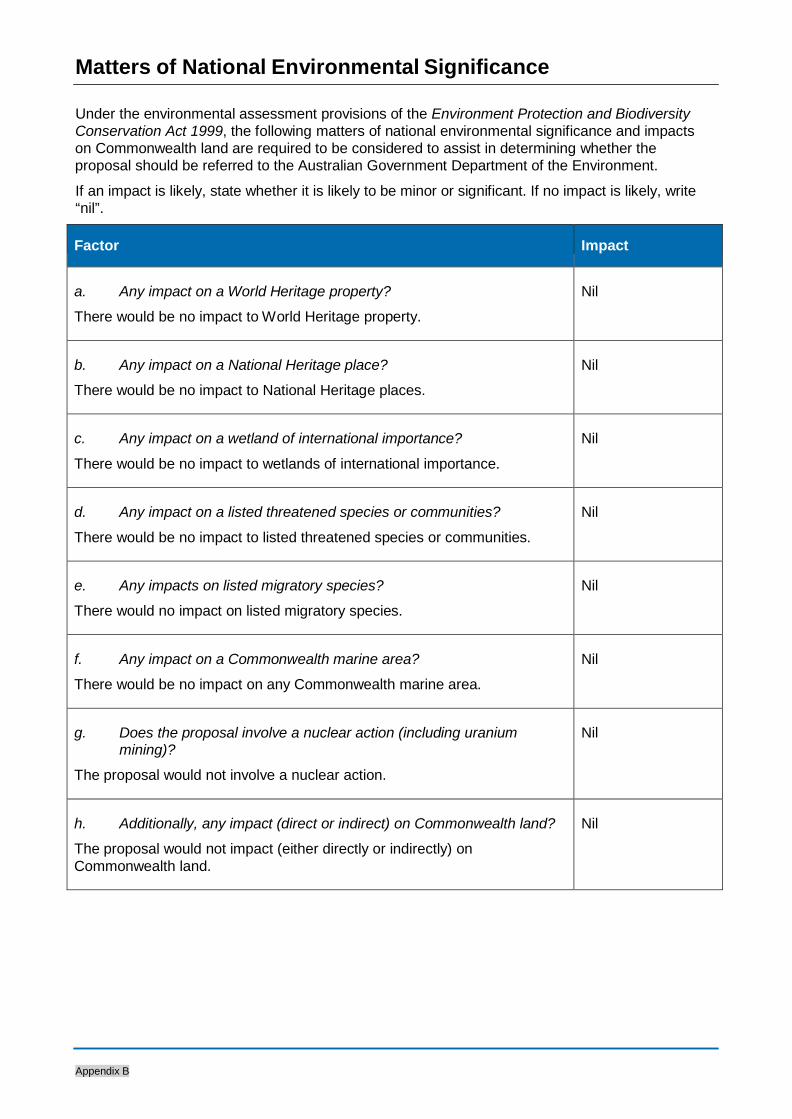
Matters of National Environmental Significance
Under the environmental assessment provisions of the Environment Protection and Biodiversity Conservation Act 1999, the following matters of national environmental significance and impacts on Commonwealth land are required to be considered to assist in determining whether the proposal should be referred to the Australian Government Department of the Environment.
If an impact is likely, state whether it is likely to be minor or significant. If no impact is likely, write “nil”.
Factor
Impact
a. Any impact on a World Heritage property?
There would be no impact to World Heritage property.
Nil
b. Any impact on a National Heritage place?
There would be no impact to National Heritage places.
Nil
c. Any impact on a wetland of international importance?
There would be no impact to wetlands of international importance.
Nil
d. Any impact on a listed threatened species or communities?
There would be no impact to listed threatened species or communities.
Nil
e. Any impacts on listed migratory species?
There would no impact on listed migratory species.
Nil
f. Any impact on a Commonwealth marine area?
There would be no impact on any Commonwealth marine area.
Nil
g. Does the proposal involve a nuclear action (including uranium
mining)?
The proposal would not involve a nuclear action.
Nil
h. Additionally, any impact (direct or indirect) on Commonwealth land?
The proposal would not impact (either directly or indirectly) on Commonwealth land.
Nil

Appendix C Statement of heritage impact and aboriginal heritage report
Appendix C
rpsgroup.com.au
Sydney Harbour Commuter Wharves Upgrade Program
Statement of Heritage Impact and Aboriginal Heritage Report, McMahons Point, NSW
Prepared by:
RPS AUSTRALIA EAST PTY LTD
Level 9, 17 York Street Sydney 2001 NSW
T: +61 2 8270 8300 F: +61 2 8270 8399 E: [email protected]
Client Manager: Deborah Farina Report Number: PR119759-1 Version / Date: Final December 2015
Prepared for: HANSEN YUNKCEN Level 6, 15 Bourke Street Mascot NSW 2020 T: +61 2 9770 7600 F: +61 2 9770 7601 E: [email protected] W: hansenyuncken.com.au

Sydney Harbour Commuter Wharf Upgrade – McMahons Point Statement of Heritage Impact and Aboriginal Heirtage Report
PR119759-1; December 2015 Page ii
IMPORTANT NOTE
Apart from fair dealing for the purposes of private study, research, criticism, or review as permitted under the Copyright Act, no part of this report, its attachments or appendices may be reproduced by any process without the written consent of RPS Australia East Pty Ltd. All enquiries should be directed to RPS Australia East Pty Ltd.
We have prepared this report for the sole purposes of Hansen Yuncken (“Client”) for the specific purpose of only for which it is supplied (“Purpose”). This report is strictly limited to the purpose and the facts and matters stated in it and does not apply directly or indirectly and will not be used for any other application, purpose, use or matter.
In preparing this report we have made certain assumptions. We have assumed that all information and documents provided to us by the Client or as a result of a specific request or enquiry were complete, accurate and up-to-date. Where we have obtained information from a government register or database, we have assumed that the information is accurate. Where an assumption has been made, we have not made any independent investigations with respect to the matters the subject of that assumption. We are not aware of any reason why any of the assumptions are incorrect.
This report is presented without the assumption of a duty of care to any other person (other than the Client) (“Third Party”). The report may not contain sufficient information for the purposes of a Third Party or for other uses. Without the prior written consent of RPS Australia East Pty Ltd:
(a) this report may not be relied on by a Third Party; and
(b) RPS Australia East Pty Ltd will not be liable to a Third Party for any loss, damage, liability or claim arising out of
or incidental to a Third Party publishing, using or relying on the facts, content, opinions or subject matter contained in this report.
If a Third Party uses or relies on the facts, content, opinions or subject matter contained in this report with or without the consent of RPS Australia East Pty Ltd, RPS Australia East Pty Ltd disclaims all risk and the Third Party assumes all risk and releases and indemnifies and agrees to keep indemnified RPS Australia East Pty Ltd from any loss, damage, claim or liability arising directly or indirectly from the use of or reliance on this report.
In this note, a reference to loss and damage includes past and prospective economic loss, loss of profits, damage to property, injury to any person (including death) costs and expenses incurred in taking measures to prevent, mitigate or rectify any harm, loss of opportunity, legal costs, compensation, interest and any other direct, indirect, consequential or financial or other loss.
Document Status
Version Purpose of Document Orig Review Review Date
Draft Draft report for internal review D. Farina P. Mangels 28/01/2015
Draft
Draft with amended design D. Farina/A. Byrne
D. Farina
30/10/2015
Final Final for client A. Byrne D. Farina 04/11/2015
Final Following client comments D. Farina D. Farina 17/12/2015
Approval for Issue
Name Signature Date
Deborah Farina
17 December 2015

Sydney Harbour Commuter Wharf Upgrade – McMahons Point Statement of Heritage Impact and Aboriginal Heirtage Report
PR119759-1; December 2015 Page 3
Contents
SUMMARY .........................................................................................................................................................1
1.0 INTRODUCTION ......................................................................................................................................3
1.1 Proposal Area ...............................................................................................................................3
1.2 Proposed Works...........................................................................................................................3
1.3 Legislative Context ......................................................................................................................8
1.3.1 National Parks and Wildlife Act 1974 .............................................................................8
1.3.2 National Parks and Wildlife Regulation 2009 .................................................................8
1.3.3 Heritage Act 1977 ...........................................................................................................9
1.3.4 Environmental Planning and Assessment Act 1979 .....................................................10
1.3.5 Native Title Act 1993.....................................................................................................10
1.4 Aboriginal Consultation ............................................................................................................10
1.5 Authorship and Acknowledgement ..........................................................................................11
2.0 ENVIRONMENTAL AND ARCHAEOLOGICAL CONTEXT .................................................................12
2.1 Local Environment .....................................................................................................................12
2.1.1 Geology and soils .........................................................................................................12
2.1.2 Topography and hydrology ...........................................................................................12
2.1.3 Flora and fauna.............................................................................................................12
2.1.4 Previous land use and disturbance ..............................................................................13
2.1.5 Synthesis of environmental context ..............................................................................13
2.2 Archaeological Context .............................................................................................................14
2.2.1 Previously recorded Aboriginal sites ............................................................................14
2.2.2 Archaeological and heritage literature review...............................................................15
2.2.3 Synthesis of archaeological context .............................................................................16
3.0 HISTORICAL CONTEXT .......................................................................................................................18
3.1 History of McMahons Point .......................................................................................................18
3.2 History of McMahons Point Wharf ...........................................................................................18
3.3 Recorded Historic Heritage .......................................................................................................20
3.3.1 World heritage ..............................................................................................................20
3.3.2 National and Commonwealth Heritage .........................................................................21
3.3.3 State Heritage ...............................................................................................................21
3.3.4 Section 170 registers ....................................................................................................21
3.3.5 Historic shipwrecks and underwater cultural heritage ..................................................21
3.3.6 Local heritage ...............................................................................................................22
3.4 Blues Point Waterfront Group ..................................................................................................24
3.5 McMahons Point South Heritage Conservation Area .............................................................24
4.0 VISUAL INSPECTION ...........................................................................................................................25
4.1 General Physical Context ..........................................................................................................25
Sydney Harbour Commuter Wharf Upgrade – McMahons Point Statement of Heritage Impact and Aboriginal Heirtage Report
PR119759-1; December 2015 Page 4
5.0 HERITAGE SIGNIFICANCE ASSESSMENT ........................................................................................29
5.1 Significance Assessment of Blues Point Waterfront Group .................................................29
5.1.1 Historical Significance (SHR Criteria A) – An item is important in the course, or pattern, of NSW’s cultural history (or the cultural or natural history of the local area) .29
5.1.2 Associative Significance (SHR Criteria B) – An item has strong or special association with the life or works of a person, or a group of persons, of importance in NSW’s cultural or natural history ..............................................................................................29
5.1.3 Aesthetic/Technical Significance (SHR Criteria C) – An item is important in demonstrating aesthetic characteristics and/or a high degree of creative or technical achievement .................................................................................................................29
5.1.4 Social Significance (SHR Criteria D) – An item has strong or special association with a particular community or cultural group in NSW (or the local area) for social, cultural or spiritual reasons............................................................................................................29
5.1.5 Research Potential (SHR Criteria E) – An item has potential to yield information that will contribute to an understanding of NSW’s cultural or natural history ......................30
5.1.6 Rarity (SHR Criteria F) – An item possesses uncommon, rare or endangered aspects of NSW’s cultural or natural history (or the cultural or natural history of the local area)30
5.1.7 Representativeness (SHR Criteria G) – An item is important in demonstrating the principal characteristics of a class of NSW’s (or the local area’s) cultural or natural places; or cultural or natural environments...................................................................30
5.1.8 Integrity and Intactness.................................................................................................30
5.1.9 Statement of Significance of Blues Point Waterfront Group.........................................30
5.2 Signific
5.2.1
ance Assessment of McMahons Point Wharf ............................................................30
Historical Significance (SHR Criteria A) – An item is important in the course, or pattern, of NSW’s cultural history (or the cultural or natural history of the local area) .30 5.2.2 Associative Significance (SHR Criteria B) – An item has strong or special association
with the life or works of a person, or a group of persons, of importance in NSW’s cultural or natural history ..............................................................................................31
5.2.3 Aesthetic/Technical Significance (SHR Criteria C) – An item is important in demonstrating aesthetic characteristics and/or a high degree of creative or technical achievement .................................................................................................................31
5.2.4 Social Significance (SHR Criteria D) – An item has strong or special association with a particular community or cultural group in NSW (or the local area) for social, cultural or spiritual reasons............................................................................................................31
5.2.5 Research Potential (SHR Criteria E) – An item has potential to yield information that will contribute to an understanding of NSW’s cultural or natural history ......................31
5.2.6 Rarity (SHR Criteria F) – An item possesses uncommon, rare or endangered aspects of NSW’s cultural or natural history (or the cultural or natural history of the local area)31
5.2.7 Representativeness (SHR Criteria G) – An item is important in demonstrating the principal characteristics of a class of NSW’s (or the local area’s) cultural or natural places; or cultural or natural environments...................................................................31
5.2.8 Integrity and Intactness.................................................................................................32 5.2.9 Statement of Significance of McMahons Point Wharf ..................................................32 5.2.10 Summary of Contribution of Elements of McMahons Point Wharf ...............................32
6.0 STATEMENT OF HERITAGE IMPACT .................................................................................................34
6.1 Summary of Proposed Changes...............................................................................................34
6.2 Impact of Proposed Works on Heritage Significance of Blues Point Waterfront Group ....34

PR119759-1; December 2015 Page 5
Sydney Harbour Commuter Wharf Upgrade – McMahons Point Statement of Heritage Impact and Aboriginal Heirtage Report
6.3 Impact of Proposed McMahons Point Wharf interchange .....................................................35
6.4 Impact of Proposed Works on Adjacent Heritage Items and Places ....................................35
6.5 Visual Impact ..............................................................................................................................36
6.6 Summary of Heritage Impact ....................................................................................................36
7.0 MITIGATION, CONCLUSION AND RECOMMENDATIONS ................................................................37
8.0 REFERENCES .......................................................................................................................................39
9.0 ACRONYMS AND UNITS ......................................................................................................................40

PR119759-1; December 2015 Page 6
Sydney Harbour Commuter Wharf Upgrade – McMahons Point Statement of Heritage Impact and Aboriginal Heirtage Report
Tables
Table 1 Acknowledgements .............................................................................................................................11
Table 2 Summary of AHIMS Sites within the searched coordinates ................................................................14
Table 3 Item of State significance in McMahons Point on State Heritage Register. Office of Environment and Heritage 2013 ...................................................................................................................................................21
Table 4 Items on s170 heritage registers .........................................................................................................21
Table 5 : 14 locally significant heritage items in the vicinity of the Proposal Area with potential to be impacted. ..........................................................................................................................................................22
Table 6 : Locally significant heritage items with potential to be visually impacted ...........................................22
Table 7 Relative heritage significance of the components and attributes of McMahons Point Wharf .............32
Figures
Figure 1 Proposal Area showing curtilage of Blues Point Waterfront Group .....................................................7
Figure 2 Proposal Area with AHIMS results .....................................................................................................17
Plates
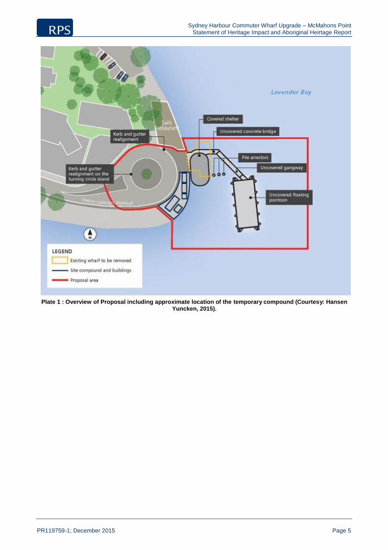
Plate 1 : Overview of Proposal including approximate location of the temporary compound (Courtesy: Hansen Yuncken, 2015). ....................................................................................................................................5
Plate 2 : Photomontage of the proposed McMahons Point wharf (Courtesy of Hansen Yuncken)....................6
Plate 3 Photomontage of the proposed McMahons Point wharf (Courtesy of Hansen Yuncken)......................6
Plate 4 View from Lavender Bay towards Millers Point, 1879-1882. McMahons Point visible in the foreground. Courtesy Stanton Library ..............................................................................................................19
Plate 5 McMahons Point Wharf, pre 1893. Note enlarged landing stage. Courtesy Stanton Library ..............19
Plate 6 Postcard depicting McMahons Point Wharf and tram turning circle, c.1910. Courtesy Stanton Library20
Plate 7 : View south east from Warung Street toward proposed wharf (RPS, 2015). ......................................23
Plate 8 Approaching existing McMahons Point Wharf on the ferry. Blues Point Tower prominent at centre, Balls Head Foreshore Group visible at the left (RPS 2012) .............................................................................25
Plate 9 View north-east toward existing McMahons Point Wharf (RPS, 2012) ................................................26
Plate 10 Former tram turning circle, McMahons Point Wharf in background (RPS, 2012) ..............................26
Plate 11 : View south with former tram turning circle location in foreground (RPS, 2015). .............................27
Plate 12 : View east toward existing wharf (at left)/location of proposed new wharf and Sydney Harbour Bridge and Opera House (RPS, 2015) .............................................................................................................27
Plate 13 : View east from Blues Point Reserve towards former vehicular ferry (foreground) and Luna Park in background. Note ferry berthing and existing wharf (background) (RPS, 2015).............................................28

Sydney Harbour Commuter Wharf Upgrade – McMahons Point Statement of Heritage Impact and Aboriginal Heirtage Report
PR119759-1; December 2015 Page vii
Appendices
Appendix 1 Summary of Statutory Controls
Appendix 2 AHIMS Results
Appendix 3 Glossary of Site Types
Appendix 4 PACHCI Letter
Appendix 5 Design Plans

Sydney Harbour Commuter Wharf Upgrade – McMahons Point Statement of Heritage Impact and Aboriginal Heirtage Report
PR119759-1; December 2015 Page 1
Summary
RPS has been engaged by Hansen Yuncken Pty Ltd on behalf of NSW Roads and Maritime Services (RMS) to prepare a Statement of Heritage Impact and Aboriginal Heritage Report for the proposed redevelopment of the McMahons Point Wharf under the Environmental Planning and Assessment Act 1979 (EP&A Act). Both Aboriginal and Historic cultural heritage were considered during the course of this assessment.
The McMahons Point Wharf Proposal Area (Proposal Area) is located on the southern shore of McMahons Point peninsula on Sydney Harbour within the North Sydney Local Government Area (LGA), approximately two kilometres north of the Sydney CBD. The existing wharf structure is located on the western shore of Lavender Bay at the eastern end of Henry Lawson Drive, McMahons Point. There has been a commuter wharf at McMahons Point since 1860 however the current wharf is thought to have been constructed in 1973 (NSW Maritime 2009:13). The heritage value of the wharf is therefore related to its location rather than its current form and fabric.
Proposed works include the demolition of the old wharf and construction of a new wharf interchange, comprising a covered shelter and uncovered bridge, gangway and pontoon. The pontoon would contain seating and a services pod (refer to Section 1.2 for a detailed description of the proposal).
This report incorporates an Aboriginal due diligence assessment, and a search of the Aboriginal Heritage Information Management System (AHIMS) for the area surrounding McMahons Point Wharf was undertaken on 14 January 2015 by RPS Senior Heritage Consultant, Deborah Farina, and updated in October 2015. The search indicates that 26 Aboriginal sites are located within a one kilometre radius of McMahons Point Wharf. However, the closest recorded site to the wharf is located in excess of 500 metres to the north and as such, will be unaffected by the proposal.
Searches of the State Heritage Inventory, which includes s170 items, local and state significant heritage items on all statutory lists in NSW, and the North Sydney Local Environmental Plan 2013, identified 14 heritage items in the vicinity of McMahons Point Wharf, including the Blues Point Waterfront Group. The existing wharf and adjacent tram turning circle at Henry Lawson Avenue are also included this group. McMahons Point South Conservation Area envelops the entire Proposal Area, and includes much of McMahons Point and Blues Point. Of the identified heritage items only the wharf and the former tram turning circle adjacent to the proposed McMahons Point Wharf interchange will be impacted by the proposed works. A search of the Australian Shipwrecks Database was also undertaken, with no shipwrecks identified off Blues Point or in Lavender Bay.
A visual inspection of the wharf was undertaken on Monday, 19 January 2014 by RPS Heritage Consultant, Joshua Madden. No new Aboriginal sites or Historic heritage items were identified in the vicinity of McMahons Point Wharf at the time of the visual inspection.
In accordance with the Burra Charter (Australia ICOMOS 1999:18-19) ‘Procedures for undertaking studies and reports’, this report has considered the environmental, heritage and archaeological context of the Proposal Area, information gained during the site inspection; the significance of the Blues Point Waterfront Group and the existing ferry wharf; the development proposal; potential heritage impacts; and mitigation measures in order to draw conclusions and provide recommendations intended to guide future decision- making.
The following mitigation measures, management recommendations have been formulated with consideration of all available information and have been prepared in accordance with the relevant legislation.

Sydney Harbour Commuter Wharf Upgrade – McMahons Point Statement of Heritage Impact and Aboriginal Heirtage Report
PR119759-1; December 2015 Page 2
Recommendation 1
Should any unexpected finds be uncovered during the course of construction of the proposal, the mitigation and management measures set out in RMS’ Standard Management Procedure – Unexpected Heritage Items should be followed.
Recommendation 2
In line with the Heritage Office publication How to Prepare Archival Records of Heritage Places (1998) it is recommended that a detailed archival record be made of the McMahons Point Wharf prior to the commencement of demolition works with a view to this information being used as part of future heritage interpretation of the site (refer to Recommendation 3 below).
Copies of the record should be submitted to North Sydney Council, the NSW Heritage Division library, as well as being offered to the NSW State Library.
Recommendation 3
It is recommended that heritage interpretation of the existing McMahons Point Wharf be undertaken prior to demolition of the wharf to interpret the historic development and use of the site. Development and implementation of an interpretation plan/strategy will ensure that social significance and a sense of place are maintained by raising public awareness and appreciation of the heritage significance of the site, particularly the historic values it embodies as a longstanding wharf site.
Information could be in the form of heritage images and text, or laminated posters put up beside general Proposal information on site. Any such heritage interpretation strategy/plan should be developed in accordance with the NSW Heritage Office’s 2005 Interpreting Heritage Items and Places Guidelines.
Recommendation 4
In accordance with Clause 14 of the State Environmental Planning Policy (Infrastructure) 2007 consultation with North Sydney Council should be undertaken prior to works commencing.
Recommendation 5
In accordance with Section 170A of the Heritage Act 1977, RMS must give the Heritage Council of NSW not less than 14 days written notice prior to demolition works, and must ensure that the Section 170 Heritage and Conservation Register is updated to reflect the works carried out at the wharf.
Recommendation 6
The proposed kerbing and guttering upgrade works for the improvement of the bus turning circle will take place at the location of the local heritage item “former tram turning circle”; it is considered that, according to the design plan provided, these works will not have an impact on this item. However, should excavation below the depth of the existing road surface be required for any reason, further assessment will be required.

Sydney Harbour Commuter Wharf Upgrade – McMahons Point Statement of Heritage Impact and Aboriginal Heirtage Report
PR119759-1; December 2015 Page 3
1.0 Introduction
RPS Sydney cultural heritage team have been engaged by project managers Hansen Yuncken (on behalf of RMS) to prepare a Statement of Heritage Impact and Aboriginal Heritage Report for the proposed McMahons Point Wharf interchange as part of RMS’s Sydney Commuter Wharf Upgrade Program.
The purpose of this report is to assess the heritage significance and the impact the proposal would have on the significance, to identify measures proposed to mitigate any negative impact, and, where applicable, why more sympathetic options are not viable (Heritage Office and Department of Urban Affairs and Planning 2002:2). When considered along with a policy or plan for conservation and management, an informed decision can be made as to whether to allow the development to proceed. The concept designs provided by Hansen Yuncken have been considered in the preparation of this report.
The Statement of Heritage Impact and Aboriginal Heritage Report will further contribute to the Review of Environmental Factors prepared by RPS as part of Sydney Commuter Wharf Upgrade Program.
1.1 Proposal Area
McMahons Point is located in the lower north shore area of Sydney, New South Wales, approximately two kilometres north-west of the Sydney CBD. McMahons Point is located on a peninsula forming the western shore of Lavender Bay in the North Sydney Local Government Area (LGA). There is an existing wharf on the western shore of Lavender Bay, first constructed in c.1860 and reconstructed and updated at various times up until 2002. The proposed McMahons Point Wharf interchange would be located in the vicinity of the existing wharf. The Proposal Area is located within the curtilage of a local heritage item, the Blues Point Waterfront Group (refer to Figure 1).
1.2 Proposed Works
The proposal includes the demolition and removal of the existing wharf and construction of a new covered shelter and uncovered bridge, gangway and pontoon. The proposal includes:
Demolition and removal of the existing wharf structures
Prior to constructing the proposed wharf interchange, the existing wharf, including waiting shelter, tidal stairs, lights, posts, fencing and timber piles, information totems and closed circuit television system will be demolished and removed
Construction of a new wharf interchange
Construction of a covered shelter about 20 metres long and 10 metres wide over the water. The shelter would connect to land at an angle of about 90 degrees and would be supported by about 12 steel piles. The shelter would include the provision of a stainless steel clad services pod including, for example, an electricity distribution board, Ferry Operations Customer Information System (FOCIS), bins, signage boards and a help point. The waiting shelter would include glass screens at its northern and southern ends
Construction of an uncovered concrete bridge about 25 metres long and three metres wide, extending from the shelter at an angle of about 90 degrees. The bridge would connect to the gangway headstock support and would be supported on about 12 steel piles and precast concrete head stocks
Construction of an uncovered aluminium gangway about 18 metres long and about three metres wide, to a floating pontoon. The gangway would extend from the bridge at an angle of about 45 degrees. The gradient of the gangway would vary according to the tides
Construction and installation of a rectangular steel floating pontoon off the gangway. The pontoon would be about 12 metres wide and 27 metres long and would have two berthing faces. The pontoon would be

Sydney Harbour Commuter Wharf Upgrade – McMahons Point Statement of Heritage Impact and Aboriginal Heirtage Report
PR119759-1; December 2015 Page 4
uncovered with stainless steel balustrades at the northern and southern ends and include seating. The floating pontoon would be held in place by four steel piles. The floating pontoon alignment would extend off the gangway at an angle of about 174 degrees
Installation of safety and security facilities including lighting, closed circuit television, ladders to the water from the pontoon, a life ring on the pontoon platform and the tactile floor treatments
Ancillary facilities
A temporary compound would be established including site sheds, an amenities shed and storage
containers for tools and some materials. The location of the temporary compound is to be confirmed and would be subject to council review and agreement. The indicative location is shown on Plate 1
The connection of existing electrical powerlines to the wharf
Landside works
Landside upgrade works would include realignment of kerb and gutter and footpath at the northern end of Henry Lawson Avenue adjacent to the wharf interchange entrance and at the southern end of the laneway on the western side of Sails on Lavender Bay restaurant.
The turning circle at Henry Lawson Avenue adjacent to the wharf interchange entry would also be upgraded to better allow buses to manoeuvre safely at the site entrance. Works would include kerb and gutter upgrades to the north and to the east of the turning circle.
The wharf (including shelter, bridge, gangway and pontoon) would be constructed to be accessible to people with a disability for no less than 80% of the high and low tide levels listed in standard tide charts.
The new wharf components (i.e. shelter, bridge, gangway and pontoon) would be predominantly assembled at the contractor’s off-site before being transported to the site via barge.
The proposal would require the McMahon’s Point Wharf to be closed to all ferries, water taxis and other vessels/watercraft for the duration of construction to enable the works to be carried out.
Sydney Harbour Commuter Wharf Upgrade – McMahons Point Statement of Heritage Impact and Aboriginal Heirtage Report
PR119759-1; December 2015 Page 5
Plate 1 : Overview of Proposal including approximate location of the temporary compound (Courtesy: Hansen
Yuncken, 2015).

Sydney Harbour Commuter Wharf Upgrade – McMahons Point Statement of Heritage Impact and Aboriginal Heirtage Report
PR119759-1; December 2015 Page 6
Plate 2 : Photomontage of the proposed McMahons Point wharf (Courtesy of Hansen Yuncken).
Plate 3 Photomontage of the proposed McMahons Point wharf (Courtesy of Hansen Yuncken)

Source: Esri, DigitalGlobe, GeoEye, Earthstar Geographics, CNES/Airbus DS, USDA, USGS, AEX, Getmapping, Aerogrid, IGN, IGP, swisstopo, and the GIS User Community
W
Legend
Project Area Blues Point Waterfront Group
Warning: While all reas onable c are has been taken to ensure the inform ation conta ine d on this m ap is up to date a nd accurate, no gua rantee is give n that the information portrayed is free from error or omis sion. Pleas e verify the ac cura cy of all inform ation prior to use.
Study Area
SON A
Figure 1: Project Area
0 12.5 25 50 75 100 125
m
SCALE 1:3,000 AT A4 S IZE
LO CAT ION :
McMahons Point Wharf
Disc lai mer : W hi le a ll re as ona ble c are ha s be e n ta ke n to en sure the inform at ion con ta ine d on t his ma p is up to da te and ac c urat e, no gua ra nte e is gi ve n tha t t he informa ti on portra ye d is fre e from e rror o r o mis sion. Pl ea se ve rify th e a c cu ra c y of al l inform at ion p ri or to us e.
DATUM : GDA 94
PRO JECTIO N: MG A Zone 56
JO B NO .: PR119 759 Data Sources: RPS
CLIENT: RMS Copy right: "Th is doc ument and th e information shown shall remai n the property of RPS Aus tral ia East PTy. Ltd.
PURPO SE: HERITAGE
Technician: Hamidreza.Karimi Date: 30/10/2015
RPS AUSTRALIA EAST PTY LTD (ABN 44 14 0 292 76 2)
OE H
The docu ent may onl y be used for the p urp ose for whi ch it was su ppli ed and in accordanc e wi th t he terms of en gagement for th e commi ssi on. Unauth ori sed us e of this docu ment in any way is prohibi ted"
241 DENISON STREET BROADMEADOW PO BOX 42 8 HAMILTON N SW 2303 T: 02 4940 4 200 F: 02 4961 679 4 www.rpsg rou p.com.au
Path: N:\Projects\Conics_Sydney\PR119759 - Sydney Com muter Wharves SoHIs\Cultural Heritage\GIS\M cMahons Point\Arcgis M ap Documents\119759 F igure 1 M cMahons A A4 20152030.m xd

Sydney Harbour Commuter Wharf Upgrade – McMahons Point Statement of Heritage Impact and Aboriginal Heirtage Report
PR119759-1; December 2015 Page 8
1.3 Legislative Context
1.3.1 National Parks and Wildlife Act 1974
The National Parks and Wildlife Act 1974 (NPW Act) protects Aboriginal heritage (places, sites and objects) within NSW. Although there are other Acts protecting and managing cultural heritage in New South Wales (see Appendix 1), the due diligence procedure is only available to projects appropriate to this Act. Protection of Aboriginal heritage is outlined in s86 of the NPW Act, as follows:
“A person must not harm or desecrate an object that the person knows is an Aboriginal object” s86(1). “A person must not harm an Aboriginal object” s86(2).
“A person must not mark of desecrate an Aboriginal place” s86(4).
Penalties apply for harming an Aboriginal object or place. The penalty for knowingly harming an Aboriginal object (s86[1]) and/or an Aboriginal place (s86[4]) is up to $550,000 for an individual and/or imprisonment for two years; and in the case of a corporation the penalty is up to $1.1 million. The penalty for a strict liability offence (s86[2]) is up to $110,000 for an individual and $200,000 for a corporation.
Harm under the NPW Act is defined as any act that; destroys defaces or damages the object, moves the object from the land on which it has been situated, causes or permits the object to be harmed. However, it is a defence from prosecution if the proponent can demonstrate 1) that harm was authorised under an Aboriginal Heritage Impact Permit (AHIP) (and the permit was properly followed), or 2) that the proponent exercised due diligence in respect to Aboriginal heritage. The ‘due diligence’ defence (s87[2]), states that if a person or company has exercised due diligence to ascertain that no Aboriginal object was likely to be harmed as a result of the activities proposed for the Proposal Area (subject area of the proposed activity); then liability from prosecution under the NPW Act will be removed or mitigated if it later transpires that an Aboriginal object was harmed.
Under section 89A of the NPW Act Aboriginal objects (and sites) must be reported to the Director-General (now Chief Executive) of the Office of Environment and Heritage (OEH) within a reasonable time (unless it has previously been recorded and submitted to AHIMS). Penalties of $11,000 for an individual and $22,000 for a corporation may apply for each object not reported.
1.3.2 National Parks and Wildlife Regulation 2009
The National Parks and Wildlife Regulation 2009 (“NPW Regulation”) provides a framework for undertaking activities and exercising due diligence in respect to Aboriginal heritage. The NPW Regulation outlines the recognised due diligence codes of practice which are relevant to this report, but it also outlines procedures for AHIP applications and Aboriginal Cultural Heritage Consultation Requirements (ACHCRs); amongst other regulatory processes.
Due Diligence
The aim of a due diligence assessment is to:
Assist in avoiding unintended harm to Aboriginal objects.
Provide certainty to land managers and developers about appropriate measures for them to take.
Encourage a precautionary approach.
Provide a defence against prosecution if the process is followed.
Result in more effective conservation outcomes for Aboriginal cultural heritage.

Sydney Harbour Commuter Wharf Upgrade – McMahons Point Statement of Heritage Impact and Aboriginal Heirtage Report
PR119759-1; December 2015 Page 9
One of the benefits of the due diligence provisions are that they provide a simplified process of investigating the Aboriginal archaeological context of an area to determine if an AHIP is required.
Under the s80A of the NPW Regulation a number of due diligence codes are recognised. This report has been written to meet the Due Diligence Code of Practice for the Protection of Aboriginal Objects in New South Wales (2010) (“Due Diligence Code”).
The Due Diligence Code sets out a minimum benchmark for acceptable due diligence investigations to be followed. The purpose of the code is set out reasonable and practical steps in order to:
Identify whether or not Aboriginal objects (and places) are, or are likely to be, present in an area. Determine whether or not their activities are likely to harm Aboriginal objects (if present).
Determine whether an AHIP application is required. (DECCW 2010:2)
Investigations under the code include the following:
A search of the Aboriginal Heritage Information Management System (AHIMS) database to identify if
there are previously recorded Aboriginal objects or places in the Proposal Area.
Identification of landscape features including, land within 200 metres of water, dune systems, ridge tops, headlands, land immediately above or below cliff faces and/or rockshelters/caves.
Desktop assessment including a review of previous archaeological and heritage studies and any other relevant material.
Visual inspection of the Proposal Area to identify if there are Aboriginal objects present. Assessment as to whether an AHIP is required.
One of the benefits of the due diligence provisions are that they provide a simplified process for investigating the Aboriginal archaeological context of an area without the need for an AHIP. Aboriginal consultation is not required for an investigation under due diligence. However, if the due diligence investigation reveals that the activities proposed for the area are likely to harm objects or likely objects within the landscape, then an AHIP will be required with full consultation.
This report has been prepared in accordance with the Due Diligence Code and also meets the RMS’s Procedure for Aboriginal Cultural Heritage Consultation and Investigation (PACHCI). The PACHCI incorporates all relevant Environment Protection Authority and OEH Aboriginal heritage guidelines and requirements in a staged procedure.
The due diligence assessment contained within in this report concludes that Aboriginal objects are not likely to be harmed, thus the AHIP procedures have not been triggered thus full Aboriginal consultation following the ACHCRs is not required.
1.3.3 Heritage Act 1977
Historical archaeological relics, buildings, structures, archaeological deposits and features are protected under the Heritage Act 1977 and may be identified on the State Heritage Register (SHR) or by an active Interim Heritage Order.
The Heritage Council of NSW, constituted under the Heritage Act 1977, is appointed by the Minister and is responsible for heritage in NSW. The Council reflects a cross-section of community, government and conservation expertise with the NSW Heritage Division being the operational arm of the Council. The work of the NSW Heritage Division includes:
Working with communities to help them identify their important places and objects.
Sydney Harbour Commuter Wharf Upgrade – McMahons Point Statement of Heritage Impact and Aboriginal Heirtage Report
PR119759-1; December 2015 Page 10
Providing guidance on how to look after heritage items.
Supporting community heritage projects through funding and advice.
Maintaining the State Heritage Inventory, an online list of all statutory heritage items in NSW.
The Heritage Division provides guidelines for conducting assessments of heritage significance. The 1996 Heritage Manual includes specific criteria for addressing the significance of an item and this assessment has been completed in accordance with those guidelines. These criteria are addressed more fully in Section 5 of this report.
1.3.4 Environmental Planning and Assessment Act 1979
The Environmental Planning & Assessment Act 1979 (EP&A Act) regulates a system of environmental planning and assessment for NSW. Land use planning requires that environmental impacts are considered, such as the impact on cultural heritage including Aboriginal heritage. Although the wharf falls under the ISEPP (see below) Part 5 of the EP&A Act states that development without consent is still subject to the assessment requirements under that Part, which includes all matters affecting or likely to affect the environment as a result of the proposed development. To that end, this report assesses the likely heritage impacts (Aboriginal and non-Aboriginal heritage) of the proposed upgrading works to McMahons Point Wharf.
1.3.4.1 State Environmental Planning Policy (Infrastructure) 2007 (ISEPP)
The purpose of this policy is to streamline and facilitate the effective delivery of infrastructure around the State. Pursuant to clause 14 of the ISEPP, where a development is likely to have an impact that is not minor or inconsequential on a local heritage item (other than a local heritage item that is also a State heritage item) or a heritage conservation area, then the public authority or the person or company acting on behalf of the public authority must consult with the local council in accordance with the requirements of the ISEPP. Further, clause 68 (4) of the State Environment Planning Policy (Infrastructure) 2007 (ISEPP) provides that development for the purposes of a wharf may be carried out by or on behalf of a public authority on any land without consent.
1.3.5 Native Title Act 1993
The Commonwealth Government enacted the Native Title Act 1993 to formally recognise and protect native title rights in Australia following the decision of the High Court of Australia in Mabo & Ors v Queensland (No. 2) (1992) 175 CLR 1 (“Mabo”).
Although there is a presumption of native title in any area where an Aboriginal community or group can establish a traditional or customary connection with that area, there are a number of ways that native title is taken to have been extinguished. For example, land that was designated as having freehold title prior to 1 January 1994 extinguishes native title, as does any commercial, agricultural, pastoral or residential lease.
Land that has been utilised for the construction or establishment of public works also extinguishes any native title rights and interests for as long as they are used for that purpose. Other land tenure, such as mining leases, may be subject to native title, depending on when the lease was granted.
Further details on the relevant legislation are provided in Appendix 1.
1.4 Aboriginal Consultation
As mentioned above, due diligence inspection relates to the physical identification of Aboriginal objects. Community consultation is only required once Aboriginal objects have been detected and an AHIP is

Sydney Harbour Commuter Wharf Upgrade – McMahons Point Statement of Heritage Impact and Aboriginal Heirtage Report
PR119759-1; December 2015 Page 11
deemed necessary. Section 5.2 of the Due Diligence Code specifically states that “Consultation with the Aboriginal community is not a formal requirement of the due diligence process” (DECCW 2010:3), and as no Aboriginal Cultural Heritage Objects, Sites or Places were identified during this process, no Aboriginal Consultation has been undertaken as part of this SoHI.
However, the RMS’s PACHCI policy indicates limited consultation earlier than that required by NSW legislation. If a PACHCI Stage 1 assessment indicates potential for Aboriginal objects or places to be impacted by a project then consultation is required with Local Aboriginal Land Councils, Native Title holders and registered community stakeholders. Following an assessment by RMS’s Cultural Heritage Advisor, Barry Gunther, it was concluded that, subject to confirmation of the location of the temporary compound area, there was no potential for impact on Aboriginal objects and places and therefore no consultation with Aboriginal stakeholders was required (see Appendix 4).
1.5 Authorship and Acknowledgement
This report was written by RPS Senior Heritage Consultant Deborah Farina with assistance from RPS Senior GIS Analyst Hamidreza Karimi. The report was reviewed by RPS Senior Heritage Consultant Erin Williams.
The RPS team acknowledges the assistance of various organisations and individuals, including but not limited to:
Table 1 Acknowledgements
Name Position Organisation Paul Blair Design Manager Hansen Yuncken
Peter Mangels REF Project Manager RPS
Barry Gunther Cultural Heritage Advisor RMS

Sydney Harbour Commuter Wharf Upgrade – McMahons Point Statement of Heritage Impact and Aboriginal Heirtage Report
PR119759-1; December 2015 Page 12
2.0 Environmental and Archaeological Context
Statements of Heritage Impact and Aboriginal heritage due diligence assessments require that available knowledge and information relating to the Aboriginal cultural heritage resource is considered. The purpose of reviewing the relevant environmental and heritage information is to assist in identifying whether Aboriginal sites or places are present within the study area.
The reporting of environmental context is also required by OEH as specified in the ‘Code of Practice for Archaeological Investigation of Aboriginal Objects in New South Wales’ (DECCW 2010).
2.1 Local Environment
2.1.1 Geology and soils
The geology of the McMahons Point Area chiefly comprises Hawkesbury Sandstone. Hawkesbury Sandstone is made up of sandstone and shale, as well as quartz. The presence of sandstone in the Proposal Area is important for Aboriginal occupation of the area because certain types of silicified tuff and quartz were used by Aboriginal people for manufacturing flaked stone tools; and sandstone was used for grinding grooves, as a form of shelter (if rock shelters present), and as a medium for engravings and art, amongst other uses.
The Proposal Area sits on the interface of the Gymea and Hawkesbury soil landscapes. The Gymea soil landscape is characterised by loose, coarse sandy loam topsoil, earthy, yellowish-brown clayey sand topsoil or subsoil (depending on topography), and earthy to weakly pedal, yellowish-brown sandy clay loam. The Hawkesbury soil landscape features loose, coarse quartz sand topsoil, which gives way to earthy, yellowish brown sandy clay loam subsoil on crests and ridges. On side slopes and benches, 10-30 centimetres of topsoil overlies bedrock (Chapman G. A. & C.L. Murphy 1989:44-48). The relationships between these soils vary depending on topography, though topsoil depth is generally between 20 and 30 centimetres (Chapman G. A. & C.L. Murphy 1989:64-67). It is not expected that Aboriginal artefacts would be present in clay subsoils and therefore potential archaeological deposits are likely to be limited to the upper 20-30 centimetres of these soil landscapes.
2.1.2 Topography and hydrology
The McMahons Point Wharf is situated in an extensively developed and highly populated commercial and residential area on Sydney’s North Shore. It sits on the southern side of the peninsula flanked by Berrys Bay to the west, and Lavender Bay to the east. This area is part of the extensive Port Jackson catchment.
Topographically, the Proposal Area is characterised by undulating to very steep hills with local reliefs of between 20 and 400 metres. Slope gradients range from 10 to 70%, valleys are narrow and incised, and rock outcrop occurs as horizontal benches and scarps that are between 5 and 10 metres high. Landscape limitations include erosion hazards, steep slopes, shallow soils of low fertility, and mass movement hazards (Chapman G. A. & C.L. Murphy 1989:44-48, 64-67). The Proposal Area is flat, and elevation levels in the surrounding landscape do not exceed 70 metres AHD (Australian Height Datum).
2.1.3 Flora and fauna
The purpose of the following summary is to provide an indication of the types of flora and fauna which may have been available to Aboriginal people in the past for sustenance and raw material resources. This section does not replace more detailed ecological studies.

Sydney Harbour Commuter Wharf Upgrade – McMahons Point Statement of Heritage Impact and Aboriginal Heirtage Report
PR119759-1; December 2015 Page 13
Marine resources played an important role in the diet of the people living in Sydney Harbour. These included a wide range of fish and shellfish, as well as crustacea and marine mammals, as evidenced in the numerous middens around Sydney Harbour (Attenbrow 2003:62).
The Proposal Area is situated within the Sydney Coastal Dry Sclerophyll Forest vegetation community. The dry sclerophyll forests that grow on the Sydney sandstones are the most diverse and extensive in Australia, and collectively cover approximately 1.4 million hectares of land (Keith 2006:146). The Sydney Coastal Dry Sclerophyll Forest is the most diverse of the Sydney dry sclerophyll forests and encompasses a wide range of related forest and woodland communities. The species composition and structure of this community varies according to topography and soil moisture, with the open eucalypt canopy varying between 10 and 25 metres tall depending on associated landforms. Common tree species found within this community include the Sydney red gum, red bloodwood, Sydney peppermint, brown stringybark, various species of scribbly gum and the old man banksia. The community is also characterised by a shrub layer that features various species of wattle and banksia, as well as the mountain devil, flaky-barbed teatree, broad-leaved geebung and the grass tree. Typical grasses include wiry panic, oat speargrass, heath bog-rush and black bog-rush (Keith 2006:147).
This vegetation community would have provided habitats for a variety of animals, as well as potentia l food and raw material sources for Aboriginal people. Grass trees, for example, were used by Aboriginal people to manufacture spears and resin, and also as a food source (Nash 2004:5). Various banksia species were collected and used to manufacture needles for basket and mat weaving, while the fruit of the geebung was eaten and string and fishing lines were soaked in a geebung bark infusion to prevent fraying (Nash 2004:2, 4). Eucalyptus trees were a particularly important resource; leaves were crushed and soaked for medicinal purposes, bowls, dishes, and canoes were made from the bark, and spears, boomerangs and shields were crafted from the hard wood (Nash 2004:4-8).
Typical animals which may have been harvested by Aboriginal people include kangaroos, wallabies, sugar gliders, possums, echidnas, a variety of lizards and snakes, birds, as well as rats and m ice. The bones of such animals have been recovered from Aboriginal sites excavated in the Sydney region suggesting that they were sources of food (Attenbrow 2003:70-76), although the hides, bones and teeth of some of the larger mammals may have been used for Aboriginal clothing, ornamentation, or other implements.
2.1.4 Previous land use and disturbance
McMahons Point Wharf has been extensively impacted by prior land use practices. In particular, the construction of wharves and the sea wall has obliterated the natural rock edge adjacent to the harbour, leaving no natural land surface visible. As the most common site types recorded in the area are those that would expect to be recorded along a natural rock ledge adjacent to water, this leaves almost little to no potential for in situ sites to exist in the vicinity of the wharf.
2.1.5 Synthesis of environmental context
The Proposal Area is located on the southern shore of a peninsula within the extensive Port Jackson catchment. The site chiefly comprises Hawkesbury Sandstone and sits on the Gymea and Hawkesbury soil landscapes. The wharf is also located within the Sydney Coastal Dry Sclerophyll Forest vegetation community, which would have provided a variety of food and raw material sources for Aboriginal people.
The Proposal Area has been extensively impacted by prior land uses, leaving no natural land surface visible. As a result, there is little to no potential for in situ Aboriginal sites in the vicinity of the wharf.

Sydney Harbour Commuter Wharf Upgrade – McMahons Point Statement of Heritage Impact and Aboriginal Heirtage Report
PR119759-1; December 2015 Page 14
2.2 Archaeological Context
The Sydney region has been inhabited by Aboriginal people for at least 10,000 years according to available radiocarbon dates. Attenbrow lists 27 separate clans recorded in the Sydney region in historical documents from 1788-1800 (Attenbrow 2003:24-26). Many of these clans were names for the areas they occupied. Most of the clans in the Sydney region belong to the Darug language group, with the exception of some of the clans around Botany Bay, who are thought to belong to the Tharawal language group and the southern rim of the Cumberland Plain west of Georges River, who belonged to the Gundungurra language group. The Darug were usually split between the coastal and hinterland people. Apart from differences in their language, each had their own diet and subsistence patterns and cultural practices. For example, the coastal Darug practiced tooth avulsion during initiation ceremonies, whilst the hinterland Darug did not. However, the language groups that various clans belonged to is still a matter of research and debate (Attenbrow 2003:34).
McMahons Point lies within an area of Port Jackson that was the traditional country of the Guringai speaking Cammeraygal Aboriginal people, although the status of Guringai as a separate language rather than as a derivative of the Darug language is contentious (Attenbrow 2003: 33). The connection between past Aboriginal inhabitants and the North Sydney area is evident, with many of the headlands, suburbs and other geographical features of the area retaining traditional Aboriginal names, or names with broader Aboriginal associations. Primary examples of this is are the North Sydney suburb of Cammeray, which derives its name from the Cammeraygal group, and the Ku-ring-gai electoral district, local council and national park, which derive their names from the Guringai language group.
While there is limited information on the lives of the Cammeraygal people, some of their heritage is preserved both archaeologically and in historic accounts. Written and pictorial observations of early colonists describe the Cammeraygal people as robust and muscular, and noted that the men of the Cammeraygal presided over the initiation of young males from other Sydney area groups (Attenbrow 2003:60).
Large Aboriginal groups such as those who lived about Sydney harbour were based on kinship, with huge importance placed on extended family groups or clans, their connections to the land and common language. Like other language groups, the Cammeraygal operated on a subsistence economy based on hunting, fishing and gathering, and it is evident from the archaeological record that this area would have had abundant food resources in the ocean, harbour, forests and woodlands sufficient to support a large Aboriginal population.
Many of the Aboriginal communities living around Sydney harbour, including the Cammeraygal population, were devastated by the outbreak of smallpox in 1789. It is thought that around half of the Aboriginal population living in Sydney at that time were killed by the disease. Many of the Sydney clans were decimated and moved to other areas intending to escape the disease.
2.2.1 Previously recorded Aboriginal sites
A search was undertaken of the Aboriginal Heritage Information Management System (AHIMS) on 14 January 2015 in accordance with the Due Diligence Code (DECCW 2010:11) and updated on 29 October 2015. The coordinates searched for the Proposal Area were GDA Zone 56, Eastings 332991 to 334991 and Northings 6252140 to 6254140 (a one kilometre radius), with a buffer of 50 metres. This search revealed that there were 26 previously recorded Aboriginal sites within these coordinates (Table 2 and Figure 5).
The search revealed that no Aboriginal objects or places were present in the Proposal Area.
Table 2 Summary of AHIMS Sites within the searched coordinates
Site type Frequency Per cent

Sydney Harbour Commuter Wharf Upgrade – McMahons Point Statement of Heritage Impact and Aboriginal Heirtage Report
PR119759-1; December 2015 Page 15
Site type Frequency Per cent Midden 10 38%
Shelter with midden 6 23%
Rock engraving 3 11%
Shelter with art 2 8%
Midden; Aboriginal Ceremony & Dreaming
1
4%
Artefact scatter 1 4%
Shelter with art and midden 1 4%
Burial; shelter with art and midden 1 4%
Midden; artefact scatter 1 4%
Total 26 100%
The results of the AHIMS search show that midden sites were the most common type of site recorded within the searched coordinates, along with rock shelters with middens, and rock art, accounting for 72% of all sites in the area. A range of other site types including sites that also have middens in association with them have also been recorded in the area, though in lesser numbers. These include a burial with a shelter with art and a midden, an artefact scatter and a midden in association with a ceremonial or Dreaming site. The sites recorded within the searched coordinates are consistent with sites recorded throughout the Sydney Harbour foreshore.
2.2.2 Archaeological and heritage literature review
There are limited archaeological reports dealing with the McMahons Point area, and none encompassing the Proposal Area. The following reports deal with the archaeology of areas surrounding McMahons Point, information from which can be extrapolated to apply to the Proposal Area.
Bowdler, S. (1971) Balls Head: The Excavation of a Port Jackson Rock Shelter.
Through the 1960s and 1970s a series of excavations were conducted within a rock shelter on the eastern side of Balls Head Reserve (AHIMS # 45-6-0027), culminating in the publication of a paper by Bowdler (1971). The shelter was described as being about 35 feet long, 7 feet deep and 6 feet from floor to ceiling at its highest point. Occupational deposit, consisting of “exceedingly disturbed” shell midden, was noted as stretching from the back of the shelter, out beyond the drip line and for about 10 feet (Bowdler 1971:126). Faint hand stencils were noted on the rear wall of the shelter.
The original excavation was carried out in 1964 under the direction of the Assistant Curator in Anthropology at the Australian Museum, Douglas Miles. Two trenches (3.0 x 1.2 metres and 1.8 x 1.2 metres) were excavated to the base of the midden. The midden was noted as having concentrated shell throughout its 1 metre depth, and a human skeleton was uncovered. The skeleton was identified as being that of an Aboriginal woman who was over the age of 30 when she died. The Aboriginality and age of the skeleton was based on the wear pattern of her teeth and the shape of her skull. In 1970, further fieldwork was undertaken at this site (see below).
The rockshelter was re-excavated in 1970 by Bowdler and a team from the Australian Museum and University of Sydney. A small, 15 by 25 centimetre column sample of midden was removed for analysis and stratigraphy observed, before the site was backfilled. Close analysis of the sample removed revealed that the midden was mostly made up of shellfish. The predominant food mollusc by weight was the rock oyster, and was considered predominant throughout the occupation of the site. Hairy mussel was also an important food resource at this site, while the Sydney cockle was notably uncommon.

Sydney Harbour Commuter Wharf Upgrade – McMahons Point Statement of Heritage Impact and Aboriginal Heirtage Report
PR119759-1; December 2015 Page 16
Bowdler also analysed Miles’ excavated material, and amongst the 450 stone artefacts that came from the two excavations, backed scrapers, thumbnail scrapers, other scrapers and utilised flakes, cores, waste flakes, and bipolar cored were found. No bone or shell tools were uncovered. Glass was present in the top layer, and its heavy patination and thick nature suggested that it was of early colonial age and that Aboriginals may have continued to inhabit the shelter after British colonisation.
The Balls Head excavations revealed one of the very few excavated archaeological items from the Sydney region that has been interpreted as body decoration: a single lower incisor of a juvenile bettong or potoroo (sub-family Potoronidae) found near the maxilla of a woman’s skeleton in the rockshelter. As no other macropod bones were retrieved from the excavations and possible vegetable gum was adhering to the tooth, Bowdler surmised that the tooth had been worn as a decoration – either stuck to the person’s hair or on a necklace.
2.2.3 Synthesis of archaeological context
Although Port Jackson was once home to hundreds of Aboriginal people, much of the evidence for thousands of years of occupation has been destroyed by urban development and the transformation of the water body into a major harbour. Generally the more developed and modified an area, the less likelihood for sites to be present, although sites have been recorded in highly modified landscapes.
The results of previous archaeological investigations in the Port Jackson area suggest that Aboriginal people who inhabited the area in the past made use of a range of locally available resources including shellfish, fish, local wildlife, and raw stone materials. The majority of previously recorded Aboriginal sites in the McMahons Point area relate to those associated with rock shelters. The extensive modification of the natural shoreline by the construction of sea wall and wharfage makes it extremely unlikely that any in situ Aboriginal material would be discovered by the proposed works.
As Table 2 demonstrates, many of the archaeological sites registered in the McMahons Point area are a combination of site types, in which more than one site type has been recorded for a specific location. When considered collectively, certain site types within combination sites become increasingly dominant. Rock shelters, for example (including those with art, deposits, and middens, or those associated with burials and other rock shelters) collectively account for 43% of all registered site types. Similarly, middens (including those associated with artefact scatters and burials) collectively occur in around 46% of registered site types.
Rock shelters with midden deposits, artefact scatters and open middens tend to be associated with less disturbed areas and located close to the edge of the harbour, or in rock overhangs overlooking the harbour. Open middens may be present behind the flat sandstone slabs marking the boundary of land and sea in the vicinity of the present wharf. Engravings and axe grooves may be present on open flat sandstone slabs west of the wharf. Artefact scatters may be found in any context, but are more likely to be located on level to nearly level land within 300 metres of water.
However, as noted in Section 2.1.4 above, the extensive modification of the shoreline in the vicinity of the proposed McMahons Point wharf reduces the potential for in situ archaeological sites to zero.

Source: Esri, DigitalGlobe, GeoEye, Earthstar Geographics, CNES/Airbus DS, USDA, USGS, AEX, Getmapping, Aerogrid, IGN, IGP, swisstopo, and the GIS User Community
Legend
Project Area Blues Point Waterfront Group
AHIMS Burial/s, Shelter with Art, Shelter with Midden Artefact Shelter with Art, Shelter with Midden Shelter with Art Shelter with Midden
45-6-1270
45-6-1269
Warning: While all reas onable c are has been taken to ensure the inform ation conta ine d on this m ap is up to date a nd accurate, no gua rantee is give n that the information portrayed is free from error or omis sion. Pleas e verify the ac cura cy of all inform ation prior to use.
45-6-3076 Midden Rock Engraving
45-6-2181 45-6-2147 45-6-0906
45-6-3077
45-6-2764 45-6-2763
45-6-2762
45-6-2055
45-6-1271
45-6-0628 45-6-0891
45-6-2961 45-6-0630
45-6-2180 45-6-0027 45-6-1267
45-6-1957
45-6-0811
45-6-2382 45-6-0030
45-6-0519 45-6-1939
45-6-1615
0 100 200 400 600 800 1,000 Disc lai mer : W hi le a ll re as ona ble c are ha s be e n ta ke n to en sure the inform at ion con ta inemd on t his ma p is up to da te and ac c urat e, no gua ra nte e is gi ve n tha t t he informa ti on portra ye d is fre e from e rror o r o mis sion. Pl ea se ve rify th e a c cu ra c y of al l inform at ion p ri or to us e.
Figure 2: Project Area with AHIMS Results
SCALE 1:14,000 AT A4 S IZE
LO CAT ION :
JO B NO .:
McMahons Point Wharf
PR119 759
DATUM : GDA 94
PRO JECTIO N: MG A Zone 56 Data Sources: RPS
CLIENT: RMS Copy right: "Th is doc ument and th e information shown shall remai n the property of RPS Aus tral ia East PTy. Ltd.
PURPO SE: HERITAGE
Technician: Hamidreza.Karimi Date: 30/10/2015
RPS AUSTRALIA EAST PTY LTD (ABN 44 14 0 292 76 2)
OE H
The docu ent may onl y be used for the p urp ose for whi ch it was su ppli ed and in accordanc e wi th t he terms of en gagement for th e commi ssi on. Unauth ori sed us e of this docu ment in any way is prohibi ted"
241 DENISON STREET BROADMEADOW PO BOX 42 8 HAMILTON N SW 2303 T: 02 4940 4 200 F: 02 4961 679 4 www.rpsg rou p.com.au
Path: N:\Projects\Conics_Sydney\PR119759 - Sydney Com muter Wharves SoHIs\Cultural Heritage\GIS\M cMahons Point\Arcgis M ap Documents\119759 F igure 2 A HIMS M cMahons A A4 20151030.m xd

Sydney Harbour Commuter Wharf Upgrade – McMahons Point Statement of Heritage Impact and Aboriginal Heirtage Report
PR119759-1; December 2015 Page 18
3.0 Historical Context
3.1 History of McMahons Point
McMahons Point was named after Michael McMahon, a brush-maker from Ireland who came to the area in the 1860s. He acquired a substantial amount of land on the peninsula, consequently becoming involved in local politics. He championed causes such as reliable transport and a harbour crossing. In 1886 he became mayor of the small municipality of Victoria, and later became an alderman of North Sydney Council which subsumed Victoria in 1890. His home, known as ‘Point House’, was located at 1 East Crescent Street, above the McMahons Point Wharf.
Before the construction of the Sydney Harbour Bridge, a reliable ferry service was an essential piece of infrastructure for residents living on the North Shore. In 1842 a regular service was established between Blues Point and Windmill Street, Dawes Point. The steam punt named Princess carried both vehicles and passengers until she was wrecked in 1898 in a collision in Circular Quay with the steamer Cammeray (NSW Maritime 2009).
The first public ferry service commenced between 1860 and 1871 following the establishment of the North Sydney Ferry Company. Subdivisions of Lavender Bay and McMahons Point occurred in the 1870s, leading to an increase in population. By 1884, an all-night ferry service operated to McMahons Point via Milsons Point and Lavender Bay to accommodate the increased population of the lower north shore. In 1901, a vehicular ferry service was commenced between Blues Point and Dawes Point (North Sydney Council u.d.). From 1906, the ferry service ran every 10 minutes during the peak hour, and every 15 minutes outside of peak times.
As a result of the improved transportation, McMahons Point continued to grow and prosper into the twentieth century. In 1957, North Sydney Council proposed rezoning a large portion of McMahons Point for industrial use. This was strenuously opposed by the McMahons Point and Lavender Bay Progress Association, who put forward their own proposal for a residential redevelopment of McMahons Point. Designed by Harry Seidler, it proposed modern high rise apartment buildings on the ridge with low rise apartment buildings on the water’s edge. The Progress Association prevailed, with the NSW Government overturning North Sydney Council’s proposal in 1958. However, owing to rising property values, the only building to be constructed as part of the Progress Association’s vision was Blues Point Tower, now listed as a locally significant heritage item in the North Sydney Local Environmental Plan 2013. Once planned to be the model for housing in McMahons Point, Blues Point Tower is now anomalous amongst the surrounding early twentieth century streetscape.
3.2 History of McMahons Point Wharf
A passenger wharf was first constructed at McMahons Point sometime between 1860 and 1871 following the establishment of the North Shore Ferry Company in 1860. An 1871 plan shows a wharf at the end of East Crescent Street (now Warung Street) as owned by the North Shore Ferry Company. There is limited information available on this original wharf but photographs and block plans held by North Sydney Council indicate that it consisted of a short timber landing stage with timber waiting shed (NSW Maritime 2009) (Plate 4).

Sydney Harbour Commuter Wharf Upgrade – McMahons Point Statement of Heritage Impact and Aboriginal Heirtage Report
PR119759-1; December 2015 Page 19
Plate 4 View from Lavender Bay towards Millers Point, 1879-1882. McMahons Point visible in the foreground. Courtesy Stanton Library
By 1895 the landing stage had been enlarged and by 1910 a larger waiting room for the ferry had been erected on the shore side (Plate 5). By 1930 the wharf had been further extended and an adjacent vehicular ferry wharf with horse ferry wharf built. The completion and opening of the Sydney Harbour Bridge in March 1932 led to a decreased demand for northern ferries.
Plate 5 McMahons Point Wharf, pre 1893. Note enlarged landing stage. Courtesy Stanton Library
Transport between the city of Sydney and the north shore generally was facilitated by the tram service from McMahons Point Wharf, which ran up Blues Point Road and terminated at the ferry wharf. The former tram
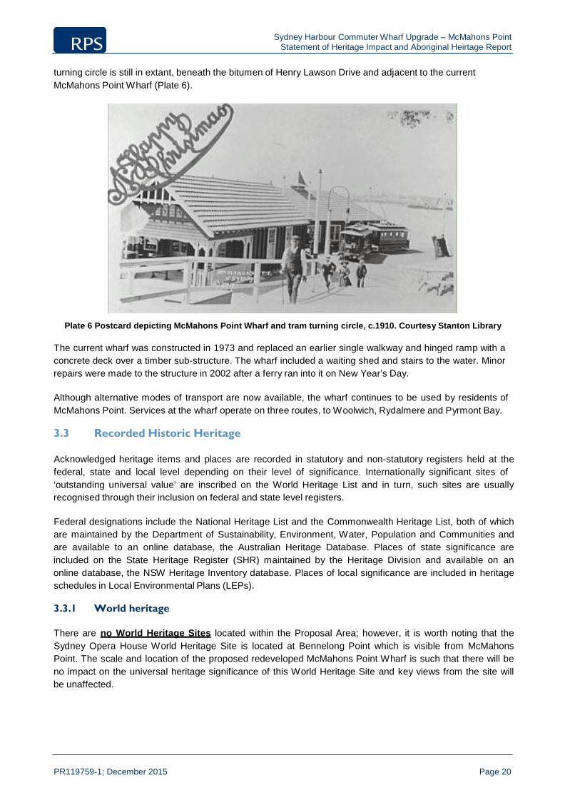
Sydney Harbour Commuter Wharf Upgrade – McMahons Point Statement of Heritage Impact and Aboriginal Heirtage Report
PR119759-1; December 2015 Page 20
turning circle is still in extant, beneath the bitumen of Henry Lawson Drive and adjacent to the current McMahons Point Wharf (Plate 6).
Plate 6 Postcard depicting McMahons Point Wharf and tram turning circle, c.1910. Courtesy Stanton Library
The current wharf was constructed in 1973 and replaced an earlier single walkway and hinged ramp with a concrete deck over a timber sub-structure. The wharf included a waiting shed and stairs to the water. Minor repairs were made to the structure in 2002 after a ferry ran into it on New Year’s Day.
Although alternative modes of transport are now available, the wharf continues to be used by residents of McMahons Point. Services at the wharf operate on three routes, to Woolwich, Rydalmere and Pyrmont Bay.
3.3 Recorded Historic Heritage
Acknowledged heritage items and places are recorded in statutory and non-statutory registers held at the federal, state and local level depending on their level of significance. Internationally significant sites of ‘outstanding universal value’ are inscribed on the World Heritage List and in turn, such sites are usually recognised through their inclusion on federal and state level registers.
Federal designations include the National Heritage List and the Commonwealth Heritage List, both of which are maintained by the Department of Sustainability, Environment, Water, Population and Communities and are available to an online database, the Australian Heritage Database. Places of state significance are included on the State Heritage Register (SHR) maintained by the Heritage Division and available on an online database, the NSW Heritage Inventory database. Places of local significance are included in heritage schedules in Local Environmental Plans (LEPs).
3.3.1 World heritage
There are no World Heritage Sites located within the Proposal Area; however, it is worth noting that the Sydney Opera House World Heritage Site is located at Bennelong Point which is visible from McMahons Point. The scale and location of the proposed redeveloped McMahons Point Wharf is such that there will be no impact on the universal heritage significance of this World Heritage Site and key views from the site will be unaffected.
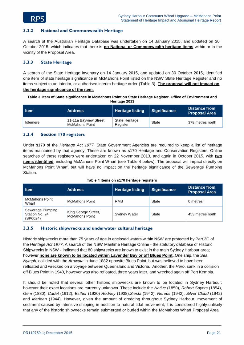
Sydney Harbour Commuter Wharf Upgrade – McMahons Point Statement of Heritage Impact and Aboriginal Heirtage Report
PR119759-1; December 2015 Page 21
3.3.2 National and Commonwealth Heritage
A search of the Australian Heritage Database was undertaken on 14 January 2015, and updated on 30 October 2015, which indicates that there is no National or Commonwealth heritage items within or in the vicinity of the Proposal Area.
3.3.3 State Heritage
A search of the State Heritage Inventory on 14 January 2015, and updated on 30 October 2015, identified one item of state heritage significance in McMahons Point listed on the NSW State Heritage Register and no items subject to an interim, or authorised interim heritage order (Table 3). The proposal will not impact on the heritage significance of the item.
Table 3 Item of State significance in McMahons Point on State Heritage Register. Office of Environment and
Heritage 2013
Item
Address
Heritage listing
Significance Distance from
Proposal Area
Idlemere 11-11a Bayview Street, McMahons Point
State Heritage Register
State
378 metres north
3.3.4 Section 170 registers
Under s170 of the Heritage Act 1977, State Government Agencies are required to keep a list of heritage items maintained by that agency. These are known as s170 Heritage and Conservation Registers. Online searches of these registers were undertaken on 22 November 2013, and again in October 2015, with two items identified, including McMahons Point Wharf (see Table 4 below). The proposal will impact directly on McMahons Point Wharf, but will have no impact on the heritage significance of the Sewerage Pumping Station.
Table 4 Items on s170 heritage registers
Item
Address
Heritage listing
Significance Distance from
Proposal Area
McMahons Point Wharf
McMahons Point
RMS
State
0 metres
Sewerage Pumping Station No. 24 (SP0024)
King George Street, McMahons Point
Sydney Water
State
453 metres north
3.3.5 Historic shipwrecks and underwater cultural heritage
Historic shipwrecks more than 75 years of age in enclosed waters within NSW are protected by Part 3C of the Heritage Act 1977. A search of the NSW Maritime Heritage Online - the statutory database of Historic Shipwrecks in NSW - indicated that 80 shipwrecks are known to exist in the main Sydney Harbour area; however none are known to be located within Lavender Bay or off Blues Point. One ship, the Sea Nymph, collided with the Arawata in June 1882 opposite Blues Point, but was believed to have been refloated and wrecked on a voyage between Queensland and Victoria. Another, the Hero, sank in a collision off Blues Point in 1940, however was also refloated, three years later, and wrecked again off Port Kembla.
It should be noted that several other historic shipwrecks are known to be located in Sydney Harbour; however their exact locations are currently unknown. These include the Native (1850), Robert Sayers (1854), Gem (1880), Cadet (1912), Esther (1920) Rodney (1938),Siesta (1942), Nereus (1942), Silver Cloud (1942) and Marlean (1944). However, given the amount of dredging throughout Sydney Harbour, movement of sediment caused by intensive shipping in addition to natural tidal movement, it is considered highly unlikely that any of the historic shipwrecks remain submerged or buried within the McMahons Wharf Proposal Area.

Sydney Harbour Commuter Wharf Upgrade – McMahons Point Statement of Heritage Impact and Aboriginal Heirtage Report
PR119759-1; December 2015 Page 22
There is subsequently an extremely low risk of impact to historic shipwreck material, as previous dredging would have ensured that the location is clear of historic material.
3.3.6 Local heritage
Searches of the State Heritage Inventory and the North Sydney Local Environmental Plan 2013 on 14 January 2015 revealed a total of 101 local heritage items within McMahons Point, 14 of which are located in the vicinity of McMahons Point Wharf. Those 14 items are located in the vicinity of McMahons Point Wharf and therefore there is some potential for them to be affected by the proposal. The remainder of the 101 heritage items within McMahons Point are physically and/or visibly separated and therefore not likely to be impacted by the proposal.
The Proposal Area is also within a heritage conservation area, being the McMahons Point South Conservation Area.
Table 5 : 14 locally significant heritage items in the vicinity of the Proposal Area with potential to be impacted.
Item
Address
Item Number Distance from
Proposal Area
Blues Point Waterfront Group
Blues Point Road and Henry Lawson Drive
I0423
0 metres
Former Tram Turning Circle and McMahons Point Ferry Wharf
Henry Lawson Avenue
I0452
30-50 metres
Slipway and Site of Former Holmes’ Residence
1 Henry Lawson Avenue
I0453
80 metres
Seawall 2A Henry Lawson Avenue (9 East
Crescent Street)
I0314
90 metres
North Sydney bus shelter Henry Lawson Avenue I0407 150 metres
Blues Point vehicular ferry dock
Blues Point Road (south end of cul de sac)
I0451
150 metres
Stone retaining wall Blues Point Road (southern end of road
reserve)
I0426
190 metres
World War II Observation Post and Stone Stair
Blues Point
I0424
230 metres
Blues Point Foreshore Shelf
Blues Point Foreshore
I0425
230 metres
Bollard Blues Point Road I0427 230 metres
Bollard with chain Blues Point Road I0428 230 metres
Excavation Blues Point Road I0429 230 metres
Steps with bollard Blues Point Road I0450 230 metres
Blues Point Tower 14-28 Blues Point Road I0408 300 metres
In addition to the above items, there are a row of houses located atop the cliff on the southern side of Warung Street that are identified as heritage items. These are included only for their potential to be visually impacted by the proposed works.
Table 6 : Locally significant heritage items with potential to be visually impacted
Item
Address
Item Number Distance from
Proposal Area
House 3 Warung Street, McMahons Point I0515 140 metres
House 5 Warung Street, McMahons Point I0516 129 metres
House 7 Warung Street, McMahons Point I0517 120 metres

Sydney Harbour Commuter Wharf Upgrade – McMahons Point Statement of Heritage Impact and Aboriginal Heirtage Report
PR119759-1; December 2015 Page 23
Item
Address
Item Number Distance from
Proposal Area
House 9 Warung Street, McMahons Point I0518 105 metres
As a result, Warung Street, McMahons Point was inspected on 19 January 2015. Whilst the ferry wharf will be visible from the back of the properties on Warung Street, It is unlikely that they will suffer a significant visual impact (see Plate 7 below). In addition, a Landscape Character and Visual Impact Assessment for the McMahons Point Wharf found that the properties near Henry Lawson Avenue (including those above Henry Lawson Avenue on Warung Street) would have low to moderate visual impact as a result of the proposed wharf (Jane Irwin Landscape Architecture 2015:13).
Plate 7 : View south east from Warung Street toward proposed wharf (RPS, 2015).
With respect to the 14 heritage sites in Table 5 above, the majority of the sites, including the current McMahons Point wharf, World War II Observation Post and Stone Stair, and Blues Point Tower, are located within 230 metres of the Proposal Area, however are of sufficient distance so as to not be impacted by the proposed works. However, many of the items listed in Table 5 above form part of the Blues Point Waterfront Group. The proposed location of the new wharf is within the curtilage of both the Blues Point Waterfront Group and the McMahons Point South Heritage Conservation Area. As such, there is potential to directly impact the significance of both the Group and Heritage Conservation Area by the proposed works. These issues will be addressed in Section 6.
A search was also undertaken of the Sydney Regional Environmental Plan (Sydney Harbour Catchment) 2005 on 7 September 2012 in order to identify any further heritage items. The SREP covers all the waterways of the Harbour, the foreshores and entire catchment. The SREP includes provisions relating to heritage conservation and wetlands protection and provides planning controls for strategic foreshore sites, and lists a number of heritage items of State and Local significance. The SREP lists no heritage items at McMahons Point and consequently no items in or near to the Proposal Area.

Sydney Harbour Commuter Wharf Upgrade – McMahons Point Statement of Heritage Impact and Aboriginal Heirtage Report
PR119759-1; December 2015 Page 24
3.4 Blues Point Waterfront Group
The Blues Point Waterfront Group is a group of heritage items on the waterfront of the McMahons Point peninsula at Blues Point. The curtilage is described on the State Heritage Inventory as:
“all lands south of the cliff face that forms the northern boundary of Henry Lawson Drive, from the McMahons Point Ferry Wharf to the northernmost end of the public reserve on the western side of Blues Point, but additionally includes the public steps from the corner of East Crescent Street and Warung Street down to the McMahons Point Ferry Wharf.”
This group comprises the following individual heritage items:
Blues Point Foreshore Shelf;
Former Tram Turning Circle and McMahons Point ferry wharf;
Ferry Access steps;
Vehicular ferry dock remains;
Former Holmes residence and slipway (1 Henry Lawson Avenue);
Stone retaining wall (Blues Point Road – southern end of road reserve);
Bollard (Blues Point Road)
Bollard and chain (Blues Point Road),
World War 2 Observation Post and Steps,
Excavation (Blues Point Road);
Steps and Bollards (Blues Point Road).
The landscape is described as:
“...a flat shelf retained by seawalls around the foreshore, with a ridge along Blues Point on which sits the Blues Point Tower. Most of the land, excepting the Blues Point Tower, is publicly owned. Numerous features, plus the landform itself, are evidence of the progressive usage of the area from the early nineteenth century.”
3.5 McMahons Point South Heritage Conservation Area
The McMahons Point South Conservation Area is identified as significant for its connections to early settler William Blue and the harbour crossing point at Blues Point, and for its association with the early waterfront industry of Sydney Harbour, which can be interpreted in part by the heritage items identified in Table 5 above.
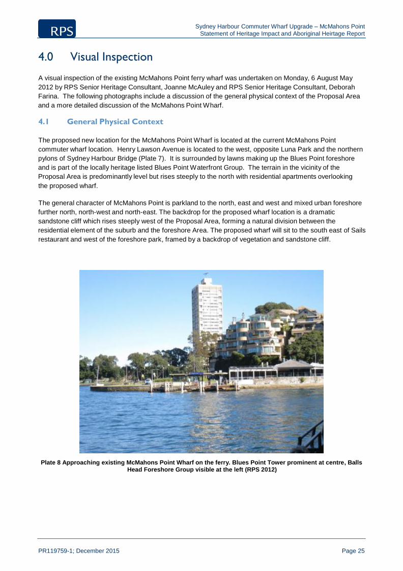
Sydney Harbour Commuter Wharf Upgrade – McMahons Point Statement of Heritage Impact and Aboriginal Heirtage Report
PR119759-1; December 2015 Page 25
4.0 Visual Inspection
A visual inspection of the existing McMahons Point ferry wharf was undertaken on Monday, 6 August May 2012 by RPS Senior Heritage Consultant, Joanne McAuley and RPS Senior Heritage Consultant, Deborah Farina. The following photographs include a discussion of the general physical context of the Proposal Area and a more detailed discussion of the McMahons Point Wharf.
4.1 General Physical Context
The proposed new location for the McMahons Point Wharf is located at the current McMahons Point commuter wharf location. Henry Lawson Avenue is located to the west, opposite Luna Park and the northern pylons of Sydney Harbour Bridge (Plate 7). It is surrounded by lawns making up the Blues Point foreshore and is part of the locally heritage listed Blues Point Waterfront Group. The terrain in the vicinity of the Proposal Area is predominantly level but rises steeply to the north with residential apartments overlooking the proposed wharf.
The general character of McMahons Point is parkland to the north, east and west and mixed urban foreshore further north, north-west and north-east. The backdrop for the proposed wharf location is a dramatic sandstone cliff which rises steeply west of the Proposal Area, forming a natural division between the residential element of the suburb and the foreshore Area. The proposed wharf will sit to the south east of Sails restaurant and west of the foreshore park, framed by a backdrop of vegetation and sandstone cliff.
Plate 8 Approaching existing McMahons Point Wharf on the ferry. Blues Point Tower prominent at centre, Balls Head Foreshore Group visible at the left (RPS 2012)
Sydney Harbour Commuter Wharf Upgrade – McMahons Point Statement of Heritage Impact and Aboriginal Heirtage Report
PR119759-1; December 2015 Page 26
Plate 9 View north-east toward existing McMahons Point Wharf (RPS, 2012)
Plate 10 Former tram turning circle, McMahons Point Wharf in background (RPS, 2012)

Sydney Harbour Commuter Wharf Upgrade – McMahons Point Statement of Heritage Impact and Aboriginal Heirtage Report
PR119759-1; December 2015 Page 27
Plate 11 : View south with former tram turning circle location in foreground (RPS, 2015).
Plate 12 : View east toward existing wharf (at left)/location of proposed new wharf and Sydney Harbour Bridge and Opera House (RPS, 2015)
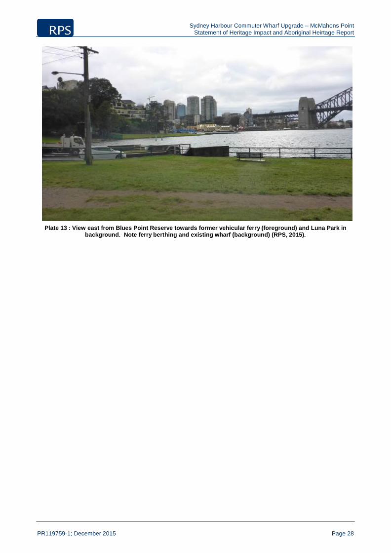
Sydney Harbour Commuter Wharf Upgrade – McMahons Point Statement of Heritage Impact and Aboriginal Heirtage Report
PR119759-1; December 2015 Page 28
Plate 13 : View east from Blues Point Reserve towards former vehicular ferry (foreground) and Luna Park in background. Note ferry berthing and existing wharf (background) (RPS, 2015).
Sydney Harbour Commuter Wharf Upgrade – McMahons Point Statement of Heritage Impact and Aboriginal Heirtage Report
PR119759-1; December 2015 Page 29
5.0 Heritage Significance Assessment
In line with the Burra Charter, before making decisions about the future of a heritage item it is first necessary to understand its heritage significance and the values it embodies. The following section contains an assessment of the heritage significance of the two recorded heritage items affected by the proposed works, being the Blues Point Waterfront Group and the existing McMahons Point ferry wharf, using the NSW state significance heritage criteria as contained within the Heritage Act 1977 and explained in ‘Assessing Heritage Significance’ (NSW Heritage Office 2001). Consideration is also given to the integrity and intactness of the items.
5.1 Significance Assessment of Blues Point Waterfront Group
5.1.1 Historical Significance (SHR Criteria A) – An item is important in the course, or
pattern, of NSW’s cultural history (or the cultural or natural history of the local area)
Whilst there is no particular significance attached to the item as part of a group, each of the items within the group has historical significance to the development of McMahons Point. As noted above, the individual items within the group are the Blues Point Foreshore Shelf, the Former Tram Turning Circle and McMahons Point ferry wharf, Ferry Access steps, Vehicular ferry dock remains, Former Holmes residence and slipway (1 Henry Lawson Avenue), Stone retaining wall (Blues Point Road – southern end of road reserve), Bollard (Blues Point Road), Bollard and chain (Blues Point Road), World War 2 Observation Post and Steps, Excavation (Blues Point Road), Steps and Bollards (Blues Point Road). Each of these items is a physical reminder of McMahons Point’s maritime or residential past and transport across Sydney Harbour.
5.1.2 Associative Significance (SHR Criteria B) – An item has strong or special association
with the life or works of a person, or a group of persons, of importance in NSW’s cultural or natural history
Although the group has items representative of other harbourside settlements, it is considered that the items do not meet this criterion.
5.1.3 Aesthetic/Technical Significance (SHR Criteria C) – An item is important in
demonstrating aesthetic characteristics and/or a high degree of creative or technical achievement
The wider visual setting of the Blues Point Waterfront Group is highly scenic. Highly dramatic and attractive views from the park encompass several iconic sites including the Sydney Harbour Bridge, the Sydney Opera House, Millers Point, the northern section of Darling Harbour, parts of the Barangaroo development and Luna Park. The Blues Point Waterfront Group therefore has an intrinsic aesthetic significance of a high standard.
5.1.4 Social Significance (SHR Criteria D) – An item has strong or special association with
a particular community or cultural group in NSW (or the local area) for social, cultural or spiritual reasons
The Blues Point Waterfront Group is a popular venue for viewing social activities on Sydney Harbour, such as the New Years’ Eve fireworks. It is therefore possible that the Blues Point Waterfront Group embodies significant social values, however community consultation would need to be undertaken to assess the level of social significance.

Sydney Harbour Commuter Wharf Upgrade – McMahons Point Statement of Heritage Impact and Aboriginal Heirtage Report
PR119759-1; December 2015 Page 30
5.1.5 Research Potential (SHR Criteria E) – An item has potential to yield information that
will contribute to an understanding of NSW’s cultural or natural history
The modified nature of the waterfront leaves little potential for scientific and archaeological information that will further contribute to an understanding of NSW cultural, industrial and maritime history. The Blues Point Waterfront Group is therefore not considered to be significant for its research/archaeological potential.
5.1.6 Rarity (SHR Criteria F) – An item possesses uncommon, rare or endangered aspects
of NSW’s cultural or natural history (or the cultural or natural history of the local area)
The items comprising the group are indicative of the development and cultural history of the suburb of McMahons Point, but are not considered to be rare.
5.1.7 Representativeness (SHR Criteria G) – An item is important in demonstrating the
principal characteristics of a class of NSW’s (or the local area’s) cultural or natural places; or cultural or natural environments
The items comprising the group are broadly representative of those expected in the development of a suburb adjacent to Sydney Harbour. Many of the items (The former tram turning circle, McMahons Point ferry wharf, ferry access steps, vehicular dock remains) relate to transport, indicative of the problems associated with travelling across the harbour before the construction of the Sydney Harbour Bridge. Others, such as the World War 2 Observation Post, bollards, retaining wall and excavation, are representative of the modification and land use of the area as part of the residential settlement.
5.1.8 Integrity and Intactness
The landscape as a whole is highly modified and disturbed. The individual items comprising the group do not appear to have any connection with one another, but are grouped under one item purely based on their location.
5.1.9 Statement of Significance of Blues Point Waterfront Group
The Blues Point Waterfront Group is considered to be of moderate local significance based on its historical, aesthetic and representative significance. It is based chiefly on its collection of items within a small area, all contributing to the development of McMahons Point as a harbourside suburb.
5.2 Significance Assessment of McMahons Point Wharf
Of the items within the Blues Point Waterfront Group, only McMahons Point ferry wharf will be impacted by the proposed works. Its significance is therefore assessed separately.
5.2.1 Historical Significance (SHR Criteria A) – An item is important in the course, or
pattern, of NSW’s cultural history (or the cultural or natural history of the local area)
McMahons Point Wharf is historically significant as the site of one of the original commuter ferry wharves on the north shore which has been in use as such since the 1870s, although the existing structure was constructed in 1973.
The existence of the wharf led to the establishment of the north shore tramway service which connected to it and today, this interconnectedness is provided by bus services with a bus stop located adjacent to the wharf.

Sydney Harbour Commuter Wharf Upgrade – McMahons Point Statement of Heritage Impact and Aboriginal Heirtage Report
PR119759-1; December 2015 Page 31
The location and long-term use of the wharf, as with many of the north shore wharves, have had a considerable impact on the urban development of the surrounding area with regard to urban and built forms as well as roads and public transport services.
The wharf’s historic significance therefore lies in its continuity of historic use and the influence it has had on the urbanisation of the surrounding locality as well as connected transport services and infrastructure.
5.2.2 Associative Significance (SHR Criteria B) – An item has strong or special association
with the life or works of a person, or a group of persons, of importance in NSW’s cultural or natural history
The McMahons Point Wharf is associated with Michael McMahon who was a prominent local landowner, businessman and councillor. As a local politician, McMahon strongly defended his constituents especially their rights to reliable transport.
5.2.3 Aesthetic/Technical Significance (SHR Criteria C) – An item is important in
demonstrating aesthetic characteristics and/or a high degree of creative or technical achievement
The wider visual setting of McMahons Point Wharf is highly scenic. Highly dramatic and attractive views from the wharf encompass several iconic sites including the Sydney Harbour Bridge, the Sydney Opera House and Luna Park. The wharf structure itself has no intrinsic aesthetic interest.
5.2.4 Social Significance (SHR Criteria D) – An item has strong or special association with
a particular community or cultural group in NSW (or the local area) for social, cultural or spiritual reasons
There is no evidence to suggest that McMahons Point Wharf embodies significant social or spiritual values. Community consultation is usually required to justify social significance.
5.2.5 Research Potential (SHR Criteria E) – An item has potential to yield information that
will contribute to an understanding of NSW’s cultural or natural history
The wharf site has little potential to yield scientific and archaeological information that will further contribute to an understanding of NSW cultural, industrial and maritime history. The research/archaeological potential of the existing wharf structure is assessed as low to nil because although intact, the wharf was constructed in 1973. The wharf is not considered to be significant for its research/archaeological potential.
5.2.6 Rarity (SHR Criteria F) – An item possesses uncommon, rare or endangered aspects
of NSW’s cultural or natural history (or the cultural or natural history of the local area)
McMahons Point Wharf is understood to be one of a small number of wharves in Sydney Harbour which retains its original access steps in the adjoining escarpment and demonstrate significant earthworks to create tramway and road access. Despite this, these features are beyond the site of the wharf site proper and as such, rarity value cannot be attributed to the current wharf site itself.
5.2.7 Representativeness (SHR Criteria G) – An item is important in demonstrating the
principal characteristics of a class of NSW’s (or the local area’s) cultural or natural places; or cultural or natural environments
McMahons Point Wharf is considered to be broadly representative of the wharves found around Sydney Harbour with regard to form, location and materials. Its location is representative of the first generation of

Sydney Harbour Commuter Wharf Upgrade – McMahons Point Statement of Heritage Impact and Aboriginal Heirtage Report
PR119759-1; December 2015 Page 32
ferry transport interchanges in the harbour which have in turn strongly influenced the subsequent development of their surrounding localities.
5.2.8 Integrity and Intactness
With regard to integrity and intactness in heritage terms, the form and fabric of the McMahons Point Wharf have been significantly compromised. This is because the structure, in its entirety, is understood to date from 1973 with some repair work dating from 2002. As noted above, it is considered that the function and location contribute to the heritage significance of the wharf whilst its fabric does not.
5.2.9 Statement of Significance of McMahons Point Wharf
The location of the existing McMahons Point Wharf has been an important transport interchange since the 1870s, firstly connected with tram and then bus services. Its use was followed by the development of the vehicular ferry services to Blues Point. Its location has associations with the history of early private ferry companies serving the north shore.
The wharf is associated with prominent local businessman and politician, Michael McMahon who was a strong advocate for his north shore constituents and in particular, their need for reliable transport services.
The establishment of the wharf and the subsequent tramway had a considerable influence on the early development of the surrounding locality with regard to urban and built form as well as roads and transport routes. Indeed, most nineteenth century residential development on the north shore followed transport routes leading from ferry wharves on the harbour.
The highly scenic setting of McMahons Point Wharf within Sydney Harbour provides the site with aesthetic value. This value is further reinforced by the impressive views from the site and encompassing the site featuring iconic sites such as the Sydney Harbour Bridge, the Sydney Opera House and Luna Park.
The heritage significance of the existing McMahons Point wharf is embodied by its location, relationship with the adjacent transport routes and its continuity of function including any physical evidence demonstrating its long history of use. Furthermore, its highly scenic visual setting is also considered to contribute to the heritage significance of the site. The fabric of the wharf dating from 1973 is considered to be of negligible heritage significance.
5.2.10 Summary of Contribution of Elements of McMahons Point Wharf
In determining the likely impact of the proposal on the heritage significance of the existing McMahons Point Wharf, an assessment of the relative significance of the fabric and features which make up the site is useful. The grading of significance employed adheres to Heritage Division standards as set out in ‘Assessing Heritage Significance’ (2001). Similarly, it is helpful to clearly identify those components and attributes of the site which embody heritage significance. The table below ranks the relative significance and integrity of the component parts of McMahons Point Wharf (Table 6).
Table 7 Relative heritage significance of the components and attributes of McMahons Point Wharf
Wharf component/attribute Integrity of fabric Assessed significance
Wharf approaches Low integrity Low local significance
Concrete wharf decking Low integrity Negligible local significance
Timber wharf piles and substructure Low integrity Negligible local significance
Waiting shelter Low integrity Negligible local significance
Location/landscape setting N/A High local significance
Function N/A High local significance
Sydney Harbour Commuter Wharf Upgrade – McMahons Point Statement of Heritage Impact and Aboriginal Heirtage Report
PR119759-1; December 2015 Page 34
6.0 Statement of Heritage Impact
The purpose of this Statement of Heritage Impact is to assess the likely impacts of the proposed redevelopment works on the Aboriginal and historic impacts of the proposed redevelopment of the McMahons Point Wharf.
This assessment will also consider the visual impacts in relation to identified heritage assets. The likely visual impact of the proposals is considered in detail by the Landscape Character and Visual Impact Assessment (Jane Irwin Landscape Architecture 2015) that will be appended to the forthcoming Review of Environmental Factors, along with this report.
In accordance with the New South Wales Government Guidelines for SoHI, this section addresses the potential impact of the proposed works on the local heritage significance of the McMahons Point Wharf, its curtilage and heritage items within the wider context of the proposed development site. Section 7 includes recommended measures proposed to manage and safeguard the heritage significance of McMahons Point Wharf.
6.1 Summary of Proposed Changes
The then NSW Maritime (now RMS) functional and performance brief for the proposed changes to the existing McMahons Point Wharf is very specific for operational purposes. In order to increase passenger comfort and safety, the design must also consider the Disability Discrimination Act 1992 and current legislative standards for disabled access. These requirements have been met and perceived constraints resolved within the current design.
The proposal includes the removal of the existing wharf structure in its entirety and its replacement with a new wharf interchange in the vicinity of the existing wharf location on the eastern shore of the McMahons Point peninsula. The new interchange comprises four main components: a covered shelter, an uncovered bridge linking the wharf to the shelter located adjacent to the shoreline, an uncovered gangway and an uncovered pontoon. A detailed description of the works is contained within Section 1.2.
In addition to the construction of the new wharf interchange, a temporary compound will also be established during the works which will include site sheds, an amenities shed and storage containers. The location of the compound is shown in Plate 1 above.
6.2 Impact of Proposed Works on Heritage Significance of Blues Point
Waterfront Group
As discussed in the significance assessment contained within Section 5.0, the heritage significance of Blues Point Waterfront Group is considered to be embodied in its location and the collective heritage significance of its elements. The highly scenic setting to the wharf also forms part of its heritage significance. Being a group rather than a single item, there is no fabric of the item to be considered per se but rather the fabric of the heritage items within the group. Therefore, its tolerance for change needs to be assessed by assessing the tolerance of the individual items to the changes within the Group.
Good conservation practice dictates that physical changes to heritage components of high or exceptional significance should be avoided. Furthermore, that any physical changes to components that are of moderate or low significance should be carefully considered and be designed in such a way as to be sympathetic to the original form, scale and location. The Burra Charter advocates a cautious approach to change: ‘do as much as necessary to care for the place and to make it useable, but otherwise change it as little as possible so that its cultural significance is retained’ (Australia ICOMOS 2013).

Sydney Harbour Commuter Wharf Upgrade – McMahons Point Statement of Heritage Impact and Aboriginal Heirtage Report
PR119759-1; December 2015 Page 35
In the case of the Blues Point Waterfront Group, only the existing McMahons Point ferry wharf is to be directly impacted. The wharf’s physical fabric is not considered to have intrinsic heritage significance and as such, it is not considered to be sensitive to change. The wharf’s significance lies in its continuity of function and its continued location. The proposal is to demolish the existing wharf and rebuild in the same location, and is therefore acceptable from a heritage perspective. Nonetheless, the status of the existing wharf as a heritage item still warrants photographic recording and heritage interpretation of the site prior to any demolition.
The proposed form, design and materials of the new wharf structure at McMahons Point Wharf follows the agreed design approach/aesthetic for the upgrading of the commuter wharves throughout the harbour. This includes the curved footprint of the main shelter, the curved, standing seam zinc roof of the main shelter and the stainless steel columns and supports for the glass balustrades. The photomontage of the proposal indicates that the new pontoon structure will be lightweight and open in appearance and that the materials (zinc roof finish and steel balustrades) will sit comfortably in the waterside context.
With regard to the impact of the proposals on the wider visual setting of the harbour, the proposed wharf is likely to have been specifically designed to accommodate and assimilate heritage structures and heritage surroundings. Whilst the full extent of the wharf would be visible from most points along Henry Lawson Avenue, including the former Holmes Residence and Slipway, the detailed design includes mitigation measures such as the selection of neutral and transparent materials.
The heritage impacts of the new wharf to the heritage significance of the Blues Point Waterfront Group can be mitigated via the development and implementation of a heritage interpretation plan (refer to Section 7.0). The development and implementation of an interpretation plan as part of the proposed works is considered to be a good opportunity to enable local people and visitors to understand and identify with the heritage significance of the McMahons Point Wharf site. In turn, interpretive information can foster a stronger sense of place. Furthermore, it would demonstrate RMS’ concern for heritage and consideration of community views.
Given statutory requirements and that the proposals will have a minor impact on the heritage significance of the site; the following aspects of the proposal respect or enhance the site’s heritage significance:
1. The maintenance of a commuter wharf at McMahons Point at its original location safeguards the
wharf site’s heritage significance by respecting its aesthetic (with regard to setting), historical and associative values whilst conserving use, retaining setting and maintaining representativeness.
2. Development and implementation of an interpretation plan/strategy will ensure that social
significance and a sense of place are maintained by raising public awareness and appreciation of the heritage significance of the site, particularly the historic values it embodies as a longstanding wharf site.
6.3 Impact of Proposed McMahons Point Wharf interchange
It is proposed prior to construction of the new wharf interchange the existing McMahons Point ferry wharf be demolished. As noted above, the significance of the McMahons Point Wharf is in its location rather than its fabric, which dates from 1973. It is therefore considered to be amenable to change, with minor alterations to its location and setting of the proposed McMahons Point Wharf interchange.
6.4 Impact of Proposed Works on Adjacent Heritage Items and Places
North Sydney Council has identified the views from Blues Point Reserve to Lavender Bay and Sydney Harbour as being significant elements of the McMahons Point South Conservation Area. Although visible from Blues Point Reserve, the proposed works will be consistent with the character of the existing wharves in

Sydney Harbour Commuter Wharf Upgrade – McMahons Point Statement of Heritage Impact and Aboriginal Heirtage Report
PR119759-1; December 2015 Page 36
the North Sydney area. The proposed roof form of the new wharf is innovative but not visually intrusive, reflective, or obstructive to views from Blues Point Reserve or adjacent residences toward Sydney Harbour. The proposed works are consistent with the desire by North Sydney Council to maintain a high level of built form with waterside commercial, industrial and residential uses.
Although the proposed wharf will be visible from the heritage items identified in Table 5 above, the new structure will not have any negative impact on the heritage significance of these items, or on the McMahons Point South Heritage Conservation Area. The proposed works will not impact either the physical or intangible heritage values of any Aboriginal or historic heritage sites within the wider townscape context of McMahons Point Wharf. It is considered, therefore, that the proposal will not impact upon heritage items within the wider context of the wharf.
The remains of the tram turning circle in the form of the roadway and roundabout adjacent to the wharf at the end of Henry Lawson Drive is included in the LEP listing for McMahons Point Wharf and as such, is the nearest heritage item to the development site. It is understood that a temporary compound site will be required during the construction works and it is anticipated, that a possible location would be close to or on the site of the former tram turning circle. On the basis that the compound would not require any ground works and that the current arrangement and ground surface of the roadway would be maintained throughout, this aspect of the proposal would not impact on the heritage significance of the locally listed item.
6.5 Visual Impact
The proposed McMahons Point Wharf interchange will be located further south east of the existing wharf within Lavender Bay. A Landscape Character and Visual Impact Assessment was prepared by Jane Irwin Landscape Architecture for the new wharf (Jane Irwin Landscape Architecture 2015:13). The Visual Impact Report should be read in conjunction of this report.
6.6 Summary of Heritage Impact
In considering the heritage impact of the proposals, it is important to clarify at the outset those physical components and attributes which embody or form part of the heritage significance of a site. In the case of McMahons Point Wharf, the location and continuity of use of the wharf are of principal significance whereas the heritage significance of the existing wharf structure fabric is considered to be negligible. The negligible significance of the fabric means that it is considered to have a high tolerance for change, including wholesale replacement, such that the heritage significance of the site would be maintained and not adversely affected. The replacement of the wharf and its various components over time is a common pattern identified in the historical development of commuter wharves in Sydney Harbour.
The use of the site for the proposal within the vicinity of the existing/original wharf structure will safeguard the heritage significance of the area. The form and design of the proposed McMahons Point Wharf interchange made up of a covered shelter and uncovered bridge connecting to a gangway and pontoon follows the consistent design approach being taken to the upgrading of commuter wharves throughout the harbour. As such, the function of the site will remain highly legible. The form and materials of the new wharf will provide visual interest and sit comfortably in the waterside setting. The zinc roof covering in particular will ensure that the new structure does not read as a discordant feature within the harbour but rather, one that sits well into the setting.
Overall, it is considered that the proposals will safeguard and maintain the heritage significance of location of McMahons Point Wharf.
Sydney Harbour Commuter Wharf Upgrade – McMahons Point Statement of Heritage Impact and Aboriginal Heirtage Report
PR119759-1; December 2015 Page 37
7.0 Mitigation, Conclusion and Recommendations
The NSW Heritage Council guidelines require that this report, together with supporting information, address what measures are proposed to mitigate the negative impacts of the proposal and why more sympathetic solutions are not viable. This section investigates the options considered for the extension/redevelopment of the McMahons Point Wharf, and for the interventions into the existing wharf curtilage.
This report has considered the environmental and archaeological context of the Proposal Area, considers the significance of the Blues Point Waterfront Group and the existing McMahons Point Wharf, the development proposal, potential heritage impacts and mitigation options, as well as reporting on the results of a site inspection of the Proposal Area.
The heritage impact assessment concludes that the proposals will safeguard the heritage significance of the Blues Point Waterfront Group. The significance of the existing McMahons Point wharf is embodied in its function and location and therefore the fabric of the wharf, principally dating from 1973, is considered to be of negligible heritage significance with a high tolerance for change. As such, it is considered that the proposed replacement of the wharf structure will have a negligible impact on the heritage significance of the Blues Point Waterfront Group.
The following mitigation measures, management recommendations have been formulated with consideration of all available information and have been prepared in accordance with the relevant legislation.
Recommendation 1
Should any unexpected finds be uncovered during the course of construction, the mitigation and management measures set out in RMS’ Standard Management Procedure – Unexpected Heritage Items should be followed.
Recommendation 2
In line with the Heritage Office publication How to Prepare Archival Records of Heritage Places (1998) it is recommended that a detailed archival record be made of the McMahons Point Wharf prior to the commencement of demolition works with a view to this information being used as part of future heritage interpretation of the site (refer to Recommendation 3 below).
Copies of the record should be submitted to North Sydney Council, the NSW Heritage Division library, as well as being offered to the NSW State Library.
Recommendation 3
It is recommended that heritage interpretation of the existing McMahons Point Wharf be undertaken prior to demolition of the wharf to interpret the historic development and use of the site. Development and implementation of an interpretation plan/strategy will ensure that social significance and a sense of place are maintained by raising public awareness and appreciation of the heritage significance of the site, particularly the historic values it embodies as a longstanding wharf site.
Information could be in the form of heritage images and text, or laminated posters put up beside general Proposal information on site. Any such heritage interpretation strategy/plan should be developed in accordance with the NSW Heritage Office’s 2005 Interpreting Heritage Items and Places Guidelines.

Sydney Harbour Commuter Wharf Upgrade – McMahons Point Statement of Heritage Impact and Aboriginal Heirtage Report
PR119759-1; December 2015 Page 38
Recommendation 4
In accordance with Clause 14 of the State Environmental Planning Policy (Infrastructure) 2007 consultation with the North Sydney Council should be undertaken in accordance with that clause prior to works.
Recommendation 5
In accordance with Section 170A of the Heritage Act 1977, RMS must give the Heritage Council of NSW not less than 14 days written notice prior to demolition works, and must ensure that the Section 170 Heritage and Conservation Register is updated to reflect the works undertaken.
Recommendation 6
The proposed kerbing and guttering upgrade works for the improvement of the bus turning circle will take place at the location of the local heritage item “former tram turning circle”; it is considered that, according to the design plan provided, these works will not have an impact on this item. However, should excavation below the depth of the existing road surface be required for any reason, further assessment will be required.

Sydney Harbour Commuter Wharf Upgrade – McMahons Point Statement of Heritage Impact and Aboriginal Heirtage Report
PR119759-1; December 2015 Page 39
8.0 References
Attenbrow, V., (2003). Sydney’s Aboriginal Past: Investigating the Archaeological and Historical Records, UNSW Press.
Australia ICOMOS, (2013). The Burra Charter: The Australia ICOMOS Charter for places of cultural significance.
Bowdler, S., (1971). “Balls Head: The Excavation of a Port Jackson Rockshelter.” Records of the Australian Museum 28: 117-128.
Chapman, G. A. & C. L. Murphy, (1989). Soil landscapes of the Sydney 1:100,000 Sheet, Sydney, Department of Conservation and Land Management.
DECCW, (2010). Code of Practice for Archaeological Investigation of Aboriginal Objects in New South Wales. Part 6 National Parks and Wildlife Act 1974.
DECCW, (2010). Due Diligence Code of Practice for the Protection of Aboriginal Objects in New South Wales.
Heritage Office and Department of Urban Affairs and Planning, (2002). Statements of Heritage Impact, Originally published as part of the new heritage manual.
Jane Irwin Landscape Architecture, (2015). McMahons Point Wharf Landscape Character and Visual Impact Assessment, Unpublished report to Hansen Yuncken.
Keith, D., (2006). Ocean Shores to Desert Dunes: The Native Vegetation of New South Wales and the ACT, Sydney, Department of Environment and Conservation NSW.
Nash, D., (2004). Aboriginal Plant Use in South-Eastern Australia. Australian National Botanic Gardens.
North Sydney Council, (U.D.). North Sydney Heritage Leaflet 28: Taking the Ferry.
NSW Heritage Office, (2001). Assessing Heritage Significance, New South Wales Heritage Manual, Sydney.
NSW Maritime, (2009). NSW Maritime Heritage Database: McMahons Point Wharf.
Sydney Harbour Commuter Wharf Upgrade – McMahons Point Statement of Heritage Impact and Aboriginal Heirtage Report
PR119759-1; December 2015 Page 40
9.0 Acronyms and Units
AHIMS Aboriginal Heritage Information Management System AHIP Aboriginal Heritage Impact Permit ACHCRs Aboriginal Cultural Heritage Consultation Requirements for Proponents cal. years BP Calibrated years before present CHL Commonwealth Heritage List DECCW Department of Environment, Climate Change and Water EP&A Act Environmental Planning and Assessment Act 1979 LEP Local Environment Plan LGA Local Government Area NHL National Heritage List NPW Act National Parks and Wildlife Act 1974 NPW Regulation National Parks and Wildlife Regulation 2009 OEH Office of Environment & Heritage PACHCI Procedure for Aboriginal Cultural Heritage Consultation and Investigation RMS Roads and Maritime Services SHI State Heritage Inventory SHR State Heritage Register SoHI Statement of Heritage Impact SREP Sydney Regional Environmental Plan

Sydney Harbour Commuter Wharf Upgrade – McMahons Point Statement of Heritage Impact and Aboriginal Heirtage Report
PR119759-1; December 2015 Page 41
Appendix 1
Summary of Statutory Controls

Sydney Harbour Commuter Wharf Upgrade – McMahons Point Statement of Heritage Impact and Aboriginal Heirtage Report
PR119759-1; December 2015 Page 42
Summary of Statutory Controls
The following overview of the legal framework is provided solely for information purposes for the client, it should not be interpreted as legal advice. RPS will not be liable for any actions taken by any person, body or group as a result of this general overview, and recommend that specific legal advice be obtained from a qualified legal practitioner prior to any action being taken as a result of the summary below.
COMMONWEALTH
Aboriginal and Torres Strait Islander Heritage Protection Act 1984 (ATSIHP Act)
The purpose of this Act is to preserve and protect all heritage places of particular significance to Aboriginal and Torres Strait Islander people. This Act applies to all sites and objects across Australia and in Australian waters (s4).
It would appear that the intention of this Act is to provide national baseline protection for Aboriginal places and objects where State legislation is absent. It is not to exclude or limit State laws (s7[1]). Should State legislation cover a matter already covered in the Commonwealth legislation, and a person contravenes that matter, that person may be prosecuted under either Act, but not both (s7[3]).
The Act provides for the preservation and protection of all Aboriginal objects and places from injury and/or desecration. A place is construed to be injured or desecrated if it is not treated consistently with the manner of Aboriginal tradition or is or likely to be adversely affected (s3).
Australian Heritage Council Act 2003
The Australian Heritage Council Act 2003 together with the Environment Protection & Biodiversity Conservation Act 1999 includes a National Heritage List of places of National heritage significance, maintains a Commonwealth Heritage List of heritage places owned or managed by the Commonwealth. It also maintains the archival Register of the National Estate.
STATE
It is incumbent on any land manager to adhere to state legislative requirements that protect Aboriginal Cultural heritage. The relevant legislation in NSW includes but is not limited to:
National Parks and Wildlife Act 1974 (NPW Act)
The NPW Act provides statutory protection for all Aboriginal heritage, places and objects (not being a handicraft made for sale), with penalties levied for breaches of the Act. This legislation is overseen by the Office of the Environment & Heritage (formerly Department of Environment, Climate Change and Water (DECCW)), now part of the Department of Premier & Cabinet. Part 6 of this Act is the relevant part concerned Aboriginal objects and places, with the Section 86 and Section 90 being the most pertinent. In 2010, this Act was substantially amended, particularly with respect to Aboriginal cultural heritage requirements. Relevant sections include:
Section 86
This section now lists four major offences:
(a) A person must not harm an object that the person knows is an Aboriginal object;

Sydney Harbour Commuter Wharf Upgrade – McMahons Point Statement of Heritage Impact and Aboriginal Heirtage Report
PR119759-1; December 2015 Page 43
(b) A person must not harm an Aboriginal object;
(c) For the purposes of s86, “circumstances of aggravation” include (a) the offence being committed
during the course of a commercial activity; or (b) that the offence was the second or subsequent offence committed by the person.
(d) A person must not harm or desecrate an Aboriginal place.
Offences under s86 (2) and (4) are now strict liability offences, i.e., knowledge that the object or place harmed was an Aboriginal object or place needs to be proven. Penalties for all offences under Part 6 of this Act have also been substantially increased, depending on the nature and severity of the offence.
Section 87
This section now provides defences to the offences of s86. These offences chiefly consist of having an appropriate AHIP, not contravening the conditions of the AHIP or demonstrating that due diligence was exercised prior to the alleged offence.
Section 87A & 87B
These sections provide exemptions from the operation of s86: Section 87A for authorities such as the Rural Fire Service, State Emergency Services and offices of the National Parks & Wildlife Service in the performance of their duties, and s87B for Aboriginal people performing traditional activities.
Section 89A
This section provides that a person who knows of an Aboriginal object or place and does not advise the Director-General of that object or place within a reasonable period of time, is guilty of an offence.
Section 90
This section authorises the Director-General to issue an AHIP.
Section 90A-90R
These sections govern the requirements relating to applying for an AHIP. In addition to the amendments to the Act, DECCW issued three new policy documents clarifying the requirements with regards to Aboriginal archaeological investigations: Aboriginal Cultural Heritage Consultation Requirements for Proponents 2010, Due Diligence Code of Practice for the Protection of Aboriginal Objects in NSW and Code of Practice for Archaeological Investigations in NSW. The Consultation Requirements formalise the consultation with Aboriginal community groups into four main stages, and include details regarding the parties required to be consulted, and the methods of establishing the necessary stakeholders to be consulted, advertisements inviting Aboriginal community groups to participate in the consultation process, requirements regarding the provision of methodologies, draft and final reports to the Aboriginal stakeholders and timetables for the four stages. The Due Diligence Code of Practice sets out the minimum requirements for investigation, with particular regard as to whether an AHIP is required. The Code of Practice for Archaeological Investigation sets out the minimum requirements for archaeological investigation of Aboriginal sites.
Aboriginal Heritage Impact Permits
DECCW encourages consultation with relevant Aboriginal stakeholders for all Aboriginal Heritage assessments. However, if an AHIP is required for an Aboriginal site, then specific DECCW guidelines are triggered for Aboriginal consultation.

Sydney Harbour Commuter Wharf Upgrade – McMahons Point Statement of Heritage Impact and Aboriginal Heirtage Report
PR119759-1; December 2015 Page 44
Aboriginal Cultural Heritage Consultation Requirements for Proponents
In 2010, the Aboriginal Cultural Heritage Consultation Requirements for Proponents (ACHCRs) were issued by DECCW (12th of April, 2010). The ACHCRs include a four stage Aboriginal consultation process and stipulates specific timeframes for each stage. Stage 1 requires that Aboriginal people who hold cultural information are identified, notified and invited to register an expression of interest in the assessment. Stage 1 includes the identification of Aboriginal people who may have an interest in the Proposal Area and hold information relevant to determining the cultural significance of Aboriginal objects or places. This identification process should draw on reasonable sources of information including: the relevant DECCW EPRG regional office, the relevant Local Aboriginal Land Council(s), the registrar, Aboriginal Land Rights Act 1983, the Native Title Tribunal, Native Title Services Corporation Limited, the relevant local council(s), and the relevant catchment management authority. The identification process should also include an advertisement placed in a local newspaper circulating in the general location of the Proposal Area. Aboriginal organisations and/or individuals identified should be notified of the Proposal and invited to register an expression of interest (EoI) for Aboriginal consultation. Once a list of Aboriginal stakeholders has been compiled from the EoIs, they need to be consulted in accordance with ACH Consultation Requirements Stages 2, 3 and 4.
Environmental Planning & Assessment Act 1979 (EP&A ACT)
This Act regulates a system of environmental planning and assessment for New South Wales. Land use planning requires that environmental impacts are considered, including the impact on cultural heritage and specifically Aboriginal heritage. Within the EP&A Acts, Parts 3, 4, and 5 relate to Aboriginal heritage.
Part 3 regulates the preparation of planning policies and plans. Part 4 governs the manner in which consent authorities determine development applications and outlines those that require an environmental impact statement. Part 5 regulates government agencies that act as determining authorities for activities conducted by that agency or by authority from the agency. The National Parks & Wildlife Service is a Part 5 authority under the EP&A Act.
In brief, the NPW Act provides protection for Aboriginal objects or places, while the EP&A Act ensures that Aboriginal cultural heritage is properly assessed in land use planning and development.
Heritage Act 1977
This Act protects the natural and cultural history of NSW with emphasis on Historic cultural heritage through protection provisions and the establishment of a Heritage Council. Although Aboriginal heritage sites and objects are primarily protected by the NPW Act, if an Aboriginal site, object or place is of great significance, it may be protected by a heritage order issued by the Minister subject to advice by the Heritage Council.
Other legislation of relevance to Aboriginal cultural heritage in NSW includes the Local Government Act 1993. Local planning instruments also contain provisions relating to indigenous heritage and development conditions of consent.

Sydney Harbour Commuter Wharf Upgrade – McMahons Point Statement of Heritage Impact and Aboriginal Heirtage Report
PR119759-1; December 2015 Page 45
Appendix 2
AHIMS Results

AHIMS Web Services (AWS) Search Result Purchase Order/Reference : pr119759-1 mcmahons updat
Client Service ID : 197115
RPS Australia East Pty Ltd -Hamilton
241 Denison Street Broadmeadow New South Wales 2292 Attention: Ali Byrne
Email: [email protected]
Dear Sir or Madam:
AHIMS Web Service search for the following area at Datum :GDA, Zone : 56, Eastings : 332991 - 334991, Northings : 6252140 - 6254140 with a Buffer of 50 meters, conducted by Ali Byrne on 29 October 2015.
Date: 29 October 2015
The context area of your search is shown in the map below. Please note that the map does not accurately display the exact boundaries of the search as defined in the paragraph above. The map is to be used for general reference purposes only.
A search of the Office of the Environment and Heritage AHIMS Web Services (Aboriginal Heritage Information Management System) has shown that:
26 Aboriginal sites are recorded in or near the above location.
0 Aboriginal places have been declared in or near the above location. *

If your search shows Aboriginal sites or places what should you do?
You must do an extensive search if AHIMS has shown that there are Aboriginal sites or places recorded in the search area. If you are checking AHIMS as a part of your due diligence, refer to the next steps of the Due Diligence Code of practice. You can get further information about Aboriginal places by looking at the gazettal notice that declared it. Aboriginal places gazetted after 2001 are available on the NSW Government Gazette (http://www.nsw.gov.au/gazette) website. Gazettal notices published prior to 2001 can be obtained from Office of Environment and Heritage's Aboriginal Heritage Information Unit upon request
Important information about your AHIMS search
The information derived from the AHIMS search is only to be used for the purpose for which it was requested. It is not be made available to the public. AHIMS records information about Aboriginal sites that have been provided to Office of Environment and Heritage and Aboriginal places that have been declared by the Minister; Information recorded on AHIMS may vary in its accuracy and may not be up to date .Location details are recorded as grid references and it is important to note that there may be errors or omissions in these recordings, Some parts of New South Wales have not been investigated in detail and there may be fewer records of Aboriginal sites in those areas. These areas may contain Aboriginal sites which are not recorded on AHIMS.
Aboriginal objects are protected under the National Parks and Wildlife Act 1974 even if they are not recorded as a site on AHIMS. This search can form part of your due diligence and remains valid for 12 months.
3 Marist Place, Parramatta NSW 2150 Locked Bag 5020 Parramatta NSW 2220 Tel: (02) 9585 6380 Fax: (02) 9873 8599
ABN 30 841 387 271 Email: [email protected] Web: www.environment.nsw.gov.au

AHIMS Web Services (AWS) Extensive search - Site list report
Datum
Purchase Order/Reference : PR119759 McMahons2
Client Service ID : 160024
SiteID SiteName Zone Easting Northing Context SiteFeatures SiteTypes Reports Site Status
Report generated by AHIMS Web Service on 14/01/2015 for Deborah Farina for the following area at Datum :GDA, Zone : 56, Eastings : 332991 - 334991, Northings : 6252140 - 6254140 with a Buffer of 50 meters. Additional Info : As part of an Aboriginal heritage due diligence assessment.. Number of Aboriginal sites and Aboriginal objects found is 26 This information is not guaranteed to be free from error omission. Office of Environment and Heritage (NSW) and its employees disclaim liability for any act done or omission made on the information and consequences of such acts or omission.
Page 1 of 2
45-6-2382 Goat Island 2
Contact
AGD
Recorders
56 333100
Klim Gollan
6252480 Closed site Valid Artefact : -, Shell : -, Aboriginal Ceremony and Dreaming : -
Permits
45-6-2961 Balls Head Midden NSC-058 GDA 56 333239 6253395 Open site Valid Shell : -
Contact Recorders Mr.Phil Hunt,Aboriginal Heritage Office Permits 45-6-0519 Moores Wharf AGD 56 333600 6252200 Open site Valid Artefact : - Open Camp Site 808
Contact Recorders R Lampert Permits 45-6-2147 Ivy Cliff (Waverton Park) AGD 56 333330 6253860 Closed site Valid Shell : -, Artefact : - Shelter with
Midden 1809
Contact Recorders Val Attenbrow,D Earle Permits 45-6-2055 Lavender bay 2; AGD 56 333890 6253550 Closed site Valid Shell : -, Artefact : - Shelter with
Midden 1809
Contact Recorders Michael Guider Permits 45-6-1267 Balls Head Reserve GDA 56 333294 6253330 Open site Valid Shell : -, Artefact : - Midden 1809
Contact Recorders Val Attenbrow,Michael Guider,Aboriginal Heritage Office Permits 45-6-1269 Waverton Park Waverton GDA 56 333384 6254040 Open site Valid Shell : -, Artefact : - Midden
Contact Recorders Unknown Author,Aboriginal Heritage Office Permits 45-6-1270 Waverton Park Waverton GDA 56 333254 6254040 Open site Valid Shell : -, Artefact : - Midden
Contact Recorders Unknown Author,Aboriginal Heritage Office Permits 45-6-1271 Lavender Bay Milsons Point
Contact
GDA
Recorders
56 334339 6253635 Closed site Valid
Michael Guider,Aboriginal Heritage Office
Shell : -, Artefact : -
Permits
Shelter with Midden
45-6-0628 Balls Head Reserve Waverton
Contact
GDA
Recorders
56 333129 6253420 Open site Valid
Michael Guider,D Lautrec,Mr.R Taplin,Aboriginal Heritage Office
Art (Pigment or Engraved) : -
Permits
Rock Engraving
45-6-0630 Berry Bay Balls Head Reserve
Contact
GDA
Recorders
56 333224 6253410 Closed site Valid
W.D Campbell,Michael Guider,Aboriginal Heritage Office
Art (Pigment or Engraved) : -
Permits
Shelter with Art
45-6-2180 Quarantine Cave;Waverton; AGD 56 332870 6253320 Closed site Valid Shell : -, Artefact : - Shelter with Midden
Contact Recorders Michael Guider Permits 45-6-2181 Waverton Park Cave; AGD 56 333120 6253870 Closed site Valid Shell : -, Artefact : - Shelter with
Midden Contact Recorders Michael Guider Permits
45-6-1939 MSB Tower; GDA 56 333640 6252227 Open site Destroyed Art (Pigment or Engraved) : -
Rock Engraving 102763
Contact Recorders Michael Guider Permits
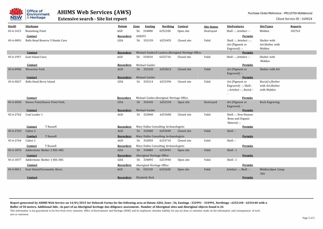
AHIMS Web Services (AWS) Extensive search - Site list report
Datum
Purchase Order/Reference : PR119759 McMahons2
Client Service ID : 160024
SiteID SiteName Zone Easting Northing Context SiteFeatures SiteTypes Reports Site Status
Report generated by AHIMS Web Service on 14/01/2015 for Deborah Farina for the following area at Datum :GDA, Zone : 56, Eastings : 332991 - 334991, Northings : 6252140 - 6254140 with a Buffer of 50 meters. Additional Info : As part of an Aboriginal heritage due diligence assessment.. Number of Aboriginal sites and Aboriginal objects found is 26 This information is not guaranteed to be free from error omission. Office of Environment and Heritage (NSW) and its employees disclaim liability for any act done or omission made on the information and consequences of such acts or omission.
Page 2 of 2
45-6-1615 Bennelong Point AGD 56 334800 6252100 Open site Destroyed Shell : -, Artefact : - Midden 102763
Contact Recorders ASRSYS Permits 45-6-0891 Balls Head Reserve 5 Hands Cave GDA 56 333139 6253455 Closed site Valid Shell : -, Artefact : -,
Art (Pigment or Engraved) : -
Shelter with Art,Shelter with Midden
Contact Recorders Michael Guider,D Lautrec,Aboriginal Heritage Office Permits 45-6-1957 Goat Island Cave; AGD 56 333010 6252710 Closed site Valid Shell : -, Artefact : - Shelter with
Midden Contact Recorders Michael Guider Permits
45-6-0906 Waverton Park
Contact
AGD
Recorders
56 333320
Michael Guider
6253813 Closed site Valid Art (Pigment or Engraved) : -
Permits
Shelter with Art
45-6-0027 Balls Head Berry Island GDA 56 333214 6253390 Closed site Valid Art (Pigment or Burial/s,Shelter
Engraved) : -, Shell : with Art,Shelter
-, Artefact : -, Burial : with Midden
- Contact Recorders Michael Guider,Aboriginal Heritage Office Permits
45-6-0030 Dawes Point;Dawes Point Park; GDA 56 334345 6252534 Open site Destroyed Art (Pigment or Rock Engraving
Engraved) : - Contact Recorders Michael Guider Permits 45-6-2762 Coal Loader 1 AGD 56 332840 6253600 Closed site Valid Shell : -, Non-Human
Bone and Organic Material : -
Contact T Russell Recorders Mary Dallas Consulting Archaeologists Permits 45-6-2763 Caltex 2
Contact
T Russell
AGD
Recorders
56 332840 6253690 Closed site
Mary Dallas Consulting Archaeologists
Valid Shell : -
Permits
45-6-2764 Caltex 1 AGD 56 332850 6253710 Closed site Valid Shell : - Contact T Russell Recorders Mary Dallas Consulting Archaeologists Permits 45-6-3076 Adderstone Shelter 2 NSC-082 GDA 56 334885 6253945 Open site Valid Shell : 1
Contact Recorders Aboriginal Heritage Office Permits 45-6-3077 Adderstone Shelter 1 NSC-081 GDA 56 334895 6253940 Open site Valid Shell : 1
Contact Recorders Aboriginal Heritage Office Permits 45-6-0811 Goat Island;Parramatta River; AGD 56 333150 6252650 Open site Valid Artefact : -, Shell : - Midden,Open Camp
Site Contact Recorders Elizabeth Rich Permits

Sydney Harbour Commuter Wharf Upgrade – McMahons Point Statement of Heritage Impact and Aboriginal Heirtage Report
PR119759-1; December 2015 Page 46
Appendix 3
Glossary of Site Types
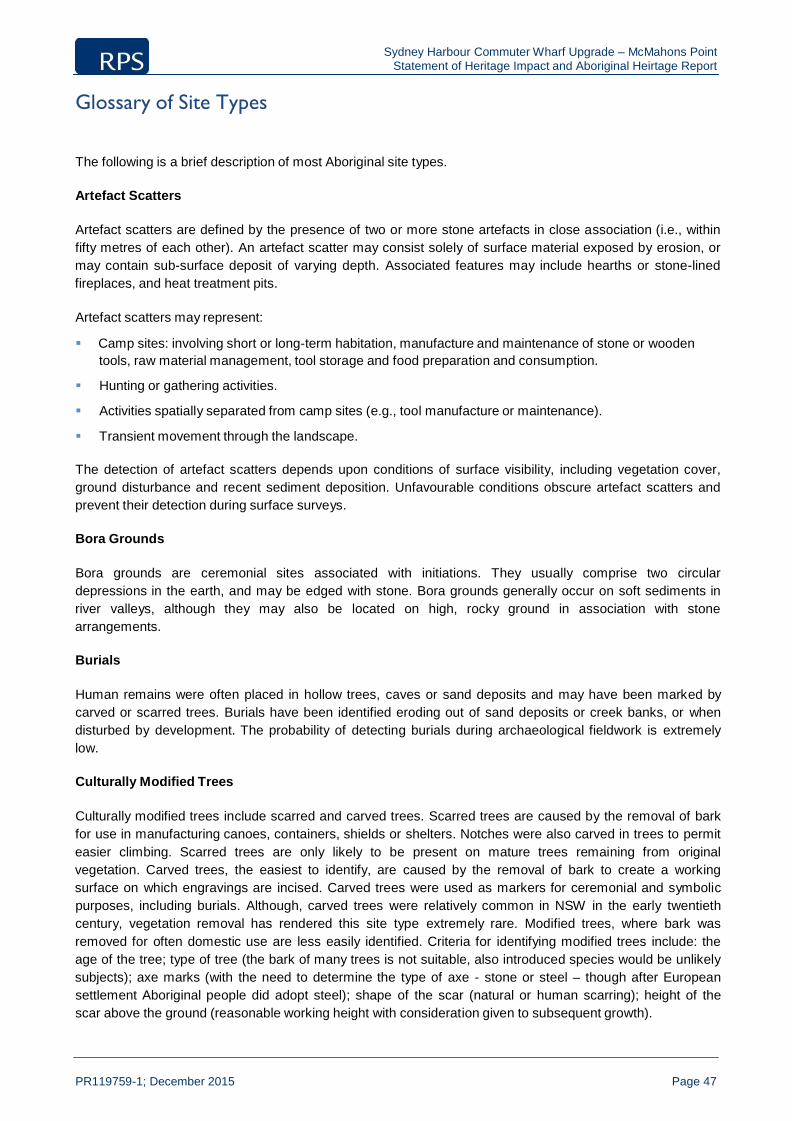
Sydney Harbour Commuter Wharf Upgrade – McMahons Point Statement of Heritage Impact and Aboriginal Heirtage Report
PR119759-1; December 2015 Page 47
Glossary of Site Types
The following is a brief description of most Aboriginal site types.
Artefact Scatters
Artefact scatters are defined by the presence of two or more stone artefacts in close association (i.e., within fifty metres of each other). An artefact scatter may consist solely of surface material exposed by erosion, or may contain sub-surface deposit of varying depth. Associated features may include hearths or stone-lined fireplaces, and heat treatment pits.
Artefact scatters may represent:
Camp sites: involving short or long-term habitation, manufacture and maintenance of stone or wooden
tools, raw material management, tool storage and food preparation and consumption.
Hunting or gathering activities. Activities spatially separated from camp sites (e.g., tool manufacture or maintenance).
Transient movement through the landscape.
The detection of artefact scatters depends upon conditions of surface visibility, including vegetation cover, ground disturbance and recent sediment deposition. Unfavourable conditions obscure artefact scatters and prevent their detection during surface surveys.
Bora Grounds
Bora grounds are ceremonial sites associated with initiations. They usually comprise two circular depressions in the earth, and may be edged with stone. Bora grounds generally occur on soft sediments in river valleys, although they may also be located on high, rocky ground in association with stone arrangements.
Burials
Human remains were often placed in hollow trees, caves or sand deposits and may have been marked by carved or scarred trees. Burials have been identified eroding out of sand deposits or creek banks, or when disturbed by development. The probability of detecting burials during archaeological fieldwork is extremely low.
Culturally Modified Trees
Culturally modified trees include scarred and carved trees. Scarred trees are caused by the removal of bark for use in manufacturing canoes, containers, shields or shelters. Notches were also carved in trees to permit easier climbing. Scarred trees are only likely to be present on mature trees remaining from original vegetation. Carved trees, the easiest to identify, are caused by the removal of bark to create a working surface on which engravings are incised. Carved trees were used as markers for ceremonial and symbolic purposes, including burials. Although, carved trees were relatively common in NSW in the early twentieth century, vegetation removal has rendered this site type extremely rare. Modified trees, where bark was removed for often domestic use are less easily identified. Criteria for identifying modified trees include: the age of the tree; type of tree (the bark of many trees is not suitable, also introduced species would be unlikely subjects); axe marks (with the need to determine the type of axe - stone or steel – though after European settlement Aboriginal people did adopt steel); shape of the scar (natural or human scarring); height of the scar above the ground (reasonable working height with consideration given to subsequent growth).

Sydney Harbour Commuter Wharf Upgrade – McMahons Point Statement of Heritage Impact and Aboriginal Heirtage Report
PR119759-1; December 2015 Page 48
Fish Traps
Fish traps comprised arrangements of stone, branches and/or wickerwork placed in watercourses, estuaries and along coasts to trap or permit the easier capture of sea life.
Grinding Grooves
Grinding grooves are elongated narrow depressions in soft rocks (particularly sedimentary), generally associated with watercourses, that are created by the shaping and sharpening of ground-edge implements. To produce a sharp edge the axe blank (or re-worked axe) was honed on a natural stone surface near a source of water. The water was required to lubricate the grinding process. Axe grinding grooves can be identified by features such as a narrow short groove, with greatest depth near the groove centre. The grooves also display a patina developed through friction between stone surfaces. Generally a series of grooves are found as a result of the repetitive process.
Isolated Finds
Isolated finds are isolated artefacts within a survey area. These finds are not found in apparent association with other evidence for prehistoric activity or occupation. Isolated finds occur anywhere and may represent loss, deliberate discard or abandonment of an artefact, or may be the remains of a dispersed artefact scatter. Numerous isolated finds have been recorded within the Proposal Area. An isolated find may flag the occurrence of other less visible artefacts in the vicinity or may indicate disturbance or relocation after the original discard.
Middens
Shell middens comprise deposits of shell remaining from consumption and are common in coastal regions and along watercourses. Middens vary in size, preservation and content, although they often contain artefacts made from stone, bone or shell, charcoal, and the remains of terrestrial or aquatic f auna that formed an additional component of Aboriginal diet. Middens can provide significant information on land-use patterns, diet, chronology of occupation and environmental conditions.
Mythological / Traditional Sites
Mythological and traditional sites of significance to Aboriginal people may occur in any location, although they are often associated with natural landscape features. They include sites associated with dreaming stories, massacre sites, traditional camp sites and contact sites. Consultation with the local Aboriginal community is essential for identifying these sites.
Rock Shelters with Art and / or Occupation Deposit
Rock shelters occur where geological formations suitable for habitation or use are present, such as rock overhangs, shelters or caves. Rock shelter sites generally contain artefacts, food remains and/or rock art and may include sites with areas of potential archaeological deposit, where evidence of rock-art or human occupation is expected but not visible. The geological composition of the site greatly impacts the likelihood for rock shelters to occur.
Stone Arrangements
Stone arrangements include lines, circles, mounds, or other patterns of stone arranged by Aboriginal people. These may be associated with bora grounds, ceremonial sites, mythological or sacred sites. Stone

Sydney Harbour Commuter Wharf Upgrade – McMahons Point Statement of Heritage Impact and Aboriginal Heirtage Report
PR119759-1; December 2015 Page 49
arrangements are more likely to occur on hill tops and ridge crests that contain stone outcrops or surface stone, where impact from recent land use practices has been minimal.
Stone Quarries
A stone quarry is a place at which stone resource exploitation has occurred. Quarry sites are only located where the exposed stone material is suitable for use either for ceremonial purposes (e.g., ochre) or for artefact manufacture.

Sydney Harbour Commuter Wharf Upgrade – McMahons Point Statement of Heritage Impact and Aboriginal Heirtage Report
PR119759-1; December 2015 Page 50
Appendix 4
PACHCI Letter
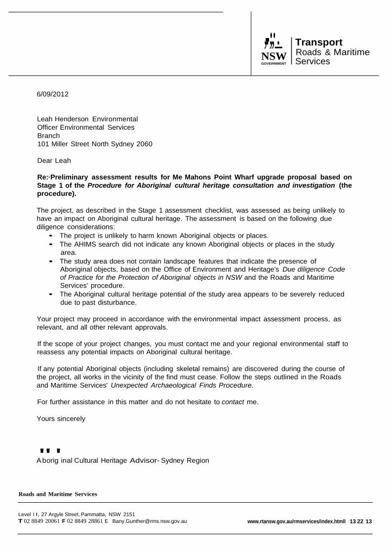
-··
,.,,_. NSW GOVERNMENT
Transport Roads & Maritime Services
6/09/2012
Leah Henderson Environmental Officer Environmental Services Branch 101 Miller Street North Sydney 2060
Dear Leah
Re:·Preliminary assessment results for Me Mahons Point Wharf upgrade proposal based on Stage 1 of the Procedure for Aboriginal cultural heritage consultation and investigation (the procedure).
The project, as described in the Stage 1 assessment checklist, was assessed as being unlikely to have an impact on Aboriginal cultural heritage. The assessment is based on the following due diligence considerations:
• The project is unlikely to harm known Aboriginal objects or places. • The AHIMS search did not indicate any known Aboriginal objects or places in the study
area. • The study area does not contain landscape features that indicate the presence of
Aboriginal objects, based on the Office of Environment and Heritage's Due diligence Code of Practice for the Protection of Aboriginal objects in NSW and the Roads and Maritime Services' procedure.
• The Aboriginal cultural heritage potential of the study area appears to be severely reduced due to past disturbance.
Your project may proceed in accordance with the environmental impact assessment process, as relevant, and all other relevant approvals.
If the scope of your project changes, you must contact me and your regional environmental staff to reassess any potential impacts on Aboriginal cultural heritage.
If any potential Aboriginal objects (including skeletal remains) are discovered during the course of the project, all works in the vicinity of the find must cease. Follow the steps outlined in the Roads and Maritime Services' Unexpected Archaeological Finds Procedure.
For further assistance in this matter and do not hesitate to contact me.
Yours sincerely
A"borig'inal Cultural Heritage Advisor- Sydney Region
Roads and Maritime Services
Level I I, 27 Argyle Street, Pammatta, NSW 2151 T 02 8849 20061 F 02 8849 28861 E [email protected] www.rtansw.gov.au/rmservices/index.htmll 13 22 13
Sydney Harbour Commuter Wharf Upgrade – McMahons Point Statement of Heritage Impact and Aboriginal Heirtage Report
Appendix 5
Design Plans
PR119759-1; December 2015 Page 51

PRELIMINARY NUMBER
REVISION
DATE
SCALE
NORTH
SYDNEY WHARVES
SK05-40 D 02.10.2015 1 : 500 @ A3 © GROUP GSA
POINT_2015_[Concept Options]_JGRAY.rvt
AV
ENUE
"SAILS RESTAURANT"
LAWSON
COVERED SHELTER
EXISTING WHARF TO BE DEMOLISHED SHOWN DASHED STEEL FENDER PILE ARRESTOR UNCOVERED CONCRETE BRIDGE UNCOVERED GANGWAY
PAVED FOOTPATH
UNCOVERED PONTOON at 174 DEGREES
LINE OF FORESHORE
CONCEPT DESIGN SIGN OFF:
RMS
BY: DATE:
SYDNEY WHARVES UPGRADE PROGRAM
MCMAHONS POINT WHARF RELOCATION PLAN - OPTION 5B
DRAWING C:\_REVIT PROJECTS\13999_SHWU_LOCAL FILE_MCMAHONS

Appendix D Noise and vibration assessment
Appendix D

I:\Jobs\2010\2010366\McMahons Point\20151210BWa_R13_McMahons Point Wharf - Noise and Vibration Impact Assessment.docx
1
MANAGING DIRECTORS MATTHEW PALAVIDIS VICTOR FATTORETTO
DIRECTORS MATTHEW SHIELDS BEN WHITE
MANAGING RS
MATTHEW PALAVIDIS
VICTOR FATTORETTO
Sydney Harbour Ferries Wharf Upgrade
McMahons Point Wharf - Noise and Vibration Impact Assessment
DOCUMENT CONTROL REGISTER
Project Number 2010366.1 Project Name Sydney Harbour Ferries Wharf Upgrade Document Title McMahons Point Wharf - Noise and
Vibration Impact Assessment Document Reference 2010366.1/1012A/R13/BW Issue Type Email Attention To Hansen Yuncken Pty Ltd
Paul Blair

I:\Jobs\2010\2010366\McMahons Point\20151210BWa_R13_McMahons Point Wharf - Noise and Vibration Impact Assessment.docx
2
Revision Date Document Reference Prepared By
Checked By
Approved By
0 28/11/2013 2010366/2811A/R0/BW JL TT BW 1 4/12/2013 2010366/412A/R1/BW JL TT BW 2 20/1/2014 2010366/201A/R2/BW JL TT BW 3 23/01/2015 2010366.1/2301A/R3/BW JL TT BW 4 27/01/2015 2010366.1/2701A/R4/BW JL TT BW 5 17/06/2015 2010366.1/2701A/R5/BW JL TT BW 6 29/10/2015 2010366.1/2701A/R6/BW JL TT BW 7 11/11/2015 2010366.1/2701A/R7/BW JL TT BW 8 9/12/2015 2010366.1/2701A/R8/BW JL TT BW

I:\Jobs\2010\2010366\McMahons Point\20151210BWa_R13_McMahons Point Wharf - Noise and Vibration Impact Assessment.docx
3
TABLE OF CONTENTS 1 INTRODUCTION 5 2 PROJECT DESCRIPTION AND POTENTIALLY AFFECTED PROPERTIES 6
10 11
2.1 SITE WORKS 12 3 CONSTRUCTION NOISE CRITERIA 12 3.1 OEH CONSTRUCTION NOISE GUIDELINE 12
3.1.1 Interim Construction Noise Guideline – Quantitative Assessment Method 12 3.1.2 Sleep Disturbance 13
3.2 ACOUSTIC SURVEY 13 3.3 ENVIRONMENTAL NOISE LEVELS 13
3.3.1 Unattended noise monitoring 13 3.3.1.1 Unattended Monitoring Period 14 3.3.1.2 Monitoring Equipment 14
3.3.2 Existing Noise Levels 14 3.4 CONSTRUCTION NOISE GOALS 15 3.5 SLEEP DISTURBANCE 15 4 CONSTRUCTION VIBRATION CRITERIA 16 4.1 GERMAN STANDARD DIN 4150-3 (1999-02) 16 4.2 BRITISH STANDARD BS 6472:1992 17 4.3 PROJECT CRITERIA 17 4.4 GROUND BORNE VIBRATION 18 5 CONSTRUCTION HOURS AND DURATION 19 6 NOISE AND VIBRATION ASSESSMENT 20 6.1 AUSTRALIAN STANDARD AS2436:1981 “GUIDE TO NOISE CONTROL ON CONSTRUCTION, MAINTENANCE AND DEMOLITION SITES 20 6.2 DETERMINATION OF CONSTRUCTION NOISE AND VIBRATION IMPACT 20 6.3 SOUND POWER AND VIBRATION LEVELS 21 6.4 VIBRATION IMPACT 21 6.5 CONSTRUCTION SCENARIOS 22 6.6 PREDICTED CONSTRUCTION NOISE LEVELS AT RESIDENTIAL RECEIVER 23 6.7 PREDICTED CONSTRUCTION NOISE LEVELS AT SAILS ON LAVENDER BAY RESTAURANT 28 6.8 NOISE AND VIBRATION MANAGEMENT FOR MCMAHONS POINT WHARF 29 7 NOISE AND VIBRATION CONTROL METHODS 30 7.1 NOISE MANAGEMENT CONTROL FOR PROPOSED NIGHT WORKS 30 7.2 SELECTION OF ALTERNATE APPLIANCE OR PROCESS 30 7.3 SILENCING DEVICES 30 7.4 MATERIAL HANDLING 30 7.5 TREATMENT OF SPECIFIC EQUIPMENT 30 7.6 ESTABLISHMENT OF SITE PRACTICES 31 7.7 REGULAR NOISE CHECKS OF EQUIPMENT 31 7.8 COMBINATION OF METHODS 31 7.9 SCREENING OF OPERATIONS 31
7.9.1 Noise and Vibration Monitoring 31 7.10ESTABLISHMENT OF DIRECT COMMUNICATION WITH AFFECTED PARTIES 32
7.10.1 Dealing with complaints 33 8 OPERATIONAL NOISE AND VIBRATION IMPACT ASSESSMENT 34 8.1 MCMAHONS POINT WHARF 34 8.2 SURROUNDING SERVICES 34

I:\Jobs\2010\2010366\McMahons Point\20151210BWa_R13_McMahons Point Wharf - Noise and Vibration Impact Assessment.docx
4
8.3 FUTURE OPERATIONS 34 9 CONCLUSION 35 REFERENCES 36

I:\Jobs\2010\2010366\McMahons Point\20151210BWa_R13_McMahons Point Wharf - Noise and Vibration Impact Assessment.docx
5
1 INTRODUCTION This document presents the acoustic impact assessment for noise and vibration associated with the proposed McMahons Point Wharf Upgrade project. The document assesses the noise and vibration associated with the proposed construction and operational activities which are required as part of the wharf upgrade, including the potential for noise and vibration impact to receivers within close proximity to the site. The report:
1. Details suitable vibration criteria based on the relevant Australian and international
standards for construction vibration including the British Standard BS 6472:1992 “Guide to Evaluation of Human Exposure to Vibration in Buildings (1Hz to 80Hz) and German Standard DIN 4150-3 (1999-02): “Structural Vibration – Effects of Vibration on Structures”.
2. Assesses construction noise impact to surrounding residential receivers in conjunction with
the relevant construction noise manuals including the Australian Standards and the Interim Construction Noise Guidelines (DECCW, 2009).
3. Conducts an assessment of potential noise impact from the operation of the future wharf.
4. Formulates a strategy for construction activities to comply with the relevant noise and
vibration standards including a suitable monitoring regime to be implemented when potentially high noise and vibration generating activities are being used and recommends noise and vibration controls for the relevant plant and equipment to be used on the site.
I:\Jobs\2010\2010366\McMahons Point\20151210BWa_R13_McMahons Point Wharf - Noise and Vibration Impact Assessment.docx
6
2 PROJECT DESCRIPTION AND POTENTIALLY AFFECTED PROPERTIES
The proposal includes the demolition and removal of existing wharf structures and construction of a new wharf, consisting of shelter, bridge, gangway and pontoon. The positioning of the new wharf is expected to be as shown at figure 1. However, for the purposes of this assessment, a proposal area has been assessed which considers potential changes to the position of the wharf should they be required following further design development.
The proposal includes:
Demolition and removal of the existing wharf structures
Prior to constructing the proposed wharf, the existing wharf including waiting shelter, tidal stairs, lights, posts, fencing and timber piles, information totems and CCTV system would be demolished and removed.
Construction of a new wharf
Construction of a covered shelter about 20 metres long and 10 metres wide over the water. The shelter would connect to land at an angle of about 90 degrees and would be supported by about 12 steel piles. The shelter would include the provision of a stainless steel clad services pod including, for example, an electricity distribution board, Ferry Operations and Customer Information System (FOCIS), bins, signage boards and a help point. The waiting shelter would include glass screens at its northern and southern ends.
Construction of an uncovered concrete bridge about three metres wide and 25 metres long extending from the shelter at an angle of about 90 degrees. The bridge would connect to the gangway headstock support and would be supported on about 12 steel piles and precast concrete head stocks.
Construction of an uncovered aluminium gangway about 18 metres long and about 3 metres wide to a floating pontoon. The gangway would extend from the bridge at an angle of about 45 degrees. The gradient of the gangway would vary according to the tides.
Construction and installation of a rectangular steel floating pontoon off the gangway. The pontoon would be about 12 metres wide and 27 metres long and would have two berthing faces. The pontoon would be uncovered with stainless steel balustrades at the northern and southern ends and include seating. The floating pontoon would be held in place by four steel piles. The floating pontoon alignment would extend off the gangway at an angle of about 174 degrees.
Installation of safety and security facilities including lighting, closed circuit television (CCTV), ladders to the water from the pontoon, a life ring on the pontoon platform and tactile floor treatments.

I:\Jobs\2010\2010366\McMahons Point\20151210BWa_R13_McMahons Point Wharf - Noise and Vibration Impact Assessment.docx
7
Ancillary facilities A temporary compound would be established including site sheds, an amenities shed and storage containers for tools and some materials. The location of the temporary compound is to be confirmed and would be subject to council review and agreement prior to the commencement of works at the site..
Landside works
Landside upgrade works would include realignment of kerb and gutter and footpath at the northern end of Henry Lawson Avenue adjacent to the wharf entrance and at the southern end of the laneway on the western side of Sails restaurant.
The turning circle at Henry Lawson Avenue adjacent to the wharf entry would also be upgraded to better allow buses to mauver safely at the site of the wharf entrance. Works would include kerb and gutter upgrades to the north and to the east of the turning circle.
The wharf (including the shelter, bridge, gangway and pontoon) would be constructed to be accessible to people with a disability for no less than 80 per cent of the high and low tide levels listed in standard tide charts.
The new wharf components (ie shelter, bridge, gangway and pontoon) would be predominately assembled at the contractor’s off-site facility before being transported to the site via barge.
The proposal would require the McMahons Point Wharf to be closed to all ferries, water taxis and other vessels/watercraft for the duration of construction to enable the works to be carried out.
An overview of the proposal including the approximate location of the works is detailed in the figure 1.

I:\Jobs\2010\2010366\McMahons Point\20151210BWa_R13_McMahons Point Wharf - Noise and Vibration Impact Assessment.docx
8
Figure 1- Overview of the proposal
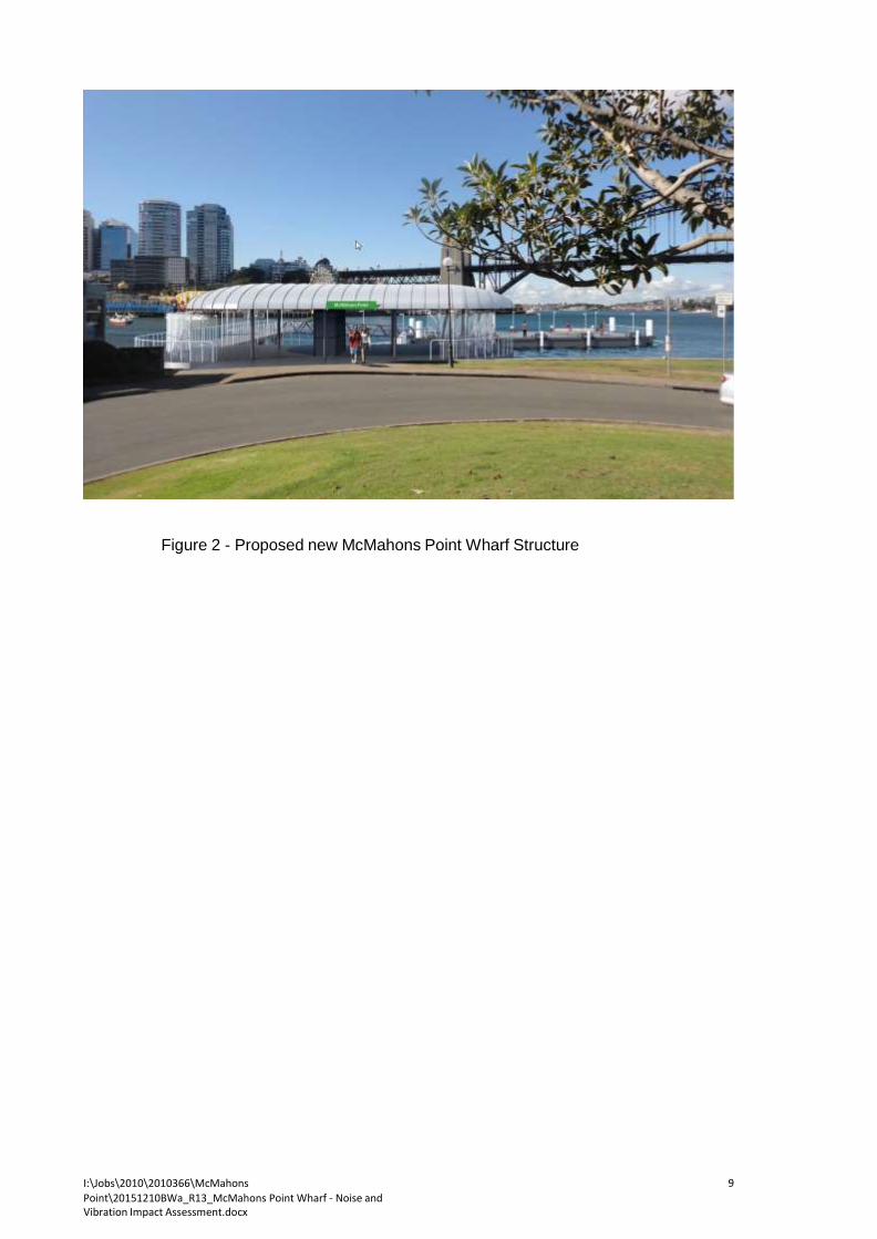
I:\Jobs\2010\2010366\McMahons Point\20151210BWa_R13_McMahons Point Wharf - Noise and Vibration Impact Assessment.docx
9
Figure 2 - Proposed new McMahons Point Wharf Structure
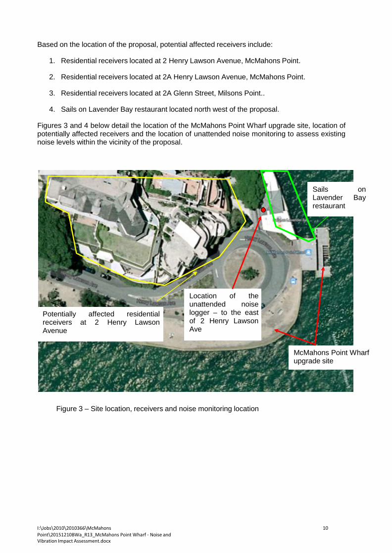
I:\Jobs\2010\2010366\McMahons Point\20151210BWa_R13_McMahons Point Wharf - Noise and Vibration Impact Assessment.docx
10
Based on the location of the proposal, potential affected receivers include:
1. Residential receivers located at 2 Henry Lawson Avenue, McMahons Point.
2. Residential receivers located at 2A Henry Lawson Avenue, McMahons Point.
3. Residential receivers located at 2A Glenn Street, Milsons Point..
4. Sails on Lavender Bay restaurant located north west of the proposal. Figures 3 and 4 below detail the location of the McMahons Point Wharf upgrade site, location of potentially affected receivers and the location of unattended noise monitoring to assess existing noise levels within the vicinity of the proposal.
Sails on Lavender Bay restaurant
Potentially affected residential receivers at 2 Henry Lawson Avenue
Location of the unattended noise logger – to the east of 2 Henry Lawson Ave
McMahons Point Wharf upgrade site
Figure 3 – Site location, receivers and noise monitoring location
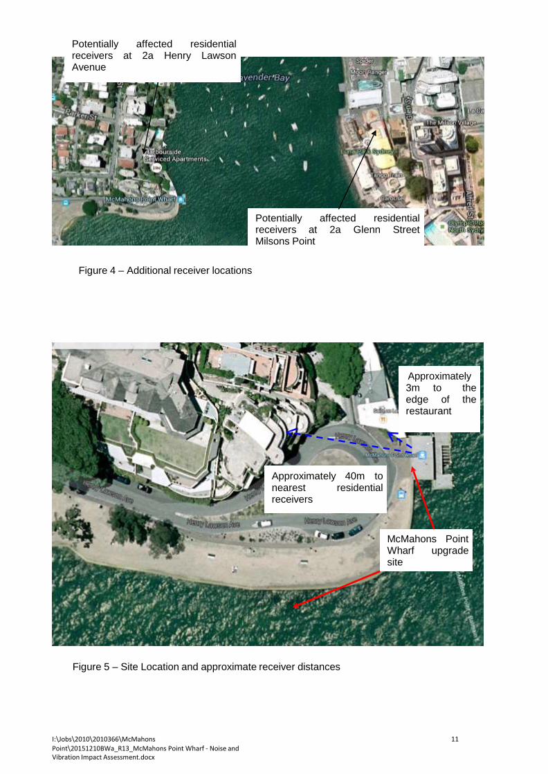
I:\Jobs\2010\2010366\McMahons Point\20151210BWa_R13_McMahons Point Wharf - Noise and Vibration Impact Assessment.docx
11
Potentially affected residential receivers at 2a Henry Lawson Avenue
Potentially affected residential receivers at 2a Glenn Street Milsons Point
Figure 4 – Additional receiver locations
Approximately 3m to the edge of the restaurant
Approximately 40m to nearest residential receivers
McMahons Point Wharf upgrade site
Figure 5 – Site Location and approximate receiver distances

I:\Jobs\2010\2010366\McMahons Point\20151210BWa_R13_McMahons Point Wharf - Noise and Vibration Impact Assessment.docx
12
2.1 SITE WORKS A temporary compound would be established including site sheds, an amenities shed and storage containers for tools and materials. The location of the compound area is to be confirmed and would be subject to council review and agreement prior to the commencement of works at the site. It is understood that the proposal has been designed so that much of the construction work is undertaken offsite which will minimise the amount of construction activity at the McMahons Point Wharf and consequently minimise the amount and duration of noise emission on site.
On site construction works are scheduled to last up to about 6 months with the piling activities expected to last up to 2 weeks.
3 CONSTRUCTION NOISE CRITERIA
To determine construction noise criteria it is proposed to use the Interim Construction Noise Guideline (DECCW, 2009) which detail requirements for construction noise. These requirements are presented in the following sections below.
3.1 OEH CONSTRUCTION NOISE GUIDELINE
The NSW Department of Climate Change and Water (now the Office of Environment and Heritage) have developed a specific construction noise guideline in the aid of reducing the impact of construction associated noise.
The guideline reflects on feasible and reasonable mitigation strategies, management controls and community consultation in the effort to reach realistic compromises between construction sites and potential noise affected receivers.
3.1.1 Interim Construction Noise Guideline – Quantitative Assessment Method
The guideline refers to a Quantitative assessment method in which construction noise is assessed on a case by case basis with regard to various activities to be conducted on site. This assessment includes the prediction of noise levels at surrounding receivers which is included in this report.
In addition, the guideline specifies goals to minimise noise from construction related activities. These noise goals are presented within the table below.
Table 1 – EPA Recommended Construction Noise Goals
Governing Body Receiver Type External sound level Goal,
Leq 15 min dB(A)
EPA
Residential
Day - Background + 10 dB(A)1
Evening - Background + 5 dB(A)1
Night - Background + 5 dB(A)1
75 dB(A)2
Commercial
Premises
The external noise levels should be assessed at the most-affected occupied point of the premises:
-offices, retail outlets: external LAeq (15 min) 70 dB(A).
1: Where the predicted or measured LAeq (15 min) is greater than the noise affected level, the proponent should apply all feasible and reasonable work practices to minimise noise (DECCW, 2009).
I:\Jobs\2010\2010366\McMahons Point\20151210BWa_R13_McMahons Point Wharf - Noise and Vibration Impact Assessment.docx
13
2: Where noise is above this level, the proponent should consider very carefully if there is any other feasible and reasonable way to reduce noise to below this level. If no quieter work method is feasible and reasonable, and the works proceed, the proponent should communicate with the impacted residents by clearly explaining the duration and noise level of the works, and by describing any respite periods that will be provided (DECCW, 2009).
These criteria aim to maintain comfort levels within surrounding residential dwellings and other non residential receivers. Additionally, noise mitigation techniques as discussed in this report should be used if noise emissions exceed the above criteria. All work is to be carried out in accordance with AS 2436:1981 “Guide to noise control on construction, maintenance and demolition sites”.
3.1.2 Sleep Disturbance
The Interim Construction Noise Guideline states that where construction works are planned to extend over more than two consecutive nights, the impact assessment should cover the maximum noise level from the proposed works. The resulting sleep disturbance criteria is summarised in the section below.
3.2 ACOUSTIC SURVEY
As part of this assessment an acoustic survey of the existing acoustic environment within the vicinity of the proposed McMahons Point wharf was conducted. The acoustic survey included acoustic monitoring using an unattended noise logger as detailed in this section of the report and results are provided at Appendix B.
3.3 ENVIRONMENTAL NOISE LEVELS
Environmental noise constantly varies in level, due to fluctuations in local noise sources including road traffic. Accordingly, a 15 minute measurement interval is normally utilised. Over this period, noise levels are monitored on a continuous basis and statistical and integrating techniques are used to determine noise description parameters.
In the case of environmental noise three principle measurement parameters are used, namely L10, L90 and Leq.
The L10 and L90 measurement parameters are statistical levels that represent the average maximum and average minimum noise levels respectively, over the measurement intervals.
The L10 parameter is commonly used to measure noise produced by a particular intrusive noise source since it represents the average of the loudest noise levels produced by the source.
Conversely, the L90 level (which is commonly referred to as the background noise level) represents the noise level heard in the quieter periods during a measurement interval. The L90 parameter is used to set the allowable noise level for new, potentially intrusive noise sources since the disturbance caused by the new source depends on how audible it is above the pre-existing noise environment, particularly during quiet periods, as represented by the L90 level.
The Leq parameter represents the average noise energy during a measurement period. This parameter is derived by integrating the noise levels measured over the measurement period. Leq is important in the assessment of traffic noise impact as it closely corresponds with human perception of a changing noise environment; such is the character of industrial noise.
3.3.1 Unattended noise monitoring
Unattended noise monitoring conducted as part of this assessment is detailed in this section of the report and results of the unattended noise monitoring is provided at Appendix B.
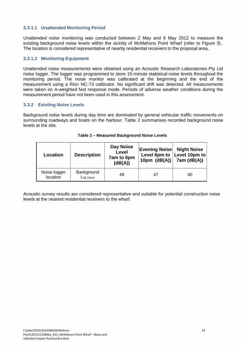
I:\Jobs\2010\2010366\McMahons Point\20151210BWa_R13_McMahons Point Wharf - Noise and Vibration Impact Assessment.docx
14
3.3.1.1 Unattended Monitoring Period Unattended noise monitoring was conducted between 2 May and 9 May 2012 to measure the existing background noise levels within the vicinity of McMahons Point Wharf (refer to Figure 3).. The location is considered representative of nearby residential receivers to the proposal area..
3.3.1.2 Monitoring Equipment
Unattended noise measurements were obtained using an Acoustic Research Laboratories Pty Ltd noise logger. The logger was programmed to store 15-minute statistical noise levels throughout the monitoring period. The noise monitor was calibrated at the beginning and the end of the measurement using a Rion NC-73 calibrator. No significant drift was detected. All measurements were taken on A-weighted fast response mode. Periods of adverse weather conditions during the measurement period have not been used in this assessment.
3.3.2 Existing Noise Levels
Background noise levels during day time are dominated by general vehicular traffic movements on surrounding roadways and boats on the harbour. Table 2 summarises recorded background noise levels at the site.
Table 2 – Measured Background Noise Levels
Location
Description
Day Noise Level
7am to 6pm (dB(A))
Evening Noise Level 6pm to 10pm (dB(A))
Night Noise
Level 10pm to 7am (dB(A))
Noise logger location
Background L90,15min
49
47
40
Acoustic survey results are considered representative and suitable for potential construction noise levels at the nearest residential receivers to the wharf.

I:\Jobs\2010\2010366\McMahons Point\20151210BWa_R13_McMahons Point Wharf - Noise and Vibration Impact Assessment.docx
15
3.4 CONSTRUCTION NOISE GOALS Based on construction noise guidelines detailed in this report and background noise monitoring results within the vicinity of the proposal, the following table details construction noise goals for the proposed McMahons Point Ferry Wharf upgrade.
Table 3 – Construction Noise Goals
Location Time Period Description Noise Level
(dB(A)) Surrounding residential receivers
Day Leq,15min
59 dB(A) 75 dB(A)
Evening Leq,15min 52 dB(A)
Night Leq,15min 45 dB(A)
Sails on Lavender Bay Restaurant
All periods Leq,15min
70 dB(A)
3.5 SLEEP DISTURBANCE
The Interim Construction Noise Guideline states that where construction works are planned to extend over more than two consecutive nights, the impact assessment should cover the maximum noise level from the proposed works. The resulting sleep disturbance criteria is summarised in the table below.
For the purpose of this assessment and based on previous industry experience on construction projects, predicted LAeq(15minute) noise levels plus 8 dB(A) provides a conservative estimate of the LA1(1 minute) noise emission levels. Sleep disturbance predictions have been provided based on proposed out of hours work activities during night time hours.
Table 4 – Construction Noise Goals for Sleep Disturbance
Location Time Period Description Noise Level
(dB(A)) Surrounding residential receivers Night Time
Periods
L1,(1 minute)
55 dB(A)
OEH’s current approach to assessing potential sleep disturbance (Application Notes to Industrial Noise Policy) is to apply an initial screening criterion of background noise level plus 15 dBA and to undertake further analysis if the screening criterion cannot be achieved. The sleep disturbance screening criterion applies outside bedroom windows during the night-time period.
Where screening criterion cannot be met, the additional analysis should consider the number of potential sleep disturbance events during the night, the level of exceedance and the noise levels from other events.
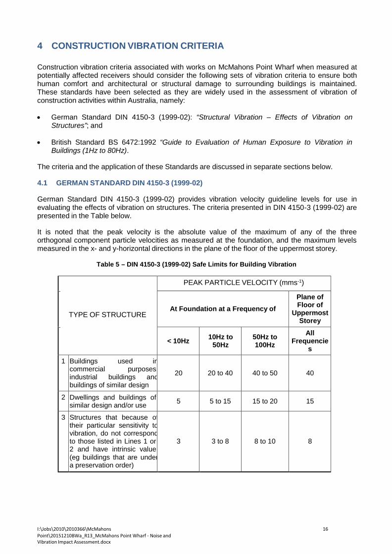
I:\Jobs\2010\2010366\McMahons Point\20151210BWa_R13_McMahons Point Wharf - Noise and Vibration Impact Assessment.docx
16
4 CONSTRUCTION VIBRATION CRITERIA Construction vibration criteria associated with works on McMahons Point Wharf when measured at potentially affected receivers should consider the following sets of vibration criteria to ensure both human comfort and architectural or structural damage to surrounding buildings is maintained. These standards have been selected as they are widely used in the assessment of vibration of construction activities within Australia, namely:
• German Standard DIN 4150-3 (1999-02): “Structural Vibration – Effects of Vibration on
Structures”; and • British Standard BS 6472:1992 “Guide to Evaluation of Human Exposure to Vibration in
Buildings (1Hz to 80Hz). The criteria and the application of these Standards are discussed in separate sections below.
4.1 GERMAN STANDARD DIN 4150-3 (1999-02)
German Standard DIN 4150-3 (1999-02) provides vibration velocity guideline levels for use in evaluating the effects of vibration on structures. The criteria presented in DIN 4150-3 (1999-02) are presented in the Table below.
It is noted that the peak velocity is the absolute value of the maximum of any of the three orthogonal component particle velocities as measured at the foundation, and the maximum levels measured in the x- and y-horizontal directions in the plane of the floor of the uppermost storey.
Table 5 – DIN 4150-3 (1999-02) Safe Limits for Building Vibration
TYPE OF STRUCTURE
PEAK PARTICLE VELOCITY (mms-1)
At Foundation at a Frequency of Plane of Floor of
Uppermost Storey
< 10Hz
10Hz to
50Hz
50Hz to 100Hz
All Frequencie
s
1 Buildings used in commercial purposes, industrial buildings and buildings of similar design
20
20 to 40
40 to 50
40
2 Dwellings and buildings of similar design and/or use
5
5 to 15
15 to 20
15
3 Structures that because of their particular sensitivity to vibration, do not correspond to those listed in Lines 1 or 2 and have intrinsic value (eg buildings that are under a preservation order)
3
3 to 8
8 to 10
8

I:\Jobs\2010\2010366\McMahons Point\20151210BWa_R13_McMahons Point Wharf - Noise and Vibration Impact Assessment.docx
17
4.2 BRITISH STANDARD BS 6472:1992 British Standard BS 6472:1992 develops criteria relating to levels of building vibration that may be expected to give rise to “adverse comment”, in the frequency range most applicable to impacts associated with construction, which is 1 to 80Hz. These threshold values are used as criteria for assessing the loss of amenity and are presented below in Table 3.
Table 6 – BS 6472:1992 Criteria to Avoid “Adverse Comment”
Type of Occupancy
Time of Day
Peak Particle Velocity (mms-1) between 1Hz to 80Hz Likely to Cause “Adverse Comment”
Continuous Vibration
Intermittent Vibration and Impulsive Vibration
Excitation with Several Occurrences per day
Vertical Horizontal Vertical Horizontal
Residential Day 0.3 to 0.6 0.8 to 0.6 8.4 to 12.6 24 to 36
Night 0.2 0.6 2.8 8
Offices Day 0.6 1.6 18 51
Night 0.6 1.6 18 51
Workshops Day 1.2 3.2 18 51
Night 1.2 3.2 18 51 The limits indicate that people in buildings are significantly less susceptible to horizontal vibration than to vertical vibration. Furthermore, Section 4.1 of BS 6472 notes that situations can exist where vibration magnitudes above those generally corresponding to minimal “adverse comment” levels can be tolerated, particularly for temporary disturbances and infrequent and intermittent events such as those associated with construction projects.
4.3 PROJECT CRITERIA
Based on the criteria detailed within the standards above the project vibration goal for the surrounding receivers includes the following criteria for cosmetic damage criteria:
1. Residential Receivers - Peak particle velocity of 10mm/s.
2. Restaurant Receiver - Peak particle velocity of 10mm/s.
The vibration criteria above is based on the vibration limits detailed in the Sections above including the spectrum criteria detailed within the German Standard DIN 4150-3 (1999-02) and specifically the potentially worst affected frequencies of 10-50Hz.
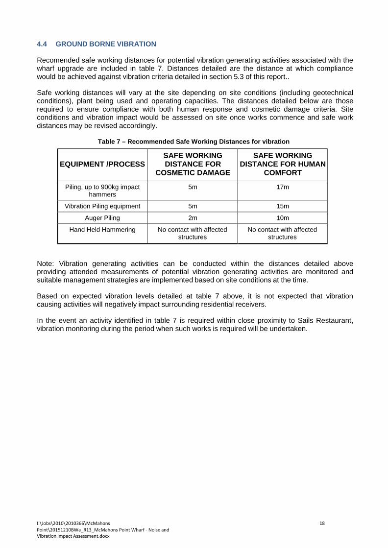
I:\Jobs\2010\2010366\McMahons Point\20151210BWa_R13_McMahons Point Wharf - Noise and Vibration Impact Assessment.docx
18
4.4 GROUND BORNE VIBRATION Recomended safe working distances for potential vibration generating activities associated with the wharf upgrade are included in table 7. Distances detailed are the distance at which compliance would be achieved against vibration criteria detailed in section 5.3 of this report..
Safe working distances will vary at the site depending on site conditions (including geotechnical conditions), plant being used and operating capacities. The distances detailed below are those required to ensure compliance with both human response and cosmetic damage criteria. Site conditions and vibration impact would be assessed on site once works commence and safe work distances may be revised accordingly.
Table 7 – Recommended Safe Working Distances for vibration
EQUIPMENT /PROCESS
SAFE WORKING DISTANCE FOR
COSMETIC DAMAGE
SAFE WORKING DISTANCE FOR HUMAN
COMFORT
Piling, up to 900kg impact hammers
5m 17m
Vibration Piling equipment 5m 15m
Auger Piling 2m 10m
Hand Held Hammering No contact with affected structures
No contact with affected structures
Note: Vibration generating activities can be conducted within the distances detailed above providing attended measurements of potential vibration generating activities are monitored and suitable management strategies are implemented based on site conditions at the time.
Based on expected vibration levels detailed at table 7 above, it is not expected that vibration causing activities will negatively impact surrounding residential receivers.
In the event an activity identified in table 7 is required within close proximity to Sails Restaurant, vibration monitoring during the period when such works is required will be undertaken.

I:\Jobs\2010\2010366\McMahons Point\20151210BWa_R13_McMahons Point Wharf - Noise and Vibration Impact Assessment.docx
19
5 CONSTRUCTION HOURS AND DURATION Construction would be limited to standard work times, being:
• 7am to 6pm Monday to Friday.
• 8am to 1pm Saturday.
However, work outside of standard hours would also be required in order to carry out piling activities and intricate lifts from the barge mounted crane, due to requirements for still water. Activities that are likely to be undertaken outside of standard work hours are outlined below.
The proposal would be constructed over a period of about 4 months (weather permitting), starting early 2016. However, for the purpose of this assessment a construction period of up to six months has been considered.
Detail of the proposed construction activities is provided at section 2.

I:\Jobs\2010\2010366\McMahons Point\20151210BWa_R13_McMahons Point Wharf - Noise and Vibration Impact Assessment.docx
20
6 NOISE AND VIBRATION ASSESSMENT An assessment of the principal sources of noise and vibration emission has been undertaken to identify the activities that may produce noise and/or vibration impacts so that appropriate ameliorative measures can be formulated.
Typical acoustic/vibration controls for specific equipment are discussed in this section of the report.
6.1 AUSTRALIAN STANDARD AS2436:1981 “GUIDE TO NOISE CONTROL ON
CONSTRUCTION, MAINTENANCE AND DEMOLITION SITES The Australian Standard AS2436 states that where all reasonable and available measures have been taken to reduce construction noise, mitigation strategies may be put in place to reduce noise levels to within a reasonable and acceptable level. The standard has been detailed in this report for the purpose of information and the Interim Construction Noise Guideline will be used for the assessment of noise impact. The standard provides comments regarding noise management which may be relevant.
For the control and regulation of noise from construction sites AS2436:1981 “Guide to noise control on construction, maintenance and demolition sites” nominates the following:
a) That reasonable suitable noise criterion is established,
b) That all practicable measures be taken on the building site to regulate noise emissions,
including the siting of noisy static processes to locations of the site where they can be shielded, selecting less noisy processes, and if required regulating construction hours, and
c) The undertaking of noise monitoring where non-compliance occurs to assist in the
management and control of noise emission from the demolition, excavation and construction site.
6.2 DETERMINATION OF CONSTRUCTION NOISE AND VIBRATION IMPACT
Using the noise levels presented in the Table 8 below, the resultant noise potentially impacting surrounding receivers can be determined.
Based on the source of the construction site the expected noise levels at surrounding receivers can be predicted based on distance, barrier and working conditions (i.e. period which the activity is continuously being conducted).

I:\Jobs\2010\2010366\McMahons Point\20151210BWa_R13_McMahons Point Wharf - Noise and Vibration Impact Assessment.docx
21
6.3 SOUND POWER AND VIBRATION LEVELS Noise impact will be determined from all processes and equipment, which are involved in the activities outlined below by defining the levels of sound, which they generate.
The A-weighted sound power levels for all the component parts of the above-described activities are outlined in the tables below.
Table 8 - Sound Power Levels and Potential Vibration Impacts
EQUIPMENT /PROCESS SOUND POWER LEVEL
- dB(A) POTENTIAL VIBRATION
LEVELS
Excavator (without hammer) 98 Up to 3mm/s @ 5m
Vibration Piling equipment 105 Up to 5mm/s @ 5m
Driven Piling equipment 115* Up to 5mm/s @ 10m
Piling Boring equipment 100 Up to 3mm/s @ 5m
Crane 105 Minimal vibration impact
Truck 96 Minimal vibration impact
Barge 95 Minimal vibration impact
Boat 100 Minimal vibration impact
Angle Grinders 114 Minimal vibration impact
Electric Saw 111 Minimal vibration impact
Hand Held Drilling 94 Minimal vibration impact
Hand Held Hammering 110 Minimal vibration impact
Concrete Vibrator 100 Minimal vibration impact
Cement Mixing Truck 105 Minimal vibration impact
Concrete Pumps 107 Minimal vibration impact
Road laying Machines 110 Minimal vibration impact The noise levels presented in the above table are derived from the following sources, namely:
1. On-site measurements 2. Table D2 of Australian Standard 2436-1981 3. Data held by this office from other similar studies.
*Note: Noise from driven piles is based on recorded noise levels from other wharf upgrades, including Neutral Bay. Details of the recorded noise levels are included in Appendix C.
6.4 VIBRATION IMPACT
Due to the distances and locations of the proposed activities to be undertaken there is no expected vibrations from works which will negatively impact surrounding receivers. This has been confirmed based on the continuous vibration monitoring which has been conducted at Neutral Bay and Rose Bay which confirms the construction activities will not generate levels of vibration which will exceed criteria detailed in this report.
In the event activities are found to be in excess of vibration criteria as measured by the monitoring at the Sails on Lavender Bay restaurant a site investigation will be conducted and proposed vibration mitigation methods explored and detailed.

I:\Jobs\2010\2010366\McMahons Point\20151210BWa_R13_McMahons Point Wharf - Noise and Vibration Impact Assessment.docx
22
6.5 CONSTRUCTION SCENARIOS
While noise levels would be influenced by the dominant plant and equipment in operation at any one time, consideration has been given to four typical construction scenarios as outlined in Table 8.
Table 9 – Construction Scenarios
Scenario Description Equipment to be used
Items of plant
required
Period of operation in any
15 minutes
1 Demolition and removal of the
existing pontoon and gangway
Barge 3 10
Truck 1 5
Hand tools 3 5
Hydraulic hammer 1 5
Angle grinders 1 5
2 Lifting of materials Barge 3 5
Crane 1 15
Hand tools 3 15
3 Installation of new piles
Barge 3 5
Piling rig 1 5
Crane 1 15
4 General construction works
Barge 3 5
Concrete truck 2 5
Concrete pump 1 5
Truck 1 5
Boat 1 5
Compressor 1 5
Hand tools 1 5
Generator 1 5
* Note: Barge will not be operational during night time periods.
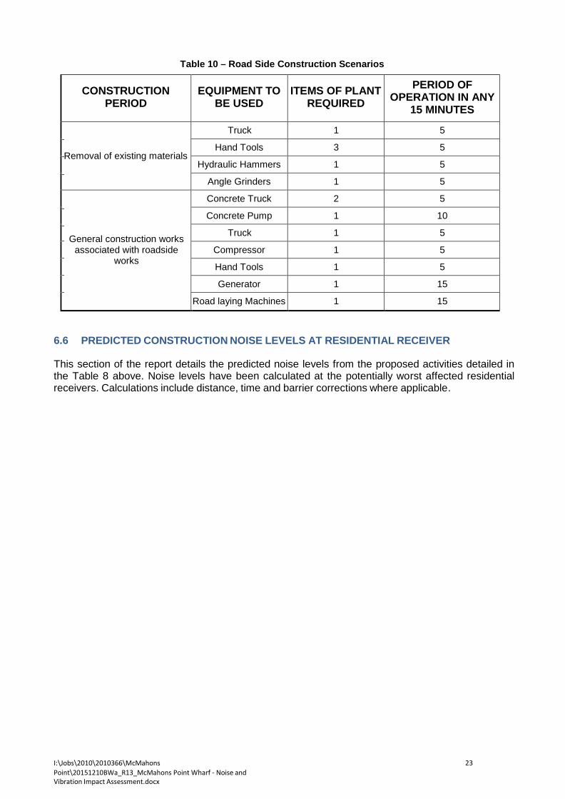
I:\Jobs\2010\2010366\McMahons Point\20151210BWa_R13_McMahons Point Wharf - Noise and Vibration Impact Assessment.docx
23
Table 10 – Road Side Construction Scenarios
CONSTRUCTION
PERIOD
EQUIPMENT TO
BE USED
ITEMS OF PLANT
REQUIRED
PERIOD OF OPERATION IN ANY
15 MINUTES Removal of existing materials
Truck 1 5
Hand Tools 3 5
Hydraulic Hammers 1 5
Angle Grinders 1 5
General construction works associated with roadside
works
Concrete Truck 2 5
Concrete Pump 1 10
Truck 1 5
Compressor 1 5
Hand Tools 1 5
Generator 1 15
Road laying Machines 1 15 6.6 PREDICTED CONSTRUCTION NOISE LEVELS AT RESIDENTIAL RECEIVER
This section of the report details the predicted noise levels from the proposed activities detailed in the Table 8 above. Noise levels have been calculated at the potentially worst affected residential receivers. Calculations include distance, time and barrier corrections where applicable.

I:\Jobs\2010\2010366\McMahons Point\20151210BWa_R13_McMahons Point Wharf - Noise and Vibration Impact Assessment.docx
24
Table 11 – Calculated Construction Noise Levels at Residential Receivers
Scenario Description Receiver location Predicted noise level
(dB(A))
Noise management level (dB(A))
LAeq (15min) dB(A)
exceedance
1 Demolition and removal of existing McMahons Point
Wharf
2A Henry Lawson Avenue
76 59 17
2 Henry Lawson Avenue
72 59 13
2A Glen Street, Milson Point
66 59 7
2 Lifting of materials 2A Henry Lawson Avenue
63 59 4
2 Henry Lawson Avenue
59 59 -
2A Glen Street, Milson Point
53 59 -
3 Installation of new piles
2A Henry Lawson Avenue
77 59 18
2 Henry Lawson Avenue
73 59 12
2A Glen Street, Milson Point
53 59 -
4 General construction works
2A Henry Lawson Avenue
76 59 17
2 Henry Lawson Avenue
72 59 13
2A Glen Street, Milson Point
66 59 7
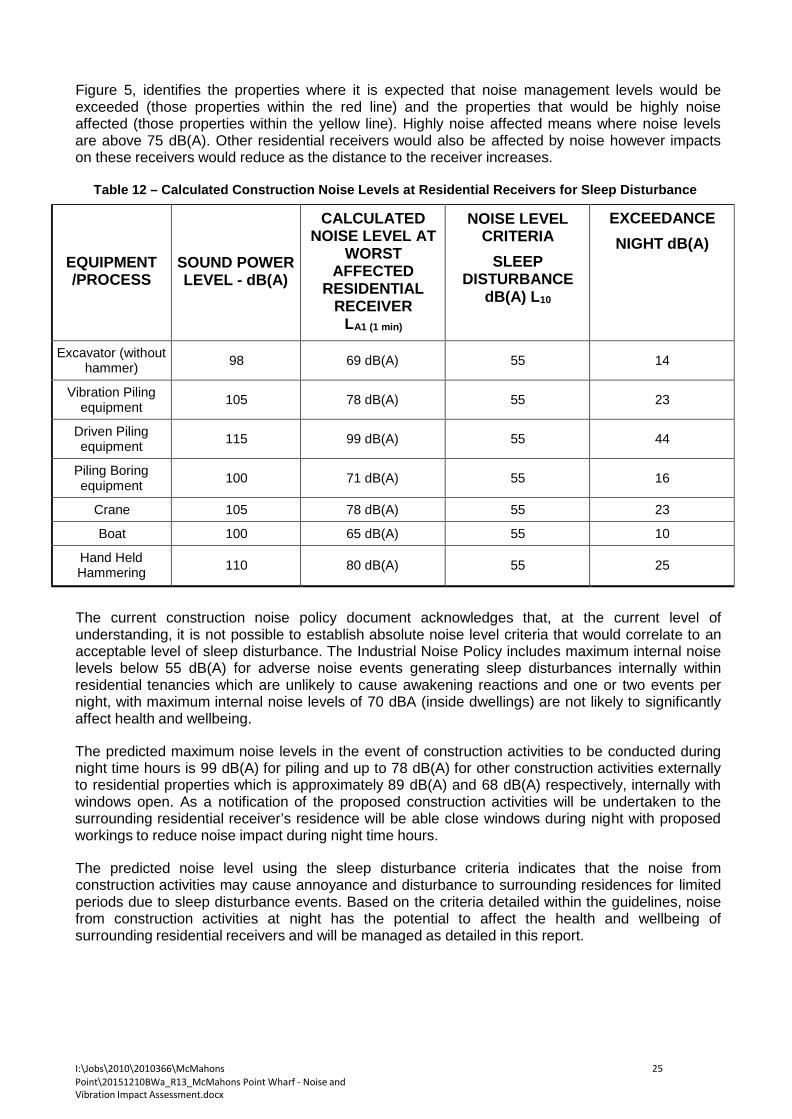
I:\Jobs\2010\2010366\McMahons Point\20151210BWa_R13_McMahons Point Wharf - Noise and Vibration Impact Assessment.docx
25
Figure 5, identifies the properties where it is expected that noise management levels would be exceeded (those properties within the red line) and the properties that would be highly noise affected (those properties within the yellow line). Highly noise affected means where noise levels are above 75 dB(A). Other residential receivers would also be affected by noise however impacts on these receivers would reduce as the distance to the receiver increases.
Table 12 – Calculated Construction Noise Levels at Residential Receivers for Sleep Disturbance
EQUIPMENT /PROCESS
SOUND POWER LEVEL - dB(A)
CALCULATED NOISE LEVEL AT
WORST AFFECTED
RESIDENTIAL RECEIVER
LA1 (1 min)
NOISE LEVEL CRITERIA
SLEEP DISTURBANCE
dB(A) L10
EXCEEDANCE NIGHT dB(A)
Excavator (without hammer)
98
69 dB(A)
55
14
Vibration Piling equipment
105
78 dB(A)
55
23
Driven Piling equipment
115
99 dB(A)
55
44
Piling Boring equipment
100
71 dB(A)
55
16
Crane 105 78 dB(A) 55 23
Boat 100 65 dB(A) 55 10
Hand Held Hammering
110
80 dB(A)
55
25
The current construction noise policy document acknowledges that, at the current level of understanding, it is not possible to establish absolute noise level criteria that would correlate to an acceptable level of sleep disturbance. The Industrial Noise Policy includes maximum internal noise levels below 55 dB(A) for adverse noise events generating sleep disturbances internally within residential tenancies which are unlikely to cause awakening reactions and one or two events per night, with maximum internal noise levels of 70 dBA (inside dwellings) are not likely to significantly affect health and wellbeing.
The predicted maximum noise levels in the event of construction activities to be conducted during night time hours is 99 dB(A) for piling and up to 78 dB(A) for other construction activities externally to residential properties which is approximately 89 dB(A) and 68 dB(A) respectively, internally with windows open. As a notification of the proposed construction activities will be undertaken to the surrounding residential receiver’s residence will be able close windows during night with proposed workings to reduce noise impact during night time hours.
The predicted noise level using the sleep disturbance criteria indicates that the noise from construction activities may cause annoyance and disturbance to surrounding residences for limited periods due to sleep disturbance events. Based on the criteria detailed within the guidelines, noise from construction activities at night has the potential to affect the health and wellbeing of surrounding residential receivers and will be managed as detailed in this report.

I:\Jobs\2010\2010366\McMahons Point\20151210BWa_R13_McMahons Point Wharf - Noise and Vibration Impact Assessment.docx
26
Table 13 – Calculated Construction Noise Levels at Residential Receivers for Sleep Disturbance at 2A
Henry Lawson Avenue
EQUIPMENT /PROCESS
SOUND POWER LEVEL - dB(A)
CALCULATED NOISE LEVEL AT
WORST AFFECTED
RESIDENTIAL RECEIVER
LA1 (1 min)
NOISE LEVEL CRITERIA
SLEEP DISTURBANCE
dB(A) L10
EXCEEDANCE NIGHT dB(A)
Excavator (without hammer)
98
64 dB(A)
55
9
Vibration Piling equipment
105
73 dB(A)
55
18
Driven Piling equipment
115
94 dB(A)
55
39
Piling Boring equipment
100
66 dB(A)
55
11
Crane 105 73 dB(A) 55 18
Boat 100 60 dB(A) 55 5
Hand Held Hammering
110
75 dB(A)
55
20
The current construction noise policy document acknowledges that, at the current level of understanding, it is not possible to establish absolute noise level criteria that would correlate to an acceptable level of sleep disturbance. The Industrial Noise Policy includes maximum internal noise levels below 55 dB(A) for adverse noise events generating sleep disturbances internally within residential tenancies which are unlikely to cause awakening reactions and one or two events per night, with maximum internal noise levels of 65 dBA (inside dwellings) are not likely to significantly affect health and wellbeing.
The predicted maximum noise levels in the event of construction activities to be conducted during night time hours is 94 dB(A) for piling and up to 73dB(A) for other construction activities externally to residential properties which is approximately 84 dB(A) and 63 dB(A) respectively, internally with windows open. As a notification of the proposed construction activities will be undertaken to the surrounding residential receiver’s residence will be able close windows during night with proposed workings to reduce noise impact during night time hours.
The predicted noise level using the sleep disturbance criteria indicates that the noise from construction activities may cause annoyance and disturbance to surrounding residences for limited periods due to sleep disturbance events. Based on the criteria detailed within the guidelines, noise from construction activities at night has the potential to affect the health and wellbeing of surrounding residential receivers and will be managed as detailed in this report.
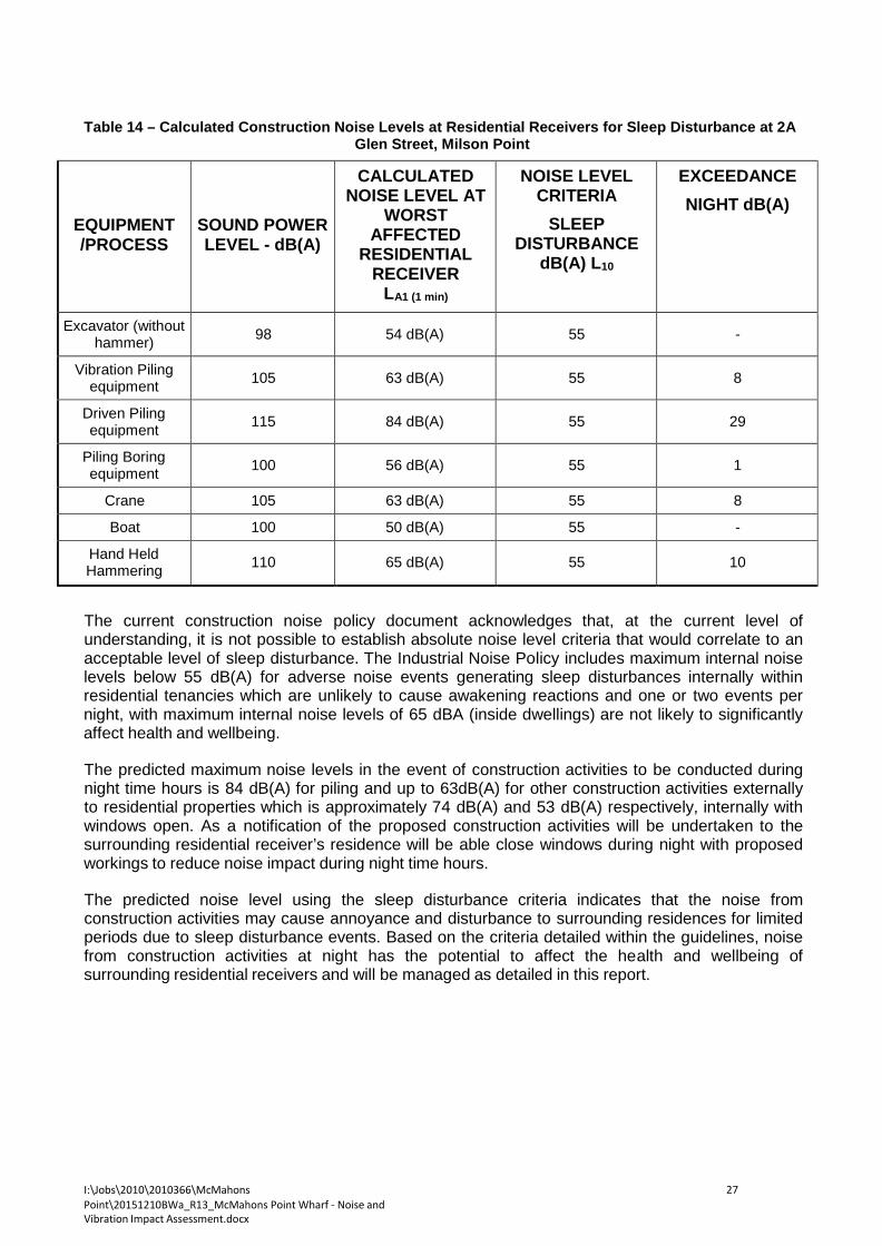
I:\Jobs\2010\2010366\McMahons Point\20151210BWa_R13_McMahons Point Wharf - Noise and Vibration Impact Assessment.docx
27
Table 14 – Calculated Construction Noise Levels at Residential Receivers for Sleep Disturbance at 2A
Glen Street, Milson Point
EQUIPMENT /PROCESS
SOUND POWER LEVEL - dB(A)
CALCULATED NOISE LEVEL AT
WORST AFFECTED
RESIDENTIAL RECEIVER
LA1 (1 min)
NOISE LEVEL CRITERIA
SLEEP DISTURBANCE
dB(A) L10
EXCEEDANCE NIGHT dB(A)
Excavator (without hammer)
98
54 dB(A)
55
-
Vibration Piling equipment
105
63 dB(A)
55
8
Driven Piling equipment
115
84 dB(A)
55
29
Piling Boring equipment
100
56 dB(A)
55
1
Crane 105 63 dB(A) 55 8
Boat 100 50 dB(A) 55 -
Hand Held Hammering
110
65 dB(A)
55
10
The current construction noise policy document acknowledges that, at the current level of understanding, it is not possible to establish absolute noise level criteria that would correlate to an acceptable level of sleep disturbance. The Industrial Noise Policy includes maximum internal noise levels below 55 dB(A) for adverse noise events generating sleep disturbances internally within residential tenancies which are unlikely to cause awakening reactions and one or two events per night, with maximum internal noise levels of 65 dBA (inside dwellings) are not likely to significantly affect health and wellbeing.
The predicted maximum noise levels in the event of construction activities to be conducted during night time hours is 84 dB(A) for piling and up to 63dB(A) for other construction activities externally to residential properties which is approximately 74 dB(A) and 53 dB(A) respectively, internally with windows open. As a notification of the proposed construction activities will be undertaken to the surrounding residential receiver’s residence will be able close windows during night with proposed workings to reduce noise impact during night time hours.
The predicted noise level using the sleep disturbance criteria indicates that the noise from construction activities may cause annoyance and disturbance to surrounding residences for limited periods due to sleep disturbance events. Based on the criteria detailed within the guidelines, noise from construction activities at night has the potential to affect the health and wellbeing of surrounding residential receivers and will be managed as detailed in this report.

I:\Jobs\2010\2010366\McMahons Point\20151210BWa_R13_McMahons Point Wharf - Noise and Vibration Impact Assessment.docx
28
6.7 PREDICTED CONSTRUCTION NOISE LEVELS AT SAILS ON LAVENDER BAY RESTAURANT
This section of the report details the predicted noise levels from the proposed activities detailed in the Table 8 above. Noise levels have been calculated at the Sails on Lavender Bay restaurant receiver within close proximity to the site. Calculations include distance, time and barrier corrections where applicable.
Table 15 – Calculated Construction Noise Levels at the Sails on Lavender Bay Restaurant
EQUIPMENT /PROCESS
SOUND POWER LEVEL - dB(A)
CALCULATED NOISE LEVEL AT
THE SAILS AT LAVENDER BAY RESTAURANT
RECEIVER LAeq (15min)
NOISE LEVEL CRITERIA
DAY dB(A) Leq (15min)
EXCEEDANCE
DAY/ EVENING /NIGHT
dB(A)
Excavator (without hammer)
98
77 dB(A)
70
7
Vibration Piling equipment
105
83 dB(A)
70
13
Driven Piling equipment
115
93 dB(A)
70
23
Piling Boring equipment
100
77 dB(A)
70
7
Crane 105 83 dB(A) 70 13
Boat 100 74 dB(A) 70 4
Barge 95 70 dB(A) 70 -
Truck 96 70 dB(A) 70 -
Angle Grinders 114 87 dB(A) 70 17
Electric Saw 111 87 dB(A) 70 17
Hand Held Drilling 94 67 dB(A) 70 -
Hand Held Hammering
110
96 dB(A)
70
26
Concrete Vibrator 100 73 dB(A) 70 3
Cement Mixing Truck
105
81 dB(A)
70
11
Concrete Pumps 107 83 dB(A) 70 13
Due to the potential for high noise levels from construction noise impacting on the existing Sails on Lavender Bay restaurant it is recommended that respite periods be introduced for high noise generating activities including the following:
1. Piling. 2. Use of the crane. 3. Hand held grinders, hammering and saws without screening to the Sails on Lavender Bay
restaurant.

I:\Jobs\2010\2010366\McMahons Point\20151210BWa_R13_McMahons Point Wharf - Noise and Vibration Impact Assessment.docx
29
Periods of respite are to be coordinated with the Sails on Lavender Bay restaurant but will typically include periods when the facility is in operation including the lunch period during daytime hours.
During all other periods screening from high noise emitting equipment using a hoarding or the like should be conducted.
6.8 NOISE AND VIBRATION MANAGEMENT FOR MCMAHONS POINT WHARF
This section of the report presents the required noise strategies to ensure noise levels when measured at a receiver within close proximity to site can be minimised. The table below presents the construction activities and discusses the management/treatments required to be conducted.
Table 16 – Recommended Noise and vibration Controls
EQUIPMENT /PROCESS
Receiver Discussion
Piling Residential Receivers
Due to the potential for high noise levels to the surrounding residential receivers, feasible and reasonable noise mitigation would be required.
Noise impacts will be assessed at the site and potential mitigation strategies will include those detailed in section 7 of this report.
Due to the potential for high noise levels from construction noise impacting on the surrounding residential receivers it is
recommended that all night time works are kept to a minimum and only undertaken when there are no other feasible or reasonable
alternatives.
Sails on Lavender Bay restaurant
Piling to be conducted during morning periods where possible, prior to the lunch time period for the restaurant and bar.
Construction activities
Residential Receivers
Due to the approximate distance of 40m from the wharf to the surrounding residential receivers it is unlikely that acoustic controls for noise or vibration are required for the proposed construction activities
on the McMahons Point Wharf site. If required specified items of equipment will be identified and noise
mitigation treatments specified as required.
Sails on Lavender Bay restaurant
Due to the potential for high noise levels from construction noise impacting on the existing Sails on Lavender Bay restaurant it is recommended that respite periods be introduced for high noise generating activities including the following:
1. piling 2. use of the crane 3. hand held grinders, hammering and saws without screening
to the Sails at Lavender Bay restaurant Periods of respite are to be coordinated with the Sails on Lavender Bay restaurant but will typically include periods when the facility is in operation including the lunch period during daytime hours. During all other periods screening from high noise emitting equipment
using a hoarding or the like should be conducted.
I:\Jobs\2010\2010366\McMahons Point\20151210BWa_R13_McMahons Point Wharf - Noise and Vibration Impact Assessment.docx
30
Table 13 (continued) – Recommended Noise and vibration Controls
Truck (including the loading of materials into
trucks)
Residential Receivers
No acoustic controls required Sails on Lavender
Bay restaurant
Concrete Pumps
Residential Receivers
No acoustic controls required providing pouring is not conducted during night time hours
Sails on Lavender Bay restaurant
Concrete pours to be conducted during morning periods where possible, prior to the lunch time period for the restaurant.
7 NOISE AND VIBRATION CONTROL METHODS
The determination of appropriate noise control measures will be dependant on the particular activities and construction appliances. This section provides an outline of potential available methods.
7.1 NOISE MANAGEMENT CONTROL FOR PROPOSED NIGHT WORKS
Based on the proposed night time activities the following acoustic controls should be adopted during this time:
1. No radios or music to be played during the night time hours.
2. Preparation and movement of material to be maximised prior to works commencing such
that it can be limited during the extended hours period.
3. A solid barrier/screen to be installed to the perimeter of the site between the areas with night works and the adjacent neighbours.
7.2 SELECTION OF ALTERNATE APPLIANCE OR PROCESS
Where a particular activity or construction appliance is found to generate excessive noise levels, it may be possible to select an alternative approach or equipment. For example; piling, particularly vibration piling on certain areas of the site may potentially generate high levels of noise. Using an alternative construction methodology (if possible) would reduce resultant noise impacts.
7.3 SILENCING DEVICES
Where construction process or appliances are noisy, the use of silencing devices may be possible. These may take the form of engine shrouding, or special industrial silencers fitted to exhausts.
7.4 MATERIAL HANDLING
The installation of rubber matting over material handling areas can reduce the sound of impacts due to material being dropped by up to 20dB(A).
7.5 TREATMENT OF SPECIFIC EQUIPMENT
In certain cases it may be possible to specially treat a piece of equipment to dramatically reduce the sound levels emitted.

I:\Jobs\2010\2010366\McMahons Point\20151210BWa_R13_McMahons Point Wharf - Noise and Vibration Impact Assessment.docx
31
7.6 ESTABLISHMENT OF SITE PRACTICES This involves the formulation of work practices to reduce noise generation. A noise plan will be developed for this project outlining work procedures and methods for minimising noise.
7.7 REGULAR NOISE CHECKS OF EQUIPMENT
To determine the requirement for silencing devices on machinery it is proposed to undertake fortnightly noise check. Noise levels of all machines on site will be measured and if they are found to be higher than nominated for that equipment type, items such as mufflers and engine shrouds will be examined to ensure they are in good working order.
A record of these measurements will be kept on a form similar to that shown in Appendix 1. This measure is expected to maintain noise at constant levels, and prevent any increases.
7.8 COMBINATION OF METHODS
In some cases it may be necessary that two or more control measures be implemented to minimise noise.
7.9 SCREENING OF OPERATIONS
Screening of operations will be required for activities which exceed noise levels, such as piling. Screening should be conducted using a solid material such as a hoarding or the like. Any screening would be required to comply with the relevant safety and operational standards.
7.9.1 Noise and Vibration Monitoring
Noise and vibration monitoring will be undertaken to determine the effectiveness of measures which are being implemented. The results of monitoring can be used to devise further control measures. The monitoring regime for the site includes the following:
1. Vibration – Due to the proximity of receivers from the wharf vibration monitoring is proposed
for the potentially high vibration generating activities such as piling and demolition of structure on the wharf site potentially impacting on the Sails at Lavender Bay restaurant
2. Noise Monitoring – Continuous noise monitoring will be conducted at the McMahons Point
sites during the high noise periods of the proposed works including demolition and piling periods.
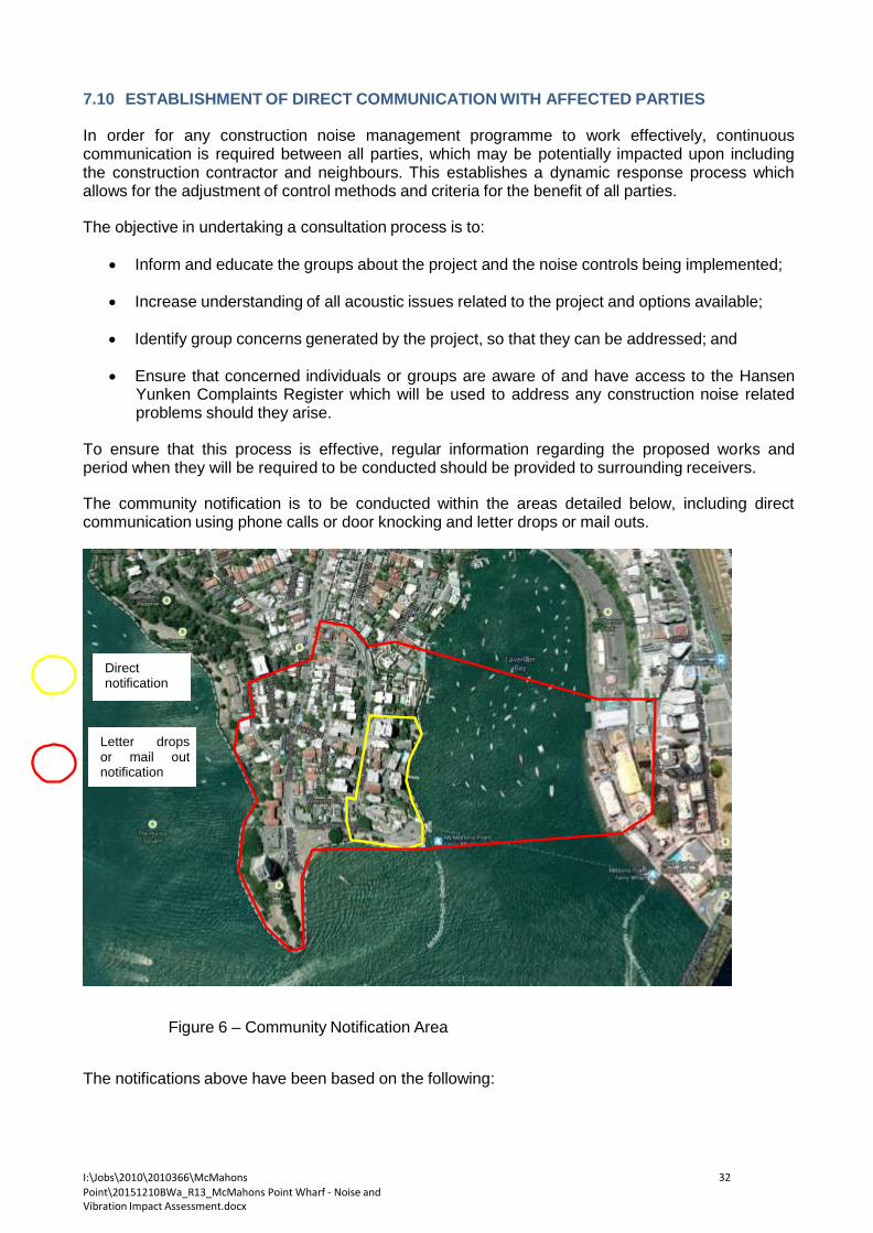
I:\Jobs\2010\2010366\McMahons Point\20151210BWa_R13_McMahons Point Wharf - Noise and Vibration Impact Assessment.docx
32
7.10 ESTABLISHMENT OF DIRECT COMMUNICATION WITH AFFECTED PARTIES In order for any construction noise management programme to work effectively, continuous communication is required between all parties, which may be potentially impacted upon including the construction contractor and neighbours. This establishes a dynamic response process which allows for the adjustment of control methods and criteria for the benefit of all parties.
The objective in undertaking a consultation process is to:
• Inform and educate the groups about the project and the noise controls being implemented;
• Increase understanding of all acoustic issues related to the project and options available;
• Identify group concerns generated by the project, so that they can be addressed; and
• Ensure that concerned individuals or groups are aware of and have access to the Hansen
Yunken Complaints Register which will be used to address any construction noise related problems should they arise.
To ensure that this process is effective, regular information regarding the proposed works and period when they will be required to be conducted should be provided to surrounding receivers.
The community notification is to be conducted within the areas detailed below, including direct communication using phone calls or door knocking and letter drops or mail outs.
Direct notification
Letter drops or mail out notification
Figure 6 – Community Notification Area The notifications above have been based on the following:
I:\Jobs\2010\2010366\McMahons Point\20151210BWa_R13_McMahons Point Wharf - Noise and Vibration Impact Assessment.docx
33
1. All receivers (residential, retail and commercial) where noise levels may exceed criteria – the red line, note these areas outside the red will not have likely exceedences within the construction noise criteria. Areas within these areas will be notified with a letter drop.
2. All receivers (residential, retail and commercial) which may have exceedences with the 75 LMax noise level have been identified within the yellow area and will be have direct notification.
7.10.1 Dealing with complaints
Should any complaints about noise or vibration occur measures shall be undertaken to investigate the complaint, determine whether criteria has been exceeded and identify the required changes to work practices. In the case of exceedances of the vibration limits all work potentially producing vibration shall cease until the exceedance is investigated.
The effectiveness of any changes to work practices shall be verified before continuing. Documentation and training of site staff shall occur to ensure the practices that produced the exceedances are not repeated.
If a noise complaint is received the complaint should be recorded on a Noise Complaint Form. The complaint form should list:
• The name and location of the complainant (if provided);
• The time and date the complaint was received;
• The nature of the complaint and the time and date the noise was heard;
• The name of the employee who received the complaint;
• Actions taken to investigate the complaint, and a summary of the results of the
investigation;
• Required remedial action, if required;
• Validation of the remedial action by a consultant or as detailed in this report; and
• Summary of feedback to the complainant. A permanent register of complaints should be held.

I:\Jobs\2010\2010366\McMahons Point\20151210BWa_R13_McMahons Point Wharf - Noise and Vibration Impact Assessment.docx
34
All complaints received should be fully investigated and reported to management. The complainant should also be notified of the results and actions arising from the investigation.
Where non-compliances or noise complaints are raised the following methodology will be implemented.
1. Determine the offending plant/equipment/process
2. Locate the plant/equipment/process further away from the affected receiver(s) if possible.
3. Implement additional acoustic treatment in the form of localised barriers, silencers, vibration
separation etc where practical.
4. Selecting alternative equipment/processes where possible 8 OPERATIONAL NOISE AND VIBRATION IMPACT ASSESSMENT
8.1 MCMAHONS POINT WHARF
The position of the proposed new wharf is located at a similar or greater distance from the surrounding residential receivers than the existing wharf and the ferry berthing direction is similar with the existing wharf conditions. Since the proposed ferry times are not expected to change and the distance between the wharf and the nearest residences is similar, a detailed assessment of the operational noise impacts is not considered necessary.
The resulting noise level impact from the proposed wharf upgrade will be similar to those currently experienced.
8.2 SURROUNDING SERVICES
The landside infrastructure works are as indicated in Figure 1. Detailed design for these elements is to be developed in consultation with North Sydney Council prior to commencement of construction. Any material changes to the proposed works or construction methodology which could result in additional environmental impacts to those assessed in this REF, would be the subject of additional environmental assessment.
8.3 FUTURE OPERATIONS
The position of the proposed new road services and volume of public transport servicing the wharf are not proposed to be significantly changed those conditions currently servicing the wharf.
Since the proposed ferry times are not expected to change significantly the land based public transport servicing the wharf will significantly altered either. The resulting noise level impact from the proposed upgrade to the surrounding roadway services be similar to those currently experienced and are therefore acoustically acceptable.,

I:\Jobs\2010\2010366\McMahons Point\20151210BWa_R13_McMahons Point Wharf - Noise and Vibration Impact Assessment.docx
35
9 CONCLUSION This document presents a discussion of the processes, which will be followed in order to manage noise and vibration associated with demolition and construction activities which will be required to be conducted as part of the McMahons Point Wharf Upgrade Project and the potential for noise and vibration impact to receivers within proximity of the site.
The report details required management controls to mitigate noise and vibration impacts to surrounding receivers and details a monitoring regime to monitor noise and vibration impacts to potential receivers.
Prepared by
ACOUSTIC LOGIC CONSULTANCY PTY LTD Ben White

I:\Jobs\2010\2010366\McMahons Point\20151210BWa_R13_McMahons Point Wharf - Noise and Vibration Impact Assessment.docx
36
REFERENCES
1. British Standard BS 6472:1992 “Guide to Evaluation of Human Exposure to Vibration in Buildings (1Hz to 80Hz) and German Standard DIN 4150-3 (1999-02): “Structural Vibration – Effects of Vibration on Structures”.
2. Australian Standard AS2436:1981 “Guide to noise control on construction, maintenance
and demolition sites”,
3. Regulation 49 of the Occupational Health and Safety Regulation
4. Office of Environment and Heritage (OEH) Construction Noise Guideline
5. German Standard DIN 4150-3 (1999-02): “Structural Vibration – Effects of Vibration on Structures”; and
6. British Standard BS 6472:1992 “Guide to Evaluation of Human Exposure to Vibration in
Buildings (1Hz to 80Hz).
I:\Jobs\2010\2010366\McMahons Point\20151210BWa_R13_McMahons Point Wharf - Noise and Vibration Impact Assessment.docx
37
APPENDIX A CONSTRUCTION APPLIANCE COMPLIANCE CERTIFICATE

I:\Jobs\2010\2010366\McMahons Point\20151210BWa_R13_McMahons Point Wharf - Noise and Vibration Impact Assessment.docx
38
Hansen Yunken Constructions
McMahons Point Wharf Project
Construction Appliance Compliance Certificate
Month
Year
Plant Item
Allowable Noise Level
Measured Noise Level
Complies Yes No
Issuing Engineer
Sub-Contractor
Project Manager

I:\Jobs\2010\2010366\McMahons Point\20151210BWa_R13_McMahons Point Wharf - Noise and Vibration Impact Assessment.docx
39
APPENDIX B
Noise Monitoring Data

Noi
se L
evel
(dB
(A))
0:00
1:00
2:00
3:00
4:00
5:00
6:00
7:00
8:00
9:00
10:0
0
11:0
0
12:0
0
13:0
0
14:0
0
15:0
0
16:0
0
17:0
0
18:0
0
19:0
0
20:0
0
21:0
0
22:0
0
23:0
0
0:00
McMahon's Point
Wednesday May 2,2012
90
80
L10 70
60
Leq
50
40 L90
30
20
Time

I:\Jobs\2010\2010366\McMahons Point\20151210BWa_R13_McMahons Point Wharf - Noise and Vibration Impact Assessment.docx
41
Noi
se L
evel
(dB
(A))
0:00
1:00
2:00
3:00
4:00
5:00
6:00
7:00
8:00
9:00
10:0
0
11:0
0
12:0
0
13:0
0
14:0
0
15:0
0
16:0
0
17:0
0
18:0
0
19:0
0
20:0
0
21:0
0
22:0
0
23:0
0
0:00
McMahon's Point
Thursday May 3,2012
90
80
L10 70
60
Leq
50
40 L90
30
20
Time

I:\Jobs\2010\2010366\McMahons Point\20151210BWa_R13_McMahons Point Wharf - Noise and Vibration Impact Assessment.docx
42
Noi
se L
evel
(dB
(A))
0:00
1:00
2:00
3:00
4:00
5:00
6:00
7:00
8:00
9:00
10:0
0
11:0
0
12:0
0
13:0
0
14:0
0
15:0
0
16:0
0
17:0
0
18:0
0
19:0
0
20:0
0
21:0
0
22:0
0
23:0
0
0:00
McMahon's Point
Friday May 4,2012
90
80
L10 70
60
Leq
50
40 L90
30
20
Time

I:\Jobs\2010\2010366\McMahons Point\20151210BWa_R13_McMahons Point Wharf - Noise and Vibration Impact Assessment.docx
43
Noi
se L
evel
(dB
(A))
0:00
1:00
2:00
3:00
4:00
5:00
6:00
7:00
8:00
9:00
10:0
0
11:0
0
12:0
0
13:0
0
14:0
0
15:0
0
16:0
0
17:0
0
18:0
0
19:0
0
20:0
0
21:0
0
22:0
0
23:0
0
0:00
McMahon's Point
Saturday May 5,2012
90
80
L10 70
60
Leq
50
40 L90
30
20
Time
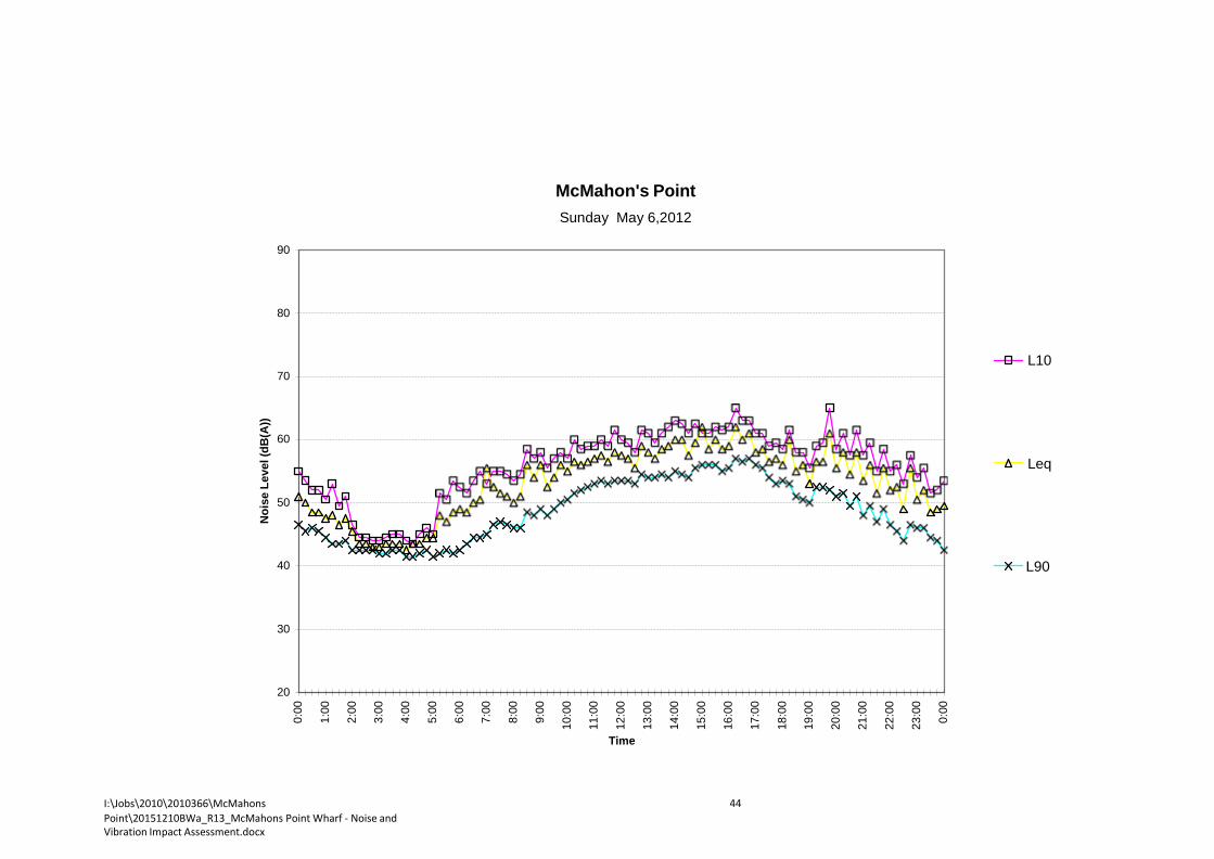
I:\Jobs\2010\2010366\McMahons Point\20151210BWa_R13_McMahons Point Wharf - Noise and Vibration Impact Assessment.docx
44
Noi
se L
evel
(dB
(A))
0:00
1:00
2:00
3:00
4:00
5:00
6:00
7:00
8:00
9:00
10:0
0
11:0
0
12:0
0
13:0
0
14:0
0
15:0
0
16:0
0
17:0
0
18:0
0
19:0
0
20:0
0
21:0
0
22:0
0
23:0
0
0:00
McMahon's Point
Sunday May 6,2012
90
80
L10 70
60
Leq
50
40 L90
30
20
Time

I:\Jobs\2010\2010366\McMahons Point\20151210BWa_R13_McMahons Point Wharf - Noise and Vibration Impact Assessment.docx
45
Noi
se L
evel
(dB
(A))
0:00
1:00
2:00
3:00
4:00
5:00
6:00
7:00
8:00
9:00
10:0
0
11:0
0
12:0
0
13:0
0
14:0
0
15:0
0
16:0
0
17:0
0
18:0
0
19:0
0
20:0
0
21:0
0
22:0
0
23:0
0
0:00
McMahon's Point
Monday May 7,2012
90
80
L10 70
60
Leq
50
40 L90
30
20
Time

I:\Jobs\2010\2010366\McMahons Point\20151210BWa_R13_McMahons Point Wharf - Noise and Vibration Impact Assessment.docx
46
Noi
se L
evel
(dB
(A))
0:00
1:00
2:00
3:00
4:00
5:00
6:00
7:00
8:00
9:00
10:0
0
11:0
0
12:0
0
13:0
0
14:0
0
15:0
0
16:0
0
17:0
0
18:0
0
19:0
0
20:0
0
21:0
0
22:0
0
23:0
0
0:00
McMahon's Point
Tuesday May 8,2012
90
80
L10 70
60
Leq
50
40 L90
30
20
Time

I:\Jobs\2010\2010366\McMahons Point\20151210BWa_R13_McMahons Point Wharf - Noise and Vibration Impact Assessment.docx
47
Noi
se L
evel
(dB
(A))
0:00
1:00
2:00
3:00
4:00
5:00
6:00
7:00
8:00
9:00
10:0
0
11:0
0
12:0
0
13:0
0
14:0
0
15:0
0
16:0
0
17:0
0
18:0
0
19:0
0
20:0
0
21:0
0
22:0
0
23:0
0
0:00
McMahon's Point
Wednesday May 9,2012
90
80
L10 70
60
Leq
50
40 L90
30
20
Time

Noi
se L
evel
(dB
(A))
0:00
1:00
2:00
3:00
4:00
5:00
6:00
7:00
8:00
9:00
10:0
0
11:0
0
12:0
0
13:0
0
14:0
0
15:0
0
16:0
0
17:0
0
18:0
0
19:0
0
20:0
0
21:0
0
22:0
0
23:0
0
0:00
Appendix C
Neutral Bay Wharf Wednesday March 14,2012
90
80
L10
70
60
Leq
50
40 L90
30
20
Time
The noise levels above are the graph for noise logging at Neutral Bay wharf on atypical day which piling was conducted. Based on the above recordings the noise level of piling is approximately 115 dB(A) SWL.

Appendix E Aquatic ecology assessment
Appendix E
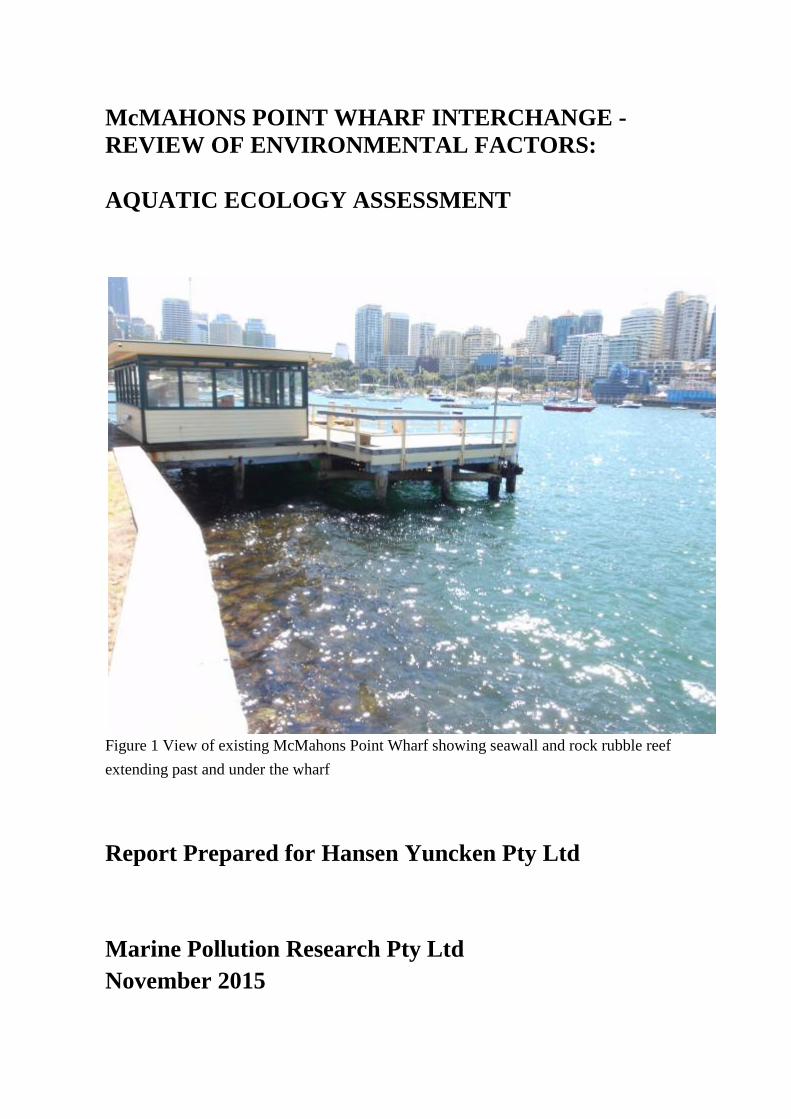
McMAHONS POINT WHARF INTERCHANGE - REVIEW OF ENVIRONMENTAL FACTORS:
AQUATIC ECOLOGY ASSESSMENT
Figure 1 View of existing McMahons Point Wharf showing seawall and rock rubble reef extending past and under the wharf
Report Prepared for Hansen Yuncken Pty Ltd
Marine Pollution Research Pty Ltd November 2015


- 2 -
McMahons Pt Upgrade Aq Ecol Ver 8a MPR 1019-8 Marine Pollution Research Pty Ltd
MARINE POLLUTION RESEARCH PTY LTD Marine, Estuarine and Freshwater Ecology, Sediment and Water Quality Dynamics
A.B.N. 64 003 796 576
25 RICHARD ROAD SCOTLAND ISLAND NSW 2105
PO BOX 279 CHURCH POINT NSW 2105
TELEPHONE (02) 9997 6541 E-MAIL [email protected]
REPORT TITLE: McMAHONS POINT WHARF INTERCHANGE - REVIEW OF ENVIRONMENTAL FACTORS: AQUATIC ECOLOGY ASSESSMENT
CLIENT & CONTACT: Mr Paul Blair Design Manager Hansen Yuncken Pty Ltd on behalf of NSW Roads & Maritime
MPR REPORT No: MPR 1019-2
DRAFT REPORT FOR COMMENT:
PDF Version 1 Sent to HY 13 Sept 2012
COMMENTS RECEIVED AND INCORPORATED:
Report upgraded with additional re-survey information and RMS comments through to Ver 5. Re-survey plus assessment for new wharf location and construction details incorporated into Version 6. Re-assessment for new Concept B alignment (V7). Re-assessment for new proposal dated 28 October 2015.
FINAL REPORT: PDF V5; 9 Jan 2014, PDF &Word V 6a; 28 January 2015, PDF & Word Ver 7; 17 April 2015, PDF & Word Ver 8a; 4 Nov 2015.
MPR APPROVAL:
PAUL ANINK 04 November 2015
Disclaimer: This report has been prepared on behalf of and for the exclusive use of Hansen Yuncken Pty Ltd and NSW Roads & Maritime, based on information supplied by the client, and is subject to and issued in accordance with the agreement between Hansen Yuncken Pty Ltd and MPR. MPR accepts no liability or responsibility whatsoever for it in respect of any use of, or reliance upon, this report by any third party. Copying this report without the permission of Hansen Yuncken Pty Ltd or MPR is not permitted.
McMahons Pt Upgrade Aq Ecol Ver 8a MPR 1019-8 Marine Pollution Research Pty Ltd
- iii -
TABLE OF CONTENTS
Page
1 INTRODUCTION 1 1.1 The Proposal 2 1.2 Available Information on Aquatic Habitats 4 1.3 Summary of Relevant Legislation 4
1.3.1 Fish, sharks and marine vegetation 5 1.3.2 Other listed or protected species 9
2 AQUATIC HABITATS AND GENERAL ECOLOGY 10
3 IMPACT ASSESSMENT AND MITIGATION 22 3.1 Management of Construction Impacts 23 3.2 Management of Operational Impacts 26 3.3 Fisheries Management Act Permit & Habitat Protection Requirements 27 3.4 Sydney REP (Sydney Harbour Catchment) 2005 28 3.5 Recommended Mitigation Measures 31
4 CONCLUSIONS 34
5 REFERENCES 35
FIGURES
1 View of existing ferry wharf at McMahons Point Frontis 2 Aerial view of McMahons Point Wharf Interchange 1 3 Concept Design Plan for McMahons Point Wharf 3 4 Depth contours under and around the existing and proposed wharves 4 5 DCP Map 9 showing aquatic habitats at McMahons Point 5 6 SREP (Sydney Harbour Catchment) Sheet 11 wetlands map 6 7 Portion of DPI (Fisheries) estuarine vegetation map for Lavender Bay 7 8 Rock rubble reef habitat in the study area – August 2015 11 9 McMahons Point seawall – east side of wharf 14 10 Seawall west of McMahons Point Wharf 15 11 Invertebrate shelter incorporated into the refurbished seawall in 2005 15 12 View of lower seawall oyster and barnacle habitat 16 13 Lower intertidal seawall and rock rubble habitats 17 14 Upper rock rubble reef habitat 17
- 4 -
McMahons Pt Upgrade Aq Ecol Ver 8a MPR 1019-8 Marine Pollution Research Pty Ltd
15 Mid rock rubble reef habitat 18 16 Lower rock rubble reef and adjacent sand habitat 18 17 Isolated piece of rock rubble on sand 19 18 Rock rubble with kelp cover around base of a wharf support pile 19 19 Shallow sub-tidal edge of wharf sea-stair support structure 20 20 Mixed frondose algae growth on wharf support pile shallow sub-tidal zone 20 21 Mid depth growth on jetty support pile 21 22 Kelp growing on lower part of a wharf support pile 21

- 1 -
McMahons Pt Upgrade Aq Ecol Ver 8a MPR 1019-8 Marine Pollution Research Pty Ltd
1 INTRODUCTION
Roads and Maritime Services (RMS) is proposing to upgrade McMahons Point Wharf with the proposed McMahons Point Wharf interchange (the proposal). Hansen Yuncken Pty Ltd has been appointed project managers for the proposal. The proposal is required to be assessed via a Review of Environmental Factors (REF) and Hansen Yuncken have commissioned Marine Pollution Research Pty Ltd (MPR) to undertake an aquatic ecology assessment to inform the REF.
This report assesses the aquatic ecology of the present McMahons Point Wharf against the Fisheries NSW Policy and Guidelines (Fisheries NSW 2013), considers the likely impacts on the aquatic ecology of the wharf upgrade and provides impact mitigation measures where necessary. An aerial view of the existing McMahons Point Wharf is shown below (Figure 2).
Figure 2 Aerial view of McMahons Point Wharf, extending west into the embayment between McMahons Point and Blues Point. Note the shallow sandy areas in the embayment with marine vegetation (darker patches). These are all rock rubble based kelp patches.
The site is exposed to winds across the harbour from the south-east to south west and is sheltered or has only limited fetch for other wind directions. The site is also exposed to regular wash from local passing vessels.
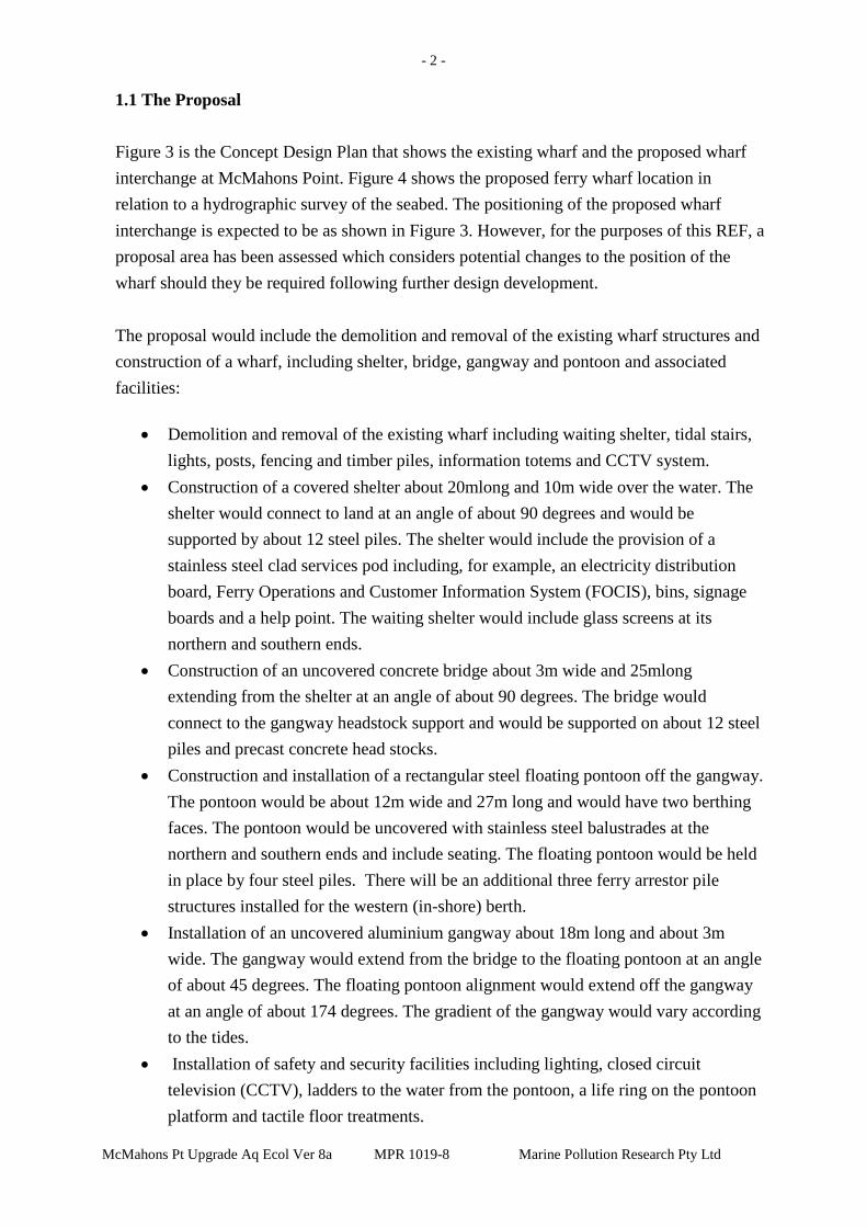
McMahons Pt Upgrade Aq Ecol Ver 8a MPR 1019-8 Marine Pollution Research Pty Ltd
- 2 -
1.1 The Proposal
Figure 3 is the Concept Design Plan that shows the existing wharf and the proposed wharf interchange at McMahons Point. Figure 4 shows the proposed ferry wharf location in relation to a hydrographic survey of the seabed. The positioning of the proposed wharf interchange is expected to be as shown in Figure 3. However, for the purposes of this REF, a proposal area has been assessed which considers potential changes to the position of the wharf should they be required following further design development.
The proposal would include the demolition and removal of the existing wharf structures and construction of a wharf, including shelter, bridge, gangway and pontoon and associated facilities:
• Demolition and removal of the existing wharf including waiting shelter, tidal stairs,
lights, posts, fencing and timber piles, information totems and CCTV system. • Construction of a covered shelter about 20mlong and 10m wide over the water. The
shelter would connect to land at an angle of about 90 degrees and would be supported by about 12 steel piles. The shelter would include the provision of a stainless steel clad services pod including, for example, an electricity distribution board, Ferry Operations and Customer Information System (FOCIS), bins, signage boards and a help point. The waiting shelter would include glass screens at its northern and southern ends.
• Construction of an uncovered concrete bridge about 3m wide and 25mlong extending from the shelter at an angle of about 90 degrees. The bridge would connect to the gangway headstock support and would be supported on about 12 steel piles and precast concrete head stocks.
• Construction and installation of a rectangular steel floating pontoon off the gangway. The pontoon would be about 12m wide and 27m long and would have two berthing faces. The pontoon would be uncovered with stainless steel balustrades at the northern and southern ends and include seating. The floating pontoon would be held in place by four steel piles. There will be an additional three ferry arrestor pile structures installed for the western (in-shore) berth.
• Installation of an uncovered aluminium gangway about 18m long and about 3m wide. The gangway would extend from the bridge to the floating pontoon at an angle of about 45 degrees. The floating pontoon alignment would extend off the gangway at an angle of about 174 degrees. The gradient of the gangway would vary according to the tides.
• Installation of safety and security facilities including lighting, closed circuit television (CCTV), ladders to the water from the pontoon, a life ring on the pontoon platform and tactile floor treatments.

- 1 -
- 3-
Lavender Bay
LEGEND rL-----• Existing wharf to be removed
-- Site compound and buildings
- Proposal area
Figure 3 Concept Design Plan, showing the proposed McMahons Point Wharf interchange.

McMahons Pt Upgrade Aq Ecol Ver 8a MPR 1019-8 Marine Pollution Research Pty Ltd
- 4 -
Figure 4 Portion of General Arrangement Plan with depth contours under and around the existing and proposed ferry wharves.
The new pontoon will have berthing depths for ferries greater than -5m chart datum which is Indian Spring Low Water (ISLW). The existing wharf currently has berthing depths between -4m and -7m ISLW.
1.2 Available Information on Aquatic Habitats
The aquatic ecological community around the existing wharf is described as "Water" on Map 3 for the Harbour Foreshores and Waterways Area Development Control Plan 2005 (Figure 5). This map indicates no foreshore or sub-tidal marine habitats at McMahons Point Wharf but does show two pocket beaches north and west of the existing ferry wharf. Sheet 11 for the Sydney Regional Environmental Plan (Sydney Harbour Catchment) 2005 indicates 'wetlands' in Lavender Bay to the west and north of McMahons Point Wharf (Figure 6). These ‘wetlands’ match up with two of the pocket beaches indentified in Figure 5. There are no designated wetlands associated with the existing or proposed ferry upgrade site.
More recent mapping by NSW Department of Primary Industries Fisheries Branch (Fisheries NSW) indicates small Zostera seagrass patches in the near-shore shallows of Lavender Bay (Figure 7) and it is concluded that the SREP wetland designation in this

McMahons Pt Upgrade Aq Ecol Ver 8a MPR 1019-8 Marine Pollution Research Pty Ltd
- 5 -
locality refers to these Zostera seagrass patches. With regard to intertidal marine vegetation
there are no mangroves or saltmarsh indicated on the vegetation surveys prepared by Allen et al (2007) and Kelleway et al (2007).
1.3 Summary of Relevant Legislation
Aquatic habitats, flora and fauna of conservation significance are protected under both State and Federal legislation. In NSW, threatened species, populations and ecological communities of animals and plants are protected under the Threatened Species Conservation Act 1995 (TSC). Threatened species, populations and ecological communities of fish and marine vegetation are protected under the Fisheries Management Act 1994 (FMA). The TSC and FMA also list a number of key threatening processes that may threaten the survival of species, populations and ecological communities. The Environment Protection and Biodiversity Conservation Act 1999 (EPBC) protects wetlands of international importance, Commonwealth Marine Areas, nationally threatened species and ecological communities and migratory species, nuclear actions and world and national heritage places.
The FMA, TSC and EPBC Act require that any proposed activity be assessed with respect to its potential impact on species or ecological communities listed as threatened under the Threatened Species Schedules of the Acts or listed as migratory species under the EPBC Act. Searches were made of the following relevant agency data-bases of listed species; Fisheries NSW Fish Records Viewer, Office of Environment and Heritage (OEH) Bionet Atlas of NSW Wildlife and the Commonwealth Department of the Environment Protected Matters Search Tool using a 10km square search area.
1.3.1 Fish, sharks and marine vegetation
The FMA and EPBC Act list a number of marine and estuarine shark and teleost fish species as Vulnerable Species under Schedule 5 of the Act. Syngnathiformes (seahorses, sea- dragons, pipefish, pipe-horses and sea-moths) are protected under the EPBC Act and the FMA:
• Of the listed sharks, the Green Sawfish is presumed extinct, the two hammerhead sharks are oceanic species and are unlikely to enter Sydney Harbour. The Grey Nurse and Great White sharks are near-shore coastal species and could enter Sydney Harbour from time to time. However such visits would be infrequent and they would generally be only found in the outer harbour when in pursuit of mobile prey species. They would not make use of any of the habitats available in the locality of McMahons Point and the likelihood of these species occurring is low.

- 6 -
c: =i
._..........
- 6-
Sydney Harbour Catchment- Foreshores and Waterways Area Development Control Plan: EcologicalCommunities and Landscape Characters
-----------,------- ---R-1AFuao------------r---- -r---- ------ r-Md
Map 9 D &WIW'MI)'IAI.abOurldaty
"ftofrestnel ECO«<'TTurttle8
"""'"""- "*'FoftNf AI
"*' FonNf81
.u.:J..-...........
II§ ........
•_ -MlloldR::-lcl.y_hllltldirllandSMd
• t.llOid R::lclt.y tdlllldirll and ADck l"'ll:bml
...
• Mllold R:)ekllnlrlttldirlland loltdlb
Sltagr11111Bids
D.w..r.ot - ltMII IlltlN!ftlqlftd
15 Lands:a Tn-: • Rli:t...y ions
-+- Alli)Qys St:eetCentelire
l Landmalt
C'iCJ.-1 ';";"' ""',,.. nt. tn ADd
1_ ,! LDclll Goverrment &tm.- -- &is'rv&Fu111'ePedestia1Aa.s:ln:ficatiYelo:ations
D w."'r -F&ets RCreeks
WhiteHofse Point
otSCl.AIMER The IMpS areincialtive of ecological oorrrrn.l"'lies and landscape chat3Clers. Site specfic in'\/9Siigltioosahouk:t be l.l'ldertlken to comfi rm ac::tu3J site concflions
N
A Scale 1:15000
0.5 0.25 0 0.5
BAUIMI EAST -Bq
Kilometres
PrOCJuc:eG Dy OIPNR. F"eDn.wy 2004 PIO Sp;lllai OWg.NO.0428
Figure 5 DCP Map 9 indicates no foreshore or sub-tidal marine habitats at McMahons Point Wharf. The closest identified
habitats are the sandy pocket beaches in Lavender Bay to the north and adjacent to Blues Point Reserve to the west.
McMahons Pt Upgrade Aq Ecol VerSa l.\1PR 1019-8 Marine Pollution Research Pty Ltd

McMahons Pt Upgrade Aq Ecol Ver 8a MPR 1019-8 Marine Pollution Research Pty Ltd
Legend -" .... ....
-7-
\ Oepartmontol lnfrtstriJCiure.Plar•int aMI NaturalReso..rets
.::l.ocflf AIN D r:c.sbcnl..sw.....,..,.,..BoundiJ'y
ENVIRONMENTAL PLANNING & ASSESSMENT N::r , 1978
DRAFT
SYDNEY REGKJNAL ENVIRONMENTALPLAN
WETLANDS PROTECTIONAREA MAP
N.Ct.n:i 0402
O.l<lol' P.H.tt.y
"""""'"' '""""""
..........P'roMdan AnNI (SYDNEY HARBOUR CATCHMENT) 2004
Figure 6 SREP (Sydney Harbour Catchment) Wetlands Protection Area Map 11 showing designated 'wetland' areas to the west and north ofMcMahons Point Wharf

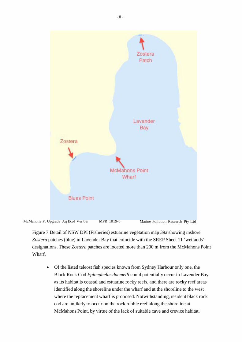
McMahons Pt Upgrade Aq Ecol Ver 8a MPR 1019-8 Marine Pollution Research Pty Ltd
- 8 -
Figure 7 Detail of NSW DPI (Fisheries) estuarine vegetation map 39a showing inshore Zostera patches (blue) in Lavender Bay that coincide with the SREP Sheet 11 ‘wetlands’ designations. These Zostera patches are located more than 200 m from the McMahons Point Wharf.
• Of the listed teleost fish species known from Sydney Harbour only one, the
Black Rock Cod Epinephelus daemelli could potentially occur in Lavender Bay as its habitat is coastal and estuarine rocky reefs, and there are rocky reef areas identified along the shoreline under the wharf and at the shoreline to the west where the replacement wharf is proposed. Notwithstanding, resident black rock cod are unlikely to occur on the rock rubble reef along the shoreline at McMahons Point, by virtue of the lack of suitable cave and crevice habitat.

- 9 -
• Of the 31 species of syngnathiformes known from NSW waters, three, (White's
McMahons Pt Upgrade Aq Ecol Ver 8a MPR 1019-8 Marine Pollution Research Pty Ltd
seahorse Hippocampus whitei, Coleman's Seahorse Hippocampus colemani and the pygmy pipehorse Idiotropiscis sp.), are endemic to NSW. White’s seahorse is common in Sydney Harbour and is known to inhabit jetty and wharf structures in Sydney Harbour upstream to at least Drummoyne.
• Seagrass beds in Sydney Harbour that include Posidonia australis are listed as an Endangered Ecological Community under the FMA and are listed as a Threatened Ecological Community under the EPBC Act. No Posidonia plants or beds are found in the inner harbour or rivers west of Bradleys Head, Mosman.
• Saltmarsh communities are listed as endangered ecological communities (EECs) under the TSC Act and can occur in all part of the harbour where there is suitable high intertidal habitat.
1.3.2 Other listed or protected species
With regard to other aquatic species or ecological communities and migratory species listed under the TSC and EPBC acts, listed cetaceans (whales and dolphins), marine mammals (seals and sea lions), marine reptiles (turtles and sea-snakes) and sea-birds (migratory ocean birds, shore birds and waders) are known from the outer Sydney Harbour and are known to penetrate the harbour to and beyond the study area, albeit rarely. The Bionet search for Sydney Harbour indicated nine marine species listed under the TSC Act; two Endangered species (the Little Tern and the Southern Right Whale), and seven Vulnerable species (Green Turtle), New Zealand and Australian Fur Seals, Humpback Whale, Goulds Petrel, Sooty Tern and Sooty Oystercatcher. The majority of these species are open water or open coastal species that are generally found on the coastline rocky shores around the harbour entrance or in the outer harbour waters:
• Both the whale species are known to penetrate well into the harbour, including the
open waters of the harbour off Lavender Bay. • Little Penguins are protected under the TSC Act and are observed fishing and
feeding throughout the harbour and could be expected to visit the site from time to time. These are likely to be members of the Little Penguin colony at North Head, which is listed as an Endangered Ecological Community under the TSC Act.
Of the species that may occur in the vicinity of the site, none would be utilising the resources of the site to any great extent and would generally be in the locality as transients or opportunistic feeders. The site does not provide any undisturbed intertidal rock reef habitat for seabird roosting or shore bird feeding and there are no undisturbed sites for seal haul-outs. It is concluded that there would not be any threatened species residing within the locality of the wharf and that the wharf and the site do not constitute specific habitat for other threatened aquatic species as listed under the FMA, TSC and EPBC Acts.
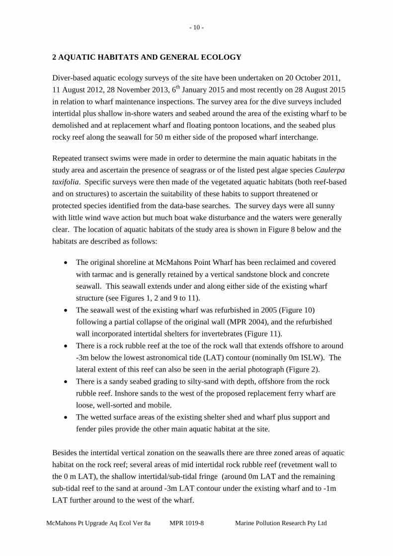
- 10 -
McMahons Pt Upgrade Aq Ecol Ver 8a MPR 1019-8 Marine Pollution Research Pty Ltd
2 AQUATIC HABITATS AND GENERAL ECOLOGY
Diver-based aquatic ecology surveys of the site have been undertaken on 20 October 2011, 11 August 2012, 28 November 2013, 6th January 2015 and most recently on 28 August 2015 in relation to wharf maintenance inspections. The survey area for the dive surveys included intertidal plus shallow in-shore waters and seabed around the area of the existing wharf to be demolished and at replacement wharf and floating pontoon locations, and the seabed plus rocky reef along the seawall for 50 m either side of the proposed wharf interchange.
Repeated transect swims were made in order to determine the main aquatic habitats in the study area and ascertain the presence of seagrass or of the listed pest algae species Caulerpa taxifolia. Specific surveys were then made of the vegetated aquatic habitats (both reef-based and on structures) to ascertain the suitability of these habits to support threatened or protected species identified from the data-base searches. The survey days were all sunny with little wind wave action but much boat wake disturbance and the waters were generally clear. The location of aquatic habitats of the study area is shown in Figure 8 below and the habitats are described as follows:
• The original shoreline at McMahons Point Wharf has been reclaimed and covered
with tarmac and is generally retained by a vertical sandstone block and concrete seawall. This seawall extends under and along either side of the existing wharf structure (see Figures 1, 2 and 9 to 11).
• The seawall west of the existing wharf was refurbished in 2005 (Figure 10) following a partial collapse of the original wall (MPR 2004), and the refurbished wall incorporated intertidal shelters for invertebrates (Figure 11).
• There is a rock rubble reef at the toe of the rock wall that extends offshore to around -3m below the lowest astronomical tide (LAT) contour (nominally 0m ISLW). The lateral extent of this reef can also be seen in the aerial photograph (Figure 2).
• There is a sandy seabed grading to silty-sand with depth, offshore from the rock rubble reef. Inshore sands to the west of the proposed replacement ferry wharf are loose, well-sorted and mobile.
• The wetted surface areas of the existing shelter shed and wharf plus support and fender piles provide the other main aquatic habitat at the site.
Besides the intertidal vertical zonation on the seawalls there are three zoned areas of aquatic habitat on the rock reef; several areas of mid intertidal rock rubble reef (revetment wall to the 0 m LAT), the shallow intertidal/sub-tidal fringe (around 0m LAT and the remaining sub-tidal reef to the sand at around -3m LAT contour under the existing wharf and to -1m LAT further around to the west of the wharf.
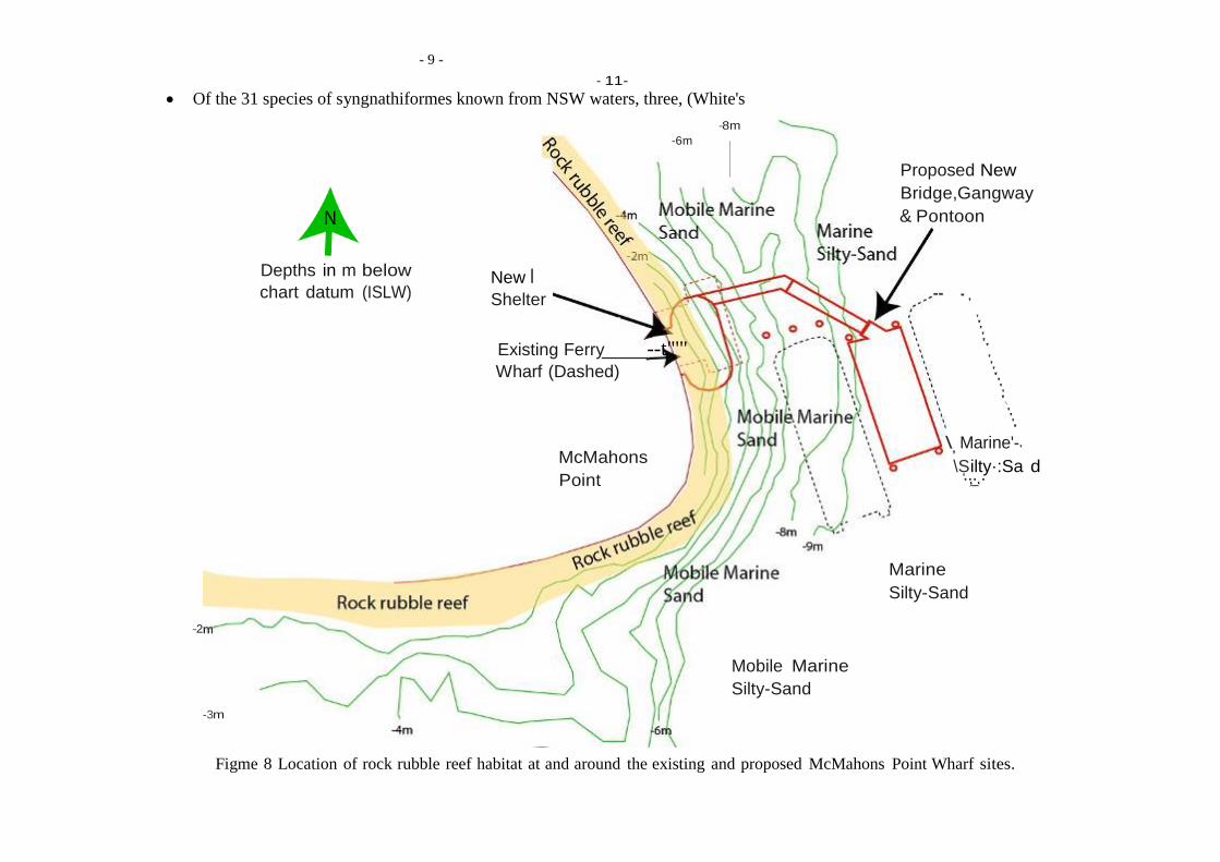
- 9 -
• Of the 31 species of syngnathiformes known from NSW waters, three, (White's
... .
' ' '
- 11-
-6m -8m
Proposed New Bridge,Gangway & Pontoon
Depths in m below chart datum (ISLW)
New I Shelter -- ' '
' ' ' ' Existing Ferry --t"'" '' Wharf (Dashed) '
' ' ' '\
' ' ' '
McMahons Point
\, Marine'-' \Silty·:Sa d ' ,_..
Marine Silty-Sand
-2
-3m
Mobile Marine Silty-Sand
Figme 8 Location of rock rubble reef habitat at and around the existing and proposed McMahons Point Wharf sites.

McMahons Pt Upgrade Aq Ecol Ver 8a MPR 1019-8 Marine Pollution Research Pty Ltd
- 12 -
The aquatic ecology of seawall to rock rubble reef depth zones is summarised as follows:
Seawall: • The high wetted portions of the seawall (around 1 m above the rock
toe) and the rock wall intertidal shelters support a variety of intertidal animals dominated by molluscs; Littorinid snails, (Nodilittorina unifasciata in the higher intertidal, and Bembicium nanum plus Sydney rock oysters in the mid to low intertidal (Figures 9 to 11).
Inner Intertidal Zone and Sub-tidal fringe: • The low intertidal part of the seawall and some exposed areas of the
rock rubble toe support a variety of barnacle species, plus chitons, limpets, several varieties of periwinkle snails and Sydney Rock oysters (Figure 10). The declared pest oyster species (Pacific Oyster) was not observed. The tops of the support piles in this zone are covered in Sydney rock oysters (Figure 9).
• There were no mangroves, saltmarsh or seagrass along the foreshore or in the vicinity of the proposed facilities and the nearest seagrass bed is the isolated Zostera bed more than 200 m to the west of the wharf (i.e., towards Blues Point).
• The rock rubble toe in the low intertidal/shallow sub-tidal fringe supports a variety of encrusting, fringing and short frondose algae species including red encrusting coralline species. The shallow sub- tidal fringe also supports encrusting tubeworms (Galeolaria caepitosa), sea squirts (mainly cunjevoi, Pyura stolonifera) and mussels (Figures 12 and 13).
Shallow Sub-tidal reef • The sub-tidal rocky rubble reef comprises some exposed basement
rock plus an almost total cover of rock rubble extending out at least 8 to 10 m into water depths varying from - 0.5 m to about - 3 m LAT around the existing wharf and to -1m LAT south and west around the seawall (Figure 8). The aquatic biota assemblage is dominated by brown macro-algae taxa; kelp, Ecklonia radiata, and several Sargassum species. There are small clumps of green algae (Caulerpa filiformis), and in the deeper waters the rocks have a cover of a pink encrusting algae plus a variety of sponges. There are a variety of molluscs including turban shells plus mussels and there are sea- urchins amongst rocks in deeper waters (Figures 14 to 16).

- 13 -
McMahons Pt Upgrade Aq Ecol Ver 8a MPR 1019-8 Marine Pollution Research Pty Ltd
Sandy Seabed: • Beyond the sub-tidal rock rubble reef, the seabed comprises firm to
loose shelly-sand inshore grading to silty-sand offshore. This habitat type supports small crustaceans, molluscs and worms, mainly in the deeper sub-tidal sediments, which are not disturbed by wave action.
• No seagrass beds or individual plants were located in the site. • There are isolated rocks scattered along the bottom just off the rock
rubble reef and these support kelp or Sargassum species (Figure 17). • A specific search was made for the listed pest algae species Caulerpa
taxifolia which is known from Sydney Harbour but none was found in the site on any of the surveys.
The wharf support and fender piles showed similar zonation with barnacles and oysters in the lower intertidal (Figure 9), fringing and frondose algae in the lower intertidal to shallow subtidal zone (Figures 18 to 20), mixed frondose algae plus kelp in mid waters (Figure 21), and mixed encrusting biota plus a few kelp in deeper waters to the seabed (Figures 18 and 22).
A specific search was made within and around sub-tidal boulder fields at the site for black rock cod. Whilst the rocky reef area under the existing wharf supported a variety of reef fish, all are common to reefs in Sydney Harbour. There was no suitable rock habitat, rock crevice or cave habitat for adult black rock cod at the site, and no specimens of black rock cod were observed during the repeated field work for this study. The rock rubble slope habitat does provide some suitable shelter and feeding habitat for juvenile black rock cod, which could be expected to occur as transients in the area from time to time.
Specific searches were also made on all dive occasions for syngnathids, with particular reference to White’s seahorse, which is known from the harbour. However, whilst there is some suitable habitat both on the jetty piles and amongst the rocky rubble, no syngnathids were found or observed. Overall there is little seabed rock rubble around the piles to support permanent seahorse numbers and there is no dense kelp cover on the lower pile habitats, both of which are necessary to provide adequate shelter habitat from predatory fish. It is concluded that it is unlikely that seahorses would reside on the support piles of the McMahons Point Wharf, although they could visit the piles from time to time from the suitable rock rubble and dense kelp habitats along the southern shore.
Prior to the closure of Sydney Harbour to commercial fishing, prawn trawling was undertaken in the main river channel well away from the existing facilities. There are now no commercial fishing operations and no aquacultural activities in the immediate locality of the site. Consequently the proposal does not have any impact on commercial fishing operations or aquaculture activities.

- 14 -
McMahons Pt Upgrade Aq Ecol Ver 8a MPR 1019-8 Marine Pollution Research Pty Ltd
With regard to the Fisheries NSW waterway classification scheme (as shown in Table 2 of the Fisheries Policy and Guidelines document (Fisheries 2013), Lavender Bay is a Class 1 “Major Key Fish Habitat” (KFH) by virtue of it being an estuarine waterway. In regard to the sensitivity classification of the specific habitats within Lavender Bay (as defined in Table 1 of Fisheries NSW 2013):
• There are no Type 1 “highly sensitive KFH” at or in the immediate vicinity of the
McMahons Point Wharf site, and the closest Type 1 habitat is the Zostera patch located more than 200 m west of the wharf as indicated on Figure 7.
• The inshore rocky rubble reef habitat under and around the wharf and at the proposed wharf site is a Type 2 “moderately sensitive KFH” by virtue of the presence of the macroalgae species Ecklonia (kelp) and Sargassum spp.
• The un-vegetated sand and silty-sand habitat offshore from the inshore rocky rubble reef habitat is Type 3 “minimally sensitive” KFH.
Figure 9 North side of wharf showing concrete and sandstone seawall with an oyster and barnacle band, and a support pile with oysters and kelp
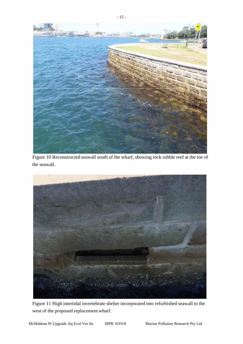
- 15 -
McMahons Pt Upgrade Aq Ecol Ver 8a MPR 1019-8 Marine Pollution Research Pty Ltd
Figure 10 Reconstructed seawall south of the wharf, showing rock rubble reef at the toe of the seawall.
Figure 11 High intertidal invertebrate shelter incorporated into refurbished seawall to the west of the proposed replacement wharf.

- 16 -
McMahons Pt Upgrade Aq Ecol Ver 8a MPR 1019-8 Marine Pollution Research Pty Ltd
Figure 12 Close up of lower seawall showing mixed barnacle and mollusc zone in mid intertidal

- 17 -
McMahons Pt Upgrade Aq Ecol Ver 8a MPR 1019-8 Marine Pollution Research Pty Ltd
Figure 13 Lower intertidal seawall and rock rubble reef top.
Figure 14 Rock rubble reef in shallow sub-tidal zone.

- 18 -
McMahons Pt Upgrade Aq Ecol Ver 8a MPR 1019-8 Marine Pollution Research Pty Ltd
Figure 15 Mid rock rubble reef dominated by kelp cover
Figure 16 Lower edge of rock rubble reef showing mixed kelp and Sargassum algae growth and coarse sand seabed.

- 19 -
McMahons Pt Upgrade Aq Ecol Ver 8a MPR 1019-8 Marine Pollution Research Pty Ltd
Figure 17 Isolated piece of rock rubble on sand that supports a kelp plant.
Figure 18 Rock rubble with kelp cover around base of a wharf support pile. Note small luderick.

- 20 -
McMahons Pt Upgrade Aq Ecol Ver 8a MPR 1019-8 Marine Pollution Research Pty Ltd
Figure 19 Shallow sub-tidal edge of wharf sea-stair support structure showing mixed oyster, barnacle and frondose algae plus sheet encrusting sponge growth.
Figure 20 Mixed frondose algae growth on wharf support pile in shallow sub-tidal zone

- 21 -
McMahons Pt Upgrade Aq Ecol Ver 8a MPR 1019-8 Marine Pollution Research Pty Ltd
Figure 21 Mid depth growth on jetty support pile showing kelp plants, and mixed encrusting colonial bryozoan and sponge species.
Figure 22 Kelp growing on lower part of a wharf support pile.

- 22 -
McMahons Pt Upgrade Aq Ecol Ver 8a MPR 1019-8 Marine Pollution Research Pty Ltd
3 IMPACT ASSESSMENT AND MITIGATION
With regard to the assessment of possible aquatic impacts, the proposed McMahons Point
Wharf interchange requires the demolition and removal of the existing wharf followed by
the construction the proposed wharf interchange. The wharf demolition will require:
• The removal of all above-water structures and facilities (shelter shed plus the sea-
stairs) and associated wooden bearers.
• Removal of up to 23 wharf support piles and six fender piles. The six support piles
under the shelter shed are located in the inshore rock rubble habitat area and the
remaining piles are located in bare shelly-sand habitat.
The new wharf interchange construction will require the following on-site activities:
• Construction of a covered shelter about 20m long and 10m wide over the water. The shelter would connect to land at an angle of about 90 degrees and would be supported by about 12 steel piles, with about half located in rock rubble reef habitat and the remainder in unvegetated sandy sediment seabed.
• Construction of an uncovered concrete bridge about 3m wide and 25m long extending from the shelter at an angle of about 90 degrees. The bridge would connect to a gangway headstock support and would be supported on about 12 steel piles and precast concrete head stocks. All piles would be placed into unvegetated silty-sand habitat.
• Installation of a rectangular steel floating pontoon wharf. The pontoon would be about 12m wide and 27m long and would have two berthing faces. The pontoon would contain a curved zinc roof, glass and stainless steel balustrades and seating. The floating pontoon would be held in place by four steel piles, and there will be an additional three ferry arrestor pile structures installed for the western (in-shore) berth.
• Installation of an aluminium gangway about 18m long and about three metres wide. The gangway would connect the concrete bridge to the floating pontoon and would extend from the bridge at an angle of about 90 degrees. The floating pontoon alignment would extend off the gangway at an angle of about 174 degrees.
• Installation of safety and security facilities including lighting, closed circuit television (CCTV), ladders to the water from the pontoon, a life ring on the pontoon platform and tactile floor treatments.
The inshore half of the covered shelter will be located over rock rubble reef habitat and will
have a slightly larger rock-reef shading footprint than the existing facility (see Figure 8).
The new concrete bridge, gangway, floating pontoon and ferry arrestor pile structures will

- 23 -
McMahons Pt Upgrade Aq Ecol Ver 8a MPR 1019-8 Marine Pollution Research Pty Ltd
be located offshore from the rock rubble reef over un-vegetated silty sand seabed habitat and
the pontoon will be located in water depths greater than -9m ISLW.
3.1 Management of Construction Impacts
Demolition works will result in the removal of attached biota on the wetted surface areas of
the piles and other intertidal wooden support sub-structures structures that are to be
removed:
• The removal of piles and wharf wetted surface habitat would result in the loss of
marine algae habitat from un-shaded piles around the perimeter of the wharf and
attached marine fauna habitat from shaded piles and structures. This loss will be
directly offset by the provision of new similar hard substratum wetted surface
habitat on the new shelter plus bridge support and pontoon locator piles, and on
the wetted surfaces on the sides of the new pontoon. This will result in a net gain
in hard substratum habitat for marine biota - ranging from barnacles, oysters and
other molluscs on the intertidal pile surfaces to fringing algae and brown
macroalgae plus sponges, tunicates and bryozoa on the shallow to deep water
parts of piles and on the pontoon sides and bottom.
• Cryptic species such as the protected Syngnathids (and in particular White’s
seahorse) are known to shelter amongst the attached biota on wharf piles and
could be removed or disturbed during pile pulling making them vulnerable to
predation by other fish. Whilst there is suitable seahorse habitat in the rock
rubble reef immediately in-shore of the piles, there is low seahorse habitat value
on the piles themselves and seahorses have not been noted on the piles during the
repeated field surveys for the proposal. Notwithstanding this conclusion, the
presence of seahorses during demolition cannot be discounted altogether.
• Syngnathids that require relocation would be taken well away from the existing
facility to deeper rock rubble reef located to the south at the turn of the wall from
the south to the west (see Figures 8 and 10). This work would be undertaken
against a Section 37 permit under the Fisheries Management Act (P12/0008-2.0).
Construction works will require placement of at least six steel piles into the rock rubble reef
habitat and will result in the displacement of rock rubble with associated algae assemblages.
The remaining bridge support, pontoon locator and ferry arrestor piles will be driven into

McMahons Pt Upgrade Aq Ecol Ver 8a MPR 1019-8 Marine Pollution Research Pty Ltd
- 24 -
coarse sand and shell habitat inshore and silty-sand habitat offshore, displacing some
benthic assemblages residing in the sediments:
• Placement of steel piles through the rock rubble reef would have a temporary
impact on the habitat, as the rocks that are displaced would continue to provide
suitable attachment habitat for algae and other encrusting biota that would
quickly re-establish. The wetted surfaces of the piles would also provide
additional hard substratum habitat for colonisation by an assemblage of
encrusting aquatic biota similar to that on the rock rubble reef.
• For piles being placed into bare seabed sediments offshore, pile placement has
the effect of laterally displacing sediments plus entrained benthic (bottom
dwelling) organisms during penetration. As the benthic organisms are generally
confined to the upper surface sediments that are loose and mobile, many of these
organisms survive and following completion of piling activities re-establish
themselves in the sediments around the pile. Further, given the large expanses of
sediment benthic habitats throughout the area, residual loss or soft sediment
benthic habitat considered trivial. Also, as the number of piles to be removed for
the present wharf demolition is much larger than the number of piles to be
placed, there is an overall net increase in available soft substratum habitats
resulting from the proposal. In regard to shading impacts, the existing wharf shades some 77m2 of inshore rock rubble reef
habitat of which about half supports an observable lower density of marine algae. The
proposed shelter facility will shade about the same area of rock rubble habitat with the same
proportion of part shade algae area and total shade area. Accordingly once the present facility
is completed there will be no net change in shading impacts from the total facility.
In terms of hard substratum habitat losses and gains, and using a mean wetted surface depth of
1m for pile shallow sub-surface algae habitat, the existing facility provides some 3.6m2 habitat
comprising about 2.4m2 shaded pile habitat and 1.2m2 unshaded habitat:
• Whilst the new facility will provide the same area of wetted surface area for piles, a
greater proportion of these piles will be unshaded resulting in some 2.4m2 unshaded
pile habitat suitable for colonisation by algae-based habitat with a residual 1.2m2
shaded habitat for encrusting fauna.
• With a wetted surface depth of 1.5m the new pontoon would provide an additional
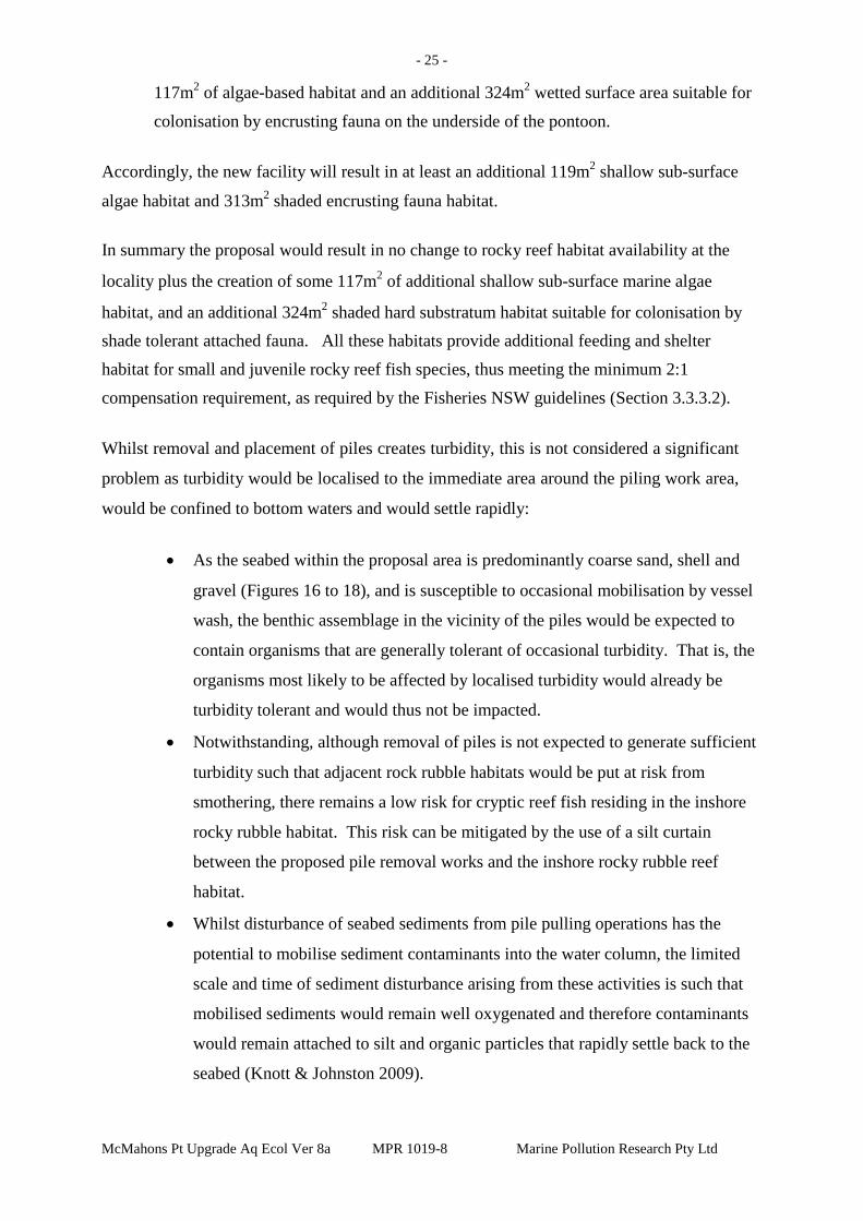
McMahons Pt Upgrade Aq Ecol Ver 8a MPR 1019-8 Marine Pollution Research Pty Ltd
- 25 -
117m2 of algae-based habitat and an additional 324m2 wetted surface area suitable for
colonisation by encrusting fauna on the underside of the pontoon. Accordingly, the new facility will result in at least an additional 119m2 shallow sub-surface
algae habitat and 313m2 shaded encrusting fauna habitat.
In summary the proposal would result in no change to rocky reef habitat availability at the
locality plus the creation of some 117m2 of additional shallow sub-surface marine algae
habitat, and an additional 324m2 shaded hard substratum habitat suitable for colonisation by shade tolerant attached fauna. All these habitats provide additional feeding and shelter habitat for small and juvenile rocky reef fish species, thus meeting the minimum 2:1 compensation requirement, as required by the Fisheries NSW guidelines (Section 3.3.3.2).
Whilst removal and placement of piles creates turbidity, this is not considered a significant
problem as turbidity would be localised to the immediate area around the piling work area,
would be confined to bottom waters and would settle rapidly:
• As the seabed within the proposal area is predominantly coarse sand, shell and
gravel (Figures 16 to 18), and is susceptible to occasional mobilisation by vessel
wash, the benthic assemblage in the vicinity of the piles would be expected to
contain organisms that are generally tolerant of occasional turbidity. That is, the
organisms most likely to be affected by localised turbidity would already be
turbidity tolerant and would thus not be impacted.
• Notwithstanding, although removal of piles is not expected to generate sufficient
turbidity such that adjacent rock rubble habitats would be put at risk from
smothering, there remains a low risk for cryptic reef fish residing in the inshore
rocky rubble habitat. This risk can be mitigated by the use of a silt curtain
between the proposed pile removal works and the inshore rocky rubble reef
habitat.
• Whilst disturbance of seabed sediments from pile pulling operations has the
potential to mobilise sediment contaminants into the water column, the limited
scale and time of sediment disturbance arising from these activities is such that
mobilised sediments would remain well oxygenated and therefore contaminants
would remain attached to silt and organic particles that rapidly settle back to the
seabed (Knott & Johnston 2009).

McMahons Pt Upgrade Aq Ecol Ver 8a MPR 1019-8 Marine Pollution Research Pty Ltd
- 26 -
• Placement of piles will not result in the mobilisation of contaminants from the
sediments as inserted pile force sediment downward via the pile friction effect
and laterally away via displacement. This means that there is little or no upward
mobilisation of the sub-surface sediments that could contain contaminants, as the
pile driving action further buries displaced sub-surface sediments.
Diving of piles creates impact noise that can adversely affect the behaviour of cetaceans and
other marine mammals that are known to penetrate the harbour beyond the Harbour Bridge
and could conceivably be in the vicinity of the construction pile driving works. Marine
mammals, if in the locality, would be conspicuous and, given the harbour situation, they
would be well monitored in regard to location, species and numbers, and their presence
would be well publicised (including via regular marine VHF radio notices from Sydney
Ports Corporation. Accordingly, if there are marine mammals in the vicinity of the piling
works the contractors will need to stop piling works until they have left the locality (see
Section 3.5 for further details).
Demolition of the existing wharf will all be undertaken over or near the water and there is
the potential for demolition materials to be accidentally dropped into the waters. This
potential impact can be mitigated to insignificance by the use of best practice construction
management procedures that can be written into a Construction Environmental Management
Plan (CEMP) for the proposal.
Use of anchors, mooring blocks and other apparatus for undertaking the demolition and
construction works and construction related excessive vessel wash and propeller thrust have
the potential to damage rock rubble algae. These risks can be mitigated to insignificance by
the implementation of suitable mooring, anchoring and work practices as outlined in Section
3.5 below.
3.2 Management of Operational Impacts
With respect to the possible operational impacts from use of the proposed wharf interchange
on the aquatic ecology of the locality, there is a net beneficial impact expected from the use
of the new facility for ferry services:
• The present wharf is located close and parallel to the outer edge of the rock rubble
reef, with minimum depths at the wharf face of -4m ISLW, and the rock rubble reefs

McMahons Pt Upgrade Aq Ecol Ver 8a MPR 1019-8 Marine Pollution Research Pty Ltd
- 27 -
to the west of the present wharf may be subjected to propeller wash from ferries
travelling east.
• The new pontoon facility will be located in deeper waters with vessel propulsion
always over water depths in excess of -9m ISLW (see Figure 8). Ferries using the
outer berth are always orientated parallel to shore and propulsion would always be
directed over deep waters. Vessels using the inner berth can only access the birth
from the west and need to reverse out of the berth so their propulsion is always
directed backwards towards deeper waters on the approach and forwards into waters
between -6 to -8m ISLW and parallel to the shore when reversing back out of the
berth.
• With regard to litter arising from use of the wharf, this is an ongoing concern for the
present wharf and more generally for all the public ferry wharves in Sydney
Harbour. Accordingly, this impact would be minimised by the use of current best
practice as applied by Sydney Ferries to resolve this problem.
3.3 Fisheries Management Act Permit and Habitat Protection Requirements
Section 7.1 of the Fisheries NSW Policy and Guidelines (Fisheries NSW 2013) states that
there must be no net loss of fish habitat and Section 3.3.3 of the Policy and Guidelines notes
that under the FMA Section 220, there are a number of activities available that can be used
to mitigate damage to fish habitat:
• habitat rehabilitation is defined as repairing damage caused by past activities, and
environmental compensation is defined as the creation or enhancement of fish
habitats or fisheries resources in order to compensate for anticipated adverse or
actual environmental effects of proposed developments.
• Habitat rehabilitation can be either passive or active. After the removal of the
damaging or inhibiting factor or structure some habitats can be left to passive natural
processes to rehabilitate the area.
• Environmental compensation (where required) must consider the representativeness
and value of different types of habitats and compensation for Type 1 to 3 key fish
habitat must be calculated on a minimum 2:1 basis (Policy and Guidelines Section
3.3.3.2).
McMahons Pt Upgrade Aq Ecol Ver 8a MPR 1019-8 Marine Pollution Research Pty Ltd
- 28 -
For the McMahons Point Wharf interchange proposal, the aim of no net loss of fish habitat
will be achieved via:
• Environmental compensation in the form of additional shallow water hard
substratum habitat (pontoon and pile wetted surface areas) suitable for colonisation
by rocky reef biota similar to those occurring on inshore rock rubble reef habitat.
• Construction related damage to existing habitats will be limited by the
implementation of appropriate construction mitigation measures as outlined in
Section 3.5 below.
Part 7 of the FMA sets out the conditions under which permits are required for various
construction activities, and the conditions under which a permit may be granted are specified
in the Fisheries NSW Policy and Guidelines (Fisheries NSW 2013). With respect to
estuarine activities, permits are required for reclamation or dredging works, for the taking or
harming of marine vegetation or for relocating fish:
• The present proposal does not include dredging or reclamation works.
• There are no significant direct or indirect impacts on marine vegetation arising from
the proposed works and, provided adequate construction safeguards as described in
Section 3.5 are implemented, the construction works would result in a substantial
increase in macroalgae habitat.
• The proposal has a Section 37 relocation permit in place to relocate seahorses (if
found on the piles to be removed) and there is suitable alternate rocky rubble reef
kelp habitat available for relocation.
3.4 Sydney Regional Environmental Plan (Sydney Harbour Catchment) 2005
Clause 21 of the SREP (Sydney Harbour Catchment) outlines nine criteria for biodiversity, ecology and environmental protection:
17(a) Need for development to have a neutral or beneficial effect on water
quality entering the waterway. Provided demolition and construction works utilise best management practice for containing water and materials runoff from the site, water quality impacts would be minimal and temporary.
17(b) Need for development to protect and enhance terrestrial and aquatic species, populations and ecological communities and, in particular, should avoid physical damage and shading of aquatic vegetation (such as seagrass, saltmarsh and algal and mangrove communities).
McMahons Pt Upgrade Aq Ecol Ver 8a MPR 1019-8 Marine Pollution Research Pty Ltd
- 29 -
The development would result in a large decrease in shading of existing marine vegetation by virtue of the removal of the existing wharf that is currently shading the rock rubble reef.
Marine mammals, reptiles and aquatic or migratory birds may utilise the aquatic resources of the site on a transient or opportunistic basis and would not be impacted, as there is abundant alternate or equivalent habitat throughout the harbour. Impact noise disturbance from pile driving activities would be mitigated by ceasing pile driving activities when there are marine mammals in the locality.
Whilst no Syngnathid fish have been found on the piles to be removed, based on the availability of suitable shelter habitat in the adjacent (inshore) rocky reef their presence cannot be discounted. Accordingly, a final check for syngnathids would be made immediately prior to wharf demolition works commencing and if found they will be relocated to suitable inshore rock rubble habitat away from the demolition zone. Protection of inshore rocky reef syngnathids from turbidity and smothering during construction piling works will be achieved by the use of silt curtains between the rock rubble reef and the offshore piling works.
17(c) Need for development to avoid indirect impacts on aquatic vegetation as a result of increased access. There would be no increased access to the aquatic vegetation at the site arising from the development.
17(d) Need for development to avoid indirect impacts on aquatic vegetation (such as changes to flow, current and wave action and changes to water quality) as a result of increased access. By virtue of the openness of the site to the harbour, there are unlikely to be any changes to tidal flow, currents, wave action or water quality arising from the proposal and thus there would be no indirect impact on aquatic vegetation arising.
17(e) Need for development to protect and reinstate natural intertidal foreshore areas, natural landforms and native vegetation. There are no natural inter-tidal foreshore areas, natural landforms or native vegetation), as this is a totally reclaimed and paved site. The proposal would have a net beneficial impact on the aquatic vegetation on the wetted surface areas of the seawall by removal of the shading from the present wharf structure, and there would be an additional beneficial impact, as the wetted surface areas of the ferry pontoon would provide some 115m2 additional habitat for marine biota including macroalgae.
McMahons Pt Upgrade Aq Ecol Ver 8a MPR 1019-8 Marine Pollution Research Pty Ltd
- 30 -
17f) Need for development to retain, rehabilitate and restore riparian
land. The total riparian shore at this location comprises reclaimed land behind revetment walls (sandstone and concrete). The proposal does not include any works on riparian lands and thus does affect existing riparian land.
17(g) Need for development on land adjoining wetlands to maintain and enhance the ecological integrity of the wetlands and where possible to provide a vegetative buffer to protect wetlands. The DCP for the Sydney Regional Environmental Plan (Sydney Harbour Catchment) 2005 indicates that there is no designated wetland at or in the near vicinity of the wharf upgrade development. Notwithstanding this, the proposal would result in a net gain in hard substratum marine vegetation habitat, and the upgrade works can be managed in a manner to protect the existing vegetated rocky reef.
17(h) Need to assess the cumulative environmental impact of the development. Assessment of the impacts of the proposal on the aquatic environment provided above indicates that recolonisation of the new wetted hard substratum surfaces would provide an assemblage of aquatic biota that would be similar but not necessarily the same as that currently at the site, thus providing a net increase in feeding and shelter habitat for marine biota, particularly for small rocky reef fish species and juveniles. There are no long-term water quality or ecological impacts arising from the proposal. There is an additional beneficial impact from the provision of further hard-substratum macroalgae habitat on the pontoon and pile surfaces. Accordingly, the net impact of the upgrade would be beneficial compared to the present situation.
17(i) State whether sediments in the waterway adjacent to the development are contaminated, and what means will minimise their disturbance. Whilst there is no information available on the contamination status of the sediments adjacent to the development, the fact that the sediments comprise mainly well-sorted loose clean sand with little or no silt content would indicate a low risk of there being contaminants in the surface sediments at the site. Further, as there would only be pulse (transient) disturbance of sediments arising from piling during construction works and no disturbance from operational use of the upgraded facilities, there are no disturbance impacts expected.

McMahons Pt Upgrade Aq Ecol Ver 8a MPR 1019-8 Marine Pollution Research Pty Ltd
- 31 -
3.5 Recommended Mitigation Measures
The McMahons Point Wharf interchange proposal can achieve the aim of no net loss of fish
habitat by the implementation of appropriate construction mitigation measures and all
contractors undertaking construction work associated with the proposal should ensure that
their activities do not cause any harm to marine vegetation habitats (i.e., rock rubble reef) in
the shallow waters along the Lavender Bay shoreline out to the -3m depth contour (Figure
8). Potential impact can be mitigated to insignificance by the use of best practice
construction management procedures incorporated into a Construction Environmental
Management Plan (CEMP) for the proposal that includes the following precautions:
• Ensure that all piles to be removed are inspected for syngnathid fish (mainly sea-
horses) prior to removal, and that any syngnathids found are captured and released to
appropriate alternative habitat as outlined in this report. This work would be
undertaken against an existing Section 37 permit; 12/0008-2.0.
• In the unlikely event that further syngnathid fish are found during the pile pulling
operations, they should be collected where this is safe to do so and placed in a large
bucket of fresh seawater pending further advice from the relevant expert.
• In order to minimise swimming distances for remaining reef fish from piles being
pulled to remaining piles in-shore and eventually to the rock rubble habitat, piles
should be systematically removed from seawards towards the shore.
• Whilst the possibility of listed sharks, cetaceans, other marine mammals and reptiles
being at the site during construction activities has been assessed as highly unlikely, if
any threatened aquatic species are noted at the construction site unexpectedly, all in-
water construction works should be halted until the species has left or if the species
To this end the contractor will need to keep a radio listening watch to Sydney Port
Control for information about sightings of marine mammals.
• Prior to commencement of pile driving operations, the contractor is to call Sydney
Port Control to check whether there have been any sightings of marine mammals and
if so their current location. If marine mammals are reported west of the Harbour
Bridge (or immediately east of the Harbour Bridge and travelling west), pile driving
operations are not to be undertaken until the marine mammals are reported to be east,
and well and clear of the Harbour Bridge and travelling east.
• A floating silt curtain that reaches to the seabed should be set parallel to the east-
facing seawall at the demolition site and about 10m offshore (on the -2m ISLW
McMahons Pt Upgrade Aq Ecol Ver 8a MPR 1019-8 Marine Pollution Research Pty Ltd
- 32 -
contour) to prevent turbidity from initial offshore pile removal operations washing
onto the inshore rock rubble reef habitat. The silt curtain should extend under the
existing ferry wharf footprint and for some 20m parallel to the shore from the
extremities of the existing wharf. This curtain will need to be removed for the
removal of the remaining inshore piles. Provided the removal of the inshore piles is
undertaken around high tide there should not be a need for any additional siltation
protection.
• Provided the placement of the inshore piles within the rock rubble reef at the south-
facing seawall at the new wharf interchange construction site is undertaken around
high tide there should not be a need for any additional siltation protection.
• However if there any are additional in-water construction works required,
smothering damage of adjacent rock rubble reef habitat within the rock rubble reef
along the south-facing shore, i.e. at the new wharf construction site) can be
minimised by using two short silt curtains around the work space set normal to the
shore and reaching from the seawall to no more than 15m offshore.
• Smothering damage of adjacent rock rubble reef habitat from placement of the in-
shore concrete bridge piles into bare sediment habitat can be minimised by
placement of a floating silt curtain. If required, this curtain should be set parallel to
the south-facing seawall at the construction site and about 12m offshore (about the -
3m ISLW contour – see Figure 8).
• Placement of the offshore bridge pontoon locator and ferry arrestor piles is
sufficiently remote from the rock rubble habitats to not require full-length silt curtain
containment but floating silt curtains may be considered for limiting the spread of
visible turbidity plumes if necessary.
• By virtue of the shallow depths over the inshore rock rubble habitat, vessel
movements over the rock rubble reef habitat beside the seawall are to be avoided.
• There should be no stockpiling of demolition or construction materials on the seabed
and the potential for materials and liquids to be accidentally spilt into the waters
should be minimised by the use of best practice construction management
procedures to be included in the CEMP.
• All demolition materials are to be removed off-site for appropriate disposal.
• No vessel should be moored with anchors or other bottom tackle located in the rock
rubble habitats inshore of the -4m ISLW depth contour (Figure 8).

McMahons Pt Upgrade Aq Ecol Ver 8a MPR 1019-8 Marine Pollution Research Pty Ltd
- 33 -
• Mooring lines or cables should not be laid across the rock rubble habitat if there is
any risk of these cables reaching the bottom due to wave action or low tides. If
deployed, they should be suitably buoyed prior to laying, and kept buoyed once laid,
to prevent cable drag and cable swing damage to marine vegetation growing on the
rock rubble. Where this is impractical, contractors should use floating rope.
• In order to minimise wash and prevent bottom scouring of the marine vegetation
(rock rubble) habitat, towing or pushing vessels should not use excessive power to
manoeuvre barges into place over the rock rubble habitat area. Scouring damage can
also be minimised by ‘working the wind and tides’, i.e., only moving floating plant
into place on high tides and under favourable or no-wind conditions.
McMahons Pt Upgrade Aq Ecol Ver 8a MPR 1019-8 Marine Pollution Research Pty Ltd
- 34 -
4 CONCLUSIONS
It is concluded that demolition of the existing McMahons Point Wharf and the construction
of the proposed McMahons Point Wharf interchange at McMahons Point, would result in
minor losses of intertidal aquatic habitat and organisms to construction and a medium to
long-term gain in available marine vegetation (algae) habitat post-construction:
• Encrusting organisms would be removed during demolition and new encrusting
assemblages would colonise wetted surfaces of reinstated wetted surface areas for
the new facility.
• Disruption to other associated fish assemblages including protected Syngnathids
would be negligible.
• Shading impact on rock rubble reef algae from the proposed wharf replacement
would be the same as present, in the same location and would be offset by the gain of
new algae colonisation on the vertical wetted surfaces of the wharf piles and
pontoon.
• Possible impacts arising from the proposed construction works and from operation of
the new facilities can be satisfactorily mitigated by appropriate best-practice
construction, demolition and operational safeguards as outlined in the report.
On balance, there would be a net beneficial impact from the proposed wharf replacement;
there would be no net loss of aquatic habitat to construction and in the medium to long term,
there would be a beneficial impact for reef fish assemblages utilising the additional marine
assemblages attached to the wetted surfaces of the piles and pontoon. The orientation of the
new wharf interchange further offshore provides additional security against propeller and
wash impacts on shallow water ecosystems.
The demolition of the present McMahons Point Wharf and the construction of its
replacement with the proposed wharf interchange can be adequately managed to satisfy the
aquatic ecology conservation requirements of SREP (Sydney Harbour Catchment) 2005 and
the aquatic ecology and fish habitat conservation requirements of the Fisheries Management
Act 1994 (FMA) as set out in the Fisheries NSW Policy and Guidelines (Fisheries NSW
2013) to ensure that there would be no net loss of fish habitat. The proposed works would
not require any permits under the FMA.

McMahons Pt Upgrade Aq Ecol Ver 8a MPR 1019-8 Marine Pollution Research Pty Ltd
- 35 -
5 REFERENCES
DECC (2009) Environmentally Friendly Seawalls, A Guide to Improving the Environmental Value of Seawalls and Seawall-lined Foreshores in Estuaries. DECC Report 2009/328 prepared on behalf of Sydney Metropolitan Catchment Authority, June 2009.
Gommon M F, Glover J C M and Kuiter R H (1994) The fishes of Australia's South Coast. The Flora and Fauna of South Australia Handbooks Committee. State Print Adelaide.
Kelleway, J., R.J. Williams and C.B. Allen (2007) An Assessment of the Saltmarsh of the Parramatta River and Sydney Harbour. NSW Department of Primary Industries – Fisheries Final Report Series No. 90. August 2007.
Knott N and Johnston E (2009) Is the ecology of Sydney harbour threatened by the disturbance of contaminated sediments?. A experimental assessment of the effects of resuspension of contaminated sediment on sessile animals of Sydney harbour. UNSW report.
Kuiter R H (1997) Guide to Sea Fishes of Australia. New Holland, Sydney.
Fisheries NSW (2013) Policy and Guidelines for Fish Habitat Conservation and Management (2013 update), NSW Department of Primary Industries, June 2013.
MPR (2004) Aquatic ecology survey, McMahons Point Seawall restoration. Report prepared by Marine Pollution Research Pty Ltd for Macleod Consultants Pty Ltd, August 2004.
SMCMA (2008) Sydney Harbour Foreshore & Estuarine Vegetation Mapping, Assessment, Planning And Management. Sydney Metropolitan Catchment Management Authority, 2008.
SPCC (1981) The Ecology of Fish in Botany Bay. Report BBS23, Environmental Control Study of Botany Bay. SPCC Sydney.
West, R J, Thorogood, C, Walford, T, Williams, R J (1985) An Estuarine Inventory for New South Wales, Australia. Fisheries Bulletin 2. Division of Fisheries, Department of Agriculture N.S.W.
West G, Williams R J and Laird R (2004) Distribution of estuarine vegetation in the Parramatta River and Sydney Harbour, 2000. NSW DPI Fisheries Final Report Series No 70. December 2004.
West G and Williams R J (2008) A preliminary assessment of the historical, current and future cover of seagrass in the estuary of the Parramatta River. NSW DPI (Fisheries) Final Report Series No. 98.
McMahons Pt Upgrade Aq Ecol Ver 8a MPR 1019-8 Marine Pollution Research Pty Ltd
- 36 -
Appendix F Threatened species search results

Appendix F
EPBC Act Protected Matters Report
This report provides general guidance on matters of national environmental significance and other matters protected by the EPBC Act in the area you have selected.
Information on the coverage of this report and qualifications on data supporting this report are contained in the caveat at the end of the report.
Information is available about Environment Assessments and the EPBC Act including significance guidelines, forms and application process details.
Report created: 28/01/15 17:05:25
Summary Details
Matters of NES Other Matters Protected by the EPBC Act Extra Information
Caveat Acknowledgements
This map may contain data which are ©Commonwealth of Australia (Geoscience Australia), ©PSMA 2010
Coordinates Buffer: 10.0Km

Summary
Matters of National Environmental Significance
This part of the report summarises the matters of national environmental significance that may occur in, or may relate to, the area you nominated. Further information is available in the detail part of the report, which can be accessed by scrolling or following the links below. If you are proposing to undertake an activity that may have a significant impact on one or more matters of national environmental significance then you should consider the Administrative Guidelines on Significance.
World Heritage Properties: National Heritage Places: Wetlands of International Importance: Great Barrier Reef Marine Park: Commonwealth Marine Areas: Listed Threatened Ecological Communities: Listed Threatened Species: Listed Migratory Species:
6
12
1
None
None
5
75
64
Other Matters Protected by the EPBC Act
This part of the report summarises other matters protected under the Act that may relate to the area you nominated. Approval may be required for a proposed activity that significantly affects the environment on Commonwealth land, when the action is outside the Commonwealth land, or the environment anywhere when the action is taken on Commonwealth land. Approval may also be required for the Commonwealth or Commonwealth agencies proposing to take an action that is likely to have a significant impact on the environment anywhere.
The EPBC Act protects the environment on Commonwealth land, the environment from the actions taken on Commonwealth land, and the environment from actions taken by Commonwealth agencies. As heritage values of a place are part of the 'environment', these aspects of the EPBC Act protect the Commonwealth Heritage values of a Commonwealth Heritage place and the heritage values of a place on the Register of the National Estate.
This part of the report summarises other matters protected under the Act that may relate to the area you nominated. Approval may be required for a proposed activity that significantly affects the environment on Commonwealth land, when the action is outside the Commonwealth land, or the environment anywhere when the action is taken on Commonwealth land. Approval may also be required for the Commonwealth or Commonwealth agencies proposing to take an action that is likely to have a significant impact on the environment anywhere.
A permit may be required for activities in or on a Commonwealth area that may affect a member of a listed threatened species or ecological community, a member of a listed migratory species, whales and other cetaceans, or a member of a listed marine species.
Commonwealth Land: Commonwealth Heritage Places: Listed Marine Species: Whales and Other Cetaceans: Critical Habitats: Commonwealth Reserves Terrestrial: Commonwealth Reserves Marine
55
72
87
14
None None None

Extra Information
This part of the report provides information that may also be relevant to the area you have nominated.
Place on the RNE:
State and Territory Reserves: Regional Forest Agreements: Invasive Species: Nationally Important Wetlands:
1678
5
None
49
1 Key Ecological Features (Marine) None
Details
Matters of National Environmental Significance World Heritage Properties [ Resource Information ]
Name Australian Convict Sites (Cockatoo Island Convict Site Buffer Zone) Australian Convict Sites (Cockatoo Island Convict Site) Australian Convict Sites (Hyde Park Barracks Buffer Zone) Australian Convict Sites (Hyde Park Barracks) Sydney Opera House Sydney Opera House - Buffer Zone
State NSW
NSW NSW NSW NSW NSW
Status Declared property
Declared property Declared property Declared property Declared property Declared property
National Heritage Properties [ Resource Information ] Name State Status
Indigenous Cyprus Hellene Club - Australian Hall Historic Bondi Beach Cockatoo Island First Government House Site Hyde Park Barracks North Head - Sydney Sydney Harbour Bridge Sydney Opera House Australia's 3 Little Italys - Norton Street Precinct Colonial Sydney National Trust Urban Conservation Areas of Kur-ring-gai Bondi Surf Pavilion
NSW
NSW NSW NSW NSW NSW NSW NSW NSW NSW NSW NSW
Listed place Listed place Listed place Listed place Listed place Listed place Listed place Listed place Nominated place Nominated place Nominated place Within listed place
Wetlands of International Importance (RAMSAR) [ Resource Information ] Name Proximity
Towra point nature reserve Within 10km of Ramsar
Listed Threatened Ecological Communities [ Resource Information ] For threatened ecological communities where the distribution is well known, maps are derived from recovery plans, State vegetation maps, remote sensing imagery and other sources. Where threatened ecological community distributions are less well known, existing vegetation maps and point location data are used to produce indicative distribution maps.
Name Status Type of Presence Coastal Upland Swamps in the Sydney Basin Bioregion Eastern Suburbs Banksia Scrub of the Sydney Region
Endangered Community likely to occur within area
Endangered Community known to occur within area
Subtropical and Temperate Coastal Saltmarsh Vulnerable Community likely to occur within area
Turpentine-Ironbark Forest in the Sydney Basin Bioregion
Critically Endangered Community likely to occur within area
Western Sydney Dry Rainforest and Moist Critically Endangered Community may occur

Name Status Type of Presence
Woodland on Shale within area
Listed Threatened Species [ Resource Information ] Name Status Type of Presence
Birds Anthochaera phrygia Regent Honeyeater [82338] Endangered Species or species
habitat known to occur within area
Botaurus poiciloptilus Australasian Bittern [1001] Endangered Species or species
habitat known to occur within area
Dasyornis brachypterus Eastern Bristlebird [533] Endangered Species or species
habitat likely to occur within area
Diomedea epomophora epomophora Southern Royal Albatross [25996] Vulnerable Foraging, feeding or
related behaviour likely to occur within area
Diomedea epomophora sanfordi Northern Royal Albatross [82331] Endangered Foraging, feeding or
related behaviour likely to occur within area
Diomedea exulans antipodensis Antipodean Albatross [82269] Vulnerable Foraging, feeding or
related behaviour likely to occur within area
Diomedea exulans exulans Tristan Albatross [82337] Endangered Species or species
habitat may occur within area
Diomedea exulans gibsoni Gibson's Albatross [82271] Vulnerable Foraging, feeding or
related behaviour likely to occur within area
Diomedea exulans (sensu lato) Wandering Albatross [1073] Vulnerable Foraging, feeding or
related behaviour likely to occur within area
Fregetta grallaria grallaria White-bellied Storm-Petrel (Tasman Sea), White- bellied Storm-Petrel (Australasian) [64438]
Lathamus discolor
Vulnerable Species or species habitat likely to occur within area
Swift Parrot [744] Endangered Species or species habitat likely to occur within area
Macronectes giganteus Southern Giant-Petrel [1060] Endangered Species or species
habitat may occur within area
Macronectes halli Northern Giant-Petrel [1061] Vulnerable Species or species
habitat may occur within area
Neophema chrysogaster Orange-bellied Parrot [747] Critically Endangered Species or species
habitat may occur within area
Pterodroma leucoptera leucoptera Gould's Petrel [26033] Endangered Species or species
habitat may occur within area
Pterodroma neglecta neglecta Kermadec Petrel (western) [64450] Vulnerable Foraging, feeding or
related behaviour may occur within area
Rostratula australis Australian Painted Snipe [77037] Endangered Species or species
habitat likely to occur within area

Name Status Type of Presence
Sternula nereis nereis Australian Fairy Tern [82950] Vulnerable Species or species
habitat known to occur within area
Thalassarche bulleri Buller's Albatross, Pacific Albatross [64460] Vulnerable Species or species
habitat may occur within area
Thalassarche cauta cauta Shy Albatross, Tasmanian Shy Albatross [82345] Vulnerable Foraging, feeding or
related behaviour likely to occur within area
Thalassarche cauta salvini Salvin's Albatross [82343] Vulnerable Foraging, feeding or
related behaviour likely to occur within area
Thalassarche cauta steadi White-capped Albatross [82344] Vulnerable Foraging, feeding or
related behaviour likely to occur within area
Thalassarche eremita Chatham Albatross [64457] Endangered Foraging, feeding or
related behaviour likely to occur within area
Thalassarche melanophris Black-browed Albatross [66472] Vulnerable Species or species
habitat may occur within area
Thalassarche melanophris impavida Campbell Albatross [82449] Vulnerable Species or species
habitat may occur within area
Fish Epinephelus daemelii Black Rockcod, Black Cod, Saddled Rockcod [68449]
Prototroctes maraena
Vulnerable Species or species
habitat likely to occur within area
Australian Grayling [26179] Vulnerable Species or species habitat likely to occur within area
Frogs Heleioporus australiacus Giant Burrowing Frog [1973] Vulnerable Species or species
habitat likely to occur within area
Litoria aurea Green and Golden Bell Frog [1870] Vulnerable Species or species
habitat likely to occur within area
Mixophyes balbus Stuttering Frog, Southern Barred Frog (in Victoria) [1942]
Mammals Balaenoptera musculus
Vulnerable Species or species habitat likely to occur within area
Blue Whale [36] Endangered Species or species habitat may occur within area
Chalinolobus dwyeri Large-eared Pied Bat, Large Pied Bat [183] Vulnerable Species or species
habitat likely to occur within area
Dasyurus maculatus maculatus (SE mainland population) Spot-tailed Quoll, Spotted-tail Quoll, Tiger Quoll (southeastern mainland population) [75184]
Eubalaena australis
Endangered Species or species habitat known to occur within area
Southern Right Whale [40] Endangered Species or species habitat known to occur within area
Isoodon obesulus obesulus Southern Brown Bandicoot (Eastern) [68050] Endangered Species or species
Name Status Type of Presence
Megaptera novaeangliae
habitat likely to occur within area
Humpback Whale [38] Vulnerable Species or species habitat known to occur within area
Petrogale penicillata Brush-tailed Rock-wallaby [225] Vulnerable Species or species
habitat may occur within area
Phascolarctos cinereus (combined populations of Qld, NSW and the ACT) Koala (combined populations of Queensland, New South Wales and the Australian Capital Territory) [85104] Pseudomys novaehollandiae
Vulnerable Species or species habitat likely to occur within area
New Holland Mouse, Pookila [96] Vulnerable Species or species habitat likely to occur within area
Pteropus poliocephalus Grey-headed Flying-fox [186] Vulnerable Roosting known to occur
within area Plants Acacia bynoeana Bynoe's Wattle, Tiny Wattle [8575] Vulnerable Species or species
habitat likely to occur within area
Acacia pubescens Downy Wattle, Hairy Stemmed Wattle [18800] Vulnerable Species or species
habitat likely to occur within area
Acacia terminalis subsp. terminalis MS Sunshine Wattle [64829] Endangered Species or species
habitat known to occur within area
Allocasuarina glareicola [21932] Endangered Species or species
habitat may occur within area
Allocasuarina portuensis Nielsen Park She-oak [21937] Endangered Species or species
habitat known to occur within area
Asterolasia elegans [56780] Endangered Species or species
habitat may occur within area
Caladenia tessellata Thick-lipped Spider-orchid, Daddy Long-legs [2119]
Cryptostylis hunteriana
Vulnerable Species or species habitat likely to occur within area
Leafless Tongue-orchid [19533] Vulnerable Species or species habitat likely to occur within area
Darwinia biflora [14619] Vulnerable Species or species
habitat likely to occur within area
Deyeuxia appressa [7438] Endangered Species or species
habitat likely to occur within area
Eucalyptus camfieldii Camfield's Stringybark [15460] Vulnerable Species or species
habitat likely to occur within area
Genoplesium baueri Yellow Gnat-orchid [7528] Endangered Species or species
habitat known to occur within area
Grevillea caleyi Caley's Grevillea [9683] Endangered Species or species
habitat likely to occur
Name Status Type of Presence
Haloragodendron lucasii within area
Hal [6480] Endangered Species or species habitat likely to occur within area
Melaleuca biconvexa Biconvex Paperbark [5583] Vulnerable Species or species
habitat may occur within area
Melaleuca deanei Deane's Melaleuca [5818] Vulnerable Species or species
habitat may occur within area
Microtis angusii Angus's Onion Orchid [64530] Endangered Species or species
habitat likely to occur within area
Pelargonium sp. Striatellum (G.W.Carr 10345) Omeo Stork's-bill [84065] Endangered Species or species
habitat may occur within area
Pimelea curviflora var. curviflora [4182] Vulnerable Species or species
habitat known to occur within area
Pimelea spicata Spiked Rice-flower [20834] Endangered Species or species
habitat may occur within area
Prostanthera marifolia Seaforth Mintbush [7555] Critically Endangered Species or species
habitat known to occur within area
Streblus pendulinus Siah's Backbone, Sia's Backbone, Isaac Wood [21618]
Syzygium paniculatum Magenta Lilly Pilly, Magenta Cherry, Pocket-less Brush Cherry, Scrub Cherry, Creek Lilly Pilly, Brush Cherry [20307] Thesium australe
Endangered Species or species habitat likely to occur within area
Vulnerable Species or species habitat likely to occur within area
Austral Toadflax, Toadflax [15202] Vulnerable Species or species habitat may occur within area
Triplarina imbricata [64543] Endangered Species or species
habitat likely to occur within area
Reptiles
Caretta caretta
Loggerhead Turtle [1763] Endangered Species or species habitat known to occur
Chelonia mydas within area
Green Turtle [1765] Vulnerable Foraging, feeding or related behaviour known
Dermochelys coriacea to occur within area
Leatherback Turtle, Leathery Turtle, Luth [1768] Endangered Foraging, feeding or related behaviour known
Eretmochelys imbricata to occur within area
Hawksbill Turtle [1766] Vulnerable Species or species habitat known to occur
Hoplocephalus bungaroides within area
Broad-headed Snake [1182] Vulnerable Species or species habitat likely to occur
Natator depressus within area
Flatback Turtle [59257] Vulnerable Foraging, feeding or related behaviour known
Name Threatened Type of Presence
Listed Migratory Species * Species is listed under a different scientific name on the EPBC Act - Threatened S
[ Resource Information ]
ecies list. Name Threatened Type of Presence Migratory Marine Birds
Sharks Carcharias taurus (east coast population)
to occur within area
Grey Nurse Shark (east coast population) [68751] Critically Endangered Species or species habitat known to occur within area
Carcharodon carcharias Great White Shark [64470] Vulnerable Species or species
habitat known to occur within area
Pristis zijsron Green Sawfish, Dindagubba, Narrowsnout Sawfish [68442]
Rhincodon typus
Vulnerable Species or species habitat may occur within area
Whale Shark [66680] Vulnerable Species or species habitat may occur within area
p Apus pacificus Fork-tailed Swift [678] Species or species
habitat likely to occur within area
Diomedea antipodensis Antipodean Albatross [64458] Vulnerable* Foraging, feeding or
related behaviour likely to occur within area
Diomedea dabbenena Tristan Albatross [66471] Endangered* Species or species
habitat may occur within area
Diomedea epomophora (sensu stricto) Southern Royal Albatross [1072] Vulnerable* Foraging, feeding or
related behaviour likely to occur within area
Diomedea exulans (sensu lato) Wandering Albatross [1073] Vulnerable Foraging, feeding or
related behaviour likely to occur within area
Diomedea gibsoni Gibson's Albatross [64466] Vulnerable* Foraging, feeding or
related behaviour likely to occur within area
Diomedea sanfordi Northern Royal Albatross [64456] Endangered* Foraging, feeding or
related behaviour likely to occur within area
Macronectes giganteus Southern Giant-Petrel [1060] Endangered Species or species
habitat may occur within area
Macronectes halli Northern Giant-Petrel [1061] Vulnerable Species or species
habitat may occur within area
Puffinus carneipes Flesh-footed Shearwater, Fleshy-footed Shearwater [1043]
Sterna albifrons
Foraging, feeding or related behaviour likely to occur within area
Little Tern [813] Breeding likely to occur within area
Thalassarche bulleri Buller's Albatross, Pacific Albatross [64460] Vulnerable Species or species
habitat may occur within area
Thalassarche cauta (sensu stricto) Shy Albatross, Tasmanian Shy Albatross [64697] Vulnerable* Foraging, feeding or

Name Status Type of Presence
Thalassarche eremita
related behaviour likely to occur within area
Chatham Albatross [64457] Endangered Foraging, feeding or related behaviour likely to occur within area
Thalassarche impavida Campbell Albatross [64459] Vulnerable* Species or species
habitat may occur within area
Thalassarche melanophris Black-browed Albatross [66472] Vulnerable Species or species
habitat may occur within area
Thalassarche salvini Salvin's Albatross [64463] Vulnerable* Foraging, feeding or
related behaviour likely to occur within area
Thalassarche steadi White-capped Albatross [64462] Vulnerable* Foraging, feeding or
related behaviour likely to occur within area
Migratory Marine Species Balaenoptera edeni Bryde's Whale [35] Species or species
habitat may occur within area
Balaenoptera musculus Blue Whale [36] Endangered Species or species
habitat may occur within area
Caperea marginata Pygmy Right Whale [39] Species or species
habitat may occur within area
Carcharodon carcharias Great White Shark [64470] Vulnerable Species or species
habitat known to occur within area
Caretta caretta Loggerhead Turtle [1763] Endangered Species or species
habitat known to occur within area
Chelonia mydas Green Turtle [1765] Vulnerable Foraging, feeding or
related behaviour known to occur within area
Dermochelys coriacea Leatherback Turtle, Leathery Turtle, Luth [1768] Endangered Foraging, feeding or
related behaviour known to occur within area
Dugong dugon Dugong [28] Species or species
habitat may occur within area
Eretmochelys imbricata Hawksbill Turtle [1766] Vulnerable Species or species
habitat known to occur within area
Eubalaena australis Southern Right Whale [40] Endangered Species or species
habitat known to occur within area
Lagenorhynchus obscurus Dusky Dolphin [43] Species or species
habitat may occur within area
Lamna nasus Porbeagle, Mackerel Shark [83288] Species or species
habitat likely to occur within area
Manta birostris Giant Manta Ray, Chevron Manta Ray, Pacific Species or species

Name Threatened Type of Presence
Name Threatened Type of Presence Manta Ray, Pelagic Manta Ray, Oceanic Manta Ray [84995] Megaptera novaeangliae
habitat may occur within area
Humpback Whale [38] Vulnerable Species or species habitat known to occur within area
Natator depressus Flatback Turtle [59257] Vulnerable Foraging, feeding or
related behaviour known to occur within area
Orcinus orca Killer Whale, Orca [46] Species or species
habitat may occur within area
Rhincodon typus Whale Shark [66680] Vulnerable Species or species
habitat may occur within area
Sousa chinensis Indo-Pacific Humpback Dolphin [50] Species or species
habitat likely to occur within area
Migratory Terrestrial Species Haliaeetus leucogaster White-bellied Sea-Eagle [943] Species or species
habitat known to occur within area
Hirundapus caudacutus White-throated Needletail [682] Species or species
habitat known to occur within area
Merops ornatus Rainbow Bee-eater [670] Species or species
habitat may occur within area
Monarcha melanopsis Black-faced Monarch [609] Species or species
habitat known to occur within area
Monarcha trivirgatus Spectacled Monarch [610] Species or species
habitat may occur within area
Myiagra cyanoleuca Satin Flycatcher [612] Species or species
habitat known to occur within area
Rhipidura rufifrons Rufous Fantail [592] Species or species
habitat known to occur within area
Migratory Wetlands Species Ardea alba Great Egret, White Egret [59541] Species or species
habitat known to occur within area
Ardea ibis Cattle Egret [59542] Species or species
habitat likely to occur within area
Arenaria interpres Ruddy Turnstone [872] Foraging, feeding or
related behaviour known to occur within area
Calidris acuminata Sharp-tailed Sandpiper [874] Foraging, feeding or
related behaviour known to occur within area
Calidris canutus Red Knot, Knot [855] Foraging, feeding or
related behaviour known to occur within area

Calidris ferruginea Curlew Sandpiper [856]
Foraging, feeding or related behaviour known
Calidris ruficollis to occur within area
Red-necked Stint [860] Foraging, feeding or related behaviour known
Calidris tenuirostris to occur within area
Great Knot [862] Foraging, feeding or related behaviour known
Charadrius bicinctus to occur within area
Double-banded Plover [895] Foraging, feeding or related behaviour known
Charadrius leschenaultii to occur within area
Greater Sand Plover, Large Sand Plover [877] Foraging, feeding or related behaviour known
Charadrius mongolus to occur within area
Lesser Sand Plover, Mongolian Plover [879] Foraging, feeding or related behaviour known
Gallinago hardwickii to occur within area
Latham's Snipe, Japanese Snipe [863] Foraging, feeding or related behaviour known
Heteroscelus brevipes to occur within area
Grey-tailed Tattler [59311] Foraging, feeding or related behaviour known
Limosa lapponica to occur within area
Bar-tailed Godwit [844] Foraging, feeding or related behaviour known
Limosa limosa to occur within area
Black-tailed Godwit [845] Foraging, feeding or related behaviour known
Numenius madagascariensis to occur within area
Eastern Curlew [847] Foraging, feeding or related behaviour known
Numenius minutus to occur within area
Little Curlew, Little Whimbrel [848] Foraging, feeding or related behaviour likely
Numenius phaeopus to occur within area
Whimbrel [849] Foraging, feeding or related behaviour known
Pluvialis fulva to occur within area
Pacific Golden Plover [25545] Foraging, feeding or related behaviour known
Rostratula benghalensis (sensu lato) to occur within area
Painted Snipe [889] Endangered* Species or species habitat likely to occur
Tringa stagnatilis within area
Marsh Sandpiper, Little Greenshank [833] Foraging, feeding or related behaviour known to occur within area
Name Threatened Type of Presence
Other Matters Protected by the EPBC Act Commonwealth Land [ Resource Information ] The Commonwealth area listed below may indicate the presence of Commonwealth land in this vicinity. Due to the unreliability of the data source, all proposals should be checked as to whether it impacts on a Commonwealth area, before making a definitive decision. Contact the State or Territory government land department for further information.
Name Commonwealth Land - Commonwealth Land - Airservices Australia Commonwealth Land - Australian & Overseas Telecommunications Corporation Commonwealth Land - Australian Broadcasting Commission Commonwealth Land - Australian Broadcasting Corporation Commonwealth Land - Australian National University Commonwealth Land - Australian Postal Commission Commonwealth Land - Australian Postal Corporation Commonwealth Land - Australian Telecommunications Commission Commonwealth Land - Australian Telecommunications Corporation Commonwealth Land - Commonwealth Bank of Australia Commonwealth Land - Commonwealth Scientific & Industrial Research Organisation Commonwealth Land - Commonwealth Trading Bank of Australia Commonwealth Land - Defence Housing Authority Commonwealth Land - Director of War Service Homes Commonwealth Land - Reserve Bank of Australia Commonwealth Land - Telstra Corporation Limited Defence - 21 CONST REGT - HABERFIELD DEPOT Defence - COCKATOO ISLAND DOCKYARD Defence - DEFENCE PLAZA SYDNEY Defence - DEGAUSSING RANGE Defence - DSTO PYRMONT - (SEE SITE 1177) Defence - FLEET BASE WHARVES Defence - FOREST LODGE (SYDNEY) TRG DEP Defence - GARDEN ISLAND Defence - GLADESVILLE TRAINING DEPOT Defence - HMAS KUTTABUL (AC 30/5 Lot4 DP218946) Defence - HMAS PENGUIN Defence - HMAS PLATYPUS - SPDU FOR DISPOSAL Defence - HMAS WATERHEN Defence - HMAS WATSON Defence - JENNER BUILDING Defence - KENSINGTON DEPOT Defence - KISMET/HMAS KUTTABUL-POTTS PT Defence - LADY GOWRIE HOUSE Defence - LEICHHARDT STORES DEPOT Defence - MARITIME COMD CTRE-POTTS POINT ; BOMERAH/TARANA Defence - MARITIME HEADQUARTERS Defence - MATERIAL RESEARCH LAB Defence - MILLER'S POINT TRAINING DEPOT Defence - NFI CHOWDER BAY (fuel depot) Defence - NORTH SYDNEY - HYDRO OFFICE Defence - OXFORD ST SYDNEY Defence - PARKVIEW BUILDING - SYDNEY Defence - RANDWICK (CARRINGTON RD) Defence - RANDWICK BARRACKS Defence - RANDWICK FRENCHMANS TRG Defence - SPECTACLE ISLAND Defence - SYDNEY UNIVERSITY REGIMENT - DARLINGTON Defence - TRESCO Defence - VAUCLUSE TRAINING DEPOT Defence - VICTORIA BARRACKS - PADDINGTON Defence - WILLOUGHBY TRG DEP Defence - WOOLLOOMOOLOO CARPARK Defence - ZETLAND NAVY SUPPLY CENTRE
Commonwealth Heritage Places [ Resource Information ] Name State Status
Historic
Name State Status Admiralty House Garden and Fortifications NSW Admiralty House and Lodge NSW Army Cottage with return verandah NSW Barracks Block NSW Barracks Group HMAS Watson NSW Batteries A83 and C9A NSW Battery B42 NSW Battery for Five Guns NSW Biloela Group NSW Bondi Beach Post Office NSW Building VB1 and Parade Ground NSW Building VB2 Guard House NSW Buildings 31 and 32 NSW Buildings MQVB16 and VB56 NSW Buildings VB13, 15, 16 & 17 NSW Buildings VB41, 45 & 53 NSW Buildings VB60 and VB62 NSW Buildings VB69, 75 & 76 including Garden NSW Buildings VB83, 84, 85, 87 & 89 NSW Buildings VB90, 91, 91A & 92 NSW Chain and Anchor Store (former) NSW Chowder Bay Barracks Group NSW Cliff House NSW Cockatoo Island Industrial Conservation Area NSW Commonwealth Avenue Defence Housing NSW Cottage at Macquarie Lighthouse NSW Customs Marine Centre NSW Defence site - Georges Heights and Middle Head NSW Factory NSW Fitzroy Dock NSW Garden Island Precinct NSW Gazebo NSW General Post Office NSW Golf Clubhouse (former) NSW HMAS Penguin NSW Headquarters 8th Brigade Precinct NSW Headquarters Training Command Precinct NSW Kirribilli House NSW Kirribilli House Garden & Grounds NSW Macquarie Lighthouse NSW Macquarie Lighthouse Group NSW Macquarie Lighthouse Surrounding Wall NSW Marine Biological Station (former) NSW Marrickville Post Office NSW Mess Hall (former) NSW Military Guard Room NSW Military Road Framework - Defence Land NSW Naval Store NSW Navy Refuelling Depot and Caretakers House NSW North Sydney Post Office NSW Office Building NSW Officers Mess, HQ Training Command NSW Paddington Post Office NSW Power House / Pump House NSW Prison Barracks Precinct NSW Pyrmont Post Office NSW Reserve Bank NSW Residences Group NSW Rigging Shed and Chapel NSW
Listed place Listed place Listed place Listed place Listed place Listed place Listed place Listed place Listed place Listed place Listed place Listed place Listed place Listed place Listed place Listed place Listed place Listed place Listed place Listed place Listed place Listed place Listed place Listed place Listed place Listed place Listed place Listed place Listed place Listed place Listed place Listed place Listed place Listed place Listed place Listed place Listed place Listed place Listed place Listed place Listed place Listed place Listed place Listed place Listed place Listed place Listed place Listed place Listed place Listed place Listed place Listed place Listed place Listed place Listed place Listed place Listed place Listed place Listed place
School of Musketry and Officers Mess, Randwick Army Barracks
NSW Listed place
Shark Point Battery NSW Snapper Island NSW Spectacle Island Explosives Complex NSW Sutherland Dock NSW Sydney Customs House (former) NSW
Listed place Listed place Listed place Listed place Listed place

Listed Marine Species * Species is listed under a different scientific name on the EPBC Act - Threatened S
[ Resource Information ]
ecies list. Name Threatened Type of Presence Birds
Name Ten Terminal Regiment Headquarters and AusAid Training Centre
State NSW
Status Listed place
Thirty Terminal Squadron Precinct NSW Underground Grain Silos NSW Victoria Barracks Perimeter Wall and Gates NSW Victoria Barracks Precinct NSW Victoria Barracks Squash Courts NSW Woolwich Dock NSW
Listed place Listed place Listed place Listed place Listed place Listed place
p
Apus pacificus Fork-tailed Swift [678]
Species or species habitat likely to occur
Ardea alba within area
Great Egret, White Egret [59541] Species or species habitat known to occur
Ardea ibis within area
Cattle Egret [59542] Species or species habitat likely to occur
Arenaria interpres within area
Ruddy Turnstone [872] Foraging, feeding or related behaviour known
Calidris acuminata to occur within area
Sharp-tailed Sandpiper [874] Foraging, feeding or related behaviour known
Calidris canutus to occur within area
Red Knot, Knot [855] Foraging, feeding or related behaviour known
Calidris ferruginea to occur within area
Curlew Sandpiper [856] Foraging, feeding or related behaviour known
Calidris melanotos to occur within area
Pectoral Sandpiper [858] Foraging, feeding or related behaviour known
Calidris ruficollis to occur within area
Red-necked Stint [860] Foraging, feeding or related behaviour known
Calidris tenuirostris to occur within area
Great Knot [862] Foraging, feeding or related behaviour known
Charadrius bicinctus to occur within area
Double-banded Plover [895] Foraging, feeding or related behaviour known
Charadrius leschenaultii to occur within area
Greater Sand Plover, Large Sand Plover [877] Foraging, feeding or related behaviour known
Charadrius mongolus to occur within area
Lesser Sand Plover, Mongolian Plover [879] Foraging, feeding or related behaviour known
Charadrius ruficapillus to occur within area
Red-capped Plover [881] Foraging, feeding or related behaviour known
Diomedea antipodensis to occur within area
Antipodean Albatross [64458] Vulnerable* Foraging, feeding or related behaviour likely

Name Threatened Type of Presence
Diomedea dabbenena to occur within area
Tristan Albatross [66471] Endangered* Species or species habitat may occur within area
Diomedea epomophora (sensu stricto) Southern Royal Albatross [1072] Vulnerable* Foraging, feeding or
related behaviour likely to occur within area
Diomedea exulans (sensu lato) Wandering Albatross [1073] Vulnerable Foraging, feeding or
related behaviour likely to occur within area
Diomedea gibsoni Gibson's Albatross [64466] Vulnerable* Foraging, feeding or
related behaviour likely to occur within area
Diomedea sanfordi Northern Royal Albatross [64456] Endangered* Foraging, feeding or
related behaviour likely to occur within area
Gallinago hardwickii Latham's Snipe, Japanese Snipe [863] Foraging, feeding or
related behaviour known to occur within area
Gallinago megala Swinhoe's Snipe [864] Foraging, feeding or
related behaviour likely to occur within area
Gallinago stenura Pin-tailed Snipe [841] Foraging, feeding or
related behaviour likely to occur within area
Haliaeetus leucogaster White-bellied Sea-Eagle [943] Species or species
habitat known to occur within area
Heteroscelus brevipes Grey-tailed Tattler [59311] Foraging, feeding or
related behaviour known to occur within area
Himantopus himantopus Black-winged Stilt [870] Foraging, feeding or
related behaviour known to occur within area
Hirundapus caudacutus White-throated Needletail [682] Species or species
habitat known to occur within area
Lathamus discolor Swift Parrot [744] Endangered Species or species
habitat likely to occur within area
Limosa lapponica Bar-tailed Godwit [844] Foraging, feeding or
related behaviour known to occur within area
Limosa limosa Black-tailed Godwit [845] Foraging, feeding or
related behaviour known to occur within area
Macronectes giganteus Southern Giant-Petrel [1060] Endangered Species or species
habitat may occur within area
Macronectes halli Northern Giant-Petrel [1061] Vulnerable Species or species
habitat may occur within area
Merops ornatus Rainbow Bee-eater [670] Species or species
habitat may occur within area

Name Threatened Type of Presence
Monarcha melanopsis Black-faced Monarch [609] Species or species
habitat known to occur within area
Monarcha trivirgatus Spectacled Monarch [610] Species or species
habitat may occur within area
Myiagra cyanoleuca Satin Flycatcher [612] Species or species
habitat known to occur within area
Neophema chrysogaster Orange-bellied Parrot [747] Critically Endangered Species or species
habitat may occur within area
Numenius madagascariensis Eastern Curlew [847] Foraging, feeding or
related behaviour known to occur within area
Numenius minutus Little Curlew, Little Whimbrel [848] Foraging, feeding or
related behaviour likely to occur within area
Numenius phaeopus Whimbrel [849] Foraging, feeding or
related behaviour known to occur within area
Pandion haliaetus Osprey [952] Species or species
habitat known to occur within area
Philomachus pugnax Ruff (Reeve) [850] Foraging, feeding or
related behaviour known to occur within area
Pluvialis fulva Pacific Golden Plover [25545] Foraging, feeding or
related behaviour known to occur within area
Puffinus carneipes Flesh-footed Shearwater, Fleshy-footed Shearwater [1043]
Recurvirostra novaehollandiae
Foraging, feeding or related behaviour likely to occur within area
Red-necked Avocet [871] Foraging, feeding or related behaviour known to occur within area
Rhipidura rufifrons Rufous Fantail [592] Species or species
habitat known to occur within area
Rostratula benghalensis (sensu lato) Painted Snipe [889] Endangered* Species or species
habitat likely to occur within area
Sterna albifrons Little Tern [813] Breeding likely to occur
within area Thalassarche bulleri Buller's Albatross, Pacific Albatross [64460] Vulnerable Species or species
habitat may occur within area
Thalassarche cauta (sensu stricto) Shy Albatross, Tasmanian Shy Albatross [64697] Vulnerable* Foraging, feeding or
related behaviour likely to occur within area
Thalassarche eremita Chatham Albatross [64457] Endangered Foraging, feeding or
related behaviour likely to occur within area
Thalassarche impavida Campbell Albatross [64459] Vulnerable* Species or species
Name Threatened Type of Presence
Thalassarche melanophris
habitat may occur within area
Black-browed Albatross [66472] Vulnerable Species or species habitat may occur within area
Thalassarche salvini Salvin's Albatross [64463] Vulnerable* Foraging, feeding or
related behaviour likely to occur within area
Thalassarche steadi White-capped Albatross [64462] Vulnerable* Foraging, feeding or
related behaviour likely to occur within area
Tringa stagnatilis Marsh Sandpiper, Little Greenshank [833] Foraging, feeding or
related behaviour known to occur within area
Fish Acentronura tentaculata Shortpouch Pygmy Pipehorse [66187] Species or species
habitat may occur within area
Festucalex cinctus Girdled Pipefish [66214] Species or species
habitat may occur within area
Filicampus tigris Tiger Pipefish [66217] Species or species
habitat may occur within area
Heraldia nocturna Upside-down Pipefish, Eastern Upside-down Pipefish, Eastern Upside-down Pipefish [66227]
Hippichthys penicillus
Species or species habitat may occur within area
Beady Pipefish, Steep-nosed Pipefish [66231] Species or species habitat may occur within area
Hippocampus abdominalis Big-belly Seahorse, Eastern Potbelly Seahorse, New Zealand Potbelly Seahorse [66233]
Hippocampus whitei White's Seahorse, Crowned Seahorse, Sydney Seahorse [66240]
Histiogamphelus briggsii Crested Pipefish, Briggs' Crested Pipefish, Briggs' Pipefish [66242]
Lissocampus runa
Species or species habitat may occur within area
Species or species habitat may occur within area
Species or species habitat may occur within area
Javelin Pipefish [66251] Species or species habitat may occur within area
Maroubra perserrata Sawtooth Pipefish [66252] Species or species
habitat may occur within area
Notiocampus ruber Red Pipefish [66265] Species or species
habitat may occur within area
Phyllopteryx taeniolatus Common Seadragon, Weedy Seadragon [66268] Species or species
habitat may occur within area
Solegnathus spinosissimus Spiny Pipehorse, Australian Spiny Pipehorse [66275]
Solenostomus cyanopterus
Species or species habitat may occur within area
Robust Ghostpipefish, Blue-finned Ghost Pipefish, Species or species

Name Threatened Type of Presence
[66183] habitat may occur within area
Solenostomus paegnius Rough-snout Ghost Pipefish [68425] Species or species
habitat may occur within area
Solenostomus paradoxus Ornate Ghostpipefish, Harlequin Ghost Pipefish, Ornate Ghost Pipefish [66184]
Stigmatopora argus
Species or species habitat may occur within area
Spotted Pipefish, Gulf Pipefish [66276] Species or species habitat may occur within area
Stigmatopora nigra Widebody Pipefish, Wide-bodied Pipefish, Black Pipefish [66277]
Syngnathoides biaculeatus Double-end Pipehorse, Double-ended Pipehorse, Alligator Pipefish [66279]
Trachyrhamphus bicoarctatus Bentstick Pipefish, Bend Stick Pipefish, Short- tailed Pipefish [66280]
Urocampus carinirostris
Species or species habitat may occur within area
Species or species habitat may occur within area
Species or species habitat may occur within area
Hairy Pipefish [66282] Species or species habitat may occur within area
Vanacampus margaritifer Mother-of-pearl Pipefish [66283] Species or species
habitat may occur within area
Mammals Arctocephalus forsteri New Zealand Fur-seal [20] Species or species
habitat may occur within area
Arctocephalus pusillus Australian Fur-seal, Australo-African Fur-seal [21]
Dugong dugon
Species or species habitat may occur within area
Dugong [28] Species or species habitat may occur within area
Reptiles Caretta caretta Loggerhead Turtle [1763] Endangered Species or species
habitat known to occur within area
Chelonia mydas Green Turtle [1765] Vulnerable Foraging, feeding or
related behaviour known to occur within area
Dermochelys coriacea Leatherback Turtle, Leathery Turtle, Luth [1768] Endangered Foraging, feeding or
related behaviour known to occur within area
Eretmochelys imbricata Hawksbill Turtle [1766] Vulnerable Species or species
habitat known to occur within area
Natator depressus Flatback Turtle [59257] Vulnerable Foraging, feeding or
related behaviour known to occur within area
Pelamis platurus Yellow-bellied Seasnake [1091] Species or species
habitat may occur within area
Name Threatened Type of Presence
Whales and other Cetaceans [ Resource Information ] Name Status Type of Presence
Mammals
Balaenoptera acutorostrata Minke Whale [33] Species or species
habitat may occur within area
Balaenoptera edeni Bryde's Whale [35] Species or species
habitat may occur within area
Balaenoptera musculus Blue Whale [36] Endangered Species or species
habitat may occur within area
Caperea marginata Pygmy Right Whale [39] Species or species
habitat may occur within area
Delphinus delphis Common Dophin, Short-beaked Common Dolphin [60]
Eubalaena australis
Species or species habitat may occur within area
Southern Right Whale [40] Endangered Species or species habitat known to occur within area
Grampus griseus Risso's Dolphin, Grampus [64] Species or species
habitat may occur within area
Lagenorhynchus obscurus Dusky Dolphin [43] Species or species
habitat may occur within area
Megaptera novaeangliae Humpback Whale [38] Vulnerable Species or species
habitat known to occur within area
Orcinus orca Killer Whale, Orca [46] Species or species
habitat may occur within area
Sousa chinensis Indo-Pacific Humpback Dolphin [50] Species or species
habitat likely to occur within area
Stenella attenuata Spotted Dolphin, Pantropical Spotted Dolphin [51] Species or species
habitat may occur within area
Tursiops aduncus Indian Ocean Bottlenose Dolphin, Spotted Bottlenose Dolphin [68418]
Tursiops truncatus s. str.
Species or species habitat likely to occur within area
Bottlenose Dolphin [68417] Species or species habitat may occur within area
Extra Information Places on the RNE [ Resource Information ]
Note that not all Indigenous sites may be listed.
Name Natural
State
Status
Bundock Street Banksia Scrub NSW Glebe Island Dyke Exposures NSW North Sydney Harbour Aquatic Reserve NSW Parramatta and Lane Cove Rivers Landscapes NSW Bantry Bay Reserve Area (former) NSW Bondi Northern Cliffline NSW Lane Cove Bushland Park NSW Macquarie Hospital Bushland NSW Manly Dam and Surrounds NSW North Head NSW St Peters Brickpit Geological Site NSW Sydney Harbour National Park (1980 Boundary) NSW Indigenous Aboriginal Boat Carvings NSW Berry Island Reserve NSW The Block NSW Historic ABC Gore Hill NSW AWA Building (former) NSW Aberdeen House NSW Angus and Son Building NSW Ardenclutha NSW Art Room at Newington College NSW Artney NSW Ashfield Park NSW Avondale NSW BBC Hardware NSW Balls Head Coal Loader NSW Balmoral Baths NSW Balmoral Shark Proof Pool NSW Bancroft Avenue Urban Conservation Precinct NSW Batemans Hut NSW Bathurst House NSW Blackwood NSW Bland / Nicholson Streets Group NSW Bligh / Camperdown Terrace Conservation Area NSW Bondi Beach Post Office NSW Bondi Post Office NSW Botany Swamps NSW Bronte Beach Baths NSW Bronte House Gardens NSW Buckle House (former) NSW Burns Bay Sewerage Aqueduct NSW Cammeray Conservation Area NSW Campbell Parade Streetscape NSW Canada House NSW Careening Cove Conservation Area NSW Carrum Carrum NSW Century House NSW Chamberlain Hotel NSW Chatswood Rifle Range (former) NSW Chatswood Septic Tanks (former) NSW Chatswood Urban Conservation Area NSW Christian Brothers High School (former) NSW Clem Morath Pool NSW Clive Park Rock Pool NSW Clovelly Bay Enclosure & Baths NSW Coles Fosseys 1915 Building (former) NSW Coles Fosseys 1935 Building (former) NSW Commercial Terrace NSW
Indicative Place Indicative Place Indicative Place Indicative Place Registered Registered Registered Registered Registered Registered Registered Registered Indicative Place Registered Registered Identified Place Indicative Place Indicative Place Indicative Place Indicative Place Indicative Place Indicative Place Indicative Place Indicative Place Indicative Place Indicative Place Indicative Place Indicative Place Indicative Place Indicative Place Indicative Place Indicative Place Indicative Place Indicative Place Indicative Place Indicative Place Indicative Place Indicative Place Indicative Place Indicative Place Indicative Place Indicative Place Indicative Place Indicative Place Indicative Place Indicative Place Indicative Place Indicative Place Indicative Place Indicative Place Indicative Place Indicative Place Indicative Place Indicative Place Indicative Place Indicative Place Indicative Place Indicative Place

Name State Status
Constables Cottage NSW Coogee Bay Hotel NSW Coolooba NSW Cooper Street Conservation Area NSW Cremorne Conservation Area NSW Cremorne Point Conservation Area NSW Criterion Hotel NSW Crown Lodge NSW Crows Nest Road Conservation Area NSW Culworth Avenue Urban Conservation Precinct NSW Darrell Lea Shop (Facade) NSW Dobroyd Stormwater Channel NSW Douglass Lane NSW Drummoyne Avenue Group NSW Drummoyne Fire Station NSW Dry Stone Wall and Water Channel NSW Dudley House NSW Dunaverty NSW Dunham House NSW East Lindfield Urban Conservation Precinct NSW Edgecliff Post Office NSW Edward Street Conservation Area NSW Egyptian Room Scottish Royal Arch Masonic Temple NSW Elismere & Studley Royal NSW Enmore Post Office (former) NSW Evening Star Hotel NSW Eventide including Front Fence NSW Fairlight Pool NSW Fairmont NSW Fayworth House NSW Ferndale NSW Fire Station (former) NSW Firs Estate and Cottage NSW Flat Rock Creek Bridge NSW Florence Bartley Library NSW Foley Bros Warehouses (former) NSW Forbes Terrace NSW Garden Island - Captain Cook Dock Precinct NSW Gates and Fence of North Sydney Demonstration School NSW George Bosch Chambers NSW Georgian Style Gable Roofed Cottage NSW Giles Baths & Bath-House NSW Gladesville Bridge NSW Glenore & Buninyong NSW Golden Barley Hotel NSW Gower NSW Greenwich Baths NSW Griffiths Building NSW Hammerhead Crane NSW Haven Amphitheatre NSW Hawthornden NSW Haymarket Post Office NSW Highbury NSW Hollis Park and Environs / Urban Conservation Area NSW Holtermann Estate Conservation Area (A) NSW Holtermann Estate Conservation Area (B) NSW Holtermann Estate Conservation Area (C) NSW Holtermann Estate Conservation Area (D) NSW Home Yardage Building NSW Honda NSW Horaceville NSW House NSW House NSW House NSW House NSW House NSW
Indicative Place Indicative Place Indicative Place Indicative Place Indicative Place Indicative Place Indicative Place Indicative Place Indicative Place Indicative Place Indicative Place Indicative Place Indicative Place Indicative Place Indicative Place Indicative Place Indicative Place Indicative Place Indicative Place Indicative Place Indicative Place Indicative Place Indicative Place Indicative Place Indicative Place Indicative Place Indicative Place Indicative Place Indicative Place Indicative Place Indicative Place Indicative Place Indicative Place Indicative Place Indicative Place Indicative Place Indicative Place Indicative Place Indicative Place Indicative Place Indicative Place Indicative Place Indicative Place Indicative Place Indicative Place Indicative Place Indicative Place Indicative Place Indicative Place Indicative Place Indicative Place Indicative Place Indicative Place Indicative Place Indicative Place Indicative Place Indicative Place Indicative Place Indicative Place Indicative Place Indicative Place Indicative Place Indicative Place Indicative Place Indicative Place Indicative Place

Name State Status
House and Garden NSW Houses NSW Hunters Hill Conservation Area Extension NSW IBM Centre (former) NSW Iver NSW John Sands Building (former) NSW Kenilworth NSW Killara Golf Links Urban Conservation Precinct NSW Killara Urban Conservation Precinct NSW Kindersley House NSW King George Hotel (former) NSW Kings Theatre (former) NSW Kurraba Point Conservation Area NSW Lane Cove House NSW Langwarren NSW Laurelbank NSW Laureston NSW Lavender Bay Conservation Area NSW Leamington NSW Leamington NSW Ledbury NSW Legion House NSW Leichhardt Fire Station NSW Lincoln Building NSW Lindfield Urban Conservation Precinct NSW Little Sirius Cove Enclosure Remnants NSW Llanthony NSW Longueville Pool NSW Loughrea NSW Lower Kirribilli Conservation Area NSW Man O'War Steps & Jetty NSW Manly Fire Station NSW Manly Public Baths Remnants NSW Manly Reservoir R64 NSW Manufacturers House NSW Marist Brothers Provincialate of Sydney NSW Marrickville Fire Station NSW Marrickville Post Office NSW Mascot Fire Station NSW McCallum Pool NSW McLaren Street Conservation Area NSW McMahons Point North Conservation Area NSW McMahons Point South Conservation Area NSW Middle Harbour Submarine Sewerage Syphon NSW Middle Head and Georges Heights NSW Milson Park NSW Milson Road Group NSW Mobarik NSW Montague Road Conservation Area NSW Mosman Reservoir NSW National Building NSW Neilsen Park Pool & Associated Structures NSW Neptune Engineering including Bay Foreshores NSW Neutral Bay Fire Station NSW Newmarket Hotel NSW North Sydney Fire Station (former) NSW North Sydney Sewerage Sewer Aqueduct NSW Northbridge Pool NSW Painters and Dockers Union Hall NSW Pair of Semi-Detached Dwelling NSW Park Avenue Urban Conservation Precinct NSW Park Lane Mansions NSW Park and Oaks Avenues Conservation Area NSW Parsley Bay Swimming Enclosure NSW Peckham NSW Penston Hall NSW
Indicative Place Indicative Place Indicative Place Indicative Place Indicative Place Indicative Place Indicative Place Indicative Place Indicative Place Indicative Place Indicative Place Indicative Place Indicative Place Indicative Place Indicative Place Indicative Place Indicative Place Indicative Place Indicative Place Indicative Place Indicative Place Indicative Place Indicative Place Indicative Place Indicative Place Indicative Place Indicative Place Indicative Place Indicative Place Indicative Place Indicative Place Indicative Place Indicative Place Indicative Place Indicative Place Indicative Place Indicative Place Indicative Place Indicative Place Indicative Place Indicative Place Indicative Place Indicative Place Indicative Place Indicative Place Indicative Place Indicative Place Indicative Place Indicative Place Indicative Place Indicative Place Indicative Place Indicative Place Indicative Place Indicative Place Indicative Place Indicative Place Indicative Place Indicative Place Indicative Place Indicative Place Indicative Place Indicative Place Indicative Place Indicative Place Indicative Place
Name State Status
Pitt Street Gardens NSW Plateau Conservation Area NSW Prince Alfred Park NSW Pyrmont Point NSW Qantas House (former) NSW Raben Footwear NSW Randwick Fire Station NSW Redleaf Pool NSW Reservoir No 120 and Reservoir No 121 NSW Residence NSW Rockend NSW Rockleigh Grange NSW Rose Bay Post Office NSW Roseville NSW Roseville Baths Remnants NSW Roseville Bush Trail NSW Roseville Chase Urban Conservation Precinct NSW Ross Jones Memorial Pools NSW
Indicative Place Indicative Place Indicative Place Indicative Place Indicative Place Indicative Place Indicative Place Indicative Place Indicative Place Indicative Place Indicative Place Indicative Place Indicative Place Indicative Place Indicative Place Indicative Place Indicative Place Indicative Place
Royal Alexander Hospital for Children (former) Garden Remnants
NSW Indicative Place
Royal Navy Logistics Store NSW Rozelle Railway Goodsline Viaduct NSW Sewer Vent Shaft NSW Shalimar, Including Garden, Fence and Gates NSW Sheffield House NSW Shirley Road Urban Conservation Precinct NSW Shone Ejector Station (former) NSW Simpson House NSW Sir John Young Hotel NSW Sirius Hoe NSW Slipway and Wharf NSW St Albans Anglican Church NSW St Albans Group NSW St Albans Rectory NSW St Josephs Convent Group NSW St Judes Rectory Garden NSW St Leonards Catholic Church NSW St Leonards Park & North Sydney Oval NSW St Marks Catholic Church NSW St Marks Catholic Church Group NSW St Marks Community Hall NSW St Marks Presbytery NSW St Peters Anglican Church NSW St Peters Presbyterian School Hall NSW St Thomas Anglican Church Memorial Hall NSW Stanmore House NSW Stone Retaining Wall and Gateposts to Rose Hall NSW Sugarloaf Bay Catchment and Headlands NSW Summer Hill Post Office (former) NSW Summerfield Terrace NSW Summerhill NSW Surrey NSW Sydenham Village NSW Sydney Harbour Entrance NSW Sydney Harbour Landscape Area NSW Sydney Hospital Nightingale Wing NSW Tambourine Bay Baths NSW Tarella NSW Taringa NSW Terrace NSW Terrace NSW Terrace NSW The Bear Pits Moore Park Zoo NSW The Cedars NSW The House of the Seven Lanterns NSW The Pressure Tunnel NSW
Indicative Place Indicative Place Indicative Place Indicative Place Indicative Place Indicative Place Indicative Place Indicative Place Indicative Place Indicative Place Indicative Place Indicative Place Indicative Place Indicative Place Indicative Place Indicative Place Indicative Place Indicative Place Indicative Place Indicative Place Indicative Place Indicative Place Indicative Place Indicative Place Indicative Place Indicative Place Indicative Place Indicative Place Indicative Place Indicative Place Indicative Place Indicative Place Indicative Place Indicative Place Indicative Place Indicative Place Indicative Place Indicative Place Indicative Place Indicative Place Indicative Place Indicative Place Indicative Place Indicative Place Indicative Place Indicative Place

Name State Status
The Scotland Australia Cairn NSW The Towers - Residence NSW Trethaway House NSW Tryon Road Uniting Church & Hall Complex NSW Tudor Lodge NSW Union / Bank / Thomas Streets Conservation Area NSW University of Technology Kuring-gai Campus NSW Upper Middle Harbour Area NSW Victorian Regency Terrace NSW Victorian Rustic Gothic Cottage NSW Victorian, Wooden Ridgeline, Semi-detached House NSW Walker / Ridge Streets Conservation Area NSW War Memorial 1914-18 NSW Warehouse NSW Warren Ball Avenue Victorian Terrace Houses NSW Water Police Station (former) NSW Waterside Workers Federation Building NSW Watsons Bay Baths NSW Waverley Post Office NSW Waverley Tramway Depot Tramshed Remains NSW Ways Terrace Group NSW West End Hotel NSW West Lindfield Urban Conservation Precinct NSW Westgate Post Office NSW Whaling Road Conservation Area NSW White Bay Power Station NSW Whitehaven NSW William Croft Building (former) NSW Wollstonecraft Conservation Area NSW Woollahra Fire Station NSW Woollahra Post Office NSW Worrall Theatre Complex & St Lukes Chapel NSW Ythanbank NSW Alexandra Canal NSW HMAS Platypus NSW Sydney ( Kingsford Smith ) Airport Group NSW ANZ Bank NSW ANZ Bank NSW ANZ Bank (former) NSW ANZ Bank (former) NSW ASN Hotel (former) NSW Abbotsford House NSW Accountants House NSW Administration Building A Sydney Technical College NSW Admiralty House Garden and Fortifications NSW Admiralty House and Lodge NSW Agar Steps & Adjacent Trees NSW Agar Steps Houses NSW Agincourt Hotel NSW Albion Place Group NSW Alcee NSW Alfred Street Entrance Luna Park NSW Alfreds Terrace NSW Alicia NSW All Saints Anglican Church NSW All Saints Anglican Church NSW All Saints Rectory NSW All Souls Anglican Church, Rectory & Minor Church Buildings NSW Alroy NSW American Express Tower (former) NSW Ammunition Store (former) NSW Anesbury NSW Angel Hotel (former) NSW Annabel Lea NSW Annandale Council Chambers (former) NSW Annandale North Public School NSW
Indicative Place Indicative Place Indicative Place Indicative Place Indicative Place Indicative Place Indicative Place Indicative Place Indicative Place Indicative Place Indicative Place Indicative Place Indicative Place Indicative Place Indicative Place Indicative Place Indicative Place Indicative Place Indicative Place Indicative Place Indicative Place Indicative Place Indicative Place Indicative Place Indicative Place Indicative Place Indicative Place Indicative Place Indicative Place Indicative Place Indicative Place Indicative Place Indicative Place Interim List Interim List Interim List Registered Registered Registered Registered Registered Registered Registered Registered Registered Registered Registered Registered Registered Registered Registered Registered Registered Registered Registered Registered Registered Registered Registered Registered Registered Registered Registered Registered Registered Registered

Name State Status
Annandale Post Office NSW Annandale Public School and Infants Building NSW Annandale Uniting Church NSW Anzac Memorial NSW Arabela Terrace NSW Araluen NSW Araluen House NSW Archibald Fountain NSW Archina and Ascot and Surrounds NSW Ardath NSW Arden Lea NSW Argyle Cut and Argyle Street Space NSW Argyle House NSW Argyle Place Park NSW Argyle Place Precinct NSW Argyle Precinct NSW Argyle Stores NSW Argyle Sub-Station NSW Argyle Terrace NSW Army Cottage with return verandah NSW Art Gallery of NSW NSW Ascham School Precinct NSW Ashton Park NSW Aston Lodge Group NSW Astor Apartment Building NSW Australasian Steam Navigation Company Building NSW Australian Consolidated Industries Building (former) NSW Australian Financial Press Building NSW Australian Gaslight Company Showroom Building (former) NSW Australian Hotel NSW Australian Hotel (former) NSW Australian Joint Stock Bank (former) NSW Australian Museum NSW Australian Workers Union Building NSW Avonmore Terrace NSW BMA House NSW Babworth House NSW Bakery (former) NSW Bakery House and Loft (former) NSW Balmain Civic Group NSW Balmain Cooperative Society Building (former) NSW Balmain Courthouse, Police Station and Post Office NSW Balmain Public School NSW Balmain Volunteer NSW Balmoral Beach Conservation Area NSW Banco Court Building NSW Banking House and Westpac Bank NSW Banksia and Witchagil NSW Bantry Bay Public Magazine NSW Barford and Garden NSW Barham (excluding later additions) NSW Barrack House NSW Barracks Block NSW Barracks Group HMAS Watson NSW Bathurst NSW Batteries A83 and C9A NSW Battery B42 NSW Battery for Five Guns NSW Bayfield NSW Beares Stairs NSW Belgrave Terrace (former) NSW Belvedere NSW Beneficial House NSW Bentham NSW Bettington and Merriman Streets Group NSW Biloela Group NSW
Registered Registered Registered Registered Registered Registered Registered Registered Registered Registered Registered Registered Registered Registered Registered Registered Registered Registered Registered Registered Registered Registered Registered Registered Registered Registered Registered Registered Registered Registered Registered Registered Registered Registered Registered Registered Registered Registered Registered Registered Registered Registered Registered Registered Registered Registered Registered Registered Registered Registered Registered Registered Registered Registered Registered Registered Registered Registered Registered Registered Registered Registered Registered Registered Registered Registered

Name State Status
Birtley Towers NSW Bishopscourt NSW Blackfriars Public School (former) NSW Blacksmith and Machine Shop NSW Blair Athol NSW Blenerne NSW Blenheim House NSW Bomera NSW Bondi Beach NSW Bondi Beach Pool Group NSW Bondi Surf Pavilion NSW Boomerang NSW Booth House (former) NSW Bossley Terrace NSW Botany Building NSW Bourke Street Public School NSW Bradleys Head Fortification Complex NSW Briarbank NSW Bristol Arms Hotel NSW Bronte House and surrounds NSW Brooklyn Hotel NSW Broughton House NSW Bryson House NSW Building VB1 and Parade Ground NSW Building VB2 Guard House NSW Buildings NSW Buildings 31 and 32 NSW Buildings MQVB16 and VB56 NSW Buildings VB13, 15, 16 & 17 NSW Buildings VB41, 45 & 53 NSW Buildings VB60 and VB62 NSW Buildings VB69, 75 & 76 including Garden NSW Buildings VB83, 84, 85, 87 & 89 NSW Buildings VB90, 91, 91A & 92 NSW Burnham NSW Burns Philp Building (former) NSW Busbys Bore or The Tunnel NSW Byrock and Uralla NSW CBC Bank Facade (former) NSW CSR Cooperage Building (former) NSW CSR Gate House (former) NSW CSR Laboratory B Building (former) NSW CSR Main Office Building (former) NSW CSR Managers House (former) NSW CSR Store House (former) NSW CSR Tablet House (former) NSW Cadmans Cottage Space NSW Cadmans Cottage including Grounds and Trees NSW Caerleon NSW Cahill Expressway Space NSW Callan Park Conservation Area NSW Callan Park House NSW Callooa and Garden NSW Cambridge NSW Cambridge Street Precinct NSW Camelot NSW Campbell Street Group NSW Campbells Cove Space NSW Campbells Storehouse NSW Capitol Theatre NSW Captain Arthur Phillip Fountain NSW Carabella Street Group NSW Carey Cottage NSW Carla Zampatti Building NSW Carleith NSW Carlson Terrace NSW
Registered Registered Registered Registered Registered Registered Registered Registered Registered Registered Registered Registered Registered Registered Registered Registered Registered Registered Registered Registered Registered Registered Registered Registered Registered Registered Registered Registered Registered Registered Registered Registered Registered Registered Registered Registered Registered Registered Registered Registered Registered Registered Registered Registered Registered Registered Registered Registered Registered Registered Registered Registered Registered Registered Registered Registered Registered Registered Registered Registered Registered Registered Registered Registered Registered Registered

Name State Status
Carmelita and Bethania NSW Carthona and Grounds NSW Cast Iron Drinking Fountain NSW Castlereagh Street Group NSW Cathedral and Forbes Streets Group NSW Cathedral and Judge Streets Group NSW Cathedral and Riley Streets Group NSW Catholic Convent of the Sacred Heart NSW Centennial Park NSW Centennial Park Gates NSW Centennial Parklands NSW Central Police Courts NSW Central Railway Station NSW Chain and Anchor Store (former) NSW Chamber of Commerce Building (former) NSW Charles Parsons and Company Building (former) NSW Chatswood South Uniting Church & Grounds NSW Cheong House NSW Chief Mechanical Engineers Office (former) NSW Chief Secretarys Building NSW Chinese Christian Church NSW Chowder Bay Barracks Group NSW Christ Church Anglican Church, Gates & Grounds NSW Christ Church Anglican Rectory NSW Christ Church St Laurence Anglican Church NSW Christ Church St Laurence Group NSW Christ Church St Laurence Rectory NSW Christ Church St Laurence School and Hall (former) NSW Church of the Holy Name of Mary NSW Cintra NSW Circular Quay West / Campbells Storehouse Space NSW City Ford NSW City House NSW City Mutual Life Assurance Building NSW City South Telephone Exchange NSW City Tattersalls Club NSW Cleland Bond Store NSW Cleveland House NSW Cleveland Street Public School NSW Cleverton NSW Cliff House NSW Cliff Tunnel and Chamber NSW Cliffbrook House, Stables & Stone Walls NSW Clifton NSW Clifton (including Front Fence) NSW Clifton Villa NSW Clivedon NSW Cloncorrick NSW Clyde Bank NSW Cockatoo Island Industrial Conservation Area NSW College Street Group NSW Collins Street Terraces NSW Colonial Mutual Building Facade NSW Commercial Bank of Sydney Facade (former) NSW Commercial Building NSW Commercial Building (former) NSW Commercial Building (former) NSW Commercial Buildings NSW Commercial Buildings NSW Commercial Buildings NSW Commercial High School (former) NSW Commercial Stores (former) NSW Commercial Terrace NSW Commercial Terrace NSW Commercial Terrace NSW Commercial Terrace NSW
Registered Registered Registered Registered Registered Registered Registered Registered Registered Registered Registered Registered Registered Registered Registered Registered Registered Registered Registered Registered Registered Registered Registered Registered Registered Registered Registered Registered Registered Registered Registered Registered Registered Registered Registered Registered Registered Registered Registered Registered Registered Registered Registered Registered Registered Registered Registered Registered Registered Registered Registered Registered Registered Registered Registered Registered Registered Registered Registered Registered Registered Registered Registered Registered Registered Registered

Name State Status
Commercial Terrace Houses NSW Commercial and Residential Buildings NSW Commonwealth Avenue Defence Housing NSW Commonwealth Bank NSW Commonwealth Bank NSW Commonwealth Bank NSW Commonwealth Bank (former) NSW Commonwealth Bank and Gallipoli Club NSW Commonwealth Trading Bank Building NSW Comus Villa NSW Coney Island Luna Park NSW Congregational Church NSW Congregational Manse NSW Conservatorium of Music NSW Convicts Dungeon (former) NSW Cooper Park NSW Coorabel NSW Copy of Choragic Monument of Lysicrates NSW Coralynn NSW Corio NSW Corn Exchange and Fruit Market (former) NSW Corner Shop NSW Corona & Hygeia Victorian Terraces NSW Coroners Court (former) NSW Corporation Building NSW Cottage NSW Cottage NSW Cottage NSW Cottage NSW Cottage NSW Cottage NSW Cottage NSW Cottage NSW Cottage No 1 NSW Cottage No 2 NSW Cottage No 3 NSW Cottage No 4 NSW Cottage at Macquarie Lighthouse NSW Cottages and Gardens NSW Council Terrace Houses NSW Courthouse & Police Station NSW Craigends NSW Cranbrook Avenue Group NSW Cranbrook Group NSW Cranbrook Group NSW Cranbrook School Sports Pavilion NSW Crater Cove Huts NSW Crown Street Public School NSW Crows Nest Fire Station NSW Croxted NSW Crystal Palace Luna Park NSW Culwalla Chambers NSW Culwalla Chambers Group NSW Cumberland Street Group NSW Cunningham Monument NSW Curators Residence (former) NSW Customs House Hotel NSW Customs Marine Centre NSW Cypress Grove NSW Cyprus Hellene Club and Australian Hall NSW Daceyville Garden Suburb Urban Conservation Area NSW Dacre Villa NSW Daily Telegraph Building (former) NSW Daking House NSW Dalgety Terrace NSW Dalgetys Bond Store (former) NSW
Registered Registered Registered Registered Registered Registered Registered Registered Registered Registered Registered Registered Registered Registered Registered Registered Registered Registered Registered Registered Registered Registered Registered Registered Registered Registered Registered Registered Registered Registered Registered Registered Registered Registered Registered Registered Registered Registered Registered Registered Registered Registered Registered Registered Registered Registered Registered Registered Registered Registered Registered Registered Registered Registered Registered Registered Registered Registered Registered Registered Registered Registered Registered Registered Registered Registered

Name State Status
Danchen House (former) NSW Darley Street Group NSW Darlinghurst Courthouse NSW Darlinghurst Fire Station NSW Darlinghurst Gaol (former) NSW Darlinghurst Police Station and Residence NSW Darlinghurst Public School (1883 Section) NSW Darlington Conservation Area NSW David Jones Department Store NSW Dawes Point Park and Reserve NSW Dawn Fraser Swimming Pool NSW Daybreak NSW Defence Site - Georges Heights and Middle Head NSW Delphin House NSW Department Store Group NSW Doctors Residence NSW Domain Lodge and Gate Piers NSW Don Bank NSW Door and Surrounds School of Rural Studies NSW Dowling Street Group NSW Drill Hall (former) NSW Drummoyne Telephone Exchange NSW Duke of Edinburgh Hotel NSW Dulwich Hill High School 1892 Building NSW Dunara NSW Dundee Arms (former) NSW Dunheved NSW Dunkirk Hotel NSW Duplex NSW Duplex NSW Duplex NSW Duplex NSW Durham Hall NSW Dymocks Building NSW ES&A Bank (former) NSW Eaton Street Group NSW Edina NSW Edinburgh Castle Hotel NSW Education Department Building NSW Edwardian Buildings Group NSW Edwardian Commercial Group NSW Edwin Davey & Sons Flour MIll NSW
Registered Registered Registered Registered Registered Registered Registered Registered Registered Registered Registered Registered Registered Registered Registered Registered Registered Registered Registered Registered Registered Registered Registered Registered Registered Registered Registered Registered Registered Registered Registered Registered Registered Registered Registered Registered Registered Registered Registered Registered Registered Registered
Elder Smith Goldsborough Mort and Company No 3 Woolstore
NSW Registered
Elder Smith Goldsbrough Mort No 1 Woolstore NSW Electricity Substation NSW Elizabeth Bay House NSW Ellesmere NSW Elsetta NSW Engehurst NSW Entrance Face and Towers Luna Park NSW Entrance Gates (original work) NSW Erskine Street Watch House Group NSW Erskineville Public School NSW Escarpment Terraces NSW Esher NSW Essex NSW Esslemont and Grounds NSW Eumalga including Stone Wall, Gates and Posts NSW Eurodux NSW Eurondella NSW Euthella NSW Eveleigh Railway Workshops NSW Everleigh Glendoon NSW Exchange Hotel NSW Factory NSW
Registered Registered Registered Registered Registered Registered Registered Registered Registered Registered Registered Registered Registered Registered Registered Registered Registered Registered Registered Registered Registered Registered

Name State Status
Fairhaven NSW Fairwater NSW Family Hotel (former) NSW Farmers and Graziers No 2 Woolstore (former) NSW Farmers and Graziers Woolstore No1 NSW Father Michael Rohan Memorial School NSW Federation Monument NSW Federation Pavilion (former) NSW Federation Place NSW Fence, Gates and Lodge NSW Fenton and Garden NSW Fernbank NSW Fernleigh Castle NSW Festival Records Building NSW Fig Tree House NSW Fig and Coral Trees Luna Park NSW Figurehead of Windsor Castle NSW Figurehead of the Ship Consuela NSW Fiona & Gates NSW Fire Brigade Amenities Building NSW Fire Brigade Headquarters NSW Fire Engine House (former) NSW Fire Station NSW First Government House Site NSW Fishermans Cottage Group NSW Fitzroy Dock NSW Fitzroy Terrace NSW Five Storey Building NSW Flats NSW Flinders Street Group NSW Former Shops and Residences NSW Fort Denison NSW Fort Street School (former) (western addition) NSW Fortuna NSW Four Dwellings and former Shop NSW Frazer Fountain NSW G A Zink and Sons Building NSW Garden Island Precinct NSW Garden Palace Gates (original work) NSW Gardeners Cottage NSW Garibaldi Inn (former) NSW Gate Lodge (former) NSW Gatekeepers Cottage NSW Gatekeepers Lodge NSW Gates Glenrock Ascham School NSW Gates and Gate Lodge NSW Gazebo NSW General Post Office NSW Genoa NSW Gents Lavatory and Stone Walls NSW Geological and Mining Museum NSW George Patterson House NSW George Street / Kendall Lane Precinct NSW George Street Business Precinct NSW Georgian Cottage NSW Georgian House and Barn NSW Georgian Terrace NSW Georgian Terrace NSW Georgian Townhouses NSW Georgian Warehouse (former) NSW Ginahgulla NSW Gladesville Mental Hospital Precinct NSW Gladswood House NSW Glasgow Arms Hotel NSW Glebe Conservation Area NSW Glebe Courthouse NSW
Registered Registered Registered Registered Registered Registered Registered Registered Registered Registered Registered Registered Registered Registered Registered Registered Registered Registered Registered Registered Registered Registered Registered Registered Registered Registered Registered Registered Registered Registered Registered Registered Registered Registered Registered Registered Registered Registered Registered Registered Registered Registered Registered Registered Registered Registered Registered Registered Registered Registered Registered Registered Registered Registered Registered Registered Registered Registered Registered Registered Registered Registered Registered Registered Registered Registered
Name State Status
Glebe Island Bridge NSW Glebe Post Office NSW Glebe Town Hall NSW Glen Mahr NSW Glencairn NSW Glenrock NSW Glenrock NSW Glenview NSW Gloucester Street North Precinct NSW
Registered Registered Registered Registered Registered Registered Registered Registered Registered
Gloucester Street North, Gloucester Walk and Escarpment Space
NSW Registered
Glover Cottages NSW Goat Island Ammunition Store Group NSW Goat Island Precinct NSW Goldring House NSW Golf Clubhouse (former) NSW Goodmans Buildings NSW Gordon Street Group NSW Gore Hill Memorial Cemetery NSW Government House NSW Government House, Associated Buildings and Garden NSW Gowing Brothers Building NSW Grace Brothers Ltd Building NSW Grace Brothers Store (former) NSW Grace Building NSW Grafton Bond Store (former) NSW Grahames Corner NSW Graythwaite including Gardens and Outbuildings NSW Greek Orthodox Church NSW Greenway NSW Greigs Building NSW Gresham Hotel (former) NSW Greycliffe House NSW Group of Service Buildings NSW Guard Room (former) NSW Guardhouse and Officers Quarters (former) NSW HMAS Penguin NSW HMAS Rushcutter (former) NSW HMAS Sydney Mast NSW Haberfield Conservation Area NSW Haeremai NSW Hall Building B Sydney Technical College NSW Hamilton and The Hermitage NSW Hannans Butcher Shop NSW Hardware House (former) NSW Harrington Argyle Precinct NSW Harrington Place Space NSW Harris Street Conservation Area NSW Hastings NSW Hawken and Vance Produce Exchange (former) NSW Hayling NSW Haymarket Urban Conservation Area NSW Headquarters 8th Brigade Precinct NSW Headquarters Training Command Precinct NSW Headquarters of the Australasian Federation League (former) NSW Health Commission Building (former) NSW Health Department Building (former) NSW Helen Keller House NSW Helensleigh NSW Henry Lawson Memorial NSW Herbarium Seed House NSW Herne NSW Hero of Waterloo Hotel NSW Hestock NSW Hexam Terrace NSW High Cross Precinct NSW
Registered Registered Registered Registered Registered Registered Registered Registered Registered Registered Registered Registered Registered Registered Registered Registered Registered Registered Registered Registered Registered Registered Registered Registered Registered Registered Registered Registered Registered Registered Registered Registered Registered Registered Registered Registered Registered Registered Registered Registered Registered Registered Registered Registered Registered Registered Registered Registered Registered Registered Registered Registered Registered Registered Registered

Name State Status
Highclare and Romney Hall NSW Hillrest NSW Hills Stairs NSW Hillside NSW Hilton NSW Hilton Hotel Marble Bar and Bar Room NSW History House NSW Hitching Posts (two) NSW Hollingworth NSW Holy Trinity Anglican Church Hall NSW Hoover Cinema NSW Horbury Terrace (former) NSW Hornby Lighthouse NSW Hornby Lighthouse Group NSW Hornby Lighthouse Keepers Cottages NSW Hotel York (former) NSW House NSW House NSW House NSW House NSW House NSW House NSW House NSW House NSW House NSW House NSW House NSW House NSW House NSW House NSW House NSW House NSW House NSW House NSW House NSW House NSW House NSW House NSW House NSW House NSW House NSW House NSW House NSW House NSW House NSW House NSW House NSW House NSW House NSW House NSW House NSW House NSW House NSW House and Gardens NSW House and Grounds NSW House and Grounds NSW House and Stables NSW House, Stone Stables and Fences at rear NSW Houses NSW Houses NSW Houses NSW Houses NSW Houses NSW Houses NSW Houses and Terraces NSW Houses and Terraces NSW
Registered Registered Registered Registered Registered Registered Registered Registered Registered Registered Registered Registered Registered Registered Registered Registered Registered Registered Registered Registered Registered Registered Registered Registered Registered Registered Registered Registered Registered Registered Registered Registered Registered Registered Registered Registered Registered Registered Registered Registered Registered Registered Registered Registered Registered Registered Registered Registered Registered Registered Registered Registered Registered Registered Registered Registered Registered Registered Registered Registered Registered Registered Registered Registered Registered Registered

Name State Status
Housing Board Building NSW Hudson House Facade (former) NSW Hunter Baillie Memorial Presbyterian Church NSW Hunter River Steamship Company Office (former) NSW Hunters Hill Conservation Area NSW Hunters Hill Post Office NSW Huntleys Point House NSW Hurworth NSW Hyde Park Barracks NSW Hydraulic Pumping Station NSW IOOF Hall NSW Industrial Therapy Unit NSW Industrial Therapy Unit NSW Innisfallen Castle and Grounds NSW Innisfree NSW Institute Building NSW Iolanthe NSW Iona NSW Irene NSW Isere NSW Italianate House NSW Italianate Terrace NSW Italianate Terrace NSW Ivanhoe NSW J A D Gibson and Company (facade) NSW J H Geddes Woolstore (former) NSW Jenner NSW Jenner Garden NSW Jobbins Terrace NSW John Storey Memorial Clinic (former) NSW John Street Terrace Group NSW Johnstons Creek Sewer Aqueduct NSW Josie NSW Juniper Hall NSW Kaoota NSW Kareela NSW Kareela NSW Kellett Street Group NSW Kellys Bush NSW Kent Street Terrace Group East Side NSW Kent Street Terrace Group West Side NSW Kent Street Warehouse Group NSW Kent Street Warehouse Group 2 NSW Kentigern NSW Kien Hay Centre NSW King George V Memorial Hospital NSW King Street Conservation Area NSW Kiola NSW Kirkbride Block NSW Kirribilli House NSW Kirribilli House Garden & Grounds NSW Kirribilli Neighbourhood Centre NSW Kyarra NSW Kyle House NSW LEP House Facade NSW Labrena NSW Lady Members Stand NSW Lands Department Building NSW Lantana NSW Latona Terrace NSW Leichhardt Civic Precinct NSW Leichhardt Post Office NSW Leichhardt Public School Buildings NSW Leichhardt Town Hall NSW Lennox Street Terraces NSW Letraset House NSW
Registered Registered Registered Registered Registered Registered Registered Registered Registered Registered Registered Registered Registered Registered Registered Registered Registered Registered Registered Registered Registered Registered Registered Registered Registered Registered Registered Registered Registered Registered Registered Registered Registered Registered Registered Registered Registered Registered Registered Registered Registered Registered Registered Registered Registered Registered Registered Registered Registered Registered Registered Registered Registered Registered Registered Registered Registered Registered Registered Registered Registered Registered Registered Registered Registered Registered

Name State Status
Lewis Wolfe Levy Fountain NSW Lilyvale NSW Lilyville NSW Lindesay NSW Linsley Terrace NSW Lisgar House NSW Lismore Hotel (former) NSW Liverpool Street Group NSW Loch Galli and Garden NSW Lochiel and Garden NSW Lochnager NSW Long Cove Creek Whipple Truss Rail Bridge NSW Longs Lane Precinct NSW Loombah NSW Lord Nelson Hotel NSW Lord Wolseley Hotel NSW Loreto Convent NSW Low Level Sewage Pumping Station No 2 NSW Lower Fort Street West Side Group NSW Lower Fort Street East Side Group NSW Lugano NSW Luna Park Precinct NSW Lyndcote NSW Lyndhurst NSW Lyndhurst NSW MMI Building NSW MWS&DB Building (1939) (former) NSW Macknade House (former) NSW Macleay Museum Building NSW Macquarie House NSW Macquarie Lighthouse NSW Macquarie Lighthouse Group NSW Macquarie Lighthouse Surrounding Wall NSW Macquarie Place Buildings Group NSW Macquarie Place Park & Structures NSW Macquaries Obelisk NSW Macquaries Wall and Gateway NSW Main Building - East Range and Great Hall NSW Main Building Additions & Quadrangle NSW Main Gates (former) NSW Marathon Terrace NSW Marcus Clark Building (former) NSW Marine Biological Station (former) NSW Marist Brothers High School (former) NSW Marist Fathers Seminary NSW Maritime Services Board Building (former) NSW Mark Foys Building (former) NSW Marrickville Town Hall (former) NSW Martin Place GPO Precinct NSW Martin Place Urban Conservation Area NSW Maruna NSW Marveen Duplex NSW Masonic Club NSW Maybanke Kindergarten NSW McCafferys Building NSW McComas and Price Williams Wool Press NSW Medical Centre NSW Medical Records Department NSW Medical School NSW Medical Superintendents Residence (former) NSW Melba NSW Members Stand NSW Members Stand Royal Randwick Racecourse NSW Memorial to World War One NSW Mendip NSW Mens Lavatory NSW
Registered Registered Registered Registered Registered Registered Registered Registered Registered Registered Registered Registered Registered Registered Registered Registered Registered Registered Registered Registered Registered Registered Registered Registered Registered Registered Registered Registered Registered Registered Registered Registered Registered Registered Registered Registered Registered Registered Registered Registered Registered Registered Registered Registered Registered Registered Registered Registered Registered Registered Registered Registered Registered Registered Registered Registered Registered Registered Registered Registered Registered Registered Registered Registered Registered Registered

Name State Status
Mercantile Hotel NSW Merimbah NSW Mermaid Baths NSW Merriman Street Precinct NSW Merryfield Hotel Group NSW Meryla NSW Mess Hall (former) NSW Methodist Church (former) NSW Methodist Parsonage (former) NSW Mia Mia NSW Middle Head Fortifications NSW Milestone Obelisk NSW Milford Haven NSW Military Guard Room NSW Military Road Framework - Defence Land NSW Military Road Framework - Sydney Harbour National Park NSW Millers Point Post Office NSW Millinery House NSW Milsons Point Public School (former) NSW Milthorpe NSW Milton Terrace NSW Minerva Cinema formerly The Metro NSW Mint Building, Wing of Rum Hospital (former) NSW Mirvac Trust Building NSW Mona NSW Montefalco NSW Moocooboolah NSW Moon House NSW Moore Park Road Group Terraces and Houses NSW Moore Stairs NSW Moorefield House NSW Morella NSW Morts Dock Historic Site NSW Mortuary Terminal (former) NSW Mr John and Merivale Building NSW Mrs Quirks Cottage NSW Muirbank NSW Myall NSW NSW Department of Labour & Industry Building (former) NSW NSW Government Railway Administrative Building NSW NSW Permanent Building Society Building (former) NSW NSW Sports Club Five Storey Building NSW NSW Sports Club Four Storey Building NSW Nalpa NSW National Bank NSW National Bank (former) NSW National Trust Centre NSW Naval Store NSW Navy Refuelling Depot and Caretakers House NSW New Metcalfe Bond NSW New Metcalfe Bond / George Street Precinct NSW New South Wales Club House (former) NSW New York Hotel NSW Newmarket House NSW Newmarket Precinct NSW Newtown Courthouse & former Police Station NSW Newtown Courthouse Group NSW Newtown Post Office NSW Newtown Public School and War Memorial NSW Newtown Telephone Exchange NSW Newtown Uniting Church Group NSW Nicholson Street Public School NSW Nobel NSW North Head Fortifications NSW North Head Quarantine Station & Reserve (former) NSW North Sydney Courthouse NSW
Registered Registered Registered Registered Registered Registered Registered Registered Registered Registered Registered Registered Registered Registered Registered Registered Registered Registered Registered Registered Registered Registered Registered Registered Registered Registered Registered Registered Registered Registered Registered Registered Registered Registered Registered Registered Registered Registered Registered Registered Registered Registered Registered Registered Registered Registered Registered Registered Registered Registered Registered Registered Registered Registered Registered Registered Registered Registered Registered Registered Registered Registered Registered Registered Registered Registered
Name State Status
North Sydney Olympic Pool Complex NSW North Sydney Post Office Group NSW North Sydney Technical High School (former) NSW North Sydney Telephone Exchange NSW Norths Factory NSW Norwood NSW Novar NSW Nugal Hall NSW Nurses Quarters NSW Nutcote and Garden NSW Oatlands NSW Obelisk NSW Observatory Park NSW Observer Hotel NSW Obyin, Including Stone Walls NSW Ocean View and Grounds NSW Office Building NSW Officers Mess, HQ Training Command NSW Old Training Block, Fort Street School (former) NSW Opera House Gate Royal Botanic Gardens NSW Oreldalodge NSW Orient Hotel NSW Original (1836-38) Quadrangular Asylum Ranges NSW Original Public School & Eulbertie NSW Osborne House NSW Oxford Square Group NSW Ozanam House and Marist Chapel NSW PMG Stores Building (former) NSW Pacific Highway Group NSW Paddington Conservation Area NSW Paddington Police Station (former) NSW Paddington Post Office NSW Paddington Public School 1870 and 1892 Buildings NSW Paddington Public School Group NSW Paddington Reservoir NSW Paddington Town Hall NSW Pair of Joined Houses NSW Pair of Neo Classic Town Houses NSW Pair of Semi-detached Houses NSW Pair of Stone Houses NSW Pair of Stone Houses NSW Pair of Stone Terraces NSW Palisade Hotel NSW Palisade Hotel and adjoining Terraces NSW Pangas House NSW Paragon Hotel (former) NSW Paraza NSW Parker Galleries NSW Parliament House NSW Passy NSW Paterson, Reid and Bruce Ltd Building NSW Peniarth NSW Perpetual Trustee Company Building NSW Petersham Park NSW Petersham Railway Station (former) NSW Physics Building NSW Pilgrim House NSW Pinnacle House NSW Pitt / King Street Group NSW Pitt Son and Badgery Wool Store NSW Pitt Street Group NSW Pitt Street Uniting Church NSW Playfair, George, Hickson Space NSW Plaza Theatre (former) NSW Police Station NSW Police Station (former) NSW
Registered Registered Registered Registered Registered Registered Registered Registered Registered Registered Registered Registered Registered Registered Registered Registered Registered Registered Registered Registered Registered Registered Registered Registered Registered Registered Registered Registered Registered Registered Registered Registered Registered Registered Registered Registered Registered Registered Registered Registered Registered Registered Registered Registered Registered Registered Registered Registered Registered Registered Registered Registered Registered Registered Registered Registered Registered Registered Registered Registered Registered Registered Registered Registered Registered Registered

Name State Status
Police Station (former) NSW Police Station (former) NSW Police Station and Fire Station Group NSW Pottery Building NSW Power House / Pump House NSW Powerhouse Museum (Stage One) NSW Powerhouse Museum (Stage Two) NSW Premises NSW Presbyterian Church NSW Presbyterian Church (former) NSW Presbyterian Church Group NSW Presbyterian Hall NSW Presbyterian Manse NSW Presbyterian Manse (former) NSW President Lincoln Hotel (former) NSW Prevost House NSW Prince of Wales Hospital Gates and Fence NSW Prince of Wales Hospital Group NSW Prince of Wales Hospital Main Block (former) NSW Prince of Wales Hospital Outpatients Building (former) NSW Prison Barracks Precinct NSW Provision Store NSW Punt Road Gates NSW Pyrmont / Ultimo Centre NSW Pyrmont Bridge NSW Pyrmont Bridge Hotel NSW Pyrmont Bridge Road Hotel NSW Pyrmont Conservation Area NSW Pyrmont Fire Station NSW Pyrmont Point Carriageway Dividing Fence NSW Pyrmont Point Escarpment Face NSW
Registered Registered Registered Registered Registered Registered Registered Registered Registered Registered Registered Registered Registered Registered Registered Registered Registered Registered Registered Registered Registered Registered Registered Registered Registered Registered Registered Registered Registered Registered Registered
Pyrmont Point Escarpment Palisade Fence and Stone Gateposts
NSW Registered
Pyrmont Point Railway Cutting & Tunnel NSW Pyrmont Post Office NSW Pyrmont Power Station Building A NSW Pyrmont Public School (former) NSW Pyrmont Square Group NSW Pyrmont and Murray Streets Residential Group NSW Quarrymans Hotel NSW Quedgley NSW Queen Street Group NSW Queen Victoria Building NSW Queens Place Group NSW Queensland Insurance Building NSW Radio Signal Station - Middle Head NSW Railway Institute Building NSW Railway Square Post Office (former) NSW Railway Viaduct NSW Randwick Police Station NSW Randwick Post Office NSW Randwick Town Hall NSW Rawson Institute for Seamen (former) NSW Rawson Place Group NSW Rectory and Stone Walls (former) NSW Rectory of St Marks Church, Stables & Garden NSW Red Cross House NSW Redfern Courthouse NSW Redfern Post Office NSW Redleaf NSW Regency Townhouses NSW Registrar Generals Department Building NSW Registry Office NSW Reinga NSW Reserve Bank NSW Reservoir Fence and Steps NSW
Registered Registered Registered Registered Registered Registered Registered Registered Registered Registered Registered Registered Registered Registered Registered Registered Registered Registered Registered Registered Registered Registered Registered Registered Registered Registered Registered Registered Registered Registered Registered Registered Registered

Name State Status
Residence and Shop NSW Residences Group NSW Retail Traders Association of NSW Building (former) NSW Retail and Commercial Building NSW Retail and Commercial Building NSW Retail and Commercial Building NSW Reussdale NSW Reynolds Cottage and Shop NSW Richard Johnson Memorial NSW Richmond NSW Richmond Villa NSW Rigging Shed and Chapel NSW Ritz Cinema NSW Robert Burns Statue NSW Robert Reid and Company Warehouse NSW Roberts House NSW Rocklands NSW Rockwall NSW Rona NSW Rosamond NSW Rose Bay Police Station NSW Rosemont NSW Roslyndale NSW Royal Agricultural Society Showground Conservation Area NSW Royal Australian College of Physicians Building NSW Royal Australian Naval House NSW Royal Automobile Club NSW Royal Botanic Gardens and Domain NSW Royal College of Radiologists Building NSW Royal Edward Victualling Yard Group NSW Royal Exchange Assurance Building (former) NSW Royal George Hotel (former) NSW Royal Hotel NSW Royal Hotel NSW Royal Pacific Hotel NSW Royal Prince Alfred Hospital NSW Rozelle Public School NSW Runnymede NSW Rydal NSW SILF Company Building NSW
Registered Registered Registered Registered Registered Registered Registered Registered Registered Registered Registered Registered Registered Registered Registered Registered Registered Registered Registered Registered Registered Registered Registered Registered Registered Registered Registered Registered Registered Registered Registered Registered Registered Registered Registered Registered Registered Registered Registered Registered
Sacred Heart Monastry & Chapel excluding 1921 & c1960 additions
NSW Registered
Saintonge NSW Salvation Army Womens Hostel Facade (former) NSW Sanderslaben NSW Sandstone Cottage NSW Sandstone Walling NSW Sarahville NSW School of Mechanical and Automotive Engineering NSW
Registered Registered Registered Registered Registered Registered Registered
School of Musketry and Officers' Mess, Randwick Army Barracks
NSW Registered
Schute, Bell, Badgery & Lumby Store NSW Science Road Bridge NSW Science Road Precinct NSW Scottish Hospital NSW Scout Hall NSW Seaforth House NSW Semi detached Houses NSW Semidetached Villas NSW Sergeant Majors Row Terraces NSW Shark Point Battery NSW Shelbourne Hotel NSW Shelter House NSW Shetland NSW Ship Inn Hotel (former) NSW Shipping Agents Office (former) NSW Shipwrights Arms Hotel (former) NSW
Registered Registered Registered Registered Registered Registered Registered Registered Registered Registered Registered Registered Registered Registered Registered Registered

Name State Status
Shop NSW Shop NSW Shop & House NSW Shops NSW Shops Residences and Offices NSW Shops and Hotel Group NSW Shops and Offices NSW Sierra Lucena NSW Sir John Robertson Memorial NSW Sir John Robertson Statue NSW Sirius Anchor and Cannon NSW Sirius House NSW Skinners Family Hotel (former) NSW Smith Copeland Warehouse (former) NSW Snapper Island NSW Societe Generale House NSW Soul Pattinson and Company Building NSW South Head Signal Station NSW Spectacle Island Explosives Complex NSW Sport House including Original Interiors NSW Sportsgirl Building NSW St Andrews Anglican Cathedral and Chapter House NSW St Andrews College NSW St Andrews Congregational Church and Hall NSW St Andrews Presbyterian Church (former) NSW St Augustines Church and Former Church NSW St Bedes Church, School & Presbytery NSW St Benedicts Catholic Church NSW St Benedicts Convent and Hall NSW St Benedicts Precinct NSW St Brigids Catholic Church NSW St Brigids Catholic Church & School NSW St Davids Uniting Church Precinct NSW St Francis Xaviers Catholic Church NSW St Francis Xaviers Church School Hall NSW St Francis Xaviers Presbytery NSW St Georges Free Presbyterian Church NSW St Georges Hall NSW St Ignatius College Riverview Main Building NSW St Ives NSW St James Anglican Church NSW St John House NSW St Johns Anglican Church NSW St Johns Anglican Church Group NSW St Johns Anglican Parish Hall NSW St Johns College NSW St Johns Rectory NSW St Johns Rectory (former) NSW St Johns Road Group NSW St Johns Uniting Church NSW St Johns Uniting Church Group NSW St Johns Uniting Church Manse NSW St Johns Uniting Church Manse / Schoolhouse NSW St Josephs College NSW St Judes Anglican Church & Cemetery NSW St Judes Anglican Church Group NSW St Judes Rectory and Curates Residence NSW St Kevins NSW St Marks Anglican Church NSW St Marks Anglican Church NSW St Marks Anglican Church Group NSW St Marks Cottage NSW St Mary the Virgin Anglican Church NSW St Marys Cathedral NSW St Marys Catholic Church NSW St Marys Catholic Church NSW
Registered Registered Registered Registered Registered Registered Registered Registered Registered Registered Registered Registered Registered Registered Registered Registered Registered Registered Registered Registered Registered Registered Registered Registered Registered Registered Registered Registered Registered Registered Registered Registered Registered Registered Registered Registered Registered Registered Registered Registered Registered Registered Registered Registered Registered Registered Registered Registered Registered Registered Registered Registered Registered Registered Registered Registered Registered Registered Registered Registered Registered Registered Registered Registered Registered Registered

Name State Status
St Matthias Anglican Church NSW St Matthias Church Group NSW St Matthias Church Hall NSW St Michaels Anglican Church NSW St Michaels Anglican Church, Hall & Rectory NSW St Michaels Church Group NSW St Patricks Catholic Church NSW St Patricks Convent NSW St Patricks Convent Chapel NSW St Patricks Hall and School NSW St Pauls College NSW St Pauls Presbyterian Church (former) NSW St Peter Chanel Catholic Church NSW St Peters Anglican Church & Graveyard NSW St Peters Anglican Church (former) NSW St Peters Anglican Church and Adjacent Bush NSW St Peters Presbyterian Church NSW St Peters Presbyterian Church and Manse NSW St Peters Presbyterian Manse NSW St Peters Presbyterian Schoolhouse NSW St Peters Rectory (former) NSW St Philips Anglican Church NSW St Saviours Anglican Church NSW St Stephens Anglican Church & Cemetery NSW St Thomas Anglican Church NSW St Thomas Anglican Church Group NSW St Thomas Anglican Church Rectory NSW St Thomas Kindergarten Hall NSW Stafford Terrace (part) NSW Stanton Road Group NSW Star Hotel NSW State Library of NSW NSW State Library of NSW Forecourt NSW State Theatre NSW Station House NSW Statue of Albert the Good NSW Statue of Captain James Cook RN NSW Statue of Dunmore Lang NSW Statue of King Edward VII NSW Stone Cottage and Adjacent Stone Wall NSW Stone Pillar NSW Stone Wall NSW Stone Wall, Entrance Gate and Sentry Box NSW Stoneleigh NSW Stoneleigh NSW Stoneleigh House NSW Strand Arcade and street facade NSW Strickland House & Grounds NSW Sugar House NSW Summer Hill Public School NSW Sunnyside NSW Sunnyside and Grounds NSW Superintendents Residence NSW Superintendents Residence (former) NSW Supreme Court Building NSW Supreme Court Group NSW Surry Hotel (former) NSW Susannah Place Terrace NSW Suspension Bridge NSW Sussex Street Group NSW Sussex Street Technical College (former) NSW Sutherland Dock NSW Sydney Ancher House NSW Sydney Arcade (former) NSW Sydney City Markets Group NSW Sydney Cricket Ground Group NSW
Registered Registered Registered Registered Registered Registered Registered Registered Registered Registered Registered Registered Registered Registered Registered Registered Registered Registered Registered Registered Registered Registered Registered Registered Registered Registered Registered Registered Registered Registered Registered Registered Registered Registered Registered Registered Registered Registered Registered Registered Registered Registered Registered Registered Registered Registered Registered Registered Registered Registered Registered Registered Registered Registered Registered Registered Registered Registered Registered Registered Registered Registered Registered Registered Registered Registered

Name State Status
Sydney Customs House (former) NSW Sydney Grammar School NSW Sydney Harbour Bridge NSW Sydney Hospital NSW Sydney Hospital Nurses Annex NSW Sydney Observatory NSW Sydney Opera House and Surrounds NSW Sydney Sailors Home (former) NSW Sydney School of Arts (former) NSW Sydney Technical College Group NSW Sydney Town Hall NSW Sydney Trades Hall NSW Sydney University Main Building Precinct NSW T S Mort Statue NSW Tank Stream Tunnel NSW Tarana NSW Tatler Hotel (former) NSW Taunton and Eldon NSW Technological Museum (former) NSW Telford Trust Building NSW Telford Type Roadway NSW
Registered Registered Registered Registered Registered Registered Registered Registered Registered Registered Registered Registered Registered Registered Registered Registered Registered Registered Registered Registered Registered
Ten Terminal Regiment Headquarters and AusAid Training Centre
NSW Registered
Terana NSW Terminus Hotel NSW Terrace NSW Terrace NSW Terrace NSW Terrace NSW Terrace NSW Terrace NSW Terrace NSW Terrace NSW Terrace NSW Terrace NSW Terrace NSW Terrace NSW Terrace NSW Terrace NSW Terrace Facade NSW Terrace House NSW Terrace House NSW Terrace House NSW Terrace House and Corner Shop NSW Terrace House with Mural NSW Terrace Houses NSW Terrace Houses NSW Terrace Houses NSW Terrace Houses NSW Terrace Houses NSW Terrace Houses NSW Terrace Houses NSW Terrace Houses NSW Terrace Houses NSW Terrace Houses NSW Terrace Houses NSW Terrace Houses NSW Terrace Houses NSW Terrace Houses NSW Terrace Houses NSW Terrace Houses NSW Terrace Houses NSW Terrace Houses NSW Terrace Houses NSW Terrace Houses NSW Terrace Houses NSW
Registered Registered Registered Registered Registered Registered Registered Registered Registered Registered Registered Registered Registered Registered Registered Registered Registered Registered Registered Registered Registered Registered Registered Registered Registered Registered Registered Registered Registered Registered Registered Registered Registered Registered Registered Registered Registered Registered Registered Registered Registered Registered Registered

Name State Status
Terrace Houses NSW Terrace Houses NSW Terrace Houses NSW Terrace Houses NSW Terrace Houses NSW Terrace Houses NSW Terrace Houses NSW Terrace Houses NSW Terrace Houses NSW Terrace Houses NSW Terrace Houses NSW Terrace Houses NSW Terrace Houses NSW Terrace Houses NSW Terrace Houses NSW Terrace Houses (former) NSW Terrace Houses Group NSW Terrace Houses Group NSW Terrace Houses including Front Fences NSW Terrace and Commercial Building NSW Terrace and Town House Group NSW Terrace and Townhouses NSW Terrace of Three Shops NSW Terraced Houses NSW Terraces NSW Terraces NSW Terraces NSW Terraces NSW Terraces NSW Terraces NSW Terraces NSW Terraces NSW Terraces NSW Terraces NSW Terraces NSW Terraces NSW Terraces NSW Terraces including Front Fences NSW Terraces Facade NSW Terraces Facade NSW Terraces and Retaining Wall NSW Terraces and Shop NSW Terraces and Street Trees NSW Terraces and Townhouses NSW Terraces and Townhouses NSW Thames Street Ferry Wharf and Shelter NSW The Abbey and Stone Walls NSW The Barn (Scout Hall) NSW The Big Stable NSW The Bungalow NSW The Bushells Building NSW The Chalet NSW The Cobbles NSW The Counting House NSW The Dower House NSW The Duncan House NSW The Eagles NSW The Fishwick House NSW The Garrison Church NSW The Gladstone NSW The Grange NSW The Great Synagogue NSW The Grove Group NSW The Guest House NSW The Haven NSW The Herbarium NSW
Registered Registered Registered Registered Registered Registered Registered Registered Registered Registered Registered Registered Registered Registered Registered Registered Registered Registered Registered Registered Registered Registered Registered Registered Registered Registered Registered Registered Registered Registered Registered Registered Registered Registered Registered Registered Registered Registered Registered Registered Registered Registered Registered Registered Registered Registered Registered Registered Registered Registered Registered Registered Registered Registered Registered Registered Registered Registered Registered Registered Registered Registered Registered Registered Registered Registered
Name State Status
The Hermitage NSW The Hub NSW The Jacaranda Including Outbuilding NSW The Judges House NSW The Lodge NSW The Mansions Terrace (Facade only) NSW The Priory NSW The Rocks Conservation Area NSW The Scout Hall and Garden of Remembrance NSW The Swifts NSW The Sydney Eye Hospital (former) NSW The Womens College NSW Thirty Terminal Squadron Precinct NSW Three Terrace Buildings NSW Three Terrace Houses NSW Three Victorian Residences NSW Three Weatherboard Cottages NSW Timber Cottage NSW Timber Cottage NSW Timber House NSW Tower House and Stone Perimeter Walls NSW Town Hall NSW Town Hall NSW Town Hall Group NSW Town House NSW Town House NSW Townhouse NSW Townhouses NSW Towns Store NSW Traffic Court Group (former) NSW Traffic Court No 1 (former) NSW Traffic Court No 2 (former) NSW Tranby NSW Transport House NSW Treago NSW Treasury Building & Premiers Office NSW Tresco including Grounds and Trees NSW Trocadero Hall NSW Trust Building NSW Tucker and Company Warehouse NSW Tusculum NSW Twin Residences NSW Two Adjoining Terrace Houses NSW Two Fig Trees NSW Two Storey Georgian House NSW Two Storey House NSW Two Storey House NSW Two Terrace Houses NSW Two Terraces NSW Ultimo Conservation Area NSW Ultimo Post Office (former) NSW Ultimo Sewage Pumping Station NSW Ultimo Uniting Church Group NSW Undercliff Cottage (former) NSW Underground Grain Silos NSW Union Bank (former) NSW Union Bond Store NSW Uniting Church (former) NSW Uniting Church Group NSW Unwins Coach House NSW Unwins Store NSW Vailele NSW Vaucluse House & Grounds NSW Venice NSW Ventnor NSW Veredelaise NSW
Registered Registered Registered Registered Registered Registered Registered Registered Registered Registered Registered Registered Registered Registered Registered Registered Registered Registered Registered Registered Registered Registered Registered Registered Registered Registered Registered Registered Registered Registered Registered Registered Registered Registered Registered Registered Registered Registered Registered Registered Registered Registered Registered Registered Registered Registered Registered Registered Registered Registered Registered Registered Registered Registered Registered Registered Registered Registered Registered Registered Registered Registered Registered Registered Registered Registered
Name State Status
Victoria / Brougham Streets Precinct NSW Victoria Barracks Perimeter Wall and Gates NSW Victoria Barracks Precinct NSW Victoria Barracks Squash Courts NSW Victoria Lodge NSW Victorian Cottage NSW Victorian Shops NSW Victorian Timber Cottage NSW Victorian Weatherboard Cottage NSW Vienna NSW View Terrace Facade NSW Viewforth NSW Villa Maria Group NSW Vine House NSW Vinetta NSW Visitors Accommodation (former) NSW Vulcan Hotel NSW Wadim (Bill) Jegorow Reserve NSW Waimea Avenue Group NSW Wainload NSW Wairoa NSW Waite and Bull Building NSW Waiwera and St Claire NSW Wales House NSW Walker Street Group NSW Wally Weekes Pool NSW Walsh Bay Wharves NSW Walshale NSW Walter Burley Griffin Incinerator NSW Walton and Herberton NSW Wandella NSW War Memorial Hospital Group NSW Ward 14 and15 NSW Wards 17 and 18 NSW Warehouse NSW Warehouse NSW Warehouse NSW Warehouse (former) NSW Warehouse (former) NSW Warehouse (former) NSW Warehouse (former) NSW Warehouse (former) NSW Warehouse Facade NSW Warehouse Group NSW Warehouse and Factory Facade (former) NSW Warehouses NSW Warehouses NSW Warehouses (former) NSW Warehouses (former) NSW Warehouses (former) NSW Warrawillah NSW Watch House NSW Watch House (former) NSW Waterloo Public School NSW Watsons Bay Church Group NSW Waverley Cemetery NSW Ways Terrace NSW Wentworth Mausoleum NSW Wesleyan Chapel (former) NSW Westminister and Garden NSW Westpac Bank NSW Westpac Bank NSW Westpac Bank (former) facade NSW Westpac Bank Archives (former) NSW Wharf 19, 20 & 21 NSW Wharf Road Precinct NSW
Registered Registered Registered Registered Registered Registered Registered Registered Registered Registered Registered Registered Registered Registered Registered Registered Registered Registered Registered Registered Registered Registered Registered Registered Registered Registered Registered Registered Registered Registered Registered Registered Registered Registered Registered Registered Registered Registered Registered Registered Registered Registered Registered Registered Registered Registered Registered Registered Registered Registered Registered Registered Registered Registered Registered Registered Registered Registered Registered Registered Registered Registered Registered Registered Registered Registered
Name Status Type of Presence
White City NSW Whitehall NSW Whites Creek Sewer Aqueduct NSW Wild Cat Luna Park NSW Wilona House NSW Winden NSW Windermere NSW Windermere Chambers NSW Windmill Street North Side Group NSW Windmill Street Southside Group NSW Windradine NSW Winery Warehouse NSW Winsbury Terrace NSW Wiston Gardens Houses Group NSW Wongonui & Wlangaroa NSW Woodbank NSW Woods Avenue Group NSW Woodstock NSW Woodstock NSW Woodville NSW Woolbrokers Arms Hotel NSW Woollahra Public School 1877 Building NSW Woollahra Public School 1899 Building NSW Woolloomooloo Finger Wharf NSW Woolshed Inn NSW Woolstores No 1 Group NSW Woolstores No 2 Group NSW Woolwich Dock NSW Working Mens Institute NSW Workshop NSW Wurley Court NSW Wyaldara NSW Wybalena NSW Wybalena NSW Wyoming NSW YMCA Building Facade (former) NSW Yandra NSW Yasmar Hostel Garden NSW Yasmar Hostel, Garden and Gates NSW York Street Group NSW Young Princess Hotel (former) NSW Ysabel NSW
Registered Registered Registered Registered Registered Registered Registered Registered Registered Registered Registered Registered Registered Registered Registered Registered Registered Registered Registered Registered Registered Registered Registered Registered Registered Registered Registered Registered Registered Registered Registered Registered Registered Registered Registered Registered Registered Registered Registered Registered Registered Registered
State and Territory Reserves [ Resource Information ] Name State Garigal NSW Lane Cove NSW Parramatta River NSW Sydney Harbour NSW Wallumatta NSW
Invasive Species [ Resource Information ] Weeds reported here are the 20 species of national significance (WoNS), along with other introduced plants that are considered by the States and Territories to pose a particularly significant threat to biodiversity. The following feral animals are reported: Goat, Red Fox, Cat, Rabbit, Pig, Water Buffalo and Cane Toad. Maps from Landscape Health Project, National Land and Water Resouces Audit, 2001.
Name Status Type of Presence Birds Acridotheres tristis Common Myna, Indian Myna [387] Species or species
habitat likely to occur within area
Alauda arvensis Skylark [656] Species or species

Name State Status
Anas platyrhynchos
habitat likely to occur within area
Mallard [974] Species or species habitat likely to occur within area
Carduelis carduelis European Goldfinch [403] Species or species
habitat likely to occur within area
Carduelis chloris European Greenfinch [404] Species or species
habitat likely to occur within area
Columba livia Rock Pigeon, Rock Dove, Domestic Pigeon [803] Species or species
habitat likely to occur within area
Lonchura punctulata Nutmeg Mannikin [399] Species or species
habitat likely to occur within area
Passer domesticus House Sparrow [405] Species or species
habitat likely to occur within area
Passer montanus Eurasian Tree Sparrow [406] Species or species
habitat likely to occur within area
Pycnonotus jocosus Red-whiskered Bulbul [631] Species or species
habitat likely to occur within area
Streptopelia chinensis Spotted Turtle-Dove [780] Species or species
habitat likely to occur within area
Sturnus vulgaris Common Starling [389] Species or species
habitat likely to occur within area
Turdus merula Common Blackbird, Eurasian Blackbird [596] Species or species
habitat likely to occur within area
Frogs Rhinella marina Cane Toad [83218] Species or species
habitat likely to occur within area
Mammals Bos taurus Domestic Cattle [16] Species or species
habitat likely to occur within area
Canis lupus familiaris Domestic Dog [82654] Species or species
habitat likely to occur within area
Felis catus Cat, House Cat, Domestic Cat [19] Species or species
habitat likely to occur within area
Lepus capensis Brown Hare [127] Species or species
habitat likely to occur within area
Mus musculus House Mouse [120] Species or species
habitat likely to occur within area

Name Status Type of Presence
Name Status Type of Presence Oryctolagus cuniculus Rabbit, European Rabbit [128] Species or species
habitat likely to occur within area
Rattus norvegicus Brown Rat, Norway Rat [83] Species or species
habitat likely to occur within area
Rattus rattus Black Rat, Ship Rat [84] Species or species
habitat likely to occur within area
Vulpes vulpes Red Fox, Fox [18] Species or species
habitat likely to occur within area
Plants Alternanthera philoxeroides Alligator Weed [11620] Species or species
habitat likely to occur within area
Anredera cordifolia Madeira Vine, Jalap, Lamb's-tail, Mignonette Vine, Anredera, Gulf Madeiravine, Heartleaf Madeiravine, Potato Vine [2643] Asparagus aethiopicus Asparagus Fern, Ground Asparagus, Basket Fern, Sprengi's Fern, Bushy Asparagus, Emerald Asparagus [62425] Asparagus asparagoides Bridal Creeper, Bridal Veil Creeper, Smilax, Florist's Smilax, Smilax Asparagus [22473]
Asparagus plumosus
Species or species habitat likely to occur within area
Species or species habitat likely to occur within area
Species or species habitat likely to occur within area
Climbing Asparagus-fern [48993] Species or species habitat likely to occur within area
Asparagus scandens Asparagus Fern, Climbing Asparagus Fern [23255]
Cabomba caroliniana Cabomba, Fanwort, Carolina Watershield, Fish Grass, Washington Grass, Watershield, Carolina Fanwort, Common Cabomba [5171] Chrysanthemoides monilifera
Species or species habitat likely to occur within area
Species or species habitat likely to occur within area
Bitou Bush, Boneseed [18983] Species or species habitat may occur within area
Chrysanthemoides monilifera subsp. monilifera Boneseed [16905] Species or species
habitat likely to occur within area
Chrysanthemoides monilifera subsp. rotundata Bitou Bush [16332] Species or species
habitat likely to occur within area
Cytisus scoparius Broom, English Broom, Scotch Broom, Common Broom, Scottish Broom, Spanish Broom [5934]
Dolichandra unguis-cati Cat's Claw Vine, Yellow Trumpet Vine, Cat's Claw Creeper, Funnel Creeper [85119]
Eichhornia crassipes
Species or species habitat likely to occur within area
Species or species habitat likely to occur within area
Water Hyacinth, Water Orchid, Nile Lily [13466] Species or species habitat likely to occur within area
Genista linifolia Flax-leaved Broom, Mediterranean Broom, Flax Broom [2800]
Species or species habitat likely to occur within area

Genista monspessulana Montpellier Broom, Cape Broom, Canary Broom, Common Broom, French Broom, Soft Broom [20126] Genista sp. X Genista monspessulana
Species or species habitat likely to occur within area
Broom [67538] Species or species habitat may occur within area
Lantana camara Lantana, Common Lantana, Kamara Lantana, Large-leaf Lantana, Pink Flowered Lantana, Red Flowered Lantana, Red-Flowered Sage, White Sage, Wild Sage [10892] Lycium ferocissimum
Species or species habitat likely to occur within area
African Boxthorn, Boxthorn [19235] Species or species habitat likely to occur within area
Opuntia spp. Prickly Pears [82753] Species or species
habitat likely to occur within area
Pinus radiata Radiata Pine Monterey Pine, Insignis Pine, Wilding Pine [20780]
Protasparagus plumosus Climbing Asparagus-fern, Ferny Asparagus [11747]
Rubus fruticosus aggregate
Species or species habitat may occur within area
Species or species habitat likely to occur within area
Blackberry, European Blackberry [68406] Species or species habitat likely to occur within area
Sagittaria platyphylla Delta Arrowhead, Arrowhead, Slender Arrowhead [68483]
Salix spp. except S.babylonica, S.x calodendron & S.x reichardtii Willows except Weeping Willow, Pussy Willow and Sterile Pussy Willow [68497]
Salvinia molesta Salvinia, Giant Salvinia, Aquarium Watermoss, Kariba Weed [13665]
Senecio madagascariensis Fireweed, Madagascar Ragwort, Madagascar Groundsel [2624]
Species or species habitat likely to occur within area
Species or species habitat likely to occur within area
Species or species habitat likely to occur within area
Species or species habitat likely to occur within area
Nationally Important Wetlands [ Resource Information ] Name State Botany Wetlands NSW

Name Status Type of Presence
Coordinates
-33.84876 151.20622
Caveat The information presented in this report has been provided by a range of data sources as acknowledged at the end of the report.
This report is designed to assist in identifying the locations of places which may be relevant in determining obligations under the Environment Protection and Biodiversity Conservation Act 1999. It holds mapped locations of World Heritage and Register of National Estate properties, Wetlands of International Importance, Commonwealth and State/Territory reserves, listed threatened, migratory and marine species and listed threatened ecological communities. Mapping of Commonwealth land is not complete at this stage. Maps have been collated from a range of sources at various resolutions.
Not all species listed under the EPBC Act have been mapped (see below) and therefore a report is a general guide only. Where available data supports mapping, the type of presence that can be determined from the data is indicated in general terms. People using this information in making a referral may need to consider the qualifications below and may need to seek and consider other information sources.
For threatened ecological communities where the distribution is well known, maps are derived from recovery plans, State vegetation maps, remote sensing imagery and other sources. Where threatened ecological community distributions are less well known, existing vegetation maps and point location data are used to produce indicative distribution maps.
For species where the distributions are well known, maps are digitised from sources such as recovery plans and detailed habitat studies. Where appropriate, core breeding, foraging and roosting areas are indicated under 'type of presence'. For species whose distributions are less well known, point locations are collated from government wildlife authorities, museums, and non-government organisations; bioclimatic distribution models are generated and these validated by experts. In some cases, the distribution maps are based solely on expert knowledge.
Only selected species covered by the following provisions of the EPBC Act have been mapped:
- migratory and - marine
The following species and ecological communities have not been mapped and do not appear in reports produced from this database:
- threatened species listed as extinct or considered as vagrants - some species and ecological communities that have only recently been listed - some terrestrial species that overfly the Commonwealth marine area - migratory species that are very widespread, vagrant, or only occur in small numbers
The following groups have been mapped, but may not cover the complete distribution of the species: - non-threatened seabirds which have only been mapped for recorded breeding sites - seals which have only been mapped for breeding sites near the Australian continent
Such breeding sites may be important for the protection of the Commonwealth Marine environment.
Acknowledgements This database has been compiled from a range of data sources. The department acknowledges the following custodians who have contributed valuable data and advice:
-Department of Environment, Climate Change and Water, New South Wales -Department of Sustainability and Environment, Victoria -Department of Primary Industries, Parks, Water and Environment, Tasmania -Department of Environment and Natural Resources, South Australia -Parks and Wildlife Service NT, NT Dept of Natural Resources, Environment and the Arts -Environmental and Resource Management, Queensland -Department of Environment and Conservation, Western Australia -Department of the Environment, Climate Change, Energy and Water -Birds Australia -Australian Bird and Bat Banding Scheme -Australian National Wildlife Collection -Natural history museums of Australia -Museum Victoria -Australian Museum -SA Museum -Queensland Museum -Online Zoological Collections of Australian Museums -Queensland Herbarium -National Herbarium of NSW -Royal Botanic Gardens and National Herbarium of Victoria -Tasmanian Herbarium -State Herbarium of South Australia -Northern Territory Herbarium -Western Australian Herbarium -Australian National Herbarium, Atherton and Canberra -University of New England -Ocean Biogeographic Information System -Australian Government, Department of Defence -State Forests of NSW -Geoscience Australia -CSIRO -Other groups and individuals
The Department is extremely grateful to the many organisations and individuals who provided expert advice and information on numerous draft distributions.
Please feel free to provide feedback via the Contact Us page.
© Commonwealth of Australia Department of the Environment
GPO Box 787 Canberra ACT 2601 Australia
+61 2 6274 1111

Data from the BioNet Atlas of NSW Wildlife website, which holds records from a number of custodians. The data are only indicative and cannot be considered a comprehensive inventory, and may contain errors and omissions. Species listed under the Sensitive Species Data Policy may have their locations denatured (^ rounded to 0.1°; ^^ rounded to 0.01°). Copyright the State of NSW through the Office of Environment and Heritage. Search criteria : Public Report of all Valid Records of Threatened (listed on TSC Act 1995) ,Commonwealth listed or Protected Entities in selected area [North: ‐33.79 West: 151.14 East: 151.24 South: ‐ 33.89] returned a total of 10,836 records of 458 species. Report generated on 28/01/2015 5:05 PM
Kingdom Class Family Species
Code
Scientific Name Exotic Common Name NSW
status
Comm. status
Records Info
Animalia Amphibia Myobatrachida e
Animalia Amphibia Myobatrachida e
Animalia Amphibia Myobatrachida e
Animalia Amphibia Myobatrachida e
3001 Adelotus brevis Tusked Frog P 1
3134 Crinia signifera Common Eastern Froglet P 24
3061 Limnodynastes peronii Brown‐striped Frog P 22
3103 Paracrinia haswelli Haswell's Froglet P 1
Animalia Amphibia Myobatrachida 3116 Pseudophryne australis Red‐crowned Toadlet V,P 18 e
Animalia Amphibia Myobatrachida e
Animalia Amphibia Myobatrachida e
3117 Pseudophryne bibronii Bibron's Toadlet P 2
3158 Uperoleia laevigata Smooth Toadlet P 1
Animalia Amphibia Hylidae 3166 Litoria aurea Green and Golden Bell Frog E1,P V 2
Animalia Amphibia Hylidae 3171 Litoria caerulea Green Tree Frog P 1 Animalia Amphibia Hylidae 3180 Litoria dentata Bleating Tree Frog P 3 Animalia Amphibia Hylidae 3183 Litoria fallax Eastern Dwarf Tree Frog P 1 Animalia Amphibia Hylidae 3204 Litoria peronii Peron's Tree Frog P 2 Animalia Amphibia Hylidae 9034 Litoria sp. Unidentified Tree Frog P 1

Animalia Scincidae Lampropholis guichenoti P
Animalia Reptilia Chelidae 2017 Chelodina longicollis Eastern Snake‐necked Turtle P 6
Animalia Reptilia Gekkonidae 2077 Diplodactylus vittatus Wood Gecko P 12 Animalia Reptilia Gekkonidae 2118 Oedura lesueurii Lesueur's Velvet Gecko P 1 Animalia Reptilia Gekkonidae 2129 Phyllurus platurus Broad‐tailed Gecko P 18 Animalia Reptilia Gekkonidae 2138 Underwoodisaurus milii Thick‐tailed Gecko P 11
Animalia Reptilia Pygopodidae 2170 Lialis burtonis Burton's Snake‐lizard P 12 Animalia Reptilia Pygopodidae 2174 Pygopus lepidopodus Common Scaly‐foot P 12 Animalia Reptilia Scincidae 2331 Cryptoblepharus virgatus Cream‐striped Shinning‐skink P 11
Animalia Reptilia Scincidae 2375 Ctenotus robustus Robust Ctenotus P 8 Animalia Reptilia Scincidae 2386 Ctenotus taeniolatus Copper‐tailed Skink P 2 Animalia Reptilia Scincidae 2408 Egernia cunninghami Cunningham's Skink P 1 Animalia Reptilia Scincidae 2557 Eulamprus quoyii Eastern Water‐skink P 28 Animalia Reptilia Scincidae 2559 Eulamprus tenuis Barred‐sided Skink P 10 Animalia Reptilia Scincidae 2450 Lampropholis delicata Dark‐flecked Garden
Sunskink P 21
Animalia Reptilia Scincidae 2451 Lampropholis guichenoti Pale‐flecked Garden Sunskink P 35
Animalia Reptilia Scincidae T117 Lampropholis sp. unidentified grass skink P 3 Animalia Reptilia Scincidae 2430 Liopholis whitii White's Skink P 1 Animalia Reptilia Scincidae 2542 Saiphos equalis Three‐toed Skink P 10 Animalia Reptilia Scincidae 2452 Saproscincus mustelinus Weasel Skink P 5
Animalia Reptilia Scincidae 2583 Tiliqua rugosa Shingle‐back P 1 Animalia Reptilia Scincidae 2580 Tiliqua scincoides Eastern Blue‐tongue P 92 Animalia Reptilia Agamidae 2194 Amphibolurus muricatus Jacky Lizard P 1
Animalia Reptilia Agamidae 2252 Intellagama lesueurii Eastern Water Dragon P 54

Animalia Elapidae Parasuta dwyeri 's Snake 1
Animalia Reptilia Agamidae 5075 Intellagama lesueurii
lesueurii Eastern Water Dragon P 29
Animalia Reptilia Varanidae 2283 Varanus varius Lace Monitor P 5 Animalia Reptilia Typhlopidae 2588 Ramphotyphlops
bituberculatus Prong‐snouted Blind Snake P 2
Animalia Reptilia Typhlopidae 2603 Ramphotyphlops proximus
Proximus Blind Snake P 1
Animalia Reptilia Boidae 5096 Morelia spilota spilota Diamond Python P 5 Animalia Reptilia Colubridae 2633 Dendrelaphis punctulatus Common Tree Snake P 18
Animalia Reptilia Elapidae 2647 Cacophis squamulosus Golden‐crowned Snake P 21
Animalia Reptilia Elapidae 2655 Demansia psammophis Yellow‐faced Whip Snake P 1
Animalia Reptilia Elapidae 2669 Furina diadema Red‐naped Snake P 3 Animalia Reptilia Elapidae 2674 Hemiaspis signata Black‐bellied Swamp Snake P 1
Animalia Reptilia Elapidae 2754 Hydrophis elegans Elegant Seasnake P 1 Animalia Reptilia Elapidae 2726 Parasuta dwyeri Dwyer's Snake P 1 Animalia Reptilia Elapidae 2693 Pseudechis porphyriacus Red‐bellied Black Snake P 22
Animalia Reptilia Elapidae 9075 Pseudechis sp. Unidentified Black Snake P 1 Animalia Reptilia Elapidae 2699 Pseudonaja textilis Eastern Brown Snake P 1 Animalia Reptilia Elapidae 2734 Vermicella annulata Bandy‐bandy P 4 Animalia Aves Megapodiidae 0008 Alectura lathami Australian Brush‐turkey P 124
Animalia Aves Phasianidae 0009 Coturnix pectoralis Stubble Quail P 3 Animalia Aves Anatidae 0210 Anas castanea Chestnut Teal P 25 Animalia Aves Anatidae 0211 Anas gracilis Grey Teal P 4 Animalia Aves Anatidae 0208 Anas superciliosa Pacific Black Duck P 182

Animalia Columbidae Phaps chalcoptera P
Animalia Aves Anatidae 0202 Chenonetta jubata Australian Wood Duck P 66 Animalia Aves Anatidae 0203 Cygnus atratus Black Swan P 5 Animalia Aves Anatidae 0204 Dendrocygna arcuata Wandering Whistling‐Duck P 1
Animalia Aves Anatidae 0200 Nettapus
coromandelianus Cotton Pygmy‐Goose E1,P 4
Animalia Aves Phaethontidae 0108 Phaethon lepturus White‐tailed Tropicbird P C,J 1
Animalia Aves Podicipedidae 0062 Poliocephalus poliocephalus
Hoary‐headed Grebe P 2
Animalia Aves Columbidae 0033 Chalcophaps indica Emerald Dove P 1 Animalia Aves Columbidae 0028 Columba leucomela White‐headed Pigeon P 5 Animalia Aves Columbidae 9931 Geopelia striata Peaceful Dove P 2 Animalia Aves Columbidae 0027 Lopholaimus antarcticus Topknot Pigeon P 3
Animalia Aves Columbidae 0029 Macropygia amboinensis Brown Cuckoo‐Dove P 1
Animalia Aves Columbidae 0043 Ocyphaps lophotes Crested Pigeon P 131 Animalia Aves Columbidae 0034 Phaps chalcoptera Common Bronzewing P 1 Animalia Aves Columbidae 0023 Ptilinopus superbus Superb Fruit‐Dove V,P 7 Animalia Aves Podargidae 0313 Podargus strigoides Tawny Frogmouth P 113 Animalia Aves Caprimulgidae 0330 Eurostopodus mystacalis White‐throated Nightjar P 1
Animalia Aves Apodidae 0335 Apus pacificus Fork‐tailed Swift P C,J,K 5 Animalia Aves Apodidae 0334 Hirundapus caudacutus White‐throated Needletail P C,J,K 8
Animalia Aves Diomedeidae 0086 Diomedea exulans Wandering Albatross E1,P E,J 1 Animalia Aves Procellariidae 0069 Ardenna pacificus Wedge‐tailed Shearwater P J 2 Animalia Aves Procellariidae 0075 Pterodroma macroptera Great‐winged Petrel P 1

Animalia Aves Procellariidae 0076 Pterodroma mollis Soft‐plumaged Petrel P 1 Animalia Aves Procellariidae 0068 Puffinus gavia Fluttering Shearwater P 1 Animalia Aves Spheniscidae 0005 Eudyptula minor Little Penguin P 47 Animalia Aves Sulidae 0104 Morus serrator Australasian Gannet P 2 Animalia Aves Anhingidae 8731 Anhinga novaehollandiae Australasian Darter P 50
Animalia Aves Phalacrocoracid
ae 0100 Microcarbo
melanoleucos Little Pied Cormorant P 74
Animalia Aves Phalacrocoracid ae
Animalia Aves Phalacrocoracid ae
Animalia Aves Phalacrocoracid ae
0096 Phalacrocorax carbo Great Cormorant P 23
0097 Phalacrocorax sulcirostris Little Black Cormorant P 226
0099 Phalacrocorax varius Pied Cormorant P 76
Animalia Aves Pelecanidae 0106 Pelecanus conspicillatus Australian Pelican P 95
Animalia Aves Ardeidae 0186 Ardea intermedia Intermediate Egret P 1 Animalia Aves Ardeidae 8712 Ardea modesta Eastern Great Egret P 1 Animalia Aves Ardeidae 0189 Ardea pacifica White‐necked Heron P 8 Animalia Aves Ardeidae 0197 Botaurus poiciloptilus Australasian Bittern E1,P E 2 Animalia Aves Ardeidae 0193 Butorides striatus Striated Heron P 14 Animalia Aves Ardeidae 0185 Egretta garzetta Little Egret P 1 Animalia Aves Ardeidae 0188 Egretta novaehollandiae White‐faced Heron P 140
Animalia Aves Ardeidae 0191 Egretta sacra Eastern Reef Egret P C 1 Animalia Aves Ardeidae 8703 Ixobrychus dubius Australian Little Bittern P 1 Animalia Aves Ardeidae 0196 Ixobrychus flavicollis Black Bittern V,P 3 Animalia Aves Ardeidae 0192 Nycticorax caledonicus Nankeen Night Heron P 2

Animalia Accipitridae Haliastur sphenurus P
Animalia Aves Threskiornithid ae
0182 Platalea flavipes Yellow‐billed Spoonbill P 1
Animalia Aves Threskiornithid ae
0181 Platalea regia Royal Spoonbill P 5
Animalia Aves Threskiornithid ae
0179 Threskiornis molucca Australian White Ibis P 270
Animalia Aves Threskiornithid ae
0180 Threskiornis spinicollis Straw‐necked Ibis P 1
Animalia Aves Accipitridae 0222 Accipiter cirrocephalus Collared Sparrowhawk P 3 Animalia Aves Accipitridae 0221 Accipiter fasciatus Brown Goshawk P 30 Animalia Aves Accipitridae 0220 Accipiter
novaehollandiae Grey Goshawk P 2
Animalia Aves Accipitridae 0224 Aquila audax Wedge‐tailed Eagle P 1 Animalia Aves Accipitridae 0234 Aviceda subcristata Pacific Baza P 6 Animalia Aves Accipitridae 0232 Elanus axillaris Black‐shouldered Kite P 5 Animalia Aves Accipitridae 0223 ^Erythrotriorchis radiatus Red Goshawk E4A,P,2 V 1
Animalia Aves Accipitridae 0226 Haliaeetus leucogaster White‐bellied Sea‐Eagle P C 27 Animalia Aves Accipitridae 0228 Haliastur sphenurus Whistling Kite P 2 Animalia Aves Accipitridae 8739 ^^Pandion cristatus Eastern Osprey V,P,3 1 Animalia Aves Falconidae 0239 Falco berigora Brown Falcon P 1 Animalia Aves Falconidae 0240 Falco cenchroides Nankeen Kestrel P 16 Animalia Aves Falconidae 0235 Falco longipennis Australian Hobby P 1 Animalia Aves Falconidae 0237 Falco peregrinus Peregrine Falcon P 26 Animalia Aves Rallidae 0059 Fulica atra Eurasian Coot P 4 Animalia Aves Rallidae 0056 Gallinula tenebrosa Dusky Moorhen P 33 Animalia Aves Rallidae 0046 Gallirallus philippensis Buff‐banded Rail P 3 Animalia Aves Rallidae 0058 Porphyrio porphyrio Purple Swamphen P 1 Animalia Aves Rallidae 0051 Porzana tabuensis Spotless Crake P 1

Animalia Aves Burhinidae 0174 Burhinus grallarius Bush Stone‐curlew E1,P 4
Animalia Aves Haematopodida e
Animalia Aves Recurvirostrida e
0130 Haematopus longirostris Pied Oystercatcher E1,P 1
0146 Himantopus himantopus Black‐winged Stilt P 1
Animalia Aves Charadriidae 0143 Charadrius ruficapillus Red‐capped Plover P 1 Animalia Aves Charadriidae 0144 Elseyornis melanops Black‐fronted Dotterel P 1 Animalia Aves Charadriidae 8006 Pluvialis fulva Pacific Golden Plover P C,J,K 3 Animalia Aves Charadriidae 0133 Vanellus miles Masked Lapwing P 288 Animalia Aves Charadriidae 0135 Vanellus tricolor Banded Lapwing P 2 Animalia Aves Scolopacidae 0157 Actitis hypoleucos Common Sandpiper P C,J,K 2 Animalia Aves Scolopacidae 0163 Calidris acuminata Sharp‐tailed Sandpiper P C,J,K 35 Animalia Aves Scolopacidae 0161 Calidris ferruginea Curlew Sandpiper E1,P C,J,K 8 Animalia Aves Scolopacidae 0153 Limosa lapponica Bar‐tailed Godwit P C,J,K 3 Animalia Aves Scolopacidae 0151 Numenius minutus Little Curlew P C,J,K 1 Animalia Aves Turnicidae 0019 Turnix pyrrhothorax Red‐chested Button‐quail P 1 Animalia Aves Turnicidae 0014 Turnix varius Painted Button‐quail P 1 Animalia Aves Stercorcariidae 0945 Stercorarius pomarinus Pomarine Jaeger P C,J 1
Animalia Aves Laridae 0125 Chroicocephalus
novaehollandiae Silver Gull P 1285
Animalia Aves Laridae 0112 Hydroprogne caspia Caspian Tern P C,J 2 Animalia Aves Laridae 0981 Larus dominicanus Kelp Gull P 1 Animalia Aves Laridae 0885 Leucophaeus pipixcan Franklin's Gull P 2 Animalia Aves Laridae 0953 Sterna hirundo Common Tern P C,J,K 5 Animalia Aves Laridae 0117 Sternula albifrons Little Tern E1,P C,J,K 1 Animalia Aves Laridae 0115 Thalasseus bergii Crested Tern P 26 Animalia Aves Cacatuidae 0269 Cacatua galerita Sulphur‐crested Cockatoo P 205 Animalia Aves Cacatuidae 0271 Cacatua sanguinea Little Corella P 9 Animalia Aves Cacatuidae T187 Cacatua sp. P 1
Animalia Psittacidae Psephotus haematonotus P
Animalia Aves Cacatuidae 0267 Calyptorhynchus funereus
Animalia Aves Cacatuidae 0265 ^Calyptorhynchus lathami
Yellow‐tailed Black‐Cockatoo P 66
Glossy Black‐Cockatoo V,P,2 2
Animalia Aves Cacatuidae 0273 Eolophus roseicapillus Galah P 41 Animalia Aves Cacatuidae 0274 Nymphicus hollandicus Cockatiel P 1
Animalia Aves Psittacidae 0281 Alisterus scapularis Australian King‐Parrot P 164 Animalia Aves Psittacidae 0294 Barnardius zonarius Australian Ringneck P 4 Animalia Aves Psittacidae 0258 Glossopsitta concinna Musk Lorikeet P 10 Animalia Aves Psittacidae 0260 Glossopsitta pusilla Little Lorikeet V,P 2 Animalia Aves Psittacidae 0309 ^^Lathamus discolor Swift Parrot E1,P,3 E 3 Animalia Aves Psittacidae 0310 Melopsittacus undulatus Budgerigar P 2
Animalia Aves Psittacidae 0282 Platycercus elegans Crimson Rosella P 70 Animalia Aves Psittacidae 0283 Platycercus elegans
adelaidae [Adelaide Rosella] P 1
Animalia Aves Psittacidae 0288 Platycercus eximius Eastern Rosella P 59 Animalia Aves Psittacidae 0295 Psephotus haematonotus Red‐rumped Parrot P 2
Animalia Aves Psittacidae 0256 Trichoglossus
chlorolepidotus Animalia Aves Psittacidae 9947 Trichoglossus
haematodus Animalia Aves Psittacidae 8882 Trichoglossus
haematodus moluccanus
Scaly‐breasted Lorikeet P 8
Rainbow Lorikeet P 304
P 2
Animalia Aves Centropodidae 0349 Centropus phasianinus Pheasant Coucal P 2

Animalia Aves Cuculidae 0338 Cacomantis flabelliformis Fan‐tailed Cuckoo P 14
Animalia Aves Cuculidae 0337 Cacomantis pallidus Pallid Cuckoo P 3 Animalia Aves Cuculidae 0343 Chalcites lucidus Shining Bronze‐Cuckoo P 5 Animalia Aves Cuculidae 0341 Chalcites osculans Black‐eared Cuckoo P 1 Animalia Aves Cuculidae 0347 Eudynamys orientalis Eastern Koel P 128 Animalia Aves Cuculidae 8930 Eudynamys orientalis
cyanocephala Animalia Aves Cuculidae 0348 Scythrops
novaehollandiae
P 1
Channel‐billed Cuckoo P 159
Animalia Aves Strigidae 0246 ^^Ninox connivens Barking Owl V,P,3 4 Animalia Aves Strigidae 9922 Ninox novaeseelandiae Southern Boobook P 65
Animalia Aves Strigidae 0248 ^^Ninox strenua Powerful Owl V,P,3 184 Animalia Aves Tytonidae 9923 Tyto javanica Eastern Barn Owl P 3 Animalia Aves Tytonidae 9924 ^^Tyto tenebricosa Sooty Owl V,P,3 1 Animalia Aves Alcedinidae 0319 Ceyx azureus Azure Kingfisher P 2 Animalia Aves Alcedinidae 0322 Dacelo novaeguineae Laughing Kookaburra P 376 Animalia Aves Alcedinidae 0326 Todiramphus sanctus Sacred Kingfisher P 18 Animalia Aves Coraciidae 0318 Eurystomus orientalis Dollarbird P 10 Animalia Aves Pittidae 0352 Pitta versicolor Noisy Pitta P 1 Animalia Aves Climacteridae 0558 Cormobates leucophaea White‐throated Treecreeper P 9
Animalia Aves Ptilonorhynchid
ae 0679 Ptilonorhynchus violaceus Satin Bowerbird P 10
Animalia Aves Maluridae 0529 Malurus cyaneus Superb Fairy‐wren P 245 Animalia Aves Maluridae 0536 Malurus lamberti Variegated Fairy‐wren P 20 Animalia Aves Acanthizidae 0470 Acanthiza lineata Striated Thornbill P 2 Animalia Aves Acanthizidae 0471 Acanthiza nana Yellow Thornbill P 14 Animalia Aves Acanthizidae 0475 Acanthiza pusilla Brown Thornbill P 24

Animalia Meliphagidae Lichenostomus P
Animalia Aves Acanthizidae 0454 Gerygone mouki Brown Gerygone P 6 Animalia Aves Acanthizidae 0453 Gerygone olivacea White‐throated Gerygone P 5 Animalia Aves Acanthizidae 0493 Sericornis citreogularis Yellow‐throated Scrubwren P 1
Animalia Aves Acanthizidae 0488 Sericornis frontalis White‐browed Scrubwren P 197 Animalia Aves Acanthizidae 0465 Smicrornis brevirostris Weebill P 1 Animalia Aves Pardalotidae 0565 Pardalotus punctatus Spotted Pardalote P 28 Animalia Aves Pardalotidae 0976 Pardalotus striatus Striated Pardalote P 1 Animalia Aves Meliphagidae 0591 Acanthorhynchus
tenuirostris Eastern Spinebill P 45
Animalia Aves Meliphagidae 0638 Anthochaera carunculata Red Wattlebird P 50
Animalia Aves Meliphagidae 0710 Anthochaera chrysoptera Little Wattlebird P 16
Animalia Aves Meliphagidae 0603 Anthochaera phrygia Regent Honeyeater E4A,P E 2 Animalia Aves Meliphagidae 0614 Caligavis chrysops Yellow‐faced Honeyeater P 9 Animalia Aves Meliphagidae 0619 Lichenostomus melanops Yellow‐tufted Honeyeater P 20
Animalia Aves Meliphagidae 0625 Lichenostomus penicillatus
White‐plumed Honeyeater P 11
Animalia Aves Meliphagidae 0634 Manorina melanocephala Noisy Miner P 254
Animalia Aves Meliphagidae 0633 Manorina melanophrys Bell Miner P 1
Animalia Aves Meliphagidae 0605 Meliphaga lewinii Lewin's Honeyeater P 1 Animalia Aves Meliphagidae 0578 Melithreptus lunatus White‐naped Honeyeater P 8 Animalia Aves Meliphagidae 0586 Myzomela sanguinolenta Scarlet Honeyeater P 1
Animalia Aves Meliphagidae 0645 Philemon corniculatus Noisy Friarbird P 3

Animalia Artamidae Cracticus nigrogularis P
Animalia Aves Meliphagidae 0632 Phylidonyris niger White‐cheeked Honeyeater P 1
Animalia Aves Meliphagidae 0631 Phylidonyris novaehollandiae
New Holland Honeyeater P 126
Animalia Aves Psophodidae 0421 Psophodes olivaceus Eastern Whipbird P 162 Animalia Aves Campephagidae 0424 Coracina
novaehollandiae Black‐faced Cuckoo‐shrike P 29
Animalia Aves Pachycephalida e
0408 Colluricincla harmonica Grey Shrike‐thrush P 6
Animalia Aves Pachycephalida e
0416 Falcunculus frontatus frontatus
Eastern Shrike‐tit P 3
Animalia Aves Pachycephalida e
0398 Pachycephala pectoralis Golden Whistler P 9
Animalia Aves Pachycephalida e
0401 Pachycephala rufiventris Rufous Whistler P 8
Animalia Aves Oriolidae 0671 Oriolus sagittatus Olive‐backed Oriole P 4 Animalia Aves Oriolidae 0432 Sphecotheres vieilloti Australasian Figbird P 33 Animalia Aves Artamidae 0547 Artamus cyanopterus Dusky Woodswallow P 3 Animalia Aves Artamidae 0700 Cracticus nigrogularis Pied Butcherbird P 2 Animalia Aves Artamidae 0705 Cracticus tibicen Australian Magpie P 195 Animalia Aves Artamidae 0702 Cracticus torquatus Grey Butcherbird P 290 Animalia Aves Artamidae 0694 Strepera graculina Pied Currawong P 215 Animalia Aves Dicruridae 0673 Dicrurus bracteatus Spangled Drongo P 20 Animalia Aves Rhipiduridae 0361 Rhipidura albiscapa Grey Fantail P 16 Animalia Aves Rhipiduridae 0364 Rhipidura leucophrys Willie Wagtail P 133 Animalia Aves Rhipiduridae 0362 Rhipidura rufifrons Rufous Fantail P 17 Animalia Aves Corvidae 0930 Corvus coronoides Australian Raven P 118 Animalia Aves Monarchidae 0415 Grallina cyanoleuca Magpie‐lark P 178 Animalia Aves Monarchidae 0373 Monarcha melanopsis Black‐faced Monarch P 8 Animalia Aves Monarchidae 0366 Myiagra cyanoleuca Satin Flycatcher P 1

Animalia Aves Petroicidae 0392 Eopsaltria australis Eastern Yellow Robin P 71 Animalia Aves Petroicidae 0377 Microeca fascinans Jacky Winter P 4 Animalia Aves Petroicidae 0384 Petroica rosea Rose Robin P 4 Animalia Aves Acrocephalidae 0524 Acrocephalus australis Australian Reed‐Warbler P 3
Animalia Aves Timaliidae 0574 Zosterops lateralis Silvereye P 267 Animalia Aves Hirundinidae 0357 Hirundo neoxena Welcome Swallow P 290 Animalia Aves Hirundinidae 0359 Petrochelidon nigricans Tree Martin P 10
Animalia Aves Nectariniidae 0564 Dicaeum hirundinaceum Mistletoebird P 1
Animalia Aves Estrildidae 0662 Neochmia temporalis Red‐browed Finch P 13 Animalia Aves Motacillidae 0647 Anthus novaeseelandiae Australian Pipit P 1
Animalia Mammalia Tachyglossidae 1003 Tachyglossus aculeatus Short‐beaked Echidna P 2
Animalia Mammalia Dasyuridae 1674 Antechinus stuartii Brown Antechinus P 3 Animalia Mammalia Dasyuridae 1008 Dasyurus maculatus Spotted‐tailed Quoll V,P E 1 Animalia Mammalia Dasyuridae 1009 Dasyurus viverrinus Eastern Quoll E1,P 1 Animalia Mammalia Dasyuridae 1061 Sminthopsis murina Common Dunnart P 1 Animalia Mammalia Peramelidae T081 Isoodon/Perameles sp. unidentified Bandicoot P 2
Animalia Mammalia Peramelidae 1097 Perameles nasuta Long‐nosed Bandicoot P 8 Animalia Mammalia Burramyidae 1150 Cercartetus nanus Eastern Pygmy‐possum V,P 2 Animalia Mammalia Petauridae 1136 Petaurus australis Yellow‐bellied Glider V,P 1 Animalia Mammalia Petauridae 1138 Petaurus breviceps Sugar Glider P 14 Animalia Mammalia Pseudocheirida
e 1129 Pseudocheirus peregrinus Common Ringtail Possum P 169
Animalia Mammalia Acrobatidae 1147 Acrobates pygmaeus Feathertail Glider P 2
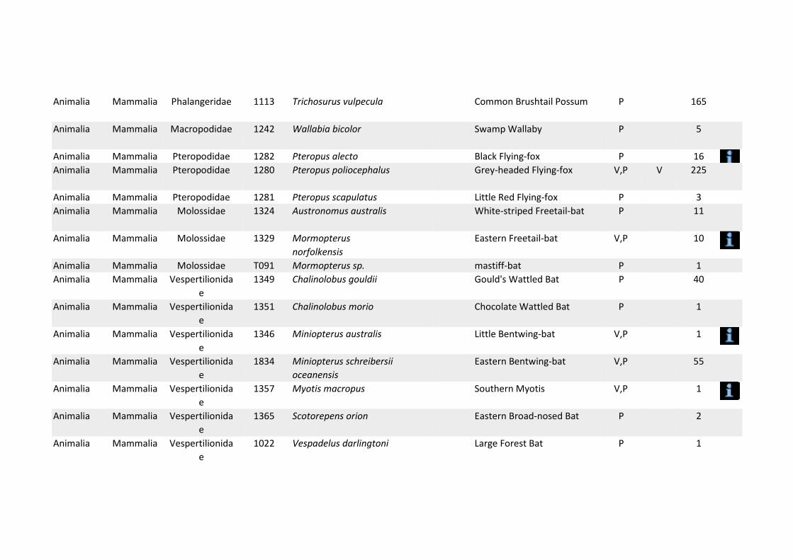
e
Animalia Mammalia Phalangeridae 1113 Trichosurus vulpecula Common Brushtail Possum P 165
Animalia Mammalia Macropodidae 1242 Wallabia bicolor Swamp Wallaby P 5
Animalia Mammalia Pteropodidae 1282 Pteropus alecto Black Flying‐fox P 16 Animalia Mammalia Pteropodidae 1280 Pteropus poliocephalus Grey‐headed Flying‐fox V,P V 225
Animalia Mammalia Pteropodidae 1281 Pteropus scapulatus Little Red Flying‐fox P 3 Animalia Mammalia Molossidae 1324 Austronomus australis White‐striped Freetail‐bat P 11
Animalia Mammalia Molossidae 1329 Mormopterus norfolkensis
Eastern Freetail‐bat V,P 10
Animalia Mammalia Molossidae T091 Mormopterus sp. mastiff‐bat P 1 Animalia Mammalia Vespertilionida
e 1349 Chalinolobus gouldii Gould's Wattled Bat P 40
Animalia Mammalia Vespertilionida e
1351 Chalinolobus morio Chocolate Wattled Bat P 1
Animalia Mammalia Vespertilionida e
1346 Miniopterus australis Little Bentwing‐bat V,P 1
Animalia Mammalia Vespertilionida e
1834 Miniopterus schreibersii oceanensis
Eastern Bentwing‐bat V,P 55
Animalia Mammalia Vespertilionida e
1357 Myotis macropus Southern Myotis V,P 1
Animalia Mammalia Vespertilionida e
1365 Scotorepens orion Eastern Broad‐nosed Bat P 2
Animalia Mammalia Vespertilionida e
1022 Vespadelus darlingtoni Large Forest Bat P 1

Animalia Mammalia Phalangeridae T082 Trichosurus sp. brushtail possum P 5
Plantae Adiantaceae Adiantum formosum P
Animalia Mammalia Vespertilionida e
1379 Vespadelus vulturnus Little Forest Bat P 1
Animalia Mammalia Muridae 1415 Hydromys chrysogaster Water‐rat P 7
Animalia Mammalia Muridae 1395 Rattus fuscipes Bush Rat P 3 Animalia Mammalia Muridae T094 Rattus sp. rat P 1 Animalia Mammalia Otariidae 1543 Arctocephalus forsteri New Zealand Fur‐seal V,P 2 Animalia Mammalia Otariidae 1882 Arctocephalus pusillus
doriferus Australian Fur‐seal V,P 4
Animalia Mammalia Otariidae T099 Arctocephalus sp. Unidentified Fur‐seal P 1 Animalia Mammalia Otariidae 9040 Seal sp. Unidentified Seal P 1 Animalia Mammalia Phocidae 1549 Hydrurga leptonyx Leopard Seal P 4 Animalia Mammalia Phocidae 1546 Mirounga leonina Southern Elephant Seal P 1 Animalia Mammalia Balaenidae 1561 Eubalaena australis Southern Right Whale E1,P E 1 Animalia Mammalia Delphinidae 1616 Delphinus delphis Common Dolphin P 4 Animalia Mammalia Delphinidae 1900 Tursiops truncatus Bottlenose Dolphin P 1 Plantae Flora Adiantaceae 7997 Adiantum aethiopicum Common Maidenhair P 20
Plantae Flora Adiantaceae 7999 Adiantum formosum Giant Maidenhair P 1 Plantae Flora Adiantaceae 8000 Adiantum hispidulum Rough Maidenhair P 7 Plantae Flora Adiantaceae 12633 Adiantum hispidulum var. P 1
hypoglaucum Plantae Flora Adiantaceae ADIA Adiantum spp. P 1 Plantae Flora Apiaceae 1094 Actinotus helianthi Flannel Flower P 15 Plantae Flora Arecaceae 1218 Howea forsteriana Kentia Palm P 1 Plantae Flora Arecaceae 1221 Livistona australis Cabbage Palm P 12 Plantae Flora Aspleniaceae 8031 Asplenium australasicum Bird's Nest Fern P 9
Plantae Flora Asteraceae 1363 Cassinia aureonitens P 1 Plantae Flora Asteraceae 8634 Craspedia variabilis Common Billy‐buttons P 1
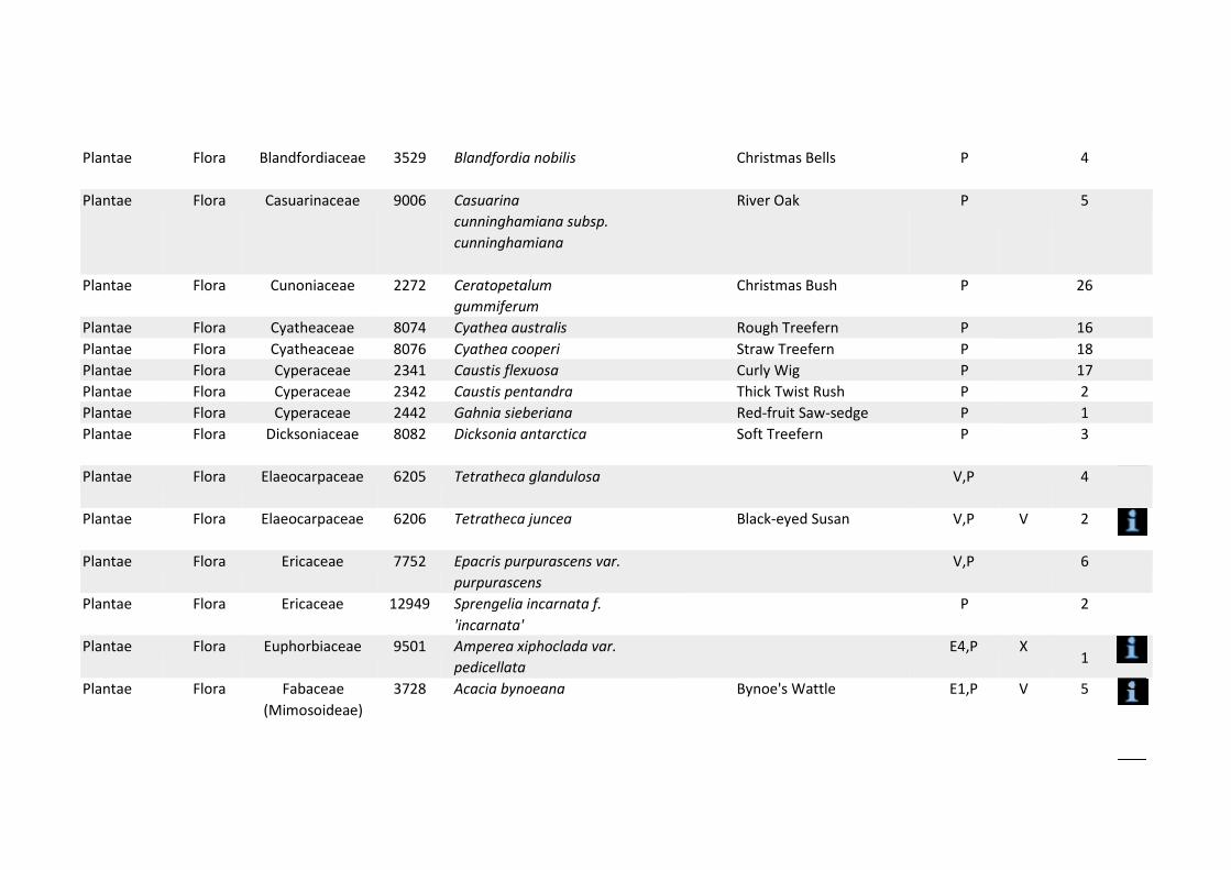
Plantae Flora Blandfordiaceae 3529 Blandfordia nobilis Christmas Bells P 4
Plantae Flora Casuarinaceae 9006 Casuarina cunninghamiana subsp. cunninghamiana
River Oak P 5
Plantae Flora Cunoniaceae 2272 Ceratopetalum gummiferum
Christmas Bush P 26
Plantae Flora Cyatheaceae 8074 Cyathea australis Rough Treefern P 16 Plantae Flora Cyatheaceae 8076 Cyathea cooperi Straw Treefern P 18 Plantae Flora Cyperaceae 2341 Caustis flexuosa Curly Wig P 17 Plantae Flora Cyperaceae 2342 Caustis pentandra Thick Twist Rush P 2 Plantae Flora Cyperaceae 2442 Gahnia sieberiana Red‐fruit Saw‐sedge P 1 Plantae Flora Dicksoniaceae 8082 Dicksonia antarctica Soft Treefern P 3
Plantae Flora Elaeocarpaceae 6205 Tetratheca glandulosa V,P 4
Plantae Flora Elaeocarpaceae 6206 Tetratheca juncea Black‐eyed Susan V,P V 2
Plantae Flora Ericaceae 7752 Epacris purpurascens var. purpurascens
V,P 6
Plantae Flora Ericaceae 12949 Sprengelia incarnata f. 'incarnata'
P 2
Plantae Flora Euphorbiaceae 9501 Amperea xiphoclada var. pedicellata
E4,P X 1
Plantae Flora Fabaceae (Mimosoideae)
3728 Acacia bynoeana Bynoe's Wattle E1,P V 5

Plantae Flora Blandfordiaceae 3528 Blandfordia grandiflora Christmas Bells P 1
Plantae Flora Fabaceae (Mimosoideae)
7229 Acacia gordonii E1,P E 1
Plantae Flora Fabaceae (Mimosoideae)
9672 Acacia terminalis subsp. terminalis
Sunshine Wattle E1,P E 28
Plantae Flora Gleicheniaceae 11076 Dicranopteris linearis var. linearis
P 5
Plantae Flora Gleicheniaceae 11175 Sticherus flabellatus var. flabellatus
Umbrella Fern P 8
Fungi Flora Hygrophoracea e
F006 Camarophyllopsis kearneyi
E1,P 1
Fungi Flora Hygrophoracea e
F003 Hygrocybe anomala var. ianthinomarginata
V,P 1
Fungi Flora Hygrophoracea e
F004 Hygrocybe aurantipes V,P 1
Fungi Flora Hygrophoracea e
F001 Hygrocybe austropratensis
E1,P 1
Fungi Flora Hygrophoracea e
F007 Hygrocybe collucera E1,P 1
Fungi Flora Hygrophoracea e
F008 Hygrocybe griseoramosa E1,P 1
Fungi Flora Hygrophoracea e
F005 Hygrocybe lanecovensis E1,P 1
Fungi Flora Hygrophoracea e
F002 Hygrocybe reesiae V,P 1
Fungi Flora Hygrophoracea e
F015 Hygrocybe rubronivea V,P 1

Plantae Myrtaceae Syzygium paniculatum E1 P 5
Plantae Flora Lamiaceae 3418 ^^Prostanthera marifolia Seaforth Mintbush E4A,P,3 CE 5
Plantae Flora Lycopodiaceae 6409 Lycopodium deuterodensum
Bushy Clubmoss P 1
Plantae Flora Malvaceae 6140 Lasiopetalum joyceae V,P V 1 Plantae Flora Myrtaceae 4007 ^^Callistemon
linearifolius Netted Bottle Brush V,P,3 4
Plantae Flora Myrtaceae 4024 Darwinia biflora V,P V 9 Plantae Flora Myrtaceae 4067 Eucalyptus camfieldii Camfield's Stringybark V,P V 8 Plantae Flora Myrtaceae 9720 Eucalyptus fracta Broken Back Ironbark V,P 1 Plantae Flora Myrtaceae 4134 Eucalyptus nicholii Narrow‐leaved Black
Peppermint V,P V 6
Plantae Flora Myrtaceae 4163 Eucalyptus pulverulenta Silver‐leafed Gum V,P V 1
Plantae Flora Myrtaceae 4204 Kunzea ambigua Tick Bush P 53 Plantae Flora Myrtaceae 4207 Kunzea capitata P 4 Plantae Flora Myrtaceae 8314 Leptospermum deanei V,P V 1 Plantae Flora Myrtaceae 4248 Melaleuca deanei Deane's Paperbark V,P V 7 Plantae Flora Myrtaceae 4293 Syzygium paniculatum Magenta Lilly Pilly E1,P V 5 Plantae Flora Orchidaceae 4351 Acianthus caudatus Mayfly Orchid P 7 Plantae Flora Orchidaceae 4352 Acianthus exsertus Mosquito Orchid P 4 Plantae Flora Orchidaceae 4353 Acianthus fornicatus Pixie Caps P 6 Plantae Flora Orchidaceae ACIA Acianthus spp. Mosquito Orchid P 3 Plantae Flora Orchidaceae 4373 Caladenia carnea Pink Fingers P 1 Plantae Flora Orchidaceae 6703 Caladenia catenata White Caladenia P 7 Plantae Flora Orchidaceae 4386 ^Caladenia tessellata Thick Lip Spider Orchid E1,P,2 V 5 Plantae Flora Orchidaceae 4388 Calanthe triplicata Christmas Orchid P 1 Plantae Flora Orchidaceae 4389 Caleana major Large Duck Orchid P 1 Plantae Flora Orchidaceae 4390 Calochilus campestris Copper Beard Orchid P 1 Plantae Flora Orchidaceae 4391 Calochilus gracillimus Slender Beard Orchid P 1

Plantae Flora Orchidaceae 4394 Calochilus paludosus Red Beard Orchid P 1 Plantae Flora Orchidaceae 4395 Calochilus robertsonii Purplish Beard Orchid P 5 Plantae Flora Orchidaceae CALO Calochilus spp. P 1 Plantae Flora Orchidaceae 4399 Chiloglottis formicifera Ant Orchid P 1 Plantae Flora Orchidaceae 4402 Chiloglottis reflexa P 1 Plantae Flora Orchidaceae 4404 Corybas aconitiflorus Spurred Helmet Orchid P 1 Plantae Flora Orchidaceae 4407 Corybas fimbriatus Fringed Helmet Orchid P 1 Plantae Flora Orchidaceae 4410 Corybas pruinosus Toothed Helmet Orchid P 1 Plantae Flora Orchidaceae CORY Corybas spp. P 1 Plantae Flora Orchidaceae 4414 Cryptostylis erecta Tartan Tongue Orchid P 11 Plantae Flora Orchidaceae CRYT Cryptostylis spp. P 2 Plantae Flora Orchidaceae 4417 Cryptostylis subulata Large Tongue Orchid P 6 Plantae Flora Orchidaceae 11228 Cyanicula caerulea Blue Caladenia P 2 Plantae Flora Orchidaceae 4419 Cymbidium suave Snake Orchid P 1 Plantae Flora Orchidaceae 6889 Cyrtostylis reniformis Gnat Orchid P 2 Plantae Flora Orchidaceae 6945 Dendrobium bowmanii P 1
Plantae Flora Orchidaceae 4425 Dendrobium kingianum Pink Rock Orchid P 1
Plantae Flora Orchidaceae 4426 Dendrobium linguiforme Tongue Orchid P 1
Plantae Flora Orchidaceae 11984 Dendrobium speciosum var. speciosum
Rock Orchid P 1
Plantae Flora Orchidaceae 7887 Dipodium punctatum P 2 Plantae Flora Orchidaceae DIPO Dipodium spp. P 1 Plantae Flora Orchidaceae 7888 Dipodium variegatum P 1 Plantae Flora Orchidaceae 4441 Diuris aurea P 5 Plantae Flora Orchidaceae 8949 Erythrorchis cassythoides Climbing Orchid P 3
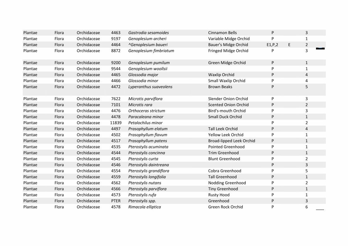
Plantae Orchidaceae Prasophyllum patens P
Plantae Flora Orchidaceae 4463 Gastrodia sesamoides Cinnamon Bells P 3 Plantae Flora Orchidaceae 9197 Genoplesium archeri Variable Midge Orchid P 1 Plantae Flora Orchidaceae 4464 ^Genoplesium baueri Bauer's Midge Orchid E1,P,2 E 2 Plantae Flora Orchidaceae 8872 Genoplesium fimbriatum Fringed Midge Orchid P 3
Plantae Flora Orchidaceae 9200 Genoplesium pumilum Green Midge Orchid P 1 Plantae Flora Orchidaceae 9544 Genoplesium woollsii P 1 Plantae Flora Orchidaceae 4465 Glossodia major Waxlip Orchid P 4 Plantae Flora Orchidaceae 4466 Glossodia minor Small Waxlip Orchid P 4 Plantae Flora Orchidaceae 4472 Lyperanthus suaveolens Brown Beaks P 5
Plantae Flora Orchidaceae 7622 Microtis parviflora Slender Onion Orchid P 3 Plantae Flora Orchidaceae 7101 Microtis rara Scented Onion Orchid P 2 Plantae Flora Orchidaceae 4476 Orthoceras strictum Bird's‐mouth Orchid P 3 Plantae Flora Orchidaceae 4478 Paracaleana minor Small Duck Orchid P 1 Plantae Flora Orchidaceae 11839 Petalochilus minor P 2 Plantae Flora Orchidaceae 4497 Prasophyllum elatum Tall Leek Orchid P 4 Plantae Flora Orchidaceae 4502 Prasophyllum flavum Yellow Leek Orchid P 1 Plantae Flora Orchidaceae 4517 Prasophyllum patens Broad‐lipped Leek Orchid P 1 Plantae Flora Orchidaceae 4535 Pterostylis acuminata Pointed Greenhood P 1 Plantae Flora Orchidaceae 4544 Pterostylis concinna Trim Greenhood P 1 Plantae Flora Orchidaceae 4545 Pterostylis curta Blunt Greenhood P 2 Plantae Flora Orchidaceae 4546 Pterostylis daintreana P 3 Plantae Flora Orchidaceae 4554 Pterostylis grandiflora Cobra Greenhood P 5 Plantae Flora Orchidaceae 4559 Pterostylis longifolia Tall Greenhood P 1 Plantae Flora Orchidaceae 4562 Pterostylis nutans Nodding Greenhood P 2 Plantae Flora Orchidaceae 4566 Pterostylis parviflora Tiny Greenhood P 1 Plantae Flora Orchidaceae 4573 Pterostylis rufa Rusty Hood P 1 Plantae Flora Orchidaceae PTER Pterostylis spp. Greenhood P 3 Plantae Flora Orchidaceae 4578 Rimacola elliptica Green Rock Orchid P 6

Plantae Flora Orchidaceae 4584 ^Sarcochilus hartmannii Hartman's Sarcochilus V,P,2 V 1
Plantae Flora Orchidaceae 11877 Spiranthes australis Ladies' Tresses P 1 Plantae Flora Orchidaceae 11449 Thelymitra angustifolia P 1
Plantae Flora Orchidaceae 4592 Thelymitra carnea Tiny Sun Orchid P 3 Plantae Flora Orchidaceae 8968 Thelymitra ixioides var.
ixioides Dotted Sun Orchid P 2
Plantae Flora Orchidaceae 4602 Thelymitra pauciflora Slender Sun Orchid P 1 Plantae Flora Osmundaceae 8151 Todea barbara King Fern P 3
Plantae Flora Poaceae 4895 Dichanthium setosum Bluegrass V,P V 1 Plantae Flora Polypodiaceae 8159 Platycerium bifurcatum Elkhorn Fern P 4
Plantae Flora Proteaceae 5349 Banksia spinulosa Hairpin Banksia P 11 Plantae Flora Proteaceae 7488 Banksia spinulosa var. P 4
spinulosa Plantae Flora Proteaceae 5365 ^^Grevillea caleyi Caley's Grevillea E4A,P,3 E 4
Plantae Flora Proteaceae 5382 Grevillea longifolia P 1 Plantae Flora Proteaceae 5433 Isopogon anemonifolius Broad‐leaf Drumsticks P 5
Plantae Flora Proteaceae 6839 Isopogon anethifolius Narrow‐leaf Drumsticks P 1 Plantae Flora Proteaceae 5445 Lomatia silaifolia Crinkle Bush P 25 Plantae Flora Proteaceae 5458 ^^Persoonia hirsuta Hairy Geebung E1,P,3 E 3 Plantae Flora Proteaceae 5460 Persoonia lanceolata Lance Leaf Geebung P 12 Plantae Flora Proteaceae 5461 Persoonia laurina Laurel Geebung P 3 Plantae Flora Proteaceae 9823 Persoonia laurina subsp. P 2
laurina Plantae Flora Proteaceae 5462 Persoonia levis Broad‐leaved Geebung P 18

Plantae Flora Proteaceae 11756 Persoonia levis x linearis P 7
Plantae Flora Proteaceae 5463 Persoonia linearis Narrow‐leaved Geebung P 10 Plantae Flora Proteaceae 5469 Persoonia pinifolia Pine‐leaved Geebung P 15 Plantae Flora Proteaceae 5479 Petrophile pulchella Conesticks P 5 Plantae Flora Proteaceae 5480 Petrophile sessilis P 1 Plantae Flora Proteaceae 5488 Telopea speciosissima Waratah P 1 Plantae Flora Proteaceae 5490 Xylomelum pyriforme Woody Pear P 5 Plantae Flora Psilotaceae 8170 Tmesipteris truncata P 2 Plantae Flora Rutaceae 12364 Boronia barkeriana
subsp. barkeriana P 1
Plantae Flora Rutaceae 5740 Boronia floribunda Pale‐pink Boronia P 2 Plantae Flora Rutaceae 5741 Boronia fraseri P 3 Plantae Flora Rutaceae 5744 Boronia ledifolia Sydney Boronia P 13 Plantae Flora Rutaceae 5746 Boronia mollis Soft Boronia P 1 Plantae Flora Rutaceae 5749 Boronia parviflora Swamp Boronia P 1 Plantae Flora Rutaceae 5750 Boronia pinnata P 1 Plantae Flora Rutaceae 5754 Boronia rigens Stiff Boronia P 2 Plantae Flora Rutaceae 5756 Boronia rubiginosa P 1 Plantae Flora Rutaceae 5759 Boronia serrulata Rose Boronia P 7 Plantae Flora Rutaceae 7210 Boronia thujona P 1 Plantae Flora Rutaceae 5775 Crowea saligna P 24 Plantae Flora Rutaceae 5776 Eriostemon australasius P 2
Plantae Flora Rutaceae 8374 Phebalium squamulosum subsp. squamulosum
P 4
Plantae Flora Rutaceae 10577 Philotheca buxifolia P 1 Plantae Flora Rutaceae 10578 Philotheca buxifolia
subsp. buxifolia P 4
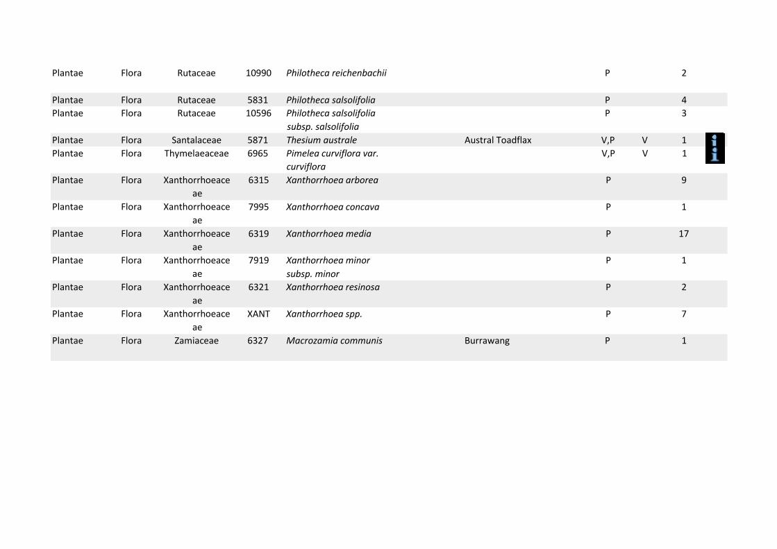
Plantae Flora Rutaceae 10990 Philotheca reichenbachii P 2
Plantae Flora Rutaceae 5831 Philotheca salsolifolia P 4 Plantae Flora Rutaceae 10596 Philotheca salsolifolia P 3
subsp. salsolifolia Plantae Flora Santalaceae 5871 Thesium australe Austral Toadflax V,P V 1 Plantae Flora Thymelaeaceae 6965 Pimelea curviflora var.
curviflora V,P V 1
Plantae Flora Xanthorrhoeace ae
Plantae Flora Xanthorrhoeace ae
Plantae Flora Xanthorrhoeace ae
6315 Xanthorrhoea arborea P 9
7995 Xanthorrhoea concava P 1
6319 Xanthorrhoea media P 17
Plantae Flora Xanthorrhoeace ae
7919 Xanthorrhoea minor P 1 subsp. minor
Plantae Flora Xanthorrhoeace ae
Plantae Flora Xanthorrhoeace ae
6321 Xanthorrhoea resinosa P 2
XANT Xanthorrhoea spp. P 7
Plantae Flora Zamiaceae 6327 Macrozamia communis Burrawang P 1
Appendix G Bat survey
Appendix G
Mail Address: 69 Bestic St. Rockdale NSW 2216 A.C.N. 065 241 732 e-mail: [email protected] A.B.N. 32 065 241 732
Bat Survey Miniopterus schreibersii oceanensis
McMahons Point Wharf
Introduction
Eastern Bent-wing Bats are a listed threatened species. These bats have two known roost sites in the North Sydney precinct on Sydney Harbour: at Balls Head and at Primrose Park. The bats are occasionally recorded at other sites around the harbour and these records are presumed to be foraging bats that have dispersed from the known roosting sites (Hoye and Spence 2004). However, other minor roost sites are likely to be present that have not been recorded.
Methods and Results
In January 2012 Biosphere Environmental Consultants Pty Ltd were engaged to undertake a rapid assessment of the possible presence of Eastern Bent-wing Bats at or near a number of Sydney ferry wharves, including McMahons Point Wharf.
On the late afternoon of the 5th of March 2012, Dr Arthur White visited the McMahons Point area with the aim of pre-determining the most likely sites where Eastern Bent-wing Bats could be detected. In general, the bats prefer reasonably densely treed sites where there is little or no night lighting.
McMahons Point Wharf lies on the western side of Lavender Bay. McMahons Point headland has two land projections: McMahons Point on its eastern side and Blues Point that forms the southern terminus of the headland. Most of McMahons Point is occupied by residential units but there is a small open reserve that extends around the headland Blues Point Reserve). The area close to the wharf is mostly residential although there is a large restaurant at the entrance to the wharf.

McMahons Point Wharf and the eastern and western sides of Blues Point were traversed on foot before nightfall and the wooded areas nearby were scanned using a hand-held Anabat detector (White 2011). After nightfall, each site was surveyed another three times at various intervals during the night to determine the presence of Eastern Bent-wing Bats. Recording were taken at each site and later analysed using Anabat 5.0 software to determine the species identity of the bat calls recorded. The recording details are presented in Table 1 below:
Table 1
Anabat recording Sites and Times
Location Times Micro-Bats Detected
McMahons Point Wharf
7.10-7.10 8.10-8.10 9.00-9.10
10.00-10.00 11.00-11.10
Nil Nil Nil Nil Nil
Blues Point East 7.15-7.25 8.20-8.30 9.15-9.25
Nil Nil Nil
Blues Point West
7.30-7.40 8.35-8.45 9.30-9.40
Nil Nil Nil
Discussion
No microbats bats were detected at the wharf area or at Blues Point. There was no apparent bat habitat close to the wharf and Blues Point Reserve contained little foraging habitat. The absence of the bats is most likely due to the scarcity of suitable foraging habitat and the extent of night lighting in the area. This site is not far from the Balls Head roost site yet no bats were detected here.
Conclusion
Bentwing bats do not appear to be present in the area around McMahons Point or Blues Point and are not present at the McMahon Point wharf site.
Dr Arthur White 6 March 2012
References
Hoye, G.A., and Spence, J. 2004. The large Bent-wing bat Miniopterus schreibersii in urban environments: a survivor? Pp 138-147, in Urban Wildlife: more than meets the eye, edited by D. Lunney and S, Burgin. Royal Zoological Society of New South Wales, Mosman, New South Wales, Australia.
White, A.W. 2011.Roosting dynamics of Eastern Bent-wing Bats Miniopterus schreibersii oceanensis in disused military areas in eastern Sydney. In “The Biology and Conservation of Australasian Bats”. Eds. B. Law, P. Eby, D. Lunney and L. Lumsden. Royal Zoological Society of New South Wales, Mosman. Pp 471-480.

Appendix H Urban design and landscape character and visual impact assessment
Appendix H

MCMAHONS POINT WHARF INTERCHANGE URBAN DESIGN REPORT AND LANDSCAPE CHARACTER AND VISUAL IMPACT ASSESSMENT
Prepared for NSW Maritime Services December 2015
By Jane Irwin Landscape Architecture

Document Control
Issue Date Submission Author Review 1 26.09.12 Draft LC JI
2 24.10.12 Final LC JI 3 25.11.13 Draft LC JI
4 03.12.13 Draft LC JI
5 17.12.13 Final LC JI
6 22.01.15 Draft SW LC
7 28.01.15 Final SW LC
8 08.04.15 Draft SW LC
9 15.05.15 Draft SW LC
10 19.05.15 Draft SW LC
11 04.11.15 Draft SW LC
12 11.11.15 Draft SW LC
13 10.12.15 Final SW LC
14 15.12.15 Final SW LC
15 18.12.15 Final SW JI
Contact
Sam Westlake Landscape Architect AILA
Jane Irwin Landscape Architecture
Tel (02) 9212 6957 Level 5 68 ‐ 72 Wentworth Avenue Surry Hills NSW 2010
3.0 Ur ban and landscape design concept 3.1 Vision 3.2 Objectives and principles 3.3 Preferred concept option ‐ waterside 3.4 Preferred concept option ‐ landside
TABLE OF CONTENTS
1.0 Introduction 1 1.1 The project 1.2 Purpose and scope of this report 1.3 Report structure 1.4 Urban design policy and guidelines 1.5 Assessment Methodology
2.0 Contextual analysis 3
2.1 Location 2.2 Landscape context 2.3 Character of the proposed wharf interchange in its setting 2.4 Heritage context 2.5 Sydney Harbour Foreshore and Waterways DCP context 2.6 Planning context
5
4.0 Landscape Character Impact Assessment 11 4.1 Landscape character assessment 4.2 Landscape character impact assessment summary
5.0 Visual Impact Assessment 16
5.1 Visual envelope mapping 5.2 Key viewpoints 5.3 Visual impact assessment summary
6.0 Summary and Mitigation Strategy 27
6.1 Summary of urban design concept and mitigation measures 6.2 Conclusion
1
MCMAHONS POINT WHARF - URBAN DESIGN REPORT AND LANDSCAPE CHARACTER AND VISUAL IMPACT ASSESSMENT
1.0 INTRODUCTION 1.1 The project This Urban Design Report and Landscape Character and Visual Impact Assessment (UDLCVIA) is a component of the REF for the Sydney Harbour Wharves Upgrade Program.
Jane Irwin Landscape Architecture has been engaged by Hansen Yunken for Roads and Maritime Services NSW (RMS) to assess the development proposals for the upgrade of a number of ferry wharves throughout Sydney Harbour. The wharves are within the inner harbour and are currently being used by ferry commuters; recreational vessels; and accessed by the general public.
1.2 Purpose and scope of this report The urban design report and landscape character and visual impact assessment (UDLCVIA) has been prepared for RMS as part of the Review of Environmental Factors (REF) for the proposal.
Under clause 68 (4) of the State Environment Planning Policy (SEPP Infrastructure) 2007, development for the purposes of a wharf may be carried out by or on behalf of a public authority on any land without consent, subject to the requirements of Part 5 of the Environmental Planning and Assessment Act 1979 (the Act). Under the Act, “land” includes the sea.
Part 5 of the Act defines development involving (among other things) the use of land, carrying out of work and demolition and construction of buildings as an activity. When considering an activity RMS as the determining authority must examine and take into account to the fullest extent possible all matters affecting or likely to affect the environment by reason of that activity. This is done through the preparation of a REF.
The requirements of an REF are specified in Environmental Planning and Assessment Regulation 2000 (the Regulations) clause 228 (Under the regulations, guidelines have been developed for the likely impacts of marinas and related facilities such as wharves). The guidelines therefore apply to the commuter wharf projects. UDLCVIA forms one of the environmental factors which requires consideration as part of the REF process. The Department of Urban Affairs and Planning ‐ EIS Guideline - Marinas and Related Facilities - September 1996, sets out the following issues to consider if a proposal is likely to have a visual impact.
a) Visual impact from adjoining properties and from surrounding land and water — consider potential impacts such as changed or obstructed views due to: • The facility form, bulk, colour or reflectivity. • Lighting from security requirements or night operations. • Boat mooring and movements. • The clearing of vegetation.
b) Proposed methods of reducing visual impact such as landscaping, materials selection and design and orientation of structures.
1.3 Report structure The structure of this report is as follows: 1.0 Introduction ‐ outlines the purpose of the report including the assessment methodology 2.0 Contextual analysis 3.0 Urban and landscape design concept 4.0 Landscape character impact assessment 5.0 Visual impact assessment 6.0 Summary and Mitigation Strategy
1.4 Urban design policy and guidelines This report has been prepared based on the structure outlined in the RMS Environmental Impact Assessment Practice Note EIA-N04 - Guideline for landscape character and visual impact assessment. (EIA‐ No4 Guideline) March 2013.
The guideline differentiates between visual assessment (the impact on views), and landscape character (the impact on the aggregate of an area’s built, natural and cultural character or sense of place).
Tasks outlined in the guide include:
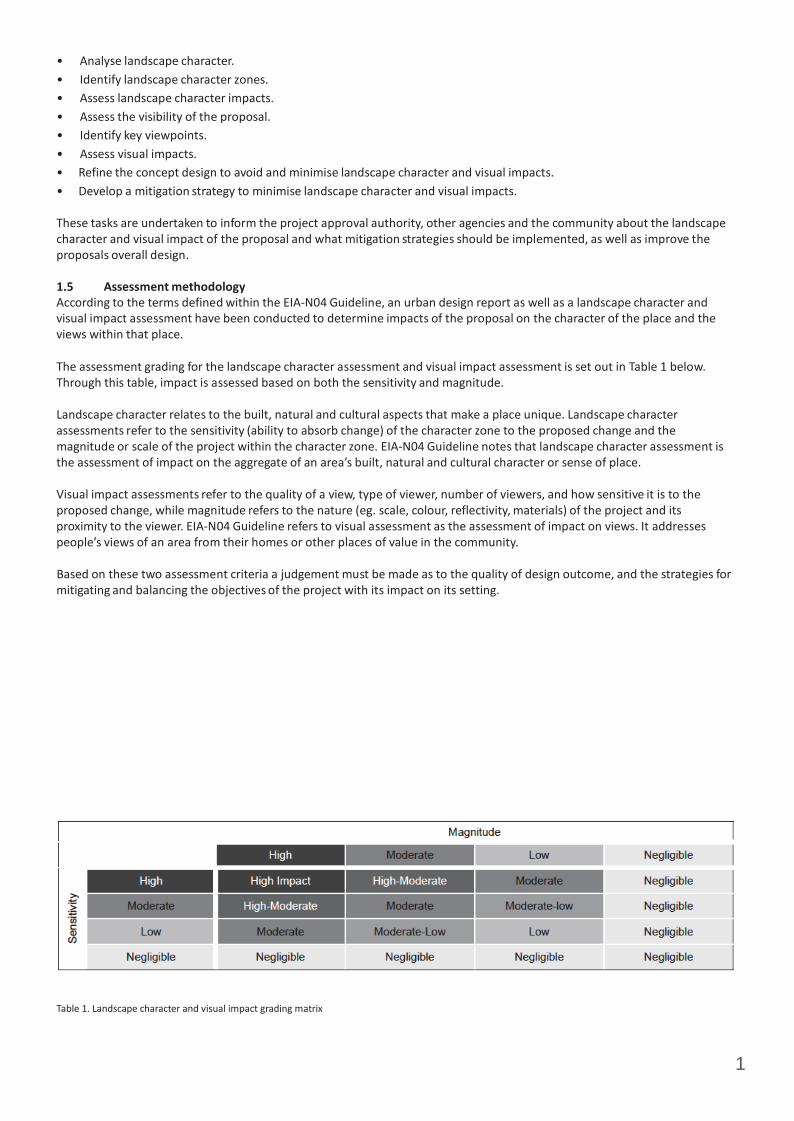
1
• Analyse landscape character. • Identify landscape character zones. • Assess landscape character impacts. • Assess the visibility of the proposal. • Identify key viewpoints. • Assess visual impacts. • Refine the concept design to avoid and minimise landscape character and visual impacts. • Develop a mitigation strategy to minimise landscape character and visual impacts.
These tasks are undertaken to inform the project approval authority, other agencies and the community about the landscape character and visual impact of the proposal and what mitigation strategies should be implemented, as well as improve the proposals overall design.
1.5 Assessment methodology According to the terms defined within the EIA‐N04 Guideline, an urban design report as well as a landscape character and visual impact assessment have been conducted to determine impacts of the proposal on the character of the place and the views within that place.
The assessment grading for the landscape character assessment and visual impact assessment is set out in Table 1 below. Through this table, impact is assessed based on both the sensitivity and magnitude.
Landscape character relates to the built, natural and cultural aspects that make a place unique. Landscape character assessments refer to the sensitivity (ability to absorb change) of the character zone to the proposed change and the magnitude or scale of the project within the character zone. EIA‐N04 Guideline notes that landscape character assessment is the assessment of impact on the aggregate of an area’s built, natural and cultural character or sense of place.
Visual impact assessments refer to the quality of a view, type of viewer, number of viewers, and how sensitive it is to the proposed change, while magnitude refers to the nature (eg. scale, colour, reflectivity, materials) of the project and its proximity to the viewer. EIA‐N04 Guideline refers to visual assessment as the assessment of impact on views. It addresses people’s views of an area from their homes or other places of value in the community.
Based on these two assessment criteria a judgement must be made as to the quality of design outcome, and the strategies for mitigating and balancing the objectives of the project with its impact on its setting.
Table 1. Landscape character and visual impact grading matrix

3
2.0 CONTEXTUAL ANALYSIS 2.1 Location The proposal area for the following Visual Impact Assessment report is McMahons Point Wharf located at McMahons Point on Sydney Harbour, approximately 5.8km from the CBD by road and 1.6km by water.
2.2 Landscape Context The wharf is located at the end of Henry Lawson Avenue within the suburb of McMahons Point. It sits adjacent to the south western extent of Lavender Bay and is also adjacent to Blues Point reserve to the west. The terrain rises steeply to the north west with residential apartments overlooking the wharf. ‘Sails on Lavender Bay’ restaurant is located to the north of the wharf.
2.3 Character of the proposed wharf interchange in its setting The character of McMahons Point Wharf is a parkland edge to the west and a mixed urban foreshore to the north, north west, and north east. The existing wharf sits against a dramatic sandstone cliff which rises steeply to the north west of the wharf. The cliff forms a natural division between the built element of the suburb and the foreshore area. The wharf therefore sits as an isolated element within the foreshore park, framed against a backdrop of vegetation and sandstone cliff. The current wharf comprises of a covered waiting area which is anchored to the sea wall, with open views to the harbour, iconic Luna Park, Sydney Opera House and the Sydney Harbour Bridge. McMahons Point Wharf consists of a fixed concrete wharf with an open deck, timber steps to the water, and a small scale building that provides shelter from the wind and rain. The character of the wharf from the water is of a small scale element against a largely unbuilt foreshore, the dramatic feature of the cliff rising up behind the wharf, and the adjacent foreshore buildings and boat stores wrapping around into Lavender Bay.
2.4 Heritage Context The wharf is listed as a heritage item within the North Sydney Local Environment Plan 2013 and on the RMS Section 170 Heritage Register. RPS has prepared a Statement of Heritage Impact for the proposal and reports that the significance of the wharf is;
“Embodied by its location, relationship with the adjacent transport routes and its continuity of function including any physical evidence demonstrating its long history of use. Furthermore, its highly scenic visual setting is also considered to contribute to the heritage significance of the site. The fabric of the wharf dating from 1973 is considered to be of negligible heritage significance.”
2.5 Sydney Harbour Foreshores and Waterways DCP context Under the Sydney Harbour Foreshores and Waterways DCP 2005 Landscape Character Type 8 applies to the McMahons Point area;
“These areas have a high level of built form with waterside commercial, industrial and residential uses. The commercial and industrial uses play an important role in terms of tourism and maritime services which support water-based activities. There are special features in these areas that contribute to the visual character of the area that should be maintained.”
McMahons Point Wharf
CBD

4
Figure 1. Context map
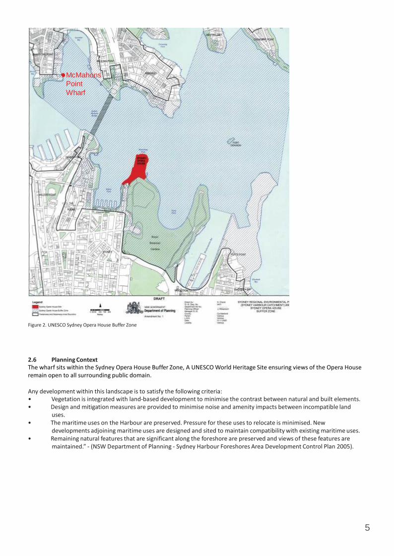
5
McMahons Point Wharf
Figure 2. UNESCO Sydney Opera House Buffer Zone
2.6 Planning Context The wharf sits within the Sydney Opera House Buffer Zone, A UNESCO World Heritage Site ensuring views of the Opera House remain open to all surrounding public domain.
Any development within this landscape is to satisfy the following criteria: • Vegetation is integrated with land‐based development to minimise the contrast between natural and built elements. • Design and mitigation measures are provided to minimise noise and amenity impacts between incompatible land
uses. • The maritime uses on the Harbour are preserved. Pressure for these uses to relocate is minimised. New
developments adjoining maritime uses are designed and sited to maintain compatibility with existing maritime uses. • Remaining natural features that are significant along the foreshore are preserved and views of these features are
maintained.” ‐ (NSW Department of Planning ‐ Sydney Harbour Foreshores Area Development Control Plan 2005).


5
3.0 URBAN AND LANDSCAPE DESIGN CONCEPT 3.1 Vision The proposed wharf interchange would promote ferry travel around Sydney Harbour. The interchange will provide for commuter amenity and safety, will improve connectivity to other transport modes in the wharf area, and will be integrated sensitively into the landscape.
3.2 Objectives and principles Objectives • Minimise clutter and work with the shapes and material selection of the surrounding foreshore design. • Reduce visual impact on the character of Sydney Harbour, the Harbour Bridge, the Opera House, and public domain of
the foreshore and park. • Minimise interruption to views. • Respect the setting and place. • Promote features that contribute to the character of the setting in any design interventions – contemporary design,
robust materials palette. • Retain and enhance the existing pedestrian and cycle systems. • Where possible retain and enhance existing vegetation. • Upgrade facilities and open space to meet current standards and improve amenity.
Principles • Locate the new covered structure in the footprint of the existing wharf. • Maintain views through the gangway and pontoon to mitigate the visual impact of the structures and to retain views
beyond. • Interventions to the public domain, including extension of paved space, inclusion of structures should complement the
existing design patterns and materials. • The location of the wharf should consider the existing path network. Connection from the wharf to the existing path
network and bicycle paths should not have a detrimental impact on other users of the foreshore or those passing through.
3.3 Preferred option - waterside The proposal would include the demolition and removal of the existing wharf structures and construction of the wharf interchange consisting of a shelter, bridge, gangway and pontoon, including associated facilities. The positioning of the new wharf interchange is expected to be as shown in figure 3. However, for the purposes of this REF, a proposal area has been assessed which considers potential changes to the position of the wharf should they be required following further design development.
The siting of the proposed wharf has been a process of ongoing consultation and testing, in order to site the new structures with sensitivity to existing views and character.
The proposal would include: Demolition and removal of the existing wharf structures • Prior to constructing the proposed wharf, the existing wharf including waiting shelter, tidal stairs, lights, posts, fencing
and timber piles, information totems and CCTV system would be demolished and removed.
Construction of a new wharf • Construction of a covered shelter about 20 metres long and 10 metres wide over the water. The shelter would connect
to land at an angle of about 90 degrees and would be supported by about 12 steel piles. The shelter would include the provision of a stainless steel clad services pod including, for example, an electricity distribution board, Ferry Operations and Customer Information System (FOCIS), bins, signage boards and a help point. The waiting shelter would include glass screens at its northern and southern ends.
• Construction of an uncovered concrete bridge about three metres wide and 25 metres long extending from the shelter at an angle of about 90 degrees. The bridge would connect to the gangway headstock support and would be supported on about 12 steel piles and precast concrete head stocks.
• Construction of an uncovered aluminium gangway about 18 metres long and about 3 metres wide to a floating pontoon. The gangway would extend from the bridge at an angle of about 45 degrees. The gradient of the gangway would vary according to the tides.
• Construction and installation of a rectangular steel floating pontoon off the gangway. The pontoon would be about 12 metres wide and 27 metres long and would have two berthing faces. The pontoon would be uncovered with stainless steel balustrades at the northern and southern ends and include seating. The floating pontoon would be held in place by

6
four steel piles. The floating pontoon alignment would extend off the gangway at an angle of about 174 degrees.

7
Figure 3. Site compound and works area (courtesy of RPS)
• Installation of safety and security facilities including lighting, closed circuit television (CCTV), ladders to the water from
the pontoon, a life ring on the pontoon platform and tactile floor treatments.
Ancillary facilities • A temporary compound would be established including site sheds, an amenities shed and storage containers for tools
and some materials. The location of the temporary compound is to be confirmed and would be subject to council review and agreement. The indicative location of the compound is shown at figure 3.
• The connection of existing electrical power lines to the wharf.
Architectural Character The proposed ferry wharf installation would replace the existing concrete wharf, steps and shelter with a new entry building at the level of foreshore and three new interconnected elements adjacent to the foreshore:
The Pontoon The pontoon would be the central gathering or holding place for ferry passengers. It is sized to accommodate passengers, with its users mainly consisting of commuters. Its primary purpose would be to provide a secure environment while passengers wait to board ferries and other vessels. The pontoon would be uncovered.
The pontoon would operate with the tides and vary in level with the tides. It would consist of an uncovered platform that would sit about 850mm above water level. The pontoon would be supported by and operate around four steel piles that would be fixed in the harbour. The height of these would be determined by the tidal range. They would also be painted in a predominantly light colour, primarily for navigation purposes.
The Gangway The gangway would be used by passengers to move from the land based structures to the platform and eventually on to ferries. This element would be affected by tidal movements, like the pontoon, and consequently would rise and fall. It is designed to be a transitional space and would be slightly lower in scale than the adjoining shelter. The structure would employ a truss system. Views would be maintained through the gangway as it is generally open and light.

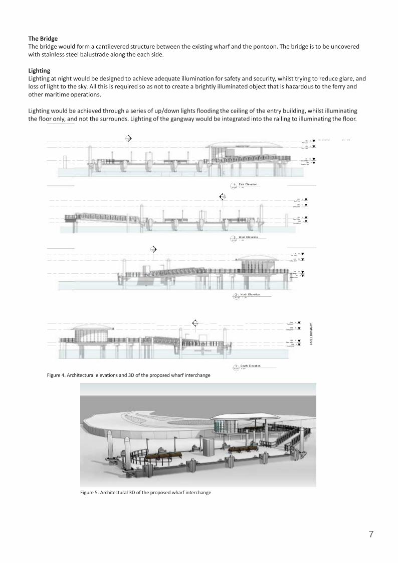
7
PREL
IMIN
ARY
The Bridge The bridge would form a cantilevered structure between the existing wharf and the pontoon. The bridge is to be uncovered with stainless steel balustrade along the each side.
Lighting Lighting at night would be designed to achieve adequate illumination for safety and security, whilst trying to reduce glare, and loss of light to the sky. All this is required so as not to create a brightly illuminated object that is hazardous to the ferry and other maritime operations.
Lighting would be achieved through a series of up/down lights flooding the ceiling of the entry building, whilst illuminating the floor only, and not the surrounds. Lighting of the gangway would be integrated into the railing to illuminating the floor.
2 05-3500
6.160 RL
Roof Level
REV DES CRIP TION DA TE APPD
4.850 RL Ceiling Level
1.850 RL
Shore Bridge 1.000 RL
Pontoon Level
4 East Elevation 05-2100 1 : 100
2
05-3500
6.160 RL
Roof Level
4.850 RL Ceiling Level
1.850 RL
Shore Bridge 1.000 RL
Pontoon Level
3 W est Elevation
05-2100 1 : 100
1
05-3500
6.160 RL Roof Level
4.850 RL Ceiling Level
1.850 RL
Shore Bridge 1.000 RL
Pontoon Level
2 North Elevation 05-2100 1 : 100
1 05-350 0
6.160 RL Roof Level
4.850 RL Ceiling Level
1.850 RL
Shore Bridge 1.000 RL
Pontoon Level
Figure 4. Architectural elevations and 3D of the proposed wharf interchange
Figure 5. Architectural 3D of the proposed wharf interchange
1 South Elevation 05-2100 1 : 100

8
Figure 6. 3D view of proposed wharf interchange from Sydney Harbour at the mouth of Lavender Bay looking west towards McMahons Point
Figure 7. 3D view of proposed wharf interchange from Lawson Avenue looking towards the Sydney Harbour Bridge, Sydney Opera House and the CBD.

9
Figure 8. 3D view of proposed wharf interchange from the Sydney Harbour Bridge looking towards McMahons Point and Blues Point.
Figure 9. 3D view of proposed wharf interchange from inside ‘Sails on Lavender Bay’ restaurant looking towards the Sydney Harbour Bridge.
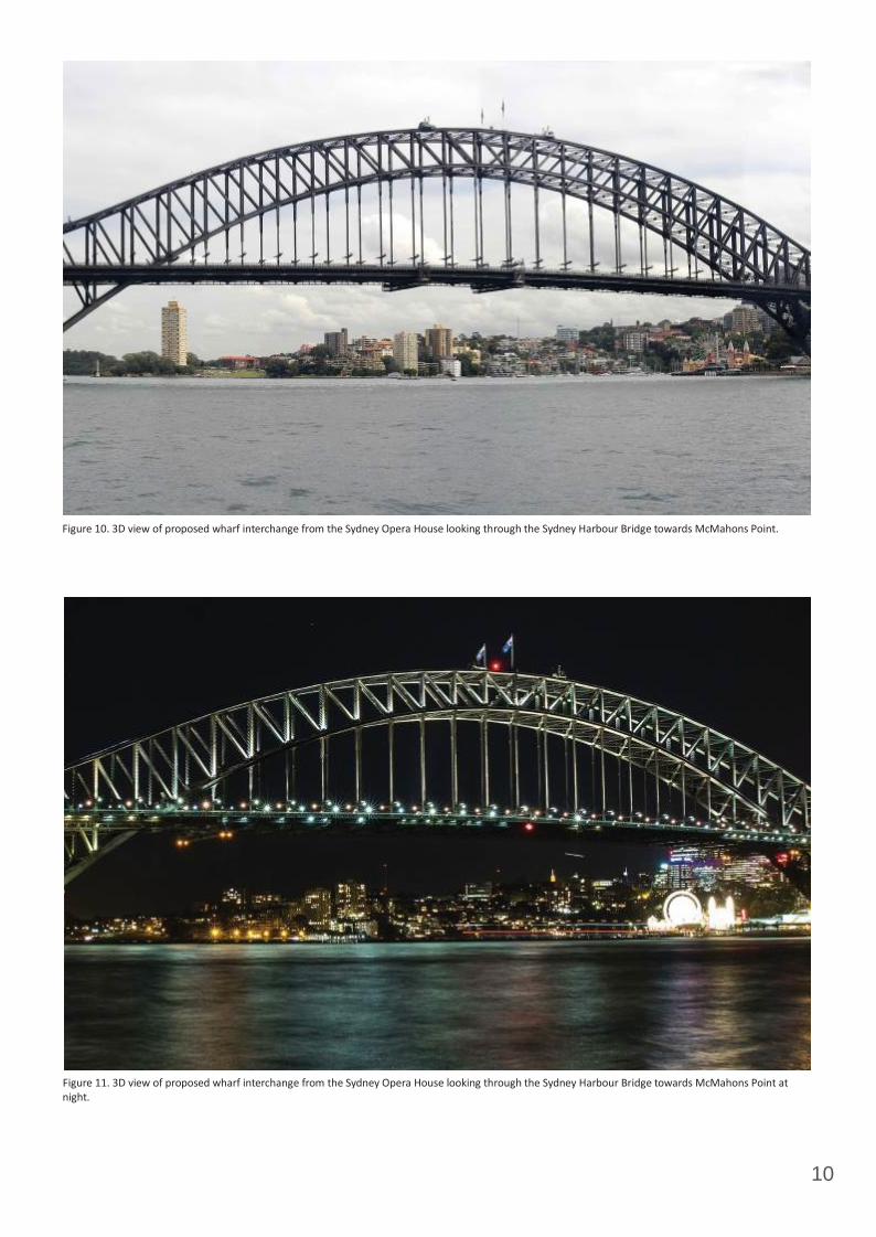
10
Figure 10. 3D view of proposed wharf interchange from the Sydney Opera House looking through the Sydney Harbour Bridge towards McMahons Point.
Figure 11. 3D view of proposed wharf interchange from the Sydney Opera House looking through the Sydney Harbour Bridge towards McMahons Point at night.

11
Stainless steel handrails Non‐slip floor surface Bridge and gangway
Zinc roof Open light steel truss system ‐ gangway Service Pod
Pontoon with service pod (McMahons Point to be uncovered)
Lighting within wharf
Figure 12. Material palette of the proposed wharf interchange

12
3.4 Landside Design Landside upgrade design would include realignment of kerb and gutter and footpath at the northern end of Henry Lawson Avenue adjacent to the wharf entrance and at the southern end of the laneway on the western side of ‘Sails on Lavender Bay’ restaurant.
The turning circle at Henry Lawson Avenue adjacent to the wharf entry would also be upgraded to better allow buses to manoeuvre safely at the site of the wharf entrance. Landside design would include kerb and gutter upgrades to the north and to the east of the turning circle.
The wharf (including the shelter, bridge, gangway and pontoon) would be constructed to be accessible to people with a disability for no less than 80 per cent of the high and low tide levels listed in standard tide charts.
The new wharf components (i.e. shelter, bridge, gangway and pontoon) would be predominately assembled at the contractor’s off‐site facility before being transported to the site via barge.
The proposal would require the McMahons Point Wharf to be closed to all ferries, water taxis and other vessels/watercraft for the duration of construction to enable the works to be carried out.
An overview of the proposal including the approximate location of the temporary compound is shown in the Figure 3.
Landside public domain works are as indicated in Figure 3. Detailed design for these elements is to be developed in consultation with North Sydney Council prior to commencement of construction. Any material changes to the proposed works or construction methodology which could result in additional environmental impacts to those assessed in this REF, would be the subject of additional environmental assessment.
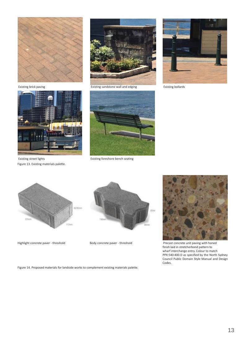
13
Existing brick paving
Existing street lights
Figure 13. Existing materials palette.
Existing sandstone wall and edging
Existing foreshore bench seating
Existing bollards
Highlight concrete paver ‐ threshold Body concrete paver ‐ threshold Precast concrete unit paving with honed
finish laid in stretcherbond pattern to wharf interchange entry. Colour to match PPX:540:400.D as specified by the North Sydney Council Public Domain Style Manual and Design Codes.
Figure 14. Proposed materials for landside works to complement existing materials palette.
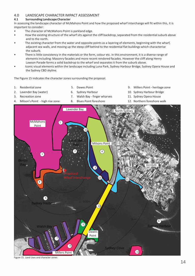
14
4.0 LANDSCAPE CHARACTER IMPACT ASSESSMENT 4.1 Surrounding Landscape Character In assessing the landscape character of McMahons Point and how the proposed wharf interchange will fit within this, it is important to consider: • The character of McMahons Point is parkland edge. • How the existing structure of the wharf sits against the cliff backdrop, separated from the residential suburb above
and to the north. • The existing character from the water and opposite points as a layering of elements, beginning with the wharf,
adjacent sea walls, and moving up the steep cliff behind to the residential flat buildings which characterise the suburb.
• There is little consistency in the materials or the form, colour etc. in this environment, it is a diverse range of elements including: Masonry facades and more recent rendered facades. However the cliff along Henry Lawson Parade forms a solid backdrop to the wharf and separates it from the suburb above.
• Iconic visual elements within the landscape including Luna Park, Sydney Harbour Bridge, Sydney Opera House and the Sydney CBD skyline.
The Figure 15 indicates the character zones surrounding the proposal.
1. Residential zone 5. Dawes Point 9. Millers Point ‐ heritage zone 2. Lavender Bay (water) 6. Sydney Harbour 10. Sydney Harbour Bridge 3. Recreation zone 7. Walsh Bay ‐ finger wharves 11. Sydney Opera House 4. Milson’s Point ‐ high rise zone 8. Blues Point foreshore 12. Northern foreshore walk
Lavender Bay North Sydney
McMahons 1 Point
1
12 Lavender
Bay Milsons Point
2 4
Berrys Bay Kirribilli
3
Proposed Wharf Interchange 12 12
8
250m
6
Sydney Harbour 500m 10
750m
Walsh Bay
7
5
Dawes Point
1km 6
Sydney Harbour
9
Millers Point
Figure 15. Land Uses and character zones
Sydney Cove
11

15
Table 2. Landscape Character Impact Assessment
Landscape character zone
Description of zone Sensitivity Magnitude Description of impact by proposal
ZONE 1. Residential Zone
The residential zone occupying the peninsula of McMahons Point, extending from the Gore Hill Freeway around the back of Lavender Bay and down to Blues Point. The character of the zone is predominantly residential consisting of two to six storey buildings, a mix of terraces, houses and apartment buildings. The zone is organised around the ridge street of Blues Point Road that contains a mixture of restaurants, shops and commercial buildings. It is a medium to high density residential area, dominated by built form, urban in character.
M M The character of this zone is focused around the fine grain of buildings and the glimpses of the harbour available from many of the streets. Activity is focussed along Blues Point Road where the mixture of cafes, shops and restaurants create a vibrant character. Blues Point Reserve also central to the character of the suburb as a major tourist destination to view the Sydney Harbour Bridge. The wharf lies to the north east of this reserve and forms an arrival point to the suburb. The wharf is separated from the built up areas by a sandstone cliff running along Henry Lawson Avenue. The impact of the proposal on the character of the suburb is considered moderate. The wharf sits on the very point of the peninsula, essentially separate from the residential areas and open space.
ZONE 2. Lavender Bay (Waters)
The bay to the north of the wharf, enclosed by the peninsulas of McMahons Point and Milsons Point. The wharf extends from the southern point of McMahons Point and is mirrored on the opposite shore by Milsons Point wharf both of which frame the entry to the bay. The bay is characterised by private boat moorings and a series of private jetties and marinas along the shore of McMahons Point.
M M The impact on Lavender Bay by the proposed wharf interchange is considered moderate. The character of the bay is set by the peninsulas of McMahons and Milsons Point which enclose a deep bay busy with boats. At either side of the entry to the bay lie the two wharves which will form gateway elements to the bay. The proposed wharf will complement the character of the existing wharf at Milsons Point. Due to the location of the proposed pontoon the presence of the wharf in the bay is increased as it becomes an element on the water with a greater association to the bay.
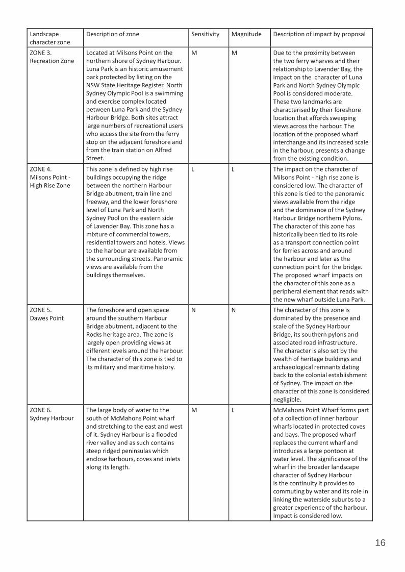
16
Landscape character zone
Description of zone Sensitivity Magnitude Description of impact by proposal
ZONE 3. Recreation Zone
Located at Milsons Point on the northern shore of Sydney Harbour. Luna Park is an historic amusement park protected by listing on the NSW State Heritage Register. North Sydney Olympic Pool is a swimming and exercise complex located between Luna Park and the Sydney Harbour Bridge. Both sites attract large numbers of recreational users who access the site from the ferry stop on the adjacent foreshore and from the train station on Alfred Street.
M M Due to the proximity between the two ferry wharves and their relationship to Lavender Bay, the impact on the character of Luna Park and North Sydney Olympic Pool is considered moderate. These two landmarks are characterised by their foreshore location that affords sweeping views across the harbour. The location of the proposed wharf interchange and its increased scale in the harbour, presents a change from the existing condition.
ZONE 4. Milsons Point ‐ High Rise Zone
This zone is defined by high rise buildings occupying the ridge between the northern Harbour Bridge abutment, train line and freeway, and the lower foreshore level of Luna Park and North Sydney Pool on the eastern side of Lavender Bay. This zone has a mixture of commercial towers, residential towers and hotels. Views to the harbour are available from the surrounding streets. Panoramic views are available from the buildings themselves.
L L The impact on the character of Milsons Point ‐ high rise zone is considered low. The character of this zone is tied to the panoramic views available from the ridge and the dominance of the Sydney Harbour Bridge northern Pylons. The character of this zone has historically been tied to its role as a transport connection point for ferries across and around the harbour and later as the connection point for the bridge. The proposed wharf impacts on the character of this zone as a peripheral element that reads with the new wharf outside Luna Park.
ZONE 5. Dawes Point
The foreshore and open space around the southern Harbour Bridge abutment, adjacent to the Rocks heritage area. The zone is largely open providing views at different levels around the harbour. The character of this zone is tied to its military and maritime history.
N N The character of this zone is dominated by the presence and scale of the Sydney Harbour Bridge, its southern pylons and associated road infrastructure. The character is also set by the wealth of heritage buildings and archaeological remnants dating back to the colonial establishment of Sydney. The impact on the character of this zone is considered negligible.
ZONE 6. Sydney Harbour
The large body of water to the south of McMahons Point wharf and stretching to the east and west of it. Sydney Harbour is a flooded river valley and as such contains steep ridged peninsulas which enclose harbours, coves and inlets along its length.
M L McMahons Point Wharf forms part of a collection of inner harbour wharfs located in protected coves and bays. The proposed wharf replaces the current wharf and introduces a large pontoon at water level. The significance of the wharf in the broader landscape character of Sydney Harbour is the continuity it provides to commuting by water and its role in linking the waterside suburbs to a greater experience of the harbour. Impact is considered low.
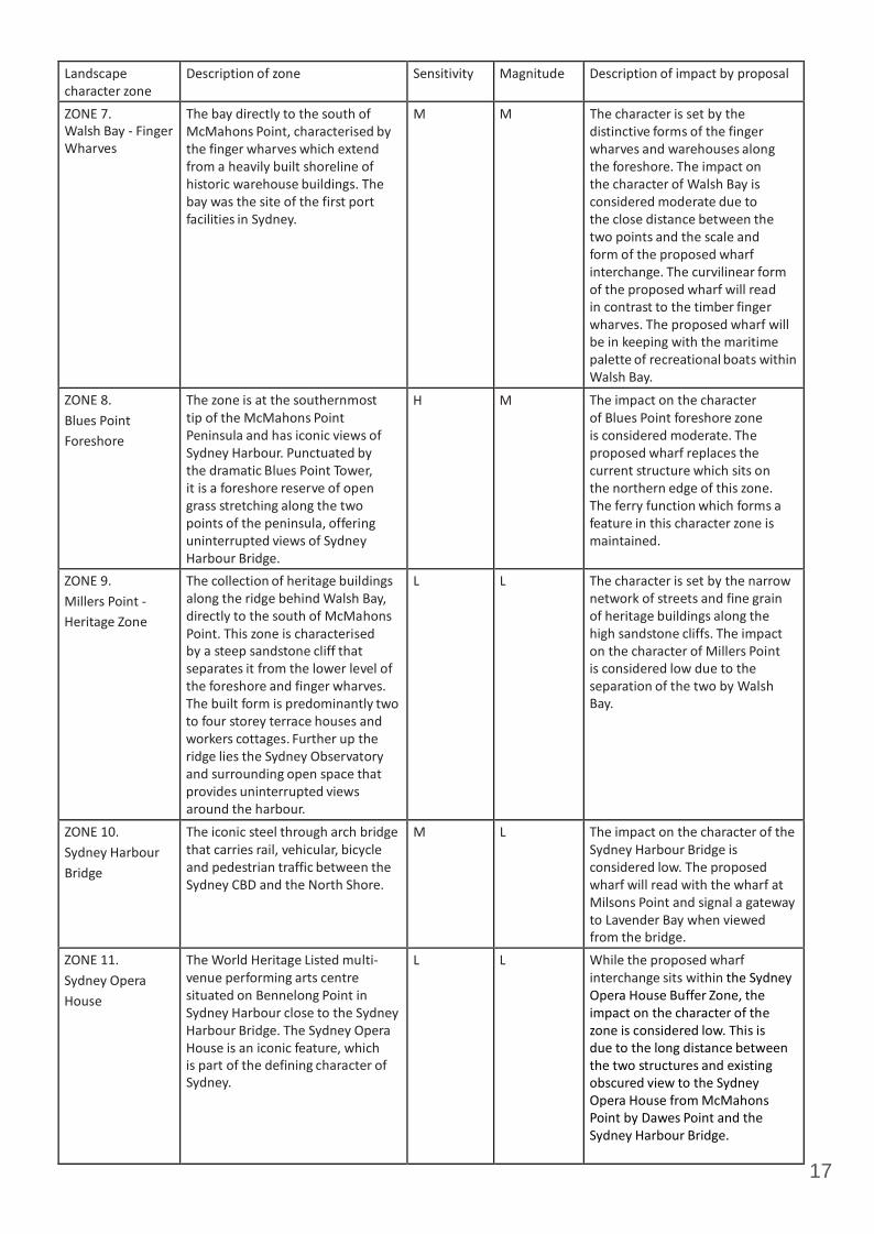
17
Landscape character zone
Description of zone Sensitivity Magnitude Description of impact by proposal
ZONE 7. Walsh Bay ‐ Finger Wharves
The bay directly to the south of McMahons Point, characterised by the finger wharves which extend from a heavily built shoreline of historic warehouse buildings. The bay was the site of the first port facilities in Sydney.
M M The character is set by the distinctive forms of the finger wharves and warehouses along the foreshore. The impact on the character of Walsh Bay is considered moderate due to the close distance between the two points and the scale and form of the proposed wharf interchange. The curvilinear form of the proposed wharf will read in contrast to the timber finger wharves. The proposed wharf will be in keeping with the maritime palette of recreational boats within Walsh Bay.
ZONE 8. Blues Point Foreshore
The zone is at the southernmost tip of the McMahons Point Peninsula and has iconic views of Sydney Harbour. Punctuated by the dramatic Blues Point Tower, it is a foreshore reserve of open grass stretching along the two points of the peninsula, offering uninterrupted views of Sydney Harbour Bridge.
H M The impact on the character of Blues Point foreshore zone is considered moderate. The proposed wharf replaces the current structure which sits on the northern edge of this zone. The ferry function which forms a feature in this character zone is maintained.
ZONE 9. Millers Point ‐ Heritage Zone
The collection of heritage buildings along the ridge behind Walsh Bay, directly to the south of McMahons Point. This zone is characterised by a steep sandstone cliff that separates it from the lower level of the foreshore and finger wharves. The built form is predominantly two to four storey terrace houses and workers cottages. Further up the ridge lies the Sydney Observatory and surrounding open space that provides uninterrupted views around the harbour.
L L The character is set by the narrow network of streets and fine grain of heritage buildings along the high sandstone cliffs. The impact on the character of Millers Point is considered low due to the separation of the two by Walsh Bay.
ZONE 10. Sydney Harbour Bridge
The iconic steel through arch bridge that carries rail, vehicular, bicycle and pedestrian traffic between the Sydney CBD and the North Shore.
M L The impact on the character of the Sydney Harbour Bridge is considered low. The proposed wharf will read with the wharf at Milsons Point and signal a gateway to Lavender Bay when viewed from the bridge.
ZONE 11. Sydney Opera House
The World Heritage Listed multi‐ venue performing arts centre situated on Bennelong Point in Sydney Harbour close to the Sydney Harbour Bridge. The Sydney Opera House is an iconic feature, which is part of the defining character of Sydney.
L L While the proposed wharf interchange sits within the Sydney Opera House Buffer Zone, the impact on the character of the zone is considered low. This is due to the long distance between the two structures and existing obscured view to the Sydney Opera House from McMahons Point by Dawes Point and the Sydney Harbour Bridge.
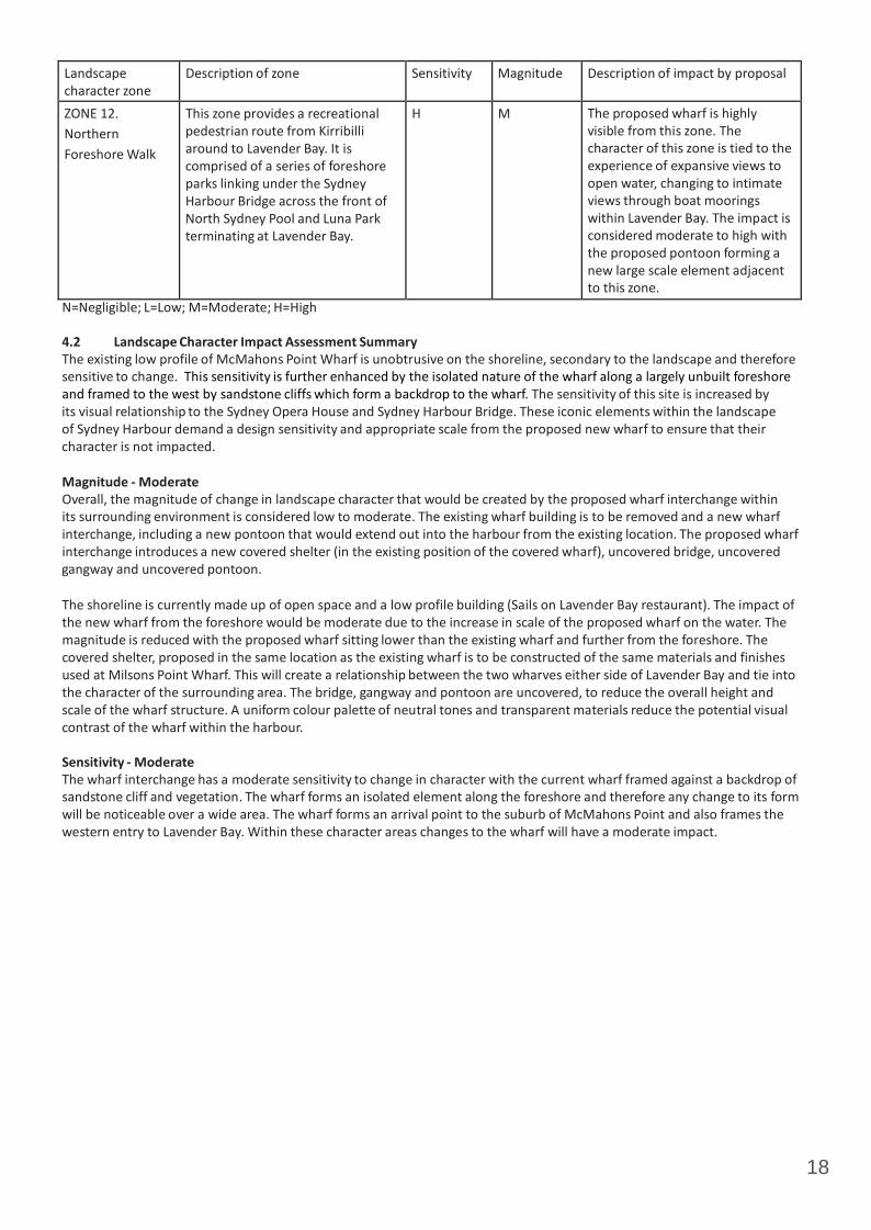
18
Landscape character zone
Description of zone Sensitivity Magnitude Description of impact by proposal
ZONE 12. Northern Foreshore Walk
This zone provides a recreational pedestrian route from Kirribilli around to Lavender Bay. It is comprised of a series of foreshore parks linking under the Sydney Harbour Bridge across the front of North Sydney Pool and Luna Park terminating at Lavender Bay.
H M The proposed wharf is highly visible from this zone. The character of this zone is tied to the experience of expansive views to open water, changing to intimate views through boat moorings within Lavender Bay. The impact is considered moderate to high with the proposed pontoon forming a new large scale element adjacent to this zone.
N=Negligible; L=Low; M=Moderate; H=High
4.2 Landscape Character Impact Assessment Summary The existing low profile of McMahons Point Wharf is unobtrusive on the shoreline, secondary to the landscape and therefore sensitive to change. This sensitivity is further enhanced by the isolated nature of the wharf along a largely unbuilt foreshore and framed to the west by sandstone cliffs which form a backdrop to the wharf. The sensitivity of this site is increased by its visual relationship to the Sydney Opera House and Sydney Harbour Bridge. These iconic elements within the landscape of Sydney Harbour demand a design sensitivity and appropriate scale from the proposed new wharf to ensure that their character is not impacted.
Magnitude - Moderate Overall, the magnitude of change in landscape character that would be created by the proposed wharf interchange within its surrounding environment is considered low to moderate. The existing wharf building is to be removed and a new wharf interchange, including a new pontoon that would extend out into the harbour from the existing location. The proposed wharf interchange introduces a new covered shelter (in the existing position of the covered wharf), uncovered bridge, uncovered gangway and uncovered pontoon.
The shoreline is currently made up of open space and a low profile building (Sails on Lavender Bay restaurant). The impact of the new wharf from the foreshore would be moderate due to the increase in scale of the proposed wharf on the water. The magnitude is reduced with the proposed wharf sitting lower than the existing wharf and further from the foreshore. The covered shelter, proposed in the same location as the existing wharf is to be constructed of the same materials and finishes used at Milsons Point Wharf. This will create a relationship between the two wharves either side of Lavender Bay and tie into the character of the surrounding area. The bridge, gangway and pontoon are uncovered, to reduce the overall height and scale of the wharf structure. A uniform colour palette of neutral tones and transparent materials reduce the potential visual contrast of the wharf within the harbour.
Sensitivity - Moderate The wharf interchange has a moderate sensitivity to change in character with the current wharf framed against a backdrop of sandstone cliff and vegetation. The wharf forms an isolated element along the foreshore and therefore any change to its form will be noticeable over a wide area. The wharf forms an arrival point to the suburb of McMahons Point and also frames the western entry to Lavender Bay. Within these character areas changes to the wharf will have a moderate impact.
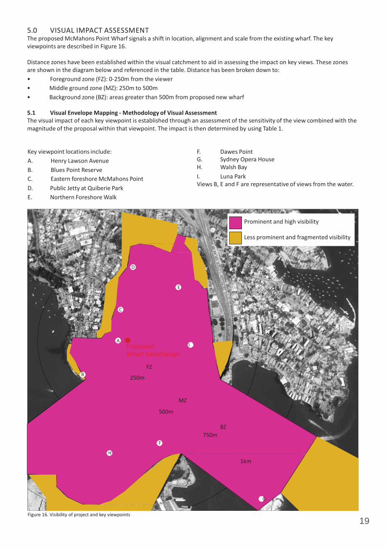
19
5.0 VISUAL IMPACT ASSESSMENT The proposed McMahons Point Wharf signals a shift in location, alignment and scale from the existing wharf. The key viewpoints are described in Figure 16.
Distance zones have been established within the visual catchment to aid in assessing the impact on key views. These zones are shown in the diagram below and referenced in the table. Distance has been broken down to: • Foreground zone (FZ): 0‐250m from the viewer • Middle ground zone (MZ): 250m to 500m • Background zone (BZ): areas greater than 500m from proposed new wharf
5.1 Visual Envelope Mapping - Methodology of Visual Assessment The visual impact of each key viewpoint is established through an assessment of the sensitivity of the view combined with the magnitude of the proposal within that viewpoint. The impact is then determined by using Table 1.
Key viewpoint locations include: A. Henry Lawson Avenue B. Blues Point Reserve C. Eastern foreshore McMahons Point D. Public Jetty at Quiberie Park E. Northern Foreshore Walk
F. Dawes Point G. Sydney Opera House H. Walsh Bay I. Luna Park Views B, E and F are representative of views from the water.
Prominent and high visibility
Less prominent and fragmented visibility
D
E
C
A Proposed I Wharf Interchange
FZ B 250m
MZ
500m
BZ 750m
F
H
1km
G
Figure 16. Visibility of project and key viewpoints

20
Figure 17. View towards existing McMahons Point Wharf from Henry Lawson Avenue.
Proposed Wharf Interchange
Figure 18. View towards Sydney Opera House from Henry Lawson Avenue.
5.2 Key Viewpoints Viewpoint A - Henry Lawson Avenue - view east Clear views towards the Sydney Harbour Bridge and Sydney Opera House are available along Henry Lawson Avenue. From the end of Henry Lawson Avenue views are available into Lavender Bay and across to Luna Park on the northern shore of Sydney Harbour. Henry Lawson Avenue is backed on the northern side by the sandstone escarpment with residential apartment buildings on top. The southern side of the street is an open level grassed foreshore with seating, this meets the water with a sandstone seawall. There is minimal furniture and visual clutter along the foreshore with the focus on the 180 degree views of the harbour. The existing wharf shelter stands alongside the private restaurant ‘Sails’ as the single built elements along this section of the foreshore. The current shelter has a partially enclosed end and a low solid roof that blocks views from the end of Henry Lawson Avenue towards the northern side of the bridge and Luna Park.
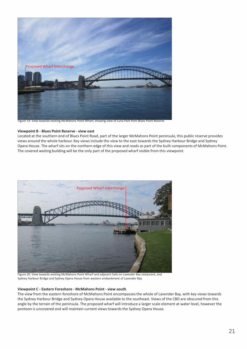
21
Proposed Wharf Interchange
Figure 19. View towards existing McMahons Point Wharf, showing view of Luna Park from Blues Point Reserve.
Viewpoint B - Blues Point Reserve - view east Located at the southern end of Blues Point Road, part of the larger McMahons Point peninsula, this public reserve provides views around the whole harbour. Key views include the view to the east towards the Sydney Harbour Bridge and Sydney Opera House. The wharf sits on the northern edge of this view and reads as part of the built components of McMahons Point. The covered waiting building will be the only part of the proposed wharf visible from this viewpoint.
Proposed Wharf Interchange
Figure 20. View towards existing McMahons Point Wharf and adjacent Sails on Lavender Bay restaurant, and Sydney Harbour Bridge and Sydney Opera House from western embankment of Lavender Bay.
Viewpoint C - Eastern Foreshore - McMahons Point - view south The view from the eastern foreshore of McMahons Point encompasses the whole of Lavender Bay, with key views towards the Sydney Harbour Bridge and Sydney Opera House available to the southeast. Views of the CBD are obscured from this angle by the terrain of the peninsula. The proposed wharf will introduce a larger scale element at water level, however the pontoon is uncovered and will maintain current views towards the Sydney Opera House.
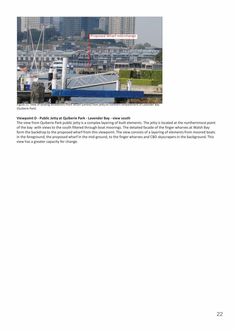
22
Proposed Wharf Interchange
Figure 21. View of existing McMahons Point Wharf (centre) from jetty on northern embankment of Lavender Bay (Quiberie Park).
Viewpoint D - Public Jetty at Quiberie Park - Lavender Bay - view south The view from Quiberie Park public jetty is a complex layering of built elements. The jetty is located at the northernmost point of the bay with views to the south filtered through boat moorings. The detailed facade of the finger wharves at Walsh Bay form the backdrop to the proposed wharf from this viewpoint. The view consists of a layering of elements from moored boats in the foreground, the proposed wharf in the mid‐ground, to the finger wharves and CBD skyscrapers in the background. This view has a greater capacity for change.

23
Proposed Wharf Interchange
Figure 22. View of existing McMahons Point Wharf (centre) from pedestrian walkway on eastern side of Lavender Bay.
Proposed Wharf Interchange
Figure 23. View of existing McMahons Point Wharf (centre) from pedestrian walkway on eastern side of Lavender Bay.
Viewpoint E - Northern Foreshore Walk - Milsons Point view south west The northern foreshore walk stretches from Quiberie Park at the northern end of Lavender Bay around and under the Sydney Harbour Bridge to Kirribilli. Views along this walk change in character from the contained internal views from the foreshore of Lavender Bay to the open expansive views of Sydney Harbour that are available from Luna Park. The internal views of the bay are assessed from Viewpoint E. These views take in the opposite shore of McMahons Point as filtered through the private boat moorings that fill Lavender Bay. From this viewpoint the proposed wharf sits partially against the built component of McMahons Point, and partially against the vegetated headland of Blues Point. The wharf sits low in the mid‐ground with direct views fractured by boat moorings.

24
Proposed Wharf Interchange
Figure 24. View of existing wharf (bottom centre) and adjacent residential apartments viewed from Dawes Point
Viewpoint F - Dawes Point - view north west The view from Dawes Point northwest across the main channel of Sydney Harbour are clear and unobstructed. From this viewpoint the wharf sits against the apartment buildings of McMahons Point as they step up the terrain. Views from Dawes Point also take in the ferry wharf at Milsons Point with the two structures reading as a consistent design aesthetic and acting as the visual gateway to Lavender Bay.
Proposed Wharf Interchange
Figure 25. View towards existing McMahons Point Wharf from Sydney Opera House.
Viewpoint G - Sydney Opera House - view north west Clear views around the harbour are available from the Sydney Opera House at a range of terrace levels. The key view to the northwest towards the Sydney Harbour Bridge takes in the proposed wharf as it sits against the built headland of McMahons Point. The impact of the proposed wharf is reduced by the dominating scale of the Sydney Harbour Bridge from this viewpoint and through the distance between the proposed wharf and the Sydney Opera House.

25
Proposed Wharf Interchange
Figure 26. View towards McMahons Point from Walsh Bay finger wharves.
Viewpoint H - Walsh Bay - view north Clear views across the main channel of Sydney Harbour are available from Walsh Bay north towards McMahons Point and North Sydney. The proposed wharf reads in the mid‐ground against the built foreshore of Lavender Bay and the complex collection of boat moorings within the bay itself. The dominant elements within this view is the scale of the buildings in the North Sydney CBD that sit along the ridge behind Lavender Bay. The other key component of this view is the open water of the main harbour channel.
Proposed Wharf Interchange
Figure 27. View of existing McMahons Point Wharf (bottom centre) and adjacent residential apartments viewed from walkway on eastern side of Lavender Bay.
Viewpoint I - Luna Park - view west The northern foreshore walk stretches from Quiberie Park at the northern end of Lavender Bay around and under the Sydney Harbour Bridge to Kirribilli. Views along this walk change in character from the contained internal views from the foreshore of Lavender Bay to the open expansive views of Sydney Harbour that are available from Luna Park. Viewpoint I assesses the view from the foreshore in front of Luna Park and North Sydney Pool. This viewpoint provides clear unobstructed views to the west towards the proposed wharf. The harbour is clear of boat moorings in this section. From this angle the proposed wharf reads as a collection of built elements at the level of the foreshore and extending back up the slope behind. The whole of the proposed wharf structure will be highly visible from this viewpoint.

26
Viewpoint Setting Visible elements
Sensitivity Magnitude Distance zone
Overall rating
Comment
A Figures 17 + 18 Henry Lawson Avenue + surrounding residences
Sydney Harbour Bridge, Sydney Opera House and CBD
Shelter, bridge, gangway and pontoon
M M FZ M The impact of views from Henry Lawson Avenue would be moderate. Some views towards the harbour including the Harbour Bridge will be affected due to the location of the fixed waiting shelter and the larger uncovered pontoon. The replacement of the current waiting shelter with a more transparent structure will have a positive impact on some views towards Luna Park. Impact on views from surrounding residences would be low due to the dramatic change in terrain. Residences at the eastern end of Henry Lawson Drive adjacent to the wharf are located above street level or on top of the sandstone ridge. Existing views from all residences would be retained towards the Sydney Harbour Bridge, Sydney Opera House, CBD and harbour more broadly.
B Figure 19 Blues Point Reserve
Luna Park and North Sydney Skyline
Pontoon and gangway
M M FZ ‐ MZ M Impact on views towards the proposed wharf interchange from Blues Point Reserve would be moderate to low. As the proposed wharf interchange reaches further into the harbour than the existing wharf, some views towards Luna Park and North Sydney Olympic Pool will be affected. However, by keeping the proposed wharf north of the McMahons Point foreshore line, views to the Sydney Opera House and Sydney Harbour Bridge will not be affected. The elements that extend into the water are uncovered, neutral in tone, and sit low in the water.

27
Viewpoint Setting Visible elements
Sensitivity Magnitude Distance zone
Overall rating
Comment
C Figure 20 Western residential embankment and Sails restaurant
Harbour Bridge and Sydney Opera House
Shelter, bridge, gangway and pontoon
M H FZ H The impact on views from the western residential embankment and in particular ‘Sails on Lavender Bay’ restaurant would be high. The proposed bridge, gangway and pontoon are located out from the existing wharf, potentially obscuring views to the Sydney Opera House. Views towards Dawes Point and Walsh Bay from the restaurant and western foreshore of Lavender Bay will be affected, filtered through the proposed gangway and pontoon depending on tidal levels. The impact on views from the western residential embankment is high with components of the proposed wharf extending further into the harbour than the existing wharf. There will be some closing off of water views in the foreground from Sails Restaurant due to the angle and size of the uncovered pontoon.
D Figure 21 Public Jetty at Quiberie Park + surrounding residences
Observatory Hill, Finger Wharves and CBD skyline
Shelter, bridge, gangway and pontoon
L L MZ L Views to the proposed wharf interchange from the public northwestern jetty would have a low impact. Views are fragmented by existing vessel moorings. Views towards Observatory Hill, the CBD and the finger wharves are maintained.
The proposed wharf would have a low impact on views towards Walsh Bay and the Finger Wharves would be impacted by the shelter of the wharf and its proposed location extending from the foreshore.
E Figure 22 + 23 Eastern pedestrian walkway
Lavender Bay and McMahons Point
Shelter, bridge, gangway and pontoon
L M MZ M Views to the proposed wharf interchange from the eastern pedestrian walkway would be moderately impacted. The impact is reduced due to the distance between foreshores, and the fragmenting of views due to boat moorings. The proposed wharf interchange will sit framed partially against the backdrop of Blues Point and also open water, and will be more highly visible than the current structure due to the extension of the structure into the harbour.

28
Viewpoint Setting Visible elements
Sensitivity Magnitude Distance zone
Overall rating
Comment
F Figure 24 Dawes Point
McMahons Point
Shelter, bridge, gangway and pontoon
L L BZ L The impact on views towards the wharf across the harbour from Dawes Point would be low. The impact is reduced due distance to the wharf at this point. Views of McMahons Point are maintained with the new covered waiting area replacing the current wharf and the pontoon partially visible though low in profile and without a roof.
G Figure 25 Sydney Opera House
McMahons Point
Shelter and pontoon
N N BZ N The impact on views from the Sydney Opera House will be negligible. The distance to the proposed wharf combined with the complexity of the view from Bennalong Point renders the wharf hard to distinguish from the surrounding foreshore structures. The scale of the Sydney Harbour Bridge in the view west from the Sydney Opera House forms a dominant element reducing the impact of small changes to the foreshore forms of McMahon’s Point
H Figure 26 Walsh Bay
McMahons Point and North Sydney
Shelter and pontoon
L L BZ L The impact on views is considered low. The proposed wharf interchange will replace the current wharf building while also introducing unroofed gangway, bridge and pontoon elements. These will sit low within the view from Walsh bay.
I Figure 27 Luna Park
Lavender Bay and McMahons Point
Shelter and pontoon
H M MZ H The impact from this viewpoint is considered high. Clear unobstructed views are available along this section of the foreshore across open water towards McMahons Point. While the landside components of the proposed wharf replace an existing structure, and read as a collection of built elements on the foreshore, the waterside components of pontoon and gangway will introduce a new larger scale built element on currently open water.
N=Negligible; L=Low; M=Moderate; H=High

29
5.3 Visual Impact Assessment Summary - Overall visual impact - Moderate The proposed wharf interchange would be visible from a range of points including the western side of Lavender Bay, Dawes Point, Walsh Bay and the Sydney Harbour Bridge.
Viewpoints within the foreground zone would be moderately impacted due to the change in scale and position of the proposed wharf interchange. The impact on views from the adjacent ‘Sails on Lavender Bay’ restaurant is considered moderate with views to the Sydney Opera House and Dawes Point fragmented by the pontoon. There will be some changes to views from Henry Lawson Avenue and Blues Point Reserve, but no overall significant view loss is expected. The use of transparent materials assist in maintaining views through the proposed structure from these zones. While the proposed wharf signals a significant shift in scale, it sits lower to the water allowing for views over towards the Sydney Harbour Bridge and Opera House.
For viewpoints in the middle ground a moderate to low impact is expected with views filtered by vessel moorings or reduced through the shift in location of the pontoon further out into Lavender Bay.
Views from the background zones will be moderately impacted with the proposed changes at the site becoming less visible across a longer distance. The impact on long range views, including those from the iconic elements of the Sydney Opera House and Harbour Bridge, would be low to negligible. For these long range views towards the wharf the critical factor is maintaining visibility through the proposed structure and utilising neutral tones to tie into the surrounding environment.
Views from Lavender Bay residences towards Walsh Bay and the Finger Wharves will be moderately affected by the proposed wharf. Mitigation measures to reduce the impact of the wharf have been implemented.
The proposed wharf interchange would form a new larger element along a largely unbuilt section of the foreshore. Pontoon orientation has been set based on Sydney Ferries feedback with respect to berthing and local bathymetry. The location of the proposed wharf reduces visual impact from existing buildings. Overall the visual impact of the proposed wharf would be moderate.
30
6.0 SUMMARY OF URBAN DESIGN PRINCIPLES AND MITIGATION STRATEGY 6.1 Summary of urban design recommendations and mitigation measures The concept for the proposed wharf and interchange upgrade works at McMahons Point has been an ongoing process of consultation and testing, based on an investigation of the following: • Potential visual impact; • Access; • Safety and security; • Buildability; • Material palette and character; • Architectural form and design; • Vegetation impacts; and • Maintenance.
The wharf siting and design ,and associated landside upgrades are subject to a complex set of influences, including: ‐ Sensitive visual location ‐ the proximity of the visual catchment of the Sydney Opera House etc ‐ Steep topography which affects accessibility from residential areas, ‐ Proximity to the Sails Restaurant, which is an established feature of this part of the harbour ‐ Low key parkland setting
The sensitivity of the existing setting has meant that the introduction of new elements has been minimised, and the essential elements of the wharf ‐ waiting shed, gangway and pontoon ‐ have been sited in response to potential impact on views. Very little intervention is proposed for landside works, in order to improve access and comfort while maintaining the character of the public domain.
The key features of the concept design are:
Wharf structures The proposed wharf interchange introduces a new, moderately increased scale to this foreshore location, in order to cater for improved amenity and increased use when placed in combination with the existing wharf elements. The wharf in this location has, however, been designed to reduce impact through location of the roofed structure in position of the existing, and reduction of roof structures on the gangway and pontoon to maintain open views and reduce the overall scale. The elements have been designed to retain simple clear lines that respond to the maritime setting.
Materiality Material selection for the wharf is based on a standardised elements that visually create a family of wharves on the harbour. These materials have been selected for durability, and fit within the character of the harbour generally.
The palette for the public domain utilises existing materials for expanded paving and changes to kerbs.
Colour plays an important role in mitigating impact. Colour selection for materials and painting respond to the surrounding palette, are low in reflectivity, and complement the surrounding harbour environment. The proposed wharf would promote a unified palette of materials which, while responding to the maritime heritage and surrounding character, also separates the structure as a piece of architectural design.
6.2 Conclusion The overall impact of the proposal is considered to be moderate. Sensitive siting and design intervention, including the minimisation of structures on the water, form the key design strategies for mitigating the impact of the proposed wharf. The main component of the proposed wharf, the covered structure, sits within the footprint of the existing wharf, with the remaining elements sitting low to the water with limited intrusive vertical elements, mitigating interruption to, and impact on views as far as possible. The design of the proposed wharf and landside public domain upgrade has been coordinated with the existing harbour and parkland environment, to minimise potential impact on the character of the area.

Locked Bag 928, North Sydney NSW 2059