Sandwell Council Local Cycling and Walking Infrastructure Plan
41
Sandwell Council Local Cycling and Walking Infrastructure Plan Strategic Outline Case January 2020
-
Upload
khangminh22 -
Category
Documents
-
view
3 -
download
0
Transcript of Sandwell Council Local Cycling and Walking Infrastructure Plan

Sandwell Council Local
Cycling and Walking
Infrastructure Plan Strategic Outline Case
January 2020


Mott MacDonald
35 New hall Street
Birmingham B3 3PU
United Kingdom
T +44 (0)121 234 1500
mottmac.com
Sandw ell Council
Regeneration and Grow th
Sandw ell Council House
Freeth Street
Oldbury B69 3DE
Mott MacDonald Limited. Registered in England and Wales no. 1243967. Registered office: Mott MacDonald House, 8-10 Sydenham Road, Croydon CR0 2EE, United Kingdom
Sandwell Council Local Cycling and Walking Infrastructure Plan Strategic Outline Case
1 January 2020


Mott MacDonald | Sandwell Council Local Cycling and Walking Infrastructure Plan Strategic Outline Case
404789AA01 | 1 | B | | 1 January 2020
Issue and Revision Record
Revision Date Originator Checker Approver Description
A 05/09/2019
Anna Newey
Luke Barley Steve Rothwell
First Draft
B 23/09/2019
Anna Watt Anna Newey
Chris Sibthorpe
Final
Document reference: 404789AA01 | 1 | B
Information class Standard
This document is issued for the party which commissioned it and for specific purposes connected with the above-
captioned project only. It should not be relied upon by any other party or used for any other purpose.
We accept no responsibil ity for the consequences of this document being relied upon by any other party, or being
used for any other purpose, or containing any error or omission which is due to an error or omission in data supplied to us by other parties.
This document contains confidential information and proprietary intellectual property. It should not be shown to other parties without consent from us and from the party which commissioned it.
This r epor t has been prepared solely for use by the part y which commissioned it (the ‘Client ’) in connection wit h the captioned pr oject . I t should not be used f or any other purpose. No person other than the Client or any party who has expr essly agr eed t er ms of r eliance with us ( the ‘Recipient( s) ’) may r ely on t he cont ent , inf or mat ion or any views expr essed in the repor t. We accept no duty of care, responsibilit y or liabilit y to any ot her recipient of t his document. This report is conf idential and contains pr opriet ar y intellectual proper ty.
No r epr esentation, war rant y or undert aking, expr ess or implied, is made and no r esponsibilit y or liabilit y is accepted by us t o any par ty other t han t he Client or any Recipient (s), as to the accuracy or completeness of t he inf or mation contained in this r eport . For the avoidance of doubt this repor t does not in any way pur port t o include any legal, insurance or financial advice or opinion.
We disclaim all and any liabilit y whether arising in tort or cont ract or ot herwise which it might otherwise have to any par ty other than the Client or the Recipient( s) , in respect of this repor t, or any information attr ibuted to it .
We accept no responsibilit y for any er ror or omission in the repor t which is due to an error or omission in dat a, informat ion or statements supplied t o us by other part ies including the client ( ‘Dat a’) . We have not independently verif ied such Dat a and have assumed it to be accur at e, com plet e, reliable and curr ent as of the date of such inf or mat ion.
For ecast s presented in this document were prepar ed using Data and t he r eport is dependent or based on Data. Inevit ably, some of the assumptions used to develop t he f or ecast s will not be realised and unanticipated event s and circumst ances may occur. Consequent ly Mott MacDonald does not guarant ee or war rant t he conclusions cont ained in t he report as there are likely t o be dif ferences bet ween the forecasts and the act ual result s and those dif ferences may be mater ial. While we consider that t he information and opinions given in t his r eport are sound all part ies must rely on their own skill and judgement when making use of it.
Under no cir cumstances may this repor t or any extract or summary t hereof be used in connection wit h any public or private securit ies of fering including any related memorandum or pr ospectus for any securit ies offering or st ock exchange listing or announcement.

Mott MacDonald | Sandwell Council Local Cycling and Walking Infrastructure Plan Strategic Outline Case
404789AA01 | 1 | B | | 1 January 2020
Contents
Introduction 8
Strategic Case 14
The Need to Implement the SCWIP 17
Economic Case 29
Management Case 36
Appendices 39
Appendix 1: TfWM Road Safety Statement 40
Tables
Table 1: SCWIP Cycle Routes 10
Table 2: Policy context 14
Table 3: Sandwell journey to work mode share – 2011 census 18
Table 4: Sandwell’s accident data by road type (2013 – 2017) 26
Table 5: Numbers of pedestrians and cyclists involved in accidents 26
Table 6: Pedestrians accidents involving other vehicles, Great Britain 26
Table 7: Pedestrian and cyclist casualty severity UK wide 27
Table 8: Cycle route costings 31
Table 9: Core walking zones indicative costs 33
Table 10: Potential Funding Sources 34
Table 11: Prioritised List of Cycle Routes 36
Figures
Figure 1: SCWIP area 9
Figure 2: Journeys to work in, out and through Sandwell of 5km or less (straight line) 18
Figure 3: Sandwell vehicle km increases 19
Figure 4: Cycle journey time to metro and rail stops and catchment of population from the
stations 20
Figure 5: Physical activity in Sandwell 22
Figure 6: Sandwell’s population classified as overweight or obese 23

Mott MacDonald | Sandwell Council Local Cycling and Walking Infrastructure Plan Strategic Outline Case
404789AA01 | 1 | B | | 1 January 2020
Figure 7: Management process 37

Mott MacDonald | Sandwell Council Local Cycling and Walking Infrastructure Plan Strategic Outline Case
404789AA01 | 1 | B | | 1 January 2020
8
Introduction
Sandwell Metropolitan Borough Council (SMBC) has appointed Mott Macdonald to prepare a Local Walking and Cycling Infrastructure Plan (SCWIP) to support mode shift in favour of active
travel across the authority. This document is the Strategic Outline Case to support the
development of the SCWIP.
The aim of the SCWIP is to:
● Assist the implementation of the West Midlands Strategic Cycle Network
● Identify the local walking and cycling networks within Sandwell with a prioritised plan for
delivery
● Coordinate the plan with existing plans for Black Country and the West Midlands to ensure a
consistent and aligned approach to delivery
● Integrate this plan into a clear planning and transport policy document and delivery plan,
taking into consideration the overarching West Midlands strategies for planning and
transport.
The SCWIP is a Sandwell-wide review of the cycle network and walking routes and incorporates 15 cycle routes for development and six core walking zones for improvements. The SCWIP
integrates with the West Midlands Local Cycling and Walking Infrastructure Plan (LCWIP), the
Cycling SPD and the Sandwell Rights of Way Improvement Plan (ROWIP). The plan presents a
long-term approach to developing walking and cycling infrastructure in the borough.
“SMBC’s ultimate aspiration is to have a prioritised plan for the local network within Sandwell,
which coordinates with the existing plans for the Black Country and for these to be integrated
with the plans that are already in place for the West Midlands strategies for planning and
transport.”
The proposed SCWIP scope is shown below in Figure 1:.1
1 For a larger v ersion, please see Appendix A of the SCWIP Final Report, January 2020

Mott MacDonald | Sandwell Council Local Cycling and Walking Infrastructure Plan Strategic Outline Case
404789AA01 | 1 | B | | 1 January 2020
9
Figure 1: SCWIP area
Source: Mott MacDonald
Scheme description
Table 1: SCWIP Cycle Routes provides a description of each of the cycle routes along with
recommended infrastructure elements. For further detail please see the SCWIP Final Report
January 2020.

Mott MacDonald | Sandwell Council Local Cycling and Walking Infrastructure Plan Strategic Outline Case
404789AA01 | 1 | B | | 1 January 2020
10
Table 1: SCWIP Cycle Routes
Cycle
Route
number
Cycle Route
description
Infrastructure Recommendations
1 Birmingham Canal –
West Bromwich via
Spon Lane
● Segregated two-way track for cyclists
● Implementation of quietways
● Implementation of 20mph zones and traffic calming
measures
2 NCN Route 5
Improvements, linking to WMLCWIP route
● Road priority changes
● Junction improvements
● Crossing improvements
● Segregated two-way track for cyclists
● Segregated shared use paths
● Improved signage and wayfinding
3 Spon Lane to Black Lake (Metro stop)
Along Kelvin Way &
Great Bridge
● Segregated two-way tracks and single way tracks for cyclists
● Road priority changes
● Implementation of 20mph zones and traffic calming
measures
● Implementation of quietways
● Segregated shared use paths
● Formalising parking
● Improved signage and wayfinding
● Improved lighting
● Vegetation maintenance
● Place led intervention
4 Oldbury to Blackheath Town Centre
● Junction improvements including early cycle release
● Crossing improvements
● Segregated two-way tracks
● Speed reduction
● Parking restrictions
5 Oldbury to Bearwood with links to
WMLCWIP Route
● Junction improvements including early cycle release
● Crossing improvements
● Implementation of quietways and traffic calming measures
● Segregated two-way tracks
● Formalising parking
6 Oldbury to Galton
Bridge Station
● Junction improvements
● Crossing improvements
● Implementation of quietways, speed reductions and traffic
calming measures
● Segregated two-way tracks

Mott MacDonald | Sandwell Council Local Cycling and Walking Infrastructure Plan Strategic Outline Case
404789AA01 | 1 | B | | 1 January 2020
11
Cycle
Route
number
Cycle Route
description
Infrastructure Recommendations
7 Stone Cross to Yew
Tree via Tame Bridge Parkway Railway
Station
● Junction improvements
● Crossing improvements
● Segregated shared use paths
● Segregated single way tracks
● Implementation of quietways, speed reductions and traffic
calming measures
8 Tipton to Wednesbury
Town Centre via Metro
● Junction improvements
● Crossing improvements
● Implementation of quietways, speed reductions and traffic
calming measures
● Formalising parking and parking restrictions in areas
● Segregated two-way tracks and single way tracks for cyclists
● Implementation of quietways, speed reductions and traffic calming measures
● Segregated shared use paths
● Improved lighting and wayfinding
● Vegetation maintenance
9 Tividale to Dudley Port
via Sheepwash Nature Reserve
● Junction improvements
● Crossing improvements
● Segregated cycle path
● Improved lighting and wayfinding
● Segregated shared use paths
● Implementing 20mph speed limits
● Vegetation maintenance
● Re-establishing John’s Lane tunnel
10 Cradley Heath to
boundary with Dudley MBC, via railway
station
● Junction improvements
● Crossing improvements
● Segregated two-way tracks
● Speed reductions and traffic calming measures
● Filtered permeability with public transport and walking and
cycling through route only
● Wider public realm scheme

Mott MacDonald | Sandwell Council Local Cycling and Walking Infrastructure Plan Strategic Outline Case
404789AA01 | 1 | B | | 1 January 2020
12
Cycle
Route
number
Cycle Route
description
Infrastructure Recommendations
11 Cape Hill to Black
Patch via Midland Metropolitan Hospital
● Junction improvements
● Crossing improvements
● Implementation of quietways, speed reductions and traffic
calming measures
● Improved wayfinding
● Segregated cycle path
● Resurfacing towpaths
● Segregated shared use paths
12 Walsall canal to
Birmingham canal
through Tipton via Alexander High School
● Junction improvements
● Crossing improvements
● Segregated two-way tracks
● Implementation of quietways, speed reductions and traffic
calming measures
● Segregated shared use paths
● Formalising parking
● Resurfacing part of the carriageway
13 Old Hill Railway Station to Bumble Hole
Nature Reserve via Dudley Canal
● Resurfacing canal towpath to form a shared use path
● Wayfinding improvements
14 Toll End to Hill Top, via Harvills Hawthorn
● Junction improvements
● Crossing improvements
● Segregated two-way tracks
● Implementation of quietways, speed reductions and traffic
calming measures
● Improved wayfinding
● Parking enforcement
● Segregated cycle path
15 Newton Road to A34 via Wilderness Lane
● Junction improvements
● Crossing improvements
● Implementation of quietways, speed reductions and traffic
calming measures
● Segregated two-way tracks
● Segregated shared use paths
Mott MacDonald | Sandwell Council Local Cycling and Walking Infrastructure Plan Strategic Outline Case
404789AA01 | 1 | B | | 1 January 2020
13
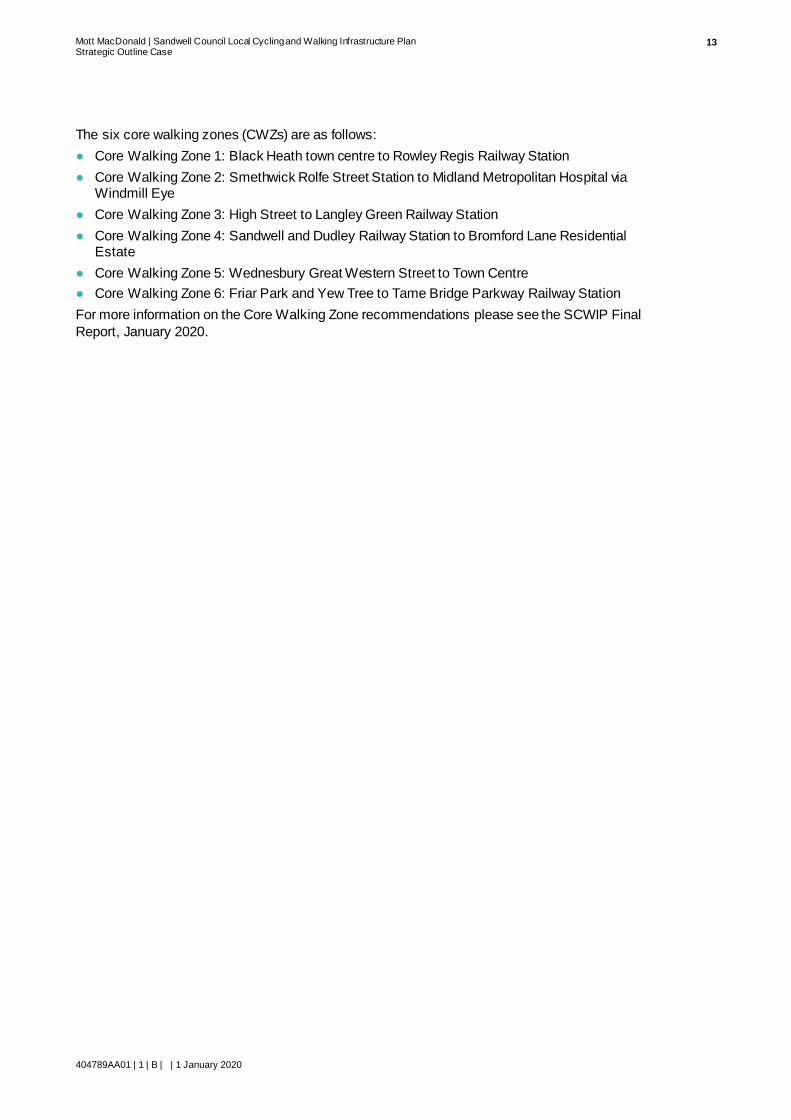
The six core walking zones (CWZs) are as follows:
● Core Walking Zone 1: Black Heath town centre to Rowley Regis Railway Station
● Core Walking Zone 2: Smethwick Rolfe Street Station to Midland Metropolitan Hospital via Windmill Eye
● Core Walking Zone 3: High Street to Langley Green Railway Station
● Core Walking Zone 4: Sandwell and Dudley Railway Station to Bromford Lane Residential Estate
● Core Walking Zone 5: Wednesbury Great Western Street to Town Centre
● Core Walking Zone 6: Friar Park and Yew Tree to Tame Bridge Parkway Railway Station
For more information on the Core Walking Zone recommendations please see the SCWIP Final
Report, January 2020.

Mott MacDonald | Sandwell Council Local Cycling and Walking Infrastructure Plan Strategic Outline Case
404789AA01 | 1 | B | | 1 January 2020
14
Strategic Case
Policy context
To ensure the SCWIP is coordinated with existing plans already in place for the Black Country and West Midlands, a review of National, Regional and Local Plans has been undertaken. A
policy review has also been undertaken to ensure the SCWIP supports all the relevant national,
regional and local policies. This initial analysis informed the scope of the SCWIP.
Table 2: Policy below summarises how the SCWIP is aligned with the different policies and plans. For a full analysis, see the SCWIP Final Report, January 2020.
Table 2: Policy context
Policy Title Key Themes How the SCWIP Supports These
National
National Planning
Policy Framework (NPPF) (2018)
• Enabling and supporting healthy
lifestyles
• Promoting walking, cycling and
public transport use
• Providing high quality walking and
cycling networks and supporting
facil ities
• The SCWIP aims to increase opportunities to walk
and cycle within the borough, therefore
encouraging and enabling healthy lifestyles and
transport modes
• The plan involves developing and improving
walking and cycling infrastructure and networks
which will promote walking and cycling as an
attractive alternative to private car use.
Cycling and
Walking Investment
Strategy (CWIS)
(2017), DfT
• Increasing cycling and walking
activity
• Improving the safety of cyclists
• Identifying safe cycling and walking
infrastructure
• The SCWIP aims to increase opportunities to walk
and cycle
• Safety of walking and cycling routes are taken into
account and planned in the infrastructure SCWIP.
LCWIP Guidance
(2017), DfT • Developing networks and routes
where infrastructure improvements
can be made to support an increase
in cycling and walking
• The SCWIP involves a prioritised programme of
infrastructure improvements and aims to increase
walking and cycling opportunities
Regional
Strategic Economic
Plan (SEP) (2017),
WMCA
• Improvements in connectivity • The walking and cycling plans enable
improvements in connectivity in active travel within
the borough to key destinations and transport l inks
West Midlands
Movement for
Growth (2017),
WMCA
• Reducing public health issues
through encouraging modes of active
travel
• Ensuring cycling and walking
strategies are a safe and attractive
alternative for short journeys
• Setting out key features of main
walking routes
• Improving the walking and cycling routes will make
active travel modes more attractive, particularly for
short journeys, which should have a positive
impact on the borough’s health
• The SCWIP needs to ensure the plans for walking
routes are in l ine with the key features specified within West Midlands Movement for Growth
2026 Delivery Plan
for Transport
(2017), WMCA
• Aiming to achieve a 5% cycle mode
share for all journeys in 2023
• Improving key walking routes to
encourage walking
• Promoting walking to school
• The SCWIP improvements to cycle routes should
encourage a modal shift towards cycling and
walking and so supports targets set in the Delivery
Plan
• Improvements will be made to key walking routes
which should encourage walking

Mott MacDonald | Sandwell Council Local Cycling and Walking Infrastructure Plan Strategic Outline Case
404789AA01 | 1 | B | | 1 January 2020
15
Policy Title Key Themes How the SCWIP Supports These
• Many of the SCWIP routes are planned around
schools to allow modal shift in favour of active
modes of travel to school
West Midlands
Cycle Charter
(2017), WMCA
• Growing cycling in the West
Midlands by making it easier and
safer for more people to cycle
• Promoting and encouraging cycling
• The SCWIP improvements to cycle routes should
make cycling easier and safer
• By providing convenient and safe routes the
SCWIP will be encouraging cycling as a mode of
transport
Local
Town Centre
Regeneration Plans (2018), WMCA
• Unlocking funding and support from
the WMCA
• West Bromwich has been identified to benefit from
this project. The SCWIP infrastructure and West
Bromwich town centre plans are aligned to ensure
maximum benefit and funding opportunities.
West Midlands
Local Cycling and
Walking
Infrastructure Plan
(LCWIP)
(forthcoming),
WMCA
• Providing cycle route schemes and
plans
• The SCWIP is aligned with the cycle route
schemes from the West Midlands LCWIP which fall
within Sandwell’s boundary to ensure a joined-up
and coherent network of walking and cycling infrastructure.
Black Country Core
Strategy (BCCS) (in
development),
Dudley MBC,
SMBC, Walsall
Council and City of
Wolverhampton
Council
• Improving and developing walking
and cycling routes to serve new
developments
• Supporting health and wellbeing
• SCWIP improvements will be made to walking and
cycling routes, ensuring accessibility for all
developments and encouraging more healthy modes of travel
Black Country
Walking and
Cycling Strategy
and Implementation
Plan (2016), Dudley
MBC, SMBC,
Walsall Council and
City of
Wolverhampton
Council
• Providing schemes for cycling and
walking routes
• Two of the schemes fall within Sandwell’s
boundary, so the SCWIP is aligned with these to
ensure a joined-up and coherent walking and
cycling network
Site Allocations and
Delivery DPD (SAD
DPD) (2012)
• Setting out allocated sites, including
cycling and walking infrastructure
that may already be planned
• The SCWIP is aligned with these existing plans
and involves plans for further infrastructure
developments for walking and cycling
West Bromwich
Area Action Plan
(AAP) (2012)
• Promoting pedestrian and cycling
accessibil ity to reduce the reliance
on car usage
• Improving safety for all modes of
transport, particularly walking and
cycling
• Ensuring new development makes
provision for cycle facil ities
• Improvements to walking and cycling routes made
through the SCWIP should encourage a modal
shift towards sustainable transport methods and
reduce reliance on cars
• Walking and cycling improvements will involve
safety considerations
Smethwick Area
Action Plan (AAP) (2008)
• Improving pedestrian and cycling
infrastructure
• Designing street layouts to avoid
conflict between different modes, for
cycling and walking consideration
• The SCWIP involves improvements to walking and
cycling infrastructure
• The walking and cycling improvements will take
layouts into consideration to avoid such conflicts

Mott MacDonald | Sandwell Council Local Cycling and Walking Infrastructure Plan Strategic Outline Case
404789AA01 | 1 | B | | 1 January 2020
16
Policy Title Key Themes How the SCWIP Supports These
Tipton Area Action
Plan (AAP) (2008) • Improving and promoting walking
and cycling provision
• The SCWIP aims to improve walking and cycling
routes
Sandwell Vision
2030 (2017)
• Focusing on good health • The improvements to walking and cycling routes
should encourage healthy modes of transport
Sandwell Cycling
Strategy (1992/3) • Supporting conditions to make
cycling easier and simpler
• Improving cycling routes should enable easier
access for cyclists
Sandwell Walking
Strategy (2015)
• Delivering improvements and
enhancements to the walking
environment
• Encouraging healthy lifestyles
• Ensuring the walking strategy meets
the demand of all users, including
those with disabilities and mobility
impairments
• The SCWIP involves improving walking routes and
therefore the walking environment, encouraging
healthy modes of travel
• The SCWIP considers the needs of a variety of
individuals, including those with disabilities, who
can benefit from walking strategies
Mott MacDonald | Sandwell Council Local Cycling and Walking Infrastructure Plan Strategic Outline Case
404789AA01 | 1 | B | | 1 January 2020
17
The Need to Implement the SCWIP
The socio-economic context
The population of Sandwell is rising with ONS mid 2018 estimates showing that there are 327,328 people living in the district of all ages2. SMBC has forecast continued population growth
with around 30,300 additional people residing in the district from 2016 to 2030. Sandwell
borough has a complex network of places within which people exercise their choice of location
for residence, business and their destination for employment, shopping, education, health
treatment, leisure and entertainment. Consequently, the borough has to support considerable trips on a daily basis. These trips will continue to grow with the SAD (2012) allocating land for
considerable development within the borough. Congestion is currently a major issue for the
borough which will only exacerbate with growth if no attractive alternatives are offered to
encourage active travel over the private car.
Travel patterns
Travel to work
Following analysis of Census Journey to Work (2011) data, the most popular workplace destination for people living in Sandwell, is Sandwell itself3. Census Journey to Work (2011) data of 5km or less has been plotted on a map to show the extent of journeys which would have a comfortable cycle commute in Sandwell. The map is shown in Figure 2:. This shows the extent of the population who have the potential to travel to work using more active transport modes in favour of the private car, if attractive options are available.
2 ONS – Mid Year Population Estimates 2018 3 NOMIS, 2011, WF01BEW shows that Sandwell is the top destination of workplace destination for those living in Sandwell. Birmingham
was the second most popular workplace destination.

Mott MacDonald | Sandwell Council Local Cycling and Walking Infrastructure Plan Strategic Outline Case
404789AA01 | 1 | B | | 1 January 2020
18
Figure 2: Journeys to work in, out and through Sandwell of 5km or less (straight line)
Source: Mott MacDonald
The Census Journey to Work (2011) data for Sandwell shows a high dependence on car travel
as set out below in Table 3: S. Cycling to work only accounts for 0.9% of journeys to work which
is a lot lower than the national and regional averages of 3% and 2% respectively. Walking
already accounts for 5% of journeys to work which is also lower than the national and regional averages of 11% and 10% respectively.
Table 3: Sandwell journey to work mode share – 2011 census
No. Percentage
Not in employment 90,878 42.0%
Driving a car or van 79,817 36.9%
Bus, minibus or coach 12,687 5.9%
On foot 10,769 5.0%
Passenger in a car or van 8,021 3.7%
Work mainly at or from home 7,840 3.6%
Bicycle 1,897 0.9%
Train 1,520 0.7%
Underground, metro, light rail or
tram 913 0.4%
Motorcycle, scooter or moped 887 0.4%
Taxi 687 0.3%
Other method of travel to w ork 429 0.2%

Mott MacDonald | Sandwell Council Local Cycling and Walking Infrastructure Plan Strategic Outline Case
404789AA01 | 1 | B | | 1 January 2020
19
No. Percentage
Total 216,345 100.0%
Source NOMIS –Table WD703EW, 2011
Car availability
Car availability per household in Sandwell has increased since 2001. Census 2011 data shows
that the percentage of households with no access to a car has decreased from 37.5% in 2001 to 33.9% in 2011. This suggests a rising trend in car journeys is taking place in Sandwell, which is
confirmed through ONS 2018 data illustrated below in Figure 3:
Figure 3: Sandwell vehicle km increases
Source: ONS – Table TRA8905
The increased population and overall level of car ownership when overlaid with the Census Journey to Work (2011) data, indicates that car is the predominant method of travel to work,
which will largely remain the same with the increasing trends of car ownership.
Opportunities for multimodal journeys
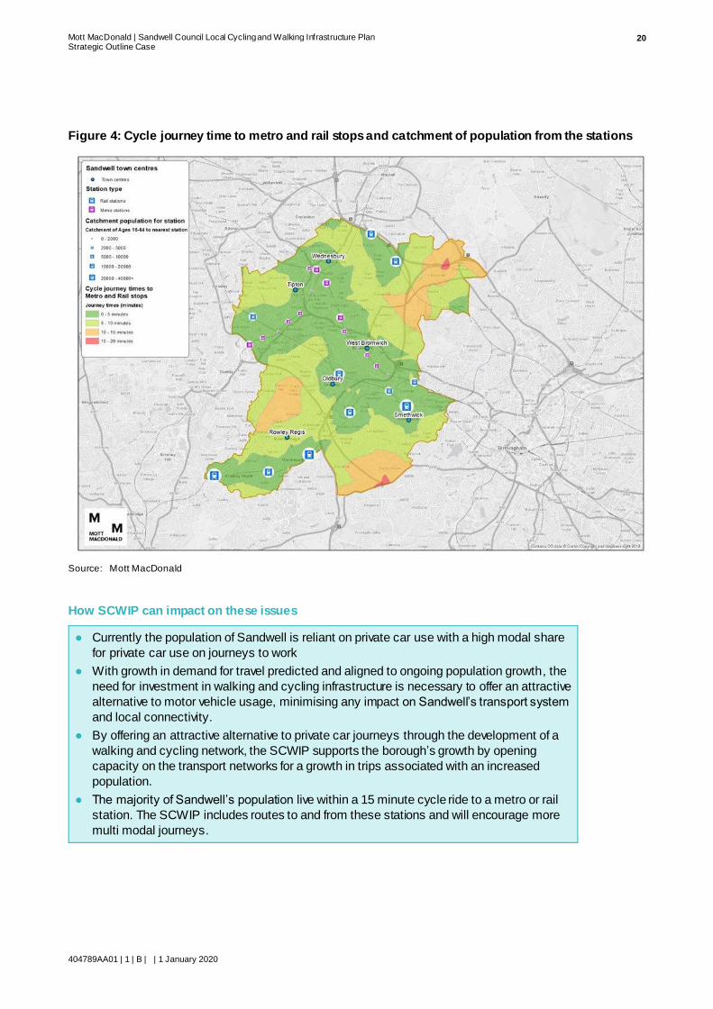
Sandwell benefits from having extensive rail and metro links in the borough. There are proposed
plans to improve existing railway lines and proposals for a new metro line between Wednesbury
and Brierley Hill, offering six new metro stops along the line. This will provide public transport links to Walsall, Wolverhampton, Birmingham and Dudley, all of which are major trip generators.
Figure 4: shows how accessible cycle journeys could be to rail and metro stations. It shows that
vast amounts of the population of Sandwell borough could reach the station in under 15 minutes
by bicycle if the choice of active travel was more attractive than private vehicle.
Mott MacDonald | Sandwell Council Local Cycling and Walking Infrastructure Plan Strategic Outline Case
404789AA01 | 1 | B | | 1 January 2020
20
Figure 4: Cycle journey time to metro and rail stops and catchment of population from the stations
Source: Mott MacDonald
How SCWIP can impact on these issues
● Currently the population of Sandwell is reliant on private car use with a high modal share
for private car use on journeys to work
● With growth in demand for travel predicted and aligned to ongoing population growth, the
need for investment in walking and cycling infrastructure is necessary to offer an attractive
alternative to motor vehicle usage, minimising any impact on Sandwell’s transport system
and local connectivity.
● By offering an attractive alternative to private car journeys through the development of a
walking and cycling network, the SCWIP supports the borough’s growth by opening
capacity on the transport networks for a growth in trips associated with an increased
population.
● The majority of Sandwell’s population live within a 15 minute cycle ride to a metro or rail
station. The SCWIP includes routes to and from these stations and will encourage more
multi modal journeys.

Mott MacDonald | Sandwell Council Local Cycling and Walking Infrastructure Plan Strategic Outline Case
404789AA01 | 1 | B | | 1 January 2020
21
Population health
The health of a population is an important factor to consider. The health of a population has an
impact on the economic and productivity of an area, social context and wellbeing of a
population. Sandwell has been ranked as the 13th most deprived local authority in the 2015
Index of Multiple Deprivation. Walking and cycling can encourage the development of an
economy as the physical activity boosts workplace activity and reduces sickness:
“Physical activity boosts energy levels, increases workplace activity and reduces sickness
absence. Businesses with active workforces have lower sickness rates and lower staff
turnover.”4
A consequence of low physical activity contributes to a number of preventable illnesses such as
obesity, diabetes, stroke, cancer, dementia, heart disease, hypertension and mental illnesses.
SMBC has a 2030 vision of Sandwell being:
“a place where we live healthy lives and live them for longer.”
However, there is evidence to suggest people living in deprived areas are twice as likely to be
physically inactive as those living in more prosperous areas5. As such this section looks at the
current physical activity and obesity levels of Sandwell using data from Sports England Active
Lives Survey, May 2017/186.
Air pollution within an area can also cause detrimental health issues. Exposure to nitrogen
dioxide (NO2) has adverse impacts on human life. This includes respiratory problems, with a
link being made to children being exposed to high levels of NO2 and poor lung function later in
life7. One of the main sources of NO2 emissions is the transport sector and so modal shift
towards more active modes of transport will help Sandwell meet its 2030 vision with regards to living healthy lives for longer.
Physical activity
The current levels of physical activity in Sandwell are lower than both the regional and national averages. The levels of physical activity are measured by the amount of activity taken place in
minutes per week. Figure 5: shows physical activity levels for the population of Sandwell. Just
over half of the population (54.7%) are classified as ‘active’ (150+ minutes of exercise per
week). One third (33.3%) of Sandwell’s population is classed as ‘inactive’ (less than 30 minutes
of activity per week), which is more than the national average of a quarter (25.2%).
4 https://www.sandwelltrends.info/physical-activity/ 5 www.sandwell.gov .uk/download/downloads/id/3269/west_bromwich_streetscape_strategy.pdf 6 Accessed on www.sandwelltrends.info
7 https://uk-air.defra.gov.uk/assets/documents/no2ten/Local_zone35_Sandwell_AQActionplan_1.pdf

Mott MacDonald | Sandwell Council Local Cycling and Walking Infrastructure Plan Strategic Outline Case
404789AA01 | 1 | B | | 1 January 2020
22
Figure 5: Physical activity in Sandwell
Source: www.sandwelltrends.info/physical-activity
Sport England’s 2018 Active Lives survey has suggested that-
“an extra 20,420 physically inactive people would have to start doing any physical activity for
Sandwell to reach the national average”8.
Obesity
As shown above, Sandwell has large amounts of inactivity which is a contributing factor to
obesity. Unsurprisingly, due to the lack of physical inactivity, obesity is also above regional and
national average. Obesity can lead to discrimination, social, emotional and psychological problems as well as reducing life expectancy. Obesity also has a large impact on the
community, leading to less productivity. Physical activity can reduce obesity in a population.
Obesity has been recorded for Sandwell and with the physical activity in Sandwell being
recorded as below average, it is unsurprising that it is not only the adult population, but also the
child population which suffer from high obesity levels. Figure 6: shows that almost one quarter (24.2%) of children between 4-5 are classified as obese or overweight. This percentage almost
doubles (42.3%) for children aged between 10 and 11 years. Almost three quarters (70.1%) of
adults are classified as overweight or obese.
8 www.sandwelltrends.info/physical-activity

Mott MacDonald | Sandwell Council Local Cycling and Walking Infrastructure Plan Strategic Outline Case
404789AA01 | 1 | B | | 1 January 2020
23
Figure 6: Sandwell’s population classified as overweight or obese
Source: https://www.sandwelltrends.info/healthy-weight/
Pollution
Sandwell borough was declared as an Air Quality Management Area in 2005 due to the amount
of NO2 emissions entering the atmosphere at several locations exceeding the annual mean
concentration. ‘Hot spots’ have been identified and continuous monitoring of s ix locations within the borough takes place to assess how successful the air quality management is.
SMBC have an Air Quality Action Plan 2018 – 20239. The Air Quality Action Plan (AQAP)
acknowledges the impact of poor air quality on health outcomes and premature deaths
particularly in the most vulnerable (elderly and children). The action plan commits Sandwell to
improving the air quality for the people who live and work in the borough. It is acknowledged within this Action Plan that:
“In Sandwell elevated NO2 levels are observed at busy junctions, narrow congested streets and
in town centres.”
It sets out five key areas that the council has already taken action on:
1. Promoting health initiatives that support sustainable transport and behavioural change
2. Reduce congestion and minimise transport emissions through traffic management and
highway improvement
3. Implementation of guidance and policy, working in partnership with key stakeholders to improve air quality outcomes.
4. Improve understanding of pollutant behaviour particularly at hot spot locations.
5. To review the council’s impact on air quality through an assessment of its vehicle fleets,
taxi licencing and employee vehicle use.
9 http://www.sandwell.gov.uk/downloads/file/26079/air_quality_action_plan_2018_-_2023

Mott MacDonald | Sandwell Council Local Cycling and Walking Infrastructure Plan Strategic Outline Case
404789AA01 | 1 | B | | 1 January 2020
24
It then identifies three key action points, which include implementing sustainable transport
initiatives to which it commits to take further action upon:
Priority 1 – “…. to develop an air pollution model of the borough to ensure all hot spot
locations are identified….”
Priority 2 – ““continue promoting walking, cycling, car sharing and public transport
initiatives and undertake additional health promotion campaigns (including walking and cycling) to increase physical activity and the use of low emission vehicles”.
Priority 3 – To review its own role as a public services provider and what is can do to
reduce emissions from its own activities.
Climate Emergency
On 28 June 2019, the West Midlands Combined Authority, in line with a number of other
authorities, declared a climate emergency10 in relation to pollution levels with the authority
area. It pledged to safeguard the environment, stating that the area had a
“moral responsibility to tackle climate change”.
Its earlier commitments to zero emissions by 2030 were reiterated and the need for each person
to play their part.
Increasing walking and cycling, and commensurate reduction in car usage can contribute to
achieving this aim.
How SCWIP can impact on these issues
● By providing infrastructure to allow for active travel the SCWIP increases the opportunities for physical activity throughout the borough.
● Walking and cycling are among the cheapest modes of transport and so help build
equality within the borough as it offers affordable options of travel to employment and higher education which in turn will encourage economic growth of the borough
● Many of the SCWIP walking and cycling routes have been planned to align with large
employment sites and schools. This will offer an attractive alternative to private car for
journeys to work or education, reducing childhood and adult obesity.
● By implementing the SCWIP, and creating a coherent walking and cycling network, SMBC
will be encouraging people to walk and cycle, increasing levels of physical activity,
lessening obesity levels of the borough
● By implementing the SCWIP and encouraging a move towards zero emissions transport
modes, Sandwell can contribute to lessening NO2 emissions and aiding the climate
emergency declared on behalf of the West Midlands in June 2019.
● By developing walking and cycling through the SCWIP, Sandwell will be supporting the 2030 vision of the borough being a ‘a place where we live healthy lives and live them for
longer.’
10 https://www.wmca.org.uk/news/the-wmca-declares-climate-emergency-and-pledges-urgent-action-to-reduce-emissions/
Mott MacDonald | Sandwell Council Local Cycling and Walking Infrastructure Plan Strategic Outline Case
404789AA01 | 1 | B | | 1 January 2020
25
Current situation for travelling actively
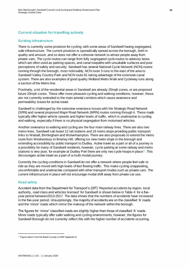
Existing infrastructure
There is currently some provision for cycling, with some areas of Sandwell having segregated,
safe infrastructure. The current provision is sporadically spread across the borough, both in
quality and amount, and so does not offer a cohesive network to attract people away from
private cars. The cycle routes can range from fully segregated cycle routes to advisory lanes which are often used as parking spaces, and canal towpaths with unsuitable surfaces and poor
perceptions of safety and security. Sandwell has several National Cycle Network (NCN) routes
running through the borough, most noticeably, NCN route 5 runs to the east of the area to
Sandwell Valley Country Park and NCN route 81 taking advantage of the extensive canal
system. There are also examples of good quality Midland Metro Walk and Cycleway runs along
a section of the Metro line.
Positively, a lot of the residential areas in Sandwell are already 20mph zones, or are proposed
future 20mph zones. These offer more pleasant cycling and walking conditions, however, these
are not currently extended to the main arterial corridors which cause severance and
permeability issues for active travel.
Sandwell is challenged by the extensive severance issues with the Strategic Road Network (SRN) and several proposed Major Road Network (MRN) routes running through it. These roads
typically offer higher vehicle speeds and higher levels of traffic, which is unattractive to cycling
and walking, especially if there is no physical segregation from motorised vehicles.
Another severance to walking and cycling are the four main railway lines. There are also two
metro lines. Sandwell can boast 12 rail stations and 16 metro stops providing public transport links to Walsall, Birmingham and Wolverhampton. There are also proposals to extend the metro
route from Wednesbury to Brierley Hill, offering six new metro stops in the borough and
extending accessibility by public transport to Dudley. Active travel as a part or all of a journey is
a possibility for many of Sandwell residents, however, cycle parking at some railway and metro
stations is very poor, for example at Dudley Port there are only two cycle hoops in place11. This discourages active travel as a part of a multi-modal journey.
Currently the cycling conditions in Sandwell do not offer a network where people feel safe to
ride as they are mixed with high levels of fast flowing traffic. This make cycling unappealing,
uncomfortable and unattractive compared with other transport modes such as private cars. The
current infrastructure in place will not encourage modal shift away from private car use.
Road safety
Accident data from the Department for Transport’s (DfT) ‘Reported accidents by region, local
authority, road class and vehicles licensed’ for Sandwell is shown below in Table 4: for a five-year period between2013-2017. The data shows that the numbers of accidents have increased
in the five-year period. Unsurprisingly, the majority of accidents are on the classified ‘A’ roads
and the ‘minor’ roads which mirror the makeup of the network within the borough.
The figures for ‘minor’ classified roads are slightly higher than those of classified ‘A’ roads.
Minor roads typically offer safer walking and cycling environments, however, the figures for
Sandwell Borough do not currently reflect this with the higher number of accidents occurring.
11 Figure taken f rom the Black Country LCWIP Appendix D
Mott MacDonald | Sandwell Council Local Cycling and Walking Infrastructure Plan Strategic Outline Case
404789AA01 | 1 | B | | 1 January 2020
26
Table 4: Sandwell’s accident data by road type (2013 – 2017)
Year Motorway A Trunk12 A Principle All A
Roads13
Minor All
2013 40 0 229 229 265 534
2014 48 4 281 285 296 629
2015 33 1 271 272 346 651
2016 44 3 225 228 341 611
2017 31 4 257 261 347 639
Source: RAS10014: Reported accidents by region, local authority, road class and vehicles licensed: England (ODS,
66.8KB) https://www.gov.uk/government/statistical-data-sets/ras10-reported-road-accidents
Although we do not have the figures for Sandwell Borough with regards to the amounts of accidents pedestrians and cyclists have been involved in, data has been extracted from DfTs
‘Reported casualty and accident rates by urban and rural roads, road class, road user type,
severity and pedestrian involvement, Great Britain’ to show the national figures of cyclist and
pedestrian involvement in accidents. This is a general reflection which can also be associated
with Sandwell. The data has been extracted for a five year period of 2013-2017 and shown below in Table 5:.
Table 5: Numbers of pedestrians and cyclists involved in accidents
Year Cyclists Pedestrians
2013 19,752 24,033
2014 21,624 24,748
2015 19,172 24,061
2016 18,743 23,550
2017 18,651 23,805
Source: RAS30018: Reported casualty and accident rates by urban and rural roads, road class, road user type, severity
and pedestrian involvement, Great Britain, 2017. https://www.gov.uk/governmaent/publications/reported-road-casulties-
great-britain-annual-report
With the exception of 2014, there appears to be a decline nationally in cyclists involved in accidents. The pedestrian rate also appears to be declining, however at a slightly slower rate.
For the same five year period, data has been extracted to show which vehicles are involved in
pedestrian accidents in Great Britain and the casualty severity of pedestrians and cyclists
across the UK. This data is shown Table 6: and Table 7: respectively.
Table 6: Pedestrians accidents involving other vehicles, Great Britain
Year Bicycle Motorcycle Car Bus or
Coach
Van / LGV HGV
2013 446 883 19,525 1,035 1,440 424
2014 498 939 20,094 1,064 1,478 435
2015 444 1,057 19,397 1,006 1,435 433
2016 460 1,085 18,897 892 1,357 412
12 Based on 2010 Core network 13 Includes 'A' roads where trunk/principal status could not be allocated
Mott MacDonald | Sandwell Council Local Cycling and Walking Infrastructure Plan Strategic Outline Case
404789AA01 | 1 | B | | 1 January 2020
27
Year Bicycle Motorcycle Car Bus or
Coach
Van / LGV HGV
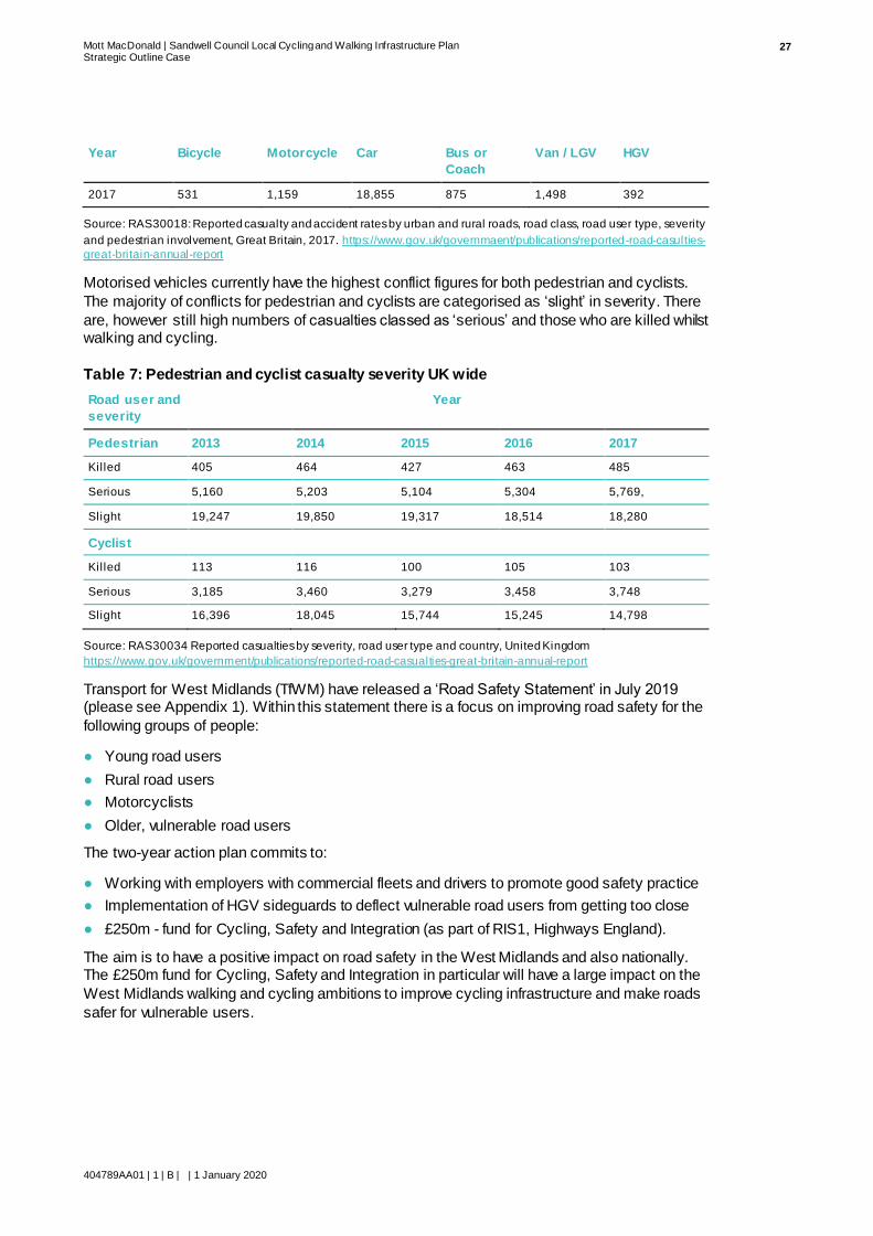
2017 531 1,159 18,855 875 1,498 392
Source: RAS30018: Reported casualty and accident rates by urban and rural roads, road class, road user type, severity
and pedestrian involvement, Great Britain, 2017. https://www.gov.uk/governmaent/publications/reported-road-casulties-
great-britain-annual-report
Motorised vehicles currently have the highest conflict figures for both pedestrian and cyclists.
The majority of conflicts for pedestrian and cyclists are categorised as ‘slight’ in severity. There
are, however still high numbers of casualties classed as ‘serious’ and those who are killed whilst walking and cycling.
Table 7: Pedestrian and cyclist casualty severity UK wide
Road user and
severity
Year
Pedestrian 2013 2014 2015 2016 2017
Killed 405 464 427 463 485
Serious 5,160 5,203 5,104 5,304 5,769,
Slight 19,247 19,850 19,317 18,514 18,280
Cyclist
Kil led 113 116 100 105 103
Serious 3,185 3,460 3,279 3,458 3,748
Slight 16,396 18,045 15,744 15,245 14,798
Source: RAS30034 Reported casualties by severity, road user type and country, United Kingdom
https://www.gov.uk/government/publications/reported-road-casualties-great-britain-annual-report
Transport for West Midlands (TfWM) have released a ‘Road Safety Statement’ in July 2019 (please see Appendix 1). Within this statement there is a focus on improving road safety for the
following groups of people:
● Young road users
● Rural road users
● Motorcyclists
● Older, vulnerable road users
The two-year action plan commits to:
● Working with employers with commercial fleets and drivers to promote good safety practice
● Implementation of HGV sideguards to deflect vulnerable road users from getting too close
● £250m - fund for Cycling, Safety and Integration (as part of RIS1, Highways England).
The aim is to have a positive impact on road safety in the West Midlands and also nationally. The £250m fund for Cycling, Safety and Integration in particular will have a large impact on the
West Midlands walking and cycling ambitions to improve cycling infrastructure and make roads
safer for vulnerable users.

Mott MacDonald | Sandwell Council Local Cycling and Walking Infrastructure Plan Strategic Outline Case
404789AA01 | 1 | B | | 1 January 2020
28
How SCWIP can impact on these issues
● The SCWIP, along with other planned walking and cycling infrastructure improvements in
the borough, will support the development of a coherent walking and cycling network.
● By incorporating walking and cycling to rail and metro stations, cycling and walking will become an integrated mode of transport and more likely be used as part of a multi-modal
journey and encourage first and last mile journeys to be made actively.
● Accident statistics have shown a growth in accidents over the five-year period from 2013
to 2017. The ambitions to improve road safety for vulnerable road users will be recognised by the implementation of safer walking and cycling infrastructure through the SCWIP and
other planned infrastructure developments.
● The safety benefits of providing dedicated infrastructure, such as that recommended by
the SCWIP will normalise walking and cycling due to minimised risks from travelling actively
Impact of not developing the SCWIP
Without the development of a SCWIP, Sandwell’s population will continue to be reliant on
private vehicle which would have the following consequential impacts on the borough:
● Sandwell would not be supporting key national, regional and local policies to encourage the
use of sustainable transport alternatives to private car use
● Sandwell will not be able to support the continued growth of the borough as all new trips will
continue to be reliant on private vehicle with the lack of an attractive walking and cycling
network to offer a choice of an alternative
● Reliance of private vehicle will exacerbate the current congestion issues and have a further detrimental impact on local air quality
● The obesity and overweight statistics for Sandwell will remain stagnant or deteriorate further
without opportunities to incorporate physical activity through increased levels of walking and
cycling. This will limit, or slow down, the economic development of the borough.
● By not developing a coherent or attractive cycling and walking network, Sandwell will be
limiting opportunities to realise the 2030 vision of Sandwell being “a place where we live
healthy lives and live them for longer.”
● A modal shift away from private car will be limited without the SCWIPs contribution to other
proposed regional infrastructure proposals for walking and cycling
● Road safety for vulnerable road users, such as pedestrians and cyclists, will unlikely be
improved without implementing safe walking and cycling infrastructure such as those recommended through the SCWIP.

Mott MacDonald | Sandwell Council Local Cycling and Walking Infrastructure Plan Strategic Outline Case
404789AA01 | 1 | B | | 1 January 2020
29
Economic Case
Economic appraisal
The current Business Case analysis tools for the economic case are geared towards large highway or public transport schemes rather than active travel schemes. As such the usual
appraisal methods are not appropriate to show the benefits of walking and cycling
improvements. Best practice from countries renowned for their progress on cycling (such as
Denmark, Holland and Sweden) indicates that they do not typically justify new and / or improved
cycling and walking infrastructure through the usual BCR figures used for other transport modes due to the number of, currently, unquantifiable benefits walking and cycling have. TAG UNIT
A5.114 does give guidance appraisal techniques for active travel and as such the SCWIP will be
appraised against the following from the guidance:
● Physical activity
● Journey quality
● Accidents
● Environmental
● Time savings
Physical activity impacts
Physical activity impacts of active travel are measured based on the change in mortality
resulting from an increase in walkers and cyclists. Physical activity, through modal shift away
from private car use, in favour of active travel, results in the economic benefit of less absenteeism for businesses and education leading to less staff turnover for businesses and a
more active workforce and so successful businesses. An area of growing businesses and
economy are likely to attract more employees and residents which in turn sustains the growth of
said area.
The proposed routes have been strategically placed where it is believed that the highest uptake of walking and cycling will be or in areas where the existing cycle network needs connecting to
create a cohesive network. The SCWIP has been designed to be attractive to both those who
are regular cyclists and those who have not cycled for a long period of time. Segregation offers
higher levels of safety and comfort and so can be used by a much wider community than the
current infrastructure and so will result in higher usage. The routes are located along employment corridors and also serve a number of high streets and education establishments.
This encourages the physical activity of cycling to become a part of everyday life.
The proposed walking infrastructure contains a lot of smaller improvements such as dropped
kerbs, tactile paving and wayfinding. These elements are important to ensuring all people feel
confident when walking, especially so for people with disabilities. By allowing walking to be an
option to all people, a higher uptake will occur increasing the physical activity of the population.
14 https://assets.publishing.service.gov.uk/government/uploads/system/uploads/attachment_data/file/712970/tag-unit-a5-1-active-mode-
appraisal-may-2018.pdf?_ga=2.103968326.712311158.1566897113-1235111002.1510753223

Mott MacDonald | Sandwell Council Local Cycling and Walking Infrastructure Plan Strategic Outline Case
404789AA01 | 1 | B | | 1 January 2020
30
Journey quality impacts
Journey quality will be improved through offering safer cycle infrastructure with high quality
cycle surfacing and allowing dedicated space for cycling. Quality of a journey is based on the safety perceptions as well as infrastructure and environmental conditions along a route.
As many of the routes are aligned to some of the major arterial transport corridors , the current
infrastructure does not offer protection from other modes of transport, heightening the
perceptions and real dangers of current cycling in Sandwell. The recommendations suggested
offer protection from other transport modes, through segregation, especially along the arterial routes which offer higher volumes and speeds of traffic. Infrastructure improvements to include
active travel priority at both major and minor junctions will offer safety benefits for both walking
and cycling and so journey quality improvements. This in turn will encourage further uptake in
walking and cycling across the borough.
Accident impacts
DfT’s Active Mode Appraisal states that the accident impacts should be measured as:
“accident analysis should take account of changes in accidents involving pedestrians and
cyclists, resulting from changes in walking and cycling and the infrastructure used, and the impact of mode switch on accidents involving other road users”15
The data extracted and demonstrated in Table 7: showing the casualty severity of pedestrians
and cyclists UK wide can potentially be a reflection of the casualty severity within the Sandwell borough. As shown in Table 6: the largest conflict for pedestrians and cyclists are cars and
other motorised vehicles. As such, the segregated nature of recommendations alongside
junction and crossing improvements will separate pedestrians and cyclists from motorised
vehicles and so minimise the risk of conflict.
The SCWIP promotes safety for walking and cycling through segregated infrastructure and as such minimises the perceptions and reality of danger whilst travelling actively, encouraging
uptake of walking and cycling.
Environmental impacts
“The environmental benefits from a walk or cycling scheme are achieved through a reduction in
motorised traffic and hence a reduction in the associated externalities ”16
The implementation of the SCWIP will encourage a modal shift in favour of active travel through:
● Showing that walking and cycling are modes of transport rather than just for leisure
● Offering safe, segregated routes, separating pedestrians and cyclist from motor traffic
● Offering convenient routes to large trip generators such as workplaces, high streets and
higher education establishments
● Creating a coherent walking and cycling network across the borough
Modal shift towards walking and cycling, away from private vehicle use, will reduce NO2
emissions through reduction in the use of cars and also through reduction in congestion. This
will be monitored in the existing six locations within the borough.
15 https://assets.publishing.service.gov.uk/government/uploads/system/uploads/attachment_data/file/712970/tag-unit-a5-1-active-mode-
appraisal-may-2018.pdf?_ga=2.103968326.712311158.1566897113-1235111002.1510753223 16 https://assets.publishing.service.gov.uk/government/uploads/system/uploads/attachment_data/file/712970/tag-unit-a5-1-active-mode-
appraisal-may-2018.pdf?_ga=2.103968326.712311158.1566897113-1235111002.1510753223

Mott MacDonald | Sandwell Council Local Cycling and Walking Infrastructure Plan Strategic Outline Case
404789AA01 | 1 | B | | 1 January 2020
31
Time saving impacts
Congestion is currently a major issue for Sandwell which increases journey time for those
travelling within and through the borough. It also impacts on bus reliability and journey time, meaning that public transport is often not an attractive enough option to encourage modal shift
away from the private vehicle. As the congestion is so severe in the borough, walking and
cycling could offer (?) quicker, more reliable journeys if infrastructure was in place to make it an
attractive option such as segregation, short cuts and to destinations of interest.
“While many active mode schemes may aim to increase demand for walking and cycling through improved quality of facilities, they may also result in time savings to pedestrians and
cyclists through provision of quicker or shorter routes.”17
A modal shift towards active travel in favour of private car would also reduce the number of trips made on the highway network by motorised vehicles and increasing capacity. By removing
some car trips from the network, journey times for other road users can also be reduced.
Cost of the SCWIP
Cycle route costings
Each of the cycle routes have been given an indicative cost. The costs of the routes have been
determined through the following methodology:
● Stage 1: A high cost and low cost based on the Greater Manchester Cycling Design
Guidance and Standards, excluding contingency
● Stage 2: The Greater Manchester Cycling Design Guidance and Standards costings were
reviewed by SMBC
● Stage 3: SMBC Highways Team produced a highest cost estimate which included a 20%
contingency
● Stage 4: An average was taken from the SMBC highest cost estimate and Greater
Manchester Cycling Design Guidance and Standards low cost to produce a final indicative
cost
The final indicative costs, along with SMBC high cost estimates and Greater Manchester Cycling Design Guidance and Standards low-cost estimate are shown below in Table 8: below.
Table 8: Cycle route costings
Cycle
Route
Number
Cycle Route Description Highways
Highest
Lowest using
Manchester
Cycle Design
Guidance based
approach
Average of
both
1 Birmingham Canal – West Bromwich via Spon Lane
£600,000 £256,700 £428,350
2 NCN Route 5 Improvements, linking to
WMLCWIP route
£210,000 £212,000 £211,000
17 https://assets.publishing.service.gov.uk/government/uploads/system/uploads/attachment_data/file/712970/tag-unit-a5-1-active-mode-
appraisal-may-2018.pdf?_ga=2.103968326.712311158.1566897113-1235111002.1510753223

Mott MacDonald | Sandwell Council Local Cycling and Walking Infrastructure Plan Strategic Outline Case
404789AA01 | 1 | B | | 1 January 2020
32
Cycle
Route
Number
Cycle Route Description Highways
Highest
Lowest using
Manchester
Cycle Design
Guidance based
approach
Average of
both
3 Spon Lane to Black Lake (Metro stop) Along Kelvin Way & Great Bridge
£300,000 £1,672,200 £986,100
4 Oldbury to Blackheath Town Centre
£420,000 £1,327,700 £873,850
5 Oldbury to Bearwood with links to WMLCWIP
Route
£900,000 £1,098,200 £999,100
6 Oldbury to Galton Bridge Station
£600,000 £1,357,800 £978,900
7 Stone Cross to Yew Tree via Tame Bridge Parkway Railway Station
£360,000 £898,600 £629,900
8 Tipton to Wednesbury Town Centre via Metro
£468,000 £816,800 £642,400
9 Tividale to Dudley Port via Sheepwash Nature Reserve
£300,000 £455,800 £377,900
10 Cradley Heath to boundary with Dudley
MBC, via railway station
£360,000 £518,200 £439,100
11 Cape Hill to Black Patch via Midland Metropolitan Hospital
£360,000 £355,700 £357,850
12 Walsall canal to Birmingham canal through Tipton via Alexander High School
£780,000 £1,193,000 £986,500
13 Old Hill Railway Station to Bumble Hole Nature Reserve via Dudley Canal
£780,000 £472,500 £626,250
14 Toll End to Hill Top, via Harvills Hawthorn
£360,000 £268,000 £314,000
15 Newton Road to A34 via Wilderness Lane
£564,000 £455,000 £509,500
Totals £7,362,000 £11,358,200 £9,360,700
It must be noted that the final indicative costs may change subject to detailed design, site investigations and exclude engineer design fees. Additional costs may be incurred for example
through complicated service diversions and ground works for each route which are yet
unknown.

Mott MacDonald | Sandwell Council Local Cycling and Walking Infrastructure Plan Strategic Outline Case
404789AA01 | 1 | B | | 1 January 2020
33
Core walking zone costings
The core walking zones consist of numerous different infrastructure recommendations as well
as recommended regeneration or public realm led schemes. These elements cannot be costed as further feasibility and design needs to be implemented. As such the core walking zones have
been costed by SMBCs Highway Team on the following infrastructure across all six of the core
walking zones:
● Dropped kerbs: Two bullnosed kerbs and two dropper kerbs, includes adjustments to the
pathway
● Tactile paving: Two rows of eight slabs, bullnosed kerbs and dropper kerbs, includes
adjustments to the pathway
● Signage: Non illuminated signs
● Resurfacing: Based on distance of requirement assuming a two-metre-wide footway with a
25mm overlay
● Parking controls: Based on distance of requirement, traffic regulation orders (TROs), lining and signage
● Zebra crossings: Two columns with beacons, tactile crossings
● Pedestrian crossing alterations: Telent costs including change of control
● 20mph zones: Based on distance of requirement, TRO, lining and signage
● Lighting: Based on number of lights required and 6m column with LED lantern for each
● Removal of guard railing: including reinstatement / TM
● Introduction of bollards: Based on distance of requirement with bollards at two metre
intervals
● Vegetation clearance: Based on distance of requirement assuming two metre wide
vegetation clearance - shrubs, no excavation
As with the cycle route costings it must be noted that the final indicative costs may change
subject to detailed design and site investigations and exclude engineer design fees. Additional
costs may be incurred for complicated service diversions and ground works for each route
which are yet unknown.
The indicative costs for each core walking zone are showed in Table 9:
Table 9: Core walking zones indicative costs
Core
Walking
Zone
Description
Indicative Cost
1 Black Heath town centre to Rowley Regis Railway Station £415,500
2 Smethwick Rolfe Street Station to Midland Metropolitan Hospital via
Windmill Eye £690,200
3 High Street to Langley Green Railway Station £299,200
4 Sandwell and Dudley Railway Station to Bromford Lane Residential
Estate £202,600
5 Wednesbury Great Western Street to Town Centre £101,100
6 Friar Park and Yew Tree to Tame Bridge Parkway Railway Station £1,054,400
Total £2,763,000

Mott MacDonald | Sandwell Council Local Cycling and Walking Infrastructure Plan Strategic Outline Case
404789AA01 | 1 | B | | 1 January 2020
34
As is usual with pedestrian improvements, it is unlikely that all infrastructure will be implemented
at the same time. The cost of the walking improvements will be spread over the period in which
the SCWIP is implemented.
Total SCWIP cost
The total indicative cost of SCWIP is: £12,123,700.
Potential funding sources
Potential funding sources have already been found for some of the cycle routes. These are
shown in Table 10:
Table 10: Potential Funding Sources
Cycle Route Funding Source Amount Predicted
4 Major Route Network funding. Two phases of funding. Currently unknown
11 Section 106 funding available £50,000
All National Productivity Infrastructure Fund (NPIF) To Be Announced (TBA)
All Transforming Cities Fund (TCF) Currently unknown
All Integrated Transport Block (ITB) £250k per annum
1, 3, 4, 5, 7, 8, 9,
10, 11, 13, 14
Housing Infrastructure Fund (HIF) TBA
3, 4, 6, 7, 9, 10,
11, 12, 13
Access to Rail/Rail Investment Funds Currently unknown
Value for money
The return on cycling investment is maximised when existing cyclists utilise it more frequently
and there is new uptake of cycling because of the route18. A recent Government report on the
return of cycling and walking concluded: “All of the studies in the UK and beyond report
economic benefits of walking and cycling interventions which are highly significant, and these
average 13:1[Benefit Cost Ratio (BCR)].”19 The threshold of BCR are 4:1 which are considered ‘very high’ value for money by DfT. BCRs for walking and cycling infrastructure are considerably
greater than the threshold and have multiple benefits:
● Easing congestion
● Improving health
● Reducing pressure on infrastructure
● Environmental benefits
● Journey quality
● Road safety
18 Get Britain Cy cling Report, https://allpartycycling.files.wordpress.com/2013/04/get-britain-cycling1.pdf 19 The British Cycling Economy, ‘Gross Cycling Product Report’, January 2001

Mott MacDonald | Sandwell Council Local Cycling and Walking Infrastructure Plan Strategic Outline Case
404789AA01 | 1 | B | | 1 January 2020
35
Letters of Support
A number of letters of support for the SCWIP have been received by stakeholders including the
Canal and River Trust, the Black Country Local Enterprise Partnership and Transport for West
Midlands. These can be found at Appendix I of the SWCIP main report.
Summary
● The total indicative cost of SCWIP is £12,123,700.
● Some potential funding has already been sourced
● The economic benefits cannot be quantified at this point however, using the DfT guidance
for active travel appraisal the SCWIP offers large benefits in terms of physical activity uptake, journey quality improvements, accident reduction, environmental benefits and
journey time savings.
● Convenient routes to large trip generators such as workplaces, high streets and higher
education establishments is facilitated through SCWIP due to the segregated nature of the recommended infrastructure
● This will promote walking and cycling as an alternative transport mode and not just a form
of leisure.

Mott MacDonald | Sandwell Council Local Cycling and Walking Infrastructure Plan Strategic Outline Case
404789AA01 | 1 | B | | 1 January 2020
36
Management Case
The management case assesses if a proposed scheme is deliverable. The SCWIP management case is based on the Black Country Walking & Cycling Strategy management
case to ensure consistency in delivery throughout the region. At this stage of the SCWIP a high-
level description of the management process, identified risks and lessons learnt have been
identified.
Prioritisation
The cycle routes have been prioritised in order of delivery. This is shown below in Table 11:.
Table 11: Prioritised List of Cycle Routes
Route Name Score* Priority
9 Tividale to Dudley Port via Sheepwash Nature Reserve 19 1
4 Oldbury to Blackheath Town Centre 18 2
8 Tipton to Wednesbury Town Centre via Metro 18 3
1 Birmingham Canal – West Bromwich via Spon Lane 17 4
3 Spon Lane to Black Lake (Metro stop) Along Kelvin Way & Great
Bridge
17 5
6 Oldbury to Galton Bridge Station 17 6
12 Walsall canal to Birmingham canal through Tipton via Alexander
High School
17 7
14 Toll End to Hill Top, via Harvills Hawthorn 17 8
2 NCN Route 5 Improvements, l inking to WMLCWIP route 15 9
5 Oldbury to Bearwood with links to WMLCWIP Route 15 10
11 Cape Hill to Black Patch via Midland Metropolitan Hospital 15 11
13 Old Hill Railway Station to Bumble Hole Nature Reserve via Dudley
Canal
15 12
10 Cradley Heath to boundary with Dudley MBC, via railway station 14 13
7 Stone Cross to Yew Tree via Tame Bridge Parkway Railway Station 13 14
15 Newton Road to A34 via Wilderness Lane 11 15
* Subject to meeting objectives set out in WebTAG and funding available
Management process
The below diagram shows the Black Country’s intended process for delivering their LCWIP . This
is a typical process of delivering high quality cycling and walking infrastructure which usually
takes about 18 months to deliver with:
● Four months spent on the feasibility study
● Eight months spent on the Preliminary and detailed designs
● Six months spent on the construction of the route (may vary dependent on the length of the
route)
Figure 7: shows the management process and details the elements of each stage.

Mott MacDonald | Sandwell Council Local Cycling and Walking Infrastructure Plan Strategic Outline Case
404789AA01 | 1 | B | | 1 January 2020
37
Figure 7: Management process
Source: Black Country LCWIP, Appendix D
Stages of the management process can overlap, depending on the complexity and length of the route.
In order to deliver the SCWIP, SMBC will have to joint work with a consortium of different
partners typical of cycle and walking infrastructure and so it is likely the SCWIP will follow a
similar process. The consortium will include:
● Council Officers and Politicians
● Project and Programme Team
● Stakeholders
– User groups
– Frontagers
– Businesses
● Design Engineers
● Powers and Consent
● Traffic and Signal Engineers
● Other Experts and Specialists
● Communications and Marketing
● Supporting measures / Behaviour Change
● Construction Managers
● Contractors
Identified risks20
There are a number of key risks to consider when implementing walking and cycling
infrastructure and that may impact on the delivery of the scheme. These include:
20 The identif ied risks have been directly taken from the Black Country LCWIP Appendix D as they are likely to be the same risks and
lessons learnt which will impact on the delivery of SCWIP
Feasibil ity Study
• Route alignment
• Scoping / planning
• Stakeholder input
• Set of measures
Preliminary Design
• Network modelling
• Public consultation
• Safety Audit Stage 1
• Consents / orders
• Civils design (2D)
• Scheme approval
Detailed Design
• Civils design (3D)
• Traffic management
• Safety Audit Stage 2
• Build schedule
• Consents / orders
• Works approval
Construction
• Construction
• Supporting measures
Operation
• Monitoring
• Safety Audit Stage 3
• Handover
• Supporting measures

Mott MacDonald | Sandwell Council Local Cycling and Walking Infrastructure Plan Strategic Outline Case
404789AA01 | 1 | B | | 1 January 2020
38
● Restricted road space
● Competing demands and priorities
● Approvals processes
● Providing consistent routes
● Politics
● Parking and loading
● Major infrastructure barriers
● Land and highway ownership
● Legislation
● Timescales of delivery
Lessons learnt21
Lessons learnt from the implementation of other walking and cycling infrastructure are:
● Benefits of managing schemes as whole routes
● Benefits of pairing hard and soft measures
● The cost of works which are ‘unseen’
● Importance of good surfacing
● Importance of good infrastructure
● Importance of political support
● Importance of methods of stakeholder engagement
● Integrating different schemes and benefits
Summary
● A high-level management plan has been suggested based on the Black Country LCWIP
● Potential delivery partners have been identified
● Common delivery risks have been identified
● Lessons learnt have been identified from other schemes
21 The identif ied lessons learnt have been directly taken from the Black Country LCWIP Appendix D as they are likely to be the s ame
risks and lessons learnt which will impact on the delivery of SCWIP

Mott MacDonald | Sandwell Council Local Cycling and Walking Infrastructure Plan Strategic Outline Case
404789AA01 | 1 | B | | 1 January 2020
39
Appendices
Appendix 1: TfWM Road Safety Statement 40

Mott MacDonald | Sandwell Council Local Cycling and Walking Infrastructure Plan Strategic Outline Case
404789AA01 | 1 | B | | 1 January 2020
40
Appendix 1: TfWM Road Safety Statement

Mott MacDonald | Sandwell Council Local Cycling and Walking Infrastructure Plan Strategic Outline Case
404789AA01 | 1 | B | | 1 January 2020
41
mottmac.com