APPENDIX B - Network Cycling Routes - CYCLEWight
33
APPENDIX B Network Cycling Routes
-
Upload
khangminh22 -
Category
Documents
-
view
0 -
download
0
Transcript of APPENDIX B - Network Cycling Routes - CYCLEWight

APPENDIX B Network Cycling Routes

Newport Cycling Network: Route Proposals NC1 Mews Lane to Newport Quay Route Description
This route involves the Improvement of an existing sub-standard former railway line route to allow all-weather cycling, improve convenience and comfort and strengthen links with local residential areas. Improvements proposed include surfacing, widening and lighting of the route. It connects with the cycle route to Wootton/Ryde (NCN 22), existing and proposed housing, Medina College, Medina Leisure Centre, Orchards Hospital and Mountbatten Hospice. A spur links to Cooper Road providing connections to the quiet residential streets beyond. A short spur connects with NC9 and links Medina College directly to the route. Future extension of the route along the former railway line as far as Wootton Bridge would be desirable, creating a high-quality link between the two settlements and providing an improved route for NCN22.
Route Map

Former rail line parallel to Fairlee Road
Image X: Former rail line parallel to Fairlee Road
Route Selection Tool Assessment

Infrastructure Improvements
Scheme Type Description Location Indicative Cost Deliverability 1 Improvement of
existing shared-use track
510m of new 3m wide, 2-way cycle track along old railway line route. Addition of lighting.
Mews Lane to Halberry Lane £183,000 5
2 New cycle track
50m of 2.5m wide shared use route linking Fairlee Rd with old railway line route almost opposite Medina College entrance
Fairlee Rd/Medina College access road
£15,000 3
3 New cycle crossing
Toucan crossing across Fairlee Rd linking the spur from the old railway line route with Medina College and leisure centre.
Fairlee Rd/Medina College access road
£62,000 4
4 New cycle crossing
Raised table, uncontrolled crossing at junction of Halberry Lane.
Halberry Lane /old railway line jct £15,000 5
5 New cycle track
Removal of barriers at both ends of track and drop kerbs at either end of lane that is already 3m wide but currently peds only
Between Cooper rd and Halberry Lane.
£8,000 4
6
On road improvements
185m of Quietway treatment. Creation of seemless links to other portions of route
Length of Gordon Rd between Halberry Lane and old railway line route
£18,500 5
7 Improvement of existing shared-use track
580m of new 3m wide, 2 way cycle track along old railway line route. Addition of lighting.
From junction of Halberry Lane /old railway line to St Paul's View Rd
£210,000 5
8 Improvement of existing shared-use track
Re-grading of slope and re-aligment of track on the approach to the old railway tunnel in order to reduce cyclists' speed and potential for pedestrian conflict
Slope down to old railway tunnel when approaching from east
£30,000 4
9 Improvement of existing shared-use track
Removal of chicane barrier at entrance to tunnel Old railway tunnel £2,000 5
10 Improvement of existing shared-use track
Upgrade lighting in the tunnel Old railway tunnel £15,000 5
11 Improvement of existing shared-use track
100m of new 3m wide, 2 way cycle track. Creation of seemless link to next portion of route.
West end of railway tunnel to Riverside Centre car park
£30,000 5
12 On road improvements
100m of Quietway treatment. Creation of seemless links to other portions of route
Riverside Centre car park to the quayside.
£10,000 0

NC2: Pan to Furrlongs Route Description:
This route links the south and west of the Pan housing estate and the new housing development off Godric Road with Newport town centre and NCN 23. New cycle tracks through Isobel Park and alongside Home Mead and the western end of Furrlongs are proposed. These sections are linked via Garden Way, improved as a Quietway. Junction improvements at St George’s Way provide a safe link on to NC3 next to Matalan. A short spur links the route along Garden Way to the new housing development off Godric Road.
Route Map

Junction of Pan Lane and Home Mead
Looking west along Garden Way
Route Selection Tool Assessment

Infrastructure Improvements
Scheme Type Description Location Indicative Cost Deliverability 1
New cycle track 160m of new 3m wide, 2 way cycle track. Creation of seemless link to next portion of route.
West side of Isobel Park linking with Garden Way
£48,000
5
2 On road improvements
210m of Quietway treatment. Creation of seemless links to other portions of route
Garden Way to Pan Lane £21,000 5
3
New cycle track 50m of new 3m wide, 2 way cycle track. Creation of seemless link to next portion of route.
Between Garden Way and new housing development off Godric Road
£15,000 5
4
New cycle track 440m of new 3m wide, 2 way cycle track using highway verge. Creation of seemless link to next portion of route.
From Pan Lane, using highway verge alongside Homemeade to Furrlongs and then down to St George's Way A3020.
£132,000 5
5 Junction improvement
Remodelling of junction to give priority to people cycling and walking
Jct of Furrlongs and St George's Way
£200,000 4
6 On road improvements
75m of Quietway treatment. Creation of seemless links to other portions of route
Jct of Furrlongs and St George's Way to the jct of NC3 (aka NCN23)
£7,500 5

NC3: Shide to Stag Lane Route Description
An existing cycle route forming the main north-south route across Newport in need of improvement to reach the standards required to support growth in everyday cycling. Proposed improvements focus on removal of barriers and widening of narrow sections including several narrow bridges, new, safe road crossings and significant improvements to Little London to prioritise walking and cycling. This will make the route more attractive and accessible to ride and facilitate extended use of the route which will form a key link between other routes, connecting with NC1, NC2, NC4, NC5, NC7, NC8, NC9 and NC10. It also provides onward links to Cowes and Sandown.
Route Map

Bridge at Pan Mill Meadows Little London, looking north
Route Selection Tool Assessment

Infrastructure Improvements
Scheme Type Description Location Indicative Cost Deliverability 1 New cycle
crossing Install parallel zebra crossing across Shide Rd Shide Rd and NCN23 £30,000 5
2 Improvement of existing shared-use track
Removal of bollards at entrance to Shide Path. Drop kerb installed.
Shide Path/Shide Lane jct. £4,000 5
3 Improvement of existing shared-use track
Removal of staggered barriers on Shide Path. Shide Path £2,000 5
4 New cycle bridge
Installation of 3m wide bridge to replace the existing 1.5m wide bridge
Where NCN23 crosses River Medina in Shide
£15,000 3
5 Improvement of existing shared-use track
Removal of guard railing where NCN23 meets St George's Way opposite Newport Football Club.
Where NCN23 meets St George's Way opposite Newport Football Club.
£2,000 5
6 New cycle bridge
Installation of 3m wide bridge to replace the existing narrow bridge.
Where NCN23 crosses Pan Stream
£15,000 3
7 New cycle track
50m of new 3m wide, 2 way cycle track creating a link from NCN23 to St George's Approach up the embankment.
Jct NCN23 and St George's Approach
£15,000 4
8 Improvement of existing shared-use track
New cantilevered cycle track decking under bridge to provide 3m width
Under bridge at St George's Approach
£30,000 3
9 Improvement of existing shared-use track
Installation of flush kerb for cyclists and peds and improved shared use signage
At jct of NCN23 and Matalan access road
£3,000 5
10
New cycle track
50m of new 3m wide, 2 way cycle track using verge alongside Matalan access road and ending just barriers the barriers that crosses the access road.
Matalan access road £15,000 3
11 On road improvements
190m of Quietway treatment along Matalan access road and then final stretch of Furrlongs leading to East Street, B3323, creation of seemless links to other portions of route
Matalan access road, Furrongs £19,000 5
12 On road improvements
Creation of raised table mini roundabout junction to slow traffic and increase cycle safety.
Jct of East St and Furrlongs £35,000 5
13
New cycle track 65m of new 3m wide, 2 way cycle track using edge of development site between East St and Pyle St.
Between Furrlongs and Pyle Street alongside East St.
£19,500 1
14 New cycle crossing Install parallel zebra crossing across Pyle Street Pyle St jct with
East St £30,000 4
15 Adjustment to existing
Re-work the the controlled crossing across High St so that cyclists and peds get a green when High Street traffic is held.
High St/Coppins Bridge jct £0 5

controlled crossing
16 On road improvements
210m of Quietway treatment, creation of seemless links to other portions of route
From junction of Sea St/High St along to jct of Sea St/Little London
£21,000 5
17 On road improvements
Remove redundant barrier apparatus in middle of road on entrance to County Hall car parking area on Sea St.
Sea St £2,000 5
18
Conversion of carriageway to cycle track
Prohibit motorised traffic along Little London from the Bargeman's Rest to Sea St. Install a turning head at south end of Bargemen's Rest, with filtered permeability towards Sea St. Create 115m of 4m, 2 way cycle track along the part of Little London no longer open to traffic.
Little London £20,000 3
19
On road improvements
470m of Quietway treatment, creation of seemless links to other portions of route
Along Little London from Bargeman's Rest to Blackhouse Quay/start of footpath N29
£47,000 5
20
Junction improvement
Re-work geometry of junction between Hurstake Rd and Little London to reduce vehicle speeds. Change priority so that users of the cycle route have priority over those travelling along Hurstake Rd.
Jct Hurstake Rd/Little London £10,000 5
21 Improvement of existing shared-use track
Removal of chicane barriers. Junction of cycle track and Blackhouse Quay.
£2,000 5
22 Improvement of existing shared-use track
Replace bollards with single bollard inset into track (away from turning point)
Cycle track junction with Riverway.
£2,000 5
23 Improvement of existing shared-use track
Improved identification of cycle route status especially across car park entrance. Parking controls to stop parking on track.
Cycle track next to Riverside Park car park.
£10,000 5
24 Improvement of existing shared-use track
Rearrange gated access to cycle track to provide cycle gaps of minimum 1.5m
Start of former railway line track £2,000 5
25 Improvement of existing shared-use track
Widen 250m long narrow concrete sections to minimum 2.5m
Between Riverway and Dodnor Lane.
£18,750 5
26 Improvement of existing shared-use track
Raise ground height either side of cycle track level with track.
Between Riverway and Dodnor Lane.
£5,000 5
27 Junction improvement
Remove barriers, parking controls to stop parking on track/junction, priority for cycle track across junction, traffic calming on approach.
Cycletrack junction with Dodnor Lane
£15,000 5
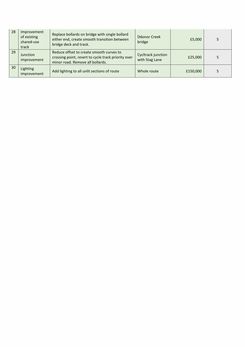
28 Improvement of existing shared-use track
Replace bollards on bridge with single bollard either end, create smooth transition between bridge deck and track.
Ddonor Creek bridge £5,000 5
29 Junction improvement
Reduce offset to create smooth curves to crossing point, revert to cycle track priority over minor road. Remove all bollards.
Cycltrack junction with Stag Lane £25,000 5
30 Lighting improvement Add lighting to all unlit sections of route Whole route £150,000 5

NC4: Church Litten to Town Centre Route Description
A new route providing safe access to the town centre from areas of housing on the south side of Newport, improving connectivity between NC3 and the town centre and increasing the permeability of the town centre by bike. A new cycle track is proposed alongside Church Litten, with improvements to junctions at Medina Avenue and South Street. A contraflow cycle track along Town Lane allows for two-way cycling in this section, and the east end of Pyle Street is proposed to be converted to a Quietway. Supporting measures to reduce traffic and improve permeability on surrounding streets would maximise the impact of this route.
Route Map

Church Litten, looking south Junction of Church Litten/South Street/Town Lane
Route Selection Tool Assessment

Infrastructure Improvements
Scheme Type Description Location Indicative Cost Deliverability 1 On road
improvements 95m of Quietway treatment, creation of seemless links to other portions of route York Rd £9,500 5
2 Junction improvement
Remodelling of junction to give priority to people cycling and walking
Jct York Rd and Medina Ave £100,000 4
3 New cycle track
260m of new 3m wide, 2 way cycle track using combination of footway and carriageway on west side of Church Litten (road).
Church Litten £156,000 4
4 Junction improvement
Remodelling of junction to give priority to people cycling and walking.
Jct of Church Litten/ South Street/Town Lane
£300,000 3
5 New cycle track 80m of contraflow, 1 way cycle cycle track
(1.5m wide)
Along whole length of Town Lane
£25,000 3
6 On road improvements
240m of Quietway treatment, creation of seemless links to other portions of route
Pyle St from Town Lane to Coppins Bridge junction
£24,000 5

NC5 Gunville to Town Centre Route Description
This provides a link between Gunville (residential areas and retail developments) and the town centre. This route would utilise Quietway treatment on Fieldfare Road, then a new dedicated cycle track from Purdy Road to Hazel Close, improved existing shared-use path to Foxes Road then Quietway treatment to Newport Harbour, including contraflow cycle track/lane on Crocker Street. A spur alongside Wellington Road provides access to the schools in this area. This route links five schools, multiple residential estates and the town centre. It also connects into NC3 at Newport harbour for onward links on the existing and proposed cycle network.
Route Map

Victoria Recreation Ground, looking south Wellington Road, looking east
Route Selection Tool Assessment

Infrastructure Improvements
Scheme Type Description Location Indicative Cost Deliverability 1
On road improvements
650m of Quietway treatment, creation of seemless links to other portions of route
Starting at jct of Gunville Rd with Taylor Rd, running along Taylor Rd, Fieldfare Rd until junction with Purdy Rd
£65,000 5
2
New cycle track 240m of new 3m wide, 2 way cycle track running along northern edge of school playing field/grounds
Christ the King school playing fields and grounds, from Purdy Rd to Wellington Rd
£72,000 2
3 New cycle crossing
Replace existing zebra crossing with a parallel zebra crossing
In front of Christ the King school on Wellington Rd
£30,000 5
4
New cycle track 465m of new 3m wide, 2 way cycle track using combination of existing verge, footway and carriageway.
From Carisbrooke School entrance to footpath N58 near eastern end of Wellington Rd
£279,000 4
5
New cycle track 650m of new 3m wide, 2 way cycle track running through playing fields and agreed access through primary school.
Through Vectis Playing Fields and Victoria Recreation Ground and along edge of Newport Primary School land.
£195,000 4
6 New cycle crossing
Install parallel zebra crossing where cycle track crosses Snowberry Lane
Jct of Snowberry Rd and shared use track
£30,000 5
7 Improvement of existing shared-use track
Remove bollards Jct of shared use track with Petticoat Lane
£2,000 5
8 Improvement of existing shared-use track
Improved route identity treatment on non-trafficked section for 100m.
Where shared use track approaches Foxes Rd at the back of Sainsbury's
£5,000 5
9
On road improvements
165m of Quietway treatment, creation of seemless links to other portions of route
From Foxes Rd (back of Sainsbury's) to Mill Street, along Mill St to Crocker St
£16,500 5
10
New cycle track 390m of 1.5m contraflow cycle lane with light segregation
Whole length of Crocker St, from Mill St to Holyrood St
£78,000 3
11 Junction improvement
Raised table junction and re-work geometry to slow traffic
Jct of Crocker St and St James St £45,000 5

12
On road improvements
115m of Quietway treatment, creation of seemless links to other portions of route
Short section of Holyrood St and then western section of Sea St to junction with Little London
£11,500 5

NC6 Mountbatten Drive to Petticoat Lane Route Description
This proposal is for the improvement and completion of an existing link between a large housing estate and Petticoat Lane, for onward connections to the town centre via NC5. Widening and improvement of existing dedicated and shared use route sections, addition of priority crossings where the route meets roads and a new cycle track to fill in a missing section between St Augustine’s Road and the Petticoat Lane/Sylvan Drive junction are proposed. This route links housing with a local primary school and the wider existing and proposed cycle network.
Route Map

Shared use path off Ward Close Junction of Sylvan Drive and Petticoat Lane
Route Selection Tool Assessment

Infrastructure Improvements
Scheme Type Description Location Indicative Cost Deliverability 1 Improvement
of existing shared-use track
Widening of 130m narrow sections of shared/partially segregated tracks, improved identification of cycle route status.
Mountbatten Drive to Sylvan Drive
£26,000 5
2 New cycle crossing
Install parallel zebra crossing where cycle track crosses Sylvan Drive Sylvan Drive £30,000 5
3 Improvement of existing shared-use track
Re-lay shared use track to ensure it remains level, with drive crossover level changes within buffer zone between track and carriageway. Distance of 220m. Continuous footway/cycleway across Juniper Close.
From Sylvan Drive crossing to St Augustines Road
£44,000 5
4 New cycle track
200m of new 3m wide, 2 way cycle track joining existing cycle track that runs next to Sylvan Drive with Petticoat Lane. Installation of lighting.
St Augustines Road - Petticoat Lane - Sylvan Drive
£72,000 2
5 New cycle crossing
Install parallel zebra crossing where cycle track crosses Sylvan Drive
Crossing of Petticoat Lane and Sylvan Drive
£30,000 5
6 Improvement of existing shared-use track
Improved route identity treatment on non-trafficked section for 175m. Install lighting
From crossing of Petticoat Lane and Sylvan Drive to junction with NC5.
£20,000 5

NC7: Parkhurst to Town Centre Route Description
This route will provide a high-quality route linking existing and planned housing at Parkhurst; St Mary’s Hospital; employment areas at Riverway and Dodnor; Isle of Wight College and Wakes retail park with the town centre, Newport Harbour regeneration area and other cycle routes. The route would require new track alongside Medina Way, possibly within hospital land, a safe, convenient crossing of the link between St Mary’s junction and the B&Q roundabout, a new track alongside Medina Way between the IW college and Little London, with a safe, convenient crossing of Riverway, possibly in the form of a new bridge and controlled crossing. This route could also provide a key connection to proposed new housing on the Camp Hill site.
Route Map

Medina Way, looking south Footpath alongside Medina Way approaching
the Isle of Wight College
Route Selection Tool Assessment

Infrastructure Improvements
Scheme Type Description Location Indicative Cost Deliverability 1
New cycle track
710m of new 3m wide, 2 way cycle track running along east side of Medina Way in front of hospital and using existing verge. 2 new raised table crossings across access roads to St Mary's Hospital.
From Hewitt Crescent to jct with Dodnor Lane
£426,000 3
2
New cycle crossing
Install parallel zebra crossing where cycle track crosses Dodnor Lane between St Mary's roundabout and B&Q roundabout. Note: planned junction changes may mean an alternative crossing type is more appropriate.
Dodnor Lane between St Mary's roundabout and B&Q roundabout
£30,000 3
3
New cycle track
880m of new 3m wide, 2 way cycle track running along east side of the dual carriageway (Medina Way) using existing verge and incorporating new bridge over Riverway and signal crossing of Medina Way slip road.
From Dodnor Lane to Little London £764,000 3

NC8: Dodnor Lane (North to South) Route Description
Part of this route involves the creation of a cycle priority route on a lightly trafficked lane (a rural Quietway) connecting the existing Cowes-Newport cycle track to the Dodnor and Riverway industrial estates. The second part involves the construction of a new cycle track along the west side of the more heavily trafficked part of Dodnor Lane between Sevenacres and the B&Q roundabout. This route offers a high-quality link between St Mary’s Hospital and the Cowes-Newport cycle track and provide key connectivity between routes NC3 and NC7 and various parts of the employment area. It also connects housing to the north of Newport to Cowes and ferry services to the mainland.
Route Map

Dodnor Lane, looking west Dodnor Lane, looking south
Route Selection Tool Assessment
Infrastructure Improvements
Scheme Type Description Location Indicative Cost Deliverability 1
On road improvements
670m of cycle and pedestrian priority treatment on lightly trafficked lane. Reduction of speed limit to 20mph. High visual priority for cycling and pedestrians. Addition of street lighting.
From jct of Dodnor Lane and NCN23 to rear entrance to Seven Acres unit at St Mary's Hospital.
£140,000 4
2
New cycle track 575m of new 3m wide, 2 way cycle track with street lighting running along west side of Dodnor Lane and using hospital land.
From rear entrance to Seven Acres unit at St Mary's Hospital to B&Q roundabout.
£380,000 2

NC9: Medina College/Leisure Centre to town centre Route Description
Improvements to this sub-standard cycle route are proposed to include widening, surfacing and improved crossings and creation of a Quietway section along Newport Quay. This would be accompanied by a short extension to provide a safe onward link to Fairlee Road and NC1 using a combination of new two-way cycle track and improvements to the car park access road including a contraflow cycle track. This route provides a key link between the town and Medina College (secondary school) and Medina Leisure Centre, improved sustainable access to Seaclose Park and connectivity to the Newport Harbour regeneration area. It also forms part of the link to Island Harbour (proposed to continue to East Cowes in the future).
Route Map

Medina College access road Shared use route south of Medina
Leisure Centre
Route Selection Tool Assessment

Infrastructure Improvements
Scheme Type Description Location Indicative Cost Deliverability 1
New cycle track 60m of new 3m wide, 2 way cycle track
From Fairlee Rd to the access road to Medina College across area of verge to the north of Medina College entry road
£18,000 5
2 On road improvements
Installation of 80m of 1.5m contraflow cycle track along Medina College access road
Medina College access road £10,000 5
3
Junction improvement
Create greater sense of priority for cycling and install traffic calming
At jct of Medina Leisure Centre car park egress road and cycle track (outside Medina Theatre entrance)
£10,000 5
4 Improvement of existing shared-use track
Widen to 3m and re-surface 720m of existing shared use track from Medina Theatre to Seaclose access road (running alongside Seaclose playing fields), addition of lighting.
Medina Theatre to Seaclose £188,000 5
5 Junction improvement
Install parallel zebra crossing where cycle track crosses Seaclose access road.
Jct of Seaclose access road and cycle track
£30,000 5
6
New cycle track
180m of new 3m wide, 2 way cycle track using space on playing fields and running parallel to footpath N120, addition of lighting.
On playing fields between Seaclose access road and Newport quay.
£60,000 4
7 On road improvements
400m of Quietway treatment, creation of seamless links to other portions of route
Quayside to Sea Street junction 40000+C125:F131 5

NC10: Cross Medina Route Route Description
This ambitious new route offers a valuable new connection across the River Medina providing key east-west connectivity and linking NC1, NC9 and NC10. The route involves improvements to the Seaclose/Fairleee Road junction to provide a safe cycle crossing, creation of a two-way cycle track alongside the Seaclose access road, construction of a new walking/cycling bridge across the Medina and improvement of the existing cycle link between NC3 and Riverway to create a link to the employment area here and Isle of Wight College. It also links the two National Cycling Network routes NCN 22 and NCN 23.
Route Map

Fairlee Road/Seaclose Park Seaclose Park looking west
Routes Selection Tool Assessment

Infrastructure Improvements
Scheme Type Description Location Indicative Cost Deliverability 1
New cycle track 25m of 3m, 2 way cycle track joining old railway line route (NC1) with Fairlee Rd at the junction of Fairlee Rd and Seaclose.
Along urban footpath that runs down the south side of Exotic Pets shop.
£7,500 3
2 Junction improvement
Remodelling of junction to give priority to people cycling and walking.
Fairlee Rd/Seaclose access road junction £200,000 3
3 New cycle track 330m of new 3m wide, 2 way cycle track running parallel to Seaclose access road Seaclose £99,000 4
4 New cycle bridge
Cycle and pedestrian bridge spanning River Medina for approx 200m from Seaclose to Blackhouse Quay
Seaclose to Blackhouse Quay £5,000,000 2
5 Improvement of existing shared-use track
60m of new 3m wide, 2 way cycle track creating a spur linking into Riverway Ind Est.
Along public footpath N29 from Riverway to Blackhouse Quay
£180,000 1