
CADASTRE SURVEY PRACTICE (SGHU 4323) - People@UTM
94
CADASTRE SURVEY (SBEU 3313) WEEK 9 & 10 – AMALAN PEJABAT SR DR. TAN LIAT CHOON 07-5543157 016-4975551 1
-
Upload
khangminh22 -
Category
Documents
-
view
2 -
download
0
Transcript of CADASTRE SURVEY PRACTICE (SGHU 4323) - People@UTM

CADASTRE SURVEY (SBEU 3313)
WEEK 9 & 10 – AMALAN PEJABAT
SR DR. TAN LIAT CHOON07-5543157
016-4975551
1

ISI KANDUNGAN
• Hitungan (Latit, Dipat, Tikaian Lurus)
• Persediaan dan format untuk jilid kira
• Hitungan Koordinat
• Hitungan keluasan
• Hitungan aras laras
2

HITUNGAN (LATIT, DIPAT, TIKAIAN LURUS)
3

Latit - Perbezaan pada Koordinat Utara / Selatan
➢ Tanda positif menunjukkan utara dan negatif menunjukkanselatan
Dipat - Perbezaan pada Koordinat Timur / Barat
➢ Tanda positif menunjukkan timur dan negatif menunjukkanbarat
❑ Bering dan jarak yang telah dilaras digunakan untukmenghitung latit dan dipat.
Hitungan Latit dan Dipat
4

5
Rajah Latit dan Dipat

latit
dipatA
B
T
U
Rajah Latit dan Dipat
6

Latit = J Cos
Dipat = J Sin
Di mana :
J adalah Jarak yang telah dilaras
adalah Bering yang telah dilaras
a
bc
Sebelah
Tentang
Sin A = Tentang
Kos A = Sebelah
Tan A = Tentang
Hipotenus
Hipotenus
Sebelah
Formula Menghitung Latit/Dipat
7

Contoh Hitungan Latit/Dipat
Latit
Latit = 37.938 x Cos 345o30’40”= 36.731
Dipat
Dipat = 37.938 x Sin 345o30’40”= -9.492
8

9
Stn Bering JarakLatit Dipat
U S T B
2
3 26 10 10 57.348 51.469 25.292
4 104 35 00 122.807 30.921 118.850
5 195 30 10 144.940 139.667 38.740
6 358 18 10 40.843 40.825 1.210
1 320 28 40 68.021 52.470 43.287
2 292 59 00 66.124 25.819 60.875
∑ 500.083 170.583 170.588 144.142 144.112
= 0.005 = 0.030
Latit = 170.583-170.588= -0.005
(- tulis di tempat S)Dipat = 144.142-144.112
= 0.030(+ tulis di tempat T)
Contoh Pembukan Hitungan Latit/Dipat
ΣL=341.171 ΣL=288.254

10
• Bertujuan mendapatkan kejituan dalam ukuran• Had yang dibenarkan mengikut PUK 2002 mestilah tidak
kurang 1 : 8000 untuk ukuran baru dan tidak kurang 1 : 4000untuk ukuran minima.
• Formula menghitung Tikaian Lurus
Tikaian Lurus = 1 : Jumlah Jarak√ Latit
2 + Dipat2
= 1 : 500.083√ 0.0052 + 0.0302
= 1 : 16,443
Hitungan Tikaian Lurus

Terdapat dua kaedah yang digunakan iaitu :
- Kaedah Transit
- Kaedah Bowditch
Pelarasan Latit/Dipat
11

Latitude And Departure
Closure of traverse is initiated by computing the latitude anddeparture of each line
❑ The latitude of course is its orthographic projection upon thenorth-south axis of the survey
❑ The latitude of course is simply the N component of a line inthe rectangular grid system
❑ The departure of course is its orthographic projection uponthe east-west axis of the survey
❑ The departure of course is simply the E component of line inthe rectangular grid system
12

Latitude And Departure
❑ In traverse calculations, latitudes and departures can beeither negative (-) or positive (+)
❑ North latitudes and east departures are consideredpositive (+)
❑ South latitudes and west departures are considerednegative (-)
13

Latitude And DepartureIn this example, the length of AB is 300 m and bearing is shown in figure below. Determine the coordinates of point 2
14
LatitudeP12 = (300) cos (42° 30’)
= 221.183 m
DepartureP12 = (300) sin (42° 30’)
= 202.677 m
EP2 = 200 + 202.677 = 402.667 m
NP2 = 300 + 221.183 = 521.183 m
Latitude = Northing
Departure = Easting
(Known)
Coordinates from point A
(E 200 , N 300)
N
E
P1
P2
(unknown = to be calculate)
Coordinates point A
(E 402.667 , N 521.183)
221.1
83 m
202.677 m
- S
- W

Latitude And DepartureIn this example, it is assumed that the coordinates of points 1 and 2 are known and we want to calculate the latitude and departure for the line AB
15
LatitudeP12 = NP2 – NP1
= -100 –(300)= - 400 m
DepartureP12 = EP2 – EP1
= 320 –(100)= 220 m
Latitude = NorthingDeparture = Easting
(known)
Coordinates from point A
(E 320 , S -100)
N
E
P1
P2
(known)
Coordinates point A
(E 100 , N 300)
- S
- W
-400 m
220 m

Latitude And Departure
Consider our previous example, determine the E and N coordinates of all the points
16
N
E
P1
- S
- W
P2
P4
P3
P5
SiteBalanced
Latitude Departure
S1-S2 - 188.388 - 20.601
S2-S3 - 152.252 86.648
S3-S4 29.933 - 195.470
S4-S5 139.080 - 30.551
S5-S1 171.627 159.974

Latitude And Departure
Consider our previous example, determine the E and N coordinates of all the points
17
N
E
P1
- S
- W
P2
P4
P3
P5
SiteBalanced
Latitude Departure
S1-S2 - 188.388
S2-S3 - 152.252
S3-S4 29.933
S4-S5 139.080
S5-S1 171.627
N coordinates
P3 = 0 m
P4 = P3 + 29.933 = 29.933 m
P5 = P4 + 139.080 = 169.013 m
P1 = P5 + 171.627 = 340.640 m
P2 = P1 + (- 188.388) = 152.252 m
P3 = P2 + (- 152.252) = 0 m

Latitude And Departure
Consider our previous example, determine the E and N coordinates of all the points
18
E coordinates
P5 = 0 m
P1 = P5 + 159.974 = 159.974 m
P2 = P1 + (- 20.601) = 139.373 m
P3 = P2 + 86.648 = 226.021 m
P4 = P3 + (- 195.470) = 30.551 m
P5 = P4 + (- 30.551) = 0 m
SiteBalanced
Latitude Departure
S1-S2 - 20.601
S2-S3 86.648
S3-S4 - 195.470
S4-S5 - 30.551
S5-S1 159.974
N
E
P1
- S
- W
P2
P4
P3
P5

Latitude And Departure
19
N
E
P1 (E 159.974 , N 340.640)
- S
- W
P2 (E 139.373 , N 152.252)
(E 30.551 , N 29.933) P4
P3 (E 226.021 , N 0)
(E 0 , N 169.013) P5

PERSEDIAAN DAN FORMAT UNTUK JILID KIRA
20

Measurement Sequence
A
B
C
D
E 21
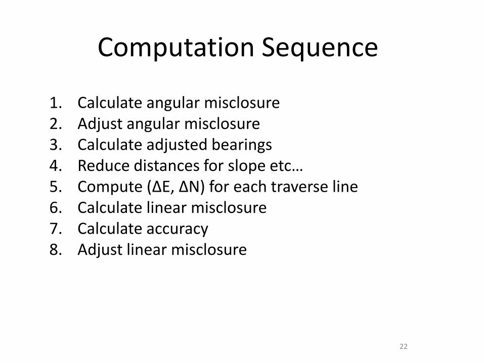
Computation Sequence
1. Calculate angular misclosure2. Adjust angular misclosure3. Calculate adjusted bearings4. Reduce distances for slope etc…5. Compute (∆E, ∆N) for each traverse line6. Calculate linear misclosure7. Calculate accuracy8. Adjust linear misclosure
22

Calculate Internal Angles
PointForesight
Azimuth
Backsight
Azimuth
Internal
Angle
Adjusted
Angle
A 21o 118o 97o
B 56o 205o 149o
C 168o 232o 64o
D 232o 352o 120o
E 303o 48o 105o
=(n-2)*180
Misclose
Adjustment
At each point :• Measure foresight azimuth• Measure backsight azimuth• Calculate internal angle (back-fore)
For example, at B :• Azimuth to C = 56o
• Azimuth to A = 205o
• Angle at B = 205o - 56o = 149o
23

Calculate Angular Misclose
PointForesight
Azimuth
Backsight
Azimuth
Internal
Angle
Adjusted
Angle
A 21o 118o 97o
B 56o 205o 149o
C 168o 232o 64o
D 232o 352o 120o
E 303o 48o 105o
=(n-2)*180 535o
Misclose -5o
Adjustment -1o
24

Calculate Adjusted Angles
PointForesight
Azimuth
Backsight
Azimuth
Internal
Angle
Adjusted
Angle
A 21o 118o 97o 98o
B 56o 205o 149o 150o
C 168o 232o 64o 65o
D 232o 352o 120o 121o
E 303o 48o 105o 106o
=(n-2)*180 535o 540o
Misclose -5o
Adjustment -1o
25

Compute Adjusted Azımuths
• Adopt a starting azimuth• Then, working clockwise around the traverse :
◼ Calculate reverse azimuth to backsight (forwardazimuth 180o)
◼ Subtract (clockwise) internal adjusted angle◼ Gives azimuth of foresight
• For example (azimuth of line BC)◼ Adopt azimuth of AB 23o
◼ Reverse azimuth BA (=23o+180o) 203o
◼ Internal adjusted angle at B 150o
◼ Forward azimuth BC (=203o-150o) 53o
26

Compute Adjusted Azımuths
LineForward Azimuth
Reverse Azimuth
Internal Angle
AB 23o 203o 150o
BC 53o
CD
DE
EA
AB
A
B
C
D
E
150o
27

Compute Adjusted Azımuths
LineForward Azimuth
Reverse Azimuth
Internal Angle
AB 23o 203o 150o
BC 53o 233o 65o
CD 168o
DE
EA
AB
A
B
C
D
E
65o
28

Compute Adjusted Azımuths
LineForward Azimuth
Reverse Azimuth
Internal Angle
AB 23o 203o 150o
BC 53o 233o 65o
CD 168o 348o 121o
DE 227o
EA
AB
A
B
C
D
E
121o
29

Compute Adjusted Azımuths
LineForward Azimuth
Reverse Azimuth
Internal Angle
AB 23o 203o 150o
BC 53o 233o 65o
CD 168o 348o 121o
DE 227o 47o 106o
EA-59o
301o
AB
A
B
C
D
E
106o
30

Compute Adjusted Azımuths
LineForward Azimuth
Reverse Azimuth
Internal Angle
AB 23o 203o 150o
BC 53o 233o 65o
CD 168o 348o 121o
DE 227o 47o 106o
EA 301o 121o 98o
AB 23o (check)
A
B
C
D
E
98o
31

(E, n) For Each Line
• The rectangular components for each line arecomputed from the polar coordinates (,d)
• Note that these formula apply regardless of thequadrant so long as whole circle bearings are used
cos)(
sin)(
dLN
dDE
=
=
32
Where
N(L) = LatitudeE(D) = Departure

Vector Components
Line Azimuth Distance N(L) E(D)
AB 23o 77.19 71.05 30.16
BC 53o 99.92 60.13 79.80
CD 168o 60.63 -59.31 12.61
DE 227o 129.76 -88.50 -94.90
EA 301o 32.20 16.58 -27.60
(399.70) (-0.05) (0.07)
33
147.76 147.81 122.57 122.50

Linear Misclose & Accuracy
• Convert the rectangular misclosure components topolar coordinates
• Accuracy is given by
22
1
)()(
)(
)(tan
DELNd
LN
DE
+=
= −
)/(:1 misclosurelinearlengthtraverse
Beware of quadrant whencalculating using tan-1
34

Example
• Misclosure (∆N(L), ∆E(D))◼ (-0.05 , 0.07)
• Convert to polar (∆,d)◼ ∆ = -54.46o (2nd quadrant) = 125.53o
◼ d = 0.09 m
• Accuracy◼ 1:(399.70 / 0.09) = 1:4441
35
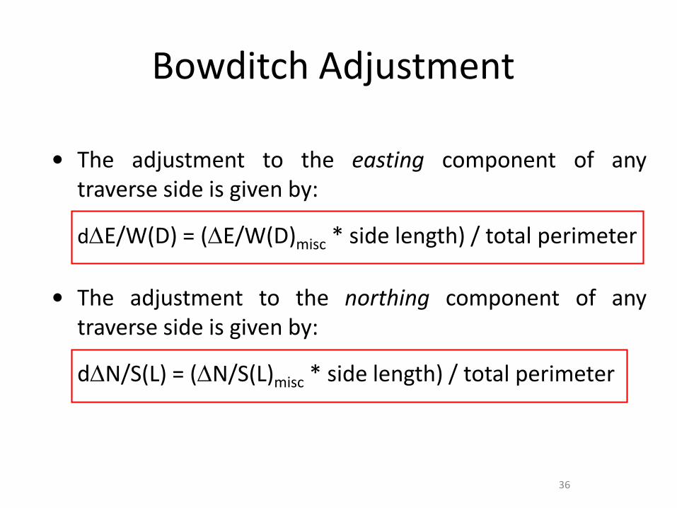
Bowditch Adjustment
• The adjustment to the easting component of anytraverse side is given by:
dE/W(D) = (E/W(D)misc * side length) / total perimeter
• The adjustment to the northing component of anytraverse side is given by:
dN/S(L) = (N/S(L)misc * side length) / total perimeter
36

Bowditch Adjustment
• The adjustment to the easting component of any traverse sideis given by:
E/W(D)adj = E/W(D) +/- dE/W(D)
The adjustment to the northing component of any traverse sideis given by:
N/S(L)adj = N/S(L) +/- dN/S(L)
37
You need to “Plus” if misc is “-”,You need to “Minus” if misc is “+”
You need to “Plus” if misc is “-”,You need to “Minus” if misc is “+”

Example
• East Misclose 0.07 M• North Misclose –0.05 M• Side AB 77.19 M• Side BC 99.92 M• Side CD 60.63 M• Side DE 129.76 M• Side EA 32.20 M• Total Perimeter 399.70 M
38

Vector Components (Pre-adjustment)
Side N(L) E(D) dN(L) dE(D) N(L)adj E(D)adj
AB 71.05 30.16
BC 60.13 79.80
CD -59.31 12.61
DE -88.50 -94.90
EA 16.58 -27.60
Misc (-0.050) (0.070)
39
147.76 147.81 122.57 122.50

Vector Components (Pre-adjustment)
Side N(L) E(D) dN(L) dE(D) N(L)adj E(D)adj
AB 71.05 30.16 -0.010 0.014
BC 60.13 79.80 -0.012 0.016
CD -59.31 12.61 -0.008 0.011
DE -88.50 -94.90 -0.016 0.023
EA 16.58 -27.60 -0.004 0.006
Misc (-0.050) (0.070) (-0.050) (0.070)
40
147.76 147.81 122.57 122.50

Vector Components (Pre-adjustment)
Side N(L) E(D) dN(L) dE(D) N(L)adj E(D)adj
AB 71.05 30.16 -0.010 +0.014 71.060 30.146
BC 60.13 79.80 -0.012 +0.016 60.142 79.784
CD -59.31 12.61 -0.008 +0.011 -59.302 12.599
DE -88.50 -94.90 -0.016 +0.023 -88.484 -94.923
EA 16.58 -27.60 -0.004 +0.006 16.584 -27.606
Misc (-0.050) (0.070) (-0.050) (0.070) (0.000) (0.000)
41
147.76 147.81 122.57 122.50
You need to “Plus” if misc is “-”,You need to “Minus” if misc is “+”

Computing Forward And Backward Bearing With One Fixed Line
42
N
B
A
C N

Computing Forward And Backward Bearing With One Fixed Line
43
C
B
E
F
A
B
N

Computing Forward And Backward Bearing With One Fixed Line
44
Line Forward Azimuth Backward Azimuth Internal Angle
AB 41° 35’ (Known) 221° 35’ 129° 11’
BC 350° 46’ 170° 46’ 88° 35’
CD 259° 21’ 79° 21’ 132° 30’
DE 211° 51’ 31° 51’ 135° 42’
EF 167° 33’ 347° 33’ 118° 52’
FA 106° 25’ 286° 25’ 115° 10’
AB 41° 35’ (Check)

Computing Forward And Backward Bearing With One Fixed Line
45
41° 35’ = AB+ 180° 00’
221° 35’ = BA+ 129° 11’
350° 46’ = BC- 180° 00’
170° 46’ = CB+ 88° 35’
259° 21’ = CD- 180° 00’
79° 21’ = DC+ 132° 30’
211° 51’ = DE
211° 51’ = DE- 180° 00’
31° 51’ = ED+ 135° 42’
167° 33’ = EF+ 180° 00’
347° 33’ = FE+ 118° 52’
466° 25’ - 360°= 106° 25’ = FA+ 180° 00’
286° 25’ = AF+ 115° 10’
401° 35’ - 360°= 41° 35’ = AB
When a computed azimuth exceeds 360°, the correct azimuth is obtained by merely subtracting 360°

Balance Interior Angles
✓ Before the areas of a piece of land can be computed,it is necessary to have a closed traverse (loop)
✓ The interior angles of a closed traverse should total:
• ∑ = (n – 2) * 180• Total correction = ∑ -total angles in the traverse• Each line correction = Total correction / Number
of sides• Where, n is the number of sides of the traverse
46

Balance Interior Angles
∑ = (n – 2) * 180 = (5 – 2) * 180 = 540°
Total correction = ∑ - Total angles of traverse = 540° - 540° 00’ 10’ = - 00° 00’ 10’
Each line correction = Total correction / Number of sides =
- 00° 00’ 10’ / 5 = - 00° 00’ 02”47
Site Measured Interior Angle Correction Adjusted Angle
AB 100° 45’ 37” - 2” 100° 45’ 35”
BC 231° 23’ 43” - 2” 231° 23’ 41”
CD 17° 12’ 59” - 2” 17° 12’ 57”
DE 89° 03’ 28” - 2” 89° 03’ 26”
EA 101° 34’ 23” - 2” 101° 34’ 21”
540° 00’ 10’ -10” 540° 00’ 00
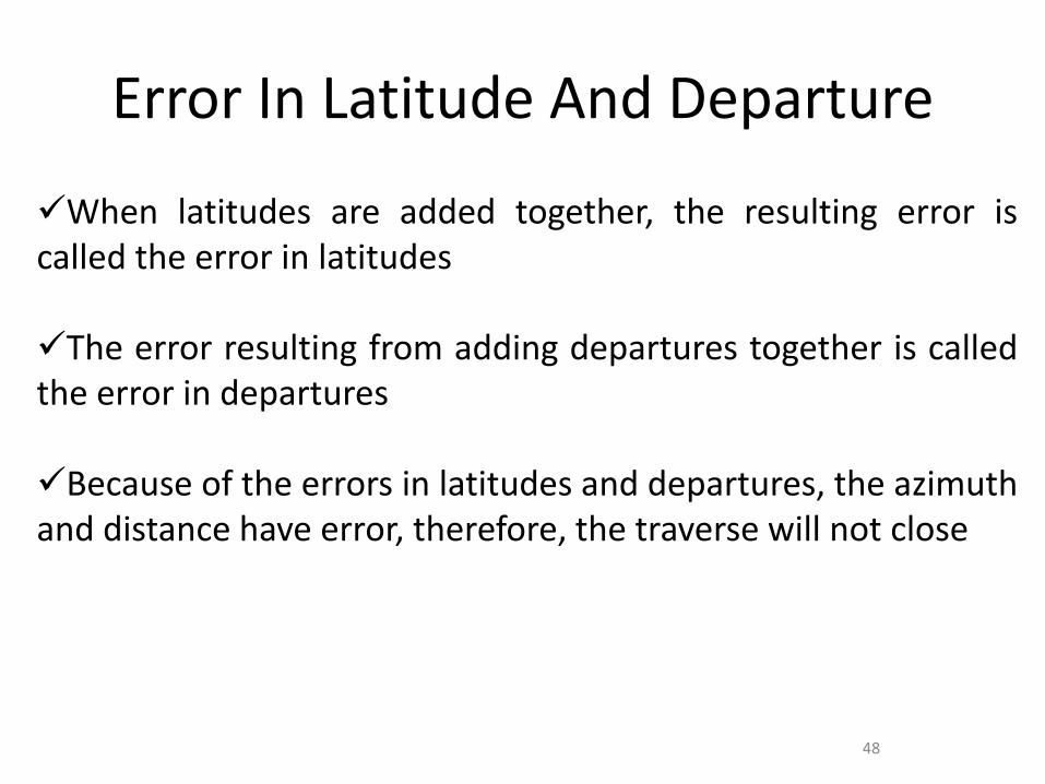
Error In Latitude And Departure
✓When latitudes are added together, the resulting error iscalled the error in latitudes
✓The error resulting from adding departures together is calledthe error in departures
✓Because of the errors in latitudes and departures, the azimuthand distance have error, therefore, the traverse will not close
48

Misclosure In Latitude And Departure
Because of errors in the observation traverse and distances. Thelinear error of misclosure (e) represents the distance from theactual location of point 1 to the computed location of point 1
e = √ (Latitude misclosure) 2 + (Depature misclosure) 2
e = √ (∑N(L))2 + (∑E(D))2
49

Misclosure In Latitude And Departure
✓The relative precision of a traverse is expressed by afraction that has the linear misclosure as its numerator andthe traverse perimeter of total length as its denominator, or
✓ Relative precision = linear misclosure / traverse length
✓ Fractional Linear Misclosure (FLM) = 1 in D/e,Where, D = total distance of surveye = linear misclosure
50

Misclosure In Latitude And Departure
e = √ (∑N(L))2 + (∑E(D))2
e = √ (-0.713)2 + (-0.013)2
e = 0.713 m
Fractional Linear Misclosure (FLM) = 1 in D/eFLM = 1 in 9172.49/0.713FLM = 1 in 12865
51
Site Azimuth
Length (m)Uncorrected Departure E(D)
Uncorrected LatitudeN(L)
Degree Minute Second
AB 00° 00’ 00” 638.57 0.000 638.570
BC 306° 12’ 51’ 1576.10 - 1271.620 931.168
CD 195° 54’ 06’ 3824.10 - 1047.754 - 3677.764
DA 47° 44’ 33” 3133.72 2319.361 2107.313
9172.49 ∑E = - 0.013 ∑N = - 0.713
cos)(
sin)(
dLN
dDE
=
=

Kaedah Perlarasan Terabas
✓ Terdapat dua jenis perlarasan terabas:
• Kaedah Transit
• Kaedah Bowditch
52

Transit Adjustment
✓ The adjustment to northing (L) component ofany traverse side is given by:
N(L)adj = [Misclosure (∑N(L)misc) * latitude line (P12)] /total latitude
✓ The adjustment to easting (D) component ofany traverse side is given by:
E(D)adj = [Misclosure (∑E(D)misc) * departure line (P12)] /total departure
53

Transit Adjustment
Adjustment latitude AB = [-0.713 * 638.570] / 7354.815= + 0.062
Adjustment departure AB = [-0.013 * 0] / 4638.735= + 0.000
Because of the uncorrected latitude N are less than S, so, the adjustment mustplus (+) or in the other way.
Site Length (m)Uncorrected
LatitudeUncorrected Departure
Adjustment Latitude
AdjustmentDeparture
AB 638.57 638.570 0.000 +0.062 +0.000
BC 1576.10 931.168 -1271.620 +0.090 -0.004
CD 3824.10 -3677.764 -1047.754 -0.357 -0.003
DA 3133.72 2107.313 2319.361 +0.204 +0.006
9172.49 3677.051-3677.764
7354.815∑N = -0.713
2319.361-2319.374
4638.735∑E = -0.013
0.356-0.357
3677.406-3677.407
0.006-0.007
2319.367-2319.367
You need to “Plus” if the total N is less than total S,You need to “Minus” if the total S is more than total Nor in the other way.
54

Bowditch Adjustment
✓ The adjustment to northing component ofany traverse side is given by:
N(L)adj = [Misclosure (∑N(L)misc) * length of line] /total traverse length]
✓ The adjustment to easting component of anytraverse side is given by:
E(D)adj = [Misclosure (∑E(D)misc) * length of line] / totaltraverse length]
55

Bowditch Adjustment
Adjustment latitude AB = [-0.713 * 638.57] / 9172.49
= + 0.050
Adjustment departure AB = [-0.013 * 638.57] / 9172.49
= + 0.001Because of the uncorrected latitude N are less than S, so, the adjustment must plus(+) or in the other way.
Site Length (m)Uncorrected
LatitudeUncorrected Departure
Adjustment Latitude
AdjustmentDeparture
AB 638.57 638.570 0.000 +0.050 + 0.001
BC 1576.10 931.168 -1271.620 +0.123 -0.002
CD 3824.10 -3677.764 -1047.754 -0.297 -0.005
DA 3133.72 2107.313 2319.361 +0.244 + 0.004
9172.49 3677.051-3677.764
7354.815∑N = -0.713
2319.361-2319.374
4638.735∑E = -0.013
0.417-0.297
3677.468-3677.467
0.005-0.007
2319.366-2319.367
56
You need to “Plus” if the total N is less than total S,You need to “Minus” if the total S is more than total Nor in the other way.

Bowditch Adjustment
Site Uncorrected
LatitudeUncorrected Departure
Adjustment Latitude
AdjustmentDeparture
Corrected Latitude
Corrected Departure
AB 638.570 0.000 +0.050 +0.001 638.620 0.001
BC 931.168 -1271.620 +0.123 -0.002 931.291 -1271.618
CD -3677.764 -1047.754 -0.297 -0.005 -3677.467 -1047.749
DA 2107.313 2319.361 +0.244 +0.004 2107.557 2319.365
∑N = - 0.713 ∑E = - 0.013 +0.417-0.297
+0.005-0.007
0.001 0.001
57

58
There are two methods used :
Transit Method▪ Used for traverse where angle measurement method has higher accuracythan distance measurement method.
▪ Correction is based on latitude and departure value. The greater the valueof latitude / departure, the greater of the value of adjustment.
Transit Method Formula
Adjustment latitude1-2 = [± Latitude x Latitude Line1-2 ]Sum of all latitude
Adjustment Departure1-2 = [± Departure x Departure Line1-2 ]Sum of all departure
Latitude / Departure Adjustment

59
StnLatitude Departure Adjusted
Latitude
Adjusted
DepartureN S E W
351.469
+0.001
25.292
-0.00351.470 25.289
430.921
0.000
118.850
-0.012-30.921 118.838
5139.667
-0.002
38.740
+0.004-139.665 -38.744
640.825
+0.001
1.210
0.00040.826 -1.210
152.470
+0.001
43.287
+0.00552.471 -43.292
225.819
0.000
60.875
+0.00625.819 -60.881
+0.003 -0.002 -0.015 +0.015 0 0
Latitude / Departure (Transit) Adjustment Booking Sample
170.583 170.588 144.142 144.1120.005 0.030
170.586 170.586
341.171 288.254
144.127 144.127

60
Latitude And Departure Adjustment Calculation Sample
Using Transit Method Latitude Adjustment
Latitude1= (0.005 x 51.469) ÷ 341.171
= 0.001 (N less, need to +)
Latitude2= (0.005 x 30.921) ÷ 341.171
= -0.000 (S more, need to -)
Departure Adjustment
Departure1= (0.030 x 25.292) ÷ 288.254
= - 0.003 (E more, need to -)
Departure2= (0.030 x 118.850) ÷ 288.254
= - 0.012 (W less, need to +)

61
Bowditch Method
▪ Used for traverse where angle measurement method almost same accuracywith distance measurement method.
▪ Correction is based on length of line. The longer line, the greater of thevalue of adjustment.
Bowditch Method Formula
Adjustment latitude1-2 = [± Latitude x Distance Line1-2 ]Total Distance
Adjustment Departure1-2 = [± Departure x Distance Line1-2 ]Total Distance
Latitude / Departure Adjustment

62
StnLatit Dipat Adjusted
Latitude
Adjusted
DepartureN S E W
351.469
+0.001
25.292
-0.00351.470 25.289
430.921
-0.001
118.850
-0.007-30.920 118.843
5139.667
-0.001
38.740
+0.009-139.666 -38.749
640.825
0.000
1.210
+0.00340.825 -1.213
152.470
+0.001
43.287
+0.00452.471 -43.291
225.819
+0.001
60.875
+0.00425.820 -60.879
+0.003 -0.002 -0.010 +0.020 0 0
Latitude / Departure (Bowditch) Adjustment Booking Sample
170.583 170.588 144.142 144.1120.005 0.030
170.586 170.586
341.171 288.254
144.132 144.132

63
Latitude And Departure Adjustment Calculation Sample
Using Bowditch Method Latitude Adjustment
Latitude1= [0.005 x 57.348] ÷ 500.083
= + 0.001 (N less, need to +)
Latitude2= [0.005 x 122.807] ÷ 500.083
= - 0.001 (S more, need to -)
Departure Adjustment
Depature1= [0.030 x 57.348] ÷ 500.083
= - 0.003 (E more, need to -)
Departure2= [0.030 x 122.807] ÷ 500.083
= - 0.007 (W less, need to +)

64

65
• Koordinat sesuatu titik dapat ditentukan jika titik tersebutmempunyai hubungan bering dan jarak dengan titik lain yangmempunyai koordinat.
• Dengan mengetahui nilai latit dan dipat di antara dua titiktersebut, koordinat titik kedua dapat ditentukan.
• Sekiranya koordinat titik 1 (U1,T1) diketahui, maka ;- Utara2 = Utara1 + Latit1-2 , Timur2 = Timur1 + Dipat1-2
- Utara3 = Utara2 + Latit2-3 , Timur3 = Timur2 + Dipat2-3
Hitungan Koordinat
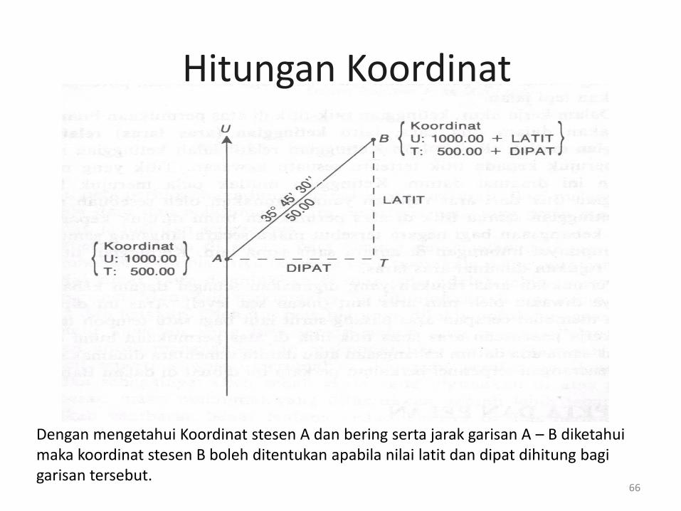
Dengan mengetahui Koordinat stesen A dan bering serta jarak garisan A – B diketahui maka koordinat stesen B boleh ditentukan apabila nilai latit dan dipat dihitung bagi garisan tersebut.
Hitungan Koordinat
66

67

68
StnLatit
Dilaras
Dipat
Dilaras
Koordinat
U / S T / B
2 500.000 700.000
3 51.470 25.289 551.470 725.289
4 -30.920 118.843 520.550 844.132
5 -139.666 -38.749 380.884 805.383
6 40.825 -1.213 421.709 804.170
1 52.471 -43.291 474.180 760.879
2 25.820 -60.879 500.000 700.000
U3= 500.000+51.470
= 551.470
T3 = 700 + 25.289
= 725.289
Contoh Pembukuan Hitungan Koordinat

HITUNGAN KELUASAN
69

Importance Of Determining Area
❑ To include acreage in a property deed
❑ Determine the area of sections of interest
❑ Determine the area to estimate required materials
70
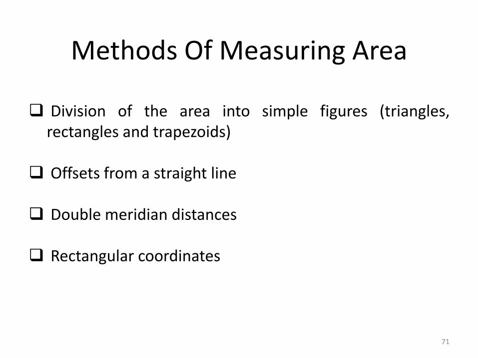
Methods Of Measuring Area
❑ Division of the area into simple figures (triangles,rectangles and trapezoids)
❑ Offsets from a straight line
❑ Double meridian distances
❑ Rectangular coordinates
71

Simple Figures
72

Area By Triangulation
If you know the length of all three sides
❑ Area = √ s(s - a) (s –b) (s – c)
❑ Where:a, b and c are the sides of the triangle and
S = ½ (a + b + c)
73

Area By Triangulation
If you know the length of two sides and the angle inbetween the sides
❑ Area = ½ ab sinC
❑ Where:C is the angle between sides a and b
74

Area By Triangulation
❑ You will likely end up using some combination of themethods
❑ With a traverse, you will know perimeter distances andinterior angles
❑ You can take additional angle measurements oradditional distance measurements while in the field tosimplify calculations
75

Segi Empat Mudah
a
b
aii
iC
b
h
b
h
a
Segi Empat Tepat
Luas, A = Panjang x Lebar
= a x b
Segi Empat Selari→ Dipecah kepada 2 segitiga
∆i = ½ ab sin C
∆ii = ½ ab sin C
Luas, A = ∆i + ∆ii
= ab sin C
Trapezium
Luas, A = ½ x (a + b) x h
Hitungan Keluasan
76

Area Computed By Coordinates
The area of a traverse can be computed by taking each Ncoordinate multiplied by the difference in the two adjacentE coordinates (using a sign convention of + for next side and– for last side)
77

Area Computed By Coordinates
78
N
E
P1 (E 159.974 , N 340.640)
- S
- W
P2 (E 139.373 , N 152.252)
(E 30.551 , N 29.933) P4
P3 (E 226.021 , N 0)
(E 0 , N 169.013) P5

Area Computed By Coordinates
❑ There are a simple variation of the coordinatemethod for area computation
Sum 1 = E1N2 + E2N3 + E3N4 + E4N5 + E5N1
Sum 2 = N1E2 + N2E3 + N3E4 + N4E5 + N5E1
79

Area Computed By Coordinates
❑ List E and N coordinates in two columns
❑ Repeat coordinates of starting point at the end
❑ Sum the products designated by arrows– Left to right (minus sign)– Right to left (plus sign)– Difference between the two sums = twice the area– Careful with the W & S…….must consider the ‘-ve’ in
the value.
80

Area Computed By Coordinates
81
P1 (E 159.974 , N 340.640)
P2 (E 139.373 , N 152.253)
P4 (E 30.551 , N 29.933)
P3 (E 226.021 , N 0)
P5 (E 0 , N 169.013)
P1 (E 159.974 , N 340.640)

Area Computed By Coordinates
Sum 1 = 159.974 (152.253) + 139.373 (0) + 226.021 (29.933) + 30.551 (169.013) +0 (340.640) = 36285.364
Sum 2 = 340.640 (139.373) + 152.252 (226.021) + 0 (30.551) + 29.933 (0) +169.013 (159.974) = 108925.854
Subtract the smaller sum from the larger sum (since it doesn’t make any sense tohave a negative area)So:2 (Area) = Sum 1 - Sum 2 or Sum 2 – Sum 1
= 108925.854 - 36285.364 = 72640.490
Remember that this is equal to twice the area, so divide this number by 272640.490 / 2 = 36320.245 m2
82

Penggunaan Maklumat Terabas
– Latit, Dipat & Koordinat– Terdapat 2 kaedah:-
• Kaedah Koordinat• Kaedah Latit dan Dipat
–Kaedah Jumlah Latit & Jumlah Dipat–Kaedah Dua Kali Latit x Dipat @ Dua Kali Dipat x
Latit
Hitungan Keluasan
83
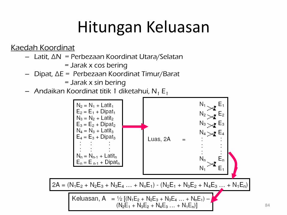
Kaedah Koordinat– Latit, ∆N = Perbezaan Koordinat Utara/Selatan
= Jarak x cos bering
– Dipat, ∆E = Perbezaan Koordinat Timur/Barat
= Jarak x sin bering
– Andaikan Koordinat titik 1 diketahui, N1 E1
Hitungan Keluasan
84

85
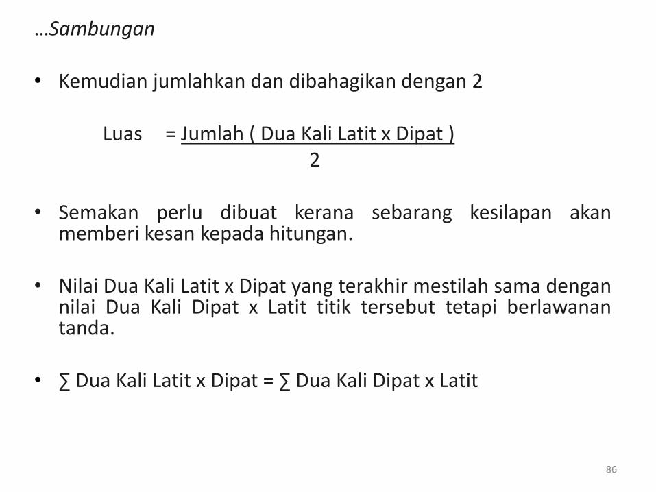
• Kaedah hitungan luas yang biasa digunakan oleh JUPEMadalah Dua Kali Latit Kali Dipat atau Dua Kali Dipat Kali Latit.
• Cara hitungan ( menggunakan Dua Kali Latit x Dipat ) ;- Dua Kali Latit 1 = Latit 1- Dua Kali Latit 2 = Dua Kali Latit 1 + Latit 1 + Latit 2- Dua Kali Latit 3 = Dua Kali Latit 2 + Latit 2 + Latit 3
• Setelah selesai, Dua Kali Latit setiap garisan tersebut dikalikan( x ) dengan Dipat bagi garisan tersebut.
Hitungan Keluasan
86
…Sambungan
• Kemudian jumlahkan dan dibahagikan dengan 2
Luas = Jumlah ( Dua Kali Latit x Dipat )2
• Semakan perlu dibuat kerana sebarang kesilapan akanmemberi kesan kepada hitungan.
• Nilai Dua Kali Latit x Dipat yang terakhir mestilah sama dengannilai Dua Kali Dipat x Latit titik tersebut tetapi berlawanantanda.
• ∑ Dua Kali Latit x Dipat = ∑ Dua Kali Dipat x Latit

87
StnLatit
Dilaraskan
Dipat
Dilaraskan
Dua Kali
Latit
Dua Kali
Dipat
Dua Kali Latit
x Dipat
Dua Kali Dipat
x Latit
2
3 51.470 25.289 51.470 25.289 1301.6248 1301.6248
4 -30.920 118.843 72.020 169.421 8559.0729 -5238.4973
5 -139.666 -38.749 -98.566 249.515 3819.3340 -34848.7620
6 40.825 -1.213 -197.407 209.553 239.4547 8555.0012
1 52.471 -43.291 -104.111 165.049 4507.0693 8660.2861
2 25.820 -60.879 -25.820 60.879 1571.8958 1571.8958
19998.4515 -19998.4515
/ 2 9999.2257 -9999.2257
Luas = 9999.2257m2 atau 2.471 ekar
Contoh Pembukuan Hitungan Keluasan

88

Unit Pengukuran(Jarak & Keluasan)
89

Unit Pengukuran(Jarak & Keluasan)
90

HITUNGAN ARAS LARAS
91

• Aras sesuatu titik dapat ditentukan jika titik di tempat alattotal station didirikan mempunyai nilai aras yang diketahui.
• Tinggi alat total station dan tinggi target (prizam) perludicatatkan
• Bacaan jarak tegak perlu dicatat atau dikira
• Contoh formula :AL titik = AL stesen + HI + v – s
Di mana, AL = aras larasHI = tinggi alat (total station)v = jarak tegaks = tinggi target (prizam)
Hitungan Aras Laras
92

Formula:
AL titik = AL stesen + HI + v – s
AL titik = 56.325 + 1.350 + 1.122 – 1.250= 57.547
Contoh Hitungan Aras Laras
93
56.325
1.350
1.1221.250

T H A N K YO U
94