Brazil Towards an Effective Cadastre With SIGEF (rev. 2)
44
BRAZIL TOWARDS AN EFFECTIVE CADASTRE WITH SIGEF THIAGO MARRA, KILDER BARBOSA, EDUARDO OLIVEIRA Institute of Colonization and Land Reform INCRA, Ministry of Agrarian Development MDA, Brazil [email protected] Paper prepared for presentation at the “2015 WORLD BANK CONFERENCE ON LAND AND POVERTY” The World Bank - Washington DC, March 23-27, 2015 Copyright 2015 by author(s). All rights reserved. Readers may make verbatim copies of this document for non-commercial purposes by any means, provided that this copyright notice appears on all such copies.
Transcript of Brazil Towards an Effective Cadastre With SIGEF (rev. 2)
BRAZIL TOWARDS AN EFFECTIVE CADASTRE WITH SIGEF
THIAGO MARRA, KILDER BARBOSA, EDUARDO OLIVEIRAInstitute of Colonization and Land Reform INCRA, Ministry of Agrarian Development MDA, Brazil
Paper prepared for presentation at the
“2015 WORLD BANK CONFERENCE ON LAND AND POVERTY”
The World Bank - Washington DC, March 23-27, 2015
Copyright 2015 by author(s). All rights reserved. Readers may make verbatim copies of this
document for non-commercial purposes by any means, provided that this copyright notice
appears on all such copies.
Thiago Marra
April 21, 2015 revision.
Abstract
The implementation of an effective Cadastre in Brazil is a historic challenge. The absence of this
instrument means constraints to tenure security, social justice and economic development.
Especially in Amazon, the lack of Cadastre complicates the management of public lands,
regularization of adverse possessions, encourages irregular exploitation of natural resources,
increases land conflicts, reduces the ability to recognize land rights and limits the sustainable
development.
To contribute to the solution of these problems we developed the Land Management System
SIGEF: a cadastral electronic platform for public and private lands, based on the Public Records
Act. Using this tool, georeferencing professionals send the surveyed parcels' data directly to
government agency for automated validation, online. The system provides results for
stakeholders and public consultation, generates standardized documents and allows direct access
to the property Registry personnel safely, efficiently and transparently. This enables the
connection between land parcels' data from Cadastre and informations of rights and restrictions
from Registry.
SIGEF is also used for land regularization in Amazon. There are more than 100 thousand parcels
of irregular possessions surveyed and validated: over 25 million hectares. More than 60 million
hectares of public and private lands all over Brazil, in 11 months of operation.
Key Words: Brazil, cadastre, georeferencing, land tenure, Sigef
Summary
Introduction
Concept of Cadastre
Cadastre in Brazil
Principles of 10,267 Act
Component 1: The Land Parcel
The NTGIR Regulation
Component 2: Rights and Restrictions
Component 3: Responsibilities
10,267 Act Implementation
Revision Process
The Guidelines of Regulatory Review
Certification Management
Land Management System SIGEF
Sigef Key Features
Input Data Model
General Data Flow
Data Flow by Parcel's Juridical Situation
Results
Ongoing Weaknesses and Challenges
Opportunities
LGAF in Brazil
National Cadastre of Rural Properties CNIR
Final Words
References
Tables
Chart 1 Cadastral systems in Brazil
Chart 2 Quality results achieved with SIGEF
Figures
Figure 1 Land in Society (Enemark, 2009)
Figure 2 Identification sheet
Figure 3 Perimeter sheet
Figure 4 Parcels composed by three perimeter sheets
Figure 5 Basic data feeding
Figure 6 General data access and sharing
Figure 7 Land parcel web search
Figure 8 Land parcel details
Figure 9 Land parcel and the total georeferenced area
Figure 10 Land parcel and its holder
Figure 11 Land parcel and the Registry status
Figure 12 Land parcel on the map
Figure 13 Land parcel and its vertices
Figure 14 Land parcel and its boundaries
Figure 15 Cadastral operations and functions
Figure 16 Available documents: plat
Figure 17 Available documents: legal description
Figure 18 Data flow by land parcel juridical situation
Figure 19 Land parcels certified by month
Figure 20 Visualization of cadastral data in Amazonian State of Rondonia, Brazil
Figure 21 Public consult in map: a registered parcel in Mato Grosso do Sul State
Figure 22 Public information in SIGEF about registered parcel
Figure 23 Relationships among the current cadastral systems and the data needed from CNIR

Introduction
It may not be evident, but a fundamental problem for the agrarian question in Brazil was and has been
the lack of clear and reliable information of rural properties.
The description of rural properties may come from very old, centenarians documents. Hence one can
imagine the variety of possible ways to describe its boundaries. Landscape abstracted descriptions, with
own languages and techniques to obtain measures that can locate them and reestablish them, if
necessary.
This wide variety of possible descriptions, also causes ambiguity in interpretation. This leads to
inaccuracies: differences between the actual situation on the ground, and what is documented,
formalized.
In Brazil, the legal rights informations are responsibility of the Land Registry (real estate registry).
When combining rights to some object that is not clearly described, emerges an insecurity scenario.
This results, among other problems, in:
agrarian conflicts;
misappropriation of public land;
threats of territorial rights of traditional populations;
environmental irregularity associated with the criminal exploitation of natural resources and
inability to hold offenders;
reduction of productive potential.
Three key issues could be highlighted about clear and reliable information of land property extent:
methods to locate and measure its boundaries;
possibilities of describing them, standardized language and format;
ability of retrieving this information.
Traditionally, the systematic description of the property is associated with a land cadastre: an
instrument to identify, clearly and precisely, spatial domain of land boundaries and allow the sharing of
such information.
Concept of Cadastre
One of the most important authorities in cadastral matters is the International Federation of Surveyors
(FIG). According to FIG, 1995:
A cadastre is normally a parcel based and uptodate land information system containing a record of interests in land (i.e. rights, restrictions and responsibilities). These units are defined by the formal or informal boundaries marking the extent of lands held for exclusive use by individuals and specific groups of individuals (e.g. families, corporations, and communal groups). Each parcel is given a unique code or parcel identifier.
The key idea in this concept is the relationship established between person and (a well defined and
described) land parcel. Additionally, is important to register all that interferes in this relation. In a
formal and juridical way, these interests could be translated in terms of rights, restrictions and
responsibilities. So, Cadastre is a source for crucial land information, that (FIG, 1995):
(...) provides the private and public sector with: information identifying those people who have interests in parcels of land; information about those interests (e.g. nature and duration of rights, restrictions,
and responsibilities); information about the parcels (e.g. their location, size, improvements, value).
This definition was adopted for the Cadastre 2014 initiative, internationally recognized. Its base
document, Cadastre and Land Management (Kaufmann, 1998), has over the years been translated into
28 languages and was a topic in many forums, panel discussions, roundtables and journal articles
( Steudler , 2014).
Most recently, this definition was adopted by World Bank's project Land Governance Assessment
Framework LGAF (Deininger & Burns, 2012). The role of Cadastre in Land Governance was detailed
in a preview work (Deininger, 2010), in the context of Land Administration Systems (LAS):
(...) the cadastral information layer cannot be replaced by a different spatial information layer derived from geographic information systems (GIS). (...) The unique cadastral capacity is to identify a parcel of land both on the ground and in the system, in terms that all stakeholders can relate to, typically an address plus a systematically generated identifier, since addresses alone are often imprecise. (...) The parcel identification provides the link for securing land rights and controlling land use.
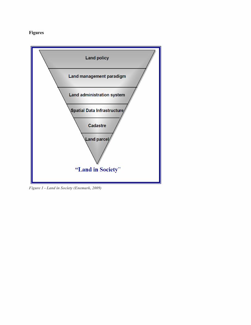
In this context, of land management paradigm, Enemark (2009) suggests a hierarchy to analyse land
issues ( Figure 1). This hierarchy is a way to link the generality of land policies, situated in an abstract
level, to “practical life”, in an operational level. From that components, we highlight two that are
crucial in our discussion:
The cadastre provides the spatial integrity and unique identification of every land parcel usually through a cadastral map updated by cadastral surveys. The parcel identification provides the link for securing rights in land, controlling the use of land and connecting the ways people use their land with their understanding of land. The land parcel is the foundation of the hierarchy because it reflects the way people use land in their daily lives. It is the key object for identification of land rights and administration of restrictions and responsibilities in the use of land. The land parcel links the system with the people.
Therefore, linking land parcels and persons, juridical or natural, is a critical step to support a wide
range of land policies and interventions:
tenure security and equity in access to land (for individuals, traditional communities or
populations in food insecurity);
management of public lands;
planning and land development;
promotion of production;
fair valuation and land taxation;
resolution of territorial disputes;
infrastructure implementations.
A simple and typical brazilian example for the infrastructure theme: when is needed to build something,
the first step is the preparation of the project. To project, is required to know the details of the terrain.
At this point, usually the first thing is used to think is the physical mapping: terrain models, horizontal
distances, heights, angles... But the legal situation of the area is quite important too. As in a
hydroelectric project: when a dam is built and the water reservoir up, what rights will be affected? How
many and what families? How to compensate? The same goes for highways, railways, transmission
lines and any other actions that have an impact on the territory.
Another example, for environmental control. Several problems can be detected remotely by the State.
The satellite images features are proof of this; more and more accessible. However, when attempting to
connect a detected evidence to a responsible, it is very difficult. In Amazon, where there is a great
effort by governments to contain the advance of deforestation, lack of cadastral data is critical. Even
where there is formality, it is very costly to obtain the information and instruct the penalty process.

These questions are even obvious in many countries, where the cadastral theme is traditional, but not in
Brazil.
Cadastre in Brazil
The implementation of the Cadastre, according to the cited concept, is a historic challenge in Brazil, as
reported in several studies. Among the most recent we can mention Hasenack (2012), Figur (2011)
Paixão (2010) and Sousa Neto & Carneiro (2010).
The lack of a clear and reliable concept of Cadastre is a key to understand the obstacles that still remain
to its implementation. Schematically, we grouped the main weaknesses in three categories: conceptual,
legal and institutional:
Purpose: the role of cadastre is not seen or recognized, as the basis for other applications in
land governance;
Formal: there is not a general and accepted view of how the cadastral data must be produced,
even its minimal requirements. In Brazil, still remains some ideas that ignore the need of clear
definition of parcels' boundaries based on survey, and rules to spatially control their topology;
Structure: even when the purpose of cadastre is (fully or partially) recognized, there is a
compartmented view of it, as if there was no need of hierarchy or connection among cadastral
themes, and between each of them and the basic one.
The conceptual issues have, as expected, consequences for all other levels. In legal level, besides the
conceptual issues and no tradition in cadastral matters, many laws created different “cadastres” during
Brazil’s history. Moreover, this usually occurs without mutual references among them, or even without
surveyed geospatial data as land descriptions.
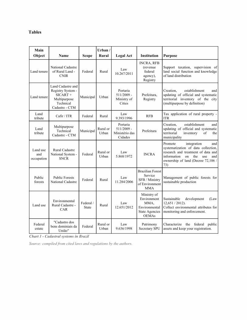
Related to the legal structure, there are several institutions aimed to manage the cadastre in Brazil. It is
clear that this is not an individual quest, necessarily. However, the way it is today, more efforts are
required to conceal and integrate the work of different governmental agencies. If there is not a clear and
stricted labour division among the cadastral data producers, the scenario should not improve. The Chart
1 is a compilation of some cases.
Considering that, is possible to highlight a central issue: there are several institutions, based on
different legal references, targeting the same object with different approaches.
Among them, however, one will be detailed here, because it broke some paradigms established until
then: is the only one that links land parcel boundaries on the ground with its cartographic
representations, by means of surveying. A mandatory reference about it is Carneiro (2003).
Principles of 10,267 Act
The Law 10,267 / 2001 brought the basic elements to overcome the difficulties mentioned before. In
particular:
established means to standardize unequivocally the production of data and documentation of
rural boundaries/limits;
established the exchange of information between georeferenced cadastre (Cadastre) and
Registry, to keep each other updated.
Also, set the agents involved and assigned responsibilities to them, according to the roles of each one in
the process:
Credentialed surveyor ; INCRA, Land Reform Institute in Brazil;
Land Registry.
As will be detailed, the Brazilian Cadastre, at least in rural areas, would have the basic components to
establish tenure security in rural area.
Component 1: The Land Parcel
One of the basic rules for the construction of any cadastre is the consistency in the juxtaposition of the
polygons that compose the parcels. It is just like to assembling a puzzle: there should not be empty or
overlap between the parts.
Thereby, the georeferencing was established as the resource to assemble this puzzle by Law 10.267 /
2001: (...) In cases of dismemberment, installment or merge of rural properties, the identification of the property (...) shall be obtained from the Legal Description, signed by a qualified professional and with due Technical Responsibility Document ART, containing the coordinates of the vertex defining the limits of the parcels, georeferenced to the Brazilian Geodetic System and positional accuracy to be fixed by INCRA.
The referred identification regards to the way the Land Registry defines the uniqueness of rural
property: (...) The identification of the property will be indicating: if rural, property code, the data from the CCIR, the name and its features, confrontations, location and area;
The georeferencing was established as a procedure to identify the spatial limits of rights and determine
the coordinates of the vertices that define them, resulting in a representation that allows to reconstitute
the parcel unequivocally.
However, the assembly of the puzzle is not simple. Considering the positional accuracy adopted, the
georeferenced coordinates obtained for the same point in space are not exactly the same. because these
values are the result of statistical calculations on observations that constantly change. Thus, it is
necessary to establish technical parameters for the products of these surveys, the representations of the
parcels in that space, demonstrating consistency between them, according to the mapping process. This
kind of technical detail was due to the Decree 4,449 / 2002, which regulated Law 10,267 / 2001. In
Article 9, repeats and supplements the text of the Act:
(...)The identification of rural property (...) will be obtained from the Legal Description document implemented and signed by a qualified professional (..) containing the coordinates of the vertex and the limits of rural properties, georeferenced to the Brazilian Geodetic System, and positional accuracy to be established in normative act, including technical manual, issued by INCRA. (...)is up to INCRA make sure that the polygonal object's Legal Description does not overlap with any other constant of your georeferenced cadastre and the document complies with technical requirements, as own normative act.
What came of this paragraph was the certification process in rural properties, in which the role of
INCRA to certify, in other words, that:
the area shown by the credentialed surveyor do not conflict with any other of the cadastre;
the Legal Description meets technical requirements defined in the regime.
The first point is the main cadastre rule: the prevention of overlapping occurrence. The registered area
in the form of cartographic representation, must be continuous without voids or crosses between the
representation of boundaries. That is based on an ability to locate more accurately the coordinates of
boundaries, but this is not enough itself.
The second point has the main objective to eliminate ambiguities in the way that information is
described by setting a standard pattern, which makes it easy to read. The Legal Description document
(called Memorial Descritivo in Brazil) should meet technical requirements and standards which would
make it more efficient. As a reference for describing the rural property, thus, would unify the
representation language of properties throughout Land Registry.
The cited normative act was published in 2003: Technical Standard for Georeferencing of Rural
Property (NTGIR).
The NTGIR Regulation
The NTGIR was elaborated with the objective to define the technical standards for implementation of
georeferencing services for INCRA certification. In its first version, it approached in detail the methods
applicable to the definition of property boundaries.
One of the main rules in NTGIR was the georeferencing of vertex and its uniqueness in the cadastre:
there is only one vertex code for each position (geospatial coordinates). This rule is important because
it is the key to perform the right fit between neighbour properties: vertices with same code must have
the same coordinates, providing equivalent limits or boundaries, which do not cross or deviate. In this
context, if a vertex with the same code is presented with different coordinates, certainly indicates a
problem like an overlap or a gap between parcels that should perfectly fit together.
With this fundamental rule, associated with definition of methods and procedures for determination of
land boundaries coordinates, it has given another step towards building the geometric component of the
Brazilian rural cadastre.
The NTGIR also established the 'output format' of georeferencing process. Also set the standard for
Legal Description document: how it must be formatted, what information contains, how to display the
coordinates, avoiding the generation of misinterpretation. Thus a property, when registered, is no
longer confused with another.
Component 2: Rights and Restrictions
A key component of Cadastre is the possibility to link parcels with people's rights, restrictions and
responsibilities. In this sense, the Law 10,267 / 2001 promoted, among others, the following change in
art. 22 of Law No. 4,947, of April 6, 1966: (...) Land registry services are required to submit to INCRA, monthly, the modifications in real estate enrollment resulting from changes of ownership, parceling, dismemberment, blending, grinding area, and particular legal reserve of natural heritage and other limitations and restrictions of environmental character, involving rural properties.
Thus, required that the description of the property, in this case the object to be dismembered, parceled
or merged, were previously approved to become registered in Land Registry. Also defined that, when
updating in the registry, this information should return to cadastre.
This regulates a cycle of updates relating INCRA Cadastre and the Land Registry. First step: when a
land parcel is modified, needs to be geometrically validated and updated on the Cadastre. After that, it
become able to be registered, where the Registry Officer will make the qualification of rights and
restrictions, relating them to it. The information is sent back to INCRA, where the parcel situation is
updated. The cycle is endless.
Component 3: Responsibilities
The Law 10,267 also established the responsibilities for the creation of each cadastral parcel: which one
is responsible for each step. Returning to paragraph 3 of art. 176: (...) In cases of dismemberment, creation or merge of rural properties, the identification of the property (...) shall be obtained from the Legal Description, signed by a qualified professional and with Technical Responsibility Document ART, containing the coordinates of the vertices defining the boundaries of the parcels, georeferenced to the Brazilian Geodetic System and positional accuracy to be fixed by INCRA.
The first responsibility mentioned is that of the professional, the surveyor. Technically qualified, shall
prepare and sign the final product of georeferencing service (Legal Description), for which formalizes a
document called ART. This binds the professional to the performed service and the respective class
council; in this case, the Regional Council of Engineering and Agronomy (Crea), under the Federal
Council of Engineering and Agronomy (Confea), as georeferencing service is a typical activity of
engineering, especially of Surveying and Cartography.
The definition of a qualified professional and technical responsibility are no mere coincidence in Law
10,267. It refers to an existing structure for carrying out those activities.
The Confea / Crea system is regulated by Law 5,194 of 1966, which regulates the exercise of
Engineering and Agronomist professions. In Chapter I, about the regulatory agencies, Title II, defines
in Article 24 that:
(...) the verification and monitoring of exercise and activities of the professions regulated it will be carried out by a Federal Council of Engineering, Architecture and Agronomy (Confea) and Regional Councils of Engineering, Architecture and Agronomy (Crea), organized order to ensure unity of action.
It is mentioned in Article 33 that:
The Boards of Regional Engineering, Architecture and Agronomy (CREA) are organs of control the exercise of engineering professions, architecture and agronomy, in their regions.
In Article 34, specifies the duties of Regional Councils (CREA), including most importantly, the
supervisory functions: Are functions of the Regional Councils: b) create the Specialized Chambers with regard to conditions of greater efficiency of supervision established in this law; d) judge and decide, on appeal, the infringement proceedings of this law and the Code of Ethics, sent the specialized cameras; e) judge on appeal, ordering processes of penalties and fines; f) organize the system of supervision of the practice of the professions covered by this law; i) advise the Federal Council measures necessary to regularize the services and the supervision of the practice of the professions regulated by this law; l) create provinces and appoint special inspectors for increased surveillance efficiency.
Thus, the allocation of responsibility for the implementation of georeferencing services to the
professional responsible refers to a structure already established to regulate its activities. It is up to
professional to do the land survey on property and submit the final product (plat and legal description)
with the appropriate technical responsibility formalized (ART), supported by a regulatory activity of
existing profession.
A member responsible for another part of this process is INCRA. Back again to paragraph 3, article 176
of Law 10,267:
(...) In cases of dismemberment, creation or merge of rural properties, the identification of the property (...) shall be obtained from the Legal Description, signed by a qualified professional and with due Technical Responsibility ART, containing the coordinates of the vertex defining the limits of the parcels, georeferenced to the Brazilian Geodetic System and positional accuracy to be fixed by INCRA.
In Decree 4,449 / 2002, the responsibilities are more detailed:
(...) The identification of rural property (...) will be obtained from the Legal Description document implemented and signed by a qualified professional (...) containing the coordinates of the vertex and the limits of rural properties, georeferenced to the Brazilian Geodetic System, and positional accuracy to be established in normative act, including technical manual, issued by INCRA.
(...) is up to INCRA make sure that the polygonal described by Legal Description does not overlap with any other constant of your georeferenced cadastre and the document complies with technical requirements, following its own normative act.
INCRA responsibilities are shown here, as already commented previously about certification. In
summary, is up to the institute:
regulate the georeferencing process for setting the professional's performance: define positional
accuracy, Legal Description format and other technical parameters;
attest that the final product does not conflict with other parcels and follows the regulated
standard.
It is also important to note that there was a concern in making explicit what is not within the
competence of INCRA. According to the Decree 4,449 / 2002:
The certification of Legal Description by INCRA do not imply recognition of the domain or the accuracy of the limits and boundaries indicated by the owner.
It is not responsibility of INCRA to validate domain property rights of someone over the land parcel
neither verify the correspondence between the property representation and the limit specified by its
owner. These are the duties of the Land Registry Officer and the credentialed surveyor. So, are
established all relevant responsibilities to each agent of cadastral inserting and updating.
From a conceptual point of view, in addition to these, other responsibilities and restrictions are attached
to the land and territorial legislation as a whole. The "nature" of the parcel itself is a indicative of
specific responsibilities linked to it; e.g. as a private property area, a conservation area or a rural
settlement. Each follows specific rules that defines what can and what cannot be done, and who is
responsible. For example, a Conservation Unit (protected areas in Brazil) parcel may have restricted
use, according to its modality; other example: parcels of particular properties must respect the social
function of land.
10,267 Act Implementation
It is not the fact that a law is created that means it should be fulfilled, especially in Brazil. There are a
number of requirements to enforce a norm to be fulfilled, in fact. In this case, the path between the
theory and the practice was neither simple nor quick.
Thinking about the impact that the certification process would cause and its costs, it was implemented
in steps. In 2002, Article 10 of Decree 4,449 specified that:
The identification of the rural area of the property (...) will be required in any transfer situation, pursuant to Article 9, passed only after the following periods, counted from the publication of this Decree: I ninety days for the properties with five thousand acres, or more; II one year, for properties with an area of thousand less than five hectares; III two years for the properties with an area of five hundred to less than a thousand hectares; and IV three years for properties with an area less than five hundred hectares.
However, as the demand for georeferencing grew, the signs that would not be possible to enforce the
law became clearer. In 2005, there was the first deadline extension:
IV eight years, for properties with an area less than five hundred hectares.
And extended again in 2011: III five years for the properties with an area of five hundred and less than a thousand hectares; IV ten years for the properties with an area of two hundred and fifty and less than five hundred acres; V thirteen, for properties with an area of one hundred and less than two hundred and fifty acres; VI sixteen, for properties with an area of twenty five and less than one hundred hectares; and
VII twenty years for the properties with an area less than twenty five acres.
In addition, and more serious: over 10 years from the Decree approval, tens of thousands of cases
accumulated in INCRA, in queues for analysis.
This situation culminated with an Direct Unconstitutional Action, ADI 4866, referred to the Brazilian
Supreme Court (STF) by the Confederation of Agriculture and Livestock of Brazil (CNA), in order to
challenge paragraphs 3, 4 and 5 of Article 176 of Law of Public Records (Law 6,015 / 73, modified by
Law 10,267 / 2001). These were precisely the devices that allow the effective implementation of the
Brazilian rural cadastre, brought by 10,267 act in 2001, with the certification stage under INCRA
responsibility (STF, 2012):
The Confederation questions the bureaucratic structure of the institute and said that the devices are opposed to the right to property, guaranteed by the Constitution. (…) the institute (INCRA) does not have adequate bureaucratic structure to certify all rural properties. (…) due to the high number of applications, from the natural movement of the market involving rural properties, was characterized by complete absence of bureaucratic structure in Incra to vent the requirements. The accumulation began to cause months or years of delay in certification, preventing the execution of any transaction that results change in property registration.
The difficulties encountered to perform the analysis of the processes were not limited to institutional
weaknesses of INCRA, but were in form and content too.
The requirements to make the certification process extrapolated the established by Law 10,267 and
Decree 4,449. For each certification analysis was made something like an expert report, which
overlapped to the roles of credentialed surveyor and the Registry Officer. Each certification process
consisted of a big sheaf of paper: even hundreds of pages.
The analysis also demanded specialized professionals, trained in surveying and mapping. As in many
other areas of public services, the institutions do not have the ideal number of employees. In practice,
the gap between demand and capacity were radically divergent, and increasing.
Besides the problem of mismatch between demand and responsiveness, the way the analyzes were
carried out was subject to a series of failures, proper to human activity. This is aggravated by the high
complexity required and the size of the work.
Another matter which compromised the implementation of the Brazilian rural cadastre was the
adoption of the rural property concept of agrarian law. According to that, one rural property may be
composed by several land parcels. Thus, the georeferenced area was homogeneous in terms of use, but
could group different juridical situations (rights and restrictions). This made unable the link between
rights and restrictions with the delimited area, due the mismatch between the georeferenced area and
the object of Registry.
Revision Process
In 2010, INCRA has started a project to convert the analog to digital certification process. eCertifica,
as it was called, has not been implemented. In 2011, less than 30% of the system had been developed,
causing great frustration among professionals, in and out of INCRA, as well as owners waiting to
obtain certification of their property.
In 2012, as an initiative of the Secretariat Land Regularization in the Amazon (SERFALMDA), a
partnership with INCRA was established to develop an information system designed to deal with:
data relating to certification of rural properties boundaries;
management of georeferencing service contracts with the government.
From there was established a technical team to carry out the basic regulatory review to operate the new
certification model.
The Guidelines of Regulatory Review
The regulatory review considered the following guidelines:
security improvement;
elimination of analogue material and data out of standard format;
elimination of unnecessary checks;
efficiency: increasing speed and accuracy of analysis.
Improved security meant reducing the possibilities of changes in any data submitted by the surveyor.
Changing the geometry of a parcel is something that does not exist in the system. If is needed, the sent
data must be formally cancelled before the reception of new ones.

Security also relates to the capacity of identify the producers of data. The use of digital certification is a
powerful tool for that. At the same time, it is attached to transparency: the more accessible information,
more society can monitor processes and identify possible failures, fraud and other problems. The social
participation increases reliability.
The transformation of paper and other media in data allowed greater traceability and process control by
government agencies, added to simplified access by stakeholders.
The objectivity of the analysis eliminated a series of validations that did not target the output of
georeferencing service. Before that, the human analysis of input data required a great effort and did not
represent qualitative gain in control.
The conversion of georeferencing output data with an electronic standard and format allowed to
automate the analysis and perform a series of validation that were not possible. It also meant the
production of richer cadastral data in less time, with fidelity between the information delivered by the
surveyor and the documents that feed the Cadastre and the Registry.
Certification Management
To support the operation of the new process, was released the certification management manual, which
rules sanctions to credentialed surveyors: warning, suspension or even disqualification /
disaccreditation. Either of these attitudes is detrimental to their performance in the market because it
inhibits the demand for new services.
To the credentialed surveyor responsible for fraud or failure, are applicable sanctions provided in the
management manual, in addition to other administrative and legal measures. If happen, all illicit or
failure is publicly available, clearly recorded with the author's digital certificate. In other words: there
are now much better conditions to identify and prove eventual frauds.
Additionally, any cadastral data can be canceled by application submitted by any credentialed surveyor.
If irregularity is observed, any credentialed surveyor or Land Registry Officer logged to the system can
open a cancellation request. The analysis of this application goes to Certification Committees. If
wellfounded, the cancellation is granted and may generate sanctions, referral to supervision of
professional council and even lawsuit.
Besides this normative revision, another team was formed to carry out the development of the software
that would apply the new process. This included specification, monitoring, testing and approval the
developed application.
Land Management System SIGEF
The Land Management System SIGEF is a tool developed to make the reception, validation,
organization, regulation and availability of georeferenced information boundaries of rural properties,
public and private. Despite “Land Management” could refer to several meanings, the focus of the
system is to deal with land tenure management.
Sigef Key Features
The system comprises the following features:
Professional Accreditation able to require certification;
System user authentication with digital certification, following patterns of Public Key
Infrastructure (ICPBrazil);
Reception of standardized georeferenced data via the Internet;
Quick, impersonal, automated validation and needs, in accordance with the established
technical parameters;
Automatic generation of technical parts (plant and Legal Description), with the possibility of
online authenticity check (via QR code or URL);
Electronic management of requests concerning parts: certification, registration,
dismemberment, merge, rectification and cancellation;
Possibility of including updated information from the Land Registry (registration and owner)
via the Internet, allowing an effective and fast synchronization;
Management georeferencing service contracts with the government, with dedicated access to
government agencies, companies, and tax officials;
Public search of georeferenced parcels, requirements and credentialed surveyors;
History of the parcels: access to requirements for each parcel, including dismemberment and
merge possibility (not implemented yet).
Input Data Model
After the survey, the professional formats the results in a simple spreadsheet file, available for
download on the SIGEF website. The spreadsheet has two sheets: one to input parcel attributes like
name, interested people and classification ("nature"). This is called identification sheet ( Figure 2).
The other sheet one is dedicated to input data related to geometric description of the parcel and
attributes related to vertices (points) and boundaries or limits (lines). It is called perimeter sheet ( Figure
3).
It is possible to insert more than one perimeter sheet. Each perimeter can be external or internal, and
related to no parcel. This enables the surveyor to represent any possible parcel geometry.
In case shown on Figure 4, we have:
Sheet 1: perimeter 1 of parcel 1, external (purple line);
Sheet 2: perimeter 1 of parcel 2, external (green line);
Sheet 3: perimeter 2 of parcel 2, internal (red line);
General Data Flow
We divided the data flow in two parts. The first one has, basically, 6 steps ( Figure 5), and its focus is
the feeding of land parcels:
1. The system is feeded directly by credentialed surveyors. These specialists must have
professional habilitation to execute georeferencing services and credentialed by INCRA to
demand land parcel certification, as explained before;
2. The surveyor executes the georeferencing of the parcel(s), according to regulations available
online;
3. After determining the geospatial coordinates, is time to input data into Open Document
Spreadsheet (ODS) file, following the instructions of SIGEF manual;
4. All accesses are made with digital certificates, that follows the brazilian national standard
(ICPBrasil). To logon, the surveyor must have a valid token or smart card;
5. From the server side, https://sigef.incra.gov.br has a digital certificate to be safely identified
online;
6. After proceed with logon in secure server, the surveyor uploads the ODS file. Then, SIGEF
executes the validation, including more than 20 tests. If the data is approved, the professional is
able to confirm the process. Once certificated, is possible to download standard documents
(plat and legal description) to be registered.
The second flow ( Figure 6) shows other users' interface with the system:
1. Once the data is stored in database, it is available to web access. This grants to anyone the
capability to look for public and private properties, or even land in regularization (not yet
titled).
2. The public search can be made with multiple criteria, like: parcel code, code of person cadastre
(CPF or CNPJ), name, code of Registry Office, credentialed survey id, vertices code among
others ( Figure 7). The results show the following parcel's information: a. parcel code, area, input date and status ( Figure 8); b. georeferenced area: other parcels related to the same property are linked ( Figure 9); c. holder ( Figure 10); d. registry: Registry Office name, municipality, code, property id and status ( Figure 11); e. map ( Figure 12); f. vertices ( Figure 13); g. boundaries or limits ( Figure 14); h. operations and functions: comprehend the opening of applications by surveyors, like
cancelling and functions to download data, in shapefile, kml and csv formats ( Figure
15); i. recently there was an update that included the informations of: credentialed surveyor's
name and code, ART (document of technical responsibility), link for data submission
web page and date of the submission.
3. The access made by governmental agencies provide functions related to the management of
georeferencing contracts with private firms. This will be detailed hereafter.
4. All accesses with any ability of edition are made with digital certificate;
5. The server has SSL certificate and secure connection to ensure the source;
6. The Registry Officers may have an account to update the status of land parcels this is the link
designed to keep the Cadastre up to date with Registry. The Officer's access is also made with
digital certificate.
SIGEF offers the possibility to export land parcel data in documents formatted for inclusion in Land
Registry. There are two documents: plat ( Figure 16) and legal description ( Figure 17). In both is
available a QR code, that allows anyone with a barcode scanner to access details of the parcel, online
(and download an updated version of the document, if needed).
On SIGEF's website (https://sigef.incra.gov.br/) there are other available informations:
applications search;
credentialed surveyors;
statistics;
documents (regulations, manuals, ODS template);
FAQ and contact.
Data Flow by Parcel's Juridical Situation
The data input of land parcel depends on the juridical relation with the holder ( Figure 18). There are
three situations:
Registered: when parcel and person establish a formal relation contained on Land Registry;
Just deed (or title): the situation where the holder has a deed (or title) but is not yet registered in
Land Registry;
No deed or title: in this case, the juridical relation between parcel and person is not formally
established. This is usually applied in areas in regularization.
The two first cases are able to be certified, because the holder has the domain documented. The
surveyor can send the data directly to INCRA via SIGEF.
For the third case, the parcel data cannot be sent directly to certification process. The geometric data is
validated using the same standard of certification, but the parcel holds to fiscalization by a
governmental agency. After administrative and fiscalization procedures, it could be titled. Since titled,
the parcel is automatically certified and is able to be registered.
After registration, cadastral updates can be done using SIGEF applications, for dismemberment,
parcellation or merge. All these new cadastral situations can be updated in Registry. Then, the cycle is
closed.
So, with this flow, the different agents have its respective responsibilities preserved. In case of untitled
areas, the flow is controlled by governmental agencies until the title emission, that precedes
registration. In case of properties, the Registry is connected to maintain the cadastral data upgraded.
Then, cadastral validation preserves the correct topology among parcels, while government land
agencies and Registry controls titling and domain in different levels.
Results
With these features, the certification process has gained in quality and performance, according to
several criteria. The Chart 2 synthesizes the advance made, comparing with the previews process.
Between November 2013 and March 2015, 75,660 land parcels were certified, equivalent to 59.2
million hectares. If considering areas in regularization (not titled), the number raises to 203,660 parcels,
totaling 80.7 million hectares. Comparatively, from 2003 to 2012, INCRA certified 39,988 rural
properties, corresponding to 96.6 million hectares.
The number of certified parcels per month raised in first nine months of operation and has been around
6 thousand since 2014 October, corresponding to an average of 200 per day ( Figure 19).
All geospatial data is available for internal analysis ( Figure 20) and online on the web for public
( Figure 21). From the webmap, is possible to obtain the parcel code and use it to consult all details
available in SIGEF's website, including the juridical status. For instance: in Figure 11, the parcel status
is certified, but not confirmed by Registry so, the information is presented in red. Otherwise, in Figure
22 is shown an area that already has the information of Registry updated presented in green.
Ongoing Weaknesses and Challenges
Despite the great advances shown here, Brazil has big challenges to establish an effective cadastre, that
empowers land governance capabilities. Even running a tool like SIGEF to manage cadastral data,
produced by governmental and private sector labour, it is not possible to go further without facing and
overwhelm these challenges.
Regarding to conceptual, legal and institutional issues pointed behind, they remain basically the same.
The apparent key problem is the need of integration. This requires that different parts of government, in
diverse conditions and priorities, must be linked to others. As the "land problem", more specifically the
land tenure problem, looks unsolvable, institutions keep creating their own solutions to their own
issues. But land administration is quite difficult to implement if you do not have a structured view of
the problem, what means integration, hierarchy and interoperability.
From an operational point of view, there are difficulties too. The number of professionals responsible
for cadastral production is rising, but more is needed; especially when is considered that they are the
same who work in civil construction, that have been a highly demanding sector in Brazil. Obtaining
skilled labor, both in public institutions and in private sector, has been difficult. Also, surveyors'
qualifying is a recurrent theme of discussion.
In public sector, there are governmental careers in fragile situation, that are responsive for creating and
keeping the Cadastre. Much of professionals that enter, in a few years are gone, attracted by private
sector or even by better careers of other public institutions.
With regard to information technology staff, there is no IT career or even formation dedicated to
software development using geospatial data fundamental to digital cadastre. There were tries to
develop such a tool as SIGEF before, but all failed. The process to contract private companies for
software developing is very bureaucratic. Some important features expected to run on SIGEF's release
are pendant until today.
It is known that changing things in motion is not easy: is not possible to stop everything that is running
today to develop new tools. Make progressive and rational migrations of cadastral data and processes
require big technical efforts of IT and Cadastre specialists, but is possible and necessary.
Another challenge is to increase the participation of Registry Officers. Just 3,297 from the total amount
of certified parcels (over 71 thousand) have the status of Registry information updated. From 3,578
Registry Offices existent on system, only 526 are active.
Opportunities
In Brazil, we still have a highlight moment in land management. This follows a general increase of
pressure in land use, stimulated by economic growth from agribusiness and infrastructural
interventions, like energy plants and roads. With it come concerns about environment, efficiency,
equitative land distribution and rights, what demands more information for monitoring, analysing and
acting. The Brazilian Amazon situation is the best example of this scenario.
LGAF in Brazil
Recently, it was created an interministerial workgroup of Land Governance in Brazil, regarding to
World Bank's LGAF. That became a great opportunity to bring the discussion to a new and higher
level:
concept and relevance of Cadastre: recognize its importance for land governance;
the need of effective cadastral integration: as the group is composed by several government
areas, the need of structured integration must be in agenda;
international cooperation: given the references used for elaboration and application of LGAF in
other countries, this group opens doors for linking internal good practices with international
recognized experiences and traditions.
This should beneficiate an effective Cadastre in Brazil, what means some institutional arrangements in
governmental structure. But this still remains in conceptual and institutional levels. With some
progress, it could be translated into a proposal for a wider normative revision, towards integration and
simplification.
National Cadastre of Rural Properties CNIR
While this approach is kept in a long term view, one way to move forward in short term is fulfill the
established by Law 10,267 and the Decree 4,449. The non yet implemented part of these regulations is
the creation of the National Cadastre of Rural Properties (CNIR). Despite those regulations have been
approved over ten years ago, in 2001 and 2002 respectively, we understand that this delay is due to the
lack of basic cadastral elements (among others causes, discussed before). However, as shown, with
SIGEF it was possible to advance: to execute the certification process in adequate time and scale, as the
basic rule to build valid geometric land parcel representations. In addition, performing a secure link
with Land Registry, for information update. With these basic elements set, now would be possible to
march forward. The Law 10,267 stated:
§ 2. It is created the National Cadastre of Rural Properties CNIR, which will have common information base, managed jointly by INCRA and by the Internal Revenue Service, produced and shared by federal and state public institutions, producers and users of information about the Brazilian rural areas. § 3. The common base of CNIR adopt unique code, to be established in a joint act of INCRA and the Internal Revenue Service for the registered rural properties to allow their identification and sharing of information between participating institutions. § 4 It will be part of CNIR the information produced and managed by the participating institutions, consisting of specific data of their interests, which may be shared by them, subject to the regulatory rules of each entity.
The Law nominated INCRA and Brazilian IRS (RFB) as managers of CNIR. Established a common
database, using an unique code (ID) and the participation of other institutions. The Decree 4,449 added
some rules:
The technical criteria for implementation, management and feeding of the National Cadastre of Rural Properties CNIR shall be determined in normative act together INCRA and the Internal Revenue Service. § 1 The minimum basic common CNIR database will address the structural information that may be set out in normative act (...) § 2 It is information of structural nature, obligatory, data for identification, location, size, ownership and the legal situation of property (...) § 3. Besides INCRA and Internal Revenue Service, all other agencies of the Federal Public Administration will be producers, feeders and users of CNIR database. § 4. The manager institutions of CNIR may sign specific agreements to his interactivity with Provincial Governments, the Federal District and the municipalities. § 5. The manager institutions of CNIR should invite and encourage the participation of civil society organizations, holders of related cadastral databases, to interact with the CNIR feeding and managing effort.
Despite some mistakes in Decree 4,449 (like admitting the possibility of structural data without
geospatial content), these regulations brought enough instruments to build an effective Cadastre in
Brazil. At a glance:
cadastral data production and validation process (certification);
defined responsibilities: credentialed surveyor, INCRA, Land Registry and RFB (IRS);
definition of structural data (base of multipurpose system);
basic links for data exchange (INCRA, Registry and RFB/IRS);
mandatory participation among governmental agencies.
This does not mean that the problem is solved. The complexity to deal with so many established
cadastral systems, with different concepts, and converge them into an unique conceptual and
operational Cadastre is a huge challenge. Paixão (2010) made a big effort to design a conceptual model
for CNIR, five years ago. We consider that Figure 23 summarizes the complexity involved. However,
we understand that the path is clearer now, after SIGEF implementation. The difference between
structural and thematic cadastral data is more evident.
This understanding is being used to design the CNIR conceptual model by the CNIR workgroup,
composed by INCRA and IRS professionals. This model is finished in a prespecification level. Now it
is entering the phase of IT evaluation, that precedes the detailment for development.
Final Words
Brazil has problems with the management of its territory since foundation. The lack of a reference
Cadastre, a similar model to that used in other countries, is a notorious weakness. Only in 2001, Law
10,267 brought essential elements to advance in the construction of this instrument:
A method for represent land parcels corresponding to the field: georeferencing;
Definition of responsibilities of the parties involved: Certified Professional, INCRA and
Property Registry;
Cadastral validation to maintain its topological integrity: the "certification" process;
The exchange of information between INCRA and Land Registry, for mutual updates;
The need to share information produced between agencies and institutions.
Implementation of the law has been difficult and has not yet been completed. More than 10 years
passed before it was applied the correct concept of cadastral parcel, and a tool capable of performing
the tasks listed above were developed. This conceptual, regulatory and operational revision was marked
by the implementation of the Land Management System (SIGEF), responsible for:
Automation of cadastral validation process;
Direct and safe access for those responsible carry out their tasks;
Tools for the management of public lands, including titling control;
Access to current information available via the Internet to the public.
Despite advances, there are still major difficulties:
Conceptual, legal and institutional: the maintenance of several "cadastres", "disengaged"
without structure (coherence, complementarity and hierarchy);
Operational: excessive bureaucracy of the software development process, the professional
profile required in IT is rare, public careers related to the theme are fragile, number and
qualification of georeferencing professionals must increase.
Moreover, there are opportunities. The politicalinstitutional point of view, the application of LGAF
(Land Governance Assessment Framework) in Brazil led this discussion a multiministerial level. It
would be a way to move more quickly in the effective integration between the producers of cadastral
data.
From an operational point of view, after unlock the "certification process", it has been possible to carry
out the second part of the Law 10.267 / 2001, the creation of the National Register of Rural Properties
(CNIR). The CNIR follows the principles of a multipurpose land Cadastre involving multiple
institutions and defines the structural data of this instrument ie your basic data.
Thus, the path to an effective Cadastre in Brazil may be shorter than one might imagine. What is
missing to go is not little, but the basic elements are present. A statutory revision could shorten the
path, with simpler cadastral rules. However, great progress can already be carried out today in
accordance with applicable laws.
The need to develop the potential of the moment can be summed up in one word: synergy. This means:
building institutional arrangements and establish appropriate connections among cadastral systems to
accomplish the CNIR. However, this is not possible without adequate institutional and operational
conditions. The implementation of this Cadastre will not only be an accommodation between existing
parts, because they do not fit. Given the recent advances is feasible to build something new, simpler,
eliminating duplication and costs. Brazil must invest in this way.
References
Carneiro, A. F. (2003). Cadastro imobiliário e registro de imóveis: A lei n. 10.267/2001, decreto
n. 4.449/2002 e atos normativos do INCRA. Porto Alegre: Sergio Antonio Fabris.
Concluídas diretrizes para posse de terra, acesso aos recursos florestais e pesca. (2012, March
13). Retrived from https://www.fao.org.br/cdptarfp.asp.
Deininger, K. W. (2010). Innovations in land rights recognition, administration, and
governance. Washington, D.C.: World Bank.
Deininger, K. W., Selod, H., & Burns, A. (2012). The land governance assessment framework:
Identifying and monitoring good practice in the land sector. Washington, D.C.: World
Bank.
Enemark, S.(2009). Facing the Global AgendaFocus on Land Governance. Retrieved from
http://www.ortra.com/fig
Figur, R. L. (2011). Análise comparativa entre o sistema cadastral da Alemanha e as diretrizes
para o cadastro territorial multifinalitário brasileiro. Master's thesis. University of Santa
Catarina, Graduate Program in Civil Engineering, Florianópolis, Brazil.
Hasenack, M. A. (2012). A cartografia cadastral no Brasil. Doctoral dissertation. Programa de
PósGraduação em Engenharia Civil. University of Santa Catarina, Florianópolis, Brazil.
Kaufmann, J. (1998). Cadastre 2014: A vision for a future cadastral system. Berne, Switzerland:
FIG, 1998.
Notícias STF :: STF Supremo Tribunal Federal. (n.d.). Retrieved January 31, 2015, from
http://www.stf.jus.br/portal/cms/verNoticiaDetalhe.asp?idConteudo=222295
Paixão, S. K. S..(2010) Design of a Conceptual Land Information Management Model for the
Rural Cadastre in Brazil. Doctoral dissertation. University of New Brunswick,
Department of Geodesy and Geomatics Engineering, Frederition, Canada.
Portal Brasil. (2013, October 9). Brasil apresenta diretrizes sobre governança da terra na FAO.
Retrieved from
http://www.brasil.gov.br/economiaeemprego/2013/10/brasilapresentanafaodiretrizes
sobregovernancadaterra.
Sousa Neto, J. A., & Carneiro A.F.T (2012) Modeling of National Rural Cadastre – CNIR with
View to their Integration to National Spatial Data Infrastructure – INDE. Master's thesis.
University of Pernambuco, Graduate Program in Geodetic Sciences and Geoinformation
Technologies,Recife, Brazil.
Steudler, D. (2014). CADASTRE 2014 and beyond. Frederiksberg: The International Federation
of Surveyors (FIG).
The FIG statement on the cadastre. (1995). Belconnen, A.C.T.: International Federation of
Surveyors (FIG).
World Bank. (2013).Land Governance Assessment Framework:Implementation Manual for
Assessing Governance in the Land Sector. Washington, D.C.: World Bank.
Cited Legislation
Lei 10.267, de 28 de agosto de 2001 (2007). Altera dispositivos das Leis nos 4.947, de 6 de abril
de 1966, 5.868, de 12 de dezembro de 1972, 6.015, de 31 de dezembro de 1973, 6.739, de
5 de dezembro de 1979, 9.393, de 19 de dezembro de 1996, e dá outras providências.
Retrieved October 20,2014, from
http://www.planalto.gov.br/CCIVIL/LEIS/LEIS_2001/L10267.htm.
Norma técnica para georreferenciamento de imóveis rurais. 2a edição revisada.Ministry of
Agrarian Development. Retrieved October 20,2014, from
htttps://sigef.incra.gov.br/static/documentos/norma_tecnica_georreferenciamento_imovei
s_rurais_3ed.pdf
Manual Técnico de Limites e Confrontações. 1ª Edição. Ministry of Agrarian Development
Retrieved October 9 , 2014, from
https://sigef.incra.gov.br/static/documentos/manual_tecnico_limites_confrontacoes_1ed.p
df
Manual Técnico de Posicionamento. 1ª Edição.Ministry of Agrarian Development. Retrieved October 9 , 2014, from https://sigef.incra.gov.br/static/documentos/manual_tecnico_posicionamento_1ed.pdf
Tables
Main
Object Name Scope Urban /
Rural Legal Act Institution Purpose
Land tenure National Cadastre of Rural Land
CNIR Federal Rural Law
10.267/2011
INCRA, RFB (revenue federal agency), Registry
Support taxation, supervision of land social function and knowledge of land distribution
Land tenure
Land Cadastre and Registry System
SICART + Multipurpose Technical
Cadastre CTM
Municipal Urban
Portaria 511/2009 Ministry of Cities
Prefeitura, Registry
Creation, establishment and updating of official and systematic territorial inventory of the city (multipurpose by definition)
Land tribute Cafir / ITR Federal Rural Law
9.393/1996 RFB Tax application of rural property ITR
Land tribute
Multipurpose Technical
Cadastre CTM Municipal Rural or Urban
Portaria 511/2009
Ministério das Cidades
Prefeitura
Creation, establishment and updating of official and systematic territorial inventory of the municipality
Land use and
occupation
Rural Cadastre National System
SNCR Federal Rural or
Urban Law
5.868/1972 INCRA
Promote integration and systematization of data collection, research and treatment of data and information on the use and ownership of land (Decree 72,106 / 73)
Public forests
Public Forests National Cadastre Federal Rural Law
11.284/2006
Brazilian Forest Service
SFB / Ministry of Environment
MMA
Management of public forests for sustainable production
Land use Environmental Rural Cadastre
CAR
Federal / State Rural Law
12.651/2012
Ministry of Environment
MMA, Environmental State Agencies
OEMAs
Sustainable development (Law 12,651 / 2012). Collect environmental attributes for monitoring and enforcement.
Federal estate
"Cadastro dos bens dominiais da
União" Federal Rural or
Urban Law
9.636/1998 Patrimony
Secretary SPU Characterize the federal public assets and keep your registration.
Chart 1 Cadastral systems in Brazil
Source: compiled from cited laws and regulations by the authors.
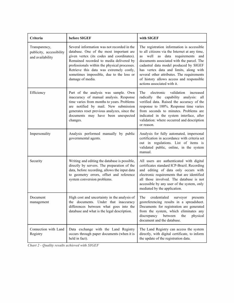
Criteria before SIGEF with SIGEF
Transparency, publicity, accessibility and availability
Several information was not recorded in the database. One of the most important are given vertex (its codes and coordinates). Remained recorded to media delivered by professionals within the physical processes. Retrieve this data was extremely costly, sometimes impossible, due to the loss or damage of media.
The registration information is accessible to all citizens via the Internet at any time, as well as data requirements and documents associated with the parcel. The cadastral data model produced by SIGEF has vertex data and limits, along with several other attributes. The requirements of history allows access and responsible actions associated with it.
Efficiency Part of the analysis was sample. Own inaccuracy of manual analysis. Response time varies from months to years. Problems are notified by mail. New submission generates reset previous analyzes, since the documents may have been unexpected changes.
The electronic validation increased radically the capability analysis: all verified data. Raised the accuracy of the response to 100%. Response time varies from seconds to minutes. Problems are indicated in the system interface, after validation: where occurred and description or reason.
Impersonality Analysis performed manually by public governmental agents.
Analysis for fully automated, impersonal certification in accordance with criteria set out in regulations. List of items is validated public, online, in the system manual.
Security Writing and editing the database is possible, directly by servers. The preparation of the data, before recording, allows the input data to geometry errors, offset and reference system conversion problems.
All users are authenticated with digital certificates standard ICPBrazil. Recording and editing of data only occurs with electronic requirements that are identified all those involved. The database is not accessible by any user of the system, only mediated by the application.
Document management
High cost and uncertainty in the analysis of the documents. Under that inaccuracy differences between what goes into the database and what is the legal description.
The credentialed surveyor presents georeferencing results in a spreadsheet. Documents for registration are generated from the system, which eliminates any discrepancy between the physical document and the database.
Connection with Land Registry
Data exchange with the Land Registry occurs through paper documents (when it is held in fact).
The Land Registry can access the system directly, with digital certificate, to inform the update of the registration data.
Chart 2 Quality results achieved with SIGEF
Figures
Figure 1 Land in Society (Enemark, 2009)
Figure 2 Identification sheet
Figure 3 Perimeter sheet

Figure 4 Parcels composed by three perimeter sheets
Figure 5 Basic data feeding
Figure 6 General data access and sharing
Figure 7 Land parcel web search
Figure 8 Land parcel details
Figure 9 Land parcel and the total georeferenced area
Figure 10 Land parcel and its holder
Figure 11 Land parcel and the Registry status
Figure 12 Land parcel on the map
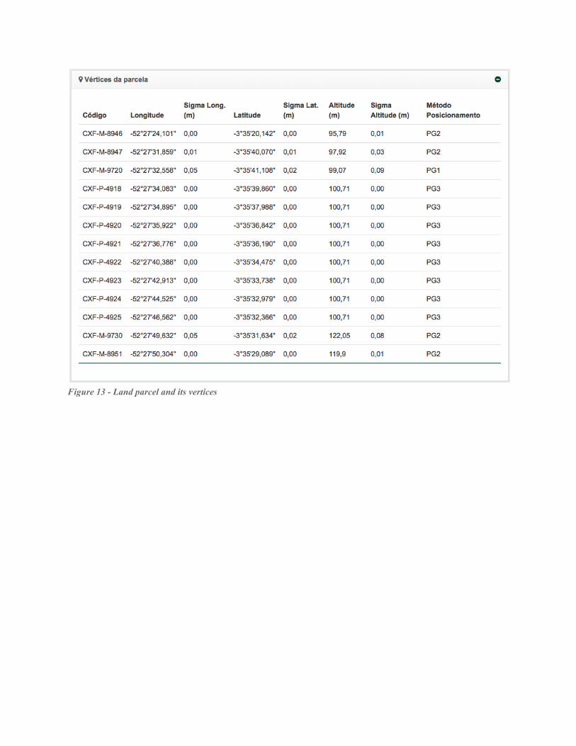
Figure 13 Land parcel and its vertices
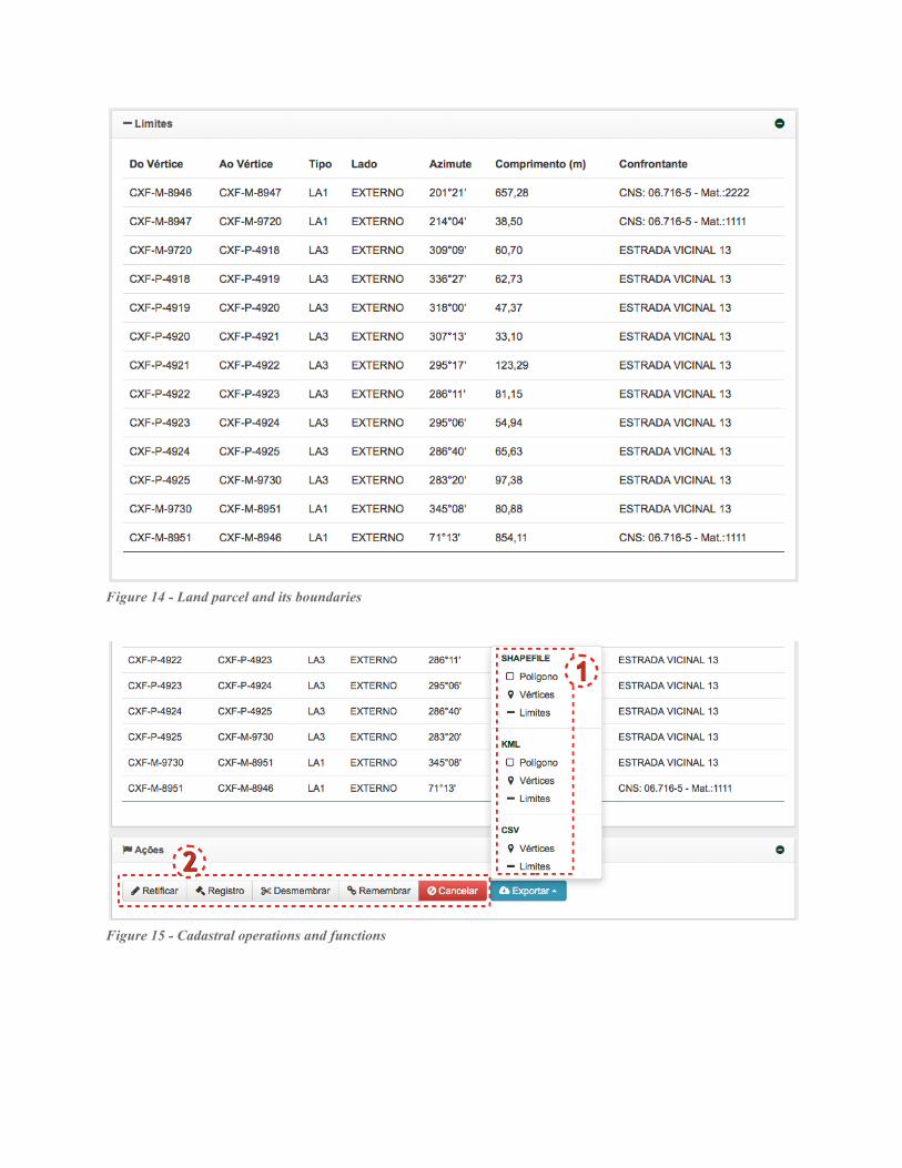
Figure 14 Land parcel and its boundaries
Figure 15 Cadastral operations and functions
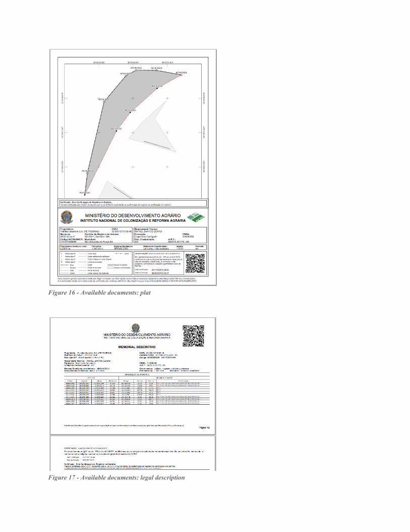
Figure 16 Available documents: plat
Figure 17 Available documents: legal description
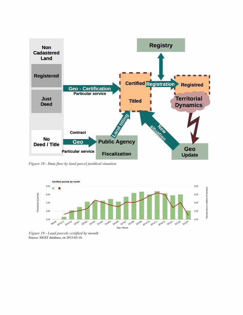
Figure 18 Data flow by land parcel juridical situation
Figure 19 Land parcels certified by month Source: SIGEF database, on 20150310.

Figure 20 Visualization of cadastral data in Amazonian State of Rondonia, Brazil
Figure 21 Public consult in map: a registered parcel in Mato Grosso do Sul State
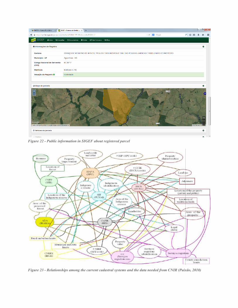
Figure 22 Public information in SIGEF about registered parcel
Figure 23 Relationships among the current cadastral systems and the data needed from CNIR (Paixão, 2010)

![REV SDP13 3352[1]](https://static.fdokumen.com/doc/165x107/631220df48b4e11f7d08cc0c/rev-sdp13-33521.jpg)