Identification of 3Dimensional Cadastre Model for Indonesian Purpose
Developing 3D Registration System for 3DCadastre
Mohd Hasif Ahmad Nasruddin and Alias Abdul Rahman
Departments of Geoinformatics, Faculty of Geoinformation Science andEngineering, Universiti Teknologi Malaysia, 81310 UTM Skudai, Johor,Malaysia. Email: {hasif aliasj Ofksg.utrn.my
Abstract
The establishment of Malaysia cadastral system is to monitor matters ofland especially the land ownership. The system is setup to ensure consistency in cadastral information that comes from cadastral survey and cadastral land registration. In general, the cadastral survey and cadastral landregistration are managed by Department of Survey and Mapping Malaysia(DSMM) and Land Offices (LO) respectively. The system for land registration is known as Cadastral Data Management System (CDMS) which iscontrolled by DSMM where as Computerized Land Registration System(CLRS) administered by the Land Office. A cadastre is normally a parcelbased and up-to-date land information system containing a record of interests on land (e.g. rights, restrictions and responsibilities). Currently, thesystem is based on 2D space. The cadastral object can be either a completeland parcel, parcel of storey houses (strata) e.g. apartments, flats residential or parcel below the surface (stratum). Demands from land owners aswell as property owners show that it is insufficient to register cadastralparcel based on 2 D space. Real-estate property is actually in 3D. Current3D GIS technology could be used to develop a registration system for 3DCadastre and eventually a solution for complex 3D Cadastre objects orsituations. Therefore, the new cadastral system should reflect the existenceof the real-world objects - 3D physical objects and have its own legalrights. 3D technologies make it possible to establish 3D cadastre. This paper discusses a development of 3D registration system for cadastre objectsin 3D. The main objective is to look into possibility of enhancing the current systems practiced by the DSMM and LO towards 3D cadastre registration. In other words, this research attempts to address one of the aspectsin 3D Cadastre, i.e. how to register 3D objects and properties for 3D cadastre.

536 Mohd Hasif Ahmad Nasruddin and Alias Abdul Rahman
Key words: 3D properties, registration system and 3D Cadastre
1. Introduction
A cadastre is normally a parcel-based and up-to-date land information system containing a record of interests in land e.g. rights, restrictions and responsibilities (FIG 1995). It usually includes a geometric description ofland parcels linked to other records describing the nature of the interests,the ownership or control of those interests, and often the value of the parcel and its improvements, (Stoter 2002). Each country has it own agencywhich responsible to monitor all mater pertaining with cadastre. In Malaysia, the responsibility is hold by Department of Surveying and MappingMalaysia (DSMM) and Land Offices (La). Cadastral System is used tomanage land registration system related to cadastral objects also known asreal-estate objects. In Malaysia, generally the cadastral object can be eithera complete parcel of land, parcel of storey houses (strata) e.g. apartments,flat houses or parcel below the surface (stratum). The above-mentioned objects need to be registered as legal objects. Currently, the system is basedon planar map, which is in 2D space.
In the real world today, the 2D system looks to be insufficient to caterthe advance development of the country especially information regardingthe 3D spatial objects. In major urban centre (and especially their businessdistricts), land use is becoming so intense, that different types of land useand properties are located in a complex 3D situations. This puts the practicality of the existing 2D cadastral parcels to the limit (Stoter 2002). Therefore, it is vital to develop and implement the 3D cadastre system to solveand address some of the problems. This research paper attempts to studyone of the aspects in 3D Cadastre that is how to register 3D objects andproperties for 3D cadastre.
Based on the foregoing discussions it shows that several aspects of 3Dcadastre problem domain need to be investigated. The 3D situations needbetter system and clearly revealed the drawbacks for such real world situations (Abdul-Rahman and Stoter, 2005; and Abdul-Rahman et al, 2005).In major urban areas the concept of 2D is insufficient to solve problemswith these 3D situations such as below:• Constructions on top of each other; e.g. fly-over of highways,• Infrastructure above and under the ground e.g. tunnel for LRT, PUTRA,
etc. and• The increasing number of cables and pipes, etc.

Developing 3D Registration System for 3D Cadastre 537
These 3D spatial objects do in general not correspond with legal objectsthat are legally registered and defined. The implementation of 3D Cadastreshould be a priority so that the land information can take 3D informationinto account for the registration. Information on the 3D objects such as thelocation, geometry, function and legal aspects can be maintained and accessible in the proposed cadastral system. The study of 3D cadastre in Malaysia is still at early stage. It is important to develop land information system to cater rapid changes in development so that the cadastre databasewill be up-to-date.
This paper describes a research conducted in developing 3D registrationsystem for 3D cadastre. In section 1, the paper explains the cadastral administration in Malaysia and the needs for registering 3D objects. In section 2, the current registration practice is introduced. Hence, topic in thesub section 2, will explain on Computerized Land Registration System(CLRS), the system architecture and the registration process. Then, it willcontinue with 3D cadastre aspects. In Section 3 topic of current registration with hybrid cadastral, conceptual model and logical model of CLRSand CDMS, and the concept proposed for CLRS of 3D Objects will be explained. Finally, all of the discussion will be concluded and future workswill be remark.
2. Current Registration Practice
In Malaysia, cadastral registration system is governed under National LandCode 1965 (NLC 1965). The system can be divided into two componentscalled land registration and cadastral registration. The land registration andcadastral registration are managed by Department of Survey and MappingMalaysia (DSMM) and Land Offices (LO) respectively. The system forland registration is known as Cadastral Data Management System (CDMS)which is controlled by DSMM where as Computerized Land RegistrationSystem (CLRS) administered by the Land Office. The CDMS is a systemthat stores digital land registration parcel i.e. cadastral maps where asCLRS store cadastral registration attribute i.e, ownerships, restrictions, etc.The cadastral object can be either a complete land parcel, parcel of storeyhouses (strata) e.g. apartments, flats residential or parcel below the surface(stratum) e.g. tunnel.
The cadastral object in Malaysia is still registered in 2D. Current 3Dsituation involves a lot in residential flat houses. Here, strata title is givento the owner base on the area they occupy. However, when it comes tocomplex situations it is still doubtful on how to fully show the legal rights

538 Mohd Hasif Ahmad Nasruddin and Alias Abdul Rahman
of the ownership. In other 3D situations, the air space permit needs to beapplied from the land office. For example, a fly-over at the highway whichcrosses the local state land needs to apply air space permit under NLC1965 jurisdiction. Here, the legal object is shown in the 2D CAD drawingoverlap with cadastral parcel a permit is written out. Overall, the currentregistration just shows the outer boundary as a frame of reference to definethe 3D legal objects.
There is a question arise on how to determine and register a complexsituations. The new cadastral system should reflect the existence of thereal-world objects i.e. 3D physical objects and have its own legal rights.Therefore, 3D cadastre is hopefully a good way to solve the problem occurred.
2.1. Computerized Land Registration System (CLRS)
Land administration in Malaysia used Torrens System as the backgroundand being portrayed in the National Land Code 1965, (NLC 1965). Landtenure using the Torrens System shows the evidence that the land ownerhas the right to the land without any objection. Traditional land registrationsystem used manual based system. In 1992, National Land Code 1965 hasbeen amended to introduce Computerized Land Registration System. Thismodernization step was taken ahead to change all manual transaction tocomputerized systems. Table 14 section 5A-NLC 1965; gives a right for aregistrar and explain the responsibilities uphold concerning on the transformation. The introduction of CLRS is to enhance work productivity atland offices. Furthermore, the land database that being developed can be auseful added for land information system user.
2.1.1. The System Architecture
State-of-the-art computer technology makes it possible to develop Computerized Land Registration System (CLRS). CLRS is a mini online system that operates to a server in UNIX environment. The interface of CLRSis shown in figure 1. The main users are Land Office and Minerals (state),and Land Office (district). All of the information can only be obtained viathe local network in the specific offices. The registration of land can onlybe done by a registrar of the respective offices. Figure 2 show the generalstructure of CLRS configuration. The system is being supervised underMinistry of Natural Resources and Environment. The registration of landcan either be registered at the State Land Offices and Mineral or DistrictLand Offices. Type of registration is applicable on the types of land being
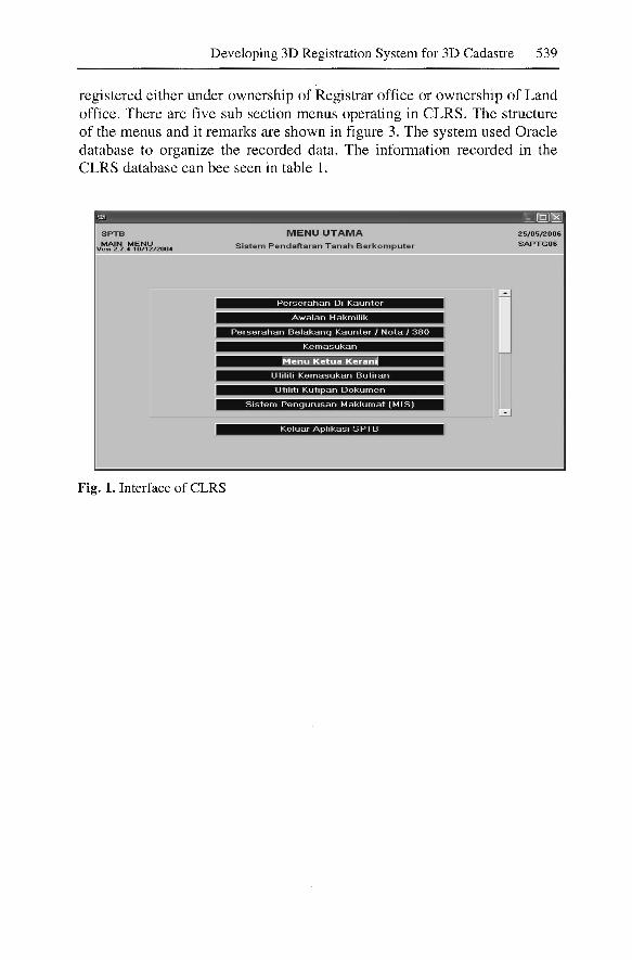
Developing 3D Registration System for 3D Cadastre 539
registered either under ownership of Registrar office or ownership of Landoffice. There are five sub section menus operating in CLRS. The structureof the menus and it remarks are shown in figure 3. The system used Oracledatabase to organize the recorded data. The information recorded in theCLRS database can bee seen in table 1.
SPTBMAIN MENU
Ve$j 2 .7.4 10/1212004
Fig. 1. Interface of CLRS
MENU UTAMAS iste m Pendaftaran T anah Berkomputer
.~. . .
,'nntl$;i"HMirm:m'idi,.."
25/05/2006SAPTG06

540 Mohd Hasif Ahmad Nasruddin and Alias Abdul Rahman
COMPUTER SYSTEMMinistry of Natural Resources
and Environment
I
CLRS - StateLand office &
Mineral
CLRS - StateLand office &
Mineral
I
CLRS - StateLand office &
Mineral
CLRS - DistrictDistrict Land Office
Fig. 2. Structure of CLRS configuration
CLRS - DistrictDistrict Land Office
Preliminary
Entry
Result
Utilities
RetrieveInforma-
Specify types ofdealings
Prepare endorse forapplications
Make decision on landregistration and documen
tation of ownership
Updates & corrections
Search record ofdocuments & details
Fig. 3. Sub section of operations in CLRS

Developing 3D Registration System for 3D Cadastre 541
Table 1. Information in CLRS database
No.1.
2.
3.4.5.6.7.8.
CLRS l"'n'f-n..~n.t- .. n."'n
Landtitle database
Landinfonnatioo
Restriction ofownershipRecordofownershipPartyofinterestPlanoflandLandtaxDealings ofland
RemarksDataofownership, no.oflandtitle, location, typeofused, typeofownership andperiod ofused.Lotnmnber, area, standard sheetno. andcertifiedplan no.ExplicitandimplicitrestrictionsDetail oflandlord & information ofdealingsDetailparty(s) ofinterestPlanoflandoccupied infonnYearly taxpaidTransfer, change ofrestriction, subdivision, lease, isemenandete.
2.1.2. The Registration Process
Basically, the registration process follows the work flow shown in figure 4.At preliminary stage, the application form will be sent to the counter andthe details will be checked. Second stage, the staff will key-in all detailsinto the CLRS system. The details in the CLRS system will be sent to theregistrar in Intermediate Titles Files (ITF) format. The registrar will proceed and make decision whether to register the document or not from theITF file. If all of the details are correct, the application will be registeredelse the application will be suspended. The output will be printed documents know as Computer Registered Document of Title (CRDT) keeps bythe land office and Computer Issued Document of Title (CIDT) deliver tothe owner.
Pre liminary
Data Entry to Systern
Decision of Registrar
Document Handling
Fig. 4. Registration Process in CLRS

542 Mohd Hasif Ahmad Nasruddin and Alias Abdul Rahman
3. Current Practice With Hybrid Cadastral
In Malaysia, a solution with the hybrid cadastral is a promising one. As theresearch is still at early stage, it is not relevant to develop a full 3D cadastral registration for this early study. However, the potential of full 3D registration will be taken into account. In summary, hybrid cadastral proposedby Stoter (2004) means that preservation of the 2D cadastre and the registration of the factual situation in 3D by registering 3D objects within 2Dcadastral registration. The relationship between the parcels and 3D objectscan be maintained explicitly. The hybrid solution will combine the legaland factual registration. The registration of 3D object can be done by intersection of 3D building plan with the cadastral parcels. Here, it can defineand show the legal rights of the property in 3D. The exact legal rights anddocuments which contain precise 3D information can be retrieved at therelevant offices. Thus, this solution should be aware that the registration of3D factual objects is not identical to the definition of 3D legal objects. Thehybrid solution offers a combination of 2D and 3D data in a single database. Therefore, the spatial information in terms of vertical dimension canbe retrieve and taken into account when it is needed. Hence, spatial operation such as storage, access, query and analysis is possible. The databasewill also maintain administrative properties such as the rights, restrictionand also the limited rights of the particular objects.
3.1. Conceptual Model and Logical Model of CLRS & CDMS
Computerized Land Registration System (CLRS) is basically involvedwith land administrative. The schematic diagram of the system is shown infigure 5. Generally, the system has registration coverage, processing, functionality and output. The CLRS administrative- model is bind into 3 components of entities which is legal rights, cadastral objects and cadastralsubject. The relationship of the entities is shown in figure 6. Cadastral object can be a parcel, strata or stratum. Cadastral subject is a person who hasrights for the cadastral objects. A legal right is registered between cadastralobjects and cadastral subjects.

Developing 3D Registration System for 3D Cadastre 543
Ownership
Dealings
Non-de alings
Notes
Preliminary
Data Entry
Result
Grant
StateLease
Land Office
Muk:imGrant
MuJdmLease
Infonnati on retrieve
Filing 0 f le tters
Fe e 0 f re gistratio n
Utilities
Retrieve Info.
Plan
Retrieve Certificate
V erific ati on doc.
Delivery record
Infonnati on
Fig. 5. Schematic diagram of CLRS
Cadas- HAS ..... Cadas-tral Subject tralObjects
Legal rights
Fig. 6. Entities relationship of CLRS administrative-model
Cadastral Data Management System (CDMS) is more towards land registration system. The conceptual model of CDMS is portrayed from the relationship of data model components. Data model of CDMS covers 3 types

544 Mohd Hasif Ahmad Nasruddin and Alias Abdul Rahman
of entities namely Cadastre Lot (parcel), boundary line and boundary mark(stone). The relationship of the entities and attributes is shown in figure 7.The logical model of the system shows the relationship of entities and thespatial objects. Each of the entities has its own attributes and represents asspatial object namely point, polyline and polygon. The relationship of thedata in the CDMS is shown in table 2.
Fig. 7. Entity Relationship and Attributes in CDMS
Table 2. Data Model of CDMS
Entities
BoundaryMarksBoundaryLine
CadastreLot
Attributes
Pointkey, Apdate, Mark_desc, serial, coordjype, R_east,R_north, S_comment, status, GillApdate, parcel_key, bearing, distance, units, class,line_code, line_type, entry_mode, PA, Fnode, Tnode,AdjParcel, Status, GillNegeri, Daerah,Mukim,Seksyen, Lot,Svy_area, Area_unit,
Spatial
Point
Polyline
Polygon

Developing 3D Registration System for 3D Cadastre 545
3.2 CLRS for 3D OBJECTS
It is clear that current Computerized Land Registration System (CLRS)does not include 3D objects registration. The system is more towards landadministrative. In addition, the parcel plan (certified plan, CP) also doesnot correlate systematically in the system itself. The CP needs to be acquired from the Survey Department database i.e. Cadastral Data Management System (CDMS). Then, later it can be incorporated in the registrationform. Therefore, this research is interest to develop CLRS for 3D objects.It is the aim of this research to develop CLRS for 3D objects. Figure 8shows our proposed concept of the registration of 3D objects. It will include two components of discussed in the preceding sections 2 called cadastral registration (land administrative) and land registration (3D objects).
Cadastral Registratio n
Combinationof Database
Land Registration
3D ObjectsVisualization
Fig. 8. Conceptual Model of 3D CLRS for 3D objects
4. Concluding Remarks
There is a need to introduce 3D registration system for 3D cadastre as current registration in Malaysia still practice in 2D system and there is a demand especially in managing 3D physical object property. There are twoorganizations involve in the cadastral system. They are Department ofSurvey and Mapping (DSMM) and Land Offices (La). DSMM deals withland registration system that produce maps where as La is responsible forcadastral registration - cadastral administrative matters. Registration of le-

546 Mohd Hasif Ahmad Nasruddin and Alias Abdul Rahman
gal cadastral objects is done through Computerized Land Registration System (CLRS). The system keeps all information on the registration. Here,relevant parcels for registration are retrievable externally from CDMS database.
Based on the proposed concept, we intend to develop a CLRS for 3D objects like buildings inside 2D parcels where an integration of geo-database(CDMS) and administrative-database (CLRS) will be carried out andeventually a 3D registration system for 3D Cadastre. Thus, aspect of 3Dregistration will be portrayed on the proposed system.
References
Abdul-Rahman, A. and J. E. Stoter (2005). 3D Cadaster in Malaysia - how to realize it? r: Surveyors Congress, Petaling Jaya, Selangor, Malaysia.
Abdul-Rahman, A. and J. E. Stoter, A.F. Nordin (2005). Towards 3D Cadaster inMalaysia. International Symposium and Exhibition on Geoinformation (ISG2005). Penang, Malaysia.
FIG (1995). The FIG Statement on the Cadastre. Technical Report Publication 11,Federation International des G''eometres, Commission 7, 1995.
Genggatharan, M. (2005). Conceptual Model for Integration of Cadastral DataManagement System (CDMS) and Computer Land Registration System(CLRS). MSc. Thesis, Universiti Teknologi Malaysia. (In Malay)
mPEM, Manual Pengguna Sistem Pengurusan Pangkalan Data Kadaster. Department of Survey and Mapping Malaysia. (In Malay)
KPTG (1997). Manual Sistem Pendaftaran Tanah Berkomputer: Latihan kepadaPendaftar. Department of Director General of Lands and Mines. (In Malay)
KPTG, Manual Sistem Pendaftaran Tanah Berkomputer: Bidang Liputan SPTB.Department of Director General of Lands and Mines. (In Malay)
National Land Code (1965).Omar, A.H. (2003). The development of Coordinated cadastral System for Penin
sular Malaysia. MSc. Thesis, Universiti Teknologi Malaysia.Stoter, J.E., M.A. Salzmann, P.J.M. van Oosterom and P. van der Molen (2002),
Towards a 3D Cadastre, FIG XXIIIACSM-ASPRS, 19 - 26 April, 2002,Washington, USA.
Stoter, J.E (2004), 3D Cadastre, PhD Thesis, International Institute for GeoInformation Science and Earth Observation (ITC), the Netherlands.
Copyright © 2022 FDOKUMEN