SFG1038 REV - World Bank Documents
309
Environmental and Social Impact Assessment Metro Manila BRT Line-1 Project Public Disclosure Authorized Public Disclosure Authorized SFG1038 REV Public Disclosure Authorized Public Disclosure Authorized Public Disclosure Authorized Public Disclosure Authorized
-
Upload
khangminh22 -
Category
Documents
-
view
1 -
download
0
Transcript of SFG1038 REV - World Bank Documents

Environmental and Social Impact Assessment Metro Manila BRT Line-1 Project
Pub
lic D
iscl
osur
e A
utho
rized
Pub
lic D
iscl
osur
e A
utho
rized
SFG1038 REVP
ublic
Dis
clos
ure
Aut
horiz
edP
ublic
Dis
clos
ure
Aut
horiz
edP
ublic
Dis
clos
ure
Aut
horiz
edP
ublic
Dis
clos
ure
Aut
horiz
ed

Environmental and Social Impact Assessment Metro Manila BRT Line-1 Project

Environmental and Social Impact Assessment Metro Manila BRT Line-1 Project
ES-1
EXECUTIVE SUMMARY I. Policy, Legal and Administrative Framework 1. An environmental and social impact assessment was undertaken for the proposed Metro Manila Bus Rapid Transit (BRT) Line-1 Project of the Department of Transportation (DOTr), the project’s executing agency. The Metro Manila BRT Line-1 Project is the first BRT in Metro Manila and second in the Philippines, next to the Cebu BRT Project. Relative to the significance of impacts and risks, Metro Manila BRT Line-1 Project falls under Project Category A as defined under Operating Policy (OP) 4.01 of the World Bank (WB). This environmental assessment study was carried in accordance with pertinent WB’s safeguards policies including OP 4.01, Environmental Assessment, and OP 4.12, Involuntary Resettlement among others. 2. The Environmental and Social Management Plan (ESMP) has taken cognizance of the policy, legal, and administrative frameworks relevant to environmental assessment of transport-related projects in the Republic of the Philippines, the WB social and environmental safeguards as provided in its applicable operating policies, and international standards addressing issues and concerns related to vulnerable stakeholders, including women, persons with disabilities (PWDs), and the elderly. For environmental impact assessment, of particular importance are the following laws and regulations: (i) Presidential Decree (PD) 1586 – Establishing the Philippine Environmental Impact Statement System; (ii) Republic Act (RA) No. 9275 – Philippine Clean Water Act of 2004; (iii) RA 6969 – Toxic Substances & Hazardous & Nuclear Waste Control Act of 1990; (iv) RA 8749 – Philippine Clean Air Act of 1999; (v) RA 9003 – Act Providing for an Ecological Solid Waste Management Program; (vi) Batas Pambansa (BP) Blg. 344 s. 1983 – Accessibility Law; (vii) RA 9994 s. 2010 – Expanded Senior Citizens Act of 2010; (viii) RA 9710 – the Magna Carta on Women; (ix) RA 10752 –The Right-of-Way Act; and (x) DOTr Department Order No. 2009-18. For social impact assessment, general policies and laws on land transportation, accessibility and PWDs, elderly and senior citizens, gender and land acquisition and resettlement were considered. II. Project Description
3. The Department of Transportation (DOTr), in collaboration with various government and multilateral agencies, plan to develop solutions and alternatives to help eliminate traffic congestion in Metro Manila and other urban areas in the country. In 2013, a Detailed Technical Study (DTS) was undertaken to examine the feasibility of developing a Bus Rapid Transit (BRT) System along España-Quezon Avenue Corridor dubbed as the Metro Manila BRT Line-1 Project. The España-Quezon Avenue Corridor is a main strategic transport route cutting diagonally through the upper half of Metro Manila. It is not currently served by any form of mass transit system. The corridor’s strategic importance and its connections with LRT1, MRT3, and the Philippine National Railways (PNR) lines, together with its high volume of travel, would suggest that the corridor is justified as a location for a mass transit route. The DTS revealed that the project is technically, financially, and economically feasible. It has the capacity of decongesting traffic flow, resulting in increased vehicular speed along the corridor, improved public mass transportation convenience, reduced travel time, decreased vehicle operating costs, savings in greenhouse gas emissions, and reduced transport accident occurrences. 4. The BRT corridor will approximately be 13 kilometers long, extending from Manila City Hall in the southwest to Philcoa in Quezon City, as shown in Figure ES-1. The government has decided to approve the project to be implemented with World Bank financing (Metro Manila BRT Line-1). The Metro Manila BRT Line-1 infrastructure will be implemented from Manila City Hall to Philcoa. This ESIA covers the corridor from Manila City Hall to Philcoa. The BRT corridor shall include (i) a segregated busway between Philcoa and Manila City Hall; (ii) stations and terminals along the route; (iv) depots for the garaging of buses designated to operate as BRT services; (v) an Area Traffic Control System (ATCS) to facilitate priority run times within the corridor and give citywide benefits of improved traffic flow; (vi) an open service plan that ensures BRT services between Philcoa in Quezon City and Manila City Hall; (vii) traffic management measures to improve traffic flow outside of the corridor that are seen to complement the BRT and maximize its benefits; (viii) parking management measures that will similarly complement the BRT and improve traffic flow; and (ix) urban planning improvements consisting of public realm augmentations, and enhanced integration of transport, and land use.

Environmental and Social Impact Assessment Metro Manila BRT Line-1 Project
ES-2
Figure ES-1. The Proposed Metro Manila BRT – Line 1 and Candidate Sites for the North and South Depot (Map refers to a larger section
than the Manila-Philcoa financed by the Bank)

Environmental and Social Impact Assessment Metro Manila BRT Line-1 Project
ES-3
5. As final selection of the depot sites has not been done, the selected depot sites shall be separately assessed for their environmental and social impacts during project implementation. In the same manner, an ESMP shall be prepared for the selected depot sites specifically. A Terms of Reference (TOR) for the environmental and social impact assessment of the selected depot sites has been prepared for guidance by DOTr and/or its consultant. 6. BRT services would be supplemented by jeepneys operating in a “feeder” mode and providing lateral access/egress to/from adjacent communities. The BRT corridor to be implemented with WB financing (Metro Manila BRT Line-1) has 16 stations. The project would incorporate footpaths, both parallel and penetrating the neighborhoods in the corridor as well as improved street lighting. During the BRT operation, the project will employ substantial Intelligent Transportation Systems (ITS) in order to provide real time passenger information, assist in managing and operating public transport services, collect fares, and manage general traffic. The estimated construction period is three (3) years. III. Environmental and Socioeconomic Conditions 7. The proposed BRT corridor is within highly urbanized sections of Metro Manila which characterizes the socioeconomic baseline conditions of the corridor. These urbanized sections are predominantly of residential, institutional, and business commercial uses. Major public transportation modes along the corridor are Public Utility Jeepneys (PUJs), Public Utility Buses (PUBs), and Asian Utility Vehicles (AUVs). In terms of environmental conditions, the proposed BRT corridor is currently experiencing localized air pollution from huge numbers of public and private vehicles that are spewing air pollutants from exhaust emissions. During construction phase, the Project implementation is expected to cause environmental impacts due to temporary traffic congestion, noise pollution, air pollution emissions from construction equipment and vehicular service, wastewater generation from construction activities, ground contamination from construction hazardous materials and supplies, nuisance, disturbance and reduction in road mobility due to road construction works, and solid waste generation. These impacts shall be managed through the implementation of appropriate and site specific ESMP which will include a traffic management plan. 8. Along the proposed BRT corridor, there are also a number of PUJ and PUB routes that may be affected by the Project operation. Social impacts on livelihood and income displacement for PUJ and PUB drivers, operators and workers may range from income reduction due to franchise cancellation or deletion to give way to BRT operation. As part of the social management plan, a traffic management plan shall be implemented during the construction of the project while at the same time, all affected PUV operators/drivers/employees and other entities will be provided with options that will mitigate and minimize social impacts such as rerouting or modification of franchises and provision of skills training and livelihood replacement, among others. 9. The proposed BRT corridor, being a main strategic transport route in Metro Manila and one of the busiest, is suffering from acute traffic gridlock and congestion. This exposes the commuters to major economic, environmental, and health concerns and stressors. Vehicle flows along the corridor are in the order of 1,150-3,500 per hour over the AM and PM peak periods, while passenger flows of 4,600-13,300 per hour are seen over the AM and PM peak periods. In the DTS, it is noted that a higher volume of vehicles travelled in the westbound direction towards EDSA in the morning peak as compared to the eastbound direction. It is also noted that the number of passenger cars remains the highest in terms of volume and consists approximately 38% of the total traffic. Slightly higher vehicle flow is noted in the eastbound direction in the PM peak.
10. In this corridor, passenger cars make up nearly 40% of the total traffic in both directions. Jeepneys make up approximately 20-25% of the total traffic. The volume of passengers travelling by public transport makes up 77% in westbound and 79% in the eastbound direction. It is notable that whilst buses account for just 3% of vehicle flow, they carry about a quarter of all passenger movements along the corridor. Conversely, private car vehicles make up over 40% of vehicle movements but carry just 15% of travellers. 11. PUB speeds are in general faster than PUJ, however, lower speeds are recorded at the same points along the corridor owing to popular interchange points such as EDSA and Welcome Rotunda. The highest speeds are recorded north of Philcoa on Commonwealth owing to fewer speed drops as

Environmental and Social Impact Assessment Metro Manila BRT Line-1 Project
ES-4
vehicles get toward the City of Manila, again owing to AM peak congestion around Lacson and Padre Noval. PUBs heading eastbound have faster speeds in general over the whole route; however, areas around Padre Noval and Lacson are heavily congested and speeds drop considerably around Padre Noval and Lacson. As with PUJs, eastbound speeds indicate a clear westbound tidal movement in the AM peak. IV. Analysis of Alternatives
12. This ESIA describes and analyzes by comparison the various alternatives considered in this project. No-Project Alternative vs With Project Alternative 13. The basic assumption in this study is that Metro Manila’s urban road networks – including the proposed BRT corridor – need a coping mechanism to address the increasing traffic demands expected in conjunction with other complementary urban development plans. 14. Without the BRT project, (i) Metro Manila and its population will be completely deprived of the benefits that may be generated by the BRT project; (ii) the existing transport system and road networks will be insufficient in capacity to accommodate existing and future traffic demands; (iii) maintaining the status quo with which only routine activities such as road maintenance and repair shall be undertaken on the proposed BRT corridor; (iv) the current public transport system, which is dominated by inefficient buses, jeepneys, mini-buses, shuttle services, and taxis as well as tricycles, multi-cabs, and pedicabs in some sections of the roadway will prevail; (v) the current motorized vehicles in the metropolitan roads and highways, which are anthropogenic sources of greenhouse gases (GHG), will continue to increase; and (vi) travel demand will increase while no additional capacity is provided, which will result to rapid deterioration in traffic speeds, from around 20.3 km per hour (kph) in 2012 to just 3.8 kph in 2040.
1 The low speed forecast represents an untenable situation
in the future and thus require interventions including demand management, highway improvements, and public transport improvements that must be introduced in the short- and medium-terms. 15. For With the Project Scenario, the proposed BRT is a viable solution as a transport intervention along the corridor in the face of growing vehicular congestion and slowing travel time. With the proposed BRT project, savings of up to 12% in v-km volume are expected to accrue starting 2025 arising from the better efficiency in the public transportation system.
2 Speed improvements of up
to one (1) kph are also anticipated by year 2020. GHG savings over 30 years as a result of the BRT project is 6.21 million tons or a yearly GHG savings of 207,000 tons. In general, the proposed BRT will improve overall accessibility and reduce transportation costs. Alternative BRT Routes 16. DOTr has come up with a strategic mass transit network within Metro Manila and nearby cities with the purpose of easing traffic in Metro Manila. Part of this plan is the implementation of a BRT system at selected routes within Metro Manila (Figure ES-2). The BRT routes under the plan are along Quezon Ave-Espana Boulevard (BRT 1), EDSA (BRT 2), and C-5 Road (BRT 3). 17. The Quezon Avenue-España Boulevard corridor is a main strategic transport route cutting diagonally through the upper half of Metro Manila. It is a route not currently served by any form of mass transit. The corridor’s strategic importance and its connections with LRT1, MRT3, and Philippine National Railways together with its high volume of travel would suggest that the corridor has justification as a form of mass transit route.
1 Figures from the Detailed Technical Study 2 Vehicle-km savings is from the Detailed Technical Study.

Environmental and Social Impact Assessment Metro Manila BRT Line-1 Project
ES-5
BRT System over LRT System 18. Two alternative mass transport systems that are commonly used in cities around the world are the LRT and BRT systems. The LRT and BRT systems have done great help to decrease and ease traffic along their respective locations. While it is generally agreed that the two systems deliver more or less the same service, the BRT is significantly cheaper to build and maintain. Whereas light rails and subways have a larger capacity and are favored in more developed countries, BRT systems are much cheaper and quicker to build, and are thus favored in the cities and megacities of the developing world. A comparison of LRT and BRT systems in terms of capital cost, operating cost, and speeds reflects the advantage of the latter as an alternative mass transportation system. Corridor-Specific Alternatives 19. Various alternatives that were considered in coming up with the specification of the proposed BRT project are presented in Table ES-1. Justifications on the recommended alternatives for each of the items were likewise provided.
Table ES-1: Corridor-Specific Alternatives
Concept Issue Option Justification/Information
Configuration of running lanes
Median with median stations Median with bilateral stations Median with cross over Median with tidal flow Bilateral
Limited roadway width, lack of service lanes, proliferation of roadside activity resulting in median operation recommendation Median stations are recommended to reduce cross section and hence right of way acquisition.
Pedestrian crossing
At grade Via skywalk Mixed
Minimizing passenger inconvenience is paramount with respect to issues of safety and impact upon overall road capacity
Regulation Closed to non BRT Open to all
A form of regulatory control is required to protect against competition. Some service overlap is desirable.
Trunk (closed) or direct (open) service
Trunk-feeder Direct
Demand has shown significant trip origins outside of the defined BRT infrastructure. Efficient service of that demand requires some direct services.
Accessibility Step free access throughout Some steps Steps
Higher platforms to achieve step free access would effectively require a closed (trunk-feeder) system and potentially closed stations. Proposal offers significant assistance to many with mobility problems.
Ticketing On board Off board Paper Magnetic Smartcard
Ease of payment, manageable technology risk and association with high technology
Number of lanes Single Twin
High demand is forecast and benefits in operating express services identified.
Vehicle type 11.0m twin-axle bus 13.7m three-axle bus 18.0m articulated bus Diesel LPG/CNG Hybrid High floor (2 step) High floor (1 step) Low floor
Good passenger access and good weight distribution between the axles. The tri-axle bus has potential unutilized axle capacity, either alternative-fuel or hybrid power train options could be pursued without reducing passenger numbers.
Stations Open Closed
To facilitate efficient boarding/alighting to reduce vehicle dwell times and enhance run times

Environmental and Social Impact Assessment Metro Manila BRT Line-1 Project
ES-6
V. Key Environmental and Social Impacts 20. The project has various components that may generate physical, biological, and social disturbance to the existing environment. The list of each of the project activities and component are enumerated in Table ES-2 with corresponding impact generation. Positive Impacts of the Proposed Project 21. The introduction of the proposed BRT project can be considered as an enhancement of the existing transport system in a highly urbanized area. The impacts and risks during construction to the surrounding natural environment and the BRT’s highly urbanized proposed corridor are anticipated to be temporary, limited, and manageable.
Table ES-2: Project Impacts Associated with the Proposed Metro Manila BRT Line-1 Project
Activity / Project Components
Activities will exert:
Key Impacts Physical impacts
Biological/Ecological impacts
Social impacts
1) Segregated Busway X (-) X (-) X (-) Physical impacts: Air, noise, water pollution, utility disturbance,
Biological impacts: urban flora loss
Social impacts: economic and business disturbance, economic displacement for PUV drivers, workers and operators, traffic, utility services disruption
2) Highway Reconstruction X (-) X (-) X (-)
3) Intersection Improvement X (-) X (+)
4) Land Acquisition (for the Depots) X (-) X (-) X (-)
5) Stations X (-) X (-) X (-)
6) Terminals X (-) X (-) X (-)
7) Depots X (-) X (-) X (-)
8) Traffic Management X (+)
9) Pedestrian Crossings X (-) X (+)
10) Urban Realm Enhancements X (+) X (+)
11) ATC (SCATS Upgrade) X (+) Traffic improvement
Enhanced social order
12) BRT / Intersection signal control (in addition to SCATS)
X (+)
13) ITS X (+)
22. The social benefits that are expected from the Metro Manila BRT Line-1 Project are (a) more efficient and safer public transport alternative; (b) safer and more orderly loading and unloading system, particularly for the vulnerable stakeholders; (c) creation of direct employment as a result of BRT construction and operation; (d) enhanced land use along the corridor due to the resulting efficient transportation service; (e) improved public transport regulations; and (f) provision of public transport supportive of women. Economic benefits include reduced travel time and cost savings, reduced vehicle operating costs, savings in GHG and CO2 emissions, and reduction in accident occurrences.

Environmental and Social Impact Assessment Metro Manila BRT Line-1 Project
ES-7
23. The proposed BRT Project will impact the quality of environment and life, productivity, health, and safety of people living in Quezon City, Manila, and nearby towns and cities. On the assumption that the BRT will use more efficient fuel and a significant number of car users will transfer to the BRT, there will be fewer vehicles on the road and the emission of greenhouse gases would be expected to decrease thereby lowering the air pollution level, thus, resulting in a healthier local environment. The proposed BRT system will provide valuable public health benefits by reducing road fatalities, crashes and injuries; reduce personal exposure to harmful air pollutants; and increase physical activity for BRT users. With the anticipated use of cleaner vehicle technologies and fuels such as Euro 4 fuel standards, BRT buses are expected to emit lower concentration of ambient air pollutants. By providing faster travel translated to time savings, passenger exposures to air pollution are reduced at stations or inside the bus. Reduced exposure to air pollutants would eliminate, for instance, days of work lost due to air pollution-related illnesses. With ease of access and confidence that BRT users can reach their destinations on time, passengers may be willing to walk from their point of origin (usually residences) to the nearest BRT stations thus increases their daily walking time as a form of physical exercise. Negative Impacts of the Proposed Project and Cumulative Impacts Environmental Impacts 24. During construction phase, the following physical attributes shall be affected during Project construction: light posts, electrical posts, telecommunication posts, utility posts, traffic lights and signages, road drainage systems, road pavements, culverts and manholes, waiting sheds, and water utilities. These physical attributes are inside the proposed location of bus stations and access to the bus stations. In this case, implementation of ESMP on impact avoidance, reduction, and minimization are necessary. For instance, the following ESMP among others are provided in this ESIA document: re-provisioning electric power lines, water mains, drains and telecommunication cables, planning temporary traffic management measures, waste management disposal, materials supply, temporary drainage, prevention of flooding and protection of the construction works, managing tree-cutting and replanting, controlling noise and dust, and managing workers and public safety. 25. Traffic congestion during construction phase may further aggravate the existing traffic congestion along the corridor. By utilizing planning and evaluation methods to ascertain how pedestrian and vehicular traffic can be affected during construction, DOTr will seek to minimize inconvenience and delay to vehicular traffic, pedestrians, properties, and businesses adjacent to the construction sites. All necessary diversions, some using temporary road and pavement surfaces, will be clearly signed in order to segregate the public from construction activities. Planning for temporary road works and diversions will proceed in a structured set of phases. All proposals for closures and diversions will require the approval of the relevant stakeholders and will be presented to those interested parties well in advance of the temporary works to obtain their timely agreement. 26. Biological impacts would be mainly due to the removal of trees and other plants that are inside or within the proposed BRT stations. However, the alignment sheets provide the account or inventory of the number of vegetation that will be affected during construction phase and corresponding mitigation measures were also made. 27. As of this ESIA work, inventory of potentially affected physical and biological attributes of the broader BRT corridor are as follows (Table ES-3):
Table ES-3: Inventory of Potentially Affected Physical and Biological Attributes

Environmental and Social Impact Assessment Metro Manila BRT Line-1 Project
ES-8
Along the Broader BRT Corridor
BRT Stations (In all 31 Stations)
Trees (estimate DBH)
Utilities Structures
< 2
5cm
25 -
50cm
> 5
0cm
Subto
tal
Lig
ht P
osts
Ele
ctr
ic P
osts
Utilit
y/T
ele
com
Posts
Wate
r U
tilit
ies
Road S
igns
Subto
tal
Private
Lot
Com
merc
ial
Wa
itin
g S
he
d
Subto
tal
Number 185 82 19 286 134 27 9 14 29 213 10 34 9 49
Note: Broader BRT Corridor refers to the initial design which included the Philcoa-Fairview section (longer section of 27.7 km)
Social Impacts 28. The most pressing social impact is the economic displacement of PUV drivers, operators, and workers due to perceived loss of livelihood. The AUV sector felt that they will not be affected during the construction phase due to their route flexibility while during the operation phase of the project, the AUVs can serve in the feeder routes. For the ambulant vendors, their entitlements are addressed and covered by the recommended SMP and in the Resettlement Policy Framework (RPF) that is specifically prepared for this project. 29. The adverse social impact on the PUV sector is a result of (1) reduced passenger volume for Public Utility Vehicles (PUVs); (2) cancellation of the present PUV routes that are along the projected corridor; and (3) economic displacement of PUV drivers, operators, and workers. In addition, there are commercial establishments that are within the proposed locations of the BRT stations. They may not be displaced but they may potentially be blocked by the proposed BRT stations by losing their frontage, customer access, parking space, or display areas. These physical restrictions may possibly have a negative impact on the livelihood of the owners and their employees. PUBs 30. For the PUB sector, the SM Fairview-Baclaran (via Quezon Avenue) bus route overlaps with the BRT corridor. About 260 units ply this route, operated by 25 operators. The driver to unit ratio for the PUBs is assumed to be similar to that of the PUJ, with one regular driver and an alternate driver during days off. Using this assumption, the total number of affected bus drivers will be 516. Considering that there is usually one conductor for every driver, and if support personnel (mechanics, janitors, and office staff) are at 10 percent of the number of drivers and conductors, the PAPs are estimated at 1,135 or 1,160 PAPs including the operators.
PUJs 31. For the proposed BRT corridor, the estimated number of franchises and units operating are 1,530 and 1,844, respectively. These may be translated to a total of 1,530 operators and 3,688 drivers or a total of 5,218 PAPs in the proposed routes that are for deletion. PUJ workers such as barkers and others were not considered as most of the PUJ drivers are doing these kinds of work during their day off or idle times. 32. Based on initial account, presented in Table ES-4 are the initial inventories of project affected people in the PUV sector plying along the BRT corridor:
Table ES-4: Inventory of Potentially Affected PAPs
Public Utility Bus (PUB):
260 units o 25 operators o 516 drivers o 619 conductors and support personnel
Total = 1,160 PAPs
Public Utility Jeepney (PUJ):
1,844 units o 1,530 operators o 3,688 drivers
Total = 5,218 PAPs
Commercial Establishments

Environmental and Social Impact Assessment Metro Manila BRT Line-1 Project
ES-9
33. In addition, there are commercial establishments that are within the proposed locations of the BRT stations. They may potentially be blocked by the proposed stations losing their frontage, customer access, parking space, or display areas. These physical restrictions may have negative impacts on the livelihood of the owners and their employees. The list of the affected establishments is provided in Table ES-5.
Table ES-5: Inventory of Potentially Affected Commercial Establishments by BRT Corridor
BRT Station Commercial Establishment/s
Remarks Potential Impacts
Bronx (Northbound Station)
STI Building An educational institution whose front entrance will directly open to the northbound BRT station.
Blockage of entrance; Land taking not necessary
Atherton (Northbound Station)
A beauty parlor A videoke bar (M2)
The station will be directly covering their frontages, obstructing customer access to the establishments; The customer parking space, which is part of the R-O-W will be taken up by the BRT station.
Blockage of entrance; Land taking not necessary.
Don Fabian (Northbound)
Carinderia with a Salon Informally occupying the R-O-W. Don Fabian may be developed as a smaller station due to very low projected volume of alighting and boarding passengers on this station. In this case, these informal occupants may remain.
Closure of Carinderia if a regular station is built on site; Land taking not necessary.
LRT Central (Southbound)
12 carinderias renting from one concessionaire of LRT commercial space at about PhP4000 to PhP6000 monthly.
Eating areas of these small eateries/restaurants intentionally encroach the pedestrian R-O-W due to the very cramped space of the carinderias.
Loss of customer space; Land taking not necessary.
34. For the affected establishments, land taking is not required. All of the problems identified can be addressed by impact avoidance during detailed engineering design stage. VI. Environmental and Social Management Plan (ESMP) 35. DOTr has prepared at the Feasibility Stage of the Project a pro-active ESMP that will address and/or mitigate all key negative environmental and social impacts that are identified in this ESIA. In crafting the ESMP, DOTr was guided by the following principles in hierarchical order and importance: (i) mitigation / elimination through design; (ii) site / technology choice; and (iii) application of best practices. The ESMP includes (i) details of mitigating measures to be implemented; (ii) required monitoring associated with the mitigating measures; and (iii) implementation arrangement. Institutional set-up discusses the requirements and responsibilities during pre-construction, construction, and operation phases. The plan includes tabulated information on (i) required measures for each environmental impact that requires mitigation; (ii) locations where the measures apply; (iii) associated costs; and (iv) responsibility for implementing the measures and monitoring. 36. The timing of the ESMP inclusion in the various stages of the project is crucial to ensure compliance with safeguard requirements. For this project, the following ESMP at various stages of the project shall be observed:
ESMP During Design Stage (Pre-Construction Phase)

Environmental and Social Impact Assessment Metro Manila BRT Line-1 Project
ES-10
37. During design stage, mitigation measures will be carried out to avoid construction impacts and operational environmental impacts. Since the project is at the Feasibility Stage, a more comprehensive ESMP shall be crafted during the detailed engineering design (DED) Phase. 38. Initiatives to strengthen the capacity of DOTr to execute the safeguard works and requirements shall be implemented. A program for environmental capacity development for DOTr is recommended in this ESIA. 39. The depot sites have yet to be identified by DOTr. A Terms of Reference (TOR) specific for these depot sites was made to ensure that all attendant environmental and social impacts related to depot design, construction, operation and maintenance are addressed and/or mitigated. The TOR as one of the Annexes formed part of this ESIA document.
40. DOTr will ensure that the ESMP and all matters related to the project safeguard compliance are all included in the bidding or tender documents through the implementation of an environmentally responsible procurement process.
41. During design stage, all applicable environmental clearance shall be secured by DOTr from relevant government offices prior to project construction.
42. In particular, all social management plan that are delegated to DOTr should be completed or undertaken prior to construction such as the provision of entitlements for all PAPs and the acquisition of the land for the north and south depots. The details are as follows:
For bus stations along the BRT corridor, land acquisition, resettlement and environmental impacts will be avoided or minimized by basing the detailed designs within the ROW as proposed in the feasibility study;
Where project design necessitates land acquisition and resettlement as in the case of the north and south depots, the recommended social management plan under the Resettlement Policy Framework, which is submitted in a separate volume, shall be used to address social impacts;
Where impacts on commercial establishments cannot be avoided during project design, the Social Management Framework shall serve as a guide in addressing social impacts;
43. The social management plan (SMP) options to be presented to the affected PUV drivers and operators include (1) route relocation, modification, and truncation; (2) co-existence with the BRT or remain on their route despite the impact of the Metro Manila BRT Line-1 project; (3) scrapping or wholesale purchase of old PUJ units by the government; (4) formation of concessionaire group among operators to become part of the BRTconsortium/investors; and (5) provision of alternative livelihood / TESDA training / preferential hiring to affected drivers/personnel and/or members of affected households. Commercial establishments that will be affected close to the BRT stations are entitled to protection and benefits enshrined in social safeguards policies of the Philippine government and the World Bank. The project architects and engineers will, based on meaningful consultations with the affected people, integrate innovative approaches and solutions during the detailed architectural and engineering design stage of project implementation in order to prevent any disturbance or any negative impact to these establishments. In the event that negative impacts cannot be avoided, these establishments are entitled to receive compensation as a full replacement cost for the physical structures to be affected by the project and loss of income in accordance with compensation guidelines under Philippine laws and the WB social safeguard policies. Details of the SMP to address PAP in the affected PUV sector are as follows (Table ES-6):
Table ES-6: Details of the SMP to Address the Needs of PAPs from the PUV Sector

Environmental and Social Impact Assessment Metro Manila BRT Line-1 Project
ES-11
Option Beneficiary Advantages/Opportunities Disadvantages/Challenges
1. Route relocation, modification, or truncation
PUJ/PUB Operators and Drivers
Jeepneys would be plying much shorter routes which translate into higher income and less fuel consumption and the potential for greater operational efficiencies;
Drivers would experience less stress and fewer traffic violations as competition for passengers would be actively managed through efficient and up-to-date market reactive, operational planning of jeepney terminals;
In addition, the designation of new routes will improve the overall efficiency of the transportation system as more areas will have access to public transportation.
New routes are not tested and there is no guarantee that transferred operations will be economically viable;
Modification results to alteration of franchise routes that might conflict with other road users resulting to congestion and stiffer competition among PUJs/PUBs;
Truncation shortens the route the PUJ/PUB may ply which could potentially result to lower number of passengers served by PUJs arising to stiffer competition among them and will potentially result to withering income.
2. Co-existence with the BRT or remain on their route, despite the impact of the Metro Manila BRT Line-1 Project;
PUJ/PUB Operators and Drivers
Opens the PT system to a more competitive market environment. Competitive market results to efficiency and beneficial to the consumers or service users.
Retaining the jeepneys alongside the BRT segregated busways would not address the congestion on the road. Congestion contributes to longer travel time, leading to losses in productivity, increased GHG emissions, deterioration in air quality, increase in respiratory diseases, and diminished competitiveness and liveability.
3. Scrapping or wholesale purchase of old PUJ/PUB units by the government
PUJ/PUB Operators
Removes old units from the roads resulting to decreased congestion and reduced GHG emissions;
PUJ/PUB operators can raise funds through this option to participate in the BRT system as investors
Loss of income due to the stoppage in operations of the old PUB/PUJ;
Loss of employment for the drivers, conductors (if PUBs);
Loss of franchise to operate in the old route or rights to be transferred to a new or modified route;
Potential problem in disposal of old vehicles
4. Participation in the BRT System as Investors
PUJ/PUB Operators PUJ/PUB drivers as members of participating cooperatives/ organizations
Provides an opportunity to the PUJ/PUB operators and drivers to become part of the BRT as a new transport system and have a sense of ownership;
Reduces the impact of feeling of being displaced by the BRT from the route they used to operate;
Opportunity to be trained as an investor and opportunity to earn profit from investment.
Lack of adequate financial resources of PUB/PUJ operators/drivers and their organizations as a prohibiting factor;
Lack of exposure and experience in investing in similar undertakings may create management problems later on.
5. Provision of alternative livelihood / TESDA
PUB/PUJ drivers and other displaced personnel
PUB drivers will benefit most as there will be preferential hiring for them as BRT drivers. Other PUJ drivers may also qualify to
Trainings are not very attractive to drivers and operators who are displaced as a result of the BRT.
Drivers usually wish only to drive
Environmental and Social Impact Assessment Metro Manila BRT Line-1 Project
ES-12
training / preferential hiring to affected drivers/personnel and/or members of affected households
drive the BRT buses;
Many positions in the BRT may be filled up by PAPs or a member of their families;
Training provided for free to PAPs or a member of their families may open employment opportunities or can offer a substitute income to the PAP households.
for a living;
Provision of allowances to offset loss of income while on training;
No guarantee of employment after training;
Lack of requisite skills or qualification among PUJ/PUB drivers may prevent them from getting hired for the BRT operation.
SMP for other Marginalized Stakeholders 44. The most pressing concerns for women in the Public Transport (PT) sector are: (1) the harassment that they encounter in over-crowded PT vehicles; and (2) difficulty in boarding and alighting. Women employees are also not well-represented in the PT sector where drivers and conductors are predominantly men. Integrating these concerns in the implementation of the Metro Manila BRT Line-1 project requires the following action plans: (1) the BRT system shall be designed for ease of boarding and alighting with buses and the stations at the same level; (2) the system shall address the issue of encumbrances of passengers, including over-crowding by provision of sufficient space for passengers and cargo; and (3) creating a policy that promotes equal employment opportunity for women in the BRT system. 45. The BRT system shall integrate appropriate public transportation design standards that will address safety and accessibility for persons with disabilities (PWDs), the elderly, and students based on existing laws and policies of the Philippine government and international covenants and standards. Students, senior citizens, and PWDs shall be afforded discounted fares based on applicable regulations on passenger fares. Specific design features for PWDs will be incorporated in the Banaue station, as this is the station nearest to the National Orthopedic Hospital and is used by many PWDs. Consultations with PWD groups will be done to ensure that design of the station will be convenient and safe for PWDs.
ESMP During Construction Phase 46. In the execution of the ESMP during the construction phase, DOTr is expected to undertake an intensive orientation of all parties that will be involved in the construction of the project on the need to observe strict compliance with the ESMP. 47. On the other hand, DOTr, through SPC and its contractors, shall be responsible in the incorporation of all ESMPs provided in this document into their Project Execution Plan (PEP). In this case, the following ESMPs shall be translated into site specific measures:
Management for the Loss of Trees and other Forms of Vegetation
Drainage and Flooding Management
Utilities Management
Materials Exploitation and Management
Spoil Disposal Management
General Construction Waste Management
Hazardous Materials and Hazardous Waste Disposal and Management
Asphalt Hot Mix Plant, Rock Crushing, and Bitumen Supply Management
Noise and Vibration Management
Air Emissions and Dust Management
Excavation and Protection, Runoff Control, and Protection of Works
River Protection, Road Reconstruction/Demolition, and Replacement
Water Quality and Water Resources Management
Construction Camps and Canteen Facilities Management
Sanitation and Disease Vectors Management
Occupational Health and Safety
Community Health and Safety
Environmental and Social Impact Assessment Metro Manila BRT Line-1 Project
ES-13
Traffic Management
Physical Cultural Resources Management
Urban Greening and Enhancements
ESMP During Operations Phase
48. During the operations phase, DOTr and/or the SPC shall be responsible in overseeing that the following ESMPs are properly executed and undertaken in accordance with the requirements of DENR and WB:
Noise Management
Gaseous Emissions Management
Particulate Emissions Management
Domestic Waste Generations Management
Driving Conditions and Community Safety
VII. Institutional Arrangement, Capacity Building on ESMP Implementation and Communication Plan
49. The main body within the DOTr that will be responsible in the implementation and/or supervision of the ESMP implementation is the Project Implementation Unit or PIU. The PIU will perform the following major responsibilities:
Ensure that bidding and contract documents include the ESMP;
Submit monthly and semi-annual monitoring reports on ESMP implementation to DENR-EMB and WB;
Include in the Project Execution Plan (PEP) the ESMP and submit method statements/site specific ESMPs as described in the ESIA;
Ensure that ESMP provisions are strictly implemented during various project phases (design/pre-construction, construction, and operation) to mitigate environmental impacts to acceptable levels;
Ensure that Project implementation complies with WB's environmental policy OP 4.01 and the principles and requirements therein;
For project duration, commit and retain a dedicated staff within each PIU as environment and safety and social safeguard officers to oversee ESMP implementation;
Check that environmental protection and mitigation measures in the ESMP are incorporated in the detailed designs;
Check the necessary environmental clearances and approval(s) from DENR prior to award of civil works contracts;
Participate in an environmental grievance redress mechanism, as described in the ESIA, to receive and facilitate resolution of affected peoples' concerns, complaints, and grievances about the Project's environmental performance;
Undertake monitoring of the implementation of the ESMP (mitigation and monitoring measures);
Report to WB and DENR on all aspects of environmental and social management and monitoring at biannual intervals, based on the results of ESMP monitoring;
Prepare semi-annual environmental and social monitoring reports for submission to WB and DENR; and,
Based on the results of ESMP monitoring, identify environmental and social corrective actions and prepare a corrective action plan, as necessary, for submission to WB.
50. In this ESIA, it is recommended that the prescribed ESMP to address the capacity building needs of DOTr-PIU be properly executed. The capacity building will cover works on environmental monitoring, ESMP implementation in terms of required mitigation measures for different project phases, data reporting, and interpretation of results of environmental monitoring, instituting

Environmental and Social Impact Assessment Metro Manila BRT Line-1 Project
ES-14
necessary remedial actions when necessary as well as documentation of complaints received and the provision of corresponding action/resolution.
51. The project will also ensure that affected PAPs and project stakeholders are appropriately engaged and consulted on issues that could potentially affect them to ensure that short and long term impacts are reduced. In this case, a communication and stakeholder engagement plan is prepared in this ESIA. 52. Fund allocation for these works are summarized in Table ES-7.
Table ES-7: Estimated Cost for Capacity Building for ESMP Implementation and Communication Plan
Particulars Details Implementation Period
Amount (US Dollars)
1. Capacity Building
Includes capacity building on ESMP, SMP, and monitoring
During construction and operations phases
44,000.00/yr
2. Environmental Monitoring Cost
Includes monitoring works for water, air, and noise
During construction and operations phases
25,000.00/yr
3. ESMP Cost is to be shouldered by the Contractor (during construction phase); Cost is to be shouldered by the SPC during the operations phase
During construction phase; During operations phase
Part of the Contractor’s Cost; Part of the SPC’s Operations and Maintenance (O&M) Cost;
4. SMP Various activities at different project phases; except for ROW and relocation cost (if there is any), cost is to be shouldered by the Contractor
During construction and operations phases
697,720.00 Additional cost shall be earmarked by the SPC during the operations phase
5. Communication Plan
To be shouldered by DOTr; Estimates are provided in this ESIA document: Stakeholder Communications Plan, Responsibilities, and Cost
During pre-construction, construction and operations and decommissioning phases
Part of the cost per activity to be prepared by the Safeguard Officers and GO and to be approved by DOTr.
VIII. Consultation, Information Disclosure, and Grievance Redress Mechanism 53. Consultation and Participation. Project planning and the subsequent impact assessment document preparation for the proposed project recognized the need for public consultation and participation as central to effective environmental safeguard. Within the context of “meaningful consultation,” DOTr initiated a process of consultation during project preparation, and will intend to continue it during the construction phase. 54. During the DTS phase, face-to-face meetings were conducted with representatives from the local governments of the City of Manila and Quezon City, officers of the public utility jeepneys operators and drivers’ associations from the nine (9) routes that were initially identified to be potentially affected by the implementation of the BRT corridor, and special interest groups. 55. During the environmental and social impact study phase, DOTr and CPI Total Corporation (CPITC) conducted a total of 19 public consultation meetings – both local and national in context. Majority of these meetings targeted the affected PUV drivers, operators, and workers that are plying along the proposed BRT corridor. The general public and commuters were also invited in these public consultation meetings.

Environmental and Social Impact Assessment Metro Manila BRT Line-1 Project
ES-15
56. In terms of consultation coverage for affected PUVs, almost all PUV organizations and associations were invited and attended the public consultation meetings. All PUJ organizations and one PUB company were represented in these consultations. However, only three PUJ organizations participated in the preparation of the social management plan. During these meetings, information disclosure with affected stakeholders was done by providing them with details of the project while their views to minimize and mitigate environmental and social impacts, among others, were solicited and discussed. In general, these project stakeholders expressed support to the proposed project provided that DOTr will address their expressed concerns during implementation.
57. Project disclosure activities were both done during the conduct of the DTS from January 2013 to August 2013 and the ESIA from the period of November 2013 up to May 2015. In all these public disclosure events, project descriptions were presented and discussed alongside potential environmental and social impacts of the project. Representatives from various public transport groups, special interest groups, and the Local Government Units of Manila and Quezon City also participated in a series of meetings. During detailed design, DOTr will again conduct public consultations and information disclosure initiatives. DOTr shall keep records of environmental and social complaints received during consultations, field visits, informal discussions, and/or formal letters, together with the subsequent follow-up and resolutions of issues.
58. A Stakeholder Communications Plan (SCP) has been prepared for future public consultations and public disclosures. The SCP listed the activities to be undertaken during pre-construction, construction and O&M phases, the timing of each activity, and the responsible entities to execute the SCP. 59. Grievance Redress Mechanism (GRM). Communities and individuals who believe that they are adversely affected by a World Bank-supported project may submit complaints to existing project-level grievance redress mechanisms or the WB’s Grievance Redress Service (GRS). The GRS ensures that complaints received are promptly reviewed in order to address project-related concerns. Project-affected communities and individuals may submit their complaints to the WB’s independent Inspection Panel which determines whether some harm occurred, or could occur, as a result of WB non-compliance with its policies and procedures. Complaints may be submitted at any time after concerns have been brought directly to the World Bank's attention, and Bank Management has been given an opportunity to respond. For information on how to submit complaints to the World Bank’s corporate Grievance Redress Service (GRS), please visit http://www.worldbank.org/GRS. For information on how to submit complaints to the World Bank Inspection Panel, please visit www.inspectionpanel.org. 60. DOTr shall disclose the proposed GRM during public consultations. Low to medium grievances about the environmental and social performance of the project during the construction phase is proposed to be handled by the Grievance Officer (GO) while highly sensitive grievances will be handled by the Grievance Redress Committee (GRC). Both GO and GRC are expected to provide expeditious resolutions of complaints. Complaints during the operations phase can be brought to the attention of the BRT operator or SPC. SPC/DOTr shall address promptly, at no cost to the complainant and without retribution, any complaints and concerns. The GRC shall be chaired by DOTr with members from multi-sectoral organizations. The creation of the GRM and its operationalization shall be included in the appropriate sections of the project’s civil works contract. 61. Aggrieved parties or complainants may also submit their complaints to DENR-EMB. EMB is mandated by PD 1586 to act on complaints about environmental and social performance of projects issued with environmental compliance certificates (ECC). IX. Conclusion and Recommendation
62. The BRT project is essential for Metro Manila’s economic development, as it will address the Metro’s sustainable urban transport development. Once the project is implemented, the Metro Manila BRT Line-1 project will serve as a catalyst in the development of an efficient and seamless public transport system, not only in Metro Manila but in the entire country as well, where it will serve more commuters and eventually encourage modal shift to efficient and low-carbon public transport system.

Environmental and Social Impact Assessment Metro Manila BRT Line-1 Project
ES-16
63. With the undertaking of a comprehensive ESIA and the subsequent identification of significant environmental and social impacts, the recommended ESMP will help reduce and mitigate these adverse environmental and social impacts arising from the location, design, construction, operation, and maintenance of the proposed BRT project. For socially-affected stakeholders, a highly feasible SMP shall be implemented to mitigate and address the needs of affected stakeholders. The proposed SMP measures to address economic displacement in the PUV sector include, among others, the relocation or modification of franchises and the provision of TESDA skills trainings. Concerns of interest groups such as PWD, the elderly, and women’s groups that are relevant to the project are also addressed in the SMP. The proposed ESMP implementation follows the hierarchy of mitigation measures, which are: (1) mitigation/elimination through design; (2) site/technology choice; and (3) application of best practices. 64. The prescribed ESMP for this project is attainable, which includes tailor-made environmental protection measures and social impact mitigating measures for all potential environmental and social impacts. The ESMP also designates each relevant organization to fully implement environmental protection measures and the planned social impact mitigating measures. The ESMP ensures the implementation of environmental and social mitigating measures and monitoring during the construction and operation stages of the BRT project. With the ESMP in this ESIA properly executed, the Project can be implemented in an environmentally sound and socially acceptable manner.

Environmental and Social Impact Assessment Metro Manila BRT Line-1 Project
ES-16

Environmental and Social Impact Assessment Metro Manila BRT Line-1 Project
i
i
TABLE OF CONTENTS
Environmental and Social Impact Assessment (ESIA) Metro Manila BRT Line-1 Project
COVER LETTER SECTION Page EXECUTIVE SUMMARY ........................................................................................................................ ES-1 1.0 INTRODUCTION ......................................................................................................................... 1-1 1.1 Project Overview ........................................................................................................ 1-1 1.2 Applicable Safeguard Policies ................................................................................... 1-2 1.3 Organization of the Report ......................................................................................... 1-3 2.0 POLICY, LEGAL AND ADMINISTRATIVE FRAMEWORK ..................................................... 2-1 2.1 Governing National Laws On Environmental Assessments ...................................... 2-1 2.2 General Policies and Laws on Land Transportation .................................................. 2-2 2.3 Related Policies to Social Impact Assessment .......................................................... 2-3 2.3.1 Laws and Standards Related to Accessibility and PWDs ................................ 2-3 2.3.2 Policies on Elderly or Senior Citizens .............................................................. 2-4 2.3.3 Gender Related Policies and Standards .......................................................... 2-5 2.3.4 Policies on Land Acquisition and Resettlement ............................................... 2-6 2.4 Applicable WB Safeguard Policy ............................................................................... 2-7 2.5 Gaps between Philippine Government and World Bank policies on key issues ....... 2-8 3.0 PROJECT DESCRIPTION........................................................................................................... 3-1 3.1 Project Background ......................................................................................................... 3-1 3.2 Project Rationale and Objectives ................................................................................... 3-1 2.3 The BRT Corridor and Location ..................................................................................... 3-1 3.4 Project Components ....................................................................................................... 3-4 3.4.1 Segregated Bus Running Way ............................................................................. 3-4 3.4.2 Bus Stations .......................................................................................................... 3-4 3.4.2.1 Components of Bus Stations ................................................................ 3-7 3.4.2.2 Outline Specification of Bus Station ...................................................... 3-9 3.4.3 Intelligent Transport Systems ............................................................................. 3-11 3.4.4 Ticketing ............................................................................................................. 3-13 3.4.5 Vehicles ............................................................................................................. 3-15 3.4.5.1 Recommendations for vehicle configuration ...................................... 3-15 3.4.5.2 Functional and technical specification ................................................ 3-17 3.4.5.3 Finalizing the bus specification ........................................................... 3-19 3.4.6 Bus Depot ........................................................................................................... 3-19 3.4.7 Branding ............................................................................................................. 3-21 3.5 Bus Operation Service Plan ......................................................................................... 3-21 3.6 Operational Management ............................................................................................. 3-21 3.6.1 Role of the System Management Company ...................................................... 3-22 3.6.2 Operations Management Requirements ............................................................ 3-23 3.6.3 Organizational Structure for System Operations Management ........................ 3-24 3.7 Project Cost ............................................................................................................. 3-26 3.8 Implementation Schedule ............................................................................................. 3-27 4.0 ENVIRONMENTAL BASELINE DATA ....................................................................................... 4-1 4.1 Physical Environment ..................................................................................................... 4-1 4.1.1 Geology and Geomorphologic Characteristics .................................................... 4-1

Environmental and Social Impact Assessment Metro Manila BRT Line-1 Project
ii
ii
4.1.1.1 Stratigraphy ........................................................................................... 4-1 4.1.1.2 Seismic activity ...................................................................................... 4-3 4.1.2 Soil Characteristics ............................................................................................... 4-4 4.1.3 Topography and Slope ......................................................................................... 4-4 4.1.4 Drainage Pattern ................................................................................................... 4-5 4.1.5 Flooding ............................................................................................................... 4-5 4.1.6 Water Quality ........................................................................................................ 4-9 4.1.7 Climatology ......................................................................................................... 4-11 4.1.8 Ambient Air Quality ............................................................................................. 4-14 4.1.8.1 Air Quality Monitoring (from DENR).................................................... 4-14 4.1.8.2 On-site Air Sampling and Measurement ............................................ 4-16 4.1.9 Air Quality Modeling ............................................................................................ 4-22 4.1.10 Current Year GHG Emissions ........................................................................... 4-29 4.1.11 Land Use ............................................................................................................ 4-30 4.1.12 Archaeological and Cultural Resources ............................................................ 4-34 4.1.13 Other Miscellaneous Landmarks ...................................................................... 4-35 4.1.14 Alignment Sheets ............................................................................................... 4-36 4.1.15 BRT Corridor Existing Condition ....................................................................... 4-36 4.2 Biological Environment ................................................................................................. 4-53 4.2.1 Flora and Fauna.................................................................................................. 4-53 4.2.2 Ecologically Sensitive Landscape ...................................................................... 4-53 4.3 Social Environment ....................................................................................................... 4-55 4.3.1 Economic Structure ............................................................................................ 4-55 4.3.2 Health ............................................................................................................. 4-55 4.3.3 Social Services / Utilities..................................................................................... 4-56 4.3.3.1 Transportation ..................................................................................... 4-56 4.3.3.2 Power Supply ...................................................................................... 4-56 4.3.3.3 Communication Infrastructure ............................................................. 4-56 4.3.3.4 Water Supply ....................................................................................... 4-56 4.3.3.5 Roads and Traffic ................................................................................ 4-57 4.3.4 Local Government Units ..................................................................................... 4-59 4.3.4.1 Local Government of Quezon City...................................................... 4-59 4.3.4.2 Local Government of Manila ............................................................... 4-60 4.3.5 Commuters and Traffic Forecast ....................................................................... 4-60 4.3.6 Public Utility Vehicle Sector ................................................................................ 4-63 4.3.6.1 PUJ and PUB Routes and Units Operating ........................................ 4-63 4.3.6.2 Socioeconomic Profiles ....................................................................... 4-65 4.3.7 Affected Commercial Establishments and Close to Stations ............................ 4-71 4.3.8 Senior Citizens, PWDs and Women .................................................................. 4-73 5.0 ANTICIPATED ENVIRONMENTAL AND SOCIAL IMPACTS AND MITIGATION
MEASURES ........................................................................................................................... 5-1 5.1. Potential Environmental and Social Impacts Associated with the Project .................... 5-1 5.1.1 Physical and Biological Impacts ........................................................................... 5-1 5.1.2 Social Impacts ....................................................................................................... 5-2 5.1.3 Cumulative, Indirect and Induced Environmental Impacts .................................. 5-2 5.1.3.1 Cumulative Impacts ............................................................................... 5-2 5.1.3.2 Indirect Impacts ..................................................................................... 5-4 5.1.3.3 Induced Impacts ................................................................................... 5-4 5.1.4 ESMP Approach ................................................................................................... 5-5 5. 2 Positive Impacts of the Proposed Project ...................................................................... 5-5 5.2.1 Socioeconomic Benefit ......................................................................................... 5-5 5.2.2 Quantified Economic Benefits .............................................................................. 5-8 5.2.3 Environmental Benefits ......................................................................................... 5-9 5.3 Negative Impacts of the Proposed Project ..................................................................... 5-9 5.3.1 Adversely Affected Sectors .................................................................................. 5-9 5.3.2 Economic Dislocation of PUJ Drivers and Operators .......................................... 5-9 5.3.3 Economic Dislocation of PUB Drivers and Operators ....................................... 5-11 5.3.4 Summary of Social Impacts ................................................................................ 5-11
Environmental and Social Impact Assessment Metro Manila BRT Line-1 Project
iii
iii
5.4 EMP for Physical and Biological/Ecological Impacts ................................................... 5-13 5.4.1 ESMP during Design Stage (Pre-Construction Phase) ..................................... 5-13 5.4.1.1 Design / Pre-Construction Phase ....................................................... 5-13 5.4.1.2 Design Measures and Project Disclosure .......................................... 5-13 5.4.1.3 Project Boundaries Change near Sensitive Receivers ...................... 5-15 5.4.1.4 Environmental Capacity Development of DOTr/PIU .......................... 5-15 5.4.1.5 Preparation of Site-specific ESMPs .................................................... 5-16 5.4.1.6 Environmentally Responsible Procurement ....................................... 5-16 5.4.1.7 Utilities Coordinating Committee......................................................... 5-17 5.4.1.8 Ambient Environmental Baseline Data (Air quality and Noise).......... 5-17 5.4.1.9 Enhancements through Urban Greening............................................ 5-18 5.4.2 ESMP during Construction Phase ..................................................................... 5-18 5.4.2.1 ESMP Activation and Securing of Permits and Licenses .................. 5-18 5.4.2.2 Orientation of Contractor ..................................................................... 5-19 5.4.2.3 Loss of Trees/Deforestation and Impacts to Fauna ........................... 5-19 5.4.2.4 Drainage and Hydrology .................................................................... 5-20 5.4.2.5 Utility Management .............................................................................. 5-21 5.4.2.6 Materials Exploitation and Management ............................................ 5-22 5.4.2.7 Spoil Disposal ...................................................................................... 5-23 5.4.2.8 General Construction Waste Management ....................................... 5-24 5.4.2.9 Hazardous Materials and Hazardous Waste Disposal ...................... 5-25 5.4.2.10 Asphalt Hot Mix Plant, Rock Crushing and Bitumen Supply ............. 5-26 5.4.2.11 Noise and Dust .................................................................................... 5-27 5.4.2.12 Vibration ............................................................................................... 5-29 5.4.2.13 Excavation and Protection, Runoff Control and Protection of Works ................................................................................................... 5-29 5.4.2.14 River Protection, Road Reconstruction/Demolition and Replacement ....................................................................................... 5-29 5.4.2.15 Water Quality ....................................................................................... 5-30 5.4.2.16 Water Resources ................................................................................. 5-30 5.4.2.17 Construction Camps and Canteen Facilities ...................................... 5-31 5.4.2.18 Sanitation and Disease Vectors .......................................................... 5-31 5.4.2.19 Occupational Health and Safety ......................................................... 5-31 5.4.2.20 Community Health and Safety ............................................................ 5-32 5.4.2.21 Traffic Management ............................................................................ 5-33 5.4.2.22 Physical Cultural Resources Management Plan ................................ 5-36 5.4.2.23 Enhancements through Urban Greening............................................ 5-37 5.4.3 ESMP during Operational Phase ....................................................................... 5-37 5.4.3.1 Noise .................................................................................................... 5-37 5.4.3.2 Gaseous Emissions ............................................................................. 5-37 5.4.3.3 Particulate Emissions .......................................................................... 5-38 5.4.3.4 Domestic Waste Generations ............................................................. 5-38 5.4.3.5 Driving Conditions and Community Safety ......................................... 5-38 5.5 Social Management Plan (SMP) .................................................................................. 5-39 5.5.1 Options Addressing Economic Dislocation in the PUV Sector ......................... 5-39 5.5.2 Desire for Flexibility to co-exist with the BRT .................................................... 5-39 5.5.3 Scrapping or wholesale purchase of old PUJ units by the government ........... 5-40 5.5.4 Participation in the BRT System as Investors ................................................... 5-40 5.5.5 Provision of alternative livelihood/TESDA training to and preferential of affected drivers/personnel and/or members of affected households ................ 5-40 5.5.6 Analysis of SMP Options Presented .................................................................. 5-41 5.5.7 Custom-Made SMPs for PUJ Drivers and Operators ........................................ 5-42 5.5.7.1 The Case of Tropang Tsuper .............................................................. 5-42 5.5.7.2 The Case of HEQFAJODA ................................................................. 5-44 5.5.7.3 The Case of COMMTRANSDECO ..................................................... 5-44 5.5.7.4 Other PUJ/PUB Organizations ........................................................... 5-46 5.5.8 Social Management Framework for the Affected Commercial Establishments .................................................................................................... 5-46 5.5.8.1 Entitlement Eligibility............................................................................ 5-46 5.5.8.2 Identification, Tagging and Appraisal.................................................. 5-49

Environmental and Social Impact Assessment Metro Manila BRT Line-1 Project
iv
iv
5.5.8.3 Consultations with PAPs and Compensation ..................................... 5-49 5.5.9 Gender Action Plan ............................................................................................. 5-49 5.5.10 SMP Measures to address accessibility to PWDs, elderly and students ...... 5-49 6.0 ANALYSIS OF ALTERNATIVES ................................................................................................ 6-1 6.1 No-Project Alternative ..................................................................................................... 6-1 6.2 With Project Alternative................................................................................................... 6-1 6.3 Project Alternatives ......................................................................................................... 6-2 6.3.1 Alternative BRT Routes ........................................................................................ 6-2 6.3.2 BRT System over LRT System ............................................................................ 6-5 6.3.3 Other Alternatives Studied for the Project ........................................................... 6-6 7.0 ENVIRONMENTAL AND SOCIAL MANAGEMENT PLAN (ESMP) ........................................ 7-1 7.1 ESMP Safeguard Compliance ........................................................................................ 7-1 7.2 ESMP Timing and Execution .......................................................................................... 7-2 7.2.1 ESMP during Design Stage (Pre-Construction Phase) ....................................... 7-2 7.2.2 ESMP during Construction Phase ....................................................................... 7-3 7.2.3 ESMP during Operation Phase ............................................................................ 7-3 7.2.4 Responsibilities for ESMP Implementation .......................................................... 7-3 7.3 Environmental Management Plan (EMP)....................................................................... 7-8 7.4 Social Management Plan (SMP) and Monitoring Works ............................................... 7-8 7.4.1 Cost of Social Management Measures .............................................................. 7-77 7.5 Environmental Monitoring Works ................................................................................. 7-78 7.5.1 Compliance Monitoring 7-78 7.5.1.1 Design Stage ....................................................................................... 7-78 7.5.1.2 Pre-construction Stage ........................................................................ 7-79 7.5.1.3 Construction Stage .............................................................................. 7-79 7.4.1.4 Operational Stage ............................................................................... 7-79 7.5.2 Reporting and Monitoring Parameters ............................................................... 7-79 7.6 Environmental Monitoring Costs .................................................................................. 7-80 7.7 Environmental Capacity Building and Training ............................................................ 7-80 7.8 Conclusions ................................................................................................................... 7-81 8.0 CONSULTATION, INFORMATION DISCLOSURE, & GRIEVANCE REDRESS
MECHANISM .................................................................................................................. 8-1 8.1 Stakeholder Identification ............................................................................................... 8-1 8.1.1 Direct Stakeholders .............................................................................................. 8-1 8.1.2 Indirect Stakeholders ............................................................................................ 8-1 8.2 Public Consultations during DTS Stage ......................................................................... 8-1 8.2.1 Local Government Units ....................................................................................... 8-2 8.2.2 Public Utility Vehicles (PUV) operators and drivers ............................................ 8-2 8.2.3 Special interest groups ......................................................................................... 8-4 8.3 Public Consultations during the ESIA Stage .................................................................. 8-5 8.3.1 Meetings with the PUJ/PUB Sectors .................................................................... 8-7 8.3.2 Meetings with the PWD Sector ............................................................................ 8-8 8.4 Future Public Consultations ............................................................................................ 8-8 8.5 Community Relations and Participation Plan (CRPP) ................................................... 8-8 8.5.1 Civil Society Consultative Committee (CSCC) .................................................... 8-8 8.5.2 Public Relations and Communication Group ....................................................... 8-9 8.5.3 Information Dissemination and Stakeholder Enhancement Plan ....................... 8-9 8.5.4 Community Support ............................................................................................ 8-10 8.6 Grievance Redress Mechanism (GRM) ....................................................................... 8-11 8.6.1 Designation of Grievance Officer (GO) and Formation of Grievance
Redress Committee (GRC) ................................................................................ 8-11 8.6.2 Grievance Reporting and Resolution ................................................................. 8-12 8.6.3 Grievance Mechanism Disclosure ..................................................................... 8-13
Environmental and Social Impact Assessment Metro Manila BRT Line-1 Project
v
v
9.0 LIST OF REFERENCES ANNEXES Annex 1: DAO 2015-04 – Implementation of Vehicle Emission Limits for Euro 4/IV, and In-Use Vehicle Emission Standards\ Annex 2: Terms of Reference for the Depot Sites Annex 3: Resettlement Policy Framework (RPF) Annex 4: Assessment and Selection Criteria for the Project Depot Site Annex 5: Water and Air Quality Laboratory Results Annex 6 Tabulated Air Quality and Noise Survey Results Annex 7: Tabulated Caline-4 Output Annex 8: Alignment Sheets Annex 9: Chance Find Procedure Annex 10: Supporting Documents – Tropang Tsuper Annex 11: Supporting Documents – HEQFAJODA Annex 12: Supporting Documents – COMMTRANSDECO Annex 13: Public Consultation Meetings

Environmental and Social Impact Assessment Metro Manila BRT Line-1 Project
vi
vi
LIST OF TABLES Table ES-1 Corridor-Specific Alternatives ................................................................................. ES-5 Table ES-2 Project Impacts Associated with the Proposed Metro Manila BRT Line-1
Project ................................................................................................................... ES-6 Table ES-3 Inventory of Potentially Affected Physical and Biological Attributes Along the
Proposed BRT Corridor .......................................................................................... ES-8 Table ES-4 Inventory of Potentially Affected PAPs ................................................................... ES-8 Table ES-5 Inventory of Potentially Affected Commercial Establishments ............................... ES-9 Table ES-6 Details of the SMP to Address the Needs of PAPs from PUV Sector ............. ES-11-12 Table ES-7 Estimated Cost for Capacity Building for ESMP Implementation and
Communication Plan ............................................................................................. ES-14 Table 1.2.1 Relevant Safeguard Policies of WB ............................................................................... 1-2 Table 2.5.1 Comparative Analysis between Philippine policies and laws on entitlements
to project affected persons (PAPs) with WB’s social safeguard policies ...................... 2-8 Table 3.3.1 Proposed BRT Stations with Corresponding Geographical Location ........................... 3-2 Table 3.4.1 Technical Specifications of BRT Vehicles .................................................................... 3-18 Table 3.4.2 Depot Site Assessment and Selection Criteria for Metro Manila BRT Line-1
Project ......................................................................................................................... 3-20 Table 4.1.1 Comparative Seismicity Risk Level ................................................................................ 4-3 Table 4.1.2 Water Sampling Locations .............................................................................................. 4-9 Table 4.1.3 Results of Analysis of Water Quality Survey................................................................ 4-11 Table 4.1.4 Climatological Normal Values ....................................................................................... 4-13 Table 4.1.5 Climatological Extreme Values ..................................................................................... 4-13 Table 4.1.6 Annual values of TSP at four sites in NCR .................................................................. 4-15 Table 4.1.7 Values of PM10 at two sites close to BRT alignment .................................................. 4-16 Table 4.1.8 Location and Description of Air and Noise Sampling Stations .................................... 4-17 Table 4.1.9 Measured Air Quality for BRT Project .......................................................................... 4-19 Table 4.1.10 National Ambient Air Quality Guidelines/Standards for Selected Air Pollutants ......... 4-20 Table 4.1.11 Measured Noise Level for BRT Project ........................................................................ 4-21 Table 4.1.12 DENR Standards for Noise in General Areas .............................................................. 4-21 Table 4.1.13 Expected Noise Levels from Construction Equipment, dB(A) ..................................... 4-22 Table 4.1.14 UK - Road Transport Emission Factors: 2008 NAEI For Urban Driving ..................... 4-23 Table 4.1.15 Vehicle Flows along the España Avenue and Quezon Avenue .................................. 4-26 Table 4.1.16 Estimate Vehicle Flows along the España Avenue and Quezon Avenue .................. 4-26 Table 4.1.17 Computed 2013 and 2018 Emission ............................................................................ 4-26 Table 4.1.18 Predicted GLC for España Avenue Road Link ............................................................ 4-27 Table 4.1.19 Predicted GLC for Quezon Avenue Road Link ............................................................ 4-27 Table 4.1.20 Observed Concentration for CO, NOx and PM2.5 during Baseline Survey (Feb. 4-9, 2015) ............................................................................................................ 4-28 Table 4.1.21 Baseline Concentration and Predicted GLC for España Avenue Road Link .............. 4-28 Table 4.1.22 Baseline Concentration and Predicted GLC for Quezon Avenue Road Link ............. 4-28 Table 4.1.23 National Ambient Air Quality Standard Values(NAAQV) ............................................. 4-29 Table 4.1.24 Current greenhouse gas emission factors derived from IVE model ........................... 4-29 Table 4.1.25 Annual GHG Emissions ................................................................................................ 4-30 Table 4.1.26 Areas of growth, land use and expected changes and effect of the project .............. 4-33 Table 4.1.27 Inventory of Affected Trees, Utilities and Structures ................................................... 4-41 Table 4.1.28 Summary of Potential Issues and Management Measures along the Proposed
BRT Station ................................................................................................................... 4-42 Table 4.3.1 Number of Motor Vehicles Registered, New-renewal, By Type: Annual 2013 ........... 4-57 Table 4.3.2 Westbound aggregated vehicle count by time period and location ............................ 4-60 Table 4.3.3 Eastbound aggregated vehicle count by time period and location ............................. 4-61 Table 4.3.4 Westbound aggregated passenger count by time period and location ....................... 4-61 Table 4.3.5 Eastbound aggregated passenger count by time period and location ........................ 4-61 Table 4.3.6 Average PUV Speeds, C5 to Lawton ........................................................................... 4-62 Table 4.3.7 PUJ Routes Affected by the Manila BRT Project ........................................................ 4-66 Table 4.3.8 List of PUJ and PUB Organizations ............................................................................. 4-67 Table 4.3.9 Age Grouping of PUJ Drivers ....................................................................................... 4-68 Table 4.3.10 Household Size and Average Daily Income of Drivers ................................................ 4-69 Table 4.3.11 Other Skill of PUJ Drivers ............................................................................................. 4-69

Environmental and Social Impact Assessment Metro Manila BRT Line-1 Project
vii
vii
Table 4.3.12 Common Illness of PUJ Drivers ................................................................................... 4-70 Table 4.3.13 Commercial establishments too close to BRT stations ............................................... 4-72 Table 4.3.14 Estimated population of vulnerable groups in Metro Manila ....................................... 4-73 Table 5.1.1 Project Impacts Associated with the Proposed MM BRT Line-1 Project ...................... 5-1 Table 5.2.1 Expected social benefits, issues and considerations, and expected impact,
Metro Manila BRT Line-1 Project ............................................................................... 5-6 Table 5.2.2 Projected Economic Benefits (PhP current prices) 2016 to 2030 .............................. 5-8 Table 5.2.3 Accident Benefits ....................................................................................................... 5-8 Table 5.3.1 PUJ routes, franchises, and operating units traversing 12 km or more along
the Metro Manila BRT Line-1 Corridor ..................................................................... 5-11 Table 5.3.2 Summary of Potential Social Impacts of the Project ................................................ 5-12 Table 5.4.1 Proposed Traffic Diversion Routes .......................................................................... 5-35 Table 5.4.2 Elements of Traffic Management Plan and Mitigating Measures ............................ 5-36 Table 5.5.1 Analysis of SMP Options for the PAPs in the PUJ and PUB Sector ....................... 5-41 Table 5.5.2 Eligibility Entitlement Matrix, Affected Establishments on BRT Stations, QC- Manila BRT Project .................................................................................................. 5-47 Table 6.3.1 Evaluation of Alternative Bus Route Options via (1) Nicanor Reyes and CM
Recto Avenue and (2) Lerma Avenue and Quezon Boulevard ................................. 6-4 Table 6.3.2 Comparative analysis of BRT and LRT Systems ....................................................... 6-5 Table 6.3.3 Summary of Various Alternatives Studied ................................................................. 6-7 Table 7.2.1 Other Entities that may be involved in ESMP Implementation .................................. 7-8 Table 7.3.1 Environmental Mitigation and Environmental Performance Monitoring Plan for
Metro Manila BRT Line-1 Project ............................................................................... 7-9 Table 7.4.1 Social Impact Management Measures and Activities .............................................. 7-64 Table 7.4.2 Cost of Social Management Measures .................................................................... 7-77 Table 7.6.1 Estimated Annual Environmental Monitoring Cost .................................................. 7-80 Table 7.7.1 Estimated Annual Capacity Building and EMP Cost ................................................ 7-81 Table 8.2.1 Public consultation meetings during DTS Phase, Metro Manila BRT Line-1
Project ...................................................................................................................... 8-1 Table 8.2.2 Summary of Consultation Meetings Held, ESIA for the Metro Manila BRT
Line-1 ...................................................................................................................... 8-5 Table 8.5.1 Stakeholder Communications Plan and Responsibilities .......................................... 8-9 Table 8.6.1 Grievance Classification Criteria and Responsibilities ............................................. 8-12

Environmental and Social Impact Assessment Metro Manila BRT Line-1 Project
viii
vii
LIST OF FIGURES Figure ES-1 The Proposed Metro Manila BRT – Line 1 and Candidate Sites for the North
and South Depot ..................................................................................................... ES-2 Figure 3.3.1 The Proposed Metro Manila BRT Line-1 Corridor ......................................................... 3-3 Figure 3.4.1 Station Platform: Centre Median .................................................................................... 3-5 Figure 3.4.2 Station Platform: Curb Side ............................................................................................ 3-6 Figure 3.4.3 Operationally Efficient Depot Arrangement .................................................................. 3-20 Figure 4.1.1 Geologic Map of Metro Manila........................................................................................ 4-2 Figure 4.1.2 Flood Risk Map of Metro Manila.................................................................................... 4-7 Figure 4.1.3 Proposed Components and Measures in DICAMM Project ........................................ 4-8 Figure 4.1.4 Water Quality Sampling Stations ............................................................................. 4-10 Figure 4.1.5 Climatological Normal Values Map .......................................................................... 4-12 Figure 4.1.6 Location of Air Quality and Noise Sampling Stations .............................................. 4-18 Figure 4.1.7 España and Lacson Street ........................................................................................... 4-24 Figure 4.1.8 Quezon Avenue and EDSA .......................................................................................... 4-25 Figure 4.1.9 Land Use Map of Quezon City and Manila City ....................................................... 4-31 Figure 4.1.10 Multi-centered neighborhood/connected urban development, City of Manila ........ 4-32 Figure 4.1.11 Growth Centers Map, Quezon City .......................................................................... 4.33 Figure 4.1.12 Map of Physical and Cultural Properties and Historical Landmarks ........................ 4-37 Figure 4.1.13 Map of Major Hospital Located near and along the Proposed BRT Corridor .......... 4-38 Figure 4.1.14 Schools/Universities Located near and along the Proposed BRT Corridor ............. 4-39 Figure 4.1.15 Malls and Supermarkets Located near and along the Proposed BRT Corridor ...... 4-40 Figure 4.3.1 Existing Travel Speeds along Metro Manila Road Network .................................... 4-58 Figure 4.3.2 Passenger Mode Share by Direction ....................................................................... 4-61 Figure 4.3.3 PUJs and PUBs Route Map ..................................................................................... 4-64 Figure 4.3.4 Breakdown of surveyed PUJ .................................................................................... 4-65 Figure 5.4.1 Map of Existing PUJ Routes .................................................................................... 5-43 Figure 5.4.2 Proposed New PUJ Routes ..................................................................................... 5-45 Figure 6.3.1 Strategic Mass Transit Network in Metro Manila Proposed by DOTr ........................ 6-3 Figure 6.3.2 Alternative BRT Routes via (1) Nicanor Reyes and CM Recto Avenue and (2) Lerma Avenue and Quezon Boulevard ........................................................ 6-4 Figure 7.2.1 Proposed Metro Manila BRT Line -1 Organizational Chart (for ESMP Implementation) ........................................................................................ 7-7

Environmental and Social Impact Assessment Metro Manila BRT Line-1 Project
ix
ix
ABBREVIATIONS
ATCS Area Traffic Control System
AUV Asian Utility vehicle
BOD Biological Oxygen Demand
BP Batas Pambansa
BPH Buses Per Hour
BRT Bus Rapid Transit
CA Commonwealth Act
CCTV Closed-Circuit Television
CEMP Contractor’s Environmental Management Plan
CENRO City Environment and Natural Resources Office
CH4 Methane
CHB concrete hollow blocks
CLUP Comprehensive Land Use Plan
CMTS Cellular Mobile Telephone Service
CNG Compressed Natural Gas
CO Carbon monoxide
COD Chemical Oxygen Demand
CO2 Carbon dioxide
CO2e CO2 equivalent
COMMTRANSDECO Commonwealth Transport Service and Development Cooperative
CPC Certificates of Public Convenience
CPITC CPI Total Corporation
CRPP Community Relations and Participation Plan
CSCC Civil Society Consultative Committee
CSR Corporate Social Responsibility
dB decibel
DBM Department of Budget and Management
DED Detailed Engineering Design
DENR Department of Environment and Natural Resources
DENR-EMB Department of Environment and Natural Resources-
Environmental Management Bureau
DILG Department of Interior and Local Government
DMP Drainage Management Plan
DO Department Order
DOLE Department of Labor and Employment
DOTr Department of Transportation
DOTr-NPMO Department of Transportation – National Program Management
Office
DPs Displaced Persons
DPWH Department of Public Works and Highways
DTS Detailed Technical Study
EA Environmental Assessment
ECA Environmentally Critical Areas
ECC Environmental Compliance Certificate
ECPs Environmentally Critical Projects
EDSA Epifanio de los Santos Avenue
EIA Environmental Impact Assessment
EIS Environmental Impact Statement
EMP Environmental Management Plan

Environmental and Social Impact Assessment Metro Manila BRT Line-1 Project
x
x
ABBREVIATIONS
EMoP Environmental Monitoring Plan
EO Executive Order
EPC Engineering Procurement and Commissioning
EPRCP Excavation Protection and Runoff Control Plan
ESC Environment and Safety Committee
ESIA Environmental and Social Impact Assessment
ESMP Environmental and Social Management Plan
EST Environmentally Sustainable Transport
Et al And others
Etc. And other things/ and the rest
FD Final Design
FMB Forest Management Bureau
FS Feasibility Study
g/km Gram per kilometer
GAD Gender and Development
GHG Green House Gas
GIS Geographic Information Systems
GCC General Conditions of the Contract
GO Grievance Officer
GOP Government of the Philippines
GPS Global Positioning System
GRC Grievance Redress Committee
GRM Grievance Redress Mechanism
HEQFAJODA Hypermart EDSA Quezon Boulevard Fairview Jeepney Operators
and Drivers Association, Inc.
HIV-AIDS Human Immunodeficiency Virus Infection-Acquired
Immunodeficiency Syndrome
HLURB Housing and Land Use Regulatory Board
HOT High-occupancy toll
HOV High-occupancy vehicle
i.e. that is
IT Information Technology
ITP Integrated Transport Planning, Limited
ITS Intelligent Transportation Systems
IVE International Vehicle Emissions
KAPCOMJODA Kalaw-Arroceros-Pier-Commonwealth Jeepney Operators-Drivers
Association
LED light-emitting diodes
LGU Local Government Unit
LRT1 Light Rail Transit System Line 1
LTO Land Transportation Office
LTFRB Land Transportation Franchising & Regulatory Board
MMDA Metropolitan Manila Development Authority
MMP Materials Management Plan
MMT Multi-Partite Monitoring Team
MRT3 Metro Rail Transit Line 3
MSDS Material Safety Data sheet
MW Megawatt
N2O Nitrous Oxide
NAAQGV National Ambient Air Quality Guideline Values of Philippines
NCCA National Commission of Culture and Arts

Environmental and Social Impact Assessment Metro Manila BRT Line-1 Project
xi
xi
ABBREVIATIONS
NCCSP National Center for Commuter Safety and Protection
NCDA National Council for Disability Affair
NCRFW National Commission on the Role of Filipino Women
NDCP Noise and Dust Control Plan
NEDA National Economic and Development Authority
NGOs Non-Government Organizations
NLEX North Luzon Expressway
NM National Museum
NOx Nitrogen oxide compound
NPCC National Pollution Control Commission
OD Survey Origin Destination Survey
OHSAS Occupational Health and Safety Assessment System
OP Operational Policy
PAPs Project Affected Persons
PC Public Consultation
PCR Physical Cultural Resources
PCW Philippine Commission on Women
PD Presidential Decree
PDPW Philippine Development Plan for Women
PEISS Philippine Environmental Impact Statement System
PEP Project Execution Plan
PIU Project Implementing Unit
PLA Philippines Labor Act
PM Particulate Matter
PME Powered Mechanical Equipment
PMU Project Management Unit
PNP Philippine National Police
PPE Personal Protective Equipment
PPGD Philippine Plan for Gender-responsive Development
ppm Parts per million
PT Public Transport
PUB Public Utility Bus
PUJ Public Utility Jeepney
PUV Public Utility Vehicle
PVR Peak Vehicle Requirement
PWD People With Disability
RA Republic Act
RCP Runoff Control Plan
ROW Right-Of-Way
SEMPs Specific Environmental Management Plans
SIA Social Impact Assessment
SJDM San Jose Del Monte
SMC System Management Company
SMP Social Management Plan
SOx Sulfur oxide compounds
SPAR Social and Poverty Assessment Report
SPC Special Purposes Company
SRs Sensitive Receivers
SUV Sport Utility Vehicle
TCRP Tree-Cutting and Replanting Plan
TESDA Technical Education and Skills Development Authority

Environmental and Social Impact Assessment Metro Manila BRT Line-1 Project
xii
xii
ABBREVIATIONS
TMP Traffic Management Plan
TOR Terms Of Reference
TSCs Technical Support Consultants
TSP Total Suspended Particulates
TSS Total Soluble Solids
TTMP Temporary Traffic Management Plan
TTTSCI Tropang Tsuper Transport Cooperative Services, Inc.
TWC Technical Working Committee
UMP Utilities Management Plan
UN United Nations
UN ECE United Nations Economic Commission for Europe
USD United States Dollar
VACC Volunteers Against Crime and Corruption
veh/hr. Vehicle per hour
VOC Volatile Organic Compound
WB World Bank
WHO World Health Organization
WLAN Wireless Local Area Network
WMP Waste Management Plan
WMSDP Waste Management and Spoil Disposal Plan
WPSP Workers and Public Safety Plan
WSMP Waste and Spoil Management Plan
μg/m3 Microgram per cubic meter
Environmental and Social Impact Assessment Metro Manila BRT Line-1 Project
i

Environmental and Social Impact Assessment
Metro Manila BRT Line-1 Project
Page 1-1
1
1.0 INTRODUCTION 1.1 Project Overview
1. This Environmental and Social Impact Assessment (ESIA) for the Metro Manila BRT Line-1 Project is prepared in accordance with the Terms of Reference (TOR) provided by the Department of Transportation (DOTr). The Project is also referred to as Metro Manila Corridor Improvement Project in the Detailed Technical Study (DTS) prepared by Integrated Transport Planning Limited in December 2013 and in the Integrated Safeguards Data Sheet - Concept Stage prepared by the World Bank (WB) in March 2015 as a project disclosure document. The DTS was undertaken to examine the feasibility of developing a Bus Rapid Transit (BRT) System along the Manila City Hall to Philcoa in Quezon City . The study revealed that the project is technically, financially, and economically feasible. The transit system has the capacity of decongesting traffic flow resulting to increased vehicular speed along the corridor, improved public mass transportation convenience, reduced travel time, decreased vehicle operating costs, savings in greenhouse gas emissions, and reduced transport accident occurrences.
2. A series of discussion-meetings with DOTr and WB were held throughout the duration of this ESIA undertaking and were documented on the minutes of meetings compiled by the Consultant. Recommendations and suggestions gathered also formed part of the basis in preparing this ESIA document. During these discussions, it was suggested by WB that the Consultant prepare instead a Resettlement Policy Framework (RPF) as an appropriate resettlement instrument in lieu of the Resettlement Plan (RP) stated in the TOR. This is due to the fact that while there will be no land-taking anticipated to take place around the proposed BRT stations as well as the BRT corridor, the depot sites are yet to be identified by DOTr which may necessitate involuntary resettlement and will thus trigger the formulation of a resettlement plan. The RP will then be prepared based on the RPF that is being submitted with this ESIA under a separate volume. A supplementary ESIA will also be necessary for the depots. It is understood however that the RP and the supplementary ESIA are already beyond the scope of this current engagement and shall therefore be undertaken either under a separate contract through a new procurement/competitive bidding or through a contract addendum that may be negotiated later between CPI Total and DOTr as they become necessary and when found to be appropriate. 3. In this ESIA, DOTr has prepared at this Feasibility Stage of the Project pro-active ESMPs that will address and/or mitigate all key negative environmental and social impacts that are identified in this ESIA. It should be understood that all ESMPs contained in this ESIA requires fine tuning during the succeeding stages of the project. In this case, DOTr, through SPC and its contractors, shall be responsible in the incorporation of all ESMPs provided in this ESIA document into their Detailed Engineering Design (DED) and Project Execution Plan (PEP) to make these ESMPs very site specific prior to actual project construction. Further, these ESMPs shall be coordinated with the concerned LGUs (city governments of Quezon City and City of Manila and the concerned barangays) and other concerned government agencies such as MMDA and DPWH prior to actual implementation. 1.2 Applicable Safeguard Policies 4. This ESIA has taken cognizance of the policy, legal, and administrative frameworks relevant to environmental and social impact assessment of transport-related projects in the Republic of the Philippines, the WB social and environmental safeguards as provided in its applicable operational policies, and international standards addressing issues and concerns related to vulnerable stakeholders, including women, persons with disabilities (PWDs), and the elderly. For environmental impact assessment, of particular importance are the following laws and regulations: (i) PD 1586 - Establishing the Philippine Environmental Impact Statement System, (ii) Republic Act No.9275 - Philippine Clean Water Act of 2004, (iii) RA 6969 -Toxic substances & Hazardous & Nuclear Waste Control Act of 1990, (iv) RA 8749 - Philippine Clean Air Act of 1999, and (v) RA 9003 - Act Providing for an Ecological Solid Waste Management Program, (v) Batas Pambansa (BP) Blg. 344 s. 1983 (Accessibility Law), (vi) Republic Act 9994 s. 2010 (Expanded Senior Citizens Act of 2010), (vii) RA 9710 or the Magna Carta on Women, (viii) Republic Act No. 8974 (2000), (ix) DOTr Department Order No. 2009-18. For social impact assessment, general policies and laws on land transportation,

Environmental and Social Impact Assessment
Metro Manila BRT Line-1 Project
Page 1-2
2
accessibility and PWDs, elderly and senior citizens, gender and land acquisition and resettlement were considered. 5. The project is classified as a Category A under WB’s Operating Policy (OP) 4.01 and thus this report adheres to Annex B of OP 4.01 (Content of an Environmental Assessment Report for a Category A Project). Based on OP 4.01, a project falls under Category A if it is likely to have significant adverse environmental impacts that are sensitive, adverse or unprecedented. The impacts may affect an area broader than the sites or facilities subject to physical works. The anticipated adverse sensitive and an unprecedented impact of the Project as cited in the DTS is the economic dislocation of drivers and operators in the Public Utility Vehicle (PUV) sector due to the perceived loss of livelihood. This is a result of (1) reduced passenger volume for PUVs; (2) cancellation of most PUV routes that overlap the BRT corridor; and (3) dislocation of PUV drivers and operators. 6. Based on the initial assessment of project impacts, applicable safeguard policies of WB were determined as presented in Table 1.2.1, below.
Table 1.2.1: Relevant Safeguard Policies of WB
Safeguard Policies Triggered? Explanation
Environmental Assessment
OP/BP 4.01
Yes The project will entail upgrading and/or construction of dedicated
bus lanes and other related infrastructure including BRT passenger
stations. Considering the current traffic congestion, the proposed
activities may have construction related localized impacts related
to traffic disturbance, occupational health and safety of workers,
commuters, pedestrian, and non-motorized transport especially
during the construction phase of the stations and depots. There is
an anticipated economic displacement of PUV drivers and
operators operating along the BRT corridor. An Environmental and
Social Impact Assessment (ESIA) will be undertaken to address the
environmental and social issues related to the project.
Natural Habitats OP/BP 4.04 No The proposed project is not expected to have any impact on
conversion or degradation of critical or other natural habitats.
There are no known natural habitats expected to be covered by
the proposed project.
Forests OP/BP 4.36 No The proposed project will not have any impact on the health and
quality of forests, the rights and welfare of people and their level
of dependence upon on interaction with forests; and the
management, protection, or utilization of natural forests or
plantations. The proposed project is located within a built up
urban environment and there are no forest habitats within the
project site.
Pest Management OP 4.09 No Not relevant for the proposed project. Use of pesticides is not
anticipated.
Physical Cultural Resources
OP/BP 4.11
Yes There are some old bridges and buildings on the project corridor
that are considered as PCR. ESIA will screen the PCR to identify
impacts to these physical cultural resources, A PCR Management
Plan and Chance Find Procedures are to be included in the ESMP
to address project impacts.
Indigenous Peoples OP/BP 4.10 No Not applicable.
Involuntary Resettlement OP/ TBD The Project is likely to involve small size involuntary land

Environmental and Social Impact Assessment
Metro Manila BRT Line-1 Project
Page 1-3
3
Safeguard Policies Triggered? Explanation
BP 4.12 acquisition and resettlement on the depot sites. However, the
sites are yet to be identified by DOTr, A Resettlement Policy
Framework (RPF) is prepared and a TOR for ESIA for the depots is
included.
Safety of Dams OP/BP 4.37 No Not applicable. The project does not entail works related to dams.
Projects on International
Waterways OP/BP 7.50
No Not applicable. Project site is specific to the urban built up areas
of Manila and Quezon City.
Projects in Disputed Areas OP/
BP 7.60
No Not applicable.
1.3 Organization of the Report
7. This report is divided into eight (8) chapters, excluding the Executive Summary. This ESIA is organized as follows: 8. Executive Summary is a stand-alone document summarizing in an adequate detail the discussions in each chapter of the ESIA. 9. Chapter 1 – Introduction provides a brief overview of the ESIA undertaking, the applicable safeguard policies of the WB that are triggered in the ESIA process, and the organization of the ESIA report.
10. Chapter 2 - Policy, Legal and Administrative Framework identifies the relevant policies, laws and administrative framework that govern the conduct of this ESIA as well as the recommended mitigation and enhancement measures and monitoring mechanisms that are spelled out in the ESMP. 11. Chapter 3 - Project Description provides a detailed description of the Metro Manila BRT Line-1 Project including a project background, rationale and objectives as well as the project components, costs and implementation schedule. 12. Chapter 4 - Environmental Baseline Data presents the baseline description and assessment of the physical environment, biological environment, and social environment in the project area. 13. Chapter 5 - Anticipated Environmental and Social Impacts and Mitigation Measures discusses the potential environmental and social impacts associated with the project, Environmental Management Plan (EMP) for physical and biological/ecological impacts, and the Social Management Plan (SMP) to address social impacts as well as gender issues and SMP measures to address accessibility to PWDs, elderly and students. 14. Chapter 6 - Analysis of Alternatives analyzes the conditions at no-project and with-project alternative scenarios and the different project options to meet the project objectives including alternate routes, BRT vs. LRT system and alternatives on various project components and specifications. 15. Chapter 7 - Environmental and Social Management Plan (ESMP) presents the ESMP safeguard compliance, details of the EMP and SMP, costs of mitigation measures, environmental monitoring works and monitoring costs and institutional capacity building and training. 16. Chapter 8 - Consultation, Information Disclosure, & Grievance Redress Mechanism provides the discussion on the process undertaken for stakeholder identification and public

Environmental and Social Impact Assessment
Metro Manila BRT Line-1 Project
Page 1-4
4
consultations and presents the Community Relations and Participation Plan (CRPP) and Grievance Redress Mechanism (GRM).
Environmental and Social Impact Assessment
Metro Manila BRT Line-1 Project
5

Environmental and Social Impact Assessment
Metro Manila BRT Line-1 Project
Page 2-1
1
2.0 POLICY, LEGAL, AND ADMINISTRATIVE FRAMEWORK 2.1 Governing National Laws On Environmental Assessments
17. The policy, legal, and administrative frameworks relevant to the environmental assessment of transport-related projects in the Republic of the Philippines have long been established by the following laws and regulations:
(i) PD 1586 - Establishing the Philippine Environmental Impact Statement System and its Implementing Rules and Regulations (IRR);
(ii) Republic Act No.9275 - Philippine Clean Water Act of 2004 and its IRR; (iii) RA 6969 -Toxic substances & Hazardous & Nuclear Waste Control Act of 1990 and
its IRR; (iv) RA 8749 - Philippine Clean Air Act of 1999 and its IRR; (v) RA 9003 - Act providing for an Ecological Solid Waste Management Program and its
IRR; (vi) RA 10066 - the National Cultural Heritage Act of 2009 and its IRR; and, (vii) RA 7160 - Local Government Code of 1991
18. As indicated, each of these national laws has its own implementing rules and regulation (IRR) in the form of Administrative Orders (AO). Within the implementing agencies of the laws, each agency may further issue Executive Orders (EO) and Memorandum Circulars (MC), among other legal instruments, to provide specific clarifications and explanations on the provisions of the laws. Some examples of these instruments are as follows:
(i) AO 42, rationalizing the implementation of the Philippine EIS System and giving authority in addition to the Secretary of the DENR, to the Director and Regional Director of the EMB to grant or deny the issuance of ECCs.
(ii) DAO 2003-30, streamlining the EIS System and to strengthen the processes for its implementation.
(iii) DENR Administrative Orders 34 and 35 (1990) which embodies the environmental quality guidelines on water quality.
(iv) MO 2012-02 – Uniform Replacement Ration for Cut and Relocated Trees. (v) Joint MC 2014-01 – Guidelines for the implementation of the DPWH-DENR-DSWD
partnership on the Tree Replacement Project. (vi) DAO 2015-04 – Implementation of Vehicle Emission Limits for Euro 4/IV, and In-Use
Vehicle Emission Standards.
19. At the local levels, each LGU issues ordinances and directives to enhance existing laws and regulations which form part of the compliance requirements.
20. Presidential Decree 1586 or the Philippine Environmental Impact Statement System (PEISS) established the Environmental Impact Assessment (EIA) process to enhance planning and decision making in projects involving transport-related investments. The Philippine environmental assessment system conforms to WB’s OP 4.01 on environmental assessment requirements.
21. Through the EIA process, adverse environmental impacts of the proposed project are considerably reduced through the formulation, and subsequent implementation of applicable Environmental Management Plan (EMP). Under the PEISS, a project categorized as “not covered” are certain projects with no significant impacts, regardless of location or threshold/project size, arising from inherent benign or clean technology and the very nature of the project’s mitigation of environmental issues or enhancement of the quality of the environment. This type of project shall be issued a "Certificate of Non-coverage" when necessary by DENR. A project categorized as “covered” project, which have been originally declared as Environmentally Critical Project (ECPs) or projects within an Environmentally Critical Areas (ECAs) having significant impacts on the quality of the environment, shall be issued an Environmental Compliance Certificate (ECC). The Metro Manila BRT Line-1 Project falls under “covered” project because of the magnitude of its potential impacts to the

Environmental and Social Impact Assessment
Metro Manila BRT Line-1 Project
Page 2-2
2
livelihood of existing PUV drivers and operators. It also falls under the ECP categorization of projects as it entails modification of existing roads or highways.
22. For this Project, it is contingent that it should be able to comply with pertinent provisions of other national environment laws, department orders and LGU ordinances governing the management of social environment, ecosystems, solid waste, water quality, air quality, and hazardous wastes.
2.2 General Policies and Laws on Land Transportation
23. Executive Order No. 125-A. Amending Executive Order no. 125, entitled "reorganizing the ministry of transportation and communications. Defining its powers and functions, and for other purposes." defines the scope and powers of DOTr as they relate to the implementation of the SMP.
24. Executive Order No. 202 - creating the Land Transportation Franchising and Regulatory Board defines the scope and powers of LTFRB as they relate to the operation of PUJs and PUBs – the adversely affected stakeholders in the Metro Manila BRT Line-1 project. LTFRB’s primary responsibilities are, among others:
a) to prescribe and regulate routes of service, economically viable capacities, and zones or areas of operation of public land transportation services provided by motorized vehicles, in accordance with the public land transportation development plans and programs approved by the Department of Transportation;
b) to issue, amend, revise, suspend or cancel ‘Certificates of Public Convenience‘ or permit authorizing the operation of public land transportation services provided by motorized vehicles, and to prescribe the appropriate terms and conditions therefore; and
c) To coordinate and cooperate with other government agencies and entities concerned with any aspect involving public land transportation services with the end in view of effecting continuing improvement of such services.
Of particular concern is the moratorium issuance of modified or new PUV franchises to
adversely affected PUV drivers and operators in light of the current moratorium on the
acceptance of applications for issuance of Certificate of Public Convenience (LTFRB
Memorandum Circular No. 2010-015)
25. Land Transportation Office-Land Transportation Franchising and Regulatory Board (LTO-LTFRB) Joint Administrative Order 2014-01 defines a colorum unit as a private vehicle that operates as a public utility vehicle without a franchise, a PUV that operates differently from its authorized denomination (bus, jeep, van or taxi), a PUV that operates outside of its authorized route, or a PUV that continues operation despite a suspended, cancelled or expired franchise.
26. Republic Act (R.A.) No. 4136 (Land Transportation and Traffic Code) - an act to compile the laws relative to land transportation and traffic rules, to create a land transportation commission and for other purposes. The provisions of this Act shall control (as far as they apply) the registration and operation of motor vehicles, and the licensing of owners, dealers, conductors, drivers, and similar matters.
27. R.A. 7924 – The Metropolitan Manila Development Authority (MMDA) Law – this defines the functions and powers of MMDA. Among which are to enforcement of such traffic laws and regulations, the provisions of R.A. 4136, and P.D. 1605, in Metro Manila.

Environmental and Social Impact Assessment
Metro Manila BRT Line-1 Project
Page 2-3
3
28. Quezon City Ordinance SP No.-2068, S-2011 - an ordinance prohibiting any person (natural or juridical), from occupying or constructing any structures, edifices or shanties in any portion of the streets, alleys, sidewalks, open spaces and other public places and/or using the same as dwelling places, vending sites, places of business and commerce or recreational areas, except those allowed by the government.
2.3 Related Policies to Social Impact Assessment
29. This section presents the applicable laws and international policy standards that served as a guide in the conduct of the SIA, and in formulating the SMP. Review of policies and international standards and conventions focused on land transportation laws including existing franchising regulations for PUVs, accessibility laws, and provisions for persons with disabilities (PWDs), women and gender policies related to transportation and development, transport-related policies dealing with senior citizens, land acquisition, and resettlement policies.
2.3.1 Laws and Standards Related to Accessibility and PWDs
30. Batas Pambansa (BP) Blg. 344 s. 1983 (Accessibility Law), Republic Act No. 7277 s. 1991 as amended by Republic Act No. 9422 s. 2006 (Magna Carta for Disabled Persons). BP 344 is more commonly known as the Accessibility Law, this requires full access to all persons with disabilities and has thus imposed sanctions upon persons and entities which fail to provide physical access, as well as access to opportunities, growth and development to all PWDs. Meanwhile, RA 9422 (which amended RA 7277) further provided benefits to all PWDs to ensure the latter’s role in nation-building and a quality of life befitting any other decent human being.
31. LTFRB Memorandum Circular No. 2011-004- 2011 Revised Terms and Conditions of Certificates of Public Convenience (CPC). The relevant passages are the following:
a) The PUV operators shall grant fare discounts as prescribed by law, policies, rules and regulations to Senior Citizens, and persons with disability.
b) The PUV operator shall display the International Symbol of Accessibility in their units and shall designate seats in all their units specifically for the use of Persons with Disabilities as follows:
For PUBs:
- Regular buses shall have at least five (5) designated seats for PWDs near entrance doors;
- Air-conditioned buses shall have at least four (4) designated seats for PWDs near entrance doors;
- For regular and air-conditioned city buses, other passengers may use those designated seats if not occupied but shall yield them to incoming PWD's whenever the occasion arises;
- For provincial buses other passengers may use those designated seats if no PWDs shall occupy these seats at the start of the trip; and
- Owners or operators of PUBs operating in highly urbanized cities shall install in their units audio-visual aids such as buzzers, bells flashing lights to inform the driver of any alighting passenger.
For Bus Terminals and Stations:

Environmental and Social Impact Assessment
Metro Manila BRT Line-1 Project
Page 2-4
4
- Widen doors/access to comfort rooms to be able to allow the entry of wheelchairs;
- Provide ramps for easy access by wheel chair to the waiting lounges; and - Mark a bench or space for the use of PWDs in waiting lounges. This may be used
by others if there are no PWDs using it.
c) It shall be considered discriminating for PUV operators and their drivers/personnel to charge higher fare or to refuse to convey a PWD, his/her orthopedic devices, personal effects and merchandise by reason of his disability.
32. DOTr Department Order No. 2014-013 – Policies on Transport Accessibility. This sets forth the rules and regulations to provide for minimum requirements and standards to make public transportation facilities and utilities accessible to PWDs pursuant to the objectives of BP 344.
33. United Nations Convention on the Right of Persons with Disabilities - as a signatory to the convention, the Philippines is bound to ensure that its development policies, programs, projects, and activities complies with the agreements set forth in the convention. The following relevant passages underscore the need for the SMP to consider with emphasis on PWDs that are likewise covered by other necessities and special considerations:
a) Recognizing the valued existing and potential contributions made by persons with disabilities to the overall well-being and diversity of their communities, and that the promotion of the full enjoyment by persons with disabilities of their human rights and fundamental freedoms. Moreover, full participation by persons with disabilities will result in their enhanced sense of belonging and in significant advances in the human, social and economic development of society and the eradication of poverty;
b) Recognizing that women and girls with disabilities are often at greater risk, both within and outside the home of violence, injury or abuse, neglect or negligent treatment, maltreatment or exploitation; and
c) Recognizing that children with disabilities should have full enjoyment of all human rights and fundamental freedoms on an equal basis with other children, and recalling obligations to that end undertaken by States Parties to the Convention on the Rights of the Child.
34. Social Analysis and Disability: A Guidance Note. Incorporating Disability-Inclusive Development into Bank-Supported Projects. Social Development Department in Partnership with the Human Development Network’s Social Protection, Disability & Development Team, the World Bank, March 2007. This offers a practical guide to integrating social analysis and disability-inclusive development into sector and thematic projects and programs of the World Bank. It provides an easy-to-access resource for the social analysis of disability; examines disability via sectors, cross-cutting issues, as well as by each of the Bank’s Regions; and demonstrates how to ensure disability-inclusive development in the project cycle.
2.3.2 Policies on Elderly or Senior Citizens
35. Republic Act 7 432 s. 1992 as amended by Republic Act 9257 s. 2003 and further amended by Republic Act 9994 s. 2010 (Expanded Senior Citizens Act of 2010). This is concerning the recognition, promotion and protection of the role, rights and benefits of elder persons in nation-building, community life, and personal living. Among the salient benefits that must be provided to senior citizens are the discounts on fares, medicines, etc.
36. U.N. General Assembly Resolution No. 46/91 or Implementation of the International Plan of Action on Ageing and related activities - recognizing in the Charter of the United Nations the fundamental human rights, the dignity and worth of the human person, the equal rights of men and women and of nations large and small and to promote social progress and better standards of life. It encourages governments to incorporate the pertinent principles into their national programs whenever

Environmental and Social Impact Assessment
Metro Manila BRT Line-1 Project
Page 2-5
5
possible. These pertinent principles include: Independence, participation, care, self-fulfillment, and dignity. Older persons should have access to adequate food, water, shelter, clothing and health care through the provision of income, family and community support and self-help; should have the opportunity to work; should have access to appropriate educational and training programs; and should be able to live in environments that are safe and adaptable to personal preferences and changing capacities. Older persons should remain integrated in society by participating actively in national policy formulation and implementation; should develop service opportunities for the community and serve as volunteers; and should be able to form movements or associations for older persons. Older persons should benefit from family and community care and protection; should have access to health care and services; should have access to social and legal services; should be able to utilize appropriate levels of institutional care; and enjoy human rights and fundamental freedoms when residing in any shelter, care or treatment facility. Older persons should be able to pursue opportunities for the full development of their potential; and should have access to the educational, cultural, spiritual and recreational resources of society. Older persons should be able to live in dignity and security and free from exploitation and physical or mental abuse; and should be treated fairly regardless of age, gender, racial or ethnic background, disability or other status, and be valued independently of their economic contribution.
37. The Madrid International Plan of Action on Ageing and the Political Declaration adopted at the Second World Assembly on Ageing in April 2002 – the plan offers agenda for handling the issue of ageing in the 21st-century. It focuses on three priority areas: older persons and development; advancing health and well-being into old age; and ensuring enabling and supportive environments. It is a resource for policy-making, suggesting ways for governments, non-governmental organizations, and other actors to reorient the ways in which their societies perceive, interact with and care for their older citizens.
2.3.3 Gender Related Policies and Standards
38. Harmonized Gender Guidelines, NEDA series of 2007. The guideline aims to provide a common set of analytical concepts and tools for integrating gender concerns into development programs and projects; and help achieve gender equity in, and empower women through, projects and programs. In 1993 the NEDA and the National Commission on the Role of Filipino Women (NCRFW) produced the Guidelines for Developing and Implementing Gender-Responsive Programs and projects that aims to (1} assist line or implementing agencies in complying with RA 7192 and its IRR; (2) integrate the GAD perspective in development planning and programming; and (3) address the issue of inadequate sex-disaggregated data in planning.
39. Executive Order No. 273 s. 1995 Philippine Plan for Gender-responsive Development (PPGD), 1995-2025. Three years after the promulgation of RA 7192, and immediately after the expiration of the Philippine Development Plan for Women, 1989-1992 (PDPW), the PPGD was approved and adopted through EO 273 by then President Fidel V. Ramos. The PPGD provided the basic socio-cultural, economic, political and legal framework as well as the basic goals, development strategies, and policies to ensure that the spirit and substance of RA 7192 is enacted. In 2010, RA 9710 or the Magna Carta on Women carried the seminal work of PDPW and ensured that PGPD is implemented.
40. DPWH Department Order No. 48, s. 2011 Guidelines for Mainstreaming Gender Equality Actions in Road Infrastructure Projects. This was in response to DBM-NEDA-NCRFW's Joint Circular No. 2004-1, of putting into place a client-focused response to gender issues and concerns involving clients and stakeholders related to the construction, maintenance and management of road infrastructures and related facilities. The DO is consistent with the Framework Plan for Women, wherein agencies including DPWH are encouraged to promote gender-responsive governance, protect and fulfill women's human rights, and promote women's economic empowerment. It specified that gender equality actions are to be executed at the planning, design, pre-construction, construction, and maintenance stage, and it will be guided by gender tools provided in the Toolkit for Making Road Infrastructure Projects Gender Responsive.

Environmental and Social Impact Assessment
Metro Manila BRT Line-1 Project
Page 2-6
6
41. A Toolkit on Making Road Infrastructures and Related Facilities Gender Responsive, DPWH & World Bank publication. This presents the principles, approaches and procedures for making road infrastructures and related facilities sensitive to the differing travel needs and patterns of women and men, especially those from low income sectors who rely solely on public and intermediate modes of transport.
42. World Bank Operational Policy 4.20 Gender and Development. This policy is concerned with the bank's objective of assisting member-countries reduce poverty and enhance economic growth, human well-being and development effectiveness by addressing inequalities and disparities on gender. The policy also aims to help member countries to formulate and implement gender and development goals.
43. The ‘Elimination of All forms of Discrimination against Women (CEDAW)’. The Convention defined "discrimination against women" as any distinction, exclusion, or restriction made on the basis of sex which has the effect or purpose of impairing/nullifying the recognition, enjoyment or exercise by women, irrespective of their marital status, on a basis of equality of men and women, of human rights and fundamental freedoms in the political, economic, social, cultural, civil or any other field, and enjoins States Parties to condemn discrimination against women in all its forms and to pursue by all appropriate means and without delay, a policy of eliminating discrimination against women.
2.3.4 Policies on Land Acquisition and Resettlement
44. Under the Philippine setting, there is no single policy that governs all aspects of land acquisition, compensation and resettlement. Below are the enumeration of key legal and administrative instruments most relevant to involuntary resettlement that are currently in force locally:
a) The Bills of Rights of the Constitution of the Republic of the Philippines states: In Article III, Section 1, "No person shall be deprived of life, liberty, or property without due process of law, nor shall any person be denied the equal protection of the laws." In Article III, Section 9, "Private property shall not be taken for public use without just compensation."
b) Executive Order No. 1035 (1985) requires conducting of feasibility studies, public information campaign, parcellary survey, and assets inventory. It also provides for compensation for acquired land at fair market value based on negotiations between owner and appraiser; relocation assistance to tenants, farmers and other occupants; financial assistance to farmers and agricultural tenants equivalent to the average harvest for the last three years but not less than P15,000/hectare; disturbance compensation to agricultural lessees equivalent to 5 times the average gross harvest during the last 5years; and compensation for improvement on land acquired under Commonwealth Act No. 141 (CA 141).
c) Commonwealth Act No. 141 (CA 141) and Public Land Act (1936) institute classification and means of administration, expropriation and disposition of alienable lands of the public domain.
d) Supreme Court Ruling (1987) defines just compensation as fair and full equivalent to the loss sustained to enable affected household to replace affected assets at current market prices.
e) Republic Act No. 6389 provides for disturbance compensation to agricultural teases, equivalent to 4 times the average gross harvest in the last 5 years.
f) Republic Act No. 8974 (2000) which facilitates the acquisition of Right of Way (ROW), site or location for National Government Infrastructure Projects and for other Purposes. Implementing Rules and Regulations of RA8974 was also issued. This mandates the use of replacement value of land and structures (without depreciation).

Environmental and Social Impact Assessment
Metro Manila BRT Line-1 Project
Page 2-7
7
g) Republic Act No. 7279 (1992) "Urban Development and Housing Act" mandates the provision of a resettlement site, basic services, and safeguards for the homeless and underprivileged citizens.
h) Republic Act No. 7160 (1991) "Local Government Code" which allows the local government units to exercise the power of eminent domain for public use.
i) DOTr Department Order No. 2009-18 – Guidelines and Procedures in the Acquisition of Right-of-Way, Site or Location for DOTr Infrastructure Projects. This department order provides guidelines in land acquisition for DOTr projects taking into consideration the IRR for RA 8974;
j) DOTr Department Order No. 2013-05 – Creation of a Technical Working Committee for the Acquisition of Sites/Right-of-Way for the Department’s Infrastructure Projects.
2.4 Applicable WB Safeguard Policy
45. WB OP 4.01, Environmental Assessment – WB requires environmental assessment (EA) of projects proposed for Bank financing to help ensure that they are environmentally sound and sustainable, and thus to improve decision making. EA is a process whose breadth, depth, and type of analysis depend on the nature, scale, and potential environmental impact of the proposed project. EA evaluates a project’s potential environmental risks and impacts in its area of influence; examines project alternatives; identifies ways of improving project selection, siting, planning, design, and implementation by preventing, minimizing, mitigating, or compensating for adverse environmental impacts and enhancing positive impacts; and includes the process of mitigating and managing adverse environmental impacts throughout project implementation. Based on project categorizations stated in the policy, the project falls under Category A and therefore will follow Annex B of OP 4.01, Content of an Environmental Assessment Report for a Category A Project.
46. WB OP 4.11, Physical Cultural Resource - this policy addresses physical cultural resources, which are defined as movable or immovable objects, sites, structures, groups of structures, and natural features and landscapes that have archaeological, paleontological, historical, architectural, religious, aesthetic, or other cultural significance. Physical cultural resources may be located in urban or rural settings, and may be above or below ground, or under water. Their cultural interest may be at the local, provincial or national level, or within the international community. Physical cultural resources are important as sources of valuable scientific and historical information, as assets for economic and social development, and as integral parts of a people’s cultural identity and practices. The project will pass through several bridges with national significance and the corridor is located along institutional buildings with historical and heritage importance (e.g., University of Sto. Tomas, Sto. Domingo Church, etc.). Although the Metro Manila BRT Line-1 Project is not anticipated to cause any significant residual impact on these cultural resources, engineering design measures must however be considered to mitigate potential impacts to the environment including noise and vibration during construction, visual amenity that may be impacted by BRT stations, and pedestrian traffic and circulation particularly on religious institutions holding yearly traditions (e.g., Black Nazarene) that should be considered in siting BRT stations. A more detailed assessment of the project’s impact on PCR can only be undertaken however during or after the detailed design stage. A framework for preparing a PCR Management Plan based on OP 4.11 is considered in this ESIA.
47. WB OP 4.12, Involuntary Resettlement - involuntary resettlement may cause severe long-term hardship, impoverishment, and environmental damage unless appropriate measures are carefully planned and carried out. For these reasons, the overall objectives of the Bank’s policy on involuntary resettlement are: (a) Involuntary resettlement should be avoided where feasible, or minimized, exploring all viable alternative project designs; (b) Where it is not feasible to avoid resettlement, resettlement activities should be conceived and executed as sustainable development programs, providing sufficient investment resources to enable the persons displaced by the project to share in project benefits. Displaced persons should be meaningfully consulted and should have opportunities to participate in planning and implementing resettlement programs; and (c) Displaced

Environmental and Social Impact Assessment
Metro Manila BRT Line-1 Project
Page 2-8
8
persons should be assisted in their efforts to improve their livelihoods and standards of living or at least to restore them, in real terms, to pre-displacement levels or to levels prevailing prior to the beginning of project implementation, whichever is higher. This policy is triggered when land-taking is necessary and that it would cause involuntary resettlement or have impact on the livelihood or access to asset to the occupants or business establishments. The project will be acquiring land to site the BRT depots. Land-taking or acquisition is neither anticipated however along the BRT corridor nor on BRT stations. In the absence of the specific depot location, the requirement for involuntary resettlement cannot be established. However, a Resettlement Policy Framework (RPF) is necessary and deemed the appropriate resettlement instrument based on OP 4.12 to be prepared.
2.5 Gaps between Philippine Government and World Bank policies on key issues
48. For the SIA component of the ESIA, which also includes the Resettlement Plan under a separate volume, the key issues that were probed in determining policy gaps are the following:
a) persons considered as PAPs; b) loss of income or sources of livelihood; c) treatment of informal settlers; d) taxes, duties, transaction costs; e) valuation of affected land; and f) treatment of renters.
49. Gaps between Philippine government policies and laws on entitlements to project affected persons (PAPs) and the WB’s social safeguard policies contained in OP 4.01, Environmental Assessment and OP 4.12, Involuntary Resettlement were identified by comparative analysis. Measures to fill the gaps were proposed based on the principle that whichever applicable policy is best for the overall welfare of the PAP shall govern and shall be adopted in crafting the ESMP. The comparisons of these policies are described in Table 2.5.1.
Table 2.5.1: Comparative Analysis between Philippine policies and laws on entitlements
to project affected persons (PAPs) with WB’s social safeguard policies3
Key Issues Philippine Policy World Bank Policy Measures To Fill Gaps
Persons Considered as Project-Affected Persons (PAPs)
PAPs consist of all members of a household who will be adversely affected by the project because their real property shall be acquired for government infrastructure projects
Persons/People impacted by Involuntary taking of land resulting in (i) relocation or loss of shelter; (ii) loss of assets or access to assets; (iii) loss of income sources or means of livelihood, whether or not the affected persons must move to another location.
Everyone who occupies land or structure and those that conduct livelihood activities at cut-off date within the ROW limits shall be identified and properly recorded including their condition in life, and their personal circumstances. Each person so identified shall be considered PAP and shall be classified accordingly to determine eligibility for any compensation or support towards a sustainable living condition.
Loss of Income or Silent regarding loss Loss of income and The project should pay for any
3 Key discussions were gathered from Cebu Bus Rapid Transit Resettlement Action Plan, Department of
Transportation, November 2012.

Environmental and Social Impact Assessment
Metro Manila BRT Line-1 Project
Page 2-9
9
Table 2.5.1: Comparative Analysis between Philippine policies and laws on entitlements
to project affected persons (PAPs) with WB’s social safeguard policies3
Key Issues Philippine Policy World Bank Policy Measures To Fill Gaps
Sources of Livelihood
of income directly resulting from land acquisition.
transfer costs to a new site will be part of the entitlement of displaced persons.
loss of income and transfer costs directly resulting from project-related or induced land acquisition.
Treatment of Informal Settlers
R.A. 7279 states that eligible homeless and poor informal settlers in urban areas are entitled to resettlement if they are affected by development projects. However, R.A. 7279 limits this to residential informal settlers and is silent on informal structures on public or private land used for commercial purposes.
For informal settlers, the payment of replacement cost for affected structures plus transfer costs, and costs of rehabilitation in the new site.
The project should implement a beneficiary award criteria system which prioritizes the award of lots and replacement housing to informal settlers who are actual occupants of affected land/structures. The project should announce a cut-off date to prevent further entry into the project area. For structures that encroach on public lands and used for purely commercial purposes, compensation will be equivalent to the loss of business income only.
Taxes and Transaction Costs involved in the Transfer of Real Property
Current practice is to deduct capital gains tax, documentary stamp tax, transfer tax, registration fees and administrative expenses from compensation of affected land and structures
Taxes, administrative fees, and other transaction costs are not to be deducted from the total compensation due the affected person/s
Since this is not a willing seller- willing buyer transaction type, the project should cover the cost of taxes, administrative fees, and other transaction costs.
Valuation of Affected Land
Philippine Constitution states that private lands expropriated or taken for the public interest shall be paid just compensation. The Supreme Court defines ―just compensation as current market value less the cost of any future benefits the landowner may derive from residual land. In negotiated settlements, government offers compensation based on the schedule of market values of the LGU or BIR zonal valuation before proceeding with
Uses replacement cost without deduction of any future benefits the landowner may derive from the residual land
The project should use replacement cost for the valuation of land, which for urban land is defined as ― the pre-displacement market value of land of equal size and use, with similar or improved public infrastructure facilities and services and located in the vicinity of the affected land, plus the cost of any registration and transfer taxes.

Environmental and Social Impact Assessment
Metro Manila BRT Line-1 Project
Page 2-10
1
Table 2.5.1: Comparative Analysis between Philippine policies and laws on entitlements
to project affected persons (PAPs) with WB’s social safeguard policies3
Key Issues Philippine Policy World Bank Policy Measures To Fill Gaps
expropriation.
Treatment of Residential and Business Renters
Fixed improvements introduced by renters on the land or structures automatically belongs to the land owner, unless there is a specific provision that the owner will compensate the renter for any fixed improvements introduced by the latter. The practice is to ask the landowner to sign a waiver, allowing the renter to be paid compensation for any fixed improvements.
Renters do not receive compensation for fixed structures; however, assistance will be provided to them for transfer of residence and/ or business and lost income due to temporary closure while transfer is ongoing.
Compensation for fixed improvements introduced by the renter shall not be provided. However, the renter will be allowed to remove his improvements before dismantling.
50. Based on the analysis of the respective policy provisions, the major gaps were found in the treatment of informal settlers. WB policies require that the internationally accepted best practice should be adopted. In the Cebu BRT Resettlement Action Plan document, DOTr concurred to the notion of taking the side that provides more advantage for the PAPs where the gap exists and recommends the adoption of the policy measure that best protect and promote the rights and welfare of the PAPs. Furthermore, the CBRT RAP cited a jurisprudence supporting the opinion that in the event the Philippine government enters into agreement with World Bank to provide financing for the Metro Manila BRT Line-1 project, the provisions of WB’s applicable operating policies would prevail over Philippine law where there are conflicts or where gaps exist but not necessarily WB policy all the time. Except for compensation and treatment for disturbed livelihood, there are no more relevant policy gaps identified between Philippine laws and WB social safeguard policy.
51. For OP 4.11 (Physical Cultural Resources) there were no observed gaps and therefore were not included in the discussions in Table 2.5.1.

Environmental and Social Impact Assessment
Metro Manila BRT Line-1 Project
1
Environmental and Social Impact Assessment
Metro Manila BRT Line-1 Project
Page 3-1
1
3.0 PROJECT DESCRIPTION 3.1 Project Background 52. Heavy traffic congestion within the roads of Metro Manila has been a part of everyday living of almost all residents in this city. This problem in our roads not only wastes our time, money, and energy, but also damages our health and environment. If heavy traffic will be lessened, or possibly eliminated, the country will benefit from improved mobility and reduced transportation costs resulting to increased economic productivity and development. 53. The Department of Transportation (DOTr), in collaboration with various government and multilateral agencies ventures, plan to develop solutions and alternatives to help eliminate traffic congestion in Metro Manila and other metropolis in the country. 54. The España-Quezon Avenue corridor is a main strategic transport route cutting diagonally through the upper half of Metro Manila. It is not currently served by any form of mass transit system.. The corridor’s strategic importance and its connections with LRT1, MRT3, and the Philippine National Railways (PNR) lines, together with its high volume of travel, would suggest that the corridor has justification as a form of mass transit route. 55. In 2013, a Detailed Technical Study (DTS) was undertaken to examine the feasibility of developing a Bus Rapid Transit (BRT) System along España-Quezon Avenue-Commonwealth Avenue corridor dubbed as Metro Manila BRT Line-1 Project. The study revealed that the project is technically, financially, and economically feasible. The transit system has the capacity of decongesting traffic flow resulting to increased vehicular speed along the corridor, improved public mass transportation convenience, reduced travel time, decreased vehicle operating costs, savings in greenhouse gas emissions, and reduced transport accident occurrences. The government has since decided to implement the first BRT corridor from Manila City Hall to Philcoa. 56. BRT is a bus-based mass transit system that is sometimes described as a "surface subway." BRT has the combined capacity and speed of a light railway system with the flexibility, built at a much lower cost and a simplicity of a bus system.
3.2 Project Rationale and Objectives 57. The primary objective of the Project is to provide better travel experience for public transport within the Metro Manila BRT Line-1 corridor. The Project shall provide (1) customized BRT transport design, services and infrastructure that will improve transport system quality and (2) variability proof transport system that will minimize or remove the typical causes of delay as a result of traffic congestion. 58. The Project also seeks to improve the level of service to the passenger while in the vehicle, waiting for the vehicle, and making their way to/from the vehicle. In this sense, a holistic approach is adopted, treating the bus as part of a system where improvements can enhance customer satisfaction and access, as well as achieving significant operational efficiencies. 59. In terms of overall environmental quality within the corridor, the Project supports the Philippine National Environmentally Sustainable Transport (EST) Strategy by addressing the impacts of climate change through GHG emission reduction from vehicular emissions and unsustainable transport system, with the end view of minimizing road accidents and improving the quality of life.
3.3 The BRT Corridor and Location
60. BRT Line-1 Project will connect Manila City Hall (Longitude 120°58'51.30"E and Latitude 14°35'28.59"N) and Philcoa in Quezon City (121°3'8.38"E and 14°39'12.26"N) through España, and Quezon Avenues with a total length of 12.3 km. These are considered the main roads connecting Quezon City and Manila and therefore a large percentage of commuters of both cities will benefit from the project.

Environmental and Social Impact Assessment
Metro Manila BRT Line-1 Project
Page 3-2
2
61. The BRT project will have 16 strategic stations (northbound and southbound) within the stretch of the aforementioned streets. Table 3.3.1 is the list of the proposed BRT Stations with their corresponding geographical locations. Figure 3.3.1 shows the vicinity map of the listed BRT Stations.
Table 3.3.1: Proposed BRT Stations with Corresponding Geographical Location
Name of Stations Technical Description Station Location
Curb side
Center Median
1 Philcoa 14°39'13.23"N,121° 3'10.56"E √
2 Lung Center 14°38'57.42"N,121° 2'45.02"E √
3 EDSA 14°38'37.32"N,121° 2'13.51"E √
4 Sct. Borromeo 14°38'22.55"N,121° 1'48.51"E √
5 Timog 14°38'15.58"N,121° 1'37.36"E √
6 Roosevelt 14°37'58.84"N,121° 1'10.25"E √
7 Sto. Domingo 14°37'28.74"N,121° 0'33.48"E √
8 Banawe 14°37'20.79"N,121° 0'24.59"E √
9 Blumentritt 14°36'57.43"N,120°59'59.04"E √
10 PNR España 14°36'45.22"N,120°59'45.69"E √
11 Lacson 14°36'36.50"N,120°59'36.03"E √
12 P. Noval 14°36'24.27"N,120°59'22.43"E √
13 Quiapo 14°36'1.85"N,120°59'4.33"E √
14 LRT Central* 14°35'34.06"N, 120°58'53.83"E √
15 Manila City Hall* 14°35'28.59"N, 120°58'51.30"E √
16 Lawton* 14°35'34.37"N, 120°58'49.13"E √
Note: * One-way traffic (one side station only) 62. The Metro Manila BRT Line-1 Project seeks to enhance the accessibility and quality of travel within its area of influence through better quality vehicles and infrastructure, but most importantly through competitive and reliable journey times. In doing so it seeks to replicate some of the functional characteristics of a Bus Rapid Transit (BRT) system, and in determining conceptual design, due reference is made to worldwide experiences in BRT design and operation.

Environmental and Social Impact Assessment
Metro Manila BRT Line-1 Project
Page 3-3
3
Figure 3.3.1: The Proposed Metro Manila BRT Line-1 Corridor (Manila City Hall to Philcoa)

Environmental and Social Impact Assessment
Metro Manila BRT Line-1 Project
Page 3-4
4
63. Streets included in this section of the corridor are as follows:
Commonwealth Ave. (Just the tip near Philcoa)
Elliptical Road
Quezon Ave.
España Boulevard
Lerma Ave.
Quezon Boulevard
A. Villegas St.
Natividad Almeda-Lopez St.
Padre Burgos St. 3.4 Project Components
3.4.1 Segregated Bus Running Way 64. A segregated running way enables buses to maintain preferential and reliable journey times, protected from the varying levels of congestion that might exist along the route. It is desirable that the running way is continuous, but not necessarily, as such a route will be examined to identify where delay occurs and physically where full segregation is desirable and achievable. 65. Where full segregation is not offered other means of priority will be sought primarily through the use of traffic signals. The corridor is relatively wide and flanked with development, much of which takes access directly from the main road. These conditions prevent the use of bilateral segregated lanes and as such median lanes are proposed. 3.4.2 Bus Stations 66. Stations will be located according to identified demand with respect to achieving safe and efficient accessibility. Bus stations will be located in the center of the road so that a single station may serve both directions of travel. 67. Minimization of right of way is a primary consideration during concept development and shall provide the following advantages:
Ability to minimize cross section width;
Ease of pedestrian management where pedestrians are channeled to the central area; and
Requirement for vehicle to have doors both on the right and left side for future interoperability.
68. The station structure itself should satisfy the basic needs of giving shelter, facilitating efficient passage between platform and vehicle, and giving appropriate levels of information about the services offered. Functions beyond this can be kept to a minimum as long as they serve essential passenger needs. The architectural form should be one that is able to be quickly and efficiently erected, with preference for a pre-fabricated modular construction. Potential expansion, both physically and in terms of the functions it provides, should be considered.
69. Two types of stations: a) median or center running curb stations, which are located at the center median of the road, and b) curb stations which are stations located along the sides of a major thoroughfare. Reference drawings in Figures 3.4.1 & 3.4.2.

Environmental and Social Impact Assessment
Metro Manila BRT Line-1 Project
Page 3-5
5
Figure 3.4.1: Station Platform: Centre Median
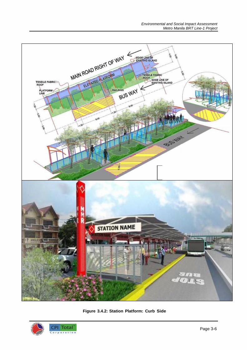
Environmental and Social Impact Assessment
Metro Manila BRT Line-1 Project
Page 3-6
6
Figure 3.4.2: Station Platform: Curb Side

Environmental and Social Impact Assessment
Metro Manila BRT Line-1 Project
Page 3-7
7
70. Both types of stations use the asymmetrical elevated station platform which allows passenger loading and unloading on one-side only. Hence, each station platform can only service buses or bus units travelling in a single direction. While curb stations are placed at opposite sides of the road usually along the sidewalks, the median station is usually composed of two platforms (one for each direction of travel) arranged in an off-set and in-line manner in order to minimize the number of car lanes given up to the station. 71. A modular design allows flexibility, ease of fabrication, assembly and replacement of building parts, faster construction, and allows re-use of materials should a station be re-located in the future. The stations can easily be lengthened and shortened to accommodate shifting passenger volumes or changes in bus type or size.
The stations will be fully specified and located between Manila City Hall and Philcoa. 3.4.2.1 Components of Bus Stations Bus Way 72. Busways at stations will be 3.5m wide. There will only be a single bus lane for each platform. Limited bypass lanes will be developed at stations due to the limited RROW of the corridor. Buses will stop at the front edge of the platform on a “first come, first served” basis. A maximum of two (2) 18m long buses can be accommodated at one time. Limiting to only two parked buses at a time allows space for a seating area and information board at the center of the station. In accordance with platform design standards, the front edge of the first bus shall be 2.0m from the edge of the elevated platform. A marker should be painted on the ground surface of the busway as guide for bus drivers where to stop. Elevated Platform 73. The typical platform dimensions for the station are 4.0m wide and 45.0m long. An additional 8.0m is allotted for the stairs (connected to the pedestrian overpass) and approach ramp/waiting area for the elevator. “Tapers” at the front/rear edges of the platform vary in length per station and serve as the acceleration/deceleration zones for the buses. 74. The effective platform area is 4.0m wide by 37.0 m long and 0.61 m above the surface pavement of the busway. This is the designated passenger waiting, pick-up (loading) and set-down (unloading). The basic module for platform design is 4.0 m. wide by 3.0 m. The 3.0 meter bay spacing (on-center spacing between column supports) was deemed most economical since the selected bay spacing is a factor of 6.0 and 12.0 m, which are the more common manufactured lengths of steel materials in the country. There are a total of 15 bays over the entire length of the platform: 12 bays for an effective passenger waiting platform and another 3 bays for the turnstiles and queuing area and the ticketing booth. Structural Foundation System 75. The structural system of the stations will be a combination of reinforced concrete and steel. Foundations shall be made of reinforced concrete. An integrated system of independent column footings and footing tie beams shall provide the structural foundation of the elevated platform. The tie beams, which connect the column footings for stability at the edges of the column footings, also serve as wall footings for the concrete hollow blocks (CHB) wall that delineates the edges of the station platform along its long sides. The interior space will be filled with gravel and sand before a top layer of checkered steel plate is laid out. A pre-cast edge curb mounted atop the CHB holds the steel flooring in place. Structural Columns 76. The structural columns shall be circular steel pipes with 5” in diameter. Each steel column will be directly fastened or attached to the column footing by way of a 30 cm x 30 cm x 6 mm steel plate

Environmental and Social Impact Assessment
Metro Manila BRT Line-1 Project
Page 3-8
8
anchored onto the reinforced concrete footing. Stiffeners will be welded onto both the steel pipe and the plate to stabilize the connection. Structural Roof Framing System 77. For ease of assembly, construction and design flexibility, the main structural components of the station shall be made of steel. Circular steel columns will support the tubular roof framing system. Tubular steel shall act as stiffener beams connecting the trusses to one another. Another set of rectangular-steel tubes will act as stiffener for the steel columns, electrical cable tray and mounting support for signage. The roof frame will be a pre-assembled circular steel frame; the top tubular member will be inclined towards the side opposite the bus-bay, while a bottom member will further stabilize the top chord as it distributes the roof load to a lower portion of the vertical member of the truss. Roof Cover and Design 78. Heat from the sun is hot and bothersome in the Philippines. Shade or protection from the sun is therefore important for waiting passengers. It helps that the station is an open structure with no enclosure at the sides to allow cross-ventilation. Heat absorbed by the roofing material is released to the area below it but is quickly dissipated by cross winds. The ideal roofing material for the station is one that can simply provide shade and protection from the sun’s rays. Metal roofing sheets and tensile fabric materials (tensile membrane) can effectively provide protection. However, a tensile membrane is preferred because of its durability, low maintenance, and ease of installation. It also requires minimal roof framing support which makes it more economical. Line Identification Pole 79. There will be two (2) bus line identification poles on either end of the station platform. The identification pole is approximately 5.10 m tall to make it visible and easily identifiable from a distance. The identification pole allows potential commuters to identify the route. Instead of assigning letters and/or numbers to identify a specific route, a color designation is preferred; colors are readily identifiable and universal. Numbers and letters are not readable especially for non-English speaking commuters. Lighting and Power System 80. LED lighting or light-emitting diodes is the lighting fixture of choice. At an approximate 7 watts per fixture, all lighting requirements within a station can be powered by the solar panels. An additional 1 kW can be allotted to power the other electrical components within the station such as electronic signage(s), such as the next bus, etc. Environmentally Conscious Design 81. Preservation of trees – as much as possible, retention of trees along the BRT route shall be prioritized. Station design may be adjusted to integrate the trees into the platform design. One approach is to build the station platform around existing trees by providing a hole within the station platform; the tensile roof will be discontinued in the area of tree(s) to create space for its crown. Another approach is to adjust the position of the station platform to avoid the trees; extensions to the platform will be constructed to connect the platform to the busway. 82. Steel as main structural framework – steel is one of the more durable materials in the building industry. A structure made of steel may be disassembled and re-assembled in another location. Steel can also be recycled. So in terms of its re-use, steel merits a high mark in sustainability. The proposed Metro Manila BRT station design uses steel columns and steel roof trusses. 83. Block pavers as floor surface of station platform – block pavers made from recycled materials shall be preferred. Block pavers as the platform surface finish provides flexibility in design, promotes

Environmental and Social Impact Assessment
Metro Manila BRT Line-1 Project
Page 3-9
9
re-use, and allows groundwater recharge as a pervious floor material. Sub-base of the block pavers can utilize the rubble obtained from breaking the center island of Quezon Ave. 84. Tensile membrane roofing – tensile membranes made from recycled materials shall be preferred. Tensile membranes are lightweight, therefore requiring less and smaller framing members. It can easily be removed and re-used thereby promoting sustainability. 85. Solar panels – solar panels will reduce a station’s dependence on the grid for power. Lighting, electric/electronic information signs, turnstiles, computerized BRT operational systems, etc. are just some of the components and equipment in the station with requirements for power. Each station can use a solar panel system with a maximum capacity of 2 kilowatts.
86. LED Lighting – use of light-emitting diodes (LED) lighting will improve energy efficiency of the lighting fixtures used in the station. Each LED light bulb is 7 watts, so the entire station lighting of a station will only use up less than 1 kilowatt of energy. 87. Groundwater recharge – a strip of landscaped area (softscape) shall be placed on the side opposite the busway. With the roof sloping towards this side, rainwater can be captured within this planting strip to promote aquifer recharge. For stations at the center of the road, there should be a narrow strip of landscaped area between the edge of the station platform and the road of the opposing traffic. Rainwater will seep into the underground to recharge the aquifer. 88. Re-directing rainwater to tree roots – a variant to groundwater recharge is to redirect the same water to areas where the trees are situated. Instead of a landscaped strip at the side opposite the busway, a gutter will guide rainwater towards the nearest tree to water its roots. 3.4.2.2 Outline Specification of Bus Station Elevated Station Platform 89. Dimensions: width: 4.00m; length: 45.00m; surface finish: 1200 mm x 2400 mm x 6 mm thick checkered steel plates with a sub-base of 50mm gravel and sand; platform will be elevated 0.61m above road level of bus way to enable level boarding/alighting of the vehicle. Approach Ramp 90. Dimensions: width: 4.00m; length: 4.20m; 100 mm thick and inclined at a slope of approximately 8.00+%; reinforced concrete slab Class B 2500 psi; 12 mm dia. deformed bars @ 0.60m on-center (oc) both ways. Access Platform 91. Dimensions: width: ranges from 3.30m to 4.00m; length: 8.25m; surface finish: 1200 mm x 2400 mm x 6 mm thick checkered steel plate with a sub-base of gravel and sand; platform will be elevated 0.61m above road level of bus way. Column Footing 92. Quantity: 16 units; 0.40m wide x 3.90m long x 0.80m high; reinforced concrete Class B 2500 psi; steel reinforcements; main deformed bars of 20 mm dia. at top and bottom with 10 mm dia. web reinforcements. Tie Beams 93. Quantity: 2 units per bay; 0.20m wide by 0.30m high reinforced concrete beam mounted 10 cm. above the bottom of column footing; reinforced concrete Class B 2500 psi; steel reinforcements: main deformed bars of 16mm dia. at top & bottom with 10mm dia. web reinforcements.

Environmental and Social Impact Assessment
Metro Manila BRT Line-1 Project
Page 3-10
1
Columns 94. Sixteen (16) units of five (5) inch dia. circular steel tube (standard); mounted on base plate with stiffeners and anchored to RC column footing; painted finish on epoxy primer; stiffener beams of 2 – 2” x 6” C-steel channels welded back to back will be anchored onto the top end of each just below the trusses; likewise, these beams will be painted finish on epoxy primer. Roof Framing 95. Modified half truss on a single column; stiffener beams or lateral ties in-between half trusses; 3” dia. circular steel tube (standard); lateral tie: 2.5” dia. circular tube steel; painted finish on epoxy primer. Roofing Material 96. Tensile fabric/membrane made from recycled materials; white color. Steel Railing 97. Main railing posts: multiple flat bar 1” x 4” (2 to 3 units); horizontal bars: flat bar 1 x 3; steel railing: circular tube 3” dia.; “System Branding” lettering ½” or ¾” square bar: all steel members will be painted over an epoxy primer base coat. Identification Pole 98. Circular steel tube 12-inch dia. mounted on steel plate with stiffeners bolted onto concrete column footing: metal or aluminum panels or expanded metal panels mounted on steel framing provide external cladding to the circular column. Protection Fence 99. A protection fence will be installed on the side opposite the busway. The protection fence will prevent passengers to exit the platform at areas that can be hazardous or life-threatening. It will also prevent unwelcome access or entry into the platform. For the center median station, a protection fence opposite the busway will suffice. But for the curb-side station, it is necessary to continue the protective fence around the short-side opposite the approach ramp. The fence will prevent and discourage entry from the sidewalk side away from the ticket booth and the turnstiles. 100. For a typical 3.0 m wide bay, there will be three (3) panels of 0.90m wide and 1.55 m high. Each panel will be made of either perforated metal or tubular steel slats to allow cross- ventilation. 101. For a typical bay within the designated information board zone, there will be a bay composed of one panel with information on the service, one panel showing the whole system and another showing the BRT route. A second bay can be composed of 3 advertisement panels. All panels will be uniform 0.90 m wide and 1.55 m high. Solar Panels 102. Two (2) units of 1.0 m. x 1.6 m solar panels can deliver 1 kW of power; for 2 kW power, a total of 4 panels will be needed with an inverter for every two panels. All lighting fixtures shall be powered by the solar panels. Furnishings 103. Furnishings are the movable/detachable items within the station. The following presents the preliminary specifications for the ticket booth and storage/electrical room.

Environmental and Social Impact Assessment
Metro Manila BRT Line-1 Project
Page 3-11
1
Ticket Booth 104. Dimensions: 1.20 m x 1.50 m x 2.20 m high (edge of platform position for asymmetrical stations); Metal or aluminum panels/slats on light-gauge framing as enclosure; glass window at front for ticket sales; metal or aluminum slats all around if booth will not be air-conditioned; insulated metal panels on light-gauge metal frame if booth will be fitted with air-conditioning unit; symmetrical stations; elevated flooring will be cement bonded boards on steel floor joists. Storage/Electrical room 105. Dimensions: 0.60m deep x 1.20m wide x 2.20m high (edge of platform position for asymmetrical stations); metal or aluminum panels on light-gauge metal framing as enclosure; flooring will be cement bonded boards on steel floor joists. Turnstiles 106. A maximum of 3 turnstiles may be accommodated within the full station design in a single platform; however, only 2 may be installed if a lane for PWDs is installed. The installation of turnstiles is dependent upon the adoption of an appropriate ticketing system. Information System 107. Appropriate passenger information will be provided consisting of static display of travel options and real time information of approaching buses. Waste Receptacles 108. The design of waste receptacles may be integrated with the over-all design theme of the station if only to strengthen the branding. 3.4.3 Intelligent Transport Systems 109. The MMDA is increasing the number of junctions signalized along the corridor and providing local linking to enable both selective detection for buses and optimize signal stages to minimize delay for all traffic. To facilitate this, buses will be tagged to ensure that their presence is detected. Once a vehicle is tagged it allows information to be sent to a control center so that the vehicle fleet can be monitored and headways managed remotely and fault-reporting systems are provided. Knowledge of the vehicles’ presence also enables information regarding arrivals to be transmitted to the waiting passenger at stations, terminals, on the Internet and on mobile devices; and to the travelling passenger within the vehicle to show location and upcoming stations. This level of system architecture should be a feature of the corridor and should not be onerous upon delivery risk, as outlined above. 110. The System utilizes the following supporting systems:
Control Centre systems
Vehicle location devices on all the system related buses
Communications system
CCTV at the bus-stop areas
Closed Wireless Local Area Network at each bus stop
111. The System Control Centre System consists of the following elements: Computer hardware, which includes:
Central server hosting databases and processing real-time data sent and received;

Environmental and Social Impact Assessment
Metro Manila BRT Line-1 Project
Page 3-12
1
Workstations for display of route, vehicle and bus-stop status, CCTV images, reported maintenance issues and management of passenger information system displays; and
Computer to support database interrogation and analysis
Computer software, which includes:
An application for analysis of vehicle location and route conditions;
An application to support route, stop, on-bus and off-route information displays;
An application to manage the images and display from the CCTV units;
An application to manage a real-time System fault-reporting system; and
Databases to store information being consumed by these software applications, expose appropriate data feeds to private and public information sources through APIs, and for strategic operations and maintenance analysis
Communications equipment, which includes:
Voice and data communications to System personnel and locations;
Voice and data communication to external entities associated with System operations;
Data communication to other third parties, including public information sources The In-vehicle unit has the following elements:
GPS device which identifies vehicle location at regular (e.g. 3 to 5 second) intervals;
GSM/GPRS/3G/HSDPA device to relay data and voice communications to the server in the System control room at predetermined regular intervals (e.g. every 30 seconds);
Hands-free voice communication for the driver;
Display screen for the driver, which will be compact, but easily visible to the driver; and
Function buttons for the driver (e.g. to request assistance), which could form part of a Graphical User Interface (GUI) on a touchscreen device such as a tablet PC
112. A closed Wireless Local Area Network (WLAN) would be required at each bus stop in order to facilitate the System Station Manager’s use of a personal communication device in order to report maintenance issues and minor operational exceptions more cost-effectively than by voice calling. As noted above, it is envisaged that the provision of this local WLAN network at each stop would be fed from the data connection required for the fare collection, passenger information and CCTV systems at each bus stop. It would not be available for members of the public (i.e. in the form of free public Wi-Fi) so as to avoid the potential dilution of bandwidth available to the station manager. 113. Information at the stations will be focused on the needs of people making journeys from a given stop within the next 5-10 minutes, on the basis that travelers will already have consumed pre-trip information through the channels identified in the previous section. This will deliberately focus the purpose of the space within the station on the needs of people making journeys, and subtly discourage the use of stations by people seeking general pre-trip information. 114. Information will be presented in a manner so that it is accessible for the local population, the disabled, and older people using the System. As a general rule, this will include the replication of information through audible announcements and visual displays.
115. The following information will be displayed in stations:
Fare and ticket information
Transit network and bus route maps
Next bus times and destination
Current service information
Nearby attractions and destinations

Environmental and Social Impact Assessment
Metro Manila BRT Line-1 Project
Page 3-13
1
The following information will be displayed inside the vehicle:
Transit network and system route maps
Next stop and time to next stop
Estimated arrival time at bus destination
System service exemptions
Older and disabled people priority seating 116. Providing on-demand SMS text alerts on system service status is also part of the system. The HTTP SMS gateway will be used as a way of providing System service status information via SMS text. Short messages will be sent in reply to SMS requests from members of the public (either to a specific number or prefixed with INFO) notifying potential System travelers of the current operating status of the system. The types of messages which can be conveyed include:
Next bus arriving in XX minutes
Normal service is currently operating
Expect delays of up to XX minutes
Partial service: Line closed at XXXX
System closed
117. This type of service will leverage similar technologies required for open-311 fault reporting (as described above) and will provide a simple way for the System Management Company to keep large numbers of people informed about the current status of the system without the need for direct customer contact. Helpfully, the One Bus Away platform already supports this type of SMS text message information provision and will provide a sound basis from which to customize system information that can be accessed by SMS text messages. One Bus Away
4 is an Open Source
platform for Real Time Transit Info that offers a suite of application programming interfaces (APIs) that facilitate the support and development of a wide range of third party applications, based on actual vehicle locations and on scheduled and predicted arrival times.
118. It includes a robust, secure, scalable back end that accepts, stores, archives, and interprets real-time vehicle location data in combination with transit schedules and other related data. 3.4.4 Ticketing 119. DOTr is planning to introduce a smart ticketing system for public transport in Metro Manila. Implementation will start with LRT/MRT where the closed nature of the system makes system entry payments relatively easy to administer. As a higher order bus route, the bus-based system developed within this report has a mass transit function and operational control regime similar to that of LRT/MRT. As such it will be desirable and entirely possible to adopt the same ticketing approach. 120. Fare collections must be undertaken efficiently and effectively to enable financial transfer within the adopted institutional structure that manages the operation of the BRT Project. It must also be a form that supports effective system operation, that is, it should enable passengers to board and alight without introducing overt system delay. 121. A distance-related charging basis is recommended, as this is the standard in transit systems (managing migration issues). It also does not overtly penalize either short or long distance trips. Customers will be charged for the total distance travelled on a trip, from first boarding to last alighting. This will be independent of whether a transfer is required. In other words, the customer will be charged as though (s)he could take one bus directly through to the destination, even if the route configuration requires one or more transfers. 122. The fare collection equipment will consist of the following:
4 http://onebusaway.org/

Environmental and Social Impact Assessment
Metro Manila BRT Line-1 Project
Page 3-14
1
Smart cards: As described above.
Smart cards issuers and encoders: These are specialist reader devices, held at the back-office of the card issuer. They are used to enable or initialize the cards prior to issue, add applications, add/modify the security features, personalize cards, carry out testing, etc. They are supported by specialist software, configured to the requirements of the specific card system. Depending on the functions to be performed and the logistics, about 10 such readers may be required.
Smart card value adding readers: These readers add stored value to the customers’ cards, and may also add or modify travel pass validity periods. They are located primarily at the points of sale, which include the ticket kiosks at the stations, ticket sales offices, and designated ticket/value agents. They are normally simple devices, connected to the main server, and acting as the ‘front end’ for online secure transactions – i.e. the transaction is being processed securely on the main server, not on the station or the agent’s PC. Normally, there would be one device per sales point, which equates to one for each of the stations, plus one for each of the designated sales agents.
Smart card validators: These are readers which read the information on the smart card, which determine whether they are good for travel, deduct the appropriate value, and record transaction data both on the card and on the reader or associated device.
Station ticket issuing machines: Each station will have a ticket issuing machine located at the ticket kiosk. The precise configuration will be determined in the RFP and offer stage of the fare collection system. The required number of equipment sets will be one per station.
Portable ticket issuing machines: These ticket machines are intended primarily for use by conductors and/or drivers on feeder buses, and any other buses that operate away from the designated stations. They are compact hand-held devices, with a keyboard, printer, control electronics, and memory.
Ticket machines chargers: These are ‘cradles’ into which the portable ticket machines are placed at the end of the working day. Their main function is to recharge the battery, but they also provide a suitable secure storage location and assist stock control. One per machine is required. They may be supplied as part of the ticket machine package.
Data transfer units: These are simple connections between the portable ticket machine and the depot PC, allowing the transfer of data at the end of the shift. This configuration is normally used when the conductor/driver should pay-in, submit a waybill, and account for any anomalies. Alternative arrangements are to embed the data transfer connector in the machine charger so that data transfer and recharging take place together; or to include a GPRS facility in the ticket machine allowing the data to be uploaded/downloaded remotely. They are not required for the station ticket machines, since these will be connected to the station PC during normal use mode. The cost of these connectors should be negligible, as USB connector cables will probably suffice.
Portable smart card readers: These readers will mostly be used by Revenue Protection staff to check cards and record information. They will also be used by technical staff for testing. About 20 units should be sufficient.
Back-office software: This software is the core of the system, so it will be relatively complex with high security requirements. Among other things, it must support the card issue and management system, system administration, card administration, customer administration, stored value management and accounting, the security keys, revenue management and reporting, revenue apportionment, and integrity surveillance.
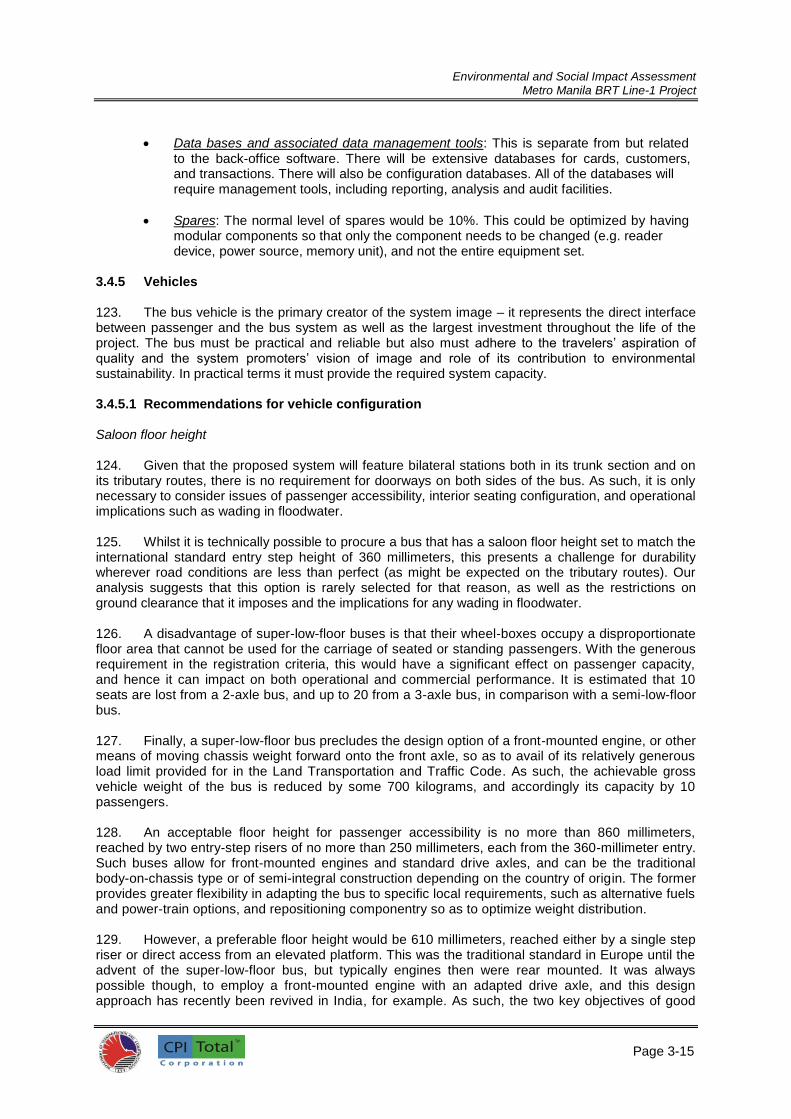
Environmental and Social Impact Assessment
Metro Manila BRT Line-1 Project
Page 3-15
1
Data bases and associated data management tools: This is separate from but related to the back-office software. There will be extensive databases for cards, customers, and transactions. There will also be configuration databases. All of the databases will require management tools, including reporting, analysis and audit facilities.
Spares: The normal level of spares would be 10%. This could be optimized by having modular components so that only the component needs to be changed (e.g. reader device, power source, memory unit), and not the entire equipment set.
3.4.5 Vehicles 123. The bus vehicle is the primary creator of the system image – it represents the direct interface between passenger and the bus system as well as the largest investment throughout the life of the project. The bus must be practical and reliable but also must adhere to the travelers’ aspiration of quality and the system promoters’ vision of image and role of its contribution to environmental sustainability. In practical terms it must provide the required system capacity. 3.4.5.1 Recommendations for vehicle configuration Saloon floor height 124. Given that the proposed system will feature bilateral stations both in its trunk section and on its tributary routes, there is no requirement for doorways on both sides of the bus. As such, it is only necessary to consider issues of passenger accessibility, interior seating configuration, and operational implications such as wading in floodwater. 125. Whilst it is technically possible to procure a bus that has a saloon floor height set to match the international standard entry step height of 360 millimeters, this presents a challenge for durability wherever road conditions are less than perfect (as might be expected on the tributary routes). Our analysis suggests that this option is rarely selected for that reason, as well as the restrictions on ground clearance that it imposes and the implications for any wading in floodwater. 126. A disadvantage of super-low-floor buses is that their wheel-boxes occupy a disproportionate floor area that cannot be used for the carriage of seated or standing passengers. With the generous requirement in the registration criteria, this would have a significant effect on passenger capacity, and hence it can impact on both operational and commercial performance. It is estimated that 10 seats are lost from a 2-axle bus, and up to 20 from a 3-axle bus, in comparison with a semi-low-floor bus. 127. Finally, a super-low-floor bus precludes the design option of a front-mounted engine, or other means of moving chassis weight forward onto the front axle, so as to avail of its relatively generous load limit provided for in the Land Transportation and Traffic Code. As such, the achievable gross vehicle weight of the bus is reduced by some 700 kilograms, and accordingly its capacity by 10 passengers. 128. An acceptable floor height for passenger accessibility is no more than 860 millimeters, reached by two entry-step risers of no more than 250 millimeters, each from the 360-millimeter entry. Such buses allow for front-mounted engines and standard drive axles, and can be the traditional body-on-chassis type or of semi-integral construction depending on the country of origin. The former provides greater flexibility in adapting the bus to specific local requirements, such as alternative fuels and power-train options, and repositioning componentry so as to optimize weight distribution. 129. However, a preferable floor height would be 610 millimeters, reached either by a single step riser or direct access from an elevated platform. This was the traditional standard in Europe until the advent of the super-low-floor bus, but typically engines then were rear mounted. It was always possible though, to employ a front-mounted engine with an adapted drive axle, and this design approach has recently been revived in India, for example. As such, the two key objectives of good

Environmental and Social Impact Assessment
Metro Manila BRT Line-1 Project
Page 3-16
1
passenger access, and good weight distribution between the axles, can be achieved together. Door Numbers and Positions 130. If the driver is to verify payment, there needs to be an organized flow of passengers through the vehicle from boarding at one end to alighting at the other. Conventional practice is for the entry door to be opposite the driver in the front over-hang of the bus. In this location, there is no loss of passenger capacity arising from the step-well, as standing passengers are barred from the area so as not to obstruct driver vision. 131. With a 900-millimeter wide doorway (800 millimeters between handrails), this enables an angle of approach of up to 10 degrees, as would be required where good road conditions cannot be guaranteed on the tributary routes. In turn, this suggests that the front overhang of the bus should be in the order of 2,250 millimeters so as to provide for a deformable body structure ahead of the doorway to absorb minor accident damage. 132. An additional rear door would be conventionally located in the rear overhang of the bus, though it would be possible to place an additional door immediately ahead of the rear axle(s). However, the loss of seats from the additional step-well probably outweighs the potential saving in station dwell-time from faster passenger egress, and would not be justified unless a full-sized doorway could not be fitted alongside a rear-mounted engine. Vehicle Size and Capacity 133. An 11.0 m twin-axle bus could have an estimated, comfortable, capacity of 76 passengers, of whom 43 would be seated; in this case, the governing factor is the tare weight of the bus in relation to permissible axle weights. However, this would involve a lightweight chassis design, whereas Philippine operators have shown a preference for heavy-duty units with high tare weights. Such vehicles appear to have been registered without due reference to the Land Transportation and Traffic Code, but enforcing its conditions would result in a significant reduction in their capacity. 134. A 13.7 m three-axle bus would have an estimated capacity of 95 passengers, of whom 59 could be seated; capacity could be increased to 100 passengers by restricting seat numbers. In this case, the governing factor is the available floor area for standing passengers, and there would be considerable spare capacity in relation to permissible axle weights. As such, heavy-duty chassis technology could be deployed without any consequent reduction in passenger capacity. 135. An 18.0 m articulated bus could have an estimated capacity of 121 passengers, of whom 70 would be seated; in this case, the governing factor is again the tare weight of the bus in relation to permissible axle weights. However the use of heavy-duty technology, typical for such vehicle types, would then reduce the passenger capacity significantly. 136. All three sizes of bus could have similar efficiency in the utilization of road space, at 7 passengers per meter of body length, provided that lightweight technology was deployed. However, the tri-axle bus has the potential to raise this level if a higher standee ratio is adopted, whereas the other two bus types do not, and its capacity is not sensitive to the tare weight of the technology adopted. Further, as the tri-axle bus has potential unutilized axle capacity, either alternative-fuel or hybrid power-train options could be pursued without reducing passenger numbers. 137. Accordingly, the 13.7 m three-axle bus is the recommended option for the Metro Manila BRT Line-1 Project, as such vehicles could legally extend to 14.0 m under the provisions of the Land Transportation and Traffic Code, but that is not an international standard dimension and so supply options would likely be very restricted. Power-Plant Rating 138. The primary power requirement is taken as enabling a steady speed of 80 km/h up a 2%

Environmental and Social Impact Assessment
Metro Manila BRT Line-1 Project
Page 3-17
1
grade at the predicted gross vehicle weight; for the 13.7m tri-axle bus, that equates to 166 kW which must be added the power consumption of the air-conditioning and electrical systems, totaling 21 kW for this size of bus. The total power requirement of 187 kW equates to 250 horsepower nominal. 139. However, the selected performance parameter might be perceived as generous and 122 kW would provide for 1% gradeability at 80km/h; the performance would still be practical in a relatively flat city such as Manila. The total power requirement would reduce to 143 kW, or 190 horsepower nominal, and that would be the target rating for a hybrid bus. Power-Plant Fuelling and Emissions Standards 140. At this point in time, there is no realistic alternative to conventional diesel fuelling for the primary power plant. Natural gas is not yet readily available in Manila, though provision could be made for conversion to this fuel type in the future. Pure electric vehicles are precluded by the axle weight restrictions, and are not a particularly ‘green’ option with the current power mix in the Philippines. However, fixed-route operation, such as proposed, could allow for opportunity-charged battery-electric vehicles with lower tare weights that might just prove viable. 141. Recently, the DENR has issued a DENR Administrative Order (DAO) No. 2015-04 which provides a directive requiring the use of cleaner fuel and imposing stricter emission standards for all vehicles starting this July 2015. The DAO provides the new vehicle emission standards to be complied with by new and in-use vehicles starting July 1, 2015. The Order also enjoins the Department of Energy to ensure the availability of Euro 4 fuels by this date. 142. For this project, BRT buses shall use Euro 4 fuel which is considered as a cleaner fuel. It has a sulfur content of only 50 parts per million (ppm) for both diesel and gasoline, compared to 500 ppm for Euro 2. Benzene in Euro 4 gasoline, on the other hand, is only 1% by volume compared to 5% in Euro 2. As for aromatics, Euro 4 fuel contains only 35% by volume compared to Euro 2, which prescribes no limit. Hybrid Options 143. Hybrid bus development has been driven by the desire to reduce fuel consumption and greenhouse gas emissions in intensive stop/start urban operation. However, the system is so designed as to minimize such service characteristics, and the potential benefit is hence much less than examples quoted from other cities. 144. Nevertheless, there may be a case for a limited procurement of mild-parallel hybrid buses within the initial fleet to investigate the costs and benefits of this technology in the Manila circumstances. The means of energy storage adopted may depend on the research and development initiatives of the selected bus supplier, but would probably focus on the use of electrical super-capacitors or hydraulic accumulators. In both cases, there would be a significant tare weight advantage in comparison with the more widespread battery energy storage in hybrid applications. Transmission 145. The operational characteristics of the system defined in a relatively flat city suggest that an appropriately rated clutch and mechanical transmission should provide adequate durability whilst minimizing fuel consumption. However, experience with rear-engined buses suggests that an automated mechanical transmission would be essential for this configuration, and would be preferable even with a front-mounted engine. 3.4.5.2 Functional and technical specification 146. The following table represents the recommended outline functional and technical specification for vehicles operating within the proposed Metro Manila BRT Line-1 Project:

Environmental and Social Impact Assessment
Metro Manila BRT Line-1 Project
Page 3-18
1
Table 3.4.1: Technical Specifications of BRT Vehicles
Specification parameter Bus requirement
International classification – UN ECE R36 Class I
Overall length, m 13.7 + 0.3
Overall width, m 2.55 + 0.05
Front overhang, m + 2.25
Wheelbase (to bogie turning center), m + 7.65
Turning circle radius, outer / inner, m 12.5 / 5.3
Angles of approach / departure (laden),deg. > 10 / > 8
Number of doorways – curbside 2, in overhangs
Width of doorway(s), between handrails, mm > 800
Height of first step above road (unladen), mm < 360 (kneeling allowed)
Height of internal step risers, mm < 250
Number of internal step risers 2 maximum; 1 preferred
Seating configuration (where feasible) 2 x 2
Seat pitch, mm > 650
Width of individual seating space, mm > 450
Width of twin seating space, mm > 850
Width of gangway, mm > 600
Clear height in aisle, mm > 2000
Driver compartment ventilation Fan-assisted A/c
Passenger saloon ventilation Air-conditioned
Destination display Dot matrix
Maximum governed road speed, km/h < 80
Minimum gradeability in 2nd gear, % > 15
Engine environmental standard Euro IV
Engine rating, kW + 190
Engine rating, mild parallel hybrid, kW + 145
Engine location Front preferred, rear lowed
Clutch diameter, mm > 380
Transmission type Automated mechanical
Hybrid transmission option Mild parallel
Hybrid energy storage
Hydraulic or super-capacitor
Suspension characteristic, front axle
Full air, optional front- engine
Suspension characteristic, rear axles Full air, with anti-roll bar
Fuel tank capacity, l > 210
Driver information display Electronic
147. Further, DAO 2015-04 also provides more stringent emission standards for carbon monoxide (CO), hydrocarbon, oxides of nitrogen, and particulate matter to be complied with by new passenger, and light- and heavy-duty vehicles. Emission standards to be complied with by the BRT buses are enumerated under DAO 2015-04 (see Annex 1 for the copy of the DAO). 3.4.5.3 Finalizing the bus specification 148. What has been derived herein is an idealized bus product that conforms to national standards and meets the needs of the project. The bus is carefully matched to the infrastructure with respect to

Environmental and Social Impact Assessment
Metro Manila BRT Line-1 Project
Page 3-19
1
passenger demand. However, there are variables that can be applied to the final vehicle choice. The floor height of 610 mm cannot be changed without changes to the platform height of stations. Any changes to the vehicle length must be made with reference to the capacity requirements defined. 149. The purchaser and operator of the buses will have a significant role to play in finalizing bus specification, and issues such as point of purchase, import duties, and any desire to localize construction will also play a part. 3.4.6 Bus Depot 150. The depot will be the bus system operations base. It will provide parking accommodation, servicing and maintenance facilities for vehicles, administrative functions, and facilities for staff. Depending upon procurement and operating structure, it may be a facility provided by the operator. 151. As a pre-requisite, the depot must provide the following features required to operate efficiently:
Direct and secure access of highway through suitable and efficient intersection design;
Bus parking area, based on sawtooth arrangement, thus allowing independent movement of vehicles;
Employee/visitor parking;
Taxi/PUJ drop off/pick up area;
Administration offices, canteen and rest areas for staff;
Bus fueling/wash area;
Fuel storage area; and
Inspection and maintenance area.
152. The layout of a bus depot should create efficiency processing and storage of vehicles. Figure 3.4.3 shows standard depot layout to achieve functional efficiency. 153. Bus depots to service the bus route along the project corridor measure approximately 3.2 ha and 1.9 ha, respectively, to provide parking accommodation, servicing, and maintenance facilities for vehicles and facilities for staff. DOTr has not yet made a decision on the depot locations. For guidance purposes, a separate Terms of Reference (TOR) in Annex 2 has been prepared for the environmental and social impact assessment of the depot sites. In this case, a separate ESMP shall be developed specific for the depot site construction and operations and maintenance. 154. The Resettlement Policy Framework presented in Annex 3 will guide DOTr on addressing the requirement of OP 4.01 on Environmental Assessment and/or OP 4.12 on Involuntary Resettlement. As the case maybe, either a resettlement plan or abbreviated resettlement plan is required for the depot sites that entail involuntary resettlement. Further, presented in Annex 4 are the site assessment and selection criteria that will guide DOTr in the selection of the project depot site. The criteria set as follows (Table 3.4.2).
155. There are two depot sites proposed to be acquired, one near each endpoint of the corridor. For the north site, the DOTr is still in the process of looking for options. For the south site, the following are the options: The Philippine Veterans Affairs Office (PVAO) property near the Manila City Hall and the ACE Citi Development property along Palanca St. in Manila.

Environmental and Social Impact Assessment
Metro Manila BRT Line-1 Project
Page 3-20
2
Table 3.4.2: Depot Site Assessment and Selection Criteria for the Metro Manila BRT Line-1 Project
Screening Parameters Ground Condition
1) Lot Size and Potential for site expandability
Total available lot size:
Required lot (per FS):
2) Lot Control Can be secured with proper fencing
No. of access gates
No security treat
3) Site dimensional suitability The lot can be configured to layout into an efficient depots/mixed land use/intermodal facility
Lot plan is very suitable for a depot plan
4) Current site uses and conditions / Suitability of adjoining and nearby land uses
Suitable for the purpose
Presence of informal settlers:
Presence vegetation/trees: very minimal
5) Environmental consideration Mixed land use development (Conflict on land use)
Presence of sensitive ecology
Expected water, biologic, or historic resource impacts;
Air pollution impact
6) Project proximity to BRT Stations and suitable/major road networks
Nearest proposed BRT stations:
7) Potential for mixed use Can be used for commercial development to support the BRT
Can be used as integrated terminal / intermodal transport facility (for PUJs, AUVs and PUBs)
Can provide parking areas for commuters owning private cars
Figure 3.4.3: Operationally Efficient Depot Arrangement

Environmental and Social Impact Assessment
Metro Manila BRT Line-1 Project
Page 3-21
2
8) Legal and financial feasibility Titling: no perceived legal problem
Feasibility of Land acquisition under OP 4.12 of WB
Market price (Approx.):
Willing selling price:
Zonal price: 3.4.7 Branding 156. Branding of a new form of bus service can be an important way of engaging the public in a new means of travel. Much has been published about the positive effects of branding within BRT services and in Cebu, ITP undertook a comprehensive brand identification programme involving the people and businesses of the city. Within this study no brand research has been undertaken due to the restriction on consultation during the project development work programme. It is however strongly recommended that a branding exercise be pursued following NEDA approval of the project. At this stage it is recommended that the following branding principles apply:
Use of strong colors to give a recognizable and positive image. The color should be non-political. For the purposes of this report we have chosen Red.
A name for the system that sits alongside the MRT/LRT systems and has a relationship to the intended road transit rationalization. This should refer to system values and be something that is ‘owned’ by users. It could reference environmental qualities, sustainability, comfort and/or speed of travel.
A symbol that represents the band values of the system and related to system name. This symbol would be used on all information relating to the system and appear at all stations/terminals used by the system.
Marketing campaign that is staged to embrace the scheme development, implementation and operational stages. It is particularly important during construction phases to relieve those that suffer impacts, most especially to those affected enough to deserve resultant service improvements. During early days/months of operation, the marketing campaign will aim to establish the brand and build patronage.
3.5 Bus Operation Service Plan
157. The service plan for the BRT buses is summarized as:
3. Philcoa – Manila City Hall These will operate at the following peak headways in order to meet forecast demand.
Service Buses per hour Headway
Philcoa – MCH 60 1 min
3.6 Operational Management 158. Management of the transport services and the infrastructure are primarily of the operations management and the collection of revenues. Each of these consists of strategic and tactical processes. The institutional structure developed to support the Cebu BRT and subject to on-going discussion between the World Bank and DOTr, has been assumed to exist and provide a basis for managing the scheme developed within this report. In summary the following has been proposed and largely agreed:
System Management is carried out at the Operational Level. A System Manager is established, which has the responsibility for the performance of the bus system, such as service quality and schedule adherence. The bus services are operated by private operators under service contracts.

Environmental and Social Impact Assessment
Metro Manila BRT Line-1 Project
Page 3-22
2
The System Manager provides overall coordination and higher-order activities, which may be procured or done by direct operation.
The bus services are operated under ‘Gross Cost’ contracts. The System Owner specifies the required service offer in some detail, and the operator is then rewarded for supplying this. Revenues are collected by (or on behalf of) the System Owner, and used (either in whole or in part) to pay the operator.
The fare structure is based on a ‘honeycomb’ structure at network level. The passenger pays a fee according to the number of zones passed through on the trip, these being split both radially and orbitaly. When there is a single bus line, the fare structure appears as a distance-based structure.
Transfers are permitted within the system developed. The passenger pays once for his total journey but can then use the ticket on any route or operator that forms part of the system.
Fare prices seek to recover the bus operating costs, vehicle operating costs, system management costs, and infrastructure maintenance costs. The fare price is not expected to recover the original infrastructure investment costs.
Fare prices are set at the network level, not at the individual route level. This provides a consistent pricing based on distance travelled.
Ticketing is based on machine-readable devices, primarily smart cards with stored value, supplemented by single-journey tickets that are printed/encoded at the point of issue.
Revenue protection is managed at network level, under the control of the System Manager.
3.6.1 Role of the System Management Company 159. In the DTS, it is proposed that a BRT management entity will be formed. For the purposes
of this section, it will be referred to as the System Management Company5 (SMC). The SMC is expected to have at least the following areas of responsibility relevant to Operations, which the SMC may perform in-house, or it may procure services from others:
Operations Management
Incident and emergency management
Safety and security
Fare collection
Revenue protection
Customer support and information
Infrastructure maintenance and cleaning
Implementation of the O&M’s ESMP which will be guided by in-house Environmental and Social Management System (ESMS) that is compliant with local and international safeguard standards
160. The following key assumptions are made in relation to bus operations:
5 In this section, SMC is used in order not to alter the discussions provided in the DTS. However, in the succeeding chapters of this document, SMC is replaced with Special Purpose Company (SPC). In essence, both SMC and SPC refer to the same entity.

Environmental and Social Impact Assessment
Metro Manila BRT Line-1 Project
Page 3-23
2
Only designated routes will operate within the segregated part of the system;
The routes will let out by competitive tendering, negotiations, or through other means to one or more operators;
Only large buses (over 11m) will be allowed to use the segregated sections;
Only approved urban buses may operate normal services within the system;
The System Management Company will establish the service quality, vehicle outline specification, and other responsibilities of the operator(s). These will be included in the route contracts or running way access agreements;
Buses will be purchased, owned and maintained by the operators. It is their responsibility to ensure that buses and drivers are fit for service;
The normal mode of fare collection and validation at designated and ancillary stations will be off-vehicles at the bus stops. Away from the designated stations, fares may be collected inside the vehicle subsequent to entry; and
Where fares are collected prior to entry, fare collection staff will be employees either of the SMC or of a special purpose company engaged by the SMC.
3.6.2 Operations Management Requirements 161. The system must work efficiently and effectively. This has five main components, which are independent of the network design, service design, and pricing:
Transport all customers who present themselves for travel;
Offer a fast and reliable service;
Offer a comfortable service both at waiting places and in the vehicles;
Be safe at all points in the system; and
Optimize resource utilization and avoid costs in excess of the planned costs. 162. There are five key operational challenges, which are the direct responsibility of the SMC.
Avoid excessive build-up of customers at stops, clear the stops of waiting passengers;
Prevent congestion within the segregated sections of buses at stops and in the lane;
Clear blockages within the segregated sections immediately;
Respond immediately to all emergency situations and minimise negative impacts; and
Minimize the disruptive effect of operations in non-segregated sections. 163. There are four basic sets of circumstances, all of which must be managed well when they occur. This requires well-developed and documented procedures, appropriate organizational structure and staffing, an effective chain of command, and common understanding by all personnel of their roles and responsibilities. It also requires ability to appraise the situation, to switch operational mode when required, and rapid response to events as they occur:
Normal operation, which includes daily variances and moderate disruptions;
Spikes and unusual levels of demand on specific days, which must be managed immediately;
Temporary degraded operation (maximum two hours) during which services must be managed and then restored while recovering from one or more significant incidents;
Extended degraded operations, during which whatever level of service is possible must be offered and managed, while also managing customers who have no realistic prospect of being transported within the normal timescale or conditions; and
Prolonged shut-down operation is defined as an extended period of service stoppage which could be a result of political, financial/economic, natural events, or

Environmental and Social Impact Assessment
Metro Manila BRT Line-1 Project
Page 3-24
2
regulatory reasons. Remedial measures will be explored and instituted during this period.
3.6.3 Organizational Structure for System Operations Management
164. The following structure and staffing is based on good international practice in Operations Management. It is intended as a robust, practical organizational and management structure that can deal with both normal and exceptional events.
a) The System Operations Manager is a key position in the SMC. The System Operations Manager will have overall responsibility for ensuring that the System Operations functions effectively. The System Operations Manager has the needed authority, staff, and budget to achieve the task, and is personally accountable for the operations performance. The System Operations Manager is expected to:
Be thoroughly familiar with all operational aspects;
Set up the needed information flows and systems;
Develop procedures and training programs, and assure that these are effectively delivered to be proactive in identifying and resolving problems that might impact on operational performance;
Spend a significant amount of time on-site;
Liaise with external support organizations such as police, traffic control and emergency services.
b) A System Control Centre will be established. A System Control Centre Manager will be
appointed who will be responsible for the performance of the Control Centre. The primary functions of the Control Centre are:
To monitor the operations, especially timekeeping and headways on routes, bus-stop status, and to identify any emerging deviations or risk situations;
To make service interventions as required, ranging from modest service adjustments to taking direct control of operations in case of serious disruptions;
To respond to all blockages, emergency, and other incidents;
To coordinate all the information from the various dedicated personnel at bus-stops, on vehicles, and along the route;
To direct and support various system personnel;
To liaise with external agencies and to request their assistance as required; and
To review procedures in the light of experience, and to ensure that lessons learned are transformed into revised procedures and related training.
c) The System Control Centre is manned at all times. It is organized around a set of
workstations that have the responsibility to monitor and manage sections of the System plus a master workstation.
d) A Support Staff manages the Mobile Supervisory Units as well as the databases and
reporting, and provide technical support the System Control Centre.
e) The Bus Stop Supervisor is in charge of each bus stop at all times. The Bus-Stop Supervisor is responsible for:
The efficient functioning of the bus-stop to which they are assigned;
Ensuring that buses respect the dwell time rules and leave on time;
Ensuring that bay assignment and passenger management is functioning effectively;
First-line intervention for any blockages or disruption at the bus-stops, exits and approaches;

Environmental and Social Impact Assessment
Metro Manila BRT Line-1 Project
Page 3-25
2
Bringing problems and potential problems to the attention of the System Control Centre;
Implementing instructions from the System Control Centre
Supervision of all personnel working at the bus-stop; and
Liaison with Revenue Protection Unit as required. 165. Each Bus Stop Supervisor is responsible for an individual bus stop location (i.e. normally one for each direction). Every 6 months, Bus Stop Supervisors will be re-assigned to different stops. The system will improve their skills development by facing different conditions; it will also reduce the risk of collusion in relation to either the fare collection staff or the drivers.
a) A Customer Care Agent is assigned at all times to each bus stop to support the Bus Stop Supervisor. The primary focus of the Customer Care Agent is on the customers passing through the station. They have the task to:
Direct customers who are waiting for buses to the appropriate location;
Direct alighting customers from the vehicles to the exit, by the route which has the least disruption to boarding and waiting passengers;
Inform and marshal customers where there are conflicting boarding and alighting customers, especially at busy times;
Inform and marshal customers when there is a change of busbay allocation or other change to normal arrangements;
Provide information to customers, including how to use the system, where to alight, how to get to their destination from the stations, etc.;
Proactively assist people in wheelchairs and with reduced mobility, the elderly, vulnerable customers, and anyone in need of additional support. Encourage other customers to make space for them, allow them to board first, give them a seat, etc.;
Assist the Bus Stop Supervisor in other ways as directed and as per procedure;
Assist the Security Guard in dealing with customers and situations arising, within the limits of defined procedures and training;
Assist in case of emergency, including evacuation of the bus stop or of buses; and
Receive, document, and submit complaints or suggestions from customers.
b) A Security Guard is assigned to each stop at all times. The Security Guard is expected to form part of the bus stop team and to assist in customer support to the extent that he can do so without compromising his security role. This will require Security Guards to have training in customer care, System service information, and System operations procedures. They have the task to:
Manage security at the bus stop to which they are assigned;
Maintain law and order at the bus stop and its immediate environs, and ensure that customers behave in an orderly manner;
Maintain planned liaison with police and emergency services;
Take the lead to resolve any emergency, security, or anti-social events at the bus stop;
Assist in customer support and provision of travel information, to the extent that the security role and actions are not compromised; and
Review security-related issues at the bus stop and submit suggestions as relevant.
c) Terminus Dispatchers are assigned to the route termini. They are equipped with the needed communication devices. They have the task to:
Organize the vehicles at the terminal;
Ensure that vehicles depart on time;
Implement the directives from the System Control Centre to change the running order, advance or delay the departure times to adjust the frequency;

Environmental and Social Impact Assessment
Metro Manila BRT Line-1 Project
Page 3-26
2
Insert additional vehicles from the reserve;
Resolve operational problems at the terminal.
d) A System Mobile Supervisory Unit is established, reporting directly to the System Operations Manager. This consists of personnel equipped with vehicles and with communications links to the System Control Centre. They are organized as teams of two persons corresponding to the six workstations at the System Control Centre, but can move among the sections as required. Their task is to cover the System running way and bus stops, and to identify and resolve problems as they arise. They provide temporary support to individual bus stops as required, and are the main personnel to deal with blockages and other incidents on the running way. They also receive basic maintenance training so that they can provide first-line assessment of any problems with vehicles and request Maintenance support.
e) A Reserve Pool of buses is established. This equates to 5-10% of the total fleet. The core 90-95% of the fleet operates on pre-assigned routes and timings. By contrast, the Reserve Pool are under the direction of the System Control Centre. They operate normally, except that they can be assigned among routes during the day as demand requires. In addition, a small Hot Reserve will be available to insert into the service directly at stations where the queues are not being cleared and potentially dangerous conditions are arising.
f) A Mobile Maintenance Crew is established. These are employees of the operator(s) at
operators’ own cost, and are under the direction of the System Control Centre. This consists of a small group of maintenance workers who can carry out minor repairs at the terminal, and get buses back into service without losing time going to the depots. The crew can also be dispatched to buses which will encounter problems along the route. An additional mobile unit is located at a location (to be determined) which only serves vehicles with problems on-route. It should be noted that the scale of the maintenance support will the minimum prudent level. The philosophy is that operators should provide buses which are fit for a full day’s service, and operators would be heavily penalized for breakdowns along the route.
g) Contracts are made for Tow Truck Services. It is not intended that the System Management
Company would own any such trucks. A number of suitable tow truck operators along the route are offered contracts. They are paid a good retainer plus a call-out fee. They are paid a bonus if they reach the requested point within 5 minutes, and lose their contract if it takes them more than 10 minutes to arrive.
3.7 Project Cost
166. The total project capital cost is $109,410,000 (PHP 4,789,080,000), broken down as follows:
COSTS
Capital costs PHP 1,347,330,000 USD 30,780,000
Land Acquisition & Resettlement PHP 791,330,000 USD 18,080,000
Cost and Price Contingency PHP 396,570,000 USD 9,060,000
Other Project Costs PHP 2,254,850,000 USD 51,490,000
TOTAL PHP 4,790,080,000 USD 109,410,000
Exchange rate: 1$ = PhP 45.426
167. The cost of land acquisition is provided in the DTS and may be assumed to be based on the nominal value for depot lot requirements totaling to approximately 6 hectares. It appears that the preliminary cost estimate for land acquisition and resettlement is pegged at 10,000 pesos per square meter.
168. It should be noted that land acquisition and resettlement cost is part of DOTr’s compliance to O.P. 4.12 and the Resettlement Policy Framework (RPF). In this case, the full cost of land acquisition

Environmental and Social Impact Assessment
Metro Manila BRT Line-1 Project
Page 3-27
2
and resettlement shall be shouldered by DOTr.

Environmental and Social Impact Assessment
Metro Manila BRT Line-1 Project
1

Environmental and Social Impact Assessment
Metro Manila BRT Line-1 Project
Page 4-1
4.0 ENVIRONMENTAL BASELINE DATA 4.1 Physical Environment 171. The study area covers Manila City and Quezon City located at the northern portion of Metro Manila covering road network from Manila City Hall located east of Manila Bay and extending westward toward Fairview in Quezon City through the Espaňa Avenue – Quezon Avenue – Commonwealth Avenue route. The physical environment and features of project area can be referred from the general physical features of Metro Manila. 4.1.1 Geology and Geomorphologic Characteristics 172. Metro Manila is the capital in the Philippines consisting of 920 sq. km. land area. It has been industrialized with bustling factories, facilities and infrastructures. Its proximity to the sea and major waterways makes it a strategic location for trade and commerce.
173. Manila and Metro Manila lies on a shelf which has been basically formed by a ridge of volcanic tuff to the west. The ridge is bounded by fluvial deposits of sand, gravel and clay. Similar deposits found in the east of the ridge are transported by the Marikina River towards a valley formed by downward and tilted fracture or fault. Two main geological formations exist. The Guadalupe tuff (adobe) characterizes the hilly areas, while quaternary alluvium or recent fluvial deposits of deltaic sediment characterize the low-lying areas. See Figure 4.1.1 for the Geologic Map.
174. The Metro Manila region is divided into three general physiographic zones: the coastal margin, the Guadalupe Plateau, and the Marikina-Laguna lowlands. Gervasio (1967) refers to the coastal margin as the Manila Deltaic Plain. The Guadalupe Plateau is high topographically; it is also a dominant physiographic feature of Metro Manila. The plateau separates the coastal margin of Manila from the western region of the Marikina-Laguna de Bay Lowlands.
4.1.1.1 Stratigraphy
175. The Guadalupe Plateau forms the backbone of Metro Manila; this north-south trending topographic high extends from Novaliches in the north to Parañaque in the south. The Guadalupe formation is initially defined for the pyroclastic deposits of rock and ash found in the Metro Manila Area (Purser and Diomampo, 1995). It includes a lower conglomerate member (Alat Conglomerate) and an
upper tuffaceous member known as the Diliman Tuff (Purser and Diomampo, 1995). Gervasio (1968)6 described the Guadalupe Formation as mostly water laid and the bulk of the formation consists of lithified volcanic ash, lapilli and crystal sand. Gervasio (1968) also noted the presence of beds rich in sand that are not directly derived from volcanic activity. This he said is common in the upper stratigraphic section, in addition, thick beds of partly welded agglomeratic tuff occur intermittently in the Blue Ridge area in Quezon City to Novaliches, while in the vicinity of Bagong Ilog, Pasig, thin beds of fluvial gravel are intercalated with the tuff. The bedding planes of the Guadalupe Formation have a regional dip of 5 to 10 degrees to the west (Gervasio, 1968). Approximately 85% of the study area is located in the Guadalupe Plateau.
176. To the west of the Plateau is the coastal margin, which is made up of unconsolidated alluvial materials. This series of alluvial deposit makes up the Manila Deltaic Plain.
177. Manila to Pasay City and coalesces with the beach and lagoonal deposits of Parañaque. Northwards, the delta connects with the estuarine deposits and beach and sand bar deposits of Caloocan City and Malabon. Gervasio (1968) further specified the extent of the deltaic plain, which includes the areas of Balut in Tondo, Binondo, San Nicolas, Santa Cruz, Sampaloc, Quiapo, Intramuros, Pandacan, and western part of Mandaluyong, Ermita, Paco, Malate and Pasay City. These areas are
6 Gervasio, F. The Geology, Structures and Landscape Development of Manila and Suburbs. The Philippine Geologist Vol. XXII, No. 4, December 1968.

Environmental and Social Impact Assessment
Metro Manila BRT Line-1 Project
Page 4-2
BRT Alignment
Source: MGB
Figure 4.1.1: Geologic Map of Metro Manila

Environmental and Social Impact Assessment
Metro Manila BRT Line-1 Project
Page 4-3
3
said to be the result of the progressive accumulation and subsequent piling up of transported sediments due to the coalescing of the deltas. The delta deposit is estimated by Gervasio to be about 70 meters thick along the coast and tapers landward. The delta deposit consists of sand, pebbly gravel, silt, mud and clay of various colors and plasticity. It conformably overlies the tuffaceous formation. 178. Recognizing the geological features of the BRT corridor, it is imperative that geotechnical investigations should be undertaken within the proposed locations of the depots and bus stations/terminals. Relevant geological features are liquefaction and ground settlement. A geotechnical site investigation is the process of collecting information and evaluation of conditions underneath the soil for the purpose of designing and constructing the foundations for the bus stations and other appurtenant structures. A design baseline from geotechnical data will be generated which will summarize all the assumptions and basis of calculations as designed parameters to address risks of liquefaction and ground settlement considerations.
4.1.1.2 Seismic activity 179. The City of Manila is physically vulnerable to earthquake related hazards such as liquefaction and ground shaking. The July 1968 earthquake proved devastating to the business community and the public in general. Earthquakes greatly affect both economic and social interaction; hence, earthquake resistant technologies or sophisticated structural measures should be applied in the construction of buildings and structures. 180. To delineate high and low seismic risk areas from a foundation engineering perspective, a detailed geological study7 was conducted. Extensive foundation drilling and soil tests of the Metro Manila area were conducted and based on the results of these tests, Metro Manila could be divided Into zones of varying vulnerability to ground-shaking induced by high intensity earthquakes. Table 4.1.1 shows the comparative seismicity risk level within Metropolitan Manila. 181. The zonal classifications are defined by the types of soil or rock material present, the depth of the adobe bedrock (or thickness of the soil) which in turn controls the resonance of swaying of a structure, especially high rise buildings. The very high risk category is assigned to areas underlain by very thick layers greater than 15 meters) of soft clay or loose sand such as those found at the mouth of the Pasig River and Marikina River. Very low risk areas are those where the adobe bedrock is exposed or covered by no more than a couple of meters of soil.
Table 4.1.1: Comparative Seismicity Risk Level
Very Low Risk
Zones
Low Risk
Zones
High Risk
Zones Very High Risk Zones
Caloocan Pasay City South East Downtown Manila, Quiapo, Intramuros, Sta
Cruz
East Sampaloc Marikina Binondo, Port Area
Malabon Pandacan Ermita Reclamation Area Along Roxas Blvd
Valenzuela East
Marikina
Malate Pasig
Novaliches .. Navotas Pateros
Quezon City .. South East Taguig
7 An excerpt from the City Profile of Manila, 2000

Environmental and Social Impact Assessment
Metro Manila BRT Line-1 Project
Page 4-4
4
Marikina
San Juan .. .. Coastal Town of the Marikina Valley Plain
Mandaluyong .. .. ..
Makati .. .. ..
Paranaque .. .. ..
Source: City Profile of Manila, 2000
182. Recognizing that downtown Manila and Quiapo are listed as very high seismic risk zones, the Project design consultant shall identify or assign values for minimum Peak Ground Acceleration (A) that will be used in the structural design of the Project structures. The design criteria and load for the BRT structures should comply with the requirements of the National Structural Code of the Philippines and AASHTO Standard Specifications for Roads and Highways (1998).
183. Incorporating the seismic features of the BRT corridor and the selection of the level of earthquake to be considered at design and service stages, the ultimate goal is to ensure that structures could withstand an earthquake (at a specified return period) with no significant damage or repairable damages.
4.1.2 Soil Characteristics
184. Major soil types in Manila along BRT alignment consist of Eutropepts8. Both soil units belong to the order inceptisols. The Eutropepts is characterized by deep to very deep well-drained dark yellowish brown to dark brown alluvial soils with loam, silt loam, clay loam, silty clay loam, or sandy loam textures and occur on level to gentle slopes having high base saturation. These soils have moderate to high fertility with soil pH of medium acid to neutral.
185. Within the Quezon City area, soil type along BRT alignment is predominantly of Novaliches loam clay series which is commonly called “adobe”. It is mainly characterized as hard and compact and covers 81.31% of whole Quezon City land area. 4.1.3 Topography and Slope 186. The topography of Metro Manila slopes moderately towards the west where it merges with the coastal margin. The westerly sloping topography is influenced by the westerly dipping strata of volcaniclastic rocks that make up the Guadalupe Plateau. In contrast, the eastern margin of the plateau is characterized by a very steep slope, especially its northern segment from Montalban to Pasig. The steep slope sharply drops to the northern portion of the Marikina-Laguna Lowland (i.e. Marikina Valley). This eastern limit of the plateau is interpreted to coincide with the fault scarp of the West Marikina Valley Fault. However, extension of the fault scarp south of Pasig City is not as well defined. From this section and southwards, the eastern margin of the Guadalupe Plateau is a moderate slope as it meets the narrow coast of Laguna de Bay (part of the Marikina-Laguna Lowlands). 187. The topography of Metro Manila can be classified as low relief, with flat to rolling terrain. The plateau reaches a maximum elevation of about 60 m asl in the vicinity of Katipunan, Quezon City and gently declines towards the north and the south. The western limit of the Guadalupe plateau is interpreted to correspond with the 5 m contour line (based on NAMRIA’s topographic map). The coastal margin is flat with elevation of 0-5 m asl. Within the City of Manila and Quezon, the coastal margin is now built up.
8 Sourced from the Manila Comprehensive Land Use Plan and Zoning Ordinance, Physical Charateristics, City of Manila, 2005-2020

Environmental and Social Impact Assessment
Metro Manila BRT Line-1 Project
Page 4-5
5
188. The topography of Manila is relatively flat with some portions below sea level. During high tide, the seawater goes about two kilometers inland along the Pasig River towards its source, the Laguna de Bay. Quezon City, on the other hand, is situated on a Guadalupe Plateau wherein topography is largely rolling with alternating ridges and lowlands. The southern part of the city has a low grade terrain while the northern half is undulating that terminates at the Novaliches Reservoir or La Mesa Dam where the water supply for most of the National Capital Region is impounded. 189. Slope along BRT alignment is generally undulating to rolling. Most of these parts are of
Novaliches clay which is further categorized as follows: Urban Land Complex (NvucC/D)9 with 5-15% slope (47.16%); Novaliches Urban Land Complex (NvucB) with 2-5% slope (7.26%); Novaliches Clay (NvC1) with 5-8% slope (10.91%), and Novaliches Clay (NvD1) with 5-8% slope (1.5%).
4.1.4 Drainage pattern
190. There are four principal river basins that drained Quezon City, namely:
San Juan-San Francisco River,
Marikina River,
Tullahan River and
Meycauayan River. 191. Within Quezon City, the BRT alignment shall be drained by San Juan River and Tullahan River. San Juan River traverses the central and southern sections of the city and sloped down to Pasig River, while Tullahan River traverses the Novaliches area discharging to Tenejeros River in Malabon and serves most of the Novaliches district from Batasan to Caloocan City including Fairview.
192. Within Manila area, the drainage system ranges from the river systems (Pasig-Manila Bay segment) to the river tributaries and creeks or “esteros” and large storm sewers to the smallest drains that run along roadsides to the receiving water body. The BRT alignment is drained by Pasig River through several “esteros” and into the Manila Bay.
193. The Pasig river system consists of Marikina River and San Juan River. Pasig river system is part of the Pasig-Laguna River Basin, one of the 18 major river basins (MRBs) in the country. Pasig River connects Laguna de Bay with Manila Bay. The tributaries of Pasig River include the San Juan River and Marikina River. The Marikina River drains the southwestern side of the Sierra Madre Mountain Range. The Pasig River System has a catchment area of about 78,793 hectares (excluding
the catchment of Laguna de Bay) (SNC-Lavalin, 1995)10. The catchment of Pasig River is highly urbanized, draining a large section of Manila, Quezon City and San Juan. It is only the headwater of Marikina River that now remains undeveloped. However, the Metro Manila urban sprawl has encroached into this area.
194. All these drainage systems drain into Manila Bay.
195. The estuary of this river system has changed significantly over the last two decades due to reclamation, although drainage channels between the mainland and the Manila Bay Reclamation area have been provided, it is still suspected that the reclamation contributes to the flooding of certain parts of the city of Manila. The flooding situation is confounded by the conversion of the wetlands along the Manila-Parañaque coastal margins.
4.1.5 Flooding
9 Sourced from Quezon City Socio Economic Profile, 2010. 10 EIS for the Light Rail Transit Line 1 South Extension Project, LRTA-SNC Lavalin/Ecosys Corp.

Environmental and Social Impact Assessment
Metro Manila BRT Line-1 Project
Page 4-6
6
196. According to Besana and Daligdig (1993)11, four types of flooding occur in Metro Manila. These are (1) flash floods which result from rapid accumulation of run-off; (2) riverine floods which occur when river water exceeds bankfull capacity; (3) standing flood which is due to accumulation of water in concreted areas like roads; and (4) coastal flood which results from storm surges during high tide.
197. Among the places in Metro Manila that they have identified to be prone to flooding are Manila, part of Makati and Pasay, and some parts of Quezon City. Coastal flooding affects Parañaque, Las Piñas and the City of Pasay while riverine flooding affects the downstream portion of Parañaque River. Cited reason for flooding is inadequate drainage system vis-à-vis the extensive development within the middle and upper reaches of Parañaque and Las Piñas Rivers. 198. Figure 4.1.2 shows the depths of flood water that may befall within flood prone areas of Metro Manila. Based on this map, the BRT corridor will traverse areas that are prone to flooding with depths ranging from 0.5 m to 1.5 m and deeper. These areas are located at sections within Espaňa Avenue in Manila and Quezon Avenue in Quezon City.
199. The project corridor has zero risk of casualty due to flooding as set out by the Master Plan for Flood Management in Metro Manila and surrounding areas published in 2013, except for the following sections:
o Immediately surrounding the bridge over the San Juan River (along Quezon Avenue
approximately 240 m north east of the junction with Araneta Avenue) – medium to high risk
o Along the frontage of Santo Tomas University – low risk o From Quiapo Church to Manila City Hall Terminal – predominantly low, but high at the
area immediately adjacent to Quezon Bridge.
200. Refer to Figure 4.1.2 for the Flood Risk Map by overflow from major rivers. The figure also shows the risk level on danger of casualty relative to flooding of major rivers that will be traversed by the alignment of proposed BRT corridor. As can be seen from the map, three major rivers will be traversed by the BRT alignment, namely: Tullahan River intersected by Commonwealth Avenue in Fairview, San Juan River crossed by Quezon Avenue and Pasig River intersected by Quezon Bridge in Manila. As mentioned in the preceding section, all these rivers drain towards Manila Bay. 201. In the proposed BRT corridor especially along España Boulevard in Manila and Quezon Avenue in Quezon City, it is recognized that localized cause of flooding is mainly due to drainage capacity constraints. This type of flooding is made possible by (1) constricted waterways and esteros; (2) siltation and obstructions due to garbage and other solid wastes; and (3) presence of settlement communities and other man-made obstructions. The flooding problem is exacerbated by piles of solid wastes which lessen the suction capacity of the pumping stations. 202. Recognizing the localized causes of flooding along Espaňa Boulevard and Quezon Avenue, the project shall implement proper mitigation measures during construction stage to avoid siltation through the implementation of excavation and runoff control plan and drainage management plan. Prevention of dumping of garbage into the drainage system through the implementation of waste management and spoil disposal plan will also be carried out. 203. To address the perennial problem of flooding in Metro Manila, the DPWH has prepared a Flood Management Master Plan for Metro Manila and Surrounding Areas. This master plan can be considered as a link project for the proposed BRT project. Under this Master Plan, one of the proposed components and measures is the so called Drainage Improvement in the Core Area of Metropolitan Manila or DICAMM. DICAMM project has the following components:
11 Dailigdig, J.A. and G.M. Besana (1993), "Seismological hazards in Metro Manila", Natural Disaster Prevention and Mitigation in Metropolitan Manila, 9-41

Environmental and Social Impact Assessment
Metro Manila BRT Line-1 Project
Page 4-7
7
1. Rehabilitation of 15 Major Pumping Stations 2. Rehabilitation of Drainage Channel
Removal of Obstructions within drainage channels with settlements
Dredging and Declogging
Rehabilitation of Drainage Mains 3. Additional Drainage Mains/Box culverts
204. The area coverage and components of the DICAMM project is graphically presented in Figure 4.1.3. This plan covers the sections of the BRT corridor from Quezon Avenue up to the Manila City Hall. In this case, DICAMM will address the potential flooding problems in BRT corridor sections along Espaňa Avenue and Quezon Avenue.
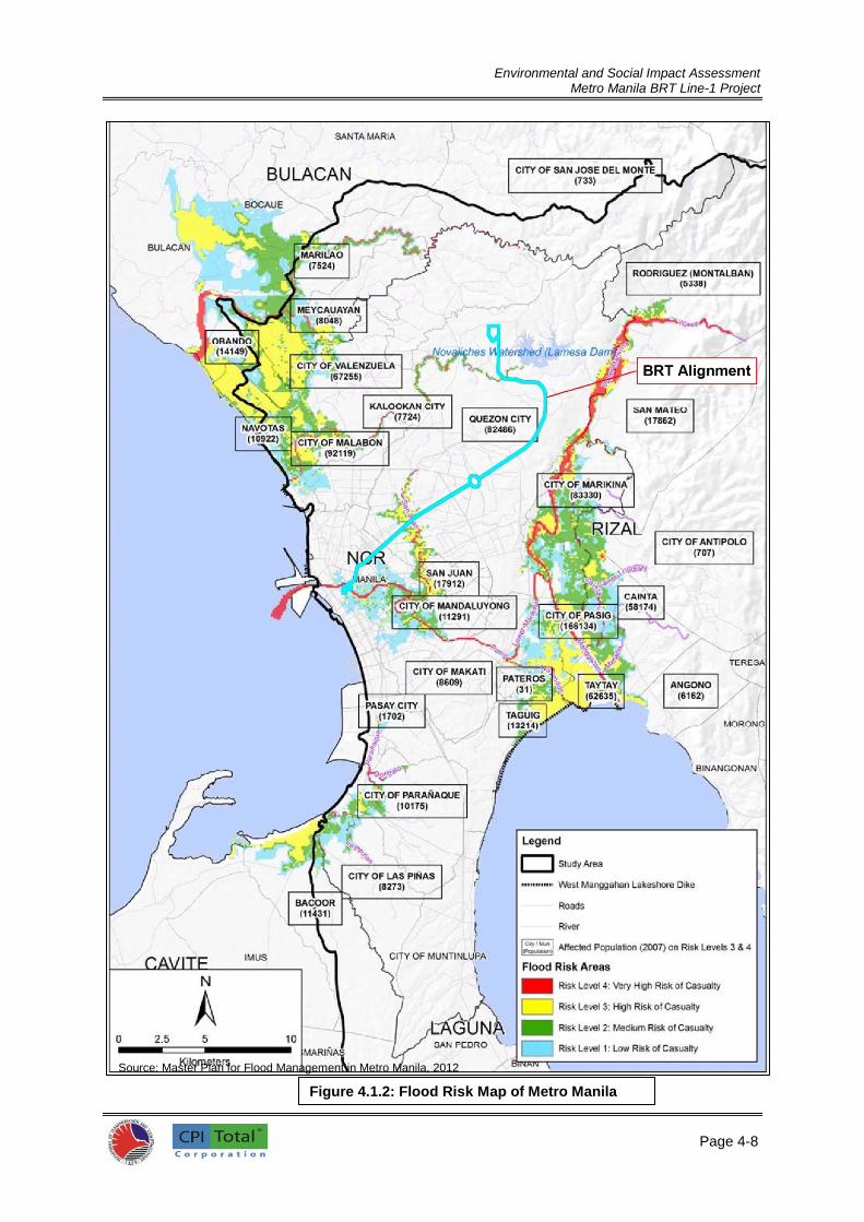
Environmental and Social Impact Assessment
Metro Manila BRT Line-1 Project
Page 4-8
8
Source: Master Plan for Flood Management in Metro Manila, 2012
Figure 4.1.2: Flood Risk Map of Metro Manila

Environmental and Social Impact Assessment
Metro Manila BRT Line-1 Project
Page 4-9
Figure 4.1.3. Proposed Components and Measures in DICAMM Project
Welcome
Rotonda
Mla City Hall
Station
Sections of the BRT Corridor
that are Flood Prones

Environmental and Social Impact Assessment
Metro Manila BRT Line-1 Project
Page 4-10
1
4.1.6 Water Quality
205. Water quality survey was conducted on January 29, 2015. In this study, water samples were collected from the three major rivers traversed by BRT alignment, namely, San Juan River, Tullahan River, and Pasig River. Water samples were taken from the upstream and downstream portions of the rivers approximately 20 meters away from the BRT alignment using grab sampling method. The weather condition before and during sampling is dry and sunny with temperature of 37°C. The sampling locations of water quality survey are listed in Table 4.1.2 and shown in Figure 4.1.4.
Table 4.1.2: Water Sampling Locations
Sample # Sampling Date and Time Location Coordinates
WS-1 29 Jan. 2015 (9:30AM) San Juan River (Upstream)
14°37'49.83"N; 121° 0'53.74"E
WS-2 29 Jan. 2015 (9:35AM) San Juan River (Downstream)
14°37'44.59"N; 121° 0'56.16"E
WS-3 29 Jan. 2015 (10:25AM) Pasig River (Upstream)
14°35'45.73"N; 120°58'52.12"E
WS-4 29 Jan. 2015 (10:35AM) Pasig River (Downstream)
120°58'52.12"E; 120°58'52.12"E
WS-5 29 Jan. 2015 (1:10PM) Tullahan River (Upstream)
14°42'25.26"N; 121° 4'0.07"E
WS-6 29 Jan. 2015 (1:25PM) Tullahan River (Downstream)
14°42'21.44"N; 121° 3'59.56"E
206. The water samples collected were delivered to Echem Environmental Testing Laboratory for physical and chemical analyses. Annex 5 shows the results of laboratory analyses and the DENR Accreditation Certificate of Echem Environmental Testing Laboratory. 207. Water samples were analysed for the following laboratory parameters and procedures:
pH (APHA 4500-H Electrometric Method)
Color (APHA 2120B Visual Comparison Method)
BOD5 (APHA 5210B Azide Modification Technique)
COD (APHA 5220B Open Reflux Method)
TSS (APHA 2540D Gravimetric Method)
Oil and Grease (APHA 5520B Petroleum Ether extraction/Gravimetric Method) 208. For comparison purposes, the quality of these water samples was compared with the standards set for Class C. By definition provided under DENR DAO 34, water assigned as Class C is usually used for manufacturing processes or Industrial Water Supply Class I. 209. Table 4.1.3 presents the results of the water quality survey together with the DENR standards for Class C.

Environmental and Social Impact Assessment
Metro Manila BRT Line-1 Project
Page 4-11
1
BRT Alignment
Source: Google Map
Figure 4.1.4: Water Quality Sampling Stations

Environmental and Social Impact Assessment
Metro Manila BRT Line-1 Project
Page 4-12
1
Table 4.1.3: Results of Analysis of Water Quality Survey
Parameter Unit DENR
Standard Class C
Water Sample (WS)
WS 1 WS 2 WS 3 WS 4 WS 5 WS 6
San Juan River Pasig River Tullahan River Upstream Downstream Upstream Downstream Upstream Downstream
Date of Collection
--- --- 29
Jan.’15 29
Jan.’15 29
Jan.’15 29
Jan.’15 29
Jan.’15 29
Jan.’15
Temperature** oC 3
o rise* 25.5 25.5 25.5 25.5 25.5 25.4
pH - 6.5-8.5 7.46 7.48 7.08 6.74 7.62 7.47
Color, apparent
PCU (c) 100 80 100 125 40 40
BOD5 mg/L 10 40 28 14 13 9 9
TSS mg/L (g) 45 42 56 69 33 37
Oil & Grease mg/L 2.0 3 2 <1 <1 <1 4
Legend: (c) – no abnormal discoloration from unnatural causes (g) – not more than 30 mg/L increase
(h) – not more than 60 mg/L increase -- No standards specified Note: Colored cell indicate that sample did not meet the DENR standard
210. Based from the results (Table 4.1.3), temperature of water sample range from 25.4 to 25.5oC
that is typical to sunny weather. The pH ranges from 6.74 to 7.62 for all water samples and fall within the DENR standards for Class C water. 211. For BOD, only water samples from Tullahan River registered BOD values within the DENR Standards for Class C waters. BOD values of Pasig River and San Juan River exceeded the DENR Standard with values measured at 14 and 13 (upstream/downstream) and 40 and 28 mg/L, correspondingly. Although dissolved oxygen (DO) levels of these rivers were not measured, expected value for this parameter is inversely correlated to BOD values. 212. The measured concentration levels of total suspended solids (TSS) in mg/L ranged from 33 to 69 mg/L. These concentration levels of TSS would serve as baseline value for future monitoring references. 213. Only upstream of San Juan River and downstream of Tullahan River registered oil and grease parameter values exceeding DENR Standards for Class C waters at 3.0 and 4.0 mg/L, respectively.
4.1.7 Climatology 214. The synoptic station of PAGASA closest to the project is located in Science Garden in Quezon City. The entire BRT Corridor falls under Type I under the modified Corona's classification of Philippine climate (see Figure 4.1.5). This type of climate is characterized by two pronounced seasons: dry season from November to April and wet season from May to October. These two seasons are caused by the northeast monsoon from November to February, two trade winds from March to May and May to June and southwest monsoon from June to October. 215. Table 4.1.4 shows the climatological normals or averages for a 30-year record (1981-2010) while Table 4.1.5 shows the climatological extremes as obtained from the PAGASA-Science Garden Station in Diliman, Quezon City.
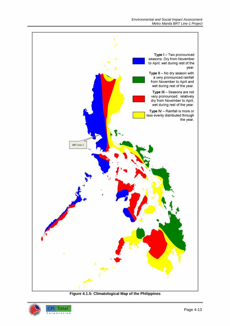
Environmental and Social Impact Assessment
Metro Manila BRT Line-1 Project
Page 4-13
1
Figure 4.1.5: Climatological Map of the Philippines
BRT Line 1

Environmental and Social Impact Assessment
Metro Manila BRT Line-1 Project
Page 4-14
1
Table 4.1.4: Climatological Normal Values
Source: PAGASA, 2015
Table 4.1.5: Climatological Extreme Values
Source: PAGASA, 2015
216. The variation of mean daily air temperature is shown in Table 4.1.4. The range of variation of monthly averages ranged from 23.1ºC to 32.2ºC. January is the coldest month with mean daily temperature of about 25.7ºC while May is the warmest month with mean daily temperature of 29.7 ºC. The minimum daily air temperatures range from 20.8ºC to 24.7ºC. The maximum daily values range from 30.5ºC to 35.0ºC. The mean annual temperature is 27.7°C.
Station Name : Science Garden, Quezon City Latitude : 14.6 N Elevation: 43.0 m
Period : 1981 - 2010 Longtitude: 121.0 E
(1) (2) (3) (4) (5) (6) (7) (8) (9) (10) (11) (12) (13) (14) (15)
Amount No. Max Min Mean Dry Wet Dew DIR SPD TSTM LTNG
of Bulb Bulb Pt. PressureHum. Amount
(mm) RD (oC) (oC) (oC) (oC) (oC) (oC) (mbs) % (mbs) (16 pt)(mps) (okta)
JAN 18.5 4 30.6 20.8 25.7 25.3 22.2 20.9 24.6 76 1012.3 N 1 5 1 0
FEB 14.6 3 31.7 20.9 26.3 26.0 22.3 20.8 24.4 73 1012.0 NE 1 5 0 0
MAR 24.8 4 33.4 22.1 27.8 27.6 23.2 21.5 25.4 69 1011.3 SE 1 4 2 1
APR 40.4 5 35.0 23.7 29.4 29.2 24.4 22.7 27.2 67 1009.7 SE 1 4 4 2
MAY 186.7 12 34.7 24.7 29.7 29.3 25.3 23.9 29.5 72 1008.5 S 1 5 12 8
JUN 316.5 18 33.1 24.6 28.8 28.4 25.5 24.5 30.6 79 1008.1 SW 1 6 17 9
JUL 493.3 22 31.9 24.1 28.0 27.5 25.2 24.4 30.5 83 1007.7 SW 2 6 19 9
AUG 504.2 23 31.3 24.2 27.8 27.3 25.2 24.5 30.6 84 1007.4 SW 2 7 17 6
SEP 451.2 22 31.6 24.0 27.8 27.2 25.1 24.4 30.4 84 1010.6 SW 1 6 18 9
OCT 296.6 18 31.6 23.5 27.6 27.0 24.7 23.9 29.5 83 1008.8 N 1 6 11 6
NOV 148.8 14 31.4 22.7 27.1 26.5 24.1 23.2 28.4 82 1010.1 N 1 5 5 1
DEC 78.7 8 30.5 21.6 26.0 25.5 22.8 21.7 25.9 79 1011.5 N 1 5 1 0
ANNUAL 2574.4 153 32.2 23.1 27.7 27.2 24.2 23.0 28.1 78 1009.8 N 1 5 107 51
(16)
Rainfall Temperature Wind No. Days w/
Vapor Rel. MSLP CloudMonth
STATION: PORT AREA (MCO), MANILA
YEAR : AS OF 2014
MONTH HIGH DATE LOW DATE AMOUNT DATE SPD DIR DATE HIGH DATE LOW DATE
JAN 36.5 01-30-1984 14.5 01-11-1914 37.8 01-08-1955 18 E 01-15-1987 1022.4 01-09-1914 1003.3 01-05-1999
FEB 35.6 02-25-1906 15.6 02-18-1920 46.4 02-03-1986 25 SE 02-26-1962 1021.4 12-01-1962 1002.7 02-18-1998
MAR 36.8 03-23-1966 16.2 03-10-1911 47.0 03-25-2009 27 SSE 03-16-1962 1020.5 03-30-1958 997.3 03-27-1991
APR 38.0 04-30-1915 17.2 04-02-1923 143.0 04-29-1905 24 WSW 04-18-1962 1018.8 04-01-1958 998.1 04-29-1905
MAY 38.6 05-17-1915 20.0 05-01-1921 371.4 05-19-1976 35 E 05-17-1989 1015.9 05-09-1937 987.4 05-23-1922
JUNE 37.6 06-04-1912 20.1 06-04-1973 252.8 06-27-1985 47 SW 06-29-1964 1021.6 06-28-1993 974.6 06-29-1964
JULY 36.5 07-02-1973 19.4 07-14-1970 293.6 07-29-1919 31 WSW 07-24-1968 1014.9 07-29-1987 990.7 07-16-2014
AUG 35.6 08-09-1964 18.0 08-14-1974 358.0 08-07-2012 34 S 08-04-1989 1015.2 08-12-1958 990.8 08-31-1920
SEP 35.3 09-18-1903 20.2 09-02-1970 403.1 09-01-1970 34 SW 09-13-1961 1015.2 09-20-1965 986.7 09-27-1906
OCT 35.8 10-01-1968 19.5 10-26-1913 194.3 10-15-1918 41 W 10-26-1978 1017.0 10-28-1960 977.9 10-14-1970
NOV 35.6 11-04-1966 16.8 11-03-1911 278.4 11-18-1923 56 WNW 11-19-1970 1019.0 11-29-1985 966.5 11-19-1970
DEC 34.6 12-14-1947 15.7 12-03-1992 128.3 12-18-1939 41 W 12-14-1964 1020.9 12-08-1960 971.1 12-26-1947
ANNUAL 38.6 05-17-1915 14.5 01-11-1914 403.1 09-01-1970 56 WNW 11-19-1970 1022.4 01-09-1914 966.5 11-19-1970
Period of
Record
GREATEST DAILY HIGHEST
LATITUDE : 14o35'13.10"N
LONGITUDE : 120o58'43.44"E
ELEVATION : 15m
TEMPERATURE (oC) RAINFALL (MM) WIND (MPS) SEA LEVEL PRESSURES (MBS)
1885-2014 1865-2014 1948-2014 1885-2014

Environmental and Social Impact Assessment
Metro Manila BRT Line-1 Project
Page 4-15
1
217. According to the 1961-2014 records from PAGASA, the highest recorded temperature at the nearest station was 38.5
oC and this was observed on May 14, 1987. The lowest temperature, on the
other hand, was observed on March 1, 1963 at 14.9oC (Table 4.1.5).
218. The highest average monthly rainfall in the Project areas occurs during the month of August with an average of 504.2 mm. The lowest monthly average rainfall in the area is during the month of February, with an average of 14.6 mm (Table 4.1.4). The rainy season coincide with the occurrence of the Southwest Monsoon in the months of June to September; the dry season on the other hand, is experienced in the months of November to April. The average annual number of rainy days in the area is 153. The most number of rainy days occurred in July to September with rainy days ranging from 22-23 days. A rainy day is defined as a period of 24 hours beginning at 0800 to 0800 hours of the following day during which more than 0.1 mm of rainfall depth is recorded.
219. For the record, the highest amount of rainfall recorded from the period of 1961-2014 on the area was on September 26, 2009 at 455.0 mm. (Table 4.1.5)
220. Based on the projected seasonal rainfall change, the average rainfall for the period of June to August is projected to increase in 2020 and 2050 to 1269.7 mm and 1419.5 mm, respectively. While, for the period of December to February, a decrease to 93.7mm and 66.1 mm is projected in 2020 and
2050, respectively12. 221. At current precipitation levels in the project area, periodic episodes of flooding along España Boulevard and Quezon Avenue are being experienced. With the projected increased in precipitation for the year 2020 and 2050, the project area may be subjected for more severe flooding episodes. Although not part of the proposed project scope, it is imperative that flood control mitigation projects should be implemented in order to address said future flooding problems along the BRT corridor. 222. The problem of rises in temperature is worldwide in scope wherein greenhouse gas emissions are said to be the main cause. The implementation of the BRT project is a small step for the country to reduce greenhouse gas emissions through the use of more efficient mass transport system coupled with the use of cleaner fuels. The modal shift in mass transportation from current traditional transport system to more efficient and cleaner systems, like the BRT, in the country could be translated to lesser greenhouse gas emission. 223. The dominant air streams that significantly affect the study area are the Northeast Monsoon, Southwest Monsoon, and the North Pacific Trades. The Northeast Monsoon prevails from October to May, while the Southwest Monsoon occurs during June to September. The North Pacific Trades is the southern portion of the North Pacific anticyclone. Having passed over a vast expanse of the North Pacific Ocean, this air stream is classified as a maritime tropical air mass. 224. In addition to the above seasonal characteristics, Metro Manila is directly influenced by tropical cyclones. An average of 20 of these disturbances affects the country each year. Of this number, 9 make a landfall and cross the country. According to a study conducted by PAGASA, the Manila Bay area lies in a region with an average of 5 tropical cyclone passages every 3 years. The typhoon-related maximum winds that may be observed in the area have greater frequencies in the months of July, October, and November. Floods are often caused by tropical cyclones in Metro Manila.
4.1.8 Ambient Air Quality 4.1.8.1 Air Quality Monitoring (from DENR)
Total Suspended Particulate (TSP) 225. During the conduct of the Detailed Technical Study, secondary data from two air quality monitoring stations of DENR which were located close to the BRT corridor were utilized to evaluate the impacts on local air quality along the BRT route. These monitoring stations record Total
12 Lifted from EIS of LRT Line 1 Cavite Extension Project, 2012

Environmental and Social Impact Assessment
Metro Manila BRT Line-1 Project
Page 4-16
1
Suspended Particulate (TSP) and the results of these recordings are published by the DENR Environmental Management Bureau each year. 226. The locations of the monitoring stations of DENR within Metro Manila are as follows:
National Ecology Centre Compound, East Avenue (close to the corridor) National Printing Office Compound, EDSA (close to the corridor) Mandaluyong City Hall Compound, Maysilo Circle (control areas) Makati Bureau of Fire Compound, Ayala Ave. corner Buendia (control areas)
227. With limited monitoring stations within Metro Manila and correspondingly limited data for use in this ESIA works especially along the BRT corridor, the ESIA study team has designated ten air quality sampling stations which are all located along the proposed BRT corridor. Parameters measured include sulfur dioxide, nitrogen dioxide, carbon monoxide, total suspended particulates and particulate matter less than 2.5. Details of the results are presented in Section 4.1.8.2 (On-site Air Sampling and Measurement). To further establish the air quality condition along the BRT corridor, future air quality monitoring works shall be done and shall form part of the ESMP for this Project.
228. Table 4.1.6 presents the recorded annual values in ug/NCM of TSP for the four monitoring stations of EMB.
Table 4.1.6: Annual values of TSP at Four Monitoring Sites of EMB
All readings are Micrograms/ Normal Cubic
Meter (ug/NCM) 2004 2005 2006 2007 2008 2009 2010 2011 2012
National Ecology Centre Compound, East Avenue
163 156 140 131 134 130 150 118 119
National Printing Office Compound, EDSA
164 163 138 125 144 89 152 103 96
Mandaluyong City Hall (control area)
133 124 121 134 125 104 138 136 148
Makati Bureau of Fire Compound (control area)
211 183 153 146 134 145 160 128 135
Source: Detailed Technical Study, Manila-Quezon Corridor Improvement Project, 2013
Particulate Matter (PM10) 229. Secondary data on air quality for Particulate Matter 10 (PM10) was also taken from EMB monitoring station located along the proposed BRT alignment. The location of the EMB station is along Commonwealth Avenue near the Crissant Tower and another one is located at Timog EDSA close to BRT corridor, see below:
Commonwealth Avenue, Quezon City (along the BRT corridor) DPWH, Timog EDSA, Quezon City (close to BRT corridor)
230. The Commonwealth Avenue monitoring station is along the proposed BRT corridor, thus capable of capturing the particulate matter concentration on this section of the BRT corridor. On the other hand, data from Timog EDSA monitoring station was used to represent the air quality condition of the nearest BRT corridor which is the EDSA – Quezon Avenue area. Although there may be differences in actual registration of levels of particulate matter, exhaust emissions for both areas are similar which are mostly diesel exhaust particles. 231. This ambient air quality monitoring is done to provide the public updated information on the
quality of air, specifically on particulate matter, in various locations of Metro Manila. Particulate Matter
(PM) is a type of air pollutant in the form of solid particles in the air that is produced by many sources, including burning of diesel fuels by vehicles, fossil fuels, mixing and application of fertilizers and pesticides, road construction, industrial processes, and wood burning. These microscopic particles, when breathed into the lungs, can increase respiratory disease and lung damage.
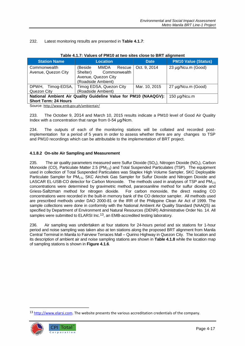
Environmental and Social Impact Assessment
Metro Manila BRT Line-1 Project
Page 4-17
1
232. Latest monitoring results are presented in Table 4.1.7:
Table 4.1.7: Values of PM10 at two sites close to BRT alignment
Station Name Location Date PM10 Value (Status)
Commonwealth Avenue, Quezon City
(Beside MMDA Rescue Shelter) Commonwealth Avenue, Quezon City (Roadside Ambient)
Oct. 9, 2014 23 µg/Ncu.m (Good)
DPWH, Timog-EDSA, Quezon City
Timog EDSA, Quezon City (Roadside Ambient)
Mar. 10, 2015 27 µg/Ncu.m (Good)
National Ambient Air Quality Guideline Value for PM10 (NAAQGV): Short Term: 24 Hours
150 µg/Ncu.m
Source: http://www.emb.gov.ph/ambientair/
233. The October 9, 2014 and March 10, 2015 results indicate a PM10 level of Good Air Quality Index with a concentration that range from 0-54 μg/Ncm. 234. The outputs of each of the monitoring stations will be collated and recorded post-implementation for a period of 5 years in order to assess whether there are any changes to TSP and PM10 recordings which can be attributable to the implementation of BRT project.
4.1.8.2 On-site Air Sampling and Measurement 235. The air quality parameters measured were Sulfur Dioxide (SO2), Nitrogen Dioxide (NO2), Carbon Monoxide (CO), Particulate Matter 2.5 (PM2.5) and Total Suspended Particulates (TSP). The equipment used in collection of Total Suspended Particulates was Staplex High Volume Sampler, SKC Deployable Particulate Sampler for PM2.5, SKC Airchek Gas Sampler for Sulfur Dioxide and Nitrogen Dioxide and LASCAR EL-USB-CO detector for Carbon Monoxide. The methods used in analyses of TSP and PM2.5
concentrations were determined by gravimetric method, pararosaniline method for sulfur dioxide and
Griess-Saltzman method for nitrogen dioxide. For carbon monoxide, the direct reading CO concentrations were recorded in the built-in memory bank of the CO detector sampler. All methods used are prescribed methods under DAO 2000-81 or the IRR of the Philippine Clean Air Act of 1999. The sample collections were done in conformity with the National Ambient Air Quality Standard (NAAQS) as specified by Department of Environment and Natural Resources (DENR) Administrative Order No. 14. All
samples were submitted to ELARSI Inc.13, an EMB-accredited testing laboratory.
236. Air sampling was undertaken at four stations for 24-hours period and six stations for 1-hour period and noise sampling was taken also at ten stations along the proposed BRT alignment from Manila Central Terminal in Manila to Fairview Terraces Mall – Quirino Highway in Quezon City. The location and its description of ambient air and noise sampling stations are shown in Table 4.1.8 while the location map of sampling stations is shown in Figure 4.1.6.
13 http://www.elarsi.com. The website presents the various accreditation credentials of the company.
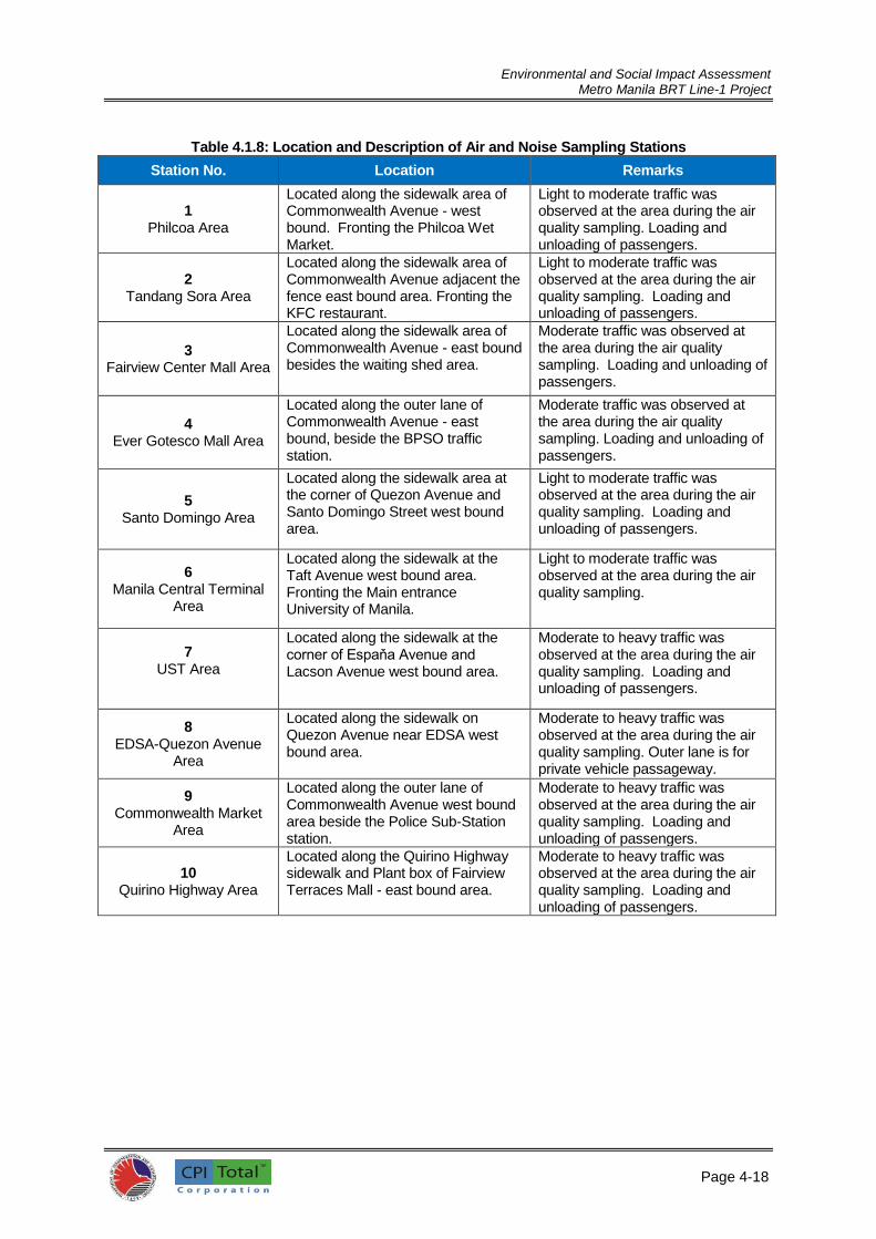
Environmental and Social Impact Assessment
Metro Manila BRT Line-1 Project
Page 4-18
1
Table 4.1.8: Location and Description of Air and Noise Sampling Stations
Station No. Location Remarks
1 Philcoa Area
Located along the sidewalk area of Commonwealth Avenue - west bound. Fronting the Philcoa Wet Market.
Light to moderate traffic was observed at the area during the air quality sampling. Loading and unloading of passengers.
2 Tandang Sora Area
Located along the sidewalk area of Commonwealth Avenue adjacent the fence east bound area. Fronting the KFC restaurant.
Light to moderate traffic was observed at the area during the air quality sampling. Loading and unloading of passengers.
3 Fairview Center Mall Area
Located along the sidewalk area of Commonwealth Avenue - east bound besides the waiting shed area.
Moderate traffic was observed at the area during the air quality sampling. Loading and unloading of passengers.
4 Ever Gotesco Mall Area
Located along the outer lane of Commonwealth Avenue - east bound, beside the BPSO traffic station.
Moderate traffic was observed at the area during the air quality sampling. Loading and unloading of passengers.
5 Santo Domingo Area
Located along the sidewalk area at the corner of Quezon Avenue and Santo Domingo Street west bound area.
Light to moderate traffic was observed at the area during the air quality sampling. Loading and unloading of passengers.
6 Manila Central Terminal
Area
Located along the sidewalk at the Taft Avenue west bound area. Fronting the Main entrance University of Manila.
Light to moderate traffic was observed at the area during the air quality sampling.
7 UST Area
Located along the sidewalk at the corner of Espaňa Avenue and Lacson Avenue west bound area.
Moderate to heavy traffic was observed at the area during the air quality sampling. Loading and unloading of passengers.
8 EDSA-Quezon Avenue
Area
Located along the sidewalk on Quezon Avenue near EDSA west bound area.
Moderate to heavy traffic was observed at the area during the air quality sampling. Outer lane is for private vehicle passageway.
9 Commonwealth Market
Area
Located along the outer lane of Commonwealth Avenue west bound area beside the Police Sub-Station station.
Moderate to heavy traffic was observed at the area during the air quality sampling. Loading and unloading of passengers.
10 Quirino Highway Area
Located along the Quirino Highway sidewalk and Plant box of Fairview Terraces Mall - east bound area.
Moderate to heavy traffic was observed at the area during the air quality sampling. Loading and unloading of passengers.

Environmental and Social Impact Assessment
Metro Manila BRT Line-1 Project
Page 4-19
1
Source: Google Map
Figure 4.1.6: Location of Air Quality and Noise Sampling Stations

Environmental and Social Impact Assessment
Metro Manila BRT Line-1 Project
Page 4-20
2
237. Justifications for the selection of the above enumerated air quality observation areas are the following:
Many commuters and road users are around the area;
The observation area is fronting the outside lane stretch of these road sections where loading and unloading for PUJs and PUBs are located;
Inner lane of these road sections are dedicated for private car mobility, thus exhaust emissions from both idle and mobile vehicles can be captured in this area; and,
All ten observation sites correspond to the proposed location of BRT station. 238. Along Commonwealth Avenue, dominant sources of exhaust emissions are jeepneys, buses, private cars and trucks while dominant sources of noise are from road traffic comprising of engine noise, accelerating / braking vehicles and honking vehicles. 239. From EDSA Quezon Avenue to Manila City Hall, dominant source of exhaust emissions are PUJs and private cars and few buses while dominant sources of noise are from road traffic comprising of engine noise, accelerating / braking vehicles and honking vehicles.
240. The measured air quality ambient concentration in the proposed BRT project alignment is shown below (Table 4.1.9):
Table 4.1.9: Measured Air Quality for BRT Project
STATION
Concentrations
Sulfur Dioxide (SO2) in µg/Ncm
Nitrogen Dioxide (NO2) in µg/Ncm
Carbon Monoxide (CO) in ppm
Total Suspended Particulates (TSP) in µg/Ncm
Particulate Matter less
than 2.5 (PM2.5)
in µg/Ncm
One Hour Sampling
1 16.77 13.29 0.84 116 68.1
2 20.03 15.96 0.62 93 51.1
3 14.87 21.28 1.02 196 86.7
4 10.51 24.65 0.04 136 68.6
5 19.04 31.75 2.02 204 85.2
6 15.92 29.24 0.89 218 103.0
24-Hours Sampling
7 21.20 45.22 1.5 424 11.4
8 14.95 54.34 1.1 299 9.9
9 29.45 24.90 1.1 589 22.4
10 15.95 20.31 0.3 319 14.4
DENR Standard Limit:
24-Hours 1-Hour
180.0 340.0
150.0 260.0
9.0* 30.0
230.0 300.0
75.0
Note: Highlighted values in yellow exceeded the ambient standards * for 8-hrs average
241. The baseline measurement for air quality and noise level was conducted last February 4 to 9, 2015 at selected sampling station along BRT alignment from Manila Central Terminal to Quirino Highway-Fairview Terraces Mall. The observed concentration for total suspended particulates (TSP) showed above the 230 μg/Ncm DENR standard limit for 24-hours average with concentration levels from 299 to 589 μg/Ncm. The TSP levels for 1-hour average sampling are below the 300 μg/Ncm DENR standard limit with observed concentration values of 93 to 218 μg/Ncm.
242. For gaseous pollutants, the ambient concentration for sulfur dioxide 24-hours average are 14.95
to 29.45 μg/Ncm below the DENR standard limit of 180 μg/Ncm while the 1-hour average concentration levels are 10.51 to 20.03 μg/Ncm below the DENR 1-hour standard limit of 340 μg/Ncm . The nitrogen dioxide 24-hours concentration is from 20.31 to 54.34 μg/Ncm less than the DENR standard limit of 260 μg/Ncm and the 1-hour average DENR standard of 260 μg/Ncm concentration is above the measured

Environmental and Social Impact Assessment
Metro Manila BRT Line-1 Project
Page 4-21
2
NO2 1-hour concentration from 13.29 to 31.75 μg/Ncm. The carbon monoxide (CO) 1-minute running average concentration is from 0.3 to 1.5 ppm for the 24-hours sampling and from 0.04 to 2.02 ppm for the 1-hour sampling. The maximum CO level recorded for the 1-hour sampling ranged from 1.5 to is 11.0 ppm from 1-minute running average concentration, and for the maximum 24-hour sampling ranged from 3.5 to 35.5 ppm. Tabulated data for carbon monoxide are shown in Annex 6. The DENR standard for sulfur dioxide, nitrogen dioxide and carbon monoxide pollutants were not exceeded for the ten sampling locations. The sulfur dioxide and nitrogen dioxide standards are 180 μg/Ncm and 150 μg/Ncm, respectively. Table 4.1.10 shows the DENR standard for National Ambient Air Quality Guidelines/Standards for Selected Air Pollutants (NAAQGS).
Table 4.1.10 National Ambient Air Quality Guidelines/Standards for Selected Air Pollutants
Pollutant Standard Maximum GLC
Averaging Time
µg/Ncm Ppm
Sulfur Dioxide (SO2) 180 340 470
0.07 0.13 0.18
24 hrs 1 hr
30 min
Nitrogen Dioxide (NO2) 150 260 375
0.08 0.14 0.20
24 hrs 1 hr
30 min
Carbon Monoxide (CO) 35,000 10,000
30 9
8 hrs 1 hr
*Particulate Matter 2.5µ (PM2.5) 75 --
-- --
24 hrs 1 hr
Total Suspended Particulates (TSP)
230 300
--- ---
24 hrs 1 hr
Source: DENR AO No. 2000-81: “Implementing Rules and Regulations for Republic Act 8749” * DENR AO No. 2013-13: “Provisional National Ambient Air Quality Guidelines Values for Particulate Matter 2.5 (PM2.5)”
243. Results of the assessment show that ambient air quality in the project site and its environment is generally good in terms of gaseous pollutant and moderately high for total suspended particulate. Existing Noise Level Conditions 244. The noise measurements were conducted using a Center Data Logging Sound Level Meter on A-weighting scale following ISO standard. The unit used is Extech Instrument Model HD600 (Digital Data Logging Sound Level Meter). Self-calibration of the sound level meter (SLM) used follows the unit operation manual. In this case, transport-generated noise is measured in terms of equivalent sound level or Leq. This metric is A-weighted and accounts for all of the sound energy occurring during a 30-second interval. Leq includes peak sounds as well as ”valleys” within a particular time frame. Leq could identify the average noise level over a period of time and can be easily measured with sound equipment. Measurements would therefore be in terms of Leq dB (A). An ’A’ weighted scale with a slow response was chosen because it has been universally adopted for measurement of transport noise to compensate human hearing characteristics. This scale simulates the response of the ear at low levels and has been found to correlate well with subjective response to noise. The noise average is calculated using the following logarithmic equation:
Leq =10 log10 {1/n [10L1/10
+ 10L2/10
+ 10L3/10
+ ... +10Ln/10
]}
Where: Leq is the average energy sound level in dB(A), and
L1, L2,..,Ln are the observed/measured noise levels from period 1 to period n.

Environmental and Social Impact Assessment
Metro Manila BRT Line-1 Project
Page 4-22
2
245. From about 1-m from the edge of the road, ambient noise measurements were made four times within a 24-hour period for different time category as morning, daytime, evening and nighttime periods. The time series of noise levels in 30-seconds intervals are shown in Annex 6. Summary of average noise levels for the ten sampling station is shown below (Table 4.1.11):
Table 4.1.11: Measured Noise Level for BRT Project
Station Area Classification Daytime
Period Evening Period
Nighttime Period
Morning Period
1 Commercial 77.0 - - -
2 Commercial 78.7 - - -
3 School 81.5 - - -
4 Commercial - 78.8 - -
5 School/Hospital (Church)
76.3 - - -
6 School 76.6 - - -
7 School 78.9 80.2 77.6 77.3
8 Commercial 74.7 72.0 70.3 77.3
9 Commercial 78.1 77.7 78.2 79.6
10 Commercial 74.6 77.8 70.1 77.2
DENR Standard: School/Hospital Residential Commercial Light Industrial
50 55 65 70
45 50 60 65
40 45 55 60
45 50 60 65
Note: Highlighted values in yellow exceeded the ambient standards
246. All ten sampling stations exceeded the allowable noise limit for four different time periods for residential areas and commercial area category. Exceedances maybe attributed to the combined noise generated by vehicular traffic, human activities and absence of vegetation as natural noise buffers. The commercial noise level limits are 65 and 55 dBA for daytime and night time period, respectively. The observed daytime average noise levels are from 74.6 to 81.5 dBA and the nighttime average noise level is from 70.1 to 78.2 dBA. 247. Table 4.1.12 shows the DENR Standards for noise in general areas while Table 4.1.13 shows the expected Noise Levels from Construction Equipment in dB(A). Daytime standards for noise are higher than morning/evening and nighttime standards of DENR. Noise levels in Table 4.1.12 may be used to determine the appropriate time to operate the construction equipment given their expected noise levels by distance to receptors. For instance, using a frontloader during daytime located 240 meters away from residential area is acceptable since the equipment will generate a noise level of 51 dB(A) which is less than the 55 dB(A) DENR standard for noise on daytime in residential areas. In case a frontloader will be used about 60 meters away from residential area, the equipment will generate 63 dB(A) which exceed the 55 dB(A) daytime standard. Therefore, mitigation measures through the use of noise barrier or limiting the hour of operation of the equipment will be necessary.
Table 4.1.12: DENR Standards for Noise in General Areas
Area Maximum Allowable Noise Level, dB(A)
Daytime Morning/Evening Nighttime
Schools, Hospitals 50 45 40
Residential 55 50 45
Commercial 65 60 55
Light Industrial 70 65 60
Heavy Industrial 75 70 65
Source: National Pollution Control Commission Memorandum Circular No. 002 Series of 1980:”Ambient Noise Quality and Emission Standard”
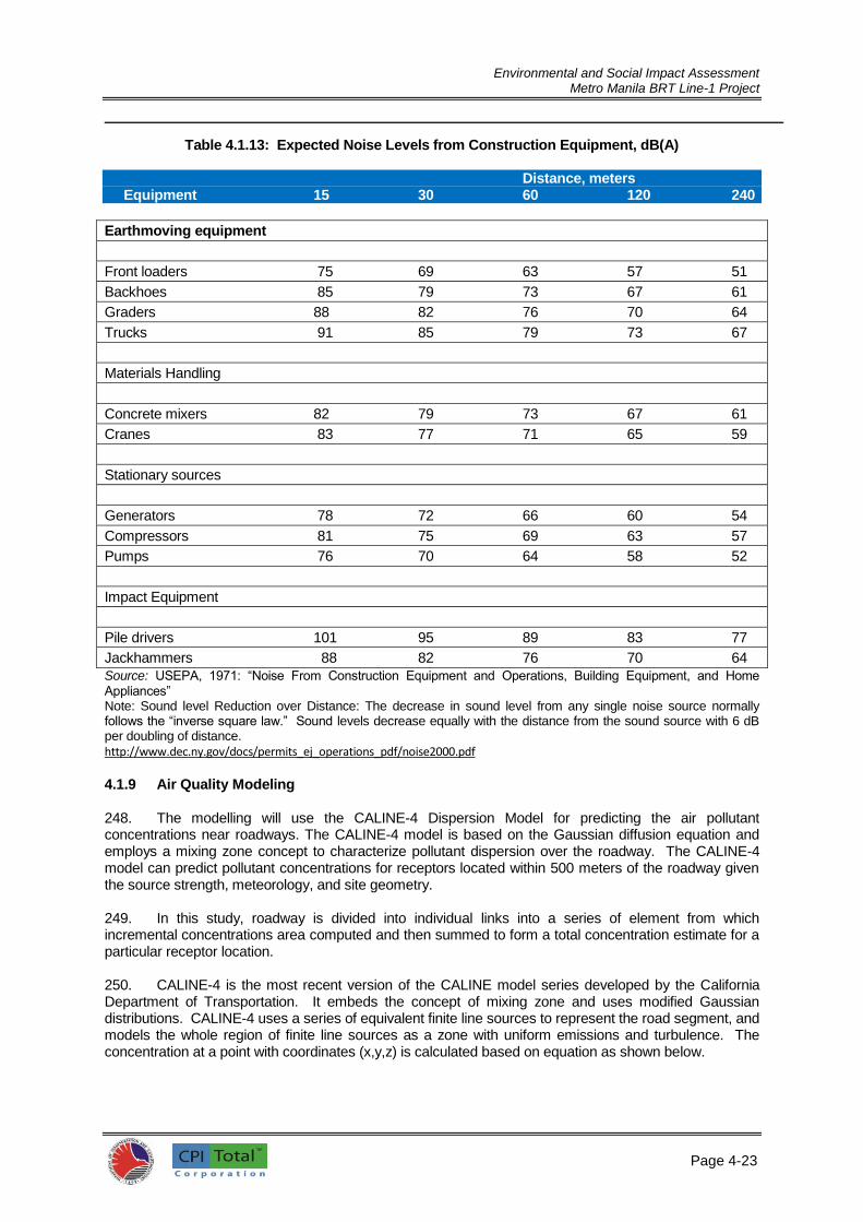
Environmental and Social Impact Assessment
Metro Manila BRT Line-1 Project
Page 4-23
2
Table 4.1.13: Expected Noise Levels from Construction Equipment, dB(A)
Distance, meters Equipment 15 30 60 120 240
Earthmoving equipment
Front loaders 75 69 63 57 51
Backhoes 85 79 73 67 61
Graders 88 82 76 70 64
Trucks 91 85 79 73 67
Materials Handling
Concrete mixers 82 79 73 67 61
Cranes 83 77 71 65 59
Stationary sources
Generators 78 72 66 60 54
Compressors 81 75 69 63 57
Pumps 76 70 64 58 52
Impact Equipment
Pile drivers 101 95 89 83 77
Jackhammers 88 82 76 70 64
Source: USEPA, 1971: “Noise From Construction Equipment and Operations, Building Equipment, and Home
Appliances” Note: Sound level Reduction over Distance: The decrease in sound level from any single noise source normally follows the “inverse square law.” Sound levels decrease equally with the distance from the sound source with 6 dB per doubling of distance.
http://www.dec.ny.gov/docs/permits_ej_operations_pdf/noise2000.pdf
4.1.9 Air Quality Modeling
248. The modelling will use the CALINE-4 Dispersion Model for predicting the air pollutant concentrations near roadways. The CALINE-4 model is based on the Gaussian diffusion equation and employs a mixing zone concept to characterize pollutant dispersion over the roadway. The CALINE-4 model can predict pollutant concentrations for receptors located within 500 meters of the roadway given the source strength, meteorology, and site geometry. 249. In this study, roadway is divided into individual links into a series of element from which incremental concentrations area computed and then summed to form a total concentration estimate for a particular receptor location. 250. CALINE-4 is the most recent version of the CALINE model series developed by the California Department of Transportation. It embeds the concept of mixing zone and uses modified Gaussian distributions. CALINE-4 uses a series of equivalent finite line sources to represent the road segment, and models the whole region of finite line sources as a zone with uniform emissions and turbulence. The concentration at a point with coordinates (x,y,z) is calculated based on equation as shown below.

Environmental and Social Impact Assessment
Metro Manila BRT Line-1 Project
Page 4-24
2
𝐶(𝑥, 𝑦, 𝑧) =𝑞
2𝜋 𝑢 𝜎𝑦𝜎𝑧
{exp (−[𝑧 − 𝐻]2
2𝜎𝑧2
) + exp (−[𝑧 + 𝐻]2
2𝜎𝑧2
)} ∫ exp (−𝑦2
2𝜎𝑦2
)𝑦2
𝑦1
𝑑𝑦
where q is the linear source length, u is the wind speed, and σ_(y,) σ_z are the horizontal and vertical Gaussian dispersion parameters, H is the source height, y1 and y2 are the y- coordinates of finite line source endpoints.
251. Among all the variables, σ_y is a function of the x‐ coordinate of the point where the concentration is calculated and horizontal wind angle standard deviation; σ_z is modified by incorporating the effects of vehicle‐ induced heat. 252. The Emission Factor used for NOX, CO and PM2.5 based on an urban roadway driving was summarized in Table 4.1.14.
Table 4.1.14: UK - Road Transport Emission Factors: 2011 NAEI For Urban Driving
Parameters All Car s All LGVs (Bus, Light Trucks(
CO, g/km (g/mi) 2.867 (5.2) 1.267 (2.3)
NOX, g/km (g/mi) 0.423 (0.8) 0.982 (1.8)
PM2.5, g/km (g/mi) 0.015 (0.03) 0.059 (0.11)
253. Above emission factors are based on hot exhaust and cold start emission. The tailpipe emissions in g/km from a vehicle with its engine warmed up to its normal operating conditions.
254. The basis of road transport emissions is U.K. setting and may differ slightly from Philippine experience due to probable differences in legislated emission standards and fleet composition. Emission sources are provided as either cars or LGVs (large good vehicles) and these vehicle categories are used in assuming fleet composition of vehicular traffic for the study. 255. Vehicle flows along the BRT alignment are shown in Tables 4.1.14 and 4.1.15. The assumption on vehicle type is of 80% cars and 20% are bus plus light trucks. Assumption of traffic growth along the España Avenue and Quezon Avenue from 2013 to year 2018 about 30% increase in 5 years (expected BRT operational phase). 256. The road link sections considered in modelling are shown below:
ESPANA (UST) Figure 4.1.7: España and Lacson Street QUEZON AVE Figure 4.1.8: Quezon Avenue and EDSA
257. It will be assumed that during the operational phase of BRT project on the year 2018, the reduction of vehicle (public utility jeep – PUJ) is estimated 40% of total light vehicles (cars). 258. The computed 2013 and 2018 emission will be summarized in Table 4.1.15. To simplify the input requirements of CALINE-4 model, the maximum value of emission factor for different pollutants (CO, NOx and PM2.5) will be used and the total maximum traffic flow at considered road link. The summary of maximum predicted ground level concentration (GLC) in ppm using the CALINE-4 air quality model for each section with the following traffic information are shown in Tables 4.1.16 and 4.1.17.

Environmental and Social Impact Assessment
Metro Manila BRT Line-1 Project
Page 4-25
Figure 4.1.7: España and Lacson Streets

Environmental and Social Impact Assessment
Metro Manila BRT Line-1 Project
Page 4-26
Figure 4.1.8: Quezon Avenue and EDSA

Environmental and Social Impact Assessment
Metro Manila BRT Line-1 Project
Page 4-27
Table 4.1.15: Vehicle Flows along the Espaňa Avenue and Quezon Avenue (Source: Manila-Quezon Corridor Improvement Project Report: 2013)
West Bound
Location
University of Santo Tomas West of EDSA
AM Peak (3hr Av) 2047 3550
PM Peak (2hr Av) 1390 2375
24 Hour 29439 47202
East Bound
Location
University of Santo Tomas West of EDSA
AM Peak (3hr Av) 1448 2312
PM Peak (2hr Av) 1449 2354
24 Hour 27195 42086
Table 4.1.16: Estimate Vehicle Flows along the Espaňa Avenue and Quezon Avenue
(Source: Estimate for 2018)
West Bound
Location
University of Santo Tomas West of EDSA
AM Peak (3hr Av) 2661 4615
PM Peak (2hr Av) 1807 3088
24 Hour 38271 61363
East Bound
Location
University of Santo Tomas West of EDSA
AM Peak (3hr Av) 1856 3006
PM Peak (2hr Av) 1884 3060
24 Hour 35354 54712
Table 4.1.17: Computed 2013 and 2018 Emission
Year 2013 (Based Year – Pre BRT Phase)
Estimated % Traffic
AM Peak WB AM Peak EB Total 80% Cars 20% LGVs
UST Area 2047 1448 3475 2780 695
EF in g/mi Emission by Type Total
Cars LGVs
CO 5.2 2.3 14456.0 1598.5 16054.5
NOx 0.8 1.8 2224.0 1251.0 3475.0
PM2.5 0.03 0.11 83.4 76.5 159.9
AM Peak WB AM Peak EB Total 80% Cars 20% LGVs
West EDSA 3550 2312 5862 4690 1172
EF in g/mi Emission by Type Total
Cars LGVs
CO 5.2 2.3 24388.0 2695.6 27083.6
NOx 0.8 1.8 3752.0 2109.6 5861.6
PM2.5 0.03 0.11 140.7 128.9 269.6
Year 2018 (Based Year – Post BRT Phase)
Estimated % Traffic
AM Peak WB AM Peak EB Total 80% Cars
20% LGVs
UST Area 2661 1856 4517 3614 903
EF in g/mi Emission by Type Total
Cars LGVs
CO 5.2 2.3 18792.8 2076.9 20869.7
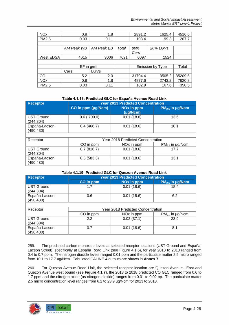
Environmental and Social Impact Assessment
Metro Manila BRT Line-1 Project
Page 4-28
NOx 0.8 1.8 2891.2 1625.4 4516.6
PM2.5 0.03 0.11 108.4 99.3 207.7
AM Peak WB AM Peak EB Total 80% Cars
20% LGVs
West EDSA 4615 3006 7621 6097 1524
EF in g/mi Emission by Type Total
Cars LGVs
CO 5.2 2.3 31704.4 3505.2 35209.6
NOx 0.8 1.8 4877.6 2743.2 7620.8
PM2.5 0.03 0.11 182.9 167.6 350.5
Table 4.1.18: Predicted GLC for Espaňa Avenue Road Link
Receptor Year 2013 Predicted Concentration
CO in ppm (μg/Ncm) NOx in ppm (μg/Ncm)
PM2.5 in μg/Ncm
UST Ground (244,304)
0.6 ( 700.0) 0.01 (18.6) 13.6
España-Lacson (490,430)
0.4 (466.7) 0.01 (18.6) 10.1
Receptor Year 2018 Predicted Concentration
CO in ppm NOx in ppm PM2.5 in μg/Ncm
UST Ground (244,304)
0.7 (816.7) 0.01 (18.6) 17.7
España-Lacson (490,430)
0.5 (583.3) 0.01 (18.6) 13.1
Table 4.1.19: Predicted GLC for Quezon Avenue Road Link
Receptor Year 2013 Predicted Concentration
CO in ppm NOx in ppm PM2.5 in μg/Ncm
UST Ground (244,304)
1.7 0.01 (18.6) 18.4
España-Lacson (490,430)
0.6 0.01 (18.6) 6.2
Receptor Year 2018 Predicted Concentration
CO in ppm NOx in ppm PM2.5 in μg/Ncm
UST Ground (244,304)
2.2 0.02 (37.1) 23.9
España-Lacson (490,430)
0.7 0.01 (18.6) 8.1
259. The predicted carbon monoxide levels at selected receptor locations (UST Ground and España-Lacson Street), specifically at España Road Link (see Figure 4.1.6), for year 2013 to 2018 ranged from 0.4 to 0.7 ppm. The nitrogen dioxide levels ranged 0.01 ppm and the particulate matter 2.5 micro ranged from 10.1 to 17.7 ug/Ncm. Tabulated CALINE-4 outputs are shown in Annex 7. 260. For Quezon Avenue Road Link, the selected receptor location are Quezon Avenue –East and Quezon Avenue west bound (see Figure 4.1.7), the 2013 to 2018 predicted CO GLC ranged from 0.6 to 1.7 ppm and the nitrogen oxide (as nitrogen dioxide) ranges from 0.01 to 0.02 pp. The particulate matter 2.5 micro concentration level ranges from 6.2 to 23.9 ug/Ncm for 2013 to 2018.

Environmental and Social Impact Assessment
Metro Manila BRT Line-1 Project
Page 4-29
261. The tabulated maximum concentrations for baseline air quality measurement conducted last Feb 4-9, 2015 are in Table 4.1.20.
Table 4.1.20: Observed Concentration for CO, NOx and PM2.5 during Baseline Survey (Feb. 4-9, 2015)
Sampling Location Measured Maximum Concentration
CO in ppm NOx in ug/Ncm PM2.5 in ug/Ncm
UST Area (España-Lacson Street)
1.5
45.22
11.4
Quezon Avenue - EDSA
1.1 54.34 22.4
262. The total ground level concentration for baseline (ambient) and predicted concentration (CALINE-4 Model) is presented in Tables 4.1.21 and 4.1.22.
Table 4.1.21: Baseline Concentration and Predicted GLC for España Avenue Road Link
Receptor
Year 2013 Predicted Concentration
CO in ppm (μg/Ncm) NOx in ppm (μg/Ncm)
PM2.5 in μg/Ncm
UST Ground (244,304)
0.6 + 1.5 = 2.1 18.6 + 45.22 = 63.82 13.6 + 11.4 = 25.0
España-Lacson (490,430)
0.4 + 1.5 = 1.9 18.6 + 45.22 = 63.82 10.1 + 11.4 = 21.5
Receptor Year 2018 Predicted Concentration
CO in ppm NOx in ppm PM2.5 in μg/Ncm
UST Ground (244,304)
0.7 + 1.5 = 2.2 18.6 + 45.22 = 63.82 17.7 + 11.4 = 29.1
España-Lacson (490,430)
0.5 + 1.5 = 2.0 18.6 + 45.22 = 63.82 13.1 + 11.4 = 24.5
Table 4.1.22: Baseline Concentration and Predicted GLC for Quezon Avenue Road Link:
Receptor Year 2013 Predicted Concentration
CO in ppm NOx in ppm PM2.5 in μg/Ncm
UST Ground (244,304)
1.7 + 1.1 = 2.8 18.6 + 54.34 = 72.94 18.4 + 22.4 = 40.8
España-Lacson (490,430)
0.6 + 1.1 = 1.7 18.6 + 54.34 = 72.94 6.2 + 22.4 = 28.6
Receptor Year 2018 Predicted Concentration
CO in ppm NOx in ppm PM2.5 in μg/Ncm
UST Ground (244,304)
2.2 + 1.1 = 3.3 37.1 + 54.34 = 91.44 23.9 + 22.4 = 46.3
España-Lacson (490,430)
0.7 + 1.1 = 1.8 18.6 + 54.34 = 72.94 8.1 + 22.4 = 30.5
263. The resulting values (baseline and predicted concentration) are still below the ambient standard the national ambient air quality standard (NAAQS) as shown in Table 4.1.23.

Environmental and Social Impact Assessment
Metro Manila BRT Line-1 Project
Page 4-30
Table 4.1.23: National Ambient Air Quality Standard Values (NAAQV)
Pollutants Concentration Time Averaging
PM 2.5 75 ug/Ncm 0
24 hours I hour
NO2 150 ug/Ncm 260 ug/Ncm
24 hours I hour
CO 10 mg/Ncm 35 mg/Ncm
8 hours I hour
4.1.10 Current Year GHG Emissions 264. The Greenhouse Gas emissions study was taken from the Detailed Technical Study conducted for Manila-Quezon Corridor Improvement project by the ITP. The study was conducted in
order to prepare a greenhouse gas emissions inventory for the urban transport sector in congested cities in the Philippines, as well as a corridor-specific inventory, based on a proposed bus rapid transit (BRT) route; and develop a descriptive baseline urban transport growth scenario for the city. Vehicle – kilometre inputs 265. The study has calculated the vehicle – kilometre calculation, wherein the number of vehicle-
km travelled by different vehicle types within the defined study boundary area was a key input to the
current year (2012) emissions inventory calculation and to future year forecasts. The inputs came from the transport model that was developed and calibrated based on an extensive data collection exercise in Cebu in 2012, and were seen as transferable to the current situation in Manila.
Current year emission factor determination 266. Determination of appropriate greenhouse gas (GHG) emission factors to use in the Manila analysis was undertaken using the International Vehicle Emissions (IVE) model; this took account of the drive cycle and vehicle technology fleet breakdown characteristics determined for Manila.
267. Greenhouse gas emission factors for the six main current vehicle types were derived from
the IVE emissions model based on the analysis of current driving conditions in congested Philippine city, as shown in Table 4.1.24. The final column of the table shows the overall greenhouse gas emission factor as “CO2 equivalent” (or CO2e) based on widely accepted values of the relative global warming power of each individual gas1.
Table 4.1.24. Current greenhouse gas emission factors derived from IVE model
Vehicle type Road‐type Current Emission factors (g/km)
CO2 N2O CH4 CO2 equiv
Car / light vehicle Highway 357.496 0.002 0.933 377.826
Arterial 386.081 0.003 1.021 408.317
Residential 466.568 0.003 1.244 493.648
Taxi 393.020 0.001 2.246 440.632
Jeepney 1563.799 0.008 0.000 1566.359
Bus 1876.469 0.004 0.000 1880.853
Motorcycle/ tricycle 61.854 0.000 2.794 120.532
Truck 1164.752 0.008 0.000 1167.078
268. All emission factors used are average values across the day (in general, higher factors are
appropriate when conditions are busiest and lower factors at other times). The IVE model analysis yielded different values by road type for cars, which were applied to the vehicle-km travelled on those road types. 269. For trucks, the emission factors shown are a weighted average of factors determined using
the IVE model for medium duty trucks and heavy duty trucks. This was based on an estimated split
Source: ITP Detailed Technical Study for Manila-Quezon Corridor Improvement Project, 2013

Environmental and Social Impact Assessment
Metro Manila BRT Line-1 Project
Page 4-31
of two-thirds medium trucks and one-third heavy duty trucks. This split appears reasonable in the light of the limited amount of detailed classified count data available to the team from previous studies. Total GHG emissions
270. The annual GHG emissions (2013) of all modes of transport in Metro Manila is 1,725,812 tonnes CO2e. This emission is categorized according to vehicle type, as shown in Table 4.1.25.
Table 4.1.25: Annual GHG Emissions
Vehicle Type Annual GHG emissions (Tonnes CO2e)
Cars & Light vehicles 654,302
Taxis 150,055
PUJ 545,500
PUB 158,689
Motorcycles 81,269
Trucks 135,997
Total 1,725,812
4.1.11 Land Use 271. The Project is located mainly along National Highways that form busy commercial urban thoroughfares. The project starts at Manila City Hall in southwest and runs along the loop at Padre Burgos-Natividad Almeda-Lopez-A. Villegas Streets, going to west along Quezon Boulevard, Lerma Avenue, Espaňa Boulevard, Quezon Avenue, Elliptical Road and Commonwealth Avenue up to Fairview in Quezon City. The whole of this section of the alignment is built up on either side. The dominant land use activity is commercial that has been developed over many years. There are also key institutional centers, shopping complexes, and occasional churches. At intervals, there are also drainage channels and sinkhole structures some way off the main thoroughfare. Very occasionally
there are undeveloped lots with trees and jeepney stopping lay-bys. Refer to Figure 4.1.9 for the
existing Land Use map of Manila and Quezon City. 272. According to the Manila city’s profile, the City of Manila has developed as the center of Metro Manila and capital of the Philippines. Various urban functions such as business, commerce, and culture have been concentrated in the center of the city, thus, a single-core concentration type of urban development (at Binondo-Escolta-Sta.Cruz) was formed with transport and road networks radiating from the central business district (Figure 4.1.10). The proposed plan intends to reform this single-core urban structure into a balance multi-core structure. Based on current and proposed land use, the commercial land use has considerably increased from 13.44 percent to 41.01 percent in 2005 for the benefit of encouraging a healthy economy, while residential and open space uses have decreased from 35.84 percent to 20.69 percent and from 7.95 percent to 6.17 percent respectively, due to its mixed use in nature. 273. With the presence of Metro Manila BRT Line – 1, improvement in public transportation along Quezon Avenue and Espaňa Boulevard will further increase commercial land use in the identified commercial subcenters of Manila due to better consumer access. As commuting becomes faster and convenient, residential developments become spatially wider, easing inner city residential land uses demands. The BRT is therefore perceived to alleviate congestion in Manila.
274. In Quezon City, residential land use accounts for the biggest increase, from 26.29 percent to
27.23 percent in 2009 due to development of new residential lands, this is followed by increased commercial land use from 5.93 percent to 6.26 percent with the conversion of former industrial sites into mixed-use commercial-residential development. Vacant lands or open spaces have been decreasing due to development of residential projects. Many parks also were either developed or rehabilitated in the last eight years, including the major parks in Quezon City like La Mesa Eco Park, Quezon Memorial Circle and Balara Park and the neighborhood or community parks. On the other hand, multi-centered growth areas are considered in the proposed land use plan of Quezon City.
Source: ITP Detailed Technical Study for Manila-Quezon Corridor Improvement Project, 2013

Environmental and Social Impact Assessment
Metro Manila BRT Line-1 Project
Page 4-32
Figure 4.1.9: Land Use Map of Quezon City and Manila City
Source: Google Map; Land Use Map of Manila City, 2003; Land Use Map of Quezon City, 2013

Environmental and Social Impact Assessment
Metro Manila BRT Line-1 Project
Page 4-33
Figure 4.1.10. Multi-centered neighbourhood/connected urban development, City of
Manila14
275. The Quezon City CLUP 2011 identified the five (5) growth areas (Figure 4.1.11) for Quezon City as follows:
1. The CBD-Knowledge Community District; 2. Cubao Growth Center 3. NGC-Batasan Growth Center 4. Novaliches-Lagro Growth Area 5. Balintawak-Muñoz Growth Center
276. These growth areas are envisioned to absorb the bulk of new private investments and expansion of businesses and commercial establishments. Employment opportunities will create demands for residential land uses within their vicinities that will spur developments of residential buildings and opening up of new residential areas. The BRT corridor passes through the CBD-Knowledge Community District and the NGC-Batasan Growth Center while it is close to Cubao Growth Center such that it will have significant bearing in the future on the changes in its physical landscape. While the other two remaining growth areas (Novaliches-Lagro and Balintawak-Muñoz) will also be affected as a result of the new mode of public transportation in Quezon City, the project’s
14 Source: Manila City Land Use Plan and Zoning Ordinance 2005-2020.

Environmental and Social Impact Assessment
Metro Manila BRT Line-1 Project
Page 4-34
impacts on these growth centers are not seen as significant as the impacts on the first three growth areas.
277. Table 4.1.26 presents the land use pattern within and around the first three envisioned growth areas in Quezon City and how the proposed Metro Manila BRT Line – 1 Project will bear on the expected changes in the land use.
Figure 4.1.11. Growth Centers Map, Quezon City15
Table 4.1.26. Areas of growth, land use and expected changes and effect of the project.
Directly Affected Growth
Area Land Use and Expected Changes Effect of the Project
1. The CBD-Knowledge
Community District
It embraces the proposed CBD comprising of the
North and East Triangles and the Veterans
Memorial Medical Center; the vicinity of SM North
EDSA; UP Campus including the UP-Ayala Techno
Hub; the campuses of Ateneo De Manila and
Miriam College; Balara Filtration Plant; and the
residential communities of UP Village, Teachers’
Village, Pinyahan, Krus na Ligas, Loyola Heights and
Xavierville.
Due to its strategic location, magnitude and high
value assets and resources, the proposed CBD
covering a total area of 250.6 hectares will play the
The BRT project complements the
envisioned changes in land use pattern.
As PT becomes more efficient
commuting becomes faster and
convenient. Demands for residential
developments become spatially wider
contributing to a much faster and wider
urban sprawl towards the adjoining
municipalities of Bulacan close to
Fairview including San Jose Del Monte,
for instance. Demand for inner city
residential land uses is eased by the
BRT and thus contributing to alleviating
congestion in the metropolis.
15 Source: Quezon City CLUP, 2011

Environmental and Social Impact Assessment
Metro Manila BRT Line-1 Project
Page 4-35
Directly Affected Growth
Area Land Use and Expected Changes Effect of the Project
most crucial role in the realization of a Knowledge
Community in the City. It is expected to assert the
role of Quezon City in the metropolitan economy
particularly in serving the demand for regional
access, mass transit and infra-structure efficiency;
large scale mix development; services for ICT,
education, health, media and recreation; and
employment. It is envisioned to be a model of
good urban environment and urban renewal/
redevelopment practices.
Many commercial establishments will
become recipients of economic benefits
from the BRT as a result of greater
patronage and ease in consumer
access.
2. Cubao Growth Center Cubao growth area covers in part or in whole 9
barangays (Immaculate Concepcion, Kaunlaran, E.
Rodriguez, Socorro, San Martin de Porres,
Silangan, San Roque, Bagong Lipunan ng Crame,,
Pinagkaisahan) of Districts III and IV. Araneta
Center, the city’s old CBD is the nucleus of the
growth area.
International investors and big private groups will
transform Araneta Center into an entertainment,
retail and business center. The center's location is
very convenient. It is flanked by both the EDSA
MRT station, which runs from North to South, and
the LRT-2 station which runs from East to West.
The great mass of people who visit the area
however, are just passing through and do not
generate much business.
The BRT will easily connect commuters
from the BRT corridor to the available
mass transport system along EDSA
going to the Cubao Growth Center, and
thus the BRT is deemed complementary
with the envisioned changes in land use
in this part of Quezon City.
3. NGC-Batasan Growth
Center
This growth area is located at the northeastern
part of Quezon City. It is bounded on the north by
lot deep northeastern portion of Commonwealth
Avenue, then lot deep northern portion of Batasan
Road; on the east by lot deep eastern portion of
Batasan Road; on the south lot deep south eastern
portion of Batasan Road going westward to lot
deep Commonwealth Avenue down to Capitol
Homes Drive; and on the west by lot deep western
side of Commonwealth Avenue from Holy Spirit
Drive up to creek.
The stretch of Commonwealth Avenue is
characterized mainly by commercial development
which is a mixture of retail and wholesale
establishments. Existing growth pattern is
expected to continue in the future and will exert
pressure for more developments of commercial
The BRT will contribute to the
development of the NGC-Batasan
Growth Center. The BRT project
complements the expected changes in
land use pattern. As PT becomes faster
and convenient, residential
developments become spatially wider
contributing to a wider urban sprawl.
Demand for inner city residential land
uses is eased by the BRT and thus
contributing to alleviating congestion in
the metropolis.
Many commercial establishments will
benefit from the BRT as a result of
greater patronage and ease in
consumer access.

Environmental and Social Impact Assessment
Metro Manila BRT Line-1 Project
Page 4-36
Directly Affected Growth
Area Land Use and Expected Changes Effect of the Project
areas.
4.1.12 Archaeological and Cultural Resources 278. Metro Manila plays a significant role in the political, economic, social, cultural and sporting life and activities of the country. As such the cities of Manila and Quezon are dotted with places of significant cultural importance including monuments, museums, libraries, schools, even old bridges. Along and near the BRT corridor are several cultural and historical sites including old buildings and bridges, churches, monuments and shrines, and public institutions. Among the important historical sites identified include several parks and shrines such as the Quezon City Memorial Circle, Andres Bonifacio Shrine, Nacpil-Bautista House, and the Bantayog ng mga Bayani Memorial. There are also places of worship along the corridor such as the Quiapo Church, Iglesia ni Cristo complex, and the Santo Domingo Church. The oldest catholic university in Asia can also be found along the corridor, the Pontifical and Royal University of Santo Tomas. Other places of cultural and historical significance found near to the corridor include the Intramuros, Manila Metropolitan Theatre, Mehan Gardens, National Museum, Manila City Hall, Manila Central Post Office, Plaza Lawton, Rizal Park and Luneta, and the University of the Philippines, and the Tandang Sora Shrine. 279. Bridge crossings along the BRT corridor calls for the use of two old bridges that are considered historical and these bridges are more than 50 years old. Brief description of these bridges are provided below:
Quezon Bridge Spanning the Pasig River, the Quezon Bridge was built in the 1930’s replacing the aging Puente Colgante (first suspension bridge in Southeast Asia) originally called Puente de Claveria. The original suspension bridge was built in 1852 during Spanish colonial period. As a steel arch bridge, the design of the Quezon Bridge takes after the Sydney Harbor Bridge. The bridge was built by a combined force of the Philippine Army Engineers and the U.S. Army Corps of Engineers In 1939, the new bridge was renamed Quezon Bridge after Manuel L. Quezon, the president of the Philippines at that time. The bridge was damaged during World War 2 however it was rebuilt immediately retaining its original design. The Quezon Bridge is adjacent to important historical landmarks and cultural properties of Metro Manila
Ayala Bridge The Ayala Bridge is a four-lane steel truss type bridge that connects the Ermita and San Miguel of Manila City. Originally built in 1872 by Don Jacobo Zobel de Ayala, the bridge was formerly known as Puente de Convalencia. The bridge was reconstructed in its current form in 1930’s. In reality, the bridge connects three land masses, the north bank of Pasig in San Miguel, the South Bank of Pasig in Ermita and the Isla de Convalescencia where the Hospicio de San Jose is located. As of this work, the bridge is closed to the public and is under rehabilitation to restore its structural integrity. The rehabilitation cum restoration works aim to strengthen the bridge to be able to withstand a high magnitude earthquake.
280. During BRT construction phase, these existing physical cultural and historical landmarks shall
be protected by implementing sound engineering practices. DOTr is recognizing the value and importance of cultural heritage in general and of physical cultural resources in particular, for current and future generations. For this BRT project, PCR impact will be avoided, minimized and if necessary mitigated. This BRT project will promote positive measures for their conservation, recognizing that cultural heritage and expressions are critical elements of sustainable urban development. While the BRT traverses the Quezon Bridge, other bridges may also be used as alternative access to bus depot area such as the Ayala Bridge. There are also other old bridges in the vicinity such as the Jones Bridge and Santa Cruz Bridge however the impacts from construction may be limited and insignificant due to their distance to the proposed BRT route.

Environmental and Social Impact Assessment
Metro Manila BRT Line-1 Project
Page 4-37
281. Figure 4.1.10 reveals existing physical cultural and historical landmarks along the BRT alignment. It was found out that several cultural sites including old theaters, churches, historical monuments, old hospitals, and government institutions are located along and/or in close proximity to the BRT route. These landmarks will not be displaced by the construction of the BRT components; however, access to these landmarks could be temporarily affected by the possible worsening of traffic flow during the construction phase. 4.1.13 Other Miscellaneous Landmarks 282. Along the proposed BRT corridor, there are existing schools and universities and shopping malls as well as hospitals located within close proximity to the BRT route. These were also identified and mapped as shown in Figures 4.1.12 to 4.1.15. During construction phase, traffic congestion along the BRT corridor is expected to be worsen, thus, patrons of these landmarks may experience problem on accessibility during construction phase. . However, in the long term, these landmarks shall experience the positive benefits of being serviced by BRT during project operation. 283. The Proposed BRT system is proposed to be designed that is to be accessible to all. For instance, PWDs may come and go to these landmarks without hitches through the provision of special access for them. In the case of hospitals like the Philippine Orthopedic Hospital in Banawe and National Kidney Institute along Quezon Avenue for instance, BRT system shall provide special access for people or patients using mobility aids such as wheelchairs. Further, each bus stations shall be provided with passenger amenities such as benches. Benches provide resting spots for senior citizens or others who may become easily fatigued or have difficulty standing for periods of time. The bus stations shall be provided with good lighting combined with large print and legible information so that people with low vision can also navigate the BRT system. 4.1.14 Alignment Sheets
284. An inventory of affected trees, utilities and structures was prepared for each of the BRT station locations. Trees were categorized according to diameter at breast height (DBH). Utilities covered are light posts, electric posts, utility/telecom posts, water utilities and road signs. Structures inventoried are fenced private lots or boundaries, commercial establishments and structures, and waiting sheds. In all stations, there are a total of 286 trees that will be affected consisting of 185, 82, and 19 trees with DBH of less than 25 cm, 25 to 50 cm, and more than 50 cm, respectively. Affected utilities totalled 213 consisting of 134 light posts, 27 electric posts, nine (9) telecom posts, 14 water utilities, and 29 road signs. There are 49 structures that encroach on the BRT stations consisting of 6, 34, and ten (10) private lots, commercial establishments, and building structures, respectively. Table 4.1.27 presents the summary of affected trees, utilities and structures by BRT station.
285. Potential issues on every BRT stations were assessed and observed (Table 4.1.28). Issues
identified are the presence of narrow sidewalks, narrow center-island, presence of utilities, encroaching commercial establishments, private lots within six (6) meters from the edge of the roadway, with busy intersection, and presence of a commercial driveway. Major issues were highlighted, so appropriate management and design measures were proposed. The presence of utilities was observed in 26 stations while trees are found in 18 locations. Other prevalent problems are narrow sidewalks (13 stations), busy intersections (11 stations), and presence of commercial driveways (11 stations). 286. Annex 8 shows the alignment sheets for each station and the locations of the above inventories of trees, utilities, and structures. Locations and dimensions of identified structures posing as problems or issues on the BRT stations are also marked on the alignment sheets.
4.1.15 BRT Corridor Existing Condition16
287. Below is the description of the existing situation of the BRT corridor or alignment that runs from Manila City Hall in the south west of Manila to the Quezon City Memorial Circle in the north east and extended further to the north east to Fairview.
16 An excerpt from the Detailed Technical Study for Manila-Quezon Corridor Improvement Project, 2013.

Environmental and Social Impact Assessment
Metro Manila BRT Line-1 Project
Page 4-38
Philcoa - Manila City Hall: Corridor Description 288. The Quezon City from/to Manila corridor that extends from Philcoa footbridge in Commonwealth Avenue in Quezon City to the Andres Bonifacio Memorial area loop in Manila City has a length of 13.0 km. from a planned perspective, this 13.0 km section forms the core improvement corridor with comprehensive infrastructure and enhanced bus priority lane.

Environmental and Social Impact Assessment
Metro Manila BRT Line-1 Project
Page 4-39
3
Figure 4.1.12: Map of Physical and Cultural Properties and Historical Landmarks
Source: Google Map

Environmental and Social Impact Assessment
Metro Manila BRT Line-1 Project
Page 4-40
4
Figure 4.1.13: Map of Major Hospital Located near and along the Proposed BRT Corridor Source: Google Map

Environmental and Social Impact Assessment
Metro Manila BRT Line-1 Project
Page 4-41
4
Figure 4.1.14: Schools/Universities Located near and along the Proposed BRT Corridor
Source: Google Map

Environmental and Social Impact Assessment
Metro Manila BRT Line-1 Project
Page 4-42
4
Figure 4.1.15: Malls and Supermarkets Located near and along the Proposed BRT Corridor
Source: Google Map

Environmental and Social Impact Assessment
Metro Manila BRT Line-1 Project
Page 4-43
4
Table 4.1.27: Inventory of Affected Trees, Utilities and Structures
BRT Stations
Trees (estimate DBH)
Utilities Structures
< 2
5cm
25 -
50
cm
> 5
0cm
Su
bto
tal
Lig
ht
Po
sts
Ele
ctr
ic P
osts
Uti
lity
/Tele
co
m
Po
sts
Wate
r U
tiliti
es
Ro
ad
Sig
ns
Su
bto
tal
Pri
vate
Lo
t
Co
mm
erc
ial
Wait
ing
Sh
ed
1 Quirino Hiway 5 0 0 5 0 4 0 0 0 4 0 0 0
2 Belfast 5 2 0 7 2 0 0 1 0 3 1 0 0
3 Bronx 0 1 0 1 3 2 1 0 1 7 1 3 0
4 Atherton 3 9 1 13 0 1 0 0 1 2 1 2 2
5 Regalado 0 0 0 0 0 3 0 0 3 6 1 8 1
6 Pearl Drive 3 0 5 8 1 3 0 0 0 4 0 0 0
7 Don Fabian 0 0 0 0 0 1 0 0 0 1 1 1 0
8 North Batasan Hills 0 0 0 0 0 2 2 0 0 4 1 0 1
9 Commonwealth Market 0 0 0 0 0 0 0 0 0 0 1 0 0
10 COA 0 1 1 2 1 2 0 0 0 3 1 8 0
11 Don Antonio 9 1 0 10 2 0 0 0 0 2 0 0 0
12 Zuzuarregui 5 0 0 5 1 0 0 0 0 1 1 0 0
13 Tandang Sora 4 0 0 4 7 1 1 0 2 11 1 0 1
14 Central Ave. 6 0 0 6 2 0 0 0 1 3 1 0 0
15 UP-Ayala Technohub 1 0 0 1 1 0 0 0 4 5 0 0 1
16 Philcoa 76 11 6 93 14 2 0 0 4 20 0 0 0
17 QMC 0 0 0 0 0 0 0 0 0 0 0 0 0
18 Lung Center 13 5 1 19 9 0 0 0 0 9 0 0 0
19 EDSA 0 0 0 0 8 0 0 0 0 8 0 0 3
20 Sct. Borromeo 12 13 1 26 10 2 0 0 1 13 0 0 0
21 Timog 20 13 2 35 12 1 1 6 0 20 0 0 0
22 Roosevelt 7 6 0 13 7 0 1 0 3 11 0 0 0
23 Sto. Domingo 9 6 2 17 10 1 1 7 1 20 0 0 0
24 Banawe 7 5 0 12 10 2 0 0 4 16 0 0 0
25 Blumentritt 0 0 0 0 8 0 0 0 0 8 0 0 0
26 PNR España 0 0 0 0 7 0 0 0 1 8 0 0 0
27 Lacson 0 0 0 0 4 0 0 0 2 6 0 0 0
28 P. Noval 0 0 0 0 6 0 2 0 1 9 0 0 0
29 Quiapo 0 0 0 0 6 0 0 0 0 6 0 0 0
30 Lawton 0 0 0 0 3 0 0 0 0 3 0 0 0
31 Manila City Hall 0 9 0 9 0 0 0 0 0 0 0 0 0
32 LRT Central 0 0 0 0 0 0 0 0 0 0 0 12 0
Total 185 82 19 286 134 27 9 14 29 213 10 34 9

Environmental and Social Impact Assessment
Metro Manila BRT Line-1 Project
Page 4-44
4
Table 4.1.28: Summary of Potential Issues and Management Measures along the Proposed BRT Station
Stations
Observations
Major Issues Management
Measures
wit
h n
arr
ow
sid
ew
alk
(3-5
m w
ide
on
ly)
wit
h n
arr
ow
cen
ter
isla
nd
(1-3
m w
ide
on
ly)
wit
h t
rees
wit
h u
tiliti
es
wit
h e
nc
roa
ch
ed
co
mm
erc
ial
esta
bli
sh
men
ts
Pri
vate
lo
t w
ith
in t
he 6
-m
wit
h b
us
y in
ters
ecti
on
wit
h c
om
merc
ial
dri
vew
ay
1 Quirino Hiway Station
● ● mall entrance restructure coordinate with mall owner regarding the project
2 Belfast Station
● ● ● ● ● 3m wide available area/subdivision driveway
bus station design relaxation
3 Bronx Station
● ● ● ● ● 3.5m wide available area/obstruction of school parking lot and entrance
bus station design relaxation
4 Atherton Station
● ● ● ● ● 3.2m wide available area / subdivision wall/busy intersection/with trees >25cm DBH
bus station design relaxation
5 Regalado Station
● ● ● ● ● 3-4m wide available area / with commercial establishments/mall entrance relocation
bus station design relaxation and coordination with business owner regarding the effect of BRT project on their business
6 Pearl Drive Station
● ● ● ● ● 5m wide available area /busy commercial driveways/with trees >25cm DBH
bus station design relaxation
7 Don Fabian Station
● ● ● ● ● 3.2m wide available area / with commercial establishment/school driveway
bus station design relaxation
8 North Batasan Hills Station
● ● ● market stalls along RoW/ busy intersection
provision for traffic signaling device and coordination with local government regarding ambulant vendors
9 Commonwealth Market Station
● ● ● market stalls along RoW/ busy market driveway
provision for traffic signaling device and coordination with local government regarding ambulant vendors
10 COA Station ● ● ● ● ● 5m wide available / with commercial establishments/COA driveway
bus station design relaxation
11 Don Antonio Station
● ● ● obstruction by mall driveway and mall entrance
provision for traffic signaling device
12 Zuzuaregui Station
● ● ● hospital and commercial establishment driveway
provision for traffic signaling device
13 Tandang Sora Station
● ● ● ● ● ● 4m wide available area / mall fence/mall driveways
bus station design relaxation

Environmental and Social Impact Assessment
Metro Manila BRT Line-1 Project
Page 4-45
4
Stations
Observations
Major Issues Management
Measures w
ith
na
rro
w s
ide
walk
(3-5
m w
ide
on
ly)
wit
h n
arr
ow
cen
ter
isla
nd
(1-3
m w
ide
on
ly)
wit
h t
rees
wit
h u
tiliti
es
wit
h e
nc
roa
ch
ed
co
mm
erc
ial
esta
bli
sh
men
ts
Pri
vate
lo
t w
ith
in t
he 6
-m
wit
h b
us
y in
ters
ecti
on
wit
h c
om
merc
ial
dri
vew
ay
14 Central Ave. Station
● ●
15 Technohub Station
●
16 Phicoa Station
● ● ● many trees with diameter at breast height (DBH) of >25cm along proposed station/1.5m wide center island only
17 QMC Station
18 Lung Center Station
● ● station to design for PWDs/ with trees >25cm DBH
provision for PWD pedestrian walk way
19 EDSA Station
● ● ● busy intersection provision for traffic signaling device
20 Sct. Boromeo Station
● ● ● reopening of intersection may obstruct BRT lane
21 Timog Station
● ● ● busy intersection/with trees >25cm DBH
provision for traffic signaling device
22 Roosevelt Station
● ● ● busy intersection/with trees >25cm DBH
provision for traffic signaling device
23 Sto. Domingo Station
● ● with trees >25cm DBH
24 Banawe Station
● ● ● 1.5-2m sidewalk only/may obstruct RoW with pedestrian overpass/with trees >25cm DBH
25 Blumentritt Station
● ● 1.5m wide center island only
26 PNR-España Station
● ● ● 1.5m wide center island only provision for traffic signaling device
27 Lacson Station
● ● ● 1.5m wide center island only provision for traffic signaling device
28 P. Noval Station
● ● ● 1.5m wide center island only provision for traffic signaling device
29 Quiapo Station
● ● 1.5m wide center island only provision for traffic signaling device
30 LRT Central Terminal Station
● ● ● commercial establishments along the area
31 Manila City Hall Station
●
32 Lawton Station
● ● Lawton terminal driveway obstruction
No. of Stations Affected
13 6 18 26 9 5 11 11

Environmental and Social Impact Assessment
Metro Manila BRT Line-1 Project
Page 4-46
4
289. The corridor shall traverse high density commercial areas and key institutional centers
including a number of important medical facilities and high density residential centers. All are
dependent on the provision of mass public transport system.
290. Streets included in this corridor section are:
Commonwealth Avenue
Elliptical Road
Quezon Avenue
España Boulevard
Lerma Avenue
Quezon Boulevard
A. Villegas Street
Natividad Almeda-Lopez Street
Padre Burgos Street
291. The last three streets form a loop returning to Quezon Boulevard. Route Context
292. Route context description of the corridor is link by link below.
293. U-turns are present along the existing corridor. During peak traffic, these U-turns effectively restrict road and frequently reducing running speed of two full traffic lanes. These U-turn slots will be eliminated under the proposed Metro Manila BRT Line 1 and to be replaced by complimentary intersection control.
Commonwealth Avenue 294. This corridor extends from a turning loop at north portion of Philcoa footbridge southwest to
the junction with Elliptical Road. It is a dual carriageway with five lanes in each direction. This section of the route is an extremely busy interchange on both side and around each end of Philcoa footbridge. Mode of transport includes provincial and city buses, taxis, AUVs and jeepneys.
Commonwealth Avenue, viewed on its approach to Elliptical Road

Environmental and Social Impact Assessment
Metro Manila BRT Line-1 Project
Page 4-47
4
Elliptical Road 295. Elliptical Road is a ten lane gyratory forming a node for several major roads including Commonwealth Avenue, Visayas Avenue, North Avenue, Quezon Avenue, East Avenue and
Kalayaan Avenue. It encloses a public open green space with exercise, retail and restaurant facilities as well as the Quezon Monument and Museum. Extensive car parking is provided within the Circle. Frontages on the outside of Elliptical Road include Quezon City Hall, the Department of Agriculture, the Department of Agrarian Reform and the Philippine Coconut Authority. 296. Despite having 10 traffic lanes, the gyratory still suffers heavy congestion particularly during peak hours; with traffic flows typically exceeding 10,000 vehicles an hour. Quezon Avenue (Elliptical Road to Start of EDSA Underpass) 297. This section of Quezon Avenue is fronted on the south by medical facilities and the north by Ninoy Aquino Parks and Wildlife, with few turning movements to access the facilities either to the north or south. Quezon Avenue (Start of Underpass to Junction with EDSA) 298. This symmetrical section of carriageway comprises EDSA underpass (dual two-lane) with two parallel side roads running at grade either side. The side roads are each two-lane and divided by a longitudinal island which is planted for up to approximately 70 m from the signalized EDSA junction.
299. Generally the inner side road is used by public transport vehicles, mainly jeepneys, and
occasionally general traffic wishing to U-turn at EDSA junction.
300. This section of road is fronted on either side mainly by commercial buildings and the Manila
Seedling Bank
Quezon Ave, looking towards Elliptical Road from EDSA.
Quezon Avenue/EDSA Junction 301. The Quezon Avenue-EDSA junction is one of the busiest junctions in Manila with over 20,000
vehicles making various turning and straight through movements in the morning peak hours. Straight
through movement for Quezon Avenue is via an underpass running under EDSA; while at the junction straight through movement is restricted with only right turn and U-turn movements allowed under the

Environmental and Social Impact Assessment
Metro Manila BRT Line-1 Project
Page 4-48
4
flyover structure in going to Quezon Avenue from EDSA. U-turn slots are located immediately north and south of the junction.
302. The area blocking the straight through movement at the junction is almost continuously
occupied by waiting taxis and, more occasionally, by provincial buses laying over.
303. A shopping mall, Centris, is located at the south east corner of the junction with Quezon Avenue Station (MRT 3) located approximately 100m south along EDSA. A busy shopping area is located at the southwest corner. Both north quadrants are relatively quiet with the northwest quadrant under (currently halted) large commercial office development and the north east quadrant occupied by a large garden centre which is accessed via Agham Road. 304. Pedestrian access between all quadrants is via footbridges – two footbridges across EDSA
either side of Quezon Avenue, and one footbridge across Quezon Avenue immediately to the north east of EDSA. These footbridges also connect bus and jeepney stops on Quezon Avenue either side of EDSA. Access to Quezon Avenue MRT station is via at grade footpath.
Quezon Avenue (EDSA to End of Underpass)
305. This section is basically a mirror image of that described in “Quezon Avenue (Start of
Underpass to Junction with EDSA)” above.
Quezon Avenue, looking towards Manila, from EDSA.
Quezon Avenue (End of EDSA Underpass to Timog/West Avenue) 306. This section of the corridor is a dual carriageway separated by a tree lined median and
generally comprising five lanes on the south west bound carriageway and four lanes on the north east
bound carriageway. U-turns are located between Eugenio Lopez and Scout Borromeo; and between Scout Borromeo and Scout Santiago.
307. A variety of retail outlets, restaurants, banks, fuel stations etc. front both sides of the highway
with particularly busy areas at the Scout Borromeo and Timog/West Avenue junctions.

Environmental and Social Impact Assessment
Metro Manila BRT Line-1 Project
Page 4-49
4
Quezon Ave, at Timog Avenue intersection.
Quezon Avenue (Timog/West Avenue to Start of Araneta Underpass) 308. This section has a similar context to the preceding road section but it widens in places – up to six lanes in the south west bound carriageway and up to five lanes in the north east bound carriageway. The section also contains a gentle curve as it approaches the Araneta Underpass. The San Juan River runs under this section as it runs in to Araneta Underpass. U-turns are provided between Scout Reyes and Scout Magbanua; between Scout Magbanua and Don A Roces Jr; and between Dr. C Garcia and Scout Chualoco.
309. Frontages are similar to the section described immediately above.
Quezon Avenue, on approach to Araneta intersection

Environmental and Social Impact Assessment
Metro Manila BRT Line-1 Project
Page 4-50
5
Quezon Avenue (Araneta Underpass) 310. Araneta Underpass is a dual two-lane carriageway taking Quezon Avenue under Araneta
Avenue. Parallel at-grade two-lane roads lead Quezon Avenue to a signalized junction with Araneta Avenue.
311. Although the frontages are similar to preceding sections described above, car dealers are
more prevalent in this section. A sanctuarium on the south west corner of the junction provides a major landmark but is not a key traffic demand mode.
Quezon Avenue, looking towards the recently constructed Araneta Underpass
Quezon Avenue (Araneta Underpass to Mabuhay Rotunda) 312. This section of the corridor comprises a dual carriageway (five lanes north east bound; 4 lanes south west bound) with a tree-lined median. Key junctions include Banawe and D Tuazon. 313. Vehicle U-turns are provided between Victory Avenue and Banawe; between Banawe and Cordillera; between Cordillera and D Tuazon; and a double U-turn between D Tuazon and Mabuhay Rotunda.
314. Frontages are similar to preceding sections. An additional large mall, Fisher Mall, form part of
the major attraction in the area. Mabuhay Rotunda 315. Mabuhay Rotunda, which marks the boundary between the cities of Quezon and Manila, acts largely as a conventional roundabout with five arms – Quezon Avenue, Espaňa Boulevard, E Rodriguez Sr. Avenue, Nicanor Ramirez and Mayon Street. 316. Currently, traffic entering the roundabout from E Rodriguez Sr. Avenue is restricted to a right
turn (into Quezon Avenue heading north east). Should this traffic need to exit on other arms, it must use the vehicle U-turn along Quezon Avenue approximately 200 m north east of the roundabout. Moreover, traffic wishing to use the roundabout from Nicanor Ramirez must turn right onto E Rodriguez Avenue, immediately U-turn and carry out the same maneuver as above.

Environmental and Social Impact Assessment
Metro Manila BRT Line-1 Project
Page 4-51
5
317. The restrictions described above reduce conflict on the Rotunda and generally allow non-conflicted running for Quezon Avenue in both directions.
318. Shops, restaurants and the South East Asia College can be found around the Rotunda, but the most significant development is the major high rise residential complex (with a mall) on the northwest corner of the Rotunda.
Mabuhay Rotunda fronting Espaňa Avenue
Espaňa Boulevard (Mabuhay Rotunda to Lacson Avenue) 319. This section forms a straight dual four-lane carriageway with a median planter soon giving
way to an ornamental iron barrier. Either side of the road are concrete planters containing a range of vegetation from small plants to established trees.
320. All significant junctions along this section (Blumentritt, Maceda, Vicente Cruz, Dela Fuente and Lacson) are signalized with no U-turns.
321. Espaňa Boulevard crosses the Philippine National Railway (PNR) at a signalized, barrier
crossing between Antipolo and Algeciras junctions.
322. Frontage is characterized by small shops set back from the edge of the carriageway with a
wide footpath providing pedestrian access.
323. Lacson junction is due to undergo major revision with preliminary design drawings indicating Espaňa Boulevard under passing Lacson Avenue. Design drawings are being sought from DPWH.
324. Frontage is dominated by Santo Tomas University campus and student accommodation. It is
also characterized by small shops set back from the edge of the carriageway with a wide footpath providing pedestrian access. Lerma (Espaňa Boulevard to Quezon Boulevard) 325. This short stretch of road (approximately 250m) connects Espaňa Boulevard to Quezon Boulevard with a signal light at junction of Espaňa Boulevard, Lerma and Nicanor Reyes at which all turns are permitted.
326. The three-lane south west bound carriageway continues at grade from Espaňa Boulevard
with the two-lane north east bound carriageway rising from Quezon Boulevard (at underpass level) to Espaňa Boulevard with retaining walls either side.

Environmental and Social Impact Assessment
Metro Manila BRT Line-1 Project
Page 4-52
5
España Boulevard, on approach to Lacson Avenue
Espaňa Boulevard (Lacson Avenue to Lerma)
327. A one-lane service road runs at grade and parallel to Lerma on its south side. 328. The frontage on the north side of Lerma comprises derelict buildings and informal residences. On the south side small shops adjoin the service road. Espaňa Boulevard (Underpass Section) 329. The north section of Espaňa Boulevard comprises a dual three-lane underpass running under
Claro M Recto Avenue reaching grade approximately 200m south of Claro M Recto Avenue. At-grade
two-lane service roads run parallel on either side. 330. Small arcade type shops front on to the service road on either side. This is a very busy retail area.
Espaňa Boulevard, looking towards underpass and Recto Avenue

Environmental and Social Impact Assessment
Metro Manila BRT Line-1 Project
Page 4-53
5
Quezon Boulevard (End of Underpass to Start of Quezon Bridge Viaduct)
331. From the end of its underpass section Quezon Boulevard is an at-grade five lane dual carriageway with a jersey barrier type median containing some small plants. 332. This section is fronted by a busy shopping area on either side, as well as Quiapo Church on the West side – a major attractor. The shops and church combine to attract heavy parking take up and many stopping taxis, AUVs and jeepneys. Quezon Bridge (Including Viaduct Approaches)
333. Approximately 50 m from the south end of Quiapo Church, Quezon Boulevard rises up on a
viaduct to Quezon Bridge, crossing the Pasig River and sloping down to its junction with A Villegas with two lanes in each direction. On the north east viaduct side, roads remain at grade either side of Quezon Boulevard and provide a U-turn under the viaduct for traffic not wishing to cross Quezon Bridge.
334. The only “frontage” on the viaduct and bridge is a footpath either side.
Quezon Bridge
A Villegas (Quezon Boulevard to Cecilia Munoz Palma) 335. A Villegas is a recently repaired two-way carriageway with no central separator. It has two
lanes in each direction until it reaches Central Terminal where it narrows to three lanes.
336. Key features on the route include the Manila Metropolitan Theatre (west side), Arroceros
Forest Park (east side), Central Terminal (LRT1) (west side), Manila City Court (east side), and the
University of Manila (west side). Cecilia Munoz Palma (A Villegas to Padre Burgos)
337. This section is approximately 7m wide road connects A Villegas to Padre Burgos with a
length of approximately 135m.
338. Adjacent to the north is the University of Manila, and adjacent to the south is the Andres
Bonifacio Memorial.

Environmental and Social Impact Assessment
Metro Manila BRT Line-1 Project
Page 4-54
5
Padre Burgos (Cecilia Munoz Palma to Quezon Boulevard) 339. Padre Burgos is a busy dual carriageway comprised of six lanes in each direction. The key feature for this project is the provincial bus and jeepney interchange at Park & Ride Lawton on the east side. The road also narrows here to two lanes to pass Manila Metropolitan Theatre on the east side Philcoa – Fairview: Corridor Description 340. The streets included in this corridor are:
Mindanao Avenue
Belfast
Quirino Highway
Regalado Highway
Commonwealth Avenue
341. As with the previous section, the route context is set out link by link below. Key features are
described by sections to cover number of lanes, type of median, frontage, etc.
342. There are several U-turns along the corridor. In peak traffic, their provision effectively restricts
road width, frequently reducing through running by two full traffic lanes. Under the Metro Manila BRT Line 1, proposals of these U-turns will be eliminated. Mindanao Avenue 343. Between Belfast and Regalado Highway, Mindanao Avenue forms the south leg of the SM/
Ayala Malls one way (eastbound) loop. It is a dual two lane carriageway carrying traffic from beyond
Belfast and that leaving the SM/Ayala Malls area. Belfast 344. Belfast forms the west leg of the SM/Ayala Malls one way loo, it is a one-way (southbound) four-lane carriageway carrying traffic from the SM/Ayala Malls area, running past the PUJ/AUV interchange south of SM Mall. Quirino Highway
345. Quirino Highway forms the north leg of the SM/Ayala Malls one way loop. It is a one way
(westbound) six lane carriageway serving the SM/Ayala Malls area. Regalado Highway (between Quirino Highway and Mindanao Avenue)
346. This section forms the east leg of the SM/ Ayala Malls one way loop. It is a four-lane one-way
(northbound) carriageway carrying traffic continuing from the section of Regalado Highway south of Mindanao Avenue and approaching the SM/Ayala Malls area. Regalado Highway (between Mindanao Avenue and Commonwealth Avenue)
347. This section is a single carriageway road with two lanes in each direction with few junctions.
The frontage is generally low rise residential.
Commonwealth Avenue (between Regalado Highway and Junction with Dona Carmen Avenue) 348. The section of Commonwealth Avenue between Regalado Highway and its junction with Dona Carmen Avenue comprises a dual four lane carriageway with, generally, a tree lined median. Many streets intersect Commonwealth Avenue with junctions generally signalized. Frontage is mainly low rise residential with some significant retail centers.

Environmental and Social Impact Assessment
Metro Manila BRT Line-1 Project
Page 4-55
5
Utilities 349. A careful visual inspection of the route has been carried out with detailed positions of high voltage power poles, low voltage power poles, telecommunications poles, water pipe/fire hydrant covers and street lighting poles catalogued. Refer to the alignment sheet in Annex 8.
350. For the entire corridor, the only utilities within the median are drainage and street lighting. It is
proposed that street lighting be relocated out of the median to the sides of the carriageway. Median
drainage will not be affected by the proposed scheme (see separate section on drainage below).
4.2 Biological Environment 4.2.1 Flora and Fauna 351. The vegetation of Manila and Quezon City has a variety of indigenous and exotic species, especially in parks and gardens. Of these parks and gardens, those directly affected by the project works include Quezon City Memorial Circle, tree-lined boulevards and sidewalks along Commonwealth Avenue, Quezon Avenue and España Avenue where local species and some exotic species were planted. The goal is for the beautification of the city in the early 19th and 20th century. 352. Built-up vegetation along the BRT corridor consists of ornamentals and native species found in the settled areas, as well as used roadside and median planting. Some of the identified species are: Bougainvillea spectabilis (Bougainvillea), Hibiscus rosa-sinensis (gumamela), Acacia auricoliformis (Japanese acacia), Samanea saman (acacia), Acacia mangium (mangium), and Pterocarpus indicus subsp indicus (narra), Syagrus romanzoffiana (palm tree), Leucaena glauca (Lynn) (ipil-ipil), Muntingia calabura Linn. (aratiles), Alstonia scholaris (dita), Mangifera indica (mango), Swietenia macrophylla (mahogany), Tecoma stans (yellow bell), Cocos nucifera (coconut), Ficus septica (hauli),
Chrysophyllum cainito (kaimito), Melaleuca quinquenervia (paper tree), Melia dubia Cav. (Meliac) (bagalunga), Carica papaya (papaya), Sandoricum koetjape (santol), Livistona rotundifolia (anahaw),
Cassia fistula (golden shower), Syzygium cumini (duhat), Areca catechu L.(bettle nut), Ixora coccinea
(santan). 353. Since the BRT alignment will traverse highly urbanized and mostly built-up areas, detailed identification of terrestrial fauna was no longer conducted. Common birds and domesticated animals like the common house cats and dogs were noted during field observation. The most commonly observed
bird species are Passer montanus (tree sparrow), Apus affinis (house swift), and Apus pacificus (white-
rumped swift). Passer montanus is known to have been introduced into Manila from Japan or Formosa during the 1930’s. Apus pacificus may be observed throughout the archipelago migrating from Eastern Siberia to Australia. Nevertheless, most poisonous snakes and non-poisonous snakes have disappeared but a few species including cobra are occasionally encountered. Reptiles, amphibians and fishes have also declined. The biodiversity of fish species has been reduced severely due to pollution of surface water. The fauna of Metro Manila has suffered from deforestation and growing population pressure in the metropolis.
354. The whole project area is an urban development and there are no rare, threatened, or
endangered species of terrestrial and aquatic flora and fauna in the primary impact zone of the Project. The main BRT corridor, the depots and terminals are not within areas protected for the natural habitats for rare or endangered species. 4.2.2 Ecologically Sensitive Landscape 355. National parks in Metro Manila are Rizal Park and Paco Park in Manila and the Quezon Memorial National Park in Quezon City. Fort Santiago in Intramuros is a designated National Historical Landmark. The Rizal Park and Paco Park are managed by the National Parks and Development Committee. The Fort Santiago is now under the Intramuros Administration, and the Quezon Memorial National Park is now managed by the Quezon City Government.

Environmental and Social Impact Assessment
Metro Manila BRT Line-1 Project
Page 4-56
5
356. There are three protected areas within the National Capital Region, namely, the Rizal Park in
the City of Manila, the Ninoy Aquino Parks & Wildlife Center in Quezon City, and the Manila Bay
Beach Resort. 357. The nature parks of Metro Manila include Manila Zoological and Botanical Garden in the City of Manila, the La Mesa Ecopark and the Ninoy Aquino Parks & Wildlife Center in Quezon City. These are important nature reserves in the country. The oldest Manila zoo was established in 1959 having a population of 832 animals.
358. All of these national parks and nature parks are very much accessible and located in close proximity to the BRT alignment. The Ninoy Aquino Parks and Wildlife Center (NAPWC) is located at the southwest of the Quezon Memorial Circle wherein both serve as major parks and open spaces that are habitat to numerous species of flora and fauna. The NAPWC is the only zoological and botanical garden in Metro Manila with an area of 19.29 hectares. According a 2009 report of the NAPWC, it housed 2,443 trees commonly found in Philippine forests, representing some 38 species of trees and shrubs. It also kept various species of endemic and endangered birds, mammals, reptiles and amphibians in the open-air Mini-zoo and Wildlife Rescue Center.
359. The La Mesa Reservoir and its Watershed is the last remaining forest in Metro Manila, it was declared as watershed reservation with the issuance of Presidential Proclamation No. 1336 on July 25, 2007 under the joint administrative jurisdiction, supervision and control of the Metropolitan Manila
Waterworks and Sewerage System (MWSS) and the Department of Environment and Natural
Resources (DENR). It has an area of about 2,500 hectares and its forest is home to numerous species of flora and fauna, some of which are categorized as threatened, endangered or critically-endangered. The reservation should be perpetually pre-served and protected to ensure the integrity of the city’s environment. 360. These natural parks and nature parks will not be affected by the BRT alignment and corridor
improvement, but only those individual trees planted for street beautification at either side of the BRT within the ROW and just outside the ROW. 361. In order to obtain permission from the forest authority, all trees to be affected by the Project
must be subject to a detailed inventory carried out by FMB and DENR. Therefore, it is recommended by the FMB that a detailed inventory be carried out as soon as practicable to identify all trees within the BRT footprint (including the depot, terminals and stations). A Tree Replacement and Compensatory Planting Plan will need to be developed at the detailed design stage. The first stage will be the presentation of the EIA and the identification of the locations where trees must be replaced based on the up to date designs. 362. The necessary permits must be obtained before tree cutting. However, the tree locations and ownership (if in private lots) will need to be identified at the detailed design stage and agreed between FMB and DENR and also National Parks and Development Committee and the concerned Local Government Unit. For infrastructure projects in the metropolis the requests that specimen or centennial trees or champion trees be avoided wherever possible and that the project proponent (DOTr) should plant replacement trees such as on any available land under DOTr control. Therefore, a tree cutting and compensatory plan will need to be agreed between DOTr and FMB and DENR at the detailed design stage. Any cut trees will probably go for local use but if trees are to be cut for the BRT there will be a need for the forest authority to mark and agree with DOTr during the detailed design stage.

Environmental and Social Impact Assessment
Metro Manila BRT Line-1 Project
Page 4-57
5
4.3 Social Environment
4.3.1 Economic Structure17
363. Metro Manila is the center of commerce and trade, culture, education, and government of the Philippines; its economy is diverse and multifaceted. Metro Manila was listed by Pricewaterhouse Coopers in 2011 as the 28th largest economy of all urban agglomerations in the world and the 2
nd in
Southeast Asia. 364. For the manufacturing sector, there are various manufacturers of industrial-related products such as chemicals, textiles, clothing, and electronic goods. Food, beverages and tobacco products are also produced. The food-processing industry is one of the most stable major manufacturing sectors in the Metro Manila. On the other hand, the primary commodities for export are rope, plywood, and refined sugar, copra, and coconut oil. 365. However, the service sector remains as the largest contributor to NCR’s economy. Metro
Manila is now the second-most preferred destination for outsourcing services (business outsourcing services) according to the investment advisory firm Tholons’ Top 100 Outsourcing Destinations for 2014. For 2013, initial estimates indicated revenue to reach $15.5 billion with full-time employees of around 900,000. 366. Metro Manila is the shopping center of the Philippines. Three “megamalls” are located in this
region and these are SM Mall of Asia, SM Megamall and SM City North EDSA which is the 2nd
largest mall in the world. Makati is regarded as the main central business district of Metro Manila, while Ortigas City is the second most important business district in Metro Manila. 367. In terms of educational institutions, there are 511 elementary schools and 220 secondary
schools in Metro Manila. There are around 81 colleges and universities, thus it is considered as the
educational center of the country. Many students from all parts of the Philippines head to Metro Manila to study. 4.3.2 Health Local Health Condition 368. According to the national record on health by the Department of Health (DOH), the top ten
leading causes of mortality in the country (as of Yr2010) are acute respiratory infection (rate: 1371.3 per 100,000 population), followed by acute lower respiratory tract infection and pneumonia (rate: 623.5 per 100,000 population), followed by bronchitis (rate: 373.5 per 100,000 population) and hypertension (367.4 per 100,000 population). For the last five years and more, these respiratory illnesses remain the leading cause of mortality in the country (since 2003).
369. In Quezon City, the upper respiratory tract infection (URTI) also remains to be the number one
cause of illness for the last 5 years (2009 to 2013). In 2013, URTI was reported to rate at 2620 per
100,000 population, followed by pneumonia with a rate of 350 per 100,000 population, and pulmonary tuberculosis ranked third with a rate of 268 per 100,000 population. In mortality, bronchopneumonia was consistently recorded as the leading cause of child death for the past five years, while, pulmonary tuberculosis is the top ten leading cause of death for all ages. 370. The trend could be attributed to the persistent air pollution from smoke, dust, and vapors. This also suggests that air quality situation in the region and in Metro Manila is not improving and that
particulate matter (PM10) and trophospheric ozone are of serious concern.
17 Source: Socio-economic profile of Metro Manila, 2013

Environmental and Social Impact Assessment
Metro Manila BRT Line-1 Project
Page 4-58
5
4.3.3 Social Services / Utilities 4.3.3.1 Transportation 371. Metro Manila has a well-integrated transport system, consisting of roads, ports and airports. Intra-provincial movements are catered by land transport, air transport and to a lesser extent by water transport. The Ninoy Aguino International Airport (NAIA) is the main international gateway consisting of four terminals, namely NAIA 1, Centennial Terminal 2, NAIA 3, and Terminal 4 (Manila Domestic Airport). Officially, NAIA is the only airport serving the Manila area. However, both NAIA and Clark International Airport, located in the Clark Freeport Zone in Angeles, Pampanga serve the Manila area. 372. The Port of Manila is the chief seaport of the Philippines; it primarily serves the city's commercial
needs. It is composed of 3 major facilities namely Manila North Harbor, Manila South Harbor and the
Manila International Container Terminal. 373. The metropolis is also served by the Manila Light Rail Transit System (LRT-1 and LRT-2), the Manila (MRT-3) and the Philippine National Railways (PNR Metro Commuter).
374. A water-based transportation, the Pasig River Ferry Service, operates 17 stations along
the Pasig River from Plaza Mexico in Intramuros to Pasig. The ferry service is the only water-based transportation that cruised the Pasig River. 375. Metro Manila has a complex mode of intra-city transportation system. It consists of public utility jeepneys, buses, AUVs, trains, taxi, vehicles for hire (SUVs), and motorized tricycles. These modes of transportation are essentially the basic system in transporting residents, employees and students of Metro Manila to their destination within and outside the metropolis. Buses are the primary mode of public transportation in going to other provinces in Luzon. 376. Metro Manila’s rapidly increasing population and economic activities resulted in increased traffic volume that consequently created traffic and transport problems. One of the most pressing transport problems is traffic congestion especially during peak periods, where travel speed is slow with trips averaging at speed below 20 km/hr. Capacity improvement of the road network such as completion of C5 or this Project is identified as one of the measures to address traffic congestion. 4.3.3.2 Power Supply 377. Power supply in Metro Manila is sourced from the National Power Corporation and other independent power producers in Luzon. The sole electric distributor is the Manila Electric Company or Meralco, its original name is Manila Electric Railroad and Light Company. Meralco is the largest distributor of electrical power in the Philippines, holding power distribution franchise for 22 cities and 89 municipalities including the whole NCR and exurbs of Mega Manila. 4.3.3.3 Communication Infrastructure 378. All major means of mass communication services are available in Metro Manila. Cable connections from several cable TV providers are available throughout Metro Manila. Major newspapers, dailies, broadsheets and other publications are likewise easily accessed. Telephone services are provided by Philippine Long Distance Telephone Co. (PLDT) and mobile phone service providers such as Globe and Smart. Mail and parcel delivery services are provided by both public and private entities such as Philippine Postal Office and its postal stations located throughout Metro Manila and by LBC and JRS, or FEDEX, respectively. 4.3.3.4 Water Supply 379. Metro Manila water supply is the responsibility of Metropolitan Waterworks and Sewerage
System (MWSS) through its private distribution concessionaires, the Maynilad Water Services, Inc.
(MWSI) and Manila Water Co. (MWC). MWSI is servicing the west zone covering the City of Manila (excluding the southeastern part of the city), Caloocan, Las Pinas, Malabon, Muntinlupa, Navotas,

Environmental and Social Impact Assessment
Metro Manila BRT Line-1 Project
Page 4-59
5
Paranaque, Pasay, Valenzuela and some parts of Makati and Quezon City. MWC is servicing the east zone covering Mandaluyong, Marikina, Pasig, Pateros, San Juan, Taguig and large areas of Makati and Quezon City. Water uses are for domestic, commercial, industrial and institutional. The classification of
water supply systems generally follows the HLURB planning standard. 4.3.3.5 Roads and Traffic 380. Metropolitan Manila has an extensive system of highways connecting the various cities and municipalities estimated to measure 5,092 kilometers long. Of this total, 1,087 kilometers are national
roads; 2,366 kilometers are city, municipal, or barangay roads; 1,639 kilometers are subdivision roads; and 37 kilometers are privately run toll expressways.
381. The major roads in Metro Manila include ten radial roads, which branch out from central Manila and five circumferential roads which form a series of concentric semi-circular arcs around downtown Manila. Most of these roads are very important transportation arteries, one is the C-4 (Circumferential Road 4), also called Epifanio de los Santos Avenue, or more popularly as EDSA. It is the major thoroughfare in Metro Manila connecting its five cities, namely: Pasay, Makati, Mandaluyong, Quezon City, and Caloocan. The MRT-3 line of Manila's metro network runs down the middle of EDSA between the roads opposite running lanes. A major alternative to EDSA is Circumferential Road 5 (C-5). Some other important roads are R-1 (Radial Road 1) better known as Roxas Boulevard and the Manila-Cavite Expressway (Coastal Road) connecting to Cavite province in the southwest; R-3 or the South Luzon Expressway (SLEX) connecting to Laguna province in the southeast; R-6 (Aurora Boulevard and Marcos Highway) connecting to Rizal province in the east; and R-8 or the North Luzon Expressway (NLEX) connecting to Bulacan province in the north. One of its newest roads, the Diosdado Macapagal Boulevard, runs along the reclamation area along the coast of Manila Bay parallel to R-1.
382. Metro Manila is infamous for its traffic jams. A trip that should take 20 minutes will last an hour
or more especially during rush hour. The increasing population and economic activities coupled with increasing car ownership have contributed to the traffic congestion in Metro Manila. As of 2013, a total number of 1,975,223 motor vehicles were registered at the Land Transportation Office (see Table 4.3.1).
Table 4.3.1: Number of Motor Vehicles Registered, New-renewal, By Type: Annual 2013
CITY CARS UV SUV TRUCKS BUSES MC/TC TRAILERS TOTAL
CITY OF MANILA 57,810 78,911 28,902 8,934 72 103,717 3,260 281,606
CITY OF MANDALUYONG 17,872 17,053 9,005 4,480 13,891 1,513 63,814
CITY OF MARIKINA 25,612 30,689 8,929 2,602 12 58,874 166 126,884
CITY OF PASIG 31,716 30,948 10,438 3,889 - 52,632 242 129,865
QUEZON CITY 122,144 178,919 46,226 24,657 12,013 161,870 2,926 548,755
CITY OF SAN JUAN 13,919 15,592 7,691 1,154 397 17,105 158 56,016
CALOOCAN CITY 13,286 28,341 6,072 7,508 35 37,294 2,093 94,629
CITY OF MALABON 4,731 12,744 2,214 2,328 15 24,137 2,079 48,248
CITY OF NAVOTAS 6,020 7,753 2,740 2,102 69 17,953 971 37,608
CITY OF VALENZUELA 11,315 17,945 4,066 3,561 17 37,452 261 74,617
CITY OF LAS PIÑAS 29,916 30,957 10,855 2,523 64 41,359 201 115,875
CITY OF MAKATI 29,776 29,762 13,248 2,470 97 35,941 900 112,194
CITY OF MUNTINLUPA 23,363 23,864 8,482 2,535 564 27,602 130 86,540
CITY OF PARAÑAQUE 18,838 17,352 6,429 1,497 5 31,732 303 76,156
PASAY CITY 12,607 17,144 5,131 2,248 387 18,843 188 56,548
PATEROS
TAGUIG CITY 11,358 13,501 4,741 79 - 35,571 618 65,868
GRAND TOTAL 430,283 551,475 175,169 72,567 13,747 715,973 16,009 1,975,223
Source: Land Transportation Office
no data
383. Accordingly, the Metropolitan Manila Development Authority (MMDA) has implemented many
infrastructure projects to decongest traffic, such as flyovers (elevated roads), interchanges, loading bays for Public Utility Vehicles (PUVs), emergency bays, and U-turn slots over various intersections and

Environmental and Social Impact Assessment
Metro Manila BRT Line-1 Project
Page 4-60
6
thoroughfares, installation of additional signalling systems, and the completion of the comprehensive railway system. It has also been engaged in road widening with the support of the Department of Public Works and Highways. MMDA has also utilized projects for the pedestrians such as the installation of footbridges, waiting sheds, and men's urinals to various roads in the metropolis. The agency has also implemented various schemes for motorists such as (1) Uniform Vehicular Volume Reduction Scheme (UVVRS), more popularly known as "color-coding", where vehicles whose plate numbers end in different digits are banned from traveling on different days, (2) Yellow Lane scheme, where yellow-plated PUBs (Public Utility Buses) will only use the two outermost lanes in EDSA, (3) Motorcycle Lane scheme along major road network and the Organized Bus Route (OBR) for Metro Manila.
384. However, despite these measures to ease traffic flow and alleviate traffic congestion, Metro
Manila still suffers severe traffic congestion especially during peak hours where the average travel speed goes down to as low as 6 to 8 kilometers per hour (see Figure 4.3.1). In a recent 2013 JICA study, it was estimated that the Philippines is losing P2.4 billion a day in potential income due to traffic congestion that eats up time that could have been used for productive pursuits. In this view, the Government intends to prioritize national roads to address traffic congestion and safety in designated strategic tourism destination and urban centers.
Figure 4.3.1: Existing Travel Speeds along Metro Manila Road Network
Source: Project Profile for Circumferential Road 5 Project, 2013

Environmental and Social Impact Assessment
Metro Manila BRT Line-1 Project
Page 4-61
6
4.3.4 Local Government Units 4.3.4.1 Local Government of Quezon City
a) City Government
385. Quezon City is governed by a mayor and a vice mayor elected to three-year terms. The
Mayor is the chief executive, while the Vice Mayor is the presiding officer of the legislative body, called the City Council or Sangguniang Panglungsod. The Council has 24 regular council members who are joined by the president of the city chapter of the Liga ng mga Barangay and the president of the Panglunsod na Pederasyon ng Sangguniang Kabataan. 386. The chief executive of the present administration is Mayor Herbert Constantine M. Bautista while the Vice-Mayor is Josefina G. Belmonte. Quezon City is divided into 142 barangays organized into four congressional districts where each district is represented by a congressman in the House of Representatives. b) Land area 387. With a land area of 161.126 sq. km. or 16,112.8 hectares, Quezon City is more than four times the size of Manila, nearly six times the expanse of Makati, and more than 14 times bigger than Mandaluyong. It is almost one-fourth the expanse of Metro Manila.
c) Geography 388. Quezon City is located near the center of Metro Manila, towards its northeastern portion, it is bordered by Manila to the southwest, by Caloocan City and Valenzuela City to the west and
northwest. Towards the south, lies San Juan and Mandaluyong City, while Marikina City and Pasig
City borders Quezon City to the southeast. Towards the north, across Marilao River, lies San Jose del Monte City in the province of Bulacan, and towards the east, lies Rodriguez and San Mateo, both in the province of Rizal. 389. Located at the heart of Metro Manila, Quezon City is also its strategic convergence point for
the metropolitan road and transportation networks, making the City an ideal distribution hub. It is
easily accessible from the major highways, thoroughfares and mass rail transit systems of the metropolis. d) Population
390. 2012 estimate is 3,179,536 people, with a 2.92% annual growth rate. It is the most populated city of the Philippines. The city is a melting pot of cultures with hundreds of constituents from other parts of the country migrating to it every year. Population density is 19,933 persons per kilometer. e) Other Demographics
391. Quezon City has a female population of 1.63M (51%) and a male population of 1.55M (49%). It has a total number of households of 706,564. Generally, a young population (less than 21 years old) comprises 38% of the total population. Religion is predominantly Roman Catholic (99%). The common spoken language is the national language (Filipino), but English is also widely spoken. English is the primary language of trade, government, media and education, as is the case in the entire Philippines. 392. Quezon City has a literacy rate of 98 percent with school-age population (3-21 years) of
1,211,914; pre-school age population (3 to 5 years) of 269,610; elementary-age population (6 to 11
years) of 577,002; high school-age population (12 to 15 years) of 241,363; and college level-age population (16 to 21 years) of 393,549.

Environmental and Social Impact Assessment
Metro Manila BRT Line-1 Project
Page 4-62
6
4.3.4.2 Local Government of Manila a) City Government
393. Like all cities of the Philippines, Manila is governed by a mayor who heads the executive
department of the city. The current mayor is a former President of the Philippines, Joseph Ejercito
Estrada. The city mayor is restricted for three consecutive terms (nine years), although he can be elected again after an interruption of one term. Isko Moreno, the city’s vice-mayor heads the legislative arm which is composed of the elected city councilors, six from each of the city’s six congressional districts. 394. The city is divided into 897 barangays, which are the smallest unit of local government in the Philippines. Each barangay has its own chairperson and councilors. For administrative convenience, all the barangays in Manila are grouped into 100 zones and which are further grouped into 16 administrative districts. These zones and districts have no form of local government. 395. The city further has six representatives popularly elected to the House of Representatives, the
lower legislative branch of the Philippines. Each representative represents one of the six
Congressional districts of Manila. b) Geography and Land Area 396. Manila is the capital city of the Philippines. It is bounded in the east by the Philippine Sea and the Pacific Ocean. Manila is located in Luzon, the biggest island. The city occupies an area of 38.55 square kilometers with a 2010 population of 1,652,171 down from 1,660,714 in 2007. It is bounded by the west by the Manila Bay. It is part of the Metro Manila or National Capital Region composed on 16 cities and 1 municipality. c) Demographics
397. According to international sources, Manila is the second densest city in the world in 2013; previously the densest city in 2007 43,079 per square kilometers (111,576/sq.mile). However, the
official country records show that the population density of Manila in year 2010 was 66,140
persons/km², an increase of its 2000 population density of 63,294 persons/km². In 2010, Manila’s population of 1,652,171 registered a 0.44% of its 2000 population of 1,581,082. 4.3.5 Commuters and Traffic Forecasts (Public transportation and private car users)18
a) Traffic Flow
398. Vehicle flows along the corridor are in the order of 1,150-3,500 per hour over the AM and PM peak periods, while passenger flows of 4,600-13,300 per hour are seen over the AM and PM peak periods. The aggregated average vehicle counts are shown in the tables below by direction, broken down by time period and survey location.
Table 4.3.2: Westbound aggregated vehicle count by time period and location
WB Espaňa Avenue Quezon Avenue
Quezon Bridge
University of St Tomas
Banawe Avenue
West of EDSA
AM Peak (3hr Av) 2420 2047 2327 3550
PM Peak (2hr Av) 1678 1390 2210 2375
24 Hour 34955 29439 37008 47202
18 Lifted from the Detailed Technical Study.

Environmental and Social Impact Assessment
Metro Manila BRT Line-1 Project
Page 4-63
6
Table 4.3.3: Eastbound aggregated vehicle count by time period and location
EB
Espaňa Avenue Quezon Avenue
Quezon Bridge
University of Sto. Tomas
Quezon Bridge
University of Sto. Tomas
AM Peak (3hr Av) 1553 1428 2034 2312
PM Peak (2hr Av) 2186 1449 2174 2354
24 Hour 33298 27195 37885 42086
399. The corresponding aggregated passenger flow statistics are summarized in the tables below
on a similar basis.
Table 4.3.4: Westbound aggregated passenger count by time period and location
WB
Espaňa Avenue Quezon Avenue
Quezon Bridge
University of Sto. Tomas
Quezon Bridge
University of Sto. Tomas
AM Peak (3hr Av) 13167 13394 12433 12785
PM Peak (2hr Av) 8180 4662 8934 6981
24 Hour 164976 130842 141262 134146
Table 4.3.5: Eastbound aggregated passenger count by time period and location
EB
Espaňa Avenue Quezon Avenue
Quezon Bridge
University of St Tomas
Quezon Bridge
University of St Tomas
AM Peak (3hr Av) 6546 4856 6485 7490
PM Peak (2hr Av) 12826 8867 10544 9538
24 Hour 148555 115341 132758 127784
400. It is noted from the results that a higher volume of vehicles travelled in the WB direction towards EDSA in the morning peak as compare to EB direction. It is also noted that passenger cars
remains the highest in terms of volume and make approximately 38% of the total traffic. Slightly
higher vehicle flow is noted in the EB direction in the PM peak. Passenger cars make up nearly 40 percent of the total traffic in both directions. Jeepneys make approximately 20 to 25 percent of the total traffic. b) Mode share 401. The volume of passengers travelling by public transport makes up 77 percent in westbound and 79 percent in the eastbound direction. It is notable that whilst buses account for just three percent (3%) of vehicle flow, they carry about a quarter of all passenger movements along the corridor. Conversely, private car vehicles make up over 40 percent of vehicle movements but carry just 15 percent of travellers.
Figure 4.3.2: Passenger mode share by direction
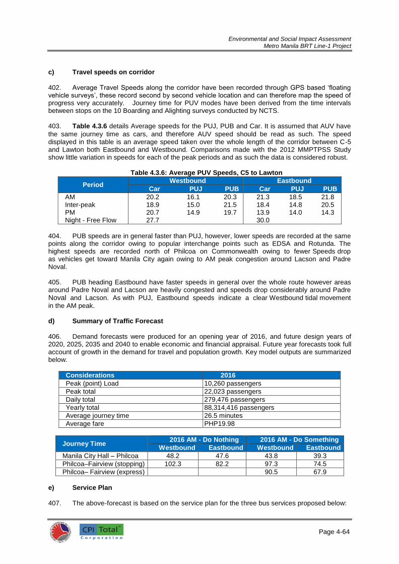
Environmental and Social Impact Assessment
Metro Manila BRT Line-1 Project
Page 4-64
6
c) Travel speeds on corridor
402. Average Travel Speeds along the corridor have been recorded through GPS based ‘floating vehicle surveys’, these record second by second vehicle location and can therefore map the speed of progress very accurately. Journey time for PUV modes have been derived from the time intervals between stops on the 10 Boarding and Alighting surveys conducted by NCTS.
403. Table 4.3.6 details Average speeds for the PUJ, PUB and Car. It is assumed that AUV have
the same journey time as cars, and therefore AUV speed should be read as such. The speed displayed in this table is an average speed taken over the whole length of the corridor between C-5 and Lawton both Eastbound and Westbound. Comparisons made with the 2012 MMPTPSS Study show little variation in speeds for each of the peak periods and as such the data is considered robust.
Table 4.3.6: Average PUV Speeds, C5 to Lawton
Period Westbound Eastbound
Car PUJ PUB Car PUJ PUB
AM Inter-peak PM Night - Free Flow
20.2 16.1 20.3 18.9 15.0 21.5 20.7 14.9 19.7 27.7
21.3 18.5 21.8 18.4 14.8 20.5 13.9 14.0 14.3 30.0
404. PUB speeds are in general faster than PUJ, however, lower speeds are recorded at the same points along the corridor owing to popular interchange points such as EDSA and Rotunda. The highest speeds are recorded north of Philcoa on Commonwealth owing to fewer Speeds drop as vehicles get toward Manila City again owing to AM peak congestion around Lacson and Padre Noval.
405. PUB heading Eastbound have faster speeds in general over the whole route however areas around Padre Noval and Lacson are heavily congested and speeds drop considerably around Padre
Noval and Lacson. As with PUJ, Eastbound speeds indicate a clear Westbound tidal movement
in the AM peak.
d) Summary of Traffic Forecast 406. Demand forecasts were produced for an opening year of 2016, and future design years of 2020, 2025, 2035 and 2040 to enable economic and financial appraisal. Future year forecasts took full account of growth in the demand for travel and population growth. Key model outputs are summarized below.
Considerations 2016
Peak (point) Load 10,260 passengers
Peak total 22,023 passengers
Daily total 279,476 passengers
Yearly total 88,314,416 passengers
Average journey time 26.5 minutes
Average fare PHP19.98
Journey Time 2016 AM - Do Nothing 2016 AM - Do Something
Westbound Eastbound Westbound Eastbound
Manila City Hall – Philcoa 48.2 47.6 43.8 39.3
Philcoa–Fairview (stopping) 102.3 82.2 97.3 74.5
Philcoa– Fairview (express) 90.5 67.9
e) Service Plan 407. The above-forecast is based on the service plan for the three bus services proposed below:

Environmental and Social Impact Assessment
Metro Manila BRT Line-1 Project
Page 4-65
6
1. Fairview - Manila City Hall (Express along Commonwealth Avenue) 2. Fairview – Manila City Hall (Stopping Service) 3. Philcoa – Manila City Hall
These will operate at the following peak headways in order to meet forecast demand.
Service Buses per hour Headway
SM Fairview – MCH (Express) 30 2 mins
SM Fairview – MCH (Stopping) 30 2 mins
Philcoa – MCH 60 1 min
4.3.6 Public Utility Vehicle Sector 4.3.6.1 PUJ and PUB Routes and Units Operating 408. The Detailed Technical Study, Appendix A, presents a list of franchises and respective
number of vehicle units from LTFRB that are seen to interact with the Metro Manila BRT Line-1
Project corridor, it was derived from a listing of 550 routes or close to 33,000 franchises for the entire Metro Manila. The DTS identified a total of 64 PUJ routes and one (1) PUB route traversing the corridor. These were studied using the PUJ and PUB route map shown in Figure 4.3.3. Using the route map, the inventory of routes is sorted by length (in km) each route traverses along the BRT corridor (Table 4.3.7). Those that are using 12 km or more of the corridor were proposed in the study to be deleted or are recommended for route relocation. Those using less than 12 km of the corridor may also be considered for route relocation, route modification or route truncation from traffic depending on the degree of congestion along their respective areas or the section of BRT corridor they operate. Some may be allowed to coexist while others will have their routes modified or truncated.
409. For the PUB sector, the SM-Fairview-Baclaran (via Quezon Avenue) bus route overlaps with the Metro Manila BRT Line-1 Project. About 260 units ply the BRT route, operated by 22 operators. Bus operators on the route have an average fleet size of 12 units, with three companies having 20 or more authorized bus units. The driver to unit ratio for the PUBs is assumed to be similar to that of the PUJs with one regular driver and an alternate driver during days off. Using this assumption, the total number of affected bus drivers will be 520. An equal number of bus conductors are also affected.

Environmental and Social Impact Assessment
Metro Manila BRT Line-1 Project
Page 4-66
Figure 4.3.3 PUJs and PUBs Route Map

Environmental and Social Impact Assessment
Metro Manila BRT Line-1 Project
Page 4-67
6
4.3.6.2 Socioeconomic Profiles PUJ and PUB operator and driver organizations
410. PUJ drivers and operators are clustered into associations or cooperatives according to the routes they operate. Size of membership range from a low of 35 among newly organized group to as high as 600 members for old established routes. Table 4.3.8 lists the name of PUJ and PUB operator and driver associations and companies (for the PUBs), the routes their members have franchises to operate, and the size of their membership. Also shown is the total number of drivers interviewed from each organization during the social survey. 411. Figure 4.3.4 presents the breakdown of interviewed members by PUJ organization. There are
a few organizations whose officers and members refused to participate in the survey or did not show
up in any of the series of public consultation meetings held.
Figure 4.3.4 Breakdown of surveyed PUJ

Environmental and Social Impact Assessment
Metro Manila BRT Line-1 Project
Page 4-68
6
Table 4.3.7: PUJ Routes Affected by the Manila BRT Project
Note: Routes in red font are those recommended for deletion in the DTS.
PUJ Routes OriginDestinatio
n
km Traveresed
along BRT
Route
Recommended Course of
Action
Fairview-Arroceros B P 21.0 For Deletion
Almar-Welcome Rotonda (TT) A K 21.0 For Deletion (189 TT)
Fairview-Kalaw B P 21.0 For Deletion
Lagro - Welcome Rtd (HEQFAJODA) A K 21.0 For Deletion
Dahlia - Arroceros (HEQFAJODA) B P 20.0 For Deletion
Fairview-Quiapo B M 19.0 For Deletion
Jordan Plains - Welcome Rotonda B K 19.0 For Deletion (about 500 drivers)
Zabarte- Panay (TT&HEQFAJODA) A J 18.0 For Deletion (18 TT)
Lagro- Panay (TT&HEQFAJODA) A J 18.0 For Deletion (30 TT)
Almar - Panay (HEQFAJODA) A J 18.0 For Deletion
Lagro-Cubao A G 14.5 For Deletion
Fairview-Cubao A G 14.5 For Deletion
Zabarte -Philcoa A F 14.0 For Deletion
Philcoa - Bagong Silang A F 14.0 For Deletion
Ever Green Subd - Philcoa via Comm Ave A F 14.0 For Deletion
Lagro - Philcoa (HEQFAJODA) A F 14.0 For Deletion
Philcoa-Kalaw (HEQFAJODA) F P 12.0 For Deletion
Philcoa-Arroceros F P 12.0 For Deletion
Balara-Arroceros/Quiapo F P 12.0 For Deletion
Philcoa-Pier South F P 12.0 For Deletion
Lagro - SM North B G 11.0 Deletion/Truncation/Modification
Philcoa-Quiapo F M 10.0 For Deletion/Truncation/Modification
Pagasa - Pier I P 9.0 For Deletion/Truncation/Modification
Project 8 - Arroceros J P 8.0 For Deletion/Truncation/Modification
Project 8 - Kalaw J P 8.0 For Deletion/Truncation/Modification
Project 7 - Arroceros J P 8.0 For Deletion/Truncation/Modification
Project 7 - Kalaw J P 8.0 For Deletion/Truncation/Modification
Project 8 - Pier J O 7.0 For Deletion/Truncation/Modification
Project 7 - Pier J O 7.0 For Deletion/Truncation/Modification
Project 6 - Quiapo J M 6.0 For Deletion/Truncation/Modification
Project 8 - Quiapo J M 6.0 For Deletion/Truncation/Modification
Project 7 - Quiapo J M 6.0 For Deletion/Truncation/Modification
Project 6 - Arroceros J P 6.0 For Deletion/Truncation/Modification
Project 6 - Pier J O 6.0 For Deletion/Truncation/Modification
Maly - Philcoa D F 6.0 For Deletion/Truncation/Modification
Project 6 - Kalaw I P 6.0 For Deletion/Truncation/Modification
Project 2,3 - Kalaw K P 5.0 For Deletion/Truncation/Modification
Cubao - Arroceros J P 5.0 For Deletion/Truncation/Modification
Cubao - Kalaw J P 5.0 For Deletion/Truncation/Modification
Project 2,3 - Remedios K P 5.0 For Deletion/Truncation/Modification
Project 2,3 - South Pier 15 K O 4.0 For Deletion/Truncation/Modification
Cubao - Pier South 15 K O 4.0 For Deletion/Truncation/Modification
Project 2,3 - Welcome Rotonda I K 4.0 For Deletion/Truncation/Modification
Project 2,3 - Quiapo K M 3.0 For Deletion/Truncation/Modification
Cubao - Quiapo K M 3.0 For Deletion/Truncation/Modification

Environmental and Social Impact Assessment
Metro Manila BRT Line-1 Project
Page 4-69
6
Table 4.3.8: List of PUJ and PUB Organizations
Name of the Organization List of Routes No. of
Members Total Survey Respondent
Percentage of Respondents
HYPERMART EDSA QUEZON CITY BLBD. FAIRVIEW JEEPNE OPERATORS AND DRIVERS ASSOCIATION INC. (HEQPA JODA INC.) FEJODAP
Zabarte – Panay; Almar –Welcome; Lagro – Panay; Lagro – Welcome
101 35 26
TROPANG TSUPER TRANSPORT COOPERATIVE SERVICES (TTTSC)
Zabarte – Panay; Almar – Welcome; Lagro - Panay
139 16 15
COMMONWEALTH TRANSPORT SERVICE AND DEVELOPMENT
Jordan Plains (Novaliches) – Welcome; San Rafael (Rizal ) – Quezon City Hall; Balara –Arroceros; Fairview – Philcoa; Zabarte/Quirino Hi-way – Panay Ave.
68
KAMIAS TRANSPORT Project 2,3 – Welcome; Welcome – Q. Mart; Project 2,3 –Q. Mart
42
OFFICE TRANSPORT COOPERATIVE GSIS (OTC) Abra – Luzon; Pag-asa –Highway; Project 7 –Quiapo; Project 7- Arroceros; Project 8 – Quiapo; Kalaw – Pier
1115
STOP TRANS Philcoa – Kalaw; Philcoa – Pier 38 16 30
HI WEST TRANSPORT SERVICE COOPERATIVE Project 6 – Kalaw; Project 7 – Quiapo; Project 7 – Arroceros; Project 8 – Quiapo; Kalaw - Pier
100
C-JODA PISTON (CUBAO JEEPNEY OPERATORS DRIVER ASSOCIATION)
Cubao – Pier; Kalaw – Vito Cruz Cubao – Recto; Cubao – Remedios
101
PASODA (PASIKLAB OPERATOR DRIVERS ASSOCIATION) Philcoa – Kalaw; Philcoa – Pier Balara – Arroceros, Quiapo
88 31 26
PROMDOA – ALTIDAP/ 1-UTAK Project 2,3 – Welcome; Project 2,3 – Kalaw; Project 2,3 – South Pier 15; Project 2,3 – Remedios
100
Q.R.C.K. JODA (QUIRINO REGALADO CUBAO KALAYAAN) Lagro – Cubao- Kalayaan 90 25 22
BASICANO (BAGONG SILANG CAMARIN NOVALICHES) Novaliches – Bagong Silang; Bagong Silang – Philcoa; Evergreen – Philcoa; Camarin – Balintawak; Bagong Silang – Kaliwa (Robinson)
600 29 5
DAHFAIRCODA Dahlia Fairview-Cubao ; Kamuning Araya
70 12
HEAVEN BLESSED BUS TRANSPORT Fairview-Quiapo 98 30 23
LACODA Lagro - Cubao 68
BAJODA Novaliches – Bagong Silang Philcoa –Bagong Silang Maligaya –Commonwealth
200
SANLICOM JODA (SAN ISIDRO –LITEX COMMONWEALTH) San Isidro -Commonwealth 65
(LSMNE JODAI) LAGRO SM NORTH EDSA JODAI Lagro – SM north 100
COMMON TRANSPORT SERVICE COOPERATIVE San Isidro –Commonwealth 35
NEW SUJODA INC San Isidro Rodriguez/Montalban –Commonwealth
35
(NEW SIGLICOM) NEW SAN ISIDRO GRAVELPIT – COMMONWEALTH MARKET
San Isidro – Commonwealth 35
Total 3220 262 8
412. There are about 500 AUV operating on the BRT corridor. However, social impact on this
sector is not considered as adverse as that on the PUB and PUJ sectors because the only route ends
are prescribed but the routes are flexible. Therefore they were not considered among the project stakeholders. Age Grouping
413. Most of the PUJ and PUB drivers are under the age bracket of 31 to 40 years old (36%), followed by those who are a little older (41-50 years old), comprising 29 percent of surveyed drivers, 20 to 30 years old consist 21 percent, 51- to 60-year-old drivers are 12 percent while the remaining three percent (3%) are senior citizens (Table 4.3.9)

Environmental and Social Impact Assessment
Metro Manila BRT Line-1 Project
Page 4-70
7
Table 4.3.9: Age Grouping of PUJ Drivers
Name of Organization Total Respondent
Age of Respondent
20 - 30 yrs old
31 - 40 yrs old
41 - 50 yrs old
51 - 60 yrs old
61 yrs & above
PASODA No. 30 3 10 9 6 3
Percent (%) 100% 10% 33% 30% 20% 10%
Stop Transport No. 15 1 1 7 6 1
Percent (%) 100% 6% 6% 44% 38% 6%
DAHFAIRCODA No. 12 3 7 2 0 0
Percent (%) 100% 25% 58% 17% 0% 0%
HEQFA JODA No. 35 7 9 14 3 2
Percent (%) 100% 20% 26% 40% 9% 6%
Tropang Tsuper No. 16 5 5 4 2 0
Percent (%) 100% 31% 31% 25% 13% 0%
LACODA No. 68 17 29 13 6 3
Percent (%) 100% 25% 43% 19% 9% 4%
1 Team (BASICANO) No. 29 6 4 18 0 1
Percent (%) 100% 21% 14% 62% 0% 3%
QRCK JODA No. 25 8 9 5 3 0
Percent (%) 100% 32% 36% 20% 12% 0%
Heaven Blessed Transport
No. 30 8 13 8 1
Percent (%) 100% 27% 43% 27% 3% 0%
Individuals No. 63 12 27 14 9 1
Percent (%) 100% 19% 43% 22% 14% 2%
Individuals from diff. Association
No. 24 3 10 6 5 0
Percent (%) 100% 13% 42% 25% 21% 0%
TOTAL No. 347 73 124 100 41 11
Percent (%) 100% 21% 36% 29% 12% 3%
Household size and income
414. The average household size of the surveyed population is 4.8 (Table 4.3.10). The average daily income from driving ranges from a low of PhP488 among the members of DAHFAIRCODA to a high of PhP1,042 among LACODA and PhP1,041 among BASICANO members. BASICANO and LACODA are part of One Team - a management company for PUJ operators paying a flat daily rate to its drivers. The overall average daily income for all drivers regardless of route or organization is PhP750.00 (Table 4.3.12).

Environmental and Social Impact Assessment
Metro Manila BRT Line-1 Project
Page 4-71
7
Table 4.3.10. Household Size and Average Daily Income of Drivers
Name Of Organization Total
Respondent
House Hold Size
Average
Average Daily Income From
Driving (PhP)
PASODA 30 4.9 695.00
Stop Transport 16 5.0 546.88
DAHFAIRCODA 12 not declared 562.92
HEQFA JODA 35 4.8 646.00
Tropang Tsuper 16 5.4 737.50
LACODA 68 4.7 1,041.91
1 Team (BASICANO) 29 4.9 1,041.38
Q.R.C.K JODA 25 4.8 546.00
Heaven Blessed Transport 30 4.6 807.00
Individual 63 5.0 601.51
Individuals from diff. Association 24 4.9 562.50
AVERAGE 348 4.7 750.20
Other skills 415. Most of the surveyed drivers are also skilled mechanics (82%). About a fourth of them can
also work as welders, electrician, construction workers or carpenters/masons (Table 4.3.11).
Table 4.3.11: Other Skill of PUJ Drivers
Name Of Organization
Total Respondent
Me
ch
an
ics
Help
er
Me
ch
an
ics
Ele
ctr
icia
ns
We
lde
r
Co
ns
tru
cti
on
W
ork
er
Carp
en
ter
Others
PASODA
31 25 1 5 5 11 2 Agriculture, farmer, mason, salesman, porter, truck driver, porter
100% 81% 3% 16% 16% 35% 6%
Stop Transport
16 12 4 3 4 3 4 Tailor, cook, security guard, farmer, mason, delivery helper, vendor
100% 75% 25% 19% 25% 19% 25%
DAHFAIRCODA
12 5 1 1 6 5 6 Warehouseman, delivery helper, security guard, mason, janitorial, waiter
100% 42% 8% 8% 50% 42% 50%
HEQFA JODA
35 33 3 15 9 10 7 Security guard, mason, barber, baker, vulcanizing, farmer, delivery man, technician
100% 94% 9% 43% 26% 29% 20%
Tropang Tsuper
16 16 4 6 4 3 Tubero, mason, security guard, cook, agricultural, fisherman
100% 100% 0% 25% 38% 25% 19%
LACODA
68 61 1 25 6 14 15 Mason, farmer, factory worker, tubero, computer technician, factory worker, printing press, mirror installer, cook, pump attendant, company driver, machinery, waiter
100% 90% 1% 37% 9% 21% 22%

Environmental and Social Impact Assessment
Metro Manila BRT Line-1 Project
Page 4-72
7
Name Of Organization
Total Respondent
Me
ch
an
ics
He
lpe
r
Me
ch
an
ics
Ele
ctr
icia
ns
We
lde
r
Co
ns
tru
cti
on
W
ork
er
Ca
rpe
nte
r
Others
1 Team (BASICANO)
29 22 7 9 4 3 Mason, textile, tricycle driver, security guard, janitor, cook, operator, painter, carwasher
100% 76% 0% 24% 31% 14% 10%
Q.R.C.K JODA
25 24 1 4 17 9 10 Farmer, factory worker, miner, painter, mason, bell boy, janitor, wood curver
100% 96% 4% 16% 68% 36% 40%
Heaven Blessed Transport
30 20 0 10 6 11 8 Office clerk, janitor, service crew, waiter, security guard, farmer, furniture worker, messenger, sales boy
100% 67% 0% 33% 20% 37% 27%
Individual
63 51 2 6 21 23 17 Mason, fisherman, cook, messenger, farmer, security guard, operator, painter, trucking, tubero, baker, tailor, barber, cook, food handler, bagger
100% 81% 3% 10% 33% 37% 27%
Individuals from diff. Association
24 18 1 2 10 8 4 Mason, food handler, farmer, barber, warehouse man, pump attendant, waiter, factory worker, delivery boy, tailor, farmer, baker, furniture worker
100% 75% 4% 8% 42% 33% 17%
Total 349 287 14 82 99 102 79
100% 82% 4% 23% 28% 29% 23%
Common illnesses from driving
416. Back pain is the most common illness drivers endure from driving (54%). Other illnesses from
driving are flu (10%), kidney disease (9%), rheumatism (5%), arthritis (4%), asthma (4%), and tuberculosis (3%) (Table 4.3.12).
Table 4.3.12: Common Illness of PUJ Drivers
Name of Organization
Total Respondent
Asth
ma
Flu
Bac
k P
ain
Kid
ne
y
Dis
ea
se
Art
hri
tis
Rh
eu
ma
tis
m
Tu
be
rco
los
is
Others
PASODA
30 1 4 13 2 3 1 2 Pneumonia, Appendicitis, High Blood, Cough, Fever.
100% 3% 13% 43% 7% 10% 3% 7%
Stop Transport
15 1 1 6 6 1 0 1 Pneumonia, Over fatigue 100% 7% 7% 40% 40% 7% 0% 7%
DAHFAIRCODA
12 0 0 4 2 2 0 0 Pneumonia, Over Fatigue. 100% 0% 0% 33% 17% 17% 0% 0%
HEQFA JODA
35 3 4 19 5 0 1 0 Cough, Headache, UTI, 100% 9% 11% 54% 14% 0% 3% 0%

Environmental and Social Impact Assessment
Metro Manila BRT Line-1 Project
Page 4-73
7
Name of Organization
Total Respondent
As
thm
a
Flu
Ba
ck
Pa
in
Kid
ne
y
Dis
ea
se
Art
hri
tis
Rh
eu
ma
tis
m
Tu
be
rco
los
is
Others
Cold, Allergy, Acidic, UTI, Pneumonia, Spot On Lungs, High Blood
Tropang Tsuper
16 0 4 11 1 0 2 0 UTI, Lung Disease, Headache, Ulcer, Fever, Cough
100% 0% 25% 69% 6% 0% 13% 0%
LACODA
68 0 8 46 0 2 4 0 Cough, Headache, UTI, Cold, Allergy, Acidic, UTI, Pneumonia, High Blood, Ulcer, Over Fatigue, Eye Problem
100% 0% 12% 68% 0% 3% 6% 0%
1 Team (BASICANO)
29 1 4 20 0 1 1 0 Fever, Anemic, Over Fatigue, Cough, UTI, Headache
100% 3% 14% 69% 0% 3% 3% 0%
Q.R.C.K JODA
25 1 1 17 3 2 0 2 Ulcer, Cough, UTI, Head Ache 100% 4% 4% 68% 12% 8% 0% 8%
Heaven Blessed Transport
30 0 0 17 0 0 3 0 Allergy, Over Fatigue, Fever, Headache, Cough, High Blood, Lung Disease, UTI.
100% 0% 0% 57% 0% 0% 10% 0%
Individual
63 5 5 24 7 3 3 5 Headache, Tonsilitis, Allergy, Cough, Ulcer, Pneumonia.
100% 8% 8% 38% 11% 5% 5% 8%
Individuals from diff. Association
24 2 3 9 4 1 1 0 Allergy, Tonsilitis, Fever, Headache, Cough, High Blood, Lung Disease
100% 8% 13% 38% 17% 4% 4% 0%
TOTAL 347 14 34 186 30 15 16 10
100% 4% 10% 54% 9% 4% 5% 3%
4.3.7 Affected commercial establishments close to stations 417. There are commercial establishments that are too close to some of the proposed BRT stations. A few are already encroaching on the public right-of-way. Some of them might benefit from the increased foot traffic in the vicinity of their businesses. Some might however lose their frontage, parking spaces, display areas, or pedestrian circulation around their establishments. These commercial establishments were identified in ten (10) BRT proposed stations, as shown in Table 4.3.13.

Environmental and Social Impact Assessment
Metro Manila BRT Line-1 Project
Page 4-74
7
Table 4.3.13: Commercial establishments too close to BRT stations
BRT Station Commercial
Establishment/s Remarks
Potential Impacts/Mitigating
Measures 1. Bronx
(Northbound Station)
STI Building An educational institution whose front entrance will directly open to the northbound BRT station.
Blockage of entrance. Maybe mitigated by moving the station a few meters off the entrance.
2. Atherton (Northbound Station)
A beauty parlor A videoke bar (M2)
The station will be directly covering their frontages, obstructing customer access to the establishments. The customer parking space, which is part of the R-O-W will be taken up by the BRT station.
Blockage of entrance. Maybe mitigated by moving the station toward the outermost lane of Commonwealth Avenue or moving the station off the entrance.
3. Regalado Fairview Center Mall and NCBA on the Southbound Five (5) small establishments on the North-bound station (2 xerox shops, a lamination shop, a notary service, and a burger stand)
The entrances to this big buildings might be blocked by the station These small establishment will lose their customer circulation area as they are too close to the BRT station. They may have to give themselves some easements by moving away a couple of meters from the sidewalk.
Integrating the station entrance/exit points with the entrance/exit of the mall and designing a narrower station to avoid the small establishments.
4. Don Fabian (Northbound)
Carinderia with a Salon Informally occupying the R-O-W. Don Fabian may be developed as a smaller station due to very low projected volume of alighting and boarding passengers on this station. In this case, these informal occupants may remain.
Closure of Carinderia if a regular station is built on site. A smaller station may be developed to avoid the establishment.
5. North Batasan Hills (Northbound)
Presence of temporary market stalls or makeshift sheds serving as ukay-ukay stalls
These occupants are already occupying the public right-of-way and may have to be moved to make the location aesthetically better..
Closure of stalls. Moving the BRT station to cut on the outermost lane of the highway is feasible since Commonwealth Ave is such a wide highway
6. Commonwealth Market (Southbound)
On-going construction of makeshift stalls very close to the sidewalk.
Stalls are made of G.I. sheets and poles and encroaching on the sidewalks.
Closure of stalls.
7. COA (Southbound)
2 videoke bars; a small residential/commercial structure; furniture shop; sari-sari store; computer shop; and a tire shop.
Encroaches on the R-O-W. Closure of stalls. BRT station may be moved into the outer lane of the road so as not to disturb the businesses.
8. Zuzuaregui (Northbound)
3 Furniture Shops Existing R-O-W is used as customer parking by the shops. BRT station might block customer access to the shops.
Loss of frontage. Providing customer access to these shops to be integrated in detailed design.
9. Tandang Sora (Northbound)
Robinson’s parking area BRT Station might cut a few meters inside Robinson’s parking space.
Loss of parking space. Station may be made narrower than the standard/ typical station design.
10. LRT Central (Southbound)
12 carinderias renting from one concessionaire of LRT commercial space at about PhP4000 to PhP6000 monthly.
Eating areas of these small eateries/restaurants intentionally encroach the pedestrian R-O-W due to the very cramped space of the carinderias.
Loss of customer space. Reducing rental spaces to on six (6) to provide areas for customers.

Environmental and Social Impact Assessment
Metro Manila BRT Line-1 Project
Page 4-75
7
418. The DTS offers some engineering solutions like asymmetric station design to avoid disturbing
the commercial activities in some of the stations. Hence, a more accurate prediction of the social
impact may only be done during or after the detailed engineering design stage of the project. 4.3.8 Senior Citizens, PWDs and Women
419. A sub-group within the commuters group is the vulnerable group composed of senior citizens, persons with disabilities (PWD) and the women. It is estimated that there are 830,994 senior citizens and 150,312 PWDs in Metro Manila this year (2015). Working mothers (either as employee or housewife taking care of children) are estimated at 3.25 million. Population who are poor or living below poverty level in Metro Manila is 3.15 million. Table 4.3.14 shows the demographics of vulnerable groups.
Table 4.3.14: Estimated population of vulnerable groups in Metro Manila
Vulnerable Groups % Share of Population Estimated 2015 population
in Metro Manila
PWDs (National Rate) 1.23% 150,312
Senior Citizens 6.8% 830,994
Women (15-49) 26.56% 3,245,765
Population below poverty line 25.8% 3,152,889

Environmental and Social Impact Assessment
Metro Manila BRT Line-1 Project

Environmental and Social Impact Assessment
Metro Manila BRT Line-1 Project
Page 5-1
5.0 ANTICIPATED ENVIRONMENTAL AND SOCIAL IMPACTS AND MITIGATION MEASURES 5.1 Potential Environmental and Social Impacts Associated with the Project 420. This section discusses the potential environmental impacts of the proposed BRT Project and identifies mitigation measures to minimize the impacts in the design, construction and operational phases. Environmental analysis covered potential direct, indirect, cumulative, and induced impacts but primarily focusing on the physical impacts within the BRT corridor. 421. The project has various components that may generate physical, biological and social disturbance to the existing environment. The list of each of the project activities and component are enumerated below with corresponding impact generation.
Table 5.1.1: Project Impacts Associated with the Proposed Metro Manila BRT Line-1 Project
Activity / Project Components
Activities will exert:
Significant impacts Physical impacts
Biological/Ecological impacts
Social impacts
1) Segregated Busway X (-) X (-) X (-) Physical impacts: Air, noise, water pollution, utility disturbance, traffic congestion (construction)
Biological impacts: urban flora loss
Social impacts: economic and business disturbance, economic displacement for PUV drivers, workers and operators, traffic, utility services disruption
2) Highway Reconstruction X (-) X (-) X (-)
3) Intersection Improvement X (-) X (+)
4) Land Acquisition (for the Depots) X (-) X (-) X (-)
5) Stations X (-) X (-) X (-)
6) Terminals X (-) X (-) X (-)
7) Depots X (-) X (-) X (-)
8) Traffic Management X (+)
9) Pedestrian Crossings X (-) X (+)
10) Urban Realm Enhancements
X (+) X (+)
11) ATC (SCATS Upgrade) X (+) Traffic improvement
Enhanced social order
12) BRT / Intersection signal control (in addition to SCATS)
X (+)
13) ITS X (+)
5.1.1 Physical and Biological Impacts 422. The EIA Study Team has prepared the BRT corridor’s alignment sheets to determine the extent of physical and biological that may arise from the implementation of the Project. It is notable to mention that even during the DTS stage, impacts of the proposed project are managed through the following approaches: (i) design flexibility based on existing local conditions such as land availability, existence of barriers or physical structures; (ii) flexibility on the of station site; and (iii) application of best practice that are derived from previous BRT experiences from other countries. 423. During construction phase, the following physical attributes shall be affected during Project construction: light posts, electrical posts, telecommunication posts, utility posts, traffic light and signages, road drainages, road pavement, culvert and manholes, waiting sheds and water utilities. These physical attributes that are inside the proposed location of bus stations and access to the bus stations. In this case, implementation of ESMP on impact avoidance, reduction and minimization are necessary. For instance, the following ESMP among others are provided in this ESIA document: re-provisioning electric power lines, water mains, drains and telecommunication cables, planning temporary traffic management measures, management of waste and spoil disposal, materials supply, temporary drainage, prevention of flooding and protection of the construction works, managing tree-cutting and replanting, controlling noise and dust and managing workers and public safety. 424. Also during the construction phase, there is an anticipated congestion of vehicular traffic particularly near the BRT stations, depots and ancillary facilities, and along the running way. Section

Environmental and Social Impact Assessment
Metro Manila BRT Line-1 Project
Page 5-2
3.1.15 of this ESIA Report describes the prevailing vehicular traffic conditions of the proposed bus station sites. Potential points of congestion along the BRT route that may be affected include the constricting carriageway (for example along España from Quezon Boulevard), underpasses along EDSA, Banawe, and Quiapo, roundabouts such as the Quezon Elliptical Road and Welcome Rotonda, and U-turn slots in Quezon Avenue. While the traffic condition is expected to worsen along the BRT route with the construction activities, the Traffic Management Plan will provide measures to ease congestion in collaboration with MMDA and the LGUs. 425. Construction works may also adversely affect the identified physical cultural resources (PCRs) such as cultural sites, historical landmarks, and even old bridges. While the construction activities may not be intensive, these may entail earth movements and direct physical works that can potentially damage these PCRs. The ESMP provides measures to reduce vibrations and other sound engineering practices to avoid and reduce adverse impacts to the cultural and historical landmarks. 426. Biological impacts would be mainly due to the removal of trees and other plants that are inside or within the propose BRT stations. However, the alignment sheets provide the account or inventory of the number of vegetation that will be affected during construction phase and a corresponding mitigation measures were also crafted. 427. In summary, most of the construction phase impacts are temporary and reversible and manageable. During operation phase, impacts of the projects are mostly beneficial. These impacts are presented in Section 4.2.3. 5.1.2 Social Impacts 428. While most significant social impacts include economic displacements for affected PUJs and PUBs that are currently plying along the proposed BRT corridor. For social impact, the restitution of livelihood source for economically displaced PUJs and PUBs workers is the main issue. 5.1.3 Cumulative, Indirect and Induced Environmental Impacts 5.1.3.1 Cumulative Impacts 429. Cumulative impacts are those impacts that may result from the combination of past, present or future actions of existing or planned activities that are along the BRT corridor’s area of influence. While a single activity may itself result in an insignificant impact, it may, when combined with other impacts (significant or insignificant) in the same geographical area or influence area and occurring at the same time, result in a cumulative impact that is significant. 1) Cumulative Impacts on Traffic and with Other Projects 430. The road within the proposed BRT corridor falls within the jurisdiction of DPWH. To date, only minor road repairs and rehabilitation are being implemented by DPWH. In terms of traffic, these minor works by DPWH do not aggravate the existing traffic flow as most works last for 1 to 2 days and are being done during nighttime. However, with the Project, traffic may be negatively affected and worsen as construction duration will be longer (1 to 2 years) and partial closure of half to full lane of the road may be required during the construction of the Project. Thus cumulative traffic impact during construction phase in conjunction with DPWH’s periodic road maintenance and rehabilitation will aggravate the traffic situation along the BRT corridor. This cumulative traffic impact scenario will surely require effective traffic management plan (TMP) which DOTr will implement in coordination with the LGUs of Quezon City and City of Manila and MMDA. In the assessment of traffic impact, DOTr shall consider the combined effects and recommend site specific traffic mitigation measures. 431. In terms of land use plan, the BRT corridor is zoned for mixed commercial, business and residential purposes – a concentrated and highly urbanized well-developed area along the proposed BRT corridor. In the long term, the Project will exert positive cumulative impact as the Project complements this highly urbanized corridor where BRT enhances people mobility and access to commercial and business facilities while at the same time promotes the use of mass safe, modern,

Environmental and Social Impact Assessment
Metro Manila BRT Line-1 Project
Page 5-3
and efficient public transport system. Viewed from a wider perspective, the probability of mobility benefits to host communities is highly likely. 432. There is a proposal for the construction of MRT-7 covering the stretch of Commonwealth Avenue down to the northernmost BRT station. As construction of this project may not be done simultaneously with BRT Project, the cumulative impact on traffic is insignificant. On the other hand, once the two mass transport system becomes operational in the long-term, cumulative impact on traffic and the transport sector in general will be positive as two mass transport system will be operating in the corridor thus enhancing people’s mobility and access to commercial and business establishments.
2) Cumulative impact on urban ecology 433. Along the entire corridor, there is no officially declared protected area that may be affected by the project. However during construction phase, few numbers of trees on selected locations may be cut to pave way for the construction of BRT bus stations. To date, there is no other similar project that may require the same tree cutting thus cumulative impact on urban ecology is insignificant. To compensate for the number of trees cut during construction phase, DOTr shall comply with tree replacement scheme as required by law. Urban greening and enhancement along the BRT corridor shall be likewise promoted and supported by DOTr.
3) Cumulative impact on flooding and water quality 434. During construction, the implementation of the Project will result in the disturbance of existing drainage system in some sections of the corridor. However, the project is not expected to cause flooding in the project area. Cumulative impact on flooding is considered insignificant. 435. There is also the potential for contamination due to construction materials storage onsite. There is potential contamination due to borehole construction, accidental spills and increased run-off and sedimentation of surface water bodies (in river crossings). There is also potential contamination from waste water run-off. With the implementation of mitigation measures, the cumulative potential impacts of contamination and siltation are therefore likely to be minor. 4) Cumulative impact on air quality 436. The proposed BRT project is located in a corridor which is currently experiencing air pollution from inefficient transport system. During construction, except for dust or fugitive emission from civil works, the overall emissions from the project are not expected to significantly aggravate the current air pollution levels in the corridor. Cumulative impact on air quality during construction phase is insignificant. 437. However in the long term, once the project becomes operational, there is big difference on the emission levels between the BRT buses and the existing PUVs plying along the corridor. Savings on GHG emissions from the use of BRT buses compared with traditional PUVs was determined to be substantial in the project Feasibility Study thus cumulative impact on air quality is projected to be positive. 5) Cumulative impact on noise and vibration 438. During construction phase, ambient noise levels within the immediate vicinity of active construction site may exceed the prescribed standards due to the use of construction equipment that generally produce noise. Thus in selected areas where sensitive receptors are readily identified, appropriate noise barriers shall be used to attenuate noise generated from the project. Thus cumulative impact on noise during construction phase requires mitigation measures. 439. During operation phase, with the assumption that many of the commuters will patronize the BRT buses, cumulative impact on noise is expected to be significantly positive as noise exposure of the BRT riding commuters from background noise (which already exceed the standards) will be shortened. With the assumption that traffic situation in the corridor will be improved due to the

Environmental and Social Impact Assessment
Metro Manila BRT Line-1 Project
Page 5-4
introduction of BRT system, transport noise along the corridor is expected to slightly improve as number of plying private cars and PUVs may decrease in quantity. 6) Cumulative impact on construction waste 440. During construction phase, significant proportion of the construction waste arising from this Project can be re-used as backfill materials. Thus, cumulative impact on construction waste is insignificant. 441. During operation phase, the Project is expected to generate significant amount of domestic wastewater and solid wastes. In relation to the other locally generated domestic s wastes, without proper in-house waste management, the cumulative impact is negative. In this case, appropriate wastewater treatment facility should be installed in all bus stations and depots. Solid waste management should comply with the requirements of RA 9003. 7) Cumulative impact on social impact and risk 442. During the Feasibility Stage and in this ESIA work, it was established that the project will exert negative social impact on PUV operators, drivers and workers and to some business establishments. 443. Impact on few business establishments may be avoided, or where avoidance is not possible, DOTr shall compensate the PAP for adverse impacts on workers, affected entities, and the environment. On the other hand, a menu of social management plan is formulated to address the needs of the affected PAPs from PUV sector. Prior to project construction, DOTr shall execute the SMP. The SMP once executed the cumulative impacts although significant on social impact and risks are minimized. 5.1.3.2 Indirect Impacts 444. There may be some adverse and beneficial environmental impacts which cannot be immediately traced to the project activities but can be causally linked. For example, the improvement in the road system in Metro Manila will potentially lead to growing traffic and commercial activities that may lead to additional pollution and thus indirectly affecting air quality. Conversely the use of more fuel efficient vehicles, more efficient running cycles and the development of better sealed roads will improve the system overall and reduce some of the pollution arising and therefore have some indirect benefits on the respiratory health of some of those living near the roads. 5.1.3.3 Induced Impacts 445. The proposed BRT Line-1 will be carried out on existing main roads and expectation is that there will be many more traveling passengers as the BRT system develops. The origins and destinations of the traveling public may remain much the same in the existing transport corridor but overall pattern of movements will change and the BRT and road upgrading should make that travel more efficient. The statutory provisions under the laws of country cover pollution control. These laws are established but institutional strengthening is required and improvements in resources are needed to achieve better enforcement to support strategic management of transport-related pollution control in the long term. The controls on the BRT operations will provide a good example of a clean efficient mass transport. Therefore overall, there would appear to be some opportunity for beneficial induced impacts although it is difficult to foresee unplanned developments caused by the project that may occur later or at different locations. As induced by the project, there will be a better strategic transport planning, an area wide traffic management system, and a general improvement to the transportation network overall. 5.1.4 ESMP Approach 446. The comprehensive ESMP presented in this section is aimed at providing more than a means of compliance with current legislation but rather comprehensive environmental management as a fundamental part of project risk management. It can therefore significantly improve the overall

Environmental and Social Impact Assessment
Metro Manila BRT Line-1 Project
Page 5-5
success of a project in terms of cost and programme and promote greater understanding and benefits. 447. Where feasible the following hierarchy of mitigation measures is applied to reduce, where possible, the significance of impacts to acceptable levels: (i) mitigation / elimination through design; (ii) site / technology choice; and (iii) application of best practice. 448. Where impacts exceed accepted environmental standards, mitigation measures are proposed in order to reduce residual impacts to acceptable levels and achieve the expected outcomes of the project. The criteria for assessment are in line with WB Policy OP 4.01, or if the GOP standard is stricter, the national standards and criteria set by GOP. Where GOP has no set of standard or guideline, the standards given in World Bank’s Environmental Health and Safety Guidelines (2007) are used. The ESMP provides a matrix of mitigation and monitoring measures to prevent or minimize the impacts. For purposes of this assessment it is assumed that DOTr through its Project Implementation Unit (PIU) will cover or engage consultants to cover all detailed Engineering, Procurement, Construction Management and Supervision during both the detailed design and construction supervision phases. In the execution of the ESMP, the Contractor is expected to execute most of the ESMP. 449. It should be understood that all ESMPs contained in this ESIA are preliminary in nature. In this case, DOTr, through SPC and its contractors, shall be responsible in the incorporation of all ESMPs provided in this ESIA document into their Detailed Engineering Design (DED) and Project Execution Plan (PEP) to make these ESMPs very site specific prior to actual project construction. Further, these ESMPs shall be coordinated with the concerned LGUs (city governments of Quezon City and City of Manila and the concerned barangays) and other concerned government agencies such as MMDA and DPWH prior to actual implementation. 5.2 Positive Impacts of the Proposed Project 5.2.1 Socioeconomic Benefits
450. The proposed BRT Line-1 Project is part and parcel of Metro Manila’s urban development initiative of the government. The project promotes better mobility, which in turn brings economic and social benefits to the community.
451. The success of BRT system in many major cities in the world and the need to modernize the ailing public transportation in the metropolis served as the impetus for the government to adopt and pursue the development of BRT system in Philippine cities. One to serve as a Philippine BRT demonstration project is currently being undertaken in Cebu. The Metro Manila BRT Line-1 Project is the second BRT system that will be implemented in the country. In general, transport projects that improve overall accessibility and reduce transportation costs tend to increase economic productivity and development. They improve businesses’ ability to provide goods and services, and people's ability to access education, employment, utilities, and services. Efficient public transportation also results to shorter travel time, lower vehicle operating costs, lower road and parking facility costs, and reduced accident and pollution damages. These development impacts are translated more congruently into the following project benefits that are expected from the Metro Manila BRT Line-1 Project:
a) More efficient and safer public transport alternative – it will offer a better PT option to the
commuters with advantages such as a fare structure lower than the existing PUJ fare rates, more reliable waiting time, faster travel time, and safe and efficient travel;
b) Safer and orderly loading and unloading system, particularly for the vulnerable stakeholders – the difficulty in boarding and alighting PUBs and PUJs will be eliminated with the BRT buses stopping at designated stations only. The design is based on national and international guidelines for people with limited mobility particularly including the principle of at-grade access in the design;

Environmental and Social Impact Assessment
Metro Manila BRT Line-1 Project
Page 5-6
c) Creation of direct employment as a result BRT construction and operation and induced economic development due to improvement in overall accessibility and reduction of transportation costs;
d) Enhanced land use along the corridor due to the resulting efficient transportation service
along the corridor improving accessibility of employees to their places of work and people’s accessibility to goods and services close to the BRT route. Improved efficiencies of various establishments along the corridor results to better land use in the vicinity.
e) Improved public transport regulations - the implementation of the project will provide the
government an opportunity to rationalize the existing public transportation system in Metro Manila and reduce, if not completely eradicate, illegal operators.
f) Provision of transport supportive of women - taking public transportation poses a challenge to women due to the limited space in PUVs and the penchant of PUV drivers to overload, which create opportunities for harassment due to the cramped space inside the vehicle.
452. The expected socioeconomic benefits of the Metro Manila BRT Line-1 Project, as were also discussed in the DTS, are summarized in the table below.
Table 5.2.1: Expected socioeconomic benefits, issues and considerations, and expected impact, Metro Manila BRT Line-1 Project
Benefits Issues/Considerations Expected Impact
More efficient and
safer public transport
alternative
The current public transportation
system in Metro Manila suffers from
operational inadequacies which create
disincentives for private car users to shift
to public transportation. These include
unreliable waiting and travel time,
improper boarding and alighting,
overloading, and high incidence of
involvement in traffic accidents.
The project will improve the options
available to the commuters. With the fare
structure similar to the existing PUJ fare
rates, commuters can enjoy more reliable
waiting time, faster travel time, and safe and
efficient travel.
Safe and orderly
loading and
unloading system,
particularly for the
vulnerable
stakeholders
One of the most cited transportation
problems during the stakeholder
consultation is the practice of drivers to
pick up and drop off passengers
anywhere, even at prohibited areas. To
avoid apprehension, they keep their
vehicles in motion while the
passengers are boarding and alighting,
making it more difficult and dangerous for
women with children and other
encumbrances, elderly people and those
with limited mobility.
The danger of falling off the vehicle while
boarding or alighting will be eliminated with
the buses stopping at designated stations
only. The design is based on national and
international guidelines for people with
limited mobility. The principle of at-grade
access has been adopted, except where this
presents an adverse effect upon safety or
an unacceptable compromise upon
capacity. Where at-grade access is not
possible alternative provision will be made
for the mobility impaired. Access between
station and bus will be step-less benefiting
all users.
Create direct
employment and
induce economic
development
Poor transportation can have various
adverse impacts on a community’s
economic development objectives, such
as low productivity, high rate of
unemployment, sluggish business activity,
inhibits investment growth and low tax
revenues.
In general, transport projects that improve
overall accessibility (i.e., they improve
businesses ability to provide goods and
services, and people's ability to access
education, employment and services) and
reduce transportation costs (including travel
time, vehicle operating costs, road and
parking facility costs, accident and pollution

Environmental and Social Impact Assessment
Metro Manila BRT Line-1 Project
Page 5-7
Benefits Issues/Considerations Expected Impact
damages) tend to increase economic
productivity and development.
Enhanced land use
along the corridor
High volume of traffic as a result of
inefficient public transportation system
increases travel time and urban
congestion. Business establishments are
at risk of losing customers who would
instead patronize establishments in areas
where travel time is reasonable and public
transportation is more conducive.
The proposed Metro Manila BRT Line-1
Project is envisioned to enhance the
operations of the establishments along the
route and within its influence area. It has
minimal requirement for right-of way
acquisition and will not affect any structure.
Improved public
transport regulations
The current state of public transportation
regulations and enforcement have layers
of imperfections - from the irregularities in
the application processing of PUV
franchises at the LTFRB level to the
proliferation of colorums at the ground
level.
During consultations with the key
stakeholders, it was expressed that the
implementation of the Corridor Improvement
Project will provide the government an
opportunity to rationalize the existing public
transportation system and reduce, if not
completely eradicate, illegal operators.
Provision of transport
supportive of women
Women, in general, perform a multitude of
tasks in her travel during the day,
including ferrying young children to and
from school or other activities and doing
grocery shopping. Taking public
transportation poses a challenge due to
the limited space in PUJs and the
penchant of PUJ drivers to overload,
which create opportunities for harassment
due to the cramped space inside the
vehicle. On the other hand, women
commuters have expressed that most
public utility buses (PUB) currently serving
the metropolis only have one door for
boarding and alighting, making it
difficult to get off when with children
or with bags, especially when one is
seated or standing at the rear end of the
bus and the aisle is full with standing
passengers.
The new system is designed for ease of
boarding and alighting with buses and the
stations at the same level. This makes it
easier to load and unload strollers. Where
necessary, drop down ramps may be
provided. The system is focused on
customer service and seeks to address the
issue of encumbrances of passengers by
provision of space for cargo.
5.2.2 Quantified Economic Benefits
19
453. These economic benefits are quantified in the DTS for the purpose of determining the economic viability of the Metro Manila BRT Line-1 Project. The economic benefits for PT users, non-users (consumers) and for producers (operator) are shown in the summary table below for each of the modeled years to 2030.
19 Values and economic benefit explanations were directly from the Detailed Technical Study.

Environmental and Social Impact Assessment
Metro Manila BRT Line-1 Project
Page 5-8
Table 5.2.2: Projected Economic Benefits (PhP in current prices), 2016 to 2030
Economic Benefits 2016 2020 2025 2030 PT User Benefits
In-vehicle Time Reduction (PhP) -503,195,099 -149,136,324 -515,053,916 1,362,365,483
Walk Time Reduction (PhP) -309,661,985 -691,075,702 -563,536,540 -536,685,447
Wait Time Reduction (PhP) 725,442,163 1,202,267,263 1,956,718,088 1,244,418,978
Interchange Reduction (PhP) -143,459,732 -413,179,769 92,764,224 389,239,649
Fare Reduction (PhP) -278,010,589 -693,628,622 -500,525,136 -302,372,863
Generalized Cost Reduction (PhP) -508,885,242 -744,753,154 470,366,721 2,156,965,801
PT Operator Benefits
Vehicle Operating Cost Reduction (PhP) 951,512,964 1,460,262,671 1,208,745,697 1,270,823,949
Total Internal Benefits 477,507,857 775,778,835 1,717,184,155 3,454,823,206
Non User Benefits
Car -1,074,055,904 -2,856,795,278 2,996,097,569 14,670,280,762
Taxi -186,600,473 -462,634,783 -98,244,886 591,448,098
Motorcycle -170,222,292 -457,919,534 172,652,014 1,694,379,020
AUV -121,825,720 -242,356,211 696,709,580 2,150,709,109
Truck -676,107,319 -2,141,088,049 -569,728,588 4,045,505,729
Generalized Cost Reduction (PhP) -2,228,811,708 -6,160,793,855 3,197,485,690 23,152,322,719
Externalities
Greenhouse Gas Reduction (PhP) 9,517,454 -20,353,343 159,397,285 399,567,719
Accident Reduction (PhP) 1,213,422,485 1,808,793,418 1,443,794,423 1,577,871,785
Total External Benefits -1,005,871,769 -4,372,353,780 4,800,677,397 25,129,762,223
Total Benefits -528,363,911 -3,596,574,946 6,517,861,552 28,584,585,429
454. The early years of the scheme, overall benefits are observed to be negative due to the impact of road space reallocation on traffic levels. However, as demand for the system increases, and general background traffic levels deteriorate, the corridor improvements provide an overall benefit to travelers.
455. The "Accident Reduction" figures in the Table 5.2.3 below is based in the expected reduction in fatalities, serious injuries, slight injuries and property damage caused by vehicles per km and them monetized based on the Value of Life/Value of Serious Injury/Value of Minor Injury or in Value per Property Damage, respectively.
Table 5.2.3: Accident Benefits
Accident Reduction 2016 2020 2025 2030
Fatality number 0.002 0.003 0.003 0.003
PhP 964,627,40054
1,437,926,039 1,147,764,900 1,254,351,605
Serious Injury number 0.004 0.006 0.005 0.005
PhP 208,968,129 311,499,235 248,641,361 271,731,337
Slight Injury number 0.010 0.015 0.012 0.013
PhP 38,699,737 57,687,929 46,047,000 50,323,135
Property Dam age number 0.006 0.010 0.008 0.008
PhP 1,127,166 1,680,215 1,341,162 1,465,708
Total Accident Reduction (PhP)
1,213,422,485 1,808,793,418 1,443,794,423 1,577,871,785

Environmental and Social Impact Assessment
Metro Manila BRT Line-1 Project
Page 5-9
5.2.3 Environmental Benefits
456. The proposed BRT Project will can impact the quality of environment and life, productivity, health, and safety of people living in Quezon, Manila City and nearby town and cities. 457. Lower Greenhouse Gas Emission. On the assumption that a the BRT will use more efficient fuel and a significant number of car users will transfer to the BRT meaning fewer vehicles on the road the emission of greenhouse gases would be expected to decrease thereby lowering the air pollution level, resulting in a healthier local environment. 458. Public Health Benefits. The proposed BRT system can provide valuable public health benefits by reducing road fatalities, crashes and injuries; reducing personal exposure to harmful air pollutants; and increasing physical activity for BRT users. With the anticipated use of a cleaner vehicle technologies and fuels such Euro 4 fuel standards, BRT buses are expected to emit lower concentration of ambient air pollution. By providing faster travel translated to time savings, passenger exposures to air pollution are reduced at stations or inside the bus. Exposure reduction to air pollutants would eliminate, for instance, days of lost work due to air pollution related illnesses. With ease of access and confidence that BRT users can reach their destinations on time, passengers may be willing to walk from their point of origin (usually residences) to the nearest BRT stations thus increases their daily walking time as a form of physical exercise. 5.3 Negative Impacts of the Proposed Project 5.3.1 Adversely Affected Sectors Public Utility Vehicle Sector
459. The implementation of the Metro Manila BRT Line-1 Project as a trunk line mass transportation system will re-define the role of the current public transportation modes plying the route. The key transmission channels of the impact on the sector will be through access to employment and assets. The impacts are as follows:
1) Reduced passenger volume for Public Utility Vehicles (PUV); 2) Cancellation of the present PUV routes that are along the projected corridor; and 3) Dislocation of PUV drivers and operators.
460. These impacts are intertwined and of these concerns, the economic dislocation of PUV drivers and operators due to perceived loss of livelihood was considered the most pressing, thus need to be managed properly.
Commercial Establishments
461. In addition, there are commercial establishments that are within the proposed limits of BRT stations. They may potentially be blocked by the proposed stations losing their frontage, customer access, parking space, or display areas. These physical restrictions might have negative impact on the livelihood of the owners and their employees. Descriptions of these establishments are presented in the previous section (Section 4.5, above). 5.3.2 Economic Dislocation of PUJ Drivers and Operators 462. The sector is composed mostly of small-scale operators owning one or two units who operate independently or belong to cooperatives. However, these cooperatives are more administrative in nature, granting short-term loans and facilitating renewal of individual franchises.
463. The DTS estimated that there are currently 3,000 PUJ units servicing the proposed BRT route. However, for the optimal operations of the Metro Manila BRT Line-1 Project, the DTS suggested the removal of nine (9) PUJ routes, such as:

Environmental and Social Impact Assessment
Metro Manila BRT Line-1 Project
Page 5-10
1. Fairview-Arroceros 2. Fairview-Cubao 3. Fairview-Pier South 15 4. Fairview-Quiapo 5. Fairview-TM Kalaw 6. Philcoa-Arroceros 7. Philcoa-Pier South 15 8. Philcoa-TM Kalaw 9. Balara-TM Kalaw
464. These routes are serviced by about 361 operators with 430 authorized units. Assuming that they are two drivers per vehicle, this will translate to about 860 displaced PUJ drivers according to the DTS.
465. The above figures were verified from the LTFRB list of franchises and apparently, the calculation in the DTS is inaccurate. The actual number of franchises granted to operate along the above nine (9) routes is 453 with 576 authorized units. This is translated to 1152 drivers as project affected persons (PAPs).
466. Based on detailed evaluation of PUJ and PUB routes through the use of the route map and looking at the length each route will traverse through the BRT corridor (Table 5.3.1), it was found out that the above nine (9) routes that were proposed for deletion in the DTS were those that are traversing the corridor for 12 km or more. Given the same criteria, it was realized that there are thirteen (13) more PUJ routes that run at least 12 km along the corridor. With the same argument in the DTS for choosing routes that are to be eliminated, these routes are proposed to be deleted likewise:
1. Almar - Rotunda 2. Lagro - Rotunda 3. Dahlia - Arroceros 4. Jordan Plains - Rotunda 5. Zabarte - Panay 6. Lagro - Panay 7. Almar - Panay 8. Lagro - Cubao 9. Zabarte - Philcoa 10. Philcoa - Bagong Silang 11. Evergreen Subd - Philcoa via Commonwealth 12. Lagro - Philcoa 13. Balara - Arroceros/Quiapo
467. In all these routes, the estimated number of franchises and units operating are 1,530 and 1,844, respectively. These may be translated to a total of 1,530 operators and 3,688 drivers or a total of 5,218 PAPs in the proposed routes that are for deletion. PUJ workers such AS barkers and others were not considered as most of the PUJ drivers are doing these works during their day off or idle times. 468. PUJs traversing short distances or less than 12 km along the corridor will also be affected by the BRT project due to loss in ridership that are expected to be captured by the BRT. 469. Average daily income from driving is PhP750 based on the survey conducted among PUJ drivers with 319 respondents. Given the above numbers, the estimated potential loss of income among the affected PUJ drivers is approximately PhP2.77 million daily or translated to an economic loss of about PhP1.0 billion yearly. Assuming that an operator earns approximately the same amount as the driver, this economic loss is then doubled. This amounts to about PhP2.0 billion annually.

Environmental and Social Impact Assessment
Metro Manila BRT Line-1 Project
Page 5-11
Table 5.3.1: PUJ routes, franchises, and operating units traversing 12 km or more along the Metro Manila BRT Line-1 Corridor
Route
Franchises
Issued
No. of Units
Operating
Estimated
No. of Drivers
A. From Detailed Technical Study Balara-TM Kalaw 26 30 60 Fairview-Arroceros 10 14 28 Fairview-Cubao 49 105 210 Fairview-Pier South 15 10 10 20 Fairview-TM Kalaw 50 57 114 Philcoa-Arroceros 9 11 22 Philcoa-Pier South 15 89 101 202 Philcoa-TM Kalaw 209 247 494 Fairview-Quiapo 1 1 2 Subtotal 453 576 1152 B. Additional Routes Identified for Deletion Almar - Rotunda 147 164 328 Lagro - Rotunda 70 106 212 Dahlia - Arroceros 1/ 16 20 40 Jordan Plains - Rotunda 1/ 200 250 500 Zabarte - Panay 424 453 906 Lagro - Panay 1/ 12 15 30 Almar - Panay 1/ 16 20 40 Lagro - Cubao 1/ 12 15 30 Zabarte - Philcoa 1/ 80 100 200 Philcoa - Bagong Silang 1/ 16 20 40 Evergreen Subd - Philcoa 1/ 16 20 40 Lagro - Philcoa 1/ 12 15 30 Balara - Arroceros/Quiapo 1/ 56 70 140 Subtotal 1077 1268 2536 TOTAL 1530 1844 3688 1/ Estimates only, based on interviews with officers of PUJ associations plying these routes.
5.3.3 Economic Dislocation of PUB Drivers and Operators
470. For the PUB sector, the SM Fairview-Baclaran (via Quezon Avenue) bus route overlaps with the BRT corridor. About 260 units ply this route, operated by 22 operators. The driver to unit ratio for the PUBs is assumed to be similar to that of the PUJ, with one regular driver and an alternate driver during days off. Using this assumption, the total number of affected bus drivers will be 520. Considering that there is usually one conductor for every driver, and if support personnel (mechanics, janitors, and office staff) are at 10 percent of the number of drivers and conductors, the PAPs are estimated at 1144.
471. Bus drivers earn a daily average income of PhP807 based on the survey conducted consisting 30 respondents. If conductors earn about P500 daily, the estimated economic displacement cost among drivers and conductors in the PUB sector is PhP679,640 or PhP248.0 million annually. Assuming that the support personnel are also earning the average of the drivers and conductors income, the total economic displacement cost for all affected PUB employees is PhP272.9 million. This value does not include loss of income of operators.
5.3.4 Summary of Social Impacts
472. The magnitudes or intensities of impacts are categorized into low, medium or high and are defined as follows:

Environmental and Social Impact Assessment
Metro Manila BRT Line-1 Project
Page 5-12
1. A low intensity impact is an impact that is localized to a specific location within the project’s site boundary and is temporary or unlikely to occur with no detectable effect on the well-being of people or a business entity so that the socio-economic baseline remains consistent;
2. A medium intensity impact is an impact that may affect the well-being of a number of people and/or households or businesses, or occurs exceptionally, mostly within the project area of influence and does not extend beyond the life of the project; and
3. A high intensity impact is an impact that affects the well-being of groups of many people or
business entities within a widespread area beyond the project life.
473. The following table summarizes the potential social impacts on the various key stakeholders of the proposed project.
Table 5.3.2. Summary of Potential Social Impacts of the Project
STAKEHOLDER TYPE OF
POTENTIAL IMPACT (+/-)
INTENSITY OF IMPACT (High/ Medium/Low)
DESCRIPTION OF IMPACTS
Commuters Positive Medium to high Reduction of in-vehicle
travel time
Reduction of waiting time due to
high frequency of buses
Better customer service
Senior Citizens Positive Medium to high Easier boarding/ alighting since
bus floor is at the same level as
station
Safer and more convenient walk
to the stations due to wider
sidewalks
Senior citizens’ discount
can be integrated in the
ticketing system
Persons with Disability
(PWD)
Positive Medium to high Easier boarding/ alighting since
bus floor is at the same level as
station
Safer and more convenient walk
to the stations due to wider,
unobstructed sidewalks
Women/Working mothers Positive Medium to high Protection from undue
physical harassment due to
cramped space inside the public
transportation vehicle
Enhanced convenience
and comfort when bringing small
children
due to step-less
boarding and alighting
Business establishments/
Residents along the proposed
Positive Medium to high Improvement of ambient air
quality along the corridor due to

Environmental and Social Impact Assessment
Metro Manila BRT Line-1 Project
Page 5-13
STAKEHOLDER TYPE OF
POTENTIAL IMPACT (+/-)
INTENSITY OF IMPACT (High/ Medium/Low)
DESCRIPTION OF IMPACTS
Route/ Community-at-large the reduction of PUV units
Business establishments
along the proposed corridor
Positive Medium Improvement of accessibility to
business establishments
Better commercial opportunities
Government (as regulator of
public transport system)
Positive Medium Opportunity to rationalize public
transportation system and
reduce number of
colorum operations
PUV Operators Negative High Potential loss of income
PUV Drivers Negative High Potential loss of income
Business establishments
close to the BRT stations (as
identified in subsection 4.5,
above.
Negative Medium to high Potential loss of income
5.4 EMP for Physical and Biological/Ecological Impacts 5.4.1 ESMP During Design Stage (Pre-Construction Phase) 5.4.1.1 Design / Pre-Construction Phase 474. The proposed project involves design and construction and operation of the proposed BRT Line-1 that will share the ROW with multiple carriageways of the existing road. As the existing alignment of the road will be followed, route selection is established but there may be some later adjustment of alignment to avoid existing structures in the ROW. There are a number of mitigation measures that will need to be carried out by the design and supervision consultant to avoid construction impacts and by good design to minimize operational environmental impacts. 5.4.1.2 Design Measures and Project Disclosure 475. DOTr will prepare the detailed designs and detailed management plans to address the requirements listed below including all items in the ESMP
i) Land acquisition, resettlement and environmental impacts will be avoided or minimized by basing the detailed designs within the ROW as proposed in the feasibility designs;
ii) Where project design necessitates land acquisition and resettlement, the recommended social management plan under Resettlement Policy Framework, which is being submitted under a separate volume, shall be used to address social impacts. Full cost of land acquisition and resettlement shall be shouldered by DOTr;
iii) Where impacts on commercial establishments cannot be avoided during project design, the Social Management Framework under Section 5.5.8, shall serve as a guide in addressing social impacts;
iv) Potential solution spaces to ensure sufficient disposal space for cut surface of the existing road and spoil materials will be identified in advance and approved by PIU and the local community before bidding;

Environmental and Social Impact Assessment
Metro Manila BRT Line-1 Project
Page 5-14
v) Arrangements will be made to facilitate the timely production and supply of construction materials (aggregates, etc.) and bitumen based materials for construction and to avoid impacts due to unnecessary stockpiling near the BRT route.
vi) Hydrological and drainage impacts during construction will be minimized by including a hydrological study prior to the detailed design phase in order to plan the early phasing of replacement of side drains, culverts and other infrastructure. Extensions and improvements of drainage culverts for BRT drainage and the adjacent road will be based on the hydrological study and designed to account for increased rain due to a once in 100 year return storm event. In this case, the detailed design will be required to ensure that the BRT can cope with flooding
from a 100 year return storm event. Leonardo Liongson20 studied the historical flood occurrence in Metro Manila. He rationalized the use and basis of using 100 year return period is the occurrence of Tropical Storm (TS) Ondoy which brought very intense and heavy rainfall to Metro Manila and nearby regions. This means that the project will be subjected into a hydrological study using 100 year return period and determine if the Project will be affected by a record amounts of rains that fell over a short time period of 12 hours to 24 hours which was experienced during TS Ondoy.
vii) In line with WB policy on environmentally responsible procurement, opportunities to provide environmental enhancements will also be identified in the detailed design as well as routine matters such as avoiding unnecessary removal of trees and compensatory and enhancement planting.
viii) Disruption to current facilities for water supply will be avoided and facilities will be retained or re-provisioned before construction works commence; provisions will be made to preserve the operation of current facilities for water supply in sufficient quantity in agreement with the local community.
ix) Disruption to current power supply will be avoided and movement of power lines and supporting pylons and poles will be planned well in advance. Power distribution circuitry will be re-provisioned before construction works commence; provisions will be made to preserve the operation of current facilities for power supply in sufficient quantity in agreement with the local power supply company.
x) Disruption to telecommunications will be avoided and movement of telecommunication lines will be planned well in advance and especially to take account of where telecom lines are supported (or piggy-backed) on power pylons and poles will be planned well in advance. Telecommunications lines will be re-provisioned before construction works commence; provisions will be made to preserve the operation of current facilities for telecommunications in sufficient quantity in agreement with the local telecommunication companies.
xi) Plans to minimize disturbance of vehicular traffic and pedestrians during construction will be included in the detailed designs as embodied in the Traffic Management Plan. The plan will be discussed and agreed with the concerned LGUs and MMDA. Plans to avoid or minimize disturbance of vehicular traffic and pedestrians during construction will be included in the detailed design. Phasing and programming for construction will retain passing lanes along the road during construction and avoid community severance.
xii) Acquisition of land will be minimized for temporary facilities (if needed) by selecting preferred locations in the detailed designs for construction yards and asphalt plant on barren or marginal land and agree terms with local community.
xiii) Enhancements will be provided in line with good practice and WB policy on environmentally responsible procurement. Negative impacts due to unnecessary removal of trees will be avoided. Compensatory tree planting and cutting will be implemented in line with the statutory requirements and a required by DENR.
476. The roads upon which the BRT Line-1 will run requiring improvement are part of the existing road corridor. There are sections of the ROW that is generally wide enough (specifically along Commonwealth Avenue) and narrow enough (España Boulevard and Quezon Boulevard) that may
20 Flood Mitigation in Metro Manila, October 2010. Academician, National Academy of Science and Technology and Professor, Institute of Civl Engineering , UP Diliman. This paper was presented in various for a and discussed with DPWH, DOST, DENR, JICA and ADB among other agencies. He mentioned that based on rainfall statistics prior to TS Ondoy, the nearly 150- year-return-period 1-day-duration rainfall of 406.6 mm was experienced in 1970 (at 403.1 mm), while the nearly 100-year-return-period 1-day-duration rainfall of 383.8 mm was experienced in 1976 (at 371.6 mm) at Port Area, Manila. Hence, the rainfall history of Manila, as recorded, has been very near the extreme 100-year rainfall experience in the record of 1907-2000. Today in 2010, it is only natural as well as logical to admit and accept a 100-year rainfall experience, given a historical record dating back to 1907.

Environmental and Social Impact Assessment
Metro Manila BRT Line-1 Project
Page 5-15
result to the disturbance of existing structures and economic activities in the area. Nonetheless, land acquisition and disturbance along the BRT corridor may be avoided through sound DED; 477. The final alignment plan will be disclosed to DENR under the PEISS requirements and to WB and a check will be made at the detailed design stage that the BRT alignment has been designed as planned to avoid and mitigate significant social and environmental impacts. The ESIA/ESMP shall be updated by the SPO/TSC and resubmitted to WB incorporating any recommendations and requirements from the DENR, should there be additional social and environmental impacts not identified in this ESIA and for which appropriate mitigation measures have not been included in the ESMP. Further, if during detailed design there are any changes to project design (such as change in alignment) that would result to environmental and social impacts or risks that are not within the scope of the current EIA, the SPO/TSC during the detailed design phase shall update the ESIA (together with the ESMP) or prepare a new environmental and social assessment report for submission to WB. Prior to preparation of the updated or new environmental assessment report, the proposed Project change(s) shall be screened by WB for potential environmental and social impacts and risks to determine the appropriate extent and type of environmental and social assessment to be undertaken. During Project implementation, either an updated EIA, an updated ESMP or a new environmental and social assessment report shall be submitted to WB for clearance, if any unanticipated environmental and social risks and impacts arise, the appropriate document for submission shall be determined by WB. SPO will also establish the Grievance Redress Mechanism at this stage before site works commence. 5.4.1.3 Project Boundaries Change near Sensitive Receivers 478. The alignment runs mainly through mixed commercial areas and will not run through a residential developed area, but the alignment is subject to detailed design and some affected persons may have their business structures or properties be disturbed. The places of worship, educational institutions and residential sensitive receivers on the roads either side of the BRT are set back sufficiently for traffic fumes to be dispersed and road traffic noise will not increase sufficient to affect the sensitive receivers. The World Bank criterion of 3dB(A) above background at the sensitive receiver for new noise sensitive developments such as residences, schools, colleges and hospitals will be achieved. Noise and dust in construction will need to be controlled. There are some medical facilities near and along the BRT corridor, as well as educational establishments, and places of worship along the corridor but the sensitive facades are also generally set some way back from the road. 479. As with most transportation projects, there will be some as yet unidentifiable refinements to the alignment at the detailed design stage that mean the works must take place over a slightly different area. Therefore, the assessment will need to be updated at the detailed design stage when the final footprint and alignment and the relative location of the bus stations and depots are known. As mentioned above, a new environmental assessment or an updated ESIA (together with the ESMP) shall be prepared by SPC/TSC if refinements or changes to the project alignment, based on the detailed design, would result to environmental impacts or risks that are not within the scope of the current ESIA. Such documents shall be submitted for DOTr’s and WB’s review before changes are implemented.
5.4.1.4 Environmental Capacity Development of DOTr/PIU 480. The PIU as an organization (from the implementation agency) will ensure that their staff are trained and prepared to ensure that future contractors will be primed to cooperate with the implementing agency, project management, SPC/TSC and local population in the mitigation of social and environmental impacts. This means that PIU should will designate safeguard officers (Environmental and Safety Officer and Social Safeguard Officer) to oversee and undertake compliance to ESMP works. These staff will have qualifications and experience in environmental management. For instance, in this kind of Project, the Government side is expected to be fully in-charge of the major social issues and concerns of the project such as livelihood provision for affected PUV drivers, workers and operators among others as embodied in the SMP. The PIU should be able to ensure the execution of the SMP

Environmental and Social Impact Assessment
Metro Manila BRT Line-1 Project
Page 5-16
5.4.1.5 Preparation of Site-specific ESMPs 481. The Contractor will be primed by including the Environmental Guidelines or Terms of Reference for the Execution of the ESMP in the bidding and contract documentation. Prior to bidding, DOTr will produce a series of method statements or site-specific environmental management plans (ESMP) that the contractor(s) will subsequently be required to update. The broad content of the ESMP is included in the construction mitigation section. The ESMP will demonstrate the manner (location, responsibilities, schedule/ timeframe, budget, etc.) in which the Contractor will implement the mitigation measures specified in the ESMP. 482. Based on the ESMP, the following method statements shall be drafted by DOTr for incorporation in the bidding documents in the preconstruction/detailed design stage for updating by the contractor before construction commences:
Tree-cutting and Replanting Plan (TRP) to ensure indiscriminate tree-cutting shall be avoided by clearly defining areas where tree removal is necessary based on Project requirements and that replanting shall be done to compensate for lost trees;
Utilities Management Plan (UMP) to minimize interruption to power, water and telecom systems;
Traffic Management Plan (TMP) to minimize disturbance of vehicular traffic and pedestrians during construction. Entree arrangements for vehicles accessing the Project area will be formulated based on a traffic impact assessment including requirements from the district transport police forces such that this will avoid community disturbance and severance and will at least retain necessary passing lanes along all roads used during construction;
Waste Management and Spoil Disposal Plan (WMSDP) for handling, storage, treatment, transport and disposal of solid and liquid wastes, hazardous materials, hazardous wastes and excavation spoils;
Materials Management Plan (MMP) detailing arrangements to be made to facilitate the timely production and supply of construction materials to avoid impacts due to unnecessary stockpiling inside and near the Project site area.
Drainage Management Plan (DMP) to ensure that construction works will not cause ponding/flooding within the Project site, construction camps, borrow/quarry areas, other areas used for project-related activities and areas adjacent to the Project;
Excavation Protection and Runoff Control Plan (EPRCP) to ensure that construction works are protected and will not cause excessive runoff and siltation of waterways adjacent or within the Project site, have sufficient provisions to protect the works, ensure stabilization of exposed soils and other runoff-prone areas, minimize hydrological impacts, flooding and uncontrolled runoff to adjacent areas and to protect the works under construction;
Noise and Dust Control Plan (NDCP) to minimize impacts to sensitive receptors (educational establishments, hospitals, residential areas, etc.) due to construction works, sourcing and transport of construction materials, and other project-related activities;
Workers and Public Safety Plan (WPSP) to identify interfaces between the works and public and ensure worker and public safety prevent accidents due to the construction works and report all accidents due to the Project activities.
5.4.1.6 Environmentally Responsible Procurement 483. All ESMP related works and plans shall be agreed in advance by DOTr in the project preparation phase and shall be included in contract bidding documentation. The requirements in the contract will include full implementation of the ESMP to ensure contractors are fully aware in advance of their environmental responsibilities and obligations. DOTr shall ensure that the ESMP and above plans are included in the bid and contract documents for civil works. 484. During construction phase, the DOTr and SPO shall require the contractor to engage capable and trained staff or site agents to take responsibility for the environmental and social management at the working level and to audit the effectiveness of the contractor’s ESMP and review mitigation measures as the project proceeds. The effective implementation of the ESMP will be audited as part of the loan conditions and the executing agency (DOTr) will be prepared for this. In this regard, DOTr-NPMO will also prepare to allow sufficient resources for their PIU to fulfill the requirements of the law.

Environmental and Social Impact Assessment
Metro Manila BRT Line-1 Project
Page 5-17
The safeguard specialist(s) in the SPC will train the PIU’s environmental and safety and social safeguard officers to guide the contractors on the environmental aspects of Project construction. Any recent recommendations and initiatives from DENR or other local environmental authorities will be incorporated in the ESMP and updated and audited as necessary as the Project is rolled out.
5.4.1.7 Utilities Coordinating Committee 485. Considering the number of Government and private agencies that need to be involved in implementing the reprovisioning of electrical power, water supply, telecom systems and drainage, it is recommended that a steering group or coordinating committee be set up early at the commencement of the detailed design stage. This will facilitate the identification of all foreseeable constraints and preparation of the Utility Management Plan (UMP) by the SPC. The objective will be to identify all potential hindrances to construction in the field and the ‘lead time’, and processes necessary to ensure reprovisioning of the utilities in good time. The process will establish preparedness of the utilities to facilitate reprovisioning. The aim will be to include the UMP (as part of the ESMP) in the bidding documents so that contractors are fully aware of the constraints. The bidding process can subsequently establish preparedness of contractors to facilitate reprovisioning by the utilities of the electrical power, water and gas supply, and telecom systems in order to minimize any interruptions to service and avoid delays in the commencement of construction works due to lack of preparation. 486. The coordinating committee should be set up under the Chairmanship of DOTr with PIU as secretary with specialized working groups regularly at least monthly during for the first six months of the design period. The membership should include all interested groups. As the Project moves into the construction phase, additional coordinating committee meetings should be conducted as necessary if problems occur. As the Project construction gears up awareness workshops should be conducted periodically by the SPC as every new contractor is engaged to ensure awareness of the constraints and processes needed to ensure reprovisioning of utilities and to share experience in the implementation of the works in case unexpected difficulties occur.
5.4.1.8 Ambient Environmental Baseline Data (Air quality and Noise) 487. Baseline data on air quality and noise levels shall be collected before commencement of civil works. Such data will help in assessing project impacts during implementation. SPC/TSC shall collect baseline data on ambient air quality (TSP, PM2.5, NOx, and SOx) and noise at locations along the alignment in the calendar month before the construction commences. Ten (10) locations for air quality and noise measurements shall be taken at least two weeks before commencement of civil works. Field sampling ambient air quality (TSP, PM2.5, NOx, and SOx) and noise shall be conducted at the same ten sampling stations used in base lining air quality and noise along the corridor. Field measurements shall be carried out using the prescribed methodology prescribed by DENR. 488. Noise impacts may be of short duration, although they can be very intrusive if not controlled properly. Noise measurement shall be undertaken at the same sites sampled for ambient air quality and shall follow the methodology specified by DENR. Noise shall be measured in dB (A) over a 24 hours covering the different periods (i.e., 6h to 18h, 18h to 22h and 2h to 6h). Measurement will also be taken to establish if the World Bank criterion of Leq55dB (A) 1-hour is exceeded at the measurement points and at what time of day / night it is exceeded. If the Philippines criterion is exceeded by the existing noise, (as seems very likely based on background spot measurements made for this EIA), the World Bank criterion of background +3dB (A) will be applied in the monitoring. The criterion of Leq50dB (A) can be used where background is below Leq50dB (A) 1hour. Works are not expected to be carried out at night but if this is unavoidable for unexpected reasons separate measurements will also be taken before construction commences to establish if the Philippines night time criteria are exceeded and the monitoring assessment criteria will be established accordingly. 489. Information such as recent rainfall will be documented as part of the baseline measurement. The sampling report will also specify if the sampling was undertaken during the rainy or dry season. Time and date of sampling, sources of dust and noise emissions during the sampling period, comparison of results to applicable standards shall also be included in the report. Actual location of the sampling stations shall be described in the report and plotted on a map together with GPS readings. The noise and ambient air quality baseline monitoring will be reported by SPC/TSC at the

Environmental and Social Impact Assessment
Metro Manila BRT Line-1 Project
Page 5-18
end of the detailed design period, either in the detailed design report or in a dedicated baseline monitoring report before the bidding documents are completed.
5.4.1.9 Enhancements through Urban Greening 490. Opportunity for tree and vegetation planting especially around stations, terminals, depots and parking areas shall be done. These locations may provide a chance to create some local soft landscaping where successful planting of trees and shrubs could be accomplished and should be investigated at the detailed design stage. This practice should be in addition to tree replacement required by DENR (for mandatory tree replacements) and should be encouraged as far as practicable and to foster goodwill with the local community. Other opportunities for enhancements can be assessed prior to construction and proposed enhancements should be discussed with the local population to identify stewardship of any planting and also to serve as a vehicle for further public consultation at the implementation stage and to assist in public relations. 491. Based on initial survey, there are around 300 trees that can be potentially affected by the BRT construction. In terms of mitigation, the Project Proponent must follow the DENR's Guidelines and Procedures on the Planting, Maintenance and Removal of Trees in Urban Areas and in Areas Affected by Government Infrastructure Projects. Under this regulation, for a 30-cm diameter tree and above to be cut, it has to be replaced with 50 trees while for trees with 29-cm diameter and below to be cut, it has to be replaced with 40 trees. Plantation area has to be mutually decided by DENR and the Project proponent. As a preliminary estimate, with the assumption that the Project will affect 100% of the inventoried tree along the BRT corridor, the Project Proponent may be required to plant around 12,000 to 15,000 trees. 5.4.2 ESMP During Construction Phase 492. The source of the construction impacts from BRT will include (i) construction of the BRT pavement, stations, terminals and depots, (ii) excavation and reconstruction of the road (iii) excavation and reconstruction of the side drains and lead off drains and upgrading road drainage, (iv) ensuring drainage and access near adjacent street developments and at other key areas is unimpaired by construction/extension of numerous culverts; (v) ensuring security of supply and reprovisioning of electrical power and water supply mains and telecommunications lines to adjacent street developments and at other key areas, (vi) installing signals, signs, road markings, landscaping and accessories. Reconstruction of the adjacent BRT road will also give rise to a lot of surface cutting which will give rise to large amounts of spoil for disposal. For purposes of this assessment it is assumed that the Design and Supervision Consultant will cover both detailed design and construction supervision. 493. While the forgoing ESMPs are crafted during the Feasibility Stage of the project, DOTr, through SPC and its contractors, shall be responsible in the incorporation of all ESMPs provided in this document into their Project Execution Plan (PEP) making them very site specific. In this case, the following ESMPs shall be translated into site specific measures. Further, all of these ESMPs shall be coordinated with the concerned LGUs (city governments of Quezon City and City of Manila and the concerned barangays) prior to implementation.
5.4.2.1 ESMP Activation and Securing of Permits and Licenses 494. The SPC/TSC will comply with WB policy on environmentally responsible procurement. The SPC/TSC will train and supervise the contractors to carry forward the environmental mitigation measures and enhancements identified in the detailed designs. On behalf of PIU the SPC/TSC will assist Contractors to prepare updates of the management guidelines/ESMP prepared by SPC/TSC at the design stage. The benchmark for monitoring and reporting on the contractor’s environmental performance are the updated ESMP, which will consist all the mitigation measure in the ESMP and any additional mitigation measures that may be included by the SPC/TSC during detailed design stage. Prior to commencement of construction, the updated ESMP/management guidelines shall be approved by the PIU. PIU shall ensure that Contractor(s) and their suppliers comply with all statutory requirements for permits from DENR with regard to use of mechanical equipment, establishment and operation of construction plants such as asphalt plant, concrete batching plant, spoils disposal, etc.

Environmental and Social Impact Assessment
Metro Manila BRT Line-1 Project
Page 5-19
PIU shall ensure that Contractor(s) and their suppliers use licensed sources of aggregates materials that comply with all statutory permits and DENR requirements.
5.4.2.2 Orientation of Contractor 495. SPC/TSC shall orient the Contractor(s) on implementation of construction mitigation measures in the ESMP/management plans and all other construction phase mitigation measures included in the Project ESMP (i.e., ESMP included in the EIA) and any mitigation measures that may be included by the SPC/TSC during detailed design stage. The SPC/TSC will monitor the implementation of mitigation measures by the Contractor(s) and if the required measures are not installed, payments will be withheld as per the bidding documents, this will include implementation of health and safety education in line with social plans and the requirements for health and sanitation awareness and prevention program to be implemented under the Project. These requirements including the ESMP table on mitigation measures will be included in the Particular Specification for the contract. 5.4.2.3 Loss of Trees/Deforestation and Impacts to Fauna
496. The plan will address the protection of endangered ecological communities, threatened flora and fauna, aquatic species and other areas of conservational significance located in the road reserve and adjoining land affected by the project. Along the BRT corridor, line of trees along the stretch of Quezon Avenue towards the direction of Quezon Memorial Circle (QMC) is considered an endangered ecological community. Trees and vegetations inside the QMC is also an endangered ecological community. In case these ecological communities are to be affected by the Project, coordination works with the concerned LGU offices must be undertaken to arrive at acceptable mitigation measures. 497. Environmentally sensitive areas (such as native vegetation and cultural heritage) within the construction site will be marked on Sensitive Area maps, demarcated and signposted where necessary. Information will be made available during all on-site inductions to construction personnel 498. The Tree-Cutting and Replanting Plan (TCRP) designed by the SPC/TSC will be prepared with the designs. The plan will be agreed with DENR and concerned LGUs prior to commencement of construction. Contractors are engaged and before any tree cutting is undertaken. The TCRP shall be updated by the Contractor (assisted by the SPC/TSC) as part of ESMP. Road excavation will be designed not to undercut or destabilize adjacent tree lined pavements and verges, and clearing of trees will be minimized in ESMP. The local DENR Forest Management Bureau (FMB) will be informed in advance and based on the tree cutting and replanting plan may monitor marking of trees that will be removed under its jurisdiction. 499. The SPC/TSC will supervise and monitor to check if the contractors have carried forward the mitigation measures and environmental enhancements identified in the ESMP, as well as routine matters such as avoiding unnecessary removing of trees and compensatory and enhancement planting. The SPC/TSC will supervise and monitor to check if the contractors will remove any trees not covered by tree-cutting and replanting plan during construction, unless agreed in advance with the SPC/TSC and DENR. All cut trees shall be surrendered and stored to the premises of DENR Forest Management Bureau (FMB) compound. 500. The SPC/TSC will supervise and monitor a ban on the use of local trees for timber. Workers shall be prohibited from using cut trees for firewood. During replanting/revegetation works, new alien plant species (i.e., species not currently established in the region of the project) shall not be used unless carried out with the existing regulatory framework for such introduction. Only native or local species of trees shall be used during tree replacement activities. All replanting, compensatory planting and tree relocation will be planned in full agreement with DENR-FMB 501. The contractor will not use or permit the use of wood as a fuel for the execution of any part of the works, including but not limited to the heating of bitumen and bitumen mixtures. To the extent practicable the Contractor shall utilize reusable shuttering for concrete works and shall ensure that fuels other than wood are used for cooking, and water heating in all his camps and living

Environmental and Social Impact Assessment
Metro Manila BRT Line-1 Project
Page 5-20
accommodation. The Contractor shall not buy or use wood from the illegal sources (that come from the illegal logging). Since fire can possibly originate from the use of wood materials, the Contractor will keep a fire watch at all times and immediately suppress any fire. 502. The Contractor will take all precautions necessary to ensure that damage to vegetation is avoided due to execution of the works. The Tree-Cutting and Replanting Plan (TCRP) will include as a minimum consideration of:
Identification of trees to be cut and its locations
Ban on use of timber for fuel.
Justification for tree cutting as an alternative to BRT realignment.
Permissions from DENR for tree cutting.
Methods for marking, protection of uncut cut trees and limitations to cutting.
Methods and timing for safe cutting to minimize interference with normal traffic.
Methods to remove trees and cut timber and avoid stockpiling cut wood on site.
Methods to avoid under cutting adjacent tree lined pavements.
Program for cutting trees and enhancement planting.
Compensatory tree planting program agreed with authorities
Discussion of the SPC/TSC/PIU inspection/monitoring role.
Agreement on publicity/public consultation requirements.
5.4.2.4 Drainage and Hydrology 503. Historically, the sections of the BRT corridor within the jurisdiction of Manila City and portion of roads within the periphery of Araneta Avenue are subject to frequent flooding events and these have been recorded over the last 20 years. The BRT Line-1 Project, in combination with other reasonably foreseeable construction and operational activities, could potentially result in adverse cumulative impacts on hydrology and water quality. However, by designing and implementing mitigation measures, the project will minimize the works contribution to adverse cumulative hydrology and water quality impacts. 504. Technical due diligence will be undertaken to include identified flood hazard zones within the sphere of BRT Line-1 corridor. Structures will be designed in such a way as to minimize the impedance or redirection of flood flows. 505. Disruption of natural hydrology is to be expected if no design is implemented to mitigate the impacts of the construction. Therefore, quantity control in design will be applied with the intent of limiting disruption of the natural hydrology by reducing impervious cover, increasing on-site infiltration, reducing or eliminating pollution from storm water run-off, and eliminating contaminants. 506. Some of the design mitigation measures may include the following:
reduce the amount of hard standing area to encourage natural infiltration;
mitigate storm water run-off by designing retention ponds or vegetated filter strips;
Installation of mechanical filtration devices or rainwater cisterns that allow sediment to settle rather than clog the natural waterways.
507. Where feasible, facilities will be located outside of identified flood hazard areas, facilities constructed within a flood hazard area will be designed and engineered to withstand a 100-year flood event. For facilities with potential to impede or redirect flood flows, a floodplain investigation will also be completed that identifies the change in flood elevations as a result of the project facilities. 508. The drainage system and water resources on surrounding lands will be affected by construction activities as follows: a) local water supplies will need to be tapped to meet work campsite and construction requirements, so bringing project based water use into competition with local use; b) surface and subsurface water resources in the Project area could be contaminated by fuel and chemical spills, or by solid waste and effluents generated by the kitchens and toilets at construction campsites; c) rebuilding drainage channels crossing the works areas and required reprovisioning, (d)

Environmental and Social Impact Assessment
Metro Manila BRT Line-1 Project
Page 5-21
natural streams are few but adjacent drainage pathways may become silted by borrow material (earth) in the runoff from the construction area, workshops and equipment washing-yards. 509. The contractors will incorporate the following design features into the ESMP after review of the detailed design to minimize alterations in the project corridor’s surface drainage patterns as far as possible:
Contractors will review the detailed designs for side and cross-drainage structures provided with the tender and assess and agree with PIU/SPC/TSC if redesign is required or if new structures will be constructed or existing ones will be repaired;
Contractors will update the Drainage Management Guidelines as required;
In areas close to the sensitive receiver, appropriate drains would be constructed so that the outfalls of the surface run-off from the carriageway are diverted away from the sensitive receiver; and,
Measures will also be taken during the construction phase to ensure that storm drains and highway drainage systems are regularly cleared to maintain storm water flow.
5.4.2.5 Utility Management 510. The BRT corridor’s right-of-way (ROW) traverses through densely populated residential areas and main roads aligned with overhead transmission lines along with underground sewer and water lines. Therefore, one of main concerns during construction is the disruption to the existing utilities. The TSC and the Contractor will produce an effective Utility Management (UM) plan so that the effect on local communities will be minimized and constantly monitored. 511. In cooperation with the utility providers affected by the alignment such as MERALCO, PLDT, Maynilad Water Services Inc., National Grid Corporation Philippines and Local Government units, the UM plan will be strictly implemented. 512. During the Pre-Construction Phase, all as-built plans of existing utilities along the alignment will be obtained from all relevant utility providers. Once collected, an in-depth study of the utilities against the alignment will be made. All conflicts will be summarized and discussed with the affected provider. It will then be decided if the utility will be relocated or terminated, whichever is overall the more cost effective. 513. Pillars and foundation system of the alignment that may conflict with existing utilities will be relocated as far as possible to minimize the complication of diversion 514. During construction, especially when undertaking excavation, major works will stop if any previously unknown utility is found to be in conflict with any civil work. The relevant provider will be contacted for the swift removal or diversion of the utility. Once the area is cleared, work will proceed. 515. Utility relocation may impose discomfort to the affected communities. To minimize the negative impact of the relocation, the public will be informed prior to the planned activities. This will be strategically scheduled to minimize the effect on the community’s activities. 516. During construction, besides the equipment operator, guards and safety personnel will be deployed to watch over the areas being excavated. During equipment mobilization, flagmen and riggers will be deployed to ensure no utilities are hit and damaged. At every tool box meeting, workers will be informed of the procedure regarding utilities. 517. Prior to construction, the contractor will:
Discuss with SPC/TSC and update Utility Management Plan
Reconfirm power, water supply and telecommunications systems likely to be interrupted by the works.
Contact all relevant local authorities for utilities and local community groups to plan reprovisioning of power, water supply and telecommunications systems.

Environmental and Social Impact Assessment
Metro Manila BRT Line-1 Project
Page 5-22
Relocate and reconnect utilities well ahead of commencement of construction works and coordinate with relevant utility company and allow sufficient lead time at the provincial and district levels for relocation and reconnection well before works commence.
Inform all hospitals, schools, places of worship and affected communities well in advance.
Arrange reconnection of utilities and telecommunications systems in the shortest practicable time before construction commences.
If utilities are damaged during construction it shall be reported to the SPC/TSC and utility authority and repairs shall be arranged immediately at the contractor’s expense.
5.4.2.6 Materials Exploitation and Management 518. The SPC/TSC will produce a Materials Management Plan (MMP) in draft in the detailed design stage for confirmation in the pre-construction phase and for updating in the construction phase (ESMP) by the contractor. The MMP will seek as far as is reasonably practicable to minimize the use of non-renewable resources and rock based materials, also to balance cut and fill requirements and contribute to the minimization of impacts due to extraction of rock based materials. As a first priority, where surplus materials arise from the removal of the existing surfaces these will be used elsewhere on the project for fill (if suitable) before additional rock, gravel or sand extraction is considered. 519. The Materials Management Plan will include as a minimum consideration of the following:
Required materials, potential sources and estimated quantities available.
Impacts to identified sources and availability
Excavated slope material for reuse and recycling methods to be employed.
Endorsement from DENR, concerned LGUs and local groups for use of sources.
Methods of transportation to minimize interference with normal traffic.
Constraints of regular delivery schedule to reduce stockpiling on site.
Program for reuse of underground excavated material for reuse
Program for delivery of quarry and borrow materials.
Discussion of the PIU/SPC/TSC inspection/monitoring role.
Agreement on publicity/public consultation requirements.
520. In the detailed design stage, the SPC/TSC will produce a draft mass haul chart for the aggregate and asphalt materials needed for the construction works. The mass haul chart will also be updated and modified as necessary by the Contractor(s) as part of the ESMP before construction commences to produce a materials management plan (MMP) including mitigation for the extraction of materials, to specify (i) the methods to be employed prior to and during the extraction and transportation of rock based materials for construction, (ii) all other measures to be employed to mitigate nuisances to local residents, and (iii) any additional measures needed (such as compensatory planting when considered necessary, if trees have to be removed for gravel extraction or quarries). Contractual clauses will be included to require the contractor(s) to update the draft MMP regularly and report monthly to monitor the production and use of materials. The Contractor will be responsible for updating the cut and fill estimates in the MMP and reporting to PIU. The MMP can then be used to plan for asphalt and aggregates management and to provide an overall balance for asphalt and cut and filled materials and minimize impacts on other local resources outside the road corridor. The Contractor will be responsible to:
Update draft Materials Management Guidelines from the detailed design phase.
Balance cut and fill requirements to minimize impacts from extraction of aggregates.
Procure materials only from DENR authorized quarries and borrow sites.
Prioritize use of existing quarry sites with suitable materials and update the list of quarries and borrow pits monthly in MMP and report to PIU and minimize impacts on other local resources.
If the contractor shall operate the quarry site, required environmental permits shall be secured prior to operation of quarry/borrow areas.
Borrow/quarry sites shall not be located in productive land and forested areas.
Follow compensatory planting plan if trees have to be removed.
Stockpile topsoil for later use and fence and re-contour borrow pits after use

Environmental and Social Impact Assessment
Metro Manila BRT Line-1 Project
Page 5-23
Topsoil, overburden, and low-quality materials shall be properly removed, stockpiled near the site, and preserved for.
Use quarry with highest ratio between extractive capacity (both in terms of quality) and loss of natural state.
Use quarry sites lying close to the alignment, with a high level of accessibility and with a low hill gradient.
Do not use quarries in areas of natural woodland or near rivers which provide food and shelters for birds and other animals.
Damaged access roads due to transport of quarry/borrow materials, other construction materials and due to various project-related activities shall be reinstated upon completion of construction works at each section.
During quarry/borrow site operation; provide adequate drainage to avoid accumulation of stagnant water.
It is preferable to avoid or reduce the sections of quarry sites located on river bed. If it is not possible to locate quarries out of river beds, quarry sites lying on small rivers and streams shall be avoided.
Alluvial terraces or alluvial deposits which lie on the river beds but not covered by water in normal hydrological conditions, shall be preferred.
Ensure borrow pits are left in a tidy state with stable side slopes and proper drainage in order to avoid creation of water bodies favorable for mosquito breeding
To avoid drowning when pits become water-filled, measures such as fencing, providing flotation devices such as a buoy tied to a rope, etc. shall be implemented.
Upon completion of extraction activities, quarry and borrow pits shall be dewatered and fences shall be installed, as appropriate, to minimize health and safety risks.
5.4.2.7 Spoil Disposal 521. The works will require road cutting and reconstruction along the segregated busway to construct BRT Line-1 project. It is expected that there will surplus of road demolition debris and soil based materials for reuse or disposal as spoil elsewhere. The disposal of this surplus in advance is necessary to avoid impacts and environmental degradation due to the improper disposal of these materials. 522. In some locations, the use of this immediately available material will minimize the need for additional extraction of rock based materials. The surplus material should be graded and cut materials suitable for reuse will be explored. The surplus can then be stockpiled at locations agreed with local authorities for use on other local district projects or other nationally planned infrastructure. This will reduce the need for construction materials or the need for a separate disposal site. 523. The surplus concrete and soil based materials for disposal must be controlled to avoid potential impacts due to improper disposal. A Waste and Spoil Management Plan (WSMP) will be required to ensure waste from BRT construction is managed properly and to reduce, reuse and recycle waste wherever possible. Contractors will initially review the SPC/TSC’s options for stockpiling and disposal locations for cut surface materials in the draft WSMP and reconfirm or propose alternative disposal locations for agreement with PIU and local authorities. The Contractor will prepare the WSMP (with the assistance of the SPC/TSC) one month before the commencement of construction including disposal sites identified for agreement by SPC/TSC/PIU and local authorities. The WSMP will cover all aspects of construction waste disposal. It is preferred that Government land is used for dumping of material. If private land is to be used for the purpose of dumping, it shall commence only after written permission from the land owner is checked and recorded by the SPC/TSC/PIU and agreeable to DENR. 524. Contractual clauses will be included to require the contractor(s) to update the draft WMSP one month before construction commences to identify all the agreed disposal sites and to balance cut and fill as far as practicable for the duration of the works. 525. Mitigation measures will seek to control the impacts at source in the first place. The SPC/TSC will be responsible to report the update of the cut and fill estimates in conjunction with asphalt and

Environmental and Social Impact Assessment
Metro Manila BRT Line-1 Project
Page 5-24
aggregate materials planning (MMP) between the different areas and contractors and advise on overall balancing for cut and fill materials to minimize impacts on local resources. (Mitigation measures for cut areas are covered under runoff control). 526. In the execution of the Construction Waste Disposal section of the Waste and Spoil Management Plan (WSMP), the Contractor is expected to make timely coordination works with local barangay officials as activities may impact locality’s traffic flow, noise and public health and welfare. In conveying the execution plan for WSMP to the barangay officials, the following items must be clearly explained and discussed:
Locations and quantities of spoil arising from the construction works.
Agreed locations for disposal / endorsement from DENR and local groups.
Methods of transportation to minimize interference with normal traffic.
Establishment of acceptable working hours and constraints.
Agreement on time scale and program for disposal and chain of custody.
Programming issues including the time of year and available resources.
Discussion of the PIU/SPC/TSC inspection/monitoring role.
Establishment of complaints management system for duration of the works
Agreement on publicity/public consultation requirements (advance signing etc.). 527. Mitigation measures will seek to prevent surface collapse impacts and control the impacts at source in the first place. The SPC/TSC will be responsible to monitor the progress of excavations and the implementation of mitigation measures to minimize impacts. The mitigation measures in the Spoil Disposal section of the WSMP will include but not necessarily be limited to:
Spoil will not be disposed of in rivers and streams or other natural drainage path;
Spoil will not be disposed of on slopes, flood ways, wetland, farmland, forest, religious or other culturally sensitive areas or areas where a livelihood is derived;
Surplus spoil will be used where practicable for local repair works to fill eroded gullies and depression areas and degraded land in consultation with local community;
Spoils shall only be disposed to areas approved by local authority;
Spoil disposal will be monitored by SPC/TSC/PIU and recorded using a written chain of custody (trip-ticket) system to the designated disposal sites;
Spoil will be to disposed of to disused quarries and abandoned borrow pits where practicable;
Disposed spoil will be spread in 15cm layers and compacted to optimum moisture content, covered with topsoil, landscaped and provided with drainage and vegetation to prevent runoff in line with best practice;
Spoil disposal shall not cause sedimentation and obstruction of flow of watercourses, damage to agricultural land and densely vegetated areas;
Under no circumstances will spoils be dumped into watercourses (rivers, streams, drainage, etc.); and,
The spoils disposal site shall be located at least 50 m from surface water courses and shall be protected from runoff by avoiding formation of steep slopes and grassing.
5.4.2.8 General Construction Waste Management 528. Construction activities will generate solid and liquid wastes. Predicted wastes include waste of construction materials such as unused and excess material generated during site excavation, site clearance, road re-construction, wood, plaster, metals, plastics, and insulation, communal waste, machine oil, etc. Significant quantities of rock and soil materials may be generated from earth moving during construction activities. Improper handling of on-site wastes and response to spills, excavated soil materials and other types of waste could result in negative effects on the local environment including groundwater, surface waters, soil and local residents. 529. Mitigation measures will seek to reduce, recycle and reuse waste as far as practicable. The SPC/TSC will be responsible to monitor the contractor’s progress of updating the WSMP and the implementation of mitigation measures to minimize impacts.

Environmental and Social Impact Assessment
Metro Manila BRT Line-1 Project
Page 5-25
530. The General Waste section of the WSMP will include consideration of all matters related to solid and liquid waste disposal including the following:
Expected types of waste and quantities of waste arising.
Waste reduction, reuse and recycling methods to be employed
Agreed reuse and recycling options and locations for disposal / endorsement from DENR and local groups.
Methods for treatment and disposal of all solid and liquid wastes.
Methods of transportation to minimize interference with normal traffic.
Establishment of regular disposal schedule and constraints for hazardous waste.
Program for disposal of general waste / chain of custody for hazardous waste.
Discussion of the PIU/SPC/TSC inspection/monitoring role.
Establishment of complaints management system for duration of the works
Agreement on publicity/public consultation requirements (advance signing etc.). 531. The Contractors mitigation measures in the waste management guidelines will include but not necessarily be limited to the measures listed below. The contractors shall ensure implementation of these measures.
Update the draft WSMP (in ESMP, assisted by SPC/TSC) to cover all aspects of waste storage, disposal and accidental spills, all to be approved in writing by the SPC/TSC one month prior to starting works.
Areas for disposal to be agreed with local authorities and checked and recorded and monitored by the SPC/TSC/PIU.
Segregation of wastes shall be observed. Organic (biodegradables - such as tree trimmings) shall be collected and disposed of onsite by composting (no burning is allowed on site).
Recyclables shall be recovered and sold to recyclers.
Residual and hazardous wastes shall be disposed of in disposal sites approved by local authorities.
Construction/workers’ camps shall be provided with garbage bins.
Burning of construction and domestic wastes shall be prohibited.
Disposal of solid wastes into canals, rivers, other watercourses, agricultural field and public areas shall be prohibited.
There will be no site-specific landfills established by the contractors. All solid waste will be collected and removed from the work camps and disposed in local waste disposal sites.
Waste disposal areas approved by local authorities shall be rehabilitated, monitored, catalogued, and marked.
5.4.2.9 Hazardous Materials and Hazardous Waste Disposal 532. Use of hazardous substances such as oils and lubricants operations can cause significant impacts if uncontrolled or if waste is not disposed correctly. Mitigation measures will seek to control access to and the use of hazardous substances such as oils and lubricants and control waste disposal. The SPC/TSC will be responsible to monitor the contractor’s progress of updating the Spoil and Waste Management Guidelines to include implementation of mitigation measures, to minimize impacts from hazardous substances such as oils and lubricants. 533. The Contractors mitigation measures in the Hazardous Materials and Waste section of the Waste and Spoil Management Plan of the ESMP will include but not necessarily be limited to the following measures. The contractors shall ensure implementation of such measures.
Ensure that safe storage of fuel, other hazardous substances and bulk materials are agreed by PIU/SPC/TSC and have necessary approval/permit from DENR and local authorities.
Hydrocarbon, toxic material and explosives will be stored in adequately protected sites consistent with national and local regulations to prevent soil and water contamination.
Equipment/vehicle maintenance and refueling areas will be confined to areas in construction sites designed to contain spilled lubricants and fuels. Such areas shall be provided with drainage leading to an oil-water separator that will be regularly skimmed of oil and maintained to ensure efficiency.

Environmental and Social Impact Assessment
Metro Manila BRT Line-1 Project
Page 5-26
The Contractor shall identify named personnel in the WSMP/ESMP in-charge of these sites and ensure they are properly trained to control access to these areas and entry will be allowed only under authorization.
Fuel and other hazardous substances shall be stored in areas provided with roof, impervious flooring and bund/containment wall to protect these from the elements and to readily contain spilled fuel/lubricant.
Segregate hazardous wastes (oily wastes, used batteries, fuel drums) and ensure that storage, transport and disposal shall not cause pollution and shall be undertaken consistent with national and local regulations.
Ensure all storage containers are in good condition with proper labeling.
Regularly check containers for leakage and undertake necessary repair or replacement.
Store hazardous materials above possible flood level.
Discharge of oil contaminated water shall be prohibited.
Used oil and other toxic and hazardous materials shall be disposed of in an authorized facility off-site.
Adequate precautions will be taken to prevent oil/lubricant/ hydrocarbon contamination of drainage channel beds.
Ensure availability of spill cleanup materials (e.g., absorbent pads, etc.) specifically designed for petroleum products and other hazardous substances where such materials are being stored.
Spillage, if any, will be immediately cleared with utmost caution to leave no traces.
Spillage waste will be disposed at disposal sites approved by local authorities and approved by SPC/TSC.
All areas intended for storage of hazardous materials will be quarantined and provided with adequate facilities to combat emergency situations complying with all the applicable statutory stipulation. In addition, copy of the updated copies of the Materials Safety Data Sheet (MSDS) of all the hazardous materials stored should be made available.
5.4.2.10 Asphalt Hot Mix Plant, Rock Crushing and Bitumen Supply 534. Construction of BRT will require rock based material and asphalt. Although the emissions from powered mechanical equipment that supply crushed rock and asphalt will be rapidly dispersed, they will need to be sited carefully to avoid complaints. 535. In order to maintain the existing air quality of the project area in a condition acceptable to the local population, compliance with the following mitigation measures will be needed:
If available, cement batching and aggregate mixing plant will be strategically situated near the project site to provide ready mixed concrete requirements. However, it shall be located as far as possible from sensitive receptors in order to spare these receptors from nuisances that may arise from the operation for these facilities. If an open area that is not close to pollutant receptors is not available, the contractor may opt to use an enclosed area in order to reduce noise and emissions from the batching plant.
All conditions of DENR permits and local guidelines shall be observed.
Dust suppression equipment shall be installed at cement and aggregate mix plants.
Areas of construction on the BRT roads as well as the haul road shall be maintained damp by watering the construction area.
Where local roads are used for haulage they shall be kept in serviceable condition and any damage shall be repaired promptly without interference to local travel routes.
Storage sites, mixing plants, and asphalt (hot mix) plants will be at least 500m downwind of the nearest human settlements or as otherwise required under DENR permits and guidelines.
All hot-mix plants, crushers, and batching plants will be located in agreement with the local district or municipality and installed on a sealed area only after receiving approval from the relevant local authority and DENR.
536. Fumes from asphalt chemicals are likely to be well dissipated in the wide open street and the criteria in the standards should not be exceeded. However, phenol compounds in the bitumen have a very low odor threshold and extremely low concentrations can cause nuisances. These are unlikely to

Environmental and Social Impact Assessment
Metro Manila BRT Line-1 Project
Page 5-27
accumulate to toxic levels but the plant for the supply of molten bitumen should be sighted well away from rivers and streams, schools, health clinics and other sensitive receivers. 537. Bituminous materials will generally be applied using machines supplied from the asphalt plant, but if bituminous compounds are to be applied by hand labor methods and melted in heaters, the fuel used shall be kerosene, diesel, or gas fuel. Fuel wood shall not be used for heating bitumen, neither will bitumen be used as fuel. 538. Bitumen drums will be stored in a dedicated area, not scattered along the works and any small accidental spills of bitumen or chemicals should be cleaned up immediately. The waste, including the top 2 cm of any contaminated soil, should be disposed of as chemical waste to an approved landfill or approved local authority disposal site. 539. Bitumen plant and rock crusher activities (if required) will be controlled (e.g. hot-mix plants should not be located within 500m of any sensitive receiver, river bank but located at convenient sites nearby but downwind of and at least 500m from sensitive receptors such as schools. 540. It is possible that contamination of soil may occur from oils and chemicals at asphalt / bitumen plant sites, workshop areas, and equipment washing-yards. The contamination may limit the future use of land for agricultural purposes. 541. The following practices will be adopted to minimize the risk of soil contamination:
The contractors will be required to instruct and train their workforce in the storage and handling of materials and chemicals that can potentially cause soil contamination.
Debris generated by the dismantling of existing pavement will be recycled subject to the suitability of the material.
Solid waste generated during construction and at campsites will be properly treated and safely disposed of only in demarcated off-site waste disposal sites identified and agreed with PIU, local community and local authorities.
542. In an event where soil contamination is not avoided, measures that will remediate the contaminated area/s and means to dispose of contaminated soil shall be implemented. In this case, the Contractor shall (1) submit environmental site assessment (ESA) and site remediation measures and disposal plan to DENR and DOTr; (2) undertake by themselves the plan or engage the services of a third party with specialization on site remediation and disposal of contaminated materials; and, (3) submit final documentation on the results of the remediation and disposal undertaken.
5.4.2.11 Noise and Dust
543. Powered mechanical equipment such as generators, excavators, bulldozers, piling rigs, stabilizers, drills, stone crushers, graders, vibratory rollers, concrete-mixing plants, and screening plants will generate noise and vibration. Whereas various modern machines are acoustically designed to generate low noise levels and acoustically insulated plant may be available in Philippines, the cumulative effects from several machines can be significant and may cause significant nuisances. 544. To minimize impacts, the contractors should be required by the PIU and SPC/TSC to (i) provide evidence and certification that all equipment to be used for construction is fitted with the necessary air pollution and noise dampening devices to meet DENR requirements, (ii) maintain and service all equipment to minimize noise levels, and (iii) locate equipment to minimize nuisances and (iv) install acoustic insulation or use portable noise barriers where practicable to limit noise at sensitive receivers. Insulation should be provided to minimize noise impacts such that the measured noise at the edge of the works nearest residential areas will be less than 50 dB(A)Leq during night time (9 p.m. to 6 a.m.) and 70 dB(A) Leq at other times during the day. 545. There are some schools, educational establishments, and medical facilities near the project. The commercial premises have no easements from the likely working areas for the project. Where schools are nearby, the contractor shall discuss with the school principals the agreed time for operating machines and completely avoid machine use near schools during examination times.

Environmental and Social Impact Assessment
Metro Manila BRT Line-1 Project
Page 5-28
Where noise is a major consideration (say, outside places of worship), construction should be avoided at sensitive times. As a fall back option to control noise, portable barriers can be introduced such as foam concrete cement, wood concrete cement, and absorbant or noise suppression materials. In addition to the physical effect of mitigating dust and noise, the installation of such measures should be discussed with the local population. 546. Earthworks which include road demolition, rehabilitation and/or reconstruction and BRT stations erections along the BRT corridor will be the main sources of dust. In some locations, there will be some buffer distance between the work corridor and the existing sensitive receivers such that no significant impact is expected from the construction works on residential and other sensitive receivers in terms of noise, vibration, and dust. However, in BRT corridor sections from Welcome Rotonda to Manila City Hall, there will little practicable buffer distance in many areas between the work corridor and the commercial premises. In this case, noise and dust construction impacts are expected from the construction works on numerous commercial premises that line the route. 547. Although construction noise and dust were recognized as nuisances by the local population they were also considered acceptable nuisances in view of the potential benefits from the BRT and future improved road conditions. Nevertheless, it is good practice to control all dusty materials at source so that nuisances do not occur, so that visibility on the adjacent road is not impaired and so that road safety can be maintained or improved. Water is available in the study area and sufficient surplus water should be available to suppress dust at all locations in the dry season. In addition, as a general approach, it is recommended that if works are within 10m of any sensitive receivers, the contractor should install dust barrier segregation between the works at the road edge and the sensitive receivers. A fixed metal site hoarding will not be practical in this situation at the edge of the road. The segregation should be easily erectable barrier >2.5m high and designed to retain dust and provide a temporary visual barrier to the works, the materials could be plastic or tarpaulin sheets. Where dust is the major consideration the barrier can take the form of tarpaulins or fences strung between two poles mounted on a concrete base. These can be moved along the road as the work proceeds. In some cases it will be necessary to seal the doors and windows with tarpaulins for the duration of the works to keep dust out as far as practicable. The other mitigation measure will include:
If the surface is dry water will be sprinkled on the road and exposed surfaces when work is carried out within 50 m of residences or roadside food stalls.
No work will be carried out within during the night (2100hrs to 0700hrs).
If works have given rise to complaints over dust, the contractor shall investigate the cause, report it to the Grievance Facilitation Unit and in the monthly progress reports and review and propose alternative mitigation measures before works recommence.
All heavy equipment and machinery shall be fit in full compliance with the national and local regulations
Fuel-efficient and well-maintained haulage trucks will be employed to minimize exhaust emissions. Smoke belching vehicles and equipment shall not be allowed and shall be removed from the project.
Vehicles transporting soil, sand and other construction materials will be covered with tarpaulin sheets to avoid impact from dust. Speed limits of such vehicles within the works site and on unpaved edge areas of the Project roads will be established and agreed with the PIU.
548. The need for large stockpiles should be minimized by careful planning of the supply of materials from controlled sources. Stockpiles should not be located within 100 m of educational establishments, public amenities and should be covered with tarpaulins when not in use and at the end of the working day to enclose dust. If large stockpiles (>25 m
3) of crushed materials are
necessary they should be enclosed with side barriers and also covered when not in use. 549. SPC/TSC shall undertake semi-annual monitoring of ambient air quality (TSP, PM2.5, PM10, CO, NOx, and SOx) and noise at the stations which were sampled during pre-construction phase. Field measurements shall also be carried out, as necessary, to validate complaints.
5.4.2.12 Vibration

Environmental and Social Impact Assessment
Metro Manila BRT Line-1 Project
Page 5-29
550. Along the proposed BRT corridor, most surface materials for demolition and/or rehabilitation can be removed with powered mechanical equipment (PME). It is therefore anticipated that powered mechanical equipment and a lot of local labor with hand tool methods will be used. When any PME is used, it could generate noise/vibration despite limited time frame over which it takes place. Under this project, the use of PME is not expected to generate vibration levels that can damage existing structures. However, it is expected that vibration level can achieve the audible and feelable ranges in adjacent structures very close to the site. 551. In order to mitigate construction vibration, phase demolition of existing surface road should be undertaken as vibration level could be less when each vibration sources operates separately. If necessary, the Contractor will need to undertake assessment of any important or fragile building structures within the work areas with respect to their capacity to withstand construction vibrations. 5.4.2.13 Excavation and Protection, Runoff Control and Protection of Works 552. Engineering controls that include runoff protection measures will be designed and installed to control soil runoff both at all the constructed works and in peripheral areas, particularly in borrow areas and along haul tracks. Before construction commences the contractor will update the draft Runoff Control Plan (RCP) produced by the SPC/TSC and implement excavation stabilization measures proposed in the detailed designs and maintained during construction to protect the works. 553. The Excavation Protection and Runoff Control Plan will include consideration of the following:
i) Climate and rainfall for the area and checking weather forecasts. ii) Terrain and typical locations susceptible to runoff and runoff. iii) Protection of the works and potential impacts to the environment. iv) Runoff control methods to be employed, locations and installation timing. v) Limits to stockpiling on sites near waterways. vi) Discussion of the SPC/TSC/PIU inspection/monitoring role. vii) Agreement on publicity/public consultation requirements.
554. Mitigation measures for excavated areas will be required by the contractors to prevent surface collapse. These will include but not necessarily be limited to:
(i) Minimize damage of surrounding facilities during excavation formation. (ii) Protect the excavation and install final structures and surfaces as soon as practicable after
excavation. (iii) Prevent runoff and protect the excavation with temporary or permanent drainage as soon as
practicable after excavation. 555. In order to preserve the constructed excavations and other works from runoff, the contractors will also be required to include appropriate measures for excavation protection, i.e. finish concrete works as soon as practicable as required in the detailed construction drawings and implement them accordingly. 556. Payments will be linked to the completion of the works as indicated by the installation of runoff and excavation control measures to protect the works to the satisfaction of SPC/TSC/PIU.
5.4.2.14 River Protection, Road Reconstruction/Demolition and Replacement 557. There are around 3 river crossings (Tullahan River, San Juan River and Pasig River) along the BRT corridor. Careless construction and poor materials control can cause blockage to rivers. Therefore in areas along and near the river the following will be carried out:
Earth and stones will be properly disposed of so that they do not block the river, resulting in adverse impact on water quality and flow regime.
In road reconstruction and demolition sites, the demolition debris will not be dropped into the river but alternative means will be used to avoid dropping the debris into these rivers.

Environmental and Social Impact Assessment
Metro Manila BRT Line-1 Project
Page 5-30
Silt fences, sediment barriers or other devices will be used as appropriate based on the design to prevent migration of silt during excavation.
Other runoff control and excavation control measures and covering open surfaces with concrete to reduce runoff will be implemented as early as possible in construction.
Demolition materials will be properly disposed of so that they do not block the road, resulting in adverse impact on pedestrian movements and traffic flow.
5.4.2.15 Water Quality
558. Water quality from incidents affecting the river crossings and drainages along the BRT alignment and possible sources of water supply disruption will be investigated and where the complaint can be substantiated, water samples should be taken and analyzed based on the baseline monitoring results in the preconstruction stage. Samples will be taken as soon after the complaint as possible and analyses immediately and again two weeks after the complaint to determine if water quality has been restored. The following precautionary measures will be undertaken by the contractors:
Lubricants will be stored in dedicated enclosures with a sealed floor/base >50m from water bodies.
Solid waste from construction activities will not be thrown in ditches or ponds or rivers and shall be disposed of as per the WMP and there will be no burning of waste.
Construction storage/stockpiles shall be provided with bunds to prevent silted run-off.
Stockpiled materials will be covered to reduce run-off.
Stockpiling or borrow sites will not be allowed within 50m of a water body.
Stockpile areas and storage areas for hazardous substances shall be located away from water bodies.
If complaints occur there will be monitoring and investigation of water quality.
Work in rivers will be scheduled during dry season and work duration shall be as short as possible.
Bare ground shall be stabilized immediately after works completed.
Washing of machinery and vehicles in surface waters shall be prohibited.
At designated washing areas for machinery and vehicles, oil and water separators shall be installed in order to avoid discharge of oil and grease pollutants.
At campsites, drains for food entrails shall be installed with oil and grease traps.
5.4.2.16 Water Resources 559. The contractors will carry out the following measures to mitigate the impact of using local community water resources, where required:
In all areas availability of water will be assessed to evaluate the impact on community resources. In areas where water pressure is low or in areas that are experiencing frequent water supply interruptions, project water will be brought in by tanker without competing or depleting local water supplies;
The contractors will be required to maintain close liaison with local communities to ensure that any potential conflicts related to common resource utilization for project purposes are resolved quickly.
Guidelines will be established to minimize the wastage of water during construction operations and at campsites.
Re-provision drainage channels affected by works two weeks before commencement of works; and,
In case of obstruction or damage and ponds shall be cleaned or repaired immediately.

Environmental and Social Impact Assessment
Metro Manila BRT Line-1 Project
Page 5-31
5.4.2.17 Construction Camps and Canteen Facilities 560. The requirement for contractors construction camps and maintenance yards is not yet known but contractors will be required to adopt good management practices to ensure that fuels and chemicals, raw sewage, wastewater effluent, and construction debris/scarified material is disposed of in controlled conditions to reduce the risk of contamination. The proposed measures include:
Worker camp location and facilities located >500m away from residential areas and agreed with local communities with facilities approved by SPC/TSC and PIU and camps managed to minimize impacts.
Construction camp will be established in areas with adequate drainage in order to prevent water logging at the camp and formation of breeding sites for mosquitoes in order to facilitate flow of the treated effluents.
Potable water, clean water for showers, hygienic sanitation facilities/toilets with sufficient water supply, worker canteen/rest area and first aid facilities will be provided. Separate toilets shall be provided for male and female workers.
Hire and train as many local workers as possible.
Provide adequate housing for all workers at the construction camps and establish clean canteen/eating and cooking areas.
Portable lavatories shall be installed and open defecation shall be prohibited and use of lavatories encouraged by cleaning lavatories daily and by keeping lavatory facilities clean at all times.
Wastewater effluent from contractors’ workshops and equipment washing-yards will be passed through gravel/sand beds and all oil/grease contaminants will be removed before discharging it into natural streams. Oil and grease residues shall be stored in drums awaiting disposal in line with the agreed WSMP.
Predictable wastewater effluent discharges from construction works shall have the necessary permits from DENR and local authorities before the works commence.
Camp site will be cleaned up to the satisfaction of ESC and local community after use.
All waste materials shall be removed and disposed to disposal sites approved by local authorities
Land used for campsites shall be restored to the original condition as far as practicable and the area shall be restored to a condition acceptable to the local community and SPC/TSC (planted with appropriate trees / shrubs as practicable) after it is vacated and cleaned.
5.4.2.18 Sanitation and Disease Vectors 561. Potential sanitation and impacts from disease will need to be controlled by maintaining hygienic conditions in the worker camps and along the construction sites, implementing the social and health programs for the Project. The contractor will ensure that:
Measures to prevent dengue shall be implemented (e.g., provision of insecticide treated mosquito nets to workers, installation of proper drainage to avoid formation of stagnant water, etc.).
Standing water will not be allowed to accumulate in the temporary drainage facilities or along the roadside to prevent proliferation of mosquitoes.
Temporary and permanent drainage facilities will be designed to facilitate the rapid removal of surface water from all areas and prevent the accumulation of surface water ponds.
Dengue control will be implemented in line with social plans for the Project.
HIV/AIDS awareness and HIV-AIDS education and prevention program shall be implemented in line with social management plan.
5.4.2.19 Occupational Health and Safety 562. Worker occupational health and safety is generally governed by the Philippines Labor Act 2006. A Worker and Public Safety Plan will be submitted by the contractor in the ESMP to establish routine safety measures as required by the Philippines Labor Act and by good engineering practice as well as to provide first aid facilities. The contractors shall adhere to all provisions stated in Department

Environmental and Social Impact Assessment
Metro Manila BRT Line-1 Project
Page 5-32
of Labor and Employment (DOLE) Department Order No. 13, Series of 1998 or the Guidelines Governing Occupational Safety and Health in the Construction Industry and other applicable laws. In addition, the contractors shall follow the operational principles under OHSAS 18000, an international occupational health and safety management system specification. 563. Facilities for workers and public safety, construction site offices and canteen will be regulated in line with the Philippines Labor Act 2006. Complaints will be monitored and investigated and mitigation measures will be revised, and the ESMP will be updated as necessary if unexpected impacts occur. All measures related to workers’ safety and health protection shall be free of charge to workers. The worker occupational health and safety plan to be submitted by the contractor before construction commences and in tandem can be extended to cover public safety and approved by PIU/SPC/TSC.
5.4.2.20 Community Health and Safety 564. Public safety, particularly of pedestrians and children can be threatened by the excavation of the trenches for side drain construction and station access tunnels. Fencing will be installed prior to excavation work commencing on all sides of temporary and permanent excavations. The plans will include provisions for site security and guards, trench barriers and covers to other holes and any other safety measures as necessary. The contractor will provide warning signs at the periphery of the site warning the public not to enter and define this in the ESMP. The contractor will restrict the speed of project vehicles and also control traffic by contra-flow and provide flag men and warning signs at either side/end of the works areas where the traveling lanes must be temporarily reduced. The safety measures for the public in the Worker and Public Safety Plan will include:
Barriers (e.g., temporary fence), shall be installed at construction areas to deter pedestrian access to the roadway except at designated crossing points.
The general public/local residents shall not be allowed in high-risk areas, e.g., excavation sites and areas where heavy equipment is in operation and these sites will have a watchman at the entrance to keep public out.
Speed restrictions shall be imposed on Project vehicles and equipment traveling within 50m of sensitive receptors (e.g. residential, schools, temples, etc.).
Upon completion of construction works, borrow areas will be backfilled or fenced.
Provisions for site security, trench barriers and covers to other holes and any other safety measures as necessary.
Provide warning signs at the periphery of the site warning the public not to enter and define this in the ESMP.
Strict imposition of speed limits along residential areas and where other sensitive receptors such as schools, hospitals, and other populated areas are located.
Educate drivers on safe driving practices to minimize accidents and to prevent spill of hazardous substances (fuel and oil) and other construction materials during transport.
565. The contractor will provide information boards near the work sites to inform and instruct the public on how to conduct themselves and to be aware of their surroundings if they must approach the works. The Public Safety section of the Worker and Public Safety Plan will include but not necessarily be limited to the following:
Statement of contractor’s safety policy for Workers and Public.
Legal requirements (Philippines Labour Act 2006).
Works safety issues and public safety issues.
Training the workforce and informing the public on works safety issues.
Establishment and monitoring of acceptable working practices to protect safety.
Overlap with traffic and road safety (e.g. traffic flow/delay requirements).
Discussion of the SPC/TSC/PIU inspection/monitoring role.
Establishment of complaints management system for duration of the works
Agreement on publicity/public consultation requirements.
Reporting of accidents.
Complaints management

Environmental and Social Impact Assessment
Metro Manila BRT Line-1 Project
Page 5-33
566. Construction activities can impact the local barangays in terms of security, safety and health. The significance of impact is minimized to negligible if awareness among local communities or barangays is considered. 567. At barangay levels, the Contractor should be able to discuss, explain and coordinate with the local Barangay Officials its Worker and Public Safety Plan. These initiatives by the Contractor will allow the local communities participate wholly or in part in their community emergency preparedness and response plan that will likewise optimize any available local community infrastructures. 568. Further, there are a number of activities in the construction phase that require orientation and
briefing to the local barangay units by the Contractor to the which if not mitigated are likely to cause
disturbance to their locality. These include but not limited to the following:
Project hauling trucks and vehicle movements will increase existing traffic volumes and is predicted to cause congestion in some locations. Journey times for local road users are likely to therefore increase. Increased traffic may also result in road safety risks, especially in areas where there are pedestrians and cyclists on the road, near schools where children are waiting for transport or are walking home.
In terms of site security, there will be a health and safety risk to the local community posed by the existence of construction sites and the storage and use of construction materials all of which will require effective management.
569. Discussions and consultations with the local barangay should include construction timing and
site specific mitigation measures.
5.4.2.21 Traffic Management Plan 570. Objective. TMP is important to managed construction traffic and traffic on the existing highway network; to maximize construction efficiency and safety while minimizing risk, inconvenience and nuisance to the general public. This will be achieved through careful management, programming and coordination of all works on the existing highway network and traffic accessing the corridor, including general traffic. A site-specific TMP will be developed prior to construction works and shall form part of the Project Execution Plan 571. During construction of BRT Line-1, there will inevitably be an impact on traffic, pedestrians, roads and pavements near construction work. In order to minimize the impact on vehicular and pedestrian traffic, careful planning, appropriate construction methods and effective organization will be required from the early stages of the project. 572. By utilizing planning and evaluation methods to ascertain how pedestrian and vehicular traffic can be affected during construction, DOTr will seek to minimize inconvenience and delay to vehicular traffic, pedestrians, properties and businesses adjacent to the construction sites. 573. All necessary diversions, some using temporary road and pavement surfaces, will be clearly signed in order to segregate the public from construction activities. 574. Planning for temporary road works and diversions will proceed in a structured set of phases. All proposals for closures and diversions will require the approval of the relevant stakeholders and will be presented to those interested parties well in advance of the temporary works to obtain their timely agreement. 575. The following procedures will be used to co-ordinate and plan the traffic management activities to minimize delay and inconvenience whilst maximizing public safety during construction.
Prior to construction, the Contractor will present all necessary Traffic Management Plans, with
the assistance of the DOTr, to all interested stakeholders, including Barangay LGUs, in order to obtain the necessary approvals and permissions.

Environmental and Social Impact Assessment
Metro Manila BRT Line-1 Project
Page 5-34
The Contractor shall coordinate with the relevant agencies such as MMDA and the concerned LGUs regarding the release of information on road closures/diversions to the public and agree upon the most effective means of communication.
Following construction, the Contractor will reinstate all road and pavement surfaces, as necessary, where they have been affected by the project civil work.
The Contractor and DOTr will plan a public relations campaign to inform road users, pedestrians, businesses and homeowners affected by the construction works. Early information to the public will be important in alleviating the impact on traffic in the affected areas. All parties will need to take a coordinated approach to traffic management, and all public relations and local traffic management needs to be effective and subject to continuous revision and evaluation.
576. The alignment will traverse along major roads such as Regalado Avenue, Commonwealth Avenue, Elliptical Road, Quezon Avenue, España Boulevard and Quezon Boulevard. Evidently, one of the biggest impacts of construction is on traffic, therefore, to ensure smooth operations and to minimize the effect on motorists and pedestrians, a comprehensive Traffic Management Plan is a necessity. Together with the various local authorities or the local governments of Quezon City and City of Manila and Metropolitan Manila Development Authority (MMDA), the project’s schedule will be configured based on land use, road use and most importantly traffic peak. To mitigate the impacts, and in addition to the information campaign outlined above, the Contractor and DOTr will address the traffic issues as follows:
Project scheduling will be carefully planned and organized so that construction areas can be utilized effectively with minimal impact on people.
Construction area boundaries will be planned and coordinated in order to isolate the minimum area appropriate to the construction schedule in that location
Movement and transportation of material delivery and construction equipment will be planned and organized to avoid the morning and evening peak hours
Sufficient traffic control personnel to monitor the movement of vehicles in and around construction sites.
Concrete barriers will be installed to act as a boundary for construction sites. The use of these, together with vinyl sheet panels, will minimize noise and dust pollution from site.
Where possible, temporary road surfaces will be used to compensate for lane loss during construction.
Warning signs, flashing lights, temporary traffic banners and traffic control lights will be installed where necessary. Clear signage will be displayed along public footpaths informing pedestrians of safe walking routes near construction areas.
Sufficient temporary lighting will be installed to replace existing lighting that may need to be removed because of construction activities. All lighting will be reinstated following the construction period
Coordinate closely with the affected police precincts and responsible entities in order to facilitate traffic movements, ensure pedestrian mobility and safety, and reduce the risk of accidents.
Traffic diversions will be used, where possible, to completely avoid construction areas. Impact to local businesses and effects on road traffic will be carefully considered when planning these.
Regular checks and maintenance will be carried out on vehicles and equipment used during construction to ensure they are in a fit condition for their purpose and that their exhaust and noise emissions are not excessive.
Public transportation is an essential part of the local transportation system and has a direct effect on passengers; The Contractor will seek to minimize the impact of construction on the corridor and will constantly liaise with transport operators to agree plans, e.g., for temporary stops and any required service diversions.
577. Prior to construction, the Contractor and DOTr will advise communities regarding the future activities so that motorists can avoid the roads affected by the construction. Activities that require large equipment and material movement will be undertaken at night to lessen the impacts on traffic flow. The Contractor will deliver materials including girders from the yard to the site and, where

Environmental and Social Impact Assessment
Metro Manila BRT Line-1 Project
Page 5-35
practical, transport concrete, rebar cages and fill materials at night. For the construction of the guideway traversing along the main roads, temporary road or lane closures will be implemented. Piling, formworks installation, excavation works and other activities that do not require constant equipment mobilization will be done during the day but with the required section temporarily closed. Closures will be by sections so as not to heavily affect the normal traffic flow. 578. Alongside the traffic management plans, signs will be placed and kept in proper position, clean and legible at all times. These will include regulatory, warning and guide signs. The layout, shape, size, height, and location will conform to all standards practiced in the Philippines. Warning signs will be installed a minimum of 750 feet in advance of areas affected. All signs will be 5 to 7 feet above the ground. Illuminators and reflective surfaces will also be used to ensure safety during the night. Signs such as “Road Construction Ahead”, “Diversion”, “One-Way or Two-Way Lane” and speed limit signs will be deployed along the alignment where construction is ongoing. Barricades will also be placed at areas closed to the public. Cones or drums will also be strategically placed to guide motorists along the barricades. Floodlights and electric lights will also be used at night to facilitate traffic management. Lastly, throughout the construction period, flagmen will be deployed around the construction area and along the road to assist passing vehicles. 579. Hours of Work: Site working hours will be between 0800 - 1800 hours Monday to Friday and 0800 - 1300 hours on Saturdays. No construction work will take place during Sundays or public holidays. In order to maintain these working hours, the appointed contractor(s) may require a period of up to half hour before and up to one hour after normal working hours for start-up and close-down activities. This period should include the operations of plant machinery, giving rise to local noise and air disturbance. In exceptional circumstances, for safety and operational reasons it may be necessary to work outside these hours. Where this occurs, the hours and duration of work would be subject to consultation with the client. 580. Proposed Traffic Diversion Routes during Construction: In order to minimize the traffic impact during construction, the following highway routes are proposed as alternative vehicle routes (Please see Table 5.4.1).
Table 5.4.1: Proposed Traffic Diversion Routes
Purpose Alternative Route Alternative, and strategic road access for vehicles going to Manila from Quezon City and vice-versa
1) EDSA via Bonifacio Avenue to Manila and vice versa;
2) EDSA to Aurora Boulevard to Nagtahan Road to Manila and vice versa;
3) EDSA-Muñoz to del Monte Avenue to Bonifacio Avenue to Bonifacio Avenue and vice versa
581. Highway Link Construction and Micro Management: It is proposed that the construction is phased into several separate phases of construction within a predefined highway link along the BRT corridor, and can be summarized as follows:
1 Divert main-line traffic (both streams) onto single side of mainline carriageway; thus releasing opposite side (non-traffic) for civil construction work
2 Clear / grub highway / sidewalk and remove central median where applicable 3 Construct busway and reconstruct adjoining highway / sidewalk 4 Re-divert main-line traffic back onto newly constructed highway, and busway 5 Clear / grub highway / sidewalk on opposite side of highway, following re-divert of traffic 6 Construct busway and reconstruct adjoining highway / sidewalk on opposite side of highway 7 Partially re-open highway in each direction 8 Install BRT segregation kerbing 9 Fully re-open highway
582. During construction and operation phase, the Contractor in coordination with the local traffic office shall review, update and provide details of the TMP. It is likewise expected that the Contractor shall factor-in the following factors which can be looked as guides for the proponent of the BRT system to ensure that the negative impacts of the BRT system during construction will be minimal if

Environmental and Social Impact Assessment
Metro Manila BRT Line-1 Project
Page 5-36
not appropriately addressed. Likewise, these can also be helpful in ensuring that the impacts on current flow of traffic, notably during construction will be minimal and that the LOS of the affected corridors will not be severely affected. TMP elements mitigating measures are summarized in Table 5.4.2.
Table 5.4.2: Elements of Traffic Management Plan and Mitigating Measures
TMP Element Mitigating Measure
a) Traffic circulation Rationalize re-routing of affected PT routes (jeepneys, buses, etc.)
Re-routing of affected traffic flows of private vehicles
Provision of appropriate information guide for the temporary re-routing
Traffic enforcement support for the re-routing
Responsive traffic control to manage re-routing
b) Pedestrian circulation
Provision of temporary pedestrian facilities along the affected corridors
Pedestrian information system
Safety measures for pedestrians
Provision of pedestrian facilities at affected institutions and establishments
c) Transport of heavy equipment
Ensure the time and route of transporting heavy equipment have minimal impacts on traffic circulation and flow in the affected corridors
Safety measures need to be in place
Traffic management in place
d) Parking facilities Provision of temporary parking for establishments and institutions affected by the construction
Proper management of parking to ensure minimal impacts
Separate parking facilities for construction
e) Disposal of construction wastes
Temporary location of wastes at construction site/s
Proper management of construction wastes
Ensure transport of construction waste have minimal impacts on traffic circulation
f) Other concerns Address concerns on PWDs,
Ensure minimal impacts on special events along affected corridors of the proposed BRT system (e.g., Sunday mass, funeral march, parades, festivals, etc.
Others that may be affected by the BRT construction/ development should be addressed
5.4.2.22 Physical Cultural Resources Management Plan
Project Impact on Physical Cultural Resources
583. There is no anticipated impact on the physical cultural resources as a result of the project except for some temporary obstructions, noise and vibrations during construction activities. During detailed design stage of the project, a more precise construction work impacts will be identified.
Management Plan
584. When the project is expected to cause significant impacts on the physical and cultural resources, the PIU Social Safeguard Specialist will ensure that OP 4.11 of the World Bank is adhered to in protecting these resources. The following activities will be undertaken:
1. Consultation with relevant project-affected groups, concerned government authorities, and relevant non-governmental organizations will be undertaken to document the presence and significance of physical cultural resources, to assess potential impacts, and to explore avoidance and mitigation options.
2. Baseline and impact assessment will be done to include (a) an investigation and inventory of physical cultural resources likely to be affected by the project; (b) documentation of the significance of such physical cultural resources; and (c) assessment of the nature and extent of potential impacts on these resources.
3. When the project may have adverse impacts on physical cultural resources, appropriate measures for avoiding or mitigating these impacts will be planned and implemented.
Environmental and Social Impact Assessment
Metro Manila BRT Line-1 Project
Page 5-37
4. When necessary, depending on the extent of impact, capacity assessment will be undertaken for implementing the proposed mitigating measures and for managing chance finds, and where appropriate, recommends capacity building measures.
Archaeological and Cultural Artifacts Chance Finds 585. The City of Manila has a rich archaeological heritage and archaeological site. As a fall back measure the contractor will take the following precautions to avoid disturbance of any as yet undiscovered archaeologically valuable artifacts:
Site agents will be instructed to keep a watching brief for relics in excavations.
Should any potential items be located, the SPC/TSC will immediately be contacted and work will be temporarily stopped in that area.
If the SPC/TSC determines that the item is of potential significance, an officer from the National Commission of Culture and Arts (NCCA) will be invited to inspect the site and work will be stopped to allow time for inspection in line with the compliance to Republic Act 10066 or the National Cultural Heritage Act of 2009;
Until NCAA has responded to this invitation work will not re-commence in this location until agreement has been reached between NCAA and PIU/DOTr as to any required mitigation measures, which may include structured excavation.
586. Detailed Chance Find Procedure is presented in Annex 9.
5.4.2.23 Enhancements through Urban Greening 587. Environmental enhancements such as tree planting near the road will be explored in the detailed designs and included in the Tree-cutting and Replanting Plan. Enhancements shall be re-assessed prior to construction and proposed enhancements should be discussed by the contractor with the local population to identify stewardship of any planting and also to serve as a vehicle for further public consultation at the implementation stage and to assist in public relations.
5.4.3 ESMP during Operational Phase
5.4.3.1 Noise 588. The Philippines noise criteria are formerly presented in Chapter 4. The main noise source in most areas is traffic noise. The project is believed to be sustainable in terms of noise. No operational mitigation measures are required based on the current alignments. 5.4.3.2 Gaseous Emissions 589. Gaseous emission will result from the fuel consumed by the BRT buses but this will be much less than at present for the equivalent number of passengers. Although there is no realistic alternative to conventional diesel as a fuel of choice for the BRT buses at the moment, provisions could be made for the conversion to natural gas in the future. The level of environmental performance that is apparent during project operation may be based on Euro IV emissions standards with the use of 50ppm sulfur fuel. 590. Hybrid bus development is also envisioned to reduce fuel consumption and GHG emissions in intensive stop/start operation. Although the system is designed so as to minimize such service characteristics, it may be integrated in the procurement plan to acquire a limited number of mid-parallel buses within the initial fleet to investigate the costs and benefits of this technology in Metro Manila.
591. The modal shift in public transportation from the current PUVs to BRT will essentially result to better air quality attributed to reduced gaseous emissions along the BRT corridor. Associated human health damage of air pollution will be reduced. Gaseous emissions to be measured that are expected

Environmental and Social Impact Assessment
Metro Manila BRT Line-1 Project
Page 5-38
to decline during operational phase on a per passenger basis include TSP, PM2.5, NOx, and SOx. Modeling results projecting changes on these air quality parameters are presented in Section 3.1.9. 592. If the BRT Line-1 Project is implemented in Metro Manila, it would give significant greenhouse gas emission benefits. Reduction in GHG is given in the DTS. Speed improvements of up to one (1) kph are also anticipated by year 2015. GHG savings over 30 years as a result of the BRT project is 6.21 million tons or a yearly GHG savings of 207,000 tonnes. Across the city, GHG emissions per person-km would be kept below current levels for around 9 years from 2015. Under the baseline scenario by contrast, emissions per person-km would exceed current levels within 3 to 4 years from 2015 and then continue to rise throughout the 20 year period. 5.4.3.3 Particulate Emissions 593. Vehicle emissions such as dust and fumes are the main source of air pollution during operation phase. However, vehicular emissions along the BRT corridor should be less likely under the improved conditions with BRT implemented and are unlikely to accumulate or create worse impacts than at present under the local conditions. Dust from the existing road will be reduced due to the better asphalt surface for the sides of the new road. Therefore, the project is believed to be sustainable in terms of particulate emissions and no operational mitigation measures are required. 5.4.3.4 Domestic Waste Generations 594. During operation phase, domestic solid wastes and domestic wastewater are expected to be generated by the Project. 595. For domestic wastewater, the Project is expected to comply with the Effluent Standards set by DENR for domestic wastewater management. The Project operator is likewise expected to secure the necessary Discharge Permit from DENR for the management of domestic wastewater. 596. On the other hand, applicable provisions of RA 9003 (Ecological Solid Waste Management Act) must be complied with for domestic solid waste management. For domestic solid waste management, it is expected that a MOA between DOTr and the concerned LGUs (City of Manila and Quezon City) shall be executed to effect periodic collection of the domestic solid wastes to be generated by the Project and allow the Project to use the existing garbage disposal site of these LGUs. 597. The project is not expected to generate hazardous wastes during operation phase except for busted lumps. Disposal of these busted lumps can be done by employing third party waste treaters which are duly accredited by DENR for the wastes proper collection and disposal. 598. At the depot site, hazardous wastes other than busted lamps may be generated as a result if the motor pool and fuel stations to be operated at the depot sites. The following mitigation are proposed:
All toxic and hazardous material being used during depots operation shall be stored and secured;
Vehicles including BRT buses and equipment shall be maintained in good operable condition, ensuring no leakage of oil or fuel;
All workshops will have waste disposal bins to store hydrocarbons from filters, rags, waste oil for disposal at approved locations;
Sanitations arrangements will be made at depot sites ensuring that no raw sewage is released into drains;
The locations and sewage treatment methods for sanitation facilities shall be indicated on specific plans and submitted to DENR during the securing Discharge Permit;
5.4.3.5 Driving Conditions and Community Safety
599. The introduction of the BRT and widening of the usable width of the existing road along the BRT corridor road will improve traveling conditions. Increase in traffic flow indicates that additional

Environmental and Social Impact Assessment
Metro Manila BRT Line-1 Project
Page 5-39
future traffic should be moderate and unlikely to create many community safety issues. The road improvements will be monitored, MMDA and the concerned LGUs of City of Manila and Quezon City will monitor accidents in the operational phase and conduct awareness campaigns. Overall the condition of the road facilities will be enhanced and driving conditions should improve. Routine safety measures, signage and road markings will be introduced to reduce driving risk further in accident prone areas and provide enhancements to driving conditions near and along the BRT corridor. 5.5 Social Management Plan (SMP) 5.5.1 Options Addressing Economic Dislocation in the PUV Sector 600. The PUV drivers are considered more vulnerable to economic dislocation than the operators, particularly PUJ drivers. Their capacity to adapt to this reform in the public transportation sector is potentially hampered by low levels of education (elementary and high-school levels) and lack of alternative skills. Such a situation could translate to widespread displacement of this sector and render their families vulnerable to negative socio-economic consequences. 601. The options presented to the affected PUJ drivers and operators include:
1) Route relocation, modification and truncation; 2) Co-existence with the BRT or remain on their route, despite the impact of the Metro
Manila BRT Line-1 Project; 3) Scrapping or wholesale purchase of old PUJ units by the government; 4) Formation of concessionaire group among operators to become part of the BRT
consortium/investors; and 5) Provision of alternative livelihood/TESDA training/preferential hiring to affected
drivers/personnel and/or members of affected households. 602. Preferred Option: Route relocation, modification or truncation 603. The operators showed preference for the options on route relocation, modification, and truncation. Three participating associations such as the Tropang Tsuper, HEQFAJODA, and Commonwealth Transport Service Cooperative have worked with the Project Team to map new PUJ routes to where they can transfer operation. Some of the routes will serve as feeder routes to the BRT Line-1 system. Presentation of custom-made social management plans or solutions for these three associations are presented below. 5.5.2 Desire for Flexibility to co-exist with the BRT 604. Despite that they are willing to relocate their operation to the new routes they have identified, the operators wish to keep the option of remaining on their existing franchise routes until it is no longer economically viable for them to operate. They wish to be given the chance to compete in the new public transportation environment. They will offer the commuting public an alternative mode of transportation by continuing using the PUJs in the advent of the BRT system. This flexibility will allow them to find new viable modes to operate along the BRT route where their existing franchises overlap. 605. This is a test for the BRT system to operate in a competitive market environment. Preferences of public transportation users will serve as a measure of the BRT’s efficiency. If it is indeed the more efficient PT alternative, commuters will definitely be abstracting from riding PUJs/PUBs, and there is a wholesale shift from PUJ/PUB use to the BRT system among the commuting public that may be anticipated. 606. If the BRT is indeed the better alternative for all classes of commuters, PUJs will lose their passengers, and thus will be forced out from the BRT corridor. In such a case, they have the option of transferring to the untested new routes or modified routes that they have identified as part of their social entitlement package as PAPs. As one by one of these PUJs are moving out from the BRT corridor, there is a possibility of arriving at an optimal number of PUJs that can remain, to operate viably, and be an integral part of the new public transport system.

Environmental and Social Impact Assessment
Metro Manila BRT Line-1 Project
Page 5-40
5.5.3 Scrapping or wholesale purchase of old PUJ units by the government 607. Some PUJ operators have expressed that they are willing to forego their old jeepneys (at least 14 years old) if the government is willing to purchase them as scraps at an agreeable price. Scrap values that came up during the discussions put the values of these old PUJs from PhP 80,000 to PhP 150,000. The government will also have to re-purchase the franchises from them at a price that equates the actual cost of getting a franchise in the black market. 608. The proceeds from these scraps may be used by members to participate in the BRT system by investing as a cooperative or as a transport organization. This is an incentive considered by DOTr to those who are investing their proceeds in the BRT system, so that their respective organizations may be able to pool enough financial resources to make a meaningful investment participation. 5.5.4 Participation in the BRT System as Investors 609. The PUB operators are deemed to have higher absorptive capacity for this option, compared to the PUJ operators. The latter will have to rely on their federations/organizations to pool resources adequate for participating in the System Company. The options for the drivers are more limited: either continue driving PUVs in restructured routes or undergo re-training for employment with the Metro Manila BRT Line-1 Project or elsewhere. DOTr may provide bonus points to bidders who are bringing in or may make it mandatory to bidders to bring in as part of their bidding consortium transport cooperatives or organizations whose membership in general are PAPs. 5.5.5 Provision of alternative livelihood/TESDA training to and preferential hiring of affected
drivers/personnel and/or members of affected households 610. Opportunities may be explored through the Technical Education and Skills Development Authority (TESDA) which offers three- to six-month courses under the Technical-Vocational Education and Training (TVET) program for unemployed persons who are actively looking for work and would want to improve their chances of landing into jobs that are in-demand. This will include displaced workers because of closure of establishments, retrenchments or laying off due to economic or other related reasons. It was estimated that the total cost for training one person is PhP 15,000. To facilitate reallocation of displaced drivers who choose to be re-trained, it is important that:
1) Clear guidelines for qualifying for the program be developed; 2) Easy registration system be available; 3) identification of employment placement after the training; and 4) Phased Program for shifting from public utility driver to new employment
611. PUJ and PUB drivers and support personnel identified and listed among the PAPs should be given preferential considerations in the hiring of manpower for the BRT construction, whenever practical, and for the BRT operation. This preferential hiring may be extended to one qualified member of a PAP household. Employment opportunities exists for various positions where most of PAPs or their family members may qualify including, among others, the following:
1) Bus drivers 2) Mechanics 3) Helper Mechanics 4) Electricians 5) Janitors 6) Ticketing Attendants 7) Customer Service Representatives 8) Office Support Personnel 9) Security Guards 10) Company Drivers 11) Facility Maintenance Staff

Environmental and Social Impact Assessment
Metro Manila BRT Line-1 Project
Page 5-41
5.5.6 Analysis of SMP Options Presented 612. Table 5.5.1 provides an analysis of the above SMP Options in terms of their advantages and disadvantages and the opportunities and challenges for each option.
Table 5.5.1: Analysis of SMP Options for the PAPs in the PUJ and PUB Sector
OPTION BENEFICIARY ADVANTAGES/
OPPORTUNITIES
DISADVANTAGES/
CHALLENGES
1. Route
relocation,
modification or
truncation
PUJ/PU
B
Operato
rs and
Drivers
Jeepneys would be plying
much shorter routes which
translate into higher income
and less fuel consumption
and the potential for greater
operational efficiencies.
Drivers would experience
less stress and fewer traffic
violations as competition
for passengers would be
actively managed through
efficient and up to date
market reactive,
operational planning of
jeepney terminals.
In addition, the designation
of new routes will improve
the over-all efficiency of the
transportation system as
more areas will have
access to public
transportation
New routes are not tested
and there are no
guarantee that transferred
operations will be
economically viable.
Modification results to
alteration of franchise
routes that might conflict
with other road users
resulting to congestion
and stiffer competition
among PUJs/PUBs
Truncation shortens the
route the PUJ/PUB may
ply which could potentially
result to lower number of
passengers served by
PUJs arising to stiffer
competition among them
and will potentially result
to withering income
2. Co-
existence with
the BRT or
remain on their
route, despite
the impact of
the Metro
Manila BRT
Line-1 Project;
PUJ/PU
B
Operato
rs and
Drivers
Opens the PT system to a
competitive market
environment. Competitive
market results to efficiency
and beneficial to the
consumers or service
users.
Retaining the jeepneys
alongside the BRT
segregated busways
would not address the
congestion on the road.
Congestion contributes to
longer travel times,
leading to losses in
productivity, increased
GHG emissions,
deterioration in air quality,
and increase in respiratory
diseases, and diminished
competitiveness and
liveability.
3. Scrapping or
wholesale
purchase of
old PUJ/PUB
units by the
government
PUJ/PU
B
Operato
rs
Removes old units from the
roads resulting to decrease
congestion and reduce gas
emissions
PUJ/PUB Operators can
raise funds through this
option to participate in the
Loss of income from the
continuous operation of
the old PUB/PUJ
Loss of employment for
the drivers, conductors (if
PUBs),

Environmental and Social Impact Assessment
Metro Manila BRT Line-1 Project
Page 5-42
OPTION BENEFICIARY ADVANTAGES/
OPPORTUNITIES
DISADVANTAGES/
CHALLENGES
BRT system as investors Loss of franchise to
operate in the old route or
rights to be transferred at
a new or modified route
Potential problem in
disposal of old vehicles
4. Participation in the
BRT System as
Investors
PUJ/PU
B
Operato
rs
PUJ/PU
B
Drivers
as
member
s of
participa
ting
cooperat
ives/
organiza
tions
Provides an opportunity to
the PUJ/PUB operators
and drivers to become part
of the BRT as a new
transport system and have
a sense of ownership
Reduces the impact of
feeling of being displaced
by the BRT from the route
they used to operate
Opportunity to be trained
as an investor and
opportunity to earn profit
from investment
Lack of adequate financial
resources of PUB/PUJ
operators/drivers and their
organizations is a
prohibiting factor.
Lack of exposure and
experience investing in
similar undertaking may
create management
problems later on.
5. Provision of
alternative
livelihood/TESDA
training/ preferential
hiring to affected
drivers/personnel and/or
members of affected
households
PUB/PU
J drivers
and
other
displace
d
personn
el
Will benefit most PUB
drivers to a preferential
hiring for them as BRT bus
drivers. Other PUJ drivers
may also qualify to drive
the BRT buses.
Many positions in the BRT
may be filled up by PAPs or
a member of their families.
Training provided for free to
PAPs or a member of their
families may open
employment opportunities
for which they received the
training and can offer a
substitute income to the
PAP households.
Trainings are not very
attractive to drivers and
operators who are
displaced as a result of
the BRT. Drivers usually
wish only to drive for a
living.
Loss of earnings while on
training and no guarantee
of employment after
training
Lack of requisite skills or
qualification among
PUJ/PUB drivers may
prevent them from getting
hired for the BRT
operation.
5.5.7 Custom-Made SMPs for PUJ Drivers and Operators 613. During the public consultation meetings conducted, key issues and concerns were collected from the participating drivers and operators. The most pressing issue brought up is the potential loss of their livelihood as a result of the BRT project operation. These stakeholders have expressed their approval of the BRT project as one important measure to modernize public transportation in the country. The stakeholders expressed full cooperation in the ESIA undertaking and identified custom-made solutions to prevent the loss of livelihood in their ranks by proposing new routes where they can

Environmental and Social Impact Assessment
Metro Manila BRT Line-1 Project
Page 5-43
operate, under the assumption that the government, particularly the LTFRB through the intercession of DOTr, the Implementing Agency for the Metro Manila BRT Line-1 Project, will grant them the necessary franchises to operate on their proposed new routes. . 5.5.7.1 The Case of Tropang Tsuper
614. The Tropang Tsuper Transport Cooperative Services, Inc. (TTSCI) has a membership totaling 214 drivers or approximately 110 PUJ units plying the routes (1) Zabarte – Panay; (2) Almar – Welcome Rotunda; and (3) Lagro – Panay. These routes are shown in Figure 5.4.1. 615. All three routes overlap with the BRT corridor. During the public consultation meetings conducted by the Project Team and in light of the potential impact of the BRT project on their livelihood, the officers and members of this organization proposed new routes where they can relocate their operations. 616. They conducted reconnaissance surveys to ensure that these routes are economically viable for their operation. It was also ensured that no current PUJ franchises overlap with the routes. This is to prevent conflict with other franchisees and to avoid potentially competing with existing PUJ operations. New routes identified and proposed by Tropang Tsuper are as follows:
Origin Destination No. of Units
Commonwealth Market Brgy. San Isidro, Rodriguez, Rizal 45
Pure Gold Mall Fairview Licao-Licao, San Jose del Monte, Bulacan 45
North Fairview/Atherton St. Karuhatan, Valenzuela 45
Novaliches Robinson Urduja, Vicas, North Caloocan 45
Total No. of Units 180
Total No. of Drivers 360
617. These proposed new routes are shown in Figure 5.4.2

Environmental and Social Impact Assessment Metro Manila BRT Line-1 Project
Page 5-44
Figure 5.4.1: Map of Existing PUJ Routes Source: Google Map

Environmental and Social Impact Assessment Metro Manila BRT Line-1 Project
Page 5-45
618. These new routes will serve as feeder routes to the BRT, carrying passengers from the inner residential areas to the BRT stations and vice-versa. Each of the above routes will be able to accommodate 45 PUJ units based on the organization’s estimates. In total, these new routes will be able to absorb all their PUJs, avoiding any loss of livelihood or economic displacement within their organization.
619. Tropang Tsuper has prepared a petition to DOTr/LTFRB requesting relocation to the new route. A master list of their affected members for which new operating franchises should be issued is also included in their petition (Annex 10).
5.5.7.2 The Case of HEQFAJODA 620. The Hypermart EDSA Quezon Boulevard Fairview Jeepney Operators and Drivers Association, Inc. (HEQFAJODA) has about sixty (60) units operating in the following routes:
1) Zabarte – Panay; 2) Lagro – Panay; 3) Almar – Panay; 4) Lagro – Philcoa; 5) Lagro – Welcome Rotunda; 6) Philcoa – Kalaw; and 7) Dahlia Arroceros.
621. These routes are also shown in Figure 5.4.1. 622. It was reported that HEQFAJODA has a total of 108 drivers operating along these routes, all of which, overlap with the proposed BRT corridor. The organization requests that they be relocated to the following new routes:
Origin Destination No. of Units SM Fairview to Sta. Maria (via Quirino Highway) Municipal Hall of Sta, Maria 50 SM Fairview to Divine Mercy, Marilao (via Quirino Highway
Divine Mercy of Marilao 50
SM Fairview to SJDM/Sta. Maria (via Maligaya) SJDM Sta. Maria 50 Quezon Ave to Malinta Exit (via NLEX) Malinta Exit 50 Total No. of Units 200 Total No. of Drivers 400
623. These proposed new routes are shown in Figure 5.4.2. 624. Similar with the routes identified by Tropang Tsuper, these new routes do not overlap with existing PUJ franchise operations. Each route can accommodate 50 PUJ units or a total of 200 PUJ units for all four new routes. Potential number of driver-beneficiaries is 400, which is more than the total affected drivers from their organization of only 108. 625. Annex 11 presents the master list of affected members from HEQFAJODA and other organizational documents.
5.5.7.3 The Case of COMMTRANSDECO
626. The Commonwealth Transport Service and Development Cooperative (COMMTRANSDECO) operates a total of 163 PUJ units in the following routes:
1) Jordan Plains (Novaliches) – Welcome Rotunda 2) San Rafael (Rizal) – Quezon City Hall 3) Balara – Arroceros 4) Fairview – Philcoa 5) Zabarte/Quirino Highway – Panay Avenue
627. These routes are shown in Figure 5.4.1.

Environmental and Social Impact Assessment Metro Manila BRT Line-1 Project
Page 5-46
Figure 5.4.2: Proposed New PUJ Routes Source: Google Map
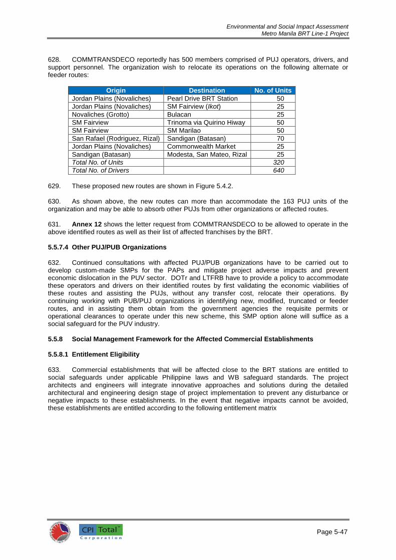
Environmental and Social Impact Assessment Metro Manila BRT Line-1 Project
Page 5-47
4
628. COMMTRANSDECO reportedly has 500 members comprised of PUJ operators, drivers, and support personnel. The organization wish to relocate its operations on the following alternate or feeder routes:
Origin Destination No. of Units
Jordan Plains (Novaliches) Pearl Drive BRT Station 50
Jordan Plains (Novaliches) SM Fairview (Ikot) 25
Novaliches (Grotto) Bulacan 25
SM Fairview Trinoma via Quirino Hiway 50
SM Fairview SM Marilao 50
San Rafael (Rodriguez, Rizal) Sandigan (Batasan) 70
Jordan Plains (Novaliches) Commonwealth Market 25
Sandigan (Batasan) Modesta, San Mateo, Rizal 25
Total No. of Units 320
Total No. of Drivers 640
629. These proposed new routes are shown in Figure 5.4.2. 630. As shown above, the new routes can more than accommodate the 163 PUJ units of the organization and may be able to absorb other PUJs from other organizations or affected routes. 631. Annex 12 shows the letter request from COMMTRANSDECO to be allowed to operate in the above identified routes as well as their list of affected franchises by the BRT. 5.5.7.4 Other PUJ/PUB Organizations 632. Continued consultations with affected PUJ/PUB organizations have to be carried out to develop custom-made SMPs for the PAPs and mitigate project adverse impacts and prevent economic dislocation in the PUV sector. DOTr and LTFRB have to provide a policy to accommodate these operators and drivers on their identified routes by first validating the economic viabilities of these routes and assisting the PUJs, without any transfer cost, relocate their operations. By continuing working with PUB/PUJ organizations in identifying new, modified, truncated or feeder routes, and in assisting them obtain from the government agencies the requisite permits or operational clearances to operate under this new scheme, this SMP option alone will suffice as a social safeguard for the PUV industry. 5.5.8 Social Management Framework for the Affected Commercial Establishments 5.5.8.1 Entitlement Eligibility 633. Commercial establishments that will be affected close to the BRT stations are entitled to social safeguards under applicable Philippine laws and WB safeguard standards. The project architects and engineers will integrate innovative approaches and solutions during the detailed architectural and engineering design stage of project implementation to prevent any disturbance or negative impacts to these establishments. In the event that negative impacts cannot be avoided, these establishments are entitled according to the following entitlement matrix

Environmental and Social Impact Assessment Metro Manila BRT Line-1 Project
Page 5-48
4
Table 5.5.2: Eligibility Entitlement Matrix, Affected Establishments on BRT Stations, Metro Manila BRT Line-1 Project
TYPE OF LOSS
MAGNITUDE AND CHARACTERISTIC
ELIGIBLE PERSONS
ENTITLEMENT
A. Land Full Owner
Full cash compensation at replacement cost without
deduction for capital gains, documentary stamp, transfer
taxes, and other directly related transaction costs
Partial Owner Full cash compensation at replacement cost for the
affected portion without deduction for capital gains,
documentary stamp, transfer taxes, survey costs, cost of
new subdivision plan, and other transaction costs.
B. Structure
Full Owner-
Occupant
Full cash compensation at replacement cost for the
affected structure without deduction for (i)
salvaged/salvageable materials; (ii) depreciation.
Replacement cost includes not only the cost of materials
but also the cost of (i) architectural services; (ii) hauling
cost of materials; (iii) labor cost; (iv) cost of reinstalling
utilities; (v) contractor’s profits; and (vi) cost of
processing or securing the necessary government
permits. Cost of transferring to the new structure,
including any loss of wages or income incurred in the
process.
Renters Full cash compensation at replacement cost for any fixed
improvements introduced. Cost of transferring to the new
structure, including any loss of wages or income incurred
in the process.
Partial Owner-
Occupant
Full cash compensation at replacement cost for the
affected portion of the structure without deduction for (i)
salvaged/ salvageable materials; (ii) depreciation.
Replacement cost includes not only the cost of materials
but also the cost of (i) architectural services; (ii) hauling
cost of materials; (iii) labor cost; (iv) cost of reinstalling
utilities; (v) contractor’s profits; and (vi) cost of
processing or securing the necessary government
permits. If owner occupant requires a separate dwelling,
while repair is ongoing, a rental subsidy equivalent to the
estimated time it will take to repair the structure. Cost of
transferring to the provisional structure and returning to
the repaired structure, including any loss of wages or
income incurred in the process.
Renter Full cash compensation at replacement cost for the fixed improvements introduced by the renter. In consultation with the owner, guarantee to continue renting the facility upon completion of repair. Rental period will be equivalent to the unutilized portion of the contract and same rental rates will apply. If renter requires a separate dwelling, while repair is ongoing, a rental subsidy equivalent to the estimated time it will take to repair the structure. Cost of transferring to the provisional structure and returning to the repaired structure, including any loss of wages or income incurred in the process. If renter does not opt to return, the project will shoulder the cost of transferring to the new structure, including any loss of wages or income incurred in the process.
Informal (Commercial)
Encroachers on public ROW
Under OP 4.12 para 16: (i) compensation at full replacement cost for loss of structures/assets other than
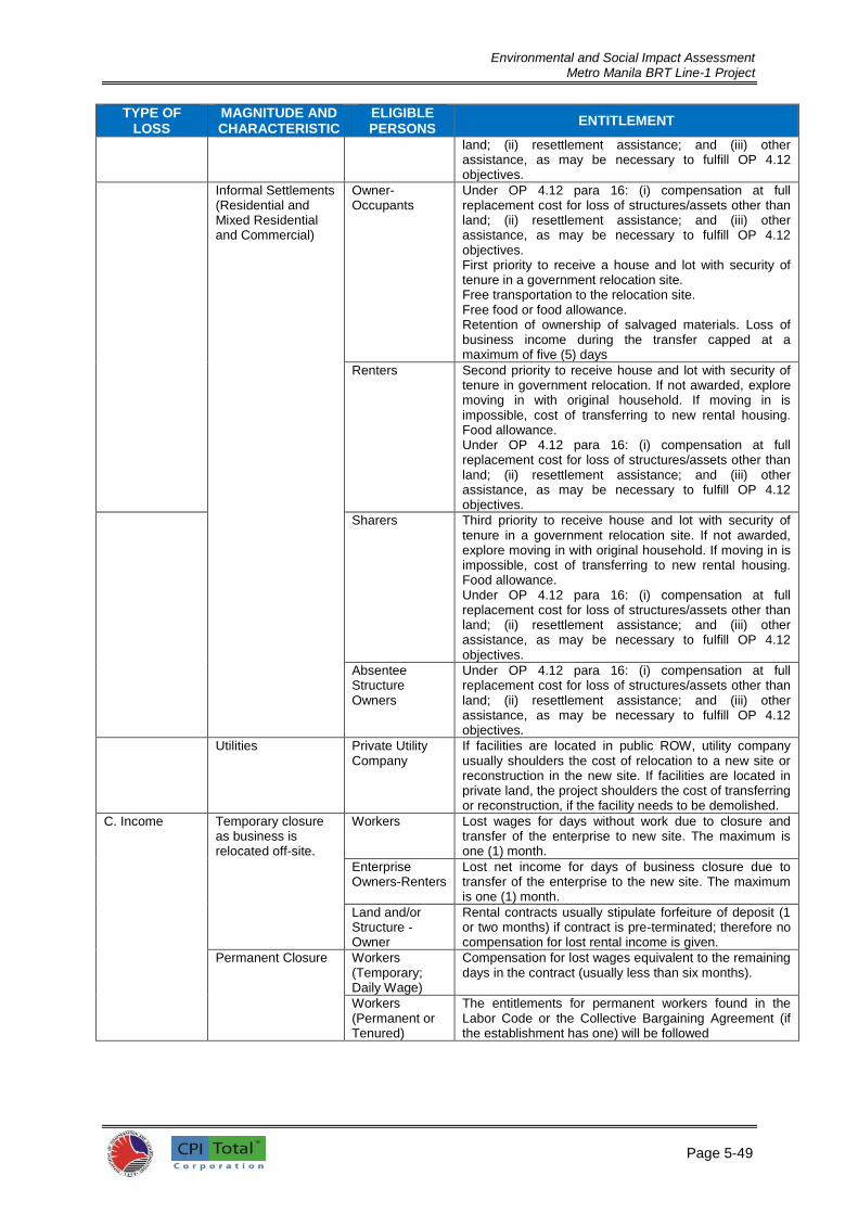
Environmental and Social Impact Assessment Metro Manila BRT Line-1 Project
Page 5-49
4
TYPE OF LOSS
MAGNITUDE AND CHARACTERISTIC
ELIGIBLE PERSONS
ENTITLEMENT
land; (ii) resettlement assistance; and (iii) other assistance, as may be necessary to fulfill OP 4.12 objectives.
Informal Settlements (Residential and Mixed Residential and Commercial)
Owner-Occupants
Under OP 4.12 para 16: (i) compensation at full replacement cost for loss of structures/assets other than land; (ii) resettlement assistance; and (iii) other assistance, as may be necessary to fulfill OP 4.12 objectives. First priority to receive a house and lot with security of tenure in a government relocation site. Free transportation to the relocation site. Free food or food allowance. Retention of ownership of salvaged materials. Loss of business income during the transfer capped at a maximum of five (5) days
Renters Second priority to receive house and lot with security of tenure in government relocation. If not awarded, explore moving in with original household. If moving in is impossible, cost of transferring to new rental housing. Food allowance. Under OP 4.12 para 16: (i) compensation at full replacement cost for loss of structures/assets other than land; (ii) resettlement assistance; and (iii) other assistance, as may be necessary to fulfill OP 4.12 objectives.
Sharers Third priority to receive house and lot with security of tenure in a government relocation site. If not awarded, explore moving in with original household. If moving in is impossible, cost of transferring to new rental housing. Food allowance. Under OP 4.12 para 16: (i) compensation at full replacement cost for loss of structures/assets other than land; (ii) resettlement assistance; and (iii) other assistance, as may be necessary to fulfill OP 4.12 objectives.
Absentee Structure Owners
Under OP 4.12 para 16: (i) compensation at full replacement cost for loss of structures/assets other than land; (ii) resettlement assistance; and (iii) other assistance, as may be necessary to fulfill OP 4.12 objectives.
Utilities Private Utility Company
If facilities are located in public ROW, utility company usually shoulders the cost of relocation to a new site or reconstruction in the new site. If facilities are located in private land, the project shoulders the cost of transferring or reconstruction, if the facility needs to be demolished.
C. Income Temporary closure as business is relocated off-site.
Workers Lost wages for days without work due to closure and transfer of the enterprise to new site. The maximum is one (1) month.
Enterprise Owners-Renters
Lost net income for days of business closure due to transfer of the enterprise to the new site. The maximum is one (1) month.
Land and/or Structure -Owner
Rental contracts usually stipulate forfeiture of deposit (1 or two months) if contract is pre-terminated; therefore no compensation for lost rental income is given.
Permanent Closure Workers (Temporary; Daily Wage)
Compensation for lost wages equivalent to the remaining days in the contract (usually less than six months).
Workers (Permanent or Tenured)
The entitlements for permanent workers found in the Labor Code or the Collective Bargaining Agreement (if the establishment has one) will be followed

Environmental and Social Impact Assessment Metro Manila BRT Line-1 Project
Page 5-50
5
5.5.8.2 Identification, Tagging and Appraisal 634. During the detailed engineering design, a cut-off date for inclusion as PAPs shall be set and affected establishments will be identified and tagged. A professional appraiser will appraise the replacement value of the structures to be affected and determine appropriate compensation based on the above entitlement matrix. 5.5.8.3 Consultations with PAPs and Compensation
635. During the detailed engineering design and after the affected establishments have been identified, tagged and appraised, the meetings will be organized to inform the DPs of the project impact on their establishment. Their suggestions and recommendations that may facilitate the implementation of the compensation program will be heard. Detailed information about the DPs including names, address, contact numbers, detailed explanation for reasons of their displacement and the breakdown of compensation and entitlements shall be compiled in a database. 636. PAPs shall be compensated or be given their entitlement package as determined by a professional appraiser prior to commencement of any construction works. 5.5.9 Gender Action Plan 637. The most pressing concerns for women in the PUBLIC TRANSPORT sector are as follows:
1) the harassment that they encounter in over-crowded PUBLIC TRANSPORT vehicles –
this is prevalent not only PUJs and PUBs but also occurs in railway vehicles such as the MRT and LRT in Metro Manila;
2) difficulty in boarding and alighting – this is experienced by women primarily on public utility buses (PUB) currently serving the metropolis with only have one door for boarding and alighting, making it difficult to get off when with children or with bags, especially when one is seated or standing at the rear end of the bus and the aisle is full with standing passengers.
638. Women employees are also not well-represented in the PUBLIC TRANSPORT sector where drivers and conductors are predominantly men. Integrating these concerns in the implementation of the Metro Manila BRT-Line 1 project requires the following action plans:
1) The BRT system shall be designed for ease of boarding and alighting with buses and the stations at the same level. This makes it easier to load and unload strollers. Where necessary, drop down ramps may be provided.
2) The system shall address the issue of encumbrances of passengers including over-crowding by provision of sufficient space passengers and cargo. When over-crowding persists, the BRT shall provide separate areas and doors for women; and
3) Creating a policy environment that promotes equal employment opportunity for women in the BRT system.
5.5.10 SMP Measures to address accessibility to PWDs, elderly and students 639. The BRT system shall integrate appropriate public transportation design standards that will address safety and accessibility for persons with disabilities, elderly and students based on existing laws and policies of the Philippine government and international covenants and standards as spelled out in the legal and policy framework. Students, senior citizens, and PWDs shall be afforded discounted fares based on applicable regulations on passenger fares. Among others, Batas Pambansa (BP) Blg. 344 s. 1983 (Accessibility Law), Republic Act No. 7277 s. 1991 as amended by Republic Act No. 9422 s. 2006 (Magna Carta for Disabled Persons) and DOTr Department Order No. 2014-013 – Policies on Transport Accessibility, which sets forth the rules and regulations to provide for minimum requirements and standards to make public transportation facilities and utilities accessible to PWDs pursuant to the objectives of BP 344, must be incorporated in the design and operating guidelines of the BRT Project.

Environmental and Social Impact Assessment Metro Manila BRT Line-1 Project

Environmental and Social Impact Assessment Metro Manila BRT Line-1 Project
Page 6-1
1
6.0 ANALYSIS OF ALTERNATIVES 640. The purpose of this section is to describe and analyze by comparison the general characteristics of the No Project alternative and the With Project alternative. 6.1 No-Project Alternative 641. The BRT Project will catalyze Metro Manila’s urban road network to cope with traffic demands expected in conjunction with other complementary development plans. Without the BRT Project, the existing transport system and road network will be insufficient in capacity to accommodate existing and future traffic demands. 642. The No-Project Alternative would mean maintaining the status quo with which only routine activities such as road maintenance and repair shall be undertaken on the proposed BRT corridor. Safety improvements in the existing transport system would only occur as the need arises or over the next several years. It is assumed that the No-Project Alternative does not include improvements that would increase roadway capacity, reduce congestion, or improve safety meaningfully. 643. The No-Project Scenario would likewise mean the continuation of the current public transport system which is dominated by inefficient buses, jeepneys, mini-buses, shuttle services, and taxis. In some sections of the roadway, tricycles, multi-cabs and pedicabs are also among the current inefficient public transportation options of the commuting public. Current motorized vehicles in the metropolitan roads and highways represent anthropogenic sources of greenhouse gases (GHG) that would occur in the absence of the proposed BRT project. Without the BRT project, Metro Manila and its people will be completely deprived of the benefits that may be generated by the BRT project. These benefits include reduced CO2 and GHG emissions, reduced traffic congestion, improved traffic safety, potential reduction in travel time, and transport cost savings accruing to the public as end users. 644. Under the No Project scenario, travel demand will increase while no additional capacity is provided. Traffic volume as expressed in terms of vehicle kilometers (v-km) across the Metro Manila, is forecast to increase from around 755,000 v-km in 2013 to around 1,775,000 v-km in 2040. With no increase in network capacity, the result is rapid deterioration in traffic speeds, from around 20.3 km per hour (kph) in 2012 to just 3.8 kph in 2040.
21 The low speeds forecast represents an untenable
situation in the future and thus require interventions including demand management, highway improvements, and public transport improvements that must be introduced in the short- and medium-terms.
6.2 With Project Alternative 645. In the face of growing vehicular congestion and slowing travel time, there is a clear need for transport interventions along the corridor. With the proposed BRT project, savings of up to 12 percent in v-km volume are expected to accrue starting 2025 arising from the better efficiency in public transportation system.
22 Speed improvements of up to one (1) kph are also anticipated by year 2015.
GHG savings over 30 years as a result of the BRT project is 6.21 million tons or a yearly GHG savings of 207,000 tonnes. 646. In general, transport projects that improve overall accessibility and reduce transportation costs, such as in the case of Metro Manila BRT Line 1, tend to increase economic productivity and development. They improve businesses’ ability to provide goods and services, and people's ability to access education, employment, utilities, and services. Efficient public transportation also results to shorter travel time, lower vehicle operating costs, lower road and parking facility costs, and reduced accident and pollution damages. Accidents are also expected to drop as a result of efficient public transportation system.
21 Figures from the Detailed Technical Study 22 Vehicle-km savings is from the Detailed Technical Study.

Environmental and Social Impact Assessment Metro Manila BRT Line-1 Project
Page 6-2
2
647. The proposed BRT system is considered generally as a public transport mode that provides almost same levels-of-service (LOS) of a mass transit system that is rail-based (e.g., LRT). The rail-based system however entails high cost of construction, operation and development. The BRT system has almost same exclusive ROW as the LRT, but is cheaper than a rail-based mass transportation system to develop while it has the capacity to provide same efficient commuting service to the public. 648. In the context of reducing the negative impacts of transport system to the environment, specifically on air quality, the BRT system can provide, to some extent, same levels of mitigation to that of LRT, as shown in various cities with BRT systems. Given again the experiences in other countries, it was shown that BRT system can significantly reduce carbon footprints in urban or metropolitan areas. The BRT system is a much better alternative when compared to the current public transport systems with respect to providing green ambiance and a better physical landscape to the urban setting. As such, the introduction of the BRT system is therefore anticipated to contribute positively in the overall transport system in Metro Manila. 6.3 Project Alternatives 6.3.1 Alternative BRT Routes 649. With the help of various government agencies and international groups, DOTr has come up with a strategic mass transit network within Metro Manila and nearby cities (see Figure 6.3.1) with the purpose of easing traffic in Metro Manila. Part of this plan is the implementation of a BRT system at selected routes within Metro Manila. The other BRT routes under the plan are along Commonwealth Ave and Quezon – España Boulevards (BRT 1), Ortigas Ave (BRT 2), and C-5 Road (BRT 3). 650. The Commonwealth - Quezon - España Boulevard corridor is a main strategic transport route cutting diagonally through the upper half of Metro Manila. It is a route that is not currently served by any form of mass transit although the planned MRT Line 7, if approved, will also serve the northern half of the corridor between SM Fairview and Elliptical Road. The corridor’s strategic importance and its connections with LRT1, MRT3 and Philippine National Rail together with its high volume of travel would suggest that the corridor has justification as a form of mass transit route. 651. In 2013, a detailed technical study was conducted to examine the España - Quezon Avenue - Commonwealth Avenue corridor. Study revealed that traffic congestion is concentrated in España and Quezon Avenues between Manila City Hall and Philcoa. However, Commonwealth Avenue between Philcoa and Fairview is wide and large, at present, without congestion. It may also be served by MRT7 if approved which will further increase traffic mobility in the serviced areas. 652. During the course of the DTS, an option to route the BRT alignment via Nicanor Reyes and CM Recto Avenue; rather than Lerma Avenue and Quezon Boulevard was explored. This alternative is outlined in Figure 6.3.2.

Environmental and Social Impact Assessment Metro Manila BRT Line-1 Project
Page 6-3
3
Figure 6.3.1: Strategic Mass Transit Network in Metro Manila Proposed by DOTr

Environmental and Social Impact Assessment Metro Manila BRT Line-1 Project
Page 6-4
4
653. An evaluation of this alternative option compared to the current proposed option is set out in Table 6.3.1, below.
Table 6.3.1: Evaluation of Alternative Bus Route Options via (1) Nicanor Reyes and CM Recto Avenue and (2) Lerma Avenue and Quezon Boulevard
Route Option Advantages Disadvantages Nicanor Reyes/CM Recto (Alternative)
Serves STARC and FEU (on Nicanor)
Serves retail on Nicanor and CM Recto
Takes up one lane of only two at N end of Nicanor
S bound at grade road parallel to Quezon Boulevard has many market stalls
N bound at grade road heavily trafficked
Heavy traffic conflict on exit from/and entry to median on Quezon Boulevard
Swept path Nicanor/CM Recto clashes with substantial LRT column
Figure 6.3.2: Alternative BRT Routes via (1) Nicanor Reyes and CM Recto
Avenue and (2) Lerma Avenue and Quezon Boulevard

Environmental and Social Impact Assessment Metro Manila BRT Line-1 Project
Page 6-5
5
Route Option Advantages Disadvantages Lerma Avenue/ Quezon Boulevard (Current)
Minimal traffic conflict
Higher speeds
Less educational facilities and shops served
Mixed running on NE bound turn into Lerma Avenue
654. The issue of clashing with the LRT support on CM Recto outweighs the advantages of this route and the proposed Lerma Ave/Quezon Boulevard route is chosen.
6.3.2 BRT System over LRT System
655. One approach in addressing traffic congestion (and deterioration of the environment due to impacts of transport systems) is the introduction of an efficient high occupancy public transport system that is in the form of a mass transit system. Two alternatives mass transport system that are commonly used in cities around the world are the LRT and BRT systems. The LRT and BRT systems have done great help to decrease and ease traffic along their respective locations. While generally agreed that the two systems deliver more or less the same service, the BRT is significantly cheaper to build and maintain. Whereas light rails and subways have a larger capacity and are favored in more developed countries, BRT systems are much cheaper and quicker to build, and are thus favored in the cities and megacities of the developing world. A comparison of LRT and BRT systems in terms of capital cost, operating cost and speeds reflects the advantage of the latter as an alternative mass transportation system (Table 6.3.2)
Table 6.3.2: Comparative analysis of BRT and LRT Systems23
Parameter Comparative Evaluation
Capital Cost Bus Rapid Transit has a clear capital cost advantage over light-rail systems, in the identified three main locations of BRT implementation: Busways, HOV lanes, and arterial streets. While the fixed costs of building these three options varied, with busways being the most expensive, each option was less expensive per mile than light rail. Light rail costs an average of $34.8 million per mile ($21.6 million per km) to build, whereas busways cost $13.5 million per mile ($8.4 million per km), or 60.2 percent less than light rail. HOV lanes and arterial streets built for BRT use cost even less, at $9.0 million per mile ($5.6 million per km) and $680,000 per mile ($422,000 per km), respectively. These systems cost 61 percent, 74 percent and 98 percent less than light-rail systems
Operating Cost Proper consideration of the cost of one system compared to another must include not only the burden of initial construction, but the ongoing costs of operation, as well. The operating costs of these two systems clearly demonstrate a vast difference. Estimate for Denver’s BRT system is that BRT costs 80.8 percent less per mile to operate than light rail.
Speed There is a marked difference in speed between Bus Rapid Transit and light rail systems. In five cities that use both systems (Dallas, Denver, Pittsburgh, San Diego and San Jose), the average speed of BRT service is faster than light rail, sometimes much faster. On average, the speed of BRT systems in these cities is 47 percent faster than light rail. In Denver, it was found that bus-rapid transit runs about 69 percent faster than light rail. The speed advantages of BRT are largely the result of running buses on highway HOV lanes, less loading times, and technological improvements to bus service. It was concluded that BRT is not only faster, it is more convenient due to fewer transfers and closer delivery to the consumers’ destinations.
Other Benefits BRT is much more flexible than light rail. Since rail lines are fixed, they cannot respond to changes in employment and land use, whereas
23 Bus-Rapid Transit Is Better Than Rail: The Smart Alternative to Light Rail by Joseph P. Kubala, P.E. and Scott Barton, Center for the American Dream, Independence Institute, Issue Paper #10-2003, December 16, 2003.

Environmental and Social Impact Assessment Metro Manila BRT Line-1 Project
Page 6-6
6
Parameter Comparative Evaluation
BRT service can be rerouted and shifted over time to correspond with the changing transportation needs of a city.
BRT systems can provide long-distance service without requiring transfers. This advantage allows BRT to overcome a serious disincentive to transit
Systems like light rail that usually require transfers between buses or automobiles.
BRT systems can be phased in step by step. Improvements can be made gradually and operations can begin before every element is in place, unlike light rail, which must be fully completed before service can begin.
BRT systems that use HOV lanes can be easily converted to high-occupancy/toll (HOT) lanes to decrease congestion in regular lanes and to generate capital. The shared use of facilities between BRT, HOV, and HOT lanes yields more utility at no or minimal expense, less conflict between technologies, and the opportunity to generate revenue.
6.3.3 Other Alternatives Studied for the Project 656. Table 6.3.3 provide the summary of various alternatives that were considered in coming up with the specification of the proposed BRT project. Justifications on the recommended alternatives for each of the items were likewise provided.

Environmental and Social Impact Assessment Metro Manila BRT Line-1 Project
Page 6-7
Table 6.3.3: Summary of Various Alternatives Studied Concept Issue Option Linkage Recommendation Justification/Information
Configuration of running lanes
Median with median stations Median with bilateral stations Median with cross over Median with tidal flow Bilateral
Median with median stations Median with bilateral stations Median with cross over Median with tidal flow Bilateral
Median operation with median stations
Limited roadway width, lack of service lanes, proliferation of roadside activity result in median operation recommendation. Median stations are recommended to reduce cross section and hence right of way acquisition.
Pedestrian crossing At grade Via skywalk Mixed
Accessibility Mixed according to Location
Minimizing passenger inconvenience is paramount with respect to issues of safety and impact upon overall road capacity
Regulation Closed to non BRT Open to all
Configuration Trunk/direct Ticketing Vehicles
BRT way closed to all non BRT specified vehicles. BRT route has some regulatory protection.
A form of regulatory control is required to protect against competition. Some service overlap is desirable
Trunk (closed) or direct (open) service
Trunk-feeder Direct
Configuration Vehicles
A mixed trunk and direct (tributary) system
Demand has shown significant trip origins outside of the defined BRT infrastructure. Efficient service of that demand requires some direct services.
Accessibility Step free access throughout Some steps Steps
Pedestrian crossing Vehicles Stations
Platform to bottom step height (350mm)
Higher platforms to achieve step free access would effectively require a closed (trunk-feeder) system and potentially closed stations. Proposal offers significant assistance to many with mobility problems.
Ticketing On board Off board Paper Magnetic Smartcard
Vehicle Stations
Tentatively, off board smartcard within the BRT with on board payment system for tributary services. Further consideration at Feasibility Stage required.
Ease of payment, manageable technology risk and association with high technology.
Number of lanes Single Twin
None Single lane system with by pass lanes at some stations to facilitate express services
High demand is forecast and benefits in operating express services identified.
Vehicle type 11.0m twin-axle bus 13.7m three-axle bus 18.0m articulated bus Diesel LPG/CNG Hybrid High floor (2 step) High floor (1 step) Low floor
Configuration Accessibility
13.7m three-axle bus with 610mm floor.
Good passenger access and good weight distribution between the axles. The tri-axle bus has potential unutilized axle capacity, either alternative-fuel or hybrid power train options could be pursued without reducing passenger numbers.
Stations Open Closed
Configuration Vehicles
Closed stations within the BRT system, Open stations to serve tributaries
To facilitate efficient boarding/alighting to reduce vehicle dwell times and enhance run times.
Source: DTS for the Manila – Quezon Corridor Improvement Project, Final Report, December 2013, V1.0.

Environmental and Social Impact Assessment Metro Manila BRT Line-1 Project
8

Environmental and Social Impact Assessment
Metro Manila BRT Line-1 Project
Page 7-1
1
7.0 ENVIRONMENTAL AND SOCIAL MANAGEMENT PLAN (ESMP)
657. The ESMP that is described and provided in this document serves as guidance only to DOTr (as Executing Agency) and the Contractor/s for the eventual construction of the project. In the absence of the project Detailed Engineering Design (DED), various environmental management plans are stated akin to the guidelines which will form part of the TOR for the DED Consultant to ensure that these guidelines are updated into management plans together with the DED. Specific and/or detailed management plans for each area of concern shall be formulated and customized based on the results of the DED subject to the final approval of DOTr. 7.1 ESMP Safeguard Compliance 658. For this BRT Line-1 Project, 2-levels of environmental and social safeguards review and approvals will be undertaken under the (1) WB Safeguard Policy and (2) country’s Philippine Environmental Impact Statement System (PEISS). 659. The WB Safeguard Policy that are triggered are as follows:
Safeguard policy Triggered?
Explanation
Environmental
Assessment OP/ BP
4.01
Yes The project is expected to generate adverse environment
and social impacts from civil works (dust, wastes, noise
and vibration)
The project shall contribute to the traffic problem during
construction;
Some trees shall be removed during the construction of
bus stations;
The project will result in loss of income for (a) vendors
and business establishments along the corridor; and (b)
PUJ and PUB operators and drivers
Involuntary
Resettlement OP/BP
4.12
Yes Project requires land acquisition for its north and south
depots’
However, OP 4.12 may not be triggered for the siting of
and construction of bus stations as ROW acquisition
avoidance will be strictly implemented.
660. PEISS was established in 1977 by virtue of Presidential Decrees 1152 and 1586 and a series of subsidiary legislation, administrative orders, and memoranda that regulate the operations of the system. The Department of Environment and Natural Resources (DENR) is the regulating authority and the DENR Administrative Order 30 Series of 2003 (DAO 03-30) contains the Implementing Rules and Regulations of the Government of the Philippines (GOP) and requires all projects categorized as environmentally critical (ECPs) or within environmentally critical areas (ECAs) to go through an assessment process referred to as the EIS System that requires Environmental Impact Assessment (EIA). DENR will review the environmental assessment and clearance certification before construction can commence.
661. The BRT-NPMO through its PIU is required to obtain approval and the Environmental Clearance certificate (ECC) from DENR following environmental assessment and public consultation. It has been clarified by DENR that under the Environmental Impact System of the Philippines (EIS) the project requires an EIA, and the BRT-NPMO/PIU should disclose the scale and scope of the project works under the provisions of the EIS prior to the detailed design stage in a timely manner so that DENR can reconfirm procedures that need to be completed under the environmental laws in Philippines so as not to delay implementation of the project. Environmental quality standards for the protection of the environment are provided by relevant national laws and regulations.

Environmental and Social Impact Assessment
Metro Manila BRT Line-1 Project
Page 7-2
2
7.1.1 Responsibilities for ESMP Implementation 662. A Technical Working Group has been established for the Project by DOTr to provide policy guidance and interagency coordination. DOTr will be the executing agency for the proposed project. DOTr shall be assisted by the BRT-NPMO and PIU in overseeing the implementation of the project. 663. Under the PPP scheme, DOTr shall delegate the implementation of the project to a Special Purposes Company (SPC) comprised of the Engineering, Procurement and Commissioning (EPC) and the Technical Support Consultant (TSC) and eventually by a Technical Services provider who will be responsible for the operations and maintenance of the BRT Line-1 system. 664. For purposes of this assessment it is assumed that DOTr will engage or designate a Special Purposes Company (SPC) to (i) ensure coordination among all implementing agencies during construction; and (ii) design and negotiate the business model of BRT Line-1 project and monitor its future operations. The SPC will be created under and will report directly to DOTr. Throughout the project implementation, the SPC will be supported strongly by the EPC and Technical Support Consultants. 665. The EPC (under the SPC) will cover engineering, procurement, construction management, and supervision and will be engaged to undertake detailed design and supervise the construction. The consulting packages will include capacity building. 666. The SPC will be created for the construction and operation of the BRT Line-1 Project and will be responsible for overall project management and coordination. The SPC will engage consultants such as the TSC which are essential for project management and coordination, detailed design, and construction supervision. The SPC with the assistance of the consultants will engage the contractors for construction. 667. Table 7.1.1 defines the responsibilities for ESMP implementation while the proposed Organizational Chart for the Metro Manila BRT Line-1 Project (with respect to ESMP formulation and implementation) is shown in Figure 7.1.1.
Table 7.1.1: Responsibilities for ESMP Implementation
Agency Responsibilities
Department of
Transportation and
BRT-National
Program
Management Office
(BRT-NPMO)
Executing agency with overall responsibility for the BRT Line-1 Project implementation
Ensure that sufficient funds are made available to the Special Purposes Company (SPC) to properly implement the ESMP
Ensure that the SPC, regardless of financing source, complies with the provisions of the ESMP and WB environmental policies and particularly WB POLICY OP 4.01
Ensure that the SPC complies with Government environmental policies and regulations
For project duration ensure that the SPC retain dedicated Technical Support Consultants including environment and safety and social safeguard officers to oversee the ESMP implementation.
Ensure that the SPC monitors environmental protection and mitigation measures in the ESMP and that these are incorporated in the detailed designs
Ensure that the SPC applies the necessary resources to obtain environmental clearances certification under the EIS from DENR prior to award of civil works contracts
Ensure that the SPC establishes and implements an environmental grievance redress mechanism, as described in the ESIA, to receive and facilitate resolution of affected peoples' concerns, complaints, and grievances about the Project's environmental performance
Ensure that the SPC confirms that bidding and contract documents include the ESMP
Ensure that the SPC submits semi-annual monitoring reports on ESMP

Environmental and Social Impact Assessment
Metro Manila BRT Line-1 Project
Page 7-3
3
Agency Responsibilities
implementation to WB
Special Purposes
Company (SPC)
Implementing agency with overall responsibility for project construction and operation
Ensure that sufficient funds are available from DOTr to properly implement the ESMP
Ensure that the Project, regardless of financing source, complies with the provisions of the ESMP and WB environmental policies and particularly WB POLICY OP 4.01
Ensure that Project implementation complies with Government environmental policies and regulations
For project duration ensure that commencing from the detailed design phase, the Technical Support Consultants (TSC) will commit and retain dedicated environment and safety and social safeguard officers to oversee the ESMP
Ensure that environmental and social protection and mitigation measures in the ESMP are incorporated in the detailed designs
Obtain necessary environmental clearances certification from DENR prior to award of civil works contracts
Establish and implement an environmental grievance redress mechanism, as described in the ESIA, to receive and facilitate resolution of affected peoples' concerns, complaints, and grievances about the Project's environmental performance
Confirm that bidding and contract documents include the ESMP
Submit semi-annual monitoring reports on ESMP implementation to WB
Project
Implementation Unit
(PIU)
Ensure that bidding and contract documents include the ESMP
Submit monthly and semi-annual monitoring reports on ESMP implementation to the SPC
Include in the Project ESMP and specify requirements for the preparation and implementation of method statements/site-specific ESMPs by the contractors as described in the ESIA
Ensure that the ESMP provisions are strictly implemented during various project phases (design/pre-construction, construction, and operation) to mitigate environmental impacts to acceptable levels.
Ensure that Project implementation complies with WB's environmental policy OP 4.01 and the principles and requirements therein
For project duration, commit and retain a dedicated staff within each PIU as environment and safety and social safeguard officers to oversee ESMP implementation
Check that environmental protection and mitigation measures in the ESMP are incorporated in the detailed designs
Check that necessary environmental clearances and approval(s) from DENR prior to award of civil works contracts
Participate in an environmental grievance redress mechanism, as described in the ESIA, to receive and facilitate resolution of affected peoples' concerns, complaints, and grievances about the Project's environmental performance
Undertake monitoring of the implementation of the ESMP (mitigation and monitoring measures) with assistance from the TSC
Report to WB on all aspects of environmental and social management and monitoring at six month intervals, based on the results of the ESMP monitoring
With support from the TSC, prepare semi-annual environmental and social monitoring reports for submission to WB
Based on the results of the ESMP monitoring, identify environmental and social corrective actions and prepare a corrective action plan, as necessary, for submission to WB
Technical Support Incorporate into the project design the environmental protection and

Environmental and Social Impact Assessment
Metro Manila BRT Line-1 Project
Page 7-4
4
Agency Responsibilities
Consultant (TSC)
and Engineering,
Procurement and
Commissioning
(EPC)
mitigation measures identified in the ESMP for the design stage
Update the ESIA and the ESMP based on detailed design
Assist the SPO/PIU to ensure that all environmental and social requirements and mitigation measures from the ESIA and the ESMP are incorporated in the bidding and contracts documents
During detailed engineering phase, prepare draft method statements/ESMPs (Traffic Management Plan, Utilities, Runoff Control Plan, Waste Management and Spoil Disposal Plan, Noise and Dust Control Plan, etc.) described in the ESIA/ESMP
Prior to construction, review and approve in writing the updated ESMPs/method statements prepared in consultation with contractors
Implement all mitigation and monitoring measures for various project phases specified as TSC’s tasks in the ESMP
Work within the PIU to execute any additional environmental assessment prior to project construction as required in the ESMP (e.g., preparation of new or supplementary environmental assessment in case of change in alignment that will result to adverse environmental impacts that are not within the scope of the ESIA prepared during loan processing, etc.)
On behalf of the SPC, prepare and submit a statutory ESIA and obtain environmental clearance certification prior to project construction as required in the ESMP (Also preparation of new or supplementary environmental assessment in case of change in alignment that will result to adverse environmental impacts that are not within the scope of the ESIA prepared during loan processing, etc.)
Assist the SPC and the PIU in obtaining environmental approvals and certification (e.g., ECC) under PEISS from DENR prior to award of civil works contracts.
Undertake environmental management capacity building activities for the SPC and the BRT PIU as described in the ESIA and the ESMP
Engage environment and safety and social safeguard specialists to ensure proper implementation of the ESMP provisions. Through these specialists, the TSC shall: (i) ensure proper and timely implementation of TSC tasks specified in the ESMP; (ii) conduct environmental training as specified in the ESIA/ESMP for the SPC and the BRT PIU; (iii) conduct contractors workers’ orientation on ESMP provisions; (iv) undertake regular monitoring of the contractor’s environmental performance, as scheduled in the ESMP; (v) conduct field measurements for dust and noise as required in the ESMP; and (vi) prepare an environmental baseline report and semi-annual environmental monitoring reports, as specified in the ESMP, for the SPC submission to WB
Contractor Recruit qualified environmental and safety and social safeguard officers to ensure compliance with environmental statutory and contractual obligations and proper implementation of the ESMP
Implement Traffic Management Plan with relevant authorities
Implement Utility Management Plan in close coordination with relevant authorities and agencies
Implement Noise and Dust Control Plan with relevant authorities
Prior to start of construction, update the draft ESMPs for approval by the TSC and the PIU
Provide sufficient funding and human resources for proper and timely implementation of the required mitigation measures in the ESMP and segregate these sums in the bidding documents
Implement additional environmental mitigation measures for unexpected impacts, as necessary
Department of
Environment and
National Resources
Review and approve environmental assessment reports required by the Government
Issue environmental clearance certification for the Project based on their mandate and regulations

Environmental and Social Impact Assessment
Metro Manila BRT Line-1 Project
Page 7-5
5
Agency Responsibilities
Undertake monitoring of the project’s environmental performance based on their mandate
City of Manila,
Quezon City, and
Barangay LGUs
Participate in the review and approval of environmental assessment reports required by the Government
Issue local business permits based on their mandate and regulations
Participate in the monitoring of the project’s environmental performance based on their mandate
Figure 7.1.1: Proposed Metro Manila BRT Line -1 Organizational Chart (for ESMP Implementation)
668. To facilitate the ESMP implementation, during construction, the contractors must be prepared during the tendering and pre-construction phase to cooperate with the SPC/TSC, the PIU and the local population in the mitigation of impacts. However, experience suggests that contractors may have little impetus or interest in dealing with environmental problems in the absence of performance-related criteria. Therefore, as previously mentioned, the Contractor will be required (with the assistance of the TSC) to update the draft site-specific ESMP prepared by the TSC during the detailed design phase. Clearances for payments will include certification from the TSC and PIU as to the effective implementation of the ESMP and all other mitigation measures specified in the ESMP. The completion of implementation of mitigation measures will therefore be linked to payment milestones.
DENR/WB
BRT-NPMO
Special Purposes Company (SPC)
Contractor
DOTr-PIU
World Bank (WB)
BRT Consultant/s
DOTr National BRT Steering
Committee
Engineering, Procurement and
Commissioning (EPC)
Tech. Support Consultant (TSC)
Pro
ject
Co
nce
pt/
FS/
ESIA
/DED
/
Ten
der
Do
cum
ents
DED
/BR
T C
on
stru
ctio
n &
Op
erat
ion
E S
M P
incl
ud
ing
mo
nit
ori
ng
and
re
po
rtin
g w
ork
s
Project
Documents /
Activities

Environmental and Social Impact Assessment
Metro Manila BRT Line-1 Project
Page 7-6
6
669. Other government agencies that may be involved in the implementation of the ESMP are presented in Table 7.1.2.
Table 7.1.2: Other Entities that may be involved in the ESMP Implementation
City Environment and Natural Resources Office (CENRO)
Undertake monitoring of the project’s environmental performance based on their mandate
Department of Public Works and Highways (DPWH)
Has overall jurisdiction over national highways
Coordinate with the PIU and the Contractor in the overall conduct of construction activities along the corridor including providing work permits that pertain to civil works required for the BRT system along Commonwealth and Quezon Avenue
Of particular significance are the construction of ramps, signages, and other structures or provisions for PWDs, the elderly, and women
Metro Manila Development Authority (MMDA)
In coordination with LTFRB, update travel lines for the restructured routes and manage traffic in keeping with its mandate
Land Transportation Office (LTO)
In coordination with the LTFRB and the MMDA, will oversee the issuance of registration of vehicles and issuance of licenses of PUV drivers
Land Transportation Franchising and Regulatory Board (LTFRB)
In coordination with the MMDA, manage the migration of PUJ operators and drivers to restructured/new routes
Issue Certificate of Public Convenience for affected PUVs to operate on new routes or modified routes.
Technical Education and Skills Development Agency (TESDA)
Skills training provider to PAPs or members of affected household as part of the ESMP
7.2 Environmental and Social Management Plan (ESMP) 670. The anticipated environmental impacts and mitigation measures discussed in the previous section are presented in Table 7.2.1. The table also shows the responsibilities and timeframe/schedule for the implementation of mitigation measures and monitoring. 671. Table 7.2.1 also shows that most mitigation activities during pre-construction are to be implemented by the DOTr BRT-NPMO/PIU assisted by the SPC/TSC while during construction, measures shall be primarily implemented by the Contractors. During operation stage, the BRT Line-1 operator shall undertake environmental mitigation and monitoring requirements specified in the ESMP. To ensure implementation of mitigation measures during construction, the ESMP shall be included in the tender and contract documents for civil works. Contractors’ conformity with environmental contract procedures and specifications shall be regularly monitored by the PIU with assistance from TSC and results shall be reported semi-annually to WB and DENR. 7.3 Social Management Plan (SMP) and Monitoring Works 672. Table 7.3.1 presents the summary of social impact management measures according to project phases (i.e., pre-construction, construction, and operation) and target population or stakeholder group. The implementing institution or agency for each social management measure and the source of financing are also indicated. The corresponding monitoring and evaluation mechanism are also provided for each activity.
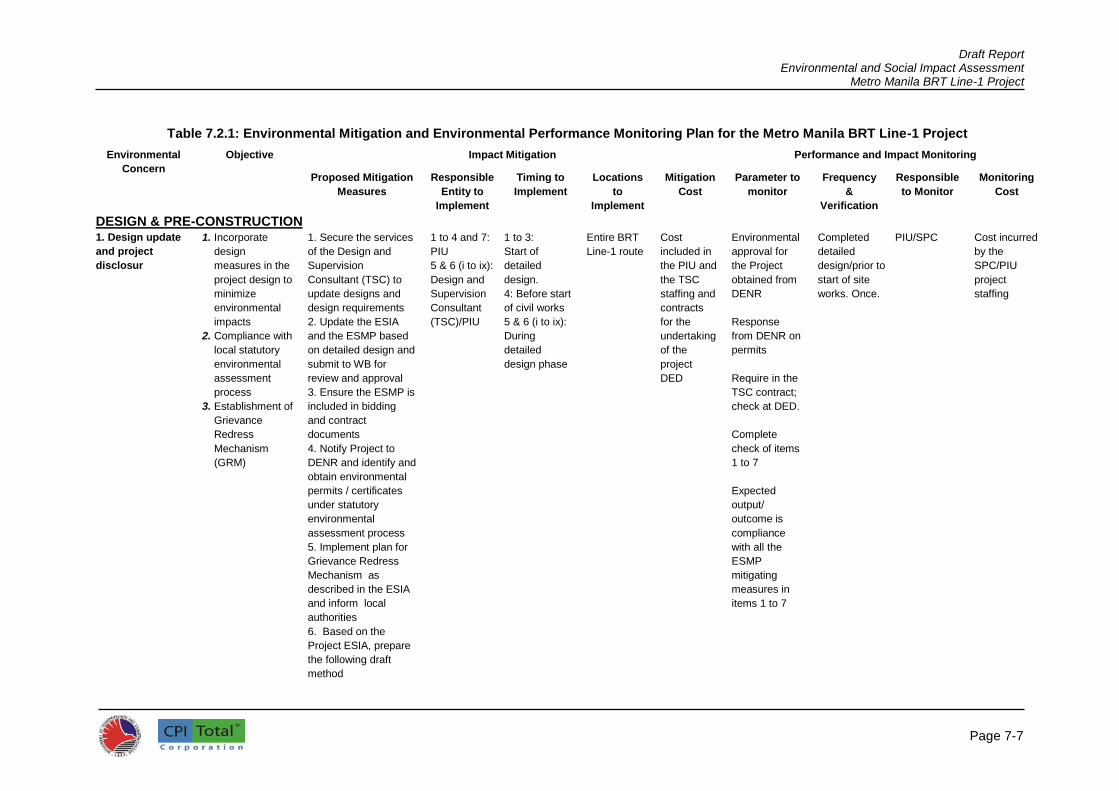
Draft Report Environmental and Social Impact Assessment
Metro Manila BRT Line-1 Project
Page 7-7
Table 7.2.1: Environmental Mitigation and Environmental Performance Monitoring Plan for the Metro Manila BRT Line-1 Project
Environmental
Concern
Objective Impact Mitigation Performance and Impact Monitoring
Proposed Mitigation
Measures
Responsible
Entity to
Implement
Timing to
Implement
Locations
to
Implement
Mitigation
Cost
Parameter to
monitor
Frequency
&
Verification
Responsible
to Monitor
Monitoring
Cost
DESIGN & PRE-CONSTRUCTION 1. Design update
and project
disclosur
1. Incorporate
design
measures in the
project design to
minimize
environmental
impacts
2. Compliance with
local statutory
environmental
assessment
process
3. Establishment of
Grievance
Redress
Mechanism
(GRM)
1. Secure the services
of the Design and
Supervision
Consultant (TSC) to
update designs and
design requirements
2. Update the ESIA
and the ESMP based
on detailed design and
submit to WB for
review and approval
3. Ensure the ESMP is
included in bidding
and contract
documents
4. Notify Project to
DENR and identify and
obtain environmental
permits / certificates
under statutory
environmental
assessment process
5. Implement plan for
Grievance Redress
Mechanism as
described in the ESIA
and inform local
authorities
6. Based on the
Project ESIA, prepare
the following draft
method
1 to 4 and 7:
PIU
5 & 6 (i to ix):
Design and
Supervision
Consultant
(TSC)/PIU
1 to 3:
Start of
detailed
design.
4: Before start
of civil works
5 & 6 (i to ix):
During
detailed
design phase
Entire BRT
Line-1 route
Cost
included in
the PIU and
the TSC
staffing and
contracts
for the
undertaking
of the
project
DED
Environmental
approval for
the Project
obtained from
DENR
Response
from DENR on
permits
Require in the
TSC contract;
check at DED.
Complete
check of items
1 to 7
Expected
output/
outcome is
compliance
with all the
ESMP
mitigating
measures in
items 1 to 7
Completed
detailed
design/prior to
start of site
works. Once.
PIU/SPC Cost incurred
by the
SPC/PIU
project
staffing

Draft Report Environmental and Social Impact Assessment
Metro Manila BRT Line-1 Project
Page 7-8
statements/site-
specific ESMPs for
updating by the
contractor before
construction
commences: Waste
Management and
Spoil Disposal Plan,
Materials Management
Plan, Drainage
Management Plan,
Runoff Control Plan,
Tree-cutting and
Replanting Plan,
Traffic Management
Plan, Utilities
Reprovision Plan,
Noise and Dust
Control Plan, and
Workers and Public
Safety Plan. These
ESMPs will
demonstrate the
manner (location,
responsibilities,
schedule/timeframe,
budget, etc.) in which
the contractor will
implement the
mitigation measures
specified in the Project
ESMP, and other
measures identified
during detailed design.
Further details that
should be included in
the above ESMPs are
provided in the
subsequent sections
of this table and in
Chapter 5 of the ESIA.
7. Incorporate/
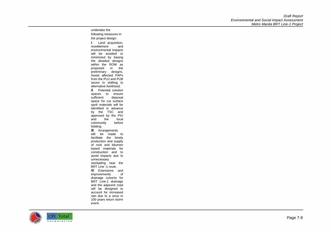
Draft Report Environmental and Social Impact Assessment
Metro Manila BRT Line-1 Project
Page 7-9
undertake the
following measures in
the project design:
I. Land acquisition, resettlement and environmental impacts will be avoided or minimized by basing the detailed designs within the ROW as proposed in the preliminary designs. Assist affected PAPs from the PUJ and PUB sector in shifting to alternative livelihood;
II. Potential solution spaces to ensure sufficient disposal space for cut surface spoil materials will be identified in advance by the TSC and approved by the PIU and the local community before bidding.
III. Arrangements will be made to facilitate the timely production and supply of rock and bitumen based materials for construction and to avoid impacts due to unnecessary stockpiling near the BRT Line -1 route.
IV. Extensions and improvements of drainage culverts for BRT Line-1 drainage and the adjacent road will be designed to account for increased rain due to a once in 100 years return storm event.

Draft Report Environmental and Social Impact Assessment
Metro Manila BRT Line-1 Project
Page 7-10
V. Hydrological and drainage impacts during construction will be minimized by including in the detailed design the early phasing of replacement of side drains, culverts, and other infrastructure.
VI. Disruption to current facilities for water supply will be avoided and facilities will be retained or re-provisioned before construction works commence; provisions will be made to preserve the operation of current facilities for water supply in sufficient quantity in agreement with the local community.
VII. Disruption to current power supply will be avoided and movement of power lines will be planned well in advance. Power distribution circuitry will be re-provisioned before construction works commence; provisions will be made to preserve the operation of current facilities for power supply in sufficient quantity in agreement with the local power supply company.
VIII. Disruption to telecommunications will be avoided and movement of

Draft Report Environmental and Social Impact Assessment
Metro Manila BRT Line-1 Project
Page 7-11
telecommunication lines will be planned well in advance. Telecommunications lines will be re-provisioned before construction works commence; provisions will be made to preserve the operation of current facilities for telecommunications in sufficient quantity in agreement with the local power supply company.
IX. Plans to minimize disturbance of vehicular traffic and pedestrians during construction will be included in the detailed designs. Plans will be discussed and agreed with police authorities and other local authorities along the project corridor. Phasing and programming for construction will retain passing lanes along the road during construction and avoid community severance.
X. Aim to provide enhancements under WB policy on environmentally responsible procurement and avoid negative impacts due to unnecessary removal of trees. Include compensatory tree planting as requested by the

Draft Report Environmental and Social Impact Assessment
Metro Manila BRT Line-1 Project
Page 7-12
Commissioner of Forests.
XI. Include vendor spaces within station designs as source of livelihood for economically displaced PAPs
2. Project
boundaries/
location change
The ESMP can
avoid or minimize
impacts and
compliance
required for
environmental
laws.
1. Design BRT Line -1
and road upgrading
works within ROW, to
avoid schools,
hospitals, and other
sensitive receptors
2. Make the detailed design of alignment to minimize loss of trees and other vegetation 4. Detailed designs to provide for enhancement (e.g., landscaping, tree replanting) where practicable 5. Make plans for tree replacement in coordination with local authorities such as the DENR-Forest Management Bureau 6. Update the ESMP
should there be
additional
environmental impacts
identified during
detailed design and for
which appropriate
mitigation measures
have not been
included in the ESMP.
Submit updated ESMP
to WB for review
before start of civil
works.
7. Prepare a new or
SPC/ EPC/
TSC
Detailed
design
Entire BRT Line-1 route
Included in
the
SPC/EPC/
TSC cost
Require in
TSC contract.
Check at
Detailed
design.
Complete
check of items
1 to 7 on
detailed
design.
Expected
output/
outcome is
compliance
with all the
ESMP
mitigating
measures in
items 1 to 7
Once, during
detailed
design
SPC/BRT-
NPMO/PIU
Cost met by
the SPC/
BRT-NPMO/
PIU project
staffing

Draft Report Environmental and Social Impact Assessment
Metro Manila BRT Line-1 Project
Page 7-13
supplementary
environmental
assessment report in
compliance with the
WB’s WB
Environmental Policy
4.01 if there are any
additional components
or modifications in the
Project such as
change in specific
location/alignment,
among others, that will
result to adverse
environmental impacts
and are not within the
scope of the
environmental
assessment report
prepared during loan
processing. Submit the
report to WB for
review before start of
related civil works.
3. Environmental
capacity
development
Develop
environmental
management
capacity of the
NPMO/PIU to
ensure proper
ESMP
implementation
and promote
environmental
awareness among
workers
1. PIU to commit and retain dedicated environmental, safety, and social safeguard officers staff for project duration to oversee ESMP implementation 2. TSC to train the NPMO/PIU to build their capacity on ESMP implementation, monitoring and reporting using workshops and on-the-job training techniques and case studies 3. Conduct workers’ orientation on ESMP provisions. Such orientation shall be periodically conducted
1: SPC/ PIU /
TSC
Initiate during
detailed
design phase
and continue
throughout
project
construction
Key stakeholders throughout the BRT corridor (DOTr BRT-NPMO/PIU, LGUs, GRC, etc.)
Cost
included in
SPC and
TSC cost
Require in
TSC contract.
Check at DD.
Complete
training and
check before
and during
construction.
Complete
check of items
1 to 3
Expected
output/
outcome is
compliance
Prior to start
of site works
and
throughout
the
construction
phase
SPC/PIU Cost met by
the SPC/PIU
project
staffing

Draft Report Environmental and Social Impact Assessment
Metro Manila BRT Line-1 Project
Page 7-14
by the TSC as every new contractor is engaged.
with all the
ESMP
mitigating
measures in
items 1 to 3
4a.Traffic
Management Plan
Minimize traffic
disruption and
congestion
1. Contact all relevant
local authorities
(MMDA and
concerned LGUs) to
implement the
Traffic Management
Plan (TMP) during
construction (to be
updated later by the
contractor) to minimize
disturbance of
vehicular traffic and
pedestrians during
construction. Access
arrangements for
vehicles accessing the
Project area will be
formulated such that
this will avoid
community
disturbance and
severance and will at
least retain a passing
lane along all roads
used during
construction. The plan
will include
consideration of the
following:
i) Lane availability and
minimizing
interference with traffic
flows past the works
site
ii) Establishment of
acceptable working
hours and constraints
TSC Detailed
design phase
(before
bidding)
Throughout
the BRT
corridor and
immediate
adjacent
areas
Cost
included in
design
fees
Require in
TSC contract.
Check at DD
Complete
check of items
1 and 2
Expected
output/
outcome is
compliance
with all the
ESMP
mitigating
measures in
items 1 and 2
Once, during
the detailed
design
phase
SPC/PIU Cost met by
the SPC/PIU
project
staffing

Draft Report Environmental and Social Impact Assessment
Metro Manila BRT Line-1 Project
Page 7-15
iii) Agreement on time
scale and
establishment of traffic
flow/delay
requirements
iv) Programming
issues including the
time of year and
available resources
v) Discussion of the
TSC/PIU
inspection/monitoring
role
vi) Establishment of a
complaints
management system
for the duration of the
works
vii) Agreement on
publicity/public
consultation
requirements
(advance signing etc.)
4b. Protect and
reprovision power
utilities and
telecommunicatio
ns
Minimize
interruption to
power and water
supply and
telecommunicatio
ns
1. Identify all power
and water supply,
telecommunications
systems likely to be
interrupted by the
works
2. Contact all relevant
local authorities for
utilities and local
district groups to plan
reprovisioning of
power and water
supply and
telecommunications
3. Prepare a draft
Utilities Reprovisioning
Plan (to be updated
later with contractor) to
minimize interruption
TSC Detailed
design phase
(before
bidding)
Throughout
the BRT
corridor
Cost
included in
design
fees.
Require in
TSC contract.
Check at DD
Complete
check of items
1 to 3
Expected
output/
outcome is
compliance
with all the
ESMP
mitigating
measures in
items 1 to 3
Once, during
the detailed
design
phase
SPC/PIU Cost met by
the SPC/PIU
project
staffing

Draft Report Environmental and Social Impact Assessment
Metro Manila BRT Line-1 Project
Page 7-16
to power and water
supply and
telecommunications
4c. Plan Waste
and Spoil Disposal
Minimize waste;
avoid pollution
1. Re-use of waste
materials & spoil
disposal locations
included in bid and
contract documents
2. Prepare a draft
Waste Management
Plan and Spoil
Disposal Plan (to be
updated by the
contractor later). The
plan shall cover
handling, storage,
treatment, transport,
and disposal of solid
and liquid wastes,
hazardous materials,
hazardous wastes,
and excavation spoils.
3. The General Waste
section of the draft
Waste Management
Plan and Spoil
Disposal Plan will
include consideration
of all matters related to
solid and liquid waste
disposal including the
following:
i) Expected types of
waste and quantities
of waste arising
ii) Waste reduction,
reuse, and recycling
methods to be
employed
iii) Agreed reuse and
recycling options and
locations for
TSC Detailed
design phase
(before
bidding)
Throughout
the BRT
Corridor and
nearby areas
Cost
included in
design
fees
Require in
TSC contract.
Check at DD
Complete
check of items
1 to 5
Expected
output/
outcome is
compliance
with all the
ESMP
mitigating
measures in
items 1 to 5
Once, during
the detailed
design
phase
SPO/PIU Cost met by
the SPC/PIU
project
staffing

Draft Report Environmental and Social Impact Assessment
Metro Manila BRT Line-1 Project
Page 7-17
disposal/endorsement
from DENR and local
groups
iv) Methods for
treatment and disposal
of all solid and liquid
wastes
v) Methods of
transportation to
minimize interference
with normal traffic
vi) Establishment of
regular disposal
schedule and
constraints for
hazardous waste
vii) Program for
disposal of general
waste / chain of
custody for hazardous
waste
viii) Discussion of the
PIU/TSC
inspection/monitoring
role
ix) Establishment of a
complaints
management system
for the duration of the
works
x) Agreement on
publicity/public
consultation
requirements
(advance signing etc.)
4. The draft Waste
Management Plan and
Spoil Disposal Plan
shall include a section
on Hazardous
Materials and Waste
section. This will detail

Draft Report Environmental and Social Impact Assessment
Metro Manila BRT Line-1 Project
Page 7-18
the mitigation
measures,
organizational
arrangements,
resources, facilities,
etc. to avoid
environmental as well
as health and safety
impacts due to use
and disposal of
hazardous
materials/substances.
5. The Spoil Disposal
section of the Waste
Management Plan and
Spoil Disposal Plan
will include
consideration of the
following:
i) Locations and
quantities of spoil
arising from the
construction works
ii) Agreed locations for
disposal/endorsement
from DENR and local
groups
iii) Methods of
transportation to
minimize interference
with normal traffic
iv) Establishment of
acceptable working
hours and constraints
v) Agreement on time
scale and program for
disposal and chain of
custody
vi) Programming
issues including the
time of year and
available resources

Draft Report Environmental and Social Impact Assessment
Metro Manila BRT Line-1 Project
Page 7-19
vii) Discussion of the
PIU/TSC
inspection/monitoring
role
viii) Establishment of a
complaints
management system
for the duration of the
works
ix) Agreement on
publicity/public
consultation
requirements
(advance signing etc.)
4d. Plan
construction
materials
management
Avoid stockpiling
of rock based
materials and
runoff
1. Designs to balance
cut and fill where
possible
2. Prepare a draft
Materials Management
Plan (to be updated by
contractor later). The
plan shall detail the
arrangements to be
made to facilitate the
timely production and
supply of construction
materials to avoid
impacts due to
unnecessary
stockpiling outside the
Project site. As a
minimum, the plan
shall consider the
following:
(i) Required materials,
potential sources and
estimated quantities
available
(ii) Impacts to
identified sources and
availability
(iii) Excavated slope
TSC Detailed
design phase
(before
bidding)
Throughout
the BRT
corridor
Cost
included in
design
fees
Require in
TSC contract.
Check at DD
Complete
check of items
1 to 3
Expected
output/
outcome is
compliance
with all the
ESMP
mitigating
measures in
items 1 to 3
Once, during
the detailed
design
phase
SPC/PIU Cost met by
the SPC/PIU
project
staffing

Draft Report Environmental and Social Impact Assessment
Metro Manila BRT Line-1 Project
Page 7-20
material for reuse and
recycling methods to
be employed
(iv) Endorsement from
DENR and local
groups for use of
sources
(v) Methods of
transportation to
minimize interference
with normal traffic
(vi) Constraints of
regular delivery
schedule to reduce
stockpiling on site
(vii) Program for reuse
of slope excavated
material for reuse
(viii) Program for
delivery of quarry and
borrow materials
(ix) Discussion of the
PIU/TSC
inspection/monitoring
role
(x) Agreement on
publicity/public
consultation
requirements
3. Prepare a draft
mass haul chart for the
aggregate and asphalt
materials needed for
the construction works
4e Drainage and
Hydrological
Impacts
To minimize
hydrological
impacts flooding
and runoff of river
banks
1. Design culverts
sufficient to control
flooding with
appropriate drainage
structures to cater for
worst-case flow and
rainfall from 100-year
return storm and to
TSC Detailed
design phase
(before
bidding)
Throughout
the BRT
corridor and
immediate
adjacent
areas
Cost
included in
design fees
Require in
TSC contract.
Check at DD.
Complete
check of items
1 to 4
Once, during
the detailed
design
phase
SPC/PIU Cost met by
the SPC/PIU
project
staffing
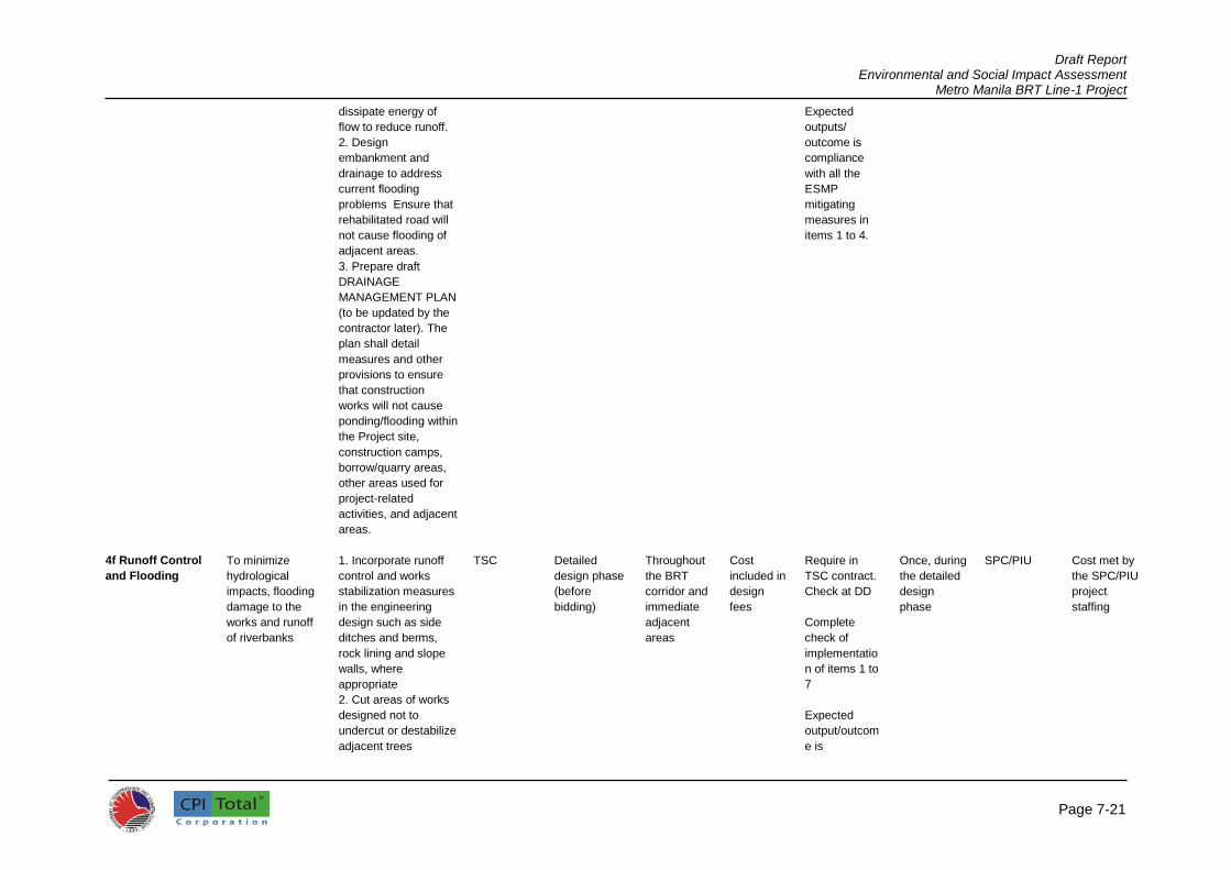
Draft Report Environmental and Social Impact Assessment
Metro Manila BRT Line-1 Project
Page 7-21
dissipate energy of
flow to reduce runoff.
2. Design
embankment and
drainage to address
current flooding
problems Ensure that
rehabilitated road will
not cause flooding of
adjacent areas.
3. Prepare draft
DRAINAGE
MANAGEMENT PLAN
(to be updated by the
contractor later). The
plan shall detail
measures and other
provisions to ensure
that construction
works will not cause
ponding/flooding within
the Project site,
construction camps,
borrow/quarry areas,
other areas used for
project-related
activities, and adjacent
areas.
Expected
outputs/
outcome is
compliance
with all the
ESMP
mitigating
measures in
items 1 to 4.
4f Runoff Control
and Flooding
To minimize
hydrological
impacts, flooding
damage to the
works and runoff
of riverbanks
1. Incorporate runoff
control and works
stabilization measures
in the engineering
design such as side
ditches and berms,
rock lining and slope
walls, where
appropriate
2. Cut areas of works
designed not to
undercut or destabilize
adjacent trees
TSC Detailed
design phase
(before
bidding)
Throughout
the BRT
corridor and
immediate
adjacent
areas
Cost
included in
design
fees
Require in
TSC contract.
Check at DD
Complete
check of
implementatio
n of items 1 to
7
Expected
output/outcom
e is
Once, during
the detailed
design
phase
SPC/PIU Cost met by
the SPC/PIU
project
staffing
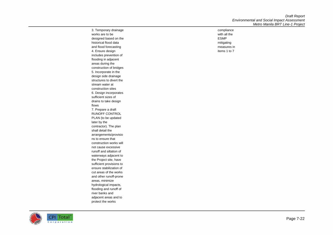
Draft Report Environmental and Social Impact Assessment
Metro Manila BRT Line-1 Project
Page 7-22
3. Temporary drainage
works are to be
designed based on the
historical flood data
and flood forecasting
4. Ensure design
includes prevention of
flooding in adjacent
areas during the
construction of bridges
5. Incorporate in the
design side drainage
structures to divert the
stream water at
construction sites
6. Design incorporates
sufficient sizes of
drains to take design
flows
7. Prepare a draft
RUNOFF CONTROL
PLAN (to be updated
later by the
contractor). The plan
shall detail the
arrangements/provisio
ns to ensure that
construction works will
not cause excessive
runoff and siltation of
waterways adjacent to
the Project site, have
sufficient provisions to
ensure stabilization of
cut areas of the works
and other runoff-prone
areas, minimize
hydrological impacts,
flooding and runoff of
river banks and
adjacent areas and to
protect the works
compliance
with all the
ESMP
mitigating
measures in
items 1 to 7

Draft Report Environmental and Social Impact Assessment
Metro Manila BRT Line-1 Project
Page 7-23
under construction.
The plan will consider
the following:
i) Climate and rainfall
for the area and
checking weather
forecasts
ii) Terrain and typical
locations susceptible
to runoff and runoff
iii) Protection of the
works and potential
impacts to the
environment
iv) Runoff control
methods to be
employed, locations,
and installation timing
v) Limits to stockpiling
on sites near
waterways
vi) Discussion of the
TSC/PIU
inspection/monitoring
role
vii) Agreement on
publicity/public
consultation
requirements
4g. Tree cutting Minimize tree
cutting
1. Contact Forest
Management Bureau,
concerned LGUs and
interested groups (for
instance NGO) to plan
tree cutting and
replanting
2. Prepare a draft Tree
Cutting and Replanting
Plan (to be updated
later by the contractor)
to avoid indiscriminate
tree cutting. The plan
TSC Detailed
design phase
(before
bidding)
Throughout
the BRT
corridor and
immediate
adjacent
area
Cost
included in
Contractor’
s fees
Require in
TSC contract.
Check at DD
Complete
check of items
1 and 2
Expected
output/
outcome is
compliance
with all the
Once, during
the detailed
design
phase
SPC/PIU Cost met by
the SPC/PIU
project
staffing

Draft Report Environmental and Social Impact Assessment
Metro Manila BRT Line-1 Project
Page 7-24
shall clearly define
areas where tree
removal is necessary
based on Project
requirements and shall
have provisions for
replanting to
compensate for lost
trees. The plan shall
prohibit introduction of
invasive species and
shall specify that new
alien plant species
(i.e., species not
currently established
in the City) shall not be
used unless carried
out within the existing
regulatory framework
for such introduction.
ESMP
mitigating
measures in
items 1 and 2
4h. Noise and dust
management
Minimize noise
and dust
1. Reconfirm all noise
and dust sensitive
receivers likely to be
affected by
construction works
2. Contact local district
groups to plan
mitigation in advance
3. Prepare a draft
Noise and Dust
Control Plan (to be
updated later by
contractor) to minimize
impacts to sensitive
receptors (residential
areas, schools,
temples, hospitals,
etc.) due to
construction works,
sourcing and transport
of construction
materials, and other
TSC Detailed
design phase
(before
bidding)
Throughout
the BRT
corridor and
immediate
adjacent
areas
Cost
included in
Contractor’
s fees
Require in
TSC contract.
Check at DD
Complete
check of
contractor’s
implementatio
n of items 1 to
3
Expected
output/
outcome is
compliance
with all the
ESMP
mitigating
measures in
items 1 to 3
Once, during
the detailed
design
phase
SPC/PIU Cost met by
the SPC/PIU
project
staffing
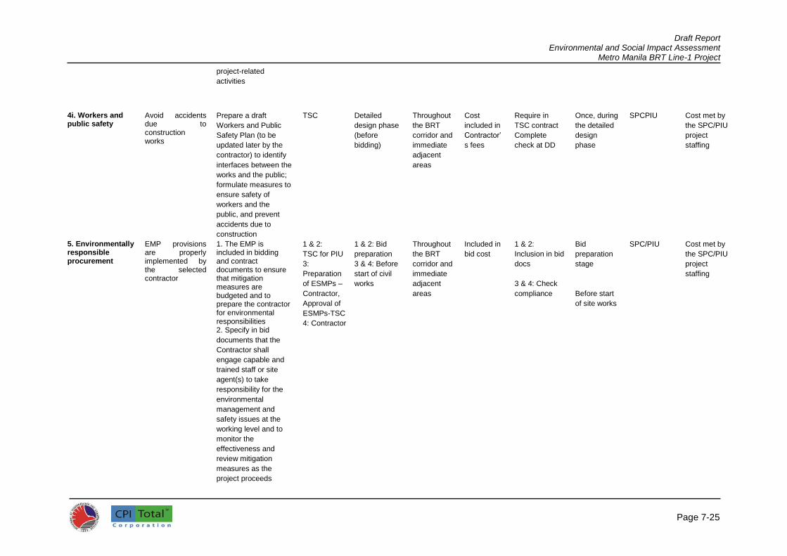
Draft Report Environmental and Social Impact Assessment
Metro Manila BRT Line-1 Project
Page 7-25
project-related
activities
4i. Workers and public safety
Avoid accidents due to construction works
Prepare a draft
Workers and Public
Safety Plan (to be
updated later by the
contractor) to identify
interfaces between the
works and the public;
formulate measures to
ensure safety of
workers and the
public, and prevent
accidents due to
construction
TSC Detailed
design phase
(before
bidding)
Throughout
the BRT
corridor and
immediate
adjacent
areas
Cost
included in
Contractor’
s fees
Require in
TSC contract
Complete
check at DD
Once, during
the detailed
design
phase
SPCPIU Cost met by
the SPC/PIU
project
staffing
5. Environmentally responsible procurement
EMP provisions are properly implemented by the selected contractor
1. The EMP is included in bidding and contract documents to ensure that mitigation measures are budgeted and to prepare the contractor for environmental responsibilities 2. Specify in bid
documents that the
Contractor shall
engage capable and
trained staff or site
agent(s) to take
responsibility for the
environmental
management and
safety issues at the
working level and to
monitor the
effectiveness and
review mitigation
measures as the
project proceeds
1 & 2:
TSC for PIU
3:
Preparation
of ESMPs –
Contractor,
Approval of
ESMPs-TSC
4: Contractor
1 & 2: Bid
preparation
3 & 4: Before
start of civil
works
Throughout
the BRT
corridor and
immediate
adjacent
areas
Included in
bid cost
1 & 2:
Inclusion in bid
docs
3 & 4: Check
compliance
Bid
preparation
stage
Before start
of site works
SPC/PIU Cost met by
the SPC/PIU
project
staffing

Draft Report Environmental and Social Impact Assessment
Metro Manila BRT Line-1 Project
Page 7-26
3. Contractors
(assisted by the TSC)
submit updated
specific environmental
management plans or
ESMPs for approval
by the TSC (i.e.,
management plans
such as Runoff Control
Plan, Noise and Dust
Control Plan, etc.)
4. Contractors recruit
qualified staff to
oversee
implementation of
environmental and
safety measures
specified in the EMP
6. Coordinating
Utility
Management Plan
Utilities & telecoms remain in service during construction; Only minor / unavoidable interruptions to utilities & telecoms
1. Set up a Coordinating Committee early in the detailed design stage 2. Identify all potential hindrances to construction in the field 3. Identify foreseeable constraints and lead time 4. Establish preparedness of the utilities to facilitate reprovisioning 5. Facilitate Utilities and Telecoms Reprovisioning Plan (URP) 6. Include the URP (as part of the EMP) in the bidding documents 7. Coordinating committee Chairmanship of DOTr/SPC with PIU as secretary 8. Monthly meetings
1 to 10:
SPC/PIU
11 & 12:
TSC
11:
Contractor
1 to 10:
During the
detailed
design and
bid
preparation
11& 12 Before
start of civil
works and
periodically
during
construction
Throughout
the BRT
corridor and
immediate
adjacent
areas
Included in
SPC and
TSC costs
1 to 10:
Inclusion UMP
in EMP in bid
docs
11 & 12
Security of
utilities and
telecoms
connections
Bid
preparation
stage
Before start
of and
throughout
site works
SPC/PIU Cost met by
the SPC/PIU
project
staffing

Draft Report Environmental and Social Impact Assessment
Metro Manila BRT Line-1 Project
Page 7-27
for first six months of design 9. Membership Implementing agency (SPC, TSC), all utilities, police, and local authorities as necessary. 10. Additional coordinating committee meetings in construction phase if problems occur 11. Contractors inducted construction gears up through awareness workshops conducted periodically by the TSC 12. The TSC shall share their experience in the implementation of the works in case unexpected difficulties occur
7. Ambient air,
water quality, and
noise monitoring
Establish baseline air, water, and sediment quality and noise levels to help in assessing project impacts during implementation.
1. Collect baseline
data on air quality at
three locations along
the alignment in the
calendar month before
construction
commences
2. Collect baseline
data on noise at six
locations along the
alignment in the
calendar month before
construction
commences
3. Collect baseline
water quality at the
sections where the
rivers of Tullahan, San
Juan and Pasig cross
the BRT Line-1
1 to 3:
TSC
4. TSC
notifies
DENR
To be
completed no
later than the
calendar
month before
construction
commences
1. For air
quality and
noise, ten
(10)
throughout
the BRT
corridor
2. For water
quality, two
(2) locations
50m up and
downstream
of the rivers
Included in
TSC costs
1. Total
suspended
particulates
(TSP), PM2.5,
NOx and SOx
2. Noise levels
Leq15mins
dB(A)
3. pH,
temperature,
turbidity,
dissolved
oxygen (DO),
oil and grease,
and total
suspended
solids (TSS)
To be
completed
no later than
the calendar
month before
construction
commences
SPC/PIU Cost met by
the SPC/PIU
project
staffing

Draft Report Environmental and Social Impact Assessment
Metro Manila BRT Line-1 Project
Page 7-28
Alignment before
construction
commences
CONSTRUCTION STAGE 1. Activate
management
plans and secure
permits/licenses
Avoid impacts
from unplanned
activities
1. Update and activate
ESMP for waste and
spoil disposal,
materials
management,
drainage, runoff
control, tree-cutting
and replanting, traffic
and utilities
management, noise
and dust control, and
workers and public
safety
2. Contractor(s) and
their suppliers comply
with all statutory
requirements for
permits from DENR
with regard to the use
of mechanical
equipment and the
establishment and
operation of
construction plants
such as concrete
batching plant, rock
crusher, spoils
disposal, etc.
1: Contractor
to prepare
updated
ESMPs, TSC
to assist and
approve
2: Contractor
1. One month
before start of
site works
2. Before start
of site works
Cost
included in
contractors
fees
1. Complete
check and
approve before
construction
2. Complete
check of all
necessary
environmental
approvals/per-
mits
Before start
of site works
TSC &
SPC/PIU
Cost met by
the TSC &
SPC/PIU
project
staffing
2. Orientation for
Contractor,
Workers on
environmental and
social
management
Contractor &
workers trained to
implement
mitigation
measures and
better
implementation of
the EMP
1. Contractors clearly
separate resources
applied to mitigation
measures. Tenders
identify named staff to
supervise
management’s plans.
2. TSC shall conduct
training/orientation
1: Contractor
2: TSC
3: Contractor
1: Before start
of site works
2: Within one
month of start
of site works
3. Upon
deployment of
workers to
project site
Project site Cost
included in
contracts
for TSC
and
Contractor
Complete
check of
implementatio
n of items 1 to
3
Expected
output/outcom
e is
1: Before
start of site
works
2: Within one
month of
start of
construction
3: Monthly
during
TSC &
SPC/EPIU
Cost met by
the TSC &
SPC/PIU
project
staffing
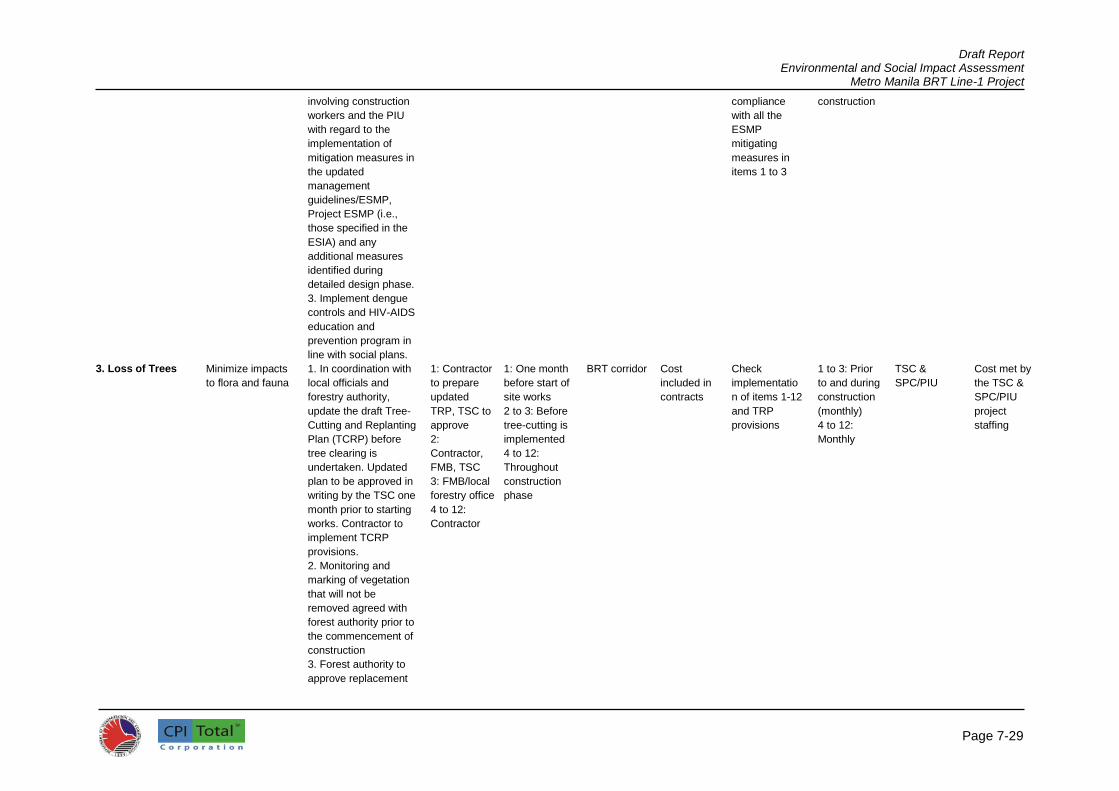
Draft Report Environmental and Social Impact Assessment
Metro Manila BRT Line-1 Project
Page 7-29
involving construction
workers and the PIU
with regard to the
implementation of
mitigation measures in
the updated
management
guidelines/ESMP,
Project ESMP (i.e.,
those specified in the
ESIA) and any
additional measures
identified during
detailed design phase.
3. Implement dengue
controls and HIV-AIDS
education and
prevention program in
line with social plans.
compliance
with all the
ESMP
mitigating
measures in
items 1 to 3
construction
3. Loss of Trees Minimize impacts
to flora and fauna
1. In coordination with
local officials and
forestry authority,
update the draft Tree-
Cutting and Replanting
Plan (TCRP) before
tree clearing is
undertaken. Updated
plan to be approved in
writing by the TSC one
month prior to starting
works. Contractor to
implement TCRP
provisions.
2. Monitoring and
marking of vegetation
that will not be
removed agreed with
forest authority prior to
the commencement of
construction
3. Forest authority to
approve replacement
1: Contractor
to prepare
updated
TRP, TSC to
approve
2:
Contractor,
FMB, TSC
3: FMB/local
forestry office
4 to 12:
Contractor
1: One month
before start of
site works
2 to 3: Before
tree-cutting is
implemented
4 to 12:
Throughout
construction
phase
BRT corridor Cost
included in
contracts
Check
implementatio
n of items 1-12
and TRP
provisions
1 to 3: Prior
to and during
construction
(monthly)
4 to 12:
Monthly
TSC &
SPC/PIU
Cost met by
the TSC &
SPC/PIU
project
staffing

Draft Report Environmental and Social Impact Assessment
Metro Manila BRT Line-1 Project
Page 7-30
of cut trees to be
undertaken based on
the tree cutting and
replanting plan
4. Clearing of trees
minimized based on
Tree-cutting and
Replanting Plan
5. Prohibit cutting of
trees for firewood and
for use in Project
6. During replanting
works, new alien plant
species (i.e., species
not currently
established in the City)
shall not be used
unless carried out with
the existing regulatory
framework for such
introduction. Invasive
species shall not be
introduced into new
environments.
7. As much as
possible, civil works
will be scheduled
during the dry season
to minimize adverse
impacts to river water
quality and other
aquatic resources.
8. The contractor will
not use or permit the
use of wood as a fuel
for the execution of
any part of the Works,
including but not
limited to the heating
of bitumen and
bitumen mixtures, and
to the extent

Draft Report Environmental and Social Impact Assessment
Metro Manila BRT Line-1 Project
Page 7-31
practicable shall
ensure that fuels other
than wood are used
for cooking and water
heating in all his
camps and living
accommodations
10. The contractor
shall not buy or use
wood from the illegal
sources (that come
from the illegal
logging)
11. The contractor will
take all precautions
necessary to ensure
that damage to
vegetation is avoided
due to fires resulting
from execution of the
works. The Contractor
will immediately
suppress the fire, if it
occurs, and shall
undertake replanting
to replace damaged
vegetation.
4. Drainage and
Hydrological
Impacts
To minimize
hydrological
impacts flooding
and runoff of
riverbanks
1. Review detailed
designs for cross-
drainage and side-
drainage structures,
assess and agree with
the PIU/TSC if a
redesign is required or
if new structures would
be constructed or
existing ones would be
repaired
2. Before the start of
site works, update the
draft Drainage
Management
1: Contractor
2: Contractor
to update
DMP, TSC to
assist and
approve
3 to 8:
Contractor
1 & 2: One
month before
start of site
works
3 to 8:
Throughout
construction
phase
Throughout
the project
site and all
areas
considered
prone to
flooding
Cost
included in
design
Check
implementatio
n of items 1-8
and DMP
provisions
1 & 2: Before
start of site
works
3 to 8:
Monthly
Implementati
on of DMP
provisions:
Monthly
TSC,
SPC/PIU
Cost met by
the TSC,
SPC/PIU
project
staffing

Draft Report Environmental and Social Impact Assessment
Metro Manila BRT Line-1 Project
Page 7-32
Guidelines prepared
by the TSC during the
detailed design phase.
Updated plan to be
approved in writing by
the TSC one month
prior to the start of site
works. Contractor to
implement provisions
of DMP.
3. Implement agreed
design of culverts
sufficient to control
flooding and to
dissipate energy of
flow to reduce runoff
4 Protect lead off
streams that may
become silted by
construction runoff,
workshops, or
equipment washing-
yards
5. Minimize alterations
in the project corridor’s
surface drainage
patterns as much as
possible
6. Drains to be
constructed so that the
outfalls of the surface
run-off from the
carriageway are
diverted away from the
sensitive receivers
7 Ensure that storm
drains and highway
drainage systems are
periodically cleared to
maintain storm water
flow during
construction

Draft Report Environmental and Social Impact Assessment
Metro Manila BRT Line-1 Project
Page 7-33
5. Utilities Prevent
interruption of
services such as
electricity and
water during
relocation of the
utilities
line/connections;
Repair damaged
access roads
1. Before start of site
works, update draft
Utility Management
Plan (UMP) prepared
by the TSC during the
detailed design phase.
Updated plan to be
approved in writing by
the TSC one month
prior to the start of site
works. Contractor to
implement URP
provisions.
2. Reconfirm power,
water supply, and
telecommunications
systems likely to be
interrupted by the
works
3. Contact all relevant
local authorities for
utilities and local
village groups to plan
reprovisioning of
power, water supply,
and
telecommunications
systems.
4. Utilities shall be
relocated and
reconnected well
ahead of the
commencement of
construction works
and the contractor
shall coordinate with
utility companies for
relocation and
reconnection well
before works
commence
5. Affected
1: Contractor
to update
UMP, TSC to
assist and
approve
2 to 8:
Contractor
1: One month
before start of
site works
2 to 6: Before
start of
construction
7 & 8: During
construction
Throughout
the project
site
Cost
included in
contracts
Check
implementatio
n of items 1-8
and UMP
provisions
1 to 6:
Before
construction
7 & 8:
Monthly
TSC,
SPC/PIU
Cost met by
the TSC and
SPC/PIU
project
staffing
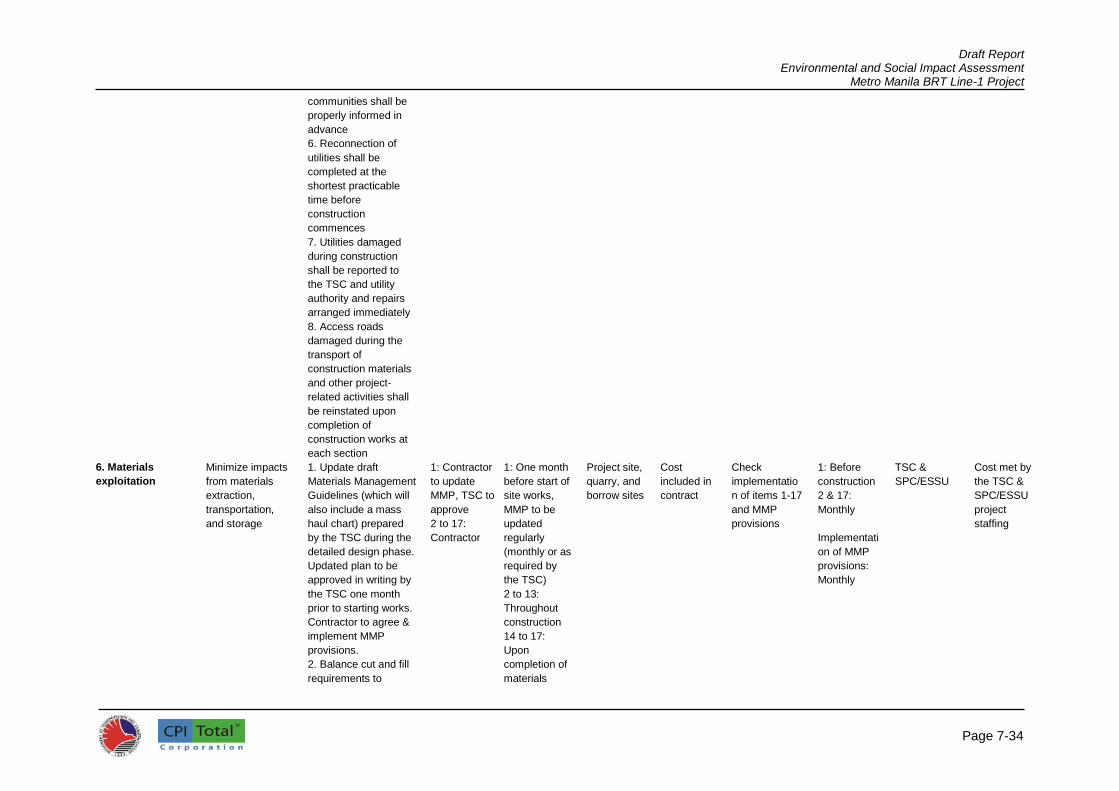
Draft Report Environmental and Social Impact Assessment
Metro Manila BRT Line-1 Project
Page 7-34
communities shall be
properly informed in
advance
6. Reconnection of
utilities shall be
completed at the
shortest practicable
time before
construction
commences
7. Utilities damaged
during construction
shall be reported to
the TSC and utility
authority and repairs
arranged immediately
8. Access roads
damaged during the
transport of
construction materials
and other project-
related activities shall
be reinstated upon
completion of
construction works at
each section
6. Materials
exploitation
Minimize impacts
from materials
extraction,
transportation,
and storage
1. Update draft
Materials Management
Guidelines (which will
also include a mass
haul chart) prepared
by the TSC during the
detailed design phase.
Updated plan to be
approved in writing by
the TSC one month
prior to starting works.
Contractor to agree &
implement MMP
provisions.
2. Balance cut and fill
requirements to
1: Contractor
to update
MMP, TSC to
approve
2 to 17:
Contractor
1: One month
before start of
site works,
MMP to be
updated
regularly
(monthly or as
required by
the TSC)
2 to 13:
Throughout
construction
14 to 17:
Upon
completion of
materials
Project site,
quarry, and
borrow sites
Cost
included in
contract
Check
implementatio
n of items 1-17
and MMP
provisions
1: Before
construction
2 & 17:
Monthly
Implementati
on of MMP
provisions:
Monthly
TSC &
SPC/ESSU
Cost met by
the TSC &
SPC/ESSU
project
staffing
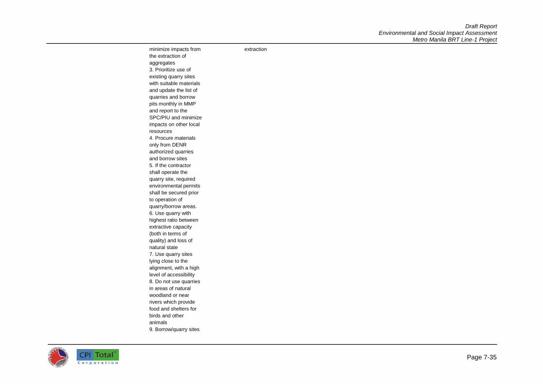
Draft Report Environmental and Social Impact Assessment
Metro Manila BRT Line-1 Project
Page 7-35
minimize impacts from
the extraction of
aggregates
3. Prioritize use of
existing quarry sites
with suitable materials
and update the list of
quarries and borrow
pits monthly in MMP
and report to the
SPC/PIU and minimize
impacts on other local
resources
4. Procure materials
only from DENR
authorized quarries
and borrow sites
5. If the contractor
shall operate the
quarry site, required
environmental permits
shall be secured prior
to operation of
quarry/borrow areas.
6. Use quarry with
highest ratio between
extractive capacity
(both in terms of
quality) and loss of
natural state
7. Use quarry sites
lying close to the
alignment, with a high
level of accessibility
8. Do not use quarries
in areas of natural
woodland or near
rivers which provide
food and shelters for
birds and other
animals
9. Borrow/quarry sites
extraction

Draft Report Environmental and Social Impact Assessment
Metro Manila BRT Line-1 Project
Page 7-36
shall not be located in
productive land and
forested areas
10. During
quarry/borrow site
operation, provide
adequate drainage to
avoid accumulation of
stagnant water
11. It is preferable to
avoid or reduce the
sections of quarry
sites located on the
riverbed. If it is not
possible to locate
quarries out of
riverbeds, quarry sites
lying on small rivers
and streams shall be
avoided.
Alluvial terraces or
alluvial deposits which
lie on the river beds
but not covered by
water in normal
hydrological
conditions, are
preferred.
12. Ensure borrow pits
are left in a tidy state
with stable side slopes
and proper drainage in
order to avoid creation
of water bodies
favorable for mosquito
breeding
13. Upon completion
of extraction activities,
quarry and borrow pits
shall be dewatered
and fences shall be
installed, as

Draft Report Environmental and Social Impact Assessment
Metro Manila BRT Line-1 Project
Page 7-37
appropriate, to
minimize health and
safety risks.
14. To avoid drowning
when pits become
water-filled, measures
such as fencing,
providing flotation
devices such as a life
buoy tied to a rope,
etc. shall be
implemented.
7. Spoil Disposal Control spoil and
construction
waste disposal,
oily and
hazardous wastes
1. Update Spoil
Disposal section in the
draft Waste
Management and
Spoil Disposal Plan
(WMSDP) prepared by
the TSC. The updated
section shall cover all
aspects of spoil
removal, storage,
disposal and
monitoring. Updated
plan to be approved in
writing by the TSC one
month prior to the start
of site works.
Contractor to
implement WMSDP
provisions.
2. Areas for disposal
to be agreed with land
owner and DENR
checked and recorded
by the TSC/PIU and
monitored
3. Spoil disposal areas
to be rehabilitated
monitored, catalogued,
and marked
4. Spoil will not be
1: Contractor
to update the
WMSDP,
TSC to assist
and approve
2 to 12:
Contractor
1: One month
before start of
site works
2 to 12:
Throughout
the
construction
phase
Project site
and spoils
disposal
sites
Cost
included in
contracts
Check
implementatio
n of items 1-12
and WMSDP
provisions
Spoils disposal
will be
monitored by
the TSC/PIU
and recorded
using a written
chain of
custody (trip-
ticket) system
to the
designated
disposal sites
1: Before
construction
2 & 12:
Monthly
Implementati
on of
WMSDP
provisions:
Monthly
TSC,
SPC/PIU
Cost met by
the TSC and
SPC/PIU
project
staffing

Draft Report Environmental and Social Impact Assessment
Metro Manila BRT Line-1 Project
Page 7-38
disposed of in rivers
and streams or other
natural drainage path
5. Spoil will not be
disposed of on fragile
slopes, flood ways,
wetland, farmland,
forest, religious or
other culturally
sensitive areas or
areas where a
livelihood is derived
6. Surplus spoil will be
used where
practicable for local
repair works to fill
eroded gullies and
depression areas and
degraded land in
consultation with local
community
7. Spoils shall only be
disposed to areas
approved by a local
authority
8. Spoil will be
disposed of to disused
quarries and
abandoned borrow pits
where practicable
9. Disposed spoil will
be spread in 15cm
layers and compacted
to optimum moisture
content, covered with
topsoil, landscaped
and provided with
drainage and
vegetation to prevent
runoff in line with best
practice
10. Spoil disposal shall

Draft Report Environmental and Social Impact Assessment
Metro Manila BRT Line-1 Project
Page 7-39
not cause
sedimentation and
obstruction of flow of
watercourses, damage
to agricultural land and
densely vegetated
areas
11. Under no
circumstances will
spoils be dumped into
watercourses (rivers,
streams, drainage,
etc.)
12. The spoils disposal
site shall be located at
least 50 m from
surface watercourses
and shall be protected
from runoff by avoiding
formation of steep
slopes and grassing
8. General
Construction
Waste Disposal
Reduce, reuse,
and recycle waste
and contamination
due to poor waste
disposal practices
1. Update the Waste
Management section
of the draft Waste
Management and
Spoil Disposal Plan
prepared by the TSC,
one month before
construction to cover
all aspects of waste
storage, disposal, and
accidental spills to be
approved in writing by
the TSC one month
prior to the start of site
works. Contractor to
implement WMSDP
provisions.
2. Areas for disposal
to be agreed with land
owner and DENR
checked and recorded
1: Contractor
to update
WMSDP,
TSC to assist
and approve
2 to 10:
Contractor
1: One month
before start of
site works
2 to 10:
Throughout
the
construction
phase
Project site
and waste
disposal
areas
Cost
included in
contracts
Check
implementatio
n of items 1-10
and WMSDP
provisions
1: Before
construction
2 & 10:
Monthly
Implementati
on of
WMSDP
provisions:
Monthly
TSC &
SPO/PIU
Cost met by
the TSC &
SPO/PIU
project
staffing

Draft Report Environmental and Social Impact Assessment
Metro Manila BRT Line-1 Project
Page 7-40
and monitored by the
TSC/SPO/PIU
3. Waste disposal
areas approved by
local authorities shall
be rehabilitated,
monitored, catalogued,
and marked
4. Segregation of
wastes shall be
observed. Cleared
foliage, shrubs, and
grasses can be given
to local farmers for
fodder and fuel.
Organic
(biodegradables) shall
be collected and
disposed of on site by
composting (no
burning on site)
4. Recyclables shall
be recovered and sold
to recyclers
5. Residual and
hazardous wastes
shall be disposed of in
disposal sites
approved by local
authorities
6. Construction
workers’ camps shall
be provided with
garbage bins
7. Burning of
construction and
domestic wastes shall
be prohibited
8. Disposal of solid
wastes into canals,
rivers, other
watercourses,
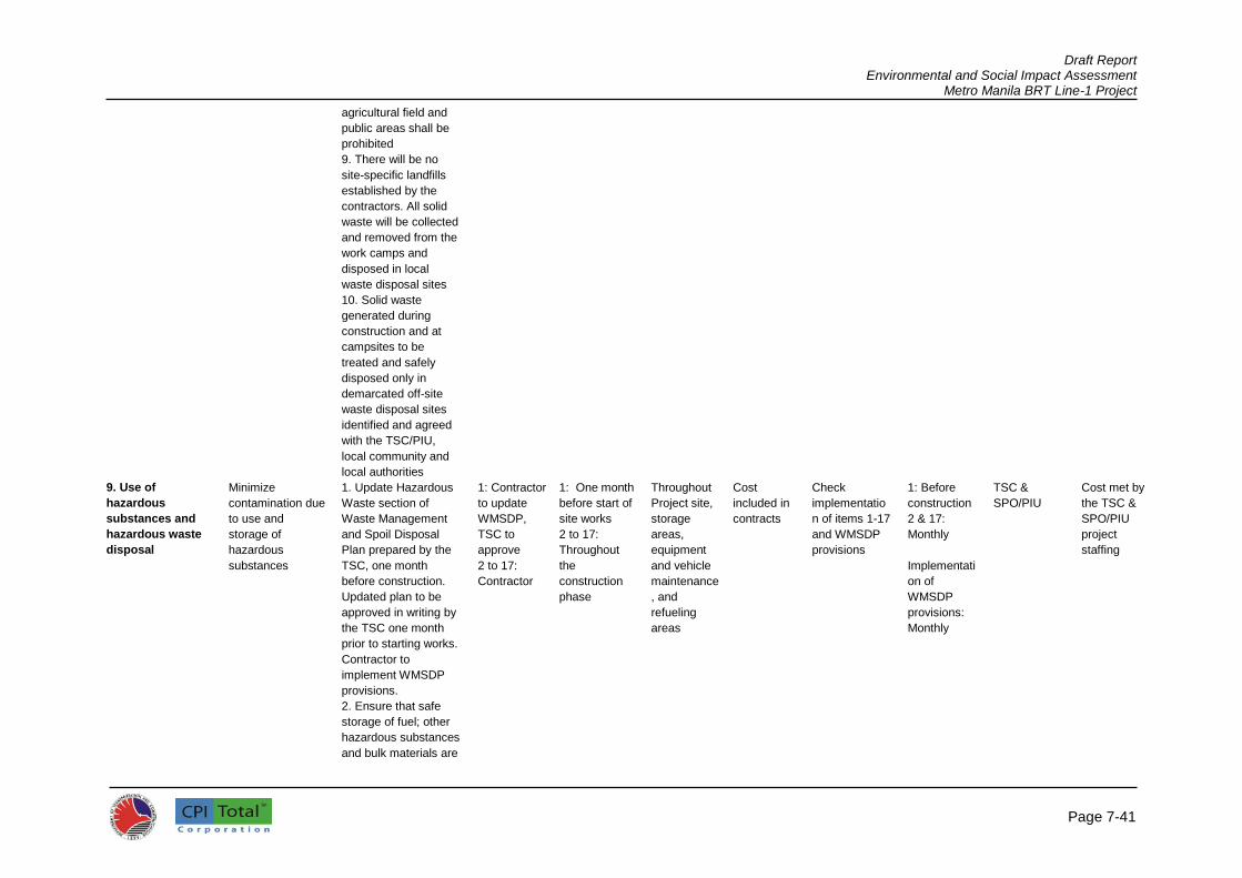
Draft Report Environmental and Social Impact Assessment
Metro Manila BRT Line-1 Project
Page 7-41
agricultural field and
public areas shall be
prohibited
9. There will be no
site-specific landfills
established by the
contractors. All solid
waste will be collected
and removed from the
work camps and
disposed in local
waste disposal sites
10. Solid waste
generated during
construction and at
campsites to be
treated and safely
disposed only in
demarcated off-site
waste disposal sites
identified and agreed
with the TSC/PIU,
local community and
local authorities
9. Use of
hazardous
substances and
hazardous waste
disposal
Minimize
contamination due
to use and
storage of
hazardous
substances
1. Update Hazardous
Waste section of
Waste Management
and Spoil Disposal
Plan prepared by the
TSC, one month
before construction.
Updated plan to be
approved in writing by
the TSC one month
prior to starting works.
Contractor to
implement WMSDP
provisions.
2. Ensure that safe
storage of fuel; other
hazardous substances
and bulk materials are
1: Contractor
to update
WMSDP,
TSC to
approve
2 to 17:
Contractor
1: One month
before start of
site works
2 to 17:
Throughout
the
construction
phase
Throughout
Project site,
storage
areas,
equipment
and vehicle
maintenance
, and
refueling
areas
Cost
included in
contracts
Check
implementatio
n of items 1-17
and WMSDP
provisions
1: Before
construction
2 & 17:
Monthly
Implementati
on of
WMSDP
provisions:
Monthly
TSC &
SPO/PIU
Cost met by
the TSC &
SPO/PIU
project
staffing

Draft Report Environmental and Social Impact Assessment
Metro Manila BRT Line-1 Project
Page 7-42
agreed by the
SPO/PIU/TSC and
have necessary
approval/permit from
DENR and local
authorities
3. Hydrocarbon, toxic
materials, and
explosives will be
stored in adequately
protected sites
consistent with
national and local
regulations to prevent
soil and water
contamination
4. Equipment/vehicle
maintenance and
refueling areas will be
confined to areas in
construction sites
designed to contain
spilled lubricants and
fuels. Such areas shall
be provided with
drainage leading to an
oil-water separator
that will be regularly
skimmed of oil and
maintained to ensure
efficiency.
5. Fuel and other
hazardous substances
shall be stored in
areas provided with
roof, impervious
flooring and
bund/containment wall
to protect these from
the elements and to
readily contain spilled
fuel/lubricant

Draft Report Environmental and Social Impact Assessment
Metro Manila BRT Line-1 Project
Page 7-43
6. Segregate
hazardous wastes (oil
wastes, used
batteries, fuel drums)
and ensure that
storage, transport, and
disposal shall not
cause pollution and
shall be undertaken
consistent with
national and local
regulations
7. Ensure all storage
containers are in good
condition with proper
labeling
8. Regularly check
containers for leakage
and undertake
necessary repairs or
replacements
9. Store hazardous
materials above flood
level
10. Discharge of oil-
contaminated water
shall be prohibited
11..Used oil and other
toxic and hazardous
materials shall be
disposed of in an
authorized facility off-
site
12. Adequate
precautions will be
taken to prevent
oil/lubricant/
hydrocarbon
contamination of
channel beds
13. Ensure availability
of spill cleanup

Draft Report Environmental and Social Impact Assessment
Metro Manila BRT Line-1 Project
Page 7-44
materials (e.g.,
absorbent pads, etc.)
specifically designed
for petroleum products
and other hazardous
substances where
such materials are
being stored
14. Spillage, if any, will
be immediately
cleared with utmost
caution to leave no
traces
15. Spillage waste will
be disposed at
disposal sites
approved by local
authorities and
approved by the TSC
16. All areas intended
for storage of
hazardous materials
will be quarantined
and provided with
adequate facilities to
combat emergency
situations complying
with all the applicable
statutory stipulations
17. The Contractor
shall identify named
personnel in the
management
plan/ESMP in charge
of these sites and
ensure they are
properly trained to
control access to
these areas and entry
will be allowed only
under authorization
10. Asphalt plant Avoid air pollution, 1. Locate asphalt Contractor 1: During Throughout Cost Check 1: Before TSC, Cost met by

Draft Report Environmental and Social Impact Assessment
Metro Manila BRT Line-1 Project
Page 7-45
rock crushers,
bitumen usage,
and soil
contamination
nuisances, traffic
obstacles, and
contamination
plant, rock crushers,
and bitumen supply off
road and (wherever
practicable) at least
500m from nearest
sensitive receivers
(residential areas,
schools, hospital, etc.)
and rivers and install
and maintain dust
suppression
equipment
2. Bitumen should not
be used as fuel. Fuel
wood not for bitumen
heating. Bitumen
drums stored in
dedicated area not
scattered along the
BRT corridor.
3. Bitumen will not be
allowed to enter either
running or dry
streambeds nor will be
disposed of in ditches
or small waste
disposal sites
prepared by the
contractor.
4. Bitumen storage
and mixing areas shall
be protected against
spills and all
contaminated soil
must be properly
handled according to
applicable national
and local laws and
regulation. As a
minimum, these areas
must be contained,
such that any spills
selection of
locations for
asphalt plant,
rock crusher,
bitumen
storage
2 to 9:
Throughout
construction
phase
the entire
BRT corridor
included in
contracts
implementatio
n of items 1-9
establishmen
t of facilities
2 & 9:
Monthly
SPO/PIU the TSC and
SPC/PIU
project
staffing

Draft Report Environmental and Social Impact Assessment
Metro Manila BRT Line-1 Project
Page 7-46
can be immediately
contained and cleaned
up. Any petroleum
products used in the
preparation of the
bitumen mixture must
also be carefully
managed to avoid
spills and
contamination of the
local water table.
5. Fuel wood shall not
be used for heating
bitumen and bitumen
shall be not used as
fuel
6. Bitumen drums shall
be stored in a
dedicated area, not
scattered along the
works
7. All accidental spills
of bitumen or
chemicals should be
cleaned up
immediately with the
top 2cm of any
contaminated soil
underneath and
disposed of as
chemical waste to a
site approved by the
local authority
8. Prevent soil
contamination
requiring contractors
to instruct and train
their workforce on
storage and handling
of materials and
chemicals that can
potentially cause soil
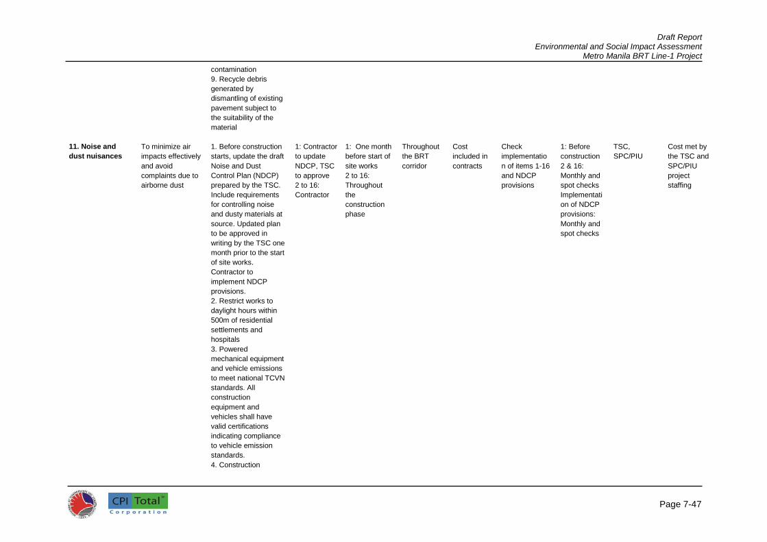
Draft Report Environmental and Social Impact Assessment
Metro Manila BRT Line-1 Project
Page 7-47
contamination
9. Recycle debris
generated by
dismantling of existing
pavement subject to
the suitability of the
material
11. Noise and
dust nuisances
To minimize air
impacts effectively
and avoid
complaints due to
airborne dust
1. Before construction
starts, update the draft
Noise and Dust
Control Plan (NDCP)
prepared by the TSC.
Include requirements
for controlling noise
and dusty materials at
source. Updated plan
to be approved in
writing by the TSC one
month prior to the start
of site works.
Contractor to
implement NDCP
provisions.
2. Restrict works to
daylight hours within
500m of residential
settlements and
hospitals
3. Powered
mechanical equipment
and vehicle emissions
to meet national TCVN
standards. All
construction
equipment and
vehicles shall have
valid certifications
indicating compliance
to vehicle emission
standards.
4. Construction
1: Contractor
to update
NDCP, TSC
to approve
2 to 16:
Contractor
1: One month
before start of
site works
2 to 16:
Throughout
the
construction
phase
Throughout
the BRT
corridor
Cost
included in
contracts
Check
implementatio
n of items 1-16
and NDCP
provisions
1: Before
construction
2 & 16:
Monthly and
spot checks
Implementati
on of NDCP
provisions:
Monthly and
spot checks
TSC,
SPC/PIU
Cost met by
the TSC and
SPC/PIU
project
staffing

Draft Report Environmental and Social Impact Assessment
Metro Manila BRT Line-1 Project
Page 7-48
equipment and
vehicles will be
maintained to a good
standard and shall be
provided with muffler
silencers. Machinery
causing excessive
pollution will be
banned from
construction sites.
5. Monitor and
investigate complaints;
propose alternative
mitigation measures
6. Keep stockpiles
moist
7. Tightly cover trucks
transporting
construction materials
(sand, soil, cement,
gravel, etc.) to avoid or
minimize spills and
dust emissions
8. On rainless days,
undertake watering, at
least twice per day, on
dusty and exposed
areas at construction
yards, materials
stockpile, construction
sites, access roads,
quarry areas, borrow
sites, and other project
areas where
residential sites and
other sensitive
receptors such as
schools, hospital, etc.
are located nearby. If
works are within 15m
of any sensitive
receivers, the

Draft Report Environmental and Social Impact Assessment
Metro Manila BRT Line-1 Project
Page 7-49
contractor shall install
dust barriers between
the works at the road
edge and the sensitive
receivers (e.g. 2.5 m
high temporary walls,
etc.)
9. Mixing and crushing
plants operations will
be equipped with dust
suppression devices
such as water sprays
10. Clean up road
surfaces after work
11. Temporary noise
barriers shall be used,
as necessary, in sites
where sensitive
receptors are present,
such as residential
areas, schools,
hospitals, temples, etc.
12. To protect
buildings and
structures from
vibration, non-vibrating
rollers shall be used in
construction sites near
buildings and
structures
13. Structures which
are damaged due to
vibration caused by
the Project shall be
repaired immediately
as directed by the TSC
14. Machinery shall be
turned off when not in
use
15. Pile driving during
construction to be
scheduled for day time

Draft Report Environmental and Social Impact Assessment
Metro Manila BRT Line-1 Project
Page 7-50
if construction site is
near sensitive
receptors or approved
by DENR, local
authority and the TSC
16. Impose speed
limits on construction
vehicles to minimize
dust emissions along
areas where sensitive
receptors are located
(houses, schools,
hospitals, etc.)
13. Runoff control
/ run-off
Protect
established works
1. Update the draft
Runoff Control Plan
(RCP) produced by
the TSC and
implement excavation
stabilization measures
specified in the
detailed designs and
maintained during
construction to protect
the works. Updated
plan to be approved in
writing by the TSC one
month prior to the start
of site works.
Contractor to
implement provisions
of RCP.
2. Establish
permanent surfaces
immediately after the
completion of works in
each stretch/sector
3. Check weather
forecasts and
minimize work in wet
weather
4. Include and
1: Contractor
to update
ECP, TSC to
assist and
approve
2 to 12:
Contractor
1: One month
before start of
site works
2 to 12:
Throughout
the
construction
phase
Throughout
the project
site and all
vulnerable
slopes
agreed with
the TSC
Cost
included in
contracts
Check
implementatio
n of items 1-12
and ECP
provisions
1: Before
construction
2 & 12:
Monthly
Implementati
on of ECP
provisions:
Monthly
TSC,
SPC/PIU
Cost met by
the TSC and
SPC/PIU
project
staffing

Draft Report Environmental and Social Impact Assessment
Metro Manila BRT Line-1 Project
Page 7-51
implement appropriate
measures for
excavation protection,
i.e. shoring up as
required in the detailed
construction drawings
5. Prevent runoff and
protect the
excavations with
temporary or
permanent drainage
as soon as practicable
after cutting
6. Payments will be
linked to the
completion of the
works as indicated by
the installation of
runoff control
measures to protect
the works to the
satisfaction of the
TSC/PIU
14. River
protection and
bridge
construction
Protect rivers and
maintain river flow
In sections along and
near the intersections
of the BRT Line-1
alignment and rivers of
Tullahan, San Juan
and Pasig:
1. Rocks and stones
will be disposed so as
not to block rivers and
streams
2. In bridge repair and
demolition, the bridge
structure will not be
dropped into the river
but alternative means
will be used to avoid
"dropping the bridge"
into rivers/streams.
This will be done by
Contractor At all times All rivers and
streams with
repair and
reconstructio
n works
Cost
included in
contracts
Check
implementatio
n of items 1-4
Monthly TSC &
SPC/PIU
Cost met by
the TSC and
SPC/PIU
project
staffing

Draft Report Environmental and Social Impact Assessment
Metro Manila BRT Line-1 Project
Page 7-52
"sawing" appropriate
sections of the bridge
and using cranes to lift
these sections away or
alternatively by
constructing a platform
onto which the bridge
could be lowered.
3. Cofferdams, silt
fences, sediment
barriers, or other
devices will be used
as appropriate based
on the design to
prevent migration of
silt during excavation
and boring operations
within streams. If
cofferdams are used,
these will be
dewatered and
cleaned to prevent
siltation by pumping
from cofferdams to a
settling basin or a
containment unit.
4. Other runoff control
measures above and
covering open
surfaces with grasses
and creepers to
reduce runoff will be
implemented as early
as possible in
construction.
15. Water quality Prevent water
quality impacts
due to negligence
and ensure
unavoidable
impacts are
managed
1. Store lubricants,
fuels in dedicated
enclosures >50 m
from water bodies
2. Solid waste from
construction activities
and workers camps
Contractor Throughout
the
construction
phase
Throughout
the project
site
Cost
included in
contracts
Check
implementatio
n of items 1-10
Monthly TSC,
SPC/PIU
Cost met by
the TSC and
SPC/PIU
project
staffing

Draft Report Environmental and Social Impact Assessment
Metro Manila BRT Line-1 Project
Page 7-53
effectively will not be thrown in
rivers and other
watercourses
(drainage, etc.)
3. Construction
storage/stockpiles
shall be provided with
bunds to prevent silted
run-off
4. Stockpiled materials
will be covered to
reduce silted run-off
5. No stockpiling or
borrow sites <100m of
water body
6. Work in rivers will
be scheduled during
the dry season and
work duration shall be
as short as possible
7. Stockpile areas and
storage areas for
hazardous substances
shall be located away
from water bodies
8. Washing of
machinery and
vehicles in surface
waters shall be
prohibited
16. Water
resources
Mitigate the
impact of using
local community
water resources
1. Assess availability
of water and evaluate
impact on use of local
water resources to
ensure that water
utilization for the
Project shall not
deplete local village
supplies
2. Bring in project
water by tanker as
necessary
Contractor Throughout
the
construction
phase
Throughout
the project
site,
construction
camps
Cost
included in
contracts
Check
implementatio
n of items 1-11
Monthly TSC,
SPC/PIU
Cost met by
the TSC and
SPC/PIU
project
staffing

Draft Report Environmental and Social Impact Assessment
Metro Manila BRT Line-1 Project
Page 7-54
3. Worker camps will
be located as agreed
with the local
community authority to
prevent the unplanned
consumption of
community-owned
water resources
4. Maintain close
liaison with local
communities to ensure
that any potential
conflicts related to
common resource
utilization for project
purposes is resolved
quickly
5. Establish and
implement guidelines
to minimize the
wastage of water
during construction
and at campsites
6. Avoid or minimize
the use of riverbed for
construction materials
7. Confine winning
river materials to 20%
of the river width in
any location and keep
away from riverbanks
8. Reinstate
riverbanks if
necessary
10. In case of
accidental obstruction
or damage, drainage
ditches and ponds
shall be cleaned or
repaired immediately
17. Operation of
workers camps
Worker facilities
so as not to cause
1. Worker camp
location and facilities
Contractor 1 & 2: During
selection of
Project site,
construction
Cost
included in
Check
implementatio
1 & 2: Once
for each
TSC &
SPC/PIU
Cost met by
the TSC and

Draft Report Environmental and Social Impact Assessment
Metro Manila BRT Line-1 Project
Page 7-55
and
workshops/yards
nuisance located and agreed
with local communities
and facilities approved
by the TSC and
managed to minimize
impacts
2. Construction camps
will be established in
areas with adequate
natural drainage
3. Hire and train as
many local workers as
possible
4. Provide adequate
housing for all workers
at the construction
camps and establish
clean canteens/eating
and cooking areas
5. Portable lavatories
(or at least pit latrines
in remote areas) shall
be installed and open
defecation shall be
prohibited and
prevented by cleaning
lavatories daily and by
keeping lavatory
facilities clean at all
times
6. Provide separate
hygienic sanitation
facilities/toilets and
bathing areas with
sufficient water supply
for male and female
workers
7. Wastewater
effluents from
contractors’
workshops and
equipment washing-
locations for
workers
camps.
3 to 16:
Throughout
the
construction
phase
camps contracts n of items 1-16 location,
prior to
establishmen
t of facilities
3 to 16:
Monthly
SPC/PIU
project
staffing
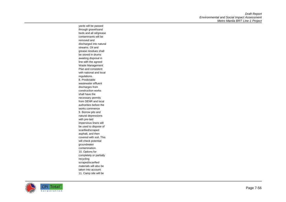
Draft Report Environmental and Social Impact Assessment
Metro Manila BRT Line-1 Project
Page 7-56
yards will be passed
through gravel/sand
beds and all oil/grease
contaminants will be
removed and
discharged into natural
streams. Oil and
grease residues shall
be stored in drums
awaiting disposal in
line with the agreed
Waste Management
Plan and consistent
with national and local
regulations.
8. Predictable
wastewater effluent
discharges from
construction works
shall have the
necessary permits
from DENR and local
authorities before the
works commence
9. Borrow pits and
natural depressions
with pre-laid
impervious liners will
be used to dispose of
scarified/scraped
asphalt, and then
covered with soil. This
will check potential
groundwater
contamination.
10. Options for
completely or partially
recycling
scraped/scarified
materials will also be
taken into account
11. Camp site will be

Draft Report Environmental and Social Impact Assessment
Metro Manila BRT Line-1 Project
Page 7-57
cleaned up to the
satisfaction of the local
community after use
12. Solid and liquid
waste will be managed
in line with Waste
Management Plan
13. All waste materials
shall be removed and
disposed to disposal
sites approved by local
authorities
14. Land used for
campsites shall be
restored to the original
condition as far as
practicable and the
area if required in the
TCRP shall be planted
with appropriate
trees/shrubs as soon
as practicable after it
is vacated and
cleaned
18. Sanitation and
Diseases
Control of
infectious
diseases
1. Standing water will
not be allowed to
accumulate in the
temporary drainage
facilities or along the
roadside to prevent
the proliferation of
mosquitoes
2. Temporary and
permanent drainage
facilities will be
designed to facilitate
the rapid removal of
surface water from all
areas and prevent the
accumulation of
surface water ponds
3. Dengue control
Contractor Throughout
the
construction
Throughout
the project
site, workers
camps
Cost
included in
contracts
Check
implementatio
n of items 1-4
Monthly TSC,
SPC/PIU
Cost met by
the TSC and
SPC/PIU
project
staffing

Draft Report Environmental and Social Impact Assessment
Metro Manila BRT Line-1 Project
Page 7-58
(e.g., provision of
insecticide-treated
mosquito nets to
workers, installation of
proper drainage to
avoid formation of
stagnant water, etc.)
and HIV-AIDS
education will be
implemented in line
with social plans for
the project
4. HIV/AIDS
awareness and
prevention program
shall be implemented
in line with social plans
under the Project
19. Safety
Precautions for
the Workers
Ensure worker
safety
1. Contractor to
update the draft
Worker and Public
Safety Plan (WPSP)
prepared by the TSC
and instruct workers in
health and safety
matters. Updated plan
to be approved in
writing by the TSC one
month prior to the start
of site works.
Contractor to
implement WPSP
provisions.
2. Establish safety
measures as required
by law and by good
engineering practices
and provide first aid
facilities that are
readily accessible by
workers
3. Scheduling of
1: Contractor
to update
WPSP, TSC
to assist and
approve
2 to 10:
Contractor
1: One month
before start of
site works
2 to 10:
Throughout
the
construction
phase
All
construction
sites
Cost
included in
contracts
Check
implementatio
n of items 1-10
and WPSP
provisions
Check
compliance to
the Philippine
Labor Act
(2006)
1: Before
construction
2 & 10:
Monthly
Implementati
on of WPSP
provisions:
Monthly
TSC,
SPC/PIU
Cost met by
the TSC and
SPC/PIU
project
staffing

Draft Report Environmental and Social Impact Assessment
Metro Manila BRT Line-1 Project
Page 7-59
regular (e.g., weekly
tool box talks) to orient
the workers on health
and safety issues
related to their
activities as well as on
proper use of personal
protective equipment
(PPE)
4. Fencing on all
excavations, borrow
pits, and sides of
temporary bridges
5. Workers shall be
provided with
appropriate PPE such
as safety shoes, hard
hats, safety glasses,
ear plugs, gloves, etc.
at no cost to the
employee
6. Where worker
exposure to traffic
cannot be completely
eliminated, protective
barriers shall be
provided to shield
workers from traffic
vehicles. Another
measure is to install
channeling devices
(e.g., traffic cones and
barrels) to delineate
the work zone.
7. Workers shall be
provided with a
reliable supply of
potable water
8. Construction camps
shall be provided with
adequate drainage to
avoid accumulation of

Draft Report Environmental and Social Impact Assessment
Metro Manila BRT Line-1 Project
Page 7-60
stagnant water
9. Construction camps
shall be provided with
toilets/sanitation
facilities in accordance
with local regulations
to prevent any hazard
to public health or
contamination of land,
surface, or
groundwater. These
facilities shall be well
maintained to allow
effective operation.
10. Ensure reversing
signals are installed on
all construction
vehicles
20. Public safety Prevent accidents
in the local
community
1. Include in the
WPSP for barriers
(e.g., temporary
fence),shall be
installed at
construction areas to
deter pedestrian
access to the roadway
except at designated
crossing points
2. The general
public/local residents
shall not be allowed in
high-risk areas, e.g.,
excavation sites and
areas where heavy
equipment is in
operation and such
sites have a watchman
to keep the public out
3. Speed restrictions
shall be imposed on
Project vehicles and
equipment when
Contractor At all times
throughout
the
construction
phase
Locations
identified
and agreed
by the TSC
Cost
included in
contracts
Check
implementatio
n of items 1-4
Monthly TSC &
SPC/PIU
Cost met by
the TSC and
SPC/PIU
project
staffing

Draft Report Environmental and Social Impact Assessment
Metro Manila BRT Line-1 Project
Page 7-61
traveling within 50m of
sensitive receptors
(e.g. residential,
schools, temples, etc.)
4. Upon completion of
construction works,
borrow areas will be
backfilled (if suitable
materials are
available, e.g.,
excavation spoils) or
fenced
21. Traffic
Conditions
Minimize
disturbance of
traffic and traffic
congestion
1. Prior to the start of
site works, update and
implement the Traffic
Management
Guidelines prepared
by the TSC during the
detailed design phase.
Updated plan to be
approved in writing by
the TSC one month
prior to the start of site
works. Contractor to
implement TTMP
provisions.
2. Communicate to the
public through local
officials regarding the
scope and schedule of
construction, as well
as certain construction
activities causing
disruptions or access
restrictions
3. In coordination with
local traffic authorities,
implement appropriate
traffic diversion
schemes to avoid
inconvenience due to
project operations to
1: Contractor
to update the
TTMP, TSC
to assist and
approve
2 to 8:
Contractor
1: One month
before the
start of site
works
2 to 8:
Throughout
the
construction
phase
Entire BRT
Line-1 route
Cost
included in
contracts
Check
implementatio
n of items 1-8
and RRMP
provisions
1: Before
construction
2 & 8:
Monthly
Implementati
on of TTMP
provisions:
Monthly
TSC &
SPC/PIU
Cost met by
the TSC and
SPC/PIU
project
staffing

Draft Report Environmental and Social Impact Assessment
Metro Manila BRT Line-1 Project
Page 7-62
road users, ensure
smooth traffic flow,
and avoid or minimize
accidents, traffic hold
ups, and congestion
4. In coordination with
local traffic officials,
schedule transport of
materials to avoid
congestion, set up
clear traffic signal
boards and traffic
advisory signs at the
roads going in and out
the road and bridge
construction sites to
minimize traffic build-
up
5. Provide safe vehicle
and pedestrian access
around construction
areas
6. Install bold diversion
signs that will be
clearly visible even at
night and provide flag
persons to send
warnings about
dangerous conditions
(24 hours, as
necessary)
7. Provide sufficient
lighting at night within
and in the vicinity of
construction sites
8. Designate traffic
officers in construction
sites
22. Archaeological
and cultural
artifacts
Preservation of
chance finds of
cultural and
archaeological
1. Site agents
instructed to keep a
watching brief for
relics
Contractor Throughout
the
construction;
Check and
All areas Cost
included in
contracts
Check
implementatio
n of items 1-4
Before
construction
and monthly
check
TSC &
SPC/PIU
Cost met by
the TSC and
SPC/PIU
project

Draft Report Environmental and Social Impact Assessment
Metro Manila BRT Line-1 Project
Page 7-63
relics identified
during
construction
2. Should any potential
items be located, the
site TSC will
immediately be
contacted and work
will be temporarily
stopped in that area
3. If the site supervisor
determines that the
item is of potential
significance, an officer
from the National
Museum (NM) will be
invited to inspect the
site and work will be
stopped
4. Until the NM has
responded to this
invitation, work will not
re-commence in this
location until
agreement has been
reached between the
NM and DOTr as to
any required mitigation
measures, which may
include excavation
report on
same day
staffing
23. Enhancements Provide
environmental
enhancement of
the project
Contractor to
reconfirm and
implement
enhancements (e.g.,
landscaping, tree
replanting) identified at
the detailed design
stage
Contractor Throughout
the
construction
All areas Cost
included in
contracts
Confirmed
implementatio
n of required
enhancements
Before
construction
and monthly
check
TSC &
SPC/PIU
Cost met by
the TSC and
SPC/PIU
project
staffing
24. Disruption to
access and
business activity
Provide continued
access to shops,
residences,
mosques, etc.,
during the
construction
period
Contractor to provide
planks and continued
access during the
construction period.
Night works to be
considered in areas
with high-density
Contractor Throughout
the
construction
All areas Cost
included in
contracts
Confirmed
implementatio
n of required
enhancements
Before
construction
and monthly
check
TSC &
SPC/PIU
Cost met by
the TSC and
SPC/PIU
project
staffing

Draft Report Environmental and Social Impact Assessment
Metro Manila BRT Line-1 Project
Page 7-64
commercial activity.
Special attention will
be given to hospitals,
specifically the
emergency room
access (e.g
Providence Hosptial,
UST Hospital).
Unimpeded access to
emergency services
such as fire stations
along the corridor.
OPERATIONAL STAGE
1. Road Safety Minimize road
accidents
1. Undertake road
safety awareness
campaigns for local
residents and other
road users of the BRT
Line-1 route
2. Install and maintain
road warning signs
and markings
3. Monitor road
accidents and
implement necessary
preventive measures
(awareness
campaigns, provision
of appropriate road
furniture to enhance
road safety and control
traffic)
BRT Line-1
Operator,
local (district)
traffic
authority
During
operations
Throughout
the entire
BRT-Line 1
route
Included in
operations
and
maintenanc
e cost
Throughout
operations and
maintenance
Semi-annual BRT Line-1
Operator
Cost met by
the SPC/PIU
staffing
2. Tree survival Ensure survival of
planted trees
Monitor survival of
replanted trees, also
transplanted/compens
atory planting trees)
and replant, as
necessary
BRT Line-1
Operator and
FMB
During
operations
Throughout
the entire
BRT Line-1
route
Included in
operations
and
maintenanc
e cost
First three
years of
operation
Semi-annual
for the 1st 3
years of
operation
BRT Line-1
Operator and
FMB
Cost met by
the SPC/PIU
staffing

Draft Report Environmental and Social Impact Assessment
Metro Manila BRT Line-1 Project
Page 7-65

Draft Report Environmental and Social Impact Assessment
Metro Manila BRT Line-1 Project
Page 7-66
Table 7.3.1: Social Impact Management Measures and Activities
Social
Risk/Impacts
Target Population
Management Measures
Implementing Agency/
Organization
Source of Fund
Monitoring and Evaluation Mechanism
Pre-Construction Phase
Accessibility and proximity
Elderly Meaningful and active participation in the planning and design phase
DOTr BRT-NPMO/PIU SPC
DOTr Number of public consultations and minutes of meetings monitored every three months Integration of concerns in project documents Adherence of design criteria and parameters to existing laws and applicable international standards
PWDs
Women
Children
Other commuters
Livelihood PUJ/PUB Drivers, Operators, and Support Personnel
Commissioning of Social and Environmental Consultants to continue consultations with the affected PUJ/PUB operators and drivers Continued public consultation to identify new routes, modified or truncated routes, or feeder routes Formulation of policies that will provide for the timely transfer of operations of PUJs/PUBs to the new, modified, or truncated routes Route verification, traffic analysis, economic viability studies on the proposed new, modified, and truncated routes
DOTR BRT-NPMO/PIU SPC LTO LTFRB
DOTr Commissioning of social and environmental consultants done after Project Appraisal; Progress to be monitored on a weekly basis Number of public consultations and minutes of meetings monitored every three months Monitor number of PAPs allocated with new, modified, and truncated routes Monitor progress on the project studies on a weekly

Draft Report Environmental and Social Impact Assessment
Metro Manila BRT Line-1 Project
Page 7-67
Table 7.3.1: Social Impact Management Measures and Activities
Social
Risk/Impacts
Target Population
Management Measures
Implementing Agency/
Organization
Source of Fund
Monitoring and Evaluation Mechanism
Project studies for the scrapping of old PUJs/PUBs Project preparation studies on the provision of a central PUV terminal
basis
Affected Commercial Establishments on BRT Stations
Engineering and architectural designs that will avoid or minimize impacts to commercial establishments Tagging of affected commercial establishments Appraisal of replacement costs of structures and income based on the entitlement matrix or social management framework Compensation to Displaced Persons (DPs)
DOTr BRT-NPMO/PIU SPC
DOTr Evaluate engineering designs and impact on establishments during and after detailed engineering designs Monitor tagging and appraisal of entitlements per entitlement matrix Monitor timely compensation to affected establishments prior to construction phase
Construction Phase
Accessibility and proximity
Elderly Posting of traffic aides to assist in street crossings and riding in public transport Safety signages written in bold letters and made very visible to avoid accidents and preferably with sounds
DOTr BRT-NPMO/PIU SPC Contractor
DOTr Conduct of compliance audit with operating rules and traffic guidelines on a monthly basis Compliance audit against established community support and communications plan on a monthly basis
PWDs
Women
Children
Other commuters
Implement a traffic management plan to avoid traffic confusion Billboards and public

Draft Report Environmental and Social Impact Assessment
Metro Manila BRT Line-1 Project
Page 7-68
Table 7.3.1: Social Impact Management Measures and Activities
Social
Risk/Impacts
Target Population
Management Measures
Implementing Agency/
Organization
Source of Fund
Monitoring and Evaluation Mechanism
announcement should be put up to provide information to public
Livelihood
PUJ/PUB Drivers and Support Personnel
Technical or skills training under TESDA Preferential hiring for BRT operations Employment Assistance Livelihood Programs
DOTr BRT-NPMO/PIU/ SPC Contractor TESDA
DOTr Number of trainings provided to be monitored every two months Cross-checking of training beneficiaries against database of PAPs
Operation Phase
Accessibility and proximity
Elderly Provide feeder transport to bus stations and terminals Provide at-grade pedestrian crossings at strategic locations (i.e. schools, markets, churches, etc.) Put up adequate and large traffic signs with flashing lights Posting of traffic aides to assist in street crossings Road curbs should be smooth and yet not cause slippage nor become slippery when wet, preferably with hand rails at points of crossing “Courtesy Lanes” at bus stations and terminal
BRT Operator, FESCAP (Federation of Senior Citizens Association of the Philippines)
BRT Management
Quarterly monitoring against established standards, rules, and regulations

Draft Report Environmental and Social Impact Assessment
Metro Manila BRT Line-1 Project
Page 7-69
Table 7.3.1: Social Impact Management Measures and Activities
Social
Risk/Impacts
Target Population
Management Measures
Implementing Agency/
Organization
Source of Fund
Monitoring and Evaluation Mechanism
Ramps on buses for easy and safe boarding/off-boarding Provide special “passenger cards” to be distributed through OSCA incorporating 20% discount Designated seats for the elderly in buses within the immediate proximity of bus door for easy ingress and egress
PWDs Provide feeder transport to bus stations and terminals Provide at-grade pedestrian crossings at strategic locations (i.e. schools, markets, churches, etc.) Put up adequate and large traffic signs with flashing lights and sounds/alarms Posting of traffic aides to assist in street crossings Road curbs should be smooth and not cause slippage nor become slippery when wet, preferably with hand rails at points of crossing “Courtesy Lanes” at bus stations and terminal Ramps on buses for easy and safe
BRT Operator BRT Management
Quarterly monitoring against established standards, rules, and regulations

Draft Report Environmental and Social Impact Assessment
Metro Manila BRT Line-1 Project
Page 7-70
Table 7.3.1: Social Impact Management Measures and Activities
Social
Risk/Impacts
Target Population
Management Measures
Implementing Agency/
Organization
Source of Fund
Monitoring and Evaluation Mechanism
boarding/off-boarding Provide special “passenger cards” incorporating 20% discount Hand and guard rails within easy reach of PWD Designated seats for PWDs in buses within the immediate proximity of bus door for easy ingress and egress Ensure enough space in the bus to accommodate assistive devices of PWDs Passenger instructions written in Braille could be installed to allow the blind or sight-impaired persons to find their way without needing special assistance
Women Provide feeder transport to bus stations and terminals Provide at-grade pedestrian crossings at strategic locations (i.e. schools, markets, churches, etc.) Put up adequate and large traffic signs with flashing lights Posting of traffic aides to assist pregnant women and mothers with
BRT Operator BRT Management
Quarterly monitoring against established standards, rules, and regulations

Draft Report Environmental and Social Impact Assessment
Metro Manila BRT Line-1 Project
Page 7-71
Table 7.3.1: Social Impact Management Measures and Activities
Social
Risk/Impacts
Target Population
Management Measures
Implementing Agency/
Organization
Source of Fund
Monitoring and Evaluation Mechanism
infants/small children in street crossings, or going into/coming from the bus station “Courtesy Lanes” for pregnant women/mothers with infants/small children at bus stations and terminal Ramps on buses for easy and safe boarding/off-boarding so as not to cause strain on pregnant women Designated seats/space for pregnant women, lactating mothers, or mothers with infants/small children, and unescorted ladies Special “for women only” buses during peak hours Bus stations ideally to be within the proximity of markets, schools, and churches
Children Provide feeder transport to bus stations and terminals Provide at-grade pedestrian crossings at strategic locations Put up adequate and large traffic signs with flashing lights Posting of traffic aides to assist in
BRT Operator BRT Management
Quarterly monitoring against established standards, rules, and regulations

Draft Report Environmental and Social Impact Assessment
Metro Manila BRT Line-1 Project
Page 7-72
Table 7.3.1: Social Impact Management Measures and Activities
Social
Risk/Impacts
Target Population
Management Measures
Implementing Agency/
Organization
Source of Fund
Monitoring and Evaluation Mechanism
street crossings or going into/coming from the bus stations as well as oversee if there may be suspicious persons in and around the vicinity of the bus stations Signage reminding commuters not to crowd-out children while boarding, off-boarding, and inside the bus must be installed Hand and guardrails must be within easy reach of children Children must not be allowed to sit or stand near bus doorways; signage must be installed to remind everyone about this
Other commuters
Provide feeder transport to bus stations and terminals Provide at-grade pedestrian crossings at strategic locations for access to short-distance trip for the affected barangays
BRT Operator BRT Management
Quarterly monitoring against established standards, rules, and regulations
Affordability Elderly Ensure affordable but competitive fare rate Provide mandated discounts
BRT Operator BRT Management
Quarterly monitoring against established standards, rules, and regulations
PWDs
Children
Women Ensure affordable but competitive fare rate Other commuters
Safety and Security
Elderly Install adequate security measures within the bus station and its
BRT Operator BRT Management
Quarterly monitoring against established

Draft Report Environmental and Social Impact Assessment
Metro Manila BRT Line-1 Project
Page 7-73
Table 7.3.1: Social Impact Management Measures and Activities
Social
Risk/Impacts
Target Population
Management Measures
Implementing Agency/
Organization
Source of Fund
Monitoring and Evaluation Mechanism
immediate environs to serve as both deterrent as well as a facilitating mechanism in the arrest of potential petty criminals Install intelligent traffic signaling devices to help in regulating the flow of people and vehicles within the bus station/terminal Post traffic aides to enhance the circulation so people and motorists can see authority figures Place security officers to ensure pre-emptive visibility Ensure adequate ventilation to help ease the discomfort of over-crowded spaces Install special waiting lounge/space for the elderly in bus stations and terminals
standards, rules, and regulations
PWDs Install adequate security measures within the bus station and its immediate environs to serve as both a deterrent as well as a facilitating mechanism in the arrest of potential petty criminals Install intelligent traffic signaling devices to help in regulating the flow of people and vehicles within the bus station/terminal
BRT Operator BRT Management
Quarterly monitoring against established standards, rules, and regulations

Draft Report Environmental and Social Impact Assessment
Metro Manila BRT Line-1 Project
Page 7-74
Table 7.3.1: Social Impact Management Measures and Activities
Social
Risk/Impacts
Target Population
Management Measures
Implementing Agency/
Organization
Source of Fund
Monitoring and Evaluation Mechanism
Post traffic aides to enhance the circulation so people and motorists can see authority figures Place security officers to ensure pre-emptive visibility Ensure adequate ventilation to help ease the discomfort of over-crowded spaces Install special waiting lounge/space for PWDs in bus stations and terminals
Women Install adequate security measures within the bus station and its immediate environs to serve as both a deterrent as well as a facilitating mechanism in the arrest of potential petty criminals Install intelligent traffic signaling devices to help in regulating the flow of people and vehicles within the bus station/terminal Post traffic aides to enhance the circulation so people and motorists can see authority figures Place security officers to ensure pre-emptive visibility Ensure adequate ventilation to
BRT Operator BRT Management
Quarterly monitoring against established standards, rules, and regulations

Draft Report Environmental and Social Impact Assessment
Metro Manila BRT Line-1 Project
Page 7-75
Table 7.3.1: Social Impact Management Measures and Activities
Social
Risk/Impacts
Target Population
Management Measures
Implementing Agency/
Organization
Source of Fund
Monitoring and Evaluation Mechanism
help ease the discomfort of over-crowded spaces Install special waiting lounge/space for pregnant women/ mothers with infants or small children in bus stations and terminals
Children Install adequate security measures within the bus station and its immediate environs to serve as both a deterrent as well as a facilitating mechanism in the arrest of potential petty criminals Install intelligent traffic signaling devices to help in regulating the flow of people and vehicles within the bus station/terminal Post traffic aides to enhance the circulation so people and motorists can see authority figures Place security officers to ensure pre-emptive visibility Ensure adequate ventilation to help ease the discomfort of over-crowded spaces Install special waiting lounge/space for children in bus stations and terminals to avoid being crowded-out/in by adults
BRT Operator BRT Management
Quarterly monitoring against established standards, rules, and regulations
Other commuters Install adequate security measures BRT Operator BRT Quarterly monitoring

Draft Report Environmental and Social Impact Assessment
Metro Manila BRT Line-1 Project
Page 7-76
Table 7.3.1: Social Impact Management Measures and Activities
Social
Risk/Impacts
Target Population
Management Measures
Implementing Agency/
Organization
Source of Fund
Monitoring and Evaluation Mechanism
within the bus station and its immediate environs to serve as both a deterrent as well as a facilitating mechanism in the arrest of potential petty criminals Install intelligent traffic signaling devices to help in regulating the flow of people and vehicles within the bus station/terminal Post traffic aides to enhance the circulation so people and motorists can see authority figures Place security officers to ensure pre-emptive visibility Ensure adequate ventilation to help ease the discomfort of over-crowded spaces
Management against established standards, rules, and regulations
Livelihood
Individual PUJ/PUB Drivers and Operators PUJ Organizations/ Cooperatives PUB Companies/ Cooperatives Support Personnel in the PUV sector (i.e., barkers, mechanics, janitors, office personnel, etc.)
SMP Options: Route relocation, modification, and truncation; Co-existence with the BRT or remain on their route, despite the impact of the Metro Manila BRT Line-1 Project; Scrapping or wholesale purchase of old PUJ units by the government; Formation of concessionaire group/s among operators to become part of the BRT
BRT Operator, DOTr, LTFRB, LTO, TESDA
DOTr, LTFRB, LTO,
Monitor number of PAPs allocated with new, modified, and truncated routes on a weekly basis Monitor number of PAPs benefited with SMP options on a weekly basis Conduct of social surveys to determine income and livelihood of PAPs three months from BRT operation

Draft Report Environmental and Social Impact Assessment
Metro Manila BRT Line-1 Project
Page 7-77
Table 7.3.1: Social Impact Management Measures and Activities
Social
Risk/Impacts
Target Population
Management Measures
Implementing Agency/
Organization
Source of Fund
Monitoring and Evaluation Mechanism
consortium/investors; and Provision of alternative livelihood/TESDA training/preferential hiring to affected drivers/personnel and/or members of affected households
PUJ/PUB Drivers and members of affected households
Skills/technical trainings under TESDA Preferential hiring for BRT operation Employment assistance Livelihood programs
BRT Operator, TESDA
DOTr, BRT Management, TESDA,
Monitor number of PAPs provided with TESDA training Track TESDA training beneficiaries and determine training effectiveness/labor force absorption Monitor number of PAPs employed in the BRT system
Misinformation/ lack of project awareness
Other commuters/commuting public
Information and Education Campaign 1) Tri-Media; 2) Public Forum; 3) Flyer distribution in public bulletin boards
BRT Operator Civil Society Consultative Committee (CSCC)
DOTr, BRT Management
Conduct of compliance audit with operating rules and traffic guidelines on a quarterly basis Compliance audit against establish community support and communications plan on a quarterly basis

Draft Report Environmental and Social Impact Assessment
Metro Manila BRT Line-1 Project
7
7.3.1 Cost of Social Management Measures 673. The costs of social management measures are presented in Table 7.3.2.
Table 7.3.2: Cost of Social Management Measures
ACTIVITY PARTICULARS COST IN
USD
A. PRE-CONSTRUCTION PHASE
1. Consultation Meetings with Vulnerable
Stakeholders (PWDs, women, the elderly,
children and other commuters)
2 meetings @ USD1000 per
meeting
2,000
2. Commissioning of Environmental and
Social Management Consultants
Social Safeguards Specialist (3
man-months @ USD8,000 per
man-month)
Environmental Specialist (1
man-month @ USD8,000 per
man-month)
Support Staff (9 man-months
@ USD2400 per man-month)
Out-of-Pocket Expenses (LS –
USD10,000)
Taxes (15%)
73,400
3. Route verification, traffic analysis,
economic viability studies on the proposed
new, modified, and truncated routes;
Traffic Modeling and
Management Specialist (3
man-months x USD8,000)
Economist (2 man-months x
USD8,000)
Support Staff (6 man-months x
USD2400)
Out-of-Pocket Expenses (LS –
USD5000)
Taxes (15%)
68,310
4. Project Studies for Scrapping of old PUVs Economist (1 man-month x
USD8000)
Environmental Specialist (1
man-month x USD8000)
Institutional Management
Specialist (0.5 man-month x
USD8000)
Support Staff (2 man-months x
USD2400)
Out-of-Pocket Expenses (LS –
USD2,000)
Taxes (15%)
30,820
5. Project preparation studies on the Economist (2 man-month x 58,190

Draft Report Environmental and Social Impact Assessment
Metro Manila BRT Line-1 Project
7
ACTIVITY PARTICULARS COST IN
USD
provision of a central PUV terminal USD8000)
Environmental Specialist (1
man-month x USD8000)
Infrastructure Planner (1 man-
month x USD8000)
Institutional Management
Specialist (0.5 man-month x
USD8000)
Support Staff (4 man-months x
USD2400)
Out-of-Pocket Expenses (LS –
USD5000)
Taxes (15%)
6. Appraisal of Replacement Cost and
Compensation for Affected Establishments
LS 10,000
7. Monitoring and Evaluation LS 25,000
8. Compensation to Affected Establishments TBD
B. CONSTRUCTION PHASE
1. Information Dissemination and
Communications
LS 100,000
2. TESDA Trainings 500 pax x USD500 250,000
3. Monitoring and Evaluation LS 20,000
C. OPERATIONS PHASE
Impact Monitoring and Evaluation LS 60,000
Total SMP Cost 697,720
674. The above cost summary does not include compensation and resettlement cost for any commercial establishment that may be affected by the project. Impact monitoring and evaluation cost is only for the one-time post implementation impact monitoring and evaluation study to be conducted. Cost of recurrent monitoring and evaluation studies are not included. 7.4 Environmental Monitoring Works
675. The main objective of environmental monitoring works is to ensure that the environmental and social mitigation measures during construction are implemented by the Contractor through a systematic supervision by the DOTr BRT-NPMO/PIU with assistance from the SPO-TSC during the construction phase. Environmental issues are also anticipated to be identified in advance for avoidance and to ensure timely completion of the project. Consequently, the environmental monitoring framework for this project will form part of the basis of the TOR for the Contractor, General Conditions of the Contract (GCC), Technical specifications, and the project ESIA/ESMP. 7.4.1 Compliance Monitoring 676. Table 7.2.1 also shows the program for monitoring the compliance on various provisions of the ESMP during pre-construction, construction, and operation phases. DOTr BRT-NPMO/PIU and the TSC need to implement a number of measures during the detailed design phase (e.g., incorporation of environmental design measures into the detailed design, preparation of draft method statements/ESMPs, etc.) and this will be confirmed by the TSC/PIU to WB. During construction, most

Draft Report Environmental and Social Impact Assessment
Metro Manila BRT Line-1 Project
8
of the mitigation measures shall be implemented by the Contractors and their environmental performance, in terms of implementation of such measures, shall be monitored by the PIU and the TSC. The timing or frequency of monitoring is also specified in Table 7.2.1. During operations, ESMP implementation shall be the responsibility of the BRT Line -1 Operator.
7.4.1.1 Design Stage 677. DOTr BRT-NPMO/PIU and the SPC shall ensure that the ESMP measures for the design stage are incorporated in the detailed design. The bidding documents for the TSC candidate consultants will also include the ESMP. The effective incorporation of the ESMP in the civil works contracts shall also be ensured by the PMO/PIU with assistance from the TSC and this, along with the implementation of the ESMP provisions, shall be audited by WB as part of the loan conditions. 678. Prior to implementation of the Project, the ESIA and the ESMP will be updated and amended, as necessary, by the TSC after the detailed designs are complete and contracting arrangements are known. Such updating shall be based on reconfirmation and any additional information on the assumptions made at this feasibility stage on location scale and expected conditions of the Project. For example, in this case, if there is additional land required (although not confirmed yet), the designs may be amended and the environmental significance must be reviewed. Although no major additional impacts would be anticipated based on the information provided to date, the performance and evaluation schedules to be implemented during project construction can be reviewed, updated, and costs estimates can be revised if necessary. 7.4.1.2 Pre-construction Stage 679. Implementation of construction of the Project will need to comply with environmental requirements and from clearance that has been obtained from DENR. The TSC will also need to confirm that the Contractor(s) and their suppliers have complied with all statutory requirements for permits from DENR and provincial authorities. TSC shall also check if the Contractor(s) have all the necessary valid licenses and permits for use of powered mechanical equipment, if necessary, and the use of local water supplies and to construct or operate plants such as those for cement batching or asphalt/bitumen (if required) in line with all environmental regulations and environmental clearance certification conditions from designated authorities.
7.4.1.3 Construction Stage 680. The updated ESMP to be prepared by the contractors, with assistance from the TSC, will be reviewed and approved by the PIU before any construction activity is initiated to take account of any subsequent changes and fine tuning of the draft ESMP prepared by the TSC. The TSC shall undertake regular monitoring of the contractor’s implementation of mitigation measures specified in the ESMP. 7.4.1.4 Operational Stage 681. The BRT Operator shall implement the ESMP mitigation and monitoring requirements during operations such as monitoring of runoff control measures, survival of planted trees, etc. Accidents along the BRT route shall also be monitored as basis for implementation of mitigation measures to improve road safety.
7.4.2 Reporting and Monitoring Parameters 682. As shown in Table 7.2.1, the TSC shall undertake baseline environmental monitoring for air quality, noise, and surface water quality. One-time sampling shall be conducted prior to start of site works at the specified locations. During construction, the TSC shall undertake quarterly monitoring of surface water quality and semi-annual monitoring of air quality and noise in the same locations

Draft Report Environmental and Social Impact Assessment
Metro Manila BRT Line-1 Project
8
sampled during pre-construction. Additional sampling occasions shall be carried out and additional parameters shall be analyzed (as necessary) to validate complaints and/or investigate pollution events caused by the project. 683. The SPC/PIU shall submit the following environmental monitoring report to WB and DENR: 684. Baseline Monitoring Report: The results of baseline data collection carried out by the TSC on air quality and noise (as specified in the ESMP) shall be submitted to WB prior to the commencement of civil works. 685. The environmental monitoring reports shall cover the status of the ESMP implementation in terms of required mitigation measures for different project phases, results of environmental effects monitoring (air quality, noise, and surface water quality), necessary remedial actions to effectively address negative environmental impacts due to project implementation, status of environmental capacity building activities, as well as documentation of complaints received and corresponding action/resolution. The environmental monitoring reports will be submitted to WB and DENR semi-annually during the construction period and annually for two years after the completion of construction. 7.5 Environmental Monitoring Costs 686. As part of good engineering practices in the Project, there have been several measures such as spoil management, safety, signage, dust prevention, noise mitigation, etc. where the costs for which will be included in the design costs of the Project. Cost for various ESMPs are embedded to the Contractors’ cost. 687. The EIA costs include monitoring costs during construction and capacity building costs on environmental management of which are either absorbed into the TSC or contractors works packages (See Table 7.5.1).
Table 7.5.1: Estimated Annual Environmental Monitoring Cost
Project Stage
Parameters Quantity Details Amount
(US Dollars)
Air Quality
Pre-Construction PM10, PM2.5, NOx, SOx, CO
10 sampling sites @ one time prior to construction
10 sampling sites @ US$1,5000/sampling site x 1
1,500.00
Construction PM10, PM2.5, NOx, SOx, CO
10 sampling sites @ twice a year
10 sampling sites @ US$1,5000/sampling site x 2
3,000.00
Operation PM10, PM2.5, NOx, SOx, CO
10 sampling sites @ twice a year
10 sampling sites @ US$1,5000/sampling site x 2
3,000.00
Noise
Pre-construction Noise levels on dB(A) scale
10 sampling sites @ one time prior to construction
10 sampling sites @ US$1,5000/sampling site x 1
1,500.00
Construction Noise levels on dB(A) scale
10 sampling sites @ twice a year
10 sampling sites @ US$1,5000/sampling site x 2
3,000.00
Operation Noise levels on dB(A) scale
10 sampling sites @ twice a year
10 sampling sites @ US$1,5000/sampling site x 2
3,000.00
Water Quality
Pre-Construction pH, color, TSS, 6 sampling sites 6 sampling sites @ 2,000.00

Draft Report Environmental and Social Impact Assessment
Metro Manila BRT Line-1 Project
8
BOD, COD, oil & grease,
(upstream and downstream of
river crossing) @ one time prior to
construction
US$ 2,000 x 1
Construction pH, color, TSS, BOD, COD, oil & grease
6 sampling sites (upstream and downstream of
river crossing) @ twice a year
6 sampling sites @ US$ 2,000 x 2
4,000.00
Operation pH, color, TSS, BOD, COD, oil & grease
6 sampling sites (upstream and downstream of
river crossing) @ twice a year
6 sampling sites @ US$ 2,000 x 2
4,000.00
Exchange rate: 1$ = PhP 40
7.6 Environmental Capacity Building and Training 688. The costs for training proposed include the costs incurred during site visits, travel to the training program by the participants, printing of training materials, and other logistic arrangements. The budget for the environmental management costs for the Project is presented in Table 7.6.1 below. The government counterpart funding will require covering the costs for environmental permitting and tree planting; these are included as a separate line item under the total project costs.
Table 7.6.1: Estimated Annual Capacity Building and EMP Cost
EMP Details Amount
(US Dollars)
6. Capacity Building
Includes hiring of third party entities; Cost is to be shouldered by the Contractor; Quarterly @ US$4,000/occasion
16,000.00
7. Monitoring Cost during pre-construction and construction phases is to be shouldered by the Contractor; Quarterly @ US$3,000/occasion
16,000.00
8. EMP Cost is to be shouldered by the Contractor Part of the project cost Exchange rate: 1$ = PhP 40
7.7 Conclusions 689. As always mentioned, the BRT Line-1 Project is for the entire Metro Manila’s transportation modernization and economic development. The EIA revealed that the Project could have adverse environmental impacts but these are by large manageable. 690. The ESMP will reduce adverse environmental impacts to acceptable levels; it includes specifications for environmental protection measures for each potential environmentally-adverse impact and includes a detailed monitoring plan. It also spells out responsibilities for each relevant organization in the implementation of the ESMP. The ESMP ensures implementation of the environmental mitigation measures and monitoring during pre-construction, construction, and operations. Therefore, the Project will be implemented in an environmentally-sound manner and will effectively contribute to the sustainable urban development of Quezon City and the City of Manila.

Draft Report Environmental and Social Impact Assessment
Metro Manila BRT Line-1 Project
8

Draft Report Environmental and Social Impact Assessment
Metro Manila BRT Line-1 Project
Page 8-1
1
8.0 CONSULTATION, INFORMATION DISCLOSURE, & GRIEVANCE REDRESS MECHANISM 8.1 Stakeholder Identification
8.1.1 Direct Stakeholders
691. Within the proposed BRT Corridor, the most affected stakeholders are the PUJ and PUB drivers, workers and operators that are plying within the BRT corridor and some business establishments or entities that are located within the proposed BRT terminals and stations. These stakeholders are considered as direct stakeholders because these stakeholders are economically displaced people. The design of major public consultations undertaken for this Project have targeted these key stakeholders. 8.1.2 Indirect Stakeholders 692. Indirect stakeholders can be defined as those persons or organizations that may, be interested in or able to influence the outcome of the Project, either because they can contribute knowledge or improve Project design or mitigate social and/or environmental impacts, or because they have regulatory function and political influence in the Project that needs to be considered. For this Project, indirect stakeholders include the DOTr-LTFRB, local government units, special interest groups, public transportation groups with routes outside of the proposed BRT corridor, local communities, local commuters, civil society, NGOs, DPWH, DENR, press and media, among others. 8.2 Public Consultations during Detailed Technical Study (DTS) Stage 693. For the Metro Manila BRT Line 1 Project, various activities were carried out related to information disclosure, public consultation (PC), and public participation. These initiatives were undertaken during the Detailed Technical Study (DTS) and ESIA Phases of the project. Information disclosure and public participation were achieved by employing various modes of public communications. 694. During DTS Phase of the project, face-to-face meetings were conducted with representative from the local governments of Manila City and Quezon City, officers of the public utility jeepneys operators and drivers’ associations on the nine (9) routes that will be potentially affected by the implementation of the project, and special interest groups. These public consultations are summarized in Table 8.2.1. Table 8.2.1: Public consultation meetings during DTS Phase, Metro Manila BRT Line-1 Project
STAKEHOLDER DATE OF MEETING
NO. OF PARTICIPANTS
(excluding study team
members)
LOCAL GOVERNMENT UNITS
Quezon City
May 20, 2013
August 7, 2013
Gen. Elmo San Diego,
Head of the Dept. of
Public Order and Safety
and staff (3)
QC Management Committee
Manila City August 5, 2013 Vice Mayor Isko Moreno
PUBLIC TRANSPORTATION OPERATORS

Draft Report Environmental and Social Impact Assessment
Metro Manila BRT Line-1 Project
Page 8-2
2
STAKEHOLDER DATE OF MEETING
NO. OF PARTICIPANTS
(excluding study team
members)
Pasiklab Operators-Drivers
Association (PASODA)
July 10, 2013
6
Kalaw-Arroceros-Pier-
Commonwealth Jeepney
Operators-Drivers Association
(KAPCOMJODA )
July 17, 2013
3
SPECIAL INTEREST GROUPS
National Center for Commuter
Safety and Protection (NCCSP)
January 18, 2013 Elvira Medina
Chairperson
Philippine Commission on Women April 23, 2013 6
8.2.1 Local Government Units 695. The concept of the project was presented on different occasions to the Head of the Department of Public Safety and Order as well as the Management Committee of Quezon City and to Vice Mayor Isko Moreno of Manila City. Views on the project
696. The participants from the two local government units that will be traversed by the proposed Metro Manila BRT Line-1 project acknowledge its potential benefits to their residents.
Mayor Herbert Bautista, Quezon City: “I have seen and experienced similar approaches in Bogota and Curitiba and I believe that proposed project will be good for Quezon City”
697. The participants from Quezon City also believe that the implementation of the proposed project will enhance the businesses along the corridor.
Gen. Elmo San Diego, DPOS, Quezon City: “This is very good for the business boom that is happening right now along Quezon Avenue”
Impact to the Environment 698. One of the key issues that were raised by the participants was on the kind of buses and fuel that will be used within the project.
Gen. Elmo San Diego, DPOS, Quezon City: “The fuel that will be used by the buses is an important consideration in view of our current thrust for a greener QC (Quezon City)”
8.2.2 Public Utility Vehicles (PUV) operators and drivers 699. Round table discussions were held with officers of the two associations identified for the 9 PUJ routes that will be affected by the proposed Metro Manila BRT Line-1Project. These associations are as follows:

Draft Report Environmental and Social Impact Assessment
Metro Manila BRT Line-1 Project
Page 8-3
3
(1) Pasiklab Operators-Drivers Association (PASODA) whose members are servicing the following PUJ routes: a) Philcoa – Pier; b) Philcoa – Kalaw; c) Fairview – Dahlia – Kalaw; and d) Fairview – Dahlia – Pier; and
(2) Kalaw-Arroceros-Pier-Commonwealth Jeepney Operators and Drivers Association (KAPCOMJODA) which plies the following routes: a) Balara-TM Kalaw; b) Fairview-Arroceros; c) Fairview-Quiapo; and d) Philcoa-Arroceros.
Views on the Project 700. Upon the presentation of the key features and examples of similar systems in other parts of the world as well as the proposed alignment, the participants acknowledge the potential benefits this would have on addressing the problem of congestion and organizing road transport. However, the participants expressed that the implementation of the BRT project will hurt them financially.
PASODA member: “Driving/Operating PUJs is our main source of income. We depend on this for our family’s daily needs, including tuition of our children. With this project, I worry about our children’s future”
701. However, the participants expressed that the essence of the jeepney as a symbol of being a Filipino must be maintained, although it was not clear how this was to be done.
KAPCOMJODA member: “The jeepney has come to symbolize the Filipinos and our colorful way of life, thus it should be retained, even with the implementation of the project”
Other issues/concerns raised 702. The participants were open to the possibility of becoming part of the project as part of management or feeder routes. The participants asked whether they could still retain their organizations for stronger positioning to participate in the project. 703. The participants were also receptive to the possibility of serving as feeder services to the corridor on new routes that will be opened. “The rationalization of the PUJ routes and the opening new ones for un-served passenger demand is something that needs to be done by LTFRB” 704. The participants opined that the reason colorum operations have proliferated is because that government has not been ‘policing’ the routes properly. Some operators have valid franchises for routes other than the actual ones they are serving. 705. Another concern raised was the potential competition with the tricycles in serving as feeders to the corridor. They were assured that the appropriate mode of transport in each area will be promoted. 706. Participants from both groups expressed their concern that bus operations will be managed by businessmen whose main agenda will be profit.
PASODA member: “Is there any assurance that the proposed system will not be run by capitalists?”
707. It was explained to the participants that the government will be regulating the operating management company which will include existing public transport operators who are qualified.

Draft Report Environmental and Social Impact Assessment
Metro Manila BRT Line-1 Project
Page 8-4
4
708. The participants accept that there will be a change in the way that public transportation will be operated in the future, although there are still misgivings as to what will happen to them. However, they express that the preparations for this change should be properly managed to ensure that none will be put at an undue disadvantage. 709. Other concerns raised were on the kind of fuel that will be used by buses; kind and capacity of buses; operating time of buses; and financing for the system 8.2.3 Special interest groups National Center for Commuter Safety and Protection (NCCSP) 710. From the perspective of the commuters as articulated by the Chairperson of the National Center for Commuter Safety and Protection, other major problems with the current public transportation system are:
1) Lack of security and exposure to risk of commuters - According to Ms. Medina, there is no law or system in place that commuters can use when they feel at risk during travel using public transportation. Thus, in response to the latter, the National Center for Commuter Safety and Protection (NCCSP) is launching a project with the Department of Interior and Local Government (DILG) and several non-government organizations such as the Volunteers against Crime and Corruption (VACC) called ‘Mata ng Kalsada’ (Eye of the Street). It seeks to provide commuters an accessible and efficient channel for reporting crimes through a mobile hotline number (117) and to document these instances.
2) Poor quality of service - NCCSP perceives that commuters are not served well by the current public transportation drivers and are subjected to discourteous behaviors of drivers at times.
Elvira Medina, NCCSP: “The commuter should be treated as king (or queen), but sadly this is not happening right now”
Philippine Commission on Women (PCW) 711. The meeting was attended by 6 staff members of the Philippine Commission on Women (PCW) who commute daily. According to the participants, their Executive Director considered it suitable that those who will participate are those who experience taking public transportation daily, thus making the discussion more meaningful. Views of the project can be summarized as:
1) Opportunity of the government to remove colorum vehicles and phasing out non-road worthy vehicles;
2) The participants believe that the implementation of bus improvements in Metro Manila will provide an opportunity for the government to weed out colorum and non-roadworthy vehicles;
3) Reduce congestion at stations - the high frequency of buses in the stations reduces waiting time and avoids the need for people to push one another as they get into the vehicle.
4) Benefits of lane separation - the participants acknowledge that with the separate busways, travel will be faster.
5) Other questions were raised by the participants, include: a) Exclusive buses for females only - one issue raised was whether there will be buses that
will be exclusively for females, say one every hour. According to the participants, women are subject to physical harassments in public transportation due to over-crowding.
b) Ticketing System - Will the ticket booths dispense change for the payments? Are tickets available for purchase at convenience stores?
c) On security in stations - Will there be security guards at stations? Will there be CCTVs at the stations? Will there be physical barriers between the platform and the busways?
d) On bus services - Will there be designated seats for those with special needs (ex. PWDs, pregnant women)? Will there be standees? Will the bus system be vulnerable to transport strikes?
8.3 Public Consultations during the ESIA Stage

Draft Report Environmental and Social Impact Assessment
Metro Manila BRT Line-1 Project
Page 8-5
5
712. During the ESIA stage, the Project Team held 19 public consultation meetings with the affected PUV sector and two (2) meetings with the PWD sector. During these public consultation meetings, the Project Team provided the following to the attendees:
1. A multi-media presentation of the BRT system; 2. An explanation of the BRT corridor, station designs, and some characteristics of BRT vehicle;
and 3. Discussion on the environmental and social impacts of the project.
713. After providing above information, the attendees were asked to fill out a form asking them of the potential issues or concerns they have about the BRT project implementation. They were also asked to provide their recommendations on issues and concerns raised. 714. All public consultation meetings held were voice recorded or video-taped. These were then transcribed. Annex 13 presents the highlights, attendance sheets, and photo documentations of the consultation meetings. Table 8.2.2: Summary of Consultation Meetings Held, ESIA for the Metro Manila BRT Line-1
DATE VENUE ASSOCIATION Number of
Participants
Nov. 24, 2014 Philcoa Terminal,
Commonwealth
Avenue
STOP TRANS.
(Samahan ng mga Tsuper at Operator sa
Philcoa)
1 officer and several members/ operators
Jan. 10, 2015 Agham Road, Quezon
City
HEQFA JODA INC. FEJODAP
(Hypermart EDSA Quezon Blvd. Fairview Jeepney Operators and
Drivers Association Inc.)
52 attendees:
officer/ members
Jan. 22, 2015
GECC Office, Blk 14,
Lot 3 Lapu-Lapu St.,
NCE1, Batasan Hills,
Q.C.
LACODA TRANSPORT President of LACODA
Jan. 24, 2015 Multi-Purpose Hall, New Capitol States 1, Brgy. Batasan Hills, Quezon City
HEQFAJODA
(Hypermart EDSA Quezon Blvd. Fairview Jeepney Operators and Drivers Association Inc.
5 attendees/ officers
TROPANG TSUPER 5 attendees/ officers
Q.R.C.K
(Quirino Regalado Cubao Kalayaan Joda)
2 attendees/ officers
Heaven Blessed Bus Line Express Inc.
1 member and officers
Jan. 29, 2015 Multi-Purpose Hall, New Capitol States 1, Brgy. Batasan Hills, Quezon City
HEQFAJODA
(Hypermart EDSA Quezon Blvd. Fairview Jeepney Operators and Drivers Association Inc.
7 attendees/ officers
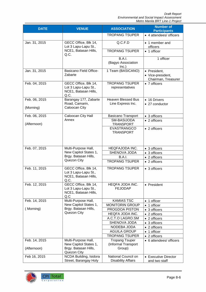
Draft Report Environmental and Social Impact Assessment
Metro Manila BRT Line-1 Project
Page 8-6
6
DATE VENUE ASSOCIATION Number of
Participants
TROPANG TSUPER 4 attendees/ officers
Jan. 31, 2015 GECC Office, Blk 14, Lot 3 Lapu-Lapu St., NCE1, Batasan Hills, Q.C.
Q.C.F.D 1 member and officers
TROPANG TSUPER 1 officer
B.A.I. (Bagyo Association
Inc.)
1 officer
Jan. 31, 2015 Basicano Field Office-Zabarte
1 Team (BASICANO) President,
Vice-president, Chairman, Treasurer
Feb. 04, 2015 GECC Office, Blk 14, Lot 3 Lapu-Lapu St., NCE1, Batasan Hills, Q.C.
TROPANG TSUPER representatives
7 officers
Feb. 06, 2015
(Morning)
Barangay 177, Zabarte Road, Camarin, Caloocan City
Heaven Blessed Bus Line Express Inc.
16 Drivers
27 conductor
Feb. 06, 2015
(Afternoon)
Caloocan City Hall Annex
Basicano Transport 3 officers
SM-BASIJODA TRANSPORT
2 officers
EVASTRANGCO TRANSPORT
2 officers
Feb. 07, 2015 Multi-Purpose Hall, New Capitol States 1, Brgy. Batasan Hills, Quezon City
HEQFAJODA INC. 3 officers
SHENOVA JODA 3 officers
B.A.I. 2 officers
TROPANG TSUPER 2 officers
Feb. 11, 2015 GECC Office, Blk 14, Lot 3 Lapu-Lapu St., NCE1, Batasan Hills, Q.C.
TROPANG TSUPER 3 officers
Feb. 12, 2015 GECC Office, Blk 14, Lot 3 Lapu-Lapu St., NCE1, Batasan Hills, Q.C
HEQFA JODA INC. FEJODAP
President
Feb. 14, 2015
( Morning)
Multi-Purpose Hall, New Capitol States 1, Brgy. Batasan Hills, Quezon City
KAMIAS TSC 1 officer
MONITORIN GROUP 1 officer
PROGDOA PISTON 3 officers
HEQFA JODA INC. 2 officers
A.C.T.O LAGRO.SM 2 officers
SHENOVA JODA 3 officers
NODEBA JODA 2 officers
AGUILA GROUP 1 officer
TROPANG TSUPER 2 officers
Feb. 14, 2015
(Afternoon)
Multi-Purpose Hall, New Capitol States 1, Brgy. Batasan Hills, Quezon City
Tropang Tsuper (Informal Transport
Group)
6 attendees/ officers
Feb 16, 2015 NCDA Building, Isidora Street, Barangay Holy
National Council on Disability Affairs
Executive Director and two staff

Draft Report Environmental and Social Impact Assessment
Metro Manila BRT Line-1 Project
Page 8-7
7
DATE VENUE ASSOCIATION Number of
Participants
Spirit, Diliman, Quezon City
Feb. 22, 2015 GECC Office, Blk 14, Lot 3 Lapu-Lapu St., NCE1, Batasan Hills, Q.C.
TROPANG TSUPER 6 attendees/ officers
Feb. 25, 2015 GECC Office, Blk 14, Lot 3 Lapu-Lapu St., NCE1, Batasan Hills, Q.C.
NEW SIGLI COM 1 officer
NEW-SI SUJODA INC. 3 attendees/ officers
SANLICOM 2 attendees/ officers
COMMON TRANSPORT
SERVICES COOPERATIVE
2 attendees/ officers
Feb. 28, 2015
(morning)
Commonwealth Extension Brgy. Pasong Putik
COMTRANSDECO (Commonwealth
Transport Service and Development Cooperative)
9 attendees/ officers
Feb. 28, 2015
(afternoon)
GECC Office, Blk 14, Lot 3 Lapu-Lapu St., NCE1, Batasan Hills, Q.C.
TROPANG TSUPER
5 attendees/ officers
Common TSC
2 attendees/ officers
March 02, 2015 NCDA Building, Isidora Street, Barangay Holy Spirit, Diliman, Quezon City
National Council on Disability Affairs
34 attendees/ representatives
8.3.1 Meetings with the PUJ/PUB Sectors 715. The main issues and concerns raised during the meetings by operators and drivers are as follows:
1) The BRT project might result to loss of livelihood to the operators and drivers; 2) Will the government help them relocate or find new routes to operate? 3) Will they be allowed to co-exist with the BRT? 4) If they operate on feeder routes to the BRT, will DOTr be willing to provide them a central
PUJ/PUB Terminal? 5) Will there be a way for them to participate as investors in the BRT? 6) Can they or a member of their households be given preference to work in the BRT system; 7) Can they avail of trainings to enhance their skills and employability. 8) Will the government be willing to purchase their old vehicles for scrapping?
716. These consultation meetings were important in crafting the SMP for the PUJ/PUB sector as provided in detail in the previous section.
8.3.2 Meetings with the PWD Sector
717. The following were the general concerns raised during the open forum at the stakeholder consultation with PWDs held through the National Council for Disabilities Affairs (NCDA):

Draft Report Environmental and Social Impact Assessment
Metro Manila BRT Line-1 Project
Page 8-8
8
1) The introduction of an additional fleet of 300 buses might lead to more congestion on the corridor.
2) Incessant flooding along España might pose problems for the BRT. There must be measures to address this.
3) Persons with disabilities hopefully will be given a discount on the bus fare. 4) The concept design addresses the needs of persons with mobility impairments, but there
seems to be none for those with sensory impairments. Announcement might just be audio, but hopefully there can be visuals also for the deaf. There must also be tactile floor services for the blind. Persons with disabilities must not need to walk too far.
5) The buses and stations have to be accessible. Is the BRT adopting the principle of universal access or BP 344 (Accessibility Law)?
6) There must be ample allocated/reserved seats or space for persons with disabilities, with special ones for those in wheelchairs. There must be strict compliance with these reserved seats or spaces.
7) The transfer from the BRT to other modes must be seamless and easy for persons with disabilities.
8) If those in wheelchairs have a ramp, how about those with crutches? It is harder for the latter to move. They should be given priority on elevators or on the buses as well.
9) Hopefully, CCTVs will be installed on the buses and stations. 10) Will there be provisions for luggage? 11) Will the BRT operate 24/7? 12) Hopefully, even persons with disabilities with ample skills can be hired to staff the BRT. 13) Every bus should have allocated seats or spaces for persons with disabilities. They do not
want to be segregated on one bus at a time. 14) There must be designated staff to help persons with disabilities. 15) Audiovisuals will greatly help persons with disabilities. 16) Get data about senior citizens and persons with disabilities. Do not rely on LGU counts alone,
as these are not accurate (as averred by the Acting Executive Director of NCDA). 17) All kinds of persons with disabilities must be taken into consideration, and all existing modes
hopefully can do the same.
718. All in all, the attending PWDs want a very accessible BRT system, which was raised over and over during the forum, as well as audiovisuals and other aids that are suited to the various sensitivities of people with disabilities and the elderly. 8.4 Future Public Consultations 719. Two more public consultations will be held during the ESIA stage. These public consultations will be done before and after the submission of the Draft Final ESIA. Representatives of project stakeholders shall be invited and are expected to attend these consultation meetings. 8.5 Community Relations and Participation Plan (CRPP)
720. The CRPP involves (i) the establishment of a civil society consultative committee, (ii) procedures and mechanisms for information dissemination and community access to project management and; (iii) support to communities for improving streets affected by construction and traffic detours; and (iv) community information mechanisms regarding work schedules, traffic detours, and disruption of urban services. 8.5.1 Civil Society Consultative Committee (CSCC)
721. A CSCC shall be organized by the Project Implementing Unit (PIU) to be composed of the PIU Communications Specialist as Chair, representatives from the LGUs (Quezon City and City of Manila), representatives from special interest groups including NCDA, NCCSP, and PCW, MMDA, PNP Traffic Management Group, barangay officials, and transport sector representatives. The committee shall identify and discuss issues and concerns from various sectors of society with regards to the BRT project construction and operation and to develop a means of communication so that such issues and concerns are taken into consideration during project implementation or are properly addressed in a timely manner either during project construction or during BRT operation.

Draft Report Environmental and Social Impact Assessment
Metro Manila BRT Line-1 Project
Page 8-9
9
8.5.2 Public Relations and Communication Group
722. A Public Relations and Communications Group shall be created under the PIU to be staffed by a Communications Specialist, graphic designer, and support staff. The Group shall be the PIU’s representative or secretariat for the Civil Society Consultative Committee. Its tasks will also include preparation of project information materials and ensuring information and communication requirements for the BRT project are met. 8.5.3 Information Dissemination and Stakeholder Enhancement Plan
723. In order to keep the stakeholders abreast about the Project, the Project will undertake a public consultation and disclosure activities and mechanisms to continue beyond the ESIA process throughout the lifecycle of the Project. In this sense, DOTr shall provide periodic reports to the stakeholders that will describe the progress of the project implementation especially on issues that involve risks or impacts.
724. Project information dissemination will be done through the use of the following:
1. Leaflets showing the project and its features; 2. Billboards as a form of promoting public awareness about the project; 3. Facebook showing the various features of the project and soliciting comments and
suggestions from the public towards a better BRT project implementation and operationalization;
4. Posters as another form of promoting public awareness; 5. Radio, TV, and online announcements community information mechanisms regarding work
schedules, traffic detours, and disruption of urban services; and 6. SMS messaging.
725. Table 8.5.1 provides the Stakeholder Communications Plan, Responsibilities and Cost
Table 8.5.1: Stakeholder Communications Plan and Responsibilities
Activity Timing Responsibility Estimated Cost
(in PhP) A. Preconstruction Phase
1) Community liaison and grievance recording
Appointment of the Project’s safeguard officers and Grievance Officer (GO) in time for consultation during the DED stage of the Project and consultation and disclosure activities concerning the final ESIA document
DOTr Project Team, Safeguard Officers and GO
Actual salary of the safeguard officers and GO
Actual community liasoning and coordination cost
Cost per activity shall be prepared by the Safeguard Officers and GO prior to the undertaking of the activity to be approved by DOTr
Immediate consultation and socio-economic profiling of additional PAPs as found out in the ESIA validation
Consultant (individual or a firm) to be hired by DOTr
Actual cost of services (as bid or as allocated by DOTr)
B. Construction Phase
1. Community liaison and grievance recording
Day to day interactions with stakeholders
Visiting local communities for
DOTr PIU, SPC, Safeguard Officers and GO
Part of the cost per activity to be prepared by the Safeguard

Draft Report Environmental and Social Impact Assessment
Metro Manila BRT Line-1 Project
Page 8-10
1
Activity Timing Responsibility Estimated Cost
(in PhP) informal consultation once a week at minimum
Weekly grievance reporting
Discussing progress of implementation of project action plans and issues that involve on-going risks or impacts (as needed, but at least annually).
Officers and GO.
2. Community consultation events
Prior to the start of construction
Prior to the completion of the construction
Project website to be regularly updated
DOTr PIU, SPC, Safeguard Officers and GO
Part of the cost per activity to be prepared by the Safeguard Officers and GO.
3. Media notifications about Project progress
At least one to two weeks prior to the community consultation meetings
Regularly updated on website or newspaper of local circulation
DOTr PIU, SPC, Safeguard Officers and GO
Cost of the engagement of Media Personnel; and, Cost of publication of news items.
4. Updating of Stakeholder Communications Plan
Following each of the community consultation events
DOTr, SPC, Safeguard Officers and GO
Part of the cost per activity to be prepared by the Safeguard Officers and GO.
C. Operation and Decommissioning Phase
1. Grievance logging, resolution and reporting
Ongoing logging and resolution
Bi-annual reporting
DOTr, SPC, Safeguard Officers and GO
Part of the cost per activity to be prepared by the Safeguard Officers and GO.
2. Decommissioning consultation event with affected staff and communities
With staff prior to retrenchment Proceedings
With communities prior to ceasing operations
DOTr, SPC, Safeguard Officers and GO
Part of the cost per activity to be prepared by the Safeguard Officers and GO.
8.5.4 Community Support 726. Community support during project construction and traffic detours brought about by the BRT project implementation will include the following:
1) Providing a health and safety specialist to assess public health and safety concerns arising from the project;
2) Develop health and safety plans including a community communications plan addressing the health and safety concerns and information needs of the community;
3) Provide adequate traffic management support including signages and traffic aide personnel and enforcers during project construction and traffic detours; and
4) Providing proper waste disposal methods to ensure sanitation and orderliness at construction sites.
8.6 Grievance Redress Mechanism (GRM)
727. A grievance redress mechanism (GRM) for the Project shall be established by DOTr as part of the overall project management system in order to address community concerns and complaints. Through this mechanism, queries, problems, and complaints about the social and environmental

Draft Report Environmental and Social Impact Assessment
Metro Manila BRT Line-1 Project
Page 8-11
1
performance of the proposed project in its preparatory, actual, and post-implementation phases will be answered, resolved effectively, and addressed expeditiously.
728. A grievance can be defined as an actual or perceived problem that might give grounds for complaint. For this project, anyone can submit a grievance in the form of comments and suggestions if a person believes that any project related activity has any detrimental impact on the environment, the community, and on their quality of life. 729. The following could be considered grievances:
Financial loss, physical harm and nuisance which are negative impacts on a person or a community;
Dangers to the environment or health and safety;
Failure of DOTr, its Contractors and sub-contractors to comply with standards or legal obligations;
Criminal activity and harassment of any nature;
Unethical behaviour;
Impropriety or fraud or financial malpractice; and,
Attempts to conceal any of the above.
8.6.1 Designation of Grievance Officer (GO) and Formation of Grievance Redress Committee (GRC)
730. DOTr shall designate a Grievance Officer who will be the main point of contact for all grievance related concerns. The grievance inquiries or complaints shall be directed to the following:
Grievance Officer Full Name Contact Numbers: Landline: Mobile Number: Email:
Complete Address of the GRC Office Tel. No.: Fax No.: Email:
731. The name and contact details of the GO shall be disclosed at the city and community levels through future public consultation meetings, Project website and/or any written information given to the stakeholders. Functions of the GO shall include, among others, (1) organize and manage grievance mechanism and processes; and, (2) responsible for disseminating information regarding construction schedules or program on a timely basis to communities that are likely to be directly affected; and (3) the establishment of a logging system of all grievances that will contain the following information: (i) Date of the grievance or comment; (ii) name and contact address of the complainant; (iii) brief description of the complaint; (iv) brief description of the action taken by DOTr to investigate the cause of the complaint and bring about corrective action; and (v) date of reply to the complainant, with a file reference to any correspondence. 732. For grievances that will not be resolved by the GO, such grievances shall be elevated to the attention of the Grievance Redress Committee (GRC). The functions of the GRC include the addressing of “high level” legitimate concerns, grievances of the local communities and affected parties who may consider themselves deprived of appropriate treatment under the project DOTr shall facilitate the establishment of GRC prior to the Project’s work mobilization. 733. The GRC may be comprised of representative from DOTr, SPC, local government units of Quezon City and Manila City, affected PUJs and PUBs, the Contractor’s Social and Environment Safeguard Specialist, and the Project’s Environment and Social Safeguard Specialist. The role of the GRC is to address the project related grievances of the affected parties which are unable to be resolved satisfactorily through the initial stages of the Grievance Redress Mechanism (GRM). 734. All important procedures to be adopted in the operation of the GRM shall be provided in an orientation meeting to be convened by the DOTr at community level. The meeting shall be attended

Draft Report Environmental and Social Impact Assessment
Metro Manila BRT Line-1 Project
Page 8-12
1
by GRC members, contractor/s, local government representative/s and other interested parties from government agencies and non-government organizations (NGOs). 8.6.2 Grievance Reporting and Resolution
735. To delineate the responsibilities of the GO and the GRC in the addressing of grievances, Table 8.6.1 provides the grievance classification criteria and responsibilities.
Table 8.6.1. Grievance Classification Criteria and Responsibilities
Grievance Classification
Risk Level
Validity Responsible Party and
Expected Response Response time
Low Negligible
to low
Unsubstantiated GO;
GO will conduct investigation,
document findings and provide a
response.
Within ten (10)
working days; unless
there are exceptional
circumstances
Medium Possible
risk and
likely one
off event
Possible
substantiation
GO;
GO together with the Contractor
and community representative
will conduct investigation. They
may decide to stop work during
the investigation to allow the
corrective preventative actions to
be determined. The GO will
provide a response.
Within twenty (20)
working days; unless
there are exceptional
circumstances
High Probable
risk and
could re-
occur
Probable
substantiation
GRC;
The GRC will organize a major
investigation team (from among
its members) for prompt
investigation and resolution.
Work will be stopped in the
affected area. The GO will
provide a response.
Within thirty (30)
working days; or until
the person or
organization is
satisfied with the
resolution or remedial
actions
736. The GO will summarize grievances to report on Project performance; weekly during construction and biannually during operation, removing identification information of complainants to protect their confidentiality and guaranteeing anonymity. Biannual grievance analysis and reporting will be undertaken where logs will be reviewed to identify repeat grievances. 737. Aggrieved parties or complainants may submit their complaints to DENR-EMB. In this Project, EMB is expected to require the formation of a multi-partite monitoring team (MMT) to oversee the ESMP’s implementation and execution. EMB is mandated by PD 1586 to act on complaints about environmental and social performance of projects issued with environmental compliance certificates (ECC). 738. Communities and individuals who believe that they are adversely affected by a World Bank (WB) supported project may also submit complaints to existing project-level grievance redress mechanisms or the WB’s Grievance Redress Service (GRS). Project affected communities and individuals may submit their complaint to the WB’s independent Inspection Panel which determines whether harm occurred, or could occur, as a result of WB non-compliance with its policies and procedures. Complaints may be submitted at any time after concerns have been brought directly to the World Bank's attention, and Bank Management has been given an opportunity to respond. For information on how to submit complaints to the World Bank’s corporate Grievance Redress Service (GRS), please visit http://www.worldbank.org/GRS. For information on how to submit complaints to the World Bank Inspection Panel, please visit www.inspectionpanel.org
Draft Report Environmental and Social Impact Assessment
Metro Manila BRT Line-1 Project
Page 8-13
1
739. Both the project level GRM and the GRS ensure that complaints received are promptly reviewed in order to address project-related concerns. 8.6.3 Grievance Mechanism Disclosure 740. Prior to the start of the main construction activities, the GO contact details and information material about the grievance redress mechanism will be disclosed in the local communities at group meetings, on the Project website and in any written information given to stakeholders.

Draft Report Environmental and Social Impact Assessment
Metro Manila BRT Line-1 Project
1

Environmental and Social Impact Assessment
Metro Manila BRT Line-1 Project
B-1
1
BIBLIOGRAPHY / REFERENCES
Clean Air Initiative for Asian Cities (CAI-Asia) Center. Draft Report on Environmental and Health
Benefits of the Cebu City BRT Corridor. August 2012
Detailed Technical Study, Manila-Quezon Corridor Improvement Project, 2013
DPWH (2003). Infrastructure Right of Way Procedural Manual
DPWH (2007). Land Acquisition, Resettlement, Rehabilitation and Indigenous Peoples Policy
(3rd edition)
EMB-DENR .Ambient Air Quality Monitoring, TSP Monitoring Dashboard, 2015.
http://www.emb.gov.ph/ambientair/
Environmental Assessment Studies, Cebu BRT Project, 2012
ITP “Auto-CAD Drawing of CBRT Alignment”, July 31, 2012
ITP. Draft Final Report on Cebu BRT Feasibility Study. August 2012
ITP. Draft Final Report on Cebu Traffic Management Study. August 2012
ITP. Study and Concept Plan for a Demonstration Bus Rapid Transit Corridor: FINAL REPORT
V2.1. and V.2.2 2010
ITP-WB. Final Report on Cebu City Urban Transport Greenhouse Gas Emissions Study. July
2012
Katsumi, K. et al. Strong Motion Observation in Metro Manila, Philippines, 1931
Leading causes of morbidity, Department of Health, Republic of the Philippines
Manila Comprehensive Land Use Plan and Zoning Ordinance, 2005-2020
Quezon City Comprehensive Land Use Plan, 2011-2030
Quezon City Zoning Map, 2013
The World Bank, CTII/WCI, Master Plan for Flood Management in Metro Manila and Surrounding
Areas, June 2012
World Bank (2008). Philippines Involuntary Settlement: Policy and Institutional Framework,
Practices and Challenges (Discussion Paper)
Webliography:
http://en.wikipedia.org/wiki/Metro_Manila
http://en.wikipedia.org/wiki/Metro_Manila#Water_and_electricity
http://en.wikipedia.org/wiki/Quezon_Memorial_Circle
http://www.chanrobles.com/virtualibrary1.htm
http://www.doh.gov.ph/kp/statistics/morbidity.html#2010
http://www.dpwh.gov.ph/
http://www.iitk.ac.in/nicee/wcee/article/1931.pdf
http://www.worldbank.org/
https://www.ifc.org/
http://www.quezoncity.gov.ph/