E1465 - World Bank Documents
366
E1465 , ~ol.7 -RAMPUR HYDIOPOW 4114 N-NHIx A- A 3WTE ElEVU R- ENT - syi~ - . w RL- ' '' - - 4- -,a D~~ WATER £ ENtVIRONMENtT Consolidated by: DHI (India) Water & Environment Pvt. Ltd. Public Disclosure Authorized Public Disclosure Authorized Public Disclosure Authorized Public Disclosure Authorized Public Disclosure Authorized Public Disclosure Authorized Public Disclosure Authorized Public Disclosure Authorized
-
Upload
khangminh22 -
Category
Documents
-
view
3 -
download
0
Transcript of E1465 - World Bank Documents

E1465, ~ol.7
-RAMPUR HYDIOPOW
4114N-NHIx
A- A
3WTE ElEVU R- ENT
-syi~
- . w
RL- ' '' -- 4- -,a
D~~WATER £ ENtVIRONMENtT
Consolidated by: DHI (India) Water & Environment Pvt. Ltd.
Pub
lic D
iscl
osur
e A
utho
rized
Pub
lic D
iscl
osur
e A
utho
rized
Pub
lic D
iscl
osur
e A
utho
rized
Pub
lic D
iscl
osur
e A
utho
rized
Pub
lic D
iscl
osur
e A
utho
rized
Pub
lic D
iscl
osur
e A
utho
rized
Pub
lic D
iscl
osur
e A
utho
rized
Pub
lic D
iscl
osur
e A
utho
rized

44L
- fp: -'
Az -
A- --AfftsXsA f
w- ^ S = - = w Mr
AeX§r~ 4d

List of Acronyms/Abbreviations
CA Compensatory Afforestation
CAT Catchment Area Treatment
CEA Central Electricity Authority
CPCB Central Pollution Control Board
cumec Cubic metre per second
DPR Detailed Project Report
EA/EMP Environmental Assessment and Environmental Management Plan
EPP Emergency Preparedness Plan
EIA Environmental Impact Assessment
GoHP Government of Himachal Pradesh
GOI Government of India
HPSPCB Himachal Pradesh State Pollution Control Board
HRT Head Race Tunnel
ITIs Industrial Training Institutes
LADC Local Area Development Committee
MoEF Ministry of Environment and Forests
MOU Memorandum of Understanding
NJHEP Nathpa-Jhakri Hydro Electric Power Project
O&M Operations and Maintenance
PAPs Project Affected Persons
PFRs Preliminary Feasibility Reports
PIA Project Influence Areas
PIIA Project Immediate Influence Areas
PIC Public Information Centre
RAP Resettlement Action Plan
RHEP Rampur Hydro Electric Project
SA Social Impact Assessment
SCDP Sustainable Community Development Program
SJVNL Satluj Jal Vidyut Nigam Limited
1 US$ = INR 40.0

ii
iI
i
I
iI

TABLE OF CONTENTS
Acronyms
Table of ContentsList of Tables xiiiList of Figures xviii
EXECUTIVE SUMMARY E-1I Introduction E-12 Project Location & Context E-13 PROJECT DESCRIPTION E-44 Important site characteristics E-45 Environmental and social Assessment process E-6
Environmental Context & Project Location E-6Impact Assessment process E-6Policy & Regulatory Framework E-7Key Safeguard Documents E-7Disclosure & Consultation E-8
6 Analysis of Alternatives E-9Identification of the Rampur Project E-9Initial Ranking E-9Analysis & Prioritization E-9The "No Project" Alternative E-10Project's Design Alternatives E-10Identification of the most favourable alternatives E-12
7 Environmental & Social Impacts & Mitigation Measures E-12Involuntary Resettlement E-12Institutional arrangements for implementation of RAP and SCDP E-14Impacts on Forests, Natural Habitats & Wildlife E-15Instream Flow Impacts & Water Quality Issues E-17Construction-Related Impacts E-19Safety of Workers and Communities E-20Impacts on Physical Cultural Resources E-21Other Induced Impacts and Cumulative Effects E-21Dam Safety E-22

Operations manual and emergency preparedness E-22
Riparian Issues E-22
Catchment Area Treatment Plan & Other Environmental Enhancements E-23
8 Implementation Arrangements E-24
Institutional Framework E-24
Adaptive Management of Environmental Issues E-24
Continuous Stakeholder Consultation E-25
Institutional Capacity Building E-25
9 Budget for environment management E-25
INTRODUCTION & PROJECT DESCRIPTION 1-1
1.1 The Rampur Project 1-1
1.2 Project Location 1-1
1.3 Context of the Project 1-3
1.3.1 Hydropower Potential in India 1-3
1.3.2 Hydro Power Potential in Himachal Pradesh 1-3
1.4 Rationale for the Project 1-5
1.4.1 Demand for Energy in India 1-5
1.4.2 Power Demand Scenario in the Country 1-6
1.4.3 Need for Hydropower 1-7
1.4.4 Identification of Rampur Hydro-Electric Project 1-7
1.5 Analyses of Alternatives 1-7
1.5.1 Identification of the Rampur Project 1-7
1.5.2 Initial Ranking of Hydropower Projects 1-8
1.5.3 Analysis & Prioritization 1-8
1.5.4 Development Status of Hydropower Projects in the Indus Basin 1-8
1.5.5 Project's Design Alternatives 1-8
1.5.6 Analyses to Identify the Most Favorable Design Alternatives 1-12* ALTERNATIVE - II 1-12
* ALTERNATIVE - III 1-14
* ALTERNATIVE - V 1-16
1.5.7 Overall Selection 1-17
1.6 Construction Components of the Selected Project Design 1-18
1.7 Project Requirements 1-22* Land Acquisition 1-22
* Construction Material 1-22
* Construction Schedule 1-23
ii

1.8 Lessons Learnt from Implementation of the Nathpa-Jhakri Hydropower Project 1-231.8.1 Major Issues as per Implementation Completion Report 1-231.8.2 Good Practices implemented in the Nathpa-Jhakri Hydropower Project 1-24
* Environment 1-24* Resettlement & Rehabilitation 1-26* Employee Welfare 1-29
1.9 Environmental Assessment in Rampur Hydropower Project 1-291.9.1 Environmental Context & Project Location 1-291.9.2 Impact Assessment process 1-301.9.3 Regulatory Clearances for the Project 1-311.9.4 Key Safeguard Documents 1-31
* Disclosure & Consultation 1-31
1.10 Structure of the Report 1-32
2 POLICY, LEGAL & REGULATORY FRAMEWORK 2-12.1 Constitutional Provisions 2-1
2.1.1 Water Resources 2-12.1.2 Environment 2-1
* Specific Reference to Environment Protection in the Constitution 2-1
2.2 The Policy Framework for Hydraulic Infrastructure & the Environment 2-22.2.1 National Water Policy 2-22.2.2 Water Policy of Himachal Pradesh 2-32.2.3 National Environment Policy 2-42.2.4 National Forest Policy 2-5
2.3 Environmental Regulations & Legal Framework for the Project 2-6
2.4 Environmental Regulations 2-62.4.1 Environment (Protection) Act, 1986 2-6
* Wildlife (Protection) Act, 1972 2-6* Forest (Conservation) Act, 1980 2-6* Water (Prevention and Control of Pollution) Act, 1974, &
Air (Prevention and Control of Pollution) Act, 1981 2-7* The Biological Diversity Act, 2002 2-7* Hazardous Wastes (Management and Handling) Amendment Rules, 2003 2-7* Ozone Depleting Substances (Regulation and Control) Rules, 2000 2-7* The Serais Act, 1867 2-7* The North India Canal and Drainage Act, 1873 2-7* Indian Easements Act, 1882 2-8* The Indian Fisheries Act, 1897 2-8* The Factories Act, 1948 2-8* The Mines Act, 1952 2-8* The River Boards Act, 1956 2-8
iii

* Ancient Monuments and Archaeological Sites and Remains Act, 1958 2-8
* EIA Notification, 1994 2-8
* EIA Notification, September 2006 2-8
2.4.2 The Environmental Clearance Process 2-8
2.4.3 The Forestry Clearance Process 2-9
2.5 Environmental Clearances Obtained for the Project 2-10
2.5.1 At State Level 2-10
* Pollution Control and Environmental Conservation 2-10
* Additional Clearance for Environmental Flow 2-11
2.5.2 At the Government of India Level 2-11
* Stage-I Environmental Clearance 2-11
* Stage-II Environmental Clearance 2-11
* Stage-III Environmental Clearance 2-12
2.6 Responsibilities of Government of India under International Treaties 2-13
2.7 Applicability of the World Bank Safeguard Policies 2-19* Environmental Assessment (OP/BP 4.01) - APPLICABLE 2-19
* Natural Habitats (OP/BP 4.04) - NOT APPLICABLE 2-19
* Involuntary Resettlement (OP/BP 4.12) - APPLICABLE 2-19
* Indigenous Peoples (OD 4.20) - NOT APPLICABLE 2-19
* Forests (OP/BP 4.36) - APPLICABLE 2-20
* Safety of Dams (OP/BP 4.37) - APPLICABLE 2-20
* Physical Cultural Resources (OPN 11.03) - APPLICABLE 2-20
* Projects in Disputed Areas (OP/BP/GP 7.60) - NOT APPLICABLE 2-20
* Projects on International Waterways (OP/BP/GP 7.50) - APPLICABLE 2-20
2.8 SJVNL Corporate Policy Statements 2-21
2.9 SJVNL Corporate Policy on Environment 2-21
2.9.1 SJVNL's Environmental Policy Statement 2-21
2.9.2 SJVNL Health, Security, Safety & Environment Directive 2-22
2.9.3 SJVNL's Biodiversity Conservation Policy 2-24
2.9.4 SNVNL's Climate Change Commitments 2-25
3 THE ENVIRONMENTAL BASELINE,ASSESSMENT & MITIGATION OF IMPACTS 3-1
3.1 River Systems of Himachal Pradesh 3-1
3.1.1 The Indus River System 3-1
3.1.2 Satluj River in Himachal Pradesh 3-2
3.1.3 Important Tributaries of River Satluj 3-2
* Spiti River 3-2
* Baspa River 3-2
* The Nogli Khad 3-2
* Soan River 3-3
iv

3.1.4 Hydro power Projects on the Satluj 3-3* Proposed Khab Hydropower Project (1020 MW), Kinnaur District 3-3* Karcham Wangtoo Hydroelectric Project (100OMW), Kinnaur District 3-3* Bhaba Hydel Project (120 MW), Kinnaur District 3-4* Baspa Hydroelectric Project (300 MW), Kinnaur District 3-4* Proposed Sorang Hydropower Project, Kinnaur District 3-4* Ghanvi-I (22.5 MW), Shimla District 3-4* Ghanvi -II (10 MW), Shimla District 3-4* Nathpa-Jhakri Hydel Project (1500 MW), Kinnaur District 3-6* Proposed Luhri Hydroelectric Project (465 MW), Kinnaur District 3-6* Kol Dam (800 MW) 3-6* Bhakra Dam 3-6
3.2 Baseline Characteristics of the Satluj Basin 3-73.2.1 The River and its Catchment 3-73.2.2 Topography 3-93.2.3 Geology 3-93.2.4 Climate 3-10
* Baseline 3-10* Rainfall & Cloud Cover 3-10* Relative Humidity 3-11* Temperature 3-11* Special Weather Phenomena 3-12* Wet Haze and Fog 3-12* Potential Impacts 3-12
3.2.5 Climate Change 3-12* Baseline 3-12* Potential Impact 3-14* Effect of Climate & Hydrological Variability on the Performance of the Project 3-14
3.2.6 Floods, Cloud Burst and Flash Floods 3-19* Potential Impact 3-20
3.2.7 Soils 3-213.2.8 Erosion & Sedimentation 3-22
* Baseline Erosion Rates 3-22* Potential Impact 3-24* Mitigation Measures & Monitoring 3-24* Monitoring 3-24
3.3 Geological Characteristics of the Project Area 3-273.3.1 Geology 3-27
* Potential Local Thrust and Faults 3-273.3.2 Seismology 3-28
* Lesser Himalayan Seismic Belt 3-30* Main Central Thrust (MCT) 3-30* Kaurik Fault 3-30* Rampur Fault 3-30* Main Boundary Fault (MBF) 3-30* Foothill Thrust 3-30* Potential Impacts 3-30
v

* Mitigation Measures 3-31
3.3.3 Landslides 3-31
* Potential Impacts 3-33
* Mitigation Measures 3-33
3.4 Hydrology & Water Resources 3-33
3.4.1 Baseline Hydrology 3-33
* Flow Profile of River Satluj 3-34
* Hydrological Changes in the Satluj River 3-45
3.4.2 Sources and Usage of Water 3-45
3.4.3 Existing Water Quality of Satluj 3-45
3.4.4 Water Quality 3-46
3.4.5 Downstream Water Use: Impacts of Water Quality Changes 3-50
* Estimates of Sewage Loads 3-51
* Effluent from Rampur Town 3-53
* Effluent Disposal from Jhakri Colony 3-54
* Effluent Disposal from Proposed Project Colony 3-54
* Effluent Disposal from Temporary Labour Shelters 3-54
* Effluent Disposal from Operation of Crushers 3-54
* Mitigation Measures 3-55
3.4.6 Channel Sedimentation and Reduced Dissolved Oxygen 3-55
* Mitigation Measures 3-56
3.5 Land Environment 3-56
3.5.1 Land Use 3-56
3.5.2 Soil Quality 3-62
3.6 Aquatic Habitat & Fish Diversity 3-63
3.6.1 Aquatic Flora 3-63
3.6.2 Aquatic Fauna 3-63
3.6.3 Fish Habitats 3-63
3.6.4 Results from Aquatic Monitoring 3-68* Migratory Fish Species 3-69
* Outcomes of the Study on Fish Availability 3-69
3.6.5 Potential Impacts on Aquatic Habitats & Mitigation 3-69
* Construction Related Impacts 3-70
* Work on the Riverbed 3-70
* Construction of Project Infrastructure 3-70
* Water Pollution 3-70
* Use of Explosives 3-71
* Vegetation Clearing 3-71
* Reduced River Flow 3-71
* Interruptions of Fish Migration & Destruction of Spawning Grounds 3-72
* Water Pollution from Use of Synthetic Chemicals 3-72
3.7 Terrestrial Biodiversity 3-72
3.7.1 Background 3-72
3.7.2 Methodology and Assessment techniques 3-74* Flora Assessment 374
vi

* Assessment Techniques 3-74* Shanon - Weaver Index (1948) 3-74
Fauna Assessment 3-74* Public Consultation 3-75
3.7.3 Forests and Terrestrial Biodiversity of Himachal Pradesh 3-75* Forest 3-75* Natural Flora 3-76* Natural Fauna 3-77* Traditional Timber Rights Followed in Himachal Pradesh 3-77* Procedure for Obtaining Timber 3-77* Timber Trees 3-78
3.7.4 Terrestrial Biodiversity of Satluj Basin 3-78* Forest Types 3-79* Natural Flora 3-79* Natural Fauna 3-79
3.7.5 Biodiversity of Project Influence Area (7 km radius surrounding the project site) 3-82* Forests 3-83* Flora 3-85* Ethno-Botanical Baseline 3-93* Fauna 3-93* Wildlife 3-93
3.7.6 Biodiversity of the Project's Immediate Influence Area 3-95* Forest Types 3-95* Flora 3-95* Fauna 3-97
3.7.7 Biodiversity of Project's Directly Affected Area 3-98* Forests Directly Affected by the Project 3-98* Forest Type 3-99* Flora 3-99* Fauna 3-101
3.7.8 Distribution of Endangered/Protected/Rare/Endemic Flora and Fauna 3-102* The Satluj Basin 3-102* Project Influence Area (7km all around the Project) 3-104* Project's Immediate Influenced Area (500m around the Project) 3-105
Project's Directly Affected Area 3-105* Comparative Distribution of Forests 3-106* Comparative Status on Protected Area Network 3-106* Comparative Distribution of Flora 3-106* Comparative Distribution of Fauna 3-107
3.7.9 Potential Impacts on Terrestrial Biodiversity & Mitigation 3-108* Loss of Forest 3-108* Mitigation Measures for Loss of Forest 3-108* Impact on Flora and Fauna 3-109
Quantitative Assessment of Flora in the Project's Directly Affected Area 3-110* Assessment of Flora of the Immediate Influence Area 3-117* Mitigation Measures for Impact on Flora and Fauna 3-121
vii

3.8 Impact Generated by Construction Activities 3-121
3.8.1 Water Quality Impacts & Mitigation 3-121
* Baseline 3-121
* Sources and Type of Impacts 3-122
* Mitigation 3-122
3.8.2 Air Quality Impacts & Mitigation 3-123
* Observations on Ambient NOX Levels 3-124
* Observation on ambient S02 levels 3-124
* Observations on Ambient SPM levels 3-125
* Observations on Ambient RPM levels 3-125* Source and Types of Impacts 3-125* Mitigation 3-125
3.8.3 Noise Impacts & Mitigation 3-125
* Baseline 3-125
* Source and Types of Impacts 3-126* Mitigation 3-130
3.8.4 Quarries 3-130
* Types of impacts 3-130
* Mitigation 3-130
3.8.5 Muck Generation & Disposal 3-130
* Types of Impacts 3-130
* Mitigation Measures 3-131
3.8.6 Work Camps, Work Areas & Labour Force - Impacts & Mitigation 3-133
* Impacts 3-133
* Mitigation 3-133
3.8.7 Construction of Headrace Tunnel - Impacts & Mitigation 3-133
* Impacts 3-133
* Mitigation 3-134
3.8.8 Construction of the Power House and Tailrace Channel - - Impacts & Mitigation 3-134
* Impacts 3-134* Mitigation 3-134
3.8.9 Road Construction Impacts & Mitigation 3-134
* Impact 3-134
* Indirect and Cumulative Impacts on Natural Resources 3-135* Interference with Movements of Wildlife 3-135
* Mitigation 3-135
3.8.10 Transmission System - Impacts & Mitigation 3-135
* Mitigation Measures 3-135
3.9 Other Environmental Impacts on the Communities 3-136
3.9.1 Impacts on Human Health 3-136* Mitigation 3-137* HIV/AIDS Risk Level 3-138* Potential Management Interventions for HIV/AIDS 3-138
3.9.2 Impacts of Downstream Hazards 3-139
3.9.3 Water Availability for Communities 3-139
3.9.4 Impact of Blasting on Agricultural & Horticultural Yield 3-140
viii

3.9.5 Potential Effect on the Occupation Pattern in the Project Influence Area 3-143* Employment Benefits 3-143* Shift in Occupation Pattern 3-144* Accessibility to Basic Infrastructure 3-145* Power Generation and Transmission Benefits 3-147
4 ENVIRONMENTAL MANAGEMENT PLAN 414.1 Objective & Principles of the Environmental Management Plan (EMP) 4-1
* Boundaries 4-1* Spatial Boundary 4-1* Temporal Boundaries 4-1
4.2 Methods & Approaches 4-24.2.1 Stakeholder Consultations 4-2
* Public Consultation and Disclosure 4-2* Public Consultation Activities 4-2* Project Planning Responses to Stakeholder Concerns 4-3* Disclosure 4-3
4.3 Environmental Regulations, Compliance & Voluntary Actions 4-34.3.1 Environmental Clearance for Rampur Hydropower Project 4-44.3.2 Conditions laid by the State Government 4-44.3.3 Conditions laid by the Central Government 4-44.3.4 SJVNL Activities for Ecosystem Sustainability of the Satluj Basin 4-54.3.5 Other Parallel Activities Ongoing 4-6
* Implementation of the Hydropower Policy of the State 4-6* River Basin Development Optimization Study 4-6* Planning for Basin Level Implementation of Catchment Area Treatment 4-6
4.4 Institutional & Implementation Arrangement 4-64.4.1 Activities within Project Area 4-6
* SJVNL Environment Management Department (EMD) 4-7* The Construction Contractors 4-8* State Forest Department 4-9
4.4.2 Activities in the Project Influence Area 4-94.4.3 Activities in the Catchment 4-9
4.5 Environmental Management Actions for the Rampur Project 4-94.5.1 Managed River Flow 4-10
* Minimum Release 4-10* Waste Water Treatment 4-10* Control of Silt Runoff in the River 4-11* Fishery Management and Sustenance of Endemic Fisheries 4-12
4.5.2 Biodiversity Management 4-12* Actions in the Project Influence Area (PIA) 4-13* Actions in the Project's Immediate Influence Area (PIIA) and the Directly Affected Area 4-14
ix

* Compensatory Afforestation Plan 4-14
* Quarry/Muck Area Redevelopment Plan 4-14
4.5.3 Catchment Area Treatment 4-14
* CAT Plan Area 4-15
* Objective of the CAT Plan 4-15
* Plan Period 4-15
* Responsibility 4-16
* Forest Conservation & Improvement 4-16
* Species Selected for Afforestation 4-17
* Soil & Moisture Conservation Work 4-17
* Infrastructure Development 4-18
* Wildlife Management (in the CAT Plan) 4-18
4.5.4 Mitigation of Construction related Impacts 4-19
* Erosion and Sediment Control 4-20
* Planning & Managing Muck Disposal 4-21
* Quarry and Borrow Area Management 4-24
* Water Quality Monitoring 4-26
* Management of Water Quality, Chemical Waste and Spillage 4-26
* Emergency Measures for Hazardous Materials 4-27
* Emissions & Dust Control 4-27
* Noise Control 4-28
* Enhancement and Conservation of Physical Cultural Properties 4-28
* Landscaping & Re-vegetation 4-30
* Vegetation Clearing 4-31
* Logging and Removal of Waste Forestry Products 4-32
* Solid Waste Management 4-33
* Management of Construction Work Camps and Spontaneous Settlement Areas 4-34
* Mitigation for Impacts from Construction of Roads 4-35
* Mitigation for Impacts from Construction of Power Evacuation System 4-36
* Environmental Training for Construction Workers 4-37
* On-Site Traffic & Access Management 4-37
4.5.5 Contractor'Staff Health Program 4-38
* Construction Camps 4-38
* For Overall Workforce 4-38
* Additional Malaria Control Measures 4-39
* HIV/AIDS Prevention Measures 4-39
4.5.6 Safety Assurance in the Project 4-44
* Goal of Working Accident-Free 4-44
* Safety Assurance Plan & Safety Manual 4-44
* Safety Management Arrangement 4-44
* Accountability 4-45
* Zero Tolerance Program 4-46
* Implementation and Responsibilities 4-46
4.5.7 Emergency Preparedness Plan 4-47
* Emergency Identification and Evaluation 4-47
* Emergency Evaluation 4-50
* Mock Drills 4-50
* Preventative Actions (where available) 4-51
x

* Notification Procedure 4-51* Notification Flowchart 4-52* Important Telephone Numbers 4-52* Early Warning System and Communication Network 4-53* Communication Systems 4-54* Access to Site 4-54* Response during Periods.of Darkness 4-54* Response during Periods of Adverse Weather 4-54* Sources of Equipment 4-54* Stockpiling Supplies and Materials 4-55* Emergency Power Sources 4-55* Warning Systems (if used) 4-55
4.6 Accessing Carbon Finance 4-554.7 Environmental Monitoring Plan 4-56
4.7.1 Internal Monitoring by the Environment Management Department (EMD) of SJVNL 4-564.7.2 Major Monitoring Themes 4-56
* Water Quality 4-57* Ambient Air Quality and Meteorology 4-57* Noise 4-57. Ecology 4-57* Incidence of Water-Related Diseases 4-58* Land Use 4-58
4.7.3 Adaptive Environmental Management Requirements 4-59* River Water Quality 4-59* Silt Load and Grain Size Distribution 4-59* Indoor Air Quality at Power House Area 4-59* Erosion and Landslide 4-60* Changes in Flow of the Natural Water Source like Tributaries and Springs 4-60* Fish Management 4-60* Review of Adaptive Management Targets 4-60* Budget 4-60* Future Studies 4-60
4.7.4 Indicators for Monitoring Implementation and Performance of EMP 4-60
4.8 Communications and Public Disclosure 4-614.9 Improving Environmental Management Capacity 4-63
4.9.1 Capacity Building of Relevant State Agencies 4-64* State Forest Department 4-64* Fisheries Department 4-68* Department of Environment 4-68* Coordination for Sustainable Hydropower Development 4-70* Institutional Arrangements for River Basin Management 4-70* Environmental Management of Hydropower Development 4-72* Managing Muck Disposal in the State 4-73
4.9.2 Capacity Building of the Regulators 4-73* Himachal Pradesh Environment Protection and Pollution Control Board (HPEPPCB) 4-73* HPEPPCB /State Council for Science Technology and Environment (SCSTE) 4-74* Ministry of Environment and Forest (MoEF), GOI 4-74
xi

4.9.3 Capacity Building of SJVNL 4-74* SJVNL: Environmental Activities 4-74* Environmental Institutional Set-up 4-75* Staffing Requirement 4-75* Environment Activities at Corporate Environment Level 4-75* Environment Activities at Project Level 4-76* Training for Environment Management & Development of Adaptive Management Capacity
4-79* The Five Dimensions of Capacity 4-79* Training Needs Assessment 4-80* List of Training Institutes In India & Abraod 4-89
4.10 Budget & Procurement of EMP and Environmental Capacity Building Activities 4-90
4.10.1 Budget for Implementation of EMP and Environmental Capacity Building 4-90
4.10.2 Procurement of EMP Implementation & Environmental Capacity Building Activities 4-91
xii

List of Tables
Table E.1 - Baseline Characteristics of Project-Affected Persons E-13Table E.2 - Comparative Status of Forests and Natural Resources in the Project Area E-16Table E.3 - Minimum Flow at Various Locations from Khab to Suni (cumec) E-18Table E.4 - Budget for Implementing EMP E-25
Tablel.1 - Hydropower Potential of India 1-3Table 1.2 - Hydropower Potential in River Basins of Himachal Pradesh 1-5Table 1.3 - Hydropower potential of Satluj Basin in Himachal Pradesh 1-5Table 1.4 - Water Conductor Loss in Alternative II 1-13Table 1.5 - Energy Generation in Alternative II 1-14Table 1.6 - Water Conductor Loss in Alternative III 1-15Table 1.7 - Energy Generation in Alternative III 1-16Table 1.8 - Water Conductor Loss in Alternative IV 1-16Table 1.9 - Energy Generation in Alternative II 1-17Table 1.10: Summary Analysis of Alternative Project Designs 1-18Table 1.11 - Salient Features of Rampur Hydroelectric Project 1-20Table 1.12 - Land Requirement for the Project 1-22Table 1.13 - Estimated Quantities of Construction Materials 1-22
Table 2.1 - Environmental Considerations and the Environmental ClearancesObtained in the Rampur Hydropower Project 2-14
Table 3.1 - The Indus River System 3-1Table 3.2 - Tributaries of the Satluj 3-3Table 3.3 - Features of Major Hydro-Electric Projects on the Satluj 3-4Table 3.4 - Topographical Divisions of the Satluj Basin 3-9Table 3.5 - Historical Monthly Rainfall (in mm) Data for Rampur 3-11Table 3.6 - Temperature Data at Rampur Station 3-11Table 3.7 - Temperature data at Luhri 3-12Table 3.8 - Hydrology Risk Assessment: Trend Variables (GWh/year) 3-18Table 3.9 - Major Flash Floods & Cloudbursts in Himachal in 2003 3-21Table 3.10 - Analysis of Soil Samples near of Rampur Hydropower Project 3-22Table 3.11 - Silt Data at Khab, Powari, Nathpa, Jhakri, Bael, Nirath and Sunni, 2006 3-23Table 3.12 - Stratigraphic Sequence of Rocks in the Project Area 3-27Table 3.13 - Seismo-Tectonic Features of the Project Area 3-28Table 3.14 - Major Earthquakes within 200km of the Project Site 3-29Table 3.15 - Historical Flow Data of River Satluj at Khab (downstream of Spiti Confluence):
Minimum, Maximum & Average Flow 3-37
xiii

Table 3.16 - Historical Flow Data of River Satluj at Nathpa Dam Intake:Minimum, Maximum & Average Flow 3-38
Table 3.17 - Historical Flow Data of River Satluj at Rampur:Minimum, Maximum & Average Flow 3-39
Table 3.18 - Historical Flow Data of River Satluj at Luhri (downstream of Bael Village):Minimum, Maximum & Average Flow 3-40
Table 3.19 - Measured Flow data for Tributaries of River Satluj (Nathpa to Jhakri Stretch)for the months of October 2005 - April 2006 3-41
Table 3.20 - Computed Lean Flow for Tributaries of River Satluj (Nathpa to Jhakri Stretch) 3-42
Table 3.21 - Daily Discharge at Rampur 3-43
Table 3.22 - Minimum Flow of the Satluj from Khab to Suni 3-44
Table 3.23 - Measured Flow data for Tributaries of River Satluj (Jhakri to Bael Stretch)for the months of February-March, 2006 3-44
Table 3.24 - Water Requirement in Project Area 3-45
Table 3.25 - Primary Water Quality Criteria as laid by the Central Pollution Control Board 3-46
Table 3.26 - Drinking Water Standards 3-47
Table 3.27 - Water Quality Profile of River Satluj, Year 2003 Monitoring Results 3-48
Table 3.28 - Water Quality Satluj, Year 2006 Monitoring Results Jhakri-Rampur-Bael Stretch 3-48
Table 3.29 - Water Quality Data of River Satluj, July 2004 3-49
Table 3.30 - Estimated Sewage Load of Villages at Right Bank of River Satluj, 2001-11 3-51
Table 3.31 - Estimated Sewage Load from Villages at Left Bank of river Satluj, 2001 3-52
Table 3.32 - Estimated Sewage Load of Rampur Town 3-54
Table 3.33 - Land Use of the Project Influence Area (7km all around the Project) 3-56
Table 3.34 - Land Utilization of Villages in RHEP influence area 3-61
Table 3.35 - Land Use in the Study Area (7km all around the Project) 3-61
Table 3.36 - Land Use (in hectares) of RHEP Influence Area 3-62
Table 3.37 - Analysis of Soil Samples near the Rampur Project Area 3-62
Table 3.38 - Floral Species in Satluj along Jhakri-Rampur-Bael stretch 3-63
Table 3.39 - Faunal Species in Satluj along Jhakri-Rampur-Bael stretch 3-64
Table 3.40 - Fish Species Historically Reported in Upper Reaches of the Satluj River 3-64
Table 3.41 - Fish Species Reported Historically in River Satluj in Himachal Pradesh 3-67
Table 3.42 - Status of Forest in Himachal Pradesh, Kullu and Shimla Districts 3-73
Table 3.43 - Status of the Protected Area Network 3-73
Table 3.44 - National Parks/ Wild Life Sanctuaries in Eastern Himachal Pradesh 3-73
Table 3.45 - Change in Forest Cover of Himachal Pradesh 3-75
Table 3.46 - Major Forest Types Recorded in Himachal Pradesh 3-76
Table 3.47 - Timber Rights Marketed to Right Holders from Rampur Forest Division 3-78
Table 3.48 - Major Forest Types of the Satluj Basin 3-78
Table: 3.49 - List of Fauna Reported from the Satluj Basin 3-82
Table 3.50 - Wildlife Sanctuaries in the Satluj Basin 3-83
Table 3.51 - Land use Pattern of Forest in Project Influence Area 3-83
Table 3.52 - List of Protected Forests in Project Influence Area 3-83
Table 3.53 - Flora Recorded in the Project Influence Area (7km all around the Project) 3-86
xiv

Table 3.54 - Ecological Features of Dominant Flora in Project Influence Area 3-87Table 3.55 - Major Uses of Trees from Forests in the Project Influence Area 3-88Table 3.56 - Commercially Important Trees (Horticulture) 3-88Table 3.57 - Medicinal Plants from Local Forests 3-89Table 3.58 - Ethno-Botanical Approach for Major Plant Species from Local Forests 3-89Table 3.59 - Domestic Animal Census Data (2003) for Rampur Division 3-93Table 3.60 - List of Wildlife Reported from the Study Area and Their Status 3-94Table 3.61 - Census Data of Wildlife 3-95Table 3.62 - Flora Recorded in the Immediate Influence Area 3-96Table 3.63 - Avifauna Recorded in the Immediate Influence Area (500m around the Project) 3-97Table 3.64 - Purpose-wise Acquisition of Forest Land in the Project 3-98Table 3.65 - Flora Recorded in the Project's Directly Affected Area 3-99Table 3.66 - Major Uses of Trees found in the Project's Directly Affected Area 3-100Table 3.67 - Avifauna Recorded in the Project's Directly Affected Area 3-101Table 3.68 - Livestock in all Villages in the RHEP Influence Area 3-102Table 3.69 - Livestock in Villages Directly Affected by RHEP 3-102Table 3.70 - List of Rare and Threatened Species 3-103Table 3.71 - Status of Rare, Endangered and Protected Species of Fauna
Historically Recorded in the Satluj Catchment 3-104Table 3.72 - Comparative Distribution of Forests Types 3-105Table 3.73 - Comparative Status of Protected Areas 3-106Table 3.75 - Comparison of Diversity Index 3-107Table 3.76 - Comparative Distribution of Endangered Species of Wildlife 3-107Table 3.77 - Density of Trees in Rampur Forest Area 3-108Table 3.78 - Diversity Index of Flora found in the Immediate Influence Area of RHEP 3-109Table 3.79 - Assessment of Flora on the Site of the Cut and Cover for the Head Race Tunnel 3-110Table 3.80 - Assessment of Flora on the Site of the Dumping Area I near Kazo Adit 3-111Table 3.81 - Assessment of Flora on the Site of the Job Facilities Area at Kazo Adit 3-111Table 3.82 - Assessment of Flora on the Site of the Approach Road for Kazo Adit 3-112Table 3.83 - Assessment of Flora on the Site of Kazo Adit 3-112Table 3.84 - Assessment of Flora on the Site of the Dumping Area II near Kunni Adit 3-112Table 3.85 - Assessment of Flora on the Site of the Kunni Adit 3-113Table 3.86 - Assessment of Flora on the Site of the Goshal Adit 3-113Table 3.87 - Assessment of Flora on the Site of the Dumping Area III
downstream of the Nimrand Bridge 3-113Table 3.88 - Assessment of Flora on the Site of the Dumping Area IV at Averi 3-114Table 3.89 - Assessment of Flora on the Sites of the Surge Shaft and the
Approach Road to the Surge Shaft 3-114Table 3.90 - Assessment of Flora on the Sites of the Power House Area &
Its Approach Road 3-114Table 3.91 - Assessment of Flora on the Quarry Site at Village Koyal 3-115Table 3.92 - Diversity Index of Project's Directly Affected Area 3-116Table 3.93 - List of Trees to be Felled for the Project 3-116
xv

Table 3.94 - Assessment of Flora of the Kunni Area 3-117
Table 3.95 - Assessment of Flora of Nirmand Area 3-118
Table 3.96 - Assessment of Flora Near Bayal Village 3-119
Table 3.97 - Assessment of Importance Value Index for Flora near Pashada Forest Area 3-120
Table 3.98 - National Ambient Air Quality Standards 3-123
Table 3.99 - Ambient Air Quality Monitoring Data 3-123
Table 3.100 - Maximum, Minimum, Average Values of NOx, S02, SPM, RPM in Ambient Air 3-124
Table 3.101 - Hourly Equivalent Noise Levels in the Project Area 3-126
Table 3.102 - Ambient Noise Standards 3-126
Table 3.103 - Noise Level due to Operation of Construction Equipment 3-127
Table 3.104 - Increase in Noise Levels due to Operation of Construction Equipment 3-127
Table 3.105 - Transmission Loss through Common Construction Materials 3-127
Table 3.106 - Increase in Noise Levels due to Increased Vehicular Movement 3-128
Table 3.107 - Noise Generated due to Drilling 3-128
Table 3.108 - Noise Generation due to Blasting 3-129
Table 3.109 - Maximum Exposure Periods Specified by OSHA 3-129
Table 3.110 - Requirement of Muck Disposal Area 3-131
Table 3.111 - Details of Identified Dumping Areas 3-131
Table 3.112 - Leading Causes of Premature Mortality in Himachal Pradesh, 2003 3-136
Table 3.113 - Leading Causes of Disability in Himachal Pradesh, 2003 3-136
Table 3.114 - Disease Profile in the Influence Area of the Project, 2005 3-137
Table 3.115 - IPH Department Water Supply Schemes Affected due to Nathpa-Jhakri Project 3-140
Table 3.116 - Horticulture Crop Trees in the Nathpa-Jhakri Influence Area 3-141
Table 3.117 - Production of Apple in Himachal Pradesh 3-141
Table 3.118 - Rainfall at Rampur: Relationship with Impacts on Orchards 3-142
Table 3.119 - Employment Generation in the Hydropower Projects on the Satluj 3-144
Table 3.120 - Change of Occupation of the Community (%) induced by theNathpa-Jhakri Project 3-144
Table 3.121 - Power Generation & Transmission Aspects forHydropower Projects in Satluj Basin 3-148
Table 3.122 - Time Lag for Peaking Power Generation among Projects in the Satluj Basin 3-149
Table 4.1 - Budget for Sanitary Facilities for Construction and Labour Camps 4-11
Table 4.2 - Farm Components in Snow Trout Facilities financed by the Project 4-12
Table 4.3 - Sites Selected for Compensatory Afforestation 4-14Table 4.4 - Activities under Forest Conservation & Improvement Component 4-16
Table 4.5 - List of Trees Recommended for Afforestation in CAT Plan 4-17Table 4.6 - Activities under Soil & Moisture Conservation Component 4-17Table 4.7 - Activities under Infrastructure Development Component 4-18
Table 4.8 - Activities under Wildlife Management Component 4-19Table 4.9 - Budget for Protection (Retaining/Toe Wall) during Pre-Construction 4-24Table 4.10 - Budget for Reinstatement Works after Completion of Muck Disposal 4-24
Table 4.11 - Budget for Solid Waste Management 4-33
xvi

Table 4.12 - Budget for Implementation of EMP Measures for Road Construction 4-36Table 4.13 - Summary Environmental Management Plan 4-40Table 4.14 - Response Level Matrix for Each Type of Emergency Events 4-48Table 4.15 - Important Emergency Contacts 4-53Table 4.16 - Local Gram Panchayat Contact Numbers 4-53Table 4.17 - Environmental Monitoring by HPEPPCB during Construction 4-58Table 4.18 - Environmental Monitoring by HPEPPCB during Operation Period 4-58Table 4.19 - Indicators for performance Monitoring 4-61Table 4.20 - Communication & Public Disclosure Plan 4-62Table 4.21 - Capacity Building Proposals of the Forest Department
(through the DPL financing) 4-66Table 4.22 - Workload of the Environment Department of SJVNL 4-77Table 4.23 - Overall Program & Budget for Environmental Training 4-80Table 4.24 - Training on Environment Management: Training Contents & Targets 4-81Table 4.25 - Detailed Plan for Training on Environmental Management 4-82Table 4.26 - Budget for Implementing the EMP 4-90Table 4.27 - Summary Procurement Plan for Implementation of
EMP and Environmental Capacity Building Activities 4-91
xvii

List of Figures
Figure E.1 - Location of Satluj Basin in State of Himachal Pradesh, Northern India E-2
Figure E.2 - Location & Lay-out of the Rampur Project E-3
Figure 1.1 - Location of Shimla Town and the State of Himachal Pradesh India 1-2
Figure 1.2 - Location of the Satluj Basin within Himachal Pradesh 1-2
Figure 1.3 - Operating and Proposed Hydropower Projects in the Satluj Basin 1-4
Figure 1.4 - Location & Lay-out of the Rampur Project 1-19
Figure 1.5 - Afforestation Works in Nathpa-Jhakri Project 1-24
Figure 1.6 - Awareness Camps in Project Affected Areas of Nathpa-Jhakri Project 1-25
Figure 1.7 - R&R Colony at Project Site 1-26
Figure 1.8 - The Mobile Health Van in Nathpa-Jhakri Project Area 1-27
Figure 1.9 - Infrastructure Development Works in Nathpa-Jhakri Project 1-28
Figure 1.10 - Health Service Provided to the Communities by Nathpa-Jhakri Project 1-29
Figure 3.1 - Major Tributaries and Streams meeting the Satluj 3-5
Figure 3.2 - Satluj Catchment Topography in the Tibet Region (I) 3-7
Figure 3.3 - Satluj Catchment Topography in the Tibet Region (II) 3-8
Figure 3.4 - Satluj Catchment Topography in the Tibet Region (III) 3-8
Figure 3.5 - IRS-WiFS Imagery showing Distribution of Snow Cover in Baspa Basin(November 2000 to February 2001) 3-14
Figure 3.6 - Hydrology Trends: Total Average Flows at Nathpa Intake 3-15
Figure 3.7 - Lean Season Average Flows at Naphta Intake 3-15
Figure 3.8 - Wet Season Average Flows at Nathpa Jhakri Intake 3-16
Figure 3.9 - Total Annual Energy 3-16
Figure 3.10 - Annual Generation, Peaking Operation 3-17
Figure 3.11 - Lean Season Peaking Energy (Morning + Evening Peaks) 3-17
Figure 3.12 - Sensitivity of Economic Returns to Hydrology Trends 3-18
Figure 3.13 - Artificial Lake Formation in River Parechu in Tibet, China 3-19
Figure 3.14 - Damages due to Flash Flood of June 2005 3-20
Figure 3.15 - Grain Size of Suspended Sediments at Upstream Locations of RHEP 3-23
Figure 3.17 - Siltation in the Project Region 3-25
Figure 3.18 - Eroded Material Transported by Tributaries of the Spiti 3-26
Figure 3.19 - Unstable and Erosion-prone River Banks of the Satluj 3-26
Figure 3.20 - Typical Topography above the Nathpa Dam 3-28
Figure 3.21 - Epicenters of Major Earthquakes 200km around the Project 3-29
Figure 3.22 - Views of a Landslides in the Project Area 3-32
Figure 3.23 - Digital Elevation Model of the Satluj Basin (in Himachal Pradesh) 3-35
Figure 3.24 - Water Flow in the Satluj at Different Locations
xviii

Figure 3.25 - Water Quality Trends: pH Values 3-49Figure 3.26 - Water Quality Trends: DO and BOD 3-50Figure 3.27 - Land Use of the Satluj Basin 3-57Figure 3.28 - Soil Erosion in the Satluj Basin 3-58Figure 3.29 - Agriculture in the Project's Surrounding Area 3-59Figure 3.30 - Grazing Land in the Vicinity of the Project Area 3-60Figure 3.31 - Fishing in the Tributaries of the Satluj 3-66Figure 3.32 - Wildlife Protected Areas in Himachal Pradesh 3-80Figure 3.33 - National Parks and Wildlife Sanctuaries in the Satluj Basin 3-81Figure 3.34 - Trees of the Area 3-90Figure 3.35 - Shrubs of the Area 3-91Figure 3.36 - Herbs of the Area 3-92Figure 3.37 - Muck Dumping Sites identified by SJVNL 3-132Figure 3.38 - Water Level along the River at a Flow of 1500 cumec 3-139Figure 3.39 - Relationship between Rainfall and Production of Apples 3-143
Figure 4.1 - Emergency Notification Flowchart 4-52Figure 4.2 - Environment Management Department in SJVNL 4-78
xix

xx

''- - _E -f -t --\ p
11 1 = v o -
U s--,
I@ I -i- --. -
b - ]'!a!N-
u-i
s +1 tS - r
-7

. .........

RAMPUR HYDRO-ELECTRIC PROJECTHIMACHAL PRADESH, INDIA
ENVIRONMENTAL ASSESSMENT
EXECUTIVE SUMMARY
INTRODUCTION
1.1 Satluj Jal Vidyut Nigam Limited (SJVN) - a joint venture between the Government of India(GOI) and the Government of Himachal Pradesh (GoHP) - has proposed construction of the 412MW Rampur Hydro Electric project (RHEP) on the River Sutlej in Himachal Pradesh to tap thehydropower potential of the Sutlej River between Jhakri and Bael village. The proposed project isconceived as a tailrace development from the 1500 MW Nathpa-Jhakri Hydro Electric Project(NJHEP); hence the operation of Rampur project would be closely interlinked with NJHEP. Thus,the Rampur project will not include the construction of a dam, nor will it involve any landinundation. The following summarises the studies and activities undertaken to assess theenvironmental and social impacts of the Rampur Hydropower Project. Further details on all aspectscan be found in the Environmental Impact Assessment (EA) full report and its associateddocuments, prepared by DHI (India) Water & Environment Pvt. Ltd., Himachal Pradesh University,Consulting Engineering Services India Ltd.), FQA Management Services Pvt. Ltd., National SafetyCouncil of India, and the Himachal State Forest Department.
1.2 The summary is set out under the following sub-headings:-
* Project location and context
* Project description
* Important site characteristics
* Environmental and social assessment process
* Analysis of alternatives
* Environmental & social impacts & mitigation measures
* Implementation arrangements
2 PROJECT LOCATION & CONTEXT
2.1 India, on account of the large river systems and favorable geographical features, has avast potential for hydropower, estimated at over 148,000 MW, which has been identified as India'ssolution to its low carbon energy growth strategy. The hydroelectric schemes, which have beendeveloped to-date, utilize only about 20% of this total potential. For the purpose of hydroelectric
E-1

Ramour HWvdroower Proiect: Executive Summary of EA
development, the river basins can be divided into six major groups namely the Indus, theBrahmaputra, the Ganges, the Central Indian Rivers, the West Flowing Rivers and the East FlowingRivers. There is a broad consensus in the Government of India to expand power generation bydeveloping the country's hydropower potential.
2.2 Himachal Pradesh has a significant hydro-potential, indeed this is one of the state's keyresources. The major river systems of the region are the Chandrabhaga or the Chenab, the Ravi,the Beas, the Sutlej and the Yamuna. Through preliminary hydrological, topographical andgeological investigations, it has been estimated that about 18,820 MW of hydro power can begenerated in the State by constructing various major, medium, small and mini/micro hydel projectson the five river basins. Out of the total hydropower potential a little over 6,000 MW has beenharnessed so far.
2.3 The River Sutlej, which is one of the key river basins featuring in the hydro developmentplan of the state of Himachal Pradesh, rises in the Tibetan Plateau (Rakastal-Mansarovar lake; atan elevation of about 4570m above mean sea level), travels about 1450km (320km in China,
758km in India, and 370km in Pakistan) before it meets the Chenab River and subsequently theIndus. Governments of Himachal Pradesh and India are working to exploit the full hydro-potentialof the Sutlej river Basin though both private and public developers. The location of Sutlej basin is
shown in the map at Figure 1.
2.4 Some of the projects proposed for construction are Khab and the 1000 MW KarchamWangtoo project upstream of Rampur and Luhri and 800 MW Kol dam projects down stream. The1500 MW Nathpa Jhakri HEP, immediate upstream is already in stage of operation. The mostcelebrated dam on the river is the Bhakra Dam, which was completed in 1963. Downstream ofBhakra too there are structures on the river, including the Nangal diversion dam and Ropar
barrage.
Figure E.1 - Location of Sutlej Basin in State of Himachal Pradesh, Northern India
2.5 RHEP is located, near the town of Rampur in Shimia and Kullu districts of HimachalPradesh. The project area is enclosed by latitudes 77035'N and 77043'; and longitudes 31°23'E and
31030'E.
E-2

Rampur Hvdropower Proiect: Executive Summary of EA
Figure E.2 - Location & Lay-out of the Rampur Project
- 1I7 '
E-3

Ram ur Hyvdroower Project; Executive Summary of EA
3 PROJECT DESCRIPTION
3.1 The project is designed to divert water from the tail race pool of Nathpa Jhakri hydro-electricpower project (NJHEP)' project (located near the village of Jhakri on the east bank of the Sutlej)through a 15km head race tunnel to a surface power station (located near the village of Bael on thewest bank of the Sutlej), from where the water will be returned to the river. The project does notdivert any additional water downstream of the Nathpa dam, and will not require any new dam todivert the water, any de-silting chambers to clean the sediments flowing in the river and intakearrangements, nor will it involve any additional land inundation.
3.2 The water from the Rampur Intake structure will be conveyed through a 484m long tunnelbefore it crosses under the river to the right bank through a 43.2m cut-and-cover conduit, fromwhere it is conveyed via a 10.50m diameter head race tunnel (HRT) of 15.08km length terminating ata 140m high, 38m diameter Surge Shaft. The water will then enter three surface penstocks of 5.4mdiameter each, which bifurcate into six branch tunnels, of 3.8m diameter. These feed six 68.7 MWFrancis turbines, housed in a surface power station.
3.3 On completion, the project would use a gross head of 139m to generate approximately 412MW of peaking power and 1,770GWh of electricity in a 90% hydrological dependable year. TheProject office and construction sites will be approached by project roads connected to NationalHighway-22A on the east bank of the river. This run-of river project will be located between the twoother run-of-river projects: the upstream and already operating 1500MW Nathpa-Jhakri project(which has a small diurnal storage) and the proposed Luhri project downstream of Rampur.
3.4 The power generated by Rampur HEP will feed the Northern Indian Energy Grid, directlybenefiting consumers in the states of north India and improving the availability of power atreasonable cost. Amongst other supplies being developed, this power can also be used to provideservice for those who currently have limited or no access to electricity. Sale of power will provide thestate of Himachal Pradesh with a royalty benefit of 12 per cent of the power generated - equivalentto some $12 million each year - in addition to the state's share in the plant's dividends.
4 IMPORTANT SITE CHARACTERISTICS
4.1 The catchment area of the Sutlej at Rampur is about 50,800km2 (49,800km2 at NathpaDam), of which about 30% falls in India and the remainder in China. The rivers in the catchment arefed by snow melt, particularly in China. A small portion of the project catchment also receiveprecipitation due to the South-West monsoon (June-September).The peak flows of the river occurduring June to September, while the lean period occurs between October and April. Muchhydrological study of the Sutlej has previously been performed in preparation for the construction ofthe existing Bhakra Dam, which is downstream of Rampur, and for the construction of the upstreamexisting Nathpa Jhakri scheme. Water availability studies were carried out from 1963 onward byusing observed discharges at Rampur town. The discharge data has been related to the Nathpa damsite considering the catchment area and rainfall variability proportions.
NJHEP was built on the River Sutlej and was commissioned in 2003-04. This project included constructionof a 60m high dam on a deep gorge, 27km headrace tunnel, a lkm tailrace tunnel; one of the world'sdeepest surge shafts; and one very large de-silting chamber. The project was financed by the World Bank.
E-4

Rampur Hydrovower Proiect: Executive Summary of EA
4.2 An independent study of alternatives has also been carried out in anticipation of theproposed Rampur scheme, confirming the prudence of investing further funds to utilize the flowsexiting the Nathpa Jhakri scheme.
4.3 Design flood: Both the permanent works and the temporary river diversion works will bedesigned to withstand a river flow corresponding to a 10,000 years return period flood, which hasbeen assessed to be 7,150 cubic meters per second at Rampur.
4.4 Geology of the locale and lessons learnt in constructing Nathpa Jhakri: Due toRHEP's proximity to Nathpa Jhakri, the geological experiences encountered in the construction of theNathpa Jhakri scheme are of direct relevance for the planned construction of the Rampur project.Nathpa Jhakri and Rampur are located in the lesser Himalayas, which are characterized by veryrugged topography and lofty steep-sided mountains. The lithology in the area has played a significantrole in the development of its surface landforms. The granite and gneisses, with subordinate schistbands, which are exposed in the eastern parts, form high peaks, steep escarpments, and glaciateddeep valleys. The terrain in the western part has subdued topography due to the presence ofessentially schistose rock. The rock types in the area of the two schemes comprise of a variety ofmetamorphic rocks, including gneisses, schistose gneiss, schist and quartzite. Amphibolites as basicintrusive, granite, and pegmatite and quartz veins as acidic intrusive were also encountered. Theseunfossiliferous rocks belong to Jeori-Wangtu Gnessisic complex of the Precambrian age. Thegeologists and construction engineers, employed on the NJHEP, successfully met the difficultchallenges, which the geology posed in the excavation and construction of the project and theselessons will inform the development of the Rampur HEP, particularly the tunneling.
4.5 Seismicity: The project area lies in the seismic zone IV as per the seismic zoning map ofIndia as incorporated in Indian Standards, a high damage risk zone. It has been rocked by a numberof major earthquakes in the recent past. As far as the project area is concerned it is observed that noepicenter of magnitude more than 5 lies within distance of 50 km. The Detailed Project Report (DPR)prepared for the project addresses seismic performance by calculating stresses induced in keycomponents of the project under seismic loading. The considerations are also made on permanentdeformations induced by seismic loading.
4.6 Sedimentation and Silt Erosion: The Sutlej River normally carries a considerable volumeof sediments particularly during the high-flow season. Sediment and erosion control measuresupstream of Nathpa Jhakri, by soil management and afforestation, offer only very limited possibilitiesto reduce the sedimentation load. This is because of - (a) the natural physiography and soilmorphology of the region and (b) it is not practical to introduce vegetation at the high altitudesaround the higher reaches of the river, from where much of the silt is derived. Recognizing that theriver silt loads will be high for the life of the project, the design of Nathpa Jhakri (a) provided forgates in the dam to facilitate the periodic flushing of the fore-bay pond in its intake area; (b)specified turbines materials to minimize equipment wear and down-time for maintenance; and (c)includes, at the head of the power tunnel, wide underground de-silting chambers, where the waterflow reduces, and heavy sediments above 0.15 to 0.2mm in diameter settle into troughs. Theresulting slurry is returned to the river.
4.7 Extensive research and dimensional analysis modeling supported the inclusion of thesemeasures in the project design. However, silt erosion of the turbines runners (impellors) and theassociated equipment has been proved more deleterious during the first three years of operationthan was expected when the project was planned. This is mainly because the silt load content of hardquartz is higher than was expected, when the river content was analyzed and the project designed inthe 1980's. Runners have been repaired by adding replacement metal to the runner blades and otherworn parts by specialized welding technique. This is an expensive and lengthy exercise andnecessitates each turbine being unavailable for generation while this work is carried out. SJVN is
E-5

Rampur Hvdropower Proiect: Executive Summary of EA
carrying out experiments and research with modern ceramic and other coatings in an effort to reducethis wear at Nathpa Jhakri. Modifications to the station's intake design to avoid the ingress of waterwith high silt contents are also being investigated.
4.8 The design of the Rampur runners and other related equipment has taken into account theconsiderable experience gained at Nathpa Jhakri project.
5 ENVIRONMENTAL AND SOCIAL ASSESSMENT PROCESS
Environmental Context & Project Location
5.1 The project area and the project's influence area are located in the lower Himalayas, and arecharacterized by rugged topography with steep hills (altitude varying from 850m to 2000m). The areaexperiences subtropical to sub-Himalayan climate; and is sparsely vegetated. Immediate vicinity ofthe projects supports patches of dense forests, but has a long history of deforestation. The hill slopesare steep, and are generally covered with sparse vegetation, over burden and outwash material. Mostof the human population in the project' influence area are concentrated in the villages along thehighway and the connecting district roads.
5.2 Although forestry is the major land use in the hill state of Himachal Pradesh (with 37,033km2
or about 66% of the state area under legally defined forests), there has been a long history of forestdegradation. As a result, only about 8976km2 area of the state currently is classified as "dense"forest, and the remaining is a mix of "open" forests, meadows, grasslands and barren scree slopes.Most of the good quality forests remain in the relatively remote and inaccessible areas, whereas theforest cover near the traditional settlements, major towns and near major transportation routes arerelatively poor. The patches of good quality forests close to the major transportation routes, such ashighways are the results of government initiatives for protection of forests since 1980.
5.3 As part of the governments' plans and programs for managing forests, biodiversity andwildlife, vast tracts of forest land is currently being protected in the state. Of these, 1896km2 (5.1%of state area) are reserved forests, and 11,378km2 (31% of state area) are demarcated protectedforests. These areas support 3295 plant species (7% of the total plant wealth of India). Similarly, forconservation of biodiversity and wildlife, an area of 7000km2 (12.7% of the state area) are under theprotected area network, which include 2 national parks (1440km2) and 32 wildlife sanctuaries(5562km 2). This protected area network supports 5721 recorded wildlife species (7.4% of totalanimal wealth of India).
5.4 Historical reasons combined with the natural setting, have led to areas around the Rampurproject having relatively poor forest cover or biodiversity. The project is located by the side of amajor transportation route (National Highway 22A), and in the midst of a number of traditionalsettlements including the major town of Rampur. The steep rocky slopes by the deep gorges of theSutlej and its tributaries do not support good forests. There is no reserve forest and only 12 patchesof protected forests within the project's influence area (defined as an area 7km around the project).The protected forests (about 20km2) overall occupy about 8% of the project's influence area. Theclosest of the protected forest patches, the Baruni Protected Forest is located about 750m away fromthe project; all others are more than 2-3km away. Of all the protected areas of the state (nationalparks and wildlife sanctuaries), none is located within the project's influence area, and the closestone - the Rupi-Bhava Wildlife Sanctuary - is located 13km away from the project.
Impact Assessment process
5.5 The Rampur Hydropower project is classified as a Category A operation under the WorldBank environmental screening procedures specified in operational policy 4.01. The project triggers 6
E-6

Rampur Hvdropower Proiect: Executive Summary of EA
of the 10 World Bank safeguard policies2, and required comprehensive environmental assessments.The project also required a comprehensive environmental impact assessment (EIA) stipulated by theGovernment of India as well as the Government of Himachal Pradesh. An initial environmentalimpact assessment was prepared by WAPCOS Ltd. (India) in parallel with the detailed project report.The baseline surveys covered a period of June 2003 to September 2004. Subsequently, 6 supportingstudies by independent consultants were undertaken to enhance the analysis, which involvedadditional detailed field investigation and community consultations over a period of about a year(November 2005 - November 2006). Further, the Himachal State Forest Department prepared thecatchment area treatment plan, and the emergency preparedness plan was prepared in-house. Theinitial EIA, the background studies and plans have been integrated into a consolidated environmentalassessment and environmental management plan (EA/EMP) by DHI (India) Water & Environment Pvt.Ltd.
Policy & Regulatory Framework
5.6 From environmental impact assessment point of view, the project is subject to a variety ofnational and state laws, rules and regulations. Among these, the prominent are the following:
. The Forest Act 1927; the Forest (Conservation) Act 1980; the Wildlife (Protection) Act1972; National Wildlife Action Plan 1983; National Conservation Strategy 1992; NationalForest Policy, 1988;
* The Environment (Protection) Act 1986; the Environmental Impact Assessment Notification,1994
* Government of Himachal Pradesh Order on Minimum Flow of Rivers, 2005.
5.7 As per the prevailing procedures, the project required (i) forestry clearances, (ii)environmental clearances. Forestry clearances were required to acquire forest land (although none ofthe area acquired was defined either as reserved forests or as demarcated protected forests) andclear fell about 1000 trees on such land. These were obtained through a process of joint verificationof land and trees by the forest department of GoHP.
5.8 The project has obtained the 3-stage environmental clearance from the Ministry ofEnvironment, GoI (MOEF). The final environmental clearance to the project was granted on 31 March2006. This was preceded by the Stage I and the Stage II clearances from MOEF; the forest andenvironmental clearances by the GoHP; and a no-objection certificate from the Himachal PradeshState Pollution Control Board (HP SPCB), based on a formal public hearing of the project.
5.9 The project does not require any regulatory clearance under the GoI Ancient Sites andRemains Act, as it does not impact, directly or indirectly any known or notified cultural heritageresource. The State Department of Culture had also provided no-objection to the project on the basisthat no cultural property is impacted by the project.
Key Safeguard Documents
5.10 A detailed description of the project's baseline environmental conditions; probable adversesocial and environmental impacts; and detailed environmental and social management plansincluding institutional responsibilities, implementation schedules, budget, arrangements formonitoring and evaluation, are provided in the following documents (i) the Environmental
2 These 6 World Bank Safeguard Policies are those on - Environmental Assessment (OP/BP 4.01), Forests(OP/BP 4.36), Cultural Property (OPN 11.03), Involuntary Resettlement (OP/BP 4.12), Safety of Dams(OP/BP 4.37), and on Projects on International Waterways (OP/BP 7.50).
E-7

Rampur Hvdropower Protect: Executive Summary of EA
Assessment and Management Plan (EA/EMP) consolidated/prepared by DHI-India Pvt. Ltd.; (ii)
Baselin socio-economic survey of project affected people carried out by Himachal Pradesh University,(iii) the Resettlement Action Plan (RAP) prepared by Consulting Engineering Services India Ltd.; (iii)
the Social Impact Assessment (SA) prepared by FQA Management Services Pvt. Ltd.; and (iv)
Sustainable community Development Program (SCDP) was prepared by SJVN in assistance with CES..
5.11 The EA/EMP is supplemented by the following supporting documents: (i) Study of the
Managed River Flow in the project stretch of the river Sutlej prepared by DHI-India Pvt. Ltd.; (ii)
Assessment of the Terrestrial Biodiversity Impacts from the project prepared by ConsultingEngineering Services India Ltd.; (iii) Analyses of Induced Impacts of the Rampur Hydropower Project
& Cumulative Impacts of Hydropower Development in the Sutlej Basin in India prepared by DHI-IndiaPvt. Ltd.; (iv) Safety Assurance Plan for the project prepared by National Safety Council of India; (vi)
Archaeological Study Report prepared by Archaeological Survey of India, Shimla Office, and (vii) aCatchment Area Treatment Plan for the project prepared by the Himachal State Forest Department.The project has also prepared an Emergency Preparedness Plan (EPP), summary recommendationsfrom which are incorporated in the EMP.
Disclosure & Consultation
5.12 The project has engaged stakeholders including the project-affected people in discussing
different aspects of the project over the last 3 years. SJVN has organized community meetings,meetings with village elders and elected leaders of the villages. During the preparation of EA and
social assessments, a number of informal, but significant, meetings were organized. As part of theregulatory clearance process, a formal public hearing was organized. At village Bael, a public
information centre (PIC) had been set up since December 2005, where the local community and any
other stakeholders have full access, and this public information centre has been helpful for the local
public in recording their views about the project. Additionally, SJVN has sponsored and participated inthe traditional village fairs, special events such as the Republic Day celebrations, and sports events inall the villages in the project area.
5.13 As part of social assessment, 17 consultations were held with various stakeholders such as
local villagers, affected people elected representatives, Government officials, women and youthorganizations, media persons, etc. In all, 207 persons participated in these meetings. The key issues
discussed included employment opportunities, health and education facilities, concerns about dryingwater sources, impact of tunnel construction, mobile health facilities, monitoring projectimplementation of community development activities, etc. The proposed measures for the above
concerns are incorporated in the Resettlement Action Plan and the Sustainable CommunityDevelopment Plan. Similarly, as part of Resettlement Action Plan, seven consultations were heldwhich were participated by 142 persons discussing about the impact of land acquisition and proposedresettlement measures, options for resettlement, site selection, opportunities for employment, etc.
5.14 The EIA report (based on which regulatory clearance for the project was granted) wasdisclosed before the formal public hearing, with assistance from the state pollution control board. Therevised EA/EMP, SA, RAP (including its translation of Executive Summary in the local language -Hindi) and SCDP reports have been disclosed, in October 2006 in public information centers in BaelVillage and Jhakri, public libraries in Shimia and Kullu, and in SJVN corporate office in Shimla. All thedocuments are also available online in the Rampur Project webpage (accessible through the SJVNwebsite - www.sivn.nic.in). The availability of these documents was also announced in the localnewspapers (both English and Hindi newspapers) in October 2006. The current (January 2007)
version of the Executive Summary of the EA has also been locally disclosed.
5.15 A complete set of these safeguard documents can also be found in Bank's Info Shop inWashington DC and New Delhi, where these have been available since October 2006. A final round to
E-8

Ramour Hvdrooower Proiect; Executive Summary of EA
publicly disseminate the final versions of these safeguard documents was held at PIC in Bael villageon March 30, 2007 and was attended was more than 200 persons.
6 ANALYSIS OF ALTERNATIVES
Identification of the Rampur Project
6.1 The key GoI policy statements that guide hydropower development are National Policy forHydropower Development (1998) and the 50,000 MW Hydroelectric Initiative (2003). The policystatements describe the policy objectives of hydropower development as: (i) environmental benefits,in particular avoidance of pollution and emissions from thermal plant, (ii) benefits for power systemoperation, especially for meeting peak demand, (iii) energy security - reducing exposure to fuel priceand supply risks. The policy statements also propose several actions to promote hydropower.
6.2 A key feature of these policy statements is the concept of planning for the development of a'shelf' (portfolio) of hydroelectric projects. India had adopted a portfolio approach to projectdevelopment given (i) the scale of projected demand increases relative to individual project size, and,(ii) the benefits of having a portfolio of projects in terms of diversifying project development andtiming risks.
Initial Ranking
6.3 In October 2001, the Central Electricity Authority (CEA) produced a study which ranked 399candidate hydro schemes (with an aggregate capacity of est. 106,910 MW) into three categories (A,B& C) according to the following criteria: (i) rehabilitation and resettlement impacts, (ii) whetherprojects are in areas subject to international water treaties, (iii) likelihood of delay due tocomplexities of inter-state co-ordination, (iv) project size, (v) type of scheme, preference being givento projects that do not involve large storage, (vi) height of dam, preference being given to projectswith lower dams, (vii) length of tunnel / channel, preference being to projects with shorter tunnels,(vii) status of upstream and downstream hydroelectric project development, preference given toprojects on rivers were there are already other projects, (ix) accessibility of site, and, (x) status ofproject development, preference being given to projects for which site investigations and feasibilitystudies are ready. This approach, therefore, screened a large universe of candidate projects usingproxy indicators for (i) environmental and social impacts, (ii) political risk, (iii) construction risk, (iv)project cost, and (v) development lead time. Rampur is a CEA category A project, high in thedevelopment portfolio.
Analysis & Prioritization
6.4 A major activity under the "50,000 MW" (2003) initiative was preparation of 'PreliminaryFeasibility Reports' (PFRs) for 162 new hydroelectric projects. CEA was entrusted with responsibilityof leading this exercise, and it in turn tasked a number of agencies to prepare these reports followinga standard guideline. PFRs include a conceptual project design, preliminary project and equipmentlayouts, environmental and geological studies, planning for power evacuation, cost estimates andfinancial appraisal. The 162 PFRs where then screened according to the following criteria; (i)projected levelised tariff below Rs 2.5 / kWh - 78 met this criterion, (ii) excluding projects with majorenvironmental impacts or international issues - 5 were excluded on this basis. Therefore, 73 projectswere selected for detailed feasibility analysis, i.e. preparation of "detailed project reports" - Rampurproject is one of these. Each of these projects is being followed up by Government of India. Rampurfalls within the top ten projects (excluding the small projects 27-85 MW) in the Indus basin and assuch is a Government priority.
E-9

Ramour HvdroDower Project: Executive Summary of EA
6.5 Detailed Project Reports also follow a methodology specified by CEA. The main componentsof this feasibility analysis are: (i) comparison of alternative technical options for exploitation of thehydro resource, (ii) hydrological analysis, (iii) quantification of power generation potential, (iv) sitesurvey, (v) geological investigation, (vi) construction methodology and equipment design, (v)environmental and social assessments, and (vi) financial analysis.
The "No Project' Alternative
6.6 'NO PROJECT' ALTERNATIVE: Rampur project is one of the priority elements in thehydropower development program for India. Currently, India faces severe power shortages (10%average, and 13.5% during peak hours), which translate into a substantial loss to the economy. Indiawill require an additional 100,000 MW of generating capacity by 2012, even with a significant pace ofloss reduction and enhanced efficiency gains, to continue with its current growth trajectory and toprovide universal access to electricity. If India continues to rely heavily on indigenous coal resources;supplies and consumes energy under a "business as usual" scenario, it might produce 13% of theworld's total C02 emissions by 2031, up from the current share of 4% of global C02 emissions. For a"lower carbon" development path, it would be important that cleaner power generation activities,such as hydro are scaled-up; and a substantial portion of the new and additional generation capacitycome from hydro.
6.7 A "no-project" scenario will ensure that the resulting increased demand-supply gap forelectricity will be filled up by development of additional coal fired power stations (the fuel of choicegiven India's abundant coal reserves) during off-peak time and small diesel or coal fired plants duringpeak time. These would result in significant net increase in GHG emissions (12,000 tonnes of SOx,6,000 tonnes of NOx, and about 2 million tonnes of C02).
6.8 Due to the finite nature and limited number of feasible of hydropower project, it is unlikelythat a gap created by not developing Rampur project can be filled up by developing anotherhydropower project which is currently low in CEA's ranking and feasibility studies. Even if any suchproject replaces Rampur, the environmental and social impacts of that project will be higher than theRampur project (as the CEA studies are good proxy for environmental and social footprints).
6.9 At the state level, hydropower is a major resource in Himachal Pradesh, important for thestate's economic progress and revenue accrual. The state is expected earn about US$245 million ofrevenue as royalty from hydro projects in 2013, which is more than 17% of the State's current levelof own tax and non-tax revenues and more than double the State's current level of own non-taxrevenues. A "no-project" scenario would mean an annual revenue loss of US$18.25 million for thestate (which is equivalent to 1.25% of the state's current revenue receipts, or about 16% of currentnon-tax revenue receipt). It is unlikely that a coal fired plant (that would come up as a response tothe "no project" scenario) will come up within Himachal Pradesh, being away both from the coalmines and the centers of power demand. The "no-project" scenario therefore will also mean aforgone power production worth more than US$ 100 million, which is equivalent to 1.9% of thecurrent state gross domestic product.
6.10 Overall, the "no project" alternative is not a desirable option.
Project's Design Alternatives
6.11 Six alternative layouts were formulated and analyzed for Rampur Hydroelectric Project. Asthe intake structure for the Rampur project had already been built along with the outfall structure ofthe 1500 MW (6 x 250 MW) Nathpa Jhakri project - this is a constant in all the 6 alternative layouts.
6.12 ALTERNATIVE - I: This involved a short tunnel on the left bank followed by an invertedsiphon aqueduct and further transfer tunnel on the left bank. The surface powerhouse would belocated on the right bank of the river Sutlej near the village of Bael to use a gross head of 138.7 m
E-10

RamourH vdrooower Proiect: Executive Summaryof EA
with an installed capacity of 412 MW. For this alternative no de-silting arrangement or storagereservoir was envisaged since only silt free and regulated flows from tailrace of ]hakri powerhouseare proposed to be used for power generation.
6.13 During construction, this alternative would have involved problems of handling a largediameter steel lined inverted siphon aqueduct and problem of accumulation of silt at the bend/depression points of the inverted siphon during operation. Further, the siphon will have to be longdue to (i) the need to achieve workable gradients and (ii) the requirement of clearance of its endsfrom river banks.
6.14 ALTERNATIVE - II: This was a modification of Alternative I. The difference was that the rivercrossing was proposed by means of a 43.2m long cut and cover reinforced cement concrete conduitin place of the deep siphon aqueduct of Alternative-I. In addition, construction of upstream and downstream coffer dams and a concrete lined horseshoe shaped diversion tunnel are also involved.
6.15 ALTERNATIVE - III: This was similar to alternative-II except that the powerhouse would belocated near village Behna at the confluence of Behna Khad with river Sutlej about 20km downstreamof outfall of alternative-II to gain an additional head of 80.22m. The unfavourable rock conditions forthe power house were found to add complexity to this alternative which already required a very long(even longer than NJHEP) head race tunnel.
6.16 ALTERNATIVE - IV: In this alternative, the powerhouse was envisaged on the left bank ofriver Sutlej. It envisaged a 11km long head race tunnel on left bank of river Sutlej from Jhakri toNogli. A long tailrace tunnel of around 8.2km would be required for releasing water back to SutlejRiver.
6.17 In this alternative, the HRT would encounter overburden or inadequate rock cover in theinitial stretch. The powerhouse caverns would have to be set deep inside the hill and reinforced. Thetailrace would also pass through unfavorable rock classifications; and an additional surge shaft in thedownstream water conductor would be required, since it is so long. The only suitable site for an aditis too close to the populated Rampur town, which was considered unlikely to be permitted.
6.18 ALTERNATIVE - V: This Alternative comprised all the features of Alternative-II and alsoinvolved picking up additional water from the Sutlej river at a point downstream of it's inter sectionwith Kajo Khad by constructing a diversion dam. It was thus proposed to utilize additional water ofabout 150 cumecs through a second parallel HRT. An underground de -silting chamber and additionaltail race tunnel would also be required. This alternative will utilize a gross head of 138.7 m with aninstalled capacity of 574MW and a design discharge of 533.88 cumecs.
6.19 The geo-technical features of this proposal were similar to those for the alternative II. Thedifference lies in the introduction of a diversion dam across the Sutlej, an additional HRT diametercoupled with a de-silting chamber for picking up the additional 150 cumecs of water during themonsoon months.
6.20 ALTERNATE VI: This alternative contemplated the construction of a pickup gravity dam witha dam toe power house near the Village of Bael so as to utilize the entire releases of Jhakri powerhouse besides the additional waters generated from the intermediate catchment area. The height ofthe dam was to be around 140m so as to fully utilize the available head between Jhakri power houseand Village Bael. The length of the dam at the top would have been more than 600m at this location.
I6.21 In this alternative, a large portion of Rampur Township, Brau, Nogli and other villages wouldhave to be displaced. A wide stretch of arable land would be submerged. Three main bridges, theNational Highway between Khaneri and Nirsu on the left bank and Rampur bypass road on the rightbank as also the link roads on the two banks would have been affected. In addition, the 2.5MW Noglipower station and some of the transmission towers of SJVN would also be submerged.
E-1 1

Rampur Hvdropower Project: Executive Summarz of EA
Identification of the most favourable alternatives
6.22 Based on the preliminary studies of geological features, environmental and sociologicalaspects, project components and operational parameters discussed above, the No Action (or "noproject") Alternative, Alternatives I, IV and VI were not considered for further examination. Powerpotential studies and selection of optimum proposal in respect of the alternative II, III and V weretaken up. The parameters for such investigation included water availability, water levels in intakepool, tail water level of powerhouse, water conductor losses, rated head, power generation andinstalled capacity, and investment cost. From all perspectives, alternative II is technically feasible,optimum from social and environmental impact points of view, and economically the most attractive.
7 ENVIRONMENTAL & SOCIAL IMPACTS & MITIGATION MEASURES
7.1 The following are reviewed in this section:-
* Involuntary Resettlement
* Impacts on Scheduled Tribes
* Impacts on Forests, Natural Habitats and Wildlife
* In stream Flow Impacts and Water Quality Issues
* Construction-Related Impacts including Impacts of Associated Works
* Safety of Workers and Communities
* Impacts on Physical Cultural Resources
* Other Induced Impacts and Cumulative Impacts
* Dam Safety
* Operations Manual and Emergency Preparedness
* Riparian Issues
* Catchment Area Treatment Plan & Other Environmental Enhancements
Involuntary Resettlement
7.2 The land acquisition and resettlement impacts of this project are small compared to similarhydropower projects. The total private land required for the project is estimated to be about 30hectares belonging to about 167 landowners (141 families). Out of these, 35 families are likely tobecome land less (less then 0.40 hectares of remaining land holding) and 28 families will bephysically displaced. There are no impacts to non-title holders except for two tenants. A rentalallowance and shifting allowances are proposed for those affected tenants. However, provisions forassistance are kept in the policy provisions in case any non-titleholders are affected during theimplementation.
7.3 As part of Memorandum of Understanding (MOU) between the state Government and SJVN,a Resettlement Policy has been executed. The policy includes several improvements over theprevious entitlements used for Nathpa-Jhakri project. The key improvement includes: top-up moneyfor loss of land, options for resettlement of displaced families (cash or cash and developed plot andconstructed house) and provision for award of small contracts to Project Affected Persons (PAPs).The policy also incorporates several provisions for taking up community development works includingoperation of a mobile health unit. A copy of the policy provisions (in English and Hindi) has been
E-12

Ramaur HvdroDower Proiect: Executive Summary of EA
circulated widely amongst the potential project affected people. However, there are a few gaps in
comparison with the Bank's operational policy on Involuntary Resettlement. These gaps include: non-inclusion of non-title holders as PAPs, lack of clarity of mitigation of impacts due to ancillary activities
such as transmission lines, access roads, borrower areas, and dump sites, cut off date for eligibility of
benefits as on the date of survey or land acquisition notification, developmental approach for income
restoration or improvements, valuation of loss of structures based on scheduled rates and excluding
the depreciated amounts; disclosure procedures. These gaps have been addressed through the
Resettlement Action Plan (RAP).
7.4 A Resettlement Action Plan (RAP) has been prepared, and the report is available both in
English and Hindi (Executive Summary only). This describes the policy provisions for payment of
compensation and resettlement assistance and implementation arrangements consisting of
institutional mechanisms, grievance procedures, monitoring and evaluation arrangements, time table
and budget provisions. It also contains the outcome of baseline socio-economic survey and
consultations and the baseline values for the key performance and impact indicators, which will be
used for measuring the outcomes of resettlement implementation. A transit plan for resettlement of
physically displaced families is in place and the livelihood support activities are also highlighted. The
Resettlement Action Plan contains the provisions for assistance to non-title holders, it has also taken
into account of the impacts related to land acquisition for ancillary services, dump sites, etc. The
compensation rates for private lands were assessed by a special committee based on various
parameters such a recent sale transactions, recent court order on enhanced compensation in the
near by projects and land rates paid for some private hydro projects. A third party assessment was
undertaken by approved valuers for payment of compensation to the structures which is based on
recent Himachal Government scheduled rates. The RAP also outlines the assistance for income
generation activities and the first notification under land acquisition act for land owners and date of
baseline survey for non- title holders will constitute the cut-off date. The draft documents are
disclosed in the Public information Centre and web site of SJVN. It was disclosed in the Bank's Info
Shop. These provisions in RAP will address the gaps in relation to comparison of the resettlement
provisions of the client with the Bank's involuntary resettlement provisions.
7.5 The key baseline socio-economic characteristics are summarized below and these will be
used during the impact evaluation to judge whether the objectives of resettlement have been realized
or not.
Table E.1 - Baseline Characteristics of Project-Affected Persons
No Indicator Value Remarks
Economic Average annual income ( Rs) 1,20,648
Proportion of families living below poverty line* (%) 2.76
Proportion of families having outstanding debt (0) 29.0 Average Rs. 81,000
Proportion of workers in service or business (%) 13.0
Housing Proportion of families living pucca houses** (/) 35.0
Average size of the house (sq.ft) 578
Proportion of families having separate kitchen (%) 79.0
Proportion of families having separate toilet (%) 68
Ownership of Average land holding size (ha) 10.35
Land and Proportion of households having Refrigerator (/) 46assets
Housing having LPG connection (%) 82
Average livestock/household (in number) 2.12
* based on per capita monthly income of Rs. 289
** A house constructed by using cement, brick and steel.
E-13

Rampur Hvdropower Project: Executive Summary of EA
7.6 A separate Sustainable Community Development Program (SCDP), has been prepareddescribing the proposed infrastructure facilities in the project area for next 5 years with an estimatedcost of INR 256.8 million (US$ 6.2 million). This program includes implementation of basicinfrastructure facilities in the affected villages, operation of mobile health van, scholarships to thewards of affected and local people, sponsoring children to industrial training institutions for acquiringtechnical skills, support services to agricultural and horticultural activities, improving drinking waterfacilities in the local villages, support to educational institutions, etc.
7.7. Implementation Progress (current status): The overall land acquisition is proceedingsatisfactorily. The principle approval has been obtained from MOEF for transfer of government land(49 hectares). The private land acquisition is in advance stage and so far about 14 hectares of privateland (49%) has already been acquired and the compensation has been offered to the affected landowners. This land is mostly required for the civil works and the balance land acquisition is requiredfor townships, for which construction is due to start only in the middle of 2008. Further, the optionsfor resettlement have been explained to all those affected and have been finalized for all the familieswho have only one house and they have expressed their preference for cash and a developed plot onwhich to construct a house. They will be offered developed plots shortly. The alternative sites havebeen identified in consultations with the displaced families and it may take some time to acquirethese lands. Since the construction of houses will take about 12-18 months, the project authoritieshave proposed transitional arrangements with an alternative of leased accommodation or rentalallowance of INR.2000 per month for a maximum of 18 months. The implementation of SCDP hasalso commenced. Some of the facilities already initiated include a mobile health van, contributiontowards construction of a new bus station and parking space at Rampur, construction of schoolbuildings and a bridge. In addition, 35 youths, including 5 girls, belonging to the families of theproject affected area have been provided sponsorship for admission in Industrial Training Institutes(ITIs) for acquiring technical skills. The first year annual program on small infrastructure, which isbased on the proposals received from each of the affected villages, is also in progress.
Impacts on Scheduled Tribes
7.8 The impact on scheduled tribes is negligible. Only two tribal families are being affected bythe project. The proportion of tribal families living in project area is about 3% compared to 4% inHimachal Pradesh and 8% in India. The socio-economic characteristics of tribal people in the projectarea reveal that they own agricultural land, livestock and also own material assets like television,cooking gas etc i.e. similar to the non-tribal people. A social assessment was carried out by a team ofindependent consultants and social scientists employed by the project developer (SJVN). It wasdetermined that the tribal families from the Negi and Gujjar tribes migrated to the project area some50 years ago. Based on the screening of the representative sample of tribal families against the fivecriteria listed in the World Bank's OD 4.20, "Indigenous Peoples," (which covers scheduled tribes),paragraph 5, the social assessment team concluded that the families do not possess three of the fivecharacteristics (close attachment to ancestral territories; self-identification as members of distinctcultural group and presence of customary social and political institutions). The World Bank socialscientist on the Task Team, who has been visiting the project site from time to time since 1998,concurs with the determination and conclusion of the social assessment team that the families do notmeet the criteria of the Indigenous Peoples as listed in OD 4.20. This issue was subject to review bythe Indigenous Peoples Coordinator of the World Bank who concurred with this decision. Therefore,the project will not trigger the Indigenous Peoples Policy (OD 4.20).
E-14
Ramour Hvdrooower Proiect: Executive Summary of EA
Institutional arrangements for implementation of RAP and SCDP
7.9 Institutional arrangements to ensure the implementation of the RAP and SCDP are in placeincluding suitable staff at project site and in Shimia. Regular review procedures are specified and agrievance redressal committee consisting of representatives from Government (sub-DivisionalMagistrate), Bloc Development Officers, and PAP representatives has been formed. The CorporateOffice at Shimla is responsible for overall policy guidance, planning and monitoring of R&R activities.Implementation of resettlement and rehabilitation component at field level is the responsibility ofEnvironment and R&R Cell at Rampur project office. The responsibility includes implementation,monitoring, contingency planning; R&R related programme and reporting during RAP implementation.The Head of the department of Environment & R&R Cell at Rampur project office and other fieldofficers will coordinate with various government departments like revenue, forest, and otheradministrative units at various levels to facilitate smooth implementation of RAP
7.10 During implementation and subsequent operation of the 1500MW Nathpa-Jhakri Hydropowerproject, SJVN has already implemented a range of good social practices successfully such as: (a)uninterrupted operation of a mobile health van for more than 5 years in the affected villages; (b)offering employment to about 60 project affected persons in the project; (c) construction of aresettlement colony and market complex for project affected people; (d) support to incomegeneration activities to about 50 families; and, (d) infrastructural developmental works worth aboutINR 25 million in the affected villages.
Impacts on Forests, Natural Habitats & Wildlife
7.11 Baseline studies were conducted for the project's influence area (PIA - 7km area around theproject), project's immediate influence area (PIIA - 1.5 km area around the project), and the directlyaffected areas (DAA - which includes all 86.5ha of land being acquired for the surface level works ofthe project, of which 48.9 ha is forestland).
7.12 Based on the baseline data and a comparison with the available data for the state, or theSutlej basin as a whole suggest that the project's influence area is relatively poor in terms of forestcover, plant wealth, wildlife and biodiversity. The project's immediate influence area and the directlyaffected area has the minimum possible forest types in hilly areas - sub-tropical euphorbia scrub anddodonea scrub, which are sparsely distributed along foothills and hill slopes. Only four species ofwildlife are reported from the project's influenced area of which Himalayan Black Bear is reportedonly during summer while Musk and Barking deer showed altitudinal migration during winter. TheCommon Leopard is reported to follow cattle/goat/sheep herd commonly surrounding the villages inforest areas. No endangered, rare or protected species is found from the project's immediateinfluenced area or the directly affected area.
7.13 Impact of the project on the existing landscape, at the basin or even at the district level istruly insignificant, owing to the environmental setting of the project. Impacts at the more immediatelevel will also be small, if not insignificant. The project acquires 48.9ha of degraded forest land (withvery little forest or tree cover), and notionally acquires (but does not disturb - as the works are deepunderground) another 20.47 ha of similar degraded forest land over the tunnels. Together theserepresent 0.07% of the total forest area of the Rampur and Anni forest divisions (which togetherhave 90,596 ha of legally defined forests).
7.14 There are total 12 protected forests under the study area of which 6 forests fall in RampurDivision while 6 are in the outer Seraj division of the Kullu district. None of these are directlyimpacted by the project.
7.15 The project will clear fell 1075 trees, of which 996 are (exotic) eucalyptus trees, which wereearlier planted by the forest department. The other 79 trees to be felled are commonly distributed
E-15

RamDur Hvdropower Proiect: Executive Summary of EA
throughout the project's immediate influence and influence area. For each of the land parcels
affected by the project, the diversity is very low. The highest value of diversity index recorded is 1.28
for the powerhouse and approach road area. For all other sites, the diversity index is even lower than
that - indicating that the area is not rich in floral wealth and represents poor diversity.
7.16 No endangered, rare, threatened or endemic trees are lost due to felling in project. The
dominant shrubs are of species which are widely distributed throughout the project immediate
influence area as well as project influence area and are not endangered, rare, threatened, or
endemic in nature. Owing to their common distribution and not having significant ecological status
loss (although some of them have community use and medicinal values), losing these trees and
shrubs will not significantly affect existing biodiversity status of the project influence area, the Sutlej
Basin in general, or Himachal Pradesh in totality. It will also not affect the structure composition, of
existing forest types, forest cover or distribution characteristics of flora.
Table E.2 - Comparative Status of Forests and Natural Resources in the Project Area
Parameter Himachal Sutlej Project's Project's Immediate Project's DirectlyPradesh Basin Influence Area Influence Area Affected Area
Forests Type 9 8 4 2 2
Sub-Groups 36 9 10 2 2
Flora (total trees, shrubs, 3256 NA 119 77 63climabers, grasses, ferns,epiphytes, etc)
Flora: Diversity Index - - - 1.17 - 1.41 0.27 - 1.3
Protected National Park 2 1 0 0 0
Areas Wildlife Sanctuary 32 8 0 0 0
Existence of Endangered/ 11 11 1 (Common 0 0Threatened/ Rare fauna (number Leopard)of species) Altitudinal Migration
- 3 more species
Other Wild Fauna 5710 NA 58 Mainly domestic animals
7.17 To compensate for the loss of the acquired forestland, a compensatory afforestation (CA)
plan will be implemented by State Forest Department. The Compensatory Afforestation will be carried
out on 139 ha as per the Forests (Conservation) Act 1980 in Arsu and Nichar ranges of Ani forest
division. The impacts of the project will be more than sufficiently compensated by such afforestation.
In fact, development of 139 ha of forested area instead of the 48.9 ha of degraded forest land will be
an environmental enhancement in the area. Additional measures by the project includes payment of
net present value of forests of about US$ 10 million (to generate forests of equivalent area elsewhere
in the project's influence area), and a catchment area treatment plan, costing US$ 5.3 million.
7.18 Indirect impacts of project activities on flora are expected to be mostly limited to project's
immediate influence area. Indirect impacts will be due to various construction activities such as
generation of dust due to earthwork, excavation, transportation of construction materials (sand,
aggregate, cement etc), quarry, crusher & blasting operations; air pollution due to movement of
construction vehicles, equipments and machinery; influx of laborers; and pollution generated through
provision of labor camps established temporarily at construction sites etc. These impacts will be
short term and limited to construction period only. Long-term exposure of dust may affect some
vegetation and lead to various morphological effects such as chlorosis, necrosis, discoloration and
ultimately reduction in primary productivity. This is important for the vast number of orchards in the
project area. The project will take sufficient measures to control dust during the construction period.
E-16

Ramour Hvdropower Proiect: Executive Summary of EA
Blasting will be controlled, so as not to create great noise, although noise impacts on wildlife wouldnot be significant owing to the lack of wildlife in the area.
7.19 The EMP also includes measures related to prevention of disturbance to forests and wildlifeby construction labourers, procedures for disposal and management of muck and debris, andredevelopment of muck disposal sites (see below). Dumping areas are either devoid of vegetation orshow a few weedy shrubs. Very limited adverse impact on flora is expected as these shrubs arewidely distributed in project immediate influence area as well as project influence area. To mitigatethis loss of shrubs, an approved muck disposal plan should be strictly implemented. As such novegetation was recorded at the proposed quarry site, however to avoid impacts due to quarryoperations on surrounding quarry site, adequate dust suppression measures should be implemented.After completion the quarry operation, the area would be redeveloped.
Instream Flow Impacts & Water Quality Issues
7.20 The Rampur Hydroelectric project will in effect be operated as a cascade station to theNathpa-Jhakri run of the river power plant. The only change in the river flow will occur between theintake works at Jhakri (where the Nathpa-Jhakri tailrace water is currently re-entering the riverSutlej), and the tailrace outlet at Bael village. At Jhakri, the current flow of river is constituted by (i)the water from Nathpa-Jhakri tailrace, and (ii) the combined flow of all tributaries joining the riverSutlej between the Nathpa dam and Jhakri (except a stream called Shoulding, where 6 cumec ofwater is diverted to augment the Nathpa-Jhakri lean season peaking power generation). The projectuses all the water coming from the Nathpa-Jhakri tailrace, but does not use any of the water comingthrough the tributaries.
7.21 The Government of Himachal Pradesh requires all projects to provide an instream flow of aminimum of 15% of the lean season flow, immediately downstream of any dam/diversion structure.The minimum lean season flow available at Nathpa dam is 47.4 cumec. Thus a minimum lean seasonflow of about 7 cumec would be required to meet the spirit of the GoHP regulatory guidelines. Theactual lean season flow that would be available from tributaries (at Jhakri, Rampur and upstream ofthe RHEP tailrace outfall at Bael village) is more than this required minimum flow.
7.22 Detailed studies carried out examining the issues of water pollution, flushing required to takecare of the pollution and sewage load in the stretch between the intake and outlet works of theproject, suggest that the available minimum lean season flow would be sufficient. There is no directconsumptive use of water (for drinking, irrigation and other household purposes) from the Sutlejsince it sits in such a deep gorge in this area. The natural springs and 'chashme' are the key sourcesof water for people living in the area for their own consumption, livestock use and irrigationpurposes. In most of the villages except those, situated on high hills, the state department of watersupply (department of public health) has provided piped water supply for domestic purposes. Theexisting plans to augment water supply also do not include use of any water from the Sutlej.Irrigation in the area is rain fed or the very limited water demand for agriculture practice (only about10% of the land area is under agriculture) is being fulfilled by khuls (canal). Therefore, the reducedflow in the river due to proposed project will not hamper the water supply schemes in the area.
7.23 Maximum discharge of river Sutlej goes up to 10000-12000 cumec and minimum dischargeremains in the range of 70-80 cumec. The absolute minimum 10-day flow at the Nathpa dam is 47.4cumec (see table E-3 below).
7.24 Owing to geographical reasons, and very high silt load coming from snow melts in China andcold desert areas of Spiti Vally, the acquatic life in the river is poor. Great hazards are caused due tovariable velocities of water, ice formation during winter, occurrence of periodic floods due to cloudburst and continuous rolling of bottom material consisting of boulders, stones, gravels etc. High flood
E-17

Ramour Hvdropower Proiect: Executive Summar" of EA
causes dislodging of benthic animals, but still the turbulent river Sutlej has provided microhabitats fora few micro-organisms to get suitably adapted to the environment.
Table E.3 - Minimum Flow at Various Locations from Khab to Suni (cumec)
Monthly min 10 Daily min Absolute MinimumSite 90 percentile 60 percentile 90 percentile 60 percentile Monthly 10 Daily
Khab 64 46 59 44 17 8
Nathpa 116 91 106 93 59 48
Rapmur 104 92 102 89 69 65
Luhri 108 98 104 90 70 56
Suni 110 99 106 96 72 71
7.25 To assess the existing scenario of fish type available in the river body, 20 days monitoringwas carried out in month of March 2006. No fish were reported in the Sutlej River in the project areaduring surveys of 1998, 2004 and 2006. However, fishes were monitored in the side streamsparticularly Nogli Khad, Sumej Khad and Kajo Khad, near the confluences with Sutlej River. Theseside streams have less flow instability, favorable temperature and less turbidity than the main Sutlej.The sole fish species monitored was a trout (Schizothorax spp, Schizothoraichthys spp.) and it wascaught downstream of the confluence of Nogli khad with main Sutlej River. This is a small sized,migratory fish variety and is locally known as "asla". Market surveys (in 4 markets where fish isavailable in the project area - Tapri, Bhabanagar, Rampur and Bael) and consultation with communityand experts suggest that the main Sutlej river has very little fish population in the stretch betweenJhakri and Bael. Only one person was found involved in fishing activity that too on one of the sidestreams. For commercial purposes, the fish is mainly brought from downstream areas like Bilaspur.Upstream, a few sites such as Sangla, are being developed by the state fisheries department forsport fishing. Mahseer is migratory fish, and was historically reported to be present in Sutlej.However, for about 50 years now its migration is affected by construction of Bhakra dam on theSutlej. Even without the Bhakra dam, its availability in project area is a remote possibility due to thelow water temperature.
7.26 Rampur, which is only town in the project area has a sewerage scheme. The seweragetreatment plants have been damaged by floods and are only partially operating and repairs are beingtaken up. In the mean time most of the population of the town is served by septic tanks. Other thanRampur, no other town puts effluent into the river. In Jhakri township, established under Nathpa-Jhakri project, the households are connected to sewage pipeline network, which is finally connectedto eight septic tanks. Most of the villages have provision of soak pits (some up to 20-30ft deep) forcollection of human excreta. Liquid effluent leaches into the ground and solid effluent is convertedinto manure after mixing with soil. There are no industries that could result in pollution. SJVN hasproposed to fund establishing a sewerage treatment plant, as part of the EMP, to treat the sewageflowing into Sutlej river from the Jagatkhan and Brow villages located opposite Rampur town, tofurther improve the water quality.
7.27 As per the primary water quality criteria as laid by the Central Pollution Control Board, theHimachal Pradesh State Pollution Control Board, has kept the river Sutlej under 'A' category of waterquality with respect to pH, DO and BOD in general. The critical parameters observed in past in somestretches of the river is total coliform for which category of river comes down to 'C' category. Thelevel of dissolved Oxygen (DO) in the project stretch varies from 8 to 8.5 (mg/I) between Jhakri toBael. The high DO levels in the river indicate high water quality in the study stretch. This may bebecause of higher water flow in the river and low environmental temperature. The pH value is 8.1
E-18

RamDur Hvdropower Project: Executive Summary of EA
and 7.88 at Bael and Jhakri respectively indicates that the river water is slightly alkaline in nature.The level of biochemical oxygen demand (BOD) in the river is around 1.0 mg/l at all places except atdownstream of Rampur town, where value observed was 1.2 mg/I. The BOD and COD values arevery low, which indicates the absence of organic pollution loading. This is mainly due to the lowpopulation density, low agro-chemical dosing and absence of industries in the area. Water quality interms of pathogenic bacteria appears to be good except at immediately downstream of Rampurtown, where faecal coliform was observed as 4 MPN/100ml and the value of total Coliform wasobserved as 14. Otherwise none of the samples (Jhakri outfall, Rampur u/s, Bael) has shown thepresence of faecal contamination. Iron and Zinc were found <.05 at Jahkri outfall and at Bael butvalue of mercury was observed on higher side. Mercury was found 7.11 ppb at Jhakri outfall thatmay be due to mecahnical processing taking place in Jhakri Power house. However, all these valuesare much below the standard water quality norms. However, the fluorides level was of the order 1mg/I which just meets the permissible limit for drinking purposes (note that there is no supply ofdrinking water from the Sutlej).
7.28 In past, no major epidemic has been reported in the area. Thus, even without lots of sewagetreatment facilities in the area, the pollution loading (organic and bacteriological) is well within thecarrying capacity of the water available for dilution in river Sutlej and its tributaries. The findings ofthe village level surveys, data collected from the Health Department and Government hospital,Rampur do not indicate prevalence of water borne diseases in the area. However, during summers(April-July) about 50 cases on an average have been recorded related to gastroenteritis, diarrhea anddysentery from the project area.
7.29 In light of the above, the parameters on which the medium and long term adequacy of riverflow will depend include desired dilution to the sewage, limited functions as aquatic habitation, andfavourable flow condition for flushing of sediments. Adequate flow in the river especially during leanseason becomes essential to provide the desired dilution to the sewage, which is being disposed intothe river with or without treatment. It is important to maintain the river ecology aesthetically as wellas for the sustenance of its natural functions i.e. aquatic habitation etc. Several different scenarios ofwater demand due to increased population in the project area, and increased sewage load have beensimulated for different flow releases varying from 1 cumec to 10 cumec as well as zero release. Thestudies suggest that the available minimum lean flow would be adequate for the needs of the waterquality impacts in the Jhakri-Bael stretch. However, for maintaining water quality in the Nathpa-Jhakristretch, a release of 5 cumec from the dam would be necessary. The project will, in fact, releasemore water from the dam (7 cumec), as per the regulatory requirement of the GoHP, which,according to the studies should be more than sufficient for water quality and aquatic life. All residualimpacts due to managed river flow will be monitored by SJVN as part of the project's overall adaptivemonitoring program, and all relevant actions including augmentation of lean season managed flowwill be taken up if warranted by such monitoring.
Construction-Related Impacts
7.30 Management of construction-related impacts would be the responsibility of the SJVN(through its contractors, as and where relevant, and as described in the EMP). The plans formanaging the construction site impacts include plans and guidelines for managing and restoring themuck disposal sites (including advance protection measures for the sites, before muck is actuallydisposed in these sites), management and reinstatements for the quarries, management of effluentdischarge, management of safety and health issues (including a plan to manage the HIV/AIDS risks),and a chance find procedure for conservation of cultural properties. These measures are described indetail in the EMP, and in the supporting environmental documents. Supervision and monitoring willbe essential to ensure full implementation of the detailed plans. These arrangements have beendescribed as part of the EMP.
E-19

Ramyar Hvdroyower Project; Executive Summary of EA
7.31 Control of Pollution from Labour Camps during Construction Phase: The aggregation of largelabour population and technical staff during construction phase is likely to put significant stress as aresult of discharge of sewage, solid wastes and other pollutants. The total population due tocongregation of work force and their families during construction phase is expected to increase thelocal population significantly. This is likely to affect the existing infrastructure. Thus, the EMP hasidentified a number of measures to be implemented to maintain the facilities in labour camps,sanitation and sewage treatment facilities, solid waste management, and provision of communitykitchen.
7.32 Environmental Management in Road Construction: In hilly terrain, road construction oftengenerates significant quantity of wastes (muck) due to the stripping of the rocks to make way for theroads. The stripped muck is generally cleared by dumping the material along the slopes. Thesedumped materials finally flow down to the valleys and ultimately finds its way in to the river. TheEMP includes measures so that the stripped material would be collected and dumped in thedesignated muck disposal areas, protection against erosion, and bio-engineering measures to protectthe road slopes.
7.33 Muck Disposal: For managing the 3 million m3 of muck to be generated by the project, amuck disposal plan has been prepared. The plan includes, over an above reuse of part of the muckas construction material for the project, site protection and rehabilitation measures which includescivil works, vegetative measures, fencing and planting. As three of the four dumping areas arelocated closed to river Sutlej, there are chances of rolling down of muck/ loose material leading toblockage in river flow or contamination of water due to silting. To avoid this, retaining walls of 2-7mheight are to be developed along the bank of the river at all muck disposal areas.
7.34 The EMP includes measures related to the control of air pollution and noise pollution. Allcrushers will have cyclone, and particulate filters. Workers would be provided with effective personalprotective gears such as masks, ear muffs or ear plugs. Equipment and machinery should bemaintained regularly to keep the noise generation at the design level. Silencers and mufflers of theindividual machinery are to be regularly checked. The sewage generated from various labour campsshall be treated in septic tanks before disposal by discharging into the river. The septic tanks shall belocated so as not to pollute the drinking water sources.
7.35 Transmission, Township, and Workers' Camps: The project does not construct any newpower transmission lines. Power would be evacuated through a short loop-in loop-out arrangementby connecting to the existing high voltage transmission line at Duttanagar. The existing transmissionline was built following the environmental and social standards of the Power grid Corporation, whichis recognized to be among the best in India. Similarly, the project does not construct any newtownship, and instead uses the existing facilities at the Jhakri Township constructed by the NathpaJhakri project. The 'small project facility at Bael village and the camp sites for the contractors hadbeen included in assessments of impacts related to land acquisition and resettlement, biodiversityand forest, etc.
Safety of Workers and Communities
7.36 Given the typical context of Himalayan geology, and the substantial undergroundconstruction works, the project involves serious potential safety risks for the workers. SJVN hasadopted, as part of its overall environment policy, a Health, Safety and Environment Directive -which includes the commitment to provide a safe place to work for SJVN employees; andacknowledges that SJVN has the ultimate responsibility for compliance with all the requirements ofapplicable safety rules and regulations. To implement this directive for the Rampur project, a sitesafety assurance plan has been prepared. This plan will install systems so that safe procedures arefollowed in construction of the project (documented in the safety manual of the project).
E-20

RamDur Hydrovower Proiect; Executive Summary of EA
7.37 The safety manual for the project describes a systems approach using an establishedstandard similar to the well known ISO 9001 standard. Describes the applicable safety policies andrules; specifies the use of personal protective equipment for all workers. It also specifies thestandards and methods to adhere to in the various stages of project construction period - such as incutting and welding operations, excavation and trenching, tunnel excavatons and drill operations; inusing explosives, cranes, ladders scaffolds and stairways; in working around high voltage and inother electrical safety contexts, etc.
7.38 The site safety assurance plan represents a program approach to safety in which specificdocumentation and practices had been developed for the Rampur project. This project specific plandescribes responsibilities for safety assurance, including the organizational set-up to effectivelymonitor and manage compliance with SJVN's corporate safety directives. It specifies methods andschedule for hazard identification, employee orientation, subcontractor orientation and training;accident investigation and reporting, contractor/SJVN interface, safety documentation and recordkeeping, and a safety incentive program. The plan also includes provisions for securing occupationalhealth by ensuring hazard communication, hearing conservation and protection, respiratoryprotection, and prevention of infectious diseases. The plan detailed the requirements for emergencyresponse including worker refuge stations, evacuation of work area or jobsite, tunnel rescue team,and securing the accident scenes.
Impacts on Physical Cultural Resources
7.39 The project area does not have known archaeological or historical sites or remains. This hasbeen confirmed by a field based archaeological examination of the project area. There is only a smallpossibility of impacts on cultural properties (such as community religious properties, sacred groves,and chance-finds). The EMP includes procedures to identify such properties, and mitigate andmanage impacts in the case such properties are affected.
Other Induced Impacts and Cumulative Effects
7.40 The induced impacts of the project could include increasing urbanization of the area aroundthe project, particularly at Rampur town, and the consequent demand for water, effects on waterquality due to increased sewage load, increased demand for timber rights from the forests, possibledrying up of small water sources, and perceived damage to built properties. The GoHP is constructingsewage treatment facilities at Rampur. The state forest department has already exhausted the stockto cater to the future demand for traditional timber rights (for which new settlers also becomeeligible), and will not entertain demands from new settlers in the area. The state's Hydropower Policycommits that in the event of increased future demand for drinking water, all water allocation could bereviewed to ensure primacy of drinking water supply. The project has committed that any watersource that dries up during construction or operation of the project will be compensated by theproject, either by supplying water directly or by developing and protecting alternative sources. Forthis, the project, jointly with the villagers, has collected baseline data (on flow, location, use)including videographs of all the water sources in the villages in the vicinity. These water sources willbe monitored as part of the adaptive monitoring program for the project. In addition, the project isproviding for some augmentation of water supply to the villages as part of the SCDP. On theperceived damage to built properties - although it is unlikely that the underground works hundredsof meters below the surface could result into such damages - the project agreed to develop abaseline jointly with the villagers (complete with photographs and video) so as to use this baseline asa basis for compensation in the event of damages. Progress on this baseline is uneven given thevaried willingness of individuals to document their properties.
7.41 Major cumulative effects of hydropower development in the Sutlej basin include the creationof additional employment, including that for the local communities. In addition, parts of the revenue
E-21

Rampur Hydrooower Project: Executive Summary of EA
from the projects, and the Rampur project in particular, goes to the state which could be used toprovide better access to social amenities. The possible negative cumulative affects relate to the influxof population to the project area, and include threats to biodiversity, deterioration of water quality,increased pollution levels all over the Sutlej basin, and increased HIV/AIDS risks. Most of thesepossible effects had been described in the preceding paragraphs. For addressing the HIV/AIDSissues, the project will partner with the state level initiatives under the National HIV/AIDS program,and will have close cooperation with state AIDS control society. The project will implement throughits contractors a program for awareness, diagnosis and referral as is the spirit of the NationalHIV/AIDS control programs. Climate change, extreme weather events and increasing flash floodscould also pose a set of risks to the project. These risks had been analyzed for the project. TheRampur project uses water which is available through the Nathpa Jhakri tailrace, and is thereforeprotected from the impacts of flash floods or increasing/decreasing water flows unless the NathpaJhakri project is also impacted. Further, the economic and the financial sensitivity analyses suggestthat viability of the project is not affected by the worst-case scenarios for the climate change and thepossible extreme events.
Dam Safety
7.42 This project does not construct any dam, but uses tailrace water diverted by the dam earlierconstructed by the Nathpa-Jhakri Power project. The Nathpa-Jhakri Dam was constructed followingthe Bank's policy on safety of dams (as the project was funded by the World Bank). Duringconstruction of the Nathpa-Jhakri project, a panel of experts was in place to advise SJVN on allaspects of construction of the dam and the underground works. In Rampur project, therefore,aspects related to safety of dam needed to be only re-confirmed. Accordingly, SJVN engaged theDam Safety Organization, from Nashik to examine the dam and related works with respect to stabilityand maintenance of the structures. The safety of the dam was confirmed and this review will now beregularly followed up.
Operations manual and emergency preparedness
7.43 Additionally, an Operations and Maintenance (O&M) Manual has been drafted, whichincorporates elements pertaining to civil works and addresses the issues of instrumentation, rockanchors in the rock slope upstream on the dam, tunnel de-watering and filling procedures, and gateoperation in case of floods. The O&M manual will integrate the relevant elements of the emergencypreparedness plan (EPP), which covers emergency identification, evaluation, and classification, whereeach emergency situation is analyzed in terms of identification (observations, monitoring, instrumentreadings), evaluation (comparison with reference values, descriptions, etc.), classification (whatmeasures to take). The EPP covers potential emergency situations such as excessive uplift pressureson the dam-concrete foundation contact, slope instability upstream of the dam (rock slope withanchors), emergency evacuation of the power house (flooding, fires, etc.), and underground waterways incidents (partial or total tunnel collapses).
Riparian Issues
7.44 The River Sutlej (a tributary of the Indus) is an international river (flowing through China,India and Pakistan). This run-of the river project is located in between two existing dams. Theupstream dam at Nathpa, about 50 km upstream of the project, has a small storage (an inundationof about 22 ha, all within the river gorge, mainly for producing peaking power for the 1500MWNathpa-Jhakri project). The downstream Bhakra dam and the storage of Govindsagar werecompleted in 1960s, and constitute a major multi-purpose project of Northern India. The Bhakra Damhas a gross storage of 9621 million m3, and is about 200km downstream of the Rampur project.Thus, there is no significant impact of the project related to water flow and availability on either theupstream or downstream riparian countries. The water quality impacts of the project are assessed to
E-22

Ramour Hvdropower Proiect; Executive Summary of EA
be minor even at the immediate project area, and would be truly negligible downstream of Bhakra. Inaddition, the Sutlej is one of the 3 eastern rivers defined by the Indus Treaty (between India andPakistan), and is earmarked for sole (consumptive) use by India.
7.45 According to the World Bank policy on International Waterways, both the upstream anddownstream riparian countries, China and Pakistan were notified and provided with relevant projectdetails. No objection to the project was raised by either of the riparian countries.
Catchment Area Treatment Plan & Other Environmental Enhancements
7.46 The Saltuj River flows in narrow deep channels with steep hills rising on either side in theproject area. The hills are very steep with poor or no vegetation cover. Due to poor vegetation coverthe rate of soil erosion is high. Different forms of erosion such as sheet erosion, gully erosion,riverbank erosion are quite prevalent throughout the project affected/immediate influence andproject influence area. Common anthropogenic factors leading to erosion are over gazing, collectionof trees for fuel, fodder, timber and unscientific farming practices. The project activities acceleratingsoil erosion will be quite significant during construction phase such excavation work,tunneling/blasting, construction of temporary and permanent road in project area to move vehicle/machinery/equipments and workforce.
7.47 The induced impacts of the project are largely confined to the project's influence area, andrelate to the dependency of local people on forests. These impacts include various anthropogenicactivities affecting forest such as traditional timber rights, new migrant laborers, associateddevelopment, and induced commercial developments.
7.48 To address these catchment-wise issues, the Forest Department, Government of HimachalPradesh has formulated a catchment area treatment (CAT) plan for the Rampur hydroelectric project.The objective of this plan is to ensure that the sediment load does not increase due to constructionand operation of the project. The CAT plan also addresses the need to protect the watersheds in theregion and, as per the directives of the GoHP; covers area treatment measures, soil conservationmeasures, and includes measures for improvement of degraded forest areas within the projectcatchment. The plan will be implemented over a 10 year period, at a cost of Rs.220 million.
7.49 The CAT plan will cover the following types of degraded area - degraded forest, degradedpasture and barren land, erosion prone area, treatment of active land slides, treatment of drains. Inthe open forest areas, the CAT plan will support replenishment afforestation, assisted naturalregeneration, development of NTFPs. As part of pasture improvement, it will provide for subsidiarysilvicultural operation, treatment of erosion prone area, stabilization of active landslides, roadsideerosion control, avenue plantation and landscaping. It will also support village infrastructuredevelopment, such as village ponds and tanks, soil/water conservation structures, repair ofsprings/baunes/water sources, strengthening of village paths/roads, treatment of private lands,distribution of seedlings, etc.
7.50 The project will support the GoHP program for development of fisheries in the state. TheGoHP has proposed to implement supplementary stocking program for snow trout (Schizothoraxrichardsonil) - an endemic species. The stocking will be done annually by the Fisheries Department.To achieve this, facilities to produce seed of trout need to be developed at suitable sites, for whichthe project will contribute Rs.10 million, to be utilized for developing hatcheries. Similarly, to supportthe GoHP programs for conservation of wildlife, the project will contribute Rs. 6.25 million.
E-23

Rampur Hvdropower Proiect: Executive Summary of EA
8 IMPLEMENTATION ARRANGEMENTS
Institutional Framework
8.1 Whereas the primary responsibility to implement the EMP is of the SJVN, a number of EMPactivities, such as the compensatory afforestation, the CAT plan, the fisheries and the wildlifeconservation support activities will be implemented by the state government agencies.
8.2 In view of the extensive hydropower development planned in Himachal Pradesh and thelimited capacity of the Forest Department of GoHP to implement the compensatory afforestation andcatchment area treatment plan in the Sutlej basin, the Forest Department and the hydropowerdevelopment agencies (particularly SJVN) will share the implementation responsibility. The overallprinciple of such division of responsibility would be to make best use of the comparative advantagesfor implementation (which suggests that all mechanical, i.e. non-plantation works will beimplemented directly by the hydropower agencies). The cost norms will be as per the ForestDepartment norms, and overall monitoring will be done by the Upper Satluj Watershed Society (apart of the Forest Department). For the Nathpa-Jhakri and the Rampur projects, SJVN will discuss onthe actual division of works with the Conservator of Forests (CF), Rampur Circle. The forestdepartment will also modify the catchment area treatment plans, so as to treat the priority areas(such as current landslides) first. To this end SJVN and the CF, Rampur Circle will review and agreeon the modified CAT plan. Additionally, as per the recent discussion between the SJVN and the GoHP,an integrated CAT plan will be prepared for the entire Sutlej basin, based on satellite imageries andremote sensed data. SJVN will prepare this plan.
8.3 As per the hydropower policy of the state, the GoHP will constitute a multi-disciplinarycommittee under the chairmanship of Chief Minister. Other members shall be state Power Minister(Vice Chairman), Minister/Member of Legislative Assembly of the area where Projects are beingexecuted, representatives of the hydropower company, representatives from various concerned stategovernment departments, Chairman/Managing Director of the concerned Power Utility and Chairman,Local Area Development Committee (LADC). The Committee will be monitoring the issues arisingduring the implementation of the project; employment related monitoring, relief and rehabilitation,review of progress of LADC schemes, implementation of CAT plan, compensatory afforestation,environmental management plan, and restoration of facilities which get damaged because of theimplementation of the project. The committee will also review the recommendations (andimplementation thereof) of the Forum of Hydroelectric Power Producers. The Committee will draw upthe methodology to regulate the payments to be made by the Company to the various departmentsof the Government in connection with the implementation of the project.
8.4 The World Bank (financed by PPIAF) is also supporting the GoHP through a technicalassistance in preparing river basin development optimization strategies, for the Sutlej basin. Theongoing study would demonstrate the methodology for optimization of hydro-development in theSutlej basin with the goal of facilitating coordinated and sustainable development by private andpublic sector developers, with due regard for the environmental and social impact of river-basin-widedevelopment. The optimization study will cover environmental and social implications of multi-projectdevelopment, including but not limited to: (i) implications for water resource management, (ii)catchment area treatment plans, (iii) potential cumulative impact on natural forests and otherprotected areas; (iv) social impacts arising from multiple projects; and (v) communication/publicoutreach issues.
Adaptive Management of Environmental Issues
8.5 SJVN has adopted a corporate environmental mission statement and environmental policies.The SJVN mission statement ( ...developing and supplying to the nation, state and local communities,
E-24

Ramour Hvdropower Proiect: Executive Summary of EA
and efficient, economic, environmentally sustainable, and socially responsible hydropower") stressesthe need to develop adequate long-term capacity to mange environmental issues in all its projects.The environment policy specifically requires SJVN to develop and maintain adaptive environmentalmanagement mechanisms and adequate risk management systems. To this end, SJVN has preparedan adaptive environmental management plan for its corporate operations. This would help managingenvironmental issues in the Rampur project.
Continuous Stakeholder Consultation
8.6 The project will continue to engage the local communities and stakeholders, through periodicpublic consultation meeting, special events such as cultural programs, and will take community viewin consideration in all stages of the project construction and operation. A community communicationplan has also been prepared, and will be implemented by SJVN. The PIC will also continue to functionthroughout the project construction and operation period for continued public disclosure, and forrecording public comments and suggestions. A committee consisting of representatives from thestate government, elected representatives, PAPs and project implementing agency has beenconstituted to serve as grievance redressal committee to deal with the grievances of the projectaffected people.
Institutional Capacity Building
8.7 SJVN has already taken a number of actions to augment the capacity of the environmentalcell. For medium term capacity building, a capacity building plan has been prepared. It includes thedevelopment plan for staffing of the environmental cell, and procurement of monitoring equipments.Additionally, a detailed training plan has been prepared, which includes training of the staff of theenvironmental and social cell, training of contractors' staff, as well as training of the corporate andproject level managerial staff on environmental management.
9 BUDGET FOR ENVIRONMENT MANAGEMENT
The overall budget for implementing the EMP is INR 455 million (- US$ 11 million). A detailed break-up is given in Table below.
Table E.4 - Budget for Implementing EMP
Item Implementation BudgetResponsibility Million INR Million USD
Compensatory Afforestation including payment of NPV of Forests HP State Forest 66.03 1.59
Wildlife Conservation Department (SFD) 6.25 0.15
Catchment Area Treatment Plan SFD and SJVN 219.90 5.30
Muck disposal Plan, including Restoration of the Disposal Areas SJVN 23.66 0.57
Restoration and Landscaping of Sites directly affected by the Project SJVN 2.50 0.06
Fisheries Development Activities Hp Fisheries Department 10.00 0.24
Control of Pollution from Sanitation Facilities SJVN 21.86 0.53Labour Camp during Solid Waste Management SJVN 11.11 0.27Construction Construction of Settling Tanks SJVN 2.00 0.05
Sewage Treatment Facilities for Jagatkhana and Brow towns SJVN 10.00 0.24
Pilot Works on Muck Dumping & Active Landslide Sites SIVN 5.00 0.12
Public Awareness Programme SNVN 0.50 0.01
Development of Environmental Laboratory and Monitoring Instruments-for Rampur Project SJVN 1.95 0.05
E-25

RamDur Hvdropower Proiect: Executive Summary of EA
Implementation BudgetItem Responsibility Million INR Million USD
Environmental Monitoring during Project Construction and Operation HP Pollution Control Board 7.50 0.18
Independent Environmental Monitoring, Regulatory Compliance, Reporting) S]VN 10.00 0.24
Environmental Monitoring SJVN 5.50 0.13Environmental Monitoring Silt Analysis S]VN 3.00 0.07Equipment, Tools and MISSoftware (Corporate & Emergency Communication and Information S]VNProject) Systems 3.50 0.08
_1:15,000 Topographic Maps SJVN 2.50 0.06
Emergency Preparedness Plan: VSAT for communication S]VN 5.00 0.12
Adoption of Environment management Systems (ISO-14000 & OSHAS- SJVN18000) - Rampur Project 2.00 0.05
Panel of Safety Experts S]VN 6.60 0.16
Implementation of On-Site Training S]VN 17.20 0.41Environmental Training Off-Site Training in India S]VN 5.60 0.13Program (Corporate & Overseas Training & Exposure Visits S]VNProject) (Environment & Sediment Control) 6.00 0.14
Total Budget for EMP Implementation 455.16 10.97
NOTE: In addition to the above budget for implementation of the EMP, the budget for Implementation of the RAP and the SCDP are INR320 million (USD 7.7 million) and INR 256.8 million (USD 6.2 million).
The budget for implementing the RAP (INR 320 million US$ 7.7 million) and the SustainableCommunity Development Plan (INR 256.8 million - US$ 6.2 million) is not included in the Tableabove. The total budget for managing social and environmental issues in the project is US$ 25million, which is about 4% of the overall project cost.
E-26

-S' - .
-- _______----- 3 -__
rr
s ,- - A{!>l}r
$L; L wI - i--
-. - .i , .
i r
AA Gal/7 :
.EE IW Ik-
VV '9EJR' . l. .

I-p
A-,
U'w

Ramour Hydropower Proiect: Consolidated EA and EMP Reort
INTRODUCTION & PROJECT DESCRIPTION
i.i The Rampur Project
Satluj Jal Vidyut Nigam Limited (SJVNL), a joint venture owned by the Union Government of IndiaIndia (GOI) and the State Government of Himachal Pradesh (GoHP), will construct a 412MW hydroproject known as Rampur Hydroelectric project (RHEP) on river Satluj in Himachal Pradesh Theproject will tap the hydropower potential of the Satluj River between Jhakri and Bael villages andproject will be a tailrace development of the 1500MW Nathpa-Jhakri Hydro Electric Project (NJHEP)constructed and operated by SJVNL. The operation of RHEP would be closely interlinked withNJHEP project.
The RHEP will divert 383.88 cubic m per second (cumec) of de-silted water of the tailrace pool ofNJHEP through 15km headrace tunnel to a surface power station near Bael Village. On completion,the project would utilise a gross head of 138m to generate approximately 1969.69 GWh of designenergy in a 90% dependable year. The catchment area of the Satluj at the Nathpa dam is49,800km2, and up to Rampur HEP is 50,800km2. Several tributaries join the Satluj between theNathpa Dam and the RHEP tailrace outfall.
The main works of the RHEP comprise of the Head Race Tunnel from the Rampur Intake, whichenvisages diversion of the entire 383.88 cumec of desilted water from Tail Race Outfall of NJHEPlocated on the left bank of river Satluj at Jhakri. The water from Rampur Intake structure shall beconveyed to the right bank through a cut & cover Conduit, 10.50 m dia HRT of 15.08 Km lengthterminating into a 140 m high, 38 m dia Surge Shaft. The length of HRT on left bank is 484 mbefore it crosses the river Satluj with a 43.2 m long Cut and Cover Conduit. The water will furtherenter into three underground penstocks 5.4 m dia each bifurcating into six Branch Tunnels each of3.8 m diameter, to feed six generating units in a surface Power House equipped with Francisturbines driven generating unit each of 68.67 MW capacity.
Since Rampur hydro project will take water from the NJHP tailrace, it will require neither a dam norany new reservoir caDacity or land inundation. No desilting chambers will be required since desiltedwater from N]HP plant will be used. Owing to Run-of-river design of RHEP, environmental andsocial impacts are not very serious in nature and are manageable.
The power generated by Rampur HEP will feed the Northern Indian Energy Grid, directly benefitingconsumers in the states of north India and improving the availability of power at reasonable cost.
1.2 Project Location
The Rampur hydroelectric project is located about 115km east of Shimla, the capital of the state ofHimachal Pradesh (Figure 1.1). The project area falls within latitudes 77°35'N to 77°43' N andlongitudes 31023'E to 31030'E (Figure 1.2).
Various sites of the Project are approachable by project roads connected to National Highway-22on the left bank of the river stream. RHEP project is one among series of projects that are beingdeveloped on river Satluj. It is located in the Jhakri village on the left bank of Satluj.
The catchment area of Satluj at Rampur discharge site, about 7 km up stream of the proposedRHEP Power House site, is about 50,800 sq. km, of which about 30% falls in India and theremaining portion in China, which is mainly covered with snow.
1-1

RamDur Hvdropower Proiect: Consolidated EA and EMP Reort
To ino tKeylong
z <; >r <Lahul &pit
larasala* ',<t K angra *
toni amu,ad hr r D{another 53vllgs(24 vilae on letbn n 9vilgsoih
aouainobu 1000 an offer reatiel btte soci ecnoicn cndtins
^ > f- Jhimlala
~01
Figure 1.1 - Location of Shimia Town and the State of Himachal Pradesh India
There are number of tributaries flowing into the Satluj between Nathpa Dam and Rampur tailraceoutfall. Both of its banks have population residing at high elevation as well as close to the river. In
the project affected stretch of river Satluj (of about 23km from Ihakri to Bael villages) the major
town is Rampur, and there are another 53 villages (24 villages on left bank and 29 villages on right
bank) Right bank is relatively less populated or developed. The RHEP would use right bank for
headrace tunnel and other facilities of the project. Rampur town is the main human settlement with
a population of about 10,000, and offers relatively better socio economic conditions.
XA ma onary of r-9
, H~~~QOX -laalAUR
JALANHAR- project
-J TEHR\ I G-'fh
Figure 1.2 - Location of the Satluj Basin within Himachal Pradesh
1-2

Ramour Hvdropower Project: Consolidated EA and EMP Report
1.3 Context of the Project
1.3.1 Hydropower Potential in IndiaIndia, on account of the great river systems and favourable geographical features, has a vastpotential for hydropower estimated over 84000 MW at 60 percent load factor with an anticipatedgeneration of 600 billion units per year. The various hydroelectric schemes presently underoperation utilise only about 14-15 % of the total potential. Efforts are on to increase the presentinstalled capacity. For the purpose of hydroelectric development, the river basins could be dividedinto six major groups namely Indus, Brahmaputra, Ganga, Central Indian Rivers, West FlowingRivers and East Flowing Rivers. There is a broad consensus in the Government of India to expandpower generation by developing the country's hydropower potential of which, very less has beenharnessed so far. While State and Central Government agencies are largely concentrating on mega-hydel projects, the private sector is being roped in to execute the mini- and micro-hydel segmentprojects. Funding for these projects has come in from the World Bank, private banks like ICICI,nationalized banks like Central Bank of India, various State Banks, and institutions like IFCI andPFC. As per the estimates of CEA, region wise hydro power potential of India has been givenbelow:
Tablel.1 - Hydropower Potential of India
Region Principal Features of Hydro Project Pumped Storage Small Hydro (upPotential at Feasible Potential in Feasible Installed to 25 MW)60%Load Installed billion kWh Capacity in MW Potential in MW
Factor Capacity in MW per year
Northern 30155 53405 225 13065 5210
Western 5679 8928 31.4 39684 2100
Southern 10768 16446 61.8 17750 2230
Eastern 5590 10965 42.5 9125 1660
North-Eastern 31857 58956 239.3 16900 3330
Total 84044 148700 600 95524 14530
Source: Estimates of Centtral Electricity Authority (CEA)
Note on potential: Estimates of Small Hydro potential vary. According to one estimate, it could exceed 10,000 MW. Gridquality power potential from wind, small hydro and biomass is estmated to be about 50,000 MW.
To tap the existing hydroelectric potential, Government of Himachal Pradesh has undertakenseveral projects. The sites thus identified by the State Government are complying with theguidelines prescribed by the Central Government and the procedure thus followed insists upon agreater public consultation, better monitoring of environmental and social aspects of projects,improvements in resettlement policy and practise, as well as in institutional capacity related toproject identification, engineering and design.
1.3.2 Hydro Power Potential in Himachal Pradesh
The State has been hallowed by tremendous hydropower potential. A comparative overview withregard to hydropower potential of various river basins in the state has been presented below (Table1.2). The total potential of various river basins in the State in terms of power generation isestimated to be 20463.5 MW approx. As of June, 2003, Himachal Pradesh had 145 Hydro Electricprojects worth Rs.47, 479 crore in various stages of planning and implementation. Table 1.3 givesan overview of capacities of different ongoing and proposed projects hydroelectric projects on theSatluj in Himachal Pradesh (also see Figure 1.3).
1-3

Rampur Hvdrooower Protect: Consolidated EA and EMP Revort
Figure 1.3 - Operating and Proposed Hydropower Projects in the Satluj Basin
FNGO PRlA UYr WhG VANGI'VIAG
UNN DM pwGW $.t.)a anti'J
41 4YN THNC. K<
LAHUL R SPMiUMTE O SA7TU3 RIVERI --. 1nMI AMGIA -
z I W ANG; THOPS PQo36CT R
R NAr.AR, KULLU | SUrP *L l A 74
/ / }KA1 iHOPA POUARI PROJFr
} rlG7HT CAD GEC, LI kliF-ll K o NNAUR
23c |Nb / |Fmur| H.E.Projeci TO3 ROHRU , - i
\,*< ~~~434MW vyET1.M
HALL IF~UK PROEC
1-4

RamDur Hivdronower Proiect: Consolidated EA and EMP Reor,
Table 1.2 - Hydropower Potential in River Basins of Himachal Pradesh
River Basin Identified potential (MW)Sadui 9728Beas 4293Ravi 2181
Chenab 3301Yamuna 960TOTAL 20463
Source: EIA for Rampur HEP, H.P, Year 2005, SJVNL Consultancy Division, Oct, 2005
Table 1.3 Hydropower potential of Satluj Basin in Himachal Pradesh
Name of Generation Implementing Name of Project Generation ImplementingType Project Capacity Agency / Owner Capacity Agency / Owner
(MW) (MW)
Currently Bhakra 1200.0 Bhakra Beas Board Nathpa-Jhakri 1500.0 SJVNL
Generating SVP Bhaba 120.0 HP Electricity Nogli Stage I 2.5 HP ElectricityProjects Board Board(3145.0MW)-
Ganvi.02)5GaniEl2.5 Board Baspa Stage II 300.0 JP (Private Sector)
Projects Ganvi-II 10.0 HP Electricity Rampur 412.0 SJVN Lunder BoardConstruction Bhava 5.5 HP Electricity Karchham 1000.0 Private Sector(2283.5MW) Augment Board Wangtoo
Keshang-I 66.0 Kol Dam 800.0 NTPC
Proposed Sorang 60.0 Shongtong 402.0Projects KarchhamunderInvestigation Sal - I 6.5 Kashang - II 60.0(2760.5 Tidong - I 100.0 Kashang - III 132.0
Thopan 400.0 Khab 600.0 SJVNLPowari
Jangi Thopan 400.0? Luhri 600.0? SJVNL
Other Kuling Lara 40.0 Lare Sumate 104.0IdentifiedProposed Lara 60.0 Sumate Khatang 130.0Projects Ropa 60.0 Chango 140.0(619.0 MW) Yangthang
Mane Nadang 70.0 Kut Khad 15.0
Source: SJVNL, Infra/ Consultancy Division Oct, 2005
1.4 Rationale for the Project
1.4.1 Demand for Energy in India
India is on a road to rapid growth in economy. During the period 1981-2000, it has witnessed animpressive GDP growth rate of around 6%/yr. Policy initiatives of the Government of India duringthe past decade have resulted in a faster growth of GDP and forecasts by several agencies pointtowards continued growth of Indian economy. Reports suggest that India has the potential to showthe fastest growth over the next 30 to 50 years. Growth could be higher than over the next 30
1-5

Rampur Hvdropower Project: Consolidated EA and EMP Report
years and close to 5% as late as 2050 if development proceeds successfully. To ensure that thedevelopment proceeds successfully, Government of India has been very proactive and several stepshave been taken in the recent past. These include policy initiatives as well as planning andlaunching of projects aimed at improving energy, transport and communication infrastructure in thecountry.
As elsewhere in the world, the energy and electricity growth in India is closely linked to growth ineconomy. Since Independence, average growth rate of electricity generation over the entire period,has been an impressive 8.6%/yr. In spite of this impressive growth, per capita electricity as well asprimary energy consumption are still very low. In addition, the share of non-commercial energyresources continues to be much higher than what it is in developed countries. Domestic productionof commercial energy has registered an average growth of about 5.9%/yr during the period 1981-2000. Various constraints, particularly poor hydrocarbon resource base, have forced an increasedreliance on energy imports, which have grown at the rate of about 7.1%/yr. The electricity sectoralso has experienced severe shortages during the above period despite an impressive growth.During the year 2000-01, there was an average electricity shortage of 7.8% and a peak powerdemand shortage of 13% . It has now increased to 10% and 15% respectively.
The growth rate of electricity has been substantially higher than other forms of energy, the reasonbeing convenience of use and cleanliness at the user end. Electricity generation in India during thefiscal year 2002-03 was about 532 billion kWh from electric utilities and about 104 billion kWh fromcaptive power plants. On per capita basis it turns out to be about 610 kWh per year. As alreadymentioned, India's GDP has been growing quite fast and it is forecast that it will continue to be soin the coming decades. GDP growth is accompanied with growth of primary energy consumption aswell as electricity consumption.
1.4.2 Power Demand Scenario in the Country
India has achieved remarkable progress in the field of power development since independence in1947. The rate of growth of installed capacity, though impressive, has not been able to keep pacewith the increase in power demand and the country is presently facing peak power shortages ofvarying degree in various regions of the country.
The power availability in 2005-06, in the northern region, comprising Chandigarh, Delhi, Haryana,Himachal Pradesh, Jammu and Kashmir, Punjab, Rajasthan, UP and Uttaranchal, was 168, 511million units (MU) against the requirement of 188,418 MU. This region suffered a shortfall of19,907 MU in 2005-06 which works out to be 10.6 per cent.
In a projection made by Assocham on Power Sector Performance, since only about one-third of10th Plan capacity target addition had been accomplished by March, the impact would be muchhigher in the northern and western regions, which suffered power shortage to the extent of 11 and14 per cent during 2005-06. In the year 2006-07, total energy and peak energy demands in thenorthern region shall be 220,820 MU and 355,540 MU against availability of 181,468 MU and29,667 MU respectively. Thus, there shall be deficit of 17.8% and 16.5% for total energy and peakenergy respectively, in the northern region. These deficit figures for all India are 12.9% and 12.3%respectively. Further, the Report of the Group on Power for 10th Plan estimated the need basedcapacity addition of 62,213 MW during 11th Plan.
Thus, it is necessary to commission projects to generate power to bridge the ever-increasing gap indemand and supply scenario. Satluj Jal Vidyut Nigam Limited (SJVNL) has proposed for completeBasin development by constructing several hydropower projects along the Satluj basin (refer Fig1.2) to exploit such an enormous source of energy which lies untapped in the State.
1-6

Ramour Hvdropower Project: Consolidated EA and EMP Report
1.4.3 Need for Hydropower
India, on account of the great river systems and favourable geographical features, has a vastpotential for hydropower, estimated to be over 84000 MW at 60 percent load factor (60% L.F.)with an anticipated generation of 600 billion units per year. The various hydroelectric schemespresently under operation in the country utilise only about 14-15 % of the total potential. Effortsare on to increase the present installed capacity. For the purpose of hydroelectric development, theriver basins could be divided into six major groups namely Indus, Brahmaputra, Ganga, CentralIndian Rivers, West Flowing Rivers and East Flowing Rivers. There is a broad consensus in theGovernment of India to expand power generation by developing the country's hydropower potentialof which, very less has been harnessed so far. While State and Central Government agencies arelargely concentrating on mega-hydel projects, the private sector is being roped in to execute themini- and micro-hydel segment projects. Funding for these projects has come in from the WorldBank, private banks, and institutions like IFCI and PFC.
To tap the existing hydroelectric potential, Government of Himachal Pradesh has undertakenseveral projects on various sites which identified by the State Government in compliance with theguidelines prescribed by the Central Government. Procedure thus followed insists upon a greaterpublic consultation, better monitoring of environmental and social aspects of projects,improvements in resettlement policy and practise, as well as in institutional capacity related toproject identification, engineering and design.
1.4.4 Identification of Rampur Hydro-Electric Project
Rampur HE Project was identified by the Central Electricity Authority (CEA) as the least cost optionplan for meeting the projected energy and power shortage in the Northern Region by the end ofll Five Year plan i.e. by 2011-12). Environmentally Rampur HE Project is least damaging owing toits nature being "run of the river scheme" and advantageous location between Nathpa Jhakri (1500MW) project which is under operation and Luhari (425 MW) project, which is under planning. Asboth the upstream and down stream projects are also run of the river schemes, Rampur HEP willhave no effect on the operation of upstream and downstream projects.
The design of the Rampur scheme encompasses the experience gained from successful projects inhydropower in India, and in its preparation has avoided the pitfalls experienced by the lesssuccessful hydroelectric projects. Rampur's technical design, layout and cost estimates result fromcareful analysis of alternatives. A range of sites, capacities, designs and engineering techniqueswere studied, before the final layout and design was decided upon.
Further rationale for the Rampur Hydropower project is described in the section on the Analysis ofAlternatives, below.
1.5 Analyses of Alternatives
1.5.1 Identification of the Rampur Project
The key GoI policy statements that guide hydropower development are National Policy forHydropower Development (1998) and the 50,000 MW Hydroelectric Initiative (2003). The lattersets a long term target for hydroelectric power to meet 40% national generation mix, and mediumterm target as 28.63% of generation mix by end 10 th Plan (the starting point being 25% in 2003).The policy statements describe the policy objectives of hydropower development as: (i)environmental benefits, in particular avoidance of pollution and emissions from thermal plant (ii)benefits for power system operation, especially for meeting peak demand (iii) energy security -reducing exposure to fuel price and supply risks. The policy statements also propose several policyactions to promote hydropower.
1-7

Ramour Hvdrooower Project: Consolidated EA and EMP Reort
A key feature of these policy statements is the concept of planning for the development of a 'shelf'(portfolio) of hydroelectric projects. India had adopted a portfolio approach to projectdevelopment given (i) the scale of projected demand increases relative to individual project size(ii) the benefits of having a portfolio of projects in terms of diversifying project development andtiming risks.
1.5.2 Initial Ranking of Hydropower Projects
In October 2001, Central Electricity Authority (CEA) produced a study which ranked 399 candidatehydro schemes (with an aggregate capacity of est. 106,910 MW) into three categories (A,B & C)according to the following criteria: (i) rehabilitation and resettlement impacts (ii) whether projectsare in areas subject to international water treaties (iii) likelihood of delay due to complexities ofinter-state co-ordination (iv) project size (v) type of scheme, preference being given to projectsthat do not involve large storage (vi) height of dam, preference being given to projects with lowerdams (vii) length of tunnel / channel, preference being to projects with shorter tunnels (vii) statusof upstream and downstream hydroelectric project development, preference given to projects onrivers were there are already other projects (ix) accessibility of site (x) status of projectdevelopment, preference being given to projects for which site investigations and feasibility studiesare ready. This approach, therefore, screened a large universe of candidate projects using proxyindicators for (i) environmental impact (ii) political risk (iii) construction risk, (iv) project cost, and(v) development lead time. Rampur is a CEA category A project, high in the development portfolio.
1.5.3 Analysis & Prioritization
A major activity under the "50,000 MW" (2003) initiative was preparation of 'Preliminary FeasibilityReports' (PFRs) for 162 new hydroelectric projects. CEA was charged with responsibility for leadingthis exercise, and it in turn tasked a number of agencies, including SJVNL. PFRs were prepared inaccordance with CEA guidelines. A PFR includes conceptual project design, preliminary project andequipment layouts, environmental and geological studies, planning for power evacuation, costestimates and financial appraisal. The 162 PFRs where then screened according to the followingcriteria; (i) projected levelised tariff below Rs 2.5 / kWh - 78 met this criterion (ii) excludingprojects with major environmental impacts or international issues - 5 were excluded on this basis.Therefore 73 projects were selected for detailed feasibility analysis. Rampur project is one of these.
Detailed Project Reports follow a methodology specified by CEA. The main components of thisfeasibility analysis are: (i) comparison of alternative technical options for exploitation of the hydroresource (ii) hydrological analysis (iii) quantification of power generation potential (iv) site survey(v) geological investigation (vi) construction methodology and equipment design (v) environmentalassessment (vi) financial analysis.
1.5.4 Development Status of Hydropower Projects in the Indus Basin
There are 9 projects (excluding 4 small projects of capacity 27-85MW) in the entire Indus basinranked higher than the Rampur project in the CEA pre-feasibility ranking exercise. Of these 2project are in the state of Jammu & Kashmir, and are yet to be taken up for construction. Theremaining projects are in the Satluj basin. Two of these projects (Allain Duhangan- 192MW andKarcham Wangtoo-IOOOMW) are under development by private entrepreneurs. For 4 other projects(all in the range of 420-600MW) detailed project reports are being prepared, and for one project(Shongtong Karcham - 780MW) the preparation is yet to start.
i.5.s Project's Design Alternatives
Six alternative layouts had been formulated and analyzed for Rampur Hydroelectric Project. As theintake structure for the Rampur project had already been built along with the outfall structure of
1-8

RamDur Hvdrovower Proiect; Consolidated EA and EMP Repo,t
the 1500 MW (6 x 250 MW) Nathpa Jhakri project - this is a constant in all the 6 alternativelayouts.
ALTERNATIVE - I: Beyond Rampur intake, around 402 m long 10.5m diameter concrete linedHead Race Tunnel (including suitable transition from 10.15 m to 10.5 m diameter) on the left bankwill join a 182m long steel lined inverted siphon aqueduct of 10.50 m diameter. Immediately afterthe inverted siphon aqueduct, a concrete lined circular headrace tunnel having 10.5 m diameterand about 14.5 km long begins on the right bank of river Satluj. This alternative envisages anopen to sky, surge shaft of 38m diameter and about 140m depth along with three numberspartially underground penstocks of 5.4m diameter, 402/409m long each and a valve chamber forhousing three Butterfly valves. The surface powerhouse will be located on the right bank of theriver Satluj near village Bael to utilize a gross head of 138.7 m with an installed capacity of 412MW. The powerhouse cannot be located further downstream, since the area is a low lying flatmade of alluvium through which tunneling is not possible. It is not feasible to construct a channeldue to presence inhabitation and agricultural field in the area. Therefore, the water is led to theriver through a relatively short tailrace tunnel of around 54m length. For this alternative no de-silting arrangement or storage reservoir is envisaged since only silt free and regulated flows fromtailrace of Jhakri powerhouse are proposed to be utilized for power generation.
The proposed headrace tunnel cuts across all the three rock groups viz., the Jeori-Wangtu Gneissiccomplex, Kullu group and Rampur group, thereby negotiating both the thrusts interpreted in thearea. A major fold axis viz., Rampur Anticlinal axis is interpreted adjoining the Suman Khadcrossing besides the general tunneling problems expected in the Himalayas. The closely jointedand fractured quartzite along the thrusted contact between the Jeori Wangtu Gneissic complex andRampur Group is for an approximate thickness of 500 meters. Hot water conditons along the abovementioned thrust shall have to be tackled. The surface temperature of hot water from the spring isreported to be about 310C. However, the temperature at depth is likely to be higher.
During construction, this proposal involves problems of handling a large diameter steel linedinverted siphon aqueduct and problem of accumulation of silt at the bend /depression points of theinverted siphon during operation. The more complicated inverted siphon will take longer toconstruct. Silt would deposit in the siphon when power discharge is low or during shut down. Thelonger the shut down the more will be the silt deposit. It will cause operational problems. Further,the siphon will have to be long due to (i) the need to achieve workable gradients and (ii) therequirement of clearance of its ends from river banks.
ALTERNATIVE - II: This is a modification of Alternative I. The difference is that the river crossingis proposed by means of a 43.2m long cut and cover reinforced cement concrete conduit in place ofthe deep siphon aqueduct of Alternative-I. In addition, construction of upstream and down streamcoffer dams and a concrete lined horseshoe shaped diversion tunnel of 10m diameter and 223.5mlength are also involved. The remaining components like 10.5m diameter and 15.08km long HRT,38m diameter 140m deep open to sky surge shaft, three partially underground steel penstocks of5.4m diameter and 402/409m length, a surface Butterfly valve house, surface power house nearvillage Bael and a tail race tunnel are similar to those of Alternative-I for ublizing a gross head of138.7m with an installed capacity 412 MW.
The proposed headrace tunnel cuts across all the three rock groups viz., the Jeori-Wangtu Gneissiccomplex, Kullu group and Rampur group, thereby negotiating both the thrusts interpreted in thearea. A major fold axis viz., Rampur Anticlinal axis is interpreted adjoining the Suman Khadcrossing besides the general tunneling problems expected in the Himalayas. The closely jointedand fractured quartzite along the thrusted contact between the Jeori Wangtu Gneissic complex andRampur Group is for an approximate thickness of 500 meters.
1-9

Ramour Hvdropower Project: Consolidated EA and EMP Rea
Hot water conditions along the above mentioned thrust shall have to be tackled. The surfacetemperature of hot water from the spring is reported to be about 310C. However, the temperatureat depth is likely to be higher. This is being explored further by drilling a hole at the requiredlocation.
Major drainages across the headrace tunnel are the Kajo Khad, the Kuni Khad and the Suman Khadand the ground cover over the proposed tunnel alignment across these drainages is approximately100 m, 250 m and 80 m respectively. The depth to bed rock and requirement of minimum soundrock cover in these sections vis-a-vis internal water pressure in the tunnel will have to be kept inview during the construction stage.
The Suman Khad - HRT intersection (bend) lies in the axial zone of the Rampur Anticline. Thetunnel is interpreted to lie within phyllite/metabasic flows in this section and the metabasics areexpected to be of a poor tunneling media.
The Kullu group of rocks is hetrogeneous in nature and as such is expected to be more problematicwhile tunneling. Presence of limestone with solution effects and inflow of water along with weakcarb-phyllites may pose tunnelling problems.
The proposed headrace tunnel will have a ground cover of less than 600m for a length of around13km. The ground, however, touches a maximum elevation of 2080m (near Kumsu, east ofNermand) indicating the maximum ground cover over the tunnel to be about 1100 meters. Thisstretch of around 1800 meters will need additional precautions coupled with timely treatment so asto achieve good progress in adverse tunnelling conditions.
The option of providing an underground powerhouse near village Bael would be to locate it inphyllites, carb phyllites and lime-stone strata with solution effects in a synclinal structure, which islikely to pose a number of problems while tunneling. Locating the tailrace tunnel could also be aproblem due to presence of thick river terrace material between the river and undergroundpowerhouse. As such an underground powerhouse at this location is likely to face a number oflimitations and even Geological Survey of India has opined in favour of a surface powerhouse atthis location. In this connection, a preliminary geological report on Rampur HEP, District Shimla(Himachal Pradesh) by Mr. Yogendra Deva of Geological Survey of India for Annual Programme1996-97 be referred. [Appendix 2, volume IV of Detailed Project Report on Rampur HEP (May2005)]. In contrast, the surface powerhouse location here is more favorable on account of being onthe riverbank and well above the highest flood level.
ALTERNATIVE - III: This is similar to alternative-II except that the powerhouse is located nearvillage Behna at the confluence of Behna Khad with river Satluj about 20km downstream of outfallof alternative-II to gain an additional head of 80.22m. Also, as suggested in the Geological Reportof the Geological Survey of India (1996-97), the proposed headrace tunnel alignment has beenmodified so as to increase the rock cover over the tunnel at Kurpan Khad and also to reduce themaximum rock cover from 1700m in the remaining reach. With this, the length of HRT increases to36km; and 4 more working adits with a cumulative length of 6km will be required over and abovethe adits already envisaged for the proposed 15km long headrace tunnel for Alternative II.
This alternative also contemplates utilization of the entire tailrace discharge of 383.88 cumec fromNathpa Jhakri HEP and comprises of structures similar to those of Alternative II. The concretelined Head Race Tunnel of 10.5m diameter will be from Jhakri tail pond to the surge shaft nearvillage Behna. As suggested in the Geological Report of the Geological Survey of India (1996-97),the proposed headrace tunnel alignment has been reviewed and modified so as to increase therock cover over the tunnel at Kurpan Khad and also to reduce the maximum rock cover from 1700meters in the balance reach. With this, the length of HRT increases to 36km. In view of the longlength of HRT, four more working adits with a cumulative length of 6km will be required over andabove the adits already envisaged for the proposed 15.08 km long headrace tunnel for Alternative
1-10

Ramour Hvdropower Proiect: Consolidated EA and EMP Reo,t
II. The depth of surge shaft will be about 180m and open to sky, steel lined pressure shaft ofabout 350m length and underground powerhouse near village Behna with a tail race tunnel ofabout lkm length terminating near the confluence of Behna Khad with river Satluj to utilize a grosshead of 238m with an installed capacity of 690 MW.
The possible underground powerhouse location is in the Dolomite/limestone, phyllite andcarbonaceous phyllite slates. Large solution cavities are present in the dolomite/limestone.Therefore, the underground powerhouse shall require elaborate support system and may faceheavy water inflow problems. For locating a surface powerhouse, terrace is not wide enough toaccommodate the proposed structure.
ALTERNATIVE - IV: In this alternative, powerhouse is envisaged on the left bank of river Satluj.It envisages a 11km long concrete lined head race tunnel of 10.5m diameter on left bank of riverSatluj from ]hakri to Nogli. A long tailrace tunnel of around 8.2km is required for releasing waterback to Satluj River. The surge shaft would be of 110m height; and steel lined pressure shafts of5.40 m diameter, about 200m long and an underground power house on right bank of Nogli Khadare the other features of the alternative. The tailrace tunnel will join the Satluj river immediatelydownstream of Duttnagar on NH-22 (opposite to the Kurpan Khad) to utilize a gross head of 147.5m with an installed capacity of about 424 MW.
Flat bedrock has been proved by geophysical survey along the riverbank, above which the hillslopes are completely under the cover of unconsolidated overburden, comprising silty/sandy soilwith boulders and rock fragments of quartz mica schist. At the proposed powerhouse site, the NogliKhad waters flow through an antformal valley with the quartzite and phyllite dipping in oppositedirections on the nala banks. A major fault along the Nogli Khad is also suspected. The phyllites onthe right bank of the Nogli Khad are found to be structurally disturbed and weak for which lot ofexcavation and rock stabilization problems are expected for the underground complex.
In this alternative, the HRT will encounter overburden or inadequate rock cover in the initial reach.The tunnel shall pass through a major thrust zone in Brauni Khad area. Huge seepage problemwould be encountered, during construction and operation, as the joints dip towards these caverns.The caverns will have to be set deep inside the hill. The tailrace will be passing through a thrustand carbonaceous phyllites. An additional surge shaft in the downstream water conductor will berequired, since it is long. Space for pothead yard will have to be created by excavating huge chunkof hill on the opposite bank at considerable cost. The only suitable site for adit is too close toRampur town. This may not be permissible.
ALTERNATIVE - V: This Alternative comprises almost all the features of Alternative-II butinvolves picking up additional water from the Satluj river at a point about 500m downstream of itsinter section with Kajo Khad by constructing a diversion dam. It is thus proposed to utilize thisadditional water of about 150 cumec through a second 6.2m diameter concrete lined tunnel, whichwill run parallel to the HRT of Alternative- II before meeting at surge shaft. An underground de -silting chamber on the 6.2m diameter tunnel will also be required. From surge shaft, undergroundsteel lined pressure shaft of about 200m length will feed a surface powerhouse located near villageBael, with twin tail race tunnels of about lkm length carrying water to a point near the confluenceof Kurpan Khad with the river Satluj opposite Duttnagar on NH-22. This alternative will utilize agross head of 138.7 m with an installed capacity of 574MW and a design discharge of 533.88cumec.
The geo-technical features of this proposal are similar to those for the alternative II. Thedifference lies in the introduction of a diversion dam across the Satluj, an additional HRT of 6.2 mdiameter coupled with a de-silting chamber for picking up the additional 150 cumec of water duringthe monsoon months.
1-11

Ramour Hvdropower Proiect: Consolidated EA and EMP Repo,t
ALTERNATE - VI: This alternative contemplates the construction of a pickup gravity dam with adam toe power house near Village Bael so as to utilize the entire releases of Jhakri power housebesides the additional waters generated from the intermediate catchment area. The height of thedam above the river bed will be around 140m so as to fully utilize the available head betweenJhakri power house and Village Bael. The length of the dam at the top shall be more than 600m atthis location.
In this alternative, large portion of Rampur Township, Brau, Nogli and other villages will have to bedisplaced. A wide stretch of arable land will get submerged. Nearly three main bridges, the NationalHighway between Khaneri and Nirsu on left bank and Rampur bypass road on right bank as alsothe link roads on the two banks will be affected. In addition, 2.5MW Nogli power station andtransmission towers of SJVNL will get submerged. About 100ha of land on right bank owned byArmy will also go under water. Besides the foregoing losses, additional arrangement for periodicflushing of reservoir during monsoon shall be required to be made thereby disrupting generation ofpower for 2 to 3 days at a time. Further, such a scheme does not appear in the master plan ofHydro Power Development in Sutlej Basin' prepared by CEA (2004).
1.5.6 Analyses to Identify the Most Favorable Design Alternatives
Based on the preliminary studies of geological features, environmental and sociological aspects,project components and operational parameters discussed above, Alternative I, IV and VI were notconsidered for further examination. Power potential studies and selection of optimum proposal inrespect of the alternative II, III and V were taken up. The parameters for such investigationincluded water availability, water levels in intake pool, tail water level of powerhouse, waterconductor losses, rated head, power generation and installed capacity, and investment cost.
ALTERNATIVE -II
Water Availability: Discharge series at Nathpa Dam have been utilized for Rampur H.E.P as thedischarge from tailrace of existing Jhakri Power House would be directly used for Power Potentialstudies. Ten daily discharge data series (May to April) for 41 years at Nathpa dam site (1963-64 to2003-2004) have been given in Annexure -5.1. Ten daily discharge data series (May-April) ofSholding Khad (1963-64 to 2003-2004) have been given in Annexure - 5.2. The series for SholdingKhad consists of the generated series from 1963-1970 and 1987-2004 and observed data for theperiod 1970-1987. Discharge from Sholding Khad restricted to 6 cumec, carried through a tunneljoins the HRT of Nathpa Jhakri Hydo-Electric Project through a drop tunnel. The discharge fromSholding Khad alongwith the discharge from Nathpa dam is utilized at Jhakri Power House.However, for meeting the environmental requirement 15% of minimum flow of the hydrologicalseries at Nathpa Dam site has been deducted during the lean period, to arrive at the dischargesthat eventually after passing through the tail race, is available for generation at Rampur Hydro-electric Project.
Water Levels in Intake Pool: In the tailrace outfall structure of Nathpa Jhakri HEP, an intakepool in front of Rampur Intake has been provided which has a limited capacity. The tail water levelin the pool is at EL 1005.00 m, when all the six (6) units at Jhakri are running. But when one (1)unit is running the tail race water level would be EL 1002 m. The average TWL of Jhakri tail poolwould be at EL 1003.5 m.
Tail Water Level (TWL) of Rampur Power House: Geologically good site is available forlocating Power House on right bank of river Satluj near village Bael opposite to Dutt Nagar, which isabout 15 Km downstream of Rampur town. The maximum and minimum tail water levels ofRampur Hydo-electric project have been fixed as EL 866.7 m & EL 862.9 m respectively. Thus, theaverage TWL would be at EL 864.8 m.
1-12

RamDur Hvdrocoower Proiect: Consolidated EA and EMP Repo,t
Water Conductor Losses of Rampur HEP: Head loss would be varying according to thevariation in discharge from time to time. The water conductor losses in the head race tunnel,penstocks and tailrace tunnel due to friction and bend losses etc. on different values of waterdischarge have been computed as follows:
Table 1.4 - Water Conductor Loss in Alternative II
Discharge (cumec) Head Loss (m)
383.88 19.6
350 16.6
300 13.0
250 9.3
200 6.5
150 4.4
127.96 (corresponding to discharge for two units) 3.2
Rated Head: The gross and net rated heads for Rampur HEP have been determined as indicatedbelow:
• Max. TWL at Jhakri Pool = EL 1005 m
* Min. TWL at Jhakri Pool = EL 1002 m
* Average TWL at Jhakri Pool = EL 1003.5 m
* Normal TWL for Rampur HEP = EL 866.7 m
Min. TWL for Rampur HEP = EL 862.9 m
* Average TWL for Rampur HEP = EL 864.8 m
* Gross Rated Head = 138.70 m
* Max. Head Loss in water conductor system at a discharge of 383.88 cumec = 19.60 m
* Rated net Head = 119.10 m
The 900/a And 50%/o Dependable Years: The 10-daily discharge series (1963-2004) at NathpaDam (Annexure -5.1), and the 10-daily discharge series (1963-2004) of Sholding Khad (Annexure -5.2) have been utilized to determine the dependable years to assess the power potential of theproject.
The discharge series of Sholding Khad (1963-2004) limited to 6 cumec which is restricted by thecapacity of the desilting chamber and tunnel emanating from the Sholding Khad weir, have beenadded to the discharge series at Nathpa Dam of respective years. The combined 10-dailydischarge series so obtained is given as Annexure - 5.3. Considering various parameters viz.combined 10-daily discharge, combined turbine generator efficiency of 92%, gross head of 138.70m and head losses as indicated in para 5.2.4, unrestricted power, and unrestricted energygeneration have been determined as shown in Annexure - 5.4 and 5.5 respectively. Theunrestricted energy has been arranged in the descending order as given in Annexure 5.6.
The 90% and 50% dependable years are determined as follows:
90% dependable year = [(N+1) x 0.9] year
1-13

Rampur Hvdropower Proiect: Consolidated EA and EMP ReDU,
50% dependable year = [(N+1) x 0.5] year, where N is the total number of years forwhich discharge series is available.
Here N is 41, therefore,
* 90% dependable year = (41+1) x 0.9 = 42xO.9 = 37.8 = 38th year
* 50% dependable year = (41+1) x 0.5 = 42x0.5 = 21 't year
2000-01 and 1972-73 works out to be 90% and 50% dependable years respectively.
Power Generation and Installed Capacity: For the 90% dependable year which works out tobe 2000-01, the power potential assessment has been carried out considering the full utilization ofthe discharge from Nathpa Jhakri Power House. The rated discharge of Jhakri plant correspondingto rated out put of 1500 MW at rated head of 428 m is 383.88 cumec. The same discharge wouldbe utilized for Rampur HEP. For a given net head of 119.10 m and specific speed of 214.3 RPM,Francis turbine is an obvious choice. For a discharge of 383.88 cumec and a net head of 119.10 m,it would be possible to develop 412 MW at Rampur. The annual energy generated, with an installedcapacity of 412 MW, in the 90% dependable year is 2025.55 GWh and the design energy with 95%availability of installed capacity and allowing for 15% deduction for meeting the environmentalrequirement, is 1969.68 GWh. The annual energy generation in the 50% dependable year is2182.06 GWh. A summary of the study is given below:
Table 1.5 - Energy Generation in Alternative II
Particulars 90% dependable year 50% dependable year
Annual Energy (GWh) 2025.55 2182.06
Lean Period Power (MW) (Oct-April) 124.42 153.4
Design Energy (GWh) 1969.68
Lean Period Energy (GWh) (Oct.-April) 634.30 781.25
Lean flow load factor (%) 30.20 37.23
Annual load factor (%) 56.12 60.46
ALTERNATIVE -III
Water Availability: This scheme is similar to alternative-II except that the power house is locatednear village Behna in the proximity of confluence of Behna Khad with river Satluj about 20 kmdownstream of outfall of alternative-II to gain additional head of 80.22 m. The discharge series atNathpa Dam and Sholding Khad as adopted in alternative-II, after deducting 15% of minimum flowof the hydrological series at Nathpa Dam site, during the lean period, to meet the environmentalrequirement, has been utilized for generation at Rampur Hydro-electric Project. The ten dailydischarge data series (May-April) at Nathpa dam site (1963-64 to 2003-04) and Sholding Khad(1963-64 to 2003-04) are given as Annexure 5.1 and 5.2 respectively.
Water Level in Intake Pool: The maximum and minimum levels in tail race pool of Jhakri plantwould be as EL 1005 m and 1002 m respectively as discussed in 5.2.2 above.
Tail Water Level (TWL): The average tail race water level has been estimated to be EL 765.5 m.
Water Conductor Losses of Rampur HEP: Head losses would be varying according to thevariation in discharge from time to time. The water conductor losses in the head race tunnel,penstock and tail race tunnel due to friction, bend losses etc. have been computed as follows:
1-14

Ramour Hvdrooower Proiect: Consolidated EA and EMP Reoort
Table 1.6 - Water Conductor Loss in Alternative III
Discharge (cumec) Head Loss (m)
383.88 38.68
350 32.42
300 24.24
250 17.32
200 11.66
150 7.25
127.96 5.28
Rated Head: The net rated head has been computed considering average tailrace water level asEL 1003.5 m at Jhakri (refer Sec 5.2.5), which is also intake for Rampur HEP and average tail waterlevel as EL 765.5 m at the proposed power house site. The rated head adopted for the turbineshas been taken as 199.32 m as indicated below.
* Max. TWL at Jhakri Pool = EL 1005 m
* Minimum TWL at Jhakri Pool = EL 1002 m
* Average TWL at Jhakri Pool = EL 1003.5 m
* Tail water level at proposed Power house site = EL 765.5 m
* Gross rated head = 238.0 m
* Head loss in water conductor system at a discharge of 383.88 cumce = 38.68 m
* Net rated head = 199.32 m
For a net rated head of 199.32 m and specific speed of 125.5 RPM, Francis turbine is an obviouschoice. Alternative -III provides a gain of net head of 80.22 m over Alternative-II.
The 900/o and 50% Dependable Years: The combined 10-daily discharge series as given inAnnexure - 5.3, has been utilized to determine 90% and 50% dependable years. Unrestrictedpower and unrestricted energy have been determined considering the combined 10-daily discharge,combined turbine generator efficiency of 92%, gross head of 238 m and water conductor losses asindicated in para 5.3.4, and are given in Annexure 5.9 and 5.10 respectively.
The unrestricted energy has been arranged in descending order as given in Annexure 5.11 and90% and 50% dependable years determined as explained in para 5.2.6. The years 2000-01 and1972-73 are the 90% and 50% dependable years respectively, as given in Annexure 5-11.
Power Generation and Installed Capacity: For the 90% dependable year, which works out tobe 2000-01, the power potential assessment has been carried out considering the full utilization ofthe discharge from Jhakri Power House. With a discharge of 383.88 cumec and a net head of199.32 m. it would be possible to develop 690 MW approximately. The annual energy generatedwith an installed capacity of 690 MW in the 90% dependable year is 3426.87 GWh and the designenergy with 95% availability of installed capacity, is 3239.75 GWh. The annual energy generationin the 50% dependable year is 3769.88 GWh. A summary of the study is as given below:
1-15

Rampur Hvdrooower Project: Consolidated EA and EMP Report
Table 1.7 - Energy Generation in Alternative III
Particulars 90% dependable year 50% dependable year
Annual Energy (GWh) 3426.87 3687.71
Design Energy (GWh) 3239.75
Lean Period Power [MWc (Oct-April)] 213.66 262.33
Lean Period Energy (GWh) (Oct-April) 1089.24 1336.04
Lean flow load factor (%) 30.97 38.02
Annual Load factor (%) 56.70 61.01
ALTERNATIVE - V
Water Availability: This scheme is similar to Alternative -II but with an additional utilization ofsurplus water available in Satluj river at Jhakri. The 10-day discharge series (1963-2004) atNathpa dam and Sholding Khad. The additional discharge diverted from river Satluj, downstreamof Jhakri, by constructing a pick up dam and underground desilting chambers joins the dischargesfrom the .hakri power house at the surge shaft through another tunnel of 6.2 m dia parallel to themain head race tunnel. Further, for meeting the environmental requirement, 15% of minimum flowof the hydrological series has been deducted during the lean period of the discharge series. Thepresent study has been done considering a combined discharge of 533.88 cumec.
Water Levels In Intake Pool: As the intake structure of Rampur is at the tail pool of NathpaJhakri HEP, the average tail water level of EL 1003.5 m fixed for Nathpa Jhakri tail pool has beentaken as water level for computation of gross head.
Tail Water Level (TWL): The maximum and minimum tail water levels for the proposed powerhouse have been kept as EL 866.7 m and EL 862.9 m respectively which are same as in alternativeII.
Water Conductor Losses of Rampur HEP: Head losses would be varying according to the dischargefrom time to time. The water conductor losses in the head race tunnel, penstocks and tailracetunnel due to friction, bend losses etc. have been computed as follows:
Table 1.8 - Water Conductor Loss in Alternative IV
Discharge (cumec) Head Loss (m)
383.88 19.6
350 16.6
300 13.0
250 9.3
200 6.5
150 4.4
127.96 3.2
Rated Head: The gross head has been considered corresponding to average water level as EL1003.5m in Intake for Rampur H.E.P at ]hakri & average Tail Water level as EL 864.8m at proposedRampur Powerhouse. The rated head adopted for the turbines has been taken as 119.1m asindicated below.
* Normal TWL at Jhakri Pool = EL 1005 m
* Minimum TWL at Jhakri Pool = EL 1002 m
1-16

Ramour Hvdrooower Proiect: Consolidated EA and EMP Report
* Max. TWL for Rampur HEP = EL 866.7 m
* Minimum TWL for Rampur HEP = EL 862.9 m
• Average water level at intake = EL 1003.5 m
* Average Tail water level = EL 864.8 m
* Gross Rated head = 138.70 m
* Head Loss in water conductor system at 533.88 cumec = 19.6 m
* Net rated head = 119.10 m
The 900/a And 500/% Dependable Years: The combined 10-daily discharge series utilized foralternative-II, as given in Annexure - 5.3, along with the 10 daily discharge series of additionalflow, from the pick up dam has been utilized. Unrestricted power and unrestricted energy hasbeen determined considering the combined 10-daily discharges, combined turbine generatorefficiency of 92%, gross head of 138.70m and water conductor losses as indicated above.
The unrestricted energy has been arranged in descending order and 90% and 50% dependableyears determined to be 2000-01 and 1995-96.
Power Generation and Installed Capacity: For the 90% dependable year the power potentialassessment has been carried out considering the full utilization of the discharge from Nathpa JhakriPower House and the additional discharge diverted from Satluj limited to a maximum of 150cumec. The total discharge is a combination of 383.88 cumec from NJHEP and 150 cumec fromthe pick up weir. With a discharge of 533.88 cumec and a net head of 119.10 m, it would bepossible to develop 574 MW approximately. The annual energy generated with an installed capacityof 574 MW in the 90% dependable year is 2412.49 GWh and the design energy with 95%availability of installed capacity, is 2312.70 GWh. The annual energy generation in the 50%dependable year is 2729.41 GWh. A summary of the study is as given below:
Table 1.9 - Energy Generation in Alternative II
Particulars 900/a dependable year 50% dependable year
Annual Energy (GWh) 2412.49 2729.41
Design Energy (GWh) 2312.70
Lean Period Power [MWc (Oct-April)] 126.55 166.70
Lean Period Energy (GWh) (Oct-April) 645.11 848.95
Lean flow load factor (%) 22.05 29.04
Annual Load factor (%) 47.98 54.28
1.5.7 Overall Selection
Economic analysis has been carried out for alternative- II, III and V. Design energy for alternativesII and III has been computed considering the water availability from tailrace of Jhakri Power Plant.For Alternative-V additional discharge diverted from River Satluj by constructing a pick up dam hasalso been considered along with the tailrace discharge from Jhakri power house. Plant availabilityhas been considered as per the norms of Central Electricity Regulatory Commission (CERC). Thetariff has also been determined for each case based on prevailing norms.
From all perspectives, alternative II is technically feasible, optimum from social and environmentalimpact points of view, and economically the most attractive (Table 1.4).
1-17

Ramour vdropjower Projiect: Consolidated EA and EMP Report
Table 1.10: Summary Analysis of Alternative Project Designs
Alternative Reason for Energy Tariff (Rs/kWH) Investment Cost (Rs.Rejection Generation Levelized First Year Crore)
(MU)II Geological Note: Considerations include suitability of available construction material, huge
uncertainties and insurmountable silt load issues.
II 2021.98 1.75 1.94 2145.95
III 3329.3 1.97 2.18 3969.64
IV Geological features, Note: Considerations include inadequate rock cover, excavation in fragilesocial issues material, huge seepage problem; adit at Rampur town.
V 2366.54 1 2.81 1 3.11 1 4032.66
VI Social and Note: This includes storage and consequent high levels of loss of forests andenvironmental impacts private properties. Additionally, the town of Rampur and other human
settlements would need to be displaced.
1.6 Construction Components of the Selected Project Design
The project envisages construction of the following structures (Figure 1.4). The salient features ofthe project are given in Table 1.11.
Intake Tunnel: A diversion tunnel of 10.50m dia, 169.00 m long to carry design discharge of 405cumec after puncturing TRT outfall of Nathpa Jhakri Project at 450 angle has already beenconstructed.
Cut & Cover River Crossing: A cut & cover river crossing of 10.50m diameter, 43.20m long RCCbox section type is to be constructed to take water from left bank to right bank.
Head Race Tunnel: The Water discharge of 405 cumec is carried through a 10.5m diameter and14.56km long concrete lined head-race tunnel provided on right bank of Satluj up to surge tank.The tunnel is designed with a bed slope of 1 in 431.
Surge Shaft: A surge shaft is provided at the end of HRT. Surge shaft is concrete lined withfinished diameter of 38m and 140m high open to sky. Surge shaft entry, 3.8m diameter is ofrestricted orifice type.
Penstock: Three penstocks of 5.4m diameter steel lined with approximate length of 402m for thecentral penstock and 409m for each side penstock.
Powerhouse and Switchyard: A surface power-house 136m long and 23.5m wide includingcontrol room, etc., is proposed to be constructed on the right bank of Satluj river near village Bail.The power-house and switchyard will be connected to NH-22 on left bank by constructing a bridgeover Satluj.
Tail Race Channel: Tail water will be discharged into river on the downstream side throughhorseshoe concrete lined section of 10.5m dia and 7.2km length.
Adits: Four adits have been proposed for construction of head race tunnel. In addition one aditcum spill tunnel on left bank is also proposed.
Transmission System: Evacuation of power generated at Rampur Hydroelectric Project will beundertaken by a 400KV Jhakri-Nalagarh D/C line at Duttnagar.
1-18

RampurilvdronowerProSect: Conso/idated EA and EMPRenort
Figure 1.4: Location & Lay-out of the Rampur Project
g- i--
- -
*- --
l--
-!:
! !- -Z l -
Z S S| ED4
| l || l -
- l -- l -- l -- I -- I -- . -
- l -- | -- . -
- l -- l i- * -
- | -
-1-19

Rampur HydrDo-wer Proiect. Consolidated EA and EMP Report
Table 1.11 - Salient Features of Rampur Hydroelectric Project
LOCATION State Himachal Pradesh
District Shimla / Kullu
Vicinity Intake works are at Jhakri in Distt. Shimia (The tail waterof Nathpa Jhakri HE Project has been utilized) and thePower House is located on right bank of river Saduj nearvillage Bayal in distt. Kullu about 15 Km d/s of Rampur
HYDROLOGY Catchment area at Nathpa 49820 km2
Catchment area at Rampur 50880 km2
(G & D Side)
Design Flood (At Rampur) (As per SJVNL)
100 Year 4104 m3/sec
1000 Year 5572 m3/sec
10,000 Year 7151 m3/sec
Av. Annual run off in 50% 10181.22 Mm3average ear
Av. Annual runoff in 90% 8195.35 Mm3average year
INTAKE STRUCTURE Normal Pond level 1005.00 m
Minimum water level (MWL) 1002 m
Design discharge 383.88 cumec
Top elevation of wall / 1026.5 m (corresponding to Design flood of 5660 cumecstructure with freeboard of 1.8m)
Number of Intake Gates 2 (6m wide x 7m high)
INTAKE TUNNEL Type Circular, concrete lined
Size 10.15m / 10.50 m dia
Length 484 m
Design discharge 383.88 cumces
INTAKE CONDUIT (CUT & Type Circular Concrete lined, 10.5 m dia.COVER) Length 43.2 m
Design discharge 383.88 cumec
HEAD RACE TUNNEL Type Circular Concrete lined
Size 10.50 m finished diameter
Length 15.08 km
Design discharge 383.88 cumec
Bed slopes 1 in 90 & 1 in 431
Velocity 4.43 m/sec
ADITS Length of adit at RD 14625 590 mm (upstream of surge shaft)
Length of Goshai khad adit 1116 mat RD 11720 m
Length of adit near Kunni 604 mkhad at RD 5854 m
Length of Kazo khad adit RD 760 m2712 m
Length of adit, cum spill 342.5 mtunnel at left bank
All the adits are 7.5 m D-Shaped
1-20

Rampur Hvdroyower Proiect: Consolidated EA and EMP Reeo,f
SURGE SHAFT Numbers One (Open to sky)
Type Restricted Orifice
Diameter 38 m
Depth 140 m
Orifice dia. 4.45 m
Elevation of centre line of 949.54 mhead race tunnel
Elevation of invert of surge 944.29 mshaft
Max. up surge 1049.38 m
Minimum down surge 978.05 m
BUTTERFLY VALVE Type Surface typeCHAMBER Size of chamber 69, long, 10.50 m wide and 23 m high
No. of butterfly valves 3 Nos.
Size of valves 5.40 m internal dia.
PENSTOCKS Numbers Three number bifurcating into six
Size 5.40/ 3.80 m circular, steel lined
Type Partly underground
Length Middle 489 m (including bifurcation)
Side 499.5 m each (including bifurcation)
Velocity in 3.8 m dia portion 5.64 m/sec
Type and thickness of steel ASTM-537 (20 mm to 16 mm) (Main pipe) (12 mm)liner (Branch pipe)
POWER HOUSE COMPLEX Type Surface
Installed capacity 412 MW
Size 136 m long x 23.5 m wide x 47 m high
Type of Turbine Francis, vertical axis
Speed of Turbine 214.3 RPM
Gross head (Rated) 138.7 m
Net head (Rated) 119.10 m
Generators 6x68.67 MW, 0.9 pf, generation voltage 11 kV
Step up unit Transformers 6 Nos, 84 MVA 3 phase 11/400 kV OFWF type
TAIL RACE Type Horse shoe concrete lined/TrapezoidalTUNNEL/CHANNEL Size 10.5 m dia.
Length 72 m + open channel
Maximum Tail water level EL 866.70 Mfor power generation (Q =383.88 cumec)
Minimum Tail water level (Q EL 862.90 M= 32 cumec)
OUTFALL ARRANGEMENT Type Broad crested weir type
Crest elevation EL 862 M
Number of gates 3
Size of Gate 7.5 m wide x 4.33 m high
Design discharge 383.88 cumec
SWITCHYARD Size and type Surface 400 kV Switch Gear
_ GIS type with double bus bars arrangement
TRANSMISSION OF It is proposed to evacuate the power generated at Rampur Hydro Electric Project byPOWER loop-in, loop-out system (LILO) of 400 kV Jhakri Nalagarh D/C line
1-21

Ramour Hvdrooower Proiect: Consolidated EA and EMP Reiu,i
POWER GENERATION Annual energy generation in 2077.84 GWha 90% Dependable year
Annual energy generation in 2230.31 GWha 50% dependable year
COST ESTIMATE Civil & E&M cost of Project Rs. 2221.55 Crores
Civil works Rs. 1565 Crores
Electrical works Rs. 656.55 Crores
IDC Rs. 254.36 Crores
Grand Total Rs. 2475.91 Crores
FINANCIAL ASPECTS Cost per MW of installed Rs. 5.39 crorescapacity
1.7 Project Requirements
Land Acquisition
The total land required for the project is approx. 80 ha. The details of the land requirement for theproject are as follows:
Table 1.12 - Land Requirement for the Project
Type of land Area (ha)
Government land/ Forest land 50
Private land 30
Total 80
Construction Material
The Project would involve handling of large quantities of construction materials. The project wouldrequire 3 lakh m3 of concrete for which an estimated 2.72 lakh m3 of coarse aggregate and 1.38lakh m3 of five aggregate will be required. Similarly large quantity of steel, cement, etc. would berequired. The estimated quantities of construction materials required are given in Table 1.13.
TABLE 1.13 - Estimated Quantities of Construction Materials
Type of Construction material Unit Quantity
Concrete m3 300,000
Coarse aggregate m3 272,000
Fine aggregate m3 138,000
Cement MT 133,000
Structural steel MT 5,057
Reinforcement steel MT 20,323
High tensile strength plates MT 12,824
Source: Detailed Project Report, Rampur 2001
For meeting the requirements of coarse and fine aggregates, it is proposed to use the Koel quarrysite, located on right bank of river Satluj near Pacchada Khad on NH-22 about 2km from the powerhouse site. Sufficient quantity of deposits is available. The barren government land available in thevicinity of the Koel quarry area can accommodate crushing plant and other accessories required forquarrying purpose.
1-22

Ramour Hyvdroower Proiect: Consolidated EA and EMP Remo,t
Construction Schedule
The project implementation schedule envisages the completion within a period of six years.
1.8 Lessons Learnt from Implementation of the Nathpa-Jhakri Hydropower Project
i.8.1 Major Issues as per Implementation Completion Report
The World Bank funded the construction of the Nathpa Jhakri Hydroelectric power Project (NJHEP).The two major concerns were:
. Tthe speed of decision making within the SJVNL, earlier known as the Nathpa JhakriPower Corporation (NJPC),
* The time taken for environmental protection and remediation work to be arranged withthe Himachal Pradesh Department of Forests.
One of the major concerns was the issue of the institutional strength of NJPC (now SJVNL). Forexample, there are still frequent periods when the organisation has less then its full complement ofDirectors. The following issues relating to the NJHP remain. These are of significance to theRampur HE project, and will be monitored during project preparation.
* There remain some disputed payments on the major civil works contracts as some claimshave been referred to arbitration or court. This is not unusual for large civil workscontracts. At present this does not seem likely to have a major impact on thecontractors' enthusiasm for the Rampur project, but this will be monitored. SJVNL havetaken action to revise the scheme of delegation of authority and the procedures forissuing variation orders to reduce the number of disputes on future contracts;
* Implementation of the Catchment Area Treatment plan is still proceeding as planned withMinistry of Environment and Forests (Government of Himachal Pradesh). Theimplementation is being closely monitored now.
* Implementation of all agreed resettlement actions were completed before the project wascommissioned, apart from the allocation of seven shops which was held up due to courtcases. However, since the project was commissioned, the Government of HimachalPradesh has retrospectively changed the definition of a project- affected family and thusadditional families have become eligible for resettlement and rehabilitation benefits.SJVNL is actively processing these new requirements;
. NJHP has suffered from a higher than expected silt content in the river water, andconsequently there has been increased wear on the turbines, which has increasedmaintenance costs. In August 2005 the project was closed for nearly three weeks due toexcess silt in the water, which was beyond the capacity of the desilting chambers.Closures due to silt were predicted in the design of NJHP but were expected to be in theregion of 5 days per year. The project authorities are now in the process of determiningthe probability that such high silt loads as happened in 2005 are likely to recur. This hasimplications for the Rampur project because Rampur can only generate when NJHP isoperating, and Rampur will be utilising the same water. These factors are being takeninto account in the technical design and financial and economic analysis of the project.
To summarise, several elements are essential for the successful implementation of large projects ofsuch nature. These include:
* careful selection of the site and appropriate engineering design;
* solid initial investigations, especially regarding geological conditions;
* strong and competent implementing agencies with the capacity to take quick decisions;
1-23

Ramour Hvdrovower Proiect: Consolidated EA and EMP Report
* continued and substantive consultations with stakeholders;
* early attention to social and environmental aspects of projects; and
* appropriate financing and tariff design which are critical to the financial sustainability ofprojects with long gestation periods.
1.8.2 Good Practices implemented in the Nathpa-Jhakri Hydropower Project
Nathpa Jhakri Hydro-Electric Project (NJHEP) is one of the most eco-friendly Projects in thecountry. Being run of the river project, it has minimum impact on ecology of the area and leastdisturbance to flora and fauna. The positive impact on the environment are on very high scale ofappraisal, because this project will generate in to Northern Region Grid about 7,000 GWh ofelectricity each year. In doing so, it will delay the necessity of the construction of either coal or gasfired thermal plant of the same capacity, and will thus hugely reduce India's green house gasemissions and positively impact on India's global warming effect.
The Satluj Jal Vidyut Nigam Ltd. has prepared and followed a comprehensive EnvironmentManagement plan and Rehabilitation & Resettlement Plan for its various Environment and R&Rrelated activities.
Environment
Salient features of Environment activities undertaken by SJVNL in Nathpa Jhakri Hydro Projectare as below:
ER & R Department: SJVNL has established a separate ER&R Department for Nathpa JhakriHydroelectric Project site and also at corporate level under the direct control of Director (P). Thisdepartment undertakes all activities of Environment and R&R at Project and at corporate level.
Works under Execution through Forest Department, GoHP: The Forest Conservation Act of1980 stipulates strict forest protection measures and raising compensatory afforestation on doublethe degraded forest land in lieu of diversion of forest land for non forest purposes. The 171 hectareof Forest land and 224 hectare of private land was acquired by SJVNL for the construction activitiesof the Project. SJVNL is utilizing 171 hectare of forest land for non forest purposes. To fulfil thestipulation of Ministry of Environment & Forest, GOI to minimize impacts on the environment in andaround Project site, SJVNL through State Forest Department, GOHP is implementing massivecompensatory afforestation, soil stabilization, avenue plantation and Catchment area treatmentactivities.
Figure 1.5 - Afforestation Works in Nathpa-Jhakri Project
AA.-IA,. -am
1-24

Ramour Hvdroopwer Proiect: Consolidated EA and EMP Report
Under afforestation plan at a cost of 3.20 crores, a total of 6, 73,860 plants of selected specieshave been planted in and around the project area. Nurseries have been raised at variouslocations through Forest Department GOHP as well as of SJVNL. Soil conservation workshave been carried out by way of constructing check walls, retaining walls and terracing with wirecrates at various locations identified by Forest Department based on the priorities fixed by themwith reference to criticality of the location. A total of 145 hectare area has been treated by Kattacrate technique. A total of 27 kms khads, nallahs, prone to flood have also been treated.
Avenue Plantation: To clean and green the project area, avenue plantation involving more than10,000 ornamental trees have been planted in and around the Project colony, along the road etc.
Reclamation of Muck Disposal: The reutilization and scientific reclamation of about 65 lacs m3of muck which was generated from excavation of this mega project was given due care. Thisexcavated material has been planned to be disposed off in ten muck disposal site dulyrehabilitated. About 22 lacs m3 of muck has been re-utilized for various purposes within theProject.
Catchment Area Treatment (CAT) Plan: It is well established fact that reservoirs formed dueto construction of dam are subjected to sedimentation. The process of sedimentation embodiessequential processes of erosion, entrainment, transportation, deposition and compaction ofsediments. The Catchment area Treatment has been envisaged to ensure that sediment load donot increase due to construction and operation of the project and reservoir life remain at least tothe extent envisaged in the design. The CAT Plan of the Project is a comprehensive activity at anestimated cost of 29.57 crore. The 280 sq. km area of Catchment will be treated by variousactivities like afforestation, pasture development, soil stabilization, erosion & land slide protectionworks. Due consideration will be taken to involve local residents in this work through awarenesscampaigns. So far a sum of Rs. 2 crores have been released to State Forest Department for raisingnurseries and other CAT related works. A sum of Rs. 94.30 lacs have been spent by the StateForest Department towards CAT activities of NJHEP.
Sustenance & Enhancement of Fisheries: SJVNL has proposed supplementary stockingprogramme for sustenance and enhancement of Fisheries through Department of fisheries, GOHPat a cost of 1.60 crores. Under this programme Fisheries department will undertake construction ofHatchery building, race ways and development of fingerlings of trout fish. A sum of Rs. 50 lacshave already been released to the Fisheries department by SJVNL.
Figure 1.6 - Awareness Camps in Project Affected Areas of Nathpa-Jhakri Project
1I-
- 11-25

Ramour Hvdrooower Proiect: Consolidated EA and EMP Report
Veterinary & Horticulture Camps at Project Area: To familiarize the local people withtechnical know how of breeds/ animal health / common diseases etc., SJVNL has organized twoVeterinary & four Horticulture camps at Project affected villages. These camps also provideawareness of local residents regarding their veterinary and horticulture need based requirements.Free inputs in the shape of seeds, farm equipments are also distributed to local residents throughthese camps.
Medical Infrastructure Facilities: To create awareness amongst the local project affectedpeople regarding health and hygiene, SJVNL has started mobile health van and which visits theproject affected villages. The health and hygiene aspects of project affected persons and otherresidents are taken care of through these facilities.
Environmental Monitoring: To assess the base line conditions at the project site with respect toair, water, waste water and soil characteristics during construction stage and after commissioning,SJVNL through HP Pollution Control board is conducting Pre & Post commission of environmentalparameters evaluation work. In this activity the Air, Water, soil and waste water samples are beingtaken and evaluated for environmental monitoring. The pre commissioning work is alreadycompleted and Post Commissioning work has started now.
Solid Waste Management: SJVNL has planned and designed the proper solid wastemanagement system, which includes network for collection, transportation, storage and disposal ofsolid waste. The Nigam has a goal for development and enforcement of sanitation standard inproject vicinity. Incinerators have been installed in the project area for solid waste management.
Resettlement & Rehabilitation
SJVNL as a responsible corporate citizen took utmost care in re-settlement and rehabilitation of fewProject Affected Families (PAFs) whose land or house or shop was affected due to construction ofNathpa Jhakri Hydro Electric Project. The Nigam followed the resettlement and rehabilitation policyformulated in consultation with Government of Himachal Pradesh to provide assistance andrehabilitation measures to all those who were affected by the project. Its various provisions are:
Developed agricultural land to land less Project affected families (PAFs) equivalent to thearea acquired or 5 bighas which ever is less. These 5 bighas would include any land leftwith the family after acquisition. Allotment of land will be made on the basis of landlesscertificate issued by the sub Divisional Magistrate of the concerned area who also acts asR&R Officer of the Project.
Figure 1.7 - R&R Colony at Project Site
-3* . Xf
1-26

Rampur Hvdropower Proiect: Consolidated EA and EMPReaQ,i
. Alternative house with a plinth area of 45 sqm. or a payment of Rs. 45000/-onlyaccording to their choice to each landless PAFs.
* Allotment of plots for shops at the market developed for displaced shopkeepers.
* Preference of allotment of shops at the shopping complex built at Project site -Jhakri tothe displaced shopkeepers.
* Provision for suitable employment to one member of each landless PAFs according to hiscapacity and qualifications, subject to availability of vacancy. However, a PAF who hasbeen allotted a shop or plot will not be eligible for employment.
All these benefits are in addition to land benefit to PAFs under Land acquisition Act 1894. Thesalient works under taken under R&R are as below:
* Land was acquired from 480 families from 22 villages in the project area.
* 62 families became landless.
* 43 families were given cash in lieu of alternative house.
* 17 families were provided built up house.
* 41 were provided with land for land benefit.
* 71 displaced shop keepers have been given shop plots.
* have been provided shops in shopping complex.
* One member of 60 PAFs have been provided employment.
Other facilities: In addition to above salient features the following facilities/ schemes have beenstarted with specific aim of care and development of Project Affected Families and localresidents.
Mobile health Van: A mobile health van for the benefits of Project Affected Familieswhich visits the affected villages for health and hygiene awareness and treatment sinceJan. 2000. So far 20,000 patients have been benefited and a sum of Rs. 25 lacs has beenincurred on this activity.
Figure 1.8 - The Mobile Health Van in Nathpa-Jhakri Project Area
L~~ *%, ,i, , ,
1-27

Rampur Hvdropower Proiect: Consolidated EA and EMP Report
* Income Generation Activities: Support is provided to PAFs for starting IncomeGeneration Activities such as poultry farm, milk diaries, taxis etc. A financial assistance isprovided under this activity.
* Merit Scholarships Scheme for wards of PAFs: SJVNL has also started MeritScholarship scheme for the wards of PAFs who are undergoing vocational / professionalcourses in the fields of ITI's, Diploma in Engineering/ Pharmacy ,Degree in engineering /Medicines .Under this scheme the wards will be provided scholarship @ Rs. 700/- PerMonth to Rs. 1500/Per Month.
* Infrastructural Facilities and other aids to School: Infrastructural facilities andother aids in the shape of grants for Primary to Sr. Secondary level Government Schoolswithin two Project area. Under this scheme financial assistance will be provided to theschool so as to improve the infrastructure and other aids such as books, notebooks,computer, overhead projector, scientific equipment, extension of room etc., as per therequirements of the school . This scheme is linked to afforestation campaign also, whereschool students will be encouraged to plant saplings under a grant.
* Compensation for Blast Damages: A compensation of 5.45 crores has beendistributed to 5509 nos. local residents whose houses were affected due to blastingactivities. This compensation was assessed by expert scientist of National Institute ofRock Mechanics and Geologist of Government of H.P.
* Scheme for Restoration of Water Sources: The construction activities of NJHEPextended in districts of Kinnaur and Shimla because of which water sources and schemesin the vicinity got affected. A sum of Rs. 88 lacs has been provided to Irrigation & PHDepartment, GOHP for restoration of dried up water sources and augmentation of watersupply schemes got affected by project activities. A total of Rs. 145 lacs will be providedfor this work.
* Infrastructural Development Works: SJVNL has spent Rs. 226 lacs on InfrastructuralDevelopment works in project affected area (project affected Panchayats ) ,whereassistance is provided to affected Panchayats for community development buildings,school rooms, school play grounds, foot paths, foot bridges, cremation grounds etc.
Figure 1.9 - Infrastructure Development Works in Nathpa-Jhakri Project
A
Impact Assessment Study of R&R Implementation: SJVNL has got conducted ImpactAssessment Study through Agro Economic Research Centre-Himachal Pradesh University, Shimla on
1-28

Ramour Hvdrooower Proiect: Consolidated EA and EMP Reort
Resettlement Implementation of NJHEP. The study reveals that, "There is considerableimprovement in living standard, Health & Hygiene, Education of PAFs in NJHEP. In fact R&RImplementation Scheme of NJHEP has achieved its objectives".
Employee Welfare
The company respects and cares for its employees and the persons living in the project vicinity andhas extended various schemes for them like:
* Establishment of branch of Delhi Public School at Jhakri.
* Subsidized Canteen facilities.
* Recreational Club with indoor games facilities.
* Multi-dish Antenna System.
* Consumer Cooperative Stores.
* Distribution of LPG.
. Provision of facilities such as Shopping Centre, Bank and Post Office in the ProjectTownship
* Ladies Club
. Auditorium
Figure 1.10 - Health Service Provided to the Communities by Nathpa-Jhakri Project
1K A
LM .='= |l ,L
1.9 Environmental Assessment in Rampur Hydropower Project
1.9.1 Environmental Context & Project Location
The project area and the project's influence area are located in the lower Himalayas, and arecharacterized by rugged topography with steep hills (altitude varying from 850m to 2000m). Thearea experiences subtropical to sub-Himalayan climate; and is sparsely vegetated. Immediatevicinity of the projects supports patches of dense forests, but has a long history of deforestation.The hill slopes are steep, and are generally covered with sparse vegetation, over burden and
1-29

Ramour Hvdropower Proect: Consolidated EA and EMPReoo,t
outwash material. Most of the human population in the project' influence area are concentrated inthe villages along the highway and the connecting district roads.
Although forestry is the major land use in the hill state of Himachal Pradesh (with 37,033km2 orabout 66% of the state area under legally defined forests), there has been a long history of forestdegradation. As a result, only about 8976km2 area of the state currently is classified as "dense"forest, and the remaining is a mix of "open" forests, meadows, grasslands and barren scree slopes.Most of the good quality forests remain in the relatively remote and inaccessible areas, whereas theforest cover near the traditional settlements, major towns and near major transportation routes arerelatively poor. The patches of good quality forests close to the major transportation routes, suchas highways are the results of government initiatives for protection of forests since 1980.
As part of the governments' plans and programs for managing forests, biodiversity and wildlife,vast tracts of forest land is currently being protected in the state. Of these, 1896km2 (5.1% of statearea) are reserved forests, and 11,378km2 (31% of state area) are demarcated protected forests.These areas support 3295 plant species (7% of the total plant wealth of India). Similarly, forconservation of biodiversity and wildlife, an area of 7000km 2 (12.7% of the state area) are underthe protected area network, which include 2 national parks (1440km2) and 32 wildlife sanctuaries(5562km 2). This protected area network supports 5721 recorded wildlife species (7.4% of totalanimal wealth of India).
Historical reasons combined with the natural setting, have led to areas around the Rampur projecthaving relatively poor forest cover or biodiversity. The project is located by the side of a majortransportation route (National Highway 22A), and in the midst of a number of traditionalsettlements including the major town of Rampur. The steep rocky slopes by the deep gorges of theSatluj and its tributaries do not support good forests. There is no reserve forest and only 12patches of protected forests within the project's influence area (defined as an area 7km around theproject). The protected forests (about 20km2) overall occupy about 8% of the project's influencearea. The closest of the protected forest patches, the Baruni Protected Forest is located about750m away from the project; all others are more than 2-3km away. Of all the protected areas ofthe state (national parks and wildlife sanctuaries), none is located within the project's influencearea, and the closest one - the Rupi-Bhava Wildlife Sanctuary - is located 13km away from theproject.
1.9.2 Impact Assessment process
The Rampur Hydropower project is classified as a Category A operation under the World Bankenvironmental screening procedures specified in operational policy 4.01. The project triggers 6 ofthe 10 World Bank safeguard policies', and required comprehensive environmental assessments.The project also required a comprehensive environmental impact assessment (EIA) stipulated bythe Government of India as well as the Government of Himachal Pradesh. An initial environmentalimpact assessment was prepared by WAPCOS Ltd. (India) in parallel with the detailed projectreport. The baseline surveys covered a period of June 2003 to September 2004. Subsequently, 6supporting studies by independent consultants were undertaken to enhance the analysis, whichinvolved additional detailed field investigation and community consultations over a period of abouta year (November 2005 - November 2006). Further, the Himachal State Forest Departmentprepared the catchment area treatment plan, and the emergency preparedness plan was preparedin-house. The initial EIA, the background studies and plans have been integrated into aconsolidated environmental assessment and environmental management plan (EA/EMP) by DHI(India) Water & Environment Pvt Ltd
These 6 World Bank Safeguard Policies are those on - Environmental Assessment (OP/BP 4.01), Forests(OP/BP 4.36), Cultural Property (OPN 11.03), Involuntary Resettlement (OP/BP 4.12), Safety of Dams(OP/BP 4.37), and on Projects on International Waterways (OP/BP 7.50).
1-30

Ramour Hvdropower Project; Consolidated EA and EMP Reon
1.9.3 Regulatory Clearances for the Project
From environmental impact assessment point of view, the project is subject to a variety of nationaland state laws, rules and regulations. Among these, the prominent are the following:
* The Forest Act 1927; the Forest (Conservation) Act 1980; the Wildlife (Protection) Act1972; National Wildlife Action Plan 1983; National Conservation Strategy 1992; NationalForest Policy, 1988;
* The Environment (Protection) Act 1986; the Environmental Impact AssessmentNotification, 1994
* Government of Himachal Pradesh Order on Minimum Flow of Rivers, 2005.
As per the prevailing procedures, the project required (i) forestry clearances, (ii) environmentalclearances. Forestry clearances were required to acquire forest land (although none of the areaacquired was defined either as reserved forests or as demarcated protected forests) and clear fellabout 1000 trees on such land. These were obtained through a process of joint verification of landand trees by the forest department of GoHP.
The project has obtained the 3-stage environmental clearance from the Ministry of Environment,GoI (MOEF). The final environmental clearance to the project was granted on 31 March 2006. Thiswas preceded by the Stage I and the Stage II clearances from MOEF; the forest and environmentalclearances by the GoHP; and a no-objection certificate from the Himachal Pradesh State PollutionControl Board (HP SPCB), based on a formal public hearing of the project.
The project does not require any regulatory clearance under the GoI Ancient Sites and RemainsAct, as it does not impact, directly or indirectly any known or notified cultural heritage resource.The State Department of Culture had also provided no-objection to the project on the basis that nocultural property is impacted by the project.
1.9.4 Key Safeguard Documents
A detailed description of the project's baseline environmental conditions; probable adverse socialand environmental impacts; and detailed environmental and social management plans includinginstitutional responsibilities, implementation schedules, budget, arrangements for monitoring andevaluation, are provided in the following documents (i) the Environmental Assessment andManagement Plan (EA/EMP) consolidated/prepared by DHI-India Pvt. Ltd.; (ii) the ResettlementAction Plan (RAP) prepared by Consulting Engineering Services India Ltd.; (iii) the Social ImpactAssessment (SA) prepared by FQA Management Services Pvt. Ltd.; and (iv) Sustainable communityDevelopment Program (SCDP) prepared by FQA Management Services Pvt. Ltd.
The EA/EMP is supplemented by the following supporting documents: (i) Study of the ManagedRiver Flow in the project stretch of the river Satluj prepared by DHI-India Pvt. Ltd.; (ii) Assessmentof the Terrestrial Biodiversity Impacts from the project prepared by Consulting Engineering ServicesIndia Ltd; (iii) Analyses of Induced Impacts of the Rampur Hydropower Project & CumulativeImpacts of Hydropower Development in the Satluj Basin in India prepared by DHI-India Pvt. Ltd.;(iv) Safety Assurance Plan for the project prepared by National Safety Council of India, (vi) Reporton Archaelogical and Cultural Properties prepared by the Archaeological Survey of India, ShimiaOffice, and (vii) a Catchment Area Treatment Plan for the project prepared by the Himachal StateForest Department. The project has also prepared an Emergency Preparedness Plan (EPP),summary recommendations from which are incorporated in the EMP.
Disclosure & Consultation
The project has engaged stakeholders including the project-affected people in discussing differentaspects of the project over the last 3 years. SJVNL has organized community meetings, meetingswith village elders and elected leaders of the villages. During the preparation of EA and socialassessments, a number of informal, but significant, meetings were organized. As part of the
1-31

Ramour Hvdrooower Proiect: Consolidated EA and EMP Revort
regulatory clearance process, a formal public hearing was organized. At village Bael, a publicinformation centre (PIC) had been set up since December 2005, where the local community andany other stakeholders have full access, and this public information centre has been helpful for thelocal public in recording their views about the project. Additionally, SJVNL has sponsored andparticipated in the traditional village fairs, special events such as the Republic Day celebrations, andsports events in all the villages in the project area.
As part of social assessment, 17 consultations were held with various stakeholders such as localvillagers, affected people elected representatives, Government officials, women and youthorganizations, media persons, etc. In all, 207 persons participated in these meetings. The keyissues discussed included employment opportunities, health and education facilities, concerns aboutdrying water sources, impact of tunnel construction, mobile health facilities, monitoring projectimplementation of community development activities, etc. The proposed measures for the aboveconcerns are incorporated in the Resettlement Action Plan and the Sustainable CommunityDevelopment Plan. Similarly, as part of Resettlement Action Plan, seven consultations were heldwhich were participated by 142 persons discussing about the impact of land acquisition andproposed resettlement measures, options for resettlement, site selection, opportunities foremployment, etc.
The EIA report (based on which regulatory clearance for the project was granted) was disclosedbefore the formal public hearing, with assistance from the state pollution control board. The revisedEA/EMP, SA, RAP (including its translation in the local language - Hindi) and SCDP reports havebeen disclosed, in October 2006 in public information centres in Bael Village and Jhakri, publiclibraries in Shimla and Kullu, and in SJVNL corporate office in Shimla. All the documents are alsoavailable online in the Rampur Project webpage (accessible through the SJVNL website -www.SJVNL.nic.in). The availability of these documents was also announced in the localnewspapers (both English and Hindi newspapers) in October 2006. This current (January 2007)version of the Executive Summary of the EA has also been locally disclosed.
A complete set of these safeguard documents can also be found in Bank's Infoshop in WashingtonDC and New Delhi, where these have been available since 23 October 2006. A further round ofpublic consultation on the final versions of these safeguard documents is scheduled to be held inBael village in February 2007.
1.10 Structure of the Report
Chapter 1 The Chapter gives an overview of the need for the project and hydro-power potential ofriver Satluj and the state of Himachal Pradesh. Good practices of SJVNL and the lessons learntduring N3HEP have also been summarized. The chapter also includes a brief write-up on variousproject appurtenances, construction schedule and related aspects.
Chapter 2 of this report summarizes the policy, leagal and regulatory framework for the project.In addition, the environmental, health and safety policies adopted by SJVNL, during preparation ofthe Rampur Hydropower project are described.
Chapter 3 describes the baseline environmental conditions including physical, biological, socio-economic parameters and resource base. The baseline study involved both field work and review ofexisting documents, which were already prepared in connection with project conceptualization,planning and design. Chapter 3 also describes, simultaneously, the anticipated positive andnegative impacts as a result of the construction and operation of the project. This Chapter furtherdescribes the overall mitigation measures that would be required, relevant to each environmentalimpact from the project.
Chapter 4 Environmental Management Plan (EMP) for amelioration of anticipated adverse impactslikely to accrue as a result of the proposed project is outlined in this Chapter. The approach forformulation of an Environmental Management Plan (EMP) was to maximize the positive
1-32

Ramour Hydrovower Proiect. Consolidated EA and EMP Reor,
environmental impacts and minimize the negative ones. After selection of suitable environmentalmitigation measures, the cost required for implementation of various management measures is alsoestimated, to have an idea of their cost-effectiveness. This Chapter further includes the descriptionof the environmental monitoring and reporting arrangements, as well as the capacity buildingrequirements. At the end, the budget for implementing the EMP is included.
1-33

IiI
I
i
I

- ;1 L. ''-.t
ip . . -
.-Il,
'i -- -. a I.cVA-
1 1 g -,-~~~~~~N W -i- --lEbS 98- --- = ! i#,

rA 1'.'
-rv t L
TU
ii.'F' (1 . ;H te
[--- X J
- S AI =
A' 'p4
1.-

RamDur Hvdropower Project; Consolidated EA and EMP Report
2 POLICY, LEGAL & REGULATORY FRAMEWORK
2.1 Constitutional Provisions
The constitutional provisions and key points of policy and regulatory framework of India arediscussed below:
2.1.1 Water Resources
* As per Constitution of India water is primarily a State subject and the role of Government ofIndia comes in only in the case of interstate river waters.
* States are free to enact "water" laws and frame policies in accordance with this provision.
* Regulation and development of inter-state rivers and river valleys is under the control of theUnion.
* Indian Parliament may, by law (1) provide for the adjudication on any dispute or complaintwith respect to the use, distribution or control of the waters of, or in, any inter-state river orriver valley" and (2) "that neither the Supreme Court nor any other court shall exercisejurisdiction in respect of any such dispute or complaint" as referred to in (1).
2.1.2 Environment
The first constitutional provisions related to environment were made in the Forty-SecondAmendment to the Indian Constitution. This amendment was passed in response to India beingparty to the Stockholm Declaration adopted by the International Conference on HumanEnvironment in 1972. The Forty-Second Amendment introduced Article 48-A into the DirectivePrinciples of State Policy in Chapter IV of the Constitution. The article declared the State'sresponsibility to protect and improve the environment and safeguard the forests and wildlife of thecountry. Another provision, included in Article 51-A (g), stipulated the duty of every citizen to"protect and improve the natural environment including forests, lakes, rivers and wildlife and tohave compassion for living creatures." These amendments imposed an obligation on theGovernment and the courts to protect the environment for the people and the nation.
Specific Reference to Environment Protection in the Constitution
The State's responsibility with regard to environmental protection has been laid down under Article48-A of our Constitution, which reads as follows:
"The State shall endeavour to protect and improve the environment and to safeguardthe forests and wildlife of the country".
Environmental protection is a fundamental duty of every citizen of this country under Article 51-A(g) of our Constitution which reads as follows:
"It shall be the duty of every citizen of India to protect and improve the naturalenvironment including forests, lakes, rivers and wildlife and to have compassion for
living creatures."
Article 21 of the Constitution is a fundamental right which reads as follows:
2-1

Ramour Hvdrooower Protect: Consolidated EA and EMP Remort
"No person shall be deprived of his life or personal liberty except according toprocedure established by law."
Article 48-A of the Constitution comes under Directive Principles of State Policy and Article 51 A(g)of the Constitution comes under Fundamental Duties.
The State's responsibility with regard to raising the level of nutrition and the standard of living andto improve public health has been laid down under Article 47 of the Constitution which reads asfollows:
"The State shall regard the raising of the level of nutrition and the standard of living ofits people and the improvement of public health as among its primary duties and, inparticular, the State shall endeavour to bring about prohibition of the consumption
except for medicinal purposes of intoxicating drinks and of drugs which are injurious tohealth."
The 42nd amendment to the Constitution was brought about in the year 1974 makes it theresponsibility of the State Government to protect and improve the environment and to safeguardthe forests and wildlife of the country. The latter, under Fundamental Duties, makes it thefundamental duty of every citizen to protect and improve the natural environment including forests,lakes, rivers and wildlife and to have compassion for living creatures.
2.2 The Policy Framework for Hydraulic Infrastructure & the Environment
2.2.1 National Water Policy
The National Water Policy was first adopted in September 1987. It has been reviewed and updatedin response to a number of new issues emerged of late. The 2002 National Water policy (Ministryof Water Resources, Government of India) has emphasized on several facets that are importantfrom an environmental and social viewpoint including the following statements:
* Water is part of a larger ecological system. Realising the importance and scarcity attachedto fresh water, it has to be treated as an essential environment for sustaining all life forms.
* Water is a scarce and precious national resource to be planned, developed and conservedand managed as such, and on an integrated and environmentally sound basis, keeping inview the socio-economic aspects and needs of the States
* Water resources development and management will have to be planned for a hydrologicalunit such as drainage basin as a whole or for a sub-basin, multi-sectored, taking intoaccount surface and ground water for sustainable use incorporating quantity and qualityaspects as well as environmental considerations
* Preservation of the quality of environment and the ecological balance should be a PRIMARYconsideration at project planning and the adverse impact on the environment, should beminimised and should be offset by adequate compensatory measures
* There should be an integrated and multi-disciplinary approach to the planning, formulation,clearance and implementation of projects, including catchments area treatment andmanagement, environmental and ecological aspects, the rehabilitation of affected peopleand command area development.
* The detrimental environmental consequences of over-exploitation of ground water need tobe effectively prevented by the Central and State Governments.
2-2

Ramour Hydropower Proiect: Consolidated EA and EMP ReDo,t
* There should be a close integration of water-use and land-use policies
* Reclamation of water logged/ saline affected land by scientific and cost effective methodsshould form a part of command area development programme
* On resettlement and rehabilitation, there is the need of a "skeletal national policy" andStates should evolve their own detailed policies.
* Effluents should be treated to acceptable levels and standards before discharging them into natural streams and that minimum flow should be ensured in the perennial streams formaintaining ecology and social considerations
* Special efforts should be made to investigate and formulate projects either in, or for thebenefit of, areas inhabited by tribal or other specially disadvantaged groups such as sociallyweak, scheduled castes and scheduled tribes
2.2.2 Water Policy of Himachal Pradesh
The State Policy is in consonance with National Water Policy of 2002. It makes a clear statement ofobjectives. Some of the statements in this policy document relevant from social and environmentalviewpoint are:
. Promotion of a participatory approach and involvement of local communities andstakeholders, including women, in the management of water resources, in an effective anddecisive manner in various aspects of planning, design, development and management ofthe water related schemes.
* Ensure ecological and environmental balance while developing water resources
* Promotion of equity and social justice among individuals and groups of users in waterresource allocation and management
* Ensure self-sustainability in water resources development
* Provision of a well-developed information system, for water related data for resourceplanning. A standardized state information system should be established with a network ofdata banks and data bases, integrating the State and Central level agencies and improvingthe quality of data collection and analysis
* Effective monitoring of policy implementation
Among the important provisions included in this policy document are:
* Non-Conventional methods for augmenting availability of water such as artificial rechargeof ground water and traditional water conservation practices like rainwater harvesting,including roof-top rainwater harvesting and use of such water through dual plumbingsystems in all buildings need to be promoted. Pilot projects will be supported fordemonstration effect. Research and development in these areas shall also be supported.
* Water resource development projects should as far as possible be planned and developedas multipurpose projects but provision for drinking water shall be a primary consideration.There should be an integrated and multi-disciplinary approach to the planning, formulation,clearance and implementation of projects, including catchment area treatment andmanagement, environmental and ecological aspects, the rehabilitation of affected peopleand command area development. Besides, in projects for hydropower generation involvingimpounding of water, adequate water shall be released round the year to meet the needsof downstream users. The sustainability evaluation of the Project shall determine"Environmental Discharge" to be prescribed for the Project, which shall not be less than15% of the available discharge at any given time. In forest areas the extraction of water
2-3

Rampur Hvdropower Proiect; Consolidated EA and EMP Reori
shall be planned keeping in view the needs of the flora and fauna of the area. Theinvolvement and participation of beneficiaries and other stakeholders will be encouraged atthe project planning stage itself.
. All water resources projects should be examined from ecological and environmentalconsiderations and remedial measures wherever needed should form a part of the projectitself and implemented along with it. A minimum flow in the natural streams should beallowed.
. Water Harvesting should be given consideration in planning water resources. Viableprojects, especially in scarce ground water areas, should be investigated and implementedto increase the surface water availability would also help in recharging the ground water.
* All the water resources projects shall give due regard to the "ecological health" and otherneeds for which adequate provision shall be made on priority basis.
2.2.3 National Environment Policy
The Ministry of Environment & Forests (MoEF) is the nodal administrative agency of the CentralGovernment for planning, promotion, co-ordination and overseeing the formulation andimplementation of environmental and forest policy, legislations and programmes. Regulatoryfunctions like grant of Environment Clearance, Forest clearance are part of the mandate of thisagency.
The essential components of environmental policy in India are the prevention of pollution atsource; the encouragement, development and application of best available feasible technology; theapplication of the polluter pays principle; the focus on critically polluted areas, and the participationby the people in the environmental planning of development.
Agenda 21 of the Earth Summit guides the current environmental policies in India. The nationalenvironment policy statements reflect the strong commitment that the government of India has forenvironmental protection and improvement.
The main features of the national environment policy are described below:
* Definition of environment has been enlarged to include all entities, natural or manmade,external to oneself, which provide value, now or perhaps in the future, to humankind.
* Foundational aspirations have been addressed, which are (i) that human beings should beable to enjoy a decent quality of life; (ii) that humanity should become capable ofrespecting the finiteness of the biosphere; and (iii) that neither the aspiration for the goodlife, nor the recognition of biophysical limits should preclude the search for greater justicein the world. The principles of good governance, viz., Transparency, Rationality,Accountability, Reduction in time and costs and Participation with stakeholders.
* Mainstreaming environment in all activities.
. Responsibilities of the State and the citizen have been stated in the light of theamendments introducing fundamental duties in the Constitution of India.
* International commitments on global climate change, stratospheric ozone depletion, andtransfer of hazardous wastes and loss of biodiversity.
Certain new principles for environmental management have been included in the policy, some ofthem based on judicial interpretations. The new principles include the following:
* The precautionary approach
* Polluter pays principle
2-4

Ramour Hvdropower Pro_ect; Consolidated EA and EMPReort
* Economic value of services of environmental resources
* Priority for incomparable entities like Taj Mahal and others
* Equity, both intra-generational and inter-generational
* Civil liability for environmental damage
* State is trustee (not the owne, of all natural resources
• Standards should be set in the context of society and economy
2.2.4 National Forest Policy
The principal aim of Forest Policy is to ensure environmental stability and maintenance of ecologicalbalance including atmospheric equilibrium, which is vital for sustenance of all life forms, human,animal and plant. The basic objectives that govern the National Forest Policy are the following:
* Maintenance of environmental stability through preservation and, where necessary, restorationof the ecological balance that has been adversely disturbed by serious depletion of the forestsof the country.
* Conserving the natural heritage of the country by preserving the remaining natural forests withthe vast variety of flora and fauna, which represent the remarkable biological diversity andgenetic resources of the country.
* Checking soil erosion and denudation in the catchment areas of rivers, lakes, reservoirs in the"interest of soil and water conservation, for mitigating floods and droughts and for theretardation of siltation of reservoirs.
* Checking the extension of sand-dunes in the desert areas of Rajasthan and along the coastaltracts.
* Increasing substantially the forest/tree cover in the country through massive afforestation andsocial forestry programmes, especially on all denuded, degraded and unproductive lands.
* Meeting the requirements of fuel-wood, fodder, minor forest produce and small timber of therural and tribal populations.
* Increasing the productivity of forests to meet essential national needs.
* Encouraging efficient utilization of forest produce and maximizing substitution of wood.
* Creating a massive people's movement with the involvement of women, for achieving theseobjectives and to minimize pressure on existing forests.
Essentials of forest management include the following provisions:
* Existing forests and forestlands should be fully protected and -their productivity improved.Forest and vegetal cover should be increased rapidly on hill slopes, in catchment areas ofrivers, lakes and reservoirs and ocean shores and, on semi-arid, and desert tracts.
* Diversion of good and productive agricultural lands to forestry should be discouraged in view ofthe need for increased food production.
* For the conservation of total biological diversity, the network of national parks, sanctuaries,biosphere reserves and other protected areas should be strengthened and extendedadequately.
* Provision of sufficient fodder, fuel and pasture, especially in areas adjoining forest, is necessaryin order to prevent depletion of forests beyond the sustainable limit. Since fuel wood continuesto be the predominant source of energy in rural areas, the programme of afforestation should
2-5

Ramour Hvdropower Proiect: Consolidated EA and EMP Repo,¢
be intensified with special emphasis on augmenting fuel wood production to meet therequirement of the rural people.
. Minor forest produce provides sustenance to tribal population and to other communitiesresiding in and around the forests. Such produce should be protected, improved and theirproduction enhanced with due regard to generation of employment and income.
* The forest policy provides strategy for area under forests, afforestation, social forestry & farmforestry, management of state forests, rights and concessions, diversion of forest lands fornon-forest purposes, wildlife conservation, tribal people and forests, shifting cultivation,damage to forests from encroachments, fires and grazing, forest-based industries, forestextension, forestry education and forestry research.
2.3 Environmental Regulations & Legal Framework for the Project
The RHEP project has been developed by meeting the requirements of State as well as CentralGovernment environmental regulations. The project issues have been addressed to comply withfollowing mentioned environmental regulations.
2.4 Environmental Regulations
2.4.1 Environment (Protection) Act, 1986
This is the national umbrella legislation for preservation and conservation of the environment.Under this, an environmental clearance from MoEF is required.
The Environment (Protection) Act, 1986 was introduced as an umbrella legislation that provides aholistic framework for the protection and improvement to the environment.
In terms of responsibilities, the Act and the associated Rules requires for obtaining environmentalclearances for specific types of new / expansion projects (addressed under Environmental ImpactAssessment Notification, 1994, and subsequently in 2006) and for submission of an environmentalstatement to the State Pollution Control Board annually.
Wildlife (Protection) Act, 1972
According to the Wildlife Protection Act, 1972 "wildlife" includes any animal, bees, butterflies,crustacea, fish and moths; and aquatic or land vegetation which forms part of any habitat. Inaccordance with Wildlife (Protection) Amendment Act, 2002 "no alternation of boundaries /National Park / Sanctuary shall be made by the State Govt. except on recommendation of theNational Board for Wildlife (NBWL)".
Further, in terms of Supreme Court Order dated 13.11.2000 the State Govts have to seek priorpermission of Supreme Court before submitting the proposal for diversion of forest land in NationalPark sanctuaries.
Whenever, any part of Wildlife Sanctuary / National Park is getting affected by a hydro project theforest proposal in respect of such project is entertained by MoEF, GOI only after permission of de-reservation / de-notification of Wildlife Sanctuary /National Park has been accorded. Afterrecommendation of Standing Committee of NBWL proposal for de-reservation/ de-notification isratified by Hon'ble Supreme Court.
Forest (Conservation) Act, 1980
This Act provides for the conservation of forests and regulating diversion of forestlands for non-forestry purposes. When projects fall within forestlands, prior clearance is required from relevantauthorities under the Forest (Conservation) Act, 1980. State governments cannot de-reserve any
2-6

RamRur Hvdropower Proiect: Consolidated EA and EMP Repo,t
forestland or authorize its use for any non-forest purposes without approval from the Centralgovernment.
For diversion of forestland (for inundation and for locating project components), the projectproponent needs to apply (on standardized formats) to the state government. Depending on thearea required to be diverted, the proposals are cleared by MoEF regional or central offices providedthat the cost of compensatory afforestation, cost of rehabilitation of endangered/rare species offlora/fauna, and the net present value of the forest resources are deposited upfront with the stateForest Departments.
Water (Prevention and Control of Pollution) Act, 1974, & Air (Prevention and Control ofPollution) Act, 1981
The requirement is to obtain from the State Pollution Control Board a no-objection certificate, bydemonstrating that the prescribed standards are not likely to be exceeded, by avoidance ormitigation measures.
The Biological Diversity Act, 2002
The Ministry of Environment and Forests has enacted the Biological Diversity Act, 2002 under theUnited Nations Convention on Biological Diversity signed at Rio de Janeiro on the 5th day of June,1992 of which India is also a party. This Act is to "provide for the conservation of biologicaldiversity, sustainable use of its components, and fair and equitable sharing of the benefits arisingout of the sued of biological resources, knowledge and for matters connected therewith orincidental thereto." As per the provision of the Act, certain areas, which are rich in biodiversity andencompasses unique and representative ecosystems are identified and designated as biospherereserve to facilitate its conservation. All restrictions applicable to protected areas like National Park& Sanctuaries are also applicable to these reserves.
Hazardous Wastes (Management and Handling) Amendment Rules, 2003
These Rules classify used mineral oil as hazardous waste under the Hazardous Waste (Management& Handling) Rules, 2003 that requires proper handling and disposal. Organisation will seekauthorisation for disposal of hazardous waste from concerned State Pollution Control Boards (SPCB)as and when required.
Ozone Depleting Substances (Regulation and Control) Rules, 2000
MoEF vide its notification dt. 17th July, 2000 under the section of 6, 8 and 25 of the Environment(Protection) Act, 1986 has notified rules for regulation/ control of Ozone Depleting Substances(ODS) under Montreal Protocol. As per the notification certain control and regulation has beenimposed on manufacturing, import, export, and use of these compounds. Organisations as perprovisions of notification shall is phase out all equipment, which uses these substances, and isaiming at CFC free organisation in near future.
The Serais Act, 1867
The Act enjoined upon a keeper of Serai or an inn to keep a certain quality of water fit forconsumption by "persons and animals using it" to the satisfaction of the District magistrate or hisnominees. Failure for maintaining the standard entailed a liability of rupees twenty.
The North India Canal and Drainage Act, 1873
Certain offences have been listed under the Act contained in Section 70.
2-7

Ramour Hvdropower Proiect: Consolidated EA and EMP Report
Indian Easements Act, 1882
Sections 7, illustrations (f), (g) and (h) of the Act deal with pollution of waters.
The Indian Fisheries Act, 1897
The Indian Fisheries Act, 1897 contains seven sections. Section 5 of the Act prohibits destruction offish by poisoning waters.
The Factories Act, 1948
Factories Act, 1948 is a social welfare legislation intend to secure health, safety and welfare of theworkers employed in factories. Hiowever,some of the provisions of this Act are concerned withprevention of water pollution.
The Mines Act, 1952
Chapter V of the Act deals with provisions regarding health and Safety of the employees. Section19(i) Government upon arrangement for the quality of water for drinking purposes.
The River Boards Act, 1956
The Act provides for the creation of River Boards for regulation and development of interstaterivers and river valleys. One of the functions of the Board is to advise to the Governmentconcerned on "prevention of pollution of the waters of the interstate rivers".
Ancient Monuments and Archaeological Sites and Remains Act, 1958
The legal requirement is to obtain from ASI a no-objection certificate if any protected culturalproperty is within 10km of the project.
EIA Notification, 1994
This restricts and prohibits on the establishment, expansion and modernization of certain activity orprojects unless environmental clearance has been accorded (applicable to hydropower projectscosting Rs. 1 billion or more). This notification was amended in 1997 to elaborate on the procedurefor public hearing. MoEF environmental clearance is given only when the other applicableclearances are obtained.
EIA Notification, September 2006
Note: This is not applicable to RHEP but will be applicable to any new hydropower project.
This notification separates projects in two categories. The first category of projects requiresenvironmental clearance from the Central Government through MoEF on the recommendation ofExpert Appraisal Committee and the second category of projects requires environmental clearancefrom state/union territory environmental impact assessment authority (SEIAA). SEIAA takesdecision on the recommendation of state/union territory level expert appraisal committee. Allhydropower projects with more than 20 MW capacity and/or 10,000ha of culturable command areawill require environmental clearance from MoEF. Projects less than 20 MW and/or 10,000haculturable command area respectively will need to take environmental clearance from SEIAA.
2.4.2 The Environmental Clearance Process
Environmental and forest clearances are two important regulatory requirement for the hydropowerproject. Ministry of Environment and Forest (MoEF) is the nodal agency which is entrusted with theauthority of issuing these clearances after thorough appraisal process. The application forenvironmental clearance has to be made in the proforma as specified and has to accompanied by a
2-8

Ramour Hvdronower Project: Consolidated EA and EMP Report
project report which should, inter alia, include an Environmental Impact Assessment Report,Environment Management Plan and details of public hearing as specified and prepared inaccordance with the guidelines issued by the Central Government in the Ministry of Environmentand Forests from time to time.
Before starting the process of EIA study, the project authorities have to intimate the location of theproject site to the Ministry of Environment and Forests while initiating any investigation andsurveys. The Ministry of Environment and Forests then has to convey a decision regardingsuitability or otherwise of the proposed site within a maximum period of thirty days. The said siteclearance is then granted for a sanctioned capacity and shall be valid for a period of five years forcommencing the construction, operation or mining.
The EIA study done for the cleared site leads to EIA report which is submitted in required format toMoEF. The reports submitted with the application is evaluated and assessed by the AppraisalCommittee constituted by MoEF. The said Committee of Experts has full right of entry andinspection of the site at any time prior to, during or after the commencement of the operationsrelating to the project.
The Impact Assessment Agency then prepares a set of recommendations based on technicalassessment of documents and data, fumished by the project authorities supplemented by datacollected during visits to sites or factories, if undertaken and details of the public hearing.
The assessment is completed within a period of ninety days from receipt of the requisitedocuments and data from the project authorities and completion of public hearing and decisionconveyed within thirty days thereafter.
The clearance granted is valid for a period of five years for commencement of the construction oroperation of the project.
As per the latest September 2006 notification, the responsibility of environmental clearance hasbeen divided between state and central government depending on the category of the project.However, this notification was not applicable on RHEP since RHEP clearances were obtained inMarch, 2006.Discussed below is the detailed process which was followed for obtaining variousapplicable clearances required for RHEP project.
2.4.3 The Forestry Clearance Process
This Act provides for the conservation of forests and regulating diversion of forestlands for non-forestry purposes. When projects fall within forestlands, prior clearance is required from relevantauthorities under the Forest (Conservation) Act, 1980. State governments cannot de-reserve anyforestland or authorize its use for any non-forest purposes without approval from the Centralgovernment. The steps for forest clearance are described below:
Identification of Forest Area Involved (Location of Project): Preliminary location of project isdone by using tools such as the forest atlas and Survey of India maps. During route alignment, allpossible efforts are made to avoid the forest area (like national park and sanctuaries) or to keep itto the barest minimum. Whenever it becomes unavoidable due to the geography of terrain orheavy cost involved in avoiding it, different alternative options are considered to minimize therequirement of forest area.
For selection of optimum proposal, the following criteria are taken into consideration:
* any monument of cultural or historical importance is not affected by the project;
* the proposed alignment of the project line does not create any threat to the survival ofany community with special reference to Tribal Community;
2-9

RamDur Hydropower Proiect: Consolidated EA and EMP Reor,
* the proposed alignment of the project does not affect any public utility services such asplaygrounds, schools and other establishments;
. the alignment of the project does not pass through any sanctuaries, National Park,Biosphere reserves or eco-sensitive zones; and
* the alignment of the project does not infringe with area of natural resources.
To achieve this, selection of forest area involved is undertaken in close consultation withrepresentatives from the State forest departments and the Department of Revenue. Minoralterations are made to avoid environmentally sensitive areas and settlements at execution stage.
Trees on such locations are felled but after stringing is complete and natural regeneration isallowed to specific heights and whenever required the tree plantation is taken.
Formulation of Forest Proposal: After finalization of forest area involved for project location theproponent submits details in prescribed proforma to the respective DFO/ Nodal Officer (Forest) ofconcerned State Government. The DFO/ Nodal Officer forward the details to the concernedDivisional Forest Officer (DFO) or the Conservator of Forest for formulation of forest proposal forprocessing of clearance under the Forest (Conservation) Act, 1980. The DFO then surveys therelevant forest area required for the construction of project under the possible alternatives. Forestauthorities conduct a cost-benefit analysis to assess the loss of forest produce, loss to environmentvis-3-vis benefits of project. Compensatory Afforestation (CA) scheme is prepared to compensateloss of vegetation and is the most important and integral part of the proposal. For CA, the forestauthorities identify degraded forestland of twice the area of affected land. The proponent providesundertaking/ certificate to meet the cost of compensatory afforestation and the Net Present Valueof forestland diverted. The NPV rate varies from Rs. 5.8 to Rs. 9.2 lakh per hectare (as per MoEFNotification dt. 23.04.04) and is payable to the "Compensatory Afforestation Fund Management andPlanning Authority" (CAMPA). If the forest is rich in wildlife, then the Chief Wildlife Warden alsogets a detailed assessment report prepared including measures to protect the wildlife, which issubmitted with the proposal.
Approval of Proposal: The proposal is submitted to the state forest department and thenforwarded to the principal chief conservator of forests in the state and finally to the statesecretariat. The State Govemment recommends the proposal for further processing and approval toa) Concerned Regional Office of the MoEF if the area involved is 40 hectare or less b) MoEF, NewDelhi if the area is more than 40 hectare.
To facilitate speedy approval of forest proposal involving lesser area, Ministry of Environment &Forests had established Regional Offices in each region for processing and approving theseproposals. The MoEF approves the proposal in two stages. In principle or first stage approval isaccorded with certain conditions depending upon the case. Second stage, or final approval isprovided after the compliance report of the conditions stipulated in first Forest Proposal (FP) isreceived by MOEF,GOI from State Forest Department .
2.5 Environmental Clearances Obtained for the Project
RHEP clearance was undertaken at two stages (i) from the HPEPPCB at state government level and(ii) from the MoEF at Government of India level.
2.5.1 At State Level
Pollution Control and Environmental Conservation
No objection certificate (NoC) under Water (Prevention and Control of Pollution) Act, 1974, & Air(Prevention and Control of Pollution) Act, 1981 is a mandatory requirement for Hydropower and the
2-10

Ramour Hvdrooower Proiect: Consolidated EA and EMP Report
same was applicable to RHEP. To obtain NoC, a detailed environmental Impact assessment studyand public consultation was undertaken. The HP Environment Protection and Pollution ControlBoard (HPEPPCB) and the State Council of Science,Technology and Environment (SCSTE) were thetwo nodal agencies responsible for assessing EIA study, organising public hearing and then issuingNo Objection Certificate for the said hydro power project.
Additional Clearance for Environmental Flow
HPEPPCB issued a notification on July 16, 2005 for quantum of minimum flow of water to bereleased and maintained immediately downstream of diversion structures of existing and up-coming hydel projects through out the year. As specified, minimum flow should not be less than10%. This notification has been partially modified vide notification No PC-F(2)-1/2005 dated Sept 9,2005. Updated notification stipulates that the quantum of minimum flow of water to be releasedand maintained immediately downstream of the diversion structures of existing and up-cominghydel projects through out the year should be threshold value of not less than 15% of theminimum flow observed in the lean season; to main river water body whose water is beingharnessed by these projects.
RHEP has been designed with above-mentioned requirement of maintaining minimum release inriver Satluj during lean season.
2.5.2 At the Government of India Level
A 3-stage procedure for project preparation as per the guidelines of the Ministry of Power wasfollowed for RHEP. Activities of the 3 stages were tied up with a concurrence or clearance from theHPEPPCB/ MoEF.
Stage-I Environmental Clearance
This comprised activities for preliminary selection of the project site including (a) a desk study onmeteorology, hydrology and topography; (b) essential topographical survey and geologicalinvestigations, (c) establishment of observatories for weather and river flow; (d) preliminary layoutof project facilities and a preliminary cost estimate; (e) cost estimates for Stage-II activities; (f)commencement of EIA and EMP studies; and (g) site clearance from MoEF as per EIA notification,1994.
Site clearance (Stage I) for RHEP was obtained from MoEF in September 2004. The purpose ofclearance was to get approval for further investigation at the site before seeking environmentalclearance from the MoEF.
Stage-II Environmental Clearance
Activities in this stage included (a) complete topographical, geo-physical and construction materialsurveys, geological exploration; (b) collection and analysis of hydro-meteorological and silt data;(c) preparation of detailed project report and techno-economic clearance from CEA; (d) preparationof EIA & EMP reports. The project authorities then approached H.P. Environment Protection andPollution Control Board (HPEPPCB) and State Council of Science, Technology and Environment(SCSTE) for No Objection Certificates (NOC). Environment Planning Unit (EPU) of SCSTE examinedthe proposal and circulated EIA/EMP to all line departments within a week. The departments wererequired to submit their response with in three weeks. Meanwhile the SJVNL was asked to makepreliminary presentation to the State Pollution Control Board-HPEPPCB. The EPU by the timeconveyed the departmental comments to SJVNL for making suitable changes in EIA/EMP. The stateboard organized internal presentation before the specialist on EIA/EMP submitted by the RHEPauthorities. Observations by the specialists were conveyed to the project authorities and wereasked to integrate observations in EIA/EMP.
2-11

Ramour Hvdropower Proiect; Consolidated EA and EMP Reort
Issues Raised in Presentatiofn Presentation before specialists, prior to public hearing, raisedissues, significant of them are detailed below:
* The spatial dimension of ambient air quality monitoring needed to be increased from thecurrent two locations to more locations so as to represent all adits and the villages of theproject area.
* Water Quality Monitoring needs to be monitored for two more seasons in addition to theone season already undertaken.
. Video recording of all ground and surface water sources to be done by the projectauthorities
* Technical plan for muck disposal should be submitted to HPEPPPCB and proper measuresshall be taken for a safe dump site
. Sewage treatment plants shall be used in the townships rather than septic tank andIncinerator shall be used for treating garbage of the township.
. EMP Implementation cost should include cost of third party monitoring duringconstruction and post construction stages of the project.
• Flow in the natural regime of river Satluj available at Jhakri should not be diverted forRampur Hydel project.
After project authorities complied with all the requirements including above mentioned, SCSTEinformed the HPEPPCB to conduct public hearing as per procedures laid down in EIA Notification.Public notices for holding environmental public hearing near proposed power house in village Bayaland near Kunni khad bridge in village Chatti were published in news paper for holding the PublicHearing on 26-10-2005. There were significant issues raised by stakeholders from villagessurrounding the project.
Project authorities were asked by HPEPPCB to prepare action plan for addressing those issues.After receiving the action plan, HPEPPCB issues No Objection certificate (NOC) to the SJVNL andrecommended the case to MOEF for environmental clearance.
Stage-III Environmental Clearance
Post NOC from HPEPPCB, environmental clearance was obtained from MoEF in March, 2006.Environmental clearance was granted by MoEF with prior mandatory conditions for implementationby the project during construction and operation phases. Simultaneously, Mining lease andpermission for diversion of 69.3762ha of forest land was obtained by SJVNL from Director ofIndustries and MoEF (FC Division) respectively.
Environmental safeguards insisted upon by MoEF: MoEF stipulated additional conditions toensure safeguards from the uncertainties, and weaknesses, if any, in the EIA/EMP. These aredescribed below:
. Preparation and implementation of (a) a resettlement and rehabilitation plan, (b) acatchment area treatment plan.
* Dissemination of clearance to the village panchayat/local NGO and advertisement in localnewspapers for general disclosure.
. Implementation of fish management plan in consultation with the state fisheriesdepartment.
* Conservation of medicinal plants.
• Compensatory afforestation and involvement of local people in afforestation.
2-12

Ramour Hvdropower Project: Consolidated EA and EMP Reo,t
* Restoration of borrow pits and quarry sites.
* Disposal of muck at designated sites and landscaping of the sites.
* Maintaining the specified minimum flow of water in the stream.
* Health check up for construction workers.
* Availability of minimum 23.7 cumec water during lean season in the river downstream of'dam' for sustaining aquatic life.
* Establishment of multi-disciplinary institutional mechanism for environmental monitoring.This to include experts on ecology, forestry, wildlife, soil conservation and NGOs, etc.
A more detailed description of the staged environmental clearance process is contained in Table 2.1below.
2.6 Responsibilities of Government of India under International TreatiesIndia is responsible to follow guidelines of Indus river treaty before developing any water resourceproject on these basins. The utilization of waters of Indus river systems have to be in accordancewith the Indus water treaty, 1960,concluded between India and Pakistan with the help of WorldBank. Under this treaty, the water of the Sutluj, the Beas and the Ravi referred to as eastern riverscan be fully utilized by India whereas the other rivers i.e., the Indus, the Chenab and the Jhelum,the so called western river fall to the share of Pakistan. The treaty, however, enables India todevelop hydro potential in the upper reaches of the western rivers, where they traverse throughthe Indian Territory. RHEP, on the river Satluj project is fully independent project of India as perthe Indus treaty and there is no limitation on its development.
2-13

Ramour Hvdrooower Proiect: Consolidated EA and EMP Renort
Table 2.1 - Environmental Considerations and the Environmental Clearances Obtained in the Rampur Hydropower Project
Project stage Subject Specific Queries S1VNL - RAMPUR PROJECr
Period before Agency Responsibility for identification of Himachal Pradesh State Electricity Board. The project was envisaged as extension of the Nathpa Jhkarithe Project was the project. Projecttransferred to The status of project preparation Only Project Feasibility Report was provided. This was developed by the HP State Electricity BoardSJVNL when the project was transferred (HPSEB). The Detailed Project Report (DPR) including the Detailed Cost Estimate was prepared by
to SIVNL. S]VNL on 315t May 2005.. However, M/S WAPCOS was appointed a Review Consultant for reviewingthe DPR before submission to CEA.
Prioritization Was this part of the prioritization Yes.by the CEA?
The environmental parameters The following environmental parameters were consideredconsidered in the CEA 1. Extent of Forest land to be usedprioritization? 2. Extent of private land required
3. Statutory requirements for diversion of Forest land4. Statutory requirements for Environmental clearance5. Land use pattern6. Wild Life clearance7. Indus Water Treaty clearance8. Defense / civil aviation clearance.9. Number of persons likely to be displaced and their rehabilitation
Analysis of Consideration of any site, Six different alternatives utilizing the tail race waters of the existing 1500 MW Nathpa Jhakri HEalternatives technology or storage alternative Project besides picking up additional water from Satluj river at a location suggested by Geological
at this stage. Brief results. Survey of India were studied for firming up the location and layout of the project. These were studiedbriefly, and which also rejected 2 alternatives on social/environmental grounds.
Evidence that the site wasselected carefully to avoid The alternatives were selected in such away that the population to be displaced be minimum. Avoidedenvironmental (or resettlement) flooding of the Rampur town.issues.Reasons for selecting the particular site (hydrology, topography, The suitability of alternative was done based on cost benefit study,geology, environment or any other). which also rejected 2 alternatives on social/environmental grounds.
Initial scoping Undertaking a preliminary (or initial or rapid) environmental Yes. The key issues identified were: Forest Clearance aspects,examination (of any form) to identify key issues. Key issues were Environment clearance aspects. The need for the EIA Study, andidentified. the issues around the muck disposal sites.
2-14

Ramour Hvdropower Protect: Consolidated EA and EMP Report
Project stage Subject Specific Queries SJVNL - RAMPUR PROJECTStage I Changes from the What were the changes, if any? Why were those changes made? NoneClearance earlier proposal Was any modification of storage or inundation proposed? None
Was the site of the storage, powerhouse, etc., changed? If yes, then why? Was Noneenvironment a factor?
Was public consulted before or after these changes? Not ApplicableSite selection Were alternative sites examined at this stage? What issues triggered search for No
alternative sites?
Public Was public informed/ consulted about the proposed project Yes.consultation
First stage Site When was the application submitted?Clearance by On 22-04-04MoEF
wanted any modification of the Yes they required Satellite Imagery of the Project area showing land use pattern vide their letterproposal? By what date? dtd2-50
submitted? Reply submitted on 27-07-04
When was the clearance On 3-09-04obtained? Date/Year?
Did MOEF lay any major condition * The fund required for Environmental Aspects should be included in the budget of theat this stage? What were those? project.
* Tandem operation process with NJPS has to be mentioned in detail in PFR
Other relevant Was any other (Wildlife Board/ASI/State PCB) clearance obtained, which included anyclearances consideration of environmental issues? If so, what were the issues? NO
Involvement of At what stages were thethe Environmental environmental officers involved? Environment officers were involved right from the start of the case.Group of SJVNL What was their scope of works?
What specific improvement or Environment Officers at Project site were involved for detail application , survey related tomodification was suggested by environment information.the environmental officers, if Environment officer at corporate Office was also involved for TOR preparation of EIA /EMP study andany? for filling up the application's column related to stage-I.
2-15

Ramour Hvdropower Proiect: Consolidated EA and EMP Renort
Project stage Subject Specific Queries S3VNL - RAMPUR PROJECT
Feasibility Agency Responsibility for the study Himachal Pradesh State Electricity Board. The project was envisaged as extension of Nathpa JhkariStudy Project. It was feasibility report.
Analysis of Was any site, technology or Six different alternatives utilizing the tail race waters of the existing 1500 MW Nathpa Jhakri HEalternatives storage alternative considered at Project besides picking up additional water from Satluj river at a location suggested by Geological
this stage? Briefly, what were the Survey of India were studied for firming up the location and layout of the project.results? Finally 2nd alternative which envisages utilization of tail race water of NJHEP and construction of cut
and cover RCC conduit for crossing the river ,15.08 Km head race tunnel, 140 m deep surge shaft sixpartially underground penstocks and a surface power house has been found to be most suitablealternative and adopted for RHEP.
Any evidence that the site was The alternative has been selected in such away that alignment should have minimum number ofselected carefully to avoid trees to be uprooted and popution to be displaced be minimum. The number of houseless families by
issues? If so, what issues? this way has been zeroed down to twenty.
Scoping Preliminary environmental examination (of any form) identify key issues. |Carried out.
What key issues were identified? As described earlier.
Public Was public informed/ consultedconsultation about the main features and General Manager of the project had number offormal and informal meetings with the public. Also,
potential impacts of the proposed press statements were issued to bring about the details to public.project.
Stage II Second stage Site Date of submission of the On 20-12-04Clearance Clearance by application.
MoEF MOEFp octions oYes, objections were raised vide their letter dated 14-01-05
application.Date of submission of the Yes, revised application was submitted on 14-01-05revised application. _
Date of Stage II Clearance. On 28-02-05
Major condition stipulated by MOEF at this stage. NO
Other relevant Was any other (Wildlife Board/ASI/State PCB) clearance obtained, which included any consideration ofclearances environmental issues? If so, what were the issues?
Involvement of At what stages were the environmental officers involved? What was Environment officers were involved right from the start of the case.the Environmental their scope of works? What specific improvement or modification Scope of their work included compilation of information andGroup of SJVNL was suggested by the environment group, if any? submitting the case for environment clearance.
2-16

RamDur Hydropower Proiect: Consolidated EA and EMP Revort
Project stage Subject Specific Queries S1VNL - RAMPUR PROJECT
EA (EIA) & Public Was public informed/ consultedPublic consultation about the main details and YESConsultation assessed environmental impacts
of the proposed project?
Give details (Date, Place, Who DATE:- 26-10-05 DATE:- 26-10-05Attended, Number of Attendees, PLACE:- Village Bayal (Near PH site) PLACE:- Near Kunni Khad in village chattiWhether the meeting wasrecorded or not, etc.) No. of Attendees:- 230 No. of Attendees:- 113
The meeting was video graphed and minutes were recorded.
Who Attended:- MLA(Anni)-cum-chairman HPMC, Member secretary HPSEP & PCB, EnvironmentEngineer Rampur, SDM Anni, Env. Engg(ST), Executive Engg. IPH Div. Rampur, Executive Engg. IPHDiv. Anni, SDO IPH Nirmand, DFO Anni, HPPWD Officials, HDO Horticulture Dept. , BDO Nirmand,Health Dept. officials, Chairman Panchayat Samiti , Senior Citizens.
What was the response of thepublic? Was it considered for Response of the public was good and supportive. There were no modifications in the proposal for themodification of the project project.proposals?
Public disclosure By what means was information PIC was setup in village Bael on 19-12-05. An officer of Executive Rank is presently posted there. Aof information publicly disseminated or No. of Boards in Hindi and English are displayed in the PIC giving Information of the Project features -.
disclosed? Give details of PIC. and the various R&R and Environment works that will be carried out by the project.
EIA Clearance Environmental How was the EA/EIA/EMP evaluated/appraised? It was evaluated at Project site with the assistance of Corporate(Stage II assessment ER&RClearance) Involuntary How were the proposals for Involuntary Resettlement evaluated It was evaluated at Project site with the assistance of Corporate
resettlement /appraised? ER&R.
Environmental When was the application submitted? On 14/12/2005Clearance by Did MOEF raise any objection, orMoEF wanted any modification of the
proposal? By what date?
Yes. on 31-01-06 observations were raised,
1. The report of CAT plan shall be submitted to member of appraisal committee.2. The unit of land use has not been mentioned.3. The project is in severe seismicity zone.- the eeismicity report needs to be corrected.
Clearnce from National Committee of Seismic Design Parameters of CWC is required.4. A statement that private land are of non agriculture category and do not belong to tribals.5. The number of tribal people affected Families be stated. 2-176. Soil (N P & K) should be reported in standard form and unit i.e., kg of nutrients/ha.7. On introductory page annual unit of power generation is mentioned as 1946 GWh, but on
page 2-5 it is mentioned 2230.31. Correct figure was to be intimated.

Rampur Hvdropower Proiect: Consolidated EA and EMP Report
Project stage Subject Specific Queries SJVNL - RAMPUR PROJECT
8. Quantity of water to be released during lean season for maintaining the aquatic life may beintimated..
9. The committee also decided to depute a sub group to vivit project.The MOEF,GOI later cancelled the visit and fixed new date for presentation..
Was a revised application submitted? ised reply submitted on 6-02-05
When was the clearance obtained? Date/Year? On 31-3-06
Did MOEF lay any major condition 1. The treatment proposed in CAT plan be submitted to MOEF .at this stage? What were those? 2. Clarence from National Committee on seism city Design Parameters of CWC should be obtained.
3. The families affected due to acquisition of land should be rehabilitated as per R&R policy of SJVNLand NPRR-2003.4. All assurance/ commitments given by project authority in the public hearing must be honoured inletter and spirit, particularly with regard to employment to project affected persons and locals.
5. Implementation of fish Management Plan should be carried out in consultation with State Fisheriesdepartment and sent to MOEF,GOI within three months of isuue of this letter .
6. During lean period 23.7 cumec water should be made available in the released downstream of thedam for immediately aquatic life.
In addition to above there are 11 general conditions.
Other relevant Was any other (Wildlife Board/ASI/State PCB) clearance obtained, Yes State Nodal Deptt takes NOCs/ Clearances from Wild life forestclearances which included any consideration of environmental issues? If so, depate Stat Aeolg etC.
whatwer theisses?department , State Archeology etc.what were the issues?
Other State Pollution Procedure followed? Any problemClearances Control Board or delay encountered Procedure was followed.
State Deptt. of Procedure followed? Any Objections were raised by the Dept and were repliedScience & Tech problem or delay encountered
Forest Procedure followed? Any problem Yes, at various levels objections were raised and attended to.Department or delay encountered?
Archaeological Procedure followed? Any problem A certificate stating that no Archeological structure is coming within the project area was acquired notSurvey of India or delay encountered? from ASI but State Archeology Deptt. .
Indian Wildlife Procedure followed? Any problem A certificate/undertaking from the DFO wildlife was obtained mentioning that there is no wild lifeBoard or delay encountered? sanctuary falling in the project area was acquired.
Any Other? Fisheries Department also gave clearance.
2-18

Ramour Hvdropower Proiect: Consolidated EA and EMP Renort
2.7 Applicability of the World Bank Safeguard PoliciesThe World Bank safeguard concerns and the policies that are applicable to the RHEP aresummarized below. The project has been designed with full compliance to the requirement of WBsafeguard policies.
Note: The Social Safeguard Policies, viz., the Policy on Involuntary Resettlement (OP/BP 4.12) and the Policyon Indigenous Peoples (OD 4.20) are included below, but are dealt separately by the social assessment
studies, and the resettlement action plan - not covered under the EA/EMP.
Environmental Assessment (OP/BP 4.01) - APPLICABLEThe major environmental issues in the project would include (a) disturbance to the forest cover inthe project influence area, and the catchment; (b) impacts on the potential water use downstream;(c) induced erosion and landslides in the project area and its vicinity; (d) impacts from the project'sassociated facilities; and (e) the construction-related impacts.
Natural Habitats (OP/BP 4.04) - NOT APPLICABLEBased on the baseline data and a comparison with the available data for the state, or the Satlujbasin as a whole suggest that the project's influence area is relatively poor in terms of forest cover,plant wealth, wildlife and biodiversity. Impact of the project on the existing landscape, at the basinor even a district level is insignificant, owing to the environmental setting of the projects. Impactsat the more immediate level will also be small, if not insignificant.
There are total 12 protected forest under the study area of which 6 forest falls in Rampur Divisionwhile 6 in outer Seraj division of Kullu district. The details of protected forest are given in Table 3.None of these are directly impacted by the project.
Owing to their common distribution and not having significant ecological status loss (although someof them have community use and medicinal values), loss the trees and shrubs will not significantlyaffect existing biodiversity status of the either project influence area, the Satluj Basin in general, orHimachal Pradesh in totality. It will also not affect the structure composition, of existing foresttypes, forest cover or distribution characteristics of flora.
Involuntary Resettlement (OP/BP 4.12) - APPLICABLEThe land acquisition and its associated resettlement impacts are very moderate and manageable.The project involves relatively a small amount of land acquisition and physical displacement,consisting of about 29 hectares of private land belonging to 180 title holders and transfer of about49 hectares of forest govemment land. Among 180 title holders, 29 title holders will also loosetheir houses and 55 land owners will become land less retaining less than 0.40 hectares.
Indigenous Peoples (OD 4.20) - NOT APPLICABLEThe impact on tribal is negligible. Only one tribal family is being affected and the proportion oftribal families living in project area is about 3% compared to 4% in Himachal Pradesh and 8% inIndia. The socio-economic characteristics of tribal in the project area reveal that they ownagricultural land, livestock and own material assets like television, cooking gas four wheelers similarto non-tribal. They do not exhibit any indigenous characteristics as described in the Bank'sOperational Policy on Indigenous Peoples as confirmed by the social analysis described in Social
2-19

Rampur Hvdropower Proiect: Consolidated EA and EMP Rego-t
Assessment. The analysis carried out by the borrower indicates that the tribal are fully integratedinto the mainstream economy of the local area.
Forests (OP/BP 4.36) - APPLICABLE
The project acquires 48.9ha of degraded forest land (with very little forest or tree cover), andnotionally acquires (but does not disturb - as the works are deep underground) another 20.47ha ofsimilar degraded forest land over the tunnels. Together these represent 0.07% of the total forestarea of Rampur and Anni forest divisions (which together have 90,596ha of legally defined forests).
The project will clear fell 1075 trees, of which 996 are (exotic) eucalyptus trees, which were earlierplanted by the forest department. Other 79 trees to be felled are commonly distributed throughoutthe project's immediate influence and influence area.
Safety of Dams (OP/BP 4.37) - APPLICABLE
This project does not construct any dam, but uses tailrace water diverted by the dam earlierconstructed by the Nathpa-Jhakri Power project. Construction of the 60m high Nathpa-Jhakri Damfollowed the Bank's policy on safety of dams (as the project was funded by the World Bank). In thisproject, the aspects related to safety of dam needed to be (only) re-confirmed. The borrowers haveprepared an Emergency Preparedness Plan, which takes adequate care of the safety features forthe project, and reconfirms the safety of the Nathpa-dam.
Physical Cultural Resources (OPN 11.03) - APPLICABLE
The project area does not have known archaeological or historical sites or remains. This has beenconfirmed by an archaeological examination of the project area.
There is only a small possibility of impacts on cultural properties (such as community religiousproperties, sacred groves, and chance-finds). The EMP includes procedures to identify suchproperties, and mitigate and manage impacts in the case, such properties are impacted.
Projects in Disputed Areas (OP/BP/GP 7.60) - NOT APPLICABLE
No part of the project area, and in fact, no part of the state of Himachal Pradesh is under anyinternational dispute.
Projects on International Waterways (OP/BP/GP 7.50) - APPLICABLE
The River Satluj (a tributary of the Indus) is an international river (lies in China, India andPakistan). This run-of the river is located in between two existing dams. The upstream dam atNathpa, about 50km upstream of the project, has a small storage (an inundation of about 22ha, allwithin the river gorge, mainly for producing peaking power for the 1500MW Nathpa-Jhakri project).The downstream Bhakra dam and the storage of Govindsagar were completed in 1960s, andconstitute a major multi-purpose project of Northern India. The Bhakra Dam has a gross storage of9621 million m3, and is about 200km downstream of the Rampur project.
Thus, there is no significant impact of the project related to water flow and availability on eitherthe upstream or downstream riparian countries. The water quality impacts of the project isassessed to be minor even at the immediate project area, and would be truly negligibledownstream of Bhakra. In addition, the Sutlej is one of the 3 eastern rivers defined by the IndusTreaty (between India and Pakistan), and is earmarked for sole (consumptive) use by India.
According to the Bank policy on International Waterways, both the upstream and downstreamriparian countries, China and Pakistan, were notified and provided with relevant project details. Noobjection to the project was raised by either of the riparian countries.
2-20

Ramour Hvdrooower Proiect: Consolidated EA and EMP Reort
2.8 SJVNL Corporate Policy Statements
As stated in the Environment Policy, the mission of SJVNL is to:
To Plan, Investigate, Organise, Execute, Operate and Maintain HydropowerProjects in the Satluj River Basin in Himachal Pradesh and at any other place.
SJVNL Corporate Vision statement is as follows:
To Make India a Fountainhead of Hydro Power and the Energy Source of theFuture by Reorganising Development with Passion and Professionalism forSustainable Viability of the Corporation on Bedrock of Sound Commercial
Principles.
In the pursuit of above mission, SJVNL had set for itself the following Corporate Objectives:
* Operating and maintaining power stations with maximum performance efficiency.
* Establishing and following sound business, financial and regulatory policies.
* Taking up of other hydro power projects.
. Completion of the new projects allocated to SJVNL in an efficient and cost effectivemanner.
* Dissemination of available in-house technical and managerial expertise to other utilities /projects.
* Creating work culture and work environment conducive to the growth and developmentof both the organization and the individuals through introduction of participativemanagement philosophy.
. Fulfilling social commitments to the society. Achieving constructive cooperation andbuilding personal relations with stakeholders, peers, and other related organization.
. Striving clean and green project environment with minimal ecological and socialdisturbances.
* To strive for acquiring MiniRatna Status.
It could be seen that sustainability of the projects, and conservation and protection of environmenthad been part of the Corporate Objectives.
2.9 S1VNL Corporate Policy on Environment
In 2006, the SJVNL Board of Directors adopted the following corporate policies on environment,health and safety. All projects of SJVNL, including the currently operating project, viz., the Nathpa-Jhakri Hydropower project will implement these policies, as applicable. The Rampur Hydropowerproject has been prepared in due consideration of these policies.
2.9.1 SJVNL's Environmental Policy StatementFollowing is the text of the SJVNL's Environment Policy:
"SiVNL is a supplier of environmentally friendly electric power generation. The Company iscommitted to the ownership and operation of generation facilities which contribute to the reductionof greenhouse gas emissions and which minimise environmental impact both in construction andoperation.
2-21
Ramour Hvdrovower Proiect: Consolidated EA and EMPReuort
SJVNL will:
. Discharge its oblipations under the national and State environmental legislations,regulations, guidelines and dlrectives; and operate in an environmentally responsiblemanner.
* Strive to minimize the impact of its operations on the environment by means of aprogram of continuous improvement
* Identify aspects of activities which have a signifcant environmental impact as an integralpart of its decision-making and its commitment to prevention pollution.
. Develop and maintain adaptive environmental management mechanisms for theestablishment and maintenance of environmental objectives.
* Develop and maintain efflcient and two-way communication with the local communities,and partner and assist them in resolving environmental concerns
* Respond promptly and effectively to any known signifcant environmental impacts causedby operations under its control.
* Promote the development of efficient and clean operations procedures.
. Promote the efflient use of energy, raw materials and other resources within itsoperations.
* Manage land under its care with sensitivity, having due regard for local environmentalsensitivities.
* When appropriate, maintain close ilaison with regulators, authorities and environmentalorganizations.
* Promote envlronmental awareness among employees, suppllers and contractors
* Educate and train employees to conduct their activities in an environmentally responsiblemanner.
* Make this policyknown and available to the publlc
In support of this pollcy, SJVNL will review all new projects for compliance and conduct regularreviews of existing projects from legal stipulations angle as well as internal procedures. SJVNL willprepare and maintain procedures to support this policy in the light of changes in knowledge andunderstanding. However presently procedures enlisted will act as guidellnes or directives forimplementing the Policy.'
2.9.2 SJVNL Health, Security, Safety & Environment Directive
Following is the text of the SJVNL's Health, Security, Safety and Environment Directive:
"Objective
SJVNL 's ambition is to demonstrate courage, foresight, respect and a strong sense of responsibilityfor people and the environment S7VNL will be in the forefront in environmental care and industrialsafety. This dlrective lays down the necessary SJVNL pollcy and requirements governing our"Health, Security, Safety and Environment"(HSE) efforts to achieve this ambition.
Scope
The directive covers all HSE aspects, applies to all parts of the value chain, and all our otheractivities.
2-22

Ramour Hvdro,oower Project: Consolidated EA and EMP Report
Responsibilities
All employees are responsible for their own health, security and safety and shall cooperate andcontribute to the creation of a safe, secure and healthy working environment and to theachievement of the SJVNL's environmental obligations and goals. Specilfcally, every employee shallexecute his or her task in a secure, safe and efffcient manner in compliance with appllcablerequirements and guidelines.
The S1VNL Board is responsible for the establishment and deployment of SJVNL's pollcyconcerning Health, Security, Safety and Environment, and for the elaboration of those relatedcorporate steering documents as are deemed necessary.
General Managers and all Project Managers shall address all relevant HSE issues. They areaccountable for the HSEpefformance of their operations/activities, including an appropriate level ofsecurity, and for compllance with statutory requirements and SJVNL 's own corporate requirements.They are responsible for integration of appllcable HSE practices into the business processes forwhich they are responsible and shall show determination and commitment to HSE through activeleadership, i.e. driving the continuous improvement process: setting goals, follow-up and supportthe HSE activities, and building a sustainable HSE culture.
Corporate Environmental, Safety and Social Development Unit shall, on behalf of theS7VNL Board, ensure that all SJVNL activities are carried out in conformity with statutoryregulations and SJVNL 's own corporate requirements. They shall assume ownership of the Health,Security, Safety and Environment Processes, assist in making information concerning HSE available,and facilitate cooperation, networking and the exchange of best practices in these fields.
In cooperation with the Corporate HSE staff, All Project Units shall facilitate informationexchange and develop common attitudes and standards across all SJVNL projects.
Health, security, safety and environmental issues shall be resolved within the appropriateorganizational level, i.e. as low as possible and practical.
Description of the HSE Policy
SJVNL is determined to work ambitiously, through continuous improvement, for a healthy workenvlronment, safe and secure conduct, and low envlronmental impact.
* We will design our projects, develop and use technology to produce minimum adverseeffect on the environment, making efficient use of energy and resources.
* At the strategic and operational levels we will show due concern to HSE, including thehealth and safety of our neighbours. When acquiring or entering into commercialagreements with companies that are far from our standards, we shall strive to setambitious goais to ensure signilfcant improvements in their HSEpefformance.
* We will systematically seek to deepen our understanding of HSE risks and effects of ouractivities, promote transparency and routinely publlclze our health, security, safety andenvironment goals and report on status and progress in a dialogue with our stakeholders,including local communities.
* We will continuously work to reduce environmental impacts and risks related to ouractivities, and contribute to sustainable power generation in a llfe-cycle perspective.
* We are determined to have no injuries on our premises, and work continuously to avoidwork related illnesses, property damage and production loss.
* We will encourage our employees to adopt a healthy, safe life-style for themselves andtheir familles.
2-23

RamDur Hydropower Project: Conso/idated EA and EMP Reort
* If accidents occur, we shall be prepared to do the utmost to prevent and mitigate injury,damage to the environment, property and SJVNL 's reputation. Saving llfe will be ourhighest priority.
* We will protect personnel, premises and activities against conscious and negligentunauthorized actions, balancing the company's need for protection of the integrity ofemployees and third parties.
HSE Management System
* All our activities shall be in compliance with statutory requlrements and S7VNL corporaterequirements.
. All SJVNL projects shall be in compliance with the 150 14001 standard or equivalent
* We shall achieve our goals through the systematic management of HSE risks andopportunities, and the development of and adherence to a common HSE managementsystem built on good practice and experience, as described in detail in Safety AssurancePlans and Environmental Management Plans of all indi vidual projects.
. SJVNL encourages the use of nationally and internationally recognized standards,guidellnes, procedures and acceptance criteria. If needed, sector specifications should beestablished for issues not covered by such.
. SJVNL will strive to develop Corporate Guidance on Health, Safety, Security andEnvironmental Management Wherever possible, SJVNL will encourage adoption ofOccupational Health, Safety and SocialAccountabillty Management Systems."
2.9.3 SNVNL's Biodiversity Conservation Policy
Following is the text of the SJVNL's Biodiversity Conservation Policy:
"The Biodiversity Challenge and Our Commitments
Respect for the values of the Earth and the resources it provides for present and future generationsbelongs to the key values that SJVNL lives by. We recognise that:
* Our operations have impacts that, if not properly addressed, may result in reducedbiodiversity; i.e. losses in the variety of ecosystems, species and genetic material
* Action is required now to protect the variety of ecosystems as providers of services topeople
* There is need for a global regulatory framework for the safeguarding of biodiversity
* There is need for knowledge of the primary and secondary effects of hydropowerdevelopment activity on biodiversity
Our ambition is to be aware of risks to biodiversity from our activities, and to contribute tobiodiversity conservation where we operate.
To meet the biodiversity challenges - we will
• Respect the Government of India (and IUCN classification, as far as applicable) ofprotected areas and management regulations applicable to them
* Take actions to avoid or mitigate impacts on biodiversity from our operations. This willinclude compensatory measures to conserve biodiversity in sensitive areas
* Consider primary and secondary effects on biodiversity in our Environmental and SocialImpact Assessments
2-24

Rampur Hvdropower Proiect: Consolidated EA and EMP Repo,t
* Monitor biodiversity in connection with our activities
* Contribute to the development of a better knowledge on the effects on biodiversity of ourbusiness
* Actively support the development of frameworks on biodiversity conservation
* Engage in partnerships and stakeholder dialogue to meet our ambitions
In the River valleys that S VNL is involved in developing hydropower, we will:
* Encourage a consistent dialogue on conservation of biodiversity
* Assist, as far as practicable, the State Governments and River basin Authorities in theimplementation of their stated biodiversity conservation plans and programs
* Partner with other hydropower developers in the river basin in developing knowledgebase on biodiversity and its linkages to community ilfe and well being."
2.9.4 SJVNL's Climate Change Commitments
Following is the text of the SJVNL's climate change commitment:
"We Recognize
* That the risk of long term climate change requires action now to reduce globalgreenhouse gas emissions
* That our own projects face potential threats from climate change and the ensuingvariability in hydrological regime and landscape degradation
* That technology development is necessary for emissions reductions and development oflong term sustainable systems
In SJVNL, we are committed to participate in the development of knowledge regarding the climatechange issues, in our own emissions reductions and in the development of sustainable systems.
We will support
The National and State Governments, other relevant stakeholder and parner agencles involved indeveloping, managing and regulating hydropower in the river valleys that SJVNL is involved:
* To implement best practices and best available technologies in the short term
* To develop bridging solutions for the intermediate term
* To develop systems and nfrastructures for the longer term
We will also support the National and State Governments to develop equitable frameworksdesigned to find cost effident solutions to the potential threats arising out of climate variability andextreme climatic events.
The framework to make it happen
* We participate in and support the National and State endeavors to develop thecommitments and the frameworks like the UNFCCC/Kyoto protocol with its flexiblemechanisms, and frameworks with similar goals
* We support market based emissions trading systems to provide the necessary incentivesto drive emissions reductions
* We will strive to design, develop and operate our projects to ensure reductions ingreenhouse gas emission
2-25

Rampur Hvdropower Proiect: Consolidated EA and EMP Reort
We will strive to design, develop and operate our projects to ensure adequatemanagement and response to extreme climatic events
Our actions to meet the global climate challenge
* We will continue to develop our business, projects and operations in a way that willsupport global green house gas emission reductions in a life cycle perspective
* We will limit emissions from our production through better operations and troughdevelopment and implementation of new technologies, wherever relevant and economical
* We will take into account the expected future cost of green house gas emissions in majorinvestment decisions to support the choice of climate benign solutions
* We will develop a trading capacity to manage our green house gas portfolio and toprovide incentives to reduce operational emissions."
2-26

c- ~ -- :
jX --w
- - J r ,
x-A
t-w r --- - w

pns W--
II
- 12 B
-a-
-~~--- -- D81:5P

Ramour Hvdrooower Proiect: Consolidated EA and EMP Report
3 THE ENVIRONMENT BASELINE & ASSESSMENT OF IMPACTS
This chapter starts with a description of entire Satluj Basin. This is followed by a presentation ofissues related to Indian part of Satluj Basin such as regional biodiversity, existing
upstream/downstream hydropower projects in the region.
The next sections focus on project specific issues. The approach adopted is in this section is to firstdescribe the baseline conditions and significant environmental issues, then to evaluate the potentialenvironmental impacts and finally the ways of avoiding these impacts. Mitigation measures,compensation measures and opportunities for environmental enhancement are discussed.
The last sections of the chapter focuses on the general and specific impacts associated withconstruction activities.
3.1 River Systems of Himachal PradeshThe Himalayan mountain chain has a dominant influence on the climatic conditions prevailing overIndian sub-continent. They lie in the path of rain-bearing monsoon winds and thus bring rain to alarge part of India. The Himalaya houses a vast reservoir of moisture both in the form of ice, fresh-water and underground water. The rivers draining the Himalayas sustain life in the Northern part ofthe Indian sub-continent. The drainage system of Himalaya is very complex. It is composed both ofrivers and glaciers. Himalayan River criss-cross the entire mountain chain. In fact a number ofrivers are older than the mountain system. They have cut across the various mountain ranges. InHimachal, rivers from two rivers systems- Indus River System (Satluj, the Beas, the Ravi, theChenab and the Jhelum) and Ganga River System (only river Yamuna) flow through.
Table 3.1 -The Indus River System
Name of Source Total Stream Drainage (km2) RemarksRiver length (km)
Jhelum Northern of Pripanjal, Kashmir 400 28, 490 Indian Scetor Only
Ravi Born in Bara Banghal, Kangra district 725 5957 Indian sector only
Chenab Greater Himalayan Canton of Lahaul 1180 26,755 Indian sector only
Beas Beas Kund at Southern face of 470 25, 900Rohtang pass in Greater Himalayas(4062m)
Satluj Mansarvor group of lakes in Tibet 1050 24, 087 Indian sector onlyHimalayas 4630m
Yamuna Yamunotri in Gharwal hills and forms 1,300 359,000 Catchment area inthe Eastern boundary with Uttar Himachal is 2320Pradesh km2
3..1 The Indus River System
The river Indus rises from the Tibetan plateau and enters the Himalaya in Ladakh. It enters theKashmir region near its confluence with the river Gurtang, at an elevation of about 4200 metres.The drainage basin of the Indus river system extends from the Naga Parbat mass in the extremeNorth-Western part of the country to the Western slopes of the Shimia ridge in Himachal Pradesh.It includes the whole of Jammu and Kashmir and most of Himachal Pradesh. The extreme Northerntract of the Indus basin comprises of the cold desert of Ladakh, Lahaul Spiti and Pooh. South ofthis tract lies the higher Himalayan mountain wall. The lower and middle Himalayas occupy thecentral part of the Indus basin. The low rolling Shivalik hills occur along its Southern periphery.
3-1

RamourHydropower Proiect: Consolidated EA and EMPReport
Climatic conditions in the Indus river system vary from arctic to sub-tropical. The cold desert arearemains devoid of rainfall and experiences heavy snowfall. The important rivers of this system arethe Satluj, the Beas, the Ravi, the Chenab and the Jhelum. Out of these five, four flow throughHimachal Pradesh and along with their tributaries draining parts of Himachal Pradesh.
3.1.2 Satluj River in Himachal Pradesh
Satluj rises from beyond Indian borders in the Southern slopes of the Kailash mountain nearMansarover lake from Rakas lake, as Longcchen Khabab river (in Tibet). It is the largest among thefive rivers of Himachal Pradesh. It enters Himachal at Shipkila (altitude is 6,608 meters) and flowsin the South-Westerly direction through Kinnaur, Shimla, Kullu, Solan, Mandi and Bilaspur districts.Its coarse in Himachal Pradesh is 320 km. from Rakastal, with famous tributaries viz. the Spiti, theRopa, the Taiti, the Kashang, the Mulgaon, the Yula, the Wanger, the Throng and the Rupi as rightbank tributaries, whereas the Tirung, the Gayathing, the Baspa, the Duling and the Soldang are leftbank tributaries. The prominent human settlements that have come on the banks of the SatlujRiver are Namgia, Kalpa, Rampur, Tattapani, Suni and Bilaspur. Its total length is 1,448 km. Itleaves Himachal Pradesh to enter the plains of Punjab at Bhakhra, where the world's highestgravity dam has been constructed on this river. Its total catchment area in Himachal Pradesh is20,000 sq. km. Its vedic name is Satudri and Sanskrit name Shatadru. The Satluj finally drains intothe Indus in Pakistan. The catchment area of about 50,140 km. of Satluj River is located above thepermanent snow line at an altitude of 4,500 metres. The upper tracts of the Satluj valley are undera permanent snow cover.
3.1.3 Important Tributaries of River Satluj
Refer Figure 3.1.
Spiti River
The Spib River originates from Kunzum range and Tegpo and Kabzian streams are its tributaries.Water draining the famous Pin valley area are also a part of the Spiti river system. Its positionacross the main Himalayan range deprives it from the benefit of the South-West monsoons thatcauses widespread rain in most parts of India from June to September. The river attains peakdischarge in late summers due to glacier melting. After flowing through Spiti valley, the Spiti Rivermeets Satluj at Namgia in Kinnaur district traversing a length of about 150 km. from the North-West beyond that it flows in South-West direction in the Pradesh. Huge mountains rise to very highelevations on either sides of the Spiti River and its numerous tributaries. The mountains are barrenand largely devoid of a vegetative cover. The main settlements along the Spiti River and itstributaries are Hansi and Dhankar Gompa.
Baspa River
Baspa is an important tributary of the river Satluj in its upper courses. The Baspa is joined by manysmaller channels draining snowmelt waters. The Baspa River has cut across the main Himalayanrange. Thereafter it empties itself into the river Satluj in district Kinnaur. Baspa originates from theBaspa hills, joins it from the left bank near Karcham. Satluj River leaves Kinnaur district in the Westnear Chauhra and enters Shimla district.
The Nogli Khad
It joins Satluj just below Rampur Bushahar. The river Satluj enters Mandi district near Firnu villagein the Chawasigarh and passes through the areas of Mahunm, Bagra, Batwara, Derahat and Dehar.Practically the whole of the ancient Suket state except Jaidevi and Balh circles drains into Satluj.The main tributaries of the Satluj in district Mandi are Siun, Bahlu, Kotlu, Behna, Siman, Bantrehr,Khadel and Bhagmati.
3-2

Ramour Hvdrooower Proiect: Consolidated EA and EMP Report
Soan River
The Soan River rises from the Southern slopes of the Shivalik range also known as Solasinghi rangein the tract to the East of the Beas gap across the Southern periphery of the Kangra valley. It joinsthe boundary of Himachal Pradesh and Punjab. Its gradient is not very steep and the slopes of theSoan catchment vary from gentle to steep. In the summer the discharge drops drastically, whileduring monsoon it is in spate.
Other tributaries of the Satluj are as in Table 3.2 below.
Table 3.2 - Tributaries of the Satluj
Region of confluence Name of Stream
Joining Satiuj in Tibet in the Province of Zangchu, Drama, Yankti, Chonak, Manglan,Nari Khorsam Trunsaco, Sumna, Trape
Right Bank Spiti, Ropa, Taiti, Kashang, Mulgaon
Joining Satluj Below Shipkila, in India , Wanger, Throng , Rupi
Left Bank Tirung, Gayathing, BaspaDuling, Shoulding
3.1.4 Hydro power Projects on the Satluj
The Government of India and State Government of Himachal Pradesh have identified the SatlujRiver as one of the main sources of hydroelectric projects. The total hydropower potential of Satlujriver basin as estimated is 9728.25 MW out of which 5515.75 MW is being harnessed throughprojects that are either under operation or in construction stages (refer Table 3.3). In thisparticular section, key features of main hydro- power projects that are in varying stages ofplanning, construction, completion and operation have been discussed. The main hydroelectricpower plants and dams are:
Proposed Khab Hydropower Project (1020 MW), Kinnaur District
The Khab HEP located in the Northern Power region is conceived as a run-of-river development onthe river Satluj to tap the hydroelectric potential of the upper reaches of river Satluj as it entersinto the Indian Territory. The project envisages the construction of 275 m high concrete gravitydam with 12.6 km long and 9 m dia tailrace tunnel and would generate 1020 MW of electricity witha tentative construction cost of 14000 Crores. It is envisaged that the cost will be shared bydownstream benefitting projects due to storage of silt which increases life of downstreamreservoirs. For the scheme, diversion works on the river are located at 310 d/s of Khab, theconfluence of river Satluj and river Spiti in District Kinnaur of State, about 300km from Shimla.
Karcham Wangtoo Hydroelectric Project (OOOMW), Kinnaur District
The Karcham Wangtoo Hydroelectric Project will utilise the head available between the tail watersof Baspa Hydroelectric Project Stage-II and head waters of Nathpa-Jhakri Hydroelectric Project.The project envisages a concrete gravity dam about 43 m high above the river bed (approx. 98 mhigh above the deepest foundation level). The dam will have 6 sluice spillway bays of size 9m (W)x 9m(H). The other main component of the Project are: 10.48 m diameter, 17.2 km long head racetunnel, 4.75m dia. 4 nos. pressure shafts, an underground power-house with 4 x 250 MW installedcapacity, transformer hall and 909 m long 10.48 m dia tail race tunnel. The diversion of river isenvisaged by construction of a Diversion tunnel.
3-3

RamDur Hvdropower Proiect: Consolidated EA and EMP Report
Table 3.3 - Features of Major Hydro-Electric Projects on the Satluj
Name of the Location | Hydrologyproject District River Catchment Area Average runoff in Average runoff in
(KM2) 90% dependable year 500/O mean year
Khab Kinnaur Satiuj 44,000 4413 Mm3 7138 Mm3
Karcham Wangtoo Kinnaur Satiuj 48,755 112558 cumec-day 75697 cumec day
Nathpa-Jhakri Kinnaur Satluj 49,820 7689 Mm3 9596 Mm3
Rampur Shimla/ Kullu Satiuj 50,880 -
Luhri Kinnaur Satiuj 52,403 9341 Mm3 12074 Mm3
Source: PFR Khab project, Year, 2004; EIA for Updation of NJHEP, Year 2003;Report on Karcham Wangtoo Project, Year 2005; EIA for Rampur HEP, Year 2005; PFR Luhri HEP, Year 2004
Bhaba Hydel Project (120 MW), Kinnaur District
The 120 MW Sanjay Vidyut Pariyojna of Bhaba Hydel Project is complete. The project includes aweir across the Bhaba Khad, a right bank tributary of Satluj with a desilting basin, a small reservoir2.5m (finished), 8.4 km long head race tunnel, 5m dia underground surge shaft, undergroundpressure shaft, and underground powerhouse on right bank of Satluj river. The project wascommissioned by HPSEB in the year 1989.
Baspa Hydroelectric Project (300 MW), Kinnaur District
It is located about 200 km from Shimla on NH-22 and envisages construction of a 10m highbarrage across river Baspa, 8km long and 4m diameter head-race tunnel and undergroundpowerhouse and has installed capacity of 300 MW. Project is complete and is commissioned.
Proposed Sorang Hydropower Project, Kinnaur District
The proposed Sorang hydroelectric project is a run-of-the-river type development on Sorang Khad,a tributary of Satluj River, in Kinnaur District. The project consists of construction of trench weiracross Sorang Khad at an elevation of + 1943.50 m. The water flow directed shall be fed through a1.54km long HRT and 183m long pressure shaft and 970 m long buried Penstock to a under groundpowerhouse on the left bank of Tikkadda Khad near the confluence with Satluj river. The Projectthus utilizes a head rated of 667.15 m. to produce 100 MW of power. The power generated atSorang HEP is propose to be fed into HPSEB 220/66KW substation at Kotla near Jeori and Kuniharin Distt. Solan.
Ghanvi-I (22.5 MW), Shimia District
Ghanvi-I hydroelectric project is a run-of-the-river scheme on Ghanvi khad a tributary of SatlujRiver in Shimia District of Himachal Pradesh. The project consists of a trench weir across GhanviKhad near village Ghanvi, vortex tube type desilting arrangement, power channel, undergroundforebay, surface/underground surge shaft, surface/underground penstock and a undergroundpower house on the left bank of Ghanvi khad. The project has been commissioned in the year2000. The development and operating scheme of Ghanvi-I & II is very similar to that of SorangHydroelectric Project.
Ghanvi -II (10 MW), Shimia District
Ghanvi-II hydroelectric project is being conceived as a run-of-the-river scheme on Ghanvi khad atributary of Satluj River in Shimla District of Himachal Pradesh. The project consists of a trench weiracross Ghanvi khad near village Rungcha, vortex type desilting arrangement, storage reservoir, 1.4km long head race tunnel, underground surge shaft, surface/underground penstock and anunderground power house on the left bank of Ghanvi Khad.
3-4

Ramour HvdroDower Project: Consolidated EA and EMP Revort
Figure 3.1 - Major Tributaries and Streams meeting the Satluj
I ,s3 W'N , , , l;*JIPGGD 4 v C ~
.. q. ,. I^;m \ .N I -
-~~~ Ka ,mVi
- LI
3-5
RamDur Hvdropower Project: Consolidated E4 and EMP Repyt
Nathpa-Jhakri Hydel Project (1500 MW), Kinnaur District
This project is the largest run-of-the river scheme on the river Satluj to harness the Satluj River for
hydel power jointly undertaken by Haryana & Himachal governments and is. It is located 140 km
from Shimia on NH-22 and includes construction of a 60.5 m. high gravity dam built on Satluj at
Nathpa, a 27-28 km. long and 10.5 m. diameter head-race tunnel on the left bank and an
underground powerhouse at Jhakri, with an installed capacity of 1500 MW (6 x 250). The plant will
utilize the available 425m gross head between Nathpa & Jhakri. Project is complete and running with
full capacity. The salient features are:
. The Nathpa Jhakri Power Project is under operation since 2003 and has a generationcapacity of 1500 MW.
* The project is also utilizing the water of an intervening stream, i.e. Sholding khad through a
trench weir and a drop shaft.
* The energy generation is of the order of 7425 GWH in a 50% mean year and nearly 6700
GWH in a 90% dependable year. The project has been completed at a cost of Rs.8656
crores.
Proposed Luhri Hydroelectric Project (465 MW), Kinnaur District
The Luhri HEP is foreseen as run-of-the-river developments on Satluj River, in the reach between
Luhri and Chaba villages in Shimla district of Himachal Pradesh just downstream of confluence of
Behna khad with Satluj River near Luhri. The project site is about 80km from Shimia and is an
upstream development to the proposed Kol dam electric project on Satluj River. The project
envisages construction of a 60M high (above sea bed) concrete gravity dam on the river near the
village Nathan for diversion of a design discharge of 477 cumec, through 4 intakes and underground
desilting arrangement into a 15.50 km long, 10.50m finished diameter head race tunnel on the right
bank of the river. A gross head of 127m is available at the power station, which shall be utilised to
generate 465 MW (3X 155 MW) of power.
Kol Dam (800 MW)
800 MW Kol Dam hydro electric project in Himachal Pradesh to be set up by National Thermal Power
Corporation at an estimated cost of Rs 5300 crore is located in Distt Bilaspur. It envisages to utilize
power potential of Satluj. The project involves construction of 163 m high rockfill dam across river
Staluj 6 km upstream from existing Dehar power station and installation of four units each of 200
MW. The power generated will be evacuated to power deficient northern region through 400 KV
integrated transmission system lines constructed for Nathpa Jhakhri and Kol dam projects.
Bhakra Dam
The construction of this project was started in the year 1948 and was completed in 1963. It is 740 ft.
high above the deepest foundation. Bhakra Dam is the highest Concrete Gravity dam in Asia and
second highest in the world. There are two power houses namely Left Bank Power Plant and RightBank Power Plant. It is a Concrete straight gravity with Height above the deepest foundation equal to225.55 metres (740 feet) Its Height above river bed is 167.64 metres (550 feet). The elevation at top
of dam above mean sea level is equal to 518.16 metres (1700 feet). The total installed capacity ofleft bank power plant is 450 MW - 5 units of 90 MW each and of the right bank power plant is 600
MW - 5 units of 120 MW each. The facility uses the Satluj River to supply drinking and irrigation
water for portions of six states.
3-6

Ramour Hvdromower ProLect: Consolidated EA and EMP Report
3.2 Baseline Characteristics of the Satluj Basin
3.2.1 The River and its Catchment
River Satluj rises in Tibetan plateau in the region of the Mansarover Lake situated at an elevation ofabout 4570m above mean sea level. The river enters India near Shipkila after traversing a length ofabout 320 km in the Tibetan province of Nari Khorsam. The geographical limits of the Satluj basincovers Nari Khorsam province in Tibet, China and in Himachal Pradesh, India. The Catchment area ofriver Satluj up to Bhakra dam is about 56,876km2 out of which about 36,900km2 falls in Tibet and19,975km2 in India.
Topographically and climatologically the catchment of entire Satluj basin can be divided into fourparts, viz., the Tibetan Plateau, the Spiti Valley, catchment from Khab to Nathpa dam site, and thecatchment from Nathpa dam site to Bhakra. The characteristics of Spiti valley catchment area areidentical to that of the Tibetan Plateau with Height of the catchment area falling above 3048m and4570m. In this area also there is absolutely no vegetation and the melting of snow forms deep flowchannels on the surface. The catchment area of Khab to Nathpa dam site and Nathpa dam site isbound by moderately high hills with elevation of 1525m to 3048m. Nathpa dam site to Bhakra damstretch is flanked by foothills of Shiwaliks near Bhakra Dam. Rainfall varies from little to moderatealong higher to lower reaches of the catchment. Snow fall is higher in the upper reaches of thecatchment area. The flows in the river are mainly due to snow melting which follows more or less aregular pattern. Good forest cover is observed at lower altitudes and on flat surface active agricultureactivities are observed.
Figure 3.2 - Satluj Catchment Topography in the Tibet Region (I)
IPO
3-7

ii
iI
i

RamDur Hvdropower Protect: Consolidated EA and EMP RCDort
Figure 3.3 - Satluj Catchment Topography in the Tibet Region (II)
," N ' ,- ', -- 4 -
-i. ', - 9;
-, ,, --e-
t - fi
'itL
, . -- - - -
Figure 3.4 - Satluj Catchment Topography in the Tibet Region (III)
3-8

Ramour Hydrogower Proiect: Consolidated EA and EMP Renort
3.2.2 Topography
As stated earlier, topographically the entire Satluj basin can be divided into four categories viz.
Tibetan Plateau, Spiti Valley, Khab to Nathpa dam site and Nathpa dam site to Bhakra Dam. TheRHEP project is located on the topographical characteristics of region between the Nathpa dam and
the Bhakra dam site. River Satluj rises in Tibetan plateau in the region of the Mansarover Lake
situated at an elevation of about 4570m above mean sea level. The river enters India near Shipkila
after traversing a length of about 320km in the Tibetan province of Nari Khorsam. The snow melt
results in deep channel formation on the surface. There is absolutely no vegetation in this region.Spiti River is the largest tributary of the river Satluj and joins river Satluj at Namgia (Khab), about
14km upstream of Pooh. The topography of this catchment is identical to that of the TibetanPlateau. From Spiti valley, the river Satluj flows through moderate to high hilly terrain withelevation of 1525m to 3048m and has little rainfall but heavy snow. The area has steep slopes withlittle earth cover. The topography of the RHEP project area catchment has high surrounding hills.In the lower area, Rampur to Bhakra, the average slope of the river is about 1 in 300. The riverSatluj in the project area flows, in south-westerly direction with a major south-easterly loop near
Nogli, the river flows through a narrow gorge, which opens into large terraces on either bank. In
the entire stretch of river Satluj, several tributaries join it on left and right banks.
Table 3.4 -Topographical Divisions of the Satluj Basin
Tibetan Plateau River Saduj rises in Tibetan plateau in the region of the Mansarover Lake situated at an elevation ofabout 4570m above mean sea level. The river enters India near Shipkila after traversing a length ofabout 320 km in the Tibetan province of Nari Khorsam. There is no local rainfall in this region. Thesnow melt results in deep channel formation on the surface. There is absolutely no vegetation in thisregion.
Spiti Valley Spiti River is the largest tributary of the river Satluj and joins river Satluj at Namgia (Khab), about 14km upstream of Pooh. The characteristics of this catchment area are identical to that of the TibetanPlateau. Rainfall is scarce in this area. Height of the catchment area drained by river Spiti is between3048m and 4570m. In this area also there is absolutely no vegetation and the melting of snow formsdeep flow channels on the surface.
Khab to Nathpa The catchment area is bounded by moderately high hills with elevation of 1525 m to 3048 m andDam Site has little rainfall but heavy snow. The snow line in this region is at + 3048 m. The flows in the river
are mainly due to snow melting which follows more or less a regular pattern. The area has steepslopes with little earth covered. Due to the absence of rain, arid conditions prevail and the goodforests seen below Reckong Peo are not found at higher altitudes. The pine forests near Karcham-Wangtu give way to chilgoza plantations in the higher altitudes.
Nathpa dam site to The catchment has high surrounding hills like Narkanda, Shimia (3050m) etc. but is flanked by footBhakra dam hills of Shiwaliks near Bhakra Dam (915m). Rainfall in the region is moderate to heavy. The area is
forested with scattered to dense patches of trees. There is agricultural development in severallocations, mainly along the river and on flatter slopes. In the lower area, Rampur to Bhakra, theaverage slope of the river is about 1 in 300, with heavier rains and silt loads. The forest cover issparse with denudation of vegetation because of over-grazing.
3.2.3 Geology
The rock formations in the entire Satluj basin, part of which falls in Tibet, belong to the Pre-cambrian Age. The region is characterized by three structural units, namely, Jeori Wangtu Gneissiccomplex, Kullu group of formation and Rampur group of formation. The geological formation in thearea is categorized into Pre-Cambrian system, Late Pre-cambrain systems, Silurain andcarboniferous systems. Pre-Cambrain system consists of schists, gneiss, grains and quartzites. LatePre-Cambrain Himanta system is marked by phylities, quartzites, contomerates, shales and states.Silurain system is rich in Karol, limestone, Quartzite while Carboniferous formations are similar toSilurian systems except that slate and dolomite replace karol of the system. Quartzite and
limestone are found in both the systems.
Seismologically, Himachal Pradesh can be classified into the following three sub-domains.
3-9

Rampur Hvdrovower Proiect: Consolidated EA and EMP Report
Frontal Foodhill Seismic Belt: area occupied by the Siwaliks, Tertiary and Quatemary sedimentsdefined on the north by the Main Boundary Fault (MBF). The southern boundary is not well defined.The belt shows evidences of neo-tectonic activity along thrust and transverse faults known as tearsin the foothill belt.
Lesser Himalayan Seismic Belt: is bounded in the north by Main Central Thrust (MCT) and MainBoundary Thrust (MBT) in the south. This area demonstrates the highest seismicity level with mostof the fault planes solutions being parallel to the Himalayan trend and displaying thrust type ofdeformations.
Great Himalayan Seismic Belt: is the area falling north of Main Central Thrust (MCT) and ischaracterised with seismic events, majority of which have magnitudes less than 5 on Richter scale.The state of Himachal Pradesh can be classified into two distinguished seismic zones namelyHimachal Upper Seismic Zone (HUSZ) and Himachal Lower Seismic Zone (HLSZ) separatedby Basement Thrust Front (BTF). The lateral bounding of surfaces of these seismic belts/zone isthrough distinct crystal blocks namely Chamba, Kangra and Shimia blocks.
3.2.4 Climate
Baseline
The climate of the whole Satluj valley region is generally temperate type, but due to largevariations in the altitude, there is a wide range of climatic variations. Climate varies from the sub-tropical climate of sub-mountainous areas at the bottom of the Satluj valley to the alpine in theupper reaches, parts of which are perpetually under snow. The climate of Satluj valley is marked bya gradual alteration from heavy monsoon of the outer Himalayas to the arid Tibetan type with awinter snowfall practically in summer rains. The monsoon clouds advancing from the plains of Indiaare combed out by the outer ranges of the hill, where most of the monsoon rain falls. Hence theinner valley, though gets good cloud, but no steady precipitation occurs during the monsoonmonths. Satluj valley lying east and west is badly placed for rainfall and further local aridity iscaused by storm clouds being checked in their progress up in the valley by many spurs. This localaridity increases by the heating of the enormous stretches of bare cliffs, turning the deep narrowgorge absolutely stifling under the summer sun. This in turn gives a hot drying local wind, beatingup and down the main valley with great regularity. It is due to this reason that Rampur where theRHEP is located, at 3000 ft elevation in the bottom of the gorge, receives about 800mm rainfall,while Kotgarh at 8000 ft, almost in the same sector of valley receives about 1150 mm of rainfall.The RHEP project area normally experiences severe cold winter during months of December toFebruary, followed by summer during months of April to June. Monsoon starts from July andcontinues till mid-September before arrival of post monsoon/autumn season from mid-Septemberto November.
Rainfall & Cloud Cover
Maximum rainfall in the area occurs in monsoon months from mid July to mid September. Thewestern disturbance that passes over the north-western part of the country during the wintermonths also affects the rain in catchments. During the months of July and August, the sky exhibitsheavily clouded to overcast conditions for almost entire months. This is a period of frequent andheavy rainfalls over the Project area. Western disturbances create impact during December toMarch but their intensity remain low and for lesser duration. A transition period, from mid-september to early December is relatively rain free. In the month of November, least cloud cover isobserved and the sky largely remains clear. December to March is a period when heavy cloudcover could be expected for a period of 10 days in a month due to western disturbances. Monthlyrainfall analysis indicates that the rainfall in the Rampur area is highly seasonal, with about 65% ofthe annual rainfall occurring between July and September. The area also receives winter rains andsnow due to the western disturbances in the months of December to March. This period
3-10

RaMnur Hydrovower Proiect: Consolidated EA and EMPRor,
contributes about 20% of the total rainfall in the area. The average annual rainfall recorded for
Rampur area was 800 mm. Rainfall data for Rampur area is summarized in Table 3.5 for the years
from 1999 till 2004.
Table 3.5 - Historical Monthly Rainfall (in mm) Data for Rampur
Year ]an Feb Mar Apr May Jun Jul Aug Sep Oct Nov Dec Total
1999 78.9 19.9 5.4 0 31.4 19.6 185 60.9 18.5 0 0 5.2 424.8
2000 0 0 0 0 0 244.9 337.9 21.3 12.1 0 0 0 616.2
2001 20 40 105 34 103 113.9 60 123.1 60 0 16 41 716
2002 61.5 142 93 104 13 45 10 152 104 0 0 1 725.5
2003 55 110 60 61 11 41.5 264 132 107 0 4 41 886.5
2004 67 4 0 69 57 114 93 244.5 24 81 2 6 761.5
Source: IMD
Relative Humidity
Relative humidity levels in the region are generally low throughout the year except during monsoon
months. Relative humidity declines below 40% during summer season, and exceeds 80% in wet
season, peaking at a mean of 91% in August. The average relative humidity during synoptic hours
is 53% and 62% respectively.
Temperature
Reduced temperatures are experienced in the project area with the onset of monsoon in July until
February, with the lowest in January. Local climatic condition characterizes a faster rate of
temperature drop in day time as compared to night time. After the withdrawal of monsoons by
mid-September, the night temperature falls rapidly. January is coolest month with the mean
maximum and minimum temperatures of around 8.9°C and 1.70C respectively. During winters,
under the influence of western disturbances, the temperature falls appreciably, touches even below
0°C. Temperature starts rising from the beginning of March till peaking up in June. The mean
minimum and maximum temperatures in this period are around 15.6°C and 24°C respectively.
Table 3.6 - Temperature Data at Rampur Station
Year Temp Jan Feb March April May June July Aug Sept Oct Nov Dec
1989 Max. 16.84 19.32 23.56 30.01 33.18 33.31 32.19 31.39 31.97 29.48 23.48 17.75
Min. 3.58 6.2 8.99 12.47 17.38 20.16 22.59 20.98 18.96 13.85 8.53 5.5
1990 Max. 20 17.46 30.08 28.24 31.97 34.66 30.53 31.72 30.68 28.56 25.51 19.58
Min. 6.21 6.52 7.52 12.38 18.13 21.33 - 21.72 19.81 12.84 8.81 5.75
1991 Max. 19.26 10.04 23.4 27.07 33.1 34.18 35.34 31.39 31.68 29.73 23.74 19.26
Min. 2.47 6.42 9.28 11.87 16.73 20.62 23.67 22.02 20.48 13.9 8.42 5.44
1992 Max. 17.25 18.96 21.39 28.94 32.11 35.11 31.61 30.98 30.75 28.24 23.77 0.66
Min. 5.66 5.42 9.87 14.18 16.05 20.31 21.45 21.98 19.59 13.65 9.68 5.39
1993 Max. 15.82 20.77 21.39 29.4 34.46 33.85 34.64 28.01 31.63 24.03 22.68 18.45
Min. 4.64 7.36 8.13 13.01 17.77 22.88 22.5 17.31 14.62 7.49 8.11 5.5
1994 Max. 18.27 18.86 27.74 26.35 32.65 35.96 32.29 31.16 30.88 28.96 25.2 18.96
Min. 5.5 5.21 9.36 11.87 16.81 21.7 22.24 21.89 18.27 13.18 8.46 5.86
Source: IMD
Recording of temperature at Luhri has been initiated by DFO Ani from May 2003. The recorded
data has been presented below:
3-11

Ramour Hydrooower Project: Consolidated EA and EMP Report
Table 3.7 - Temperature data at Luhri
Month (Year 2003) Maximum Minimum
May 40.2 17.1
June 44.5 19.0
July 38.6 22.7
August 36.6 22.9
September 40.7 20.5
Source: Luhri PFR, Year 2004
Special Weather Phenomena
Thunderstorms mostly occur from March to September. Thunderstorms also occur in associationwith the western disturbances in winter, often accompanied with hail. During winter months fog iscommon phenomenon.
Wet Haze and Fog
Still and cool air, when combined with the presence of hygroscopic particles in the air, forms wethaze or fog near the ground or water surface, even when the relative humidity is as low as 75%.With wet Haze, the number and size of the condensed droplets are both small; with fog however,there are more and larger sized particles. Fog forms in different ways. When a surface is radiatingits energy to the clear sky, the cooling surface then cools the air directly above it. This couldhappen only in areas where the water body is very shallow. Otherwise, the warmer water belowwill replace the cooling water at the surface. Another type of fog, steam fog, is formed when coldair moves over warm water. The cold air causes the condensation of the evaporating water. The"steam" so formed drifts upwards and slowly disappears. The general circulation model indicatesthat this can occur at times when the mountain air is very cold and the reservoir water is verywarm. This will be an early morning event.
Potential Impacts
The replacement of forest, agricultural lands and grasslands may result in some changes to the airtemperature and relative humidity over the water and around the Banks. However, it has beenexperienced that these changes are more prominent in large Hydropower projects where waterreservoir and Dam activities are involved. The RHEP project does not involve Reservoir activities,and therefore, the microclimatic changes will not have significant adverse impact on the overallclimate of the area.
The project area does not have significant presence of condensation nuclei, as the area is relativelyfree of pollutants. RHEP is not likely to change haze and fog pattern significantly in the area.Chances of formation of haze and fog will be there but will not be severe enough as the projectdoes not involve reservoir activity. Usually fog and haze will be seen in morning hours, near riverbanks.
3.2.5 Climate Change
Baseline
According to WWF, "Himalayan glaciers are among the fastest retreating glaciers globally due tothe effects of global warming." A WWF report- An Overview of Glaciers, Glacier Retreat andSubsequent Impacts in Nepal, India and China, states that glaciers in the region are now recedingat an average rate of 10-15 metres per year. This will eventually result in water shortage forhundreds of millions of people who rely on glacier-dependent rivers in China, India, and Nepal.
3-12

RamaurHvdroaower Project: Consolidated EA and EMPReDvi
As glacier water flows decline, the energy potential of hydroelectric power will decrease, causing
problems for industry, while reduced irrigation means lower crop production. Rapid melting of
glaciers and snowfields may also lead to disruption of water supplies, fisheries and other wildlife.
Himalayan glaciers feed into seven of Asia's greatest rivers, the Ganges, Indus, Brahmaputra,
Salween, Mekong, Yangtze and Huange Ho. In India, the Gangotri glacier, which supports one of
India's largest river basins, is receding at an average rate of 23 metres per year. In China, the
report shows that Qinhai Plateau's wetlands have seen declining lake water levels, lake shrinkage,
the absence of water flow in rivers and streams, and the degradation of swamp wetlands.
A study by the United Nations Environment Program (UNEP) and the International Center for
Integrated Mountain Development (ICIMOD) reveals that the temperature in the Himalayan region
has risen by almost 1 degree Celsius (1.8 degrees Fahrenheit) since the 1970's. This shift in climate
causes meltdown of snowfalls and glaciers - at the fastest rate in the world (50 feet/15 m per year
in northern India) - even in winter, causing icy water to accumulate in lakes hedged by unstable
dams of sediment and stone. As the lakes swell, the dams often burst, sending muddy streams
down the narrow valleys. In addition to life and property - including bridges, hydro-electric plants
and tourist facilities - the flood, laden with massive boulders and sediment, also devastates
agricultural lands and irrigation systems in the valleys below.
During winter, most of the high-altitude regions experience snowfall, and snow cover plays an
important role in the ecology of the region. Therefore, understanding of snow accumulation and
ablation is important for utilization of the Himalayan water resource. The heavy snowfall is also
fortuitous for the rivers, especially snow-fed ones which will have abundant water during summers
when the snow melts, which in turn shall boost hydro-power generation. The snow has also lent
some happiness to farmers in the state who are anticipating a good yield with abundant water to
enhance their crop quality.
Snowpack ablation is highly sensitive to climatic variations. Increase in atmospheric temperature
can enhance energy exchange between the atmosphere and snowpack. This can increase snow-
melting. Investigations suggest that climate of the earth has constantly changed in the course of
time, during the past ten million years or so. This increase in temperature has continued in the 21st
century and average surface temperature of the earth can rise by 1.4 to 5.80C by the end of the
century. This will have a profound impact on snow accumulation and ablation rate in the Himalaya,
as snow and glaciers are sensitive to global climate change.
Many research organizations and independent researchers are doing commendable work in
systematic analysis of accumulation and ablation of snow cover in the Himalayan region using WiFS
data of Indian Remote Sensing Satellite (IRS). A study has also been done for Baspa Basin up to
Sangla, in Himachal Pradesh. Baspa is a one of the main tributaries of river Satluj. The study
confirms that global warming has started affecting snowmelt and stream run-off in this region of
Himalyas. Winter stream flow for the Baspa glacier basin has increased 75% since 1966 and local
winter temperatures have warmed, suggesting increased glacier melting in winter (Figure 3.5)
The problems associated with glacier retreat in the face of climate change are not straightforward.
On the one hand current increased melting induces a gradual increase in discharge. In the longer
term however as glacial mass decreases there will be a 'tipping point' as runoff begins a decreasetrend with massive implications. Perennial rivers could be changed into seasonal streams giving rise
to freshwater scarcity in the summer months when melt waters contribute the bulk of the water
(around 75%) to the Himalayan rivers.
In addition more melting is expected to increase the frequency of catastrophic events such as
glacier lake outburst floods (GLOF) that have devastating consequences for civil works like bridges,dams and powerhouses, and communities living at downstream. Also, the increase in phenomenasuch as cloudbursts is widely noted. Incidence of landslides, on other hand, was perceived to have
slightly declined or remained relatively constant over time.
3-13

Ramur Hvdropower Proiect: Consolidated EA and EMPReport
Figure 3.5 - IRS-WiFS Imagery showing Distribution of Snow Cover in Baspa Basin(November 2000 to February 2001)
Note reduction of snow cover from November to February.
IRS To WSI , *U,1P Nov. 28. IOM IRS l DWr S 4 t ofDet t 1S 200
qS 1CWIFS dataJmn I 1 2001 fIRS 10 WaFSdanol Fob tl 2001
Potential Impact
RHEP being a "run of the river" project is not likely to cause major issues that could add to theglobal warming. Impacts on climate change (increased flooding or reduced water flow later) willhave limited impact on the Rampur project, as the operation of the project is linked to the Nathpa-Jhakri project, in tendem. The passing of increased flood from Nathpa Dam will not effect theRampur project. Over a period of time, if water flow reduces such that the generation of powerduring the lean season (especially during the peak hours) declines for the Nathpa-Jhakri project,generation of power at Rampur will also reduce proportionally. Given the financial rate of return,even a 15-20% reduction of flow will not make the Rampur project commercially unviable.
However, indirect impact of climatic change would be triggered by the associated effects of climatechange like flood and flash floods. With one more project added in the Satluj Basin, any flood willhave larger impact on the downstream people. RHEP's impact due to climatic change is likely to beimpacts related to flood and flash floods.
Effect of Climate & Hydrological Variability on the Performance of the ProjectOver the past 20 years, the stream flows exhibit a statistically significant decreasing trend overtime, as shown in Figure 3.6 below.
3-14

RampurvHydropower Proect: Consolidated EA and EMP
Figure 3.6 - Hydrology Trends: Total Average Flows at Nathpa Intake
500
40 . ... ....- . .i . .. .,, .,, '. ...
400t-
0 300
200 ....... .. .........
100 i1964 1968 1972 1976 1980 1984 1988 1992 1996 2000 2004
1966 1970 1974 1978 1982 1986 1990 1994 1998 2002
The annual average flow of the 22 years 1964-1992 is 335 cumec; the annual average since thencomputes to 291 cumec. However when the total flows are decomposed into lean and wet seasonflows, a somewhat different picture emerges. Figure 3.x below shows the lean season averageflows which appear to have become more volatile (coefficient of variation increased 60% from 0.1in 1964-1992 to 0.16 in 1993-2004), while the average has declined only marginally from 127 to126 cumec over the same period.
Figure 3.7 - Lean Season Average Flows at Naphta Intake
180 ' ' ' ' s s i' s i . i i i s i
160 - ....... .. ......... . .......... .......... ..............
.IM:
140 .' .* - t
*4
o 120 - 4.1 .*
bD
.1 0 ...... ..... . ,..... .... . ................ ', ...... . ...... . '.... . ...... .. ..... ......
s sla s i i ' i . . i i s i i
601964 1968 1972 1976 1980 1984 1988 1992 1996 2000 2004
1966 1970 1974 1978 1982 1986 1990 1994 1998 2002
3-15

Ramour Hvdrooower Protect: Consolidated EA and EMP Report
In other words, the decline has occurred in the wet season flows, as shown in Figure 3.8 below:the average 1964-1992 flow of 626 cumec is followed by an average for the 1993-2005 period ofonly 526 cumec.
Figure 3.8 - Wet Season Average Flows at Nathpa Jhakri Intake1000
bfl
4 0 ...... ..... . .... ..... .. .... ..... ...... ..... .. ... ..... ..... ......
200
1964 1968 1972 1976 1980 1984 1988 1992 1996 2000 20041966 1970 1974 1978 1982 1986 1990 1994 1998 2002
However, what matters is not so much the total inflows much of which is spilled anyway duringthe wet season, but the corresponding energy generation. Figure 3.9 below shows the total annualenergy generation, based on the DPR data that extends just to April 2004, and which is based on"energy potential". The trend shown since the mid 1970s is unmistakable, and statisticallysignificant.'1
Figure 3.9 - Total Annual Ener*gy5000
4500 .. . . I. . ... - . . . . ,
~40000 I0
23500 I -: --
U ~ ~ ~ ~ U .U. I . . i I I I
I U I I I I I I I I : : i.
20001964 1968 1972 1976 1980 1984 1988 1992 1996 2000 2004
1966 1970 1974 1978 1982 1986 1990 1994 1998 2002
Source. Rampur DPR
The least squares fit shown in the figure has an R2 of 0.28.
3-16

Rampur Hydropower Project: Consolidated EA,and EMP Ret
As an independent check on the DPR calculations we have run our project simulation model for theentire set of years from 1964 to 2005, based on a reservoir operating rule that maximizes peak-hour generation. The result is shown in Figure 3.10 below.
Figure 3.10 - Annual Generation, Peaking Operation2200
DPR50D%dependable DPR 90%dependable
20 0 0 ............... .
I zoo
14000
1400
1200 L
It00o 19T0 Its It" 0 2000 2010
SourceL model estimates
The downward trend in total energy depends upon the time period selected. If one starts in 1973,
the trend-line has a lesser slope than if one starts in 1990, but both are statistically significant. If
one takes the view that in a normal system (without curtailments), the most valuable energy islean season peak energy, does this exhibit a similar trend? Figure 3.11 below shows that this isindeed the case: while the longer time series shows no statistically significant trend, the shorter
series shows a statistically significant downward trend.
Figure 3.11 - Lean Season Peaking Energy (Morning + Evening Peaks)
700
500 - . B....... ... eA5
400
300
1964 1968 1972 1976 1988 1984 1988 1992 1996 2000 2004
Therefore for the risk assessment of economic returns we take as one of the variables the trendvalue of peaking energy. The corresponding trend variables for the wet season peaking energy,and off-peak energy, are as follows in table 3.8.
3-17

Rammir Hvdropower Proiect. Consolidated EA and EMP Repo,t
Table 3.8 - Hydrology Risk Assessment: Trend Variables (GWh/year)
Lean season Total lean Wet season Wet season Total energy
Peaking season Peaking [Figure 16][Figure 18] [Annex II] [Annex II] [Annex II]
1974-2004 0 -1.4 -0.04 -3 -4.41990-2004 -6.4 -9.1 -1.2 -10 -20
Boldface = statistically significant at the 95% confidence level
For the corresponding probability distributions we assume that the trend variable is distributed withmean at the mid-point of the ranges shown in Table 3.xx; truncated at zero at the low end (i.e. inthe interest of conservative assumptions, we assign zero probability to increasing trends); andadjusted such that the probability of a downward trend greater than -6.4 GWh/year is 10%.
The trend line in Figure 3.9 indicates that in the 20 years from 1980 to 2000, the potential averageannual energy generation has fallen from 3,500 GWh to 2,800 GWh, an annual decline of around1.25%. If this trend were applied to the design energy estimate (1,835GWh for peaking operation),the energy generation in year 20 falls to around 1,400 GWh, but the baseline ERR decreases from20.1% (as shown in Table 6) only to 19.1% - a reflection of the relative unimportance to economicreturns of generation beyond the 10th year or so (at the discount rate of 12%).
Figure 3.12 shows the sensitivity of returns to the magnitude of this long-term downward trend(assuming the worst case that this is indeed a downward trend and that the trend would notreverse itself. For the hurdle rate to be reached would need generation in year 10 to fall to about700 GWh, or an annual decline of 6.5%, or five times greater than what has been observed.
Figure 3.12 - Sensitivity of Economic Returns to Hydrology Trends
0.25
c 0.2 -
-0 0.15 -(D hurdle rate
0.1 -0
0.05
0 500 1000 1500 2000generdion in year 10[GWh]
Such a decline in stream flows would be unprecedented, even under the most pessimisticassessments of the impact of climate change. It may be concluded that even under a worst casescenario of a long-term decline in inflows, the Rampur economic returns are robust. If indeed thecause is long-term climate change, then similar trends in the hydrology of other Himalayan riverswould be observed, so all hydro projects feeding into the Northern Region would be similarlyaffected. This would aggravate peaking power shortages in the system as a whole, making greaterthe economic value of Rampur's energy, which would offset Rampur's lower production.
3-18

RamDur Hivdrooower Proiect; Consolidated EA and EMP Repor
3.2.6 Floods, Cloud Burst and Flash Floods
The river Satluj carries the maximum amount of silt among all Indian rivers. The maximum flows init occur during June-August resulting from combined contribution of rainfall and snowmelt. Threefloods that submerged the entire Satluj basin in 1997, 2000 and 2005 have affected the Satlujcatchment area immensely. Those floods not only led to damages in the area but also the entiretopography,which has changed with heavy erosion of the riverbanks. Between 1991 and 2003nearly 36 major cloudbursts and flash floods have been recorded in the basin.
An unprecedented cloudburst and flash flood on August 11, 1997 in the catchment area of riverSatluj had caused extensive damage. The river Satluj was blocked near Wangtoo and a 5 km x 2km lake was formed in a matter of hours. This nascent water body had submerged an equal lengthof the National Highway. The peak discharge at Rampur during this flash flood was 2,577 cumec.In this flood around 223 lives were lost and property worth several crores was damaged.
Figure 3.13 - Artificial Lake Formation in River Parechu in Tibet, China
Satellite image of Lake Parechu, October 1, 2003 Satellite image of Lake Parechu , July 15, 2004
r ~*/
Satellite image of Lake Parechu, September 1, 2004
The flash flood of August, 2000, the probability of which was estimated to be one in 61,000 years,left a trail of destruction in Shimla and Kinnaur districts, killing more than 150 persons and washingaway 14 bridges. The estimated loss to public and private property in this calamity was around Rs.1,000 crore. The water level rose suddenly from 12 to 20 metres, damaging a 320 km stretch ofthe National Highway and the 1500 MW nathpa Jhakri Hydro Electric Project.
In June 2005, there was a sudden breach in the artificial lake on river Parechu, in Tibet (China),which led to an unprecedented rise in the water level of river Satluj and caused flash floods in flvedistricts of Himachal Pradesh. Parechu is 3500 metre-long 800-metre wide and 15 meter-deep lakein Tibet close to the Indian border which was formed behind a landslide blocking the Parechu river,
3-19

Ramour Hvdrooower PMiect; Consolidated EA and EMP Report
a tributary of the Satluj river that flows into India from Tibet. The flash floods, however, causedextensive damage to roads, bridges, agricultural crops, Government & private properties and otherinfrastructure. Also, three hydro-electric power projects in the State viz. Naptha Jakhri, Chamera IIand Baspa, had to be temporarily shut down due to heavy siltation caused by the flash floods. Thedischarge recorded was about 3000 cumec.
Potential Impact
RHEP is likely to add risk of greater damage from flood or flash flood situation in the area. Althoughit is not likely to trigger directly a flood or flash flood situation but may contribute in cumulativefactors for flood and flash flood situations in the region. It will also indirectly increase the damageto downstream river streams and people and property in case of any such situations of flood/flashflood.
Figure 3.14 - Damages due to Flash Flood of June 2005
- ' nn' "
#1 -- ~-=
Villagers collect logs of timber brought by the raging Satluj;Portion of houses washed away by the torrents at Nogli
Flood loss: Broken limb of a bridge in Satluj river near Bael village, near Rampur
In 'the last 12 years, over 40 incidents of flashflood, cloudbursts have occurred in Himachal. Most ofthese were extremely fierce, like the Chirgaon and Wangtoo flashflood, where even the army fellhelpless. Over 350 people were killed. Prior to this 1994-95 (August) the Manimahesh cloudburstand flashfloods washed away almost entire length of Chamba-Bharmour road (62 kin). Over 50people feared dead leaving 2000 people injured.(estimated loss over 450 crores). The year 1997again saw a heavy flashflood in Manglad in Rampur Tehsil of Shimla District. In the year 2000, theMonsoon brought nightmare for people living in Satluj catchment areas. The dead bodies evenreached up to Kasol- Chindi (Mandi). Over 150 lost their life; several thousand lost their livelihood.There was loss of life and property worth Rupees 200 crores.
3-20
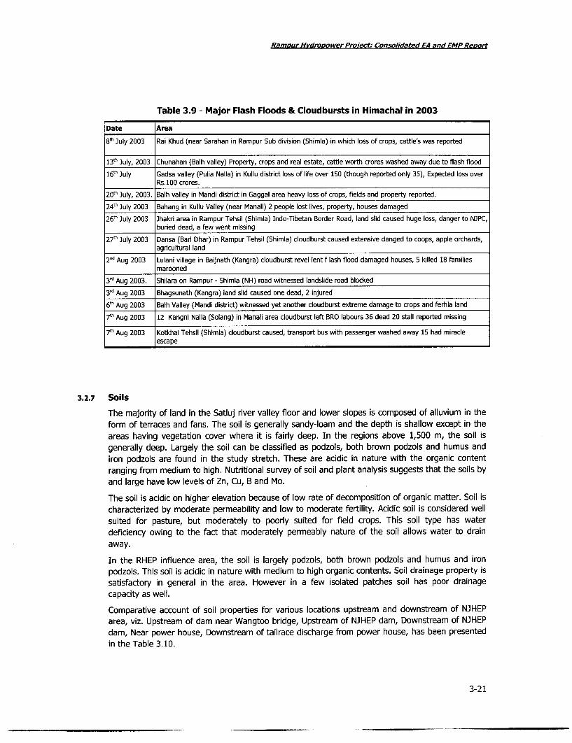
Ramour Hvdropower Proiect. Consolidated EA and EMP Reoug
Table 3.9 - Major Flash Floods & Cloudbursts in Himachal in 2003
Date Area
8' July 2003 Rai Khud (near Sarahan in Rampur Sub division (Shimla) in which loss of crops, cattle's was reported
13t July, 2003 Chunahan (Balh valley) Property, crops and real estate, cattle worth crores washed away due to flash flood
16" July Gadsa valley (Pulia Nalla) in Kullu district loss of life over 150 (though reported only 35), Expected loss overRs.100 crores.
20' July, 2003. Balh valley in Mandi district in Gaggal area heavy loss of crops, fields and property reported.
24th 3uly 2003 Bahang in Kullu Valley (near Manali) 2 people lost lives, property, houses damaged
26' July 2003 Jhakri area in Rampur Tehsil (Shimia) Indo-Tibetan Border Road, land slid caused huge loss, danger to NJPC,buried dead, a few went missing
27' July 2003 Dansa (Bari Dhar) in Rampur Tehsil (Shimia) cloudburst caused extensive danged to coops, apple orchards,agricultural land
2nd Aug 2003 Lulani village in Baijnath (Kangra) cloudburst revel lent f lash flood damaged houses, 5 killed 18 familiesmarooned
3' Aug 2003. Shilara on Rampur - Shimia (NH) road witnessed landslide road blocked
3rd Aug 2003 Bhagsunath (Kangra) land slid caused one dead, 2 injured
6" Aug 2003 Balh Valley (Mandi district) witnessed yet another cloudburst extreme damage to crops and ferhia land
7th Aug 2003 12 Kangni Nalla (Solang) in Manali area cloudburst left BRO labours 36 dead 20 stall reported missing
7t' Aug 2003 Kotkhai Tehsil (Shimia) cloudburst caused, transport bus with passenger washed away 15 had miracleescape
3.2.7 Soils
The majority of land in the Satluj river valley floor and lower slopes is composed of alluvium in theform of terraces and fans. The soil is generally sandy-loam and the depth is shallow except in theareas having vegetation cover where it is fairly deep. In the regions above 1,500 m, the soil isgenerally deep. Largely the soil can be classified as podzols, both brown podzols and humus andiron podzols are found in the study stretch. These are acidic in nature with the organic contentranging from medium to high. Nutritional survey of soil and plant analysis suggests that the soils byand large have low levels of Zn, Cu, B and Mo.
The soil is acidic on higher elevation because of low rate of decomposition of organic matter. Soil ischaracterized by moderate permeability and low to moderate fertility. Acidic soil is considered wellsuited for pasture, but moderately to poorly suited for field crops. This soil type has waterdeficiency owing to the fact that moderately permeably nature of the soil allows water to drainaway.
In the RHEP influence area, the soil is largely podzols, both brown podzols and humus and ironpodzols. This soil is acidic in nature with medium to high organic contents. Soil drainage property issatisfactory in general in the area. However in a few isolated patches soil has poor drainagecapacity as well.
Comparative account of soil properties for various locations upstream and downstream of NJHEParea, viz. Upstream of dam near Wangtoo bridge, Upstream of NJHEP dam, Downstream of NJHEPdam, Near power house, Downstream of tailrace discharge from power house, has been presentedin the Table 3.10.
3-21

Ramour Hvdrooower Proiect: Consolidated EA and EMP Report
Table 3.10 - Analysis of Soil Samples near of Rampur Hydropower Project
Parameters U/s dam near U/s of D/s of NJHEP Near 3hakri D/s NJHEPWangtoo bridge NJHEP dam dam P.H. tailrace
pH 6.02 7.22 7.47 7.21 7.4
Electrical conductivity (ps/cm) 174 310 211 575 164
Sodium as Na (meq/100 gm) 0.004 0.004 0.01 0.007 0.01
Nitrogen as TKN (%) Nil Nil Nil Nil Nil
Phosphates as P04 (meq/100 gm) 0.200 BDL BDL 1.40 0.200
Potassium as K (meq/100 gm) 0.003 0.005 0.002 0.005 0.002
Source: EIA Study for Updation of NJHEP, Year 2004; EIA study for Rampur HEP, Year 2005
BDL - Below Detectable Limit
In the Luhri region, downstream of the Rampur Hydropower Project, soil texture is clayey loam richin organic matter with varying depth. The soil is acidic on higher elevation because of lower rate ofdecomposition of organic matter. Soil drainage is generally satisfactory except in few isolatedpatches where it is poor.
3.2.8 Erosion & Sedimentation
Baseline Erosion Rates
River Satluj in general is characterized by a very high silt load coming from snow melts in Chinaand cold desert areas of Spiti Vally. The average annual sediment load in the Spiti, a majortributary of river Satluj, was estimated at 7.66 million tones while that for river Satluj wasestimated to be 7.30 million tones. These estimations were carried out on the basis of suspendedsediment sampling done by the Himachal Pradesh State Pollution Control Board at several gaugingstations in the Satluj river system. The annual sediment transport by these two rivers wascalculated by undertaking river cross-section modelling and velocity measurement to arrive atestimates of river discharge. The annual sediment transport for the river Spiti has been reported at7.84 million tones and correspondingly 7 million tones for river Satluj. Snowmelt and the relatederosion processes (rapid mass wasting in combination with glacier runoff) are the major sedimentsources. The local developmental activities like construction of roads, hydro projects, residentialareas, tourism also contribute in soil erosion and are of great importance for estimating erosionpotential of the area. The density of the silt deposits is influenced by the particle size distributionand is time dependent.
At the upper Satluj regions, the bed material is heterogeneous as a result of heavy floods whichbreak up the "erosion pavement" of coarse bed material exposing a finer substratum. Catastrophicinput from rapid mass wasting process also leads to heterogeneous nature of bed material. Bothfactors result in a rapid increase in bed-load transport by the river Satluj that is reduced only whenthe riverbed adapts to the new situation. River Satluj on its course of travel flows through terrainhaving very little as well as loose vegetation. Such terrain does not hold soil tightly and henceenhances the rate of erosion. Most of the loose soil is flushed into the river. This makes river highin suspended solid and hence turbid water for larger part of the year.
The data of average silt concentration at a few locations viz. Khan, Power, Nathpa, Jhakri, Bale,North and Sunni have been summarized in Table 3.11 and Figure 3.15 below.
3-22

Ramour Hvdropower Project: Consolidated EA and EMP Revort
Figure 3.15 - Grain Size of Suspended Sediments at Upstream Locations of RHEP
Grain Size Distribution of susupended particlesat different locations
* Fine < 0.07570 - Medium 0.075-0.20 mm60 - E3 Coarse > 0.20 mm
Ef 30 - *20 -10 -0
SatIuj at Khab Spiti at Khab Satluj atWangtoo
Table 3.11 - Silt Data at Khab, Powari, Nathpa, Jhakri, Bael, Nirath and Sunni, 2006
(in parts per million)
Month Khab (1) Powari (2) Nathpa (3) 3hakri (4) Bael (5) Nirath (6) Sunni (7)
January - 126.41 11.97 89.21 98.59 101.61 41.13
February 48.79 95.18 108.09 106.04 118.3 126.78 31.95
March 92.52 98.55 108.8 88.24 127.12 133.85 -
April 1181.54 816.95 478.3 1324.63 1211.86 1229.78
May 2553.11 2863.4 2007.89 3604.77 3246.58 3637.96
June 686 818.52 583.22 1261.36 1208.75 1248.42
July 7985.45 4086.79 4296.41 4342.68 4004.92 -
August 13155.74 8368.56 8846.56 5979.19 6310.56 -
Figure 3.16 - Extent of Siltation in the Project Area
1400012000 - January
§ 10000 -\- February8000 - March
{ 6000 - \ - - April4 4000 - May
2000 - -o JuneO - O | July
0 1 2 3 4 5 6 7 8 - August
Locations
3-23

Rampur Hvdropower Proect: Consolidated EA and EMP Reort
Potential Impact
The impacts described above are not of serious consequence to either the function of the energyproduction, or to the environmental impact. Generally it has been observed that changes in theflow and flood regime do create impacts on the competence of the channel to carry sediment andto the ability of the system to flush sediment deposited during low-flow events. In downstream,where tributaries add more material to the river, aggradations may be more common thandegradation. Lower regulated flows, especially without the natural freshet peaks; do not have theconveyance power to carry material produced by upstream degradation as well as that contributedby the tributary flow. Where aggradations occur, typical responses include lateral scour, channelwidening, braiding, and a reduced mean flow depth. The runoff from the unprotected excavatedborrow pits and muck disposal sites will trigger increased soil erosion and therefore, increasedsedimentation rate downstream of the area. The erosion rates are generally significant duringconstruction phase. High turbidity levels in the Satluj river water due to sediments reduce the lightpenetration, which reduces the photosynthetic activity and therefore the primary productivity aswell. This is well established by the low value observed for nutrients in river water during riverwater quality monitoring in June, 2004.
Mitigation Measures & Monitoring
The appropriate management adopted by SJVNL will guarantee that the suitable Catchment AreaTreatment (CAT) Plan measures are implemented to control erosion and sedimentation in the river.It will further ensure that sediment yield will remain at the current estimated low level. From aneconomic and environmental perspective it is important that timber harvest in the project area iseliminated and that slash-and burn activities be limited to current levels or less. The objectives ofthe SJVNLL management will include activities to protect and rehabilitate the forest cover to ensureadequate water flows with low sediment in the river.
Although the resettlement area represents only a fraction of the catchment area, uncontrollederosion will contribute to sedimentation in the nearby streams. The implementation of themanagement plan will ensure that agricultural practices and forestry activities within theresettlement area prevent such erosion.
Some existing quarries which were used for Nathpa Jhakri Project will also be used for RHEP,resulting in no further erosion. To minimize use of natural resources, excavated material for theHRT will be reused for construction work elsewhere because the geology of the HRT area is similarto the quality of construction material required for the project.
Muck disposal areas have been chosen in such a manner that chances of exposure of humansettlements to these disposal areas are minimized. These disposal areas are located close to aditsfor the HRT. The sites of disposal area are currently barren and hence biotic life will be leastaffected. Quarrying and muck disposal activities will be undertaken strictly as per the guidelinesdeveloped by environment management plan related to construction activities. Project releases intothe Satluj river at tailrace will be equivalent to natural discharges. Therefore it is expected that thequantity released will not impact the current rate of erosion expected in the Satluj downstream ofRHEP tailrace.
Monitoring
To assess whether the land use and forestry plans are being successfully implemented, a waterquality-monitoring program will be used to analyze levels of suspended solids and sediment sizedistribution in the river.
3-24

Ramour Hvdrooower Proiect: Consolidated EA and EMP Rew,rt
Figure 3.17 - Siltation in the Project Region
I-2
3-25,o

Ramour Hydropower Project: Consolidated EA and EMP Repo,t
Figure 3.18 - Eroded Material Transported by Tributaries of the Spiti
S.
., :
9- .
Figure 3.19 - Unstable and Erosion-prone River Banks of the Satluj
3-26

Ramour HWdroDower Proiect: Consolidated EA and EMP Reor¢
3.3 Geological Characteristics of the Project Area
3.3.1 Geology
The project region lies in the Western Himalayas. Geologically, Himalayas is one of the youngestorogenic belts and therefore represent unstable regions of the earth. The region belongs to Jutoghseries of formation, which is co-relatable to the archaen group of rocks. These are the oldestsedimentary systems that have metamorphosed and occur more or less as a continuous bandbetween the central axis of higher Himalayas and outer ranges. The project area lies in lesserHimalayas with general altitude above elevation 1000 mts. The area consists of deep and narrowvalleys and gorges having steep cliffs and escarpment faces. The rock types in the area comprise avariety of metamorphic rocks like gneisses, schist, gneissose schist and basic intrusive and granite.These unfossiliferous rocks belong to Rampur block and surrounded by the Jeori-wangtu, Jutoggroup, Sakala group.
The RHEP project is located in Pre-Cambrian terrain of Lesser Himalayas. The stratigraphicsequence of Pre-Cambrain rocks is presented in Table 3.12.
Table 3.12 - Stratigraphic Sequence of Rocks in the Project Area
Age Formation Group Lithology
Pre-cambrian Manikaran Rampur Predominantly white quartzite with minor greenish, grey phyllite andOrtho-amphibolites bodies
Banjar Rampur Metabasic volcanic flows with minor white quartzite and ortho-amphibiolite bodies
Garh Kullu Streang augen gneiss with pocket of phyllite, carbphyilite andmetabasic intrusive
Khamrada Kullu Phyllite carls phyllite and limestone stone with quartzite interbeds
The bedding seen in the Rampur group and that in the Jeori-wangtu complex is in the form ofcompositional banding. In the Rampur area the strike direction varies from N 40 E-S400 W to N60°W with southerly dips ranging from 200 to 400. At some places gouge seams are also associatedwith some of the joints. The foliation trend generally varies from N70°W-S700E to N700E-S70°Whaving an average dip of the order of 350 in the northerly direction. Being in orogenic belt theproject area is prone to earthquakes and as per the Indian Seismic Zone categorization, the projectsite falls in Seismic Zone IV.
Potential Local Thrust and Faults
Satellite imagery indicated that Main Central Thrust (MCT) treanding parallel to the Himalayan axisis identifiable along the entire stretch of the Himalayas. In the project area the MCT treands in theNW-SE direction. Rampur fault separates the quartzites of the Rampur from the gneisses and islocated about 1 km downstream of the Jhakri underground power house. Another fault known asMain Boundary Fault(MBF) was found running parallel to MCT at a distance of 60-70 km south of itand runs along the entire stretch of Himalayas. Another youngest of the regional tectoniclineaments and quaternary/neogene deformations known as Foot Hill Thrust (FHT) has a strikelength of 60 km and runs parallel to MCT and MBF.
The Seismo-tectonic features of the geology that can significantly affect the seismicity in the areaare listed in Table 3.13.
3-27

Ramour Hvdropower Proiect: Consolidated EA and EMP Repo,t
Figure 3.20 - Typical Topography above the Nathpa Dam
tAA
TAAL
L '.~~~~~~~ ..-. ; '' ,',i:
Table 3-13 - Seismo-Tectonic Features of the Project Area
Seismo-tectonic Characteristicsfeatures
Main Central Thrust Regional feature trending parallel to the Himalayan axis and is identifiable along the entire stretch(Ma) of the Himalayas.
In the project area, MCT trends in NW-SE direction with shortest distance from the Nathpa dam siteand powerhouse being 10 km and 26 km respectively.
Kaurik Fault Trends in the N-S direction in the northern part and NW-SE in the southern part, it is one of thebounding features of the Shimla block.
The fault has a length of 100-200 km and it runs at a distance of 40 km and 50 km from the Nathpadam site and power house respectively.
Rampur Fault Separates the quartzites of the Rampur from the gneisses and is located about 1 km downstream ofthe Chakri underground power house
Main Boundary Fault Lies parallel to MCT at a distance of 60-70 km south of it and runs along the entire stretch of(MBF) Himalayas.Foot Hill Thrust (FHT) Youngest of the regional tectonic lineaments and quaternary/Neogene deformations are observed.
The thrust has a strike length of 60 km and trends parallel to MCT and MBF.
3.3.2 SeismologyThe project zone lies in the Lesser Himalayas Region, which is seismologically very active as per theseismic zone categorization in India (IS: 1893-2002). The entire project area falls in Zone-IV with ahistory of occurrences of series of earthquakes having magnitude greater than 5 on Richter Scaleand the last major earthquake had occurred in 1991. The list of major earthquakes that haveoccurred in Rampur Project site is given in Table 3.14.
3-28
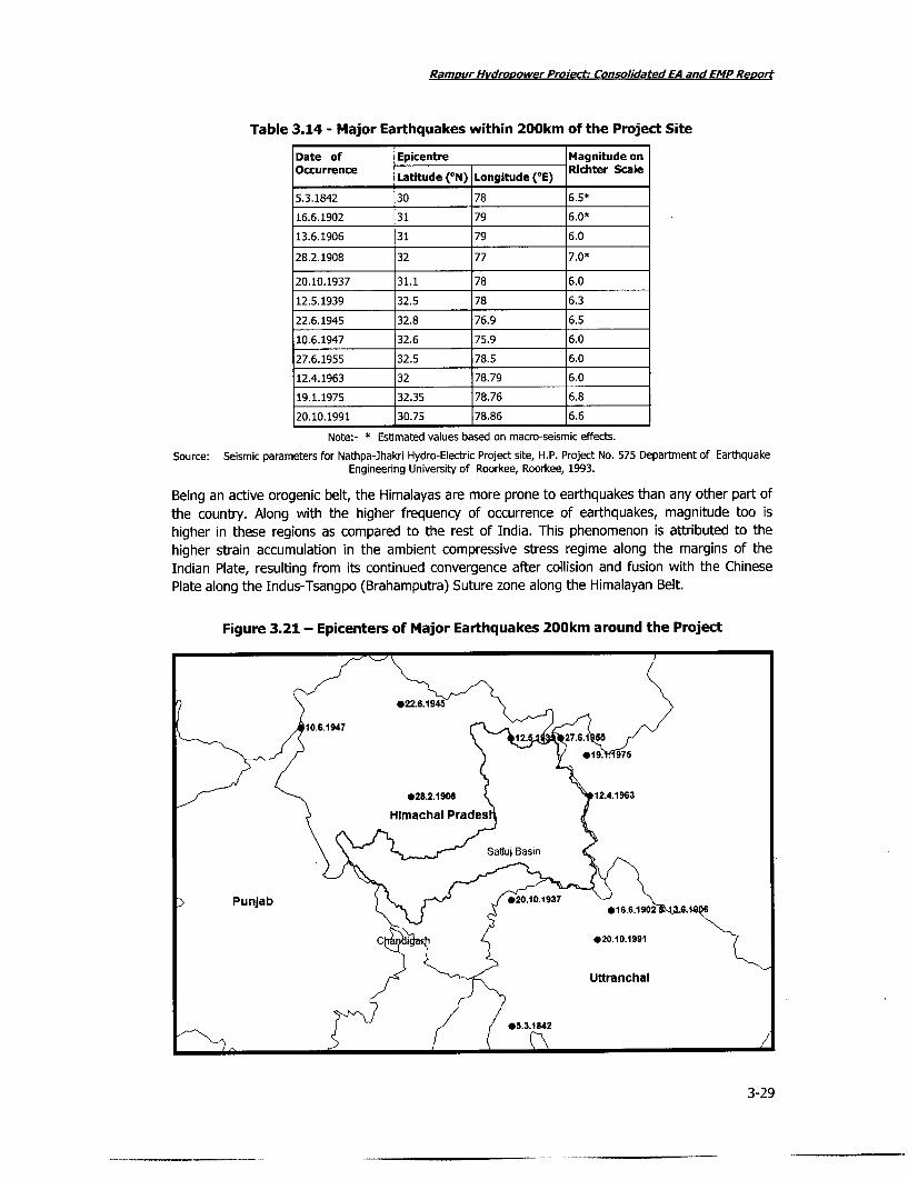
Ramour Hvdrooower Proiect: Consolidated EA and EMP Reort
Table 3.14 - Major Earthquakes within 200km of the Project Site
Date of Epicentre Magnitude onOccurrence Latitude (°N) Longitude (°E) Richter Scale
5.3.1842 30 78 6.5*
16.6.1902 31 79 6.0*
13.6.1906 31 79 6.0
28.2.1908 32 77 7.0*
20.10.1937 31.1 78 6.0
12.5.1939 32.5 78 6.3
22.6.1945 32.8 76.9 6.5
10.6.1947 32.6 75.9 6.0
27.6.1955 32.5 78.5 6.0
12.4.1963 32 78.79 6.0
19.1.1975 32.35 78.76 6.8
20.10.1991 30.75 78.86 6.6
Note:- * Estimated values based on macro-seismic effects.
Source: Seismic parameters for Nathpa-Jhakri Hydro-Electric Project site, H.P. Project No. 575 Department of EarthquakeEngineering University of Roorkee, Roorkee, 1993.
Being an active orogenic belt, the Himalayas are more prone to earthquakes than any other part ofthe country. Along with the higher frequency of occurrence of earthquakes, magnitude too ishigher in these regions as compared to the rest of India. This phenomenon is attributed to thehigher strain accumulation in the ambient compressive stress regime along the margins of theIndian Plate, resulting from its continued convergence after collision and fusion with the ChinesePlate along the Indus-Tsangpo (Brahamputra) Suture zone along the Himalayan Belt.
Figure 3.21 - Epicenters of Major Earthquakes 200km around the Project
12 27S2 .6.15
- X 4 19. .1975
,/ - 28.2.19081 12.4.1963
:> PunJab) 02.013
C Ci X 20.10.1991I
Uttranchal
X5.3.1842
3-29

Ramour Hvdropower Proiect: Consolidated EA and EMP Reo,t
Lesser Himalayan Seismic Belt
The lesser Himalayan Seismic Belt is bounded in the north by Main Central Thrust (MCT) and MainBoundary Thrust (MBT) in the south. This area demonstrates the highest seismicity level with mostof the fault planes solutions being parallel to the Himalayan trend and displaying thrust type ofdeformations.
The RHEP site is located in Shimia Block, which is bound on the west by Sundernagar fault and onthe east by Kaurik fault and its extension. The block forms the eastern most region of HimachalPradesh and shares its boundary with Uttar Pradesh. The rock formations exposed in the area areopenly folded with axial trends in NW-SE to E-W directions. Minor folds of varying trends superposethese folds. Along the numerous zones/seams in the area, localized faults with length varying from0.5 km to 3.0 km have also been observed.
The above mentioned structural features are too localized to have a bearing on the seismic activityof the area. The various seismo-tectonic features, which can significantly affect the seismicity in thearea, are listed as below:
Main Central Thrust (MCT)
This is a regional feature trending parallel to the Himalayan axis and is identifiable along theentire stretch of the Himalayas. In the project area, MCT trends in NW-SE direction withshortest distance from the dam site and power house being 10 km and 26 km respectively.
Kaurik Fault
The Kaurik Fault trends in the N-S direction in the northern part and NW-SE in the southern part itis one of the bounding features of the Shimla block. The fault has a length of 100-200km and itruns at a distance of 40km and 50km from the Nathpa dam site and power house respectively.
Rampur Fault
This separates the quartzites of the Rampur from the gneisses and is located about lkmdownstream of the Jhakri underground power house.
Main Boundary Fault (MBF)
This lies parallel to MCT at a distance of 60-70km south of it and runs along the entire stretch ofthe Himalayas.
Foothill Thrust
This is the youngest of the regional tectonic lineaments and quatemary/Neogene deformations areobserved. The thrust has a strike length of 60km and trends parallel to the MCT and the MBF.Continuous seismic activity of the Himalayas is possible in the areas situated in the intersections ofthese transverse features.
Potential Impacts
Seismically active areas generally feel tremors on regular interval. The satluj basin Region is proneto high chance of occurrence of earthquake due to various types of normal or lateral faults. TheRHEP does not involve any reservoir activity. The Nathpa Jhakri project does involve reservoir butonly for water regulation purposes and hence the size of reservoir being small. Therefore, in boththe cases, project structures are not likely to induce additional factors for increased seismic effect.Nonetheless, there are good numbers of hydropower projects planned along the Satluj basin, whichmay trigger individual or cumulative seismic effect.
3-30

Rampur Hydrooower Project Consolidated EA and EMP Reort
Mitigation Measures
All precaution will be taken to incorporate seismic factors in all the construction projects andearthquake will be one of the key aspects for designing a sound emergency and disastermanagement plan for the project as well as for the entire basin as part of the adaptivemanagement plan to be developed by SJVNL authorities.
3.3.3 Landslides
Besides earthquakes, landslide is another natural hazard, frequent in the Satluj river basin.Landslides in the region is triggered by downslide movement of soil, debris and rocks, resultingfrom natural causes, vibrations, overburden of rock material, removal of lateral supports, change inthe water content of rock or soil bodies and blocked drainage, etc. The mass movement varies inmagnitude from soil creep to landslides. Almost every year one or more major landslides affect thestate. Loss of life; damage to houses, roads and other means of communication, agricultural land;and floods are some of the major consequences of landslides in the region. Flash floods,particularly in the narrow river gorges are one of the leading causes of landslides in Himachal.These in tum jeopardize the stability of the hill as a whole. Some landslides fragments have oftenblocked various river gorges and streams.
At present, landslides occupy about 1% of the land surface in five central districts of HimachalPradesh. Some of the major landslides in the state include the following:
. Thangi Slide (on the NH 22, 389.2 km on the right bank of Satluj river opposite theconfluence with Tirung Khad): It is a recurring landslide with instability caused by toeerosion by Satluj and due to cutting in the road widening. The high discharge of TirungKhad has forced the Satluj river towards west to undercut the slope.
* Khadra Dhang Slide Zone (75 x 1300 x 10m): It is located on the old Hindustan-Tibetroad along the right bank of Satluj, opposite to Ribba. The construction of road andsteepening of already steep slopes due to toe-cutting by river Satluj make it an activelandslide. Though the Hindustan-Tibet road has now been diverted to the left bank of theriver, but toe cutting by river Satluj during peak discharge continuously causes activesliding.
. Pangi Slide (measuring 65 x 300 x 6m): it is located on the Pangi-Kalpa link roadsjunction with NH 22. Seasonal seepages along with uncontrolled blasting for theconstruction of NH-22-Kalpa link road has contributed to the generation of this slide.
* Powari Slide Zone (measuring 1000 x 500 x 25m): It is located on the lower slopealong the right bank of Satluj river between Powari and Peo. The construction of theapproach road from Powari to Kalpa has been one of the lead causes in making this amajor landslide area.
* Barua Slide (measuring 60 x 100 x 15m): It is located in the left middle slope in theBaspa valley about 5 km southeast of Karcham. Though the slode was triggered in 1987-88 it has been repeatedly activated. The removal of toe to widen the road and alreadymoistened glacial material and seasonal seepage from upslope has contributed to theoccurrence of this landslide.
. Urni Rockfall (measuring 500 x 250 x 5m): It is located near village Tapri along thelower slope, on the right bank of river Satluj on NH 22. Over steepening of the slopes dueto toe cutting by Satluj has been further intensified by rockfall on the opposite bank,forcing the river towards the present slide.
3-31

RamDur Hvdropower Proect: Consolidated EA and EMP Reort
Figure 3.22 - Views of a Landslides in the Project Area
A10
3-3
F* r
L- ~- - i **
3-32

Ramour Hvdroaower Project: Consolidated EA and EMP Report
* Nichar/ Nathpa Landslide (measuring 350 x 200 x 35m): It is located in the lowermiddle slope on left bank of Satluj river is located on NH-22 road. The toe cutting by theSatluj River and widening of the NH-22 road had over steepened the slopes. Thusadverse rock dip and slope relationship and seepage of water from upper slopes havecaused this complex rockfall and debris slide.
* Shoulding Khad Slide (measuring 200 x 200 x 15m): It is located along the right bankof the Shoulding Khad, a tributary of Satluj River. The toe-cutting by the Soldan Khadhave also over-steepened the slope and contributed in sliding. The monsoonal rain ofSeptember 1992 have further deteriorated the situation and resulted in debris flow.
* Jhakri Landslide (measuring 500 x 500 x 15m): It is located on the left valley slopes ofthe Satluj valley on NH-22 (288/450 km stone). The upper slope area is covered withagricultural fields of Shah and Ghaso villages are situated. The location of the landslide isin the vicinity of main central thrust and east-west trending Nogli Gad Fault. The greaterslide occurred on 24 Feb 1993 following heavy winter rains. The slipped mass (37.5 x10⁵m) temporarily blocked the river Satluj and within 48 hours a lake was formed whichwas 1.5 km long, 25-30m deep and 15-20m. The lake induced dimension remains inexistence for 7-8 months.
All the landslides have a total volume of more than 2.2 x 10⁶ m3 and a mean age of 6.5 years. Thishelps to calculate the denudation rate, which is about 12mm/year (all erosive processes).Landslides have about 2.5 mm/year denudation rate.
Potential Impacts
Planned and unplanned developments in the region over a period of time have created an increasein the vulnerability of the geologically young, unstable and fragile rocks. Deforestation, poor roadalignment and construction techniques, terracing and water intensive agricultural practices,encroachment on steep hill slopes in the area have lead to general increase in the intensity andfrequency of landslides. The construction of road is leading factors for increased landslide incidencein the project area as well as in the neighbouring regions. The construction of roads in the recentpast has been extensive with the development of various hydropower projects in the area. Surfaceerosion of the bank is another major cause for landslides.
Mitigation Measures
Surface erosion is best controlled by vegetation. However, in a steeply sloping terrain, difficulty liesin growing vegetation on steeply sloping banks. Engineering solutions such as surface drainage,sub-surface drainage, toe protection and rock bolting will be required to be used for preventinglandslides. All road construction works in the area will be planned and adequate provisions forprevention of erosion activibes will be incorporated. Landslides will be stabilized by engineering andbio-engineering methods. A comprehensive Catchment Area Treatment (CAT) Plan andEnvironment Management Plan for road construction will be prepared by SJVNL with adequatesafeguards for land slide prevention.
3.4 Hydrology & Water Resources
3.4.1 Baseline Hydrology
The operation of the Rampur Hydro Electric Project will involve diversion of entire water from theJhakri Tailrace outfall of Nathpa-Jhakri Hydro Electric Project. The water, after utilization by RHEPfor power production, will be discharged in the river Satluj near village Bael in Rampur at about 23km from Jhakri. Total catchment area at the Rampur discharge site is about 50,880km2. Theprincipal tributaries in the area that significantly contribute to Satluj flow especially in peak season
3-33

Rampur Hvdropower Project: Consolidated EA and EMP Report
are Gaura, Barauni, Pashada, Machhada, Darshai, Jakho, Racholi and Nogli In addition, there areseveral small nallas that drain into the river Satluj between Jhakri to Bael stretch.
Flow Profile of River Satluj
The course of river Satluj in Himachal Pradesh is 320 km from Rakas Lake, with principal tributariesin India are Spiti, Kashming, Baspa, Bhaba, Nogli, Kurpan, Nauti, Shoulding, Seer, Bahrari, Ali andGambher. River Spiti, which confluences at Nangia, 14 km upstream of Pooh is the biggesttributary. The upper tracts of the Satluj valley are under a permanent snow cover. The prominenthuman settlements along the banks of the Satluj are Namgia, Kalpa, Rampur, Tattapani, Suni andBilaspur. See Figure 3.22.
To understand the changes in the river flow profile over the course of time, historical flow datagiving the minimum, maximum and average discharge for at different locations have been compiledand plotted (Table 3.15. 3.16, 3.17 and 3.18 below).
Referring to various project documents has collected and complied the historical flow data for theriver Satluj and its tributaries at various stretches in the basin i.e. Khab, Luhri, Suni, Kasol etc.(refer Annexure III). At Khab, the annual average flow ranges from 81.6 cumecs to about 334cumecs, with a maximum flow of 334.58 cumecs witnessed in the year 1973. Similarly at Rampur,the minimum flow encountered was of 247.5 cumecs in the year 2001 and a maximum of 534.5cumecs in year 1973. At Luhri the range of flow is 273.83-557 cumecs. At Suni the maximum flowof the value 580 cumecs was seen in the year 1973. At Kasol, the year 1979 saw the maximumflows of value 446.67, while the leanest flow the region has seen is 336.83 in 1997.
The flow data for various tributaries, existing in Nathpa-Jhakri stretch has been compiled fromavailable project reports (refer Table 3.19). For the determination of the flow levels of thetributaries joining the river in the Jhakri-Bael stretch, a flow measurement campaign was organizedfor a period of two months (Feb-March, 2006) with each observation taken at an interval of 10days (refer Table 3.20). Unlike Nogli khad, the flow in most of the tributaries was very low duringthe monitoring campaign; hence a current velocity meter was used to measure the flow.Considering, comparatively higher flow in Nogli khad, float method was used.
Similarly, flow pattern of the principal streams contributing into the river Satluj has also been takeninto account so that in later stages of impact assessment, it could be estimated that after therestricted river flow due to NJHEP and RHEP, how significantly the tributaries contribute to the riverto maintain the minimum desired flow in it. The flow data for tributaries meeting Satluj betweenNathpa and Jhakri stretch has been compiled using data measured by IIT Roorkee on 10 daily basisand is presented below for the months of Oct, Nov, Dec 2005, Jan, Feb, Mar and April 2006.
Further, the principal tributaries between Jhakri up to Bael have been identified and mapped;accordingly, a flow measurement campaign for the tributaries/ khads was carried out for twomonths (Feb-March, 2006) at 10 days interval of time. Considering comparatively lesser flow, the'Current Velocity Meter' method was adopted to measure the flow in streams i.e. Kajo, Kunni, andRacholi etc. For Nogli khad, which is having reasonably higher flow, 'Float method' was used forflow measurement.
The flow data for all tributaries (khads) from Nathpa to Bael is presented below. Table 3.22 givesdata for tributaries from Nathpa to Jhakri and table 3.23 gives data for tributaries from Jhakri toBael.
3-34

Ramour Hvdronower Proiect: Consolidated EA and EMP Reno,t
Figure 3.23 - Digital Elevation Model of the Satluj Basin (in Himachal Pradesh)
--- M L
3-35

Ramour Hydropower Project; Consolidated EA and EMP Reoort
Figure 3.24 - Water Flow in the Satluj at Different Locations
1. Flow of the river near u/s Jhakri 2. Satluj river near u/s Jhakri 3. Satluj river meandering through the regi'on
4. Satluj river at Jhakri 5. Satluj river near d/s Rampur 6. Satluj riveraByl
3-36

Ramf ur Hvdropower Protect: Consolidated EA and EMPReoort
Table 3.15 - Historical Flow Data of River Satluj at Khab (downstream of Spiti Confluence): Minimum, Maximum & Average Flow
a. Dischiaiae Data al Kiiab It;s of Spdi Coitliieiicej mi CiliecsYear Monthy 10-daily I i I
Miniinu Maximti aily Mhlihi 0daily Ma Aveiage197' d5 3 5J3 44 617 171831973 41.66 960 40 1238 334.581974 43.67 668 43 743 207.75 --------- T-- -1975 41 670 E66 39 8as 24 g 1719'6 ;9 591 33 38 670 1666 E7197- 3-766 814 3 40 938 248-d33 .1978 55 734.33 53 923 265.67 - - I - -� - -t1979 55 1001.33 51 1459 307.92 . ----
1980 54.33 882 53 940 268.5 ---- -= - -- - - - --. -
1981 57.66 753.66 55 945 223.51982 57.33 954.33 53 983 281.58 -- -- - - --- --1983 51 867 52 775 259.5 - - -_-1984 22 553.33 20 698 189.251985 17.66 511.66 17 478 170.25 Discharge Data at Khab (dis of Spiti Confluence) -- .1986 28 795.33 24 1041 217.08 in Cumecs1987 21.33 635.66 8 681 177.831988 44.66 769 21 820 263.64 16001989 42.66 693.33 44 832 1981990 45.66 659.33 40 947 2641991 61 1011 44 1136 306.67 120E - ---- Monthly Min1992 88.33 500 60 643 218.67 1000 Monthly Max - .1993_ 79__ 329 78 399___ 163.92 LI00 f m __
1994 64.33 735.33 64 898 218.92 . O 8 Daily1995 65 488 59 551 167 --- --- 10 Daily Max -.
1996 49.66 580.b6 49 906 195.83 - .! 400 - ,.;Average1997 37.33 430 36 500 131.08 2001998 26.33 950 22 1084 238.031999 39 925 40 1325 239.52000 36 349.33 34 426 128.92 1970 1980 1990 2000 20102001 21 227 19 259 81.67 Year-2002 17.33 365 17 440 114.42 . _._ . _._._-.
3-37

Ramour Hvdropower Proiect: Consolidated EA and EMP Renort
Table 3.16 - Historical Flow Data of River Satluj at Nathpa Dam Intake: Minimum, Maximum & Average Flow
h. DISCHARGE (IN CUMECS) DATA OF RIVER SATLUJ AT NATHPA -Year Mo lthly 10 Daily Average I
Minimti Maxiinum Minimum Maximum1990 82.89 1240.46 77.5 1718.54 476.115 DISCHARGE (IN CUMECS) DATA OF RIVER SATLUJ1991 87.39 1332.94 74.89 1896.6 462.44. AT NATHPA1992 117.49 1017.84 105.03 1760.99 399.891993 114.53 842.28 106.91 1223.06 321.75 25001994 128.37 1867.785 113.62 2258.65 591.641995 90.45 1137.53 85.4 2230.46 486.54 2000 - MonthlyMin1996 97.45 1164.28 93.13 1793.63 386.35 . -in- MonthlyMax1997 74.76 761.635 71.21 741.51 344.61 10 Daily Mm1996 99.42 1962.39 94.7 2226.41 746.93 1000o1999 106.17 1220.98 100.78 1808.21 407.075 5 .- DailyMax2000 100.16 1536.46 95.91 2317.771 440682 500 - --*-Average2001 92.44 01 533 83.2 880.25 285.64 . um m hhI;2002 74.74 864.765 70.568 1106.5 355.81 .2003 73.69 901.46 70.2 1172.64 336.54 1985 1990 1995 2000 2005 20102004 67.548 655.7 59.03 1019.92 203.51 Year2005 59.53 1347.21 47.53 1895.45 381.88 ..
3-38

Ramour Hvdropower Proiect Consolidated EA and EMP Reoort
Table 3.17 - Historical Flow Data of River Satluj at Rampur:: Minimum, Maximum & Average Flow
c. Dischalrie Data at Rainrur (Cumecs)
I - '-- -------- ----- - 4 ---------- - - -- - - .
Year Morithy 10-daily AverageMinimum Maximum Minimum Maxiimum
1972 77.66 882.66 77 1116 313.421973 90 1618.33 88 2215 534.51974 88.66 851.66 85 1053 304.081975 87.66 1308 76 1551 492.42 - - -
1976 98 1143 94 1390 341.171977 87.66 1266.66 86 1433 396.5 -. - .--.
1978 87.66 1176.33 88 1466 4411979 94.66 1285 93 1840 4311980 90 1124 90 1221 377.08 - - -
1981 72.66 1060 77 1293 347.92 4 i _ i -
1982 75.33 1318.66 78 1333 347.5 -7.. -- -__
1983 87.66 1101.66 88 1270 411 -1984 81 801.66 80 929 3091985 69 780.66 65 833 305 . Discharge Data at Rampur (Cumecs)1986 72.66 1138.33 67 1365 381.421987 104 1063.66 97 1133 346.581988 76 1039.33 71 1128 374.35 25001989 103.66 979.66 102 1183 339.75 20001990 96.33 935 89 1340 399.85 2 Monthly Min1991 86 1193 87 1318 404.08 E s otl a1992 110 841.66 104 1047 340.83 B1500MotlMa91993 100.66 727.33 94 876 298.42 10 Daily M .
1994 98 1210.33 93 1308 355.42 1000 10 Daily Max1995 103 805.66 104 893 358.08 U O 1--Average1996 103 1026.33 102 1483 365.42 a 500-1997 91.66 715.33 69 789 268.58
PI3 I9 , i?Y 3 C 1487 a2692t a_19r ' .3cm 6F. i 1037 324 -33 90 1690 2iii 21
1 64 b6 t6 2. 12 47 ' Year
3-39

Ramour Hvdrooower Proiect: Consolidated EA and EMP Reoort
Table 3.18 - Historical Flow Data of River Satluj at Luhri (downstream of Bael Village):: Minimum, Maximum & Average Flow
d. Discharge Data at Luhri (Curnecs
Year MatlC le- AverageAhlnimum Maximum Minmum axnum::
3 7, 11 I______ ______ j8 r-1lti 11, ' M , ,
_____3____ '9j
1974 92 899.33 90 1102 321.421975 88.33 1360.67 78 1670 514.51976 99.66 1142 97 1444 355 83
1I 9 , l3j: Li! 14 J3 5 J1979 99.67 1302 95 1460 439.421980 90.6 7 1181 86 1277 390.67
81 i I:, - 1 O 3- 3641982 79.67 1303 76 1317 418.25
8 6a; ;-3 33 z 1 1 8 - 86 1308 4f 14 V "1984 85 831.67 81 964 371.331985 70 816.33 69 877 337.0819836 74.67 1197.67 71 1419 396 DshreDt tLhi(ues1987 104.67 1106.33 102 1165 344.17 Discharge Data atLuhri (Cumecs)1988 78.67 1103.33 72 1199 395.831989 106 1023 104 1236 326.42 2500 _______a
1990 99 1018.67 94 1364 4261991 9367 1244 90 1375 421.42 1 2000 -.1Monthly Min1992 111 892.33 105 1135 358.171993 103 778 99 966 319.17 1500 Daithly Ma1994 96.67 1270.67 89 1386 402.28 11995 107.33 878.67 104 951 365.92 C1000 .10 Daily Max1996 106 1059.67 102 1521 426.33 50 -- *--Average1997 101.67 765.33 92 1841 281.081998 89 1288.33 88 1500 431.51999 124.67 915.33 118 1172 351.25 02000 112 754 105 1016 29758 1970 1980 1990 2000 20102001 85 687.67 84 801 273.83 Year2002 79 823.6667 76 868 352
3-40

Ramour Hvdrovower Project; Consolidated EA and EMPReoort
Table 3.19 - Measured Flow data for Tributaries of River Satluj (Nathpa to Jhakri Stretch) for the months of October 2005 - April 2006
Average 10 Daily Discharge (cumec)
Tributary October 2005 November 2005 December 2005 January 2006 February 2006 March 2006 April 2006
Manglad 1.44 1.35 1.32 1.23 1.15 1.12 0.592 0.589 0.563 0.572 0.787 0.619 0.587 0.537 0.505 0.662 0.725 0.934 0.979 1.099
Chaura Khad 0.62 0.58 0.61 0.60 0.56 0.51 0.485 0.450 0.406 0.464 0.563 0.488 0.470 0.446 0.438 0.686 0.748 0.812 0.867 1.049
Chaunda Khad 1.01 0.87 0.91 0.79 0.76 0.72 0.437 0.460 0.392 0.407 0.468 0.443 0.419 0.408 0.352 0.589 0.669 0.684 0.744 0.962
Rupi Khad 1.74 1.46 1.37 1.40 1.15 0.98 0.637 0.535 0.526 0.515 0.706 0.534 0.546 0.516 0.538 0.739 0.771 0.816 0.884 1.106
Sholding Khad 1.93 1.84 1.56 1.27 1.16 0.98
Sumej Khad 1.66 1.56 1.32 1.08 1.03 1.00
GaanviKhad 1.92 1.67 1.56 1.53 1.60 1.12
Sorang Khad 1.58 1.21 0.96 0.75 0.72 0.44
Silaring Khad 0.91 1.19 1.09 0.69 0.60 0.45
Unoo Khad 0.134 0.136 0.153 0.162 0.215 0.162 0.149 0.146 0.121 0.155 0.195 0.217 0.246 0.301
Daaj Khad 0.107 0.094 0.085 0.114 0.152 0.128 0.120 0.114 0.108 0.214 0.221 0.226 0.240 0.308
Kaowil Khad 0.165 0.118 0.102 0.129 0.170 0.157 0.148 0.144 0.133 0.183 0.195 0.251 0.275 0.350
Gatti Khad 0.158 0.150 0.136 0.136 0.168 0.149 0.144 0.138 0.135
Source: Primary Survey by IIT Roorkey.
3-41

Ramour Hvdrooower Protect: Consolidated EA and EMP Reoort
Table 3.20 - Computed Lean Flow for Tributaries of River Satluj (Nathpa to Jhakri Stretch)
Average ten daily discharge (cumec) L LeanOctober November December January February March April Flow Mont
Tributary II I I I III I III I III I II III I II III I h
Manglad 1.44 1.35 1.32 1.23 1.15 1.12 0.592 0.589 0.563 0.572 0.787 0.619 0.587 0.537 0.505 0.662 0.725 0.934 0.979 1.099 0.505 FebChaura Khad 0.62 0.58 0.61 0.6 0.56 0,51 0.485 0.45 0.406 0.464 0,563 0.488 0.47 0.446 0.438 0.686 0.748 0.812 0.867 1.049 0.406 DecChaunda Khad 1.01 0.87 0.91 0.79 0.76 0.72 0.437 0.46 0.392 0.407 0.468 0.443 0.419 0.408 0.352 0.589 0.669 0.684 0.744 0.962 0.352 FebRupi Khad 1.74 1.46 1.37 1.4 1.15 0.98 0.637 0.535 0.526 0.515 0.706 0.534 0.546 0.516 0.538 0.739 0.771 0.816 0.884 1.106 0.515 JanSholding Khad 1.93 1.84 1.56 1.27 1.16 0.98 0.98 0.98 0.98 0.98 0.98 0.98 0.98 0.98 0.98 0.98 0.98 0.98 0.98 0.98 0.98 NovSumej Khad 1.66 1.56 1.32 1.08 1.03 1 1 1 1 1 1 1 1 1 1 1 1 1 1 1 1 NovGaanvi Khad 1.92 1.67 1.56 1.53 1.6 1.12 1.12 1.12 1.12 1.12 1.12 1.12 1.12 1.12 1.12 1.12 1.12 1.12 1.12 1.12 1.12 NovSorang Khad 1.58 1.21 0.96 0.75 0.72 0.44 0.44 0.44 0.44 0.44 0.44 0.44 0.44 0.44 0.44 0.44 0.44 0.44 0.44 0.44 0.44 NovSilaring Khad 0.91 1.19 1.09 0.69 0.6 0.45 0.45 0.45 0.45 0.45 0.45 0.45 0.45 0.45 0.45 0.45 0.45 0.45 0.45 0.45 0.45 NovUnoo Khad 0.121 0.121 0.121 0.121 0.121 0.121 0.134 0.136 0.153 0.162 0.215 0.162 0.149 0.146 0.121 0.155 0.195 0.217 0.246 0.301 0.121 FebDaaj Khad 0.085 0.085 0.085 0.085 0.085 0.085 0.107 0.094 0.085 0.114 0.152 0.128 0.12 0.114 0.108 0.214 0.221 0.226 0.24 0.308 0.085 DecKaowil Khad 0.102 0.102 0.102 0.102 0.102 0.102 0.165 0.118 0.102 0.129 0.17 0.157 0.148 0.144 0.133 0.183 0.195 0.251 0.275 0.35 0.102 DecGatti Khad 0.135 0.135 0.135 0.135 0.135 0.135 0.158 0.15 0.136 0.136 0.168 0.149 0.144 0.138 0.135 0.135 0.135 0.135 0.135 0.135 0.135 FebGharsoo 0.2 0.2 0.2 0.2 0.2 0.2 0.2 0.2 0.2 0.2 0.2 0.2 0.2 0.2 0.2 0.2 0.2 0.2 0.2 0.2 0.2 FebChhota Kumba 0.2 0.2 0.2 0.2 0.2 0.2 0.2 0.2 0.2 0.2 0.2 0.2 0.2 0.2 0.2 0.2 0.2 0.2 0.2 0.2 0.2 FebShimla Khad 0.5 0.5 0.5 0.5 0.5 0.5 0.5 0.5 0.5 0.5 0.5 0.5 0.5 0.5 0.5 0.5 0.5 0.5 0.5 0.5 0.5 FebDharali Khad 0.5 0.5 0.5 0.5 0.5 0.5 0.5 0.5 0.5 0.5 0.5 0.5 0.5 0.5 0.5 0.5 0.5 0.5 0.5 0.5 0.5 FebWadhal RB 0.5 0.5 0.5 0.5 0.5 0.5 0.5 0.5 0.5 0.5 0.5 0.5 0.5 0.5 0.5 0.5 0.5 0.5 0.5 0.5 0.5 FebManglad RB 0.5 0.5 0.5 0.5 0.5 0.5 0.5 0.5 0.5 0.5 0.5 0.5 0.5 0.5 0.5 0.5 0.5 0.5 0.5 0.5 0.5 Feb
3-42

Ramour A'vdroyower Proiect: Consolidated EA and EMP Reao,t
Table 3.21 - Daily Discharge at Rampur
Daily Discharge of SatIuj River Observed at 10am at Rampur G&D Sites
Upstream of Rampur Downstream of Date Upstream of Downstream ofDate (February Town (at Rampur Town (at Rampur Town Rampur Town
2006) Jagatkhana Bridge SJVN Bridge Site) (March 2006) (at Jagatkhana (at SJVN BridgeSite) Bridge Site) Site)
1-Mar-06 103 104
- 2-Mar-06 110 112
3-Mar-06 104 106
4-Feb-06 127 128 4-Mar-06 102 103
5-Feb-06 150 151 5-Mar-06 96 97
6-Feb-06 134 135 6-Mar-06 120 122
7-Feb-06 137 130 7-Mar-06 147 149
8-Feb-06 106 106 8-Mar-06 148 145
9-Feb-06 134 137 9-Mar-06 153 152
10-Feb-06 109 109 10-Mar-06 103 105
11-Feb-06 106 150 11-Mar-06 103 105
12-Feb-06 113 114 12-Mar-06 121 122
13-Feb-06 106 158 13-Mar-06 112 110
14-Feb-06 104 105 14-Mar-06 110 111
15-Feb-06 126 126 15-Mar-06 111 112
16-Feb-06 112 113 16-Mar-06 101 102
17-Feb-06 106 109 17-Mar-06 67 70
18-Feb-06 116 118 18-Mar-06 98 100
19-Feb-06 145 143 19-Mar-06 101 100
20-Feb-06 142 144 20-Mar-06 83 85
21-Feb-06 103 104 21-Mar-06 104 105
22-Feb-06 105 106 22-Mar-06 146 147
23-Feb-06 112 113 23-Mar-06 154 155
24-Feb-06 122 124 24-Mar-06 158 157
25-Feb-06 116 117 25-Mar-06 156 155
26-Feb-06 109 110 26-Mar-06 145 150
27-Feb-06 128 129 27-Mar-06 108 107
28-Feb-06 127 128 28-Mar-06 107 108
29-Mar-06 108 109
- 30-Mar-06 106 107
31-Mar-06 155 157
3-43

Ramour Hvdrooower Proiect: Consolidated EA and EMP Reoort
Table 3.22 - Minimum Flow of the Satluj from Khab to Suni
Monthly min 10 Daily min Absolute Minimum
Site 90 percentile 60 percentile 90 percentile 60 percentile Monthly min 10 Daily min
Khab 64.33 45.66 59.00 44.00 17.33 8.00
Nathpa 116.01 91.45 105.97 93.13 59.13 47.53
Rapmur 104.00 91.66 102.00 89.00 69.00 65.00
Luhri 107.70 97.60 104.00 90.00 70.00 56.00
Suni 110.33 99.00 106.00 96.00 72.00 71.00
Table 3.23 - Measured Flow data for Tributaries of River Satluj (Jhakri to Bael Stretch)for the months of February-March, 2006
S. Name of Discharge Minimum S. Namie of Discharge MinimuNo tem Date cue) Dscharge No tem Date cue) Discharge
No tem(ue) ( c o tem(cumec) (cumec)
06.02.2006 0.422 06.02.2006 0.290
16.02.2006 0.502 16.02.2006 0.304
27.02.2006 0.432 27.02.2006 0.2681 Kajo 06.03.2006 0.508 0.42 2 Kunni 06.03.2006 0.283 0.290
15.03.2006 0.526 15.03.2006 0.316
25.03.2006 0.575 25.03.2006 0.312
09.02.2006 0.113 09.03.2006 0.103
16.02.2006 0.147 17.02.2006 0.141
28.02.2006 0.131 01.03.2006 0.1023 Tunnan 0.113 4 Racholi 0.102
06.03.2006 0.166 07.03.2006 0.131
15.03.2006 0.179 16.03.2006 0.121
25.03.2006 0.184 26.03.2006 0.114
17.02.2006 0.107 18.02.2006 0.133
01.03.1006 0.097 02.03.2006 0.095
5 Jhako 07.03.2006 0.114 0.097 7 Barauni 09.03.2006 0.092 0.082
16.03.2006 0.111 18.03.2006 0.083
26.03.2006 0.112 27.03.2006 0.082
08.02.2006 0.101 14.02.2006 3.39
17.02.2006 0.117 23.02.2006 4.01
01.03.2006 0.118 03.03.2006 3.546 Pashada 0.101 10 Nogli 3.54
07.03.2006 0.131 10.03.2006 3.77
16.03.2006 0.120 19.03.2006 4.01
26.03.2006 0.114 28.03.2006 4.15
18.02.2006 0.145 18.02.2006 0.175
02.03.2006 0.127 02.03.2006 0.1'19
8 Kasholi 09.03.2006 0.119 0.091 9 Badgai 09.03.2006 0.106 0.089
18.03.2006 0.104 18.03.2006 0.101
27.03.2006 0.091 27.03.2006 0.089
28.03.2006 4.15 Sourec: Primary Survey by DHI-Water & Environment
3-44

Rampur HvdroDvower Project: Consolidated EA and EMP Revort
Hydrological Changes in the Satluj River
Historically managed river flow has potential to impact land, water and biodiversity environmentaround the river. For RHEP, the diversion of estimated 383.88 cumec water from river Satluj atJhakri outfall may have impacts to the river, biodiversity as well as communities residing along it.
Throughout the year, this impact on water level will be prominent in the dry season. As per theproject estimations, a minimum of 13.537 cumec discharge without considering the evaporationlosses in tributaries will be available in the river Satluj between Jhakri and village Bael.
3.4.2 Sources and Usage of Water
The river Satluj is not the main source of water in the area. The natural springs and 'chashme' arethe key sources of water for people living in the area for their own consumption, livestock use andirrigation purposes. In most of the villages except those, situated on high hills, IPH Department haslaid down the pipelines to connect the natural springs (at upper reaches) to the householdsthrough storage tanks for water supply after providing primary treatment. The villages those arelocated on higher reaches depend directly on natural springs or khads flowing in vicinity. The mainkhads in the NHEP area are Sholding Khad, Panvi Khad, Bhawa Khad, Baspa River, Kut Khad etc,while in RHEP area, the main khads are Nogli, Kajo, Kunni, Racholi, Kasholi, Barauni etc. The totalflow coming to the river from main perennial streams falling in Jhakri outfall to Bael river stretch is5.36 cumecs as measured by the consultant during lean season.
For drinking purpose, about 76.6 % of population depend upon piped water supply about 5.8 %and 17.6 % utilize water from perennial/seasonal streams and natural sources respectively. Forcleaning and other domestic uses 49.4 % use pipe and tap, 20 % use streams and 30.6 % usenatural sources. For cattle, tap water takes care if 43 % of the requirement, 18 % of the watercomes from natural sources while streams/river and meet 39%.
Table 3.24 - Water Requirement in Project Area
Water Requirements (based on findings of primary level village surveys)
NJHEP area IRHEP area
2.0 MLD* (@ 40 Ipcd for villages 11.33 MLD* (@ 40 Ipcd for villages
* Population of Rampur town and ]hakri Township have not been included.The specific water demand for these areas is 0.68 MLD and 0.60 MLD respectively
Further, agriculture crops in the area mainly depend on rains, however, irrigation canals also existin some of the villages especially in the downhill parts of the areas. These canals are basicallyknown as 'Khuls' in the area and having capacity of only 3-4 cusecs. The water in the streams,khads, is also used by people living alongside as on requirement, especially for livestock purposes.
3.4.3 Existing Water Quality of Satluj
The water quality of river Satluj in general is good. There are no major sources of domestic orindustrial pollution, hence the Dissolved Oxygen (DO) levels are good with low BOD and CODvalues of the river. There is no direct disposal of domestic sewage into the river but due to opendefecation; human/animal waste finds its way to Satluj through seasonal and perennial streamsowing to natural slope of area.
The use of agro-chemicals in the area is low but it has been seen that over the last few years therate of consumption has increased. This can be one of the sources of water pollution; it can alsolead to production of excessive organic matter, which would deplete the DO content of the river.
The Central Pollution Control Board of India has classified water resources of the country fordifferent water bodies, according to their uses.This has been summarized in tablexx. As per the
3-45

Ramnur Hydropower Proiect: Consolidated EA and EMP Regort
classification, the river water quality at Rampur has been designated as Class A, making it fit fordrinking purpose after disinfection and without conventional treatment. However, this quality iswith respect to pH, DO and BOD only. By the standard of Total Coliform prescribed by CPCB andactual value monitored in Satluj River, category of river comes down to C category. This makes itimportant to control discharge of sewage in the river and also the open defecation near river andstreams.
3.4.4 Water Quality
Adequate flow in the river especially during lean season is essential for maintaining natural dilutioncapacity of the river, which can then sustain a certain level of organic pollution load from sewage,without getting polluted itself. Adequate flow is also important to maintain the river ecologyaesthetically as well as for the sustenance of its aquatic habitation .Restricted flow in the riverbetween Jhakri to Bael for RHEP has potential to affect dilution of the sewage discharged fromproject influence area to the river. In addition to sewage, effluents from crushers and muckdisposal area will increase pollution pressure on the river.
Table 3.25 - Primary Water Quality Criteriaas laid by the Central Pollution Control Board
Designated Base Use Class of Water Criteria
Drinking water source without 1. Total Coliform organism MPN/100ml. shall be 50 or less.conventional treatment but after 2. pH between 6.5 and 8.5.
disinfection A 3. Dissolved Oxygen 6 mg/I or more.
4. Biochemical Oxygen Demand 5 days 20'C, 2 mg/I or less.Outdoor bathing (Organized) 1. Total Coliform organism MPN/100ml.shall be 500 or less.
B 2. pH between 6.5 and 8.5.
3. Dissolved Oxygen 5 mg/I or more.
4. Biochemical Oxygen Demand 5 days 20°C 3 mg/l or less.Drinking Water Sources after 1. Total Coliform organism MPN/100ml.shall be 5000 or less.conventional treatment C 2. pH between 6 and 9.
3. Dissolved Oxygen 4 mg/I or more.
4. Biochemical Oxygen Demand 5 days 20'C 3 mg/l or less.Propagation of Wild Life and Fisheries. 1. pH between 6.5 and 9.5.
D 2. Dissolved Oxygen 4 mg/I or more.
3. Free Ammonia (as N) 1.2 mg/l or less.Irrigation, Industrial Cooling 1. pH between 6.5 and 9.5.Controlled Waste E 2. Electrical Conductivity at 25-mg/cm max. 2250.
3. Sodium absorption ratio Max. 26.
4. Boron Max 2 mg/I.If three parameters falls in category 'A' but fourth parameter falls in category C, the overall quality of river will fall under Class 'C'.
As per the above criteria, the Himachal Pradesh State Pollution Control Board has reported the riverSatluj under 'A' category of water quality with respect to pH, DO and BOD in general. The criticalparameters observed in past is Total Coliform according to which category of river comes down to'C' category.
3-46

Ramour Hvdropower Project: Consolidated EA and EMP Repo,t
Table 3.26 - Drinking Water Standards
Parameters Value
Acceptable* Cause for Rejection+
Turbidity 2.5 10
pH 7.0-8.5 <6.5
Total Dissolved Solids (mg/I) 500 1500
Total hardness (mg/I) 200 600
Chlorides (mg/I) 200 1000
Sulphates (mg/I) 200 400
Fluorides (mg/I) 1.0 1.5
Nitrates (mg/I) 20 20
Calcium (mg/I) 75 200
Magnesium (mg/i) 30 150
Iron (mg/I) 0.1 1.0
Phenolic compounds (mg/I) 0.001 0.002
Faecal coliform (MPN/100 ml) Nil Nil
Total Colifoms 10 10
* Umits upto which water is generally acceptable to the consumers.
+ Figures in excess of those mentioned under 'Acceptable' render the water not acceptable but still may be tolerated in the
absence of alternative and better source, but upto the limits indicated under column 'Cause for Rejection', above which thesupply will have to be rejected.
Satluj is marked by turbulent flow and low temperature. River water monitoring was undertaken
twice by different agencies, first in June 2004 and second in February 2006. The monitoring results
show different values for a few of the parameters. However these differences are not very alarmingand can be assumed to be the result of temporal changes as well as induced impacts. Going by the
recent monitoring in February 2006, the dissolved oxygen is relatively good (between 8 to 8.5
mg/I) between Jhakri to Bael and suggest good river purification capacity. Water is alkaline with
very low organic load. Turbidity is very low [1.2-1.6 Nephrometric Turbidity Units (NTU)], indicating
the absence of a large sediment or algal load carried by the river. This is further confirmed by low
presence of total suspended solids (22.28 mg/I).
The pH values are around 8 and Biochemical Oxygen Demand (BOD) is about 1.0 mg/l.Fecal
coliform bacteria were found to occur in negligible numbers except at down stream of Rampur
town. Fecal coliform count here can be related to human and animal activities in the lower river
basin.
Heavy metals are generally present in traces, except for Mercury which was estimated on higher
side at 7.11 ppb at Jhakri outfall. This high level of mercury may be due to mechanical processingin the power house of Nathpa-Jhakri project.Bacteria present in decaying vegetation can also
change mercury, present in rocks underlying a reservoir, into a form which is soluble in water. This
mercury in its methylated form enters the food chain and is bio-concentrated, with highestconcentrations occurring in piscivorous fish and birds. These elevated tissue levels can often
exceed those recommended for human consumption (particularly in older biota), thereby creating
associated human and environmental health risks. It is important for SJVNL to identify the source
of this mercury through series of water quality monitoring and take adequate mitigation measuresfor preventing health hazard due to mercury contamination of river water. Presented in Tables
below are the 'water quality monitoring' results for June 2004, February 2006 and drinking water
parameters prescribed by the Indian National Standard.
3-47

Ramour Hvdropower Proiect: Consolidated EA and EMP Reuort
Table 3.27 - Water Quality Profile of River Satluj, Year 2003 Monitoring Results
Parameter u/s d/s u/s d/s u/s
Nathpa Nathpa N.Sari N.Sari Jhakri
BOD (mg/L) 0.10 0.20 0.20 0.10 0.30
COD (mg/L) 16 20 14 14.80 48
TSS (mg/L) 214.90 322 29.70 36.10 208.90
TDS (mg/L) ' 254 258 80 68 207
Turbidity (NTU) 72.80 104 25.00 26.40 68
pH 8.20 8.17 7.40 8.05 7.93
Total hardness (mg/L) 160 152 26 28 134
Total Alkalinity (mg/L) 105 15 35 30 165
Faecal Coliform (MPN/100 ml) NA NA NA NA NA
Total Coliforms (50 standard value) NA NA NA NA NA
Mercury as Hg (ppb) NA ND ND ND ND
Iron as Fe (mg/L) 0.03 0.09 ND 0.06 0.12
Nickel as Ni (mg/L) 0.08 nd 0.10 0.46 0.08
Cadmium as Cd (mg/L) ND ND ND 0.01 ND
Chromium as Cr (mg/L) 0.03 ND 0.23 ND 0.01
Zinc as Zn (mg/L) 0.01 0.03 0.10 0.02 0.01
Source: State Environment Protection & Pollution Control Board, 2003NA: data not available; ND: value not detected
Table 3.28 - Water Quality Satluj, Year 2006 Monitoring ResultsJhakri-Rampur-Bael Stretch
Parameter Below NJHEP tailrace Rampur u/s Rampur d/s Bael Townoutfall
BOD (mg/L) 1.00 1.05 12.00 1.00
COD (mg/L) 19.36 19.36 19.36 53.24
TSS (mg/L) 22.0 29.0 39.0 28.0
TDS (mg/L) 290 320 360 380
Turbidity (NTU) 1.4 1.2 1.6 1.4
pH 7.88 7.95 8.10 8.10
Electrical Conductivity (pS/cm) 490 530 600 630
Total hardness as CaCO3 175 175 170 175
(mg/L)Total Alkalinity (mg/L) 186 186 186 186
Faecal Coliform (MPN/100 ml) Absent Absent 4 na
Total Coliforms (50 standard na na 14 navalue)
Mercury as Hg (ppb) 7.11 - nd
Iron as Fe (mg/L) < 0.05 < 0.05
Nickel as Ni (mg/L) < 0.02 < 0.02
Cobalt as Co (mg/L) 0.051 0.077
Cadmium as Cd (mg/L) < 0.1 < 0.1
Chromium as Cr (mg/L) < 0.003 < 0.003
Zinc as Zn (mg/L) < 0.05 < 0.05
Source: Monitoring Results carried out by DHI-Water & Environment, 2006
3-48
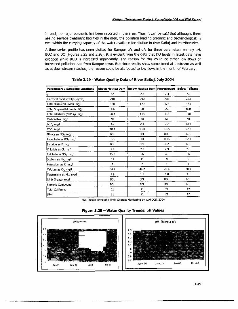
RamDur Hvdropower Proxect: Consolidated EA and EMP Rewoit
In past, no major epidemic has been reported in the area. Thus, it can be said that although, thereare no sewage treatment facilities in the area, the pollution loading (organic and bacteriological) iswell within the carrying capacity of the water available for dilution in river Satluj and its tributaries.
A time series profile has been plotted for Rampur u/s and d/s for three parameters namely pH,BOD and DO (Figures 3.25 and 3.26). It is evident from the data that DO levels in latest data havedropped while BOD is increased significantly. The reason for this could be either low flows orincreased pollution load from Rampur town. But since results show same trend at upstream as wellas at downstream reaches, the reason could be attributed to low flows in the month of February.
Table 3.29 - Water Quality Data of River Satluj, July 2004
Parameters / Sampling Locations Above Nathpa Dam Below Nathpa Dam Powerhouse Below TailracepH 7.4 7.4 7.3 7.5Electrical conductivity (1Ls/cm) 210 290 203 263Total Dissolved Solids, mg/i 130 179 125 163Total Suspended Solids, mg/l 466 60 558 880Total alkalinity (CaCO3), mg/l 98.4 118 118 118Carbonates, mg/I Nil Nil Nil NilDOD, mg/i 3.2 2.1 2.7 13.2COD, mg/l 18.4 13.8 18.5 27.6Nitrate as NO3, mg/l BDL BDL BDL BDL
Phosphate as P04 , mg/l 0.28 BDL 0.16 0.40Fluoride as F, mg/l BDL BDL 0.2 BDLChloride as Cl, mg/l 7.9 7.9 7.9 7.9Sulphate as 504, mg/I 45.3 56 49 86
Sodium as Na, mg/l 11 11 8 9Potassium as K, mg/I 1 2 1 1Calcium as Ca, mg/I 34.7 44.2 28.4 38.7
Magnesium as Mg, mg/l 1.9 1.9 4.8 3.3Oil & Grease, mg/l BDL BDL BDL BDLPhenolic Compound BDL BDL BDL BDLTotal Coliforms 21 21 21 12MPN 21 21 21 12
BDL: Below detectable limit. Source: Monitoring by WAPCOS, 2004
Figure 3.25 - Water Quality Trends: pH Values
pH-Rampurd/s pH -Rampur u/s
A J 8.5
3, 8.48.38.2a.i
87.9
7.87.7
June, 01 June, 04 Jan,05 Feb-06 June, 01 June. 04 Jan.05 Feb-06
3-49

Rampur Hvdropower Proiect; Consolidated EA and EMP Report
Figure 3.26 - Water Quality Trends: DO and BOD
DO-Rampur dls DO-Rampur u/s
= s= E;; iZi W - i s12!--
10
BOD B11 FR!-Rapu dl!s BOORa pu u/sEI
04
June, 01 June, 04 Jan,05 Feb-06 June, 01 June, 04 Jan,05 Feb-06
3B.5 Donsrem RateurdUse BODctsoWatrmualtyChage
wae, rretin and wahig iriain fisin and waern ivesoc. Thrfr th qult of=XX-
| N~~~~~~~~1 i 31*-|-l = -11
wae is reare as an imotn issue no on fo aquatic lif but als fo1temut-ue1fwae
June, 01 June, 04 ia n,05 Fepn06 June, 01 June, 04 Jan,05 Fes 06
pr4s opostedairriatinwaer Usu:Ipplys schme likdtWie alj ec matoater sourceChage
The o surey cofmuithe nteprojectinlec area dureing study prevealed tha the eitnaturale springs, kandschashenl andiz bowir(achchite and grukiandwae o varioustriuare oflowfiilussicuing invcnt dreihekeygsour,rcsrfeatern for villanges thriatiare located alng wtheriverlivstrech. bhetwefoen thakriuandt Baef
Majority ofgtheeDas urcs aeperennial wit selasonal dis e vatRationr bte 0.7ti- sec wt
0.00 ri/sec.n Thdesientsouce Aryofte fulygapable ofhatiesfyingaiu water neltyhghihedsi ofe villages.s
IRrigatio acivites ino thell areatmeetmwaterodemandsbyeraincorvbyicanals, knowneaswakhulsvalocalliy.
pramputownd hriastiped water supply froeme govenmento rune Schemes. These ipconwater suppyrchemedrawe water fromanatu rvraflowrig/bwis loasgnfcante oncupernrahso.onais emnn
pheomrenonfi wthero vlarea. therefore, thlrdcaed flowng the river duret btowrooedn pharoject would
notmber bottlnec for runnin water supply schgoermest iun themaea. Teewtrsplcee
3-50

Rampur Hydropower Preyect: Consolidated EA and EMP Remort
Naturally available water sources as mentioned above do get adversely impacted by constructionand blasting activities. Study undertaken during preparation of previous projects i.e. Nathpa JhakriHydro Electric Project reported drying of some stream outlets due to blasting activities andsediments carried by floods, which is common in the area. The upper outlet of a chashme along theKajo khad had closed during the flood in 2001. Change in flow pattern, drying of some sources andopening of new sources is also a natural occurrence in such hilly areas where there is large-scaleconstruction and or blasting activities in operation. During the course of time as well, due tochanges in climatic condition, sometimes some sources show change flow behaviour, which mayalso impact water activities depending on these sources. Since RHEP is a run of the river project,not involving very large scale construction of dam / reservoir activities, adverse impacts asenumerated above are not likely to impact existing water supply sources and thereby schemesdependent on these sources.
Nevertheless, keeping in mind sensitive receptors of RHEP, a detailed monitoring programme willbe planned and implemented by the SJVNL for regular monitoring of the flow of naturalstreams/khads in the project affected as well as project influence area. Result of monitoring will bedocumented for preparation of short and long term action, if required.
Estimates of Sewage Loads
Primary village level survey in the project influence area showed that the area is inhabited bypopulation of 15,926 at Right Bank of the river and 25,753 at Left Bank. Cumulative generation ofsewage from villages on both bank of the river is about 0.314 MLD. This sewage when consideredon standalone basis in the river can be well taken care of by the present river flow. However, thereare other sewage loads as well from near by Rampur Town, residential colony for the projectrelated population and existing residential colony of the Nathpa Jhakri project near Jhakri. Out ofthree above-mentioned residential areas, only Rampur has potential of creating adverse impactowing to its sewage load since other two have provision of treating their sewage loads. The scaleof development in the town due to hydroelectric project development is very fast. Administrativestatus of the town is soon going to be upgraded to District level from present Block level. This islikely to induce rapid growth in the area hence heavy population inflow. Although, Rampur townhas sewage treatment plants of varying capacity, yet in light of ever increasing floating populationas well as settling population, the existing sewage treatments may not be fully capable of meetingthe requirement.
To estimate the generation of sewage load in Rampur Town in future, a decadal variation in thepopulation as noticed over the period and decadal projections has been made using linear growthpattern. The result has been summarized in Tables 3.30 and 3.31.
Table 3.30 - Estimated Sewage Load of Villages at Right Bank of River Satluj, 2001-11
2001 2011Stream in Name of Estimated Estimated . Estimated EstimatedVidnity Village Population Water Sewage Populaton Water Sewage
(Census 2001) Demand in Generation (Eima Demand in GenerationMLD in MLD ) MLD in MLD
Kajo Duwari 240 0.010 0.008 313 0.013 0.010Kajo Kafti 54 0.002 0.002 70 0.003 0.003Kajo Kharga 350 0.014 0.011 457 0.018 0.014Kajo Kimcha 48 0.002 0.002 63 0.003 0.003Kajo Kumahar 400 0.016 0.013 522 0.021 0.017Kajo Kund 60 0.002 0.002 78 0.003 0.003Kajo Narku 42 0.002 0.001 55 0.003 0.001
3-51

Ramour Hvdropower Proiect; Consolidated EA and EMP ReDpUL
2001 2011
Stream in Name of Estimated Estimated pulati Estimated EstimatedVicinity Village Population Water Sewage (oiatlon Water Sewage
(Census 2001) Demand in Generation 2011) Demand in GenerationMLD in MLD MLD in MLD
Kajo Seri 12 0.0005 0.0004 16 0.001 0.001
Kajo Shaich 42 0.002 0.001 55 0.003 0.001
Kajo Suraage 390 0.016 0.012 509 0.021 0.016
Kajo Tharwa 320 0.013 0.010 418 0.017 0.013
Tributary - Kajo 0.063 0.081
Kasholi Brow 120 0.005 0.004 157 0.007 0.005
Kasholi Damehli 750 0.030 0.024 979 0.039 0.031
Kasholi Kasholi 1018 0.041 0.033 1328 0.054 0.043
Kasholi Pauli 450 0.018 0.014 587 0.023 0.018
Kasholi Panasha 250 0.010 0.008 326 0.013 0.010
Kasholi Pankwa 1320 0.053 0.042 1723 0.069 0.055
Kasholi Poshna 3552 0.142 0.114 4635 0.185 0.149
Kasholi Sharshaya 378 0.015 0.012 493 0.020 0.016
Kasholi Tunan 4115 0.165 0.132 5370 0.215 0.172
Tributary - Kasholi 0.382 0.500
Kunni Gad 120 0.005 0.004 157 0.007 0.005
Kunni Bishlai 350 0.014 0.011 457 0.018 0.014
Tributary - Kunni 0.015 0.019
Satluj IKoelSTu 636 0.025 0.020 830 0.033 0.026
Satluj Bael
Directly Draining to the Satluj 0.020 0.026
TOTAL 0.480 0.620
Table 3.31 - Estimated Sewage Load from Villages at Left Bank of river Satluj, 2001
2001 2011
Stream in Name of -A EtmtdEstimated EstimatedVicinity Village (Survey/ Esrtimated Eseti e (Estmated Water sewage
Census 2001) in MLD Generation 2011) MLD Generaon
Barauni Jhakri 5890 0.23560 0.18848 7686 0.3075 0.246
Tributary - Barauni 0.189 0.246
Jakho Darshal [ 287 | 0.011 0.009 375 0.0144 0.012
Jakho JKhanari [ 1038 | 0.042 0.033 1355 0.0548 0.043
Tributary - 3akho 0.042 0.055
Racholi Racholi 915 0.037 0.029 1194 0.0483 0.038
Racholi Odda 437 0.017 0.014 570 0.0222 0.018
Racholi Kandi 900 0.036 0.029 1175 0.0470 0.038
Racholi Pal 608 0.024 0.019 793 0.0313 0.025
Racholi Kasha 1920 0.077 0.061 2506 0.1005 0.080
Tributary - Rancholi 0.153 0.200
Satiuj Shingla 890 0.036 0.028 1161 0.0470 0.037
Satiuj Shaneri 713 0.029 0.023 930 0.0378 0.030
Satduj Uru | 220 0.009 0.007 287 0.0117 0.009
3-52

RamDur Hvdropower Project: Consolidated EA and EMPRevo,t
2001 2011
Stream in Name of Population Estimated Estimated Population Estimated EstimatedVicinity Village (oSuraveon WaterDmand Swg. (siae Water Sewagee Census 2001) W MDe Generation (Estimated Demand in Generation
Cnu201 inMD in MLD 21) MLD in MLD
SatIuj Kalna 382 0.015 0.012 499 0.0196 0.016
Satduj Besri 293 0.012 0.009 382 0.0157 0.012
Satiuj Duttnagar 1213 0.049 0.039 1583 0.0639 0.051Directly Draining to the Satluj 0.118 0.155Nogli Kumsu 937 0.037 0.030 1223 0.0483 0.039Nogli Kamlahu 438 0.018 0.014 572 0.0235 0.018
Nogli Rajpura 114 0.005 0.004 149 0.0065 0.005Nogli Masarna 337 0.013 0.011 440 0.0170 0.014Nogli Makroli 90 0.004 0.003 117 0.0052 0.004Nogli Karali 379 0.015 0.012 495 0.0196 0.016Nogli Thana 68 0.003 0.002 89 0.0039 0.003Nogli 3aguni 706 0.028 0.023 921 0.0365 0.030Nogli Dhar 306 0.012 0.010 399 0.0157 0.013Nogli Dansa 595 0.024 0.019 776 0.0313 0.025Tributary - Nogli 0.128 0.167TOTAL 0.630 14679 0.5873 0.823
Above values have been used for assessing the DO profiles along the main river.
Effluent from Rampur Town
Rampur is the only major town falling in the diversion tunnel site under Rampur Hydroelectricproject. Presently it has a provision of STP with total capacity of 1.0 MLd to serve total populationof 7083 persons (this also includes 2800 persons under floating population) but due to hugedamages occurred to the machinery part and particularly to the main line, presently only 50households are being served by the STP. Total about 60% of population is being served by Septictanks.
One another STP with capacity of 0.5 MLD is under re-construction for 1737 persons. The otherzone has provision of septic tank covering 157 persons and 2200 college students.
Considering the scale of development taking place in the town due to hydro-electric projectdevelopment in the area and also noticing that very soon administrative status of the town is goingto change from Block level to District level, which may induce heavy growth in the area and mayattract heavy population inflow.
However, in existing conditions, there is sufficient water available in the river for providing enoughdilution to the effluent waste of the town, but the reduced flow in the river as proposed under theRHEP and induced growth of the town as foreseen, it may lead to deterioration of water quality inthe river.
The decadal variation in the population as noticed over the period with available population dataand decadal projections has been made using linear growth pattern to estimate the generation ofsewage load.
3-53

Ramour Hvdrooower Proiect; Consolidated EA and EMP Reort
Table 3.32 - Estimated Sewage Load of Rampur Town
Using Linear Trends of Population Growth
Year Population Water Demand (MLD) Effluent generated (MLD)
0.391981 3310 0.312
1991 4342 0.52 0.416
2001 5653 0.68 0.544
2011 7354 (projected) 0.88 0.704
2021 9055 (projected) 1.08 0.864
2031 1,0756 (projected) 1.29 1.032
It is to be noted that the population estimate given above does not include floating population.
Thus it becomes essential to give due attention towards installation of adequate capacity of sewage
treatment plant and to maintain minimum flow in river especially during lean season to provide
enough dilution for disposal of effluents.
Effluent Disposal from Jhakri Colony
In Jhakri Township, which was constructed under under Nathpa-Jhakri project, total number of
households is one thousand. This township is well connected to sewage pipeline network, which is
finally connected to eight number of septic tanks. However, presently storage capacity of these
septic tanks is adequate and as such, no directs disposal into the river has been planned.
Effluent Disposal from Proposed Project Colony
The effluent will be purely domestic sewage in absence of any major construction activity during
operation of the proposed hydropower plant. If assume the population of proposed colony is 3000,
the water demand would be around 0.3 mid (taking 1001/capita/day water requirement). The
sewage load would be about 0.24 mid. The total BOD load would be in order of 71 kg/day, which is
insignificantly low to generate any adverse impacts on river water quality. To avoid any
concentrated point source impact, it is advised to plan for installation of adequate sewage
treatment facility for the colony.
Effluent Disposal from Temporary Labour Shelters
Taking total population inflow of 12000 during 6 years of proposed construction activities underRHEP projects, the total water requirements would be 0.84 mid ( @ 70 Ipcd ). Thus, total sewage
generation would be 0.67 mid (80% of water supply). The corresponding BOD load would be 541
kg/day.
Generally, during construction stages, labour camps get installed at two or three different locationsbut even considering the entire sewage disposal as a concentrated point source enough dilution is
available in river Satluj.
As observed from the modelling results, no impacts are anticipated on water quality of river Satluj
but to have pre-construction measures, appropriate treatment facility (septic tank etc.) should beprovided to avoid any adverse conditions.
Effluent Disposal from Operation of Crushers
A crusher of capacity 120-150tph will be commissioned at the project site during constructionperiod and water will be required for washing of boulders and for lowering of temperature of thecrushing edge. About 0.1 m3 of water will be needed per tonne of material crushed.
3-54

RamDurHvdropowec roject: Consolidated EA and EMP Revolt
* Expected effluent from the crusher: About 12-15 m3/hr
* Expected discharge: 0.0033- 0.0042 cumecs
* Expected suspended solids: 3000-4000 mg/It
Considering the present minimum flow, which remains in order of 60-70 cumecs, the impact due todisposal of crusher effluent could be considered insignificant, however, it is advised to avoid singlepoint disposal instead multiple location, could be identified at sufficient intervals to provide enoughdilution. It is also advised to have provision for primary treatment to effluent prior to disposal inriver.
Mitigation Measures
RHEP authorities will make a comprehensive evaluation of augmentation required for existingsewage treatment plants and if required new sewage treatment plan will be constructed to managepollution load on the river. Besides sewage load, another pollution load generated will be frommuck disposal area and also crushers. Project authorities will prepare a detailed waste watermanagement plan.
3.4.6 Channel Sedimentation and Reduced Dissolved Oxygen
Low flow in river causes sedimentation in downstream channel and can also reduce dissolvedoxygen. Increased sedimentation and reduced dissolved oxygen have wide ranging implications foraquatic biodiversity and river aesthetics.
A study was undertaken to measure flow velocity profile of Satluj River between Nathpa and Baelso as to determine most favourable flow condition for flushing of sediments and dilution scenariosfor expected organic pollution loads. The different scenarios were simulated for different flowreleases varying from 1 cumecs to 10 cumecs as well as zero release. Several BOD loads for thedifferent merging tributaries in Satluj were used for DO modelling. Results indicate that for anyorganic load (BOD) less than 5 mg/I, the DO levels at no point along the stretch, even at release of1 cumecs in the river goes below 8. For details, refer Background Report on the study of ManagedFlow (DHI, 2006).
The MIKE 11 model was used for the simulation of flows, water quality and sediment transport inrivers, irrigation systems, channels and other water bodies. As an assumption, instead of 23 kms ofriver stretch between Jhakri to Bael for assessing the changes in river flow profile at downstreamwith varying flow releases, model has been established for 63kms of river stretch between Nathpato Bael. The river network with different streams meeting with river is shown in fig.xxx. Amonghydrometric data, constant flow data for various streams have been used due to un-availability oftime series data. Three cross-sectional data were used for 63kms of river stretch. These were, (i)Nathpa Dam Site (U/s)- Cross-sectional data (for about 3 kms of river stretch), (ii) Jhakri Outfall(approximate middle of the stretch) (for about 2 kms of river Stretch) and (iii) Rampur PowerHouse ( Bael in D/s) (for about 1 km of river stretch).
Flow Velocity Profiles of river Satluj were worked out for different flow conditions at Nathpa DamSite. Varying discharge scenarios at Nathpa Dam site in the range of 0-10 cumecs have beenconsidered to assess the corresponding flow velocities at different stretches of river. In addition, asimulation for 1500 cumec was also carried out to observe velocity profile of the river in worst-casescenario of a flood.
Model results estimate that average velocities up to a release of 3 cumecs are in the order of 1.0m/sec, which further reduce downstream. This is not a favorable condition for flushing ofsediments. For release more than 3 cumecs, the average flow velocity reaches in the order of 0.8 -1.2m/sec for 4 cumec and 10 cumec of discharge respectively. This has potential of easily flushingthe sediments sizes of the order of 0.7- 0.8 mm. Aquatic ecologyl and fisheries too find a
3-55
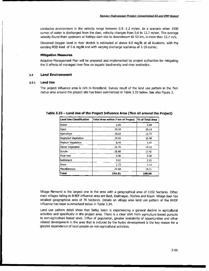
Ramour HvdroMower Project: Consolidated EA and EMP Report
conducive environment in the velocity range between 0.8 -1.2 m/sec. In a scenario when 1500
cumec of water is discharged from the dam, velocity changes from 0.6 to 12.7 m/sec. The averagevelocity found from upstream at Nathpa dam site to downstream till 53 km, is more than 12.7 m/s.
Dissolved Oxygen level in river stretch is estimated at above 8.0 mg/lit at all locations, with the
existing BOD load of 5-8 mg/lit and with varying discharge scenarios of 1-10 cumec.
Mitigation Measures
Adaptive Management Plan will be prepared and implemented by project authorities for mitigating
the ill effects of managed river flow on aquatic biodiversity and river aesthetics.
3.5 Land Environment
3.5.1 Land Use
The project influence area is rich in forestland. Survey result of the land use pattern in the 7km
radius area around the project site has been summarized in Table 3.33 below. See also Figure 3.
Table 3.33 - Land Use of the Project Influence Area (7km all around the Project)
Land Use Classification Total Area within 7 km of Project % of Total Area
Water 1.05 0.68
Open 29.54 19.14
Agriculture 18.10 11.73
Degraded Vegetation 20.02 12.98
Medium Vegetation 8.44 5.47
Dense Vegetation 21.76 14.10
Scrubs 26.88 17.42
River bed 0.46 0.30
Setdement 3.62 2.35
Snow 1.75 1.13
Miscellaneous 22.69 14.71
Total 154.31 100.00
Village Nirmand is the largest one in the area with a geographical area of 1102 hectares. Other
main villages falling in RHEP influence area are Bael, Duttnagar, Poshna and Koyal. Village Bael has
smallest geographical area of 76 hectares. Details on village wise land use pattern of the RHEP
influence has been summarized below in Table 3.34.
Land use pattern detail show that Satluj basin is experiencing a general decline in agriculturalactivities and specifically in the project area. There is a clear shift from agriculture based pursuits
to non-agriculture based ones. Influx of population, greater availability of opportunities and other
related development in the area that is induced by the hydro development is the key reason for a
greater dependence of local people on non-agricultural activities.
3-56

Ramour Hvdrooower Proect: Consolidated EA and EMPReoort
Figure 3.27 - Land Use of the Satluj Basin
AL-5
* ~ ~ ~ ~ ~ jl clr--..
# , . .,, Pr
VraJ. l~X W $ ,
.- atshfiew . es 3-57

Rampur Hydropower Project; Consolidated EA and EMP ReLort
Figure 3.28 - Soil Erosion in the Satluj Basin
I *x
'-:~~ Ff - -. -- .-
3--
d3 -
3-58

Ramour Hydrooower Protect Consolidated EA and EMP Renuri
Figure 3.29 - Agriculture in the Project's Surrounding Area
1. Agricultural fields near Bael 2. Farming done at Landless colony, Jhakri
3. Farming at Landless colony 4. Agricultural fields near Bael
L&fltIb &''Tur'L1TJ.-
5. Crops near Bael 6. Plum plantation near Tunnan village
3-59

Ramour H vdroLower Proiect: Consolidated EA and EMP Reort
Figure 3.30 - Grazing Land in the Vicinity of the Project Area
3-60

Ramour Hvdropower Project: Consolidated EA and EMP Reovi
Table 3.34 - Land Utilization of Villages in RHEP influence area
Land Use Type Koyal Bael Dutt Nagar Tunan Poshna Nirmand
Area under Forests - - - - - -
Area not available for Cultivation 29 15 83 107 49 246(non-agri/uncultivable)
Other uncultivable land excluding 114 547 - - - -
fallow land (permanentpastures/other grazing land,miscellaneous tree crop/grooveincluded in net area sown, culturablewaste
Fallow Land (current/others) 1 4 - 23 22 71
Total cropped area (net sown 316 114 230 731 391 1553area/area sown more than once)
Total Cultivable area (irrigated/un- 133 57 - 6 244 856irrigated)
Village common lands - - - - -
Land put to other use(industry/community house)
Area under ponds for agriculture
Source: Baseline Demographic Socio-Economic Survey of Rampur Hydroelectric Project, Year, 2005
Land use pattern has been studied using latest satellite data (IRS P6, LISS III sensor) for the entireSatluj basin. Raw digital satellite data was procured from National Remote Sensing Agency andprocessed in house using the hardware and software facilities available with the consultant. Theland use classification has been presented in the Table 3.35 below:
Table 3.35 - Land Use in the Study Area (7km all around the Project)
S.No. Landuse Category Percentage of total Satluj basin area
1. Agricultural land 10.95
2. Fallow land 0.08
3. Plantations 0.25
4. Land without scrubs 1.68
5. Forest areas 24.96
6. Water bodies 0.69
7. Snow covered area 37.87
8. Settlement 0.21
9. Barren areas 20.16
10. Grassland 3.16
Total 100
Source: Satellite Imagery, Year 2005
The influence area of RHEP includes village Nirmand, which is having largest geographical area of1102 hectares. Other main villages falling in RHEP influence area are Bael, Duttnagar, Poshna andKoyal. Village Bael has smallest geographical area of 76 hectares. Bael and Poshna villages do nothave any land under category of 'non-agriculture' use. Details on land use pattern of the RHEPinfluence has been presented below in Table 3.36.
3-61

Ramour Hydropower Proiect: Consolidated EA and EMP Reoort
Table 3.36 - Land Use (in hectares) of RHEP Influence Area
Landuse Type Koyal Bael Dutt Nagar Tunan Poshna Nirmand
Area under Forests - - - - - -
Area not available for Cultivation (non- 29 15 83 107 49 246agri/uncultivable)
Other uncultivable land excluding fallow land 114 547 - - - -(permanent pastures/other grazing land,miscellaneous tree crop/groove included in netarea sown, culturable waste
Fallow Land (current/others) 1 4 - 23 22 71
Total cropped area (net sown area/area sown 316 114 230 731 391 1553more than once)
Total Cultivable area (irrigated/un-irrigated) 133 57 - 6 244 856
Village common lands - -
Land put to other use (industry/communityhouse)
Area under ponds for agriculture
Source: Baseline Demographic Socio-Economic Survey of Rampur Hydroelectric Project, Year, 2005
It can be inferred from the above data that there is a decline in landuse under agriculture relatedactivities and irrespective of form of compensation provided to affected people in the projectinfluence area, there has been a shift from agriculture based pursuits to non-agriculture basedones. This could mainly be attributed to the influx of more number of people, greater availableopportunities and other related development in the area that is induced by the hydro development.
3.5.2 Soil Quality
In Shimla district, the soil is generally shallow in depth except in the areas having vegetation coverwhere it is fairly deep. In the regions above 1,500 m, the soil is generally deep. Largely the soil canbe classified as podzols, both brown podzols and humus and iron podzols are found in the studystretch. These are acidic in nature with the organic content ranging from medium to high.Nutritional survey of soil and plant analysis suggests that the soils by and large have low levels ofZn, Cu, B and Mo.
Comparative account of soil properties for various locations - upstream of NJHEP dam, downstreamof NJHEP dam, near the power house, downstream of tailrace discharge from power house, hasbeen presented in the Table 3.37.
Table 3.37 - Analysis of Soil Samples near the Rampur Project Area
Parameters Upstream of Downstream of Near 3hakri Downstream of JhakriNathpa dam Nathpa dam Powerhouse Tailrace Discharge
pH 7.22 7.47 7.21 7.4
Electrical conductivity (us/cm) 310 211 575 164
Sodium as Na (meq/100 gm) 0.004 0.01 0.007 0.01
Nitrogen as TKN (%) Nil Nil Nil Nil
Phosphates as P04 (meq/100 gm) BDL BDL 1.40 0.200
Potassium as K (meq/100 gm) 0.005 0.002 0.005 0.002
Source: EIA study for Rampur HEP, Year 2005
BDL - Below Detectable Limit
3-62

Ramour Hvdropower Proiect; Consolidated EA and EMP Reoo,t
3.6 Aquatic Habitat & Fish Diversity
3.6.1 Aquatic Flora
Past studies in various stretches of the river Satluj indicate inherently poor presence of planktoniccommunity in the river and its tributaries. The planktonic community, therefore, plays a little role inecological niche in the Satluj river system. A monitoring survey of Jhakri-Rampur-Bael stretch ofriver in the month of March 2006 establishes presence of Green Algae and Blue GreenAlgae.Diatoms,Bryophyta and pteridophytes are also significantly present in the river. The speciesalong with their typical characteristics are summarized in Table 3.38 below:
Table 3.38 - Floral Species in Satluj along Jhakri-Rampur-Bael stretch
Type Species Characteristics
Green Algae Tetraspora, Ulothr/x and Oedogonium Contains chlorophyll, hence use captured lightenergy to fuel the manufacture of sugars.
Blue green algae Microcystis, Chrococcus, Gloecapsa, Arthrospora, The blue green algae do not possessOscillatoria, Lyngbya, Phormidium, Schizothlix, flagellated motile cells and hence foundRichella, Anabaenopsis, Cyllnderospermum, attached except a few forms like oscillatoriaWollea, Nostoc, Anabaena, Gloetricha, Fisherella. which shows slow creeping movement
A large number of blue green algae are ableto fix atmospheric nitrogen e.g. Nostoc,Anabaena, Cylinderospermum etc.
Diatoms Navicula, Gyrosigma, Nitzschia and Suriella. unicellular algae
cell walls of these organisms are made ofsilica, and are of varied shapes
Bryophyta R/cc/a flu/tans, Marchanba simlana "amphibious" in nature; grow in moist and
Pellia endivlaefolla, Madotheca shady places on the sides on river water
Pteridophytes Equisetum ervense, E debile, E ramosisslmum containing all the vascular plants that do notand E.diffusum bear seeds: ferns, horsetails, club mosses,
and whisk ferns
Source: EIA for Rampur Hydroelectric Project, Year 2005; Monitoring carried out during March, 2006
3.6.2 Aquatic Fauna
The aquatic faunal communities are severely harmed by variable velocities of water, ice formationduring winter, occurrence of periodic floods due to cloud burst and rolling of stream bottommaterial consisting of boulders, stones, gravels etc. Faced with tough survival conditions, thesefaunal communities show inherent capability to adapt to the tough hydrological conditions of fastflowing riverine conditions. Satluj river provides good microhabitats for various faunal communitiesto get suitably adapted to the tough environment. Faunal communities in Jhakri-Rampur-Baelstretch of Satluj River are summarized in Table 3.39 below
3.6.3 Fish Habitats
Historical survey reports of the state fisheries department, for the streams of river Satluj at highreaches i.e. upstream of Bilaspur, estimated presence of 51 species of cold water fishes includingexotic trout, snow trout and several species of hill stream fishes. Main species are listed in tablexxx.
Another study conducted by K.L. Sehgal of ICAR,Nainital on the Ecology and Fisheries of MountainStreams of the North-Western Himalayas in 1988 reported a large number of fish species mainlybelonging to 13 taxonomical families (51 species) present in entire Satluj River of Himachal region.The survey was made for the entire Satluj basin up to downstream till now existing Govind Sagarproject. These species survey results are presented in tablexx.
The study also established that in comparison with other mountain streams of NW Himalayas, thefish population in river Satluj is very little. The river flows through deep gorges alternating with
3-63

Ramnur Hvdropower Project: Consolidated EA and EMPReport
oblong and wide valleys. Advance debris and/or glacial moraines and landslides continuously causemodifications in the morphology of Satluj. In the river course such places are clearly marked by asudden widening of the valley indicating a damming of the river and creation of a natural reservoir.These changes have resulted in different stream ecology, which is not conducive for fish growth.
As per the historical information collected from the Fisheries department, the streams of river Satlujat high reaches i.e. upstream of Bilaspur harbored 51 species of cold water fishes (Table 3.40)including exotic trout, snow trout and several species of hill stream fishes.
Table 3.39 - Faunal Species in Satluj along Jhakri-Rampur-Bael stretch
Group Species Characteristics
Invertebrates Arcella. -Stagnate water containing much vegetation
-Found growing at-least 20 meter away from the riverbank.
-Secretes yellow to brown thick hard transparent and hemispherical shell
Diffusia, Monostyla -Free living; symmetrical shell
-Feeds upon algaehence it is in plenty where algae are in abundance
Planaria naids of -Found at the bottom where it is found resting on the undersurface of stones andBaetis, Ephemerella, on the aquatic leaves.Epeorus, Rithrogena, -Planarians were collected for laboratory analysis by baiting shallow streams withcaen/s, Heptagenla raw pieces of raw liver
Elmis Psephenus, -Forewings are leathery possess antennaHydrophilus amongst' -Mouth parts are chewing type.Coleoptera
Vertebrates Amphibia -Tadpoles of Rana tigrina
Fishes Salmo trutta fario (Fry and fingerlings), Schizothorax richardsonii (Young stages),Nemacheilus gracilis, N. stolizkae, N. botia, Glyptothorax stoliczkae, G. conirostre
Source: EIA for Rampur HEP, Year 2005; Monitoring Results, March, 2006.
Table 3.40 - Fish Species Historically Reported in Upper Reaches of the Satluj River
Family Species
Cyprinidae Barl/us bendelisis, B. vagra, B barila, B. modestus, Oxygaster bacaila, Rasboradan/con/us, Carassius auratus, Cirrhinus reba, C mrlgala, Crossocheilus fat/us, Catlacatla, Labeo dero, L. dyocheilus, L. bata, L. calbasu, L. rohita, Cyprinus carpio var.communis, C. carpio varnudus, C carp/o varspecularis, Schizothoraxrichardson/*,S plagiostomius, Ctenophalyngodon idella, Hypophthalmicthys molitrix, Tor put7toratGanra gotyla gotyla, G. Ianlta, Puntius sarana, P ticto, P. chola and P. sophore.
Cobitidae Biota dario, B. birdi B. lohachata, Noemacheilus botla, N. rupicola, N. monatanus, N.kangrae and N. horai
Bagridae Mystus seenghala and M. aor
Schilbeidae Clupisoma garua
Sisoridae GIYptothorax pectinopterus and G. cavia
Belonidae Xenentondon canclla
Ophiocephalidae Channa gachua and C punctatus
Mastocembelidae Mastocembelus armatus armatus
Salmonidae Salmo trutta farno*
Source: Himachal Pradesh Fisheries Department
* A migratory fish
3-64

Rampur Hvdrooower Proiect: Consolidated EA and EMP ReDU,i
A survey was undertaken during RHEP EIA study to confirm the earlier mentioned study reports aswell as to identify source, availability, quantity and type of fish found in river stretch adjoiningproject area. The survey indicated a scanty fish population in the Satluj river stretch betweenNathpa and Bael. Here too the fish population is mainly derived from the khads that meet Satluj.They are mainly confined to the side streams like Nogli, Samej and Kurpan. Trout is the main fishspecies.
Prominence of fish population in the khads has resulted in the fish catching activity mainlypracticed at confluence of Nogli tributary with Satluj. There are only four licensee fish catchersamong the local people at the Nogli confluence area, for carrying out fishing activities. Forcommercial purposes, fish is mainly brought from Bilaspur.
Satluj is category A or high mountain stream ranging 0.92 - 2.68 m/s in velocity. The abioticparameters which affect the biotic communities of the river are source of water, size, elevation,slope, substratum, water temperature, dissolved oxygen, water hardness etc. Many of theseparameters control the biological productivity either singly or in combination. The studies availableon quantitative and qualitative analysis of micro and macro-benthic communities in the river stretchrevealed that river Satluj and its tributaries are represented by major benthic invertebrates andvertebrates. The micro-biotic communities are represented by diatoms, blue-green and green algaeon which the invertebrate and benthic fish subsist. The invertebrates are represented by youngstages of insects, which contribute up to 80% of total invertebrates' density. The vertebrates arerepresented by benthic fish species belonging to garrids, nemacheilids and glyptothoracids groups.Nektonic fish are represented by Schizothorax richardsonii and Salmo trutta fario.
No historical or existing data are available on utilization of micro- and macro- biotic life by thefishes in river Satluj that could indicate the growth pattern of fish population in the river. From thedata available on other rivers in the region, similar to Satluj river like rivers of the Indus basin, itcan be established that ecology of river Satluj is conducive only for propagation of twocommercially important species. High velocity (Average stream velocity of 2.00 m/s ), lowtemperature, lack of spawning beds (pebbles, gravel etc) in the project area induces migration offishes to the tributaries, which maintain relatively higher temperature. Fish here can easily matureand spawn. The newly hatched young fish remain in the tributaries till they are sufficiently grownup to take care of themselves.
The high flow regime in river Satluj makes the upper reaches, difficult habitats for fish. Frequentoccurrence of spates makes conditions worse for breeding and propagation of cold-water fish.Sometimes entire species type from the river body disappears due to devastating floods, ashappened in case of river Ravi. The flood in 1947 caused complete removal of brown troutpopulation in Ravi. The cold-water streams of Satluj river also make it inherently poor in biologicalproductivity due to low temperature and scanty food. Most of the energy of cold-water fishes isutilised in maintaining their position in fast-flowing waters and hence they live under continuousphysiological stress.
The same was confirmed by referring to the thesis on "Ecology and Fisheries of Mountain Streamsof the North-Western Himalayas", KL Sehgal, ICAR, Nainital, and Yearl988), which reported a largenumber of fish species mainly belonging to 13 taxonomical families (51 species) inhabited theSatluj River in Himachal region in the past. As per discussions with Dr. K. L. Sehgal, these specieshave been reported in the entire Satluj basin up to downstream before coming up of Govind Sagarproject. Refer Table 3.41 below.
3-65

Ramour Hvdrooower Proiect: Consolidated EA and EMP Reoort
Figure 3.31 - Fishing in the Tributaries of the Satluj
AT THE JUNCTION OF THE NOGLI KHAD WITH THE SATLUJ
.. ~ ., .... ...
36 6
I3-6

Rampur Hvdro=ower Project: Consolidated EA and EMP Report
Table 3.41 - Fish Species Reported Historically in River Satluj in Himachal Pradesh
Family Species Local Name Fish Type / Remarks
Notopteridae Notopterus chitala (Hamilton) Pari
N. notopterus (Pallas) Moh
Cyprinidae Bar/ius barila (Hamilton)
B.bendelisis chedra. (Hamilton) Patha
B. vagra(Hamilton) Lohari
B.shacra (Hamilton) Chilwa
Danlo (danio)devarno (Hamilton) Parrandah
D.(Brachydanio) rerio (Hamilton) Kangi
Esomus danricus (Hamilton) Makni
Rasbora daniconius (Hamilton) Chindolachal
Tor chilinoides
Tor putitora (Hamilton) Mahseer chiniaru Migratory Sharp declinein catch
Catla catla (Hamilton) Theila
Cirrhina mrigala (Hamilton) Mori
C.reba (Hamilton) Sunni
Crossocheilus latius punjabensls (Hamilton) Tiller
Garra gotyla (Gray) Kurka
Puntius chola (Hamilton) Chidu
P.chonchonius (Hamilton) Chidu
P.ticto (Hamilton)
P.sophore (Hamilton)
Labeo boga (Hamilton) Morah
Lcalbasu(Hamilton) Kalbaus
Ldero (Hamilton) Gid
Ldyocheilus(MeClelland) Kunni Sharp decline in catchover the years
Lgonius (Hamilton)
L.pangusia(Hamilton)
Lrohita (Hamilton) Rohi
Schizothorax richardson#i Trout (Migratory)
Cobitidae Bobta birdi Chipar
Noemacheilus botia(Hamilton) Sundal
N.botia aeurus (Hamilton) Sunda
N.corica (Hamilton) Talana
N.kangrae(Menon)
Siluridae Ompak bimacu/atus(Bloch) Pallu
Wallago attu (Hamilton) Mullae
Bagridae Mystus (Mystus) bleekrl (Day)
M.(Mystus) vittatus (Bloch) Kingra
M.(Osteobagrus) seenghala (Sykes) Singhara
Rita rita (Hamilton) Khagga
Amblycipitidae Amblyceps mangois (Hamilton) Sundal
Sisoridae Glyptothorax conirostris (Steind) Nao
G.pectinopterus(Hamilton) Mochi nao.
G.stoliczkae(Steind) Naiya
Schilbeidae Clupisoma garua (Hamilton) Bachwa
3-67

Ramour Hvdrovower Proiect; Consolidated EA and EMPReport
Family Species Local Name Fish Type / Remarks
Belonidae Belone cancila (Hamilton) Takla
Muglidae Mugdi cascasia (Hamilton) Buah
Channidae Channa gachau (Hamilton) Dauli
Cmarulius (Hamilton) Saul
Mastocembelidae Mastacembalus anmatus (Lacepede) Bami
Salmonidae Sa/mo trutta fario Trout
Source: 'Ecology and Fisheries of Mountain streams of the North-Western Himalayas', K.L Sehgal, ICAR, Nainital, 1998
The data available on quantitative qualitative analysis of micro and macro-benthic communities inthe river stretch reveal that river Satluj and its tributaries are represented by major benthicinvertebrates and vertebrates. The micro-biotic communities are represented by diatoms, blue-green and green algae on which the invertebrate and benthic fish subsist. The invertebrates arerepresented by young stages of insects which contribute up to 80% of total invertebrates' density.The vertebrates are represented by benthic fish species belonging to garrids, nemacheilids andglyptothoracids groups. Nektonic fish are represented by Schizothorax richardsonii and Salmo truttafario.
Although no data are available in the literature on utilization of micro- and macro- biotic life by thefish in river Satluj but considerable literature is available in closely related rivers of the Indussystem. In river Beas, Sehgal (1988) and Sehgal et al. (1984) worked out a coefficient ofaccessibility or availability factor or forage ratio (Pf/Pb where Pf is percentage of animal/plantsforaged and Pb is percentage of benthic biota in the stream) in S. richardsonii and S. trutta fario.It was observed that forage ratio ranged 2.8- 4.2, 0.3 -1.0 and 0.3 - 3.7 for larvae of Diptera,nymphs of Ephemeroptera and larvae of Trichoptera in young of S. richardsonii (15-65 mm in totallength). In the grown up specimens 140-480 mm in total length, the fish subsisted on benthicalgae. The food quotient ranged 0.9 -1.2, 0.3 -1.6 and 0.5 -2.8 for diatoms, blue green and greenalgae respectively. The brown trout S. trutta fario which is sight feeder has been studied in Beasand Jhelum. Fish ranging 101- 200 mm in total length consumed 74.2 % of Ephemeroptera in totalanimal foraged although other groups were fairly abundant. Specimen ranging 201- 400 mm intotal length consumed larvae of Trichoptera to the extent of 54.6 % in total invertebrates and onaerial insects and other small land animals to the extent of 20.9%. The forage ratio forEphemeroptera ranged 0.6 -1.1 against 1.0-4.3 for Trichoptera. Based on the results obtained forother rivers of North West Himalayas it is presumed that ecology of river Satluj is conducive forpropagation of two commercially important species. Due to high velocity, low temperature, lack ofspawning beds (pebbles, gravel etc) in the project area, fish is induced to enter the tributaries,which maintains comparatively higher temperature where they mature and spawn. The newlyhatched young fish remain in the tributaries till they are able to take care of themselves.
3.6.4 Results from Aquatic Monitoring
As mentioned earlier, a monitoring was carried out in month of March 2006 to determine thepresence or otherwise, and the typology of fish population. Small-narrow thread system, commonlyprevalent in the area, was used for fish catch. No fish could be found in the Satluj during the 20days of monitoring. However, fishes were observed in the Nogli Khad, Sumej Khad and Kajo Khad,near their confluences with Satluj River.
The sole fish species caught with the help of a local fisherman was a trout (Schizothorax spp,Schizothoraichthys spp.). Fish was caught downstream of the confluence of Nogli khad with mainSatluj river. Schizothorax belongs to taxonomical family Cyprinidae and sub-familySchizothoracinae. It is a small sized, migratory fish variety and is locally known as "asia".
3-68

Ramour Hvdropower Proiect: Consolidated EA and EMP Report
Migratory Fish Species
When the temperatures start rising above 22 °C to 25 °C, sometimes during Feb-March, migratoryspecies in Satluj starts moving upstream to colder reaches of the river from downstream. But lowtemperature of 8-9.5 ° C of water due of the influx of snow-melt water does not make it conducivefor the ripe fish to spawn. Hence, Trouts enter the side streams of the river, which receive warmground waters (17.5-21.5°C) and spawn abundantly.
Outcomes of the Study on Fish Availability
Assessment of the available historical data, fish monitoring survey and interaction with fisheriesdepartments, fisheries expert and fisherman conclude following on fish availability in the river Satlujalong the stretch between Jhakri and Bael:
. River has very less fish population in stretch between Jhakri to Bael. Whatever fishpopulation exists in the river in this stretch comes from the Khads. Fish species mainlyfound are Trouts i.e. Snow trouts and Brown trouts. Snow Trouts ( 5. richardsonii) ismost common fish in river Satluj. Snow trout is neither a rare nor an endangered fish butis categorized as vulnerable one.
* The side streams like Nogli khad, Samej khad have fish populations. This is mainly due toless flow instability, favourable temperature and less turbidity. Fishes have also beensighted at the confluence points of khads (Nogli, Sumej and Kajo).
* All species available in River Satluj (stretch from Jhakri to Rampur to Bael) are endemicexcept brown trout that is exotic.
. Fish catching is not a very prevalent activity in the area. Only a few fishermen areinvolved in fishing activity at Nogli for commercial purpose. Only four fishing licence havebeen issued in this region. For commercial purpose, the fish is mainly brought fromdownstream regions, Bilaspur being one among the major ones.
. Migratory fishes like the snow trout etc., require free passage, to and fro from theirspawning grounds located upstream, owing to changes in water velocity, volume ofdischarge, water chemistry, temperature and turbidity. But this issue is insignificant owingto low fish population that primarily exists in tributaries and their confluences with riverSatluj.
• Mahseer is migratory fish and its migration is affected by construction of Bhakra dam onthe Satluj. Its availability in project area is a remote possibility due to low watertemperature.
A detailed study shall be undertaken for the entire stretch to understand the exact route that isbeing followed by the fisheries in the river especially after construction of hydroelectric projects andto understand the microclimate needed for the fish growth in the area.
3.6.5 Potential Impacts on Aquatic Habitats & Mitigation
With the limited information on fish distribution and biology, and no information on the preciseecological requirement or the reactions to environmental stress of the fishes native to the surveyedarea, the discussion on the potential impacts of the Project is derived from past experience withother, related species in adjacent areas and expertise. Two main types of impacts are presented:
* Impacts related to construction
* Impacts related to the permanent changes to the various aquatic habitats due to waterdiversion.
3-69

Ramour Hvdrooower Proiect: Consolidated EA and EMP Reort
Migration measures are proposed whenever possible (see EMP, Chapter 4).
Construction Related Impacts
The possible impacts of the Project on aquatic habitats and biodiversity during construction include:
* Silt deposit in river bed
* Construction of Project infrastructure
* Water pollution
* Use of explosives
* Vegetation clearing
Work on the Riverbed
Silt deposit in riverbed increases the sediment load of the river. This affects fish downstreamdirectly and indirectly. Fish living in clear water habitats are directly affected by increasedsuspended sediments that may damage their gills or accumulate in their gill chambers, leading todeath. Indirect effects of silt deposits in river bed include:
* Modifications of the natural habitat by silt deposition
• Destruction of spawning sites
* Silt deposition over freshly laid eggs or newly hatched larvae;
* Reduced primary production as a result of reduced light penetration
Mitigation: Construction material will not be dumped in the river but transported to securedisposal areas and dumped above the level of the rainy season flows. Construction sites will becleared before they are flooded.
SJVNL will adhere to the erosion control plans set down in environment management plans to helplimit sedimentation resulting from construction.
Construction of Project Infrastructure
Construction of the infrastructure mainly affects the freshwater ecology when poor constructionpractices result in an increased sediment loads. This happens when:
* Construction material is washed into the water course
* Unstabilised infrastructure is washed away in the rainy season
* When temporary infrastructure or rods are constructed.
Mitigation: All infrastructure including temporary constructions, will be stabilized and bridges willbe built to respect the existing stream/ river bed and bank morphology. Construction material willnot be washed into the stream but transported to disposal areas.
Water Pollution
Spills of fuel and chemicals may have direct and indirect impacts on the aquatic fauna, as well ashumans and animals feeding on aquatic products. Pollution most often occurs where pollutants arestored, and also when they are used incorrectly.
Mitigation: Retention tanks will be constructed around every area where liquid and solid fuels orchemicals are stored. Empty packaging material will be eliminated in the appropriate way.Recyclable packaging will be preferred whenever possible. The construction work force will be
3-70

Ramour Hydropower Proiect. Consolidated EA and EMP Reort
trained in the safe and proper use of fuel and chemicals and instructed in non-damaging disposal.Safety will be controlled and enforced.
Use of Explosives
Use of explosives in water is highly damaging for fishes and other aquatic organisms. If they arenot killed instantly, their internal organs may be severely injured leading to death within e fewminutes to a few days, even if they are at a considerable distance from the explosion site. Intheory, little or no explosives will be used underwater during construction of the Project. Howeverexperience shows that at most construction sites, large quantities of explosives are stolen ordiverted from their proper goal and used for fishing. Besides being illegal, fishing with explosives isa very inefficient method as most killed fishes cannot be recovered. Additionally, the explosivesdamage the fish habitats and occasionally kill fishermen. As these occasional "fishermen" areusually Project workers, this issue is also of concern for Project security.
Mitigation: Fishing with explosives by Project workers will be totally banned in the projectinfluence area.
Vegetation Clearing
The mechanical removal of vegetation for construction purposes, ideally accompanied by itstransformation into any usable product, is probably the environmentally les damaging method, butdepending on the timing and locations of the clearing it will result in a short-term increasedsediment load in the river during the wet season.
Mitigation: All possible measures to reduce the transport of sediment to the main river will betaken, including proper road construction and sediment traps. Sediment traps will be checkedfrequently and maintained. Sediment will essentially be transported to proper disposal areas.
Reduced River Flow
Diversion of the waters for power generation will have the obvious consequences of reduced flowin the Satluj River. This will have several secondary consequences and the already mentionedeffects of degraded water quality.
The reduced flow in the Satluj river will result in a decrease in water level compared to the presentlowest level, but the existing morphology will only be slightly affected. The deep pools will remain.Runs, rapids and rifles will become narrower and shallower, with slower water. The slower watermay affect the survival of some species and their population density. It will very significantly reducethe habitats suitable for the endemic kind. Reduction of flow coupled with increase in turbidity willseverely affect groups of micro-benthic organisms especially diatoms. The virtual suppression ofmost of the seasonal, cyclic successions of low and high waters will probably have a much moresignificant impact on the aquatic diversity than the reduction of the minimum flow. It is likely toseverely affect their growth, reproduction and migration.
A permanent low water level will have a negative impact on fish as it will drastically reduce theavailable food sources, reduces the number of hiding places and increase s predation. This willincrease their sensitivity to diseases through increased stress. Almost all the cold water fish breedin flowing water. The spawning areas of these fish species are found amongst pebbles, gravel,sand etc. The eggs are sticky in nature and remain embedded in the gravel and subsequentlyhatch. Any disturbance of stream bottom will result in adverse impacts on fish eggs. Even increasein fine solids beyond 25 ppm will result in deposition of silt over the eggs, which would result inasphyxiation of developing embryo and also choking of gills of young newly emerged fry. Theconstruction of a dam on river Satluj at Nathpa has lead to reduction of flow, which has alreadyaffected the riverine ecology by converting lentic system to a lacustrine system. The ecology in thelacustrine system has already developed over an area of 16.5 ha. As a result of reduction in flow,
3-71

Ramour Hvdrooower Proiect. Consolidated EA and EMP Report
downstream of the dam i.e. from Nathpa-Jhakri-Bael, the fish stock could be affected adversely.However, since this stretch has negligible fish population and the fish predominance is more in theside streams/ tributaries, not much impact is envisaged due to reduced flow on the fishery.
Interruptions of Fish Migration & Destruction of Spawning Grounds
Information obtained on fish migrations in the Satluj is at present incomplete, and does not allowclear conclusions about which fish may migrate, during which season and for what purpose.
Some migratory fish species may travel very long distances between precisely delimited feedingand breeding over hundreds or thousands of kilometres. Others may migrate for a few km betweendifferent places within the main river, between the main river and tributaries. Usually, Fish laddersare constructed at many dams to allow for fish to migrate. RHEP does not involve construction ofDam and hence fish ladder is not required for consideration.
Mahseer is the only migratory fish in the area and its migration is affected by construction ofBhakra dam on the Satluj downstream of RHEP. Its availability in project area is a remotepossibility due to low water temperature.
Water Pollution from Use of Synthetic Chemicals
Any increase in the use of synthetic chemicals associated with Project activities has the potential toelevate their concentrations in the surroundings water. Although low concentrations of thesesynthetic chemicals may not be acutely toxic to aquatic organisms, they may exhibit chronic effectsand potentially bio-accumulate to levels that are harmful to humans.
Mitigation: A Chemical Management Plan has been developed to ensure the safe storage, use anddisposal of synthetic chemicals.
3.7 Terrestrial Biodiversity
3.7.1 Background
Biodiversity or biological diversity is the variability within and between all micro organisms, plantsand animals as well as the eco-system, which they inhabit. Himachal Pradesh is a mountainousstate in northern India known for its natural beauty, rich culture and religious heritage. The statehas a population of six million and covers 55,673 sq. km, ranging from foothills (Shivaliks), the Mid-hills, the High- Hills, and the Cold Dry Zone of upper Himalayas. The state is a rich repository ofbiodiversity, and forms the Catchment of several major northern Indian rivers. Endowed with avast canvas of dense forest and colourful wildlife, state encompasses three bio geographic zonesrepresenting great attitude and climate variations, sub tropical to cold desert supporting a vastvariety of floral and faunal biodiversity. The protected areas are the vital tools for conservingbiodiversity. The 32 Wildlife Sanctuaries together with the 2 National Parks consist the state'sProtected Area Network (PAN) occupy, which 13.6% of state's geographical area as compared tonational average of 4.70%. About 25.8% area of States area' falls under forests which is higherthan the average national forest area of 20.64%. The status of forest of the India, HimachalPradesh and the two districts-Kullu and Shimla are summarizedin Table 3.42 below.
Table 3.42 - Status of Forest in Himachal Pradesh, Kullu and Shimia Districts
3-72

Rampur Hydropwer Project: Consolidated EA and EMP Reort
Place Geographical Area km 2 Dense Forest km 2 Moderately Dense Open Forest km 2
Forest km 2
India 3287263 51285 339279 287769
Himachal Pradesh 55673 1093 7883 5377
Kullu District 5503 117 1295 521
Shimla District 5131 194 1587 602
Source: State of Forest Report 2003, Forest Survey of India, Dehradun
The state's Protected Area Network is extremely rich in wildlife. Rare mammals include Musk Deer,Black Bear, and Snow Leopard & Leopard. The avifauna includes rare pheasants such as WesternTrapogon and Cheer Pheasants. The state bird Monal is still found extensively in many higherprotected areas. The status of protected area is given below.
Table 3.43 - Status of the Protected Area Network
Location No. of Sanctuaries No. of National Parks
India 490 88
Himachal Pradesh 32 2
Satduj basin 10 0
Project area 0 0
Source: Wildlife Wing, Himachal Pradesh Forest Department, Shimia
Table 3.44 - National Parks/ Wild Life Sanctuaries in Eastern Himachal Pradesh
S. No. Name of Wild Life Sanctuary/National Park Region Area (kM 2)
1. Bandli Wild Life Sanctuary Mandi 41
2. Gobindsagar Wild Life Sanctuary Bilaspur 100
3. Majathal Wild Life Sanctuary Solan 40
4. Darlaghat Wild Life Sanctuary Solan 6
5. Shilli Wild Life Sanctuary Solan 2
6. Rupi Bhabha Wild Life Sanctuary Kinnaur 503
7. Daranghati (Part I & II) Shimla 167
8. Lippa Asrang Kinnaur 31
9. Sangla Valley Kinnaur
10. Great Himalayan National Park Kullu 765
11. PIN Valley National Park Lahaul & Spiti 675
Source: Environmental Information Centre, Ministry of Environment & Forests
The terrestrial biodiversity status was studied regarding flora and fauna in the Project InfluenceArea, (7km surrounding the project sites), the Project Immediate Influence Area (500m on all sidesalong the alignment of HRT) and the Project Affected Area (the total 49.8ha of forest landacquired). For Terrestrial biodiversity survey, data were collected through extensive survey of theareas. Information was also collected from different Government Organizations such as ForestDepartment, Social Forestry, Dept of Science, Technology & Environment, District Statistical office,Animal Husbandry Dept., Govt. of Himachal Pradesh. On the basis of onsite observations as well asforest department records a checklist of flora and fauna was prepared. Public consultation andliterature review helped in identifying major uses of plant species in terms of timber, fodder, food,medicinal.
3-73

Ramour Hvdrooower Proiect: Consolidated EA and EMP Reor,
Botanical Survey of Flora was undertaken with respect to taxonomy, physiognomy, forest type,Structure, Associations, Phenology and Ethno-botanical information for major forest species, etc.Ecological status of flora and fauna with respect to endangered, rare, threatened, endemic as wellas distribution characteristics i.e. native/exotic, commercially/ locally important species, weeds orparasites were surveyed extensively.
3.7.2 Methodology and Assessment techniques
The Primary survey & secondary data available with various state sources were collected to assessbaseline terrestrial biodiversity status.
Flora Assessment
To characterize the vegetation under the project area, study was carried out by using StandardQuadrat Method and Random Sampling approach was followed. The project area is open scrub landwith dominant shrub species hence quadrat size of 5 x 5m was used for study of trees and shrubs,whereas for grasses and herbs lx lm quadrats were used. Immediate impact sites have beenconsidered for study. The number of quadrats was taken such so as to cover 8-10 % of the totalland parcel under the project area. The properties of vegetation with reference to speciescomposition and functional attributes are expressed on species basis. The specific formats wereformulated to collect information regarding flora & fauna of the project / study area.
Assessment Techniques
The density measurements is calculated to measure individuals present, the dominancemeasurements is estimated to denote which species is largest in terms of its presence and thefrequency measurements calculation indicated how widely species is distributed among the sameplots. Importance value is used to assess the overall significance of a species since it takes intoaccount several properties of the species in the vegetation. Importance value index were calculatedas per Curtes & Mc Intosh (1950). The following parameters were assessed from the field datameasurements.
Shanon - Weaver Index (1948)
The number of species and number of individuals in a community is measure of species diversity,which depends on stability of the habitat. Vegetation of the study area was assess by determiningShannon - Weaver diversity index (1948)
D= -E (ni / n) 109 2 (ni / n)
ni = Number of individuals of each species in the sample
n = Total number of individuals
Fauna Assessment
The fauna assessment technique followed during study varied with type of animal present. Thedomestic animals were listed based on direct observation during field survey; census data was alsocollected from the District Statistical office, Shimia. The list of wild life was obtained from Rampurand Anni Forest Division, Govt. of Himachal Pradesh office as well as onsite observations (direct/indirect method). On the basis of onsite observations as well as forest department records achecklist of fauna was prepared.
3-74

Rampur Hyvdrovower Proiect; Consolidated EA and EMP ReDort
Public Consultation
The public consultations were undertaken to understand about various aspects of biodiversity ofthe area. Information about uses of various plant species by local people as well as sighting of anywildlife species, uses, poaching, etc were gathered as part of the public consultation activities.
3.7.3 Forests and Terrestrial Biodiversity of Himachal Pradesh
Himachal Pradesh, one of the important mountainous states of India spreads over an area of 55673Sq. Km in the Himalayan Region of India. The area is rugged and mountainous with rangesspreading along the Indus-Satluj river system. The height varies from 244 m above Mean Sea level(msl) in areas bordering Uttar Pradesh and Punjab plains to 6750 m in Trans Himalayan zone alongLahaul, Spiti and Pin valleys.
Geographically area of the state can be divided into three major zones i.e. subtropical zoneextending from lower frames to a height of 1550 m above main sea level and incorporating Shivalikfoothills & lower ranges of middle Himalaya. The temperate zone incorporating all hills and valleyssituated between 1500 to 3200 m and the Alpine zone covering all hills and valleys situated abovean altitude of 3200 m, which are, characterize by extreme cold climate.
Forest
Forestry is the major land use in Himachal Pradesh, owing to a wide range of altitude, temperatureand rainfall, Himachal Pradesh supports diverse types of forests, now mostly confined to higherhills and interior valleys. The total geographical area of 55,673 Sq. Km in the state, out of which14,353 Sq. Km area is legally classified as forest. This includes meadows, grasslands and barrenscree slopes above the tree line as well as areas under permanent snow. 1,093 Sq. Km is classifiedas "dense" forest and 5,377 Sq. Km as "open" forest.
The tree cover (dense forest and open forests) accounts for 25.78% of the geographical area ofthe State (SFR, 2003). The actual forest cover has decreased by 7km2 from the assessment madeduring 2001.
Table 3.45 - Change in Forest Cover of Himachal Pradesh
Year Dense Forest (Sq. Kmn) Open Forest (Sq. Kin) Total Forest (Sq. Kmn)
2001 10,429 3,931 14360
2003 8,976 5,377 14353
Change in Forest cover -1,453 1,446 -7
Given the wide latitudinal and climatic range in the State, a wide variety of forests are met with atdifferent altitudes and in different physiographic zones. See Table 3.46
The forest wealth of Himachal Pradesh, replete with diverse vegetation, ranging from tropical tosub-tropical and temperate to alpine, has been sustaining rural life since time immemorial. Thewide range of altitude, topography and climatic conditions have contributed towards the rich anddiversified flora Coniferous forests dominant from mid to high hills, with a preponderance of Oaksin moist depressions. In the foothills, forests are dry deciduous, thriving in a low water table anddry soil conditions. The sub-Himalayan region is characterized by most deciduous forests, with Salas the predominant species. In dry the dominant species, and the moist temperate region incharacterized by the presence of Deodar forests.
3-75

Ramour Hvdropower Project: Consolidated EA and EMP Report
Table 3.46 - Major Forest Types Recorded in Himachal Pradesh
S.No Major Forest Type Classification Code
1 Tropical Moist Deciduous Forest 3C/ C 2A
3C/C2B
2 Tropical Dry Deciduous 5B/C-1 A
5B/C-2
5B/C2/DS1
5B/E9
5B/1-S2
3 Subtropical Dry Evergreen 10-Cl
10-DS1
4 Himalayan Moist Temperate Forest 12/C-1a
12/C-lb
12/C-lc
12/C-le
12/C2-a
12/C2-b
12/DSI
____ ____12/DS-2
5 Himalayan Dry Temperate Forest 13/Cl
13/C2a
13/C2b
13/C4
13/C5
6 Sub Alpine Forest 14/C/a
14/Cl-b
14/DS1
7 Subtropical Pine Forest 9C1
9DS1
9DS2
8 Most Alpine Scrub 15/Cl
15/C2
15/El
15/C3
9 Dry Alpine Scrub 16/Cl
16/El
Source: Forest Working Plan Rampur Forest Division
Natural Flora
It is estimated that almost 3256 species of vascular plants occur in the forests of HimachalPradesh. Of these, only about 100 odd are commonly utilized for timber, farming implements, fuel,fodder, and NTFP, include medicinal use. Based on published records for the State, the BotanicalSurvey of India has compiled a Flora of Himachal Pradesh (Chowdhery & Wadhwa, 1984). As per atentative compilation of the total higher plants found in the State, there are 3120 angiosperm and12 gymnosperm taxa while 34 species for lower plants including pteridophytes, bryophytes, fungiand algae.
3-76

Ramour Hvdropower Proiect; Consolidated EA and EMP Peort
Natural Fauna
The estimated 5721 species of vertebrate and invertebrate fauna listed in the state, perhaps onlyabout 100 species are commonly observed and reported upon regularly. The faunal diversityincludes 649 Chordates (77 Mammals, 447 Birds, 44 Amphibians and 81 Fishes), 4543 Arthropods(2 Bryozoa, 4362 Insects, 195 Arachnids, 11 Myriopods and 73 Crustaceans) and 412 others (60Annelids, 73 Mollusks, 2 Acanthocephala, 132 Nematodes, 16 Rotifers, 90 Platyhe/minths, 2Cnidaria, 3 Porifera and 34 Protozoan). (Biodiversity Action Plan 2003)
The fauna of Himachal Pradesh is very diverse and unique. The rich faunal diversity includes 77species of mammals, 447 species of birds, 44 species of reptiles, and 81 species of fish. Among thepheasants, with increasing altitude, are Kalij in the foothills Koklas and Monal in the temperate andmid-level forests, and the Snow cock in the alpine areas. The Western Tragopan, a rare andendangered species, is confined only to the western Himalayas. Himachal Pradesh also hasprobably the largest population of Chir pheasants in the world. Among herbivores are the Ibex,Serow, Blue sheep, Tahr, Musk deer, Goral and the Barking deer or of intermediate status such asBlack Bear, Himalayan Weasel, Yellow Throated Martin, Stone Martin and Wolf are also found here.The Common Leopards and Snow Leopards are representative of the larger cats.
Traditional Timber Rights Followed in Himachal Pradesh
Himachal Pradesh has the highest percentage of rural population (90.21%) in the country residingmore than 20000 villages across the state. The predominantly rural population is primarilydependent on agriculture base economy for livelihood. The natural forest in the area provides woodfor building of houses, bridges, furniture, and agricultural implements, in addition to providingmuch needed fuel wood. People are also dependent upon the native land races of livestock foragricultural purposes and their daily needs of milk, meat, wool and hide. A large proportion of thislivestock feeds on grasses and leaves obtained from forest. Overall the dependency of local peopleon naturally available resources of forest is very high.
The forest of Himachal Pradesh have an estimated growing stock of 10.26 crore m3 and more than4.5 lakh m3 of timber is harvested every year in the form of salvage and to meet the demand ofright holders. As per one estimate timber worth Rs 60 crore is allocated to the right holders atnominal cost every year (HPFSR, 2000). All green commercial harvesting of timber from the State'sforests has been suspended since 1984. The forests also contribute an estimated annual income ofRs. 25 crore to the rural communities in the form of minor forest produce.
The right to the timber is admitted under section 28 of Indian Forest Act (1927). People have aright to get timber at nominal rates for construction/repair of houses/dwellings. The right holdersmust be bonafied native agriculturist, holding land in settlements in forest areas. A right to thetimber is for following purposes:
. For construction and repair of dwelling houses, cattle and grass sheds and otheragriculture buildings.
* For construction & repair of temple and buildings attached to temple.
* For ask of deotas and other such purposes.
* For grain boxes, irrigation channels, agricultural & domestic implements.
Procedure for Obtaining Timber
The timber tree allotted to bonafied right holder on application to D.F.O. through Gram Pradhanand Patwani of settlement. The trees are cut and removed whether dry or green stating as fallenfor building purpose only. The deputy commissioner is empowered to arrange with right holders in
3-77

Ramour Hvdroaower Proiect: Consolidated EA and EMP Rem.,,
forest. The quantity of timber per annum to be granted (Thumb rule: 800 trees/year) is fixed andquantity is distributed among right holders.
Timber Trees
A total number of 20 timber spices are recommended by forest department. The some importanttimber species are Deodar (Cedrus deodara); Chir (Pinus roxburghil); Kail (Pinus wallichiana); Rai(Picea smithiana); Tosh (Abies pindron@; Shisham (Dalbergia sissoo); Poplar (Populus deltoides)etc.
Trees to be cut are marked by Forest Officer strictly according to the silvicultural availability.Deodar trees are given only for irrigation channels for the construction & repair of temple buildingsand for doors and windows of dwelling houses. Green deodar trees are not cut within 10 years ofits age which are present in the premises of any temple or any building connected with temple.While dry deodar trees standing within above mentioned places may be cut and remove only forrepair of the temple buildings. There are 250 villages belonging to 48 Panchayat in Rampur forestdivision.
Table 3.47 - Timber Rights Marketed to Right Holders from Rampur Forest Division
Year Deodar Kail Rai Chir
Number Volume (m3 ) Number Volume (m
3) Number Volume (m3) Number Volume (m3)
1987 - 88 533 1646.71 1058 4291.62 277 941.68 58 35.70
1988- 89 408 1085.58 955 2597.34 53 786.79 70 99.36
1989 - 90 109 543.04 655 2397.98 236 1118.43 23 26.99
1990 - 91 344 1773.625 1414 378.85 86 363.99 25 58.63
1991 - 92 624 2448.14 1661 6694.68 65 996.29 41 116.45
Source: Working Plan for Rampur Forest Division
Table 3.48 - Major Forest Types of the Satluj Basin
S. No. Major Forest Type Classification Code
1 Northern Dry Mixed Deciduous Forests 5B/C-2
2 Himalayan Subtropical Pine Forests 9 C-1
3 Dry Bamboo Breks 5 B/E9
4 Himalayan Sub Alpine Fir Forests 14/ Clb
5 Himalayan Kharsoo - Oak Forests 12/C2 a
6 Himalayan Dry Temperate Forests 13/ Cl
7 Himalayan Kharsoo - Oak Forests 12/Cla
8 Mixed Broad leaved Coniferous Forests 12/Clb
9 Coniferous Pine Forests 13/C2a
10 Western Mixed Coniferous Forests 12/Cld
Source: Enchanting Himachal Wildlife wing (2004)
3.7.4 Terrestrial Biodiversity of Satluj Basin
The river Satluj is the largest river system of Himachal Pradesh with a total catchment area of20,398-km2 spread over the districts of Lahaul & Spiti, Kinnaur, Simla, Solan and Bilaspur.Originating in Tibet, the river flows from east to west, enters the State at Shipki (6,608 m) inKinnaur. Its various right bank tributaries including the Spiti, the Ropa, the Kasang, the Mulgaon,the Yul, the Wanger and the Throng in Kinnaur join it. The Tirung, the Gayanthing, the Duling, the
3-78

RamourHvdropower Proyect: Consolldated EA and EMP Report
Baspa, the Solding, the Manglad and the Nogli streams form some of its left bank tributaries.Before entering the Punjab plains, it cuts a gorge in Naina Devi Dhar. A big dam across this gorgenear Bhakra village has been constructed which has created a huge reservoir called the GovindSagar in the district of Bilaspur.
Forest Types
The altitudinal variation in Satluj basin leads to variation on forest types. The various forest typesreported in Satluj basin is as given in Table 3.48.
Natural Flora
The marked altitudinal variation in Satluj leads to various forest types. The higher elevations i.e.upper reaches of Satluj basin is marked by great Himalayan Ranges with very high ruggedmountains, covered with massive snow and glaciered rising as high as 6700 m above mean sealevel. The area is known as Cold Desert, which covers about 35% of total geographical area of thestate. The upper reaches of Satluj basin fall in Lahaul & Spiti and Kinnaur district. Major foresttypes found are Dry Alpine Scrub predominantly in Cold Desert area form 3600 to 5500m. Thevegetation is sparse, discontinuous and scattered represented by shrubs having high medicinalvalues. The dominant shrubs are Juniperus sp, Ephedra sp, Myricaria sp, with supported herbs suchas, Rosa macrophylla, Ribes orlentale, Ralpestrie, Lonlcera spinosa, Clemat/s veratie, Capparisspinosa, etc.
The Moist Alpine Scrubs are found where cold dry conditions prevail above 3600 m elevation. Thedominant herbs represented by Berberis, Loniccra, Cotoneaster, Astragalus, Potertilla, Geranium,Fritillaria, Corydalis etc. Himalayan dry Temperate Forests found in Kinnaur district. The dominanttree species are Pinus wallichiana (Blue pine); Picea smithiana (Rai), Abies spectabilis, Juniperusmacropoda, Populus ciliata, Salix viminalis, Quercus dilata, Alnus ind/ca. The dominant shrubscomprise of Salix, Barberis, Rosa, Viburnum, Lonicera sp. etc.
The Middle basin of Satluj shows moist Deodar Mixed coniferous Forests at altitudinal range of1800 to 2400m. & 2400 to 3300 m. Cedrus deodara (Deodar) is dominant species of forests. TheMixed Coniferous Forests include pure Spruce & Silver fir mixed with Deodar (Cedrus deodara), Kail(Pinus wallichiana) with associated species such as Aesculus indica, Coly/us colurna, Juglans regia,Prunus cornata etc.
The Subtropical Pine Forests occurs between 600-1700m covering district of Solan, Shimla andBilaspur in lower Satluj basin Pinus roxburgh/i (Chil) is the predominant species associated withQuercus leucotrichophora, Rododendron arboreum, Lyon/a ovalifalla, Acacla catehu, Termlnaliachebula, Syzygium cumunni, Embllca offcinalis, Mallotus philippinensis and dominant shrubs asCarissa opaca, Carissa spinarum, Dodonea viscosa, Indegofera heterantha, Rhamnus virgata etc.
Natural Fauna
The altitudinal variation, also the climatic and forest types the variation in fauna of the Satluj basinis observed. The fauna of the upper basin i.e. Cold desert is of special concern; as most of theendangered, endemic and rare species of wildlife is reported, form this region. A large variety ofcarnivore of endangered/ rare status such as, Snow Leopard, Himalayan Brown Bear, Black Bear,Himalayan weasel, Yellow throated martin, Wooly hair Wolf, and Common Leopard. The herbivoresare of various types of which, Ibex, Serow, Blue Sheep, Thar, Musk deer, Ghoral and Barking deer.
The small mammals include the Himalayan and long tailed marmots, Himalayan squirrels and Voles.The lower basin of the Satluj represents the different fauna such as Jungle cat, Bengal Fox, IndianPorcupine, Wild Boar, Common Palm Civet etc. The wildlife reported from various forests types aregiven in details in table 3.50.
3-79

Ramour Hvdropower Protect: Consolidated EA and EMP Report
Figure 3.32 Wildlife Protected Areas in Himachal Pradesh
WILDLIFE PROTECTED AREAS LOCATION IN HIMACHAL PRADESH STATE
NN
|1 A
l D PA "
lA1 1A r,
* Proposed NP 2"
F oii n N P S-. AMEALFNR,| Cspitsl City - C '. '
3-80

Ramour Hvdropower Proiect: Consolidated EA and EMPReaort
Figure 3.33 - National Parks and Wildlife Sanctuaries in the Satluj Basin
Niational Park
I Lippa AsangRupi Bhaba Wild Wild Lfe
- Life sanctuary Sanctuaryi
LDaraiigli Sangla ValleyG
Sanctuary Sanctuay
Gobind SaL°i;~+
J-Sanctuary S--t1jShill Wild LifeSanictuary
PROECTEID AREAS IN SATLWJ BASIN HIMACAL PORTION
3-81

Ramour Hvdrooower Proiect. Consolidated EA and EMP Reort
Table: 3.49 - List of Fauna Reported from the Satluj Basin
Scientific Name Common Name Family
Mammals
Canis lupus Indian Wolf Canidae
Canis aureus Jackal Canidae
Capra ibex Himalayan Ibex Bovidae
Capricornis sumatraensis Serow Sciuridae
Cervus un/color Sambar Canidae
Felis bengalensis Leopard cat Felidae
Felis caracal Caracal Felidae
Hemitragusjemlahicus Himalayan thar Bovidae
Hylopetes, Petaurlsta Flying Squirrels Hylobatidae
Hystrixindica Indian Porcupine
Macaca mutata Rhus Macaque Cercopithecidae
Martes flavigu/a Yellow Throated Martens
Martes fonia intermedia,, Martens
Moschus moschiferus Musk deer Cervidae
Muntiacus munt7ak Barking deer or Muntjac
Nemorhaedus gora, GoralsOvis nahura Bharal Bovidae
Paguma larvata Himalayan Palm CivetPanthera paradus Leopard or Panther Felidae
Panthera uncia Snow leopard Platanistidae
Presbytis entellus Common langur Cerocopithecidae
Petaurnsta pataurlsta Common Giants squirrels Sciuridae
Selenarctos thibetanus Himalayan black bearSusscrofa Wild pig Suidae
Tragulusmeminna Mouse deer TragulidoeUrsus arctos Himalayan Brown bear Ursidae
Vulpes benga/ensis Indian fox Canidae
Vulpes ferrilatus Tibetan fox Canidae
ReptilesBungarur cacraleus Common Indian Crait
Hemiductilus fuvivridis Common House Geico
Naja naja Indian CobraVaranus bengalensis Monitor Lizard VaranldaePyyas mocosus Common rat Snake BovidaeVaranus bengalensis Bengal Monitor Lizard
Source: Enchanting Himachal Pradesh, 2004
3.7.5 Biodiversity of Project Influence Area (7 km radius surrounding the project site)The project influence area is defined as the zone within 7 Km radius surrounding the project sites.Forests of this zone belong to Rampur division of Shimla District and Anni (Outer Seraj) Division ofKullu District. All the project units will be located in Rampur division. Rampur division has a totalforest cover of 40,372ha. The details of project influence area are discussed below.
3-82

Il
iil

Ramaur Hvdropower Proiect: Consolidated EA and EMP Repor
Interacting biophysical (elevation, soil types, moisture, flooding slope), climatic and anthropogenicfactors (logging, burning, agriculture fuel wood collection, hunting, non-timber forest productgathering) have resulted in the development of a mosaic of forest and vegetation types in thiszone.
Table 3.50 - Wildlife Sanctuaries in the Satluj Basin
Serial No. Name Area (kmi2 )
1. Bandli (Mandi) 41
2. Daranghati (Shimia) 167
3. Darlaghat (Solan) 6
4. Gobind Sagar 100
5. Kibber (Llauhal & Spiti) 1400
6. Lippa Assrang (Kinnaur) 349
7. Majathal (Solan) 57.55
8. Rakchham Chitkul (Kinnaur) 304
9. Rupi Bhabha (Kinnaur) 738
10. Shikari Devi (Mandi) 72
Source: Wildlife Wing Forest Department Himachal Pradesh
Forests
Forest Type: The regional climate variation and altitudinal variation have resulted in wide varietyof forests. In general coniferous forests dominates mid to high hills while foothill forests are drydeciduous and scrub forests, thriving in a low water table & dry soil conditions. In dry localities,Chir pine (Pinus roxburghil) occurs as a dominant species while moist temperate region ischaracterized by the presence of Deodar (Cedrus deodara) forests. The details of land use patternof forest in the Project Influenced Area are summarized below in Table 3.51.
Table 3.51 - Land use Pattern of Forest in Project Influence Area
Details of Land Rampur (Area in ha) Ani (Area in ha)
Demarkated Protected Forest 14737.01 13774.80
Un Protected Forest 16562.65 16212.49
Agriculture 7560.09 4618.90
Pasture 562.90 2637.63
Other 10532.25 3252.12
Total 49955.71 40495.94
Source: Rampur Forest Divison
Table 3.52 - List of Protected Forests in Project Influence Area
S.No Rampur Forest Division (Area in ha) Distance (km) Anni Forest Division (Area in ha) Distance (km)
I Bahli Protected Forest (176.17) 2.5 Marha Kod Protected Forest 5.25
2 Banavali Protected Forest 3.0 Khaira Kod Protected Forest 4.0
3 Baruni Protected Forest (32.4) 0.75 Ramgarh Kondi Protected Forest 3.5
4 Daran Protected Forest (5.5) 5.5 Sanpatu Protected Forest 4.5
5 Gaura Protected Forest (113.8) 3.5 Shikarwah Protected Forest 3.75
6 Sanathali Protected Forest (299.70) 2.5 Tandi Thera Protected Forest 3.0
3-83
Rampur Hvdropower Project: Consolidated EA and EMP Repot
Source: Data collected form Rampur Forest Division
There are 12 protected forests under the influence zone, of which 6 protected forests fall inRampur Division while 6 others belong to outer Seraj division of Kullu district. The details ofprotected forest are summarized in Table 3.52.
Forest Distribution: Distribution of forests in Rampur division occurs mainly between altitudes of700 m to 2600 m. The forests distributions are as per the definition of "The Forest Types of India:by Champion and Seth (1962)". Following are the typical forest types located in project influencearea.
5B/C-2 Northern mixed deciduous forest: This type is spread above Rampur, up to 40 Kmupstream of river Satluj and its tributaries on the banks of the stream. The forests are largely ofthe scrub type. Major and minor associates of this type are characterized as follows:
Major Associates Lannea - Mallotus - Cedrela
Bauhina - Albizzia - Bombax
Sapindus - Dalbergia - Cedrela
Minor Associates Desmodium - Rhus - Colebrookia
Euphorbia - Woodfordia - Rubus- Cannabis
Sub qroup 5/1-5-2 Khair - Sisoo Forests: These types of forests are restricted along the riverSatluj on gravy and sandy loam soils. Major and minor associates of this type are characterized asfollows:
Major Associate: Acacia- Dalbergia - Mallotus
Minor Associate: Adhatoda- Zizyphus - Mallotus - Aseculus
Sub- group 9/C-1 Himalayan Subtropical Pine forests: This type occurs between 1000m to 2000melevation. Pinus roxburghii (Chir) occurs remarkably in pure and gregarious form. The crop isirregular and mature trees few and widely scattered. Major and minor associates of this type arecharacterized as follows:
Major Associates Quercus - Rhododendron- Lyonia
Abizzia - Pinus wallichiana
Minor Associates Woodfordia - Desmodium - Rhus
Rubus - Lillium - Berberis
Myrsine -Indigofera - Plectranthus
Himalayan Moist Temperate Forests: This type of forest generally occurs between 1500 to 3300m.These are well-stocked forests of good height, growth varying between 30-45m. Major and minorassociates of this type are characterized as follows:
Major Associates: Quercus - Pine
Minor Associates: Sarococca - Skimmia - Strobilanthus
Rosa - Clematis- Hedera
Sub group 12/C-lBan - Oak Forests: The Ban Oak is common low level Oak of moist zone and isthe major species over considerable area, varies from 1500 to 2100m. Major and minor associatesof this type are characterized as follows:
Major Associate: Rhododendron - Lyonia- Litsea
Cedre/a - Carpinus
3-84

Ramour Hvdrooower Peoiect: Consolidated EA and EMP Reort
Minor Associate: Berberis - Indigofera - Sarcococca
Desmodium - Inyrrine - Vibernum
Prinsepia-Spiraea - Lonicera - Rubus
Sub group 12/c-lb Mohru oak forests: These forests occur in small patches above the ban forestsbetween 2100-2500m.
Major Associates: Cedrela -Acer- Rhus
Aesculus - Prunus - Pyrus - Jugla
Minor Associates: Rubus - Lillium - Berberis
Myrsine -Indigofera - Plectranthus
Sub arouD 12/DS-1 Oak Scrub: This forest type occurs near habitations between 1500-2200m andis affected by lopping, browsing, unregulated failings for fuel and agricultural implements. Majorand minor associates are described as:
Major Associates: Rhododendron - Lyonia
Minor Associates: Berberis - Prinsepia
Sub group - 12/DS-1/I-C Moist Deodar Forests: The deodar forest is found between the altitudinalranges of 1800-2400m. Deodar is poorly represented in the heavy rainfall zones adjoining Saharanand this type can be seen in Ramgarh - Kanji range of Anni division. Major and minor associates ofthis type are characterized as follows:
Major Associates: Deodar - Pinus wallichiana - Quercus incana
Minor Associates: Berberis - Launicere - Desmodium
Flora
Characteristics: The climatic and altitudinal variations markedly influence the type of speciesdistribution in various zones. Physiognomically flora of the study area can be categorized as trees,shrubs, herbs and grasses. The details of Flora recorded during survey in project influence area issummarized and presented in Table 3.53. The climax and dominant species of forests are Chir(Pintus roxburghil) Kall (Plnus wallichiana), Deodar (Cedrus deodara) and Ban Oak (Quercus incana)along with their major associated species. The dominant associate of (Cedrus deodara) Deodar isBan Oak (Quercus incana) Kharsu Oak (Quercus semicarpifolia).
The Chir (Pinus roxburghii) occurs remarkably in pure and gregarious form and constitute stablesub climax due to biotic factors. The crop is generally irregular and mature trees are widelyscattered. It improves in quality where pure quartzite formations occur. The common associates ofChir (Pinus roxburghii) are Ruin (Mallotus philippinenisis); Toon (Cedrela toona), Kachnar (Bauhinavarigata), Siris (Albizzia lebbek), and Semal (Bombax ceiba). The undergrowth generally consists ofIndigofera pulchella, Rosa mustata etc. The ecological features with reference to their habitat,nature i.e. evergreen or deciduous, and their distribution in terms of altitude of the major forestspecies is given in details below in Table 3.54.
3-85

Rampur HydromowerProiect. Consolidated EA and EMPReoort
Table 3.53 - Flora Recorded in the Project Influence Area (7km all around the Project)
S SCIENTIFIC NAME LOCAL NAME FAMILY S SCIENTIFIC NAME LOCAL NAME FAMILYNo. I INo.I
TREES SHRUBS
1 Acacia leucophloea Subabul Mimosaceae 1 Adhatoda vasica Basuti, Vasika Acanthaceae
2 Albizzia lebbek Seris Leguminosae 2 Agave americana Rambans Cactaceae
3 Bauhinia variegata Kachnar Leguminosae 3 Aloe vera Aloe Liliaceae
4 Bombax ceiba Semal Bombaceae 4 Artemesia vulgaris Kubash Compositae
5 Calllstemon citrinus Bottle brush Myrtaceae 5 Berberles aristata Karmshal, BerberidaceaeCal/stemn ctrins BotleKashmoi
6 Cedrala serrata Darloi Miliaceae 6 Berberis lycium Kashmanl Berberidaceae
7 Cedrela toona Toon Miliaceae 7 Calotroplsgigantea Aak Asclepiadaceae
8 Cedrus deodara Devdaar Coniferae 8 Cannabis satlva Bhang Cannabinaceae
9 Ce/tis australis Kharak Urticaceae 9 Carissa splnarum Karonada Apocynaceae
10 Cupressus torulosa Leuri Coniferae 10 Colebrook/ia Bambher Labiataeopposit/folia Sidhar
11 Da/berg/a sissoo Shisham Fabaceae 11 Cotoneaster acuminata Ruinish Rosaceae
12 Embellca offlclnalls Amia Euphorbiaceae 12 Cotoneasterbacillaris Ruinish Rosaceae
13 Eucalyptus globulus Safeda Myrtaceae 13 Daphne papyracea Chamua, ThymelaeaceaeSatpura hmleca
14 Ficus bengalensis Bargad Urticaceae 14 Debregeasia hypoleuca Sihanru Artocarpeae
15 Ficus elastica Rubber tree Urticaceae 15 Desmodium tiliaefolium Martoi Leguminosae
16 Ficuspalmata Fedu, Phegru Urticaceae 16 Dodonaea viscosa Mehandi Sapindaceae
17 Ficus religiosa Pipal Urticaceae 17 Euphorbla royleana Shuru Euphorbiaceae
18 Ficus roxburghii Timal Urticaceae 18 Girardinia heterophylla Bichhu, Kushki Urticaceae
19 Grevillea robusta Silver oak Proteaceae 19 Hyperclum Phiunli HypericaceaeI oblongifolium
20 Grewia oppositifolia Biul Tiliaceae 20 Indigofera gerardiana Kathi Leguminosae
21 Juglans reg/a Akhrot Juglandaceae 21 Irndigofera pulchella Sakina Leguminosae
22 Lannea grandis Jinghini Anacardiaceae 22 Lantana camara Lantana Verbinaceae
23 Lit/sea umbrosa Shuru Lauraceae 23 Lonicera angustifolia Banchulu Caprifoliaceae
24 Mallotus philippinenisis Ruin Euphorbiaceae 24 Mohonia nepalensis Khoru Berberidaceae
25 Mangifera indica Aam Anacardiaceae 25 Moriandra strobilifera Pothi Labiatae
26 Melia azedarach Dhenk Meliaceae 26 Murraya koenigii Kath Neem Rutaceae
27 Morus alba Tut Urticaceae 27 Musa paradisiaca Kela Scitaminaeae
28 Morus serrala Himu, Tut Urticaceae 28 Opuntia monocantha Nagphani Cactaceae
29 Morus sps Maper Urticaceae 29 Plectranthus coesta Chichiri Labiatae
30 Pinus roxburghii Chil Coniferae 30 Princepia utilis Bhekal Rosaceae
31 Populus ciliala Poplar Salicaceae 31 Ricinus communis Arandi Euphorbiaceae
32 Prunus amygradus Badam Rosaceae 32 Rubus ellipticus Hinsar Rosaceae
33 Prunus armeniaca Chuli Rosaceae 33 Rumex hastatus Bhilmora Polgonaceae
34 Prunus cerasoides Paja Rosaceae 34 Sarcococca saligna Tiliari Euphorbiaceae
35 Prunus communis Aloocha Rosaceae 35 Solanum surattense Kateli Solanaceae
36 Prunuspersica Aroo Rosaceae 36 Strobilianthes sp. Acanthaceae
37 Pun/ca granatum Aanar Lythraceae 37 Woodfordia fruticosa Dhaula Lythraceae
38 Pywus malus Seb Rosaceae 38 Zizyphusjujuba Beri Rhamnaceae
39 Quercus incana Ban Cupuliferae 39 Zizyphus nummularia Beri Rhamnaceae
40 Quercus dilata Moru Cupuliferae
3-86

Ramour Hvdr=ower Proiect: Consolidated EA and EMP Report
S. SCIENTIFIC NAME LOCAL NAME FAMILY S. SCIENTIFIC NAME LOCAL NAME FAMILYNo. No.
41 Robinia pseudoacacia Pahari kikar Papilionoidaea42 Rhodondendron arboreum Burans Ericaceae
43 Sapindus mukorossi Ritha Sapindaceae44 Syzyglum cumlni Jamun Myrtaceae45 Tamarindus indica Imli Caesalpiniaceae
HERBS/CLIMBERS
1 Achyranthes aspera Aghada, Amaranthaceae 2 Argemone mexicana Prickly poppy PapaveraceaePuthkanda3 Asparagus racemosa Sahansarpali Liliaceae 4 Bauhinia vahlii Malo Leguminosae
5 Chenopod/um album Bathwa Chenopodiaceae 6 Chromolaena odorata Triva gandha Chromolaenae7 Clemapis montana Kauniabali Ranunculaceae 8 Datura suaveolens Datura Solanaceae9 Echinops echlnatus Gokhru Compositae 10 Erigeron bellidioides Horse weed Compositae11 Frageria indica Bhumia Rosoideae 12 Frageria vesica Bhumia Rosoideae13 Helotropium strlgosum Hatta-juri Boraginaceae 14 Jasm/nium officinale Chameli Oleaceae15 Odmum basilicum Vantulsi Labiatae 16 Oxalis corniculata Amrit sak Oxilidaceae17 Polygonum chinense Jangli palak Polgonaceae 18 Sonchus oleraceus Dudhi, Pathari Convolvulanceae
19 Thymus serphyllum Hasha Lebiatae 20 Tridexprocumbens Ground weed Amaranthaceae21 Trifolium pratense Purple clover Papilionoidae 22 Verbascum thapsus Gidar tamakus Scrophulariaceae
GRASSES Ferns
1 Arundo donax Phiral, Naru Gramineae 1 Pteris sp Fern Pteridaceae
2 Cynodon dactylon Dhub Gramineae 2 Adiantum sp Fern Pteridaceae
3 Saccharum spontaneum Kans Gramineae Epiphyte
4 Palthenium hysterophorus Congress Compositae 1 Vanda roxburghll Badang Orchidaceaegrass
5 Phragmites communis Naal Gramineae Epiphyte
6 Erlanthus munja Munj Gramineae 1 | Vandaroxburghll |Badang |Orchidaceae
Source: Field Survey CES (I) Pvt. Ltd, Feb- April 2006
Table 3.54 - Ecological Features of Dominant Flora in Project Influence Area
S.No Name of Species Ecology
Scientific Local Habitat Nature Distribution (m)
1 Albizzia lebbek Siris Hills Deciduous 300 - 13002 Bombax ceiba Semal Hill slopes Deciduous 300 -1500
3 Bauhinla variegata Kachnar Forest Deciduous 300 - 15004 Cedrus deodara Deodar High forest Evergreen 1800 - 3000
5 Dalbergia sissoo Shisham Hill slopes Deciduous 300 - 15006 Mallotus philippinenisis Roghs Forest Evergreen 300 - 1200
7 Pinus roxburghii Chir Forest Deciduous 300 - 15008 Pinus wallichiana Kail Forest Evergreen 1800 -4300
9 Quercus incana Ban Oak Forest Evergreen 1200 -240010 Quercussemicarpifolia Kharsu Oak Forest Evergreen 2100 - 380011 Rododendron arboreum Brans Forest Evergreen 1800 -4300
12 Sapindus mukurossii Ritha Forest Deciduous 1200 - 1500
Source: Data collected during field survey
3-87

Ramour Hyvdroower Project: Consolidated EA and EMP Remort
The Upper reaches are generally occupied by Kail. The common associates are Brass (Rododendron
arboreum). Ban oak (Quercus incana) is usually found in small proportion mixed with the Chil
(Pinus roxburghii), Kai (Pinus wallichiana) and Deodar (Cedrus deodana). It occupies lower
elevation in the northern slopes and along hills as it requires a good soil rich in humus. The Deodar
(Cedrus deodara) forests occur at higher elevations. The snowfall is must for the existence of these
forests. The Deodar prefers comparatively heavy soil formed by disintegration of granite. A few
species of flora types(trees, shrubs and herbs) in the area are presented here in pictorial view.
Community use of Natural Flora: The people from surrounding villages depend on forest for
various purposes. The Table 3.55 given below depicts various uses of trees by local people.
Table 3.55 - Major Uses of Trees from Forests in the Project Influence Area
Name of Tree Local Name Charcoal Resins Fodder Fuel Timber Manure
Cedrus deodara Deodar + +
Mal/otus philippinenisis Ruin + + +
Pinus roxburghli Chir + + + + +
Pinus wallichiana Kail + + + +
Dalbergia sissoo Shisham - + +
Morus alba Tut - + + +
Quercus incana Ban oak - + + + +
Quercus semicarpifolia Kharsu Oak - + +
Source: Information Collected during Public Consultation
+ In Use - Not in use
Considerable loss is done to the forest by the way of illicit felling of Deodar (Cedrus deodara) and
Kail (Pinus wallichiana) for agricultural implements and manufacturing of packing cases. The resins
are obtained from Kail (Pinus wallichiana) and Chir (Pinus roxburghil) by cutting deeply at the base
of trees. The local villagers debark Chir (Pinus roxburghil) trees for roofing material of sheds and
charcoal. The resinous wood is used by the villagers for igniting fires in their houses.
Horticulture offers the better and maximum use of land besides checking soil erosion and
ameliorating the economic condition of farmers. Fruit trees offer the possibility of a high food yield
per unit of land. They optimize the moisture and nutrients from the sub-soil. Some of the fruit trees
generally grown in fields are listed in Table 3.56.
Table 3.56 - Commercially Important Trees (Horticulture)
Botanical Name English/Common Name
Juglans regia Walnut
Pyrus malus Apple
Mangifera indica Mango
Prunus armeniaca Apricot, Khumani,
Prunus avium Cherry (sweet)
Prunus domestica Plum
Prunus dulcis Almond
Prunuspersica Peach, Aaru
Prunus cerasus Cherry (sour)
Punlca granatum Pomigranate
Pyrus communis Nashpati
Source: Information collected during Public consultation/survey
3-88

Rampur Hydropower Proiect: Consolidated EA and EMP Report
Large number of herbs was collected for various medicinal purposes. It is estimated that if all thehousehold remedies are taken into account, about 1500 native plant species are used for healthcare purposes by the people of the State (Chauhan, 1999). In order to exercise some measure ofcontrol over the exploitation of medicinal plants, especially herbs, the forest department hasprescribed a four-year exploitation cycle and has also fixed an export permit fee in respect of someheavily exploited species.
The Gentiana kurro, Podophyulum emodi are extensively exported as dhup for incense. Theimportant medicinal herbs of the forest are described in Table 3.57.
Table 3.57 - Medicinal Plants from Local Forests
Name of Species Chemical Part of Plant Use against Collection
Scientific Local Property Use Disease Period
Acorus calamus Barre Carminative Rhizome Colic May- June
Aconltum heterophyllum Patis Febrifuge Root Dysentery Sept-Oct
Berberls lycium Kashmal Anti-malerial Root Jaundice Nov - Mar
Adhatoda vasica Basul Expectorant Leaves/root Cough/cold Dec-Mar
Juranea macrocephala Dhoop Freshener Roots Dhoop Mar-May
Orchis latifolia Salmam Aphrodic Tubers Nervous debality Sept- Nov
Pistacia intergerrima Kakarsingi Expectorant Leaves Asthama Mar-May
Podophyllum emodi Bankakdi Purgative Rhizome Apr- Sept
Gentiana kurroo Karu Stimulant Rhizome Fever Oct- Dec
Taxus baccata Rakhal Anti-carcinogenic Bark/ Laves Asthama Mar- May
Rhum emodi Chukri Purgative Rhizome May-Jul
Source: Information Collected during Public consultation
Table 3.58 - Ethno-Botanical Approach for Major Plant Species from Local Forests
Name of Species Group Pests Part of Plant Symptoms Name of Pests
Scientific Local Affected
Cedrus deodara Deodar Insect Needle Defoliation Electropis deodara
Cone Loss of seeds Euzophrea cedrella
Poles Debarking Scontus major
Roots Stunted growth Cockchafer malolanthea
Seedlings Regeneration Agrotis ypsilon
Needle Discoloration Brachyxstus subsignatusis
Fungus Poles Stunted Growth Fomes annosus
Pinus roxburghii Chir Insect Needle Loss of needles Platypus biferis
Needle Discoloration Chlonophrous stroilicola
Fungus Shoots Stunted Growth Peridermium cedri
Needle Shunted Growth Peridermium comanulatum
Pinus wallichiana Kail Insect Poles Debarking Inslongifolia bores
Cones Discoloration Polyranthus sp
Fungus Growth Trametes pinii
Source: Information collected from Forest Working Plan Rampur / Seraj division
3-89

Rampur Hvdropower Proiect' Consolidated EA and EMP Remo,t
Figure 3.34 - Trees of the Area
aamr-iv
3. Ceru .ed 4i Pinu roxrghi
JLA- '
Ift
-391. Rhododendron arboretum 2 Juglans regi
~- A.-Isx r4*(, . w>bi 42
5.Mitsph enss 6. Calteo citnnu
' M .3-90

Ramour Hvdropower Proiect' Consolidated EA and EMP Report
Figure 3.35 - Shrubs of the Area
rn'-
______, . .- . .__ _ _ _ __ _ _ _ .-
Woodfordia fruticosa Euphorbia royleana
Dodoneac visocsa Lantana camara
S , w.
' " ' -
Adhatoda vasica DL reanta ia hn poar ea
3-91

Ramour Hvdrooower Proiect: Consolidated EA and EMP Revort
Figure 3.36 - Herbs of the Area
4 FtC a
-AA
Oxalis corniculata Fern sp.
w-"'
Sonchus oleraceus Erigeron bellidoides
*~ ,.
Fragaria indica Arbtmone mexicana
3-92

Rampur Hvdropower Proiect: Consolidated EA and EMP Report
Ethno-Botanical Baseline
The climax species of forest are Deodar (Cedrus deodara), Chil (Pinus roxburghii) and Kail (Pinuswallichiana) hence pathological and ethno-botanical information has been collected with referenceto various diseases pathogen type, major symptoms and put of plant affected. The following Tabledepicts details of pathology & ethno-botanical information. See Table 3.58.
Fauna
The fauna of the study area is dominantly represented by reptiles, birds and animals. The variationin altitude, climate, topography, forests type and forest cover in the area provides habitat forvariety of animals like reptiles, birds and animals. The fauna of the area is further classified asdomestic animals and wild life and explained below.
Domestic Animal: The cattle share dominates the fauna population by contributing 42% in thetotal population of domestic animals. This is followed by 40% of sheep and 18.% of Goats. Localpeople use the horses, mule and donkeys for carrying their luggage/material in hilly areas.Domestic animal census data is summarized in Table 3.59 below:
Table 3.59 - Domestic Animal Census Data (2003) for Rampur Division
S. No. Animal Population
i Cows 37267
2 Buffaloes 862
3 Horses 20
4 Mules 99
5 Donkeys 57
6 Sheeps 35553
7 Goats 16449
Total 90315
Source: Information collected form District Statistical Handbook Govt. of Himachal Pradesh
Wildlife
Habitat Affinities of Wildlife: Wildlife habitat is that space where the animal lives over theseasons of a year. Habitat serves as physical location for food or nutrients, as well as for shelter.
Surveys were carried out primarily using direct sighting and indirect evidence and throughinterviews with local residents. The altitudinal variation in the study area (from 700-3000 m) hasremarkable impact on the distribution pattern of wildlife in the region. The carnivore wildlife in areais represented by Leopard (Panthera pardus), Indian Wolf (Canis lupus) and Himalayan Fox (Valpesvulpes). Among herbivores, Barking Deer (Muntiacus muntiak) is sighted at elevations from 1600-2900mts. Musk Deer (Moschus moschiferus) is also seen at 3000m and above. This animal comesdown at lower elevation during the winter and goes back to higher altitude during summer. All thevalleys of Satluj Basin have good population of Black Bear (Selenarctos thibetanus). These wildanimals move close to habitation during crop season particularly during summer.
Among the reptiles, the most species are represented by common Indian Krait (Bungarus caerules),Himalayan viper (Ancistrodous himalayanus), Indian cobra (Naja naja) and Rat snake (Pyersmocosus) among Snakes, while lizards were represented by Common Indian Monitor (Varanusmonitor), common House Geeko (Hemidactylus brooki), and Rock lizard (Agamo tuberculata).
3-93

Ramour Hvdrooower Proiect: Consolidated EA and EMPReD v,
Important birds of the study area include pheasants, showing typical altitudinal variation in theiroccurrences such as Kauj Pheasat at foothill while Koklas & Monal Pheasant in temperate and midlevel forest. A list of wildlife as reported by forest department of Himachal Pradesh has beenprepared and presented here in Table 3.60 below:
Table 3.60 - List of Wildlife Reported from the Study Area and Their Status
Scientific Name Common Name Family Status*
Mammals
Barbastella barbasete/lus Barbos teliobat
Canis lupus Indian Wolf Canidae Endangered & Rare
Capricorns sumatraensis Serow Sciuridae Special Game
Caprolagus hispidus Hispid hare Cervidae Endangered & Rare
Hylopetes, Petaurista Flying Squirrels Hylobatidae Special Game
Hystrixhodgson Himalayan Porcupine Special Game
Martes flavigula Martens Small Game
Mustela sibirica Himalayan weasel
Mos homourus Hill mouse
Moschus moschiferus Musk deer Cervidae Endangered & Rare
Muntlacus munt7ak Barking deer or Muntjac Big Game
Nemorhaedus goral Gorals Big Game
Nesekia indlca Indian Moir rat
Pteromys petaurista Brown Flying Squirrel
Selenarctos thibetanus Himalayan black bear Big Game
Vulpes vulpes Red fox Canidae Small Game
Reptiles
Agamo tuberculata Rock Lizard
Ancistrodous himalayanus Himalayan pit viper
Bungarus caerulues Common Indian Krait
Hemidactylus brooki Common House Geeko
Naja naja Indian Cobra
Pyyas mocosus Rat Snake
Varanus flavescens Monitor Lizard Varanidae
Birds
Catreus wallichii Cheer Pheasant Phasianidae Endangered & Rare
Ithaginis cruentus tbbetanus, Blood Pheasants Phasianidae Endangered & Rare
Catreus wallichii Cheer Pheasant Phasianidae Endangered & Rare
Syrmaticus humlae Humes bar backed Pheasant Phasranidae Endangered & Rare
Lophophorus impejanus, Monal Pheasants Phasianidae Endangered & Rare
Tetraogallus tibetanus Tibetan Snow cock Phasianidae Endangered & Rare
Source: Information collected from working plan Rampur/Seraj forest division
Status*: As per Wildlife (Protection) Act, 1972
The Census data of wildlife for Rampur and Anni Forest Division indicates large population ofmonkey in both forest divisions. Leopards have been reported in Rampur Forest division however inAnni Forest division no Leopard is reported. The detail of wildlife census conducted in 2005 forRampur and Anni divisions are is given in the Table 3.61 below:
3-94

Ramour Hyvdroower Proiect: Consolidated EA and EMP Repo,t
Table 3.61 - Census Data of Wildlife
Wildlife Number Forest division
Red Jungle Fowl 09 Rampur
Kelij Pheasant 04 Rampur
Koklas 09 Rampur
Himalayan Monal 04 Rampur
Monkey 5881 Rampur
Langur 664 Rampur
Leopard 07 Rampur
Monkey 5601 Anni
Leopard 00 Anni
Langur 552 Anni
Source: Forest Department Rampur wild Census 2005
3.7.6 Biodiversity of the Project's Immediate Influence Area
The project immediate influence area is comprised of 500m all around the project. The projectimmediate influence area is characterized by steep hill slopes, foothills, national highways (NH-21)and major settlements of Jhakari, Rampur and other townships. The entire area is interrupted byagricultural and horticultural activities. The detail of forest types, natural flora and fauna isdiscussed in following sections.
Forest Types
The major forest types within the project influence area are DS-I Himalayan sub tropical scrub andDS-II sub tropical scrub. The extensive growing areas used as grazing grounds & hay fields by thevillagers result in formation of DS-I Himalayan Sub tropical Scrub forest. They are spread over inbetween Chir (Pinus roxburghii). There is frequent and large scale burning hence this type formsregressive serial stage.
Minor Associates: Berberts - Cotoneastor- Prinsepia
This type is due to heavy biotic interference of grazing and burning.
Another important forest variety is Sub tropical Euphorbia Scrub, spread along river Satluj. Thecommon associates are Zizyphus jujube, Zizyphus nummularia & Ficus sp. Occurrence of this typeof forest is usually associated with lime stone formation.
Flora
The natural flora of the immediate influence area of the project is spread along the slopes, foothills.There is avenue plantation along the existing NH-21 as well as Eucalyptus & Dalbergia sissooplanted by forests department. Compensatory afforestation and plantation under catchment areatreatment plan of NJHEP project too fall in the immediate project influence area. A total of 75 plantspecies were observed during survey of floral species in the area. 28 species accounted for treesfollowed by 26 for shrubs, 17 for herbs and 4 species for grasses. The detail of flora recorded ispresented in Table 3.62 below.
3-95

Rampur HvdroZower Project: Consolidated EA and EMP Repo,t
Table 3.62 - Flora Recorded in the Immediate Influence Area
No. |SCIENTIFIC NAME |LOCAL NAME IFAMILY |No. ISCIENTIFIC NAME |LOCAL NAME IFAMILY
Trees
1 Acacia leucophloea Subabul Mimosaceae 1 Adhatoda vaslca Basuti, Vasika Acanthaceae
2 Albizzla lebbek Seris Leguminosae 2 Agave americana Rambans Cactaceae
3 Sombax ceiba Semal Bombaceae 3 Aloe vera Aloe Liliaceae
4 Callistemon citrinus Bottle brush Myrtaceae 4 Artemesia vilgaris Artemesia Compositae
5 Celtis australis Kharak Urticaceae 5 Berberies aristata Karmshal, Kashmoi Berberidaceae
6 Cupressus torulosa Leuri Coniferae 6 Calotropis gigantea Aak Asclepiadaceae
7 Dalbergia sissoo Shisham Fabaceae 7 Cannabis sativa Bhang Cannabinaceae
8 Eucalyptus globules Safeda Myrtaceae 8 Carissa spinarum Karonada Apocynaceae
9 Flcus elastica Rubber tree Urtcaceae 9 Colebrookia Bambher, Sidhar Labiataeopposetifolia
10 Ficus rel/giosa Pipal Urticaceae 10 hypoDeuca Sihanru Artocarpeae
11 Ficus palmate Fedu, Phegru Urticaceae 11 Desmod/um Martoi LeguminosaetiAaefo/ium
12 Ficusroxburghli Timal Urticaceae 12 Dodonaea viscosa Mehandi Sapindaceae
13 Grevellia robusta Silver oak Proteaceae 13 Euphorbia royleana Shuru Euphorbiaceae
14 Grewia opposibfolia Biul Tiliaceae 14 heterophyala Bichhu, Kushki Urticaceae
15 Mangifera ind/ca Aam Anacardiaceae 15 Lantana camara Lantana Verbinaceae
16 Melia azaderach Dhenk Meliaceae 16 Moriandra strobilifera Pothi
17 Mallotus philippinenisis Ruin Euphorbiaceae 17 Musa paradisiaca Kela Scitaminaeae
18 Morus a/ba Tut Urticaceae 18 Opuntia monocantha Nagphani Cactaceae
19 Morus sps Paper Mulberry Urticaceae 19 Plectranthus coesta Chichiri Labiatae
20 Morus serrala Himu, Tut Urticaceae 20 Princepia utis Bhekal Rosaceae
21 Pinus roxburghli Chil Coniferae 21 Ricinus communis Arandi Euphorbiaceae
22 Populus ciliata Poplar Salicaceae 22 Rubus ellipticus Hinsar Rosaceae
23 Prunus amygradus Badam Rosaceae 23 Rumex hastatus Bhilmora Polgonaceae
24 Prunus communis Aloocha Rosaceae 24 Solanum surattense Kateli Solanaceae
25 Prunuspersica Aroo Rosaceae 25 Woodfordia fruticosa Dhaula Lythraceae
26 Robinia pseudoacacia Pahari kikar Papilionoidaea 26 Zizyphus nummularia Beri Rhamnaceae
27 Syzygium cumini Jamun Myrtaceae
28 Tamarindus indica Imli Caesalpiniaceae
Herbs
1 Achyranthes aspera Aghada, Puthkanda Amaranthaceae 2 Argemone mexicana Prickly poppy Papaveraceae
3 Asparagus racemosa Sahansarpali Liliaceae 4 Chenopodium album Bathwa Chenopodiaceae
5 Chromolaena odorata Triva gandha Chromolaenae 6 Echinops echinatus Gokhru Compositae
7 Erigeron bellidioides Horse weed Compositae 8 Fragarla indica Bhumla Rosoideae
9 Heliotropium stnigosum Hatta-juri Boraginaceae 10 Ocimum basilicum VantuIsi Labiatae
11 Oxalis corniculata Amrit sak Oxilidaceae 12 Pterls sps Fem Pteridaceae
13 Sonchus oleraceus Dudhi, Pathari Convolvulanceae 14 Tridex procumbens Ground weed Amaranthaceae
15 Trifollum pratense Purple clover Papilionoidae 16 Verbascum thapsus Gidar tamakus Scrophulariaceae
17 Jasminium offlcinalis Chameli Oleaceae _
Grasses
1 Arundo donax Phiral, Naru Gramineae 2 Cynodon dactylon Dhub Gramineae
3 Saccharum spontaneum Kans jGramineae 4 Parthenium h Congress grass Compositae
Source: Field Survey CES (I) Pvt. Ltd, Feb- April 2006
3-96

RamDur Hvdropower Project: Consolidated EA and EMPRepo,
The dominant tree species of avenue plantation are Acacia leucophloea (Subabul), Albizzia lebbek(Seris), Bombax ceiba (Semal), Callistemon citrinus (bottle brush), Ficus palmate (Fedu), Grevelliarobusta (Silver oak), Grewia oppositifolia (Biul), Melia azaderach (Dhenk), Morus serrata (Shehtut),Populus ciliata (Poplar), Robinia pseudoacacia (Pahari Kikar), etc. The plantation carried out byforests department is mainly of Pinus roxburghi (Chil), Dalbergia sisso (Sisham) and Eucalyptusglobulus (Safeda).Since the area is interrupted by various agricultural and horticultural activities,fruit trees such as Mangifera indica (Mango), Prunus amygradus (badam), Prunus communis(Aloocha), Prunus persica (Aroo), Syzium cumini (Jamun), Tamarindus indica (Imli) etc., werecommonly recorded.
Typical of the climate and other meteorological variations in the area, the common shrubs observedwere Adhatoda vasica (Agave americana (Rambans), Calotropis gigantean (Akh), Cannabis sativa(Bhang), Carissa spinarum (Karonda), Colebrookia oppositifolia (Bhaber), Debregeasia hypoleuca(Sihanaru), Dodoneae viscosa (Mehandi), Euphorbia royleana (Shuru), Girardinia heterophylla(Bichhu Ghas), Moriandra strobilifera (Pothi), Rubus ellipticus (Hinsar) Rumex hastatus (Bhilmora)etc.,
The common herb species of the immediate influence area is represented by Achyranthes aspera(Aghada), Chenopodium album (Bathua), Erigeron bellidioides (Horse weed), Oxalis corniculata(Amrit sack), Sonchus oleraceus (Dudhi), Fragaria indica (Bhumla) etc. The common climbers arerepresented by Asparagus racemosa (Shatavari) and Jasminium officinalis (Chameli).
Fauna
The distribution of fauna is driven by presence of favourable vegetation providing feeding,breeding, hiding & resting sites. Project area is dominated by hilly tracks with less vegetation coverand further interrupted by agriculture activities in the form of trench cultivation. Fauna of theproject area is mainly represented by reptiles, birds and mammals. The reptiles are furtherrepresented by Calotes versicolor (Common Lizard) and common Geeko (Hemidactylus brooki). Themammals are represented by animals of local importance such as Cows, Oxes, Horese, Mule,Donkey, Pigs etc. No wildlife is commonly observed in the area, which may be due to increasedhuman activity in the area. Total 35 species of birds observed in the area are summarised in Table3.63 below:
Table 3.63 - Avifauna Recorded in the Immediate Influence Area(500m around the Project)
S. No. Scientific Name Common Name Family
1 Acridotheres tristis Indian Myna Sturnidae
2 Aeridotheres ginginianus Bank myna Sturnidae
3 Cassa flavirostris Yellowbilled Blue Magpai Carvidae
4 Columba livia Blue Rock Pigeon Columidae
5 Corvus macrorhynchos Jungle Crow Carvidae
6 Corvus splendens House Crow Carvidae
7 Corvus corax Ravan Carvidae
8 Dandroatta vagabunda Treepie Corvidae
9 Dicrurus adsimilis Black Drongo Dieruridae
10 Egretta garzetta Little Egret Ardeidae
11 Gallus gallus Common Fowl Phasinidae
12 Lanius schach Rofusedbacked Shrike Campehagidae
13 Lanius excubitor Grey Shrike Campehagidae
14 Megalaima malabarica Crimsonbreasted barbet Cpilonidae
3-97

Ramour Hvdropower Proiect: Consolidated EA and EMPReiort
S. No. Scientific Name Common Name Family
15 Megalaima zeylanica Largegreen barbet Cpilonidae
16 Milvus migrans Pariah Kite Acciptridae
17 Motacilla maderatensis Large pied wagtail Motacillidae
18 Myiophonus horsfieldii Whistling Thrush Turnidae
19 Nactarinia asiatica Purplerumpled Sunbird Nectarinidae
20 Nectarinia minima Small Sunbird Nectarinidae
21 Orthotomus sutorius Tailor Bird Pachycephalinae
22 Parus major Gray Tit Parinae
23 Passeer domesticus House Sparrow Passerinae
24 Psittacula krameri Roseringed Parakeet Psittacidae
25 Psittacula cyanocephala Blossomheaded Parakeet Psittacidae
26 Psittacula himalayana Slatyheaded Parakeet Psittacidae
27 Picnonotus articeps Black Headed Bulbul Pycnonotidae
28 Picnonotus leucogenys White Cheeked Bulbul Pycnonotidae
29 Picnonotus cafer Redvented Bulbul Pycnonotidae
30 Saxicoloides fulicate Indian Robin Muscicapidae
31 Sopsychus saularis Magpie Robin Muscicapidae
32 Streptopelia chinensis Spotted dove Columbidae
33 Streptopelia decaocto Ring Dove Columbidae
34 Turdoides caudatus Common babbler Muscicapidae
35 Terpsiphone paradisi Paradise Flycatcher Muscicapinae
36 Turdus merula Blackbird Turninae
37 Upupa epops Hoopoe Upupidae
38 Zosterops palpebrosa White Eyed Zosteropidae
Source: Field Survey CES (I) Pvt. Ltd, Feb- April 2006
3.7.7 Biodiversity of Project's Directly Affected Area
Forests Directly Affected by the Project
The project-affected area comprises of entire footprint of the project activities. Total footprint ofthe project, involving various project units, consist of 86.5 ha of land. Out of this land, 48.9 habelongs to forestland for surface work and 20.41 ha forestland for underground work. Break up offorestland for various project units in the project area is summarized and presented in Table 3.64.
Table 3.64 - Purpose-wise Acquisition of Forest Land in the Project
S.No Name of Site Forest Area Acquired
Mohal /Up Mohal Area (Bigha) Area (Hectare)
1 Cut & cover and Job facilities Falti Kushwa (Kothi 15/20) 10-19 00-88-62
2 Adit Approach road & Job facilities Koja Adit) Fatti Tunan (Kothi 15/20) 12-10 01-01-16
3 Job Facilities (Kajo Adit) Fatti Tunan (Kothi 15/20) 05-14 00-46-13
4 Dumping Area (Near Kojo Adit) Fatti Tunan (Kothi 15/20) 89-13 07-25-53
5 Adit Approach & Job facilities (Kunni Adit) Fatti Tunan (Kothi 15/20) 05-08 00-43-70
6 Dumping Area (Near Kunni Adit) Fatti Tunan (Kothi 15/20) 15-03 01-22-61
7 Bridge & Approach road 9near Kunni Adit) Fatti Tunan (Kothi 15/20) 00-13 00-07-69
8 Adit & Job Facilities (Goshai Adit) Fatti Tunan (Kothi 15/20) 18-00 01-45-67
3-98

Rampur Hvdrovower Provect: Consolidated EA and EMP ReDort
S.No Name of Site Forest Area AcquiredMohal /Up Mohal Area (Bigha) Area (Hectare)
9 Dumping Area Fatti Nirmand 29-10 02-38-74
10 Dumping Area Fatti Nirmand 45-01 03-64-59
11 Approach road & Job facilities Fatti Bayal 198-09 16-06-04
12 Power House, Penstocks, Approach Road & Job facilities Fatti Bayal 82-17 06-70-50
13 Approach road, Tail Race & job facilities Fatti Bayal 08-02 00-65-55
14 Approach road & Job facilibes Fatti Bayal 15-11 01-25-84
15 Quarry road, Crusher & Job facilities Gadej (Koel) 67-05 05-44-25
Total 604-15 48-96-62
Forest Type
The forest type is influenced by hilly mountainous tracks, steep hill slopes, foothills and Satluj rivervalley. Forest type is mainly represented by dwarf shrubby vegetation interrupted by patches ofEucalyptus plantation. The major forests type occurring in project affected area are discusses indetails below.
DS-I Himalayan Sub tropical Scrub: The extensive growing areas used as grazing grounds & hayfields by the villagers forms this forest type. There is frequent and large scale burning hence thistype farms regressive seral stage.
Major Associates: Dodonea - Rhus - Woodfordid
Minor Associates: Berberis - Cotoneastor- Prinsepia
DS-II Sub tropical Euphorbia Scrub: Euphorbia royleana and Opuntia sp constitute this type offorest, which spread along river Satluj. The common associates are Zizyphus jujuba Zizyphusnummularia & Ficus sp. This type is associated with lime stone formation.
Flora
The flora of project area is dominated by 64 species belonging to 52 genera and 34 families.Physio-gnomically vegetation has been categorized as trees, shrubs, herbs and grasses. The florarecorded under the project-affected sites is presented below in Table 3.65:
Table 3.65 - Flora Recorded in the Project's Directly Affected Area
No. SCIENTIFIC NAME LOCAL NAME FAMILY No. SCIENTIFIC NAME LOCAL NAME FAMILY
Trees Shrubs
1 Acacia leucophloea Subabul Mimosaceae 1 Adhatoda vasica Basuti, Vasika Acanthaceae
2 Bombax ceiba Semal Bombaceae 2 Agave americana Rambans Cactaceae
3 Celtis australis Kharak Urticaceae 3 Aloe vera Aloe Liliaceae
4 Dalbergia slssoo Shisham Fabaceae 4 Artemesia vulgans Artemesia Compositae
5 Eucalyptus globulus Safeda Myrtaceae 5 Berberies aristata Karmshal, Kashmoi Berberidaceae
6 Ficus palmata Fedu, Phegru Moraceae 6 Calotropis gigantea Aak Asclepiadaceae
7 Grew/ia oppositlfolia Biul Tiliaceae 7 Cannabis sat/va Bhang Cannabinaceae
8 Mangifera indica Aam Anacardiaceae 8 Carissa spinarum Karonada Apocynaceae
9 Melia azaderach Dhenk Meliaceae 9 Colebrookia oppositifolia Bambher, Sidhar Labiatae
10 Millingtonia hortensis Akas Neem Sapotaceae 10 Debregeasia hypoleuca Sihanru Artocarpeae
11 Mallotus philippinenisis Ruin Euphorbiaceae 11 Desmodium tiliaefolium Martoi Leguminosae
12 Morus alba Tut Meliaceae 12 Dodonaea viscosa Mehandi Sapindaceae
3-99

Ramour Hvdrovower Proiect; Consolidated EA and EMP ReDort
No. SCIENTIFIC NAME LOCAL NAME FAMILY No. SCIENTIFIC NAME LOCAL NAME FAMILY
13 Pinus roxhurghli Chil Coniferae 13 Euphorbia royleana Shuru Euphorbiaceae
14 Prunus communis Aloocha Rosaceae 14 Girardinia heterophylla Bichhu, Kushki Urticaceae
15 Prunuspersica Aroo Rosaceae 15 Lantana camara Lantana Verbinaceae
16 Robinia pseudoacacia Pahan kikar Papilionoidaea 16 Musa paradislaca Kela Scitaminaeae
17 Tamarindus indica Imli Caesalpiniaceae 17 Opuntia monocantha Nagphani Cactaceae
Herbs 18 Pr/incepia ut/lis Bhekal Rosaceae
1 Aghada, Amaranthaceae 19 Arandi EuphorbiaceaeAchyrenthes aspera Puthkanda Riclnus communls
2 Argemone mexicana Prickly poppy Papaveraceae 20 Rubus ellipticus Hinsar Rosaceae
3 Asparagus racemosa Sahansarpali Liliaceae 21 Rumex hastatus Bhilmora Polgonaceae
4 Chenopodium album Bathwa Chenopodiaceae 22 So/anum surattense Kateli Solanaceae
5 Chromolaena odorata Triva gandha Chromolaenae 23 Zizyphus nummularia Beri Rhamnaceae
6 Echinops echinatus Gokhru Compositae
7 Erigeron bellidioides Horse weed Compositae
8 Fragania indica Bhumia Rosoideae
9 Heliotropium striposum Hatta-juri Boraginaceae
10 Ocimum basilicum Vantulsi Labiatae
11 Oxalis comrcu/ata Amrit sak Oxilidaceae
12 Pteris sps Fern Pteridaceae
13 Sonchus oleraceus Dudhi, Pathari Convolvulanceae Herbs
14 Tridex procumbens Ground weed Amaranthaceae 1 Achyranthes aspera Aghada, Puthkanda Amaranthaceae
15 Trifolium pratense Purple clover Papilionoidae 2 Argemone mexicana Prickly poppy Papaveraceae
16 Verbascum thapsus Gidar tamakus Scrophulariaceae 3 Asparagus racemosa Sahansarpali Liliaceae
17 Jasminium officinalis Chameli Oleaceae 4 Chenopodium album Bathwa Chenopodiaceae
Source: Field Survey CES (I) Pvt. Ltd, Feb- April 2006
Table 3.66 - Major Uses of Trees found in the Project's Directly Affected Area
Name of Tree Fence Ornamental Avenue Planting Fodder Fuel limber Fruit
Acacia leucophloea + +
Sombax ceiba + +
Celtis australis + +
Dalbergla sisso + +
Eucalyptus globulus + +
Flcus palmata + +
Grewia oppositEfolia +
Mangifera indica - +
Melia azaderach - +
Millingtonia hortensls - + -
Mollotus phillipinenisis - + + -
Mowus alba - + - +
Pinus roxburghii - + + - -
Prunus communis - - +
Prunus persica - +
Robinia pseudoacacia + +
Tamanndus ;ndica +
Source: Public Consultation + In use - Not in use
3-100

Ramour Hyvdrrower ProJect: Consolidated EA and EMP Report
Community Uses of Natural Flora: The trees in the project area are used for various purposes.The major uses of trees falling under the project area are as given in Table 3.66.
Fauna
Project, area is dominated by hilly tracks with less vegetation cover and interrupted by agricultureactivities in the form of trench cultivation. Fauna of the project area is mainly represented byreptiles, birds and mammals. The reptiles were represented by Calotes versicolor (Common Lizard)and Hemidactylus brooki (Common Geeko)
Avifauna: The common birds observed are tabulated below:
Table 3.67 - Avifauna Recorded in the Project's Directly Affected Area
S. No Scientific Name Common Name Family
1 Acridotheres tristis Indian Myna Stumidae
2 Aeridotheres ginginianus Bank myna Sturnidae
3 Columba livia Blue Rock Pigeon Columidae
4 Corvus macrorhynchos Jungle Crow Carvidae
5 Corvus splendens House Crow Carvidae
6 Corvus corax Common raven Carvidae
7 Dandroatta vagabunda Treepie Corvidae
8 Dicnurus adsimilis Black Drongo Dieruridae
9 Egretta garzetta Little Egret Ardeidae
10 Lanius excubitor Grey Shrike Campehagidae
11 Megalaima malabarica Crimson breasted barbet Cpilonidae
12 Milvus migrans Pariah Kite Acciptridae
13 Motacilla maderatensis Large pied wagtail Motacillidae
14 Nactarinia asiatica Purplerumpled Sunbird Nectarinidae
15 Nectarinia minima Small Sunbird Nectarinidae
16 Orthotomus sutorius Tailor Bird Pachycephalinae
17 Passeer domesticus House Sparrow Passerinae
18 Psittacula krameri Rose ringed Parakeet Psittacidae
19 Picnonotus leucogenys White Cheeked Bulbul Pycnonotidae
20 Picnonotus cafer Red vented Bulbul Pycnonotidae
21 Sexicoloides fulicate Indian Robin Muscicapidae
22 Sopsychus saularis Magpie Robin Muscicapidae
23 Streptopelia chinensis Spotted dove Columbidae
24 Turdoides caudatus Common babbler Muscicapidae
25 Terpsiphone paradise Paradise Flycatcher Muscicapinae
26 Turdus merula Blackbird Tuminae
27 Upupa epops Hoopoe Upupidae
Source: Field Survey CES (I) Pvt. Ltd, Feb- April 2006
Domestic and Wild Animals: The common domestic animals observed are Cow, Bulls, Sheep,Goats, Dogs, Cats and Fowls. The major grazers are cows and bulls while browsers are sheep andgoats.Wildlife is not observed in the area.
3-101

Rampur Hydrooower Priect; Consolidated EA and EMP aepor
Table 3.68 - Livestock in all Villages in the RHEP Influence Area
Name of Gram Total Cattle Population Name of Gram Total Cattle PopulationPanchayat (Cow/Ox / Sheep /Goat) Panchayat (Cow/Ox / Sheep /Goat)
District Shimia District Kullu
Racholi 506 Sarga 1681
Singla 523 Kushwa 1578
Bharawali 782 Kharga 2524
Duttnagar 231 Tunan 1272
Lalsa 445 Nishani 1054
Dansa 875 Arsu 1910
Munish 3565 Bari 3289
Kuhal 2633 Kot 4207
Kashapat 3804 Poshna 631
Jhakri - Deem 1478
Source: District Census for Shimla & Kullu Districts, Year 2001 andReport on Catchment area Treatment Plan for Rampur Block, Forest Division, Rampur
Table 3.69 - Livestock in Villages Directly Affected by RHEP
Livestock Number per household
SC/ST General All
Milch cattles 0.67 0.60 0.63
Draught animals 1.32 1.21 1.26
Young stock 0.67 0.64 0.66
Sheep & Goat 0.56 0.42 0.48
Others 0 0.01 Neg
Total 3.22 2.88 3.03
Source: District Census for Shimla & Kullu Districts, Year 2001 andReport on Catchment area Treatment Plan for Rampur Block, Forest Division, Rampur
Besides providing a source of supplementary income, livestock also serves as a source of balanceddiet for the people in the rural as well as for the surrounding urban areas. Bee keeping is alsobeing promoted in the study area as it helps in pollination of the apple crop.
3.7.8 Distribution of Endangered/Protected/Rare/Endemic Flora and Fauna
The distribution of endangered/protected and vulnerable animals in various project zones isdiscussed further:
The Satluj Basin
The state of Himachal Pradesh is rich in biodiversity. Forest is an important natural resource of theState. Forests of the state are utilized for timber collection, fuel wood source, fodder & grasses andhorticulture & leaf collection activities. These activites have induced heavy pressure on forests andowing to this forests are under severe threats of lasting damage. Past studies undertaken in thearea reported an alarming degradation of 440 Sq km of dense forests into open forests from 1997to 1999. The loss of forest has lead to loss of habitat for wildlife. Absence of friendly habitat hasput significant pressure on the survival ability of wildlife. Some of the wild animals that are unableto adapt to the new conditions have become endangered/threatened. Those species of wildlife that
3-102

Ramour Hyvdroower Proiect, Consolidated EA and EMP Reort
are not commonly available and are in very less numbers have become a rare species and arefacing severe threat from hostile living conditions. The ecological status of flora & fauna in forestof Himachal Pradesh, which are under pressure, is discussed here in detail.
Flora: The State forests are rich in variety of plants that are utilized for medicinal purposes. TheAlpine meadows and Alpine scrub forests provide habitat to a variety of important medicinal flora ofthe state. As per an estimate, about 1500 native plant species are used for health care in the state.Local villagers in these forests have traditional rights to harvest medicinal plants. Over exploitationof some of these medicinal plants has put them in threatened/endangered/rare species category.The rare & threatened/endangered plants of Himachal Pradesh are summarized in Table 3.70below.
Table 3.70 - List of Rare and Threatened Species
S.No. Name S.No. Name S.No. Name
1. Achillea millefolium 2. Aconitum heterophyllum 3. Aconitum violaceum
4. Amebia benthami 5. Arnebia euchroma 6. Amebia guttata
7. Astragalus candolianus 8. Astragalus grahmianus 9. Astragalus leucocephalus
10. Betula utilis 11. Bunium persicum 12. Carex borii
13. Carum carvi 14. Chrysanthemum pyrathroides 15. Cortusa mathiole
16. Dactylorhiza hatagirea 17. Draba cachemirica 18. Draba lasiophylla
19. Ephedra geradiana 20. Eremurus himalaicus 21. Euphrasia jaeschkei
22. Euphrasia pauciflora 23. Euphrasia platyphylla 24. Fernula jaeshkeana
25. Galium serphylloides 26. Gentiana tianschanica 27. Hedysarum cashmerianum
28. Heracleum candicans 29. Heracleum thomsoni 30. Heteropappus holohermaphroditus
31. Hyoscyamus niger 32. Inularracemosa 33. Juniperus communis
34. Juniperus recurva 35. Jurinea tibetica 36. Leontopodium frinbriligerum
37. Limosella aquatica 38. Meconopsis bikramii 39. Orobanchhe hansii
40. Pedicularis albida 41. Pedicularis pychnantha 42. Pedicularis purpurea
43. Physochlaina praealta 44. Picrorhiza kunooa 45. Pinus gerardiana
46. Podophyllum hexandnum 47. Potentilla curviseta 48. Potentilla fulgens
49. Rheum australe 50. Rheum moorcroftianum 51. Rheum spiciforme
52. Saussurea gnapholoides 53. Sa ussurea gossypiphora 54. Saussurea obvallata
55. Scrophularia koelzii 56. Scrophulria suffruticosa 57. Sedumjaeschkei
58. Seseli tribobium 59. Silene stewartii 60. Silene stewartii
61. Thylacospermum caespitosum 62. Valerianajaeschkei 63. Veronica biloba
64. Viola biflora 65. Waldhemia glabra 66. Waldhemia stoliczkei
67. Waldhemia tomentosa
Source: Biodiversity Action Plan 2003
Among the total endangered species, 7 species are found in the project influence area. Themedicinal plant species such as Aconitum heterophyllum (Mithi patish), Picorhiza Karoo (Karoo) andPodophyllum emodi (Bankakari) are categorized as endangered owing to 50% reduction in theirpopulation while Rheum emodii (Rewand chini), Polygonatum verticillatum (Salammishri), velerinawallichii (Nalchnihani) and Acorus calamus (Birch) have faced about 20% reduction in theirpopulation in last ten years. These too are categorized as endangered species.
Project immediate influence area and the project-affected area are free from presence of any ofthe above-mentioned 7 endangered species of medicinal plants.
Fauna: The entire satluj basin is rich in faunal diversity owing to significant variation in climaticconditions, altitudinal differences and forests diversity. However, the faunal biodiversity remains
3-103

Ramour Hvdrooower Proiect: Consolidated EA and EMP Report
under constant threat due to fragmentation, degradation and loss of natural habitats. The state
government has extended special protection to endangered wildlife of the state by giving them
special recognition. Musk Deer is recognized as state animal and Monal Phesant as state bird. A list
of endangered and protected wildlife of Himachal Pradesh is summarized in Table 3.71 below:
Table 3.71 - Status of Rare, Endangered and Protected Species of Fauna HistoricallyRecorded in the Satluj Catchment
Scientific Name Common Name Scientific Name Common Name
Protected Endangered
Panthera pardus Leopard Panthera uncia Snow leopard
Panthera uncia Snow leopard Capra ibex Himalayan Ibex
Felis bengalensis Leopard Cat Hemitragusjemlahicus Himalayan Thar
Ovis ammon hodgsoni Nayan
Pseudois nayaur Bharal
Capricomis sumatraensis Serow Vulnarable
Moschus moschiferus Musk deer Panthera pardus Leopard
Hemitragusjemlahicus Himalayan Thar Moschus moschiferus Musk deer
Catreus wallchii Cheer Pheasant |Panthera uncia Snow leopard
The distribution of endangered/protected and vulnerable animals in project influenced area,
immediate influence area and project affected area is discussed below.
Project Influence Area (7km all around the Project)
The information about the distribution of endangered wildlife is collected from respective forest
division i.e. Rampur/Ani forest Division Himachal Pradesh. The endangered animals reported from
project influence area are Leopard (Panthera pardus), Himalayan Black Bear (Selenarctos
thibetanus), Barking deer (Muntiacus muntialA, Himalayan fox ( Vulpes valpes), wolf (Canis lupus),
and among birds Monal phesant (Lophophorus impejanus), Koklaj Pheasant (Purcrasia
macrolopha), and Cheer Pheasant (Catreus wallichil) are reported from the forests of the study
area.
The carnivore representative of forest under the study area is Leopard (Panthera pardus). It is
member of cat family is a sleek short haired and agile animal with a fabulous coat marked with
close-set rosettes. It has adapted itself to the forest aera as well as to the open countryside. It is
known to lift sheep & cattle from the shed. The Himalayan Blackbear (Selenarctos thibetanus)
inhabits the oak forests from 1800m to 2500m and is considered a savage animal by villagers for
its raids on village cultivation and occasional attacks on humanbeings. Jackel (Canus aureus) have
been reported from populated areas while Himalayan fox (Vulpes valpes) reported during winter
near habitations in forests.
The Musk deer (Muschus mosehiferus), a solitary and secretive animal is reported from Alpine and
sub alpine zones of the forests at altitude above 2900-4000m elevation range The havey show fall
in higher altitudes leads to downward migration up to 2800-2500m is reported during winter. The
Rhesus macaque (macaca mulata) reported between 1200-2400m mostly in broad-leaved forests
while Langoor (Presbytes entellus) reported 1800-2800m.
The large sexually dimorphic members of phesant family are found throughout the forests. The
Monal phesant (Lophophorus impejanus) a colourful and attractive bird reported fom 300-3000m
while Koklaj Pheasant (Purcrasia macrolopha) is found on steep forested hillsides between 500-
3-104

Ramour Hvdrooower Proiect. Consolidated EA and EMP Report
3000m elevation, and Cheer Pheasant (Catreus wallichil) is found on hillsides between 1800-2500m.
Project's Immediate Influenced Area (500m around the Project)
The area is marked by degraded scrub forest, heaving populated along the National Highwayinterrupted with intensive agriculture/horticulture/animal hasbandary practices, etc Hence chancesof wildlife habitats are not expected; and no records of wild life reported from the project area.
Project's Directly Affected Area
The area is marked by dry denuaded steep hillslopes, foothills with sdcanty thorney shrubs typevegetation cover and plantation paches of Eucalyptus interrepted by agricultural activities. None ofthe wildlife was noticed either direct or indirect evidences as well as there are no reports of wildlifefrom forest department records.
Table 3.72 - Comparative Distribution of Forests Types
Forest Types Himachal Pradesh SatIuj Basin Project Influence Project ProjectArea Immediate Affected
Influence Area Area
Tropical Moist Siwalic Sal Forest. 3C/C2aDeciduous Forest Bhabur Sal Forest. 3C/C2b
Dry Alpine Scrub + 16/Cl(3000-3600m.)
Moist Alpine Scrub + Alpine Pasture 15/C3(3000-3600m)
Sub Alpine Forest + Fir Frs. 14/Cla(3000-3500m) Pasture 14/DS1
Himalayan Dry + Coniferous Dry D. Frs. 13/C2bTemperate Forest Con. Pine Frs. 13/Cl(2500-3000m)
Blue Pine Frs. 13/C2b
Himalayan Moist + Ban-Oak Frs. 12/Cla +Temperate Forest Kharsu Oak Frs. 12/C2a +(1500-2500m)
Moist Deodar Frs. 12/ClC +
Oak- Fir Frs. 12/C2b
Mix. Con Frs. 12/Cld +
Moharu Oak Frs. 12/C1 +
Oak Scrub Frs. 12/Dsl +
Sub- tropical Pine + Himalayan Sub- tropical Pine +Forest.. Frs. 9C1 St. Euph Srb 9DS2 + +
Sub-tropical Dry Dodonea Srb + +Evergreen Forest.. + + 10DS1
Tropical Dry + + Northern Dry Mixed A -
Deciduous Forest. Dec. Frs. 5/C2
+ + Khair - SissooForest. 5B/152
Total 9/36 8/9 4/10 2/2 2/2
+ Present - Absent
3-105

Ramour Hvdropower Proiect: Consolidated EA and EMP R&2g,t
Comparative Distribution of Forests
Table 3.72 shows comparative distribution of forest types in Himachal Pradesh, the Satluj Basin,the Project Influenced Area, the Project Immediate Influenced Area and the Project Affected Area.It revealed that Shivalik Sal Forest differentiate Himachal Pradesh from Satluj Basin. While HighAltitude Forest (3500-6600m), Alpine and Sub-Alpine Forest differentiate Satluj Basin and ProjectInfluenced Area, the Project Immediate Influenced Area and the Project Affected Area representsminimum forest types, i.e., Sub-tropical Euphorbia Scrub and Dodonea Scrub, which are sparselydistributed along foothills and hill slopes.
Comparative Status on Protected Area Network
The Himachal Pradesh is endowed with the vast canvas of dense forest and colorful wildlife. TheProtected Area network of Himachal Pradesh is comprised of 32 Wildlife Sanctuary and 2 NationalParks occupying 13.6% of the Geographical Area of the States. Following table shows comparativedistribution of Protected Area Network.
Table 3.73 - Comparative Status of Protected Areas
Protected Areas Himachal Satluj Basin Project Project Immediate ProjectPradesh Influence Area Influence Area Affected Area
National Park 2 1 -
Wildlife Sanctuary 32 8
Comparative Distribution of Flora
The wide range of altitude topography and climatic conditions resulted in rich and diversified florain Himachal Pradesh. The flora of Himachal Pradesh comprised of higher plants, ferns, mosses,fungi and lichens. A total number of 3256 vascular plants has been reported from the State ofwhich 3210 are angiosperms, 12 are gymnosperms and 34 species of lower plants. Local people fortimber, fodder, fuel, food and medicines have used the flora. The comparative statement on florarecorded during survey is given below
Table 3.74 - Comparative Distribution of Flora
Sl.No. Nature of Flora Project Influence Project Immediate Project AffectedArea Influence Area Area
1 Trees 45 28 17
2 Shrubs 39 26 23
3 Herbs 21 14 16
4 Climber 04 02 01
5 Grasses 06 04 04
6 Ferns 02 02 02
7 Epiphytes 01 01
8 Mushroom 01
Total 119 77 63
Taxonomically flora of the Project Influenced Area recorded highest number of 119 speciesbelonging to 98 Genera & 58 Families followed by 77 and 63 in Project Immediate Influenced Areaand Project Affected Area respectively. Physiognomically these can be categorized as trees, shrubs,herbs, climbers, grasses, ferns, epiphytes and mushrooms.
3-106

Ramour Hvdrooower Proiect: Consolidated EA and EMP Reywi
The diversity of flora of project affected area and immediate influence area does not show muchvariation. The value of diversity index for trees & shrubs fall in the range of 0.27 to 1.30 for projectaffected sites and 1.17 to 1.41 for immediate influence areas. The range for diversity index ofproject affected sites and immediate influence area are given in the Table 3.75 below.
Table 3.75 - Comparison of Diversity Index
Area Diversity index Range for Trees & Shrubs Diversity index Range for Grasses & HerbsProject Affected Area 0.27 - 1.30 0.17 - 0.80
Immediate Influence Areas 1.17 - 1.41 0.87 - 1.13
Comparative Distribution of Fauna
The variation in forest type and vegetation pattern resulted in distribution of diversified florathroughout the state. The rich faunal diversity includes 77 species of mammals, 447 species ofbirds, 44 species of amphibians & reptiles and 81 species of fishes. The Himachal Pradesh supportsrich wildlife fauna, which is generally recorded from higher altitude forest (3500-6600m). Thecomparative distribution of endangered, rare & protected species of Himachal Pradesh is given intable 3.76 below.
Table 3.76 - Comparative Distribution of Endangered Species of Wildlife
Forest Wild life Himachal Satluj Basin Project Project Project AffectedType Pradesh Influence Area Immediate Area
Influence Area
Cold Desert Snow Leopard + +
Dry Alpine Him Brown Bear + +Scrub Tibetan Wolf + +
Moist Alpine Red Fox + +
Sub Alpine Common Leopard + + +Frs. (3500-6600) Him Black Bear + + +*
Bharal + +
Him Thar + +
Him Ibex + +
Musk Deer + + +*
Barking Deer + + +*
+- Present, - - Absent *- Altitudinal Migration
Only four species of Wildlife are reported from the Project Influenced Area of which HimalayanBlack Bear reported only during summer while Musk & Barking deer showed altitudinal migrationduring winter. The Common Leopard is reported to follow cattle/goat/sheep herd commonlysurrounding the villages in forest areas. None of the endangered rare or protected species isreported from Project Immediate Influenced Area or Project Affected Area.
The base line faunal survey of the Project Influenced Area revealed that a total 58 species of faunarecorded during survey of which 18 species are recorded for mammals, 38 species of birds and 2species of reptiles. Fauna of Project Affected Area and Project Immediate Influenced Area showpoor distribution and mainly represented by domestic animals of local interest such as cows/buffaloes/ horses/ donkeys/ mules/ cats/ dogs, etc.
3-107

Ramour HfvdroDower ProLect: Consolidated EA and EMP Revort
3.7.9 Potential Impacts on Terrestrial Biodiversity & Mitigation
Impacts to the terrestrial ecosystems on the Rampur region may be fairly significant during theconstruction and operation of the power plant if it is considered separate part of the biodiversity.However, in the context of overall biodiversity of the region,the significant will be very low owing tonature of project being "Run of the River" with small forest land requirement. Impacts will be eitherdirect related to the physical clearance, degradation or disturbance of ecosystems and/ or indirectresulting from the increased population and improved access. Impacts are predicted for variousproject activities during construction & operation phase of project. Impacts are categorized asdirect, indirect, cumulative and induced impacts. Impacts on terrestrial biodiversity have beenconsidered at various levels such as project-affected area, project immediate influenced area andproject influenced area (7 Km surrounding project site).
Loss of Forest
The terrestrial biodiversity of project affected area and project immediate influence area isrepresented by low floral & faunal diversity. The tree density in the forest to be acquired for theproject is low. It is around 128-184 trees/ ha , whereas in a good forest, the tree density should beof the order of 1000-1100 trees/ ha. No rare or endangered tree species were observed in theforest. No medicinal plants or species of economic importance is present in the proposed projectland. The forests of the area are represented by degraded forests type such as Euphorbia Scruband Himalayan Subtropical Scrub. Weedy shrubs with some common tree species dominate thearea. As acquire forestland is just 0.9% of the total forestland available in Rampur divisiontherefore it will not significantly affect existing forest cover.
Table 3.77 - Density of Trees in Rampur Forest Area
Location Density (No./ ha)
Nogli (Left bank) 128
Bael (Right bank) 184
Duttnagar (Left bank) 133
Source: EIA Study Rampur HEP, H.P
The impact due to tree felling will be insignificant, as 92.6 % of the total trees to be felledcomprised of Eucalyptus trees, which is exotic species to the natural forest. Other tree species arecommonly available in the project immediate influence area and project influence area. As a resultthere will be no change in community composition and structure of forest due to tree felling.
The loss due to clearing is also not expected as weedy shrubs, which dominate the forest, arewidely distributed. None of the endangered, rare, threatened or endemic species was observedthroughout the project area hence adverse impacts on Terrestrial Biodiversity due to loss of speciesare not at all envisaged.
Mitigation Measures for Loss of Forest
Afforestation programmes for the loss of forests will include tree plantations, silvipasturedevelopment and development of vegetative shrubs. Afforestry mitigation measure will be doneonly on pasture lands and grazing lands will not be taken up for afforestation. Exotic species anddry deciduous species will be avoided. Ever green species should be preferred, to avoid fire due toflammability of grass during dry summers. A decentralized way of participatory managementpractices will be encouraged for conservation of natural resources in the area. A detailedafforestation plan will be prepared by the project authorities. Besides, a Biodiversity Management
3-108

Ramour Hvdropower Project: Consolidated EA and EMPReDo,t
Plan be prepared for construction & operation phase of the project that will mitigate indirect andcumulative impacts of loss of forest.
Impact on Flora and Fauna
Increased human interference, direct as well as indirect will have impact on flora and fauna of thearea. The workforce of project may be tempted to cut trees to meet their fuel requirements and fortemporary shelters of their families. In absence of strict implementation of an environmentalmanagement plan; adverse impacts on terrestrial flora may be significant.
Wild fauna is nonexistent in the vicinity of project area. Wild animals generally do not prefercoming below the altitude of 2000m in the project area because of low density of forest and lack ofproper habitat in the region. Hence, impacts on terrestrial fauna are not expected to be significant.Construction phase will induce movement of large number of machinery and construction labour inthe area. The operation of construction equipment and blasting is likely to generate noise that cancreate some level of disturbance to wildlife population. The increased accessibility to the area dueto human interferences may also have some adverse impact on the migratory birds of the area.Since the area does not fall on the migratory route of animals, there is no likelihood of significanteffect on migration of animals during seasonal changes.
Although project affected area does not have much flora and fauna of significant value, yet anassessment of Importance Value Index and Diversity Index of flora of project affected areas andproject immediate influence area was conducted to understand the likely damage to biodiversity.Importance Value Index (IVI) expresses dominance and ecological success of any species in anarea whereas Diversity Index expresses the variety of species in an area.
Table 3.78 - Diversity Index of Flora found in the Immediate Influence Area of RHEP
S.N. SITE DIVERSITY INDEX (H)
Trees & Shrubs Grasses & Herbs
1. Kunni Area 1.40 1.10
2. Nirmand Area 1.41 1.13
3. Near Pashada Forest Area 1.17 0.94
4. Bayal Village 1.24 0.87
Low diversity index and project area being very small portion of the entire biodiversity, make thepotential impact on the biodiversity very less significant.
Induced Impact relevant to Traditional Timber Rights: The state of Himachal Pradesh hasthe highest percentage of rural population (90.21%) in the country, with more than 20000 villagesacross the state. The predominantly rural population is primarily dependent on agriculture baseeconomy for livelihood. The natural forest in the area provides wood for building of houses,bridges, furniture, and agricultural implements, in addition to providing much needed fuel wood. Alarge proportion of local livestock feeds on grasses and leaves obtained from forest. Overall thedependency of local people on naturally available resources of forest is very high.
Under section 28 of Indian Forest Act (1927), the people of Himachal Pradesh have a right to gettimber at nominal rates for construction/repair of houses/dwellings and also for cremation of deadbodies etc.
There will be increase in timber demand owing to increase in the population and hence of the rightholders. Division in the family, economic development of the people will further boost the demandfor timber rights. It is also observed that, local right holders misuse rights by selling timberobtained in consessional rates to non-right holders & city dwellers of nearby town. Therefore a
3-109

Ramour Hydrovower ProSect: Consolidated EA and EMP Reou,
major impact on project influence area will happen due to various rights given to villagers residing
in forests.
Quantitative Assessment of Flora in the Project's Directly Affected Area
Assessment of flora of project-affected area was conducted to arrive at area specific diversity index
and importance value of affected project area. All the sites are open scrub areas dominated by
thorny shrubs and weed species. The dominant shrub species recorded are Adhatoda vasica,
Zizyphus nummularia, Rumex haustatus, Colebrookia oppositifolia, Cannabis sativa, Artemesia
vulgaris, Euphorbia royleana, Dodoneae viscose etc. These species are representative of degrade
area and are abundantly found in dry areas and wasteland.
The dominant herbs and grasses are represented by Pathenium hysterophorus, Arundo donax,
Cynodon dactylon, Oxalis corniculata, Tridex procumbens, Erigeron bellidioides etc. Parthenium is
weed species present in the area is indicator of degraded land and is found throughout the arid
zones and degraded areas.
The Tree species is represented by Eucalyptus globules, which is an exotic species planted in the
area. Besides Eucalyptus some fruit trees like, Prunus persica, Prunus communis, etc are present.
Assessment of flora of project-affected area has been conducted. Area specific Diversity index and
importance value of affected project area have been derived. All the sites are open scrub areas
dominated by thorny shrubs and weed species. The dominant shrub species recorded are Adhatoda
vasica, Zizyphus nummularia, Rumex haustatus, Colebrookia oppositifola, Cannabls satlva,
Artemesia vulgarls, Euphorbla royleana, Dodoneae vlscose etc These species are representative of
degrade area and are abundantly found in dry areas and wasteland.
The dominant herbs and grasses are represented by Pathenium hysterophorus, Arundo donax,
Cynodon dactylon, Oxalis corniculata, Tridex procumbens, Erigeron bellidloldes etc Parthenium is
weed species present in the area is indicators of degraded land and are found throughout the arid
zones and degraded areas
The Tree species is represented by Eucalyptus globules, which is an exotic species planted in the
area. Besides Eucalyptus some fruit trees like, Prunus persica, Prunus communis etc. are present.
The area wise assessment of the flora is provided in the Tables 3.79 to 3.91 below:
Table 3.79 - Assessment of Flora on the Site of the Cut and Cover for the Head RaceTunnel
Spedes Relative Relative Relative ivIFrequency Density Dominance
Artemesia vulgaris 42.85 78.26 10.81 131.9
Euphorbia royleana 42.85 17.39 30.83 91.08
FIcus palmate 14.28 4.34 58.37 77.01
Herbs & GrassesArgemone mexicana 20.00 7.14 1.01 28.16
Arundo donax 40.00 42.86 89.66 172.5
Parthenium hysterophorus 40.00 50.00 9.14 99.14
3-110

Ramour Hvdrooower Proiect: Consolidated EA and EMP Repor,
Table 3.80 - Assessment of Flora on the Site of the Dumping Area I near Kazo Adit
Relative Relative RelativeSpecies Frequency Density Dominance IVI
Adhatoda vasica 14.81 27.27 14.75 56.83
Agave americana 3.70 1.81 0.72 6.24
Aloe vera 3.70 1.81 0.662 6.18
Bombaxceiba 3.70 1.81 61.37 66.88
Calotropls glgantea 7.40 9.36 0.937 17.70
Cannabis sativa 11.11 14.54 2.245 27.90
Canissa spinarum 3.70 1.81 0.49 6.01
Colebrookia oppositfolia 11.11 16.36 7.99 35.46
Dodonaeae viscosa 7.40 3.63 0.641 11.68
Opuntia monocantha 3.70 1.81 3.07 8.59
Prinsepia utilis 7.40 3.63 1.70 12.74
Ricinus communis 3.70 1.81 0.371 5.89
Rumex hastatus 11.11 7.27 0.837 19.22
Zizyphus nummularna 14.81 16.36 5.17 36.35
Herbs & Grasses
Chenopodium album 10.00 13.79 18.32 42.11
Chromolaena odorata 20.00 17.24 18.95 56.19
Cynodon dactylon 10.00 13.79 33.93 57.7
Jasminium offcinalis 20.00 6.89 1.864 28.76
Oxals corniculata 10.00 17.24 15.38 42.62
Tridexprocumbens 30.00 31.03 11.58 72.61
Table 3.81 - Assessment of Flora on the Site of the Job Facilities Area at Kazo Adit
Species Relative Relative Relative IVIFrequency Density Dominance
Berberies aristata 10.00 3.33 1.52 14.85
Cannabissativa 10.00 13.33 1.53 24.86
Carissa splnarum 10.00 3.33 0.42 13.75
Colebrookla oppositifolia 40.00 66.66 23.64 130.3
Desmodium tiliaefolium 20.00 10 1.41 31.41
Pinus roxburghli 10.00 3.33 71.49 84.82
Herbs & Grasses
Achyranthes aspera 12.49 7.69 10.44 30.63
Asparagus racemosa 6.24 2.56 3.55 12.37
Echinops echinatus 18.74 17.94 26.84 63.53
Ocimum basillcum 24.99 17.94 17.90 60.85
Oxals corniculata 18.74 17.94 11.86 48.56
Parthenium hysterophorus 6.24 20.51 16.24 43.00
Pteris sps. 12.49 15.38 13.07 40.96
3-111

RamDur HvdroDower Proieat; Consolidated EA and EMP ReDWL
Table 3.82 - Assessment of Flora on the Site of the Approach Road for Kazo Adit
Speces Relative Relative RelativeFrequency Density Dominance
Acacia leucophloea 9.09 4.00 23.44 36.53
Calatropis gigantea 18.18 8.00 0.341 26.52
Cannabis sativa 27.27 56.0 2.61 85.88
Colebrooka oppositifolia 27.27 20.0 3.91 51.18
Mallotus phillipnenisis 27.27 16.0 69.37 112.6
Rumex haustatus 27.27 16.0 0.80 44.08
Solanum surattense 9.09 4.00 0.74 13.83
Herbs & Grasses
Heliotropium strigosum 25.0 22.22 18.34 65.56
Ocimum basiculum 16.66 22.22 22.53 61.42
Oxalis corniculata 16.66 18.51 15.41 50.59
Saccharum spontaneum 25.0 29.63 34.73 89.36
Verbascum thapsus 16.66 7.40 8.86 32.94
Table 3.83 - Assessment of Flora on the Site of Kazo Adit
Spedes Relative Relative Relative IVIP Frequency Density Dominance
Pinus roxburghll 33.33 50.05 99.78 183.16
Rumexhastatus 66.66 50.05 0.192 116.90
Herbs & Grasses
Parthenium hysterophorus [ 49.97 | 66.66 48.17 164.81
Saccharumspontaneum [ 49.97 | 33.33 51.83 135.14
Table 3.84 - Assessment of Flora on the Site of the Dumping Area II near Kunni Adit
Species Relative Relative Relative IVIFrequency Density Dominance
Adhatoda vasica 10.71 7.84 19.50 38.06
Berberies aritata 3.57 1.96 3.02 8.55
Calatropls glgantea 7.14 5.88 6.09 19.12
Cannabis sativa 7.142 15.68 10.73 33.56
Carissa spinarum 3.57 1.96 2.46 7.99
Colebrookia oppositifolia 17.85 25.49 16.40 59.82
Debregeasia hypoleuca 3.57 1.96 2.77 8.31
Dodonaea viscosa 21.42 19.60 18.90 59.93
Euphorbia royleana 3.57 1.96 5.02 10.55
Lantana camara 14.28 11.76 8.10 34.15
Rubus elliptlcus 3.57 1.96 2.76 8.29
Zizyphus nummularia 3.57 3.92 4.125 11.61
Herbs & Grasses
Fragaria indica 18.18 15.38 18.30 51.86
Launaea procumbens 18.18 23.07 21.28 62.54
Parthenium hysterophorus 36.36 34.61 40.56 111.54
Tridex procumbens 27.27 26.92 19.85 74.05
3-112

Ramour Hvdropower Prvfect; Consolidated EA and EMP Rem, i
Table 3.85 - Assessment of Flora on the Site of the Kunni Adit
Species Relative Frequency Relative Density DoRenantvce IVI
Calotropus glgantea 40.00 37.50 39.67 117.17
Rumex hastatuls 60.00 62.50 60.32 182.82
Herbs & Grasses
Cynodon dactylon 49.99 41.66 41.25 132.92
Parthenium hysterophorus 49.99 58.33 58.74 167.0-7
Table 3.86 - Assessment of Flora on the Site of the Goshal Adit
Species Relative Frequency Relative Density Relative IVI
Freqenc Denity Dominance
Dodoneae vascosa 60.00 71.43 1.82 133.25
Eucalyptus globulus 20.00 14.28 91.99 126.28
Euphorbia royleana 20.00 14.28 6.18 40.47
Herbs & Grasses
Oxalis corniculata 50.00 60.00 58.44 168.44
Tridex procumbens s 50.0067 40.00 41.55 131.55
Table 3.87 - Assessment of Flora on the Site of the Dumping Area III downstream ofthe Nimrand Bridge
Spce Relative Relative Relative vpersFrequency Density Dominance IV
Adhatoda vasica 17.65 20.0 3.16 40.81
Cannabis sativa 11.76 16.00 2.56 30.33
Carissa spinarum 5.882 4.00 0.67 10.56
Colebrookia oppositfifolia 17.65 24.00 7.42 49.07
Euphor'bia royleana 23.53 20.00 29.89 73.4
Ficus palmata 5.882 4.00 27.19 37.07
Opuntla monocantha 5.882 4.00 2.09 11.98
Robinia pseudoacacia 5.882 4.00 1 25.97 35.85
Zlyplhus nummularia 5.88 4.00 0.99 10.88
Herbs & Grasses
Fragaria indica 16.67 10.52 9.20 36.39
Oxalis comiculata 33.33 38.59 36.57 108.50
Parthfenlum hysterophorus 41.67 47.36 50.4 139.53
Verbascum thapsus 8.33 3.50 3.715 15.55
3-1 13

Ramour Hvdrooower Proiect; Consolidated EA and EMP Reoo,i
Table 3.88 - Assessment of Flora on the Site of the Dumping Area IV at Averi
Species Relative Relative Relative 7Frequency Density Dominance
Calotropis glgantea 25.00 29.99 1.68 56.68
Colebrookia oppositifolia 25.00 20.0 3.00 48.00
Zizyphus nummularia 25.00 29.99 2.54 57.54
Eucalyptus globulus 25.00 20.0 92.66 137.66
Herbs & Grasses
Parthenium hysterophorus 75.00 86.84 96.10 257.95
Cynodon dactylon 25.00 13.15 3.84 42.00
Table 3.89 - Assessment of Flora on the Sites of the Surge Shaft and the Approach Roadto the Surge Shaft
Species Relative Relative Relative __
Frequency Density Dominance
Adhatoda vasica 25.0 35.55 3.57 64.13
Cannabis sativa 12.5 26.66 1.16 40.33
Carissa spinarum 4.16 2.22 0.17 6.55
Eucalyptus globulus 12.5 8.88 90.0 111.38
Euphorbia royleana 12.5 6.66 3.26 22.43
Opuntia monocantha 8.33 4.44 0.65 13.43
Princepia utilis 8.33 4.44 0.52 13.29
Rumex hastatus 8.33 6.66 0.40 15.40
Saccharum spontaneum 62.5 63.63 32.03 158.17
Zizyphus nummularla 8.33 4.44 0.24 13.01
Herbs & Grasses
Arundo donax 37.5 36.36 67.96 141.82
Table 3.90 - Assessment of Flora on the Sites of the Power House Area & its ApproachRoad
Spedes Relative Relative RelativeFrequency Density Dominance IVI
Adhatoda vasica 9.30 11.86 0.32 21.49
AgaveAmencana 6.97 5.08 2.41 14.4
Ailanthus excelsa 2.32 1.69 3.02 7.04
Cannabis sativa 6.97 10.17 0.16 17.3
Carissa spinerum 4.65 5.08 0.21 9.95
Celtis australis 2.32 1.69 2.60 6.62
Da/bergia sissoo 2.32 1.69 1.29 5.31
Eucalyptus globulus 9.30 11.8 39.0 60.20
Euphorbia royleana 2.32 1.69 0.85 4.87
Ficus,palmata 2.32 1.69 3.00 7.02
Girardinia heterophylla 2.32 3.3 0.20 5.9
Grevia sps 2.32 1.69 2.70 6.72
Lantana camara 2.32 6.78 0.10 9.20
Mangifera ind/ca 2.32 1.69 13.52 17.5
3-114

Rampur Hvdropower Proiect: Consolidated EA and EMP Report
Species Relative Relative RelativeFrequency Density Dominance IVI
Melia azaderach 6.97 5.08 4.50 16.5
Milingtonla hortensis 2.32 1.69 3.43 7.45
Morua alba 2.32 1.69 3.32 7.34
Musa paradisiaca 2.30 1.69 4.21 8.23
Prlnsepla utilis 4.65 3.39 0.15 8.19
Prunus communis 4.65 6.78 6.30 17.7
Prunus persica 4.65 3.39 6.01 14.0
Ricinus communis 4.65 3.39 0.09 8.13
Rumex haustatus 4.65 3.3 0.03 8.07
Solanum surattense 2.32 1.69 0.29 4.31
Tamrindusindica 2.32 1.69 2.14 6.16
Herbs & Grasses
Arundo donax 11.11 6.89 64.69 82.699
Chenopodium album 11.11 6.897 1.272 19.28
Cynodon dactylon 22.22 31.04 11.35 64.604
Fragaria indica 11.11 13.79 5.875 30.78
Oxalis corniculata 22.22 24.14 6.666 53.02
Trifolium pratense 11.11 13.79 5.525 30.43
Verbascum thapsus 11.11 3.44 4.627 19.187
Table 3.91 - Assessment of Flora on the Quarry Site at Village Koyal
Species Relative Relative Relative IVIFrequency Density Dominance
Adhatoda vasica 10.52 6.25 5.16 21.94
Calatropis glgantea 5.263 3.12 0.05 8.44
Eucalyptus globulus 5.263 12.50 12.83 30.60
Euphorbia royleana 10.52 9.37 2.79 22.69
Ficus palmata 5.263 3.12 7.34 15.73
Melia azaderach 10.52 6.25 12.30 29.08
Musa paradisiaca 5.263 6.25 10.97 22.49
Prunus communis 15.78 21.87 34.03 71.69
Prunus perslca 10.52 12.50 14.18 37.21
Rumex hastatus 10.52 9.37 0.15 20.05
Zizyphus nummularla 10.52 9.37 0.1 20.05
Herbs & Grasses
Argemone mexicana 11.11 10.00 11.52 32.63
Erigeron beilldioides 22.22 15.00 13.65 50.87
Fragaria indica 22.22 20.00 19.36 61.58
Oxa/s comrcu/ata 22.22 20.00 18.20 60.42
Sonchus oleraceus 11.11 15.00 15.92 42.03
Tridexprocumbens 11.11 20.00 21.36 52.47
3-115

Ramour Hvdropower Project: Consolidated EA and EMP Rep(r
The Diversity Index for the project-affected area has been calculated. The diversity of the areais very low. Highest value of diversity index recorded is 1.28 for Powerhouse and approach roadarea. For all other sites, the diversity index is below. This indicates that the area is not rich in floralwealth and represents poor diversity. The diversity index of the project-affected area is given in theTable 3.92 below.
Table 3.92 - Diversity Index of Project's Directly Affected Area
S.N SITE DIVERSITY INDEX (H)
Trees & Shrubs Grasses & Herbs
1 Cut and Cover Head Race Tunnel 0.27 0.39
2 Dumping Area (near Kazo Adit) 0.90 0.58
3 Dumping Area (near Kunni Adit) 0.97 0.73
4 Kazo Adit 0.27 0.27
5 Kazo Job Facility 0.48 0.79
6 Kazo Approach Road 0.51 0.66
7 Kuni Adit 0.28 0.29
8 Goshai Adit 0.34 0.29
9 Dumping Area (Nirmand Bridge) 0.83 0.46
10 Averi Dumping Area 0.59 0.16
11 Surge Shaft Area (Approach road) 0.78 0.28
12 Power House Area (Approach road, tail race and job facilities) 1.28 0.75
13 Quarry road, Crusher & Job Facilities 0.97 0.76
Tree Felling in the Project: A verification of the trees to be felled fro the project reveled that, of92.6 % of trees to be felled is Eucalyptus. The Eucalyptus is an exotic species to the natural forestsof the region, and is planted by the Forest Department under degraded forest area developmentscheme. Other species reported are commonly distributed throughout the project immediateinfluence area and project influence area.
Table 3.93 - List of Trees to be Felled for the Project
SI.No. Scientific Name Common Name Number
1 Eucalyptus globolus Safeda 996
2 Dalbergia sissoo Shisham 37
3 Melia azadirach Dreak 21
4 Grewia oppos/tifolia Biul 9
5 Toona cillata Tun 4
6 Pinus roxburghii Chir 3
7 Morus alba Mulberry 2
8 Acacia leucophloea Subabul 1
9 Salix sp Willow 1
10 Ficus palmata Fedu I
Total 1075
Source: Tree Cutting Report Rampur Forest Division
None of endangered, rare, threatened or endemic tree is loosed due to felling in project-affectedarea. Owing to their common distribution and not having significant ecological status loss, of these
3-116

Ramour Hvdropower Proiect: Consolidated EA and EMPRemort
species will not significantly affect existing biodiversity status of the either project influence area,Satluj Basin in general or Himachal Pradesh in totality. It will also not affect the structurecomposition, of existing forest types, forest cover or distribution characteristics of flora. Therefore,adverse impacts on terrestrial biodiversity due to proposed tree felling is not at all expected.
Assessment of Flora of the Immediate Influence Area
Assessment of flora of immediate influence area has been conducted (500m from the project-affected areas). Random Quadrat sampling has been conducted and site-specific Diversity Indexand Importance Value Index have been derived. The Diversity index is low and maximum value is1.41. The value of diversity index for trees & shrubs is higher than grasses & herbs. ImportanceValue Index (IVI) expresses dominance and ecological success of any species in an area. The floraof the area is dominated by succulent shrubs such as Agave americana (Rambans), Euphorbiaroyleana (Shuru), and Opuntia monocantha (Nagphani) followed by thorny species such as Carissaspinarum (Karonda), Zizyphus nummularia (Beri), Rubus ellipticus (Hinsar), Solanum surrattense(Kateli) etc. The assessment of flora depicts that Eucalyptus globules is the dominant tree in thearea followed by Mallotus phillipinenisis andfruit trees of Prunus sps.
Among herbs and grasses Parthenium hysterophorus is dominant species followed by Arundodonax, Cynodon dactylon, Oxalis corniculata, Tridex procumbens, Erigeron bellidioides, Jasminiumofficinalis, Fragaria indica etc. The site wise quantitative assessment of the flora of project affectedsites is presented below in Tables 3.94 to 3.97.
Table 3.94 - Assessment of Flora of the Kunni Area
Species Relative Relative Relative IVIFrequency Density Dominance
Calllstemon citrinus 5.40 5.88 7.20 18.44
Dalbergia sissoo 5.40 3.92 9.43 18.76
Eucalyptus globules 5.40 3.92 13.91 23.24
Ficus religiosa 2.70 1.96 2.91 7.57
Ficus palmata 2.70 1.96 3.09 7.75
Ficus roxburghii 2.70 1.96 4.27 8.93
Grevellia robusta 2.70 3.92 12.32 18.95
Mangifera indica 2.70 1.96 17.07 21.73
Mallotus philippinenlsls 2.70 1.96 1.43 6.10
Pinus roxburghii 2.70 3.9 12.32 18.95
Prunus communis 5.40 3.92 1.66 10.99
Robinia pseudoacacia 2.70 1.96 3.86 8.52
Adhatoda vasica 5.40 5.88 1.149 12.43
Artemesia vulgaris 5.40 5.88 0.64 11.93
Calotropisgigantea 2.70 1.96 0.21 4.87
Cannabis sativa 2.70 5.88 0.80 9.38
Colebrookia oppositifolia 2.70 1.96 0.36 5.03
Debregeasia hypoleuca 5.40 3.92 1.68 11.00
Dodonaea viscosa 2.70 5.88 1.20 9.79
Girardinia heterophylla 5.40 5.88 1.20 12.49
Lantana camara 2.70 1.96 0.13 4.79
Morlandra strobilifera 2.70 1.96 0.36 5.03
Plectranthus coesta 2.70 3.92 0.40 7.02
3-117

RamDur Hvdro ower Proiect: Consolidated EA and EMPRevot
Species Relative Relative Relative iFrequency Density Dominance
Princepia ubli/s 2.70 1.96 0.26 4.93
Rubus ellipticus 5.40 5.88 1.10 12.39
Rumex hastatus 2.70 5.88 0.30 8.88
Woodfordla fnuticosa 2.70 1.96 0.50 5.16
Zizyphus nummularia 2.70 1.96 0.10 4.76
Herbs & Grasses
Achyranthes aspera 4.54 5 6.03 15.57
Chenopodium album 4.54 5 4.05 13.5
Chromolaena odorata 4.54 2.5 1.86 8.90
Erigeron bellidioides 9.09 7.5 5.44 22.03
Fragaria indica 9.09 7.5 7.52 24.11
Heliotropium st7igosum 9.09 12.5 10.23 31.82
Oxalis corniculata 9.09 10 7.99 27.08
Sonchus oleraceus 9.09 7.5 5.53 22.12
Tridex procumbens 4.54 5 2.72 12.27
Verbascum thapsus 4.54 5 4.13 13.67
Jasminium officinalis 13.63 12.5 8.06 34.20
Cynodon dactylon 4.54 2.5 2.49 9.54
Saccharum spontaneum 4.54 7.5 9.10 21.15
Parthenium hysterophorus 9.09 10 24.77 43.86
Table 3.95 - Assessment of Flora of Nirmand Area
Species Relative Relative Relative IVIFrequency Density Dominance
Acacia leucophloea 3.33 2.27 4.70 10.3
Albizzia lebbek 3.33 2.27 5.30 10.9
Callistemon citrinus 3.33 4.54 5.53 13.4
Cupressus torulosa 3.33 4.54 5.99 13.8
Dalbergia sissoo 3.33 2.27 4.61 10.2
Eucalyptus globulus 3.33 2.27 6.91 12.5
Ficus palmate 3.33 2.27 3.53 9.14
Ficus roxburghii 3.33 2.273 4.88 10.4
Grevellia robusta 3.33 2.273 5.38 10.9
Melia azaderach 3.33 4.545 8.45 16.3
Morussps 3.33 2.273 5.76 11.3
Pinus roxburghil 6.66 6.818 18.6 32.1
Populus ciliata 3.33 2.273 5.38 10.9
Prunus communis 3.33 4.545 2.30 10.1
Robinla pseudoacacla 3.33 2.273 4.41 10.0
Adhatoda vasica 3.33 4.545 0.87 8.75
AgaveAmericana 3.33 2.273 0.34 5.95
Artemesia vulgaris 3.33 4.545 0.49 8.37
Cannabls sativa 6.66 9.091 1.22 16.9
Colebrookia opposltifolia 3.33 4.545 0.92 8.80
Debregeasia hypoleuca 3.33 2.273 0.69 2.96
Dodonaea viscosa 3.33 2.273 0.49 6.10
3-118

Ramour Hvdropower Protect: Consolidated EA and EMP Reort
Species Relative Relative RelativeFrequency Density Dominance
Euphorbia royleana 3.33 4.545 0.99 8.87
Glrardinia heterophylla 3.33 2.273 0.384 5.99
Lantana camara 3.33 2.273 0.230 5.83
Plectranthus coesta 3.33 4.545 0.307 8.18
Princepia ublis 3.33 2.273 0.307 5.91
Rumex hastatus 3.33 4.545 0.3075 8.18
Woodfordia fruticosa 3.33 2.273 0.538 6.14
Herbs & Grasses
Achyranthes aspera 3.84 2.632 3.89 10.37
Argemone mexicana 3.84 2.632 5.72 12.21
Chenopodium album 3.84 5.263 4.83 13.94
Echinops echinatus 3.84 2.632 0.01 6.478
Erigeron bellidioides 3.84 2.632 2.16 8.643
Fragaria indica 7.69 10.53 11.91 30.13
Heliotropium strigosum 7.69 7.895 7.31 22.91
Oxalis corniculata 7.69 10.53 9.53 27.75
Sonchus oleraceus 7.69 13.16 10.99 31.85
Tridex procumbens 11.5 7.895 4.87 24.31
Trifollum pratense 7.69 5.263 4.81 17.77
Verbascum thapsus 3.84 2.632 2.17 8.654
Jasminlum offlcinalis 3.84 2.632 2.06 8.54
Cynodon dactylon 3.84 5.263 5.26 14.38
Saccharum spontaneum 11.5 10.53 13.74 35.81
Parthenium hysterophorus 7.69 7.895 10.65 26.24
Table 3.96 - Assessment of Flora Near Bayal Village
Species Relative Relative Relative_ _ _ _ _ Frequency Density Dominance
Ficus elastica 5.26 3.704 7.648 16.61
Mangifera indica 5.26 3.704 29.08 38.05
Melia azaderach 5.26 3.704 6.373 15.34
Mallotus phllippinenisis 5.26 7.407 5.307 17.98
Morus serrata 5.26 3.704 8.633 17.6
Prunus amygradus 5.26 11.11 10.08 26.46
Prunus communis 5.26 7.407 3.476 16.15
Prunus perslca 5.26 7.407 5.214 17.88
Syzygium cumlni 5.26 3.704 5.62 14.59
Tamarindus indica 5.26 3.704 5.041 14.01
Adhatoda vasica 5.26 7.407 1.321 13.99
Artemesia vulgaris 5.26 7.407 0.746 13.42
Colebrookia oppositifolia 5.26 3.704 0.695 9.662
Debregeasia hypoleuca 5.26 3.704 1.043 10.01
Dodonaea vlscosa 5.26 3.704 0.753 9.72
Girardlnia heterophylla 5.26 3.704 0.579 9.546
Lantana camara 5.26 7.407 0.695 13.37
Musa paradisiacal 5.26 3.704 7.068 16.04
3-119

Rampur Hvdropower Proiect: Consolidated EA and EMP Report
Species 1 Relative Relative Relative lFrequency Density Dominance I
Zizyphus nummularia 5.26 3.704 0.637 9.604
Herbs & Grasses
Achyranthes aspera 8.33 3.704 6.159 18.2
Erigeron bellidioides 8.33 3.704 3.424 15.46
Fragaria indlca 16.7 18.52 23.55 58.74
Heliotropium strgosum 8.33 14.81 15.43 38.58
Ocimum basillcum 8.33 7.407 7.609 23.35
Oxalis corniculata 8.33 11.11 11.3 30.75
Tnidex procumbens 16.7 25.93 18.01 60.6
Trifolium pratense 8.33 7.407 7.609 23.35
Verbascum thapsus 16.7 7.407 6.884 30.96
Table 3.97 - Assessment of Importance Value Index for Flora near Pashada Forest Area
Species Relative Relative Relative IVIFrequency Density Dominance
Adhatoda vasica 4.166 5.71 0.95 10.83
Artemesia vulgari5 4.166 5.71 0.55 10.43
Berberies aristata 4.166 2.85 0.35 7.382
Bombax ceiba 4.16 2.85 6.73 13.75
Carissa splnarum 8.333 5.71 0.55 14.60
Celtis australis 4.16 2.85 5.13 12.16
Dalbergia sissoo 4.16 2.85 5.57 12.60
Desmodium tillaefolium 4.166 2.85 0.27 7.30
Eucalyptus globulus 8.33 5.71 10.04 24.08
Euphorbia royleana 4.166 2.85 0.35 7.38
Grewia oppositifola 4.166 2.85 5.89 12.92
Lantana camara 4.166 5.71 0.51 10.3
Mallotus phillppinenisis 8.333 8.57 6.45 23.35
Moriandra strobilifera 4.16 2.85 0.36 7.39
Pinus roxburghll 12.5 22.8 53.5 88.90
Plectranthus coesta 4.166 5.71 0.70 10.58
Princepla utilis 4.166 2.85 0.55 7.581
Rumex hastatus 4.16 5.71 0.8 10.75
Solanum surattense 4.16 2.8571 0.51 7.54
Herbs & Grasses
Achyranthes aspera 7.69 4.34 2.4 14.49
Arundo donax 7.69 4.34 4.28 16.32
Chenopodium album 7.69 8.69 7.35 23.7
Cynodon dactylon 7.69 8.69 9.55 25.94
Echinops echinatus 15.3 13.0 8.82 37.25
Fragaria indica 7.69 13.0 11.3 32.13
Heliotropium strgosum 15.38 13.0 11.7 40.1
Parthenlum hysterophorus 15.38 21.739 31.86 68.98
Pterls sps 7.69 4.34 2.4 14.49
Saccharum spontaneum 7.69 8.69 10.04 26.43
3-120
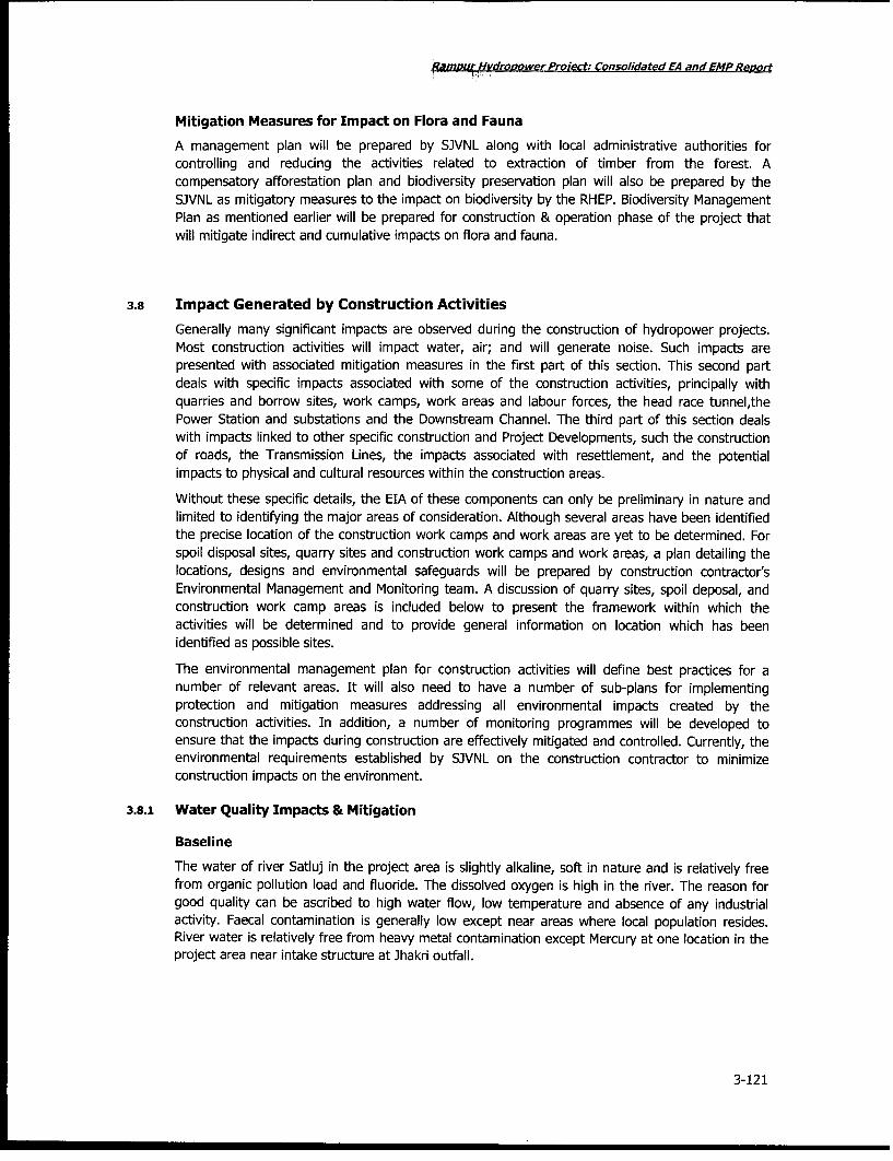
igamDuydropower Project: Consolidated EA and EMP Report
Mitigation Measures for Impact on Flora and Fauna
A management plan will be prepared by SJVNL along with local administrative authorities forcontrolling and reducing the activities related to extraction of timber from the forest. Acompensatory afforestation plan and biodiversity preservation plan will also be prepared by theSJVNL as mitigatory measures to the impact on biodiversity by the RHEP. Biodiversity ManagementPlan as mentioned earlier will be prepared for construction & operation phase of the project thatwill mitigate indirect and cumulative impacts on flora and fauna.
3.8 Impact Generated by Construction Activities
Generally many significant impacts are observed during the construction of hydropower projects.Most construction activities will impact water, air; and will generate noise. Such impacts arepresented with associated mitigation measures in the first part of this section. This second partdeals with specific impacts associated with some of the construction activities, principally withquarries and borrow sites, work camps, work areas and labour forces, the head race tunnel,thePower Station and substations and the Downstream Channel. The third part of this section dealswith impacts linked to other specific construction and Project Developments, such the constructionof roads, the Transmission Lines, the impacts associated with resettlement, and the potentialimpacts to physical and cultural resources within the construction areas.
Without these specific details, the EIA of these components can only be preliminary in nature andlimited to identifying the major areas of consideration. Although several areas have been identifiedthe precise location of the construction work camps and work areas are yet to be determined. Forspoil disposal sites, quarry sites and construction work camps and work areas, a plan detailing thelocations, designs and environmental safeguards will be prepared by construction contractor'sEnvironmental Management and Monitoring team. A discussion of quarry sites, spoil deposal, andconstruction work camp areas is included below to present the framework within which theactivities will be determined and to provide general information on location which has beenidentified as possible sites.
The environmental management plan for construction activities will define best practices for anumber of relevant areas. It will also need to have a number of sub-plans for implementingprotection and mitigation measures addressing all environmental impacts created by theconstruction activities. In addition, a number of monitoring programmes will be developed toensure that the impacts during construction are effectively mitigated and controlled. Currently, theenvironmental requirements established by SJVNL on the construction contractor to minimizeconstruction impacts on the environment.
3.8.1 Water Quality Impacts & Mitigation
Baseline
The water of river Satluj in the project area is slightly alkaline, soft in nature and is relatively freefrom organic pollution load and fluoride. The dissolved oxygen is high in the river. The reason forgood quality can be ascribed to high water flow, low temperature and absence of any industrialactivity. Faecal contamination is generally low except near areas where local population resides.River water is relatively free from heavy metal contamination except Mercury at one location in theproject area near intake structure at Jhakri outfall.
3-121

RamDur Hvdrovower Proiect: Consolidated EA and EMP Re,oort
Sources and Type of Impacts
The major sources of construction related impacts on water quality will be from erosion of thedisturbed area required for the construction activities (construction sites, concrete batch plants,material storage areas, vehicle maintenance areas, disposal areas), from waste water dischargefrom the construction labour camps and from contaminated water (oil, grease, petro chemicals,cement and chemicals) resulting from various construction activities. The primary impact is thepotential for introducing sediments and pollutants to the adjacent river body during the period ofconstruction, thereby affecting aquatic habitats, fishes and water source for residents and wildlifedownstream of the construction areas.
Mitigation
The project authority will be required to prepare several plans, including an Erosion and Sedimentcontrol Plan, and Water Quality Monitoring Plan, incorporating the following key points:
* Water management plans will comprise of the development of drainage works, sedimenttraps, diversions, culverts and other structures designed to treat water to an acceptablequality before discharge into the natural water courses. All structures will be in place priorto beginning the construction of the facilities.
. All runoff from the construction areas, including from concrete batch plants, will bedirected to sediment settling areas. Erosion control facilities will be installed throughoutthe construction areas and will include silt traps, fences and sedimentation basins whereappropriate, depending upon the size of the catchment. The sediment settling basin willhave adequate storage capacity and will be regularly inspected, with accumulatedsediments removed throughout the construction period.
. Catch drains, diversion drains, table drains, windrows and associated drop down willdirect site run off to established watercourses. These will be inspected regularly for anydamage caused by sourcing, sediment deposition, channel obstruction and loss ofvegetation cover, and all erosion control measures will be maintained.
. Soil and spoil removed from the construction areas will be stockpiled separately andstabilized with grasses or other vegetations
* Treatment facilities to remove oil and grease from the water before discharge to the riverwill be installed. This will be of particular importance for the runoff from the Vehiclemaintenance areas. Monitoring of oil and grease skimmers will be made throughout theconstruction period.
. Refueling of heavy equipment and machinery will be undertaken with appropriatesafeguards and protection measures to prevent spillage or contamination by chemicals ormaintenance oils and lubricants. All fuel and hazardous materials will be stored in such away as to minimize the potential for spills(chemical waste/spillage Management Plan,Emergency plan for Hazardous materials of RHEP)
* Waste water treatment plants will be installed to treat all waste water generated from thelabour camps and other facilities associated with the construction of the project
. Any use of Synthetic chemicals will have to be done in accordance with the RHEPChemical waste/Spillage Management Plan.
3-122
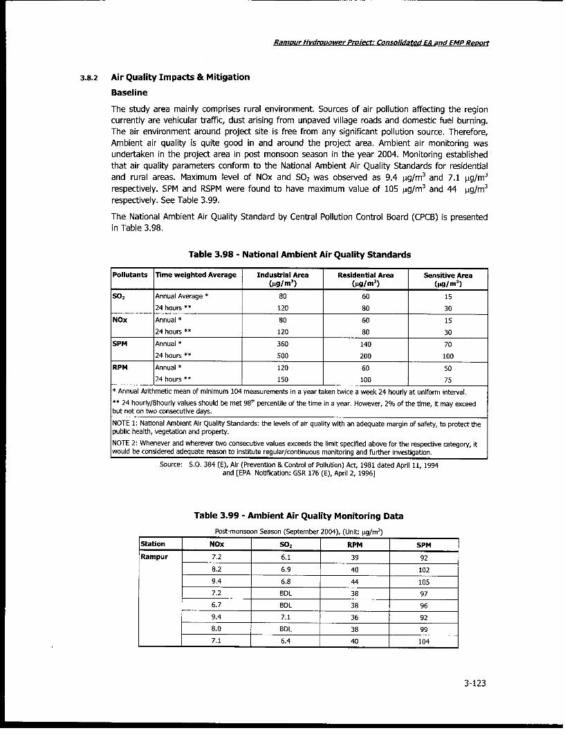
RamDur Hvdropower Prolect: Consolidated EA and EMP Report
3.8.2 Air Quality Impacts & Mitigation
Baseline
The study area mainly comprises rural environment. Sources of air pollution affecting the regioncurrently are vehicular traffic, dust arising from unpaved village roads and domestic fuel burning.The air environment around project site is free from any significant pollution source. Therefore,Ambient air quality is quite good in and around the project area. Ambient air monitoring wasundertaken in the project area in post monsoon season in the year 2004. Monitoring establishedthat air quality parameters conform to the National Ambient Air Quality Standards for residentialand rural areas. Maximum level of NOx and S02 was observed as 9.4 pg/m3 and 7.1 sig/m 3
respectively. SPM and RSPM were found to have maximum value of 105 [Lg/m 3 and 44 pg/M3
respectively. See Table 3.99.
The National Ambient Air Quality Standard by Central Pollution Control Board (CPCB) is presentedin Table 3.98.
Table 3.98 - National Ambient Air Quality Standards
Pollutants rTime weighted Average Industrial Area Residential Area Sensitive Area(gg/M
3) (pg/M
3) (pg/M
3)
S02 Annual Average * 80 60 15
24 hours ** 120 80 30
NOx Annual * 80 60 1524 hours ** 120 80 30
SPM Annual * 360 140 70
24 hours ** 500 200 100
RPM Annual * 120 60 50
24 hours ** 150 100 75
* Annual Arithmetic mean of minimum 104 measurements in a year taken twice a week 24 hourly at uniform interval.
** 24 hourly/8hourly values should be met 98m percentile of the tme in a year. However, 2% of the time, it may exceedbut not on two consecutive days.
NOTE 1: National Ambient Air Quality Standards: the levels of air quality with an adequate margin of safety, to protect thepublic health, vegetation and property.
NOTE 2: Whenever and wherever two consecutive values exceeds the limit specified above for the respective category, itwould be considered adequate reason to institute regular/continuous monitoring and further investigation.
Source: S.O. 384 (E), Air (Prevention & Control of Polluton) Act, 1981 dated April 11, 1994and [EPA Notification: GSR 176 (E), April 2, 1996]
Table 3.99 - Ambient Air Quality Monitoring Data
Post-monsoon Season (September 2004), (Unit: pg/m3)
Station NOx 502 RPM SPM
Rampur 7.2 6.1 39 92
8.2 6.9 40 102
9.4 6.8 44 105
7.2 BDL 38 97
6.7 BDL 38 96
9.4 7.1 36 92
8.0 BDL 38 99
7.1 6.4 40 104
3-123

Rampur Hvdropower Proiect: Consolidated EA and EMP Reort
Station NOx S02 RPM SPM
Village Bael 8.2 6.2 36 87
8.2 BDL 38 95
8.6 BDL 40 101
7.8 6.7 40 103
8.2 6.7 38 97
8.1 6.9 40 104
7.9 BDL 40 101
7.8 BDL 38 94
BDL: Below Detectable Limit (6 pg/M 3 for S02 )
The maximum, minimum and the average values for different air quality paramters have beencalculated and presented below for easy reference.
Table 3.100 - Maximum, Minimum, Average Values of NOx, S02, SPM, RPM in AmbientAir
Post-Monsoon Season (Unit: Pgm 3)
Station Average Maximum Minimum
Nitrogen Oxides
Rampur 7.9 9.4 6.7
Village Bael 8.1 8.6 7.8
Sulphurdioxide
Rampur 4.1 7.1 BDL
Village Bael 3.3 6.9 BDL
Suspended Particulate Matter
Rampur 98.3 105 92
Village Bael + 97.75 104 87
Respirable Particulate Matter
Rampur 39.1 44 36
Village Bael 38.75 40 36
* Below Detectable Limit (BDL) for S02 is 6 pLg/M3
* Average values have estimated excluding values Below Detectable Limit.
Observations on Ambient NOx Levels
The highest average NOx value of 8.lpg/m3 was observed at Rampur in post-monsoon season.The highest value of 9.4 [lg/m3 too was observed at the same station. The NOx level as monitoredby HP State Environment Protection & Pollution Control Board ranges from 5.24 to 26.34,ug6/m3.The NOx level observed at various sampling stations in the project and the study area was muchlower than the permissible limit of 80[.g/m3, specified for residential and rural areas.
Observation on ambient S02 levels
The maximum S02 level of 7.1 pg/m3 was observed at Rampur. Quite a few values were observedto be below detectable limit (BDL) of 6 ,Ig/m 3 during the survey conducted in post-monsoonseason. The average S02 levels as observed by HP State Environment Protection & Pollution
3-124

Ramour Hydropower Projiect: Consolidated EA and EMP Report
Control Board ranges from 1.84 to 9.42 ,tg/m3. The S02 level observed at various stations was muchlower than the permissible limit of 80 pg/M3 specified for residential and rural areas.
Observations on Ambient SPM levels
The maximum SPM level of 105pg/m3 was observed at Rampur. At all the ambient air qualitymonitoring stations, the SPM level was much below the permissible limit of 200pg/m3, specified forresidential and rural areas.
Observations on Ambient RPM levels
The average RPM levels as observed at the two stations in the study area ranged from 38.75 to39.lpg/m3 in post monsoon season. The highest RPM level observed was 44 Ag/M 3. All the valuesof RPM monitored during the field survey were well within the permissible limit of 100 pg/M3
specified for residential and rural areas.
Source and Types of Impacts
Vehicles and stationary equipment will impact air quality at the construction site through emissionsfrom the engines. Additionally quarry site activities including operation of crushers, concrete batchplants, construction work and movement of vehicles along unpaved road will generate dust &gaseous emission and impact air quality. The burning of waste will also affect air quality. Inabsence of proper fuel, construction workers at the project site may use wood for fuel burning.This will impact air quality.
Mitigation
Maintenance of vehicles and stationary equipment in good working order will reduce negativeimpacts on air quality. Spraying water on roadways and other activity areas where there ispotential for dust emission will control dust. The burning of waste will be done in designated areasaway from settlement. Burning of wood for fuel purposes by the construction workers and anyother material, which produces toxic gases, will not be allowed. The construction contractor willprepare an Emission and dust control plan.
3.8.3 Noise Impacts & Mitigation
Baseline
The project area is calm and peaceful with negligible high sound activity. The noise survey resultsfor the project area are well within the upper limit prescribed by the National Ambient NoiseStandards for residential area. The noise level at various sampling stations ranged from 32 to 44dBA.
The noise levels at Jhakri, Near Rampur Bridge and Bael were monitored in the month ofSeptember 2004. These two locations would be potentially affected the most by high noiseactivities of the project. Monitoring was done only during daytime since the noise levels observedwere quite low, almost close to lowest permissible standard i.e. night time in silence zone; hencemeasuring noise level during night time was not considered important from study point of view.The day time monitoring was carried out continuously for 12 hours, at each location and hourlyequivalent noise level(Leq) was measured. The results are summarized in Table 3.101. Table 3.102presents ambient noise standard prescribed by the CPCB.
3-125

RamDur Hvdronower Proiect: Consolidated EA and EMP Repor
Table 3.101 - Hourly Equivalent Noise Levels in the Project Area
[unit: db(A)]
Time Jhakri Near rampur Bridge Bael
8 -9 AM 34 32 32
9-10 AM 38 39 34
10-11 AM 36 38 32
11 AM - 12 Noon 34 38 34
1 - 2 PM 35 38 34
2 - 3 PM 34 37 34
3 - 4 PM 38 36 34
4 - 5 PM 37 30 35
5 - 6 PM 38 31 35
6 - 7 PM 34 38 33
7 - 8 PM 33 38 33
8 - 9 PM 32 38 32
Table 3.102 - Ambient Noise Standards
Area Code Category of Area Limits in dB (A) Leq
Day time Night time
A Industrial Area 75 70
B Commercial Area 65 55
C Residential Area 55 45
D Silence Zone 50 40
NOTE 1: Day time - 6 AM and 9 PM; Night time is 9 PM and 6 AM
NOTE 2: Silence zone is defined as areas upto 100 metres around such premises as hospitals, educationalinstitutions and courts. The silence zones are to be declared by competent authority. Use of vehicular horns,
loadspeakers and bursting of crackers shall be banned in these zones.
Source: Environment (Protection) Third Amendment Rules, 2000 Gazettee notification, Government of India, date 14.2.2000.
Source and Types of Impacts
Sources of noise will be the vehicles and equipment for excavation and stationary equipment,including concrete batch plant located at the construction sites. Other sources of noise will be theuse of explosives for blasting purposes for construction activities, drilling machines and quarryingand crushing activities.
Construction Equipment: Under the worst case scenario, considered for prediction of noiselevels during construction phase, it has been assumed that all these equipment generate noisefrom a common point. The increase in noise levels due to operation of the different constructionequipment are given in Table 3.103.
It would be worthwhile to mention here that in absence of the data on actual location of thedifferent construction equipment, all the equipment have been assumed to operate at a commonpoint. This assumption leads to over-estimation of the increase in noise levels. Also, it is a knownfact that there is a reduction in noise level as the sound wave passes through a barrier. Thetransmission loss values for common construction materials are given in Table 3.105.
3-126
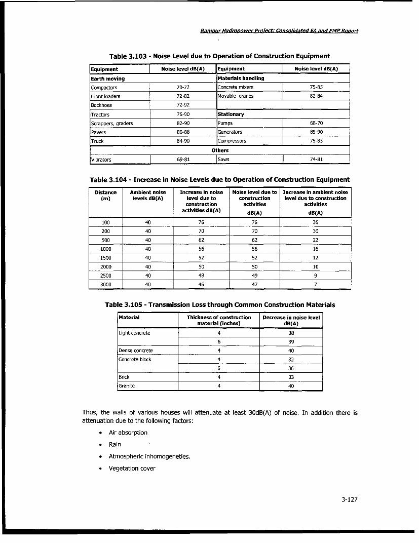
Ramour Hvdrovower Project: Consolidated EA and EMP Reort
Table 3.103 - Noise Level due to Operation of Construction Equipment
Equipment Noise level dB(A) Equipment Noise level dB(A)
Earth moving Materials handling
Compactors 70-72 Concrete mixers 75-85
Front loaders 72-82 Movable cranes 82-84
Backhoes 72-92
Tractors 76-90 Stationary
Scrappers, graders 82-90 Pumps 68-70Pavers 86-88 Generators 85-90
Truck 84-90 Compressors 75-85
Others
Vibrators 69-81 1Saws 74-81
Table 3.104 - Increase in Noise Levels due to Operation of Construction Equipment
Distance Ambient noise Increase in noise Noise level due to Increase in ambient noise(m) levels dB(A) level due to construction level due to construction
construction activities activitiesactivities dB(A) dB(A) dB(A)
100 40 76 76 36
200 40 70 70 30500 40 62 62 22
1000 40 56 56 161500 40 52 52 12
2000 40 50 50 10
2500 40 48 49 9
3000 40 46 47 7
Table 3.105 - Transmission Loss through Common Construction Materials
Material Thickness of construction Decrease in noise levelmaterial (inches) dB(A)
Light concrete 4 38
6 39
Dense concrete 4 40
Concrete block 4 32
6 36
Brick 4 33
Granite 4 40
Thus, the walls of various houses will attenuate at least 3OdB(A) of noise. In addition there isattenuation due to the following factors:
* Air absorption
* Rain
* Atmospheric inhomogeneties.
* Vegetation cover
3-127

Rampur Hvdrooowe_ProPect: Consolidated EA and EMPReorf
Table 3.106 - Increase in Noise Levels due to Increased Vehicular Movement
Distance (m) Ambient noise level Increase in noise Noise levels due to Increase in ambientdB(A) level due to increased vehicular noise level due to
increased vehicular movement dB(A) increased vehicularmovement dB(A) movement dB(A)
10 40 72 72 32
20 40 67 67 27
50 40 61 61 21
100 40 57 57 17
200 40 52 52 12
500 40 46 47 7
1000 40 42 44 4
As mentioned earlier, there will be significant attenuation due to various factors, e.g. absorption byconstruction material, air absorption, atmospheric inhomogeneties, and vegetation cover. Thus, nosignificant impact on this account is anticipated.
Noise Generated due to Drilling: The noise levels monitored at a 10m distance from the sourceand operator's cabin is given in Table 3.107.
Table 3.107 - Noise Generated due to Drilling
Equipment Noise level at source dB(A)
Standing idle (inside cabin) 70-72
Standing idle (10 m radius) 72-74
On load (inside cabin) 78-80
On load (10 m radius) 82-84
The noise levels during various construction activities have been compared to various standardsprescribed by Occupational Safety and Health Administration (OSHA), which are being implementedin our country through rules framed under Factories Act. It can be observed that for an 8 hourduration, equivalent noise level exposure should be less than 9OdB(A).
The Director General of Mines Safety in its Circular number DG(Tech)/18 of 1975, has prescribedthe noise level in mining operations for workers in 8 hour shift period with unprotected ear as9OdB(A) or less. Similar norms can be considered for construction phase of the proposed project aswell. The workers who are expected to be exposed to noise levels greater than 90dB(A), shouldwork in these areas upto 6 to 8 hours. In addition, they also need to be provided with ear plugs.Thus, increased noise levels due to drilling are not expected to adversely affect the workersoperating the drill or involved in other mining activities closely.
Noise Generated due to Blasting: Noise generated by blasting is instantaneous in nature. Noisegenerated due to blasting is site specific and depends on type, quantity of explosives, dimension ofdrill hole, degree of compaction of explosives in the hole and rock. Noise levels generated due toblasting have been monitored at various sites and the results have been summarized in Table3.108.
3-128

Rampur Hydropower ProSect: Consolidated EA and EMP Repo,t
Table 3.108 - Noise Generation due to Blasting
No. of holes Total charge (kg) Maximum charge/delay (kg) Distance (m) Noise level dB(A)
15 1500 100 250 76-85
17 1700 100 250 76-86
18 1800 100 250 74-85
19 1900 100 400 70-7520 2000 100 100 76-80
It can be observed from Table 3.108 that noise level due to blasting operations are expected to beof the order of 75-86 dB(A). Since, the nearest settlement is atleast 1 km away, the incrementalnoise due to blasting is expected to be 50-6OdB(A). As the blasting is likely to last for 4 to 5seconds depending on the charge, noise levels over this time would be instantaneous and short induration. Considering attenuation due to various sources, even the instantaneous increase in noiselevel is not expected to be more than 6OdB(A). Hence, noise level due to blasting is not expected tocause any significant adverse impact.
Impacts due to Ground Vibrations: The explosive energy generated during blasting sets up aseismic wave within the surface, which may affect the structures and cause discomfort to humanpopulation. When an explosive charge is fired in a hole, stress waves traverse in various directions,causing the rock particles to oscillate. Blasting also generates ground vibrations and instantaneousnoise. Various measures have been recommended to minimize the adverse impacts due to blasting:
* Proper design of blast hole to be developed.
* Use of noiseless trunk delays to minimize the noise due to air blast.
* Use of non-electric system of blasting for true bottom-hole initiation.
* Use of muffling mats to arrest the dust and fly rock.
Noise in and around the construction site will likely affect the wildlife and potentially residents inthe nearby areas. Wildlife in the area will likely move away from the noise and eventually return tothe area when construction is complete. However, there is no major wildlife observed in andaround the construction site and hence this may not be a significant issue.
Impacts on Labour: The effect of high noise levels on the operating personnel has to beconsidered as this may be particularly harmful. It is known that continuous exposures to high noiselevels above 9OdB(A) affects the hearing acuity of the workers/operators and hence, should beavoided. To prevent these effects, it has been recommended by Occupational Safety and HealthAdministration (OSHA) that the exposure period of affected persons be limited as in Table 3.109.
Table 3.109 - Maximum Exposure Periods Specified by OSHA
Maximum equivalent continuous noise level Unprotected exposure period per day for 8 hrs/daydB(A) and 5 days/week
90 8
95 4
100 2
110 1/2
120 ¼A
No exposure permitted at or above this level
3-129

RamDur Hydropower Proiect: Consolidated EA and EMP ReHow
Mitigation
Maintenance of the vehicles and construction machinery in good working order and installation ofnoise mufflers on all engines will reduce the noise nuisance.
Exposure period of noise affected operation personnel will be limited. This will reduce any adverseimpact on their health
To reduce the impact of noise on wildlife, explosives will be used during the daylight hours whenwildlife is less active than during night time.
The construction contractor will prepare a Noise Control Plan to manage noise pollution.
3.8.4 Quarries
Cement, coarse and fine aggregate, sand will be required for various project uses, such as roadbase for the new roads, as well as for works involving concrete constructions. The project requiresabout 2.72-lac m3 coarse aggregates and 1.38 lac m3 fine aggregate. The excavated material of the
Headrace tunnel (between Kajo and Kunni khads) will be used as coarse aggregates meetingpartial requirement of the project. The remaining requirements of coarse and fine aggregates willbe met from the already existing (same quarry was used during Nathpa Jhakri Project)Koel Quarry,located near Bael on right bank of river Satluj near Kurpan Khad on NH-22 about 2 km from thepower house site. Sufficient quantity of deposits is available. The barren government land availablein the vicinity of Koel quarry area will accommodate crushing plant and other accessories requiredfor quarrying purpose.
Types of impacts
Opening of the quarries will cause visual impacts because they remove a significant part of thehills. Other impacts will be the noise generated during aggregate acquisition through explosive andcrushing, which could affect wildlife in the area, dust produced during the crushing operation to getthe aggregates to the appropriate size and transport of the aggregates, and transport of materialsto the nearby rivers.
Mitigation
Standard mitigation measures against erosion and sedimentation, noise and air pollution will betaken, in particular for the use of explosive. At the end of the exploitation, quarries will berehabilitated. This will include re-establishment of vegetation, restoration of natural watercourses,avoidance of flooding of the excavated areas, achievement of stable slopes, and avoidance offeatures, which would otherwise constitute a risk to health and safety or a source of environmentalpollution.
3.8.5 Muck Generation & Disposal
Types of Impacts
The Project will generated approximately 2.76 lacs m3 of muck which will be disposed off at fourdesignated dumping sites having a total capacity of 2.82 lac m3. The details of the muck dumpingsites are explained in tablexx below.
The proposed project at Rampur is expected to generate approx. 2.85 million m3 of muck, which isproposed to be disposed at the following designated sites:
* near Kajo adit
* near Kunni adit
* dumping area in Nermand
3-130

RampurHvdropower Pro_ect: Consolidated EA and EMP Report
0 dumping area in Bael
These sites have been identified at right bank of the river, close to four edits of proposed tunnel soas to minimise the risks involved in terms of affecting human settlements due to blow of dust andfrequent movement of heavy vehicles. The sites need attention in terms of surface preparation andfencing of boundaries to avoid environmental risks i.e. land sliding, sedimentation of river, airpollution, etc. An area of 18.3593 ha has been earmarked for disposal of muck. The details aregiven as below.
Table 3.110 - Requirement of Muck Disposal Area
Si. no. Land Area
1. Private land in tehsil Nirmand 3.8446 ha
2. Government land 14.5147 ha
Total 18.3593 ha
Table 3.111 - Details of Identified Dumping Areas
S.N. Dumping Area Description of Area Quantity of Dump mm3
1 Dumping area - I Opposite Kaneri Hospital, Rampur 1.05
2 Dumping area - II Opposite HERC workshop, Rampur 0.06
3 Dumping area - III D/S Nirmand Bridge 0.38
4 Dumping area- IV Averi 1.32
These sites are located on the right bank of Satluj river, close to four edits of Head Race Tunnel(HRT). The locations are favourable in minimising the risks to human settlements due to blow ofdust and frequent movement of heavy vehicles.
Mitigation Measures
The sites of muck disposal will be provided with surface preparation and fencing of boundaries toavoid risks such as land sliding, sedimentation of river, dust pollution. A retaining wall will beconstructed at site before to prevent accidental dumping of spoil in the river. Rehabilitation of thesite will be undertaken for used disposal sites. This will include re-establishment of vegetation,restoration of natural water courses, achievement of stable slopes, and avoidance of features whichwould otherwise constitute a risk to health and safety or a source of environmental pollution.
A suitable plan for muck dumping schedule will be prepared by the construction contractor beforethe start of construction work so as to control muck disposal activity in environment friendlymanner. Figure 3.37 shows pictures of identified dump sites.
3-131

Ramour Hydropower Protect: Consolidated EA and EMPReao,t
Figure 3.37 - Muck Dumping Sites identified by SJVNL
- 'j ,.. . .
Site 1- Near Kajo Adit Site 2- Near Kunni Adit
. . , .I-
Site 3- Near Village Nermand Site 4- Near Village Baei
3-132

Ramour Hvdropower Proiect; Consolidated EA and EMP Revolt
3.8.6 Work Camps, Work Areas & Labour Force - Impacts & Mitigation
Suitable zones will be identified for potential construction camp development to accommodate amaximum construction worker population of approximately 4000 workers. It is expected that smallbusinesses and their families will move to the proximity of the work camps and are expected to behigher in number than that of workers formally employed by the project.
Impacts
Potential impacts from the workforce and of the spontaneous development, at the work camps inall construction areas, will be in terms of additional pressure on land and natural resourcesincluding hunting near the camps and, directly and indirectly on project influence area. It isexpected that the spontaneous development will generate solid and liquid wastes. Additionally, thespontaneous development near the construction camps could create public health risks, included anincrease in the prevalence of sexually transmitted diseases.
Without treatment of wastewater from the work camps and the adjacent communities could causewater quality problems in the adjacent water bodies, and could affect local populations, the labourforce, new communities, and fish populations. Inappropriate solid waste disposal could lead to thecontamination of the soil and rivers, and the spread of communicable diseases.
Mitigation
The environmental management of construction work camps and spontaneous settlement areas willbe specified in the Environmental Management Plan for Construction Work Camps andSpontaneous Settlement Areas . It will be made part of the contractual arrangement withcontractors. Hunting will be completely prohibited in the area by the rule of law. Project StaffHealth Programme will be established to educate and provide health services to the workforcerelative to the prevention and control of diseases vectors, communicable and sexually transmitteddiseases. Licenses to operate small businesses will be made conditional upon appropriate disposalof wastewater, waste and good sanitary conditions. The same environmental provisions that applyto other construction areas will also apply to the construction work camps.
3.8.7 Construction of Headrace Tunnel - Impacts & Mitigation
Construction of the headrace tunnel will occur on the right bank of satluj River. Construction willinvolve excavation of materials from the headrace channel and the tunnel. A section of the area willbe cleared of vegetation and overburden.
Impacts
Excavation of the headrace tunnel to the Power Station will involve movement of vehicles and theuse of excavating equipment, explosives and other types of machinery.
A primary Impact of this construction will be placement of spoils removed from the tunnel. Theclearing of the area and muck disposal will be source of impact.
The concrete batch plant will be used to mix the concrete necessary for lining the tunnel and forthe lining of the surge chambers. Placement of the concrete for the lining of the tunnel and surgechamber will require movement of vehicles to the various locations. Installation of the concretebatch plant could create some impacts associated with air quality, water quality and noise.Movement of vehicles bringing aggregate to the batch plant from the quarry could also create somesimilar impacts.
3-133

Rampur Hvdrooower Project; Consolidated EA and EMP ReDu,
Mitigation
Standard construction impacts will be mitigated as required by the various environmentalmanagement plans to be prepared by the SJVNL (air quality, water quality, noise, spoil disposal).
3.8.8 Construction of the Power House and Tailrace Channel - - Impacts & Mitigation
Construction of the Power House and the Tailrace Channel will have similar impacts to thoseidentified for the Headrace Tunnel. The main potential sources of impacts include
* Disturbance of land
* Disposal of spoil material
* Operation of construction equipment
Impacts
During construction of the power station, a certain amount of land will be disturbed. The powerStation switchyard and substation construction will require the clearing of forest. Disposal of thespoil materials will be required The major potential impact of the cleared areas in the constructionand spoil disposal areas includes the potential for erosion and the runoff of cement, oils, andgrease, particularly during the wet seasons. The potential impacts of additional sediment and thedischarge of cement, oils and grease to the streams include damage to fish populations andpollution of water sources for residents living downstream from the construction areas.
Mitigation
Mitigation measures for prevention of contamination of the local water courses will be similar tothose described in earlier sections and will be enumerated in detail in Environmental managementPlan to be prepared by the construction contractor.
3.8.9 Road Construction Impacts & Mitigation
The project involves upgrading public roads and the construction of new roads and three of bridges(mainly one spanning 75mts steel bridge at Jhakri near NJHEP power house, one 125 mts concretenear RHEP power house and one permanent steel bridge at Kunni Khad). In addition, access roadsand tracks, some of them of a temporary nature, will be constructed between public roads andproject facilities to enable construction, operation and maintenance. This section presents anassessment of the environment that will be impacted by road construction and a discussion on thepotential direct and indirect environmental impacts from the construction and use of the roads.Finally Mitigation strategies and measures will be discussed
Impact
Upgrading of roads will not cause significant environmental impact over and above that of theexisting roads, with the exception of impacts that will occur during the upgrading constructionactivities. Safeguards to ensure that road upgrades will not generate additional disturbance to theenvironment and will remedy any existing poor environmental performance will be included invarious sub-plans of the environmental management plans which cover erosion control,landscaping and best practices in drainage and earthworks.
The planning of design routes for the new roadways will incorporate inputs from ground surveys tominimize social and environmental impacts and to provide for the best technical and financialsolution. A formal alternatives analysis has not been conducted for the siting of the new roadwaysas the proposed routings have proved to be highly suitable, with expected low environmental andsocial impacts.
3-134

Rampur Hvdrovower Project: Consolidated EA and EMPReort
Environmental impacts include both direct impacts at the road construction sites and in theimmediate surroundings, and indirect impacts in the adjoining area, such as induced economic,social or environmental effects, whether planned or spontaneous, which are the results ofincreased accessibility and lower transportation costs.
Vegetation clearance, erosion and sedimentation, dust and impacts related to construction workerswill have similar impacts as mentioned in earlier sections. Additionally, disturbance to crops willoccur in areas near the roads. Traffic on the roads during construction and during operation mightcause accidents with livestock moving on the roads.
Mitigation measures are similar to the mitigation measures described above, and for impacts oncrops, the mitigation measures are discussed in the sections below. For details, refer EMP (Chapter4).
Indirect and Cumulative Impacts on Natural Resources
The improved year round access to the whole project area from new and upgraded roads willenable people to settle in the area.Use of the improved access will enable movement from one areato another. This translates into the development of roadside villages, and a potential increasedpressure on the natural resources in the vicinity of the roads. The increased pressure will includeuncontrolled logging, hunting, and fishing, wildlife and non-timber forest product collection,livestock husbandry, the shifting cultivation in forest areas and forest fires. These impacts areexpected during the economic development of the Satluj basin, and are expected to be managedby the basin level catchment area treatment plan, and the proposed Environmental Master Plan forthe state.
Interference with Movements of Wildlife
Road construction, human presence and traffic will interfere with the natural movement of wild life.However, RHEP area does not have significant wildlife movement.
Mitigation
Mitigation measures for road construction and upgrading are summarized in the EMP.
3.8.10 Transmission System - Impacts & Mitigation
The clearance of vegetation for construction, cutting of lopping trees within Right of Way andaccess roads required for routine maintenance of the easements are the main impacts associatedwith he transmission lines. Loss of socially relevant properties and lands are social issues generatedby transmission projects.
Mitigation Measures
The development of certain protocol will be required so as to minimize disturbance, throughalternative routes, or least damaging route. The following protocol will be used for routing thetransmission lines:
* The route will not involve any human habitation and public utility services; The route willnot affect any monument of cultural or historical importance;
. The proposed route will not threaten the survival of any community, especially tribalcommunities; The route will not pass through any sanctuaries, National park, or similarecologically fragile areas, etc.
A comprehensive transmission route planning will be done based on the survey of the project areaso as to meet the above-mentioned protocol.
3-135

Ramour Hvdropower Proiect: Consolidated EA and EMP Reort
3.9 Other Environmental Impacts on the Communities
The resettlement issues are not discussed in this EA/EMP Report. Refer the Social AssessmentReports Prepared. The following sections
3.9.1 Impacts on Human Health
The influx of people into the area is associated with an augmented risk of transmission diseases,including sexually transmitted diseases.More traffic on the roads during construction and operationcould increase accidents within communities living adjacent to the roads. Aquatic invertebratesknown to be vectors of disease could inhabit stagnant water created during construction of roads.The increased prevalence of such diseases may impact the health of communities and theconstruction workforce.
The findings of the village level surveys, data collected from the Health Department andGovernment hospital, Rampur doesnot indicate the prevalence of water borne diseases in the area.However, during summers (April-July) about 50 cases on an average have been recorded related toGastroenteritis, Diarrhea and Dysentery from the study area. Information has been collected fromRampur Hospital for the area (Table 3.112).
Table 3.112 - Leading Causes of Premature Mortality in Himachal Pradesh, 2003
Male Population 0/0 Female Population 0/ |
Road accident 12.75 Diarrhoeal diseases 13.25
Diarrhoeal diseases 10.77 Other unintentional injuries 11.32
Other unintentional injuries 9.34 Road accident 9.67
Ischaemic heart diseases 9.09 Lower birth weight 9.23
Tuberculosis 6.54 Tuberculosis 8.32
Lower birth weight 5.85 Ischaemic heart diseases 7.87
Self inflicted injury 5.78 Self inflicted injury 7.44
Other unintentional injuries 5.48 Other unintentional injuries 6.23
Chronic Obstructive Pulmonary Diseases 4.12 Other digestive diseases 4.82
Other digestive diseases 3.32 Chronic Obstructive Pulmonary Diseases 3.55
Source: Department of Health & Family Welfare, Himachal Pradesh
Table 3.113 - Leading Causes of Disability in Himachal Pradesh, 2003
Male Population 0/% Female Population 0/0
Chronic Obstructive Pulmonary Diseases 26.09 Iron deficiency anaemia 20.13
Iron deficiency anemia 14.19 Chronic Obstructive Pulmonary Diseases 17.15
Other unintentional injuries 12.24 Diarrhoeal diseases 13.04
Dental caries 7.08 Other unintentional injuries 12.68
Diarrhoeal diseases 6.15 Other infectious diseases 11.64
Asthma 5.92 Dental caries 7.31
Other unintentional injuries 5.23 Asthma 5.87
Upper Respiratory Infection 4.80 Tuberculosis 5.61
Lower Respiratory Infection 3.24 Road accident 5.38
Otitis media 2.28 upper Respiratory Infection 4.78
Source: Department of Health & Family Welfare, Himachal Pradesh
3-136

Ramour Hvdropower Proiect: Consolidated EA and EMPi?epo,t
The common leading causes of disability (YLD) in both sexes of Himachal Pradesh are obstructivepulmonary disease, iron deficiency anemia, diarrhoeal disease, and other unintentional injuries asshown in Table 3.113.
The information on prevalent disease for the area has been collected from Khaneri GovernmentHospital, Rampur and is in Table 3.114 below:
Table 3.114 - Disease Profile in the Influence Area of the Project, 2005
Name of Disease |an Feb March April May June July Aug Sept Oct Nov. DecG.Entritirs 12 15 15 21 42 31 44 27 10 14 10
Diarrhoea 1 2 - - 4 10 4 5 1 7 -
Dysentry 9 - 2 1 3 2 1 3 2 - 6 7Pneumia 5 4 5 7 10 11 3 4 7 - 6 7
Br. Pneumia 3 5 14 5 7 10 11 3 4 7 na naBr. Asthma 5 2 6 8 - - 11 - na na na na
COPD* 36 31 48 38 29 11 16 25 31 29 29 12
PGO 15 12 4 8 5 15 13 4 6 13 - -
AOD** 7 4 3 3 7 27 3 3 7 -
* COPD: Chronic Obstructive Pulmonary Disease; ** AOD: Arteriosclerotic occlusive disease
Source: Khaneri Government Hospital, Rampur
The construction activities that are taking place because of the hydropower project in the area willinvolve the engagement of a work force in the area, thus changing the population density andincreasing the floating population during construction activities. This may result in a change in theexisting health scenario due to increased pressure on existing infrastructure i.e. water supplysources, sanitation, etc. The additional domestic sewage generated may cause increasedcontamination of river water.
Lesser flow in the river due to diversion of flow may affect the dispersion and dilution time ofdomestic effluent coming from major settlements, such as Rampur town, along the river, hence,measures to maintain the levels as stated in the HPPB Standards are required. Further, due tolesser river flow, algal growth may occur along the river stretch in the study area, which on decaycreates foul taste and odour thus making the river water unfit for use.
The diversion of water into the tunnel at Jhakri will cause a change in the velocity in river waterflow and due to this, mosquitoes may establish during lean seasons. Thus, pre and postmeasurements should be identified to avoid such a situation.
Mitigation
At present, the river is not a source of drinking water for the habitants as ample natural watersources i.e. natural springs (chashme), perennial/seasonal streams are present in the region.However, looking at the present scenario of hydroelectric power project development on riverSatluj and indirect impacts coming on natural water sources due to extensive blasting process, inlong term (how long), natural sources may get dried up. In this case, river will be the alternativesource of water thus river ecology and flow conditions cannot be compromised. Minimum desiredquality standards for the river as specified by the Himachal State Pollution Control Board should bemaintained.
Following actions could be initiated for community health outreach programs to emphasize long-term improvements in region's health status:
3-137

Rampur Hvdropower Proect.: Consolidated EA and EMP ReLor,
* Augment existing government and NGO health programs.
* Place high priority on health education for local project workers and community residents.
* Vaccination programs - meningitis, tuberculosis & tetanus
HIV/AIDS Risk Level
Hydroelectric projects may cause spread of HIV/AIDS in the project area due to following reasons:
* Project requires long-term input of labour from outside the area.
. Project requires that significant numbers of project employees be separated from theirfamilies for long periods of time (e.g. a month or more at a time).
* Project involves the creation of large, temporary construction camp(s).
. Increases mobility of people in and out of the area (job seekers, formal and informalservice providers).
* Requires participation / resettlement of the local population.
Potential Management Interventions for HIV/AIDS
Following are the proposed management interventions to prevent HIV transmission and to managethe impact of HIV/AIDS:
Specific HIV prevention activities:
* HIV/STDs/AIDS awareness centres for IEC (information, education and communication)activities.
* Peer education programmes within the workforce.
* Condoms provision.
• Training of health personnel, social marketing of condoms, technical and material supportto STD clinics, etc.
* Integration of HIV/AIDS into thematic projects (e.g. emergency training).
. Workers periodically brought out of the field with pay to receive health and safety
training.
Specific HIV/AIDS management & mitigation activities:
* Voluntary counseling and testing for education, free condoms and screening for sexuallytransmitted diseases.
* Treatment of opportunistic infections.
* Provision for ART (Anti-Retroviral Treatment).
* Medical Aid policies for workforce.
Addressing "vulnerability" of the workforce:
* Adjust labour recruitment policies to (i) support better distribution across gender groups,(ii) promote use of local labour.
* Improve labour housing to accommodate families and enhance integration into the local
community.
* Recreation provision.
* Remittance provision.
3-138

RamDur Hvdropower Project: Consolidated EA and EMP Report
. Labour transport.
There needs to be meaningful consultation with local communities so that management measuresare culturally appropriate locally, and will have community support. The HIV/AIDS/STDmanagement plans should be compatible with and integrated with local, and state initiatives, andbe implemented in consultation with State AIDS Control Society.
3.9.2 Impacts of Downstream Hazards
A water level profile has been plotted for a hypothetical 1500 cumecs flood for the reach betweenNathpa to Bael and is shown below in Figure 3.38.
Figure 3.38 - Water Level along the River at a Flow of 1500 cumec
1600
1400
1200
1000Water Level - RL (m)
800
600
400
200Nathpa-Jhakri > Jhakri- Bael
00 10000 20000 30000 40000 50000 60000 70000
Distance (m)
Based on the above profile, it is inferred that between Nathpa to Jhakhri stretch, no habitationwould be vulnerable as the habitation is at much above elevations along the hill slopes. However,in the downstream reach of Jhakhri to Bael, the major habitation like Rampur, Nogli and Duttnagarare most vulnerable to flooding. An emergency action will be prepared for protecting thedownstream vulnerable areas. The Emergency Preparedness Plan will include warning andnotification procedures to be followed during the monsoon season in case of possibility of flood.The objective is to provide timely warning to nearby residents and alert key personnel responsiblefor taking action in case of emergency.
3.9.3 Water Availability for Communities
As mentioned earlier, the river Satluj is not the main source of water in the area. The naturalsprings and 'chashme' are the key sources of water for people living in the area for their owndomestic consumption, livestock use and irrigation purposes. In most of the villages except thosesituated on high hills, the IPH Department has laid down the pipelines to connect the naturalsprings (at upper reaches) to the households through storage tanks for water supply afterproviding primary treatment. The villages those are located on higher reaches depend directly on
3-139

RamDur Hvdrooower Proiect: Consolidated EA and EMP ReDUI
natural springs or khads flowing in vicinity. Hence, the hydropower development in the area, whichis causing diversion of flow from river for power generation, will not directly put an impact onavailability of water for consumption purpose for village population.
However, drying of natural springs (at its original location) has been reported in the past by thevillagers due to construction and blasting activities. It has been reported that more than 30
chashme have dried up in Yangpa village due to the construction works for Sanjay VidyutPariyojna. Also, it was found out during primary surveys conducted for the study that more than 8-12 chashme have dried up in Nathpa-Jhakri areas due to NJHEP project. Considering a post projectmeasure, SJVNL has conducted a monitoring campaign for examining the flow of springs. It wasestablished that blasting/digging activities can cause building up of excessive water pressure atparticular location, which may lead to shift in the position of a spring or reduction in the flow rateof spring, but complete drying of springs is not likely.
Due to construction of NJHEP, the IPH water supply schemes were badly affected in followingvillages.
Table 3.115 - IPH Department Water Supply Schemes Affected due to Nathpa-Jhakri Project
S. No. Name of Scheme Name of Habitation Present Population
1. WSS Maghara Majholi Koshgar Majhewali 490
Koshgar 130
2. WSS Kartot Chandpur Kartot 437
Chandpur 138
3. WSS Khasha Shah 3aleend Gaso 622
Shah 326
4. WSS Sharn Rattanpur Rattanpur 151
Rattanpur II 50
Basara 329
Sanarsa 282
Halb 229
5. WSS Jhakri Jhakri 4980
Total 12 habitation 8164
Source: IPH Department, Rampur
Presently, restoration of these schemes is going on and SJVNL is providing financial support to IPHdepartment for restoration of these schemes. SJVNL has kept a budget provision of 5 crore forrenewal of water provision in areas where the water resources have been dried up. Immediatemeasure under the scheme will be lifting of water directly from river Satluj to the affected villagesto maintain the minimum water supply to the affected areas.
Under the proposed Rampur Hydroelectric project, SJVNL is taking pre-project measurement offlow and started monitoring the flow of existing natural springs in the influence area. All watersupply sources have also been video documented. SJVNL will compensate any affect on thesewater supply sources and schemes.
3.9.4 Impact of Blasting on Agricultural & Horticultural Yield
Simla is one of the biggest apple growing districts in HP. About half of the State's apple crop isproduced in the district. But for the consecutive 5-6 years from 1992-93 to 1997-98 the apple cropwas very poor due to continuous rains and widely fluctutating temperatures (maximum andminimum) at the time of flowering during March- April. In 2001-02, there was virtually no crop inapple growing areas situated at elevations below 6500 ft above MSL.
3-140

Ra-mur Hvdropower Proiect. Consolidated EA and EMP Report
Table 3.116 - Horticulture Crop Trees in the Nathpa-Jhakri Influence Area
Horticulture trees No. of Trees
Apple 6135
Plum 265
Khurmani 86
Almond 9
Walnut 16
Nashpati 110
Galgal 8
Lemon 15
Total 6644
EIA updation Study for 1500 MW NJHEP, Kinnaur, Himachal Pradesh, 2004
Table 3.117 - Production of Apple in Himachal Pradesh
Year Apple Production (OOO tonnes) Year Apple Production ('OOO tonnes)1980-1981 118.01 1992-1993 279.05
1981-1982 306.79 1993-1994 294.73
1982-1983 139.08 1994-1995 122.78
1983-1984 257.91 1995-1996 276.68
1984-1985 170.62 1996-1997 288.54
1985-1986 174.61 1997-1998 234.25
1986-1987 359.32 1998-1999 393.65
1987-1988 259.27 1999-2000 491.3
1988-1989 165.15 2000-2001 376.73
1989-1990 394.86 2001-2002 180.53
1990-1991 342.07 2002-2003 348.26
1991-1992 301.73 2003-2004 459.49
Source: HP, Statistical outline of Himachal Pradesh, 2003-04,Department of Economics and Statistics (Horticulture Department data)
This kind of reduction in apple production was attributed to dust pollution caused by varioushydropower project-related activities in Satiuj Basin. Projects of these kind include activities likeblasting for various construction purposes like excavation of underground tunnels for channelisingthe waters of river, open blasting for mining operations and other works of the project. Acommittee was formed by Horticultural Department, HP to inspect the case. The following areaswere surveyed by the experts', to inspect the level of air pollution and to study whether theparticulate air pollutants emitted from blasting operations were causing any adverse effects on theproduction of apple and other fruit crop:
. Project sites at: Nathpa; Jhakri; Pashada quarry; Mini hydroelectric project at Kafnu/Katgaon; Piwa crusher plant at Tapri.
* Orchards near project/ quarry sites at: Pachchada and Dhar Gaura; Ponda and adjoiningareas; Katgaon/Kafnu; Kacksthal; and Tapri.
Sh TCP negi, Joint Director, Horticulture, Dr. SA Ananda, Professor of Pomology and Dr. PS Chauhan, Horticulturist
3-141

Rampur HydropowerPro ect; Consolidated EA and EMP Report
Although atmospheric pollutants adversely affect the plants in various ways, such as causing
closure of leaf stomata, growth retardation, injury to leaves, plasmolysis, other physiological effects
like reduced photosynthesis etc, in this particular case, the findings of experts are given below:
* No evidence of dust pollution were recorded being responsible for the low and decliningyield of apple in Shimla and Kinnaur areas falling within the boundaries of SJVNL projects.
* Though dust deposition on flowers may reduce the period of stigma receptivity or may
hinder pollen dehiscence and pollination, or may affect pollen germination but for all
these effects to show up, the dust pollution must be very high so as to form a sufficientthick layer of dust particles on the flower parts. But it was found that the level of dust on
the plants in the adjoining area of Jhakri, Pashada and Dhar Gaura villages were not highenough to cause such adverse effects on flowers of fruit plants, including apple.
* No such dust deposition was noticed at orchards/ sites at Ponda, Nichar area, Katgaon,Kafnu and Kacksthal. The SPM at a site near Jhakri at a distance 250 m from Pashadaquarry as recorded during the time of inspection was around 350 pg/ m3, which was
much lower than the threshold admissible limit of 500 pg/ m3 for industrial areas.
* At the Pashada Quarry, although open blasting was being carried out, the levels of dust
pollution caused by blasting appeared to be low because these operations were carried
out entirely on solid stone rocks. Also, most of the components of NJHE project work
were carried underground; hence underground blasting could not cause such seriouspollution problems. Similarly, no pollution could have been caused by dumping of
excavated sites as these sites were away from fruit plantation.
* Similarly in villages of Jhakri, which is located just near Pashada quarry and Snarsa and
Shah, which are located on Kacha approach road to surge shaft and in the villages of
Ropru, Pashada, Dhar Gaura, Dobi and Gopalpur, it was found that the although the fruit
set for stone fruits like apricot, plum and almond was good, the fruit set in apple in Shah,
Pashada and Dhar Gaura areas was average. It was concluded that had dust pollution
been responsible for poor fruit set in apple, it should have played a similar adverse role in
fruit set in stone.
It was observed that the extent of fruit set in apple in above-mentioned areas was low, but it is
due to some other factors. The main causes might be:
Continuous rains and low temperature during the time of flowering (March April) resultsin poor bee activity, inadequate cross pollination and poor fruit set. An attempt was made
to correlate the rainfall with fruit production. Table 5.4 shows drastic reduction in the
production of apple in the year 2001-2002. The rainfall data (Table 3.118 produced belowagain) shows that in this particular year, there was continuous rainfall in the months of
March-April.
Table 3.118 - Rainfall at Rampur: Relationship with Impacts on Orchards
[Unit - mm]
Year Jan. Feb. March I April May June July Aug. Sept. Oct. Nov. Dec. Total
1999 78.9 19.9 5.4 0 31.4 19.6 185 60.9 18.5 0 0 5.2 424.8
2000 0 0 0 0 0 244.9 337.9 21.3 12.1 0 0 0 616.2
2001 20 40 105 34 103 113.9 60 123.1 60 0 16 41 716
2002 61.5 142 93 104 13 45 10 152 104 0 0 1 725.5
2003 55 110 60 61 11 41.5 264 132 107 0 4 41 886.5
2004 67 4 0 69 57 114 93 244.5 24 81 2 6 761.5
3-142

Rampur Hydrogower Proiect: Consolidated EA and EMP Re,ort
However, the areas located at higher elevations, i.e. 2000m above msl had good cropbecause in such area flowering took place a little later which escaped the adverse effectsof rain and low temperatures.
Figure 3.39 - Relationship between Rainfall and Production of Apples
Rainfall vs Apple Production
600 -
a2 400-
* 200 - _ _ _ _*_ -_ _ _ _
01999- 2000- 2001- 2002- 2003-2000 2001 2002 2003 2004
Year
* Rainfall (mm) in the month of March,n3 Rainfall (mm) in the month of April* Apple Production in '000 tonnes
* It may be due to lesser number of pollinizer trees in the orchards2. It was observed thatthe fruit was very good in pollinizer trees of Golden Delicious variety and adjoining treesof Royal Delicious variety, but was poor in trees away from pollinizer's trees. Hence, thereason of lesser extent of apple could be due to the inadequate and improper placementof trees of pollinising varieties in orchards.
3.9.5 Potential Effect on the Occupation Pattern in the Project Influence Area
Employment Benefits
A large number of hydro projects are planned in the entire Satluj basin. The development of theseover the time would generate many employment opportunities in the basin directly as well asindirectly in the form of various service providers. A tentative estimate of potential employmentopportunities have been worked out on the basis of hydro generation capacity. As per MOU signedby government of Himachal Pradesh with all hydro developers, 70% is to be engaged from thestate. Hence around 30000 staff is expected to be employed from the state. Rest of the staffwould contribute as migrant population. The migrants will also bring their families along with themand thus the migrant population will be around 38000. It is also expected that 2% of the migrantpopulation will start some petty business or business establishments for their daily needs.
2 Survey report on the effect of Blasting operations on Fruit production in NJ HEP areas, by Dr. SA Ananda, Professorand Head, Department of Pomology, Dr. PS Chauhan, Senior Horticulturist, RHRS and Dr. KN Ojha, SMS, Deptt of Horticulture,Simla
3-143

Ramour Hvdropower Proiect; Consolidated EA and EMP Reuori
Table 3.119 - Employment Generation in the Hydropower Projects on the Satluj
Project Capacity Staff expected to be employed
(MW) Technical Supervisor Skilled Unskilled Total
RHEP 412 200 350 1500 2000 4050
NJHEP 1500 215 378 1628 2200 4421
Khab EP 1020 490 860 3700 5000 10050
Karcham 1000 480 842 3626 4802 9750
Bhawa augmentation 4.5 5 9 37 49 100
Sorang 100 48 84 362 480 974
Luhri 700 337 591 2545 3371 6844
Kol 800 385 675 2908 3851 7819
TOTAL 5536 2160 3789 16306 21753 44008
In absence of time series data (before and after) for all hydroelectric project sites that are in
operation or proposed, change in employment pattern and employment benefits has been assessed
and quantified only for NJHEP and RHEP influence areas which would be helpful to understand the
kind of scenario which could be foreseen for the region, once all proposed hydro power projects
get started
Shift in Occupation Pattern
There is clear indication of shift of type of economic activities from agriculture to business due to
massive hydropower development projects in the region. The statement has been substantiated
with the help of following:
Table 3.120 - Change of Occupation of the Community (%) induced by the Nathpa-Jhakri Project
Occupational Activities Areas outside the Project' Project's Immediate Influence AreasImmediate Influence Area Pre Project Post Project
Cultivators 51.89 49.39 40.07
Agri-Labour 0.84 1.70 2.13
Daily Wages 1.68 13.59 18.29
Service 29.95 20.15 24.35
Others 7.17 20.15 20.15
Business 8.43 11.65 12.79
Pensioners 0.84 - -
Non-working 74.78 76.10 74.15
Source: EIA for Updation of NJHEP, Year 2003
A comparison of pre and post project employment scenario as given above reveals the following:
Average annual employment of those households who were given land for land has
increased from 393 days to 550 days per household. The average annual income has
increased from Rs.45,222 to Rs.107,422. However, the share of agriculture in the
household income has declined because of reduction in the size of their land holdings.
But their income from wage labour and services has more than doubled as compared to
there past income six years ago.
3-144

Rampur Hvdropower Proiect: Consolidated EA and EMP Report
* The average income of those households who got compensation for house constructionhas increased from Rs.28,333 to Rs.50,933. The employment and income from regularjobs have increased in the group.
* In the case of those households who were allotted alternative shop plot average annualincome was Rs. 79,867 in 1996, which increased to Rs.181,107 in year 2002. This changehas been mainly due to increase in pretty business/trading activities, which haveincreased due to increase increased demand for daily need items from residents of newNJPC colony and also due to increased purchasing power of project affected families.Average income of those families who have been provided employment in the NJPC hasincreased from Rs.68,874 to Rs.141,759 per annum. The increase in household incomehas been mainly due to increase in employment in non-farm activities.
* Those households who were provided cash compensation only have also improved theireconomics position. Average annual employment of these families was 350 days in 1996,which has now increased to 401 days. Similarly the average annual household income hasincreased from Rs.77,677 to Rs.98,721 in year 2002.
* Out of 62 families of project affected areas and who are rendered landless under theproject, one person each from the 51 families has already been provided a regularemployment in the NJPC, and it is to be noted that 29% of employed persons arewomen.
Further, in case of RHEP, apart from students, the largest number of males is engaged in serviceand females have agriculture as a main activity. The analysis indicates that annual income of thesampled households from different sources, at overall level was Rs.107,408 per annum, which wasRs. 77,351/- for SC/ST and 132,748 for general category. The largest share of the total income wasgenerated from employment including service and wage labour. This was followed by agriculture;accounting for 18.61% and other sources, 17.71%. Business was observed to be last in this respectand generated only 0.98% of total household income at overall terms.
It is foreseen that after operation of RHEP project, the business activities will definitely have someimpact and this would flourish due to increase in influx of the people resulting in demand for alldaily-need products.
A similar trend is predicted for the whole Satluj basin when construction of the envisagedhydropower projects will start. Business establishments like vegetable shops, grocery shops etc,taxis, auto rickshaw etc will come up in respective regions. Hence, the development of the basin,in-general, would improve the living conditions of the local population by generating employment.
Accessibility to Basic Infrastructure
Infrastructure is a key facilitator of economic development. With the hydropower development inthe region, improvement in basic infrastructural amenities i.e. roads, highways, public healthinstitutes, telecommunications, water supply, electrification and hence, the economic developmentof the area is bound to happen.
For the various projects envisaged along the Satluj basin, from upstream Khab to downstream,which comprise the extreme boundaries of our study stretch, various infrastructural developmentshave occurred due to the progress of hydro power projects. These developments would, in the longrun, i.e. even after when the projects are well-commissioned, be of great use to the inhabitantpopulation.
However, the villages falling under influence areas had already had accessibility to basicinfrastructural amenities like motor-able roads i.e. highways, access/approach roads, electricity,piped water supply, health centers, primary schools, Banks/post offices and Canals (khuls) for
3-145

Ramour HvdropowerProMect: Consolidated EA and EMPReport
irrigation but due to hydropower project development, there has been improvement in road
facilities. At various places pathways have been made, bridges have been constructed across
nullahas and rivulets, which has significantly reduced the travel time and distance of the villages
with nearby towns and also among villages of the area.
Generally, for the area, infrastructure building could be discussed under two different heads, one is
building up of these facilities which are directly must for hydro power project development during
construction stages, it could be of use of local people as well. Second category is these
infrastructure facilities, which have been built up or proposed by the implementing agencies for the
project-affected areas or indirectly catering to those areas as well, which are not directly affected
by the projects. Below is the complied information on infrastructure amenities that have been
built up under different hydropower projects:
Infrastructure Building to Cater to Community Needs during Construction of the Projects:
* For the movement of heavy trailer/ machinery up to Karcham, for execution of NJHEP
and Baspa HEP -II, the highway has been widened with the quality improvement of road
surface as well.
* For movement of heavy machinery during construction of NJHEP project, 15 m wide road
has been constructed at right bank of the river up to Jhakri along with the connecting
bridges, which has helped in connecting the local villages to the highway and hence, in
improving their quality of life.
* From Karcham up to Khab, the widening of the road and strengthening of bridges (five in
number from Jhangi to Khab) has been kept in the purview under Khab project.
* At Luhri, the existing High way from Shimia to power house site/ dam site will be suitably
widened/ improved to 7-10 m wide specifications in about 80 km length to serve as
approach road to the project site for construction. In addition, NH way will be re-aligned
at some stretches where blind curved exist. Also a 70R bridge for crossing over to the
right bank of river Satluj will be constructed near dam.
* Under proposed Luhri project, it has been proposed that schools and college education
institutes, hospitals, market, recreational facilities at Nathan and Suni would be
constructed for the staff posted on the project, which would also cater to the local village
population.
Infrastructure Building during Operation to Cater to Community Needs
* Under the NJHEP project, infrastructure has been created for nearby rural areas which,
helped farmers in switching from the traditional subsistence farm production system to
the high value cash crops in the area, which would ultimately helped in increasing the
employment opportunities.
. A mobile Health Unit has been started under NJHEP project, which is functioning since
January 2000. The unit makes four visits per week to nearby villages that include two in
project-affected villages of Kinnaur district and two Shimla district. Through this, doctorsof the team are also helpful in making the local people aware about common health
diseases and ailments.
• A project hospital in NJPC colony at Jhakri at the cost of Rs.13.22 million has also been
established under NJHEP project, which is also serving local people of villages.
* A 200-bed hospital has been constricted at Khaneri, Rampur by the State Government
with the financial assistance of Rs. 80 million from the NJPC.
3-146

Ramour Hvdropower Proiect: Consolidated EA and EMP Repoort
A school has been established at Jhakri with a grant of Rs. 20 million from NJPC for thechildren of the staff. It is also providing quality educational facility to the local people andhelping other schools to improve their existing level of infrastructure and quality ofeducation. The project affected area villages have to pay subsidized fees for their childrenin this school, which is otherwise a very costly affair for them as compared to any othergovernment school.
. NJPC also helping in building up of new infrastructure facilities or in improving theexisting ones in government schools of the area in terms of construction of classrooms,play grounds etc. A sum of Rs. 70 lacs has already been spent on school building andplaygrounds by the ER&R department of the NJPC. The school at Sansara village hasbeen provided playground with the financial assistance from NJPC. Financial assistancehas been provided for construction of school building at Shah Village.
The displaced shopkeepers were provided alternative shop plots in the market complex.NJPC has provided water supply, sewerage system, streetlight and other amenities in themarket complex. All shops in the new market complex are of permanent type, unlike theold shops, which were kuccha structures.
All the project-affected villages have been electrified and have provision of piped watersupply.
IPH has various schemes for renovation of water supply schemes for the local villagepeople and the places where water sources have been dried up, alternate sources wouldbe provided. NJPC is providing financial support to IPH for such schemes.
Similar provisions are expected to be provided by various project proponents of the variousenvisaged hydropower projects in the Basin. The living standards, access to infrastructure,education and health and hygiene will improve considerably. The State Development Plan of theGovernment may incorporate such changes in anticipation.
Power Generation and Transmission Benefits
There is a broad consensus in the government to expand power generation by developing thecountry's hydropower potential, of which only 30 percent has been harnessed so far. Thegovernment has set the target for India's optimum power system mix at 40 percent fromhydropower and 60 percent from thermal/nuclear power. The present ratio - at 25:75 - falls farshort of this optimum, causing severe power shortages particularly during peak periods andtechnical and economic problems in grid operations. The country, therefore, plans to increasehydropower's share in power generation to 28 percent by fiscal 2007, and to reach the target of 40percent over the longer term.
Table 3.121 shows the major hydropower projects along river Satluj, their generation capacitiesand transmission benefits.
The Himachal Pradesh State Electricity Board is planning the evacuation system in totality in viewof the multiple hydropower projects in the State. The power generation will improve the quality ofelectrical supply to existing consumers, especially at peak times, and also benefit farmers and otherconsumers in the northern Indian states who currently have either no access or constrained accessto electricity. While the benefits from the additional power generated are indisputable, the financialbenefits from the projects are also immense for the Government of Himachal Pradesh as the stateis entitled to get 12% free power generated from the projects and there would also be additionalrevenue earnings by way of direct & indirect taxes by the sale of electricity.
3-147
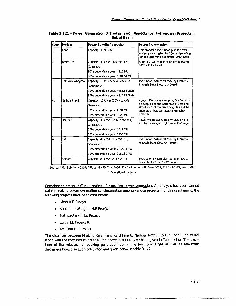
Ramour Hvdropower Proiect: Consolidated EA and EMP Re,ort
Table 3.121 - Power Generation & Transmission Aspects for Hydropower Projects inSatluj Basin
S.No. Project Power Benefits/ capacity Power Transmission
1. Khab Capacity: 1020 MW The proposed evacuation plan is underreview as suggested by CEA in view of thevarious upcoming projects in Satiuj basin.
2. Baspa II* Capacity: 300 MW (100 MW x 3) A 400 KV D/C transmission line between
Generation: BASPA-II to Jhakri.
90% dependable year: 1213 MU
50% dependable year: 1391.61 MU
3. Karcham Wangtoo Capacity: 1000 MW (250 MW x 4) Evacuation system planned by Himachal
Generation: Pradesh State Electricity Board.
90% dependable year: 4463.88 GWh
50% dependable year: 4810.56 GWh
4. Nathpa Ihakri* Capacity: 1500MW (250 MW x 6) About 12% of the energy at Bus Bar is to
Generation: be supplied to the State free of cost andabout 25% of the remaining 88% will be
90% dependable year: 6684 MU supplied at bus bar rates to Himachal
50% dependable year: 7425 MU Pradesh.
5. Rampur Capacity: 434 MW (144.67 MW x 3) Power will be evacuated by LILO of 400
Generation: KV Jhakri-Nalagarh D/C line at Duttnagar.
90% dependable year: 1946 MU
50% dependable year: 2206 MU
6. Luhri Capacity: 465 MW (155 MW x 3) Evacuation system planned by Himachal
Generation: Pradesh State Electricity Board.
90% dependable year: 2037.15 MU
50% dependable year: 2260.50 MU
7. Koldam Capacity: 800 MW (200 MW x 4) Evacuation system planned by Himachal
- ~Pradesh State Electricity Board.
Source: PFR Khab, Year 2004; PFR Luhri HEP, Year 2004; EIA for Rampur HEP, Year 2005; EIA for NJHEP, Year 1998
* Operational projects
Coordination amona different projects for peakina power generation: An analysis has been carried
out for peaking power generation synchronization among various projects. For this assessment, the
following projects have been considered:
* Khab H.E Proejct
* Karchham-Wangtoo H.E Proejct
* Nathpa-Jhakri H.E Proejct
* Luhri H.E Proejct &
* Kol Dam H.E Proejct
The distances between Khab to Karchham, Karchham to Nathpa, Nathpa to Luhri and Luhri to Kol
along with the river bed levels at all the above locations have been given in Table below. The travel
time of the releases for peaking generation during the lean discharges as well as maximum
discharges have also been calculated and given below in table 3.122.
3-148

Rampur HvdroLgower Proiect: Consolidated EA and EMP Report
Table 3.122 - Time Lag for Peaking Power Generation among Projects in the SatlujBasin
Project Distance in km River bed level in m Travel time at max Travel time at leanflow (hour) flow (hour)
Khab 0 2550 0 0Karchham 100 1700 3.0 5.0Nathpa 125 1450 3.75 6.0Luhri 200 710 6.00 10.0Kol 295 600 11.0 18.0
Synchronization of peaking power generation will need to be undertaken accordingly as perrequirement and can be coordinated by a single agency - which could one of the major benefitfrom a basin level water resources agency. The State Government is discussing the possibilities ofmanagement of water resources infrastructure at a basin level management perspective.
3-149

i
i

|;;Ii
- --
L4
-'
__ _ _
r !!-
s e . )ts 0*
. II

Il
l;
.14

RamDur Hydropower Proiect; Consolidated EA and EMP ReD VI
4 ENVIRONMENTAL MANAGEMENT PLAN
4.1 Objective & Principles of the Environmental Management Plan (EMP)The Rampur Hydropower Plant project will generate individual, cumulative and induced impactswhich might have some impact on the sustainability of the project influence area as well as theregion in which project influence area falls. The potential environmental and ecological impacts tobe managed from the project are related to biodiversity, erosion and sedimentation, construction-related impacts, fish management and instream flow management. The purpose of this EMP is toachieve better environmental and ecological viability of the hydropower project, with an overall aimfor sustainable development around the project. The key purpose of this EMP will be to:
* Minimize pollution load on the ecosystem
* Minimize damage to terrestrial and aquatic biodiversity
* Optimize river management for sustainable downstream use and for aquatic life* Minimize safety risk to the employees and communities
* Improve the quality of life of the people associated with project directly or indirectly.
Boundaries
Environment Management Plan for the hydropower projects extends to different zones of projectimpacted areas. Some of the EMP activitiess provide immediate mitigation to environment problemswhile some others take longer in giving results, for example, the catchment area treatment plan(CAT plan) or the Biodiversity Management Plan. Adaptive Management is implemented until themitigations measures stabilize and reach a point where they are self-sustainable.
Spatial Boundary
Area examined for the project i.e., study area for environmental impact assessment is area up to7km upstream of the intake, 7km downstream of proposed power house, 7km on both side of theriver. This study area is termed as the Project Influence Area(PIA). The study area has been furtherdivided in two inner zones for evaluating impacts on significant influence zones of the project.These are:
* Activities within Project's Directly Affected area (PAA)
* Activities within Project Immediate Influence area (PIIA) i.e. within 500m radius of theproject site
Temporal BoundariesEnvironmental Impact Assessment for primary data collection was carried in post monsoon seasonof year 2006. However, references have also been made to past and current studies going on inthe area on issues related to fisheries, biodiversity and catchment area improvement. EnvironmentManagement Plan has been developed for immediate as well as long term project impacts. TheCAT Plan is developed for a 10 years period. Adaptive Management Plans are designed withminimum five years duration, expecting that within five years adaptive management plans willstabilize and start delivering results. In case where adaptive management plan is successful inestablishing its approach before five years, further changes will be stopped and that plan will beestablished as the environment management plan for specific project impact.
4-1

Ramour Hydropower Project: Consolidated EA and EMP Renort
4.2 Methods & Approaches
4.2.1 Stakeholder Consultations
Stakeholder consultations provided sound platform for planning mitigation measures for the project
and the influence area. Site selection, project design, resettlement and rehabilitation measures,
social development of the area and biodiversity issues were all addressed by the project with
properly organized stakeholder consultation sessions. SJVNL adopted an extensive and multistage
consultation process for arriving at a good hydropower project. Details of stakeholder consultations
are explained below.
Public Consultation and Disclosure
The Public Consultation and Disclosure (PCD) process has been guided by the requirements of the
Government of Himachal Pradesh, Government of India and the World Bank. Its overriding goals
had been to ensure transparency in decision-making and provide for stakeholder involvement in
selecting resettlement sites, designing the project and determining appropriate remedial measures
for impacted people and communities. More specifically the objectives were to:
* Ensure Stakeholder concerns are incorporated in Project design and planning
* Increase public awareness and their understanding of the Project
. Enhance positive development initiatives through the direct involvement of affected
people.
Public Consultation Activities
Stakeholder consultation activities for this Project began at the conception stage of the project;
there have been significant number of public consultation and participation meetings and briefings.
This project was indeed significant that a large-scale public consultation process was undertaken
and substantial capacity and understanding on stakeholder involvement in decision making has
been built and strengthened as a result. Consultation ongoing has provided constructive proposals
form local villagers about the resettlement and compensation programme, mitigation measures for
environmental issues and about enhancing the positive development of the project. This is
providing an excellent basis on which to make improvements to the entire environment and social
management plan.
The PCD program had been and continues to be carried out in a three stage process:
* Phase I: Information Collection and Dissemination: data collection on the human and
physical characteristics of the current environment in order to predict Project impacts. As
part of this phase, information was disseminated to stakeholders regarding Projectfeatures and its potential implications in terms of changes to the social and physical
environment.
. Phase II: Consultation with Stakeholders Comments continue to be sought from
stakeholders in response to information gathered as part of Phase I. The information wasdisseminated and discussion of the alternative and proposed mitigation measures wereencouraged. Issues for stakeholders that may previously have been overlooked or are
outstanding are given a forum for review.
* Phase III: Active Involvement in Project Design and Implementation1 Based on the
discussion of Phase II, stakeholder input has been sought in determining mitigationmeasures to address project impacts. The process of stakeholders' involvement and
identification will continue during project implementations.
Techniques used have reflected the diversity of individuals and groups involved. They include:
4-2

RamDALr Hvdrobower Proiect: Consolidated EA and EMP ReDuri
* Use of visual representations including pictures, diagrams and posters.
* Face to face communication where levels of literacy are recognized as being low
* The translation into local Language of project documents and summaries
* Use of local SJVNL Project Information Centers (PIC); and
* Direct contact with stakeholders through electronic or written media, group and individualbriefings, distribution of detailed project information, organization of stakeholder forums.
Efforts have been made to remain sensitive to language and gender issues. The participation ofwomen in consultation has received special attention because they tend to be less educated thanmen or have less exposure to the outside world. The participation of women has been encouraged.
Project Planning Responses to Stakeholder Concerns
Feedback from Stakeholders has influenced or has been incorporated into the Project planning anddesign. For example, the following Project design features are attributed to public consultations:
* Location of the power station to avoid any resettlement
* Routing of the downstream channel to minimize impacts
* Construction of the Regulating Pond to minimize fluctuations in daily discharge into theSatluj River.
The views of Project affected people have also been incorporated into the design of resettlementareas, house designs, livelihood models and village composition.
Disclosure
Throughout Project planning, copies of key reports and draft projects environmental and socialdocuments have been made available. Informations has, and continues to be disseminated throughthe SJVNL website including drafts of the EA/EMP and its Summary. The first draft of the EA/EMP,the background reports, and their subsequent updates, have been disclosed to the public since2005.
In accordance with State Government, MoEF and WB procedures, the EA/EMP were be finalizedfollowing local, regional and national information dissemination and consultation. Local levelconsultations on the E/EMP began in 2005. Any further required revisions will be made afterconsultation with various stakeholders.
4.3 Environmental Regulations, Compliance & Voluntary Actions
The Rampur Hydropower Project project has been developed meeting the State as well as CentralGovernment environmental regulations. The project issues have been addressed to comply withfollowing mentioned environmental regulations.
* Environment (Protection) Act, 1986, and all relevant Rules made under this Act
* Wildlife (Protection) Act, 1972
* Forest (Conservation) Act, 1980
* Water (Prevention and Control of Pollution) Act, 1974, & Air (Prevention and Control ofPollution), Act, 1981
* Ancient Monuments and Archaeological Sites and Remains Act, 1958
* EIA Notification, 1994
4-3

Ramour Hvdropower Project: Consolidated EA and EMP Revort
4.3.1 Environmental Clearance for Rampur Hydropower Project
A 3-stage procedure for project preparation as per the guidelines of the Ministry of Power was
followed. Activities of 3 stages were tied up with a concurrence or clearance from the HPEPPCB/
MoEF. (See Chapter 2 for details.)
4.3.2 Conditions laid by the State Government
The State Government Departments and regulators laid down certain conditions (most of these
pertain to preparation of the EA/EMP), all of which had been complied by the project.
* The spatial dimension of ambient air quality monitoring needed to be increased from the
current two locations to more locations so as to represent all adits and the villages of the
project area.
* Water Quality Monitoring needs to be monitored for two more seasons in addition to the
one season already undertaken.
. Video recording of all ground and surface water sources to be done by the project
authorities
* Technical plan for muck disposal will be submitted to HPEPPPCB and proper measures will
be taken for a safe dump site
. Sewage treatment plants will be used in the townships rather than septic tank and
Incinerator will be used for treating garbage of the township.
. EMP Implementation cost should include cost of third party monitoring during
construction and post construction stages of the project.
* Flow in the natural regime of river Satluj available at Jhakri should not be diverted for
Rampur Hydel project.
After project authorities complied with all the requirements including above mentioned, SCSTEinformed the HPEPPCB to conduct public hearing as per procedures laid down in EIA Notification.
Public notices for holding environmental public hearing near proposed power house in village Bayal
and near Kunni khad bridge in village Chatti were published in news paper for holding the Public
Hearing on 26-10-2005. There were significant issues raised by stakeholders from villages
surrounding the project. Project authorities were asked by HPEPPCB to prepare action plan for
addressing those issues. After receiving the action plan, HPEPPCB issues No Objection certificate
(NOC) to the SJVNL and recommended the case to MOEF for environmental clearance.
4.3.3 Conditions laid by the Central Government
The environmental clearance was obtained from MoEF in March, 2006. Environmental clearancewas granted by MoEF with prior mandatory conditions for implementation by the project during
construction and operation phases. Simultaneously, Mining lease and permission for diversion of
69.3762ha of forest land was obtained by SJVNL from Director of Industries and MoEF (FC Division)
respectively.
The MoEF stipulated additional conditions to ensure safeguards from the uncertainties, and
weaknesses, if any, in the EA/EMP. These are as below:
. Preparation and implementation of (a) a resettlement and rehabilitation plan, (b) a
catchment area treatment plan.
* Dissemination of clearance to the village panchayat/local NGO and advertisement in local
newspapers for general disclosure.
4-4

Ramour Hvdrooower Proiect: Consolidated EA and EMP Report
. Implementation of fish management plan in consultation with the state fisheriesdepartment.
* Conservation of medicinal plants.
* Compensatory afforestation and involvement of local people in afforestation.
* Restoration of borrow pits and quarry sites.
* Disposal of muck at designated sites and landscaping of the sites.
* Maintaining the specified minimum flow of water in the stream.
* Health check up for construction workers.
* Availability of minimum 23.7 cumec water during lean season in the river downstream ofdam for sustaining aquatic life.
* Establishment of multi-disciplinary institutional mechanism for environmental monitoring.This may include representatives from ecology, forestry, wildlife, soil conservation, NGO,etc.
4.3.4 SJVNL Activities for Ecosystem Sustainability of the Satluj BasinThe power potential of Satluj basin is estimated at more than 10,000 MW installed capacity. 17power plants of capacity 100 MW and above have been identified in Satluj basin, of which four areunder operation, two under construction and others in the planning/ investigation stage. Presently,only Bhakra dam is a storage dam project on Satluj river. Kol dam project, immediately upstream ofBhakra dam, has a limited life of 18 years to function as a storage dam after which it has also tooperate as a run-of-the-river plant. Nathpa Jhakri Project, the biggest power plant on Satluj with aninstalled capacity of 1500 MW is a run-of-the river scheme. An acute silt problem in Satluj River hascreated a need for storage dam projects in the Satluj basin for improving functioning ofdownstream projects.
Cumulative impact is a major issue in Satluj basin as there are power plants in cascade in Satlujbasin and there are numerous developers in the Private sector, State sector and Central sectoroperating in the basin. A consensus on co-operation strategy, for operating existing as well asplanned power plants, is essential for sustainable development of the region. It is also necessary toreduce the impact of silt which would yield beneficial results to all the power plants operating/planned in the basin. Long term measures for silt control like catchment area treatment throughvegetation, toe walls and bench development to stabilize slide prone areas, check dams etc. areessential.
Further, the basic inputs for planning of the power projects in Satluj basin are the river discharge,silt load and other meteorological parameters. Presently, there is duplicacy in observing these dataand agencies like BBMB, HPSEB, SJVNL, CWC, NTPC etc., are recording the data to meet therequirement of their own organizations. Since the planning and development of the power potentialin the basin, keeping in view peculiar considerations, has to be based on systematic basin analysis,it is necessary that a joint understanding on maintenance of these observation sites and exchangeof data between various organizations be resorted to as per their requirement. Similarly, testinglaboratory could be upgraded with the state of the art facilities on shared basis.
Treatment of the catchment area through CAT plans and other measures will also be taken up in acomprehensive manner for the whole of the basin.
There are certain laws, regulations and guidelines issued by various authorities including Govt ofIndia & State Govrnment that make it mandatory for all the plants to release minimum discharge inthe river during lean season. There is a need for power producers to take up such matters jointly.
4-5

Ramour Hvdrovower Project; Consolidated EA and EMP Re,ort
In general, while operating power stations in cascade, as is the case in Satluj basin, several issues
are likely to come up and co-operation would be required amongst all the power producers.
To achieve above-mentioned objectives, idea of a permanent Forum of Hydropower Producers of
Satluj Basin is being actively promoted by SJVNL.
4.3.5 Other Parallel Activities Ongoing
Implementation of the Hydropower Policy of the State
As per the hydropower policy of the state, the GoHP will constitute a multi-disciplinary committee
under the chairmanship of Chief Minister. Other members will be state Power Minister (Vice
Chairman), Minister/Member of Legislative Assembly of the area where Projects are being
executed, representatives of the hydropower company, representatives from various concerned
state government departments, Chairman/Managing Director of the concerned Power Utility and
Chairman, Local Area Development Committee (LADC). The Committee will be monitoring the
issues arising during the implementation of the project; employment related monitoring, relief and
rehabilitation, review of progress of LADC schemes, implementation of CAT plan, compensatory
afforestation, environmental management plan, and restoration of facilities which get damaged
because of the implementation of the project. The committee will also review the recommendations
(and implementation thereof) of the Forum of Hydroelectric Power Producers. The Committee will
draw up the methodology to regulate the payments to be made by the Company to the various
departments of the Government in connection with the implementation of the project.
River Basin Development Optimization Study
The World Bank (financed by PPIAF) is also supporting the GoHP through a technical assistance in
preparing river basin development optimization strategies, for the Satluj basin. The ongoing study
would demonstrate the methodology for optimization of hydro-development in the Satluj basin with
the goal of facilitating coordinated and sustainable development by private and public sector
developers, with due regard for the environmental and social impact of river-basin-wide
development. The optimization study will cover environmental and social implications of multi-
project development, including but not limited to: (i) implications for water resource management,
(ii) catchment area treatment plans, (iii) potential cumulative impact on natural forests and other
protected areas; (iv) social impacts arising from multiple projects; and (v) communication/public
outreach issues.
Planning for Basin Level Implementation of Catchment Area Treatment
In view of the extensive hydropower development planned in Himachal Pradesh, the Forest
Department has created Upper Satluj Watershed Society for implementation of the CAT Plan
and the other compensatory afforestation program. Additionally, as per the recent discussion
between the SJVNL and the GoHP, an integrated CAT plan will be prepared for the entire Satluj
basin, based on satellite imageries and remote sensed data. SJVNL will prepare this plan.
4.4 Institutional & Implementation Arrangement
4.4.1 Activities within Project Area
The activities within project area having major impact on environment will be land acquisition,
felling of tree, clearing of forest for construction work, construction of project facilities and
operation of the project once it is functional. Environment Management implementation for impacts
related to forest and tree felling is the joint responsibility of Satluj Jal Vidut Nigam Limited (SJVNL)
and State Forest Department. Compensatory Afforestation Plan (CAP) will be implemented by State
Forest Department. Muck/Quarry Area Redevelopment Plan, Avenue Plantation and Landscaping
4-6

Ramour Hydrooower Proiect: Consolidated EA and EMP Revort
will be implemented by SJVNL. Environmental Management Plans for construction and operation ofthe project is responsibility of project contractors and SJVNL respectively. Wherever contractors areinvolved, SJVNL will hold responsibility for implementing EMPs through contractors.
SJVNL Environment Management Department (EMD)
The EMD of SJVNL will be responsible for the technical planning, implementation and monitoring ofall environmental mitigation and compensation measures under SJVNL's responsibility as outlined inEMP. In addition the EMD will monitor mitigation measures that will be implemented andsupervised by the contractor to ensure compliance with constructor's contract(CC). The EMD willalso work closely with the Himachal Pradesh Environment Protection and Pollution ControlBoard(HPEPPCB) and MoEF, as appropriate.
EMD will prepare regular reports for submission to HPEPPCB and MoEF. The reports will addressthe following items:
* Progress made to implement the environmental mitigation measures in compliance withEMP and the CC;
* Schedule of implementation of environmental mitigation measures;
. Difficulties with implementing the environmental mitigation measures andrecommendation for correcting the problems; and
. Any aspect that does not conform to the environmental mitigation measures andproposed remedial measures.
Prior to the start of construction, the EMD will:
* Ensure that the relevant environmental mitigation measures are reflected in the projectcontract
* Prepare plans for mobilizing subcontracts for studies that will be conducted by SJVNL
* Hold discussion with the government authorities participating in the project to developprocedures for inter-agency coordination and reporting
. Ensure that the construction phase activities include appropriate environmentalmonitoring;
* Assist the HPEPPCB to plan and manage environmental public hearing and informationprogram; and
* Provide any necessary background information to the HPPCB to enable response to publiccomments, complaints and inquiries in relation to the environmental mitigation measures.
During the construction and the operating phases, SJVNL, through the EMD, will be responsible forimplementing and monitoring environmental mitigation measures. The management ofenvironment concern will include:
* Developing and implementing the monitoring programs;
* Managing the subcontracts for specialist studies to ensure their performance
* Liaising and cooperating with the government authorities
• Preparing work and cost schedules for the monitoring programs
* Conducting appropriate testing to ensure that the environmental mitigation measures areeffective
* Arranging for reporting of the results of the monitoring programs
4-7

Ramour Hydrooower PMiect: Consolidated EA and EMP Report
* Maintaining records for reporting to HPEPPCB and MoEF
* Preparing budgeting and financial reports for the operation of the EMD
. Conducting internal and external audits to ensure compliance with the EMP and the
procedures of SJVNL, and
. Assisting Government of Himachal Pradesh with the public consultation programs and
documenting the feedback for incorporation into program planning.
The Construction Contractors
The contractor will be responsible for implementation of measures to avoid or minimize
environmental impacts during construction. These will include protection measures relating to:
. Meeting effluent standards and water quality requirements for discharges into surface
water and ground water;
* Controlling erosion and sedimentation;
* Managing onsite traffic;
* Providing physical cultural protection and relocation as necessary
* Managing onsite waste;
• Managing, preventing and developing emergency plans for chemical pollution incidents;
* Controlling noise emissions and dust;
* Proper siting of the construction work camps
. Implementing a health program for all persons engaged in undertaking construction
works.
The provisions of the contract between SJVNL and the construction contractor include clear
descriptions of the Contractor's obligations for undertaking measures to minimize and/or to
mitigate impacts on the existing environment and social situation. The primary reference documentfor this will be the constructions contractor's environment management and monitoring plan
(CCEMMP). The CCEMMP will cover all the protection measures listed above and will be required to
contain an over view of the project impacts that the contractor's work will have on the physical,
biological and social environment and including:
* Details of environment control to be implemented in accordance with the requirements of
the CC;
* Statutory requirements including approvals and licenses
* Location of environmental control works
* Timing of environmental control activities
. Assignment of responsibility to implement, maintain, asses and monitor each
environmental control
. Procedures and instructions to implement, maintain, asses and monitor each
environmental control
* Reporting procedures
* Emergency procedures, and
* Corrective action requirement and verification.
4-8

Ramour Hydropower Project: Consolidated EA and EMP Report
The CCEMMP will also contain the plans and sub plans addressing the contractor's generalenvironmental measures including a manual of environmental procedures and practices applicableto all construction works.
State Forest Department
State Forest Department will be responsible for preparing and implementing catchment areatreatment (CAT) plan. Department will work for forest conservation and improvement, soil andmoisture Conservation works, Infrastructure Development and Implementation of Eco Developmentplan for reducing pressure on forest.
4.4.2 Activities in the Project Influence Area
In the project influence area, the Biodiversity Management is the joint responsibility of Satluj JalVidut Nigam Limited (SJVNL) and State Forest Department. Catchment Area Treatment (CAT) Planand Wild Life Management Plan will be implemented by State Forest Department. Managed riverflow responsibility will lie with SJVNL.
4.4.3 Activities in the Catchment
In view of the extensive hydropower development planned in Himachal Pradesh and the limitedcapacity of the Forest Department of GoHP to implement the compensatory afforestation andcatchment area treatment plan in the Satluj basin, the Forest Department and the hydropowerdevelopment agencies (particularly SJVNL) will share the implementation responsibility. The overallprinciple of such division of responsibility would be to make best use of the comparativeadvantages for implementation (which suggests that all mechanical, i.e. non-plantation works willbe implemented directly by the hydropower agencies). The cost norms will be as per the ForestDepartment norms, and overall monitoring will be done by the Upper Satluj Watershed Society (apart of the Forest Department). For the Nathpa-Jhakri and the Rampur projects, SJVNL will discusson the actual division of works with the Conservator of Forests (CF), Rampur Circle. The forestdepartment will also modify the catchment area treatment plans, so as to treat the priority areas(such as current landslides) first. To this end SJVNL and the CF, Rampur Circle will review andagree on the modified CAT plan. Additionally, as per the recent discussion between the SJVNL andthe GoHP, an integrated CAT plan will be prepared for the entire Satluj basin, based on satelliteimageries and remote sensed data. SJVNL will prepare this plan.
4.5 Environmental Management Actions for the Rampur ProjectThe most reliable way to ensure implementation of the management plan is to integrate themanagement measures in the overall project planning, design, construction and operation works.In the Rampur project, the environmental management actions had been integrated into the civilworks contracts, and other project planning and design activities. The EMP measures includemitigation or enhancement measures as appropriate to the nature of impacts, and are explained inthe following Sections. These include:
. Actions related to managed flow of river (at Nathpa dam), fisheries management andcontrol of water pollution
* Actions to conserve and protect biodiversity; and compensatory afforestation
* Catchment area treatment plan
• Mitigation of construction related impacts, control of pollution from labour camps,restoration and landscaping of areas disturbed by construction and quarrying; muckdisposal plan and reinstatement of muck disposal areas; control of air and noise pollution
* Delivery of public health services
4-9

RamDur Hydropower Priect: Consolidated EA and EMPRenort
* Safety assurance plan
* Emergency preparedness plan
4.5.1 Managed River Flow
The Rampur hydro electric project will lead to reduction in flow for a stretch between Tail Race
Outfall of existing Nathpa Jhakri hydroelectric project and tail race outfall of proposed Rampur
project. The reduced flow rate will have some potential to affect the aquatic ecology (although
impact on fish species is expected to be low). Due to construction of a diversion dam on river Satluj
at Nathpa, reduction of flow has already affected the riverine ecology by converting lentic system
to a lacustrine system. As a result of reduction in flow, downstream of the dam i.e., from Nathpa
dam to Bayal village, some form of aquatic life, such as the benthic population may be affected.
The fishery study undertaken revealed that the stretch has negligible fish population in the main
river, although some fish is found in the side streams/ tributaries, hence chances for significant
adverse impact are negligible. However, reduced flow may mean decline in the water quality,
particularly due to increased sewage load. Although there is no direct consumption of water from
the river for irrigation or domestic purposes in the stretch being impacted, small impacts on grazing
land close to the river in future is ruled out. Also silt flushing could be an issue for which regular
flow is important, particularly during the lean season.
Objective of the managed river flow is to minimize, to the extent possible, potential impacts on
aquatic and terrestrial habitats from the planned diversion of river water which will curtail the
natural flow between Jhakri and Bayall village (of which the Rampur project is responsible for
diversion downstream of the Nathpa-ihakri tailrace outfall) rendering it less useful quality wise.
Minimum Release
SJVNL will affect a minimum water release of 7 cumec from the Nathpa dam during the lean
season. This will be added by another additional 16.7 cumec from various tributaries between the
Nathpa dam (except the tributary called the Shoulding, which was already diverted to the head
race tunnel of Nathpa-Jhakri project) and Bayal, total discharge available upstream of the Rampur
tailrace outfall at Bayal will be 23.7 cumec.
Minimum flow available in various tributaries between Nathpa and Bayal will be lifeline of the
aquatic habitats in the river stretch impacted by Rampur Hydropower Project. SJVNL is obliged not
only to use all reasonable endeavours to ensure that the minimum water is released in continuous
manner but also to ensure that constant observation is maintained on the flows coming from
tributaries and in case of reduction in flow, adequate measures are implemented to restore the
minimum flow.
Waste Water Treatment
SJVNL as part of the adaptive environment management plan will monitor the water quality at
various locations of the river and adopt necessary measures to protect river water quality and
aquatic life. SJVNL, in association with state public health department will ensure adequate
treatment of sewage from the Jagatkhana and Brow towns since the river at these sewage
discharge points will be affected by lean flow and hence dilution for natural purification will not be
enough over there. Additionally, Rampur Hydropower Project project colony will have separate
sewage treatment plan for treating domestic wastewater.
Sewage Treatment Plant for Project colony: In the project operation phase, a plant colony with 300
quarters is likely to be set up. Suitable treatment facilities will be set up to treat the sewage
generated from the colony. The cost required for construction of these facilities in the project
colony has already been covered in the budget earmarked for construction of the project colony,
and therefore not included EMP budget.
4-10

Rampur Hydropower Proiect: Consolidated EA and EMP Report
Sewage Treatment Plant for Jaaatkhana and Brow Towns: SJVNL in consultation with the localadministration will develop of sewage treatment facilities for these settlements. As a preliminaryestimate an amount of Rs. 10 million has been earmarked for this purpose. The amount can berevised at a later date, once the details of the sewage treatment plants are finalized.
During project construction phase, sufficient measures need to be implemented to ameliorate theproblem of water pollution from various sources. The sewage generated from various labour campswill be treated in septic tanks and disposed by discharging into river Satluj. The septic tanks will belocated so as not to pollute the drinking water sources. The construction activities would require acrusher to crush large lumps of rocks to the requisite size for coarse as well as fine aggregates.The effluent generated from these crushers will have high suspended solids. The effluent will betreated before disposal. Settling tanks of appropriate size for treatment of effluent from variouscrushers will be provided.
During tunnelling works the ground water flows into the tunnel along with construction water whichis used for various works like drilling, shortcreting, etc. The effluent thus generated in the tunnelcontains high suspended solids. Normally, water is collected in the side drains and drained off intothe nearest water body without treatment. It is recommended to construct a settling tank ofadequate size to settle the suspended impurities. The sludge from the various settling tanks can becollected once in 15 days and disposed at the site designed for disposal of municipal solid wastesfrom the labour camps. The sludge after drying could also be used as cover material for landfilldisposal site. An amount of Rs. 20 million will be earmarked for construction of various settlingtanks.
Sanitation at the Construction Camps: The aggregation of large workforce during constructionphase is likely to put significant stress as a result of discharge of sewage, solid wastes and otherpollutants to the streams and rivers. Water requirements for the construction camps and thelabourers camps will be met by nearby rivers or streams flowing upstream of the labour camps,strictly without affecting any existing community sources of water. Bacteriological analysis of waterto be utilized for meeting domestic water requirements be done regularly. Normally, disinfection bychlorination would be adequate. The chlorine dosage will be fixed judiciously so that there isadequate residual chlorine in water being used by consumers at various locations.
In the construction and labour camps, a community WC can be provided for each 20 persons orpart thereof. The sewage from the community latrines will be treated in aerated lagoons andsettling tanks. The total budget required for providing adequate sanitation facilities will be Rs.21.86 million.
Table 4.1 - Budget for Sanitary Facilities for Construction and Labour Camps
Unit Rate (Rs./unit) Number Total cost (Rs. million)
Community latrines 20,000 593 11.86Aerated lagoon and secondary settling tank including Lump sum 10.00sewerage system for from labour camps to treatment siteand to disposal sites
Total 21.86
Control of Silt Runoff in the River
Adequate provisions as mentioned in sub plans of construction activities, "erosion andsedimentation control" as well as mentioned in CAT plan, will be implemented during constructionand operation phase of the project to control sedimentation of the river especially during wet
4-11

Ramour HyvdroDower Project: Consolidated EA and EMP Report
seasons. River bank protection/stabilization downstream of tailrace discharge and lining of exposedsections of the downstream channel will be important activities throughout the project life span.
Fishery Management and Sustenance of Endemic Fisheries
SJVNL will prepare a fishery monitoring and management plan under the guidance of fisheriesdepartment and implement the same. The fishery study undertaken as part of the EIA study wasdone for a short period of time; a detailed study will be undertaken to substantiate findings of
earlier fishery study and to develop a baseline for a comprehensive fishery management.
Snow trout (Schizothorax richardsonil) is the endemic species in the Satluj and being a vulnerablespecies amongst the threatened fishes of India, scientific management of the existing stock in theregion will be adopted.
Supplementary stocking program will be implemented in the project area. River will be stocked fora length of 10 km each on the upstream and the downstream sides of the Nathpa dam site. The
rate of stocking is estimated at 100 fingerlings of about 30mm size per km. The stocking will bedone annually by the Fisheries Department, Government of Himachal Pradesh. To achieve, facilitiesto produce seed of trout will be developed at suitable sites, in addition to the facility at Sanglafinanced by the Nathpa-Jhakri project. The fisheries department shall prepare plan and design for
the hatcheries and rearing units, along with the budget. Seeds will be transported from thishatchery. The supply of seeds could be augmented by collecting them from natural sources. Thetotal budget for developing of hatcheries will be Rs. 6.5 million. The dimension of the hatchingnurseries and rearing unit and their approximate cost is given below.
Table 4.2 - Farm Components in Snow Trout Facilities financed by the Project
Farm Component Area (m) Number Type Rate of flow Cost (Rs.Ipm) million)
Hatchery building 20x15x8.0 1 0.5
Hatching trough each with 4 trays each 2.0x0.5x 0.4 20 Flow through system 3.0-5.0 1.0
Nursery ponds (Cement lined) 5.0 x 1.0 x 0.5 15 Flow through system 25-50 1.0
Rearing tanks (cement lined) 10.0 x 2.0 x 1.0 10 Flow through system 75-100 1.0
Stock raceways (cement lined) 25.0x3.Ox 1.5 5 Flow through system 150-200 2.0
Storage - cum - silting tank 100xSOx50 1 1.0
Total 6.5
Overall, the management plan for sustenance of riverine fisheries for the Rampur project will beimplemented at a cost of Rs. 10 million.
4.5.2 Biodiversity Management
An institutional framework for implementation of the State Biodiversity Strategy and Action Planhas been set up by Government of Himachal Pradesh in the form of a committee comprising of ViceChancellor, University at Palanpur, Head of the Department of Bio-Sciences, Himachal PradeshUniversity at Shimla, and the Member Secretary of the State Council for Science Technology &Environment. The committee regulatory reviews implementation of BSAP and takes correctivemeasures accordingly.
Biodiversity Evaluation Approach: The State Government of Himachal Pradesh has assigned"environmental value" to forest land - a sum of Rs. 800,000 and Rs. 500,000 are assigned as
environmental value per hectares for the areas having forest cover exceeding 10% and for the
4-12
Ramour Hvdrooower Proiect: Consoldated EA and EMP Revolt
areas having less than 10% forest cover respectively. Cost equivalent to this value towardscompensation for loss of environmental values of forestland will have to be borne by SJVNL forevery hectare of forestland diverted for the Rampur project. The amount so collected will be usedto improve the forest cover and the quality of the forests.
Actions in the Project Influence Area (PIA)
The objective is to protect the biodiversity from adverse environmental and social impacts cause bythe Rampur Hydropower Project, by implementing various mitigation measures. This applies to anarea within 7km radius of the project site. Responsibility for implementation of biodiversitymanagement plan in project influence area will lie with state forest department of HP. Local peoplewill be involved by the forest department on its discretion, for encouraging communityparticipation.
Control of Timber Demand: Local people have recorded rights of timber for constructionpurposes at nominal rate and due to division of families, the number of right holders is multiplyingrapidly leading to depletion of forests. Timber demand by villagers is seriously affecting forests ofthe project influence area. The loss of timber trees of the forest has tremendous potential toadversely affect the forest cover and habitat for wildlife. Mitigation measures will be taken up bystate forest department and district authorities for prohibiting felling of timber species of size lessthan 90 i.e. girth at gbh (II B class) timber species. Rates at which the timebr is offered to thevillagers will also be increased at par with the market so that black marketing could be avoided,simultaneously judicious selection of right holders will be made to avoid duplicacy in a family andfake claims. Provision of alternate building material to timber will be promoted such as the concreteblock made of fly ash or brick for construction of houses/dwellings.
Control of Agriculture/Horticulture activities in forest areas: The agriculture/horticultureactivities at the cost of forestlands will be discouraged and control on land use in forests areas willbe gradually converted to "on land capability" classification. Areas under dense forests cover willnot be disturbed for agriculture/ horticulture activities
Control of Forest Fire: Effective fire protection measures like early detection systems,communications systems, equipment and public awareness will be implemented for forest firecontrol.
Control on Grazing: Overgrazing will be controlled by punitive as well as awareness buildingmeasures, as mentioned below:
* In the permitted grazing areas, the animals will be allowed to enter the forests well afterthe rains so that grasses would have grown sufficiently to withstand grazing andtrampling.
* To reduce the dependency of grazing on forest surrounded by heavy bovine population,stall feeding, balanced animal nutrition, improved cattle varieties application ofconcentrates etc. will be encouraged
* Cattle proof trench of size 3m wide top, 1.5m wide bottom, and 1.5m deep will be dugand dugout earth would be heaped on the edge of trench so that cattle cannot enter theprotected area. On the soil, heaped on the edge of trench, thorny species like Carissaspinarium, Zizyphus nummularia, Euphorbia royleana, Agave americana etc. will beplanted so that it will stabilize the soil and prevent animals to jump and get into forest.
Prevention Illegal Felling of Trees: Illegal cutting of trees will be prevented by adequatesecurity measures and also by involving NGOs for creating public awareness against illegal felling oftrees.
4-13
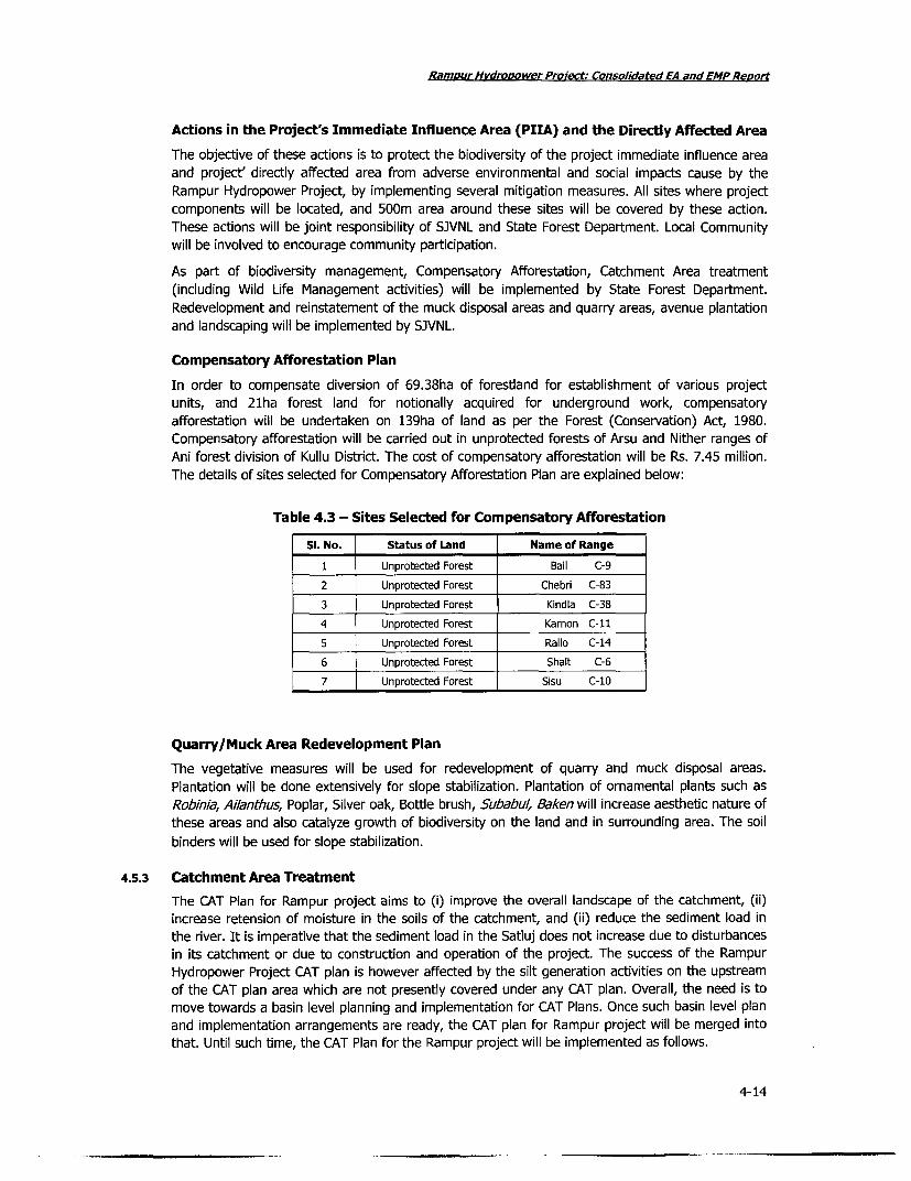
Ramour Hydrovower Proect: Consolidated EA and EMP Report
Actions in the Project's Immediate Influence Area (PIIA) and the Directly Affected Area
The objective of these actions is to protect the biodiversity of the project immediate influence areaand project' directly affected area from adverse environmental and social impacts cause by theRampur Hydropower Project, by implementing several mitigation measures. All sites where projectcomponents will be located, and 500m area around these sites will be covered by these action.These actions will be joint responsibility of SJVNL and State Forest Department. Local Communitywill be involved to encourage community participation.
As part of biodiversity management, Compensatory Afforestation, Catchment Area treatment(including Wild Life Management activities) will be implemented by State Forest Department.Redevelopment and reinstatement of the muck disposal areas and quarry areas, avenue plantationand landscaping will be implemented by SJVNL.
Compensatory Afforestation Plan
In order to compensate diversion of 69.38ha of forestland for establishment of various projectunits, and 21ha forest land for notionally acquired for underground work, compensatoryafforestation will be undertaken on 139ha of land as per the Forest (Conservation) Act, 1980.Compensatory afforestation will be carried out in unprotected forests of Arsu and Nither ranges ofAni forest division of Kullu District. The cost of compensatory afforestation will be Rs. 7.45 million.The details of sites selected for Compensatory Afforestation Plan are explained below:
Table 4.3 - Sites Selected for Compensatory Afforestation
Si. No. Status of Land Name of Range
1 Unprotected Forest Bail C-9
2 Unprotected Forest Chebri C-83
3 Unprotected Forest Kindla C-38
4 Unprotected Forest Karnon C-1i
5 Unprotected Forest Rallo C-14
6 Unprotected Forest Shalt C-6
7 Unprotected Forest Sisu C-10
Quarry/Muck Area Redevelopment Plan
The vegetative measures will be used for redevelopment of quarry and muck disposal areas.Plantation will be done extensively for slope stabilization. Plantation of ornamental plants such asRobinia, Ailanthus, Poplar, Silver oak, Bottle brush, Subabul, Baken will increase aesthetic nature ofthese areas and also catalyze growth of biodiversity on the land and in surrounding area. The soil
binders will be used for slope stabilization.
4.5.3 Catchment Area Treatment
The CAT Plan for Rampur project aims to (i) improve the overall landscape of the catchment, (ii)increase retension of moisture in the soils of the catchment, and (ii) reduce the sediment load inthe river. It is imperative that the sediment load in the Satluj does not increase due to disturbancesin its catchment or due to construction and operation of the project. The success of the RampurHydropower Project CAT plan is however affected by the silt generation activities on the upstreamof the CAT plan area which are not presently covered under any CAT plan. Overall, the need is tomove towards a basin level planning and implementation for CAT Plans. Once such basin level planand implementation arrangements are ready, the CAT plan for Rampur project will be merged intothat. Until such time, the CAT Plan for the Rampur project will be implemented as follows.
4-14

Rampur Hvdropower Proiect: Consolidated EA and EMP Reo,t
CAT Plan Area
The area covered in the cat plan is 1,062.5km2, of which 612.5km2 falls in Rampur Forest Divisionwhile 450km2 is in Ani Forest Division. The catchment Area Treatment Plan of proposed RampurHEP includes Rampur Range, Bahil Range, Machhada catchment of Nankhari Range and of SarahanRange. Population density in the catchment area per 107/km2 and the population is predominantlyrural.
Objective of the CAT Plan
The CAT plan is designed to address catchment area degradation of the Rampur HydropowerProject tract. The plan will support a combination of bio-engineering techniques to reduce soilerosion, conserve water and improve vegetation cover in the catchment. Institutional strengtheningwill also be undertaken to ensure sustainability of the CAT plan interventions. The main objective ofCAT plan will be:
. To achieve ecological rehabilitation of the project area leading to all round economicdevelopment on sustainable basis.
* To increase the vegetation cover in the area by afforestation of areas/forest threatenedwith erosion, with due consideration for fodder/fuelwood and timber demand of localpeople.
* To combat erosion in all forms on slopes, where possible
. To promote in-situ moisture conservation, ground water recharge and to increase theproductivity of all types of land.
* To carry out soil conservation measures in identified water shed to ensure the longevityof the reservoir of Rampur Hydropower Project.
* To improve carrying capacity of pastures by augmenting grass and fodder availability andto solve the problem of migratory graziers
* To provide employment to the local people by engaging them on afforestation and soilconservation works.
* To improve rural infrastructure in the project area
* To increase productivity of all types of land and sustained use of natural resources.
* To promote community participation
* To conduct research for developing appropriate site specific tools with focus on solvingCAT plan implementation problem
* To mitigate the project impacts on wild life by initiating ameliorating measures and tostrengthen wildlife management in the catchment.
Plan Period
The proposed plan is formulated by State Forest Department for the period of ten years startingfrom 2006-07 until 2015-16. Emphasis in the first year will be to develop and maintain nurseries toraise sufficient planting stock. Most of the activities will be completed within initial 5 years and thelater half of the plan will be mainly for maintenance. The afforestation work will be completed in 3to 4 years and thereafter maintenance will be done up to 7 years. Pasture development works andsoil and water conservation works will be completed within first five years and will be furthermaintained till the completion of the project period. Infrastructure work development will again becompleted within five years.
4-15

Ramour Hvdropower Protect: Consolidated EA and EMP ReDuji
Responsibility
The CAT plan will be implemented by a society specifically created for this purpose by thegovernment of Himachal pradesh. The Government has notified and registered a society in thename of Upper Satluj Valley Watershed Development Society. Overall, the execution of CAT plan
will be the responsibility of the State Forest Department with Conservator of Forests of Rampur
Division acting as the project director. Field level responsibility will be of divisional forest officers ofrespective divisions and their support staff. The area of CAT plan will be divided into small
watersheds. The communities living in watershed will be associated in preparing micro plans within
the framework of CAT plan.
Forest Conservation & Improvement
In order to improve forest cover of the Catchment area it is proposed to increase vegetation coverthrough implementation of various forestry schemes such as Afforestation of degraded forestland,Replenishment, afforestation, Assisted Natural Regeneration, Development of Medicinal Plants,
Pasture improvement and subsidiary silvicultural operations barren, areas which are devoid of treegrowth or the degraded forestland with scanty vegetation will be brought under afforestation. Thedetails of various schemes will be implemented under forest conservation and improvementprogram is given in detailed below
Afforestation of Degraded Forestland includes blank areas devoid of vegetation or degradedforestland will be taken up for plantation. A total 780 ha area have been identified available for
taking under this scheme. Out of total 300 ha falls in Rampur while 480 ha in Ani forest division.
Replenishment Afforestation includes plantation of forest areas of the track depleted due toexcessive pressure of local community due to fodder, fuel, timber, etc., to restore such areas to
their optimum productive potential. Such forest areas will be planted by artificial means to increasetheir stocking to the required level.
Table: 4.4 - Activities under Forest Conservation & Improvement Component
Type of Scheme Total Area (Ha), No. of Share in the CAT PlanForest Compartment Plants/ha Budget (%)
Degraded Area Development 780 R:480 A:300 1100 17.31
Replenishment Afforestation 460 R:260 A:200 700 8.25
Assisted Natural Regeneration 400 R:195 A:205 300 5.17
Development of NTFPS/ Medicinal 170 R:80 A:90 2000 2.92Plants
Alpine Pasture Improvement 125 R: 100 A:25 - 0.47
Low-lying Pasture 240 R:80 A:160 3.92
Source: Catchment Area Treatment Plan (2005) State Forest Department HP
The Assisted Natural regeneration scheme will be implemented to forest areas where conditions areconductive to natural regeneration. Forest floor will be cleared of slash, debris and felling refuse to
afford a clean seed bed to the falling seeds & to germinate large number of villagers depends onmedicinal plants as their livelihood. In order to meet their demand as well as for in-situconservation of Medicinal plants, herbs such as Karoo, Dhoop, Chora, Salam Pania, Discorea, Patishwill be planted on 170ha of forestland.
Under Pasture improvement schemes, Alpine pasture and Low-lying pastures will be taken up fortreatment. A total of 3200ha of pasture area is available in catchment. It is an important source ofherbage/roughage for cattle, sheep & goats. The well developed crop areas within the forests willtaken for subsidiary silvicultural operations to improve the growth conditions & hygiene of theforests floor such as, climber cutting (de-weeding), slash disposal, debris collection & burning.
4-16
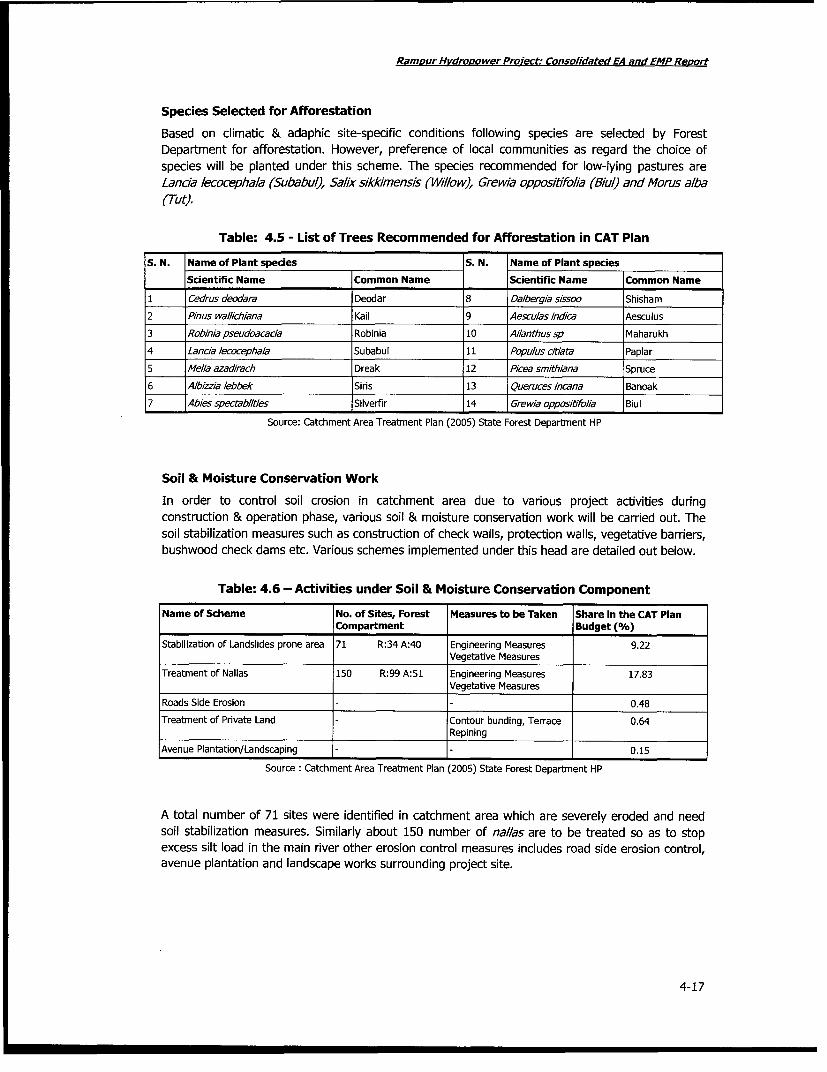
Rampur Hvdropower Project: Consolidated EA and EMP Reo,t
Species Selected for Afforestation
Based on climatic & adaphic site-specific conditions following species are selected by ForestDepartment for afforestation. However, preference of local communities as regard the choice ofspecies will be planted under this scheme. The species recommended for low-lying pastures areLancla lecocephala (Subabul), Salix sikklmensis (Wlllow), Grew/a oppositifolia (Biul) and Morus alba(Tut).
Table: 4.5 - List of Trees Recommended for Afforestation in CAT Plan
S. N. Name of Plant spedes S. N. Name of Plant speciesScientific Name Common Name Scientific Name Common Name
I Cedrus deodara Deodar 8 Dalbergia sissoo Shisham
2 Pinus wallichiana Kail 9 Aesculas indica Aesculus3 Robinla pseudoacacia Robinia 10 Ailanthussp Maharukh
4 Lancia /ecocephala Subabul 11 Popu/us citiata Paplar5 Me/ia azadirach Dreak 12 Picea smithiana Spruce
6 Albizzia lebbek Siris 13 Queruces incana Banoak7 Abies spectablities Silverfir 14 Grewia oppositifo/ia Biul
Source: Catchment Area Treatment Plan (2005) State Forest Department HP
Soil & Moisture Conservation Work
In order to control soil crosion in catchment area due to various project activities duringconstruction & operation phase, various soil & moisture conservation work will be carried out. Thesoil stabilization measures such as construction of check walls, protection walls, vegetative barriers,bushwood check dams etc. Various schemes implemented under this head are detailed out below.
Table: 4.6 - Activities under Soil & Moisture Conservation Component
Name of Scheme No. of Sites, Forest Measures to be Taken Share in the CAT PlanCompartment Budget (%)
Stabilization of Landslides prone area 71 R:34 A:40 Engineering Measures 9.22Vegetative Measures
Treatment of Nallas 150 R:99 A:51 Engineering Measures 17.83Vegetative Measures
Roads Side Erosion 0.48
Treatment of Private Land Contour bunding, Terrace 0.64Repining
Avenue Plantation/Landscaping - 0.15
Source : Catchment Area Treatment Plan (2005) State Forest Department HP
A total number of 71 sites were identified in catchment area which are severely eroded and needsoil stabilization measures. Similarly about 150 number of nallas are to be treated so as to stopexcess silt load in the main river other erosion control measures includes road side erosion control,avenue plantation and landscape works surrounding project site.
4-17
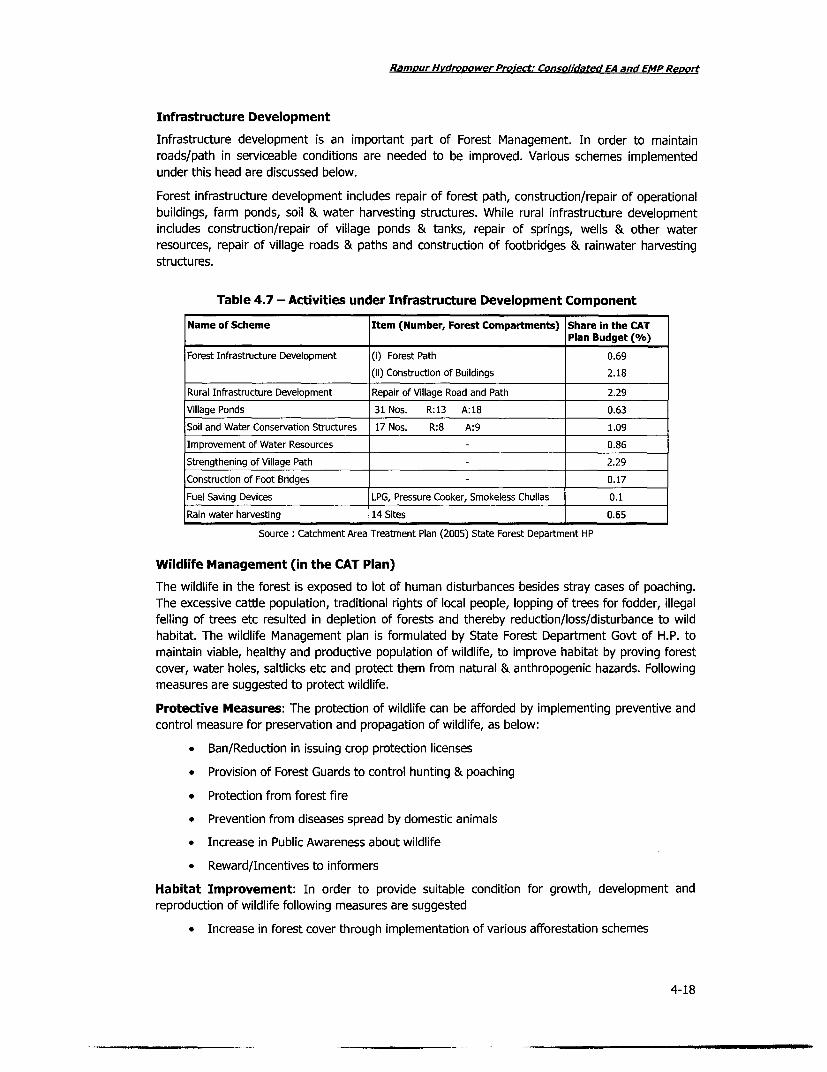
Rampur Hvdropower Proiectt: Consolldated EA and EMP Repy,
Infrastructure Development
Infrastructure development is an important part of Forest Management. In order to maintain
roads/path in serviceable conditions are needed to be improved. Various schemes implementedunder this head are discussed below.
Forest infrastructure development includes repair of forest path, construction/repair of operationalbuildings, farm ponds, soil & water harvesting structures. While rural infrastructure developmentincludes construction/repair of village ponds & tanks, repair of springs, wells & other water
resources, repair of village roads & paths and construction of footbridges & rainwater harvestingstructures.
Table 4.7 - Activities under Infrastructure Development Component
Name of Scheme Item (Number, Forest Compartments) Share in the CATPlan Budget (%)
Forest Infrastructure Development (i) Forest Path 0.69
(ii) Construction of Buildings 2.18
Rural Infrastructure Development Repair of Village Road and Path 2.29
Village Ponds 31 Nos. R:13 A:18 0.63
Soil and Water Conservation Structures 17 Nos. R:8 A:9 1.09
Improvement of Water Resources 0.86
Strengthening of Village Path 2.29
Construction of Foot Bridges 0.17
Fuel Saving Devices LPG, Pressure Cooker, Smokeless Chullas 0.1
Rain water harvesting 14 Sites 0.65
Source: Catchment Area Treatment Plan (2005) State Forest Department HP
Wildlife Management (in the CAT Plan)
The wildlife in the forest is exposed to lot of human disturbances besides stray cases of poaching.The excessive cattle population, traditional rights of local people, lopping of trees for fodder, illegal
felling of trees etc resulted in depletion of forests and thereby reduction/loss/disturbance to wild
habitat. The wildlife Management plan is formulated by State Forest Department Govt of H.P. to
maintain viable, healthy and productive population of wildlife, to improve habitat by proving forest
cover, water holes, saltlicks etc and protect them from natural & anthropogenic hazards. Followingmeasures are suggested to protect wildlife.
Protective Measures: The protection of wildlife can be afforded by implementing preventive and
control measure for preservation and propagation of wildlife, as below:
* Ban/Reduction in issuing crop protection licenses
* Provision of Forest Guards to control hunting & poaching
* Protection from forest fire
* Prevention from diseases spread by domestic animals
* Increase in Public Awareness about wildlife
* Reward/Incentives to informers
Habitat Improvement: In order to provide suitable condition for growth, development and
reproduction of wildlife following measures are suggested
* Increase in forest cover through implementation of various afforestation schemes
4-18

Ramour Hvdrooower Proiect: Consolidated EA and EMP Reort
* Plantation of tree species, which are major sources of fodder for wildlife
* Provision of Saltlicks at various places as a source of essential nutrients required forgrowth of wild animals
* Increase in pastureland by sowing suitable local species of grasses, bamboo plantationetc
Besides this, there is also provision conducting of wildlife census in forest areas, as well asconducting Public Awareness Programs, display of sign and slogan boards in forest areas forprotection of wildlife. The budgetary provision for wildlife management plan is given detailedbelow.
Table 4.8 - Activities under Wildlife Management Component
Name of Scheme Amount (Rs. Lakh)
Wildlife Improvement 47.10
Protection of Forest 25.48
Training and Studying 5.00
Awareness and Publicity 2.00
Eco Development 12.50
Source: Catchment Area Treatment Plan (2005) State Forest Department HP
4.5.4 Mitigation of Construction related Impacts
The mitigation measures aimed to mitigate and manage the construction induced impacts, arecategorized into the following, and each of these group of actions are described in the followingsub-sections.
* Erosion and sediment control measures
* Muck disposal planning and management measures
* Quality management measures
* Water quality management and monitoring measures
* Chemical waste/ spillage management measures
* Emergency measures for hazardous materials
* Emissions and dust control measures
* Noise control measures
* Enhancement measures for physical cultural resources
* Landscaping and re-vegetation measures
* Vegetation clearing measures
* Waste management measures
* Environmental training for construction workers measures
* On-site traffic and access management measures
* Site hygiene measures for construction work camps and resettlement areas
* Health assurance measures for project and contractors' staff
4-19

Ramour Hvdropower Proiect: Consolidated EA and EMP Revort
Erosion and Sediment Control
There is the potential for site erosion and sedimentation of downstream waterways if the siteactivities are not carefully managed.
Erosion and sedimentation will be controlled during the construction of the works. Areas of the sitenot disturbed by the construction activities will be maintained in their existing condition. A principaleffort at the Construction Areas will be management of erosion of excavated surfaces especiallyduring the wet season when the volume of the runoff is expected to be high. Contractors shallprepare an Environmental Monitoring and Management Plan that shall include environmentalmanagement and pollution control techniques for all these areas of activity including drainagemeasures for underground works.
The Contractor shall prepare an erosion and sediment control plan in conjunction with theContractor's Environmental Monitoring and Management Plan which will be prepared in accordancewith the Landscaping and Re-vegetation Plan. It shall detail all site-specific measures theContractor will implement during the construction phase to prevent an increase in pollution loadsbeing exported from the site. It shall cover site drainage, especially related to storm watermanagement. In particular it will include:
* An assessment of the potential for water pollutants to be generated.
* Measures to be taken to collect, store and treat storm water prior to any discharges formthe site, (considering options for water re-use on site)
. Management of material storage areas, including raw materials, chemicals, fuels, andoils;
. Measures to prevent litter entering water courses and details of permanent pollutanttreatment measures or other water pollution control devices proposed for the operationalstage;
. Identification of any significant effects on hydrological condition and appropriatehydrological studies;
. An inspection and maintenance program to maintain the effectiveness of erosion andsediment control measures
Examples of activities, requirements, and practices that will be included in the Contractor'sEnvironmental Monitoring and Management Plan include the following:
1. Areas within the construction areas not disturbed by construction activities will be maintainedin their existing conditions.
2. Soil erosion and sediment control practices will be implemented prior to any major soildisturbance, or in their proper sequence, and maintained until permanent protection isestablished. Only approved areas due for construction activity according to the Programme willbe cleared of vegetation and topsoil in accordance with sub-section on vegetation clearance;
3. Prior to wet season, the contractor shall implement appropriate measures to ensure thaterosion is minimized from works where the permanent drainage and erosion control measures,if any, are yet complete;
4. Materials excavated by the Contractor from open and underground excavation, which areunsuitable for incorporation into the Permanent Works or are surplus to such requirements,will be disposed of as spoil dumps in spoil disposal areas. Materials suitable for roads, saddledams, slope protection, channel armoring or riprap and resettlement area fills will be stockpiledseparately from spoil disposal areas, at agreed locations for later use by the Contractor orSJVNL;
4-20

Rampur Hvdropower Proiect: Consolidated EA and EMP Repuort
5. Soil excavated during construction will be stockpiled separately. The soil will be used forlandscaping and restoration of work areas. All stockpiles and spoil dumps will be constructedand stabilized, including provision of drainage and erosion control measures in accordance withthe Landscaping and Re-vegetation Plan. The height of stockpiles and spoil dumps in spoildisposal areas will be proposed in the Sub-Plan and will be limited to 3m for Topsoil andmaterials for future use. The height of spoil dumps will be determined by the locationsoccupied, but generally will be not more than 6m, with a 2m berm at 3m. Topsoil stockpileswill be deep ripped to provide for moisture retention and re-growth. Drainage and erosion fromthe stockpiles will be controlled by locating them in areas away from drainage lines. Theerosion of the base of the dump will be prevented by providing a silt fence to contain anysediment in any runoff resulting from stockpile or spoil dump;
6. Stockpiles and spoil disposal areas shall not be located on drainage lines or in floodway zonesor other areas important for the conveyance of floodwaters during major floods. Flooded areabehind spoil disposal areas will be allowed to drain to the Downstream Channel;
7. Plans for water management during construction will be in accordance with the Best Practices,and include development of drainage works, sediment traps, diversion, culverts and otherstructures designed to treat water to the water quality requirements of this Sub Plan andWater Quality Management Plan before discharge into natural watercourses. All these structurewill be constructed progressively prior to commencement of construction work and areas willbe directed to the sediment settling areas;
8. The drainage works shall direct site runoff to established watercourses. They will be inspectedregularly for damage caused by scouring, sediment deposition, channel obstruction, and loss ofvegetation cover. Non-erodible segments will be established along the slope lengths. Theseoutlets will be located along the natural drainage lines;
9. Sedimentation controls will be implemented in the form of silt trap fences and sedimentationponds where appropriate depending upon the size of the catchment, and other physical andenvironmental constraints. The silt trap fences shall control flows along minor drainage lines,whereas the sedimentation ponds will be utilized for removing sediment-laden runoff from theconstruction areas. These will be built prior to the start of the activity and will be maintaineduntil the completion of that activity. The ponds will be designed in accordance with the BestPractices.
Planning & Managing Muck Disposal
Impacts from spoil disposal from excavation activities on surface water drainage will be properlyaddressed during construction period.
The Contractor will prepare a Muck Disposal Planning and Management Plan for the total works.The Contractor will also submit Muck Disposal Planning and Management Plans for each proposedspoil disposal sites, to the SJVNL for no-objection at least two months prior to commencementwork at each site.
SJVNL has already identified a number of muck disposal sites, and erected the toe protectionworks. For any new site identified by the contractors, and for the currently identified sites, thecontractors will be responsible for planning and designing for all protection works.
The Muck Disposal Planning and Management Plan shall include environmental studies andconsultation which analyses the potential impacts of each proposed muck deposit and will becomplete at least three moths prior to commencement of construction activities in the particulararea.
The Contractor shall submit to the SJVNL, prior to submission of the Reference Design, drawingsshowing the proposed locations for muck disposal areas. The Contractor shall also include the
4-21

Rampur Hvdropower Preect. Consolidated EA and EMPRo
requirements of the activities given below (which are Contractor's responsibility) which will bemodified in accordance with the SJVNL's comments and incorporated in the Reference Design.
The Contractor shall carry out all the following activities, and shall use the findings and results inthe Dreparation of the drawing showing the proposed locations of the spoil disposal areas:
1. Field inspection of sites and geomorphologic studies to determine if any proposed spoil disposalareas are located in floodway zones of the flood plain;
2. Land use impact assessment, with attention to those areas of land used and designed foragricultural purposes;
3. Estimation of flood stage frequency at relevant locations;
4. Determination of the reduction in flood storage volume that would result from spoil dumps inmain segments of flood plains
5. Determination of the reduction in cross-section area that would result from the positioning ofeach spoil platform;
6. Assessment of impacts caused by increases in the general depth of flooding in each proposedspoil disposal areas.
7. If preliminary flood studies show that the effect of spoil disposal in a particular site would be sosmall as to have little impacts on users of the flood plain, the application of more rigoroushydrological analysis and hydraulic modeling may not be necessary. However, if the preliminarystudies show that significant adverse impacts might accrue to the well-being of the flood plaininhabitants, more rigorous analytical methods will be applied to determine, with greateraccuracy, the effects of spoil disposal in a particular site;
8. Consultations with the communities, if any, living close to the proposed spoil disposal siteswhich may be affected. The consultations shall provide local villagers with detailed informationof the potential spoil disposal site, collect relevant information which may be of use indetermining the most appropriate site, and provide an opportunity for villagers to express theiropinions and concerns with the proposed plans. Information and feedback from theconsultation process will be incorporated into the final design for each spoil disposal site.
The SJVNL shall consider all the above requirements when reviewing the drawing showing theproposed location of the spoil disposal area, which may require modifications to the proposals. Themodifications will be incorporated in the Reference Design.
The Contractor shall also use the findings and results of the above activities to prepare a MuckDisposal Planning and Management Plan as a sub-plan under the Contractor's EnvironmentalMonitoring and Management Plan. The Muck Disposal Planning and Management Plan shall:
. Include allowance for muck disposal sites to be located in flood storage areas only inthose cases where the studies have determined that impact is not significant.
* Include the requirement for all muck disposal sites to be located outside of flood
conveyance areas.
* Not permit the obstruction of access to gardens or dwellings, or require re-routings ofroads and tracks;
. Include provisions regarding the environmental management of the day-to-dayconstruction of muck platforms.
. Require disposal sites not to be located in areas of land, which prior to thecommencement of the construction works, were used for agricultural purposes, or weredesignated for agricultural purposes;
4-22

Ramnur Hvdrooower Project: Consolidated EA and EMP Reoot
* Include provisions for incorporating the most appropriate stabilization techniques for eachdisposal site;
* Assess risks of any potential impacts regarding leaching of the muck, both in terms ofimpacts on surface water as well as on ground water supplies;
. Include appropriate engineering analysis to determine that the selected mcuk disposalsites do not cause unwanted surface drainage;
. Include recommendations for measures to be implemented regarding stabilization anderosion relating to the muck disposal sites, in accordance with the requirements of theLandscape and Re-vegetation Plan and the of Best Practices
* Include a social and environmental assessment of risk in case of failure of each muckdisposal site
. Incorporate information and feedback obtained from public consultation meetings asprovided by the SJVNL for the area identified above or as practical for other areas.
Topsoil will be stripped from areas to be used for spoil platforms and subsequently used tolandscape and grass the top and slopes of the muck platforms.
The Contractor shall identify muck materials which have potential for use by others in futureconstruction work. Such muck will be stockpiled and secured by the Contractor according to thoserequirements relevant and in such a manner to allow future use of the muck by others.
The spoil will be placed on reverse order of excavation, with finer materials in layers towards thetop of the spoil dump, and stockpiled topsoil placed as the final layers. All layers will be of uniformthickness and compacted sufficiently to minimize future settlement, in accordance with agreedprocedure.
SJVNL will be responsible for supervising and to assure that the spoil is placed in the appropriatesites, to evaluate potential for failure of the slopes, and to monitor the effectiveness of erosioncontrol at each of the sites.
Recommendations for rehabilitation of muck disposal areas: Pending preparation of thecontractors' rehabilitation and reinstatement plans for the muck disposal areas, the following arerecommended. These could form the minimum acceptable guidance for rehabilitation andreinstatement.
. The retaining wall varying from 2 to 7 m of height will be provided to prevent thedumped material from sliding.
. One meter terracing along the contour at 5 m interval along the slope in staggeredmanner will be done.
* The uphill side of the terraces will be provided with the walls/edging of 50 cm height and50 cm thickness to protect the uphill side of the terraces from slipping.
. Vegetative measures would include (i) suitable tree and shrub species will be plantedafter fencing the area, and (ii) bBroadcasting of grass and Rumex seed will be done
* Fencing and Planting - After the completion of civil works in the dumping sites to be willbe fenced with the barbed wire in strands with two diagonal strands using wooden fenceposts of eucalyptus 3m apart.
* Choice of Species for planting: Keeping in view the climatic and soil conditions of the site,broadly following species are recommended for planting:
Tree species: Robinia, Ailanthus, Poplar, Iqomoea, Siverock, Bottle brush, Ducinia,Agave, Melia azedarach.
4-23

Ramour Hvdrooower Proiect: Consolidated EA and EMP Revort
Grass seeds Heteropogan, Fescue and Chrysopogon seed at the rate of 4kg perhectare may be broadcasted all over the area. Rumex hestatus seed in smallquantities may also be broadcast. Since this plant is naturally growing in the area inabundance.
Maintenance: Possibility for watering the plants at least for early two or three years ofplanting will be explored. Maintenance of the plants will be for five years. The dead plantswill be replaced and fencing if damaged be repaired.
Budget for rehabilitation and reinstatement of the muck disposal areas including for all measuresfor stabilization of muck disposal site will be Rs.23. 26 million. Works to be carried out during pre-construction period will include constructing retaining wall or toe wall of average 5m height (2m to7m) at a cost of Rs. 13.21 million. Works to be carried out after completion of muck disposal willinclude terracing, fencing, planting and grass seeding; at a cost of Rs. 10.04 million.
Table 4.9 - Budget for Protection (Retaining/Toe Wall) during Pre-Construction
Description Quantity Rate (Rs.) Amount (Rs.)
Excavation 2.70m3 64.00 172
Cement concrete 0.81m3 982.10 795.50
Cement mortar 2.01m3 1140.60 2292.60
Dry masonry 6.41m3 453.00 2903.73
Boulders filling 3.00m 3 391.70 1175.10
Others 391.70 1175.10
Total for Im of retaining or toe wall 7337.73
Total I|OOm 7337.73 13,212,000.00
Table 4.10 - Budget for Reinstatement Works after Completion of Muck Disposal
Description of Measure Quantity Rate (Rs.) Amount (Rs.)
Terracing of 1 meter width with toe walling 50 x 50 cm size 18000 running metre 145.00 26,10,000
Fencing of area with barbered wire 4 strand horizontal and 3600 running metre 38.00 1,36,800two strand diagonal - as per HPSR - 1999 , ,
Planning of different species of plants 14000 plants 18.98 2,61,639
Grass seeding 18.38 hectare 1320.00 24,26,160
Total 54, 34,599
Total including escalation © 8.5% per year for 6 years 80, 43,206
Add for maintenance for 5 years 20, 00,000
Grand Total 100,43,000
Quarry and Borrow Area Management
The project has identified 1 quarry site for acquiring aggregate and additional areas for sand.During construction there is potential for noise, dust and sedimentation of waterways, andincreased traffic hazards if the development and operation are not carefully managed. Suitablemitigation and closure measures will be adopted for management of these sites. The requirements
4-24

Ramour Hydrooower Project: Consolidated EA and EMP Report
of considerations and specifications for the use of quarry and borrow areas has been incorporatedinto the construction contracts.
The contractor will be responsible for use of the quarries and borrow areas in accordance with theprovisions of the EMP. The EMD of SJVNL will ensure that the specifications are incorporated intothe construction contracts. The EMD will develop a monitoring program to ensure that theoperations are in accordance with the requirements of quarry management.
The Contractor shall have the right to quarry construction materials such as soil, sandstone,limestone, stone, sand, gravel and any other materials from the Quarry Areas subject to therequirements of the EMP and the Conditions of Contract.
The Contractor shall prepare an overall Quarry Management Plan for the total works in conjunctionwith the Contractor's Environmental and Manaaement Plan.
At least 3 months prior to commencing any activities in a particular Quarry Area, the Contractorshall submit a separate Quarry Management Plan to SJVNL for no-objection for the proposedquarrying activities. The Plans shall include the following consideration:
* An assessment of the following impacts at all quarry sites will be identified and assessedfor their magnitude and importance:
* Erosion and sedimentation
* Road damage
* Spoil and other waste generation
* Noise and dust generation
* A plan showing the extent of the area to be developed
* A method statement defining the proposed working method
* The proposed access and haulage routes between the quarry and the destination for theextracted material
* A justification for the quantities of material to be extracted, an estimate of the wastematerials to be generated and disposal details for such waste materials
* Details of the measures taken to minimize the quarry area and its visual impact on thesurrounding area
* Measures which are recommended to minimize the significance of each identified impact
The plan will also describe details of the measures to be taken for the log-term rehabilitation of thequarry and borrow workings. These shall include re-establishment of vegetation, restoration ofnatural courses, avoidance of flooding of the excavated area wherever possible, achievement ofstable slopes, and avoidance of features which would otherwise constitute a risk to health andsafety or a source of environmental pollution.
Where the excavated quarry and borrow areas cannot be reasonably drained, the contractor shallminimize their number and consult with the local population as to that population's preferences fortheir location for reuse or other community purposes
Quarry faces and excavations will be made safe and buildings, plant, equipment and debris andmiscellaneous stockpiles of material will be removed form the areas
Materials, other then waste materials, extracted from quarrying operations will be used exclusivelyfor the Construction Works.
4-25

Ramour Hvdropower Project: Consolidated EA and EMP Reo,t
Water Quality Monitoring
Construction activities may impact water quality in areas downstream of the construction activity.SJVNL will monitor water quality in the Satluj River, and some of the tributaries.
SJVNL's water quality program will start before the main civil works contract is initiated to
determine baseline conditions in Satluj River. The information obtained during this period will be
used to improve the water quality modelling and to compare water quality conditions duringconstruction and operation of the project. The monitoring program will assess whether SJVNL isfulfilling its goal of beneficial use of water within the project area.
The EMD of SJVNL will be responsible for implementing the water quality monitoring program fromthe pre-construction phase through construction and the operating period. The water quality-monitoring plan will be designed to monitor the effects of surface water runoff from areasdisturbed by all construction related activities.
The SJVNL shall prepare a Water Quality Monitoring Plan. The Water Quality Monitoring Plan will be
designed to monitor the effects of surface water runoff from areas disturbed by all constructionrelated activities. The plan shall include the following:
. Detailed plans regarding monitoring the effects of surface water runoff from all
construction areas, including cleared land, roads, construction camps, quarry areas, whichmay affect water quality in natural waterways. The plans shall include the locations of thesampling water in waterways upstream and downstream of the entry points of thesurface water runoff from the construction areas. The frequency and method of testingwill be in accordance with internationally recognized standards;
* The contractor shall ensure all construction related activities shall not pollute waterways,in accordance with Application Standards. The Water Quality Monitoring Plan shall includethe Applicable Standards for water quality parameters
. The water quality monitoring program shall also monitor the quality of potable watersupplied to the construction work camps, work sites.
As and when any water quality impact is identified, SJVNL will take immediate actions to control
pollution of water, including provision of all corrective measures at site.
Management of Water Quality, Chemical Waste and Spillage
During construction there will be a potential for the pollution of adjacent habitat areas anddownstream waterways if the site activities are not carefully managed. SJVNL will strive to reducethe potential impacts to surface water and ground water within the vicinity of the constructionareas. This includes waste water management and discharges from the construction areas.
Construction camps will be equipped with waste water treatment facilities to prevent adverseimpacts to the surrounding water bodies. To ensure that the waste water treatment facilities ateach camp are effective, the EMD will implement a water quality monitoring programme, as
described in sub-section above.
Responsibility for providing waste water treatment facilities at the construction camps will be theconstruction contractors. The EMD of SNVNL will be responsible for monitoring of the wastewatertreatment facilities.
The Contractor shall prepare a Chemical Waste/Spillaqe Management Plan. The Plan shall includeproposed actions for the following situations, and any other situations that could involve similarproducts:
4-26

Ramour Hvdropower Proiect: Consolidated EA and EMP ReDULL
All refueling of heavy equipment and machinery will be undertaken with appropriate safeguardsand protection measures to prevent any spillage or contamination by chemical wastes ormaintenance oils, lubricants etc;
All fuel and hazardous material storage will be adequately bunded to prevent any spillageproblems;
Storm water runoff from open workshop servicing and repair areas and bunded storage areas willbe collected and treated before discharge to drains or waterways
Portable toilets will be installed at each short term work site employing 5 workers or more. At leastone toilet will be installed per 20 workers. The toilets will be clean and a special service unit will beresponsible for collection and distribution of toilet units. The sludge will be treated according to therequirements of the Contractor's waste management plan
Suitable sanitary sewage and solid waste disposal facilities or systems will be provided at all longterm work sites, workshops stores and offices; all explosives will be transported, stored andhandled in accordance with the Applicable laws and Good Design Engineering, and ConstructionPractice. The Contractor shall provide details of proposed storage and security arrangements;
Emergency Measures for Hazardous Materials
During construction there will be a potential for the pollution of adjacent habitat areas anddownstream waterways if site activities are not carefully managed, and there is uncontrolleddisposal and/or leaching of hazardous chemicals. SJVNL will minimize the potential for impactsassociated with chemical waste and spills of oil, diesel, grease from the construction area.
The contractor will be responsible for the preparation of the chemical waste and spillagemanagement plan which will be approved and monitored by the EMD. This plan will incorporatemeasures and processes to handle situations resulting from accidental spills of hazardous materials,including chemicals and hydrocarbons or other similar incidents.
The SJVNL will be informed immediately of any accidental spill or incident in accordance with theplan. I
Following any spill or incident the Contractor shall immediately initiate remedial action.
This plan will be coordinated with the Emergency Preparedness Plan, and will include provision oftrained personnel, specialized plant and equipment, and defined and approved treatment anddisposal methods for the known range of hazardous materials.
The Contractor shall subsequently provide a report detailing the reason for the spill or incident,remediation action taken, consequences/ damages from the spill, and proposed corrective actions.The Emergency Plan for Hazardous Materials will be subsequently updated and submitted to SJVNLfor no objection, every time such an accidental spill happens.
Emissions & Dust Control
Fugitive dust from the site disturbances and emissions from the vehicles and plant have thepotential to negatively affect air quality in the vicinity of the construction sites and access roads.SJVNL will minimize emissions from vehicles and equipment used for construction activities andminimizes fugitive dust from construction areas and from unpaved roads within the constructionareas.
Responsibility for incorporating specifications for regular maintenance of vehicles and equipmentused will be with construction contractor. The EMD of SJVNL will review the contracts to ensurethat these specifications are incorporated. The Contractor will aslo prepare an Emissions and DustControl Plan. The EMD will develop a monitoring program to ensure that specifications within theconstruction contracts are respected.
4-27

Rampur Hydropower Proiect: Consolidated EA and EMP RODUIL
The Contractor's Emissions and Dust Control Plan will include the following:
* Proposed methods and action to control dust resulting from construction related activities,including quarry sites, crushing and concrete batching plants, earthworks including roadconstruction, embankments and channel construction, haulage of materials andconstruction work camps. As a minimum, dust will be controlled by water spraying or anyother similar measures. These are to be applied as necessary to reduce to a minimum thespread of dust from unsealed construction roads and public roads when constructionequipment is active, in areas of major earth excavation, and any other areas whichproduces dust;
* The exhaust gases from the construction machinery and vehicles are accepted. Howeverthe engines will be inspected and adjusted as required to minimize pollution levels;
• The emission and dust control plan shall include an internationally recognized air qualitystandard such as from ITA (International Tunneling Association) which will be applied todesigning, monitoring and controlling air quality/ pollution in the underground works.
For all underground works, for all activities and type of material excavated, the Contractor shallinstall mechanical/ forced ventilation systems which shall provide air pollution concentration thatcomply with the requirements of the internationally recognized air quality standard included in thissub plan. When internal combustion engines are operated in the underground works only dieselengines will be used.
The burning of waste and/or garbage will be done in designated areas at a distance of at least 2kmdownwind from the nearby villages and in accordance with Applicable Law and the Contractor'sEnvironmental Monitoring and Management Plan. Burning of any material which produces toxicgases will not be allowed.
Noise Control
Although noise impacts on communities on plateau are unlikely, excessive noise will impact onwildlife. In the Power Station excessive noise will impact upon communities. SJVNL will minimizethe amount of noise generated at construction sites, as well as in the power house.
The contractor will be responsible for the preparation of the noise control Dlan, which will beapproved by the EMD. Monitoring of noise in the construction areas will be responsibility of EMD.The Noise Control Plan shall include a nationally recognized noise level standard which will beapplied to designing and managing noise levels in construction plant, equipment and vehicles
Mufflers and other noise control devices of construction equipment and vehicles will regularlychecked, and be repaired or replaced if defective;
Construction works may generally be carried out 24 hours a day within lkm of villages andconstruction camps. Work practices may have to be modified outside the period of 6:00 and 18:00hours.
Construction workers exposed to noise levels of 80dB or more will be provided with adequatehearing protection, in accordance with the requirement of Health and Safety Plan. Blasting, exceptfor underground, only permitted between 10:00 and 18:00 hours, within 2km of any villages.
Enhancement and Conservation of Physical Cultural Properties
Objects and sites of physical cultural resources may be encountered during construction activities inthe Construction Areas. SJVNL will implement the procedures required to prevent damage to theobjects and sites of Physical and Cultural Resources and to enable appropriate action to be takenby SJVNL.
4-28

Ramour Hvdrooower Proiect: Consolidated EA and EMP Renvort
SJVNL will avoid or minimize impact to physical cultural resources, including items havingarchaeological, historical, religious, scared and or unique nature values that may be affected by theproject construction and operation. The SJVNL will be responsible for the appropriate managementof all items or sites of physical cultural resources located in Construction Areas in coordination andconsultation with Government Authorities.
SJVNL has already undertaken field work to evaluate the potential for cultural resources within theconstruction areas. Based on this survey, a detailed update to previous findings has been compiledalong with recommended mitigation and management strategies for each item of physical culturalresources. The result of the survey will be taken into consideration in construction of the project.The contractor will prepare a sub-plan called the physical cultural resources management plan.The SJVNL has completed surveys for objects and sites for physical cultural resources within theselected construction areas. The results of the completed surveys indicate that few, if any, objectand sites will be affected by construction activities. Objects and sites of physical cultural resourceswhich may be encountered during construction activities include sites having archaeological,palaentological, historical, religious, sacred and unique natural values.
Prior to commencement of work by the Contractor in any portion of the Construction Areas, theSJVNL will have:
. Completed a physical cultural resources survey for the particular portion of theConstruction Area
• Informed the contractor of any known objects and sites of physical cultural resourceswithin the particular portion of the construction area
* In accordance with conditions of the contract, required actions to be implemented by thecontractor for any such known objects and sites of physical cultural resources
The Contractor shall prepare a physical cultural resources plan for dealing with any objects andsites of physical cultural resources notified by SJVNL or encountered by the contractor within theConstruction Area. Such physical cultural resources plan shall include proposed methodologies for:
. Documentation and identification of any location of any objects or sites of physicalcultural resources notified by SJVNL or encountered by the contractor within theconstruction areas;
* Notification to the construction workforce of the need to be vigilant in the detection andreporting of, and the prevention of disturbance and damage to, objects and sites ofphysical cultural resources
. Notifications to the SJVNL of any objects or sites of physical cultural resourcesencountered by the contractor within the construction areas
* Stopping work and securing the area adjacent to the objects and sites of physical culturalresources to prevent damage to such objects and sites.
The SJVNL, in coordination and consultations with Government Authorities, will be responsible forthe appropriate overall management, protection and preservation of all objects and sites of physicalcultural resources encountered within the construction area and will, in accordance with theconditions of contract, instruct the contractor on the actions to be taken by the contractor inrelation to avoiding or minimizing disturbance and damage to such objects and sites of physicalcultural resources, including:
* Protection and preservation measures are to be taken by the Contractor;
* Additional mitigation, management, notification and reporting measures are to be takenby the Contractor to enable the construction activities to proceed;
4-29

Ramour Hvdrooower Progect; Consolidated EA and EMPReoort
Changes to the Works and the construction methods, if any, required to be taken by the
contractor.
Additionally, SJVNL will retain the support of the Archaeological Survey of India, Shimla Office to
periodically inspect the site, and the physical cultural properties identified by the survey, to verify
that these properties are not damaged, and are being protected adequately. The experts from the
Archaeological Survey of India, Shimia Office would also advise on the enhancement and protection
measures that might be required from time to yime.
Archaeological Chance Find Procedure: Sites and properties that are buried or not identified
by the survey undertaken by SJVNL may be discovered during project implementation, especially in
the course of construction or excavation. Such unanticipated discoveries of remains of an
archaeological and/or historical nature are termed archaeological chance finds. Most often they are
concentrations of pottery, worked stone, and human and animal bones, without commercial value,
but of significance to archaeologists, historians, anthropologists, and paleontologists.
The following archaeological chance find procedures will be adopted in project design and
construction contracts:
* The responsibility for preservation, maintenance and assessment of historical and cultural
monuments rests with the Department of Archaeology, Government of Himachal Pradesh,
and in specific cases, with the Archaeological Survey of India.
* Whenever chance finds of cultural or historical artifacts (moveable and immovable) are
made the Department of Archaeology, Government of Himachal Pradesh, and the
Archaeological Survey of India will be informed. Should the continuation of work
endanger the historical and cultural artifacts, the project work will be suspended until a
solution is found for the preservation of these artifacts, or advice from the Archaeological
Survey of India is obtained.
* Contractors, employees of the contractors and all project employees will be responsible
for informing the Project Director immediately after discovery of the chance find, without
any judgment on their own on the value of the chance find. The Project Director will be
responsible to inform the Department of Archaeology, Government of Himachal Pradesh,
and the Archaeological Survey of India, Shimla Office, within 48 hours of such discovery.
* The Project Director will request for a representative of the Department of Archaeology,
Government of Himachal Pradesh, and/or the Archaeological Survey of India, Shimla
Office to make a site inspection.
* Project Director will order cessation of work in the vicinity of the chance find until the visit
of a representative (usually required within 48-72 hours of notification); and follow the
advice by the Department of Archaeology, Government of Himachal Pradesh, and/or the
Archaeological Survey of India on possible salvage or excavation (usually required within
48-72 hours of notification).
* Failure to report a chance find within the 48 hours of discovery, is a punishable offece
under the relevant Indian legislation. Similarly, (intentional) damage to a historical or
cultural artifact is a punishable offence.
SJVNL will also seek the support of the Archaeological Survey of India, Shimia Office to periodically
inspect the sites of construction, excavation and muck disposal to detect any chance finds.
Landscaping & Re-vegetation
The contractor will prepare a LandscaDing and Re-Vegetation Plan that includes measures for
restoration of cleared areas, quarries which are no longer in use, spoil areas, haulage roads,
construction camp areas, borrow areas, stockpile areas, working platforms and any areas
4-30

Rampur Hvdroeower Project: Consolidated EA and EMP Revert
temporarily occupied during construction. The measures will include landscaping, provision ofadequate drainage and re-vegetation.
All areas disturbed by construction activity, including temporary access roads and tracks, will belandscaped to reflect natural contours, restore suitable drainage paths and encourage the re-establishment of vegetation.
Spoil heaps and excavated slopes will be re-profiled to stable batters and grassed to preventerosion. Topsoil stripped from the areas occupied by the spoil heaps will be used for landscapingworks. Re-establishment of vegetation will be commenced at the earliest possible opportunity.Appropriate local species of vegetation will be used.
Local depressions created by construction activities will be either backfilled or drained to preventponding possible. Where the local depressions cannot be reasonably drained, the contractor shallminimize their number and consult with the local populations as to that population's preference fortheir location for reuse for fish forming or other community purposes.
All hazardous materials construction plant and waste will be removed from site and safely disposedof in an environmentally acceptable manner. Reusable construction materials will be eitherremoved from site or, with the approval of the SJVNL, left in a secure manner such that they donot constitute a risk to health and safety or a source of environmental damage.
Watercourses, if any, which have been temporarily diverted by the construction activities, will berestored to their former flow paths.
Vegetation Clearing
During construction there will be a potential for areas to be cleared in excess of real requirements,and insufficient consideration given to retaining vegetation. SJVNL will minimize vegetation clearingfor construction activities and control erosion and sedimentation from the disturbed areas. All suchadditional clearance will be subject to the approval of the State Forest Department, if the land isdesignated as forest land, or if the land supports forests.
All land and forestvegetation clearing activities will be carried out according to a site plan, whichenforces the minimization of vegetation disturbance. Additionally, specification for control oferosion of sediments will be detailed in the Erosion and Sediment Control Plan.
The contractor will include specifications for the removal of vegetation from the construction areasand specifications for management of runoff from the disturbed areas during the constructionphase. These specifications are incorporated into the construction contracts. The EMD will beresponsible for ensuring the compliance of the construction contractors. The EMD will also inspectthe construction areas at the end of the construction phase to ensure that the areas are stabilizedbefore the construction contractor can vacate the area.
At the end of the construction period, the disturbed areas will be inspected to ensure that the areashave been re-graded to conform to the natural topography and that appropriate grasses andshrubs have been planted to start the re-vegetation process. The constructor contractor will beresponsible for the stabilization of construction areas before they are allowed to vacate theconstruction areas.
Areas proposed for clearing will be submitted to and agreed by SJVNL, and only those proposedareas will be cleared. SJVNL will reasonably consider the existing usage of the project land to allowits existing usage to continue as long as is practicable, without interference with the contractor'sactivities.
The design of roads, including temporary and permanent access roads, shall avoid crop areaswhere reasonable and practical. The application of chemicals for vegetation clearing will be
4-31

Ramour Hvdropower Proiect: Consolidated EA and EMPReout
minimized to the greatest extent reasonable and practical. Chemicals, if any, will be selected on the
basis of being non-residual and with regard to human health.
Herbicides used in the Project shall have negligible adverse human health effects; be shown to be
effective against the target vegetation species; have minimal effect on the natural environment;
and be demonstrated to be safe for inhabitants and domestic animals in the treated areas, as well
as, for personnel applying them. Herbicides will be appropriately packaged, labelled, handled,
stored, disposed of and applied according to international standards to be proposed by the
Contractor for the SJVNL's non objection. Persons applying herbicides will be provided with
appropriate training, equipment, and facilities to handle, store, and apply these products properly.
All herbicides shall have labels in both English and local Languages to allow those handling the
herbicides to comprehend the labeling fully.
Clearing will be carried out in accordance with the following requirements, 'Logging and Removal of
Waste Forestry Products' given below, which describes the Contractor's responsibilities, which is
referred to in the Conditions of the Contract.
Logging and Removal of Waste Forestry Products
Prior to Commencement of Construction, SJVNL shall have the right, but not obligation, to remove
or arrange for the removal of commercial and non-commercial timber as well as other forestry
products from the designated Construction Areas. After commencement of Construction the
Contractor shall have the right to log and remove forestry products remaining as required to clear
areas to carry out the construction of the works, as necessary. However, in either case, the
ownership and any value accruing remains with the State Forest Department.
The contractor shall submit plans for removal of the remaining timber and other forestry products
in the areas permitted under this clause to SJVNL for approval at least three months in advance of
any work being executed by the Contractor. The plan will be in accordance with the Contractor's
obligations of the contract Requirements, including in particular, the following items:
* erosion and sedimentation control and mitigation
* vegetation clearing
* air quality
* noise pollution
The contractor's plan shall provide detailed information regarding the proposed logging and
clearing work, including the following:
* Clear identification and justification of the areas to be logged and cleared;
* Name of the company or organization to do the logging and clearing work;
* Schedule for logging and clearing to be undertaken;
* Clear identification of disposal sites for the timber and forestry products;
If the SJVNL elects to log and clear the areas nominated in the Contractor's plan as areas which the
SJVNL may log and clear, it shall have the right to do so within the period specified by the
Contractor consistent with the obligation referred to in contract.
All works involving the logging and removal of timber and other forestry products after
commencement of Construction Works must be carried out in accordance with the Contractor's non
objected Vegetation Clearance Plan;
Other than the contractor's right to use timber obtained from the areas permitted under this clause
for construction or for the temporary works necessary for that construction and other than the sale
4-32

Ramour Hvdrooower Project: Consolidated EA and EMP Report
rights described in contract, the contractor must not sell, use or obtain any other benefit from thecommercial timber of forestry products form the Construction Areas.
The contractor, with explicit permission from the State Forest Department, shall dispose of anytimber or forestry products resulting from the clearing not used in the construction Works andwhich are not sold, in a manner selected by the contractor including leaving the timber and forestryproducts at the perimeter of the cleared construction areas or areas selected by the Contractorwithin the cleared construction areas for collection by SJVNL.
For timber and forestry products discarded by the contractor and left at the perimeter of thecleared Construction Area or at areas selected by the contractor within the cleared constructionarea, the SJVNL shall have the right to arrange for the removal of such discarded timber andforestry products.
Solid Waste Management
During construction there will be potential for garbage and waste collection and disposal to begiven a low priority with resultant low efficiency and health problems. SJVNL will ensure propermanagement of solid waste generated by project activities.
A solid waste management plan will be developed by the contractor and will be monitored by theEMD, which will assure that the solid waste is disposed as described in the solid wastemanagement plan.
A sufficient number of garbage bins and containers will be made available at the work camps, theareas of planned and spontaneous resettlement and at the main work sites. Garbage and otherwaste will be regularly collected and be transported to a designated waste disposal site.
Suitable sanitary and solid waste collection and disposal facilities or systems will be provided at allcamps, workshops, stores, offices, long term main work sites and personnel will be provided tooperate and maintain the systems. During construction phase, labour, clerical staff and technicalpersonnel are likely to congregate. The increase in population is expected to be of the order of11,850. The average per capita solid waste generated would be of the order of 425gm/day/person. The solid waste likely to be generated from labour camps will about 5 tonne perday. For solid waste collection, 50 number of masonry storage vats, each of 2m3 capacity will beconstructed at appropriate locations in various labour camps. These vats will be emptied at regularintervals and the collected waste can then be transported to disposal site. Three covered trucks tocollect the solid waste from common collection point and transfer it to the disposal site will be putto service. A total provision of Rs.11.11 million is earmarked for these purposes.
Table 4.11 - Budget for Solid Waste Management
Item Cost (Rs. million)
Three covered truck for conveyance of solid waste to landfill site @ Rs. 1.60 4.80million/truck
Manpower cost for 12 persons @ Rs.5500/month for 6 year 6.11
Awareness programme 0.20
Total 11.11
The waste disposal site will be located at least 2km from the nearest village. Connections to thegroundwater or surface water will be avoided, either by clay or impervious membrane at thebottom and walls of the waste disposal site. When parts of the waste disposal sites are full, theywill be covered by a depth of 1.5m of soil, and then re-vegetated according to relevantrequirements included in the Landscaping & Re-vegetation Plan. In addition, rehabilitation of thoseareas used to bury waste will be done in accordance with the requirements of the HPEPPCB.
4-33

Rampur Hydropower Proiect: Consolidated EA and EMP Report
A separate collection and storage procedure will be developed for hazardous or toxic waste, suchas batteries, unused paint thinners and hydrocarbons, disused electronic equipment, etc. Thesewastes will be stockpiled in accordance with the requirement of the applicable Laws andsubsequently transported to special solid waste treatment plant capable of proper disposal of suchhazardous or toxic waste as approved by HPEPPCB.
Management of Construction Work Camps and Spontaneous Settlement Areas
During construction there will be potential for construction work camps and spontaneoussettlement areas to be developed without sufficient consideration of planning, health, andenvironmental requirements. SJVNL will mitigate the following identified impacts of establishing andoperating work construction camps - erosion; runoff and sediment control from the disturbedareas; and health issues. For spontaneous development of business not associated with theconstruction activities at all sites, or for spontaneous settlement of construction workers or therfamilies, SJVNL will seek to maintain the similar standards.
The contractor will be responsible for developing a plan and design for construction of the workcamps. SJVNL, through the EMD, will ensure that the work camps prevent environmental impactsto the camp sites and to the surrounding areas. The EMD will be responsible for monitoringactivities within the camps to ensure compliance with the plan.
The contractor shall plan, design and construct construction work camps for the constructionworkers, which satisfy the following general requirements:
. Plans will be prepared for all camps and preliminary plans and information will besubmitted with the contractor's Environmental Monitoring and Management Plan.
* Approvals and permits will be obtained in accordance with the Applicable Laws, ApplicableStandards and Environmental Requirements, if any, for the building and infrastructurework for each camp area.
* Camp site selection and access roads will be located so as to avoid clearing as many treesand vegetation as possible form the areas and to avoid aquatic habitats.
* Camp areas will be sited to allow effective natural drainage.
. Effective sediment control measures during construction and operation of theconstruction work camps in accordance with the Environmental Requirements, especiallynear rivers.
* Adequate drainage structures will be located and constructed to prevent formation ofstagnant pools.
* Suitable sanitary, sewage and solid waste collection and disposal facilities will be providedto serve the construction camps. Sewage effluent shall meet water quality criteriarequired by Applicable Laws, Standards and Environmental requirements beforedischarge.
* Adequate provision for medical facility; signage for awareness on health and hygiene;and condom vending machines and other awareness materials to combat HIV/AIDS.
The contractor shall plan, design and construct construction work camps for the constructionworkers and the officials of the contractors' organization, which satisfy the following specificrequirements:
Paved internal roads, storm water drainage systems to prevent stagnant water, adequateday time, night time and security lighting will be provided
4-34

Ramour Hvdrooower Proiect: Consolidated EA and EMP Revort
. Camps shall consist of living facilities with housing mess, shopping, recreational andsanitary facilities for all workers accommodated within the camps.
* Fire fighting equipment and services and portable fire extinguishers will be provided forall building
* Medical and first aid facilities will be provided at each camp area
. The camp areas shall have an adequate supply of potable water compliant with WHOcriteria and Applicable Laws
* Ventilation of buildings within the camp areas will be in accordance with Applicable Lawsand Standards
• Mess halls and residential accommodation will be mosquito and fly proofed.
. Adequate provision for medical facility; signage for awareness on health and hygiene;and condom vending machines and other awareness materials to combat HIV/AIDS.
Water quality will be maintained, and sanitation facilities provided as described in Section 4.5.1.
Mitigation for Impacts from Construction of RoadsSJVNL will strive to inimize impacts during the construction and upgrading of roads. The majormitigation measures is the minimization of new road alignments in favour of upgrading existingroads and for new roads, seeking an alignment that minimizes damage to vegetation.The contractor will be responsible for constructing and/or strengthening the access roads, thehaulage roads, or any other roads within the project area in accordance with the EMP. The EMDwill be responsible for ensuring that contractor's environment management plan adequately coversthe environmental impact mitigation measures for the road construction activities. It will also beresponsible for monitoring compliance.
The approach roads will have to be constructed as a part of the access to the construction site. Ina hilly environment, construction of roads sometime disturbs the scenic beauty of the area. Inaddition, landslides are often triggered due to road construction because of the loosening of rocksby water trickling from various streams.
Road construction is expected generates significant quantity of wastes (muck) due to the strippingof the rocks. The stripped muck is generally cleared by dumping the material along the slopes.These dumped materials finally flow down to the valleys and ultimately finds its way in to the river.In the Rampur HEP, this will be prohibited. The stripped material will be collected and dumped inthe designated muck disposal areas, which will be managed and protected as described in a sub-section above.
After disposal operation is complete at the dump site, dump site will be reinstated, contoured andvegetated. Various other aspects to be integrated while constructing the project roads aredescribed below.
. Where erosion is likely to be a problem, clearing and grubbing operations will be soscheduled and performed that grading operations and permanent erosion control offeatures can follow immediately thereafter, if the project conditions permit; otherwisetemporary erosion control measures will be provided between successive constructionstages. Under no circumstances, however, should very large surface area of erodibleearth material be exposed at any one time by clearing and grubbing.
* The method of balanced cut and fill formation will be adopted to avoid large difference incut and fill quantities.
4-35

Ramour Hvdropower Proiect: Consolidated EA and EMP Repu,i
. Where rock blasting is involved, controlled blasting techniques adopted to avoid over-
shattering of hill faces.
* Excavated material should not be thrown haphazardly but dumped duly dressed up in a
suitable form at appropriate places where it cannot get easily washed away by rain, and
such spoil deposits may be duly turfed or provided with some vegetative cover.
* Drainage of the water from hill slopes and road surface is very important. All artificial
drains will be linked with the existing natural drainage system.
* Surface drains shall have gentle slopes. Where falls in levels are to be negotiated, check
dams with silting basins will be constructed and that soil is not eroded and carried away
by high velocity flows.
* Location and alignment of culverts should also be so chosen as to avoid severe erosion at
outlets and siltation at inlets.
* Tree felling for road construction/works will be kept bare minimum and strict control must
be exercised in consultation with the Forest Department. Equivalent amount of new trees
will be planted as integral part of the project within the available land and if necessary,
separate additional land may be acquired for this purpose.
* Depending on the availability of land and other resources, afforestation of roadside land
will be carried out to a sufficient distance on either side of the road.
An amount of Rs.8 million is earmarked for the purpose of implementing these EMP measures
described above. These costs have already been included in the estimates of the contract cost, and
the bill of quantities. Therefore, these are not included in the EMP budget.
Table 4.12 - Budget for Implementation of EMP Measures for Road Construction
S. No. Item Cost (Rs. million)
1. Clearing and grubbing 3.0
2. Provision of breast walls, construction of catch water and interceptor drains 1.5
3. Provision of drainage system along roads 2.0
4. Planting and grassing works, roadside plantation, etc. 1.0
5. Sprinkling of water through tankers on roads 0.5
Total 8.0
Mitigation for Impacts from Construction of Power Evacuation System
Although the transmission line that would be constructed for the project will be a short loop-in
loop-out line, and the impacts are not expected to be significant, there would be some potential
impacts. The system will be constructed by the Powergrid Corporation of India.
The Powergrid Corporation of India has already adopted and implemented in its projects, a set of
Corporate Environmental Policies. These policies are equivalent to the environmental safeguard
policies of the World Bank. Using guidance and methods defined by these policies, the Powergrid
Corporation of India will mitigate the impacts of vegetation and habitat loss, disturbance from
construction, possible soil toxicity from the application of chemicals used in vegetation clearance,
and possible health risks associated with electric and magnetic fields generated by transmission
lines. Additional measures to mitigate against impacts includes avoidance of felling of trees as
much as possible, implementation of proper logging techniques where vegetation clearing is
4-36

RamDur Hvdrooower Proiect: Consolidated EA and EMP Report
unavoidable, avoidance of application of chemicals, and prohibition of dwellings, and businesses inthe easements along the transmission lines.
The Powergrid Corporation of India will be responsible for these activities. The EMD of SJVNL willreport on the adequacy of the environment management by the Powergrid Corporation of India.
Environmental Training for Construction WorkersDuring construction there will be a potential for workers to damage the forests and waterwaysadjacent to camps and work areas. The contractor shall prepare a training plan for all constructionworkers. The training will need to ensure that all employees of the contractor are aware about theirduties, responsibilities, liabilities and consequences of non-compliance.
All employees of the contractor will be required to comply with environmental protectionprocedures and they will be able to provide evidence that they have attended the training sessionsdetailed in the plan.
The goal of the "Environmental Training for Construction Workers" program will be to educate allconstruction workers on the following issue: traffic regulations, illegal logging and collection of non-timber forestry products (particularly in the resettlement areas), hunting nad fishing restrictions,sanitation practices, waste management, erosion control, general health issues including theinformation and education, specific health issues related to HIV/AIDS, safety issues and generalinformation on the environment in which they will be working and living.
Training will also include awareness generation that (personal, not related to work) use ofexplosives and chemicals is not permitted; or hunting and fishing is not permitted. Contractors willestablish rules and penalties for violation.
These training sessions will be organized by the contractor, and woulod include formal trainingsessions, posters, signage in construction and camp areas, and tool box meeting. These would bein addition to the training program organized by EMD, SJVNL. However, both training programcould be coordinated.
On-Site Traffic & Access Management
During construction there will be a potential for use of large numbers of vehicles of variable size,leading to hazardous conditions on public roads, camps, project roads and work areas. To addressthe potential hazardous conditions, the contractor will prepare and implement an On Site Trafficand Access Manaaement Plan. The plan shall address the following:
> Details regarding expected road quality, maximum permissible vehicular speed on each sectionof road, establishment of safe sight distance including within the construction areas andconstruction camp site.
> Detailed plans for signage around the construction area to facilitate traffic movement.
> Estimated maximum concentrations of traffic and effects on existing traffic patterns fordifferent times of day, and at individual locations within the construction area.
> Provisions to be made by the contractor for adequate off-road parking of all constructionrelated vehicles.
> Plans to be followed while moving special loads, such as hazardous material, or heavy loads.Plans for controlling site access, including both construction areas and construction campareas.
> Monitoring and methods of enforcing the requirements of the traffic management plan.
Construction traffic, including heavy loads, must not damage public roads. Personnel authorized tothe construction areas will be briefed on traffic regulations applicable to the construction area.
4-37

Ramnur Hvdropower Project: Consolidated EA and EMP Renort
Parking will be provided for all classes of vehicles travelling to the site. At no time shall construction
vehicles be parked in a manner which may restrict movement of traffic on public roads. Signage
should provide directions to various components of the works, provide safety advice and warning.
All signs will be in both English and Local Language and be constructed to Indian Standards.
4.5.5 Contractor' Staff Health Program
During construction there will be potential for workers to be affected by diseases associated with
the local conditions and camp/ temporary living conditions. There would be potential to infect the
local communities with infectious diseases, or communicable diseases, particularly HIV/AIDS. SJVNL
will strive to ensure that the health of the construction workforce is maintained, and that the local
communities are not exposed to increased health risks, or increased HIV/AIDs risks due to the
presence of the large number of migrant workforce.
SJVNL will ensure that disease control measures are affected by the contractor at the time the
construction camps are built and during the construction period while the camps are inhabited.
Construction camp siting decisions will be made considering good drainage, water supply, sewage
disposal and disease transmission potential, especially malaria. An adequately staffed clinic will be
sited at the base camp. The contractors will establish all required linkages with the State AIDS
Control Society (SACS), and will implement all measures including referral system advised by the
SACS. The contractor will responsible for these activities. SJVNL, through EMD will be responsible
for monitoring the contractor's activities and compliance.
As part of the contractor's Health and Safety Plan the Contractor shall prepare and enforce the
Staff Health Program in respect to matters regarding the health and safety of the construction
workforce. The contractor's project Staff Health Program shall also provide some assistance to
nearby communities for emergency matters if space resources become intermittently available.
Similarly, the contractors can coordinate, as an additional facility but not replacing its own
obligations under this EMP, with all other functioning medical facilities in the locality.
Construction Camps
* In general, anti-malaria measures following current accepted practice will be instituted at
campsites and facilities established for early diagnosis and treatment of patients with the
diseases.
* Disease control measures are to be implemented by the construction contractors at the
time the construction camps are built.
. Decisions regarding siting of camps will be made with regard to good drainage, water
supply, sewage disposal and disease transmission potential, especially malaria.
* Mosquito nets will be provided.
For Overall Workforce
With regard to providing high quality health services to the Contractor's employees, the program
shall include:
* Appropriate measures to address mosquito control, including dengue fever control.
* A medical centre sited at the main construction camps, for the diagnosis and treatment of
communicable diseases, simple medical complaints and handling of medical emergencies
and accidents. It will be staffed adequately. Subsidiary treatment or first aid posts at each
smaller construction camps will be staffed by either a trained nurse or locally trained
personnel.
4-38

Ramour Hvdrooower Proiect; Consolidated EA and EMP Repo,t
. Suitable workers will be selected from the workforce and receive additional training inoccupational health and first aid shall form teams of two or three personnel at each worksite. They shall do this as part of their normal work and will be under the supervision ofthe person responsible for occupation health and of the medical officer.
* For the control of communicable diseases and other public health issues, contractors willemploy services of a sanitation officer and a disease control officer.
* Provision will be made for health checks of employees, including checks, where required,for drug abuse and sexually transmittable diseases in accordance with ILO and WHOresolutions, recommendations, guidelines for construction workers.
* The contractor shall employ a sanitation management and control office who will be fullydevoted to (i) control vector borne and other diseases, (ii) ensure the continued safedisposal of all solid waste and sewage, (iii) implement fly and other insect control atconstruction camp sites and in the project area, (iv) implement and monitor the sanitationmanagement measures throughout the project area including construction camps andspontaneous resettlement areas, (v) provide appropriate information and education to theworkforce on prevention of diseases, including malaria, diarrhea, STD and HIV/AIDS, and(vi) investigate and document diseases outbreaks within the contractor's workforce.
Additional Malaria Control Measures
To reduce the risks of workers contracting malaria, the following measures will be followed formosquito control at construction site:
* Education of workers about problems and preventive measures
* Require protective clothing
* Repellents protective clothing
* Minimize presence of containers full of water
* Remove discarded items that could contain water
* Keep storm water drains and borrow pits free of vegetation
. Insecticide control as a last resort method and only after studies indicate primarylocations of mosquitoes
HIV/AIDS Prevention Measures
To effectively address the HIV/AIDS issues and the associated risks, the contractors will associatewith the SACS fully and without any failure or excuse. SJVNL will insist that the contractorsimplement all advice from the SACS. In addition, the contractors will be obliged to implementregular and periodical awareness campaign on HIV/AIDS, provide for all awareness materials andtheir dissemination, including erecting large signage in prominent areas; and to provide for andmaintain condom vending machines in all work areas including construction camps, pubic toiletbooths, and work sites.
4-39

Ramour Hvdrooower Proiect: Consolidated EA and EMP Report
Table 4.13 - Summary Environmental Management Plan
Acivitiy/Imp Direct and Indirect Impacts of the project |Boundary' T Proposed Mitigation Measures |Responsibilityact Receptor -- - TFim
l ~~Space Tm
Project Preparation Stage
Acquisition of Loss of 48.9 ha of forest land and associated Project affected Until Compensatory Provision for alternate land for Compensatory State Forest Department/SJVNL
Forests Land biodiversity area afforestation is Afforestation Plancomplete
Felling of Trees Loss of one thousand seventy five(1075) trees Project affected Until Compensatory Compensatory Afforestation with large scale tree State Forest Department/S]VNL
for project area afforestation is plantationconstruction complete
Vegetation Loss of shrubs and grasses leading to loss of Project affected Construction Period Clear marking of required areas so that excess Contractor will prepare and
Clearing for biodiversity area vegetation clearance does not happen implement the vegetation
construction Erosion of soil Logging and removal of waste forestry products clearance plan and SIVNL willactivity imdandtemoalfyat pe monitor tne implementation
Project Construction Stage
Construction Emissions from vehicles and equipment Localized in PM The impact will be Dust suppression measures will be utlized at all dust Contractor will prepare and
activities and operating at construction sites and PIAA temporary but will generation locations implement dust and emission
vehicle Dust generated by construction activibes at continue till All equipment and engines will be maintained in good control plan and SJVNL will
movement quarry sites,concrete batch plans,construction construction stage condition monitor the implementation
siates,dust on roads and passing traffics Proper collection and disposal of waste will be practiced
Burning of waste and burning of waste in and around the project area willbe prohibited.
Generation of Increase in noise level, causing disturbance to PM,PIAA Impact will be Mufflers and noise control devices will be used in Construction contractor will be
Noise from the fauna and human settlements around the temporary but will construction equipment responsible for preparing and
constructionare site. continue during the Defective vehicles generating gih noise will be replaced implementing the noise controlas construction period plan
Construction activities will be limited to day time only SJVNL will be responsible for
Hearing protection aids will be used where high noise monitoring the implementation oflevel exposure to the workers is needed to be curtailed noise control plan
'Project Impact boundary is categorized as -Project Affected Area(PAA),Project Immediate Influence Area(PIIA) and Project Influence Area(PIA)
4-40

Ramour Hydropower Proiect: Consolidated EA and EMP ReDort
Activitiy/lmp Direct and Indirect impacts of the project Boundary' Proposed Mitigation Measures Responsibilityact Receptor
Space TimeConstruction Destructons of flora and Wildlife hunting Wildlife hunting will be banned by order of law Construction contract will beWork camps Tree felling for timebr exploitation as fuel Alternate source of energy such as Kerosene or LPG will responsible for preparing and
Waste water/Solid waste generation be provided implementing a construction workPunitive measures will be enforced tree cutiing and ScVNL will be responsible fordamage to natural resources monitoring the implementation ofProper soild waste collecetion and treatment measures the planwill be implemented
Waste water will be treated and safely disposed of.
Environmental awareness training will be provided to theContractor and workers.
Quarry Loss of biodiversity PM,PIM Sediment traps will be installed Construction contract will beactivities Runoff from the area may affect surface water Dust suppression measures will be implemented responsible for preparing and
quality and eventually pollution of river and quarry will be rehabilitated implementing the quarryAbandoned borrow pit an urywl erhblttd management planLoss of aesthetic value of the area with vegetation,etc SJVNL will be responsible forDust generation Good landscaping measures will be adopted monitoring the implementation of
the quarry management planMuck Disposal Damage to top soil and flora at the sites of PAA,PIAA Until construction Top soil will be reused for landscaping activities Construction contractor will be
construction. activities are over Silt trap fences will be installed and before dumping responsible for preparing andHeavy siltation of surface water and river action the muck disposal area will be covered by implementing a muck disposalespecially during rainy season due to muck retaining walls on the sides bordering the surface water management planfalling in surface water source/river source/river SJVNL will be responsible forLoss of aesthetic value of the area Muck disposal area will be vegetated and good monitoring the implementation of
landscaping will be done noise control plan
Excess Timber Loss of flora due to logging of timber trees PIAA,PIA During construction Effective catchment area treatment plan will be State forest department willlogging as well as operation implemented develop and implement CAT plan
stage
Blasting Drying of water supply sources like natural PM,PIAA,PIA Temporary during Water resource survey will be undertaken before SJVNL will undertake survey andsprings,khulls,etc blasting time construction activity and any loss will be compensated compensate the asset lossHigh noise generation
Construction of Loss of crop land Locations of During tower Adequate compensation will be provided for loss of asset Environment management Plan fortransmission Loss of vegetation; Tree cutting transmission errection Towers will be aligned away from habitation transmission line projects will betowers towers developed and implemented byCreation of electromagnetic field around towers Transmission towers will aligned to reduce tree cutting SJVNL
4-41

Rampur Hvdropower Proiect: Consolidated EA and EMP ReVort
Activitly/Imp Direct and Indirect Impacts of the project Boundaryl Proposed Mitigation Measures Responsibility
act Receptor_ _ _ _ _ __ _ _ _ _ _ _ _ _ _ _ _ _ _ _ _ Space Tim e _ _ _ _ _ _ _ _ _ _ _ _
Construction/ Loss of biodiversity PIM,PIA One year from Environment Management Plan for road construction Constructor contractor will be
upgradation of Silt runoff to surface water body/river construction till road work will be prepared and implemented responsible to implement the plan
roads construction and/or and SJVNL eill br responsible for
Construction related pollution upgradation is over monitoring the implementation
Project Operation Stage-Impact on Physical Environment
Hydrology Diversion of 388.83 cumec from Satluj River at River Satluj Life span of the Project will release minimum 7 cumec of flow into S]VNL will be responsible for
lhakri Between Jhakri project downstream of NJHEP to help sustain the riparian release of minimum flow and HP
Significant reduction in flow in satluj River and Bayal environment.Additionally about 14 cumec water will also Environment Protection and
between Jhakri and Bayal Stretch flow in from various tributaries between Jhakri to Bayal. Pollution Control Board will monitorthe same.
Water Quality Periodic episodes of low dissolved oxygen River Satluj Life span of the Solid waste and waste water management in the villages SJVNL will be responsible for water
concentration in downstream rivers Between Jhakri project and rampur town quality monitoring and
River pollution from discharge from power and Bayal Effective Catchment Management Plan implementation of suitablemeasures. Environment Protection
house through tail race discharge Water quality Monitoring and implementation of effective and Pollution Control Board will
measures in case of water pollution monitor the same at regularinterval as external check
State forest department willimplement CAT plan
Erosion and Increase in silt load of the river stretch between Monitoring of minimum release in the river downstream SJVNL will implement adaptive
sedimentation Jhakri and Bayal and silt flushing capacity of the river management plan for managed
Increase in river bank erosion from the tail race Inclusion of regulating channel in design facilitating river flow
discharge below confluence with the more constant and controlled release of water atdownstream channel downstream
River bank protection/stabilization downstream oftailrace discharge
Lining of exposed sections of the downstream channel
Asset compensation for any land/asset lost
Operation Phase-Impact on Biological Environment
Aquatic Transformation of 25 km stretch of satluj River Sabuj River Life span of the A detailed fishery study will be undertaken and fish Fisheries department will
habitats and between Jhakri and bayal will alter habitats and Stretch between project management plan will be developed undertake fishery study with
fish diversity disfavour species adapted to fast flowing Jhakri and Bayal Continuous water quality monitoring and implement project related support from SJVNL
conditions. adaptive management practice for maintaining water SJVNL will undertake monitoring
The diversion weir will present a barrier to quality and river bank stabilizaton
migration of fish Stabilization of road sides and other areas to reduce programme in association with
4-42

RamDur Hvdropower Proiect: Consolidated EA and EMP ReDvort
Activitiy/Imp Direct and Indirect Impacts of the project Boundaryl Proposed Mitigation Measures Responsibilityact Receptor
- Space Time
Changes in water flow,quality and temperature erosion required as rule of the lawmight alter the species composition and River bank stabilizationproductivity of the river
Work in or along river might increase thesediment load causing damage tofish(gills),destroy pawning areas and reduceproductivity of the river
Terrestrial 80 ha of land and associated vegetation PAA,PIA Life Span of the Compensatory afforestation plan towards loss of forest State forest department willBiodiversity affected by project permanently(construction project Effective Catchment treatment plan prepare and implement
phase) Ct a e ran compensatory afforestation planImproved accessibility of the area and Control measures for grazing and CAT planincreased human population on plateau will Control measures for forest firestimulate increased pressure on naturalresources and wildlife due to encroachment andpoaching activities
Increased land erosion activities in catchment.area
4-43

RamDur Hvdrovower Proiect: Consolidated EA and EMP Repo,t
4.5.6 Safety Assurance in the Project
It is the policy of SJVNL to provide a safe place to work for its employees. It is acknowledged that
SJVNL has the ultimate responsibility for compliance with all the requirements of applicable safety
rules and orders on the Rampur Hydropower Project.
Each employee has the responsibility to plan, organize and perform work in the safest manner
possible, consistent with sound construction practices. All employees will be constantly on the alert
for unsafe acts and conditions and to correct them immediately. SJVNL management will ensure
that all employees - including contractors and subcontractors, are aware of their personalresponsibility in maintaining an accident-free and healthy work environment.
Goal of Working Accident-Free
THE GOAL OF SJVNL IS TO WORK ACCIDENT FREE.
When an accident occurs, the degree of loss is determined by chance; therefore, preventing allaccidents must be the objective of the safety goal, rather than only those where potential for
serious consequences is most apparent. Accidents are preventable and result from unsafe andinefficient procedures or methods, unsafe physical conditions, unsafe equipment, and unsafe
personal acts.
The challenge is to work every day on the job INJURY FREE. The Safety Manual lays out the
written program that will assist in preventing accidents. Safety is a full time commitment on
everyone's part, not just the Safety management team. SJVNL has prepared a directive that lays
down the necessary SJVNL policy and requirements governing SJVNL's "Health, Security, Safety
and Environment" (HSE) efforts to achieve this ambition.
Safety Assurance Plan & Safety Manual
A project-specific Safety Manual and a Site Safety Assurance Plan have been prepared.
However, all employees will ensure that the Safety Manual and the Site Safety Plan must be
complemented with continuous day-to-day, personal involvement in preventing accidents.
It is recognized, however, that Occupational Health and Safety Legislation and Regulation inHimachal Pradesh and India are also driving forces behind safety management. Legislation and
regulations will take precedence over any provisions of SJVNL's safety policies or procedures.Nothing contained in SJVNL's documentation will be construed as somehow lessening the
requirements of duly enacted Legislation or Regulation.
The Occupational Health & Safety Management System and its associated definitions of roles and
responsibilities has been constructed as a guide to meet the intent of the SJVNL Health, Security,Safety & Environment Directive as well as to meet the expectations of legislators and regulators. Ifa legislator or regulator ever questions whether SJVNL or any of its personnel has met the
expectations of safety and health legislation, a key defense of our actions will be one of due
diligence-whether we have taken reasonable care to comply with occupational health and safetylaw and its intended purpose of protecting the health and safety of workers whilst they areemployed by SJVNL or by our Contractors.
Safety Management Arrangement
Safety on this Project will be the responsibility of everyone on the job - it will be the ultimate teameffort involving management, supervision, craft, owner's representatives, and subcontractors.Everyone is encouraged to think and act as a safety supervisor and is empowered to stop work and
immediately correct unsafe acts or conditions.
4-44

Ramiur H/dropower Proiect: Consolidated EA and EMP Reort
The Site Safety Assurance Plan will be continually monitored by the HOD (Safety), who willensure that all elements of the Plan and the Safety Manual are effectively working. The HOD(Safety) will report directly to the the Project Director, and be the point of contact for all issuesregarding safety and health on the project. Along with project management, the HOD Safety willestablish and enforce the Project's attitude and commitment towards site safety. Other primaryduties of the HOD Safety will include:
* Spending the majority of time in the field actively observing operations.
* Conducting and monitoring orientations, training, and reporting.
. * Monitoring management, distribution and proper use of all safety equipment by thecontractor.
* Monitor all on and off-site medical including physicians and facilities to be establishedby the contractor.
* Interfacing continually with the General Manager (Projects) on all matters of safety.
* Maintain records and documentation.
* * Conduct accident investigations.
Safety Supervisor(s): The HOD Safety will manage a staff of Safety Supervisors. Each work sitewill have a full-time Safety Supervisor who will have no other duties other than safety. The SafetySupervisors will be trained and qualified. These supervisors will be deployed by the Contractor.
Competent Person(s): Each area of work will have a Competent Person deployed by thecontractor who will be assigned and readily available to address any safety issue at that location.Competent Persons shall have the knowledge and training to meet all requirements for the workbeing performed. The Competent Person shall perform routine inspections of the work area,address any instant worker concerns, and understand all emergency and crisis response activities.
Due Diligence: Societal expectations are increasing the pressure on organizations, such as SJVNL,to reduce the risk of illness accidents and incidents in the workplace. In addition to meeting ourlegal responsibilities, SJVNL will strive to continually improve safety performance and managementsystems to reduce occupational injury and disease to the lowest practicable level amongst its ownemployees, and those of Contractors, through the application of following stated principles:
* management accepts that all accidents are preventable
* management accepts responsibility for providing a safe workplace
* employee training is essential
* training to work safely is essential
* all employees are accountable for health and safety
Accountability
All employees will be held accountable for their own and their staff or crew's actions. Accountabilityis not limited to disciplinary action that happens after an incident or accident. Accountability willinclude dedication and commitment to all of the process goals that will make the Project workAccident-Free. This Pro-Active Accountability will include:
. Effective Training - Monthly Mass Safety meetings - (i) well planned usingdemonstrations and training tools; (ii) 100% mandatory attendance; (iii) front-lineforemen who conduct training.
4-45

Ramour Hydropower Project; Consolidated EA and EMP aort
* Hazard Identification - (i) safety engineering (risk mitigation) part of each Work Plan; (ii)
detailed, operation-specific Job Hazard Analysis; (iii) all documents used in field and
constantly updated.
. Proper Indoctrination - (i) first impression to emphasize importance of safety and
accountability; (ii) provide all necessary training, personal protective equipment; (iii)
multiple-step orientation process that lasts longer than the first day of work.
* Promote Awareness - (i) inspection and audit feedback provided directly to foreman and
crew; (ii) visible incentive programs tied to safety performance and personal performance
Zero Tolerance Program
SJVNL's ZERO TOLERANCE directive for the Rampur HEP holds all employees - including
management, all staff, consultants, contractors and all subcontractors - accountable to prevent
injuries and prevent property damage.
SJVNL will direct all its staff, contractors, consultants, and subcontractors to be aware of the
following principles.
* ZERO TOLERANCE for anyone knowingly creating a hazardous condition, or allowing a
hazardous condition to exist without taking appropriate action.
* ZERO TOLERANCE for anyone performing their work or knowingly allowing the work of
others to be performed in a hazardous manner.
* ZERO TOLERANCE for anyone purposely causing an injury to another person.
. ZERO TOLERANCE for anyone damaging company vehicles, equipment, and tools, or
causing damage to another person's property when taking proper action could have
prevented damage.
* Violations of our safety policies, whether an injury occurs or not, will subject violators to
discipline.
. Disciplinary actions could include (i) re-orientation, (ii) verbal reprimand, (iii) written
reprimands, (iv) suspension from project site or termination; or that (v) a willful violation
will be grounds for immediate termination.
Implementation and Responsibilities
Every employee is responsible for full compliance with the Project's Site Safety and Health Plan and
be committed to building work Accident-Free. Each SJVNL's/Contractor's Managers and Supervisor
are responsible for daily conformance with all Site Safety Programs including training,
documentation, communication, and reporting requirements to ensure full conformance and
commitment to providing a safe workplace for each employee, subcontractor, vendor and visitor.
All supervision and employees are responsible for conforming to all safety requirements, correcting
and reporting unsafe acts and conditions, reporting all accidents, maintaining their work areas in a
safe manner, and providing a "Safety First" attitude in their work areas at all times. Each personwill be held accountable for his or her actions and for the actions of their crew.
Each person on the job has specific duties within the Safety Program, including that the employees
would:
* Come to work prepared to work safely.
* Maintain a positive attitude toward safety at all times.
* Follow all safety rules at all times.
4-46

Ramour Hvdropower Proiect: Consolidated EA and EMP Repo,t
Keep your work areas neat, organized, and professional.
Report and correct any unsafe working conditions immediately.
* Report all accidents immediately to your supervisor.
The Safety Supervisors will:
* Set an example for safety.
* Maintain a positive attitude toward safety at all times.
* Enforce the Zero Tolerance Policy at all times.
* Train your employees to SJVNL standards and rules.
* Develop Work Plans that take safety into account.
* Demand that work areas be maintained in a neat, organized and professional manner
* Ensure that all required safety equipment is available and in good condition.
* Correct all safety deficiencies immediately.
* Report and investigate all accidents immediately.
The SJVNL Management will:
• Support a 'Safety First" attitude, and hold individuals accountable for safety.
* Maintain a safety focus at all times - lead by example.
* Establish clear and consistent expectations for safety performance.
* Assist in providing meaningful safety training in time to deal with potential risks beforethey occur.
* Make sure employees get the training they need.
4.5.7 Emergency Preparedness Plan
SJVNL has prepared an Emergency Preparedness Plan for the Rampur HEP. This plan however,applies also to the Nathpa-Jhakri Project also, as the two projects operate in tendem, and as thediversion dam and the diurnal storage of the Nathpa-Jhakri project is used by the Rampur HEP.Following below is a summary of the Emergency Preparedness Plan.
Emergency Identification and Evaluation
The Emergency Preparedness Plan includes an Emergency identification and evaluation matrixcontaining following items:
* Listing of the conditions or events which could lead to or indicate an existing or potentialemergency.
* Brief description of the means by which potential emergencies identified, including thedata and information collection system, monitoring arrangements.
* Designation of persons responsible for identifying and evaluating the emergency.
Accordingly emergency identification Response Level Matrix has been prepared and is describedbelow (Table 4.14).
4-47

Ramour Hvdropower Project; Consolidated EA and EMP Report
Table 4.14 - Response Level Matrix for Each Type of Emergency Events
AbnormalResponse Hydrological Event/Flooding Emergency releases at upstream Earthquake Instrument Gate Failure/Power
Level reservoirs Readings loss/Equipment failure/fire
Reservoir level approaching design flood level, In case instrumentsEarthquake less than DBE placed in the main civil Failure of Spillway gates - For
ouowsrecorded - Nathpa dam has structures of the normal conditions one sluiceupto the magnitude of 3000 cumec can be Upstream dam warns of imminent spill - In reore - Nahadmhs srcue fte nra odtos,oesuc
passed through dam sluices by opening the dam our case, upstream dam is at Karcham. In been designed for DBE value project show abnormal gate has ben taken to beInternal Alert sluices. This is possible if advance warning of case the dam authorities warn of imminent of 0.29g o ax sluice readings, the same inoperative and floods upto 3000Situation can be the flood about the magnitude of the flood is spill due to sudden tripping of units, water secton. After the earthquake, would be critically cumec can be safely passedmanaged available about 3 hours in advance so that all would take about 90 minutes to reach dam the visual inspection of dam examined by the through dam sluices even when
internally Outside he sluice gates can be opened and reservoir site. If the amount of discharge to be body & galleries etc. will be design department. the reservoir level is at El.notificabon NOT tevsluic gat can bopee and reseise. th un t o ar be carried out and After the analysis of 1474.0m. However, if more thanrequired. level is brought down to free flow level . released is upto 700 cumec , it can be passed instrumentation readings will the abnormal readings, one gate is in-operative, matter
However, before bringing down the water level safely by opening the dam sluices in advance also be taken and the same remedial measures for will be immediately taken upbelow MDDL, generation in the power house will within the above time period . will be intimated to the design if any would be between field & designbe stopped and intake & SFT gates closed in department. suggested by the departments.phased manner. design department.
Reservoir level above design flood level, butbelow crest level - A flood of the magnitude of Earthquake greater than DBE-4500 cuectcanebe Assed through tda s es Release in excess of channel capacity - In After the earth quake ,the In case instrumentsby00 rumesoing to floodsroutingrouTs im pssibleis i lcase a discharge of the order of 4500 cumec visual inspection of dam body placed in the main civil
by esodngto loo roUn . hisis ossbleifis released by upstream dams due to falsh & galleries etc. will be carried structures of the Failure of Spillwayv gates - Foradvance warning of the flood is available about flood etc. in their tributariesa he same can out and instrumentaion project show abnormal normal conditions, one sluice
Response Level - 3 hours in advance so that al the sluice gates be passed through dam sluices by resorting readings will also be taken readings, the same gate has ben taken to beI. Conditions can be opened and reservoir level brought down to flood routing . This is possible if advance and the same will be would be crithcally inoperative and floods upto 4500might lead to to free flow level. However, before bringing warning of the flood is available about 3 inmated to the design examined by the cumec can be safely passeddownstream down the water level below MDDL, generation in hours in advance. Immediate informabon will department t If design departmenth through dam sluices when the
flooding. Outside Power House will be stopped and intake & SFT be passed on to Civil Authorifes/Warning inslrumentation readings After the analysis of reservoir level is at El. 1485.0m.notification gates closed in a phased manner. mediate Stations etc. asking people not to venture indicate earthquake of the abnormal readings, However, if more than one gate
Authrd. inoriaties/warning Statiedons etc. asingl pepeinto river banks below HFL mark. the magnitude more than DBE, remedial measures for is in-operative, matter will beAuhoiie/Wrin Saios t. skn popeinformation will be immediately passed to the information will be if any would be immediately taken up between
not to venture into river banks below HFL mark. Power House, Civil Authorities & Defence immediately passed to Power suggested by the field & design departments.the information will be immediately passed to Department House, Civil Authorites & design department.Power House, Civil Authorities & Defence Def Department.Department.
Reservoir level above design flood level, but Controlled releases likely to flood Inhabited Instability of dam resulting In case instruments Failure of Spillway gates - ForResponse Level - below crestlevel- A flood of the magnitude of areas - In case a discharge of the order of from earthquake- If there placed in the main civil normal conditions, one sluiceII Prepare for 6500 cumec can be passed through dam sluices 6500 cumec is released by upstream dams appears to be any possibility structures of the gate has ben taken to be
evacuation by resorting to flood routing . This is possible if due to flash flood etc. in their tributaries, the of any substantial damage or project show abnormal inoperative. But in case ofadvance warning of the flood is available about same can be passed through dam sluices by failure of dam due to readings, the same exceptional conditions when3 hours in advance so that al the sluice gates resorting to flood routing .. Generation will earthquake, Immediate would be critically there is flood of the order of
4-48

Ramour Hvdropower Proiect; Consolidated EA and EMP Reaort
Leve Hydrological Event/Flooding Emergency releases at upstream Earthquake Instrument Gate Failure/Powerreservoirs Readings loss/Equipment failure/fire
can be opened and reservoir level brought down be stopped and Intake Gates & SFT gates will information will be passed on examined by the 6500 cumec, all the five gatesto free flow level. However, before bringing be closed in phased manner. Staff working in to Civil Authorities/Warning design department. have been assumed to be indown the water level below MDDL, generation in the dam complex area would be asked to be Stations etc. and people living After the analysis of operative condition. The flood ofPower House will be stopped and intake & SFT ready for evacuation Immediate information near HFL mark asked to be the abnormal readings, the order of 6500 cumec can begates closed in a phased manner. Staff working will be passed on to Civil Authorities/Warning ready for evacuation remedial measures for passed through dam sluices byin the dam complex area would be asked to be Stations etc. and people living near HFL mark Necessary action to shift the if any would be resorting to flood routing whenready for evacuation. Immediate information will asked to be ready for evacuation . the S]VNL staff to safer places suggested by the advance warning of the flood isbe passed on to Civil Authorities/Warning information will be immediately passed to will be taken by the project design department. available. The reservoir level isStations etc. and people living near HFL mark Power House, Civil Authorities & Defence authorities. the information brought to free flow level byasked to be ready for evacuation . the Department. will be immediately passed to opening all the radial gate ininformation will be immediately passed to Power Power House, Civil Authorities advance .However, if more thanHouse, Civil Authorities & Defence Department. & Defence Department. one gate is in-operative, matter
will be immediately taken upbetween field & designdepartments.
Integrity of dam jeopardiled Failure of Spillway gates - Forby earthquake- If by visual normal conditions, one sluice
Overtopping imminent - In case information Controlled releases likely to flood inhabited inspection any substantial gt a e ae obregarding flood of the magnitude more than areas - In case a discharge more than 6500 damage has been caused to gateaen takn tob6500 cumec is received from Khab , flood upto cumec is released by upstream dams due to dam or there is possibility of In case instruments inoperative, But in case of6500 cumec can be passed through dam sluices flash flood etc. in their tributaries, failure of dam due to damage placed in the main civil exceptional condiotons whenby resorting to flood routing. Instructions can be instructions can be given to the manpower because of earthquake, structures of the 6500 cumec, all the five gatesgiven to the manpower working at Nathpa dam working at Nathpa dam complex that after immediate information will be project show abnormal have been assumed to be incomplex that after opening radial gates of dam opening radial gates of dam & closing the passed on to Civil readings, the same operatve condition. The flood of
- & closing the intake gates, SFT gates the intake gates, SFT gates the complex will be Authorities/Warning Stations would be critically orer of 6500 The can beIII Evacuation is complex will be evacuated and all the staff evacuated and all the staff should move to etc. asking people living examined by the passed through dam sluices bynecessary should move to safer place. It is expected that safer place It is expected that power house downstream near the river design department. resorting to flood routing when
ry power house has stopped generation . has stopped generation Immediate banks upto 10m above HFL After the analysis of advance warning of the flood isImmediate information will be passed on to Civil information will be passed on to Civil mark to evacuate and move the abnormal readings available. The reservoir level isAuthorities/Warning Stations etc. asking people Authorities/Warning Stations etc. asking to safe places. Necessary remedial measures for brought to free flow level byliving downstream near the river banks upto people living downstream near the river action to shift the SJVNL staff if any would be ought the fl gate in10m above HFL mark to evacuate and move to banks upto 10m above HFL mark to evacuate to safer places will be taken suggested by the openig all the radial gate Insafe places. the information will be immediately and move to safe places. the information will by the project authorities. design department. one gate is in-operative, matterpassed to Power House, Civil Authorities & be immediately passed to Power House, Civil the information will be will be immediately taken upDefence Department. Authorities & Defence Department. immediately passed to Power between field & design
House, Civil Authorites & departments.Defence Department.
4-49

Rampur Hydrooower Project. Consolidated EA and EMP Reort
Emergency Evaluation
Emergency Preparedness Committee: The committee will have the following members.
Head of Project - Chairman of Committee
Head of PH/Mtc - Vice Chairman (alterative to chairman in his absence)
Head of MIS - Member Head of P&A - Member
Head of PH-Operation - Member Head of Civil Maintenance - Member
Head of Dam - Member Head of Medical - Member
Head of Finance - Member Head of CISF - Member
Head of W&T - Member Head of Store - Member
Head of Safety - Member Secretary
The Emergency Preparedness Committee will invite any other official/ Expert, if considerednecessary. The committee shall supervise following activities:
* Functioning of emergency control centre very specifically availability of all facilities for itsfunctional healthiness as per the response level matrix detailed in Table 4.14 above.
. To evaluate communication of the disaster Management plan to all segments ofemployees to familiarize them about their responsibilities in case of any disaster includingevaluation of behavior of employees and others.
. To ensure that employees are fully aware to fight any emergency like sealing of firefighting, flash floods, land slides or any other such measures, etc.
Mock Drills
It is imperative that the procedures laid in the plan are put to the test by conducting Mock Drills.The mock drills will be carried-out step by step as stated below:-
* FIRST STEP: Test the effectiveness of communication system.
* SECOND STEP: Test the speed of mobilization of the plant emergency teams.
. THIRD STEP: Test emergency isolation of all the actions to be taken during anemergency.
* FOURTH STEP: Conduct a full rehearsal of all the actions to be during an emergency. TheDisaster Management plan will be periodically revised based on experience gained fromthe mock drills.
Disaster Management Efficacy Drill Monitoring Committee (such drill will be conducted atleast once in every 3 months):
Head of Project - Chairman Head of Operation - Member
Head of PH- Maintenance - Member Head of P&A - Member
Head of Communication - Member Head of CISF - Member
Head of Medical - Member Head of Safety - Member, Secretary
The committee will invite any other official/ expert to assist its functioning. Following activities willbe necessary supervised for its being effectiveness.
All employees are trained about their responsibilities/ duties during an emergency. Theyall are aware about evacuation routes, direction of evacuation, equipments to be used
4-50

Rampur Hvdropower Project: Consolidated EA and EMP Report
during evacuation or the method of evacuation. The Response level Matrix at point 1above may be made aware of.
* All employees are fully trained to rescue their colleagues. In case they are unable to sothey will be in a position to know whom they have to contract.
* All employees are fully trained in first aid, use of desired equipment's including breathingapparatus, first aid box etc. are available at the desired location.
* All warning alarms are functional. Public Address System is in healthy condition.
. All telephone/communication systems are provided in control rooms and there is noremoval of the facilities (as prescribed) for the control rooms.
. It is very clear amongst the concerned Managers, who shall call for assistance undermutual aid scheme or facilities from within.
* It is clear at the plant, who shall declare emergency.
* It is clear at the plant, who shall inform the District Authorities/ State Authorities andCorporate centre.
Preventative Actions (where available)
These are provisions for preventive actions available during emergency.
* Round the clock monitoring of river Satluj at Khab and Powari warning stations. Listing ofall the Data records available in the dam Control room.
. Once the emergency situation is suspected as per Response Level Matrix conditions,action to be initiated. All the villages falling under emergency or on margin would becommunicated through wireless system, phones or any other means of communicationsystem.
* Mock drill will be conducted once in three months for emergency preparedness. Regularinspection and maintenance of Dam, Power House, other underground structure, sluicegates and other gates installed at various structures.
* Regular inspection and maintenance of electrical equipments, substations, lifting deviceslike EOT Cranes, Mobile Cranes, etc., and arrangement of at least 1000 sand bags, etc.,in the SFT.
* Use of Personal Protection Equipments (PPE); procurement of rescues equipments to therescues team.
* Medical services.
Notification Procedure
Notification procedures are the procedures which contain a list of all persons to be notified in theevent that an emergency is declared. Any emergency as per Response Level Matrix will beintimated through communication system to Head of Project and other as per following:
Head of Power House - Operation Head of Power House - MaintenanceHead of Personnel & Administration Head of Dam - Operation
Head of Dam - Maintenance Head of Hospital
Head of CISF Deputy Superintendent of Police
Local Administration, SDM Head of Safety
4-51

RamourHvdropower Proect: Consolidated EA and EMP Reoort
Army Headquarters
* Message regarding flood conveyed from BRO, Sumdo to Warning Station, SJVNL, at Khabfrom where it is further communicated to Dam Control Room, NJHPS at Nathpa.
. Message will immediately conveyed from Dam Control Room to Power House, NJHPS,Jhakri.
* Message from Dam Control Room will further pass on to local administration at BhabaNagar, Jeori & Rampur.
* Message will be conveyed from Dam Control Room to Corporate Office, SJVNL, Shimla.
Notification Flowchart
A notification flowchart is a diagram showing the hierarchy of notification during an emergency.Following is the notification flowchart in case of major emergency:
Figure 4.1 - Emergency Notification Flowchart
f ~BRO, SUMDO|
[FLOOD WARNING STATION, 51VNL, KHAB
[FLOOD WARNING STATION, SJVNL, PO"AJ
.H
Head ofProjectNlH PS
Power Power PA Dam CISFamHouse House MainteOpr
Head of Head of ARMY Dy. SMOSafety Media S . of Rumpur
Important Telephone Numbers
The following names and contact numbers will be advertised in the important locations within thework sites, and in the locality.
4-52

Ramour Hvdrooower Proiect: Consolidated EA and EMP RePort
Table 4.15 - Important Emergency Contacts
24 Hours Operated Telephone Numbers of Power House & Dam Site|
Power House Control Room - 275194/ 234960/ 98166-75197
Dam Control Room - 253238/ 94180-11368/ 98166-11368/ 200359
Control Room, Powari - 94181 40083 Control Room, Khab - 01785 232760/ 232724
Local AdminiON ration, Rampur Bushahr (+91 - n1782)
DC, Shim2a - 0177 2803400 SDM - 233002, 233030
Tehsildar - 233003, 233003 SMO MGMCP Khaneri - 233029, 234429
DSP - 234646( 233114 CO2 ITBP( Sarahan Bushahr - 274324
CM (Knar - 292 236Plc sitne-221
Police Station - 233010 Fire Station -233168
SJVNLos Important Peaephone Numbers
Dam Control Room, Nathpa - 253238; 9418011368; 9816611368
Power House, Shakri - 275194; 234960 HOP, Jhakri - 275201
HOS, Nathpa - 253598 In-charge, Dam Operation - 253598
In-charge, Dam Maintenance - 253590
DISTRICT ADMINImRATION TELEPHONE UMBERS - District Kinnaur (+90 - 11785)
DC - 222252, 222251 AC to DC - 222227, 222278
SP - 222270, 222288 DSP -223055, 222316
CO, Army (Pooh) - 232244 ADM (Pooh) - 232222, 232223
ADM (Kalpa) - 222253, 222310 SDM (Nichar) - 253201, 253202
CMO (Kinnaur) - 222922, 222346 DPolice Assistance - 222210
Ambulance - 222319 Fire station - 222219
Complaint Electricity - 222299
Army Cont./ CO - 275304 (4950), 275188 ntPolice Station DSP - 275450 (4966), 275570
Himachab Fire Service, Rampur - 233 168 a Police Station, Jhakri - 275 554/ 275 450; EPABX: 4966/4967
Table 4.16 - Local Gram PanchayatContact Numbers
Name of Village Pradhan |Village Contact Number
Sh. Hari Dass Ihakri 94180-75569
Sh. Sohan Lal Jeori 94181-20448
Sh. Soni 4Wadhal 94180-51771
Sh. Hari Om Thakur Gopalpur 094177-33214
Smt. Shanti Devi Dopda 273514
Smt. Sheela Devi Shahdhar 98163-16860
Sh. Tara Moin Tranda 94183-40301
Sh. Subhash Chand Ponda 94180-11485
Smt. Kamla Devi Nichar 94183-07878
Sh. Jai Ram Nathpa 94181-55452
ISh. K.C. Chahaun Dhar Gura 01782-275875
Early Warning System and Communication Network
The early warning system and communication network at Nugalsari, Chaura & Jeori in addition toKhab, Powari, Dam Site Nathpa and Power House site at Jhakri will be established. Warning systemwill be established at Nugalsari, Chaura, Wadhal, Jeori and Jhakri with installing Hooters andCommunication system.
4-53

Ramour Hvdropower Proiect: Consolidated EA and EMP Reoo,
Communication Systems
Following communication system (Internal/External) are available in the Dam Control Room atNathpa.
* VSAT
* Mobile (BSNL)
* Mobile (Air Tel)
* WLL (BSNL)
* Land Line (BSNL)
* Intercom (EPABX)
* Wireless Handsets
* Mobile van announcement s
* Written messages.
Access to Site
* By vehicles upto maximum approachable point.
* On foot
* Using rescue paths & rescue equipments
* Primary access to Dam is routed within project site premises via P&A, GVG to DamControl Room.
* In case of any disruption in above mentioned path, substitute approach is available in theright bank of river Satluj via NH-22, Wangtoo upto Dam Control Room.
* In case of worst situation/emergency, walkway path will be used from Dam Control Roomto approach at NH-22.
* Helipad is available near P&A building premises at Nathpa and near VIP Guest House atJhakri.
Response during Periods of Darkness
The following equipments and procedure will be followed - (i) DG sets, (ii) emergency lights; (iii)hand light, torches, etc., (iv) glow-light signs. Procedure as suited and mentioned under title"Access to the Site" will be followed with safety equipments.
Response during Periods of Adverse Weather
All arrangements like, raincoat, gum boots and other personal protective equipments (PPE) etc. willbe made available to respond the adverse weather. Procedure as suited and mentioned under title"Access to the Site" will be followed with safety equipments.
Sources of Equipment
* Rescue equipments will be available with rescue team of CISF fire wing.
* The other material and equipment will be available through effective communication atwork from O&M In-charge Power House, In-charge W&T, In charge Stores & CivilMaintenance Division of NJHPS.
4-54

Ramour Hvdrovower Project. Consolidated EA and EMP Report
. Effective Communication regarding any emerging disastrous situation will be intimatedimmediately from Dam control room to the Contractor, if any, for mobilizing theequipments etc.
* Internal vehicles/equipments for emergency use be managed within the project.
* Mechanical store is situated in the Intake Structure premises at site.
Stockpiling Supplies and Materials
* During emergency main stock of the material will be maintained in the main store ofNJHPS at Jhakri & Dam site and thereafter supplied to the different areas i.e. PowerHouse Complex, Dam site and other rescue camps.
. The material will be supplied to the different units directly under the control ofStore/Safety department.
* The location is same as mentioned above under title "Sources of Equipment".
* Mechanical store is situated in the Intake Structure premises at site.
Emergency Power Sources
* DG Sets
* Emergency lights
. Torches
* Auxiliary/standby power supply will be restored by any of the DG set one each availableat Intake Structure, GVG Complex, Residential premises.
Warning Systems (if used)
* Hooters at prominent locations at dam ,power house site ,identified places in villages asper discretion of Dam -in-Charge.
* PA System
* Mobile Van announcements and
* By all other means of communications.
4.6 Accessing Carbon Finance
There is a growing demand of electricity in India due to its rapid economic growth. To meet itsdemand, India will increase its production capacity utilizing all sources of generation facilitiesincluding thermal energy (coal, gas, oil) as well as renewable energy sources. Compared withthermal plant, the hydro plant has more initial investment per MW, longer gestation period and notthe least cost project and the water flow has some uncertainty in local area. On the other hand, thethermal power plant (coal, oil, gas) is the majority type (72% of energy mix in Northern Region ofIndia) and least cost expansion with shorter gestation period and this situation will not change inthe foreseeable years. To meet its increasing demand, India will go for least cost expansion withshorter gestation project.
India acceded to the Kyoto Protocol in August 2002 and one of the objectives of acceding was tofulfill prerequisites for implementation of Clean Development Mechanism (hereinafter referred to asCDM) projects, in accordance with national sustainable priorities, where-under, a developedcountry would take up greenhouse gas reduction project activities in developing countries where
4-55

Ramour Hvdropower Project: Consolidated EA and EMP Peort
the costs of greenhouse gas reduction project activities are usually much lower with the purpose toassist developing country parties in achieving Sustainable Development and in contributing to theultimate objective of the Convention and to assist developed country Parties in achievingcompliance with their quantified emission limitation and reduction commitments.
The supply of renewable, clean and reasonably low - cost hydro electricity from the RampurHydropower Project to India would displace or delay the equivalent capacity addition of thermalplant, thereby reducing the C02 emissions that otherwise would have been emitted without RampurHydroelectric Power Project. The Rampur Hydro Power Project once commissioned would generateabout 1969.69 GWh per annum of renewable energy. By utilizng this energy in India, it isestimated that it would displace about 1.3623 million tons of C02 per year. The increased powerproduction shall contribute to sustain a higher growth rate of economic development, particularly inthe region and generally for the country.
The estimates of CO2 abatement from the Rampur Hydropower Project is as given below.
. Annual: 165,337.24 tCO2-equivalent
* Up to and including 2012: 1,215,557 tCO2-equivalent
* Up to a period of 10 years: 13,476,113 tCO2-equivalent
* Up to a period of 7 years: 9,389,261 tCO2-equivalent
* Up to a period of 14 years: 18,925,249 tCO2-equivalent
With this potential the Rampur Hydropower Project will try to avail carbon finance. It has askedsupport from the World Bank to access the CDM.
4.7 Environmental Monitoring Plan
Monitoring will determine during the concession period (pre-construction, construction andoperation) whether the mitigation measures undertaken by construction contractor, SJVNL andother agencies responsible for implementation of activities are achieving their objectives. Internalmonitoring of the environmental measures will be undertaken by various parties involved inenvironmental management plan.
4.7.1 Internal Monitoring by the Environment Management Department (EMD) of SJVNL
The EMD will:
* Manage and implement the overall monitoring programme and supervise the monitoringdone by other entities;
* Regularly review the status of the project impacts;
* Make recommendations to contractors to rectify any failure to perform its obligations inrespect of the environmental measures; and
. Report regularly to the environmental regulatory authorities of state and centralgovernment.
4.7.2 Major Monitoring ThemesFrom the monitoring point of view, the important parameters are water quality, river banklandscape, induced impacts, etc. The suggested monitoring details are outlined in the followingsections.
4-56

Rampur Hvdropower Proiect: Consolidated EA and EMP Report
Water Quality
Construction Phase: It is proposed to monitor the effluent before and after treatment fromseptic tanks. The frequency of monitoring could be once per month. The parameters to bemonitored include pH, Bio-chemical Oxygen Demand, Total Suspended Solids and Total DissolvedSolids. The analysis work can be done by a laboratory recognized by the State Pollution ControlBoard.
Operation Phase: The surface water quality of river Satluj needs to be monitored thrice a year.The proposed parameters to be monitored include pH, temperature, electrical conductivity,turbidity, total dissolved solids, calcium, magnesium, total hardness, chlorides, sulphates, nitrates,DO, COD, BOD, Iron, Zinc and Manganese. The sampling sites will be:
* lkm upstream of the intake site, and 3km downstream of the confluence of the tail racedischarge, with river Satluj.
* The analysis will be done throughout the entire life of the project. The analysis work canbe conducted by a reputed external agency recognized by State Pollution Control Board.
During project operation phase, a Sewage Treatment Plant (STP) is proposed to be set up to treatthe effluent from the project colony. Once every week, it is envisaged to analyse a sample eachbefore and after treatment from the STP. The parameters to be analysed include pH, BiochemicalOxygen Demand, Chemical Oxygen Demand, Total Suspended Solids and Total Dissolved Solids.The analysis work can be conducted by a reputed external agency recognized by State PollutionControl Board.
Ambient Air Quality and Meteorology
Construction Phase: The ambient air quality monitoring during construction phase can be carriedout by an external agency, approved by State Pollution Control Board at three stations where majorconstruction sites. Every year monitoring is to be done for three seasons namely, winter, summerand Post-monsoon. The frequency of monitoring could be twice a week for four consecutive weeksat each station for each season. The parameters to be monitored are Respirable Particulate Matter(RPM) and Suspended Particulate Matter (SPM), Sulphurdioxide (SO2) and Nitrogen Oxides (NO%).Every year, ambient air quality is to be monitored for (3 stations* twice a week* four weeks*threeseasons) 72 days.
A meteorological laboratory will be set up (by HPEPPCB with financing from the project) at one ofthe ambient air quality monitoring stations. Automatic recorders for temperature, wind speed anddirection, humidity, rainfall needs to be commissioned at the site. An amount of Rs.400,000 hasbeen be earmarked for this purpose.
Noise
Construction Phase: Noise emissions from vehicular movement, operation of the constructionequipment may be monitored during construction phase at major construction sites. The frequencyof monitoring could be once every three months. For monitoring of noise generators an IntegratingNoise Level Meter will be required. An amount of Rs.50,000 has been earmarked for purchase ofnoise meter.
Ecology
Construction Phase: A detailed ecological survey covering forestry, fisheries, wildlife isrecommended during the entire construction phase. The survey can be conducted once every yearfor the entire construction period. The various aspects to be covered include qualitative andquantitative assessment of flora & fauna and monitoring of restoration of muck disposal area.
4-57

Ramour Hvdropwer Proiect. Consolidated EA and EMP Reoort
Operation Phase: Monitoring of aquatic ecology will be essential to achieve sustainable yield offish. Some of the parameters to be monitored are phytoplanktons, zooplanktons, benthic life andfish composition, etc. Status of greenbelt development, changes in migration patterns of theaquatic and terrestrial fauna species will be studied. The monitoring work will be conducted by anindependent agency.
Incidence of Water-Related Diseases
Construction Phase: Identification of water-related diseases, adequacy of local vector controland curative measures, status of public health are some of the parameters which will be closelymonitored three times a year with the help of data maintained in the governmentdispensaries/hospitals. The monitoring can be done by Public Health Department and otherinfrastructure, e.g. hospitals and dispensaries constructed by the project proponents.
Operation Phase: Increased prevalence of various vector borne diseases and adequacy of localvector control and curative measures need to be monitored. The monitoring can be done threetimes in a year. The monitoring can be done by Public Health Department and other infrastructure,e.g. hospitals and dispensaries constructed by the project proponents.
Land Use
Operation Phase: During project operation phase, it is proposed to monitor land use pattern onceevery year using satellite data as procured by National Remote Sensing Agency, Hyderabad.
Table 4.17 - Environmental Monitoring by HPEPPCB during Construction
Item Parameters Frequency Location
Effluent from septic tanks pH, BOD, COD, TSS, TDS Once every month Before and after treatmentfrom each septic tank
Water-related diseases Identification of water related Three bmes a year Labour camps and coloniesdiseases, adequacy of localvector control and curativemeasure, etc.
Noise Equivalent noise level Once in three months At major construction sites.
Air quality SPM, RPM, 502 and NOx Once every season At major construction sites(total 3 stations)
Meteorological aspects Wind direction & velocity Once every season At one of the ambient airtemperature humidity, rain quality sampling sites
Table 4.18 - Environmental Monitoring by HPEPPCB during Operation Period
Items Parameters Frequency Location
Water pH, Temperature, EC, Turbidity, Total Thrice a year 1 km upstream of RampurDissolved Solids, Calcium, Magnesium, 1 km down-stream of Rampur townTotal Hardness, Chlorides, Sulphates,Nitrates, DO. COD, BOD, Iron, Zinc, 1 km down-stream of Tail RaceManganese discharge of Rampur power house
Treated Effluent from pH, BOD, COD, TSS, TDS Once every week Before and after treatment fromSTP STP
Erosion & Siltabon Soil erosion rates, stability of bank Twice a yearembankment, etc.
Ecology Status of afforestation programmess of Once in 2 years_green belt development I
4-58

Rampur Hydropower Project: Consolidated EA and EMP Re
Items Parameters Frequency Location
Water-related diseases Identification of water-related diseases, Three times a year Villages adjacent to project sitessites, adequacy of local vector controlmeasures, etc.
Aquatic ecology Phytoplanktons, zooplanktons, benthic Thrice a year 1 km upstream of Rampur Townlife, fish composition 1 km down-stream of Rampur Town
1 km downstream of Tail Racedischarge of Rampur power house
Landuse Landuse pattern using satellite data Once in a year Catchment area
Soil pH, EC, texture, organic matter Once in a year Catchment area
4.7.3 Adaptive Environmental Management Requirements
The concept of adaptive management has become a foundation of effective environmentalmanagement for initiatives characterized by high levels of ecological uncertainty. Adaptiveenvironmental management is based upon the premise that managed ecosystems are complex andinherently unpredictable. Adaptive management accepts the uncertainty that exists in the realworld rather than ignoring it. Consequently adaptive management views management actions asexperiments rather than solutions. Generally, adaptive management of environmental issuesinvolve the monitoring and evaluation of the environmental performance of a particular program oractivity and responding to that evaluation with appropriate changes to the program or activity. Thisis an iterative process, repeated for as long as it takes for an environmental system to stabilizeafter an impact.
SJVNL recognizes that changes may need to be made to the methods used to address andimplement the impact management and monitoring objectives determined for the Project. AnAdaptive Management approach will therefore be adopted for environmental and socialmanagement components. Adaptive management will be applied to following project relatedimpacts for at least five years irrespective of changes to these over five years period. If any impactdoes not show uncertainty within five years then that component will be assumed to be stabilizedfor environmental complexity point of view:
River Water Quality
SJVNL will continuously monitor river quality for three seasons every year at four locations viz. atRampur Hydropower Project intake structure, downstream near Rampur town, upstream of tailracechannel and downstream of tailrace channel. The monitored results will be utilized for adaptivemanagement of environmental and ecological issues generated from managed flow.
Silt Load and Grain Size Distribution
Siltation is common phenomenon in Satluj river. Upstream project activities, floods and othernatural disasters often dump large amount of silt in the river causing heavy load on powergenerating units downstream. NJHEP operations have faced major shutdowns due to this. For theRampur Hydropower Project, measurement of Silt load and grain size distribution every year in theriver of Rampur Hydropower Project stretch will be undertaken to evaluate the effectiveness of CATplan and further mitigation/improvement measures required if any. State of the art tools and latestmodels will be used for this study.
Indoor Air Quality at Power House Area
This is important parameter for measuring occupational health of the operators in the powerhouse.Indoor air quality will be monitored twice a year for internationally established indoor air quality
4-59

Ramour Hydropower Proiect: Consolidated EA and EMP Revort
parameters. The results will be utilized for designing effective air quality management in the areaand continuous improvement of the same.
Erosion and Landslide
Erosion and landslides ill be monitored through photographic analysis of pre selected areas of rockand land strata at 6 monthly intervals. SJVNL team will undertake survey of the potential areas,mark and photograph them on visible scale of clarity. Exercise will be repeated every six month andcomparative analysis will be made of photograph to identify changes, if any in the rock, vegetation,and strata locations. A record will be maintained of changes occurring in the character of the landstrata and /or rock. Evaluation will be used for advance warning of possible erosion and landslidepossibility.
Changes in Flow of the Natural Water Source like Tributaries and Springs
Natural water resources will be monitored every year by SJVNL physically to establish theirconditions and for maintaining inventory so that compensation measures for asset loss asestablished during project preparation stage could be implemented effectively. This will be inaddition to the system where local people have access to project information system for notifyingtheir complaints, etc on the water resources status of the area.
Fish Management
Fish management as approved by state fishery department will be implemented and evaluated forprogress every year. Adaptive management principles will be implemented in case the progress isnot found satisfactory.
Review of Adaptive Management Targets
In the first five years, adaptive management targets and related monitoring requirements will bereviewed and amended. Thus, the adaptive management process will accommodate any changesbased on new information.
Budget
The monitoring and evaluation process will require additional and at times, extensive surveys andprimary data collection, either to establish a base line or to measure changes. In order to respondto evolving management needs, a contingency budget may be required-especially where responsemay require capital works. In the project some substantial contingencies have already in certaincases been allocated. Remaining requirement of contingency budget will be committed by SJVNLunder performance commitment as recommended by the finance agencies.
Future Studies
In addition to studies already done, other studies are either ongoing or will be conducted for theproject to assist in preventing, mitigating potential project impacts. These studies will also, in somecases, facilitate each of the major areas identified for adaptive management, particularly:
* The effect of CAT Plan implementation on reduction on sediment and silt load;
* Effect on the landscape of the river banks due to reduced flow of the river;
* Effectiveness of the EMP implementation.
4.7.4 Indicators for Monitoring Implementation and Performance of EMP
These indicators are summarized below, in Table 4.19.
4-60

Ramnur Hvdropower Proiect: Consolidated EA and EMP Re0a,t
Table 4.19 - Indicators for performance Monitoring
S. NO. DESCRIPTION Targets REMARKS1' Yr. |2"' Yr. 30 Yr. 4- Yr. 5' Yr.
ENVIRIONMENT ASPECTS
Planned disposal of muck in the designated 28000m3 14000m3
7000m 3
1. sites, measured by the instances of unplanned 0 0dumping. (Total muck volume - 2,818,771m3) (1%) (0.5%) (0.250)
Reinstatement of any affected community2. water source (identified by quarterly 75% 100%
monitoring)
3. Proposed STPs in EMP fully operational 1 2 24 CAT Pln implenmented
4A CAT Plan implementation by Forest Department 10% 20% 50% 80% 100%4B CAT Plan (part) implementation by SNVNL 25% 50% 100%
5 Completion of Compensatory Afforestation 28ha 69ha s7ha 124ha 138haWorks
Reporting and monitoring to comply with 100%6. GOI/GOHP Environmental Compliance 100% 100% 100% 100%
Requirements
7. Environmental Training Program completed 220 550 870 1030 1088 Total Person days(person-days) 20 50 80 13 188 -1088
Contractor's compliance to EMP & incidence of8. non compliance rectified within 3 days of 100% 100% 100% 100% 100%
identification
Response to public grievances related to9. Environmental issues (within 15 days of 100% 100% 100% 100% 100%
reporting)
SAFETY ASPECTS
1. No. of accidents (fatal or serious) 0 0 0 0 0 Contractors will beadvised to ensure.
Rectification taking2. Contractors rectification of incidences of safety 100% 100% 100% 100% 100% full mitigationmeasures within
three days.3. No. of days lost due to accidents 0 0 0 0 0
Contactr'scomliace t saetyaspctsforCompliance be4.Contractor's compliance to safety aspects for 100% 100% 100% 100% 1000/ made within threecomplance.days of reporting.
4.8 Communications and Public DisclosureExperience has shown that development projects in general, infrastructure projects in particular,and hydropower projects perhaps most of all require early and continuous communication betweenthe implementing authorities and all other stakeholders. In this way the benefits of the project arewidely understood and both real and perceived concerns of stakeholders are taken into account.This in turn contributes to better design and sequencing of the project, larger stakeholder supportfor it, and smoother implementation.
The approach towards communication therefore has been to prepare a strategy that will:Ensure complete transparency around the Rampur hydropower project and help SJVNLuphold the highest standards of transparency and disclosure as benchmarked by theRight to Information (RTI) Act.
4-61

Ramour Hvdropower Prmiect; Consolidated EA and EMP Report
* Establish and maintain an effective and credible two-way channel of communication with
stakeholders in general and project-affected persons (PAPs) in particular, throughout the
implementation of Rampur Hydropower Project.
* Help ensure smooth and timely project implementation by anticipating and addressing the
concerns and misapprehensions of local communities and other civil society organizations
that may impact the project.
Accordingly, SJVNL has agreed on the importance of proactive, professionally managed
communication and transparency through all stages of the project both at the site and at the
corporate level. Effort will be made to ensure that the communication activities are not piecemeal
but are integrated with the project process so that: (i) they meet the assessed information needs
of different stakeholders at any given time; (ii) project SJVNL's work on the ground and its position
on various issues; (iii) help it meet desired standards of transparency and disclosure; (iv) equip it
to meet all contingencies, and (v) enable it to gain skills in this area that would stand it in good
stead in future, especially in the wake of growing competition in the sector.
A communications need assessment study for SJVNL was conducted by a consultant, based on
which an action plan has been prepared. The plan is aimed at addressing key issues highlighted by
the Needs Assessment Study including:
* Ensuring transparency by following appropriate disclosure norms.
* Establishing and maintaining an effective and credible two-way channel of communication
with PAPs.
. Enhancing public awareness of SJVNL as a socially and environmentally responsible
developer of sustainable hydropower.
At present, SJVNL maintains a Public Information Center at the proposed site in Bael village; has
steady, informal relations with local communities; is upgrading its website; has designated an
information officer as required under the RTI legislation; and engages with the local Himachal
Pradesh media. Also, given the challenges thrown up by the communications needs assessment,
SJVNL has set up its own internal nodal communications cell which can guide and oversee the
implementation of communication activities detailed in the following table 4.20:
Table 4.20 - Communication & Public Disclosure Plan
Area of Action Actions Required for Implementation Status
Disclosure Ensure full compliance with Right to Information Information officers and appellate authority as
(RTI) Act norms. mandated by the RTI legislation have been appointed;an RTI corner has been created on the SJVNL websitecontaining details mandated for disclosure under Section4(1)(b).
SJVNL is also formulating a disclosure framework inorder to put into place systems and processes forcontinued disclosure under RTI, both for suo moto aswell as on-demand disclosure.
S]VNL has also agreed contracted an appropriatelyqualified independent consultant (as suggested by theCentral Information Commission) to identify any gaps inits current RTI disclosure. This consultant has alsoundertaken specialized RTI training modules for S]VNLstaff as well as for project-affected communities.
Maintain full and complete documentation and These documents, as and when available, are being
disclosure on rehabilitation and resettlement disclosed in the PIC at Bael village and also on the
(R&R) issues - eg. (i) lists of PAPs; (ii) RAPs; (iii) S]VNL website.
4-62

R,am,oat Hvdropower Proiect; Consolidated EA and EMP Report
Area of Action Actions Required for Implementation Statusentitlement criteria etc; (iv) R&R status updates.These should all be available in the PIC at the siteas well as on the website.
At all times maintain at transparency of Efforts to increase transparency around these areprocurement and financial management processes ongoing.and decisions through effective disclosure.
Document the process followed and the details of Ongoing; details are maintained in the PIC at Bael..public consultations (on R&R, environment impactetc) and their outcomes and disclose these in thePIC as well as on the website. This documentationshould include details such as date, venue,participants, issues discussed, decisions and nextsteps. Photographic records should also bemaintained.
Communication Regular and transparent consultations on key Ongoingwith PAPs and issues affecting PAPsother Strengthen the existing PIC set-up by furnishing OngoingStakeholders full details of R&R package (see above), etc.
Robust grievance redressal mechanism to be PAPs have been notified about the establishment of theidentified and details communicated to PAPs grievance redressal committee and details will continuethrough personal interaction, PIC, handbills and to be communicated through diverse media on anthe website. ongoing basis.
Make relevant technical issues (eg dam safety, Inititiated - will be taken further by the nodalconstruction safety and emergency measures) communications cell.accessible to stakeholders through easilycomprehensible handouts as well as directinteraction.
Enhancing Revamp the website to include: Completed in substantial part in-house, but SJVNL isSJVNL's Public * Frequently Asked Questions (FAQs) experiencing a skill-gap on this and will need externalProfile Interactive section on feedback, queries technical and creative help to make its website truly
and grievances comprehensive and user-friendly. Hence, a professionalai grievances rweb consultant is being retained to take this forward.. Details of grievance redressal mechanism. R&R details (see above)
. Major reports and studies including EIA,RAP, etc.
. Monthly updates on project developmentsand achievements
. Human interest stories from the ground(including benefits of Nathpa Jhakri).
Regular and intensive media outreach: Ongoing.. Regular stream of project updates to local
media
. Site visits for media at appropriateintervals
. Workshops and roundtable discussionsaimed at sensitizing the media to relevantissues.
4.9 Improving Environmental Management CapacityImplementation of the EMP is the responsibility of the SJVNL and the state departments alike.Overall the following is the distribution of responsibilities:
The state Forest Department will be responsible for implementing the (i) compensatoryafforestation, including implementation of afforestation works from the money separately
4-63

Ramour Hvdropower Prolect: Consolidated EA andEMP Report
allocated for (a) compensatory afforestation, (b) lease value of forest land, and (c) net
present value of forests;
• The state Forest Department will be responsible for implementing the CAT plan, including
any part of the CAT plan the forest department delegates to other agencies for
implementation (such as part of the soil and moisture conservation works delegated to
SJVNL or any other agencies under separate contracts);
* The Fisheries Department will be responsible for implementing the Fisheries Management
Plan;
. The state Pollution Contol Board will be responsible for implementing the specific
Environmental Monitoring activities agreed;
. The SJVNL will be responsible for implementing all other components of the EMP,
including any EMP activities delegated to the contractors or any other agency by SJVNL.
. The regulatory roles for compliance monitoring will be with the state Environment
Department and the pollution Control Board, the state Forest Department, and the GOI
Ministry of Environment and Forests.
For ensuring effective implementation of the EMP, all these above agencies will require capacity
building. For SJVNL the capacity building activities will be implemented by the project. For the state
agencies, the capacity building will be part of the larger development policy lending (DPL) funded
by the World Bank.
These are discussed below.
4.9.1 Capacity Building of Relevant State Agencies
State Forest Department
The aim of capacity building activities under the DPL is to improve the accountability mechanism,
so that the entire catchment of the river valley projects, especially hydropower projects on the
Satluj is managed effectively, the erosion and sedimentation is effectively reduced, and the
afforestation and catchment management works are completed by the time the projects are
operational. This will require adequate and timely resource flow; monitoring and performance audit
systems; and clear responsibilities for implementation, with adequate reporting (to authorities at
different levels) on non-performance and capcity constraints. For this the following will be done
(see Table 4.21 for details).
Institutional Arrangements: The GoHP will notify State Compensatory Afforestation and
Management Authority (CAMPA); with adequate authority to receive and distribute funds (including
releasing funds for eligible activities under the CAT Plan), and ask for performance reports and
audits. The GoHP will notify River Valley Watershed Societies (RVWS), using the HP State NRM
Society Act; with authority to spend through enforceable contracts (between RVWS and
government or public sector agencies / Panchayats / private sector).
Consolidation of Funds: All compensatory afforestation resources will be deposited to State
CAMPA (including a centralized State database for forest land diversion and status of consolidation
of compensatory afforestation funds). The state will consolidate CAT Plan resources to RVWSs
(including a centralized RVWS and State Database for accrual and outstanding.
Interim Actions to Use Part of the Currently Available Resources: CAMPA will finance
priority plantation works for 1 year (based on annual estimates by Territorial DFOs) - at least 10%
outstanding compensatory afforestation works will be completed in by 2008. RVWS will finance
priority works for 2 years (based on annual estimates prepared by each territorial DFO, and each
4-64

Ramour Hfvdrooower Project: Consolidated EA and EMP Revo,t
hydropower agency) through enforceable contracts - to use least 20% of the currently accruedresources (INR 140 crores - US$ 35 million).
Prevention of Degradation of Catchments: The GoHP will order the PWD banning any disposalof construction and excavated waste or muck in hill slopes, including that any muck from clearingof landslides on roads or from any other construction activity to be dumped in pre-identified sites(to be listed by PWD).
Improved Planning for compensatory afforestation and CAT: The Forest Department willcreation adequate baseline data (using GIS and survey of sediment load for each stream), andprepare proper actions for compensatory afforestation; proper CAT Plan actions (includingdovetailing of micro-plans for each Panchayat and Forest Division; with separation of activities tobe funded by other sources of financing). It will develop proper implementation and reportingarrangements (by jurisdiction, by competence, and by capacity to implement).
Adequate Fund Release Mechanism: Fund releases to RVWSs will align with CAT Planrequirements, and every agency will prepare Annual Work Plan; and six-monthly release of fundsby CAMPA/RVWS. All CAT fund flow will be purely based on contractual arrangements; and basedon performance audits.
Effective Implementation: Each agency will be permitted to outsource (through contracts), butwill be responsible for outputs. Whenever the private Sector is engaged (by direct contract or bysubletting) a system of supervision will be in place. Periodical Review of CAT Plan targets andImplementation will take place at 3 levels. Failure to implement or release funds in time will berecorded and placed before the Principal Secretary, Forest Department by RVWS every six months.
Monitoring & Enforcement: The Forest Department will develop an effective monitoring system(GIS and Satellite Imagery database), with monitoring responsibilities clearly defined. There will bea system of independent half-yearly monitoring / audit, supplemented by Community Monitoring.The Forest Department will ensure full public disclosure of targets and achievements. Irrespectiveof sources of funding, all relevant activities (i.e. all activities similar or same as the activities listedin the CAT Plan) will be recorded and reported (on a GIS platform). The Forest Department willalso put in place a system to link the community monitoring and the independent monitoring toperformance management of RVWSs and the Forest Department's staff including territorial DFOs.
4-65

Ramour Hvdropower Project: Consolidated EA and EMP Reort
Table 4.21 - Capacity Building Proposals of the Forest Department (through the DPL financing)
Item Institutional Capacity Building Requirements for Implementing Compensatory Afforestation & Catchment Area Treatment
Institutional 0 Notify State CAMPAArrangements * Separate account, budget head; GO for State CAMPA to prepare annual plans
* GO for State CAMPA to also use State Watershed Societies as implementation agencies for CA (as the capacity of the territorial DFOs is limited)
* GO requiring performance audit of territorial DFOs on any amount received from State CAMPA
O Notify River Valley Watershed Societies (RVWS), using the HP State NRM Society Act
* GO that RVWS can only spend through enforceable contracts (and not through MOU, GO, etc.)
* GO allowing enforceable contracting arrangements between RVWS and government or public sector agencies / Panchayats I private sector
* GO authorizing Panchayats and private sector to work in forest land (including reserve forests, but not within protected areas - NP/WLS) - include measures to prevent illegal
felling, etc.; GO for Territorial DFOs to allow and assist other agencies implementing CAT Plan activities within their territory
O Improved Reporting Arrangements of the State Forest Department
* GO for each Territorial DFO to prepare beat level status of forests; Designated State CCF to review and consolidate these reports (on a GIS platform)
* GO that expenditure on each beat on each type of activity to be recorded and reported, irrespective of the source of financing (format to be attached with the GO)
Consolidation of 0 All CA (+NPV + LR) resources to be deposited to State CAMPA
Funds * Separate account, budget head for State CAMPA; Deposit all current accruals, and all money unutilized to data to Sate CAMPA account; Prepare statement of outstanding CA
(+NPV + LR) resources from all cases of forest diversion; Centralized State database for forest land diversion and status of consolidation of CA funds
O Consolidate CAT Plan resources* For each River Valley Watershed Society, create separate account; Deposit current accruals to the RVWS
* GO for future CAP Plan resources to be directly deposited to the RVWS; Centralized RVWS and State Database for accrual and outstanding
Interim Actions to 0 CAMPA finances priority works for 1 year
Use nat Avibe * Territorial DFOs send an annual estimate (by beat) of money required for CA; Nursery raising should not account for >10% of the above annual estimate; Non-plantation works
Reourrenl Awill not be allowed (in this interim annual plan)Resources
O RVWS finance priority works for 2 years
* Each territorial DFO, State Department (Fishery, Horticulture, Wildlife Division of Forest, Soil Conservation) prepare an annual estimate for relevant catchment treatment in year
1; RVWS gives out contracts to the above
* Each hydropower agency prepare a list of priority actions (such as treatment of landslide sites); RVWS reviews and contracts the hydropower agencies to undertake the priority
activities
Prevention of 0 GO to the PWD banning any disposal of construction and excavated waste or muck in hill slopes
Catchments * Each road work to minimize muck disposal (show balance of cut and fill); and protect dumping sites to acceptable standards (with toe walls); Should fully apply to PMGSY roads
* For each stretch of roads in the state, State PWD to prepare a list of designated muck disposal area (and prepare an estimate for protection of these areas)
* Each PWD Executive Engineer will be held accountable for non-compliance
O GO that any muck from clearing of landslides on roads or from any other construction activity to be dumped in pre-identified sites (to be listed by PWD)
4-66

Ramour Hvdropower Protect; Consolidated EA and EMP Report
Item Institutional Capacity Building Requirements for Implementing Compensatory Afforestation & Catchment Area TreatmentPlanning 0 Creation of Baseline Data
* GO for each Territorial DFO to develop forest cover and quality baseline data for each forest beat (using GPS); Identify areas under erosion; gradation by erosion intensity* Develop baseline of sediment load by rivers and streams (by an independent survey - recurring)
O Prepare Proper Actions for CA (+NPV + LR)* Identify the maintenance needs for current forested areas; and needs for plantation in degraded beats; Allocate resources depending on the nature of work, site contexts, andfor assured survival; Allocate separately for maintenance of planted saplings
O Develop Proper CAT Plan Actions* Identify where treatment will give best results (benefit / cost ratio); For each area to be treated, develop specific action plan* Separate (beat-wise) works to be funded under ALL regular Government Funding and Special Projects (externally funded projects, and Centrally Sponsored Schemes).* Identify plantation/afforestation works to be financed by CA; and the remainder by CAT Plan resources; Flexibility for micro plans for each Panchayat and Forest Division
O Develop Proper Implementation Arrangements*Identify jurisdiction for each treatment site, and for each type of treatment; Considering implementation capabilities, develop action plans for each type of work; Developimplementation responsibilities + reporting arrangements
O Allocate budget to activities and for each jurisdiction; Prepare model contract documents (for Panchayats, Public or Private Agencies)Fund Release 0 CA Fund releases to RVWSs to align with CAT Plan requirements
O Every agency to prepare Annual Work Plan - Watershed Society releases money to State Agencies (including Territorial DFOs), Panchayats, and other public/private agenciesbased on Annual Plan; Separate clear allocation for maintenance; based on clear annual maintenance plan by each implementation agencyO Other than CA fund releases to Territorial DFOs, all other fund flow to be purely based on contractual arrangements
* All release will be timely and performance referenced - Annual funds released in equal half yearly installments; Link fund release with financial performance of each agencyImplementation 0 CAT Plan to be detailed out at Panchayat or Forest Division levels (micro-plans)
O Each agency is permitted to outsource (through contracts), but will be responsible for outputsO Whenever, Private Sector is engaged (by direct contract or by subletting), a system of supervision will be in placeO Periodical Review of CAT Plan targets and Implementation at 3 levels - Joint Review (Forest Department + Hydropower Agencies) of progress every quarter; RVWS reviews theprogress of work through half yearly independent monitoring; Annual review by State Forest DepartmentO Failure to implement or release funds in time to be recorded and placed before the Principal Secretary, Forest Department by RVWS every six months.
Monitoring 0 Develop Effective Monitoring System - Develop a GIS and Satellite Imagery database and system for monitoring; Monitoring responsibilities clearly defined; A system ofindependent half-yearly monitoring / audit; Monitoring based fund release arrangements
O Community Monitoring - The Annual Plan for each Forest Division or Panchayat to be displayed / disclosed to the public at every Panchayat Office; Community reporting ofprogress and non-performance incentivised; Online community grievance reporting system (available to RVWS), summary of which will be compiled and distributed to all relevantstakeholders (Principal Secretary Forest and all Hydropower Agencies)
O Irrespective of sources of funding, all relevant activities (i.e. all activities similar or same as the activities listed in the CAT Plan) are to be recorded and reported (on a GIS platform)* Agree on performance audits system - Independent audit mechanism; Performance monitoring at local, catchment and state levels; All instances of treating the same area(beat) more than once to be audited separately
4-67

RamDurHlvdroMower Project: Consolidated EA and EMPReawi
Fisheries Department
Himachal Pradesh Fisheries Department is responsible for Implementing various fishery
development and management program on Satluj River. From setting up of modern seed
raising fish farm in the state to the development and strengthening of fisheries in the main
Satluj river and its tributary, are important activities which are currently underway and/or
planned in future. Department also associates from time to time with national and
international research organization for undertaking research on various aspects of fisheries.
The EMP component on fisheries management is not very large, and within the current
capacity of the Fisheries Department to implement.
Department of Environment
Sustainability of economic growth in HP is contingent upon sustainability of its environmental
heritage. HP's key growth and revenue drivers in the medium term are critically dependent
on the state's natural resource base. While some environmental degradation inevitably
accompanies growth, inaction or failure to balance the environmental costs of development
with the benefits will have particularly serious consequences for the state-whose
opportunities lie in sectors like horticulture, tourism, and hydropower which depend on the
environment. Given HP's unique geographic situation and small resource base, protecting
rich natural resources assume greater importance than in other states. In addition, increased
pollution can have implications for the entire Indo-Gangetic plains.
HP has already introduced a number of commendable new initiatives to address the growing
threats to its fragile ecology, though there remain issues around implementation. These
initiatives include: (i) broadening the State Pollution Control Board's (HPEPPCB) regulatory
role to include environmental auditing, micro/macro level environmental planning by which
zoning atlases have been completed for five districts, the preparation of district level
industrial siting guidelines, and industrial estate planning studies; 2 (ii) establishment of a
Special Area Development Authority to implement the approved notified development plans;
(iii) implementation of a ban on polythene bags of certain dimensions with effect from June,
2004; and (iv) segregation of non-biodegradable waste.3 The major concern remains the
weak implementation of regulations. There is an over-reliance on command and control
regulations which are cumbersome and costly to enforce.
GoHP recognizes the need to improve institutions to manage environmental assets,
and has committed to improving environmental management, particularly by: (i) promoting
inter-departmental coordination to ensure convergence of environmental objectives and
minimize inter-sectoral conflicts; (ii) strengthening the Environment Department, which
currently has insufficient capacity and powers, in order to capitalize on the state's
comparative advantages and use environmental resources as growth drivers; and (iii)
preparing an Environment Master Plan supporting development goals, and providing a holistic
view of the growth-generating potential of natural resources, as well as the limits and
carrying capacity of key resources.
Recognizing the importance of environment, GoHP, in its Budget announcement, has
proposed to form a Department of Environment and Pollution Control, as per terms of
reference issued by the Ministry of Environment of Forestry in GoL. A comprehensive
Government Order has already been notified by GoHP on April 13, 2007, providing details for
2 The five districts are Shimla, Kullu, Kangra, Kinnaur and Chamba
3 Draft"State of the Environment Report", Himachal Pradesh, Coordinated and prepared by State
Council for Science, Technology & Environment, Sponsored by the MoEF.
4-68

Ramour Hvdropower Project: Consolidated EA and EMP Revort
the formation of the department itself, its staff and equipment composition, and functions foreach of the subset departments: Science and Technology, Biotechnology, and Environmentand Pollution Control.
An urgent need has been noted for conducting a capacity assessment for the newDepartment of Environment and Pollution Control. The assessment would review staffing/skillmix, equipment, knowledge and resource requirements, as well as identify functions to beperformed by the Department and those to be outsourced. It has been further emphasized byGoHP that the state's extremely fragile Himalayan eco-systems warrant a strong research anddevelopment capacity in priority areas such as adaptation strategies for glacial melts due toglobal warming; preservation of pasture lands and wetlands (Ramsar sites); river basin issuesimpacting environment flows, aquatic life and impacts on livelihoods. GoHP plans tomainstream environment management within sectoral agencies by preparing sectoralguidelines to strengthen environment management in sectors with high vulnerabilities. Thiswill be initiated with a particular focus on the needs of the hydropower sector.
With a long term perspective in mind, GoHP has indicated its intention to prepare anEnvironment Master Plan for the state to foster inter-departmental coordination andinclude environmental considerations as key planning tools. This includes identifyingexecution, accountability, monitoring, and enforcement procedures, and roles for otherdepartments such as Transport, Forestry, Tourism, Hydropower, Industry, UrbanDevelopment, Town and Country Planning, and Public Works-to be coordinated by theEnvironment Department. The components of the Environment Master Plan would includedetailed resource inventory covering all environment parameters; trend analysis ofenvironment degradation; vulnerability assessment to establish zones and appropriatedevelopment criteria to guide development and optimize resource utilization. Once prepared,its implementation would be piloted, beginning with fragile areas and gradually scaling up tostate level.
In order to build up towards the Environment Master Plan, GoHP will first initiate a "gapanalysis" of the sector. This would include: (i) assessment of environmental pressures invarious areas in the state; (ii) identification of regulatory, institutional, and policy gapsleading to these pressures; (iii) assessment of workload and implementation capacity for theEnvironment Department, Forest Department, and the State Pollution Control Board; (iv)strengthening of compliance and efficiency by assessing alternative ways of implementationof development projects; and (v) assessment of adequacy of the existing range of policyinstruments and feasibility of using new ones that target the systemic and root causes ofpolicy failure.
In addition, GoHP is keen on strengthening community involvement mechanisms, toenhance environmental performance and accountability, and improve regulatory compliance.Since GoHP has already established Local Area Development Committees in each district, ithas been proposed that pilot "community environment monitoring mechanisms" would beinitiated through these Committees. In addition, grievance redressal mechanisms will beestablished by project proponents to increase their environment responsibility and publicaccountability.
In the context of GoHP's specific needs of balancing green cover and maintaining the "health"of forests, the need for further research in the area of environmental restoration andregeneration has been recognized by GoHP. GoHP will work on preparation of guidelines tostrengthen the Compensatory Afforestation programs using scientific criteria (e.g. biodiversityoff-sets, restoration biology) in the short term.
4-69

Ramaur HvdraDower Proiect: Consolidated EA and EMP Report
Coordination for Sustainable Hydropower Development
Hydropower is a key resource of the state, and can be a major source of non-tax revenue, as
described above. It is particularly important that hydropower be developed in an
environmentally sustainable manner. Injudicious exploitation of the state's hydropower
resources can pose a threat to the state's natural resources. As the development of the
significant hydropower potential of HP advances to a mature stage, concerns pertaining to
optimal planning for the development of the state's river water resources and the long-term
sustainability of this development will come to the fore.
The project-based approach currently in use by the state (and throughout India) will be
inadequate to address these concerns. With the entry of the private sector as well as a
number of relatively new public sector agencies into hydropower generation, HP is
increasingly experiencing the situation where projects in the same river basin are assigned to
a number of different public and private operators. This approach to allocating projects could
eventually give rise to controversy or conflict, as the differing owners/operators could have
different priorities for the quantum of exploitation of the water resource available to them,
and there may be differing views on the actual use of the water held by local communities,
environmentalists, and other interest groups. Eventually, as the revenues from power sales
become significant, it is normal to expect the emergence of competing views on the use of
these revenues in the context of the public discourse on the budget.
In order to manage these processes, GoHP, as the steward of these significant resources,
may find it useful to move beyond the present planning paradigm based on the individual
project to a more holistic approach to development based on river basin management as a
whole, that incorporates the environmental and social aspects as integral to the process of
development. There are many aspects of management on the level of the river basin which
are crucial for sustaining revenues and the long-term operability of projects, but which are
not adequately reflected when development is viewed from the perspective of individual
projects. Examples of this include management of the river catchment area; management of
sediment in the river bed; management of social and environmental impacts; and the
implications for the entire river basin of the long-term evolution of basin hydrology and river
geomorphology, including the possible impact of climate change.
A potentially positive development is the recent establishment of a Forum of Hydropower
Producers of Satluj Basin in order to achieve common goals and objectives for harnessing the
hydroelectric potential of the Satluj basin in an eco-friendly manner, and to ensure the
development of the area including welfare of people.4 The state could facilitate a river basin
study for the Satluj basin as a starting point, and prepare an implementable Action Plan that
could promote sustainable development of the hydropower resources along the dimensions
outlined below.
Institutional Arrangements for River Basin Management
In order to promote effective institutional arrangements for river basin management, the
state could consider creating a specialized agency with a broad mandate for overseeing the
development of the major river basins. Another important benefit of a river basin agency
with a mandate for coordination is the positive role the agency can play in facilitating the
work of investors with other governmental agencies in specific areas of relevance to project
development, e.g. land acquisition, implementation of environment management plans,
4 The members of the forum are - Bhakra Beas Management Board (BBMB), NTPC Ltd, Himachal
Pradesh Electricity Board (HPSEB), Satluj Jal Vidyut Nigam Ltd. (SJVNL), Jai Prakash HydropowerLimited (JPH), Himachal Sarong Power Ltd., and Nuzivedu Seeds Ltd.
4-70

Ramour Hvdropoower Prolect: Consolidated EA and EMP Repoort
resettlement and rehabilitation aspects, etc. In a well-functioning agency, this wouldfacilitate the overall project implementation process and give assurances to investors,contributing to the mitigation of the significant risks generally perceived to be associated withdevelopment of hydro projects. The following points must be considered with respect to ariver basin management agency.
. Common institutional models follow a two-tiered management and governancestructure, whereby political support and policy decision-making are separated fromtechnical and managerial functions. The design of a river basin agency model forHP would need to assess and address the specific issues of operations acrossdepartmental and administrative jurisdictions and include mechanisms of conflictresolution. Given the highly technical nature of the expertise required to operatesuch an agency, it will be particularly important to ensure the insulation of thetechnically-based decisions from political pressures.
. Basin institutions can be advisory in nature but they may also include planning,construction or management in their mandate. The mission of the agency mustdefine the fields of activity, which may include flood management, social andenvironmental management, disaster planning, etc., in addition to hydrodevelopment.
. Basin institutions can also help facilitate putting in place mechanisms for cost-benefit sharing between projects within the same basin, for example, in a scenariowhere an upstream storage project could complement several downstream projectswith increased generation during lean season
. Identification and incorporation of stakeholders is crucial for ensuring that allinterests are represented, that the adequate legal authority is vested, and thatadequate financial resources are made available. It is also important to realisticallyassess the requirements of driving the change agenda, and to include theinstitutional actors accordingly.
A practical starting point could be the creation of a working-level forum for the coordinationof existing projects on a given river basin and to finance its growth over time throughearmarking a small portion of the revenues from projects as they enter commercialproduction. Where such forums already exist, they will be institutionalized and given a formalrole.
One of the key issues in the planning for the development of the Himalayan rivers forhydropower generation has been the relative dearth of storage projects, with preferencegiven to small and medium-sized run-of-river projects. Under certain circumstances, storageprojects could be the economically preferable alternative, as long as adequate provision canbe made for mitigating the generally greater environmental and social impacts of the project.The storage projects can provide significant benefits in terms of drinking water availability,peaking power generation and silt management.
In current practice in India, the decisions regarding the siting and capacity for the hydroproject allocations are generally not supported by river systems analysis. This can lead tosub-optimal planning whereby benefits are foregone due to under-realization of hydropotential. A strong river basin management agency with good analytical capacity could helprectify this shortcoming of the planning process.
Better hydropower planning could be adopted, with decisions regarding the siting andcapacity for hydro project allocations supported by river systems analysis. There is animportant role for the state in identifying and encouraging storage projects for possible futuredevelopment, and this function could be assigned to a river basin management agency. Thestate could investigate opportunities for economically viable storage projects and, where
4-71

Rampur Hydrovower Protect: Consolidated EA and EMP Reoo,t
identified, facilitate their development while ensuring adequate risk mitigation towards
environmental and social impacts.
Environmental Management of Hydropower Development
One of the most challenging and controversial dimensions of the development of the
Himalayan rivers, including the rivers of HP, is the environmental impact of the development
projects. Given that this is a major sector that GoHP wishes to expand in the medium term,
particular attention needs to be paid to ensure that hydroprojects are developed in an
environmentally sustainable manner. Injudicious exploitation of the state's hydropower
resources can pose a threat to the state's natural resources. Delay in or improper
implementation of environmental management activities falling within state's domain is a
threat to the larger environment. In HP, this is important not just for assuring stewardship,
but also because of the negative external impacts on the growth prospects of other economic
sectors.
The track record of GoHP's agencies, notably the Forest Department, in implementing
Environment Management activities-like the Catchment Area Treatment (CAT) plan,
Compensatory Afforestation, development of fisheries, conservation of wildlife, etc.- related
to hydropower projects in the state is modest. In order to promote sustainable development
of the sector, it is important to take steps to improve these activities, as discussed below.
Catchment Area Treatment (CAT) is critical, but instead of using a river-basin approach,
the current approach of preparation and implementation of CAT plans is piece-meal. A
uniform approach to the preparation and implementation of the CAT plan, rather than the
current piece-meal approach that divides responsibility for the CAT plan among the individual
projects, would have direct technical benefits, as removal of sedimentation is one of the
major operational problems faced by hydropower generation plants on rivers in the
Himalayas. In order to improve the framework for environmental management with regard
to hydro development, the state could reform of the practice of preparation and
implementation of CAT plans using a river-basin approach, consider alternative methods of
implementation (e.g. through outsourcing, through project developer, etc.), and ensure the
activities are completed in synchronization with project completion.
Any delay in the implementation of the environmental management activities (such
as CAT plans, compensatory afforestation) falling within state's domain is a threat to the
sustainability of the environment. It is critical to ensure that these activities are implemented
in synchronization with the project implementation schedule so that maximum benefits are
available to the stakeholders. Given the limited capacity of local government institutions and
agencies (e.g. Forest Department) to implement environmental management activities, it may
be worthwhile to consider such innovations as outsourcing this responsibility or making the
project implementing agency responsible for carrying out the activities under the CAT plan
and other important tasks in the area of environmental management. In parallel, it would be
advisable for the state to put in a place a plan for building up capacity of state regulatory
agencies for implementing and supervising such activities-such as the SPCB and the Forest
Department.
The current approach of applying a uniform minimum ecological water flow
requirement irrespective of the project site and other considerations is inefficient to the
extent that the actual requirement (i.e. what is needed to achieve the stated objective of the
minimum flow) at any given location may be higher or lower than the arbitrarily determined
uniform norm. If the uniform norm is higher than the actual requirement, then there would
be a loss in the benefits of electricity generation. On the other hand, if the uniform norm is
lower than the actual requirement, then there would be a failure to achieve the stated
objective of the minimum ecological flow. Flexible norms that are determined on the basis of
4-72

Ramour Hydropower Proiect: Consolidated EA and EMP Report
site-specific analysis would lead to outcomes that are preferable from both a technical and anenvironmental perspective. The role of the government, then, will be not to determineuniform norms, but to specify the nature and quality of the environmental analysis to becarried out at specific sites in order to come to the determination of the minimum ecologicalflow requirement for the concerned section of the river. Accordingly, the state couldintroduce flexible, site-specific norms for minimum ecological flow-where GoHP determinesthe nature and quality of the studies required to make the site-specific determination
Given the increased global focus on "low carbon" technologies for generating power andthe significant role hydro power can play towards that end, the state may also wish toconsider measures to encourage use of carbon finance as a potential source of revenuetowards mitigating the costs of the risks associated with development of hydropower. Whilethe likelihood of future projects being commissioned and becoming eligible to receive carbonrevenue before the end of the first commitment period under the Kyoto Protocol, in 2012, islow, negotiations are on-going for the second commitment period, which may provideimportant opportunities for HP.
Managing Muck Disposal in the State
This is required to prevent muck and eroded material (resulting from all kinds of constructionwork, especially road works) from being indiscriminately thrown on the hill slopes - damagingforests and ultimately adding to the silt load. Ultimately all much generated from differentkinds of construction works will be disposed at the designated sites; the sites are to theprotected against breach or erosion; and the sites will be used for productive purposes (suchas village grounds, real estate, parking spaces or gardens) after disposal is complete on aparticular site.
As part of the DPL the following will be taken up by the different state agencies involved.
. Activity I: The Urban Development department (UDD) will identify and assessfeasibility (including environmental and social impact assessments) of muck disposalsites within urban areas and in the urban fringes. A first set of these forest orrevenue lands will be leased to the UDD to develop in a commercial model (such asa prospective real estate).
* Activity II: The PWD will similarly identify suitable disposal sites all along the road(national and state highways in phase I, major district roads in phase II, otherdistrict roads and village roads in phase III). Forest department will assess andclear these sites for much disposal. Protection works for these sites will beimplemented using rural employment guarantee or other similar schemes.
4.9.2 Capacity Building of the Regulators
Himachal Pradesh Environment Protection and Pollution Control Board (HPEPPCB)HPEPPCB is the nodal agency in the state for prevention and control of pollution. Hydropowerplants generate environmental impacts during construction as well as operating phase.Maintaining minimum flow in the river down stream of the hydro plant is one of the mainresponsibilities of the Board, in addition to water quality monitoring of rivers. The HPEPPCB incollaboration with the MOEF, GOI is carrying out "Environmental Status Mapping andConservation Strategies" for the Satluj Catchment in Himachal Pradesh. The study involvesextensive monitoring of environmental resources, inputs from latest tools and techniques ofRemote Sensing, Geographical Information System (GIS) and Spatial Environmental Planning.Outcome of this environmental resource inventory/spatial environmental informationdatabase would be helpful to the development agencies and user institutions of the State intheir decision-making wherein, all aspects related to environment are considered in relation to
4-73

Ramour HkVdroower Proiect: Consolidated EA and EMP Report
the entire catchment system and to achieve the development targets which are compatible
with the regional environmental conditions. This composite view of environmental status
mapping and conservation priorities of the region/catchment would also be useful to the
environmental regulators to have a neutral opinion in decision making while granting
environmental clearances to the development projects at the State and MOEF level.
Such a programme not only require dedicated skilled manpower but also various tools and
techniques helpful in completing such projects. Currently, HPEPPCB does not have adequate
resources to undertake studies diligently. A detailed plan will be prepared, as part of the DPL
for the Board's need on capacity building vis-a-vis this project as well as other upcoming
projects and related studies.
HPEPPCB /State Council for Science Technology and Environment (SCSTE)
SCSTE and HPEPPCB are responsible for regulatory control on all new hydropower
development activities and existing hydropower activities. While SCSTE is mainly involved in
environmental clearance process at state level, HPEPPCB is responsible for public hearing,
environmental clearance from state, post project monitoring and implementation of plans and
programs. HPEPPCB can also impose new conditions on the plants or ask for more studies if it
thinks is required under a particular scenario having adverse impact on environmental
conditions. As it is in the case of SJVNL, HPEPPCB may also require adaptive approach to
monitoring and management. New monitoring equipment, software and training will be
important component of the capacity building program.
The project will finance setting up of the environmental monitoring, mostly to ensure
regulatory compliance by the project, by HPEPPCB. This will include financing an environment
monitoring laboratory for the HPEPPCB.
Ministry of Environment and Forest (MoEF), GOI
MoEF is responsible to regulate site clearance, environmental clearance and diversion of any
forest land for non forest purposes. The agency regulates the project activities through its
regional offices in the state and information on the same is sent to the MoEF at Delhi. Prior to
granting site clearance and environmental clearance, MoEF seeks number of studies and
plans including detailed environmental impact assessment report of the proposed project.
Ministry officials also make visit of the plants through its regional offices at frequencies
decided by the environmental importance of the project. The ministry has the right to add
additional safeguard measures subsequently if found necessary and to take action including
revoking of the clearance under the provision of the Environment (Protection) Act, 1986. No
capacity building may be required for MoEF for monitoring this project.
4.9.3 Capacity Building of S]VNL
The following sections describe the workload of the Environment Management Department of
SJVNL, the additional staffing requirement, and the environmental training program.
S.VNL: Environmental Activities
Environment Management and Monitoring would continue to be a key area of activity in
SJVNL along with growth in generation of power. Driven by its commitment for sustainable
growth of power, SJVNL has evolved a well defined environment management policy for
minimizing environmental impact arising out of setting up of power units and preserving the
natural ecology. SJVNL has adopted an Environment, Policy which reiterates company's
commitment to sustainable development which is within the carrying capacity of the eco-
system and promotes the improvement of quality of life.
4-74

Ramour Hvdrooower Proiect. Consolidated EA and EMP R
The Satluj Jal Vidyut Nigam Ltd. has prepared and followed a comprehensive EnvironmentManagement plan and Rehabilitation & Resettlement Plan for its various Environments andR&R related activities in its on going Nathpa Jhakri Power station and Rampur HEP. SJVNLhas established a separate Environment Department at Corporate Centre and individually forNathpa Jhakri Hydroelectric Project, Rampur site and also proposes to strengthen thisdepartment in future for new projects in Uttranhal and other states within the country andout side the country also.
Environmental Institutional Set-up
Realizing the importance of protection of the environment with speedy development of thepower sector, the company constitutes different groups at project and corporate centre levelto carry out specific environment related functions. The Environment Management Group canfunction from the Corporate Centre and initiate measures to mitigate the impact of powerproject implementation on the environment and preserve ecology in the vicinity of theprojects. Environment Management Group established at each site, look after variousenvironmental issues of the individual site. See Figure 4.2.
Staffing Requirement
It is proposed to develop environmental group at corporate headquarters level. The group willbe able to handle all issues related to different environmental attributes. The group will beoverall responsible for environmental management in all hydro projects being undertaken bySJVNL whether at investigation level or execution level.
Similarly at each project site, the Environment group will be strengthened by posting at leastone specialized Environment Engineer at each project site. This was endorsed whileapproving the Environment Policy and also during discussions with the World Bank.
For specific increased work loads specifically during execution stage of various environmentalmitigation measures, the individual teams can be reinforced from the corporate head quarterenvironment team. Manpower requirement for corporate environment cell as well as at eachproject location has been indicated as in Figure 4.2.
It is envisaged that Environment engineer at Project sites should send the detils of EMPImplementation progress through their Head to Corporate Environment .In addition if there issome advice on policy and implementation same can be referred to the CorporateEnvironment Department. Corporate Environment Department will work a nodal centre forEnvironment aspect implementation at Project and a guiding force for environment aspects.The corporate environment will interact with external agencies.
Environment Activities at Corporate Environment Level
The following activities and work load has been identified as well as presently undertaken atCorporate level:
* Preparing Terms of References of Environment Impact Assessment Studies for theProjects. Coordination with projects for submission of form to MOEF, GoI forapproval of TOR and site clearance/ scoping.
* Award of EIA Studies based on approved TOR by Ministry of Environment, GOI.
* Finalization of EMP for inclusion in to the EIA Report based on Public Hearing ofeach Project. Holding Public hearings at the Project site.
. Co-ordination for finalization of CAT Plan proposal in consultation with projectauthorities or the Forest Department and other external agencies.
4-75

RamDur HvdroDower Proiect: Consolidated EA and EMP Report
Assistance for completion of EIA Studies by constantly interacting with agency for
sampling and preparation and finalization of report thereof. Preparation of
comments and guidelines for project environment for timely completion of these
studies. Preparation of board agendas for approval of these studies.
* Coordination with state agencies like the Forest Department, the Environment
Department, the Pollution Control Boards, Irrigation & Public Health Department,
PWD, etc.
* Compliance monitoring for Ministries of Environment and Power; and the World
Bank.
* Regular monitoring of approved Environment Management Plan for each project.
For effective implementation the Corporate Environment will undertake regular
visits to site and will seek monthly progress reports on Muck disposal, environment
monitoring, Compensatory afforestation and CAT plan, etc.
* Corporate Environment will prepare status reports for management on
environmental issues of the organization covering all the projects.
* Corporate Environment will prepare implementation guidelines and monitoring
mechanism so as to address the EMP Implementation in letter and spirit at the
project site in coordination with project head.
* Preparations of technical reports, technical papers, status reports and other inputs
for Management from time to time.
* Environment related consultancy services to other outside agencies undertaken by
SJVNL's consultancy wing.
* Proposals for Carbon Financing involving environmental aspects.
Environment Activities at Project Level
The following activities and work load has been identified a for Project Environment for
implementation of Environment Management Plan:
* Prepare schedule of implementation of the approved Environment Management
Plan (EMP); based on schedule implement the EMP the activities will be monitored
and compliance report will be submitted to corporate environment.
* To interact with Contractor throughout the course of study and seek guidance if
required on matters of Environment aspects of the project from the Corporate
Environment Department.
* Prepare schedule of implementation of CAT Plan for physical inspection and inspect
every site of work related to environment activities.
* Implement and Monitor Muck disposal and other environment related aspects at
construction site during the construction of the project.
* To overall see the concerns of environment are taken care within the project.
* To interact with agencies like forest, pollution Control Board at site for liaison; and
submit monthly progress reports on environment aspects of the project to corporate
environment.
• To establish Environmental Management System (EMS) as per ISO-14001 at
project.
* An environment lab with some facilities for water quality, noise and air pollution
facilities will be setup so as to keep a check from time to time.
4-76

RamDur iHydrovower Proiect: Consolidated EA and EMP Report
Table 4.22 - Workload of the Environment Department of S]VNL
ENVIRONMENT SAFETY & HEALTH CARBON FINANCE &Regulatory Compliance Environment Management Plan Training & Communication MANAGEMENT CONSULTANCY SERVICES
These works includes those environment This aspect involves preparation of This aspect covers public consultations, This aspect will be monitored by This aspect is important as Env.aspects which are essential as per environment activities for public hearings, status reports and other the Corporate Env. Group Deptt will not only identify thestatutory and legal requirements. implementation for new projects and for related reports to be prepared by the opportunities but will also prepare
actual implementation for the ongoing Department for management and baselines and application for carbonprojects. external agencies. financing.
O New Projects - 3 0 EA /EMP Quality 0 Public Consultation 0 Safety Plan for each Project 0 Identifying opportunities* TORs 0 Budgets 0 Input to communication activities 0 EPP for each project 0 Prepare baseline* Consultant Supervision 0 Implementation Plan * Input to Website updates 0 Implementation * includes monitoring* EIA quality 0 Implementation of EMP 0 National Seminars / Conferences * Safety activities 0 After project 6 month / annual* State Clearances * SJVNL activities 0 Training * Safety Training monitoring to claim CF* Public hearingevel emergency including coordination with* MoEF Clearances 0 Monitrigua Corporate level response verification agenciesself regular Project Level Forward looking monitoring
O During Construction . . * New Staff O Monitorng and research and consultancy* Implementing Clearance 0 Consultantsupervision * Contractors * Contractors safety work.
conditions 0 6-mmonthly monitoring reports (3 assurancemontly fr Wold ank rojets)0 To develop new initiatives and* Regulatory monitoring monthly for World Bank projects) O Preparation of Training Module * Coordination for EPP approaches for development.
* 6-monthly compliance reporting 0 Co-ordination with State * Overall 0 ReportingO Operation period implementing agencies * EMP based. * Regulatory reporting
0 Comperatinperiod iorn 0 Adaptive (Long term) Management 0 Board agenda preparations (under Acts)* Compliance monitoring * Includes forward looking * 3/6 monthly reporting* Yearly reporting research 0 Applications for submission to
various awards. 0 HIV/AIDS/Health coordination0 CAT Plan implementation and 0 ISO Certification for all projects.physical inspections 0 To prepare status of Management foalprjcs0 ISO Implementation Review Meetings. 0 OSHAS 18000
0 Project Review Meetings and * CertificationStatus reports. * Implementation
To accomplish above mentioned work To accomplish above work two One environment engineer can To accomplish these works oneone environment engineer (full time) is environment engineers are required for undertake this work along with safety environment engineers (full time) isrequired through out the year. six months man hours averagely. and health aspects required throughout the year.
4-77

Ramnur Hvdropower Proiect: Consolidated EA and EMP Repoit
Figure 4.2 -Environment Management Department in S]VNL
Itoinct (C)
GM~.)
lPIN) JIl-fl)J
[A.G4U g)Ouatz r 51Mw A.SNas Juntr Office
NJHPS I RHEP LHEP KHEP . JTNtvMxi
EE rUE3 El D El-E3
In the above organizational set up the post of General Manager shall be added subsequently subject to more projects undertaken by SJVN in
future.
4-78

Ramour Hydropower Project: Consolidated EA and EMP Report
Training for Environment Management & Development of Adaptive ManagementCapacity
Capacity is defined as the ability of individuals and organizations or organizational groups toperform functions effectively, efficiently and in sustainable manner. This has three importantaspects:
* It indicates that capacity is not a passive state but is part of a continuing process;
* It ensures that human resources and the way in which they are utilized are central tocapacity development; and
* It requires that the overall context within which organizations undertake their functionswill also be a key consideration in strategies for capacity development.
Capacity development is a broader concept than institutional development, and in addition to aconcern with human resources and the development of institutions, it includes an emphasis on theoverall environment within which organizations operate and interact.
Unlike capacity building efforts, adaptive capacity is something organizations pursue in an ongoingmanner through measures that embed the four attributes of adaptive capacity-external focus,network connectedness, inquisitiveness and innovation inextricably in the corporate culture.
The difference between capacity development and institutional development is mainly a differenceof perspective. A capacity development approach requires that, even if the focus of concern is aspecific capacity of an organization to perform a particular function, there must nevertheless alwaysbe a consideration of the overall policy environment and the coherence of specific actions withmacro-level conditions. Capacity development is therefore concerned with the micro and macrofactors that determine how institutions translate their capacities into actual performance.
The Five Dimensions of Capacity
Five dimensions of capacity have been identified as the major areas of analysis and the key levelsof intervention.
First, training and education: Effective performance requires a well-trained human resourcebase of managerial, professional and technical personnel. This involves both specialized trainingand professional education, and in-service training needed for role specific activities.
Secondly, organization and its management: effective performance requires the utilizationand retention of skilled people. Thus, capacity development must include the organizationalstructures, processes and management systems, in particular the personnel management systems,which make the best use of skilled human resources, and which ensure their retention andcontinued motivation.
Thirdly, the network and linkages among different groups: there is a need to consider thenetwork of groups or divisions that facilitates or constrains the achievement of particular tasks. Theaccomplishment of many tasks requires the coordinated activities of many groups and anyparticular group may belong to several task networks. How these networks function, and the natureof formal and informal interactions among them, are important aspects of group's performance.
Fourthly, the public sector environment: the policy and institutional environment of the publicsector is a major factor that constrains or facilitates organizational activities and affects theirperformance. This includes the laws, regulations and policies affecting the civil service, includinghiring, promotion, salary structures and operating procedures, the budgetary support that allowsorganizations to carry out their tasks, the definitions of responsibilities among agencies, and thenature of the policy environment that supports or impedes the performance of functions.
Fifthly, the overall context: it is important to consider the broad action environment of theorganization, beyond the public sector. This refers to the economic, social, cultural and political
4-79

RamDur ivdropower Project: Consolidated EA and EMPReoort
milieu in which organization operates, and the extent to which conditions in this broader
environment facilitate or constrain the functional capacity of organization. For example, the level
and rate of growth of output, changes in markets, and changes in aid policies of major donors are
key economic factors that can constrain or facilitate capacity development.
Training Needs Assessment
Training need assessment has been done based on discussions with SJVNL staff with regard to
immediate requirements of ongoing/proposed projects at SJVNL, in-house expertise available at
SJVNL for regular monitoring of ongoing hydroelectric projects & proposals for up-coming projects.
It is important to mention that besides operational NJHEP (1500MW) project and planned Rampur
Hydropower Project (412 MW) project, the following are 5 projects have been proposed by SJVNL:
* Devsari Dam HE Project ( 300 MW)
* Devra Mori HE Project ( 33 MW )
* Jhakhol Sankari HE Project ( 35 MW)
* Luhri HE Project (700 MW)
* Khab HE Project (636 MW)
Successful operation of hydro electric project demands regular monitoring of various activities
related to civil works, environmental issues and social issues. In addition, key contribution by the
concerned organization, in overall development of the area by adopting R&R programme and by
association with local organizations in various development schemes is must to deliver.
In view of existing organisational structure at SJVNL Corporate office, which is presently under
process of restructuring and at project office (NJHEP & Rampur Hydropower Project), following, is
suggested:
The existing staff working on environmental aspects in SJVNL will be kept abreast with the latest
tools and methodologies in Environment field especially Impact Assessment Studies. They should
undergo short duration trainings on environmental issues linked with hydro electric projects and
their remediation practices being follwed in other areas from prestigious institutions in India or
abroad. In India, it could also be in the form of attachment with some organizations already
involved in implementing environment mitigatory requirements for hydro power development like
NHPC, THDC etc or conceptual up gradation by attachment with TERI, NEERI etc.
While short term overseas training could also be undertaken at University of Oklahoma or East
West Centre, Hawaii. with emphasis on modeling of various environmental parameters. These are
the institutes which are pioneer in the field of Environment managements. The association with
B.C. Hydro -Canada can also be fruitful in this direction.
Table 4.23 - Overall Program & Budget for Environmental Training
Xw a Category t Levels of Person Days of Training Person Days of Training Planned (by Source of
0 .E Officers Planned (by Level of Officers) Training) s
.s >- LO El-E5 E6-E8S- El-E5 E6-E84 In India Abroad / In-house X
M __ Director Director Exposure Visit (Shimia/Kotla)
2007-08 76 42 76 42 76 42 42 41.2
2008-09 100 45 100 45 100 45 42 56.2
2009-10 52 58 52 58 52 58 42 36.2
2010-11 76 42 76 42 76 42 42 41.2
2011-12 76 26 76 26 76 26 42 31.2
Total Budget for Training on Environmental Management 206
NOTE: See Table 4.25 for details of Training Program.
4-80

Ramour Hvdropower Proect: Consolidated EA and EMPRevort
Table 4.24 - Training on Environment Management: Training Contents & TargetsTarget Trainee - Staff of the Trainer Target Trainee - Project Trainer Target Trainee - Contractors' Trainer Target Trainee - SJVNL TrainerEnvironment Unit Engineers (Selected - Nlid Staff Corporate Units (Planning,
Level) Finance, Procurement), SeniorManagement
EIA - Case studies WB, Outside Environment impacts of Outside country Details of Indian Legal SPCB Environment impacts of WBScreening & Scoping Experts hydro project; storage, run of and within requirements & hydro project; storage, run of
GudlnsfrEA&EP International river India. Procedures: forest, waterrieGuidelines for EIA & EMP Impact International & National flow, construction (roads), International & National POEAssessment Experiences safety, health, etc. ExperiencesSociety.
Details of Indian Legal CPCB / MOEF Dam related disasters: Dam With in India / SJVNL Env Policies/ Environment Dam related disasters: Dam POErequirements & Safety Issues, Indian Outside. guidelines/ procedures Unit of SJVNL Safety Issues, IndianProcedures: forest, water Experience Experienceflow, construction (roads), WBsafety, health, etc.
Procedures for baseline Outside experts Details of Indian Legal MoEF /CPCB Implementation of SNVNL Environment What is EIA/EMP: content of WB, Outsidesurveys: biodiversity, requirements & Corporate Policies Unit of SJVNL an EIA/EMP, when an E/A will Expertsaquatic life, cultural property, Procedures: forest, water be done, different types of EIAhealth issues, landslides, etc. flow, construction (roads),
safety, health, etc.Procedures for Impact Outside country Monitoring outputs, results and MoEF/ CPCB Monitoring outputs, results and Environment Indian National / State HP SPCB, OtherAssessment and within India. outcomes of EMP outcomes of EMP Unit of SJVNL requirements for EIA and Experts
implementation implementation other relevant laws / rules,Monitoring Methodologies Outside country Project EMP - Details International Project EMP - Details Contractors' EO Studies and deliverables
and within India. Training. Monitoring, evaluation &
Owners' responsibilities Contractors responsibilities EnvU actionsMonitoring outputs, results Outside country Health & Safety Management International Health & Safety Management National Safety EIA Notificaton and Env Act: HP SPCBand outcomes of EMP and within India. Systems & Responsibilities Training. Systems & Responsibilities council. different deliverablesimplementation lRisk assessment, International Owners' Reporting on EMP, Within India. Contractors' Reporting on EMP, Contractors' EO Examples of Env Management Outside Expertsapportionment and Training Health and Safety Management Health and Safety Management in hydro projects:management Resource needs and effort inPublic consultation / Outside country Risk assessment, Within India. Contract Provisions for Contractors' EO preparation, construction &information dissemination and within India. apportionment and Environment, Health & Safety operation
management ManagementImplementation of SJVNL Outside Trainer Public consultation / Within India. Contractors' Obligation to the Labour S3VNL Env Policies/ EnvironmentCorporate Policies (IHA?) information dissemination State (Different Relevant Acts) Commissioner guidelines/ procedures Department
of the State.
4-81

Ramour Hydropower Proiect: Consolidated EA and EMP ReDort
Target Trainee - Staff of the Trainer Target Trainee - Project Trainer Target Trainee - Contractors' Trainer Target Trainee - SiVNL Trainer
Environment Unit Engineers (Selected - Mid Staff Corporate Units (Planning,
Level) Finance, Procurement), Ser,iorManagement
CCorporace Suslainability AOTS Japar Implementacior, c,f SiVrIL WLthin Inclia. Details of che Safety mar,ual rMlaharastra Responsibilities for Env En.,rc,r,rrnert
Reporting Corporate Policies and Safety Plan Dam Safety Management DepartmentOrganization / Env Div. staff, capacity,NSC training
EMS Quality systems: ISO Outside country Corporate Sustainability Within India. Safe Construction Practices Contractors' Other corporate responsibilities
14000, OSHAS 18000; EMS and within India. Reporting EO/ Engineer
Audit Response to emergencies
Methods of mitigation of Exposure visits EMS Quality systems: ISO Within India.impacts and Outside 14000, OSHAS 18000
trainer
Carbon Finance: WB Response to emergencies Within India. / Resource needs for Env mgmt Environment
Opportunities, International in SiVNL Department,
methodologies, & monitoring visit. WB, Outside
for claiming Experts_E
Table 4.25 - Detailed Plan for Training on Environmental Management
Topic / Item Target Trainees Mode of Duration 8 Source of Training Schedule for Training
Training Invited Trainer Training Program Exposure Visit Training Budget
Group National |International National |International National lInternational
Training for the Staff of the Environment Unit
EIA - Case studies El-E5 24 person days Yes Yes Yes Yes 24 person Rs. 3.00 Lacs
Screening & Scoping in India Training / days in India.
Guidelines for EIA & Exposure NEERI Nagpur / UNEP Env. Trg, Inst. Hydro BC Hydro Canada
EMP E4-E8 16 person days Visit CPCB, New Delhi / / California College projects / Three Gorgees 16 person Rs. 5.00 Lacs
ESCI Hyderabad of Natural Resources within India River Project - days
CMD/Directors Abroad -Barkeley (Env. China Abroad
Leadership Prog.) /._ AOTS Prof. Trg. Prog.
Details of Indian El-E5 10 person days Training Yes Yes 10 person Rs. 1.00 Lacs
Legal requirements in India days in India
& Procedures:forest, water flow, NEERI Nagpur / Hydro
construction, CPCB, New Delhi / projects
safety, health, etc. ESCI Hyderabad within India
4-82

Ramaur Hydrogower Proiect: Consolidated EA and EMPReoort
Topic / Item Target Trainees Mode of Duration & Source of Training Schedule for TrainingTraining Invited Trainer Training Program Exposure Visit Training Budget
Group Number National International National International National International
Procedures for El-E5 24 person days Training Yes Yes Yes 24 person Rs. 2.00 Lacsbaseline surveys: in India / Invited days in Indiabiodiversity, aquaticTrielife, cultural Trainer CPCB /MoEF WB / IHA NEERI Nagpur I Rs. 3.00 lacs.property, health GOI CPCB, New Delhi /issues, landslides, ESCI Hyderabad /etc. TERI
Procedures for E1-E5 24 person days Training / Yes Yes Yes Yes 24 person Rs. 3.00 Lacs
Impact Assessment in India Exposure days in India .
E6-E8 Visit NEERI Nagpur / UNEP Env. Trg, Inst. Hydro BC Hydro Canada Rs. 5.00 Lacs16 person days CPCB, New Delhi / / California College projects / Three GorgeesAbroad ESCI Hyderabad / of Natural Resources within India River Project - 16 person
TERI -Barkeley (Env. China daysLeadership Prog.)
Abroad
Monitoring El-E5 24 person days Yes Yes Yes 24 person Rs. 3.00 LacsMethodologies in India Training days in India
E NEERI Nagpur / BC Hydro Canada 16 personE4-E8 o Exposure CPCB, New Delhi / Hydro / Three Gorgees Rs. 5.00 LacsDirectors 16 person days Visit ESCI Hyderabad / projects River Project -
TERI within India China
Monitoring outputs, El-E5 5 person days Invited Yes Yes 5 person days Rs. 2.00 Lacsresults and in India Trainers in Indiaoutcomes of EMPimplementation E4-E8 5 person days CPCB /MoEF WB / IHA peroa y Rs. 3.00 Lacs
abroa GOIabroad
Risk assessment, E5-E8 24 person days Training / Yes Yes Yes Yes 24 person Rs. 6.00 Lacsapportionment and CMD/Directors Abroad Exposure NEERI Nagpur / UNEP Env. Trg, Inst. Hydro BC Hydro Canada days in Indiamanagement Visit CPCB, New Delhi / / California College projects / Three Gorgees
ESCI Hyderabad / of Natural Resources within India River Project -TERI -Barkeley (Env. China
Leadership Prog.)
Public consultation/ El-E5 5 person days Invited Yes Yes 5 person days Rs. 2.00 Lacsinformation in India Trainers in Indiadissemination
E4-E8 5 person days CPCB /MoEF WB / IHA 5 person days Rs. 3.00 Lacs5 person daysGOI5pesndy
abroad
4-83

Ramaur Hvdropower Proiect: Consolidated EA and EMPRenort
Topic / Item Target Trainees Mode of Duration & Source of Training Schedule for TrainingTraining Invited Trainer Training Program Exposure Visit Training Budget
Group Number National International National International National International
Implementation of El-ES 5 person days Invited Yes Yes 5 person days Rs. 2.00 LacsSJVNL Corporate in India Trainers IndiaPolicies
CPCB /MoEF WB / IHA Rs. 3.00 LacsE4-E8 5 person days GOI 5 person days
abroad
Corporate El-ES 5 person days Invited Yes Yes 5 person days Rs. 2.00 LacsSustainability in India Trainers IndiaReporting E4-E8 CPCB /MoEF WB IHA S person days Rs. 3.00 Lacs
5 person days GOI abroad
EMS Quality El-ES 5 person days Invited Yes Yes 5 person days Rs. 2.00 Lacssystems: ISO in India Trainers India14000, OSHAS E4ES person daysRs3.0Lc18000; EMS Audit CPCB /MoEF WB / IHA Rs. 3.00 Lacs
5 person days GOI abroad
Methods of El-ES 5 person days Invited Yes Yes S person days Rs. 2.00 Lacsmitigation of in India Trainers India
impacts E4-E8 ~ CPCB /MoEF WB IHA 5 person days Rs. 3.00 Lacs5 person days GOI IHA abroad
Carbon Finance: El-ES 24 person days Training / Yes Yes Yes Yes 24 person Rs. 3.00 LacsOpportunities, in India Exposure NEERI Nagpur / UNEP Env. Trg, Inst. Hydro BC Hydro Canada days in Indiamethodologies, & E4-E8 Visit CPCB, New Delhi / / California College projects / Three Gorgees 16 person Rs 5 00 Lacsmonitorng for 16 person days ESCI Hyderabad / of Natural Resources within India River Project - days Abroadclaiming CMD/Directors Abroad TERI -Barkeley (Env. China
Leadership Prog.)
Target Trainee - Project Engineers (Selected - Mid Level)
Environment E1-E7 24 person days Training / Yes Yes Yes Yes 24 person Rs. 3.00 Lacsimpacts of hydro in India Exposure NEERI Nagpur / UNEP Env. Trg, Inst. Hydro BC Hydro Canada days in Indiaproject; storage, run Visit CPCB, New Delhi / I California College projects / Three Gorgeesof river ESCI Hyderabad / of Natural Resources within India River Project -
International & TERI -Barkeley (Env. ChinaNational Experiences Leadership Prog.)
Dam related E1-E5 24 person days Training / Yes Yes. UNEP Env. Trg, Yes Yes 24 person Rs. 3.00 Lacsdisasters: Dam in India Exposure NEERI Nagpur / Inst. / California Hydro BC Hydro Canada days in IndiaSafety Issues, 16 person days VRsit CPCB, New Delhi College of Natural projects / Three Gorgees 16 person Rs. 5.00 LacsIndian Experience E4-E8 Abroad ESCI Hyderabad / Resources -Barkeley within India River Project - days Abroad
CMD/Directors TERI (Env. Leadership China
4-84

Ramaur Hvdropower Proiect: Consolidated EA and EMP Reoort
Topic / Item Target Trainees Mode of Duration & Source of Training Schedule for TrainingTraining Invited Trainer Training Program Exposure Visit Training Budget
Group Number National International National International National InternationalDetails of Indian El-E5 24 person days Training/ Yes Yes Yes 24 person Rs. 2.00 LacsLegal requirements in India Invited NEERI Nagpur days in India
forest, water flow, Trainer CPCB /MoEF WB / IHA CPCB, New Delhi /construction 5 person days GOI ESCI Hyderabad / Rs. 3.00 lacs.(roads), safety,health, etc.
Monitoring outputs, El-ES 24 person days Training/ Yes Yes Yes 24 person Rs. 3.00 Lacsresults and in India Invited CPCB /MoEF WB / IHA NEERI Nagpur / days in Indiaoutcomes of EMP Trainer GOI CPCB, New Delhi! Rs. 2.00 lacs.implementation S person days ESCI Hyderabad/
TERIProject EMP - El-E5 24 person days Training/ Yes Yes Yes 24 person Rs. 2.00 LacsDetails in India Invited CPCB /MoEF WB / IHA NEERI Nagpur days in IndiaOwners' Trainer GOI CPCB, New Delhi / Rs. 3.00 lacs.responsibilities ESCI Hyderabad/
TERIHealth & Safety El-E5 24 person days Training / Yes Yes Yes Yes 24 person Rs. 3.00 LacsManagement in India Exposure NEERI Nagpur UNEP Env. Trg, Inst. Hydro BC Hydro Canada days in IndiaRysespniiiis E4E8Visit CPCB, New Delhi /I California College projects / Three Gorgees 16 person Rs. 5.00 LacsResponsibilities E4-8 DESCI Hyderabad / of Natural Resources within India River Project - days
CMD/Directors 16 person days TERI -Barkeley (Env. China AbroadAbroad Leadership Prog.)
Owners' Reporting El-E5 24 person days Training/ Yes Yes Yes 24 person Rs. 2.00 Lacson EMP, Health and in India Invited CPCB /MoEF WB/ IHA NEERI Nagpur days in IndiaSafety Management Trainer GOI CPCB, New Delhi! Rs. 3.00 lacs.
5 person days ESCI Hyderabad!TERI
Risk assessment, El-E5 24 person days Training Yes Yes Yes Yes 24 person Rs. 3.00 Lacsapportionment and in India Exposure NEERI Nagpur UNEP Env. Trg, Inst. Hydro BC Hydro Canada days in Indiamanagement E4-E8 Visit CPCB, New Delhi // California College of projects / Three Gorgees 16 person Rs. 5.00 Lacs
16 person days ESCI Hyderabad / Natural Resources - within India River Project - days AbroadCMD/Directors Abroad TERI Barkeley (Env. China
Leadership Prog.)Public consultation / El-E5 24 person days Training Yes Yes Yes. NEERI Nagpur 24 person Rs. 2.00 Lacsinformation in India CPCB /MoEF WB/ IHA / CPCB, New Delhi days in Indiadissemination 5 person days Invited GOI / ESCI Hyderabad/ Rs. 3.00 lacs.
Trainer TERI
4-85

Ramnur Hvdropower Proiect' Consolidated EA and EMP Revort
Topic / Item Target Trainees Mode of Duration & Source of Training Schedule for TrainingTraining Invited Trainer Training Program Exposure Visit Training Budget
Group Number National International National International National International
Implementaton of El-E5 5 person days Invited Yes Yes 5 person days Rs. 2.00 LacsSJVNL Corporate in India Trainers CPCB /MoEF WB / IHA IndiaPolicies E4-E8 5 person days GOI 5 person days Rs. 3.00 Lacs
abroad
Corporate El-E5 5 person days Invited Yes Yes 5 person days Rs. 2.00 LacsSustainability in India Trainers CPCB /MoEF WB / IHA India .Reporting E4-E8 GOI 5 person days Rs. 3.00 Lacs
5 person days abroad
EMS Quality El-E5 5 person days Invited Yes Yes 5 person days Rs. 2.00 Lacssystems: ISO in India Trainers CPCB /MoEF WB / IHA India14000, OSHAS E4-E8 5 person days GOI 5 person days Rs. 3.00 Lacs18000 E-8abroad
Response to El-E5 5 person days Invited Yes Yes 5 person days Rs. 2.00 Lacsemergencies in India Trainers CPCB /MoEF WB / IHA India
E4-E8 5 person days GOI 5 person days Rs. 3.00 LacsI I I I II Iabroad
Target Trainee - Contractors' StaffDetails of Indian All levels of 5 person days Invited Yes 5 person days Rs. 2.00 LacsLegal requirements Contractor's in India Trainers CPCB /MoEF India& Procedures: Staff GOIforest, water flow,construction(roads), safety,health, etc.SJVNL Env Policies/ Senior Staff of 5 person days Invited Yes 5 person days Rs. 2.00 Lacsguidelines/ Contractors in India Trainers SJVNL Indiaprocedures
Implementation of Senior Staff of 5 person days Invited Yes 5 person days Rs. 2.00 LacsSJVNL Corporate Contractors in India Trainers SJVNL IndiaPoliciesMonitoring outputs, All levels of 5 person days Invited Yes 5 person days Rs. 2.00 Lacsresults and Contractor's in India Trainers CPCB /MoEF Indiaoutcomes of EMP Staff GOIimplementationProject EMP - Senior Staff of 5 person days Invited Yes 5 person days Rs. 2.00 LacsDetails of Contractors in India Trainers CPCB /MoEF IndiaContractors GOIresponsibilities
4-86

Rampur Hvdropower Proiect: Consolidated EA and EMP Renort
Topic / Item Target Trainees Mode of Duration & Source of Training Schedule for TrainingTraining Invited Trainer Training Program Exposure Visit Training Budget
Group Number National International National International National InternationalHealth & Safety All levels of 5 person days Invited Yes 5 person days Rs. 2.00 LacsManagement Contractor's in India Trainers CPCB /MoEF IndiaSystems & Staff GOIResponsibilities
Contractors' All levels of 5 person days Invited Yes 5 person days Rs. 2.00 LacsReporting on EMP, Contractor's in India Trainers CPCB /MoEF IndiaHealth and Safety Staff GOIManagement
Contract Provisions All levels of 5 person days Invited Yes 5 person days Rs. 2.00 Lacsfor Environment, Contractor's in India Trainers CPCB /MoEF IndiaHealth & Safety staff GOIManagement
Contractors' Senior Staff of 5 person days Invited Yes 5 person days Rs. 2.00 LacsObligation to the Contractors in India Trainers CPCB IMoEF IndiaState (Different GOIRelevant Acts)
Details of the Safety Senior Staff of 5 person days Invited Yes 5 person days Rs. 2.00 Lacsmanual and Safety Contractors in India Trainers CPCB /MoEF IndiaPlan GOI
Safe Construction Senior Staff of 5 person days Invited Yes 5 person days Rs. 2.00 LacsPractices Contractors in India Trainers CPCB /MoEF India
Target Trainee - SJVNL Corporate Units (Planning, Finance, Procurement), Senior ManagementEnvironment E5 - E8 16 person days Outside Yes Yes 16 person Rs. 5 lacsimpacts of hydro abroad & 5 Trainer / CPCB /MoEF BC Hydro Canada days abroad &project; storage, run person days World CPBOI oF Three Gorgees person daysof river - trianing bank / GOI River Project - training Rs, 2 lacsInternational & Exposure ChinaNational Experiences visit
Dam related ES - E8 16 person days Exposure Yes Yes. BC Hydro 16 person Rs. 5 lacsdisasters: Dam abroad visit CPCB /MoEF Canada / Three days abroadSafety Issues, GOI Gorgees RiverIndian Experience Project - ChinaWhat is EIA/EMP: ES - E8 5 person days Outside Yes Yes Yes 5 person days Rs. 5 lacscontent of an trainerEIA/EMP, when anE/A will be done, CPCB /MoEF WB / IHA BC Hydro Canadadifferent types of GOI l Three GorgeesEIA River Project -
4-87

Ramour HydroDower Proiect: Consolidated EA and EMP Revort
Topic / Item Target Trainees Mode of Duration & Source of Training Schedule for TrainingTraining Invited Trainer Training Program Exposure Visit Training Budget
Group Number National International National International National International
China
Indian National / E5 - E8 5 person days Outside Yes 5 person days Rs. 2 lacsState requirements trainer CPCB /MoEFfor EIA and other GOIrelevant laws /rules. Studies anddeliverables.Monitoring,evaluation & actions
EIA Notification and E5 - E8 5 person days Outside Yes 5 person days Rs. 2 lacsEnv Act: different trainer CPCB /MoEFdeliverables GOI
Examples of Env E5 - E8 5 person days Outside Yes 5 person days Rs. 2 lacsManagement in trainer CPCB /MoEFhydro projects. GOIResource needs andeffort inpreparation,construction &operation
SJVNL Env Policies/ ES - E8 5 person days Outside Yes 5 person days Rs. 2 lacsguidelines/ trainer CPCB /MoEFprocedures GOI
Responsibilities for ES - E8 5 person days Outside Yes 5 person days Rs. 2 lacsEnv Management - trainer CPCB /MoEFEnv Div. staff, GOIcapacity, training.Other corporateresponsibilities.Response toemergencies
Resource needs for ES - E8 5 person days Outside Yes Yes 5 person days Rs. 5 lacsEnv mgmt in SJVNL trainer CPCB /MoEF WB /IHA
GOI
NOTE: (1) The training plan has been devised for five years and will be implemented in phases. (2) The Institutes suggested in the Columns are illustrative and efforts will be made to explore more suchinstitutes where relevant Training can be imparted.
4-88

Rampur Hydrooower Proiect: Consolidated EA and EMP Report
List of Training Institutes In India & Abraod
NATIONAL INSTITUTES
* Central Pollution Control Board -New Delhi
* Environmental Management & Policy research Institute - Bangalore
* National Water Academy -Maharashtra (www. nwa.mah.nic.in)
* The Energy Resource Institute -New Delhi
* National Environment Engineering Research Institute -Nagpur
* Administrative Staff College of India-Hyderabad
* Engineering staff college of India -Hyderabad
* EPTRI-Hyderabad.
* Exposure visits to sites of NHPC,NTPC ,Narmada Projects.
INTERNATIONAL INSTITUTES
* Gailillee College ,International agricultural Training Centre ,Ruth Fishmann, Nahalal,Israel.
* Charted Institute of Water & Environment Management, UK. (www.ciwem.org)
* UNEP-Environmental Impact assessment Training institute ,Production & Consumptionbranch (www.uneptie.org)
* Asian Institute of Technology -Bangkok
* Centre for International Postgraduate Studies of Environmental management - CIPSEM,Dresden, Germany .
* University of California ,Barkeley -College of Natural Rsources, Centre for SustainableResource Development, Environment Leadership[ Programme(http;//enr.berkeley.edu/BeahrsELP)
* British Columbia Hydro, Canada,
* World Bank Institute ,Washington, USA
* Yangtze River Three Gorgers Study tour through Yangtze CruiseInc.(www.YangtzeCruises.com)
* University of Oklahoma
* East West Centre Hawaii -Japan
* AOTS-Japan Sponsored Program
4-89

Ramour Hvdrooower Proiect: Consolidated EA and EMP Reau,
4.10 Budget & Procurement of EMP and Environmental Capacity Building Activities
4.10.1 Budget for Implementation of EMP and Environmental Capacity Building
The overall budget for implementing the EMP is INR 455 million (" US$ 11.4 million). A detailedbreak-up is given in Table below.
Table 4.26 - Budget for Implementing the EMP
Item Implementation BudgetResponsibility Million INR Million USD
Compensatory Afforestation including payment of NPV of Forests HP State Forest 66.03 1.651
Wildlife Conservation Department (SFD) 6.25 0.156
Catchment Area Treatment Plan SFD and SJVNL 219.90 5.498
Muck disposal Plan, including Restoration of the Disposal Areas SJVNL 23.66 0.592
Restoration and Landscaping of Sites directly affected by the Project S]VNL 2.50 0.063
Fisheries Development Activities Hp Fisheries Department 10.00 0.250
Control of Pollution from Sanitation Facilities SJVNL 21.86 0.547Labour Camp during SManagement SVNL 11.11 0.278Construction Construction of Settling Tanks SIVNL 2.00 0.050
Sewage Treatment Facilities for Jagatkhana and Brow towns SJVNL 10.00 0.250
Pilot Works on Muck Dumping & Active Landslide Sites SJVNL 5.00 0.125
Public Awareness Programme SJVNL 0.50 0.013
Development of Environmental Laboratory and Monitoring Instruments- SJVNLfor Rampur Project 1.95 0.049
Environmental Monitoring during Project Construction and Operation HP Pollution Control Board 7.50 0.188
Independent Environmental Monitoring, Regulatory Compliance, Reporting) SJVNL 10.00 0.250
Environmental Monitoring SJVNL 5.50 0.138
Environmental Monitoring Silt Analysis SJVNL 3.00 0.075Equipment, Tools and MISSoftware (Corporate & Emergency Communication and Information SJVNLProject) Systems 3.50 0.088
11:15,000 Topographic Maps SJVNL 2.50 0.063
Emergency Preparedness Plan: VSAT for communication SJVNL 5.00 0.125
Adoption of Environment management Systems (ISO-14000 & OSHAS-18000) - Rampur Project SJVNL 2.00 0.050
Panel of Safety Experts SJVNL 6.60 0.165
Implementation of On-Site Training SJVN L 17.20 0.430Environmental Training Off-Site Training in India S]VNL 5.60 0.140
Program (Corporate & Overseas Training & Exposure Visits SJVNLProject) (Environment & Sediment Control) 6.00 0.150
Total Budget for EMP Implementation 455.16 11.379
NOTE: In addition to the above budget for implementation of the EMP, the budget for Implementation of the RAP and the SCDP are INR320 million (USD 8 million) and INR 256.8 million (USD 6.4 million).
The budget for implementing the RAP (INR 320 million -. US$ 8 million) and the SustainableCommunity Development Plan (INR 256.8 million - US$ 6.4 million) is not included in the followingTable. The total budget for managing social and environmental issues in the project is 25.8 million,which is about 4% of the overall project cost.
4-90

Ramour Hvdrooower Proiect: Consolidated EA and EMP Report
4.10.2 Procurement of EMP Implementation & Environmental Capacity Building Activities
A procurement plan has been prepared by SJVNL, and is part of the Project's overall procurement
plan. The Table below is a summary of the procurement plan.
Table 4.27 - Summary Procurement Plan for Implementation of EMP andEnvironmental Capacity Building Activities Rupees in Lakh (INR100.000)
Type Item Unit Unit Total First YearCost No. Budget No. Budget
Consultancy International Safety Expert Visit 3.0 12 36.0 4 12.0
National Safety Expert Visit 1.5 20 30.0 6 9.0
Environmental Monitoring Consultants for Regulatory Number 20.0 5 100.0 1 20.0
Compliance/Reporting
ISO 14000 and OSHAS 18000 Systems Adoption and Number 20.0 1 20.0 - -
Accreditation
Preparation of 1:15000 Topographic Maps and Cross Number 25.0 1 25.0 -
Sections in Nathpa-Bael Stretch
TOTAL CONSULTANCY 211.0 41.0
Training / Implementation of Environmental Management Training Person-days 172.0 44.0Consultancy Plan - Training at Site
Implementation of Environmental Management Training Person-days 56.0 19.5Plan - Training in India (Off-Site)
Implementation of Environmental Management Training Person-days 60.0 10.5Plan - Exposure Visits to China, South Africa, Canada,USA
TOTAL TRAINING / CONSULTANCY 288.0 74.0
Works Pilot for Reinstatement of Muck Dumping Areas using Site (2 ha) 10.0 2 20.0 1 10.0environmentally degradable materials
Pilot for Treating Acting Landslide Sites - using low cost Site (2 ha) 15.0 2 30.0 1 15.0methods and bio-engineering
TOTAL WORKS 50.0 25.0
Goods Mobile Environmental Monitoring System (Vehicle-SUV + Number 25.0 1 25.0 1 25.0thermometer +barometer +air quality monitoring kits andconsumables + water quality monitoring kits andconsumables + interated noise meter + vehicle mountedvideo system + telescope + computer, etc.)
Additional monitoring kits - air quality, noise quality + Set 2.5 2 5.0 1 2.5integrated noise meter
Digital Silt Analysis (Grain size distribution, petrographic Number 30.0 1 30.0 1 30.0analysis, physical and chemical properties) Instruments
Rehabilitation and upgradation of gauging stations Number 7.5 2 15.0 1 7.5
Emergency communication systems (New and Number 10.0 2 20.0 1 10.0
rehabilitation)
Desk top computers with total station (printer + scanner) Number 1.0 2 2.0 1 1.0and all assemblies
Desktop computer and printers Number 0.6 5 3.0 3 1.8
Laptop computers Number 1.0 2 2.0 1 1.0
Handheld GPS with complete kits Number 3.0 3 9.0 1 3.0
Methanometer + Gas Detector Number 0.5 4 2.0 4 2.0
Software for MIS for Environmental monitoring and Number 2.0 1 2.0 1 2.0
reporting
Software (Mike 11 or equivalent) for flood routing analysis Number 5.0 1 5.0
TOTAL GOODS 120.0 85.8
GRAND TOTAL 669.0 228.8
4-91

I
Ii
i
i

A _______________
* I � 4
- � J�¶
-LIt
$. ¶2
- _-,� *e�
A $ *a I
�h�wurnmm a,

-~~ -., -- .-- -
,--r -
- .