multi0page.pdf - World Bank Documents
225
E421 Volume 6 SCot 3 Wvilsol in association with w IIIE Phase Il: Environmental Impact Assessment Report Project Co-ordinating Consultancy Services (PCC) for the Karnataka State Highways Improvement Project IBRD Loan/Credit No. LN-4114 Belga X i d a~~idr Karwar ,J '\ Mangalor .- lore Prepared for: , n n nzl ~~~~~Govt of Karnataka Public Works Dept. (PIU KSHIP) August 2002 Public Disclosure Authorized Public Disclosure Authorized Public Disclosure Authorized Public Disclosure Authorized Public Disclosure Authorized Public Disclosure Authorized Public Disclosure Authorized Public Disclosure Authorized
-
Upload
khangminh22 -
Category
Documents
-
view
1 -
download
0
Transcript of multi0page.pdf - World Bank Documents

E421Volume 6 SCot 3
Wvilsol
in association withwIIIE
Phase Il: Environmental Impact Assessment ReportProject Co-ordinating Consultancy Services (PCC)for the Karnataka State Highways Improvement ProjectIBRD Loan/Credit No. LN-4114
Belga X i d a~~idr
Karwar ,J '\
Mangalor .- lore
Prepared for:
, n n nzl ~~~~~Govt of KarnatakaPublic Works Dept.
(PIU KSHIP)August 2002
Pub
lic D
iscl
osur
e A
utho
rized
Pub
lic D
iscl
osur
e A
utho
rized
Pub
lic D
iscl
osur
e A
utho
rized
Pub
lic D
iscl
osur
e A
utho
rized
Pub
lic D
iscl
osur
e A
utho
rized
Pub
lic D
iscl
osur
e A
utho
rized
Pub
lic D
iscl
osur
e A
utho
rized
Pub
lic D
iscl
osur
e A
utho
rized

Kamataka State Highways Enviromnental Impact Assessment ReportImprovement Project Table of Contents
VOLUME-I: ENVIRONMENTAL IMPACT ASSESSMENT
TABLE OF CONTENTS
ENVIRONMENTAL ASSESSMENT SUMMARY .............................................. EX-1
1. INTRODUCTION .................................................. 1-1
1. 1. PROJECT BACKGROUND ................................................................................ 1-11.2. METHODOLOGY ................................................................................ 1-21.3. STRUCTURE OF THE REPORT ................................................................................ 1-3
2. POLICY, LEGAL AND ADMINISTRATIVE FRAMEWORK .............. .............................. 2-1
2.1. HIGHLIGHTS OF THE INDIAN SYSTEM & MAJOR ORGANISATIONS ................................................. 2-12.2. GUIDELINES FOR EIA OF HIGHWAY PROJECTS, IRC: 104-1988 ..................... ............................... 2-12.3. RESPONSIBILITIES OF THE PROJECT PROMOTER & INTERFACES WITH OTHER AGENCIES ............... 2-1
2.3.1. Interface with the Ministry of Environment & Forests ........................................................ 2-22.3.2. Interface with the Karnataka State Pollution Control Board ............................................... 2-2
2.3.3. Interface with the Department of Land & Land Revenue of the GoK ................................... 2-22.3.4. Interface with the Offices of the District Magistrate & City Municipalities ......................... 2-32.3.5. Interface with the Department of Forests of the GoK ........................................................... 2-32.3.6. Interface with the Department of Mines of the GoK ............................................................. 2-4
2.4. STRENGTH OF THE PUBLIC WORKS DEPARTMENT OF GoK FOR INTERFACE MANAGEMENT .. 2-42.5. STATUTES RELATED TO ENVIRONMENT .. 2-4
2.5.1. Land Acquisition Act, 1894 (with subsequent amendments) ................................................. 2-4
2.5.2. The Mysore Highways Act, 1964 ............................................................... 2-42.5.3. The Wildlife (Protection) Act, 1972 ............................................................... 2-42.5.4. Water (Prevention and Control of Pollution) Act, 1974 ....................................................... 2-42.5.5. The Karnataka Preservation of Trees Act, 1976 ............................................................... 2-52.5.6. Town and Country Planning Act, 1976 ............................................................... 2-62.5.7. Forest Conservation Act, 1980 ............................................................... 2-6
2.5.8. The Air (Prevention and Control of Pollution) Act, 1981 ..................................................... 2-62.5.9. Environment (Protection) Act, 1986 ............................................................... 2-6
2.5.10. Motor Vehicles Rules, 1989 ............................................................... 2-62.5.11. The Hazardous Wastes (Management And Handling) Rules, 1989 ...................................... 2-7
2.6. ENVIRONMENTAL CLEARANCES .. 2-7
3. PROJECT DESCRIPTION ................................................. 3-1
3.1. PROJECT LOCATION . . .3-13.2. SCOPE OF WORKS BY CONTRACT PACKAGES . . .3-23.3. TRAFFIC DETAILS OF PROJECT LINKS . . .3-2
3.4. DESIGN OPTIONS CONSIDERED . . .3-33.5. OPTIONS ON CONSTRUCTION METHODS . . .3-6
3.5.1. Pavement Overlay ................................... 3-6
3.5.2. New Construction ................................... 3-63.5.3. Treatment Alternatives ................................... 3-63.5.4. Cross Drainage Structures Construction ..................................... 3-8
3.6. OPTIONS ON ROAD CONSTRUCTION MATERIALS ........................................ . 3-83.6.1. Rocks.3-113.6.2. Natural Gravel .3-12
3.6.3. Sand.3-123.6.4. Embankment Fill .3-12
3.6.5. Asphalt .3-12
ToC-I Scott Wilson / CES / IIIE

Kamataka State Highways Environmental Impact Assessment ReportImprovement Project Table of Contents
3.7. OPTIONS ON CROSS DRAINAGE STRUCTURES .............................................. 3-123.8. OPTIONS ON INTERSECTIONS ON ROADS FOR UPGRADATION ..................... ......................... 3-143.9. OPTIONS ON BYPASSES .............................................. 3-15
4. ANALYSIS OF ALTERNATIVES ................................................ 4-1
4.1. INTRODUCTION . . .4-14.2. INITIAL PACKAGE OF THE KSHIP . . .4-14.3. ALTERNATIVES SUGGESTED BY PCC . . .4-14.4. IMPACT OF WORLD BANK'S CRITERIA . . .4-14.5. DESIGN ALTERNATIVES . . .4-1
4.5.1. Route Alternatives .................................... 4-24.5.2. Alignmenzt Alternatives .................................... 4-24.5.3. Bypass Alternatives .................................... 4-44.5.4. Cross-sectioni Alternatives .................................... 4-4
4.6. ALTERNATIVE METHODS OF CONSTRUCTION ..................................... . 4-54.6.1. Bridge Construction .................................... 4-5
4.7. CONCLUSION ...................................... 4-5
5. BASELINE ENVIRONMENTAL SET UP ...................................... 5-1
5.1. INTRODUCTION ........................................ 5-15.2. PHYSICAL RESOURCES ....................................... 5-1
5.2.1. Physiography .. 5-15.2.2. Geology .. 5-15.2. 3. Seismicity .. 5-25.2.4. Climate .. 5-25.2.5. Temperature .. 5-55.2.6. Rainfall ............... 5-55.2.7. Direction of Wind .. 5-55.2.8. Ambient Air Quality .. 5-65.2.9. Ambient Noise Level .. 5-175.2.10. Drainage System .. 5-195.2.1 . Soil .. 5-23
5.3. ECOLOGICAL RESOURCES ...................... 5-235.3.1. Flora .................... :. 5-245.3.2. Fauna ..................... 5-30
5.4. HUMAN USE VALUES ...................... 5-305.4.1. Land use ..................... 5-30
5.5. SOCIAL ENVIRONMENT ... ................... 5-315.5.1. Demographic Featuz-es .. 5-325.5.2. Occupational Pattern ...................................... . 5-335.5.3. Economic Profile of the Region .. 5-365.5.4. Regional and Local Utilities along the Project Routes . .5-375.5.5. Religious and other Sensitive Structures along the Project Routes .5-37
5.6. PUBLIC HEALTH ....................................... 5-375.7. ACCIDENT HAZARDS AND SAFETY .... .................... ............. 5-385.8. AESTHETICS ....................................... 5-385.9. SITES OF TOURIST AND ARCHAEOLOGICAL INTEREST . ...................................... 5-38
6. IMPACT ASSESSMENT AND MITIGATION MEASURES 6-1
6.1. INTRODUCTION ................... 6-16.2. IMPACTS FROM LOCATION ... ................ 6-1
6.2.1. Impacts of Gravity Flow Irrigation Systems ..................................... 6-16.2.2. Large Reservoirs behind Dams ..................................... 6-2
ToC-2 Scott Wilson / CES / IIIE

Kamataka State Highways Environmental Impact Assessment ReportImprovement Project Table of Contents
6.2.3. Consequences of Extensive deforestationz ................................... 6-26.2.4. Improper Road Drainage System ................................... 6-36.2.5. Effects of Growing Mining Economy .................................. . . . . . ...... 6-3
6.3. IMPACTS FROM ROAD DESIGNS . . .6-36.3.1. Impacts from Altered Design .6-46.3.2. Impacts from Diversion from Current Use of Land .6-56.3.3. Impact on people due to land acquisition and displacement .6-6.3.4. Impacts on Regional Utilities .6-66.3.5. Impacts on Local Utilities .6-66.3.6. Impacts on Local Religious Stiuctutres .6-76.3.7. Impacts on Other Community Assets .6-76.3.8. Impacts on Avenue Trees .6-76.3.9. Impacts from the Clhoice of Construction Materials .6-96.3.10. Accidents and Road Safety ............................ 6-10
6.4. IMPACTS DURING CONSTRUCTION . . .6-116.4.1. Impact on Land Resources. 6-116.4.2. Impact on Soil Quality .6-116.4.3. Impact on Water Resources .6-126.4.4. Impact on Water Quality .6-136.4.5. Impact on Air Quality .6-136.4.6. Impact on Noise Level .6-146.4.7. Impact on Biological Environment .6-156.4.8. Impacts from Sanitation and Waste disposal ...... . ........................................................ 6-156.4.9. Other impacts .6-16
6.5. IMPACTS DURING OPERATION PHASE ............................... 6-166.5.1. Impact on Land Use .6-166.5.2. Impact on Air Quality .6-166.5.3. Impact on Noise level .6-186.5.4. Impact on Ecological Resources .6-19-6.5.5. Accident Hazards and Safety .6-196.5.6. Aesthetics .6-19
6.6. CONCLUDING OBSERVATION ........................ 6-19
7. PUBLIC CONSULTATION .......................... 7-1
7.1. INTRODUCTION.7-17.2. CONSULTATION DURING MONITORING AMBIENT AIR QUALITY & NOISE LEVEL .7-17.3. JOINT PUBLIC CONSULTATIONS WITH SOCIAL IMPACT ANALYSTS .7-27.4. WORKSHOP ON ISSUES INVOLVED IN PROJECT IMPLEMENTATION .7-47.5. PROJECT LAUNCH WORKSHOP .7-47.6. DISTRICT LEVEL PUBLIC CONSULTATIONS ORGANISED BY PIU .7-47.7. PUBLIC DISCLOSURE OF EIA REPORT ......................... 7-57.8. CONCLUSION .7-5
E2,HIBITSAPPENDIX 6.1APPENDIX 6.2APPENDIX 6.3APPENDIX 6.4APPENDIX 6.5APPENDIX 7.1
ToC-3 Scott Wilson / CES / IIIE

Kamataka State Highways Environmental Impact Assessment ReportImprovement Project List of Tables and Figures
LIST OF TABLES AND FIGURES
TABLE 1-1: ROAD LINKS SELECTED FOR UPGRADATION & REI-IABILITATION IN PHASE II .................................... 1-1
TABLE 2-1: CLEARANCES OBTAINED FOR PHASE II COMPONENT Ol KSHIP ......................................................... 2-7
TABLE 3- 1: DISTRICTS AND TALUKS TRAVERSED BY THE PHASE II UPGRADATION ROADS .......... ....................... 3-1TABLE 3-2: DISTRICTS AND TALUKS TRAVERSED BY THE PHASE 11 REHIABILITATION ROADS .......... ................... 3-1TABLE 3-3: PRESENT & PROJECTED TRAFFIC BY VEHICLE TYPES ALONG THE PROJECT ROADS ......... ................. 3-2TABLE 3-4: GUIDING PARAMETERS FOR ROAD UPGRADATION IN RURAL AREAS .............. ................................... 3-3TABLE 3-5: GUIDING PARAMETERS FOR ROAD UPGRADATION IN SEMI-URBAN & URBAN AREAS ........ .............. 3-5TABLE 3-7: SOURCES OF COMMON ROAD CONSTRUCTION MATERIALS ...................... ....................................... 3-10TABLE 3-8: NUMBER OF NEW IMPROVED CROSS DRAINAGE STRUCTURES ......................................................... 3-12TABLE 3-9: LIST OF INTERSECTIONS FOR IMPROVEMENT .................................................................................... 3-14TABLE 3- 10: BYPASSES UNDER CONSIDERATION .................................................................................... 3-15
TABLE 4- 1: TOTAL NUMBER OF TREES IN THE ROW AND THE COI ..................................................................... 4-2TABLE 4-2: TREES SAVED DUE TO ALIGNMENT SHIFTS .................................................................................... 4-2TABLE 4-3: MAGNITUDE OF RE-ALIGNMENT IN UPGRADATION LINKS .......................... ....................................... 4-3TABLE 4-4: TREES SAVED DUE TO RE-ALIGNMENTS ..................................................................................... 4-3
TABLE 5-1: TOPOGRAPHY ALONG THE PROJECT CORRIDORS ................................................................................ 5-1TABLE 5-2: GEOLOGY OF THE STUDY AREA .......................... .......................................................... 5-1
TABLE 5-3: TEMPERATURE RANGE (IN CENTIGRADE) .................................................................................... 5-5TABLE 5-4: RAINFALL PATTERN IN THE STUDY AREA .................................................................................... 5-5TABLE 5-5: AMBIENT AIR QUALITY STANDARDS (NATIONAL) ............................................................................. 5-6TABLE 5-6: LoCATION OF AMBIENT AIR QUALITY MONITORING STATIONS ................ ...................................... 5-13TABLE 5-7: AMBIENT AIR QUALITY MONITORING RESULTS .............................................................................. 5-16TABLE 5-8: NOISE LEVEL (AMBIENT AIR QUALITY STANDARDS) ................................ ...................................... 5-17TABLE 5-9: AMBIENT NoISE LEVELS MEASUREMENT STATIONS .................................... .................................... 5-18TABLE 5- 10: AMBIENT NOISE LEVEL .................................................................................... 5-18TABLE 5-11: SURFACE WATER SAMPLING LOCATIONS .................................................................................... 5-19TABLE 5-12: DRINKING WATER- SPECIFICATION- IS 10500: 1991 ..................................................................... 5-20TABLE 5-13: AMBIENT QUALITY OF SURFACE WATER .................................................................................... 5-21TABLE 5-14: SOIL CHARACTERISTICS OF THE STUDY AREA ............................................................................... 5-23
TABLE 5-15: SPECIES OF TREES IN THE STUDY AREA .................................................................................... 5-24TABLE 5-16: RESERVE FORESTS NEAR PROJECT ROUTES ................................................................................. 5-25TABLE 5-17: COMMON WILD FAUNA IN THE STUDY AREA ..................................................................... 5-30TABLE 5-18: LAND USE IN THE STUDY AREA ..................................................................... 5-31TABLE 5-19: DEMOGRAPHIC FEATURES OF THE STUDY AREA ..................................................................... 5-32TABLE 5-20: DEMOGRAPHIC FEATURES OF THE TOWNS OF THE STUDY AREA ................................................... 5-32TABLE 5-21: LITERACY STATUS- RURAL POPULATION IN THE STUDY CORRIDORS ............................................ 5-33TABLE 5-22: WORKFORCE IN RURAL AREA ..................................................................... 5-33TABLE 5-23: WORKFORCE IN URBAN TRACTS ..................................................................... 5-34TABLE 5-24: OCCUPATION PATTERN OF MAIN WORKERS IN RURAL TRACTS ...................................................... 5-35TABLE 5-25: OCCUPATION PATTERN OF MAIN WORKERS IN URBAN TRACTS .................................................... 5-35tABLE 5-26: MAJOR FUNCTIONS OF THE TOWNS ...................................................... 5-36TABLE 5-27: ARRIVAL OF AGRICULTURAL PRODUCTS IN MARKETS ...................................................... 5-37TABLE 5-28: PLACES OF TOURIST INTEREST IN THE CORRIDORS ...................................................... 5-39
TABLE 6- 1: MAGNITUDE OF IMPACTS FROM ALTERED DESIGN ...................................................... 6-4TABLE 6-2: EXTENT OF LAND ACQUISITION IN UPGRADATION LINKS ...................................................... 6-5TABLE 6-3: PAFS AND PAPS ALONG THE PROJECT ROUTES ...................................................... 6-6TABLE 6-4: MAGNITUDE OF IMPACTS ON REGIONAL UTILITIES ...................................................... 6-6TABLE 6-5: MAGNITUDE OF IMPACTS ON LOCAL UTILITIES ...................................................... 6-7TABLE 6-6: MAGNITUDE OF IMPACTS FROM FELLING OF AVENUE TREES ........................................................... 6-8
LoT- I Scott Wilson / CES / IIIE
Kamnataka State Highways Environmental Impact Assessment ReportImprovement Project List of Tables and Figures
TABLE 6-7: SPECIES WISE NUMBER OF TREES IN THE PROPOSED CORRIDOR OF IMPACT ........... ........................... 6-8TABLE 6-8: PROPOSED NUMBER OF BUS BAYS ALONG THE PROJECT ROUTES .................................................... 6-10TABLE 6-9: LENGTHS UNDER EMBANKMENT RAISING IN PROJECT CORRIDORS .................................................. 6-12TABLE 6-10: MAGNITUDE OF RE-ALIGNMENT IN UPGRADATION LINKS ..................... ........................................ 6-12TABLE 6-11: LOCATIONS REQUIRING AIR QUALITY CONTROL MEASURES DURING CONSTRUCTION ........ ......... 6-14TABLE 6-12: EMISSION FACTORS OF DIFFERENT VEHICLES (G/KM) ............................... ...................................... 6-17TABLE 6-13: POLLUTION LOAD OF POLLUTANTS ALONG THE PROJECT ROUTES ................................................. 6-17TABLE 6-15: PREDICTED NOISE LEVELS (L) ............................ ......................................................... 6-18TABLE 6-17: NO PROJECT AND UPGRADATION SCENARIO ASSESSMENT ..................... ....................................... 6-20
TABLE 7-1: DETAILS OF PUBLIC CONSULTATION ..................................................................................... 7-3TABLE 7-2: DETAILS OF PUBLIC CONSULTATION VENUES .................................................................................... 7-4
FIGURE 1-1: UPGRADATION AND REHABILITATION RoUTES - PHASE I & II .................. ....................................... 1-4FIGURE 1-2: UPGRADATION AND REHABILITATION ROUTES - PHASE II ................................................................ 1-5
FIGURE 2-1: ENVIRONMENTAL CLEARANCE PROCEDURE ..................................................................................... 2-3FIGURE 2-2: FORESTRY CLEARANCE PROCEDURE UNDER FOREST CONSERVATION ACT, 1980 ......... ................... 2-5
FIGURE 3-1: PROJECT ROUTES - PHASE II ................................................................................... 3-4FIGURE 3-2: RURAL CROSS SECTION OF THE ROAD ...................................................................................... 3-5FIGURE 3-3: URBAN CROSS SECTION OF THE ROAD ...................................................................................... 3-6FIGURE 3-4: TYPICAL CROSS-SEcION OF UPGRADATION SECTION ........................... ......................................... 3-7FIGURE 3-5: TYPICAL CROSS-SECTION OF REHABILITATION SECTIONS ....................... ......................................... 3-8FIGURE 3-6: DESIGN DETAILS OF GABIONS AND MATTRESSES FOR FLOOR PROTECTION WORKS ........ ................ 3-9FIGURE 3-7: SOIL GRAVELLINESS IN THE STUDY AREA ...................................................................................... 3-13
FIGURE 4-1: REALIGNMENT IN KUDACHI VILLAGE IN LINK IK ........................................................................ ;.4-6FIGURE 4-2: MODIFIED CROSS SECTION IN SOPADLA VILLAGE-LINK I J ............................................................... 4-7FIGURE 4-3: PROPOSED CROSS SECTION ALTERNATIVES IN LINK 6G ................................................................... 4-8
FIGURE 5-1: PHYSIOGRAPHY OF THE STUDY AREA ..................... ................................................... 5-3FIGURE 5-2: GEOLOGY OF THE STUDY AREA ........................................................................ 5-4FIGuRE 5-3: 24 HOURs RAINFALL ........................................................................ 5-7FIGURE 5-4: WIND ROSE DIAGRAM - BIJAPUR IMD STATION ........................................................................ 5-8FIGURE 5-5: WIND ROSE DIAGRAM - BELGAUM IMD STATION ........................................................................ 5-9FIGURE 5-6: WIND RoSE DIAGRAM - GADAG IMD STATION . ..................................................................... 5-10FIGuRE 5-7: WIND ROSE DIAGRAM - CHITRADURGA IMD STATION .................................................................. 5-11FIGuRE 5-8: WIND ROSE DIAGRAM - BELLARY IMD STATION ........................................................................ 5-12FIGURE 5-9: AIR, NoISE AND WATER MONITORING LOCATIONS ........................................................................ 5-14FIGURE 5-10: DRAINAGE BASINS OF THE STUDY AREA .................................... .................................... 5-22FIGURE 5-11: SOIL TYPE OF STUDY AREA ........................................................................ 5-26FIGURE 5-12: FOREST AREA BY TYPES ALONG THE PROJECT ROUTES ................................................................ 5-27FIGURE 5-13: FOREST AREA IN PROJECT ROUTES ..................... ................................................... 5-28F%JURE 5-14: NATIONAL PARKS AND WILDLIFE SANCTUARIES IN PROJECT ROUTES .............. ........................... 5-29
LoT-2 Scott Wilson / CES / IIIE

Environmental AssessmentSummary

Karnataka State Highways Environmental Assessment SUinmarvImprovement Project
ENVIRONMENTAL ASSESSMENT SUMIMARY
TABLE OF CONTENTS
ENVIRONMENTAL ASSESSMENT SUMMARY .................................................................................. 1
1. INTRODUCTION .12. METHODOLOGY FOR ENVIRONMENTAL IMPACT ASSESSMENT .33. POLICY, LEGAL AND ADMINISTRATIVE FRAMEWORK .34. PROJECT DESCRIPTION .55. ANALYSIS OF ALTERNATIVES .66. BASELINE ENVIRONMENTAL SETUP .67. IMPACT ASSESSMENT AND MITIGATION MEASURES .88. PUBLIC CONSULTATION .129. ENVIRONMENT MANAGEMENT PLAN .1310. RESETTLEMENT ACTION PLAN ............................................................................... 17
TABLE 1: ROAD LINKS FOR UPGRADATION & ROAD REHABILIT-ATION IN PI-IASE 11 ................................................. I
FIGURE 1: PROJECT ROUTES PHASE II .............. 2....................................................................2FIGURE 2: TYPICAL CROSS-SECTION OF UPGRADATION SECTION ............................................................................ 5FIGURE 3: TYPICAL CROSS-SECTION OF ROAD REHABILITATION SECTIONS ............................................................. 5FIGURE 4: ORGANISATION AND STAFFING OF THE ENVIRONMENT MANAGEMENT PLAN IMPLEMENTATION UNIT
(EMPIU) ........ ......................................................................... 19
Ex-] Scott Wilson / CES / IIIE

Karnataka State Highwvays Environmental Assessment SummaryImprovement Project
ENVIRONMENTAL ASSESSMENT SUMMARY
1. IntroductionThe Karnataka State Highways Improvement Project (KSHIP) is an initiative of the Public WorksDepartment (PWD) of the Government of Kamataka (GOK) to undertake improvement of 2490 km ofroads consisting of State Highways and Major District Road. These roads were selected on the basisof a Strategic Options Study (SOS) carried out in 1996, the objective of which was to formulate apolicy for developing an effective network of regional roads.
The Govemment of Karnataka appointed M/s Scott Wilson Kirkpatrick UK and Scott WilsonKirkpatrick India to carry out the feasibility study for the road upgradation and rehabilitation. ScottWilson Kirkpatrick in turn forned as the Project Co-ordinating Consultants (PCC) in association withConsulting Engineering Services (I) Ltd. (CES), New Delhi and India International InfrastructureEngineers Ltd. (IIIE), Bangalore. The objectives of the PCC were to conduct a Detailed Feasibility ofthe 2490-Km of State Highways and Major District Roads along with thorough evaluation undereconomic, environmental and social criteria to qualify for improvement options.
The project preparation has been divided into two phases. In Phase I, 394 Km of roads have beenselected for upgrading and 848 km of roads have been selected for rehabilitation. Table I shows theproposed Phase II project roads. It includes about 548 km of roads proposed for Upgradation andapproximately 491 km of roads proposed for Road Rehabilitation.
Table 1: Road Links for Upgradation & Road Rehabilitation in Phase II
Upgradation Road RehabilitationLink Location Link Length(Km) Link Location Link Length
_____ ~~~~~(K mn)
IF Hungund -Bevinmutt cross 41.53 IC Kalmala - Lingsugur 76.7IH Gaddankeri- Lokapur 28.11 ID Lingsugur - Mudgal 19.913 Lokapur -Yargatti 44.473 4B Yargatti - Hulikatti 29.2IK Yargatti-Belgaum 56.53 8B Alnavar - Yellapur 57.0943A Bijapur-Mudhol 81.37 8C Yellapur - Sirsi 48.23B Mudhol-Lokapur 22.480 8D Sirsi - Siddapur 37.04A Hulikatti-Nargund 20.84 8E Siddapur - Mavingundi 12.04C Sankeshwar-Yargatti 73.354 IOA *Mysore - Kerala Border 92.006E Hiriyur-Challakere 40.837 13A 'Ramnagar Junction- 120.00
Sadashivgadh6F Challakvee-Hanagal 49.4126G Hanagal-Bellary 5317518A CKhanapur-Alnavar 35.19
Total Length 547.877 Total Length 490.694Note: *- Sections of two rehabilitation corridors, namely Corridor l 0(beyond Km 62 till Km 91) and Corridor 13 (BetweenKm 55.6 at Kumbharwad and Km 83.5) pass through National Parks. A separate stand alone Report on the sections of thesetwo corridors passing through National parks is being formulated as per MOEF and World Bank guidelines as outlined inOP 4.04 on Natural Habitats.
In addition, the Phase II component is intended to include six (6) bypasses, their total lengthapproximating 50 Km. The proposed bypasses are intended to circumvent the urban settlements ofRaichur between road-links IA &IB, Bijapur between road-links 2A, 3A & NH2 18, Sindhnur betweenroad-links SA & 5B, Mudhol between road-links 3A & 3B, Challakere between road-links 6E & 6Fand the rural settlement of Aiabhavi in road-link 4C. Separate stand alone environmental assessmentreports will be prepared for each of the proposed bypasses.
The environmental evaluation was preceded by Environmental Screening (ES) and SectoralEnvironmental Assessment (SEA) as per World Bank Guidelines described in Operational Policy OP-4.01 for the roads selected under Upgradation as well as Rehabilitation options. Both ES and SEAcovered all the road-links, totalling 2490-Km of roads of the KSHIP.
Ex- I Scott Wilson / CES / I I I E

Karnataka State Highways Environmental Assessment Summary
Improvement Project
%nd
Improvement Legend For Phase-l1I Road rXV>
' ; -- Upgradation ;>BsvkN7bad (Bidar)
* aRehabilitation ,/
2 LInd Akalpur \cj m
2 J -. JJ~~~evargi >
. t .ff~~~inoqidi
tSnk sivr--udo tMdea Border
tm,tumi <-?ll Savaunur uppa S
vkumat iebg >S_lfngerg~~~~~~~~~~~~~~lt t
,; Ho~~~Savanura )- %dks
Ka ~ ~ ~ \>*uy t arpana\ * VhahW
\1S~ i eH aklmruBya ll R nur d<gamnakere
r- -die.
atk Fiue1:Poecaouelhae1
Hosanax- akScotira n/ E/II

Kamnataka State Highways Environmental Asscssment SummaryImprovement Project
Two reports on Environmental Impact Assessment (EIA) were prepared each covering the Phase-I andPhase-II road corridors respectively. Both followed identical format, covering all aspects related toenvironmental impacts and the required mitigation measures for improving the roads selected forUpgradation as well as Rehabilitation. The Environment Management Plan (EMP) for both phasesappear as stand-alone reports, covering all aspects related to link-specific environment manauementand mitigation of impacts during the implementation of the project.
It is important to note that at the stage of preparing the SEA report, twvo Phase 11 corridors selected forrehabilitation, namely Corridor 10 and 13, were identified as passing through National Parks andWildlife Sanctuaries. About 30 Km of Corridor 10 passes through the Rajiv Gandhi National Park,Nagarhole. Similarly, 4.91 Km of Corridor 13 passes through the buffer zone of the Dandeli Wild LifeSanctuary and about 23 Kmn passes through Anshi National Park. The segments of Corridors I OA and13A passing through the Parks and Sanctuaries will be reviewed as per the guidelines of the MOEFand Operation Policy OP 4.04 on Natural habitats of the World Bank. For this reason, these stretchespassing through the parks will form a separate stand-alone report and are not included in this EIA andthe EMP report for Phase-fl.
2. Methodology for Environmental Impact AssessmentThe Environmental Impact Assessment (EIA) study started with a detailed reconnaissance survey forthe purpose of recording the features along roadside and in the adjoining area. Areas impacted due toanthropogenic activities and the manifest expressions of the natural environmental processes were alsorecorded. The need for re-alignments was considered in relation to the road geometry as well as forobserved traffic congestion.
The above survey was followed by collation of data pertaining to the physical attributes of the regionin general and the proposed road in particular covering a 14 km wide swath for every link. Detailedinformation on physical, biological and human resources, cultural heritage and human impacts wererecorded and analysed. Subsequently, primary data on the ambient quality of noise, water, air and soilwas collected as per procedures prescribed by the MOEF.
As part of the assessment, the rules and regulations governing environmental assessment and theirapplication to the project and the institutions responsible for providing the clearances and fordischarging those functions were charted. Thus from the regulatory perspective, the legal procedureson land acquisition, tree felling, compensatory afforestation, preparation of rehabilitation &resettlement action plan and environmental monitoring and reporting were identified as key issues.
To identify and assess the probable impacts upon the environment from road design, construction andoperation phases, close interaction was established with the design engineers. Alignment shifts wereconsidered in sensitive areas involving community, religious structures, drainage problems and in thestretches where social forestry plantations were encountered.
Public consultations were carried out during the environmental reconnaissance and ambient air qualitymonitoring surveys. Formnal public consultations were carried out jointly with the social team duringthe^socio-economic surveys. The public consultations were well attended by the Project affectedPersons, Local NGOs and the Panchayat officials and other stakeholders.
Based on the impact analysis and the public consultations, a comprehensive Environment ManagementPlan (EMP) has been prepared for sound environment management during the design, construction andoperation phases of the project.
3. Policy, Legal and Administrative FrameworkThe Ministry of Environment and Forests (MOEF), set up in 1980, can be said to be the "custodian" ofenvironmental resources in India and is the controlling institution in this regard. The MOEF has twowings, Environment and Forests and clearance of new projects is necessary from both the wings.
Ex-3 Scott Wilson / CES / IIIE

Kamataka State Highways Environmental Assessment SummaryImprovement Project
Development of environmental protection and enhancement measures in India arises primarily fromthe Environment (Protection) Act of 1986 and subsequent notifications thereof forn the basis ofenvironment management in India. There are indeed other statutes, which are concemed with one orthe other components of environment.
The Kamataka State Pollution Control Board (KSPCB) advises the State Government of Kamataka onwater pollution issues, enforcement and monitoring as per the Air Act, Co-ordinating the activities ofthe regional offices of the pollution control board. It also issues "No Objection" Certificates (NOC) forestablishment of new projects, environmental clearance of projects and conducting public hearing withrespect to developmental projects. It also issues NOC for projects involving expansion. The KSHIPwould come under the purview of the KSPCB.
The GoK has the Department of Forests, Ecology and Environment. Environmental clearance of theKSHIP is also necessary from this Department.
Legal Obligations of the Project Proponent
The responsibility of initiating actions leading to issuance of environmental clearance of a proposedproject vests with the PWD. The clearance obliges the PWD to implement the project withoutdeviation from the design and to seek explicit permission in case of any deviation from the originaldesign appears necessary.
The Amendment dated 4tlh May, 1994 of the EIA Notification under the Environment (Protection) Act,1986 requires the PWD to prepare and submit Environmental Impact Assessment (EIA) report beforethe Ministry of Environment & Forests (MOEF), Government of India (GOI), for clearance before theproject is implemented. However, in a subsequent notification dated April 10, 1997, the Ministrydeclared that projects concerning upgradation of existing roads, which involve marginal landacquisition, would be exempted from the prescribed clearance procedure except where sensitive areaslike sanctuaries, national park, reserved forests etc, are involved. The Circular on 15*' October, 1999(No.21012/26-99-IA-Ill) of the Ministry of Environment and Forests, Government of India states that"Marginal Land acquisition means land acquisition not exceeding a total width of 20 metres on eitherside of the existing alignment put together.
The notification, dated April 10, 1997, also requires that "the Environmental Assessment report onroad up-gradation project should be disclosed for public hearing through a notified meeting to beheaded by the nominee-of the State Pollution Control Board and the District Collector of the concerneddistrict." Following the hearings, the State Pollution Control Board may issue a No ObjectionCertificate (NOC). The NOC together with the minutes of the meetings is forwarded to the MOEF forfurther scrutiny and clearance.
As mentioned earlier, the KSHIP is also required to honour the stipulations of the following statutes:* Land Acquisition Act, 1894 (with subsequent amendments)* Forest Conservation Act, 1980* I1e Kamataka Forest Act, 1963* The Karnataka Preservation of Trees Act, 1976* The Wildlife (Protection) Act, 1972* Water (Prevention and Control of Pollution) Act, 1974* The Air (Prevention and Control of Pollution) Act, 1981* The Mysore Highways Act, 1964* Motor Vehicles Rules, 1989* The Ancient monuments and Archaeological sites and Remains Act, 1958* The Karnataka Ancient monuments and Archaeological sites and Remains Act, 1961* Town and Country Planning Act, 1976
Ex-4 Scott Wilson / CES / IIIE

Kamataka State Highways Environmental Asscssment SummaryImprovement Project
4. Project Description
The proposed Phase II road project involves:* Upgradation involving widening, strengthening and raising of embankment height (where
necessary); and* Road Rehabilitation involving strengthening of the existing carriageway wvidth.
It is important to note that the magnitude of the rehabilitation options is much less compared to theupgradation options. The maintenance is also restricted to improvements of the existing carriagewaywidth.
Figure 2 and Figure 3 show typical road profiles for Upgradation and Rehabilitation components.
Figure 2: Typical Cross-Section of Upgradation Section
Paved and UniWved Paved nd UilvedShkdderCrdgm ScJder
250m 3.50m 3.50 m 250 m
Figure 3: Typical Cross-Section of Road Rehabilitation Sections
Earthen Earthen
Shoulder Carriageway Shoulder
| 1-1.5~m 3.75 -7.0 m i11.5 m
Corridor of Impact
For"Road Construction MaterialsRocks, Natural Gravel, Sand, Fly Ash, and Embankment Fill will be used. The sources have beenidentified and the quality of materials tested. About 100 existing rock quarries with different parentrock like Granite, Trap metal, quartzite and sandstone metal are located in the vicinity of the Projectroads.
For Cross Drainage StructuresThe locations of all cross-drainage structures like culverts, causeways and bridges, for every road linkwas listed and those requiring repair or replacement were identified.
For Intersections on Roads
Ex-5 Scott Wilson / CES / IIIE

Karnataka State Highways Environmental Assessment SummaryImprovement Project
All intersections with the roads for Upgradation and requiring improvements were listed.
For BypassesThe PIUJ envisaged construction of Bypasses for Towns keeping in view the increase in traffic alongthe Project Road following the improvement and to avoid future bottlenecks in the town area. Thesebypasses are being viewed as additional corridors to the existing roads passing through the settlementsto facilitate smooth traffic dispersal. Mudhol, Bijapur, Challakere, Raichur, Sindhnur and Arabhavivillage are being considered for bypasses. Separate stand alone EIA Reports are being prepared for thebypasses.
5. Analysis of AlternativesVarious alternatives were considered for selection of roads for upgradation and rehabilitation. Thehighlights of the sieving process are:Alternatives Explored by Karnataka PCC: Several issues of critical importance were considered tokeep the impacts upon environment to the minimum. These are as follows:* The design for upgradation of project roads attempts to follow the existing alignment of the roads
so as to .inimise land acquisition and social impacts.* The deviations from the existing alignment have been necessitated in some sections because of the
poor road geometry and safety considerations.* The existing alignment necessitated modification along Link 6G for a length of about 5-Km
because of the presence of continuous row of avenue plantation on the roadside. The centrelinewas shifted to one side of the existing road to retain the avenue plantation on one side of theexisting road in the new median.
* The cross section has been modified in Sopadla village (Link IJ-Km Chainage-39.00-39.300), asre-alignment option was not feasible in the stretch.
* Realignment is being undertaken in Basavana Kudachi village (Link IK-Km Chainage- 52.8-53.3)to avoid demolition of residential and commercial structures in the existing alignment. Total re-alignment considered in the project is about 28.65 Km.
* Bypass as an alternative along the Project routes for five towns, namely, Mudhol, Challakere,Bijapur, Raichur and Sindhnur and Arabhavi village in Link 4C is being studied.
* The Road Rehabilitation is restricted to the existing pavement and existing width withoutdeviation from the existing alignment.
* A separate study on the segments of roads passing through National Parks, Wildlife Sanctuariesand Reserve Forests is being carried out to integrate road rehabilitation with the Forestmanagement plans and eco-development programmes of these sensitive areas.
6. Baseline Environmental SetupChapter Five of the EIA provides a comprehensive report on the environment of the upgradationproject routes, covering physical, biological and social elements in their essential details. The baselineenvironment details of rehabilitation sections have been covered in detail in the SEA Report.
Many of the major changes in the environment have been induced by the society. While a few of thechaages may have arrested deterioration in the ecological system, most of the changes have made thesystem increasingly vulnerable.
Geology, physiography, climate, drainage system and soil constitute the physical components ofenvironment. The project routes pass through a succession of plateau of varying elevations, being amixture of varying topography consisting of flat, undulating and rolling terrain. In the western sectionof the State, some of the rehabilitation roads (8D, 8E and 13A) pass through the Western Ghats. Mostof the project routes fall under the North and Central Karnataka climate zone. This zone experiencessemi-arid tropical steppe type of climate with the temperature ranging between 10 - 45 Degree Celsius.The main monsoon is experienced from July to December.
Ex-6 Scott Wilson / CES / IIIE

Kamataka State Highways Environmental Assessmncnl StmimiaryImprovement Project
Ambient air quality and ambient noise levels were monitored at I I stations. Except for the Suspendedand Respirable Particulate Matter (SPM and RPM), other pollutants were within the permissible limits.Especially in urban settlements like Mudhol, Challakere, Bellary, Sambra poor shoulder conditions,encroachment and parking on carriageway leads to dust entrainment and localised pollution. Noiselevels were on the higher side during night because of the varied land use and lack of regulation inbuilding activities. Traffic related noise was marginal. Much of the ambient noise level in the urbanareas seems to result from the commercial and economic activities.
Water quality was monitored at 4 locations. All parameters were within the prescribed limits. Theprevailing wind direction was analysed for 5 India Meteorological Department (IMD) stations. Theinformation has been included on maps to show the patterns of regional variation in wind direction.The dominant wind direction will help in selecting the location of the Asphalt Mixing Plants and batchplants during the construction phase. A map showing probable amount of maximum rainfall in 24hours, prepared by the India Meteorological Department, has also be included to assist designing ofcross-drainage structures.
The tree species found by the roadside are Acacia nilotica, Azadirachita indica, Dalbeergia sissoo,Ficus bengh2alensis, Ficuts religiosa, Tamarindus indica, Teriniialia chebula etc. Although roadupgradation will involve felling of the roadside trees, no forestland is being diverted for the projectpurpose. However, there are a few reserved forests with very sparse vegetation and open wasteland inthe vicinity of the roads. None of the upgradation project roads in Phase II pass through ReservedForests, Protected Forests, National Parks or Wildlife Sanctuaries. The faunal species along theroadside are the tree dwelling species such as Parakeets, Kites, Pigeons and Squirrels. These speciesare highly tolerant to disturbance and frequently live in proximity to humans and are well adjusted toanthropogenic interference.
Sections of Rehabilitation Corridors 1OA and 13A pass through National Parks and WildlifeSanctuary. A separate report on the development of these corridors is under preparation.
The project has a comprehensive R & R Policy and Resettlement Action Plan prepared as per WorldBank Operational Directive -OD 4.30 to address the issues of resettlement and compensation. Thedetails of the Social Impact Assessment are presented in the Resettlement Action Plan (RAP) Reporton Phase II routes. Section 10 of this document deals with the resettlement issues of the Project. About2952 families are getting affected and there is a total acquisition of about 80 hectares including 44hectares of Govemment land.
Two major vectors of economic development are discernible. One is related to growth in agriculturebased on irrigation. The other is associated with urban-industrial formations. The substantive point tonote in this regard is the progressive reduction of the earlier contrasts noticeable between rural andurban habitats. The dynamics of such change needs appreciation while selecting the roads forimprovement.
Regional utilities like telephone poles, electric poles, and transformer fall within the ROW and willreqmre relocation of the same to facilitate road widening. Encroachments in the form of temples,mosques and shrines are seen in the ROW and these will have to be relocated before road works canbegin.
The places of cultural and tourist importance in Kamataka falling on the road corridors or in nearbylocations have been listed in the section on Cultural Heritage. Most of the project routes offerconnectivity to many of the tourist spots and places of archaeological interest in Karnataka. Tourism,in fact, is a major revenue earner for many towns in and near the project routes like Bijapur, Bellary,Belgaum etc.
Ex-7 Scott Wilson / CES / IIIE

Karnataka State Highways Environmental Assessment SummaryImprovement Project
7. Impact Assessment and Mitigation Measures
Probable negative impacts of the KSHIP were examined in terms of four scenarios, namely* Impacts from Location;* Impacts from Project Design;
Impacts during Construction; and* Impacts when the roads would be operational.
The major findings under each scenario are noted below.
* Impacts from Location
The major processes related to social uses of resources, contributing to change in environment are* Practices on gravity flow irrigation, arising from uncontrolled release of water to affect in turn the
base and sub-base of road formations. This problem is very much evident in Link 3A (Bijapur -Mudhol), Link 4C (Sankeshwar-Yargatti) and Link 4B (Yargatti-Hulikatti).
* Formation of large reservoirs large dams, leading to rise in water table and collapse of roadstructures. Road formations are affected in Link 4B between Yargatti and Hulikatti.
* Extensive deforestation, contributing to increased air-bome suspended particulate matter, parts ofwhich get captured by the vegetation growing on the earthen shoulders, leading to rise of shoulder-level in relation to that of the carriageway. The anthropogenic interference is observed in Link I K,3A, 3B, 6F, 6G and 8A.
* Improper road drainage systems, arising partly from inadequacy in the original road designs fordrains and cross-drainage structures and leading to deterioration of the road formations. Almost allthe links suffer from improper road drainage system and clogged cross drainage structure.
* Growing mining economy, contributing to high axle-load traffic, which has been in manyinstances greater than the bearing capacities of the old roads. The project routes where heavyvehicles carrying granite are seen are Link IF, I J, 1K, 3B, 6E and 6G.
The road links suffering under such stresses have been identified. The required mitigation measuresare* Raise the height of the so affected roads to save the sub-grade from being contaminated by
groundwater. Raising of embankment has been included in the Design for 113 Km of Phase IIUpgradation roads.
* Establish fairly deep cut drains along the outer edge of the right of way of the so selected roadlinks. This is a an option to be explored in areas, where there is possibility of water affecting theroad formation during release of irrigation water. This option can be explored in Link 3A, 4C and8A.
* Pave the shoulders wherever possible or keep the earthen shoulders free from vegetative growth;Paved shoulders are proposed in all the upgradation links.
* Restrain the truckers from over loading.
* Impacts from Road Designs
The design criteria for roads under upgradation programme involve widening, widening andstrengthening and raising embankments in raising section to roadway width of 12m and construct sideditches wherever specified. The suggested specifications appear reasonable, although the thickness ofthe different components of the road-formation would under go modifications in tune with the bearingstrengths of the available materials. Careful supervision is warranted while using the diverse materials.The objective of supervision would vary according to the quality of the available constructionmaterials and their sources. The pertinent elements of caution are* Availability of gravel and its nature: It is abundant in distribution, but occurs with clay fractions;* Locations of borrow materials: By practice, these get located near the construction site, but do not
necessarily yield good quality materials, especially in the tracts with black cotton soil;
Ex-8 Scott Wilson / CES / IIIE

Karmataka State Highways Environmental Assessment SummaryImprovement Project
* Re-use of the excavated roadforinations: Disposal of the bitumen contaminated parts need carefulattention; and
* Locationt of stone crus1hers: By practice, these are located at the mine heads and restrict, thereby,gainful use of the fines as fillers.
Other major impacts from, road design would emerge in the shape of land acquisition, tree felling andeviction of encroachers. As stated earlier, these issues are to be handled through Land AcquisitionPlan, Forestry Plan and Resettlement Action Plan. Regional utilities like telephone lines, power linesand transformers etc. and local utilities like lampposts, hand pumps, water taps etc will have to beshifted. The owners and government institutions will have to be informed and assisted in shifting ofthese utilities. Another major impact is on the persons from whom land and establishments are beingacquired and also encroachers and squatters.
In the context of tree felling and further environmental enhancement, the design of avenue plantationshould be carefully considered. The utility of avenue plantation in confining the distribution of air-bome pollutant is well known. As recommended by the MOEF, the most effective species to absorbthe various elements of traffic related pollutants are, Azadirachlta indica (bevu or neem), Tainarindusindica (hunsemara or tamarind), Ficus beughlalensis (aladamara or banyan), Ficus religiosa(Ashwatha) and Dalbergia sissoo (White beete or shisham).
To mitigate the impacts due to tree felling programme the PIU has formulated an ambitious treeplantation programme with the involvement of the State Forest Department. The Tree Plantationprogramme envisages planting of 200 trees per Kilometre i.e. 100 trees on either side of the road perkilometre. The implementation and monitoring mechanism has been worked out in consensus with theForest department. The PWD along with the Forest Department will maintain this shrub plantation.
Though there is no acquisition of forestland for the project, yet for overall environmentalenhancement, the PWD has also made a budgetary allocation of about Rs. 6.5 lakhs for afforestationschemes in the degraded and barren forestland in vicinity of the project roads. The PWD along withthe State Forest Department will identify suitable stretches where the Afforestation programme can beundertaken and the PWD will make available the funds required for carrying out this programme.
A few requirements should be fulfilled before initiating the construction. In case of borrow materials,it is necessary that proper reclamation of borrow pits be undertaken to prevent accumulation of waterand to make it hygienically as well as aesthetically acceptable. Bitumen contaminated materials fromexcavation should not be re- used for construction as it releases Phenol. All the Mines and Quarriesshould be licensed units and in case new mines are to be utilised, proper clearance from the KSPCBand licence from the Department of Mines and Geology should be obtained.
As already mentioned since the roads are in a damaged state, proper road signage and symbols shouldbe installed to forewam the road users to ensure safety and smooth flow of traffic.
* Impacts during Construction
Several types of negative impacts upon environment do happen during construction of roads, primarilydue to negligent practices. Responsible supervision is needed to avoid and to mitigate such adversities.The contexts of such impacts are noted below:
* Impact on Land Resources: Impact on land resources will be in terms of borrow pits for fillingmaterial, this may require land acquisition.
The necessary mitigation measure is that the borrow pits are restored and dressed to create a slopeconsistent with the level of the adjoining land
Ex-9 Scott Wilson / CES / IIIE

Kamataka State Highways Environmental Assessment SummaryImprovement Project
* Impact on Soil Quality: Scouring of soil is expected along the roadside earthen drains therebyleading to siltation. Periodic maintenance of the earthen drains is the required mitigation measure.Construction activities for bridges and culverts will be limited to dry seasons.
Several types of mitigation measures have been suggested. Soil erosion is anticipated in stretcheswhere embankment raising and re-alignment have been proposed. In the areas prone to soil erosion,clearing and grubbing, excavation, borrow and fill operations shall be limited to the extent practicable.The Phase II upgradation involves 28 Km of re-alignment beyond the existing Right of Way. Goodconstruction practices coupled with responsible supervision and implementation of mitigationmeasures like embankment stabilisation, designated storage sites for raw materials, rehabilitation ofcut and fill sections, restoration of borrow areas near road side etc. and adherence to conditionsspecified in the contract clauses will reduce soil erosion and run off during monsoon and unexpectedshowers.
* Impact on Water Resources: Some of the bridges and culverts require replacement. Impacts areanticipated in terms of deterioration of water quality due to construction activity and establishingtemporary diversions for traffic flow.
Regular maintenance of these structures is required to prevent erosion and resultant pollution of thewater body.
* Impact on Water Quality: Temporary impacts are anticipated on water quality in terms of increasedturbidity and contamination by oil and grease.
The suggested mitigation measures are prevention of disposal of solid and liquid wastes to any waterbody. Dumping of earth material, solid wastes and Debris generated from dismantling of existingstructure would not be allowed to be left in the streambed. Designated sites will be identified forsystematic storage of dismantled structures that can be used.
* Impact on Air Quality: Moderate air quality impacts during the construction phase of the projectcan be anticipated due to the uses of construction machinery and fugitive dust generation in andaround the construction site due to vehicular movement and handling of materials. Regulation oftraffic and pedestrian movement is of particular concern in the urban areas during construction, asthe regular traffic will have to be diverted to other temporary roads for the period of construction.
The suggested mitigationmeasures are (1) asphalt, hot mix plants and stone crusher plants should belocated at least 500-metres away from inhabited urban and rural settlements, (2) trucks carrying earth,sand or stone should be covered with tarpaulin or canvas sheets to avoid spilling, (3) fugitive dustshould be controlled by sprinkling water, and (4) regular maintenance of machinery and equipmentshould be carried out.
* Impact on Noise Level: Temporary impacts in the immediate vicinity of the project may occur dueto construction. The magnitude of impact will depend upon the specific types of equipment usedand on the construction methods employed. The construction equipment will be located at least250m away from inhabited areas.
The generated noise may affect workers. They would require protection devices like earplugs. Otherancillary mitigation measures are source-control and scheduling of construction activities. Source-control means that all equipment will be maintained in good condition, properly designed engineenclosures and intake silencers will be employed. Construction activities will be strictly prohibitedbetween 10 P.M and 6 A.M. in the residential areas and sensitive areas.
* Impact on Biological Environment: No impacts are anticipated on the vegetation and animalsduring construction. The temporary impact may be the in the visual appearance of the trees and
Ex-I0 Scott Wilson / CES / IIIE

Kamataka State Highways Environmental Assessment SummaryImprovement Project
shrubs as construction activity may lead to deposition of dust over the leaves and foliage. This islimited to the construction period and gets washed away wvith the first monsoon showers. Inaddition regular watering will arrest the entrainment of dust during construction period.
Satiitationi and Waste disposal: Sewage and Domestic solid waste generated at the workers colonyshall be properly disposed off.
The applicable PWD specifications for labour camp development for type A construction will ensurethat adequate sanitation is maintained.
* Other impacts: Other short-term impacts are envisaged due to establishment of site office,equipment storage, traffic diversion and possibility of employment of the local populace.
Since the negligent road contractors generally cause such impacts, the mechanism for controlling themhave been specified in the Bid Document for Environment Protection and has been placed inEnvironment Management Plan (EMP).
* Impacts during Operation Phase
The operation phase impacts mainly arise due to vehicular movements. These can be grouped asfollows
* Impact on Lanid Use: The land use pattern may experience changes, as is the normal processthroughout India like coming up of petty shops, commercial establishment and other road induceddevelopments.
The PWD will strictly monitor its ROW and prevent encroachment on the same. The Statutory bodywill strictly enforce land use control measures and prevent development of roadside squatters andunauthorised constructions.
* Impact on Air Quality: Increased traffic will lead to increase in vehicular emissions as well as inthe noise levels. The plantation along the roadside will function as a pollution barrier. In additionmitigation measures in the form of emission checks, phasing out of old vehicles etc are the othermeasures.
* Impact oi Noise level: The avenue plantations will dampen the noise levels to a considerableextent. Implementation of proper land use control with proper traffic management will be therequired mitigation measure.
* Impact on Biological Resoudrces: The roadside plantation will greatly enhance the aesthetics of theroad corridor and also function as a pollution arrester and also prevent surface runoff in stretchesprone to soil prevention.
* mccident Hazards and Safety: The significant impact is the accident of vehicles carrying hazardouscargo. In such situations, the area of spillage will be cordoned off immediately and be made offlimits to the public. Emergency response mechanism will be evolved to tackle such situations.
In addition, to reduce accide'nts and enhance safety, PIU has carried out safety audits on all projectroads. The results of the safety audits will be incorporated in the road design and in placing roadfurniture. The project plans to carry out (1) black spot improvement study on all project and other non-project roads and (2) extend the computerised accident analysis system (currently in use in Bangaloreand other cities) to the rest of the State roads; and (3) train the PWD. Police and other safety staff onaccident investigation and analysis techniques. The outcome would be incorporated in the
Ex-l I Scott Wilson / CES / IIIE

Kamnataka State Highways Environmental Assessment SummaryImprovement Project
implementation of the project and form the basis of on-going institutional and capacity developmentcomponent.
* Aesthietics: The Avenue Plantation will greatly increase the aesthetics of the corridor and alongwith the road furniture greatly enhance the appearance of the road.
8. Public Consultation
Public consultations were carried out in two stages, namely* Unstructured consultation during Monitoring Ambient Air Quality & Noise Level* Formally announced Joint Public Consultations with Social Impact Analysts
The major findings are the people consider that* Regular repairing of any road is certainly desirable;* Widening of road would reduce traffic bottlenecks and ensure smooth movement of heavy
vehicles especially the ones carrying agricultural produce;* Project Designs should minimise land acquisition and demolition of structures
The PIU had organised a workshop on 2nd August 2001 to discuss the problems to be encounteredduring project implementation related to land clearance, utilities and land acquisition. The participantsincluded govemment officials, private implementing agencies, contractors and consultantsimplementing other road projects in Kamataka.
The Project launch Workshop was organised on 5h and 6h" of October 2001. All the aspects related toroad infrastructure development and implementation issues were discussed in detail. Issues related toenvironmental management during project implementation were discussed in detail in the course ofdeliberations. The Participants included delegates from the World Bank, NHAI, Gujarat, Kerala,Tamilnadu and Andhra Pradesh PWD and also PCC consultants for Gujarat, Supervision consultantsand contractors and officials of various government departments like Forest, Revenue, Telecom,Finance, Police, Social Welfare and District Administration.
The PIU organised District Level Public Consultations to elicit the views of the public on the projectcorridors on environmental and social issues. Most of the queries, were directed towards the procedureof implementation of the various mitigation measures, information on the existing ROW of the PWDand RAP implementation. The public also wanted the PWD to explain its role in preventingencroachment and congestion on the ROW. T'ne P'WDL has taken a pro-active approach to address theissues of public concern in rural settlements and areas with bad road geometry. Change in alignmentsand design interventions have been adopted to accommodate the apprehensions of the community.
The PWD has adopted a pro-active approach for effective road management and has undertakenregular interactions and discussions with various department like Telecom, Town Planning, ElectricityBoards, Town municipality, Police Department, Pollution Control Board, Water Supply and Sewerage,Board, Department of Public Health, Revenue Department and Police etc. The PWD has decided toadopt an integrated approach with the Public Health Engineering Department and the Rural WaterSupply Departments in establishing sanitary facilities at the roadside villages and hand pumps andwater lines for drinking water.
* Public Disclosure for EIA Report
It is of particular importance to note that the Rules formulated under the Environment (Protection) of*1986 stipulate that Public Disclosure of the EIA Report would be required under the aegis of the StatePollution Control Board. The listed stakeholders in the given Rule should be drawn form the ProjectAffected Area. This Rule is given in Schedule 4 of the Gazettes Notification, dated 10 'h April 1997.This is applicable in case the Project promoter applies for clearance to the MOEF.
Ex-1 2 Scott Wilson / CES / IIIE

Karnataka State Highways Environmental Assessmient SummaryImprovement Project
9. Environment Management Plan
The Environment Management Plan -Phase 1I summarizes the environmental impacts of the projectand presents measures, which will be implemented to mitigate the adverse impacts of the project andto enhance the positive outcome of the project. Based on the proposed construction activitiesenvisaged for road maintenance, no adverse environmental impacts are anticipated, if thespecifications given for road improvement are adhered to. However, some minor construction relatedimpacts are expected. Applying the EMP with the same diligence to the works involving rehabilitationcontracts can mitigate these impacts.
The EMP includes the following components:The environmental impacts due to location, engineering design, impacts during construction andoperation phases and the mitigation measures have been discussed in detail in section 7 of thisdocument.
The EMP is an integral part of the Project and an important component, which will be implementedsimultaneously as the project proceeds. The linkages established with the various project componentsduring the different phases of the project will have to be executed and supervised for effective andefficient environmental management and timely completion of the project. The budgetary allocationsfor EMP implementation would be a part of the project costs so that the EMP will receive funding tosupervise and monitor the various components and train the staff and develop capacity and expertisewithin the Department.
The Phase II Project includes roads for upgradation as well for rehabilitation. For all practical purpose,the mitigation measures outlined in the EMP apply equally to both the Upgradation and theRehabilitation components of the project.
* Environment Management Plan Ihnple,nentation Unit: Implementation of mitigation measureswould be the responsibility of the Environment Management Plan Implementation Unit (EMPIJ)which will be set up as part of institutional strengthening plan. Earlier, the Project Co-ordinatingConsultants (PCC) had noted that the PWD did not have an established EMPIU. Under thecircumstances, the PCC proposed that the Project Implementation Unit (PIm), set up for workingwith the PCC, would be the best organisation to supervise the implementation of the EnvironmentManagement Plan. Staff of the PIU, with appropriate training and exposure, should becomecompetent to act as the EMP Implementation Unit (EMPIU). Following discussions between thePCC, PIU and PWD, the EMPIU framework was finalised and the appropriate expertise requiredduring the implementation of the EMP were identified. The EMPIU may be further strengthened, asthe project is implemented.
Responsibilities of the EMPIU:
The EMPIU will be assigned with specific responsibilities with regard to:* Monitoring progress of the project as per planned schedule of activities.* Exercising oversight over the implementation of environmental mitigation measures by the
contractors.* Assisting the Site Engineers by providing appropriate environmental advice and solutions to
changes in engineering design and developing appropriate mitigation measures.* Documenting the experience in the implementation of the environmental process.* In collaboration with the Supervising Consultant's Environment Engineer preparing and
implementing training materials for the Public Works Department by incorporating the experienceof implementation processes and other issues concerning protection of the environment.
* Maintaining ongoing interfaces with the other relevant institutions in the context of the works.
Ex- 13 Scott Wilson / CES / III E

Kamataka State Highways Environmental Assessment SummaryImprovement Project
The EMPIU shall be a specific functional unit under the Project Director of the PIU and will be headedby a Senior Environmental Engineer (of equivalent level to an Executive Engineer of the GOK) andhave three wings, the functions of which are stated below:
> Environment Mitigation & Monitoring Wing - This will be headed by the Senior EnvironmentEngineer in-charge of the EMPIU and supported by four Assistant Environmental Engineers;
> Forestry & Environment Enhancement Wing - to be headed by an Assistant Conservator ofForest and Range Forest Officers in the divisions to assist the Executive Engineers on forestryaspects of the project.
> Monitoring & Training Wing - to be headed by a Training Manager. This wing will be under theSenior Environmental Engineer (Environment Mitigation & Monitoring Wing).
The three wings of the EMPIU shall maintain close interaction and co-ordination amongst themselvesas well as with the other Divisions of the PIU.
Powers of the EMPIU:
The EMPIU would have the following authority:* Have access to all relevant project related documents;* Have access to all Govemment Orders issued for the appointment of and the conditions stipulated
therein for all Contractors and the Supervision Consultants;* Have access to the records maintained by the Contractors, including that of the Consulting
Supervisors;* Freedom to inspect the works under execution;* Record the circumstances requiring application of altemative cost-effective mitigation measures;* Appoint specialists to monitor unanticipated social and environmental problems and to obtain
from them the appropriate solutions thereof;* Prepare and submit environment monitoring reports on works under execution at regular intervals;
and* Undertake any other tasks arising from and related to the implementation of the EMP.
In addition to the staffing of the EMPIU by local environmental staff, it is proposed that theSupervisory Consultants (an external entity engaged to supervise the project) would provide anexperienced Environmental Engineer who will assist in the staffing, training and setting up of theEMPIU and who will assist the EMPIU to develop training material, develop supervision records andreport preparation, assist in developing monitoring contracts and reports, etc.
The Contractors and the Consulting Supervisors are to be seen as the arms of the EMPIU. Therefore,to appreciate their co-operation and to stimulate them to execute the works should be seen as a majorobjective of management.
In the long-term, EMPIU will have to develop capacity and expertise to liaise with other agencies tohandle issues and tasks that affect the efficient functioning of the PWD.
The Role of the Functionaries
The major functionaries, external to the EMPIU, are the Contractors and the Consulting Supervisors. Itis proposed that the team of Supervisory Consultants include an Environmental Engineer. ThisSupervising Environmental Engineer shall be a civil engineer with post-graduate specialisation inenvironmental engineering. He should have at least five years of working experience related tointegration of environmental and social issues in the design, construction and operation of transportprojects (preferably in intemational projects).
Pro-actions initiated by the PIU
Ex-14 Scott Wilson / CES / IIIE

Kamataka State Highways Environmental Assessment SummaryImprovement Project
Following the approval of the Phase I EMP of KSHIP by the Government of Karnataka and the WorldBank, the PIU has adopted a proactive approach leading to the formation of the EMPIU in the PIU set-up.
The EMPIU formation has been initiated by the appointment of a Senior Environmental Engineer ofthe rank of an Assistant Executive Engineer of the Government of Kamataka in May 2001. The PIUhas appointed 5 Assistant Environmental Engineers of Assistant Engineer rank in August 2001 andthey are placed in the divisional offices. The forest Department has deputed five Range Forest Officers(RFOs) to the PIU to assist the ACF in smooth implementation of the afforestation and avenuePlantation schedule of the PIU. The Divisional Forest officers (DFO) have been advised to supervisethe seedlings being raised in the nurseries.
The Phase I EMP had devised the EMPIU Organisation structure in order to facilitate smoothimplementation of the EMP. At that juncture, the PIU had expressed its own apprehension aboutgoing ahead all by themselves with the suggested set-up. Therefore, the PCC in consultation with thePIU and the World Bank had advised for the appointment of a private Consulting Firmn to perform thefunctions of the EMPIU in tandem and, in the process, train the persons deputed to the EMPTU. Thistask to be performned by the Private consultant was time bound and dependant upon the quality ofservices rendered and the ability of the EMPIU to function in its full capacity.
Following further discussion with the World Bank Mission of February 2002 and the PCC, the PIUhas initiated the following tasks:a) The EMPIU is appointing a Consultancy firnn for assisting them in implementation of the Phase I
EMP in rehabilitation roads under PIU supervision.b) The EMPIU has already conducted an orientation programme on Environmental Management for
Civil Contractors and its staff by engaging the Environmental Training Institute of the KarnatakaState Pollution Control Board.
Environmental MonitoringMonitoring will be carried out as part of the project implementation to record the actions taken tocheck the environmental status of the project at pre-defined time. The monitoring records will indicatewhether progress is being achieved as planned and could form the basis for any modifications toachieve compliance with the regulations. It is anticipated that the monitoring records would yield datafor comparison of the status of the environment at a later time point. The monitoring will be carriedout to meet the quarterly reporting requirements as per the Kamataka State Pollution Control Boardregulations and to ensure compliance with the EMP.
In the context of environment management, the project would be monitored for Ambient Air Quality,Ambient Noise Level, Water Quality, and Avenue Plantations together with CompensatoryAfforestation. Monitoring should be carried out during Pre-construction Phase, Construction Phaseand Operation Phase.
Based on the Phase I EIA Report, 25 locations have been proposed for air quality and noise monitoringin the upgradation routes. For water quality monitoring 10 locations have been proposed in theupgmadation routes. These locations would be adequate to cover the road links under upgradation. Thelocations where air, noise and water quality monitoring were carried out during the EIA study aregiven in Chapter 5 of the EIA Report. However, the locations may be shifted during constructionphase.
For roads subject to rehabilitation, only the air quality in the vicinity of the asphalt plant would bemonitored. During the construction phase, it is proposed to carry out the air quality monitoring atabout 15 locations.
In addition to the above monitoring, additional checks and monitoring would be initiated at the asphaltmix plants, cement concrete mix plans and at the effluent discharge points at the construction camps.In addition, noise level and water quality monitoring will also be taken up during construction phase.
Ex-15 Scon Wilson / CES / IIIE

Karnataka State Highways Environmental Assessment SummaryImprovement Project
As mentioned earlier, monitoring during the Operation Phase will be carried out for Ambient AirQuality, Ambient Noise level and Water Quality at many of the monitoring stations used during the
construction phase. However, depending on the experience gained during the construction monitoring,
the monitoring locations may be changed, reduced or increased.
It is anticipated that environmental monitoring will be contracted out to competent private sector firms
with capacity, capability and experience in carrying out such monitoring. However, it is recommended
that the EMPIU should seek information and advice from the State Pollution Control Board in
identifying the firms capable of carrying out such task. The budget for carrying out the monitoring
during the construction and operation will be included as part of the EMP. The EMPIU has appointed
Environmental Monitoring Consultants for carrying out the air, noise and water quality monitoring inthe Phase I Project Roads, similarly for Phase II competent consultants would be engaged to monitor
ambient environment parameters.
Environmental Supervision and Monitoring Formats for the various components like Site selection,
Borrow Area Management, Air and Noise level Monitoring and prevention of water pollution and soilerosion etc. have been finalised and circulated to the civil contractors to ensure that the describedmeasures are implemented.
The EMPIU has briefed the Contractors of Phase I contracts on the environmental management
aspects and the EMP requirements and advised the contractors to submit revised Environmental Plan
along with their work plan that will form part of the Contract Agreement. Regular monthly reports willbe prepared for intemal use and dissemination and quarterly reports will be prepared for submission tothe Bank, Regulatory Agencies and the PWD management. A consolidated annual report will be
prepared every calendar year and disseminated to the Bank, PWD and the Regulatory Agencies.
Capacity Development through Training for Environment Management
The environmental training aspects of the EMPIU staff should encompass the following:
> Understanding of the relevant environmental regulations and their application to the project.
> Main impacts of the project on the environment.> Mitigation measures as given in the EMP and their implementation through incorporation in the
design, construction supervision and monitoring.' Duties and responsibilities of the Contractors, Supervisor Engineers, Supervising Consultants, PIU
and EMPIU.> Public/community consultation and it's role during the implementation of the project.> Liaison with other departments and relevant agencies (such as Forestry).> Supervision of the implementation of the EMP and social issues during construction and
operation. Resolution of environmental and social issues and their reporting.> Monitoring during construction and operation.> Weekly, monthly and quarterly report preparations and submission.
> Preparation of dissemination notes, holding of workshops, and training of other staff in PWD.
The EMPIU has carried out periodic meetings and orientation training for the Project Staff. Thefollowing meetings and workshops where instrumental in creating awareness and sensitising the PIU
field staff on environmental issues related to road development.a) One-day state level workshop on Road Safety, Traffic Management and Environmental
Management held on 24h' June 2002.b) Two days training programme on Environmental Management of Highways and regulatory
provisions applicable on KSHIP held in February 2002.c) Training Programme for PIU Field Engineers on Environmental Aspects of Construction
Management and Contractual obligations. This programme was organised by EMPIU on 4 th
November 200 1.
d) Project Launch Workshop held on 5 th and 6'h October 2001.
Ex-16 Scott Wilson / CES / IIIE

Kamataka State Highways Environmental Assessment SummaryImprovement Project
e) Orientation programme on issues involved in EMP implementation during Pre-construction andConstruction stage held on 15' October 2001. The participants included civil contractors appointedfor the Phase I rehabilitation packages and PIU and EMPIU field Engineers.
Budget for EMP ImplementationThe budgets for project construction and implementation of the RAP components have been computedseparately elsewhere by the PCC. The design and construction of the project involve a number itemssuch as erosion prevention, rehabilitation of borrow areas, safety, signage, provision of temporarydrains, etc. costs for which are included in the contact costs. Therefore, these items of costs will notbe seen as parts of the EMP budget. Only those items not covered under budgets for construction andRAP are shown in the EMP budget. The cost estimates arrived at are based on the type of impactsenvisaged and the mitigation measures required for the same and the related monitoring and training ofpersonnel to be undertaken. The costs may be modified based on the implementation of the project.The EMP budget for Phase II Upgradation and rehabilitation is estimated at Rs. 10.03 Crores.
10. Resettlement Action PlanThe Addendum to Resettlement Action Plan (RAP) of Phase II has been prepared on the basis ofprovisions contained in the document approved by Government of Kamataka (GOK) entitled:Resettlement and Reliabilitation: Principles and Policy Framework for the Karniataka StateHigl ways Improvement Project.
Socio- economic surveys were conducted on the upgradation roads, for a Corridor of Impact of 26 mkeeping in view the design requirements. These surveys were conducted between January to June2001.
There was a concerted effort to reduce impact on the number of families being affected. Theintegration of the social survey results with the final designs has resulted in reducing the number ofaffected families substantially from 4532 families to 2952 families. The total number of ProjectAffected Persons (PAPs) is 20229. The extent of land acquisition from private owners necessary forroad widening and other improvements is 36.67 ha. About 44.12 Ha of land is to be transferred formother Government Departments. The total resettlement and rehabilitation budget for Phase II is Rs.11.43 crores.
The community properties getting affected include a few worship places, which are notarchaeologically important, but will be replaced by the project authorities before demolition after dueconsultation with the local people.
Local level public consultations were conducted in 10 villages covering 12 links. The institutional andorganisational mechanisms required for the resettlement program has been outlined in Phase I RAPReport. The Phase II RAP implementation mechanism will be further refined by the SocialDevelopment Resettlement Cell set up by Kamataka PWD-PIU with support from other governmentagencies, non-governmental organisations/community-based organisations based on their experiencegained during Phase I RAP implementation. The RAP provides a detailed and updated implementationschedule for Phase II. 10. Resettlement Action PlanThe Addendum to Resettlement Action Plan (RAP) of Phase II has been prepared on the basis ofprovisions contained in the document approved by Government of Kamataka (GOK) entitled:Resettlement and Rehabilitation: Priniciples and Policy Framework for thle Karnataka StateHighlways Imlprovement Project.
Socio- economic surveys were conducted on the upgradation roads, for a Corridor of Imnpact of 26 mkeeping in view the design requirements. These surveys were conducted between January to June2001.
There was a concerted effort to reduce impact on the number of families being affected. Theintegration of the social survey results with the final designs has resulted in reducing the number of
Ex-17 Scott Wilson /CES/ IIIE

Kamataka State Highways Environmental Assessment SummaryImprovement Project
affected families substantially from 4532 families to 2952 families. The total number of ProjectAffected Persons (PAPs) is 20229. The extent of land acquisition from private owners necessary forroad widening and other improvements is 36.67 ha. About 44.12 Ha of land is to be transferred formother Government Departments. The total resettlement and rehabilitation budget for Phase II is Rs.11.43 crores.
The community properties getting affected include a few worship places, which are notarchaeologically important, but will be replaced by the project authorities before demolition after dueconsultation with the local people.
Local level public consultations were conducted in 10 villages covering 12 links. The institutional andorganisational mechanisms required for the resettlement program has been outlined in Phase I RAPReport. The Phase II RAP implementation mechanism will be further refined by the SocialDevelopment Resettlement Cell set up by Kamataka PWD-PIU with support from other govemmentagencies, non-govemmental organisations/community-based organisations based on their experiencegained during Phase I RAP implementation. The RAP provides a detailed and updated implementationschedule for Phase II.
Ex-18 Scott Wilson / CES / IIIE

Karnataka State Highways Environmental Assessment SummaryImprovement Project
Figure 4: Organisation and Staffing of the Environment Management Plan Implementation Unit (EMPIU)
Mr. R Nayak,Project Director - PIU
Chief Administrative Officer
_| M.D Nadaf, Sr. Env. Engineer 1 <; ................. - - ,- .-. 1 R. Uday kumar, ACF, Bangalore
Construction-Supervision | j Smt Vijaya Lakshmi 'i;F B,Bangalore | Additional Consultant A AE (Env.) R 1 rn
Enviromna -Dcumentation, Monitoring and Training Unit
1 Engineer -. 1 . -. ,;
............................................. .- - - - - - - - - - - - - - --
AE, (Env.) Kamaluddin H. Belure, Krishnamurth . Beeregowda, Lakshman, Gokak, RFO, BasavrajBelgaum , AE, (Env.), AE, (Env.) y, AE (Env.) . i RFO, Hiriyur Malagi, RFO, Belgaum Doddamani,
Raichur Gulburga Hiriyur Gulbarga RFO, Raichur
........................................................................... , 1 - - -- -- - -- - - - - -J
Executive Engineer of Respective PWD Division
...............> EMPIU SETPUP * to b f s Initial Staffing of EMPIU
* ........ |... Project Requirement
Ex-19 Scott Wilson / CES / IIIE

Chapter 1Introduction

Kamataka State Highways Environmental Impact Assessment ReportImprovement Project Chapter I
CHAPTER 1: INTRODUCTION
TABLE OF CONTENTS
1. INTRODUCTION ................................................................... 1-1
1.1. PROJECT BACKGROUND . 1-1
1.2. METHODOLOGY.1-21.3. STRUCTURE OF THE REPORT .1-3
TABLE 1-1: ROAD LINKS SELECTED FOR UPGRADATION & REHABILITATION IN PHASE II. 1-1
FIGURE 1-1: UPGRADATION AND REHABILITATION ROUTES - PHASE I & II. 1-4FIGURE 1-2: UPGRADATION AND REHABILITATION ROUTES - PHASE II .1-5
ToC-I Scott Wilson/CES/ IIIE

Kamataka State Highways Environmental Impact Assessment ReportImprovement Project Chapter I
1. INTRODUCTION
1.1. Project Background
The Kamataka State Highways Improvement Project (KSHIP) is an initiative by the Public WorksDepartment (PWD) of the Govemment of Kamataka (GOK), under the proposed World Bank loan, toundertake improvement of 2490 km of roads consisting of State Highways and Major District Roads.
The road improvement programme of the GOK entailed upgradation of about 942 kim of roads and tocarry out Rehabilitation of the rest based on Feasibility Study. The Government of Kamrtakaappointed M/s Scott Wilson Kirkpatrick (SWK) of UK to carry out the Feasibility study for roadupgradation and Rehabilitation. The scope of the feasibility study included preparation of anEnvironmental Impact Assessment (EIA) Report on the selected roads.
Scott Wilson Kirkpatrick India in association with Consulting Engineering Services (I) Ltd. (CES),New Delhi and India Intemational Infrastructure Engineers Ltd. (IEE), Bangalore, acted as the ProjectCo-ordinating Consultants (PCC).
The EIA study was carried out as per the Guidelines of the Ministry of Environment and Forests(MOEF) of the Government of India (GOI) as also to meet the requirements of the World Bank as perits Operational Policy OP 4.01. The environmental evaluation involved Environmental Screening ofthe 2490 km of the roads and Sectoral Environmental Assessment (SEA). It is necessary to mentionthat the SEA Report has comprehensively dealt with all the road links for upgrading and rehabilitation.Based on these studies, the PCC identified in the SEA Report the issues needing attention in thedetailed Environment Assessment (EIA) report and in Environment Management Plan (EMP) and alsothose requiring inclusion in the contract clauses for the protection of environment. Figure 1-1 showsthe project roads of Phase I and II.
In Phase II, roads selected for upgrading total up to 548 Km. In addition, around 491 Km of roads hasbeen selected for Rehabilitation. Table 1-1 shows the project roads selected under Phase IIUpgradation and Rehabilitation. The structure of the EIA report for the Phase II is similar to that of thePhase I roads. This EIA Report addresses 548 Km of Upgradation corridors and 443 Km ofrehabilitation corridors excluding sections of rehabilitation Corridor 10 A and 13 A passing throughNational Parks and Wildlife Sanctuaries. Figure 1-2 shows the Phase II project Roads.
Parts of rehabilitation Corridors 10 and 13 pass through National Parks and Wildlife Sanctuaries. Aseparate stand alone Report on these corridors as per OP-4.04 on Natural Habitat is under preparationin consultation with the Forest Department to formtulate the mitigation measures and in conformitywith the Forest and Wildlife Management Plan and the Eco-development Plans of the National Parksand Wildlife Sanctuary.
The Phase II Project Preparation also includes Bypasses for 5 ToNvns and.i village. The five towns areRaichur, Sindhnur, Bijapur. Mudhol and Challakere. A bypass for Arabhavi village in Link 4C is alsoproposed. Separate stand alone EIA Report and EMP will be formulated for each of the proposedbypasses.
Table 1-1: Road Links selected for Upgradation & Rehabilitation in Phase II
Upgradation RehabilitationLink Location Link Length Link Location Link Length
(Krn) (Km)IF Hungund -Bagalkot 41.53 IC Kalmala - Lingsugur 76.70.IH Gaddankeri- Lokapur 28.11 ID Lingsugur - Mudgal 19.90IJ Lokapur -Yargatti 44.473 4B Yargatti - Hulikatti 29.201K Yargatti-Belgaum 56.53 8B Alnavar - Yellapur 57.0943A Bijapur-Mudhol 81.37 8C Yellapur- Sirsi 48.20
-I Scott Wilson I CES / IIIE

Kamataka State Highways Environmental Impact Assessment ReportImprovement Project Chapter I
Upgradation RehabilitationLink Location Link Length Link Location Link Length
(Km) (Kni)3B Mudhol-Lokapur 22.480 8D Sirsi - Siddapur 37.004A Hulikatti-Nargund 20.84 8E Siddapur - Mavingundi 12.004C Sankeshwar-Yargatti 73.354 *10A Mysore - Kerala Border 90.606E Hiriyur-Challakere 40.837 * 13A Ramnagar Junction- 120.00
Sadashivgadh6F Challakere-Hanagal 49.4126G Hanagal-Bellary 53.7518A Khanapur - Alnavar 35.190
Total Length 547.877 Total Length 490.604
Note: *- Sections of two rehabilitation corridors, namely Corridor 10(beyond Km 62 till Km 91) and Corridor 13 (BetweenKm 55.6 at Kumbharwad and Km 83.5) pass through National Parks. A separate stand alone Report on the sections ofthese two corridors passing through National parks is being formulated as per MOEF and World Bank guidelines asoutlined in OP 4.04 on Natural Habitats.
1.2. MethodologyThe Environmental Impact Assessment study was preceded by an Environmental screening of all thecorridors selected during the SOS study amounting to 2490 km. A Sectoral Environmental Assessmentwas carried out for all the roads selected under Upgradation and Rehabilitation programmes as per OP4.01.
The results of the environmental screening and the Sectoral Environmental Assessment have beenuseful in identifying the key environmental parameters getting affected due to the proposed project.The Environmental Screening and the sectoral environmental assessment identified the key parametersthat may get impacted due to the project and helped in scoping the tasks related to detailedenvironmental impact assessment of phase II upgradation routes. These assessments also providedvaluable inputs in identifying the significant impacts and devising appropriate mitigation measures.
The environmental impact assessment study started with a detailed reconnaissance survey for thepurpose of recording the environmental features along the roadside and in the adjoining area. Areasimpacted due to anthropogenic activities and natural processes were also recorded. Areas of tourist andarchaeological importance were identified and recorded. In addition, the locations with encroachmentson the right of way and congestion due to varied causes were noted. Sensitive areas like schools,hospitals, religious structures like Temples, mosques and sepulchres by the roadside and encroachingupon the ROW were also noted.The above survey was followed by collation of data pertaining to the physical attributes of the regionin general and road in particular on a 14-km wide swath for every road link. Detailed information onthe following features were recorded and analysed.* Physical Resources: Geology, Topography, Tectonics, Climate, Soil and Drainage system,* Biological Resources: Ecology, Vegetation, Flora and Fauna* Human Resources: Demography, Land Use, Occupation pattern* Quality of life values: Educational institutions, Medical facilities, basic amenities like water
supply, electricity and communication and transport* Aesthetics* Cultural heritage and Tourism
The reconnaissance survey enabled the consultants to identify the various critical locations whereprimary data on Air, Noise, Water and Soil quality were to be generated for impact assessment andprediction. These data were generated.
In addition to the above surveys, informal and formal discussions and consultation were held with thelocal populace with reference to the pertinent projects and their views and suggestions were sought onissues of road widening, land acquisition, environmental pollution and degradation, sanitary facilities
1-2 Scott Wilson / CES / IIIE

Karnataka State Highways Environmental Impact Assessment ReportImprovement Project Chapter I
and safety. The environment team alongwith the social team participated in the more formallyorganised public consultation and discussed issues related to road development and related problems.
As part of the assessment, the rules and regulations goveming environmental assessment and theirapplication to the project and the institutions responsible for providing the clearances and fordischarging those functions were charted. Thus from the regulatory perspective, the legal procedureson land acquisition, tree felling, compensatory afforestation, preparation of rehabilitation &resettlement action plan.and environmental monitoring and reporting were identified as key issues.The issues related to land acquisition, displacement and rehabilitation are covered separately in thereport on Resettlement Action Plan.
The legal provisions for carrying out this study is given in the January 27, 1994 EIA notification andsubsequent amendments dated 4th May 1994, 10'h April 1997 and 15'h October 1999 under theEnvironment (Protection) Act, 1986.
The pavement conditions of the existing roads indicate that these are damaged. Altered hydrologicalregimes are the substantive causes of deterioration of roads. Social actions taken over different parts ofKamataka subsequent to the time of initial construction, poor maintenance and environmental factorshave resulted in the current deteriorated state of the roads.
To identify and assess the probable environmental impacts during design phase, construction andoperation phase, close interaction was established with the design engineers and feasible engineeringsolutions were arrived at. In addition alignment shifts were considered in sensitive areas involvingcommunity, religious structure, drainage constraints and stretches were social forestry plantations wereencountered. The corridor of impact varies between 10-30 m depending upon the terrain andgeographical location of these roads. The social section separately covers the impacts due to landacquisition, displacement and rehabilitation.
The impact analysis and mitigation measures arrived at, help in formulating the EnvironmentManagement Plan (EMP). The EMP looks into the environmental impacts and mitigation measures,identifying the implementing organisation for enviromnental management, the current composition ofthe PIU, level of expertise of the personnel, external consultants required for monitoring andimplementation. The training needs of the personnel were also considered for formulating the EMPand calculating the budgetary allocations. The EMP covers the procedure to be followed forimplementation of the mitigation measures, monitoring of the various activities and the responsibilitiesof the project proponent, supervisory consultant and the contractors. It also records the progress of theimplementation in the Phase I Project roads. The Roads under Rehabilitation component have beenincluded in the EMP report to alert the Supervisor Engineer and the Civil Contractors about mitigationmeasures to be implemented.
1.3. Structure of the ReportKeeping in mind the physical features of the various routes and the related impacts the report has beendivided into two sections under the following Chapter headings. Each Chapter deals with the situationsrelated to each of the Project Routes.
Volume - I: Environmental Impact AssessmentEnvironmental Assessment SummaryChapter 1- IntroductionChapter 2- Policy, Legal and Administrative FrameworkChapter 3- Project DescriptionChapter 4- Analysis of AlternativesChapter 5- Baseline Environmental Set upChapter 6- Impact Assessment and Mitigation MeasuresChapter 7- Public Consultation
Volume - II: Environment Management Plan
1-3 Scott Wilson I CES / IIIE

Kamataka State Highways Environmental Impact Assessment ReportImprovement Project Chapter I
Improvement Legend For Phase-I
inU Upgradation Kamataka State Highways Improvement Project_Rehabiitation
Improvement Legend For Phase-Il
c--J pgradatlonRehabilitation
422~~~~~~. <omn d
-52~~~~~~~~~~ gubarga, z
Xa-*AthS' Etl g pk 1g3h~~~~ahlplur rr6hedbal J j ) *4|;5'%('et! jsl ,
-Whikodi,%_ A. P. Border
~~~~~~~~ eur
G oa tA rnar -a
,SD*5M iBlp? *1 E1Ta4tk, 6k l
G liyal 7rp'ahikna a r 7
_ ~ kn(agI{jf4~ca ee&R~~, A; . iŽB30ur zJ:I X
nn 0
< > t * ;.i'.5' *'$eItzkot *Chann n
I- Kr~~~~,Ciknana4 ~~~~!d * h a > R i < *q!-1* ,'
CD~ ~~~~~~~~~0
Figure 1-1: Upgradation and Rehabilitation Routes - Phase I & 11
14 ScottRWilson/RCES/IsIIE

Kamataka State Highways Environmental Impact Assessment Report
Improvement Project Chapter I
nnd
Improvement Legend For Phase-iI Road / 9\<
Upgradation c Basava L ubad (Bidar)ZRehabilitation
Alab /-;
g;Ind, AfzalpurJ Cis
<~~~~~~~~ia d gir;
4Qhsnkiko°di %-uhli\ Mud,4ehal > >B re
F~~~iun^g~~~~~ungfOn
3 a 9t>w}Navalgund \ @ t / dt[F9a~~lakote
LAnshim 3/ Savanur m H clra llapur5 0 Jd/ligi 5 pr
Karwaeahc 3 Hnilra i.aamuumat i 5 hgerw{f R ker
e~~~~iRwi 0 b aa3 da
Y \ S^t9f, \osanag6 livyrkasira
\<ndapy ra X a a rt el sa \u
t NZ~~~~geri idd;2ght4r d g ni
ur ruvekln%gat7,\4
UuSulya tSvrevL -Can,
9 w\Ma_ira Lt urf\-e\ ~~Hee
Figure 1-2: Upgradation and Rehabilitation Routes - Phase II
I-S Scott Wilson /CES /IIIE

Chapter 2Policy, Legal and Administrative
Framework

Karnataka State Highways Environmental Impact Assessment ReportImprovement Project Chapter 2
CHAPTER 2: POLICY, LEGAL AND ADMINISTRATIVE FRAMEWORK
TABLE OF CONTENTS
2. POLICY, LEGAL AND ADMINISTRATIVE FRAMEWORK ............................................ 2-1
2.1. HIGHLIGHTS OF THE INDIAN SYSTEM & MAJOR ORGANISATIONS . . .............................................. 2-I2.2. GUIDELINES FOR EIA OF HIGHWAY PROJECTS, IRC: 104-1988 .................................................... 2-12.3. RESPONSIBILITIES OF THE PROJECT PROMOTER & INTERFACES WITH OTHER AGENCIES .............. 2-1
2.3.1. Interface with the Ministry of Environment & Forests ............................................................... 2-22.3.2. Interface with the Karnataka State Pollution Control Board ....................................................... 2-22.3.3. Interface with the Department of Land & Land Revenue of the GoK ........................................... 2-22.3.4. Interface with the Offices of the District Magistrate & City Municipalities ................................. 2-32.3.5. Interface with the Department of Forests of the GoK ............................................................... 2-32.3.6. Interface with the Department of Mines of the GoK ........................................ ,,,,....,..,.,..,,,.... ,.,,,,2-4
2.4. STRENGTH OF THE PUBLIC WoRKs DEPARTMENT OF G oK FOR INTERFACE MANAGEMENT . 2-42.5. STATUTEs RELATED To ENVIRONMENT.............................................................. 2-4
2.5.1. Land Acquisition Act, 1894 (with subsequent amendments) .............. . . ... 2-42.5.2. The Mysore Highways Act, 1964 ., 2-42.5.3. The Wildilife (Protection) Act, 1972 .2-42.5.4. Water (Prevention and Control of Pollution) Act, 1974 .2-42.5.5. The Karnataka Preservation of Trees Act, 1976.2-52.5.6. Town and Country Planning Act, 1976 .2-62.5.7. Forest Conservation Act, 1980 .2-62.5.8. The Air (Prevention and Control of Pollution) Act, 1981 .2-62.5.9. Environment (Protection) Act, 1986 .2-62.5.10. Motor Vehicles Rules, 1989 ...... ., ..... ,. , , . .2-62.5.11. The Hazardous Wastes (Management And Handling) Rules, 1989 .............................................. 2-7
2.6. ENVIRONMENTAL CLEARANCES .2-7
TABLE 2- 1: CLEARANCES OBTAINED FOR PHASE II COMPONENT OF KSHIP ......................................................... 2-7
FIGURE 2-1: ENVIRONMENTAL CLEARANCE PROCEDURE .2-3FIGURE 2-2: FORESTRY CLEARANCE PROCEDURE UNDER FOREST CONSERVATION ACT, 1980 .2-5
ToC-I Scott Wilson I CES / IIIE

Karnataka State Highways Environmental Impact Assessment ReportImprovement Project Chapter 2
2. Policy, Legal and Administrative Framework
2.1. Highlights of the Indian System & Major OrganisationsDevelopment of environmental protection and enhancement measures in India has been determined toa considerable extent by the central legislation. The Ministry of Environment and Forests (MOEF), setup in 1980, is the controlling institution in this regard. The MOEF has two wings as Environment andForests. Clearance of new developmental projects is necessary from both the wings.
Every state in India has now their respective Departments of Environment & Forests. In Kamataka,this department is known as the Department of Forests, Ecology and Environment. This Departrnentwas established in March 1981 to have an integrated approach to deal with, prevention and control ofair and water pollution, preservation and development of forest wealth and other natural resources inthe state. This department co-ordinates and controls the activities sponsored by the Union Ministry ofEnvironment within the State. It also co-ordinates and controls the activities of the State PollutionControl Board.
The Central Pollution Control Board (CPCB) is another technical wing of the MOEF entrusted withthe responsibilities for detection and abatement of pollution. Every state of India has their respectivepollution control boards, which act in unison with the policies of the CPCB. The State PollutionControl Boards (SPCB), in turn, are the empowered institution to issue licenses to the industries. Theselicenses are issued on the condition of total compliance with the standards of permnissible pollution asprescribed from time to time by the CPCB or as modified (usually in more stringent terms) normnsdepending on local conditions. Every licensed industry is required to carry out environmental auditingand submit such reports to the license issuing authority. The State Pollution Control Boards can repealsuch licenses on the observed violation of the norms.
The functions of the Kamataka State Pollution Control Board include advising the State Governmenton water pollution issues, enforcement and monitoring as per the Air Act, co-ordinating the activitiesof the regional offices of the pollution control board. It also issues "No Objection" Certificates (NOC)for establishment of new projects, environmental clearance of projects and conducting public hearingwith respect to developmental projects. It also issues consent letters and NOC for projects involvingexpansion. The KSHIP would come under its purview.
The Kamataka State Pollution Control Board is the nodal body involved in monitoring the variousindustries and infrastructure related development projects from the angle of pollution control. It alsoformulates and stipulates the various standards for the various emissions, discharge of effluents, by-products and pollutants into the environment.
2.2. Guidelines for EIA of Highway Projects, IRC: 104-1988The Indian Roads Congress published the guidelines for EIA of road projects in 1988. It outlines theprocedure for carrying out the EIA and the requirements to be met under it. It also lists the variousenvironmental components to be examined in relation to road projects. It also recommends that theproject authorities have close interaction with the Department of Environment and Forests. It ispertinent to mention that the Guidelines of the Ministry of Environment and Forests for EIA are muchexhaustive than that outlined in the IRC guidelines.
2.3. Responsibilities of the Project Promoter & Interfaces with Other AgenciesThe responsibility of initiating actions leading to issuance of environmental clearance of a proposedproject vests with the project promoter. In the present instance, the Public Works Department (PWD)of the GoK would be canrying the legal responsibilities of the project promoter.
The basic responsibility of the project promoter is to prepare, submit a comprehensive document,complete in all respect. It shall be obliged to provide clarification, with or without additional
2-1 Scott Wilson/CES/IIIE

Karnataka State Highways Environmental Impact Assessment ReportImprovement Project Chapter 2
documentation, when intimated by the designated authority. It must carry the commitment that nodeviation from designed project would be made during implementation without prior and explicitpermission of the designated authority to do so.
2.3.1. Interface with the Ministry of Environment & ForestsThe basic document required for obtaining environmental clearance is the Environmental Assessment(EA) report presented in the prescribed format and supported by detailed and accurate description ofthe project. The Environmental Impact Assessment (EIA) report when prepared and where necessary,would follow the formnat prescribed by the MOEF in this regard. In addition to the EIA report, theproject proponent are to furnish informnation on the rehabilitation of the displaced people if more than1000 people are likely to be displaced. In case it is less than 1000 persons a summary plan would beadequate.
While following the prescribed format of the EA report, it would be seen that the project promoter hasto establish and utilise strong interfaces with several other Departments of the State Government andother State Agencies. It is useful to understand the contexts of this need.
2.3.2. Interface with the Karnataka State Pollution Control BoardThe Amendment dated 4 th May, 1994 of the Environment (Protection) Act, 1986 requires everypromoter of major infrastructure projects, including road development, to prepare and submitEnvironmental Impact Assessment (EIA) report for clearance before the project can be implemented.However, the Ministry declared through a notification dated April 10, 1997 that projects concerningupgradation of existing roads which involve marginal land acquisition would be exempted from theprescribed clearance procedure except where sensitive areas like sanctuaries, national park, reservedforests etc, are involved.
In schedule IV of the above referred notification, the MOEF has prescribed that the EnvironmentalAssessment report on road up-gradation project should be disclosed for public hearing through anotified meeting to be headed by the nominee of the State Pollution Control Board and the DistrictCollector of the concemed district. The report of this meeting with observations would be sent by theSPCB to the MOEF. This report would contain a copy of the No Objection Certificate (NOC), ifissued to the concemed project promoter.
Following the amendment dated April 10, 1997, the Ministry of Environment and Forests,Government of India issued a circular on 15'h October, 1999 (No.21012/26-99-IA-II1) where itclarified that "Marginal Land acquisition means land acquisition not exceeding a total width of 20metres on either side of the existing alignment put together. Further it is also clarified that bypasseswould be treated as stand alone projects and would require environmental clearance only if the cost ofthe projects exceed Rs.50 Crores each."
Figure 2-1 shows the procedure for obtaining Environmental Clearance from the SPCB, StateDepartment of Environment and MOEF.
2.3.3. Interface with the Department of Land & Land Revenue of the GoKHowever marginal may be the amount of land required, for its acquisition the project promoter has toproceed by following the laid procedures in this regard. The District Land Acquisition officer of theDepartment of Revenue is the designated authority to conduct the business of land acquisition withinhis jurisdiction. The Collector of the District in the Controlling Officer and would receive requisitionsfor land acquisition required in public interest. All costs in this regard are to be borne by the projectpromoter. The given Office of the District Collector wvould carry out disbursement of the amounts ofcompensation, adjudicated in conformity with the declared state policy on entitlement.
Persistence of public grievance in such matters complicates the schedule of implementation of theproject on ground. Therefore, it is recommended that no construction work should start beforecompleting land acquisition process ending with payment of compensation and/or rehabilitation.
2-2 Scott Wilson / CES / IIIE

Karnataka State Highways Environmental Impact Assessment ReportImprovement Project Chapter 2
documentation, when intimated by the designated authority. It must carry the commitment that nodeviation from designed project would be made during implementation without prior and explicitpermission of the designated authority to do so.
2.3.1. Interface with the Ministry of Environment & ForestsThe basic document required for obtaining environmental clearance is the Environmental Assessment(EA) report presented in the prescribed format and supported by detailed and accurate description ofthe project. The Environmental Impact Assessment (EIA) report when prepared and where necessary,would follow the format prescribed by the MOEF in this regard. In addition to the EIA report, theproject proponent are to furnish informnation on the rehabilitation of the displaced people if more than1000 people are likely to be displaced. In case it is less than 1000 persons a sumrnary plan would beadequate.
While following the prescribed format of the EA report, it would be seen that the project promoter hasto establish and utilise strong interfaces with several other Departments of the State Govemment andother State Agencies. It is useful to understand the contexts of this need.
2.3.2. Interface with the Karnataka State Pollution Control BoardThe Amendment dated 4 th May, 1994 of the Environment (Protection) Act, 1986 requires everypromoter of major infrastructure projects, including road development, to prepare and submitEnvironmental Impact Assessment (EIA) report for clearance before the project can be implemented.However, the Ministry declared through a notification dated April 10, 1997 that projects concerningupgradation of existing roads which involve marginal land acquisition would be exempted from theprescribed clearance procedure except where sensitive areas like sanctuaries, national park, reservedforests etc, are involved.
In schedule IV of the above referred notification, the MOEF has prescribed that the EnvironmentalAssessment report on road up-gradation project should be disclosed for public hearing through anotified meeting to be headed by the nominee of the State Pollution Control Board and the DistrictCollector of the concemed district. The report of this meeting with observations would be sent by theSPCB to the MOEF. This report would contain a copy of the No Objection Certificate (NOC), ifissued to the concemed project promoter.
Following the amendment dated April 10, 1997, the Ministry of Environment and Forests,Govemment of India issued a circular on 15th October, 1999 (No.21012/26-99-IA-III) where itclarified that "Marginal Land acquisition means land acquisition not exceeding a total width of 20metres on either side of the existing alignment put together. Further it is also clarified that bypasseswould be treated as stand alone projects and would require environmental clearance only if the cost ofthe projects exceed Rs.50 Crores each."
Figure 2-1 shows the procedure for obtaining Environmental Clearance from the SPCB, StateDepartment of Environment and MOEF.
2.3.3. Interface with the Department of Land & Land Revenue of the GoKHowever marginal may be the amount of land required, for its acquisition the project promoter has toproceed by following the laid procedures in this regard. The District Land Acquisition officer of theDepartment of Revenue is the designated authority to conduct the business of land acquisition withinhis jurisdiction. The Collector of the District in the Controlling Officer and would receive requisitionsfor land acquisition required in public interest. All costs in this regard are to be borne by the projectpromoter. The given Office of the District Collector would carry out disbursement of the amounts ofcompensation, adjudicated in conformity with the declared state policy on entitlement.
Persistence of public grievance in such matters complicates the schedule of implementation of theproject on ground. Therefore, it is recommended that no construction work should start beforecomiipleting land acquisition process ending with payment of compensation and/or rehabilitation.
2-2 Scott Wilson' CES / IIIE

Karnataka State Highways Environmental Impact Assessment ReportImprovement Project Chapter 2
Figure 2-1: Environmental Clearance Procedure
|Apph ID MOE npncie
| Insestor | j >| ~~~~~~~~~~~~ ~ ~ ~~qucstioun.ire
l | S~~~~~~~~~~~~~~~~~~~~~Cap mbynesto l
Sobo,ts Project Questionnaire to Concered SPCB Sbmis'sot ofthe poject to MOEfF
| ab~~~~~~~~~~~~~~~~~Ing whth *d1 rLevt D.-emnt,
eo by SRInitul seiy by MOEF Staff
|Re,iew by EAC ofN MOFcI h pmjcr srle meopaze
Is the EMP Satisfoctory
Coo 3s.es be meohed ls the infomeanos
ThIs wnoul be critical EAt thetime of removalbof encroachmentandcongestion h undee Magistrate ohe
Did take al acIos on cle f t . Rn ofthyes d is olneed the assistance of both the DistrictIMagistratesand ther Citya Municipality.e peblsh objouil b
approachewhilefrmulatingtheResetlement Rehabiitation( R)Plan.However,inthi the pcjtcte
SPCo isues NOC o c w ss aeps
Does d he pajneh b uda Sched.uI of EIA Not. catin Public Hearig, rne
2.3.5. Interface wi the DepartmentofeFrWhen road development1000 PAPs rqIre pac)quistio Compoehensd aEnAor nv lvefstoraclin toloof r
Collector,decision are nviolaby takenhcepthb cs spe h study suggated byD artment.
AppO toetco te pErmsi t No rea
concurrence of thenForest Wing of the MOEF of thecGom to t Epn.vhmneamnistry, beonr cncuYiongl I Can ussues be i ~~~~EACll
2.3.4. Interface with the Ofwfices of the District MaIistrate & City Municipalities
This would be critical at the time of removal of encroachment and congestion. The Magistrate of theDistrict would take all actions on clearance of these. Rehabilitation of the displaced persons wouldneed the assistance of both the District Magistrate and the City Municipality. These offices should be
approached while formulating the Resettlement & Rehabilitation (R&R) Plan. However, in the context
of environmental management, no construction work should start before the displaced persons areresettled and rehabilitated.
2.3.5. Interface with the Department of Forests of the GoK
When road development projects require acquisition of forestland and/or involve felling of trees,Consent of the Forest Department of the State as well as that of the Ministry of the Govertment ofIndia is then required. Although the designated authority to perrnit felling of trees is the District
Collector, decisions are mviolably taken with the consent of the State Forest Department.
On receipt of the perrt ission to fell trees, the State Forest Department has to arrange to obtainconcurrence of the Forest Wing of the MOEF of the GOI to the plan. The Ministry, before concurring,may wish to verify the facts through their own agencies. If no diversion of land from the designated
forest areas is involved, then the Ministry may accept the proposal without ground verification. Under
that circumstance, the project promoter is not required to transfer acquired land to the State Forest
Department to carry out compensatory afforestation. This can happen when felling is limited only to
the avenue trees planted earlier on the unused part of the right of way belonging to the project
promoter. However, raising of new trees twice the number of felled trees on the unused part of the
riglit of way persists as a condition for obtaining clearance of the project by the appropriate authority.
2-3 SCOtt WVilson i CES;, IIIE

Karnataka State Highways Environmental Impact Assessment ReportImprovement Project Chapter 2
Assistance of the State Forest Department for meeting this task facilitates preparation of compliancereports. Figure 2-2 shows the procedure to be followed for obtaining forestry clearance.
2.3.6. Interface with the Department of Mines of the GoKIt is generally expected that the project promoter would obtain supplies of stone aggregates from theexisting licensed quarries. If for any reason new quarries are to be opened up. Then the permission ofthe State Department of Mines would be required. Such new quarries of sizes more than 5-hectareswould require environmental clearance based on EA reports.
2.4. Strength of the Public Works Department of GoK for Interface ManagementThe Project Implementation Unit (PIU) under KSHIP and fonnation of a dedicated EnvironmentManagement Plan Implementation Unit (EMPIU) under it consisting of Highway Engineers,Environmental Engineers and Forest officers are functioning for over a year now and are wellacquainted with the procedural requirements. The PIU and the EMPIU are adequately aware of thenecessity of a multidisciplinary approach being adopted for Highway Construction and Management.Such multifaceted units that can adopt a holistic approach should also be deployed for future roadprojects.
2.5. Statutes Related to EnvironmentThe various laws and policies of the Central and the Kamataka State Govemment having a bearing onthe Kamataka State Highways Improvement Project are discussed below.
2.5.1. Land Acquisition Act, 1894 (with subsequent amendments)This statute would apply on KSHIP as and when land is to be acquired in the case of changes inalignment and widening where there is not enough Right of Way (ROW) with the State Government.
The Land Acquisition Act under Section 4(1) is enforced to acquire land in public interest. Themaximum time allowed, from the date of notification for the acquisition is two years, after which thenotification lapses. For the project land acquisition will be required The compensation for land is fixedunder section 23 (2), where the amount to be paid is the market value + 30% solatium (compulsory). Ifthis amount is paid within one year then an additional interest of 9% is paid to the beneficiary; if itexceeds one year then an additional interest of 15% is paid.
2.5.2. The Mvsore Highways Act, 1964The Mysore Highways Act, 1964 and the Mysore Highways Rules, 1965 are in force in the State ofKarnataka. These enactments provide, among other things, for the restriction of ribbon developmentand removal of encroachments. They are applicable to highways of the State, but not to the NationalHighways. These have also provisions for enforcing restrictions on building activity along highwaysand control of access to their land.
2.5.3. The Wildlife (Protection) Act, 1972This Act provides for the protection of wild animals, birds and plants and for matters connected therewith orancillary or incidental to. It appoints the wildlife wardens and constitution of the wildlife advisory board, etc.
2.5.4. Water (Prevention and Control of Pollution) Act, 1974The basic objective of this Act is to maintain and restore the wholesomeness of the country's aquaticresources by prevention and control of pollution. Water is a state subject under the constitution.Consequently, the Water Act. a Central law, was enacted under Article 252(1) of the Constitution,which empowers the Union Government to legislate inma field reserved for the States. All the Stateshave approved implementation of the water Act.
2-4 Scott Wilson / CES/ IIIE

Karnataka State Highways Environmental Impact Assessment ReportImprovement Project Chapter 2
Figure 2-2: Forestry Clearance Procedure under Forest Conservation Act, 1980
|Application of User Agency to DFO |
| cuiy of Application, Preparation IdnifctinoFrstlnof Formal Proposal
Scrutiny,Recommendation
Scrutiny, Remark, Recommendabonof PCCF
{ Scrutiny, Remark, Recommendation
Proposals upto n a Pputtis above 20 REcmen s ifedinsor0 hectares-RCCF M tn thomentined b ov
Examination and final decision for _ cases upto S Ha forest land exceptl
those of mining and encroachment
Examination and puttng beforeState Advisory Group proposals committee
other than those mentioned above P
Thisactproidesfo the preservationoftreesinthFinal decigion, issue of
1 comenaio=sz irtstg apoal
Issue of orders by State State Govt ComplianceGovt reNport
| Monitoring l
|ApprovalOre l
2.5.5. The Karnataka Preservation of Trees Act, 1976
This act provides for the preservation of trees in the State by regulating the felling of the trees and forthe planting of adequate number of trees to restore ecological balance and for matters connectedtherewith.
The Act also elaborates the restriction on felling of trees and liability for preservation of trees. Section8(2) of the Act specifies that "Any person desiring to fell a tree, shall apply in writing to the concemedTree Officer for permission in that behalf. The application shall be accompanied by a site plan or
2-5 Scott Wilson / CES / IIIE

Karnataka State Highways Environmental Impact Assessment ReportImprovement Project Chapter 2
survey sketch specifying clearly the site or survey number, the number, kind and girth of tree sought tobe cut and the reasons therefore along with the consent of the owner or occupant".
2.5.6. Town and Country Planning Act, 1976Like the act on prevention of water pollution, the original structure of this act was drafted in the UnionGovernment and later adopted by the constituent States. Under this the States were to set up Boards toplan land use for both towns and country. Any promoter of project has to obtain a certificate from thisBoard stating whether the proposed land use is compatible with the laid plan. (It should be mentionedhere that The State of Karnataka had its own Town and Country Planning Act since 1961 which hasundergone several Amendments and presently is known as The Karnataka Town and Country Planning(Amendment) Act, 1993).
2.5.7. Forest Conservation Act, 1980This Act provides for the conservation of forests and for matters connected therewith or ancillary orincidental to. This Act restricts the de-reservation of forests or use of forestland for non-forestrypurposes without the prior approval of the Union Government.
The Rules and Guidelines under this Act as amended on October 25,1992 have elaborately outlinedand defined the application of the Act, procedure to be followed for acquisition of forestland for non-forest purposes, submission of proposals, compensatory afforestation and certain clarifications aboutthe procedural requirements.
Under Para 2.5, the rules and their applicability is elaborated regarding rail, roads and irrigationprojects. Keeping in view the requirement of various departments like Railways, Irrigation and PWDfor specific purpose like laying of roads, rail links etc., the Ministry under Para 2.5 stated that vacantland already in possession with the government agencies and that have not been notified as protectedforests will not attract the provisions of Forest (Conservation) Act, 1980 for the purposes of wideningor expansion or re-alignment. However, the concemed agency will seek permnission under local laws,if any, from appropriate authority.
Under section 3.2(vi) (e) land for compensatory afforestation requires that "for diversion of linear orstrip plantation declared as protected forest along the road sides for widening or expansion of road,compensatory afforestation may be raised over degraded forest land twice in extent of the forest areabeing diverted/de-reserved in respect of the above proposal.
2.5.8. The Air (Prevention and Control of Pollution) Act, 1981The Union Government under Article 253 of the Constitution passed this Statute. This Act providesfor the prevention, control and abatement of air pollution and confers powers to the Central and StatePollution Control Board with a view to carry out the aforesaid purposes.
2.5.9. Environment (Protection) Act, 1986The Union Government under Article 253 of the Constitution passed this Statute. The Environment(Protection) Act, 1986 seeks to achieve the objective of protection and improvement of environmentand for matters connected therewith. This legislation enables the co-ordination of activities of thevarious regulatory agencies, setting up of an authority or authorities with advocate powers forenvironmental protection etc.
2.5.10. Motor Vehicles Rules, 1989In 1989, the Central Motor Vehicles Rules introduced nation wide emission levels for both petrol anddiesel driven vehicles. Rule 115(1) requires that every motor vehicle be manufactured and maintainedso that smoke. visible vapours, grits, sparks, ashes, cinders are not emitted vhen the vehicle is driven.Emission standards for petrol and diesel vehicles have been specified by the motor vehicles rules.
2-6 Scott WVilson /CES l IIIE

Kamataka State Highways Environmental Impact Assessment ReportImprovement Project Chapter 2
2.5.11. The Hazardous Wastes (Management And Handling) Rules, 1989The Central Govemment fortnulated these rules under the Environment (Protection) Act, 1986. Undersection 7 of these rules it is required that the operator or occupier of a facility dealing with hazardouswaste ensures that the hazardous waste is packaged in a suitable manner for storage and transport andthe labelling and packaging shall be easily visible and be able to withstand physical conditions andclimatic factors. Packaging, labelling and transport of hazardous wastes shall be in accordance with theprovisions of the rules issued by the Central Government under the Motor Vehicles Act, 1988, andother guidelines issued from time to time. Section 9 of these Rules also requires that in case of anaccident during transportation of hazardous wastes, the operator or occupier of a facility shallimmediately report to the State Pollution Control Board in the prescribed form.
2.6. Environmental ClearancesThe designated authorities are empowered to prescribe norms and procedures to be followed to complywith the respective Statutes. Bearing in mind that the KSHIP involves upgradation and rehabilitationof roads, the project will require clearance from the statutory agencies like the Kamataka StatePollution Control Board and the State Forest Department. The Table 2-1 below lists the laws underwhich clearances have been acquired at the state/central level for Phase II of KSHIP.
Table 2-1: Clearances obtained for Phase II component of KSIHIP
Statutes ClearanceWater (Prevention and Control * No Objection Certificate and clearance from the Kamataka Stateof Pollution ) Act, 1974 Pollution Control Board. Date: 14"' May 2002The Air (Prevention and . No Objection Certificate and clearance from the Kamataka StateControl of Pollution) Act, Pollution Control Board. Date: 14' May 20021981The Environment (Protection) * No Objection Certificate and clearance from Department of Forest,Act, 1986. EIA Notification Environment and Ecology, Government of Kamataka. Date: 16h Julydated May 1994 and 2002subsequent amendments. . Clarification sought from the MOEF on Enviromnental Clearance from
the Ministry of Environment and Forests, Govemment of India.
2-7 Scott Wilson / CES / IIIE

Chapter 3Project Description

Karnataka State Highways Environmental Impact Assessment ReportImprovement Project Chapter 3
CHAPTER 3: PROJECT DESCRIPTION
TABLE OF CONTENTS
3. PROJECT DESCRIPTION ...................................................................... 3-13.1. PROJECT LoCATION .. 3-13.2. SCOPE OF WORKS BY CONTRACT PACKAGES .. 3-23.3. TRAFFIC DETAILS OF PROJECT LINKS .. 3-23.4. DESIGN OPTIONS CONSIDERED .. 3-33.5. OPTIONS ON CONSTRUCTION METHODS .. 3-6
3.55.1. Pavement Overlay ...................................... 3-63.5.2. New Constnrction ...................................... 3-63.5.3. Treatment Alternatives ...................................... 3-63.5.4. Cross Drainage Structures Construction ...................................... 3-8
3.6. OPTIONS ON ROAD CONSTRUCTION MATERIALS ....................................... 3-83.6.1. Rocks.3-113.6.2. Natural Gravel .3-123.6.3. Sand .3-123.6.4. Embankment Fill.3-123.6.5. Asphalt .3-12
3.7. OPTIONS ON CROSS DRAINAGE STRUCTURES....................................................................... 3-123.8. OPTIONS ON INTERSECTIONS ON ROADS FOR UPGRADATION ................................................. 3-143.9. OPTIONS ON BYPASSES ..................................................................... 3-15
TABLE 3-1: DISTRICTS AND TALUKS TRAVERSED BY THE PHASE II UPGRADATION ROADS ................................. 3-1TABLE 3-2: DISTRICTS AND TALUKS TRAVERSED BY THE PHASE II REHABILITATION ROADS ............................. 3-1TABLE 3-3: PRESENT & PROJECTED TRAFFIC BY VEHICLE TYPES ALONG THE PROJECT ROADS .......................... 3-2TABLE 3-4: GUIDING PARAMETERS FOR ROAD UPGRADATION IN RURAL AREAS ................................................ 3-3TABLE 3-5: GUIDING PARAMETERS FOR ROAD UPGRADATION IN SEMI-URBAN & URBAN AREAS ...................... 3-5TABLE 3-7: SOURCES OF COMMON ROAD CONSTRUCTION MATERIALS ............................................................. 3-10TABLE 3-8: NUMBER OF NEW IMPROVED CROSS DRAINAGE STRUCTURES ........................................................ 3-12TABLE 3-9: LIST OF INTERSECTIONS FOR IMPROVEMENT ...................................................................... 3-14TABLE 3-10: BYPASSES UNDER CONSIDERATION ...................................................................... 3-15
FIGURE 3-1: PROJECT ROUTES- PHASE II .................................................................... 3-4FIGURE 3-2: RURAL CROSS SECTION OF THE ROAD .................................................................... 3-5FIGURE 3-3: URBAN CROSS SECTION OF THE ROAD .................................................................... 3-6FIGURE 3-4: TYPICAL CROSS-SECTION OF UPGRADATION SECTION .................................................................... 3-7FIGURE 3-5: TYPICAL CROSS-SECTION OF REHABILITATION SECTIONS ................................................................ 3-8FIGURE 3-6: DESIGN DETAILS OF GABIONS AND MATTRESSES FOR FLOOR PROTECTION WORKS .......... .............. 3-9FIGURE 3-7: SOIL GRAVELLINESS IN TIIE STUDY AREA ............................. ....................................... 3-13
IoC-I Scott Wilson/CES / IIIE

Karnataka State Highways Environmental Impact Assessment ReportImprovement Project Chapter 3
3. Project Description
3.1. Project Location
The Upgradation and Rehabilitation Project Roads are distributed over Western, Northwestem,Northern, Southem and Eastern Kamataka. Table 3-1 and Table -3-2 show the contract wisedistribution of the Phase II Upgradation and Rehabilitation links respectively. The various districts andtaluks traversed by these routes are also presented.
Figure 3-1 shows the geographical location of the Phase II project roads.
Table 3-1: Districts and Taluks Traversed by the Phase II Upgradation Roads
Contract KSHIP Length Location Districts TaluksPackage Link (Km)
U6 4C 73.354 Sankeshwar- Yargatti Belgaum Hukeri, Gokak, Parasgad3A 81.370 Bijapur-Mudhol Bijapur, Bijapur, Jamkhandi
U7 Bagalkot Mudhol3B 22.480 Mudhol-Lokapur Bagalkot MudholIF 41.530 Hungund-Bagalkot Bagalkot Hungund, Bagalkot1H 28.110 Gaddankeri- Lokapur Bagalkot Bagalkot, Mudhol1J 44.473 Lokapur- Yargatti Bagalkot, Mudhol
U8 Belgaum Parasgad1K 56.53 Yargatti - Belgaum Belgaum Parasgad, Sampgaon,
Belgaum8A 35.190 Khanapur- Alnavar Belgaum, Khanapur,
U9 Dharwad Alnavar4A 20.840 Hulikatti-Nargund Belgaum, Parasgad,
Uio Gadag Nargund
6E 40.837 Hiriyur -Challakere Chitradurga Hiriyur, Challakere6F 49.412 Challakere- Hanagal Chitradurga Challakere, Molakalnuru
Ull 6G 53.751 Hanagal-Bellary Chitradurga, Molakalmuru, RevenueAnanthpur Division- Dharmavaram,District-A.P, Mandal- D.Hirehal(A.P),Bellary Bellary
Table 3-2: Districts and Taluks Traversed by the Phase II Rehabilitation Roads
Contract KSHIP Length Location District TalukPackage Link (Kni)
M 24 8B 57.10 Alnavar-Yellapur Dharvad, Dharwad, YellapurUttaraKannada
M 25 8C 48.20 Yellapur-Sirsi Uttara Yellapur, SirsiKannada
M 26 8D 37.00 Sirsi-Siddapur Uttara Sirsi, SiddapurKannada
8E 12.00 Siddapur-Mavingundi Uttara Siddapur____ ___ ___ ___ ___ ___ ___ K annada
M 27 13A 25.10 Kadra junction-Sadashivgadh Uttara KanvarKannada
3-1 Scott Wilson / CES I IIIE

Karnataka State Highways Environmental Impact Assessment ReportImprovement Project Chapter 3
Contract KSHIP Length Location District TalukPackage Link (Km)
M 28 63.00 Ramnagar Junction- Belgaum, Khanapur, Supa,Kumbharwad Uttara
KannadaM 29 4B 29.20 Yargatti - Hulikatti Belgaum ParasgadM 30 IC 50.00 Kalmala Junction to Kavital Raichur Raichur, ManviM 31 1D 46.6 Kavital to Mudgal Raichur Manvi, LingsugurM 32 10A 60.60 Mysore - PWD KIn 62- Mysore Mysore,
Krishnarajpura Heggadadevanakote
Note: Sections of two rehabilitation corridors, namely Corridor 10(beyond Km 62 till Km 91) and Corridor 13 (Between Km55.6 at Kumbharwad and Km 83.5) pass through National Parks. A separate stand alone Report on the sections of these twocorridors passing through National parks is being formulated as per MOEF and World Bank guidelines as outlined in OP 4.04on Natural Habitats.
3.2. Scope of Works by Contract PackagesThe PWD, GOK reviewed the various links selected for upgradation and decided to award the workbased on six contract packages under International Competitive Bidding (ICB) and under NationalCompetitive Bidding (NCB).
3.3. Traffic Details of Project LinksThe volume of vehicular traffic as of year 2000 is presented in Table 3-3 a!ong with the projection foryear 2008. The rate of growth of the different types of vehicles between the years as given in the FirstInterim Report (Appendix F) has been used. The reason for not preparing any projection beyond year2008 is that the MoEF does not consider an EIA report as valid beyond five years without furtherreview.
Table 3-3: Present & Projected Traffic by Vehicle Types along the Project Roads
Link Year TWO THREE CAR BUS-TOTAL LCV- TRUCKS_ WHEELERS WHEELERS TOTAL TOTAL
IF 2000 697 68 623 580 542 5802008 1787 174 1598 1042 974 1199
IH 2000 357 6 415 256 318 5072008 916 14 1065 460 572 1048
IJ 2000 357 6 415 256 318 5072008 916 14 1065 460 572 1048
IK 2000 1101 190 741 364 714 5742008 2824 487 1901 654 1284 1186
3A 2000 831 76 632 578 394 6622008 2132 196 1622 1039 708 1368
3B 2000 516 61 525 474 322 6032008 1324 156 1393 851 579 1246
4A 2000 350 8 525 109 450 5872008 897 20 1348 196 809 1214
4C 2000 963 14 1031 160 431 592008 2472 35 2645 287 775 1219
6E 2000 1136 265 239 165 97 6022008 2525 588 531 270 159 1106
6F 2000 1441 756 302 366 129 9902008 3202 1679 671 600 212 1819
3-2 Scott Wilson/ CES / IIIE

Kamataka State Highways Environmental Impact Assessment ReportImprovement Project Chapter 3
Link Year TWO THREE CAR BUS-TOTAL LCV- TRUCKSWHEELERS WHEELERS TOTAL _ TOTAL
6G 2000 921 75 616 427 198 13092008 2819 228 1885 734 340 2551
8A 2000 1078 107 820 68 628 10682008 2766 274 2105 121 1129 2208
Source: First Interim Report, Appendix F
3.4. Design Options Considered
The design options considered in the First Interim Report are:* The adopted Pavement Design standards are according to the current Indian Roads Congress
guidelines and Note-3 1 of the Road Transport Research Laboratory (TRL), UK.* For all improvement options and altematives, a design life of 20 years has been considered.* Upgradation options have been prepared with the aim to improve both the structural and functional
performance of the existing road.* Paved shoulders are also proposed for the Upgradation options as per the IRC guidelines.* Similarly, widening of the fornation to 12m as per IRC 73:1980 guidelines is also proposed only
for the Upgradation options.
Upgradation Options were considered in three (3) forms, namely
* Widening to either 6-m or 7-ni,
* Strengthening of the existing pavement to its current width, or* Widening and strengthening of the pavement.
Subsequently, the design parameters for cross sections of roads for Upgradation have been fuirtherrefined. These are being used for designing the roads as guidelines. Table 3-4 shows these guidingparameters for roads in rural areas. Similarly Table 3-5 indicates these guiding parameters for roads inthe urban and semi-urban areas. The rural and urban cross sections are given in Figure 3-3 and .
Table 3-4: Guiding Parameters for Road Upgradation in Rural Areas
Cross-Section Carriageway Width Paved UnPaved Service Median Drain Width Embankm Berm Ditch Width TotalType (m) Shoulder Shoulder Duct (m) (m eat Slope Width (m) Width
2-lane 3- 14-lan (m) (m) (m) U.C.D C.D Width (m) (m) (i)_____ ____ __ _ ____ lane
Rural - 2- 7.00 - - 1.00 1.50 - - - - 1.50 0.50 1.75 (Top) 19.5Lane(H< 1.5m) __ __ _ ___ _ _ _ _ _ _
Rural - 2- 7.00 - - 1.00 1.50 - - - - 2.25 - Natural 16.5Lane Slope(H> l.5m ) _ _ _ _ _ __ _ _ _ _ _ _ __ _ _ _
Village-2- 7.00 - - 1.50 - 1.25 - - 1.85 - 16.2LancVillage-3- - 10.50 - 1.50 - 1.25 - 1.85 - 19.7LaneNote: U.C: Uncovered Drain, C. D: Covered Drain
3-3 Scott Wilson / CES / IIIE
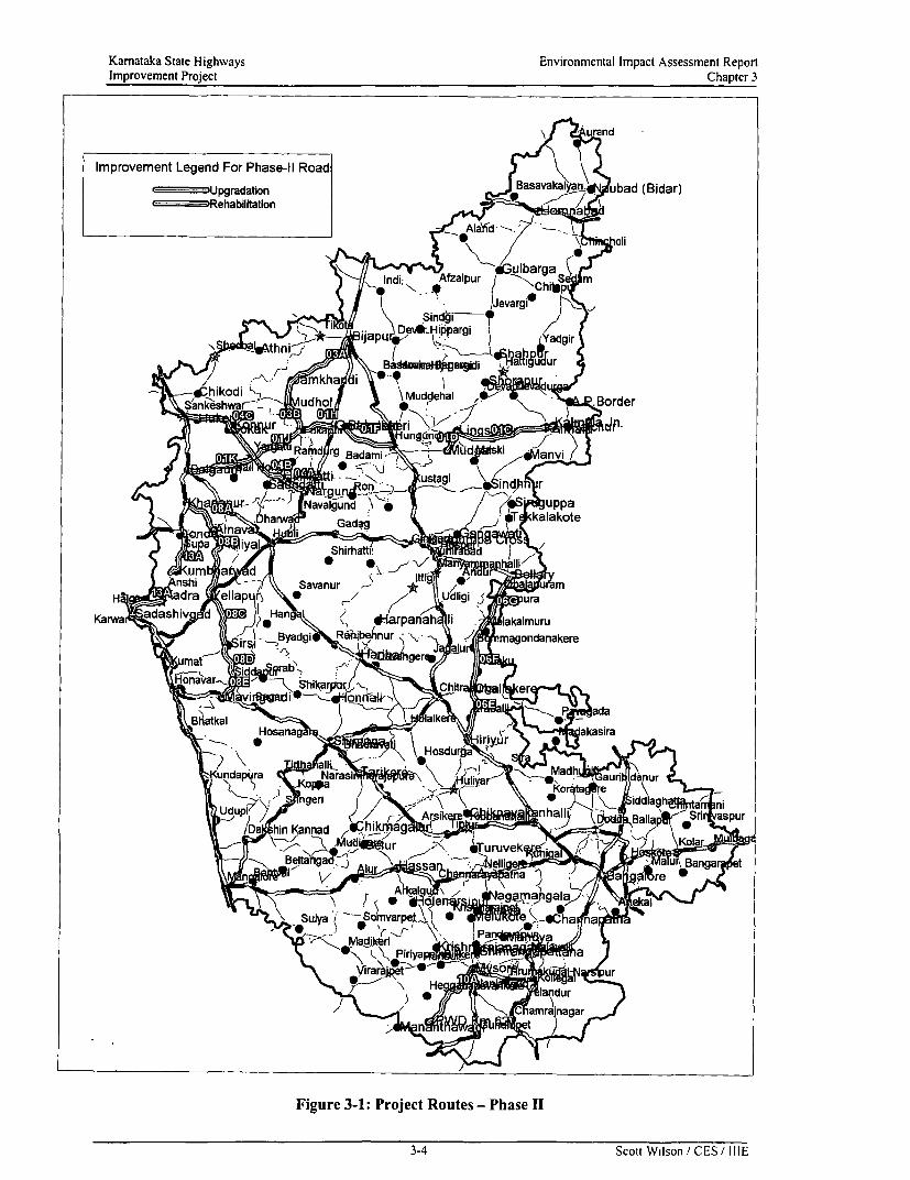
Kamataka State Highways Environmental Impact Assessment ReportImprovement Project Chapter 3
\ ind
Improvement Legend For Phase-11 Road! G= (impgradation _, asaiv * bad (Bidar)
r-_---Rehabilitation-
Alad ./ - .
l ndi; Afzalpu 8, Lc.
) ,a*4 ) |,NavalguSnd 8 g*bi -p
_u] a / TV,alak~~~Ba odi
4nshioi Mud-pehSvaur* Hadra ,> nellhap Borderdii friapr
Vundapir =_^_dam
ha uy qS;marei le9 Cakote
nshi) SavanurrW ~ ~ ~ ~ ~ ntVR ldra eapujnadgaig
Fiur31 PHrojctRots-PhseI
9~~~~- RScottnu resn E /II

Karnataka State Highways Environmental Impact Assessment ReportImprovement Project Chapter 3
Table 3-5: Guiding Parameters for Road Upgradation in Semi-Urban & Urban Areas
Cross- Carriageway Paved Unpaved Service Median Drain Emban Berm Ditch TotalSection Type W dth (m) Shoulder Shoulder Duct (m) Width m kment Width Width Widt
2- 3- 4- (m) (m) (m) U.C. C.D Slope (m) (m) h (m)lane lane lane D Width
Urban - 3- - 10.5 1.25 - - 1.85 - - 16.7Lane IIIIUrban -4- -4 14.0 - 1.25 - - 1.85 - - 20.2Lane-Min. 0 °Urban -4- -4 2 x - 1.25 1.20 - 1.85 -; 22.4Lane-Max. 7.5 _____ __
Figure 3-2: Rural Cross Section of the Road
L 1750 ,500L 1200, 1500 L 10Do L 7000 L1000L 1500 L 1200 0D 1750UNLINED UP.SH IP.SHJ CARRAGEWAY 1P.SH] UP.SH] . UNLINED'UDRLAINN 1 PS ]PS1ROADWAY I f DRAINE
3.0 ,2.5% 2.5% 3.0%
RURAL-2-LANE (H < 1.2m)
1800 1500 1000 7000 1000 L 1500 1800.. UP.SH IP.SH' CARRAGEWAY P.SH' UP.SHI
_ 3.0% 2.5% IRAWY2.5%. 3.0%
/~~~~~~~ 1.5 ^1X1.5\
RURAL-2-LANE (H > 1.2m)
L 1250 L 1850 ' 1500 L 7000 1500 1850 , 1250,SDUCDV DRAIN 1 P.SHLDR] CARRAGEWAY tP SHLDU1 C0V.URAIN 1S.JUC
1
2.52 t ROADWAY
VILLAGE-2-LANE
L 1250 , 1850 1500 10500 1500 1850 L1250S DUCT] COV.DRAIN ] P SHLDR1 CARRAGEWAY t ;P.SHLDCV DRAIN 1 S.DUCJ
| t ROADWAY W C l E
I I | ~~VILLAGE-3-LANE
3-5 Scott Wilson, CES,' IIIE

Karmataka State Highways Environmental Impact Assessment ReportImprovement Project Chapter 3
Figure 3-3: Urban Cross Section of the Road
1250 i 850 10500 L 1850 , 1250.AS.DUCT' COV.DRAIN 2 CARRAGEWAY COV.DRAIN 5.DUCT
I ROADwAY2.52_.5%
URBAN-3-LANE
1250 1850 14000 L 1850L 1250
.5 UUCIICOV DRAIN 2 CARRAGEWAY 2.D A 1 S.Ducr
/- 1~~~~~~25 ROADWAY 2=5_
URBAN-4-LANE-MIN
1250 L 1850 , 7500 1200 L 7500 1850 L 1250 LS.DUICTI C ODRAIN CARRAGEWAY ' E1ANCARRAGEWAY COV.DRAIN .
/~~~~~~~25 2-5% \
URBAN-4LANE-MAX
3.5. Options on Construction MethodsSubsequent to submission of the First Interim Report and the Second Interim Report, options onconstruction methods have been examined and the suitable ones were selected. These are importantfeatures of the proposed project and are potential determinants of environmental impacts from roaddesign. While the details will be found in the Final Project Report, some of the critically importantissues are highlighted below.
3.5.1. Pavement OverlayOverlay thickness design has been based on the characteristic deflection determined for each relevantsection of the project road links and as per the Design chart given in IRC: 81-1997.
3.5.2. New ConstructionIn the Second Interim Report, after reviewing several methods, it was decided to adopt IRC 37-1984(extrapolated curves) and cross check the design thickness with AASHTO method.
3.5.3. Treatment AlternativesThe main elements of the construction processes are given below.
Upgradation:
Widening & Strengthening (including raising of embankment): The elements are:* Remove high shoulders & grub out bushes (some trees may get removed);* Remove existing pavement and pavement widening;* Widen road formation to 12-m width:
3-6 Scott Wilson / CES / IIIE

Kamataka State Highways Environmental Impact Assessment ReportImprovement Project Chapter 3
* Construct new wider pavement with paved shoulder, including surfacing andproviding ditches and pavement edge internal drains, wherever necessary; and
* Construct unpaved shoulder filling to the specified camber and width along with thepavement layers as per new cross section.
> Raising of Embankment & New Pavement: The elements are:* Remove high shoulders & grub out bushes (some trees may get removed);* Remove existing pavement and widening;* Widen roadway to 12-m and construct side ditch, if required;* Raise embankment;* Construct new wider pavement and paved shoulder, including surfacing and pave&ment
edge internal drain; andConstruct unpaved shoulder filling to the specified camber and width as per new cross sections.
T7he sections identifiedfor raising wvere selected on the basis of a number of criteria including* Relative height of the existing road formation level (top of subgrade) to the surrounding
ground and likely maximum water table conditions;* Possibility of seepage across the road line;* Presence or likelihood of field irrigation close to the road;* Nature of local soil; and* Possibility or otherwise of improving drainage by means of side drains.
> Widening* Remove high shoulders & grub out bushes (some trees may get removed);* Remove existing widening* Widen road formation and construct side ditch wherever specified;;* Construct new wider pavement with paved shoulder, including surfacing and
providing ditches and pavement edge internal drains, wherever necessary;* Regulate the old carriageway surface (as required) and then surface the full new width
carriageway and paved shoulders* Construct unpaved shoulder filling to the specified camber and width along with the
pavement layers as per new cross section.
Figure 3-4 shows the typical cross section for upgradation sections.
Figure 3-4 : Typical Cross-Section of Upgradation Section
Paved and Paved andUnpaved Unpaved
Shoulder Carriageway Shoulder
2.50 m 3.50 m 3.50 m 2.50 mi
Corridor of Inact
Rehabilitation: Strengthening of existing carriageway width* Remove high shoulders and grub out bushes;* Construct side ditches wherever specified;* Remove poor quality existing road material as instructed on the field;
3-7 Scott Wilson /CES / IIIE

Kamataka State Highways Environmental Impact Assessment ReportImprovement Project Chapter 3
* Re-compact the existing subgrade in widening area. If existing subgrade is not suitable,add selected material (Like WBM) from dismantling of the existing widening or from theborrow areas;
* Reconstruct the widening portion to match the existing pavement;* Regulate the existing pavement surface and existing widening (if not replaced);* Place overlay for entire width of the carriageway;* Construct drainage channel outlets;* Construct shoulder filling to the specified width or to the edge of the existing roadway.
Figure 3-5 shows the typical cross section for Rehabilitation sections.
Figure 3-5: Typical Cross-Section of Rehabilitation Sections
Earthen EarthenShoulder }Carriageway Shoulder
+/ r ~1-1.5 m 3.75 -7.0 m v 1-1.5 m 1\
Corridor of Impact
3.5.4. Cross Drainage Structures ConstructionIn addition to the conventional revetments in the form of pitched grouting and embankment slopestabilisation methods, alternatives in the form of Gabions and Mattresses are being considered.Gabions and mattresses are rectangular units fabricated from a double-twist, hexagonal mesh of zinccoated steel wires. Gabions may be divided into cells by fitting diaphragms that reinforce the structureand make assembly and erection easier. Mattresses are a special type of gabion with a large plan areato thickness ratio. Mattresses are proposed for riverbeds to prevent under scouring and erosion. Use ofthese gabions and mattresses facilitate structural integration with the soil and also promote growth ofvegetation. The structures are highly permeable because of the void size and permit the naturalmovement and filtration of ground water. No skilled labour is required to execute the work as workinvolves filling of rock/stone aggregates into the gabion boxes. Around 10 to 20 percent cost savingare achieved. Figure 3-6 shows the typical design of gabions and mattresses.
3.6. Options on Road Construction MaterialsInformation about existing quarry and other sources of potential road construction materials wascollected by the PCC from the local offices of the Public Works Department throughout the projectarea. Information from other sources and from field observations was also collected. These arepresented in Table 3-6.
The distance and direction of these sites is given with respect to the starting point of each link.Suitability of these materials has been tested. It is important to note the importance of tested bearingstrengths in determining the required thickness of the different parts of the road formation. In theSecond Interim Report, the desired parameters of the different components of the road formation withreference to their thickness have been recommended on the assumption that the available constructionmaterials will have CBR value of 10.
3-S Scott Wilson / CES/ I IIE

kom(awlt.k;t .Stlla' Ilighlw4yls
L'iVititJtimtitat Wtpa).t( s\2'.1t1$<'J'011
linprovcTnciit Project
CIbptcu 3Figure 3-6: Design Details of Gabions and Mattresses for Floor Protection Works
ELEVATION SECTION AT'ASUTMENT
SHDL FMTRSE
DETAIL-1 SCHEDULE OF GABItONS
== IF rs > .s SWa
__ __ I=
SECTION A-AIt_qW.'A,W':*
A CH 1.
.
.4 i - -s; *4 pWt -P - . -
| | ~~~~~~~~~~~~~~~~~~~~~~~~~~~~~~~~~~~~~~~~~~~~~~~~~~~~t u 9/ 2Ms&
M DET/ILS ~~~~~~~~~~~~~~~~~~~~~OF IMA7TTRESSES DETAILS OF GASIONS
P L A N 1-- < < ,, "',<,, '>, t _~~~~~~~~~~~~~~~~31
DETAI1-3 DETAIL-4
_ 3-9 Scout Wil C i-E

Karnataka State Highways Environmental Impact Assessment ReportImprovement Project Chapter 3
Table 3-6: Sources of Common Road Construction MaterialsLink Rock Gravel Sand
IF Sandstone/Granite; Sunkapur Moorum: Thimmapura Quarry 2km Malaprabha river at KmMetal Quarry, 15.8 Km left of left of Km 156 Chainage 177.8 near KamatgiKm 156 BridgeSandstone: Anagwadi Hill Metal Moorum; Borrow pit 0.6 Km left of Thumba Nalla sands at aQuarry, 18 km left of Chainage Chainage 198 distance of 11.0 Km from201 Chainage 145 on Raichur -
Hungund Road.Quartzite; Kyadagere Metal Moorum; Imgalgi Borrow pit 3 kmQuarry, 12 km right of Km left of Chainage 177.8Chainage 167
Moorum: Semekere borrow pit, 18km right of chainage 201
IH Sandstone: Anagwadi Hill Metal Moorum; Borrow pit, 15km from Malaprabha river at KmQuarry, 18 km left of Chainage Km 213 towards Bagalkot and 0.6 Chainage 177.8 , 35 Km from213 km left from Km stone 198. Chainage 213Sandstone: Trap Metal Quarry, Moorum; Semekere borrow pit, 648 km left of Chainage 240 km right of chainage 213Sandstone: Sathegeri Trap Metal Budhe Nalla sands 8 Km fromQuarry, 7 km left of Chainage Km 250 to Right.281 on Yargatti -Yadwad Road
IJ Sandstone: Sathegeri Trap Metal Moorum; Thoranahatti borrow pit Godchi Nalla 6 km from KMQuarry, 7 km lefl of Chainage 8km right of Km 250 on 266 on Right side.281 on Yargatti -Yadwad Road
Moorum; Thaveregere, borrow pit Bunde Nalla, 8km from Km11 km left of Km 281 250 on Right side
IK Sandstone: Sathegeri Trap Metal Moorum: Moorum Quarry at a Parishwad Sand, 25 km fromQuarry, 7 km left of Chainage distance of 4km left of Km 313. Km 340 on Belgaum Dharwad281 on Yargatti -Yadwad Road road and 10 km left to it.
Trap Metal: Alathege Trap Metal Ramnagar river sand at aQuarry 7 Km from Belgaum on distance of 34 km from KmBelgaum Khanapur road 340 off NH-4ATrap Metal; Kamkaratti Quarry at Malaprabha River Sand, 30 km12 km distance from Km 340 on from Km 340Belgaum -Dharwad road.
Trap Metal; Ranakunde andThirthkunde Trap Metal quarry,12 km from Km 340 and 7 Kmoff Belgaum- Khanapur road
3A Trap Metal; Buranpur Trap Metal Moorum; Borrow pit on right side at Bhima River sand, 75 km fromQuarry 7 Km from Km 0.00 on Km 4. Bijapur on Bijapur - SholapurBijapur- Devera Hippargi Road. roadTrap Metal; Quarry 3.7 Km from Moorum; Borrow pit on right sidc at Ghataprabha River sands at aKm 0.00 on Bijapur- Sholapur Km 41. distance of 1.3 km from Km 81Road. to right on Mudhol Yadawad
road.Trap Metal; Trap Metal 5Km Moorum; Borrow pit on right side atfrom Km 39 Km 56.Mudhol trap Metal Quarry at Km80.5
3B Mudhol trap Metal Quarry at Km Moorum; Borrow pit near road on Ghataprabha river sand, 1.2 km80.5 left side at Km 81. 83.5, 93.5, and left of km S3.10 on Mudhol -
96.5 Yadwad road.Chinchakandi sand stone quarrv,I km from Km 91.5 on Lcfi side
3-I10 Scott Wilson / CES ' IIIE

Karnataka State Highways Environmental Impact Assessment ReportImprovement Project Chapter 3
Link Rock Gravel Sand
Sand stone; quarry left of Km94.4, 0.2 km from roadSand stone; quarry left of Km94.4, 0.2 km from roadSand stone quarry at Km 104.5
4A Pink Quartzite; Yekkeri quarry, 8 Moorum; Yekkeri quarry, 8 km Chunchanur Nalla sand, 20 kmkm from Km 100, near Hulikatti from Km 100, near Hulikatti form HulikattiSandstone: Sathegeri Trap Metal Moorum; Khanapur quarry 24.6 km Hampi Holle Nalla sand, 26Quarry, 30 km from Km 30, 7km from Km 82 on Hubli- Bijapur road km form Hulikatti, Km O00to right. on right side. Malaprabha river sand, 19 km
Konnur quarry, 19km from Nargund from Nargund, Km 82, onon Hubli-Bijapur road Hubli-Bijapur road
4C Trap Metal: Dhupdal Moorum: Borrow Pit; 10 Km from Sand: Maldinni River: ataQuarry;2Km from Chainage km Chainage Km 3.2 on Left Hand Side distance of 5 km from28.0 on Right Hand Side Chainage 41.0 on Right Hand
Moorum: Borrow pit; Roadside, at SideTrap Metal: Borgal Quarry ,10 Chainage Km 63.0Km from Chainage 3.2 on RightHand Side Moorum: Melmatti Quarry at a
distance of 4 Km from ChainageKm 28.0 on Right Hand Side
6E Granite Maddakanhalli Quarry: Moorum: Borrow pit near the road Sand: Vedavati River; 18 km23 Km from Chainage km 195.0 at Chainage 210.0 from Chainage Hiriyur onon NH4 and 5 Km to the left. Hiriyur-Dhammapura Road
Moorum: Sanikere Borrow pit at aGranite ; Siddalayyankote distance of 1.0 km on Left HandQuarry: 18 km from Chainage side at Chainage Km 221.8km 201.5 on the Right hand Side
Granite: Sanikere Quarry, 1.0 kmfromri Chainage 221.0 o Left HandSide
6F Granite: Narale Gunte Quarry; 12 Moorum: RayapuraGokatte; IKm Sand: Tuppadkkanahalli Nullakm from Chainage 237.0 on Right Hand Side at Chainage at Chainage Km 282.8
281.0Granite: Hanagal Quarry; I kms Sand: Vedavathi River, at afrom Chainage km 285.5 on Left Moorum: Borrow Pit by the distance of 27 km fromHand Side roadside; 5km from Challakere on Challakere towards Pavagda on
Kumta-Pavadga Road SH 46G Granite: Hanagal Quarry;l Km Moorum: Naga Samundra Tank; Sand: Hagari River; 13 km
from Chainage 285.5 4kms from Chainage Km 297.2 on from Bellary towards NH 63 onRight Hand Side Right Hand Side
Granite; Chikkenhalli Quarry at a Sand: Byrapura Village Nalla;distance of 5 km from Chainage Moorum: Sangankal; 11.6 Km from at Chainage Km 292.4 on Right294.0 on Left Hand Sidc Bellary on Right Hand Side Hand Side
Granite: Sanagal Quarry; 11.6Km from Bellary on Left HandSide
8A Trap Metal: Kamkaratti Trap; Moorum: Nandagad Borrow Pit; by Sand: Ramnagar River; 34 km34.5km from Chainage Kmsl9.3 the road side at Chainage Km 12.0 from Khanapur on NH4A.on Left Hand Side
Moorum: Bakewad Borrow Pit at Sand: Malaprabha River; 2.5Trap Metal: Ranakunde, Chainage km 15.5 km from Chainage km 2.1Thirthekunde Trap metal Quarry,20 km from Khanapur on NH 4A Moorum: Gollihali Borrow Pit aton Left Hand Side Chainage km 22.0
3.6.1. RocksIn most of the links, sources of rocks are available. Granite, gneiss, basalt, quartzite and sandstone arethe common rocks. Amongst these, granite, gneiss and massive basalt are suitable for all purposes.Quartzite and sandstone are more variable in nature and may be used for some specific purposes.
3-11 Scott Wilson', CES / IIIE

Kamataka State Highways Environmental Impact Assessment ReportImprovement Project Chapter 3
3.6.2. Natural GravelMoorum and residual gravel are useful for application for sub-base, subgrade and shoulder material.Figure 3-7 shows the regional distribution of gravel soils in Kamataka. The bearing strengths of theavailable materials have been tested.
3.6.3. SandMost rivers in Kamataka, especially those with dry beds during the greater part of the year havespreads of sand, which are collected for making concrete and lime plaster. These sands get replenishedeach monsoon and there is little shortage in their availability.
3.6.4. Embankment FillAppropriate materials will be drawn from the nearest available location to the construction site.However, highly plastic black cotton soil will not be used.
3.6.5. AsphaltAsphalt for the Project routes are to be brought from Mumbai and Mangalore.
3.7. Options on Cross Drainage StructuresMany cross-drainage structures, like culverts and bridges, are on the project roads. The number ofculverts and bridges proposed to be improved at old locations or to be created anew is noted in Table3-7. Some of these would require improvement or replacement at approximately the same locations.
Table 3-7: Number of New Improved Cross Drainage Structures
Link Culverts Causeways BridgesExisting Improvement New Existing Improvement Existing Improvement
proposed Culverts _ _ proposed ProposedIF 31 28 13 2 2 10 _
1H 28 27 1 - - 14 5IJ 53 16 1 10 21K 110 100 - - 11 4
3A 103 103 9 3 3 34 93B 38 35 3 - - 74A 44 44 - 4 4 114C 158 142 - 4 4 35 116E 21 21 3 - - 19 116F 45 45 8 25 146G 71 71 - - - 50 298A 62 62 6 1 1 6 2
Total 764 694 44 14 14 232 89
3-1' Scott Wilson / CES / IIIE

Karnataka State Highways Environmental Impact Assessment RcportImprovement Project Chapter 3
Figure 3-7: Soil Gravelliness in the Study Area
Legend For Phase-Il
-p Upgradation-Rehabilitation
KARNA TAKA
SOIL GRAVELUNESS 0
Xst< < ,0 -i .
Lecjend % TGA7= w , /Nongravellyorslight(c15%) 60.13
Moderately gravelly( 15-35%) 5.590 ETI-'] 5i& z7wdow W Stronggr3veily,'5-0°:f 31.S.'
_ Rbck land 2.56Settlements
- Wateir bodies
.V itamil Nadu
km 25O0- 50 km* - ~-~--- Dist Dbundary
~-- RowO- River
NBSS8LUP. R.C.. Bangalore
3-13 Scott Wilson / CES / IIIE

Kamataka State Highways Environmental Impact Assessment ReportImprovement Project Chapter 3
3.8. Options on Intersections on Roads for UpgradationAll intersections on the roads selected for Upgradation in Phase-II were studied. Amongst these, 15intersections will require improvement. The list is shown in Table 3-8. Improvement would entailestablishment of smooth gradient into the feeder road from the given main road and widening thepaved surface to allow easy tum for vehicles.
The intersection improvements include:* Widening and improvement of road geometrics for smooth movement of vehicles and enhanced
safety due to better line of sight.* Deceleration and acceleration lanes for vehicles* Separate lane for left tuming vehicles* Road markers like Pedestrian crossing for safety of the pedestrians* Channelising and Directional island
The intersections on the roads selected for Rehabilitation will be made consistent with the given levels.
Table 3-8: List of Intersections for Improvement
Link Location Chainage Intersection with Intersection Type
SH MDR Other RoadIF Kamatagi Bridge 24.45 Hubli T-intersection
_______ ________ ~M DR
I F Almatti Dam Cross 40.86 - Almatti road Y-intersection
I H/ lJ Lokapur 0.00 65 Y- -intersection
IJ Near 0.799 65 Y- -intersectionLokapur(HubliRoad)
Il/I K Yargatti 0.00 - Nargund - 4-armn intersection(MDR)
3A Galgali Road 25.088 Galgali -
MDR3A Jamkhandi Bypass 61.174 Arterial - Y- intersection
starts . Road3A Jamkhandi Bypass 62.963 Arterial - Y-intersection
ends Road3A Mudhol 80.689 SH 18 - Y-intersection
3B Mudhol 1.468 - Anagwadi Y-intersectionMDR
4A Hulikatti 0.00 65 - 4-arn intersection
4C Gokak 44.096 - - Arterial street Y- intersection
4C Gokak 42.853 - - Arterial Street T-intersection
4C Gulapur cross 41.002 - - - Y-intersection
4C Ghataprabha 30.342 - - - 4-arn intersection
6F Challakcrc 0.00 Chitradurga - - 4 arm intersectionSH
6G Hanagal 0.00 Gangavati SH - - 4-arm intersection
6G Hanagal 0.540 Molakalmooru - - Y-intersectionSH
8A Near Alnavar 34.143 34 Y-intersection
8A Near Alnavar 34.974 Dharwad SH - Start of 8B Y-intersection
Note: SH-State Highway; MDR- Major District Road; ODR- Other District Roads
3-14 Scott Wilson / CES/ III E

Karnataka State Highways Environmental Impact Assessment ReportImprovement Project Chapter 3
3.9. Options on BypassesThe PIU envisaged construction of Bypasses for Towns keeping in view the increase in traffic alongthe Project Road following the improvement and to avoid future bottlenecks in the town area. Thesebypasses are being viewed as additional corridors to the existing roads passing through the settlementsto facilitate smooth traffic dispersal. The settlements that are being considered for Bypasses as a partof the Phase II project preparation are described below. Table 3-9 lists the towns for which bypassesare being explored.
Table 3-9: Bypasses under Consideration
SI. No Settlement KSHIP Links1 Mudhol 3A and 3B2 Bijapur 2A, 3A3 Challakere 6E and 6F4 Arabhavi village 4C5 Raichur IA and IB6 Sindhnur 5A, 5B
Separate stand alone EIA and EMP reports will be prepared for the six bypasses.
3-15 Scott Wilson/CES IIIE

Chapter 4Analysis of Alternatives

Karnataka State Highways Environmental Impact Assessment ReportImprovement Project Chapter 4
CHAPTER 4: ANALYSIS OF ALTERNATIVES
TABLE OF CONTENTS
4. ANALYSIS OF ALTERNATIVES ................................................ 4-1
4.1. INTRODUCTION ................................................. 4-14.2. INITIAL PACKAGE OF THE KSHIP ................................................. 4-14.3. ALTERNATIVES SUGGESTED BY PCC ................................................ 4-14.4. IMPACT OF WORLD BANK'S CRITERIA ................................................ 4-14.5. DESIGN ALTERNATIVES ................................................. 4-1
4.5.1. Route Alternatives ................................................ 4-24.5.2. Alignment Alternatives ................................................ 4-24.5.3. Bypass Alternatives ................................................ 4-44.5.4. Cross-section Alternatives ............................................... 4.-4... , , , . ............ _ 4-4
4.6. ALTERNATIVE METHODS OF CONSTRUCTION ..................... .......................... 4-54.6.1. Bridge Construction ............................................... 4-5
4.7. CONCLUSION ................................................ 4-5
TABLE 4-1: TOTAL NUMBER OF TREES IN THE ROW AND THE COI ................................................. 4-2TABLE 4-2: TREES SAVED DUE TO ALIGNMENT SHIFrTS ................................................. 4-2TABLE 4-3: MAGNITUDE OF RE-ALIGNMENT IN UPGRADATION LINKS ...................... ........................... 4-3TABLE 4-4: TREES SAVED DUE TO RE-ALIGNMENTS ................................................. 4-3
FIGURE 4-1: REALIGNMENT IN KUDACHI VILLAGE IN LINK IK ................................................. 4-6FIGURE 4-2: MODIFIED CROSS SECTION IN SOPADLA VILLAGE-LINK IJ ................................................. 4-7FIGURE 4-3: PROPOSED CROSS SECTION ALTERNATIVES IN LINK 6G ................................................. 4-8
ToC-I Scott Wilson / CES / IIIE

Karnataka State Highways Environmental Impact Assessment ReportImprovement Project Chapter 4
4. Analysis of Alternatives
4.1. IntroductionThe constituent road-links of the KSHIP were selected after considering various options as the work ofproject formulation progressed. The objective of this Chapter is to highlight some of the salient issuesconsidered for exercising options.
4.2. Initial Package of the KSHIIPOf the roads identified in the SOS Report that would deserve improvement, the GoK chose to exa,minethe feasibility of 54 road links, their lengths totalling 2490 odd kilometres. The work of ascertainingfeasibility was assigned to the PCC.
4.3. Alternatives Suggested by PCCThe EIRR analysis, placed in the First Interim Report (August 1999), indicated that Corridor 10 and13, two road links of corridor 1, one road link of corridor 4 and three road-links of Corridor-8 did notjustify investments for road improvements based on unit costs used at the time of analysis. Thisreduced the Initial Package of the KSHIP to 46 road-links, totalling 2061-km. The EIRR alsoidentified the road links justifying investment for Upgradation as distinct from Rehabilitation. Basedon the combine ranking technique adopted for the selection of links for improvement, these corridors(totalling about 428 Km of roads) were excluded from the initial phase of the project.
An economic analysis was carried out in November 2000 for the 428 km of unviable links based onthe reduced cost of construction obtained during detailed engineering of phase-I. The reanalysis foundthese road links to be economically viable. The PWD included these road links under the Phase IIRehabilitation in November 2000.
4.4. Impact of World Bank's Criteria
As a part of the negotiation for loan with the World Bank, it was decided that about 942 Km length ofroad should require Upgradation and the remaining 1339 Km would need Rehabilitation. In the FirstPhase, 394 Km of road was chosen by the GoK for Upgradation and 848-km of road forRehabilitation. In the Second Phase, the GoK considered 548 Km for Upgradation and 491 Km forRehabilitation.
4.5. Design Alternatives
The KPCC explored a wide range of design options available for both Upgradation and Rehabilitation.The recommended designs are based on the assumption that the available road construction materialswould have a CBR value of 10. Otherwise, the thickness of the different components of the roadformation would be made to vary. These are given in the Second Interim Report.
Arising from the findings of the Environmental Screening Report, the KPCC thought it advisable tomodify the proposed road design in order to minimise felling of avenue trees. In addition. the need forreducing the designed speed of traffic was accepted in order to minimise the size of land acquisition inavoidable locations.
The project design considered for this project follows the existing alignment of the roads to minimiseland acquisition and social impacts. The deviations from the existing alignment have been necessitatedin certain sections because of the poor road geometry and safety considerations.
Keeping in mind the above constraints the various design alternatives explored are described below:
4-1 Scott Wilson, CES I IIIE

Kamataka State Highways Environmental Impact Assessment ReportImprovement Project Chapter 4
4.5.1. Route Alternatives
Prior to selection for upgradation, the initial set of roads comprising of 2490 km were subjected todetailed economic, environmental and social evaluation and the combined outcome of these studieswere taken into account for selecting the roads for upgradation and Rehabilitation. The selected routesfor upgradation and Rehabilitation were also evaluated in the sectoral environmental assessment and itwas found that the impacts could be mitigated.
The route alternative issue does not arise in any of the selected corridors as these corridors pose theminimum of environmental problems and also available Right of Way is more than the other corridorsunder consideration for improvement. The economic activities in these corridors are also very muchdeveloped as the roads pass through the sugarcane and rice belt of Kamataka.
4.5.2. Alignment AlternativesSince the improvements are envisaged in the existing alignments only there are no major alignmentchanges in the project. The alignment shifts are marginal and have been necessitated as alreadymentioned in section 4.7 due to poor road geometry and safety considerations. In stretches wheresocial problems were anticipated, the designs were modified accordingly. Appendix 6.1 -I list the roadsections where horizontal alignment has been rectified.
The trees that are located in the Corridor of Impact are the only ones that are to be felled. Changing thealignment due to the roadside trees is a constraint because most of the trees that are coming in the COIare at a distance of around 3.5m- 5.5m from the centreline. The stretches where there is off centricwidening from the existing centreline, a few more trees on the edge of the ROW are getting affected.The felling of these trees is inevitable. Table 4-1 below shows the total number of trees in the Corridorof Impact and the existing Right of Way. It is useful to mention here that in Link IK inadequate ROW,poor road geometry and sight distances led to alignment modifications. The modified alignments wentbeyond the existing ROW. This also contributed to felling of additional trees in the COI that is beyondthe ROW. It can be seen that in Link IK the total number of trees in the design COI is more than thenumber of trees in the ROW.
Table 4-1: Total number of Trees in the ROW and the COI
Link Total Number of Trees in Total Number ofthe ROW Trees in the COI
IF 2288 904IH 622 6011J 1050 855IK 3365 35453A 1528 14153B 308 2994A 137 1274C 2111 13106E 1339 10856F 2545 16596G 2583 16248A 2656 1866
Total 20822 15290
However shifting of centreline in certain instances has led to saving of quite a good number of trees inthe project links. The details of number of trees saved in the project roads are listed in Table 4-2.
Table 4-2: Trees saved due to Alignment Shifts
KSHIP Link Design Chainage (Kni) Number of treesretained due toCentreline shift
From to3A 56.0 62.20 81 trees on LHS
4-2 Scott Wilson / CES / IIIE

Karnataka State Highways Environmental Impact Assessment ReportImprovement Project Chapter 4
KSHIP Link Design Chainage (Km) Number of treesretained due toCentreline shift
From to6E 24.9 25.6 7 trees on LHS
28.5 31.35 20 trees on LHS32.3 36.1 5 trees on LHS
Re- alignments beyond the existing Right of Way have been undertaken in road stretches having poorline of sight, inadequate road geometry from safety and Design standards, improvement of acute andreverse curves in the existing alignment and congested urban, semi-urban and rural locations. Realignments have also been considered following public consultations held in the Project Routes. Thevillagers of Basavana Kudachi village (Chainage Km52.8-53.3) in Link 1K expressed their
requirement of an alternate route to ease the congestion in the existing road and to avoid demolition ofresidential houses for widening the road. Re- alignment option has been adopted in Basavana Kudachivillage. Figure 4-1 shows the existing alignment and the alternative alignment proposed. Total Re-alignment considered in the upgradation links are listed in Table 4-3. Total numbers of trees located inthe existing ROW that are not getting affected because of the re-alignments are listed in Table 4-4.Appendix 6.1-1I provides the chainage wise details of the re-alignments.
Table 4-3: Magnitude of Re-alignment in Upgradation Links
Link Length (Km)-IF No re-alignmentIH 1.30IJ 0.80IK 2.003A 1.853B 7.454A 1.104C 2.756E 1.206F 4.006G 1.608A 4.60Total 28.65
Table 44: Trees saved due to Re-alignments
Link Total Number ofTrees saved
IK 203A 73B 44A 124C 1196F 426G 19SA 218Total 441
No cost effective engineering solution other than embankment raising and additional cross drainagestructures could be envisaged as this option has been suggested in low lying area that are often proneto inundation during monsoons and due to uncontrolled discharge of irrigation waters, causing damageto road sub-structure. Moreover, the roads pass through irrigated areas and additional land acquisitionwill be an expensive option. Therefore in areas where embankment construction is proposed. treefelling is also involved. The areas where raising of embankment, pavement raising and modification ofcross section has been included in the Design and is listed in Appendix 6.1-111 of this Report.
43 Scott Wilson i CES,' IIIE

Karnataka State Highways Environmental Impact Assessment ReportImprovement Project Chapter 4
It is worth mentioning here that on average only 28 trees are being felled per krn in the entire project.The project has a comprehensive tree plantation programme that envisages plantation of around 200trees per km. On completion of the construction phase, the tree plantation will begin and add to theaesthetic beauty of the roads.
4.5.3. Bypass AlternativesBypasses for some urban settlements to offer better connectivity have been suggested by the PIU.These bypasses are related to five urban settlements, namely Mudhol (on Links 3A and 3B),Challakere (6E and 6F), Bijapur (on Links 3A and 2A), Raichur (on Links IA and IB) and Sindhnur(on Links 5A and 5B) and one rural settlement, namely Arabhavi on Link 4C.
The environmental assessments of all these bypasses would be covered in separate stand-alone reports.
4.5.4. Cross-section AlternativesThe Cross sections considered for the road improvement have been shown in Figure 3.2 and 3.3 ofChapter -3. These cross sections were designed keeping in mind the minimum road width required asper IRC standards and also the constraints related to environmental aspects, land acquisition and socialimpacts. The carriageway and the shoulder are 12m wide in rural areas and 10 m wide in villages. Inaddition to the carriageway, the drains have been proposed of average width of 1.125 m on both sidesof the carriageway in the rural areas and 2.05m width in the villages.
The carriageway is 7 m wide in urban area. The shoulders will be utilised as parking areas. Covereddrains of 1 .85m width are proposed on both sides of the road. In urban sections like Challakere, whereadequate ROW is available, Dual Carriageway of 7.5m width has also been considered. The totalroadway width varies between 16.7 to 22.4 m in urban areas.
In link IJ at Sopadla village between Chainage Km39.00 and Chainage Km 39.30, the original crosssection consisted of two lane road with carriageway width of 7m and 3 m shoulders with covereddrains and utility ducts in the village limits. This has been modified to a two lane carriageway of 7mwidth with covered drains to reduce the impact on the roadside structures. The drain cross section hasalso been modified in the village limits. The additional section of the drain to accomnmodate utilityducts has been excluded and has led to a additional reduction of the COI by 3.5 m. The abovemodifications were adopted as realignment in this stretch was not feasible. Figure 4-2 shows therevised cross section.
In Link 6G the cross section has been revised in order to retain the existing 5.5m carriageway runningparallel to railway line. The existing carriageway is retained as one lane and a new carriageway of5.5m width with both paved and unpaved shoulder has been proposed as a parallel lane. Additional5.0m wide median is proposed to separate the left and right carriageway. The designs haveaccommodated the existing avenue plantation consisting of mature Neem trees in the median andthereby avoided felling of trees in a stretch of about 5Km. The total number of trees saved betweenChainage Km 40.60 and Km 45.30 is 159. Figure 4-3 shows the revised cross section and thecorresponding chainages where the modifications have been introduced.
The existing alignment necessitated modification in the proposed design in link 8A because of thecontinuous row of avenue plantation on both sides of the road. The new alignment has been shiftedsuitably depending upon the side where continuous row of avenue plantations is observed. Appendix6.1 lists all the locations in the Project Corridor where modification of cross section has beenundertaken.
4-4 Scott Wilson / CES / IIIE

Karnataka State Highways Environmental fmpact Assessment ReportImprovement Project Chapter 4
4.6. Alternative Methods of Construction
4.6.1. Bridge ConstructionFor river protection works in addition to revetments in the form of pitched grouting and embankmentstabilisation, protection measures in the form of gabions and mattresses have been proposed.Mattresses have been proposed on the riverbeds to prevent scouring and erosion. These structures arehighly permeable because of the void size of the mesh and moreover as the fill material required isstone/rubble, it saves on procurement of construction material like cement etc and water. Anotheradvantage of these structures is their efficiency increases with age. Further consolidation takes place assilt and soil collect in the void and the vegetation establishes itself. These structures are also eco-friendly. Over a period of time, natural cementation takes place in the structures facilitating the gr'owthof grasses and other plants. These alternatives are cheaper compared to conventional revetments.
4.7. ConclusionThe pointed reference to the diverse criteria used for discovering the alternatives summarises theprocesses under consideration.
4-5 Scott Wilson / CES/ 1II E

Karnataka State Highways Environmental Impact Assessment ReportImprovement Project Chapter 4
Figure 4-1: Realignment in Kudachi Village in Link 1K
|Re-aligned section | /9
n l n zr ~I T n
4 Towards Belgaum] Basavana Kudachi Village] Towards Yargat
4-0 Scott Wilson / CES / IIIE

Karnataka State Highways Environmental Impact Assessment ReportImprovement Project Chapter 4
Figure 4-2: Modified Cross Section in Sopadla village-Link 1J
1.BSm 1 7.Om i1.85mDRAIN CARRIAGEWAY . DRAIN
2.5% 2.5St%
4-7 .. Scott Willson / CES III1E

Kamataka State Highways Environmcntal Impact Assessment ReportImprovement Project Chaptcr4
Figure 4-3: Proposed Cress Section Alternatives in Link 6G
CROSS SECTION 8 4ECH:7.850 TO CH:B.550 .CJ5 DRG.1
CROSS SECTION iBEtWEEN CH:37.900 TO 38.500C15 DRG2
CROSS SECION BETWEEN CH:39.90C TO 40310 CH:44.430 TOM47.07D. CH.49.650T0 50.700
CIS DRG.3
CROSS SECTIOUN BETIWEEN CH:41.820 TO CH:44A3.CH:47.070 TO Ct4&450 & CH:49.100 TO CH:49.650
CIS ORGA
CROSS SECTION BETWEEN CON03O0 TO 41.820 & CH:48.45 TO CH:49.1 DOC/S DRG.5
= _
CROSS SECTIOw BEOTWEEN CH:50.7O7 TO 51.1W0Ot.51.450 TO CH:52242
CIS DRG.6

Chapter 5Baseline Environmental Set up

Karnataka State Highways Environmental Impact Assessment ReportImprovement Project Chapter 5
CHAPTER 5: BASELINE ENVIRONMENTAL SET UP
TABLE OF CONTENTS
5. BASELINE ENVIRONMENTAL SET UP .. ...... .................................. 5-1
. 1. INTRODUCTION .. 5-15.2. PHYSICAL RESOURCES ..-
5.2.1. Physiography. .5-15.2.2. Geology .............. -.-. 5-15.2.3. Seisinicitv . 5-5.2.4. Climate .. 5-25.2.5. Temperatzire . 5-55.2.6. Raiifall . 5-55.2.7. Direction of Wind ......... . 5-S5.2.8. Ambient Air Qualit .. 5-65.2.9. Ambient Noise Level . 5-175.2.10. Drainage System.I -95.2.1 1. Soil . 5-23
5.3. ECOLOGICAL RESOURCES .. 5-235.3.!. Flora.5-245.3.2. Fatna .5-30
5.4. HUMAN USE VALUES .. 5-305.4.1. Land tse .5-30
5.5. SOCIAL ENVIRONMENT .. 5-315.5.1. Demograpihic Featuires ............................................ - 5-325.5.2. Occiupational Pattern .- 335.5.3. Econtomic Profile of the Region .5-365.5.4. Regioncal and Local Utilities along the Project Rouites .5-375.5.5. Religiouis antd oth/er Sensitive Strictures alotng rtie Project Rotutes .5-3 7
5.6. PUBLIC HEALTH ................................................ . 5-375.7. ACCIDENT HAZARDS AND SAFETY .. 5-385.8. AESTFIETICS ................. .............................. 5-385.9. SITES OF TOURIST AND ARCHAEOLOGICAL INTEREST .. 5-38
TABLE 5-1: TOPOGRAPHY ALONG T}IE PROJECT CORRIDORS. 5-1TABLE 5-2: GEOLOGY OF THE STUDY AREA. 5-1TABLE 5-3: TEMPERATURE RANGE (IN CENTIGRADE) ........ -- ..... ............................................................. ...... 5-5T,ABLE 5-4: RAINFALL PATTERN IN THE STUDY AREA ........................................................................ S 5TABLE 5-5: AMBIENT AIR QUALITY STANDARDS (NATIONAL) ............. ..................................... 5-6TABLE 5-6: LOCATION OF AMBIENT AIR QUALITY MONITORtNG STATIONS .................................................. 5-13TABLE 5-7- AMBIENT AIR QUALITY MONITORING RESULTS ............................................--.-.-- 5-16
TABLE 5-8: NOISE LEVEL (AMBIENT AIR QUALITY STANDARDS) ........... ................................ 5-17
TABL E 5-9: AMBIENT NOISE LEVELS MEASUREMENT STATIONS .......................................... 5-18TABLE 5-10: AMBIENT NOISE LEVEEL ............................................ -- - --- 18TABLE 5-1 1: SURFACE WAATER SAMPLING LOCATIONS ........................................... 5-19
TABI.E 5-12: DRINKING WATER- SPECIFICATION- IS 10500: 1991 ........ ................................... 5-20T.\I1LE 5-13: AMBIENT QUALITY OF SURFACE WATrER ........................................... 5-21
T.\BiiE 5-14: SOIL CI IARACTERISTICS OF TIlE STUDYARA ........................................ 5-23TABI31 5-15: SPECIES OF TREES IN TIIE STUDY AREA.......... .. .... 5-24................ --- . --- - .. 5-24Tr.\BLE 5 5-16: RESERVE FORESTS NEAR PROJIECT RolTCS ................-.................. I ................................................ 5-25T.\IlLIE 5- 17: COCNION 0WIILD FAUNA IN TlrE STUDrm AREA ......................................... 5-'0AIt- 5-1 : LAND USE IN THE STUDY AREA .5-3........................................ S31
rAII.Iw 5-19: DE[MOG RAPI Ic FEArURES OF 11I SS I) YARA .......................................... 5-32TA\I3i1 5-20: DENIOGRAPIIIC FE.ATURES OTI- n:Tm)k-NS OI TIII SIruI) AREA .................................................. 5-32TAB\I 5-21: LITERACwYSTATllS- RURAL POP'1.,A HION IN Hit: SSrt'IDYCORRIDORS ............................................ 5-33
TA . 5-22: WORKFORCtE IN RURAL ARIA .................. . . . ............- 5-33T.\ABII1 5-23: WORKFOR1E IN URFAN TRACTS . - - 5-34I\131 1 5-24: 0(cI1\ IION P.\ rTIrRN 01: MAIN WOKRKIRSIN RIut \.I rRACIS .................................................... . 5-35
FoC- 1 Scoll WViison, CES, IIIE

Karnataka State Highwvays Environmental Impact Assessment ReportImprovement Project Chapter 5
TABLE 5-25: OCCUPATION PATTERN OF MAIN WORKERS IN URBAN TRACTS .................................................... 5-35TABLE 5-26: MAJOR FUNCTIONS OF THE TOWNS ............................................................ 5-36TABLE 5-27: ARRIVAL OF AGRICULTURAL PRODUCTS IN MARKETS ............................................................ 5-37TABLE 5-28: PLACES OF TOURIST INTEREST IN THE CORRIDORS .................................... ........................ 5-39 -
FIGURE 5- 1: PHYSIOGRAPHY OF THE STUDY AREA ............................................................ 5-3FIGURE 5-2: GEOLOGY OF TFIE STUDY AREA ............................................................ 5-4FIGURE 5-3: 24 HOURS RAINFALL ............................................................ 5-7FIGURE 5-4: WIND ROSE DIAGRAM - BIJAPUR IMD STATION ............................................................ 5-8FIGURE 5-5: WIND ROSE DIAGRAM - BELGAUM IMD STATION ............................ ................................ 5-9FIGURE 5-6: WIND ROSE DIAGRAM - GADAG IMD STATION ............................................................ . -10FIGURE 5-7: WIND ROSE DIAGRAM - CHITRADURGA IMD STATION ............................................................ 5-11FIGURE 5-8: WIND ROSE DIAGRAM - BELLARY IMD STATION .................................... ........................ 5-12FIGURE 5-9: AIR, NOISE AND WATER MONITORING LOCATIONS ............................................................. ...... 5-14FIGURE 5- 10: DRAINAGE BASINS OF THE STUDY AREA .............................................................. 5-22FIGURE 5-1 1: SOIL TYPE OF STUDY AREA ............................................................ 5-26FIGURE 5-12: FOREST AREA BY TYPES ALONG THE PROJECT ROUTES ............................................................ 5-27FIGURE 5-13: FOREST AREA IN PROJECT ROUTES ............................................................ 5-28FIGURE 5-14: NATIONAL PARKS AND WILDLIFE SANCTUARIES IN PROJECT ROUTES .................... ..................... 5-29
TOC-2 Scott \Vilson i CES i IIIE

Karnataka State Highways Environmental Impact Assessment ReportImprovement Project Chapter 5
5. BASELINE ENVIRONMENTAL SET UP
5.1. IntroductionThe study area considered for the project covers a 7-km wide swath on either side of the project routesfollowing the existing alignment. Information on physical, biological, social environment, humanresources, economic environment, cultural heritage and aesthetics was collated and analysed. Primaryand secondary data were collected on the above features. The reconnaissance survey enabled theconsultants to identify the various critical locations where primary data on Air, Noise, Water and Soilquality were to be generated for impact assessment and prediction. At these locations monitoring ofthe ambient conditions were done. All these information together provide understanding on thebaseline environmental set up.
5.2. Physical ResourcesPhysical resources refer to physiography, geology, climate, drainage system and soil. In the followingsub-sections, an attempt has been made to describe the attributes of the twelve road links in this regard.
5.2.1. PhysiographyThe routes selected for upgradation pass through the Central and Northern Kamataka Plateau, westernKamataka and Eastern Kamataka. The topography traversed by the different routes is noted in Table5-1 in summary form. The distribution of physiographic features has been shown in Figure 5-1
Table 5-1: Topography along the Project Corridors
Link Location TopographyIF Hungund -Bagalkot Undulating TerrainIH Gaddankeri-Lokapur Undulating Terrain1J Lokapur-Yargatti Undulating Terrain1K Yargatti- Belgaum Rolling and hilly Terrain3A Bijapur- Mudhol Undulating Terrain3B Mudhol-Lokapur Undulating Terrain4A Hulikatti-Nargund Flat Terrain4C Sankeshwar-Yargatti Undulating Terrain6E Hiriyur-Challakere Undulating Terrain6F Challakere-Hanagal Undulating Terrain6G Hanagal- Bellary Undulating Terrain8A Khanapur- Alnavar Gently undulating Terrain
5.2.2. GeologyThe geological formations in Kamataka are of varied types and the project routes pass through manytype of rock formations. The major types of lithology are the Ancient Gneiss complex consisting ofgranitic and granodioritic rocks, the Kaladgi formnation. Deccan Trap and the Dharwarian SchistQuartzite formation. The geological formations along the routes have been listed in Table 5-2. InFigure 5-2, the distribution of geological formations has been shown.
Table 5-2: Geology of the Study Area
Link Location Geological Formation Rock TypeIF Hungund -Bagalkot Gold Bearing schist, Kaladgi Schist Quartzite, Limestone,
formation and younger Granitegranites
IH Gaddankeri-Lokapur Kaladgi forrnation Limestone, dolomitelJ Lokapur-Yargatti Kaladgi formation and Shale, Quartzite, Basalt
Deccan Trap1 K Yargatti- Belgaum Kaladgi tormation. Deccan Limestone, Basalt
5-1 Scott Wilson / CES / IIIE

Karnataka State Highways Environmental Impact Assessment ReportImprovement Project Chapter 5
Link Location Geological Formation RockT eTlTrap
3A Bijapur- Mudhol Deccan Trap Basalt, Limestone3B Mudhol-Lokapur Deccan Trap and Kaladgi Basalt, Limestone
formation near Lokapur
4A Hulikatti-Nargund Older Gneiss Complex with Granite, Greywacke, chertscattered Dhanvar schist belt
4C Sankeshwar-Yargatti Deccan Traps and Kaladgi Basalt, Shale.___ _ _ formation
6E Hiriyur-Challakere Dharwar schist belt, Older Schistose rock, greywacke,Gneiss complex, Younger limestone GraniteGranites
6F Challakere-Hanagal Older Gneiss complex, GraniteYounger granites
6G Hanagal- Bellary Younger Granites, Younger GraniteGneiss complex
8A Khanapur- Alnavar Older Gneissic Complex and Granite, greywacke, chertDharwar schist Belt
5.2.3. Seismicity
Following the recent Gujarat Earthquake, the seismic zoning of entire country has been revised.Following this revision most of the regions coming under Zone I have been placed under Zone II, i.e.,to higher propensity of seismic disturbances compared to Zone I.
The peninsular India, of which Kamataka formns a part, has remained comparatively quiet and leastaffected by earthquakes of great intensity. This does not however mean that earthquakes arecompletely ruled out in this region. The greater part of Kamataka falls within Zone II and Zone III,which are normally affected by mild tremors, not causing damage to life or property.
Links IF, 1H, 4A, 6E, 6F come under Zone II. Links IJ, IK, 3A, 3B and a small stretch of Link 6Gbetween Hanagal and Bellary and 8A fall in Zone III. It can be safely concluded that none of theproject roads are passing through zones that are prone to frequent earthquakes of high intensity.
5.2.4. Climate
The climatic zone known as the North Interior Kamataka zone covers Bijapur, Bagalkot, Dharwad andBelgaum districts. This zone experiences semi-arid tropical steppe type of climate. Here rainfalldeclines from east to west. This region is hot with temperature ranging between 45°C in the summersand a low of around 10°C in the winters. Links IF, IH, IJ, IK, 3A, 3B, 4A, 4C and 8A pass throughthis region.
Chitradurga and Bellary District fall in the South interior Kamataka climatic zone. This regionexperiences hot, seasonally dry tropical savannah climate. Links 6E, 6F and 6G pass through thisregion. The meteorological parameters influencing the climate and having a bearing on the roadenvironment are discussed in the following section:
5-2 Scott Wilson / CES ,'1 IE

Kamataka State Highways Environmental Impact Assessment ReportImprovement Project Chapter 5
Improvement Legend For Phase-Il Roads
Upgradaton NRehabilitation
Physiographic Regions AO Coastal Dc
Malnad o ,NortheBm MaidanJ
El Southem Maidan } ~
AF~~~~~~~~~~~~~ 0
IE + 0
I'tA tS _______5 c
I~ X I~ 2 I~ ~ %O°0°I~A Xlg
I ~~~~~~~~~~~~~~~~~~~~~~~~~Scott WiIsonICES/IIIE
I ~~~~~~~~~Figure 5-1: Physiography of the Study Area
5-3 Sconi Wilson ICl:S / 111lE

Kamataka State Highwvays Environmental Impact Assessment ReportImprovement Project Chapter 5
Figure 5-2: Geology of the Study Area
Legend For Phase-il
Upgradation- Rehabilitation
0 GEiCOILOG;Y S
-Mohorachtro a>-* l
Prodooh
-°E Tv.tIoy to Oumloda.Occcn Trom
Goo _i opCSic
a>4 p ~~~~~~~~~~~~~~~~~~~YUC, G nnis OltCa
-o g q a tS < 9 6 C " (~~~~~~~~~~~anumt smeecb -d
Qro, IIto PI
_.~~~~~~~~~~~~~~~~~~~1 to2 W B sdtSoi
Om Gia fcam!a
4%ofni Sdo uI
5-4 Scott Wilson / CES / IIIE

Karnataka State Highways Environmental Impact Assessment ReportImprovement Project Chapter 5
5.2.5. TemperatureIn Table 5-3 annual variation in temperature has been shown.
Table 5-3: Temperature Range (In Centigrade)
Link Location Mean Maximum Nlean IMD StationMinimum .
IF Hungund -Bagalkot 32.9 20.6 BijapurI H Gaddankeri-Lokapur 32.9 20.6 BijapurIJ Lokapur-Yargatti 32.9 20.6 BijapurIK Yargatti- Belgaum 30.1 18.5 Belgaum3A Bijapur- Mudhol 32.9 20.6 Bijapur -
3B Mudhol-Lokapur 32.9 20.6 Bijapur4A Hulikatti-Nargund 31.7 20.0 Gadag4C Sankeshwar-Yargatti 30.1 18.5 Belgaum6E Hiriyur-Challakere 30.3 20.2 Chitradurga6F Challakere-Hanagal 30.3 20.2 Chitradurga6G Hanagal- Bellary 33.2 22.1 Bellary8A Khanapur- Alnavar 30.1 18.5 Belgaum
5.2.6. RainfallThe principal part of annual rainfall is experienced during the Southwest Monsoon, covering theperiod between June and September. Some amount of rainfall is also available during the Northeastmonsoon. In Table 5-4 the rainfall pattern and the expected maximum rainfall in 24-hours along theroutes has been shown. Regional variation of maximum rainfall in 24-hours is presented in Figure 5-3.Flash floods are experienced during cloudbursts.
Table 54: Rainfall Pattern in the Study Area
Link Annual Normal Rainfall (mm) 24-Hour Maximum Rainfall (mm)I F 594 2801 H 575 2801J 542 2401 K 1376 3203A 542-565 240-2803B 542 2404A 545-629 240-2804C 568-630 240-2806E 458-524 2406F 524-557 240-2806 525-557 240-2808A 1780 320-400
5.2.7. Direction of Wind
Kamataka is generally windy. Dry ploughed fields suffer from soil drifts. Wind velocity increasesduring the period of Southwest Monsoon, often reaching 60 Km per hour. The dominant trend over theyear is however from Southwest to Northeast. In most of the places the wind direction changes tosome extent in the course of the day. Annual Wind roses for Bijapur, Belgaum, Gadag and BellaryIMD station are shown in Figure 5-4 to
5-5 Scott Wilson/CES/ IIIE

Karnataka State Highways Environmental Impact Assessment ReportImprovement Project Chapter 5
Figure 5-7.
5.2.8. Ambient Air Quality
The ambient air quality along the routes was carried out in the month of March and Apnrl 2001. Theprocedure used and the findings from monitoring are narrated below.
Ambient Air Quality Standards: The Central Pollution Control Board has specified the Parameters to bemonitored and their permissible limits in the ambient air depending upon the location of the proposed project.
The various parameters considered for ambient air quality monitoring are Suspended Particulate Matter (SPM),Respirable Particulate Matter (RPM), Oxides of Nitrogen (NO,), Sulphur Dioxide (SO2 ), Carbon Monoxide
(CO), Hydrocarbon (HC) and Lead (Pb) in air.Table 5-5 lists the standards prescribed for Ambient Air Quality. Limits have not been prescribed forhydrocarbons in the ambient atmosphere. These have been used as datum for ascertaining the qualityof ambient air in the project area.
Table 5-5: Ambient Air Quality Standards (National)
Pollutants Time-Weighted Concentration in ambient airAverage Industrial Residential, Rural & Sensitive
Area other Areas AreaSulphur Dioxide(SO2) Annual Avg. 80pIg/m3 60pg/m3 15pg/m3
24 Hours** 120,ug/m3 80pg/m3 30pg/m3
Oxides of Nitrogen(NO,) Annual* 80pg/m3 60pg/m3 ISpg/m3
24 Hours** 120pg/m3 80pg/m3 30pg/m3SPM Annual 360pug/m3 140psg/m3 70pg/m3
24 Hours"* 500, g/m3 200pg/m3 I00pg/m3RPM(Size<I0pm) Annual 120pg/m3 60ptg/m3 50ptg/m3
24 Hours"* 150lgIm3 100pg/m3 75pg/m3
Lead(Pb) Annual I gg/m3 0.75pg/m3 0.5pg/m3
24 Hours"* 1.5pg/m3 Ipg/m3 0.75pg/m3
Carbon Monoxide(CO) 8 Hours* 5mg/m3 2mg/m3 Img/m3
I Hour 1Omg/m3 4mg/m3 2mg/m3Source: Standards for liquid effluents, gaseous emissions, automobile exhaust, noise and Ambient Air Quality,Central Pollution Control Board,PCL/4/1995-96* Annual Arithmetic Mean of minimum 104 measurements in a year taken twice a week 24 hourly at uniformlinterval
2** 4 hourly/8 hourly values should be met 98% of the time in a year. However, 2% of the time, it may exceedIbut not on two consecutive days.
i-6 (Scott Wilson, CES i IIIE

Kamataka State Highways Environmental Impact Assessment ReportImprovement Project Chapter 5
Figure 5-3: 24 Hours Rainfall
Legend For Phatse-II
-- Upgradation-Rehaoilitation
. ,NIT Cg4004 .1A
ISOHYEETS IN mm,,r, o
n~~~~~~~~~~~~~~ o\n Ae
" djJ^ T b U R X g ' > >~~~~~L .A
hTs~~~~~~~~~~~~~ 320 3G0 ATN
.SAW- ( Uo g ^
1-~~~~~~~~~~~~~IV U
*g~~~~~~~~~~~~~~~~~8
s! 5~~~~~~~~~~~~~4
400~ BL ,PA'T
fAL~TB ' {K
400 ~ ~ ~~ __
400'44~~~~~~ > 2ct ilo ESIII

Kamataka State Highways Environmental Impact Assessment ReportImprovement Project Chapter 5
Figure 5-4: Wind Rose Diagram - Bijapur IMD Station
N30
25
NW NE20
15
w ~~~~~~~~~~~~~~~~~~~~~~~~E
SW SE
|= 0830Hrs Calm 10%A - - 01 73OHrs Calm II%
S
5-S Scoll WVilson I CES! IIIIE

Karnataka State Highways Environmental Impact Assessment ReportImprovement Project Chapter 5
Figure 5-5: Wind Rose Diagram - Belgaum IMD Station
N35
30
NW 25 NE
20
15
10
w ~~~~~~~~~~~~~~~~~~~~~~E
SW SE
S
S-') Scott Wilson; CES IIIE

Karnataka State Highways Environmental Impact Assessment ReportImprovement Project Chapter 5
Figure 5-6: Wind Rose Diagram - Gadag IMD Station
N35
30
NW 25 NE
20
15
W } _ < > F E r
SW SE
S|+ i-0 83OHrs Calm 11%
-1| -0173OHrs Calm 7%
5-I() Scott NVWilson., CES / III E

Karnataka State Highways Environmental Impact Assessment ReportImprovement Project Chapter 5
Figure 5-7: Wind Rose Diagram - Chitradurga IMD Station
N35
30
NW 25 NE
20
15
10
W~~~~~~~~~~~~
Y E
SW SE
4 + 083OHrs Calm 13%-0 -0173OHrs Calm 12%
5-1 I Scott Wilson / CES i IIIE

Kamataka State Highways Environmental Impact Assessment ReportImprovement Project Chapter 5
Figure 5-8: Wind Rose Diagram - Bellary IMD Station
N25
20NW NE
'\I \ 15
10
W E
SW SE
+-083OHrs Calm 26%-0 01730Hrs Calm 11%
S
5-12 Scott Wilson / CES/ IIIE

Kamataka State Highwvays Environmental Impact Assessment ReportImprovement Proiect Appendix 5.1
Appendix 5.1: Accident Data pertaining to Upgradation Project Routes
| Link |YWear | sNo. of Fatal Injuries Vehicles involved Nature ol'Accident [ V'ehiclesl |Accidents Accidents MFlajor MINinorl | [ Damaged
Start 1996 = - Two Wheeler Pcdestrian
1997 0
1998 0 _ _
1999 1 I Tractor Pedestr_an
K m 239 _ _ _ _ _ _ _ __ _ _ _ _ _ _ _ _1996 0
1997 0
1998 2 Truck B ETus Hcad-on1999 4 4 Tractor - Pcdesirian
Link 1K 1996 1 Bus Oil Tanker Side Swipe 2
Start 1997 0 - - I
point _ _ _ _
1998 2 _ Motor Cycle r PcdcstrianBus - Pcdestrian
1999 4 _ Bus - Passengecr (ucing down from_________ ______ ______________B u s)
Borewell Tanker Bicycle Rear End CollisionTruck - Passengcr-lop-Electric Wire-
2000 0 _ - , S o
Link3Aj _ i T _ I I
61.3 1997 3 I Truck - PcdesirianI I IIII Bus Pedal Cycle Rear End Collision 1
1998 0 - - - - - I
1999 4 Truck Truck Rear End Collision 2
Truck Truck Rear End Collision 2
|_____ |2000 3 1 Trax Motor Cycle 2
63.00 1997 8 1 I | |2 Bus Truck Head-on 2
Two Wheeler Jeep Side Swipe _____
1998 4 I Jeep Bullock Cart Sidc Swipe I
II I I BBus | Pedestrian
Truck | Ovenumr|_____ |1999 I I Motor Cycle - Pedestrian
|_ _ _ _ I i_ _ _ _ I i I !__ _ _ _ _ _ _ _i
80.9 1997 3 Truck Pedestrian_____ - l l lI Bus Pedal Cycle Rear End Collision
I I __ 1998 1 -- - - -1999 4 Truck Truck Rear End Collision 2
Truck Truck Rear End Collision j 2
| j 2000 | 3 | | t I ! Trax Motor Cycle | 12 .
|~~~~ ~ ~~~~~ ~~~~ ~~~ !__|_j I I i-i83 1 1997 S 0-I - I -1
L 1998 1 0 1 - I - I II III
Scott NN'ilsont/CES.'IIIE

Karnataka State Highways Environmental Impact Assessment ReportImprovement Project Chapter 5
Location: The sampling stations were selected after considering the spatial relationship of the variousland uses with the existing alignment of the highway in accordance with IS Guidelines (BIS: 5182,1985). Due consideration was given to the traffic density in the area and the commercial activity in theregion. Suitability of fixing the High Volume and Respirable Dust Sampler at the chosen location inrelation to the meteorological parameters was also examined. Every location is on down-winddirection. The Sampling Stations were selected to cover the densely populated urban, semi urban andrural areas. The locations of Ambient Air Quality Monitoring Stations with the criteria used for theirselection are shown in Table 5-6. The locations of monitoring stations have been shown in Figure 5-9.
Table 5-6: Location of Ambient Air Quality Monitoring Stations
Link Monitoring Location by Settlement Distance from Height from Description of,jocationStation Chainage Profile Ceutreline Ground level
. . ~~~~~ ~~(Km) (m) (m)IF AQ-I Aminagadh Semi-Urban 10 6 On LHS, commercial structure,
(13.5) commercial area with mediumtraffic movement, road conditiondegraded. Area generally windy
1H AQ-2 Gaddankere Rural 12 8 On LHS, commercial structure,Cross near NH 208 intersection, medium
(Near Starting to heavy traffic movementpoint)
1J/1K AQ-3 Yargatti Rural 10 6 On RHS, commercial structure(0.12 Km) near Yargatti junction. Medium
traffic. Land use mixture ofagriculture and scatteredsettlements
1K AQ-4 Sambra, Urban 12 5 On RHS, Residential structures,Belgaum commercial cum residential area
(47.8) with heavy traffic.3B AQ-5 Mudhol Urban 8 5 On RHS, Commercial Structure,
(0.5 Km) near Edwards hospital, heavycongestion due to movement ofheavy vehicles and non motorisedtraffic and poor traffic management
3B AQ-6 Lokapur Rural 10 5 On LHS, Commercial structure,(21.92 Km) junction with SH -20, commercial
area with poor traffic managementand degraded road. Area generally
_______________ ~~~~~~~~~~~~windy4C AQ-7 Sankeshwar Urban 12 5 ON RHS, Commercial structure,
(0.35 Km) near Bus and Taxi stand. Taxistand by the roadside, two-lanecarriageway with broken shoulders.Area generally windy
6E AQ-8 Hiriyur Semi-Urban 12 5 On RHS, Opposite KPTCL office,(0.4 Km) medium traffic movement,
residential area.6F AQ-9 Challakere Urban to 6 On LHS, road condition degraded
(0.28 Kni) with damaged shoulders,conmmercial area with irregularparkiing and congcstion in the formof pedestrian and non -motorised
. . . ~~~~~~~~~~~~~~~~~~~~~~~~traff-ic. Area generally very windv6G I AQ-10 Bellary Urban 8 5 On LHS, residential cum
(52.2 Kni) comercial area, heavy trafficI_______________ ________________ ________________ m ovem ent and congestion
8A AQ-1 I Bidi Rural 1I) 5 On LHS, commcrcial area, State(17.55 Kim) Highway intersection.
Note: RHS = Right hand sidc LHS = Lcft land side
5- 13 Scott Wilson / CES t IIIE

Karnataka State Highva's Environmental Impact Assessment ReportImprovement Project Chapter 5
Sampling and Testing Methods: The measurement techniques employed for carrying out the ambientair quality measurements are outlined below in brief.
Suspended Particulate matter (SPM) and Respirable Particulate Matter (RPM) were measuredusing High Volume sampler and Rcspirable Dust Sampler respectively by collecting 8 hourly samplesfor 72 hours. The RPM was collected on EPM 2000 Filter paper.
Sulphur Dioxide was measured by employing the method prescribed in IS: 5182 Part II, Method II(Improved West and Gaeke method) and 8 Hourly samples were collected for 72 hours. SO, isabsorbed in Sodium tetrachloromercurate. The absorbed SO2 is estimated by colour produced whenpararosaniline-HCL is added to the solution. Absorption is measured in a spectrophotometer andcompared with calibration curve.
Oxides of Nitrogen were measured by employing the method prescribed in IS: 5182 Part IV (Jacoband Hochheiser modified method). 8 hourly samples were collected for 72 hours. Ambient air isbubbled through NaOH solution to form stable Sodium nitrite. Nitrite produced is determinedcolorimetrically with phosphoric acid, sulphanilamide and NEDA reagent.
Carbon Monoxide was measured as per IS: 5182 Part X. Ambient air sample was collected in asealed rubber bladder fitted with an air valve. Subsequent analysis is done at laboratory using GasChromatography technique.
Hydrocarbon was analysed as per IS: 5182 Part XVII. Ambient air sample was collected in a sealedrubber bladder fitted with an air valve. Subsequent analysis is done at laboratory using GasChromatography technique.
Lead in air was analysed by collecting the sample in EPM 2000 Filter paper. The filter papercontaining particulate is leached in nitric acid and filtered. The solution is made to a known volumeand aspirated in to the air/acetylene flame. The standard solution is prepared in a similar manner andreadings are taken at 217 nm.
Ambient Air Qualitv Monitoring Results: The ambient air quality monitoring results are presentedin Table 5-7. The maximum, minimum and average values of each parameter for each of themonitoring locations are presented in the table. The major findings are briefly noted as foilows.
Suspended Particulate Matter (SPM): The SPM level in all the monitoring locations is well beyondthe limits specified for residential, rural and other areas i.e. 200 JLg/M 3 . Slow movement of traffic andpedestrian traffic dust entrainment due to the damaged condition of the carriageway and broken anddegraded earthen shoulders also contribute to high SPM concentration. Localised wind pattern andvelocity and driftince nature of the soil also contribute to the high levels of SPM in the area.
Respirable Particulate Matter (RPM): The data shows that the average level is within the prescribedlimits of 100 ptg/nm in AQ-4 and AQ-8. The RPM level in all other locations arc very high. In additionto the slow movement of traffic and pedestrian traffic dust entrainment due to the damaged conditionof the carTiageway and broken and degraded earthen shoulders also contribute to high RPMIconcentration. Localised wind pattern and velocity aiso conltribute to the high levels of RPM in thearea.
Oxides of Nitrogen (NO,): The data shows that the level is wvell within the prescribed limits ot' S0jIg/nil flr rtesidential areas in all the monitoring statiotns.
I Scolt WVilson (TS 1111
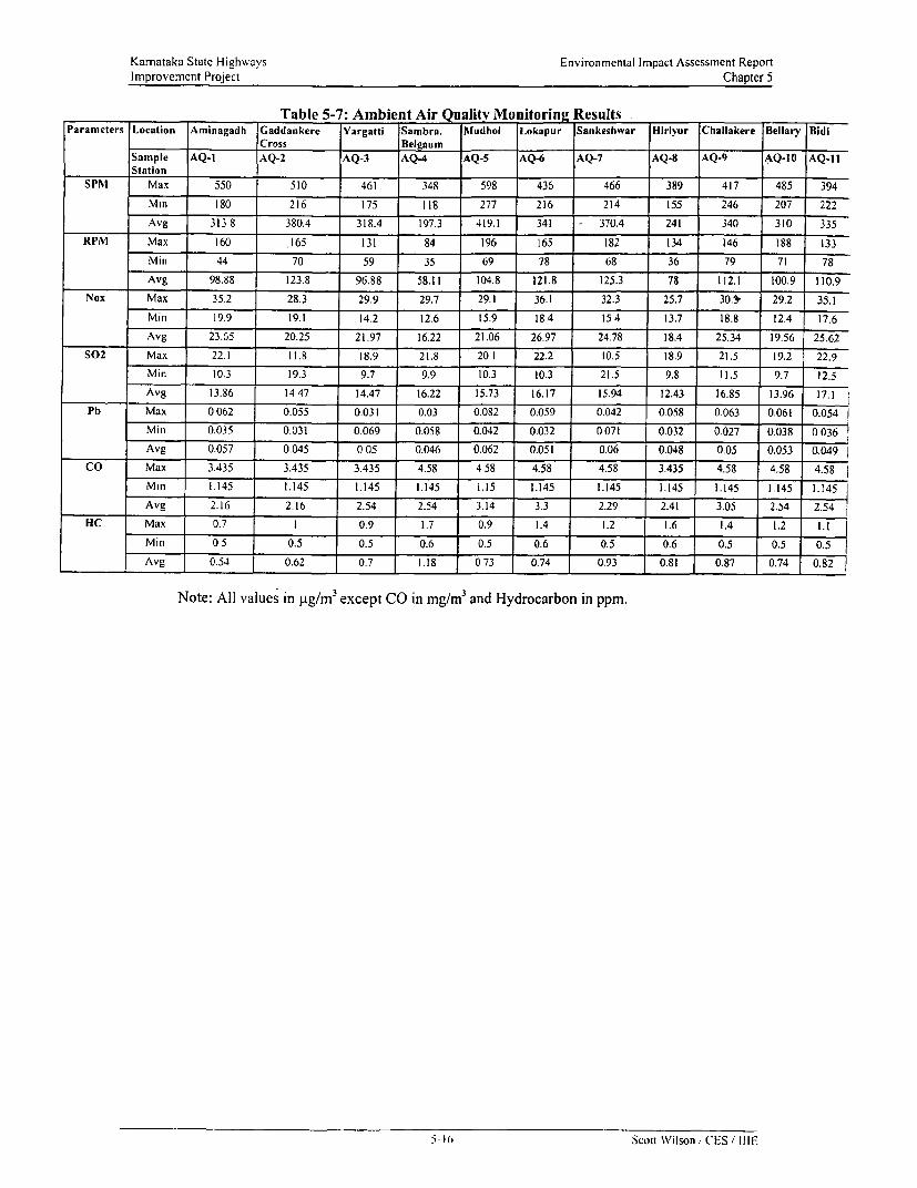
Karnataka State Highwvavs Environmental Impact Assessment ReportImprovement Project Chapter 5
Table 5-7: Ambient Air Qu ality Monitoring ResultsParameters Location Aminagadh Gaddankere Yargatti Sambra. Mludhol Lokapur Sankeshwar Hirivur Challakere Bellary Bidi
Cross Belgaum _Sample AQ-1 AQ-2 AQ-3 AQ4 AQ-5 AQ-6 AQ-7 AQ-8 AQ-9 AQ-10 AQ-11Station
SPM1 Max 550 510 461 348 598 436 466 389 417 485 394
Mm 180 216 175 118 277 216 214 155 246 207 222
Avg 313 8 380.4 318.4 197.3 419.1 341 370.4 241 340 310 335
RPM Max 160 .165 131 84 196 165 182 134 146 188 133
Min 44 70 59 35 69 78 68 36 79 71 78
Avg 98.88 123.8 96.88 58.11 104.8 121.8 125.3 78 112.1 100.9 110.9
Nox Max 35.2 28.3 29.9 29.7 29.1 36.1 32.3 25.7 30.1 29.2 35.1
Min 19.9 19.1 14.2 12.6 15.9 184 15 4 13.7 18.8 12.4 17.6
Avg 23.65 20.25 21.97 16.22 21.06 26.97 24.78 18.4 25.34 19.56 25.62
S02 Max 22.1 11.8 18.9 21.8 20 1 22.2 10.5 18.9 21.5 19.2 22.9
Min 10.3 19.3 9.7 9.9 10.3 10.3 21.5 9.8 11.5 9.7 12.5
Avg 13.86 14 47 14.47 16.22 15.73 16.17 15.94 12.43 16.85 13.96 17.1
Pb Max 0 062 0.055 0.031 0.03 0.082 0.059 0.042 0.058 0.063 0.061 0.054
Min 0.035 0.031 0.069 0.058 0.042 0.032 0 071 0.032 0.027 0.038 0 036
Avg 0.057 0.045 0 05 0.046 0.062 0.051 0.06 0.048 0.05 0.053 0.049
CO Max 3.435 3.435 3.435 4.58 4 58 4.58 4.58 3.435 4.58 4.58 4.58
Mm 1.145 1.145 1.145 1.145 1.15 1.145 1.145 1.145 1.145 1.145 1.145
Avg 2.16 2.16 2.54 2.54 3.14 3.3 2.29 2.41 3.05 2.54 2.54
HC Max 0.7 I 0.9 1.7 0.9 1.4 1.2 1.6 1.4 1.1
Mi 05 0.5 0.5 0.6 0.5 0.6 0.5 0.6 0.5 0.5 0.5
Avg 0.54 0.62 0.7 .18 073 0.74 0.93 0.81 0.87 0.74 0.82
Note: All values in p.g/m3 except CO in mg/rn3 and Hydrocarbon in ppm.
5-01 Scoit Wilson, CES / IIIE

Karnataka State Highways Environmental Impact Assessment ReportImprovement Project Chapter 5
Sulphur Dioxide (SOJ): The data shows that the level is well within the prescribed limits of 80 gg/m 3
for residential areas in all the monitoring stations.
Lead in air (Pb): The lead level in ambient air is well below the prescribed limits of 1.0 p.g/ for'residential areas in all the monitoring stations.
Carbon Monoxide (CO): The average CO level on all the monitoring stations are well within theprescribed limits of 4 mg/mr3 for residential areas. However, the peak concentration reaches beyond4.0mg/m3 in all the locations except in AQ-1, AQ-2, AQ-3 and AQ-8.
Hydrocarbons (HC): The HC level ranged between 1.7 and 0.5 ppm across the monitoring stations.
5.2.9. Ambient Noise LevelTo determine the existing Ambient Noise level in the study area extensive noise level measurementwere carried out as per the guidelines of the CPCB and the requirements of the MoEF. Themethodology adopted for the sampling and monitoring and various other parameters in selection of themonitoring stations are discussed in the subsequent sections. The discussion begins with anintroduction to the prescribed standards of the CPCB with respect to Ambient Noise levelmeasurement.
Ambient Noise level Standards: The measurements should yield hourly averages during day-time(0600 to 2100 hrs.) and night-time (2100 to 0600 hrs.) over 24-hours on two days interspersed by atwo-day interval in a given week. These are shown in Table 5-8. These were used as datum toascertain the quality of ambient noise in the project area.
Table 5-8: Noise Level (Ambient Air Quality Standards)
Area Category of Limits in dl (A LeqCode Area Day Time Night Time
A Industrial area 75 70B Commercial area 65 55C Residentiai area 55 45D Silence area 50 40
Note: (1) Daytime is reckoned in between 6 a.m. and 9 p.m.; (2) Night time is reckoned in between 9p.m. and 6 a.m.; (3) Silence zone is defined as area upto lOOm around such premises as hospitals,educational institutions and law-courts. The silence zones are to be declared by the competentAuthority. Use of vehicular homs. loud speaker and bursting of crackers shall be banned in thesezones. (4) Mixed categories of areas should be declared as one of the four above-mentioned categoriesby the competent authority and the corresponding standards shall apply.
Location of monitoring stations: The Noise level measurements were carried out at select locationsin the routes in the month of March and April 2001. The sampling stations were selected consideringthe location of sensitive areas and receptors like residential areas, Hospitals educational institutionsand government institutions like courts and Rest Houses. Due consideration was given to the trafficdensity in the area and the commercial activity in the region. The average distance of the monitoringlocation was about 10-15 m irom the centre line of the carriageway. The Sampling Stations wereselected to cover the densely populated urban, semi-urban and rLural areas. The Noise levelmeasuL-ements locations with their selection criteria are shown in Table 5-9. Figure 5-9 shows theNoise Monitoring Locations.
eleastirement Technique: Portable sound level meters with a built in capacitance microphone wereutllised for measuring the ambibent noise level in the location. 'T'he measuremiients were recorded every5 minute interval and the equivalent sound pressure level were calculated for 8 hour cycles for 72houIrs. The eight-h1our cycles were devised based upon tlhe day and night-time duration and the
5.17 Scott Wilson / C'ES i111 E

Karnataka State Highways Environmental Impact Assessment ReportImprovement Project Chapter 5
movement of traffic during the course of the day. The three cycles considered are from 0600-1400Hours, 1400-2200 Hours and 2200-0600 Hours. The results are shown in dB (A) Leq i.e. indicating thecontinuous equivalent sound pressure level in the area.
Table 5-9: Ambient Noise levels Measurement Stations
Link Noise level Location Settlement Chainage Distance Description of Locationmeasurement Profile (KIm) from
Station Centrcline(m)
IF NL-I Aminagadh Semi-Urban 13.30 10 On RHS, near AminagadhPolice Station, Residential andCommercial area. -
IH NL-2 Gaddankere Rural 0.0 10 On RHS, near traffic junctionCross
1J/IK NL-3 Yargatti Rural 0.10 10 On LHS, near Yargatti_____________________________ junction
1K NL-4 Sambra, Urban 48.00 10 On LHS, residential cumBelgaum commercial area with traffic
movement3A NL-5 Mudhol Urban 0.300 10 On LHS, King Edwards
Memorial Hospital,commercial area with heavytraffic movement.
3B NL-6 Lokapur Rural 21.70 10 On RHS, PWD InspectionBungalow, mixed land usewith medium traffic movement
4C NL-7 Sankeshwar Urban 0.65 10 On LHS, Near PWD RestHouse, moderate traffic.
6E NL-8 Hliriyur Semi-Urban 0.30 15 On LHS, Primary school,KPTCL Residential Townshipwith medium traffic.
6F NL-9 Challakere Urban 0.58 12 On LHS, near ChallakereAmma Temple.
6G NL-10 Bellary Urban 52.10 0 On RHS, APMC office withheavy traffic
8A NL-1 I Bidi Rural 17.40 10 On RHS, primary school
RHS: Right Hand Side, LHS: Left Hand Side,Noise level Monitoring Results: In Table 5-10, the ambient noise level monitoring results are shovn.All the values are expressed in dB (A) Leq.
Table 5-10: Ambient Noise level
Noise level Duration |Monitoring 0600-1400 Hours 1400-2200 Hours 2200-0600 Hours
StationNL-1 64.96 61.22 57.47NL-2 63.70 64.17 62.14NL-3 62.33 61.35 53.99NL-4 58.73 56.72 52.83N L-5 64.29 63.60 54.84NL-6 59 08 59.77 49.16NL-7 59.14 57.43 46.50NL-8 56.42 53.11 52.59NL-9 62.30 62.06 53.51NL-10 60S6 56.90 55.08NL-1 I 58.63 59.22 48.66
The noise levels ranged betwecri 46.5 - 64.96 dB (A) Leq. Higher noise levels were recorded duringthe daytime and evening hours. During daytime the noise level was below the prescribed limit of 65dB(.A\) Leq for commercial areas. T he noise level was slightly higher than the prescribed limits duringnight at NL- I, NL-3, NL-4 and NL-5. The ambient noise level in these urban centres is high due to thecommercial activity going around in the town. The main contributors to the noise are the roadsideshiops playing their music systems. the vehicles blaring their horns. Lack of landuse control and poortownl polanning and lax implementation ot noise nuisance control laws by the enforcing agencies have
5-IS Scott Wilson/ CES, IIIE

Karnataka State Highwavs Environmental Impact Assessment ReportImprovement Project Chapter 5
also resulted in congestion, encroachment and unwanted noise nuisance in sensitive areas like schoolsand hospital zones.
The sensitive zones like educational institutions, hospitals and health centres located near the projectroads are listed in Appendix 6.2.
5.2.10. Drainage System
The State of Kamataka has two major drainage basins of the Krishna and the Cauvery. The ProjectRoutes are located in the Krishna and Tungabhadra basin. In Figure 5-10, the locations of the majorbasin and their tributary basin are shown.
Water Resources along the Project Routes: The project routes cross many small seasonal andperennial streams. Link IF crosses Malaprabha River near Kalatgi village. Link 3A crosses RiverKrishna at Chikkapadasalagi village. The adjoining region is served by canal irrigation. Link 4Ccrosses Ghataprabha near Gokak. A very good network of canals is seen between Jamkhandi andMudhol in Link 3A. Water for construction purpose can be easily sourced from the rivers and streamsthat flow through the corridors. Malaprabha, Krishna and Ghataprabha can ensure adequate water forconstruction.
Inundation of roads during monsoons and uncontrolled flow of irrigation water is seen in Link 3A and4C. This happens mainly in areas where the existing culverts are clogged with weeds and debris. Manyculverts lack adequate vent size to accommodate increased run off during cloudbursts or from theirrigated fields. In the irrigated areas seepage of water has led to the collapse of road formations and inthe process the shoulders have become higher than the carriageway. During rains the water flows onthe roads and the road functions like a drain. Inadequate maintenance of the roads and lack of roadsidedrains result in the inundation of adjacent areas during heavy rains.
The stretches where the existing road level is less than the adjoining ground level and whereembankment raising has been proposed is given in Appendix 6. 1-III.
Water Quality: Water sampling was carried out at four locations along the selected routes to assessthe ambient wvater quality. The four locations where sampling was carried out are listed in Table 5-11.
Table 5-lI: Surface Water Sampling Locations
SI.No Link Location Design Chainage (PWD Cliainage)I 3B Ghataprabha River, 8.369(89.90)
south of Mudhol
2 4C Ghataprabha River. 41.93(101.28)Near Gokak
3 6E Garani Halla, south of 31.689(228.2)Challakere
4 6G Chinna Hagari River. 7.458(293.5)North of Hlanagal River,
Water qualitv standard: The drinking water standards for potable water are prescribed under IS-10500: 1991. The parameters and their limits thereof are presented in Table 5-12. These have beenused as datLuim to assess the quality of wvater in the project area.
Surface XVater Quality Results: The results of the water quality analysis of the four stations arepresclted In Table 5-13. The sampling wvas carried out in the month of March 2001. The concentrationof' all the parameters are well withini thc prescribed limits of the drinking water standards. It is anindicator that water in the streams and rivcrs is still unpolluted and wvhatever variation is observed isduc to natural causes and seasonal changcs duc to ingress of irrigation water. Pcople in the vicinity useth. \ atc- tor drinkin!' puT)Mose and othel- houschold chores.
5-19 Scott \Wilson (I-S t111E

Karnataka State Highways Environmental Impact Assessment ReportImprovement Project Chapter 5
Table 5-12: Drinking Water- Specification- IS 10500: 1991
Si No SURSTANCE/ DESIRABLE PERMISSIBLE REMARKSCHARACTERISTIC LIMIT LIMIT
COLOUR, HAZEN 5 25 Extended To 25 If Toxic Substance AreUNITS, MAX Not Suspected In Absence Of Alternate
Sources2 ODOUR Unobjectionable a)Test cold and when heated
b)Test at several dilution3 TASTE Agreeable Test to be conducted only after safety has
been established
4 TURBIDITY N T U, 5 10Max
5 pH value 6.5 to 8.5 No relaxation -
6 TOTAL HARDNESS 600 600(as Ca C03 mg/lit)
7 IRON (as Fe mg/lit, 0.3 1.0Max
8 CHLORIDES(as Cl 250 1000mg/lit Max
9 RESIDUAL FREE 0.2 To be applicable only when water isCHLORINE, mg/lit chlorinated. Treated at consumer end. WhenMax protection against viral infection is
required, it should be Min 0.5 mg/lit10 DISSOLVED SOLIDS 500 2000
mg/I, MaxII CALCIUM (as Ca ) 75 200
mg/1 ,Max12 COPPER (as Cu ) mg/I 0.05 1.5
,Max13 MANGANESE(Mn ) 0.1 0.3
mg/l Max14 SULPHATE (As So4 ), 200 400 May be extended up to 400 provided (as
Max Mg )does not exceed 3015 NITRATE (as No3) 45 100
mg/l , Max16 FLUORIDE (as F) 1.0 1.5
mg/I, Max17 PHENOLIC 0.001 0.002
COMPOUNDS (asC6H6OH) mg/l Max
18 ARSENIC(as As ) ,mg/l 0.05 No relaxation To be tested when pollution is suspected19 LEAD(as Pb) mg/l 0.05 No relaxation
20 ANIONIC 0.2 1.0DETERGENTS (asM BAS)mg/l
21 CHROMIUM(as Cr) 0.05 1.0 To bc tested when pollution is suspectedmg/l
22 MINERAL OIL mg/l 0.01 0.0323 ALKALINITY mg/I 200 600
5-20 Scott Wilson; CES / IIIE

Karnataka State Highways Environmental Impact Assessment ReportImprovement Project Chapter 5
Table 5-13: Ambient quality of Surface Water
Parameters Units Monitoring StationLink 3B Link 4C Link 6E Link 6 G
Ghataprabha Ghataprabha Garani Halla Chinna-Hagari
Physical ParametersTemperature °C 37 29 34 32pH 7.2 8.2 8.3 8.4Turbidity NTU <5 10 15 12TSS mg/l 7 28 42 24TDS mg/l 762 88 1305 1275TFDS mg/l 430 47 970 860Organic ParametersDO mg/I 6.2 6.4 6.3 6.2BOD mg/I 5.5 6 7.5 7COD mg/l 16.3 18 22.5 21.2Nitrites + Nitrates mg/l <0.01 <0.01 <0.01 <0.01TKN, Mg/l 12.1 2.6 8 9.52Ammoniacal Nitrogen Mg/l 2.9 3.5 3.5 4Chemical Parameters <1 <1 <1.0 <1Conductivity Micro 1160 134 1986 1942
mho/cmTotal Alkalinity mg/l 125 37.5 413 685Sulphates mg/l 38 8.2 45 48.2Chlorides mg/I 145 12.9 217 168Sodium-- mg/l 136 10.9 369 451Phosphate mg/i 1.2 1.1 2.5 2.1Boron mg/l <0.1 <0.1 <0.1 <0.1Calcium as CaCO3 mg/l 39.3 11.2 22 15.2Magnesium as CaCO3 mg/l 39.1 5.1 36.5 26Total hardness as mg/l 259 49 205 145CaCO3
Anionic Detergents as mg/i <0.01 <0.01 <0.01 <0.01MBASLead as Pb mg/l <0.01 <0.01 <0.01 <0.01Phenolic Compounds mg/l <0.001 <0.01 <0.001 <0.001as PhenolFluoride mg/I 1.4 0.8 2.5 2.4Oil and Grease mg/I <1 <1 2.8 1.9BacteriologicalParametersFaecal Coliform MPNIOml => 1600 => 1600 50 => 1600Tota IColiform MPN/ 0 mnil => 1600 => 1600 50 =>I1600
5I Scott Wilson. CES, 1IIE

Karnataka State Highways Environmental Impact Assessment ReportImprovement Project Chapter 5
Figure 5-10: Drainage Basins of the Study Area
Legend For Phase-ll
UpgradationRehabilitation
DRAINAGE & RIVER. BASINS
ANDNRtA PRADESI4
LEGEND,
Westetn coit'
7 Mali, R- Mr, ' atinacrte}
_ $_ -,08E -'- nvu
*~ ~~~~~~~EA -- !6 - ' ............. :. '' 1a A. of Iondiwr -: 7
a^ Q ~~~~~~-22 Sct W ilsn CESf 9IIIE
, ~~~~~~~~~~~~~~~~Sb1 _¶Vw Bun
; " , ' -' ." , '- ,,, ' '
_ ' 's v ,; - ,
,, .< ;8 .. , - ~ TAMIL NADU,
ICERAL So, _..ioe. Natilonal Atlas od Indiia- 19?.
5-22 Scott Wilson / CES / IIIE

Karnataka State Highways Environmental Impact Assessment ReportImprovement Project Chapter 5
5.2.11. SoilThe State of Kamataka has five major types of soil. These are Coastal Alluvium, Lateritic Soil, DarkBrown Clay Soil, Red Soil and Black Soil. Amongst these, the Project Routes do not traverse CoastafAlluvium and Dark Brown Clay Soil. Within each major group of soils, the relative incidence ofargillaceous and clastic materials varies. The distribution of the major groups of soil along the projectroads is shown in Figure 5-1 1. The basic features of soil along the routes are given in Table 5-14.
Borrow material will have to be sourced from approved quarries by the contractors during constructionand in the event that it is sourced from private land then the area has to be restored to its originalstatus. Necessary conditions will be incorporated in the contracts for ensuring the restoration ofborrow pits in a suitable manner. The stretches where embankment raising has been proposed may beprone to erosion during monsoon, however with proper compaction and stabilisation followed byturfing and regular maintenance can prevent slippage and soil erosion. The road stretch whereembankment raising is proposed is listed in Appendix 6.1 -IV.
Table 5-14: Soil Characteristics of the Study Area
Links Soil Type DescriptionIF, 1H, 6E, 6F Deep Black Soil Deep, moderately well drained, calcareous cracking clay to
silty clay soils, moderately to severely susceptible toerosion
IH, IJ 3A, 6E, and 8A Medium Black Soil Moderately deep, moderately well drained, non-calcareouscracking clay to silty clay soils, moderately to severelysusceptible to erosion
iJ, tK, 3B, and 4C Shallow Black Soil Shallow, well drained clay loam, severely susceptible toerosion
3A Red Clay Soil Deep to moderate deep and shallow, well drained toexcessively drained, yellowish brown, gravelly sandy loamto sandy clay loam and loamy sand surface soils andgravelly sandy clay to sandy to clay subsurface soils,moderately to severely susceptible to erosion
I K Lateritic Gravelly Deep, well drained to excessively drained, sandy clay loamSoil to sandy clay and clay surface soils and sandy clay to clay
sub surface soils, moderately to severely susceptible toerosion
6E, 6F and 6G Alluvio-colluvial Deep, moderately well drained to poorly drained,soils calcareous, cracking clay soils associated with stratified
soils with contrasting textures observed along the streams.Dark greyish brown to very dark greyish brown and strongbrown, clay to sandy clay and clay loam surface soils.Saline and sodic in patches.
6E, 6F and 6G Red gravelly clay soil Deep to moderate deep and shallow well drained toexcessively drained yellowish brown dark red to reddishbrown, gravelly sandy loam to sandy clay loam and loamysand surface soils. Moderate to severely eroded.
SA (Northern part) Brown forest soil Deep moderately deep, wvell drained to excessively drained,dark brown to dark yellowish brown and black sandy clayto sandy clay loam and sandy loam, humus reach surfacesoil. Slightly eroded.
5.3. Ecological Resources
The ecological resources refer to tlora and fauna and social impacts upon these. The project routespass through the central. eastern and westem region of Karnataka, which are characterised by mediumto low rainfall. These areas experience arid climate. Dry deciduous vegetation and xerophytesrepresent the flora in such regions. The rainfall determines the vegetation. open forest canopy that isverdant during the monsoon turns leafless to avoid loss of water due to transpiration. The Bellary,
5-23 Scott Wilson / CES ,' IIIE

Karnataka State Highways Environmental Impact Assessment ReportImprovement Project Chapter 5
Chitradurga (Link 6E, 6F and 6G) region is characterised by dry deciduous and thorn and scrubvegetation. The vegetation is a mixture of Acacia, Albizia species and thormy scrubs. The Belgaumregion (Link 8A) is characterised by moist deciduous vegetation. While in leaf the canopy of thesetrees is dense, during the dry period months there is a short period of leaf fall. Over the past fewdecades the forests are subject to heavy pressure from firewood extraction, grazing and fauna.Introduction of irrigation in these tracts (IF, IH, 3A, 3B, 4C) has also altered the ecology of thisregion and large areas previously uncultivated and under forests has bome the brunt of extensivefelling and conversion into agricultural lands. The flora and fauna found in the study area aredescribed below. Figure 5-12 shows the Forest Area by types along the project routes. There are noNational Parks and Wildlife sanctuaries along the upgradation project roads.
5.3.1. FloraThe area traversed by these roads is poorly vegetated. As a result of the expansion of agriculture andits allied activities, the natural vegetation in the plains has been greatly reduced. The common speciesseen by the roadside are Azadirachta indica (Bevu or Neem), Tamnarindus indica (Hunsemara orTamarind), Acacia nilotica, Acacia ferruginea, Dalbergia sissoo, Termninalia chebtula, Albizia lebek,Albizia ainara, Ficus benghalensis, Ficus religiosa and Prosopis juliflora. The forest departmentunder the social forestry programme has undertaken Acacia auriculiformnis and Eucalyptus plantationin link 3A and 8A. Table 5-15 lists the various tree species found in the study area.
Table 5-15: Species of Trees in the Study Area
Scientific Name Family Kannada NameAcacia auriculiformiis Mimosaceae Bangali jaliA cacia ferniginea Mimosaceae BannimaraAcacia lezucophioeae Mimosaceae BilijaladamaraAcacia ntilotica Mimosaceae KarijaliAcacia latronunt Mimosaceae GonajaliA egle ,nar,telos Rutaceae Bi lipatraAgave sisalana Agavaceae KattaleAlbizia amzara Mimosaceae TugaleAlbizia lebek Mimosaccae BageA lbizia odoralisstua Mimosaceae BilwaraA rtocarputs heterophvllus Moraccae HalasuAzadirachia imdica Meliaccae Bevu (Neem)BIambusa anrndiniacea G ramineae BidruBaui,inia racemosa Si maroubaceae BasavanapadaBombax ceiba Caesalpiniaceae BurugadamaraBorassuis flabellifer Palmae TalemaraButlea monosperma Papi I ionaceae MuttugadamaraBorassusflabellifer Palmae TalemaraCalotropis gigantea Ascelpiadaccae BcsharamCassia fisrla CaesalpiniaCeac KakemaraCassia sia,nea Caesalpiniaceae SeementangadiCocos nncifera Palmae Tengu (Coconut)Dalbergia sissoo Ebenaccac White BecteDC/loni.Y regia Caesalpiniaceae GulmoharEiucalptius tereticor-uiis Mvrtaccae NilgiriPicias beglighalenisis Moraccac AladamaraFPcics religiosa Moraccac AshwathaGli ricidia sepnim,, Papil ionaccac Gobarad igCLLeaucea /Iciucocepala Mimosaccae Subabul, ladillca Ionigcfolnagf ta indica) Sapotaccae H ippeAlangifera il(lica Anacardiaceac Mavu,lanilkar'e :apota Sa otaccac Chikku
liclhlha chiiaip(aika Magnoliaccac SampigcPhYllanthus cinblica Euphorbiacenc Ncli
I Ponganno puinata Papilionaceac Honge/'h/y)('a,w,( mar-pl Z((-susiun _ 1 Papilionaccac Honnc
| N Igonu co,,,,, _ a.zr~,caccae Neralc (Jamun)I a/)hijllnidx indIica, ': '.ipiniaCCaI-lunsemara
5-24 |Scott Wilson (cIS 1111

Karnataka State Highways Environmental Impact Assessment ReportImprovement Project Chapter 5
Scientific Name Familv Kannada NameTerminalia clhebtula Combretaceae AllallemaraZiziphi s nauiritiauia Rhamnaceae Elachimara (BerZizip Iits ru gosa Rhamnaceae Chotemara
There are roadside social forestry plantations on both sides along Link IK, 3A, 8A. The plantation
consists mostly of eucalyptus, Acacia auriculifor,nis and cashew trees for commercial exploitation.
The State Forest Department under the OECF's Environment improvement programme of Eastern
Karnataka plains has taken up widespread plantation along the roadside and adjoining forest lands and
reserve forests near the roadside. In addition to this the forest department has also undertaken
development of scrub forestlands and done extensive plantations in them. This type of forestry
improvement is seen in links IK, 6F and 6G. The Forest Department has classified these fores]s as
Reserve Forests. These Reserve forests are well beyond the PWD Right of Way and widening of the
existing road will not involve any acquisition of forestland. Table 5-16 below lists the reserve forests
near the project roadsides. These forestlands could be further improved/enhanced under the KSHIP's
afforestation and plantation programme. Adequate budgetary provisions have been made in the EMP
for the afforestation and plantation programme.
Table 5-16: Reserve Forests near Project Routes
Link Chainage Reserve Forests Terrain Type of Vegetation
IH 3.9-5.049 Reserve Forest near Tulasigeri- 10m Rolling terrain Eucalyptus and shrubfrom the roadside vegetation
1K 12.2 Near Halki- 15m from the roadside Undulating Shrub vegetationTerrain consisting of Acacia,
Tamarind, Ficus etc.,6F 34.6 - 42.3 Kamarakaval RF, Rocky and Hilly Scrub vegetation
Forest Boundary 10 m from the ROW consisting of Acaciaedge spp., Eucalyptus and
xerophytes developedby the KamatakaForest Department
6G 15.5 -18.3 Santhebande RF, Rocky and Hilly Scrub vegetationForest Boundary 10 m from the ROW consisting of Acaciaedge spp., Eucalyptus and
xerophytes developedby the KamatakaForest Department
i-?5 Scott Wilson. CES I IIIE

Kamataka State Highways Environmental Impact Assessment RcportImprovement Project Chapter 5
Figure 5-11: Soil Type of Study Area
Legend For Phase-l1
- UpgradationRehabilitation
K: :ARNATAKA.:::..SOILS
Traditional nomenclaiure C - No =3.Red9 [email protected]
-* _ t , ̂ ,, t . .-C. Al!iVvlO.cciUvl solls
o g*j| < '~~~~~~~ - > _ .bgop bIa-k Wii
- ^ *;,- 9.115dium dee_p black solk03A i~~~~~~~~~~~~~~~~~~~1-hlo~w black sAItIs
* q F ., . ; . 1 ,_ . . . 1,AiIuvig.colsivifatstInwoS p
r~ ~ ~ j pi
_i3~^1sir 01H . . . : 2,1te nonq voltty strita;;t#. . C01J ~01F OI 0D OIC , _ . . _ -3,Rcid'gtulljio 64yi611
* * - 04B 04A *._-; -tbcsl
+ , - _ 15 ~~~~~:S.Rellt nnrvally Clary so,U,g
SDF ,. . - _? w . . . 7.Rcd srave~~~~~~~~~~~SJtiJ110 Mflly Clkai sa41s
§ l _ tw j + ~~~~~~~~~~~~~~~~~~~~~i8Cocasbotaluvria ioii5
Wolor bodies
-lahl- 1-11 Sck11s of Scuth Delectcan Plateau06E - . l' - --S.... 12-14.Soils of Western (Ghats
~~~~~~ " ' ' ; 0E'.'s15-17 Soils cot E:fster-n:GhJts-189 Soils of Coastal Plains :
-ii. Tmil Na"du
- iQA kri~~~~~~ 2~~ '~~6 ~~~5o 'kni
- --- R.v7t
, .NBSS&LUP, R-.C.'. 8ar ' 'ore
5-26 Scott Wilson /CES I IIE

Karnataka State Highways Environmental Impact Assessment ReportImprovement Project Chapter 5
Figure 5-12: Forest Area by Types along the Project Routes
Legend For Phase-11
FOR'EST AREABYTPES** - pgraclation
727(18) ,/- Evergreen&VemiEwgr~ee
(1111 MOIST FRES 7
DYECDOS 'OhST
5-27 Scott Wilson/ CES IItIE

Kamataka State Highways Environmental Impact Assessment ReportImprovement Project Chapter 5
Figure 5-13: Forest Area in Project Routes
Legend For Phase-lI
UpgradationRehabilitation
FQREST AREA IN KARNATAK'A.:1-994 95 :::
- GUUARGA. / S +~~~G
g - -t-biJAP~~~UR'- -3
* tJ / ~~~~~~~~~RAICHUR. ..
)HARWAD
t _ .......................... G ZVK > _ j~~~~~~~~~~~~~~~~~~~~~~~~~~~~~~~~~~~~~~~~~~~~~~. .....
*STATrE TOTAV: FOREST AREA P 38i83 GEmoGRAPHICAL AREA_ 0 19-)773~ IN So. KILOMETERS5
5-28 Scott Wilson ICES IIIE

Karnataka State Highways Environmental Impact Assessment ReportImprovement Project Chapter 5
Figure 5-14: National Parks and Wild Life Sanctuaries in Project Routes
Legend For Phase-IlUpgradationRehabilitation
'National Parks& Wildlife Sanctuaries ' in Karnataka - -,
J~~~
N II'A ' ,. . , *-
S - z -S F - .. Y<.. ;
5-29 Scott Wilson/ CES I IIIE

Karnataka State Highways Environmental Impact Assessment ReportImprovement Project Chapter 5
5.3.2. FaunaThe fauna is poorly represented in all the routes. Extension of agriculture has resulted in conversion offorested/wooded areas into agricultural land and in the process fauna is restricted to common specieslike Bonnet Macaques, Langurs, Mongooses, Foxes and Civets etc. Parakeets, Partridges, Pigeons,House Sparrows, Kites, Owls and Crows represent the avian fauna. Cattle egrets, Herons andLapwings are seen near the streams, rivers and the agricultural fields. The reptilian fauna is limited toa few snake species of Cobra, Rat Snake and Land Monitors near agricultural fields and water bodies.The tree dwelling species will be the one that will be affected, as the tree felling will force the fauna tolook for new nesting sites and habitat. But the number of trees affected will be less than the actualtrees in the existing Right of way and adequate design considerations have been taken to ensure thatthe tree felling is kept at minimum. All these species are highly tolerant to disturbance and frequentlylive in proximity to humans and have well adjusted to anthropogenic interference. Table 5-17 lists thevarious wild fauna in the study area.
Table 5-17: Common Wild Fauna in the Study Area
Common Name Scientific NameBonnet Macague Macaca radiataCommon Langur Presbytis entellusSmall Indian Civet Viverricula indicaCormnon Palm Civet Paradoxurus hermophooroditisWolf Canis lupitsGolden Jackal Canis atureusCommon Mongoose Heaepestus edwardsiiIndian Fox Vualpes bengalensisWild Pig Sus scorofaBlack naped Hare Lepes nigricolisIndian Porcupine usstrix indicaFlying Fox Picteral ninaltetesPangolin Maabis crassicankdataIndian CobraNaaspRat Snake Plvas mnt(costisIndian Monitor daraegt1s bengalensis
5.4. Human Use ValuesAs per MoEF Guideline, this section deals with land use of the study area. The land use data of 1991census has been used for deterenining the land ustoe h study area. The data collation pertains to a 14Km wide swath with the road as the centreline.
5.4.1. Land useThe principal land use along the corridor is agricultural in all the routes. Irrigation is more pronouncedin link IJ, 4A, 4C and 8A. Malaprabha and Ghataprabha main canals cater to irrigation in link 4A and4C respectively. Certain pockets depend on g tound cater or irrigation. Ground water is extracted byusing bore iells and wells. About 40% of agicultural land h o in k 4A are under irrigation. The landuse data indicates that there is not much land to be broight under cultivation. Links 6E, 6oand 6Goffer some scopTe Por culivion. growmaximum culturable dasteland is available in link 6F beateenClhallakere and Hanag:al. Another noticeable feature in corridor 3A is the shift from traditional cropslikie p)addy to more productive crops like Sugarcane and orchards of Pomegranates and Grapes. Thiscani be attributed to the opportumity offered by the canal network of Krishna and Ghataprabhadeveloping in these areas. This in turn has led to increase in Sugarcane production. which in turn hasled to establishmient of quite a fewv Suigar Factories in the sLirrounding region. Land not available forCLIltivatioii ranges betwveen 4-24°9, indicating that either the laind is barren and rockov or not suitable forcultivation. The ProsOPijXjuliflora growving by the roadside and planted by the forest department isheavily coppiced and sometimes totally pulled from the ground by the villagers for fodder and
i-3o1 Scott Wilson / C'ES / IIIE

Karnataka State Highways Environmental Impact Assessment ReportImprovement Project Chapter 5
firewood. Localised mining of shale and limestone is observed in link 3B especially between Mudholand Lokapur.
The maximum percentage of Forestland is seen in link 8A. However, there is no forestland by theRoadside in Link 8A. Upgradation of the roads does not involve acquisition of forestlands. In most ofthe tracts forestland has been converted to agricultural land over the past few decades. Links IK, 6Gare characterised by sparse scrub forests and thorny vegetation.The land use pattern in.the study area considered for the various routes that covered all revenuevillages falling in a 14 km wide swath is presented in Table 5-18.
Table 5-18: Land use in the Study Area
(All Area in Hectares)Link Total Forest Area Irrigated area Unirrigated area Culturable Waste Land Not
Area Land Available forCultivation
Area In % Area In % Area In % Area In % Area In %IF 47180.83 6215.26 13.17 489.17 1.04 36601.37 77.58 46.64 0.10 3828.39 8.111H 24598.54 1389.05 5.65 1570.74 6.39 17161.29 69.77 692.17 2.81 2531.4 10.29IJ 84310.28 8417.28 9.98 11586.11 13.74 54914.62 65.13 700.79 0.83 7437.59 8.82IK 84848.87 16025.82 18.89 9371.25 11.04 51564.85 60.77 1415.61 1.67 6471.34 7.633A 126897.9 5677.26 4.47 20119.7 15.86 90611.15 71.40 5749.23 4.53 5018 3.953B 37317.8 2553.59 6.84 5049.54 13.53 25175.83 67.46 327.29 0.88 2957.66 7.934A 40365.31 1793.31 4.44 16036.55 39.73 17974.79 44.53 935.09 2.32 3625.57 8.984C 111445.1 8331.95 7.48 22595.76 20.28 65393.26 58.68 3491.86 3.13 11632.24 10.446E 52978.85 402.87 0.76 4051.48 7.65 39619.93 74.78 4829.9 9.12 4074.67 7.696F 76409.42 3673.42 4.81 6621.96 8.67 41902.73 54.84 17045.71 22.31 7165.6 9.386G 79277.32 9487.71 11.97 7685.29 9.69 46373.65 58.5 10675.1 13.47 5055.57 6.388A 42245.75 10890.85 25.78 4551.61 10.77 16412.51 38.85 170.48 0.40 10220.3 24.19
Source: Village and Town Directory, Census of India, 1991
Substantive point to note in this regard is the progressive reduction of the earlier contrasts noticeablebetween the rural and urban habitats. The dynamics of such change needs appreciation in the contextof designing road improvement strategy. In the first instance, irrigation based agricultural growth hasattracted processing industries in the heretofore rural areas, contributing to the formation of nascenturban settlements. Cotton ginning factories, oilseed expellers, Poultry farms, sugar factories and limefactories etc., are the commonest manifestation in this regard. Best examples of this trend are thetowns of Mudhol and Lokapur in corridor 3, Challakere and Bellary in Link 6F and 6G. Similarly,urban industrial formations have stimulated the neighbourhood agricultural economy to shift towardscommercial cropping. This is widely noticed in Link 3A in and around Bijapur and Jamkhandi.Expansion of, fruit orchards, commercial plantations etc., are the commonest manifestation in thisregard. Each one of these commercial crops is attracting processing industries.
The consequential need to obtain increasing access to the regional and national markets and demandsfor it have been the central consideration of the Government of Karnataka for promoting the roadimprovement programme. Increased traffic is progressively damaging the structurally weak roads,rendering them unusable in many tracts. Hence the need for upgrading these. The road improvementprogramme is certainly going to further stimulate the growvth of regional economy. One majorconsideration in this regard should be to avoid causing environmental degradation. Another matter ofconcern is the ribbon development occurring along the roadsides in the urban, semi-urban and largerur-al settlements. Almost all the roads suffer from encroachment and congestion due to lax applicationof land use control laws and poor ROW management by the PWD.
5.5. Social Environment
klany of the major changes in the environmental set up havc been induced by society. Some of thesehave arrested deterioration in the ecological systems. Some made the system increasingly vulnerable.
5-.31 Scott Vilson / CES / IIIE

Karnataka State Highways Environmental Impact Assessment ReportImprovement Project Chapter 5
All impulses in this regard originated from within the emerging social systems. This has been true asmuch in Kamataka as in all other places of the world.
Propensities in this regard have, however, been different between the societies, govemed as these areby their respective demography, literacy economic occupations and basic amenities, including the ratesof urban-industrial growth. All these features of the social environment along every route have beenrecorded in the following sections.
5.5.1. Demographic FeaturesIn Tables-5.19 and 5.20, the basic features of demography along the study comrdors have beenindicated. Due to the absence of better data, the figures as of 1991 Census of Population havebeenused.
In Table 5-19, care has been taken to depict the average situation obtaining within the Study Area.
Table 5-19: Demographic Features of the Study AreaLocation Total Total Male Total Female Density of Sex Ratio Literacy SC ST
Population Population Population Population (No. of Rate (%) % %(No. of females
persons per per 1000Sq.Km) males)
Karnataka 44977201 22951917 22025284 235 960 56.04 16.38 4.26State I
IF 65602 32939 32263 113 979 43.99 30.78 4.03IH 35599 17778 17821 61 1002 41.01 13.39 1.79
li 132216 67160 63931 335 952 35.29 8.94 3.68IK 229298 117229 110123 368 939 41.23 6.13 4.953A 186801 95586 90474 236 947 37.19 18.70 1.103B 57100 28930 26883 50 929 38.14 17.75 4.264A 62267 31588 30228 213 957 38.18 9.94 3.974C 256430 131255 122022 243 930 3244 13.25 3.136E 72362 37169 35193 127 947 40.98 32.71 11.476F 97197 50098 46977 141 938 33.17 23.86 40.826G 106846 54929 51784 142 943 27.31 21.47 17.138A 87890 44498 43392 178 975 45.29 7.75 1.69
Source: Primary Census Abstract, Census of India, 1991
In Table 5-20, care has been taken to depict the situation obtaining with the urban places. Here UArefers to the urban area, which is larger than the town limits (TL). The data shows that there is ageneral tendency towards formation of urban sprawls. Beyond the town limits, land use control is lessstrict.
Table 5-20: Demographic Features of the Towns of the Studv Area
Name of Link Population Densitv Sex Literacy SC STTowin Total Male Female Persons Ratio rate % %
____ _ _ /Sq.KmHunulLid IF 15391 7799 7592 6522 973 56.59 13.59 2.87Bel-aum UA IK 402412 209411 193001 2597 922 69.14 7.23 2.05Belgaum CD Block 1K 52060 26983 25077 816 929 57.48 8.90 2.61Belgaurn\'IC & OG IK 369177 190964 178213 2601 933 69.30 6.84 2.08Belgautin NMIC IK 326399 168954 157445 3889 932 71.20 6.54 1.98Bijapurl-ULA 2A 193131 100474 92657 2563 922 62.64 11.74 0.66Bijapuri-l-l 2A IS6939 97202 89737 4175 923 63.24 11.35 0.68Jamnklhundi 3A 48143 24214 23929 1055S 98S 54.77 15.39 0.45
5-32 Scoui Wilson CES /1lIE

Karnataka State Highways Environmental Impact Assessment ReportImprovement Project Chapter 5
Name of Link Population Density Sex Literacy SC STTown Total Male Female Persons Ratio rate % %
_ _ _ _ _ _ _ __ ____ _ _ ___ ___ /S g.K m _ _ _ _ _
Mudhol 3A & 3B 31095 15796 15299 8119 969 50.70 19.38 1.12
Nargund 4A 29944 15203 14741 5671 970 44.99 10.54 2.80Sankeshwar-TMC 4C 27244 13969 13275 4284 950 61.14 12.00 0.58Hukeri-TMC 4C 17398 8965 8433 5858 941 51.11 12.44 4.69
Gokak-TMC 4C 52080 26603 25477 7213 958 57.08 6.50 2.89
Hiriyur-TMC 6E 37509 34561 32086 4003 928 56.27 15.28 7.80
Challakere-TMC 6F 38369 20081 18288 5497 9111 56.82 15.01 26.69
Bellary-CMC 6G 245391 126613 118778 3724 938 56.14 14.49 1.87
Khanapur-TMC 8A 14728 7566 7162 4160 9471 64.75 6.92 4.37Alnavar-TMC 8A 14485 7397 7088 1710 958 54.33 9.00 1.37
Source: Primary Census Abstract, Census of India, 1991,TL: Town Limits, UA: Urban Agglomerate, CMC-City Municipal Corporation, TMC-Town Municipal Corporation, MC-Municipal Corporation
Table 5-21 would indicate the status of literacy in the rural areas.
Table 5-21: Literacy Status- Rural Population in the Study Corridors
Route Literate Population % of Female Literateto Total
Male female Total LiterateIF 19167 9693 28860 33.59
IH 9293 5306 14599 36.34
iJ 32224 14438 46662 30.94
1K 61521 33011 94532 34.92
3A 45992 23483 69475 33.80
3B 14085 7692 21777 35.32
4A 16518 7255 23773 30.52
4C 57771 25410 83181 30.55
6E 18745 10912 29657 36.796F 22467 9776 32243 30.32
6G 21064 8114 29178 27.81
8A 25389 14417 39806 36.22
Source: Primary Census Abstract, Census of India, 1991
5.5.2. Occupational PatternIn Table 5-21 to Table 5-23 attempt has been made to show the features of the workforce in the studyarea as well as their relative incidence between the occupational categories that the Indian CensusOrganisation uses. It may be noted that the relative incidence of main workers in all the route-corridorsis higher than that of the State of Kamataka. This indicates that economic functions in these corridorsare more intense than the state.
Table 5-22: WVorkforce in Rural Area
Link Percentage of worker category to TotalPopulation
Main Marginal Non-worker Worker worker
Karnataka 38.45 22.73 38.01IF 43.96 0.99 55.04I H 39.76 5.291 54.94
i --1.1 AScott WilIson I CES i I I I E

Kamataka State Highways Environmental Impact Assessment ReportImprovement Project Chapter 5
Link Percentage of worker category to TotalPopulation
Main Marginal Non-worker Worker worker
1J 43.09 0.00 56.91
1K 39.27 6.08 54.65
3A 38.93 4.27 56.80
3B 43.19 3.44 53.37
4A 44.01 5.07 50.91
4C 38.82 7.97 53.21
6E 43.74 5.05 51.21
6F 43.05 6.15 50.80
6G 46.46 4.05 49.49
8A 40.97 3.89 55.14
Source: Primary Census Abstract, Census of India, 1991
It may be noted in Table 5-23 that except for Nargund in all the urban tracts within the route corridorsthe incidence of main workers is less than the average for the State of Kamataka.
Table 5-23: Workforce in Urban Tracts
Name of Status of % Main % Marginal % Non-Towns The Town Worker Worker Worker
Hungund TMC 29.86 2.72 67.43UA 29.48 0.90 69.62
Belgaum CD Block 32.64 3.86 63.50MC & OG 29.24 0.87 69.90
MC 28.65 0.46 70.89Bijapur UA 24.85 0.49 74.69
CMC 24.72 0.49 74.79Jamkhandi TMC 27.50 0.66 71.84Mudhol TMC 30.68 0.61 68.71Nargund TMC 39.96 1.78 58.26Sankeshwar TMC 31.48 1.84 66.68Hukeri TMC 32.06 0.48 67.47Gokak TMC 28.71 0.76 70.54Hiriyur TMC 32.71 1.54 65.75Challakere TMC 29.97 0.11 69.91Bellary CMC 30.54 0.44 0.32Khanapur TMC 29.83 0.58 69.59Alnavar TMC 30.72 1.03 68.25
Source: Primary Census Abstract, Census of India, 1991, UA: Urban Agglomeration, TMC:Town Municipal Corporation. CMC: City Municipal Corporation. MC: Municipal Corporation
From Table 5-24, it can be seen that agriculture has the largest share of the main wyorkers in the ruraltracts of all the route corridors. Especially in Link IJ, 4A, 4C, 6E and 8A the percentage of cultivatorsand Agricultural labourers accounts for around 80 %fo of the total main wvorkers.
5 34 Scott Wilson .' CES,' IIIE
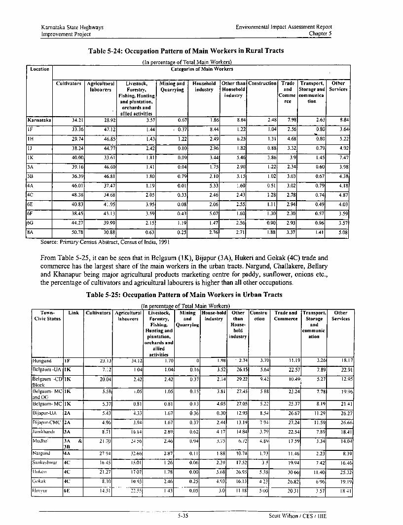
Kamataka State Highways Environmental Impact Assessment ReportImprovement Project Chapter 5
Table 5-24: Occupation Pattern of Main Workers in Rural Tracts
(In percentage of Total Main Workers)Location Categories of Main Workers
Cultivators Agricultural Livestock, Mining and Household Other than Construction Trade Transport, Otherlabourers Forestrv, Quarrying industry Household and Storage and Services
Fishing, Hunting industry Comme communicaand plantation, rce tionorchards and
allied activitiesKarnataka 34.21 28.92 3.57 0.67 1.86 8.84 2.48 7.98 2.63 8.84
IF 33.36 47.12 1.44 0.37 8.44 1.22 1.04 2.56 0.80 3.64
IH 29.74 46.85 1.43 1.22 2.49 6.25 1.31 4.68 0.80 5.22
IJ 38.24 44.77 2.42 0.10 2.96 1.82 0.88 3.32 0.79 4.92
IK 40.00 33.61 1.81 0.09 3.44 5.46 3.86 3.9 1.45 7.47
3A 39.16 46.60 1.41 0.04 1.75 2.90 1.22 2.34 0.60 3.98
3B 36.39 46.81 1.80 0.79 2.10 3.15 1.02 3.03 0.67 4.38
4A 46.01 37.47 1.19 0.01 5.33 1.60 0.51 3.02 0.79 4.18
4C 48.38 34.68 2.05 0.33 2.46 2.43 1.28 2.78 0.74 4.87
6E 40.83 41.95 3.95 0.08 2.06 2.55 1.11 2.94 0.49 4.03
6F 38.45 43.13 3.59 0.43 5.07 1.60 1.30 2.30 0.57 3.59
6G 44.27 39.99 2.15 1.19 1.47 2.56 0.90 2.93 0.96 3.57
8A 50.78 30.88 0.63 0.25 2.76 2.71 1.88 3.371 1.41 5.08
Source: Primary Census Abstract, Census of India, 1991
From Table 5-25, it can be seen that in Belgaum (IK), Bijapur (3A), Hukeri and Gokak (4C) trade andcommerce has the largest share of the main workers in the urban tracts. Nargund, Challakere, Bellaryand Khanapur being major agricultural products marketing centre for paddy, sunflower, onions etc.,the percentage of cultivators and agricultural labourers is higher than all other occupations.
Table 5-25: Occupation Pattern of Main Workers in Urban Tracts
In percentage of Total Main Workers)Town- Link Cultivators Agricultural Livestock, Mining House-hold Other Constru Trade and Transport, Other
Civic Status labourers Forestry, and industry than ction Commerce Storage ServicesFishing, Quarrying House- and
Hunting and hold communicplantation, industry ation
orchards andallied
activitiesHungund IF 23.13 34.12 1.70 0 1.98 2.74 3.70 11.19 3.26 18.17
Belgaum -UA IK 7.12 1 04 1.04 0.16 3.52 26.15 5.64 22.57 7.89 22.91
Belaum -CD IK 20.04 2.42 2.42 0.37 2.14 29.22 9.42 10.49 5.27 12.95B lock _ _ _ _ _ __ _ _ _ _ _ _ _ _ _
Belgaumn- MC IK 5.58 1.05 1.05 0.15 3.81 27.45 5 88 23.24 7.78 19.96and OGCBelgaum- MC IK 5.37 0.81 0.81 0.13 4.05 27.05 5.22 25.37 8.19 21.41
Bijapur-UA 2A 5.43 4.33 1.67 0.36 0.30 12.93 8.54 26.67 11.29 26.27
B ijapur-CMC 2A 4.96 3.94 1.67 0.37 2.44 13.19 7.94 27.24 11.59 26.66
Janikhandi 3A 8.71 16.14 2.89 0.62 4 17 14.84 3.79 22.54 7.89 18.41
Mudlhol 3A & 21.70 24.56 2.46 0.94 3.75 6.72 4.89 17 59 3.34 14.04
Nargulnd 4A 27 94 32.66 2.87 0.11 1.88 10.74 1.73 11.46 2.23 8.39
Sankeshwar 4C 1645 15.01 1 26 0.06 2.39 17.52 3 = 19.94 7.42 16.46
Itkc.,, 4C 21.27 1707 1.78 0.00 3.68 26.95 5.38 3066 11.40 25.32
Gokak 4C 8.10 10.93 2.46 0.25 4.93 16.13 423 26.82 696 19.19
i irivyur 6E 14.51 22.55 I 43 0.05 3.0 11.-8 5() 20.3 357 IX41
5-35 Scott Wilson / CES / IIIE

Kamataka State Highways Environmental Impact Assessment ReportImprovement Project Chapter 5
Town- Link Cultivators Agricultural Livestock, Mining House-hold Other Constru Trade and Transport. OtherCivic Status labourers Forestry, and industry than ction Commerce Storage Services
Fishing, Quarrying House- andHunting and hold communic
plantation, industrv ationorchards and
alliedactivities
Challakere 6F 29.97 5.49 9.40 1.56 0.90 2.70 17.69 8 33 26.87 7.21
Bellary 6G 30.54 4.69 7.01 1.66 0.92 2.06 18.49 7.57 23.21 12.21
Khanapur 8A 29.83 13.04 4.98 3.12 0.02 5.21 9.60 4 07 24.12 6 99
Alnavar 8B 30.72 18.94 25.39 1.66 0.02 1.75 12.52 2.09 15.78 10.90
Source: Primary Census Abstract, Census of India, 1991
5.5.3. Economic Profile of the RegionUrban outgrowths are occurring as linear extensions of existing towns along the routes. The people aretransforming themselves by using the urban facilities and by participating in the urbanising socialprocess. The towns play a major role in the development of the adjoining region. They act ascollection point of diverse commodities raised in different parts of the surrounding tracts and thedistrict. Processing of the same materials take place in these towns and the finished goods are exportedto different centres of consumption. The point to note is that the functions of these towns areintimately related to, but not exclusively determtined by the economy of the immediate neighbourhood.Table 5-26 lists the major functions of the towns in the routes.
Table 5-26: Major Functions of the Towns
Link Town Indicative Major FunctionAs Importer As Processor As Exporter
IF Hungund Grains, Cotton & Groundnut Cotton lint, Rice, Ground nut oil &Groundnut Oil and Cotton lintWashing Soap
IK Belgaum Steel leather, and Food grains Steel Fumiture, Silver ornaments, LeatherLeather shoes, shoes, Textile goods,Textile Fabric and Machinery & SteelGarments Furniture
3A Bijapur Jowar, oil seeds and cotton Edible oil, Cotton Cotton yam, cotton lint,lint and cut sized Edible oil and Non-edibletimber Oil
3A Jamkhandi Cotton, Tobacco Powder and Ground nut, cotton Ground nut oil, cotton lintGround nut lint and Beedies and Beedies
3Aand 3B Mudhol Food Grains, Cotton and Edible oil, cut sized Edible oil, cotton lint andGround nut timber and steel cut sized Timber
.__ _ _ _ _ _ __ _ _ _ _ _ fum iture4A Nargund Food, Grains, Jaggery and Cotton yarn, edible Cotton lint, ground nut oil
cotton oil and whcat and wheat productsproducts
4C Hukeri Rice, chemicals & Tobacco Incense, Beedics Sugar, Inccnsc and becdiesand cut sized timber
4C Gokak Food grains, leather, clothes and Sugar, ground nut Cotton lint, Jaggerv anddyes oil and cotton lint Ground nut oil
6E Hirivur Food grains. Paddy and Ground Ground nut oil Ricc and Ground nut oil___________ ~~nu t__ _ _ _ _ _ _ _ _ _ _ _
6E and 6F Challakerc Ground nut, sunflower seeds Groundnut oil and Edible oil and onionand Rice Groundnut oil
cakes.6G Bellary Food grains, oil seeds and Ground nut oil. Ground nut oil, pressed
cotton pressed cotton. cotton, cotton seeds andcotton seeds and ricerice
SA Khanapur Paddy, GrouLid nut and Raw Fire Bricks, Tiles Rice, Purified china clayChina Clay and ceramic pipes and earthen ware
Source Village and Town Directorv. Census of India. 1991
5-,6 Scott Wilson CESt IIIE

Karnataka State Highways Environmental Impact Assessment ReportImprovement Project Chapter 5
Agriculture being the major occupation in most of the roads, it is useful to know about the croparrivals in these towns. Table 5-27 lists the various crop arrivals in the towns falling in the routes. Thisis indicative of the economy of the service area of the towns.
Table 5-27: Arrival of Agricultural Products in Markets
(Amount in Quintals)Crops _ Hungund Belgaum Bijapur Jamkhandi NargundPaddy 10991Rice 56092 - - -
Maize - - 33293 62474 96404Jowar 17258 44750 63652 - -
Wheat - 50648 18756 10423Tur - - -
Groundnut - 100654 24402Sunflower 11755 - -
Cotton - 439706Onions - 378047 17215Jaggerv - 177878 110948Coconut - 7726000 -
Crops Sankeshwar Gokak Hirivur Challakere Hanagal BellaryPaddy - - 12434 337644Rice - - 16947 - 37792Maize - 50687 - - 82889Jowar - - - - - 54143Wheat - - - - - 99967Tur - - - - - 10914Groundnut 20866 - - 412191 - 41207Sunflower - - - - - 111833Cotton 20866 75457 - 10118 174757Onions - - - 13855 - 19684Jaggen, 315550 56180 - -
Coconut - 7299600 222400Source: Village and Town Directory, Census of India, 1991
5.5.4. Regional and Local Utilities along the Project Routes
A variety of regional utilities like Telephone poles, Optical Fibre Cables, and Electric Poles,Telephone boxes transformers etc fall within the ROW. Local utilities like lamp posts water lines,hand pumps, and dug wells and bore wells also fall within the ROW. Road widening will involveremoval and relocation of these utilities. The total number of such utilities falling within the ProjectCorridor of Impact (COI) is listed in section 6.3.4 and 6.3.5 of chapter 6 of this report.
5.5.5. Religious and other Sensitive Structures along the Project Routes
Development of the towns and growth of the rural settlements has seen the coming up ofencroachments within the ROW in the forms of temples, shrines and mosques. The other forms ofencroachment within the ROW and public land are sepulchres, mazaar and aralikatte (Platformsconstructed around Ficius religiosa and Acacia fernrginea trees). The total number of such structuresgetting affected is given in the Resettlement Action Plan Report.
5.6. Public Health
No major diseases in the form of pulmonary and respiratory trouble due to vehicular pollution andtraffic movement have been observed. The common diseases seen in the area are cases of commoncold, influenza. diarrhoea, typhoid, dysentery and other gastro-intestinal disorders. Nutrition relatedproblems and ailments due to old age and infirmity are also observed in the study area. In 2000, Brainfever had afflicted the populace in Bellary district. Pigs are the carriers of this disease and poor
5.37 Scott Wilson / CES, IIIE

Karnataka State Highways Environmental Impact Assessment ReportImprovement Project Chapter 5
community and personal hygiene and sanitary facilities in the urban area result in the spread of thisdisease. It should be emphasised that sanitary facility is near totally absent in the entire rural area.
5.7. Accident Hazards and SafetyIn most of the stretches the existing road is only a single lane and moreover encroachments andcongestion have resulted in reducing the carriageway width in urban areas and in stretches passingthrough rural settlement. Here mention should be made of Corridor 3A where the encroachment by thecasual and migrant agricultural labourers in the form of makeshift hutment and squatters occupy agood portion of the ROW and spill over to the carriageway. Such unauthorised occupations pose amajor traffic hazard to the road users as well as to the roadside cormrmunity. Acute-angle intersections,lack of proper road signage and dumping of leftover construction material are common sights ont theroads. Improper storage of construction material also poses a major threat to the road users and causeaccidents. Lack of proper bus-bays and parking facilities also pose a major obstacle to the smooth flowof traffic in urban and rural areas. The existing bus stops are also not properly constructed at properlocations keeping in mind the terrain and curve of the road.
One of the constraints in identifying the accident-prone locations is the lack of authentic database andstatistics on the traffic accidents that have occurred in the corridors. The accident data available fromthe Police stations along the Project Corridors and major intersections are listed in Appendix 5.1.Theconsultant conducted specific junction surveys and visual observations along with discussions with thelocal populace for identifying the location of bus bays, parking facilities and other requisite roadfurniture.
5.8. AestheticsLink IF, 1H, IJ, 1K, 4A pass through the undulating terrain of the Dharwarian formation consisting ofgently sloping lands and summits of plateau rocks and hillocks, otherwise the region is a verj starktreeless landscape. Link 4C traverses the Deccan Trap between Sankeshwar and Ghataprabha. Link6Fand 6G traverse through a few residual hills and region interspersed with Tors and Bos. The varietyof landscapes adds to the aesthetic wealth of the project roads.
Avenue plantations consisting of various trees like Ternninalia clhebtla, Dalbergia sissoo, Cassiaspecies, Azadiraclzta indica, Tamarindus indica, Mantgifera indica and many varieties of Acaciaspecies are the elements of the aesthetic wealth of the routes. The social forestry department has takenup eucalyptus and Acacia plantations in links 3A and 8A. The forest department in the vicinity of theproject roads has developed many forest nurseries. A very dense avenue plantation consisting ofAzadirachlta indica (Neem), Tamnarindus indica (Tamarind) antd Mangifera indica (Mango) is seenalong link 8A.
5.9. Sites of Tourist and Archaeological InterestThe world famous Gol Gumbaz, Ibrahim Rauza and Baraah Kamaan are the major tourist spots inBijapur that is the starting point of link 3A. These monuments are at a distance of about 4 Km from theproject route. None of these sites will be directly impacted upon due to this project.
Links I F and I H function as important connectors to the Pattadakal and Aihole temples of Chalukyanera. These temples are at a distance of about 10Km from the project corridor. The Gokak falls are at adistance of about 8Km from Link 4C. Belgaum and Bellary are important commercial centres in theproject corridors.
On the whole developing these roads will greatly benefit the tourist circuits in Kamataka. as all theseroads will functions as connectors to important tourist spots and places of cultural and historicalinterest. Table 5-28 lists the important tourist spots near the project routes.
5-38 Scott W'ilson CES IIIE

Kamataka State Highways Environmental Impact Assessment ReportImprovement Project Chapter 5
Table 5-28: Places of Tourist Interest in the Corridors
Link Places of Tourist & Distance Nearest TownArchaeological Interest from
_ _ _ _ _ _ _ _ _ _ _ _ _ _ _ _ _ _ _ _ _ _ _ _ L in k
IF and IH Aihole Temple, Pattadakal II Km Aminagad,Bagalkot
3A Golgumbaz, Ibrahim Rauza, 2 Km Bijapur
Baraah Kamaan
4C Ghataprabha Bird Sanctuary 4 Km Ghataprabha
4C Gokak Falls 8Km Gokak
6G Bellary Fort 3Km Bellary
5-39 Scott Wilson /CES IIIE

Chapter 6Impact Assessment and Mitigation
Measures

Kamataka State Highways Environmental Impact Assessment ReportImprovement Project Chapter 6
CHAPTER 6: IMPACT ASSESSMENT AND MITIGATION MEASURES
TABLE OF CONTENTS
6. Impact Assessment and Mitigation Measures ................................. 6-16.1. INTRODUCTION .... .................................. 6-16.2. IMPACTS FROM LOCATION ... . ..................... 6-1
6.2.1. Impacts of Gravity Flow Irrigation Systems .. 6-16.2.2. Large Reservoirs behind Dams .. 6-26.2.3. Consequences of Extensive deforestation .. 6-26.2.4. Improper Road Drainage System .. 6-36.2.5. Effects of Growing Mining Economy .. 6-3
6.3. IMPACTS FROM ROAD DESIGNS . . . . 6-36.3.1. Impacts from Altered Design .. 6-46.3.2. Impacts from Diversion from Current Use ofLand .. 6-56.3.3. Impact on people due to land acquisition and displacement . .6-56.3.4. Impacts on Regional Utilities ....................................................................................................... 6-66.3.5. Impacts on Local Utilities .. 6-66.3.6. Impacts on Local Religious Structures .................................... 6-76.3.7. Impacts on Other Community Assets ................................... . 6-76.3.8. Impacts on Avenue Trees .................................... 6-76.3.9. Impacts from the Choice of Construction Materials ................ ................... 6-96.3.10. Accidents and Road Safety ............... .................... 6-10
6.4. IMPACTS DURING CONSTRUCTION .. . . 6-116.4.1. Impact on Land Resources ............................... 6-116.4.2. Impact on Soil Quality ............................... 6-116.4.3. Impact on Water Resources ............................... 6-126.4.4. Impact on Water Quality .............................. 6-136.4.5. Impact on Air Quality ............................... 6-136.4.6. Impact on Noise Level ............................... 6-146.4.7. Impact on Biological Environment ............................... 6-156.4.8. Impacts from Sanitation and Waste disposal ............ .. ................ 6-156.4.9. Other impacts ............................... 6-15
6.5. IMPACTS DURING OPERATION PHASE .. . . 6-166.5.1. Impact on Land Use ...................... 6-166.5.2. Impact on Air Quality ....................... 6-166.5.3. Impact on Noise level ................................... 6-186.5.4. Impact on Ecological Resources ....................... 6-196.5.5. Accident Hazards and Safety ....................... 6-196.5.6. Aesthetics ....................... 6-19
6.6. CONCLUDINGOBSERVATION .. . . 6-19
TABLE 6-1: MAGNITUDE OF IMPACTS FROM ALTERED DESIGN . 6-4TABLE 6-2: EXTENT OF LAND ACQUISITION IN UPGRADATION LINKS . 6-5TABLE 6-3: PAFS AND PAPS ALONG THE PROJECT ROUTES . 6-6TABLE 6-4: MAGNITUDE OF IMPACTS ON REGIONAL UTILITIES . 6-6TABLE 6-5: MAGNITUDE OF IMPACTS ON LOCAL UTILITIES . 6-7TABLE 6-6: MAGNITUDE OF IMPACTS FROM FELLING OF AVENUE TREES . 6-8TABLE 6-7: SPECIES WISE NUMBER OF TREES IN THE PROPOSED CORRIDOR OF IMPACT . 6-8TABLE 6-8: PROPOSED NUMBER OF BUS BAYS ALONG THE PROJECT ROUTES . 6-10TABLE 6-9: LENGTHS UNDER EMBANKMENT RAISING IN PROJECT CORRIDORS . 6-12TABLE 6- 10: MAGNITUDE OF RE-ALIGNMENT IN UPGRADATION LINKS . 6-12TABLE 6-1 1: LOCATIONS REQUIRING AIR QUALITY CONTROL MEASURES DURING CONSTRUCTION . 6-14TABLE 6-12: EMISSION FACTORS OF DIFFERENT VEIIICLES (GIKNI) . 6-17TABLE 6-13: POLLUTION LOAD OF POLLUTANTS ALONG TIHE PROJECT ROUTES . 6-17TABLE 6-15: PREDICTED NOISE LEVELS (L) . 6-18TABIE 6-17: No PROJECT AND UPGRADATION SCENARIO ASSESSMENT . 6-20
ToC-i Scott Wilson / CES / IIIE

Karnataka State Highways Environmental Impact Assessment ReportImprovement Project Chapter 6
6. Impact Assessment and Mitigation Measures
6.1. IntroductionRoads may cause negative impacts upon environment in many different ways. The objective of thischapter is to discern those negative impacts that are contextually possible in the project underconsideration and to suggest the required mitigation measures. Care has been taken also to identify theprospects of positive impacts and of the measures that are likely to enhance the quality of the givenenvironment.
Road development projects generally cause impacts in four specific situations. These are* Impacts from Location,* Impacts from Project Design,* Impacts during Construction, and* Impacts when the Road becomes Operational.
6.2. Impacts from LocationIt has been mentioned earlier that the objective of the KSHIP is to improve several existing road links,which are distributed across the State of Kamataka. Whatever impacts these roads might have hadcaused initially upon environment now appear as more or less adjusted. Nevertheless, the operatingprocesses of environment have changed in many places so as to cause adverse impacts upon some ofthe existing roads. The examples given in this regard not only indicate the need for care whileimproving the conditions of these roads but also these should also suggest that fresh impacts upon theenvironment can happen when these roads are redesigned for reconstruction. The nature of theseimpacts shall vary over tracts notwithstanding the similarities in the construction-designs, since theenvironmental settings vary between the locations of these road links.
The pavement conditions of some of the existing roads indicate that these are damaged. Alteredhydrological regimes are the substantive causes of deterioration of roads. Apart from the over-loadedvehicles using these roads, lack of regular maintenance has contributed towards deterioration ofpavements. However, it is necessary to note that social actions taken over different parts of Kamatakasubsequent to the time of initial construction of these roads are the reasons behind the observedalterations in the hydrology. The major features of social action influencing the alterations in thehydrological regimes appear to suggest four specific processes. These are* Improper practices in.the command areas of gravity flow irrigation,* Formation of large reservoirs behind large dams for moderating the seasonal variations in rainfall,* Extensive deforestation,* Improper road drainage systems, and* Growing mining economy.All the above processes were discussed in the SEA Report (January 2001). The Phase II links wherethese processes are seen are discussed below.
6.2.1. Impacts of Gravity Flow Irrigation SystemsAll major command areas of Kamataka, as in many other places of India, function throughuncontrolled delivery of wvater without laying proper drainage facilities. This leads to the rise ofground water table above the level of the sub-grades that was assumed in the original road design. Insome extreme cases, the excess water from the nearby agricultural fields overflows across the roads.Both these situations cause damage to the road-pavements on account of damaged sub-grades.
It is essential that the PWD appraise the appropriate quarters of the GoK and assist the relevantdepartment(s) to install proper drainage facilities to safeguard their assets and to reduce frequentlyreculTing costs of repairing the roads The available mitigation measure in the form of road design
6-1 Scott Wilson / CES / IIIE

Kamataka State Highways Environmental Impact Assessment ReportImprovement Project Chapter 6
intervention is to raise the height of the so affected roads to save the sub-grade from being affected bygroundwater.
The tracts suffering from such problems are found in Links 3A, 4A and 4C. The magnitude ofrequirement of embankment raising in these Routes has been indicated in Table 6-1. The detailedinformation on the location of the embankment raising and their starting and ending chainages havebeen shown in Appendix-6.1-IV.
6.2.2. Large Reservoirs behind DamsKarnataka is studded with reservoirs created by damming rivers. These reservoirs are criticallyimportant for obtaining agricultural development based on irrigation, and for sustaining dfties,industries and mines.These reservoirs have set in changes in hydrological regimes in many tracts. Some of the manifestfeatures are worth noting. Seasonal rhythm of rainfall and run off from the respective catchments areasis reflected in the fluctuations of the water-spread areas of these reservoirs. Several consequentialeffects of this are discemible within the neighbourhood drainage systems. Smaller tributaries enteringthe reservoir have to face seasonal variations in their respective hydraulic gradients. Increase in thewater spread area of a given reservoir cause backward rising flood hydrographs in these tributarychannels. If there happens to be a road passing through so affected area, the structure gets damaged,especially the cross-drainage facilities, often leading to their collapse.
The effects of the reservoirs are also discernible in the downstream zones in the immediate vicinity ofthe dams. No matter how well constructed the dam might be, some seepage under the dam isunavoidable. This makes the exit channels perennial. This is observed in Links 4A & 4B. These twolinks cross the channel of the Navilthirtha Dam on Malaprabha. The required mitigation measure is toresection the exit channel and to place a cross drainage structure of sufficient capacity across it..
6.2.3. Consequences of Extensive deforestationA significant part of the spread area of the forests in Kamataka has been converted into other uses, likeagriculture, irrigation infrastructure, mining, etc. Along with it the age-old practices of felling of treeswithout commensurate replanting have been continuing to meet the rural energy demands. This hascaused faster run off, rapid denudation of soil cover, changes in the channel shapes due to depositionof larger quantities of transported materials, deepening of channel bottoms, etc. In several places, thefoundations of the cross-drainage structures have been exposed by the deepened channels or areeroding the nearby banks due to changes in stream course consequent upon sedimentation on theirbeds. None are welcome signs for maintenance of roads. This problem is manifested along almost allthe routes.
Armouring the channel beds at the sites of the cross-drainage structures appears to be the requiredmitigation measure. The design incorporates placing of mattresses to arrest scouring of channel bedsnear the cross-drainage structures.
In addition, rehabilitating the forest cover in the catchment area is also required. The PWD hasenvisaged a comprehensive tree plantation programme along the road and has also made budgetaryallocation for taking up afforestation programme in the degraded forestland in the vicinity of theproject corridor in due consultation and participation of the State Forest Department. The present treeafforestation programme involves planting 200 trees per km. 100 trees are to be planted per km oneach side of the road with a spacing of 10 m between each tree. Local and indigenous tree species likeAzadirachta indica, Tainarindus indica, Mangifera inidica, Acacia nilotica, Acacia auriculifornnis,Albizia lebek, Ficus spp., are grown in the Forest Department Nurseries. Fast growing species likeGliricidia sepilum, Dalbergia sissoo, etc., are also being raised in the Forest nurseries. Indigenous andendemic species like Prosopis juliflora, Euphorbia tirtcalli, Jutstica adliadota, Caesalpinia bonducand Bougainvillaea sp., can be planted adjacent to the tree line. Adequate budgetary allocation hasbeen made for the plantation and subsequent maintenance of the plantations in the EMP budget.
6-2 Scott Wilson / CES I IIIE

Karnataka State Highways Environmental Impact Assessment ReportImprovement Project Chapter 6
Plantations of tall flowery trees in the rotary of major intersections will also be undertaken forincreasing the aesthetics of the surrounding area. The afforestation programme can be taken up in LinkIF, 1H, lJ, 4A, 4C, 6F and 6G.
6.2.4. Improper Road Drainage SystemThe carriageways in nearly all the project roads appear to act as drains. This has happened because theshoulders have become higher than the carriageway levels. It is important to note that nearly all partsof Karnataka are windy and suffer from aeolian erosion, especially during dry weather months. On theearthen shoulders, many types of shrubs grow. These arrest the moving dust and in time raise theshoulder height.
Regular grubbing and dressing of earthen shoulders to establish and maintain a gentle slope away fromthe carriageway can be an effective mitigation measure. This has been taken care of in the proposedroad designs. Altematively, paved shoulders should replace the earthen shoulders.
6.2.5. Effects of Growing Mining EconomyKarnataka is rich in mineral resources and building stones. These deposits are mostly associated withthe Dharwarian petrology, which covers a major part of Karnataka. Mining has been increasing theload of suspended particulate matter in the nearby places.
Road-transport is used for transhipments of the extracted materials to the consuming areas. Thetruckers have the habit of driving over-loaded carriages. This is reflected in the axle-load surveyfindings placed in the First Interim Report. The over loaded trucks damage the road fornations,leading to increased maintenance costs.
The trucks carrying limestone primarily use the road-links IJ, 3B, IH and 4A. Some parts of all otherroutes are not totally free from this problem since these connect the sources with the consumers. LinkIF acts as a connector to the consumer-locations, especially for granite that is mined in and aroundIlkal Town. Although this town is about 11 km away, the trucks carry stones from the mines along theproject Corridor I to reach Bagalkot and Belgaum.
One could certainly consider providing higher than the prescribed loads for two axle carriages in thereconstructed road formations. This has been admitted in the designs of project roads. Specificmitigation measures in terms of road fumiture have also been proposed in the engineering design. Allthese are risk-covering measures arising from less than effective policing on over-loaded trucks. ThePWD could interact with the Police department and carry out random checks during the operationphase to prevent over loaded vehicles from plying on the roads.
6.3. Impacts from Road DesignsThe design criteria for roads under upgradation have been noted in Chapter-3 of this report. Diversetypes of impacts can arise on account of implementing the proposed design. These are as follows:* Impacts from Altered Design* Impacts from Diversion from Current Use of Land* Impact on people due to land acquisition and displacement• Impacts on Regional Utilities* Impacts on Local Utilities* Impacts on Local Religious Structures* Impacts on Other Community Assets* Impacts on Avenue Trees* Impacts from the Choice of Construction Materials* Accidents and Road Safety
Detailed explanations on all such impacts are noted belowv.
(,3 Scott Wilson ICES / IIIE

Kamataka State Highways Environmental Impact Assessment ReportImprovement Project Chapter 6
6.3.1. Impacts from Altered DesignVarious types of alterations of the road designs as proposed in Chapter 4 and improvements uponmany components of the existing road have been suggested in the Final Design of the project routes.The magnitude of such alterations has been shown in Table 6-1. These are as follows:* Rectifying through Shifting of Horizontal Alignment* Re-alignment of geometrically inadequate stretches beyond the ROW.* Raising of Embankment* Placement of Improved Cross-drainage (CD) Structures* Reconstruction of Bridge or Causeway* Rail Over Bridge (ROB)
At many locations poor geometry of the horizontal alignments in the existing roads were rectifiedthrough shifting of horizontal alignment to ensure as much as possible the designed speed. Inadequatenumber of culverts as well as damaged culverts had to be amended. The details of the modification inexisting alignment are listed in Appendix 6.1-I.
Re- alignments beyond the existing Right of Way have been undertaken in road stretches having poorline of sight, inadequate road geometry from safety and Design standards, improvement of acute andreverse curves in the existing alignment and congested urban, semi-urban and rural locations. Realignments have also been considered following public consultations held in the Project Routes. Thedetails of the re-alignment sections are listed in Appendix 6.1-H.
Embankment height has been raised to protect the sub-grades from altered hydrological conditions. Inaddition to the raising for the protection of the pavement, under pavement drains below the sub-gradehas been included in the design. The detailed information on the location of each of these alterationsand their starting and ending chainages have been shown in Appendix-6.1-IV.
While improved cross drainage Istructures and bridges would be constructed at the same site, anysignificant negative impact on local hydrology is not expected. However, care should be taken duringconstruction phase to reduce turbidity in the rivers, especially where diversion-structures are to be laid.It should be noted that the bridge designs have incorporated the use of Gabions and Mattresses toreduce the construction cost of the bridges and also to function as a means to reduce scouring of thewatercourse and erosion of the banks near the bridges. These structures also reduce the use ofconcrete. In addition to these benefits the gabions and mattresses are highly permeable and alsofacilitate growth of vegetation.
Table 6-1: Magnitude of Impacts from Altered Design
(Magnitude Indicated by Length or by numbers)Link Link Parameters
Length Rectifying or Re-alignment Reduction Improvement Improvement Raising ofShifting (Kmn) of of culverts of Bridge or EmbankmentHorizontal Shoulders (Numbers) Causeway (Km)Alignment (m) (Numbers)
IF 41.534 - Nore-alignment - 41 2 11.35I H 28.063 4.300 1.30 - 28 5 5.70IJ 44.357 2.060 0.80 - 17 2 4.10I K 56.343 2.550 2.0 - 100 4 8.903A 81.304 6.600 1.85 710 112 12 11.703B 22.430 1.550 7.45 - 38 1 8.404A 20.676 0.900 1.10 - 44 1 2.104C 73.178 12.100 2.75 - 142 15 16.606E 40.814 14.250 1.20 - 24 11 8.06F 49.202 8.550 4.00 - 53 14 15.206G 52.249 7.600 1.60 1720 71 29 8.70
(64 Scott Wilson/ CES / IIIE

Kamataka State Highways Environmental Impact Assessment ReportImprovement Project Chapter 6
Link Link ParametersLength Rectifying or Re-alignment Reduction Improvement Improvement Raising of
Shifting (Km) of of culverts of Bridge or EmbankmentHorizontal Shoulders (Numbers) Causeway (Km) -Alignment (m) (Numbers)
8A 34.969 5.050 4.60 68 3 12.20
No Rail Over Bridge (ROB) is required in any of the routes. The required mitigation measure is toimplement the design with utmost care during construction phase.
6.3.2. Impacts from Diversion from Current Use of Land
In order to implement the altered road design, some land is to be acquired. This will cause diversion ofland from current use. The required mitigation measure is to follow the land acquisition proceduredetailed out in Chapter 2 and to implement the Resettlement Action Plan (RAP) according to theState's policy on entitlement. The details on both these issues have been presented in a separate reporton Resettlement Action Plan. Table 6-2 shows the magnitude of Land acquisition.
Table 6-2: Extent of Land Acquisition in Upgradation Links
Link Land in Existing ROW Total additional Land Percentage of Acquisition to(In Hectares) requirement (In Hectares) Existing ROW
1F 106.40 14.45 13.581H 70.51 3.06 4.34IJ 92.47 4.52 4.891K 120.34 9.41 7.823A 179.50 9.83 5.483B 53.01 2.06 3.894A . 21.43 2.90 13.534C 164.41 8.50 5.176E 168.09 0.29 0.176F 206.86 2.12 1.026G 177.95 8.03 4.518A 70.00 14.66 20.94
The land acquisition involved is about 80.79 hectares, out of which 44.12 hectares is GovernmentLand, involving inter departmental transfer of Land and 36.67 hectares of land belong to privateowners, requiring acquisition. The details of land acquisition, ownership and land use are covered inthe Phase II addendum to the Resettlement Action Plan.
6.3.3. Impact on people due to land acquisition and displacementThe existing ROW is not sufficient for the considered design. For widening of the roads private land inthe formn of agricultural land, commercial structures, residential structures are getting affected and willbe acquired as per the Land Acquisition Act, 1894. A comprehensive Resettlement and Rehabilitation(R & R) policy has been formulated, presented in a separate volume, detailing the benefits to beextended to the Project Affected Persons under this project. Since many people are dependent on theroad users and the road for their livelihood, the shifting from the current place will affect theirsustenance. In addition to it many encroachers and squatters have occupied the ROW and pursue theircommercial activities from there. In certain stretches residential encroachers and squatters are alsoobserved. Based on the R & R policy a detailed Resettlement Action Plan (RAP) has been prepared asper the World Bank Guidelines described in their Operational Directive - OD 4.30. The RAP addressesthe issues pertaining to displacement of Project Affected Persons and their rehabilitation andresettlement. The total number of Project affected Persons (PAPs) is 20229 and the total number ofProject Affected Families (PAFs) is 2952. The link wvise PAFs and PAPs are shown in Table 6-3placed below.
6-5 Scott Wilson / CES I IIIE

Karnataka State Highways Environmental Impact Assessment ReportImprovement Project Chapter 6
Table 6-3: PAFs and PAPs along the Project Routes
Link Project Affected Project Affected PersonsFamilies (PAFs) (PAPs)
1F 250 17661H 112 7811J 190 12861K 518 36543A 378 25053B 166 11904A 147 9234C 339 22956E 115 7726F 121 9266G 238 1470
______ 8A ________________ _378 2661Total 2952 20229
6.3.4. Impacts on Regional UtilitiesA variety of utilities serving the regional needs are currently placed within the ROW. The details ofthese utilities that are falling in the Corridor of Impact are presented in Table 6-4. The categories ofsuch utilities are as follows:* Optical Fibre Cable Posts* Telephone Box* Telephone Poles* Power Lines* Power Transforners* Electric PolesThe required mitigation measure would be to instruct the relevant owners of these utilities in advanceto shift those before construction starts to avoid disruption of regional services. It is the responsibilityof the PWD to make the required land available to the contractor free of all encumbrances beforeconstruction begins.
Table 64: Magnitude of Impacts on Regional Utilities
(Magnitude indicated in Numbers)Link Optical Telephone Telephone Power Electric
Fibre Cable Box Poles Transformers Poles_______ P osts __ _ _ _ _ __ _ _ _ _
IF 121 73 2 1151H 36 28 1 91IJ 2 - 40 3 1031K 115 2 129 11 2683A 189 - 155 4 2243B 29 - 58 2 1404A I - 29 5 634C 79 - 213 10 3606E I 1 47 6 1546F 35 - 59 2 966G 34 1 77 3 1578A 87 1 46 1 105
Total 729 5 908 50 1876
6.3.5. Impacts on Local UtilitiesMany types of utilities serving local needs are now placed within the ROW. The details of these arepresented in Table 6-5. The categories of such utilities are as follows:
Lamp Posts
6-6 Scott Wilson / CES IIIE

Karnataka State Highways Environmental Impact Assessment ReportImprovement Project Chapter 6
* Water Lines* Hand Pumps* Water Taps* Dug Wells* Bore WellsThe required mitigation measure would be to instruct in advance the relevant owners of these utilitiesto shift those before construction starts to avoid disruption of local services. It would be judicious forthe PWD of the GOK to assist such owners, be they local institution, communities or individuals, toget land for new locations.
Table 6-5: Magnitude of Impacts on Local Utilities
(Magnitude indicated in Numbers)Link Lamp Water Hand Water Bore Wells
Posts Lines Pumps TapsIF 8 4 51H I - 1 4 -
IH 6 5 3 71K 18 116 28 12 93A 13 26 13 3 113B - - 1 1 44A 2 1 2 - -
4C 11 - 12 1 1 106E 5 1 5 7 16F 1 - 5 4 26G 15 6 3 128A I - 2 2 6
Total 67 150 88 54 67
6.3.6. Impacts on Local Religious StructuresThere are many types of religious structures located within the ROW. These will need shifting to newlocations. The required mitigation measure would be to assist the owners, be they local institution,communities or individuals, to get land for new locations. The PWD will ensure that the idols/artefactsare relocated in the new structures before demolishing the structures falling in the corridor of impact.The PWD will construct these new structures at a site identified by the project authorities inconsultation with the local communities. The details are listed in the Resettlement Action Plan Report.
6.3.7. Impacts on Other Community AssetsThe road upgradation project would have impact upon other community assets like, parts of land ofColleges and Schools and also of the Bus Stands. The required mitigation measure for land acquisitionshould be followed. Bus Stands should be relocated with the assistance of the PWD of the GoK onroadside. The Bus Bays have been provided for in the Final Design.
The PWD will develop the avenue plantation along the road length and also involve the SchoolAuthorities in exploring the possibility of establishing another row of trees and shrubs in the schoolground. The total number of educational institutions and medical centres near the project routes arelisted in Appendix 6.2. The total numbers of such assets getting affected are listed in the ResettlementAction Plan Report.
6.3.8. Impacts on Avenue TreesOn account of widening the roads as also for rectifying the horizontal alignments some trees wouldunavoidably be felled. The magnitude of such impacts is discernible from Table 6-6. It appears that 28trees on the average per km are to be felled. The major contributory factor behind number of treesrequiring felling in routes or links is the location of the trees at a distance of 3.5-5.5 m from theexisting centreline coupled with the need to raise embankment height.
6-7 Scott Wilson / CES / IIIE

Karnataka State Highways Environmental Impact Assessment ReportImprovement Project Chapter 6
The trees that are located in the Corridor of Impact (COI) are the only ones that are to be felled.Changing the alignment due to the roadside trees is a constraint as already mentioned as the treescoming in the COI are at a distance of around 3.5m- 5.5m from the centreline. The stretches wherethere is off centric COI from the existing centreline, a few more trees on the edge of the ROW aregetting affected. The felling of these trees is inevitable.
No cost effective engineering solution other than embanklment raising-and additional cross drainagestructures could be envisaged as this option has been suggested in low lying area that are often proneto inundation during monsoons and due to uncontrolled discharge of irrigation waters. Moreover, theroads pass through irrigated areas and additional land acquisition will be an expensive option.Therefore in areas where embankment construction is proposed, tree felling is involved. Appendix 6.3lists the details of trees on either side of the project routes.
Table 6-6: Magnitude of Impacts from Felling of Avenue Trees
(Magnitude indicated in Numbers)Link Number by irth
> 30 cm >60cm& > 90 cm & > 180 cm Total No. per& < 60 < 90 cm <180 cm Imt
cmIF 365 273 159 307 904 211H 48 184 72 266 601 211J 211 383 169 92 855 191K 436 873 1654 582 3545 633A 124 633 481 257 1415 173B 48 50 189 12 299 134A - 8 72 47 127 64C 173 528 319 290 1310 186E 109 107 243 626 1085 276F 88 52 190 1329 1659 346G 64 128 450 982 1624 318A 5 155 837 869 1866 53
Total 1671 3374 4835 5659 15290 28
In Table 6-7, the number of trees to be felled has been classified in termns of different species for all thetwelve links. None of the species are endangered.
Table 6-7: Species wise Number of Trees in the Proposed Corridor of Impact
Tree Species 1F |IH 1J 1K 3A 3B 4A 4C 6E 6F 6G 8AAcacia auriculiformis 250Acaciaferrmginea 4 30 42Acacia latronum - - -
Acacia nilotica - - 100 183Albizia amara = 86 - 30Albizia lebek - - 96 - -
Azadirachita indica 796 521 754 215 52 99 71 391 50 467 1100Cassiafistula - - - - - - - - - - 115Dalbergia sissoo - 25 195 60 - - 224 - 120 -
Delonix *-egia 25 14 2 1020 - - - 150 155 255 16
Eitcalyiprts tereticornis 16 7 - 20 906 6 - - - - - 200Ficius Benlghalentsis - - 22 270 80 1 5 - - 40 223
Ficits r eligiosa 64 - - - 35 - -
Ficus spp. 170 - - - - -
Gliricidia sephim 15 44 420 - - 35 95 35 42 10
Alangifera indica - 6 72 - - - - - - 0Pongainia pinnlata - 58 - - - 230 -
6-S Scott Wilson I CES / IIE

Karnataka State Highways Environmental Impact Assessment ReportImprovement Project Chapter 6
Tree Species IF 1H IJ 1K 3A 3B 4A 4C 6E 6F 6G 8ASyzygiwun cumini - - - 64 - - - - - - 42 -
Tamarindus indica 32 34 2 600 260 167 21 120 845 640 797 548Terininalia chebula 35 6 - 236 15 12 - 100 - - 6 -
Total 904 601 855 3545 1415 299 127 1310 1085 1659 1624 1866
The required mitigation measures are many indeed. In the first instance, a survey has to be conductedin collaboration with the Department of Forest of the GOK. Then permnission to fell trees would haveto be obtained from the designated authority. Then nurseries will have to be established with the helpof the Department of Forest. Simultaneously appropriate institutions will have to be entrusted with thejob of replanting of avenue trees as per the rules of the MoEF and for their subsequent maintermnce.The procedure has been fully stated in Chapter 2. The views expressed by the local people duringPublic Consultation (see Chapter 7) should be noted in this regard. The involvement of the villagepopulace and the village panchayats in the plantation programme will be an added advantage.
As recommended by the MoEF, the most effective species to absorb the various elements of trafficrelated pollutants are, Azadirachta indica (Bevu or Neem), Ta,narindus indica (Hunsemara orTamarind), Ficus benghalensis (Aladamara or Banyan), Te"ninalia chebula (Hallalemara or Arjun)and Dalbergia sissoo (White Beete or Shisham). All these species were found to be the majorconstituents of the existing avenue plantations. These are also the preferred species in the avenue-plantations by the Karnataka Forest Department. The Forest Department is also planting Acaciaauriculiforinis (prevents soil erosion & provides fuel-wood), Albizia lebek & Albizia amara (shadegiving ornamental trees) and Mangifera indica (fruit bearing tree) along the roadsides.
The PWD is also considering planting Justica Adltadota (Adasala or Adusoge), Jatropha tanjorensis(Gavadal or Bettada haralu), Caesalpinia bonduc (Gajaga), Prosopis juliflora, Euphorbia tirucalli andBougainvillaea sp. as the second tier. All these species are used as live hedges in the villages and arewell adapted to dry conditions.
As already discussed in section 6.2.3, the programme of planting avenue trees will be taken upimmediately after the Construction phase with the participation of the State Forest Department.However, planting trees within the degraded forests can start before then.
6.3.9. Impacts from the Choice of Construction Materials
The suggested specifications for the different formations of the roads under upgrading appearreasonable. Nevertheless, the thickness of the different components of the road-formation would undergo modifications in tune with the bearing strengths of the available materials. Since the nature ofavailable materials would vary betwveen regions, the total thickness of the formations is likely to varybetween the locations of the project roads. However, careful supervision is warranted while using thediverse materials. In this regard, three observations noted below may appear pertinent. All related tothe choice of materials.
Gravel & Borrow PitIn the first instance, one should note that soil with gravel (moorum) occur extensively over nearl allparts of Karnataka, but is generally associated with rather high clay fractions. Proper homogenisationwitlh sand would add to the stabilitv of the road embankments. Connected to this situation is thelocation of borrow-materials. Borrow pits are generally located along the road corridors. Wateraccumulates in these pits during the rainy season. which in turn can act as disease vectors. Properreclamationi of the pits would be environmentally desirable. The locations of the borrow material.gravel and sand are listed in Table-3.5 of Chapter 3.
Use of Alternative MaterialsThe use of excavated materials firom the damaged roads is a good idea. But it would not be possible tore-usc the bilLumen-contaminated materials from excavation. Bitumeni is known to release phenol.Dum.pin off suchl material anywhlere and vcery vilerc is not permissible under the CPCB Rulcs. flence
(,6- Scott Wilsoni CES IIE

Karnataka State Highways Environmental Impact Assessment ReportImprovement Project Chapter 6
their disposal should be made in clay-lined pits of abandoned stone quarries or can be re-used in ruralareas.
Gabions and MattressesGabions and Mattresses are rectangular units fabricated from a double-twist, hexagonal mesh of zinccoated steel wires. Gabions may be divided into cells by fitting diaphragms that reinforce the structureand make assembly and erection easier. Mattresses are special types of gabions with a large plan areato thickness ratio. Mattresses are proposed for the bridges to prevent under scouring and erosion. Useof these gabions and mattresses facilitate structural integration with the soil and also promote growthof vegetation. The structures are highly permeable because of the void size and permit the naturalmovement and filtration of ground water. The Design details are covered in Section 3.5.4 of Chapter 3of this Report.
MinesAll the mines and quarries to be used for obtaining construction materials for the project roads arelicensed units. Due to increased production, some negative impacts can be apprehended. However, itwould be appropriate to inforn the Karnataka State Pollution Control Board (KSPCB) about thespecific mines used for obtaining construction materials, since these are in their purview. Decisionshould also be taken in consultation with the KSPCB on the proposed location of stone crushers. If thestone crushers get located near the construction site, then adequate measures must be taken to controldust pollution and noise level. The contractors should also purchase the construction materials fromlicensed quarries only. In case new mines are to be utilised by the contractor proper clearance andlicenses should be obtained from the Kamataka State Pollution Control Board and the Department ofMines and Geology respectively. The quarries and mines are listed in Table 3-6 of Chapter 3 of thisReport.
6.3.10. Accidents and Road SafetyThe traffic studies have identified areas with heavy traffic intensity and acute-angle intersections,which require junction improvements and widening of roads in congested stretches. The locations ofthese intersections have been noted in Chapter 3. Appendix 5.1 lists the locations and intersectionswhere accidents have occurred in the past five years. The road improvement plan has suggestedimprovement of junction points and improvements in the vertical profile and straightening of the roadin stretches with acute curves. Sound construction management practices and traffic managementplans have been formnulated for implementation during the construction phase. Road markers, safetyappurtenances and safety signage in construction area and advance waming signs have been includedin the construction management aspects. Traffic management during construction by creation ofdiversion and building of additional road shoulder to ensure two-way traffic has been included in thedesign. For smooth traffic movement and safety during operation phase, the provision of ChevronDirection board, road delineators at all bridges and culverts, guard posts on embankments, crashbarriers, rumble strips on sharp curves, at village and urban approaches, speed breakers and raisedreflective pavement markers (RPM) have been included in the designs. Table 6-8 shows the totalnumber of the proposed Bus bays in the project routes. Appendix 6.4 lists the locations of these busbays and their chainages.
Table 6-8: Proposed Number of Bus Bays along the Project Routes
Link Proposed Numberof Bus Bays
IF 16I H 8IJ t0
I1K 383A 303B 144A 64C 38
6,-101 Scott Wilson /CES IIIE

Karnataka State Highways Environmental Impact Assessment ReportImprovement Project Chapter 6
Link Proposed Number______________ of Bus Bays
6E 246F 306G 328A 22
Total 270
6.4. Impacts during ConstructionSeveral types of negative impacts upon environment may happen during construction of roads,primarily due to negligent practices. Responsible supervision is needed to avoid/minimise as,d tomitigate such adversities. The contexts of such impacts are as listed below. Each of these requiresspecific mitigation measures.* Impact on Land Resources* Impact on Soil Quality* Impact on Water Resources* Impact on Water Quality* Impact on Air Quality* Impact on Noise Level* Impact on Biological Environment* Impacts from Sanitation and Waste disposal* Other impacts* Aesthetics
6.4.1. Impact on Land ResourcesSome land will be needed to establish site office and construction-labour camp. Both will require landacquisition, although for a short period. Temporary leasing of private land can be seen as alternative toland acquisition. Reinstatement of original quality of land is an essential.
A substantial amount of land would also be required for borrow pits. Here, use of the instruments ofland acquisition would be unavoidable. Complete reinstatement of the original condition after removalof borrow materials will not be possible. However, dressing the sides of the borrow pit to create aslope consistent with the level of the adjoining land would be better than leaving the hollow altogetherunattended. The ground water level being high in most of the project routes the utilisation of these pitsfor water harvesting and ground water recharge is very much limited. As a supplementary action, thelocal villagers may be encouraged, through public consultation, to use these pits for compost making.
6.4.2. Impact on Soil QualitySoils of eastern and northern Kamataka plateau are prone to erosion due to their characteristics.Scouring of soil is expected along the roadside earthen drains leading to siltation. Periodicmaintcnance of the drains is the required mitigation measure. In the areas prone to soil erosion,clearing and grubbing, excavation, borrow and fill operations shall be limited to the extent practicable.
The mitigation measures to prevent soil erosion and sedimentation include:(a) Designated storage sites for fill material and adequate stockpiling to prevent erosion and runoff
related problems.(b) Construction of temporary berms. sediment basins, slope drains and use of temporary mulches,
fabrics or other control devices or methods necessary to control erosion and sedimentation.(c) Cut and Fill slopes shall be seeded and turfed as required depending upon the site condition and
design requlrements.(d) Embankment Stabilisation will be undertaken by prudent selection of fill material to prevent
erosion. Placement of gabbions, ripraps and stone pitching as per the design requirement and asspecified in the contract clausc will be carried out.
(c) The emiibankment slopes will be vegtetied with native seed mix to prevent soil erosion.
(i I Scott \Vilson ,'CES / 1111

Kamataka State Highways Environmental Impact Assessment ReportImprovement Project Chapter 6
Appendix 6.1 -IV lists the stretches where embankment raising has been proposed. These are thelengths where special attention is warranted during the construction phase. Table 6-9 lists the totallength in each link where embankment raising is included in the design.
Table 6-9: Lengths under Embankment Raising in Project Corridors
Link Link Length (Km) Length underRaising of
Embankment(Kmn)
IF 41.534 11.351H 28.063 5.701J 44.357 4.101K 56.343 8.903A 81.304 11.703B 22.430 8.404A 20.676 2.104C 73.178 16.606E 40.814 8.006F 49.202 15.206G 52.249 8.708A 34.969 12.20
Total 548.877 112.95
Soil erosion control is important in the stretches where re-alignment is involved and a new roadformation is to be constructed. About 28.65 km of re-alignment is proposed in the Phase II upgradationcomponent. Appendix 6.1-I1 lists the road lengths where re-alignment is proposed. Table 6-10 list thetotal re-alignments proposed in the Upgradation Designs.
Table 6-10: Magnitude of Re-alignment in Upgradation Links
Link Length (Km)IF -
1H 1.30iJ 0.801K 2.003A 1.853B 7.454A 1.104C 2.756E 1.206F 4.006G 1.608A 4.60
Total 28.65Good construction practices coupled with responsible supervision and with the implementation ofmitigation measures explained above wvill reduce soil erosion and run off during monsoon andunexpected showers.Construction areas near culverts and bridges are likely to be prone to erosion, particularly duringmonsoon season. Hence, construction activities for culverts and bridges should be limited to dryseasons.
6.4.3. Impact on Water Resources
There are many bridges and culverts in the given network of the roads selected for improvement.Some of these will require rehabilitation and reconstruction.
6}-1- 'Scott Wilson / CES / IIIE

Karnataka State Highways Environmental Impact Assessment ReportImprovement Project Chapter 6
During reconstruction of such structures, diversions are required to avoid impairing the traffic. Careshould be taken to prevent erosion of these diversion structures. Proper management of excavationmaterials, construction debris, site wastes and run off is required to protect the aquatic ecosystem.
Roads can act as dams, impeding free run off along the sloping terrain. It would be necessary to placeadequate number of culverts with carefully designed capacities to avoid adverse impacts on waterresources. It is also necessary to note that accumulation water on one side of the road damages theroad structures. Establishing roadside drains leading to natural drainage channels will prevent wateraccumulation near the road formation.. Hence all temporary cross drainage structures and roadsidedrains should have adequate capacity to discharge the run off from probable highest rainfall in 24hours as per the IMD Data-book. The map showing regional variations of such rainfall has been placedin Chapter 5.
The dismantled culverts and bridges in part or in full shall be removed as per the design requirementsand shall be salvaged and neatly piled at points designated by the competent authority i.e. theSupervision consultant and the PIU for further re-use or disposal. No dismantled material like earth,stone and site debris will be allowed in the stream and canal bed. This is to prevent any hindrance inthe stream flow and pollution of the rivers, canals, channels and streams.
6.4.4. Impact on Water QualityNo permanent impact is anticipated on water quality due to the project. Construction activities maytemporarily deteriorate surface water quality near the alignment through increase in turbidity as well asin oil and grease. Some of the important mitigation measures are as follows:* All water and other liquid wastes arising from construction activities will be properly disposed off
and will not be let into any water body.* Littering or unauthorised discharge will not be permitted.* Permnission of the engineer and the concerned regulatory authorities will be obtained for disposal
of the wastes at the designated disposal point.* The stream courses and drains will be kept free from any dumping of solid wastes and earth
material.* All the natural and artificial water bodies will be protected from possible modes of pollution like
runoff of the earth material to the water course, blockage of drains and culverts due to spillage ofmaterials and other drain off which contribute to siltation.
* Details of temporary drainage system (including all surface channels, sediment traps, washingbasins and discharge pits) will be submitted for approval prior to commencing of constructionworks.
6.4.5. Impact on Air QualityModerate air quality impacts during the construction phase of the project can be anticipated due to theuses of construction machinery and fugitive dust generation in and around the construction site due tovehicular movement and handling of materials. It has been noted in Chapter 3 and 5 that the SPM andRPM levels are generally high in Kamataka and well beyond the prescribed limits in semi-urban areaslike Aminagad and Sankeshwar and urban areas like Mudhol. Lokapur. Challakere and Bellary.Regulation of traffic and pedestrian movement is of particular concem in the urban areas duringconstruction, as the regular traffic wvill have to be diverted to other temporary roads for the period ofconstruction. The required mitigation measures are* Asphalt and hot mix plants and stone crusher plants should be located at least 500-metres away
fiom inhabited urban and rural settlements. These units should be located in downwind directionto the nearby settlements. Guldelines issued by the State Pollution Control Board on establishmentof Stone Crusher Units Would be adhered to.
* lrucks canrying earth. sand or stone should be covered wvith tarpaulin or canvas sheets to avoidspilling.
* Fngitive dust should be conitrolled by sprinkling water, and* Regular maintenance ot machinlery and equipment should be carried out.
(,6 3 Scott Wilson , CES IIIE

Karnataka State Highways Environmental Impact Assessment ReportImprovement Project Chapter 6
* Designated storage area for construction material like gravel, blue metal, earth and sand should bedemarcated to ensure safe and accident free utilisation of raw material.
* Diligent supervision by the PIU and the Supervision consultant should be carred out to ensureimplementation of suggested measures and rectify lapses of the contractor.
* A green belt would be developed around the Plant site.
The urban and rural settlements in the project roads where air quality is an issue because of the trafficmovement, pedestrian traffic and congestion are listed below along with the total length passingthrough the settlement. These are the settlements where construction supervision should be carried outdiligently in order to prevent deterioration of air quality because of the construction activity. ProperConstruction scheduling along with limited working lengths in the settlements and implementatien ofabove listed mitigation measures will reduce the impact on the ambient air quality. Table 6-11 lists thelocations where adequate mitigation measures and supervision need to be carried out.
Table 6-11: Locations requiring Air Quality Control Measures during Construction
Link Settlement Settlement profile Chaina Xe (Km) Total lengthFrom To (Km)
1F Hungund Semi-urban 0.67 3.92 3.251F Aninagadh Semi urban 13.31 16.09 2.781H Lokapur Rural 26.14 28.07 1.931J Lokapur Rural 0.00 2.935 2.9351K Sambra Urban 47.40 48.68 1.281K Basavana Kudachi Semi-urban 51.78 54.3 2.523A Chikkapadasalgi Rural 44.60 47.48 2.883A Mudhol Urban 79.35 81.35 2.003B Mudhol Urban 0.00 1.735 1.7353B Lokapur Rural 21.260 22.335 1.0754C Sankeshwar Urban 0.00 2.34 2.344C Ghataprabha Urban 29.20 31.10 1.904C Arabhavi Rural 34.82 39.64 4.826E Challakere Urban 40.34 40.82 0.486F Challakere Urban 0.00 2.72 2.726G Bellarv Urban 51.59 52.23 0.648A Bidi Rural 17.36 18.24 0.88
6.4.6. Impact on Noise LevelTemporary impacts in the immediate vicinity of the project may occur due to construction. Themagnitude of impact will depend upon the specific types of equipment used and on the constructionmethods employed. Care should be taken to reduce such impacts.
Based upon previous studies and measurements, the construction equipment appears as a point sourceof such negative impacts. With source strength of 95 dB(A) at a reference distance of 2m, the noiseproduced should not exceed 45 dB(A) beyond a distance of 250m, the drop off rate being 6 dB(A) fordoubling the receptor distance from a point source. In view of this, the construction equipment will belocated at least 250m away from inhabited areas. These units would be located in downwind directionto the nearby settlements. Guidelines issued by the State Pollution Control Board on establishment ofStone Crusher Units would be adhered to. This would be the essential mitigation measure.
In addition, one should note that the workers near construction equipment are likely to be exposed toan equivalent noise level of 80-95 dB(A) in an 8-hour shift. The generated noise may affect workers.They would require protection devices like earplugs.
Other ancillary mitigation measures are source-control and scheduling of construction activities.Source-control means that all equipment will be maintained in good condition, properly designedengine enclosures and intake silencers will be employed. Scheduling of project activities means that all
6.-14 Scott Wilson / CES / IIIE

Karnataka State Highways Environmental Impact Assessment ReportImprovement Project Chapter 6
operations will be scheduled to coincide with periods when people would be least affected.Construction activities will be strictly prohibited between 10 P.M and 6 A.M. in the residential areas.Due care would be taken to establish construction equipment and machinery away from sensitivereceptors like Schools, Hospitals and Health centres. Roadside sensitive locations are listed inAppendix 6.2.
6.4.7. Impact on Biological Environment
No impacts to threatened or endangered plant and animal species are anticipated. The temporaryimpact may be in the visual appearance of the trees and shrubs as construction activity may lead todeposition of dust over the leaves and foliage. This is limited to the construction period and getswashed away with the first monsoon showers. In addition regular watering will arrest entrainment ofdust during construction period in the construction site and crusher plants. Nevertheless, actionsspecified under Sub-section 6.2.3 and 6.3.8 above must be strictly followed.
6.4.8. Impacts from Sanitation and Waste disposalSewage and domestic solid waste generated at the construction workers colony shall be properlydisposed off. Improper management of these solid wastes may lead to health and hygiene relatedproblems. The applicable PWD specifications for labour camp development for type A constructionwill ensure that adequate sanitation at the workers' colony is maintained. The basic mitigationmeasures are:* The contractor shall install adequate lavatories at the construction camp to cater to the
requirements of the workers.* The contractor at the campsites shall build Septic Tanks.* Proper collection system for domestic refuse from the campsite and its segregation and disposal
will be ensured.* Periodic health check-ups of construction workers will be undertaken.
6.4.9. Other impacts
Some short-term impacts may happen during the construction phase. The locations and contexts ofsuch impacts are:
* Site OfficeTemporary impacts may occur due to the construction of site offices and labour camps. The followingimpacts are envisaged:* Land acquisition,* Destruction of vegetation, and* Poaching and illegal timber cutting.
These impacts are likely to be marginal and can be mitigated by sensitising and educating the workersthrough regular discussion of issues and following good construction camp practices.
* Equipment Storage and machinerv maintenanceThe site area should have a proper maintenance shed for the regular maintenance of the constructionvehicles and the waste emanating from the maintenance shed should not be allowed into any waterbody. The oil and Grease change of the equipment and vehicles should be carried out in the servicearea designed for the vehicles and the wastes should be collected in containers and bins before sellingthem off. Proper sand beds should be developed to prevcnt the flow of oily wastes. The tar-coateddruLm1s should be properly stored in the site area and can be used for demarcating the diversions duringconstruction phase with proper tluorescent markers. The drums can be used for storing wvater forconstructioll purposes. Under no circumstances uncleaned drums should be used for storing drinkingwater.
* Tratlic Diversion and Safety aspectsShor-t term impact associated with this pr jeci. will be traffic diversion and management during theconstr-uction phase. Suitable traftic maaagement system will be devised and finalised with the
6-15 Scott Wilson CES, IIIE

Karnataka State Highways Environmental Impact Assessment ReportImprovement Project Chapter 6
concurrence of the Police Department. Assistance of the Police Department would be necessary toregulate traffic. Road markers, safety appurtenances and safety signage will be displayed along theconstruction area and advance warning signs will be established to forewarn the traffic about theconstruction site. The traffic management includes sufficient safety measures in terms of advancewarning to the road-users, clear demarcation for movement of vehicles and traffic control devices toguide the drivers and improve their behaviour through construction and maintenance zones.
Traffic management dunng construction involves preparation of road shoulder on one side to carrytraffic and allowing the construction on the other side. This will enable two-way traffic to continue.Speed restrictions will be applied. It is suggested to limit working lengths to lkm each with 0.5 to lkmspacing in between where overtaking and stopping can take place. The contractor with the approval ofthe concerned authorities will work out site-specific safety measures during construction. The detailsof Traffic Management Plan during construction are covered in Chapter 3, Section 3.13 of the DetailedEngineering Design Report.
* Employment OpportunitiesThe construction activity can provide opportunities to the residents of the neighbouring area to earn.They may come to provide labour or to service the construction camps. It is necessary to ensure thatthe persons after completion of construction works return back to their homes and not set up squattercolonies.
6.5. Impacts during Operation PhaseThe operation phase impacts mainly arise due to vehicular movements. These can be grouped asfollows* Impact on Land Use,* Impact on Air Quality,* Impact on Noise level,* Impact on Biological Resources,* Accident Hazards and Safety, and* Aesthetics
6.5.1. Impact on Land UseThe land use pattern may experience some changes on the roadside like the coming of commercialestablishments and other road induced developments. The local statutory bodies will strictly enforceland use control measures to regulate development of commercial, residential and industrialinfrastructure, development of squatter settlements on the slopes of the embankments and on vacantareas of the existing and acquired ROW will be prevented and monitored.
6.5.2. Impact on Air QualityRoad upgradation will lead to better road surface and wider area for traffic movement. This wouldensure smooth flow of traffic. This would also assist in reducing the ambient air pollution previouslyexperienced because of damaged road surface, earthen shoulders and congestion especially in urbanand semi-urban settlements like Mudhol, Challakere, Lokapur and Amingadh.
However, increase in vehicular traffic is assumed in the very design for road upgrading. Consequentrise in the level of vehicular emission as well as of noise is only to be expected on all road segments infuture. Creating a vegetation screen along the roadside having a two-tier arrangement will absorbpollutants and arrest dust entrainment. The details of Avenue Plantations have been presented in Sub-section 6.3.8 above. At the operation phase maintenance of avenue plantation would be necessary. Inaddition to this. periodic air quality monitoring is also to be carried out in the Operation Phase toidentify the locations where air quality may be getting affected for causes due to road improvementand others extemal to it.
Other measures on reducing impacts on air quality would be
6-16 Scott Wilson; CES/ IIIE

Karnataka State Highways Environmental Impact Assessment ReportImprovement Project Chapter 6
* Phasing out of old vehicles,
* Promote increasing use of fuel-efficient engines,
* Promote use of catalytic converters for petrol vehicles,
* Promote use of Natural Gas in cars, and
* Promote use of smoke traps for diesel vehicles.
* Prevent Debris and Municipal Waste Disposal and buming by Roadside
It may be noted that increased traffic speed will reduce localised concentration of pollutants and resultin faster dispersion of the pollutants.
It is difficult to predict the pollution level from vehicles, since it is not known how the adoption ofnewtechnology vehicles would proceed. It is, however, possible to assess the future pollution load on theassumption that the old technology vehicle would persist and the volume of traffic will increase aspredicted. The unit load of pollutants from different types of vehicles have been estimated under thesame assumption by the Indian Institute of Petroleum, which is presented in Table 6-12.
Table 6-12: Emission factors of different vehicles (g/Km)
Types of VehicleCO HC NOx SOx Pb TSP
Two Wheeler 8.3 5.16 - 0.013 0.004Cars 24.03 3.57 1.57 0.053 0.0117Three Wheelers 12.25 7.77 - 0.029 0.009 -
Buses-Urban 4.381 1.327 8.281 1.441 0.275Trucks 3.425 1.327 6.475 1.127 0.45Light Commercial Vehicles 1.3 0.5 2.5 0.4 0.1
Note: TSP: Total Suspended ParticulateSource: Indian Institute Of Petroleum, 1985
Based on these factors, the current loads of vehicular pollution as well as those expected in 2008 havebeen estimated in Table 6-13. Though there is an observable increase in the pollution load in 2008when compared to 2000 figures yet it is very low and below the prescribed limits.
Table 6-13: Pollution Load of Pollutants along the project Routes
(In Tons/Kmi/day)Parameters
Link Year TSP SOx NOx Pb | HC CO
IF 2000 0.0005 0.0018 0.011 0.00001 0.007 0.027
2008 0.0009 0.0034 0.021 0.00003 0.018 0.065
IH 2000 0.0003 0.0011 0.007 0.0000 1 0.004 0.0162008 0.0007 0.0021 0.014 0.00002 0.010 0.040
IJ 2000 0.0003 0.0011 0.007 0.00001 0.004 0.016
2008 0.0007 0.0021 0.014 0.00002 0.010 0.040
IK 2000 0.0004 0.0015 0.010 0.00001 0.011 0.034
2008 0.0008 0.0029 0.019 0.00004 0.027 0.084
3A 2000 0.0005 0.0018 0.011 0.00001 0.008 0.028
2008 0.0010 0.0034 0.022 0.00003 0.020 0.069
3B 2000 0.0004 0.0015 0.009 0.00001 0.006 0.0232008 0.0009 0.0030 0.019 0.00002 0.014 0.055
4A 2000 0.0003 0.0010 0.007 0.00001 0.004 0.019
2008 0.0007 0.0021 0.014 0.00002 0.010 0.046
4C 2000 0.0004 0.00I1l 0.008 0.00002 0.009 0.036
2008 0.0007 0.0023 0.016 0.00004 0.023 0.091
6E 2000 0.0003 0.0010 0.006 0.00001 0.009 0.021
2008 0.0006 0.00IS I o 00 1 0.00002 0.020 0.046
0-17 Scott Vilson, CES IIIE

Kamataka State Highwa%s Environmental Impact Assessment ReportImprovement Project Chapter 6
ParametersLink Year TSP SOx NOx Pb HC CO
6F 2000 0.0006 0.0018 0.010 0.00002 0.015 0.034
2008 0.0010 0.0031 0.011 0.00004 0.033 0.072
6G 2000 0.0007 0.0022 0.013 0.00001 0.008 0.0302008 0.0014 0.0042 0.026 0.00004 0.024 0.084
8A 2000 0.0006 0.0016 0.010 0.00001 0.010 0.0351 2008 0.0011 0.0033 0.021 0.00004 0.025 0.086
Note: TSP: Total Suspended Particulate
6.5.3. Impact on Noise level
Increase in noise level is anticipated due to increase in traffic movement. The impacted areas arebasically the towns and the other places having a semi-urban profile and which function as majormarket centres and where inter-modal transfer of commodities is involved. Proper traffic managementand legal measures can easily control the unwanted increase in the noise level.
Avenue plantations would dampen traffic-related noise. Intermix of vegetation consisting of localshrubs and trees wvill be planted along sensitive receptors like hospital, schools and administrativeoffices.
Noise levels near urban stretches have been predicted by using the following relationship.
L = 10 Logloq - 10 Log1 od + 20 Log1 ou + 20, where,
L is mean noise level at receiver located at distance d (in Metres) from the source in dB (A)d is distance between receiver and pseudo-lane at the centre of the traffic lanesq is traffic volume, vehicles per houru is mean speed of traffic, miles per hour
The above relationship assumes that there is no obstruction such as high building or high wall betweenthe roadway and the point at which the noise level is being predicted. The traffic details and meanspeed of the traffic are as per the existing traffic (1999). Table 6-14 shows the estimated noise levels.
Table 6-14: Predicted Noise Levels (L)
(In dB (A))Link q u d L
IF 162 33.75 15 60.891 H 110 33.75 15 59.21
IJ 142 33.75 15 60.32
1K 201 33.75 15 61.83
3A 171 34.38 15 61.29
3B 142 34.38 15 60.48
4A 90 35.00 15 58.66
4C 175 35.00 15 61.55
6E 126 38.75 15 61.00
6F 217 36.875 15 62.93
6G 181 36.875 15 62.15
8A. 188 35.00 15 61.86
The maximum predicted noise level of 62.93dB (A) is well within the limits prescribed forCommercial areas. Previous field measurements and observations have shown that a vegetative screenattenuates noise level bv 7 -10 dB (A). This implies that the noise level in the area will be within the
(6-IS Scott Wilson/ CES, IIIE

Karnataka State Highways Environmental Impact Assessment ReportImprovement Project Chapter 6
limits prescribed for residential areas i.e. 55dB (A). The point to be noted here is that when comparedto night -time ambient sound level in the urban areas, it is high but when the road is widened and withsmooth traffic flow the noise level will come down appreciably. A few hospital and school buildingsare located around 50 m from the centreline. Previous studies have established a drop off rate of 6dB(A) on doubling of the receptor distance. Providing a vegetation barrier will dampen the noise level toa large extent in such sensitive locations. It also indicates that proper land use control should beexercised in designated sensitive areas by the appropriate government agency.
6.5.4. Impact on Ecological ResourcesThe roadside plantation, once undertaken, will greatly enhance the aesthetics of the road and alsofunction as a pollution arrester and prevent surface runoff in stretches prone to soil erosion. It freedsmention that no negative impact is anticipated on forest vegetation and the fauna during operationphase.
The villagers can be involved in maintaining the shrubs that has been suggested as the second tierplantation and in turn they can source their fuel wood from these plantations by pruning the branchesof the shrubs. The only precaution that has to be exercised is that the shrubs are not uprooted to meetthe fuel wood needs. This is one way of preventing the villagers from indiscriminate felling of thetrees and other vegetation for fuel.
6.5.5. Accident Hazards and SafetyDuring the operation phase, accident hazards will be greatly reduced and the widened road will ensuresmooth and fast flow of traffic. The event that could pose potential environmental risk is the accidentof vehicles carrying hazardous cargo. At present most of the vehicles carrying such cargo use theNational Highways. With better connectivity, some of the vehicles may use the state highways.
Spillage of hazardous chemicals and subsequent run off into a water body may have adverseenvironmental impact. To handle such problems, the area of spillage should be immediately cordonedoff and be made off limits to the public. Run off of the chemical into any water body shall beprevented. Side drainage channels and collection sumps at the landfall points need to be provided forcollection and safe removal of hazardous materials. Emergency response mechanism should beevolved to tackle accidents and spillage of hazardous nature. Effective collaboration will beestablished with the PWD National Highway Division's wing dealing with emergency response toevolve a spill management capability.
In addition, to reduce accidents and enhance safety, PIU has carried out safety audits on all projectroads. The results of the safety audits will be incorporated in the road design and in placing roadfurniture. As part of the Institutional Development Strategy, the project also plans to carry out:i) Black spot improvement study on all project and other non-project roads:ii) Extend the computerised accident analysis system (currently in use in Bangalore and other
cities) to the rest of the State roads; andiii) Train the PWD, Police and other safety staff on accident investigation and analysis
techniques. The outcome would be incorporated in the implementation of the project andform the basis of on-going institutional and capacity development component.
6.5.6. AestheticsThe roadside plantation, in addition to functioning as pollution screens, will add to the aesthetics of theroad. Road furniture, if properly designed, can also contribute towards attractiveness of the road to theusers.
6.6. Concludling Observation
An attempt has been made to assess and compare the quality of environment in the Study Area underthlree assumed scenarios as* No Plroject
6 1*) Scott Wilson / CES / IIIE

Karnataka State Highways Environmental Impact Assessment ReportImprovement Project Chapter 6
* Project without Mitigation Measures Implementation
* Project with Mitigation Measures Implementation
Granting that subjectivity would always be there in such assessments, the advantage of comparisonbetween the three scenarios would still be possible because the subjective weightage have been keptconstant between them. A matrix has been developed taking into account twelve impact areas. Thetwelve impact areas have been taken into account keeping in view the main resources that will getaffected due to road development. In this context, a weighted scheme approach has been adopted. Thisapproach is based on the desire to assess quantitatively the impact and weight of that value by itssignificance or importance. The idea is to require environmental impact analyses to define two aspectsof each action that may have an impact on the environment. The first aspect is "magnitude" (M) of theimpact upon specific environmental factors. The term magnitude is used in the sense of extensivenessor scale. The second is the weighting of the degree of "importance" (W) i.e. significance of theparticular action on the environmental factor in the specific instance under analysis. A scale of 1-5 hasbeen used for the magnitude and importance. A (+) in front of the magnitude number indicates theimpact is beneficial and (-) indicates an adverse impact.
The product of the magnitude "M" and importance "W" value gives the net impact of the action onthe environmental resource i.e. the impact magnitude. The total impact score of a project altemativecan be obtained by the sum of the impact magnitudes on the environmental resource in a givenscenario. Based on this approach the maximum impact score that can be achieved is +300 i.e. amaximum impact magnitude of (+) 25 for each parameter and summation for 12 environmentalparameters gives a maximum impact score of (+) 300 indicating positive and beneficial impact.Similarly the minimum score that can be achieved is (-) 300 indicating negative and adverse impact.To distinguish between the three scenarios and to give it a qualitative aspect, the following
classification has been adopted.
Positive and beneficial impact . () 200 to (+) 300Positive and moderate impact (I) 100 to (+) 199No appreciable impact 0 to (+) 99Negative and moderate impact I(-) to (-) 100Negative and significant impact: (-) 101 to (-) 199Negative and adverse impact: (-) 200 to (-) 300
The impact scores obtained for the three scenarios considered for the project route links are presentedin Table 6-15. The details of the analysis are presented in Appendix 6.5.
Table 6-15: No Project and Upgradation Scenario Assessment
Link No Project Upgradation without Upgradation withScenario Mitigation Measures Mitigation Measures
IF (-)39 (-) 119 (+) 109IH (-)40 (-) 110 (+) 108II (-) 51 (-) 101 (+) 120IK (-) 72 (-)147 (+) 1383A (-) 98 (-) 149 (+) 1473B (-) 98 (-) 146 (+) 1394A (-) 51 (-)104 (+) 1064C (-)87 (1)I19 (+)1266E (-) 74 (-j 101 (+) 1006F 64 (-) 135 (+) 1196G (-)45 (-)108 (+)1178A (-)41 (-) 110 (+) 121
It is very clear from the scores obtained for the 'No Project Scenario' and 'Project without MitigationMeasures Scenario' that both situations will certainly have negative impacts upon the environment. Itis evident from the table that implementation of the mitigation measures will have a positive impact
upon the environment and assist towards better uses of the natural resources.
6-20 Scott Wilson / CES / IIIE

Chapter 7Public Consultation

Karnataka State Highways Environmental Impact Assessment ReportImprovement Project Chapter 7
CHAPTER 7: PUBLIC CONSULTATIONTABLE OF CONTENTS
7. PUBLIC CONSULTATION ....................................... 7-1
7.1. INTRODUCTION .7-17.2. CONSULTATION DURING MONITORING AMBIENT AIR QUALITY & NOISE LEVEL .7-17.3. JOINT PUBLIC CONSULTATIONS WITH SOCIAL IMPACT ANALYSTS .7-27.4. WORKSHOP ON ISSUES INVOLVED IN PROJECT IMPLEMENTATION .7-47.5. PROJECT LAUNCH WORKSHOP .7-47.6. DISTRICT LEVEL PUBLIC CONSULTATIONS ORGANISED BY PI .7-47.7. PUBLIC DISCLOSURE OF EIA REPORT .. 7-57.8. CONCLUSION .7-5
TABLE 7-1: DETAILS OF PUBLIC CONSULTATION ....................................... 7-3TABLE 7-2: DETAILS OF PUBLIC CONSULTATION VENUES ....................................... 7-4
roc- I Scott Wilson i CES, III E

Karnataka State Highways Environmental Impact Assessment ReportImprovement Project Chapter 7
7. Public Consultation
7.1. IntroductionEven when a project carries environmental clearance and is not apprehended to infringe thestipulations of any Statute during implementation, keeping the concerned people informed is useful.Structured or unstructured consultation with the local stakeholders is the best means to keep the publicinformed about a project. The investigators may get better insights about the problems faced and thesolutions expected thereof by the local people. The two together often provide cost-effective solutionsby participation of the affected populace in the implementation stage. The process certainly eliminatesundue apprehensions about the project.
Organising public consultation, however, needs careful planning. One has to disclose information thatis relevant to the public, who would react in terms of their respective stakes. A successfullyimplemented consultation process will help ensure public support for the project. Once the territorialspecificity of the project is determined it paves way for more cohesive and transparent discussion withthe lay public of the affected area and the stakeholders.
The objective of this chapter is to record the various procedures adopted for public consultations as thespecificity in the KSHIP was progressively attained. The review of this may assist the implementers ofthe given project. The procedures as outlined in the Operational Policy OP 4.01 on Public Consultationwere followed while conducting the public consultation. The procedures adopted during this processare:* Consultation during Environment Screening and SEA study* Consultation during Monitoring of Air, Noise, Water and Soil in Phase II Corridors;* Consultation in tandem with those conducted by the Social Impacts Consultants; and* Consultation with the Stakeholders* District level Public Consultation organised by PIU
7.2. Consultation during Monitoring Ambient Air Quality & Noise Level
Monitoring of ambient air quality was started after the GoK selected the road-links for upgrading aswell as for Rehabilitation. The programme of monitoring involved supervision by the Consultants andstaying at the chosen station for a stretch of at least 72 hours. This gave a good opportunity to interactwith the neighbourhood communities. It is pertinent to mention here that out of the 12 stations selectedfor Air Quality monitoring in Phase II, 9 locations were also monitored for Air quality and Noiselevels during the SEA stage. This offered a very good opportunity for the consultants to interact withthe public as they were familiar with the consultants and over a period of two years had observed agamut of surveys ranging from traffic surveys, pavement investigations, bridge investigations, socio-economic surveys etc., being carried out in the project roads. The findings from this phase of PublicConsultations are as follows:
The consultants explained in simple terms about the utility of the work that they were carrying out inthe local language. This prompted the respondents to disclose their problems that require mitigation.
Nearly all the people present expressed happiness about the project. Some of them took uponthemselves a new role to convince the others about the usefulness of the project. In some placesthe public stated that they wish the given road had not been selected for upgrading. They said thatthe traffic volume has already become unbearable for the dust and smoke these generate. Theproblem is aggravating everyday with increasing volume of traffic so as to make crossing the roadunsafe for the children and the aged. Such a situation offered the Consultants an opportunity toexplain the objective of monitoring air quality and noise level. If the levels of noise and pollutionwere found unacceptable, then that road might not be retained in the list for upgrading or would beupgraded with appropriate mitigation measures. The respondents were also happy to see the
7-1 Scott Wilson / CES / IIIE

Karmataka State Highways Environmental Impact Assessment ReportImprovement Project Chapter 7
"contractors" doing their work paid for with care. They have seen many contractors taking littlecare of the quality of the work given to them. The GoK should maintain strict supervision andapply punitive measures on the defaulters.
* An unsolicited response provided an interesting exposition of the problem faced by the localpeople with increasing traffic of trucks. During rains and harvest seasons, the trucks and tractor-trailers, twin trolley tractors avoid the earthen shoulders as the wheels sink into the mud and thetotally exposed aggregate damage the tyres. During this time, these trucks and tractors overladen with agricultural produce (Sugarcane, Jowar and Maize) spilling out of the truck sidesoccupy a good part of the road and obstruct the oncoming traffic. As a result, traffic bottlenecksget created. This often leads to traffic jams and break downs on the road. They had no conicretesolution to offer, but felt that widening of the road would probably solve the problem. On theutility of the paved shoulders, they felt that the animal drawn carts should find that useful andwould probably use those if punitive measures were there for disobedience. This problem wasprominent in Corridor IH, lJ, 1K, 3A, 3B and 4C.
The above finding is important on two counts. In the first instance, it suggests that the local peopledesire to put in their suggestions about the probable contents of the project and wish to do so from theinitial stages of project formulation. Secondly, it is necessary to inforrn the local people that theofficial project designers equally share their concem and explain how they are trying to meet suchconcerns.
* Some of the public expressed their irritation against the PWD citing that even after two years stillstudies are going but there is no sign of any kind of routine maintenance leave aside upgradation.The general belief is even though there are regular news briefs regarding the project in thenewspapers, still there is no sign of any improvement in the selected project routes. The consultantexplained the project proposition and its structuring to the public and then again asked theirreaction. The general response was that they hope that this project materialises so they couldbenefit from using a better road.
* These inter-actions were never structured beforehand. It was kept free floating to proceed in tunewith the mood of the listeners. These moods reveal their basic concems in life. Therefore, whenasked to give their suggestions on the manner of conserving the roadside plantations, theimmediate answer was that more important a task is to ensure supplies of fuel-wood. Fire woodplantations should be raised. The village Panchtavats should be assigned with the responsibility toconserve these and meet the cost with the proceeds of sale. Felling of roadside shrubs is a commonpractice throughout the project corridors.
The above finding should be an object lesson for maintaining any asset created through public funding.In the context of the avenue plantations, the suggestion of the local people to involve the villagepuanc/ha vats for maintenance is important and could be accommodated within environmentmanagement plan.
7.3. Joint Public Consultations with Social Impact Analy sts
More formal public consultations were organised after the horizontal geometry of the road linksselected for upgrading started getting prepared one by one. These drawings indicated the places wvherefresh acquisition of land would be necessary and also those where encroachment have to be cleared.These two issues were the purview of the Social Impact Analysts. This team immediately initiatedsocio-economic census in the so designated tracts and. on completion. called for public meetings.Tcam on Environment joined the Social Tcam in these participatory Public Consultations. TheConsultants on Social Impact Analysis will present in a separate report the details on their findingsfrom these meetings.
-7 2 n Scoit Vilson' CES IIIE

Karnataka State Highways Environmental Impact Assessment ReportImprovement Project Chapter 7
The Consultants on Environment Impact Analysis, however, did not get any new insight on the publicawareness of environmental issues than what were gathered from the earlier interactions. Theparticipants had obviously set their priorities on issues concerning land acquisition and resettlement-packages and were disinterested to talk on environment. A few participants from Challakere Townexpressed their concern about the possible increase in traffic in the urban area and resultant increase invehicular pollution. They requested the PIU to consider a bypass for Challakere Town that will notonly reduce pollution but also reduce social impact by avoiding demolition of commercialestablishments inside the town. The PIU is exploring the bypass option for Challakere Town.
Villagers in Basavana Kudachi village (Link 1K) and Arabhavi village (Link 4C) requested the PIU toexplore an alternative to the existing alignment as widening would result in demolition of at least 75structures. The PIU is re-aligning the road section in Basavana Kudachi village and a bypass option isbeing explored for Arabhavi village.
The reports on such meetings is placed in Appendix-7.1.The conclusion to be drawn is that the issuesconcerning environment should be unstructured and infonnally organised.
Attempts were made to identify Non Governmental Organisations (NGOs) who had previousexperience in the implementation of the environmental measures, but most of them were involved inwatershed development and social development projects only.
One very interesting issue came out from these structured Public Consultations. In nearly all themeetings, the participants expressed their concem for Public Health in the neighbourhood. They feltthat the problems arising from lack of safe drinking water and toilets in the villages should bemitigated as early as possible.
It may be interesting to recall that in Chapter 6 of this report, care has been taken to prescribemitigation measures to sustain the water sources those are falling on the corridor of impacts. This isthe minimum that the PWD can do meet the needs of the villagers. However, much more is needed tobe done to mitigate the problems of safe drinking water and the PWD should consider taking someinitiative in this regard by way of impressing upon the other relevant departments of the GOK toattend to the problems encountered. That this concem is also relevant for the PWD can be appreciatedfrom what has been noted in Chapter 6 of this report, on the habit of the villagers defecating on theroad embankment, which leads to reduction of safety to traffic. Table 7-1 lists the places where thepublic consultations were held and the topics discussed there in and the total number of participants.
Table 7-1: Details of Public Consultation
Link Date Venue Issues Number of WvomenParticipants Participants
IF 13 th July Gram Panchayat Office, Land acquisition, Encroachment, 100 102001 Aminagadh village Resettlement, - Employment,
Environmental aspects andSanitarv facilities
I H. I J F3 July Primary School, Lokapur Land acquisition, Encroachment, 50 12and 3B 2001 Resettlement, Environmental aspects &
Public utilities and BypassIK 1 8 h July Basava Temple. Basavana Land acquisition, Encroachment, 78 -
2001 Kudachi Resettlement. Environmental aspects &Public utilitics and Bvpass
3A 15l' July High School. Land acquisition. Encroachment, 100 202001 Chikkapadasalgi v illage Resettlement. Environmcntal aspects &
Public utilities4A j9,h Juiy Patl Complex, Land acquisition. Encroachment. 62 s
2001 Nargund Rcscttlemcnt. Environmental aspects &h________ Public utilities
4C 16' July Hanunian Temple. Land acquisition. Encroachment, 52 102001 Arabhavi village Resettlement. Environmental aspects &
Public utilities and Bypass6E May Panchavat O0icc. Ycrabalhi Land acquisition. Encroachment, 68 lt)
7-3 Scott Wilson/ CES IIIE

Karnataka State Highways Environmental Impact Assessment ReportImprovement Project Chapter 7
Link Date Venue Issues Number of WomenParticipants Participants
2001 Village Resettlement, Employment,Environmental aspects, Sanitaryfacilitiesand Safety
6F May Panchayat Building, Tallak Land acquisition, Encroachment, 60 52001 Village Resettlement, Employment,
Environmental aspects, Sanitaryfacilitiesand Safety
6G I May Primary school, Halekundi Land acquisition, Encroachment, 56 72001 village Resettlement, Employment, _
Environmental aspects, Sanitaryfacilities
h___________________ and SafetySA I 9 lh July Basapanna Aragavi Land acquisition, Encroachment, 65 2
2001 Kalyana Mantapa, Nandgad Resettlement, Employment,Village Environmental aspects, Sanitary
facilitiesand Safety
7.4. Workshop on issues involved in Project ImplementationThe PIU organised a Workshop on 2 nd August 2001 to sensitise and understand the problems faced bythe various government and private agencies in land clearance and shifting of utility lines. The PIUand the PCC utilised this workshop to deliberate and arrive at procedures to be followed where inter-agency co-ordination is required. Issues related to tree felling, removal of roots from the Corridor ofImpact and Tree Plantation in the Right of Way (ROW) were also discussed at length. The participantsincluded officers from the Forest Department, Central and State Pollution Control Board, RevenueDepartment, Department of Telecom and Consultants and Contractors of other government fundedroad projects under implementation in the State.
7.5. Project Launch WorkshopThe PIU organised the Project Launch Workshop on 5"' and 6ih October 2001. Environmental issues tobe addressed during project implementation were comprehensively covered by the PCC Team and theWorld Bank Team. The participants included officers from the NHAI, Gujarat, Kerala, Tamilnadu andAndhra Pradesh PWD who shared their Project experience in similar Projects in various stages ofpreparation and implementation. PCC consultants for Gujarat State Highways Project also shared theirexperience in environmental management. Officials from Forest Department, Central and StatePollution Control Board, Revenue Department, Department of Telecom and Consultants andContractors of other government funded road projects under implementation in the State alsoelaborated their views and mechanisms developed to arrive at solutions. The Launch Workshop waswvidely covered in the Print and the electronic media. Members of the Press were also invited andincluded the English and the vernacular press.
7.6. District Level Public Consultations organised by PIUThe PIU organised District Level Public Consultations to elicit the views of the public on the projectcorridors on environmental and social issues. The information about the venue and timings werepublislhed one month in advance in the local newspapers. Copies of the Executive Summary of the EIAand RAP in Kannada and English were circulated in the District headquarters for information to thepublic. The details of the venues are listed below.
Table 7-2: Details of Public Consultation Venues
Date District VenueS'l' February 2002 BelgauLM Office of Zilla Panchayat. Belgaum5i1 Februarv 2002 Bijapur Deputy Commissioner's Office. Bijapur5i" IFebruary 2002 Gadag Dcputv Commissioner's Office. Gadag
D"' IFcbruary 2002 Chitradurua Deputy Commissioner's Office. Chitraduriza
7-4 Scott %Vilson / CES IIIE

Kamnataka State Highways Environmental Impact Assessment ReportImprovement Project Chapter 7
Date District Venue6zh February 2002 Bagalkot Deputy Commissioner's Office, Bagalkot6"h February 2002 Dharwad Deputy Commissioner's Office, Dharvad6' February 2002 Bellary Deputy Commissioner's Office, Bellary
A major revelation of these consultation was the awareness about the project among the publicincluding the Project Affected Persons and prominent citizens of the society. The public was pro-active in approach and offered constructive suggestions to improve and facilitate road developmentactivities. Most of the queries were directed towards the procedure of implementation of the variousmitigation measures, informnation on the existing ROW of the PWD and RAP implementation. Thepublic also wanted the PWD to explain its role in preventing encroachment and congestion ort theROW. Participants were of the opinion that Land use Control and Building line control laws should beaccorded maximum priority to ensure no encroachment and congestion occurs in the widened road infuture and the Mysore Highways Act, 1964 should be diligently implemented to prevent any kind ofencroachment. The public appreciated the plantation programme envisaged under the Project andagreed that it would add to the overall aesthetics of the region. The Public felt that the authoritiesduring project implementation should also carry out similar exercise of consultations and inforrnationdissemination.
7.7. Public Disclosure of EIA ReportIt is of particular importance to note that the Rules fornulated under the Environment (Protection) of1986 stipulate that Public Disclosure of the EIA Report would be required under the aegis of the StatePollution Control Board. The listed stakeholders in the given Rule should be draNvn forn the ProjectAffected Area. This Rule is given in Schedule 4 of the Gazettes Notification, dated 10'h April 1997.The MOEF stipulates that such disclosures should be made in terms of only the Executive Summary ofthe EIA Report.
If the Project comes under the purview of this statute, it means that meetings for Public Disclosure areto be scheduled by the PWD for the upgradation component of Phase II. The roads underRehabilitation would not be required to organise any such Public Disclosure meeting.
In addition to the legal requirements, the PWD has decided to disclose the Environmental AssessmentReport and make the executive summary available to the public at all the taluks and districtheadquarters of the project roads in public buildings like the District information centre, Publiclibraries and the District PWD office.
7.8. ConclusionThe findings from the above noted diverse types of public consultations were shared with the PIU,which in turn, obtained the views of the PWD on many of the issues. Some of the decisions taken bythe PWVD are noted below.
The PWD has taken a pro-active approach to address the issues of public concem in rural settlementsand areas with bad road geometry. In villages and semi urban settlement where alignment changescannot be undertaken, the design speed has been reduced and adequate road signs will be installed toforewram the road users. PIU is also exploring the possibility of Bypasses in Challakere and Mudhol.In Sopadla village in Link IJ, the design cross section has been reduced to avoid demolition ofresidential structure and in Basavana Kudachi, village in Link IK, realignment has been proposed tocircumvent the settlement and avoid demolition of about 70 structures.
The PWD has decided to adopt an integrated approach with the Public Health Engineering Departmentand the Rural Water Supply Departments in establishing sanitary facilities at the roadside villages andhand pumps and water lines for drinking water. The consultations have revealed that in most of thecases the general perception is that it is the responsibility of the administration to provide the sanitaryfacilities and maintain the same. One cannot expect the local community s participation in
7-i Scott Wilson /CES / IIIE

Karnataka State Highways Environmental Impact Assessment ReportImprovement Project Chapter 7
maintenance of the public lavatories and drainage, as there are social and cultural differences in thevillage community.
As far as the avenue plantations are considered, maintaining them is not considered a problem if it is invicinity to their residential quarters. In some of the villages the participants agreed to maintain theplantations provided the funds are available. Keeping in mind the divergent viewpoints of the public,the PWD has decided to go ahead with the Tree Plantation programme along with the State ForestDepartment.
The villagers can be involved in maintaining these shrubs and in turn they can source their fuel woodfrom these plantations by pruning the branches of the shrubs. The only precaution that has so beexercised is that the shrubs are not uprooted to meet the fuel wood needs. This is one way ofpreventing the villagers from indiscriminate felling of the trees and other vegetation for fuel.
The PWD has realised that for effective road management, the active participation and co-operation ofthe various department like Telecom, Town Planning, Electricity Boards, Town municipality, PoliceDepartment, Pollution Control Board, Water Supply and Sewerage Board, Department of PublicHealth, Revenue Department and Police etc. are required. For instance in towns like Aminagadh,Mudhol, Lokapur, Challakere and Bellary, the poor condition of the road and resultant ambientpollution is not only due to inadequate maintenance. Many other activities like indiscriminate dumpingof garbage and debris by the roadside, unauthorised parking and laying of utility lines, poor townplanning and total lack of land use control have also led to deterioration of the roads.
The PWD has already inforned the various government agencies about the issues to be taken up fordiscussion and initiating remedial measures and possible relocation of the various utilities currentlyinstalled in PWD's Right of Way. The PWD has also adopted a pro- active approach for coordinatingwith other government agencies in providing sanitary and drainage facilities in the roadside villages. Aconsolidated amount of Rs. 37.5 Lakhs has also been included in the EMP Implementation budget forestablishing sanitary and water supply facilities in roadside villages that could be maintained wvith theparticipation of the local community and the panchayats.
7-0 Scott Wilson X CES IlIE

Exhibits

Kamataka State Highways Environmental Impact Assessment ReportImprovement Project Exhubits
<I~~~~~~~~Ii
X4
Prosopisjuliflora plantation-Link iF
.- ....
~ '
-Nil~~~~~~~~g
PHOTO- 2Ambient Air Quality Monitoring Station Bellary - Link 6G
I Scott Wilson- eCF /,

Kamataka State Highways Environmental Impact Assessment ReportImprovement Project Exhibits
|~ ~~~ --
PHOTO-3Tors and Residual Hills near Hanagal - Link 6F
L%4~~~~~~~~ -n- -=**l
T t W
__~~eml onk theRO- in
Tr .Scott Wilson /CF.S /WF.

Karnataka State Highways Environmental Impact Assessment ReportImprovement Project Exhibits
-' "'.
PHOTO-5Avenue Plantation- Link 8A
m Scott Wilson/ CFS /I

Appendices

Appendix 5

Karmataka State Highways Environmental Impact Assessment ReportImIprovement Proiect Apvendix 5.1
Linkl Year No. of Fatal Injuries Vehicles involved Nature of Accident VehiclesAccidents Accidents I\lajor imor Damaged
199') 1 0 _ I .
200)) 2 Tractor Tractor Hcad-on
I Link 4A . _ _ _ I _ I _ !start 1996 2 _ Truck | Pedestrian
I Two Wheeler - Pedestrian1997 4 I Truck - Pedestrian
Truck - PedestranTruck - PedestrianTruck Pedestrian
1998 5 Two Wheeler Stopped Rear End CoiisionBullock Cart
Bus Pedestriani______ ________ Tempo Pedal Cycle
1999 4 1 Two Wheeler - PedestrianTruck - PedestrianBus - Pedestrian
Truck - Pedestrian_ __,_ I I I _ _ I I__ _I i__ _I
60.6 199% 0 1997 7 _ .3 Truck Bus 2
Motor Cycle - Pedestrian_ 1998 0 - - - - - -
1999 6 - Car Two Wheeler Side Impact 2- | TraxM Pedestrian
| Bus - PedestrianCar -Pedestrian
2000 6 - 1 Truck Bus I2 Bus Motor Cycle
30.5 1996 | 1 Mini Bus - Pedestrian1997 7 2 Bus Trax Head-on 2
| Mini Bus - PedestrianI Bus - Object ( Bldg. - I
I__ _ _ _ _ I__ _ _ _ _ _ I__ _ _ _ _ _ I__ _ _ _ _ _ _ _ _ _ I__ _ _ _ _ _ _ _ _ _ S h o p )
1998 2 = MotorCycle Pedestrian_____ 4 | Motor Cycle - Pedestrian
| 1999 9 2 Tractor Motor Cycle, Rear End Collision 3Mini Bus &
I______ ____________ _ g PedestrianTruck Stopped Bus Rear End Collision 2
I Matador - Object (Buildine) _ _i
3t.5 1996 I I Mini Bus - Pedestrian1997 7 2 Bus Trax Head-on 2
___| Mini Bus - Pedestrian j
Bus - Object ( Bld. - I_ _ _ _ I _ I __Shop
1998 | 2 I Motor Cycle - Pedestrian
I ___ I ___ |__ I Motor Cycle - Pedestrian1999 9 2 Tractor Motor Cyclc, Rear End Coiision 3
Mini Bus &Pedestrian
Scott Wilson/CES/IIIE

Kamataka State Highwvavs Environmental Impact Assessment ReportImRrovement Proiect Appendix 5.1
Link Year | No. of Fatal Injuries Vehicles involved Nature of Accident VehiclesAccidents Accidents Major |Minor . Damaged
Truck |_ Stopped Bus Rear End Collision 2Matador - Object (Building) I
4C- 1996 3 i Motor Cycle Matador Head-on 2Guilapu~r_
1997 I 1 Mini Bus Pedestrian1998 7 I Motor Cycle Pedestrian
3 Truck Tractor Head-os 2Car Pedestrian
1999 I _ Trax Pedestrian2000 6 3 Mini Bus Overturn
Motor Cycle PedestrianTruck Overturned & Fallen
in to the Drain1996 I I Bus Cattle
102.4 1997 0 -
1998 0 -1999 0 -
1 2000 3 = Jcep Two Wheeler Head-on 2
103 1996 0 - I - .1997 1 I Bus . Pedestrian1998 2 Motor Cycle Stone (Road Side
_ _ _ _ _ _ _ _ _ _ _ _ _ _ _ _ _ _ _ _ _ _ _ _ _ _ _ _ J_ _ _ _ _ _ _ _ _ _ _ _ _ _ _O b icct)_ 1999 3 1 Jeep Two Wheeler Head-on 2
2K84 1 1 1i!
Kamataka State Highways Environmental Impact Assessment ReportImprovement Proiect Appendix 5.1
Link Year No. of Fatal Injuries Vehicles involved Nature of Accident VehiclesAccidents Accidents lM`ajor | \%iuor Damaged j
3 Lorry 2-Twxo Hcad - on & 2+2Whcelers & a Sidcswvipe
________ _________ ______________ ~T ruck
1996 0 - ---
8A 1997 = - Truck - Pedestrian1998 1 0 Trax Overtumr
i 7 Trax Ovcrtrnm1999 4 Truck Stopped Truck Rear End Collision 2
_ _ _ _ _ _ _ _ _ _ _ _ _ _ _ _ _ _ & _BM e.
:________ _ i Tempo 1 ObJect (Tree)200()0 5 Truck Truck Head-on 2
=_______ _Motor Cyclc I Motor Cycle Head-on 2
Scott Wilson/CES/IIIE

Appendix 6

Appendix 6.1

Kamataka State Highways Environmental Impact Assessment ReportImprovement Project Appendix 6.1
Appendix 6.1: Design Alterations Considered in Project Routes
1. Rectifving or Shifting of Horizontal Alignment
Link Chainage(Km) RemarksFrom To
IF17.60 18.00 Improvement of Horizontal Alignment
18.80 19.25 Improvement of Horizontal Alignment
20.90 21.50 Improvement of Horizontal Alignment
22.60 23.05 Improvement of Horizontal Alignment
24.70 24.90 Improvement of Horizontal Alignment
25.70 26.20 Improvement of Horizontal Alignment
26.50 26.80 Improvement of Horizontal Alignment
27.00 30.00 Improvement of Horizontal Alignment
32.30 32.60 Improvement of Horizontal Alignment
34.15 34.30 Improvement of Horizontal Alignment
36.80 37.40 Improvement of Horizontal Alignment
39.50 39.90 Improvement of Horizontal Alignment
45.65 46.40 Improvement of Horizontal Alignment
47.50 47.85 Improvement of Horizontal Alignment
IIH 2.2 2.7 Proposed Centreline shifted to LHS to
save trees on RHS of existing carriageway8.3 9.0 Proposed Centreline shifted to LHS to
save trees on RHS of existing carriageway16.7 17.5 Proposed Centreline shifted to LHS to
save trees on RHS of existing carriageway
25.1 26.1 Proposed Centreline shifted to LHS tosave trees on RHS of existing carriageway
Scott Wilson / CES / IIIE

Karnataka State HiLhwvavs Environmental Impact Assessment ReportImprovement Project Appendix 6. I
Link Chainage(Km) Remarh;l
From To
1J
13.S4 15.20 Proposed Centrcliiie shiited to LHS tosave trees on RHS of existing carriagewavy
36.90 37.20 Proposed Centreline shifted to LHS tosave trees on RHS of existing carriageway
1K
7.10 7.60 Alignment shifted to LHS. Geometricimprovement
9.30 9.50 Alignment shifted to LHS. Geometricimprovement
22.20 23.00 Alignment shifted to LHS, re-alignmenit,shifting by 65m.
25.05 25.5 Alignment shifted to LHS. re-alignment,shifting by 40m.
30.60 30.90 Alignment shifted to LHS. re-alignment,
55.00 55.30 Alignment shifted to LHS. re-alignment
3A
6.30 6.70 Proposed Centreline shifted to RHS tosave trees on Rihht side
56.00 62.20 Alignment shifted to RHS to avoidinterference from Pipeline and to savetrees on LHS
3B
7.80 8.00 Improvement of Horizontal Alignment
12.85 13.150 Improvement of Horizontal Alignment
13.30 13.50 Improvement of Horizontal Alignment
14.85 15.15 Improvement of Horizontal Alignment
15.20 15.45 Improvement of Horizontal Alignment
20.95 21.25 Improvement of Horizontal Alignment
4A
2.100 2.700 Straightening done to improve horizontalalignment
19.4 19.7 Straightening done to improve horizontalalignment
4C 0.95 3.5 Proposed Centreline shifted to RHSbecause of Pipeline at a distance of 5nSfrom LHS of carriageway
16.2 18.6 Proposed Centreline shifted to RHSbecause of Pipeline at a distance of 3mfrom LHS of carriageway
19.3 20.6 Proposed Centreline shifted to RHSbecause of Pipeline at a distance of 5mfrom Left carriageway edge
21.4 21.95 Improvement of horizontal alignment
24.1 24.9 Proposed Centreline shifted to RHSbecause of Pipeline at a distance of O.Sm
Scott Wilson / CES / IIIE

Karnataka State Highways Environmental Impact Assessment ReportImprovement Project Appendix 6.1
Link Chainage(Km) Remarks
From To
from Left carriagewav edge
4C
31.9 32.4 Improvement of horizontal alignment
35.00 35.30 Improvement of horizontal alignment
39.55 40.40 Improvement of horizontal alignment
56.65 57.1 Improvement of horizontal alignment61.6 62.25 Improvement of horizontal alignment
63.6 63.8 Improvement of horizontal alignment
68.7 69.00 Improvement of horizontal alignment
70.2 70.5 Improvement of horizontal alignmnent
6E
19.3 23.6 Proposed Centreline shifted to RHS tosave trees on LHS of existing carriagewvay
23.7 24.9 Proposed Centreline shifted to LHS tosave trees on RHS of existing carriageway
24.9 25.6 Proposed Centreline shifted to RIS tosave trees on LHS of existing carriageway
27.6 28.2 Proposed Centreline shifted to LHS tosave trees on RHS of existing carriageway
28.5 31.35 Proposed Centreline shifted to RHS tosave trees on LHS of existing carriageway
32.3 36.1 Proposed Centreline shifted to RHS tosave trees on LHS of existing carriageway
6F17.60 18.00 Improvement of horizontal alignmnent
18.80 19.25 Improvement of horizontal alignment
20.90 21.50 Improvement of horizontal alinment
22.60 23.05 Improvement of horizontal alignment
24.70 24.90 Improvement of horizontal alignment
25.70 26.20 Improvement of horizontal alignment
26.50 26.80 Improvement of horizontal alignment
27.00 30.00 Improvement of horizontal alignment32.30 32.60 Improvement of horizontal alignment
34.15 34.30 Improvement of horizontal alignment
36.80 37.40 Improvement of horizontal alignment
39.50 39.90 Improvement of horizontal alignment
45.65 46.40 Improvement of horizontal alignment
47.50 47.85 Improvement of horizontal alignment
6G1.10 1.4 Improvement of Horizontal Alignment
4.50 4.90 Improvement of Horizontal Alignment
7.20 7.80 Distressed Bridge Location avoided andlImprovement of Horizontal Alignment
11.20 11.45 Distressed Bridge Location avoided and
Scott Wilson / CES / IIIE

Kamataka State Highwvays Environmental lmpact Assessmenit ReportImprovement Prolect Appendix 6.1
Link Chainage(Knh) RemarksFrom To
hmprovemenii of I-lorizontal Alignment
6G 11.70 12.00 Improvement of Horizontal Alignment
23.00 23.20 Improvement of Horizonital Alignment
37.70 End of Link Railway line running parallel to theexisting road
8A
0.7 1.05 Improvement of Horizontal Alignment
1.35 1.50 Improvement of Horizontal Alignment
1.65 1.80 Improvement of Horizontal Alignment
2.35 2.50 Improvement of Horizontal Alignment
4.5 4.8 Improvement of Horizontal Alignment
5.00 5.60 Improvement of Horizontal Alignment
6.30 6.50 Improvement of Horizontal Alignment
6.60 6.80 Improvement of Horizontal Alignment
9.0 9.80 Improvement of Horizontal Alignment
11.50 11.90 Improvement of Horizontal Alignment
20.20 20.60 Improvement of Horizontal Alignment
20.90 21.20 Improvement of Horizontal Alignment
23.70 24.00 Improvement of Horizontal Alignment
24.55 25.15 Improvement of Horizontal Alignment
26.15 26.30 Improvement of Horizontal Alignment
II. Re-alignments considered in the Project Routes
Details of Realignments in Phase II - Upgradation Links
Link Start Ch. End Ch. Length (Kmrs) Reason1H 10.60 11.20 0.60 Realignment included removing sharp curve.
17.60 17.80 0.20 Sharp reverse curve, which lacks adequate sight distance,is realigned to 100 Kph design speed.
0.8iJ 29.00 29.70 0.70 In this accident-prone location, due to lack of sight
distance, realignment included removing seriouslysubstandard reverse curve. This location also involvesnew bridee construction.
0.70
IK 9.30 9.60 0.30 Realignrent included removing sharp curve.11.4 11.6 0.20 Realignment included removing sharp curve.
22.20 23.05 0.85 Realignment included to remove sharp curve of irregulargeometrv and new bridge is proposed.
25.00 25.50 0.50 Realignment included to remove sharp curve of irregular.eometrv and new bridee is proposed.
___ 52.300 53.600 1.3 Re-alignment in kudachi v illage3.35
3A 7.00 7.50 0.50 Realignment included removing sharp curve.15.05 15.70 0.65 Realignment included removing sharp curve of irregular
zeometrm and ne-w major bridge proposed.
Scott Wilson / CES / IIIE

Kamataka State Highways Environmental Impact Assessment ReportImprovement Project Appendix 6.1
Detail of Realigrnents in Phase II - Upgradation LinksLink Start Ch. End Ch. Length (Kms) Reason
56.30 61.30 5.00 Aligmnent shifted due to water supply line runningparallel.
64.30 64.60 0.30 Realignment included removing sharp curve.70.20 70.80 0.60 Realignment included removing sharp curve.79.55 79.95 0.40 Realignment included removing sharp curve.
________ 7.753B 12.80 13.10 0.30 Sharp reverse curve, which lacks adequate sight distance,
is realigned14.50 14.80 0.30 Alignment passes through summit curve and rocky
cutting. Sight distance improved by compensating theerade and improving the horizontal geometry.
15.00 15.20 0.20 Alignment passes through summit curve and rockycutting. Sight distance improved by compensating thegrade and improving the horizontal geometry.
20.95 21.25 0.30 Realignment included removing sharp irregular reversecurve. Sight distance improved.
1.104A 2.10 2.85 0.75 Straight alignment proposed to remove sharp curve and
new major bridge is proposed.19.45 19.90 0.45 New straight alignment is proposed to achieve
considerable increase in the speed and reduces congestionat Ch.19.700.
1.204C 31.9 32.4 0.50 Curve straightening
56.7 57.30 6.60 To retain the major bridge at Ch.56,550, alignmentapproach has been changed. This also eliminates a curveafter the bridge.
61.60 62.30 0.70 To retain the existing bridge across canal crossing and toimprove serious reverse curve, new alignment has beenproposed, passing through rocky out crop.
70.15 70.55 0.40 Existing back to back curve has been replaced by astraight alignrment. New bridge is proposed.
21.40 21.95 0.55 To retain the existing bridge across canal crossing,realignment included removing seriously substandardreverse curve.
34.95 35.35 0.40 Realignment included removing seriously substandardreverse curve. This location also involves new bridgeconstruction.
39.50 40.40 0.90 Sharp reverse curve, which lacks adequate sight distance,is realigned to 100 Kph design speed. New bridge isproposed.
4.056E 6.80 7.55 0.75 Realignment included removing seriously substandard
reverse curve. This location also involves new bridgeconstruction.
12.15 12.60 0.45 Reverse curve on Tank bund realigned.1.20
6F 16.10 16.50 0.40 Realignment included to remove sharp curve of irregular,geometry and new bridge is proposed.
18.70 19.30 0.60 Realignment of sharp reverse curve to design speed of 100Kph and construction of new bridge proposed.
Scott Wilson / CES / IIIE

Kamataka State H1ighhways Environimental lmpact Assessment ReportImprovement Project Appendix 6. I
Details of Realignments in Phase 11 - Upgradation LinksLink Start Ch. Eiid Cli. Length (Kms) lleason
22.6 23.10 0.70 Realignmeint of sharp reverse curv
27.00 28.S0 1.80 Sharp reverse cur\v, cwhiclh lacks adequate si-ht distance... is realigned to 100 KIph design speed.
36.70 37.40 0.70 Realignment included removing a seriously substanidardcurve in rolline terrain.
39.50 40.00 0.50 Realignmient included Improving existing eometry ofreverse curv'e.
4.706G 4.30 4.90 0.60 Minor realignment included improving existing geometry
of back to back curve. Alignment passes throughl rockyarea.
6G 7.20 7.70 0.50 Narrow bridge has been replaced by construction of newmajor bridee and existing geometry is improved
12.00 12.50 0.50 Minor realignment included improving existing geometryof reverse curve. Design speed improved to 50 Kph.Alignment passes through rocky area.
39.55 0.00 At railway crossing. acute angle approaches has beenrealigned and existing geometry is improved as per IRCQuidelines.
1.608A 0.70 1.10 0.50 Straightenine of curve
1.6 1.9 0.300 Straightening of curve2.35 2.55 0.20 Straightening of curve4.50 4.85 0.35 Straightening of curve
5.3 5.6 0.30 Straightening of curve______ 6.3 6.6 0.30 Removal of sharp curve
6.65 6.9 0.25 Curve straightening9.40 9.90 0.50 Reverse curve on Tank} bund realigned.
20.40 20.7 0.30 Realignment included removing sharp curve.21.10 21.4 0.30 Realignment included removing sharp curve.
23.90 24.30 0.40 Realignment included removing sharp curve and wideningof existing bridge.
24.70 25.40 0.70 Realignment included removing sharp curveTotal 4.3
III. Reduction of Shoulders in Project Routes
JLink Chainage (KN)M Reniarks| | From. I To
Scott WVilson / CES / IIIE

Karnataka State Highways Environmental Impact Assessment ReportImprovement Project Appendix 6.1
3A 62.90 63.61 No paved shoulders due to hilly terrain andNarrow ROW
6G 37.90 38.50 No unpaved shoulders on RHS due toRailway line
39.90 40.38 No unpaved shoulders on LHS due toRailway line
44.43 47.07 No unpaved shoulders on LHS due toRailwav line
49.65 50.70 No unpaved shoulders on LHS due toI_____ __ _ IRailway line
IV. Raising of Embankment Considered in Project Routes
Link 1 PPWD - Chainage Distance Raising Remarks(Km) (i)
Froni To |IF 155.250 156.000 0.75 0.30 Existing ground level above
,existing road level
166.700 167.750 1.05 0.30 Existing ground level aboveexisting road level
167.750 168.000 0.25 0.90 Existing ground level aboveexisting road level
168.000 169.200 1.20 0.60 Two Irish causeways in between
171.900 172.150 0.25 1.00 Existing ground level above,existing road level
173.400 173.600 0.20 1.50 Due to additional proposed bridge174.250 174.350 0.10 0.50 Culvert required174.950 175.200 0.25 1.50 Due to additional proposed bridge
175.550 175.650 0.10 1.00 Irish causeway exists, new culvertto be provided
176.000 176.950 0.95 0.60 Existing ground level aboveexisting road level
176.950 177.150 0.20 1.00 Irish causeway exists, new culverttoBe provided
178.850 179.150 0.30 1.20 Irish causeway exists, new culvertto be provided
179.600 179.800 0.20 1.50 Irish causeway exists, new culvertto be provided
180.150 180.300 0.15 1.20 Irish causeway exists, new culvertto be provided
180.300 181.000 0.70 0.30 Existing ground level above_existin2 road level
181.000 181.200 0.20 0.50 Existing ground level aboveexisting road level
181.200 181.300 0.10 1.00 Existing' ground level aboveexisting road level
182.500 183.100 0.60 0.60 Existing ground level aboveexisting road level
184.850 185.000 0.15 1.50 Irish causeway exists, new culvertto be provided
185.350 185.500 0.15 1.50 Irish causeway exists, new culvert. _______ to be provided
Scott Wilson / CES / IIIE

Karnataka State Hiliwhays Environmental Impact Assessmenit IReportImprovement Project Appendi\ ( I
Linki PWD - Chainage Distance I Raising Remarks(Km) (nm)
Froni To I X
187.500 189.400 1.90 0.50 Existing ground lexel aboveexisting road level
190.200 191.600 1.40 0.30 Existing ground level aboveexisting road level
194.450 194.650 0.20 0.30 Existing ground level aboveexisting road level
_ _ _ _ _ _ _ _ _ _ _ _ _ _ _ _ _ _ _ _ 1 1 .3 5 _ _ _ _ _ _ _ _ _ _ _ _ _ _ _ _ _ _ _
IHlll
211.300 212.100 0.80 0.3 Existing ground le' el aboveexistinu road level
213.400 213.600 0.20 0.80 Due to Bridge214.000 214.500 0.50 0.30 Existing ground level above
existing road level215.650 215.750 0.10 0.60 Due to Culvert
216.300 216.500 0.20 0.60 Due to Culvert219.400 219.700 0.30 0.30 Existing ground level above
existing road level
220.000 220.500 0.50 0.30 Existing ground level above_existing road level
220.800 221.300 0.50 0.60 Existing ground level aboveexisting road level
223.100 223.400 0.30 0.30 Existing ground level aboveexisting road level
227.000 227.350 0.35 0.60 Due to Culvert227.650 227.900 0.25 0.60 Due to Culvert
229.800 230.100 0.30 0.60 Existing ground level aboveexisting road level
230.600 231.000 0.40 0.30 Existing ground level aboveexisting road level
231.000 231.300 0.30 0.60 Existing ground level aboveexisting road level
236.000 237.500 1.50 0.60 Existing ground level aboveexisting road level
5.7 X__
240.300 240.700 0.40 0.60 Due to Culvert241.000 241.200 0.20 0.60 Existing ground level above
,existing road level
IJ 241.600 241.900 0.30 0.60 Existing ground level aboveexisting road level
243.200 243.400 0.20 0.30 Existing ground level aboveexisting road level
243.600 244.000 0.40 0.30 Right side ground 0.3m belowRoad level. BC Soil
244.200 244.800 0.60 0.60 Existing ground level aboveexisting road level
246.500 247.500 1.00 0.3-0.6 Existing ground level aboveexisting road level
248.600 249.100 0.50 0.60 Existing grounld level aboveexisting road level
Scott \V ilson / CES / IIIE

Kamataka State 1-lighways Environmental Impact Assessment ReportImprovement Project Appendix 6.1
Link PWD - Chainage Distance Raising Remarksl | ~~~~(KEm) (m)
From To |253.000 253.200 0.20 0.60 Existing ground level above
_______ _________ ________ ~~exisin road level
253.200 253.400 0.20 0.30 Existing ground level aboveexisting road level
253.800 253.900 0.10 0.30 Existing ground level aboveexisting road level
4.11K
283.500 286.500 3.00 0.30 Existing ground level above.existing road level
287.850 288.100 0.25 0.90 For Culvert289.600 290.100 0.50 0.60 Existing ground level above
existing road level293.200 293.700 0.50 0.60 Left side ground 0.3m above road
top.294.600 295.000 0.40 0.60 Road 0.3m below ground, sloping
towards road.295.200 295.600 0.40 0.30 Road 0.3m below ground, sloping
towards road.
310.700 310.900 0.20 2.00 at 310.800 due to Culvert.324.500 325.200 0.70 0.60 Existing ground level above
existing road level326.400 327.600 1.20 0.60 Both sides Ground level flushing
with road and sloping towards road.331.800 332.500 0.70 0.60 Both sides Ground level 0.3m
below road top.334.200 334.550 0.35 1.00 Due to Culvert334.700 335.100 0.40 0.30 Left side ground 0.3m above road
top.
335.100 335.400 0.30 0.30 Right side ground Flushing with_ _ _ _ _ _ _ _ _ _ _ _ _ _ _ _ _ _ _ _ _ _ _ _ _ _ _ _ ro ad
8.9
3A I _ I I10.900 11.250 0.35 0.6 Existing ground level above
existing road level
15.000 15.250 0.25 0.6 to I Existing ground level aboveexisting road level
16.400 16.600 0.20 0.6 Due to Culvert
17.200 17.450 0.25 0.8 Existing ground level aboveexisting road level
17.450 17.800 0.35 0.6 Existing ground level aboveexisting road level
27.100 27.300 0.20 0.6 Existing ground level aboveexisting road level
27.400 27.700 0.30 0.3 Existing ground level aboveexisting road level
28.800 29.200 0.40 0.6 Left side ground flushing with top.29.200 29.600 0.40 0.3 Road 0.3m above ground.29.800 30.400 0.60 0.6 Existing ground level above
existing road level
Scott Wilson / CES / IIIE

Kamataka State Highwvays Environmental Impact Assessment ReporlImprovement Project Appendix 6.1
Link PVD - Chainage |Distance |emaisino Remarks
From ITo31.050 31.200 0.15 0.8 Existing ground level above
existing road level38.100 38.300 0.20 0.8 Existing ground level above
,existing road level
39.850 40.000 0.15 0.8 Due to Culvert40.000 40.200 0.20 0.6 Road 0.3m above erounid.41.650 41.900 0.25 0.6 Existing ground level above
__existing road level
42.000 43.000 1.00 0.60 Existing ground level abovelexisting road level
43.000 45.200 2.20 0.90 Flushing and sloping towards road.45.600 47.000 1.40 0.60
3A 52.600 55.000 2.40 0.90 Both sides ground level 0.3m aboveroad top. Highly irrigated stretch.
59.000 59.800 0.80 0.30 Both sides ground level 0.3m above.road top. Highiv irrigated stretch.
59.800 61.200 1.40 0.60 Existing ground level aboveexisting road level
67.200 67.700 0.50 1.00 Due to Bridge(67.500)71.200 71.350 0.15 0.60 Both sides ground level 0.3m above
road top.
74.450 74.800 0.35 0.50 Left side ground level 0.3m aboveroad top.
78.000 79.500 1.50 0.90 Right side ground level 0.3m aboveroad top.
Total 11.7 Existing ground level aboveexisting road level
3B _ I__81.500 83.000 1.50 0.60 Mudhol toNvn, Existing ground
level above existing road level
83.300 83.450 0.15 0.30 Mudhol town, Existing groundlevel above existing road level
85.000 86.000 1.00 0.60 Mudhol towvn, Existing groundilevel above existing road level
86.000 87.000 1.00 0.30 Existing ground level aboveexisting road level
87.000 88.000 1.00 0.6-0.9 Left side ground level 0.4-I.Ormabove road.
89.200 89.400 0.20 0.60 Existing ground level aboveexisting road level
91.600 93.000 1.40 0.80 Both sides ground 0.2m aboveroad.
94.600 95.200 0.60 0.40 Both sides ground 0.2m above_ road.
97.900 98.100 0.20 0.30 Existing ground level above_________ __________ existing road level
100.000 101.000 1.00 0.60 Road 0.3m below ground.102.700 103.000 0.30 0.60 Road 0.3m below ground.
8.4
4A l l
Scott WVilson / CES I IIIE

Karnataka State Highways Environmental Impact Assessment ReportImprovement Project Appendix 6.1
Linki PWD - Chainage Distance Raising RemarksI(Knml (m)
From i To |60.400 62.600 2.20 0.90 Left side ground level 0.3m above
road.65.200 65.600 0.40 0.30 Road 0.3m higher but sloping
towards road.67.700 68.300 0.60 0.90 Right side ground level 0.3m below
road.71.550 71.650 0.10 1.50 Due to Culvert at 71.600)74.450 74.550 0.10 0.60 Due to Bridge(74.400)75.550 75.750 0.20 0.60 Due to Bridge(75.650)77.000 78.750 1.75 0.80 Left side ground level 0.2-0.35m
above road.______ 78.8 79.0 0.20 1.50 Due to Causeway (78.850)
2.1
4C -3.800 4.000 0.20 0.6 Ground flushing.4.700 5.000 0.30 0.8 For culvert, valley portions.5.000 5.400 0.40 0.3 Left side ground flushing but
.,______ ________ longitudinally sloping.6.000 6.600 0.60 1.2 For Bridge at ch 6.2507.700 7.900 0.20 0.6 For Culvert.8.300 8.500 0.20 0.6 For Culvert.8.700 8.900 0.20 0.3 Existing ground level above
existing road level9.800 10.800 1.00 0.8 Left side ground 0.2m above road.12.000 12.300 0.30 1.5 Due to Brid2e at 12.10012.600 12.900 0.30 0.3 Hukkeri town area.16.000 16.200 0.20 0.6 For Culvert.
4C 19.000 19.300 0.30 0.9 For Culvert.22.100 22.800 0.70 0.9 Left side ground 0.3m above road
top, BC soil.23.600 23.800 0.20 0.6 For Culvert at ch 23.70023.700 23.900 0.20 0.6 Gudas town.27.600 28.500 0.90 0.6 Left side to Right side ground
sloping.
32.300 32.500 0.20 1.0 For Culvert.33.000 33.500 0.50 0.9 Left side ground 0.3m higher.34.300 34.500 0.20 0.30 Existing* ground level above
existing road level36.000 36.600 0.60 0.60 Existing ground level above
_________ _________ _________ existing road level36.600 36.700 0.10 1.00 Existing ground level above
existing road level37.500 39.500 2.00 0.90 Right side ground 0.6m higher40.000 40.400 0.40 0.60 Existing ground level above
existing road level40.400 41.200 0.80 0.60 Right side ground 0.3m below road,
Left side flushing.102.800 103.300 0.50 0.60 Road level flushing with ground on1 ______ 104.300 .70 0.90 both sides.103.600 104.300 0.70 0.90 Both sides around 0.3m above
Scott Wilson / CES / IIIE
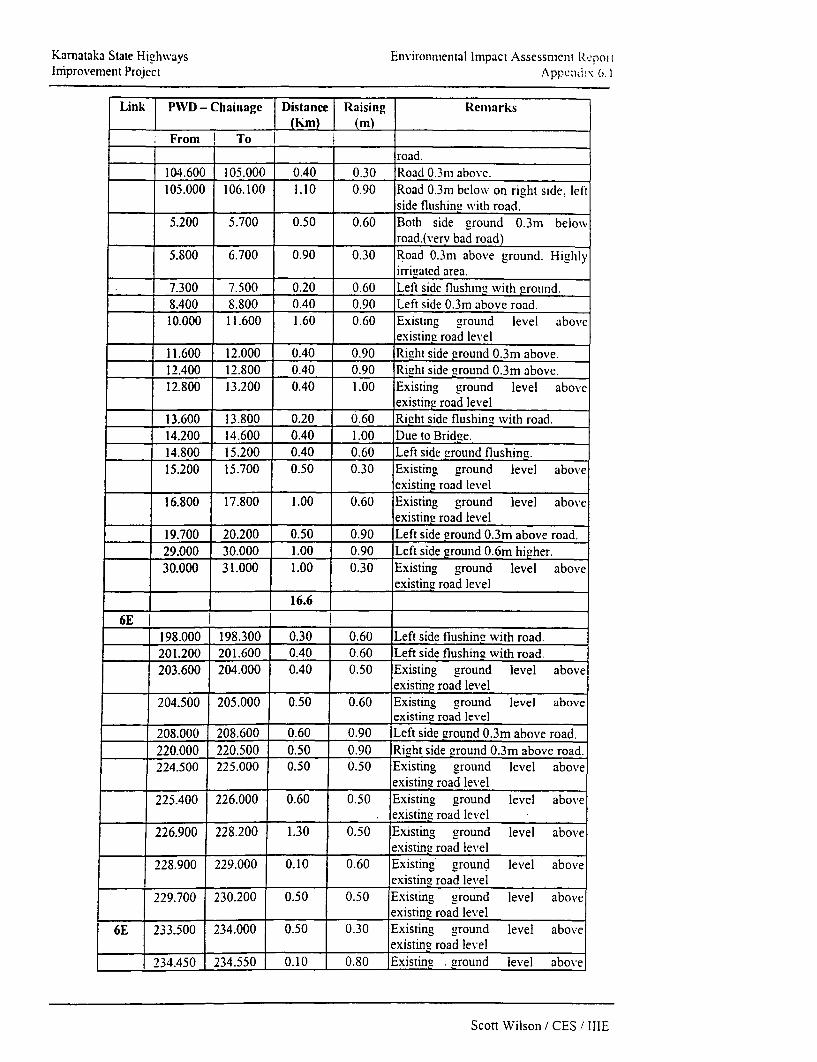
Karnataka State Highvays Environmental Impact Assessmenl RepotIniprovement Project Appcmid!; 6. I
Link PWD - Chainage Distance Raising Reemarks_(hm) (m)
From To _
road.104.600 105.000 0.40 0.30 Road O.3m above.105.000 106.100 1.10 0.90 Road 0.3m below on right side, left
,side flushing xvith road.5.200 5.700 0.50 0.60 Both side ground 0.3m below\
road.(verv bad road)5.800 6.700 0.90 0.30 Road 0.3m above ground. Highly
irrigated area.7.300 7.500 0.20 0.60 Left side flushine with grounid.8.400 8.800 0.40 0.90 Left side 0.3m above road.10.000 11.600 1.60 0.60 Existing ground level above
_existing road level11.600 12.000 0.40 0.90 Right side ground 0.3m above.12.400 12.800 0.40 0.90 Right side ground 0.3m above.12.800 13.200 0.40 1.00 Existing ground level above
existing road level13.600 13.800 0.20 0.60 Right side flushing' with road.14.200 14.600 0.40 1.00 Due to Bridge.14.800 15.200 0.40 0.60 Left side ground flushing.15.200 15.700 0.50 0.30 Existing ground level above
existing road level16.800 17.800 1.00 0.60 Existing ground level above
_existing road level19.700 20.200 0.50 0.90 Left side ground 0.3m above road.29.000 30.000 1.00 0.90 Left side ground 0.6m higher.30.000 31.000 1.00 0.30 Existing ground level above
existing road level16.6
6E I l l198.000 198.300 0.30 0.60 Left side flushing with road.201.200 201.600 0.40 0.60 Left side flushing with road.203.600 204.000 0.40 0.50 Existing ground level above
______ existing road level204.500 205.000 0.50 0.60 Existing ground level above
existing road level208.000 208.600 0.60 0.90 Left side ground 0.3m above road.220.000 220.500 0.50 0.90 Right side ground 0.3m above road.224.500 225.000 0.50 0.50 Existing ground level above
_existing road level225.400 226.000 0.60 0.50 Existing ground level above
. existing road level226.900 228.200 1.30 0.50 Existing ground level above
existing road level228.900 229.000 0.10 0.60 Existing ground level above
existing road level229.700 230.200 0.50 0.50 Existing ground level above
existing road level6E 233.500 234.000 0.50 0.30 Existing ground level above
existine road level234.450 234.550 0.10 0.80 Existing . ground level above
Scott Wilson / CES / IIIE

Karnataka State Highways Environmental Impact Assessment ReportImprovement Project Appendix 6.1
Link; | PWD - Chainage Distance 1 Raising Remarks(Km) (m)
Fromn To | l
existing road level
235.300 237.000 1.70 0.50 Urban drain also required.8.0
6F I I237.000 237.500 0.50 0.50 Challakere Town, Existing ground
level above existing road level239.600 239.800 0.20 0.50 Existing ground level above
existing road level
241.300 241.750 0.45 0.50 Existing ground level aboveexisting road level
242.800 243.000 0.20 0.50 Existing ground level aboveexisting road level
244.750 245.300 0.55 0.50 Existing ground level aboveexisting road level
245.500 245.700 0.20 0.60 Existing ground level aboveI_______ ________ existing road level
247.200 247.700 0.50 0.60 Existing ground level aboveexisting road level
248.000 249.500 1.50 0.60 Existing ground level aboveexisting road level
250.400 251.000 0.60 0.30 Existing ground level aboveexisting road level
252.000 252.650 0.65 0.30 Existing ground level aboveexisting road level
253.500 254.000 0.50 0.60 Left side ground 0.3m above road.255.000 256.200 1.20 0.90 Road below ground level on both
sides by 0.2-0.4m.
256.200 258.000 1.80 0.50 Existing ground level above,existing road level
258.000 262.000 4.00 0.50 Left side ground higher by 0.3m orflushing throught.
263.000 263.800 0.80 0.90 Left side ground above road by0.3m.
263.800 264.300 0.50 0.50 Existing ground level aboveexisting road level
267.600 267.800 0.20 0.60 Right side ground level above by. _ _ _ _ _ _ _ _ _ _ _ _ _ _ 0.3m .
280.500 280.900 0.50 Existing ground level aboveexisting road level
283.650 284.500 0.85 0.30 Existing ground level aboveexisting road level
15.2
6G 1 I I I291.500 292.300 0.80 0.5 Existing ground level above
existing road level
296.200 296.700 0.50 0.5 Existing ground level aboveexisting road level
300.850 301.100 0.25 0.5 Due to culvert301.800 302.200 0.40 0.3 Existing ground level above
existing road level
Scott Wilson / CES i IIIE

Karnataka State Highways Environmental Impact Assessment ReportImprovement Project Appendix 6.1
Link | PWD - Chainage [Distance Raising Remarksl _ _(m (K) (m)
From I To ! l303.400 304.000 0.60 0.3 Existing ground level above
existing road level304.750 304.900 0.15 0.3 Existing ground level above
existinu road level305.000 305.800 0.80 0.60 Existing ground level above
existint- road level307.000 3.07.500 0.50 0.30 Existing ground level above
existing road level307.750 308.200 0.45 0.30 Existing ground level above
existing road level
308.500 308.600 0.10 0.60 Existing grounid level aboveexisting road level
309.100 309.500 0.40 0.30 Existing ground level aboveexisting road level
310.900 311.200 0.30 Left side ground 0.3m above roadtop.
311.600 312.800 1.20 0.50 Existing ground level above_existing road level
313.200 314.900 1.70 0.60 Existing ground level aboveexisting road level
315.200 315.800 0.60 0.30 Existing ground level aboveexisting road level
319200 319.600 0.40 0.60 Existing ground level aboveexisting road level
329.000 331.200 2.20 0.60 Existing ground level above. ________ _________ _________ _________ existing road level
8.7
8A I2.300 2.600 0.30 0.60 Right side ground 0.3m above road
top
8A 2.700 3.000 0.30 0.30 |Existing ground level aboveexisting road level
3.900 4.000 0.10 0.60 Existing ground level aboveexisting road level
4.500 4.800 0.30 1.00 Existing ground level aboveexisting road level
4.900 5.200 0.30 0.30 Existing. ground level above_________ existing road level
5.700 6.000 0.30 Left side ground 0.6m above roadtop.
6.150 6.300 0.15 1.00 Existing ground level aboveexisting road level
7.400 7.800 0.40 1.00 Both side ground 0.4m -0.5m aboveroad -
9.800 10.100 0.30 0.50 Existing ground level above,________ existing road level
11.000 11.500 0.50 0.30 Existing ground level aboveexisting road level
11.900 12.100 0.20 0.60 Both side ground flushing road12.100 12.500 0.40 0.30 Existing ground level above
._______ ________ existing road level
Scott Wilson / CES / IIIE

Karnataka State Higghways Environmental Impact Assessment ReportImprovement Project Appendix 6.1
Link | PIVD - Chainage Distanoe Raising RemarksI I (Km) I (m)
_ From To I13.200 13.700 0.50 1.00 Existing ground level above
.existing road level14.800 15.600 0.80 1.00 Road 0.6m below both side ground16.300 16.700 0.40 0.90 Ground 0.3-0.5m above road16.900 17.300 0.40 1.00 Existing ground level above
existing road level18.600 20.000 1.40 0.30 Existing ground level above
,existing road level20.150 20.500 0.35 0.60 1.5m at 20.4m causeway20.500 21.000 0.50 1.00 0.3m down the adjacent grounds21.000 22.000 1.00 0.60 Existing ground level above
existing road level22.800 23.400 0.60 1.00 Existing ground level above
existing road level23.600 24.000 0.40 1.00 Im at culvert 23.80025.000 25.400 0.40 1.00 left side 0.6m higher26.600 26.700 0.10 0.30 Existing ground level above
existing road level27.200 27.400 0.20 1.00 Existing ground level above
I_ _ _ _ _ __ _ _ _ existing road level27.500 28.500 1.00 0.60 Existing ground level above
existing road level29.300 29.600 0.30 1.00 Existing ground level above
existing road level29.800 29.900 0.10 0.60 Existing ground level- above
lexisting road level31.100 31.300 0.20 1.00 Existing ground level above
existing road level= -____ 12.20 =
Note: 1) Existing Road Top has to be made higher by the aboveI______ I_______g iven raising.
2) Link 4C & 8A required to be raised atleast 0.3 m at mostl _____________ _ lof the places
Scott Wilson / CES / IIIE

Appendix 6.2

Karnataka State Highways Environmental Impact Assessment ProjectImprovement Project Appendix 6.2
Appendix 6.2: Educational Institutions and Hospitals near the Project Routes
Link School Colle-c Hospit al/Health CentreLHS RHS Total LHS RHS Total LHS RHS Total
IF 2 2 1 1 1 1IH - -
1K - - -
3A 2 2 4 I 13B - - -
4A -4C _ -
6E - I = - 2 16F - - - -- 1 2 3
6G2 - 2 - - -- --
8A 1 2 -
Total 6 6 10 I I 2 5 7
Note: The above Table lists only those institutions that are located by the roadside or near it.Most of the other schools, hospitals etc., are located within the village away from the road.
Scott Wilson / CES / IIIE

Appendix 6.3

Kamataka State Highways Environmental Impact Assessment ReportImprovement Project Appendix 6.3
Appendix 6.3: Girthwise Classification of trees with in the Corridor of Impact
Link Parameters Chainage (km) Numbers TotalFrom To LHS RHS No. or
_____________ T rees
IF __=_= =
i Girth => 30 and < 60 cm 0.000 41.534 194 171 365ii Girth => 60 and < 90 cm 0.000 41.534 172 201 273
.ii Girth => 90 and < 180 cm 0.000 41.534 92 67 159
iv Girth=> 180cm 0.000 41.534 129 178 307
______ _ ______________________ 904
IH i Girth => 30 and < 60 cm 0.000 28.063 30 18 48ii Girth => 60 and < 90 cm 0.000 28.063 82 102 184
iii Girth => 90 and < 180 cm 0.000 28.063 33 39 72
iv Girth=> 180cm 0.000 28.063 125 141 266
______=___ = = 601
_ Girth => 30 and < 60 cm 0.000 44.357 120 91 211
ii Girth => 60 and < 90 cm 0.000 44.357 199 184 383
.in Girth => 90 and < 180 cm 0.000 44.357 89 80 169
iv Girth => 180 cm 0.000 44.357 45 47 92
IK _ __ _ __
_ Girth => 30 and < 60 cm 0.000 56.343 213 221 434ii Girth => 60 and < 90 cm 0.000 56.343 413 466 879
iii Girth => 90 and < 180 cm 0.000 56.343 774 887 1661iv Girth => 180 cm 0.000 56.343 278 319 3550
3A _
i Girth => 30 and < 60 cm 0.000 81.304 55 69 124
it Girth => 60 and < 90 cm 0.000 81.304 307 326 633iii Girth => 90 and < 180 cm 0.000 81.304 239 242 441iv Girth => 180 cm 0.000 81.304 129 128 257
1455
3B __=_= =
_ Girth => 30 and < 60 cm 0.000 22.430 1 6 32 48
ii Girth => 60 and < 90 cm 0.000 22.430 18 32 50
iii Girth => 90 and < 180 cm 0.000 22.430 102 87 189iv Girth => i80 cm 0.000 22.430 8 4 12
_ 144 155 299
4A .
_ Girth => 30 and < 60 cm 0.000 20.676
ii Girth =>.60 and < 90 cm 0.000 20.676 4 4 8
iii Girth => 90 and < 180 cm 0.000 20.676 38 34 72iv Girth => 180cm 0.000 20.676 20 27 47
_ _ _ _ - 62 65 127
Scott Wilson / CES / IIIE

Karnataka State Highways Environmental Imnpact Assessment ReportImprovement Project Appendix 6.3
Link Parameters Chainage(km) Numbers TotalFrom To LHS RHS No. of
_____________ ~~~~ ~~Trees4C__ _ _ _
i Girth =>30and<60cm 0.000 73.178 84 T9 173ii Girth=>60and<90cm 0.000 73.178 251 277 528iii Girth => 90 and < 180 cm 0.000 73.178 240 27 9 319iv Girth=> 180cm 0.000 73.178 139 15 I 290
6E____ _ _______________ __ _ _ 13106E
i Girth => 30 and < 60 cm 0.000 40.814 46 7 109ii Girth => 60 and < 90 cm 0.000 40.814 50 5 _ 107.ii Girth => 90 and < 180 cm 10.000 40.814 109 13.4 243iv Girth => 180 cm 0.000 40.814 278 34S 626
_ = = = ______1085
6F _I____=_= =i Girth -> 30 and < 60 cm 0.000 49.202 30 5S 881.. Girth => 60 and < 90 cm 0.000 49.202 31 2 1 52iii Girth => 90 and < 180 cm 0.000 49.202 86 104 190iv Girth => 180 cm 0.000 49.202 631 698 1329
16596G __
6 Girth => 30 and < 60 cm 0.000 52.249 44 20 64ii Girth => 60 and < 90 cm 0.000 52.249 74 54 128iii Girth => 90 and < 180 cm 0.000 52.249 264 186 450iv Girth => 180 cm 0.000 52.249 560 422 982______ = = =_______ 1624
8A _ =_ _ =_=i Girth => 30 and < 60 cm 0.000 34.969 2 5. Girth => 60 and < 90 cm 0.000 34.969 85 70 155iii Girth => 90 and < 180 cm 0.000 34.969 379 458 837iv Girth => 180cm 0.000 34.969 389 480 869______ = - = = _____ 1866
Scott Wilson / CES ! IIIE

Appendix 6.4
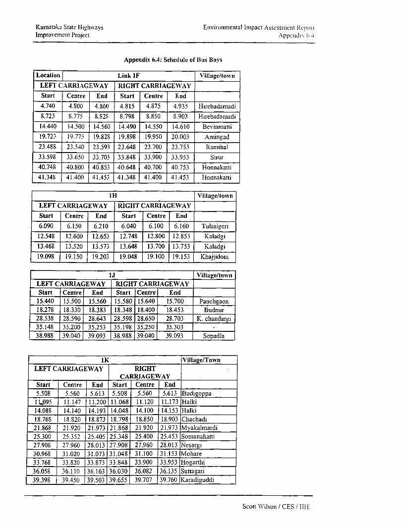
Karnataka State Highwavs Environmental Impact Assessmiienlt Repoi lImprovement Project Appcndi\ 6 4
Appendix 6.4: Schedule of Bus Bavs
Location Link IF Villagc/town
LEFT CARRIAGEWAY' RIGHT CARRIAGEWAY
Start Centre End Start Centre End
4.740 4.800 4.860 4.815 4.875 4.935 Hirebadamadi
8.723 8.775 8.828 8.798 8.850 8.903 Hirebadamadi
14.440 14.500 14.560 14.490 14.550 14.610 Bevinmatti
19.723 19.775 19.828 19.898 19.950 20.003 Amingad
23.488 23.540 23.593 23.648 23.700 23.753 Ramthal
33.598 33.650 33.703 33.848 33.900 33.953 Sirur
40.748 40.800 40.853 40.648 40.700 40.753 Honnakatti
41.348 41.400 41.453 41.348 41.400 41.453 Honnakatti
1H Village/town
LEFT CARRIAGEWAY RIGHT CARRIAGEWAY
Start Centre End Start Centre End
6.090 6.150 6.210 6.040 6.100 6.160 Tulasigeri
12.548 12.600 12.653 12.748 12.800 12.853 Kaladgi
13.468 13.520 13.573 13.648 13.700 13.753 Kaladgi
19.098 19.150 19.203 19.048 19.100 19.153 Khajjidoni
1J Village/townLEFT CARRIAGEWAY RIGHT CARRIAGEWAYStart Centre End Start Centre End
15.440 15.500 15.560 15.580 15.640 15.700 Panchgaon18.278 18.330 18.383 18.348 18.400 18.453 Budnur28.538 28.590 28.643 28.598 28.650 28.703 K. chandargi35.148 35.200 35.253 35.198 35.250 35.30338.988 39.040j 39.093 38.988 39.040 39.093 Sopadla
1K Village/TownLEFT CARRIAGEWAY RIGHT
CARRIAGEWAYStart Centre End Start Centre End5.508 5.560 5.613 5.508 5.560 5.613 Budigoppa1L.095 11.147 11.200 11.068 11.120 |11.173 Halki14.088 14.140 14.193 14.048 14.100 14.153 Halki18.768 18.820 18.873 18.798 18.850 18.903 Chachadi21.868 21.920 21.973 21.868 21.920 21.973 Myakalmardi25.300 25.352 25.405 25.348 25.400 25.453 Somanahatti27.908 27.960 28.013 27.908 27.960 28.013 Nesargi30.968 31.020 31.073 31.048 31.100 31.153 Mohare33.768 33.820 33.873 33.848 33.900 133.953 Hogarthi36.058 | 36.110 36.163 36.030 36.082 36.135 Suttagati39.398 139.450 39.503 39.655 39.707 39.760 Karadiguddi
Scott Wilson / CES! IIIE

Karnataka State H-lighways Environmental Impact Assessment ReportImnprovement Project Appendix 6.4
IK Village/TownLEFT CARRIAGEWAY RIGHT
CARRIAGEWN'AYStart Centre End Start Centre End
41.095 41.147 41.200 41.095 -41.147 41.200 Marihal43.075 43.127 43.180 43.075 43.127 43.180 Modaga45.048 45.100 45.153 45.118 45.170 45.223 Balekundri B K46.498 46.550 46.603 46.548 46.600 46.653 Balekundri K H46.978 47.030 47.083 46.998 47.050 47.103 Sambra47.648 47.700 47.753 47.548 47.600 47.653 Sambra49.588 49.640 49.693 49.618 49.670 49.723 Mutaga52.998 53.050 53.103 53.098 53.150 53.203 Kudachi
3A Village/TownLEFT CARRIAGEWAY RIGHT
CARRIAGEWAYStart Centre End Start Centre End6.873 6.925 6.978 6.873 6.925 6.978 Khatijapur13.898 13.950 14.003 14.028 14.080 14.133 Sarawada22.328 22.380 22.433 22.328 22.380 22.433 Bobleswar31.188 31.240 31.293 31.268 31.320 31.373 Yakkundi34.808 34.860 34.913 34.828 34.880 34.933 Ariunagi38.958 39.010 39.063 38.958 39.010 39.063 Chikkalagi41.178 41.230 41.283 41.248 41.300 41.353 Todalabagi42.518 42.570 42.623 42.448 42.500 42.553 Todalabagi45.698 45.750 45.803 45.728 45.780 45.833 Chikkapadasalagi47.278 47.330 47.383 47.278 47.330 47.383 Chikkapadasalagi52.198 52.250 52.303 52.198 52.250 52303 Alagur56.008 56.060 56.113 55.698 55.750 55.803 Kumbaralla67.698 67.750 67.803 67.698 67.750 67.803 Siddapur74.398 74.450 74.503 74.528 74.580 74.633 Shirol77.658 177.710 77.763 77.578 77.630 77.683 Malapur
3B Village/TownLEFT CARRI Y RIAGEWAY HT
CARRIAGEWAYRIGStart Centre End Start Centre End3.198 3.250 3.303 3.198 3.250 3.303 Zunzerkop5.948 6.000 6.053 5.848 5.900 5.953 Jirgal9.578 9.630 9.683 9.578 9.630 9.683 Chinchankandi K D11.358 11.410 11.463 11.448 11.500 11.553 Kasbajlambagi12.908 12.960 13.013 12.838 12.890 12.943 Kasbajambagi14.468 14.520 14.573 14.628 14.680 14.733 Muddapura14.978 15.030 15.083 15.148 15.200 15.253 Thimmapura
4A Village/town
Left Carriage Way Right Carriage Way
Start |Centre |End Start Centre |End
0.045 0.097 0.150 0.045 0.097 0.150 Hulikatti
Scott Wilson / CES / IIIE

Karnataka State Highways Environmental Impact Assessmenlt RtcportImprovenment Project Appendix 6.4
5.548 5.600 5.653 5.5IS | 5.570 | 5.623 Haralikatti
11.75S 11.810 11.863 11.75S 11.810 11.863 Achamatti
4C Village/town
Left Carriage Way Right Carriage Way
Start Centre End Start Centre End
3.328 3.380 3.433 3.508 3.560 3.613 Kammnur
7.008 7.060 7.113 7.208 7.260 7.313 NerliS.448 8.500 8.553 8.518 8.570 8.623 Mosarguppi
9.768 9.820 9.873 9.848 9.900 9.953 Jabapur
18.538 18.590 18.643 18.708 18.760 18.813 Raxi23.833 23.885 23.938 23.698 23.750 23.803 Gudas
27.298 27.350 27.403 27.448 27.500 27.553 Shirdon29.098 29.150 29.203 29.278 29.330 29.383 Doopadal
30.398 30.450 30.503 30.398 30.450 30.503 Doopadal35.668 35.720 35.773 35.855 35.907 35.960 Arabhavi
36.928 36.980 37.033 36.928 36.980 37.033 Arabhavi
39.348 39.400 39.453 39.445 39.497 39.550 Arabhavi
41.378 41.430 41.483 41.208 41.260 41.313 Lolasur
46.948 47.000 47.053 47.128 47.180 47.233 Gokak
53.098 53.150 53.203 53.088 53.140 53.193 Mamadapur
55.938 55.990 56.043 55.938 55.990 56.043 Chikkanandi
62.878 62.930 62.983 62.878 62.930 62.983 Madamgeri
65.428 65.480 65.533 65.415 65.467 65.520 Yarganvi
67.480 67.532 67.585 67.668 67.720 67.773 -
Location Village/tow^ n6E
Left Carriage Way Right Carriage Way
Start Centre End Start Centre End
0.0725 0.125 0.1775 0.0725 0.125 0.1775 Hiriyur
2.2725 2.325 2.3775 2.3475 2.400 2.4525 Hemadal
5.3975 5.450 5.5025 5.2975 5.350 5.4025 Hemadal
6.9475 7.000 7.0525 6.9475 7.000 7.0525 Balenahalli
11.1475 11.200 11.2525 11.2975 11.350 11.4025 Harthikote
12.8725 12.925 12.9775 13.0725 13.125 13.1775 Harikote
15.1225 15.175 15.2275 15.2475 15.300 15.3525 Yeraballi
16.5475 16.600 16.6525 16.5475 16.600 16.6525 Yeraballi
Scott NW'ilson , CES / IIIE

Karnatak-a State Highwvays Environmental limpact Assessment ReportImprovernent Project Appendix 6.4
Location Village/towii6E
Left Carriage Wav Right Carriage Way
Start Centre End Start ICentre End
18.7725 18.825 18.8775 18.8475 18.900 18.9525 GolIahalli
26.5475 26.600 26.6525 26.7475 26.800 26.8525 Sanikere
31.2475 31.300 31.3525 31.1225 31.175 31.2275 MummadiSaear
33.9975 34.050 34.1025 34.1975 34.250 34.3100 Hottepanahalli
36.0975 36.150 36.2025 36.0975 36.150 36.2025 Laxmipur
Location 6F Village/townLEFT CARRIAGEWAY RIGHT CARRIAGEWAY
Start Centre End Start Centre End0.065 0.125 0.185 0.165 0.225 0.285 Challakere1.848 1.900 1.953 1.748 1.800 1.853 Challakere5.448 5.500 5.553 5.523 5.575 5.628 Budnahatti9.230 9.282 9.335 9.295 9.347 9.400 Chikkamanahalli11.998 12.050 12.103 12.173 12.225 12.27814.728 14.780 14.833 14.773 14.825 14.878 Tallak16.250 16.302 16.355 16.295 16.347 16.400 Kodihalli18.148 18.200 18.253 18.148 18.200 18.253 Kodihalli23.423 23.475 23.528 23.423 23.475 23.528 Hirehalli24.395 24.447 24.500 24.395 24.447 24.500 Hirehalli28.498 28.550 28.603 28.598 28.650 28.703 Hirehalli32.240 32.300 32.360 32.240 32.300 32.360 B G Kere42.648 42.700 42.753 42.898 42.950 43.003 Tumkarhalli45.448 45.500 45.553 45.673 45.725 45.778 Rayapura46.348 46.400 46.453 46.398 46.450 46.503 rayapura
Location of Bus 6G Village/townBavs
Left Carriage WVay Right Carriage Way
Starct Centre End Start Centre End
0.3475 0.400 0.4525 0.2475 0.300 0.3525 Hanagal2.8475 2.900 2.9525 2.9475 3.000 3.0525 Hanagal7.8975 7.950 8.0025 7.8725 7.925 7.9775 Amakundi8.9225 8.975 9.0275 8.9475 9.000 9.0525 Amakundi11.0475 11.100 11.1525 11.0225 11.075 11.1275 Nagasamudra14.4475 14.500 14.5525 14.4725 14.525 14.5775 Gowrasamudra18.4475 18.500 18.5525 18.6225 18.675 18.7275 Rampur
Scott Wilson / CES / IIIE

Kamataka State Highways Ensvironmental Impact Assessment ReportImprovement Project Appeildix 6.4
20.1725 20.225 20.2775 20.2225 20.275 20.3275 Rampur23.4725 23.525 23.5775 23.5475 23.600 23.6525 Bommakannahalli26.8475 26.900 26.9525 26.9475 27.000 27.052529.8475 29.900 29.9525 30.0475 30.100 30.1525 Thammanahalli33.6725 33.725 33.7775 33.7725 33.825 33.8775 D. Hirehal36.0275 36.080 36.1325 36.0875 36.140 36.1925 D. Hirehal39.0975 39.150 39.2025 38.9975 39.050 39.1025 Obalapura46.0725 46.125 46.1775 46.1225 46.175 46.2275 Halekundi
-- - 49.8675 49.920 49.9725 Mundargi
Location of Bus Bays 8A Village/towvn
Left Carriage Way Right Carriage Way
Start Centre End Start Centre End
1.098 1.150 1.203 1.098 1.150 1.203 Karambal
4.118 4.170 4.223 4.198 4.250) 4.303 Hebbal
9.768 9.820 9.873 9.848 9.900 9.953 Kasba Nandgad
11.268 11.320 11.373 11.448 11.500 11.553 Zunjawad K N
12.578 12.630 12.683 12.748 12.800 12.853 Zunjawad K N
17.798 17.850 17.903 17.798 17.850 17.903 Bidi
18.948 19.000 19.053 19.058 19.110 19.163 Goliha11i
25.348 25.400 25.453 25.518 25.570 25.623 Manganakoppa
29.570 29.622 29.675 29.570 29.622 29.675 Kakkeri
31.848 31.900 31.953 32.028 32.080 32.133 Kakkeri
32.528 32.580 32.633 32.528 32.575 32.635 Linganamatt
33.818 33.870 33.923 33.898 33.950 34.003 Linganamatt
Scott Wilson / CES / IIIE

Appendix 6.5

Kaiail,i;ii Stale liigliways lF iviIOiiftCicital iiiapact Asscsstiicil iliucl tIfilillovcInieW PriljcCt Appetldlix 6.5
Link IF, Location- Hungund to Bevinmatt JunctionMax imum No Pro ect Upgradation without Mitigatlon Measures Upgradation with Mitigation Measure
_ ____________ _ ______________._______ , ______.__ _________________ ___________. _______________ IInpact Critcria Magnitude(m) Importance(w) m w m'w m w M mw m w mw
Location 5(Max) 5(Max) ___ ______ _
Gravity flow irrigation 5 5 _ _ _Reservoirs behind dams 5 5 _ _ . _ . _ .Oeforestation 5 5 _ _ _Road drainage 5 5 3 3 9 4 4 -16 4 4 16
Road Design 5 5 -3 3 9 -4 4 -16 5 5 25
Land Resources 5 5 1 1 1 -3 4 -12 -3 3 -9
Soil Quality 5 5 1 2 2 -2 4 -8 4 41 4_4
lWater Resources 5 5 1 2 2 -3 3 -9 1 3 3
Water quality 5 5 1 1 1 -3 3 -9 -1 4 4
AirQuality 5 5 -2 4 -8 -4 4 -16 4 4 __ 16
Noise Level 5 5 -3 4 -12 -2 2 - 4 2 4 8
Biotic Environment S 5 -2 3 -6 -3 5 -15 3 5 15
Sanitation and waste disp 5 5 -2 4 -8 -3 4 -12 2 5 10
Employment opportunities 5 . 5 1 1 1 2 2 4 3 3
Safety 5 4 2 3 -6 4 4 109
-391 -1119 _ _ _ _ _ 0
Magnitude: Defined in a scale of 1 to 5 "+" indicates beneficial Impact and I-" Indicates adverse Impact)Importance: Defined In a scale of I to 5 (Importance means the significance of the particular action on the environmental criterla/factor)
Positive and beneficial Impact: 200 to 300Positive and moderate impact: 100 to199No appreciable impact: 0 to 99Negative and moderate impact: -1 to -100
Scott Wilson / CES /IHE1

K1arnalaka Slac reII ligiv ways Environmental hnipact Asscsstnieit RvpwtJruprovciuctc Ilroect
Appendtix 6.5LinklH Location- Gaddankere Cross to Lokapur
. . Maxlinum >No Pro ect Upgradatlor without Mitlaation Measure U pgadat n with n itigatlon measureImpact Criteria Magnude(m) Welghtage(w m w m^w m w m^w m w mWLocation _| _
Gravity flow irrigation 5 5 __ .Reservoirs behind dams 5 5 _ _ . _Deforesation 5 5 _ _ . . .Road drainage 5 5 3 3 9 -4 4 -16 4 4 16
Road Design 5 5 3 3 -9 -3 4 .12 5 5 25Land Resources 5 5 1 1 1 -4 4 .16 _ 3 3 9Soil Quality 5 5 1 2 2 -3 3 .9 1 3 3Water Resources 5 5 1 2 2 -3 3 -9 1 3 3Water quality 5 5 1 1 -3 4 -12 -1 4 -4lAir Quality 5 5 -3 4 -12 -3 4 -12 4 4 16Noise Level 5 5 3 4 -12 -1 2 -2 2 4 8Biotic Environment 5 5 -1 3 -3 -3 5 -15 3 15Sanitation and waste disposal 5 5 -2 4 -8 -2 4 _ -8 2 5 10Employment opportunities5 5 1 1 1 2 2 4 3
Safet . 5 34-12 -1 3 ;1 4 4 16_ - 0 _10_ _ _ _ 0
Magnitude: Defined in a scale of 1 to 5 ('+ indicates beneficial impact and - indicates adverse impact)Importance: Definied in a scale of 1 to 5 (Importarice means the significance of the particular action on the environmental criteria/factor)Positive and beneficial irnpact: 200 to 300Positive and moderate impact: 100 to 199No appreciable impact: 0 to 99Neg3tive aiid moderate impact: -1 to -100Ncgativc and significanrt impact: -101 to -200Negativc and adverse impact: -200 to -300
Scott Wilson / CES / IIIE

Kariatiaka S.<tate IIighiways Environimicintal Impact Asscssiiicnt Reloirthliliprovenlniit Project
Appendix 6.5Link 1K. Location- Yargatti to Belgaum
ImPact Criteria Maximum No Pronect Upgradation Withc ut Mitigationn Measure Upradation with miti atlon measureMagnituie(m) Importance(w) _u w mw m w mw m w m-wILocation__
Gravity flow irrigation 5 5 _ Reservoirs behind dams 5 5___Deforestation 5 5 31 3 -9 -4 4 -16 4 4 16Road drainage 5 5 3_ 3 _ 9 -4 4 -16 4 4 16Road Design 5 5 __3 3 -9 -3 4 -12 4 5 20Land Resources 5 5 1 1 1 -3 5 -15 -2 3 -6Soil Quality 5 5 1 2 2 -2 3 -6 1 3 3Water Resources 5 5 -1 3 -3 -2 3 -6 3 3 9
Water quality 5 5 1 1 1 -3 3 -9 -1 4 4lAir Quality 5 5 -2 4 _8 -3 4 -12 4 4 16Noise Level 5 5 -2 4 -8 -1 2 -2 2 4 8Biotic Environment 5 5 -1 3 -3 -5 5 -25 4 5 20Sanitation and waste disposal 5 5 -3 4 -12 -4 4 -16 3 5 15Employment opportunities 5 5 1 1 1 2 2 4 3 3 9Safety 5 5 4 -16 -4 4 -16 4 4 16_________
-- J~~~~~~~~ ~~~~-72 __ _-147 _ 3Magnitude: Defined in a scale of I to 5 ( +" Indicates beneficial Impact and -" indicates adverse impact)Importance: Defined in a scale of I to 5 (Importance means the significance of the particular action on the environmental criteria/factor)
Positive and beneficial impact: 200-300Positive and moderate impact: 100-199No appreciable impact: 0-99Negative and moderate impact: -1 to -100Negative and significant impact: -101 to -200Negative and adverse impact: -200 to -300
Scott Wilson / CES / IIIE

Karnataka Slate Iliglnvays Einvironimlenltal Impact Assessnienit ReportImipriovemilenit Project
Appendix 6.5
Link 1J, Location- Lokapur to Yargatti
_________ r Maxinmum No_ Prcoect Upgrada ion With ut Miligation Measure Upgradation with mitigation measureImpact Criteria Magnituje(m) importance(w m w mrw m w m-w m w mwLocation 5(Max) _ 0
Gravity flow irrigation 5 5Reservoirs behind dams 5 5Deforestation 5 5Road drainage 5 5 3 3 - -4 4 -16 4 4 16Road Design 5 5 44 -16 -3 3 -9 4 5 20Land Resources 5 5 1 1 1 -2 4 -8 -1 3 -3Soil,Quality 5 5 1 2 2 -2 3 -6 1 3 3Water Resources 5 5 1 2 2 -3 3 _9 1 3 3Water quality 5 1 1 T -3 3 -9 -1_ 4.Air Quality 5 5 -3 4 -12 -2 4 .8 3 4 3 12Noise Level 5 5 -2 4 -8 -1 2 -2 2 4 8Biotic Environment 5 5 -1 3 -3 -5 5 -25 5 5 25Sanitation and waste dis 5 5 -3 4 -12 -2 2 _4 3 5 15Employment opportuniti 5 5 I 1 1 2 2 4 3 3 9Safety 5 5 -4 4 -16 -3 3 J9 4 4 16_____________________ _ ___________ _ ___________ -51 -101 '120Magnitude: Defined in a scale of I to 5 ( * indicates beneficial Impact and "-" indicates adverse impact)Importance: Defined In a scale of I to 5 (Importance means the significance of the particular action on the environmental criteria/factor)Positive and beneficial itnpact: 200-300Positive and moderate Impact: 1ao-1ssNo appreciable impact: 0-99Negative and moderate impact: -1 to -100Ncgative and significant Impact: -101 to -200Negative and adverse impact: -200 to -300
Scott Wilson / CES I IIE

Kat ialaka State II ighiways Eiiviroii:ineital Imtpact Assessimenit ReportIinproveiien( Ilroject
Appendix 6.5Link 3A, Location- Bijapur to Mudhol
Impact Criteria Noximum N Project Uncradation without M lHgation Measure Uugradatlon' with mtitgatlon measure_Magn ude(m) Importance(w m w m w m w m'w m w m wLocation 5(Max) 5(MA) _ _
Gravity flow irrigation 5 5 -4 3 -12 -3 4 -12 _ 4 4 16Reservoirs behind dams 5 5Deforestation
_ _5 -2 3 -6 -3 _ 4 _ _-12 4 4 16Road drainage 5 5 _3 3 _ 4 4 -16 4 4 16Road Design 5 5 -4 4 -16 .3 4 -12 4 5 20Land Resources 5 5 1 _1_3 4 -12 -3 _3_9
Soil Quality _5 5_ _1 2 2 -3 -_4 -12 I 3 3Water Resources 5 5 _2 3 -6 -2 4 _ 8 3 3 9Water quality 5 5 1 1 1 -3 3 .9 -2 4 -8Air Quality 5 5 _ 2 4 .3_ 3 94 416Noise Level 5 5 _2 4 8 .1 2 -2 2 4 8Biotic Environment 5 5 _-2 3 _6 5 5 -25 4 5 20Sanitation and waste disposal 5 5 -4 4 _16 -3 4 -12 3 5 15Employment opportunities 5 5 I_1 1 2 2 4 3 3 9safety 5 4 16 -3 44 4 16
I -98 __ _ _ _ -149 _ _ _ 147Magnitude: Defined in a scale of 1 to 5 ( + indicates beneflcial Impact and - indicates adverse Impact)Importance: Defined in a scale of I to 5 (Importance means the significance of the particular action on the environmental criterlalfactor)
Positive and beneficial imnpact: 200-300Positive and moderate impact: 100-199No appreciable Impact: 0-99Negative and moderate impact: -1 to .100Negative and significant Impact: -101 to -200Negative and adverse Impact: -200 to -300
Scott Wilson / CES / IIIE

Karnataka Stale Hlighways Environmental Imiipact Assessniciit ReportImprovement IPloject
Appenidix 6.5
Link 3B, Location- Mudhol to LokapurImpact Criteria Maximum _ No Project Upgradation Without Mitigalion Measure Upgradatio with mitigation measurMaggiitude(m) Importance(w) m w m-w m w m w m w m wLocation 5(Max) 5(-- ax) __--- _ ___a_
Gravity flow irrigation 5 5 = = = =Reservoirs behind dams 5 5Dolorestation 5 5 -2 3 -6 -4 4 -16 4 4 16Road drainage 5 5 -3 3 -9 -4 4 -16 4 4 16
Road Design 5 5 -4 4 -16 -3 4 -12 4 5 20Land Resources 5 5 1 1 1 -3 4 -12 -3 3 .9Soil Quality 5 5 1 2 2 -3 3 -9 1 3 3Water Resources 5 5 -2 3 -6 -2 3 -6 3 3 9Waterquality 5 5 1 1 1 -3 3 .9 -2 4 -8Air Quality 5 5 -4 5 -20 -3 4 -12 4 4 16Noise Level 5 5 -4 4 -16 -3 3 -9 3 4 12Biotic Environment 5 5 1 2 2 -5 5 -25 4 5 20Sanitation and waste disposal 5 5 -4 4 -16 -3 4 -12 3 5 15Employment opportunities 5 5 1 1 1 2 2 4 3 3 9Safety 5 5 -4 4 -16 -3 4 -12 4 5 1 20_ _ _ _ _ _ _ _ _ _ _ _ _ _ _ _ _ _ _ _ _
_ _ _ _ _ _ _ _ _ _ _ _ _ _ _ _ _ _ _ _ _ _ _ _ _ _ -9 8 _ _ _ _ __I_ -14 6 1 3 9Magnitude: Defined in a scale of 1 to 5 ('+ indicates beneficial impact and "-" indicates adverse impact)Importance: Defined in a scale of I to 5 (Importance means the significance of the particular action on the environmental criteria/factor)Positive and beneficial impact: 200-300Positive and moderate impact: 100-199No appreciable impact: 0-99Negative and moderate impact: -1 to -100Negative and significant impact: -101 to -200Negative and adverse impact: -200 to -300
Scott Wilson f CES / IIIE

Kariralaka Stalc Ilighlways Etivitotimileitial Imipact Assessnieiet Reportliiplpovetiteiit llroject
\Appenidix 6.5
Link 4A, Location- Hullikatti to Nargund
Maximum NNo Pro ect Upgradatlon Wit out Miti atlon Measur pgradation with mitigation measurImpact Criteria Manlgntude(m) lmportance(w) m w m-w m w m_w m w MwLocation 0
Gravity flow Irrigation 5 5 -3 4 -12 -4 3 -12 3 4 12Reservoirs behind dams 5 5 _I_ _ .. _ _ Deforestation 5 5Road drainage 5 5 .3 3 49 -4 4 -16 4 4 16Road Design 5 5 -4 4 .16 -3 4 -12 4 5 20Land Resources 5 5 1 1 1 -3 4 -12 -3 3 .9Soil Quality 5 5 1 2 2 .3 3 9 1 3 3Water Resources 5 5 1 3 3 -2 3 -6 2 2 4Water guality 5 5 1 1 1 -3 3 -9 -2 4 -8Air Quality 5 5 -2 3 -6 -3 4 -12 3 4 12Noise Level 5 5 1 2 2 -1 2 -2 2 4 8Biotic Environment 5 5 -l1 2 -2 _ 3 3 -9 4 5 20Sanitation and waste disposa 5 5 -3 4 -12 -3 4 -12 3 5 15Employment opportunities 5 5 1 1 1 2 2 4 3 3 9Safety . -22 -4 2 1 3 2 2 4Y_____________________________________ . _____ _ _ _ -51 .________________5_ -104 10 106Magnitude: Defined in a scale of I to 5 ( + Indicates beneficial impact and i Indicates adverse Impact)Importance: Defined In a scale of I to 5 (Importance means the significance of the particular action on the environmental criterialfactor)
Positive and beneficial Impact: 200-300Positive and moderate Impact: 100-199No appreciable impact: 0-99Negative and moderate Impact: -1 to -100Negative and significant impact: -101 to -200Negative and adverse impact: -200 to -300
Scott WilsoD / CES I tIIE

Karinalaka Slalc I iighiways Environimiental l ilpact Asscssmient RepottIlmprovement PIroject Appeid(lix 6.5
LInk4C, Location- Sankeshwar to Yargattl cross
Maximium No Pro ect Upgradation Wit out Mitig tlon Measure pgradation with mitigation measur_Impact Criteria _Magntude(m) Importance(w) m w m w m w m-w m w m-wLocation___ 5_Max *(Max) _ _ _
Gravity flow irrigation 5 5 -4 5 -20 -4 4 -16 4 4 16Reservoirs behind dams 5 5Deforestation 5 5Road drainage 5 5 -3 3 -9 4 4 .16 4 4 16
Road Design 5 5 -3 3 .9 -3 4 -12 4 5 20
Land Resources 5 5 1 1 1 -4 4 -16 -3 3 -9
Soil Quality_ 5 5 1 2 2 .3 3 .9 1 3 3
Water Resources 5 5 1 3 3 -2 3 -6 2 2 4
Water quality 5 5 -2 3 -6 -3 3 -9 1 4 4
Air Quality 5 5 -3 4 -12 -3 4 .12 4 4 16
Noise Level 5 5 -3 4 -12 -1 2 -2 2 4 8
Biotic Environment 5 5 -1 2 -2 -3 4 -12 4 5 20
Sanitation and waste disposal 5 5 -3 4 -12 4 4 -16 3 5 15
Employment opportunities 5 5 1 1 1 2 2 4 3 3 9
Safety S 5 -34 -12 2 1 3 2 2 4 -Y_________________________ ___________ -87 -119 = 126Magnitude: Defined in a scale of I to 5 ( + indicates beneficial impact and "-" indicates adverse impact)Importance: Defined in a scale of 1 to 5 (Importance means the significance of the particular action on the environmental criterialfactor)
Positive and beneficial impact: 200-300Positive and moderate impact: 100-199No appreciable impact: 0-99Negative and moderate impact: -1 to -100Negative and significant impact: -101 to -200Negative and adverse impact: -200 to -300
Scott Wilson ICES I IIIE

Karnrataka S:lalc I ligliways Environlmenital Impact Asscswmlint Relportimprovemiienit Plioject
Arpend(lix 6.5
Link 6E, Location- Hiriyur to Challakere
Maximum No Project Upgradat on wit out mitigation _ dation with mitigation measureImpact Criteria Mdgnitude(m) Importance(w) m w m'w m w m w m w m*wLocation 5(Max) -(Max) = = 1Gravity flow irrigation__ _ _ _ ._..Reservoirs behind dams l_ _ _ _Deforestation
-3 3 -9 1 4 1
IRoad Design 5 5 4 3 -12 -3 4 -12 3 5 2Land Resources 5 5 1 -2 -2 -4 4 -16 3 4 -12Soil Qualit m 5 5 1 2 2 -3 3 .1 1 3 2Water Resources 5 9- 4 - -2 3 -8 2 2 4Water quality 5 5 1 1 1 -3 3 .9 1 4 4
lAir Quality 5 3 4- 3 12 1 3 4 -12 3 4 12[Noise Level .5 53 4 -12 -2 2 -4 2 4 8Biotic Environment 5 .| | 2 -4 4 -16 4 5 20ISanitation and waste disposal 5 5 |4 4 116 -2 4 -8 3 4 12Employment opportunities 5 5 I 1 1 2 2 4 3 39Safety 5 5 2 2 -4 2 1 3 2 2 4
-74 ~~~~~-101 _____100
Magnitude: Defined in a scale of I to 5 ( + Indicates beneficial impact and - Indicates adverse Impact)Importance: Defined in a scale of I to 5 (Importance means the significance of the particular action on the environmental criteria/factor)Positive and beneficial Impact: 200-300Positive and moderate Impact: 100-199No appreciable Impact: 0-99Negative and moderate impact: -1 to -100Negative and significant impact: -101 to -200Negative and adverse impact: -200 to -300
Scott Wilson / CES IIIE

K,ialak.i Slate I lighiways Environinmeilal Impact Assessmicit RceritlIliproveliicit rlroject
Appcndix 6.5
Link 6F, Locatfon- Challakere to Hanagal
- MaxJimurn __ N Pro ect Upgradatlon without mitigation measure Upgra ation with mit iation measureImpact Criteria _ Magn tud m Importance(W m w mlw m W_ m w m w m-wLocation ._ _ _ _ .
Gravity flow Irrigation 5 __ _ . .Reservoirs behind dams 5 5 __ . . - _Deforestation 5 5 -2 3 -6 -3 4 -12 4 5 20Road drainage 5 5 -3 3 .9 -4 4 -16 4 4 16Road Design 5 5 -3 3 .9 -5 4- -20 3 5 15Land -sources 5 5 1 1 I1 -4 4 -16 -2 4 -8Soll Quality 5 5 1 2 2 -3 3 -9 1 3 3Water Resources 5 5 1 3 3 -2 3 -6 2 2 4water quality 5 5 1 1 1 .3 3 -9 1 4 _ 4AirQuality 5 5 -3 3 _9 *3 4 -12 3 4 12Nolse Level 5 5 -2 3 _6 -1 2 -2 2 4 8Biotic Environment 5 5 -2 3 -6 -1 3 9 4 5 20Sanitation and waste disposal 5 5 -3 4 -12 -4 5 -20 3 4 12Employment opportunities 5 5 - t 1 2 2 4 3 3 9Safety i 5 5 -3 5 -15 -2 4 -8 2 2 4Total = _-64 -135 119Magnitude: Defined in a scale of I to 5 (+I indicates beneficial Impact and - Indicates adverse Impact)Importance: Defined in a scale of 1 to 5 (Importance means the significance of the particular action on the environmental criteria/factor)Positive and beneficial Impact: 200-300Positive and moderate impact: 100-199No appreciable impact: 0-99Negative and moderate impact: -1 to -100Negative a .d significant impact: -101 to -200Negative and adverse impact: .200 to -300
Scott Wilson / CES / IIE

Karnataka Statc lligihways Enviroiinmenital Impact Assessnient ReportInmprovemenit I roject
Appendix 6.5
Link 6G, Location- Hanagal to Bellary
___________ __ Maximum No Pro ect Upgrdation without mitigation Upgradatlln with mitigation measureImpact Criteria P Magnitude(m mportance(w m w m w m w m-w m w m wLocation __=_=_=__
Gravity flow irrigation 5 5Reservoirs behind dams 5 5 _
Deforestation 5 5 -2 2 -4 -3 3 -9 4 4 16Road drainage 5 5 -3 3 -9 -4 4 -16 4 4 16Road Design 5 5 -1 3 -3 .3 5 -15 3 5 15Land Resources 5 5 1 1 1 -3 4 -12 .2 4 4Soil Quality 5 5 1 2 2 .3 3 .9 1 3 3Water Resources 5 15 3 3 -2 3 -6 2 2 4Water quality 5 5 1 1 1 -3 3 -9 1 4 4Air Quallty 5 5 -2 3 .6 .3 4 .12 3 4 12Noise Level 5 5 _1 2 -1 2 -2 2 4 8Biotic Environment 5 5 -1 2 -2 -2 3 -6 4 5 20Sanitation and waste disposal 5 5 4 4 -16 -2 4 4 3 4 12Employment opportuniUes 5 5 1 1 1 2 2 4 3 3 9Safety 5 5 -3 5 -15 -2 4 -B 3 2 6Total - = -108 117Magnitude: Defined in a scale of I to 5 ( + indicates beneficial impact and "-" indicates adverse impact)Importance: Defined in a scale of 1 to 5 (Importance means the significance of the particular action on the environmental criterialfactor)Positive and beneficial Impact: 200-300Positive and moderate Impact: 100-199No appreciable Impact: 0-99Negative and moderate Impact: -1 to -100Negative and significant impact: -101 to -200Negative and adverse impact: -200 to -300
Scott Wilson / CES I [IIE

Karnataka State I-lighways Environniental Impact Assessment ReportImprovement Project Appenedix 6 5
Link 8A, Location- Khanapur to Alnavar
Maximum No Project Upgradation without mitigation Upgradation with mitigation measureIrnpact Criteria s Magnitude(m Importance(w) m w m w m w r Iw m w m w
Location .__.__
Gravity flow Irrigatlon 5 5 _ _Reservoirs behind dams 5555 _ _ _
Deforestation 5 5 -2 2 -4 -3 3 -9 4 4 16Read drainage 5 5 3 3 .9 -4 4 .16 4 4 16
Road Design 5 5 -1 3 *3 -is 3-15 3 5 15
Land Resources 5 5 1 1 1 -3 4 -12 -1 4 -4
Soil quality 5 5 1 2 2 -3 3 -9 1 3 3
Water Resources 5 5 1 3 3 -2 3 *6 2 2 4
Water quality 5 5 1 11 -3 3 _ 9 1 4 4
Alr Quality 5 6 -2 3 -4 -2 2 .4 3 4 12
Noise Level 5 5 1 2 2 -1 2 -2 2 4 8
Biotic Environment 5 5 -1 2 -2 -4 4 .16 4 5 20
Sanitation and waste disposal 5 5 -3 4 *12 -2 4 *8 3 4 12
Employment opportunities 5 5 1 1 1 2 2 4 3 3 9
Safety 5 5 -3 5 -15 -2 4 4i 3 2 6
Total =-= 41 _ -110 _________ 121
Magnitude: Defined in a scale of 1 to 5 ( + indicates beneficial Impact and '- indicates adverse impact)Importance: Defined in a scale of 1 to 5 (Importance means the significance of the particular action on the environmental criteria/factor)
Positive and beneficial Impact 200-300Positive and moderate Impact: 100-199No appreciable Impact: 0-99Negative and moderate impact: -1 to -100Negative and significant Impact: -101 to -200Negative and adverse inmpact: -200 to -300
Scott Wilson / CES / IIIE

Appendix 7

Karnalaka Slate II igliways Elnvironiniental Impact Assessmnicit ReportImiiproveenwt Project Appciidix 7.1
I'ublic Consultation at ,ink 6E, Yeraballi village, lliriyur Taluk, District Chitradurga- 8"' lay 2001 _-SI.No Issues I'ublic l'erception _ Constiltants' R1ecommendatioui = llt atio MeasirCsLand Compensationi has to be on par witli the prevalent market rates. The respondenits' awvaieness level is very high. TIlle R&ZR policy and( the RAIP acdcquatelyacquisition Some of themii also suggested that the COI could be reduced such Land owners and structure owners are mostly address the compensationi benelits anicl o(ililthat thlere is miimtinim acquisitioIn an1d affect on the structure. businiessimieni anid are aware of' the prevailing allowaances and( the disbur-sal procedIlre also.nmarket rates and are also faimiliar wsithi theIt was opiiied that if the remaininig stricture beconies univiable, the delays associated wvith sucil land transactionis.
compcisationi shoul(d be paid for the whole structtiue and if theC ovt. was not makinig uise of thei remaininig piece of land, the same T'he land acquisitioni and compensationsilhould be giveii to concerined family. dispeisal wvill have to be transparenit anci
efficienlt so as to avoid any problemis in fiLture.2 Encr-oacihimleit! People accept that tihey have encroaciled tiponi public/commun`ity The P'WD shiotild strictly mainitaini its Legal Shilfting allowance to bc prov'idcd to thlEncroacliers land aincl are also paying sonic type of rent to tIme Panchayat. Eveni ROWV. Roadlside vendors and( shiopkeepers cncroacliers andl squatters as per thle RAP.and Squatters the landl records have not been updated. T'licre is no clear-cut must be preveniled fioni spilling over to tliedemarcation of Right of way widtil, government land and private ROW irrespective of the days or activities.properties.
T'lie PWD and the PIlJ can explore tlleSqulatters are of thie opinlioIn that since they have been pursuinig possibility of constrmcting a comimiercialthieir occupationis by the roadside for more thani 5 years and are complex on the event of availability offreqtictly asked to shlilt fiom tile roadsile, some arrangement in requisite numii ber of persons hlo can afford tothe lorm of a nCew location close to the road should be developed contributc a part of the construction costs.I'or thiem or else this problenm will persist. Most of thie squattcrs aredependenit on their roadside kiosks/petty sliops for tiheir livelilhood.
_._5 Envirolinilenital T'le environimilenital aspects (lid not figure that hiighi in thle Thle disinterest in environment issues x- as vety Thlie project lENII has adcqtett nicasures 1hiaspects discussion. AvCILue plantation miainitenianice and othier related muclh cvideint. The gencral periceptionl is that Cnvironmliental elinhaliccliemit.issues did not evince imluchi initerest. the issue of planitation. mainitenianice ofroadside puiblic ameniities is that of therespective gnc ernuterlit agencics. Respondentsae-c n1(t fol thinCilling in tileir opiniol on ILphbliCpart icipal ioni in sucil activities.
Thelic state forest departimicit has unidertak-ein aplantationi pi ogranime.ies hliiclh is unidcrprogress The Plantation pro-gaiaim e shouldl behlanded over to the State Fotest Departmenit
6 Sanitary T'lie village lack's proper sanitationi anid peoplc defecate in the 'toilets and sanitation facilities ate a iitist infacilities 1iel(ds and( by the roadsidle. T'hlis is a rajor t raflc hazaid especially this ane"a Isstius eclated to Ir;ailic accidenits anldin ilte cal niorninii hotius and( in the ccrniings. Fromt liealthi and( gencial salcty (lid iiot cviltce any inte
A7-1 Scott \Vilson / CES / IIIE

Karnataka State lHighvays v\ it ointimental Imipact Assess,iimte Repot tlniprovemiient Ilroject Appenilix 7.1
SI.No Issues Consul tants'Rublic PercVI)tioIl CwlsiliIs,Rccomimiendatlon __ i itigatioii M leastiresi ygicile aspect aliso iiis is into acceptable. Villgers participa ti on in the tmain ten alice ol
iltese facilitics is ako %civ remiiote.
7 _ lealili Aspects Ih1OLli lithe Village has a prilmary icaltli centre, the people p;eFer Cicatiig oteth N(Os and \i(.)s CI ioNld(iiate iti I leuiii iDc lparl-lo totravelliILc Io I liiiyul- to avail hettcir hcaltih flcilities for theil to dra% aittentioll to health. \Onleln and chiid ortgallise health caimps \% itli pal ticipation 0iajnil4t )S., _ _ _ devlCIopment.l ___ ___ __ _ tN( ;oK. .-----
._ . Safetly Aspelts lt Slit;y Spects('I,vIC of' Co[i 0 to tIeC ItC 1pttlt IIIs tIltl Ioatl Propel toadtl Sit_gC alimpitljl)ldt i f hi i i)htvttid pesiopale l t; eabuts tfllouaht the village. Ihlcy ilisisted o0 proper tralFic signs and pavelnent 'vill greatly reduce the iliCi(ictce of nceCssary road flit litureC alid satety Sicouce.saicty measures. - any mishap
A7-2 Scott Wilson / CES / IIIE

Karnatak.i Statelihw:vv' 1 ii i52icni.I np '
Improvenicni Projeci
LIST OF PIARTICIP.ANTS IN PIC IN LINk 6E
I RAJAGOPAL Y N2 VARALAKSM113t NIANJUNATHASETTY4 SATYANAR-A\YANASETTY Y N5 GOVINDARAJU K6 GEETALAKSMI7 JAGANMOI-IAN N8 MUDALAGIRIYAPPA K T9 KRISHANMURTFIY Y N10 RAJKUMAR K1 \IIJAYAKUMAR K \'12 GALAJA IANGAIPI'A13 PRABAKARA SETTY N14 SUBRAMANYA SETTY15 SULOCHANAMNMA16 MANJUNATHASETTY Y K17 RAMAMURTHY ETTY T N18 PREMALEELA19 RINIVASPPA T N20 CHANDRAPPA H21 ASHOK KUMAR \'22 MALLAMMA B T23 VEERUPAKSAPIPA C24 NAGARAJU Y R25 NANJUNDAPPA N26 THIPPESWAMY S27 LAKSMIDEVAMMA28 KAMBANNA29 PREMANATH R30 THIPPESWAMY G31 MHAHALINGAPPA R32 SOMASHEKA S R33 MAHESH S R34 PREMANATH R35 MAHANTAMMA36 SANNARANGANAIK37 PAPANNA K38 RANGASWAMY R39 SRINIVASA40 THIPPESWAMY41" PATALINGEGOWDA N42 THIPPESWAMY C43 CHANDRAMMA44 ANAIK45 HARIYAMMA46 HONNURASWAMY47 KARIYAMMA48 VEERAPPA49 RAMANNA50 VEERAPPA R
A7-3 Scott Wilson / CES / IIIE

Karnataka stac I ii ii.\N a\vs ELironmental Iiimpact Assessniienit Repoit
ImplovemenIt Proicfct Appendi\ 7.1
5 1 HANUMNIANTARAYiA V52 RANGAPI'A G5 3 KUMARAIAI-H R54 VEERANNA 1-155 KENCHARAYA B 1-156 RAJANNA S57 HANUMIANTAPPA5S RANGASWANMY K59 \'ERANNA K60 DAYANANDAK61 JAGADEESHI S62 PURANDARABABUI G H63 GIRl YAPPA64 DEVENDRA G B65 FIANUMANTARAYA V66 SHIVANNA67 I3RMNIMN ACHAARI68 RANGASWAMS; I' R
A7-4 Scott \Vilson / CES / IIIE

Karnatala State IlighImays Fn% it onie ilila Inipact Assessi lcitt RepoitImiprovemilenit Project Appenidix 7.1
I'liblic Coiisultatioii at ,ink 6F, Tallak village, Cliallakere lTaluk, District Chitradurga- 9"' I\lav 2001Sl.No Issues t Public lercerption_ Coonsultanits' Recoiiimenidationi Mitigaifitiil Mleasuire
Landl ac-quisitionl 'I'lie gericial vie" I egarditig land acquisitionl was to be 'I'he public is very clear about the compenacitsionioc Resettltcicnt Aclioni Plani adecqatlcIvcompensated as per thie prevailing market rate and on the event of issue and is conversant with the prevailing miarket addresses the beliefits to be extciide(l todisplakcemllent. tile atlfecte( people to be reihabilitate(d in tile village rates. 'I'lic land acquiisition and disbursemilenit of the Projcct aftccte(d PeIsOIts ;II(d Ihs anitsclf. 'Ilhe shiop owiiers were a bit apprehensive given the the payment should be very transparent in btuilt clause that comnpensationlsillutionll where tlle sItiuciic dleolitlio is parlial 1dl the ile d5isilltSeiimicit aimmi bIeCneis ,le tol liepossihility ol[pursuinlg tihcir business froml the uinnatT'eced portioi dtistilSCdI toltce I'Al's bQbmie
COlililICIIcrCilent ol'civil works2 Encroachiieinilt/ 'I'lhe coIm111unity accepts the t'act that tilere has been encroachlimlenit T'lhe participants in general' cle apprehensive The ploject em isages ulIder its R&AR
Encroachers oni ilte ROW but at tile same time insist tiat given the situation z about ilic issuie of shilting iohnl their curietit policy to extietd Shiltingu Almatlec.thiat they arc asked to vacate the landl. Altcriiate site ii additionl to location. 'I'hev requested to be allowed to ptiISueC hlousinig facility undler E\VS schemes toshiilitig allowanice should be provicdedi as it is a im;atter of their vocations beyond the right of way if space is the encroachels losing tir live tin mu1livelihiood andl tlheir sustenianice is entirely dependent oni thie road- available. depending u poli the pa % cIty linic stll It'users. Many were very vocal oin this issue and did niot sttbscribe to In the case of'squatters slhittitngtIel dehit;itiont ofeiiccroacliers as valid papers WvcrC preseint and in allox\ ance to be exteictled only t(omaniy instanices regular rents were beinig paid to the village Squattet s BPI_. 'I'lte details arc Lix en ill_lanchayat. thc RAP.
3 Riesetticilicilt 1 tlhc villagets atc intily against the idca of'hcitng reltahilitated at a Appiclhensioni about R& R is well appticialed. Resettlement SiteS ale t(t mldlidilt'ei-eit area and atc apprehensive about the basic ameilities and coostsicictation in thic tilst pWlasc (I'infi-astrutictuie facility being extenided to the resettlement site. TIhe KSIIIP. Adequate conipe-wali Ii andargtiilleit extetided is severanice frotii kitli an(i kin and a sense of benelits have been describted in theinsectirity abouit the new place. T-he villagers are avcrse to the idea . RA I'.ol' bcini shift'ed to otlier areas as tleiri econoriiic andl busitiessiniteests will be severely af'fected. __._._____________________________.
4 mploymtInt andl 'I'llerc is perceptible illtdi l'ferlene in the peoleI regarding the NIany self' interest gtiotps are intvolk cd as the hle RAP 'K akddicsses titc iscu ilt 1 lI:li' 111economiic benief its employmilenit opportuitiiies as a jestilt of road deevelopment. 'lie deinatilds ' aryv trotm gi Loip to grollp a' ai le sItups to time squatici S helm ,'
uomalside shopkeepers aLdl dlwellers i-ioni; whomi landcl may be pm' crt lity eat al ziost (dXv (leie bv tlheacqutiledL aind persons mtilminLg petty sihops i.e. tlie eneroacliers 60Kdemand tllat tIley shol.1d be allowed to rim their business by tlie
ioadside bevondl tei land ti;o(ecr l'WD possessioii._ LItiviroinicilmtal aspects 'I iIC poIpulae iiCenct-al iS itiditfelctit to tie envirotiljental issues. Most ot tihe -espoin(leilts ame u1nam ate Ol I'lanft;OI div te u bU tP, 1'! 'Iid
A\t least to expect cotiiiitiiiiiy paltiCipatioli in tili lla dIOCS IItII et11i1oin1iCeiltL1 IssueCs all(lii jS t1CnIene,j III 1 I t mlm lal Itim ni sill it ! iii In: t 1 ii(at isC. '[liC gencial pCIcCptioIt is that tIc issue of' planitatiotn. issties is clearly isible. (.'its d\ elles espeially loc IOuCII l)cPIeliCC imL timCe 1Miem'
mliMintelaliCe o0' ro`a(lsidle public ;iiticIII;CS is thiat ot time CsicPcii\ c f-111 (h1alla;kcc ;11-C a\A.auc ahout tillegOVCllCcntt III agetIcics. Respondellis ate n1ot iuolthcuiiimintg ill thei cii itoltimcntial pioblclls Ftllt licmit it tlte111commnmie
__________ ____________ ___ _ _ Oti2iLS il pat2ttbe araticipiatioii in stichi activities. about Coivuuitv, pLpartictmplm I llotkimlu a ICss
A7-5 Scott WVilson / CES I IIIE

Karinatak'a Slate Highways Enviironmieni(al impact Assesseniill RepottImprovemiienit l'roject Appendix 7.1
SI.Nn Issues PIublic Perception Consultants' Reconistitez(ltatioil lMitigititon MIesurelocal NGOs ar-e there buit tlieir participation andexper-iCeice in plantation progr-ammine is veI V m1111chI... ____ _.__ __ .__ ________ iltc.__ __ _ __ _ __ __ .___._._ _ ________ _________________________ lnid....... ,_6 Sanit imy flue jut ics 'I tic village lacks p roper sait a tioi aticl people de lecatc in tlic toilets azidc saillitaliolt lfacilitics aric a miost ist i this I lie L \VDI) ill discit l h' ' t lCS ili)I jeLdIs and hy the loadside. IThis is a major tralfic hazard especially area. Issues i-clated to traftic accidents anid the PI El) and ask thiCm in prictvin ilte ciity Itoniling tolois and in the cvenlings. Fromii hcaltil andl general safety did not evince any itltercst iecess;lly Flacilities to thle x Mage___)hyien ct aspect also this is ltot acceijble. ________
7 _ Sality AspcCts The people were disinterested in discussing the safety aspcct. Any Proper roadt signage and improvmenct of the Detailed ccsigns have iicorporutud :1l1measur-e taken by the goveinnriient in this aspect is welcomed. pavement will greatly redtice any mishlap. tile nccessaty roa(l lbritito-e andl saficvMaintenanice of the measUres did tinot evince any cogent response. Possibility of a bypass for Challakere towvn couild signageResponidenits of challakere towni were the only ones concerned be examinied.about road safet and congestio_ ___
A7-6 Scott Wilson / CES I ItIE

KariLitaka State I hitiwa\ s Ip1'II'ct;:jI l; Asusixict;m - :. ,Improvcmcnt lProject .\I).T!il
LIST OF P'ARTICIIPANTS IN PIC IN LINK 6F
1 NIANJUNA\TII . N12 RAVI. N
3 SURESFI . B H14 NIEFIABOOB BABL3.S
5 THIIPPESWAMY T S6 NAGARAJ A
7 NMIAH ANTESI-I 1PS BHIMMANNA
9 RAJJANA G B
10 SIIANKAR SI I BASAVARAJ A12 PRAKASH M 11'13 THIPPESWAMY14 MALLESII B15 RAMACHANDRA NAIK16 RAMACFIANDIRA17 JANJANNA
18 SRINIVASULU IP19 DANNAPPA REDDY20 GUNDAPPA R
21 RUDRAMUNI BH22 HANUMANTAPPA B R23 GUNDAPPA R
24 PRASANNA25 MARUTHI N L
26 MAJANNA M27 OBAIAH B
28 NAGARAJU H N
29 SHIVAGANGAMM30 KALAIAH31 TAILOR RAJU32 ADISHANKAR SETTY C B33 NANDAKUMR C B
34 LAKSMIKANTH M. P35 GOVINDARAJU R36 NAGARAJU C V
37 RAJANNA S38 VENKATESH V
39 SHASHIDHAR A
40 SIDDESWARA S4 I SYED AHAMAD42 ABDUL RAJACK SAB43 ANWAR KIHAN
44 SURESH R45 BANJUBAIAH
46 NAGARAJ47 INDRAMMA G48 PRAMEELA J H
49 SHIVAMMA B
50 MALLESHA KUMAR T M
A7-7 Scott Wilson / CES / IIIE

Karnatakia Sta.le lIlihsxa,s Environimiental Impact Assessillelii ReportImprovenment Project Appendix 7.1
5 1 MANJANNA V52 ANUSUYAAMMA5 3 NAGARAJU54 GANGAMMA5x TIIIPPESWAMN' fI56 RAJANNA57 SRINIVSA58 ANAND59 NIEERABIIAI60 DASTAGIR BHASA
A7-8 Scott WVilson / CES / IIIE

KaatraLak;a Stale I ligInvays E1n ironimen talI Imipact Ass cssmcn t Reportlinploveilrreit 'tiojcCt Appendix 7. 1
I'uilic Consultation at Link 6G: llalekundi Village, Taluk BeIlli-ry, District- B10la NIO ay, 2001
SI.No Issues I'ublic Perceptiol Consuiltanits' Reconiriireinlat ioit ilitigatiun lMeasureI Lan(t Compensation has to be on par with tire prevalent maiket rates for the Ihe respond(enits a% areness level is vcry ilh. -RLesettleiriicit Actioni Planacquisitioni land, lire participants especially the stiuciure owners were of the Due con1s1Ultatioll shol0.d be lield dUring tile lanld adequately addresses tIre beniefitsopinion that the land acquisitionis slotild be mininrised acquisition process to be extcildedi to tIre Projectattcted(l PCIsonIs and lias aniribirilt claose that Conlpenrsationrdisbursement andc benefits arc tobc (lisblinse(l to tlic PAl's hecl6r_______________________________________________________________________________
________________ __ __ __ ___ c riioncmeneeiett of civil wvoi k,s2 Enicooachliere Whil tire 'AIPs do1 agrce that tlhcre have beeii illcgal occupa-cy arI lir l'\VL ) sPD otldl sirictl' Iraintai pits l.t gal R(I) I hc ploject elivisaLges 0ll( '1 itslit/ enrcroaclinoreirt of the govt. laird, and that thsey caninot get any Roadside vendors and s'hopkeepers must be prevetited R&Rl policy to extcnd ShiftiligEsicroaciers compensationi for the land occupied, they nevertheless feel that fiom spillilig over to tIe ROW irrespective of tIlec days or Allowance, lrotisirig facilit%ygoverniriniet shotil(d extend some amourit of assistanice. Sincec the activities. Slriitifin alloo arice carr be extendled to tIre unicier EWS sclrciires to tIreSouilces of livelilood lor illost of tile likely I'AI's/1'APls is depeiI(rdint enrcroachlers. cncroacheirS lOSili thieirupOII their roadside petty sliops. livelihoond dependinrg upoll tilepoxverty line status. Ihc (cltailsEncroachrers tuncleistaii(r tire fact that tlrcy have btuilt thlcir stiuctulres arc ti\ en in thc RAA.up1oi0 governrmtenilt land( yet soni0C kirrd of lenrieticy shiotild be ma(le so as
to minimliise daimages.Nevertheless, some of tire squtatters felt that they slroulkl be providedwitls landc arid monetary assistance to constlLuct the lost structuire. _____3 Resettlemenit Fliose likely to lose coninisercial structures felt tirat the best option is to Thle Local MIuLnicipal authiorities milst be irrN olved ini TIhel-e is a pto\ ision ill thlc R Plallow themil to coinilitle in tile existinrg locales by shliil irig a little beyond cxploritrg tIre possibility of pov di gn alIlernale site fo lofr InALing aaIitih lie 5itl.q It oltirc COI. I loNever. tliey also conseite(d on tfie optioln of commercial commercial complex or miake provisions 'or a market shiop alca ill a CoplipleN to tilucomiplexes ICt ollt oil reit basis withl vicinity to tire toad. place or municipol or pariclnavat- lad, piciclcablly rearL e'lowv l t\C linc S lI;ICr al
tIre road alignmrernt. a cost to hc (ci(dd hyl o It, ii r
Shriftinu allimance can be extend(le( to tile cDcloacliels___________ ~~~~~~~~~~~~~~~~~~~~~~~~airdi sqUatters.4 Finnpoynnnert A lew'rqii lesinsistedi oil gttc(ing either a gover ricriert.job or at least It is evident thec people are noulrtC inclined tmrxa;rds a lIwnei is.a pri\ isioll Ilr tIre It k P.and sinoln ltinioetariy assistance fromin thie alitorilies. 11Ile popuilacc iii genicral govitrimnirt joih as it oflfls good paty ridl(I ,ccil ity. I'loject polihc that i1wz ( olitrlactor eC(1i1ni1ric Coul1(d riot relate to thIe ecorsonric belneits of a road developmrenrt ielated eniplov. irclt opponilirities did llot evince alr! iXCuthOI lias ti uLI\ c pi cile nherlefits project. intcrest il tIre PAh in jols. No
l,)\.1111 1'1)IhS mIC t,) I1E :C\tend(cIdl to I P.- \s I
A7-9 Scott \\ Ilson I CES /I IE

Kainataka Slae II ighivays Environmeiiial Imipact Asscssmiicnit ReportImprovement l'ro jcct Appeindix 7.1
SI.No Issies P'ublic Perception Consultants' Reconiendationt Mlitigatioin Measure5 Elnvil-oliil,clt 'The respondents felt thaty (lhe miailitenianice of tlheni avenute plantation is hlie awareness abouLt environment is eri miuchi evident '[lie planitation piogranmine killal aspects the job on tlie goveritinent. lere. Proxiii ity to M arvi and Raicl it r also enstii es takC cal c ol't he roadssidc aV C1iICapprec ial e social, enlvivrolilnielitial a l(i political awali eiss plailtat iouof the responidelts.C'onilitiuiity 'I'lhe ptublic opined thaLt Suchl assets whichl belong to the cntil-e village The piroject involves re -establislinicint of' tile assets Necessary rc-locationis alhcad>assets liikc Iai-ilp dumps a 1(1 sit ni ics. tc., and tihose likely to bc affected( (dIC to alonigWith tlihe participa tioni o(i tilc otheC vat il(tS CoVCeted ill Ci-illceril (i dcsigilithe ploject wotiul have to be relocatcd and( that it would extend its dcpartmnits. and( RAI. Cost ol' the relocationsupport and help in locating a suitable site for the same and in also incltudcd in (tic RAI'reconstrUctilng the lost assets.
6 Sanitialy TI'he pcople enquired about any assistance being extended to thie TIle PlIED should explore the possibility of inillediately 'I'he project in the first phasefacilities development of sanitary facilities and water supply in the village, as providing public lavatories anid drains in teie village. 'Ilie cleos not envisage providinigthe comnitinity hygienie and sewerage conditions are very poor. Water prevailing condition is a major healih hazard. these facilities. lhe ItW) vf illpools and puddlles are a niajor eyesore and breeding conditions for interact w\ith the P111 1) and Imosqtuitoes, icqucst the P11 ED) to takc thiencccssaly action ill tile atfelctcd
__________________.____________________________________________________ stretclhes7 Sal'fty School Cliild-en are a XLulierable lot iii tiis stretchi as there is a higih Proper road signage and improvement of tlie pavemenit Engineerinig Desigins have taklenAspects school in the village and mnaniy StLUllctS Use Ihe road to reacil the will greatly reduce the incidenice of any misiap. inito accouit adequate saeltyschiool. People opined thiat Proper Safety mcasures and road sigins were considerationis ancd road firniitiireneeded. Design speeds have been reducedin settlenments.
A7-1( Scott \\ ilsotn / CES / tilE

Karnlataka Statc HiLhwavs I3jix le loHcnialpac: improvement Projcct
LIST OF P'ARTICIIANTS IN I'IC IN LINK 6GI B.11ONNURAPPIA2 BASAPIPA3 S ZHAKIR I-IUSAIN4 M.GANGADIIARAIAII S\WAMY5 ARJUNAPI'A6 P.BUDANSAB7 H.RAMAKIRSI-INA\ IIEGDE8 V.RAMANJANE)7ULI!9 N.NAIDU10 V.NEELAKANTAI IT.RADHAKRISFINA12 H.CHANNABASAVA REDDY13 M.MARISWAMY14 HONNAPIPA15 MALLIKARJUNA16 RANGASWAMY17 H.LINGANNAI 8P.VIJAYAKUMAR19 M.UMAPATHISWAAMY20 B.SABUDDIN21 S.RAGHAVENDRA IRAO22 K.MAHABALESWARAPPA23 K.MAREGOWDA24 G.GUNDAPPA25 SARVARAPPA26 GANGAPPA27 HOTEL BANDEPPA28 YALLAPPA29 KENCHAPPA30 HONNURASWAMY3 IMAREYANNA32 M.NAGARATHNAMMA33 V.KRISHNA34 B.BASHA35 ERANNA36 K.GORAVAIAH37 GANGAMMA38 SHANKARAMMA39 P.SHIRASAPPA40 KASHIM VALI41- H.UMESH42 NANI SAB43 GUDU SAB44 NOORULLAH SAB45 K.SRINIVAS46 SHANKARAPPA
A7-11 Scott \NVlson ! CES IIIE

Karnataka Suate II igliways wvivironm enial Impact Assessmnicit KepoitImprovemilenit 1'roject Appeni(lix 7.1
Pt*hlic Conisultationl at Link IF, Aminagadli village, Ilungum(i Caluk, IDistrict I1N alkot-l3"' Juily 2001Sl.No Issues ru,II tl-'rp c cpo i_ Conisultatnts' Recoimmiiienidationi lslitigation IXleasu eLIaInId Ilic participants deSircld thial cultivable land acquisition should be 1 he espoidlenits' awareness level is vet y higli. Iliojcct antlholitv slioti (1 iLiniittlArq uistio it iiiiil1uiseC(i as ;ISucilh as possible. Due couisrillationi should be lilcd Jutingn the land( land ti0 IecttleitilcIt i)iacquisitioni process. constullation w'ilh tllc pII v.(1:t
a ifCcIld PCISoIlS and(l thL I((i Il__________ ~~~~~~~~~~~~~~~~~~~~~~~~~~~~~~~~~~~~~bodlies.2 EncroAc iuuent/ The audience agreed that there has been encroachment on public lands The P%VD should strictly mainitaini its Legal ROWV. Shifting allox' ance to heFitcroachiers and even the pancliayats collect some type of rent for thle Roadside vendors and shopkeepers must be prevented provided to the encroachieis aindand Squatters establishnielits. Ihe audience felt that the govemment should be a bit from spilling over to the ROW irrespcctive of the days or squatters as per the RAP.more flexible and provides some assistance so as to enable the activities. Shifting allowance can be extended to thecojinniercial establishments to pursue thleir vocations as complete encroachers.(lisplacenmellt would be detrimental to their livelihood. The P\VD and the PIU can explore the possibility of
constructinlg a comnnercial complex on the event ofavailability of requisite nuimber of percons -who can_________________________________________________________________ afford to contribute a part of the constructioln costs.3 E'ivir-oimiie.ital 'rlie environmental aspects did not figure that higii in the discussion. The disinterest in enviroinmenit issues was v,ery mucii TIhe project Eli ias adequatVAspects Avenuie plantation maintenianice and other related issues did not evince evident The general percceptionl is that the issue of measures Ibr enviroinniclntIILIUCII inlterest. plantationi, mainitenianice of roadside pLublic amentities is ehanllicmlint. The Forcslthat of the respective government agencies. Respondents Departmtenit uxill undertake the Iare not forthcominig in their opinion on1 public Plantationi Programme in thit:participation in such activities. Project Roads
4 Sanitary TIhc village lacks proper sanitationi and people defecate in the fields and Toilets and sanitation facilities are a must in this area. Sanitary facilities can bcFacilities by the roadside. This is a major traffic liazard especially in the early developed in consultation withImoriniig houtirs anid in the eveninigs. FroIml hcaltil and(I hygicien aspect the local public and lokcal hudics.also thiis is not acceptablc. EIll' has adleqitiate budgctar\
SufPor lfor these tacilites5 Shilltilig ol '[hc participalits insisted that all the water supply linies and other 'lhe RAP provides for relocationl anid establislhment or all 'Ihe l'lU an(d the othier goverilntPublic UJtilities utilities anid drainage works that are withlinl the COI should be relocated utility lines before enibarking on civil works agency in constiltationi witlh tlhand laid befl-oie comimillenicemilenit of civil works. Panclhayat in constiltation % i t the stakeholder-s art antge for i clocationi of utility lines to cnsmL i
encumnbrance fiee x%orkinL aica.
A7-12 Scott Vilson i C'ES / II IE

Karnataka Staic Hi-ivkavs Lwiroin;ln-i, I:ilpaicI t\'SCSIImprovement Project
LIST OF I'PARTICIPANTS IN LINK IF
I BASAPPA MURIGENI A BADAVAD)I(iI2 NIALLAPPA NM AKKI3 DR F1 R SALINMAT4 Y B SAJJANAR5 V S SHIVA,MURTIIY6 A L SINGAD7 SHASIDAR ARALINIAT8 ISMAIL LAVAIFOR9 SHIVAJI SOLANKI10 D \ PAWN'AR11 PR-ABHU PAVAR12 SHI\VAPUTRAIAHI SEETALANAYAK13 HANUMANTAPPA ERRAPIPA l'AVAR14 KESFIAVA DANAVANA DEVADI15 SRINIVASA FAKIRAPPA MUDEVADA16 BASAVARAJ GAVATAL17 CHANDRASHEKARAIAIH AMARAIAII SANTIKARMZNAT18 SHIVAJI K MAT19 NAGAPPA VEERABHADRAPPA KANTI20 I A KALSMAT21 M D BAGEVADI22 DHVALASAB23 SANGAN BASAYA VASTRAD24 YANKAPPA DEVAPPA BANDIVAD25 BASAVARAJ KARASANGAPPA BADAVADGI26 C S TEGGINMAT27 MUTTANNA KESAPP MUDAGALLI28 KUBERAPPA KESAPPA MUDAGALII29 YAMANAPPA D NIUNDEVADI30 BASAVARAJ SHARANAPPA KAMBALI31 RAM4ACHANDRA M HOSAMANI32 VERUPAKSYA SHANMUKAYA HOSAMANI33 CHANNAAIA C HIREMAT34 GURAPPA BASALI35 RAMANNA HULIGEPP BAJANTRI36 A N JANGI37 S N SHANTAGERI38 D C HUNGUNDA39 M M GODAKAR40 BABU ANNAPPA RONADA41 A D RUDRASWAMY MATA42 S R YARAGERI43 M G VASTRAD44 SANKRAPPA BASAPPA MOSORI45 U S PATIL46 H J PATIL47 S C KAMBAR48 N R BOMBOLE49 SHANKRAPP SYAMAPP RATOD50 NAGAPPA SANAPP KANTI
A7-13 Scott \Vilson / CES IIIE
Kiarnitaka Staic I lighm ays En il onniental lmiipact Assessmnei1lt ReportIilproN elcinent Prjoct App,l(lch 7.1
51 K B MESTRI52 C A ItONAD53 B R I)EGANAAL54 \ V SIIIRNAL55 Y S BANDIVADDAR56 NAGAIAH SHIVAIAI-I VASTItAD57 CIIANDAPPA YAKARI MALLAPPA58 P Y BANDREVARDAR59 CHANDIRAKANT SANGAT'A60 S B KUMBARA61 R I' ATIL62 BASAMNIA H SANTAGERI63 B IK LAMAANI64 NI S DADDANAVAR65 SANGAVVA KAVYANADA66 SNMI YASODA67 B RKAM168 C H NATIKAR69 S 1I KALLA KUTIGAR70 Y N GUJJALA71 B B SANJIHAL72 MI B MADLI73 S \'SANNAL74 R MOHIDRAKAR75 C M SALANKI76 SS HUGAAR77 B A DHAVALGI78 SHIVANDA VANDAAL79 I S MAMADAPUR80 CT RAVI81 H R KUMAR82 S S CHALLAGIDAD83 P S YALLAPANVAR84 RNARASIMAMURTHY85 S Y CHALNAGAD86 M G KAI87 S B KARADI88 S S KARADI89 I S SANKALA90 B R BALIGER91 MALLESAPPA SIDDAPA HUDLUR92 S L GUDDAR93 R S SIMAASAN94 SHIVAMURTHY95 NAGAPPA SANGAPPA RAKKASAGI96 G M GARADI97 SHARANAPPA MALLAPPA HIOSAMANI98 V N GOUDAR99 A H TARVATI100 HATAWAR
A7-14 Scott "Wilson / CES I IIIE

Karinalaka Slalc I ighxvays F.liviromltcnial ImItpact Assscssuicnt RlepoilIln provcnicilt Vrojct Appendix 7.1
pPublic Constiltation at Liik 4C, Arabliavi village, Gokak taluk, District flelgaun-i 6'. il\ 2001 II Sl.NO Issues Public Perception_ Consultaits' Recomniueidafiuoi NMitigaitiotn enisure(I TIe participants expected prevailing market rates for land acquisition. Tlhe respondcnis' awareness level is very high. PIroject authority shoukl idenfiliieAcquisition 'Ihc villagers wvere or the opinlioIn that the compenisationi has to be paid DIue conisultationi should be held diCI ing the land land( for rescitlci eli t jllprior to comnleicemiierit ol civil works, acquisition process. consuIltatioll W it the I projecta tl'cclc(l pcrsoUns aid th. hl tI -.~~~~~~~_ _ _ __ _ _ __ _ _ _ __ _ _ __ _ _ _ __ __ __ _ __ _ _ ____ h, di,s. ___ __.__|2 Elncroachlimenit/ I lic atnldicocc agreed tiatl there Iias becen enicroaclhmlenit oni public lands Ihc P\XVD shoti d strictly ma ailitaiii its Legal NOWXV. Shil ling allo%xa nec to II.Elncroachiers aiid even the pancilayats collect some type of rent for the Roadside vendors and sliopkeepers muist be prcventcd proVidLld to the encroachers andaand Squatters establislhmlenits. hlie audienice felt that the governmenit shotild be a bit fiomi spilling over to tihe ROW ifirespective of thel days or s-,quatters as per thle RAI).IltorC tiexibic and provides somic assistanice so as to enable the activities. Slhilting allowance can be extein(lded to tilccoiniricicial establishinierits to puisue tlleir vocations as complete encroachers.
displacemenit would be detrimental to their livelihood. T1he PWD and the PIU can explore the possibility ofconstructing a comimilercial complex oo thie event ofavailability of requisite number of personis who can__.___._._. alTord to contribute a part of the construictionl costs. _________________aod ctiep otC rtn s3 Environmental The envirotinmenital aspects did not figure that highi in the disctission. The disinterest in environment issues was very niucih T-he project ENMII has adequatcAspects Avenitue plantation maintenance nnd oilier related issues did not evince exvident. Thie veneral perception is tliat the issue of measures tor ClnvirOiuiuLeialMuch interest. plantatio, mainitenanice of roadsidce public amenities is cnha1ncemcnlit. The nic js!that of tle respective governmenii agencies. Respondlents Department \x ill uLindeltake tilhare not fortlhcomiiing in their opinion on piblic IPlanltaition Pio ',raminc ill theparticipation in stichl actil ities. Il-oICte Roadcs
4 Saniitarv 'Ihlc village lacks pioper sanitationi and people defecate in the 1ield(s and TIoilets and sanitationi facilities are a must in this area. S a litary klchit(ics cani hleFacilities by the roiadsidic. TIhlis is a major tiaific hazard especially in tlhe early dIevhcrlcpel in cc,' itt'lclitm \ Wilt. niorninig hotius anid in the eveniiigs. From healthi and hygienie aspect the loc.il public ami.l i. l hitibisalso thiis is not acceptable. EMVI has adequalte bitclatrtir' Si ltl aplUlt iO (ll,St -l ". Cmt,l 11
_ _- - -
________ _____- _ _ _ _ _ _ _ _ _ _ _ _ _l ~ ~ I P t _r th. .t_ _ _ .ei_li..t _ _shilling of. Ilie par-ticipiantis inisistcid that all tie watcr suipply lities and oilier Thi RAP hOd idles Ini iclocatiof and(I establishmieuit ofall lie ll) athe ilie u1 IPIublic Utilities utilities andt drainage wo-rks that are within the COI should be relocated utility lines beoire embarkini.g on cix il wo ks a-cLicy in consultation vA 'Ii tliand laid before commeniicemnciit of civil works. Panciaval in enosultat i.tw , nJltle stakltlde.,)(t s atl ¢ raii r
.~~~~~~~~~~~~~~~~~~~~~~~~~~~~~~~~~~~~~~~~~~~~~~na .i __f ut)CilitxIlilS '.iI'iiU_)! Ks :I A 7i-nii tiiot frei 'x nt kit' ii
A7-15 Scott Wilson ICES! 111E

Kainiataka Statc Ilighiways Envirioinmenial iilpact Asscssiiient Rcpoitlriiprovenieiit Plroject Appeldix 7.1
6i Issuc of Bs)ypass Thv *illagers weie of the opinion that the project auithiorities should lie PCC' is exploring the possibility oi a bypass for this A bypiass alignmncilt is Cxplore IhC possibilily ol a bypass fior the village as the roadl was very villagc consideration.harro(W and videcilg vwouldld leld to deolitionl of VUsidetItial houScs Of
. ___________ __ Iatleast 5o foimiihiiies.
A7-16 Scott Wilson / CES / IIIE

Kariiataka State -li j'hwavs liE vironmenltal I ipa ci A >scsmc i "
Improvement e Prlo;ct
LIST OF P'AIZTICIPANTS IN LINK 4C
I NIAAVALLA SAB:\ DAS I AGIItA SA13 KABBURA2 G(IIANNAPPA LAKSMAPIA 13ANGI3 NI AKBULSAB MAIIAMNIAD SAB NAAGA1RAJI4 JAGAADISFI HIRENIAT5 DUNDAIAH SHIVANIUTTAIAI I RIItEMAT6 UDAYA BABU KOPARDE7 KLAGOUDA BASAGOUDA PATILA8 NIJALINGAPPA RANIAPI'A RAMANAVAR9 HANMANTA BHINIAPPA10 TUKARAMA YADAVADA11 RAJASABA ABDULSAAB DASTI KALAPI'A12 KADESHA MALLAPPA DUNAKAR13 HUSENASABA ABDULSAB DASTIKARSI-IIKANDAR B
NANADI14 EBRAHIM SAABHA NIADAVADA15 SURESIIA16 DURGADEVI17 MARUTI BANDIVAIR18 LAKSAMANA BANDIYAPPANVAR19 SHEKAR BANDIYAPPANVAR20 SHANKADAR B SANADI21 R Y CHAKERI22 JAMlA MANEGED23 MAMADASAB D RAJAPURA24 DASTAGIRASABA E MAHAMAD25 SUNILA RAMAVVA26 SHIVALINGAPPA VEERUPAKSAVVA RAMANVAR27 VASANTA KERUMAANE28 DIVAKAR RAMASEETTY29 VISVANATASETFTY30 BASAVANNA KALLOLA MYAGERI31 BALAPPA RAMACHANDRATALWAR32 DAREPPA NINGAPPA TELI33 BASAVARAJ DAREPPA TELI34 SHIVAJI CHANDRAPP35 HANIF YADAVADA36 NEELAPPA L MADAR37 SHABBIRA M BALIGAARA38 DEELIPA D PATANA39 SADU SAB40 DAVALA P SADGAR41 S D KALBURGI42 GAJABARA SYEDA GADEKARA43 NAGESHA CHUMARAO KODATE44 MUDAKAPPA KALLAPPA NAAVI45 SHIVAJI V'ITAL KOLI46 ASHOK SETTY47 MANJUNATA48 NAGESHA BHIMARAO49 KALEDA HANUMANTA JAMAKHANDI
A7-17 Scott %Vilson iCES IIIE

Kainiauaka Staic ilcil" ays Environmenital Impact Assessment ReportImproveflment Plolec' Append:c;x 7.1
50 SURESHA HFANUMANTAPI'A JAMAKFIANDI51 NIAJID NI ANASARI52 AI3DUL NIUSAF NI ANASARI
A7-18 Scott Wilson / CES / IIIE

Karnataka State llighways Environmental hilpact Assessimncit Repoi IImprovemilenit Project Appendix 7.1
_ _'iPblic Colnsultaijirn SA, Nandgad villagc, Klianapur taluk, )istrict Bcl aunl-19"'.J1ill 2001Sl.No IsstuCs P'uhlic Percel)tioi_ Consultaots' Recomnmeidatiow M_____.__ iti atjo ii1c ure =L aintd 'Ihc participants desired iliat cuiltivahle lanid acqtuisition should be '[lic icspondents' nawareness level is very hiigl. I'nrject autlihority Slitilld idetilil y 1attiAcquistiou nililinised as micli as possible. Duc consultationi sliotil hbe liekcI dinioglg thc laid for rCsetlleilit iOi co is tilatio l; it Iacquisition process. the pro jcct at'lectcd cie sons anil tilc
2 Eicroaclhmcnt/ 'Ilie aidicnce agreed that there has been encroachment on piblic lanids Ihe IlMV should strictly mainitain its Lceal ROW. Sljiji ti iillowiaiie tot ie priovide CitEiteroachers and cven the pancliayats collect somtie type of -cnt for the Roadside vendors and shopkeepers muIst bc pl evelted the eiici oachIers and squatteis as pCanid Squatters establishieiniits. Ihe auidience 1'elt thlat the governmelt shotld be a bit from spilling over to the ROW irrespective of the days or the RAI.more tlexible and provides some assistance so as to enable the activities. Shifting allowvance can be extended to thecomtiierc ial establishlieuts to pursue their vocations as complete encroacihers.
displacement would be detrimental to their livelihood. The PWD and the PIU can explore the possibility ot'constructing a commeicial complex on the ecent ofavailability of requisite nuilber ofpersons who can
___________________________________________________________ affoid to contribute a part of tlc constiiuctioni costs. ______3 T heironincuttil I li cilvi ilillelital aspects did not figire that lhigli in the discussiol. The disinitcrcst in environcinent issiies was very tiucli I ll pjeC t I M P iis ateqtt cAstpects AveuLeC IpIlaittatioa0 Illailiteil;e11CC tiLl an ild te relatcd issues (lid niot evince CVident1. 'I'hic general pCiLCptioll iS tlihLt the iSSuIe (F illvaSllrCS lir i e etiiiilitiitalnuch interest. planiationl, iainitenaiace of' roadside public amenlities is enhanicciellent. 'Ilie to DepartlIlt Ithat of the respective government agencies. Respondenits %x ill ui(tel take tile Plantatioin
arc not foitlicominLg ill thleir Opillionl Oll public Programtm tie in the P rot Ict Rovats(participation in suchi activities.
4 Sanitarvy TIhe village lacks proper sanitationi and people defecate in the fields and Toilets and sanitationi facilities are a must int tiis at ea. Sanitary .lbcilities can hc dcx cltried inFacilities by the roadsi(le. This is a major traffic hazard especially inl the early conulltationl \% itti the lut tnl litilic :lldnioiriiiiig hoturs aiid in tihe eveiiiiigs. Froiii licalilt and hygicne aspect local hlidliCC ENII' bw :ltliati__also this is tiot acceptable.
si _ __ ___ budeetaivjspJ3oit or tI ts' I:tei!ie5 Slulting ult TIhc paiticipants iisiste(d that all thic watcr supply lihes aii(l other I lie RAP pioviidcs ftor iclttationi id(l establishlitlttt (It all tlc It tll ttiit thte Outhr Lot.ci:'utblic Utilities tlfilities and d(Iaitiagc wvorks that are wvithiin the COI sliould be relocated titilitv lines befoie eibar-king oii civil works agency iii conisutltatioi will thcandt laid belorc couiniciiceiicit of civil ixoiks. PaticlIv at iii cousoItSti;tinl xx itil IIIC
stakltloldttlcti a,ia,,,ii toIC ,Ittit ittitililit) lilnes to enliSle cttloriteilll:
li-ce \kt 1i kittt :i tl.rc6 ('nhunlwit nitv tlc villkge elders opilled that the comiuinity asscts likcr shriiies. hand ' lie RAP proxides for rclocatioii atidt jsthlislittieit oi all Ruci ;tilm ;;i ,i ;,ilAssets puniips tc. shioul(d be iclocaled ald(l tle village coilititii v xxotild coitllllilutv assets ill cotusiltatioll wvithl tlte local coililttlilitv tssi.ts bLitLce.xtend required support in locatiiig a suiitable site and in re constructing cot limttv before enaiakine ttix il xxl ois CeOilliCinlCelniCll (It, c l; 1 vthC alIfectCd stltIcItIes. _ _ _______________
A7-19 Scott Wilson I CES I IIIE

Kariauaka Siate fl lilhways Environmental Inipact Assessment ReportImproxevilelin Project Appendix 7.1
LIST OF IPARTICIPANTS IN LINK 8A
I ]1N.-\ZEERSAB E HARAGI2 SIKINDARSAB E HARAGI3 YALLAPPA L NAGANVAR4 ESUBHA E HARAGI5 PARASURAM 11 YUKADE
-6 KUSANAJI N PATIL7 BABU K KAVIS N;AGOGIRAO B PATIL9 PARASURAM PATIL10 PARASURAM H CHA\'AN11 KALLAPPA LAKSMANA PATIL12 PUNDALIKA H CHAVAN13 NAGAPPA V PATIL14 MIARUTI G PATIL1 5 NAGU P PATIL16 KALLAPPA B GURAV17 ERAKAAD A TAHASILDAR18 NARAYANA YASPAAL PATIL19 NIAHAMAD ALI A DEAHNAIK20 M-IARUTI V BASTIKAR21 \'IJAYASREE KAMAT22 SHASIDAR PAKIRAPPA HUBLI23 GOUSSAB SYED SAB SANADI24 PARASURAM GANGAPPA GURAV25 APPAJI GOVINDA PATIL26 YESVAT G KURVAKAR27 BHUVABAVA BUBE KARVALU28 \'VTMAL M MADAR29 LAKSMANA B NARASAPPANAVAR30 SHIVANANIDA G KUNGLAKAR31 SOMANING K DAVAGAR32 RUDRANA S DAVAKAR33 MALRUTI R DAVAKAR34 YELLAPP L DAVAKAR35 PUNDALIKA D DAVAKAR36 SHIVAJI R PATIL37 NARAYANA R DAVAKAR38 SHVAJI R DAVAKAR39 NIARUTI B PATIL40 GLTNDAPPA YALLAPPA PALEKAR41 R.MESH S BALEKAR42 R R PATIL43 N AGOOJI T PANEKAR44 RAiMACHANDRA K MALGEKAR45 PUNDALIK K KARADI46 \ ITATL R MALGEKAR47 BHIMARAO M DHABALE48 MARUTI K DHABALE49 PINNAPPA B MADAR
A7-20 Scott Wilson / CES / IIIE

Kamnataka State Hi'llhNa!vs Lnironniini:zi lnptcl! Asst-sSilltii P.c:'Improvement Project . i- i *
50 LAKSMANA A GURAV51 AJJANA B PATIL52 PARASURAM B PATIL53 RAMACHANDRA B lATIL54 MARUTIBPATIL55 PRAKASH B PATIL56 APPJI M PATIL57 RENIANA NI KARADI58 V'IJYA D SUTAAR59 RAAMANA N SUTAAR60 MARUTI LINGANMAT61 MAHESI- GURAV62 SATISH PATIL63 SIDDUJI PATIL64 MOHAN G PATIL65 P N SUDAR
A7-21 Scot WVilson CES i I IE

Karriataka Stale I lighways llnviiormiental Impact Assessmlncit Repol IImprovement Project Appendix 7.1
I'iblic (osiult;tion 4A, Naud Nar t aluk, )istrict (;adag-19 h Juli 20_01SI.No __Issucs; ____ I'_l lic l'erc eptinCionsul t (osIalls' RtecommlIelndatioln _ _ lUit_gatiii iClStlteI.and 'I'lhc participants desiredi that cultivable land acquisitionl should be 'Ilhe rcspondents' awareness level is vety lIigh. Il-oicct atllhorily silould idelitifyAcquilsitiou n in it iiiizj(l as miucli as possibhle. Due consultatioll shoukl I1C hed 11 i [hni;g tiIC land landl fr resettltICInecli 11lacquisitioni process. consulltatioll with tile plOicct-
af feccted peIsonls alid tie IlIw Il- |-- - - . . . . hodicc.2 lIt'.croaiclm,mienitf 'I'lwc aLI(ielice agreed that thiere has becn encroacimienit on public landcs 'lie PWD should strictly mainitaini its Legal l'OW. Slhiftinlg alitwalnce to hcFicrorichers andl even the panchiayats collect sonme type of rent for the Roadside vendors and shopkeepers mtist be prevenited provided to the cticneroaclcs ami(iand Squatters establishlnicits. The audience felt that the government shouild be a bit from spilling over to the ROW irrespective of the days or squatters as per the RAP.more flexible and provides some assistance so as to enable the activities. Shifting allowance can be extended to thecominiercial establishments to ptrsuc their vocationis as complete encroachiers.displacement would be detrimental to their livelihood. The PWD and the l'Ilt can explore the possibility of-
constrtuctinig a commerciaml complcx on the event ofavailability of reqtuisite miniiber of' persomis wlho cani___________________.________________________.________________________ afford to contribite a part of the consiruction costs. ___________c_sr_ci__css3 Environmental 'I'hc enviromilniiental aspects dlid not tigur-e that higih in thie discussion. The disiniterest in enivironimjent isstues was eCry ImuLCh heli project ENII' has adeqLltcAspects Avenue plantation maintenance and other related issues did not evince evident. Thie general perception is that the issue of measures for environmentalmucil interest. plantation, maintenance of roadside public anienities is enilancemiienit. T'he F 0o C tthat of the respective government agencies. Respondents Department will undertake thecare not forthicomiiing in thieir opinion otn public Plantationi Programnime in ilicparticipation in such activities. Project Roads
4 Idetililicatioti Some of the fanimers whose land is getting affected and borelioles are The RAP provides for assistance in identifyinig water Adequate bu(dgetary prov!isi(.uof water getting affected irissited tihat the Project authiority sliould extend help in points. are incltided in thc RAl'striking Poinits identifying new water striking points at its cost and arrange for drillingthe same. .5 R)oadside 'T'he participanits expressed their concerin regarding the roadside The toni part of Naigtid requires inimi:ediated attelitioli Budgetary provision i'r sanitar11rain:tge andel dIr;ainaiae and lack of sanitationi alonig the road section passing in in ternis oflcotmnitiiity hlygicne andl sanitary facilities like facilitics inluCidtedI ill 1'San itation Nargund town cominuniity toilets etc. budgct.
A7-22 Scott Wilson / CES / IIIE

Kaniataka State Hieihwas bivir'nnljit Ir ltct \s I<.cmIc iImprovement Projec !t i..i.-
LIST OF IARTICIPANTS IN LINK 4A
I RANNEGOUDA BARAM ANAGOUI)A2 RAIMJAANA GORAVANA KOLLA3 S B K GOUDAR4 TAKKINAGOUDA NAGANUR5 BASAPPA G KADEKELA-6 SANGAPPA G KADEIAL7 BALAPPA B NAJANVAR8 DYAMAPPA K BANAAJAN\'AR9 KENCHAPPA L BANAJANAVAR10 MAHADEVN BANAJANAVARI] I HANUMANTA B HIPLI12 BASAPPA SOMANVAR13 PAKIRAPP YELLAPI'A GAAJI14 PAARUTANGI15 KADAIAH HIREMAT16 MULARAJI17 GOVINDAKATTI18 KRISHANAREDDY19 DYAMAPPA20 BABU21 BABU22 MARUTI23 BALAPPA24 BINIGA25 SHEETAMMA26 HANUMANTA27 VARAMAHADEVI28 CHANDRAVVA29 TOLAPPA N KERVAR30 SIDDAMMA31 YELLAVA32 DYAMAPPA33 MARUTI34 DYAMAVVA35 SHIVAMMA36 VARADI37 S V CHULKI38 S S POOJAR39 F M SURKOD40 GARIYANVAR41 GOURA TALVAR42 MUDUKAPPA TALVAR43 MAKTASAB AKTAR44 DEVAMMA CHUKKI45 BASA SAVANUR46 CHAMBAKUMBI47- SANKAPPA48 BABYLING49 VENKAT REDDAY
A7-23 Scoit Wilson CES 'IIIE

Karnaiaka State lIgIi'xvoys Environmental Ilmpact Assessment Repoihimpro% emenit lProjeci Appendix 7.1
50 MARUTI TAMMAR PAWAR51 MALAPPA KAMBLI52 NAGAPPA KAMBLI53 NAGAPPA PAWAR54 NIAI-JALINGA MUDUKAPPA55 NMALLAIAH CHANDRA GOUDAR56 VITTAL HANUMANT MAANE57 SHIRUK GAVCHAR58 VEERESH SANGAPPA59 BASAVARAJ MADIHAL60 RAGAPPA KUDACHI61 SURESH PATEL62 PURVANKAR
A7-24 Scott Wilson / CES / IIIE
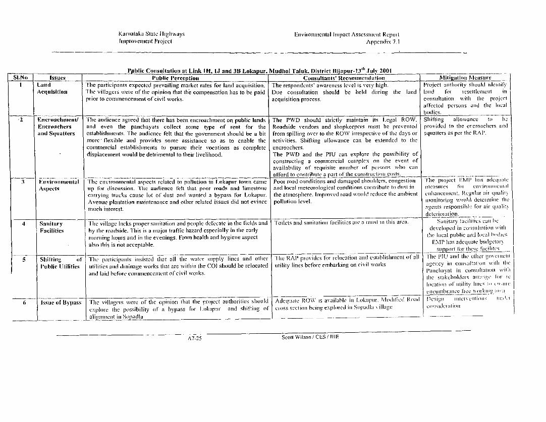
Karnalaka State I liglways l'nvirotnmnen iaal linpact Assesstimenlt RepoilImiproveimenit Plroject Appelndix 1.1
Ppblic Consultationi at Link IH, IJ and 3B Lokapur. Nludliol Taluk, District Bija ur-13"' Jul 2001SI.No Issues Public l'erception Consultanlts llecommecndation MIiiigatioll MecasuireLand ilhc participants expected prevailing mar-ket rates for land acquisitioni. Ihle responients' awvarcnless level is very higil. Il'oIcct authlority should ideitlitAcquisitioni TFle villagers were of the opitioni that thle conipetisationi hias to be paid Due consultationi shiould be lheld dLilig thle land land laon tesettlenlicilt inpi ior to comm1iencenment of civil works. acquisition process. constiltatioti with the projectalt'l'ctcd personis anid the localbodlies.2 Encroucltinent/ The audience agreed that there has been encroaclhment on public lands The PWD should strictly mainitain its L egal ROW. S hiftinig allowance to heEltt-oaclmers and eveni thle panichayats collect some type of rent for the Roadside vendors and shiopkeepers mnist be prevenited provi(ded to the encroaclhcrs andand Squatter-s establislhileits. Ilhe audieince felt tilat the governmenit sholod be a bit froin spilling over to the ROW irrespective o' tlhc days or sqiuatters as per the RAIP.more flexible anid provides some assistance so as to enable the activities. Shiftinig allowance can be extendecd to thecominercial establishmiienits to purstue their vocations as complete encroacbers.
displacemenlt would be detrimental to their livelihood. The PWD and the PIU can explore the possibility ofconstructinig a commnercial complex on the event ofavailability of requisite number of peilonS who canl
_ _.__ _ _ _ _ afford to conltlihute a part of the consitrictiont costs. |3 k:nvirollillenital I[lie enviromnenital aspects related to pollutioni in Lokapur townI came Poor road conditions and damaged shoulders. cotigestion I he plojcct lM.P hl.ls adCql(;lteAspects utp lor (liscissioll. thIe audlience felt thiat poor road(s and limestonie anci local meteorological conditions contiibuite to dist in nicasucrs Pf) cnvironninnt)atcarlyilng tircks cause lot of dtist and wanitecl a bypass Ior Lokapur. the atrimosphiere. Improved toad woltid recdlce the ambicit citlianiceiicint. Ryglilar aiit qualilhAvenue platitatiori niaioitenianice and otlher related issues did not evince pollutioni lcvel. titoisitorinl cic c n i cl,mtlcih interest. agenis responsihl?h: for air qualit>dCeteriOltatioll.4 San i tary I cle village lacks ptoper sanitation anid people diefcatc in the licels and Ioilets and sanitation facilities ate a Intst in this arca. Sanitary e C&6!ics call bcFacilities by tIme roadsi(le. TI his is a miajor traflic hazard especially in tile carly developed ill colisnlllnioll wiltlmiot-itiiig lotiots anid iii the evenings. From healilt and hygielne aspect thc local public anid local bortisalso this is not acceptable.
EMrP has adeuCLiate bttdgleti-s t )I If - Ir- 1-1 TI ie;cI( 'a c t ciliC5 S_ ill itg ot The participants inlsiste(i tliat all the water sippl y lines and( o lielr I lie RAP pi oxidus for rclocz tioti a ci csabll stincilt ot' all I Il'l U atd tlte ;tlien p liPublic UIJilities utilities anid dthaitage xvorks that are wvitliiii the COI should be relocated utility lines before etubarking on civil xvorks agency ill consuItStOti1 xvitil tbc|anid laid bclore cotiuintenlccilictit of civil wot ks. Paitcihavat in consultation iv itI
thle stakeholdet s arromnn 1w 1.I clocatiion ol' tbilicc fie utkIc I, ... ,I,,
__ _ _ |_ _ _ cllclllllb-lll.cc llc'c',""lt!l"' St" :'.~~~~~~~~~~~~~~r Nlo(lllei ~od 1cil'l 111I'clllll~ ll~.6 Issue of 113pss The villagers xwerc of the opinlioIn thiat the project atitltorities sliottld AdCquael ROW\ is available in l.okapitr. rlndicd Road licti n nitcrntimmi¢ mlvicx plore (lie possibility of a bypass for L I kaputr and shl-tiit g of cioss sectioir beiriig explo ied in Solpad l a illagc cinisdciatli loa i igll_iClit n Sip tadl a
A7-25 Scott Wilson / CES / IIIE

Kaniataka State Filighwavs Environmental Impact Assessnient ReportImproxvcmeni lProject Appendix 7. i
LIST OF l'ARTICIPANTS IN LINKS IH, 1J & 3B
V1 G KOPPAD
2 BASAVARAJ N HUKUMNAVAR
3 JAKIR HUSSEN ATTAR
4 GULAB SAB ATTAR
5 GURUSIDDAPPA R BOLISATTI
6 B B NADAYANDA
-7 MALLAPPA H DADDAMANI
8 SAYAD GUDAGI
9 H B GOUDRA
10 R F1 GHATGE
11 D M HADAREDDI
12 V M GHARPAD
13 S C MODI
14 D M PANGATTI
15 V P KAMKERI
16 B A HUNASIKKATTI
17 B K MATHAD
18 D H GASTI
19 L G SARAKAR
20 S F KALKOD
21 S L PATIL
22 A L MAHENDRAKAR
23 L D MOSWADI
24 I S SARKARA
25 K M LODAYAL
26 AV' SURGALI
27 MALLIKARJUN MAHARUDRAPPA HADAPADA
28 T V DESHAPANDE
29 YALLAPPA RAVAJI JADHAVA
30 S A PATIL
31 V S HOSAMAT
32 SMT GOURAVVA D BANASARI
33 SALEEM I KOPPADA
34 R B ARAMORI
35 RAVI Y JADHAV
36 CHIDANANDA HADAPAD
37 SAVITRI HUKUMNVAR
38 SAROJA T DESAPANDE
39 NEELVVA B ANGADI
40 DAKSYANI G BATKURKI
41 KAMALKSHI S HIREMAT
42 NEELA B MATADA
43 GIRIJA M NAMAGI
44 GANGAVVA ARORI
45 A Y KAMBLE
46 M S SUDHA
47 H P BANGER
48. KRISHNA AGASA
49 S P RAMNVAR
50 HIREMAT
A7-26 Scott Wilson / CES IIIE

Karialtaka State I lighlways I ttvironnienital Inipact Assessmnent RcpoltImprovemenit Project Appendix 7.1
_Public Consultationj at Linik IK, Kudachii village, Begaun 'I'aluk. D)istrict Belgautn-13"' Julv 2001 ___ _Sl.No Issues __ _ __Public Perception Consultalits' Reconumendation __ Nli!ig:ation MeasrureI Land 'Ih'ac patlicipan_ts expected prevailinig market rates for land acquisition. [he respondents' awareness level is vcry higih. Plojcct authority sIhould( idIntityAcqttlsitlout 'I'lie villagers were of tlhe opinion that the compensation has to be paid Due consultation should be held during the land land for resettlemeilt if?prior to commenicemenit of civil works. acquisition process. constiltationi wilit the projcctaff'ected persons and thic local._____________________________._____________________________.______________ bodies.2 Eicr-oaclinreuit/ The audienice agreed that thlere hias been cincroachment on public lands Tlle PWD should strictly mainitain its Lcgal ROW. Slifting allowance to hc. Fncroachiers and even the panchayats collect some type of rent for the Roadside vendors and shtopkeepers muist be preveuted provided to the enicoaclhcrs andan(l Squatters establisihments. The audience felt that the government should be a bit from spilling over to the ROW irrespective of the days or squatters as per the RAP.more flexible and provides some assistance so as to enable the activities. Shifting allowance can be extended to thecommercial establishiments to pursue thleir vocations as complete encroachers.
displacement would be detrimental to their livelihood. The PWD and the PIU can explore the possibility ofconstructing a commercial complex on the event ofavailabilily of requisite numlaber of persons wvho canafford to contribuite a part of the conistruictioni costs. ________________3 Environimiienital Avenue plantationi maintenanice and othier related issues did not evince Avenuie plantation and enhlancemilenits would be car-iied The project EMI' htas adleqtiatcAspects mnich interest. out by thie Forest Department in constultation with the measures for environmientalPiU enllancemenit.4 Sanitarv Thle village lacks proper saniitation and people dlefecate in the fields and Toilets and sanitation facilities are a muist in this area. Sanitary facilities can beFacilities by the roadside. This is a major traffic hazardl especially in the early developed in consitiltltio ii withImorniing hotirs and in the evenings. From health and hygiene aspect tIre local public and local hodie,;.also this is not acceptable.
E 11 lias adequate hrudctai ysupport ibr thiese lt` i ites5 Sl'lihi ilg or 'I'lhc participanits iirsis-te l th all thle water supply ilnes anid othier 'I lie RAI' provides for rclocationi ariid cstablislh mciit of all 'I'lic I'll J azid lic ottic:r g,ye fmim i11u1blic tltilities utilities and( dIrainage works thiat are witliin thie COI should be relocated utilitv lines before embarking on civil works agenCcy iln colisuhltatir'll \011 tbI.an(l laid before comilii!ceniiccle of civil works. .amclt:iva in consuiri i'i with
tIre stu ;iak hlcll u s a n,m taHt 1t, .locationi olt tility lines t1, r.rc
ciiciiumbranice Itce Wolkilu ;r ;ca.6 Issue of Bypass lIlic villagers were of the opinlioII that tire project authior-ities should Re-alignillmet der colsidcratiotl A new alignimlelit to the li'lit otexplore tle possibility of a bypass for KLdaclii tile existine r oa(d is riCillcxnloredI
A7-27 Scott WVilson / CES/ tIlE

Kamataika State Ifidhways Environmental Impact Assessment Reportlmprovement Project Appendix 7.1
LIST OF PARTICIPANTS IN LINK 1 KI IRANNA B TIMAPPAMAT7 M BABIAH3 M D MUJAWR4 M D MAKUNDAR5 K K KAMBLE6 NAJEER MUTUMMA JAMADAR7 SAMSUDIN D YARAGATTI
-8 P A PATILA9 NAGAIAH SACHAIAH PUJARI10 VRUSHABANAT RAMACHANDRA KOTERI11 SHANMUKAIAH BASALIGAPPA HIREMATT12 GANGAIAH BASVANTAIAH HIREMATT13 BALAKRISHANA LAKKANAGOUDA PATILA14 PSBEDKA15 K M GHASARI16 DR M B HAMMANVAR17 MALLAPPA MODEYAKAR18 SOMU D BHAKEDA19 NAMADEVA VAMADEVA DIVATE20 ARJUNA BABU KULKARNI2 1 BASAVARAJ PAWADI22 MALLAPPA B HAMMMANVAR23 BASAVANTA P BOGAR24 JAYAPAD B BEDAKA25 SANJYA26 JAYAVANTA B BEDAKA27 PASAVAN BASAVANT SANADI28 NEELAKANT S KUDACHIMAT29 PRASANNA D HINDALGAT30 C THIMMANAMAT31 KRISHN K MODEKAR32 SHIVALINGA K PAWADI33 B S HIREMAT34 P B PATIL35 JAIPAL B PATIL36 SACHIN N KARADI37 PARASURAM B HAMMANAVAR38 DHANANJAYA R PATIL39 YALLAPPA K DIVATE40 BAIMANGARA MUCHUDIKAR41 B B KARELI42 S G KUDACHIMAT43 DEVENDRA B PATIL44 BASAVANT T PATIL45 VASANTA PATIL46 RAJU PATIL47 CHANDRASHEKAR B PATIL48 S S PALKAR49 BASAVANT ITAGI50 K C PUJAAR5 1 S S RACHANVAR
A7-28 Scott Wilson / CES / IIIE

Karnataka State Highways Envirotnmem.'.I Iiiclp ... '':.;:1.'!e w1i
Improvement Project _____
52 B B MUKANVAR
53 SHASIKANT B NAAVI
54 BASAPPA B MARKUNIBI
55 ESWR B GIRIY'AN VAR
56 MALLESAPPA B MUKKANVAR
57 B B RAJANNAVAR
58 SIDDANAGOUDA GANGAPPA l'ATIL
59 LAKSAMAN B KEMPANAVAR
60 RUDRAPPA KEMPANVAR
61 BHIMAPPA B KEMPANVAR
62 RAMAPPA R NAIK
63 MUSAPPA D KEMPANAVAR
64 ALLAH MOHAMAD GOUSE
65 SANGAPPA NAGANOOR
66 SHANKAR BALAPPA NAIK
67 MAHADEV BASPPA DUTTE
68 MALLAPPA NAGAPPA DUTTE
69 G J MARUTI
70 DR Y P YARAGANAVI
71 CHANNAGOUDER M PATIL
72 SURESH DHAVATI73 RAMESHA BASAVNNEPPA BEDKANVAR
74 BASAVARAJ TALWAR
75 SHIVAPPA ARABALI
76 NAGAPPA L KOPPANVAR77 ASHOK R KEMPANVAR
78 DYANDEV M KEMPANVAR
A7-29 Scott \Vilson, CES! 111E

Karnataka State I ligliways Environtilienital i hipact Assessmnicit Reportlimprovemiient Project Appendix 7.1
Public Consulltationi at Li.ik 3A, Chikkapadasalagi, Jainkliandi Taluk. District Bijapur-13" July 2001 _ _Sl.No Issues e s Public 1'erception_ Consullants'lRecomimeinidation Mitiaion MeasureI tLand 'l lic participanits expccteld prevailiig market rates for land acquisitioni. I-he respondeits' awvareness level is very hiigh. IProject autliotity shiol( i(leitil!Acquisitioni The villagers were of the opinion that the compensation has to be paid Doe consultation should be held during the land land for resettleinicit inprior to comim1encement of civil works, acquisition process. consultatioll with tile prujcclaffectcdl pelsols aln( flhe loc.1___________ _______________ bodies.2 Encroaclmeniet/ The audience agreed that there has been encroachment on public lands The PWD should strictly maintain its Legal ROW. Shifting allowance to hcEncroacliers and even the pancliayats collect some type of rent for the Roadside vendors and shopkeepers must be prevented provided to the encroachirs an!(and Squatters establishments. The audience felt that the governrment should be a bit from spilling over to the ROW irrespective of the days or squatters as per the RAP.more' flexible and provides some assistance so as to enable the activities. Shifling allowance can be extended to thecommercial establishments to pursue their vocations as complete encroachers.
displacement would be detrimental to their livelihood. The PWD and the PIU can explore the possibility ofconstructing a commercial complex on the event oFavailability of requisite number of persons whio canafford to contribute a part of the construction costs. ________________3 Environmental Avetne planitatioi maintenance and other related issues did not evince Avenue plantation and nhancements would be carried Tlhe project EMI' has adcquateAspects much interest. out by the Forest Department in consultation with the Measures fon r enivironcaialPIU enhancement.4 Sanitary Tlhe village lacks proper sanitation and people defecate in the fields and Toilets and sanitation facilities are a must in this area. Sanitary facilities can heFacilities by the roadside. This is a major traffic hazard especially in the early developed in consultationi wxithmorninig hours and in the evenings. From health and hygiene aspect the local public and local bodies.also this is not acceptable.
EMP has adequate budgetary__________ support for these facilites
A7-30 Scott Wilson / CES / IIIE

Kamnataka State llit'hwavs Environnienal Imip2ct Assess;mcnl R,poi:Improvement Prqiect Appcndl: .
5 1 THIMANNA THUKARAMA KALALA52 PARAPPA RAMAPPA NYAMAGOUDA53 SUNILA THUKARAMA KASHIDA54 CHANDRASHEKARIYA MATHAPATHI55 SHIVARUDRIYA MATHAPATHI56 MAHADEVA RAMAPPA THUPPADA57 TIPPANA PARAPPA NAMADAKARA58 RANGAPPA SHASHAPPA KARABAGHI59 SHADASHIVA GURUPPA HARAKERI60 CHANDRAVVA SURUPPA SHINDE6 1 MURIGEPPA SHIVAPPA KALAYANI62 BAPU SHIVAPPA KALAYANI63 HANUMANTHA MURIGEPPA KALAYANI64 RAMESHA SHIVAPPA BODALLI65 SHARANNAPA DAREPPA NAVI66 CHIDANNANDA DAREPPA NAVI67 HANUMANTHA RAMAPPA THUPPADA68 JAIVANTHA SHIVAPPA KAMBALE69 PARAMANNADA THUKARAMA MADARA70 ASHOKA MALLAPA NAGATHANA71 BASVRAJA RAMU THELI72 GIREPPA RANGAPPA SANTHI73 SURESHA THIMMPPA SANTHI74 MAHAVERA LAKSHMANNA SHIRAHATTI75 THAYAVVA RUKUMVVA GADANEVAR76 SAVITHRI RUKUMAVVA GADANEVAR77 SURESHA PUNDALIKA PARAMANADA78 HANUMANTHA KALAYANI79 MUTHAPPA BHIMAPPA HAMBI80 MAHALINGA THIPPANA HAMBI81 CHANDRAPPA GANGAPPA MALI82 GANGAYYA RAMAYYA MATAHPATI83 ANILA KALLAPA MALAGADDE84 MALLAPA KARABANDI85 MUKUNDA SHIVAPPA KAMDE86 MALIKAYYA EERIYA MATHIPATHI87 SHRISHAILA HEERIYA MATHPATHI88 RACHAPPA KALLAPPA BIRADARA89 MURIGEPPA SANGAPPA ANNATAPUR90 MUBARAK EBRAHIM MULLI91 HANAMANTA BAJRELI92 SHARIPA RAJASAHEBA MULLA93 TUKARAMA ETAL BIRANAL94 PARAPPA LIGAADI95 MALLAPPA BAJENTRI96 SIDDAPPA GULAPPA PUJAARI97 MUTTAPPA AYYAPPA BAJENTRI98 PARASURAMA YELLAPPA BAJENTRI99 SADASHIVA RAYAPPA BHAJENTRI100 DODDAPPA YARAPPA BHAJENTRI
A7-32 Scott Wilson / CESI IIIE