E4416 V1 REV - World Bank Documents
374
PAKISTAN WATER AND POWER DEVELOPMENT AUTHORITY (WAPDA) Dasu Hydropower Project ENVIRONMENTAL AND SOCIAL ASSESSMENT Reviewed Draft Report by Independent Environmental and Social Consultants March 2014 Public Disclosure Authorized Public Disclosure Authorized Public Disclosure Authorized Public Disclosure Authorized Public Disclosure Authorized Public Disclosure Authorized Public Disclosure Authorized Public Disclosure Authorized
-
Upload
khangminh22 -
Category
Documents
-
view
0 -
download
0
Transcript of E4416 V1 REV - World Bank Documents
PAKISTAN
WATER AND POWER DEVELOPMENT
AUTHORITY (WAPDA)
Dasu Hydropower Project
ENVIRONMENTAL AND SOCIAL ASSESSMENT
Reviewed Draft
Report by Independent Environmental and Social
Consultants
March 2014
Pub
lic D
iscl
osur
e A
utho
rized
Pub
lic D
iscl
osur
e A
utho
rized
Pub
lic D
iscl
osur
e A
utho
rized
Pub
lic D
iscl
osur
e A
utho
rized
Pub
lic D
iscl
osur
e A
utho
rized
Pub
lic D
iscl
osur
e A
utho
rized
Pub
lic D
iscl
osur
e A
utho
rized
Pub
lic D
iscl
osur
e A
utho
rized
wb371432
Typewritten Text
E4416 V1 REV
wb371432
Typewritten Text
wb371432
Typewritten Text

ii ESA of Dasu Hydropower Project
Contents
List of Acronyms ..................................................................................................... xiii
1. Introduction ..................................................................................................... 1-1
1.1. Background .............................................................................................. 1-1
1.1.1. The Energy Sector in Pakistan ..................................................... 1-1
1.1.2. The Vision 2025 Program ............................................................ 1-3
1.2. The Proposed Project ................................................................................ 1-4
1.2.1. Location ........................................................................................ 1-4
1.2.2. Main Structure .............................................................................. 1-6
1.2.3. Karakorum Highway and Access Roads ...................................... 1-6
1.2.4. Transmission Line for Power Evacuation .................................... 1-6
1.2.5. Project Ancillaries ........................................................................ 1-7
1.2.6. Phasing of the Project ................................................................... 1-7
1.2.7. Run-of-river .................................................................................. 1-8
1.2.8. Preparatory Studies and Planning of DHP ................................... 1-9
1.3. Scope of the Project and Nature of Impacts ............................................. 1-9
1.3.1. The Project Area ........................................................................... 1-9
1.3.2. The Area of Influence ................................................................. 1-10
1.3.3. Cumulative Impacts .................................................................... 1-10
1.4. Environmental and Social Assessment of DHP ..................................... 1-11
1.4.1. Purpose and Methodology .......................................................... 1-11
1.4.2. Composition of Study Team ....................................................... 1-13
1.4.3. Document Structure .................................................................... 1-14
2. Policy, Legal and Administrative Framework .............................................. 2-1
2.1. General ..................................................................................................... 2-1
2.2. Applicable legislation and policies in Pakistan ........................................ 2-1
2.2.1. National Legislation ..................................................................... 2-1
2.2.2. Other Relevant Legislation ........................................................... 2-3
2.2.3. National Environmental Guidelines and Policies ......................... 2-8
2.2.4. National Environmental Quality Standards ................................ 2-10
2.2.5. Environmental Regulatory Authorities ...................................... 2-11
2.2.6. International Treaties and Conventions ...................................... 2-12
2.3. World Bank ............................................................................................ 2-12
2.3.1. Overview .................................................................................... 2-12
2.3.2. Operational Policies (OPs) of the World Bank .......................... 2-13
2.3.3. Applicable World Bank Policies ................................................ 2-14
2.3.4. World Bank Environmental and Social Guidelines ................... 2-16

iii ESA of Dasu Hydropower Project
3. Project Description .......................................................................................... 3-1
3.1. Location of the Project ............................................................................. 3-1
3.2. Project Components ................................................................................. 3-1
3.2.1. Component A - Construction of Main Hydraulic Structure ......... 3-1
3.2.2. Component B - Power Generation Facilities ................................ 3-4
3.2.3. Component C - Preparatory and Other Works ............................. 3-6
3.2.4. Component D - Transmission Line from Project to Pathar
Garh .............................................................................................. 3-9
3.2.5. Component E - Implementation of Social and Environmental
Management Plans and Glacial, Sediment River Monitoring .... 3-10
3.2.6. Component F - Construction Supervision, Monitoring and
Evaluation and Social and Environmental Management Plans .. 3-12
3.2.7. Component G - Project Management Support, Capacity
Building of WAPDA, Technical Assistance and Training ......... 3-12
3.3. Project Resources ................................................................................... 3-13
3.3.1. Temporary Facilities ................................................................... 3-14
3.3.2. Construction Materials ............................................................... 3-14
3.3.3. Spoil Disposal Sites .................................................................... 3-17
3.3.4. Construction Machinery ............................................................. 3-17
3.3.5. Manpower Requirements ........................................................... 3-18
3.3.6. Security Situation ....................................................................... 3-18
3.4. Phasing and Construction ....................................................................... 3-18
3.4.1. Phased Approach to Development of the Project ....................... 3-18
3.4.2. Construction Schedule ................................................................ 3-19
3.5. Summary of Technical Specifications of the Project ............................. 3-19
3.6. Operation and Maintenance of the Project ............................................. 3-21
3.6.1. Filling of the Reservoir ............................................................... 3-21
3.6.2. Operational Concept for DHP in Stage 1 ................................... 3-21
3.6.3. Operational Concept for DHP in Stage 2 ................................... 3-21
3.6.4. Sediment Flushing ...................................................................... 3-23
3.7. Project Cost ............................................................................................ 3-24
4. Project Alternatives ......................................................................................... 4-1
4.1. The Without Project Option ..................................................................... 4-1
4.2. Alternative Sources of Energy ................................................................. 4-3
4.2.1. Alternative Hydropower Projects ................................................. 4-3
4.2.2. Other Sources of Renewable Energy ............................................ 4-4
4.2.3. Nuclear ......................................................................................... 4-4

iv ESA of Dasu Hydropower Project
4.2.4. Comparison between Hydropower and Thermal Generation ....... 4-4
4.2.5. Net Greenhouse Gases Emissions ................................................ 4-6
4.3. Alternative Sites of the Main Structure .................................................... 4-8
4.4. Alternatives for Dam Height .................................................................. 4-11
4.5. Alternatives Types of Structure .............................................................. 4-11
4.6. Alternatives for the Layout of Intake and Tailrace Tunnels................... 4-11
4.7. Alternatives for the Selection of Generating Equipment ....................... 4-12
4.8. Alternative Construction Schedules ....................................................... 4-12
4.9. Alternative Sources of Construction Material ........................................ 4-14
4.9.1. General ....................................................................................... 4-14
4.9.2. Sources of Coarse Aggregates .................................................... 4-15
4.9.3. Sources of Fine Aggregates ........................................................ 4-18
4.9.4. Sources of Pozzolanic Material .................................................. 4-19
4.10. Alternative Alignment of KKH .............................................................. 4-20
4.10.1. Alternative Alignments Studied in Feasibility Study ................. 4-20
4.10.2. Alternatives in Detailed Design.................................................. 4-23
4.11. Alternative Sites for WAPDA Colony ................................................... 4-23
4.12. Alternatives in Operation and Management ........................................... 4-24
5. Baseline Description ........................................................................................ 5-1
5.1. Physical Environment ............................................................................... 5-1
5.1.1. Project Area .................................................................................. 5-1
5.1.2. Physiography ................................................................................ 5-1
5.1.3. Climate ......................................................................................... 5-2
5.1.4. Geology ........................................................................................ 5-2
5.1.5. Seismology ................................................................................... 5-3
5.1.6. Rock Stability and Landslides ...................................................... 5-4
5.1.7. Sedimentation ............................................................................... 5-4
5.1.8. Soils .............................................................................................. 5-5
5.1.9. Hydrology ..................................................................................... 5-5
5.1.10. Flooding ........................................................................................ 5-7
5.1.11. Groundwater ................................................................................. 5-7
5.1.12. Water Quality ............................................................................... 5-7
5.1.13. Air Quality .................................................................................... 5-8
5.1.14. Noise ............................................................................................. 5-8
5.2. Aquatic Environment ............................................................................... 5-8

v ESA of Dasu Hydropower Project
5.2.1. Field Surveys ................................................................................ 5-8
5.2.2. Aquatic Ecosystems ..................................................................... 5-9
5.2.3. Fish ............................................................................................. 5-10
5.2.4. Snow Carps Habitat, Migration and Spawning .......................... 5-11
5.2.5. Mahaseer .................................................................................... 5-12
5.2.6. Fisheries ...................................................................................... 5-12
5.2.7. Other Aquatic Biota .................................................................... 5-13
5.3. Terrestrial Environment ......................................................................... 5-14
5.3.1. Field Surveys .............................................................................. 5-14
5.3.2. General Biodiversity ................................................................... 5-14
5.3.3. Terrestrial Ecosystems of Project Area and Beyond .................. 5-14
5.3.4. Terrestrial Flora and Habitat of Project Area ............................. 5-16
5.3.5. Use of Vegetation ....................................................................... 5-19
5.3.6. Terrestrial Fauna ......................................................................... 5-19
5.3.7. Protected and Sensitive Areas .................................................... 5-21
5.3.8. Bird Migration ............................................................................ 5-22
5.4. Social and Economic Environment ........................................................ 5-22
5.4.1. Kohistan District ......................................................................... 5-22
5.4.2. Demography ............................................................................... 5-22
5.4.3. Education and Literacy ............................................................... 5-23
5.4.4. Health and Sanitation ................................................................. 5-24
5.4.5. Economy and Employment ........................................................ 5-24
5.4.6. Land Tenure and Land Use ........................................................ 5-27
5.4.7. Agriculture and Local Irrigation ................................................. 5-27
5.4.8. Seasonal Migration ..................................................................... 5-28
5.5. Social and Cultural Aspects ................................................................... 5-29
5.5.1. Customs and Traditions .............................................................. 5-29
5.5.2. Social Structure and Role of Women ......................................... 5-29
5.5.3. Tribal Systems and Leadership .................................................. 5-30
5.5.4. District Administration and Traditional Governance System .... 5-30
5.5.5. Land Titles .................................................................................. 5-30
5.6. Physical Cultural Resources ................................................................... 5-30
5.6.1. Rock Carvings at Shatial ............................................................ 5-32
5.6.2. Seo Mosque ................................................................................ 5-33
5.6.3. Seer Gayal Mosque .................................................................... 5-34

vi ESA of Dasu Hydropower Project
5.6.4. Moveable Artifacts ..................................................................... 5-34
6. Other Relevant Issues ..................................................................................... 6-1
6.1. Risk of Earthquakes .................................................................................. 6-1
6.2. Risk of Landslides .................................................................................... 6-1
6.3. Risk of Flooding ....................................................................................... 6-1
6.4. Climate Change ........................................................................................ 6-2
6.4.1. Research Done .............................................................................. 6-2
6.4.2. Support to Glacier Monitoring and Research Centre ................... 6-3
6.4.3. Telemetric Network ...................................................................... 6-4
7. Potential Environmental and Social Impacts and their Mitigations .......... 7-1
7.1. General ..................................................................................................... 7-1
7.2. Impact Assessment Methodology ............................................................ 7-1
7.3. Summary of Assessed Impacts ................................................................. 7-3
7.4. Environmental Impacts related to Project Siting ...................................... 7-9
7.4.1. Change in Physiography and Landform ....................................... 7-9
7.4.2. Loss of Natural Vegetation and Trees ........................................ 7-11
7.4.3. Impacts on Physical Cultural Resources in Project Area ........... 7-13
7.4.4. Impacts due to Increased Traffic and Transportation ................. 7-14
7.4.5. Inundation of 52 km of KKH ..................................................... 7-14
7.4.6. Loss of Access to Villages ......................................................... 7-15
7.4.7. Impact on Natural Habitat .......................................................... 7-15
7.5. Social Impacts Related to Project Siting ................................................ 7-17
7.5.1. Land Acquisition for the Project ................................................ 7-17
7.5.2. Relocation of Inhabitants of 34 Hamlets .................................... 7-22
7.5.3. Relocation of 50 Shops and Commercial Establishments .......... 7-22
7.5.4. Loss of Civic Amenities ............................................................. 7-23
7.5.5. Loss of 423 ha of Farm Land, Grazing Area and Crops ............ 7-23
7.5.6. Increased Pressure on High Altitude Grazing Area
and Forests .................................................................................. 7-24
7.5.7. Impacts of the Construction of the 132 kV Power
Supply Line to Project and Colony ............................................ 7-24
7.5.8. Generation of Employment in the Region .................................. 7-26
7.5.9. Increased Economic Activity ..................................................... 7-27
7.6. Environmental Impacts during Construction Stage ................................ 7-27
7.6.1. Increased Traffic on KKH and Local Access Roads .................. 7-27

vii ESA of Dasu Hydropower Project
7.6.2. Impacts on Kaigah Community-managed Game Reserve.......... 7-28
7.6.3. Impact on River Habitat due to Construction
Activities in the River ................................................................. 7-29
7.6.4. Entrainment and Mortality of Fish ............................................. 7-29
7.6.5. Potential Risk of Air, Soil and Water Pollution ......................... 7-30
7.6.6. Risk of Pollution from Solid Waste and Waste Effluents .......... 7-31
7.6.7. Potential Loss of Land in Disposal Areas .................................. 7-31
7.6.8. Noise and Dust Generated by Construction Works,
Increased Traffic and Use of Explosives .................................... 7-32
7.6.9. Increased Risk of Landslides ...................................................... 7-33
7.6.10. Impacts of Increased Human Activities on Flora and Fauna ..... 7-33
7.6.11. Risk of Water Pollution from Storage Tanks ............................. 7-34
7.6.12. Shortages and/or Negative Effects on Local Water
Supply and Sanitation ................................................................. 7-34
7.6.13. Disturbance of Visual Landscape ............................................... 7-35
7.7. Social Impacts during Construction Stage ............................................. 7-35
7.7.1. Safety Hazards for Communities and Workers .......................... 7-35
7.7.2. Social Conflict due to the Influx of Workers and
In-migrants ................................................................................. 7-36
7.7.3. Respect of Local Cultural Norms and Values by
Work Force ................................................................................. 7-37
7.7.4. Reduced Safety and Adverse Effects on Health Situation ......... 7-37
7.7.5. Increased Load on Local Services and Supplies ........................ 7-38
7.8. Environmental Impacts during Operation and Maintenance .................. 7-38
7.8.1. Impact on Aquatic Habitat of the Indus and its
Tributaries through the Creation of Reservoir ........................... 7-38
7.8.2. Impact of First Filling of Reservoir ............................................ 7-39
7.8.3. Impacts on Fish Migration ......................................................... 7-40
7.8.4. Impact of Reduced Water Flows between Dam and Tailrace .... 7-41
7.8.5. Impact on Downstream Fish due to Changes in Water
Flows and Quality ...................................................................... 7-44
7.8.6. Impact of Sedimentation on Reservoir Area .............................. 7-44
7.8.7. Impact of Reservoir Operation during Base Load
Operation of Plant ...................................................................... 7-46
7.8.8. Impact on Downstream Fish during Flushing Operation ........... 7-47
7.8.9. Impact of Daily Reservoir Operations during Peak
Production .................................................................................. 7-48

viii ESA of Dasu Hydropower Project
7.8.10. Risk of Bird Collisions with Transmission Cables .................... 7-49
7.9. Social Issues during Operation and Maintenance .................................. 7-51
7.9.1. Loss of Employment for Construction Workers ........................ 7-51
7.9.2. Reservoir Fisheries (Enhancement Opportunity) ....................... 7-51
7.10. Potential Impacts of 500 KV Transmission Line ................................... 7-51
8. Cumulative Impacts ........................................................................................ 8-1
8.1. Introduction .............................................................................................. 8-1
8.2. The Indus Basin Water System ................................................................ 8-3
8.2.1. Indus-water related Impacts downstream from Tarbela ............... 8-3
8.2.2. Mitigation Measures Taken .......................................................... 8-4
8.3. Expected Developments in the Upper Indus Basin .................................. 8-5
8.3.1. Shift in Focus of Water Policy Planning ...................................... 8-5
8.3.2. Indus Cascade Development from Tarbela to Diamer- Basha ..... 8-5
8.3.3. Overview of Expected Development until 2035 .......................... 8-5
8.3.4. Brief Description of Diamer Basha Project .................................. 8-7
8.3.5. Baseline Conditions ...................................................................... 8-8
8.4. Cumulative Impacts and Trends to be Expected ...................................... 8-9
8.4.1. General ......................................................................................... 8-9
8.4.2. Impacts on River Hydrology ........................................................ 8-9
8.4.3. Impact on Sedimentation ............................................................ 8-10
8.4.4. Impacts on Downstream Water Releases ................................... 8-11
8.4.5. Impact on Water supply for irrigation and drinking water ......... 8-11
8.4.6. Impacts on Flood Management .................................................. 8-11
8.4.7. Impacts on Water Quality, Aquatic Ecology and Fish ............... 8-12
8.4.8. Impact of Barriers for Fish Movement ....................................... 8-13
8.4.9. Impacts on Forestry and Biodiversity......................................... 8-14
8.4.10. Impacts on Resettlement, Livelihood and Income ..................... 8-14
8.4.11. Impacts on Physical Cultural Resources .................................... 8-15
8.4.12. Transport .................................................................................... 8-16
8.5. Mitigations for Cumulative Effects to be Implemented under DHP ...... 8-17
8.5.1. Development and Organization of Regional
Knowledge on UIB ..................................................................... 8-17
8.5.2. Early Flood Warning and Climate Monitoring Program ............ 8-18
8.5.3. Integrated Watershed Development Studies .............................. 8-19
8.5.4. Fish Hatchery and Stocking ....................................................... 8-19
ix ESA of Dasu Hydropower Project
8.5.5. Physical Cultural Resources (PCR) Protection Plan .................. 8-19
8.5.6. Review of EMPs of Other Hydropower Projects ....................... 8-19
8.6. Summary of Major Cumulative Environmental and Social
Concerns ................................................................................................. 8-20
9. Environmental and Social Management Plans ............................................. 9-1
9.1. General ..................................................................................................... 9-1
9.2. Objectives of ESMP ................................................................................. 9-1
9.3. Inclusion of Relevant Components of ESMP and SRMP in Contract
Documents ................................................................................................ 9-1
9.4. Institutional Arrangements ....................................................................... 9-2
9.4.1. Construction Phase ....................................................................... 9-2
9.4.2. O&M Phase .................................................................................. 9-6
9.5. Environmental and Social Management ................................................... 9-7
9.5.1. Environmental Codes of Practice ................................................. 9-9
9.5.2. Mitigation Plans ......................................................................... 9-10
9.5.3. Site Specific Management Plans ................................................ 9-10
9.5.4. Social Management .................................................................... 9-13
9.6. Mitigation Plans ..................................................................................... 9-14
9.7. Monitoring Plan ...................................................................................... 9-87
9.8. Capacity Building and Training ............................................................. 9-91
9.9. Panel of Experts ...................................................................................... 9-92
9.10. Audits ..................................................................................................... 9-92
9.11. Reporting and Grievances ...................................................................... 9-92
9.12. Cost of ESMP/SRMP ............................................................................. 9-93
10. Stakeholder Consultations and Disclosure ................................................. 10-1
10.1. Overview ................................................................................................ 10-1
10.2. Community Consultations ...................................................................... 10-2
10.3. Consultation Workshops ........................................................................ 10-7
10.4. Disclosure ............................................................................................. 10-11
Annex A: ToRs of Independent Consultants and IPOE
Annex B: ToRs of Studies
Annex C: List of Wildlife Species
Annex D: Environmental Code of Practice

x ESA of Dasu Hydropower Project
List of Tables
Table 1.1: Staged Development of DHP in Relation to Basha ................................ 1-7
Table 1.2: DHC Environmental Management Action Plan (EMAP) .................. 1-11
Table 1.3: DHC Social and Resettlement Management Plan (SRMP) ................ 1-12
Table 2.1: Triggering the World Bank Policies ..................................................... 2-14
Table 3.1: Ancillary Facilities .................................................................................. 3-13
Table 3.2: Salient Features of DHP ......................................................................... 3-19
Table 3.3: Overall Estimate of Project Cost (Million Dollars) ............................. 3-24
Table 4.1: Power Demand and Supply Gap (2000-2011) and Predictions ........... 4-1
Table 4.2: Estimated Cost of Various Hydropower Projects ................................. 4-3
Table 4.3: Comparison between Hydropower and Thermal Alternatives ............ 4-5
Table 4.4: Health Damage and Clean Development Mechanism
Costs of Thermal Alternatives ................................................................. 4-6
Table 4.5: Alternatives of Dam Location (Feasibility Study) ................................. 4-9
Table 4.6: Staged Development of DHP (full development) ................................. 4-13
Table 4.7: Alternatives for Construction of Stage 1 .............................................. 4-13
Table 4.8: Alternative sites for coarse aggregates and their suitability .............. 4-15
Table 4.9: Alternative Sources of Fine Aggregates ............................................... 4-18
Table 4.10: Potential Sources of Natural Pozzolan ................................................. 4-20
Table 4.11: Comparison of Options 1 and 2 for KKH Realignment ..................... 4-22
Table 4.12: Annual Energy Production for three O&M Options .......................... 4-24
Table 5.1: Particle Size Distribution of Total Sediment Load
at the Project Site ..................................................................................... 5-4
Table 5.2: Main Streams and Nullahs Flowing into the Indus in
the Project Area ........................................................................................ 5-5
Table 5.3: Landuse Types in Dasu Project Area ................................................... 5-17
Table 5.4: Primary Education (Percentages) ......................................................... 5-23
Table 5.5: Education Levels in the Project Area ................................................... 5-24
Table 5.6: Average Income by Livelihood Sector .................................................. 5-25
Table 7.1: Parameters for Determining Magnitude ................................................ 7-1
Table 7.2: Criteria for Determining Sensitivity ....................................................... 7-3
Table 7.3: Significance of Impact Criteria ............................................................... 7-3
Table 7.4: Potential Impacts and their Significance ................................................ 7-4
Table 7.5: Affected Tree Species ............................................................................. 7-11
Table 7.6: Recommended Species for Tree Plantation ......................................... 7-12
xi ESA of Dasu Hydropower Project
Table 7.7: Summary Land Acquisition and Resettlement Budget ....................... 7-18
Table 7.8: Hydrological Characteristics between Dam and Tailrace for
Average Winter Flows and Recommended Environmental Flows .... 7-43
Table 8.1: Hydropower Development in the Upper Indus Basin .......................... 8-6
Table 8.2: Salient features of Diamer Basha Project .............................................. 8-7
Table 8.3: Percent of Change in River Hydrology Downstream of
Tarbela under Different Hydropower and Storage Scenarios ............. 8-9
Table 8.4: Impact in percentages of water availability and ecological releases
downstream Kotri under different hydropower/storage scenarios ... 8-11
Table 8.5: Social and Cultural Impacts of DHP and BD ...................................... 8-15
Table 8.6: Summary of Major Environmental and Social Concerns
regarding Cumulative Impacts ............................................................. 8-21
Table 9.1: Management Plans ................................................................................... 9-7
Table 9.2: Mitigation Plan for Construction Stage ............................................... 9-15
Table 9.3: Mitigation Plan for O&M Stage ............................................................ 9-83
Table 9.4: Effects Monitoring Plan ......................................................................... 9-87
Table 9.5: Cost Estimate of Implementation of ESMP ........................................ 9-93
Table 9.6: Cost Estimate SRMP .............................................................................. 9-95
Table 10.1: Number of Participants in Various Consultation Meetings ............... 10-1
Table 10.2: Summary of consultations undertaken during Feasibility Study ...... 10-2
Table 10.3: Consultations with Community Representatives ................................ 10-3
Table 10.4: Summary of the Consultations undertaken during
Detailed Design ....................................................................................... 10-5
Table 10.5: Details of Jirga Meetings ....................................................................... 10-5
Table 10.6: Key Issues Raised in Community Consultations ................................. 10-6
Table 10.7: Summary of Discussions in Consultation Workshops ........................ 10-8
List of Figures
Figure 1.1: Location of DHP in Pakistan ................................................................ 1-2
Figure 1.2: Indus Cascade - Water, Hydropower and Economic Growth of
Pakistan .................................................................................................... 1-5
Figure 1.3: Operational Concept of DHP as Run of River Type (Base-load
Operation) ................................................................................................ 1-8
Figure 2.1: Review and Approval Process of EIA ................................................... 2-4
Figure 3.1: Layout of Dasu Hydropower Project .................................................... 3-2
Figure 3.2: Downstream view of Dam, Spillway and Low Level Outlets .............. 3-3
Figure 3.3: Profile of Tunnels and Power House ..................................................... 3-5

xii ESA of Dasu Hydropower Project
Figure 3.4: Realignment of KKH .............................................................................. 3-7
Figure 3.5: Location of 132 KV Transmission Line for Dasu Project ................... 3-9
Figure 3.6: Proposed Alignment of Transmission Lines ....................................... 3-10
Figure 3.7: Locations and Details of Temporary Facilities – 1 ............................ 3-15
Figure 3.8: Locations and Details of Temporary Facilities - 2 ............................. 3-16
Figure 3.9: Location of Spoil Disposal Area........................................................... 3-17
Figure 3.10: Operational Concepts of DHP as Peaking Plant ................................ 3-22
Figure 3.11: Reservoir Water Levels - Year-round under
Run-of-River Type and Peak Plant Operations ................................. 3-22
Figure 3.12: Tentative Reservoir Flushing Program .............................................. 3-23
Figure 4.1: Boundaries of the Community-managed Game Reserve
at Kaigah ................................................................................................ 4-16
Figure 4.2: Site of Quarry and Aggregate Crushing Plant at Kaigah ................. 4-17
Figure 4.3: Options 1 and 2 for KKH Relocation .................................................. 4-21
Figure 5.1: Geological and Tectonic Sketch of Northern Pakistan and
Surrounding Regions (after Zanchi et al., 2000) .................................. 5-3
Figure 5.2: Mean Annual Flows of the Indus River at Project Site
(1962-2008)............................................................................................... 5-6
Figure 5.3: Aquatic Biological Sampling Sites ......................................................... 5-9
Figure 5.4: Vegetation Ecology Map of Project Area and Surrounding
Mountains .............................................................................................. 5-15
Figure 5.5: Major Habitat Types in the Project Area ........................................... 5-17
Figure 5.6: Seasonal Migration Pattern of People in the Project Area ............... 5-28
Figure 5.7: Location of Identified PCRs.................................................................. 5-31
Figure 5.8: Rock Carving Depicting Tale of Sibi Jataka ....................................... 5-32
Figure 5.9: Seo Mosque showing Wooden Pillar and Brackets ............................ 5-33
Figure 7-1: Reservoir Area ...................................................................................... 7-10
Figure 7-2: River Profile and Water Levels on the Downstream o
f the Damsite .......................................................................................... 7-41
Figure 7-3: Expected Sedimentation Profiles Over Time -without Flushing ...... 7-45
Figure 7-4: Reduction of Reservoir Storage after Impounding
(without flushing) .................................................................................. 7-45
Figure 8.1: The Indus Basin Water System ............................................................. 8-2
Figure 8.2: Location of Tarbela and other Planned Hydropower
Projects in UIB ........................................................................................ 8-6
Figure 9.1: DHP Organization Chart for Safeguards Implementation ................. 9-3
xiii ESA of Dasu Hydropower Project
List of Acronyms
AP Affected Person
amsl Above mean sea level
BDF Basic Design Flood
BHU Basic Health Unit
BP Bank Procedures
CCA Community Conservation Area
CIIA Cumulative and Induced Impact Assessment
CITES Convention on International Trade in Endangered Species
CSC Construction Supervision Consultants
CVC Conventional concrete
DBP Diamer-Basha Project
DCO District Coordinating Officer
DG Director General
DHC Dasu Hydropower Consultants
DHP Dasu Hydropower Project
EA Environmental Assessment
EARF Environmental Assessment and Review Framework
ECA Employment of Child Act
EIA Environmental Impact Assessment
ECP Environmental Code of Practices
EHS Environment, Health, and Safety
EMAP Environmental Management Action Plan
EMP Environmental Management Plan
EPA Environmental Protection Agency
EPD Environmental Protection Department
ESA Environmental and Social Assessment
ESM Environmental and social monitor
ESMP Environmental and Social Management Plan
ESMU Environment and Social Management Unit
ESS Environment and Social Supervisor
EU Environment Unit
FGD Focus group discussion
FSL Full supply level

xiv ESA of Dasu Hydropower Project
GAP Gender Action Plan
GDP Gross Domestic Product
GHG Greenhouse gases
GLOF Glacial lake outburst flood
GoP Government of Pakistan
GT Road Grand Trunk Road
HIV/AIDS Human immune-deficiency virus/ acquired immune-deficiency
syndrome
HSE Health, Safety, and Environment
IBWS Indus Basin Water System
ICOLD International Commission on Large Dams
IEE Initial Environmental Examination
IFC International Finance Corporation
ILRP Income and livelihood restoration program
IPCC International Panel on Climate Change
IPOE International panel of Experts
IRR Internal Rate of Return
IUCN International Union for Conservation of Nature
KCGR Kaigah Community Game Reserve
KKH Karakorum Highway
KP Khyber Pakhtunkhwa
KPI Key performance indicator
LLO Low Level Outlet
LOS Laws of Seas
LPG Liquefied petroleum gas
M&E Monitoring and Evaluation
MEA Multilateral Environmental Agreement
MMT Main Mantle Thrust
MoE Ministry of Environment
MoWP Ministry of Water and Power
MSDS Material Safety Data Sheet
NCS National Conservation Strategy
NEAP National Environmental Action Plan
NEP National Environmental Policy
NER Net enrolment rate

xv ESA of Dasu Hydropower Project
NEQS National Environmental Quality Standards
NGO Non-Governmental Organization
NOC No Objection Certificate
NTDC National Transmission and Dispatch Company
NWFP North Western Frontier Province (now KP)
O&M Operation and maintenance
OHS Occupational Health and Safety
O&M Operation and Maintenance
OEAP Operation Environmental Action Plan
OP Operational Policy
Pak-EPA Pakistan Environmental Protection Agency
PATA Provincially Administrated Tribal Areas
PD Project Director
PEPA Pakistan Environmental Protection Act
PEPC Pakistan Environmental Protection Council
PKR Pak Rupees
PM Particulate matter
PMU Project Management Unit
POP Persistent Organic Pollutants
PPE Personal protective equipment
PRA Participatory rural appraisal
RAP Resettlement Action Plan
RCC Roller compacted concrete
RHC Rural Health Center
SA Social Assessment
SCF Safety Check Flood
SDF Social Development Fund
SIMF Social Impact Management Framework
SRMP Social and Resettlement Management Plan
SRU Social and Resettlement Unit
SSESA Strategic Sectoral Environmental and Social Assessment
TMP Traffic Management Plan
ToRs Terms of reference
TV Television
UIB Upper Indus Basin
xvi ESA of Dasu Hydropower Project
UNDP United Nations Development Program
UNFCCC United Nations Framework Convention on Climate Change
US-EPA United States Environmental Protection Agency
USD United States Dollars
WAPDA Water and Power Development Authority
WB World Bank
WBG World Bank Group
WCAP Water Sector Capacity Building and Advisory Services Project
WEC WAPDA Environmental Cell
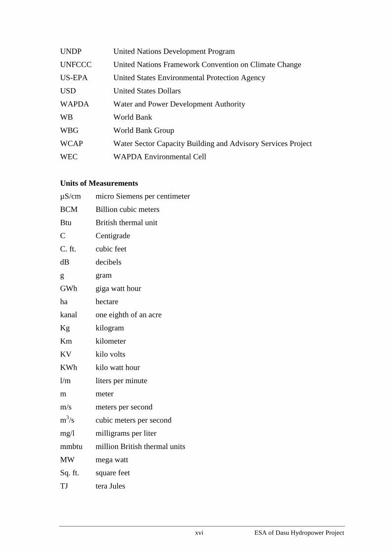
Units of Measurements
µS/cm micro Siemens per centimeter
BCM Billion cubic meters
Btu British thermal unit
C Centigrade
C. ft. cubic feet
dB decibels
g gram
GWh giga watt hour
ha hectare
kanal one eighth of an acre
Kg kilogram
Km kilometer
KV kilo volts
KWh kilo watt hour
l/m liters per minute
m meter
m/s meters per second
m3/s cubic meters per second
mg/l milligrams per liter
mmbtu million British thermal units
MW mega watt
Sq. ft. square feet
TJ tera Jules

1-1 ESA of Dasu Hydropower Project
1. Introduction
The Dasu Hydropower Project (DHP) is a major investment project proposed by the
Government of Pakistan (GoP) to modernize and expand the energy sector of the country,
while shifting from thermal generated electricity to low cost and high reward, clean
generation of hydropower. The project is situated in remote mountainous terrain in the
Upper Indus valley in the district of Kohistan, Khyber Pakhtunkhwa (KP) province in the
north of Pakistan; see Figure 1.1 for the project location.
In the present document the potential environmental and social impacts of the project are
described, including measures to prevent, mitigate, or compensate possible negative
impacts and also to enhance the environmental as well as social benefits.
1.1. Background
1.1.1. The Energy Sector in Pakistan
Access to electricity in Pakistan is at par with other countries of similar income. The
number of electrified households has risen from nearly half of Pakistani households (7.8
million) in 1996 to two-thirds (13.4 million) in 2006 and three-quarters (19 million) in
2011. The major electricity consuming sectors of the country (based on 2011-12 data)
are: residential (45.3 percent), industry (29.2 percent), agriculture (11.3 percent),
commercial (7.6 percent), bulk (4.7 percent) and others (1.9 percent).
Although access to electricity has expanded, service is unreliable. The electricity sector
faces a large gap between supply and demand, and widespread load shedding is
prevalent. Annual per capita electricity consumption in Pakistan 433 kilowatt-hours
(kWh) is lower than lower middle income country standards, which on average consumed
643 kWhs per person per year in 2008.1 Moreover, electricity consumption in Pakistan
grew by only about 73 percent since 1990 compared to 187 percent in Malaysia and 300
percent in China. Neighboring countries in South Asia such as Bangladesh, Nepal and Sri
Lanka witnessed a growth in electrical consumption by about 221, 129 and 159 percent
respectively over the same period (World Development Report, 2010).
Generation is only two thirds of peak demand and 6-8 hours a day of load shedding is
common. Such shortages have significantly affected the ability of businesses to operate
efficiently while also disrupting daily routines for the general population and their quality
of life (summers are uncomfortable, children often have no light to study, people cannot
watch TV, food cannot be cooled, and so forth), and have given rise to unrest and
violence in the major cities. This means, on a macro level, reduced economic growth
which translates into loss of livelihoods, jobs and income. The financial impact of load
shedding has been estimated at 3 percent to 4 percent of GDP, costing about USD 10
billion a year. This situation is causing serious economic losses to the country and is
responsible for increased unemployment and poverty.
1 World Development Indicators. Annual per capita consumption is 3,388 kWh for Malaysia and 2,040
kWh for China.

1-2 ESA of Dasu Hydropower Project
Figure 1.1: Location of DHP in Pakistan

1-3 ESA of Dasu Hydropower Project
The country needs additional generation capacity. Installed capacity essentially
stagnated over 2000–2008. By comparison, installed capacity increased by 40 percent in
Bangladesh, and 46 percent in India over the same period. After 2008, around
3,000 mega watts (MW) were added, taking capacity to about 22,500 MW by end-2011.
But around 10 percent of total installed capacity is unavailable, however, because of lack
of maintenance and lack of fuel. From a peak of 26 percent of total investment and
51 percent of public investment in the mid-1990s, the share of energy (including power)
investments had declined to 4 percent and 26 percent, respectively, by 2009/10. During
this period, private investment was essentially zero.
Generation costs are now very high. Capital and operational constraints meant that the
country was not able to undertake new investments in hydropower. To address
continuing energy shortages in the 1990s, Pakistan launched an extensive program to
mobilize private sector investments in power generation. These were primarily
concentrated on thermal generation, which typically require smaller investments and have
a faster gestation time. As a result, generation mix shifted from two-thirds hydro and one-
third thermal in the 1980s to only 30 percent hydro and 70 percent thermal today. The
new plants rely on higher priced, dirtier furnace oil.
Heavy reliance on imported fuels: The greater reliance on thermal sources also resulted in
an increasing dependency on imported fuel (oil, gas and coal). As much as 85 percent of
oil and allied products are imported. In the period 2000-2010 fuel prices have increased
about three times (in nominal terms) at an average annual rate of 11.3 percent. During the
year 2007-2008 more than US$ 1.25 billion was paid for imported fuel for power
production. These high imports negatively influence the balance of payments.
Alternative Projects: The economic analysis shows that DHP has net benefits greater than
or equal to those of mutually exclusive project alternatives. In Pakistan there exist a
series of options such as demands side management and improved utilization efficiency,
and reduced transmission and distribution losses, that have high economic returns and are
already being undertaken by various Pakistani organizations to address these issues,
Projects such as energy conservation and energy efficiency are complements to, rather
than mutually exclusive substitutes for, DHP and will be implemented regardless of
whether Dasu is built or not. Alternate renewable sources such as wind and solar cannot
be developed to a scale comparable to DHP since they will be three times more expensive
than DHP. Both of these options need to be developed to the extent technically and
financially feasible. They are complementary, but not substitutes for DHP.
Hydro is by far the cheapest generation type for Pakistan and less than a fifth of the cost
of generation from heavy fuel oil which predominates now. New large hydro plants can
generate power for Rs 2.50-3.50 per kWh, compared to Rs 4.5 per kWh for domestic gas
combined cycle plants, Rs 4.2 for nuclear, Rs 8.1 per kWh for coal, Rs 16.75 per kWh for
fuel oil, and around Rs 21 per kWh for diesel. The DHP will have a major impact on
sector performance and finances. It is expected to bring down the average cost of
generation for the entire country by 5-12 percent.
1.1.2. The Vision 2025 Program
During the 1980’several studies were carried out to identify new water storage and
hydropower projects. The total identified capacity of hydropower was estimated at some
46,000 MW. Nine of the projects identified were located in the Upper Indus basin. On
basis of these studies, the Water and Power Development Authority (WAPDA) prepared
at the end of the millennium its “Vision 2025” program.

1-4 ESA of Dasu Hydropower Project
The Vision 2025 was designed to cope with the increasing water and power demands of
the country. The program had a dual purpose: to increase the hydropower generation
capacity in the country, and meanwhile optimizing the water supply to the Indus
irrigation system. The program was approved by GoP in 2001. It included an ambitious
development program with short-term and long-term hydropower projects to be
constructed in three phases until the year 2025 to generate an additional 16,000 MW.
The Dasu Hydropower Project (DHP) was included in this program as one of the priority
projects under phase 3 (2011- 2025). On the priority list DHP ranked second.
A least-cost capacity optimization plan was included in the National Power System
Expansion Plan 2011-2030 (NPSEP), prepared for the National Transmission and
Dispatch Company (NTDC) by SNC-Lavalin. The NPSEP confirms the presence of
Dasu in the least cost expansion plan. The screening curve analysis of this Plan
demonstrates the large cost advantage of the large hydro projects – which is independent
of the thermal project load factors. DHP has generation costs (using NPSEP assumptions)
of $39/MWh, less than half of the best thermal option, and regardless of load factor.
Moreover, this cost comparison does not include the environmental externalities of
thermal generation. Large hydropower projects are known for significant environmental
and social issues. However, DHP has limited social and environmental impacts primarily
because of having a small reservoir. The DHP, in turn, has least cost when compared to
the various ongoing and planned hydro schemes in the country, including – (i) public and
private, (ii) run-of-river and storage, (iii) up- and down-stream of DHP, and (iv) on rivers
other than the Indus (Jhelum and Swat).
Indus Cascade
The GOP energy strategy (2013) emphasizes the development of the Indus Cascade (see
Figure 1.2) to add hydropower to the system to bring down the cost of generation which
is crucial for the sustainability of the sector. In that context, the GOP is now increasing
its investments in hydropower development.
Over the next 15-20 years Pakistan plans to develop, subject to availability of funds, the
Indus Cascade between Tarbela and Diamer-Basha (DB) thus adding about 12,000 MW
or about 71,000 giga watt-hours (GWhs) of electricity generation annually. Dasu
Hydropower Project (DHP), one of the projects in this cascade is relatively low cost and
fast to undertake with a low gestation period.
1.2. The Proposed Project
1.2.1. Location
The Dasu Hydropower Project is located on the Indus River at a site about 7 km upstream
of Dasu bridge near the small town of Dasu, the capital of Kohistan district in KP
province (see Figure 1.1). At this site the river Indus flows in a deep and narrow valley
(elevation 750 - 800 m). The valley is strongly incised into the lower Himalayan
mountains, which have an average altitude between 2,000 and 4,000 m amsl. The project
area is accessible through the Karakorum Highway (KKH), which is the single and
strategic road connection between Islamabad (about 350 km south of Dasu) and the north
of Pakistan (Gilgit-Baltistan province) and with China (Kashgar). About 74 km further
upstream distance from the Dasu dam another water storage and power generation project
in the Indus valley is planned under the “Vision 2025” program: the Diamer-Basha
Project in Diamer district.

1-5 ESA of Dasu Hydropower Project
Figure 1.2: Indus Cascade - Water, Hydropower and Economic Growth of Pakistan
Inflows: 49 million Acre Foot (MAF) Diamer Basha (Planned)
Storage: 6 MAF Installed capacity: 4,500 MW
Completion in about 12-15 yrs Annual Generation: 18 billion KWhs
Cost: US$13-16 billion
Dasu Hydropower (Planned)
Inflow: 54 MAF Installed capacity: total 4,300 MW
Storage live: 0.7 MAF, Dead 0.4 MAF Phase I: 1,080 MW; 8 billion KWhs
Phase-I completes in 5 years (US$3.6 B) Phase II: 2,160 MW; 12 billion KWhs
Phase by 6-7 years (US$0.8 B) Total: 4,320 MW; 18 billion KWhs
Remaining phases depending With Basha: 21 billion KWhs
Available Financing, 7-8 yrs
Pattan (Planned)
Inflows: 58 MAF Installed Capacity: 3,000 MW
Storage: about 0.5 MAF Generation: 15 billion KWhs
Cost: about US$6 billion
Inflows: 60 MAF Thakot (Planned)
Storage: about 0.5 MAF Installed Capacity: 3,000 MW
Cost: about US$6 billion Generation: 15 billion KWhs
Tarbela (Existing)
Inflows: about 61 MAF Installed Capacity: 3,750 MW already in
Storage: 6.7 MAF operation; about 14 BKWhs generated
annually
Tunnel 4 ongoing; 1470 MW; 3.5 BKWhs
Tunnel 5 Possible: 1000 MW; ~2 BKWhs
Ghazi-Barotha (Existing)
1450 MW; 6.5 B KWhs
Possible increase by 150 MW
Total cascade installed capacity: about 22,000 MW; generation: 85 billion KWhs. With 10,000 MW new
capacity and 72 billion KWhs thus substantially shifting the mix to hydropower.

1-6 ESA of Dasu Hydropower Project
1.2.2. Main Structure
The DHP includes the construction of a 242 m high concrete main structure in a gorge
like valley of the upper Indus River basin. The water retained by this structure will
provide sufficient “head” to generate electricity in an underground powerhouse, housing
12 turbines - at its final stage - each of which will produce 360 MW of power.
Behind the main structure there will be a 73 km long reservoir (at full supply level of
950m above mean sea level - amsl) with an average width of 365 m and a total surface
area of about 2400 ha. The total maximum generation capacity will be 4,320 MW. After
full completion, the Dasu Hydropower Project is estimated to generate about 21,000
GWh of energy per annum. This would significantly alleviate the shortage of electricity
in the country.
1.2.3. Karakorum Highway and Access Roads
Apart from the hydraulic and electrical infrastructure needed, the project includes the
realignment of about 62 km of KKH at a higher level in the valley due to submergence of
about 52 km length of the current road on the left bank of the Indus. The relocated road
section also requires the construction of 8 new bridges and a link road of 3 km between
the relocated KKH and the existing KKH near the dam site. In addition, an access road
with a length of about 13 km from the town of Komila (right bank opposite to Dasu) will
connect the existing KKH on the right bank with the dam site. Similarly, on the Indus
right bank upstream of the dam local access roads will be constructed to provide access to
small resettlement villages on the right bank of the reservoir. The project also includes
the construction of a new suspension bridge on Indus near Kandia River connecting left
and right banks.
Also included in the project is the construction of a 132 kV transmission line from Dubair
grid station (near Pattan) at some 45 km downstream of the project site. The transmission
line will provide the project and the residential colony with electricity during the years of
construction. The environmental and social impacts of the construction of the
transmission line and their mitigations are also included in this report.
1.2.4. Transmission Line for Power Evacuation
Two parallel running 500 kV transmission lines will be constructed to connect DHP with
the 500 kV grid station located at a village Pathar Garh near Hassanabdal (District
Attock) to evacuate power from the project. The 250 km long transmission line traverses
along the Indus river from Dasu project to Pattan and then passes through Palas valley,
enters into Mansehra and Abbottabad districts and finally enters to District Attock in
Punjab after passing through District Haripur in KP. The National Transmission and
Dispatch Company (NTDC) is responsible for the construction of the transmission line
and the company has already started the project planning work. Different alignment
alternatives are proposed and they are under further analysis. Along the areas of the
alternatives, NTDC has subsequently completed a study on environmental assessment
and an Environmental Assessment and Review Framework (EARF) has been submitted
to the Bank for its clearance. NTDC completed the Framework by hiring environmental
consultants who worked with its Environmental and Social Impact Cell to do the surveys
and consultations. NTDC has also carried out a socioeconomic profiling exercise and a
screening of the possible social impacts under the transmission line. Key environmental
and social feature of the EARF have been presented later in the present document and
also in the Executive Summary of ESA while the EARF and the social impact screening

1-7 ESA of Dasu Hydropower Project
are presented as stand-alone volumes along with the main ESA report. NTDC has
received a technical assistance support from Asian Development Bank (ADB) and has
developed a Land Acquisition and Resettlement Framework (LARF) in line with relevant
ADB and government policies. The LARF was endorsed and adopted by NTDC
management for all its investment operations to be supported by international financial
institutions. The LARF was reviewed and approved by ADB for compliance with its
resettlement policy under its sector program lending operation. The World Bank has also
reviewed and cleared the LARF, with further revisions, for compliance with OP 4.12, for
CASA 1000 Transmission Line Project. The same LARF will apply to Dasu
Transmission Project.
1.2.5. Project Ancillaries
In addition to the main components described above, the project will also include the
following permanent and temporary ancillary investments (further discussed in
Chapter 3):
Permanent ancillaries including the WAPDA colony with staff housing, sites and
services, offices, access roads from KKH to Colony and on right bank providing
access to villages, and a new suspension bridge over the Indus at Kandia;
Temporary facilities such as labor camps, construction yards, quarries and borrow
areas, stockpiles, spoil disposal sites, workshops and stores needed for the
construction of the main project;
Temporary facilities for the construction of the 500 kV (250 km) and 132 kV
transmission lines (45 km); and
Sites and services for the people to be resettled by the project, including supporting
infrastructure (water supply, sanitation, roads, agricultural terraces, mosques, schools,
and health clinics).
1.2.6. Phasing of the Project
The project will be completed in two stages. Stage 1 (2015-2022) will include the
construction of the main hydraulic structures and the installation of six of the planned
twelve turbines. Stage 2 will include installation of the remaining six turbines and will
be implemented after the completion of Diamer Basha project (see Table 1.1).
Table 1.1: Staged Development of DHP in Relation to Basha
Stage 1 Stage 2
Phase-1 Phase-2 Phase-3 Phase-4
Works Dam, three
turbines, all
ancillary
infrastructure,
KKH relocation,
and one 500 KV
transmission line
Additional
tunnel and
three turbines
Additional
tunnel and
three turbines,
and one 500
KV
transmission
line
Additional
line and
three
turbines
Total installed
capacity in MW 1,080 2,160 3,240 4,320
Generation electricity
in GWh 8,058 12,225 18,730 21,485

1-8 ESA of Dasu Hydropower Project
Stage 1 Stage 2
Phase-1 Phase-2 Phase-3 Phase-4
Start 2015 To be initiated after the
completion of Basha
Completion 2022 (first power after 5
years) 4 years after
commencement
Notes:
Diamer Basha Project (DBP) detailed design is ready and project is likely to be completed in 15 years;
DHP-Stage 2 will be started after the completion of DB, and would take four years to complete;
DHP Stage 1 will be completed in seven years; the first unit will start generating after five years.
1.2.7. Run-of-river
The Dasu Hydropower project is a “run-of-river” project exclusively used for power
generation. Water flowing into the reservoir and stored behind the dam will always be
kept at a permanent water level of 950 m to maintain sufficient “head” for power
generation, at least during the Stage I. Whatever additional water is flowing into the
reservoir will be diverted through the intake and power tunnels towards the turbines
installed in the underground powerhouse. All water used for power generation will be re-
diverted to the river through tail race tunnels. Therefore, there will be no consumptive use
of water in the project with the exception for some evaporation from the relatively small
reservoir (about 2,400 ha). During high flows/floods excess water will pass through low
level outlets and/or spillway. During low flow seasons, there will be reduced flows
between the dam and tailrace outlet (4.4 km section). Downstream of the tailrace outlets,
the river flows would remain unaffected by the project. In this way the project is not
expected to adversely affect the water availability downstream, including the water
sharing between the four provinces of Pakistan as agreed in the 1991 Water Accord. The
principle of the base-load operation of a Run-of-River project is schematically shown in
Figure 1.3. After completion of Diamer Basha project (in Stage 2), the DHP can also be
operated as a peaking plant during winter months to meet the peak time demand (further
discussed in Section 3.6.3). However, the current planning is to use DHP as a base load
plant throughout its lifetime due to higher power generation.
Figure 1.3: Operational Concept of DHP as Run of River Type (Base-load
Operation)

1-9 ESA of Dasu Hydropower Project
1.2.8. Preparatory Studies and Planning of DHP
A feasibility study for the DHP project was carried out between 2007 and 2009. During
this study the location of the project was identified and preliminary engineering designs
and cost estimates for a project with generating capacity of 4,320 MW and an annual
energy generation of about 21,000 GWh were prepared. The preliminary design was
prepared on the assumption that the Diamer-Basha Project (DBP) will be constructed
prior to DHP. A preliminary environmental and social impact assessment was also
included in the feasibility study2 (Environmental Impact Assessment and Resettlement
Aspects, 2009). On basis of these studies a preliminary ‘no objection certificate’ was
obtained from the Environmental Protection Agency (EPA) of KP province in 2011. The
current location and detailed designs are largely based on the results of the feasibility
study.
The detailed design of DHP subsequently has been prepared by an international
consortium of consultants: the Dasu Hydropower Consultants (DHC)3. The design is
prepared on basis of the concept that the DBP will take longer to implement and first two
phases of the DHP that is Stage 1 will start operation before the completion of DBP. This
is a major conceptual shift as compared with the initial feasibility study. Financial
assistance for the design studies has been given by World Bank under the Water Sector
Capacity Building and Advisory Services Project (WCAP) and Tarbela 4 Extension
Hydropower project (T4HP).
Subsequent to the completion of detailed design of the project, the tender documents for
the Stage 1 have also been prepared. Furthermore, as of January 2014, the pre-
qualification process for the preparatory works (KKH relocation, WAPDA colony, and
132-kV transmission line for construction power supply) has also been initiated.
1.3. Scope of the Project and Nature of Impacts
Project interventions may have direct or indirect impacts on the physical, natural, socio-
economic environment and cultural heritage. The anticipated impacts may bring positive
or negative changes or alterations in the area. Some impacts, such as dust and noise
pollution might be temporal and restricted to the construction period. Other impacts
might be more permanent. Some of the impacts can be easily predicted, others are
difficult to predict and should be closely monitored during implementation and operation
of the project.
1.3.1. The Project Area
The project will be implemented in the gorge-like valley along the Indus. Project
construction activities and erection of temporary facilities will directly affect a narrow
corridor extending from Dasu bridge towards Kaigah, a small village situated at the left
bank, 18 km north of Dasu. Direct influence of reservoir will be from the site of the main
structure towards a point 73 km upstream, at 1 km distance from the projected site of the
Diamer-Basha (DB) dam. Other direct and indirect impacts will occur in the immediate
surroundings of borrow areas and quarries for construction materials.
2 Feasibility Study of DHP was carried out by J.V. NESPAK/ACE/Harza/Colenco in association with
Binnie& Partners in 2009. 3 DHC is led by Nippon Koei, Japan (joint venture with Dolsar Engineering, Turkey in association with
three Pakistani firms: Development Management Consultant, National Development Consultants and
Pakistan Engineering Services).

1-10 ESA of Dasu Hydropower Project
Vertically all land situated between the Indus river bed near Dasu at a level of 750 m and
higher uphill including the zone between 1000 and 1500m, where people will be
resettled, will be affected by the project. Implementation of the project will mean that 34
small villages and hamlets will have to be abandoned, requiring the resettlement at higher
levels of some 6,860 persons.
The project area for the present ESA is the “direct footprint” of the project and includes
those areas where the direct impacts of the project are observed or felt. This is the area to
be acquired for the reservoir, the project infrastructure and ancillaries, the resettlement
sites, including the areas used for contractor facilities such as labor camps, workshop,
disposal areas, borrow pits, and quarries.
The project area includes the following:
The Indus river and lower valley slopes between a point at some 74 km upstream
from the dam site up to a point 12 km downstream from the dam site, and including
the left and right bank of the Indus valley up to an elevation of 1500 m amsl
(including the KKH section to be relocated);
The (twin) towns of Dasu (left bank) and Komila (right bank);
Quarry/borrow areas;
Haulage routes for project equipment and supplies;
The corridor (200 m wide) of the transmission line to be constructed providing
electricity to project during construction, connecting Dubair grid station with the
project (45 km); and
The 250 km long and 500 m wide corridor of 500 kV transmission line from Dasu
hydropower to village Pathar Garh in District Attock.
1.3.2. The Area of Influence
The area of influence is much larger and can be described as the area where the indirect
(induced) impacts on the physical and social environment are felt. This includes amongst
others:
The KKH from Thakot bridge to the project area (traffic and transportation);
The Indus river downstream until Tarbela dam (water quality and discharge)
The neighboring mountain uplands on both sides of the Indus valley above (el. 2000
m amsl) characterized by a high biodiversity; and
The population in and around the project area which is not directly affected, but
living in the area.
1.3.3. Cumulative Impacts
The combined and cumulative impacts of construction of DHP and other projects in the
area could be quite significant. Often these impacts are associated with the connectivity
of a road or a river, but also an indirect result of resettlement as well as influx of people.
For instance large scale transport of building materials along the KKH during a long
period (years) may influence the capacity of this important road considerably. This might
have significant positive and negative social and economic impacts. The river hydrology
and sediment transport of the Indus might also be affected by the project, as well as fish
habitats. This might have positive as well as negative induced impacts further

1-11 ESA of Dasu Hydropower Project
downstream, at least until the Tarbela dam and possibly beyond. Construction of a
cascade of dams in the Indus might lead to resettlement of people on higher elevations
resulting in increased pressure on land resources, forests and biodiversity in the higher
mountain plains.
Cumulative impacts from the implementation of other hydro-projects situated in the
Upper Indus Basin might give both positive and negative impacts on the physical and
social environment in the Dasu area and further downstream. Examples are the positive
impacts of the completion of DBP and DHP together on life expectancy of the Tarbela
reservoir due to the trapping of sediment. Also the water availability for irrigation during
early kharif growing season in the plains could be improved through coordinated
operation of water releases of both projects to Tarbela reservoir. Some other potential
cumulative downstream effects of a changed and largely controlled river regime will
depend to a certain extent on the operational system selected for DHP (power generation
based on base load or peak production).
The impacts of the operation of the project will be examined in more detail in Chapter 7,
while cumulative assessment is discussed in Chapter 8.
1.4. Environmental and Social Assessment of DHP
1.4.1. Purpose and Methodology
This report describes the potential environmental and social impacts of the DHP project.
The environmental and social assessment (ESA) is an important tool for decision making.
In the ESA the social and environmental risks and impacts of the project are evaluated.
The ESA process for the DHP started early during the feasibility stage and a preliminary
environmental and social assessment was carried out as described in Section 1.2.8 earlier.
Subsequently in 2011, WAPDA engaged the Dasu Hydropower Consultants to prepare
the detailed design of the project, as well as a more detailed environmental and social
assessment (called Environmental Management and Action Plan, or EMAP). In addition,
resettlement and social management planning was also initiated in 2011-12, leading to
the development of the Social and Resettlement Management Plan (SRMP).
The various volumes included in the EMAP and SRMP are listed below. The EMAP
volumes are available on WAPDA’s website as supporting background documents to the
present ESA, while the SRMP volumes are supplementary to the present ESA.
.
Table 1.2: DHC Environmental Management Action Plan (EMAP)
Vol. 1 Executive Summary
Vol. 2 Environmental Impact Assessment (Main Report)
Vol. 3 Terrestrial Ecology
Vol. 4 Aquatic Ecology
Vol. 5 Physical Cultural Resources (PCR)
Vol. 6 Cumulative and Induced Impact Assessment
Vol. 7 Environmental Baseline Quality
Vol. 8 Environmental Management Plan
1-12 ESA of Dasu Hydropower Project
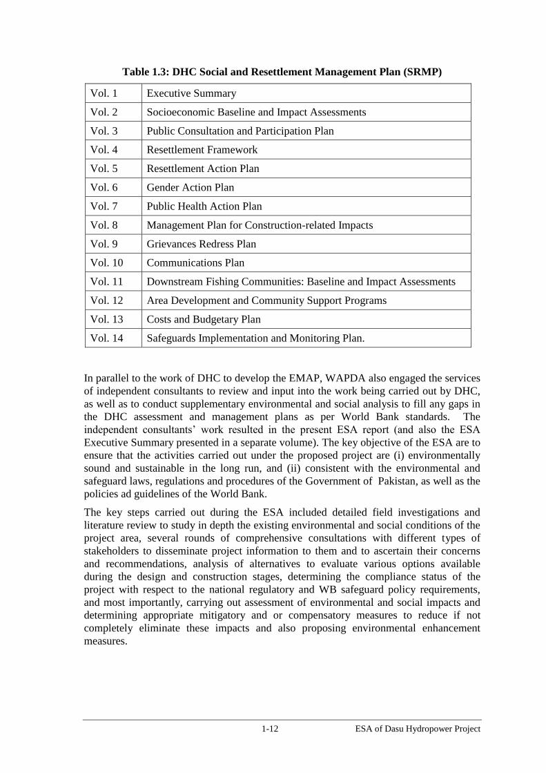
Table 1.3: DHC Social and Resettlement Management Plan (SRMP)
Vol. 1 Executive Summary
Vol. 2 Socioeconomic Baseline and Impact Assessments
Vol. 3 Public Consultation and Participation Plan
Vol. 4 Resettlement Framework
Vol. 5 Resettlement Action Plan
Vol. 6 Gender Action Plan
Vol. 7 Public Health Action Plan
Vol. 8 Management Plan for Construction-related Impacts
Vol. 9 Grievances Redress Plan
Vol. 10 Communications Plan
Vol. 11 Downstream Fishing Communities: Baseline and Impact Assessments
Vol. 12 Area Development and Community Support Programs
Vol. 13 Costs and Budgetary Plan
Vol. 14 Safeguards Implementation and Monitoring Plan.
In parallel to the work of DHC to develop the EMAP, WAPDA also engaged the services
of independent consultants to review and input into the work being carried out by DHC,
as well as to conduct supplementary environmental and social analysis to fill any gaps in
the DHC assessment and management plans as per World Bank standards. The
independent consultants’ work resulted in the present ESA report (and also the ESA
Executive Summary presented in a separate volume). The key objective of the ESA are to
ensure that the activities carried out under the proposed project are (i) environmentally
sound and sustainable in the long run, and (ii) consistent with the environmental and
safeguard laws, regulations and procedures of the Government of Pakistan, as well as the
policies ad guidelines of the World Bank.
The key steps carried out during the ESA included detailed field investigations and
literature review to study in depth the existing environmental and social conditions of the
project area, several rounds of comprehensive consultations with different types of
stakeholders to disseminate project information to them and to ascertain their concerns
and recommendations, analysis of alternatives to evaluate various options available
during the design and construction stages, determining the compliance status of the
project with respect to the national regulatory and WB safeguard policy requirements,
and most importantly, carrying out assessment of environmental and social impacts and
determining appropriate mitigatory and or compensatory measures to reduce if not
completely eliminate these impacts and also proposing environmental enhancement
measures.

1-13 ESA of Dasu Hydropower Project
1.4.2. Composition of Study Team
Independent Consultants
WAPDA engaged a team of independent consultants - Mr. Reitse Koopmans,
Mr. Mohammad Omar Khalid, and Mr. Hans van Zon – to assess the potential
environmental as well as social impacts of the project, to prepare the environmental and
social management plans, and to prepare the main ESA report as well as the Summary
ESA report. The independent consultants commenced working from the start of the
project design around August 2011 and they were authorized to recruit/access
professional expertise as required for carrying out the independent ESA. During the ESA
process, the independent consultants regularly interacted with the DHC’s design team
providing technical advice and recommendations, carried out their own field visits,
participated in the consultations, and conducted their independent analysis and impact
assessment. Where found suitable the independent consultants obtained information
from the design consultants concerning the technical aspects of the project, and asked to
collect environmental and social information from the field through surveys and
collection of data by their staff. The assessment and analysis about the impacts as well as
proposed management plans have been based on the recommendations and professional
judgment of the independent consultants. See the terms of reference (ToRs) of
independent consultants in Annex A.
Environmental Study Team
The national environmental team members included Zafar Iqbal Chaudry and Mudassar
Hassan (Environment Specialists), Dr. William George and Prof. Tahir Omer (Fish
Experts), Dr. Sajid Nadeem (Wildlife Expert), Dr. Rehmatulla Qureshi (Vegetation
Expert), Prof. Ihsan H. Nadiem, Irshad Ahmad Soomro (PCR Specialists), Dr. Allah
Bakhsh Sufi (CIIA Specialist) and Noman Saeed (GIS Specialist). The international team
members included Dr. Venkata Nukala (Lead Environmental Specialist), Malcolm
Winsby (Aquatic Ecologist), Dr. Kashif Sheikh (Terrestrial Ecologist), and Dr. Masud
Karim (Environmental Specialist- Climate Change).
Social Study Team
The national members of the social and resettlement team included Maqsood Ahmed, Dr.
Ramzan Chaudhary, Awais Hassan Khan (Resettlement Specialists), Anwar Fazal
Ahmed, Arslan Tariq (Sociologist), Samia Raoof and Ujala Saleem (Gender Specialists),
Rana Muhammad Saleem (Consultation Specialist), Ahmed Saleem (Communications
Specialist), Noorul Hadi (Livelihood Specialist), and Dr. Ilyas Quershi (Public Health
Specialist). The international experts included Dr Mohammad Zaman, Sunil Gonnetilleke
and Dr. Haimin Wang (Resettlement Specialists), Dr. Iffat Idris (Social/Conflict Analyst),
and Dr. Bernhard Eder (Public Health Specialist).
International Panel of Experts
WAPDA has also engaged an international panel of experts (IPOE) consisting of
renowned specialists including Mr. Erik Helland-Hansen from Norway (Environmental
Expert) and Prof Shi Guoqing from China (Social Expert). These experts together with
experts from various other disciplines have reviewed the design of the project including
the environmental and social aspects. These experts have so far convened during three
missions (May 2012, February 2013 and November 2013). They have conducted site

1-14 ESA of Dasu Hydropower Project
visits, reviewed the ESA reports and provided their respective comments which have
been addressed while preparing the present report. See the ToRs of IPOE in Annex A.
1.4.3. Document Structure
The ESA in Chapter 2 describes the current status of compliance with national and
provincial laws, regulations and procedures, and review compliance with applicable
World Bank Operational Policies (OPs), and guidelines. Chapter 3 provides an overall
description of the project, including design considerations and concepts, construction
methods, use of materials, phasing and construction cost. Possible design alternatives
which have been considered and their influence on environment and social situation are
presented in Chapter 4. A baseline description of the physical, biological and socio-
economic environment is given in Chapter 5. This baseline is also used as a reference
during the development and monitoring of the project construction and operation. Other
relevant issues in the area like seismic hazards, flooding and impacts of climate change
are discussed in Chapter 6. In Chapter 7 the potential negative and positive
environmental and social impacts of the project are presented and their significance,
determined from background data, field studies, interviews and scoping sessions.
Mitigating measures to offset, reduce or compensate adverse impacts, responsibilities for
implementation of these measures and the cost thereof are proposed. Chapter 8 presents
an assessment of the cumulative impacts resulting from the development of DHP together
with other potential hydropower projects. An Environmental and Social Management
Plan (ESMP) is presented in Chapter 9, together with the recommended institutional
arrangement, the management and monitoring requirements. Finally in Chapter 10 a
summary of public consultations and disclosure is given.
2-1 ESA of Dasu Hydropower Project
2. Policy, Legal and Administrative Framework
2.1. General
This Chapter provides an overview of the legislative structure and environmental
assessment process in Pakistan as well as a list of key environmental legislation
applicable to hydro power projects. It also provides an overview of World Bank and
other relevant international requirements including identification of applicable World
Bank Operational Policies and applicable World Bank Group Environmental, Health and
Safety Guidelines.
2.2. Applicable legislation and policies in Pakistan
2.2.1. National Legislation
The development of statutory and other instruments for environmental management has
steadily gained priority in Pakistan since the late 1970s. The Pakistan Environmental
Protection Ordinance, 1983 was the first piece of legislation designed specifically for the
protection of the environment. The promulgation of this ordinance was followed, in 1984,
by the establishment of the Pakistan Environmental Protection Agency (Pak-EPA), the
primary government institution dealing with environmental issues. Significant work on
developing environmental policy was carried out in the late 1980s, which culminated in
the drafting of the Pakistan National Conservation Strategy. Provincial Environmental
Protection Agencies (EPAs) were established at about the same time. The National
Environmental Quality Standards (NEQS) were adopted in 1993. The enactment of the
Pakistan Environmental Protection Act (PEPA), 1997 provided broad-based enforcement
power to the provincial EPAs. The publication of the Pakistan Environmental Protection
Agency Review of IEE and EIA Regulations in 2000 provided the necessary details on
the preparation, submission, and review of initial environmental examinations (IEE) and
environmental impact assessments (EIA). In addition to the Pakistan Environmental
Protection Act, 1997, Pakistan’s statute books contain a number of other laws that
include clauses concerning the regulation and protection of the environment.
Eighteenth Amendment in the Constitution
Amendment XVIII (the Eighteenth Amendment) of the Constitution of Pakistan was
passed by the National Assembly of Pakistan on April 8, 2010. According to this
amendment, the Ministry of Environment has been dissolved and the provinces have been
authorized to make the laws and regulations regarding environment. The powers of Pak-
EPA have now become the powers of Provincial EPAs. Every province is making its own
environment protection act. Although, work on this has initiated however, to date law
has not been enacted in KP and PEPA 1997 continues to be the prime legal instrument
for environmental protection. Based on consultation with KP EPA, it is understood that
they are still drafting the act based on the PEPA 1997 and the whole text of PEPA, 1997
will remain almost same with following amendments:
for the words “Federal Government”, wherever occur, the word “Government” shall
be substituted;
for the words “Federal Agency”, wherever occur, the words “Provincial Agency”
shall be substituted;
for the word “National”, wherever occurs, the word “Khyber Pakhtunkhwa” shall be
substituted;

2-2 ESA of Dasu Hydropower Project
for the word “Pakistan” wherever occurs, the word “Khyber Pakhtunkhwa” shall be
substituted; and
The Government shall, by notification in the official Gazette, establish a Council to
be known as the Khyber Pakhtunkhwa Environmental Protection Council consisting
of Chief Minister, Provincial Environment Minister and members.
Pakistan Environmental Protection Act, 1997
The Pakistan Environmental Protection Act (PEPA) is the basic legislative tool
empowering the government to frame regulations for the protection of the environment.
The act is applicable to a broad range of issues and extends to air, water, industrial liquid
effluent, soil, marine, and noise pollution, as well as to the handling of hazardous wastes.
In context of the Act "environment" means- “(a) air, water and land; (b) all layers of the
atmosphere; (c) all organic and inorganic matter and living organisms; (d) the ecosystem
and ecological relationships; (e) buildings, structures, roads, facilities and works; (f) all
social and economic conditions affecting community life; and (g) the inter-relationships
between any of the factors in sub-clauses (a) to (f). The following key features of PEPA
have a direct bearing on the proposed project:
Section 11 (Prohibition of Certain Discharges or Emissions): states that “Subject to
the provisions of this Act and the rules and regulations made there under, no person
shall discharge or emit, or allow the discharge or emission of, any effluent or waste or
air pollutant or noise in an amount, concentration or level which is in excess of the
NEQS”.
Section 12-I (IEE and EIA); requires that “No proponent of a project shall commence
construction or operation unless he has filed with the Federal Agency an IEE or,
where the project is likely to cause an adverse environmental effect, an EIA, and has
obtained from the Federal Agency approval in respect thereof.”
Section 12-2b (Review of IEE and EIA): The Federal Agency shall review the EIA
report and accord its approval subject to such conditions as it may deem fit to impose,
or require that the EIA be re-submitted after such modifications as may be stipulated
or rejected, the project as being contrary to environmental objectives.
Section 14 (Handling of Hazardous Substances); requires that “Subject to the
provisions of this Act, no person shall generate, collect, consign, transport, treat,
dispose off, store, handle, or import any hazardous substance except (a) under a
license issued by the Federal Agency and in such manner as may be prescribed; or (b)
in accordance with the provisions of any other law for the time being in force, or of
any international treaty, convention, protocol, code, standard, agreement, or other
Instrument to which Pakistan is a party.” Enforcement of this clause requires the
EPA to issue regulations regarding licensing procedures and to define ‘hazardous
substance.’
Section 15 (Regulation of Motor Vehicles): Subject to provision of this clause of the
Act and the rules and regulations made there under, no person shall operate a motor
vehicle from which air pollutants or noise are being emitted in an amount,
concentration or level which is in excess of the NEQS, or where the applicable
standards established under clause (g) of subsection (1) of Section-6 of the Act.
Section 17 (Penalties): Whoever contravenes or fails to comply with the provisions of
section 11, 12, 13, or section 16 or any order issued there under shall be punishable

2-3 ESA of Dasu Hydropower Project
with fine which may extend to one million rupees, and in the case of a continuing
contravention or failure, with an additional fine which may extend to one hundred
thousand rupees for every day during which such contravention or failure continues:
Provided that if contravention of the provisions of section 11 also constitutes
contravention of the provisions of section 15, such contravention shall be punishable
under sub-section (2) only.
Review of IEE and EIA Regulations, 2000
The Pakistan Environmental Protection Agency Review of IEE and EIA Regulations,
2000, prepared by the PEPA provide the necessary details on the preparation, submission,
and review of the initial environmental examination (IEE) and the environmental impact
assessment (EIA). Under these Regulations projects are classified on the basis of the
expected degree of adverse environmental impacts. Project types listed in Schedule II of
the regulations are designated as potentially seriously damaging to the environment, and
those listed in Schedule I as having potentially less adverse effects.
Schedule-I projects require an IEE to be conducted, rather than a full-fledged EIA,
provided that the project is not located in an environmentally sensitive area. The projects
listed in Schedule-II are generally major projects and have the potential to affect a large
number of people in addition to significant adverse environmental impacts. For Schedule
II projects conducting an EIA is obligatory. Dams and reservoirs with a maximum
storage volume over 50 million m3 or a surface area greater than 8 km
2 and hydroelectric
power projects generating over 50 MW fall under Schedule-II. DHP falls in Schedule II
as per EPA classification, because the power generation is 4320 MW and the reservoir
area is 23.8 km² with a reservoir volume 1,410 million m³.
The prescribed procedure for review of EIA by the EPA is shown in Figure 2.1.
2.2.2. Other Relevant Legislation
Pakistan Penal Code, 1860
The Pakistan Penal Code deals with offences where public or private property and/or
human lives are affected due to the intentional or accidental misconduct of an individual
or body of people. In the context of the environment, the Penal Code empowers local
authorities to control noise, toxic emissions and disposal of effluents.
Pakistan Explosives Act, 1884
This Act provides regulations for the handling, transportation and use of explosives
during quarrying, blasting and other purposes. The construction of the new power house
may require blasting at rocky areas making these regulations applicable for this project.
Forest Act, 1927
This Act authorizes provincial forest department to establish forest reserves and protected
forests. The Act prohibits any person from: setting fires in the forest; quarrying stone;
removal of any forest produce; or causing any damage to the forest by cutting trees or
clearing areas for cultivation or any other purpose.
Hazara Forest Act 1936
An act to consolidate and amend the law relating to reserved forests and waste lands in
Hazara District. This act applies only to the left bank of the project, which is a part of
Hazara Division.

2-4 ESA of Dasu Hydropower Project
Source: DHC, EMAP, Volume 2
Figure 2.1: Review and Approval Process of EIA
Protection of Trees Act, 1949
This Act prohibits cutting or lopping of trees along roads and canals planted by the Forest
Department, without permission of the Forest Department. Within the project area there
Proponents Submits
EIA to KP-EPA
Initial Scrutiny by EPA
Actions by EPA: 1) Notice for
Public Hearing; 2) Placement of
EIA for Public Review; 3)
Circulation of EIA to Concerned
Government Agencies
Public Hearing
Optional:
Committee of Experts;
Site Visit by EPA
Submission of Acceptance of
Conditions by Proponent
Initiate Construction
Initiate Construction
Decision
on
Scrutiny
Decision
on EIA
Require more
information
Return the
EIA for revision
Accept
Approve without
conditions
Reject
Approve with
conditions
Time Frame
10
Wo
rkin
g d
ays
No
t m
ore
th
an
12
0 d
ays
Pre
fera
bly
no
t m
ore
th
an
90
da
ys
30
da
ys

2-5 ESA of Dasu Hydropower Project
are no planted forests reserves and hardly any road side trees available, apart from some
planted trees along KKH.
Land Acquisition Act, 1894
This Act is the primary law for acquisition of land and built-up properties for public
interest in Pakistan and also sets out the procedure and rules for acquisition and
compensating the land owners, including for any damage caused to their properties, crops
and trees by a project, however it lacks the mechanism to address the complex issues of
resettlement. The Act comprises 55 sections dealing with area notifications, surveys,
acquisition, compensation, appointment awards, disputes resolution, penalties and
exemptions. For DHP, WAPDA will acquire land broadly following the procedures
prescribed by this Act, while also complying with the WB safeguard policies (discussed
later in the Chapter).
Factories Act, 1934 (as amended to 1997)
The clauses relevant to the project are those which concern health, safety and welfare of
workers, disposal of solid wastes and effluents, and damage to private and public
property. The Factories Act also provides regulations for handling and disposal of toxic
and hazardous materials. As construction activity is classified as ‘industry’, these
regulations will be applicable to the construction contractors. Particular sections of the
act applicable to DHP project are:
Section 13(1): Every factory shall be kept clean and free from effluvia arising from
any drain, privy or other nuisance.
Section 14(1): Effective arrangements shall be made in every factory for the disposal
of wastes and effluents due to the manufacturing process carried on therein.
Section 16(1): In every factory in which, by reason of the manufacturing process
carried on, there is given off any dust or fume or other impurity of such a nature and
to such an extent as is likely to be injurious or offensive to the workers employed
therein, effective measures shall be taken to prevent its accumulation in any work-
room and its inhalation by workers and if any exhaust appliance is necessary for this
purpose, it shall be applied as near as possible to the point of origin of the dust, fume
or other impurity, and such point shall be enclosed so far as possible.
Section 16(2): In any factory no stationary internal combustion engine shall be
operated unless the exhaust is conducted into open air and exhaust pipes are insulated
to prevent scalding and radiation heat, and no internal combustion engine shall be
operated in any room unless effective measures have been taken to prevent such
accumulation of fumes there from as are likely to be injurious to the workers
employed in the work-room.
Section 20(1): In every factory effective arrangements shall be made to provide and
maintain at suitable points conveniently situated for all workers employed therein a
sufficient supply of whole-some drinking water.
Section 26(1) d(i): In every factory the following shall be securely fenced by the
safeguards of substantial construction which shall be kept in position while the parts
of machinery required to be fenced are in motion or in use, namely – (a) every part of
an electric generator, a motor or rotary convertor.
2-6 ESA of Dasu Hydropower Project
The West Pakistan Board of Revenue Act 1957
This act is to provide for the constitution of a board of revenue for West Pakistan. The
Board shall be the controlling authority in all matters connected with the administration
of land, collection of land revenue, preparation of land records and other matters relating
thereto. This task has been now been devolved to the Provinces following the Eighteenth
Amendment Act 20120 of the Constitution.
Pakistan Water and Power Development Authority Act, 1958
The Act provides for the unified and coordinated development of the water and power
resources of Pakistan. This Act authorizes WAPDA to develop water and power
resources in the country through construction and operation of water storages and power
houses and erecting electrical transmission lines. The responsibility for erecting
transmission lines and operation of the distribution network now rests with the National
Transmission and Dispatch Company (NTDC). WAPDA still has the powers and
obligations of a licensee under the Telegraphy Act of 1910. This Act also establishes
policy for land acquisition and compensation, as well as the degree of liability of
WAPDA for damages sustained by landowners or other parties. WAPDA is the owner of
DHP and its development is covered under this Act.
The West Pakistan Firewood and Charcoal (Restriction) Act 1964
This act is to prohibit and regulate the burning of firewood and charcoal in West
Pakistan. This act extends to the whole of the province of West Pakistan, except the tribal
areas. Use of firewood is still very common in the area and for this reason the act is
applicable for the entire project area.
Motor Vehicle Ordinance, 1965 and Rules, 1969
The Motor Vehicles Ordinance, 1965, has been extended with effect from March 05,
1978, to the whole of Pakistan. It deals with the licensing requirement for driving;
powers of licensing authority, Regional Transport Authority and those of Court vis-à-vis
disqualification for license and registration requirements to control road transport;
compensations for the death of or injury to a passenger of public carrier; powers of Road
Transport Corporation; traffic rules, power to limit speed, weight, use of vehicles; power
to erect traffic signs; specific duties of drivers in case of accident and powers of police
officers to check and penalize traffic offenders. All vehicles used on DHP by WAPDA,
Consultants and the Contractor will be subject to this Motor Vehicle Ordinance 1965 and
rules 1969.
KP Wildlife Protection, Preservation, Conservation and Management Act,
1975 (NWFP Act No. V of 1975)
This law was enacted to protect the province’s wildlife resources directly and other
natural resources indirectly. It classifies wildlife by degree of protection, i.e., animals
that may be hunted on a permit or special license, and species that are protected and
cannot be hunted under any circumstances. The Act specifies restrictions on hunting and
trade in animals, trophies, or meat. The Act also defines various categories of wildlife-
protected areas, i.e., National Parks, Wildlife Sanctuaries, and Game Reserve. The project
activities will have to be carried out in accordance with this Act. The act is particularly
relevant for the Kaigah private game reserve (5000 ha, community managed), which is
the only protected site situated within the project area. After approval and notification of

2-7 ESA of Dasu Hydropower Project
the Wildlife authorities certain amendments, including mitigation measures and changes
in the boundaries of a particular game reserve are possible.
Antiquity Act, 1975
The Antiquity Act of 1975 ensures the protection of cultural resources in Pakistan. This
Act is designed to protect antiquities from destruction, theft, negligence, unlawful
excavation, trade and export. Antiquities have been defined in this Act as “Ancient
products of human activity, historical sites, sites of anthropological or cultural interest
and national monuments”.
The law prohibits new construction in the proximity of a protected antiquity and
empowers the government of Pakistan to prohibit excavation in any area that may contain
articles of archaeological significance.
Under this Act, the proponents are obligated to:
Ensure that no activity is under taken in the proximity of a protected antiquity, and
Report any archaeological discovery made during the course of the project to the
Department of Archaeology, Government of Pakistan.
Fisheries W.P. Ordinance XXX of 1961 Amended Vide NWFP Fisheries
(Amendment) Ordinance 1982
This Ordinance was promulgated to amend and consolidate the law relating to fisheries in
the province of West Pakistan (including KP). The ordinance was issued during West
Pakistan as one unit. This was later adopted by provinces. This grants power to Director
General (DG) Fisheries to issue permit to catch fish. The ordinance protects the fish
against 1) Destruction of fish by explosives, 2) Destruction of fish by poisoning water.
There are other clauses providing protection to fish.
The Provincial Administered Tribal Areas (Conservation and Exploitation of
certain Forests) Regulation 1980
The purpose of this regulation is to provide for conservation, better exploitation and
prohibition of unlawful cutting of forest in certain Provincially Administered Tribal
Areas of Hazara Division. Since the Indus left bank falls under this division the Act is
applicable to the project.
The NWFP Power Crushers (Licensing) Ordinance 1980
This ordinance is to provide for the licensing of power crushers in the NWFP (now KP).
This ordinance will extend to the whole of KP. It will also deal with the licensing
authority, registration fee of power crushers and with the penalties. It is possible that
some of the construction material is required from areas outside KP province. In this case
the licenses to be obtained by contractors should be according to the rules and regulations
of the competent authorities in these regions.
Labor Laws
Labor laws in Pakistan are governed by several legislative tools. However, the principal
labor rights are provided by the constitution of Pakistan. In addition to constitutional
rights, Acts and Ordinances have been enforced for limiting working hours, minimum
working age and conditions of employment. The laws will be applicable to the project
construction contractors.

2-8 ESA of Dasu Hydropower Project
Employment of Child Act, 1977
Article 11(3) of the Constitution of Pakistan prohibits employment of children below the
age of 14 years in any factory, mines or any other hazardous employment. In accordance
with this Article, the Employment of Child Act (ECA) 1991 disallows the child labor in
the country. The ECA defines a child to mean a person who has not completed his/her
fourteenth years of age. The ECA states that no child shall be employed or permitted to
work in any of the occupation set forth in the ECA (such as transport sector, railways,
construction, and ports) or in any workshop wherein any of the processes defined in the
Act is carried out. The processes defined in the Act include carpet weaving, biri (kind of
a cigarette) making, cement manufacturing, textile, construction and others).
Highway Safety Ordinance, 2000
This Ordinance includes provisions for licensing and registration of vehicles and
construction equipment; maintenance of road vehicles; traffic control offences, penalties
and procedures; and the establishment of a police force for motorways and national
highways to regulate and control the traffic as well as keep the highways clear of
encroachments. This Ordinance will have an impact on the road network leading to the
Project area during the construction phase of the project.
Local Government Ordinance, 2001
This Act empowers the Government of Pakistan and provincial governments to enforce
laws for land use; conservation of natural vegetation; air, water, and land pollution;
disposal of solid waste and wastewater effluents; and public health and safety, including
some provisions for environmental protection. Section 93 of this Ordinance pertains to
environmental pollution, under which the local councils are authorized to restrict causing
pollution to air, water or land. DHP will have to follow the Ordinance with regards to
pollution of air, water and land.
2.2.3. National Environmental Guidelines and Policies
National Climate Change Policy, 2012
Pakistan has prepared the National Climate Change Policy in order to ensure that climate
change is mainstreamed in the economically and socially vulnerable sectors of the
economy and to steer Pakistan towards climate resilient development. The Policy
addresses the key issues relevant to the country including food security, water security,
energy security, and extreme weather events. The Policy covers climate change
adaptation with respect to water resources, agriculture and livestock, human health,
forestry, biodiversity, disaster preparedness, poverty, and gender aspects, while it
addresses energy, transportation, town planning, and industry with respect to climate
change mitigation.
National Conservation Strategy (NCS) 1992
The Pakistan NCS is the principal policy document for environmental issues in the
country, which was developed and approved by the Government of Pakistan on 1 March
1992. The NCS works on a ten-year planning and implementation cycle. It deals with
fourteen core areas, as follows:
Maintaining soils in cropland;
Increasing irrigation efficiency;

2-9 ESA of Dasu Hydropower Project
Protecting watersheds;
Supporting forestry and plantations;
Restoring rangelands and improving livestock;
Protecting water bodies and sustaining fisheries;
Conserving biodiversity;
Increasing energy efficiency;
Developing and deploying material and energy renewable;
Preventing and abating pollution;
Managing urban wastes;
Supporting institutions for common resources;
Integrating population and environmental programs; and
Preserving the cultural heritage.
National Environment Policy
This policy was implemented in 2005 to provide an overarching framework for
addressing the environmental issues facing Pakistan. It gives directions for addressing
sectoral issues and provides means for promoting conservation and environmental
protection in water, air and waste management, forestry, and transport. The policy aims
to promote protection of the environment, the honoring of international obligations,
sustainable management of resources and economic growth.
CDM Strategy 2006
Pakistan has prepared the clean development mechanism strategy to fulfill the
requirements of establishing a designated national authority (DNA) and ensuring
transparent, participatory and effective management of CDM process in the country. The
strategy describes the functions and powers of DNA, the criteria for CDM projects and
national approval process. Under the Policy, Pakistan allows unilateral, bilateral and
multilateral CDM projects preferably in the areas of energy including renewable energy,
energy efficiency, energy conservation and fossil-fueled cogeneration; land use, land use
change and forestry (e.g. biodiversity protection, soil conservation, watershed
maintenance and sustainable forest/rangeland management); agricultural and livestock
practices; waste management (e.g. landfills, solid waste management, recycling,
animal/livestock wastes); transportation (e.g. alternative fuel vehicles, mass transit
systems, cleaner engines, compressed natural gas; and Industrial processes.
Guidelines for the Preparation and Review of Environmental Reports, 1997
These guidelines on the preparation of environmental reports address project proponents,
and specify the:
Nature of the information to be included in environmental reports;
Minimum qualifications of the EIA consultant;
Need to incorporate suitable mitigation measures into every stage of project
implementation;

2-10 ESA of Dasu Hydropower Project
Need to specify monitoring procedures.
Terms of reference for the reports are to be prepared by the project proponents
themselves. The reports must contain baseline data on the Project area, a detailed
assessment thereof, and mitigation measures.
Policy and Procedures for Filing, Review and Approval of Environmental
Assessments, 2000
These policies and procedures define the policy context and the administrative
procedures that govern the environmental assessment process, from the project pre-
feasibility stage to the approval of the environmental report.
Guidelines for Public Consultation, 1997
The guidelines deal with approaches to public consultation and techniques for designing
an effective program of consultation that reaches out to all major stakeholders and
ensures the incorporation of their concerns in impact assessment.
Guidelines for Sensitive and Critical Areas, 1997
The guidelines identify officially notified protected areas in Pakistan, including critical
ecosystems, archaeological sites, etc., and present checklists for environmental
assessment procedures to be carried out within or near to such sites. Environmentally
sensitive areas include, among others, archaeological sites, biosphere reserves and natural
parks, and wildlife sanctuaries and preserves, none of which are relevant to the Project
area.
2.2.4. National Environmental Quality Standards
The NEQS first promulgated under the PEPA 1997 and revised/expanded thereafter in
2010, specify the following standards:
Maximum allowable concentration of pollutants in gaseous emissions from industrial
sources;
Maximum allowable concentration of pollutants in municipal and liquid industrial
effluents discharged to inland waters, sewage treatment and sea (three separate set of
numbers);
Maximum allowable emissions from motor vehicles;
Ambient air quality standards;
Drinking water standards; and
Noise standards.
The following NEQS will be relevant to the environmental aspects of the Dasu
Hydropower Project4:
Industrial and Municipal Effluents;
Waste Effluents;
Ambient Air;
Motor Vehicle Exhaust and Noise;
4 These NEQS are available at the Pak-EPA website (http://www.environment.gov.pk/info.htm).

2-11 ESA of Dasu Hydropower Project
Ambient noise; and
Drinking Water Quality Standards.
2.2.5. Environmental Regulatory Authorities
The Pakistan Environmental Protection Ordinance, 1983 was the first legislation in
Pakistan designed specifically for the protection of the environment. The promulgation
of this Ordinance was followed in 1984 by the creation of Pakistan Environmental
Protection Council (PEPC).
Pakistan Environmental Protection Council
The PEPC is the highest inter-ministerial statutory body in the country headed by the
Prime Minister and is responsible for:
Formulating national environmental policy;
Enforcing PEPA 1997;
Approval of the NEQS;
Incorporation of environmental considerations into national development plans and
policies; and
Provision of guidelines for the protection and conservation of biodiversity in general
as well as conservation of renewable and non-renewable resources.
Climate Change Division
The Climate Change Division, which falls directly under the Prime Minister Secretariat,
is the focal point for National Policy, Legislation, Plans, Strategies and programs with
regard to Disaster Management, Climate Change including Environmental Protection and
preservation. The Division also deals with other countries, international agencies and
forums for coordination, monitoring and implementation of environmental agreements.
Pakistan Environmental Protection Agency (PAK-EPA)
The PAK-EPA is headed by a Director General and has wide ranging functions as set out
in PEPA 1997. These include preparation and co-ordination of national environmental
policy for approval by PEPC, administering and implementing PEPA 1997 and
preparation, revision or establishment of NEQS. The PAK-EPA has issued regulations
regarding the environmental assessment procedures known as Review of Initial
Environmental Examination (IEE) and EIA Regulations, 2000; these provide a firm legal
status to the IEEs and EIAs. The jurisdiction of the EPA is applicable to the following
projects:
On federal land;
Military projects;
Involving trans-country impacts; and
Bearing trans-province impacts.
Provincial/Regional Environment Protection Agencies
The four provinces and the two regions (Azad Jammu and Kashmir - AJK and Gilgit-
Baltistan) have each their own Environmental Protection Department (EPD) and/or
EPAs, which are counterparts of the PAK-EPA at the provincial/regional level. The

2-12 ESA of Dasu Hydropower Project
provincial/regional EPAs are established by the respective provincial/regional
governments. They are headed by a Director General. The IEE and EIA reports
pertaining to projects falling within the different provincial/regional boundaries are to be
submitted to the relevant provincial/regional EPA for approval. For the proposed project,
KP-EPA is the relevant agency for the approval of the EIA.
2.2.6. International Treaties and Conventions
Pakistan is a signatory to a number of Multilateral Environmental Agreements (MEAs).
These MEAs impose requirements and restrictions of varying degrees upon the member
countries, in order to meet the objectives of these agreements. However, the
implementation mechanism for most of these MEAs is weak in Pakistan and institutional
setup mostly non-existent. The following are the relevant international treaties and
conventions that have been ratified by Pakistan, where relevant these will be discussed in
further detail within relevant chapters:
Basel Convention,
Convention on Biological Diversity, Convention on Wetlands (Ramsar convention),
Convention on International Trade in Endangered Species (CITES),
United Nations Framework Convention on Climate Change (UNFCCC),
Kyoto Protocol,
Montreal Protocol,
UN Convention to Combat Desertification,
UN Convention on the Law of Seas (LOS),
Stockholm Convention on Persistent Organic Pollutants (POPs),
Convention concerning the Protection of World Culture and Natural Heritage (World
Heritage Convention), 1972; and
International Plant Protection Convention, 1951.
2.3. World Bank
2.3.1. Overview
The World Bank (WB) categorizes development projects according to the type, location,
sensitivity, and scale of the project, as well as the nature and magnitude of its potential
adverse social and environmental impacts.
The Project has been categorized as “Category A” requiring a detailed environmental and
social assessment (ESA) and development and implementation of an environmental and
social management plan (ESMP). For category ‘A’ projects borrowers must consult with
project-affected groups and local non-governmental organizations about the project’s
environmental aspects and take their views into account. Borrowers must (a) initiate
consultations as early as possible; (b) consult groups at least twice (before terms of
reference for the assessment are finalized and once a draft assessment report is prepared);
and (c) consult affected groups throughout project implementation as necessary to
address related issues.
2-13 ESA of Dasu Hydropower Project
2.3.2. Operational Policies (OPs) of the World Bank
Governments seeking financing from the World Bank are required to comply with the
applicable Operational Policies (OPs) on environmental and social safeguards. A
summary of the key objectives of the relevant safeguards policies considered for the
Project is provided below.
OP 4.01 (Environmental Assessment): provides the framework for World Bank
environmental safeguard policies and describes project screening and categorization to
determine the level of environmental assessment required. For category A and B projects
the policy requires public consultation and disclosure to be undertaken as part of the
Environmental Assessment process. Finally the policy sets out requirement to comply
and report on implementation of any environmental management plans (i.e. mitigation
measures, monitoring program etc.) The policy is triggered.
OP 4.04 (Natural Habitats): The policy recognizes the importance of natural habitat in
sustaining biodiversity, and requires that projects strictly avoid their significant
conversion or degradation (particularly for critical natural habitat), and minimize and
mitigate impacts to them including, as appropriate, through creation of offsets and
restoration measures. This policy is triggered by the project.
OP 4.11 (Physical Cultural Resources): sets out the World Bank requirement to avoid or
mitigate adverse impacts resulting from project developments on cultural resources.
There are important cultural or archaeological resources in the vicinity of the Project,
including two beautifully decorated and centuries-old mosques and numerous ancient
rock carvings dating from Stone Age to Buddhist era; hence this OP will be triggered.
OP 4.12 (Involuntary Resettlement): the World Bank aims to avoid involuntary
resettlement where possible. Where necessary or acquisition of land or other assets is
necessary, the policy sets out requirements for participation in resettlement planning,
mandates compensation for assets at replacement cost, and expects the borrower to see
that incomes and standards of living of affected persons are improved or at least restored
to what they were prior to displacement. The document also identifies the need for a
Resettlement Plan, an abbreviated Resettlement Plan or otherwise. Since more than 6,950
people will be resettled under the project this OP will be triggered.
OP 4.36 (Forests): this policy recognizes the need to reduce deforestation and promote
sustainable forest conservation and management in reducing poverty. Pakistan has forests
only covering 2.0 percent of its territory and annually the forested area decreases with
2.5 percent. North Pakistan (including Kohistan) has a forest cover of about 29 percent.
The direct impacts of the project on the forest resources include some tree cutting for
dam construction, creation of reservoir, and KKH realignment. The indirect impacts of
the project activities on the forest resources include increased population pressure and
agricultural activities caused by the resettlement, potentially resulting in increased
pressure on the high altitude forests. In addition, the project will include a reforestation
program. Hence this OP is triggered.
OP 4.37 (Safety of Dams): this policy requires that experienced and competent
professionals design and supervise construction, and that the borrower adopts and
implements dam safety measures through the project cycle. It recommends, where
appropriate, that Bank staff discuss with the borrowers any measures necessary to
strengthen the institutional, legislative, and regulatory frameworks for dam safety

2-14 ESA of Dasu Hydropower Project
programs in those countries. For large dams, the borrower must engage an independent
Dam Safety Panel. The policy is triggered.
OP 7.50 (Projects on International Waterways): Projects on International Waterways -
may affect the relations between the World Bank and its borrowers, and between riparian
states. Therefore, the Bank attaches great importance to the riparian making appropriate
agreements or arrangements for the entire waterway, or parts thereof, and stands ready to
assist in this regard. A borrower must notify other riparian of planned projects that could
affect water quality or quantity, sufficiently far in advance to allow them to review the
plans and raise any concerns or objections. This OP is triggered, given that the Indus is a
shared waterway and its use is governed by an existing bi-national treaty with India.
Access to Information: This policy sets out the Bank's requirements for disclosing and
sharing information. The policy reaffirms the Bank’s commitment to transparency and
accountability in its activities for promoting development effectiveness and poverty
reduction.
2.3.3. Applicable World Bank Policies
The status of the environmental and social safeguard policies of the World Bank are
provided below in Table 2.1.
Table 2.1: Triggering the World Bank Policies
Directive Policy Triggered Comments
Environmental
Assessment
OP/BP
4.01
Yes As the Project falls into Category A, a full ESA has to
be carried out. It is the basis of this ESA document.
Natural
Habitats
OP/BP
4.04
Yes The project has potential to cause significant
conversion of habitat and impair associated ecological
functions by: conversion of riverine habitat to
lacustrine habitat through creation of a long reservoir
(74 km); placement of a high dam (242 m) on the river
main stem effectively creating a barrier to movement of
biota and impairing ecological/longitudinal
connectivity along the Indus River main stem; carrying
out transmission line construction activities in forested
areas. Furthermore, the project activities can
potentially have adverse effects on the natural habitat
particularly at the higher elevations and in the Kaigah
Nullah Game Reserve and Palas Valley.
Indigenous
Peoples
OP
4.10
No Not triggered since no Indigenous People or ethnic
minorities are living in the area.
Physical
Cultural
Resources
OP
4.11
Yes Triggered. Two historical and beautiful decorated
wooden mosques are located in the project area. One of
them will be submerged by the reservoir. Part of a
large endangered cluster of pre-historic and historic
rock art with national and international importance is
located in the Indus valley adjacent to the head of
reservoir.

2-15 ESA of Dasu Hydropower Project
Directive Policy Triggered Comments
Involuntary
Resettlement
OP/BP
4.12
Yes Triggered. The project will require the acquisition of
about 4,650 ha of land and resettlement of about 767
households including some 6,953 persons. A
Resettlement Action Plan (RAP) and a SRMP have
been developed in line with relevant Pakistani laws and
World Bank OP 4.12 to guide the planning and
implementation of necessary compensatory measures.
Forests OP/BP
4.36
Yes Triggered. The direct impact area situated below el.
1500 m is an area consisting of steep slopes full of
rubble and rocks with hardly any vegetation other than
low scrubs and stunted trees. An estimated 21,000
individual trees were counted in the reservoir and
resettlement areas, including 2,980 fruit and medicinal
trees. Additional trees may need to be felled for the
construction of the 500 kV transmission line. These
trees will be lost as a result of the project and a
reforestation program will be created to offset the loss.
The project will also have an induced impact by the
expected increase in population pressure (collection of
firewood, logging, and agriculture) on the high altitude
forests, which are already under heavy pressure from
deforestation and degradation. These forests are
situated at higher elevations (2,000 - 4,000 m) where
the gently sloping plateaus and glacial terraces can be
found.
Pest
Management
OP
4.09
No Not triggered. No pesticides, herbicide or fungicides
will be used in any of the project activities including
forest nurseries.
Safety of
Dams
OP/BP
4.37
Yes Triggered. The dam safety policy is triggered since the
project involves the construction of a large dam
including associated infrastructure. An international
panel of experts has reviewed the engineering designs
of the dam. Dam safety monitoring equipment will be
installed and regularly recorded by DHP. WAPDA’s
Dam Safety Organization will annually conduct
investigations. This includes the monitoring of the
movement of sediment and an early warning system
will be installed. An external organization will be hired
to independently review dam safety during operational
phase.
Projects in
International
Waterways
OP/BP/
GP
7.50
Yes The Project is located on an international waterway and
will require a riparian notification consistent with
World Bank.
Projects in
Disputed
Areas
OP/BP
7.60
No Not triggered. All project facilities are located in KP
province.
2-16 ESA of Dasu Hydropower Project
Directive Policy Triggered Comments
Access to
Information
World Bank has developed a new approach to the
disclosure of information, transparency and sharing of
knowledge. The public will have access to a broad
range of information about project in preparation and
implementation. The ESA report, EARF, ESA
Executive Summary, and SRMP have been disclosed
on WAPDA’s website in January 2014. Consultations
were held with the affected community through a
public disclosure/consultation meeting in February
2014. Public consultations and disclosure were also
held in Islamabad and Peshawar in February 2014. The
ESA Executive Summary has been translated into Urdu
and has been made available to the communities and
other stakeholders through local government’s office
and also WAPDA’s field office in Dasu. ESA, ESA
Summary, EARF for the project’s 500 kV
Transmission Line, and SRMP have also been sent to
World Bank Info Shop.
2.3.4. World Bank Environmental and Social Guidelines
The principal World Bank publications that contain environmental and social guidelines
are listed below;
Environmental Assessment Sourcebook, Volume I: Policies, Procedures, and Cross-
Sectoral Issues;
Involuntary Resettlement Sourcebook;
Social Analysis Sourcebook;
Physical Cultural Resources Sourcebook; and
World Bank Group - Environmental Health and Safety Guidelines.

3-1 ESA of Dasu Hydropower Project
3. Project Description
3.1. Location of the Project
The Dasu Hydropower Project is to be constructed in the Indus valley at a site about 7 km
upstream of Dasu Bridge near Dasu town, the administrative headquarters of the
Kohistan District, Khyber Pakhtunkhwa (KP) province. The site is about 74 km
downstream of the projected Diamer-Basha Dam, another project to be developed under
the Vision 2025 program. The project is located in a remote and thinly populated and
mountainous area. Dasu is only accessible from Islamabad by GT Road to Hassanabdal
and KKH via Abbottabad-Mansehra-Besham-Dasu. Distance to Islamabad is about 350
km, which can be covered in about 10 hours by car. The Indus between Tarbela and Dasu
is fast flowing river full of sediment. The river is not navigable. The nearest railway
station is at Havelian, which lies about 240 km south of Dasu along KKH. From there
runs a railway link to Karachi sea port at about 1,600 km distance.
3.2. Project Components
The Dasu Hydropower Project involves the construction of a 242 m high hydraulic
structure in a narrow stretch of the Indus valley. The purpose of this structure is to create
sufficient potential head to generate 4,320 MW of electricity by creating a relatively
small (max 24 km²) but deep (max 180 m) water reservoir. At full development the
project will have an underground powerhouse housing 12 turbines, each of which will
produce 360 MW power. The project consists of a number of components which are
briefly described in this section. The lay-out of the project is shown in Figure 3.1.
3.2.1. Component A - Construction of Main Hydraulic Structure
This component would primarily consist of the civil works required for the main structure
in the Indus River and associated civil works to raise the water level and thus create
energy for running the power generating turbines and generators.
Main Dam
The structure is designed to pass the probable maximum flood of 50,360m3/s safely and
with openings/tunnels to flush the sediment coming from upstream. The arch-gravity
structure will be constructed with roller compacted concrete. The height of the dam
would be about 242 m above the bedrock (full supply level at 950 m amsl) and a length
of the crest of about 570 m. This structure would allow an operational storage capacity of
0.82 billion cubic meters (BCM), between elevation of 900 m and 950 m amsl and a dead
storage of 0.57 BCM. At full supply level the reservoir will have a length of about 73 km
and an average width of about 340 m, covering some 24 km² of valley.
In the lower part of the main structure (831 m) there will be nine low level outlets (LLO),
which are tunnel-like openings to control the water flow. The main purpose of the LLOs
is to flush sediments and to discharge floods. This will be done together with two
sediment expulsion tunnels on the right bank. A downstream view of the dam is given in
Figure 3.2.
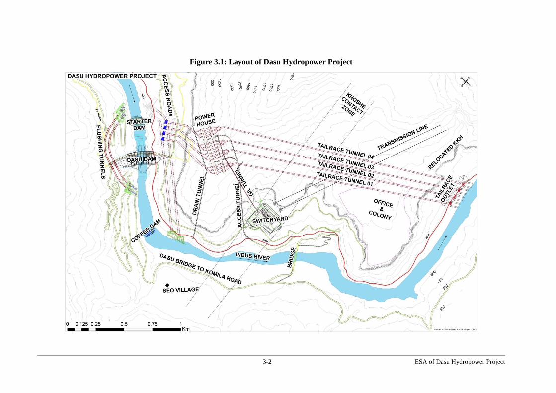
3-2 ESA of Dasu Hydropower Project
Figure 3.1: Layout of Dasu Hydropower Project

3-3 ESA of Dasu Hydropower Project
Figure 3.2: Downstream view of Dam, Spillway and Low Level Outlets (Source: DHC- Part C EMAP, Volume 3)
`

3-4 ESA of Dasu Hydropower Project
In order to cope with the high floods during summertime between May to September
there will be a spillway, consisting of a radial, frontal overflow with eight bays for
control of the overflowing water. The spillway has a maximum discharge capacity of
36,800 m3/s. The spillway has a special shape to deliver flood water along its slope
towards a flip bucket at the bottom of the spillway. The flip-bucket tosses the excess
water flow - not used for generation of electricity- into the air. The flood water falls into a
long and deep plunge pool downstream of the dam, which further absorbs the energy of
the overtopping flood water. In this way damage to the dam toe by the flood water flow is
avoided.
River Diversion Tunnels and Coffer Dams
During the construction of the main hydraulic structure the river water has to be
temporarily diverted from the upstream side to a site downstream of the dam in order to
create a dry working area during construction. This is done by constructing two 1260 m
and 1100 m long diversion tunnels to transport Indus water on the left bank of the river,
diverting the water to a site about one km downstream of the main structure measured
along the river channel. The upstream diversion will be made possible by constructing
dewatering dike and an upstream cofferdam (length 88m, height 95m) in the Indus, which
will later be part of the main hydraulic structure. To facilitate the construction of the
upstream cofferdam a dewatering dyke and a small starter dam will be needed. A second
coffer dam (length 40 m, height 19 m) will be constructed at the downstream side of the
main structure.
The capacity of the diversion tunnels is designed to divert a flood of 10,300 m³/s, which
is the peak discharge of 5-year probable flood. The diversion tunnels include inlet and
outlet structures to control the water flow. They will be 17m wide and 20m high and
lined with shotcrete. After completion of the main structure and before the first filling of
the reservoir the diversion tunnels will be plugged with concrete on permanent basis,
since river diversion is only required in the first phase when the dam is built.
Flushing Tunnels
Sediment deposition in the reservoir area will be major threat to the life of reservoir. To
meet the discharge requirement of sediment flushing, two sediment flushing tunnels will
be constructed on the right bank of the Indus in addition to the low level outlets
constructed in the main dam (see also Figure 3.1). Each tunnel will have a discharge
capacity of 1,060 m³/s. The tunnels will be 4.8 m wide and 9.5 m high, and 820 m and
680 m in length. Both tunnels are gated structures.
The dam and associated works such as coffer dams, river diversion works will be
completed in the first phase of the project.
3.2.2. Component B - Power Generation Facilities
Intake Structures and Waterways for Power Generation
In total four intake structures will be constructed on the left bank at the upstream site of
the main hydraulic structure. In the first phase there will be one intake structure and one
pressure tunnel towards the underground powerhouse in which three turbines will be
installed. The entrance of each intake is covered by a removable trash rack, in order to
prevent debris entering the power tunnel. Each intake is connected with a pressure tunnel,
which transports the water from the reservoir to the underground power house. In total
four power tunnels (each 12 m in diameter, 450 m in length, circular shaped and concrete

3-5 ESA of Dasu Hydropower Project
lined) will be constructed. Each tunnel follows a slightly different route until they reach a
vertical pressure shaft (131 m long). At the bottom of each pressure shaft the tunnel is
connected to three turbines located in the power house and generating electricity. From
there the water returns to the river via four 2.2 km long tailrace tunnels. The tailrace
tunnels are situated at the left bank and run from the underground powerhouse towards
the Indus. The purpose of the tunnels is to receive the water from the turbines and to
transport it to the river. Each tunnel receives the discharge of three turbines. They start at
the vertical underground surge chamber with diameter of 37m and a height of 45m. The
surge chamber protects the turbines for a sudden stop in power generation which may
result in “water hammer”. The tailrace will be equipped with gates so that the tunnel can
be isolated from the water for inspection and maintenance. The outfall structures of the
tunnels will be below the water level in the river. In the first phase of the project only one
tailrace tunnel will be constructed. A profile of tunnels and underground powerhouse is
given in Figure 3-3.
Figure 3.3: Profile of Tunnels and Power House
Source: DHC, Part C: EMAP, Volume 2
Underground Power House Complex
The powerhouse complex is located in the left bank abutment of the main dam. At full
development the four power tunnels will serve 12 vertical shaft Francis turbines each
producing 360 MW of electricity, with a total installed capacity of 4,320 MW. The
powerhouse complex comprises three major underground caverns, the powerhouse
cavern with the twelve turbine units, a transformer cavern housing the switchyard with
transformers and gas-insulated switchgears for all units and a cavern housing four surge
chambers serving the tailrace tunnels. The surge chambers will protect the turbines in
case there is a sudden stop in power generation which could result in “water hammer”.

3-6 ESA of Dasu Hydropower Project
Through underground tunnels the power will be transported to a power yard and further
connected to the transmission network of NTDC.
3.2.3. Component C - Preparatory and Other Works
These works include the construction of access roads, the relocation of a part of the
Karakorum Highway (KKH), the construction of a 132kV transmission line from Dubair
to Dasu during construction, offices, on-site housing and an access tunnel.
Relocation of KKH
A major activity under this component is the relocation of the KKH since about 52 km of
road will be inundated as a consequence of the project. Relocation at a higher level of the
slopes along the Indus is required. To compensate the loss of the inundated section a total
of about 62 km of new KKH will have to be constructed and about 3 km of link road (see
Figure 3.4). The KKH is the only road connection and lifeline between Islamabad and
the North of the country. The two-lane road is 810 km long with two narrow lanes and
used by much heavy traffic of people and goods. Daily about 3,000 vehicles are passing
the twin city of Dasu- Komila, of which 20 percent consist of heavy vehicles. In the steep
sloping project area the KKH follows the Indus on the left bank close to the river bed.
The road section between Dasu and Choree Mora (47 km north of Dasu) will have to be
rebuilt. This will be a major operation in difficult terrain, which also includes the
construction of bridges, retention walls, culverts and local access roads. The realignment
of the KKH is very critical to the project, since the traffic on the KKH should not be
interrupted or affected by the project.
The relocation of the KKH is divided into two contracts, i.e. KKH-01 and KKH-02. The
first contract comprises the construction of about 15.6 km of new KKH, and a link road
of about 3 km from the existing KKH at lower level towards the relocated KKH at higher
level. This contract should be implemented with priority and serves as a bypass for KKH
traffic to avoid interference in the construction activities at the dam site. The second
section to be constructed under KKH-02 is the construction of 46.1 km of new KKH
towards Choree Mora. The entire operation is expected to be completed between 2014
and 2016.
In addition to the road, the structures on realigned KKH will include:
The Section KKH-01 will involve construction of four box culverts, two bridges (20
and 30 m lengths), 29 causeways, and about 3.7 km long retaining walls.
The Section KKH-02 will include construction of six single span RCC pre-stressed
bridges, 23 box culverts 19 causeways, and retaining wall at 139 locations having a
total length of about 9 km.
Access Roads
A total of 53 km of access roads will be built for access to the dam site and for access to
the villages on the right bank of the Indus. The following local access roads and tracks
are foreseen under this component:
Komila to Dam axis: about 12 km (access road to dam site);
Dam axis to Kandia: about 23 km (access road to villages on right bank); and
Kandia to Utter Gah: about 18 km (minor roads and tracks giving access to villages
on right bank upstream of Kandia).

3-7 ESA of Dasu Hydropower Project
Figure 3.4: Realignment of KKH
The access road from Komila to the dam site on the right bank (right bank access road,
shown as RAR1 in Figure 3.4) will follow the current road from Komila to the village
Seo. From there will be a road of about 23 km towards Kandia village. A new suspension
bridge near Kandia river confluence will replace the two existing suspension bridges over
the Indus, which will be dismantled due to submergence. A minor access road and tracks
will be constructed on the right bank from the new suspension bridge near Kandia river
confluence towards the north.

3-8 ESA of Dasu Hydropower Project
WAPDA Offices and Colony
Residences and offices for WAPDA’s staff (total area 32 ha) will be constructed on a
river terrace overlooking the Indus valley opposite Dasu, at Chuchang hill. The facilities
include project offices, security offices and information center, residences, hostels, rest
houses, a hospital and schools (primary and secondary), mosque, community center, club,
market, bank, post office, park and playgrounds.
A water supply system will be constructed for the office and colony. The source of water
supply is Dasu nullah, a perennial tributary to Indus. The water supply system will
include water extraction, raw water tank, slow sand filter, treatment by chlorination, and
transmission and distribution system. The facilities are designed for 6,200 people (staff
and their families).
The sewage system will consists of collection of sewages through concrete pipes and
treatment of sewage by septicization. A surface drainage system with a disposal system
will also be constructed. Solid waste management system will include segregation of
waste, storage and collection, storage depots, waste processing and disposal. A sanitary
land filling facility will be constructed (with appropriate landfill liners) for non-
degradable, inert waste and other waste that are not suitable for recycling or biological
processing.
132-KV Transmission Line for Power Supply during Construction
About 30 MW of power supply is required for the construction site and the Colony. The
required power will be supplied from Dubair Khwar hydropower project (near Pattan)
through a new transmission line to be constructed from Dubair towards Chuchang, which
is a small village situated at the left bank opposite Dasu. From Chuchang grid station
about 7 km of new distribution line will be constructed to the work areas.
The line will provide electricity to the Project and the Colony during the construction.
The transmission line is about 45 km and will follow more or less the current KKH on the
right bank (see Figure 3.5). For the selected alignment 233 towers have to be
constructed, each about 32 m high. An alternative route on the other side of the mountain
was studied, but was abandoned due to technical reasons (high elevation > 2,500 m,
much longer distance, difficult access). The selected alignment follows the KKH, since
there is hardly any other option in the narrow valley with already two planned 220 kV
transmission lines constructed higher on the slopes at the other side of the Indus. The area
between Pattan and Dasu is barren with only a few cultivated areas and houses. Just
before Dasu the line crosses the Indus to the right bank, avoiding the town of Komila and
continuing along the slope, avoiding the residential areas of towards Chuchang area,
where the Colony is projected. The Peshawar Electric Supply Company (PESCO) will
operate and control the power supply. It is envisaged to dismantle the line after
completion of the project.

3-9 ESA of Dasu Hydropower Project
Figure 3.5: Location of 132 KV Transmission Line for Dasu Project
3.2.4. Component D - Transmission Line from Project to Pathar Garh
For transmission of power a double circuit 500 KV line will have to be installed from
Dasu to Islamabad (via Mansehra), that can serve two phases, i.e. an installed capacity of
2,160 MW. The two parallel running transmission lines will connect Dasu Power Station
with the 500 kV Grid Station at Pathar Garh (Tehsil Hassanabdal, District Attock). The
transmission lines will extend over a distance of about 250 km and will traverse five
districts of KP including Kohistan, Battagram, Mansehra, Abbottabad and Haripur before
connecting to the Pathar Garh Grid Station in Punjab province. The proposed corridor
(preliminary) for the construction of the lines is shown in Figure 3.6.
The National Transmission and Dispatch Company (NTDC) will carry out the detailed
design and an environmental and social assessment of the transmission line during 2014-
2015. NTDC has carried an environmental and socioeconomic profiling of the project
areas and a screening of potential environmental and social impacts of the construction of
the transmission line. While the highlights of this screening process are summarized in
the present report in Section 7.10, the full screening is available in the stand-alone
accompanying Environmental Assessment and Review Framework (EARF) document.
Further details of the transmission line will be included in the ESA of this component.
132 kV Transmission
Line

3-10 ESA of Dasu Hydropower Project
Figure 3.6: Proposed Alignment of Transmission Lines
Source: NTDC Transmission Line EARF
3.2.5. Component E - Implementation of Social and Environmental Management Plans and Glacial, Sediment River Monitoring
Social and Resettlement Management Plan
The main elements of the Social and Resettlement Management Plan (SRMP) are the
compensation, livelihood assistance, and relocation program to the affected people. In
addition, the SRMP also includes provisions to support communities in the project areas
for their sustainable livelihood development and broader local area development, and to
mitigate the negative effects of in-migration to the region associated with the project. The
SRMP also includes a public health action plan to address possible health impacts under

3-11 ESA of Dasu Hydropower Project
the project and a gender action plan. The SRMP includes both short-term income and
livelihood measures during the construction phase as well as long-term measures that go
into the post-construction phase for a period of 10 years.
Environmental Management Plan
The Environmental Management Plan (EMP) includes elements of slope stabilization,
afforestation and watershed management in the upland areas along the reservoir and the
reconstructed KKH, enhancement of the aquatic life and fisheries through reservoir
management, preservation and protection of cultural property (petro glyphs) and
unforeseen issues that need to be addressed during the project. Construction related
environmental issues will be addressed in the construction contracts, thus cost of such
measures are included in the construction cost. The EMAP would also include those
issues which are not or cannot be effectively covered under the construction contracts.
Glacier, Flood Warning, Watershed, Sediment and River Monitoring
Since most of the water resources of the Indus originate from glacial melt, the project
includes a component to study and evaluate glacial melt in the high mountain glaciers and
ice fields in the Upper Indus catchment. Guidelines for monitoring and research on
glaciers and catchment areas will be developed under the project including an early
warning for glacial lake outbursts and on water security control. The project would
support the Glacier Monitoring and Research Center (GMRC) under the WAPDA
General Manager Planning. The activities would include monitoring and research on the
Upper Indus Basin (UIB) glaciers, watershed monitoring, sediment and river monitoring
that would help in the operation of the DHP. The proposed GMRC would have four
sections: (a) a field investigations section responsible for establishing and managing field
stations. The office is proposed to be established in the upper catchment of the Indus; (b)
a remote sensing and modeling section located in Lahore to carry out remote sensing and
modeling studies; (c) a forecasting section; and (d) a data management section to
maintain and upgrade data management systems and carry out data analysis and research
activities. Links will be established with the high altitude meteorological network,
surface water hydrology, and the WAPDA hydro-meteorological network.
For better management of flood waves and safe operation of DHP and other hydropower
projects in the country, it is imperative to have an early warning system for these
hydropower catchments. There is no existing flood telemetry network in the DHP
catchment. Hence it is recommended that the existing telemetry network in River Indus
will be extended to the upper catchments of River Indus. This will include installation of
river level, temperature and rain sensors at 18 flood warning sites and providing them
with reliable telecommunication system. The component would support works,
equipment, operations cost and training for the establishment of the flood telemetry
network. This will be implemented by the Hydrology & Research Directorate of
WAPDA. The component would also support the monitoring and improvement of the
watershed and catchment in Pakistan of the DHP and the Indus Cascade in the river
sections upstream and downstream till Tarbela.

3-12 ESA of Dasu Hydropower Project
3.2.6. Component F - Construction Supervision, Monitoring and Evaluation and Social and Environmental Management Plans
Construction Supervision and Implementation Support
This would cover the cost of consulting and other services for Project implementation,
including construction supervision and Project management support. It would also cover
implementation of all activities under the Project, including: procurement, contract
administration, quality control, certification of payments, financial management,
preparation of any additional designs, and bidding documents and support in
implementation of SRMP and RAP.
Monitoring and evaluation of Project impacts and of Social and Environmental
Management Plans
The Management Support and monitoring and evaluation activities would provide
continuous feedback to the Government of Pakistan (GoP), Ministry of Water and Power
(MoWP) and WAPDA on the Project’s performance and impact of its various
components, so that corrective actions could be undertaken in a timely manner. The
component would support independent monitoring of implementation of the
environmental and social management plans and Project Management support to
WAPDA as owner of the project.
3.2.7. Component G - Project Management Support, Capacity Building of WAPDA, Technical Assistance and Training
Project Management Support and Audits
This sub-component would support WAPDA in implementing Project related activities,
including support for operation of the PMU, capacity building, incremental staff salaries,
operations cost and audits, etc.
Strengthening of WAPDA, Independent Panel of Experts and Technical
Assistance
This sub-component would build the capacity of WAPDA to effectively implement the
Project, O&M of the dams it manages, and fully carry out its mandated functions. It
would also strengthen WAPDA’s capacity in developing financing plans and mobilize
funding for this project, for other large water and hydropower infrastructure and other
elements of the Indus Cascade. This component will also support the continuation of
existing social, environmental, dam safety and other technical experts during project
preparation, construction and operational stages.
Future Project Preparation and Strategic Studies
This component would support strategic studies to address technical, financial or
management issues, , environmental and social issue, pilot projects and preparation of
future projects that may be identified during Project implementation and agreed upon
with the Bank, and will be developed in conformance with World Bank safeguard policy
requirements

3-13 ESA of Dasu Hydropower Project
3.3. Project Resources
The list of the key project resources and facilities is presented in Table 3.1 and discussed
in the sections below.
Table 3.1: Ancillary Facilities
Project
Facility Location Length /
Size
Status
Access Roads
on Right Bank Komila to Dam site 12.96 km Alignment
finalized
Dam site to Kandia 22.85 km Alignment
finalized
Kandia to Utter Gah (Track) 17.84 km Alignment
finalized
Suspension
Bridge on
Indus
Bridge on Indus near Kandia 350 m Location to be
finalized
Access road to above bridge from left bank
(relocated KKH) and right bank 0.48 km Location/alignm
ent to be
finalized
Power
transmission 132 kV transmission line from Dubair to Dasu 45km Alignment to be
finalized
Colony and
Infrastructure
Colony with necessary infrastructure (water,
sanitation, roads, power distribution etc.)
31.5 ha Location
finalized
Quarry Area Quarry area, crushing plants and storage area
at Kaigah (along the existing KKH)
34.26 ha Location
finalized
Conveyor belt for transport of aggregates
(along the existing KKH up to dam site)
10 km Alignment to be
finalized
Sites for
Contractors
use
Material storage sites, batching plant area,
construction yard (including dam site),
(Sieglo area on right bank)
90.35 ha Proposed
location
identified
Contractors offices and workers camps (Kass
area on right bank, downstream)
41.7 ha Proposed
location
identified
Workshops/construction yards/ workers
camps on upstream of dam site (Uchar and
Barseen area)
19.03 ha Proposed
location
identified
Explosive storage sites (On the Left Bank
Area near Khoshe)
Part of
112.7 ha
Proposed
location
identified
Fuel storage area will be near Kass area Part of
41.7 ha
Proposed
location
identified
Site for laboratories in the proposed switch Part of Proposed

3-14 ESA of Dasu Hydropower Project
Project
Facility Location Length /
Size
Status
yard area on the left bank 112.7 ha location
identified
Spoil disposal
areas
Spoil disposal for dam, tunnel and other
works (at Zal and Khoshe)
68.85 ha Location
finalized
Resettlement
sites
Development of resettlement sites with
infrastructure and access roads
30 nos. Being finalized
Measures
proposed in
ESMP
Development of tree plantation, traffic control
units, fish hatchery, protection of rock carving
sites, weather monitoring, etc. (locations will
be finalized later)
To be finalized
Sites for
Contractors
use (KKH)
Contractors office, worker camps,
construction yards and stockpile storage sites
for KKH (at Barseen)
12.67 ha Proposed
location
identified
Quarry and
Borrow areas
for KKH
Same as for dam works Same as for
main works
Access roads
to build KKH
realignment
Four access roads from existing KKH (at
Khoshe, Uchar Gah, Barseen and Kaigah) to
new alignment
12 km To be finalized
3.3.1. Temporary Facilities
Temporary facilities like construction yards, construction camps, workshops, stores will
have to be constructed and areas will be designated as temporary or permanent disposal
areas for the enormous quantities of rock and excavation material from the project. The
project will make use of a number of quarries and excavation areas which are located
within and outside the project area. The location and details of the temporary facilities are
shown in Figure 3.7 (dam site to Dasu bridge) and Figure 3.8 (dam site to Kaigah
quarry).
3.3.2. Construction Materials
The construction materials needed for constructing the hydraulic structure, the tunnels,
the powerhouse and associated facilities are as much as possible coming from the area, A
large quantity of coarse aggregates might be obtained by re-using excavated rock from
the underground powerhouses and tunnels, as far as these materials meet the
specifications and quality needed. Another potential source of aggregates is situated at
Kaigah (left bank), some 10 km upstream from the project site. The quarry at Kaigah is
situated in the reservoir submergence area. Quarrying will be carried out by bench cut
method with necessary drilling and blasting. A crushing plant also will be established
near the quarry site. From Kaigah a conveyor belt (10 km long) will bring the aggregates
to the dam site. In total 9.2 million ton of coarse aggregates (stones) and 5.0 million ton
of fine aggregates, 0.6 million ton of manufactured sand is required. About 35 truckloads
per day are needed for this material during construction. An estimated 0.8 million ton of
cement, 150,000 ton steel, 300 million liter of fuel and 20,000 ton of explosives will have
to be obtained from “down country” and be transported over the KKH to the project area.

3-15 ESA of Dasu Hydropower Project
Figure 3.7: Locations and Details of Temporary Facilities – 1

3-16 ESA of Dasu Hydropower Project
Figure 3.8: Locations and Details of Temporary Facilities - 2

3-17 ESA of Dasu Hydropower Project
3.3.3. Spoil Disposal Sites
The excavation activities carried out for dam, power house, tunnel and KKH realignment
will generate about 20 million m3 of excess rock material. A site of 69 ha (see also
Figure 3.7) situated some 3 km downstream of the dam site will be used for disposal of
excess spoils (see satellite photo in Figure 3.9). Detailed surveys and geo-technical
investigations were carried out to identify this site and to determine its suitability. The
selected site meets the required criteria for spoil disposal including: i) proximity to the
main construction site thus minimizing the haulage distance; ii) located downstream of
the dam thus avoiding its future submergence in the reservoir; iii) relatively flat area thus
minimizing the possibility of the disposed material to slide in the river; iv) suitable
geotechnical conditions as revealed by the geotechnical investigations; v) capacity to
hold the required spoils generated by the Project; and vi) minimal resettlement impacts.
Spoils from KKH construction activities will also be disposed at switchyard area near
Khoshe and Barseen at left bank (Figures 3.7 and 3.8).
Figure 3.9: Location of Spoil Disposal Area
3.3.4. Construction Machinery
For the implementation of the project construction plants, conveyor belts and equipment
have to be used. All these machines and equipment has to be transported from “down
country” via the KKH and assembled in the project area. These include concrete mixing
plants, belt conveyor systems (for RCC, aggregates and excavated material), aggregate
plants, asphalt plants, a milling plant, various silo’s for storage, workshops etc. Also a
large quantity of excavation, compacting and building equipment, trucks and vehicles is
required.

3-18 ESA of Dasu Hydropower Project
3.3.5. Manpower Requirements
Skilled and semi-skilled construction workers are needed to construct the hydraulic and
underground structures. Technicians, foremen and supervisors will be required for
specialist works such as RCC placement, drilling, blasting operations. Operators for the
various plants and equipment and machinery are needed. A mix of expatriate and local
technicians/supervisors will be employed. It is expected that a number of skilled workers
and most of the non-skilled labor will be recruited from Kohistan and surrounding
districts.
The number of workers to be involved in the project activities on contract basis including
staff from WAPDA and Consultants are estimated to increase from about 1,100 in 2015
to 2,700 in 2019 and gradually decreasing to 1,500 after the year 2022. It is estimated that
about 60 percent of the total workforce can be attracted from Indus Kohistan and
neighboring areas along the Indus valley, the majority being unskilled workers. In
addition, it is also estimated that about 4,000 other in-migrants (traders/entrepreneurs,
family/followers) will be settled in Dasu during construction. The number of staff
required for operation and maintenance after completion of the project is estimated at
around 1,400 workers (including 275 technical staff).
3.3.6. Security Situation
The Kohistan district is a historically isolated area along the Indus, characterized by high
levels of poverty and deprivation. Ownership of arms is common and every year there are
a number of incidents of violence (killing and shooting incidents) in the district. In recent
years the prevalence of carrying arms and the number of violent incidents has dropped
significantly. This has been attributed to the influence of the increased use of the KKH
opening the district to the outside world and providing more opportunities to the people
to find work and schooling elsewhere in the country, mostly on temporary basis. Also the
well-organized tribal governance system and strong leadership and the frequent exposure
to tourists visiting the area on their way to popular tourist destinations contributed to a
relatively good law and order situation in recent years.
Also the public consultations, workshop and hearings organized during social surveys
and design studies in the project area have helped to avoid potential conflicts with people
currently living in the area. The fact that their very genuine concerns were taken into
consideration when selecting the resettlement sites and developing mitigation and
compensation measures provided reassurance that the proponent of the project is serious
about minimizing the adverse impacts on local people and ensuring that persons will be
equal or better off as a result of the construction of the proposed project. The building of
replacement suspension bridges and new access roads on the right bank of the Indus will
also help in ensuring that the area can be easily accessed and made secure.
3.4. Phasing and Construction
3.4.1. Phased Approach to Development of the Project
DHP will be implemented in a two staged development, with each stage divided into two
phases. Each stage is further divided into two phases of 1,080 MW each (Table 3.2),
served by a separate tunnel running three turbines of 360 MW each. Under the DHP
Stage I (DHP-I) two phases of 1,080 MW each would be developed simultaneously with
gestation of first generating unit as soon as possible. The first phase is critical with higher
cost US$ 3,650 million as much of the infrastructure, site preparation and social and
environmental safeguards for the whole project have to be developed under this phase.

3-19 ESA of Dasu Hydropower Project
The high upfront cost for Phase 1 is offset by high generation which despite the front-
loading of main infrastructure and other social and environmental management costs
gives good economic returns of more than 20 percent (excluding environmental benefits).
The generation from Phase I is over 8,000 GWh as sufficient water flows are available in
the river throughout the year to run a 1080 MW hydropower plant and thus gives a very
high plant factor, over 85 percent which is extra ordinary for a hydro project. The cost of
Phase II is quite low, about US$ 600 million increasing the installed capacity to 2,160
MW and annual generation of about 12,225 GWhs with a plant factor still very high, over
65 percent. The cost per unit would be even lower and ERR would increase to 25
percent. The DHP-I, therefore, is transformational as it will reduce the cost of generation,
foreign exchange expenditures for the country and generate cash flow that and will
support the development of Indus Cascade. Stage II of the Project would be developed
later when Diamer Basha project is nearing completion. Environmental and social
management plans will be implemented during Stage 1 (See Table 1.1).
3.4.2. Construction Schedule
During Stage 1 (2015-2022) the major hydraulic structures and related infrastructure will
be constructed and inlet and tailrace tunnels and six turbines with a total installed
capacity of 2,160 MW. Also the relocation of the KKH will be completed in the year
2016. The Second Stage will include the construction of two more power tunnel and
generating facilities for an additional 2,160 MW. Stage 2 would preferably be carried out
after the development of Diamer-Basha dam. Construction of this dam will provide
sediment control in the upstream reservoir and consequently less need for sediment
flushing at the Dasu site.
3.5. Summary of Technical Specifications of the Project
Salient technical specifications of the project are summarized in Table 3.2 below.
Table 3.2: Salient Features of DHP
Item Detail General
- Installed Capacity 4,320 MW
- Total Energy 18,440 GWh/annum (pre Basha) 21,485 GWh/annum (post Basha)
- Catchment area at dam site 158,800 km²
- Average discharge at dam site 2,102 m³/s
- Safety Check Flood (SCF) 51,957 m³/s
- Basic Design Flood (BDF) 24,932 m³/s
Water Level
- Flood Water Level under SCF - Flood Water Level under BDF
- Full Supply Level (FSL) - Minimum Operating Level (MOL)
EL. 959.5 m EL. 951.3 m
EL. 950.0 m EL. 900.0 m
Reservoir
- Gross Storage Capacity (El.950m) - Operational Storage Capacity
1.41x 10⁹m³
0.82x 10⁹m³
-Reservoir Area Full Supply El 950 m -Reservoir Area: BD Level El 951.28m
-Reservoir Area : MOL El 900 m
23.9 km² 24.5 km²
11.5 km²

3-20 ESA of Dasu Hydropower Project
Item Detail Diversion Tunnel on Left Bank
- Number, Shape and Length 2 no, D-shape, 1,261 m and 1,101m
- Size and Lining W= 17 m, H= 20 m, shot Crete lined
Main Dam
- Type Arch-Gravity Dam in Roller Compacted
Concrete(RCC) type)
- Maximum Height above foundation 242 m
- Crest Length 570 m
Spillway
- Number of Bays, Type and Size of Gates 8 no, radial, W=16.5 m H=22.4 m
- Maximum Discharge Capacity under SCF 45,097 m³/sec
- Plunge Pool 162m from dam toe
Low Level Outlet (LLO)
- Discharge Capacity under SCF 2,756 m³/s by 2 LLO at reservoir El.959.5 m 12,157 m
3/s by 9 LLO at El. 955.7 m
Flushing Tunnels
- Number and Size 2 No 9.5 m dia, (L= 820 m & 680 m)
- Discharge Capacity under SCF 1,060 m³/s per tunnel
Power Intake
- Number and Shape 4 no, D=12 m, flatbed type
- Removal Trash rack 4 sets,
Power Tunnel
- Number and Shape 4 no, circular
- Size and Lining, and average length D=12 m dia, concrete lined, 500 m
Power Generation
- Generating Units and Unit Capacity 12 Francis turbines - 360 MW, 167 rpm
- Powerhouse Location Underground, left bank
- Design Head Approximately 185 m
- Rated Discharge (12 units) and Voltage 2,670 m³/s, 16.5 kV
Tailrace Tunnel
- Number, shape and average length 4 no, D-shaped, 2,200m in average
- Size and lining W=10 m, H= 12.5 m, concrete lined
- Discharge per Tunnel 650 m³/s
Tail Water Level
- Flood Water Level under SCF El. 778.4 m
- Tail water level under 12-unit operation El. 762.8 m
- Tail water level under 3-unit operation EL. 759.2 m
Power Transmission
- Transmission Voltage 500 kV (AC)
- Powerhouse Substation & Gas Insulated Substation (GIS),
- Transmission Substation Air Insulated Switchgear (AIS) , Surface
- Length and Location of Transmission Line 250 km, Dasu – Mansehra –Pathar Garh
KKH realignment
KKH realignment (to compensate loss of 52 km of
existing KKH) 62 km

3-21 ESA of Dasu Hydropower Project
3.6. Operation and Maintenance of the Project
3.6.1. Filling of the Reservoir
Once the main hydraulic structure is completed, water will be allowed to store behind the
dam. The first filling of the reservoir requires a lot of preparation and careful monitoring
for landslides especially in the landslide prone areas. A slow rate of filling of maximal 2
m/day will be used up to 950 m and the excess flows will be released through LLO’s.
About 215 m3/s rate of flow is required on average to fill the reservoir with the
recommended rate of 2 m/day. The low rate of filling is maintained to stabilize the banks
of the reservoir area and not to trigger any landslides. The first impounding is planned to
start in mid June when the average flows are above 4,000 m3/s. However, the filling can
also be done at any time of year without causing significant reduction in downstream
flows, even in the months of February or March, when the Indus is at its lowest. There
should not be any fear that there will be insufficient flow to the river downstream. Even
in these months the Indus carries 380 - 400 m³/s of water. The whole filling operation is
expected to be completed in 60 days.
3.6.2. Operational Concept for DHP in Stage 1
After filling of the reservoir the water level in the reservoir will then permanently be
maintained at 950 m. The water coming into the reservoir will be diverted via the intake
and power tunnel towards the power house. This means the reservoir and power house
will be operated as a run of river of type power generation (base load plant). During the
high flow season (May to September) water will mainly enter the reservoir at a rate
higher than the flow diverted through the power tunnel intakes. The excess flow will pass
over the spillway. During low flow season (October to April) the water level in the
reservoir will also be maintained at 950 m, and all the inflow water in to the reservoir will
be diverted through the power tunnel intake. No additional water retention is required
even in winter months. In sum, the instantaneous inflow into the reservoir will be equal to
the instantaneous outflow from the reservoir.
3.6.3. Operational Concept for DHP in Stage 2
Although it is recommended to run the DHP plant as a base load plant throughout its
entire life, during the feasibility study the option was identified to operate the project as a
peak plant. This option is feasible after commissioning of the Basha Hydropower Project
in Stage 2. DHP could be used as a peak plant in the low flow season by producing
electricity during 4-5 hours per day to cover peak electricity demand in the country.
However, peaking operation would produce about 900 GWh less annual energy
compared to run-of-river operation. Hence it is planned that DHP will continue to work
as base load plant even during Stage 2. The current planning of WAPDA is also to use
DHP as base load plant in Stage 2, while meeting the peak demand from thermal power
plants. Nonetheless, the impacts associated with the peaking operation are also covered in
this ESA. The operational concept of this type of operation is shown in Figure 3.10.
As shown in Chapter 1 (Figure 1.3) the water level of the reservoir during base load
operation (run- of-river concept) is constantly maintained at 950 m. However with peak
load operation (storage type of reservoir), the water level behavior will be entirely
different. In the peaking plant operation, water will be stored and released on basis of a
daily cycle of storage during 18-20 hours followed by 4-6 hours release for power
production. Reservoir levels are thus fluctuating strongly on a daily basis. But there is
also a considerable annual fluctuation of the reservoir level.

3-22 ESA of Dasu Hydropower Project
Figure 3.10: Operational Concepts of DHP as Peaking Plant
Source: DHC, EMAP Volume 2, EIA
From early December up to April the water level drops due to insufficient inflow in the
reservoir. In Figure 3.11 the reservoir levels of the two types of power generation are
compared on a 10-day basis. The required flow for a peaking operation of 4 hours in
winter is 443 m³/sec. In the post-Basha scenario, the (95 percent dependable) flow at
Dasu is estimated to be 661 m³/sec. The peaking operation is not feasible in pre-Basha
scenario (Stage 1) since the (95 percent dependable) flow at Dasu is lower with 348
m³/sec than required flow for peak operation.
Figure 3.11: Reservoir Water Levels - Year-round under Run-of-River Type and
Peak Plant Operations
Source: DHC, EMAP Volume 2, Environmental Assessment

3-23 ESA of Dasu Hydropower Project
3.6.4. Sediment Flushing
About 200 million tons of sediment would flow every year into the reservoir. Hence there
will be a reduction of the reservoir storage over the years due to sedimentation. It is
expected that the inlets for LLO and power intake will be filled within 20 to 25 years if
there is no flushing of sediments. The reservoir periodically will have to be flushed to
remove part of the accumulated sediment. The frequency of flushing is yet to be
finalized. However, the current plan is to flush the reservoir annually after 15 years of
operation of DHP, in case Basha is not constructed by that time. When the Basha dam is
constructed within 15 years after commissioning of DHP the first flushing of the
sediment in the Dasu reservoir could be postponed for some 40 years, since most
sediments will be trapped into the Basha reservoir.
The optimal period for flushing would be one month between 21 May and 20 June. A
tentative schedule of expected drawdown of the water level of the reservoir during
flushing operation is shown in Figure 3.12. The entire operation lasts some three months
from 15 April to 20 July. The anticipated lowering rate of the water level is 3 meter per
day before flushing and 4 meters per day after flushing when the reservoir is filled to full
supply level (run-of - river operation).
Figure 3.12: Tentative Reservoir Flushing Program
Source: DHC, EMAP Volume 2, Environmental Assessment.
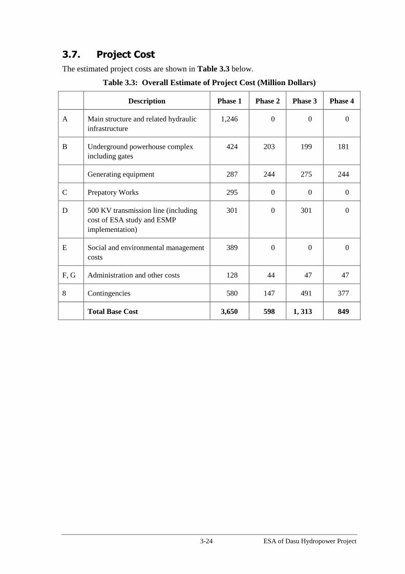
3-24 ESA of Dasu Hydropower Project
3.7. Project Cost
The estimated project costs are shown in Table 3.3 below.
Table 3.3: Overall Estimate of Project Cost (Million Dollars)
Description Phase 1 Phase 2 Phase 3 Phase 4
A Main structure and related hydraulic
infrastructure
1,246 0 0 0
B Underground powerhouse complex
including gates
424 203 199 181
Generating equipment 287 244 275 244
C Prepatory Works 295 0 0 0
D 500 KV transmission line (including
cost of ESA study and ESMP
implementation)
301 0 301 0
E Social and environmental management
costs
389 0 0 0
F, G Administration and other costs 128 44 47 47
8 Contingencies 580 147 491 377
Total Base Cost 3,650 598 1, 313 849

4-1 ESA of Dasu Hydropower Project
4. Project Alternatives
This Chapter presents the analysis of various alternatives considered during the feasibility
and detailed design stages of the project and provides a comparative evaluation of their
respective environmental and social benefits and impacts. The analysis of alternatives for
the 500 kV transmission line will be presented in the ESA of that component.
4.1. The Without Project Option
Energy Sector Scenario in Pakistan
Pakistan is suffering from an acute power and energy crisis, which is primarily caused by
the increasing gap between the supply and the demand of electricity. The need to
accelerate the production of electricity is summarized in Table 4.1. Between 2001 and
2011 the supply of electricity increased with an average 3.5 percent per year from 12,708
MW to 17,924 MW. The demand for power meanwhile increased with 7.6 percent per
year from 12,344 MW to 25,648 MW. This resulted in an escalating gap between supply
and peak demand of at least 13.1 percent per year. The peak demand is expected to grow
until the year 2029 with an average 7.7 percent and the gap in demand and supply is
predicted to increase to 16.4 percent with a shortfall in supply (resulting in load
shedding) of 17,367 MW in 2029.
Table 4.1: Power Demand and Supply Gap (2000-2011) and Predictions (up to 2029)
Current situation Predicted
2001 2011 Annual
increase 2029 (MW)
Annual
increase
MW MW percent MW percent
Available power 12,708 17,924 3.5 90,110 7.0
Peak demand 12,344 25,648 7.6 107,477 7.7
Gap +364 -7,724 13.1 -17,367 16.4
Source: Basic Design Report, 2012
Another major problem in the sector is the high cost of electricity generation. In the past
the country has not invested sufficiently in its huge hydropower potential and is strongly
dependent on the existing thermal power plants. These plants are not running up to their
full capacity, due their dependency on imported fuel. Lack of foreign exchange to pay for
fuel supplies has resulted in production of electricity below capacity of the present plants.
Due to large gap between the demand and the supply, aggravated by the fact that existing
thermal power plants do not produce at their full capacity due to their dependency on
imported fuel, there is load shedding up to eight hours daily throughout the year. Fuel for
power plants is imported and there is a shortage of fuel due to the lack of foreign
currency. For the year 2011 the amount of load shedding was estimated at 5,000 MW.
Power shortages result in long hours of load shedding, impacting households, industrial
and commercial activities. Lack of power affects people’s quality of life: summers are
uncomfortable, children often have no light to study, people cannot watch TV, food
cannot be cooled, and so forth. But the impact of the energy crisis extends far beyond the
daily life. It affects schools, colleges, clinics and hospitals; it affects shops and
businesses, reducing sales and revenues; and it affects industry, reducing productivity. It
also deters investment. This means, on a macro level, reduced economic growth which

4-2 ESA of Dasu Hydropower Project
translates into loss of livelihoods, jobs and income. The financial impact of load
shedding has been estimated at 3 percent to 4 percent of GDP, costing about USD 10
billion a year. This situation is causing serious economic losses to the country and is
responsible for increased unemployment and poverty.
On a number of occasions the frequent and prolonged power cuts have caused social
unrest. This included demonstrations and blocking of traffic and highways. Several
WAPDA and other government offices were attacked, as people expressed their
frustration caused by the prolonged and repeated power cuts. .
Hydropower production as percent of total energy production declined from about
64 percent in the period 1970- 1980 to about 27 percent in recent years, despite the huge
hydropower potential in the country. Since the nineties the power system in the country
has steadily relied more and more upon thermal energy. In 2007 about 65 percent of the
total installed power capacity originated from fossil power plants, 2 percent from the
nuclear generation and the remaining 33 percent from hydropower production. The
primary reason for the declining share of hydropower in the overall generation capacity
in the country has been the fact that the power development during last 20 years has been
carried out mostly through the private sector investment in thermal power generation.
Private sector has added nearly 7,000 MW thermal power in to the system in last 20
years. This greater reliance on thermal sources also resulted in an increasing dependency
on imported fuel (oil, gas and coal). As much as 85 percent of oil and allied products are
imported. The imports result in high cost of power production. In the period 2000-2010
fuel prices have increased about three times (in nominal terms) at an average annual rate
of 11.3 percent. During the year 2007-2008 more than US$ 1.25 billion was paid for
imported fuel for power production. These high imports negatively influence the balance
of payments.
In Pakistan there exist a series of options such as demands side management and
improved utilization efficiency, and reduced transmission and distribution losses, that
have high economic returns and are already being undertaken by various Pakistani
organizations to address these issues, GoP is already undertaking projects such as World
Bank funded Pakistan - Electricity Distribution and Transmission Improvement Project,
and Asian Development Bank funded Energy Efficient Investment Program. Pakistan is
also planning to import about 1,000 MW of electricity from Central Asia (CASA 1000)
to partly address the summer deficit of 7,700 MW. However these projects are unlikely
to fully cover the energy shortfall.
Case of "Without Project Alternative"
The “without project” alternative is not realistic, because Pakistan will build additional
generating plants to eliminate power shortages. Given the increasingly prohibitive costs
of fuel oil-based electricity generation, development of Pakistan’s hydro resources at a
variety of scales represents the only reasonable prospect of eliminating these shortages.
Indeed, until such time as power shortages are significantly reduced and system
reliability increased the incremental output of Dasu would serve primarily to reduce these
shortages – the benefits of which are largely the same as that of the “no project”
counterfactual: i.e., substituting grid electricity for diesel self-generation and kerosene for
lighting. However, these sources will not meet the required shortfall. Hence the "without
project alternative" will result in more load shedding and power cuts with considerable

4-3 ESA of Dasu Hydropower Project
social and economic impacts such as impeded economic growth, increased
unemployment and poverty and social conflict.
4.2. Alternative Sources of Energy
The economic analysis shows that DHP has net benefits greater than or equal to those of
mutually exclusive project alternatives. Projects such as energy conservation and energy
efficiency are complements to, rather than mutually exclusive substitutes for, DHP and
will be implemented regardless of whether Dasu is built or not.
The relevant alternative sources to the proposed DHP design fall into four categories: (i)
hydro projects other than Dasu, (ii) other renewable projects such as wind and solar, (iii)
nuclear; and (iv) thermal power (coal, oil and gas).
4.2.1. Alternative Hydropower Projects
Pakistan has a large potential of renewable and clean energy resources in the form of
hydropower. Out of an estimated potential of 46,000 MW so far only about 6,500 MW or
14 percent has been utilized. The majority of the hydropower potential can be found in
the Upper Indus Basin. Investing in hydropower development can provide additional
generating capacity less expensively and in an environmentally cleaner manner than any
thermal alternative with almost no long-term fuel cost. Development of hydropower
potential can contribute in reducing the cost of electricity generation, reducing the sector
deficit by injecting positive cash flow, saving foreign exchange by displacing imported
fuel and reduction of carbon dioxide (CO2) emissions.
The DHP is least cost when compared to the various ongoing and planned hydro schemes
in the country: (i) public and private, (ii) run-of-river and storage, (iii) up- and down-
stream of DHP, and (iv) on rivers other than the Indus (Jhelum and Swat) (Table 4.2).
These projects are mostly on Indus River where river flows and elevations are available
and some are on Jhelum River. Both of these rivers are with Pakistan according to the
Indus Treaty of 1960 and their catchment is also located in the country. One project is on
the Swat River which has relatively smaller inflow.
Table 4.2: Estimated Cost of Various Hydropower Projects
Sr. No Name Capacity Generation
MW Gwhs USD/kW Cents/Kwh
Projects Under Various Stages of Constuction or Recently Completed
1 Allai Khawar 121 463 1,345 3.73 Indus
2 Khan Khawar 72 306 1,356 3.39 Indus
3 Duber Khawar 130 595 1,477 3.42 Indus
4 Jinnah Hydropower 96 688 2,150 3.18 Indus
5 Neelam Jhelum 969 5,150 2,229 4.45 Jhelum
6 Patrind 147 633 2,463 8.29 Jhelum
7 New Bong 84 470 2,560 8.55 Jhelum
8 Tarbela 4th Extension 1,410 3,871 645 2.49 Indus
Planned Projects
9 Dasu Hydropower Stage I 2,160 12,225 1,968 3.69 Indus
10 Dasu Hydropower (Phased Dev.) 4,320 21,485 1,389 2.96 Indus
11 Thakot 2,800 14,095 2,500 5.27 Indus
12 Pattan 2,800 15,230 2,500 4.88 Indus
13 Diamer Bhasha 4,500 18,097 2,510 6.62 Indus
14 Bunji Hydropower 7,100 24,088 1,710 5.35 Indus
15 Lower Plas valley 665 2,658 1,786 4.74 Indus
16 Lower Spat Gha 496 2,106 2,198 5.49 Indus
17 Kohala Hydrpower Project 1,100 4,800 2,757 6.70 Jhelum
18 Sukhi Kinari 840 2,951 1,356 6.70 Jhelum
19 Munda 740 2,407 1,893 6.17 Swat
Unit Costs River
System
4-4 ESA of Dasu Hydropower Project
The above estimates are based on the data collected from WAPDA hydropower planning
and feasibility, and design studies for the projects and actual concessions by NEPRA.
Projects 1, 2 and 3 (Allai Khwar, Khan Khwar and Dubair Khwar) are located on
tributaries of the Indus upstream of Tarbela. Jinnah Hydropower is below Tarbela on a
barrage which was constructed in 1948. These projects owned by WAPDA are either
commissioned or nearing completion. Projects 11, 12, 13 and 14 (Thakot, Pattan,
Diamer-Basha, and Bunji) are above Tarbela in a sequence. Projects 15 and 16 (Lower
Palas Valley and Spat Gah) are on tributaries of the Indus above Tarbela.
Social and Environmental Considerations: Projects comparable to DHP providing
generation of more than several thousand GWh are Diamer Basha, Bunji, Pattan, and
Thakot. Among them, Diamer Basha is a storage project (with a reservoir area of 150
km2) and will have significant environmental and social impacts compared to other
projects, which are run of river projects with limited reservoir area. Among these run of
river projects, the engineering designs of Pattan and Thakot are yet to be undertaken.
DHP has the lowest cost among the comparable hydro projects in Pakistan.
4.2.2. Other Sources of Renewable Energy
The main sources of alternative renewable energy available to Pakistan are small and
medium scale hydropower, wind and solar power. These options are being actively
pursued and have the same beneficial impact in avoiding the environmental externalities
of fossil generation. However, the scale and nature of these resources are such that these
cannot be viewed as a mutually exclusive substitute for Dasu. Both of these options need
to be developed to the extent technically and financially feasible: they are complements,
not substitutes to Dasu. In order to replace 12,200 GWh of annual energy of DHP-I, at a
typical 28 percent annual load factor the installed capacity of wind/solar would be 5,000
MW, requiring a capital investment of more than US$ 15 billion – over 3.5 times the total
financial cost of DHP-I of $4.2 billion. Moreover, from the perspective of mobilizing the
necessary finance for the power sector, they do not compete for the same sources of
finance: wind and small hydro can be 100 percent financed from local commercial banks,
whose resources are simply not available to large hydro projects. It is not anticipated that
DHP would crowd out the ability of the GoP, Provincial Governments and/or private
sector to finance small and medium scale investments in renewable energy.
4.2.3. Nuclear
Two nuclear power plants currently operate in Pakistan, and there exist plans for
additional nuclear projects, the main justification for which is to diversity the supply mix.
However, nuclear projects are designed for year-round base load operation, and cannot
substitute for peaking/intermediate duty at annual load factors around 50 percent, or for
projects that support the summer load peaks. Moreover, while the social and
environmental impacts of large hydro projects can be mitigated with appropriate social
and environmental management plans, the main environmental impact of nuclear power -
the disposal of its radioactive waste - has yet to be satisfactorily solved in the Pakistan
context. In short, under no circumstances can nuclear power be considered a mutually
exclusive alternative to hydropower in general, or to the Dasu project in particular.
4.2.4. Comparison between Hydropower and Thermal Generation
In Pakistan, the domestic gas resources are limited, oil is mostly imported and
exploitation of Thar coal is still under investigation. As explained in Section 4.1, the

4-5 ESA of Dasu Hydropower Project
present generation is highly dependent on imported fuel which is very expensive.
Hydropower development can be compared with various thermal alternatives such as
High Sulfur Fuel Oil, Thar Coal plant, Natural Gas plant and Combined Cycle Gas
Turbine -in terms of their energy cost and CO2 emissions (Table 4.3).
The CO2 emissions from thermal alternatives vary from 6.7 to 17.2 million tons per
annum, while CO2 emissions from DHP are minimal (further discussed below). In
addition, thermal generation will emit large amounts of particulate matter (PM), sulfur
dioxide (SO2), carbon monoxide (CO), and nitrogen oxides (NOx) - adversely damaging
ambient environment and public health. Thus, the health impacts of air pollution by
hydropower generation are very low to negligible.
Table 4.3: Comparison between Hydropower and Thermal Alternatives
Technology Hydro-
Power Thermal
Unit DHP
High
Sulfur Fuel Oil
Thar
Coal Natural
Gas
Combined
Cycle Gas Turbine
Technical Required
Capacity1
MW 4,320 2476 2476 2476 2476
Load Factor percent 85 85 85 85 Annual
Electricity
Generated GWh 18,440 18,440 18,440 18,440 18,440
Efficiency (%) 39 39 39 55 Calorific Value Btu/Kg 40,216 21,844 936.8 936.8 Calorific Value TJ/Ton 0.042 0.02 Annual Fuel
Consumption million
4.0 tons 8.51
tons 161.3
mmbtu 114.4mmbtu
Environmental Annual CO2
Emissions million tons
0.0045 13.2 17.2 9.5 6.8 Annual CH4
Emissions tons
38 136 170 121 Annual PM
Emissions ton
0 19,078 2,202 701 497 Annual CO
Emissions ton
0 2,553 3,064 2,173 Annual NOX
Emissions ton
0 34,043 13,277 42,554 30,175 Annual SO2
Emissions ton
0 240,968 26,154 5,261 3,730 Annual Total CO2
eq. Emissions million tons 0.0073 13.187 17.226 9.558 6.778
Economic
Unit Energy Cost USD/kWh 0.02 0.203 0.220 0.116
Note 1: Required capacity for thermal alternatives to generate 18,440 GWh
Source: Economic and Financial Analysis Report of DHP Detailed Engineering Design

4-6 ESA of Dasu Hydropower Project
From the above table it can be seen that the cost of electricity production per kWh of
hydropower generation is much lower than those of any thermal alternative. These are a
fraction of the cost of electricity from thermal plants fuelled with oil, coal, or gas.
The impacts of air pollution caused by thermal power generation are significant. High
concentrations of NOx can cause inflammation and reduced lung functions. High
concentrations of SO2 can also affect breathing functions and can cause inflammation of
the respiratory tract. SO2 also contributes to the formation of particulate matter (PM) in
the atmosphere. PM can penetrate into sensitive regions of the respiratory system, and
can cause or aggravate cardiovascular and lung diseases. The impacts of thermal
alternatives are much more difficult and costly to mitigate than the limited health impacts
from hydropower projects. Health damage cost for thermal alternatives may vary
considerably as can be seen from Table 4.4.
Table 4.4: Health Damage and Clean Development Mechanism (CDM) Costs of
Thermal Alternatives
Health Damage Cost Unit DHP HSFO Thar
Coal Natural
Gas CCGT
NOx damage cost
(1,308 USD/ton) Million
USD 0 44.53 17.37 55.66 39.47
PM damage cost
(1,504 USD/ton) Million
USD 0 28.69 3.31 1.05 0.75
CDM Cost
CDM Price of CO2
(9.5 USD/ton) Million
USD 125.11 163.65 90.72 64.33
Source: DHP Economic and Financial Analysis.
Development of hydropower project usually requires a considerable investment in overall
infrastructure (dam and associated structures) in an early phase of the project and a long
period of development. For this reason a carefully scheduled development in phases can
be economically beneficial in order to start generating electricity in an early stage of the
project. Generally large hydropower projects have significant environmental and social
impacts due to flooding of huge terrestrial areas, changes in aquatic ecology and large
scale resettlement of affected community. Though DHP is a large hydropower project, it
has very limited reservoir area of 24 km2
and hence very limited social and environmental
impacts. Power density of DHP (181 W/m2, meaning 180 MW of generation per unit
square kilometer of submergence) is the highest in the world among hydropower projects
of such large capacity. Generally the thermal power plants will require smaller area
compared to DHP, and thus may have lower impacts associated with land acquisition and
resettlement or biodiversity. However, the footprints and life cycle impacts of thermal
power plants will be much higher compared to DHP due to development, production and
supply of thermal fuel for its 50 years of operation. An analysis on life cycle emissions
from DHP and a least cost thermal alternative is presented in next section below.
4.2.5. Net Greenhouse Gases Emissions
Net greenhouse gas (GHG) emissions from Stage 1 implementation of DHP (12,225
GWh/year) are estimated using the World Bank "Guidance Note: Greenhouse Gases
Accounting for Energy Investment Operations, Ver 1.0, June 2013 (hereinafter

4-7 ESA of Dasu Hydropower Project
"Guidance Note") and IPCC 2006 guidelines. The emissions from the Project and
baseline emission of the nearest least-cost alternative (CCGT) estimated over 50 year.
Project GHG Emissions
Four sources of emissions are considered for accounting GHG from the Project. The
sources and the estimates are given below.
1. Reservoir Emissions. When a river is dammed, the flow dynamics are changed,
riverine sediment and organic material are trapped, and terrestrial ecosystems are
flooded. This alters the previous cycle and fluxes of CO2 and other GHGs within the
reservoir area. The main contributions to emissions are decomposable parts of flooded
soil and vegetation in terrestrial zones and removed sinks from cleared biomass growth.
GHG emissions from new aquatic systems will occur during the full lifetime of the
reservoir, but will exponentially decrease as the flooded organic material is decomposed
and as biochemical conditions change.
The power density of the Project in Stage I is 91 MW/km2. The Guidance Note includes a
methodology to estimate default emission factor from reservoirs based on three key
parameters: power density, plant factor and climate. From Table 4B1 of the Guidance
Note, reservoir emissions for plants with power densities greater than 40 MW/km2
located in temperate areas are negligible and can be assumed to be zero.
However, according to IPCC guidelines, the flooding of lands in warm temperate dry
areas produce a median CH4 emissions of 0.044 kg/ha/day and CO2 emissions of 5.2
kg/ha/day. These diffusion values are considered for reservoir emissions of the Project.
The emissions of CH4 are converted to CO2 equivalents using a global warming potential
of 72. Annual CO2e emissions from DHP reservoir are 7284.6 tons.
According to the World Bank Guidance Note reservoir emissions are assumed to have a
standard 100 year time horizon. But reservoir emissions from the DHP are expected to be
limited to first few years due to (i) run-of-river nature of the project, (ii) 60 percent of the
reservoir area is barren, and (iii) large volume of water inflow with respect to limited
reservoir area (which limit the residence time of inflowing water in the reservoir, 1 to 6
days during high flow season and about 19 days during low flow season). Hence a time
horizon of 10 years is considered reasonable for the Project. Hence, Total Project
Reservoir Emissions are estimated as 0.073 million tCO2e.
2. Emissions from Land Clearing for Civil Works. Construction of dam, power
facilities, access roads, offices, and some other project facilities require permanent land
clearing. Emissions from land clearing can be calculated as a one-time emission of CO2
based on the available dry biomass carbon for the total cleared areas for construction,
according to IPCC guidelines. According to IPCC guidelines, Temperate dry climate has
100 tons/ha of dry biomass, of which average carbon content is 47 percent. Total land
clearing emissions for 6 km2 are 0.103 million tons CO2e.
3. Embodied (Life Cycle) emissions in construction materials. The construction of
Project consumes about 400,000 tons of cement, 60,000 tons of steel, metals, and other
electro mechanical equipment. All of these materials have embodied emissions as a result
of the energy used to produce them, meaning that the implementation of the Project
creates some upstream emissions in the manufacture of the materials used. The Guidance
Note recommended a mean value of 2.9 kg CO2e/MWh per hydropower as a default

4-8 ESA of Dasu Hydropower Project
factor if no other information is available. Total Embodied (Life Cycle) Emissions are
1.772 million tCO2e.
4. Emissions from Energy Use in Construction. Diesel fuels are mainly used by the
construction vehicles and equipment. GHG emissions from Project vehicles and
equipment are estimated by EIA during 88 months of construction period. Total
Construction Emissions would be 0.158 million tCO2e (source: EMAP). The Project
emissions from all the above four sources is 2.11 million tCO2e.
Baseline Emissions
Two sources of emissions are considered for estimations of baseline emissions.
1. Baseline Generation Emissions. These are GHG emissions resulting from same
amount of electricity generation using other alternate feasible energy sources. This
feasible alternative should be realistic in terms of economic, technical, financial, legal
and regulatory aspects. The economic and least cost analysis of the Project described
CCGT is the most feasible alternative to the Project. Emission Factor for CCGT is 367.56
g CO2/kWh (source: EAMP). Total Baseline Generation Emissions for 50 years are
224.67 million tCO2e.
2. Baseline Construction Emissions. According to the 'Guidance Note', the default value
for one-off emissions for thermal gas power is 503 kgCO2e/kW of installed capacity. The
corresponding plant factor is 85 percent. For the installed capacity to produce 12,225
GWh/year requires 1,642 MW of thermal gas power. Total baseline construction
emissions are 0.83 million tCO2e. Therefore, the total baseline emissions from above
two sources are 225.50 million tCO2e.
Net Emissions
The net emissions (Project Emissions - Baseline Emissions from CCGT) of DHP are
minus 223 million tons of CO2 equivalent.
4.3. Alternative Sites of the Main Structure
WAPDA conducted a study in 1981 (MONENCO, 1991) to identify potential
hydropower and storage development projects in the Upper Indus Basin. The study
recommended a cascade of hydropower projects between Bunji and Tarbela and
identified potential locations of various dam sites. Between Basha and Dasu a relatively
narrow stretch of about 10 km segment of the Indus valley upstream of Dasu bridge was
identified as one of such sites (KKH crossing the Indus River). Dasu town according to
this study would be the downstream limit of a possible dam site since the valley of the
Indus after Dasu is becoming wider, which makes a dam more expensive.
The feasibility study of the project (J.V. NESPAK/ACE/Harza/Colenco in association
with Binnie and Partners, 2009) was carried out in the assumption that the Dasu project
would be implemented after completion of the Diamer-Basha dam. In this study several
locations from 3 to 9 km upstream from Dasu bridge were investigated. The initial six
possible locations for the main structure were reduced during the studies on geotechnical
grounds to three technically feasible alternatives. Alternative analysis of these three
locations is given in Table 4.5. Alternative 2 (Axis 5) was finally selected after extensive
consultations with the affected population. This alternative was technically and
economically more feasible and had considerable lower social impacts, with lower needs
of resettlement of people. An adverse environmental impact is that in all three

4-9 ESA of Dasu Hydropower Project
alternatives about 51 ha of the Kaigah private game reserve would be submerged by the
future reservoir. The area inundated represents 1 percent of the reserve. During the field
studies extensive consultations were held with the local population. The selected
alternative was supported by the population since a smaller population would be affected,
less land (87 percent) would be flooded and the village of Seo and its important physical
cultural resources including a 400 year old mosque and an ancient graveyard (5000
graves) would be spared.
Table 4.5: Alternatives of Dam Location (Feasibility Study)
Alternative 1
(Axis 2)
Alternative 2
(Axis 5)
Alternative 3
(Axis 6)
Description Located 3.9 km
upstream of Dasu
bridge along KKH
Located 8.2 km upstream of Dasu
bridge along KKH
Located 9.3
km upstream
of Dasu
bridge.
Technical Features
Geological
and
Geotechnical
Conditions
Relatively poor
compared to other
alternatives, but still
considered acceptable
for the dam.
More preferable
More
preferable
Conditions are
similar to Axis
5
Energy
Production
Higher potential
4,320 MW
20,613 GWh
(annually)
This alternative
produces 6 to 8%
more energy than
other options.
Less potential
4,280 MW
19,381 GWh (annually)
However, a subsequent re-
optimization of the design allowed
for this alternative to have the same
power output of Alternative 1 (Axis
2)
Less potential
4,000 MW
19,050 GWh
(annually)
Cost
Construction
Cost for RCC
dam
High
2,588 million US$
(only for dam)
Low
2,468 million US$ (only for dam)
Very high
2,651 million
US$ (only for
dam)
Resettlement (for Dam and Reservoir)
Land
acquisition
Land required
High
7,363 acres
Less
6,439 acres
Similar to
Alternative 2,
but no detailed
assessment
was made.
Households
affected
High
778 households
Entire Seo village
will be flooded
Less (65% less compared
Alternative 1)
278 households (Seo village will not
be affected)
(Surveys during detailed design
indicate 767 households will be
affected. This also imply that
affected households for Alternative
1 will be much higher than 778 as
the entire Seo village consisting of
about 500 households will be
affected)
Similar to
Alternative 2,
but no detailed
assessment
was made.

4-10 ESA of Dasu Hydropower Project
Alternative 1
(Axis 2)
Alternative 2
(Axis 5)
Alternative 3
(Axis 6)
Population
affected
7,670 3,670 (52% less compared to Axis
2)
(Surveys during detailed design
indicates 6,953 people will be
affected)
Similar to
Alternative 2,
but no detailed
assessment
was made.
Environment
Loss of Trees 22,149 21,000 Similar to
Alternative 2,
but no detailed
assessment
was made.
Physical
cultural
resources
High
A 400 year old
mosque, located at
Seo, that is highly
revered both locally
and regionally will be
submerged.
One graveyard in Seo
with 5,000 graves will
be affected.
Another historical
mosque located at
Seer Gayal (said to be
of similar age as Seo
mosque but
religiously not
important as Seo
mosque) will be
submerged.
All the options will
not have any impact
on rock carvings at
Shatial.
Medium
Historical mosque at Seo and
graveyard (with 5000 graves) will
not be submerged. However another
historical mosque in Seer Gayal will
be submerged (this will be common
for all alternatives). Unlike Seo
mosque, this is a regular mosque
without any specific religious
importance. Being a wooden
structure, the mosque can be
relocated to a new location, which
was agreed by the local religious
leaders and community.
Medium
Similar to
Alternative 2
Kaigah private
game reserve
Similar to other
alternatives
About 51 ha of
private game reserve
(1% of total game
reserve area) will be
submerged
Similar to other alternatives
Similar to
other
alternatives
Public
acceptance
Negative
The Jirga of Seo
village decided
against this
alternative due to
submergence of Seo
mosque.
No opposition No opposition
Conclusions Alternative 2 (Axis 5) is selected
based on lesser social and
environmental impacts and cost.

4-11 ESA of Dasu Hydropower Project
During detailed design two other alternative sites for the main structure (near-by within a
distance of 200 m) were studied, one upstream and one downstream of the recommended
site from the feasibility study. The three alternatives were compared on technical and
environmental merits. It turned out that the upstream alternative (55 m upstream)
required a somewhat lower volume of concrete and less excavation work with lower
environmental impacts. This site was finally selected as the most favorable for the
detailed design.
4.4. Alternatives for Dam Height
To maximize the benefits of the Dasu Project, it is logical to adopt a maximum normal
reservoir level equal to the tailrace level of Diamer Basha dam, which ranges from
minimum elevation of 947 m amsl to 970 m amsl. At Dasu, the maximum normal
reservoir level has been adopted as 950 m amsl being the normal tailrace water level of
Diamer Basha. Any operational level higher than this would have increased the cost of
dam without achieving any significant gain in the energy production. Thus, the dam
height of the Project (950 m operation level) is determined to maximize the power output
from the cascade of project and to match tailrace water level of Basha dam. During
excessive flood events (lasting a few days), the water levels in the reservoir will be
allowed to rise up to 959.5 m amsl. This will allow attenuation of flood intensity
downstream. Final height of dam was chosen by reservoir operating level and flood
volumes, and also geotechnical conditions for dam foundation.
4.5. Alternatives Types of Structure
Three types of main structure were considered during the feasibility study, (i) a Roller
Compacted Concrete (RCC) structure, (ii) a Concrete Faced Rock fill structure and (iii)
an earth fill structure. The feasibility study recommended an RCC structure on basis of
lower cost and technical advantages. The possibility of an earth fill structure was
abandoned at an early stage, since the selected site is very narrow and therefore not
suitable for such a type of dam. The impervious material required for the construction of
an earth fill dam had to be obtained from far way. A rock fill dam would be possible
since abundant rocky material of good quality is available at short distance. In the
technical and cost comparison between an RCC structure and a rock fill structure the first
structure scored much better. Construction cost of an RCC structure is almost half of that
for a rock fill dam and also the construction period is shorter. Moreover the presence of
quantities of good quality of building materials (e.g. aggregates) was identified within the
reservoir area and at reasonable hauling distance. Large quantities of these materials for
building RCC structure can be transported to the site with an overhead transportation
system. Use of such a system will also help to reduce possible negative impacts on
environment and pressure on the KKH traffic.
4.6. Alternatives for the Layout of Intake and Tailrace Tunnels
Three different types of waterways (intake and tail race tunnels) were considered during
the feasibility study. The most economical alternative producing significantly more
energy was selected. An alternative that produces more energy than the other alternatives
was recommended. However this study did not evaluate the stability of the various types
of rock and the possible impacts of the presence of the Khoshe fault, a geological
dislocation near to the location of the underground power house. The Khoshe fault is not

4-12 ESA of Dasu Hydropower Project
an active fault, with a weak or fractured rock structure. However its presence could
possibly create water leakage from the pressurized tunnels and influence the design and
construction cost of the tunnels.
During detailed design four alternatives were studied. The layout for alternative 1, in
which the power house is located upstream of the Khoshe fault, was worked out further
during the feasibility study. The tail race tunnels are all crossing the fault, with possible
negative impacts. In alternative 2 the powerhouse is located downstream of the fault. In
alternative 3 any crossing with the fault is avoided, but the tail race tunnels are curved,
which is a disadvantage. Alternative 4 is a slight modification of Alternative 1, in which
the tail race tunnels are straight without any bend. This alternative is selected because of
higher efficiency, since the head losses in a straight tunnel are always lower because of
lower friction.
4.7. Alternatives for the Selection of Generating Equipment
The feasibility study proposed to install eight turbines of 540 MW each for the generation
of a total of 4,320 MW. These turbines are huge in size and difficult to transport. It
appeared that the current condition of the KKH presents an important limitation to the
selection of suitable equipment. A comprehensive study was made to find out the
maximum weight and width of generating equipment, which could safely pass the KKH.
This was tested during trial transportations towards the Basha dam. Another factor which
was considered was the possible influence of future changes in the flow regime of the
Indus due to climate change. Three combinations of generating equipment were
evaluated: (a) 8 units of 540 MW, (b) 10 units of 432 MW, (c) 12 units of 360 MW.
Option (c) was selected as the most feasible option on basis of energy production and
transportation requirements. Another advantage is that a unit with a smaller capacity
could easier generate electricity even with low flow conditions. With possible river flow
changes due to climate change a smaller unit is more flexible in operation.
4.8. Alternative Construction Schedules
Both WAPDA and World Bank agreed on a two staged development of DHP, with each
stage divided into two phases as this approach: (i) is less resource intensive which is very
important consideration given the financial constraints the sector and the country is
facing; (ii) the gestation period would be lower which has immensely positive impact on
financial and economic aspects in addition to meeting the needs of energy starved
economy; and (iii) revenue from the Stage 1 can be used to finance other elements of the
Indus Cascade and Stage 2 of the project that would increase the benefits of the DHP and
enhance its sustainability. These factors combined give optimal approach of developing
the project in stages/phases instead of constructing it in one go. The development of
Stage 2 is assumed to be implemented after completion of the Diamer-Basha project. The
construction of this dam will largely reduce the sediment load into the Dasu reservoir and
thereby prolonging the life of DHP, which is a considerable technical and economic
benefit. The proposed overall development of the project is shown in Table 4.6.

4-13 ESA of Dasu Hydropower Project
Table 4.6: Staged Development of DHP (full development)
Stage 1 (Pre-Basha) Stage 2 (Post-Basha)
Phase 1 Phase 2 Phase 3 Phase 4
Works to be
completed
- Dam and its
ancillaries
- Hydraulic
infrastructu
re
- 1 power
tunnel
- 3 turbines
-1 power
tunnel
- 3 turbines
- 1 power
tunnel
- 3 turbines
-1 power
tunnel
- 3 turbines
Cumulative Installed
Capacity (in MW)
1,080 2,160 3,240 4,320
Cumulative
Generation
(in GWh)
8,058 12,225 18,730 21,485
Total Project cost, (in
million USD)
3,650 599 1,313 849
Three alternatives for the implementation of Stage 1 have been considered. A summary
has been given in Table 4.7. The three alternative construction schedules for Stage 1 are
not very different in construction cost, but mainly differ in duration of the construction
and in the timing of the production of power.
Table 4.7: Alternatives for Construction of Stage 1
Item Alternative 1 Alternative 2 Alternative 3
Construction
mode
Sequential
Development
Phase 2 starts after
completion of Phase
1
Semi-simultaneous
Development
Phase 2 work start
after relevant Phase
1 work finish
Simultaneous
Development
Procurement of
contractors
Different contractors
for Phase 1 and
Phase 2
Different contractors
for Phase 1 and
Phase 2
Same contractors for
Phase 1 and Phase 2
Start of Phase 1 5 years (60 months) 5 years (60 months) 5 years (60 months)

4-14 ESA of Dasu Hydropower Project
Item Alternative 1 Alternative 2 Alternative 3
commissioning
Start of Phase 2
commissioning
10 years (120
months)
8.6 years (104
months)
7.3 years (88 months)
Contract
conditions
Use of Standard
Contracts
Need of special
conditions
Use of Standard
Contracts
Cost less annual
disbursement
less annual
disbursement
high annual
disbursement
Temporary
facilities
Duplication Duplication No duplication
Design of E/M
equipment
Double work due to
different contractors
Double work due to
different contractors
Single work
Contract
management
Simple Complicated Simple
Environmental
and social
considerations
Delayed power
generation by 2.5
years will increase
the environmental
and health impacts
from thermal power
generation.
Delayed power
generation by 1.3
years will increase
the environmental
and health impacts
from thermal power
generation.
Earlier power
generation avoid
environmental and
health impacts from
thermal alternative,
and brings earlier
economic growth, and
increased employment
Economically, contractually and environmentally Alternative 3 has several advantages
due to earlier generation of power in Phase 2. Early generation and distribution of hydro-
generated power means that environmental impacts of thermal power generation can be
reduced; in addition, earlier economic growth, increased employment as well as socio-
economic development of the area can be achieved.
4.9. Alternative Sources of Construction Material
4.9.1. General
The project will require 4.1 million cubic meters of roller-compacted concrete (RCC) and
2.0 million cubic meters of conventional concrete (CVC). The production of standard
quality and durable concrete at economical cost is therefore of paramount importance for
the project. Industrial material required for the concrete such as steel (0.15 million ton)
and cement (0.8 million ton) will be procured from the market, while natural material
required for the concrete such as coarse aggregates (9.2 million ton), natural or
manufactured sand (6 million ton) and pozzolan (0.5 million ton) will be sourced from
nearby quarries. Studies have been conducted both during feasibility and detailed design
to identify potential sources of natural material with required quantity and quality.

4-15 ESA of Dasu Hydropower Project
4.9.2. Sources of Coarse Aggregates
About 9.2 million ton of coarse aggregate will be required for both RCC and CVC works.
The major concrete works include the main dam, the powerhouse structure, the power
tunnels and different other components of the project. During the feasibility study four
sites with suitable material (including six quarries) were identified, as tabulated below.
Table 4.8: Alternative sites for coarse aggregates and their suitability
Name of site Quarries Location Suitability
1 Uchar Nullah 2 1 km u/s Dam site Unsuitable due to insufficient
quantity available
2 Barseen 1 6 km u/s Dam site Unsuitable, material suitable, but
no flat area available
3 Kaigah nullah 2 8 km u/s Dam site Very suitable, sufficient flat area
available
4 Panibah 1 10 km u/s Dam site Unsuitable due to difficult terrain
All prospective quarry sites preferably should be located in the future reservoir area,
since this area already acquired for the project. Moreover downstream of the dam there is
no suitable site available so close to the city of Dasu-Komila. For geomorphological
reasons all potential sites are concentrated on the left bank side, since the right bank side
of the Indus is very steep and susceptible for landslides, Moreover an important
consideration is that all quarry sites should be accessible at an early stage of the project.
This is not the case on the right bank (the right bank access road will only be constructed
at a later stage of the first phase). From an environmental point of view it is also an
advantage that the sites are situated in the future reservoir area and will be inundated after
the borrowing activities are completed and will be covered by sediment. The future
landscape and vegetation therefore will not be affected by the excavations. The rock
quality in three sites (sites 2, 3 and 4) was considered to be suitable. The Uchar Nullah
site was abandoned since insufficient quantity of good quality rock is available.
Two sites, Kaigah nullah and Panibah are adjacent to the area defined as the Kaigah
Nullah Community Conservation Area (5000 ha). This conservation area was established
in 1993 as Private Game Reserve and is managed by the local community of Kaigah. The
boundaries of the Kaigah Community-led Game Reserve (KCGR) have been notified by
the KP government in 2000 (see also Figure 4.1).
The community of Kaigah belongs to the affected people of the project, since they are
living in the reservoir area and will have to be resettled. Wildlife in the area will be
negatively affected during construction and possibly also afterwards during operation.
The community managing KCGR will also be affected by loss of income (share of the
annual sales of hunting licenses). A detailed discussion of impacts on the reserve, its
wildlife and the community is presented later in the document (Chapter 7).
The site in Barseen is nearest to the project, but has hardly any flat terrain needed for
establishing sites for crushers, equipment and for a stockpile. Also the area at Panibah
was considered as unsuitable, since the quarry is situated in very rugged terrain with few
level areas. No other feasible options except Kaigah materialized during field studies.

4-16 ESA of Dasu Hydropower Project
Figure 4.1: Boundaries of the Community-managed Game Reserve at Kaigah

4-17 ESA of Dasu Hydropower Project
On basis of these findings DHC selected the Kaigah site (see Figure 4.2) as the
technically and economically most suitable site for quarrying. However the selection of
this site will have adverse environmental consequences for KCGR, the village
community and biodiversity (disturbance of wildlife) (further discussed in Chapter 7).
Figure 4.2: Site of Quarry and Aggregate Crushing Plant at Kaigah
Source: DHC, EMAP Volume 2, Environmental Assessment
In summary, Kaigah has the following technical and economic advantages:
The quarry area is located in the future reservoir submergence area, thus avoiding any
additional land acquisition and resettlement;
The area is already being quarried for building local roads and repairing of KKH
The nearest community (Kaigah village), living near to the quarry site will already be
compensated and resettled on priority basis before large scale excavation work and
blasting starts;
Enough space is available in the surrounding area to establish an aggregate processing
plant and for storage of processed aggregates. No additional excavation of land is
required to create level areas; and
From the existing quarry in Kaigah it will be a relatively easy and low cost solution to
transport the material by conveyor belt to the dam site (about 10 km), without
interference in the traffic on KKH and in a relatively environmental-friendly way
(compared to transport by truck or rail).
The use of the Kaigah site along with reservoir submergence and KKH relocation will
have the following negative impacts on the Kaigah game reserve:
Quarry Site and Aggregate Crushing Plant Yard
Zone A

4-18 ESA of Dasu Hydropower Project
Loss of some 82 ha from the reserve caused by construction of the new alignment of
the KKH and from submergence by the reservoir (31 ha and 51 ha respectively).
However, this affected area of the game reserve is located at a lower elevation of the
Kaigah valley and currently used for residential, grazing and agricultural purposes in
addition to supporting a stone quarry;
Noise and vibrations from blasting and excavation operations from the quarry
(duration estimated at 2.75 year) along with 5.5 km of KKH construction within the
game reserve (duration estimated at 7-8 months) will have negative impacts on the
presence of the wildlife However, wildlife habitat starts about 3 km (about 3,000 m
amsl) from relocated KKH and extends to about 12 km (further higher elevations).
During the winter months the wildlife particularly markhor inhabit at lower altitudes
about 3 km from the KKH, and during summer months, they inhabit at higher
elevations; and
Reduction of community income for conservation management during the above
years of construction. This income forms a share of the sale of hunting permits
(trophy hunting).
The detailed assessment of above impacts and the associated mitigation measures are
discussed in Chapter 7.
4.9.3. Sources of Fine Aggregates
It is estimated that about 6 million ton of good quality sand will be required for the
construction of the project. Natural sand is the ideal material to be used as fine aggregates
(size from 75μ to 5 mm). During the feasibility study no significant sources of good sand
to be used in concrete structures could be found, which are located close enough to the
dam site. It turned out that the river bed alluvium in this part of the Indus valley is not
suitable as a source due to the fine nature of the sand and its limited availability. Two
other sources of natural sand were identified in the study: Maira and Chilas Sand
deposits, located respectively some 80km downstream near Thakot and 120km upstream
from Dasu, near Chilas (see also Table 4.9). Both have good quality river sand, but both
sites are far away from the project.
During detailed design, another alternative was studied. By crushing suitable hard rock or
gravel fine aggregate material could be produced with similar characteristics
(composition, grain size, shape) as natural sand. Detailed studies on rock material from
the quarries near Kaigah confirmed that crushed diorite was suitable to be used as fine
aggregates. Kaigah is already selected for the production of coarse aggregates and the
same facility can be used to produce fine aggregates. However, another crusher has to be
installed.
Table 4.9: Alternative Sources of Fine Aggregates
Location Remarks Result
1 Maira sand, both
sides of Indus
80 km downstream of
Dam site
Suitable
2 Chilas sand 120 km upstream of Suitable

4-19 ESA of Dasu Hydropower Project
Location Remarks Result
Dam site
3 Manufactured sand
from rock at
Kaigah
8 km upstream of Dam
site
Suitable
Manufacturing of sand from Kaigah is found to be a better option compared to other two
options proposed in feasibility study due to the following reasons:
Borrowing sand from Maira and Chilas will affect the aquatic ecology of Indus;
Transportation costs can be largely reduced; and
No negative effects on regular KKH traffic since the project is using the conveyor
belt system and the internal project road network for transportation.
In addition to Kaigah quarry, more raw materials for manufacturing sand will become
available from excavations for power tunnels and power house. Reuse of excavated
material as aggregates production will reduce generation of spoils and associated
environmental impacts from spoil disposal. Reuse of excavated material would also
minimize additional land acquisition for spoil disposal.
4.9.4. Sources of Pozzolanic Material
Pozzolan is a fine material when combined chemically with hydrated lime will form
hardened compounds at normal temperatures and can be used in mortar and concrete for
dam construction. It is estimated that 0.5 million ton of pozzolanic material will be
required in concrete as partial replacement (about 40 percent) of cement to improve water
tightness of concrete, and to improve workability and other properties of concrete, and
reduce the use of chemical admixtures. Three types of pozzolanic material can be used
for concrete production. They are (i) slag and fly ash; (ii) natural pozzolan; and (iii)
manufactured or processed pozzolan.
The use of slag and fly ash is not feasible in this project, since local and international
sources either produce insufficient quantities or are located far away from the project
area.
Natural pozzolan has a volcanic origin. It is a porous variety of volcanic tuff and ashes,
which gives a typical pozzolanic reaction in combination with cement. The material is
available in or near the project area, but the quantity found is often either insufficient or
very variable in composition and quality. Potential locations in or near to the project area
where natural pozzolan is found were identified during the feasibility study. The various
potential locations have been analyzed on quality, distance and potential
environmental/social impacts. Two sites are at larger distance (95 and 128 km) outside of
the project area and the other two between the dam site and Dasu, in areas not affected by
the reservoir. A summary of the findings of these tests are given in Table 4.10.
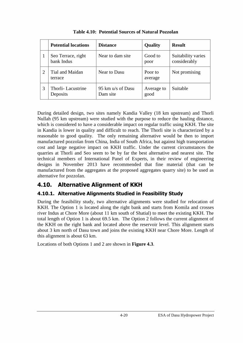
4-20 ESA of Dasu Hydropower Project
Table 4.10: Potential Sources of Natural Pozzolan
Potential locations Distance Quality Result
1 Seo Terrace, right
bank Indus
Near to dam site Good to
poor
Suitability varies
considerably
2 Tial and Maidan
terrace
Near to Dasu Poor to
average
Not promising
3 Thorli- Lacustrine
Deposits
95 km u/s of Dasu
Dam site
Average to
good
Suitable
During detailed design, two sites namely Kandia Valley (18 km upstream) and Thorli
Nullah (95 km upstream) were studied with the purpose to reduce the hauling distance,
which is considered to have a considerable impact on regular traffic using KKH. The site
in Kandia is lower in quality and difficult to reach. The Thorli site is characterized by a
reasonable to good quality. The only remaining alternative would be then to import
manufactured pozzolan from China, India of South Africa, but against high transportation
cost and large negative impact on KKH traffic. Under the current circumstances the
quarries at Thorli and Seo seem to be by far the best alternative and nearest site. The
technical members of International Panel of Experts, in their review of engineering
designs in November 2013 have recommended that fine material (that can be
manufactured from the aggregates at the proposed aggregates quarry site) to be used as
alternative for pozzolan.
4.10. Alternative Alignment of KKH
4.10.1. Alternative Alignments Studied in Feasibility Study
During the feasibility study, two alternative alignments were studied for relocation of
KKH. The Option 1 is located along the right bank and starts from Komila and crosses
river Indus at Chore More (about 11 km south of Shatial) to meet the existing KKH. The
total length of Option 1 is about 69.5 km. The Option 2 follows the current alignment of
the KKH on the right bank and located above the reservoir level. This alignment starts
about 3 km north of Dasu town and joins the existing KKH near Chore More. Length of
this alignment is about 63 km.
Locations of both Options 1 and 2 are shown in Figure 4.3.

4-21 ESA of Dasu Hydropower Project
Figure 4.3: Options 1 and 2 for KKH Relocation
Sheet 1

4-22 ESA of Dasu Hydropower Project
Sheet 2
Legend: : Indus River; : Realigned KKH – Option 1;
: Realigned KKH – Option 2.
The key aspects of both of the above options are tabulated below.
Table 4.11: Comparison of Options 1 and 2 for KKH Realignment
Option 1 Option 2
Length 69.5 km 63 km
Indus Crossing Needed Not needed
Construction cost About 3 million USD costlier
than option 1
Less expensive than Option 1
Construction schedule About one year longer than
option 1
Shorter construction schedule
than Option 1
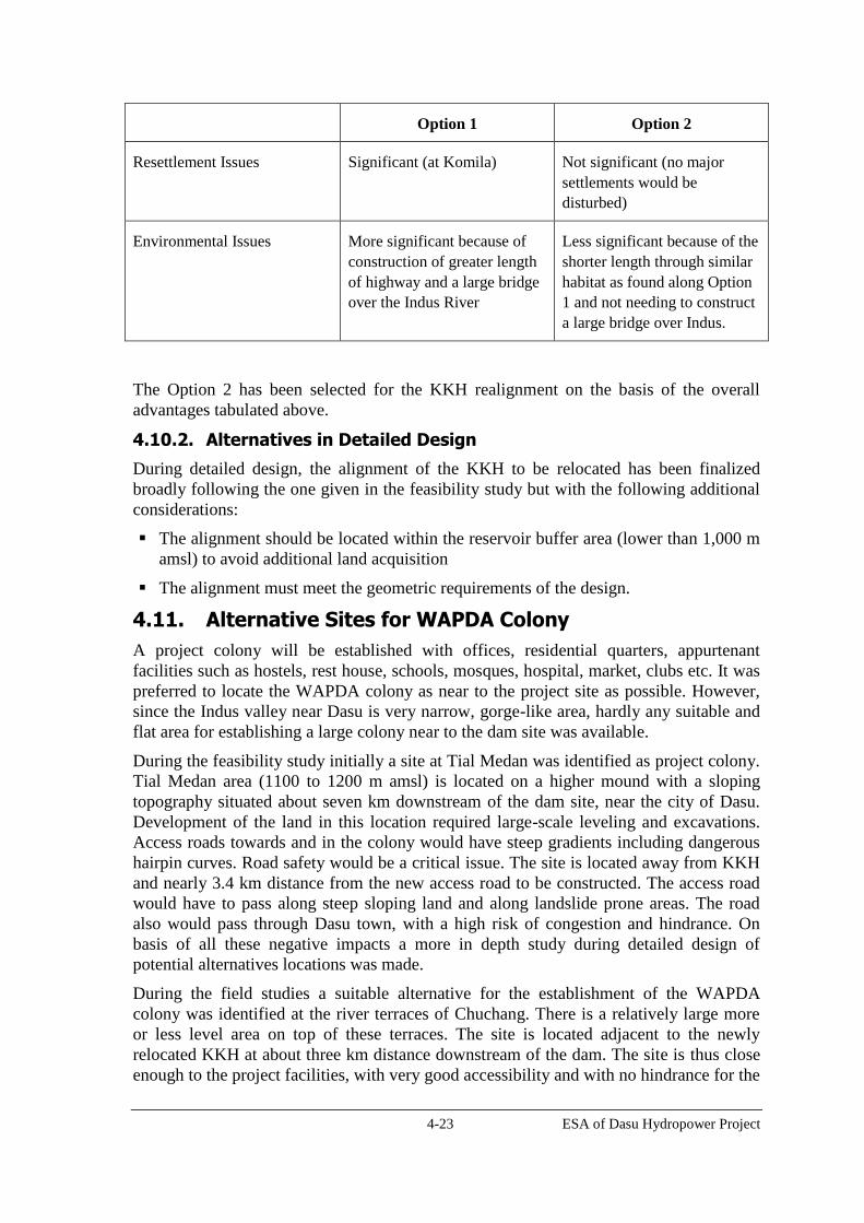
4-23 ESA of Dasu Hydropower Project
Option 1 Option 2
Resettlement Issues Significant (at Komila) Not significant (no major
settlements would be
disturbed)
Environmental Issues More significant because of
construction of greater length
of highway and a large bridge
over the Indus River
Less significant because of the
shorter length through similar
habitat as found along Option
1 and not needing to construct
a large bridge over Indus.
The Option 2 has been selected for the KKH realignment on the basis of the overall
advantages tabulated above.
4.10.2. Alternatives in Detailed Design
During detailed design, the alignment of the KKH to be relocated has been finalized
broadly following the one given in the feasibility study but with the following additional
considerations:
The alignment should be located within the reservoir buffer area (lower than 1,000 m
amsl) to avoid additional land acquisition
The alignment must meet the geometric requirements of the design.
4.11. Alternative Sites for WAPDA Colony
A project colony will be established with offices, residential quarters, appurtenant
facilities such as hostels, rest house, schools, mosques, hospital, market, clubs etc. It was
preferred to locate the WAPDA colony as near to the project site as possible. However,
since the Indus valley near Dasu is very narrow, gorge-like area, hardly any suitable and
flat area for establishing a large colony near to the dam site was available.
During the feasibility study initially a site at Tial Medan was identified as project colony.
Tial Medan area (1100 to 1200 m amsl) is located on a higher mound with a sloping
topography situated about seven km downstream of the dam site, near the city of Dasu.
Development of the land in this location required large-scale leveling and excavations.
Access roads towards and in the colony would have steep gradients including dangerous
hairpin curves. Road safety would be a critical issue. The site is located away from KKH
and nearly 3.4 km distance from the new access road to be constructed. The access road
would have to pass along steep sloping land and along landslide prone areas. The road
also would pass through Dasu town, with a high risk of congestion and hindrance. On
basis of all these negative impacts a more in depth study during detailed design of
potential alternatives locations was made.
During the field studies a suitable alternative for the establishment of the WAPDA
colony was identified at the river terraces of Chuchang. There is a relatively large more
or less level area on top of these terraces. The site is located adjacent to the newly
relocated KKH at about three km distance downstream of the dam. The site is thus close
enough to the project facilities, with very good accessibility and with no hindrance for the

4-24 ESA of Dasu Hydropower Project
traffic and the population in and around Dasu town. From a social and urban planning
point of view this would seem to be a better solution. Another advantage is that no large
scale and expensive excavation works are needed for the construction of the colony. A
disadvantage is that the area is partly occupied, not surprisingly in an area with almost no
other flat land. Currently there are 96 houses in the area, mainly occupied by people
working in Dasu or Komila. People in the area would have to be resettled and
compensated for the loss of land and property. After consultations with the local
population it turned out that people in the area do not oppose resettlement to other areas,
since most of them own land in other parts of the village. This all provided that they
would be compensated in a satisfactory manner. Evaluation of all the concerned factors
led to the conclusion that the site in Chuchang was found to be far more suitable than the
previous location in Tial Medan. Possible suitable alternatives situated within a
reasonable distance were not available. On basis of these facts it was decided to prepare
the detailed design for the Colony in Chuchang.
4.12. Alternatives in Operation and Management
About 200 million ton of sediment passes every year at the dam site. Without any
mechanism for flushing of sediments the LLO’s and power intake will be filled within
20-25 years. The feasibility study was prepared on the assumption that the Basha dam
would be constructed earlier then DHP. Most sediments would then be trapped into the
Basha reservoir. Flushing of Dasu would only be required after 50 year.
But with Basha now likely to be completed after Dasu, the question is what flushing
regime is required during the first few years of Dasu operation, before Basha is
commissioned. If there is no flushing of sediments it is expected that the inlets for LLO
and power intake of DHP will be filled within 20 to 25 years. After studying various
options, the design team finally considered following three feasible options.
Option-1: Without Basha, first 15 years no flushing and after this annual flushing;
Option-2: Without Basha, after impounding every year flushing;
Option-3: Basha commissioned in year 15, no flushing under Pre-Basha” and Post-
Basha conditions
In Table 4.12, a comparison of energy production under these three options is presented.
Table 4.12: Annual Energy Production for three O&M Options
Annual energy production (in GWh)
Year after
commissioning 0-5 5-10 10-15 15-20
Units operating 3 6 9 12
Option 1 Without Basha
No flushing Flushing
8,058 12,225 15,544 13,584
Option 2 Without Basha
Every year flushing after impounding

4-25 ESA of Dasu Hydropower Project
Annual energy production (in GWh)
Year after
commissioning 0-5 5-10 10-15 15-20
Units operating 3 6 9 12
6,561 9,371 11,631 13,584
Option 3 "Pre-Basha' "Post-Basha"
No flushing
8,058 12,225 18,730 21,485
Source: DHP Detailed Engineering Design, 2012
In case Basha is not constructed the flushing regime of Option 1 (annual flushing starting
in year 15) is recommended since more energy is produced annually, than in option 2.
This is because the turbines will not work for a period of about 60 days during flushing.
After 15 years the energy production is equal in both options. When Basha is built the
option 3 will generate more power and eventually flushing may not be required for a
period of 40 to 50 years, since most sediments do not reach the Dasu reservoir.
The table shows the effect on annual energy production in DHP after completion of the
Diamer-Basha dam. Hydrological, environmental and ecological effects of sedimentation,
flushing and the different possible scenario’s (base load or peak load production) will be
discussed in Chapter 7. The potential impacts during flushing operations on the
downstream aquatic habitat are turbulent flows, sediment load and altered water quality.
Option 3 has advantage of delaying these potential impacts associated with flushing by
35 years. Option 3 will also ensure higher power generation during these 35 years and
hence ensure positive socioeconomic development in the country.

5-1 ESA of Dasu Hydropower Project
5. Baseline Description
This Chapter describes the existing, pre-project environmental and socioeconomic
conditions of the project area. Where not otherwise mentioned, data and information
presented in this Chapter have been taken from the various volumes of the EMAP (see
Table 1.2). The details including the data collection methodologies, sample
questionnaires, and monitoring results are available in those volumes. The baseline
description associated with the 500kV transmission line will be included in the ESA of
that component.
5.1. Physical Environment
5.1.1. Project Area
The direct impact area of the project covers the left and right bank of the Indus from the
riverbed up to contour 1500 m amsl. The impact area extends from the upstream end of
the reservoir along the Indus (few km downstream of the proposed site for the Diamer-
Basha dam) to a point some 10 km downstream of Dasu Bridge where the influence of
the tailrace tunnels of the project ends and the flow is expected to be “normalized”.
The potential impact area of DHP includes:
all areas to be acquired permanently for the reservoir and for construction works,
housing areas, offices, and other project facilities including borrow and disposal
areas, and quarries;
all sections to be acquired permanently for realignment of KKH and a 500 m wide
corridor along it to be used during the construction phase;
all areas between Dasu and Basha to be acquired on a temporary basis for
construction camps and storage of material;
all areas to be acquired on a temporary basis as borrow areas for construction
materials;
the 45 km long and 200 m wide corridor of 132 kV transmission line to be
constructed providing electricity to project during construction, connecting Dubair
grid station with the project; and
the 250 km long and 500 m wide corridor of 500 kV transmission line from Dasu
hydropower to village Pathar Garh in District Attock (to be covered in detail in the
ESA to be carried out for this component of the project).
The area that will be influenced indirectly by the project is much larger and covers the
Indus River between Dasu and the Tarbela Reservoir and the KKH between Khunjerab
pass and Hassanabdal as well as some of the higher mountain areas above 1500 m
altitude.
5.1.2. Physiography
The area of Indus-Kohistan belongs to the lower Himalayas and consists (in the project
area) of mountains between 2,000 and 4,000 m amsl. At some distance higher mountains
can be found (> 5,000 m amsl). On the western side there is a watershed between the
catchments of the Indus and the Swat rivers, whereas on the eastern side there is a
watershed between the catchments of the Indus and the Jhelum rivers. The Indus River
originates from a spring called Singikabad near Manasarovar lake on the north side of the
Himalayan Range (Kailas Parbat) in Tibet at an altitude of 5,500 m amsl. The distance
5-2 ESA of Dasu Hydropower Project
from here to the project site at Dasu is about 1,024 km. The Indus has cut out a deep
valley in the mountain piedmont plain. The river enters the impact area in western
direction near Diamer, flowing through a relatively wide valley for some distance
towards Shatial. Near Lootar the valley bends southward and forms a narrow gorge-like
valley. The valley has steep rocky slopes and stony foothills and is sparsely vegetated.
The slopes on both sides show gradients of some 40-60 percent. The altitude of the
riverbed is around 930 m amsl near Diamer and drops to 890 m amsl near Lootar, with a
gradient of 0.3 percent. In Dasu the elevation of the riverbed is 765 m amsl. From the
mountainous hinterland small lateral tributaries and nullahs (small streams) are
discharging water originating from rainfall and melting snow into the main river. The
Indus here is fast flowing and full of sediment.
The area is characterized by low population density. In total there are 34 small villages or
hamlets, 17 on the left bank (along the KKH) and 17 on the right bank of the Indus.
Dasu–Komila is the only somewhat larger town with about 7,150 inhabitants. Most of the
area is heavy sloping and very rocky. There is hardly any level or gently sloping land.
Along some of the nullahs agricultural cultivation is found, usually on terraced soils on
alluvial fans and old river terraces.
5.1.3. Climate
The project area is characterized by a large variation in climatic conditions, strongly
varying with altitude. Commonly, the climate in the zones lower than 1,500 m is
classified as “dry subtropical”, whereas the higher elevated zones have a “temperate”
climate. Annual rainfall generally is low with figures between 200 mm and 300 mm.
There is a strong increase in rainfall with altitude. It is not unusual that rainfall (often in
the form of snow) amounts to values of 1,000 mm at altitudes of 3,000-5,000 m. The
summers are usually hot in the valleys (average maximum temperature of 35°C in
August) and winters are cold (average minimum temperature of 5° C in January). The
area is not influenced by the monsoon and is lying in the rainfall shadow of the higher
mountains, including the Nanga Parbat (over 8,000 m high). During winter the
precipitation falls as snow. Generally the areas between 1,500 m and 5,000 m in the
Upper Indus Basin are snow-covered during most of the winter months. The areas above
5,000 m are permanently snow covered. Although annual precipitation is low at the
valley floor there can be occasional but intense rainfall events, often with significant
hydrological and geomorphological significance (erosion). Winds can be very variable in
the project area; the dominant wind directions depend largely on the local topography.
5.1.4. Geology
Geologically, the northern Pakistan region is divided into three blocks, from north to
south: Karakoram Block, Kohistan Island Arc and Indian plate. The project area is
located in the southern part of the Kohistan Island Arc bounded by the Main Karakoram
Thrust in the north and west (Northern Suture) and by the Main Mantle Thrust (MMT) to
the south and east (Southern Suture) as shown in Figure 5.1.
The Kohistan Arc Complex is an area of igneous and sedimentary rocks that was formed
during the mid-Cretaceous period. The area lies near to the area where the Asian and
Indian continental plates meet, resulting in considerable thrusting, uplifting, tilting and
plutonic activity. In the project area mainly granulites and amphibolites can be found on
both sides of the Indus. These rock formations both date from Cretaceous period. At
places the geological conditions are quite complex, with major faults, volcanic intrusions,
batholites and thrusts requiring detailed investigations and testing. Near the main
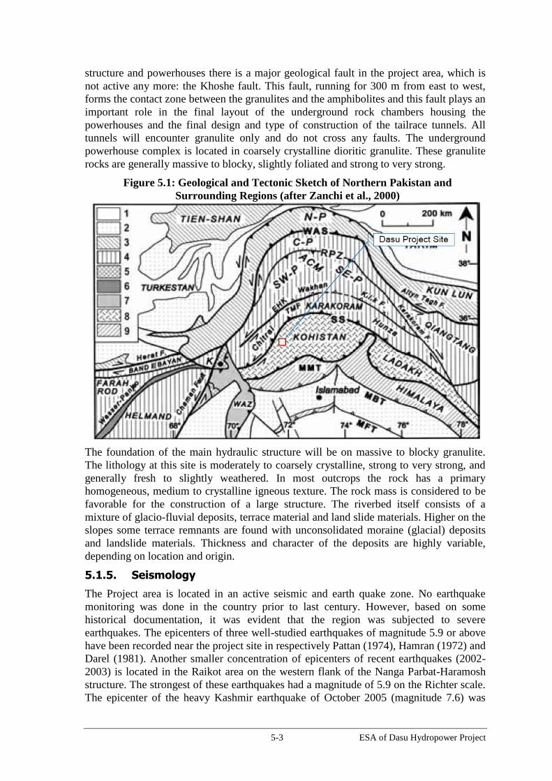
5-3 ESA of Dasu Hydropower Project
structure and powerhouses there is a major geological fault in the project area, which is
not active any more: the Khoshe fault. This fault, running for 300 m from east to west,
forms the contact zone between the granulites and the amphibolites and this fault plays an
important role in the final layout of the underground rock chambers housing the
powerhouses and the final design and type of construction of the tailrace tunnels. All
tunnels will encounter granulite only and do not cross any faults. The underground
powerhouse complex is located in coarsely crystalline dioritic granulite. These granulite
rocks are generally massive to blocky, slightly foliated and strong to very strong.
Figure 5.1: Geological and Tectonic Sketch of Northern Pakistan and
Surrounding Regions (after Zanchi et al., 2000)
The foundation of the main hydraulic structure will be on massive to blocky granulite.
The lithology at this site is moderately to coarsely crystalline, strong to very strong, and
generally fresh to slightly weathered. In most outcrops the rock has a primary
homogeneous, medium to crystalline igneous texture. The rock mass is considered to be
favorable for the construction of a large structure. The riverbed itself consists of a
mixture of glacio-fluvial deposits, terrace material and land slide materials. Higher on the
slopes some terrace remnants are found with unconsolidated moraine (glacial) deposits
and landslide materials. Thickness and character of the deposits are highly variable,
depending on location and origin.
5.1.5. Seismology
The Project area is located in an active seismic and earth quake zone. No earthquake
monitoring was done in the country prior to last century. However, based on some
historical documentation, it was evident that the region was subjected to severe
earthquakes. The epicenters of three well-studied earthquakes of magnitude 5.9 or above
have been recorded near the project site in respectively Pattan (1974), Hamran (1972) and
Darel (1981). Another smaller concentration of epicenters of recent earthquakes (2002-
2003) is located in the Raikot area on the western flank of the Nanga Parbat-Haramosh
structure. The strongest of these earthquakes had a magnitude of 5.9 on the Richter scale.
The epicenter of the heavy Kashmir earthquake of October 2005 (magnitude 7.6) was

5-4 ESA of Dasu Hydropower Project
located at a distance of 90-100 km from the project area. The event struck the northern
part of Pakistan, causing widespread damage and casualties in Azad Kashmir and
adjoining areas of KP.
For detailed design, the instrumental records of earthquakes within a 150-km-radius of
the project were obtained from the International Seismological Centre in England, the
National Earthquake Information Centre of the U.S. Geological Survey, the Geophysical
Centre in Quetta and the Tarbela Seismic Observatory of WAPDA. A composite
catalogue of instrumentally recorded earthquakes was prepared by combining these
earthquake listings comprising 2,115 events having magnitude greater than 3.0. For
seismic data to be used in seismic hazard analysis, the magnitudes given in different
scales were converted into a uniform magnitude-scale.
5.1.6. Rock Stability and Landslides
The project area is characterized by steep and moderately steep slopes. The granulite and
amphibolite rock slopes are susceptible to rock fall and block toppling along steeply
inclined foliation, discontinuities and occasional wedge sliding along various
combinations of inclined joints and shears. The stability of rock slopes depends largely
on rock mass properties, structural discontinuities, groundwater and earthquakes.
Frequent landslides are not very common in the area. However, huge moraine deposits
occur on nearly vertical slopes on either side of the Indus River. In the Project area these
deposits occur near Kandia, Seo and Tial Medan. These deposits are loose and during
heavy rainfall landslides and road blockage may happen. A few incidents with landslides
were reported from the Kandia valley.
5.1.7. Sedimentation
The Indus River carries a heavy sediment load due to the ruggedness of the catchment
area and the strong erosional forces in the upper catchment area caused by deforestation
and lack of protective vegetation cover. Another factor is the great variation between day
and night temperatures. This may cause cracking and disintegration of rocks, erosion, and
landslides on unstable slopes. Erosion materials in side valleys will be transported by
melted snow towards the tributaries and will finally discharge as mud flows into the
Indus. The river also derives sediments from vast alluvial fields and moraine deposits
formed along its banks more upstream. Moraine deposits (silty sand with gravel and
boulders from glacial origin are embedded) can be found on both embankments of the
Indus River, sometimes characterized by nearly vertical slopes. The sediments in the river
water comprise of suspended solid and moving bed load. The annual runoff is estimated
at 67 BCM and 79 percent of the flow occurs between June and September. The annual
sediment load at Dasu is estimated at 221 million ton.
It has been assumed that particle size distribution entering Dasu reservoir will be the
same as observed at Partab/Bunji Bridge, shown in Table 5.1.
Table 5.1: Particle Size Distribution of Total Sediment Load at the Project Site
Sediment Type Percentage Total
( percent) Sand Silt Clay
Suspended 40.0 44.0 16.0 100
Unmeasured (bed load) 10.6 0.2 0.0 10.8
Total 50.6 44.2 16.0 110.8
Percentage 45.7 39.9 14.4 100
Source: DHC EMAP

5-5 ESA of Dasu Hydropower Project
5.1.8. Soils
Geomorphologically the project area consists of mountain terraces and piedmont plains.
The mountains are rugged with high relief and steep slopes. Geological erosion in these
mountain areas is substantial. Rock debris is generally found at the toe of the highlands.
Accessible slopes with a soil cover are terraced by the population for arable farming. The
gravelly fans and terraces are of limited extent and mostly located at the bottom of
mountain slopes. These are characterized by gravelly moderately coarse to medium
textured soils. Most soils consist of sandy loam and silt loam. In general, the infiltration
rate in these soils is moderately rapid. Water holding and nutrient holding capacity is low.
Cultivated areas are usually developed on alluvial fans and to the lesser extent by
reclamation of old river terraces. The soils are generally low in clay and high in silt and
sand with low organic matter content. These soils are used for the cultivation of wheat,
maize, fodder and some vegetables. The soils are generally poor in plant nutrients. Soil
samples (virgin soil, not used for agriculture) were collected along the valley and were
analyzed for mercury. The concentration of mercury at all locations was found to be
within the standard limits.
5.1.9. Hydrology
The Indus flows from the Tibetan Plateau (elevation 5,500) m in westerly direction
through India and is joined in Pakistan by four major tributaries: the Shigar and Shyok
rivers in Baltistan and the Gilgit and the Astor rivers before reaching Dasu. The
catchment of Indus River at Dasu covers some 158,800 km2. During the last stretch
before Dasu the Indus flows in a deep narrow channel with a steep gradient of 3 m/km
and bends near Kandia in southern direction. The side slopes of the river are often
without any vegetation and very rocky. Several lateral river valleys are found between
Basha and Dasu, including the valleys of the Darel, Tangir and Kandia rivers. These
lateral rivers drain the hinterland and bring snow melt water throughout the year and with
it comes fine to coarse sandy sediment. After rainfall the water of the tributaries becomes
very turbid. Apart from these rivers there are some 14 nullahs flowing into the main river
in the project area, see Table 5.2.
Table 5.2: Main Streams and Nullahs Flowing into the Indus in the Project Area
Stream/
Nullahs
Elevation
(m)
Catchment Area
(km²)
Length
(km)
Mean Annual
Flow (m³/s)
Streams located at left bank (upstream of dam site)
Uchar 814 70.6 - 2.57
Barseen 834 15.3 2.9 0.59
Kaigah 875 43.0 13.1 1.65
Lutter 957 9.5 8.7 0.36
Summar 957 82.6 22.6 2.21
Shatial 991 9.2 7.7 0.35
Streams located at right bank (upstream of dam site)
Duga 892 - 13.0 -
Kandia River 841 2,242 84.3 79.92
Uttar 814 28.0 10.8 1.08
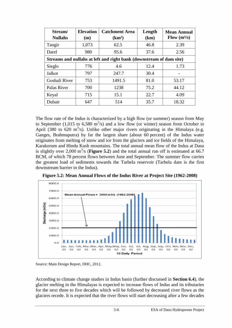
5-6 ESA of Dasu Hydropower Project
Stream/
Nullahs
Elevation
(m)
Catchment Area
(km²)
Length
(km)
Mean Annual
Flow (m³/s)
Tangir 1,073 62.5 46.8 2.39
Darel 980 95.6 37.6 2.56
Streams and nullahs at left and right bank (downstream of dam site)
Sieglo 776 4.6 12.4 1.73
Jalkot 797 247.7 30.4 -
Goshali River 753 1491.5 81.0 53.17
Palas River 700 1238 75.2 44.12
Keyal 715 15.1 22.7 4.09
Dubair 647 514 35.7 18.32
The flow rate of the Indus is characterized by a high flow (or summer) season from May
to September (1,015 to 6,580 m3/s) and a low flow (or winter) season from October to
April (380 to 620 m3/s). Unlike other major rivers originating in the Himalaya (e.g.
Ganges, Brahmaputra) by far the largest share (about 60 percent) of the Indus water
originates from melting of snow and ice from the glaciers and ice fields of the Himalaya,
Karakorum and Hindu Kush mountains. The total annual mean flow of the Indus at Dasu
is slightly over 2,000 m3/s (Figure 5.2) and the total annual run off is estimated at 66.7
BCM, of which 78 percent flows between June and September. The summer flow carries
the greatest load of sediments towards the Tarbela reservoir (Tarbela dam is the first
downstream barrier in the Indus).
Figure 5.2: Mean Annual Flows of the Indus River at Project Site (1962-2008)
Source: Main Design Report, DHC, 2012.
According to climate change studies in Indus basin (further discussed in Section 6.4), the
glacier melting in the Himalayas is expected to increase flows of Indus and its tributaries
for the next three to five decades which will be followed by decreased river flows as the
glaciers recede. It is expected that the river flows will start decreasing after a few decades

5-7 ESA of Dasu Hydropower Project
due to reduced glacier mass to a level that would be determined by the precipitation input
at that time. A recent simulation modeling conducted by GCISC5 on Indus flows for a
scenario, where the temperature will rise by 3˚C and the glaciers to shrink to half their
present size, not only the overall annual flow would reduce by about 15 percent, the
monthly flow pattern would also change considerably, with more water coming in spring
and early summer and less water in the later part of the summer. This scenario is
considered in planning and design of the DHP. One of the criteria considered in the
selection of the size of turbines of DHP is to accommodate any future low flows due to
climate change.
5.1.10. Flooding
In the upper Indus catchment area floods occur due to natural dam formation and their
subsequent breakdown. Natural dam formations are either caused by landslides, or by
bursting or overtopping of an ice dam, resulting in a sudden discharge of the lake behind
the glacier. Dams created by massive landslides are rare but glacier dams are numerous;
nearly 60 of such events have been reported since 1830. Dam break floods are
characterized by a very rapid flood rise. Other causes of floods are heavy and prolonged
storm runoff and intensive and extreme glacier and snow melting.
A number of historic floods are known from the upper Indus catchment area. The most
recent one happened in 2010 in the Hunza Valley, when the Hunza River was blocked by
an ice dam. After overtopping a considerable length of KKH near Ata-Abad was eroded
away. The event created a lake which is still existing and affecting the trade with China.
In February 2012 the blockage was blasted to release some 1,416 m3/s) to lower down the
lake water level and ease the situation to some extent. This resulted in a sudden raise in
water level of the Indus at Dasu of about 2.5 m.
5.1.11. Groundwater
The groundwater table in the river valley is deep and limited to deeper aquifers.
Groundwater was not even noticed in some of the test wells. No confining layers are
expected. The ground water depth near the main structure varies between 48 m and 68 m.
Groundwater level along the tunnel alignments is generally above the level of the tunnel
invert; some groundwater inflow would be expected during tunneling. However,
according to seepage measurements carried out during excavations the inflow will be
limited to around 200 l/min. Groundwater levels in the vicinity of the underground power
house complex are 250 to 300 m deep below ground surface, but probably above the level
of the power house cavern, which might give some limited inflow (200 l/min) during
tunneling operations.
5.1.12. Water Quality
The quality of the water of the Indus and its small tributaries has been investigated during
the high flow and low flow season at 20 sampling sites in order to establish a baseline for
the project. Generally the water quality parameters are good to excellent and are in
compliance with the national standards for drinking water quality from Pak-EPA,
(NEQS) and WHO drinking-water standards, Also they were compared with the National
Surface Water Classification criteria as proposed by WWF-2007. The water quality is
characterized by slight alkalinity, high oxygen levels, low conductivity and very high
5 GCISC (2009): Ali, G., S. Hasson, and A.M. Khan, Climate Change: Implications and Adaptation of
Water Resources in Pakistan, Research Report No.GCISC-RR-13, Global Change Impact Studies
Centre, Islamabad

5-8 ESA of Dasu Hydropower Project
turbidity and water temperatures varying between 6 and 21°C. Turbidity exceeds both
Pak-EPA’s and WHO drinking water standard limits at several locations in the project
area. However, turbidity in the tributaries was generally below recommended levels. The
iron concentration exceeded the (Pak-EPA’s drinking-water standard i.e. 0.01 to 1.4 mg/l
at few places, which is probably caused by iron ore deposits in the neighboring areas. The
concentration of boron also exceeded US-EPA’s fresh-water standard limit i.e. 0.007 to
0.5 mg/l at 4 out of 15 sampling sites. This raised boron content could be due to various
causes, but since the water is neither used for drinking (people and livestock) nor for
irrigation, this has no direct impact on human health.
The water quality of the Indus and its tributaries are characterized by:
Considerable variations in physico-chemical conditions in high flow and low flow
seasons
high water temperatures in high flow season (15 to 21°C) and low temperatures in
low flow season (6 to 15°C);
alkaline, with pH above 7;
high dissolved oxygen (above 6.5 mg/l)
high turbidity up to 70 NTU in high flow season; and up to 32 NTU in low flow
season;
low total dissolved solids (less than 150 mg/l) and low conductivity (325 µS/cm);
Nitrate concentrations varying from 0.6 to 3.5 mg/l; and
Nickel concentration which is slightly exceeding the national drinking water
standards.
5.1.13. Air Quality
Along the project area 24 hour air quality monitoring was conducted during summer and
winter of 2012 at 18 locations in the project area. The parameters for fine dust such as
PM10 (24 hours) were found to be within the Pak-EPA(NEQS) limit, however fine
particulate matter (PM2.5) at 50 percent of the investigated sites (in residential areas
mainly along KKH) was found to exceed the Pak-EPA’s prescribed limits slightly. The
possible reason could be fuel burning (coal, wood, and fuel oil), incineration (house and
municipal garbage) or other causes (construction, traffic along KKH). The ambient gases
(CO2, SO2, NOx, and CO2) concentrations were found to be within the standard limits of
Pak -EPA at all sampling sites.
5.1.14. Noise
Noise quality monitoring was carried out 18 locations along the project area. Noise levels
are high along the valley and in most cases exceeded the Pakistan EPA standard limits.
The noise levels at different locations were found to be in the range of 45-67 dB.
5.2. Aquatic Environment
5.2.1. Field Surveys
Field investigations on aquatic ecology were conducted during April and August of 2012
in the project area by Dr. William George (a former Director of WAPDA Fisheries Unit,
who introduced fisheries in Pakistan) and Prof. Tahir Omer. Investigations were also
carried out in January 2013 by researchers from Department of Zoology of University of

5-9 ESA of Dasu Hydropower Project
Punjab. The survey area extended from the Tarbela Dam to the upper limit of the planned
Diamer Basha project reservoir. Locations of sampling sites are shown in Figure 5.3.
Field data included biological data, fishing techniques and practices. In addition to field
observations and sampling, fish, plants and plankton were investigated in laboratories
(taxonomy, morphometry, gut contents, reproduction status). In addition to the field data,
other sources of information include interviews with local fishermen and KP Fishery
Department, international and national literature on the snow carp (also known as snow
trout) fish species, and EIA reports of other hydropower projects in the trans-Himalayan
region of Pakistan, Nepal and India. The ESMP (Chapter 9) also provides for further
studies to be carried out to collect additional baseline data during the pre-
construction/construction phase (see Annex B for ToRs for the studies). Procurement of
consultants for these studies is yet to be finalized. Suitable organizations to carry out
these studies include WWF-Pakistan and IUCN-Pakistan, where essential technical
know-how is available.
Figure 5.3: Aquatic Biological Sampling Sites
5.2.2. Aquatic Ecosystems
The Indus originates in Mansorawar Lake in Tibet, is approximately 3,058 km long and
drains an area of 963,480 km² before discharging into the Arabian Sea. Physical
geological, meteorological and hydro-biological conditions vary substantially along the
river as do corresponding important human uses of the river and dependent economic

5-10 ESA of Dasu Hydropower Project
conditions. The uppermost section of the river flows east-west in the mountain peak zone
for about 950 km before it reaches the Dasu Project area. The catchment in that area is
mountainous and characterized by towering peaks covered with snow and glaciers. The
river is mainly fed by melting of mountain snow; flow is high during summer and
contribution from rainfall is very small. The mean annual flow and annual runoff at Dasu
amounts to 2,100 m³/s and 68 BCM respectively, but differences between summer and
winter are large: 80 percent of the water flows between June and October.
Physico-chemical conditions of river water changes between the summer and winter
seasons. During summer, river water is very turbid and carries a high sediment load.
Annual sediment inflow at DHP dam site is about 200 million tons and 97 percent of it
occurs during high flow season of June to October.
During the 2012 April surveys the ranges of physico-chemical parameters were: water
temperature 15-24°C; conductivity 63-149 µS/cm; calcium carbonate hardness 30-110
mg/l; dissolved oxygen 4.8-7.4; and NO3 0.20-1.20 mg/l. Low concentrations of NO3
suggest mainly low nutrient levels and oligotrophic conditions. There were rather large
differences in chemical parameters between sample stations, mainly related to close-by
human residences.
Several river tributaries join the Indus between Basha and Tarbela. Catchment areas vary
greatly. All streams pass along steep gradients through rocky areas of high mountains,
exhibiting variable cascades. At confluences with other tributaries and the Indus River
they discharge gravel and sand from river bed erosion. Water quality in the main
tributaries was also surveyed during the summer of 2012. The water in these
nullahs/streams was generally colorless, odorless, transparent and cool. Dissolved oxygen
concentrations ranged from 5.0 to 10.0 mg/l and conductivity ranged from 28 to 105
µS/cm, indicating variable but generally low concentrations of dissolved solids. During
winter months temperatures were reported to be substantially lower: data averaged
around 8°C, against some 20°C during summer. The banks of some tributaries show
patches of vegetation.
5.2.3. Fish
Fish diversity in the Indus is low compared to other major rivers. 177 fish species are
reported from the Indus River system, including 12 exotic species. This is substantially
lower than in other major rivers in Asia; the Ganges houses 350 fish species, the
Brahmaputra and the Mekong around 400, and the Hwang 320. Fish species of Northern
Pakistan is given in Annex C. Five species of fish are recorded in the project area. The
first of two sampling trips carried out in early summer and late summer seasons of 2012
(6 persons, 10 days) yielded only 25 fish, and the second only 50, belonging to four
species: three carps and one catfish. The distribution of sexes was equal. The fish
sampling carried out in winter 2013/2014 also yielded about 60 fish (24 hour fishing
using gill/cast nets at 16 locations). Nearly all fish were captured in small riffles and
pools of tributaries; fish caught in the Indus River were mostly from confluence areas,
close to the tributaries. The main reasons for poor fish diversity and density are the long
torrential upper courses in the Himalayas, glacier fed water and high sediment load or
low mean discharge rate of water. Fish sampling for the Diamer Basha Hydropower
Project (2006) yielded 14 species, but also this can be considered low, probably due to
high-altitude tributaries, low water temperature, high water velocity, low benthic
productivity and long stretches of gorges.

5-11 ESA of Dasu Hydropower Project
Most species in the project area are members of the carp family (Cyprinidae) and loach
family (Noemachcilidae). The piscifauna is dominated by endemic genera of the cyprinid
sub-family Schizothoricinae (snow carps or snow trouts: Schizothorax, Esocinus and
Labitusspp.) and one genus of the Noemachcilidae family (Triplophysa sp.) and one
species of the Sisoridae family (the catfish Glyptosternum reticulatum). These genera
inhabit torrential and swift streams and rivers of the mountain region and have evolved
morphologic features adapted to these habitat conditions. In order to enhance fish
production two species of Salmonidae (brown trout and rainbow trout) were introduced in
the upper part of Indus in Gilgit river and adjoining streams during the early nineties. No
brown/rainbow trout was observed in any of the samples.
Downstream of the project site the number of species increases. From the area between
Dasu and Pattan seven species are reported by fisheries authorities, especially from the
tributaries. Prior to construction of the Tarbela dam, 35 fish species were recorded in the
Indus River and tributaries around Tarbela.
Snow carp and Mahaseer are the two important fish species of cold waters of Himalayan
waters. Snow carps are the major fish species in the Indus and as one moves to south to
transitional or semi-cold waters, snow carps are joined by mahaseers. Further south and
at lower altitude warm water fish species prevail6. The snow carp species and the two
Mahaseer species (Tor putitora and Tor tor) were common and utilized as food fish. The
other native fish species are resident species and have no commercial value. No cave
species are present in the Indus.
5.2.4. Snow Carps Habitat, Migration and Spawning
Schizothoracines (genera Schizothorax and Schizopyge) are the major fish of cold water
streams and rivers of Himalayan regions, with the dominant species being Schizothorax
plagiostomus. In Dasu project area three species of scizothorax (plagiostomus, esocinus
and labitus) are present. Plagiostomus is the dominant fish species in Dasu area
representing more than 75 percent of total fish catch and other two species represent
about 15 percent of total fish catch. None of these species are listed in IUCN Red List.
Based on the review of available literature and the surveys carried out by the Project, the
habitat, spawning and migration conditions of snow carps are established and presented
below.
Habitat. Snow carps thrive in the snow fed river habitat of clear, shallow water of stony
substratum with an average depth from 0.5 to 3 meters, and river flows with low to high
velocities (0.5 to 1.5 m/s) 7,8
. Average temperature requirements are 4 to 20 oC and
dissolved oxygen requirements are 8 to 12 mg/l. Snow carps are bottom feeders and
mainly feed on peryphyitic algae and diatoms.
6 T. Petr. 2002 Cold Water Fish And Fisheries In Countries Of The High Mountain Arc Of Asia (Hindu
Kush-Pamir-Karakoram-Himalayas). (Cold water fisheries in the trans-Himalayan countries. Edited
by T. Petr and S.B. Swar) FAO Fisheries Technical Paper 431. 7 S.N.Bahuguna, R.S.Negi, P.Bahuguna and M. K. Upadhyay. Ex-situ Developmental study of
Schizothorax Plagiostomus from pre to post hatching. 2008. J. Env. Bio-sci. Vol. 22 (1) : 67-76, 2008. 8 Rajvanshi, Asha; Roshni Arora; Vinod B. Mathur; K. Sivakumar; S. Sathyakumar; G.S. Rawat; J.A.
Johnson; K. Ramesh; NandKishor Dimri and Ajay Maletha (2012) Assessment of Cumulative Impacts
of Hydroelectric Projects on Aquatic and Terrestrial Biodiversity in Alaknanda and Bhagirathi Basins,
Uttarakhand. Wildlife Institute of India, Technical Report. Pp 203 plus Appendices.

5-12 ESA of Dasu Hydropower Project
During fish surveys, in the Indus and its tributaries in the Project area, fish found mainly
in the tributaries, while in the main stem they are found near the confluences. Tributaries
with snow carp fish habitat on the upstream side of the dam site are Kandia, Tangir,
Darel, Kaigah, Summar, and Goshali. While tributaries on the downstream side with
snow carp fish habitat are Sieglo, and Jalkot.
Migration: Snow carps are short distant migrants. In the project area, they migrate
within the tributaries, not along the main stem Indus. During April to September (spring
and summer, high flows), they prefer upstream head waters habitat at higher elevations.
During September to April (low flows and winter), they prefer lower elevations and
confluence zone with Indus. The triggers for migrations are high flows, high sediment
load and low temperatures. During spring, when flows started increasing in the rivers due
to melting of snow, the fish migrate upstream from April and May (within tributaries)
due to high flows and turbidity at lower elevations. During autumn, when the
temperatures start to drop at higher elevations, the fish migrate downstream from
September and October.
Spawning: Female fishes spawn in two seasons, one in September-October and other in
March - April. Sexually matured snow carp (when they reach 18-24 cm length, at the age
of 2-3 years) spawn in tributaries in clear water (along stream banks, backwater pools and
near confluences of other tributaries and Indus) on gravelly/stony ground or on fine
pebbles at 10-30 cm depth. Low water currents of 0.5- 1.5 m/sec, pH 7.5, dissolved
oxygen concentration of 8-12 mg/L and gravel sizes of 50-60 mm are the optimum
conditions for spawning.
5.2.5. Mahaseer
Golden Mahaseer (Tor Putitora) is a long distant migratory and endangered fish species
of Indus. Mahaseers join snow carps in Indus when one moves to south to transitional or
semi-cold waters. Mahaseer habitat starts about 70 to 80 km downstream of the DHP dam
site. Mahaseer species habituated in slow moving streams and rivers of the foothill
regions and bred in gravels and sandy beds. Mahaseer is reported to ascend the Indus
River to Besham Qila and above and to spawn in Allai Khwar which has been described
as the last upstream safe-haven for the species. The Golden Mahaseer was the primary
quality food fish in the region and an attractive fish for anglers. Its economic significance
was substantial. However, due to permanent deep submergence of many natural breeding
grounds of Mahaseer in the Tarbela reservoir, natural propagation of the species
drastically declined. Mahaseer migrated into upstream tributaries where breeders were
indiscriminately fished; enforcement of protective regulations proved to be ineffective.
During fish sampling in the Dasu project area no Mahaseer specimen could be caught;
local people confirmed its absence from the area.
5.2.6. Fisheries
Fishing activity is very limited in the project area. Fishing in the project area is not
supported or assisted by government or non-government agencies. Local people fish as a
part time activity (about 12 percent of households), not as commercial fishermen: fish
density (and thus yields) is too low to support full-time jobs. In order to catch fish in the
rivers, a fishing permit must be obtained from the KP Fishery Department on payment of
a nominal fee, but regularly people practice illegal fishing. There is no fish farming and
no regular fisheries management in the Dasu area, although officially the KP Fishery
Department is expected to plan and execute sector development strategies and promotion
programs.

5-13 ESA of Dasu Hydropower Project
Both active and passive fishing techniques are being applied; due to their weak financial
situation fishermen prefer to use cast nets which are handy and relatively cheap. Illegal
fishing though the use of dynamite or poison is relatively common, especially in winter
time, when fish hide under rocks. Application of hook and rods are also in practice. Some
locals in remote areas use simple sieve cloths in shallow nullahs. Interviews of local
people revealed that catches in the project area included mainly snow carp of moderate
size (100-300 g). Reported catch quantities are relatively small: a three-hours fishing
effort with cast nets typically yields 2-7 kg of snow carps. Gill nets are set for a whole
night, catching 7-10 kg. Fish caught are brought home in sacks moistened with frequent
water sprays. There are no fish processing or storing centers in the project area. There are
also no fish shops or fish markets. Some owners of roadside truck-driver hotels catch fish
and fry them directly on customer’s demand. All these occasional fishermen expressed
the desire to apply their fishing skill if more opportunities arise in the future reservoir.
The success of Tarbela fisheries development, even though still at a lower production
levels than in Mangla or Chashma reservoirs due to the oligotrophic water quality, may
well serve as a potential example for fisheries management in the future Dasu reservoir.
In Tarbela reservoir, commercial fishing activities dominate; recreation fishing is rare.
Fishing in the Tarbela reservoir is properly organized; fishing rights are being leased out
annually or for maximum three year period through open auctions. Fisheries control was
transferred to the provincial fishery department in 2006; since 2007 the Government of
KP province was managing and developing the Tarbela reservoir fisheries further. From
2008 fishing rights have been auctioned to contractors on three year lease agreements.
The fishing contractors are fishing themselves and they are responsible for stocking of
fingerlings in the reservoir. Some fishing contractors engage local fishermen on daily
wages basis (PKR 20/kg in 2012). Some of the skilled fishermen possess their own
fishing boats and nets; others hire gear from the contractors. In the Tarbela reservoir,
gillnet, set nets and cast nets are applied. Yield and catches are supervised, monitored and
transported to the market by contractors’ manpower. Catches are being sorted out and
auctioned in Rawalpindi and Islamabad and at Peshawar fish markets.
5.2.7. Other Aquatic Biota
Macro-vegetation is scarce; only the banks of some nullahs show patches of vegetation
(herbs, shrubs and trees).
Fifty-nine species of phytoplankton were identified in plankton samples from stations
upstream of the proposed dam site, and thirty-five in samples from downstream stations.
Phytoplankton was dominated by Chlorophyta and Chrysophyta, indicative of
oligotrophic to low-mesotrophic water. Phytoplankton identified from samples collected
during field surveys are shown in Annex C.
Zooplankton and macrobenthos sampling revealed small numbers of species of
protozoans, crustaceans (rotifers, cladocerans and decapods), insects (damselfly larvae)
and mollusks (snails). The sampling intensity was too limited to allow conclusions.
Detail of zooplankton is given in Annex C.
Sixteen species of aquatic birds were observed during surveys, while 39 species of
aquatic birds are reported in Kohistan area. Only Ferruginous duck (Aythya nyroca) in
this list is the near threatened, while other species are of least concern. Detailed
information is available in Annex C. No aquatic mammals are reported or sited in the
project area.

5-14 ESA of Dasu Hydropower Project
5.3. Terrestrial Environment
5.3.1. Field Surveys
The studies for terrestrial ecology were carried out over a period of 4 months with field
investigations during July to September 2012. A series of biological sampling stations
was selected, so that all these different geomorphological, soil and vegetation elements
were covered. Plant specimens were collected, dried, pressed and mounted on herbarium
sheets and identified; their habitat was noted. Wildlife surveys were conducted at selected
vantage points, point counts and line transects for representative bird species and
photography. Data from the surveys and observations at those stations were
complemented by data from recent literature and from local enquiries. The field
investigations were conducted by Dr. Kashif Sheikh (a terrestrial ecologist and a former
Pakistan IUCN Biodiversity Expert), Dr. Sajid Nadeem (wildlife expert) and Dr.
Rahmatullah Qureshi (vegetation expert and associate professor at Arid Agriculture
University, Islamabad). The field investigations also covered surrounding mountains (up
to 4000 m amsl) along the project area. Further studies will be carried out to collect
additional baseline data during the pre-construction/construction phase (see Annex B for
ToRs for the studies).
5.3.2. General Biodiversity
The mountain areas of Pakistan are home to unique wildlife and wilderness areas. Also
the montane landscape at higher altitudes above the Dasu Hydropower Project area has a
large biodiversity; but the Indus valley bottom (including the project area proper and the
future reservoir area) is hardly vegetated. The available plant cover can be characterized
as “scrub vegetation” with its typical low biodiversity. Trees are mainly found near
human dwellings along the river and on widely dispersed plots along the nullahs. On
cultivable terraces commonly maize and wheat are grown, accompanied by common
weeds.
From the study area, which could be defined as the major habitats in the area up to 2,000
m amsl in total 232 species of plants, 199 species of avifauna, 31 species of mammals
and 18 species of reptiles and amphibians are recorded. None of the plants are endemic or
threatened; from the animal species the only threatened one sometimes visiting close to
the border of project area is the Markhor (Capra falconeri falconeri). The Indus Valley's
wetlands are a major wintering ground for many central and northern Asian species, but
these are not present in the project area.
5.3.3. Terrestrial Ecosystems of Project Area and Beyond
A vegetation ecology map from Dasu to Diamer Basha area and surrounding mountains
(up to 4000 m amsl), prepared based on field investigations, literature review, and
interpretation of satellite images, is given in Figure 5.4. On the basis of the vegetation
patterns a number of ecological zones were identified.
Most of the project area falls mainly in the “montane dry sub-tropical scrub zone”,
characterized by barren hills with steep slopes. This zone is typical for foothills and areas
between 800 and 1,500 m amsl. At lower altitudes, up to 950 m amsl, the shrub cover is
dominated by Artemisia maritima and grasses. On intermediate slopes plots of mixed
forest are encountered. Wildlife does not reside here, but is reported to visit the area
during winter in search of food when higher areas are snow laden.

5-15 ESA of Dasu Hydropower Project
Figure 5.4: Vegetation Ecology Map of Project Area and Surrounding Mountains

5-16 ESA of Dasu Hydropower Project
Above 1,500 m amsl, in the indirect impact zone of the project, a large variety of
vegetation is found, characterized as “Sub-tropical pine forests”, which consists of thorny
and small-leaved evergreen species. Typical are the Artemisia steppes (Artemisia
maritima).
Himalayan temperate forest starts above 2,000 m amsl and is mainly dominated by
conifers especially Deodar (Cedrusdeodara) and Pine-nut (Pinusgerardiana) interspersed
with some Oak (Quercus ilex) and various deciduous broad-leaved trees.
At even higher mountainous ranges alpine vegetation types are found, including “Sub-
alpine forests”, “Alpine shrub”, and “Alpine meadows”. Especially the Alpine meadows
are ecologically important: situated between high valleys and permanently snow covered
mountain areas at altitudes between 3,500 and 3,800 m amsl they present lush green
pockets surrounding the mountainous watercourses. They are rich in wildlife. These
higher areas were surveyed since they play an important role in the summer livelihood
(grazing, forestry, hunting, firewood) of the affected population of the project area
occupying the lower slopes of the valley. These higher areas are particularly ecologically
very sensitive. The details of protected and sensitive areas in the project area are given in
Section 5.3.7.
The alpine vegetation zones are relatively low in canopy cover. The forest plots are
characterized by evergreen conifers and evergreen broad-leaved trees such as Betulautilis
along with a deciduous shrubby undergrowth of Viburnum grandiflorum, Berberis spp.,
Rhododendron hypenanthemum, Salix spp., and others. The alpine shrubs show
formations of up to 2 m high, typically consisting of Salix, Lonicera spp., Berberis spp.,
and Cotoneaster spp. Here and there Juniperusmaropoda and Rhododendron or Ephedra
spp. are found. The vegetation composition of the alpine meadows includes mainly Poa
spp., sedges, Artemisia spp., Trifoliumrepens, Drabatrinervia, Polygonum affine,
Saxifragasibirica and Euphorbia kanaorica.
At lower levels, along some nullahs, small alluvial ecosystems are found on the sandy
soils, intermixed with gravels. This kind of alluvial zone is also a preferable area for
breeding/nesting of insects, birds, amphibians and reptiles. The biodiversity of this
habitat will be characterized through further studies (Annex B) before filling of the
reservoir.
5.3.4. Terrestrial Flora and Habitat of Project Area
The project area is located along the Indus River, which is flanked by desolate valleys
and high mountain ranges. The terrain is rocky and barren in nature with scattered
vegetation. Due to high wind velocity, white sandy particles are deposited on the valley
bottoms and adjacent mountain slopes. The river beds are characterized by rocky
outcrops with stony cliffs, large boulders and washed gravels. There is no littoral zone
outside the tributaries (nullahs). There is extensive soil erosion along the steep slopes.
The perennial flow of water from springs/streams and nullahs maintain the lifeline of the
Indus River. In the valleys near the human settlements, there is frequent irrigation and
cultivation along with deep soil depositions.
Land use types of the reservoir submergence zone and its buffer area up to 1,000 m amsl
are analyzed based on satellite imagery and field surveys. The major land use types and
their area of coverage are given in Table 5.3. About 61 percent of the land is covered by
barren slopes and rocks.

5-17 ESA of Dasu Hydropower Project
Table 5.3: Landuse Types in Dasu Project Area
Land Use Type Total Area (ha)
(up to 1,000 m amsl)
Percentage
River/ Nullah 1067 27.36
Clump of Trees 50 1.28
Cultivated Land 36 0.92
Grazing Land/ Pasture 222 5.69
Barren Slopes/ Rocks 2382 61.06
Exposed Sand 139 3.56
Houses/ Buildings 5 0.13
Total 3901 100%
The vegetation cover between the river and 2,000 m amsl can be divided into seven major
habitats based on geomorphologic features of the terrain associated with typical
vegetation types. These habitats and vegetation types are distributed throughout the
project area are shown in Figure 5.5 and are described below. A detailed list of all plant
species is provided in Annex C. A total of 232 plant species were identified. These
belong to 173 genera and 70 families. None of the recorded 232 floral species are
endangered, rare or vulnerable (International Union for Conservation of Nature IUCN
Red-List).
Figure 5.5: Major Habitat Types in the Project Area
Rocky Cliff Woodlands (12%) Rocky slopes woodlands (31%)
Mountain basement/Stony foothills (15%) Riparian zone (9%)

5-18 ESA of Dasu Hydropower Project
Rocky outcrops and boulders (9%) Spring/waterfall (12%)
Valleys/Cultivated Terraces (12%)
Rocky Woodlands (12 percent of total area): This habitat is located on higher altitudes
such as the mountain peaks, canyons with very steep and rocky slopes. The upper reaches
of this habitat has very little and scanty vegetation. This terrain is largely occupied by
sparsely distributed woody species such as Quercus baloot, Cotinus coggygria, Olea
ferruginea, Rhus mysurnesis and Cotoneaster spp.
Rocky Slopes Woodlands (31 percent of total area): This habitat is widely distributed
and relatively abundant in the study area with typical steep to moderate slopes on
relatively higher elevations characterized by massive rocks. The vegetation consists of
woody species with small trees, often with dense shrub layers and many herbs and
grasses that are abundantly found in upper slopes. Key vegetation comprised of Olea
europaea, Quercus baloot, Pistacia chinensis, Cotoneaster microphyllus, C. affinis,
Maytenus royleanus, Cotinus coggygria and Rhus mysurensis.
Mountain basement/ Stony foothills Woodlands (15 percent of total area): This habitat
is found adjacent to Indus River including its tributaries. It possesses a range of
geomorphologic and geological features, mostly composed of rocks and gravels along
steep to gentle slopes at lower altitudes. Though this is the most abundant community
type in the project area, however, it contains relatively less number of species and has
low species richness as well as total vegetation coverage. The representative species of
this community include Rumex hastatus, Dodonea viscosa and Maytenus royleanus.
Riparian scrublands (9 percent of total area): The riparian habitat is found in the
lowland floodplains of Project area. This habitat is scattered in the project area along
River Indus and its major tributaries. The habitat possesses sandy soil intermixed with
gravels adjacent to the river and nullahs. The most common species found are Dodonaea
viscosa, Nerium oleander, Debregeasia salicifolia and Maytenus royleanus.

5-19 ESA of Dasu Hydropower Project
Rocky Outcrops and Boulders Shrubland (9 percent of total area): This habitat type is
located in transitional zone between the mountains and riparian habitats on both banks of
the river Indus. This habitat possesses sparse vegetation with stunted shrubs and bushes.
It is found on intermediate altitudes, where there is mixture of soils and rocky gravel. In
this habitat, vegetation cover is very low. The most common species found are Maytenus
royleanus, Olea ferruginea, Rumex hastatus, Artemisia maritima, Heliotropium sp. and
Periploca aphylla.
Spring /Waterfall (12 percent of total area): This is a distinct habitat formed by running
water from the mountain tops. In this habitat, there is plenty of water and moisture
content and plant species are thriving. The most common plant species include:
Debregeasia salicifolia, Adiantum capillus-veneris, Persicaria glabra, Mentha longifolia,
Aialnthus altissima, Ficus carica and Themeda anathera.
Valleys/ cultivated land terraces (12 percent of total area): Some high altitude plain
grounds/valleys/cultivated terraces are located on the higher slopes and often encircled by
rocky mountains. These areas are inhabited by human settlements. This kind of habitat is
composed of sandy loamy soils with gravels and is best suited especially for the
cultivation of maize and wheat. This habitat showed common weeds as well as grasses
with potential for foraging. Common weed species include: Amaranthus caudatus, A.
ovalifolius, Portulaca oleracea, Physalis peruviana, Euphrasia himalyica, Cleome viscosa,
Trianthema portulacastrum, Coronopus didymus, Chenopodium ambrisoides, Euphorbia
indica, Bidense chinensis, Oxalis corniculata, Achyranthes aspera, Conyza bonariensis,
Oxalis corniculata, Verbena officinale along with grasses such as Brachiaria distachya
and Cynodon dactylon.
5.3.5. Use of Vegetation
Many of the occurring plant species are utilized by local communities as vegetables or
medicines, as animal food or fodder, for timber or fuel wood, and for harvesting their
fruits. In addition to the cultivated species, edible parts from a variety of wild plants are
cooked for preparing local meals, and 24 species, including 13 wild species, produce
fruit. Over 60 species are reported to contain crude medicines. Fuel wood is the major
source of energy for cooking and heating; some 78 species of trees and shrubs used as
fuel wood source by the local communities.
The forests from higher altitudes produce substantial amounts of timber and non-timber
forestry products. A large proportion of the harvested forestry products are transported
southward; local people indicate to be heavily dependent on the forests and forestry
products for their income. Officially, all forests in the project area are classified as
“Private Forests”, owned by the local community, but managed by the KP Forest
Department. The Department is responsible for overseeing commercial timber extraction
and timber sales. The royalty ratio is 80-20: i.e. 80 percent of the financial proceeds go to
the community and 20 percent to the government treasury. Previously local communities
would sell the timber on standing basis to logging contractors. The Forest Department
attempted to regulate the extracted volume through the use of harvesting plans, but
unofficial logging is common.
5.3.6. Terrestrial Fauna
Mammals: A total of 31 species of mammals were recorded from the region. According
to IUCN’s Status and Red List of Pakistan Mammals, two species are Critically
Endangered (Common Leopard (Panthera pardus) and Caracal Cat (Felis caracal); three
species are Endangered Indian Wolf (Canis lupus), Himalayan Musk Deer (Moschus

5-20 ESA of Dasu Hydropower Project
chrysogaster) and Markhor (Capra falconeri cashmiriensis); one Vulnerable (Asiatic
Black Bear (Ursus thibetanus); three Near Threatened (Hill fox - Vulpesvelpesgriffithi),
Asiatic jackal (Canisaureus), and Rhesus macaque (Macacamulatta), and one data
deficient (Leopard cat - Prionilurus bengalensis). All of these were confined to the
mountain tops at higher altitudes (2,000 m amsl) outside the core project area. Some of
them visit parts of the riverine habitats in the project area proper occasionally in search of
food; Jackals and Caracal Cats are occasionally seen in the area. The more mountainous
species are included in the survey results since the summer up-migration of villagers
from the project area to the high altitudes for herding of goats, sheep and cattle and for
forestry activities has a negative bearing on the vulnerability status of these species.
During the surveys only 10 species were recorded from the project area and list of these
species are given in Annex C.
Birds: Overall, 199 birds species are reported from Indus Kohistan district. During the
field surveys 58 species were recorded, belonging to 28 families/subfamilies. The largest
family recorded is Turdidae with 11 species followed by Columbidae and Corvidae (five
species each). Among the recorded birds about 62 percent species were found to be
resident in the area, 24 percent are summer breeder or wintering guests and 14 percent are
passing migrants. The status of 72 percent of the bird species is “Abundant and
Common”.
The Western-horned Tragopan (Tragopan melanocephalus) is listed as “vulnerable”. This
species is found at higher elevations (>2,000 m) only. Local communities stated that
Tragopan is found in the upper reaches of Kandia, Lachi and Sazin Kot, but this could not
be confirmed by the surveys. The Monal Pheasant (Lophophorus impejanus) and the
Rufous-tailed Rock Thrush (Monticola saxatilis) are classified as “rare”, and the Grey-
necked Bunting (Emberiza buchanani) and White-bellied Redstart (Hodgsonius
phoenicuroides) as “scarce”. Analysis of interview data showed that 30-40 percent of the
populations of Monal and Tragopan have decreased in the last 20-30 years. Most
frequently encountered species during the surveys were White-cheeked Bulbul, Shrikes,
Tits, Wagtails, Jungle Crow, Common Myna, House Sparrow, Thrushes, and Blue Rock
Pigeon. The least encountered species were Marsh Harrier, Indian Roller, Common
Kingfisher, White-bellied Redstart and Eagle Owl. The IUCN listed species reported in
the area are Egyptian vulture (endangered) and Pallid harrier (near threatened).
Reptiles and amphibians: Eighteen species of amphibians and reptiles are reported from
the project area, but only five of them were observed during the field surveys. These
included two types of common lizards (Agama species Agama agrorensisand Laudakia
pakistanica) and one toad (Green Toad, Bufo viridis). Two killed snakes were found
(Blunt-nosed Viper, Macroviperalebetina and Dhaman, Ptyasmucosus); it is a common
practice that locals kill the snakes whenever encountered. Occurrence of the Monitor
(Varanus monitor) was not observed, but a common sighting, according to the local
people.
Invertebrates: In spite of their positive role in pollination, the current state of knowledge
about northern Pakistan insect biodiversity and distribution is very inadequate. Various
butterfly and beetle studies were carried out in the wider region, showing high variety.
Multipedes, centipedes and other soil insects are common. Sand Fly is reported of
causing nuisance in the project area. Detailed studies will be conducted during the
construction stage to establish baseline data for these biological resources, and to enable
identification of any necessary mitigation or management measures for conservation of
these species (see Annex B for ToRs).

5-21 ESA of Dasu Hydropower Project
5.3.7. Protected and Sensitive Areas
Inside the valley of the Kaigah tributary (nullah) there is a 5,000 ha Community Game
Reserve for Markhor sheep (Capra falconeri falconeri), which was established through an
act of the NWFP (now KP) government in 2000. The area also provides protection to
other mammal and bird species. This area, supported by WWF, was holding the largest
population of Markhor in Indus Kohistan during the 2005 census (150 individuals).
According to some reports the community program has been rather successful in
protecting markhor by allowing a limited extent of trophy hunting and income generation
for the community from the auctioning of hunting licenses. The extent of game reserve is
located up to 12 km from Indus along the Kaigah valley. Within this game reserve,
markhor inhabit lower elevations (located about 3 to 5 km from the proposed reservoir
submergence area) in winter and higher elevations during summer.
The riparian/nullah habitat can be classified as natural habitat as defined in OP 4.04. In
the project area, this type of natural habitat covers about 160 ha (about 9 percent of the
terrestrial area to be submerged). There will be no net loss of this type of natural habitat
due to development new habitat around the reservoir. However, these habitats will be
further evaluated during detailed studies and additional offset measures will be developed
if required.
There is no critical habitat in the reservoir submergence area that meets the OP 4.04
requirement. The submergence areas of Kaigah game reserve are currently being used by
the community for the residential, agricultural and grazing purposes. There is also an
existing quarry site in this area.
Other sensitive areas near the project boundaries are Laachi nullah and Sazin Kot on the
Indus left bank, Kandia Valley (between the villages Thooti and Aliel) and the area
opposite to Shori nullah on the right bank. In all these areas, high biodiversity is only
found at higher elevations (above 2,000 m amsl); it includes the threatened Markhor and
some rare species such as Common Leopard (Panthera pardus), Leopard Cat
(Prionailurus bengalensis), Musk Deer (Moschus chrysogaster), Asiatic Black Bear
(Ursus thibetanus), Western-horned Tragopan (Tragopan melanocephalus), and the
Himalayan Monal pheasant (Lophophorus impejanus).
Palas Valley
The Palas valley supports about 1,000 of Western Tragopan (Tragopanmelanocepahalus -
IUCN vulnerable), which is an important pheasant in the Himalayan region. The Palas
Valley also supports populations of at least seven other rare bird species, including
Phylloscopustytleri that is classified as near vulnerable and the remaining are restricted
range. The Palas Valley is listed by Birdlife International as the most important site for
bird conservation in this bio-geographical zone.
Populations of most if not all of the mammals found in the Western Himalayas are
present in Palas. These include Brown and Black Bears, Himalayan Ibex, Markhor, Snow
Leopards, and Wolves. Inventories now being undertaken of smaller mammals and
especially bats. Total area of the Palas valley is about 1400 km2 with elevations ranging
700 m to 5200 m amsl. Both the winter and summer ranges of much of the wildlife are
included within the valley. The biodiversity of these mountainous ecosystems is under
heavy stress from deforestation, firewood collection, overgrazing, over-hunting, over-
harvesting of medicinal plants, soil erosion, use of pesticides, and weak law enforcement.

5-22 ESA of Dasu Hydropower Project
5.3.8. Bird Migration
The Indus flyway is a famous route for migratory birds from Siberia to various
destinations in Pakistan over Karakorum, Hindu Kush, and Suleiman Ranges along Indus
River down to the delta. This flyway of waterfowl and migratory birds constitutes a
famous corridor of international importance, the so-called “Indus Flyway” or
“International Green Route” or “International Migratory Bird Route Number 7”.
According to some estimates, 700,000 to 1,200,000 birds arrive in Pakistan through Indus
Flyway every year. The southward migration begins in November, and the northward
migration starts in March.
These periods may vary depending upon weather conditions in Siberia and/or Pakistan.
The route offers plenty of food and a mild and hospitable climate to the birds. The Indus
valley and more particularly the wetlands of southern Sindh are the major wintering
grounds of migratory waterfowl. Key species using the flyway include cranes, teals,
pintails, mallards, gadwalls, White-headed Duck, Houbara Bustard and Siberian Crane.
The 100 km long Tarbela Reservoir is known as a staging ground for migrating birds; the
creation of the large and permanent Dasu reservoir will further enhance the habitat
availability for wintering and for resting of migratory birds. Some species will favor the
deep areas while some will refuge on the new shoreline of the reservoir as noticed in
other dam projects and reservoirs of Pakistan and elsewhere in Asia. However, due to the
absence of feeding grounds in the vicinity of the Dasu project there will be hardly any
winter migrants resting longer than one day in the project area. The ESA study for the
500 KV transmission line will also include Avian Risk Assessment.
5.4. Social and Economic Environment
5.4.1. Kohistan District
The word Kohistan literally means land of mountains. The district is one of the most
isolated and the least developed districts, not only in Hazara Division but in the entire
country. In the past, during the rule of the Wali of Swat, Kohistan was united with the
area west of the watershed between Indus and Swat rivers. Swat is situated to its west,
Chilas, Darial and Tangir on the northern side and Naran, Kaghan and Alai valley form
the southern and eastern border. Dasu is the headquarters of the district. The district
consists of three tehsils: Pattan, Palas and Dasu. The Indus flows through Kohistan and
divides it socially and culturally in left and right bank. The KKH forms the lifeline
between this isolated and remote district and the populated areas down country. Dasu lies
at 350 km distance from Islamabad and about halfway between Islamabad to the Chinese
border at Khunjerab Pass. The KKH is the main, transportation and trade link between
China and Pakistan.
5.4.2. Demography
Since ancient times Kohistan is predominantly inhabited by Dardic and Pashtun tribes. In
history the region has been invaded and contested by Persians, Greeks, Scythians,
Kushans, Turks, Mughals, and the British. The community in the Dasu project is ultra-
conservative and not very responsive to the main stream development concepts in
communication, health and occupational opportunities.
In 2008 the total population of Kohistan amounted to 477,000 people, of which
55 percent were male and 45 percent female (a ratio of 1.24). The entire population is
considered to be rural, since there are no major cities in the district. Almost all
inhabitants (99.6 percent) are Muslim and belong to the Hanfi Sunni Sect. The population

5-23 ESA of Dasu Hydropower Project
density is low with 63 persons per km2. The average household in 1998 consisted of 6.4
persons. Population growth is very low: between 1981 and 1998 the average annual
growth was below 0.1 percent. The national growth rate over the same period amounted
to 2.7 percent.
In the project area the habitation is in small villages (nine on the right bank and ten on the
left bank) and hamlets (18 on the right bank and 17 on the left bank). An average village
consists of 20 to 25 household units. The settlements are administratively combined to
Union Councils: six on the right bank and two on the left bank. All settlements are on
sloping land. The houses are largely katcha (temporary, made of wood with mud walls).
There are also semi-pucca houses and pucca (brick built) houses. Most villages already
have a range of civic amenities. Access roads to the villages are fairly common with
some having internal roads too. Two or more extended families live in one house. Thus,
the basic residential/economic unit is the patrilocal joint family. Typically, this unit
includes an elder’s household and his married sons’ families. Married sons generally live
in their father’s household with the latter or the eldest brother exercising authority over
the extended family.
5.4.3. Education and Literacy
The literacy rate in Kohistan (measured over people above 10 year) is low with only
30 percent, compared to the national level of 57 percent. One in every three villages has a
school for boys; however, rarely for girls. Low enrollment rates and even lower
completion rates of primary schools are assumed to be the prime cause for the low
literacy. Gender disparity in education, health and employment is a prominent and
widespread feature in Kohistan society. Almost all social indicators show considerable
gender gaps. Most obvious is the field of education, with a sizable gender gap in literacy
and enrollment rates as compared to national statistics. Tables 5.4 and 5.4 summarize
Kohistan education data in comparison with the national situation.
Table 5.4: Primary Education (Percentages)
Indicator Kohistan District Pakistan
Literacy Rate 10+ 30 57
Male 49 69
Female 3 45
Primary net enrolment rate (NER)* 37 57
Male 57 61
Female 11 54
Primary completion rate 15 49
Male 25 59
Female 1 38
*The NER shown here is for ages 5-9
Source: UNDP 2011 Report On the Status of Millennium Development Goals.

5-24 ESA of Dasu Hydropower Project
Table 5.5: Education Levels in the Project Area
Education level
Total number of persons
Left
Bank
Right
Bank Total Percentage
Illiterate 824 1,007 1,831 77.0
Up to Primary 342 53 395 16.6
Up to Matric 79 6 85 3.6
Higher Education 50 2 52 2.2
Professional and Post Graduate 15 0 15 0.6
Total: 1310 1068 2378
Source: Field Surveys, Env.and Soc. Safeguards Study, Detailed Design 2012, DHC.
5.4.4. Health and Sanitation
Although reliable health data on Kohistan are rudimentary and/or missing, the health
situation in the district can be considered very poor, especially in the remote valleys at
some distance from the KKH. There are only a few and Rural Health Centers in the area.
Maternal and child mortality rates are very high; around ten percent of the children die
before their fifth birthday. The people in the area are particularly vulnerable to diseases
due to high mountain conditions and remoteness as well as their poverty and chronic
malnourishment. The problem becomes especially pressing during winter. In the cold
months the prevalence of respiratory infections and other dangerous communicable
diseases tends to increase sharply. This is why interventions are needed especially in
winter.
The Basic Health Units are situated on union council level and meant to provide basic
curative and preventative services with no inpatient facilities and no laboratory. Their
main activity is the provision of basic curative services, but on a limited basis, due to lack
of staff and due to cultural restrictions. They are expected to play an active role in the
polio eradication (immunization) program. Some of the facilities are staffed with social
mobilizers/health promoters. They interact with the community (only men) for issues on
health awareness such as safe drinking water, hygiene promotion and proper waste
disposal.
Access to proven clean and safe water for households is limited. The fast flowing and
highly turbid Indus is not used as a water source by the population. Instead, they use
water from tributaries and nullahs with lower turbidity, as well as springs. About 44
percent of the population of Kohistan’s rural areas has access to proper sanitation
facilities (underground, covered or open drains) in 2006/07, but the situation in the Dasu
area is worse. In Dasu village is a proper sanitation system available but in other villages
and hamlets there is none. Some people discharge their sanitation water into the river and
some people dig a pit and discharge there.
5.4.5. Economy and Employment
Socio-economic Indicators
According to the 1998 Census Kohistan had the country’s lowest scores in terms of
socio-economic development indicators. In the Dasu area the per capita income was the

5-25 ESA of Dasu Hydropower Project
lowest of Kohistan. The proportion of the population that was working and employed
was 26.4 percent, equivalent to 70.5 percent of the total labor force. Of those employed,
72 percent were self-employed, 11 percent worked as employees (mainly government)
and 17 percent were unpaid family helpers. Still people in the area do not consider
themselves poor: they see themselves as a lower middle class agrarian society. Hardly
any people are landless or have no share in the forest resources. The proportion of
households living under the estimated national poverty line is only 1.56 percent.
Secondary income from sales of walnuts and pine nuts (Chilghoza) as well as timber and
fire wood from community forests is probably the main factor for the low level of
poverty in the area. However, given the social context and the male domination, a large
majority-of women live in conditions of poverty. Children are generally working
following the traditional family system: they are mostly involved in herding and feeding
of animals; some children of 10 years and above are working part-time in automobile
workshops, wood factories, shops and hotels.
Income and Livelihood
The Kohistan district has the lowest per capita income in whole KP province. But it is
interesting to note that most of the affected households in the project area has three
homes and land for agriculture at three different places. One near the Indus River, one in
the middle elevations and one in the very high elevations near the glaciers for extreme
summers. They migrate seasonally between the low elevation areas in the valley and the
high elevations and their economic activities are spread between low and high elevation
areas. Overall the people of Dasu area are lower middle class agrarian society.
Economically they look strong but as far as basic facilities are concerned, they are
deprived of these basic facilities and are poor. People do not have schools, education,
health facilities, safe drinking water and no access to their villages, except on foot.
Moreover people have to pay prices for every day needs than in the urban centers of KP.
These deprivations classify them as poor. In Table 5.6 the average income per livelihood
sector is given of the population affected by the project.
Table 5.6: Average Income by Livelihood Sector
Livelihood Sectors Persons Involved Average Annual
Income (PKR)
Agriculture 511 3,269
Forestry and Business 176 24,970
Skilled Work/ Handicrafts 10 17,850
Government Jobs 60 20,344
Private Jobs 27 11,944
Agri. Labor Permanent 1 30,000
Livestock Rearing 81 7,293
Labor 156 10,615
Soniwals (gold extractors) 28 10,417
Others 36 13,447
Overall 1086 9,981
Source: DHC, Socio-economic baseline study

5-26 ESA of Dasu Hydropower Project
Agriculture and Livestock Holding
Livestock holding with agriculture (mainly subsistence farming) is the main source of
income, together with some income obtained from the sales of forest products. There is
hardly any flat or gently sloping cultivable land. Small terraces have to be built on steep
slopes to grow one crop per year (mostly wheat) at altitudes above 1,200 m and double
cropping (predominantly maize, rice and vegetables) is possible on the lower valley
terraces. Livestock holding with goat, sheep, cattle, bullocks and some poultry is the
main activity and more important than farming, due to the scarcity of cultivable land.
Families are in principle pastoralist and most of them migrate during summer to higher
altitudes in search of pastures and a cooler climate. The seasonal migration between the
winter residences at the valley bottom and the higher summer residences at elevations
between 1,500 m and 3,000 m is typical for the area.
Income from Forests
Forests, though essentially located on high elevation, are the most important natural
resource of the area. Firstly, they meet the fuel wood requirements of the local
inhabitants. Secondly, forests are quite significant source of income for communities as
private owners; woodchoppers; and timber cutting. Some people are involved in timber
business. Another rather common business in the area is sales of sand and gravel. A
seasonal source of income is the collection and sale of Pine nut (Chilghoza), walnuts,
honey, mushrooms and medicinal plants and other forest products.
Tourism
The project area has a potential for development of tourism, but supporting tourist
facilities are hardly available. Most tourists are passing the project area on their way to
popular tourist destination in Gilgit Baltistan. There are a few hotels in Dasu and one
smaller PTDA guesthouse to accommodate tourists. There is a need of upgrading tourist
and hotel accommodations. The importance of the national tourism industry is growing;
there are various interesting spots in the Dasu project area. Important tourist attractions in
the area are archaeological remains (rock carvings or petroglyphs) along a section of the
Silk Road (ancient KKH) between Shatial (in DHP) and Rajkot bridge (section of 100
km along KKH), and two historically important and beautifully decorated mosques at
Seo and Seer Gayal. Several locations along KKH such as the Sammer and Zaid Khwar
nullah crossing provide picturesque view of Indus valley. There are restaurants at these
locations.
Skilled and Unskilled Workers
The literacy rate in the project area is very low. The majority of the population is
unskilled and working as self-employed worker in agriculture and livestock holding,
often with different sources of secondary income coming from the sale of fuelwood,
timber and various forest products. There is a lack of vocational education and training in
the area. Parents are forced to send their children to work at an early stage instead of
sending them to school. Young males usually unmarried are working in other parts of the
country, usually in other parts of KP or in Karachi. Most of these jobs include drivers,
construction workers, cleaners, cooks and others.
Government Employment
The Government headquarter in Dasu provide jobs for civil servants, contractual staff and
daily-wages support staff. The Educational department is the largest employer in the

5-27 ESA of Dasu Hydropower Project
entire district and the police department is second in providing job opportunities to all
kind of people. Other people are employed through the Forest Department, Agriculture,
District Administration, Health, Social Welfare & Women Development Department,
Population Welfare, Fisheries, the National Bank of Pakistan, and Archaeology at Shatial
and Meteorological point at Kandia. The government jobs contribute the income of the
inhabitants to 9 percent of the total affected area.
Private Jobs
Some employment exists in the area through contractors involved in implementing the
National Program for Water Management, National Data Base Registration Authority
(NADRA), however, most of the jobs under these contracts are of technical nature with
limited scope for locals due to the low illiteracy rate.
People of the project area are also doing private jobs. Most of the young educated people
of the area are working with some national and international NGOs. These NGOs are
working for the development of the local population. Some people are working in schools
run by NGOs.
Soniwal
A special commercial activity is carried out by the Soniwal, which are tribes living in the
northern area of Pakistan. They are earning their livelihood through gold extraction from
sand which is deposited on the banks of Indus River. The vicinity of the Dasu project
area has a number of Soniwal and the project area of Dasu also includes 13 households in
the Daril valley just under the Shatial bridge. Soniwal extract some 6-7 tolas (1 tola =
11.78 gram) of gold in one season. All members of the family take part in extraction of
gold from river sand.
5.4.6. Land Tenure and Land Use
Almost all land in the area is uncultivable and consists of rock outcrop, gravelly
scrubland, rock land, steep rocky slopes with boulders, rock fragments and shallow soils
and other so-called wastelands. Forests are found at higher altitudes on both sides of the
Indus. Some agriculture is found on river terraces, high moraine terraces and on alluvial
fans along the small streams (nullahs). On most of these lands small terraces have been
built, which form an intricate pattern on the slopes. Because of the scarcity of cultivable
land, there are many disputes over land, forests, and even water (streams), some of them
long lasting. Traditionally the land was not permanently allotted to any individual or tribe
and all the tribes owned all communal land in Kohistan. The tribes used to rotate their
lands every five to ten years. However, after 1960 all the tribes decided to allot the lands
on a permanent basis. At present all the land is divided among the tribes and most of the
land is allocated to individuals. Nonetheless, there is no formal or regular system of land
tenure in the entire district. Likewise, there are no land titles or records due to lack of
cadastral maps.
5.4.7. Agriculture and Local Irrigation
Despite the scarcity of cultivable land in the district, people practice some agriculture
where it is possible. Most of the farming is subsistence farming, with the purpose to grow
wheat, vegetables and other crops for home consumption and as fodder. Very few crops
are grown for the market. The district is by far not self-supporting. Wheat and rice have
to be imported from “down country”. The kharif crops are grown in high altitude lateral
valleys which remain very cold in winter. Both kharif and rabi crops are grown in the

5-28 ESA of Dasu Hydropower Project
lower valley slopes and along the banks of the Indus, wherever land is available.
Dominant crops grown in the district are maize, wheat and rice. Pulses such as peas, red
beans, vegetables and potatoes are grown on a smaller scale. Irrigation is not systematic,
but some “wild” irrigation is found at places where mountain streams easily can be
tapped and utilized. Almost all the valleys have gushing streams (nullahs). The lands
along the banks of streams, which can be commanded, are being irrigated through small
channels constructed by the people. In some areas land is also irrigated from springs.
5.4.8. Seasonal Migration
Seasonal migration is very common in Kohistan and people practice it for a variety of
reasons, livelihood and cultural – being the principal factors. Typically, the people
commence migrating to higher elevations in May and start moving back in mid-October.
In most cases, people in the Project area thus have two houses at various levels or
altitudes of the mountains. The “permanent” houses are on the lower altitudes of the
mountains along the river banks. They migrate to temporary houses at higher elevations
of the same mountains during summer to avoid the heat and to feed their livestock. At
higher elevations, the families own and/or have access to more grazing lands and forests.
They prefer housing is at higher elevations but those who have jobs or businesses at
lower elevation stay year-round in their lower elevation houses. This cyclical seasonal
transhumance is common all over the valleys in Kohistan (see Figure 5.6).
Figure 5.6: Seasonal Migration Pattern of People in the Project Area
ELEVATION/m amsl PERIOD OF RESIDENCE
AREA OF VALLEY
Hill Top Areas
2500-3000
romulgated
220002222
2000
May - Oct
Summer Residence Zone
May - Sep
2000 - 2500
Summer Cropping Zone
1500-2000
Apr - May
Winter Residences Zones Less than 1500 Oct - Apr
INDUS RIVER

5-29 ESA of Dasu Hydropower Project
In winter people live near the river; this is where they have their more permanent ‘winter
residence’. Below 1,500 m amsl two agricultural crops are possible, but there is little
suitable land available for farming. Hence farmers cultivate higher land (2,000- 2,500 m
amsl), where only one crop is possible due to climatic reasons. This is where they build
their “summer residence”. The pastoralists herd their livestock in summer at higher
altitudes (2,500- 3,000 m amsl) and have “temporary shelters”. They come down in
winter together with their cattle. Those who are shepherds have a fourth house at the top
and move there to graze their livestock. In sum, there are four ecological zones in the
mountains that largely define live and livelihoods of the affected populations. The
dependence for livelihoods is more on the higher elevations where there are terrace land,
forests and grazing fields for the herds.
5.5. Social and Cultural Aspects
5.5.1. Customs and Traditions
Kohistan is a deeply conservative society, and religious values prevail. However, due to
lack of education and literacy, local interpretation of religious teachings can be
inconsistent with the true spirit of Islam. Religious practice is generally confined to
prayer and fasting. It is reported that, often more priority is given to tradition than
religion. There are no religious tensions within the local population because all people are
followers of the Sunni sect.
The tribal people of Kohistan have a social structure which is rooted in strong traditions
and local customs. People consider themselves different from the majority of Pakistani
population, especially, with regard to ancestry. Religious leaders have a large influence.
Due to their influence and the remoteness of the area daily information (television, radio,
newspapers) is very limited and only available for few people. Information disseminated
by imams is considered to be more reliable. Printed material is hardly used, because of
the low literacy. There prevails a sense of suspicion that outsiders, particularly NGOs,
have a hidden agenda of social change detrimental to their religious and cultural practices
and traditions prevailing in the area; outsiders are not always welcome in the area.
5.5.2. Social Structure and Role of Women
The social structure is based on the extended family pattern. The family includes the
household of the parents (including grandparents, uncles etc) together with the families of
the married sons. The authoritative head of the household (usually the father or the eldest
brother) has the responsibility and authority to make decisions on behalf of the entire
extended family. In joint families all family members pool together their incomes and
share collectively their expenses on food, clothing, education, health, births, marriages
and funerals. Kohistan has a highly patriarchal society in which women are absent from
public life. Girls and women usually have hardly any opportunity for education or work
outside their homes. They do not participate in politics and have no say in decision-
making, even within the household. Purdah is strictly observed and women are rarely
seen outside. They work at home caring for children, men and livestock. Collecting
firewood and doing farm work belongs also to their tasks, but this is done within the
confines of purdah: only in restricted areas of the farm and the forest, where no men will
be allowed. Men still make every effort to prevent women from being influenced by the
outside world. Televisions (TV) and dish antennas have become slightly more common,
but watching of TV is restricted to rooms with access for men only.
The restrictions on women mean that vital positions in the health and education sectors
are not filled, with a corresponding negative effect on women’s access to these services.

5-30 ESA of Dasu Hydropower Project
There are currently around 20 Lady Health Visitors on the payroll of the Health
Authorities, but these cannot do any field work because of the strict purdah requirements
for women.
5.5.3. Tribal Systems and Leadership
Kohistan is divided by the Indus into Indus Kohistan on the right bank and Hazara
Kohistan on the left bank. Both parts have their own history, culture and language. In
both parts different tribes are living in the valleys of the tributaries of the Indus. Main
tribes are the Manzar and Money on the right bank of the Indus, while the Koka Kheil,
Manik Kheil and Darram Kheil live on the left bank. Generally a sub-tribe includes the
population of two or three villages. A sub- tribe is traditionally headed by a tribal head or
“malik”. In every village or sub-tribe there is at least one malik, but often people
informally give this title to other respected elderly people as well. The malik takes
decisions on behalf of the village community with involvement and consultation of the
notables of the village and the tribe. Issues beyond the level of the malik are resolved
through the jirgas process described below.
5.5.4. District Administration and Traditional Governance System
Kohistan is since 1976 a district administered under the Provincially Administrated
Tribal Areas (PATA) in KP province. The district practices the local traditional
governance system, which is accepted by the provincial government and in accordance
with federal laws. The district administration involves the maliks and conducts “jirgas”
for local decision-making and resolution of disputes, as well as project administration.
Jirga’s are constituted at different levels and are convened to resolve a particular issue. In
the case of a family dispute the jirga will be formed at family level; if the dispute is at
village level a village jirga will be formed and for tribal questions a tribal jirga will be
formed. Inter-tribal affairs will be including the involvement of maliks from the different
tribes. In resolving issues which require legal interpretation, jirgas at tehsil or district
level will be convened, which will include the District Coordinating Officer (DCO) or
his/her representative.
5.5.5. Land Titles
In the specific requirements of the DHP project, given the absence of a cadastral data and
land records, the establishment of land tenure and acquisition are completed with the help
of the local communities, maliks and the jirga system. With the help of this traditional
and accepted system conflicts related to land titling will be resolved. The traditional
system will be also useful during the project implementation to organize participatory
planning and monitoring and for establishing a grievance redress mechanism process.
5.6. Physical Cultural Resources
The field survey of Physical Cultural Resources (PCR) was carried out by two PCR
specialists (Prof. Ihsan H. Nadiem and Irshad Ahmad Soomro) together with Dr Bakht
Muhammad from the KP Directorate of Archeology and Assistant Curator of the
Peshawar Museum, and also with representatives of the local government. In view of the
rugged terrain conditions in addition to the field reconnaissance, it was decided that the
most effective way of collecting information was using questionnaires and interviewing
maliks and elders of the affected villages in the project area. Through the Directorate of
Archaeology and Museums background information on the archeological studies carried
out in the region was compiled. Most work on archeology in the area has been related to
the studies of the Heidelberg University from Germany, who has studied a large field of

5-31 ESA of Dasu Hydropower Project
petroglyphs in the Indus valley between Dasu and Chilas since 1978. During two EIA
workshops in Islamabad and Peshawar the preservation of physical cultural resources has
been extensively discussed in the presence of provincial and federal archeological
institutions. A request for assistance from the project for the preservation of rock art near
Shatial was received from the Directorate of Archaeology and Museums.
The Indus valley in pre-historic and historic periods has always been the only connection
between China and the subcontinent on the other side of the Himalayan and Karakorum
mountains in this part of the world. Traders, armies and caravans have used this road
through the dangerous and rugged terrain following the Indus River. The 50,000 rock
drawings and inscriptions found over a stretch of more than 100 km west and east of
Chilas give evidence. There is proof that part of Alexander the Greats’ Greek army has
passed northwards (without Alexander who sailed down the Indus after reaching Attock
in 437 BC). The area also witnessed the rise and fall of the Buddhist culture (1st – 9th
Century) for which evidence is found at many places in Kohistan (Reference: Rock art in
Northern Areas of Pakistan, Heidelberg Academy, 2009) and in the 8th – 12th Century
the road was known as Silk Road, the main artery of trade and exchange of culture and
goods between China, the Indian Subcontinent, the Middle East and also Europe.
A number of PCRs were identified in the study area. They are the following: (i) rock
carvings near Shatial, (ii) two about 400 year old historical and beautiful decorated
mosques at Seo and Seer Gayal, one of them (Seo) will remain, but is very near to the
working area, and the other smaller mosque at Seer Gayal will be submerged by the
reservoir, (iii) older and more recent graveyards and (iv) moveable artifacts. Locations of
these PCRs are shown in Figure 5.7.
Figure 5.7: Location of Identified PCRs

5-32 ESA of Dasu Hydropower Project
The rock carvings around Shatial will not be submerged, but they are rather unique for
the Buddhist period and should be saved. They are unprotected now and endangered by
threats by developments related to construction works and other activities of the project.
Since another 20,000 of these engravings of often older periods (up to 5000 year BC) will
be lost due to submergence from the Diamer- Basha reservoir a joint implementation plan
to document and partly save these artifacts and rock art is needed. It is important to
realize that after completion of both Basha and Dasu project the rock carving cluster near
Shatial is the only site where petroglyphs are found in the original condition without any
compromise with their authenticity. Therefore these sites should be preserved.
5.6.1. Rock Carvings at Shatial
Shatial is located about 52 km upstream of DHP dam site. Rock carvings located near
Shatial between the Indus and the KKH is a designated archaeological site. It consists of
46 major rock boulders with carvings representing a wide variety of images ranging from
simple line drawings of humans and animals such as mountain goats, including ibexes
and markhors to a very unique and sacred depiction of the life of Buddha (see also
Figure 5.8). Most zoomorphic images are characterized by long exaggerated horns.
These rock carvings belong to 1st to 7th century AD. These are of interest, in addition to
the scholars, to local and foreign tourists particularly the Buddhists for their religious
significance.
Figure 5.8: Rock Carving Depicting Tale of Sibi Jataka (From Life of Buddha)

5-33 ESA of Dasu Hydropower Project
Rock carvings at Shatial are a part of a large complex of over 30,000 petro glyphs and
5,000 inscriptions, spread over 30 sites stretching over 100 km from Shatial to the Raikot
Bridge (located outside the study area).
The boulders on which these carvings have been made are presently not in good state of
preservation. Many of them have developed cracks while almost all of them bear the
adverse weathering effects. The surface of rock at most of the places is eroded and the
inscriptions are not readable. The rock carvings are located in a private properly and are
not protected with fencing or security, and hence are subjected to vandalism. Some of
the carvings had already been deformed by vandals. Assistance from DHP has been
requested by the provincial Directorate of Archeology and Museums to purchase about
25 ha of land in this area to do proper fencing, provide some infrastructure and protection
of the objects.
5.6.2. Seo Mosque
The Seo mosque is a widely revered mosque in the region. The mosque is located in Seo
village, about 1.2 km downstream of the Dasu dam and within short distance of 500 m at
higher grounds in the village from the proposed disposal site. According to the local
tradition the mosque is approximately 400 years old. The mosque is constructed in
dressed timber trunks placed one over the other. This religious building is currently in use
for prayers and imparting Islamic religious education. Muslim visitors to Dasu visit this
mosque in reverence. The building and surroundings also attract common tourists for its
ancient style of building and remarkable wood carvings (see also Figure 5.9) and
attractive environment.
Figure 5.9: Seo Mosque showing Wooden Pillar and Brackets

5-34 ESA of Dasu Hydropower Project
5.6.3. Seer Gayal Mosque
The mosque at the village Seer Gayal like the Seo mosque is over 400 years old. The
wooden mosque has the same articulate carved motifs as those found in the Seo mosque,
which suggest their origin in the same period. The mosque is also decorated with
beautiful carvings on its wooden columns, door or other decorative elements, like
brackets. The structure of the Seer Gaya mosque is in good state of preservation.
Religiously the mosque has less significance compared to the Seo mosque and is
frequented only by the local community.
5.6.4. Moveable Artifacts
The area has never been intensely explored by any archaeological study team or survey,
with the exception of the area north of Shatial where the University of Heidelberg
(Germany) has done research on rock carvings. Since it might be expected that the roads
and tracks along the Indus river apart from the already surfaced pre-historic and historic
evidence (Silk Road) may feature many other archeological objects and sites, the
possibility of unexpected chance-finds will be high. Recent findings of the local
community include an iron sword with handle (possibly from period of Sikh rule of
Kashmir), which was in good state of preservation and pottery objects, possibly from the
Mughal period.

6-1 ESA of Dasu Hydropower Project
6. Other Relevant Issues
6.1. Risk of Earthquakes
The Dasu project site is located in a zone with high seismic activity. According to the
Geological Survey of Pakistan the area is part of a larger area which is classified as
‘Serious Seismic Danger Zone’. From historical documentation there is already sufficient
evidence of earthquakes in Kohistan in the past. Regular earthquake monitoring started in
the first half of the 20th
century. The intensity of the earthquakes measured in the
epicenter is estimated to be not greater than class VIII on the Modified Mercalli scale.
For the design of DHP the records of all earthquakes in a 150-km-radius of the dam were
collected from different international and national sources. This resulted in a list of 2115
recorded earthquakes with a magnitude of more than 3.0. The epicenters of three well-
studied earthquakes of magnitude 5.9 or above, all situated within 100 km from the dam
site were analyzed in detail. All these data were used to prepare a seismic hazard
assessment for the project, resulting in a set of safe dam design parameters. The dam
design is in accordance with the international standards (ICOLD) for dam construction in
an earthquake zone of class VIII. According to these standards the dam is considered to
be safe under strong earthquake action. In the seismic hazard assessment also the risk of
reservoir-triggered earthquakes was considered. A committee of international panel of
experts recruited by WAPDA finally reviewed and approved the dam design (please see
Section 1.4.2 and Table 2.1). This was done in accordance with World Bank Policy OP
4.37 Safety of Dams. A seismic monitoring program will be established at the dam site
for continuous seismic monitoring.
6.2. Risk of Landslides
Landslides are common and natural phenomena in the mountain slopes along the Indus.
Natural landslides can occur due to lubrication of rock support structure by rainfall or by
water seepage. The use of explosives to break rocks may cause vibrations which easily
can trigger a landslide. Earthquakes and tremors can also trigger landslides. Landslide-
prone areas near the project site and reservoir have been identified and mapped. Any
blasting activities required in these areas should be controlled and contained within a
limited area. As much as possible explosives with a low intensity should be used.
Extreme care would be exercised to protect workers and the public from the dangers of
sudden landslides, which may occur during excavation and blasting works. Particularly
during rainy periods there might be increased risk of such incidents. Another critical
period might the period of first filling of the reservoir. The risk assessment of the
reservoir slopes already revealed that a slow rate of filling is required of max 1-2 m per
day in order to saturate and stabilize slopes as much as possible with water from the
reservoir. During filling but also in other periods regular monitoring of the high-risk
slopes is required.
6.3. Risk of Flooding
Although the risk of flooding in the Indus Basin might increase in the coming years due
to rising air temperature, shift in rainfall pattern and increased melting of glaciers in the
upstream regions the risk of flooding and related damage in the area is low. Large floods
as occurred with the unprecedented catastrophic flood events in July 2010 are not very
likely to occur, since the Upper Indus Basin is outside the influence of the monsoon rains.
Most of the Indus water results from snow and ice melt. Moreover the Indus valley is
narrow with steep slopes. The riverbed is always cut into the embankments and therefore

6-2 ESA of Dasu Hydropower Project
no flooding will occur. However erosional forces may undermine the embankments
occasionally resulting in loss of land and deposition of sediment elsewhere downstream
in or along the riverbed. Floods in the northern areas of Pakistan, including the upper part
of the Indus catchment are not exclusively associated with extreme rainfall events, but
they can also occur after landslides and creation of river-dams and subsequent flood
waves. However these flooding events are usually restricted to tributary areas and may
have impacts on the upper Indus valley. Formation of river dams can occur through
landslides, but these events are rare. More often rivers are blocked by an ice dam from
glaciers. A lake is formed behind the glacier and through overtopping or collapse of the
natural dam a sudden outburst flood can occur, sometimes with devastating results.
About 60 Glacial Lake Outburst Floods (GLOFs) have been reported in North Pakistan
since 1830.
6.4. Climate Change
6.4.1. Research Done
During the last decade substantial research is carried out to study the effects of long-term
climate change on precipitation, air temperatures, and droughts. Some of the main
conclusions of these studies (GCISC, 20099, Planning Commission, 200910) are:
between 1980 and 2005 the frequency of heat waves (T >40 °C) has been increased in
north-western Pakistan. It is expected that there will be more frequent periods with
extreme drought;
based on predictions in scenarios of the International Panel on Climate Change
(IPCC) estimates have been made by the Pakistan Meteorological Service of the
increase in maximum daily temperatures, which ranges from 2.8 °C to 4.2 °C in the
year 2080 for northern Pakistan;
more heavy rainfall events during monsoon season will occur over north-western
Pakistan instead of over the north-east of the country. Some models calculate 25
percent more rainfall during monsoon. As a result, areas along the western rivers of
the country (Indus and Kabul) will be more vulnerable to flood episodes similar to the
one experienced during 2010;
water availability might increase considerably (during kharif) but not when it is
required for agriculture (rabi season);
a shift has been observed in the rainfall pattern with monsoons starting 1-2 weeks
earlier and winter rains confined towards February. The predictions of changes in
precipitation however are much less certain than those in temperature. A general
conclusion is that precipitation in the form of rainfall and snow is likely to increase in
summer (2- 7 percent) and decrease (2-4 percent) in Northern Pakistan in the year
2080 (GCISC, 2009).
Other studies (World Bank, 200511
, Rees and Collins, 200412
) have been concentrated on
the effects of glacial melt, especially on the Hindu Kush-Karakorum or the Western part
of the Himalaya. Major issues to be investigated are amongst others:
9 GCISC (2009): Ali, G., S. Hasson, and A.M. Khan, Climate Change: Implications and Adaptation of
Water Resources in Pakistan, Research Report No.GCISC-RR-13, Global Change Impact Studies
Centre, Islamabad. 10
Planning Commission 2009, Pakistan’s Climate Change Policies and Actions, Task Force on Climate
Change, Planning Commission, Planning and Development Division, Government of Pakistan.

6-3 ESA of Dasu Hydropower Project
the importance of the contribution of snow and glacial melt on the hydrology of the
Indus;
the observed changes in the extent of the glaciers;
the effects of climate changes on the amount of melt-water.
From these studies it has been concluded that glaciers in the Himalaya and Karakorum
are receding faster than happens in any other part of the world. From digital terrain
models and satellite observations it might be concluded that the reduction of the thickness
of ice in the Western Himalayan glaciers ranges between 0.50 to 0.90 m per year,
although in some areas in the Karakorum an extension and increase of glaciers has been
reported. A recent study (Immerzeel et al, 2010) suggests that 60 percent of the discharge
in the Indus catchment is fed by melting of glaciers and snow. This is a very high
percentage as compared to other major rivers originating in the Himalayas, such as
Brahmaputra, Ganges and Yellow River. In a likely scenario of global warming based on
IPCC predictions the reduction of the share of melt-water in the Indus discharge has been
estimated at 8.4 percent. However this could be (over) compensated by an expected
increase of precipitation in the downstream areas (in the NW of the country) which are
under influence of the monsoon.
The relation between climate change and hydrology is extremely complex. This is
especially the case, since the high variability in data on climate and hydrology, requiring
long time series and proper monitoring. Moreover regional circumstances might vary
considerably, especially in high mountain areas. This often leads to conflicting data.
More studies and more reliable data should be collected in the coming years.
6.4.2. Support to Glacier Monitoring and Research Centre (WAPDA)
Continued monitoring of glaciers is crucial for the water security of the country, and
useful for developing the knowledge base for the operation of the dam and for planning
future hydropower investments in the Indus Basin. A glacier monitoring program is
recommended in DHP. This program would support the Glacier Monitoring and Research
Center (GMRC) under the WAPDA General Manager Planning for monitoring and
research on the Upper Indus Basin (UIB) glaciers. The program is intended to examine
and monitor the characteristics and movements of these glaciers with the help of satellite
data and also to provide early warning for glacial lake outbursts. The proposed GMRC
would have four sections: (a) a field investigations section responsible for establishing
and managing field stations. The office is proposed to be established in the upper
catchment of the Indus; (b) a remote sensing and modeling section located in Lahore to
carry out remote sensing and modeling studies; (c) a forecasting section; and (d) a data
management section to maintain and upgrade data management systems and carry out
data analysis and research activities. It would also link up with the high altitude
meteorological network, surface water hydrology and WAPDA’s hydro-meteorological
network. It is recommended that DHP contributes with USD 4.0 million to support the
program of GMRC.
11
World Bank 2005. Pakistan's Water Economy Running Dry 12
Rees, G. and D. N. Collins (2004), An assessment of the Potential Impacts of Deglaciation on the
Water Resources of the Himalaya, Technical Report, DFID KAR Project No. R7890: Snow and
Glacier Aspects of Water Resources Management in the Himalayas (SAGAR MATHA), Centre for
Ecology and Hydrology, Oxfordshire, UK

6-4 ESA of Dasu Hydropower Project
6.4.3. Telemetric Network
A flood warning telemetry network is proposed by WAPDA to be developed for the
Indus basin. Such a system would strengthen the flood forecasting system in the country
and complement the above Glacier Monitoring Program. Floods in Indus basin were
worst in the country’s history with large amount of damages in human lives, livestock
and agricultural destruction. For safety of public and better management of flood waves
and safe operation of DHP and other hydropower projects in the country, it is imperative
to have an early warning system for these hydropower catchments.
The existing flood telemetry network in the entire Indus basin comprises 45 automatic
rain and river level recording stations. There is no existing flood monitoring station in the
DHP catchment at this moment and very few in the upper catchments of River Indus and
this needs expansion in order to provide realistic and accurate data. At the moment all
automatic rainfall and river level recorders are situated at low-level stations. Since rain
(snow) fall generally is much higher at higher altitudes and rain- and snow fall are not
recorded. Expansion of the telemetric network to strategic locations along the Indus and
its main tributaries and possibly higher upstream in the main catchments is therefore
essential.
WAPDA has proposed the installation of 18 telemetry stations, most of them in the Indus
catchment area. Under DHP currently a budget of USD 2.5 million is proposed for the
installation and operation (10 year) of these telemetric stations, including the training of
staff. The works will be implemented by the Hydrology & Research Directorate under the
administrative control of the Chief Engineer, Hydrology & Water Management,
WAPDA.
Apart from this it is recommended to establish a permanent hydro-meteorological station
at the Dasu dam site to monitor the complete set of hydro-metrological parameters such
as rainfall, temperature, wind speed/direction, evaporation etc. The budget for the
proposed hydro-meteorological station is included in the civil works.
7-1 ESA of Dasu Hydropower Project
7. Potential Environmental and Social Impacts and their Mitigations
The potential impacts associated with all components of the project - except the 500 kV
transmission line - on environment and people are assessed in this Chapter and
appropriate mitigation measures proposed. For the 500 kV transmission line, a separate
EARF has been prepared as described in Sections 1.2.4 and 3.2.4, which is briefly
introduced at the end of the present Chapter.
7.1. General
Most direct and significant negative impacts of the project are caused by the loss of
existing physical infrastructure and land that will be flooded by the reservoir and by the
need to resettle an estimated number of 6,953 people living in 34 small villages/hamlets
in the lower parts of the Indus valley to higher altitudes on the mountain. Much land is
needed for the location of project facilities, staff quarters and housing. In total about
4,643 ha of land will have to be acquired for the project, including some 423 ha of
agricultural and grazing land. Other adverse impacts will be mainly of temporary nature
during the construction of the project. However, the permanent presence of the Dasu
hydropower plant, including all its facilities and permanent presence of WAPDA
employees and their families will drastically change the life and the social and economic
structure of the local communities in the area.
The overall positive impacts of the project will be a major contribution in the energy
production in Pakistan in an environmental friendly and clean manner with minimal
carbon emission. The final installation of 4,320 MW in additional generating capacity
will be experienced countrywide.
7.2. Impact Assessment Methodology
Potential environmental and social impacts were identified on basis of the earlier
feasibility study (2009) and the preliminary EIA carried out during that stage, assessment
and judgment of the independent consultants, specialists involved in the present ESA,
and IPoE members (see Section 1.4.2), and the focus group discussions as well as
stakeholder consultation workshops which were held in Peshawar, Lahore, Karachi and
Islamabad. The significance of potential impacts was assessed using the criteria and
methodology given below.
Impact Magnitude
The potential impacts of the project have been categorized as major, moderate, minor or
nominal based on consideration of the parameters such as: i) duration of the impact; ii)
spatial extent of the impact; iii) reversibility; iv) likelihood; and v) legal standards and
established professional criteria.
The magnitude of potential impacts of the Project has generally been identified according
to the categories outlined in Table 7.1.
Table 7.1: Parameters for Determining Magnitude
Parameter Major Medium Minor Nominal
Duration of Long term Medium Term Less than Temporary

7-2 ESA of Dasu Hydropower Project
Parameter Major Medium Minor Nominal
potential
impact
(more than 35
years)
Lifespan of the
project
(5 to 15 years)
project lifespan with no
detectable
potential
impact
Spatial extent
of the potential
impact
Widespread far
beyond project
boundaries
Beyond
immediate
project
components,
site boundaries
or local area
Within project
boundary
Specific
location within
project
component or
site boundaries
with no
detectable
potential
impact
Reversibility of
potential
impacts
Potential
impact is
effectively
permanent,
requiring
considerable
intervention to
return to
baseline
Baseline
requires a year
or so with
some
interventions to
return to
baseline
Baseline
returns
naturally or
with limited
intervention
within a few
months
Baseline
remains
constant
Legal
standards and
established
professional
criteria
Breaches
national
standards and
or international
guidelines/obli
gations
Complies with
limits given in
national
standards but
breaches
international
lender
guidelines in
one or more
parameters
Meets
minimum
national
standard limits
or international
guidelines
Not applicable
Likelihood of
potential
impacts
occurring
Occurs under
typical
operating or
construction
conditions
(Certain)
Occurs under
worst case
(negative
impact) or best
case (positive
impact)
operating
conditions
(Likely)
Occurs under
abnormal,
exceptional or
emergency
conditions
(occasional)
Unlikely to
occur

7-3 ESA of Dasu Hydropower Project
Sensitivity of Receptor
The sensitivity of a receptor has been determined based on review of the population
(including proximity / numbers / vulnerability) and presence of features on the site or the
surrounding area. Each detailed assessment has defined sensitivity in relation to the topic.
Criteria for determining receptor sensitivity of the Project’s potential impacts are outlined
in Table 7.2.
Table 7.2: Criteria for Determining Sensitivity
Sensitivity
Determination
Definition
Very Severe Vulnerable receptor with little or no capacity to absorb
proposed changes or minimal opportunities for mitigation.
Severe Vulnerable receptor with little or no capacity to absorb
proposed changes or limited opportunities for mitigation.
Mild Vulnerable receptor with some capacity to absorb proposed
changes or moderate opportunities for mitigation
Low Vulnerable receptor with good capacity to absorb proposed
changes or/and good opportunities for mitigation
Assigning Significance. Following the assessment of magnitude, the quality and
sensitivity of the receiving environment or potential receptor has been determined and the
significance of each potential impact established using the impact significance matrix
shown below in Table 7.3.
Table 7.3: Significance of Impact Criteria
Magnitude of Impact
Sensitivity of Receptors
Very Severe Severe Mild Low
Major Critical High Moderate Minimal
Medium High High Moderate Minimal
Minor Moderate Moderate Low Minimal
Nominal Minimal Minimal Minimal Minimal
7.3. Summary of Assessed Impacts
The project’s potential impacts and their significance have been assessed using the
methodology described in Section 7.2 above. These impacts are discussed in the
following Sections; a summary of these impacts and their significance is presented in
Table 7.4.

7-4 ESA of Dasu Hydropower Project
Table 7.4: Potential Impacts and their Significance
Impact Phase Sensitivity Magnitude Significance Prior
to Mitigation Mitigation and Enhancement Measure
Residual
Significance
Environmental impacts due to Project siting:
Changes in physiographic and landform All phases Mild Major Moderate Adverse Develop and Implement a landscape and plantation
plan in the project footprint areas
Low Adverse
Loss of natural vegetation and trees Pre-
construction,
Construction
Mild
Medium Moderate adverse Planting of native trees near resettlement villages and
along roads
Promote the use of alternatives for fuelwood
Plan for rejuvenation of forests at higher altitudes
Low to
Moderate
Adverse
Inundation of 400 year old mosque in Seer
Gayal
Pre-
construction,
Construction
Severe Medium High adverse Disassembling and rebuilding of mosque at higher
resettlement village
Minimal
Impact of increased traffic and
transportation on KKH
All phases Severe Medium High adverse Traffic Management Plan, including awareness
raising and safety measures
Low to
moderate
adverse
Inundation of 52 km of KKH - All phases Very
Severe
Major Critical Realignment and construction of 62 km of new KKH
at higher level
Minimal
Loss of bridges and access roads connecting
villages on right bank
All phases Severe Major High adverse Building of a new suspension bridges over the
reservoir and construction of new access roads along
the right bank
Minimal
Adverse impacts on natural habitat
All phases Severe Major High adverse Study, selection and implementation of minimum
two community-led conservation activities in the
DHP sub-catchment areas
Supporting and promoting conservation activities in
Kaigah game reserve
Compensation of community for any losses from
sales of hunting permits during construction stage
Moderate
adverse
Social impacts due to Project Siting:
Land acquisition of 4,643 ha for the project
Pre-
construction
and
construction
Severe Major High adverse Prepare and implement Resettlement Action Plan;
temporary lease of land needed for construction
facilities
Low to
moderate
adverse
Resettlement of 767 households, totaling
6,953 people
Pre-
construction
Severe Major High adverse Compensation, resettlement and livelihood restoration
of affected households/persons according to
Low to
moderate

7-5 ESA of Dasu Hydropower Project
Impact Phase Sensitivity Magnitude Significance Prior
to Mitigation Mitigation and Enhancement Measure
Residual
Significance
and
construction
Resettlement Action Plan adverse
Relocation of shops/commercial
establishments
Pre-
construction,
Construction
Mild Medium Moderate adverse Compensation for lost assets and commercial
enterprises.
Assistance and livelihood restoration of affected
persons according to RAP
Low to
moderate
adverse
Loss of civic amenities - Pre-
construction,
Construction
Mild Medium Moderate adverse Rebuilding of civic amenities by project Minimal
Loss of 143 ha agricultural land and 280 ha
grazing land
Pre-
construction,
Construction
Severe Medium Moderate adverse Compensation for lost land, crops and fruit trees
according to Resettlement Action Plan
Agricultural, Livestock and Fisheries Development
Plan
Low to
moderate
adverse
Increased pressure on high altitude forests
and grazing areas
All phases Mild Medium Moderate adverse Forest Management Plan, including forest
rejuvenation
Moderate
adverse
Impacts of construction of 132 kV power
supply line for Project and Colony
Pre-
construction
Construction
Mild Medium Moderate adverse Compensation of owners of land;
Avoiding residential and agricultural areas and dense
forest
Reduction of health hazards for community and
workers
Minimal
Generation of sustainable employment Construction
and Operation
Mild Medium Moderate beneficial Fixed quota for local workers and technicians
Vocational training; Monitoring of labor rights,
workforce composition, working and living conditions
Major
beneficial
Increased economic activity
All phases Mild Medium Moderate beneficial Establishment of new businesses and commercial
enterprises; Local employment
Moderate
beneficial
Environmental impacts during Construction:
Increased traffic on KKH and Local Access
roads
Construction Severe Medium High adverse Traffic Management Plan, including awareness
raising and safety measures
Low adverse
Impacts on Kaigah Community-managed
Game Reserve
Construction Severe Medium High adverse Monitor noise levels during the quarry operation;
Reduction of duration, timing and strength of blasting
operations and vibrations according to internationally
recognized standards;
Use the Kaigah quarry only for borrowing material
for dam construction and construction of the new
KKH section (limited period);
Moderate
adverse
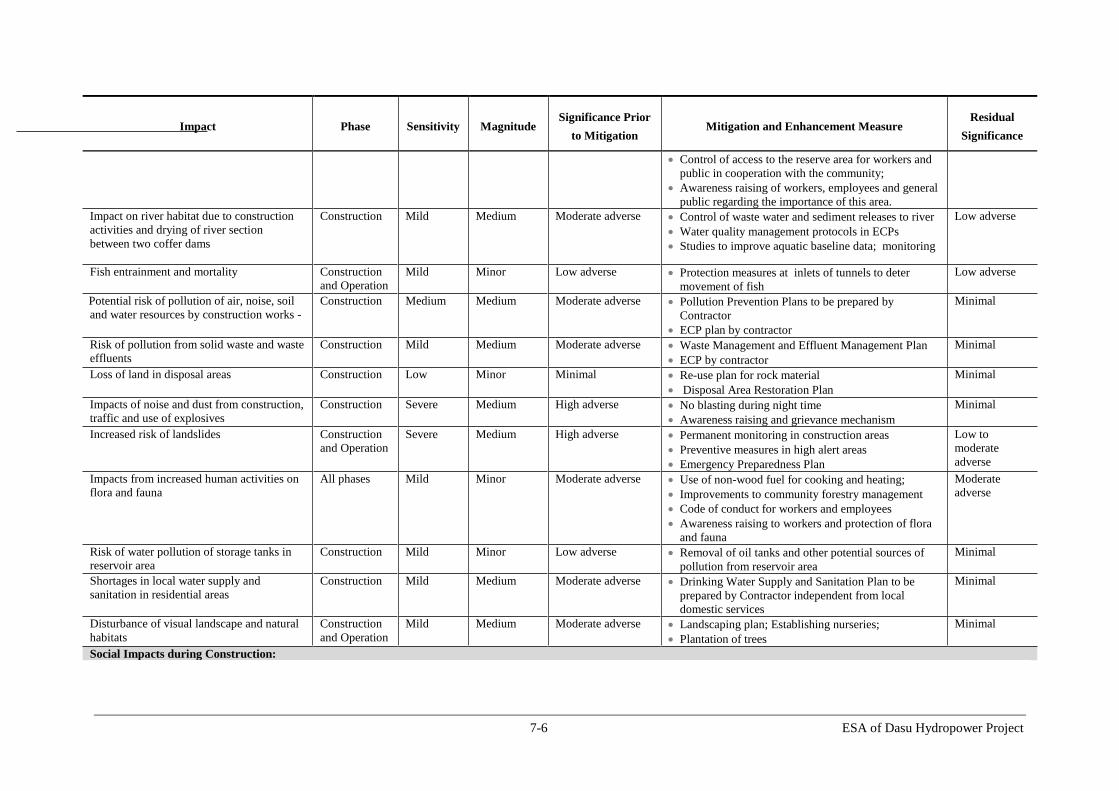
7-6 ESA of Dasu Hydropower Project
Impact Phase Sensitivity Magnitude Significance Prior
to Mitigation Mitigation and Enhancement Measure
Residual
Significance
Control of access to the reserve area for workers and
public in cooperation with the community;
Awareness raising of workers, employees and general
public regarding the importance of this area.
Impact on river habitat due to construction
activities and drying of river section
between two coffer dams
Construction Mild Medium Moderate adverse Control of waste water and sediment releases to river
Water quality management protocols in ECPs
Studies to improve aquatic baseline data; monitoring
Low adverse
Fish entrainment and mortality Construction
and Operation
Mild Minor Low adverse Protection measures at inlets of tunnels to deter
movement of fish
Low adverse
Potential risk of pollution of air, noise, soil
and water resources by construction works -
Construction Medium Medium Moderate adverse Pollution Prevention Plans to be prepared by
Contractor
ECP plan by contractor
Minimal
Risk of pollution from solid waste and waste
effluents
Construction Mild Medium Moderate adverse Waste Management and Effluent Management Plan
ECP by contractor
Minimal
Loss of land in disposal areas
Construction Low Minor Minimal Re-use plan for rock material
Disposal Area Restoration Plan
Minimal
Impacts of noise and dust from construction,
traffic and use of explosives
Construction Severe Medium High adverse No blasting during night time
Awareness raising and grievance mechanism
Minimal
Increased risk of landslides Construction
and Operation
Severe Medium High adverse Permanent monitoring in construction areas
Preventive measures in high alert areas
Emergency Preparedness Plan
Low to
moderate
adverse
Impacts from increased human activities on
flora and fauna
All phases Mild Minor Moderate adverse Use of non-wood fuel for cooking and heating;
Improvements to community forestry management
Code of conduct for workers and employees
Awareness raising to workers and protection of flora
and fauna
Moderate
adverse
Risk of water pollution of storage tanks in
reservoir area
Construction Mild Minor Low adverse Removal of oil tanks and other potential sources of
pollution from reservoir area
Minimal
Shortages in local water supply and
sanitation in residential areas
Construction Mild Medium Moderate adverse Drinking Water Supply and Sanitation Plan to be
prepared by Contractor independent from local
domestic services
Minimal
Disturbance of visual landscape and natural
habitats
Construction
and Operation
Mild Medium Moderate adverse Landscaping plan; Establishing nurseries;
Plantation of trees
Minimal
Social Impacts during Construction:

7-7 ESA of Dasu Hydropower Project
Impact Phase Sensitivity Magnitude Significance Prior
to Mitigation Mitigation and Enhancement Measure
Residual
Significance
Safety hazards due to increased traffic
especially for children and elderly people;
Increased risk of accidents, unsafe working conditions and health risks for workforce
Construction
and Operation
Severe Medium High adverse Traffic management plan addressing general access
Safety and security actions and procedures to protect
local community
OHS Plan to be implemented
Emergency Preparedness Plan; Contractor follows IFC Performance; Standards on Labor and Working Conditions;
Safety training for workers
Low adverse
Social unrest due to influx of about 12,000
in-migrants
Construction
and Operation
Severe Major High adverse Awareness campaign
Develop Migration Management Plan
Grievance mechanisms to address complaints
Minimal
Lack of respect of cultural norms and values
by work force
Construction
and Operation
Mild Medium Moderate adverse Awareness campaign; Code of conduct for workers;
Grievance mechanism
Minimal
Reduced safety and health risks by
interaction workforce with local residents
Construction
and Operation
Mild Medium Moderate adverse Public Health and Safety Plan
Safeguards and awareness raising against
communicable diseases.
Minimal
Increased load on local services and supplies Construction Mild Medium Moderate adverse Contractor to procure camp supplies in a manner not
affecting availability of essential commodities.
Minimal
Environmental impacts during Operation & Maintenance:
Impact on 571 ha of aquatic habitat along
Indus and its tributaries in reservoir area
Operation Mild Medium Moderate adverse Developing of fish hatchery with native snow carps
for stocking fish in the affected tributaries and
reservoir
Monitoring of spawning areas
Monitoring programs
Low to
moderate
adverse
Impacts of first filling of reservoir on safety
of people and livestock and stability of
slopes
Operation Severe Major High adverse Awareness campaign and warning signs;
Slow rate (1 m/day);
Permanent monitoring of slopes
Minimal
Barrier effect to fish migration Operation Mild Medium Moderate adverse Compensatory fish hatchery
Study fish migration; establish baseline data;
Low to
moderate
adverse
Reduced water flows between dam and
tailrace (4.4 km) during low flow season
Operation Very
Severe
Major Critical Release of 20 m3/s of environmental flow from dam
and 222 m3/s from tail race
Downstream monitoring and adjustment of flows if
required.
Low to
moderate
adverse
7-8 ESA of Dasu Hydropower Project
Impact Phase Sensitivity Magnitude Significance Prior
to Mitigation Mitigation and Enhancement Measure
Residual
Significance
Impact on downstream and aquatic habitats
and fish due to changes in water flows and
quality (temperature, DO, sedimentation)
Operation Mild Minor Low adverse Monitoring of downstream water quality and aquatic
habitats
Minimal
Impact of sedimentation on reservoir area Operation Severe Medium High adverse Yearly flushing after 10-15 years of operation
Will be reduced after completion of Basha dam
Low adverse
Impact of daily reservoir operations during
base load operation
Operation Mild Moderate Moderate adverse Fisheries Management Plan
Monitoring and study
Low adverse
Impact on downstream fish and fisheries
during flushing operation
Operation Severe Major High adverse Flushing during high flow season (not in low
flow/winter)
Develop ramp down criteria (5-10 cm/hr)
Monitoring DO and temperature in reservoir and de-
stratification or simultaneous release of water from
low-level outlets and spillways if required.
Downstream monitoring of fish, habitats and
sediments
Low to
moderate
adverse
Impact on downstream fish and fisheries due
to changes in hydrological flows due to
peaking operations
Operation
(Post Basha)
Mild Medium Moderate adverse Continuous operation of one turbine
Using remaining flow for peak operation
Low adverse
Risk of bird collision and electrocution with
transmission cables
Construction
and Operation
Mild Medium Moderate adverse Carry out Avian risk assessment
Maintaining 1.5 meter spacing between energized
components and grounded hardware; covering
energized parts and hardware;
Installing visibility enhancement objects such as
marker balls, bird deterrents, or diverters
Low adverse
Social impacts during Operation & Maintenance:
Loss of employment for construction
workers
Operation Mild Medium Moderate adverse Vocational training for operational and maintenance
Preference for local construction workers in other
WAPDA Upper Indus projects
Low adverse
Reservoir fisheries will create large number
of employment opportunities
Operation Severe Major High beneficial Fisheries Management Plan
Employment of local people
Beneficial

7-9 ESA of Dasu Hydropower Project
7.4. Environmental Impacts related to Project Siting
7.4.1. Change in Physiography and Landform
The physiography and landform of the Indus Valley will change gradually during all
phases. During pre-construction phase the transition will be moderate only. Villages in
the entire reservoir area will be dismantled and new ones rebuilt at higher elevations,
trees will be cut. Priority work on KKH will be in full swing and preparation and
construction of the WAPDA Colony and offices will start. Other preparations for
establishing temporary facilities for workshops, labor camps and other facilities will
continue until the mobilization of the main contractor.
Once the main contractor starts major excavation and construction works, the character of
the Indus valley bottom and lower slopes will change in the area between the dam and the
town of Dasu-Komila. This will continue during the entire construction period and once
the dam and tunnels have been constructed and the reservoir is filled there will be a major
change of the entire valley.
The character of the Indus River and its valley bottom will change from a fast flowing
uncontrolled sediment-laden river with steep rocky slopes into a narrow controlled slowly
flowing water reservoir with an average width of 365 m and extending for about 73 km
upstream at full supply level (fsl) (see Figure 7.1). The flow velocities in the reservoir
are medium to slow, ranging between 0.56 and 3.08 m/sec at the head of the reservoir to
between 0.02 and 0.14 m/sec near to the dam. In lateral valleys where tributaries and
nullahs meet the main Indus valley the reservoir penetrates several km inland to form
new natural hot-spots at the confluence of snow-fed small streams with the main water
body. The reservoir is expected to rapidly decrease in size due to siltation from 73 km
length towards 8-9 km in 15 year after commissioning of the Dasu dam (provided Basha
dam is not commissioned in that period). During high flow season most of the reservoir
bottom will be inundated for most of the period, providing opportunities for spawning of
fish (e.g. carp).
The new KKH follows the left embankment of the reservoir. The reservoir will be deep
near to the dam site with initially depths between 100 and 175 m. New villages will be
built at selected sites for the affected people. Approaching the dam site, however a
completely new landscape will be developed over the next 8 km in the direction of the
twin city of Dasu and Komila. At full development an enormous complex of dam and
associated hydraulic, mechanical and electrical infrastructure is visible over the next 4-5
km, with on the hill terrace the WAPDA Colony and offices. Part of the hydraulic and
electrical infrastructure is underground but transmission lines are now dominating the
Indus valley.
A new bridge over the Indus is built upstream of Dasu, which is used for the project
related traffic. KKH traffic is now following the new winding KKH road above Dasu
until the road is connected with the old KKH crossing the Indus at Dasu bridge like
before. The impacts of the changes in physiography have been assessed as Moderate
Adverse, especially in the 4 km of the project site situated between dam and tailrace
outlet. Without mitigation the landscape will be bare and industrial. Mitigation should
start therefore with the preparation of an overall landscape plan for this part of the valley.
The plan should be worked out in more detail for the areas of the Colony, the Offices and
the road infrastructure of the project.

7-10 ESA of Dasu Hydropower Project
Figure 7-1: Reservoir Area

7-11 ESA of Dasu Hydropower Project
In the rest of the areas the impact on physiography and landscape is low adverse to
moderately beneficial (development of reed marshes and natural riparian vegetation along
reservoir). At other places most of the landscape is expected to return to the baseline
condition without major mitigation measures. This impact is characterized as Moderate
Adverse as given in Table 7.4.
Mitigation
For the project area between dam and end of tailrace and for the WAPDA Colony and
Offices area a landscape and plantation plan will be prepared by a qualified landscape
architect and implemented by a contractor.
Residual Impacts
With the help the proposed mitigation measures, the significance of the impacts on
physiography and land form will be reduced to Low Adverse (see Table 7.4).
7.4.2. Loss of Natural Vegetation and Trees
In the area reserved for project facilities including KKH realignment and reservoir a total
number of 21,000 trees has been identified, including some 2,982 fruit and medicinal
trees. The majority of the trees present in area where the main project facilities will be
constructed have been surveyed. Per village the most dominant species are indicated (see
Table 7.6). Generally all species present are very common and widely distributed
throughout the project area including downstream of dam axis.
Table 7.5: Affected Tree Species
Village Habitat Types Tree Species
1 Dooga Gah Steep rocky slope Quercus baloot, Olea ferruginea and
Cotinus coggygria
2 Chuchang Rocky steep to
moderate slopes
Olea ferruginea, Quercus baloot,
3 Khoshe Gentle slope Olea ferruginea and Quercus baloot
4 Siglo Gentle slope Olea ferruginea, Quercus baloot and
Cotinus coggygria
5 Seer Gayal Rocky steep to
intermediate slopes
Olea ferruginea and Cotinus coggygria
6 Toothi Rocky steep slopes Qurecus baloot, Cotinus coggygria and
Olea ferruginea
7 Seo Rocky gentle slope Olea ferruginea
8 Malyar Rocky steep slope Quercus baloot and Olea ferruginea
9 Panibah Rocky gravelly Olea ferruginea and Quercus baloot
Bushy vegetation and shrubs have been developed on the steep slopes of the Indus valley.
This vegetation does not represent much natural and commercial value, other than as a
source of firewood for the local communities. Trees should be cut prior to the flooding of
the reservoir area. Small bushes and other vegetation can be left to be inundated.

7-12 ESA of Dasu Hydropower Project
Loss of trees and natural vegetation will also have an effect on the collection of firewood.
People will move to higher places in order to collect. Selling of fire wood is an important
business in the project area and a common practice along KKH mainly in winter season
and also partly in summer season. People harvest oak, wild olive and other fuel wood
trees from forests and store in the form of wood toll on the main KKH. The daily sales of
firewood are very high and people can earn a large amount. The local selling rate of the
firewood amounts to PKR 260 (equal to USD 2.50) per 50 Kg. It is expected that the
Project will attract in-migrants (construction workers, their families and service
providers). This influx will create a huge demand for firewood due to increased energy
requirements for cooking and heating during winter. This is expected to increase the
pressure on forest resources at higher altitudes even further, which are already under
heavy pressure from local communities for commercial logging, firewood and grazing.
This impact has been assessed as Moderate Adverse, as shown in Table 7.4.
Mitigation Measures
The following mitigation measures will be implemented:
Tree plantation (under Landscaping and Plantation Plan): The loss of trees will
be compensated by successful plantation of native species. The lost trees will be
replaced at a minimum ratio of 5:1 in the buffer area of the reservoir on the right
bank, near to resettlement sites, around the DHP offices and residential colony.
Suitable species of tree plantation are given in Table 7.7. The losses of the
community caused by on the felling of trees will be compensated by allowing the
community to cut and use the wood in addition to the monetary compensation. The
communities will also play a key role in planting and watering the plantations.
Table 7.6: Recommended Species for Tree Plantation
Family Tree species Local Name
1. Anacardiaceae Cotinus coggygria Scop. Khakoh/Shini
2. Anacardiaceae Pistacia chinensis Bunge Kangar
3. Anacardiaceae Rhus mysurensis Heyne. Kasudur
4. Fagaceae Quercus baloot Griffith Bani/Jaand
5. Oleaceae Olea ferruginea Royle Kao
Alternatives for fuelwood: The Project will support the local government to
establish a market for the supply of non-timber fuels such as LPG for cooking and
heating to reduce the pressure on firewood. As costs are minimal, this will be funded
under WAPDA’s general environmental management budget for the project.
Contractors shall also minimize the use of fuel wood and encourage the use of non-
wood fuels such as LPG to the construction staff for cooking and heating purposes.
Forest rejuvenation and planting (under Afforestation and Forest Rejuvenation
Plan): At higher altitudes (> 1500 m) a number of forest plantations will be
established where forest could be rejuvenated. This will be done at selected places in
consultation with local communities on both sides (left and right bank) of the
reservoir. Communities can play an important role in planting and managing these
plantations. There is experience with this type of social forestry elsewhere in the
region (a.o Swat Kohistan) (ToRs are presented in Annex B).

7-13 ESA of Dasu Hydropower Project
Residual Impacts
With the help of the above listed mitigation measures, the adverse impacts associated
with vegetation loss are likely to be partially addressed, and hence the associated residual
impact has been assessed as Low to Moderate Adverse (see Table 7.4).
7.4.3. Impacts on Physical Cultural Resources in Project Area
The 400 year old historic mosque in the village Seer Gayal will be flooded by the
reservoir, together with the houses of the hamlet. In consultation with the local
community it was agreed that the wooden structures will be disassembled, transported
and reassembled at a higher altitude at the new location of the village. Also 16 graveyards
spread over the valley will be submerged by the reservoir. With the various communities
alternative proposals for mitigation were discussed. Most communities preferred to leave
the graves at the place of burial, but to protect them against erosional forces of the water.
Other cultural resources that will not be submerged but should be protected against
adverse impacts from the project are the burial ground in Seo, which is near to the
disposal areas. Also the cluster of petro glyphs (rock carvings) near Shatial, which is part
of a much larger field of 50,000 rock carvings extending from Shatial over more than 100
km towards the bridge of Raikot should be protected in consultation with the
Archeological department. This complex is one of the largest fields of rock art in the
world, with carvings dating from Stone Age (9th
millennium BC to Buddhist period).
The above impacts have been assessed as High Adverse, as shown in Table 7.4.
Mitigation Measures
The following mitigation measures will be implemented:
Archeological survey will be carried out by an archeologist engaged by WAPDA in
the project area to identify any PCR sites/artifacts not identified through the
investigations carried out during the ESA. This survey will be completed before
commencement of any construction activities of each contract. In case of any
discovery, a plan will be prepared in consultation with the Archeology Department
for their protection and conservation.
The mosque at Seer Gayal will be disassembled and reassembled at a new location in
consultation with the community.
The graves will be protected by stone-pitching so that no floating and washing away
of the bodies or skeletal remains occur.
DHP will support KP Archaeological Department to (i) procure 25 acres of land for
acquisition of land, in which rock carvings are located, (ii) fence the area, (iii)
provide fiberglass sheds; (iv) develop tourist facilities and (v) documenting the
importance of rock carvings and their translations. The CSC will prepare a detailed
plan for this purpose.
In case any artifact or site of archeological, cultural, historical, or religious
significance are discovered during construction activities, the works will be stopped
in that area, and the Archeological Department will be informed. WAPDA will
facilitate the Department in documenting such chance finds and also for whatever
actions are possible/feasible for their protection and conservation. Provisions for this
will be included in the contracts and a qualified archeologist will be engaged on a
retained basis during the entire construction period.

7-14 ESA of Dasu Hydropower Project
Residual Impacts
With the help of the above listed mitigation measures, the adverse impacts associated
with physical cultural resources are likely to be adequately addressed, and hence the
associated residual impact has been assessed as minimal (see Table 7.4).
7.4.4. Impacts due to Increased Traffic and Transportation
During design stage and during mobilization of the contractor traffic along KKH and in
the twin city of Dasu-Komila will increase and this will boost up even further as soon as
construction is started. This will lead to congestion at certain places like main streets,
central markets and bus stops. Apart from congestion there will be increased air pollution
and noise at these places. This might result in friction with shopkeepers, hotel/restaurant
owners and general public. Road safety will decrease and risk of accidents will increase.
This impact has been assessed as High Adverse, as shown in Table 7.4.
Mitigation Measures
The following mitigation measures will be implemented:
The main dam construction contractor will prepare a Traffic Management Plan
(TMP) and obtain approval from the supervision consultants. The approved plan will
be implemented. All other contractors will also prepare their respective TMPs, which
will combined/merged with the main TMP under the guidance of CSC.
WAPDA will facilitate establishment of traffic management committee with the
relevant stakeholders (traffic agencies, local governments along KKH, contractors).
WAPDA will hold a one day workshop(s) with the stakeholders to devise a plan for
traffic management along KKH during construction period.
Residual Impacts
With the help of the above listed mitigation measures, the adverse impacts associated
with increased vehicular traffic are likely to be mostly addressed. The associated residual
impact has been assessed as low to moderate adverse (see Table 7.4).
7.4.5. Inundation of 52 km of KKH
Around 52 km of the Karakorum Highway (KKH) will be submerged by the reservoir.
This part of the road lies between Dasu and Shatial. About 45 ha of land will have to be
acquired for road construction purposes. Loss of habitat because of the construction of
realigned KKH is covered later in the Chapter; loss of trees and natural vegetation caused
by this activity is covered under Section 7.4.2.
This impact has been assessed as Critical, as shown in Table 7.4.
Mitigation
The following mitigation measures will be implemented:
A new alignment will be constructed at a higher level on the left bank of the Indus. A
total of about 62 km of highway will be constructed including 10 km of bypass road
downstream of Dasu and a link road of 3 km. Five new bridges in the KKH will be
constructed crossing nullahs and small streams.
7-15 ESA of Dasu Hydropower Project
The land required for these road segments will be acquired following the procedure
defined in the RAP. The cost of this land acquisition is included in the overall
resettlement budget given in Table 7.5.
Residual Impacts
With the help of the above listed mitigation measures, the adverse impacts associated
with inundation of KKH are likely to be adequately addressed, and hence the associated
residual impact has been assessed as minimal (see Table 7.4).
7.4.6. Loss of Access to Villages
Two suspension bridges over the Indus connecting both river banks and some secondary
access roads on the right bank will be lost. The existing villages which will not be
flooded and the new resettlement sites will need proper access and connectivity to the
KKH.
This impact has been assessed as High Adverse, as shown in Table 7.4.
Mitigation
The following mitigation measures will be implemented:
A new suspension bridge near Kandia will be constructed
A total of 35 km of new access roads will be built, all at a higher level of the right
bank of the Indus.
A new jeepable track of 18 km will provide access to the villages in Kandia valley.
All new settlement sites will be provided with good access roads.
Other existing facilities for pedestrians to cross the river, such as foot bridges and
cable cars will be replaced by appropriate alternatives. Different options for
pedestrians for crossing the 73 km long reservoir will be considered in consultation
with local communities since these connections are important assets and a lifeline for
the remote communities at the right bank with the rest of the world.
Residual Impacts
With the help of the above listed mitigation measures, the adverse impacts associated
with loss of access to villages are likely to be adequately addressed, and hence the
associated residual impact has been assessed as minimal (see Table 7.4).
7.4.7. Impact on Natural Habitat
The DHP reservoir would cover about 2400 ha of the area, which includes permanent
flooding of about 1800 ha of natural terrestrial habitat. Most of the affected terrestrial
habitat is covered with barren rocks and slopes with little vegetation. Based on analysis
of satellite imagery and field surveys (Table 5.3), the affected land is mostly covered by
barren slopes/rocks (61 percent), followed by river/nullah (27 percent), grazing
land/pasture (6 percent), exposed sand (3.5 percent), vegetation cover (1.3 percent),
cultivated land (0.92 percent), and houses (0.13 percent).
The following specific potential impacts have been identified on natural habitat:
Loss of about 82 ha of natural habitat from the Kaigah Community Game Reserve
(including the affected area by KKH relocation). Kaigah nullah is the location of a
designated (Act of 15 July 2000- Government of NWFP) Wildlife Community

7-16 ESA of Dasu Hydropower Project
Conservation area (5000 ha) where trophy hunting of markhor sheep is allowed. The
area is bordered by the KKH and located at short distance of the proposed quarry site.
In the area limited hunting on markhor sheep is allowed within the framework of
wildlife management by WWF-Pakistan in cooperation with the KP wildlife
department. With the proceeds of the yearly auction of hunting rights a number of
community development activities are financed. About 1.6 percent of 5,000 ha area
of the game reserve will be permanently affected by the Project due to reservoir
submergence and KKH realignment. The affected area is located on the lower
elevations of the game reserve, which is mainly inhabited the community of Kaigah
village and consists of residential areas, agriculture lands, grazing areas and an
existing quarry site. No wildlife habitat will be permanently affected by the project.
The construction activities within the game reserve for relocation of KKH and
quarrying activities will also affect the natural habitat in the game reserve. The
construction related impacts are discussed later in the Chapter.
Loss of about 160 ha natural habitat along the tributaries and about 1550 ha of other
natural terrestrial habitat. This affected natural habitat mostly consists of barren
rocks, steep slopes and sparse vegetation as stated above, while similar habitat still
remains unaffected over a waste area in the region outside the affected area.
However, other natural habitats near the project area that are severely under stress are
the forests located on higher altitudes such Himalayan Temperate Forests and Alpine
Forests. The forest resources are reported to be decreasing by about 2 percent
annually.
The impacts on natural habitat have been assessed as High Adverse, as shown in
Table 7.4.
Mitigation and Compensation
The permanent impacts such as loss of natural habitat cannot be fully mitigated, but only
compensated by other conservation measures. The project is committed to support
development of offset areas to compensate the loss of natural habitat and conservation
value of Kaigah reserve as well as support the forest management and rejuvenation
activities, as described below.
Mitigation for Kaigah Game Reserve
The Project will support development of two offset areas for the wildlife
conservation. The ESA has identified four feasible sites (Laachi Nullah, Sazin Kot
on left bank, Kandia Valley and area opposite to Shori Nullah on right bank of Indus)
near the project area that have similar habitat characteristics of the affected habitat to
support the key wildlife species particularly markhor. A study will be carried out to
further evaluate these sites and finally recommend two sites to develop as offset areas
to conserve the natural habitat and wildlife in compliance with the World Bank OP
4.04 on Natural Habitats. The extent of offset areas will be based on sub water sheds
and will be determined by the proposed study. The study will be carried out during
the first year of project construction (2015). A mechanism will be developed by the
study, whereby the local communities will be provided with appropriate incentives to
help conserve natural habitat, and wildlife. The detailed ToRs of the study are
presented in Annex B.
Renowned agencies such as WWF-Pakistan or IUCN Pakistan will be involved by the
project to implement the above ecological conservation activities. WWF Pakistan has

7-17 ESA of Dasu Hydropower Project
already shown interest to enter into a partnership with WAPDA to develop such
conservation areas for Diamer Basha Dam Project. These conservation areas will be
further complemented by ecotourism initiatives, an information centre, and research.
In addition to development of above offset areas, the Project will also support the
community of the Kaigah game reserve to strengthen the management of
conservation measures in the game reserve.
The community will be consulted and involved in the selection of alternative options
to strengthen ecological conservation measures
Mitigation for Loss of Natural Habitat
To compensate for the loss of natural habitat, the Project will support afforestation
and forest rejuvenation programs in the higher altitudes for the conservation and
sustainable development of forest ecosystems in compliance with World Bank Policy
OP 4.36 on Forests.
This will be done at selected places in consultation with local communities and
relevant departments on both sides (left and right bank) of the reservoir. Communities
can play an important role in planning and undertaking these activities. There is
experience with this type of social forestry elsewhere in the region (a.o Swat
Kohistan).
The project will also support development of natural habitat and natural vegetation in
the above proposed wildlife conservation areas and reservoir buffer areas
The study proposed for habitat conservation and offset development mentioned
earlier will also include forestry assessment survey in Kohistan and development of
action plans for forest restoration activities that maintain or enhance biodiversity and
ecosystem functionality. The ToRs of the study are given in Annex B.
Residual Impacts
With the help of the above described mitigation measures the potential impacts of the
project on natural habitat are likely to be partially addressed and hence the residual
impacts on the reserve are estimated to be moderately adverse (Table 7.4).
7.5. Social Impacts Related to Project Siting
7.5.1. Land Acquisition for the Project
A total of 4,643 ha of land have to be acquired for the project. This includes 2,778 ha of
land below the 1,000 m contour that will be covered by the reservoir and its fringes, 174
ha to be used by physical project infrastructure and 205 ha for construction of roads
(KKH and access roads). The area to be acquired consists of natural wastelands and some
425 ha of agricultural land such as farm land, grazing areas and orchards. Family income
from land in terms of crops, fodder and forest products will be lost. This will require
proper compensation measures for the people affected and their resettlement at higher
altitudes including assistance and livelihood restoration. According to inventory surveys
and a census, a total of 767 households consisting of some 6,953 persons, more or less
equally divided over both river banks will be affected by the project and will have to be
resettled above 1,000 m.
Natural and semi-natural habitats, mainly consisting of steep rocky slopes and some
farmland and grassland on river terraces and alluvial fans along the Indus will be
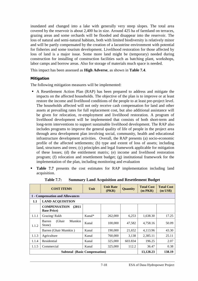
7-18 ESA of Dasu Hydropower Project
inundated and changed into a lake with generally very steep slopes. The total area
covered by the reservoir is about 2,400 ha in size. Around 425 ha of farmland on terraces,
grazing areas and some orchards will be flooded and disappear into the reservoir. The
loss of natural and semi-natural habitats, both with limited biodiversity is relatively minor
and will be partly compensated by the creation of a lacustrine environment with potential
for fisheries and some tourism development. Livelihood restoration for those affected by
loss of land is a major issue. Some more land might be (temporary) needed during
construction for installing of construction facilities such as batching plant, workshops,
labor camps and borrow areas. Also for storage of materials much space is needed.
This impact has been assessed as High Adverse, as shown in Table 7.4.
Mitigation
The following mitigation measures will be implemented:
A Resettlement Action Plan (RAP) has been prepared to address and mitigate the
impacts on the affected households. The objective of the plan is to improve or at least
restore the income and livelihood conditions of the people to at least pre-project level.
The households affected will not only receive cash compensation for land and other
assets at prevailing rates for full replacement cost, but also additional assistance will
be given for relocation, re-employment and livelihood restoration. A program of
livelihood development will be implemented that consists of both short-term and
long-term interventions to support sustainable livelihood development. The RAP also
includes programs to improve the general quality of life of people in the project area
through area development plan involving social, community, health and educational
infrastructure development activities. Overall, the RAP presents (a) socio-economic
profile of the affected settlements; (b) type and extent of loss of assets; including
land, structures and trees; (c) principles and legal framework applicable for mitigation
of these losses; (d) the entitlement matrix; (e) income and livelihood restoration
program; (f) relocation and resettlement budget; (g) institutional framework for the
implementation of the plan, including monitoring and evaluation
Table 7.7 presents the cost estimates for RAP implementation including land
acquisition.
Table 7.7: Summary Land Acquisition and Resettlement Budget
COST ITEMS Unit
Unit Rate
(PKR) Quantity
Total Cost
(m PKR)
Total Cost
(m US$)
1 - Compensation and Allowances
1.1 LAND ACQUISITION
COMPENSATION (2011
Base Price)
1.1.1 Grazing/ Rakh Kanal* 262,000 6,253 1,638.30 17.25
1.1.2
Barren (Ghair Mumkin
Stone) Kanal 100,000 47,582 4,758.16 50.09
Barren (Ghair Mumkin ) Kanal 190,000 21,652 4,113.96 43.30
1.1.3 Agriculture Kanal 760,000 3,138 2,385.11 25.11
1.1.4 Residential Kanal 325,000 603.834 196.25 2.07
1.1.5 Commercial Kanal 325,000 112.2 36.47 0.38
Subtotal (Basic Compensation) 13,128.23 138.19

7-19 ESA of Dasu Hydropower Project
COST ITEMS Unit
Unit Rate
(PKR) Quantity
Total Cost
(m PKR)
Total Cost
(m US$)
Escalation of 2 Years at
6.5% for 2013 Rates 1,762.14 18.55
Tax (2%) 262.56 2.76
Service Charges (15%) 1,969.24 20.73
Subtotal (1.1) 17,122.17 180.23
1.2 Structures
1.2.1 Katcha Sq. ft 1,500 740,526 1,110.79 11.69
1.2.2 Pacca Sq. ft 2,500 87,659 219.15 2.31
1.2.3 Semi Pacca Sq. ft 2,000 481,413 962.83 10.14
1.2.4 Wood Sq. ft 1,500 11,326 16.99 0.18
Subtotal (1.2) 2,309.75 24.31
1.3 Trees
1.3.1 Non Fruit Tree No. 20,000 18,317 366.34 3.86
1.3.2 Fruit Tree No. 57,000 2,982 169.97 1.79
Subtotal (1.3) 536.31 5.65
1.4 Crops
1.4.1 Maize Per 40 kg 1,500 22,724 34.09 0.36
1.4.2 Wheat Per 40 kg 1,600 18,592 29.75 0.31
Subtotal (1.4) 63.83 0.67
1.5 Relocation Cost (Based on Entitlement Matrix)
1.5.1 Dislocation Allowance
against loss of agri. Land Kanal 20,000 2,827 56.54 0.60
1.5.2 Reconstruction Grant for
Residential Structure m
2 250 127,906 31.98 0.34
Subtotal (1.5) 88.52 0.93
1.6 Rehabilitation Assistance
1.6.1 Special Assistance For Vulnerable HHs
Soniwals No. 200,000 13 2.60 0.03
Others No. 150,000 42 6.30 0.07
1.6.2
Assistance against income
loss by owners operated
commercial setups for three
months.
Person 30,000 76 2.28 0.02
1.6.3 Assistance for affected wage
earners
APs for 3
months 27,000 137 3.70 0.04
1.6.4 Transfer Grant for relocation
of business structures m
2 100 7113.8 0.71 0.01
Subtotal (1.6) 15.59 0.16
Sum of Sub-totals of 1 20,136.18 211.96
2 - Resettlement Sites Development
2.1 Land
2.1.1 Land Leveling Kanal 350,000 2070 724.50 7.63
Subtotal (2.1) 724.50 7.63
2.2 Resettlement sites Infrastructure development

7-20 ESA of Dasu Hydropower Project
COST ITEMS Unit
Unit Rate
(PKR) Quantity
Total Cost
(m PKR)
Total Cost
(m US$)
2.2.1 Access Roads construction
and land compensation Km 10,000,000 51 510.00 5.37
2.2.2 Mosque No. 7,360,000 4 29.44 0.31
2.2.3 Water supply Tank(30
Village) Cu. ft 2,850 57,120 162.79 1.71
2.2.4 Water Supply Channel(30
Village) per km 695,000 100 69.50 0.73
2.2.5 School (Middle) No. 12,720,000 2 25.44 0.27
School(Primary) No. 6,360,000 4 25.44 0.27
2.2.6 Boundary Wall for
Graveyard
per
Graveyard 1,170,000 30 35.10 0.37
2.2.7 Dispensary(3 Structures) per
structure 920,000 3 2.76 0.03
Subtotal (2.2) 860.47 9.06
Sum of Subtotals of 2 1,584.97 16.68
3 - Livelihood Support
3.1 Skill Development for
affected Communities per year
100,000,00
0 15 1,500.00 15.79
Subtotal of 3 1,500.00 15.79
4 - Local Area Development
4.1 Infrastructure 1,235.00 13.00
4.2 Entrepreneur Support 10
Years 475.00 5.00
4.3 Capacity Building of Local
Government 237.50 2.50
4.4
Training & extension
support 10 Years (Services
and facilities)
Years 47,500,000 10 475.00 5.00
4.5
Education Fund 10 Years
(Literacy Promotion,
Scholarships, etc.) 427.50 4.50
Subtotal of 4 2,850.00 30.00
5 - Institution and Management
5.1 Building Sq. ft 2,000 8,160 16.32 0.17
5.2 Fixtures and Furnishing Lump sum 20.00 0.21
5.3 (a) PMU Staff Salaries Years 36,100,000 10 361.00 3.80
(b) PMU Costs during O&M Years 45,600,000 5 228.00 2.40
5.4 Vehicles No 4,200,000 10 42.00 0.44
5.5 R&M of vehicles Years 10,000,000 15 150.00 1.58
5.6 Office Equipment Lump Sum 10.00 0.11
5.7 Operation & Maintenance
Cost Years 250,000 15 3.75 0.04
Subtotal of 5 831.07 8.75
6 - Planning and Designing
6.1 Resettlement Lump 28.50 0.30

7-21 ESA of Dasu Hydropower Project
COST ITEMS Unit
Unit Rate
(PKR) Quantity
Total Cost
(m PKR)
Total Cost
(m US$)
Implementation Design Sum
6.2 Resettlement Site
Development Design
Lump
Sum 28.50 0.30
6.3 Livelihood Support Design
and Implementation Year 28,500,000 15 427.50 4.50
Subtotal of 6 484.50 5.10
7 - Administrative Overheads
7.1 Administrative Overhead:
Land Acquisition By DRO Lump Sum 10.00 0.11
Subtotal of 7 10.00 0.11
8 - Monitoring & Evaluation
8.1 Independent Monitor (2
times a year) Year 30,000,000 8 240.00 2.53
8.2 Internal Monitoring month 250,000 84 21.00 0.22
8.3 IPOE Per visit 3,000,000 14 42.00 0.44
8.4 MIS Development Lump
Sum One time cost 2.65 0.03
8.5 MIS Staff Lump sum 24.78 0.26
Subtotal of 8 330.43 3.48
9 - Training and Capacity Building
9.1
Consulting Service Cost
(Sub Projects) / Outsourcing,
(If any)
Lump
sum 25.00 0.26
9.2 Research Year 15,000,000 10 150.00 1.58
9.2.1 National Year 2,500,000 7 17.50 0.18
9.2.2 International Year 7,000,000 7 49.00 0.52
9.3 Trainings Year 30,000,000 10 300.00 3.16
Subtotal of 9 541.50 5.70
Total (1+2+3+4+5+6+7+8+9) 28,268.65 297.56
10 - Contingency
10.1 Physical Contingency
(@25%) 7,067.16 74.39
10.2 Price Contingency (@9 %) 2,544.18 26.78
Subtotal of 10 9,611.34 101.17
GRAND TOTAL 37,879.99 398.74
* 1 Kanal = one eighth of an acre or 506m2 or 0.05ha, 1$=95 PKR as per 2012 rate
Residual Impacts
Despite the implementation of the very elaborate measures included in the RAP, the
impacts associated with land acquisition cannot be fully mitigated. The residual impacts
of land use change have therefore been assessed as low to moderate; see Table 7.4.
7-22 ESA of Dasu Hydropower Project
7.5.2. Relocation of Inhabitants of 34 Hamlets
The footprint of the project will affect 34 hamlets and villages, each of them often
consisting of not more than 25 to 30 houses. Seventeen villages are situated on the right
bank and seventeen villages on the left bank. A total of 923 houses and residential
structures will be lost. This impact has been assessed as High Adverse, as shown in
Table 7.4.
Mitigation
The following mitigation measures will be implemented:
Compensation and assistance in resettlement, including development of identified
resettlement sites and provision of infrastructure. The associated cost estimates are
included in the overall resettlement budget (Table 7.7).
Consultations with the inhabitants have revealed that most of them do not want to
move away from the valley, where their present abodes are located and most of the
lands remain. The main reason is that most of them are predominantly livestock
holders and pastoralist used to seasonal migration to higher altitudes in the valley,
where they already have one or more summer residences near to some farmlands and
extensive grazing areas. The project identified 13 potential resettlement sites at higher
locations. Most of the people prefer to move with their small community to a self-
selected and self-managed site at a higher location in the same valley. About
10 percent have opted for relocation “down country” in more populated areas on their
own.
Residual Impacts
Despite the implementation of the very elaborate measures included in the RAP, the
impacts associated with relocation of hamlets cannot be fully mitigated. The residual
adverse impacts of land use change have therefore been assessed as low to moderate, as
shown in Table 7.4.
7.5.3. Relocation of 50 Shops and Commercial Establishments
Most of the commercial enterprises affected by the project are located on the left bank of
the Indus, near to the KKH. The commercial enterprises on the right bank usually consist
of residential houses with a small shop as annex.
This impact has been assessed as Moderate Adverse, as shown in Table 7.4.
Mitigation
The following mitigation measures will be implemented:
Compensation and/or resettlement assistance is worked out in details in the RAP.
The associated costs are included in the overall resettlement budget given in
Table 7.7.
Residual Impacts
Despite the implementation of the very elaborate measures included in the RAP, the
impacts associated with relocation of shops cannot be fully mitigated. The residual
adverse impacts of land use change have therefore been assessed as low to moderate, as
shown in Table 7.4.
7-23 ESA of Dasu Hydropower Project
7.5.4. Loss of Civic Amenities
The civic amenities that will be affected in 34 villages include 31 existing mosques,
seven schools, two basic health units, three community centers and 17 graveyards,
facilities for drinking water supply and irrigation, and latrines. Most of the affected
villages have direct access roads from KKH (left bank) or internal access roads (right
bank). This impact has been assessed as Moderate Adverse, as shown in Table 7.4.
Mitigation
The following mitigation measures will be implemented:
The lost amenities with similar or better condition/capacity will be constructed at the
resettlement sites.
The associated costs are included in the overall resettlement budget given in
Table 7.7.
Residual Impacts
With the help of the above listed mitigation measures, the adverse impacts associated
with loss of amenities are likely to be adequately addressed, and hence the associated
residual impact has been assessed as minimal (see Table 7.4).
7.5.5. Loss of 423 ha of Farm Land, Grazing Area and Crops
About 600 families that are presently involved in agriculture will lose their cropping
areas (double cropping) in the lower valleys and along the banks of the Indus, wherever
land is available. In high-altitude lateral valleys only one crop per year is grown during
the warmer summer season. The combination of summer and valley crops is sufficient for
family consumption requirements (there is no local market). Submergence of the most
productive agriculture on the relatively flat areas along the river will result in severe
shortage of both family employment and food. Although farmer families indicated their
preference to continue with the same livelihood, the opportunities are very limited. Over
95 percent of the land is uncultivable, and the remaining small plots (terraces) are fully in
use already. Adding pressure on the use of these plots by additional farmers will increase
the already common land disputes. The food situation of some 300 other families,
practicing part-time agriculture in and around the villages, will also weaken.
Livestock herding on higher altitudes during summer may continue, but the winter part of
this activity, along the river embankments, will cease, resulting in loss of the livelihood
of those herders that cannot find low areas downstream of the main structure.
The total loss of income from all the sources (including grazing and cultivation) of the
affected households is estimated to be 5 percent of their total income.
This impact has been assessed as High Adverse, as shown in Table 7.4.
Mitigation
The following mitigation measures will be implemented:
A livelihood restoration program will be implemented as part of RAP in order to
sustain and improve agriculture and livestock herding. Simultaneously, new potential
opportunities will be developed such as reservoir fisheries development, a forestry
management program and provision of temporary employment and additional income
in clearing of vegetation and trees in the reservoir area. These programs will be

7-24 ESA of Dasu Hydropower Project
introduced at an early start of the project in order to prevent further malnutrition,
unemployment and impoverishment of the local pastoralist families.
The cost associated with the above initiatives is included in the overall resettlement
budget given in Table 7.7.
Residual Impacts
Despite the implementation of the very elaborate measures included in the RAP, the
impacts associated with loss of agriculture land and grazing areas cannot be fully
mitigated. The residual adverse impacts of land use change have therefore been assessed
as low to moderate, as shown in Table 7.4.
7.5.6. Increased Pressure on High Altitude Grazing Area and Forests
Resettlement of about 3,200 people above 1,000 m altitude will mean that pressure on the
mountain zone between 1,000 and 1,500 m and higher will increase. Especially the
grazing areas and forests around 2,000 m are currently already under pressure, resulting
in deforestation, erosion and decrease of flora and fauna. The pressure will certainly
increase as a consequence of the project. Deforestation and increasing erosion will have
serious consequences and will lead to further land degradation and possible flash floods
after heavy rainfall. The high biodiversity of vegetation and wildlife will be under stress
from agricultural use, firewood collection, overgrazing, over-harvesting of medicinal
plants and forest products, poaching and poor law enforcement. This impact has been
assessed as Moderate Adverse, as shown in Table 7.4.
Mitigation
The following mitigation measures will be implemented:
An Afforestation and Forest Rejuvenation Plan will be prepared, with the objective of
regeneration of forest and grazing areas at higher altitudes.
Regeneration, rejuvenation and protection of natural forest, through a mixture of
different measures including watershed management, erosion control, tree planting,
improved (certified) forest exploitation.
Residual Impacts
With the help of the above listed mitigation measures, the adverse impacts associated
with increased pressure on forests could be partly mitigated. The residual impact however
will remain moderate adverse (see Table 7.4).
7.5.7. Impacts of the Construction of the 132 kV Power Supply Line to Project and Colony
The area of the new 45 km long alignment of the power supply line from Dubair Khwar
(4 km downtown of Pattan) to Dasu (Chuchang area) leads through an almost barren area,
with only few small hamlets or small villages with 25- 35 households on average. The
alignment follows the KKH at the right bank on the side of the mountain for almost 35
km. Near to the village Jalkot the line crosses the Indus and continues further towards
Chuchang along the left bank of the Indus. In this way the residential areas at Komila and
Dasu are avoided. It has been estimated that the power line will have 233 towers, each
about 32 m high.

7-25 ESA of Dasu Hydropower Project
Construction of the transmission line will have the following social and environmental
impacts:
Land Acquisition and ROW: The land needed for the footprint of each tower (6 x 6 m)
has to be acquired from the owners of the land. The total land acquisition is low (about 1
ha is needed). No resettlement is required. However agreements have to be signed with
the owners for the use by PESCO of the Right of Way (ROW) needed for operation and
maintenance of the transmission line. The ROW is the corridor of 60 m wide, where land
use and vegetation is restricted for reasons of safety. Tall and fast growing trees should
be cut and dense vegetation removed in order to prevent the possibility of contact with
the lines and the risks associated with forest or bush fires. The total area needed for
maintenance is 270 ha. No acquisition of land is required for the ROW, but an adequate
compensation has to be paid by PESCO for the restrictions in the land use and the
utilization by the company of the ROW corridor for maintenance and repair work.
Community Health and Safety Hazards: There is a potential danger for electrocution,
from direct contact with high voltage electricity or from contact with tools, vehicles,
ladders that are in contact met high voltage transmission.
There could be some electro-magnetic interference in radio and communication devices,
especially during periods of rain, sleet or snow and hail. This could affect radio reception.
However it is not expected that electromagnetic fields will be much of a problem since
the strength of magnetic fields is relatively low due to the low voltage of the lines and the
low population density in the area. Also the exposure of the public to electric fields will
be low, since the transmission lines avoid as much as possible the residential areas and
buildings, especially schools. If required in residential areas cable shielding technique
could be used to minimize electro-magnetic interference.
During installation, but also during maintenance there can be some hinder and nuisance
from noise and dust resulting from transportation of materials, the installation of
equipment and use of machinery.
Occupational Health Hazards of the Workers: This is an important problem since
workers could be exposed to contact with live power lines during construction,
maintenance and operation activities. Moreover they are working often at high altitudes
in poles and structures and therefore exposed to considerable risks. Electric utility
workers also have a higher exposure to EMF (electric and magnetic fields) since they are
working in the proximity to electric power lines.
Impacts on Natural Habitats: There could be environmental impacts from construction
work on watercourses and nullahs. About 20 nullahs have to be crossed and these sites
are usually ecological hotspots.
Impacts of ROW Maintenance on Natural Vegetation: The vegetation of the ROW
should regularly be monitored. Timely thinning, slashing and cutting of vegetation can
prevent the outbreak of forest fire.
The above impacts have been characterized as Moderate Adverse as shown in Table 7.4.
Mitigation
The following mitigation measures will be implemented:
Compensation will be paid for any private land that needs to be acquired in
accordance with the Resettlement Framework prepared for the DHP as part of SRMP
(see Table 1.3).

7-26 ESA of Dasu Hydropower Project
Safety hazards can be mitigated by installing warning signs, barriers, steel posts
surrounding transmission towers to create barriers for people to climb in masts.
Raising awareness of residents and an education program aimed at schoolchildren
providing information of possible hazards and risks can help to prevent such
problems.
Only trained and certified workers should be allowed to install, maintain and repair
electrical equipment. Strict safety and insulation standards should be maintained, as
well as minimum approach distances for people not directly associated with power
transmission. Safety belts, fall protection devices and specific tools and equipment for
working at high altitudes should be used by workers working in towers. EMF levels
should be continuously monitored and exposure levels recorded in order to remain
within the international accepted limits of exposure.
Aquatic habitats should be spared, since these are usually important spawning and
breeding places for fish. Riparian vegetation spared. Water courses should not be
blocked. Temporary roads and tracks used for construction should be provided with
single span bridges or open-bottom culverts or other methods (to avoid obstruction of
flows) at nullah crossings.
Maintenance should be based on ecological principles, avoiding the introduction of
non-native plant species and to encourage the restoration of the natural habitat with
herb vegetation (e.g. Artemisia sp.) and some low shrubs. This is possible by
removing fast growing trees and dense bushes. Herbicides should not be used and
there should be no planting or sowing of seeds in natural habitats.
Residual Impacts
With the help of the above listed mitigation measures, the adverse impacts associated
with the construction and operation of the 132 KV transmission line are likely to be
adequately mitigated. The residual impact will therefore be quite minimal (see
Table 7.4).
7.5.8. Generation of Employment in the Region
Currently only 26 percent of the population is employed, most of them are self-employed
in agriculture or livestock holding or as small shopkeeper. From those working about
17 percent works as unpaid family helper. Only 12 percent of them are working as
employee. The project offers good opportunities for local residents to apply for
employment as unskilled and skilled construction worker. Within the construction
contracts the contractor(s) would have to attract local workers and technicians on basis of
agreed quota. Construction works could offer at least for a period of 10 years many
opportunities for unskilled workers and technicians. There will also be employment
opportunities for office staff, administrative and logistic functions and in transportation.
Important for sustainable livelihood restoration is that sufficient vocational training and
skill development is provided. A pro-active program to this end is already started by
WAPDA: local youths are receiving a six-month vocational training in various lines of
work to prepare them for guaranteed jobs in the project construction work. The graduates
may also obtain jobs elsewhere, if they choose to. Establishment of vocational training
centers for men and women will be part and parcel of the project resettlement plans. After
the construction phase there will be other opportunities for more permanent functions
within the project operation and maintenance. All these new opportunities for work for
local residents could boost employment and improve the social and economic position of

7-27 ESA of Dasu Hydropower Project
the population. This will be a major and significant positive impact of the project. This
impact has been assessed as Moderate Beneficial, as shown in Table 7.4.
7.5.9. Increased Economic Activity
The considerable influx of people during all phases of the project (up to 7,000 during
construction) will considerably stimulate the local economy, by involving local
businesses and village level enterprises. New opportunities for local businesses,
suppliers, hotel owners, shopkeepers and the transportation sector will be created. All
these developments will considerably stimulate the local economy in the district.
This impact has been assessed as Moderate Beneficial, as shown in Table 7.4.
7.6. Environmental Impacts during Construction Stage
7.6.1. Increased Traffic on KKH and Local Access Roads
The KKH is the life line of northern areas and it is the only highway connecting China
and the north of Pakistan with the rest of the country. About 2,590 vehicles per day
including 200 heavily loaded trucks are currently using the KKH for transportation of
goods. During construction of the project it is estimated that daily 200 - 300 extra trucks,
needed for the supply of construction materials, will make use of the KKH. Additional
project vehicles using the KKH and exceptional heavy transports of turbine sections may
cause traffic congestions and safety hazards. The access road to the project along the
busy Komila bazaar and those from borrow areas and to deposition sites are also expected
to create traffic problems and safety hazards. This impact has been assessed as High
Adverse, as shown in Table 7.4.
Mitigation
The following mitigation measures will be implemented:
WAPDA will establish a traffic management committee with the relevant
stakeholders (traffic agencies, local governments along KKH, contractor).
WAPDA will hold a one day workshop with the stakeholders to devise a plan for
traffic management along KKH during construction period.
A traffic unit at Dasu is proposed to control the construction related traffic inflow
and outflow with sub offices along KKH at Hassanabdal, Haripur, Abbottabad,
Chatter Plain, Thakot, Besham, Pattan, Komila, dam site, quarry site Kaigah. These
offices will be connected with telephone, fax, mobile phone and internet.
The movement of traffic carrying cement or steel to be register at Hassanabdal
(junction of KKH and GT Road). These will travel in small lots of 10 trucks.
Hassanabdal sub-office will inform the next stations by phone, fax or internet.
The weather conditions must be known before the start of the journey from Met office
and drivers must be briefed before the start of the journey so that cargo may be
protected from rain damage and driver may plan the journey accordingly.
The receiving stores must be notified, who must prepare for offloading the goods.
This preparation includes the location of offloading, laborers for offloading together
with crane or low lift fork lifters.
Traffic facilities, such as speed limits and signal lights, are to be strengthened from
Hassanabdal to Dasu

7-28 ESA of Dasu Hydropower Project
Support to be provided to the local traffic authorities to engage traffic police at the
busy junctions.
All contractors will be required to prepare their respective Traffic Management Plans
in close cooperation with the Project Management Unit (PMU) and the local
authorities. CSC will coordinate the integration of these plans into a single TMP.
This plan will include safety measures, traffic control measures, provision of by-
passes at busy places and provisions for repair of damage caused by project vehicles.
Residual Impacts
With the help of the above listed mitigation measures, the adverse impacts associated
with increased traffic on KKH are likely to be mostly addressed, and hence the associated
residual impact has been assessed as low adverse (see Table 7.4).
7.6.2. Impacts on Kaigah Community-managed Game Reserve
The potential issues relating to the project siting on KCGR have already been discussed
under Section 7.4.7. The construction activities may potentially cause the following
additional impacts on the KCGR:
Noise and vibrations from blasting and excavation operations from the quarry
(duration estimated at 2.75 year) along with 5.5 km of KKH construction within the
game reserve (duration estimated at 7-8 months) may have negative impacts on the
presence of the wildlife. However, wildlife habitat in the reserve are primarily located
from 3 to 12 km from the construction activities while the impacts will mostly be
limited to lower altitudes - areas that are likely to be avoided by the wildlife;
Reduction of community income for conservation management during the above
years of construction. This income forms a share of the sale of hunting permits
(trophy hunting);
Increased population pressure from the nearby construction activities at the main dam
site and its vicinity. This might lead to frequent disturbance of wildlife, increased
poaching and hunting activities, deforestation and degradation by collection of
firewood, medicinal plants and other forest products.
The above impacts have been assessed as High Adverse, as shown in Table 7.4.
Mitigation
Part of the construction related impacts can be reduced by suitable mitigation measures
such as controlling access to the reserve and by limiting and reducing blasting operations
below stringent international threshold values. The following mitigation measures will be
adopted:
Monitor noise levels during the quarry operation;
Reduction of duration, timing and strength of blasting operations and vibrations
according to internationally recognized standards (e.g. Australian standards – more
details are available in Section 7.4.3.2, Volume 2 of EMAP);
Use the Kaigah quarry only for borrowing material for dam construction and
construction of the new KKH section (limited period);
Control of access to the reserve area for workers and public in cooperation with the
community;

7-29 ESA of Dasu Hydropower Project
Awareness raising of workers, employees and general public regarding the
importance of this area.
Residual Impacts
With the help of the above listed mitigation measures, the adverse impacts on the Kaigah
Reserve are likely to be partially addressed, and hence the associated residual impacts
have been assessed as moderate adverse (see Table 7.4).
7.6.3. Impact on River Habitat due to Construction Activities in the River
At the dam site coffer dams will be placed upstream and downstream of the work areas to
keep the river bed dry for about 980 m length to facilitate construction of the dam.
Aquatic biological production will be eliminated from approximately 980m of stream
length, part of which (the dam footprint) will be removed for the life of the dam. Pre-
construction and construction activities have potential to adversely affect aquatic biota by
release of high concentrations of sediment, fuels/oils and other toxic compounds, and
solid waste and use of explosives. High sediment loads will be produced during
placement of the coffer dams and again when water first passes through the work area
after completion of dam and plunge pool construction. Sediment concentrations above
natural levels can cause mortality of biota directly; for fish, damaged gills and sediment
clogging of gill chambers eventually leads to death. This impact has been assessed as
Moderate Adverse, as shown in Table 7.4.
Mitigation
The following mitigation measures will be implemented to address the potential impacts
described above:
Control of waste water and sediment releases to river particularly in the section
between coffer dams
Contractor will be required to implement the water quality management protocols
given in ECPs
WAPDA will commission a study to collect additional aquatic baseline data and to
prepare management plan for the aquatic resources of the area (Study ToRs are
presented in Annex B).
A monitoring program will be initiated for the impact of the construction activities on
the aquatic habitat and key species.
Residual Impacts
Despite the implementation of the above mitigation measures, the potential impacts
associated with the construction activities in the river bed are not likely to be completely
mitigated. Hence the associated residual impact has been assessed as low adverse (see
Table 7.4).
7.6.4. Entrainment and Mortality of Fish
The construction of Indus water diversion tunnels where high water velocities may
develop will have impact on fish. Fish trying to move downstream in water conduits such
as diversion tunnels, powerhouse intake tunnels, lower level outlets and spillways will

7-30 ESA of Dasu Hydropower Project
potentially be subjected to high levels of mortality and injury. This impact has been
assessed as Low Adverse, as shown in Table 7.4.
Mitigation
Inlets should be protected either by entrainment screens or by acoustic and or electric
methods in order to prevent fish to be caught by the inflow and be killed in the turbines.
Under the local circumstances it is not easy to find a suitable technical solution and this
should be subject of more detailed study (described in Section 7.6.2 above) by the design
team together with a fishery specialist. On basis of these studies the most feasible
solution for mitigation should be determined.
Residual Impacts
Despite the implementation of the above mitigation measures, the potential impacts
associated with the construction activities in the river bed are not likely to be completely
mitigated. The associated residual impacts therefore have been assessed as Low Adverse
(see Table 7.4).
7.6.5. Potential Risk of Air, Soil and Water Pollution
During construction there is a high risk of accidental spills and leakages that may occur
from fuel and oil tanks, vehicles and machinery and storage of chemicals used in
construction areas, yards, batching plants, quarry areas, worker camps, and residential
areas and from storage sites. These spills can pollute soils and contaminate surface water
and groundwater in the area. Waste effluents from temporary facilities such as camps and
offices can also contaminate soil and surface run off. Air pollution may occur by
emissions from construction related traffic and machinery. These impacts have been
assessed as Moderate Adverse, as shown in Table 7.4.
Mitigation
The following mitigation measures will be implemented:
The contractor will prepare and implement a Pollution Prevention Plan prior to the
start of the work. Proper baseline data will be collected.
The contractor(s) will be required to implement the measures prescribed in the
Environmental Code of Practices (ECP), which will be included in the contracts.
Detailed ECPs are included in the Annex D.
Contractor(s) will be required to take appropriate measures to avoid and contain any
spillage and pollution of the soil and water resources both upstream and downstream
of the dam.
Construction equipment and vehicles will need to be well maintained, so that
emissions are minimal.
Dust generation from construction sites will be restricted as much as possible and
water sprinkling would be carried out as appropriate, especially at those places where
earthmoving, excavation and blasting will be carried out.
Air quality will be properly monitored, especially near the population centers and
WAPDA colonies. Protocols and measures for the use of relevant equipment and
machines should be prescribed in the ECPs (Annex D).
Permanent and regular monitoring will be carried out.

7-31 ESA of Dasu Hydropower Project
Residual Impacts
With the help of the above listed mitigation measures, the adverse impacts associated
with air, soil and water pollution are likely to be adequately addressed, and hence the
associated residual impact has been assessed as minimal (see Table 7.4).
7.6.6. Risk of Pollution from Solid Waste and Waste Effluents
Large construction works generate large quantities of excess materials from construction
sites (concrete, steel cuttings, discarded material) and wastes from field camps and
construction yards, including garbage, recyclable waste, food waste, and other debris. In
addition small quantities of hazardous waste will be generated from maintenance
activities, contaminated soil, oil filters and other waste products. The offices, residential
colonies and contractor camps at the peak time of construction are estimated to produce
about 1821 kg of solid waste per day (0.3 kg/capita/day). A large part of this waste is bio-
degradable. In addition small quantities of hazardous waste will also be generated mainly
from the vehicle maintenance activities (liquid fuels; lubricants, hydraulic oils;
chemicals, such as anti-freeze; contaminated soil; spillage control materials used to
absorb oil and chemical spillages; machine/engine filter cartridges; oily rags, spent filters,
contaminated soil, etc). It is imperative that such waste is responsibly disposed to avoid
adverse environmental, human health and aesthetic impacts. This impact has been
assessed as Moderate Adverse, as shown in Table 7.4.
Mitigation
The following mitigation measures will be implemented:
Contractor will prepare and implement pollution prevention plan
The contractor will identify suitable sites for disposal of hazardous and non-
hazardous waste. The selection will be done in consultation with the PMU and the
local municipal authorities.
Protocols and measures will be prescribed in the ECPs to be included in the contracts
with the contractors.
Siting of any fuel and hazardous material storage sites, including refueling facilities,
asphalt plants and construction yards are to be located minimal 100 m from the banks
of any streams and at least 500 m away from any residential areas, cultural or
archaeological sites.
Residual Impacts
With the help of the above listed mitigation measures, the adverse impacts associated
with waste generation and disposal are likely to be adequately addressed, and hence the
associated residual impact has been assessed as minimal (see Table 7.4).
7.6.7. Potential Loss of Land in Disposal Areas
With the construction of tunnels and underground chambers for housing the powerhouse
and switch yard facilities huge quantities of rock will have to be excavated and brought to
the surface. It is estimated that the quantity of rock to be excavated will be 10.25 million
m3, excluding the excavations from KKH. Around 7.2 million m³ will be generated in the
first phase. Part of the excavated rock can be used as concrete aggregate provided the
fragmented rock meets the quality standards needed for the work. Mixing with fresh
quarried rock is possible. In order to reduce the amount of rock to be disposed, excavated

7-32 ESA of Dasu Hydropower Project
rock can be used in the project for different types of infrastructural works, including road
construction. The remaining spoil will be disposed in designated and safe disposal areas.
These impacts have been assessed as minimal, as shown in Table 7.4.
Mitigation
The following mitigation measures will be implemented:
Minimize the generation of spoils by recycling the excavated rock to the maximum
extent possible by using them as aggregate material in the concrete works;
A re-use plan for the disposal areas will be prepared in advance.
A Spoil disposal plan will be prepared and implemented
The disposal area will be re-contoured to minimize changes in topography
Dispose excess rock material in the designated disposal site in an orderly manner
(different spots to different size rocks); soil erosion control measures through bio-
engineering techniques.
Potential risks of acid drainage will be assessed during construction (though it is not
identified as a concern during geotechnical and geochemical investigations during
design) by the contractor and necessary treatment measures will be adapted.
7.6.8. Noise and Dust Generated by Construction Works, Increased Traffic and Use of Explosives
It has been estimated that at least 20,000 ton explosives will be used for excavation of
tunnels and rock chambers and for construction of the main structure and the road. Apart
from noise produced by blasting and drilling operations a lot of noise and dust will be
produced by excavation equipment, other machinery, concrete mixing, and traffic from
trucks and vehicles. The town of Dasu-Komila and the village of Seo are very vulnerable
for increased noise and dust from traffic. Noise levels may exceed the national standards.
The village Seo and nearby hamlets are close to the project and the disposal areas. These
villages will be exposed to high noise levels from the project. The V-shape of the Indus
valley will reinforce the noise levels. Noise of explosions and ground vibrations will be
common during excavations. At low to medium levels, ground vibrations and air blasts
can result in community annoyance. At higher levels this could lead even to structural
damage on buildings. The noise and vibrations levels from construction activities near
Kaigah will also have potential to affect the wildlife in the game reserve. The impacts on
wildlife are discussed in Section 7.4.8. These impacts have been assessed as High
Adverse, as shown in Table 7.4.
Mitigation
The following mitigation measures will be implemented:
Continuous monitoring of noise and dust levels will be carried out,
Continued consultations with the affected communities will be carried out
Blasting and drilling during night time and on during Friday prayers will not be
carried out.
Dust prevention measures by contractor, e.g. regular watering of roads and tracks
near to residential areas
7-33 ESA of Dasu Hydropower Project
Measures to protect workers for excessive noise and dust
NEQS compliance will be ensured.
Residual Impacts
With the help of the above listed mitigation measures, the adverse impacts associated
with noise and dust generation are likely to be adequately addressed, and hence the
associated residual impact has been assessed as minimal (see Table 7.4).
7.6.9. Increased Risk of Landslides
During construction there is an increased risk of landslides and collapse of slopes.
Landslides are natural and common phenomena in the project area and along the KKH.
Landslides in freshly-cut slopes can occur due to lubrication or saturation of rock support
structure by rainfall or by water seepage. The use of explosives to break the rock will
have the capacity to generate vibrations which can trigger a landslide. Landslide- prone
areas in the project area have been identified and classified on basis of potential risks.
This impact has been assessed as High Adverse, as shown in Table 7.4.
Mitigation
The following mitigation measures will be implemented:
Any blasting activities in these areas will be controlled and contained within defined
limits.
Pro-active measures will be implemented to stabilize and protect slopes and to protect
workers safety. Early warning systems will be introduced that will indicate when
cracks appear and allow any widening to be monitored. Access would be restricted
during the periods that slope stability is not yet entirely secured and guaranteed by
proper safety measures such as rock bolts, anchors, safety nets and gabion structures.
Permanent monitoring by the contractor will be required.
Residual Impacts
With the help of the above listed mitigation measures, the adverse impacts associated
with landslides are likely to be partially addressed, and hence the associated residual
impact has been assessed as low to moderate adverse (see Table 7.4).
7.6.10. Impacts of Increased Human Activities on Flora and Fauna
Human activities during construction will strongly increase in the area with the influx of
7,000 construction workers and technicians, some of them with their families, suppliers
and business men and followers. The population increase will exert a strong pressure on
the local environment by increased pollution, noise, disturbance, hunting, poaching and
fishing.
This impact has been assessed as Moderate Adverse, as shown in Table 7.4.
Mitigation
The following mitigation measures will be implemented:
WAPDA will maintain liaison with the concerned departments and local community
for the protection of the forest and wildlife of the area;

7-34 ESA of Dasu Hydropower Project
WAPDA will commission a study for the management of forest, wildlife, and
ecological resources of the area; the ToRs of this study are presented in Annex B of
this ESA. The management plan prepared during this study will be implemented
during the construction and O&M phases of the project.
Contractors will promote the usage of the non-wood fuel for cooking and heating.
WAPDA will coordinate with the local administration for the enhanced availability of
LPG in the area.
Include information on wildlife protection in all construction related tool-box
orientation briefings for new construction staff.
A public education program (under the Afforestation and Forest Rejuvenation Plan)
will be designed and implemented to discourage cutting of trees, poaching of wildlife
No tree-cutting, hunting, poaching, trapping, or catching of wildlife by the
construction workers will be allowed.
Contractor will enforce ECP for flora, fauna, and other natural resources.
Residual Impacts
With the help of the above listed mitigation measures, the adverse impacts on flora,
fauna, and other natural resources are likely to be partially addressed, and hence the
associated residual impacts have been assessed as moderate adverse (see Table 7.4).
7.6.11. Risk of Water Pollution from Storage Tanks
Through the conversion of the Indus valley into a reservoir oil tanks and underground
storage containers (such as chemicals, lubricants, and pest control agents) will be
submerged, with the risk of serious pollution of the water of the reservoir.
This impact has been assessed as Low Adverse, as shown in Table 7.4.
Mitigation
The potential sources of pollution will be identified and removed during the construction
period and prior to the first filling of the reservoir.
Residual Impacts
With the help of the above listed mitigation measures, the adverse impacts associated
with reservoir water pollution are likely to be adequately addressed, and hence the
associated residual impact has been assessed as minimal (see Table 7.4).
7.6.12. Shortages and/or Negative Effects on Local Water Supply and Sanitation
The influx of large numbers of workers, technicians and staff employees and their
families will require well-organized drinking water supply and sanitation facilities.
Various stakeholders might draw from the same available water resources. This impact
has been assessed as Moderate Adverse, as shown in Table 7.4.
Mitigation
A Drinking Water Management Plan, based on separate water supply and sanitation for
the work force, will have to be prepared by the contractor. In designing such a plan it is
7-35 ESA of Dasu Hydropower Project
important to maintain and safeguard the water supply and sanitation facilities for the local
population.
Residual Impacts
With the help of the above listed mitigation measures, the adverse impacts on water
supply and sanitation are likely to be adequately addressed, and hence the associated
residual impact has been assessed as minimal (see Table 7.4).
7.6.13. Disturbance of Visual Landscape
The project will drastically change the visual landscape at the site of project and
especially at places where slopes have been excavated for construction of roads and
project infrastructure, at disposal sites and in borrow areas. This impact has been
assessed as Moderate Adverse, as shown in Table 7.4.
Mitigation and Enhancement
The following mitigation measures will be implemented:
Proper landscaping will have to be done and an overall Landscape Plan will have to
be prepared, that will be worked out in more detail for the area where the project
infrastructure is located.
Landscape plans for the residential areas and the offices will be developed to create a
good living and working environment.
Tree planting will be well organized and where possible vegetation and natural
habitats will have to be restored or newly created.
For the disposal and borrow areas, restoration plans will be prepared (under the
Landscaping and Plantation Plan) to restore original landscape and vegetation.
Residual Impacts
With the help of the above listed mitigation measures, adverse impacts associated with
visual landscape are likely to be adequately addressed, and hence the associated residual
impact has been assessed as minimal (see Table 7.4).
7.7. Social Impacts during Construction Stage
7.7.1. Safety Hazards for Communities and Workers
The construction activities can potentially impact the residents of Dasu-Komila and along
KKH, particularly the movement and safety of school children. In addition, due to
increased use of trucks and other vehicles on the narrow roads in the project area and the
access roads pedestrians, particularly elderly people and children will be more exposed to
dangerous situations, which may lead to traffic accidents. Construction activities also
pose safety hazards for the site staff.
The rough terrain and difficult work conditions in some parts of the area will need extra
attention from contactors and project management for the increased risk of accidents,
unsafe working conditions and health risks. This is especially true for underground work
in tunnels and caverns, but also during excavation and construction work.
This impact has been assessed as High Adverse, as shown in Table 7.4.

7-36 ESA of Dasu Hydropower Project
Mitigation
The following mitigation measures will be implemented:
Occupational health and safety procedures will be enforced at site. Each contractor
will be required to prepare, obtain approval of, and implement an occupational health
and safety (OHS) plan. These plans will be prepared in compliance with the ECPs
(Annex D) and World Bank Group’s Environment, Health, and Safety (EHS)
Guidelines. 13
A Traffic Management Plan will be implemented that will aim at ensuring access to
residential areas, and preventing of unsafe situations, especially near schools, housing
areas, construction areas, camps and offices.
Construction activities such as blasting and excavation particularly at the borrow
areas may pose safety risks to the nearby population.
Appropriate procedures will be maintained for such activities, including cordoning
off the area, prior information to nearby population and liaison with the community.
There will be appropriate medical services and a facility with the capacity to treat
emergency cases and trauma patients.
Special attention should be focused on safety training for workers to prevent and
restrict accidents and on the knowledge how to deal with emergencies.
Road signage will be fixed at appropriate locations to reduce safety hazard associated
with project-related vehicular traffic.
Liaison with traffic police will be maintained
Project drivers will be trained on defensive driving.
Vehicle speeds near / within the communities will be kept low, to avoid safety
hazards.
ECP-15 and ECP-18 will be implemented.
Residual Impacts
With the help of the above listed mitigation measures, any adverse impacts associated
with safety hazards are likely to be mostly addressed, and hence the associated residual
impact has been assessed as low adverse (see Table 7.4).
7.7.2. Social Conflict due to the Influx of Workers and In-migrants
The project construction will bring significant changes in the lives and livelihoods,
including new opportunities for employment and income for the local people. The
development also attracts thousands of new in-migrants to the project area. Through the
influx of workers, business people and followers the population of Dasu-Komila will
increase more than three times within a few years. Unless properly managed this sudden
influx of people could create negative aspects such as an increased crime rate, tensions
and social conflicts between the various groups. This impact has been assessed as High
Adverse, as shown in Table 7.4.
13
EHS Guidelines available at:
http://www.gcgf.org/wps/wcm/connect/554e8d80488658e4b76af76a6515bb18/Final%2B-
%2BGeneral%2BEHS%2BGuidelines.pdf?MOD=AJPERES
7-37 ESA of Dasu Hydropower Project
Mitigation
The following mitigation measures will be implemented:
Project has developed a pro-active approach by working out an In-Migration
Management Plan. In this plan detailed solutions for a number of key issues have
been proposed including issues regarding housing and accommodation, food security,
local infrastructure, community health, labor contracts, employment and business
opportunities, security, integration and cultural understanding and community and
area development. In accordance with this Plan procedures and rules will be worked
out by the PMU in close cooperation with the contractors and local authorities.
Responsibilities for the implementation of the plan will rest with the local authorities,
the line departments, WAPDA and the contractors.
Residual Impacts
With the help of the above listed mitigation measures, any adverse impacts associated
with influx of workers and in-migrants are likely to be adequately addressed, and hence
the associated residual impact has been assessed as minimal (see Table 7.4).
7.7.3. Respect of Local Cultural Norms and Values by Work Force
Workers coming from different parts of Pakistan may have norms and values in social
behavior and religion that differ from those of the resident population. This can
potentially cause tension and conflicts between outside workers and local community.
This impact has been assessed as Moderate Adverse, as shown in Table 7.4.
Mitigation
The following mitigation measures will be implemented:
This situation will be addressed by an awareness campaign implemented under the
Public Consultation and Participation Plan (see Table 1.3)
The contractors would be aware of the possibility and risks of miscommunications
between local residents and workers, a situation which easily could lead to social
unrest. This would be prevented by raising awareness and implementation of a Code
of Conduct for the workers.
Complaints from the local community will be addressed by the grievance redress
mechanism.
Residual Impacts
With the help of the above listed mitigation measures, adverse impacts associated with
lack of respect of local values and norms are likely to be adequately addressed, and hence
the associated residual impact has been assessed as minimal (see Table 7.4).
7.7.4. Reduced Safety and Adverse Effects on Health Situation
The influx and accommodation of a large work force will result in increased concerns for
the health and safety of local population particularly women and children. This impact
has been assessed as Moderate Adverse, as shown in Table 7.4.
Mitigation
The following mitigation measures will be implemented:
7-38 ESA of Dasu Hydropower Project
These concerns would be addressed by raising awareness of the associated risks for
the local population.
The awareness campaign will also be aimed at the risk of interaction between the
resident population and the construction work force, including the spreading of
sexually transmitted diseases such as HIV/AIDS.
The medical health facilities in the project area will be facilitated to deal with such
incidences.
Measures to this end are included in a Public Health Action Plan that will be
implemented.
Residual Impacts
With the help of the above listed mitigation measures, concerns associated with safety
and health risks of the local population are likely to be adequately addressed, and hence
the associated residual impact has been assessed as minimal (see Table 7.4).
7.7.5. Increased Load on Local Services and Supplies
The project area is situated in a remote area far from the main population centers of the
country. Especially in the beginning of the project there will be a limited presence of
shops, markets, service providers and suppliers of commodities. With the presence of a
considerable work force in the area there could be shortage of supplies for the resident
population. The in-migrants may also create additional stress on local services /
infrastructure (such as schools, health clinics, housing, and roads). This impact has been
assessed as Moderate Adverse, as shown in Table 7.4.
Mitigation
The following mitigation measures will be implemented:
This potential impact would be mitigated by requesting the contractors to procure
their supplies in a manner not significantly affecting the availability of essential
commodities in the area for the residents.
Grievance redress mechanism will be established to address community complaints
and grievances.
Residual Impacts
With the help of the above listed mitigation measures, concerns associated with increased
load on local service are likely to be adequately addressed, and hence the associated
residual impact has been assessed as minimal (see Table 7.4).
7.8. Environmental Impacts during Operation and Maintenance
7.8.1. Impact on Aquatic Habitat of the Indus and its Tributaries through the Creation of Reservoir
The character of the river Indus and its valley bottom will change from a fast flowing
uncontrolled sediment-laden river with steep rocky slopes into a narrow controlled water
reservoir (average width 365 m) and extending for about 73 km up stream at full supply
level of 950m. In lateral valleys of tributaries the reservoir penetrates several kilometers
inland. About 570 ha of river and tributaries will be subject of biotic and abiotic changes

7-39 ESA of Dasu Hydropower Project
caused by the reservoir. Reservoir ecology will not be typical of a natural lake
environment and will undergo rapid reduction in size caused by rapid sedimentation.
Water velocities along the length of the reservoir will generally be lower than in pre-
reservoir river conditions. Although reservoir features will be lake-like, surface water
velocities will be high compared to most lakes and storage reservoirs. The relatively high
water velocities suggest that conditions may be mainly compatible for riverine fish
species, particularly along the reservoir shoreline. Spawning areas in the in the tributaries
will be submerged and it is expected that new natural spawning areas will be developed
at the confluence of tributaries with the main water body. This impact has been assessed
as Moderate Adverse as shown in Table 7.4.
Mitigation
The following mitigation measures will be implemented:
Maintenance of spawning areas and developing of new spawning areas in the
tributaries near the reservoir confluence areas,
Developing fish hatchery for production of native snow carps (snow carp hatcheries
are already established in India and Nepal) and stocking of snow carp in the
tributaries and reservoirs is recommended to compensate the loss of habitat and
reservoir fishery production.
Further studies will be carried out (see Section 7.6.3) during pre-construction stage to
establish detailed baseline data on aquatic ecology to develop additional offset
measures for loss of habitat and research on hatchery development.
Residual Impacts
With the help of the above listed mitigation measures, concerns associated with aquatic
habitat are likely to be somewhat addressed, and hence the associated residual impact has
been assessed as low to moderate adverse (see Table 7.4).
7.8.2. Impact of First Filling of Reservoir
The first filling of the reservoir is expected to start mid- June and about 1.4 BCM water
will be stored in the reservoir. About 2 m/day rate of filling will be followed to control
the risk of landslides in the reservoir submergence area. About 215 m3/s of flow is
required to achieve this filling rate, and the remaining flows (above 4,000 m3/s) will be
released through LLOs. However, the filling can also be done at any time of year without
causing significant reduction in downstream flows, even in the months of February or
March, when the Indus is at its lowest.
The entire first-filling operation will take about two months. After the filling the reservoir
will reach a maximum depth of approximately 185 m (the deepest part of the reservoir
will be adjacent to the dam). As physical changes take place chemical and biological
conditions also will be altered. With reduced water velocities as water depth increases, a
sedimentation process will commence, whereby larger sediment fractions will
sequentially settle along the reservoir length. Habitat upstream of the dam will be
changed from current riverine habitat to lake-like habitat commencing with first-filling of
the reservoir once dam construction has been completed. Physical, chemical and
biological conditions along the Indus River will be altered from current conditions.
However, river-like attributes, notably high water velocity in upstream segments of the
reservoir will be retained. Habitat in lower portions of tributaries will be submerged and

7-40 ESA of Dasu Hydropower Project
replaced in some locations by small embayments. Overall reservoir habitat, including
newly formed embayments in tributary valleys, will rapidly be reduced due to
sedimentation.
Reservoir taxa will reflect the mixed river-like and lake-like habitat features and changes
that occur as the reservoir decreases in size over the initial operating period. Current
small-scale fishing activity in tributaries and the Indus River will be replaced by tributary
and reservoir fishing activity adapted to natural changes in species composition and
abundance. The reservoir fishery will be enhanced with a flexible fisheries management
program that will reflect expected habitat resulting from progressive decrease in reservoir
size and development of wetland conditions in the remaining part, with rich natural
riparian vegetation in the upstream part of the reservoir.
Other potential impacts of the first filling of the reservoir are the following:
The first filling of the reservoir may potentially induce landslides along the water
line. Careful filling at a low rate of inflow therefore is required;
Rising water may also pose safety risk for the local population and they may be
caught unaware. Reptiles and terrestrial fauna may also be at risk. This means that
proper communication of timing and potential risks of the filling is important.
These impacts have been assessed as High Adverse, as shown in Table 7.4.
Mitigation
The water level rise during filling is expected to be around 2 m per day. This slow rate is
maintained in order not to destabilize the slopes of the valley and to prevent landslides,
which may occur when soil/rock is getting wet causing collapse of slopes. In periods with
more inflow in the reservoir then needed the water level rise will be controlled by
opening the LLOs in the main structure. Maintaining a relatively slow rate of filling will
also help to reduce the potential hazards for people living or herding cattle in the area and
for livestock. Public awareness campaign will be implemented to inform the communities
about the reservoir filling and associated risk of accidents. People in the area will be
warned timely for the risks and there should be a ban on entering the future reservoir
area. During the filling, a terrestrial fauna monitoring program will be implemented to
rescue any trapped fauna.
Residual Impacts
With the help of the above listed mitigation measures, concerns associated with first
filling of reservoir are likely to be adequately addressed, and hence the associated
residual impact has been assessed as minimal (see Table 7.4).
7.8.3. Impacts on Fish Migration
By constructing the main structure in the Indus a barrier in the river will be created,
which will impair the ecological connectivity in the river, including the movement of
biota and the migration of fish. Fish production in the Indus River within the project area
is low, the main reasons being the fast torrential stream, the cold, glacier-fed water, the
high sediment load, and the low trophic level of the water. No long distance migratory
fishes are present in the project that could be affected by the dam. Snow carp migration is
within the tributaries and hence will not be affected by the dam. This impact has been
assessed as Moderate Adverse, as shown in Table 7.4.

7-41 ESA of Dasu Hydropower Project
Mitigation
The following mitigation measures will be implemented:
The aquatic study described in Section 7.6.2 will also include fish migration;
WAPDA will develop fish hatchery through which tributaries and reservoir will be
restocked.
Residual Impacts
With the help of the above listed mitigation measures, concerns associated with fish
migration are likely to be somewhat addressed, and hence the associated residual impact
has been assessed as low to moderate adverse (see Table 7.4).
7.8.4. Impact of Reduced Water Flows between Dam and Tailrace
The river reach between dam-axis to tailrace discharge point is about 4.8 km long (Zones
A and B in Figure 7.2).
Figure 7-2: River Profile and Water Levels on the Downstream of the Damsite
From June to September, when the average river flow is higher than 2600 m3/s (the flow
required to run all turbines), the excess water will be discharged through the
spillways/LLOs thus maintaining (a minimum of 165 m3/s) flow through the Zones A and
B. However, from October to May, when the average flow is less than 2,600 m3/s, there
will be no water released downstream of the dam and all the water will be diverted to the
power house and will be released to the river through tailrace outlet. A small tributary -
Sieglo stream - joins the Indus in this reach (about 1.2 km downstream of dam). The
average annual runoff from Sieglo stream is 1.7 m3/s with average runoffs less than 0.5
m3/s during low flow season, which indicates most part of this section will be dry during
low flow season. Nearly 0.4 km of this section covers the dam structure and plunge pool.
Thus the distance between the plunge pool to tailrace is about 4.4km.
The reduced water inflow in this river section of 4.4 km length can potentially cause
significant impacts on the aquatic fauna and overall ecology of the river in this reach.

7-42 ESA of Dasu Hydropower Project
However due to a favorable profile of the riverbed (Figure 7.214
), a section of 3.2 km
length (Zone B) upstream of the tailrace could permanently receive water from backwater
flow from the tailrace during run of river base load operations. Only 1.2 km of river
below the main dam (Zone A) is critical for drying up during the low flow season.
However, in case of peaking operations in low flow season (in Stage 2), Zone B is also
affected during reservoir storage period of 18 to 20 hours.
Need for Environmental Flow: Environmental flows are the water that is released into
it, for the specific purpose of managing the condition of that ecosystem. Generally
requirements of environmental flows are assessed based on the impact of specific
ecosystem component such as aquatic animals, flood plains, river sand, estuaries,
groundwater aquifers, recreational and cultural features, irrigation and drinking, etc.
There is no human use of water (e.g. drinking, irrigation, cultural use, etc.) in the river
section between dam and tailrace. All the affected villages in the project area depend on
tributaries for drinking water and irrigation requirements. Lower Seo village is located on
the right bank of Indus in this section and it also draws water for irrigation and drinking
requirements from Sieglo stream. The only ecosystem that is likely to be affected in this
river section due to reduced flows are the low flow season (wintering) habitat of snow
carps, especially near confluence with Sieglo. Maintaining an environmental flow
downstream of the dam could mitigate potential impacts on this habitat of snow carps.
This impact has been assessed as Critical, as shown in Table 7.4.
Mitigation
Environmental flows of 20 m³/sec from the dam and 222 m³/sec from the tailrace
(releases from operation of one turbine) are recommended for DHP. Two approaches
were followed in developing these environmental flows – one on the experience of Ghazi
Barotha hydropower project located on Indus on the downstream of Tarbela and other on
hydraulic modeling method to measure the required water flows to meet the requirement
of snow carps habitat.
Ghazi Barotha hydropower project is located on Indus about 200 km downstream of Dasu
(the barrage of Ghazi Barotha is located about 7 km downstream of Tarbela dam). It has a
54 km of river section between barrage and tailrace and it is being compensated by 28
m3/s (about 7 percent of lowest 10 day mean flow) to meet the requirement of aquatic
habitat (snow carps and Mahaseer), drinking water and irrigation requirements in this
section. These environmental flows of 28 m3/s are found to be adequate through a 5-year
monitoring program conducted by WAPDA Environmental Cell (WEC 2009 Social and
Environmental Monitoring assessment of Ghazi Barotha Hydropower Project). The 28
m3/s of flows at Ghazi Barotha will be equivalent to about 20 m
3/s at DHP and can be
used as environmental flows for DHP.
14
The river profile on the downstream of the damsite and river water levels for lowest recorded flows
(291 m3/s), average winter flows (550 m
3/s) and high flows (5,000 m
3/s) are presented in Figure 7.2.
The river between dam and tailrace can be divided in to 10 cross sections. The river profile can be
divided in to two zones based on the extent of backwater flows from tailrace: 1.2 km long Zone A,
from cross sections 1 to 3 (excluding 0.4 km dam structure and plunge pool), which is located at an
elevation above tailrace level (750m); and 3.2 km long Zone B, from cross sections 3 to 10, which is
located at an elevation below tailrace water level. Thus, out of 4.4 km section between plunge pool
and tail race, the 3.2 km section (Zone B) upstream of tailrace will receive water from backwater
flows of tailrace.

7-43 ESA of Dasu Hydropower Project
A hydraulic modeling study was also conducted to assess the environmental flows of
20 m3/s from dam and 222 m
3/s from tailrace with respect to the hydrological features of
Indus (wetted perimeter, water depth and water velocities) at various locations in the river
section between dam and tail race (Zones A and B in Figure 7.2) and the requirement of
snow carp habitat, especially at confluence with Siego nullah. Average hydrological
features of Indus between dam and tail race during pre-dam scenario for low flow season
and post dam scenario with the release of environmental flows as determined with the
help of this hydraulic modeling are shown in Table 7.8.
At the Siego confluence (between cross sections 2 and 3 in Table 7.8), the flows will
maintain adequate depths (0.5 to 0.6 m) and velocities (1 to 2 m/s) to support the winter
habitat of snow carps (see Section 5.2.4 for snow carp habitat requirements). Hence
environmental flows of 20 m3/s from dam and 222 m
3/s from tailrace are recommended
for the DHP.
During peaking operations in Stage 2, one turbine will always be operated to release the
environmental flows of 222 m3/s from tailrace, in addition to 20 m
3/s through the dam.
These environmental flows will maintain about 44 percent of average winter flows and
72 to 95 percent average winter wetted perimeter in Zone B (3.2 km long). In Zone A
(1.2 km long), they represent 4 percent of average winter flows, 20 to 25 percent of
average winter depth, 34 to 45 percent average winter wetted perimeter. During peaking
operations in Stage 2, these environmental flows also represent about 44 percent of
average winter flows on the downstream of tailrace (see Section 7.8.10 on impacts during
peaking operation). A downstream environmental effects monitoring program will be put
in place to enable assessment of changes in ecological components and adjust the
environmental flows if required.
Review of the IPOE on the recommended environmental flows: The international
panel of experts (IPOE), during its third mission in November 2013, has carefully
reviewed the above approach to assess the environmental flows and approved the
recommended environmental flows.
Table 7.8: Hydrological Characteristics between Dam and Tailrace for Average
Winter Flows and Recommended Environmental Flows
Residual Impacts
With the help of the above listed mitigation measures, concerns associated with reduced
water flows are likely to be somewhat addressed, and hence the associated residual
impact has been assessed as low to moderate adverse (see Table 7.4).
River
width
(m)
Average
water depth
(m)
Wetted
Perimeter
(m)
Velocity
(m/s)
River
width (m)
Average
water depth
(m)
Wetted
Perimeter
(m)
Velocity
(m/s)
1 (Dam
axis)0 68.84
2 508 73.31 2.59 75.37 2.9 34.01 0.59 34.41 0.99
3 1,598 50.67 2.29 51.374.75
20.37 0.46 20.49 2.14No backwater flows from tail
race.
4 2,107 93.94 4.84 100.741.21
76.07 3.25 79.71 0.8Includes baclwater flows
from tailrace
5 2,780 57.24 4.76 63.16 2.02 48.14 3.27 51.21 1.2 do.
6 3,750 69.74 4.77 74.79 1.65 65.9 3.69 69.54 0.8 do.
7 4,120 78.44 5.04 84.59 1.39 64.08 4.91 68.83 0.6 do.
8 4,633 85.66 5.3 95.54 1.21 79.42 4.74 86.42 0.5 do.
9 4,733 68.98 6.11 73.5 1.3 66.59 5.36 69.93 0.6 do.
10
(Tailrace)4,833 96.62 5.1 100.59 1.12 97.02 5.15 94.72 0.5 do.
This section mostly consists
of dam structure and plunge
pool (412m)
Cross
section
Number
Distance
from
Dam, m
Remarks
Pre-Dam Scenario for an average winter flow
of 550 m³/s
Post-Dam Scenario with 20 m³/s from dam and
backwater from tailrace (with one turbine flow of
222 m³/s)
7-44 ESA of Dasu Hydropower Project
7.8.5. Impact on Downstream Fish due to Changes in Water Flows and Quality
Generally water quality in reservoirs will be deteriorated to thermal stratification and
depletion of dissolved oxygen at deeper levels. Average water retention time (residence
time) in the reservoir (volume/flow per unit time) is an important determinant of the
extent of the change in water quality. Generally, long retention times in the reservoir will
affect the reservoir water quality through changes in dissolved oxygen, eutrophication
and thermal stratification. Average water retention time in Dasu reservoir will be very
short varying from 1 to 6 days during high flow season, and about 19 days during low
flow season. The impacts on water quality are estimated to be minor due to these short
retention times. The changes may occur over short distances downstream of the dam, but
are not expected to have significant adverse effects. Changes in downstream sediment
quantities are not expected to negatively affect downstream aquatic resources and may
favor species that will benefit from reduced amounts of sand and gravel in seasonal
deposition and scouring cycles. About 97 percent of the sediments occur in Indus basin
during months of high flows of June to September during which water passes through
spillways, low level outlets and turbines and hence some of the fine sediment will be
continued to carry out downstream and sediments will continue to enter through
tributaries located downstream of the dam. Major tributaries immediately below the dam
site are Sieglo at 1.5 km and Jalkot at 9 km distance. This impact has been assessed as
Low Adverse, as shown in Table 7.4.
Mitigation
A downstream environmental effects monitoring program will be put in place to enable
assessment of changes in ecological components.
Residual Impacts
With the help of the above listed mitigation measures, concerns associated with
downstream fish are likely to be somewhat addressed, and hence the associated residual
impact has been assessed as minimal (see Table 7.4).
7.8.6. Impact of Sedimentation on Reservoir Area
Annually some 200 million ton of sediment enters the reservoir area. After completion of
the Dasu structure the reservoir will be filled and flow velocities in the reservoir will be
greatly reduced causing most of the sediment to be deposited in the reservoir. The coarser
sandy sediments will settle near the upper reach of the reservoir and the finer sediments
will settle in the middle and lower reaches. This sedimentation will reduce the reservoir
storage capacity over the years to come. It is expected that the inlets for LLO and power
intake will be filled within 20 to 25 years if there will be no flushing of sediments.
Longitudinal sediment profiles after every 5 years of impoundment are show in
Figure 7.3. The sedimentation will occur over the entire 73 km length of the reservoir.
Heavy bed load will settle near the head reach and the finer material will settle in middle
and lower reaches of the reservoir. The reduction of the storage volume after dam
construction is shown in the Figure 7.4. From the figure it might be concluded that the
storage volume of the reservoir will be reduced by more than 80 percent and the length of
the reservoir is then about 10 km (at fsl).
Habitat conditions along the 73 km length of the reservoir (at fsl) will be characterized by
along transition along the former river gradient featuring river-like fast-moving water in
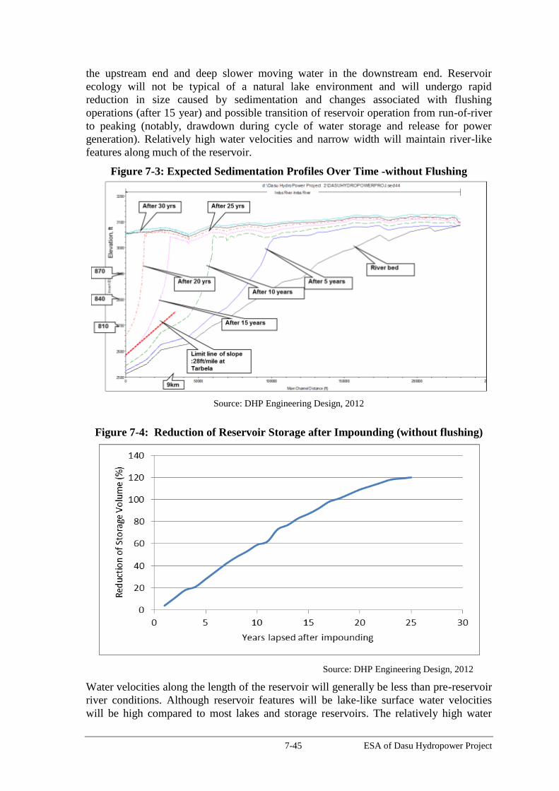
7-45 ESA of Dasu Hydropower Project
the upstream end and deep slower moving water in the downstream end. Reservoir
ecology will not be typical of a natural lake environment and will undergo rapid
reduction in size caused by sedimentation and changes associated with flushing
operations (after 15 year) and possible transition of reservoir operation from run-of-river
to peaking (notably, drawdown during cycle of water storage and release for power
generation). Relatively high water velocities and narrow width will maintain river-like
features along much of the reservoir.
Figure 7-3: Expected Sedimentation Profiles Over Time -without Flushing
Source: DHP Engineering Design, 2012
Figure 7-4: Reduction of Reservoir Storage after Impounding (without flushing)
Source: DHP Engineering Design, 2012
Water velocities along the length of the reservoir will generally be less than pre-reservoir
river conditions. Although reservoir features will be lake-like surface water velocities
will be high compared to most lakes and storage reservoirs. The relatively high water

7-46 ESA of Dasu Hydropower Project
velocities suggest that conditions may be mainly compatible for riverine fish species,
particularly along the reservoir shoreline. Water velocities along the length of the
reservoir would be relatively high, ranging from 0.56 to 3.08 m/sec at the head of the
reservoir and 0.02 to 0.14 m/sec at the dam.
Water velocities in deeper areas close to the dam will be mainly influenced by facility
operation:
900-950m – relatively high water velocity; determined by intake/spillway use
875-900m – relatively high water velocity; determined by intake use
810-875m – relatively low water velocity except during periodic flushing; mainly
stagnant water upstream - annual/periodic flushing will rejuvenate
724-810m – low water velocity; mainly stagnant water upstream
Based on the hydraulic and engineering studies DHC concluded that flushing of
sediments will not be required until 15th
year of operation. If Basha dam is constructed
by that time, flushing operations are not required for another 30 years, since Basha dam
having enough storage capacity would act as sediment trap. After construction of Basha
dam, annual sedimentation inflow will be reduced to 46 million tons (which will also
include sediment outflow from Basha dam).
Without Basha annual flushing operations will be carried out for a period of one month.
During flushing operations power generation will be stopped.
This impact has been assessed as High Adverse, as shown in Table 7.4.
Mitigation
To prolong the life of the reservoir (at least to 40 years) it is estimated that annual
flushing should start after 15 years. This assumption is based on the use of the reservoir
to generate base load electricity. For the first 15 year period the impact of sedimentation
on potential development of commercial fisheries will be minimal, provided that stocking
of the reservoir is carried out with suitable non-migrating fish species adapted to the
circumstances in the reservoir. The situation can be compared with the situation at the
Tarbela reservoir. When flushing would start after 15 years this would mean that the size
of the reservoir will be reduced to 7 km instead of the 9-10 km length of the reservoir
after 15 year.
Residual Impacts
With the help of the above listed mitigation measures, concerns associated with
sedimentation in reservoir are likely to be mostly addressed, and hence the associated
residual impact has been assessed as low adverse (see Table 7.4).
7.8.7. Impact of Reservoir Operation during Base Load Operation of Plant
The current plan is to use the reservoir for base load generation during the first stage of
the project, estimated at 15 years. During this period there will be minimal impacts on
fish production, with the exception that the volume of water in the reservoir will decrease
with about 80 percent. After this period the reservoir will be flushed annually during one
month (mid May-mid June) when discharges of the Indus are high. Flushing is most
effective in the high flood season. During flushing operation the water level in the
reservoir will be lowered from 950 m amsl to 830 m (level of the low level outlets).This

7-47 ESA of Dasu Hydropower Project
will be achieved at an estimated rate of 3 m/day and takes about 40 days. Drawdown will
be kept at this low rate in order to minimize the risk of landslides. After this lowering
period the flushing of sediment will be carried out during 30 days. When the gates in the
dam are closed the water level in the reservoir will start to rise with an average of 4
m/day and will reach fsl 30 days later. The whole operation will take about 100 days (1
April -10 July).
Fish stocks will be compressed in a reduced volume during flushing operations. There
will be impacts on fish stock. There will be losses of fish during flushing operation. An
unknown percentage of fish will be trapped or injured during the extreme drawdown
during flushing. For mitigating these impacts the technical feasibility of protecting the
inlets should be determined, either by screening of inlets or by other methods. A certain
percentage of fish (to be determined) will have to be restocked annually.
The impacts have been assessed as Moderate Adverse, as shown in Table 7.4.
Mitigation
In the above-mentioned period of flushing it is expected that specific fisheries
management is required to sustain the population of fish in the reduced reservoir area
during flushing, and possibly followed by re-stocking afterwards. There are considerable
uncertainties with respect to expected losses of fish harvest during flushing and the
appropriate mitigating measures. These issues have to be studied into more detail in the
Fisheries Development and Management Program. Flow releases during reservoir
flushing are not likely to have a sustained negative effect on the downstream ecosystem,
as long as peak flows occur within the normal period of seasonal high flows.
Residual Impacts
With the help of the above listed mitigation measures, concerns associated with flushing
of reservoir are likely to be mostly addressed, and hence the associated residual impact
has been assessed as low adverse (see Table 7.4).
7.8.8. Impact on Downstream Fish during Flushing Operation
The potential impacts on the downstream during flushing operations are turbulent habitat
conditions, release of high sediment load and altered water quality from the reservoir.
Flushing events should not occur earlier than the planned early summer period to prevent
possible adverse effects outside the intended timing window especially during the winter
low-flow period. Release flows during flushing should be within limits of historical
flows for the season over which flows will be released (currently planned for mid-May to
mid-June). As explained earlier, the impacts on water quality in the reservoir are
estimated to be minor due to these short retention times. However, if low oxygen
conditions are evident during monitoring prior to flushing a lead-in period may be
required whereby the lower-level outlets are used to draw out low oxygen-concentration
lower-elevation water in combination with spillway releases to provide adequate oxygen
concentrations in water downstream of the plunge pool. The impact has been assessed as
High Adverse, as shown in Table 7.4.
Mitigation
The following measures will be implemented to address the potential impacts associated
with flushing:
WAPDA to carry out flushing during high flow season (not in low flow/winter)

7-48 ESA of Dasu Hydropower Project
WAPDA to develop ramp down criteria (5-10 cm/hr)
WAPDA will conduct monitoring of dissolved oxygen and temperature in reservoir
and de-stratification or simultaneous release of water from low level outlets and
spillways if required.
WAPDA will carry out downstream monitoring of fish, habitats and sediments.
Residual Impacts
With the help of the above listed mitigation measures, concerns associated with flushing
of reservoir are likely to be mostly addressed, and hence the associated residual impact
has been assessed as low to moderate adverse (see Table 7.4).
7.8.9. Impact of Daily Reservoir Operations during Peak Production
After commissioning of the Diamer-Basha project (expected in 2037) DHP will depend
on the guaranteed water releases from the Basha reservoir. During this stage it has been
recommended to operate the Dasu plant as a peaking facility during 4 - 6 hours per day to
cover the peak demand for electricity in the country. There will be a daily storage-release
cycle during the winter low-flow period, with strong fluctuating water levels.
Operation of DHP as a run-of-river facility will not change the hydrology downstream of
the tailrace outlet during the low flow season, as has been discussed in the previous
section. However, during storage/peaking operations (in Stage 2) the situation will be
totally different. During the low flow season there could be periods potentially of no
inflow into the segment of the river below the tailrace outlet. Downstream habitat and
biota will be significantly adversely affected when flow is reduced due to the daily
retention of water in the reservoir, in order to cover the needs for peak power generation.
Potential effects on aquatic resources and fishing activity could extend downstream for a
substantial distance (depending on minimum environmental flows adopted) until the
major tributaries join Indus. However it appears doubtful that potential effects would
extend to the south end of Tarbela Reservoir (approximately 200 km downstream) where
the commercial fishery is located.
Risk of Tail Race Flow Surges
A period of no inflow could be followed by a sudden pulse of water during peak
operation. Peaking will thus cause daily fluctuations in flow and water levels in the river
section downstream of the tailrace outlet. Repeated daily surges will affect the aquatic
ecology.
The magnitude of water level fluctuation will vary along the river, depending on the river
cross section downstream. In addition, the daily water level variations depend on the
number of turbines working during that day. Just at the tailrace discharge point, the water
level will change quite suddenly after a start or stop of the turbine.
Following examples give an indication of the expected changes in water level:
If the power generation from one turbine is increased to three turbines, the water level
at tailrace is expected to rise 2.8 m. During power generation with twelve units (in
phase 4), the rise of water level will be 6.4 m. However, instantaneous power
operation with twelve units is not practical, due to constrained load control in the
power grid connected to other power plants in the country. This scenario is therefore
very unlikely. A more likely scenario is that three turbines operate simultaneously.
The time needed for the sequential start of three turbine units is estimated to take at

7-49 ESA of Dasu Hydropower Project
least 15 minutes. The rising rate of the water level at the tail end would then be 0.8
m/minute. Therefore it is expected that a sudden surge wave may not occur in the
river section downstream of the tailrace outlet.
In case of the use of one turbine the total time before a sudden water surge reaches
the tailrace outfall is estimated at minimal 23 minutes. The water level then will rise
with an estimated 0.27 m/minute. The water level fluctuations will continue further
downstream for longer distance. However, the fluctuations become smaller when
major tributaries join the Indus.
The above impacts have been assessed as Moderate Adverse, as shown in Table 7.4.
Mitigation
During peaking operation of the plant, it will be required to operate at least one turbine
and the additional flows can then be used for peaking operation. Operation of one turbine
will release 222.5 m3/s and the total flow at tailrace, including an environmental flow of
20 m3/s from dam, will then be 242.5 m
3/s. This discharge is equal to about 44 percent of
average winter flow of Indus at Dasu. This amount can be adjusted based on the
monitoring of impacts on aquatic ecology. Release of 44 percent of average monthly
flows generally exceeds the recommendations set by other hydropower projects in the
region. For example, Wildlife Institute of India has recommended 20 percent of winter
monthly flow for sustaining river ecology with special reference to snow carps in
Alaknanda and Bhagirathi Basins, Uttarakhand, India (source: Wildlife Institute of India,
2012 Assessment of Cumulative Impacts of Hydroelectric Projects on Aquatic and
Terrestrial Biodiversity in Alaknanda and Bhagirathi Basins, Uttarakhand).
Residual impacts
With the help of the above listed mitigation measures, concerns associated with peak
production are likely to be mostly addressed, and hence the associated residual impact
has been assessed as low adverse (see Table 7.4).
7.8.10. Risk of Bird Collisions with Transmission Cables
The Indus valley is a major fly-way for bird migration. Huge flocks of migrating birds
follow the Indus valley fly-way with south ward migration starting from November and
northward migration starting from March. Fatal collisions occur mostly with cables
hanging perpendicular to the flight direction particularly with the top neutral conductor
because of its poor visibility. The 132 kV transmission line from Dubair to Dasu will
mainly be located along the lower altitude slopes of the Indus valley, not perpendicular to
the flight direction of the birds. At one location, near Jalkot, the 132 kV transmission line
would cross the Indus river from right bank to left bank and hence this location could be
potential for bird collision.
Power line structures (towers) provide perching, roosting, and nesting substrates for some
avian species especially for birds of prey (raptors). Due to their large wingspans, the
raptors may simultaneously come in contact with two energized parts or one energized
and one neutral/grounded part of the transmission lines/their towers, potentially resulting
in electrocution. Although raptors are most often considered when addressing
electrocution risk, other birds such as crows, ravens, magpies, small flocking birds and
wading birds can also be electrocuted. Closely-spaced exposed equipment, such as
jumper wires on transformers, poses an electrocution risk to small birds.

7-50 ESA of Dasu Hydropower Project
This impact has been assessed as Moderate Adverse, as shown in Table 7.4.
Mitigation
Visibility enhancement objects such as marker balls, bird deterrents, or diverters will be
attached to the 132 kV transmission line at the Indus crossing to avoid any bird collision.
The electrical design factor most crucial to avian electrocutions is the physical separation
between energized and/or grounded structures, conductors, hardware, or equipment that
can be bridged by birds to complete a circuit. As a general rule, electrocution can occur
on structures with the following characteristics:
• Phase conductors separated by less than the wrist-to-wrist or head-to-toe (flesh-to-
flesh) dimensions of a bird. The wrist is the joint toward the middle of the leading
edge of a bird’s wing. The skin covering the wrist is the outermost fleshy part on
the wing.
• Distance between grounded hardware (e.g., grounded wires, metal braces) and
any energized phase conductor that is less than the wrist-to-wrist or head-to-toe
(flesh-to-flesh) distance of a bird.
Avian risk assessment is a prerequisite for designing the transmission line. The
assessment includes development of a database for morphological features (wrist-to-wrist
or head-to-toe) for all the large birds, raptors and threatened species. Morphological
features, in terms of length of the birds and wingspan of all large birds, raptors and
threatened species of the project area are presented in Annex C. Maximum length and
wingspan of these birds are summarized below.
maximum length is 1 m and maximum wingspan is 1.8 m for large water birds and
waders (Black stork, Bar-headed goose, Demoiselle crane, etc.)
maximum length is 1.5 and maximum wingspan is 3 m for birds of prey (vultures:
Lammergeyer, Himalayan, Egyptian; and eagles: Short toed, Golden)
length is 0.65 and wingspan is 1.8 m for Egyptian vulture (endangered)
length is 0.5 and wingspan is 1.2 m for Pallid harrier (near threatened).
The maximum length and wingspan of all the above birds are within 1.5 m and 3 m,
respectively. Hence, mitigation to prevent or reduce the bird electrocution is possible by
maintaining a minimum vertical distance of 1.5 m and horizontal distance of 3 m between
the energized parts of the transmission line. However, in the proposed design of the 132
kV transmission line, the distance between vertical conductors is 4.1 m and horizontal
conductors is 6.8 m, much higher than the morphometric features of the birds. Hence no
bird electrocution is expected with 132 kV transmission line through touching of two
conductors. In addition, the exposed coverings and parts of the structure will be insulated
to avoid any electrocution of birds.
Residual Impacts
With the help of the above listed mitigation measures, concerns associated with bird
collision are likely to be mostly addressed, and hence the associated residual impact has
been assessed as low adverse (see Table 7.4).

7-51 ESA of Dasu Hydropower Project
7.9. Social Issues during Operation and Maintenance
7.9.1. Loss of Employment for Construction Workers
Local construction workers and technicians may lose their jobs at the end of the
construction works and this may lead to increasing unemployment for local residents
with negative consequences. The impact of the loss of employment has been estimated as
moderate adverse, as shown in Table 7.4.
Mitigation
There are good opportunities for follow-up projects which are: (a) the successive follow
up projects under stage 2 of DHP (phase 3 and 4), (b) the construction of the Diamer-
Basha dam and (c) possible other major works further upstream. WAPDA could develop
a preferential system for local workers with good qualifications and experience at the end
of the construction of stage 1. Construction workers could also qualify for positions in
maintenance and operational activities. Also important is that the vocational training
program for the various categories of workers will be continued together with the
implementation of the Social Assistance Program.
Residual Impacts
With the help of the above measures the impact of the loss of employment opportunities
could be largely mitigated and hence the residual impacts have been assessed as low
adverse.
7.9.2. Reservoir Fisheries (Enhancement Opportunity)
Development of reservoir fisheries could create employment: based on experience from
Tarbela, it is estimated that there could be potential for development of reservoir fisheries
in the Dasu reservoir. A well designed fisheries management program is an essential
condition for such an enterprise, including the provision of the required infrastructure,
such as hatchery, landing facilities, ice factory, craft and gear, laboratory and training
facilities. Implementation of such a program would substantially increase the
employment opportunities in the area as well as the nutritional status of the population.
The project would support collecting detailed baseline data for aquatic resources in the
area (see Annex B for the ToRs for this study), which would be a pre-requisite for
preparing such a program.
7.10. Potential Impacts of 500 KV Transmission Line
As described earlier, the present ESA does not cover the impacts associated with the 500-
kV transmission line since the detailed design of this component is yet to be carried out.
In order to carry out a preliminary assessment and to define the extent and scope of the
detailed ESA to be carried out once the detail design is available, the National
Transmission and Dispatch Company (NTDC) has prepared a separate EARF for this
component. As a next step, a detailed ESA will be carried out during the detailed design
of this component, in accordance with the WB requirements. A summary of this EARF
is presented below.
Summary of EARF for the Construction of 500 kV Transmission Line
The EARF, which is available for review under separate cover, includes initial screening
of potential impacts. The key findings of this screening are listed below.

7-52 ESA of Dasu Hydropower Project
No permanent land will be acquired for the erection of towers. Only for grid station,
about 100 acres of private land will be acquired.
Temporary land will be acquired for contractor’s camp(s) and other facilities like
storage, workshop, machinery parking, washing, aggregate quarries and access
roads/paths.
The construction activities can potentially have some impacts on crops. As the
construction activities will continue throughout the year, people will potentially lose
their crop for two seasons i.e. winter and summer. About 5000 ha of agriculture land,
5000 ha of barren/grazing land and 2500 ha of forest land is likely to fall within the
corridor of impact of the transmission line.
The transmission line will cross several local roads, a railway line, and also the
existing transmission lines. Clearance will be maintained throughout the route of the
transmission line in accordance with the relevant safety standards.
The construction activities can potentially have impacts on the air quality due to the
dust and exhaust emissions from the construction machinery as well as vehicles.
Similarly, the noise generated by the construction machinery may have impacts on
the sensitive receptors such as communities, schools, and hospitals.
No major tree cutting is likely to be needed for the transmission line construction.
The construction activities may have some impacts on the terrestrial fauna of the area,
however these impacts will be minimized during the operation phase of this
component.
The transmission lines may cause fatal injuries to birds due to electrocution and
collision. In particular large birds such as raptors and storks are susceptible to such
impacts.
The construction activities may potentially have some impacts on the local
communities due to the movement of labor in that area and use of their local
resources such as water.
As the transmission line route would mostly be passing through the rural areas and as
a result, women activities and mobility in the field will potentially be impacted during
the construction activities.
The transmission line route will not cross any area inhabited by indigenous people as
defined in the WB OP 4.10.
No documented/officially notified cultural and archeological sites are known to exist
within the transmission line corridor.
The EARF has identified the possible crossing of the transmission line through Palas
Valley as a potential environmental impact, to be studied in greater detail during the
transmission line ESA. The transmission line route identified in the EARF is about 250
km long and begins at the Dasu Hydropower plant. The route runs parallel to the Indus
River till Pattan. From there, the proposed corridor would proceed through the lower
Palas valley and pass the districts of Battagram, Mansehra, Abbottabad, Haripur passing
east of Tarbela Dam towards Pathar Garh, situated near Hassanabdal in District Attock,
Punjab. Out of total 250 km, about 200 km is mountainous terrain with rocks covered
with natural and planted forests. Only the last 50 km towards Pathar Garh is relatively flat
or slightly sloping terrain with cultivated lands and barren areas. The crossing through
7-53 ESA of Dasu Hydropower Project
Palas valley could be environmentally sensitive, since this area is an IBA (Important Bird
Area) declared by BirdLife International. Palas valley is also known by its rich
biodiversity and is considered to be an environmental hotspot.
The EARF has identified as another possible major impact the interference of the selected
transmission line- corridor with the well-known Indus Flyway, or Bird Migration route
no. 7 along the Indus. Part of the line follows the Indus valley between Dasu and Pattan,
in an area where the Indus valley is rather narrow with steep mountains on both sides
reaching 2,500 – 3,000m amsl. The Indus Flyway follows the narrow valley and
especially large flocks of waterfowl, geese and ducks, cranes and herons are passing there
twice a year on their way from Siberia towards their wintering grounds situated in Sindh,
Indus Delta and along the coastline of the Arabian Sea, and vice-versa.
ESA Study and Alternative Routes of Transmission Line
The EARF also includes the ToRs of the detailed ESA to be carried out during the design
of this component. There are potential alternatives available for routing of the
transmission line, including completely bypassing of the Palas valley. The study will
compare the various alternatives and assess their impacts on the biodiversity of the area
including Palas valley. One important issue to note here is that the Palas valley is not
included in some 150 long list of protected and conservation areas in Khyber
Pakhtunkhwa, and hence no monetary support is available from the government to
strengthen the conservation measures in the Palas valley. The biodiversity in the Palas
valley is reported to be currently under heavy stress from deforestation, firewood
collection, overgrazing, over-hunting, over-harvesting of medicinal plants, soil erosion,
use of pesticides, and weak law enforcement. Considering these issues, the ESA study
will also assess the merits of passing transmission line through Palas valley besides
evaluating environmental enhancement opportunities (e.g. funding of conservation
measures by the project).
The study will also identify and evaluate various alternatives available during the design
and construction phase of the transmission line including siting and design of towers,
access paths, and construction methodology.
The ESA will cover the potential impacts associated with the construction and operation
of the transmission line and related ancillaries, as well as all temporary and permanent
facilities and resources required (e.g., including access routes, helipads if required,
workshops, and equipment yards) during the construction and operation phases. The ESA
will also include an avian risk assessment, addressing the potential impacts of the
transmission line on birds. The study will also cover the cumulative impacts of this
component and any other project in the area. The ESA will also include environmental
management and mitigation plans which will be embedded into the bidding documents
for the construction of transmission line. World Bank will provide funding for detailed
design and ESA study of the transmission line. The ESA will be reviewed and cleared
by the Bank before any construction on this component can be commenced.

8-1 ESA of Dasu Hydropower Project
8. Cumulative Impacts
8.1. Introduction
Mangla and Tarbela dam are the only existing major dam projects that have been
constructed in Pakistan, both about 40-45 years ago. After this, Pakistan has not
constructed any major dams for irrigation or hydropower purposes. In order to harness
the hydropower potential of the Indus River, WAPDA has proposed to build a cascade of
projects in the Upper Indus Basin (UIB). Under the Vision 2025 DHP and Diamer-Basha
(DB) are the first of a series of hydropower projects planned by WAPDA in the Indus
river section upstream of Tarbela until Raikot bridge (near Astor), see Figure 1.2. DHP
in combination with Diamer- Basha and several minor hydropower projects along Indus
tributaries have the potential to cause significant cumulative impacts on physical,
ecological and social resources in the basin.
Strategic Sectoral Environmental and Social Assessment (SSESA)
Meanwhile, the Ministry of Water and Power of GOP, through the World Bank-funded
the Water Sector Development Project (WCAP), awarded a study titled “Strategic Sector
Environmental and Social Assessment” (SSESA) to an international consortium of
consultants. SSESA has been launched to look at the whole Indus Basin for sector wide
environmental and social considerations including cumulative impacts to help prioritize
the investments in hydropower and storage development options. The study would
provide recommendations on programmatic mechanism for monitoring and evaluating
environmental and social performance in the management of storage and hydropower
projects in Pakistan. The study considers WAPDA Water Resources and Hydropower
Development Vision 2025 document as the reference document, besides Government
policies on Power and Energy Conservation. It is expected that the recommendations of
the study will help the Government in making strategic choices in the water resources
and hydropower development, which have positive environmental and social impacts and
conserve the overall natural resource base. The study is at an advanced stage of
completion.
Spatial and Temporal Boundaries of Cumulative Assessment
For the present ESA a preliminary cumulative impact assessment has been prepared by
the design consultant’s team based on “Vision 2025”. The spatial and temporal
boundaries for the cumulative impact assessment have been defined according to an
expected and realistic timeline, as discussed with WAPDA and the World Bank. DHP is
the first structure upstream of Tarbela to be constructed to be followed by DB. The latter
dam (DB) will be constructed at a site a few km from the upstream end of the DHP
reservoir. The assessment framework as presented here is spatially limited to the Indus
valley downstream of the confluence of Gilgit/Hunza river with the Indus (some 15 km
upstream of Raikot bridge (at the upper end of the Basha reservoir), until the Tarbela
dam, where the Indus water is distributed over the entire Indus Basin Water System
(IBWS) see Figure 8.1. As temporal boundaries the time between now and the year 2035
(DHP and DB expected to be in full operation) have been taken.
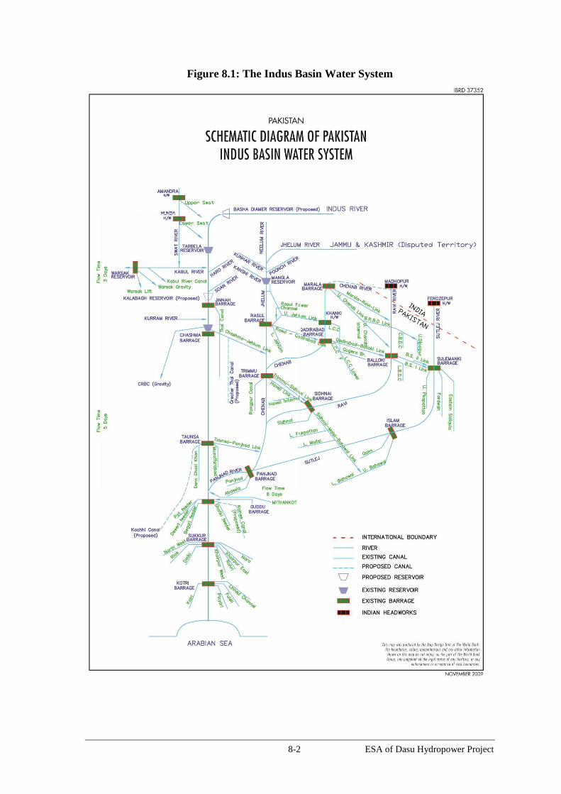
8-2 ESA of Dasu Hydropower Project
Figure 8.1: The Indus Basin Water System
8-3 ESA of Dasu Hydropower Project
Potential cumulative impacts arising out of the water resources and hydropower projects
likely to be developed within the next twenty years (both on Indus main stem and its
tributaries) have been assessed for this part of the river. Other developments outside the
water sector have not been considered, since there are very few infrastructural and other
developments foreseen in this mountainous and rugged terrain belonging to the
Himalayan and Karakorum mountain ranges.
The assessment has been concentrated on possible cumulative effects of projects on: (a)
river hydrology, (b) sedimentation (c) water releases downstream of Tarbela, (d) water
supply for irrigation and drink water, (e) management of floods, (f) changes in habitat
from river to lake type, (g) barriers for fish movement, (h) social impacts due to
resettlement, loss of livelihood and income (i) damage to physical cultural resources, and
(j) need for realignment of the KKH. These valued environmental components (VECs)
identified and discussed through a ‘CIA Stakeholder Consultation Workshop’ held at
Islamabad (2 October 2012), which was attended by federal (Ministry of Climate
Change, Planning Commission and National Highway Authority, Dept. of Archeology)
and relevant provincial government stakeholders (EPA, wildlife, fisheries, archaeology)
from the provinces of Baluchistan, Sindh, Punjab and KP; international financial
institutions (ADB, World Bank and JICA), Indus River System Authority, university
teachers and NGOs. The key cumulative impacts and their mitigations and concerns are
discussed in the sections below.
8.2. The Indus Basin Water System
To meet the increasing food production demands, Pakistan has been expanding the
surface water supplies to the Indus Basin Water System (IBWS) over time by capturing
more water from the Indus and its other rivers. The Tarbela Dam was developed during
the seventies of the last century in the framework of the Indus Basin Water Master Plan.
Initially the main purpose of the dam was to supply irrigation water to the densely
populated agricultural areas in Punjab and Sindh. For the project 120 villages along the
Indus were submerged and a total of 96,000 persons had to be resettled and 33,200 ha of
land to be acquired. At present the Tarbela dam is the most upstream constructed
hydraulic structure controlling the Indus waters, its main functions are to supply
irrigation water to the IBWS as well as generate power.
Post Tarbela, canal diversions in the past reached as high as 105 million acre feet (MAF).
However, they have declined in recent years due to reduced storage of Tarbela reservoir
because of sedimentation and several other factors such as the state of the infrastructure
and a sequence of dry years. The 2001-2010 average canal diversions have now been
reduced to 94.5 MAF, and the reduction is primarily in the rabi (winter: October-March)
season by about 8.6 MAF.
8.2.1. Indus-water related Impacts downstream from Tarbela
From 1900 onwards, as development of the IBWS proceeded and extraction from the
river steadily increased, the delta and coastal zone began to receive lower volumes of
water, thus changing the characteristics and ecology of the area. Decreased water flows in
the Indus River have caused serious adverse environmental and social impacts on the
delta and coastal zone. These impacts include the loss of mangrove forests, decreased
fisheries, deteriorated water quality, and sea intrusion. All of these factors have direct
bearings on the livelihood and wellbeing of the local population.
8-4 ESA of Dasu Hydropower Project
The other source of water Pakistan has tapped is groundwater, which is recharged by the
surface water system. Since the 1980s, the groundwater aquifers have supplied increasing
amounts of water for irrigation in areas underlain by fresh groundwater. In Punjab, about
an equal amount of irrigation water comes from the groundwater wells. This resource is
now reaching its limit and further withdrawals are not possible without serious
groundwater mining and extraordinary costs for pumping.
8.2.2. Mitigation Measures Taken
The described impacts have been mitigated through implementation of various programs
aimed at improving water management in the delta area, provision of drainage and
revival of some of the lakes using better quality drainage water and various livelihood
programs. Some of these programs are supported by the Bank.
Under the mitigation measures taken by the Government of Sindh province the following
major projects were undertaken:
a) The interprovincial Water Accord of 1991. This Accord has a provision for
ecological flows to be released downstream from Kotri Barrage.
b) Preparation of a Master Plan for the Left Bank of Indus, Delta and Coastal Zone.
Under the Sindh Water Sector Improvement Project the World Bank is assisting the
Government of Sindh to prepare a regional master plan to address the flooding issues
and provide proper drainage to the area on the left bank of the Indus River.
c) Sediment Management Plan for the Basin and Tarbela. Under the Water Capacity
Building Project (WCAP) the World Bank is also assisting the GoP and WAPDA to
understand the sediment management issues for the basin and at Tarbela Dam.
d) Improving Irrigation Efficiencies. With increasing population and development,
water demand is expected to continue to increase in the Indus Basin, which is the main
food production area for the country. In the past Pakistan has been increasing surface
water diversions and also tapping groundwater, both of which are reaching their limits
now. In future, substantial quantities of water can only come from reducing losses in
the irrigation system (now about 35-40 percent). The Bank is assisting the
Government to start an irrigated agriculture productivity improvement program under
which watercourses (Punjab, Sindh to be followed by other provinces) would be
improved to reduce delivery losses and introduce high efficiency irrigation systems,
such as drip irrigation.
e) Plans for Storage Reservoirs in IBWS. Pakistan has already raised the level of the
Mangla dam on the Jhelum River. This provides about 2.9 MAF of additional storage,
however, this is much less than the combined storage lost to sedimentation of the
Mangla and Tarbela reservoirs.
f) Sind Coastal Area Development. The Pakistan Poverty Alleviation Fund through its
partner organizations has been implementing the Sindh Coastal Area Development
program (WB funded) to address the spatial and economic isolation and poverty of the
population of the coastal areas following natural/man-made disasters seawater
intrusion, floods, and climate change specifically in districts of Thatta and Badin.

8-5 ESA of Dasu Hydropower Project
8.3. Expected Developments in the Upper Indus Basin
8.3.1. Shift in Focus of Water Policy Planning
The development of the Indus River system as envisioned under the Vision 2025
Program has the potential to provide the long term solution for the water and electricity
sector and growth of the Pakistani economy. However, the aim of developing the Indus
River needs to be shifted from merely storing and increasing water supplies towards
developing sustainable water and hydropower resources also in view of the rapid
industrialization and urbanization of the country and the increase in demand for energy.
The focus therefore is now moving to the main Indus River with its large untapped water
resources potential, especially since the waters of the other rivers (Chenab and Jhelum)
are fully utilized and other sources provide lesser amount of water and power. On the
Indus River the same water can be utilized through a cascade to maximize benefits of
storage and hydropower generation.
8.3.2. Indus Cascade Development from Tarbela to Diamer- Basha
The first step in this long term plan is to develop the segment of Indus Cascade between
the Tarbela Dam up to Diamer-Basha (DB) and to exploit all water and hydropower
resources in this segment, followed by investments further upstream. This segment has an
annual water flow of about 60 billion cubic meters (BCM) and an elevation drop of about
700 meters between upstream of DB to the Tarbela reservoirs. At this stage, this segment
is planned to be developed by four major structures on the Indus River going upwards
from Tarbela Dam, Thakot, Pattan, Dasu and Diamer-Basha (see Figure 1.2). Two of
these projects (DHP and DB) will be developed in the next 20 years, providing about
8,800 MW of newly installed capacity. Two other projects from this cascade: Thakot and
Pattan Hydropower Project are currently under consideration and feasibility studies are
still underway. These projects have not been included in this assessment.
8.3.3. Overview of Expected Development until 2035
Hydropower Development
The proposed developments in Indus cascade are shown in Figure 8.2. In this cascade,
DHP and Basha are ready for implementation with detailed designs in hand. Other two
projects of vision 2025, Pattan and Thakot, are still in the planning stage. Considering
that only two major dam projects have been completed in last 50 years in Pakistan and
amount of finances required to develop these mega projects, it can be safely assumed that
only Basha and DHP are the only major projects that could be completed in next 20 years
or so. In addition, six hydropower projects are located in the tributaries, of which two are
under construction.. A list of these hydropower projects currently designed or under
construction is given in Table 8.1. From the table it can be seen that DHP (Run of River)
and Basha (storage) are major hydropower projects, whereas the projects along the
tributaries are much smaller and often also ‘Run of River’ projects with small storage
dams. DHP has a limited reservoir (24 km² only) with the only objective to generate
hydropower (base-load, possibly peak-load in the far future), whereas Basha has the
objective to improve the storage capacity in the IBWS and to alleviate flood damage of
the Indus River next to generating electricity.

8-6 ESA of Dasu Hydropower Project
Figure 8.2: Location of Tarbela and other Planned Hydropower Projects in UIB
Non Hydropower Development
Non hydropower developments have not been considered in this assessment since there
are no major developments are planned in this region. A major limitation for any
economic development is the poor condition of the KKH between Thakot and Raikot
bridge (the only lifeline with the outside world), which situation is prohibitive for any
further economic development in the area. So far there are no plans to reconstruct this
road section (with the exception of the relocated stretch of KKH inside the future DHP
reservoir area, to be constructed as part of the DHP project), which is in difficult terrain
and is frequently blocked for days.
Table 8.1: Hydropower Development in the Upper Indus Basin (under Vision
2025)
Name of
Project River Location
Storage
(BCM)
Installed
Capacity
(MW)
Expected
Completion
Date
Major Hydropower projects
1. Diamer Basha 3)
Indus Diamer 7.90 4500 2030
2. Dasu 3)
Indus Dasu RoR
(0.67)
4320 2022
3. Minor Hydropower projects
3.1 Keyal Khwar 4)
Indus tributary Besham RoR 122 2018
3.2 Dubair Khwar 2)
Indus tributary Besham RoR 130 2013

8-7 ESA of Dasu Hydropower Project
Name of
Project River Location
Storage
(BCM)
Installed
Capacity
(MW)
Expected
Completion
Date
3.3 Khan Khwar 1)
Indus tributary Besham RoR 72 2012
3.4 Allai Khwar 1) Indus tributary Besham RoR 121 2013
3.5 Lower Spat
Gah 4)
Indus tributary Kohistan RoR 496 2025
3.6 Lower Palas
Valley 4)
Indus tributary Pattan RoR 665 2025
Status: 1)
Existing; 2)
Under construction; 3)
Ready for construction; 4)
Under Planning (expected
completion date is uncertain)
8.3.4. Brief Description of Diamer Basha Project
Primary objective of DB is to improve significantly the storage capacity in the stressed
Indus Basin Water System (to alleviate water shortages for agriculture and environmental
flow) and to generate relatively cheap and clean (due to the renewable nature) energy to
be transported and distributed by the National Power Grid. Main national benefits of the
project will comprise:
Enhanced water storage capability of the Indus River System by adding about 7.9
BCM of live storage at a time when the on-line storages will have lost over one-
third of original capacity of about 19 BCM;
Increased useful life of downstream Tarbela reservoir by about 50 years (together
with development of DHP) through trapping large amount of sediments;
Optimization of water and power benefits through conjunctive operation with
Tarbela reservoir;
Alleviation of flood damage of the Indus River, particularly in the reach Kalabagh
to Guddu.
Providing about 18,100 GWh of energy per annum from its installed capacity of
4,500 MW;
Enabling about 1100 GWh of additional generation at Tarbela due to conjunctive
operation of the reservoirs of Tarbela and Basha.
Sizeable addition to other two existing hydropower projects of Ghazi-Barotha and
Chashma due to routing of additional water provided by storage at Diamer Basha will be
possible in future. Besides the above national benefits, a major ‘trickle-down effect’ of
the project will be significant improvement in socio-economic conditions in Gilgit-
Baltistan. Salient features of the project are given in Table 8.2.
Table 8.2: Salient features of Diamer Basha Project
Element Details / feature Description
Catchment Area 153,200 km² Mean Annual Inflow 62 BCM Probable Maximum Flood (PMF) 49,4170 m3/s
Location On Indus river near Chilas (Gilgit Baltistan & K.P), 300 km upstream from

8-8 ESA of Dasu Hydropower Project
Element Details / feature Description
Tarbela dam and about 40 km downstream of Chilas town Dam and
Reservoir
Type Roller compacted concrete (RCC) Crest Level 1,170 m amsl Full Reservoir Level (FRL) 1,160 m amsl Minimum Operation Level (MOL) 1,060 m amsl Length of Reservoir 102 km Surface Area 115.2 km² Storage Capacity 13 % of Inflow Height 272 meters Length 939 meters
Spillway Type Ogee Type with Flip Bucket and Plunge
Pool
11.5 m x 16.24 m (14 Nos.) Radial gates Outlets Low level 2
Sluicing 5
Reservoir Gross Storage 8.10 MAF (10 BCM)
Live Storage 6.40 MAF (7.9 BCM)
Power House Installed Capacity 4,500 MW
Location and Type Underground, one each on right and left
side
No. of units 12, each of 375 MW (4500 MW)
Annual Energy 18,500 GWh Project
Benefits Generation of Hydropower Employment generation during construction and O&M of the project. Uplift of socio-economic conditions. Development of fisheries (reservoir)
People
affected 28,650 persons
Project Cost Rs 894.000 billion (US$ 11.18 billion) Executing
Agency WAPDA
Source: DBC, 2009
8.3.5. Baseline Conditions
The baseline conditions in Basha project and DHP are largely comparable. Both projects
are situated in the same agro-ecological zone along the Indus valley at few km distances
of each other. Near Chilas the Indus is at about 1000 m and the mountain along the Indus
valley rises up to 4,000- 5,000 m elevation. Near Dasu the Indus bed is about 760 m
amsl, whereas the mountains bordering the valley are somewhat lower with elevations
between 3000 – 4000 m. The smaller hydropower projects along the Indus tributaries are
also found in the same zone, but at some 35 – 60 km distance downstream of Dasu. The
projects downstream from Pattan are situated in an area which receives some more
rainfall and has well developed vegetation and natural forests along the tributaries and on
the slopes. The area forms a transitional zone towards the zone downstream from
Besham-Thakot where the influence of the monsoon begins (Battagram-Mansehra) with
more rainfall and more agricultural development.

8-9 ESA of Dasu Hydropower Project
8.4. Cumulative Impacts and Trends to be Expected
8.4.1. General
DHP in combination with other proposed hydropower and storage projects has the
potential to cause significant cumulative and induced impacts on physical, ecological and
social resources in the UIB. Most of the expected cumulative impacts relate to
hydropower development, since this is the only major structural development in the area.
Influx of workers and migrants will be restricted in Dasu since there is hardly any
suitable place to find to accommodate large numbers of people and commercial business.
In the Basha project there will be more influx of in-migrants since there is more free
physical space for small industries and commercial establishments to develop. The
tributary projects will also attract influx of migrants to nearby urban centers. The
impacts on biodiversity and wildlife of DHP have been described in Chapter 7 and the
trends and concern identified in DHP and other hydropower projects are similar, since the
areas are as far as natural forests and vegetation and ecology is concerned almost
identical, especially at the higher altitudes.
8.4.2. Impacts on River Hydrology
Cumulative Impacts
Among the hydropower projects, Basha is a storage project and others are run of river
projects. DHP is planned as a baseload run of river project and other tributary projects are
planned as peaking run of river projects. River flows in Indus and its tributaries could be
affected due to seasonal storage in the Basha and daily storage in tributary projects (for
peaking operation). The objective of Basha project is different from DHP and this
consequently may lead to other environmental impacts. With construction of Basha,
which has a gross storage volume of 7.9 BCM, the storage capability in the Tarbela
reservoir could considerably be increased. The change in river hydrology for different
scenarios has been determined in a hydrological study for Basha dam carried out by
WAPDA in 2012. It has been estimated that by optimizing the operations of Tarbela,
Basha and DHP about 42 percent more flow during the low flow season could be released
from Tarbela and about 19 percent in early kharif period (see Table 8.3).
The changes in the river flows above Tarbela will have a positive benefit on the
downstream of Tarbela through alleviation of water shortages for irrigation especially in
the beginning of the kharif season, which is a crucial period for development of the
summer crops in Punjab and Sindh. The impact of these extra releases will be very
beneficial for irrigated agriculture in the plains. This extra flow could also mitigate the
reductions in the ecological flow, which is often compromised and reduced by
overconsumption in agriculture.
Table 8.3: Percent of Change in River Hydrology (Flow Volume) Downstream of
Tarbela under Different Hydropower and Storage Scenarios
Hydropower / Storage development scenarios Low flow
(Oct - March)
Early kharif
(Apr-May)
High flow
(Jun-Sep)
1. Dasu + Tarbela 0 +10 -1
2. Basha + Tarbela +42 +9 -11
3. Basha + Dasu + Tarbela*) +42 +19 -12
Note: *) Through optimizing the operation of the three dams

8-10 ESA of Dasu Hydropower Project
Incremental Effects by DHP Alone
The contribution of DHP to the cumulative impacts on the hydrological regime of the
Indus is minimal since it is run of river facility used for based load power generation.
There will be minor changes in the flow, during first filling and during flushing which
will start 15 years after commissioning of DHP. During base-load operation all water
entering the reservoir will pass either through the tailrace tunnels, via the LLOs, or
spillway. The downstream flow will only slightly be reduced during the first-filling of the
reservoir. Even if this happens in the low flow season (February – March) there will be
sufficient water discharged through the low level outlets and diversion tunnels to
downstream areas. Dasu is likely to contribute to improvement in Tarbela storage by 10
percent. As long as DHP is operating as Run-of River project there will be minimal
impacts on the flow. However this will change when DHP is operated as a peaking plant.
The impacts of peaking operations is a daily cycle of low flow (during reservoir filling)
and of high flow during power generation. The impacts of peaking operations have been
described as moderately adverse, and discussed in Chapter 7. Mitigation of the impacts
can be done by releasing sufficient environmental flow to downstream area and through
operational measures in running the turbines to prevent sudden surges.
8.4.3. Impact on Sedimentation
Cumulative Impacts
Indus and tributaries carry most of their sediment (nearly 97 percent) during high flow
season. All hydropower projects will retain these sediments to some extent behind the
dams. Thus the sediment content on the downstream flows of the dams will be reduced.
This could increase the erosive capacity of the river flows. However sedimentation in the
reservoirs of cascades will have positive impacts on the downstream dams through
increased storage. The construction of Basha will have a considerable beneficial impact
on both Dasu and Tarbela reservoir in extending the life of both reservoirs. The Basha
reservoir with a large storage volume will then act as a sediment trap and the inflow in
Dasu reservoir will be reduced to 46 million ton of sediment (mainly fine fraction). The
cumulative impacts on sediment transport of both Dasu and Basha together will have a
considerable positive impact on water quality and aquatic ecology in downstream areas
and on sediment deposition in the Tarbela reservoir. The strong decrease in sedimentation
may extend the life of the reservoir with another 50 years (15 years due to the retention of
sediments in Dasu and 35 years due to retention in the Basha reservoir).
Incremental Effects by DHP Alone
Annually about 200 million ton of sediment would be flowing into the DHP reservoir.
Sand would be trapped, but most of the suspended silt would pass through the turbines
and the spillways/LLOs. Sedimentation trap efficiency of DHP is estimated to be 60
percent. Without flushing it is expected that the Dasu reservoir will be filled in 20-25
year. Once the flushing commences after 15 year (assuming Basha is not completed)
about 27 percent of the annual sediment inflow would be trapped and 73 percent would
be flushed through the flushing tunnels and LLO. This will have an impact on the
composition of the sediments (relatively more fine fraction) reaching downstream areas,
with possibly some changes in the aquatic ecology. The reduction of the sediment
quantity and composition as a result of the construction of DHP is however not likely to
have an impact on the water quality of the Tarbela reservoir.

8-11 ESA of Dasu Hydropower Project
8.4.4. Impacts on Downstream Water Releases
Cumulative Impacts
A system integrated study conducted by WAPDA showed that impacts from the
completion of DHP and DB and optimized management of Tarbela could even be felt
downstream of Kotri barrage, which is the last barrier before the Indus delta. Especially
during low flow season the ecological flow at Kotri would increase with 14 percent and
in early kharif with 2 percent as shown in the Table 8.4.
Table 8.4: Impact in percentages of water availability and ecological releases
downstream Kotri under different hydropower/storage scenarios
Hydropower / Storage Development Scenarios Low Flow
(Oct - March)
Early Kharif
(Apr-May)
1. Dasu + Tarbela 0 1
2. Basha + Tarbela 14 1
3. Basha + Dasu + Tarbela 14 2
Incremental Effects of DHP Alone
DHP alone will have no effect on water availability for use downstream of Kotri during
the winter low flow period and will increase water availability slightly during early
Kharif in the years when flushing takes place.
8.4.5. Impact on Water supply for irrigation and drinking water
Cumulative Impacts
Upstream of Tarbela, the changes in river flow will have no influence on irrigation and
drinking water, since Indus water is not used for this purpose. Irrigation water and
drinking water are usually drawn from the tributary rivers and often from small streams
or nullahs. These water resources might be affected by the development of the minor
hydropower project planned and currently under construction. These developments are
mitigated by constructing pipe lines supplying water to the settlement in these areas.
On the downstream of Tarbela, as shown in Table 8.3, there will be increased water
availability during the low flow season and transition period of Early Kharif. The
enhanced supplies downstream of Tarbela reservoir, in tandem operation with Basha and
Dasu reservoirs, in low flow period is expected to increase the irrigation supplies by 42
percent during October to March and by 19 percent during early Kharif. During high flow
season the average flow is 11-12 percent lower, which is also beneficial for downstream
areas, since irrigation demand is low and the occurrence of floods caused by monsoon
rains in the Northwest of the country is high.
Incremental Effects of DHP Alone
DHP will not generally contribute to the cumulative impacts on water supply and
irrigation releases in the Indus. However during the flushing periods (starts after either 15
years or 50 years), DHP will contribute to increase of Tarbela storage by 10 percent.
8.4.6. Impacts on Flood Management
Storage of water in the reservoirs will attenuate the floods in downstream areas and save
the properties and lives especially of people living in the densely populated areas further
downstream of Tarbela (Punjab and Sindh). Combined operation of Basha, Dasu and

8-12 ESA of Dasu Hydropower Project
Tarbela can reduce average high flow downstream of Tarbela during the summer season,
as shown in Table 8.3. With conjunctive operation of Tarbela, Diamer Basha and Dasu
reservoirs, combined flood regulating capability of these dams will significantly increase.
For individual 10-daily flows it was assessed that a maximum of about 60 percent
reduction could be expected downstream of Tarbela. This could be a beneficial impact to
mitigate the impacts of severe floods along the lower reaches of the Indus valley in
Punjab and Sindh. During the past 40 years the Tarbela dam has shown that this dam
could withstand exceptional foods without damage, including the high flood from 2010.
Most problems then were caused by floods coming from Indus tributaries in NW Pakistan
joining the main Indus river downstream from Tarbela (e.g Kabul and Swat rivers).
Sudden waves such as those from Glacial Lake Outburst Floods (GLOF’s) could cause
damage in the Indus valley section as far as Tarbela. However most of the valley is
deeply incised into the mountains and there is few flat area to be found in the riparian
areas. However urban centers and built-up infrastructure situated at low terraces along the
Indus are at risk. GLOFs are a serious threat and these events should be better managed
to protect the hydropower infrastructure and community. In 2010 there was a huge
landslide in the Hunza Valley, which blocked Hunza River and eroded away a
considerable length of Karakoram Highway (KKH) near Ataabad. This event also created
a lake, which is still there blocking the KKH. Currently there is no early flood warning
telemetry network available on the upstream of Dasu. Support of DHP and Dasu projects
to assist WAPDA in establishing such a flood warning system would help to mitigate the
potential impacts of GLOF’s.
8.4.7. Impacts on Water Quality, Aquatic Ecology and Fish
Cumulative Impacts
Reservoir areas of Basha and DHP. Formation of reservoir changes biotic and abiotic
conditions in the submerged Indus and the lowest part of the tributaries. In the reservoir
areas the changes in the flow velocity, the water quality (less turbidity, higher
temperature, and more light) is expected to change the aquatic ecosystem considerably.
The riverine ecosystem will be converted into a more lacustrine aquatic habitat.
Deposition of thick layers of sandy and fine silty sediment will alter the bottom
conditions and the aquatic habitat will change depending of water depth, penetrating light
and water temperature. These changes will affect the fish habitat and spawning sites of
the tributaries and Indus. Water quality in the reservoirs will probably decrease due to
thermal stratification and a lower oxygen content in the deeper parts of the reservoir.
Water released from the reservoirs will be different in water quality due to changes in
temperature, oxygen and sediment content.
Downstream of DHP. Water quality in the Indus downstream of DHP is expected to be
somewhat lower after completion of Basha dam, since the inflow of water from the Basha
reservoir which has a much longer storage time, may also influence negatively the
oxygen content and temperature of the water in the Dasu reservoir. Also there will be an
effect of thermal stratification of water in the deep Basha reservoir, which also may
negatively affect the quality downstream. Also there might be some inflow into both
reservoirs of untreated waste water coming from settlements along the realigned KKH.
The risk of decreasing water quality is much smaller in the DHP reservoir, since the
storage time in this 73 km long reservoir is relatively short (a few days). Once the flow
has passed the tailrace outlet or spillway of Dasu dam, the flow again is rapid over the
next 80 km (with steep gradient) until the river reaches the Tarbela reservoir. Water

8-13 ESA of Dasu Hydropower Project
quality will improve and oxygen content and BOD will recover over relatively short
distances. With other dams to be developed in this river section the water quality
however might decrease more, but since both Pattan and Thakot dam will be Run-of
River projects (both with low storage capacity and short storage times) no major decrease
in chemical and biological water quality is expected. The fast flowing river and the
composition of the riverbed are positive factors to restore the water quality. Fish
movement from the tributaries to Indus confluences is common during low flow season
in winter. Due to release of high water flows from Basha reservoir in winter, there will be
a potential effect on the fish habitat near the confluences and movement patterns between
tributaries and the Indus. This will also affect the availability of fish and the fish catches
along the tributary waters will drop. This impact will be strengthened once a number of
the minor hydropower projects which are currently under construction along the
tributaries are becoming operational.
Incremental Effects of DHP Alone
Water retention time in DHP reservoir is very few days due to large inflow of water and
small reservoir area (24 km2). Hence no water quality changes are expected in the Dasu
reservoir and hence Dasu will have little contribution to the overall quality changes in
Indus. DHP may affect the fish habitat and spawning areas in its reservoir submergence
area. A compensation plan through hatchery development and fish stocking in the
affected areas is recommended in the ESA. These measures could be extended to the
affected areas of other hydropower projects in UIB as well.
Opportunities for Reservoir Fishery
However, there could be opportunities for development of fisheries in the newly
developed reservoirs. Development of a new lacustrine habitat in the reservoir areas of
Basha and DHP could be a valuable especially in combination with the presence of the
lateral tributaries of the Indus, where melt water streams flow into the reservoir. These
places could develop into important spawning areas for fish. The negative impact on loss
of fish habitat can be compensated by developing fish hatcheries with suitable species
(e.g. snow carp and possibly other native species), including open water stocking in the
affected tributaries and reservoirs including maintenance of spawning areas. Fish
hatcheries for snow carps are so far not established in Pakistan, but are exist in India and
Nepal. However, further studies and investigations are required for detailed
understanding of snow carp biology before developing a full scale hatchery. Studies
should be implemented to prepare a practical research program to determine the
feasibility of hatcheries for native snow carp or for other carp species.
8.4.8. Impact of Barriers for Fish Movement
Cumulative Impacts
By constructing major structures in the Indus barriers will be created, which will impair
the ecological connectivity in the river. This might influence the presence of long
distance migrant species, such as the Mahaseer that was very common in the Indus before
the construction of the Tarbela dam. The fish is a long distant migratory and endangered
fish species of the Indus. Its present habitat starts about 70 to 80 km downstream of the
DHP dam. They fish lives in slow moving streams and rivers in the foothill regions and
breeds in gravels and sandy river beds. Mahaseer is reported to ascend the Indus River to
Besham Qila and above and to spawn in Allai Khwar which has been described as the

8-14 ESA of Dasu Hydropower Project
last upstream safe-haven for the species. During fish sampling in DHP, as well as in
Basha, no Mahaseer specimen could be caught; local people also confirmed its absence
from the area. It might be expected that the construction of both DHP as well as Basha
will have no impact on Mahaseer in the Indus.
The other migrant fish (over short distance only) is the snow carp or snow trout. This fish
is common in the DHP and Basha area (75 percent of catches) and lives in the tributaries
and confluence area with Indus. They migrate within the tributaries, not along the main
stem Indus, and they migrate from the spawning areas at the confluence towards the
upstream area of the tributary, where it lives for a part of the year before returning to the
Indus. Its habitat has been discussed in Section 5.2.4 and potential mitigation measures to
support the presence of snow carp in the tributaries in the reservoirs of Basha and DHP
and further downstream of Dasu are presented in Section 7.8.2.
Impacts on Mahaseer and grass carp might be expected from the barrier impact of the
small dams constructed in the framework of the development of the Allai Khwar and
Khan Khwar minor HP projects and the Dubair and Keyal minor HP projects along Indus
tributaries near to Besham. These projects are presently under construction or planned by
WAPDA. It is not known if any mitigation to facilitate migration of Mahaseer and snow
carp along these tributaries will be carried out and this should be verified by WAPDA in
the coming period.
Incremental Effects by DHP Alone
Incremental contribution by DHP to the fish migration is not expected since there is no
fish migration along the Indus at the Dasu.
8.4.9. Impacts on Forestry and Biodiversity
The construction of both DHP and the Diamer-Basha project may have a significant
cumulative and induced impact on the high-altitude natural forests and wildlife of the
area. There will be a large influx of many thousands of people including construction
workers, operational staff, and business people together with their dependents over a
period of 25 to 30 years. They will settle in the main urban centers in the area around
Dasu/Komila and Chilas. The construction of new resettlement sites for both projects at
higher altitudes will also increase the population pressure of the rural population at higher
elevations particularly on forest resources and wildlife including a whole range of rare
and endangered plants and fauna. As a result there will be more collection and
commercial trade in fire wood and herbs, illegal deforestation, logging, reclamation of
land for agriculture and other activities. Illegal practices such as poaching, trapping and
hunting will increase. The impacts and the potential mitigations have been indicated in
Chapter 7.
8.4.10. Impacts on Resettlement, Livelihood and Income
For Basha Dam project and DHP the nature of the social impacts are largely comparable,
although social impacts are larger than in Dasu. DB requires the resettlement of
considerably more people than DHP and more land is to be acquired for the project.
Impacts on trees felling, loss of land and commercial establishments is larger since the
DB project is planned in a part of the Indus valley, which is much wider and more
densely populated including more commercial activities than in the Dasu area. The
impacts of resettlement, loss of land and assets are shown in Table 8.5.

8-15 ESA of Dasu Hydropower Project
Table 8.5: Social and Cultural Impacts of DHP and BD
Indicators Basha Dam Project Dasu Hydropower Project Location Diamer and Kohistan District Kohistan District Displaced Population 28,650 people will be directly
displaced due to project
interventions.
6,953 affected persons will be
dislocated requiring
relocation Households displaced 4,310 from 31 villages 767 from 34 villages Land needed for
project construction Total estimated land acquisition of
15,150 ha, A total of 4,643 ha of land
will be affected Trees Loss of estimated 525,775 trees both
fruit (283,964) and non-fruit
(241.811) varieties.
An estimated 21,000 trees of
various species and sizes will
be lost Commercial activities 453 commercial units/objects
comprising of public buildings and
sites and services
197 commercial structures
will be affected due to project
interventions. Vulnerable A total of 100 people socially
vulnerable people There are 10 families of
Soniwal (nomad) tribe living
in project area and several
disabled and female-headed
households KKH Submergence of about 94 km of
existing Karakorum Highway
(KKH) on the left bank
Submergence of about 46 km
of existing Karakorum
Highway (KKH) on the left
bank Suspension Bridges 7 suspension bridges are being
affected. 2 suspension bridges are
being affected. Ethnic Minorities There are 500 families of Soniwal
tribe living in project area. They
migrate along the Indus banks for
extracting gold
There are 13 families of
Soniwals living in project
area.
Cultural heritage Submergence of 30,367 rock
carvings forming part of the cultural
heritage
A 400-year old mosque at
Seer Gayal village on right
bank would require relocation In-migrants and
social Issues Several thousand in-migrants and
construction workers will move in
creating cultural conflict and
disruptions in community life
Deterioration of social and
community life due to in-migration from
other areas of Pakistan and
foreign construction workers Gender impacts Women have lower status, very
limited access to education and
health due to seclusion. The poor
suffer even more from malnutrition.
Many pregnancy related death; lack
of access to medical centers.
Disruption of life due to loss of land
and access to resources.
Women have a lower status
and publicly “invisible.” As a
result, mobility is restricted
.The loss of land, houses and
forests due to the project will
have significant impacts on
the women.
8.4.11. Impacts on Physical Cultural Resources
A large field of pre-historic and historic rock drawings and inscriptions (50,000 rock
drawings and 5000 inscriptions) can be found at 30 sites on both sides of the Indus
between Shatial and Raikot bridge (near Astor) spread over a distance of more than 100

8-16 ESA of Dasu Hydropower Project
km. The rock art dates from Stone Age (8-9th millennium BC) to Buddhist and Islamic
periods and is internationally known as the “guest book of the Silk Route”. Most of the
30,000 of these engravings will disappear into the future Diamer Basha reservoir and will
be covered by silt. During almost 40 years archeologists of the University of Heidelberg
in Germany have worked in the area and studied the rock-art clusters stretching out over
the entire distance of 100 km along the Indus. Currently the researchers are involved in a
project to document all these engravings and rock-art, which is unique in the world.
There are plans to save the most valuable pieces from inundation by the Basha reservoir
and to display them (copies or pictures) elsewhere in a safe place.
The rock carvings around Shatial will not be submerged by DHP, but these pieces of rock
art are not protected and endangered by on-going developments from construction works
and other activities along the KKH. Since this part will be the only remaining in-situ part
from the entire field of almost 100 km of petroglyphs it is recommended that DHP is
assisting in saving the in situ objects from further destruction and vandalism, by assisting
the KP Department of Archaeology and Museums to acquire the land, provide proper
fencing and protection measures, including some infrastructure for visitors of an
information centre in Shatial and possibly a museum in either Chilas or Gilgit.
8.4.12. Transport
One of the most critical social impacts of the development of DHP and DB is that both
projects draw heavily on the only existing road along the Indus, the Karakorum Highway.
Not only the population in Kohistan and Diamer is strongly dependent, but also the
population of major towns such as Gilgit, Hunza and in Skardu and the rest of the
province of Gilgit-Baltistan (population > 1.2 million). The KKH is the only lifeline with
the outside world. The road which was built during the sixties with by the Pakistan Army
with Chinese assistance is for most of the sections between Thakot and Raikot bridge in
very poor condition. The section runs through very difficult terrain and belongs to a very
dynamic and challenging environment for building roads. Average speed for cars is
about 20- 30 km/hr over most of this section. The road is narrow and in poor shape.
Frequently the road is blocked by landslides after rainfall or minor earthquakes. Closure
of the road is common, not only for one or two days, but often for a week or more.
Currently the section between Khunjerab pass and Raikot bridge is upgraded to highway
standards with the help of Chinese contractor.
However with the construction and operation of in mega hydropower projects like Basha
and Dasu the status of the current road conditions is absolutely prohibitive for
simultaneous or overlapping construction and development of these projects. Population
in the rural areas of Kohistan and Gilgit-Baltistan is accustomed to endless delays and
has learned to adapt since they have ever lived as self-sufficient farmer or livestock
holder. However for the population of the major city centers the delays mean that they are
entire isolated from the rest of the world during many days or weeks in the year.
Under current plans, reconstruction of roads in DHP and Basha which will be submerged
by the reservoirs and about 175 km of new KKH road is foreseen. The new alignment
will be improved to a relevant standard, but this will be only for the early phases of
development (5-10 years). It is very essential that GOP is preparing plans and seeking
assistance for upgrading the KKH to real highway standards. WAPDA could play an
intermediary role in these developments and could bring this to the attention of
responsible authorities and planning commissions.

8-17 ESA of Dasu Hydropower Project
8.5. Mitigations for Cumulative Effects to be Implemented under DHP
8.5.1. Development and Organization of Regional Knowledge on UIB
Since DHP is the first in the row of mega-projects to be developed under WAPDA’s
Vision 2025 Program with relatively low environmental and social impacts with a limited
number of affected households as compared to other mega-project and with modest
resettlement, it is recommended to strengthen the respective data bases on ecology (both
aquatic and terrestrial), biodiversity and on fisheries and forestry. Most ecological
information in the UIB area dates from the last century and very few reliable field data
have been collected in recent years. One of the reasons for this lack in information is the
remoteness of the area and the difficult terrain conditions in the absence of access roads
and accommodation. However with remote sensing and GIS techniques a lot of recent
Karakorum Highway (KKH)
Between 1959 and 1979 Pakistan and China constructed jointly the Karakorum Highway
traversing the Himalayan-Hindukush Mountain range via the Khunjerab pass (at elevation
4,690 m). China constructed the section between Kashgar (China) and Khunjerab, whereas
Pakistan was responsible for the section between Khunjerab and Hassanabdal (806 km).
The road follows mainly the valleys of the Indus, the Gilgit and Hunza River, though very
rugged and difficult terrain. The work on Pakistani side was carried out by the Frontiers
Work Organization (FWO) together with the Army Corps of Engineers. The work was very
challenging and frequently stopped due to landslides and accidents, which cost about 800
lives on Pakistani side and nearly 200 on the Chinese side.
In 1979 the work was completed and the road could be opened. Until that year the North of
the country had been largely isolated from the rest of Pakistan. Most of the northern areas
had for long times been completely cut off from the areas down-country (Punjab and
Sindh). There were mainly pony tracks, some suspension bridges and a handful of hospitals
and schools in the entire area. For supplies one was often dependent from trade with China
or Afghanistan. The opening of the road marked an important step forward for the districts
situated along the KKH (Kohistan, Gilgit-Baltistan and Hunza). In this period there was an
unprecedented influx of developers, immigrants and tourists. Probably the KKH has been
the most important factor for social and economic development of this part of the country,
next to the strategic and economic significance of the road. Nowadays there are an
estimated 2.5 millions of people dependent from this only lifeline with the rest of the
country (including 1.2 million people in Gilgit-Baltistan, 0.5 million in Kohistan and 0.8
million elsewhere along the KHH). Although the KKH is an important asset for the people
in the region, the road itself has deteriorated over time. The present alignment is narrow
and susceptible for frequent blockages by landslides and rock falls, which often last several
days.
In 2006 a Memorandum of Understanding was signed between the Pakistan Highway
Administration and the Chines state owned organization to rebuild and upgrade the KKH.
However a major disaster happened in 2010 when a major landslide at Attabad blocked 22
km of road by creating a 100 m deep lake and creating havoc and loss of life. Currently
China started rebuilding part of the section between Khunjerab and Raikot bridge.

8-18 ESA of Dasu Hydropower Project
spatial information can be collected and institutions in Pakistan like WWF/IUCN, the
Islamabad Herbarium and other institutions have facilities and expertise needed for
implementing field studies to verify and collect reliable field data. It is suggested to
concentrate under DHP on establishing a reliable data base and information system for
the entire Indus Valley, including tributaries between Raikot bridge and Tarbela, which
could also be used in detailed planning and preparation of the other hydropower projects
along the Indus River.
Next to this DHP should concentrate on two major problems facing WAPDA in the
Upper Indus Basin, which are measures to improve flood warning through improved
watershed management and research on climate change. Watershed management is
essential, but this is often difficult since all information on climate is collected from
weather stations in the valley of the Indus and its major tributaries. Climatic conditions at
higher elevations (3000 – 5000m and higher) are completely different from those in the
valley and not recorded. Other main issues are the salvation of part of the collection of
famous rock art and petroglyphs on both sides of the Indus; and a district forestry
inventory of Kohistan to upgrade GIS information of forestry and deforestation, which is
needed to identify suitable areas for reforestation and/or afforestation in the upland areas
of the project. This study could also be used to identify suitable areas to compensate for
eventual loss of the Kaigah Community-managed Game reserve. WWF-Pakistan and/or
IUCN could be involved in this work.
Other issues for instance related to water quality research might come up during the first
stage of the project. In the environmental mitigation measures a budget for such studies
has been included. The ToRs for a forestry and wildlife management study in Kohistan
district and a baseline study of aquatic and terrestrial ecology of the Indus valley between
Raikot bridge and Thakot bridge are given in Annex B. The other measures to be
implemented under DHP to mitigate and reverse negative environmental trends and also
for environmental enhancement are described in the following sections.
8.5.2. Early Flood Warning and Climate Monitoring Program
For safety of public, improved management of flood waves and safe operation of DHP
and other hydropower projects downstream of Dasu, it is imperative to have an early
warning system for early flood warning in the major catchment areas of the project. The
existing flood telemetry network in the Indus basin comprises 45 automatic rain and river
level recording stations. There is no existing flood monitoring station in the DHP
catchment. Hence it is recommended that the existing network is extended to the upper
catchments of the River Indus including DHP. This component will include installation
of River Level sensors (pressure transducers), temperature sensors, and Rain sensors
(Tipping Buckets) at flood warning sites and hooking them with reliable
telecommunication system, i.e., Meteor burst communication system. In total the
installation of 18 telemetry stations is recommended in the upper catchment areas of the
Indus. The works will be executed by the Hydrology & Research Directorate, under the
administrative control of the Chief Engineer, Hydrology & Water Management,
WAPDA. The operation and maintenance of the project will be handed over to
Hydrology and Research directorate WAPDA after implementation, which is scheduled
to be completed in one year. New staff will be hired and after proper training, they will
be used for O&M of augmented network in conjunction with old staff. This is covered
under Component E of the project.

8-19 ESA of Dasu Hydropower Project
8.5.3. Integrated Watershed Development Studies
At higher altitudes (> 1500 m amsl) a number of forest plantations will be established
where forest could be rejuvenated. This will be done at selected places on both sides (left
and right bank) of the reservoir. Communities can play an important role in planting and
managing these plantations. There is experience with this type of social forestry
elsewhere in the region. In addition, a comprehensive study will be undertaken under
DHP, with the objective to determine the forestry status and trends in areas between
1,000 and 2,500 m in the Indus District of Kohistan, Pakistan, to develop a general
ecological management plan for sub-catchment areas of DHP, and to develop detailed
community-led ecological management plans for at least two sub-catchment areas,
focusing on sustainable forest management and conservation management of wildlife.
The study will be carried out by a qualified organization (e.g. IUCN or WWF) with
experience in ecological and forestry management (ToRs provided in Annex B).
8.5.4. Fish Hatchery and Stocking
A fish hatchery for production of native cold water fish species, snow carps and stocking
of fish in the tributaries, reservoirs and downstream Indus is recommended to compensate
the loss of fish habitat on the downstream and to address potential downstream impacts.
This requires maintenance of an onsite fish hatchery of snow carps for the production of
the targeted numbers of fingerlings from hatchery and hauling of the fish fingerlings for
open water stocking in the river. Fish hatcheries for snow carps are so far not established
in Pakistan, but are existing in Uttaranchal, India (Garhwal Himalaya) and Nepal (Kali
Gandaki A, Plkhra, Trishuli and Godavari). However, further studies and investigations
are required for detailed understanding of snow carp biology before developing a full
scale hatchery. The hatchery could be used to stock the fish in the affected areas of other
hydropower projects in UIB. In addition, a fisheries development and management plan
in cooperation with the KP Fishery Department will be prepared and implemented for the
Dasu reservoir (ToRs provided in Annex B).
8.5.5. Physical Cultural Resources (PCR) Protection Plan
DHP will support KP Archaeological Department to (i) procure 25 acres of land for
acquisition of land, in which rock carvings are located, (ii) fence the area, (iii) provide
fiberglass sheds; (iv) develop tourist facilities and (v) documenting the importance of
rock carvings and their translations. A detailed plan for this will be worked out together
with the various stakeholders, including the Heidelberg University and the KP
Department for Archaeology and Museums.
8.5.6. Review of EMPs of Other Hydropower Projects
Footprints of other individual projects and their impacts are covered in the EIA reports of
respective hydropower projects. It is recommended that WAPDA should review the
mitigation measures proposed in the respective EMPs of those projects and strengthen the
mitigation measures where necessary. For example, the EIA reports of Khan Khwar and
Allai Khwar have identified the impacts on fish migration and downstream fish habitat,
but no specific mitigation measures are proposed. It is also recommended that WAPDA
should follow best practice approaches to management of cumulative effects in the UIB
through collaboration with: knowledgeable specialists in environmental/resource-
management agencies, academia and NGOs for addressing broad considerations related
to biodiversity, especially aquatic biodiversity and fisheries. (An example of best practice
approach is: Columbia Fish and Wildlife Compensation Program - it addresses needs

8-20 ESA of Dasu Hydropower Project
related to three large and several small HP projects on the Canadian portion of the
Columbia River http://www.fwcpcolumbia.ca/).
8.6. Summary of Major Cumulative Environmental and Social Concerns
A summary of the main environmental and social concerns is given of the cumulative
impacts is given in Table 8.6. The evaluation is based on the assumption that DHP
(phase 1 and 2) is implemented in the period 2015- 2022 and that electricity is generated
as from 2020. Diamer Basha project is expected to be commissioned after 15 years from
now and starts generating electricity. Meanwhile in the period until 2025 all minor
hydropower projects in the tributaries have been implemented and are under operation.

8-21 ESA of Dasu Hydropower Project
Table 8.6: Summary of Major Environmental and Social Concerns regarding Cumulative Impacts
VEC Feature Major Concerns/Benefits Mitigation/Management Plans
Physical environment
Surface
water
River hydrology Positive impact due to increased control and management of
river flow
Operational Plans for optimization of flow (WAPDA)
Improved hydrological data from UIB (telemetric
network etc)
Sediment
transport
- Positive benefits due to prolonged life of Tarbela and Dasu
- Changes in sediment deposition might affect aquatic ecology
Monitoring of sediment deposition and effect on water
quality
Downstream
water releases
More water available in downstream areas during low flow
season
Improve water releases downstream (e.g. Kotri) in low
flow season (WAPDA/Provinces)
Water availability - Improved water supply for irrigation (early kharif)
- More water available for maintaining environmental flow
Maintaining irrigation demand in early kharif season
(WAPDA)
Maintaining agreed environmental flow downstream of
Tarbela (Provinces)
Flood
management
Improved flood attenuation and control during high flow season
Improved control of GLOF events
Operational Plans (WAPDA)
Biological environment
Aquatic
habitat and
fish
Downstream fish
habitat
Reduced flows and/or increased surges in low flow season;
Changes in downstream water quality (temperature and
dissolved oxygen).
- Maintain recommended environmental flows
- Monitoring of water quality downstream of Dasu
Reservoir habitat - Decrease in water quality is reservoir due to stagnating flow
and potential risk of pollution by untreated waste water
- Impacts on spawning areas of fish (Indus and tributaries)
- Study and monitoring of changes in aquatic habitat
- Feasibility of hatcheries of snow carp/other species
Barrier effect Migration of snow carp in Indus tributaries
Migration of Mahaseer in area downstream of Allai Khwar
- Detailed inventory of aquatic habitats and fish
- Monitoring of catches
Biodiversity Natural forests Pressure on forests (illegal logging) by influx of workers & in- - Awareness raising in-migrants

8-22 ESA of Dasu Hydropower Project
VEC Feature Major Concerns/Benefits Mitigation/Management Plans
and forests
Biodiversity
and forests
migrants - Updated Forest inventories (GIS + field study)
- Improved and sustainable forest management by
Communities
- Forest Rejuvenation and Management Plans
Wildlife Increased poaching, hunting and trapping; reduction or
degradation of aquatic and forest habitats
- Awareness raising public, schools
- Expand Community Managed game reserves
Natural habitats Flooding of natural habitats, degradation by increased
overgrazing, firewood collection, etc.
- Inventory of terrestrial flora and fauna of downstream
areas until Tarbela
- Prepare Management Plans for sensitive areas (eg,
Palas)
Lack of reliable data on terrestrial and aquatic ecology, wildlife
and forests
- Implement inventories and studies on aquatic and
terrestrial ecology
Social/cultural environment
PCR Archaeology Loss of more than 31,000 petroglyphs along “Silk Road” by
inundation of reservoir and/or vandalism from KKH travelers
- Prepare a salvage and management plan in
cooperation with national and international
archeologists
- Establish a museum for display and information
Social
behavior
Influx of
migrants
Lack of respect for cultural norms and traditions local
population
- Prepare Migration Management Plans
- Awareness raising and Grievance address mechanisms
KKH Access to area Frequent blockage and poor maintenance KKH Upgrade KKH to highway standards

9-1 ESA of Dasu Hydropower Project
9. Environmental and Social Management Plans
9.1. General
This Chapter presents the environmental and social management plans for all the project
components except the 500 kV transmission line, for which a separate ESA including an
ESMP will be prepared.
9.2. Objectives of ESMP
The basic objective of the ESMP is to manage adverse impacts of project interventions in
a way, which minimizes the adverse impact on the environment and people of the Project
area. The specific objectives of the ESMP are to:
Facilitate the implementation of the mitigation measures identified during the present
ESA and discussed earlier in the document.
Maximize potential project benefits and control negative impacts;
Draw responsibilities for project proponent, contractors, consultants, and other
members of the Project team for the environmental and social management of the
Project;
Define a monitoring mechanism and identify monitoring parameters in order to:
Ensure the complete implementation of all mitigation measures,
Ensure the effectiveness of the mitigation measures;
Maintain essential ecological process, preserving biodiversity and where possible
restoring degraded natural resources; and
Assess environmental training requirements for different stakeholders at various
levels.
The ESMP will be managed through a number of tasks and activities and site specific
management plans. One purpose of the ESMP is to record the procedure and
methodology for management of mitigation identified for each negative impacts of the
Project. The management will clearly delineate the responsibility of various participants
and stakeholders involved in planning, implementation and operation of the Project.
9.3. Inclusion of Relevant Components of ESMP and SRMP in Contract Documents
In order to make contractors fully aware and responsible of the implications of the ESMP
and SRMP and to ensure compliance, it is recommended that environmental and social
management measures are included in the tender documentation. The various contractors
must be made accountable to implement the plans and mitigation measures which pertain
to them through contract documents and/or other agreements of the obligations and
importance of the environmental and social components of the Project.
Payment Milestones
Payments to contractors would be linked to environmental performance, measured by
completion of the prescribed environmental and social mitigation measures. Contractors
would be trained how to join forces with the executing agency, project management unit,
supervising consultants and local population for the mitigation of adverse impacts of the

9-2 ESA of Dasu Hydropower Project
project. For effective implementation of the proposed mitigation and monitoring
measures they would attract trained and experienced environmental management staff.
9.4. Institutional Arrangements
9.4.1. Construction Phase
The overall responsibility for the implementation of the project rests with the Project
Management Unit (PMU), headed by the Project Director (PD). Within the PMU there
will be an Environment Unit (EU) - responsible for implementing the ESMP, and a
Social and Resettlement Unit (SRU) - responsible for implementing the SRMP. The EU
and SRU, headed by the Deputy Project Director-Safeguards, will include representatives
of all actors responsible for ESMP/SRMP implementation (see Figure 9.1).
The responsibilities of the EU and SRU are: (i) supervising, facilitating and coordinating
implementation of environmental and social plans including ESMP and Resettlement
Action Plan (RAP); (ii) ensuring that contractors follow KP-EPA regulations, World
Bank Safeguard Policies, and other requirements mentioned in the ESMP and SRMP;
(iii) identifying any issues of non-compliance and report these; (iv) suggesting
mechanisms to link contractor performance in relation to the ESMP to the timing of
financial payments, incentives or penalties; and (v) interacting with stakeholders for their
concerns about the construction activities.
The EU will consist of three sub-units (Environment; Ecology; and Occupational Health
and Safety - OHS) with the following staff:
Director - EU
Deputy Director - Environment
Assistant Director - Environment (with two site engineers)
Assistant Director - Ecology (with one fish expert and one plantation expert)
Assistant Director - OHS (with one support specialist)
The Director EU with the assistance of Deputy Director-Environment will endorse
and support the implementation of the ESMP and associated policies and
documentation. The Director will be responsible to ensure appropriate resources are
made available to implement the ESMP and to support established systems,
procedures and environmental objectives.

9-3 ESA of Dasu Hydropower Project
Figure 9.1: DHP Organization Chart for Safeguards Implementation
AD Assistant Director
CE Chief Engineer
CEO Chief Executive Officer
CH Community Health
Comm. Communications
DC Deputy Commissioner
Dy. Deputy Director
Eco. Ecology
Env. Environment
GM General Manager
G&CH Gender and Community Health
LA Land Acquisition
LAU Land Acquisition Unit
LA&R Land Acquisition and Resettlement
LLG Local Leading Group/Jirga
M&E Monitoring and Evaluation
MM Migration Management
OHS Operation Health and Safety
R&R Resettlement and Rehabilitation
T&L Training and Livelihood
WEC WAPDA Environment Cell
Local Leading
Group
Social and
Resettlement Unit
CE
Deputy Project
Director-Safeguard
Director
Environment Unit
Director Social and
Resettlement Unit
GM
LA & R
DOR Dasu
LLG
DCO Dasu
External Monitoring and Evaluation
Agency Contractors
GM/CEO
PD-DHP/PMU GM
Technical WEC
Member (Water)
WAPDA
AD G&CH
G&CH Team
Dy. Director
Consultation and
Participation
Dy. Director
Gender &CH
AD MM
MM Team
Dy. Director
Environment
AD Eco. AD OHS AD Env.
Env Team Eco. Team OHS. Team
Dy. Director
Resettlement
AD R&R ADLA
LA Team R&R Team T&L. Team
AD T&L
GRC
Environment
Unit
Project
Manager
Construction Supervision
Consultants (CSC)
Director
Communication
Dy. Director
Downstream Impacts
Management
Dy. Director
Livelihood
&Community Support
Dy. Director
M&E

9-4 ESA of Dasu Hydropower Project
Some specific responsibilities of the EU will include:
Liaising with the Construction Supervision Consultants (CSC), and ensuring that they
perform their responsibilities effectively and adequately
Liaising with the SRU and other relevant Project entities for effective safeguard
management;
Assist in resolving disputes which may arise in respect to environmental management
Liaising with government agencies and relevant stakeholders regarding
environmental matters; overseeing the implementation of ESMP requirements;
Coordinating appropriate responses to environmental related complaints, ensuring
complaints are investigated for effective resolution;
Coordinating the involvement of environmental specialists (from the broader project
team) as the need arises throughout the construction phase.
Liaising with WEC to update them on the ESMP implementation, and seeking any
technical backup
Ensure commissioning of additional studies required/recommended in ESA.
Finalizing ToRs for hiring of consultants and contractors
Prepare monthly and quarterly reports on the status of implementation of the ESMP
Conduct monthly meetings with the environmental staff of consultants and
contractors on the progress of ESMP implementation, issues associated with
implementation, non-compliance issues, and recommended course of action.
Document the minutes of the meetings and present them in the monthly reports
Ensure review of ESMP every six months, and ensure its updation it if required
Ensure implementation of various plans to be prepared by the contractors (further
discussed later in the Chapter).
The Assistant Director – Environment will be mainly responsible for liaising with
CSC on the field level for the implementation of ESMP and preparing weekly
compliance reports.
The Assistant Director – Ecology will be responsible for coordinating with district
Forest and Fisheries departments (and other relevant agencies) for development of
nurseries for plantation in the project area, supervision of aquatic ecology studies and
monitoring, participating in landscaping plans for the quarry and spoil disposal areas,
identifying needs for environmental enhancement measures in Kaigah Community
KCGR, and conducting additional studies recommended in the terrestrial and aquatic
ecology reports.
The Assistant Director – OHS will be responsible for liaising with CSC for the
implementation and supervision of occupational health and safety issues at the work
areas and camp sites.
Some specific responsibilities of the SRU will include:
Liaising with the CSC, and ensuring that they perform their responsibilities
effectively and adequately

9-5 ESA of Dasu Hydropower Project
Liaising with the EU and other relevant Project entities for effective safeguard
management;
Overall planning, management and monitoring of the land acquisition activities, as
well as implementation of other plans included in SRMP (see Table 1.3);
Synchronization of resettlement activities with the construction schedule of the
Project;
With the help of CSC, prepare database on loss, entitlement and payment files of
individual PAPs to enable effective monitoring and evaluation of RAP
implementation;
Ensure that all eligible persons are identified, provided with their respective
entitlements and are relocated/resettled as per the implementation schedule, in time,
with minimum hardships;
Liaise with the DCO and DRO offices for the timely acquisition of identified land
and arrange timely payment of compensation and ensure that these activities are
completed as per the proposed schedule;
Ensure that all PAPs are informed about their entitlements and provided with
Identification as a proof of their eligibility to resettlement benefits;
Establish Grievance Redress Committees (GRCs) and ensure its smooth functioning;
Monitor the effectiveness of entitlement packages and delivery mechanism and, if
necessary, propose modifications to Project management;
Prepare monthly and quarterly progress reports for WAPDA and funding agencies;
Develop the preferred resettlement sites for housing and businesses in the identified
valleys with civic amenities and services;
Coordinate with contractors for providing preferential employment to PAPs in the
construction activities;
Conduct internal monitoring on RAP Implementation and advise PD; and
Study and monitor unforeseen adverse effects during and after construction and
recommend necessary mitigation measures to the PD.
Construction Supervision Consultants
The CSC will be responsible for supervising the contractors for the implementation of
ESMP and SRMP. For this purpose, the CSC will appoint dedicated environment and
social staff to ensure the ESMP and SRMP implementation during the project. They will
supervise the contractor for the ESMP and SRMP implementation, particularly the
mitigation measures. They will also be responsible for implementing the monitoring of
effects of these measures.
CSC will have the following environmental staff:
Team Leader (international environmental specialist)
Environmental Specialists (one international and two national specialists)
Ecologists (one international and one national)
Occupational Health and Safety Specialist (one national)

9-6 ESA of Dasu Hydropower Project
Environmental Surveyors (four national)
The environment staff of CSC will closely supervise the construction team to ensure that
all environmental commitments are incorporated into the construction activities and work
processes. Specific responsibilities include:
Supervising and supporting contractors in achieving their responsibilities as outlined
in the ESMP;
Issuing non-compliance notices to the contractors;
Providing input, advice, and approval on activity specific work plans relating to
ESMP;
Supervising the implementation of activity specific work plans;
Regularly reviewing and assessing environmental risks throughout the construction
phase;
Identifying and preparing environmental induction and training materials;
conducting environmental trainings;
Assist EU in addressing and resolving environment-related complaints and grievances
Responding to environmental incidents as required;
Managing compliance reporting as it relates to the Project, and preparing quarterly
ESMP compliance reports;
Liaise with DHP’s EU for effective environmental management at site;
Liaise with the Resettlement Office and other relevant Project entities;
Reviewing ESMP and revising it if required on six-monthly basis.
Contractor
Each contractor will be required to appoint adequate number of dedicated
Environment/Social Officers at the site for the implementation of ESMP in the field,
particularly the mitigation measures. The contractor will also be responsible for
communicating with and training of its staff in the environmental/social aspects. The
contractor will develop the various plans directed towards health, safety, the environment
and social issues (discussed later in the Chapter), and get them approved by the CSC
before the commencement of the physical works on site. Appropriate numbers of the
following personnel are required in the contractor’s environmental team:
Environmental Specialists
Occupational Health and Safety Specialists
Environmental Technicians (both for lab and field investigations)
The construction contract will have appropriate clauses to bind the contractor for the
above obligations.
9.4.2. O&M Phase
The O&M establishment at the DHP will be responsible for management of the
environmental and social aspects of the Project including implementing the ESMP during
the operation and maintenance of the facility and dedicated staff will be appointed for this
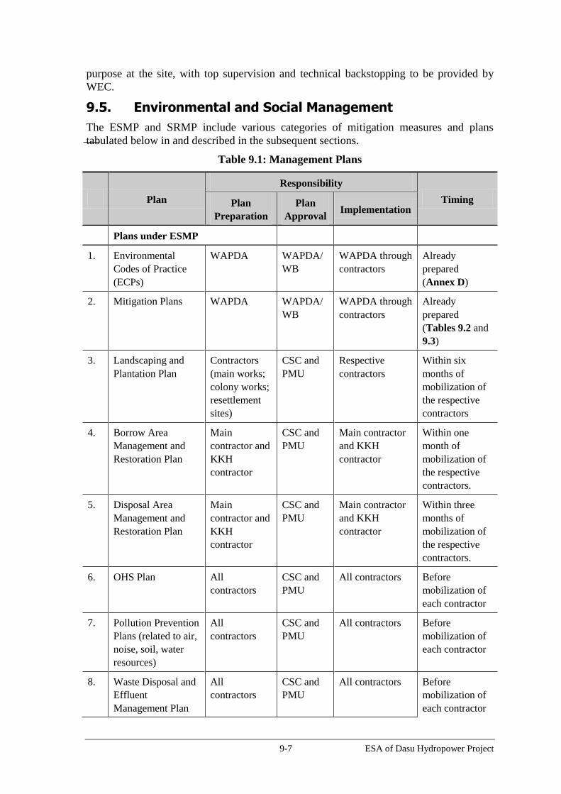
9-7 ESA of Dasu Hydropower Project
purpose at the site, with top supervision and technical backstopping to be provided by
WEC.
9.5. Environmental and Social Management
The ESMP and SRMP include various categories of mitigation measures and plans
tabulated below in and described in the subsequent sections.
Table 9.1: Management Plans
Plan
Responsibility
Timing Plan
Preparation
Plan
Approval Implementation
Plans under ESMP
1. Environmental
Codes of Practice
(ECPs)
WAPDA WAPDA/
WB
WAPDA through
contractors
Already
prepared
(Annex D)
2. Mitigation Plans WAPDA WAPDA/
WB
WAPDA through
contractors
Already
prepared
(Tables 9.2 and
9.3)
3. Landscaping and
Plantation Plan
Contractors
(main works;
colony works;
resettlement
sites)
CSC and
PMU
Respective
contractors
Within six
months of
mobilization of
the respective
contractors
4. Borrow Area
Management and
Restoration Plan
Main
contractor and
KKH
contractor
CSC and
PMU
Main contractor
and KKH
contractor
Within one
month of
mobilization of
the respective
contractors.
5. Disposal Area
Management and
Restoration Plan
Main
contractor and
KKH
contractor
CSC and
PMU
Main contractor
and KKH
contractor
Within three
months of
mobilization of
the respective
contractors.
6. OHS Plan All
contractors
CSC and
PMU
All contractors Before
mobilization of
each contractor
7. Pollution Prevention
Plans (related to air,
noise, soil, water
resources)
All
contractors
CSC and
PMU
All contractors Before
mobilization of
each contractor
8. Waste Disposal and
Effluent
Management Plan
All
contractors
CSC and
PMU
All contractors Before
mobilization of
each contractor

9-8 ESA of Dasu Hydropower Project
Plan
Responsibility
Timing Plan
Preparation
Plan
Approval Implementation
9. Drinking Water
Supply and
Sanitation Plan
All
contractors
CSC and
PMU
All contractors Before
mobilization of
each contractor
10. Traffic Management
Plan
Contractors
(Main works
and KKH)
CSC and
PMU
Respective
contractors
Before
mobilization of
each contractor
11. Construction Camp
Management Plan
All
contractors
CSC and
PMU
All contractors Before
mobilization of
each contractor
12. Fuels and hazardous
substances
management plan
All
contractors
CSC and
PMU
All contractors Before
mobilization of
each contractor
13. Emergency
Preparedness Plan
All
contractors
CSC and
PMU
All contractors Before
mobilization of
each contractor
14. Afforestation and
Forest Rejuvenation
Plan
WAPDA
(consultants to
be hired to
conduct the
ecological
study)
CSC and
PMU
WAPDA (the
study to provide
the details)
Before the
commencement
of main
construction
works (2015)
15. Ecological
Conservation Plan
WAPDA
(consultants to
be hired to
conduct the
ecological
study)
CSC and
PMU
WAPDA (the
study to provide
the details)
Before the
commencement
of main
construction
works (2015)
16. PCR Plan CSC PMU WAPDA and
contractors
During
construction
(before first
filling of
reservoir)
17. Fish Conservation
and Management
Plan
WAPDA
(consultants to
be hired to
conduct the
aquatic study)
CSC and
PMU
WAPDA (the
study to provide
the details)
Before the
commencement
of main
construction
works (2015)
Plans under SRMP (see Table 1.3)
18. Resettlement Action
Plan (Volume 5 of
WAPDA WAPDA /
WB
WAPDA Already
prepared

9-9 ESA of Dasu Hydropower Project
Plan
Responsibility
Timing Plan
Preparation
Plan
Approval Implementation
SRMP)
19. Income and
livelihood
restoration program
(ILRP) (included in
Volume 5 of SRMP)
WAPDA WAPDA /
WB
WAPDA Already
prepared
20. Gender Action Plan
(Volume 6 of
SRMP)
WAPDA WAPDA /
WB
WAPDA Already
prepared
21. Fisheries
Development
management plan
(included in Volume
11 of SRMP)
WAPDA WAPDA /
WB
WAPDA Already
prepared
22. Communication and
Information Plan
(included in Volume
10 of SRMP)
WAPDA WAPDA /
WB
WAPDA Already
prepared
23. In-Migration
Management Plan
(included in Volume
8 of SRMP)
WAPDA WAPDA /
WB
WAPDA Already
prepared
24. Public Health
Action Plan
(Volume 7 of
SRMP)
WAPDA WAPDA /
WB
PMU/WAPDA Already
prepared
9.5.1. Environmental Codes of Practice
The environmental codes of practice (ECPs) are generic, non site-specific and non
project-specific measures. The ECPs consist of environmental management guidelines and
practices to be followed by the contractors for sustainable management of all environmental
issues. The contractor will be required to follow them and also use them to prepare site-
specific management plans (discussed later in the Section). The ECPs are presented in
Annex D and listed below.
ECP 1: Waste Management
ECP 2: Fuels and Hazardous Goods Management
ECP 3: Water Resources Management
ECP 4: Drainage Management
ECP 5: Soil Quality Management
ECP 6: Erosion and Sediment Control

9-10 ESA of Dasu Hydropower Project
ECP 7: Top Soil Management
ECP 8: Topography and Landscaping
ECP 9: Quarry Areas Development and Operation
ECP 10: Air Quality Management
ECP 11: Noise and Vibration Management
ECP 12: Protection of Flora
ECP 13: Protection of Fauna
ECP 14: Protection of Fisheries
ECP 15: Road Transport and Road Traffic Management
ECP 16: Construction Camp Management
ECP 17: Cultural and Religious Issues
ECP 18: Workers Health and Safety.
9.5.2. Mitigation Plans
These mitigation plans have been prepared on the basis of the detailed impact assessment
covered under Chapter 7. These plans (Tables 9.1 and 9.2) are project-specific, and to
the extent possible, site-specific, however contractors will be required to carry out further
detailing of the key aspects, to prepare site-specific management plans discussed below.
9.5.3. Site Specific Management Plans
These plans are site-specific and where applicable, contract-specific and will be prepared
by WAPDA and various contractors prior to the commencement of construction
activities. The Plans to be prepared by WAPDA include Afforestation and Forest
Rejuvenation Plan, Ecological Conservation Plan, Fish Conservation and Management Plan,
and PCR Plan. The Plans to be prepared by the contractors for various aspects of the
environmental management will mostly include the detailing of the measures included in
the ECPs and Mitigation Plans respectively discussed in Sections 9.5.1 and 9.5.2,
providing where applicable, location details, layouts and drawings, timelines, roles and
responsibilities, methodologies and procedures, and key performance indicators (KPIs).
A brief description of each of these plans is provided below.
Landscaping and Replanting Plan will be prepared by a qualified landscape architect to
replace or compensate the vegetation and trees lost during land acquisition and
resettlement of villages, clearing of construction sites and other areas needed for
construction activities such as borrow and disposal areas, batching plants, workshops and
other facilities. Landscaping, restoration, and plantation methodologies will be included
in the Plan. Tree species to be selected would be natural or semi-natural, adapted to the
local (micro) climate and predominant soil conditions in the area. Establishment of a
nursery will be considered as part of the Forestry Rejuvenation Plan for upland forest
resources. The Plan would be approved by the CSC and a landscape architect assigned
by WAPDA.
Borrow Area Management and Restoration Plan for management and restoration of
borrow areas will be prepared by the Contractor on the basis of ECPs 8 and 9 (Annex D)
and other requirements described in the mitigation plans (Table 9.2). This Plan would
aim at minimizing the environmental and social impacts during borrowing activities and

9-11 ESA of Dasu Hydropower Project
restoring as much as possible the original natural situation of these sites by various
measures (refill, leveling or smoothening) and removing all non-natural artifacts such as
equipment parts, and sheds. Restoration methodologies will be included in the Plan. The
Plan would be approved by the CSC and a landscape architect assigned by WAPDA.
Disposal Area Management and Restoration Plan for management and restoration of
disposal areas will be prepared by the Contractor on the basis of ECP 8 and other
requirements described in the mitigation plans (Table 9.2). The Plan will describe the
procedures for spoil management, transportation and disposal at the selected site(s). The
Plan will also describe the procedures for systematically disposing the spoil at the
disposal site. This Plan would aim at minimizing the environmental and social impacts
during disposal activities and restoring as much as possible the original natural situation
of these sites by various measures (landscaping, leveling or smoothening). The Plan will
include measures to avoid land/soil erosion and landslides. Restoration methodologies
will be included in the Plan. The Plan would be approved by the CSC and a landscape
architect assigned by WAPDA.
Occupational Health and Safety (OHS) Plan will be prepared and implemented by
each contractor on the basis of the IFC/WBG EHS Guidelines (1997), ECP 18, mitigation
plan (Table 9.2), and other relevant standards. The Plan will be submitted to the CSC for
their review and approval before contractor mobilization.
Pollution Prevention Plan will be prepared and implemented by the Contractor on the
basis of the ECP 1, ECP 2, ECP 11, and IFC/WBG EHS Guidelines (1997), as well as the
mitigation plans given in Table 9.2. The Plan will be submitted to the CSC for their
review and approval before contractor mobilization.
Waste Disposal and Effluent Management Plan will be prepared and implemented by
the Contractor on the basis of the ECP 1, ECP 4, and IFC/WBG EHS Guidelines (1997),
as well as the mitigation plans (Table 9.2). The Plan will be submitted to the CSC for
their review and approval before contractor mobilization.
Drinking Water Supply and Sanitation Plan: Separate water supply and sanitation
provisions will be needed for the temporary facilities including offices, labor camps and
workshops in order not to cause shortages and/or contamination. A Plan will be prepared
by the Contractor on basis of the ECP 3 and the mitigation plans given in Table 9.2. The
Plan will be submitted to the CSC for their review and approval before contractor
mobilization.
Traffic Management Plan (TMP) will be prepared by each contractor on the basis of
ECP 15 and also the mitigation plans given in Table 9.2, and after discussion with
WAPDA and authorities responsible for roads and traffic. The Plan will be submitted to
the CSC/WEC for their review and approval before contractor mobilization. CSC will
facilitate the integration and coordination of these plans to prepare an overall TMP.
Construction Camp Management Plan: will be prepared by each contractor on the
basis of ECP 16 and also the mitigation plans given in Table 9.2. The Plan will include
the camp layout, details of various facilities including supplies, storage, and disposal.
The Plan will be submitted to the CSC for their review and approval before camp
establishment.
Fuel and Hazardous Substances Management Plan will be prepared by each
contractor on the basis of ECP 2 as well as the mitigation plans given in Table 9.2, and in
accordance with the standard operating procedures, relevant guidelines, and where
9-12 ESA of Dasu Hydropower Project
applicable, material safety data sheets (MSDS). The Plan will include the procedures for
handling the oils and chemical spills. The Plan will be submitted to the CSC for their
review and approval before contractor mobilization.
An Emergency Preparedness Plan will be prepared by each contractor after assessing
potential risks and hazards that could be encountered during construction. The Plan will
be submitted to the CSC for their review and approval before contractor mobilization.
Afforestation and Forest Rejuvenation Plan: The forest areas above 1,500 m amsl are
already being exploited in an unsustainable manner: harvesting only. It can be expected
that this type of exploitation will increase since it is one of the few potential sources of
income for the increasing population, whereas the project-induced move up mountain
will result in additional stress on forest resources as well as on wildlife. In order to
maintain a healthy forest ecosystem, modern management will have to be introduced,
including planning of felling and rejuvenation (including nursery activities). Preparation
of a Forestry Management Program by forestry consultants and in cooperation with the
Forestry Department is urgently required. Implementation of such program would also
create a relatively large number of jobs for forestry activities proper (including a nursery)
and for enforcement of regulations. The Plan needs to be finalized before the
commencement of main construction works. The Plan would include sustainable logging
systems, rejuvenation schedules, nursery, manpower implications (forestry staff, guards)
and a sound financial system to make the Plan self-sufficient. The ToRs of this Plan are
presented in Annex B.
Ecological Conservation Plan: Under this Plan, two wildlife conservation areas will be
developed as offsets to the potential impacts of the project on Kaigah Community Game
Reserve. This will be done on the basis of a thorough assessment and community
engagements that will be carried out during the first year the preceding study on forestry
and wildlife management (ToRs included in Annex B). A mechanism will be included in
the Plan, whereby the local communities will be provided with appropriate incentives to
help conserve natural habitat, wildlife and forests. These conservation areas will be
further complemented by ecotourism initiatives, an information centre and research.
PCR Plan. Under this Plan, the mosque in Seer Gayal will be disassembled, transported
and reassembled at a higher altitude at the new location of the village, in consultation
with the community. Also covered under the Plan will be the activities required (land
procurement, fencing, protection of carvings, and tourist facilities) for the protection of
rock carvings at Shatial. The Plan will also include archeological survey to be carried out
by an archeologist engaged by WAPDA before the commencement of construction
activities in the project area to identify any PCR sites/artifacts.
Fish Conservation and Management Plan. Under this Plan, specific measures will be
identified and planned for the conservation of the aquatic fauna, particularly fish. The
key element of this Plan will be the development of a snow carp hatchery with all the
allied facilities for the primary objective of restocking the Indus river upstream and
downstream of the Dasu dam and also the tributaries (and also other Indus tributaries
where smaller hydropower plants are being established/planned). This Plan will be
developed on the basis of the aquatic (and terrestrial) baseline study (ToRs provided in
Annex B).

9-13 ESA of Dasu Hydropower Project
9.5.4. Social Management
The following plans – to be implemented during various phases of the project - have
already been prepared by WAPDA under SRMP to address various social issues of the
project:
Resettlement Action Plan (RAP): The Project will require acquire about 4,643 ha of
land, affect a total of 767 households as a result of the construction dam and powerhouse,
formation of the reservoir, and the relocation of KKH. The social impacts largely include
loss of residential and agricultural land, residential, commercial and communal
structures, as well as loss of income and livelihoods. To address and mitigate these
relocation and resettlement impacts, the Resettlement Action Plan (RAP) has been
prepared under the SRMP (see Table 1.3).
Income and Livelihood Restoration Program: The income and livelihood restoration
program (ILRP) has been developed with the aim of improving or at the least restoring to
the earlier level the livelihood of all displaced households/persons. In preparing the
program the impact of dislocation on livelihoods and adversely affected income was
given due consideration. In addition to income restoration, capacity building and
enhancing social capital of the affected communities are major objectives of the ILRP.
Hence, training and skills development and measures for income and livelihood
restoration of those affected have been included in addition to compensation and
resettlement benefits. An approach in two phases has been selected. Phase I (2014-2019)
is a short-term program implemented during the construction of the main structure and
the relocation of the affected people. Phase II will start in 2019 after completion of the
main structure. The RAP has provisions for a Social Development Fund to finance a
long-term (10 year) livelihood development program. The detailed planning of livelihood
activities will be carried out with participation of the local community. The long-term
programs will be designed considering the sustainability of income and livelihood based
on local resources, skills, and market opportunities.
Gender Action Plan: A gender assessment was conducted under the project. The
assessment revealed the lacking development status of women, analyzed the challenging
environment and explored potential entry points for gender interventions under the
project. .A Gender Action Plan has been developed on the basis of this assessment under
the SRMP (see Table 1.3). The action plan recommends a three-prong approach. The
first is to educate project staff, including construction forces to raise awareness and
increase sensitivity on gender. The second is to educate men, such as maliks, religious
leaders and husbands on the importance for women to access project benefits. The third
is to identify existing and future entry points and use them as much as possible to benefit
women. It is cautioned that, given the sensitivity, all interventions related to women will
need to be discussed and agreed with the communities first before putting to
implementation.
Fisheries Development Program. The Dasu reservoir, measuring about 2,400 ha, could
produce a minimum of 500 ton of good quality fish with a value of some PKR 150
million (US$ 1.5 million), provided that a thought-through fisheries management
program is introduced, together with its required infrastructure (hatchery, landing
facilities, ice factory, craft and gear, laboratory, training facilities). Suitable commercial
fisheries could provide at least 1,250 long term livelihood opportunities (based upon an
average monthly income of PKR 10,000) and it will improve the nutritional level of the
local communities. The Project, in cooperation with the Fishery Department will have to

9-14 ESA of Dasu Hydropower Project
engage a reservoir fisheries specialist to prepare the program, preferably before the end of
2014.
Communication and Information Plan: A Communication and Information Plan has
been developed by WAPDA, as part of the SRMP documents (see Table 1.3). The Plan
addresses different target groups including local communities, previously affected
persons, local and provincial authorities, general public and press. During the project
regular briefings of progress will be organized for public information and for the media.
The Communication and Information Centre will also have a section where complaints
and grievances can be registered and addressed. A Communication and Information
Specialist will be appointed for the project. WAPDA is engaging consultant experts to
develop the Communication and Information Plan. This plan is expected to be completed
by end 2014.
Management Plan for in-migrants: This plan prepared under the SRMP outlines the
approach to in-migration management and defines the steps to be taken by the project
during construction and operation periods. The objective of the plan is to avoid and
mitigate potential adverse impacts of influx of construction workers and other in-
migrants on the local communities and the project-affected persons. The plan will also
address the social dynamics between the different communities and groups and
strengthen inter-cultural understanding. Finally it will help to build an integrated vibrant
local community to facilitate better project management and implementation of the
project.
Public Health Action Plan has been prepared under the SRMP (see Table 1.3). The
Plan focuses on mitigation of the health impacts of the construction activities. The
interventions address the main target groups: (i) the resettling and residing communities;
(ii) population in the surrounding of the construction sites; (iii) people attracted by and
interacting with the construction related workforce; and (iv) construction workforce. The
Public Health Action Plan envisages activities by health actors to concentrate on
prevention and promotion, community work and primary curative care with some support
to the secondary care level.
9.6. Mitigation Plans
The mitigation plans given in Tables 9.2 and 9.3 are organized around various project
activities and include various actions identified under the mitigation measures discussed
in Chapter 7, define responsibilities for implementation as well as monitoring of each
action, identify key performance indicators, and also indicate the timing of these actions.
Should any changes to the Project design or methods of construction and operation take
place post this assessment stage, the impacts and monitoring/mitigation measures
discussed may need to be revised to reflect such changes to allow the environmental and
social implications of these changes to be addressed. Separate mitigation plans have been
prepared for the construction and O&M phases of the Project.

9-15 ESA of Dasu Hydropower Project
Table 9.2: Mitigation Plan for Construction Stage
Environmental
Impact/Issue Actions
Responsibility Key Performance
Indicator Timing
Cost
Allocation Execution Monitoring
1. Activity: Design / pre-construction considerations
1.1 Changes in
land use, loss of
properties,
cultivated land
and grazing land,
relocation of
settlements and
amenities
The RAP will be implemented for
permanent land acquisition and loss of
assets/livelihood and other similar
impacts
WAPDA PMU
SRU
Documentary evidence of
RAP implementation
Establishment of
resettlement sites
Payment of compensation
amounts
People resettling in new
villages
Income levels of displaced
households
Number of public
grievances re resettlement
and compensation
Before
construction
Project
Component
E1
Contractors will lease the land for
construction facilities on temporary
basis. Proper documentation will be
carried out for this leasing.
Contractor
SRU Documentary evidence of
land leasing for temporary
facilities
Absence of grievances
regarding temporary
facilities
Before contractor
mobilization
Included in
contractors’
costs
(Components
A, B, and C)
1.2 Slope
Instability
Disposal Area Management and
Restoration Plan to include siting and
detailed assessment of the suitability of
the proposed excavated materials
disposal site
Borrow Area Management and
Restoration Plan to include measures to
address slope instability in borrow
areas
Identification of areas prone to land
sliding.
Design Consultants WEC/
Environment
Unit (EU)
Identification of Disposal
Area and availability of
Disposal Area
Management Plan
Availability of maps
showing land slide prone
areas.
Availability of
contingency plan
Before
construction
F1
9-16 ESA of Dasu Hydropower Project
Environmental
Impact/Issue Actions
Responsibility Key Performance
Indicator Timing
Cost
Allocation Execution Monitoring
Preparation of emergency response
plan.
1.3 Geology and
seismology Foundations for infrastructure would
comply with relevant design standards
for structures in areas at risk of seismic
activity.
Foundation design of the towers,
powerhouse, and other structures to
consider the probability of earthquake
at the earliest design stage.
Emergency Preparedness Plan to
address the response to a disaster
occurring during each phase of the
Project lifecycle.
Seismic monitoring
Design Consultants
WAPDA
WEC/EU Compliance to the design
to be ensured
Emergency Preparedness
Plan in place prior to
commencement of
construction.
Monitoring record
Before
construction
During
construction and
operation
F1
1.4 Disposal of
excavated material
Identification of re-use of excavated
material on site, to reduce off site
effects
Maximization of use excavated
material in construction.
Design Consultants WEC/EU Availability of plan to
dispose excavated
material.
Before
construction
F1
1.5 Surface Water
quality
Select access roads to avoid run-off to
river.
Design cross- and side drainage
Design Consultants WEC/EU Inclusion of cross and side
drainage system in the
design
Before
construction
F1
1.6 Groundwater
quality
Drainage system will be designed so
that all spills will be drained and
collected in a sump for further
appropriate disposal; and
Oil and chemical storage and vehicle
wash and oil change facilities will be
on an impermeable surface to avoid
percolation
Design Consultants WEC/EU Monitoring in accordance
with Ground Water
Monitoring Program.
No breaches of Material
Safety Data Sheet (MSDS)
for hazardous substances.
Before
construction
F1
1.7 Traffic A Traffic Management Plan (TMP) will Contractors (with CSC/PMU Approved TMP Before A, B, and C

9-17 ESA of Dasu Hydropower Project
Environmental
Impact/Issue Actions
Responsibility Key Performance
Indicator Timing
Cost
Allocation Execution Monitoring
Management be prepared in accordance with ECP 15 PMU’s assistance) Plan itself will outline
appropriate KPIs for its
implementation.
mobilization of
contractor
1.8 Construction
camp (and other
temporary
facilities) site
selection
Site for construction camp will be
selected with approval from the
Construction Supervision Consultants
(CSC).
Areas having thick/dense vegetation
will be avoided as far as possible.
Contractor CSC Approval from ESMU/ESM
Plan itself will outline
appropriate KPIs for its
implementation.
Before
mobilization of
contractor
A, B, and C
1.9 Construction
camp management
Construction Camp Management Plan
will be prepared per ECP 16 and
approval obtained from CSC.
Contractor CSC Approved Plan
Plan itself will outline
appropriate KPIs for its
implementation.
Before
mobilization of
contractor
A, B, and C
1.10 Waste
management
A Waste Management Plan will be
prepared per ECP 1 and approval
obtained from CSC.
Contractor CSC Approved Plan
Plan itself will outline
appropriate KPIs for its
implementation.
Before
mobilization of
contractor
A, B, and C
1.11 Fuels and
hazardous
substances
management
A fuels and hazardous substances
management plan will be prepared per
ECP 2 and approval obtained from CSC.
Contractor CSC Approved Plan
Plan itself will outline
appropriate KPIs for its
implementation.
Before
mobilization of
contractor
A, B, and C
1.12 Water
resource
management
A Drinking Water Supply and Sanitation
Plan will be prepared per ECP 3 and
approval obtained from CSC.
Contractor CSC Approved Plan
Plan itself will outline
appropriate KPIs for its
implementation.
Before
mobilization of
contractor
A, B, and C
1.13Occupational
Health and Safety
(OHS)
management
An OHS management plan will be
prepared per ECP 18 and WBG EHS
Guidelines, and approval obtained from
CSC.
Contractor CSC Approved Plan
Plan itself will outline
appropriate KPIs for its
implementation.
Before
mobilization of
contractor
A, B, and C
1.14 Impacts on
aquatic habitat
A detailed fishery study on the
significance of migration will be carried
out by a team of qualified fishery
experts, with appropriate mitigation
WAPDA WEC Presence of Study report
Implementation of
recommended mitigation
2015 (before
drying of
riverbed section
begins)
E2

9-18 ESA of Dasu Hydropower Project
Environmental
Impact/Issue Actions
Responsibility Key Performance
Indicator Timing
Cost
Allocation Execution Monitoring
measures outlined. measures
2. Activity: Construction of 132 kV Power supply line from Dubair Khwar to Dasu
2.1 Final design
alignment of
transmission line
- Design to include all standard safety
protocols.
- Alignment should avoid residential
areas
- Alignment should avoid agricultural
and dense vegetated and forested areas
as much as possible
- Alignment should avoid sensitive
aquatic habitats
- Avoidance of areas prone to landslides
Contractor
CSC Approval from
ESMU/PESCO
2014 C
2.2 Land
acquisition for
owners of land
and ROW
- Acquisition of land for erecting towers
- Agreements for operation and
maintenance of ROW corridor
WAPDA /
Contractor
CSC Number of owners
compensated
Number of agreements
signed
Number of grievances
regarding resettlement
2014-2015 C and E1
2.3 Protection of
nullahs and other
vulnerable
habitats
- Avoid sensitive habitats and hotspots
- Maintain fish access in nullahs
- ensure no debris or wastes are released
in the nullahs
- Minimize clearing and disruption of
riparian vegetation
Contractor CSC/WEC Number of non-
compliances
During
construction
C and E2
2.4 Public Health
and Safety of
communities
- implement measures to protect health
and safety of community and workers
- Raising awareness and information of
public on safety measures and pre-
cautions.
- Warning signs where appropriate
- Ensure that community’s drinking
Contractor CSC Number of complaints
received
Number of incidents
reported
Number of awareness
raising events arranged
During
construction and
afterwards
C and E2

9-19 ESA of Dasu Hydropower Project
Environmental
Impact/Issue Actions
Responsibility Key Performance
Indicator Timing
Cost
Allocation Execution Monitoring
water source is not contaminated.
2.5 Occupational
Health and Safety
for workers
- Prepare and implement OHS Plan
Implement fuels and hazardous
substances management plan
-Only allow trained and certified workers
to install, maintain or repair electrical
equipment
-conduct regular trainings
- availability and regular usage of PPEs
- Strict safety measures to avoid contacts
with life power lines and from working
with electric and magnetic fields
- Strict safety measures for working at
great height on poles and structures
- Adhere strictly to EHS guidelines and
international standards for installation
of electric equipment and devices
Contractor CSC Monitoring of
compliance with Health
and Safety standards
(including monthly
reporting of accidents).
Availability and usage
of PPEs
Number of accidents
and near-miss reported
Number of trainings
provided
During
construction
C and E2
2.6 Natural
habitats and
forests
- Maintenance of vegetation of ROW
based on ecological principles in order
to prevent damage to the infrastructure
from trees and the outbreak of fires
- Minimize tree cutting and vegetation
clearance,
- compensatory tree plantation
- Forest management and rejuvenation
at higher altitudes along the reservoir.
Contractor CSC/ESMU Seasonal monitoring of
vegetation in the ROW
Number of trees felled
During
construction and
afterwards
C and E2
2.7 Risk of
collision and
electrocution
Visibility enhancement objects such as
marker balls, bird deterrents, or
diverters will be attached to the 132 kV
transmission line at the Indus crossing
to avoid any bird collision
Design transmission line with a
minimum vertical separation of 1.5 m
Design consultants CSC/ESMU Presence of visibility
enhancers
Minimum distances
maintained
During design
and construction
phases
C and E2

9-20 ESA of Dasu Hydropower Project
Environmental
Impact/Issue Actions
Responsibility Key Performance
Indicator Timing
Cost
Allocation Execution Monitoring
and horizontal separation of 3 m
between the energized parts.
2.8 Noise and dust
prevention - implement pollution prevention plan.
- Noise and dust prevention near
residential areas
- Regular watering of access roads and
tracks
- Liaison with the local community
- establishing GRM
Contractor CSC/ESMU Monitoring of noise
Number of grievances
regarding noise and dust
During
construction and
afterwards
C and E2
2.9 Damage to
PCRs An archeological survey will be carried
out by an archeologist at the
construction sites before any ground
breaking
In case any artifact or site of
archeological, cultural, historical, or
religious significance are discovered
during construction activities, the
works will be stopped, and the
Archeological Department will be
informed.
Contractor CSC Number of non-
compliance reports
Number of reports of any
PCR discovery
Throughout the
construction
phase
C and E2
2.10 Slope
stability and soil
erosion
Protection measures such as retaining
walls will be implemented to avoid
erosion and land slides
Contractor CSC Presence of the
protection measures
Throughout the
construction
phase
C and E2
3. Activity: Contractor Mobilization and Demobilization
3.1 Traffic
management The approved TMP will be followed.
Establishment of traffic management
committee with the relevant
stakeholders (traffic agencies, local
governments along KKH, contractor).
Hold a one day workshop with the
stakeholders to devise a plan for traffic
management along KKH during
construction period.
Contractors (with
PMU’s assistance)
CSC/PMU Number of any non-
compliance reports
Number of complaints /
grievances.
Number of traffic
accidents/incidents
involving project vehicles
and lorries bringing
materials and supply to
During
mobilization and
demobilization
A, B, C, and
E2

9-21 ESA of Dasu Hydropower Project
Environmental
Impact/Issue Actions
Responsibility Key Performance
Indicator Timing
Cost
Allocation Execution Monitoring
A traffic unit at Dasu is proposed to
control the construction related traffic
inflow and outflow with sub offices
along KKH at Hassanabdal, Haripur,
Abbottabad, Chatter Plain, Thakot,
Besham, Pattan, Komila, dam site,
quarry site Kaigah. These offices will
be connected with telephone, fax,
mobile phone and internet.
The movement of traffic carrying
cement or steel to be register at
Hassanabdal (junction of KKH and GT
road). These will travel in small lots of
10 trucks. Hassanabdal sub-office will
inform the next stations by phone, fax
or internet.
The weather conditions must be known
before the start of the journey from Met
office and drivers must be briefed
before the start of the journey so that
cargo may be protected from rain
damage and driver may plan the
journey accordingly.
The receiving stores must be notified,
who must prepare for offloading the
goods. This preparation includes the
location of offloading, labor for
offloading together with crane or low
lift fork lifters.
Traffic facilities, such as speed limits
and signal lights, are to be strengthened
from Hassanabdal to Dasu
Support to be provided to the local
traffic authorities to engage traffic
police at the busy junctions
project
9-22 ESA of Dasu Hydropower Project
Environmental
Impact/Issue Actions
Responsibility Key Performance
Indicator Timing
Cost
Allocation Execution Monitoring
Implement the mitigation measures
proposed in ECP 15.
3.2 Soil Erosion
and
Contamination
Vehicular traffic on unpaved roads will
be avoided as far as possible.
Operation of vehicles and machinery
close to the water channels, water
reservoir will be minimized.
Vehicles and equipment will not be
repaired in the field. If unavoidable,
impervious sheathing will be used to
avoid soil and water contamination.
Waste management plan will be
implemented
NEQS compliance will be ensured.
ECP 1, ECP 5, ECP 6, and ECP 7 will
be implemented.
Contractor CSC Number of any non-
compliance reports
Throughout
contractor
mobilization and
demobilization
A, B, C, and
E2
3.3 Air Quality -Pollution prevention plan will be
implemented.
Construction machinery and vehicles
will be kept in good working condition
and properly tuned, in order to
minimize the exhaust emissions, and in
compliance with the NEQS.
Fugitive dust emissions will be
minimized by appropriate methods,
such as spraying water on soil, where
required and appropriate.
Project vehicles will avoid passing
through the communities as far as
possible. If unavoidable, speed will be
reduced to 15 km/h to avoid excessive
dust emissions.
Air quality will be properly monitored,
especially near the population centers
Contractor CSC Number of non-
compliance reports.
Number of community
complaints.
Ambient air quality found
beyond the national
standards (NEQS)
Throughout
contractor
mobilization and
demobilization
A, B, C, and
E2

9-23 ESA of Dasu Hydropower Project
Environmental
Impact/Issue Actions
Responsibility Key Performance
Indicator Timing
Cost
Allocation Execution Monitoring
and WAPDA colonies. Appropriate
actions will be undertaken in case
ambient air quality at the population
centers deteriorates beyond NEQS
limits.
ECP 10 for air quality management
will be implemented.
3.4 Noise -Pollution prevention plan will be
implemented.
Vehicles will have exhaust mufflers
(silencers) to minimize noise
generation.
Nighttime traffic will be avoided near
the communities. Local population
will be taken in confidence if such
work is unavoidable.
Vehicular traffic through the
communities will be avoided as far as
possible. Vehicle speeds will be kept
low, and horns will not be used while
passing through or near the
communities.
Compliance with NEQS and
WBG’EHS Guidelines will be ensured.
ECP-11 will be enforced.
Continued consultations with the
affected communities will be carried
out.
Contractor CSC Number of non-
compliance reports;
Noise measurement data
Number of community
complaints.
Throughout
contractor
mobilization and
demobilization
A, B, C, and
E2
3.5 Public Safety Occupational health and safety
procedures and OHS Plan will be
enforced.
Implement fuels and hazardous
substances management plan
A Traffic Management Plan will be
Contractor CSC Number of any non-
compliance reports;
Number of any related
public complaints
Number of accidents,
Throughout
contractor
mobilization and
demobilization
A, B, C, and
E2

9-24 ESA of Dasu Hydropower Project
Environmental
Impact/Issue Actions
Responsibility Key Performance
Indicator Timing
Cost
Allocation Execution Monitoring
implemented that will aim at ensuring
access to residential areas, and
preventing of unsafe situations,
especially near schools, housing areas,
construction areas, camps and offices.
OHS Plan will be implemented
Special attention should be focused on
safety training for workers to prevent
and restrict accidents and on the
knowledge how to deal with
emergencies.
Road signage will be fixed at
appropriate locations to reduce safety
hazard associated with project-related
vehicular traffic.
Liaison with traffic police will be
maintained
Project drivers will be trained on
defensive driving.
Vehicle speeds near / within the
communities will be kept low, to avoid
safety hazards.
ECP-15 and ECP-18 will be
implemented.
incidents and near-misses.
3.6 Damage to
Infrastructure
All damaged infrastructure will be
restored to original or better condition.
Contractor CSC Number of any non-
compliance reports;
Number of any public
complaints.
Throughout
contractor
mobilization and
demobilization
A, B, C, and
E2
4. Activity: Construction workers camp establishment and operation
4.1 Soil erosion;
soil and water
contamination
Camp management plan will be
implemented
location of camp will be selected after
obtaining CSC’s approval and in
Contractor CSC Compliance to the Camp
Management Plan, Waste
Management Plan
Number of any non-
Before and
throughout the
construction
phase
A, B, C, and
E2
9-25 ESA of Dasu Hydropower Project
Environmental
Impact/Issue Actions
Responsibility Key Performance
Indicator Timing
Cost
Allocation Execution Monitoring
consultation with local community
Photographs will be taken to record the
site conditions prior to the
establishment of the camp.
Land clearing, leveling and grading
will be minimized, and carried out in a
manner to minimize soil erosion.
Camp will have rainwater drainage
arrangements
Camps will have protection
arrangements against soil erosion and
land sliding
Vehicular traffic on unpaved roads will
be avoided as far as possible.
Operation of vehicles close to the water
channels, water reservoirs will be
minimized.
Contractors will prepare and implement
a Waste Management Plan.
For the domestic sewage, appropriate
treatment and disposal system (e.g.,
septic tank and soaking pits) will be
constructed having adequate capacity
Waste oils will be collected in drums
and sold to the recycling contractors.
The inert recyclable waste from the site
(such as cardboard, drums, and
broken/used parts) will be sold to
recycling contractors. The hazardous
waste will be kept separate and handled
according to the nature of the waste.
Domestic sold waste from the camp
site will be disposed off in a manner
that does not cause soil contamination.
compliance reports
Results of soil and water
quality analysis
Number of related
complaints

9-26 ESA of Dasu Hydropower Project
Environmental
Impact/Issue Actions
Responsibility Key Performance
Indicator Timing
Cost
Allocation Execution Monitoring
The contractor will identify suitable
sites for disposal of hazardous and non-
hazardous waste. The selection will be
done in consultation with the PMU and
the local municipal authorities.
The camp site area will be completely
restored after completion of
construction works. All temporary
structures will be demolished,
NEQS compliance will be ensured.
ECP-1, ECP-2, ECP-3, ECP 4, ECP 5,
ECP 6, ECP 7, ECP 8, ECP 16, and
ECP-18 will be implemented.
4.2 Air Quality -Pollution prevention plan will be
implemented.
Generators and vehicles will be kept in
good working condition and properly
tuned, in order to minimize the exhaust
emissions.
Fugitive dust emissions will be
minimized by appropriate methods,
such as spraying water on soil, where
required and appropriate.
Air quality will be properly monitored,
especially near the population centers
and WAPDA colonies
NEQS compliance will be ensured.
ECP-10 will be implemented.
Contractor CSC Number of any non-
compliance reports
Air quality monitoring
data
Number of related
grievances
Throughout the
construction
phase
A, B, C, and
E2
4.3 Vegetation
loss; threat to
wildlife
Clearing natural vegetation will be
avoided as far as possible.
The camp will be established in a
natural clearing, outside forested areas.
Complete record will be maintained for
Contractor CSC Number of any non-
compliance reports
Number of tree felled
Number of sighting of key
wild species
Before and
throughout the
construction
phase
A, B, C, and
E2
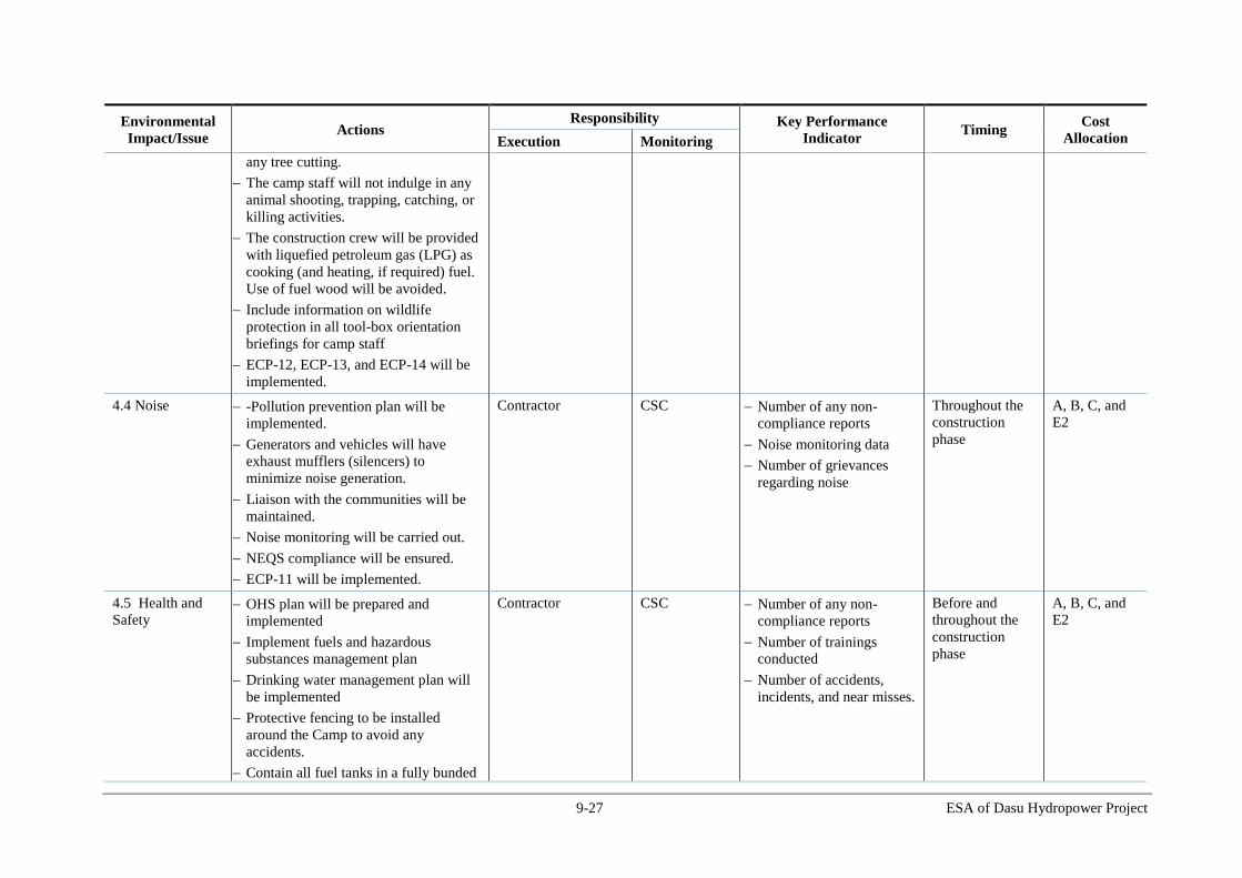
9-27 ESA of Dasu Hydropower Project
Environmental
Impact/Issue Actions
Responsibility Key Performance
Indicator Timing
Cost
Allocation Execution Monitoring
any tree cutting.
The camp staff will not indulge in any
animal shooting, trapping, catching, or
killing activities.
The construction crew will be provided
with liquefied petroleum gas (LPG) as
cooking (and heating, if required) fuel.
Use of fuel wood will be avoided.
Include information on wildlife
protection in all tool-box orientation
briefings for camp staff
ECP-12, ECP-13, and ECP-14 will be
implemented.
4.4 Noise -Pollution prevention plan will be
implemented.
Generators and vehicles will have
exhaust mufflers (silencers) to
minimize noise generation.
Liaison with the communities will be
maintained.
Noise monitoring will be carried out.
NEQS compliance will be ensured.
ECP-11 will be implemented.
Contractor CSC Number of any non-
compliance reports
Noise monitoring data
Number of grievances
regarding noise
Throughout the
construction
phase
A, B, C, and
E2
4.5 Health and
Safety OHS plan will be prepared and
implemented
Implement fuels and hazardous
substances management plan
Drinking water management plan will
be implemented
Protective fencing to be installed
around the Camp to avoid any
accidents.
Contain all fuel tanks in a fully bunded
Contractor CSC Number of any non-
compliance reports
Number of trainings
conducted
Number of accidents,
incidents, and near misses.
Before and
throughout the
construction
phase
A, B, C, and
E2
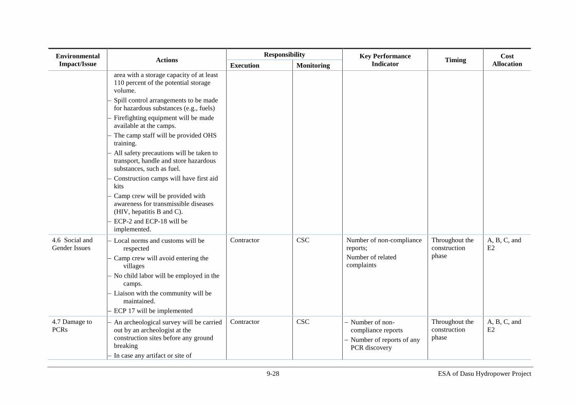
9-28 ESA of Dasu Hydropower Project
Environmental
Impact/Issue Actions
Responsibility Key Performance
Indicator Timing
Cost
Allocation Execution Monitoring
area with a storage capacity of at least
110 percent of the potential storage
volume.
Spill control arrangements to be made
for hazardous substances (e.g., fuels)
Firefighting equipment will be made
available at the camps.
The camp staff will be provided OHS
training.
All safety precautions will be taken to
transport, handle and store hazardous
substances, such as fuel.
Construction camps will have first aid
kits
Camp crew will be provided with
awareness for transmissible diseases
(HIV, hepatitis B and C).
ECP-2 and ECP-18 will be
implemented.
4.6 Social and
Gender Issues Local norms and customs will be
respected
Camp crew will avoid entering the
villages
No child labor will be employed in the
camps.
Liaison with the community will be
maintained.
ECP 17 will be implemented
Contractor CSC Number of non-compliance
reports;
Number of related
complaints
Throughout the
construction
phase
A, B, C, and
E2
4.7 Damage to
PCRs An archeological survey will be carried
out by an archeologist at the
construction sites before any ground
breaking
In case any artifact or site of
Contractor CSC Number of non-
compliance reports
Number of reports of any
PCR discovery
Throughout the
construction
phase
A, B, C, and
E2

9-29 ESA of Dasu Hydropower Project
Environmental
Impact/Issue Actions
Responsibility Key Performance
Indicator Timing
Cost
Allocation Execution Monitoring
archeological, cultural, historical, or
religious significance are discovered
during construction activities, the
works will be stopped, and the
Archeological Department will be
informed.
4.8 Increased
Load on Local
Services and
Supplies
- the contractors to procure their
supplies in a manner not significantly
affecting the availability of essential
commodities in the area for the
residents.
Grievance redress mechanism will be
established to address community
complaints and grievances.
Contractor CSC Number of related public
grievances
Construction
phase
A, B, C, and
E2
5. Activity: Transportation of Equipment and Construction Material
5.1 Traffic
management The approved TMP will be followed.
Establishment of traffic management
committee with the relevant
stakeholders (traffic agencies, local
governments along KKH, contractor).
Hold a one day workshop with the
stakeholders to devise a plan for traffic
management along KKH during
construction period.
A traffic unit at Dasu is proposed to
control the construction related traffic
inflow and outflow with sub offices
along KKH at Hassanabdal, Haripur,
Abbottabad, Chatter Plain, Thakot,
Besham, Pattan, Komila, dam site,
quarry site Kaigah. These offices will
be connected with telephone, fax,
mobile phone and internet.
The movement of traffic carrying
Contractor CSC Number of any non-
compliance reports
Number of complaints /
grievances.
Number of traffic
accidents/incidents
involving project vehicles
and lorries bringing
materials and supply to
project
Throughout the
construction
phase
A, B, C, and
E2

9-30 ESA of Dasu Hydropower Project
Environmental
Impact/Issue Actions
Responsibility Key Performance
Indicator Timing
Cost
Allocation Execution Monitoring
cement or steel to be register at
Hassanabdal (junction of KKH and GT
road). These will travel in small lots of
10 trucks. Hassanabdal sub-office will
inform the next stations by phone, fax
or internet.
The weather conditions must be known
before the start of the journey from Met
office and drivers must be briefed
before the start of the journey so that
cargo may be protected from rain
damage and driver may plan the
journey accordingly.
The receiving stores must be notified,
who must prepare for offloading the
goods. This preparation includes the
location of offloading, labor for
offloading together with crane or low
lift fork lifters.
Traffic facilities, such as speed limits
and signal lights, are to be strengthened
from Hassanabdal to Dasu
Support to be provided to the local
traffic authorities to engage traffic
police at the busy junctions
Implement the mitigation measures
proposed in ECP 15.
5.2 Soil Erosion
and
Contamination
-Pollution prevention plan will be
implemented.
Vehicular traffic on unpaved roads will
be avoided as far as possible.
Operation of vehicles and machinery
close to the water channels, water
reservoir will be minimized.
Vehicles and equipment will not be
Contractor CSC Number of any non-
compliance reports
Before and
during
construction
A, B, C, and
E2

9-31 ESA of Dasu Hydropower Project
Environmental
Impact/Issue Actions
Responsibility Key Performance
Indicator Timing
Cost
Allocation Execution Monitoring
repaired in the field. If unavoidable,
impervious sheathing will be used to
avoid soil and water contamination.
NEQS compliance will be ensured.
ECP 1, ECP 5, ECP 6, and ECP 7 will
be implemented.
5.3 Air Quality -Pollution prevention plan will be
implemented.
Construction machinery and vehicles
will be kept in good working condition
and properly tuned, in order to
minimize the exhaust emissions, and in
compliance with the NEQS.
Fugitive dust emissions will be
minimized by appropriate methods,
such as spraying water on soil, where
required and appropriate.
Project vehicles will avoid passing
through the communities as far as
possible. If unavoidable, speed will be
reduced to 15 km/h to avoid excessive
dust emissions.
Trucks and conveyor belts carrying
construction material and excavated
soil will be covered if required to avoid
air quality deterioration.
Air quality will be properly monitored,
especially near the population centers
and WAPDA colonies
ECP 10 for air quality management
will be implemented.
Contractor CSC Number of any non-
compliance reports
Air quality monitoring
data
Number of related
grievances
Before and
during
construction
A, B, C, and
E2
5.4 Noise -Pollution prevention plan will be
implemented.
Vehicles will have exhaust mufflers
Contractor CSC Number of any non-
compliance reports
Number of related public
Before and
during
construction
A, B, C, and
E2
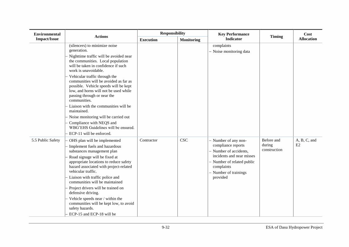
9-32 ESA of Dasu Hydropower Project
Environmental
Impact/Issue Actions
Responsibility Key Performance
Indicator Timing
Cost
Allocation Execution Monitoring
(silencers) to minimize noise
generation.
Nighttime traffic will be avoided near
the communities. Local population
will be taken in confidence if such
work is unavoidable.
Vehicular traffic through the
communities will be avoided as far as
possible. Vehicle speeds will be kept
low, and horns will not be used while
passing through or near the
communities.
Liaison with the communities will be
maintained.
Noise monitoring will be carried out
Compliance with NEQS and
WBG’EHS Guidelines will be ensured.
ECP-11 will be enforced.
complaints
Noise monitoring data
5.5 Public Safety OHS plan will be implemented
Implement fuels and hazardous
substances management plan
Road signage will be fixed at
appropriate locations to reduce safety
hazard associated with project-related
vehicular traffic.
Liaison with traffic police and
communities will be maintained
Project drivers will be trained on
defensive driving.
Vehicle speeds near / within the
communities will be kept low, to avoid
safety hazards.
ECP-15 and ECP-18 will be
Contractor CSC Number of any non-
compliance reports
Number of accidents,
incidents and near misses
Number of related public
complaints
Number of trainings
provided
Before and
during
construction
A, B, C, and
E2

9-33 ESA of Dasu Hydropower Project
Environmental
Impact/Issue Actions
Responsibility Key Performance
Indicator Timing
Cost
Allocation Execution Monitoring
implemented.
5.6 Damage to
Infrastructure
All damaged infrastructure will be
restored to original or better condition.
Contractors CSC Number of any non-
compliance reports
Before and
during
construction
A, B, and C
6. Activity: Construction of Dam, Powerhouse, and other related structures
6.1 Changes to
topography Changes to the topography will only
occur in designated areas to
accommodate defined project features.
Excavation of material will be kept to a
minimum.
Excavated material will be managed in
accordance with the Disposal Area
Management and Restoration Plan.
Preparation and implementation of
landscaping and plantation plan at
the key locations (project area between
dam and end of tailrace and for the
WAPDA Colony and Offices area)
Implement ECP 8.
Contractor CSC Volume of spoil extracted
(monitor against
predictions).
All excavated materials to
be disposed of in
designated sites.
Number of non-
compliances
observed/reported
Presence of landscaping
plan
Evidence of
implementation of the
above plan.
Throughout the
construction
phase
A, B, and E2
6.2 Landslide
Method Statements and Risk
Assessments prepared prior to any
excavation activity
Any blasting activities in these areas
will be controlled and contained within
defined limits.
Pro-active measures will be
implemented to stabilize and protect
slopes and to protect workers safety.
Early warning systems will be
introduced that will indicate when
cracks appear and allow any widening
to be monitored. Access would be
restricted during the periods that slope
stability is not yet entirely secured and
Contractor CSC Number of blasting
events.
Method Statements and
Risk Assessments
produced for construction
of each item of
infrastructure.
All excavated materials to
be disposed of in
designated sites.
Monitoring of early
warning systems.
Number of landslides
reported in the project
Throughout the
construction
phase
A, B, and E2

9-34 ESA of Dasu Hydropower Project
Environmental
Impact/Issue Actions
Responsibility Key Performance
Indicator Timing
Cost
Allocation Execution Monitoring
guaranteed by proper safety measures
such as rock bolts, anchors, safety nets
and gabion structures.
Permanent monitoring by the
contractor will be required.
Slope protection measures, such as
rock bolts, rock anchors, safety nets
and other protection measures will
have to be applied including proper
terracing to reduce the risk of slope
failures.
Stabilize landslide prone areas which
may be impacted by construction
activities or reservoir formation
Monitor stability of landslide prone
areas at identified locations during
construction and operational phases
During excavations the concerned
slopes will be stabilized and excavation
started exacted from the top then
gradually working down the slope.
After blasting a riser, it will be
stabilized by pre-designed support
systems such as shotcrete, mesh and
rock bolts prior to drilling the next riser
for excavation. Where there are
confinement issues, cushion blasting
will be the method applied. Extreme
care will be taken in designing the
blasting pattern and blasting will be
controlled so as to avoid disturbance of
nearby slopes where stability is in a
critical condition.
Emergency Preparedness Plan and
Early Warning System will set out
area

9-35 ESA of Dasu Hydropower Project
Environmental
Impact/Issue Actions
Responsibility Key Performance
Indicator Timing
Cost
Allocation Execution Monitoring
response actions in the event of a
landslide
Other methods to be considered as
alternatives to blasting
6.3 Soil erosion
Areas not used during operation will be
re-vegetated, particularly slopes
Borrow pits/areas to be restored to the
extent possible/ necessary
Areas exposed during construction and
not used for operation will be re-
vegetated (‘greened’) immediately
Adopt measures set out in the
Landscaping and Plantation Plan
Road edge buffers will be re-planted
Replanting to occur prior to the
commencement of operation, using
fast-growing native species; and
grasses to assist slope and soil stability.
ECP-6 will be implemented.
Contractor CSC Number of incidences of
borrow pits not being
covered.
Compliance with the
Landscaping and
Plantation Plan.
All replanting to be
commenced prior to
operation.
Throughout the
construction
phase and prior
to operation
A, B, and E2
6.4 Soil and water
contamination The contractor will prepare and
implement a Pollution Prevention Plan
prior to the start of the work. Proper
baseline data will be collected.
Construction materials will be stored,
used and handled appropriately.
Excavated material disposal method to
include measures to reduce risk of
environmental pollution.
Reduce risk of a pollution event
through adoption of measures set out in
Solid Waste Management Plan and
(Drinking Water ) and Sanitation Plan
Hazardous and toxic materials stored
Contractor CSC Monthly auditing of
management of hazardous
materials against Material
Safety Data Sheet
Soil and water quality
monitoring data
Number of any non
compliance
Number of related
complaints
Throughout the
construction
phase
A, B, and E2

9-36 ESA of Dasu Hydropower Project
Environmental
Impact/Issue Actions
Responsibility Key Performance
Indicator Timing
Cost
Allocation Execution Monitoring
separately
The contractor will identify suitable
sites for disposal of hazardous and non-
hazardous waste. The selection will be
done in consultation with the PMU and
the local municipal authorities.
Fuels and hazardous substances
management plan will be implemented
Design drainage for the batching plant
area to direct runoff into a sump/basin
for inspection for pollutants prior to
discharge
Design settling basins for the
discharges from tunnel construction
areas
Establish a laboratory at Dasu with all
necessary facilities at the site for
chemical analysis of water for key
parameters (dissolved oxygen,
turbidity, total suspended solids, total
dissolved solids, petroleum products);
along with potable conductivity, pH
and turbidity meters to assess pollution
from construction activities.
Any discharges to the river or streams
should have turbidity of less than 2
mg/l to meet the NEQS 2000
Regular waste water streams are to be
passed through settling basins.
Undertake pH monitoring of site runoff
to ensure alkaline runoff is not leaving
the site.
Construct a designated, signposted
concrete wash down bay that is fully
contained and bunded for all excess

9-37 ESA of Dasu Hydropower Project
Environmental
Impact/Issue Actions
Responsibility Key Performance
Indicator Timing
Cost
Allocation Execution Monitoring
concrete and concrete wash down, e.g.
plastic lined.
Regularly maintain the concrete
washout bay, treating any water prior
to release to natural systems.
NEQS compliance will be ensured.
ECP-1, ECP-2, ECP-4, ECP-5, and
ECP-7 will be implemented.
6.5 Risk of Water
Pollution from
Storage Tanks
The potential sources of pollution will
be identified and removed during the
construction period and prior to the first
filling of the reservoir.
Contractor CSC Documentary evidence of
removal of storage tanks
Number of non-
compliances
construction
phase
A, B, and E2
6.6 Air Quality
-Pollution prevention plan will be
implemented.
Air quality in the tunnels should be
maintained in accordance with
technical specifications
The quantity of fresh air pumping from
outside to inside the tunnel must be
boosted such that a wind velocity of 1
m/s is maintained as the minimum.
Construction materials will be stored in
designated areas away from sensitive
receptors and covered to minimize dust
on site from site construction works
Construction vehicles will be sprayed
with water when entering and leaving
the site, covered if transporting
materials, adhere to speed limits, and
engines will be turned off when idling.
Water spraying will be carried out to
suppress dust emissions where needed
Batching plants, asphalt plants, and
Contractor CSC Number of dust-related
complaints.
Number of air quality-
related complaints,
Air quality monitoring
data
Throughout
construction
phase
A, B, and E2

9-38 ESA of Dasu Hydropower Project
Environmental
Impact/Issue Actions
Responsibility Key Performance
Indicator Timing
Cost
Allocation Execution Monitoring
crushers will have appropriate dust and
emission abatement systems (e.g., wet
scrubber) as appropriate.
Target zero dust related complaints
Target zero air quality related
complaints.
NEQS compliance will be ensured.
Monitoring of ambient air quality near
settlements and colonies. Appropriate
actions to be undertaken in case
ambient air quality deteriorates beyond
NEQS limits.
ECP-10 will be implemented.
6.7 Health and
Safety Compliance with Occupational Health
& Safety standards and OHS Plan
Implement fuels and hazardous
substances management plan
Use of personal protective equipment
(PPE)
Construction sites to be cordoned off to
stop unauthorized access
Develop controls and standard
operating procedures for the use of
fuels and other hazardous substances to
prevent spills, accidents, and pilferage
Handle explosives strictly according to
the protocols
Train and designate personnel for
various OHS aspects such as spill
control procedures, fire fighting
Establish fire fighting system and fire
safety (fire extinguishers) at the
construction sites where fire is an
Contractor CSC Number of respiratory
protective devices and
other PPEs issues to
workers.
Monitoring of compliance
with Health & Safety
standards (including
monthly reporting of
accidents).
Number of accidents,
incidents and near misses.
Number of trainings
provided.
Throughout
construction
phase
A, B, and E2

9-39 ESA of Dasu Hydropower Project
Environmental
Impact/Issue Actions
Responsibility Key Performance
Indicator Timing
Cost
Allocation Execution Monitoring
hazard
Spill kits and trained personnel are to
be made available at the workshops.
Contain all fuel tanks in a fully bunded
area with a storage capacity of at least
110 percent of the potential storage
volume.
Use auto shut down valves for fuel
transfer pipes
Transport of hazardous goods and fuel
to be done in closed containers and ISO
certified tanks
Provision of respiratory protective
devices for workers where needed
Designate agreed routes for traffic (set
out in the Traffic Management Plan)
Provision of insurance-backed
compensation scheme for major injury
or loss of life reflecting settlement
sums that are consistent with
national/international benchmarks.
Contractor to engage a doctor at the
site/camp
Construction sites to have first aid
boxes
Site to have ambulance to transfer
injured/sick workers to nearest hospital
WBG’s EHS Guidelines to be
implemented
Regular OHS trainings to be provided
to workers
ECP 2 and ECP-18 will be
implemented.

9-40 ESA of Dasu Hydropower Project
Environmental
Impact/Issue Actions
Responsibility Key Performance
Indicator Timing
Cost
Allocation Execution Monitoring
6.8 Noise and
Vibration
-Pollution prevention plan will be
implemented.
Perform test blasting with various
charges and monitor resultant noise
and vibration levels at various
distances and to define the sensitive
areas that will be affected during the
future blasting activities
Blasting activity will be restricted to
fixed times;
Communities will be informed in
advance of planned blasting;
Construction plant producing sound in
excess of 85dB will be fitted with
mufflers;
Noise barriers will be provided in areas
where significant noise is expected
(e.g. during blasting).
Noise monitoring will be conducted
NEQS compliance will be ensured.
ECP-11 will be implemented.
Contractor CSC Number of blasting events
recorded.
Evidence of providing
advance warning of
blasting to communities.
Record of equipment used
on site capable of
producing over 85dB and
whether equipment has
been fitted with mufflers
Number of related
community complaints
Noise monitoring data
Number of non-
compliances
Throughout
construction
phase
A, B, and E2
6.9 Landscape and
Visual Intrusion Implementation of the Landscape and
Plantation Plan
New planting and landscape restoration
as soon as practicable at the end of
construction phase
Replanting of flora/vegetation
alongside new access roads
Enhance flora environment by planting
fruit trees and ornamental shrubs.
ECP 8 to be implemented
Contractor CSC Compliance with
Landscaping and Plantation
Plan
Before the
completion of the
construction
phase
A, B, and E2

9-41 ESA of Dasu Hydropower Project
Environmental
Impact/Issue Actions
Responsibility Key Performance
Indicator Timing
Cost
Allocation Execution Monitoring
6.10 Vegetation
loss
A nursery will be established with the
native species with a capacity to
produce about 300,000 saplings with an
objective to develop 100,000 trees (5
saplings for each proposed tree).
At higher altitudes (> 1500 m) a
number of forest plantations will
established where forest could be
rejuvenated. This will be done at
selected places on both sides (left and
right bank) of the reservoir.
Communities can play an important
role in planting and managing these
plantations. There is experience with
this type of social forestry elsewhere in
the region (a.o Swat Kohistan).
Plantation to be developed in the buffer
areas (at suitable sites) of the reservoir
on the right bank, in DHPs office and
colony, and at the resettlement with a
target to develop about 5 trees for each
tree cut.
Maintain each sapling for a period of
minimum 2 years with the support of
local community. Community will be
paid for watering and raising the
plantation.
A public education program should be
designed and implemented to
discourage cutting of trees by the
construction workers
The Project will support the local
government to establish a market for
the supply of non-wood fuels such as
LPG for cooking and heating to reduce
Contractor CSC Number of trees felled
Number of saplings
planted
Survival rate of saplings
after one year
Throughout
construction
phase
A, B, and E2
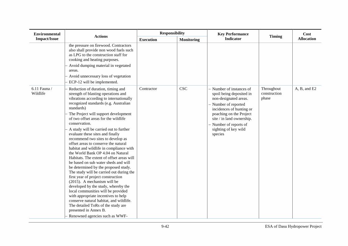
9-42 ESA of Dasu Hydropower Project
Environmental
Impact/Issue Actions
Responsibility Key Performance
Indicator Timing
Cost
Allocation Execution Monitoring
the pressure on firewood. Contractors
also shall provide non wood fuels such
as LPG to the construction staff for
cooking and heating purposes.
Avoid dumping material in vegetated
areas.
Avoid unnecessary loss of vegetation
ECP-12 will be implemented.
6.11 Fauna /
Wildlife Reduction of duration, timing and
strength of blasting operations and
vibrations according to internationally
recognized standards (e.g. Australian
standards)
The Project will support development
of two offset areas for the wildlife
conservation.
A study will be carried out to further
evaluate these sites and finally
recommend two sites to develop as
offset areas to conserve the natural
habitat and wildlife in compliance with
the World Bank OP 4.04 on Natural
Habitats. The extent of offset areas will
be based on sub water sheds and will
be determined by the proposed study.
The study will be carried out during the
first year of project construction
(2015). A mechanism will be
developed by the study, whereby the
local communities will be provided
with appropriate incentives to help
conserve natural habitat, and wildlife.
The detailed ToRs of the study are
presented in Annex B.
Renowned agencies such as WWF-
Contractor CSC Number of instances of
spoil being deposited in
non-designated areas.
Number of reported
incidences of hunting or
poaching on the Project
site / in land ownership.
Number of reports of
sighting of key wild
species
Throughout
construction
phase
A, B, and E2

9-43 ESA of Dasu Hydropower Project
Environmental
Impact/Issue Actions
Responsibility Key Performance
Indicator Timing
Cost
Allocation Execution Monitoring
Pakistan or IUCN Pakistan will be
involved by the project to implement
the above ecological conservation
activities. These conservation areas
will be further complemented by
ecotourism initiatives, an information
centre, and research.
In addition to development of above
offset areas, the Project will also
support the community of the Kaigah
game reserve to strengthen the
management of conservation measures
in the game reserve.
The community will be consulted and
involved in the selection of alternative
options to strengthen ecological
conservation measures
To compensate for the loss of natural
habitat, the Project will support
afforestation and forest rejuvenation
programs in the higher altitudes for the
conservation and sustainable
development of forest ecosystems in
compliance with World Bank Policy
OP 4.36 on Forests.
This will be done at selected places in
consultation with local communities
and relevant departments on both sides
(left and right bank) of the reservoir.
Communities can play an important
role in planning and undertaking these
activities. There is experience with this
type of social forestry elsewhere in the
region (a.o Swat Kohistan).
The project will also support

9-44 ESA of Dasu Hydropower Project
Environmental
Impact/Issue Actions
Responsibility Key Performance
Indicator Timing
Cost
Allocation Execution Monitoring
development of natural habitat and
natural vegetation in the proposed
ecological conservation areas and
reservoir buffer areas
The study proposed for habitat
conservation and offset development
mentioned earlier will also include
forestry assessment survey in Kohistan
and development of action plans for
forest restoration activities that
maintain or enhance biodiversity and
ecosystem functionality. The ToRs of
the study are given in Annex B.
Establish vantage stations to monitor
the presence and movement of
Tragopan and migratory birds,
breeding birds, small mammals,
ungulates and otters.
Include information on wildlife
protection in all construction related
tool-box orientation briefings for new
construction staff
A public education program will be
designed and implemented to
discourage poaching of wildlife
Avoid positioning spoil in areas used
by fauna
No hunting or poaching
Provide corridors for animal
movement.
ECP-13 and ECP 14will be
implemented.
6.12 Mortality of
Fish
Inlets will be screened or fitted with
acoustic fish repellents to prevent inflow
Contractor CSC Number of any non-
compliance reports
construction
phase
A, B, and E2

9-45 ESA of Dasu Hydropower Project
Environmental
Impact/Issue Actions
Responsibility Key Performance
Indicator Timing
Cost
Allocation Execution Monitoring
of unwanted materials; the screening
will have to be fine enough to prevent
fish passage.
6.13 Impact on
Ecological
Connectivity and
Migration of Fish
Studies will be commissioned on fish
resources in the area, their migration,
and their food/economic value
Fisheries development and
management plan will be prepared and
implemented for the Dasu reservoir.
WAPDA will develop fish hatchery
through which tributaries and reservoir
will be restocked
Maintenance of spawning areas and
developing of new spawning areas in
the tributaries near the reservoir
confluence areas
WAPDA WEC Presence of study report
and management plan
Evidence of
implementation of
management plans
construction
phase
E2
6.14 Damage to
infrastructure
Any damaged infrastructure such as
roads, bridges and culverts will be
repaired
Contractor CSC Number of any non-
compliance reports
construction
phase
A and B
6.15 Damage to
PCRs An archeological survey will be carried
out by an archeologist at the
construction sites before any ground
breaking.
The mosque at Seer Gayal will be
disassembled and reassembled at a new
location.
The graves will be protected by stone-
pitching so that no floating and
washing away of the bodies or skeletal
remains occur.
In case any artifact or site of
archeological, cultural, historical, or
religious significance are discovered
during construction activities, the
Contractor CSC Number of any non-
compliance reports
Number of reports of any
new PCR
discovered/reported
construction
phase
A, B, and E2

9-46 ESA of Dasu Hydropower Project
Environmental
Impact/Issue Actions
Responsibility Key Performance
Indicator Timing
Cost
Allocation Execution Monitoring
works will be stopped, and the
Archeological Department will be
informed.
DHP will support KP Archaeological
Department to (i) procure 25 acres of
land for acquisition of land, in which
rock carvings are located, (ii) fence the
area, (iii) provide fiberglass sheds; (iv)
develop tourist facilities and (v)
documenting the importance of rock
carvings and their translations.
DHP will commission an archeological
study before commencing the
construction activities to survey the
project area to identify any PCRs (CSC
will prepare the ToRs).
WAPDA WEC Evidence of
commencement of works
Report of the
archeological survey
construction
phase
E2
6.16 Loss of
Access to Villages A new suspension bridge near Kandia
will be constructed
A total of 35 km of new access roads
will be built, all at a higher level of the
right bank of the Indus.
A new jeepable track of 18 km will
provide access to the villages in Kandia
valley.
All new settlement sites will be
provided with good access roads.
Other existing facilities for pedestrians
to cross the river, such as foot bridges
and cable cars will be replaced by
appropriate alternatives. Different
options for pedestrians for crossing the
73 km long reservoir will be considered
since these connections are important
assets and a lifeline for the remote
communities at the right bank with the
Contractor CSC Presence of new bridges
and access paths
Number of related
community complaints
construction
phase
A, B, and C

9-47 ESA of Dasu Hydropower Project
Environmental
Impact/Issue Actions
Responsibility Key Performance
Indicator Timing
Cost
Allocation Execution Monitoring
rest of the world.
6.17 Disturbance
of Visual
Landscape and
Natural Habitats
Proper landscaping will be done and an
overall Landscape and Plantation Plan
will be implemented in the area where
the project infrastructure is located.
Landscape and plantation plans for the
residential areas and the offices will be
implemented to create a good living
and working environment.
Tree planting will be well organized
and where possible vegetation and
natural habitats will have to be restored
or newly created.
For the disposal and borrow areas a
restoration plans will be implemented
to restore original landscape and
vegetation.
Contractor CSC Number of any non-
compliance reports
construction
phase
A, B, and E2
6.18 Social
conflict due to the
Influx of Workers
and In-migrants
Implementation of the In-Migration
Management Plan. In accordance with
this Plan procedures and rules will be
worked out by the PMU in close
cooperation with the contractors and
local authorities.
PMU WEC Number of public
grievances relating to in-
migrants
Construction
phase
E1
6.19 Respect of
Local Cultural
Norms and Values
by Work Force
Implementation of awareness campaign
The contractors would be aware of the
possibility and risks of
miscommunications between local
residents and workers, a situation
which easily could lead to social
unrest. This would be prevented by
raising awareness and implementation
of a Code of Conduct for the workers.
Complaints from the local community
will be addressed by the Grievance
PMU and contractor CSC Number of related public
grievances
Construction
phase
A, B, and E2

9-48 ESA of Dasu Hydropower Project
Environmental
Impact/Issue Actions
Responsibility Key Performance
Indicator Timing
Cost
Allocation Execution Monitoring
Mechanism that will be developed.
6.20 Adverse
Effects on Health
Situation
The Public Health Action Plan will be
implemented.
Raising awareness of the associated
risks for the local population.
The awareness campaign will also be
aimed at the risk of interaction between
the resident population and the
construction work force, including the
spreading of sexually transmitted
diseases such as HIV/AIDS.
The medical health facilities in the
project area will be facilitated to deal
with such incidences.
PMU and contractor CSC Number of patients being
treated in the local hospitals
Construction
phase
A, B, and E1
6.21 Increased
Load on Local
Services and
Supplies
The contractors to procure their
supplies in a manner not significantly
affecting the availability of essential
commodities in the area for the
residents.
Grievance redress mechanism will be
established to address community
complaints and grievances.
Contractor CSC Number of related public
grievances
Construction
phase
A, B, and E2
7. Activity: KKH Construction and other related structures
7.1 Changes to
topography Changes to the topography will only
occur in designated areas to
accommodate defined project features.
Excavation of material will be kept to a
minimum.
Excavated material will be managed in
accordance with the Disposal Area
Management and Restoration Plan.
Preparation and implementation of
Contractor CSC Volume of spoil extracted
(monitor against
predictions).
All excavated materials to
be disposed of in
designated sites.
Number of non-
compliances
observed/reported
Throughout the
construction
phase
C and E2

9-49 ESA of Dasu Hydropower Project
Environmental
Impact/Issue Actions
Responsibility Key Performance
Indicator Timing
Cost
Allocation Execution Monitoring
landscaping and plantation plan at the
key locations (project area between
dam and end of tailrace and for the
WAPDA Colony and Offices area)
Implement ECP 8.
7.2 Landslides
Method Statements and Risk
Assessments prepared prior to any
excavation activity
Any blasting activities in these areas
will be controlled and contained within
defined limits.
Measures will be taken to ensure that
the landslides do not affect the existing
KKH and its traffic. Road clearing
machinery will be deployed along the
KKH where necessary. Warning signs
will also be placed along the existing
KKH.
Pro-active measures will be
implemented to stabilize and protect
slopes and to protect workers safety.
Early warning systems will be
introduced that will indicate when
cracks appear and allow any widening
to be monitored. Access would be
restricted during the periods that slope
stability is not yet entirely secured and
guaranteed by proper safety measures
such as rock bolts, anchors, safety nets
and gabion structures.
Permanent monitoring by the
contractor will be required.
Slope protection measures, such as
rock bolts, rock anchors, safety nets
and other protection measures will
Contractor CSC Number of blasting
events.
Method Statements and
Risk Assessments
produced for construction
of each item of
infrastructure.
All excavated materials to
be disposed of in
designated sites.
Monitoring of early
warning systems.
Number of Landslides
affecting traffic on
existing KKH
Throughout the
construction
phase
C and E2

9-50 ESA of Dasu Hydropower Project
Environmental
Impact/Issue Actions
Responsibility Key Performance
Indicator Timing
Cost
Allocation Execution Monitoring
have to be applied including proper
terracing to reduce the risk of slope
failures.
Stabilize landslide prone areas which
may be impacted by construction
activities or reservoir formation
Monitor stability of landslide prone
areas at identified locations during
construction and operational phases
During excavations the concerned
slopes will be stabilized and excavation
started exacted from the top then
gradually working down the slope.
After blasting a riser, it will be
stabilized by pre-designed support
systems such as shotcrete, mesh and
rock bolts prior to drilling the next riser
for excavation. Where there are
confinement issues, cushion blasting
will be the method applied. Extreme
care will be taken in designing the
blasting pattern and blasting will be
controlled so as to avoid disturbance of
nearby slopes where stability is in a
critical condition.
Emergency Preparedness Plan and
Early Warning System will set out
response actions in the event of a
landslide
Other methods to be considered as
alternatives to blasting
ECP 6 will be implemented

9-51 ESA of Dasu Hydropower Project
Environmental
Impact/Issue Actions
Responsibility Key Performance
Indicator Timing
Cost
Allocation Execution Monitoring
7.3 Soil erosion
Areas not used during operation will be
re-vegetated, particularly slopes
Borrow pits/areas to be restored to the
extent possible/ necessary
Areas exposed during construction and
not used for operation will be re-
vegetated (‘greened’) immediately
Adopt measures set out in the
Landscaping and Plantation Plan
Road edge buffers will be re-planted
Replanting to occur prior to the
commencement of operation, using
fast-growing native species; and
grasses to assist slope and soil stability.
ECP-6 will be implemented.
Contractor CSC Number of incidences of
borrow pits not being
covered.
Compliance with the
Landscaping and Plantation
Plan.
All replanting to be
commenced prior to
operation.
Throughout the
construction
phase and prior
to operation
C and E2
7.4 Soil and water
contamination The contractor will prepare and
implement a Pollution Prevention Plan
prior to the start of the work. Proper
baseline data will be collected.
Construction materials will be stored,
used and handled appropriately.
Excavated material disposal methods to
include measures to reduce risk of
environmental pollution.
Reduce risk of a pollution event
through adoption of measures set out in
Solid Waste Management Plan and
(Drinking Water ) and Sanitation Plan
Hazardous and toxic materials stored
separately
The contractor will identify suitable
sites for disposal of hazardous and non-
hazardous waste. The selection will be
Contractor CSC Monthly auditing of
management of hazardous
materials against Material
Safety Data Sheet
Soil and water quality
monitoring data
Number of reports if any
non compliance
Number of related
complaints
Throughout the
construction
phase
C and E2

9-52 ESA of Dasu Hydropower Project
Environmental
Impact/Issue Actions
Responsibility Key Performance
Indicator Timing
Cost
Allocation Execution Monitoring
done in consultation with the PMU and
the local municipal authorities.
Fuels and hazardous substances
management plan will be implemented.
Design drainage for the batching plant
area to direct runoff into a sump/basin
for inspection for pollutants prior to
discharge
Design settling basins for the
discharges from tunnel construction
areas
Any discharges to the river or streams
should have turbidity of less than 2
mg/l to meet the NEQS 2000
Regular waste water streams are to be
passed through settling basins.
Undertake pH monitoring of site runoff
to ensure alkaline runoff is not leaving
the site.
Construct a designated, signposted
concrete wash down bay that is fully
contained and bunded for all excess
concrete and concrete wash down, e.g.
plastic lined.
Regularly maintain the concrete
washout bay, treating any water prior
to release to natural systems.
NEQS compliance will be ensured.
ECP-1, ECP-2, ECP-4, ECP-5, and
ECP-7 will be implemented.

9-53 ESA of Dasu Hydropower Project
Environmental
Impact/Issue Actions
Responsibility Key Performance
Indicator Timing
Cost
Allocation Execution Monitoring
7.5 Air Quality
-Pollution prevention plan will be
implemented.
Construction materials will be stored in
designated areas away from sensitive
receptors and covered to minimize dust
on site from site construction works
Construction vehicles will be sprayed
with water when entering and leaving
the site, covered if transporting
materials, adhere to speed limits, and
engines will be turned off when idling.
Water spraying will be carried out to
suppress dust emissions where needed
Batching plants, asphalt plants, and
crushers will have appropriate dust and
emission abatement systems (e.g., wet
scrubber) as appropriate.
Target zero dust related complaints
Target zero air quality related
complaints.
NEQS compliance will be ensured.
Monitoring of ambient air quality near
settlements and colonies. Appropriate
actions to be undertaken in case
ambient air quality deteriorates beyond
NEQS limits.
ECP-10 will be implemented.
Contractor CSC Number of dust-related
complaints.
Number of air quality-
related complaints,
Compliance with Traffic
Management Plan.
Air quality monitoring
data
Throughout
construction
phase
C and E2
7.6 Health and
Safety Compliance with Occupational Health
& Safety standards and OHS Plan
Implement fuels and hazardous
substances management plan
Use of personal protective equipment
(PPE)
Contractor CSC Number of respiratory
protective devices and
other PPEs issues to
workers.
Monitoring of compliance
with Health & Safety
standards (including
Throughout
construction
phase
C and E2

9-54 ESA of Dasu Hydropower Project
Environmental
Impact/Issue Actions
Responsibility Key Performance
Indicator Timing
Cost
Allocation Execution Monitoring
Construction sites to be cordoned off to
stop unauthorized access
Develop controls and standard
operating procedures for the use of
fuels and other hazardous substances to
prevent spills, accidents, and pilferage
Handle explosives strictly according to
the protocols
Train and designate personnel for
various OHS aspects such as spill
control procedures, fire fighting
Establish fire fighting system and fire
safety (fire extinguishers) at the
construction sites where fire is an
hazard
Spill kits and trained personnel are to
be made available at the workshops.
Contain all fuel tanks in a fully bunded
area with a storage capacity of at least
110 percent of the potential storage
volume.
Use auto shut down valves for fuel
transfer pipes
Transport of hazardous goods and fuel
to be done in closed containers and ISO
certified tanks
Provision of respiratory protective
devices for workers where needed
Designate agreed routes for traffic (set
out in the Traffic Management Plan)
Provision of insurance-backed
compensation scheme for major injury
or loss of life reflecting settlement
sums that are consistent with
monthly reporting of
accidents).
Number of accidents,
incidents and near misses.
Number of trainings
provided.

9-55 ESA of Dasu Hydropower Project
Environmental
Impact/Issue Actions
Responsibility Key Performance
Indicator Timing
Cost
Allocation Execution Monitoring
national/international benchmarks.
Contractor to engage a doctor at the
site/camp
Construction sites to have first aid
boxes
Site to have ambulance to transfer
injured/sick workers to nearest hospital
WBG’s EHS Guidelines to be
implemented
ECP 2 and ECP-18 will be
implemented.
7.7 Noise and
Vibration
-Pollution prevention plan will be
implemented.
Perform test blasting with various
charges and monitor resultant noise
and vibration levels at various
distances and to define the sensitive
areas that will be affected during the
future blasting activities
Blasting activity will be restricted to
fixed times;
Communities will be informed in
advance of planned blasting;
Construction plant producing sound in
excess of 85dB will be fitted with
mufflers;
Noise barriers will be provided in areas
where significant noise is expected
(e.g. during blasting).
NEQS compliance will be ensured.
ECP-11 will be implemented.
Contractor CSC Number of blasting events
recorded.
Evidence of providing
advance warning of
blasting to communities.
Record of equipment used
on site capable of
producing over 85dB and
whether equipment has
been fitted with mufflers
Number of related
community complaints
Noise monitoring data
Number of non
compliances
Throughout
construction
phase
C and E2
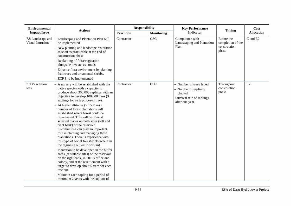
9-56 ESA of Dasu Hydropower Project
Environmental
Impact/Issue Actions
Responsibility Key Performance
Indicator Timing
Cost
Allocation Execution Monitoring
7.8 Landscape and
Visual Intrusion Landscaping and Plantation Plan will
be implemented
New planting and landscape restoration
as soon as practicable at the end of
construction phase
Replanting of flora/vegetation
alongside new access roads
Enhance flora environment by planting
fruit trees and ornamental shrubs.
ECP 8 to be implemented
Contractor CSC Compliance with
Landscaping and Plantation
Plan
Before the
completion of the
construction
phase
C and E2
7.9 Vegetation
loss
A nursery will be established with the
native species with a capacity to
produce about 300,000 saplings with an
objective to develop 100,000 trees (3
saplings for each proposed tree).
At higher altitudes (> 1500 m) a
number of forest plantations will
established where forest could be
rejuvenated. This will be done at
selected places on both sides (left and
right bank) of the reservoir.
Communities can play an important
role in planting and managing these
plantations. There is experience with
this type of social forestry elsewhere in
the region (a.o Swat Kohistan).
Plantation to be developed in the buffer
areas (at suitable sites) of the reservoir
on the right bank, in DHPs office and
colony, and at the resettlement with a
target to develop about 5 trees for each
tree cut.
Maintain each sapling for a period of
minimum 2 years with the support of
Contractor CSC Number of trees felled
Number of saplings
planted
Survival rate of saplings
after one year
Throughout
construction
phase
E2

9-57 ESA of Dasu Hydropower Project
Environmental
Impact/Issue Actions
Responsibility Key Performance
Indicator Timing
Cost
Allocation Execution Monitoring
local community. Community will be
paid for watering and raising the
plantation.
A public education program should be
designed and implemented to
discourage cutting of trees by the
construction workers
The Project will support the local
government to establish a market for
the supply of non-wood fuels such as
LPG for cooking and heating to reduce
the pressure on firewood. Contractors
also shall promote the usage of non
wood fuels such as LPG to the
construction staff for cooking and
heating purposes.
Avoid dumping material in vegetated
areas.
Avoid unnecessary loss of vegetation
ECP-12 will be implemented.
7.10 Fauna /
Wildlife Monitor wildlife in the reserve in
cooperation with wildlife and forest
officials;
Reduction of duration, timing and
strength of blasting operations and
vibrations according to internationally
recognized standards (e.g. Australian
standards);
Control of access to the project area for
workers and public in cooperation with
the community;
Awareness raising of workers,
employees and general public;
Kaigah community will be
Contractor CSC Number of instances of
spoil being deposited in
non-designated areas.
Number of reported
incidences of hunting or
poaching on the Project
site / in land ownership.
Number of reports of
sighting of key wild
species
Throughout
construction
phase
C and E2
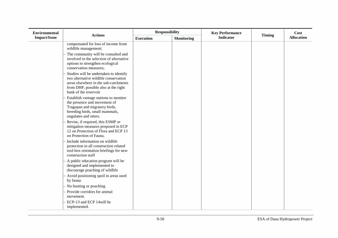
9-58 ESA of Dasu Hydropower Project
Environmental
Impact/Issue Actions
Responsibility Key Performance
Indicator Timing
Cost
Allocation Execution Monitoring
compensated for loss of income from
wildlife management;
The community will be consulted and
involved in the selection of alternative
options to strengthen ecological
conservation measures;
Studies will be undertaken to identify
two alternative wildlife conservation
areas elsewhere in the sub-catchments
from DHP, possible also at the right
bank of the reservoir
Establish vantage stations to monitor
the presence and movement of
Tragopan and migratory birds,
breeding birds, small mammals,
ungulates and otters.
Revise, if required, this ESMP or
mitigation measures proposed in ECP
12 on Protection of Flora and ECP 13
on Protection of Fauna.
Include information on wildlife
protection in all construction related
tool-box orientation briefings for new
construction staff
A public education program will be
designed and implemented to
discourage poaching of wildlife
Avoid positioning spoil in areas used
by fauna
No hunting or poaching
Provide corridors for animal
movement.
ECP-13 and ECP 14will be
implemented.

9-59 ESA of Dasu Hydropower Project
Environmental
Impact/Issue Actions
Responsibility Key Performance
Indicator Timing
Cost
Allocation Execution Monitoring
7.11 Mortality of
Fish
No untreated effluents will be released
in water bodies. Care will be observed
to minimize sliding of soil and spoil in
water bodies.
Contractor CSC Number of any non-
compliance reports
construction
phase
C and E2
7.12 Damage to
infrastructure
Any damaged infrastructure such as
roads, bridges and culverts will be
repaired
Contractor CSC Number of any non-
compliance reports
construction
phase
C and E2
7.13 Damage to
PCRs Archeological survey will be carried
out by an archeologist at the
construction sites before ground
breaking
DHP will support KP Archaeological
Department to (i) procure 25 acres of
land for acquisition of land, in which
rock carvings are located, (ii) fence the
area, (iii) provide fiberglass sheds; (iv)
develop tourist facilities and (v)
documenting the importance of rock
carvings and their translations.
In case any artifact or site of
archeological, cultural, historical, or
religious significance are discovered
during construction activities, the
works will be stopped, and the
Archeological Department will be
informed.
Contractor CSC Number of any non-
compliance reports
Number of reports of any
new PCR
discovered/reported
construction
phase
E2
7.14 Disturbance
of Visual
Landscape and
Natural Habitats
Proper landscaping will be done and an
overall Landscape and Plantation Plan
will be implemented that will be
worked out in more detail for the area
where the project infrastructure is
located.
Tree planting will be well organized
and where possible vegetation and
Contractor CSC Number of any non-
compliance reports
construction
phase
C and E2

9-60 ESA of Dasu Hydropower Project
Environmental
Impact/Issue Actions
Responsibility Key Performance
Indicator Timing
Cost
Allocation Execution Monitoring
natural habitats will have to be restored
or newly created.
For the disposal and borrow areas
restoration plans will be prepared to
restore original landscape and
vegetation.
7.15 Social
conflict due to the
Influx of Workers
and In-migrants
Implementation of the In-Migration
Management Plan. In accordance with
this Plan procedures and rules will be
worked out by the PMU in close
cooperation with the contractors and
local authorities.
PMU WEC Number of public
grievances relating to in-
migrants
Construction
phase
E1
7.16 Respect of
Local Cultural
Norms and Values
by Work Force
Implementation of awareness campaign
The contractors would be aware of the
possibility and risks of
miscommunications between local
residents and workers, a situation
which easily could lead to social
unrest. This would be prevented by
raising awareness and implementation
of a Code of Conduct for the workers.
Complaints from the local community
will be addressed by the Grievance
Mechanism that will be developed.
PMU and contractor CSC Number of related public
grievances
Construction
phase
C and E2
7.17 Adverse
Effects on Health
Situation
The Public Health Action Plan will be
implemented
Raising awareness of the associated
risks for the local population.
The awareness campaign will also be
aimed at the risk of interaction between
the resident population and the
construction work force, including the
spreading of sexually transmitted
diseases such as HIV/AIDS.
PMU and contractor CSC Number of patients being
treated in the local hospitals
Construction
phase
C and E1
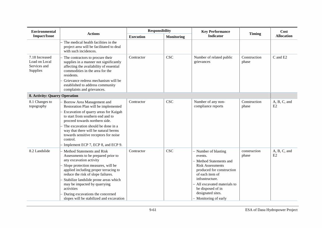
9-61 ESA of Dasu Hydropower Project
Environmental
Impact/Issue Actions
Responsibility Key Performance
Indicator Timing
Cost
Allocation Execution Monitoring
The medical health facilities in the
project area will be facilitated to deal
with such incidences.
7.18 Increased
Load on Local
Services and
Supplies
The contractors to procure their
supplies in a manner not significantly
affecting the availability of essential
commodities in the area for the
residents.
Grievance redress mechanism will be
established to address community
complaints and grievances.
Contractor CSC Number of related public
grievances
Construction
phase
C and E2
8. Activity: Quarry Operation
8.1 Changes to
topography Borrow Area Management and
Restoration Plan will be implemented
Excavation of quarry areas for Kaigah
to start from southern end and to
proceed towards northern side.
The excavation should be done in a
way that there will be natural berms
towards sensitive receptors for noise
control.
Implement ECP 7, ECP 8, and ECP 9.
Contractor CSC Number of any non-
compliance reports
Construction
phase
A, B, C, and
E2
8.2 Landslide
Method Statements and Risk
Assessments to be prepared prior to
any excavation activity
Slope protection measures, will be
applied including proper terracing to
reduce the risk of slope failures.
Stabilize landslide prone areas which
may be impacted by quarrying
activities
During excavations the concerned
slopes will be stabilized and excavation
Contractor CSC Number of blasting
events.
Method Statements and
Risk Assessments
produced for construction
of each item of
infrastructure.
All excavated materials to
be disposed of in
designated sites.
Monitoring of early
construction
phase
A, B, C, and
E2

9-62 ESA of Dasu Hydropower Project
Environmental
Impact/Issue Actions
Responsibility Key Performance
Indicator Timing
Cost
Allocation Execution Monitoring
started exacted from the top then
gradually working down the slope.
After blasting a riser, it will be
stabilized by pre-designed support
systems such as shotcrete, mesh and
rock bolts prior to drilling the next riser
for excavation. Where there are
confinement issues, cushion blasting
will be the method applied. Extreme
care will be taken in designing the
blasting pattern and blasting will be
controlled so as to avoid disturbance of
nearby slopes where stability is in a
critical condition.
Emergency Preparedness Plan and
Early Warning System will set out
response actions in the event of a
landslide
ECP 6 will be implemented
warning systems.
Number of landslides
reported
8.3 Soil erosion
Borrow pits/areas to be restored to the
extent possible/ necessary
Road edge buffers will be re-planted
Replanting to be carried out after
completing the quarrying, using fast-
growing native species; and grasses to
assist slope and soil stability.
ECP-6 will be implemented.
Contractor CSC Number of any non-
compliance reports
construction
phase
A, B, C, and
E2
8.4 Soil and water
contamination Pollution prevention plan and waste
disposal plan will be implemented.
Any discharges to the river or streams
should have turbidity of less than 2
mg/l to meet the NEQS 2000
Regular waste water streams are to be
passed through settling basins.
Contractor CSC Monthly auditing of
management of hazardous
materials against Material
Safety Data Sheet
Soil and water quality
monitoring data
Number of reports if any
construction
phase
A, B, C, and
E2
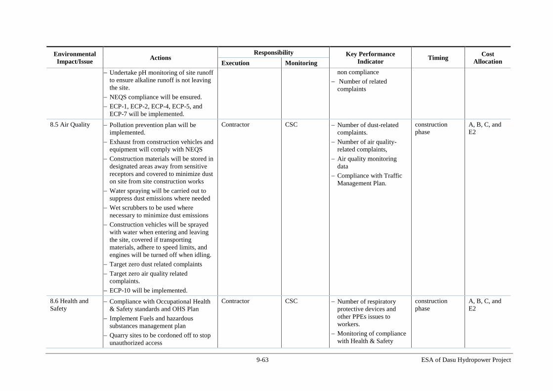
9-63 ESA of Dasu Hydropower Project
Environmental
Impact/Issue Actions
Responsibility Key Performance
Indicator Timing
Cost
Allocation Execution Monitoring
Undertake pH monitoring of site runoff
to ensure alkaline runoff is not leaving
the site.
NEQS compliance will be ensured.
ECP-1, ECP-2, ECP-4, ECP-5, and
ECP-7 will be implemented.
non compliance
Number of related
complaints
8.5 Air Quality
Pollution prevention plan will be
implemented.
Exhaust from construction vehicles and
equipment will comply with NEQS
Construction materials will be stored in
designated areas away from sensitive
receptors and covered to minimize dust
on site from site construction works
Water spraying will be carried out to
suppress dust emissions where needed
Wet scrubbers to be used where
necessary to minimize dust emissions
Construction vehicles will be sprayed
with water when entering and leaving
the site, covered if transporting
materials, adhere to speed limits, and
engines will be turned off when idling.
Target zero dust related complaints
Target zero air quality related
complaints.
ECP-10 will be implemented.
Contractor CSC Number of dust-related
complaints.
Number of air quality-
related complaints,
Air quality monitoring
data
Compliance with Traffic
Management Plan.
construction
phase
A, B, C, and
E2
8.6 Health and
Safety Compliance with Occupational Health
& Safety standards and OHS Plan
Implement Fuels and hazardous
substances management plan
Quarry sites to be cordoned off to stop
unauthorized access
Contractor CSC Number of respiratory
protective devices and
other PPEs issues to
workers.
Monitoring of compliance
with Health & Safety
construction
phase
A, B, C, and
E2

9-64 ESA of Dasu Hydropower Project
Environmental
Impact/Issue Actions
Responsibility Key Performance
Indicator Timing
Cost
Allocation Execution Monitoring
Develop controls and standard
operating procedures for the use of
fuels and other hazardous substances to
prevent spills, accidents
Handle explosives strictly according to
the protocols
Train and designate personnel for
various HSE aspects such as spill
control procedures, fire fighting
Establish fire fighting system and fire
safety (fire extinguishers) at the
construction sites where fire is an
hazard
Transport of hazardous goods and fuel
to be done in closed containers and ISO
certified tanks
Provision of respiratory protective
devices for workers where needed
Designate agreed routes for traffic (set
out in the Traffic Management Plan)
Quarry sites to have first aid boxes
WBG’s EHS Guidelines to be
implemented
ECP 2 and ECP-18 will be
implemented.
standards (including
monthly reporting of
accidents).
Number of accidents,
incidents and near misses.
Number of trainings
provided.
8.7 Noise and
Vibration
Pollution prevention plan will be
implemented.
Perform test blasting with various
charges and monitor resultant noise
and vibration levels at various
distances and to define the sensitive
areas that will be affected during the
future blasting activities
Blasting activity will be restricted to
Contractor CSC Number of blasting events
recorded.
Evidence of providing
advance warning of
blasting to communities.
Number of record of
equipment used on site
capable of producing over
85dB and whether
construction
phase
A, B, C, and
E2

9-65 ESA of Dasu Hydropower Project
Environmental
Impact/Issue Actions
Responsibility Key Performance
Indicator Timing
Cost
Allocation Execution Monitoring
fixed times;
Communities will be informed in
advance of planned blasting;
Construction plant producing sound in
excess of 85dB will be fitted with
mufflers;
Noise barriers will be provided in
areas where significant noise is
expected (e.g. during blasting).
NEQS compliance will be ensured.
ECP-11 will be implemented.
equipment has been fitted
with mufflers
Number of related
community complaints
Noise monitoring data
8.8 Landscape and
Visual Intrusion Landscaping and Plantation Plan will
be implemented
New planting and landscape restoration
as soon as practicable at the end of
construction phase
Replanting of flora/vegetation
alongside new access roads
Enhance flora environment by planting
fruit trees and ornamental shrubs.
ECP 8 to be implemented
Contractor CSC Number of any non-
compliance reports
construction
phase
E2
8.9 Vegetation
loss Determine the need of re-vegetation
and tree plantation after completing the
quarrying operation
CSC
CSC
Contractor
EU
EU
CSC
Number of any non-
compliance reports
construction
phase
E2
8.10 Fauna /
Wildlife Kaigah community will be
compensated for loss of income from
wildlife management;
The community will be consulted and
involved in the selection of alternative
options to strengthen ecological
WAPDA /
Contractor
CSC Number of reported
incidences of hunting or
poaching on the Project
site / in land ownership.
Number of reports of
sighting of key wild
construction
phase
E2

9-66 ESA of Dasu Hydropower Project
Environmental
Impact/Issue Actions
Responsibility Key Performance
Indicator Timing
Cost
Allocation Execution Monitoring
conservation measures;
Studies will be undertaken to identify
two alternative wildlife conservation
areas elsewhere in the sub-catchments
from DHP, possible also at the right
bank of the reservoir
Establish vantage stations to monitor
the presence and movement of
Tragopan and migratory birds,
breeding birds, small mammals,
ungulates and otters.
Revise, if required, this ESMP or
mitigation measures proposed in ECP
12 on Protection of Flora and ECP 13
on Protection of Fauna.
Include information on wildlife
protection in all construction related
tool-box orientation briefings for new
construction staff
A public education program will be
designed and implemented to
discourage poaching of wildlife
Avoid positioning spoil in areas used
by fauna
No hunting or poaching
Provide corridors for animal
movement.
ECP-13 and ECP 14will be
implemented.
species
8.11 Damage to
infrastructure
Any damaged infrastructure such as
roads, bridges and culverts will be
repaired
Contractor CSC Number of any non-
compliance reports
construction
phase
A, B, and C
8.12 Damage to
PCRs An archeological survey will be carried
out by an archeologist at the quarry site
Contractor CSC Number of any non- Throughout the
construction
A, B, C, and
E2

9-67 ESA of Dasu Hydropower Project
Environmental
Impact/Issue Actions
Responsibility Key Performance
Indicator Timing
Cost
Allocation Execution Monitoring
before any ground breaking
In case any artifact or site of
archeological, cultural, historical, or
religious significance are discovered
during construction activities, the
works will be stopped, and the
Archeological Department will be
informed.
compliance reports
Number of reports of any
new PCR
discovered/reported
phase
9. Activity: Spoil disposal area management
9.1 Changes to
topography Disposal Area Management and
Restoration Plan will be implemented
Area will be re-contoured to minimize
changes in topography
Dispose excess rock material in the
designated disposal site in an orderly
manner (different spots to different size
rocks)
Contractor CSC Number of any non-
compliance reports
construction
phase
A, B, C, and
E2
9.2 Landslide
Slope protection measures will be
applied including proper terracing to
reduce the risk of slope failures.
Measures will be implemented to avoid
slipping of the spoil in the river
Emergency Preparedness Plan and
Early Warning System will set out
response actions in the event of a
landslide
ECP 6 will be implemented
Contractor CSC Number of any non-
compliance reports
Number of landslides
reported in the disposal
area
construction
phase
A, B, C, and
E2
9.3 Soil erosion
Disposal areas to be restored to the
extent possible/ necessary
Replanting to be carried out after
completing the spoil disposal, using
fast-growing native species; and
grasses to assist slope and soil
Contractor CSC Number of any non-
compliance reports
Number of saplings
planted
Survival rate of saplings
after one year
construction
phase
A, B, C, and
E2

9-68 ESA of Dasu Hydropower Project
Environmental
Impact/Issue Actions
Responsibility Key Performance
Indicator Timing
Cost
Allocation Execution Monitoring
stability.
ECP-6 will be implemented.
9.4 Air Quality
Pollution prevention plan will be
implemented.
Water spraying and compaction will be
carried out to suppress dust emissions
where needed
ECP-10 will be implemented.
Contractor CSC Number of dust-related
complaints.
Number of air quality-
related complaints,
Air quality monitoring
data
construction
phase
A, B, C, and
E2
9.5 Landscape and
Visual Intrusion Landscaping and Plantation Plan will
be implemented
New planting and landscape restoration
as soon as practicable at the end of
construction phase
Enhance flora environment by planting
fruit trees and ornamental shrubs.
ECP 8 to be implemented
WAPDA /
Contractor
CSC Number of any non-
compliance reports
construction
phase
E2
9.6 Vegetation
loss Determine the need of re-vegetation
and tree plantation after completing the
spoil disposal
Prepare the Landscaping and Plantation
Plan
Implement the above plans
CSC
CSC
Contractor
EU
EU
CSC
Number of any non-
compliance reports
construction
phase
E2
10. Activity: Construction of Colony
10.1 Change in
topography Changes to the topography will only
occur in designated areas to
accommodate defined project features.
Excavation of material will be kept to a
minimum.
Excavated material will be managed in
accordance with the Disposal Area
Management and Restoration Plan
Contractor CSC Volume of spoil extracted
(monitor against
predictions).
All excavated materials to
be disposed of in
designated sites.
Any non-compliances
observed/reported
Throughout the
construction
phase
C and E2
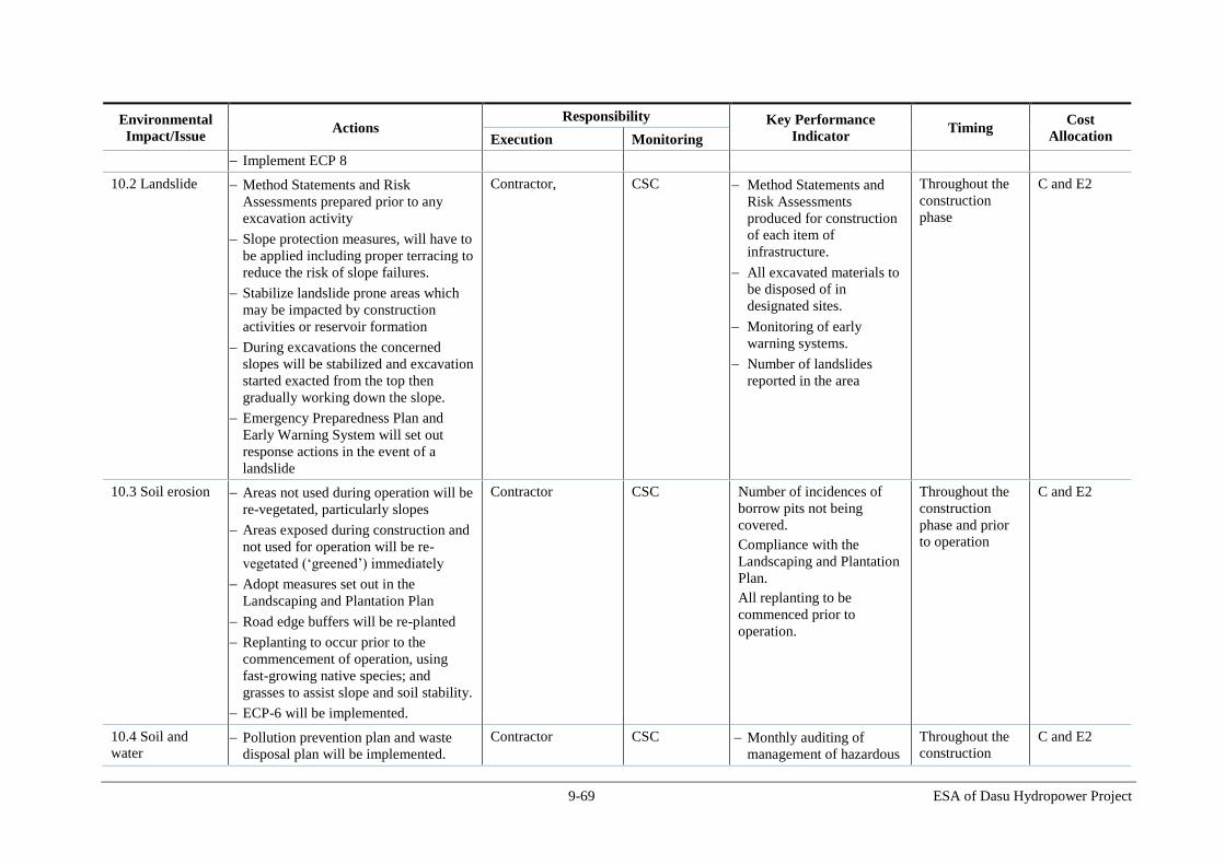
9-69 ESA of Dasu Hydropower Project
Environmental
Impact/Issue Actions
Responsibility Key Performance
Indicator Timing
Cost
Allocation Execution Monitoring
Implement ECP 8
10.2 Landslide
Method Statements and Risk
Assessments prepared prior to any
excavation activity
Slope protection measures, will have to
be applied including proper terracing to
reduce the risk of slope failures.
Stabilize landslide prone areas which
may be impacted by construction
activities or reservoir formation
During excavations the concerned
slopes will be stabilized and excavation
started exacted from the top then
gradually working down the slope.
Emergency Preparedness Plan and
Early Warning System will set out
response actions in the event of a
landslide
Contractor, CSC Method Statements and
Risk Assessments
produced for construction
of each item of
infrastructure.
All excavated materials to
be disposed of in
designated sites.
Monitoring of early
warning systems.
Number of landslides
reported in the area
Throughout the
construction
phase
C and E2
10.3 Soil erosion
Areas not used during operation will be
re-vegetated, particularly slopes
Areas exposed during construction and
not used for operation will be re-
vegetated (‘greened’) immediately
Adopt measures set out in the
Landscaping and Plantation Plan
Road edge buffers will be re-planted
Replanting to occur prior to the
commencement of operation, using
fast-growing native species; and
grasses to assist slope and soil stability.
ECP-6 will be implemented.
Contractor CSC Number of incidences of
borrow pits not being
covered.
Compliance with the
Landscaping and Plantation
Plan.
All replanting to be
commenced prior to
operation.
Throughout the
construction
phase and prior
to operation
C and E2
10.4 Soil and
water Pollution prevention plan and waste
disposal plan will be implemented.
Contractor CSC Monthly auditing of
management of hazardous
Throughout the
construction
C and E2

9-70 ESA of Dasu Hydropower Project
Environmental
Impact/Issue Actions
Responsibility Key Performance
Indicator Timing
Cost
Allocation Execution Monitoring
contamination Construction materials will be stored,
used and handled appropriately.
Excavated material disposal methods to
include measures to reduce risk of
environmental pollution.
Reduce risk of a pollution event
through adoption of measures set out in
Solid Waste Management Plan and
(Drinking Water ) and Sanitation Plan
Hazardous and toxic materials stored
separately
Fuels and hazardous substances
management plan will be implemented
Design drainage for the batching plant
area to direct runoff into a sump/basin
for inspection for pollutants prior to
discharge
Design settling basins for the
discharges from tunnel construction
areas
Any discharges to the river or streams
should have turbidity of less than 2
mg/l to meet the NEQS 2000
Regular waste water streams are to be
passed through settling basins.
The contractor will identify suitable
sites for disposal of hazardous and non-
hazardous waste. The selection will be
done in consultation with the PMU and
the local municipal authorities.
Undertake pH monitoring of site runoff
to ensure alkaline runoff is not leaving
the site.
Construct a designated, signposted
materials against Material
Safety Data Sheet
Soil and water quality
monitoring data
Number of non
compliance
Number of related
complaints
phase

9-71 ESA of Dasu Hydropower Project
Environmental
Impact/Issue Actions
Responsibility Key Performance
Indicator Timing
Cost
Allocation Execution Monitoring
concrete wash down bay that is fully
contained and bunded for all excess
concrete and concrete wash down, e.g.
plastic lined.
Regularly maintain the concrete
washout bay, treating any water prior
to release to natural systems.
NEQS compliance will be ensured.
ECP-1, ECP-2, ECP-4, ECP-5, and
ECP-7 will be implemented.
10.5 Air Quality
The Pollution Prevention Plan will be
implemented
Construction materials will be stored in
designated areas away from sensitive
receptors and covered to minimize dust
on site from site construction works
Construction vehicles will be sprayed
with water when entering and leaving
the site, covered if transporting
materials, adhere to speed limits, and
engines will be turned off when idling.
Water spraying will be carried out to
suppress dust emissions where needed
Batching plants and asphalt plants will
have dust and emissions abatement
systems.
Monitor ambient air quality near
communities.
Target zero dust related complaints
Target zero air quality related
complaints.
NEQS compliance will be ensured.
ECP-10 will be implemented.
Contractor CSC Number of dust-related
complaints.
Number of air quality-
related complaints,
Compliance with Traffic
Management Plan.
Air quality monitoring
data
Throughout
construction
phase
C and E2

9-72 ESA of Dasu Hydropower Project
Environmental
Impact/Issue Actions
Responsibility Key Performance
Indicator Timing
Cost
Allocation Execution Monitoring
10.6 Health and
Safety Compliance with Occupational Health
& Safety standards and OHS Plan
Implement fuels and hazardous
substances management plan
Construction sites to be cordoned off to
stop unauthorized access
Develop controls and standard
operating procedures for the use of
fuels and other hazardous substances to
prevent spills, accidents
Train and designate personnel for
various OHS aspects such as spill
control procedures, fire fighting
Establish fire fighting system and fire
safety (fire extinguishers) at the
construction sites where fire is an
hazard
Spill kits and trained personnel are to
be made available at the workshops.
Transport of hazardous goods and fuel
to be done in closed containers and ISO
certified tanks
Provision of respiratory protective
devices for workers where needed
Designate agreed routes for traffic (set
out in the Traffic Management Plan)
Provision of insurance-backed
compensation scheme for major injury
or loss of life reflecting settlement
sums that are consistent with
national/international benchmarks.
Construction sites to have first aid
boxes
Site to have ambulance to transfer
Contractor CSC Number of respiratory
protective devices and
other PPEs issues to
workers.
Monitoring of compliance
with Health & Safety
standards (including
monthly reporting of
accidents).
Number of accidents,
incidents and near misses.
Number of trainings
provided.
Throughout
construction
phase
C and E2

9-73 ESA of Dasu Hydropower Project
Environmental
Impact/Issue Actions
Responsibility Key Performance
Indicator Timing
Cost
Allocation Execution Monitoring
injured/sick workers to nearest hospital
WBG’s EHS Guidelines to be
implemented
ECP 2 and ECP-18 will be
implemented.
10.7 Noise and
Vibration
The Pollution Prevention Plan will be
implemented
Construction plant producing sound in
excess of 85dB will be fitted with
mufflers;
Noise barriers will be provided in areas
where significant noise is expected
(e.g. during blasting).
NEQS compliance will be ensured.
Community liaison will be maintained.
ECP-11 will be implemented.
Contractor CSC Record of equipment used
on site capable of
producing over 85dB and
whether equipment has
been fitted with mufflers
Number of related
community complaints
Noise monitoring data
Number of non-
compliances
Throughout
construction
phase
C and E2
10.8 Landscape
and Visual
Intrusion
Landscaping and Plantation Plan will
be implemented
New planting and landscape restoration
as soon as practicable at the end of
construction phase
Replanting of flora/vegetation
alongside new access roads
Enhance flora environment by planting
fruit trees and ornamental shrubs.
ECP 8 to be implemented
WAPDA /
Contractor
CSC Compliance with
Landscaping and Plantation
Plan
Before the
completion of the
construction
phase
E2
10.9 Vegetation
loss
Plantation to be developed in the buffer
areas (at suitable sites) with a target to
develop about 5 trees for each tree cut.
Maintain each sapling for a period of
minimum 2 years with the support of
local community. Community will be
Contractor CSC Number of trees felled
Number of saplings
planted
Survival rate of saplings
after one year
Throughout
construction
phase
E2

9-74 ESA of Dasu Hydropower Project
Environmental
Impact/Issue Actions
Responsibility Key Performance
Indicator Timing
Cost
Allocation Execution Monitoring
paid for watering and raising the
plantation.
A public education program should be
designed and implemented to
discourage cutting of trees by the
construction workers
Avoid dumping material in vegetated
areas.
Avoid unnecessary loss of vegetation
ECP-12 will be implemented.
10.10 Fauna /
Wildlife Include information on wildlife
protection in all construction related
tool-box orientation briefings for new
construction staff
A public education program will be
designed and implemented to
discourage poaching of wildlife
Avoid positioning spoil in areas used
by fauna
No hunting or poaching
Provide corridors for animal
movement.
ECP-13 and ECP 14will be
implemented.
Contractor CSC Number of instances of
spoil being deposited in
non-designated areas.
Number of reported
incidences of hunting or
poaching on the Project
site / in land ownership.
Number of reports of
sighting of key wild
species
Throughout
construction
phase
C and E2
10.11 Damage to
infrastructure
Any damaged infrastructure such as
roads, bridges and culverts will be
repaired
Contractor CSC Number of any non-
compliance reports
construction
phase
C
10.12 Damage to
PCRs An archeological survey will be carried
out by an archeologist at the
construction sites before any ground
breaking.
In case any artifact or site of
archeological, cultural, historical, or
Contractor CSC Number of any non-
compliance reports
Reports of any new PCR
discovered/reported
Throughout the
construction
phase
C and E2

9-75 ESA of Dasu Hydropower Project
Environmental
Impact/Issue Actions
Responsibility Key Performance
Indicator Timing
Cost
Allocation Execution Monitoring
religious significance are discovered
during construction activities, the
works will be stopped, and the
Archeological Department will be
informed.
10.13 Access The Colony will be provided with access
road connecting it with the KKH
Contractor CSC Presence of access road
Number of related
complaints
construction
phase
C
11. Activity: Construction of Resettlement Sites
11.1 Change in
topography Changes to the topography will only
occur in designated areas to
accommodate defined project features.
Excavation of material will be kept to a
minimum.
Excavated material will be managed in
accordance with the Disposal Area
Management and Restoration Plan
Implement ECP 8
Contractor CSC Volume of spoil extracted
(monitor against
predictions).
All excavated materials to
be disposed of in
designated sites.
Any non-compliances
observed/reported
Throughout the
construction
phase
C and E2
11.2 Landslide
Method Statements and Risk
Assessments prepared prior to any
excavation activity
Slope protection measures, will have to
be applied including proper terracing to
reduce the risk of slope failures.
Stabilize landslide prone areas which
may be impacted by construction
activities or reservoir formation
During excavations the concerned
slopes will be stabilized and excavation
started exacted from the top then
gradually working down the slope.
Emergency Preparedness Plan and
Early Warning System will set out
Contractor, CSC Method Statements and
Risk Assessments
produced for construction
of each item of
infrastructure.
All excavated materials to
be disposed of in
designated sites.
Monitoring of early
warning systems.
Number of landslides
reported in the area
Throughout the
construction
phase
C and E2

9-76 ESA of Dasu Hydropower Project
Environmental
Impact/Issue Actions
Responsibility Key Performance
Indicator Timing
Cost
Allocation Execution Monitoring
response actions in the event of a
landslide
11.3 Soil erosion
Areas not used during operation will be
re-vegetated, particularly slopes
Areas exposed during construction and
not used for operation will be re-
vegetated (‘greened’) immediately
Adopt measures set out in the
Landscaping and Plantation Plan
Road edge buffers will be re-planted
Replanting to occur prior to the
commencement of operation, using
fast-growing native species; and
grasses to assist slope and soil stability.
ECP-6 will be implemented.
Contractor CSC Number of incidences of
borrow pits not being
covered.
Compliance with the
Landscaping and
Plantation Plan.
All replanting to be
commenced prior to
operation.
Throughout the
construction
phase and prior
to operation
C and E2
11.4 Soil and
water
contamination
The Pollution Prevention Plan and
Waste Management Plan will be
implemented
Construction materials will be stored,
used and handled appropriately.
Excavated material disposal methods to
include measures to reduce risk of
environmental pollution.
Reduce risk of a pollution event
through adoption of measures set out in
Solid Waste Management Plan and
Wastewater Treatment Plan
Hazardous and toxic materials stored
separately
Fuels and hazardous substances
management plan will be implemented
Design drainage for the batching plant
area to direct runoff into a sump/basin
Contractor CSC Monthly auditing of
management of hazardous
materials against Material
Safety Data Sheet
Soil and water quality
monitoring data
Number of non
compliance
Number of related
complaints
Throughout the
construction
phase
C and E2
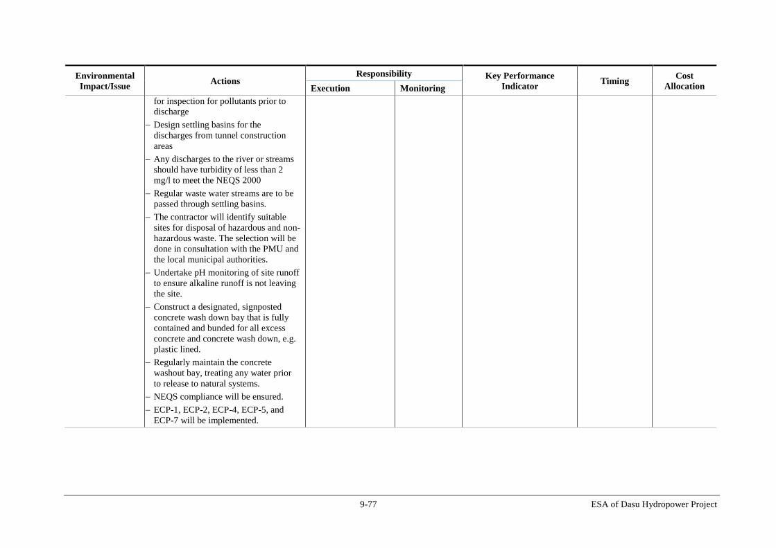
9-77 ESA of Dasu Hydropower Project
Environmental
Impact/Issue Actions
Responsibility Key Performance
Indicator Timing
Cost
Allocation Execution Monitoring
for inspection for pollutants prior to
discharge
Design settling basins for the
discharges from tunnel construction
areas
Any discharges to the river or streams
should have turbidity of less than 2
mg/l to meet the NEQS 2000
Regular waste water streams are to be
passed through settling basins.
The contractor will identify suitable
sites for disposal of hazardous and non-
hazardous waste. The selection will be
done in consultation with the PMU and
the local municipal authorities.
Undertake pH monitoring of site runoff
to ensure alkaline runoff is not leaving
the site.
Construct a designated, signposted
concrete wash down bay that is fully
contained and bunded for all excess
concrete and concrete wash down, e.g.
plastic lined.
Regularly maintain the concrete
washout bay, treating any water prior
to release to natural systems.
NEQS compliance will be ensured.
ECP-1, ECP-2, ECP-4, ECP-5, and
ECP-7 will be implemented.

9-78 ESA of Dasu Hydropower Project
Environmental
Impact/Issue Actions
Responsibility Key Performance
Indicator Timing
Cost
Allocation Execution Monitoring
11.5 Air Quality
The Pollution Prevention Plan will be
implemented
Construction materials will be stored in
designated areas away from sensitive
receptors and covered to minimize dust
on site from site construction works
Construction vehicles will be sprayed
with water when entering and leaving
the site, covered if transporting
materials, adhere to speed limits, and
engines will be turned off when idling.
Water spraying will be carried out to
suppress dust emissions where needed
Batching plants and asphalt plants will
have dust and emissions abatement
systems.
Monitor ambient air quality near
communities.
Target zero dust related complaints
Target zero air quality related
complaints.
NEQS compliance will be ensured.
ECP-10 will be implemented.
Contractor CSC Number of dust-related
complaints.
Number of air quality-
related complaints,
Air quality monitoring
data
Number of non
compliances
Throughout
construction
phase
C and E2
11.6 Health and
Safety Compliance with Occupational Health
& Safety standards and OHS Plan
Implement fuels and hazardous
substances management plan
Construction sites to be cordoned off to
stop unauthorized access
Develop controls and standard
operating procedures for the use of
fuels and other hazardous substances to
prevent spills, accidents
Contractor CSC Number of respiratory
protective devices and
other PPEs issues to
workers.
Monitoring of compliance
with Health & Safety
standards (including
monthly reporting of
accidents).
Number of accidents,
Throughout
construction
phase
C and E2

9-79 ESA of Dasu Hydropower Project
Environmental
Impact/Issue Actions
Responsibility Key Performance
Indicator Timing
Cost
Allocation Execution Monitoring
Train and designate personnel for
various OHS aspects such as spill
control procedures, fire fighting
Establish fire fighting system and fire
safety (fire extinguishers) at the
construction sites where fire is an
hazard
Spill kits and trained personnel are to
be made available at the workshops.
Transport of hazardous goods and fuel
to be done in closed containers and ISO
certified tanks
Provision of respiratory protective
devices for workers where needed
Designate agreed routes for traffic (set
out in the Traffic Management Plan)
Provision of insurance-backed
compensation scheme for major injury
or loss of life reflecting settlement
sums that are consistent with
national/international benchmarks.
Construction sites to have first aid
boxes
Site to have ambulance to transfer
injured/sick workers to nearest hospital
WBG’s EHS Guidelines to be
implemented
ECP 2 and ECP-18 will be
implemented.
incidents and near misses.
Number of trainings
provided.
Number of non
compliances
11.7 Noise and
Vibration
The Pollution Prevention Plan will be
implemented
Construction plant producing sound in
excess of 85dB will be fitted with
Contractor CSC Record of equipment used
on site capable of
producing over 85dB and
whether equipment has
been fitted with mufflers
Throughout
construction
phase
C and E2

9-80 ESA of Dasu Hydropower Project
Environmental
Impact/Issue Actions
Responsibility Key Performance
Indicator Timing
Cost
Allocation Execution Monitoring
mufflers;
Noise barriers will be provided in areas
where significant noise is expected
(e.g. during blasting).
Maintain liaison with the communities
NEQS compliance will be ensured.
ECP-11 will be implemented.
Number of related
community complaints
Noise monitoring data
11.8 Landscape
and Visual
Intrusion
Landscaping and Plantation Plan will
be implemented
New planting and landscape restoration
as soon as practicable at the end of
construction phase
Replanting of flora/vegetation
alongside new access roads
Enhance flora environment by planting
fruit trees and ornamental shrubs.
ECP 8 to be implemented
Contractor CSC Compliance with
Landscaping and Plantation
Plan
Before the
completion of the
construction
phase
E2
11.9 Vegetation
loss
Plantation to be developed in the buffer
areas (at suitable sites) with a target to
develop about 5 trees for each tree cut.
Maintain each sapling for a period of
minimum 2 years with the support of
local community. Community will be
paid for watering and raising the
plantation.
A public education program should be
designed and implemented to
discourage cutting of trees by the
construction workers
Avoid dumping material in vegetated
areas.
Avoid unnecessary loss of vegetation
Contractor CSC Number of trees felled
Number of saplings
planted
Survival rate of saplings
after one year
Throughout
construction
phase
E2
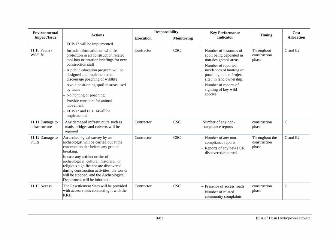
9-81 ESA of Dasu Hydropower Project
Environmental
Impact/Issue Actions
Responsibility Key Performance
Indicator Timing
Cost
Allocation Execution Monitoring
ECP-12 will be implemented.
11.10 Fauna /
Wildlife Include information on wildlife
protection in all construction related
tool-box orientation briefings for new
construction staff
A public education program will be
designed and implemented to
discourage poaching of wildlife
Avoid positioning spoil in areas used
by fauna
No hunting or poaching
Provide corridors for animal
movement.
ECP-13 and ECP 14will be
implemented.
Contractor CSC Number of instances of
spoil being deposited in
non-designated areas.
Number of reported
incidences of hunting or
poaching on the Project
site / in land ownership.
Number of reports of
sighting of key wild
species
Throughout
construction
phase
C and E2
11.11 Damage to
infrastructure
Any damaged infrastructure such as
roads, bridges and culverts will be
repaired
Contractor CSC Number of any non-
compliance reports
construction
phase
C
11.12 Damage to
PCRs
An archeological survey by an
archeologist will be carried out at the
construction site before any ground
breaking.
In case any artifact or site of
archeological, cultural, historical, or
religious significance are discovered
during construction activities, the works
will be stopped, and the Archeological
Department will be informed.
Contractor CSC Number of any non-
compliance reports
Reports of any new PCR
discovered/reported
Throughout the
construction
phase
C and E2
11.13 Access The Resettlement Sites will be provided
with access roads connecting it with the
KKH
Contractor CSC Presence of access roads
Number of related
community complaints
construction
phase
C
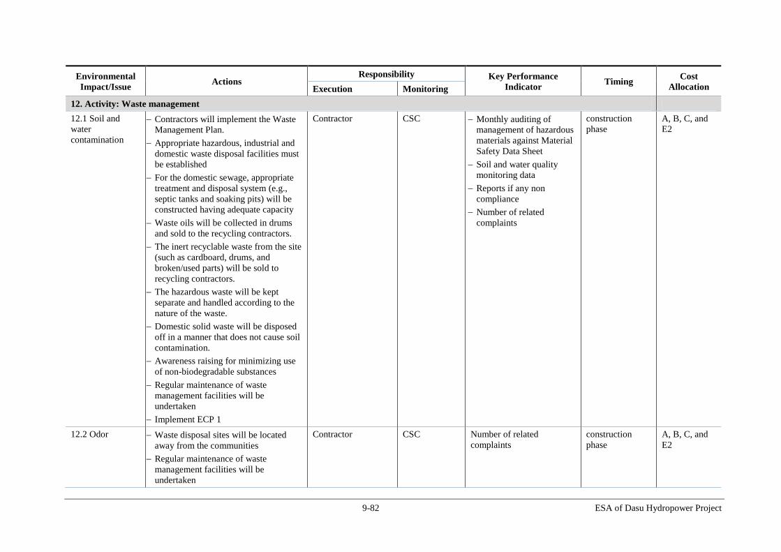
9-82 ESA of Dasu Hydropower Project
Environmental
Impact/Issue Actions
Responsibility Key Performance
Indicator Timing
Cost
Allocation Execution Monitoring
12. Activity: Waste management
12.1 Soil and
water
contamination
Contractors will implement the Waste
Management Plan.
Appropriate hazardous, industrial and
domestic waste disposal facilities must
be established
For the domestic sewage, appropriate
treatment and disposal system (e.g.,
septic tanks and soaking pits) will be
constructed having adequate capacity
Waste oils will be collected in drums
and sold to the recycling contractors.
The inert recyclable waste from the site
(such as cardboard, drums, and
broken/used parts) will be sold to
recycling contractors.
The hazardous waste will be kept
separate and handled according to the
nature of the waste.
Domestic solid waste will be disposed
off in a manner that does not cause soil
contamination.
Awareness raising for minimizing use
of non-biodegradable substances
Regular maintenance of waste
management facilities will be
undertaken
Implement ECP 1
Contractor CSC Monthly auditing of
management of hazardous
materials against Material
Safety Data Sheet
Soil and water quality
monitoring data
Reports if any non
compliance
Number of related
complaints
construction
phase
A, B, C, and
E2
12.2 Odor Waste disposal sites will be located
away from the communities
Regular maintenance of waste
management facilities will be
undertaken
Contractor CSC Number of related
complaints
construction
phase
A, B, C, and
E2

9-83 ESA of Dasu Hydropower Project
Environmental
Impact/Issue Actions
Responsibility Key Performance
Indicator Timing
Cost
Allocation Execution Monitoring
13. Activity: De-commissioning
13.1 Soil erosion As part of decommissioning, all
disturbed areas would be contoured and
re-vegetated
Contractor CSC Audit areas of site that were
disturbed and remain
without vegetation.
During
decommissioning
-
13.2 Surface
Water Quality; air
contamination;
noise; and other
environmental
impacts.
Disturbed areas will be contoured and
re-vegetated to minimize the potential
for soil erosion and water quality related
impacts.
ECP-1, ECP-2, ECP-3, ECP-4, ECP-5,
ECP 6, ECP 7, ECP-8, ECP-10, ECP-
11, ECP-12, ECP-13, ECP-14, ECP-15,
and ECP-16, ECP 17, and ECP 18 will
be implemented.
Contractor CSC
Monitoring data for air
quality, water and other
environmental parameters
Number of related
community complaints
Upon completion
of
decommissioning
-
Table 9.3: Mitigation Plan for O&M Stage
Environmental
Impact/Issue Actions
Responsibility Key Performance
Indicator Timing
Execution Monitoring
1 General - An ‘Operation Environmental Action Plan’ (OEAP) needs to
be prepared demonstrating the manner in which the
Contractor/Operator will comply with the requirements of
management plans proposed in ESA (Chapter 7).
- The following strategies and procedures will be developed
prior to the commencement of Project operations:
- Dam specific security and public access control strategy;
- Dam specific greenhouse gases (GHG) abatement strategy;
- Dam specific waste management strategy;
- Dam specific air and noise control strategy;
- Dam specific traffic control strategy;
- Reservoir specific sediment and erosion, and landslides control
strategy;
- Recycling strategy;
EU/WEC WEC Presence of Plan and
associated strategies
Before O&M
phase

9-84 ESA of Dasu Hydropower Project
Environmental
Impact/Issue Actions
Responsibility Key Performance
Indicator Timing
Execution Monitoring
- Environmental releases strategy;
2 Inundation or
terrestrial habitat Planting of native trees in reservoir buffer areas
Promotion of conservation of natural habitat in Kaigah and other
suitable areas (Kandia, Laachi, Sazin kot)
Further studies on terrestrial baseline during pre-
construction/construction and design of additional offset
measures if required
Implementation of monitoring programs
WAPDA WEC - Number of trees planted
- Survival rate of trees
after one year
- Presence of study report
3 Loss of aquatic
habitat Maintenance of spawning areas and developing fish hatchery for
production of native snow carps (snow carp hatcheries are
already established in India and Nepal) and stocking of fish in
the tributaries and reservoirs is recommended to compensate the
loss of habitat and reservoir fishery production.
Further studies will be carried out during construction and
operation stage to establish detailed baseline data on aquatic
ecology to develop additional offset measures and research on
hatchery development
WAPDA WEC - Presence of study report
- Presence of fish
hatcheries
- Amount of restocking in
a year
4 First filling of
reservoir The water level rise during filling to be around 1-2 m per day
Public awareness campaign will be implemented to inform the
communities about the reservoir filling and associated risk of
accidents
Contractor/P
MU
Number of public
awareness actions
Before/during
first filling of
reservoir
5 Fish migration The aquatic study described in Section 7.6.2 will also include
fish migration;
- WAPDA will develop fish hatchery through which tributaries
and reservoir will be restocked.
WAPDA WEC Presence of study report
6 Land slides - Monitor stability of landslide prone areas during operational
phases.
- Monitor stability of landslide prone areas at 18 identified
locations
- First filling of reservoir should be done at a slow pace of 1
m/day
EU WEC Number of landslides in
the area
Operation
7 Impact of Reduced Release a minimum of 20 m3/s of environmental flow from dam WAPDA WEC

9-85 ESA of Dasu Hydropower Project
Environmental
Impact/Issue Actions
Responsibility Key Performance
Indicator Timing
Execution Monitoring
Water Flows
between Dam and
Tailrace
and 222 m3/s from tail race
WAPDA will conduct downstream monitoring and adjustment of
flows if required.
8 Fisheries and other
aquatic fauna Start a reservoir fishery management program and monitor
reservoir fishery production
Maintain environmental flows downstream of the dam
EU WEC Evidence of initiation
of fishery management
program
Evidence of
maintaining
environmental flow
through the dam
Operation
5 Loss of active dam
storage due to
sediment deposition
in the reservoirs
Integrated watershed management of UIB is critical for control
of sedimentation in to the Indus. Detailed studies are
recommended for planning, design and implementation of
integrated watershed management for control of erosion and
sedimentation in the UIB
Dam
Control
Office
WEC Initiation of water shed
management program
Operation
6 Dam safety due to
earth quakes
- Monitoring of seismicity in the project area
- Installation of dams safety monitoring equipment
Dam
Control
Office
Presence of
instrumentation
Operation
7 Changes in Natural
river flows of the
downstream
- Operate the dam as a true run of river by allowing the whatever
flow received will be returned in the Stage 1 (pre-Basha)
- Maintain a minimum environmental flow of 20 m3/s during
low flow season
- Always run one turbine during Stage 2 (post-Basha) if the dam
is operated as peaking plant.
Dam
Control
Office
WEC Initiation of regular
monitoring of water
flow, water quality and
fish in river downstream
of dam
Operation
8 Degradation of
downstream erosion
and ecosystems
Implement a sediment monitoring and management program in
the reservoir systems to minimize sedimentation.
Dam
Control
Office
WEC Initiation of sediment
monitoring program
Operation
9 Changes in
downstream water
quality due to
thermal stratification
and changes in
sediment load and
Vertical monitoring of DO and temperature in the reservoir
Operational protocol to release simultaneous release of waters
from LLOs and spillways for missing of surface and deep waters
in the reservoir
Dam
Control
Office
WEC Initiation of regular
monitoring of water
flow, water quality and
fish in river downstream
of dam
Operation
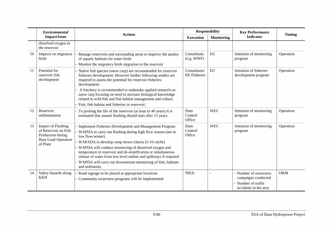
9-86 ESA of Dasu Hydropower Project
Environmental
Impact/Issue Actions
Responsibility Key Performance
Indicator Timing
Execution Monitoring
dissolved oxygen in
the reservoir
10 Impacts on migratory
birds Manage reservoirs and surrounding areas to improve the quality
of aquatic habitats for water birds
Monitor the migratory birds migration to the reservoir
Consultants
(e.g. WWF)
EU Initiation of monitoring
program
Operation
11 Potential for
reservoir fish
development
Native fish species (snow carp) are recommended for reservoir
fisheries development. However further following studies are
required to assess the potential for reservoir fisheries
development:
A hatchery is recommended to undertake applied research on
snow carp focusing on need to increase biological knowledge
related to wild fish and fish habitat management and culture.
Fish, fish habitat and fisheries in reservoir;
Consultants/
KP Fisheries
EU
Initiation of fisheries
development program
Operation
12 Reservoir
sedimentation To prolong the life of the reservoir (at least to 40 years) it is
estimated that annual flushing should start after 15 years.
Dam
Control
Office
WEC Initiation of monitoring
program
Operation
13 Impact of Flushing
of Reservoir on Fish
Production during
Base Load Operation
of Plant
Implement Fisheries Development and Management Program
WAPDA to carry out flushing during high flow season (not in
low flow/winter)
WAPADA to develop ramp down criteria (5-10 cm/hr)
WAPDA will conduct monitoring of dissolved oxygen and
temperature in reservoir and de-stratification or simultaneous
release of water from low level outlets and spillways if required.
WAPDA will carry out downstream monitoring of fish, habitats
and sediments.
Dam
Control
Office
WEC Initiation of monitoring
program
Operation
14 Safety hazards along
KKH Road signage to be placed at appropriate locations
Community awareness programs will be implemented
NHA/
- Number of awareness
campaigns conducted
Number of traffic
accidents in the area
O&M

9-87 ESA of Dasu Hydropower Project
9.7. Monitoring Plan
The monitoring program has a dual purpose. It is designed (i) to monitor the contractor’s
work during project implementation in order to check contractual compliance with
specified mitigation measures, and subsequently (ii) to assess the actual environmental
and social impacts of the project over the years following completion of the various
project components. The first type of monitoring will be carried out by the Engineering
Consultant and supervised by an independent environmental management consultant. The
second type of monitoring will be commissioned and carried out by a local organization
or consultant with sufficient experience in environmental, ecological and social
monitoring. The total cost of monitoring has been estimated at US$ 0.50 m for the
construction phase. Monitoring indicators and frequency are shown in Table 9.4.
Table 9.4: Effects Monitoring Plan
Parameter Means of Monitoring Frequency Responsible Agency
Implementation Supervision
During Construction
Landslides Visual Inspection on
stability of landslide
areas
Monthly Contractor CSC, DHP
Top Soil Visual inspection on
stripping, storage and
reuse of top soil
Monthly Contractor EU-CSC, EU-
DHP
Erosion Visual inspection of
erosion prevention
measures and
occurrence of erosion
Monthly Contractor EU-CSC, EU-
DHP
Operation of
quarry sites
Visual inspection of
quarry sites
Monthly Contractor EU-CSC, EU-
DHP
Surface water
quality
Sampling and analysis
of river water quality
and waste water
discharges for the
parameters given in
NEQS
Quarterly
Contractor EU-CSC, EU-
DHP
Annually
External Monitor
(DHP through a
nationally
recognized
Laboratory)
EU-CSC, EU-
DHP
Spot measurements of
pH, conductivity,
turbidity. Visual
Monthly EU-CSC EU-CSC, EU-
DHP
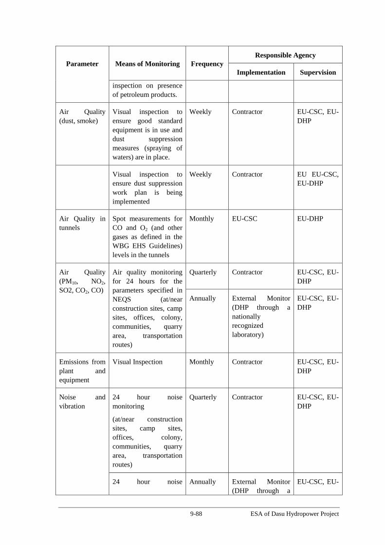
9-88 ESA of Dasu Hydropower Project
Parameter Means of Monitoring Frequency Responsible Agency
Implementation Supervision
inspection on presence
of petroleum products.
Air Quality
(dust, smoke)
Visual inspection to
ensure good standard
equipment is in use and
dust suppression
measures (spraying of
waters) are in place.
Weekly Contractor EU-CSC, EU-
DHP
Visual inspection to
ensure dust suppression
work plan is being
implemented
Weekly Contractor EU EU-CSC,
EU-DHP
Air Quality in
tunnels
Spot measurements for
CO and O2 (and other
gases as defined in the
WBG EHS Guidelines)
levels in the tunnels
Monthly EU-CSC EU-DHP
Air Quality
(PM10, NO2,
SO2, CO2, CO)
Air quality monitoring
for 24 hours for the
parameters specified in
NEQS (at/near
construction sites, camp
sites, offices, colony,
communities, quarry
area, transportation
routes)
Quarterly Contractor EU-CSC, EU-
DHP
Annually External Monitor
(DHP through a
nationally
recognized
laboratory)
EU-CSC, EU-
DHP
Emissions from
plant and
equipment
Visual Inspection Monthly Contractor EU-CSC, EU-
DHP
Noise and
vibration
24 hour noise
monitoring
(at/near construction
sites, camp sites,
offices, colony,
communities, quarry
area, transportation
routes)
Quarterly Contractor EU-CSC, EU-
DHP
24 hour noise Annually External Monitor
(DHP through a
EU-CSC, EU-

9-89 ESA of Dasu Hydropower Project
Parameter Means of Monitoring Frequency Responsible Agency
Implementation Supervision
monitoring nationally
recognized
laboratory)
DHP
Spot measurements Monthly CSC EU-DHP
Waste
Management
Visual inspection on
spoil disposal
Monthly Contractor EU-CSC, EU-
DHP
Visual inspection that
solid waste is disposed
at designated sites
Monthly Contractor EU-CSC, EU-
DHP
Spills from
hydrocarbon
and chemical
storage
Visual Inspection for
leaks and spills
Monthly Contractor EU-CSC, EU-
DHP
Wild life
(including
migratory bird)
Surveys for wildlife and
migratory birds
Half yearly DHP through
nationally
recognized institute
EU-CSC, EU-
DHP
Fish Surveys for Half yearly DHP through
nationally
recognized institute
EU-CSC, EU-
DHP,
External
Monitor
Traffic Safety Visual inspection to see
whether Traffic
Management Plan is
implemented;
record of accidents and
near misses
Monthly Contractor EU-CSC, EU-
DHP,
Local Roads Visual inspection to
ensure local roads are
not damaged
Monthly Contractor EU-CSC, EU-
DHP,
Cultural and
archeological
Sites
Visual observation for
Physical Cultural
Resources
Monthly Contractor EU-CSC, EU-
DHP,,
External
Monitor
Drinking water Ensure the construction
workers are provided
Weekly Contractor EU-CSC, EU-

9-90 ESA of Dasu Hydropower Project
Parameter Means of Monitoring Frequency Responsible Agency
Implementation Supervision
and sanitation with safe water and
sanitation facilities in
the site
DHP,
Safety of
workers
Usage of Personal
Protective equipment
Monthly Contractor EU-CSC, EU-
DHP,
Reinstatement
of Work Sites
Visual Inspection After
completion
of all works
Contractor EU-CSC, EU-
DHP,
Plantation Visual inspection to
ensure plantations are
growing well.
Monthly District Forest
Office with support
of civil society
EU-CSC, EU-
DHP,,
External
Monitor
During Operation (details to be worked out as part of studies to be carried out before
construction phase)
Surface Water
Quality
Sampling and analysis
for sediment load, DO
and temperature
(upstream and
downstream of dam, on
tributaries joining the
reservoir)
Half Yearly DHP through
nationally
recognized
laboratory
CSC, External
Monitor
In situ measurements on
DO and temperature at
different depths in the
reservoir
Quarterly DHP through
nationally
recognized
laboratory
CSC, External
Monitor
Downstream
river flows
Measurements of
discharges to the
downstream
Monthly DHP External
Monitor
Migratory birds Surveys for migratory
birds
Half Yearly DHP through
nationally
recognized institute
EU-DHP,
External
Monitor
Fish Surveys for fish (in the
river upstream and
downstream of dam,
reservoir, tributaries)
Half yearly DHP through
nationally
recognized institute
EU-DHP,
External
Monitor
Monthly data on fish Monthly Fisheries Contractor EU-DHP,

9-91 ESA of Dasu Hydropower Project
Parameter Means of Monitoring Frequency Responsible Agency
Implementation Supervision
catches
Dam Safety Monitoring of data from
dam safety equipment
Quarterly DHP Dam Safety
Organization
of WAPDA
Survey, inspection and
testing
Yearly Dam Safety
Organization of
WAPDA
DHP
Survey, inspection and
testing
Once in
three years
External Monitor
(DHP through an
internationally
recognized
institute)
DHP
The role of WAPDA is to select consultants and organizations needed for implementing
the ESMP and the SRMP They will supervise progress and quality of ESMP and SRMP
and take over regular monitoring activities during O&M phase. Result of monitoring of
impacts will have to be reviewed and evaluated from time to time by the M&E
consultants. Findings might be used to revise the operational rules of the project.
Third Party Monitoring. WAPDA will engage qualified consultants to conduct third
party monitoring initially on a six-monthly basis. The purpose of this monitoring will be
to carry out an independent assessment and validation of the ESMP and SRMP
implementation, including the OHS aspects.
9.8. Capacity Building and Training
Capacity building will be aimed at strengthening the WAPDA organization in Dasu in the
field of environmental management and social development. Members of the
environmental/social unit responsible for supervision of environmental and social
mitigation measures would be trained in environmental management, environmental
quality control, ecology, environmental awareness, participatory approach and social
development. Training would not be restricted to WAPDA staff, but selected project staff
involved in construction and operation of the project would also be trained. The
contractor will also be required to impart environmental and social trainings to its staff, to
ensure effective implementation of the ESMP and SRMP. A budget of US$ 0.6 million
has been earmarked for capacity building and training. In addition to the project-specific
capacity building described above, WEC will be strengthened to actively partake in the
environmental and social management of the WAPDA projects, particularly towards the
effective ESMP implementation of the DHP, as well as the ESA studies and ESMP and
SRMP implementation of the forthcoming hydropower projects such as the Basha dam.
Additional funds of US$ 0.3 million have been allocated to build capacity in WAPDA to
effectively implement the project, O&M of the structures it manages and fully carrying
out its mandated functions. This would include: (i) enhancing WAPDA’s capacity in
planning and programming, engineering and O&M of the project facilities, financial

9-92 ESA of Dasu Hydropower Project
management, procurement, and management of the environment and social issues; (ii)
technical assistance and training in such areas as engineering designs, river training
works, hydraulics, detailed designs of structures, contract administration and construction
supervision, procurement, operations and management planning, asset management
plans, financial management, and legal issues; and (iii) an independent panel of experts
for design and construction quality and safety enhancement or any other issues that may
have to be addressed during project implementation.
9.9. Panel of Experts
WAPDA has engaged an independent panel of environment and social experts to advise
the design team during the detailed design phase. This panel will be retained during the
construction phase also to advise ESMU and other project entities on all environmental
and social matters including effective implementation of ESMP and SRMP, particularly
on unanticipated situations, impacts, and their mitigation. The Panel will review on a
regular basis the various reports and documents produced by EMU, Supervision
Consultants and contractors; periodically visit the site to have first-hand information on
the environmental and social impacts and ESMP/SRMP implementation; and provide
report to WAPDA on the overall environmental and social performance of the project. An
amount of US$ 0.43 million has been included in the Project cost for this purpose.
9.10. Audits
Internal Environmental Audits will be held once during construction phase and once at
the end of the construction activities. The objective of the audits is to review the
effectiveness of environmental management. It is proposed that WEC would carry out
these audits on six-monthly basis. External audits on the implementation of the ESMP
and SRMP will be made by an independent environmental management specialist on a
six monthly basis. These audits would be used to re-examine the continued
appropriateness of the ESMP and SRMP and to provide advice on any up-dates required.
9.11. Reporting and Grievances
Reporting. Proper arrangements are necessary for recording, disseminating and
responding to information which emerges from the various environmental monitoring
and management programs. They are also necessary for rendering the environmental
management system “auditable”. However, the primary focus must remain on the
pragmatic control of impacts, not the creation of complex bureaucratic procedures. The
CSC will prepare monthly and quarterly reports covering various aspects of the ESMP
implementation including compliance and effects monitoring, capacity building, and
grievance redressal (discussed below).
Grievances. Grievances are actual or perceived problems that might give grounds for
complaints. As a general policy, WAPDA will work proactively towards preventing
grievances through the implementation of impact mitigation measures and community
liaison activities that anticipate and address potential issues before they become
grievances. Grievances recorded will be reviewed and investigated by Project staff and
outside authorities as appropriate. The investigations will aim to identify whether the
incident leading to the grievance is a singular occurrence or likely to reoccur. Possible
remedial measures or actions will be identified and implemented when justified. The
responsibility for addressing grievances will rest with a committee including Project
Manager, the Contractor’s Site Manager and a person designated to be responsible for
stakeholder liaison.
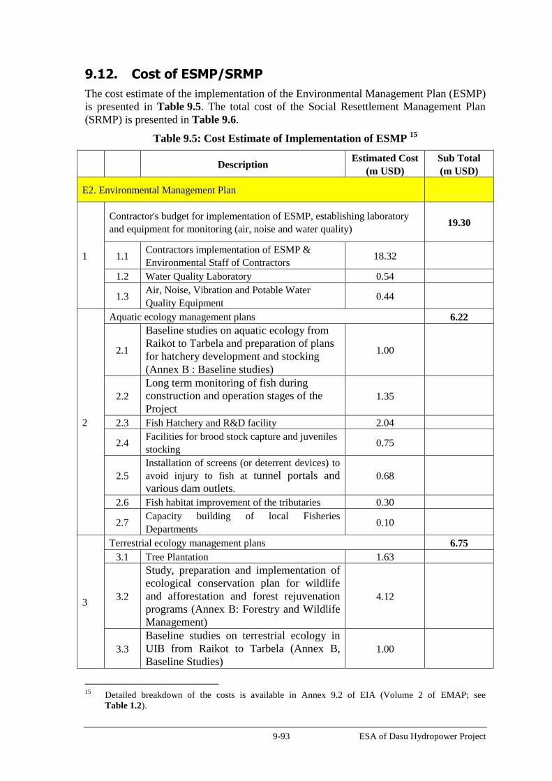
9-93 ESA of Dasu Hydropower Project
9.12. Cost of ESMP/SRMP
The cost estimate of the implementation of the Environmental Management Plan (ESMP)
is presented in Table 9.5. The total cost of the Social Resettlement Management Plan
(SRMP) is presented in Table 9.6.
Table 9.5: Cost Estimate of Implementation of ESMP 15
Description Estimated Cost
(m USD)
Sub Total
(m USD)
E2. Environmental Management Plan
1
Contractor's budget for implementation of ESMP, establishing laboratory
and equipment for monitoring (air, noise and water quality) 19.30
1.1 Contractors implementation of ESMP &
Environmental Staff of Contractors 18.32
1.2 Water Quality Laboratory 0.54
1.3 Air, Noise, Vibration and Potable Water
Quality Equipment 0.44
2
Aquatic ecology management plans 6.22
2.1
Baseline studies on aquatic ecology from
Raikot to Tarbela and preparation of plans
for hatchery development and stocking
(Annex B : Baseline studies)
1.00
2.2
Long term monitoring of fish during
construction and operation stages of the
Project
1.35
2.3 Fish Hatchery and R&D facility 2.04
2.4 Facilities for brood stock capture and juveniles
stocking 0.75
2.5
Installation of screens (or deterrent devices) to
avoid injury to fish at tunnel portals and
various dam outlets.
0.68
2.6 Fish habitat improvement of the tributaries 0.30
2.7 Capacity building of local Fisheries
Departments 0.10
3
Terrestrial ecology management plans 6.75
3.1 Tree Plantation 1.63
3.2
Study, preparation and implementation of
ecological conservation plan for wildlife
and afforestation and forest rejuvenation
programs (Annex B: Forestry and Wildlife
Management)
4.12
3.3
Baseline studies on terrestrial ecology in
UIB from Raikot to Tarbela (Annex B,
Baseline Studies)
1.00
15
Detailed breakdown of the costs is available in Annex 9.2 of EIA (Volume 2 of EMAP; see
Table 1.2).

9-94 ESA of Dasu Hydropower Project
Description Estimated Cost
(m USD)
Sub Total
(m USD)
4
Physical cultural resources management plan 1.74
4.1 Protection of Shatial Rock Carvings 1.52
4.2 Relocation of historical mosque at Seer Gayal 0.03
4.3 Protection of Graveyards that will be
submerged in reservoir 0.01
4.4 Enhancement of Seo Mosque 0.03
4.5 Chance finds and archeological survey in
project area 0.14
5 Traffic management 1.54 1.54
6 Weather Station at Dasu Colony 0.15 0.15
7 Environmental management and enhancement of
resettlement villages 2.10 2.10
8
Provisional budget for implementation of
additional offset measures if required and
management plans for 500 kV transmission line
7.00 7.00
Subtotal E2 44.80 44.80
E 3. Glacier, Watershed Monitoring
9 Glacier Monitoring Program 4.00 4.00
10 Flood warning and climate monitoring (Telemetry
Network) 2.50 2.50
11 Integrated Watershed Development of Upper Indus
Basin (Tarbela Catchment) 4.00 .00
Subtotal E3 10.50 10.50
F1. Construction Supervision Consulting Services
12 Environment staff in CSC 4.33 4.33
Subtotal F1 4.33 4.33
G. PMU Support
13 Environment staff in PMU (including equipment,
vehicles, maintenance) 2.18 2.18
14 Internal auditing 0.20 0.20
15 External monitoring 0.50 0.50
16 Panel of Experts 0.43 0.43
17 Capacity building 0.90 0.90

9-95 ESA of Dasu Hydropower Project
Description Estimated Cost
(m USD)
Sub Total
(m USD)
17.1
Capacity Building of environmental staff of
DHP and WAPDA Environmental Cell (WEC) 0.60
17.2
Establishment of GIS/MIS 0.10
17.3
Institutional strengthening of WEC 0.20
Subtotal G 4.21 4.21
Grand Total 63.84 63.84
Table 9.6: Cost Estimate SRMP
COST ITEM Total
(m US$)
1 Public Consultation and Participation Plan 0.71
2 Resettlement Action Plan 398.74
3 Public Health Action Plan 20.10
4 Grievance Redress Plan 2.68
5 Communications Plan 0.54
7 Downstream Fishing Communities Support Plan 6.70
8 Safeguard Implementation & Monitoring Plan 5.29
Total Estimated Cost 434.76

10-1 ESA of Dasu Hydropower Project
10. Stakeholder Consultations and Disclosure 16
10.1. Overview
Extensive consultations were carried out during the detailed design phase of the project,
primarily through community consultations, jirgas and stakeholder consultation
workshops. Community consultations involved multiple methods – for example,
household level interviews, participatory rural appraisal (PRA), community meetings,
and focus group discussions (FGD). Given the cultural context, key issues were largely
addressed by community elders at jirga meetings. In some sense, standard participatory
tools such as PRA and FGD and small group meetings are constrained by the tribal
political and decision-making systems. Therefore, jirga meetings are the predominant
modes for disclosure and decision-making in the project area. Objectives of the
consultation process are:
Analyze household and community level issues and draw early attention for
mitigations and/or resolution of the same issues
Promote participation of the local people, local level government stakeholders,
elected representatives and other community representatives to create opportunity to
play a role and express their views
Acquire suggestions of the community for mitigating any anticipated adverse
environmental and social impacts and expected benefits of the Project;
Obtain the views of various categories of vulnerable groups, discuss project impacts
and benefits on these groups, and ascertain their expectations regarding project
benefits
Develop strategies to minimize potential social and environmental adverse impacts in
conjunction with government stakeholders
Promote pro-people and community-based resettlement and development strategies
Socially prepare the community with confidence and capacity to deal with
displacement, environmental and resettlement management.
During the consultations with the communities, salient features of the project, potential
social and environmental impacts of the project, and proposed scope of ESA study were
explained to the participants. Similarly, during the consultation workshops, booklets
were distributed to the participants containing information on the project, scoping of
impacts, mitigation frameworks, and ToRs of the ESA study.
A total of 2,392 persons were involved in various consultation meetings at the project
sites and consultation workshops (Table 10.1) between April 2012 and October 2012.
Table 10.1: Number of Participants in Various Consultation Meetings
Activities No. of participants
1. Social environmental surveys and inventory survey 1,435
2. Jirga meetings, consultation meetings 718
16
Details of consultations are available in the Public Consultation and Participation Plan, Volume 3 of
SRMP – see Table 1.3.

10-2 ESA of Dasu Hydropower Project
3. National consultative workshops 239
Total 2,392
10.2. Community Consultations
Community consultations were held during the feasibility study in 2007. A summary of
consultations undertaken during feasibility study is given in Table 10.2.
Table 10.2: Summary of consultations undertaken during Feasibility Study
Date Objectives Person/agency consulted
No. of
participants
Social survey conducted in the reservoir area only
1 2007 Social economic survey 602 households 602
2 2007 Business survey 25 business activities 25
Group discussions at scoping sessions
2 Apr. 29, 2007 To share the perceptions
and develop a better
understanding and
contribution towards
preparation of the
Feasibility Study Report
Representatives,
Village Seo
11
3 Jun. 24, 2007 Representatives,
Village Segal
15
4 Nov. 3, 2007
Representatives,
Village Seglo and
Commercial Activities
22
5 Nov. 3, 2007 Representatives,
Village Seo
25
6 Nov. 4, 2007
Representatives,
Village Khashai and
Chuchang
21
7 Nov. 4, 2007 Representatives,
Village Kaigah
14
8 Nov. 6, 2007 Representatives,
Village Sazin
10
9 Nov. 6, 2007 Representatives,
Village Shatial
15
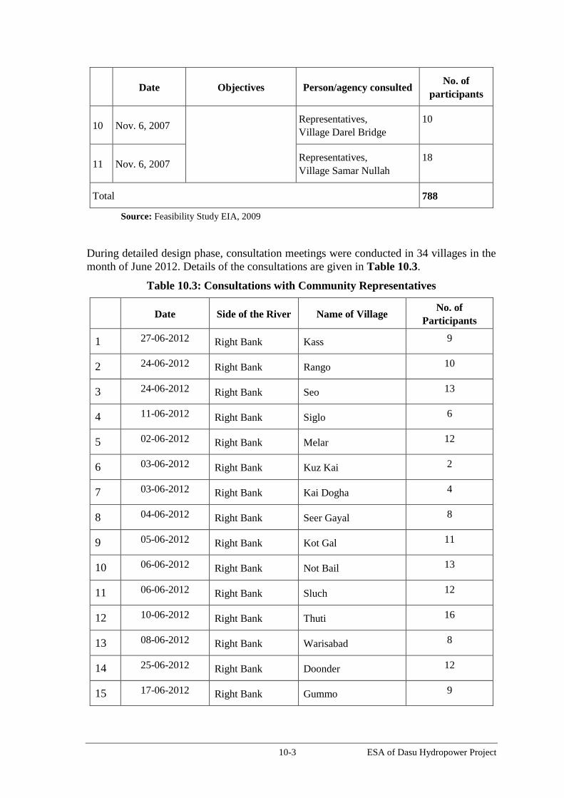
10-3 ESA of Dasu Hydropower Project
Date Objectives Person/agency consulted
No. of
participants
10 Nov. 6, 2007 Representatives,
Village Darel Bridge
10
11 Nov. 6, 2007 Representatives,
Village Samar Nullah
18
Total 788
Source: Feasibility Study EIA, 2009
During detailed design phase, consultation meetings were conducted in 34 villages in the
month of June 2012. Details of the consultations are given in Table 10.3.
Table 10.3: Consultations with Community Representatives
Date Side of the River Name of Village No. of
Participants
1 27-06-2012 Right Bank Kass 9
2 24-06-2012 Right Bank Rango 10
3 24-06-2012 Right Bank Seo 13
4 11-06-2012 Right Bank Siglo 6
5 02-06-2012 Right Bank Melar 12
6 03-06-2012 Right Bank Kuz Kai 2
7 03-06-2012 Right Bank Kai Dogha 4
8 04-06-2012 Right Bank Seer Gayal 8
9 05-06-2012 Right Bank Kot Gal 11
10 06-06-2012 Right Bank Not Bail 13
11 06-06-2012 Right Bank Sluch 12
12 10-06-2012 Right Bank Thuti 16
13 08-06-2012 Right Bank Warisabad 8
14 25-06-2012 Right Bank Doonder 12
15 17-06-2012 Right Bank Gummo 9

10-4 ESA of Dasu Hydropower Project
Date Side of the River Name of Village No. of
Participants
16 09-07-2012 Right Bank Cheer Chial 12
17 12-06-2012 Right Bank Khaliqabad 7
18 26-06-2012 Left Bank Chuchang 12
19 24-06-2012 Left Bank Khoshi 25
20 23-06-2012 Left Bank Logro 27
21 10-06-2012 Left Bank Uchar Nallah 6
22 09-06-2012 Left Bank Barseen 10
23 10-06-2012 Left Bank Largani 10
24 08-06-2012 Left Bank GulBagh/Maidan 12
25 06-06-2012 Left Bank Kaigah 15
26 12-06-2012 Left Bank Pani Bagh 12
27 09-06-2012 Left Bank Gadeer 2
28 29-06-2012 Left Bank Chalash 9
29 21-06-2012 Left Bank Looter 14
30 19-06-2012 Left Bank Shori Nallah 14
31 15-06-2012 Left Bank Summar Nallah 15
32 18-06-2012 Left Bank Lachi Nallah 7
33 14-06-2012 Left Bank Sazeen Camp 5
34 20-06-2012 Left Bank Shatial 26
Total 385
In addition to the consultation meetings, one on one consultation was held with 1,487
people during environmental and social surveys. Details of these consultations are given
in Table 10.4.

10-5 ESA of Dasu Hydropower Project
Table 10.4: Summary of the Consultations undertaken during Detailed Design
Date Objectives Person/agency consulted
1
May-July, 2012
Social economic survey 319 households
2 Resettlement Inventory
survey
763 households
3 Environmental baseline
survey
63 households
4 Aug. 2012
Gender survey 250 women respondents interviewed at
Basic Health Unit (BHU) and Rural
Health Center (RHC),
5 July.-Sep. 2012 Ecological Survey Focus group discussions on fish and
wildlife. With 40 persons
6 Aug-Sep. 2012 Consultation on availability
of relocation sites
26 over 35 sub-tribes consulted (52
village leaders participated)
Total 1,487
Jirga Meetings
The Jirga is like a local “workshop”, in which the tribal elders deliberate on important
political, legal and development issues. As an important political instrument and political
process, the Jirga system plays a vital role in the social, economic and political spheres.
Local jirgas in a tribal setup is called by an elder of a tribe for settling local affairs within
the family, clan, sub-tribe and tribe. The jirga exercises both judicial and executive roles
to settle all disputes pertaining to the distribution of land, properties, blood feuds, blood
money and other important inter-tribal affairs on the basis of tribal conventions, traditions
and principles of justice. Often grand jirgas are convened to resolve issues of regional
and national interests.
Prior to starting of detailed design, a grand Jirga meeting was held on 28th July 2011, in
which a list of demands (Charter of Demands) were submitted to the Project Director,
DHP on behalf of the affected people of the Project. The list was signed by Abdul Sattar
Khan, Member of Province Assembly, KP.
Three Jirga meetings were conducted during detailed design to inform the community
leaders about the project, its details and potential impacts, and seek their participation in
social and environmental assessment. Details of Jirga meetings are given in Table 10.5.
In the first Jirga meeting held in March 2012, a committee of ‘List of Notables’ was
formed by the Jirga to assist in environmental assessment. A new committee of
‘Affectees of Dasu’ was formed during the Jirga meeting in September 2012.
Table 10.5: Details of Jirga Meetings
Date Details of Participants
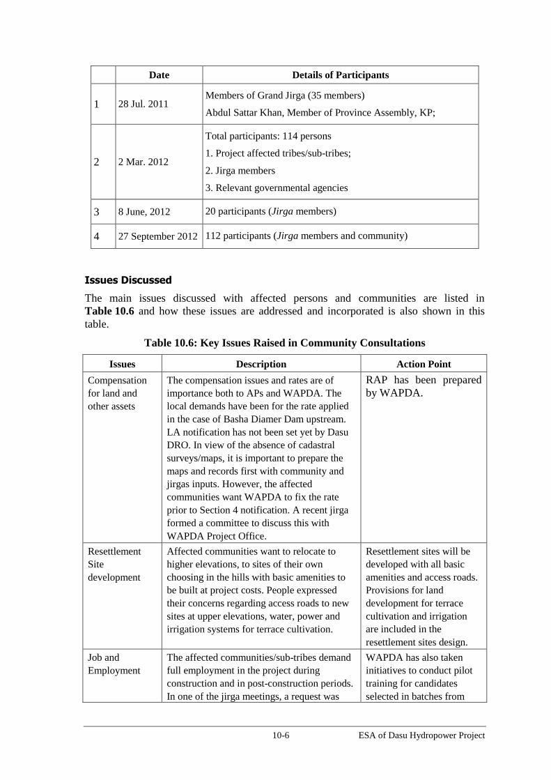
10-6 ESA of Dasu Hydropower Project
Date Details of Participants
1 28 Jul. 2011 Members of Grand Jirga (35 members)
Abdul Sattar Khan, Member of Province Assembly, KP;
2 2 Mar. 2012
Total participants: 114 persons
1. Project affected tribes/sub-tribes;
2. Jirga members
3. Relevant governmental agencies
3 8 June, 2012 20 participants (Jirga members)
4 27 September 2012 112 participants (Jirga members and community)
Issues Discussed
The main issues discussed with affected persons and communities are listed in
Table 10.6 and how these issues are addressed and incorporated is also shown in this
table.
Table 10.6: Key Issues Raised in Community Consultations
Issues Description Action Point
Compensation
for land and
other assets
The compensation issues and rates are of
importance both to APs and WAPDA. The
local demands have been for the rate applied
in the case of Basha Diamer Dam upstream.
LA notification has not been set yet by Dasu
DRO. In view of the absence of cadastral
surveys/maps, it is important to prepare the
maps and records first with community and
jirgas inputs. However, the affected
communities want WAPDA to fix the rate
prior to Section 4 notification. A recent jirga
formed a committee to discuss this with
WAPDA Project Office.
RAP has been prepared
by WAPDA.
Resettlement
Site
development
Affected communities want to relocate to
higher elevations, to sites of their own
choosing in the hills with basic amenities to
be built at project costs. People expressed
their concerns regarding access roads to new
sites at upper elevations, water, power and
irrigation systems for terrace cultivation.
Resettlement sites will be
developed with all basic
amenities and access roads.
Provisions for land
development for terrace
cultivation and irrigation
are included in the
resettlement sites design.
Job and
Employment
The affected communities/sub-tribes demand
full employment in the project during
construction and in post-construction periods.
In one of the jirga meetings, a request was
WAPDA has also taken
initiatives to conduct pilot
training for candidates
selected in batches from
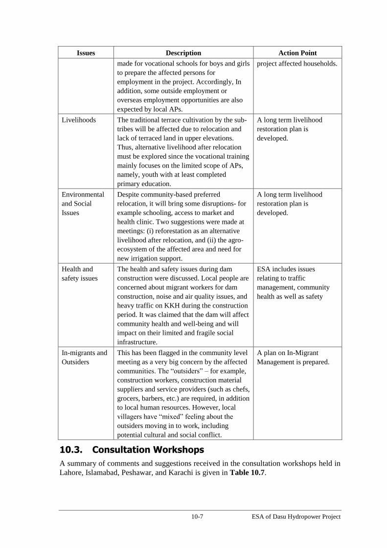
10-7 ESA of Dasu Hydropower Project
Issues Description Action Point
made for vocational schools for boys and girls
to prepare the affected persons for
employment in the project. Accordingly, In
addition, some outside employment or
overseas employment opportunities are also
expected by local APs.
project affected households.
Livelihoods The traditional terrace cultivation by the sub-
tribes will be affected due to relocation and
lack of terraced land in upper elevations.
Thus, alternative livelihood after relocation
must be explored since the vocational training
mainly focuses on the limited scope of APs,
namely, youth with at least completed
primary education.
A long term livelihood
restoration plan is
developed.
Environmental
and Social
Issues
Despite community-based preferred
relocation, it will bring some disruptions- for
example schooling, access to market and
health clinic. Two suggestions were made at
meetings: (i) reforestation as an alternative
livelihood after relocation, and (ii) the agro-
ecosystem of the affected area and need for
new irrigation support.
A long term livelihood
restoration plan is
developed.
Health and
safety issues
The health and safety issues during dam
construction were discussed. Local people are
concerned about migrant workers for dam
construction, noise and air quality issues, and
heavy traffic on KKH during the construction
period. It was claimed that the dam will affect
community health and well-being and will
impact on their limited and fragile social
infrastructure.
ESA includes issues
relating to traffic
management, community
health as well as safety
In-migrants and
Outsiders
This has been flagged in the community level
meeting as a very big concern by the affected
communities. The “outsiders” – for example,
construction workers, construction material
suppliers and service providers (such as chefs,
grocers, barbers, etc.) are required, in addition
to local human resources. However, local
villagers have “mixed” feeling about the
outsiders moving in to work, including
potential cultural and social conflict.
A plan on In-Migrant
Management is prepared.
10.3. Consultation Workshops
A summary of comments and suggestions received in the consultation workshops held in
Lahore, Islamabad, Peshawar, and Karachi is given in Table 10.7.

10-8 ESA of Dasu Hydropower Project
Table 10.7: Summary of Discussions in Consultation Workshops
Comments and suggestions Action Point/Response
Development of an agricultural terrace
in the hilly areas will take several years
of effort and hard work. Development
of agricultural terraces to be
considered for the affected households
in their new resettlement areas.
Agricultural terraces will be developed in the
resettlement sites.
Physical cultural resources in the area
are to be properly documented.
ESA addresses issues relating to PCR and proposes
mitigation as well as enhancement measures.
The people in Kohistan have unique
social culture, which may be affected
by resettlement.
The social structure of the affected people will not be
disturbed and will remain same. Relocation of the
affected people will be still within their winter
migration range.
It is apprehended that existing health
facilities will not be enough to meet
local and inward migrant workers’
need. How the Project will address
these health needs?
A public health action plan (Volume 7 of SRMP) has
been developed. Public health issues such as safe
drinking water, safe disposal of sewage, safe collection
and disposal of solid waste, protection against dust and
community health are considered as part of ESMP.
Protection of aquatic flora and fauna
should be considered in project design.
Requirement of environmental flows
for the sustainability of downstream
habitat is to be assessed.
Environmental flows have been designed for the
Project.
KKH is life line of northern areas as it
is only highway connecting northern
areas with reset of the Pakistan. Impact
of construction traffic on KKH to be
assessed.
A traffic management plan will be prepared to address
the traffic related issues along KKH and along the
access roads to the Project sites.
Impacts during demobilization of
contractors are to be considered in the
EIA
Contractors’ demobilization is considered in the ESMP
and ECPs.
WAPDA shall have an Environmental
Monitoring Unit at Project Site for
supervision of ESMP implementation.
An Environmental Unit will be established for both
DHP (WAPDA) and supervision consultants.
Initial filling of reservoir may affect
the downstream release of water to
Rabi crops
The first water filling of reservoir will be carried out
slowly at the rate of 2 m/day. The rest of the river water
will be allowed to flow downstream of the dam through
LLO. No impact on Rabi crop will be expected.
Low flow season operation of the dam
and its impact on aquatic life to be
considered.
The reservoir will be operated as full runoff river (base
load plant). Whatever water comes to the reservoir, the
same will be released through the power house. Further,
environmental flows will be released to maintain the
downstream habitat.
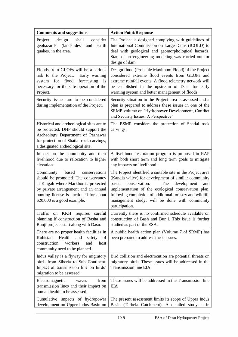
10-9 ESA of Dasu Hydropower Project
Comments and suggestions Action Point/Response
Project design shall consider
geohazards (landslides and earth
quakes) in the area.
The Project is designed complying with guidelines of
International Commission on Large Dams (ICOLD) to
deal with geological and geomorphological hazards.
State of art engineering modeling was carried out for
design of dam.
Floods from GLOFs will be a serious
risk to the Project. Early warning
system for flood forecasting is
necessary for the safe operation of the
Project.
Design flood (Probable Maximum Flood) of the Project
considered extreme flood events from GLOFs and
extreme rainfall events. A flood telemetry network will
be established in the upstream of Dasu for early
warning system and better management of floods.
Security issues are to be considered
during implementation of the Project.
Security situation in the Project area is assessed and a
plan is prepared to address these issues in one of the
SRMP volume on ‘Hydropower Development, Conflict
and Security Issues: A Perspective’
Historical and archeological sites are to
be protected. DHP should support the
Archeology Department of Peshawar
for protection of Shatial rock carvings,
a designated archeological site.
The ESMP considers the protection of Shatial rock
carvings.
Impact on the community and their
livelihood due to relocation to higher
elevation.
A livelihood restoration program is proposed in RAP
with both short term and long term goals to mitigate
any impacts on livelihood.
Community based conservations
should be promoted. The conservancy
at Kaigah where Markhor is protected
by private arrangement and an annual
hunting license is auctioned for about
$20,000 is a good example.
The Project identified a suitable site in the Project area
(Kandia valley) for development of similar community
based conservation. The development and
implementation of the ecological conservation plan,
following completion of additional forestry and wildlife
management study, will be done with community
participation.
Traffic on KKH requires careful
planning if construction of Basha and
Bunji projects start along with Dasu.
Currently there is no confirmed schedule available on
construction of Bash and Bunji. This issue is further
studied as part of the ESA.
There are no proper health facilities in
Kohistan. Health and safety of
construction workers and host
community need to be planned.
A public health action plan (Volume 7 of SRMP) has
been prepared to address these issues.
Indus valley is a flyway for migratory
birds from Siberia to Sub Continent.
Impact of transmission line on birds’
migration to be assessed.
Bird collision and electrocution are potential threats on
migratory birds. These issues will be addressed in the
Transmission line EIA
Electromagnetic waves from
transmission lines and their impact on
human health to be assessed.
These issues will be addressed in the Transmission line
EIA
Cumulative impacts of hydropower
development on Upper Indus Basin on
The present assessment limits its scope of Upper Indus
Basin (Tarbela Catchment). A detailed study is in

10-10 ESA of Dasu Hydropower Project
Comments and suggestions Action Point/Response
Lower Indus Basin should be
monitored.
pipeline from WCAP on ‘Strategic/Sectoral
Environmental and Social Assessment of Indus Basin’
Impact on migratory birds and
important bird areas (IBA) to be
assessed.
DHP will have a positive impact on the migratory birds.
Impacts related to the transmission line will be studied
in the transmission line EIA.
Indus river ecology should be
protected. Feasibility of fish ladders
should be studied.
Detailed studies on terrestrial and aquatic ecology were
under taken as part of environmental assessment of the
Project. Further studies are planned to be carried out
before construction phase.
The Project design should consider
geological hazards (seismic activity
and faults) in the Project area.
The Project is designed complying with guidelines of
International Commission on Large Dams (ICOLD) to
deal with seismicity and faults. State of art engineering
modeling was carried out for design of dam.
Climate change impacts may trigger
GLOFs, high erosion and
sedimentation; and finally may affect
the Project.
A climate change assessment study was under taken as
part of ESA and the expected changes to flows on the
Indus, as well as risk of GLOFs, was taken into account
in designing the dam.
Habitat management plan for
endangered species is to be proposed.
A community conservation area is proposed for
protection of important fauna in the project area such
Markhor, musk deer, monal pheasant and Tragopan
peasant.
Lost community facilities in the
affected villages are to be restored in
the new resettled villages.
All basic amenities like roads, water supply, irrigation,
sanitation, schools and any other facilities that were lost
will be built in the new resettlement areas.
Involvement of local community in
planning and development process is
very important.
Consultation meeting were carried out in all the project
villages through PRA techniques.
Ensure timely and frequently
stakeholders meetings for suggestion
and feedback.
WAPDA has established a full time office at Dasu
which is constantly providing a forum to consult on any
and all issues. An Executive Engineer of WAPDA
heads the office. DCO is also involved. A Public
Consultation and Participation Plan and a Grievances
Redress Plan have been prepared to be implemented
during the construction phase.
Proper compensation of affected
community is needed, to make it more
transparent & clear; affected persons
be given proper guidance.
Recommended in RAP.
Capacity of WAPDA in term of human
resources needs to be increased to
address social and environmental
issues.
Field level social and environmental units will be
established in DHP.
Potential livelihood and income
generation activities to start
Short term and long term livelihood restoration plans
are recommended in RAP

10-11 ESA of Dasu Hydropower Project
Comments and suggestions Action Point/Response
Education sector is very important in
this area. Focus on Education & Health
sector.
Education and heath will be considered in the social
development plan and benefit sharing of the Project
Involvement of women is very
important. Design livelihood livestock
related activities for women.
A Gender Action Plan is prepared.
Mobilization of women for capacity
building related to income generation
activities need to be more focused
A Gender Action Plan is prepared.
Invertebrate fauna/aquatic flora should
be addressed
These are part of aquatic ecology assessment
Establishment of fish hatchery Fish hatchery will be established, initially for R&D,
and then later for full scale development if the farming
of snow trout is feasible in the reservoir.
Motivate local people for terrace
farming.
Recommended in RAP
Livestock farming through providing
quality animals breeds
Recommended in RAP
10.4. Disclosure
The updated ESA was submitted to KP- EPA on 16 December 2013. A consultation and
disclosure meeting was held in Dasu during February 2014, and was participated by the
local community, district officials, and media representatives. Similar meetings were
held in Peshawar and Islamabad also during the same month. The ESA summary has
been translated in Urdu. Both the Urdu and the English version have been distributed to
local communities and relevant stakeholders. The Summary and the ESA document have
also been published on the website of WAPDA and also sent to the WB InfoShop.

A-1 ESA of Dasu Hydropower Project
Annex A: Terms of Reference (ToRs) for Panel of Experts and
Independent Consultants
International Technical and Safeguard Panel of Experts
Employer, Pakistan Water and Power Development Authority (WAPDA) through General
Manager (Hydro) Planning, Sunny View, Kashmir Road, Lahore coordinate with POE members.
The Water and Power Development Authority is planning to implement the Dasu Hydropower
Project that has entered the stage of Detailed Engineering Design. The project is one of several
hydropower projects of a cascade development of upper Indus River, planned upstream of
existing Tarbela Dam Project. The Dasu Hydropower project is located about 350 Km from
Islamabad and about 7km upstream of the Town of Dasu District headquarter of District Kohistan
in the Province of Kohistan Pakistan.
Project Consultants
On 19th September 2011, WAPDA signed Consultancy Contract with JV for providing services
for Assignment: A Preparation Detailed Engineering Design, Tender Documents and support to
Client in Tender and Contracting and Assignment: B for Construction Design, Contract
Management and Construction Supervision. Joint Venture consist of two foreign consultancy
firms in association with three local firms such as
i. Nippon Koei, Japan, Lead Firm
ii. Dolsar, Turkey
In association with
i. Development Management Consultants (DMC), Pakistan.
ii. National Development Consultants (NDC), Pakistan
iii. Pakistan Engineering Services (PES), Pakistan
At present are preparing detailed engineering design, tender documents and PC-1 under
Assignment-A which will last by end of February 2013 and tender and contracting required
further 11 months.
Consultants Scope of Services
The feasibility study of the project was prepared under post Diamer-Basha Dam Project and
construction of whole project in one go. The construction period was estimated 8 years after
mobilization of contractors at site.
The detailed engineering studies is being sponsored through World Bank Capacity Building
Project (WCAP), the World Bank desired that project should be constructed in stages because
arrangement of full project finance is difficult under present International finance market and
suggested that the project should be studied for four stages construction such as:
i. Stage I: Construction of Dam to a certain height and installation of 1080 MW power Units
ii. Stage II: Construction of Dam to full height and installation of another 1080 MW power
Units
iii. Stage III: Installation of additional units perhaps 1080 MW
iv. Stage IV: Installation of additional units perhaps 1080 MW
The optimal phasing of the project would be basis for development of the project detailed
engineering Design. The modifications and improvements as a result of review, staged
development and further studies should be incorporated in the detailed engineering design.
Main Features of Project Layout.
- River diversion system comprising of u/s and d/s cofferdams, two (2) tunnels.
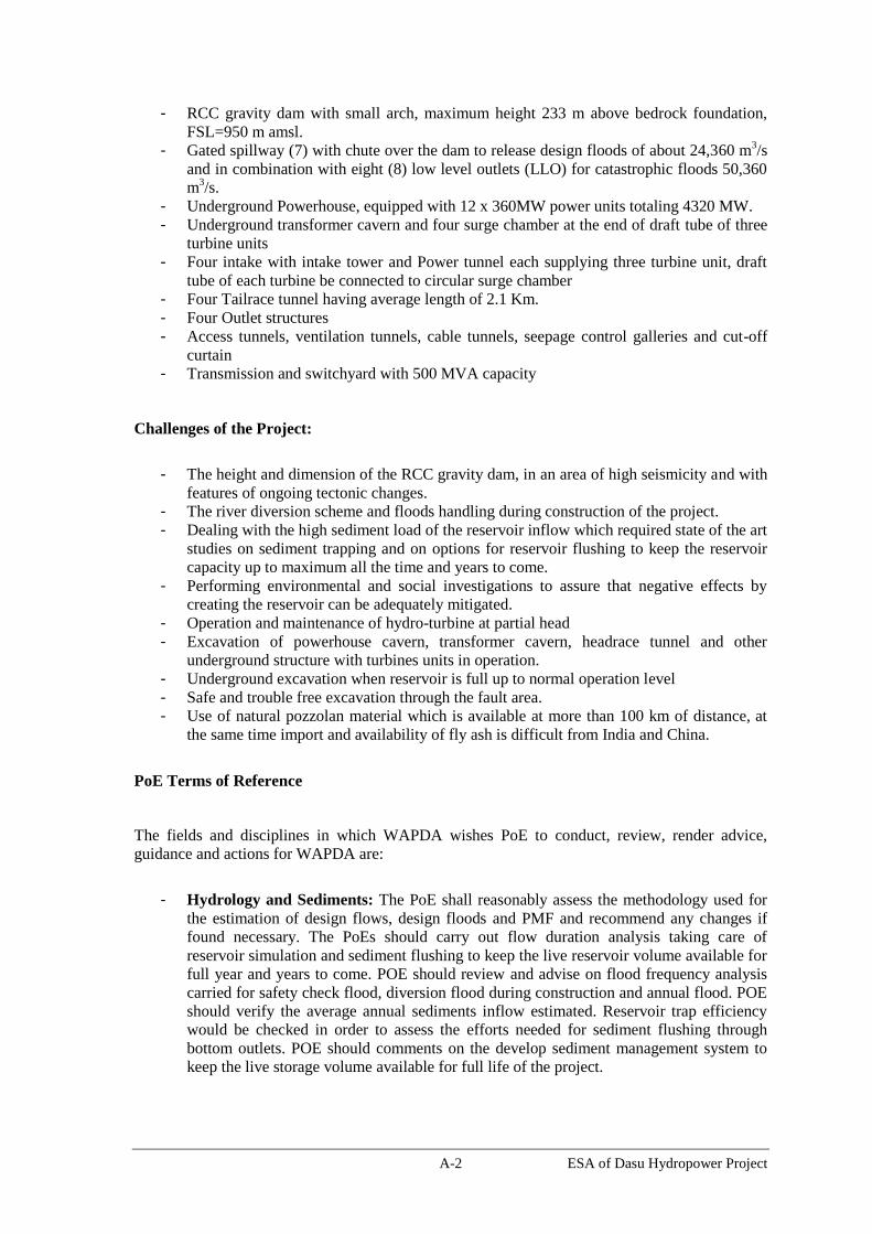
A-2 ESA of Dasu Hydropower Project
- RCC gravity dam with small arch, maximum height 233 m above bedrock foundation,
FSL=950 m amsl.
- Gated spillway (7) with chute over the dam to release design floods of about 24,360 m3/s
and in combination with eight (8) low level outlets (LLO) for catastrophic floods 50,360
m3/s.
- Underground Powerhouse, equipped with 12 x 360MW power units totaling 4320 MW.
- Underground transformer cavern and four surge chamber at the end of draft tube of three
turbine units
- Four intake with intake tower and Power tunnel each supplying three turbine unit, draft
tube of each turbine be connected to circular surge chamber
- Four Tailrace tunnel having average length of 2.1 Km.
- Four Outlet structures
- Access tunnels, ventilation tunnels, cable tunnels, seepage control galleries and cut-off
curtain
- Transmission and switchyard with 500 MVA capacity
Challenges of the Project:
- The height and dimension of the RCC gravity dam, in an area of high seismicity and with
features of ongoing tectonic changes.
- The river diversion scheme and floods handling during construction of the project.
- Dealing with the high sediment load of the reservoir inflow which required state of the art
studies on sediment trapping and on options for reservoir flushing to keep the reservoir
capacity up to maximum all the time and years to come.
- Performing environmental and social investigations to assure that negative effects by
creating the reservoir can be adequately mitigated.
- Operation and maintenance of hydro-turbine at partial head
- Excavation of powerhouse cavern, transformer cavern, headrace tunnel and other
underground structure with turbines units in operation.
- Underground excavation when reservoir is full up to normal operation level
- Safe and trouble free excavation through the fault area.
- Use of natural pozzolan material which is available at more than 100 km of distance, at
the same time import and availability of fly ash is difficult from India and China.
PoE Terms of Reference
The fields and disciplines in which WAPDA wishes PoE to conduct, review, render advice,
guidance and actions for WAPDA are:
- Hydrology and Sediments: The PoE shall reasonably assess the methodology used for
the estimation of design flows, design floods and PMF and recommend any changes if
found necessary. The PoEs should carry out flow duration analysis taking care of
reservoir simulation and sediment flushing to keep the live reservoir volume available for
full year and years to come. POE should review and advise on flood frequency analysis
carried for safety check flood, diversion flood during construction and annual flood. POE
should verify the average annual sediments inflow estimated. Reservoir trap efficiency
would be checked in order to assess the efforts needed for sediment flushing through
bottom outlets. POE should comments on the develop sediment management system to
keep the live storage volume available for full life of the project.

A-3 ESA of Dasu Hydropower Project
- Geology and Geo-techniques: The PoE shall reasonably assess the site conditions,
especially of the tectonic features at the dam site and in the reservoir area, which have to
be taken into consideration by the Engineer in designing and planning the execution of
the project works. Field and laboratory works necessary to obtain relevant design
parameters need to be indicated and reviewed. The implications of faulting, shearing and
stress relief joints at proposed dam axis shall be stated/reviewed and realignment of the
tails race channels. Methods to determine the sources of seismic events and of their
relevance to the project design, including the applicable design parameters shall be
reviewed. The program prepared for trial mix should also be commented. To control
water inflow in excavated area under full reservoir condition is another field to be
commented. The type and quantum of geo-technical investigation planned to be executed
be reviewed and any action required may be recommended.
- Project Layout and Design of Components: Assessment of various project layout
schemes including the proposals at axis 5.1, 5.2, 5.3 in the area of axis 5, Dam and
Diversion Works layout, necessary excavation works, sequence and methods of
construction, appropriate separation of concrete works in roller compacted and
conventionally built in mass concrete and reinforced concrete works, upstream seal of
dam, joint design, Assessment of movement due to the effect of khoshe fault in the
tailrace tunnel. The PoE shall review and recommend the optimized layout.
- Stability and Stress: Assessment of dam safety aspects with the construction of RCC
and conventional concrete construction. Dam stability dam stress/deformation behavior
and analysis and its seismic engineering and analyzing the newly installed seismic
stations at the site. Dam Safety Assessment Study would also include the study of Safety
of Dam against the extreme loading conditions imposed, through penstocks/headrace
tunnels, by water hammer resulting from assumed catastrophic conditions upon sudden
load (electrical) rejection by the Power House units. Safety of temporary and permanent
excavations and rock slope stability / stabilization measures, cofferdam foundations and
sealing method, stability of rock slope u/s of cofferdam shall be reviewed. Safety of dam
against thermal stress and method to control thermal stress in such a way that placing
progress of RCC should be affected.
- Location of Power House: Risks involved in underground power house.. The panel may
please recommend a safe, sustainable layout of various components of the powerhouse,
which includes stability design of large size of caverns
- Construction Methods: The latest technology to be applied for the construction of very
high RCC dam with particular attention to the construction joints and its integrated
components of conventional concrete. Construction planning of the Power house with its
penstock and tailrace channels to be reviewed as all these components are very near to
each other. Concrete production, placement and testing methods, hydration control,
application of the shutters and application of reinforcement within the stressed zones of
the RCC works shall be reviewed considering the construction of the project in stages.
Availability and use of natural Pozzolon found locally is also a matter of concern for the
PoEs.
- Seepage, Cut-off and Drainage: Seepage control and reduction in dam, foundations and
abutments, particularly for the case of thick riverbed deposits. Seepage control of
temporary works. Reservoir slopes stability measures, considering reservoir draw down
during normal and exceptional operations. Drainage of works.
- Hydraulics: Hydraulic design and operation of waterways for flood evacuation, other
releases and hydropower operation (peaking). Principal requirements for hydraulic steel

A-4 ESA of Dasu Hydropower Project
works. Effect on tail water, plunge pool, etc. Reservoir sediment handling of the
combined storage at Basha and Dasu and Without Diamer Basha.
- Electrical & Mechanical: Review of layout and design of electrical-mechanical
equipment. Design should be checked in such a way that quality contractor and
manufacturers of the world could participate in International competitive bidding. The
layout and design of turbine should be such that it is easy in maintenance and erection.
The selection of equipment should be such that a robust operation of the project is
achieved. PoE recommendations for quality control during manufacturing, testing,
commissioning and operation are welcomed. Review and comment to design of
mechanical equipment against abrasion due to hard minerals contained in Indus River
- Social and Environment: The POE should review and guide the consultants about
preparation of Social Action Plan and Environmental Management Plan as per World
Bank guideline given in its operational policies. Further, the prepared document should
also meet the requirement of other funding agencies such JICA, Asian Development
Bank, Islamic Development Bank, IFC, etc.

A-5 ESA of Dasu Hydropower Project
TOR for Independent Consultants for Environmental and Social Assessment
(a) Background
WAPDA is planning to construct the Dasu Hydropower (run of the river) Project on the Indus
River near Dasu, in Kohistan district of Khyber Pakhtunkhwa province of Pakistan. The key
components of the Project include a 233 m high dam, a powerhouse having a capacity of 4,320
MW, eight 260-m long power tunnels, eight 2,625 m long tailrace tunnels, two 878 long diversion
tunnels, substation, and other ancillaries. The Project also includes re-routing of about 46 km
section of Karakoram Highway (KKH) and transmission line for power evacuation.
Detailed engineering and design studies are now awarded. The studies include investigations,
technical and engineering studies, detailed design, economic and financial evaluation, the
preparation of tender documents, as well as environmental and social studies. As part of the
project the Design Consultants will also update existing reservoir sedimentation studies and
examine the provision of a raised intake to reduce the possibility of inundation from sediment that
has been deposited in the reservoir during the life of the scheme.
Safeguard activities related to environmental and social issues are also being taken into account
for the preparation of detailed designs. A draft Environmental and Social Impact Assessment
(ESIA) including an Environmental Management Plan (EMP), Social Assessment and
Resettlement Action Plan (RAP) will be prepared by the Design Consultants. As per World Bank
requirements, an independent assessment and audit of the above Safeguard reports has to be
carried out by independent consultants to assess the adequacy and compliance of these reports
with the World Bank Safeguard Policies and Guidelines.
(b) Objective
The objective of the Independent Consultants is to provide an independent opinion on approach,
adequacy and quality of the Environmental and Social Impact Assessment (ESIA) and
Environmental Management Plan (EMP) and Resettlement Action Plan (RAP) in order to ensure
that the activities carried out under the proposed Dasu Hydropower Project are (i)
environmentally sound and sustainable in the long run, and (ii) consistent with the environmental
and safeguard guidelines, rules and regulations of the Government of Pakistan, as well as those
of the World Bank. The Consultants will carry out an independent assessment of the
environmental and social impacts in compliance with World Bank policies and guidelines.
(c) Scope of Services
To achieve the above objectives, the Consultant will carry out the tasks including, but not limited
to, the following:
(i) Review available data, baseline studies and results of scoping sessions and also take into
account the legal and administrative framework and national policies in the country and detailed
Safeguard Policies of World Bank on Environment, Natural Habitats, Physical Cultural
Resources, Involuntary Resettlement and Public Disclosure of Information;
(ii) Carry out field visits on the project area as required and if relevant prepare brief report
highlighting major findings; and participate in consultation activities;
(iii) Review various interim reports prepared by the Design Consultant, such as draft ESIA and
EMP/RAP, at different stages of the project as requested by WAPDA and provide independent
professional views on the quality and adequacy of the report and underlying analysis;
(iv) Guide WAPDA for ensuring that the project ESIA being prepared by the Design Consultant
A-6 ESA of Dasu Hydropower Project
addresses all potential environmental direct and indirect impacts of the project during pre-
construction, construction and operation phases in the project area of influence;
(v) If necessary advise WAPDA how to collect missing information or data required for a proper
assessment of expected impacts, mitigation or compensation measures required under the
Safeguard Policies in order to ensure that relevant environmental and social concerns are
addressed at all levels of planning, design, construction and operation of the project. This will
include recommendations for necessary actions to analyze alternatives optimizing environmental
and economic aspects of the project;
(vi) Provide an independent opinion on approach and adequacy to integrate appropriate
environmental management measures with related costs into the detailed design, specifications,
and project contract documents;
(vii) Review the consultation and disclosure procedure;
(viii) Recommend (additional, if required) institutional and capacity building measures for
WAPDA to identify, manage, and eventually mainstream environmental aspects of the project
activities through the entire project cycle - conceptualization, preparation, implementation, and
operation;
(ix) Carry out independent assessment of the project impacts and prepare final Environmental and
Social Assessment Report and a Summary document (both in English and Urdu) to be submitted
by WAPDA to World Bank.
(d) Staffing
Two independent consultants will be hired (one international expert and one national expert) for
carrying out these studies. These consultants can hire experts from other fields if required with
the approval of WAPDA.

B-1 ESA of Dasu Hydropower Project
Annex B: Terms of Reference for Studies
FORESTRY AND WILDLIFE MANAGEMENT
1 Objective
The project is committed to compensate the loss of natural habitat (about 1800 ha),
including loss of about 80 ha in Kaigah community game reserve, by the Project through
development of (i) two offset areas for wildlife conservation though community
involvement and (ii) afforestation and forest rejuvenation in minimum two degraded
watersheds in the project area. The offset areas will be called as Ecological Conservation
Areas.
For conservation of wildlife, The ESA has identified four feasible sites (Thoti near
Kandia, Sazin, Laachi and opposite Shori nullah) in the project area that have similar
habitat characteristics of the affected habitat. The proposed study will further evaluate
these sites and finally recommend two sites to develop as offset areas in compliance with
the World Bank OP 4.04 Natural Habitats. Similarly the proposed study also identify
degraded forest areas in the project area and develop an afforestation and forest
rejuvenation plan for two degraded watersheds for conservation and sustainable
development of forest ecosystems in compliance with World Bank Policy OP 4.36
Forests.
The study will be carried out during the first year of implementation (2015-2016) and the
implementation will be carried out from second year onwards over a period of nine years
(2016-2025). Renowned Agencies such as WWF-Pakistan or IUCN Pakistan will be
involved by the project to implement the ecological conservation plans. WWF Pakistan
has already shown interest to enter into a partnership with WAPDA to design and
implement such measures for Diamer Basha Dam Project.
2 Justification
The Dasu hydropower project affects about 1800 ha of natural habitat, including some 80
ha in Kaigah Community Game Reserve and 160 ha riparian/nullah habitat, due to
reservoir formation and construction activities. The Kaigah tributary (nullah) is a 5,000
ha Community Conservation Area (private game reserve) for Markhor, but will also
provide protection to other mammal and bird species. The Project is committed to
compensate these losses through development of two offset community managed wildlife
areas and afforestation/forest rejuvenation programs.
The forest cover of North Pakistan is estimated at 29%, but is reported to decrease by 2%
annually. A reversion of this deforestation trend is highly needed, since both the unique
mountain fauna and human settlements are highly dependent on forestry resources. The
mountain fauna includes a number of rare and endangered species, some of them
restricted to the mountain range concerned and protected under Pakistani law. The human
population around the valleys of the Indus River and its tributaries is dependent on
forestry resources for their livelihood. Fire wood is an essential commodity, not only for
home cooking and heating, but also for trading; no clear alternatives are available as yet.
The construction of the project will also have some indirect impact on the forest
resources and its ecosystem due to increased demand by the immigrants. Development of

B-2 ESA of Dasu Hydropower Project
a forestry and wildlife management system, therefore, is meant to counteract or reverse
these negative pressures on forest resources and wildlife.
3 Study Methodology
3.1 Wildlife Conservation
Important sites near the Project Area, from an ecological perspective and the areas
comparable to Kaigah habitat, are upper valleys of Laachi Nullah, Sazin Kot on left bank,
Kandia Valley and area opposite to Shori Nullah on right bank of Indus. These valleys
include the habitat of important flagship and endangered wildlife species, Astor Markhor
(Capra falconeri falconeri). In all these areas high biodiversity is reported to be under
heavy stress from deforestation, firewood collection, overgrazing, over-hunting, weak
law enforcement, and combinations of these factors. Locations of these sites are given in
Figure B. 1. These areas will be studied further and finally two high priority valleys will
be selected on the basis of a thorough assessment and community engagements that will
be carried out during the first year. A mechanism will be developed by the study,
whereby the local communities will be provided with appropriate incentives to help
conserve natural habitat, wildlife and forests. These conservation areas will be further
complemented by ecotourism initiatives, an information centre and research.
Figure B.1: Potential Feasible Sites to Develop as Off Set Areas for Loss of Natural
Habitat and Part of Kaigah Community Conservation Area
Note: The extent of the offset areas will be determined by the proposed study

B-3 ESA of Dasu Hydropower Project
3.2 Afforestation and Forest Rejuvenation
The present forestry situation will be determined through a GIS on medium resolution
satellite data. In comparison with earlier data, the GIS will provide a baseline to select
high degradation areas (catchments of small rivers and nullahs) for development of
forestry management and it will provide a baseline for monitoring future negative and
positive changes in the region. The GIS will be accompanied by field truthing, during
which common distinctions will be used to characterize forest stands. Characterization
will be assessed on the basis of commonness of species (indicative of biodiversity value
and sensitivity for disturbance) and usefulness for humans or animals (wood and non-
wood forest products).
On the basis of common forestry practice and experiences in comparable areas elsewhere
(including e.g. Nepal), the study will identify opportunities for relatively undisturbed
sub-catchments, and for restoration of already degraded areas, all at higher altitudes.
For conservation management sufficient tools are available within Pakistani laws and
regulations; a main additional requirement is the provision of information and training to
potential human users of these areas on sustainable forestry activities and alternative
livelihoods. As far as degraded sub-catchments are concerned, tools include afforestation,
rejuvenation, and plantation forestry, combined with agroforestry and horticultural
activities. Also here information and training of local communities will be required.
Forestry activities will be certified under an independent forest certification system.
3.3 Activities to be carried out in Inception Phase (One year/2015-2016)
During this phase, ecological baseline studies conducted at a coarser level in the entire
project area and at finer level in the proposed four feasible sites to select two high priority
areas for conservation initiatives to be initiated during the implementation phase. This
phase will help in developing an understanding of the ecology and short listing high
priority valleys for conservation. The project team will also have discussions with the
communities to gauge the feasibility of initiating the proposed activities of the
implementation phase.
GIS surveys will be carried out to identify four sub-catchments: two with relative healthy
forestry stands and two with already high human pressure on forestry resources. The
identified management opportunities will be worked out in detail for these areas, keeping
up with needs shown in livelihood analyses for these areas. The study will develop plans
for development of nurseries and the plantation of indigenous species as well as suitable
species with economic benefits for livelihood sustenance and support such as fruit trees,
flowering plants, etc. The plans will also develop a mechanism to ensure local
community participation in restoration efforts, as direct involvement may inspire better
stewardship and a keener sense of project ownership by local communities.
3.4 Activities to be carried out in Implementation Phase (9 years/2016-2025)
This implementation phase will organize local communities into Community Based
Organizations (CBOs) in their respective valley/sub-watershed and build their capacity to
conserve and manage the natural resources within their respective valleys. Moreover,
during this phase communities will be empowered to develop and implement their valley

B-4 ESA of Dasu Hydropower Project
specific conservation projects. This will add sustainability to this Ecological
Conservation Plan beyond its implementation phase. These conservation areas will be
supported by ecotourism and education and awareness initiatives. The planned
interventions will include;
Wildlife Conservation
Mitigation of identified anthropogenic pressures that adversely affect keystone
species in the area, community based wildlife guards will be engaged to
monitor and protect wildlife species.
A species action plan for each identified keystone species will be developed
considering the threats and conservation needs. Communities will be trained
to monitor their populations and accordingly management will be done, for
example markhor and ibex may be considered for a trophy hunting program,
and black bear valleys may be considered for rehabilitation of rescued bears or
ecotourism.
The project will steer the development of agreements between communities
and government, where trophy hunting programs are initiated to share the
benefits to support conservation and community development. The rules of
which will be clearly defined and strictly managed based on the regular
monitoring and census of the wildlife species involved (e.g. markhor)
Review the existing practices of conservation and management measures in
Kaigah game reserve and strengthen these measures in consultations with the
community
Forestry Programs
Implementation of afforestation and forest rejuvenation plans prepared during
the inception phase
Establishment of nurseries and the plantation of indigenous species as well as
suitable species with economic benefits for livelihood sustenance and support
such as, fruit trees, flowering plants, etc.
Ensure local community participation in restoration efforts, as direct
involvement may inspire better stewardship and a keener sense of project
ownership by local communities
Training opportunities in forest management and engage community based
forest guards
Incorporate habitat conservation into the initial stages of land use planning.
This will be carried out in consultation with communities whereby their use of
natural resources will be understood. On the basis of this needs assessment, a
GIS map will be developed in order to define areas for land use after which a
plan of action for the sustainable use of natural vegetation will be marked out.
Further Tools for Conservation
Development of an Information and Conservation Centre at an appropriate site
near the reservoir. This centre will have education officer(s) and will also
liaison with ecotourism guides from communities. It will have interactive
displays and will disseminate information material to promote information
about the ecology and also provide information about the Dasu Hydropower

B-5 ESA of Dasu Hydropower Project
Project. This material will also help in promoting ecotourism to the area and
will support livelihoods of local communities. This centre will also have basic
research equipment and a small water quality testing laboratory, which will
support conservation and facilitate research students.
Trainings will be organized for the community based ecotourism guides.
Develop an understanding of pasture use, their importance, carrying capacity,
seasonal variation and patterns; and develop rangelands management plan for
improved management
Linking livelihood sustenance interventions to ecosystem conservation (pine
nuts, honey, etc.) and integrating a conservation plan for medicinal plants and
endangered plant species.
Introduce alternate energy units for space heating and cooking (solar water
heaters, solar stoves, etc.) and energy efficient wood stoves in the selected
valleys based on the need assessment.
3.5 Funding
The study will be financed under the Environmental Management Plan of DHP (Item 3.2
of Table 9.5). A budget of US$ 4.12 million is proposed in EMP for carrying out studies
and implementation of conservation activities and forestry management activities for the
first 10 years. The budget is proposed based on quotation submitted by WWF Pakistan to
WAPDA to carry out similar activities in Diamer Basha Project. The study will develop a
mechanism for revenue generation (e.g. ecotourism, trophy hunting opportunities, etc.)
for continued sustainability. A solid system for monitoring and evaluation of progress
will be prepared.
Time frame
The following time frame is foreseen for the study:
First year
(2015, before
construction
of main civil
works):
Site office established and core study team in place;
Survey team deployed for GIS based forest cover assessment;
Survey team deployed for analysis of forestry management
opportunities and livelihood dependency on natural resources;
GIS produced, including forest cover, change analysis and location
of critical (sub)catchments;
Four (sub)catchments selected and forestry management activities
planned;
(At least two) community conservation areas selected and wildlife
management activities planned.
Forestry activities are certified under an independent forest
certification system
Second year
onwards Field team in place for education and information activities and
execution of pilot schemes;

B-6 ESA of Dasu Hydropower Project
(2016 –
2025):
Community-based resources management organizations mobilized;
Training and guidance in forestry and wildlife management
techniques;
Pilot schemes operational;
Compensation areas for Kaigah Community Game Reserve
operational;
Future field activities planned;
Detailed monitoring and evaluation scheme prepared, including
impacts on forestry, wildlife and socio-economics of communities
concerned.
Developing action plans (with meaningful participation of local
communities) for afforestation and forest restoration activities that
maintain or enhance biodiversity and ecosystem functionality in
compliance with OP 4.36
Implementation of forest rejuvenation plan
5 Manpower for proposed study
The study requires GIS specialists, forestry experts and community workers.
Organizations with relevant experience should be requested to prepare a detailed
proposal. A suitable organization is WWF-Pakistan, where both GIS facilities and
technical know-how are available.

B-7 ESA of Dasu Hydropower Project
Aquatic and Terrestrial Baseline Study
1 Objective
During the DHP environmental impact assessment the lack of readily available and
reliable baseline data on flora and fauna was seriously felt. The purpose of the study is to
develop a sound ecological baseline for the Indus Corridor between Basha and Tarbela
(from Raikot bridge towards Tarbela dam), in order to better interpret, monitor and
mitigate actual impacts of DHP and to be able to prepare a more advanced management
plans for fish (hatchery, restocking, etc.) and future activities in the area, including
construction of the Diamer-Basha dam.
2 Justification
The mountain areas of Pakistan are home to exceptional wildlife and wilderness areas
with high biodiversity: 232 species of plants, 199 species of avifauna, 31 mammals and
18 species of reptiles and amphibians species are recorded in (often rather old) literature.
The area contains the full extent of the Western Himalayas Endemic Bird Area (BirdLife
International, 2013).
The Indus valley bottom is largely covered with scrub vegetation with a typical low
biodiversity, but the higher elevations contains high biodiversity including rare and
threatened species. Higher altitudes in the valley support a number of critical biotopes for
Markhor, Musk deer, Black bear, Tragopan, Monal pheasant as well as other rare species.
However, firm recent data are absent on the species distribution and threats on these
habitats.
River and its tributaries are reported to contain indigenous cold water aquatic fauna,
including mahaseers and snow carps. No detailed and long term studies are carried out in
Indus basin in Pakistan on the native cold water species to understand their biological
characteristics of snow carps and other native fish species. Development of fish hatchery
and stocking of fingerlings in the affected tributaries and Indus is recommended as one of
the mitigation measure to address the impact on fish. However, further studies are
required to develop the detailed management plan for development of full scale snow
carp hatcheries and a small scale R&D hatchery. The study should consider the
experience of snow carps hatcheries established in Nepal and India.
In order to be able to improve conservation and protection activities in the Indus valley
and its watersheds, and in order to be able to accurately assess impacts of development
projects in the widest sense, establishment of an ecological baseline is highly required,
covering flora and fauna species and associations, biotopes and hotspots of threatened
species, and seasonal effects.
3 Study components
3.1 Scope of Study
Develop baseline data for all types of terrestrial and aquatic macro and micro
fauna, including invertebrates, including information on presence, seasonal
behavior and biotope characteristics of selected species at selected locations
Characterization and delineation of natural and critical habitats as defined by OP
4.04, including study of nullah habitats, which are considered to be important
areas for breeding and nesting of insects, birds, amphibians and reptiles.

B-8 ESA of Dasu Hydropower Project
Breeding, spawning, migration and other biological characterization of indigenous
cold water fish species
Study on migratory birds including avian risk assessment
Review the impacts and mitigation measures proposed in ESA, and develop
additional mitigation measures (based on enhanced understanding) to offset
potential impacts if required.
Develop detailed plans on development of hatchery for snow carps, and
maintenance of fish spawning areas
Ensure all mitigation measures will result in to no net loss in the natural habitat in
compliance with World Bank Policy OP 4.04 and recommend proactive measures
to improve the aquatic and terrestrial habitat.
3.1 Consolidation of existing data
Existing information will be collected and consolidated through completion of a full
literature and internet review. The review should not be limited to the Indus region, but
should include relevant data from comparable areas and resource centers in Pakistan,
India and Nepal. The resulting list of species and list of conservation activities will be
annotated as much as possible (number, location, year, season, other relevant remarks).
When available, physico-chemical data will be added. Subsequently, this quantitative
information will be turned more qualified by comparison of data over time. This exercise
is expected to show the relative value of data and, especially, gaps in information.
3.2 Preparation of survey plan
Realistically, it will not be possible to implement a full survey of all biota and
ecosystems in this both horizontally and vertically divers area. For a practical plan of
field surveys choices (species, areas) will have to be made, using the (at least) the
following criteria:
The above analysis of existing and missing data. This will show what information
needs updating, what species or ecosystems might be used as indicators of change,
and what biological phenomena will require additional attention (reproduction
success, food chains, migration of fish and birds);
A division of the large area in ecologically different sections, e.g.:
o Section 1 - Raikot bridge to Diamer Basha dam (the future BHP storage
reservoir); information from this section will provide basic information for
the Diamer-Basha EIA and especially for the future of aquatic fauna in the
complete river valley;
o Section 2 - Diamer Basha dam to Dasu dam: this is the future DHP
reservoir (73 km); information from this section will provide basic
information for environmental activities under DHP;
o Section 3 - Dasu dam to Besham: natural river section with potential
impacts on hydrology, sedimentation, and aquatic ecology from BHP
and/or DHP; major tributaries flowing into Indus in this section, a.o Palas
en Dubair river;
o Section 4 - Besham - upper end Tarbela reservoir, few or no impacts likely
on this natural river section - low gradient; and

B-9 ESA of Dasu Hydropower Project
o Section 5 - Tarbela reservoir (c100 km); information from this section will
provide information to better predict ecological changes behind the Dasu
and Diamer-Basha dams.
Section 3 might have to be subdivided further, e.g. in an Indus river sub-sections and
a nullah sub-section. All sections will have a riverine and a mountainous component.
Availability of experienced staff and suitable equipment for field sampling at
different stations in different seasons.
3.3 Actual field surveys
Collection of information on presence, seasonal behavior and biotope characteristics of
selected species at selected locations. Depending on the above analysis, a group of
experts will be required. In order to obtain fully comparable data, the same survey team
should do sampling in all selected locations. There could be different survey teams for
the riverine and the mountainous areas; as far as observations are done in both areas (e.g.
birds) they should use the same sampling protocols.
Surveys of terrestrial fauna (including invertebrates) might include direct observations
(survey team) and indirect observations, carried out by instructed community members.
Aquatic macro- and micro-fauna will require expert sampling techniques, including mark
and recapture for fish species.
Surveys of macro- and micro-flora should be carried out following commonly used
survey techniques, that reveal both qualitative (species composition) and quantitative
(spread, density) data.
As far as collection of physico-chemical data in river and nullahs is concerned: care
should be taken that only those data are collected that might lead to interpretation of
ecological phenomena and that they are collected in a way that allows conclusions. Too
often parameters like O2, pH, BOD and temperature of water bodies are collected once a
season, whereas these parameters might change substantially over time in one day. At the
same time, ecologically relevant data like riverbed status, sediment load, hiding places,
presence of food sources are often not noted.
Since ecological data on riverine fish are urgently needed to be able to mitigate
environmental impacts of dam projects, sampling should result in knowledge on
migration behavior and reproduction needs (physiological data (stomachs, ovaries);
locations for overwintering pools; locations for spawning and nursing).
3.3 Reporting and Action Plans for Additional Mitigation Measures
All collected information should be worked up in reports immediately, so that further
sampling may be adapted to results obtained so far. Based on the enhanced understanding
of the baseline data, the impacts and mitigation measures proposed in the ESA will be
reviewed and additional offset measures will be proposed in compliance with OP 4.04.
4 Time frame and budget
The studies will be carried out during the first two years of project implementation. A
budget of US$ 2 million is proposed in EMP (items 2.1 and 3.3 of Table 9.5) for carrying
out these studies. The budget to cover proposed management plans on fish and any

B-10 ESA of Dasu Hydropower Project
additional offset measures if required are also included in EMP. The following time
frame is foreseen for the study:
First year: Site office established and core study team in place;
Literature/internet review completed;
Ecological survey teams deployed for aquatic and terrestrial biota
assessment;
Selection of five-six ecologically representative valley areas between
Basha and Tarbela;
Selection of survey techniques (indicator species,
sampling/observation techniques);
Survey activities commenced (one season).
Second year:
Survey activities continued (other seasons);
Analyses of findings;
Reporting;
Additional management plans for offsetting impacts on natural
habitat, flora and fauna based on the enhanced understanding of the
baseline data
Detailed plans to address the impacts on native fish (development of
hatchery and fish stocking; maintenance of spawning areas)
5 Manpower for proposed study
The study requires specialists in floristic and faunistic surveys. Organizations with
relevant experience should be requested to prepare a detailed proposal. Suitable
organizations are WWF-Pakistan and IUCN-Pakistan, where essential technical know-
how is available. Cooperation with universities (provision of specialists) will be required.

C-1 ESA of Dasu Hydropower Project
Annex C: Baseline Data of Biological Environment
Fish species of Northern Pakistan
Family / Species Local Name
A – Indigenous species
1. Family – Cyprinidae
Sub family – Schizothoracinae
1. Schizothorax plagiostomus Gahi, Cheemo
2. Schizothorax labiatus Chochan
3. Schizothorax esocinus Chakhat
4. Schizothorax skarduensis Khaduk
5. Schizothorax intermedius Khaduk
6. Schizothorax longipinnis Khaduk
7. Schizopygopsis stoliczkai -
8. Schizocypris curviforms -
9. Ptychobarbus conirostris -
10. Diptychus maculatus -
11. Racoma labiata Snowcarp
2. Family – Sisoridae
12. Glyptosternum reticulatum -
3. Family – Noemacheilidae
13. Triplophysa stoliczkai -
14. Triplophysa gracilius -
15. Triplophysa yaseenis -
16. Triplophysa trawovasea -
17. Triplophysa tenuicauda -
18. Triplophysa microps -
B – Exotic species
4. Family – Salmonidae
19. Salmo trutta faria Brown Trout
20. Oncorhynchus Mysis Rainbow Trout
5. Family – Cyprinidae
21. Cyprinus carpio Chinese carp / Gulfam
Source: M. Rafique (2000) Pak. Museum of National History, Islamabad.
Phytoplankton Identification of Project Area
Algae Groups
River Mainstem Tributaries
Upstream Down-stream Left hand
streams
Right hand
streams
Cyanophyceae
- Anabanea spp + + + +
- Oscillatoria spp + + + +
- Phormidium spp - + + +
- Spirulina spp - - + +
- Johanneslaptista spp - - + -
- Cylindrospernum spp - - + +
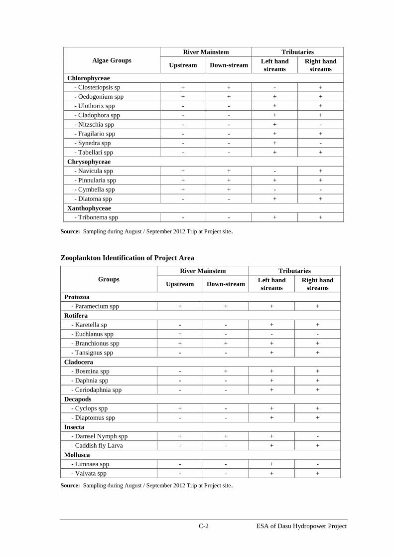
C-2 ESA of Dasu Hydropower Project
Algae Groups
River Mainstem Tributaries
Upstream Down-stream Left hand
streams
Right hand
streams
Chlorophyceae
- Closteriopsis sp + + - +
- Oedogonium spp + + + +
- Ulothorix spp - - + +
- Cladophora spp - - + +
- Nitzschia spp - - + -
- Fragilario spp - - + +
- Synedra spp - - + -
- Tabellari spp - - + +
Chrysophyceae
- Navicula spp + + - +
- Pinnularia spp + + + +
- Cymbella spp + + - -
- Diatoma spp - - + +
Xanthophyceae
- Tribonema spp - - + +
Source: Sampling during August / September 2012 Trip at Project site.
Zooplankton Identification of Project Area
Groups
River Mainstem Tributaries
Upstream Down-stream Left hand
streams
Right hand
streams
Protozoa
- Paramecium spp + + + +
Rotifera
- Karetella sp - - + +
- Euchlanus spp + - - -
- Branchionus spp + + + +
- Tansignus spp - - + +
Cladocera
- Bosmina spp - + + +
- Daphnia spp - - + +
- Ceriodaphnia spp - - + +
Decapods
- Cyclops spp + - + +
- Diaptomus spp - - + +
Insecta
- Damsel Nymph spp + + + -
- Caddish fly Larva - - + +
Mollusca
- Limnaea spp - - + -
- Valvata spp - - + +
Source: Sampling during August / September 2012 Trip at Project site.

C-3 ESA of Dasu Hydropower Project
Floral Biodiversity Recorded In Dasu Project Area (None of the species are included in the
Red List)
No. Plant Species Family Habit Life
span Life form Local name
1
Abelmoschus
esculentus (L.)
Moench.
Malvaceae Herb Annual Therophyte Bhindi
2 Abies pindrow Royle. Pinaceae Tree Perennial Phanerophyte Chur
3 Achyranthes aspera L. Amaranthacea
e Herb Annual Chamaephyte Malkuni
4 Adiantum capillus-
veneris L. Adiantaceae Herb Perennial Chamaephyte
5 Adiantum venustum D.
Don Adiantaceae
Herb Perennial Chamaephyte Jathoori
6 Ailanthus altissima
(Mill.) Swingle Simarubaceae Tree Perennial Phanerophyte Darawa
7 Ajuga bracteosa Wall.
ex Bth. Lamiaceae Herb Annual Therophyte
8 Ajuga parviflora Bth. Lamiaceae Herb Annual Therophyte
9 Alnus nitida Endl. Betulaceae Shrub Perennial Phanerophyte
10 Alternanthera
pachyacantha Aizoaceae Herb Perennial
Hemicryptophyt
e
11 Alternanthera
pungens Kunth.
Amaranthacea
e Herb Annual Chamaephyte
12 Amaranthus caudatus
L.
Amaranthacea
e Herb Annual Therophyte Ghanar
13 Amaranthus
graecizense L.
Amaranthacea
e Herb Annual Therophyte
14 Amaranthus oleraceus
L.
Amaranthacea
e Herb Annual Therophyte Kas ghanar
15 Amaranthus viridis L. Amaranthacea
e Herb Annual Therophyte Ghanar
16 Anagallis arvensis L. Primulaceae Herb Annual Therophyte
17 Arabidopsis himalaica
(Edgew.) O.E.S. Brassicaceae Herb Annual Therophyte
18 Aristida cyanatha
Nees ex Steud. Poaceae Grass Perennial
Hemicryptophyt
e
19 Artemesia maritima L. Asteraceae Herb Annual Therophyte Daroon
20
Asparagus filicinus
Buch.-Ham. ex D.
Don Asparagaceae Shrub Perennial
Hemicryptophyt
e
Zao
21 Aster aitchisonii
Boiss. Asteraceae Herb Annual Therophyte
22
Astragalus
candolleanus Royle
ex Benth. Fabaceae Shrub
Perennial
Phanerophyte Chioo
23 Atriplex lasiantha
Boiss.
Chenopodiace
ae Herb Annual
Therophyte
Kiklohukbur
sa
24 Barleria acanthoides
Vahl. Acanthaceae Subshrub Perennial Chamaephyte
25 Barleria cristata L. Acanthaceae Herbs Perennial Chamaephyte
26 Bauhinia variegata L. Caesalpiniacea
e Tree Perennial Phanerophyte
27 Bergenia ciliata
(Haw.) Sternb. Saxifragaceae Herb Annual
Hemicryptophyt
e Korat
28
Bidens biternata
(Lour.) Merr. &
Sherff. Asteraceae Herb Annual Therophyte Surbul

C-4 ESA of Dasu Hydropower Project
No. Plant Species Family Habit Life
span Life form Local name
29
Boerhavia
procumbens Banks ex
Roxb.
Nyctaginaceae Herb Perennial Cryptophyte
30 Bothriochloa bladhii
(Retz.) S.T Blake Poaceae Grass Perennial
Hemicryptophyt
e Lhash
31 Bothriochloa
ischaemum (L.) Keng Poaceae Grass Perennial
Hemicryptophyt
e Lhash
32 Brachiaria distachya
(L.) Stapf Poaceae Grass Annual Therophyte
33
Brachiaria reptans
(L.) Gard. & C.E.
Hubb.
Poaceae Grass Annual Therophyte
34 Brousonetia
papyrifera (L.) Vent. Moraceae Tree Perennial
Phanerophyte Jangal murt
35
Calamintha umbrosa
(M. Bieb.) Fisch. &
Mey. Lamiaceae Herb
Annual
Therophyte Bheroo rang
36 Calotropis procera
(Willd.) R. Br.
Asclepiadacea
e Shrub Perennial Phanerophyte
37 Cannabis sativa L. Cannabinaceae Herb Annual Therophyte
38 Capparis spinosa L. Capparidaceae Shrub Perennial Hemicryptophyt
e Kurr
39 Capsella bursa-
pastoris (L.) Medik Brassicaceae Herb Annual Therophyte
40 Carex chitralensis
Nelmes Mag. Cyperaceae Sedge Annual
Hemicryptophyt
e Zatch
41 Carum carvi L. Apiaceae Herb Annual Therophyte Zeera
42
Cedrus deodara
(Roxb. Ex Lamb. ) G.
Don Pinaceae tree Perennial Phanerophyte Beesh
43 Celtis australis L. Ulmaceae Shrub Perennial Phanerophyte Makosh
44 Centella asiatica (L.)
Urban Apiaceae Herb Annual Cryptophyte Tikroo
45 Cheilanthus farinosa
(Forssk.) Kaulf. Pteridaceae Herb Annual Therophyte
46 Chenopodium album
L.
Chenopodiace
ae Herb Annual Therophyte Kanwan
47 Chenopodium
ambrosioides L.
Chenopodiace
ae Subshrub Biennial
Hemicryptophyt
e Tahoo
48 Chenopodium botrys
L.
Chenopodiace
ae Herb Annual Therophyte Kunwan
49
Chenopodium cf.
opulifolium Schrad. ex
Koch & Ziz.
Chenopodiace
ae Herb Annual Therophyte
50 Chrozophora tinctoria
(L.)Juss. Euphorbiaceae Herb Annual Therophyte
51 Chrysopogon aucheri
(Boiss.) Stapf Poaceae Grass Perennial
Hemicryptophyt
e
52 Cirsium falconerii
(Hk.f.) Petrak Asteraceae Herb Annual Therophyte Jocho
53 Citrullus colocynthis
(L.) Schrad. Cucurbitaceae Subshrub Perennial
Hemicryptophyt
e
54 Clematis montana
Buch. Ranunculaceae Climber Perennial Phanerophyte
55 Clematis nepalensis
Royle Ranunculaceae Climber Perennial Phanerophyte
56 Cleome viscosa L. Capparidaceae Herb Annual Therophyte
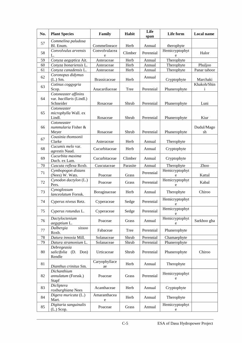
C-5 ESA of Dasu Hydropower Project
No. Plant Species Family Habit Life
span Life form Local name
57 Commelina paludosa
Bl. Enum. Commelineace Herb Annual therophyte
58 Convolvulus arvensis
L.
Convolvulacea
e Climber Perennial
Hemicryptophyt
e Halor
59 Conyza aegyptica Ait. Asteraceae Herb Annual Therophyte
60 Conyza bonariensis L. Asteraceae Herb Annual Therophyte Phuljoo
61 Conyza canadensis L. Asteraceae Herb Annual Therophyte Panar tahoor
62 Coronopus didymus
(L.) Sm. Brassicaceae Herb Annual
Cryptophyte Marchaki
63 Cotinus coggygria
Scop. Anacardiaceae Tree Perennial Phanerophyte
Khakoh/Shin
i
64
Cotoneaster affinins
var. bacillaris (Lindl.)
Schneider Rosaceae Shrub Perennial Phanerophyte Luni
65
Cotoneaster
microphylla Wall. ex
Lindl. Rosaceae Shrub Perennial Phanerophyte Kiur
66
Cotoneaster
nummularia Fisher &
Meyer Rosaceae Shrub Perennial Phanerophyte
Dudul/Mago
sh
67 Cousinia thomsonii
Clarke Asteraceae Herb Annual Therophyte
68 Cucumis melo var.
agrestis Naud. Cucurbitaceae Herb Annual Cryptophyte
69 Cucurbita maxima
Duch. ex Lam. Cucurbitaceae Climber Annual Cryptophyte
70 Cuscuta reflexa Roxb. Cuscutaceae Parasite Annual Therophyte Zhoo
71 Cymbopogon distans
(Nees) W. Wats. Poaceae Grass Perennial
Hemicryptophyt
e Kattal
72 Cynodon dactylon (L.)
Pers. Poaceae Grass Perennial
Hemicryptophyt
e Kabal
73 Cynoglossum
lanceolatum Forssk. Boraginaceae Herb Annual Therophyte Chiroo
74 Cyperus niveus Retz. Cyperaceae Sedge Perennial Hemicryptophyt
e
75 Cyperus rotundus L. Cyperaceae Sedge Perennial Hemicryptophyt
e
76 Dactyloctenium
aegyptium L. Poaceae Grass Annual
Hemicryptophyt
e Sarkhoo gha
77 Dalbergia sissoo
Roxb. Fabaceae Tree Perennial Phanerophyte
78 Datura innoxia Mill. Solanaceae Shrub Perennial Chamaephyte
79 Datura stramonium L. Solanaceae Shrub Perennial Phanerophyte
80
Debregeasia
salicifolia (D. Don)
Rendle
Urticaceae Shrub Perennial Phanerophyte Chiroo
81 Dianthus crinitus Sm.
Caryophyllace
ae Herb Annual Therophyte
82
Dichanthium
annulatum (Forssk.)
Stapf
Poaceae Grass Perennial Hemicryptophyt
e
83 Dicliptera
roxburghiana Nees Acanthaceae Herb Annual Cryptophyte
84 Digera muricata (L.)
Mart.
Amaranthacea
e Herb Annual Therophyte
85 Digitaria sanguinalis
(L.) Scop. Poaceae Grass Annual
Hemicryptophyt
e

C-6 ESA of Dasu Hydropower Project
No. Plant Species Family Habit Life
span Life form Local name
86 Diospyros lotus L. Ebenaceae Tree Perennial Phanerophyte Amlok
87 Dodonaea viscosa (L.)
Jacq. Sapindaceae Shrub Perennial Phanerophyte Shounth/Bajj
88 Duchesnea indica
(Andr.) Focke Rosaceae Herb Annual Cryptophyte
89 Echinochloa colona
(L.) Link Poaceae Grass Annual Therophyte
90 Echinops cornigerus
DC. Asteraceae Herb Annual Therophyte Kuro/Ziach
91 Eclipta prostrata (L.)
L. Asteraceae Herb Annual Therophyte
92 Ephedra ciliata Fisch.
& Mey. ex C.A. Mey. Ephederaceae Shrub
Hemicryptophyt
e Ragaal
93 Ephedra intermedia
Schrenk Ephederaceae Shrub Perennial Phanerophyte
Suo
94 Eragrostis aterovirens
(Desf.) Trin. ex Nees Poaceae Herb Annual Therophyte
95 Eragrostis cilianensis
(All.) Vig. Poaceae Herb Annual Therophyte
96 Eragrostis minor
Host. Poaceae Herb Annual Therophyte
97 Eucalyptus
lanceolatus Myrtaceae Tree Perennial Phanerophyte
98 Euonymus pendulus
Wall. Celastraceae Shrub Perennial Phanerophyte
99 Euphorbia granulata
Forssk. Euphorbiaceae Herb Annual Therophyte
100 Euphorbia hirta L. Euphorbiaceae Herb Annual Therophyte
101 Euphorbia indica
Lam. Euphorbiaceae Herb Annual Therophyte Ispatre
102 Euphorbia kanorica
Boiss. Euphorbiaceae herb Perennial
Hemicryptophyt
e
103 Euphorbia prostrata
(L.) Ait Euphorbiaceae Herb Perennial Cryptophyte
104 Euphrasia himalayica
Wettst.
Scrophulariace
ae Herb Annual Therophyte
105 Ficus carica L. Moraceae Tree Perennial Phanerophyte Pha
106
Fumaria indica
(Hausskn.) H.N.
Pugsley
Fumariaceae Herb Annual Therophyte
107 Gallium aparine L. Rubiaceae Herb Annual Therophyte
108 Gentiana capitata
Ham. ex D. Don Gentianaceae Herb Annual Therophyte
Salaloo
109 Geranium
rotundifolium L. Geraniaceae Herb Annual Therophyte
110 Geranium
willichianum D. Don Geraniaceae Herb Annual Therophyte
Ratajot
111 Grewia optiva Drum.
ex Burret. Tiliaceae Tree Perennial Phanerophyte
112 Heliotropium
europaeum L. Boraginaceae Herb Annual Therophyte
113 Heliotropium spp. Boraginaceae Herb Annual Therophyte Dodosulo
114
Heteropogon
contortus (L.) P.
Beauv.
Poaceae Grass Perennial Hemicryptophyt
e
115 Impatiens edgeworthii
Hook.f.
Scrophulariace
ae Herb Annual Cryptophyte

C-7 ESA of Dasu Hydropower Project
No. Plant Species Family Habit Life
span Life form Local name
116 Indigofera heterantha
Wall. Ex Brand Fabaceae Shrub
Perennial Phanerophyte Kachhi
117 Juglans regia L. Juglandaceae Tree Perennial Phanerophyte chhoe
118 Juncus spp. Juncaceae Herb Perennial
Hemicryptophyt
e
119 Kickxia ramosissima
(Wall.) Janchen
Scrophulariace
ae Herb Annual Therophyte
120 Lactuca auriculata
(Wall. ex Dc.) Asteraceae Herb Annual Therophyte
121 Lactuca dissecta D.
Don. Asteraceae Herb Annual Therophyte
122 Lactuca serriola L. Asteraceae Herb Annual Therophyte Harool
123 Lagenaria siceraria
(Molina) Standley Cucurbitaceae Climber Annual Cryptophyte
124
Launaea procumbens
(Roxb.) Ram. &
Rajgo.
Asteraceae Herb Annual Chamaephyte
125 Lepidium pinnitifidum
Ledeb. Brassicaceae Herb Annual
Therophyte Makoch
126 Lespedeza elegans
Cambess. Fabaceae Herb Annual Cryptophyte
127
Leucaena
leucocephala (Lam.)
de-Wit Mimosaceae Tree Perennial Phanerophyte
128 Luffa cylindrica (L.)
Roem. Cucurbitaceae Climber Annual Cryptophyte
129 Malva neglecta
Waller. Malvaceae Herb Annual Therophyte Shani
130 Malva parviflora L. Malvaceae Herb Annual Therophyte Zarooshal/M
asha
131 Malvastrum
coromendelianum L. Malvaceae Herb Perennial Cryptophyte
132
Maytenus royleanus
(Wall. ex Lawson)
Cufodontis
Celastraceae Shrub Perennial Phanerophyte Phaikar
133 Medicago lupulina L. Fabaceae Herb Annual Therophyte
134 Melia azedarach L. Meliaceae Tree Perennial Phanerophyte
135 Mentha longifolia (L.)
Huds. Lamiaceae Herb Perennial
Hemicryptophyt
e Feeru
136 Micromeria biflora
(Ham.) Bth. Lamiaceae Herb Perennial
Hemicryptophyt
e Kaldajar
137 Morus alba L. Moraceae Tree Perennial Phanerophyte Marath
138 Morus nigra L. Moraceae Tree Perennial Phanerophyte
139 Myrtus communis L. Myrtaceae Shrub Perennial Phanerophyte Amboo/Lach
i
140 Nasturtium officinale
R. Br. Brassicaceae Herb Biennial
Hemicryptophyt
e Zalzaal
141 Nerium oleander L. Apocynaceae Shrub Perennial Phanerophyte
142 Olea ferruginea Royle Oleaceae Tree Perennial Phanerophyte
143 Onopordum
acanthium L. Asteraceae Herb Annual Therophyte Zehech
144 Otostegia limbata
(Benth.) Boiss. Lamiaceae Shrub Perennial Phanerophyte
145 Oxalis corniculata L. Oxalidaceae Herb Perennial Hemicryptophyt
e Chukoo
146 Parthenium
hytserophorus L. Asteraceae Herb annual Therophyte
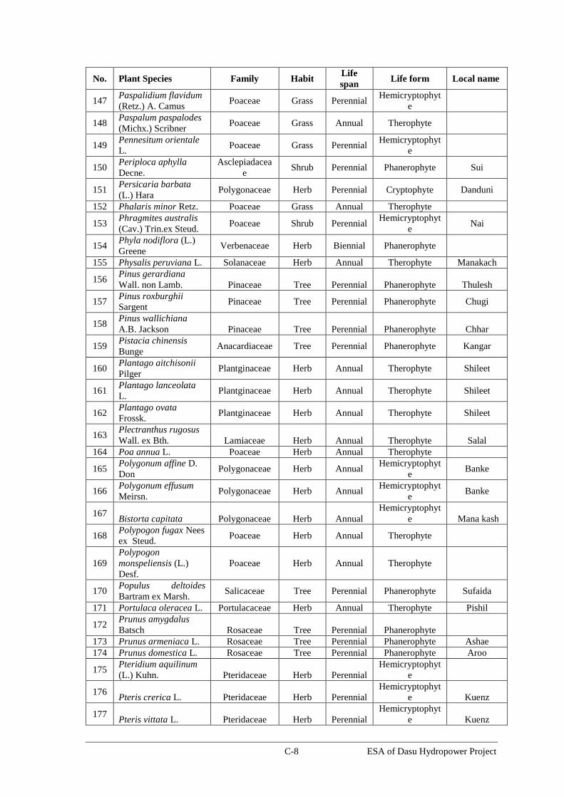
C-8 ESA of Dasu Hydropower Project
No. Plant Species Family Habit Life
span Life form Local name
147 Paspalidium flavidum
(Retz.) A. Camus Poaceae Grass Perennial
Hemicryptophyt
e
148 Paspalum paspalodes
(Michx.) Scribner Poaceae Grass Annual Therophyte
149 Pennesitum orientale
L. Poaceae Grass Perennial
Hemicryptophyt
e
150 Periploca aphylla
Decne.
Asclepiadacea
e Shrub Perennial Phanerophyte Sui
151 Persicaria barbata
(L.) Hara Polygonaceae Herb Perennial Cryptophyte Danduni
152 Phalaris minor Retz. Poaceae Grass Annual Therophyte
153 Phragmites australis
(Cav.) Trin.ex Steud. Poaceae Shrub Perennial
Hemicryptophyt
e Nai
154 Phyla nodiflora (L.)
Greene Verbenaceae Herb Biennial Phanerophyte
155 Physalis peruviana L. Solanaceae Herb Annual Therophyte Manakach
156 Pinus gerardiana
Wall. non Lamb. Pinaceae Tree Perennial Phanerophyte Thulesh
157 Pinus roxburghii
Sargent Pinaceae Tree Perennial Phanerophyte Chugi
158 Pinus wallichiana
A.B. Jackson Pinaceae Tree Perennial Phanerophyte Chhar
159 Pistacia chinensis
Bunge Anacardiaceae Tree Perennial Phanerophyte Kangar
160 Plantago aitchisonii
Pilger Plantginaceae Herb Annual Therophyte Shileet
161 Plantago lanceolata
L. Plantginaceae Herb Annual Therophyte Shileet
162 Plantago ovata
Frossk. Plantginaceae Herb Annual Therophyte Shileet
163 Plectranthus rugosus
Wall. ex Bth. Lamiaceae Herb Annual Therophyte Salal
164 Poa annua L. Poaceae Herb Annual Therophyte
165 Polygonum affine D.
Don Polygonaceae Herb Annual
Hemicryptophyt
e Banke
166 Polygonum effusum
Meirsn. Polygonaceae Herb Annual
Hemicryptophyt
e Banke
167 Bistorta capitata Polygonaceae Herb Annual
Hemicryptophyt
e Mana kash
168 Polypogon fugax Nees
ex Steud. Poaceae Herb Annual Therophyte
169
Polypogon
monspeliensis (L.)
Desf.
Poaceae Herb Annual Therophyte
170 Populus deltoides
Bartram ex Marsh. Salicaceae Tree Perennial Phanerophyte Sufaida
171 Portulaca oleracea L. Portulacaceae Herb Annual Therophyte Pishil
172 Prunus amygdalus
Batsch Rosaceae Tree Perennial Phanerophyte
173 Prunus armeniaca L. Rosaceae Tree Perennial Phanerophyte Ashae
174 Prunus domestica L. Rosaceae Tree Perennial Phanerophyte Aroo
175 Pteridium aquilinum
(L.) Kuhn. Pteridaceae Herb Perennial
Hemicryptophyt
e
176 Pteris crerica L. Pteridaceae Herb Perennial
Hemicryptophyt
e Kuenz
177 Pteris vittata L. Pteridaceae Herb Perennial
Hemicryptophyt
e Kuenz
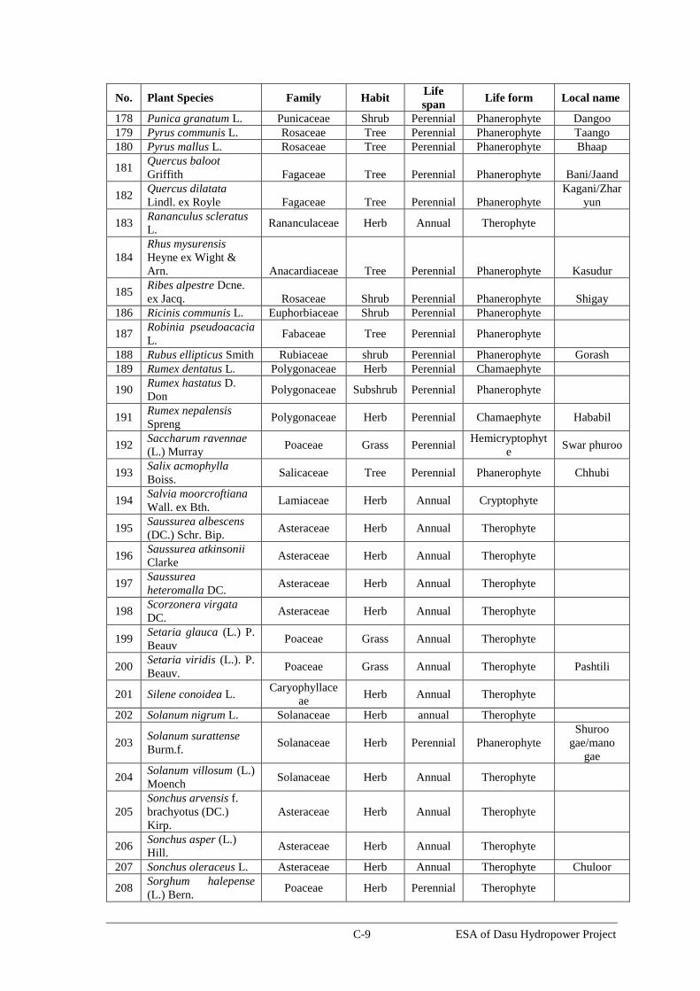
C-9 ESA of Dasu Hydropower Project
No. Plant Species Family Habit Life
span Life form Local name
178 Punica granatum L. Punicaceae Shrub Perennial Phanerophyte Dangoo
179 Pyrus communis L. Rosaceae Tree Perennial Phanerophyte Taango
180 Pyrus mallus L. Rosaceae Tree Perennial Phanerophyte Bhaap
181 Quercus baloot
Griffith Fagaceae Tree Perennial Phanerophyte Bani/Jaand
182 Quercus dilatata
Lindl. ex Royle Fagaceae Tree Perennial Phanerophyte
Kagani/Zhar
yun
183 Rananculus scleratus
L. Rananculaceae Herb Annual Therophyte
184
Rhus mysurensis
Heyne ex Wight &
Arn. Anacardiaceae Tree Perennial Phanerophyte Kasudur
185 Ribes alpestre Dcne.
ex Jacq. Rosaceae Shrub Perennial Phanerophyte Shigay
186 Ricinis communis L. Euphorbiaceae Shrub Perennial Phanerophyte
187 Robinia pseudoacacia
L. Fabaceae Tree Perennial Phanerophyte
188 Rubus ellipticus Smith Rubiaceae shrub Perennial Phanerophyte Gorash
189 Rumex dentatus L. Polygonaceae Herb Perennial Chamaephyte
190 Rumex hastatus D.
Don Polygonaceae Subshrub Perennial Phanerophyte
191 Rumex nepalensis
Spreng Polygonaceae Herb Perennial Chamaephyte Hababil
192 Saccharum ravennae
(L.) Murray Poaceae Grass Perennial
Hemicryptophyt
e Swar phuroo
193 Salix acmophylla
Boiss. Salicaceae Tree Perennial Phanerophyte Chhubi
194 Salvia moorcroftiana
Wall. ex Bth. Lamiaceae Herb Annual Cryptophyte
195 Saussurea albescens
(DC.) Schr. Bip. Asteraceae Herb Annual Therophyte
196 Saussurea atkinsonii
Clarke Asteraceae Herb Annual Therophyte
197 Saussurea
heteromalla DC. Asteraceae Herb Annual Therophyte
198 Scorzonera virgata
DC. Asteraceae Herb Annual Therophyte
199 Setaria glauca (L.) P.
Beauv Poaceae Grass Annual Therophyte
200 Setaria viridis (L.). P.
Beauv. Poaceae Grass Annual Therophyte Pashtili
201 Silene conoidea L. Caryophyllace
ae Herb Annual Therophyte
202 Solanum nigrum L. Solanaceae Herb annual Therophyte
203 Solanum surattense
Burm.f. Solanaceae Herb Perennial Phanerophyte
Shuroo
gae/mano
gae
204 Solanum villosum (L.)
Moench Solanaceae Herb Annual Therophyte
205
Sonchus arvensis f.
brachyotus (DC.)
Kirp.
Asteraceae Herb Annual Therophyte
206 Sonchus asper (L.)
Hill. Asteraceae Herb Annual Therophyte
207 Sonchus oleraceus L. Asteraceae Herb Annual Therophyte Chuloor
208 Sorghum halepense
(L.) Bern. Poaceae Herb Perennial Therophyte

C-10 ESA of Dasu Hydropower Project
No. Plant Species Family Habit Life
span Life form Local name
209 Stellaria media (L.)
Cyr.
Caryophyllace
ae Herb Annual Therophyte
210 Tagetes minuta L. Asteraceae Herb Annual Therophyte
211 Tamarix aphylla (L.)
Karst. Tamaricaceae Tree Perennial Phanerophyte
212 Taraxacum officinale
Weber. Asteraceae Herb Perennial Chamaephyte Palor
213 Taraxcum wallichii
DC. Asteraceae Herb Perennial Chamaephyte
214 Themeda anathera
(Nees) Hack. Poaceae Herb Perennial
Hemicryptophyt
e Furun
215 Thymus serphyllum Lamiaceae Herb Annual Chamaephyte Isperki
216 Tragus biflorus
Schult. Poaceae Grass Annual Therophyte
217 Tribulus longipetalus
Viv.
Zygophyllacea
e Herb Annual Therophyte Shiwo kuroo
218 Tribulus terrestris L. Zygophyllacea
e Herb Annual Therophyte Shiwo kuroo
219 Trifolium repens L. Fabaceae Herb Perennial Hemicryptophyt
e
220 Urtica dioica L. Urticaceae Subshrub Annual Therophyte Jomi
221 Valeriana stracheyi Valerianaceae Herb Annual Therophyte Koindaru
222 Valeriana wallichii
DC. Valerianaceae Herb Annual Therophyte
223 Verbascum thapsus L. Scrophulariace
ae Herb Biennial Therophyte
Khardak/Kh
eros
224 Verbena officinalis L. Verbenaceae Herb Annual Cryptophyte Chiroo
225 Veronica beccabunga
L.
Scrophulariace
ae Herb Annual Therophyte
226 Vitex negundo L. Verbenaceae Shrub Perennial Phanerophyte
227 Vitis himalyana Vitaceae Climber Perennial Phanerophyte
Kuchar
jachh
228 Vitis jaquemontii
Parker Vitaceae Climber Perennial Phanerophyte Magrath
229 Vitis vinifera L. Vitaceae Climber Perennial Phanerophyte Jach
230 Withania coagulens
Dunal Solanaceae Subshrub Perennial Phanerophyte
231 Xanthium strumarium
L. Asteraceae Herb Annual Phanerophyte Kundi
232 Zizyphus sativa
Gaertn Rhamnaceae Shrub Perennial Phanerophyte Sizin/Sigiun
The List of Important Mammals from Kohistan area
Common
Name Scientific name Family Status Remarks
1 Asiatic
jackal
Canis aureus Canidae NT Pellet Laachi Nallah, Melar
2 Indian wolf Canis lupus Canidae EN Reported by locals from Laachi
nullah and Kandian Valley
3 Hill or
Kashmir fox
Vulpes velpes
griffithi
Canidae NT Pellet near Melar Village,
reported by locals from Kandian
valley, Laachi Sazin kot area
4 Common Panthera Felidae CR Reported rarely by locals of

C-11 ESA of Dasu Hydropower Project
Common
Name Scientific name Family Status Remarks
Leopard pardus Kandian, Laachi
5 Leopard cat Prionilurus
bengalensis
Felidae DD Preserved skin at house-Laachi
Nallah
6 Caracal Felis caracal Felidae CR Crossed KKh near Kandian
suspended bridge in evening time;
also reported by locals of Kandian
valley
7 Asiatic
Black bear
Ursus
thibetanus
Ursidae V Reported from higher elevation of
Laachi, Kandian, Sazin and
Chochung area
8 Himalayan
musk deer
Moschus
chrysogaster
Moschidae EN Youngone captured from Pallas
by local of Dasu and sold for Pak
Rs. 15000. Also reported from
higher valleys of Kandian, Laachi
and Palas valley
9 Markhor Capra falconeri
cashmiriensis
Bovidae EN Stuffed specimens at Laachi
nullah, Sazin kot, Kandian valley-
Aliel village. Summara Nallah
police check post- hunted one
female; reported from Kaigah,
Laachi, Sazin and Kandian Valley
10 Rhesus
macaque
Macaca mulatta Cercopitheid
ae
NT Reported by locals from Laachi
nullah, Kandian, Sazin kot,
Chochung, Jalkot areas at higher
elevation
NT=Near threatened; EN=Endangered; CR=Critically Endangered; V=Vulnerable; DD=Data deficient
(status described by IUCN-Pakistan, 2005)
Birds Reported From the Study Kohistan Area
Non-passerines Birds Recorded from Kohistan Area
Common Name Scientific Name Family Status IUCN
Status
1. Great or Eurasian
Cormorant **
Phalacrocorax carbo
sinensis
Phalacrocoracidae A NA
2. Chukar * Alectoris chukar Phasianidae C LC
3. Grey
Partridge/Francolin*
Francolinus
pondicerianus
Phasianidae C LC
4. Himalayan Monal* Lophophorus impejanus Phasianidae R LC
5. Western Tragopan* Tragopan
melanocephalus
Phasianidae V V
6. Marsh harrier** Circus aeruginosus Accipitridae C LC
7. Black kite* Milvus migrans Accipitridae A LC
8. Shikra * Accipiter badius Accipitridae F LC
9. Common Kestrel* Falco tinnunculus Falconidae C LC

C-12 ESA of Dasu Hydropower Project
Common Name Scientific Name Family Status IUCN
Status
10. Water rail** Rallus aquaticus Rallidae F LC
11. Red-wattled lapwing* Vanellus indicus Charadriidae A LC
12. Common sandpiper*** Actitis hypoleucos Tringinae C LC
13. Blue rock pigeon* Columba livia Columbidae A LC
14. Indian ring dove* Streptopelia decaocto Columbidae A LC
15. Oriental turtle dove* Streptopelia orientalis Columbidae C LC
16. Little brown dove* Streptopelia senegalensis Columbidae A LC
17. Spotted dove*** Streptopelia chinensis Columbidae C LC
18. Northern eagle owl* Bubo bubo Strigidae F LC
19. Common kingfisher* Alcedo atthis Apodidae F LC
20. Indian roller* Coracias benghalensis Meropidae C LC
21. Hoopoe* Upupa epops Upupidae C LC
22. Asian Koel***l Eudynamys scolopacea Cuculidae C LC
23. Lammergeyer or bearded
vulture
Gypaetus barbatus Accipitridae LC
24. Egyptian vulture Neophron percnopterus Accipitridae EN
25. Himalayan griffon
vulture
Gyps himalayensis Accipitridae LC
26. Common quail Coturnix coturnix Phasianidae LC
27. Himalayan snowcock Tetraogallus
himalayensis
Phasianidae LC
28. Short-toed eagle Circaetus gallicus Accipitridae LC
29. Hen harrier Circus cyaneus Accipitridae LC
30. Pallid harrier Circus macrourus Accipitridae NT
31. Golden eagle Aquila chrysaetos Accipitridae LC
32. Booted eagle Hieraaetus pennatus Accipitridae LC
33. Spotted crake Porzana porzana Rallidae LC
34. Baillon’s crake Porzana pusilla Rallidae LC
35. Sociable lapwing Vanellus gregarious Charadriidae NA
36. Curlew sandpiper Calidris ferruginea Scolopacidae LC
37. Eurasian woodcock Scolopax rusticola Scolopacidae LC
38. Tawny owl Strixaluco Strigidae NA
39. White-throated needle
tail swift
Hirundapus caudacutus Apodidae NA
40. Common swift Apus apus Apodidae LC
41. Alpine swift Apus melba Apodidae LC
42. Little swift Apus affinis Apodidae LC
*Resident; **Passage migrant; ***Summer breeder/wintering; A=Abundant; C=Common; F=Frequent;
S=Scarce; V=Vulnerable; R=Rare (status described by Roberts, 1991, 1992).
IUCN Status: LC: Least Concern, V – Vulnerable, NA – Not Assessed

C-13 ESA of Dasu Hydropower Project
Passerines Birds Recorded from Kohistan area
Common Name Scientific name Family Status IUCN
Status
1. Crested lark* Galerida cristate Alaudidae A NA
2. Yellow wagtail** Motacilla flava Motacillidae C LC
3. Grey wagtail*** Motacilla cinera Motacillidae C NA
4. White/pied wagtail*** Motacilla alba Motacillidae A LC
5. Large wagtail* Motacilla
maderaspatensis
Motacillidae C NA
6. White-cheeked bulbul* Pycnonotus leucogenys Pycnonotidae A LC
7. Brown dipper* Cinclus pallasii Cinclidae C LC
8. Blue throat**/*** Luscinia svecia Turdidae F NA
9. Indian blue robin**/*** Luscinia brunnea Turdidae C LC
10. Blue-headed
redstart***
Phoenicurus
caeruleocephalus
Turdidae C LC
11. Black redstart*** Phoenicurus ochruros Turdidae C LC
12. White-bellied Redstart* Hodgsonius
phoenicuroides
Turdidae S NA
13. Plumbeous water
Redstart***
Rhyacornis fuliginosus Turdidae C LC
14. Common
Stonechat**/***
Saxicola torquate Turdidae C NA
15. Pied Bushchat* Saxicola caprata Turdidae C LC
16. Rufous-tailed Rock
Thrush**
Monticola saxatilis Turdidae R LC
17. Blue whistling
thrush***
Myiophoneus cacruleus Turdidae C NA
18. Eurasian blackbird* Turdus merula Turdidae F LC
19. Grey-hooded
flycatcher***
Seicercus xanthoschistos Sylviidae C LC
20. White-cheeked
nuthatch*
Sitta leucopsis Sittidae C LC
21. Eurasian nuthatch*** Sitta europaea Sittidae F LC
22. Isabelline shrike *** Lanius isbellinus Laniidae F NA
23. Bay-backed shrike* Lanius vittatus Laniidae C LC
24. Jungle crow* Corvus macrorhynchos Corvidae C LC
25. House crow* Corvus splendens Corvidae A LC
26. Common Raven* Corvus corax Corvidae F LC
27. Lanceolated/Black-
headed Jay*
Garrulus lanceolatus Corvidae F LC
28. Yellow-billed Chough* Phyrhocorax
phyrhocorax
Corvidae A NA
29. Common myna* Acridotheres tristis Sturnidae A LC
30. Jungle myna* Acridotheres fuscus Sturnidae F LC
31. House sparrow * Passer domesticus Passeridae A LC
32. Red-fronted serin* Serinus pusillus Carduelinae A LC
33. Rock bunting *** Emberiza cia Emberizinae C LC
34. Grey necked Emberiza buchanani Emberizinae S LC
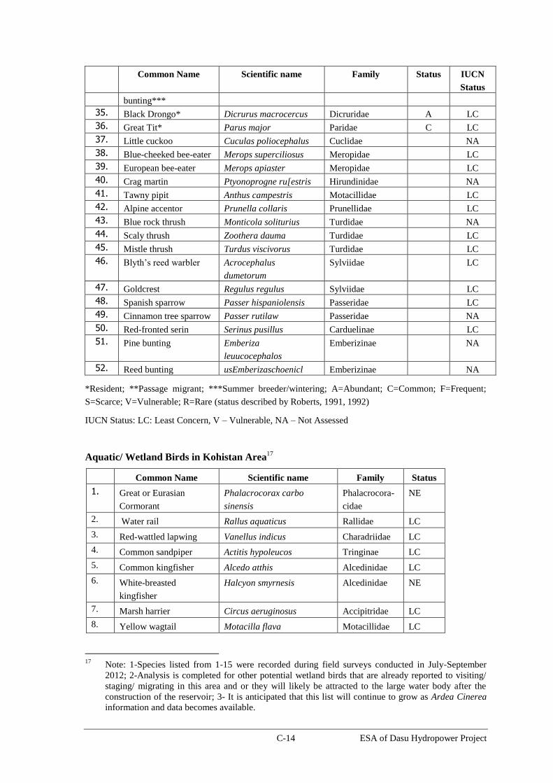
C-14 ESA of Dasu Hydropower Project
Common Name Scientific name Family Status IUCN
Status
bunting***
35. Black Drongo* Dicrurus macrocercus Dicruridae A LC
36. Great Tit* Parus major Paridae C LC
37. Little cuckoo Cuculas poliocephalus Cuclidae NA
38. Blue-cheeked bee-eater Merops superciliosus Meropidae LC
39. European bee-eater Merops apiaster Meropidae LC
40. Crag martin Ptyonoprogne ru[estris Hirundinidae NA
41. Tawny pipit Anthus campestris Motacillidae LC
42. Alpine accentor Prunella collaris Prunellidae LC
43. Blue rock thrush Monticola soliturius Turdidae NA
44. Scaly thrush Zoothera dauma Turdidae LC
45. Mistle thrush Turdus viscivorus Turdidae LC
46. Blyth’s reed warbler Acrocephalus
dumetorum
Sylviidae LC
47. Goldcrest Regulus regulus Sylviidae LC
48. Spanish sparrow Passer hispaniolensis Passeridae LC
49. Cinnamon tree sparrow Passer rutilaw Passeridae NA
50. Red-fronted serin Serinus pusillus Carduelinae LC
51. Pine bunting Emberiza
leuucocephalos
Emberizinae NA
52. Reed bunting usEmberizaschoenicl Emberizinae NA
*Resident; **Passage migrant; ***Summer breeder/wintering; A=Abundant; C=Common; F=Frequent;
S=Scarce; V=Vulnerable; R=Rare (status described by Roberts, 1991, 1992)
IUCN Status: LC: Least Concern, V – Vulnerable, NA – Not Assessed
Aquatic/ Wetland Birds in Kohistan Area17
Common Name Scientific name Family Status
1. Great or Eurasian
Cormorant
Phalacrocorax carbo
sinensis
Phalacrocora-
cidae
NE
2. Water rail Rallus aquaticus Rallidae LC
3. Red-wattled lapwing Vanellus indicus Charadriidae LC
4. Common sandpiper Actitis hypoleucos Tringinae LC
5. Common kingfisher Alcedo atthis Alcedinidae LC
6. White-breasted
kingfisher
Halcyon smyrnesis Alcedinidae NE
7. Marsh harrier Circus aeruginosus Accipitridae LC
8. Yellow wagtail Motacilla flava Motacillidae LC
17
Note: 1-Species listed from 1-15 were recorded during field surveys conducted in July-September
2012; 2-Analysis is completed for other potential wetland birds that are already reported to visiting/
staging/ migrating in this area and or they will likely be attracted to the large water body after the
construction of the reservoir; 3- It is anticipated that this list will continue to grow as Ardea Cinerea
information and data becomes available.
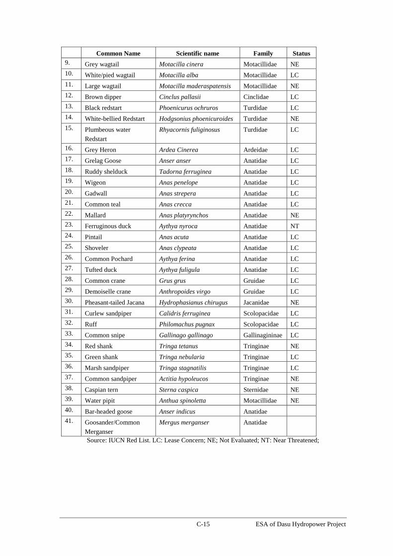
C-15 ESA of Dasu Hydropower Project
Common Name Scientific name Family Status
9. Grey wagtail Motacilla cinera Motacillidae NE
10. White/pied wagtail Motacilla alba Motacillidae LC
11. Large wagtail Motacilla maderaspatensis Motacillidae NE
12. Brown dipper Cinclus pallasii Cinclidae LC
13. Black redstart Phoenicurus ochruros Turdidae LC
14. White-bellied Redstart Hodgsonius phoenicuroides Turdidae NE
15. Plumbeous water
Redstart
Rhyacornis fuliginosus Turdidae LC
16. Grey Heron Ardea Cinerea Ardeidae LC
17. Grelag Goose Anser anser Anatidae LC
18. Ruddy shelduck Tadorna ferruginea Anatidae LC
19. Wigeon Anas penelope Anatidae LC
20. Gadwall Anas strepera Anatidae LC
21. Common teal Anas crecca Anatidae LC
22. Mallard Anas platyrynchos Anatidae NE
23. Ferruginous duck Aythya nyroca Anatidae NT
24. Pintail Anas acuta Anatidae LC
25. Shoveler Anas clypeata Anatidae LC
26. Common Pochard Aythya ferina Anatidae LC
27. Tufted duck Aythya fuligula Anatidae LC
28. Common crane Grus grus Gruidae LC
29. Demoiselle crane Anthropoides virgo Gruidae LC
30. Pheasant-tailed Jacana Hydrophasianus chirugus Jacanidae NE
31. Curlew sandpiper Calidris ferruginea Scolopacidae LC
32. Ruff Philomachus pugnax Scolopacidae LC
33. Common snipe Gallinago gallinago Gallinagininae LC
34. Red shank Tringa tetanus Tringinae NE
35. Green shank Tringa nebularia Tringinae LC
36. Marsh sandpiper Tringa stagnatilis Tringinae LC
37. Common sandpiper Actitia hypoleucos Tringinae NE
38. Caspian tern Sterna caspica Sternidae NE
39. Water pipit Anthua spinoletta Motacillidae NE
40. Bar-headed goose Anser indicus Anatidae
41. Goosander/Common
Merganser
Mergus merganser Anatidae
Source: IUCN Red List. LC: Lease Concern; NE; Not Evaluated; NT: Near Threatened;

C-16 ESA of Dasu Hydropower Project
Morphometric Features of Birds of Prey and Large Birds in the Project Area
Common Name Scientific name Family Morphometric
Features
IUCN
Status
Length
(Cm)
Wingspan
(Cm)
Large Birds
Black stork Ciconia nigra Ciconiidae 95-100 145-155 L.C
Greylag goose Anser anser Anatidae 74-91 41-48 L.C
Bar-headed goose Anser indicus Anatidae 71-76 110-135 L.C
Ruddy shelduck Tadorna ferruginea Anatidae 58-70 78-90 L.C
Gadwall Anas strepera Anatidae 46-56 71-80 L.C
Eurasian wigeon Anas penelope Anatidae 42-52 81-98 L.C
Northern pintail Anas acuta Anatidae 59-76 80-95 L.C
Goosander/Common
Merganser
Mergus merganser Anatidae 58-72 78-97 L.C
Demoiselle crane Anthropoids virgo Gruidae 85-100 155-180 N.A
Caspian tern Sterna caspia Sternidae 48-60 127-145 L.C
Birds of Prey
Lammergeyer or
bearded vulture
Gypaetus barbatus Accipitridae 94-125 231-283 L.C
Egyptian vulture Neophron
percnopterus
Accipitridae 47-65 127-176 EN
Himalayan griffon
vulture
Gyps himalayensis Accipitridae 98-135 256-310 L.C
Short-toed eagle Circaetus gallicus Accipitridae 62-67 170-185 L.C
Hen harrier Circus cyaneus Accipitridae 47-52 97-122 L.C
Pallid harrier Circus macrourus Accipitridae 40-48 95-120 N.T
Golden eagle Aquila chrysaetos Accipitridae 66-102 180-234 L.C
Booted eagle Hieraaetus pennatus Accipitridae 46 120 L.C
Tawny owl Strixaluco Strigidae 37-46 81-105 N.A
IUCN Status: L.C: Least Concern, EN: Endangered, N.T: Near Threatened, N.A: Not Assessed
Amphibian and Reptiles Reported From Kohistan Area
Scientific Name Common Name Family Status
1 Bufo stomaticus Indus Toad BUFONIDAE LC
2 Bufo viridis Green Toad -do-- C
3 Paa hazarensis/
Sternosignata
Mountain Frog RANIDAE LC
4 Agama tuberculata Kashmir Rock Agama AGAMIDAE NE
5 Agama agrorensis Agrore Valley Agama -do- NE
6 Hemidactylus
flaviviridis
Yellow-bellied House
Gecko
Gekkonidae NE
7 Gymnodactylus
stoliczkai
Karakoram Rock Gecko Gekkonidae NE
8 Ophisops jerdonii Punjab/Jerdon Snake-eyed
Lizard
Lacertidae NE
9 Eumeces taeniolatus Yellow-bellied Mole SCINCIDAE NE

C-17 ESA of Dasu Hydropower Project
Scientific Name Common Name Family Status
Skink
10 Liolopsima
himalayanum
Himalayan Ground Skink -do- NE
11 Riopa punctata Dotted Garden Skink -do- NE
12 Coluber rhodorachis Cliff Racer COLUBRIDAE NE
13 Coluber ravergieri Mountain Racer -do-- NE
14 Naja oxiana Oxus Cobra ELAPIDAE NE
15 Agkistrodon
himalayanus
Himalayan Pit Viper VIPERIDAE NE
16 Sphalerosophis
diademea
Diadem Snake Colubridae NE
17 Ptyas mucosus Dhaman –do- NE
18 Eirenis persicus Dark-headed Dwarf Racer –do- NE
LC=Least concern; C=Common; NE=Not evaluated ; Source: Palas Conservation Project.

D-1 ESA of Dasu Hydropower Project
Annex D: Environmental Code of Practices
Introduction
The objective of the Environmental Code of Practices (ECPs) is to address all potential and general
construction related impacts during implementation of the Dasu Hydropower Project (the Project or
DHP). The ECPs will provide guidelines for best operating practices and environmental management
guidelines to be followed by the contractors for sustainable management of all environmental issues.
These ECPs shall be annexed to the general conditions of all the contracts, including subcontracts,
carried out under the Project.
The list of ECPs prepared for the DHP is given below.
• ECP 1: Waste Management
• ECP 2: Fuels and Hazardous Goods Management
• ECP 3: Water Resources Management
• ECP 4: Drainage Management
• ECP 5: Soil Quality Management
• ECP 6: Erosion and Sediment Control
• ECP 7: Top Soil Management
• ECP 8: Topography and Landscaping
• ECP 9: Quarry Areas Development & Operation
• ECP 10: Air Quality Management
• ECP 11: Noise and Vibration Management
• ECP 12: Protection of Flora
• ECP 13: Protection of Fauna
• ECP 14: Protection of Fisheries
• ECP 15: Road Transport and Road Traffic Management
• ECP 16: Construction Camp Management
• ECP 17: Cultural and Religious Issues
• ECP 18: Workers Health and Safety
Contractors will prepare site specific management plans, namely Construction Environmental
Management Plan (CEMP), in compliance with World Bank and Government of Pakistan guidelines
and based on the guidance given in the ECPs. The CEMP will form the part of the contract documents
and will be used as monitoring tool for compliance. It is mandatory for the main contractors procured
directly by the project to include these ECPs in their subcontracts. Violation of the compliance
requirements will be treated as non-compliance leading to the corrections or otherwise imposing
penalty on the contractors.
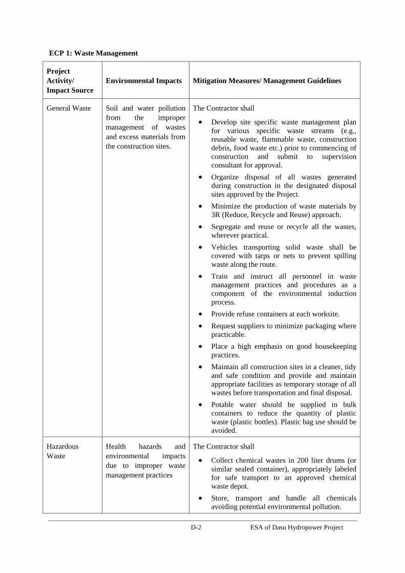
D-2 ESA of Dasu Hydropower Project
ECP 1: Waste Management
Project
Activity/
Impact Source
Environmental Impacts Mitigation Measures/ Management Guidelines
General Waste
Soil and water pollution
from the improper
management of wastes
and excess materials from
the construction sites.
The Contractor shall
Develop site specific waste management plan
for various specific waste streams (e.g.,
reusable waste, flammable waste, construction
debris, food waste etc.) prior to commencing of
construction and submit to supervision
consultant for approval.
Organize disposal of all wastes generated
during construction in the designated disposal
sites approved by the Project.
Minimize the production of waste materials by
3R (Reduce, Recycle and Reuse) approach.
Segregate and reuse or recycle all the wastes,
wherever practical.
Vehicles transporting solid waste shall be
covered with tarps or nets to prevent spilling
waste along the route.
Train and instruct all personnel in waste
management practices and procedures as a
component of the environmental induction
process.
Provide refuse containers at each worksite.
Request suppliers to minimize packaging where
practicable.
Place a high emphasis on good housekeeping
practices.
Maintain all construction sites in a cleaner, tidy
and safe condition and provide and maintain
appropriate facilities as temporary storage of all
wastes before transportation and final disposal.
Potable water should be supplied in bulk
containers to reduce the quantity of plastic
waste (plastic bottles). Plastic bag use should be
avoided.
Hazardous
Waste
Health hazards and
environmental impacts
due to improper waste
management practices
The Contractor shall
Collect chemical wastes in 200 liter drums (or
similar sealed container), appropriately labeled
for safe transport to an approved chemical
waste depot.
Store, transport and handle all chemicals
avoiding potential environmental pollution.
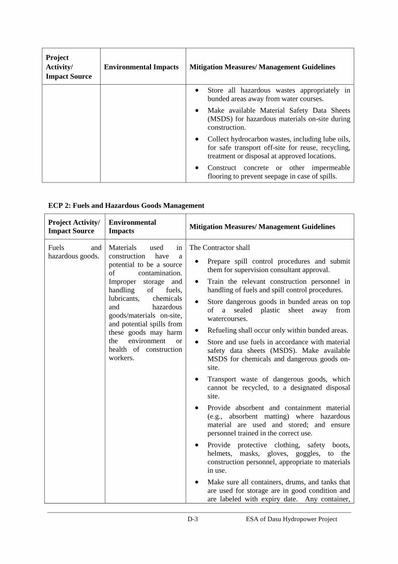
D-3 ESA of Dasu Hydropower Project
Project
Activity/
Impact Source
Environmental Impacts Mitigation Measures/ Management Guidelines
Store all hazardous wastes appropriately in
bunded areas away from water courses.
Make available Material Safety Data Sheets
(MSDS) for hazardous materials on-site during
construction.
Collect hydrocarbon wastes, including lube oils,
for safe transport off-site for reuse, recycling,
treatment or disposal at approved locations.
Construct concrete or other impermeable
flooring to prevent seepage in case of spills.
ECP 2: Fuels and Hazardous Goods Management
Project Activity/
Impact Source Environmental
Impacts Mitigation Measures/ Management Guidelines
Fuels and
hazardous goods. Materials used in
construction have a
potential to be a source
of contamination.
Improper storage and
handling of fuels,
lubricants, chemicals
and hazardous
goods/materials on-site,
and potential spills from
these goods may harm
the environment or
health of construction
workers.
The Contractor shall
Prepare spill control procedures and submit
them for supervision consultant approval.
Train the relevant construction personnel in
handling of fuels and spill control procedures.
Store dangerous goods in bunded areas on top
of a sealed plastic sheet away from
watercourses.
Refueling shall occur only within bunded areas.
Store and use fuels in accordance with material
safety data sheets (MSDS). Make available
MSDS for chemicals and dangerous goods on-
site.
Transport waste of dangerous goods, which
cannot be recycled, to a designated disposal
site.
Provide absorbent and containment material
(e.g., absorbent matting) where hazardous
material are used and stored; and ensure
personnel trained in the correct use.
Provide protective clothing, safety boots,
helmets, masks, gloves, goggles, to the
construction personnel, appropriate to materials
in use.
Make sure all containers, drums, and tanks that
are used for storage are in good condition and
are labeled with expiry date. Any container,

D-4 ESA of Dasu Hydropower Project
Project Activity/
Impact Source Environmental
Impacts Mitigation Measures/ Management Guidelines
drum, or tank that is dented, cracked, or rusted
might eventually leak. Check for leakage
regularly to identify potential problems before
they occur.
Store and use fuels in accordance with material
safety data sheets (MSDSs).
Store all liquid fuels in fully bunded storage
containers, with appropriate volumes, a roof, a
collection point and appropriate
filling/decanting point.
Store hazardous materials above flood level
considered for construction purposes
Put containers and drums in temporary storages
in clearly marked areas, where they will not be
run over by vehicles or heavy machinery. The
area shall preferably slope or drain to a safe
collection area in the event of a spill.
Take all precautionary measures when handling
and storing fuels and lubricants, avoiding
environmental pollution.
Avoid the use of material with greater potential
for contamination by substituting them with
more environmentally friendly materials.
ECP 3: Water Resources Management
Project
Activity/
Impact Source Environmental Impacts Mitigation Measures/ Management Guidelines
Hazardous
material and
Waste
Water pollution from the
storage, handling and
disposal of hazardous
materials and general
construction waste, and
accidental spillage
The Contractor shall
Follow the management guidelines proposed in
ECPs 1 and 2.
Minimize the generation of sediment, oil and
grease, excess nutrients, organic matter, litter,
debris and any form of waste (particularly
petroleum and chemical wastes). These
substances must not enter waterways or storm
water systems.
Discharge from
construction
sites
Construction activities,
sewerages from
construction sites and
work camps may affect
the surface water quality.
The construction works
The Contractor shall
Install temporary drainage works (channels and
bunds) in areas required for sediment and
erosion control and around storage areas for
construction materials.

D-5 ESA of Dasu Hydropower Project
Project
Activity/
Impact Source Environmental Impacts Mitigation Measures/ Management Guidelines
will modify groundcover
and topography changing
the surface water drainage
patterns of the area. These
changes in hydrological
regime lead to increased
rate of runoff, increase in
sediment and contaminant
loading, increased
flooding, and effect
habitat of fish and other
aquatic biology.
Install temporary sediment basins, where
appropriate, to capture sediment-laden run-off
from site.
Divert runoff from undisturbed areas around the
construction site.
Stockpile materials away from drainage lines
Prevent all solid and liquid wastes entering
waterways by collecting solid waste, oils,
chemicals, bitumen spray waste and
wastewaters from brick, concrete and asphalt
cutting where possible and transport to a
approved waste disposal site or recycling depot.
Wash out ready-mix concrete agitators and
concrete handling equipment at washing
facilities off site or into approved bunded areas
on site. Ensure that tires of construction
vehicles are cleaned in the washing bay
(constructed at the entrance of the construction
site) to remove the mud from the wheels. This
should be done in every exit of each
construction vehicle to ensure the local roads
are kept clean.
Soil erosion and
siltation Soil erosion and dust from
the material stockpiles
will increase the sediment
and contaminant loading
of surface water bodies.
The Contractor shall
Stabilize the cleared areas not used for
construction activities with vegetation or
appropriate surface water treatments as soon as
practicable following earthwork to minimize
erosion.
Ensure that roads used by construction vehicles
are swept regularly to remove dust and
sediment.
Water the loose material stockpiles, access
roads and bare soils on an as required basis to
minimize dust. Increase the watering frequency
during periods of high risk (e.g. high winds).
Construction
activities in
water bodies
Construction works in the
water bodies will increase
sediment and contaminant
loading, and effect habitat
of fish and other aquatic
biology.
The Contractor Shall
Dewater sites by pumping water to a sediment
basin prior to release off site – do not pump
directly off site.
Monitor the water quality in the runoff from the
site or areas affected by dredge/excavation
plumes, and improve work practices as
necessary.
Protect water bodies from sediment loads by silt
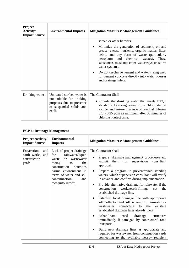
D-6 ESA of Dasu Hydropower Project
Project
Activity/
Impact Source Environmental Impacts Mitigation Measures/ Management Guidelines
screen or other barriers.
Minimize the generation of sediment, oil and
grease, excess nutrients, organic matter, litter,
debris and any form of waste (particularly
petroleum and chemical wastes). These
substances must not enter waterways or storm
water systems.
Do not discharge cement and water curing used
for cement concrete directly into water courses
and drainage inlets.
Drinking water Untreated surface water is
not suitable for drinking
purposes due to presence
of suspended solids and
ecoli.
The Contractor Shall
Provide the drinking water that meets NEQS
standards. Drinking water to be chlorinated at
source, and ensure presence of residual chlorine
0.1 ~ 0.25 ppm as minimum after 30 minutes of
chlorine contact time.
ECP 4: Drainage Management
Project Activity/
Impact Source Environmental
Impacts Mitigation Measures/ Management Guidelines
Excavation and
earth works, and
construction
yards
Lack of proper drainage
for rainwater/liquid
waste or wastewater
owing to the
construction activities
harms environment in
terms of water and soil
contamination, and
mosquito growth.
The Contractor shall
Prepare drainage management procedures and
submit them for supervision consultant
approval.
Prepare a program to prevent/avoid standing
waters, which supervision consultant will verify
in advance and confirm during implementation.
Provide alternative drainage for rainwater if the
construction works/earth-fillings cut the
established drainage line.
Establish local drainage line with appropriate
silt collector and silt screen for rainwater or
wastewater connecting to the existing
established drainage lines already there.
Rehabilitate road drainage structures
immediately if damaged by contractors’ road
transports.
Build new drainage lines as appropriate and
required for wastewater from construction yards
connecting to the available nearby recipient
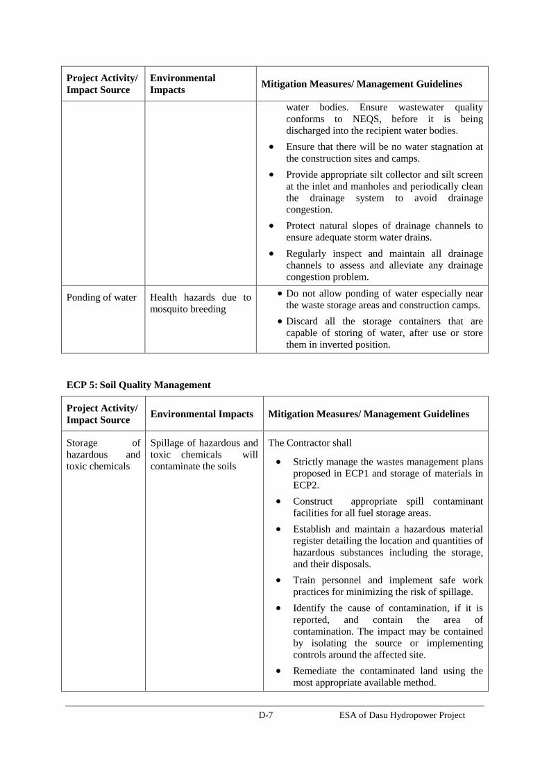
D-7 ESA of Dasu Hydropower Project
Project Activity/
Impact Source Environmental
Impacts Mitigation Measures/ Management Guidelines
water bodies. Ensure wastewater quality
conforms to NEQS, before it is being
discharged into the recipient water bodies.
Ensure that there will be no water stagnation at
the construction sites and camps.
Provide appropriate silt collector and silt screen
at the inlet and manholes and periodically clean
the drainage system to avoid drainage
congestion.
Protect natural slopes of drainage channels to
ensure adequate storm water drains.
Regularly inspect and maintain all drainage
channels to assess and alleviate any drainage
congestion problem.
Ponding of water Health hazards due to
mosquito breeding
Do not allow ponding of water especially near
the waste storage areas and construction camps.
Discard all the storage containers that are
capable of storing of water, after use or store
them in inverted position.
ECP 5: Soil Quality Management
Project Activity/
Impact Source Environmental Impacts Mitigation Measures/ Management Guidelines
Storage of
hazardous and
toxic chemicals
Spillage of hazardous and
toxic chemicals will
contaminate the soils
The Contractor shall
Strictly manage the wastes management plans
proposed in ECP1 and storage of materials in
ECP2.
Construct appropriate spill contaminant
facilities for all fuel storage areas.
Establish and maintain a hazardous material
register detailing the location and quantities of
hazardous substances including the storage,
and their disposals.
Train personnel and implement safe work
practices for minimizing the risk of spillage.
Identify the cause of contamination, if it is
reported, and contain the area of
contamination. The impact may be contained
by isolating the source or implementing
controls around the affected site.
Remediate the contaminated land using the
most appropriate available method.

D-8 ESA of Dasu Hydropower Project
Project Activity/
Impact Source Environmental Impacts Mitigation Measures/ Management Guidelines
Construction
material stock
piles
Erosion from construction
material stockpiles may
contaminate the soils
The Contractor shall
Protect the toe of all stockpiles, where erosion
is likely to occur, with silt fences, straw bales
or bunds.
ECP 6: Erosion and Sediment Control
Project Activity/
Impact Source Environmental Impacts Mitigation Measures/ Management Guidelines
Clearing of
construction sites Cleared areas and slopes
are susceptible for erosion
of top soils, which affects
the growth of vegetation
and causes ecological
imbalance.
The Contractor shall
Prepare site specific erosion and sediment
control measures and submit them for
supervision consultant approval.
Reinstate and protect cleared areas as soon
as possible.
Cover unused area of disturbed or exposed
surfaces immediately with mulch/grass
turf/tree plantations.
Construction
activities and
material
stockpiles
The impact of soil erosion
are (i) Increased run off and
sedimentation causing a
greater flood hazard to the
downstream, and (ii)
destruction of aquatic
environment by erosion
and/or deposition of
sediment damaging the
spawning grounds of fish
The Contractor shall
Locate stockpiles away from drainage lines.
Protect the toe of all stockpiles, where
erosion is likely to occur, with silt fences,
straw bales or bunds.
Remove debris from drainage paths and
sediment control structures.
Cover the loose sediments of construction
material and water them if required.
Divert natural runoff around construction
areas prior to any site disturbance.
Install protective measures on site prior to
construction, for example, sediment traps.
Install ‘cut off drains’ on large cut/fill batter
slopes to control water runoff speed and
hence erosion.
Observe the performance of drainage
structures and erosion controls during rain
and modify as required.
Soil erosion and
siltation Soil erosion and dust from
the material stockpiles will
increase the sediment and
The Contractor shall
Stabilize the cleared areas not used for

D-9 ESA of Dasu Hydropower Project
Project Activity/
Impact Source Environmental Impacts Mitigation Measures/ Management Guidelines
contaminant loading of
surface water bodies.
construction activities with vegetation or
appropriate surface water treatments as soon
as practicable following earthwork to
minimize erosion.
Ensure that roads used by construction
vehicles are swept regularly to remove
sediment.
Water the material stockpiles, access roads
and bare soils on an as required basis to
minimize dust. Increase the watering
frequency during periods of high risk (e.g.
high winds).
ECP 7: Top Soil Management
Project Activity/
Impact Source Environmental Impacts Mitigation Measures/ Management Guidelines
Land clearing and
earth works Earthworks will impact the
fertile top soils that are
enriched with nutrients
required for plant growth or
agricultural development.
The Contractor shall
Strip the top soil to a depth of 15 cm and
store in stock piles of height not exceeding
2m.
Remove unwanted materials from top soil
like grass, roots of trees and similar others.
The stockpiles will be done in slopes of 2:1
to reduce surface runoff and enhance
percolation through the mass of stored soil.
Locate topsoil stockpiles in areas outside
drainage lines and protect from erosion.
Construct diversion channels and silt
fences around the topsoil stockpiles to
prevent erosion and loss of topsoil.
Spread the topsoil to maintain the physico-
chemical and biological activity of the soil.
The stored top soil will be utilized for
covering all disturbed area and along the
proposed plantation sites.
Prior to the re-spreading of topsoil, the
ground surface will be ripped to assist the
bunding of the soil layers, water
penetration and revegetation
Transport Vehicular movement outside
ROW or temporary access
roads will affect the soil
fertility of the agricultural
Limit equipment and vehicular movements
to within the approved construction zone.
Plan construction access to make use, if
possible, of the final road alignment.

D-10 ESA of Dasu Hydropower Project
Project Activity/
Impact Source Environmental Impacts Mitigation Measures/ Management Guidelines
lands
ECP 8: Topography and Landscaping
Project Activity/
Impact Source Environmental Impacts
Mitigation Measures/ Management
Guidelines
Land clearing and
earth works Construction activities
especially earthworks will
change topography and disturb
the natural rainwater/flood
water drainage as well as will
change the local landscape.
The Contractor shall
Prepare land scaping and plantation plan
and submit the plan for supervision
consultant approval.
Ensure the topography of the final
surface of all raised lands (construction
yards, approach roads and rails, access
roads, etc.) are conducive to enhance
natural draining of rainwater/flood
water.
Keep the final or finished surface of all
the raised lands free from any kind of
depression that causes water logging.
Undertake mitigation measures for
erosion control/prevention by grass-
turfing and tree plantation, where there
is a possibility of rain-cut that will
change the shape of topography.
Cover immediately the uncovered open
surface that has no use of construction
activities with grass-cover and tree
plantation to prevent soil erosion and
bring improved landscaping.
Reinstate the natural landscape of the
ancillary construction sites after
completion of works.

D-11 ESA of Dasu Hydropower Project
ECP 9: Quarry Areas Development & Operation
Project Activity/
Impact Source Environmental Impacts Mitigation Measures/ Management Guidelines
Development and
operation of
borrow areas
Borrow areas will have
impacts on local
topography, landscaping
and natural drainage.
The Contractor shall
Prepare quarry area management plan and
submit the plan for supervision consultant
approval.
Use only approved quarry and borrow sites
Identify new borrow and quarry areas in
consultation with Project Director, if required.
Reuse excavated or disposed material available
in the project to the maximum extent possible.
Store top soil for reinstatement and
landscaping.
Develop surface water collection and drainage
systems, anti-erosion measures (berms,
revegetation etc.) and retaining walls and
gabions where required. Implement mitigation
measures in ECP 3: Water Resources
Management, ECP 6: Erosion and Sediment
Control
The use of explosive should be used in as
much minimum quantity as possible to reduce
noise, vibration and dust.
Control dust and air quality deterioration by
application of watering and implementing
mitigation measures proposed in ECP 10: Air
Quality Management
Noise and vibration control by ECP 11: Noise
and Vibration Management.
ECP 10: Air Quality Management
Project
Activity/
Impact Source
Environmental
Impacts Mitigation Measures/ Management Guidelines
Construction
vehicular traffic Air quality can be
adversely affected by
vehicle exhaust
emissions and
combustion of fuels.
The Contractor shall
Prepare air quality management plan (under the
Pollution Prevention Plan) and submit the plan for
supervision consultant approval.
Fit vehicles with appropriate exhaust systems and
emission control devices. Maintain these devices
in good working condition.

D-12 ESA of Dasu Hydropower Project
Project
Activity/
Impact Source
Environmental
Impacts Mitigation Measures/ Management Guidelines
Operate the vehicles in a fuel efficient manner.
Cover hauls vehicles carrying dusty materials
moving outside the construction site.
Impose speed limits on all vehicle movement at
the worksite to reduce dust emissions.
Control the movement of construction traffic.
Water construction materials prior to loading and
transport.
Service all vehicles regularly to minimize
emissions.
Limit the idling time of vehicles not more than 2
minutes.
Construction
machinery Air quality can be
adversely affected by
emissions from
machinery and
combustion of fuels.
The Contractor shall
Fit machinery with appropriate exhaust systems
and emission control devices. Maintain these
devices in good working condition in accordance
with the specifications defined by their
manufacturers to maximize combustion efficiency
and minimize the contaminant emissions. Proof or
maintenance register shall be required by the
equipment suppliers and
contractors/subcontractors.
Focus special attention on containing the
emissions from generators.
Machinery causing excess pollution (e.g. visible
smoke) will be banned from construction sites.
Service all equipment regularly to minimize
emissions.
Provide filtering systems, duct collectors or
humidification or other techniques (as applicable)
to the concrete batching and mixing plant to
control the particle emissions in all its stages,
including unloading, collection, aggregate
handling, cement dumping, circulation of trucks
and machinery inside the installations.
Construction
activities Dust generation from
construction sites,
material stockpiles and
access roads is a
nuisance in the
environment and can be
a health hazard, and
also can affect the local
The Contractor shall
Water the material stockpiles, access roads and
bare soils on an as required basis to minimize the
potential for environmental nuisance due to dust.
Increase the watering frequency during periods of
high risk (e.g. high winds). Stored materials such
as gravel and sand shall be covered and confined
to avoid their being wind-drifted.
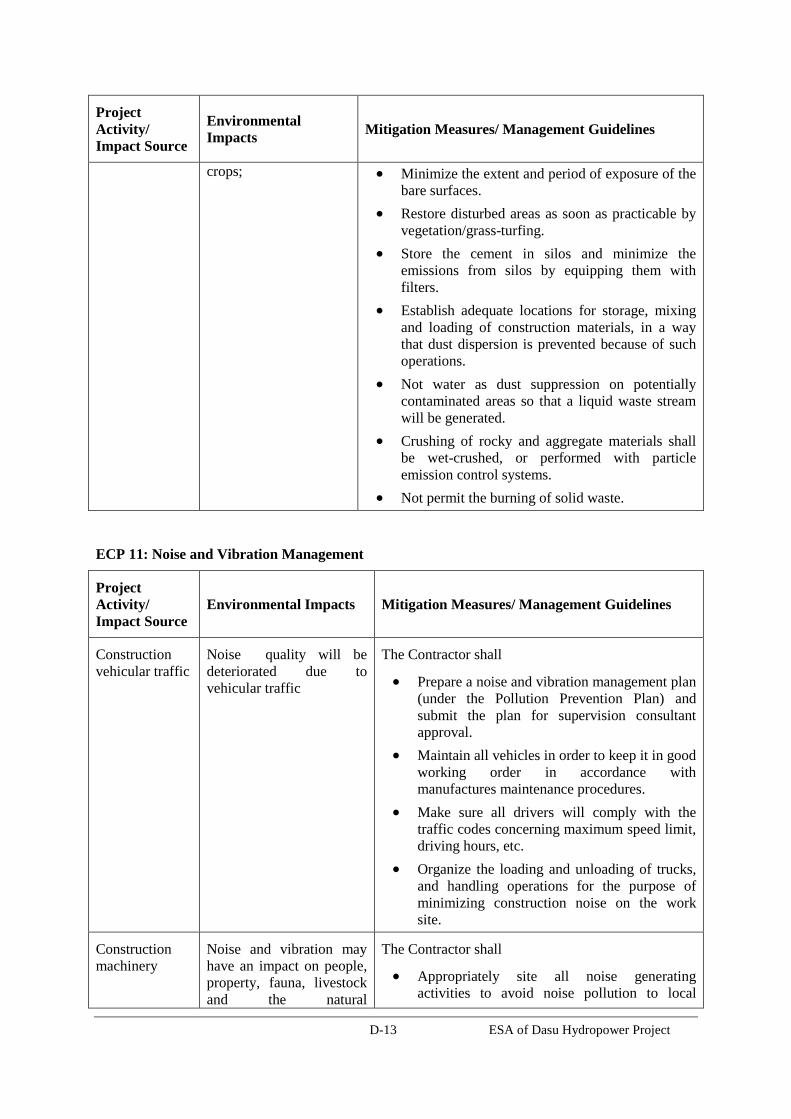
D-13 ESA of Dasu Hydropower Project
Project
Activity/
Impact Source
Environmental
Impacts Mitigation Measures/ Management Guidelines
crops; Minimize the extent and period of exposure of the
bare surfaces.
Restore disturbed areas as soon as practicable by
vegetation/grass-turfing.
Store the cement in silos and minimize the
emissions from silos by equipping them with
filters.
Establish adequate locations for storage, mixing
and loading of construction materials, in a way
that dust dispersion is prevented because of such
operations.
Not water as dust suppression on potentially
contaminated areas so that a liquid waste stream
will be generated.
Crushing of rocky and aggregate materials shall
be wet-crushed, or performed with particle
emission control systems.
Not permit the burning of solid waste.
ECP 11: Noise and Vibration Management
Project
Activity/
Impact Source Environmental Impacts Mitigation Measures/ Management Guidelines
Construction
vehicular traffic Noise quality will be
deteriorated due to
vehicular traffic
The Contractor shall
Prepare a noise and vibration management plan
(under the Pollution Prevention Plan) and
submit the plan for supervision consultant
approval.
Maintain all vehicles in order to keep it in good
working order in accordance with
manufactures maintenance procedures.
Make sure all drivers will comply with the
traffic codes concerning maximum speed limit,
driving hours, etc.
Organize the loading and unloading of trucks,
and handling operations for the purpose of
minimizing construction noise on the work
site.
Construction
machinery Noise and vibration may
have an impact on people,
property, fauna, livestock
and the natural
The Contractor shall
Appropriately site all noise generating
activities to avoid noise pollution to local

D-14 ESA of Dasu Hydropower Project
Project
Activity/
Impact Source Environmental Impacts Mitigation Measures/ Management Guidelines
environment.
residents.
Use the quietest available plant and equipment.
Maintain all equipment in order to keep it in
good working order in accordance with
manufactures maintenance procedures.
Equipment suppliers and contractors shall
present proof of maintenance register of their
equipment.
Install acoustic enclosures around generators to
reduce noise levels.
Fit high efficiency mufflers to appropriate
construction equipment.
Avoid the unnecessary use of alarms, horns
and sirens.
Construction
activity Noise and vibration may
have an impact on people,
property, fauna, livestock
and the natural
environment.
The Contractor shall
Notify adjacent landholders prior any typical
noise events outside of daylight hours.
Educate the operators of construction
equipment on potential noise problems and the
techniques to minimize noise emissions.
Employ best available work practices on-site to
minimize occupational noise levels.
Install temporary noise control barriers where
appropriate.
Notify affected people if major noisy activities
will be undertaken, e.g. blasting.
Plan activities on site and deliveries to and
from site to minimize impact.
Monitor and analyze noise and vibration results
and adjust construction practices as required.
Avoid undertaking the noisiest activities,
where possible, when working at night near the
residential areas.
ECP 12: Protection of Flora
Project
Activity/
Impact Source Environmental Impacts Mitigation Measures/ Management Guidelines
Vegetation
clearance Local flora are important to
provide shelters for the
birds, offer fruits and/or
The Contractor shall
Prepare a plan for protection of flora and
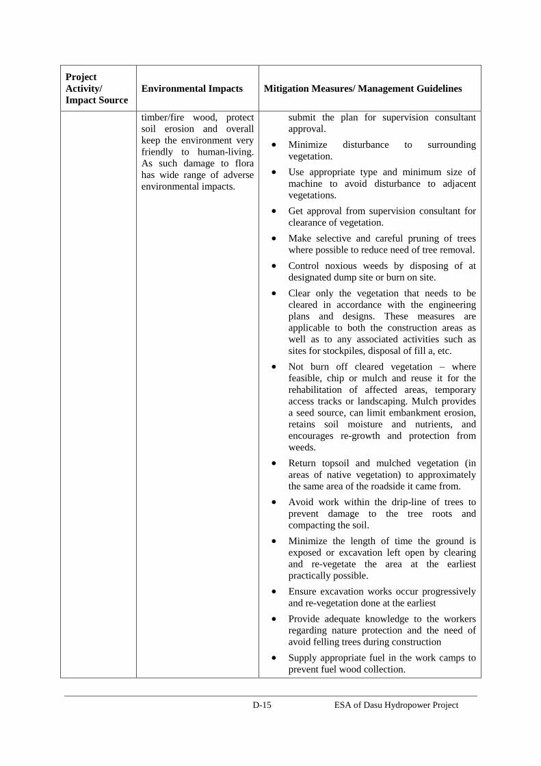
D-15 ESA of Dasu Hydropower Project
Project
Activity/
Impact Source Environmental Impacts Mitigation Measures/ Management Guidelines
timber/fire wood, protect
soil erosion and overall
keep the environment very
friendly to human-living.
As such damage to flora
has wide range of adverse
environmental impacts.
submit the plan for supervision consultant
approval.
Minimize disturbance to surrounding
vegetation.
Use appropriate type and minimum size of
machine to avoid disturbance to adjacent
vegetations.
Get approval from supervision consultant for
clearance of vegetation.
Make selective and careful pruning of trees
where possible to reduce need of tree removal.
Control noxious weeds by disposing of at
designated dump site or burn on site.
Clear only the vegetation that needs to be
cleared in accordance with the engineering
plans and designs. These measures are
applicable to both the construction areas as
well as to any associated activities such as
sites for stockpiles, disposal of fill a, etc.
Not burn off cleared vegetation – where
feasible, chip or mulch and reuse it for the
rehabilitation of affected areas, temporary
access tracks or landscaping. Mulch provides
a seed source, can limit embankment erosion,
retains soil moisture and nutrients, and
encourages re-growth and protection from
weeds.
Return topsoil and mulched vegetation (in
areas of native vegetation) to approximately
the same area of the roadside it came from.
Avoid work within the drip-line of trees to
prevent damage to the tree roots and
compacting the soil.
Minimize the length of time the ground is
exposed or excavation left open by clearing
and re-vegetate the area at the earliest
practically possible.
Ensure excavation works occur progressively
and re-vegetation done at the earliest
Provide adequate knowledge to the workers
regarding nature protection and the need of
avoid felling trees during construction
Supply appropriate fuel in the work camps to
prevent fuel wood collection.
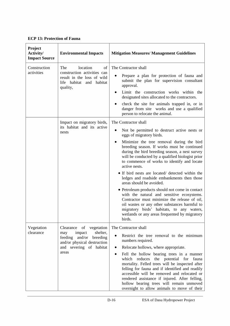
D-16 ESA of Dasu Hydropower Project
ECP 13: Protection of Fauna
Project
Activity/
Impact Source Environmental Impacts Mitigation Measures/ Management Guidelines
Construction
activities The location of
construction activities can
result in the loss of wild
life habitat and habitat
quality,
The Contractor shall
Prepare a plan for protection of fauna and
submit the plan for supervision consultant
approval.
Limit the construction works within the
designated sites allocated to the contractors.
check the site for animals trapped in, or in
danger from site works and use a qualified
person to relocate the animal.
Impact on migratory birds,
its habitat and its active
nests
The Contractor shall
Not be permitted to destruct active nests or
eggs of migratory birds.
Minimize the tree removal during the bird
breeding season. If works must be continued
during the bird breeding season, a nest survey
will be conducted by a qualified biologist prior
to commence of works to identify and locate
active nests.
If bird nests are located/ detected within the
ledges and roadside embankments then those
areas should be avoided.
Petroleum products should not come in contact
with the natural and sensitive ecosystems.
Contractor must minimize the release of oil,
oil wastes or any other substances harmful to
migratory birds’ habitats, to any waters,
wetlands or any areas frequented by migratory
birds.
Vegetation
clearance Clearance of vegetation
may impact shelter,
feeding and/or breeding
and/or physical destruction
and severing of habitat
areas
The Contractor shall
Restrict the tree removal to the minimum
numbers required.
Relocate hollows, where appropriate.
Fell the hollow bearing trees in a manner
which reduces the potential for fauna
mortality. Felled trees will be inspected after
felling for fauna and if identified and readily
accessible will be removed and relocated or
rendered assistance if injured. After felling,
hollow bearing trees will remain unmoved
overnight to allow animals to move of their

D-17 ESA of Dasu Hydropower Project
Project
Activity/
Impact Source Environmental Impacts Mitigation Measures/ Management Guidelines
own volition.
Night time
lighting Lighting from construction
sites and construction
camps may affect the
visibility of night time
migratory birds that use the
moon and stars for
navigation during their
migrations.
The Contractor shall
Use lower wattage flat lens fixtures that direct
light down and reduce glare, thus reducing
light pollution,
Avoid flood lights unless they are absolutely
required.
Use motion sensitive lighting to minimize
unneeded lighting.
Use, if possible, green lights that are
considered as bird’s friendly lighting instead
of white or red colored lights.
Install light shades or plan the direction of
lights to reduce light spilling outside the
construction area.
Construction
camps Illegal poaching The Contractor shall
Provide adequate knowledge to the workers
regarding protection of flora and fauna, and
relevant government regulations and
punishments for illegal poaching.
Ensure that staff and Subcontractors are
trained and empowered to identify, address
and report potential environmental problems.
ECP 14: Protection of Fish
Project
Activity/
Impact Source Environmental Impacts Mitigation Measures/ Management Guidelines
Construction
activities in
River
The main potential impacts
to fisheries are hydrocarbon
spills and leaks from
riverine transport and
disposal of wastes into the
river
The Contractor shall
Prepare procedures for protection of fish and
submit them for supervision consultant
approval.
Ensure the construction equipment used in the
river are well maintained and do not have oil
leakage to contaminate river water.
Contain oil immediately on river in case of
accidental spillage from equipment; make an
emergency oil spill containment plan (under
the Fuels and Hazardous Substances
Management Plan) to be supported with
enough equipments, materials and human

D-18 ESA of Dasu Hydropower Project
Project
Activity/
Impact Source Environmental Impacts Mitigation Measures/ Management Guidelines
resources.
Do not dump wastes, be it hazardous or non-
hazardous into the nearby water bodies or in
the river.
Construction
activities on the
land
The main potential impacts
to aquatic flora and fauna
River are increased
suspended solids from
earthworks erosion,
sanitary discharge from
work camps, and
hydrocarbon spills
The Contractor shall
follow mitigation measures proposed in ECP
3: Water Resources Management and EC4:
Drainage Management.
ECP 15: Road Transport and Road Traffic Management
Project
Activity/
Impact Source Environmental Impacts Mitigation Measures/ Management Guidelines
Construction
vehicular traffic Increased traffic use of road
by construction vehicles will
affect the movement of
normal road traffics and the
safety of the road-users.
The Contractor shall
Prepare a traffic management plan and submit
the plan for supervision consultant approval.
Strictly follow the Project’s ‘Traffic
Management Plan’ and work with close
coordination with the Traffic Management
Unit.
Prepare and submit additional traffic plan, if
any of his traffic routes are not covered in the
Project’s Traffic Management Plan, and
requires traffic diversion and management.
Include in the traffic plan to ensure
uninterrupted traffic movement during
construction: detailed drawings of traffic
arrangements showing all detours,
temporary road, temporary bridges
temporary diversions, necessary barricades,
warning signs / lights, road signs etc.
Provide signs at strategic locations of the
roads complying with the schedules of
signs contained in the Pakistan Traffic
Regulations.
Accidents and spillage of
fuels and chemicals The Contractor shall
Restrict truck deliveries, where practicable, to
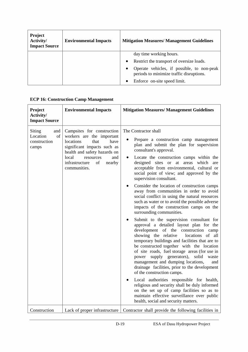
D-19 ESA of Dasu Hydropower Project
Project
Activity/
Impact Source Environmental Impacts Mitigation Measures/ Management Guidelines
day time working hours.
Restrict the transport of oversize loads.
Operate vehicles, if possible, to non-peak
periods to minimize traffic disruptions.
Enforce on-site speed limit.
ECP 16: Construction Camp Management
Project
Activity/
Impact Source
Environmental Impacts Mitigation Measures/ Management Guidelines
Siting and
Location of
construction
camps
Campsites for construction
workers are the important
locations that have
significant impacts such as
health and safety hazards on
local resources and
infrastructure of nearby
communities.
The Contractor shall
Prepare a construction camp management
plan and submit the plan for supervision
consultant's approval.
Locate the construction camps within the
designed sites or at areas which are
acceptable from environmental, cultural or
social point of view; and approved by the
supervision consultant.
Consider the location of construction camps
away from communities in order to avoid
social conflict in using the natural resources
such as water or to avoid the possible adverse
impacts of the construction camps on the
surrounding communities.
Submit to the supervision consultant for
approval a detailed layout plan for the
development of the construction camp
showing the relative locations of all
temporary buildings and facilities that are to
be constructed together with the location
of site roads, fuel storage areas (for use in
power supply generators), solid waste
management and dumping locations, and
drainage facilities, prior to the development
of the construction camps.
Local authorities responsible for health,
religious and security shall be duly informed
on the set up of camp facilities so as to
maintain effective surveillance over public
health, social and security matters.
Construction Lack of proper infrastructure Contractor shall provide the following facilities in

D-20 ESA of Dasu Hydropower Project
Project
Activity/
Impact Source
Environmental Impacts Mitigation Measures/ Management Guidelines
Camp Facilities
facilities , such as housing,
water supply and sanitation
facilities will increase
pressure on the local
services and generate
substandard living standards
and health hazards.
the campsites
Adequate housing for all workers.
Safe and reliable water supply, which should
meet NEQS. Drinking water to be
chlorinated at source, and ensure presence of
residual chlorine 0.1 ~ 0.25 ppm as minimum
after 30 minutes of chlorine contact time
(WHO guideline).
Hygienic sanitary facilities and sewerage
system. The toilets and domestic waste water
will be collected through a common
sewerage. Provide separate latrines and
bathing places for males and females with
total isolation by location. The minimum
number of toilet facilities required is one
toilet for every ten persons.
Treatment facilities for sewerage of toilet and
domestic wastes.
Storm water drainage facilities.
Paved internal roads.
Provide child crèches for women working
construction site. The crèche should have
facilities for dormitory, kitchen, indoor and
outdoor play area. Schools should be
attached to these crèches so that children are
not deprived of education whose mothers are
construction workers.
Provide in-house community/common
entertainment facilities. Dependence of local
entertainment outlets by the construction
camps to be discouraged/prohibited to the
extent possible.
Disposal of
waste Management of wastes is
crucial to minimize impacts
on the environment
The Contractor shall
Ensure proper collection and disposal of
solid wastes within the construction camps.
Insist waste separation by source; organic
wastes in one container and inorganic wastes
in another container at household level.
Store inorganic wastes in a safe place within
the household and clear organic wastes on
daily basis to waste collector. Establish waste
collection, transportation and disposal
systems with the manpower and
equipments/vehicles needed.

D-21 ESA of Dasu Hydropower Project
Project
Activity/
Impact Source
Environmental Impacts Mitigation Measures/ Management Guidelines
Do not establish site specific landfill sites.
All solid waste will be collected and removed
from the work camps and disposed in
approval waste disposal sites.
Fuel supplies
for cooking
purposes
Illegal sourcing of fuel wood
by construction workers will
impact the natural flora and
fauna
The Contractor shall
Provide fuel to the construction camps for
their domestic purpose, in order to
discourage them to use fuel wood or other
biomass.
Made available alternative fuels like natural
gas or kerosene on ration to the workforce to
prevent them using biomass for cooking.
Conduct awareness campaigns to educate
workers on preserving the protecting the
biodiversity and wildlife of the project area,
and relevant government regulations and
punishments on wildlife protection.
Health and
Hygiene
There will be a potential for
diseases to be transmitted
including malaria,
exacerbated by inadequate
health and safety practices.
There will be an increased
risk of work crews spreading
sexually transmitted
infections and HIV/AIDS.
The Contractor shall
Provide adequate health care facilities within
construction sites.
Provide first aid facility round the clock.
Maintain stock of medicines in the facility
and appoint fulltime designated first aider or
nurse.
Provide ambulance facility for the laborers
during emergency to be transported to
nearest hospitals.
Initial health screening of the laborers
coming from outside areas.
Train all construction workers in basic
sanitation and health care issues and safety
matters, and on the specific hazards of their
work.
Provide HIV awareness programming,

D-22 ESA of Dasu Hydropower Project
Project
Activity/
Impact Source
Environmental Impacts Mitigation Measures/ Management Guidelines
including STI (sexually transmitted
infections) and HIV information, education
and communication for all workers on
regular basis.
Provide adequate drainage facilities
throughout the camps to ensure that disease
vectors such as stagnant water bodies and
puddles do not form. Regular mosquito
repellant sprays during rainy season in
offices and construction camps and yards.
Not dispose food waste openly as that will
attract rats and stray dogs.
Carryout short training sessions on best
hygiene practices to be mandatorily
participated by all workers. Place display
boards at strategic locations within the camps
containing messages on best hygienic
practices.
Safety In adequate safety facilities
to the construction camps
may create security
problems and fire hazards
The Contractor shall
Provide appropriate security personnel
(police or private security guards) and
enclosures to prevent unauthorized entry in
to the camp area.
Maintain register to keep a track on a head
count of persons present in the camp at any
given time.
Encourage use of flameproof material for the
construction of labor housing / site office.
Also, ensure that these houses/rooms are of
sound construction and capable of
withstanding wind storms/cyclones.
Provide appropriate type of fire fighting
equipments suitable for the construction
camps
Display emergency contact numbers clearly
and prominently at strategic places in camps.
Communicate the roles and responsibilities
of laborers in case of emergency in the
monthly meetings with contractors.
Site Restoration Restoration of the
construction camps to
original condition requires
demolition of construction
camps.
The Contractor shall
Dismantle and remove from the site all
facilities established within the construction
camp including the perimeter fence and
lockable gates at the completion of the

D-23 ESA of Dasu Hydropower Project
Project
Activity/
Impact Source
Environmental Impacts Mitigation Measures/ Management Guidelines
construction work.
Dismantle camps in phases and as the work
gets decreased and not wait for the entire
work to be completed.
Give prior notice to the laborers before
demolishing their camps/units.
Maintain the noise levels within the national
standards during demolition activities.
Different contractors should be hired to
demolish different structures to promote
recycling or reuse of demolished material.
Reuse the demolition debris to a maximum
extent. Dispose remaining debris at the
designated waste disposal site.
Handover the construction camps with all
built facilities as it is if agreement between
both parties (contactor and land-owner) has
been made so.
Restore the site to its condition prior to
commencement of the works or to an agreed
condition with the landowner.
ECP 17: Cultural and Religious Issues
Project
Activity/
Impact Source Environmental Impacts Mitigation Measures/ Management Guidelines
Construction
activities near
religious and
cultural sites
Disturbance from
construction works to the
cultural and religious sites,
and contractors lack of
knowledge on cultural issues
cause social disturbances.
The Contractor shall
Communicate to the public through
community consultation regarding the scope
and schedule of construction, as well as
certain construction activities causing
disruptions or access restriction.
Not block access to cultural and religious
sites, wherever possible.
Restrict all construction activities within the
foot prints of the construction sites.
Stop construction works that produce noise
(particularly during prayer time) should
there be any mosque/religious/educational
institutions close to the construction sites
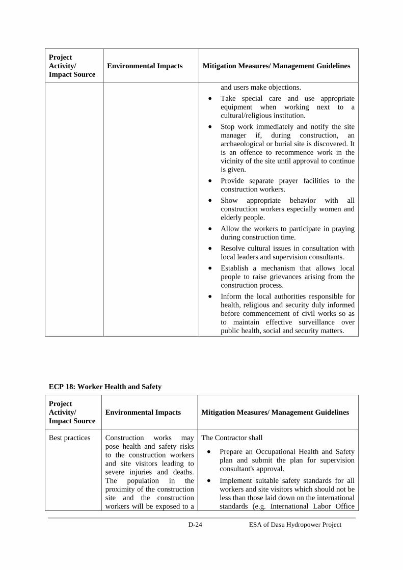
D-24 ESA of Dasu Hydropower Project
Project
Activity/
Impact Source Environmental Impacts Mitigation Measures/ Management Guidelines
and users make objections.
Take special care and use appropriate
equipment when working next to a
cultural/religious institution.
Stop work immediately and notify the site
manager if, during construction, an
archaeological or burial site is discovered. It
is an offence to recommence work in the
vicinity of the site until approval to continue
is given.
Provide separate prayer facilities to the
construction workers.
Show appropriate behavior with all
construction workers especially women and
elderly people.
Allow the workers to participate in praying
during construction time.
Resolve cultural issues in consultation with
local leaders and supervision consultants.
Establish a mechanism that allows local
people to raise grievances arising from the
construction process.
Inform the local authorities responsible for
health, religious and security duly informed
before commencement of civil works so as
to maintain effective surveillance over
public health, social and security matters.
ECP 18: Worker Health and Safety
Project
Activity/
Impact Source Environmental Impacts Mitigation Measures/ Management Guidelines
Best practices Construction works may
pose health and safety risks
to the construction workers
and site visitors leading to
severe injuries and deaths.
The population in the
proximity of the construction
site and the construction
workers will be exposed to a
The Contractor shall
Prepare an Occupational Health and Safety
plan and submit the plan for supervision
consultant's approval.
Implement suitable safety standards for all
workers and site visitors which should not be
less than those laid down on the international
standards (e.g. International Labor Office
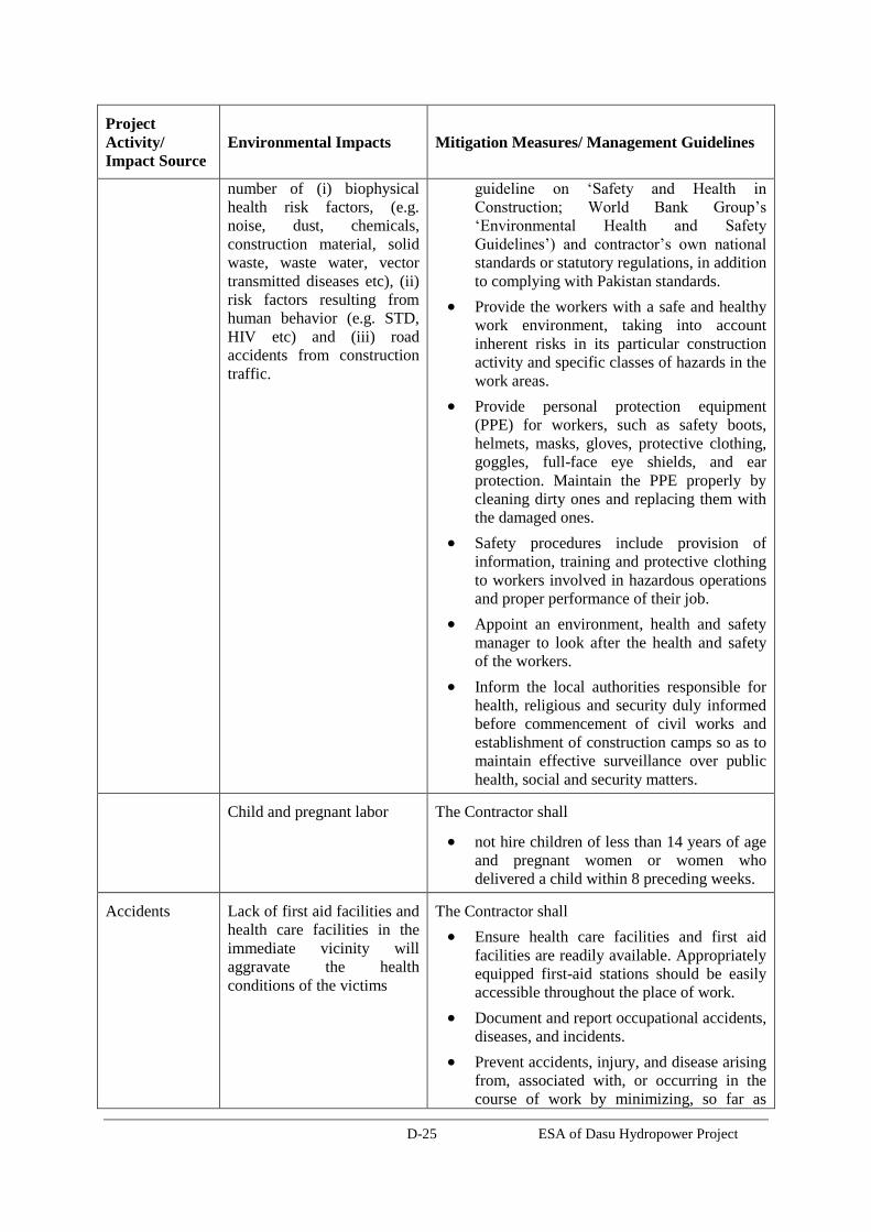
D-25 ESA of Dasu Hydropower Project
Project
Activity/
Impact Source Environmental Impacts Mitigation Measures/ Management Guidelines
number of (i) biophysical
health risk factors, (e.g.
noise, dust, chemicals,
construction material, solid
waste, waste water, vector
transmitted diseases etc), (ii)
risk factors resulting from
human behavior (e.g. STD,
HIV etc) and (iii) road
accidents from construction
traffic.
guideline on ‘Safety and Health in
Construction; World Bank Group’s
‘Environmental Health and Safety
Guidelines’) and contractor’s own national
standards or statutory regulations, in addition
to complying with Pakistan standards.
Provide the workers with a safe and healthy
work environment, taking into account
inherent risks in its particular construction
activity and specific classes of hazards in the
work areas.
Provide personal protection equipment
(PPE) for workers, such as safety boots,
helmets, masks, gloves, protective clothing,
goggles, full-face eye shields, and ear
protection. Maintain the PPE properly by
cleaning dirty ones and replacing them with
the damaged ones.
Safety procedures include provision of
information, training and protective clothing
to workers involved in hazardous operations
and proper performance of their job.
Appoint an environment, health and safety
manager to look after the health and safety
of the workers.
Inform the local authorities responsible for
health, religious and security duly informed
before commencement of civil works and
establishment of construction camps so as to
maintain effective surveillance over public
health, social and security matters.
Child and pregnant labor The Contractor shall
not hire children of less than 14 years of age
and pregnant women or women who
delivered a child within 8 preceding weeks.
Accidents Lack of first aid facilities and
health care facilities in the
immediate vicinity will
aggravate the health
conditions of the victims
The Contractor shall
Ensure health care facilities and first aid
facilities are readily available. Appropriately
equipped first-aid stations should be easily
accessible throughout the place of work.
Document and report occupational accidents,
diseases, and incidents.
Prevent accidents, injury, and disease arising
from, associated with, or occurring in the
course of work by minimizing, so far as
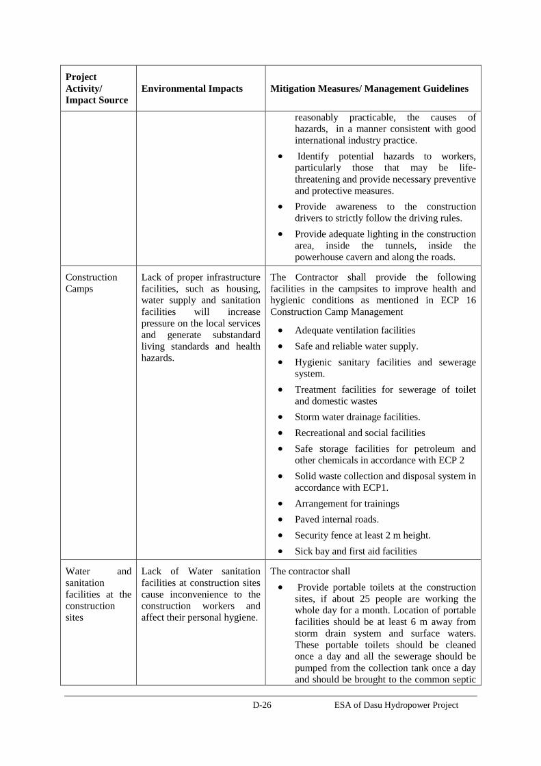
D-26 ESA of Dasu Hydropower Project
Project
Activity/
Impact Source Environmental Impacts Mitigation Measures/ Management Guidelines
reasonably practicable, the causes of
hazards, in a manner consistent with good
international industry practice.
Identify potential hazards to workers,
particularly those that may be life-
threatening and provide necessary preventive
and protective measures.
Provide awareness to the construction
drivers to strictly follow the driving rules.
Provide adequate lighting in the construction
area, inside the tunnels, inside the
powerhouse cavern and along the roads.
Construction
Camps Lack of proper infrastructure
facilities, such as housing,
water supply and sanitation
facilities will increase
pressure on the local services
and generate substandard
living standards and health
hazards.
The Contractor shall provide the following
facilities in the campsites to improve health and
hygienic conditions as mentioned in ECP 16
Construction Camp Management
Adequate ventilation facilities
Safe and reliable water supply.
Hygienic sanitary facilities and sewerage
system.
Treatment facilities for sewerage of toilet
and domestic wastes
Storm water drainage facilities.
Recreational and social facilities
Safe storage facilities for petroleum and
other chemicals in accordance with ECP 2
Solid waste collection and disposal system in
accordance with ECP1.
Arrangement for trainings
Paved internal roads.
Security fence at least 2 m height.
Sick bay and first aid facilities
Water and
sanitation
facilities at the
construction
sites
Lack of Water sanitation
facilities at construction sites
cause inconvenience to the
construction workers and
affect their personal hygiene.
The contractor shall
Provide portable toilets at the construction
sites, if about 25 people are working the
whole day for a month. Location of portable
facilities should be at least 6 m away from
storm drain system and surface waters.
These portable toilets should be cleaned
once a day and all the sewerage should be
pumped from the collection tank once a day
and should be brought to the common septic

D-27 ESA of Dasu Hydropower Project
Project
Activity/
Impact Source Environmental Impacts Mitigation Measures/ Management Guidelines
tank for further treatment.
Provide safe drinking water facilities to the
construction workers at all the construction
sites.
Other ECPs Potential risks on health and
hygiene of construction
workers and general public
The Contractor shall follow the following ECPs to
reduce health risks to the construction workers and
nearby community
ECP 2: Fuels and Hazardous Goods
Management
ECP 4: Drainage Management
ECP 10: Air Quality Management
ECP 11: Noise and Vibration Management
ECP 15: Road Transport and Road Traffic
Management
Trainings Lack of awareness and basic
knowledge in health care
among the construction
workforce, make them
susceptible to potential
diseases.
The Contractor shall
Train all construction workers in basic
sanitation and health care issues (e.g., how to
avoid malaria and transmission of sexually
transmitted infections (STI) HIV/AIDS.
Train all construction workers in general
health and safety matters, and on the specific
hazards of their work. Training should
consist of basic hazard awareness, site
specific hazards, safe work practices, and
emergency procedures for fire, evacuation,
and natural disaster, as appropriate.
Implement malaria, HIV/AIDS and STI
education campaign targeting all workers
hired, international and national, female and
male, skilled, semi- and unskilled
occupations, at the time of recruitment and
thereafter pursued throughout the
construction phase on ongoing and regular
basis. This should be complemented by easy
access to condoms at the workplace as well
as to voluntary counseling and testing.