A modular standard for the cadastral domain: Application to the Portuguese Cadastre
23
A modular standard for the cadastral domain: Application to the Portuguese Cadastre Joa ˜o Paulo Hespanha a, * , Peter van Oosterom b , Jaap Zevenbergen b , Gonc ¸alo Paiva Dias a a ESTGA, Technology and Management Polytechnic School of A ´ gueda, University of Aveiro, Rua Comd.te Pinho e Freitas, 3754-909 A ´ gueda, Portugal b OTB, Research Institute for Housing, Urban and Mobility Studies, Delft University of Technology, Jaffalaan 9, 2628 BX Delft, The Netherlands Received 9 November 2004; received in revised form 15 September 2005; accepted 15 September 2005 Abstract Following recent worldwide developments and initiatives by FIG (Cadastre 2014) and UN, an object oriented, conceptual model for the Cadastral Domain, adapted to Portuguese Cadastre and related Real Estate Register is presented, based on a previously proposed standard. After a brief description of present Cadastral and Land Registration situation in Portugal, UML (Unified Mod- eling Language) literate modeling was used to describe the top level classes by using a structured mix of UML Class Diagrams and natural text. Important contributions of this paper are the evaluation of the FIG core cadastral model by applying it to Portugal. It turns out that a limited number of the classes of the core model are currently not needed (but some of them might be used in the future) and that other classes were added specifically for the situation in Portugal. This is anticipated use of the core model and in case similar patterns occurs in several countries, the new version of the core model should be adapted accordingly within the FIG. In addition to these static model aspects, Activity Diagrams were used to model dynamic behavior concerning a number of chosen Cadastral Update tasks. Currently, the dynamic aspects are not yet present in the FIG core cadastral model, but in case similar dynamic patterns occurs in several countries, then this should be added to the core model. (Notation: In this article, all class names appearing in the text are written in Italics, while the names of class methods are written in Bold Italics and names of attributes are in the in default text style. 0198-9715/$ - see front matter Ó 2005 Elsevier Ltd. All rights reserved. doi:10.1016/j.compenvurbsys.2005.09.005 * Corresponding author. Tel.: +351 234 611 536; fax: +351 234 603 838. E-mail addresses: [email protected] (J.P. Hespanha), [email protected] (P. van Oosterom), [email protected] (J. Zevenbergen), [email protected] (G.P. Dias). Computers, Environment and Urban Systems 30 (2006) 562–584 www.elsevier.com/locate/compenvurbsys
Transcript of A modular standard for the cadastral domain: Application to the Portuguese Cadastre

Computers, Environment and Urban Systems30 (2006) 562–584
www.elsevier.com/locate/compenvurbsys
A modular standard for the cadastraldomain: Application to the Portuguese Cadastre
Joao Paulo Hespanha a,*, Peter van Oosterom b,Jaap Zevenbergen b, Goncalo Paiva Dias a
a ESTGA, Technology and Management Polytechnic School of Agueda, University of Aveiro,
Rua Comd.te Pinho e Freitas, 3754-909 Agueda, Portugalb OTB, Research Institute for Housing, Urban and Mobility Studies, Delft University of Technology,
Jaffalaan 9, 2628 BX Delft, The Netherlands
Received 9 November 2004; received in revised form 15 September 2005; accepted 15 September 2005
Abstract
Following recent worldwide developments and initiatives by FIG (Cadastre 2014) and UN, anobject oriented, conceptual model for the Cadastral Domain, adapted to Portuguese Cadastre andrelated Real Estate Register is presented, based on a previously proposed standard. After a briefdescription of present Cadastral and Land Registration situation in Portugal, UML (Unified Mod-eling Language) literate modeling was used to describe the top level classes by using a structured mixof UML Class Diagrams and natural text. Important contributions of this paper are the evaluationof the FIG core cadastral model by applying it to Portugal. It turns out that a limited number of theclasses of the core model are currently not needed (but some of them might be used in the future) andthat other classes were added specifically for the situation in Portugal. This is anticipated use of thecore model and in case similar patterns occurs in several countries, the new version of the core modelshould be adapted accordingly within the FIG. In addition to these static model aspects, ActivityDiagrams were used to model dynamic behavior concerning a number of chosen Cadastral Updatetasks. Currently, the dynamic aspects are not yet present in the FIG core cadastral model, but in casesimilar dynamic patterns occurs in several countries, then this should be added to the core model.(Notation: In this article, all class names appearing in the text are written in Italics, while the namesof class methods are written in Bold Italics and names of attributes are in the in default text style.
0198-9715/$ - see front matter � 2005 Elsevier Ltd. All rights reserved.
doi:10.1016/j.compenvurbsys.2005.09.005
* Corresponding author. Tel.: +351 234 611 536; fax: +351 234 603 838.E-mail addresses: [email protected] (J.P. Hespanha), [email protected] (P. van Oosterom),
[email protected] (J. Zevenbergen), [email protected] (G.P. Dias).

J.P. Hespanha et al. / Comput., Environ. and Urban Systems 30 (2006) 562–584 563
Where it exists a correspondence with the standard model, the original English name is referredwithin brackets.)� 2005 Elsevier Ltd. All rights reserved.
Keywords: Cadastral reform; Cadastral domain modeling; Real estate register; UML; Real property transactions
1. Introduction
The main goal of this article is to present a generalized conceptual model for the Por-tuguese Cadastre, developed upon the modular standard presented on the article ‘‘A mod-ular standard for the Cadastral Domain’’ (Lemmen et al., 2003). For the PortugueseCadastre, both the Geometric and Legal components will be considered. Strong relation-ships between these two components are already considered in the legislation, but they arenot yet fully implemented in actual practice.
To achieve the stated goal, in a first stage, for all the object classes presented in the ori-ginal (standard) diagrams, a local equivalent was identified, where it existed. For someclasses presented on original diagrams, however, there was no equivalent in the PortugueseCadastral System. Where the authors assume those classes could, sometime in the future,be necessary for an eventual implementation of the proposed data model, those objectclasses were indeed maintained in the packages presented.
The contrary was also verified, that is, certain classes existing in the Portuguese Cadas-tre had no counterparts in the original modular standard. In those cases, they wereinserted in the most logic place, and associations with already identified equivalents werecreated. If during further investigation it becomes clear that these classes are also relevantfor other countries, then the core Cadastral model should be extended.
With this process, the proposed model intends to answer all the main requirementsalready defined, while others are foreseeable in the near future and were also considered.The aggregation of classes into packages follows the one presented in the standard model,because they reflect well functionality that can be assumed by different existing Portugueseinstitutions.
As already verified on the modular standard, the consideration of a UML literate mod-eling process presents the advantage of communicating a complex model in a clearly orga-nized and standard form (Erikson & Penker, 1998), more easily interpreted by the severalprofessionals involved, from surveyors to registrars (‘‘conservadores’’) to cadastralexperts.
The following sections include a number of class diagrams showing the static or‘‘entity’’ view of the proposed data model, that is, the components which would originatethe spatial database in a possible implementation. The last diagrams present interactionsbetween several classes previously identified, modeling the dynamic behavior of the datamodel for a few typical functions of the Cadastre. It should be further investigated whetherthese dynamic models are indeed generic, that is, also applicable to other countries. Untilnow the dynamic aspects are lacking in the core cadastral model, but if generic dynamicbehavior can be modeled, then this should also be included in the core cadastral model.
This paper continuous in Section 2 with the presentation of the current situation ofthe Portuguese Cadastre as this is the starting point and (legal) context for any further

564 J.P. Hespanha et al. / Comput., Environ. and Urban Systems 30 (2006) 562–584
development or re-engineering and re-modeling. Section 3 then presents the new (static)data model for the Portuguese Cadastre based on the standard core cadastral model; exten-sions and modifications are presented. Correct implementation of the modular standard,extended for the most relevant Use Cases, including modeling some dynamic behavior ofthe system, can answer more effectively to legislative demands for a closer integrationbetween the geometric and legal components of Cadastre. A few proposed communicationchannels between the Real Estate Register and the Geometric Cadastre can be seen on theActivity Diagrams on Section 4. The dynamic aspects of the Portuguese Cadastre are thenpresented in Section 4 in the form of UML Activity Diagrams augmented with natural text.The paper ends with conclusions, recommendations and future work in Section 5.
2. The Portuguese Cadastre: Present situation
Before presenting a brief description of the evolution and present situation of Cadastrein Portugal, a word must be said concerning the scarcity of documentation dealing specif-ically with the Geometric Cadastre, or its relations with the Legal Register. Until recently(Silva & Erik, 2002) this subject received no focus at academic level, although some studiesexist concerning related subjects, such as Socio-Economic aspects of Land Tenure or LandAdministration.
In its beginnings in the XIX century, the Cadastre had mainly a fiscal purpose, manag-ing the application of taxes to rural property and related agricultural income. It has beenknown by ‘‘Cadastro Geometrico da Propriedade Rustica’’, that is, a Geometric Cadastreof Rural Property.
Such Cadastre also included a procedure for valuation of property and the identifica-tion of land use, both data serving fiscal purposes, although statistics produced upon itwere most valuable to Ministry of Agriculture services (Coelho, 1989; Pinto, 1986).
The legal component was also secured in those municipalities were the geometricCadastre was completed, and legislation was created turning mandatory the legal registra-tion of parcels under the regime ‘‘Concelho em Regime de Cadastro’’. All transactionsinvolving parcels should be certified by rigorous identification on the existing CadastralPlans (Melo, 1989). Eventually, this Cadastre began to face multiple problems due to lackof timely update procedures (Veigas, 2002).
The nineties brought new digital technologies to the Cadastre, involving the definitionof a Cadastral Plan Data Model, implemented on five municipalities. The main focus hasnow changed from a fiscal to a legal cadastre, in which new planning and managementissues are being also considered. This new form of Cadastre,1 called ‘‘Cadastro Predial’’,includes now the inventory of all immovable property, being it rural or urban parcels(IPCC, 1995).
The legal counterpart, the Real Estate Register (‘‘Registo Predial’’), which can be con-sidered as a Title based system (Mendes, 2003a, 2003b), is just making its first steps intothe digital realm. At present, however, there is no Data Model equivalent as to what existsin the Geometric component. Also, the adaptation of digital data and procedures is facingserious difficulties, due to differences in the development stage of Geometric and Legalcomponents.
1 The Fiscal Role is only foreseen in the future ‘‘Real Property Cadastre National System’’.

J.P. Hespanha et al. / Comput., Environ. and Urban Systems 30 (2006) 562–584 565
In view of the present situation, it seems as indeed necessary an involved discussion on afuture integrated Geometric and Legal Data Model, for which the authors assume thisarticle can contribute as a systematic, upgradable and scalable solution, based on state-of-the-art modeling techniques. In subsequent developments, presented static and dynamicmodels are to be prototyped using state of the art information and communicationtechnology.
3. Cadastral data model
In this section the static part of the model is presented, that is, the data model of thePortuguese Cadastral domain. This is done on the basis of the UML class diagrams ofthe core cadastral model (Lemmen et al., 2003). This model is subdivided in a numberof packages and in the subsequent subsections the adoptions of the packages to the Por-tuguese situation is described. First, Section 3.1 discusses the three core classes of themodel (RealEstateObject, RightOrRestriction, and Person). In Section 3.2 the classes fromthe core cadastral model related to the geometric side of the Cadastre (Parcel, geometry,topology, and surveying) are placed in and modified according to the situation in Portugal.Also, a number of new classes, not present in the current core cadastral model, but neededin Portugal, are presented in this subsection. Finally the last subsection, the more legalclasses of the model are evaluated.
3.1. Core of cadastral domain
The fundamental relationship between real estate objects and persons (natural or not)via legal rights (or restrictions) as the core of the cadastral domain, is a basic relationshipthat serves as core for the proposed Portuguese Cadastre model as well. Additional notesin Fig. 1 diagram reflect the distribution of the cadastral responsibilities between differentPortuguese institutions.
Thus, real estate objects are included in the super class ObjectoCadastroPredial (Real-
EstateObject in the standard model) whose specializations should be implemented andmaintained by the Portuguese Geographical Institute (IGP), although some collaborationwith the legal register is expected. The specialization classes include all geometric objectscollected in the Cadastral Plans. This package is further elaborated in Section 3.2.
The Persons super class is here called Titular (Person) reflecting the legal basis of theproposed model and also the fact that it is a system based on title. According to the Titularnature, different departments of the General Directorate for Registries and Notaries(DGRN) should implement and maintain this component of the model.
Finally, the DireitoOuRestricao (RightOrRestriction) association class, also a superclass, should be implemented and maintained by the Real Estate Register, also belongingto DGRN. Again, some collaboration is expected with the Geometric counterpart, IGP.These last two super classes will be further developed on Section 3.3.
Regarding the cardinality of the association, the diagram in Fig. 1 preserves the originalones, although some additional attention is in place for a number of specializations ofPartitionParcels, which do not have any identifiable Titular to associate with (e.g. aServingParcel in the core cadastral model). This question is further elaborated on Section3.2.

Titular
(from CadastralSubject )
-SubjId:oid
-tmin:Date
-tmax:Date
ObjectoCadastroPredial
(from CadatralObject )
-ObjectId :oid
-tmin:Date
-tmax:Date
DireitoOuRestrição
(from Legal)
-tmin:Date
-tmax :Date
-Type :enum
Institution Responsible:Portuguese Geographic Institute(IGP).
Institution Responsible:General Directorate ofRegistries and Notaries(DGRN).
1..*
1..*
RightOrRestriction
Fig. 1. Cadastral model core.
566 J.P. Hespanha et al. / Comput., Environ. and Urban Systems 30 (2006) 562–584
3.2. Geometric cadastre class diagrams
3.2.1. The parcel component
Following class diagrams show the specialization (and associated) classes of theObjectoCadastroPredial (RealEstateObject). A total of four (partial) class diagrams (inFigs. 2–5) were created, due to the complexity of the model, each showing different func-tions and components for the geometric component of the Cadastre. 3D objects were notconsidered, but some other classes from the core cadastral model that were not consideredin the present Portuguese Cadastral Data Model were included (for future use).
In the first diagram (Fig. 2) all the specializations derived from the ObjectoCadastro-Predial have in fact an identifiable relationship with one or more Titular (meaning ownersof Title). The Predio (Parcel) is the fundamental legal unit in the 2D partition of spacecalled here PlantaCadastral (PartitionParcel), from which it represents a specialization,together with AreaSocialDeFolha (ServingParcel), that is a Social Area identified in eachCadastral Section. Typical instances of AreaSocialDeFolha are Public Roads serving sev-eral Parcels, or other areas of Public Domain (and with no identifiable Titular). Can alsorepresent community pastures or other forms of communal land known as ‘‘Baldios’’.

LoteUrbano
-ComplNum:oid
Fracção
-ApartNum:int
Prédio
-Area:float
+ParcelReport():void
Estrema
-Quality:char-SurveyDate:Date
Loteamento
-TotalArea:float
Subdivisão
-PartNum:intObjectoCadastroPredial
-ObjectId:oid-tmin:Date-tmax:Date
ÁreadeRestrição
-TotalArea:Float
+Realize():gm_surface
PlantaCadastral
-Area:int
ÁreaSocialdeFolha
-SType:enum[ ]Any type of Object witha graphical or databaserepresentation on thepresent Cadastral Plan.And in addition the Restriction Area objectclass..
Cannot cross overa Parcel boundary.2..* In
0..1
LocatedOn
0..1
2..*Elems
2..*
split
2..*
*serving
1..*
2
/derived
Fig. 2. Geometric cadastre—parcel component.
J.P. Hespanha et al. / Comput., Environ. and Urban Systems 30 (2006) 562–584 567
By its turn, each cadastral area unit included in the PlantaCadastral (PartitionParcel) isderived from a set of one (closed boundary case) or more parcel boundaries, here namedwith the Portuguese expression Estremas (ParcelBoundary). These objects can in fact beassociated with all four specializations of the PlantaCadastral object class, as we will seein Fig. 4. All these four classes exist already in the Portuguese Cadastral Data Model,but they are not implemented as shown because current system is not based on an ObjectOriented Data Model (IPCC Public Tender 7/96, 1996).
Also existing is the class Fraccao (ApartmentUnit), meaning an apartment or horizontalproperty, located on one LoteUrbano (ApartmentComplex). An LoteUrbano should haveat least 2 Fraccao, otherwise both these classes are not considered. The main differenceto the standard model is that each LoteUrbano should belong to just one Predio (Parcel)object, which is an additional constraint to the standard core cadastral model as thisallows an AppartmentComplex to be related to one or more Parcels. The Fraccao classhas no graphical representation in the present system, it exists only in the associateddatabase.

tp_edge
+Realize ():gm_curve
tp_face
-NrOfRings:int
+Realize ():gm_surface
tp_node
+Realize ():gm_point
Estrema
(from CadatralObject )
-Quality:char
-SurveyDate:Date
PlantaCadastral
(from CadatralObject )
-Area:int
End Node of a A.S.P., A.S.F.,A.C.D. or Cornerstone
If the object is a Parcel,one face must be formedby a minimum of threeedges.
1..*
2
BoundedBy (ordered)
2
*
EndNodes
1D Geometry
2D Geometry
1..*
2
/derived
Fig. 3. Geometric cadastre—geometry and topology.
568 J.P. Hespanha et al. / Comput., Environ. and Urban Systems 30 (2006) 562–584
The following classes, shown also in Fig. 2, do not exist in the present system, but theyshould be considered for future implementation based on this proposal: Subdivisao, Lotea-
mento, and AreadeRestricao. First, we have the class Subdivisao (PartofParcel), which isimportant to consider regarding update procedures to be adopted. It can represent: (a)one annex to be merged (see Section 4.1), or (b) a split from a Predio (Parcel), or (c) a splitdue to inheritance (Portuguese: Partilha) or (d) a special case of Loteamento (ParcelCom-plex) where just one departing Predio is involved.
Regarding Loteamento, also important for cadastral update procedures, it is an aggre-gation of two or more Predio objects, although is not mandatory. There are plans tochange the Real Estate Register Code to ease and accelerate the legal procedures involvedin such a case.
Current legislation forces each Titular of a Parcel, part of an Urban Lot project, to reg-ister an individual permit,2 which by its turn can involve annexations or detachments. Thesituation can be further complicated if the different Titular involved pretend to exchangeparts or the totality of Parcels they own in the Urban Lot project area. A common solu-tion to this question has been to constitute a collective or Non-Natural Person, which willown the entire project area.
2 The ‘‘individual permit’’ means that each Titular involved in a Loteamento must request a building permitand must also register any possible detachments and/or annexes. As this procedure involves at least 2 Titular(often much more), the legal workflow implies a heavy burden both to Titular and Registry Services.

PlantaCadastral
-Area:int
Prédio
-Area:float
+ParcelReport():void
ÁreaSocialDePrédio
-SType:enum[ ]
Estrema
-Quality:char
-SurveyDate:Date
ÁreaCadastroDiferido
-Area:float
FolhaCadastral
-Limits:BoundingBox
-SectionNr: int
+SectionReport():void
Construção
-Area:float
Set of Cadastral Planobjects that typicallyforms a printableCadastral Section.
2..*
*serving
1..*
2
/derived
1..*
*
The objects representingPrédio, ACD or ASF (see
in 2D space.Fig.2) should not overlap
ÁreadeRestrição
-TotalArea:: Float
+ gm_surfaceRealize:
Fig. 4. Geometric cadastre—other objects.
Levantamento
-Number:char
-Measurements:data
-Author :Sign
PontoLevantado
-Location:gm_point
-SurveyCode:char
-ChainCode:char[ ]
-PointType:enum
LinhaLevantada
-Location :gm_curve
-Type :enum
tp_node
(from Topology)
+Realize():gm_point
tp_edge
(from Topology)
+Realize():gm_curve
2..*
2
*
EndNodes*
2D Metrics
2D Metrics
1D Metrics
1..*Source
/Derived
DocumentoDe
Fig. 5. Cadastral survey classes.
J.P. Hespanha et al. / Comput., Environ. and Urban Systems 30 (2006) 562–584 569
At last, we have the AreadeRestricao (RestrictionArea), representing planning areasdefined, for instances, in the Municipal Master Plans, and that typically would overlapwith a set of Predio and other PlantaCadastral objects. These areas are not under the juris-diction of IGP, but they should be considered in a future Cadastral National System,through database linkages to several other state agencies. There is however a proposed

570 J.P. Hespanha et al. / Comput., Environ. and Urban Systems 30 (2006) 562–584
specialization of this class, termed AreaSocialPredio (English: Parcel�s Social Area),described in Section 3.2.3, which exists in the current system and is acquired by IGP.
3.2.2. Geometry and topology
This part of the model shows no fundamental differences with the one presented in thestandard model, except for some class names. However, it must be stressed that the presentPortuguese Cadastral Data Model does not store explicit topologic classes as shown inFig. 3 by classes tp_face, tp_edge and tp_node. Instead, extensive tests and verificationsare conducted, ensuring that the graphical elements have correct topology; e.g. all Parti-tionParcels are closed areas and they do not overlap.
The advantage of having topologic classes, however, can overcome the disadvantageof increased processing time (and costs), namely by ensuring the correctness of futureupdates or facilitating certain types of queries and spatial analysis. Also redundant storageof the shared parts of the boundaries (in left and right Parcel) is avoided and boundariescan have there own attributes (not belonging to the Parcels), such as survey date andquality.
In the Portuguese Cadastre, we can assume a tp_node (see Fig. 3) to be an end node ofan Estrema on which the PlantaCadastral (and all its specializations) are based. This cor-responds to an end node of a AreaSocialDePredio (ASP), AreaSocialDeFolha (ASF),AreaCadastroDiferido (ACD), or Predio (in the form of a parcel corner/cornerstone, ora passage mark), as described in Section 3.2.3 and Fig. 4. Each pair of end nodes will thenform a tp_edge (with a one-to-one association to Estrema), and if it forms a closed figure, atp_face (with a one-to-one association to PlantaCadastral).
Current Portuguese Data Model forces Parcel objects to have a minimum of threetp_edge to form a tp_face, reflecting the concept that a cadastral edge must be a straightline between two cornerstones or end nodes or passage marks. No intermediate vertices areallowed in at this moment in Portugal, in contrast to the core cadastral model, whichallows intermediate vertices (we keep the multiplicity ‘‘1..*’’ at the side of tp_edge as inthe FIG core cadastral model, though current practice in Portugal implies the more strictmultiplicity of ‘‘3..*’’).
Another advantage of topologic classes is that one can consider enclaves of a Predio
within the area of another Predio, a situation that occurs rarely but poses some questionson the present Data Model. Associations with the purposed surveying classes are not showhere. Read Section 3.2.4 for an explanation on how to bring survey field data to the Cadas-tral Model.
3.2.3. Additional cadastral plan objects
Certain classes of objects belonging to the present Portuguese Cadastral Data Modelwere not available in the standard core cadastral model, or in the adaptation shown inFig. 2. To overcome this, a number of new classes are created, as shown in Fig. 4. Mostof those classes are new specializations of the PlantaCadastral class, thus implying somenew form of partition of 2D space.
The AreaSocialPredio however, is a specialization of AreadeRestricao (RestrictionArea),abbreviated to ASP hereon, and should overlap the area of at least 2 Predio, although agiven Predio could show no ASP overlapping it. One typical instance of such a class wouldbe a Right-of-Way (‘‘Serventia de Passagem’’ is the Portuguese term), which can overlapmore than one Parcel.

J.P. Hespanha et al. / Comput., Environ. and Urban Systems 30 (2006) 562–584 571
In the cases of AreaSocialDeFolha and AreaCadastroDiferido (English: Deferred Cadas-tre Area), there cannot exist any overlap between them, nor with the areas of parcels, norwith AreaSocialDePredio. Thus, no association is defined here. These areas should partic-ipate in the same topology structure as the Predio (and therefore, first two are consideredas specializations of PlantaCadastral). The classes AreaSocialDeFolha, AreaCadastroDif-erido and Predio form the 2D Partition of space, filling the whole area of any given Cadas-tral Section. The new class Construcao (English: Building) should be related to a givenPredio, where several buildings can exist. The association is not obligatory, meaning a Pre-
dio can also have no buildings (Construcao) within it. However, a building is always inexactly one Predio. A Construcao is not embedded in the same topology structure (asall PlantaCadastral), it has therefore its own geometry.
Furthermore, a new aggregation class was defined, representing a set of PlantaCadas-
tral objects included in a certain bounding box area, thus forming a printable FolhaCad-astral. The method SectionReport( ) answers to one of the deliverables of the presentCadastral Model, as well as the method ParcelReport( ) considered in the Predio object.The newly formed classes represent the following real world objects:
• AreaSocialdePredio (ASP): as referred above, it can represent a right-of-way or othertype of area part of a given Parcel where the Titular has some form of restriction toits rights. Another example is an irrigation channel serving a neighboring Parcel.
• AreaCadastroDiferido (ACD): sets of parcels were their Titular and/or their boundariescould not be defined during cadastral execution, or an area subject to legal litigation.
• Construcao: any construction of permanent nature on a Parcel. It is only surveyedabove a certain dimension of its projected straight on the ground.
Note that ACD could also be modeled with a specifically coded Titular, and thereforeno extension to the core cadastral model would be needed. However in order to emphasizethese important situations in Portugal they are shown in the conceptual UML class dia-grams (but later on they might be implemented with the standard FIG core cadastralmodel with a number of �specific Titulars�).
Concerning the methods SectionReport( ) and ParcelReport( ), they can simply present aset of Administrative and Cadastral attributes read from the objects and inserted in a for-matted document, as occurs in the current system, or they can represent a step ahead in afuture implementation, presenting at the same time spatial information concerning theFolhaCadastral or the Predio objects.
3.2.4. Surveying classesThe present Portuguese Cadastral Data Model does not explicitly store any component
of the surveys carried out in order to complete a Cadastral Plan. Instead, they are archivedas separate Plans and Computations, together with the material used to produce theCadastral Plan. It is a great advantage, however, especially if one considers a system thatshould be constantly updated, to implement classes of survey data and associate them withthe geometric components of the Data Model. Based on some actual survey informationand on the standard model diagram, Fig. 5 shows a possible implementation of CadastralSurvey classes.
The source of all survey data is the DocumentoDeLevantamento (SurveyDocument),which can exist both in printed form and as a digital archive, and should be done by a

572 J.P. Hespanha et al. / Comput., Environ. and Urban Systems 30 (2006) 562–584
chartered surveyor (Portuguese: Perito Cadastral). In fact, this information represents typ-ically a set of three types of files, as follows:
1. A survey data file, with field observations;2. A graphic archive, which can store also the computations;3. Descriptive text and commentaries.
To the DocumentoDeLevantamento, a class is associated, called PontoLevantado (Sur-
veyPoint). This class has a PointType attribute, which differentiates between AuxiliarySurvey Points and Cadastral Points, that is, points that will belong to the Cadastral Plan.One auxiliary point will not make, in principle, part of the PlantaCadastral nor its special-izations. It can be a Station in a Traverse or an offset point, or other kind of point usefulfor the Survey, but with no Cadastral meaning. A PontoLevantado represents the end nodeof a cadastral object like an Estrema, so it defines the metrics of a tp_node object.
Two connected survey points are required to define the metrics for a tp_edge, but anobject LinhaLevantada (a directly surveyed linear object), which is a linear object definedby an aggregation of at least two PontoLevantado objects can also directly form thisobject. The LinhaLevantada object should be obtained from the PontoLevantado objectupon verification of its chain and survey codes, that is, alphanumeric attributes storedin the field data by surveying equipments like Total Stations or connected Field Collectors.It can represent a straight-line segment, with end nodes, or a line with a series of interme-diate points and the end nodes.
3.3. Legal component class diagram
This diagram further develops on the DireitoOuRestricao (RightOrRestriction) and onthe Titular (Person) superclasses of the core model. It represents the legal and administra-tive components of the system (Fig. 6), and presently is managed by three branches of theDGRN. As traditionally the legal and geometric components have worked in an autono-mous fashion, some overlapping occurs in data that is stored in present systems (digital ornot).
In particular, it should be noticed that the legal description of a parcel is stored now-adays in the Register (‘‘Registo Predial’’) but is in fact data about the Predio (and alsoFraccao) objects in the Geometric component. A future implementation should take careof this in the form of a shared edition of such objects by both Institutions (IGP and ‘‘Reg-isto Predial’’). This further implies that there will be certain attributes of the referredobjects that will be maintained by IGP (like its Area), while other attributes of the sameobjects will be maintained by the ‘‘Registo Predial’’ (like the Legal Classification of theParcel: Rural, Urban or Mixed).
The source of all the information regarding rights or restrictions on a given Cadastralobject is the RealEstate Register, which in fact represents a combination of two classes, theDireitosOuRestricoes and the Hipoteca (Mortgage) object classes. Other data presentlystored by the Register will be stored directly on certain ObjectoCadastroPredial objects,as explained above following ‘‘Shared Edition’’ (that is, objects in part maintained by bothInstitutions: IGP and ‘‘Registo Predial’’). By its turn, the source of information for theregister is a RequisicaodeRegisto (LegalDocument) containing three types of documents,typically supplied by an Owner who wants to register a Title, or any interested party in

RequisiçãodeRegisto
-Number:char
Hipoteca
-Value:int
-tmin:Date
-tmax:Date
DireitoOuRestrição
-tmin:Date
-tmax:Date
-Type:enum
Titular
(from CadastralSubject )
-SubjId:oid
-tmin:Date
-tmax:Date
PessoaSingular
(from CadastralSubject)
-PersonExtId :oid
-Issuer:char
-name:char
PessoaColectiva
(from CadastralSubject )
-OrgExtId :oid
+operation_1 ():void
Responsible: National(Civil) IdentificationArchives
Responsible: NationalRegister of CollectivePersons (RNPC)
ObjectoCadastroPredial
(from CadatralObject )
-ObjectId:oid
-tmin:Date
-tmax:Date
Responsible: RealEstate Register ("Registro Predial")
1..*
0..1
Rests
*
Source
*
Source1..*
1..*
RightOrRestriction
Fig. 6. Legal and administrative registers.
J.P. Hespanha et al. / Comput., Environ. and Urban Systems 30 (2006) 562–584 573
some form of Transfer of Rights. These three types of documents could have beenincluded in the conceptual model in UML class diagram, but we omitted this because thesedocuments will not be stored (reflected) in the digital version of the system (just paperdocuments).
Each request should have at least a Principal Declaration and one (or more) Legal Doc-uments to support it. In certain types of request, namely in a first inscription in the RealEstate Register, a Complementary Declaration is also needed. Those three types of docu-ments, as said, are not shown as Classes in the Diagram, because they are solely intendedto serve as a base for data input into the above mentioned object classes, although they canalso serve as a sort of analogue backup to the Real Estate Register.
Each record of the Real Estate Register should have at least one registered right (typ-ically, ownership), although it can store several DireitoOuRestricao objects. Furthermore,additional information will update some attributes of the Predio (or eventually Fraccao)objects. Several tenths different types of Rights or Restrictions are mentioned in the legal

574 J.P. Hespanha et al. / Comput., Environ. and Urban Systems 30 (2006) 562–584
code. At a given time, there can also exist a Hipoteca upon the Parcel or a part of the Par-cel. In the Portuguese Civil Code, one can constitute a mortgage over rights of ownership,a long lease (provided it respects public domain parcels) or rights of superficio.
Following is a list of possible Rights or Restrictions currently stored in the files of theReal Estate Register. This list is, of course, far from exhaustive. Its intention is to give abroad picture of the kind of legal inscriptions associated with a given Titular and Objecto-
CadastroPredial. An unofficial classification is given, grouping items in the list into Meansof Acquisition (of Rights and Restrictions, Legal Rights and Restrictions (the last term isnot common in Portugal, where the terms onus and incumbency are used), which makes adifference between restriction (what not to do) and responsibility (what you have to do).
• Means of Acquisition
– Acquisition: a Titular gets its Ownership registered;– Donation: a free Transmission of Rights from a registered Titular to a new one;– Financial Location3: legal contract between the Titular and a third party. Assumes
that a building or habitation permit already exist;– Concession (long lease): legal contract that allows a third party to use the Parcel for
an extended period in time (typically, several years);
• Legal Rights– Ownership: the basic Right. It must be registered for every Parcel;– Usufruct: a Right for someone (not the Titular) to use facilities within a Parcel;– Time Share: the Titular has the right to use this particular type of Fraction for a
defined period in time throughout the year;– Urbanization Lot Permit: a Permit to split a Parcel for Urbanization, typically issued
by a Municipality;
• Legal Restrictions– Servitude: a Restriction to full private ownership of a certain part of a Parcel, like ina right-of-way. There are several different types of Servitude;
– Pledge of Receivables: the Titular assumes to pay a certain rent for the Parcel (whichcan be a factory, for instance) to a third party;
– Economic Rent: details of the Rent to be paid under state controlled residential build-ing construction, and related subsidies.
• Can work both as Rights or Restrictions
– Legal Action: Register of a Legal Action taking place, which can modify existingRights or Restrictions. If a Legal Action is pending in Court, over a certain Parcel,then it should be referenced in the Registry.
Every Right, Restriction or Mortgage, by its turn, is associated with one or moreObjectoCadastroPredial and one or more Titular, a super class with two specializationclasses: PessoaSingular (NaturalPerson) and PessoaColectiva (NonNaturalPerson). Whilethe Real Estate Register is taken care by the ‘‘Registo Predial’’, the PessoaSingular classshould be addressed by the Civil Register, which National Archive is in digital form
3 It is a type of leasing which can involve movable or immovable goods. For example, a Titular can preserve hisSuperficio rights while allowing a firm to build a new building on its Parcel, according to a Financial Locationcontract.

J.P. Hespanha et al. / Comput., Environ. and Urban Systems 30 (2006) 562–584 575
already for several years. It typically stores data used to issue the personal identificationcard. The National Register of Collective Persons (RNPC), also in digital form, addressesthe PessoaColectiva class.
Although the PublicRestriction object class was included in the standard model, it is notincluded in this article, mainly because such type of areas are not under the jurisdiction ofthe Legal Registers, but can belong to several different types of state agencies or ministries,like the Ministry of Agriculture or the Ministry of Environment. Examples of PublicRestrictions are certain types of Agricultural or Ecological areas, or rights-of-way andprotection areas related to State owned facilities.
4. Dynamic aspects of the cadastral data model
The previous UML class diagrams described a static or ‘‘Entity Objects’’ view of thedata model. Next two subsections show procedure flow and involved class interactionfor a few typical update types to the Cadastral Data Model, which involve both the Geo-metric and Legal components. Currently, the standard core cadastral model does notcover these aspects. Therefore the presented dynamic aspects are modeled from scratch.The first procedure being modeled is the annexation (and detachment) of a part of a Parcel(see Section 4.1). The second procedure is �Transformation of a rural into a urban parcel�(see Section 4.2).
It must be stressed, at this point, that the presented procedures were drawn from exist-ing tasks performed within Portuguese Cadastre (Real Estate Register and GeometricCadastre), as a possible implementation based on the static data model. They shouldnot be interpreted as a description of generic behavior of the standard model.
Included at the end of each procedure description are some preliminary comparisonsbetween the proposed Portuguese implementation and the dynamic modeling of PropertyTransactions presented for some European countries such as Slovenia and Sweden (Sum-rada, 2004) and Denmark and England and Wales (Vaskovich, 2004).
4.1. Annexation (and detachment) of part of a parcel
In this process, it is assumed that a part amounts to a small fraction of a Parcel area,always far less than half of its area, unless we would have an actual split of Parcel, orig-inating a new Parcel. In the law, however, there is no definite number (in terms of relativearea) regarding the distinction between an annexation and a split.
In descriptive terms, one can say that this process involves the purchase of a smallpart of a neighboring Parcel by a Titular, whose Parcel area will increase throughthis annexation. This transaction involves modification of both the Legal and Geo-metric components of Cadastre, as explained in the following paragraphs. It doesnot involve, however, the deletion or creation of new Parcels (it is just a boundarychange).
To begin, let us assume Titular A sells a small part of its Parcel to Titular B (that is,both have its Parcels registered) who will make the annexation. Titular B wants to registerthis new situation, so it presents a request to the Real Estate Register, consisting namely ofa notary deed of transfer, and a declaration where the Parcel�s Register numbers and bothTitular ID�s are shown. Let us further assume that Titular A is the owner of Parcel 1, and

576 J.P. Hespanha et al. / Comput., Environ. and Urban Systems 30 (2006) 562–584
Titular B is the owner of Parcel 2 (that will see its area increased through annexation). Thefollowing modifications should be done to the ObjectoCadastroPredial object, through theReal Estate Register:
1. Legal Description of Parcel 1 must be changed, stating its new area (original area �annex area) and value.
2. Legal Description of Parcel 2 must be changed, stating also its new area (originalarea + annex area) and value.
The new acquisition through annexation must be registered as a new Right in the Direi-
toOu Restricao component of Parcel 2, were an association to the previous owner of theannex (Titular A) must be included. The added Right means that there should be equallyan update to the Geometric component of Parcel 2.
Above steps do not contain any references to the Geometric component, although it isnecessary to modify it in order to derive new area figures, and present an updated Cadas-tral Plan with the new Parcel�s shape. A possible procedure is as follows:
1. After Titular B makes its request to the Real Estate Register, this institution sends aSubdivision Request to the Geometric Cadastre.
2. The Subdivision Request goes to a queue accessible to all licensed Cadastral Expertsand eventually is addressed by one of those professionals, who will then write and senda Survey Document to the Geometric Cadastre.
3. The Geometric Cadastre updates Geometry and Topology of Parcels 1 and 2, while pre-serving old data that becomes ‘‘historic’’ information. The Subdivisao object (see Fig. 2)is then destroyed, and an update notification is send to the Real Estate Register.
The process termination will occur when Titulars A and B receive notifications in theform of updated Parcel Reports for Parcels 1 and 2. Nowadays, this could be achievedthrough the implementation of a Web Service, were the Titular would have a Loginand could know in which phase the process would be at any time.
The Activity Diagram in Fig. 7 represents a complex task used in both processes (that isAnnexation (and detachment) of Part of a Parcel and Transformation of a Rural into anUrban Parcel), namely involving an update to the geometry of a Parcel. This complexactivity is thereon referred as ‘‘Cadastral Geometric Update’’.
A comparison of the presented activity diagram with the subdivision or ‘‘ParcellingOut’’ transactions as documented for Denmark and England and Wales (Vaskovich,2004), although the described procedure is not a true subdivision, indicates both a differentmodeling approach and different procedures between these countries.
Regarding modeling approaches, clearly the documented case for the Portugueseannexation procedure did not take into account tasks done before the annexation request,although it was referred that this request is preceded with a notary deed of transfer. Nota-ries� role is not shown in any of the diagrams, but the Solicitor role as described for Eng-land and Wales is roughly equivalent to current situation in Portugal.
The Surveyor�s role, absent in England and Wales (and also in current Portuguese prac-tice), plays a fundamental part in Danish Cadastre. In the proposed implementation, sur-veyor�s tasks do not include Land Policy Control neither the Treatment of Rights. Bothtasks should be done by a Solicitor or under the Titular initiative.

Start
Send_Subdv_Request Add_SurveyRequests_Queue
Field_Survey
New_Survey_Doc
S.D.1:Levantamento
[New]
Cadastral_Plant_Update
Updated_Areas_Report
Tp.E.1:tp_edge
[New]
Es.1:Estrema
[New]
Sb.1:Subdivisãÿ
[New]
Updated_Parcels_Legal_Descriptions
End of Process
Documento De
Fig. 7. Cadastral geometric update (UML activity diagram); see Fig. 10 for overall UML Activity Diagrams withthe involved actors indicated.
J.P. Hespanha et al. / Comput., Environ. and Urban Systems 30 (2006) 562–584 577
Decision and registration phases are described in greater detail in the present article. Asin the Danish situation, two institutions are involved: Geometric Cadastre (Danish‘‘Cadastral Authority’’) and Real Estate Register (Danish ‘‘Land Registry’’). The maindifference here lies in who initiates the registration procedure: The Real Estate Registerin the proposed implementation; the Cadastral Authority in Denmark.
The subdivision Activity Diagrams for Slovenia and Sweden (Sumrada, 2004) show sig-nificantly different approaches for cadastral activities in both countries. Swedish situationhas many differences to the proposed implementation, mainly because of the rather exten-sive role of the Surveyor, which has even more responsibilities than in Denmark. The Sur-veyor does the majority of tasks, delivering at the end information to the Titular and LandRegistration Authority.
Slovene situation is very interesting, once it shows many commonalities with the pro-posed implementation. In particular, the Surveyor�s role is almost identical.

578 J.P. Hespanha et al. / Comput., Environ. and Urban Systems 30 (2006) 562–584
There is, however, one difference between the proposed implementation and four othercountries: the registration process begins with the Land Registry and not with the Cadas-tral Authority. Furthermore, the proposed implementation considers a provisional registerwith the Real Estate Register (also for procedure in Section 4.2), only mentioned in theDanish Parcel Sale activity diagram.
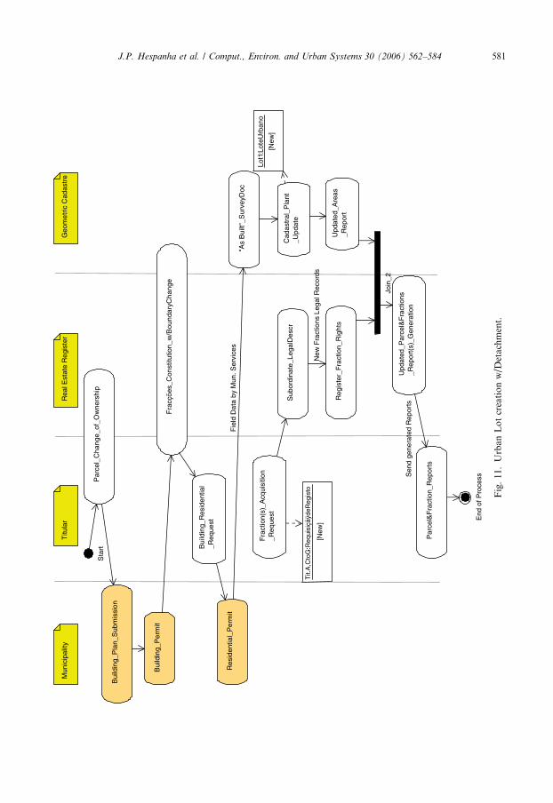
4.2. Transformation of a Rural into an Urban Parcel
In this second process, very frequent nowadays due to intensive urbanization pressuresespecially in the cities located near the Littoral,4 there is also no creation or destruction ofthe Parcel object, but a different and more complex modification of its description, bothlegal and geometric.
In textual form, one can tell this most repeated story as follows: A Titular (A) of a reg-istered Rural Parcel now lying in a zone open to urbanization, sells the Parcel to a RealEstate Firm (becoming Titular B), which requests a building permit to the Municipality.After receiving the permit, construction of a new urban lot begins, but the Municipalityannexes a small portion of land to rectify a neighboring service road.
After the urban lot is finished, a residential permit is issued upon inspection and thebuilding Fractions identified with letters A to F are bought by Titular C to G, and TitularA (the first owner) receives also an Apartment (Fraccao Object) as part of the originaldeal.
Let us identify, step by step, the modifications that should be made to the Real EstateRegister during this process:
1. The acquisition of the Parcel by the Real Estate Firm is registered, making it the newParcel Owner. The reservation of one future Fraction for the previous Titular is alsoregistered as part of the acquisition contract. Both inscriptions will update the Direi-
toOuRestricao component of the Real Estate Register.2. The Real Estate Firm submits a building plan, including the constitution of horizon-
tal property (Apartments) to the Municipality. This part of the process does notbelong to any of the institutions directly related to the Cadastre, so it is not shown here.After some time, a building permit is issued by the Municipality, and the Real EstateFirm requests a new update of the DireitoOuRestricao component of the Parcel, statingthat it has now an authorization to constitute Fractions A to F. As part of the deal withthe Municipality, a small portion is detached for the Municipal Domain. Thislast action requires also an update of the legal description component of the Parcelobject.
3. After the building is completed and receives a residential permit (again from MunicipalServices), acquisition of Fractions by different Titular will be eventually registered insubordinate registers, associated with the main Parcel Register in the same way Fraccao
are associated with a Predio (through an Lote Urbano object).
4 In all the main cities located on the Atlantic Shore of Portugal there are tremendous pressure for Urbanizationin the rural areas adjacent to them.

J.P. Hespanha et al. / Comput., Environ. and Urban Systems 30 (2006) 562–584 579
And now the related modifications to the Geometric Cadastre:
1. Step 1 on the Real Estate Register process does not involve any modification on theGeometric component. Step 2, however, involves a permanent change in Parcel bound-aries, due to the detachment of a small part for the Municipal Domain. This process
Acquisition_Request
Register_Modified_RightOrRestriction
Updated_Parcel_Report_Generation
Updated_Parcel_Report
Tit.B:RequisiçãodeRegisto
[New]
Fig. 8. Parcel change of ownership (complex activity).
Fracções_Authorization_Request
Provisional_LegalDescr
register (prov.)detachment. Stillwith no updatedareas info.
Register_Modified_Rights
Fork_1
Join_1
Updated_Parcel_Report_Generation
Cadastral_Geometric_Update
Fig. 9. ‘‘Fraccoes’’ Constitution w/boundary change (complex activity); see Fig. 11 for Activity Diagrams.

Ann
exat
ion_
Req
uest
Sta
rt
Titu
lar
R.R
.1:R
equi
siçã
odeR
egis
to
[New
]
Rea
l Est
ate
Reg
iste
r
Pro
visi
onal
_Leg
alD
escr
Reg
iste
r_M
odifi
ed_
Rig
hts
For
k_1
Geo
met
ric C
adas
tre
Lice
nsed
Sur
veyo
r
Join
_1
Upd
ated
_Par
cel
_Rep
ort_
Gen
erat
ion
Upd
ated
_Par
cel_
Rep
ort
End
of P
roce
ss
Cad
astr
al_G
eom
etric
_Upd
ate
Fig
.10
.A
nn
exat
ion
UM
LA
ctiv
ity
Dia
gram
.
580 J.P. Hespanha et al. / Comput., Environ. and Urban Systems 30 (2006) 562–584
Titu
lar
Mun
icip
ality
Rea
l Est
ate
Reg
iste
r
Bui
ldin
g_R
esid
entia
l_R
eque
st
Res
iden
tial_
Per
mit
Fra
ctio
n(s)
_Acq
uisi
tion
_Req
uest
Tit.
A,C
toG
:Req
uisi
çãÿd
eReg
isto
[New
]
Sub
ordi
nate
_Leg
alD
escr
Reg
iste
r_F
ract
ion_
Rig
hts
Geo
met
ric C
adas
tre
"As
Bui
lt"_S
urve
yDoc
Cad
astr
al_P
lant
_Upd
ate
Upd
ated
_Are
as_R
epor
t
Upd
ated
_Par
cel&
Fra
ctio
ns_R
epor
t(s)
_Gen
erat
ion
Join
_2
Par
cel&
Fra
ctio
n_R
epor
ts
End
of P
roce
ss
Lot1
:Lot
eUrb
ano
[New
]
New
Fra
ctio
ns L
egal
Rec
ords
Bui
ldin
g_P
lan_
Sub
mis
sion
Bui
ldin
g_P
erm
it
Fie
ld D
ata
by M
un.S
ervi
ces
Par
cel_
Cha
nge_
of_O
wne
rshi
pS
tart
Fra
cçõe
s_C
onst
itutio
n_w
/Bou
ndar
yCha
nge
Sen
d ge
nera
ted
Rep
orts
Fig
.11
.U
rban
Lo
tcr
eati
on
w/D
etac
hm
ent.
J.P. Hespanha et al. / Comput., Environ. and Urban Systems 30 (2006) 562–584 581

582 J.P. Hespanha et al. / Comput., Environ. and Urban Systems 30 (2006) 562–584
implies a resurvey and the update of Parcel�s boundary (through a new Estrema object)and of the neighboring A.S.F. object. The building permit plan, as a temporary objectrecorded by Municipal Services, could be referred through a hyperlink, at this stage.
2. After construction is completed and the Municipality issues a residential permit, an ‘‘asbuilt’’ survey records the definite layout of the Lote Urbano object. This concludes theupdate of the Parcel Geometric component, as Fractions do not have a graphicdepiction.
Due to the complexity of this process, there were two groups of tasks which are shownas complex activities, each having their own Activity Diagram, as presented in Figs. 8and 9.
Presented Activity Diagram does not include any mention to externally imposed restric-tions and regulations, identified in recent Property Transactions studies (Sumrada, 2004;Vaskovich, 2004) as the ‘‘Land Policy Control’’ phase. So, although this phase also existsin Portugal, the examination of master plan zones regulations or others at National level,like those respecting the Waters Public Domain, are not shown.
It must be said, however, that there is a commonality present in all five countries (Por-tugal, Denmark, England and Wales, Slovenia and Sweden), which is the presence of threecommon actors, namely the Owner (Titular), the Land Registry (Real Estate Register) andthe Municipality (Figs. 10 and 11).
5. Conclusions and recommendations
The Modular Standard where the present article is based upon, builds on the FIG CoreCadastral Domain Model that integrates Land Registration and Cadastre, so it shows thesame development path Portuguese Cadastre aims at.
Through the different sections presenting a possible implementation of the ModularStandard to National Data, one can conclude that most of the classes and its associationswere preserved, although some adaptations have been made.
Generally speaking, modifications increase from the Core to the more specialized dia-grams, a natural consequence of particular solutions adopted in Portuguese Cadastre. Themore conceptual, top level view of the Cadastral Domain Model, however, reflects a fun-damental relationship that seems to be widely applicable.
More important for any other implementation work to be developed, is the way theModular Standard was modified to suit particular (National) needs and existent DataStructures.
For that purpose, each original Class Diagram was carefully examined, paying specialattention to each class description and its associations with other Classes. From that data,a possible National equivalent was identified, and the Class Name and its descriptionadapted accordingly. Although some Classes had an almost immediate equivalent identi-fied, with nearly 100% overlap in description and associations, there were cases thatinvolved modifications in associations and Class contents (Properties and Methods).
After the first phase above explained, the result was again examined for global consis-tency. At that stage, the lack of certain Classes existing in National Data Structures imme-diately pop up from the Diagrams, so they were added, and new associations wereestablished between them and the already existent Classes. Comparisons with other coun-tries will be important to decide whether these extensions are specific for Portugal or are

J.P. Hespanha et al. / Comput., Environ. and Urban Systems 30 (2006) 562–584 583
more generic (and in that case should be included in the future version of the FIG corecadastral model). Other future work includes the development of a prototype system basedon the proposed model, in order to further evaluate the appropriateness in a realistic (dis-tributed) setting in which the system has to be used.
Last phase involved the consideration of the methods to implement in each Class, con-sidering namely the dynamic modeling cases presented. Currently, the dynamic modelingis not a part of the FIG core cadastral model. In case similar dynamic models (or at leastparts of the dynamic models) can be identified in other countries, then the FIG core cadas-tral model should also be extended with these dynamic aspects (as they carry an importantpart of the semantics). For this purpose, the initial dynamic models from Portugal arecompared to models of a number of other countries that have been described and com-pared as part of the ongoing COST Action G9 �Modeling Real Property Transactions�,esp. Denmark, England and Wales, Slovenia and Sweden. It is too early to draw conclu-sions whether significant similarities can be found, because the �modeling style� of theresearchers involved may be different (though their reality could be the same). Only in dis-cussion between researchers and experts of the country being modeled and a researcherfrom another country, the (dynamic) models can be questioned and refined enough tobe able to come to real comparison, as was learned in COST Action G9 (and reportedin e.g. Zevenbergen, 2003). Thus, further discussion is needed between these researchersin order to make a definite decision concerning the (un)equality of the modeled dynamicaspects (processes).
Acknowledgement
Within the TU Delft, this publication is the result of the research program SustainableUrban Areas� (SUA) carried out by Delft University of Technology.
The Authors also wish to thank the contribution given by MSc. Marco Pimpao, fromUniversity of Aveiro-ESTGA, in the field of Portuguese Civil Law and the (always diffi-cult) translation of Legal terms.
References
Coelho, R. M. (1989). O Cadastro e o Registo Predial. In Proceedings from SICRUM, international symposium on
multifunctional rural and urban cadastre, 20–25 November 1989, Lisbon.Erikson, H.-E., & Penker, M. (1998). UML toolkit. Wiley Computer Publishing, John Wiley & Sons.IPCC (Portuguese Institute for Cartography and Cadastre) (1995). �Cadastre of Real Property�, Ministry for
Planning and Land Administration (IPCC is now called Portuguese Geographical Institute).IPCC (1996). Programa de Concurso e Caderno de Encargos para a Execucao do Levantamento Cadastral nos
Concelhos de Ovar, Murtosa e Estarreja. Document belonging to International Public Tender no. 7/96 fromIPCC.
Lemmen, C., van der Molen, P., van Oosterom, P., Ploeger, H., Quak, W., Stoter, J., et al. (2003). A modularstandard for the cadastral domain. In Proceedings on the 3rd international symposium on digital Earth, 21–25September 2003 (pp. 399–419), Brno, Czech Republic.
Melo, C. (1989). Conservacao do Cadastro—Problemas e Perspectivas. In Proceedings from SICRUM,
international symposium on multifunctional rural and urban cadastre, 20–25 November 1989, Lisbon.Mendes, I. P. (2003). Codigo de Registo Predial. Anotado e comentado com formulario (13th ed.). Livraria
Almedina, Coimbra, Portugal.Mendes, I. P. (2003). Estudos sobre Registo Predial. Livraria Almedina, Coimbra, Portugal.

584 J.P. Hespanha et al. / Comput., Environ. and Urban Systems 30 (2006) 562–584
Pinto, R. H. G. B. (1986). O Cadastro da Propriedade Rustica e o seu papel no Desenvolvimento do Territorio�,Documentation and Information Centre of Portuguese Geographical Institute. http://www.igeo.pt/IGEO/portugues/servicos/Biblioteca.htm.
RNPC (National Registry of Collective Persons), Ministry of Justice, Portugal, http://www.rnpc.mj.pt/. Note:the RealEstate Register section of this site just provides access and download of some standard registerrequest forms, identified as ‘‘RequisicaodeRegisto’’ in the Class Diagrams.
Silva, M. A., & Erik, S. (2002). A review of methodologies used in research on cadastral development. Computers,
Environment and Urban Systems, 26, 403–423.Sumrada, R. (2004). Modeling real property transactions. COST G9—Workgroup 2 meeting at Szekesfehervar,
2–3 September 2004, Hungary.Vaskovich, M. (2004). Comparative analysis of property transaction models for Denmark, England and Wales.
Report on STSM at University Ljubljiana, 22–28 August 2004 for COST G9, Royal Institute of Technology,September 2004, Stockholm.
Veigas, D. (2002). El Catastro en Portugal�. In 1. Congreso sobre Catastro en la Union Europea, 15–17 May 2002,Granada.
Zevenbergen, J. (2003). Studying transfer of part-parcels and easements in Finland. Report on the short-termscientific mission in the COST framework at Helsinki University of Technology, Finland.