Configurar o beta ESA para aceitar o tráfego da produção ESA - Cisco
Upload
khangminh22Category
view
0download
0
PORTUGUESE SST CAPABILITY- THE PORTUGUESE SPACE SURVEILLANCE
NETWORK SYSTEM
José Freitas(1), João Fidalgo Neves(2), Raúl Domínguez-Gonzalez(3), Jaime Nomen(3), Miguel Santos(4), Margarida Vieira(4), Nuno Ávila Martins(4), and Noelia Sanchez Ortiz(3)
(1)PT MoD-Armament Directorate, Avenida Ilha da Madeira, no1 4oPiso, 1400-204 Lisboa, Portugal,
Email: [email protected] (2)Portuguese Navy Research Centre, Escola Naval, Base Naval de Lisboa, Alfeite, 2810-001 Almada, Portugal,
Email: [email protected] (3)Deimos Space, Ronda de Poniente 19, 28760, Tres Cantos, Madrid, 28760, Spain,
Email: {raul.dominguez, jaime.nomen}@deimos-space.com (4)Deimos Engenharia, S.A., Av. D. Joao II , No.41, 10th floor 1998-023 Lisboa, Portugal,
Email: {miguel.santos, margarida.vieira, nuno.avila}@deimos.com.pt
ABSTRACT The 2000 active satellites, which represent an enormous of the value by its operational output and by the growing
investment they represent, are becoming threatened by the growing number of active constellations, most of them the “new space” actors. This represents a growing need to predict and correct the orbits of the active satellites, avoiding
collisions with other inactive satellites or debris, and guarantee their long-term operation and investment. In such sense, Portugal, through the Portuguese Ministry of Defense – Armaments Directorate, is investing with the purpose of obtaining SST data autonomously, as well as to produce derived SST information and services from it. Such information will contribute to a wider national and international common effort, with valuable data and services that can support all kind of stakeholders. This paper describes the capabilities and versatility of the Portuguese SST network, provides information about the main assets, their capabilities and characteristics and provides samples and discussions on the
data products obtained and made available by the National Operations Centre (NOC).
Keywords: SSA; SST; Surveillance; Tracking; Conjunction; Cataloguing; Visualization; NEO; Re-entry. 1. INTRODUCTION Notwithstanding the different approaches and inherent comprehension of the Space Situational Awareness (SSA) concept, the common European concept defined in [1] is a holistic approach towards the main space hazards, encompassing collision between satellites and space debris, space weather phenomena, and near earth objects. “Space Hazards” are in the frame of the Space Surveillance and Tracking (SST) program, created by means of [2], which represents a growing interest in Europe to improve autonomy and to obtain and exploit space situational awareness data (more specifically, SST data). In order to keep the pace of the western nations and contribute to such common effort, Portugal has set up an initial network of four state-of-the space debris optical sensors and a National Operations Centre (NOC). The optical sensors allow extremely high throughput of Earth-orbiting object data, as well as solar system objects (NEOs). Their location is spread over the Portuguese territories, namely mainland and overseas territories (Azores and Madeira), separated by more than 1.000kmt far from each other sites, which allows to have, almost at all times, observation capability, no matter the weather conditions. These locations are the western locations in the European mainland and extend far beyond it (by means of the Azores and Madeira territories), allowing to access some extreme GEO longitudes from European outermost territories. Two
sensors are mainly devoted to surveillance activities, whereas the other two are devoted for tracking activities. In order to even extend the observation capability, one of the sensors has been conceived and designed in a deployable configuration that will allow a different placement in the future, according to the national and international framework needs. The measurement accuracy of these optical sensors is better than 1 arcsec and the NOC includes a complete SST suite, including the tasking of sensors, an autonomous SST catalogue, conjunction screening and evaluation, re-entry analysis, fragmentation detection and visualization capabilities. Cataloguing function includes initial orbit determination, routine orbit determination and correlation, and enables the autonomous built-up of catalogue with no information from outside of the Portuguese network. The Conjunction screening allows detecting the conjunctions of one or several objects of interest against the own and external catalogues, while the evaluation implement 5 different algorithms, Re-entry prediction includes a long-term re-entry mode based on long-term (up to 25 years) semi-analytical propagation, while short-term mode works by fitting orbital data, in order to find a re-entry trajectory in the coming days. Fragmentation detection is autonomous, and works by automatically detecting new fragments in the autonomous catalogue and tracing them back to their origin. The connection to external entities and
Proc. 8th European Conference on Space Debris (virtual), Darmstadt, Germany, 20–23 April 2021, published by the ESA Space Debris Office
Ed. T. Flohrer, S. Lemmens & F. Schmitz, (http://conference.sdo.esoc.esa.int, May 2021)

databases allows it to work in a closed loop, in which sensor tasking requests are generated from the events of interest, and the processing of generated data produces refined information for these events. Beyond the SST functionalities, it includes NEO capabilities, by collaborating with the Minor Planet Center and evaluating possible long-term NEO impacts on Earth and its consequences. Space weather capability is performed by aggregating observational data provided by third parties. 2. THE PORTUGUESE SPACE SURVEILLANCE AND TRACKING SYSTEM (SST-PT) At the actual date, SST-PT comprises four optical telescopes and a NOC, notwithstanding the continuous effort to expand its capability with other assets and functionalities. The telescopes have surveillance and tracking capabilities for Earth-orbiting objects and for NEO objects. They include: • One surveillance and one tracking telescope located at Pico do Arieiro, in Madeira Island (SOO, Site de Observacão Óptica). • One tracking sensor located in Santa Maria island (Azores), at the RAEGE (Rede Atlântica de Estações Geodinâmicas e Espaciais) facility. • One surveillance sensor, currently in an interim location at Terinov technological park (Terceira island, Azores), but to be deployed to mainland – Pampilhosa da Serra. The two surveillance sensors are identical, and so are the two tracking sensors and all can be operated remotely, from the NOC or from a nearby control room, which comprises the telescope hardware and the servers required to control them. Apart from the telescope control, the NOC is responsible for planning the observations every night, as well as building a catalogue from the own observations, evaluation of conjunctions, re-entries and exchange of data with other entities. Figure 1 shows the location of all these assets.
Figure 1. Location of the SSTPT assets
Additional local support is available in the case of emergency. Local support is mandatory if there is a loss of remote access, plus a failure of safeguard automatic mechanisms or bad weather. 2.1 OPTICAL SITES 2.1.1 Madeira site The Madeira site (SOO) comprises two sensors (tracking and surveillance). They are controlled remotely from the NOC, with processing servers located in a dedicated room near the domes (Figure 2). The characteristics of the two sensors are summarised in tables 1 and 2.
Figure 2. SOO domes
2.1.2 Santa Maria site The sensor based on Santa Maria Island is a tracking telescope located at the RAEGE facilities (Figure 3). As a tracking telescope, its characteristics are summarised in table 2.
Figure 3. Santa Maria telescope
The sensor was calibrated on 19/01/2021. This calibration was performed by observing satellites of the Galileo constellation. Such satellites, as they are GNSS (Global Navigation Satellite System) publish ephemeris with centimetre precision, and therefore are a very suitable target for calibration. Table 3 summarises the results.

Optical design Schmidt Cassegrain Coma-Free (ACF)
Aperture 400 mm
Focal length 3251 mm
Focal relation (f/R) 8 (5.5 with focal reducer)
FOV 21 x 21 arcmin (0.35o x 0.35o)
Resolution 1.19 arcsec/pix
CCD chip EMCCD 201 e2v Back-illuminated
CCD array 1024 x 1024
Pixel size 13 x 13 microns
Quantum efficiency 90%
Colling temp -95◦C
Table 1. Characteristics of tracking sensors
Optical design Rowe-Ackermann-Schmidt
Aperture 356 mm
Focal length 790 mm
Focal relation (f/R) 2.2
Central obstruction 158 mm
Well corrected circle 61.1 mm (4.4o)
Wavelenght range 400 – 900 nm
FOV 160 x 160 arcmin (2.67o x 2.67o)
Resolution 2.35 arcsec/pix
CCD chip GSense4040 (sCMOS)
CCD array 4096 x 4096
Pixel size 9 x 9 microns
Quantum efficiency 74%
Colling temp 40 ◦C below ambient
Table 2. Characteristics of surveillance sensors
Galileo ID COSPAR ID bias (milliseconds)
205 2015-045A -0.4 216 2017-079B -11 218 2017-079D 0.4 222 2018-060B 5
Table 3. Santa Maria calibration summary The next figures (4, 5, 6 and 7) show the calibration results obtained with the CALMA1 tool at the NOC (see section 2.2.) Along-track errors are directly associated with time bias. As a reference: a system that does not correctly account for light time travel would show a bias of roughly the telescope/satellite distance divided by the speed of light. In these conditions, a Galileo satellite would show a bias of 77 to 98 milliseconds just for this reason.
1 CALMA - Calibration Measurements Ancillary tool, by DEIMOS
Therefore, ideally, along-track errors should be centred in zero in order to have an unbiased system. In this case, the accuracy shown here is in the range of milliseconds, and sub-millisecond in two of four cases. Normally, optical sensors are considered biased when they show an average of 10 milliseconds over several tracks (covering different targets and pass geometries). In the case at hand, the Santa Maria sensor shows unbiased behaviour.
Figure 4. Calibration results for Galileo 205
Figure 5. Calibration results for Galileo 218
Figure 6. Calibration results for Galileo 216
Figure 7. Calibration results for Galileo 222

Figure 8. Right ascension and residual residuals for the Santa Maria calibration campaign
CALMA is also used to characterize the noise in the provided measurements, as the 1σ of the obtained measurements against the reference measurement (assuming a Gaussian behaviour, and that all measurements are uncoupled). In Figure 8, we can see that for 3 of 4 cases in this campaign, the 1σ stays well below 1 arcsec, while it is slightly higher for the fourth case. As conclusion, the calibration has shown that the sensor is able to produce products suited for SST purposes. 2.1.3 Terinov interim site A surveillance telescope is currently deployed at Terinov technological park, at an outdoors location near the NOC (Figure 9). The sensor is controlled from the NOC, and there is direct local access to the hardware from the NOC itself. As a surveillance telescope, its characteristics are summarised in table 2.
Figure 9. Terinov telescope
2.2 NOC COMPONENTS The Portuguese NOC is located in the Terinov technological park in Angra do Heroísmo (Terceira Island, Azores).
Figure 10. NOC main operations room
The current daily workflow involves: - daytime operators - their role is to process the observations taken during the night, analyse new data and optimize observations plans based on the results of the analyses; - night/daytime operators – they are mainly dedicated to the optical sensors operation during the night (Considering the time difference between the locations), and are tasked with performing the requested observations. 2.2.1 Database The central point of the system is a database that contains (among others): • Tracks Observations obtained by the sensors of the
SSTPT network. • Internal catalogue Orbits obtained by the
cataloguing system (2.2.5). • External catalogue External catalogue from United
States Space Force’s 18th Space Control Squadron (18 SPCS).
• Sensors Information of the sensors that belong to the SSTPT network.
• Conjunctions Information of conjunctions detected by the system (2.3.1).
• Re-entries Information of re-entries detected by the system (2.3.2).
• Fragmentations Information of fragmentations detected by the system.
• Sensor plans Observations plans generated by the system. (2.2.3)
• Sensor statistics Statistical information on the performance of the sensors.
All the SST-related NOC systems are integrated with this database.

2.2.2 Interfaces All NOC exchanges of data with the rest of the world are centralized. This approach enables keeping proper traceability of all data items coming in or out of the NOC. 2.2.3 Planning A dedicated system exists for planning surveillance and tracking observations for optical sensors, every night, as they work differently for surveillance and for tracking. The objective of surveillance is to survey a region of the sky where Earth-orbiting objects (previously known or unknown) are expected to be found, while tracking is based on a list of previously known targets. For tracking, the system automatically chooses objects from the public and own catalogues (called background objects). In addition to this, objects involved in conjunction events and re-entry events are automatically considered without operator intervention, although it is possible to manually specify objects to be tracked. The observation plan is based on fixed-duration observation slots, and considers the visibilities of tracked objects (thus, it is guaranteed that all planned objects are visible from the sensor). In addition to this, the plan filters by apparent motion speed and minimum elevation. Apparent motion is very relevant for optical sensors, even if it is possible to observe a fast-moving object, if the apparent speed is large enough, the quality of the astrometry decreases sharply. Regarding the elevation, the filter prevents observations from being scheduled at very low elevations (with potential interference with the ground and increased refraction effects). Figure 11 shows an example of a generated tracking plan. At the end, the generated tracking plan translates to a list the objects to be observed and the times, based on TLE or custom orbits. For each object to be observed based on OEM (Orbit Ephemeris Message), a copy of the OEM file is attached. The sensors make use of these files for performing the pointing. For TLE objects, the sensor makes use of the TLE message to perform the pointing.
Figure 11. Example of tracking plan
For surveillance, there are several strategies possible to choose. For optical sensors, observation strategies are
based on performing observations around the GEO ring (which is observed at a fixed declination from the telescope). Active objects in the GEO ring are at orbits with near-zero inclinations, while inactive objects are at similar altitudes and inclinations ranging from 0◦ to approximately 15◦. Common surveillance strategies perform observations between a minimum and maximum declination around the GEO ring. In addition to this, surveillance strategies try to get several re-observations of the same objects at different times of the night. This is done because the objective of these measurements is to feed them into an orbit determination system. From the point of view of such system, it is more favourable to have repeated observations than isolated observations (better orbits can be obtained from the repeated observations). Surveillance also considers avoiding regions of the sky where observations will be diminished or completely nullified, namely: • The system ensures that no observations are tasked
on the region covered by the Earth shadow (as no observations are possible there).
• The system avoids observations around the Moon. The Moon is extremely bright, and observations around it, are affected by stray light. The system considers an exclusion angle which is configurable by the operator and a function of the phase of the Moon (i.e, the exclusion angle will be maximum when the Moon is full and minimum when there is new Moon).
• The Milky way is a region of the sky that has a large density of background stars. Observations in this region are feasible, but subject to worse signal-to-noise rations and to increased possibility of false detections. The system can be tuned with a weight to make it avoid the Milky way.
• Filters exist to avoid planets and bright stars (which have the same effect as the Moon, although much less relevant).
Figure 12. Example of survey plan
Figure 12 shows a graphical view of a surveillance plan for a sensor located in Azores (this plan translates to a

list of fields to observe and times). It shows a snapshot at 5:26 UTC. The dark blue area depicts the region of the sky reachable by the telescope at the time of the frame. The dark circle is the shadow of Earth, and the white circle is the position of the Moon with the operator configured exclusion angle. The red boxes are the observation fields that were configured; we see that there are three bands, in order to allow re-observations (as discussed above). The first two fences were observed during the first part of the night (when they were reachable). We can see that the plan was generated avoiding the shadow of Earth, and with certain clearance with respect to the Milky way. In both cases, the plans are generated automatically every day, based on fixed default configuration values, and (in the case of tracking) retrieving objects of interest from those involved in re-entries and conjunctions. The NOC operator reviews the plans every day, and then approves them. The operator has also the chance to recompute the plans in case he wants to change some parameter and alter the priorities list (for example, for including tracking of particular objects). 2.2.4 Calibration The calibration capability is based on the well established CALMA tool. This tool allows calibrating optical, radar and laser-ranging sensors by comparing the actual measurements against accurate reference data. In the case of optical sensors, this reference data is GNSS satellite ephemeris (which are centimetre-accurate). By comparing the obtained measurements against the theoretical measurements that we expect to obtain from the reference, we can determine the level of noise of the measurements. In addition to this, the most common effect in optical telescopes is a constant bias between the measurements and the reference in the along-track direction of the satellite. This bias maps to a bias in the timestamping of the measurement, and can be eliminated by correcting the timestamping with this number. The system is able to calibrate not only its own telescopes, but also external telescopes. Section 2.1.2 presented an example of the results of the calibration system. 2.2.5 Cataloguing The cataloguing is performed by means of a custom version of the CORTO tool [3]. This tool allows maintaining a catalogue of Earth-orbiting objects based on sensor data (currently optical data). The system is able to maintain the catalogue autonomously, and associate objects in it with the public catalogues (thus identifying the objects). It implements a method that performs correlation and orbit determination for each incoming track. In case the correlation is unsuccessful, a new object is automatically inserted in the catalogue.
The operator makes use of the HMI (Human-Machine Interface) to evaluate the computations performed by the system and to change the computations that took place automatically. It implements the Gibbs and Herrick-Gibbs algorithms for initial orbit determination (IOD) for radar observations (described in [5]). For telescope IOD, it implements an enhanced double-R iteration algorithm [6]. The orbit determination is implemented with the Square Root Information Filter algorithm (SRIF) [4]. The cataloguing system includes fragmentation detection in the own catalogue. This is achieved by implementing the method described in [7]. In addition to this, the cataloguing system generates orbits with the fitted data. The orbits are generated in the standard Orbit Ephemeris Message (OEM) format, and can be readily shared. 2.3 NOC SERVICES AND OUTPUT 2.3.1 Conjunction analysis The conjunction system is based on three capabilities: • Conjunction screening • Collision risk assessment • Avoidance manoeuvre computation The conjunction screening works by routinely evaluating the close approaches of a list of satellites of interest against the background catalogue (either the public one or the own catalogue). Close approaches are computed in terms of miss distance only (further, detailed evaluations are carried out by the collision risk assessment module. The evaluation of close approaches undergoes three filters for speeding up computations: (1) a perigee/apogee filter, then (2) a filter that verifies the absolute minimum distance between the orbits that were allowed by the first filter, and finally (3) a filter considering the relative positions of satellites in their respective orbits (Even intersecting orbits may be filtered out if the phasing of the satellites rules out a conjunction). The conjunction screening process is executed once per day. When a new event is detected, an entry is created in the database. Then, further automatic, refined computations of this event will be bound to it in the database. The operators can consult the on-going conjunction on the satellites of interest, and alerts are raised and displayed in the video walls. The next step is the collision risk assessment. This module performs automatic evaluation of conjunctions for conjunctions that were detected by the conjunction screening module, storing the results in the centralized database and raising alarms for high risk events. In addition to this, it is possible for the operator to manually evaluate conjunctions based on a Conjunction Data Message (CDM) or a couple of orbits (OEM). The evaluation includes the Alfriend & Akella algorithm [8],

the Patera algorithm [9], [10], the Patera with covariance scaling and the maximum likelihood algorithm [11]. In addition to this, a Montecarlo approach can be used to evaluate the encounters. Figures 13 and 14 show an example of the data and plots available.
Figure 13. Example of conjunction assessment report
(web interface)
Figure 14. Example of conjunction assessment close
approach plot (web interface)
The system is then capable of evaluating (automatically or manually) conjunctions involving objects in its own catalogue, and allows operators to manually evaluate conjunctions with external data (CDMs provided by a satellite operator and/or orbits of the objects) involved in the conjunction. Finally, the module for avoidance manoeuvres allows the operator to compute manoeuvers to mitigate the risk. The module allows to evaluate several possible approaches (impulsive or low-thrust manoeuvres) happening at a different number of revolutions before the time of closest approach (TCA) and let the NOC operator suggest a manoeuvre based on this data. The software module produces standards-compliant CDM messages that can be exchanged with external entities, if necessary. 2.3.2 Re-entry The re-entry system has two different capabilities for long-term and short-term re-entries.
Firstly, it computes long-term re-entries up to 25 years implementing the recommended methods in [12] and [13]. All objects in the own and public catalogue are filtered based on the [13] method. Objects that yield an estimated lifetime of less than 25 years are later propagated with an orekit-based implementation of the Draper Semi-analytical Satellite Theory (DSST) [14]. The semi-analytical method provides the adequate balance between accuracy and runtime performance. Of course, the accuracy of this approach is limited. Even making use of DSST, the uncertainties in the knowledge of the orbit and the satellite and the use of predictions for the solar activity sum up. For this reason, the information gathered by this method is taken to give an overview of the re-entries in the coming years, including an approximate re-entry. Secondly, the short-term re-entry module deals with objects re-entering a few days after the analysis. We approach this with two methods: (1) the public catalogue is used by fitting the public data available. This process of fitting obviously depends on the availability and reliability of public data and; (2) the internal catalogue is used to predict re-entries. In this second case, the orbits of the internal catalogue include the orbits that were generated by the cataloguing system (section 2.2.5). In both cases, the approach is the same: We first verify the perigee altitude of all objects in the public and own catalogues. Objects with a perigee below a certain threshold are propagated numerically. In the case of public objects, a fitting process is carried out in order to determine an accurate orbit and drag coefficient (as this parameter is critical to the propagation of the trajectory). For own catalogue objects, the drag coefficient is already determined by the cataloguing module, and thus it is used directly. In both cases, an accurate numerical propagation is executed until the re-entry conditions or the maximum time is reached. A short-term re-entry involves many estimations of the re-entry, each estimation is done when there is new data available. Ideally, each new estimation is more accurate than the former one because there is more data available, and the time to the event is lower (thus, the uncertainty of the re-entry epoch reduces). In order to keep track of this, the data model considers, for each re-entry, all the different updates that were done. Figure 15 shows an example of different re-entry data computed from public data and Figure 16 shows the altitude-time plot of a re-entry event. For each update, the system generates on-demand reports in PDF (Portable Document Format) and RDM (Re-entry Data Message). The computation of long-term re-entries is automatically executed once per week, while the short term re-entry is executed daily. In addition to this, the

operators have the opportunity to execute the analysis manually at any time. As such, up-to-date re-entry information is always available, and detailed data can be obtained in case some re-entry of interest is being tracked.
Figure 15. Example of different computations of the
same event
Figure 16. Decay trajectory plot
2.3.3 NEO capabilities Even though the system is focused on daily processing of SST data, it has the capability to perform observations of Near-Earth Objects, both in surveillance and follow up modes, and to perform independent analyses for NEO (Near-Earth Object) data. On the sensor side, the telescopes control and processing software include modes dedicated to NEO, generating data compatible with the Minor Planet Center (MPC). Additionally, the NOC is able to query the MPC to retrieve the current confirmation list [15]. Finally, the NOC has the capability to independently evaluate the collision risk of asteroids with the Earth by means of the NIRAT tool [16], which allows evaluating the projection of the B-plane dispersion at the dates of
possible impact for a given asteroid. It also computes keyholes (Encounters with Earth that perturb the asteroid trajectory in a way that creates a future conjunction risk). It runs an accurate long-term propagation on a number of virtual asteroids (VAs), whose orbit is compatible with the initial known orbit of the asteroid at the time of the analysis. With the VAs, a sensitivity analysis is done. The example depicted in figure 17 (first plot) shows the B-plane of a fictitious asteroid in two sequential close approaches. In both plots the Earth is depicted as a circle, however, due to the scaling, the circle is depicted as a highly elongated ellipse. We see that, even with a well-determined asteroid (VAs in the first close approach are clustered and very unlikely to hit the Earth), the close approach can pose a certain risk in a subsequent conjunction (Second plot in Figure 17).
Figure 17. NIRAT results examples. Two close
approaches of a ficticious asteroid 2.3.4. Visualization In order to support the operators work, the NOC has available 2D and 3D visualizations. The 2D visualization is based in the Bokeh library [17]. It allows the operator to display the ground tracks of own and public objects with automatic retrieval from the database. In addition to this, the operator can plot an arbitrary public TLE or OEM file by means of a web
interface. This visualization is integrated also in the re-entry subsystems and is available for displaying in the NOC dashboard. The Bokeh library provides an open street map backend, and thus the world map can display tiled data from that provider.
Figure 18. 2D visualization
The 3D visualization is supported by the custom developed ViSST tool. This tool allows displaying the full population of space objects (either based on TLE or own catalogues) with a free moving camera and accurate lightning. It is implemented in a client-server architecture, where the server is responsible of storing the trajectories of Earth-orbiting objects and dispatching them to the client. The client is just responsible of retrieving the data and displaying it. This approach has the advantage that the client does not need to perform propagation, and one server can support any number of clients. The client is implemented using the Panda 3D library [18], thus it makes use of 3D acceleration. It is possible to use it in real time or to manually set the time, thus allowing visualization of conjunctions.
Figure 19. ViSST view showing GEO objects
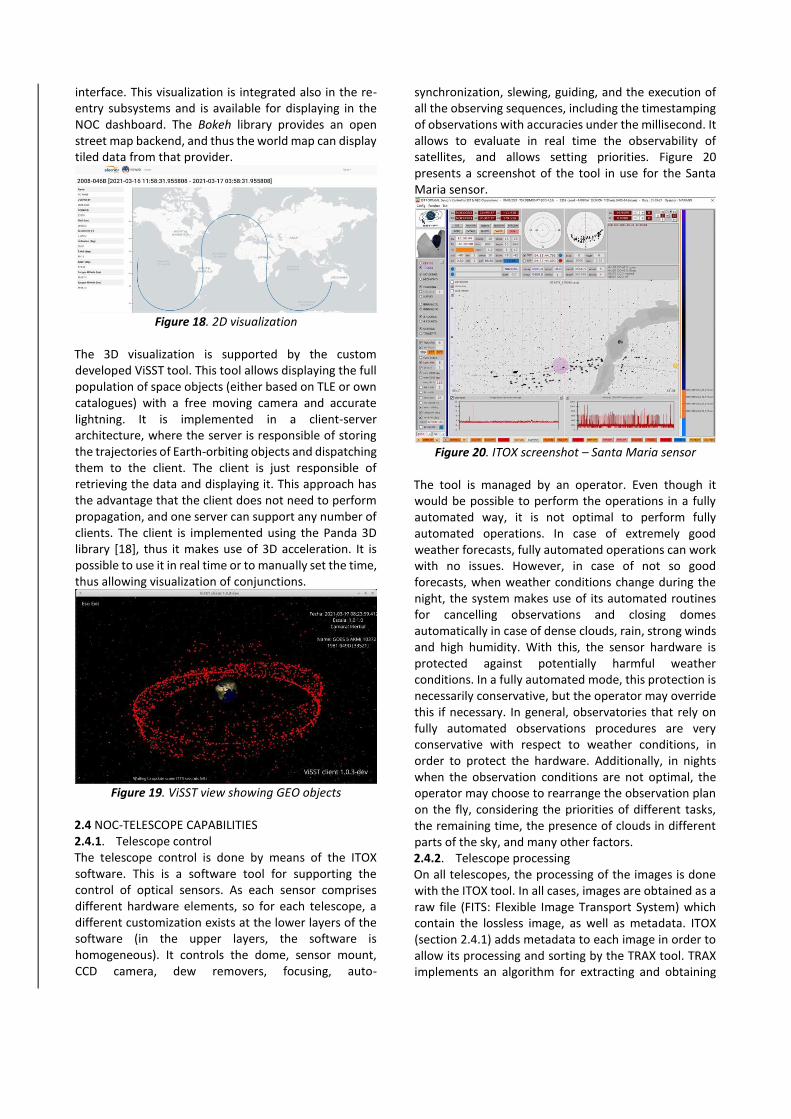
2.4 NOC-TELESCOPE CAPABILITIES 2.4.1. Telescope control The telescope control is done by means of the ITOX software. This is a software tool for supporting the control of optical sensors. As each sensor comprises different hardware elements, so for each telescope, a different customization exists at the lower layers of the software (in the upper layers, the software is homogeneous). It controls the dome, sensor mount, CCD camera, dew removers, focusing, auto-
synchronization, slewing, guiding, and the execution of all the observing sequences, including the timestamping of observations with accuracies under the millisecond. It allows to evaluate in real time the observability of satellites, and allows setting priorities. Figure 20 presents a screenshot of the tool in use for the Santa Maria sensor.
Figure 20. ITOX screenshot – Santa Maria sensor
The tool is managed by an operator. Even though it would be possible to perform the operations in a fully automated way, it is not optimal to perform fully automated operations. In case of extremely good weather forecasts, fully automated operations can work with no issues. However, in case of not so good forecasts, when weather conditions change during the night, the system makes use of its automated routines for cancelling observations and closing domes automatically in case of dense clouds, rain, strong winds and high humidity. With this, the sensor hardware is protected against potentially harmful weather conditions. In a fully automated mode, this protection is necessarily conservative, but the operator may override this if necessary. In general, observatories that rely on fully automated observations procedures are very conservative with respect to weather conditions, in order to protect the hardware. Additionally, in nights when the observation conditions are not optimal, the operator may choose to rearrange the observation plan on the fly, considering the priorities of different tasks, the remaining time, the presence of clouds in different parts of the sky, and many other factors. 2.4.2. Telescope processing On all telescopes, the processing of the images is done with the ITOX tool. In all cases, images are obtained as a raw file (FITS: Flexible Image Transport System) which contain the lossless image, as well as metadata. ITOX (section 2.4.1) adds metadata to each image in order to allow its processing and sorting by the TRAX tool. TRAX implements an algorithm for extracting and obtaining

astrometry of moving objects (i.e, moving against the stars background). It requires a set of individual detections taken in a row (usually, three individual detections). This step removes false positives that can be caused by hot pixels or similar cases (as it is extremely unlikely that false detections appear in three sequential images with an apparent motion compatible with one of a satellite). This software is able to produce astrometry for both surveillance (where the satellites that will be observed are unknown) and tracking (where the expected position and trajectory of the satellite is an input to the process). Thanks to the metadata inserted by TRAX, the processing can better filter the observations by the expected angle of displacement and speed, as they are known from the nominal trajectory of the tracked satellite, thus filtering out false detections or other satellites appearing in the field of view. Figure 21 shows the main view of the tool, including three detections.
Figure 21. TRAX screenshot
TRAX produces astrometry in a proprietary format (HUN) and a log file for the observations, that interleaves the messages related to the processing/image solving and messages from the weather conditions. The result is a raw astrometry file and a log file that is later processed by the NOC (track processing and sensor statistics modules). 2.4.3. Telescope monitoring Monitoring of the SOO telescopes is achieved by means of a dashboard tool (AZIX, Figure 22) that provides, in a single viewpoint, the status of the SOO telescopes, with colour-coded indicators so that it is possible to evaluate, at a glance, the status of the SOO system.
Figure 22. AZIX screenshot
3. CONCLUSIONS The Portuguese SST-PT architecture is a network based system, interconnecting the optical sensors and the NOC and providing a complete set of services to be used by several stakeholders. Its fundamental concept relies on the capacity to gather high quality data, communicating through secure channels, process it and provide reliable services and accurate information for stakeholders with several levels of demanding, which applies for non-classified and classified information. Its modularity and flexibility allows interconnecting with
external stakeholders, by ingesting data or proving it, but also by means of the flexibility achieved with the deployability concept of one of its optical sensors, notwithstanding the logistic related aspects/constraints.
The complete operation is achieved with a minimal operator intervention, although the full performance demands, as in all cases, high expertise and a proficient operation by the human resources, which is proved to be a critical aspect throughout the known SST networks. In the near future, it is expected to improve some of its functionalities, with minor investment, taking advantage of the system scalability. The Portuguese MoD investment in the SST network is considered to be a part of the national contribution to develop highly skilled areas, both in terms of knowledge and technology, and to contribute to increase a better and stronger Space security, as a part of an international effort, considering that Space is the only operational environment able to contribute to a permanent and comprehensive monitoring and development of all the human activities. REFERENCES 1. European Commission, REGULATION OF THE
EUROPEAN PARLIAMENT AND OF THE COUNCIL establishing the space programme of the Union and the European Union Agency for the Space Programme, Brussels, 2018.
2. European Union, Decision No 541/2014/EU of the European Parliament and of the Council establishing a Framework for Space Surveillance and Tracking Support (SST), Brussels, 2014.
3. Raul Domınguez-Gonzalez, Noelia Sanchez-Ortiz,´ Nuria Guijarro-Lopez,´ Pablo Quiles-Ibernon, and Jaime Nomen-Torres, Cataloguing space objects from observations: CORTO cataloguing system, Space Debris Conference 2017
4. G.J Bierman. Factorization Methods for Discrete Sequential Estimation. (1997)
5. D.A Vallado. Fundamentals of Astrodynamics and Applications. (4th edition p. 454-461)
6. Olmedo, Estrella, Sanchez-Ortiz, Noelia, R. Lerate, Mercedes, Bello-Mora, Miguel, Klinkrad, Heiner,´ Pina, Fernando. Initial Orbit Determination algorithms for cataloguing optical measurements of space debris. Monthly Notices of the Royal Astronomic Society (Volume 403) (10.1111/j.1365-2966.2008.13940.x)
7. Andrisan, Roxana Larisa, Ionita, Alina Georgia, Domínguez-González, Raúl, Sánchez-Ortiz, Noelia ,Pina-Caballero, Fernando, Krag, Holge, Fragmentation event model and assessment tool (FREMAT) supporting on-orbit fragmentation analysis, r. 6th International Conference on Astrodynamics Tools and Techniques (ICATT)
(2017) 8. M.R. Akella and K.T. Alfriend , Probability of Collision
Between Space Objects, Journal of Guidance, Control, and Dynamics Vol. 23 No. 5 – 2000
9. R.P. Patera, General Method for Calculating Satellite Collision Probability , Journal of Guidance, Control, and Dynamics Vol. 24 No.4 – 2001
10. R.P. Patera, Calculating Collision Probability for Arbitrary Space-Vehicle Shapes via Numerical Quadrature, Journal of Guidance, Control, and Dynamics Vol. 28 No.6 – 2005
11. F.K. Chan, Spacecraft Collision Probability, The Aerospace Press 2008
12. ISO 27852:2010(E), Space systems — Estimation of orbit lifetime, 2010
13. Oltrogge, Daniel & Chao, C.-C. Standardized approaches for estimating orbit lifetime after end-of-life. Advances in the Astronautical Sciences. 129. 187-206, 2008.
14. Nicolas Bernard, Pascal Parraud, Luc Maisonobe, Lucian Barbulescu Validation of the Draper semianalytical satellite theory implementation in Orekit, 2014
15. NEO MPC confirmation page https://www.minorplanetcenter.net/iau/NEO/toconfirm_tabular.html (Checked March 2021)
16. Juan L. Cano, Gabriele Bellei, Javier Mart´ın, NEO threat mitigation software tools, 2016
17. Bokeh website https://bokeh.org/ (Checked March 2021)
18. Panda 3D website https://www.panda3d.org/ (Checked March 2021)
Copyright © 2022 FDOKUMEN