Brevard County, Florida Hurricane and Storm Damage ...
169
Appendix I: Pertinent Correspondence and Mailing List
-
Upload
khangminh22 -
Category
Documents
-
view
3 -
download
0
Transcript of Brevard County, Florida Hurricane and Storm Damage ...

Appendix I: Pertinent Correspondence and Mailing List
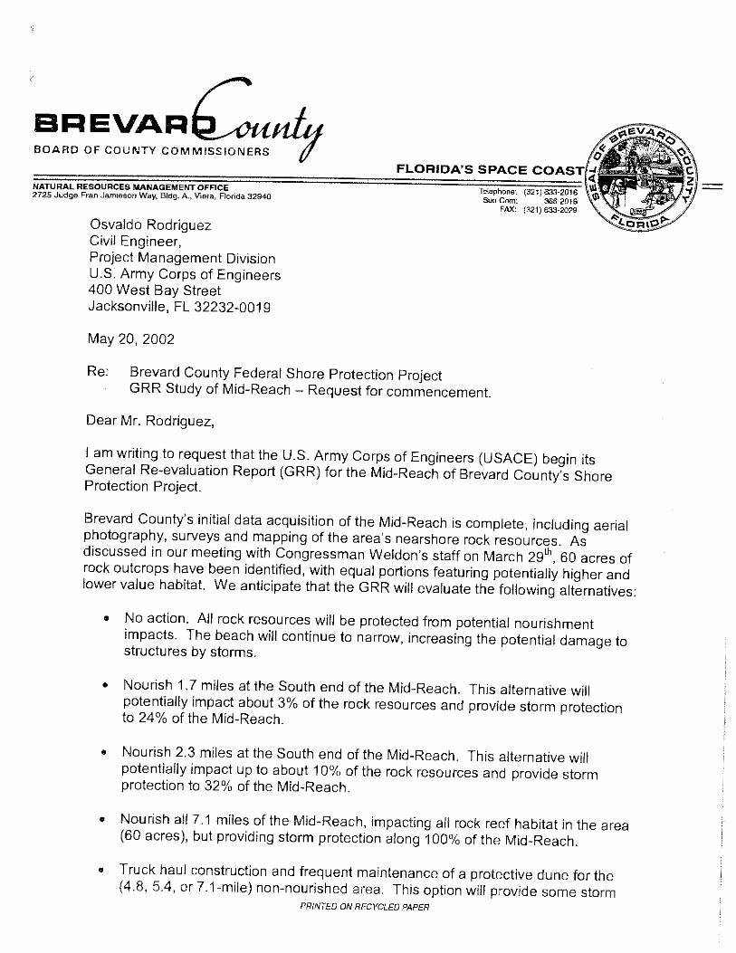
NATURAL RESOURCES MANAGEMENT OFF1CE 2725 Judge Fran Jamieson Way, Bldg. A., Viera, Florida 32940
Osvaldo Rodriguez Civil Engineer, Project Management Division U.S. Army Corps of Engineers 400 West Bay Street Jacksonville, FL 32232-0019
May 20, 2002
FLORIDA'S SPACE
To!ephone: SUn Com: 366·2016
FAX: (32i) 633·2029
Re: Brevard County Federal Shore Protection Project GRR Study of Mid-Reach- Request for commencement.
Dear Mr. Rodriguez,
I am writing to request that the U.S. Army Corps of Engineers (USACE) begin its General Re-evaluation Report (GRR) for the Mid-Reach of Brevard County's Shore Protection Project.
Brevard County's initial data acquisition of the Mid-Reach is complete, including aerial photography, surveys and mapping of the area's nearshore rock resources. As discussed in our meeting with Congressman Weldon's staff on March 291
h, 60 acres of rock outcrops have been identified, with equal portions featuring potentially higher and lower value habitat. We anticipate that the GRR will evaluate the following alternatives:
• No action. All rock resources will be protected from potential nourishment impacts. The beach will continue to narrow, increasing the potential damage to structures by storms.
• Nourish 1.7 miles at the South end of the Mid-Reach. This alternative will potentially impact about 3% of the rock resources and provide storm protection to 24% of the Mid-Reach.
• Nourish 2.3 miles at the South end of the Mid-Reach. This alternative will potentially impact up to about 10% of the rock resources and provide storm protection to 32% of the Mid-Reach.
• Nourish all 7.1 miles of the Mid-Reach, impacting all rock reef habitat in the area (60 acres), but providing storm protection along 100% of the Mid-Reach.
• Truck haul construction and frequent maintenance of a protective dune for the (4.8, 5.4, or7.1-mile) non-nourished area. This option will provide some storm
PRINTED ON RECYCLED PAPER

protection, but may be more expensive to construct and maintain, erode more quickly, and may still impact some of the rock reef habitat.
• Construction of shoreline revetment, seawalls or other armor along the (4.8, 5.4, or 7.1-mile) non-nourished area. This option will provide storm protection to upland development, but reduce the recreational and environmental benefits of the beach, and may not be permittable on a large-scale basis.
• Relocation of structures and acquisition of at risk properties along the (4.8, 5.4, or 7.1-mile) non-nourished area. All rock resources within this area will be protected from potential nourishment impacts, recreational and environmental beach benefits will be maintained, but upland property will be sacrificed.
• Combination of 2.3 miles of nourishment and:::; 4.8 miles of dune construction and maintenance.
• Combination of 1.7 miles of nourishment and :::; 5.4 miles of dune construction and maintenance.
We anticipate the GRR to include an evaluation of mitigation alternatives for rock resources that may be impacted along the Mid-Reach. Based upon our preliminary studies, to be finalized and delivered to the Corps this summer, the County anticipates that the preferred alternative will be sand nourishment of 1.7 to 2.3 miles at the South end of the Mid-Reach, and possible construction of a dune along portions of the nonnourished area. This is based on the alongshore distribution of rock resources, oceanfront property improvements, and shoreline arrnoring.
We look forward to hearing back from you with a schedule for the performance of the surveys, economic analysis, environmental assessment, draft document formulation and other milestones attendant to the Report.
Please let me know if further direction is needed to initiate the GRR.
Respectfully Submitted,
Nikhil Mehta Environmental Scientist
cc: Virginia Barker, Management Section Supervisor Kevin Badge, Olsen Associates
FLORIDA'S SPACE COAST
TAMARA J. RICARD, Clerk to the Board, 400 South Street • P.O. Box 999, Titusville, Florida 32781 ·0999
August29,2008
MEMORANDUM
Telephone: (321) 637·2001 Fax: (321) 264·6972
TO: Ernest Brown, Natural Resources Management Director, Attn: Mike McGarry
RE: Item VIII.A.3, Resolution for Brevard County Shore Protection Project: Mid Reach Plan, State Beach Management Long Range Budget Request and State Cost-Share Request
The Board of County Commissioners, in regular session on August 28, 2008, selected Option B, Local Option Plan (TDC 50-year funding obligation of $31 .2 million), for the U.S. Army Corps of Engineers to pursue along the Mid Reach shoreline; adopted Resolution No. 08-187 supporting Brevard County Shore Protection Project and requesting State cost-share funding as a match for dedicated local funds. Enclosed are two certified copies of the Resolution.
Your continued cooperation is always appreciated.
Sincerely yours,
BOARD OF COUNTY COMMISSIONERS
sz :E7kcuL Tamara Ricard, Deputy Clerk
lte
Encls. (2)
cc: Contracts Administration Finance Budget
PRINTED ON RECYCLED PAPER

AGENDA
Section New Business Meeting Date
August 19, 2008 Item No.
AGENDA REPORT BREVARD COUNTY BOARD OF COUNTY COMMISSIONERS
SUBJECT: Brevard County Shore Protection Project: Mid Reach Plan, State Beach Management Long Range Budget Request and State Cost-Share Request
DEPT/OFFICE: Natural Resources Management Office Requested Action:
Select a shore protection plan for the U.S. Army Corps of Engineers to pursue along the Mid Reach shoreline and approve a resolution supporting the Brevard County Shore Protection Project and requesting State cost-share funding as match for dedicated local funds. All Local Match is derived from the TDC Dedicated Beach Improvement Fund Summary Explanation & Background:
The Mid Reach is a 7.78-mile section of critically eroded beach lying between Patrick Air Force Base and Indialantic that includes the Towns of Satellite Beach and Indian Harbour Beach. The Mid Reach was deleted from the Brevard County Federal Shore Protection Project in 1996 due to environmental concerns regarding rocky hard bottom habitat present in the surf zone. Since that time, Brevard County has been working with the U.S. Army Corps of Engineers (Corps) to develop a suitable shore protection plan for the Mid Reach.
On October 26, 2004, the Board executed an Agreement with the Corps to cost share a General Re-evaluation Report (GRR) for developing a federally authorized shore protection project for the Mid Reach. The GRR process is nearly complete. After evaluating over 1 00 different shore protection options for the Mid Reach, the Corps has identified an environmentally acceptable plan that yields the greatest federal benefits. This National Economic Development (NED) Plan maximizes the available federal cost share for the project. During the Corps' GRR process, County staff and consultants developed and evaluated shore protection alternatives with the desire to enhance local benefits beyond the NED plan. This Local Option Plan increases sand placement and shore protection benefits along the Mid Reach while still maintaining the required federal scope. These two possible shore protection options are described in Attachment A. On August 4, 2008, the TDC Beach Improvement Committee voted unanimously in favor of recommending the Local Option.
In order to complete the GRR, the Corps needs the Brevard County Board of County Commissioners to formally select either:
A. National Economic Development (NED) Plan (TDC 50 year funding obligation $28.3 million) or B. The Local Option Plan. (TDC 50 year funding obligation $31.2 million)
As part of this agenda, staff also requests authorization to solicit State cost share for the non-federal costs of restoring Brevard's critically eroded beaches. This is accomplished each year by submitting a resolution and funding request to the Florida Department of Environmental Protection (FDEP) Office of Beaches and Coastal Systems. This request contains a 1 0-year Long Range Budget Plan (LRBP). Attachment B contains two draft LRBP's, one includes cost share for the NED Plan and a second is based on the Local Option Plan. It is requested the Board approve the cost share resolution (Attachment C) and submittal of the appropriate LRBP based on the Board's selection of either the NED Plan or Local Option Plan for shore protection along the Mid Reach.
Fiscal Impact: FY 07-08 No fiscal impact to the General Fund (GF) associated with this item. FY 08-09 There is no GF impact. Long Range Budget Plan 08-09 expenses to the TDC are up to $4,205,310.
Staff Contacts: Ernest Brown (5-2439) or Mike McGarry (5-2696) Natural Resources Management Office, 633-2016.
Exhibits Attached:
Attachment A: Staff Report RE: U.S. Army Corps of Engineers Mid Reach Plan with option map Attachment B: Staff report RE: State Long Range Budget Plan with LRBP option tables Attachment C: Resolution supporting the Brevard County Shore Protection Project and requesting State costshare funding as a match for the TDC's dedicated local funds.
Contract /Agreement (If attached): Reviewed by County Attorney I Yes D No D pending
County Manager's Office Natural Resources Management Office
Peggy Busacca, County Manager Ernest N. Brown, Director

SUBJECT: DATE: AUTHOR:
BREVARD COUNTY BOARD OF COUNTY COMMISSIONERS
NATURAL RESOURCES MANAGEMENT OFFICE
US Army Corps of Engineers Mid Reach Plan August 5, 2008 Mike McGarry
STAFF REPORT
The US Army Corps of Engineers (Corps) is finalizing the Mid Reach General Reevaluation Report (GRR) to determine the best shore protection plan for the Mid Reach. For the purpose of evaluating the options, the Mid Reach was subdivided into 6 "reaches," so the optimal beach width could be determined for each reach based on the unique shore protection needs and submerged rock habitat in that reach. The six reaches are illustrated in the Corps' Figure 3.3 which is attached.
The GRR process has evaluated over 100 combinations of shore protection options combined across the 6 reaches and narrowed the search to two plans that offer different strengths. The Corps process focuses on identifying a National Economic Development (NED) Plan. The NED Plan is designed to maximize national economic benefit within constraints imposed by environmental and other regulations. Maximizing shore protection or recreational benefits is not a specific goal of the NED Plan. The highest NED Plan with not more than 3 acres of rock impact is the federally chosen plan. This plan is illustrated as a blue line on Figure 3.3 with project widths ranging from "dune only" in Reaches 4 and 6, to 30+ feet of beach widening in Reach 3.
In order to provide Brevard County with an option that provides a more equitable treatment of reaches while maximizing shore protection and recreational benefits, the Corps has considered a Local Option. In this plan the width of additional beach in Reach 3 has been reduced from 30' to 20' to allow construction of 1 0' of beach in Reach 4. Additional costs of this plan, if selected, would be the responsibility of Brevard County. To facilitate comparison ofthe two plans, the primary differences are highlighted in the table below and relative beach widths are sketched on Figure 3.3.
Comparison of NED Plan and Local Option Plan NED Plan Local Option Plan
Initial Sand Volume 540,000 cy 588,000 cy
Total Project Length 7.78 miles 7.78 miles
Length of Widened Beach 5.36 miles 6.42 miles
Length of Dune Only 2.42 miles 1.36 miles Rock Impact 2.9 acres 3.0 acres Average Storm Protection 32 year return 35 year return
Total 50 Year Project Cost $103.5 M $108.4 M Federal Cost Share 54% 51.55% Local 50 Year Project Cost $28.3 M $31.2 M
On August 4, 2008 the Tourist Development Council (TDC) Beach Improvement Committee reviewed both plans and the relative benefits. The County and State will bear the extra cost of the local option which amounts to $2.9 million for the TDC over the 50 year project life. A 25 year budget forecast indicates the TDC Beach Improvement Fund can provide sufficient funding for either plan. The TDC Beach Improvement Committee voted unanimously to recommend the Local Option Plan. The Corps has requested that the Brevard County Board of County Commissioners decide whether to finalize the GRR based on the NED Plan or the Local Option Plan.
Pagel of I

\
PatrlckAFB
Reach 6 Dune Only Local Option
Hightower Park
\ ~~nPark
\~'Pine Tree Drive
'\:\ ~ .... \
- --Corps NED Plan
Widths Not To Scale
Reach 5 10 Foot Beach Width Increase
Dune Only or 10 Foot Beach Width Increase
Canova Beach Park
~\~~ ~ ~~. Howard Futch Park
.,_ ce , ~-·~
Reach 1 10 Foot Beach Width Increase
) R-1183
~ South Reach
ol-...._o ...... s-+--+--+-+--t--t' ""'\ ~ .
Figure 3-3. Reaches Associated with the Brevard County Mid-Reach Study Area

Programs and Project Management Division Coastal, Navigation and Antilles Branch
LTC Michael L. Furey 45 CES/CC 1224 Jupiter St MS 9125 Patrick AFB, Florida 32925-3343
Dear Colonel Furey:
r v
The U.S. Army Corps of Engineers, Jacksonville District is currently engaged in a general reevaluation study of the Brevard County shore protection project. The study will determine if the area known as the Mid-Reach is justified for federal participation in a project to reduce storm damages along the shoreline. The study area extends from the southern limit of Patrick Air Force Base for 7.6 miles south along the shoreline. As part of the study, we are evaluating several alternatives including a truck haul fill of the beach. It has come to our attention that an existing dredged material management area located at Port Canaveral could be beneficial to our project. This could also benefit the U.S. Air Force and the Naval Ordinance Test Unit.
This letter and enclosure is intended to inform you of the alternative being considered in the Brevard County Mid-Reach project and request participation and concurrence. The alternatives include dredging of offshore sands, dewatering the material at the upland disposal site (stockpile site), and truck-hauling the material to the mid-reach shoreline. It is our belief that stockpiling material at Port Canaveral is beneficial in nature in that it will 1) rehabilitate the existing Poseidon dredged material management area at no cost to the U.S. Navy or U.S. Air Force including clearing of exotics and relocation of gopher tortoises; 2) provide capacity above the existing upland disposal area for future dredging of the Port and Navy Trident Basin; and 3) provide an additional source of material for shorelines including capacity above that for the Mid-Reach and the Patrick Air Force Base Reach.

-2-
Detailed design of the stockpile area would be completed in coordination with your office to meet the goals of all parties involved.
It would be our pleasure to meet further to discuss this issue. The project manager for the Brevard County Mid-Reach project, Mr. Osvaldo Rodriguez, can be reached at 904-232-2909.
Enclosure
Copies Furnished:
Sincerely,
Paul L. Grosskruger Colonel, U.S. Army District Commander
CAPT William M. Drake, Naval Ordnance Test Unit, P.O. Box 1623, Cape Canaveral, Florida 32920-1623
Mr. Carlos Alvarado, P.O. Box 1623, Cape Canaveral, Florida 32920-1623
Mr. Patrick S. Giniewski, 45 CES/CEVR, 1224 Jupiter St. MS 9125, Patrick AFB, Florida 32925-3343
Mr. Robert Van Vonderen, 45 CES/CEL, 1224 Jupiter St. MS 9125, Patrick AFB, Florida 32925-3343
Mr. Dale Hawkins, 45 CES/CEVP, 1224 Jupiter St. MS 9125, Patrick AFB, Florida 32925-3343
Ms. Virginia Barker, 2725 Judge Fran Jamieson Way, Building A, Viera, Florida 32940
Dr. Kevin Badge, Olsen Associates Inc., 4438 Herschel St. Jacksonville, Florida 32210
Ms. Jeannie Adame, Canaveral Port Authority, 200 George King Blvd, Cape Canaveral, Florida 32920
bcf: CESAJ-PD (Mrs. Candida Bronson)
1 Rodriguez/DP-C jam/3137 12-18-06 ~ Scarborough/DP-C
~er/DP Finch/DX
C\.-..._Robertson/DD <¥~sskruger/DE

BREVARD COUNTY, FLORIDA SHORE PROTECTION PROJECT MID-REACH GRR
STOCKPILE AREA ALTERNATIVE
I. PROJECT DESCRIPTION: Brevard County Mid-Reach study area is 7.6 miles in length and extends from Patrick Air Force Base in the north to the city of Indialantic to the south (see attached map, Figure 1). As part of the study, sand sources for truck haul fill of the shoreline are being investigated. An offshore sand source has been used in other projects, and could be used in conjunction 1.vith an upland stockpile area for dewatering.
The sand source for the fill material is Canaveral Shoals II (CSII), which is located approximately 20 miles north-northeast of the Mid Reach and 9.4 miles east of the proposed Poseidon stockpile site. This sand source has been used previously for construction and renourishment of the North and South Reaches of Brevard County.
The sand will be dredged from CSII and transported to the Poseidon DMMA at Port Canaveral (see project map, Figure I) at approximately 6 year intervals. Sand will be dredged utilizing hopper dredges with direct pump-out at the stockpile site. Sand will be de watered at the Poseidon site and then transported to the Mid Reach Project via dump truck and placed and shaped on the beach utilizing tractors. Initial use of the Poseidon site will require clearing, grubbing and dike repair work as outlined in section 2.
The economic life of the proposed project is 50 years. Over this time period, multiple stockpiling events would occur at approximately 6 year intervals. The initial fill is anticipated to be up to 900,000 cubic yards, with removal of half that volume immediately following dewatering. The remaining volume will allow for two truck haul events prior to the next dredging event to fill the stockpile area. All subsequent dredging events will only fill the stockpile area to approximately halffull. Thus it is anticipated that except for the intial fill event, the stockpile area will generally be half or less full. The remaining capacity could be used for other projects.
2. POSEIDON STOCKPILE SITE: The Poseidon DMMA is directly adjacent to the Trident Submarine Basin on the west side. The interior of the site will require approximately 15 acres of heavy clearing, 20 acres oflight clearing, and two dike repairs of 6000 cy and 8500 cy, respectively. The dikes surrounding the placement area will require approximately 10 acres of light clearing and approximately 1 foot of material added (30,000 cy total) to dress and restore the dike surface. Material that is presently within the stockpile site should be suitable for repairing the dikes and dressing the surface. In addition to the rehabilitation and preparation of the site, a road ramp will be constructed at the southwest corner for truck access over the dike. The site will have a capacity of approximately 900,000 cy if filled to +28' NGVD within the southern portion of the site (see Figure 2 Poseidon site map). The Poseidon

site's perimeter dikes are approximately 32' above grade at the present time. It is anticipated that the stockpile site would be replenished when hydraulic dredges were mobilized for the north and south reach hydraulic beach fill renourishments (approximately every 6 years). The sand source contains sand that consists primarily of poorly graded, slightly silty, fine to medium grained sands, with trace to some sand sized carbonate shell and shell fragments. Occasional gravel sized shell fragments as indicated in the laboratory data should be expected. The sand source has an approximate mean grain size of0.30 mm (1.75 phi) and a standard deviation of 1.03 phi. This same material has been used successfully for beach fill in other portions of Brevard County.
3. DUNE AND BEACH FACE FILL: Table 1 summarizes the quantities for the Dune Only and Dune+ Beach Face alternatives under consideration. The final proposed plan has not been selected at this time. The limits and lengths of each reach are included along with the haul distance (via existing roads) from the mid-point of each reach to the Poseidon stockpile site. The project alternatives consist of I) a dune fill of approximately 5 cubic yards per foot and 2) the same 5 cy/ft dune plus a 9.4 cy/ft beach face fill.

Canaveral Shoals U
0 1.25 2_5

Table 1. Dune and Beach Initial Construction Fill Quantities
Reach Limits Distto Truck Haul Volume (cy) I I Dune ! Dune + 20~Foot , I
length Stockpile Fill (5 cy/ft) j Beach Face Fill i FOEP Monuments (ft) site rini) (14.4 cy/ft)
Reach 1 R119 • R109 9,599 24.0 48,000 I 138,000 Reach 2 R109 • R105.5 3,406 22.7 17,000 I 49,000 I
Reach 3 R105.5 • R99 6,239 21.7 32,000 90,000 Reach4 R99 • ~93 -~~"~
5,603 20.7 28,000 81,000 Reach 5 R93 • R83 9,029 19.4 45,000 130,000
Reach 6 R83 • R75.4 1,201 I 18.0 36,000 104,000
206,000 592,000 ... I

-"~- ""~~--""-~"----
, , ' ... =
Figure 2. Poseidon Stockpile Area Map
~
_ _..... DIKE R£P,tjR •1 - 6,000 CY DIKE R£P,tjR •2 - 8,500 CY ROAD RAhiP - 2,500 CY
HEAVY CLEARING - 15 ~ LIGHT CLEARING - 20 ~
----~-"-~--~-

REP~Y '0 ATTfNr:ON OF
DEPARTMENT OF THE ARMY JACKSONVILLE DISTRICT CORPS OF ENGINEERS
P. 0. BOX 4970 JACKSONVILLE, FLORIDA 32232..(]()19
JAN 0 5 2001 Programs and Project Management Division Coastal, Navigation and Antilles Branch
LTC Michael L. Furey 45 CES/CC 1224 Jupiter St MS 9125 Patrick AFB, Florida 32925-3343
Dear Colonel Furey:
The U.S. Army Corps of Engineers, Jacksonville District is currently engaged in a general reevaluation study of the Brevard County shore protection project. The study will determine if the area known as the Mid-Reach is justified for federal participation in a project to reduce storm damages along the shoreline. The study area extends from the southern limit of Patrick Air Force Base for 7.6 miles south along the shoreline. As part of the study, we are evaluating several alternatives including a truck haul fill of the beach. It has come to our attention that an existing dredged material management area located at Port Canaveral could be beneficial to our project. This could also benefit the U.S. Air Force and the Naval Ordinance Test Unit.
This letter and enclosure is intended to inform you of the alternative being considered in the Brevard County Mid-Reach project and request participation and concurrence. The alternatives include dredging of offshore sands, dewatering the material at the upland disposal site (stockpile site), and truck-hauling the material to the mid-reach shoreline. It is our belief that stockpiling material at Port Canaveral is beneficial in nature in that it will 1) rehabilitate the existing Poseidon dredged material management area at no cost to the U.S. Navy or U.S. Air Force including clearing of exotics and relocation of gopher tortoises; 2) provide capacity above the existing upland disposal area for future dredging of the Port and Navy Trident Basin; and 3) provide an additional source of material for shorelines including capacity above that for the Mid-Reach and the Patrick Air Force Base Reach.
-2-
Detailed design of the stockpile area would be completed in coordination with your office to meet the goals of all parties involved.
It would be our pleasure to meet further to discuss this issue. The project manager for the Brevard County Mid-Reach project, Mr. Osvaldo Rodriguez, can be reached at 904-232-2909.
Sincerely,
~)~ Paul L. Grosskruger Colonel, U.S. Army District Commander
Enclosure
Copies Furnished:
CAPT William M. Drake, Naval Ordnance Test Unit, P.O. Box 1623, Cape Canaveral, Florida 32920-1623
Mr. Carlos Alvarado, P.O. Box 1623, Cape Canaveral, Florida 32920 1623
Mr. Patrick S. Giniewski, 45 CES/CEVR, 1224 Jupiter St. MS 9125, Patrick AFB, Florida 32925-3343
Mr. Robert Van Vonderen, 45 CES/CEL, 1224 Jupiter St. MS 9125, Patrick AFB, Florida 32925-3343
Mr. Dale Hawkins, 45 CES/CEVP, 1224 Jupiter St. MS 9125, Patrick AFB, Florida 32925-3343
Ms. Virginia Barker, 2725 Judge Fran Jamieson Way, Building A, Viera, Florida 32940
Dr. Kevin Badge, Olsen Associates Inc., 4438 Herschel St. Jacksonville, Florida 32210
Ms. Jeannie Adame, Canaveral Port Authority, 200 George King Blvd, Cape Canaveral, Florida 32920

DEPARTMENT OF THE AIR FORCE 45TH SPACE WING (AFSPC)
JAN 2 2 2007
MEMORANDUM FOR JACKSONVILLE DISTRICT CORPS OF ENGINEERS P.O. BOX 4970
FROM: 45 CES/CC
JACKSONVILLE FL 32232-0019 ATIN: COLONEL PAULL. GROSSKRUGER, DISTRICT COMMANDER
1224 Jupiter St, MS 9125 Patrick AFB FL 32925-3343
SUBJECT: Brevard County Mid-Reach Project, Poseidon Sand Stockpile
1. The 45th Space Wing, US Air Force supports the subject project as outlined in your letter of 5 Jan 07.
2. We would like to meet and discuss several aspects of the proposed project including sand deposition on the north jetty, truck haul traffic and roadway impacts, methods of dewatering, hopper-dredge siting, prevention of re-infestation of invasive species and relocation of gopher tortoises under the 45 SW permit.
3. We would also like to discuss development of a memorandum of understanding with the Corps of Engineers for the eventual operation of the stockpile area. Finally, we would like to discuss renourishment of Patrick Air Force Base south beaches.
4. We propose a meeting on 6 Feb 07 at 1000, building 60600, Cape Canaveral Air Force Base. We will finalize this meeting time and location with Mr. Osvaldo Rodriguez.
5. Our POC for this action is Dale Hawkins, 45 CES/CEV, 321-853-6578, or E-mail, [email protected].
, Lt Col, USAF
GUARDIANS OF THE HIGH FRONTIER
August 9, 1994
FLORIDA DEPARTMENT OF SJ'ATE Sanclm B. Mortham
Sa::retary of State DIVISION OF HISTORICAL RliSOURCES
IV\. Gray lluildin~: SOO South tlwnough Sh·e"t
Tallaha~"'""' l-1orida '32399·0250 Dir<•,·tor's Office Tci<'Copier Number (I' AX)
(904) 4AA·14Rll (g()1) 488·3353
Mr. A. ;J. Salem, Chief In Reply Refer To: Planning Division, Bnvironmental Resources Branch
Jacksonville District Corps of Enqineers
P.O. Box 4970 Jacksonville, Florida 32232-0019
Frank J. Keel Historic Siles Specialist
(904) 487-2333 Project File No. 942533
RE: Cultural Resource Assessment Review Request A Cultural Resources Magnetometer Suz'Vey of l'roposed Borrow Areas, Vicinity of Cape Canaveral, Brevard County, F.lorida, Tidewater Atlantic Research, May 20, 1994.
Cape Canaveral, Brevard County, Florida
Dear Mr. Salem:
In acconiance with the procedures contained in 36 C.F.R., Part 800 ("Protection of Ilistoric Properties"), we have reviewed the results of the magnetometer survey and find them to be sufficient.. In order to make the materials complete, would your office or Tidewater Atlantic Research fill out the enclosed Florida Site FjJe Survey Log Sheet.
We note that nine magnetic anomalies were recorded within the proposed borrow areas. The proximity of CC-01, CC-02, and CC-03 led the investigators to conclude that these anomalies may represent a siqnificant resource. In addition, the signatures and proximity of CC-07, CC-08, and CC-09 may represent significant submerged resources. We concur with the investigators conclusions that these areas should be avoided or additional investigations be completed if area is impacted. This office is also of the opinion that a buffer zone of 300 feet would sufficiently protect these resource~. Therefore, if the buffer zone ls ma1ntained, it is our opinion that project activitles wlll not effect significant resources listed or eligible for listing in the National Register of Historic Places.
Horid11 rolklif~ Program~ Hi~>toric Preser"Vation MuFOemu of florida Hi~tory ,,-"~,,, -•~·H! -;~u~

Mr. Salem .August 9, 1994 Page 2
lf you have any questions concerning our comments, please do n\)t hesitate to contact us. Your interest in protecting Florida's historic properties is appreciated.
GWP/Kfk Enclosures (2) xc: Gurdon P. Watts
Sincerely,
George W. Percy, Director Division of Historical Resources
and State Historic Preservation Officer

DIVISIONS OF FLORIDA DEPARTMENT OF STATE
OffiCE' oi the ~Cft!'tary
Division of Elections Di~ision c: Corporations
Division of Cultural Aitilirs
Division of Historical Reoource~
DivJSion Df Library and InfonnJ.hOfl Servin'S
Division of Licensing Division d Administrative Services FLORIDA DEPARIMENT OF STATE
Katherine Harris Secretary of State
June 9, 1999 DIVISION OF HISTORICAL RESOURCES
Mr. Hanley K Smith Planning Division, Environmental Branch Jacksonville District, Corps of Engineers P 0. Box 4970 Jacksonville, Florida 32232-0019
RE: DHR Project File No. 992156 Cultural Resource Assessment Review Request
MEMBER OF THE FLORIDA CABINET
State Board of Wu,;afum Trclstees of the lntem;~.llmprovemcnt Trust Fund
Administration CJrrunission F!otida Lmd and Water Adjudicatory Corru:ni.s@(ID
Siting Board Division of Bond Finance
DrparL-nent d Revenue Department of Law f:nforu"ment
Departrne11t of Highway Safety and \furor Vehicles DepartmPnt of V>!ttnl.r:s· Affah""S
Draft Report -A Submerged Cultural Resources Remote Sensing Survey C?f Four
Proposed Borrow Areas and Archaeological Diver Identification and Evaluation of Eight
Potentially Significant Targets for the Brevard County Shore Protection Project, Brevard
County, Florida. By Tidewater Atlantic Research, March 1999.
Dear Mr. Smith:
In accordance with the procedures contained in 36 C.P.R., Part 800 ("Protection of Historic
Properties"), we have reviewed the draft report for the referenced project performed by Tidewater
Atlantic Research and find it sufficient. Please have Tidewater Atlantic Research provide a survey
log sheet.
We have reviewed the draft copy of the "A Submerged Cultural Resources Remote Sensing
Survey of Four Proposed Borrow Areas and Archaeological Diver Identification and Evaluation
of Eight Potentially Significant Targets for the Brevard County Shore Protection Project." Mr.
Jim Dunbar, Underwater Archaeologist, Division of Historical Resources, has reviewed the
proposed remote sensing survey.
For Borrow Area I, Sand Rehandling Area and the Space Coast Shoal Area, based on the results
of the survey, it is the opinion of this office that the proposed activities within these areas will
have no effect on historic properties listed or eligible for listing in the National Register of
Historic Places or otherwise of historical or archaeological value.
As for Borrow Area II, we concur with Mr. Dunbar's recommendations:
• The eight potentially significant targets ( C2-0 1, C2-02, C2-1 0 - C2-14 and C2-16) should be
diver checked and assessed.
R.A. Gray Building • SOO South Bronough Street • Tallahassee/ Florida32399-0250 ~~ http:/ /wvnv.I1heritage.com
:1 Director's Office :"] Archaeological Research _Tf-Hstork Preservation _0 f--li~torical ~1uscums (850) 4SO~l4HO • FAX: 48ikB5':i (850) -187-229C, • FAX: ,H-1-~2207 (8,'51)) 't~7--2333 • PAX: Y22-G4Y6 {850) 48H-l,1..'14 • h-\X: ';l21·2.':i03
'J Historic Pensacola Preservntion Hoard :l P<1lm Beach Rcgi()nai Office ::J St. Augustin<: Regional Office -:J Tampa Regional Office
(350) 5'15-5985 • lAX: S'J5-.'J9B9 (56!) 2'/9-H75 • FAX: 279- 'JA76 (9U4) f!25-S045 • FAX: 825-5044 (R13) 272-3843 • h\X: 272-2340

?vir. Smith June 9, 1999 Page2
• If target C2-02 is identified as a historic shipwreck then targets C2-17, C2-18 and C2-I9 be diver checked.
• In addition, targets that lie within 1 OOOft of each other should be diver checked. This would include targets C2-05, C2-07 and C2-08.
If you have any questions concerning our comments, please contact Scott Edwards, Historic Preservation Planner, at 850-487-2333 or 800-847-7278. Your interest in protecting Florida's historic properties is appreciated.
GWP/Ese
Sincerely,
George W. Percy, Director Division of Historical Resources
and State Historic Preservation Officer

DIVISIONS Of FLORIDA DEPARTMENT Of STATE Offlc,; of the Stxrerary Office of lntematl<>n,li Rdatinns
Divl~l<1n ,,1 Cmpf>ri>hons
Uivh:un of Cul!oral Afi.a.1rs Dn·:ston d l·l!st,,rKJi R.._.osnurce-s D:v,S<t>n of Llbr,,rv .>n.:i !nf,>rm.il!'<>n Scrv''"~ UlVhiOn of L:C<'nHng
D1v:Sl\lr\ nf .-\dm<mstr~tlVt' Sernn">
FLORIDA DEPARrMENT OF STATE Katherine Harris
Secretary of State
DIVISION OF HISTORICAL RESOURCES
MEMBER OF THE FLORIDA CABINET
SIMe B\lMd n{ Educa!wn rru~tet·o A th<' lrHt'!Tlill Improvement Tr,;,;.t Fund
Admnnstrat;nn (\>mmh~IOn f.londel Lmd ,1f'ld Wder AJfu.:ilamrv C>mml%101\
Sttmg Buud D:v;swn <>! Bond Fin;mc<>
INp.lr!rrwm of R<'H"nw; Dcp<crtmco> ;,f L.1w Lnfmcemen
iA'P•rt>rr"·cL>i \iGt<lt Veh!d;>s
ML James C Duck May 3, 2000 Jacksonville District Corps of Engineers P,O, Box 4970 Jacksonville. Florida 32232-0019
RE: DHR Project No. 2000-02415 Contract No. DACW17-98-M-0272 Request for Submerged Cultural Resource Survey Review: A submerged Cultural Resources Remote Sensing Survey oj'Four Proposed Borrow Areas and Archaeological Diver Identification and Evaluation of' Eight Potentially Significant Submerged Targets for the Brevard County Shore Protection Project. Brevard County. Horida.
Dear Mr, Duck:
ln accordance with the procedures contained in 36 CF.R, Part 800 ("Protection of Historic Properties"), as well as tbose contained in Chapter 267.061, F1orida Statutes, as implemented tbrough 1A-46 F1orida Administrative Code, we have reviewed the results oftbe submerged cultural resource survey oftbe referenced project and fmd them to be complete and sufficient
Results of tbc diver evaluation revealed that tbe large cluster of anomalies in tbe northern part of tbe survey area (CC-0 I, CC-02, CC-03, CC-04, CC-05, and CC-08) were tbe remains of modern fishing vessels. The remaining anomalies (CC-07 and CC-09) were identified as modem debris. No anomalies were identified in either Borrow Area 1 -Access Channel, tbe Sand Rehandling Area, or tbe Space Coast Shoals Area. We concur with tbese fmdings. Funher, Borrow Area 2 produces 20 anomalies. Eight oftbese targets produced signatures characteristic of potentially significant submerged cultural resources and are recommended by Tidewater Atlantic Research for further investigation in tbe event that proposed dredging activity could impact these sites. We concur witb tbese rccommt-'Ildations.
If you have any questions concerning our comments, please contact Brian Yates, Historic Sites Specialist at (850) 487-2333 or 1-800-847-7278. Your interc-st in protecting Florida's historic properties is appreciated.
s, Ph.D., Director Divis ton of Historical Resources State Historic Prest-'TVation Officer
JSMIYby Xc: Gordon Watts, Tidewater Atlantic Research, Inc,
IL\. Building • 500 Snuth Bronough Street • J Arch,lt'tdt>g:H:<d Rbe<lr~·h :::,'id)-J.b7 22'J'! • h\X 4:-+<?2·'7
I [':dm Beach Rt•gunl<ll Officl' t'ihl\27<~-H7S • L\X.27'i-~·l7i·
• http:/ '\N;\·wJlheritage.Ctlfn Pn·.,t·rvati,m • FAX: 'i22-il.-l0t>
J St. Augu.-.tiiw Rc.,:;wrMi Office '''ldl>i'"·'nFO: .. 1:>.v ~'"'"'"''''
J Hi;,tnric.l) Mu.'><.'um.s iK"ilj-t;<h-i--1-k-i • i-.-\X.'J2l·2:illl ,

DIVISIONS OF FLORIDA DEPARTMENT OF STATE Office of the Secretary Office of International Relations Division of Election;; Division of Corporations Division of Cultural Affairs Division of Historical Resources Division of Library and Information S.:rvkes Division of Licensing Division of Administrative Services
Mr. James C. Duck Attn: Mr. Tommy Birchett
FLORIDA DEPARTMENT OF STATE Katherine Harris
Secretary of State DIVISION OF HISTORICAL RESOURCES
Jacksonville District US Army Corps of Engineers P.O. Box4970 Jacksonville, Florida 32232-0019
RE: DHRNo.2001-316 Date Received by DHR: January 3, 2001 Agency: United States Army Corps of Engineers
MEMBER OF THE FLORIDA CABINET Sta;e Board of Education
Trustees of the !ntemallmprovement Trust F1md Adntin:strdtion Conunisswn
Florida land and Water Adjudicatory Conunission Siting Board
Division of Bond Finance Department of Revenue
Department of Law Enforcement Department of Highway Safety and Motor Vehicles
Deparrrnent of Veterans' Affairs
August 10, 2001
Project Name: Archaeological Diver Identification and Evaluation of Fourteen Potentially Significant Submerged Targets for the Brevard County Shore Protection Project
Brevard County, Florida
Dear Mr. Duck:
Our office has received and reviewed the above referenced project in accordance with Section 106 of the National Historic Preservation Act of 1966 (Public Law 89-665), as amended in 1992, and 36 C.FR., Part 800: Protection ofHistoric Properties. The State Historic Preservation Officer (SHPO) is to advise and assist federal agencies when identifYing historic properties (listed or eligible for listing, in the National Register of Historic Places), assessing effects upon them, and considering alternatives to avoid or reduce the project's effect on them.
Results of the investigations revealed that eight of the anomalies (C2-0l, C2-02, C2-08, C2-12, C2-13, C2-l4, C2-l6, and C2-17) were debris from either the Air Force missile program or the NASA space program. Although considered modem, the association of these materials with the Air Force and NASA programs suggests that these objects may be potentially eligible for listing in the National register. Thus, it is the opinion of the project archaeologist that these targets be avoided during the proposed project. If this is not feasible, the additional investigation and evaluation is recommended.
Finally, Anomaly C2-11 was identified as the remains of a modem fishing vessel. Anomaly C2-10 was identified as a section of cable and most likely associated with C2-1l. Based on the information provided, this agency concurs with this determination and finds the submitted report complete and sufficient. Please note that all future submissions to our office for review and comment must adhere to the Division of Historical Resources' recently revised Performance Standards for Submerged Remote Sensing Surveys.
500 S. Bronough Street • Tallahassee, FL 32399-0250 • http;fiwww.tlheritage.com 0 Director's Office
-c>sm ?-l::i-0\(!0 • Fi\X- 7---F;-e;T-t'\ 0 Archaeological Research
iS"1(l\ 2-t"i--h-1-;4 ~FAX· 2!'1J._f1h ~istoric Preservation
i!'\Sil'\ 7-·+:"J:--h"'? 1, • F.-\ >c 24'\-A-:i F t] Historical Museums

Mr. James C. Duck August 10, 2001 Page 2
If you have any questions concerning our comments, please contact Brian Yates, Historic Sites Specialist,
at [email protected]. Your interest in protecting Florida's historic properties is appreciated.
Sincerely,
-=+ .. .Q. :...Q. \). G -2... .1>~~'~ s~Po ~ Janet Snyder Matthews, Ph.D., Director )
~Division of Historical Resources State Historic Preservation Officer
JSM!Yby

DIVISIONS OF FLORIDA DEPARTMENT OF STATE O.Fficc of the 5ccn"l<1ry Office of International Relations Division of Elections Division of Corporations Division of Cultural Affairs Division of Historical Resources Divi.<>ion of Library and Information Services Division d Licensing
MEMBER OF THE FLORIDA CAHINET State Board of Education
Division of Administrative Services FLORIDA DEPARTMENT OF STATE
Trustees of the Internnl Improvement Trust Fund Admini'ltra:ion Commission
Florida Lmd and Water Adjudicatory Commission Siting Board
Division of Bond Finance Department of Revenue
Department vf Llw Enforcen:1Cnt Department of Highway Safety and Motor V chides
Department of Veterans' Affairs
Katherine Harris Secretary of State
DIVISION OF HISTORICAL RESOURCES
Mr. James C. Duck Jacksonville District US Army Corps of Engineers P.O. Box 4970 .Jacksonville, Florida 32232-0019
Re: DHR No. 2002-06980! Date Received by DHR: July 9, 2002
July 16, 2002
A Cultural Resources }vfarine Remote Sensing Survey of the Offshore Borrow andReHandling Areas South Reach Brevard County Shore Protection Project, Brevard County, Florida (Mid-Atlantic Technology and Environmental Research, Inc. 2002)Draft Report
Dear Mr. Duck:
Our office has received and reviewed the above referenced project in accordance with Section 106 of the National Historic Preservation Act of 1966 (Public Law 89-665), as amended in 1992, and 36 C.F.R., Part 800: Protection of Historic Properties. The State Historic Preservation Officer is to advise and assist federal agencies when identifying historic properties listed or eligible for listing in the National Register of Historic Places, assessing effects upon them, and considering alternatives to avoid or minimize adverse effects.
No magnetic or acoustic anomalies were identified during the survey. It is the opinion of the project archaeologist that use of the proposed borrow and re-handling areas will have no effect on any historic properties eligible for listing in the National Register of Historic Places. Based on the infonnation provided, this office concurs with this detetmination and finds the submitted draft report complete and sufficient.
If you have any questions concerning our comments, please contact Mary Beth Fitts, Historic Sites Specialist, at [email protected] or (850) 245-6333. Your interest in protecting Florida's historic properties is appreciated.
Sincerely,
~ •. .,Q • .--~ \(, C, ~.')ei(.A-1 s~~o ~ Janet Snyder Matthews, Ph.D., Director, and ){State Historic Preservation Officer
500 S. Bronough Street • Tallahassee, FL 32399·0250 • http://www.f1hcritage.com
;] Director's Office (SSO' 2-i5-6.'(j() • F!\X: 2..15-(;435
::J Archaeological Research
(S.::o; 245-(J44-+ • FAX: 245-6.f3fJ Historic Prc<>crvation
{N50) 245-6333 • FAX: 245~()-L\7 CJ Historical \Juscums
(i\50) 2~5-6400 • FAX: 2~5-(J43?
':J Palm Bl"ach Ht·gional OfHcc
(561) 27().)4/5 • FAX: 279-1476 0 St. Augusline Reginna! Ofiice
;904) 225-50..+5 • FAX: 825~5U44
Cl Tampa Regional Onice iSl3) 272-3843 • FAX: 272-2340


Ms. Lauren Milligan
FLORIDA DEPART1vffiNT OF STATE Glenda E. Hood Secretary of State
D!v1SION OF HISTORICAL RESOURCES
May 12, 2005 Director. Florida State Clearinghouse Florida Department of Environmental Protection 3900 Commonwealth Boulevard, Mail Station 47 Tallahassee, Florida 32399-3000
RE: DHR No.: 2005-3278 I Date Received by DHR: April 8, 2005 SAl#: FLI99606100442CR I Jacksonville Corps of Engineers Scoping Notice- Feasibility Study, Mid-Reach Section of the Brevard County Shore P,-c,r.•·t•1'~:.t;; •. ;,.,.,, }'.r:::;;',::r.t ... B:•·,:;·•,•,;;;,r:d C,·mnty, Florida
rtr='"'"•~.t[kt.' :::it>-DVe referenced project in accordance v;ith Section l 06 of ... g.c•o.n()966, as amended, and 36 C.FR., Part 800: Protection .; ....... : Environmental Policy Act of 1969, as amended. The ir.• t;.; ,;iiJvise and assist federal agencies when identifying
•i~rrdritectural, and historical) listed, or eligible for listing, in }\\',~t:.;':ll. assessing the project's effects, an,! considering r,e;:lvr.;;n:e:· effects.
~;itrJ ~''iil;: and our records for information to define issues and ;:•;:;i;:r<.m:~·d project. Our review indicates that the NN Shipwreck .: •• ·•·: ;!-;:,;,~ r!t:m a mile north of the old Canova Beach Pier (see \,:;.,::.;;.:;;i•::•n• •::•f 8BR199 needs to be addressed and the area avoided by
::::::-iirJ;; Df developed shoreline from the south end of Patrick Jii~~t m.:-df.: ,;;finJi±;ariti-c:, a/k/a the "Mid-Reach," has never be~n subjected to a cultural resource assessment to determine whether any archaeological sites or historic properties are present. We further note that the location of the borrow areas for the alternatives of hydraulic beach fill and truck-haul beach fill and dune fill, are not identified. If rhe borrow areas--whether terrestrial or offshore-have not been surveyed previously, they should be investigated. Therefore, and in consultation with Ms. Della Scott-Ireton, Under·vater
500 S. Bronough Street • Tallahassee, FL 32399-0250 • http://www.flheritage.c.;m 0 Director's Office 0 Archaeological Research !il Historic Preservation 0 Hi~toricaJ \·bseums (350) 245-6300 • FAX: 245-6436 (S50) 245-6444 • FAX: 24S-Q:i36 {850) 245--6333 • FAX 245-6437 :8SC' ::4s 64c\-; • FAX .::_,, 5_6433 0 Southeast Regional Office ~Northeast Regional Office (954) 467-4990 • FAX: 467--499'1 (904) B25-504!f• FAX: 825-5044
0 Central FlrJrida Regional Office 272<}~-i3 • Fi;:<. 272<:> :'_!

Ms. Milligan May 12,2005 Page2
Archeologist with our Bureau of Archaeological Research, this office recommends that a standard systematic remote sensing survey be performed for offshore borrow areas in order to avoid potential adverse effect to unrecorded shipwrecks. In addition, we recommend that terrestrial borrow areas be subjected to the standard professional cultural resource survey to avoid possible impact to unrecorded sites. This office looks forward to coordinating with the Jacksonville District Corps of Engineers in the management and protection of historic properties associated with this project.
If there are any questions concerning our comments, please contact Jan ice Maddox, Historic Sites Specialist, by electronic mail at jmaddoxialdos.state.fl.us, or by telephone at 850/245-6333. Thank you for your interest in protecting Florida's historic properties.
Sincerely,
~~ 11___ ~~, ~ et+-PD
'1t- Fredei:lri!ci1k1f1Gj.r iaskqe,pirector, ~~cer

FLOR!DADEP Kurt S. Browning
Secretary of State DIVISION OF HISTORICAL RESOURCES
Mr. Kenneth Dugger Jacksonville District Army Corps of Engineers P. 0. Box 4970 Jacksonville, Florida 32232-0019
Re: DHR No.: 2007-8113 Received by DHR: October 25, 2007
November 28, 2007
Historic Assessment and Cultural Resources Survey of the Shoreline and Submerged Remote Sensing Survey and Diver Evaluation of the NN (No Name) Shipwreck Site (8BR199) Brevard County, Florida
Dear Mr. Dugger:
Our office received and reviewed the above referenced survey report in accordance "ith Section I 06 of the National Historic Presen,ation Act of I 966 (Public Law 89-665), as amended in 1992; 36 C.F.R .. , Part 800: Protection of Historic Properties; and Chapter 267, Florida Statutes, for assessment of possible adverse impact to cultural resources (any prehistoric or historic district, site, building, structure, or object) listed, or eligible for listing, in the National Register of Historic Places (NRHP).
From September 2006 through July 2007, Southeastern Archaeological Research (SEARCH) conducted an underwater remote sensing survey of the Brevard County beach renourishment project area, diver investigations of selected anomalies, and an archaeological and historical terrestrial survey of the beach access and staging areas on behalf of the U.S. Army Corps of Engineers.
SEARCH identified 64 magnetic anomalies in the project area during the investigation. Of these, four were determined to be a storm drain outfall pipe and five are likely the remains of the Canova Beach Pier. SEARCH divers investigated six additional anomalies and detennined that all were buried deeply under the sand. Only two of these (BC-7 and BC-8) are likely to represent a historic shipwreck. SEARCH determined that, due to the depth of the materials and the nature of the proposed project, the proposed project will have no effect on BC-7 and BC-8.
500 S. Bronaugh Street • Tallahassee, FL 32399-0250 • http://www.tlheritage.com J:l Director's Office
(850) 245-<>.100 • FAX: 245-&136 0 Archaeological Research (850) 245-6444 • FAX: 245-&152
Iii Historic Preservation (850) 245-6333 • FAX: 245-64:17
0 Historical Museums (850j 245-MUO • FAX. 2-15-.:'H_l_i
[]Southeast Regional Office (5h1) 416-2115 • FAX: 416-2149
[]Northeast Regional Office (904) 825-5045 • FAX: 825-5044
0 Central Florida Regional Office (813) 272-3843 • FAX: 272-:C140

Mr. Dugger November 28, 2007 Page 2
SEARCH was unable to relocate a previously recorded historic shipwreck, The No Name Wreck (8BR199). SEARCH determined that the proposed project will have no effect on cultural resources listed or eligible for listing in the NRHP, or otherwise of historical, archaeological, or architectural value. SEARCH recommends no further investigation of the project areas.
Based on the information provided, our office concurs with these determinations and finds the submitted report complete and sufficient in accordance with Chapter IA-46, Florida Administrative Code.
For future reports:
I) Include the location where all project records will be curated.
2) Cite informant interviews in the References Cited section.
3) If the subbottom profiler is not used for a remote sensing survey, please include an explanation of why that technology was not considered necessary for the investigation.
For any questions concerning our comments, please contact April Westerman, Historic Preservationist, by electronic mail at [email protected], or by phone at (850) 245-6333. We appreciate your continued interest in protecting Florida's historic properties.
Sincerely,
~a· .Q P. G..a.~ ... ll,..... _ Frederick P. Gaske, Director, and State Historic Preservation Officer
Mr. Kenneth Dugger
FLORIDA DEPARTMENT OF STATE Kurt S. Browning
Secretary of State DIVISION OF HISTORICAL RESOURCES
Jacksonville District Army Corps of Engineers P. 0. Box 4970 Jacksonville, Florida 32232-0019
Re: DHR No.: 2008-00032 Received by DHR: January 8, 2008
January 14, 2008
Final Report: Historic Assessment and Cultural Resources Survey of the Shoreline and Submerged Remote Sensing Survey and Diver Evaluation of the NN (No Name) Shipwreck Site (8BR199) Brevard County, Florida
Dear Mr. Dugger:
Our office received and reviewed the above referenced survey report in accordance with Section 106 of the National Historic Preservation Act of 1966 (Public Law 89-665), as amended in 1992; 36 C.F.R .. , Part 800: Protection of Historic Properties; and Chapter 267, Florida Statutes, for assessment of possible adverse impact to cultural resources (any prehistoric or historic district, site, building, structure, or object) listed, or eligible for listing, in the National Register of Historic Places (NRHP).
From September 2006 through July 2007, Southeastern Archaeological Research (SEARCH) conducted an underwater remote sensing survey of the Brevard County beach renourishment project area, diver investigations of selected anomalies, and an archaeological and historical terrestrial survey of the beach access and staging areas on behalf of the U.S. Army Corps of Engineers.
SEARCH identiiied 64 magnetic anomalies in the project area during the investigation. Of these, four were determined to be a storm drain outfall pipe and five are likely the remains of the Canova Beach Pier. SEARCH divers investigated six additional anomalies and detem1ined that all were buried deeply under the sand. Only two of these (BC-7 and BC-8) are likely to represent a historic shipwreck. SEARCH determined that, due to the depth of the materials and the nature of the proposed project, the proposed project will have no effect on BC-7 and BC-8.
500 S. Bronaugh Street • Tallahassee, FL 32399-0250 • http://www.flheritage.com D Director's Office
(.'150) 2-t5~h100 • FAX: 2.J.5~f>.iJ6 D Archaeological Research
(H5U} 2-t5-t:H44 • FAX: 245-6452 00 Historic Preservation
(850) 245-6333 • FAX: 2-45..W37 a Historical Museums
(850) 2..!5-64()0 • FAX: 245---1:)433
D Southeast Regional Office (501) ·ll6~2115 • FAX: ..J:16-2149
D Northeast Regional Office (904) 825~5045 • FAX: 825-5044
a Central Florida Regional Office (813) 272-38-t::'l • FAX: 272-23-:W
Mr. Dugger January 14, 2008 Page 2
SEARCH was unable to relocate a previously recorded historic shipwreck, The No Name Wreck (8BRI99). SEARCH determined that the proposed project will have no effect on cultural resources listed or eligible for listing in the NRHP, or otherwise of historical, archaeological, or architectural value. SEARCH recommends no further investigation of the project areas.
Based on the information provided, our office concurs with these determinations and finds the submitted report complete and sufficient in accordance with Chapter I A-46, Florida Administrative Code.
For future reports:
I) Include the location where all project records will be curated.
2) Cite informant interviews in the References Cited section.
3) If the sub bottom pro filer is not used for a remote sensing survey, please include an explanation of why that technology was not considered necessary for the investigation.
For any questions concerning our comments, please contact April Westerman, Historic Preservationist, by electronic mail at [email protected], or by phone at (850) 245-6333. We appreciate your continued interest in protecting Florida's historic properties.
Sincerely,
Frederick P. Gaske, Director, and State Historic Preservation Officer

Florida Department of Environmental Protection
Marjory Stoneman Douglas Building 3900 Commonwealth Boulevard Tallahassee, Florida 32399-3000
CERTIFIED - RETURN RECEIPT REQUESTED
June 16, 2008
Ernest N. Brown, Director Natural Resources Management Office Brevard County Board of County Commissioners 2725 Judge Fran Jamieson Way, Building A Viera, FL 32940-6605
c/o
Kevin Bodge, Ph.D., P.E. Olsen Associates, Inc. 4438 Herschel Street Jacksonville, FL 32210
JCP File Number: Applicant Name: Project Name:
Dear Mr. Brown:
02544 79-00 1-JC Brevard County Board of County Commissioners Brevard County Mid-Reach Beach Restoration
Charl ie Crist Governor
Jeff Kottkamp Lt. Governor
Michael W. Sole Secretary
The Department has calculated the final mitigation ratio for the anticipated hardbottom impacts associated with the Brevard County Mid-Reach Beach Restoration Project using the Uniform Mitigation Assessment Methodology (UMAM) according to Rule 62-345, F.A.C. For the anticipated 2.95 acres ofhardbottom impact, 4.8 acres of mitigation will be required, which is a ratio of approximately 1: 1.6.
The mitigation acreage stated herein is based on information provided by the Applicant as well as the Department's knowledge of the site. The mitigation ratio has been calculated assuming that no changes are made to the application, and that the anticipated impacts are not exceeded. The Department is in the process of finalizing the UMAM spreadsheets, and can provide these to you once this process is complete. If you have any questions, please contact Ms. Caitlin Lustic at (850) 413-7766.
"More Protection, Less Process '' www. dep.state.jl. us

JCP File No. 0254479-001-JC Brevard County Mid-Reach Beach Restoration Page 2 of2
Copies furnished to:
Virginia Barker, Brevard County Irene Sadowski, USACE, CESAJ-RD-NA-M George Getsinger, NOAA/NMFS, Jacksonville AnnMarie Lauristen, USFWS, St. Petersburg Dave Herbster, DEP, Central District Vladimir Kosmynin, DEP, BBCS-JCP Paden Woodruff, DEP, BBCS-BECP BBCS Permit File
Sincerely,
)LU_f/~ Michael R. Barnett, P .E., Chief Bureau of Beaches and Coastal Systems
Mike McGarry, Brevard County Osvaldo Rodriguez, USACE, CESAJ-DP-B Robbin Trindell, FWC, ISMS Keith Mille, FWC, MFMS Martin Seeling, DEP, BBCS-JCP Robert Brantly, DEP, BBCS-CE Guy Weeks, DEP, BBCS-BECP
Printed on recycled paper

INTERAGENCY COORDINATION AGREEMENT FOR CIVIL WORKS PROJECTS
FLORIDA DEPARTMENT OF ENVIRONMENTAL PROTECTION UNITED STATES ARMY CORPS OF ENGINEERS JACKSONVILLE DISTRICT
UNITED STATES ARMY CORPS OF ENGINEERS MOBILE DISTRICT
I. Parties, Purposes and Goals
A Parties: Florida Department of Environmental Protection (FDEP), United States Army Corps of Engineers Jacksonville District (SAJ), and United States Army Corps of Engineers Mobile District (SAM). SAJ and SAM shall jointly be known as the Corps.
B. Common Vision: Mutual recognition of the environmental and economic benefits to the State of Florida and the nation associated with planning, designing, constructing, and operating Federal water resource projects that are consistent with Federal law and th~ State of Florida's environmental regulatory and proprietary requirements.
C. Goals: 1. Work together cooperatively within the Corps' schedules and budgets and the
state's statutory and rule timeframes and requirements during project development and throughout the project lifecycle, to develop and review project designs and process permit applications.
2. Provide quality service to the taxpayers through the planning and implementation of environmentally sound public works projects and environmental protection and restoration programs.
3. Fully satisfy appropriate environmental standards and requirements applicable to Corps public works activities covered by this agreement.
D. Objectives: 1. Establish and maintain close, professional partnership. 2. Establish better integration of Corps civil works processes with FDEP regulatory,
Sovereignty submerged lands, and Coastal Zone Management (CZM) requirements. 3. Implement effective project coordination at early stages of project development. 4. Streamline application submittal and processing requirements. 5. Establish a clear understanding of criteria and parameters for development of
specific conditions. 6. Meet mutual expectations with regard to business processes and regulatory
requirements.
II. Acknowledgements

A. The Corps agrees to apply for and the FDEP is responsible for taking action on the following permits:
1. Joint Coastal Permits (JCPs) issued pursuant to Ch. 161 and Part IV ofCh. 373, F.S. 2. Comprehensive Everglades Restoration Plan Regulation Act (CERPRA) permits
issued pursuant to Section 373.1502, F.S. 3. Lake Okeechobee Protection Act Permits (LOP A) issued pursuant to Section
373.4595, F.S. 4. Environmental Resource Permits (ERPs) and Wetland Resource Permits (WRPs)
processed by FDEP pursuant to Part IV ofCh. 373, F.S.
B. For the purposes of this agreement, the term "permit" or "permits" means one of the permit types referenced in Section II. A., the issuance of which constitutes the granting of water quality certification and concurrence with the CZM program. Issuance of such Joint Coastal Permits, Comprehensive Everglades Restoration Plan Regulation Act Permits, Lake Okeechobee Protection Act Permits, Environmental Resource Permits and Wetland Resource Permits constitutes certification of compliance with state water quality standards pursuant to Section 401 ofthe Clean Water Act, 33 U.S.C. Section 1341, and where applicable constitutes a finding of consistency with Florida's Coastal Zone Management Program, as required by Section 307 of the Coastal Management Act, 16 U.S.C. Section 1456, 15 C.F.R. Part 930, and Section 380.23 of the Florida Statutes.
C. The Corps is engaged in its mission in Florida, which includes activities for which water quality certification is required pursuant to 33 U.S.C. Section 1341.
D. The Corps considers its mission in Florida to include the requirement to be consistent to the maximum extent practicable with the Florida Coastal Zone Management Plan under 16 U.S.C. Section 1456, as defined by 15 C.F.R.§930.32, in accordance-with Corps regulations at 33 C.F.R. Parts 335-337. It is the Corps' position that the state can impose reasonable conditions on water quality certification, consistency concurrence, and other required permits. The Corps contends that "reasonableness" is defined by a comparison to a "Federal standard," which is the least costly environmentally acceptable alternative consistent with engineering requirements established for the project. Pursuant to Corps regulations, the District Engineer will cooperate to the maximum extent practicable to achieve consistency to the maximum extent practicable with an approved coastal zone management program. 33 CFR 337.2(a). Corps regulations provide that the District Engineer may request the State or local sponsor to pay for costs above the Federal standard. If a state agency attempts to impose conditions or controls which in the District Engineer's opinion cannot be reasonably accommodated or requires additional conditions or activities above that required for the Federal standard, the project may be referred to Corps headquarters with deferral likely. See 33 CFR § 335-338.
E. FDEP contends that 33 CFR § 335-338, which includes the "Federal standard", cannot apply to consistency determinations under the CZMA, and disagrees that there is a
2

"reasonableness test" different from or in addition to the requirements of the CZMA and NOAA's implementing regulations, which require that the COE comply with the CZMP to the maximum extent practicable, as defined by 15 C.F.R.§ 930.32. FDEP also contends that there is no "irreconcilable conflict" test apart from the requirements of the CZMA and NOAA's implementing regulations.
F. Pursuant to Florida Statute 403.061 ( 4), during the feasibility phase of a project, the FDEP's Office of Intergovernmental Programs serves as the Florida State Clearinghouse for CZM review. The Clearinghouse solicits and coordinates comments from other agencies and regulatory programs within FDEP for the preliminary CZM consistency determination. Once a permit application is submitted, the FDEP's regulatory program coordinates the CZM review. The FDEP regulatory program solicits and coordinates comments from other agencies and other programs within FDEP for the final CZM consistency determination, which is granted as part of the permit. As stated in II D. above, the Corps agrees to comply with reasonable comments and requirements of the commenting agencies to the maximum extent practicable, as defined by 15 C.F.R. § 930.32, and 33 CFR § 335-338 unless to do so creates an irreconcilable conflict with the Corps' view of its federal responsibilities.
G. It is the intent of the parties to coordinate with all involved federal and state agencies to determine if there are mutually acceptable alternatives that would avoid an irreconcilable conflict with the Corps' interpretation of its federal responsibilities. The parties agree that conditions that are inconsistent with the Corps' view of its Federal responsibilities shall not be imposed in FDEP permits, but rather, a permit application will be denied and the denial will include alternatives, if any, that would make the project consistent with state requirements. Nothing in this agreement will be construed to imply that the State will issue a permit that does not comply with State requirements.
H. The parties recognize that the provisions of Section 404(r) ofthe Clean Water Act could be used for projects with National Environmental Policy Act (NEP A) documents which are approved by Congress. For a project authorized under 404(r), the COE is not required to obtain water quality certification from the state. However, it is not current Corps policy to avail itself of the provisions of 404(r). The parties will make all reasonable efforts to avoid the use of the provisions of 404(r) but recognize that the Corps may consider it necessary in certain cases.
I. All parties maintain positions regarding their authority and sovereign immunity and do not waive their respective positions by entering into this agreement.
J. Nothing in this agreement will be construed to imply that the State waives any rights it has to mediation or judicial challenge regarding any requirement under the CZMA.
3

III. Early Project Coordination
A. General
1. It is the intent of the parties to coordinate with all involved federal and state agencies to determine if there are mutually acceptable alternatives that would avoid an irreconcilable conflict between the State's view of Federal and state requirements and the Corps' view of its federal responsibilities. The goal of including all project requirements into the planning documents and plans and specifications is critical to the success of the parties' respective missions.
2. The parties agree that early participation by, and close coordination among the U.S. Fish and Wildlife Service (USFWS), the National Marine Fisheries Service (NMFS), and the Florida Fish and Wildlife Conservation Commission (FFWCC) on listed species protection measures recommended for proposed projects is critical to the success of the parties' respective missions. The parties agree to promote and facilitate such participation and coordination in order to avoid conflicts between federal and state requirements, to the extent possible within the responsibilities and capabilities of the parties. It is the intent of the parties to coordinate with all federal and state agencies to determine if there are mutually acceptable alternatives that would avoid an irreconcilable conflict.
3. As previously stated in II D., the Corps complies with Federal law with regard to protected species and agrees to consider input from and to comply with reasonable requirements of the Florida Fish and Wildlife Conservation Commission for consistency with the FCMP to the maximum extent practicable to the extent that to do so would not create an irreconcilable conflict with the Corps' view of its federal responsibilities.
4. The parties agree to work to identify other agencies that are a part of Florida's Coastal Management Program that may have a heightened interest in a particular project (such as Department of Agriculture and Consumer Services with respect to CERPRA and LOPA projects) early in project development and to promote and facilitate coordination and participation of such agencies to the extent possible within the responsibilities and capabilities of the parties.
5. The parties, within their respective authorities and funding allocations, shall ensure that, for Joint Coastal Permits, beach compatible dredged material is disposed on Florida's beaches to the extent economically feasible consistent with Florida's beach management plan adopted pursuant to Chapter 161 F .S. and other beneficial uses criteria as may be specified by the FDEP and applicable federal standards. To further the parties' goals for sediment management, the Corps shall provide the FDEP with geotechnical information characterizing the sediments to be dredged and alternative disposal options with projected costs to allow the FDEP to participate in funding alternative disposal options over the least costly method.
4

6. The goal for obtaining required permits from the State is one year prior to the expected start of the work.
B. NewWork
This category of work includes any new project being considered for Federal Involvement. The process normally begins with a series of studies, including reconnaissance and feasibility studies, to determine if Federal involvement is warranted. Project design can begin after the Federal interest is determined. Each project with a Federal interest is also authorized in public law. Construction can begin after the project is authorized (and needed permits are obtained). Project operation and maintenance (O&M) commences when construction is completed. The responsibility for O&M varies from Federal to local depending upon the project type. Navigation projects are typically federally maintained while flood control projects are typically locally maintained.
1. Reconnaissance Phase (Applies to ERP, WRP, and JCP)
Under this phase, there is a reconnaissance study which includes tasks to determine if a proposed project has sufficient merit to warrant moving into more detailed studies prior to authorization ofthe project. The study includes reconnaissance and assembly of the Project Management Plan (PMP). Reconnaissance is designed to compile the best input in the shortest amount of time. At its conclusion, all potential issues that may derail a project should be identified. Participation by the State is critical to help identify these issues.
a) At the initiation of the reconnaissance phase the Corps will contact appropriate persons on the contact list (Appendix A) for initial input on the proposed activity. The State will identify any critical issues over which the state has authority to the Corps project manager.
b) The Corps will include all comments in the Draft Reconnaissance (905b) Report.
c) A copy of the draft report will be sent to all contacts to ensure their issues are accurately captured.
d) A copy of the draft report will be provided to the state clearinghouse for interagency review
2. Project Management Plan
The Project Management Plan (PMP) lists all the activities which are required to complete the feasibility phase. Examples of activities are cultural resource surveys, endangered species reports, and seagrass surveys. The PMP has cost estimates, time estimates and identifies who performs the activities. It is critical for the State to participate in its formulation to ensure its issues are fully explored and that any requirements are included prior to funding.
5
a) The Corps will include the issues raised by the State in the "issue gathering" phase when planning activities under the PMP.
b) A template of a typical PMP is included under Appendix B. c) The Corps will provide a copy of the current PMP to the contact person at
FDEP.
3. Feasibility Phase
The feasibility phase continues the study process to determine Federal Interest in construction of a project. The study efforts include gathering a significant amount of information for engineering, environmental, and economic analysis. The National Environmental Policy Act (NEP A) document is prepared during this phase and is normally incorporated as part of the feasibility report. The entire report is coordinated with the public and numerous Federal, State, and Local agencies. The Project Implementation Report (PIR) phase serves the same function for CERP projects as the feasibility phase.
The State has three mechanisms under which they may participate in this early coordination including the Feasibility Study scoping letter, serving as a Project Delivery Team (PDT) member(s) and serving as a cooperating agency under NEPA
a) The Corps will send a Feasibility Study scoping letter to the State Clearinghouse. The State Clearinghouse will provide comments upon receipt of the letter. The Corps will include a copy of the reconnaissance study in the scoping letter when possible.
b) The State agrees to designate a member to serve on the PDT. Members will be encouraged to attend team meetings when possible, comment on interim products when possible, and express any concerns on resource or regulatory issues. At a minimum State PDT members agree to participate in Feasibility Scoping Meetings (FSM) and the Alternative Formulation Briefings (AFB).
c) As an additional option the state may elect to be a cooperating agency under NEPA. This will entail attendance at the scoping meeting, in progress reviews on portion(s) of the NEPA document (Environmental Assessment (EA)/Environmental Impact Statement (EIS)), input into project descriptions and alternatives, comments on draft EIS, comments on a response matrix and on the draft EIS and final EIS.
It is the goal of the Corps to submit the permit application when the Draft NEPA document is completed. The draft NEPA document will contain the preferred alternative which will form the basis of the permit application. At the conclusion of the feasibility phase the final NEP A document is approved and a decision document is written (Finding of No Significant Impact/Record of Decision).
It is the ultimate goal to obtain the State authorizations which constitute Water Quality Certification and Coastal Zone Management concurrence when the decision document is completed at the Corps District level. It is recognized that receipt of a
6

permit during this part of the Federal process may result in the need to apply for a permit modification at a later date due to changes to the project.
4. Design Phase
This phase focuses on preparation of plans and specifications which take into account all pertinent issues identified in the feasibility phase and permitting requirements, and will contain more detailed information on geotechnical data and various required surveys. Occasionally additional studies will need to be done at the request of sponsors, due to the discovery of unknown site conditions, or reevaluations that occur due to new technology.
Plans and specifications will be provided to all state PDT members. Differences between plans and specifications and a permitted project will be identified by the Corps and the Corps will notify FDEP when there are changes in:
a) Plans for operation of facilities such as water control structures b) Dimensions, size or location of proposed work c) Ability to adhere to permit conditions d) Project Description included in the permit e) Monitoring plans f) Environmental impacts
If the FDEP determines that a modification to the permit is required, then the Corps shall apply for and obtain the modification. FDEP approval of the modification shall be obtained prior to implementing the change, unless the change is determined by the FDEP to reduce the scope of work from that authorized under the original permit, and will not affect compliance with permit conditions or monitoring requirements.
If the FDEP determines that a modification would affect the consistency concurrence of a partner FCMP agency, the partner agency's concurrence with the modification will be required.
Communication between the Corps and FDEP will occur during the design phase through participation in the PDT, and plans and specifications sent to PDT members via electronic means such as CDs, email, phone, or letters when appropriate.
5. Construction Phase
During the construction phase unforeseen site conditions or other environmental conditions may require that modifications to permits be obtained. The parties recognize that there are significant costs whenever the Corps requests a modification during the construction phase. The FDEP and the Corps will expedite the processing of modifications to the extent possible.
7

Plans and specifications will be provided to all state PDT members. Differences between plans and specifications and a permitted project will be identified by the Corps and the Corps will notify FDEP when there are changes in:
a) Plans for operation of facilities such as water control structures b) Dimensions, size or location of proposed work c) Ability to adhere to permit conditions d) Project Description included in the permit e) Monitoring plans f) Environmental impacts
If the FDEP determines that a modification to the permit is required, then the Corps shall apply for and obtain the modification. FDEP approval of the modification shall be obtained prior to implementing the change, unless the change is determined by the FDEP to reduce the scope of work from that authorized under the original permit, and will not effect compliance with permit conditions or monitoring requirements.
If the FDEP determines that a modification would affect the consistency concurrence of a partner FCMP agency, the partner agency's concurrence with the modification will be required.
C. Operations and Maintenance Projects
Projects included under this category include, for example, maintenance dredging of federal channels and revision of regulation schedules for lakes, canals, and structures. Procedures similar to those described above in Section III.B.5. Construction Phase will apply for renewal of state permits (water quality certification and certification of consistency with the State CZMP) for existing Operations and Maintenance projects with no new project features or significant changes in operation and maintenance activities. Application for renewal ofthe state permit for a routine Operations and · Maintenance project would be submitted one year prior to expiration of the current State permit, with the goal to obtain the renewal permit prior to expiration of the current State permit.
Procedures similar to those described above in Sections lli.B.3, Feasibility Phase and III.B. 5. Construction Phase would apply to Operations and Maintenance projects with new project features or significant changes in project operations and maintenance activities. The level of reporting documentation, e.g. Post Authorization Change Report with Congressional approval, PAC with higher level Corps approval, revision to a Dredged Material Management Plan, revision to an Operational Manual, modification ofthe permit, etc., would be determined depending on the specifics of the change. Regardless ofthe level of reporting documentation, the Corps will involve the FDEP at the earliest stage of planning to define the issues of concern as described in Section III.B.3.
8

IV. Permit Application Fees
The Corps contends that the requirement to pay permit application fees is dependent on whether the specific federal law that waives sovereign immunity and requires the Corps to obtain a particular type of permit also waives sovereign immunity as to fees. The parties agree that the Corps will pay permit application fees as follows:
Permit Type Corps To Pay Application Fee Joint Coastal Permits issued puisuant to Ch. !: No 161 and Part IV ofCh. 373, F.S1. "
• .·· Comprehensive Everglades Restoration ,Plan
.I
No Regulation Act permits issued pursuant to .,
Section 373.1502, F.S. Lake Okeechobee Protection Act Permits i! No issued pursuant to Section 373.4595, F.S.
I
Environmental Resource Permits and Wetlana No Resource Permits pursuant to Part IV of Ch. 373, F.S. ' .
*NPDES Generic Permit for Stormwater Yes Discharges From Large and Small Construction Activities pursuant to 403.088~~ F.S.
I
*NPDESDischarge Permits pursuantto Yes 403 .0885, F.S. il ' *Underground Injection Control Permits (for :: Yes aquifer storage and recovery) pursuant to 403.087, F.S. !i
*Air Pollution Control Permits Pursuant to jl 1 Yes
403.087, 403.0872, 403.08725, F.S. *Solid Waste Disposal Permits pursuant to Yes 403.704(16), 403.707_(1), F.s~ *Hazardous Waste Disposal Permits pursuant Yes to 403.722(1), F.S.
*This agreement does not specifically address these permitting programs, but this information is included here for completeness.
V. Permit Application Submittal and Review
A. The parties agree to communicate and coordinate on the anticipated submittal dates of applications. To this end, the Corps agrees to provide FDEP a list of project applications expected to be submitted in the next year, along with the desired date of receipt of the permit. The list shall be updated at least monthly.
9

B. The Corps agrees to make every effort to submit permit applications that are well organized, clear and complete in order to facilitate timely and efficient review by FDEP.
C. FDEP recognizes that engineering drawings and analysis submitted by the Corps as part of a permit application are not subject to the Florida's statutory requirement that the information be signed and sealed by a professional engineer (P.E.) registered in the State of Florida. However, the engineering documents including permit drawings shall be signed, and may be sealed, by a P.E. registered in any state. Professional certification may be required for other portions of the permit application.
D. The Corps shall make every attempt to submit, as part of the application, the specific requirements that will be included in the plans and specifications for the project (for example, standard specifications) as a method for providing FDEP with the necessary reasonable assurances.
E. The parties agree that it shall be a goal to minimize requests for additional information (RAJ). The parties agree that communication by phone or e-mail will be used as appropriate to resolve minor informational issues that do not warrant a formal RAJ.
F. Weekly or biweekly teleconferences may be held with SAJ and SAM to review and discuss active permit applications.
G. The parties acknowledge that for Corps maintenance dredging projects the Corps performs preconstruction bathymetric surveys shortly before actual construction and that these surveys may not be available at the time of application for water quality certification. The Corps will send preconstruction surveys prior to the start of construction.
VI. Permit Condition Principles
A. General
1 Notwithstanding the different positions reflected in II. D and E. above, the parties agree to work together in good faith in an attempt to resolve any issues concerning permit conditions. The parties agree to follow the dispute resolution procedures contained in this agreement prior to referral to Corps headquarters
2. The parties agree that the state and the Corps have an interest in protecting resources, and agree to work together to agree to mutually acceptable resource provisions related to the project that do not conflict with federal laws. Where necessary, the parties will work with federal resources agencies concerning appropriate resource protections.
3. In the event of a disagreement regarding the acceptability of certain state requirements for a federal project, the parties recognize that a local sponsor may
10

agree to resolve the dispute by accepting responsibility for meeting such requirements. The parties acknowledge that the Corps' position is that it cannot cost share in requirements agreed to by the local sponsor in a separate agreement with FDEP that is not also part of the permit.
B. Specific Parameters for Permit Conditions
The parties agree that brand name restrictions, e.g. for equipment or materials used, are generally not acceptable but may be included if the parties agree that specification of a brand name is necessary and appropriate and consistent with Federal law.
? The parties agree that permit conditions should not require the use of a specific contractor or provider of services or supplies.
3. The parties agree that conditions will not require specific licensing of Federal contractors.
4. The parties agree that they will strive to avoid requirements for specific methodology or equipment (such as requiring the use of a cutter head dredge) in order to allow flexibility in the Corps bidding process; however, the parties recognize that there may be situations in which the prohibition of specific equipment may be acceptable.
5. As stated in II.D. above, the Corps agrees that permit conditions requiring reasonable monitoring and testing are generally acceptable.
6. The parties agree that anchorage restrictions should be specifically tailored to resources to be protected (known hard bottoms, sea grass areas, etc.) and are generally acceptable conditions; however, restrictions on anchoring outside of the project limits will be reviewed on a case-by-case basis. (For example, depending on methodology, channel dredging usually requires anchorage outside the channel)
7. As stated in II.D. above, the Corps recognizes that reasonable restrictions on hours of operation may impact project costs but are generally acceptable conditions.
8. As stated in II.D. above, the Corps agrees that reasonable lighting restrictions are generally acceptable conditions within project boundaries.
9. The Corps agrees that conditions requiring aerial over-flight for environmental protection are acceptable to the extent the Corps contends is allowed by Federal standards. (For example, Federal Aviation Administration and the Department of Homeland Security may regulate such flights.)
10. The parties acknowledge that permit conditions that address direct and indirect effects outside of project boundaries due to the construction, operation or
11

maintenance ofthe project may be appropriate. The parties acknowledge that conditions that require work outside of project boundaries may not be within the control of the Corps or may be outside the scope of the Corps' authority.
11. If any conditions required by the State prompt safety concerns, the Corps will provide justification to support their request that the condition be modified. The parties commit to work together to resolve the conflict.
12. The parties agree that early coordination should eliminate the need for conditions requiring notice to proceed from the state prior to construction and agree to avoid such conditions.
C. General Conditions
The parties agree that the general conditions in Appendix C shall be included in permits issued to SAM or SAJ. These conditions shall be enforceable to the extent sovereign immunity has been waived under Federal law.
VII. Operating Permits
The parties recognize that some Corps projects include the construction of structures that will require long-term operation and maintenance. In most cases an entity other than the Corps, usually the local sponsor, will have the responsibility for long term operation and maintenance. For these projects, one ofthe following approaches may be taken:
A. The Corps and the local sponsor may be co-applicants for the permit. The conditions of the subsequently issued permit shall clearly indicate which activities are the responsibility ofthe Corps and which are the responsibility of the local sponsor; or
B. The Corps may be the permittee, and the permit shall contain a condition that requires that the permit be transferred to the appropriate operation and maintenance entity following project construction.
C. Separate permits may be issued to Corps (construction) and the local sponsor (operation and maintenance). Ideally, both permit applications would be applied for at the same time.
The parties recognize that operations must meet Federal requirements, and the state, Corps and local sponsor are encouraged to work together to ensure that conflicts are resolved prior to issuance of the operating permit.
12

VIII. Sovereignty Submerged Lands:
A. It is the Corps' position that no authorization to use sovereignty submerged lands is required for the projects it constructs because of navigation servitude which extends to its civil works projects under the commerce clause.
B. The state concurs that certain projects constructed by the Corps in the State of Florida (navigation, flood control, and power generation) fall within one of the federal powers listed in the Sovereign Submerged Lands Act under 43 USC 1311 (d) or 43 USC 1314, and, under those provisions, needs no authorization from the Board of Trustees to utilize sovereignty submerged lands. However, under the provisions of the Coastal Zone Management Act (16 USC 1451-1465), the state's position is that this activity requires Florida's concurrence with a determination of consistency with the sovereignty submerged lands provisions of Florida's approved Coastal Management program prior to Federal approval of the proposed activity. For these projects, the state shall include a determination of the consistency with the sovereignty submerged lands provisions of Florida's approved Coastal Management program in permits issued for Corps projects.
C. For projects not covered in B. above, such as beach restoration and nourishment, it is the FDEP's position that the appropriate form of consent of use is required. Without waiving their respective positions, the parties agree that authorization to use sovereignty submerged lands may be issued to the project local sponsor. The parties recognize that the Corps is concerned that no additional costs be imposed on the Corps, or on the local sponsor that the Corps would be required to cost-share, as part of the authorization. The Corps is also concerned that no additional conditions will be imposed on the federal project or which will interfere with the requirements for local cooperation imposed by federal law on the local sponsor. The intent of the parties is that the state submerged lands process, to the maximum extent allowable under applicable laws, will not add additional cost or time to the process. Nothing in this paragraph waives the state's rights under the Coastal Zone Management Act.
D. The parties recognize that the State's interests in submerged lands include tracking what submerged lands are being used in order to avoid conflicting uses by other parties. The Corps agrees to provide the State the information the State needs in an agreed upon format.
IX. Compliance and Enforcement
A The parties have a mutual interest in protecting environmental resources. Where sovereign immunity has been waived by Congress, State permit and CZMA conditions are part of the Congressional intent to protect those resources. In addition, the parties recognize that non-compliance with permit conditions has resulted in significant adverse environmental impacts and problems in obtaining permits for subsequent projects. Non-compliance can lead to imposition of more extensive, timeconsuming or expensive permit conditions on subsequent projects, or permit denial.
13

B. In furtherance of the parties' mutual goals, the Corps agrees that it will monitor performance of its contractors for compliance with state permit conditions, and will use all contractual means available to it to ensure compliance with both permit conditions and any corrective actions required by the Corps or FDEP.
C. If non-compliant activities are observed at the project site by either FDEP or the Corps, the other entity shall be notified by phone or e-mail as soon as practicable.
D. During the Corps' responsibility determination for prospective contractors, the Corps will coordinate with both the Corps project managers and FDEP about the contractor's past performance in complying with FDEP permit conditions and taking any corrective action required by the Corps or FDEP. The Corps will consider such comments in its determination of responsibility. The Corps will include appropriate provisions in the bid package informing contractors.
E. On contracts where past performance is an evaluation factor, the Corps will ask both the Corps project managers and FDEP for past performance of contractors in complying with FDEP permit conditions, and taking any corrective action required by the Corps or FDEP. The Corps will consider such comments in its evaluation of past performance of prospective contractors. The Corps will include appropriate provisions in the bid package informing contractors.
F. Contractor performance will be considered in rating Quality of Work, Contractor Quality Control, Effectiveness of Management, and any other applicable element of contractor performance that is rated. Unsatisfactory performance on one or more of the elements to be rated may be sufficient to justify an overall unsatisfactory rating.
G. When subcontractors receive a performance rating, the Corps agrees to follow the same procedures for subcontractors.
H. The Corps agrees, and may state in its specifications, that the Corps may not issue its final performance evaluation of the contractor until it has consulted with Corps project managers and FDEP on the contractor's compliance with FDEP permits or any corrective actions required by the Corps or FDEP for violations of permit conditions.
I. The Corps agrees, and may state in its specifications, that the contractor's failure to comply with FDEP permit conditions, or to take the corrective action required by FDEP or the Corps, may be considered as a basis for an unsatisfactory performance rating.
J. The Corps ofEngineers agrees that federal law waives sovereign immunity for certain state penalties for Underground Injection Control (aquifer storage and recovery), Air Pollution Control, Solid Waste Disposal, Hazardous Waste Disposal, the state's NPDES Stormwater programs for Point Sources for Construction Activities, and the
14
State's NPDES permits where applicable. The Corps' position is that the extent of liability for penalties depends on the exact language of the federal law waiving sovereign immunity for penalties in that area.
K. The standard federal Permits and Responsibilities clause, required in all federal contracts, provides that: "The Contractor shall, without additional expense to the Government, be responsible for ... complying with any Federal, State, and municipal laws, codes, and regulations applicable to the performance of the work." The Corps' position is that this contract clause does not waive sovereign immunity of the federal government itself. However, the Corps also agrees that under this contract clause, federal contractors are liable for penalties for violations of State permit conditions.
L. The Corps agrees to include in its bid package and contract documents a provision advising prospective contractors that failure of any subcontractor to comply with any permit condition for the purposes of this section or perform any required corrective actions may be deemed to be a failure of the contractor to supervise the work and comply with the Permits and Responsibilities Clause.
X. Staff Training
A The parties agree to train their respective staffs on the provisions of this agreement within 90 days of its execution.
B. The parties commit to training each other's staff on agency processes and policies to promote a better understanding of each other's requirements and limitations.
XI. Dispute Resolution
The parties will use the specific dispute resolution agreement, if any, applicable to that work, or, ifthere is none, then the provisions of this paragraph.
If disputes arise during the permitting coordination outlined in this agreement, the parties shall make all efforts to resolve the dispute at the staff level. If resolution is not reached, the issue shall be elevated within the FDEP and the Corps to the next supervisory level until the dispute is resolved. If an issue has not been resolved after involving the highest level staff, the issue shall be raised to the Secretary ofFDEP and the appropriate Corps District Engineer. The parties may also use dispute resolution mechanisms as provided by law.
XII. Superseded Agreements
This Agreement supersedes the Standard Operating Procedure Related to Corps Coastal Activities between the United States Army Corps of Engineers and the State ofFlorida Department ofEnvironmental Protection, dated June 5, 1998.
The parties recognize that as of the effective date of this agreement, many Corps Civil works projects are in various stages of development and permitting. For these projects the parties
15

agree that the provisions of this agreement will be implemented to the greatest extent practicable.
XIII. Effective Date
This Agreement shall become effective upon execution by all parties.
XIV. Termination
Any party to this Agreement may terminate, with or without cause, its participation hereunder by giving 60 days written notice to all parties. In the event oftermination by FDEP, the Corps waives any right to an administrative hearing under Sections 120.569 or 120.57, F.S.
Signatures
olleen M. Cas He, Secretary Department of Environmental Protection State ofFlorida
~tl!,cJa>6 Date
£~~ Colonel, Corps of Engineers District Engineer, US Army Engineer District Jacksonville
~fiLe Colonel, Corps ofEngineers District Engineer, US Army Engineer District Mobile
Appendices:
Appendix A: List of Contacts with the State ofFlorida Appendix B: Project Management Plan Format Appendix C: General Conditions
16
Date
Date

Appendix A: List of Contacts with the State of Florida

Telephone Activity Type Geographical Area Responsible Office Contact Name Contact Title Number E-mail Mailing Address
Office of was & Special CERP Any County Projects Temperince Morgan Envir. Manager 850-245-8424 [email protected]
Office of was & Special LOPA Any County Projects Temperince Morgan Envir. Manager 850-245-8425 [email protected]
Office of was & Special Kissimmee River Any County Projects Temperince Morgan Envir. Manager 850-245-8426 [email protected] SF Restoration Office of was & Special Project Any County Projects Temperince Morgan Envir. Manager 850-245-8427 [email protected]
Bureau of Beaches and Coastal 3900 Commonwealth Blvd. M.S. Beach Restoration Any County Systems Michael Barnett Bureau Chief 8~Q 4!l!l-7ZO!l [email protected] 300 Tallahassee, FL 32399-3000
Bureau of Beaches and Coastal 3901 Commonwealth Blvd. M.S. Beach Renourishmen Any County Systems Michael Barnett Bureau Chief 8~Q 48!l-770!l [email protected] 300 Tallahassee, FL 32399-3000
Bureau of Beaches and Coastal 3902 Commonwealth Blvd. M.S. Deep Water Ports · Any County Systems Michael Barnett Bureau Chief 850 488-77Q!l [email protected] 300 Tallahassee, FL 32399-3000
Bureau of Beaches and Coastal 3903 Commonwealth Blvd. M.S. Inlet Work" Any County Systems Michael Barnett Bureau Chief 850 488-770!1 [email protected] 300 Tallahassee, FL 32399-3000 Other Dredging and Envir. 160 Governmental Center Restoration Escambia Northwest District Main Office Connie Lasher Administrator 850-595-8300 [email protected] Pensacola, FL 32502 Other Dredging and Envir. 162 Governmental Center Restoration Santa Rosa Northwest District Main Office Connie Lasher Administrator 850-595-8302 [email protected] Pensacola, FL 32502 Other Dredging and Envir. 165 Governmental Center Restoration Okaloosa Northwest District Main Office Connie Lasher Administrator 850-595-8305 [email protected] Pensacola, FL 32502 Other Dredging and Envir. 166 Governmental Center Restoration Watton Northwest District Main Office Connie Lasher Administrator 850-595-8306 [email protected] Pensacola, FL 32502 Other Dredging and Envir. 169 Governmental Center Restoration Holmes Northwest District Main Office Connie Lasher Administrator 850-595-8309 [email protected] Pensacola, FL 32502 Other Dredging and Environmental 2353 Jenks Avenue Restoration Bay Pamana City Branch Office Diana Athnos Manager 850-872-4375 [email protected] Panama City, FL 32405 Other Dredging and Environmental 2356 Jenks Avenue Restoration Washington Pamana City Branch Office Diana Athnos Manager 850-872-4378 [email protected] Panama City, FL 32405 Other Dredging and Environmental 2357 Jenks Avenue Restoration Jackson Pamana City Branch Office Diana Athnos Manager 850-872-4379 [email protected] Panama City, FL 32405 Other Dredging and Environmental 2360 Jenks Avenue Restoration Calhoun Pamana City Branch Office Diana Athnos Manager 850-872-4382 [email protected] Panama City, FL 32405 Other Dredging and Environmental 2361 Jenks Avenue Restoration Gulf Pamana City Branch Office Diana Athnos Manager 850-872-4383 [email protected] Panama City, FL 32405 Other Dredging and 2816 Remington Green Circle Restoration Gadsden Tallahassee Branch Office Tom Franklin Envir. Supervisor II 850-488-3705 [email protected] Tallahassee, FL 32308-1513 Other Dredging and 2817 Remington Green Circle Restoration Leon Tallahassee Branch Office Tom Franklin Envir. Supervisor II 850-488-3706 Thomas. F ranklin@dep. state. fl. us Tallahassee, FL 32308-1513 Other Dredging and 2820 Remington Green Circle Restoration Liberty Tallahassee Branch Office Tom Franklin Envir. Supervisor II 850-488-3709 [email protected] Tallahassee, FL 32308-1513 Other Dredging and 2821 Remington Green Circle Restoration Wakulla Tallahassee Branch Office Tom Franklin Envir. Supervisor II 850-488-3710 [email protected] Tallahassee, FL 32308-1513 Other Dredging and 2824 Remington Green Circle Restoration Franklin Tallahassee Branch Office Tom Franklin Envir. Supervisor II 850-488-3 713 [email protected] Tallahassee, FL 32308-1513 Other Dredging and 2825 Remington Green Circle Restoration Jefferson( split wiNE District) Tallahassee Branch Office Tom Franklin Envir. Supervisor II 850-488-3714 [email protected] Tallahassee, FL 32308-1513 Other Dredging and Environmental 7825 Baymeadows Way, Suite Restoration Nassau Northeast District Main Office Jim Maher Administrator 904-807-3300 [email protected] B200 Jacksonville, FL 32256 Other Dredging and Environmental 7826 Baymeadows Way, Suite Restoration Duval Northeast District Main Office Jim Maher Administrator 904-80 7-3301 [email protected] B200 Jacksonville, FL 32256 Other Dredging and Environmental 7827 Baymeadows Way, Suite Restoration St. Johns Northeast District Main Office Jim Maher Administrator 904-807-3302 [email protected] B200 Jacksonville, FL 32256 Other Dredging and Environmental 7828 Baymeadows Way, Suite Restoration Flagler Northeast District Main Office Jim Maher Administrator 904-807-3303 [email protected] B200 Jacksonville, FL 32256 Other Dredging and Environmental 7829 Baymeadows Way, Suite Restoration Putnam Northeast District Main Office Jim Maher Administrator 904-807-3304 [email protected] B200 Jacksonville, FL 32256
Draft 5-23-05

Other Dredging and Environmental 7830 Baymeadows Way, Suite Restoration Clay Northeast District Main Office Jim Maher Administrator 904-80 7-3305 [email protected] B200 Jacksonville, FL 32256 Other Dredging and Environmental 7831 Baymeadows Way, Suite Restoration Union Northeast District Main Office Jim Maher Administrator 904-807-3306 [email protected] B200 Jacksonville, FL 32256 Other Dredging and Environmental 7832 Baymeadows Way, Suite Restoration Bradford Northeast District Main Office Jim Maher Administrator 904-807-3307 Jim. [email protected]. fl. us B200 Jacksonville, FL 32256 Other Dredging and Environmental 7833 Baymeadows Way, Suite Restoration Baker Northeast District Main Office Jim Maher Administrator 904-807-3308 [email protected] B200 Jacksonville, FL 32256 Other Dredging and Environmental 7834 Baymeadows Way, Suite Restoration Alachua Northeast District Main Office Jim Maher Administrator 904-80 7-3309 [email protected] B200 Jacksonville, FL 32256 Other Dredging and Environmental 7835 Baymeadows Way, Suite Restoration Levy Northeast District Main Office Jim Maher Administrator 904-807-3310 [email protected] B200 Jacksonville, FL 32256 Other Dredging and Environmental 7836 Baymeadows Way, Suite Restoration Gilcrist Northeast District Main Office Jim Maher Administrator 904-807-3311 [email protected] B200 Jacksonville, FL 32256 Other Dredging and Environmental 7837 Baymeadows Way, Suite Restoration Columbia Northeast District Main Office Jim Maher Administrator 904-807-3312 [email protected] B200 Jacksonville, FL 32256 Other Dredging and Environmental 7838 Baymeadows Way, Suite Restoration Dixie Northeast District Main Office Jim Maher Administrator 904-807-3313 [email protected] B200 Jacksonville, FL 32256 Other Dredging and Environmental 7839 Baymeadows Way, Suite Restoration Lafayette Northeast District Main Office Jim Maher Administrator 904-80 7-3314 Jim. [email protected]. fl. us B200 Jacksonville, FL 32256 Other Dredging and Environmental 7840 Baymeadows Way, Suite Restoration Suwannee Northeast District Main Office Jim Maher Administrator 904-80 7-3315 [email protected] B200 Jacksonville, FL 32256 Other Dredging and Environmental 7841 Baymeadows Way, Suite Restoration Hamilton Northeast District Main Office Jim Maher Administrator 904-80 7-3316 [email protected] B200 Jacksonville, FL 32256 Other Dredging and Environmental 7842 Baymeadows Way, Suite Restoration Madison Northeast District Main Office Jim Maher Administrator 904-807-3317 [email protected] B200 Jacksonville, FL 32256 Other Dredging and Environmental 7843 Baymeadows Way, Suite Restoration Jefferson( split w/NW District) Northeast District Main Office Jim Maher Administrator 904-807-3318 [email protected] B200 Jacksonville, FL 32256 Other Dredging and Environmental 7844 Baymeadows Way, Suite Restoration Taylor Northeast District Main Office Jim Maher Administrator 904-807-3319 [email protected] B200 Jacksonville, FL 32256 Other Dredging and Environmental 3319 Maguire Blvd. Suite 232 Restoration Marion( split w/SW District) Central District Office Dave Herbster Administrator 407-894-7555 [email protected] Orlando, FL 32803-3767 Other Dredging and Environmental 3320 Maguire Blvd. Suite 232 Restoration Lake Central District Office Dave Herbster Administrator 407-894-7556 [email protected]. fl. us Orlando, FL 32803-3767 Other Dredging and Environmental 3321 Maguire Blvd. Suite 232 Restoration Orange Central District Office Dave Herbster Administrator 407-894-7557 Dave. Herbster@dep. state. fl. us Orlando, FL 32803-3767 Other Dredging and Environmental 3322 Maguire Blvd. Suite 232 Restoration Volusia Central District Office Dave Herbster Administrator 407-894-7558 [email protected] Orlando, FL 32803-3767 Other Dredging and Environmental 3323 Maguire Blvd. Suite 232 Restoration Seminole Central District Office Dave Herbster Administrator 407-894-7559 Dave. Herbster@dep. state. fl. us Orlando, FL 32803-3767 Other Dredging and Environmental 3324 Maguire Blvd. Suite 232 Restoration Osceola Central District Office Dave Herbster Administrator 407-894-7560 [email protected] Orlando, FL 32803-3767 Other Dredging and Environmental 3325 Maguire Blvd. Suite 232 Restoration Brevard Central District Office Dave Herbster Administrator 407-894-7561 Dave. H erbster@dep. state. fl. us Orlando, FL 32803-3767 Other Dredging and Environmental 3326 Maguire Blvd. Suite 232 Restoration Indian River Central District Office Dave Herbster Administrator 407-894-7562 [email protected] Orlando, FL 32803-3767 Other Dredging and Environmental 3804 Coconut Palm Dr. Restoration Marion( split w/SW District) Southwest District Office Cece McKiernan Administrator 813-744-6100 [email protected]. fl. us Tampa, FL 33619-8318 Other Dredging and Environmental 3805 Coconut Palm Dr. Restoration Sumter Southwest District Office Cece McKiernan Administrator 813-744-6101 [email protected] Tampa, FL 33619-8318 Other Dredging and Environmental 3806 Coconut Palm Dr. Restoration Citnu Southwest District Office Cece McKiernan Administrator 813-744-6102 Cece. [email protected]. fl. us Tampa, FL 33619-8318 Other Dredging and Environmental 3807 Coconut Palm Dr. Restoration Hernando Southwest District Office Cece McKiernan Administrator 813-744-6103 [email protected]. fl. us Tampa, FL 33619-8318 Other Dredging and Environmental 3808 Coconut Palm Dr. Restoration Pasco Southwest District Office Cece McKiernan Administrator 813-744-6104 [email protected] Tampa, FL 33619-8318 Other Dredging and Environmental 3809 Coconut Palm Dr. Restoration Pinellas Southwest District Office Cece McKiernan Administrator 813-744-6105 [email protected]. fl. us Tampa, FL 33619-8318 Other Dredging and Environmental 3810 Coconut Palm Dr. Restoration Hillsborough Southwest District Office Cece McKiernan Administrator 813-744-6106 [email protected] Tampa, FL 33619-8318
Draft 5-23-05

Other Dredging and Environmental 3811 Coconut Palm Dr. Restoration Manatee Southwest District Office Cece McKiernan Administrator 813-744-6107 [email protected] Tampa, FL 33619-8318 Other Dredging and Environmental 3812 Coconut Palm Dr. Restoration Sarasota Southwest District Office Cece McKiernan Administrator 813-744-6108 [email protected] Tampa, FL 33619-8318 Other Dredging and Environmental 3813 Coconut Palm Dr. Restoration DeSoto Southwest District Office Cece McKiernan Administrator 813-744-6109 [email protected] Tampa, FL 33619-8318 Other Dredging and Environmental 3814 Coconut Palm Dr. Restoration Hardee Southwest District Office Cece McKiernan Administrator 813-744-6110 [email protected] Tampa, FL 33619-8318 Other Dredging and Environmental 3815 Coconut Palm Dr. Restoration Polk Southwest District Office Cece McKiernan Administrator 813-744-6111 [email protected] Tampa, FL 33619-8318 Other Dredging and Environmental A-10 Airport Road Restoration Charlotte Punta Gorda Branch Office Calvin Alvarez Manager 941-575-5810 [email protected] Punta Gorda, FL 33982 Other Dredging and Environmental A-10 Airport Road Restoration Highlands Punta Gorda Branch Office Calvin Alvarez Manager 941-575-5811 [email protected] Punta Gorda, FL 33983 Other Dredging and Environmental A-10 Airport Road Restoration Glades Punta Gorda Branch Office Calvin Alvarez Manager 941-575-5812 [email protected] Punta Gorda, FL 33984 Other Dredging and Environmental P.O. Box 2549 Restoration Lee South Disrict Office Lucy Blair Administrator 239-332-6975 [email protected] Ft. Myers, FL 33902 Other Dredging and Environmental P.O. Box 2549 Restoration Hendry South Disrict Office Lucy Blair Administrator 239-332-6976 [email protected] Ft. Myers, FL 33903 Other Dredging and Environmental P.O. Box 2549 Restoration Collier South Disrict Office Lucy Blair Administrator 239-332-6977 [email protected] Ft. Myers, FL 33904 Other Dredging and Envirinmental 2796 Overseas Hwy. Restoration Monroe Marathon Branch Office Tania McMillan Manager 305-289-2310 Tania. [email protected]. fl.us Marathon, FL 33050 Other Dredging and 1801 SE Hilmoor Dr. Suite C-204 Restoration Okeechobee Port St. Lucie Branch Office Kim Hefty Envir. Specialist Ill 772-398-2806 [email protected] Port St. Lucie, FL 34952 Other Dredging and 1802 SE Hilmoor Dr. Suite C-204 Restoration St. Lucie Port St. Lucie Branch Office Kim Hefty Envir. Specialist Ill 772-398-2807 [email protected] Port St. Lucie, FL 34952 Other Dredging and 1803 SE Hilmoor Dr. Suite C-204 Restoration Martin Port St. Lucie Branch Office Kim Hefty Envir. Specialist Ill 772-398-2808 [email protected] Port St. Lucie, FL 34952 Other Dredging and Environmental 400 N. Congress Ave. Suite 200 Restoration Palm Beach Southeast District Vacant Administrator 561-681-6600 West Palm Beach, FL 33401 Other Dredging and Environmental 401 N. Congress Ave. Suite 200 Restoration Broward Southeast District Vacant Administrator 561-681-6601 West Palm Beach, FL 33401
Environmental 402 N. Congress Ave. Suite 200 Dade Southeast District Vacant Administrator 561-681-6602 West Palm Beach, FL 33401
Draft 5-23-05

Appendix B: Project Management Plan Format

U.S. Army Corps of Engineers
Project Management Plan/Program Management Plan (PMP/PgMP) Minimum Content
This reference defines the minimum requirements for Project/Program Management Plans (PMPs/PgMPs). The PMP/PgMP is required to provide the framework so that all team members can work together efficiently. The PMP/PgMP communicates critical project/program information to all interested parties. The PMP/PgMP serves as the planning, communications, and quality management tool for the project. It encompasses all aspects, phases, and resources for the lifecycle of a project. The Environmental Operating Principles (http://www.hq.usace.army.mil/cepa/envprinciples.htm) should be considered as a critical component in the planning and execution of the project. The document records endorsement by the PDT. The following items comprise the PMP/PgMP:
a. Scope, based on customer need (project definition, objective, identification of customer(s) and stakeholder(s), description of services to be provided, key products, authority, location, unique customer requirements/concerns stored within P2 as notebook items or other features, etc.). Refer to Project Scope and Customer Requirements Definition - PROC201 0.
b. Team Identification; refer to Team Establishment- PROC2020.
c. Critical Assumptions and Constraints. Critical assumptions are considered to be true at the time the PMP/PgMP is written/updated and if changed, could cause major impact to the project. Constraints are items that limit the POT's options.
d. Work Breakdown Structure (WBS). Specifies the task and subtask necessary to fulfill the objectives of the project. Refer to Activity/Schedule Development -PROC2030
e. Funding (sources, available budget, customer requirements for requesting/receiving funds and reporting of expenditures, resource estimates). Refer to Resource Estimate Development - PROC2040
f. Schedule (schedule in Project Manager™, continuously maintained to show actual completion status and show how schedule will be progressed). Refer to Activity/Schedule Development- PROC2030 and Project Execution and Control -PROC3000.
g. Project Quality Control Plan and Objectives (customer expectations, applicable Quality Management Plans, criteria and regulations) Refer to Quality Management Plan- REF8008G.
B-1
h. Acquisition Strategy. Refer to Project Delivery Acquisition Strateg:L:: PROC2050.
i. Risk Analysis. Refer to Risk Management Plan - REF8007G.
j. SOH hazard analysis and monitoring. Refer to Safety and Occupational Health Plan - REF8016G.
k. Change Management Plan - REF8009G (Schedule/cost risk analysis, thresholds, how cost growth and other changes to the plan will be approved, what changes require customer re-approval). Refer to Change ManagementPROC3010.
I. Communications Strategy- how the team will communicate with the customer(s) and each other, customer's requirements for status reporting. Refer to Communications Plan - REF8006G.
m. Value Management. Refer to Value Management Plan- REF8023G.
n. Closeout Plan. Refer to Activity/Project/Program Closeout- PROC4000.
o. Approvals. Refer to PMP/PgMP Approval - PROC2070 . Page may include signatures of the PM and the customer(s) and may be electronic.
Additional information may be found at: http://bp.usace.army.mii/Robo/BIN/Robo.dll?mgr=agm&tpc=%2Frobo%2Fprojects%2F pmbp manuai%2Fpages%2Findex.html&wnd=PMBP Manual% 7CPMBP%20Manual &agt=wsm&ctxid=
B-2

Appendix C: General Conditions

GENERAL CONDITIONS
1. This permit, including its general and specific conditions, must be construed in light of the [date] futeragency Cooperative Agreement for Civil Works Projects (ICA) between the Department and the Corps. As recognized in the ICA, the Department has the authority to include reasonable conditions in this permit. All of the conditions in this permit, both general and specific, are enforceable to the extent sovereign immunity has been waived under 33 U.S.C. §§ 1323 and 1344(t). The ICA is incorporated herein by reference.
2 All activities approved shall be implemented as set forth in the drawings incorporated by reference and in compliance with the conditions and requirements of this document. The Corps shall notify the Department in writing of any anticipated changes in:
a) operational plans; b) project dimensions, size or location; c) ability to adhere to permit conditions; d) project description included in the permit; e) monitoring plans.
If the Department determines that a modification to the permit is required then the Corps shall apply for and obtain the modification. Department approval of the modification shall be obtained prior to implementing the change, unless the change is determined by the Department to reduce the scope of work from that authorized under the original permit, and will not effect compliance with permit conditions or monitoring requirements.
3 If, for any reason, the Corps does not comply with any condition or limitation specified herein, the Corps shall immediately provide the Department with a written report containing the following information:
a) a description of and cause of noncompliance; b) the period of noncompliance, including dates and times; c) impacts resulting or likely to result from the non-compliance; d) steps being taken to correct the non-compliance; and e) the steps being taken to reduce, eliminate, and prevent recurrence of the
noncompliance.
Compliance with the provisions of this condition shall not preclude the Department from taking any enforcement action allowed under state law with respect to any non-compliance.
4. The Corps shall obtain any applicable licenses, permits, or other authorizations which may be required by federal, state, local or special district laws and regulations. Nothing herein constitutes a waiver or approval of other Department permits or authorizations that may be required for other aspects of the total project.
5. Nothing herein conveys to the Corps or creates in the Corps any property right, any interest in real property, any title to land or water, constitutes State recognition or acknowledgment
C-1

of title, or constitutes authority for the use of Florida's sovereign submerged lands seaward of the mean high-water line or an established erosion control line, unless herein provided, and the necessary title, lease, easement, or other form of consent authorizing the proposed use has been obtained from the State.
6. Any delineation of the extent of a wetland or other surface water submitted as part of the application, including plans or other supporting documentation, shall not be considered specifically approved unless a specific condition of this authorization or a formal determination under section 373.421(2), F.S., provides otherwise.
7. Nothing herein authorizes any entrance upon or activities on property which is not owned or controlled by the Corps or local sponsor, or conveys any vested rights or any exclusive privileges.
8 This document or a copy thereof, complete with all conditions, attachments, modifications, and time extensions shall be kept at the work site of the authorized activity. The Corps shall require the contractor to review this document prior to commencement of the authorized activity.
9. The Corps specifically agrees to allow Department personnel with proper identification, at reasonable times and in compliance with Corps specified safety standards access to the premises where the authorized activity is located or conducted for the purpose of ascertaining compliance with the terms of this document and with the rules of the Department and to have access to and copy any records that must be kept; to inspect the facility, equipment, practices, or operations regulated or required; and to sample or monitor any substances or parameters at any location reasonably necessary to assure compliance. Reasonable time may depend on the nature of the concern being investigated.
10. At least forty-eight (48) hours prior to the commencement of authorized activity, the Corps shall submit to the Department a written notice of commencement of activities indicating the anticipated start date and the anticipated completion date.
If historic or archaeological artifacts such as, but not limited to, Indian canoes, arrow heads, pottery or physical remains, are discovered at any time on the project site, the Corps shall immediately stop all activities in the immediate area which disturb the soil and notify the Department and the State Historic Preservation Officer. In the event that unmarked human remains are encountered during permitted activities, all work shall stop in the immediate area and the proper authorities notified in accordance with Section 872.05, Florida Statutes.
12. Within a reasonable time after completion of construction activities authorized by this permit, the Corps shall submit to the Department a written statement of completion. This statement shall notify the Department that the work has been completed as authorized and shall include a description of the actual work completed. The Department shall be provided, if requested, a copy of any as-built drawings required of the contractor or survey performed by the Corps.
C-2

FLORIDA'S SPACE COAST
TAMARA J. RICARD, Clerk to the Board, 400 South Street • P.O. Box 999, Titusville, Florida 32781 ·0999
August29,2008
MEMORANDUM
Telephone: (321) 637·2001 Fax: (321) 264·6972
TO: Ernest Brown, Natural Resources Management Director, Attn: Mike McGarry
RE: Item VIII.A.3, Resolution for Brevard County Shore Protection Project: Mid Reach Plan, State Beach Management Long Range Budget Request and State Cost-Share Request
The Board of County Commissioners, in regular session on August 28, 2008, selected Option B, Local Option Plan (TDC 50-year funding obligation of $31 .2 million), for the U.S. Army Corps of Engineers to pursue along the Mid Reach shoreline; adopted Resolution No. 08-187 supporting Brevard County Shore Protection Project and requesting State cost-share funding as a match for dedicated local funds. Enclosed are two certified copies of the Resolution.
Your continued cooperation is always appreciated.
Sincerely yours,
BOARD OF COUNTY COMMISSIONERS
sz :E7kcuL Tamara Ricard, Deputy Clerk
lte
Encls. (2)
cc: Contracts Administration Finance Budget
PRINTED ON RECYCLED PAPER

AGENDA
Section New Business Meeting Date
August 19, 2008 Item No.
AGENDA REPORT BREVARD COUNTY BOARD OF COUNTY COMMISSIONERS
SUBJECT: Brevard County Shore Protection Project: Mid Reach Plan, State Beach Management Long Range Budget Request and State Cost-Share Request
DEPT/OFFICE: Natural Resources Management Office Requested Action:
Select a shore protection plan for the U.S. Army Corps of Engineers to pursue along the Mid Reach shoreline and approve a resolution supporting the Brevard County Shore Protection Project and requesting State cost-share funding as match for dedicated local funds. All Local Match is derived from the TDC Dedicated Beach Improvement Fund Summary Explanation & Background:
The Mid Reach is a 7.78-mile section of critically eroded beach lying between Patrick Air Force Base and Indialantic that includes the Towns of Satellite Beach and Indian Harbour Beach. The Mid Reach was deleted from the Brevard County Federal Shore Protection Project in 1996 due to environmental concerns regarding rocky hard bottom habitat present in the surf zone. Since that time, Brevard County has been working with the U.S. Army Corps of Engineers (Corps) to develop a suitable shore protection plan for the Mid Reach.
On October 26, 2004, the Board executed an Agreement with the Corps to cost share a General Re-evaluation Report (GRR) for developing a federally authorized shore protection project for the Mid Reach. The GRR process is nearly complete. After evaluating over 1 00 different shore protection options for the Mid Reach, the Corps has identified an environmentally acceptable plan that yields the greatest federal benefits. This National Economic Development (NED) Plan maximizes the available federal cost share for the project. During the Corps' GRR process, County staff and consultants developed and evaluated shore protection alternatives with the desire to enhance local benefits beyond the NED plan. This Local Option Plan increases sand placement and shore protection benefits along the Mid Reach while still maintaining the required federal scope. These two possible shore protection options are described in Attachment A. On August 4, 2008, the TDC Beach Improvement Committee voted unanimously in favor of recommending the Local Option.
In order to complete the GRR, the Corps needs the Brevard County Board of County Commissioners to formally select either:
A. National Economic Development (NED) Plan (TDC 50 year funding obligation $28.3 million) or B. The Local Option Plan. (TDC 50 year funding obligation $31.2 million)
As part of this agenda, staff also requests authorization to solicit State cost share for the non-federal costs of restoring Brevard's critically eroded beaches. This is accomplished each year by submitting a resolution and funding request to the Florida Department of Environmental Protection (FDEP) Office of Beaches and Coastal Systems. This request contains a 1 0-year Long Range Budget Plan (LRBP). Attachment B contains two draft LRBP's, one includes cost share for the NED Plan and a second is based on the Local Option Plan. It is requested the Board approve the cost share resolution (Attachment C) and submittal of the appropriate LRBP based on the Board's selection of either the NED Plan or Local Option Plan for shore protection along the Mid Reach.
Fiscal Impact: FY 07-08 No fiscal impact to the General Fund (GF) associated with this item. FY 08-09 There is no GF impact. Long Range Budget Plan 08-09 expenses to the TDC are up to $4,205,310.
Staff Contacts: Ernest Brown (5-2439) or Mike McGarry (5-2696) Natural Resources Management Office, 633-2016.
Exhibits Attached:
Attachment A: Staff Report RE: U.S. Army Corps of Engineers Mid Reach Plan with option map Attachment B: Staff report RE: State Long Range Budget Plan with LRBP option tables Attachment C: Resolution supporting the Brevard County Shore Protection Project and requesting State costshare funding as a match for the TDC's dedicated local funds.
Contract /Agreement (If attached): Reviewed by County Attorney I Yes D No D pending
County Manager's Office Natural Resources Management Office
Peggy Busacca, County Manager Ernest N. Brown, Director

SUBJECT: DATE: AUTHOR:
BREVARD COUNTY BOARD OF COUNTY COMMISSIONERS
NATURAL RESOURCES MANAGEMENT OFFICE
US Army Corps of Engineers Mid Reach Plan August 5, 2008 Mike McGarry
STAFF REPORT
The US Army Corps of Engineers (Corps) is finalizing the Mid Reach General Reevaluation Report (GRR) to determine the best shore protection plan for the Mid Reach. For the purpose of evaluating the options, the Mid Reach was subdivided into 6 "reaches," so the optimal beach width could be determined for each reach based on the unique shore protection needs and submerged rock habitat in that reach. The six reaches are illustrated in the Corps' Figure 3.3 which is attached.
The GRR process has evaluated over 100 combinations of shore protection options combined across the 6 reaches and narrowed the search to two plans that offer different strengths. The Corps process focuses on identifying a National Economic Development (NED) Plan. The NED Plan is designed to maximize national economic benefit within constraints imposed by environmental and other regulations. Maximizing shore protection or recreational benefits is not a specific goal of the NED Plan. The highest NED Plan with not more than 3 acres of rock impact is the federally chosen plan. This plan is illustrated as a blue line on Figure 3.3 with project widths ranging from "dune only" in Reaches 4 and 6, to 30+ feet of beach widening in Reach 3.
In order to provide Brevard County with an option that provides a more equitable treatment of reaches while maximizing shore protection and recreational benefits, the Corps has considered a Local Option. In this plan the width of additional beach in Reach 3 has been reduced from 30' to 20' to allow construction of 1 0' of beach in Reach 4. Additional costs of this plan, if selected, would be the responsibility of Brevard County. To facilitate comparison ofthe two plans, the primary differences are highlighted in the table below and relative beach widths are sketched on Figure 3.3.
Comparison of NED Plan and Local Option Plan NED Plan Local Option Plan
Initial Sand Volume 540,000 cy 588,000 cy
Total Project Length 7.78 miles 7.78 miles
Length of Widened Beach 5.36 miles 6.42 miles
Length of Dune Only 2.42 miles 1.36 miles Rock Impact 2.9 acres 3.0 acres Average Storm Protection 32 year return 35 year return
Total 50 Year Project Cost $103.5 M $108.4 M Federal Cost Share 54% 51.55% Local 50 Year Project Cost $28.3 M $31.2 M
On August 4, 2008 the Tourist Development Council (TDC) Beach Improvement Committee reviewed both plans and the relative benefits. The County and State will bear the extra cost of the local option which amounts to $2.9 million for the TDC over the 50 year project life. A 25 year budget forecast indicates the TDC Beach Improvement Fund can provide sufficient funding for either plan. The TDC Beach Improvement Committee voted unanimously to recommend the Local Option Plan. The Corps has requested that the Brevard County Board of County Commissioners decide whether to finalize the GRR based on the NED Plan or the Local Option Plan.
Pagel of I

\
PatrlckAFB
Reach 6 Dune Only Local Option
Hightower Park
\ ~~nPark
\~'Pine Tree Drive
'\:\ ~ .... \
- --Corps NED Plan
Widths Not To Scale
Reach 5 10 Foot Beach Width Increase
Dune Only or 10 Foot Beach Width Increase
Canova Beach Park
~\~~ ~ ~~. Howard Futch Park
.,_ ce , ~-·~
Reach 1 10 Foot Beach Width Increase
) R-1183
~ South Reach
ol-...._o ...... s-+--+--+-+--t--t' ""'\ ~ .
Figure 3-3. Reaches Associated with the Brevard County Mid-Reach Study Area
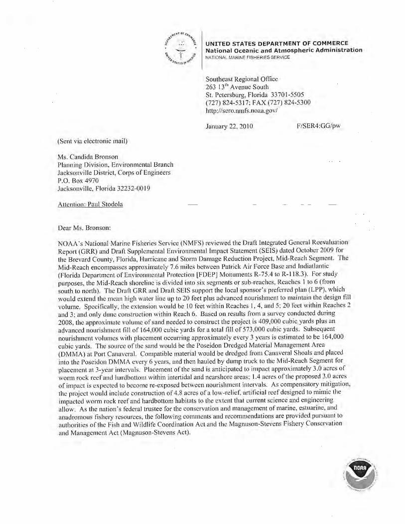
~""'"'lor •rc.,.,.+ ,5~ l .,.~ " ~ UNITED STATES DEPARTMENT Of COMMERCE .,. ";--'] .. National Oceanic and Atmospheric Administ ration ~'b ff NATIONAL MARINE FISHERIES SERVICE
~l't:JI'r'"'
(Sent via electronic mail)
Ms. Candida Bronson Planning Division, Environmental Branch Jacksonville District, Corps of Engineers P.O. Box 4970 Jacksonville. Florida 32232-0019
Attention: Paul Stodola
Dear Ms. Bronson:
Southeast Regional Office 263 13'h Avenue South St. Petersburg, Florida 33701-5505 (727) 824-53 17; FAX (727) 824-5300 http: //sero.nmls.noaa.gov/
January 22. 20 I 0 F/SER4:GG/pw
NOAA's National Marine fisheries Service (NMFS) reviewed the Dmll Integrated General Reevaluation
Report (GRR) <md Draft Supplemental Environmental Impact Statement (SEJS) dated October 2009 for
the Brevard County, Florida, Hurricane and Storm Damage Reduction Project, Mid-Reach Segment. The
Mid-Reach encomp<1SSCS approximately 7.6 mi les between Patrick Air Force Bas<.: and lndiallantic
(Florida Department of Environmental Protection [FDEP] Monuments R-75.4 to R-118.3). For sl11dy
purposes, the Mid-Reach shoreline is divided into six segments o r sub-reaches, Reaches I to 6 (from
south to north). The Draft GRR and Draft SEIS support the local sponsor's preferred plan (LPP), which
would extend the mean high water line up to 20 feet plus advanced nourishment to maintain the design fill
volume. Spcci lically, the extension would be I 0 feet within Reaches I, 4, and 5; 20 feet within Reaches:!
and 3; and only dune construction within Reach 6. Based on resu lts from a survey conducted during
1008, the approximate volume of sand needed to CQnstruct the project is 409,000 cubic yards plus an
advanced nourishment lill or 164,000 cubic yards tbr a total fill of 573,000 cubic yards. Subsequent
nourishment volumes with placement occurring approx imately every 3 years is estimated to be 164.000
cubic yards. The source of the sand would be the Poseidon Dredged Material Management Area
(DMMA) at Port Canaveral. Compatible material wou ld be dredged from Canaveral Shoals and placed
into the Poseidon DMMA every 6 years, and then hauled by dump truck to the Mid-Reach Segment for
placement at 3-year intervals. Placement of the sand is anticipated to impact approximately 3.0 acres of
worm rock ree f and hardbottom within intertidal and nearshore areas; 1.4 acres of the proposed 3.0 acres
of impact is expected to become re-exposed between nourishment intervals. As compensatory mitigation,
the project would include construction of 4.8 acres of a low-relief~ artificial reef designed to m imic the
impacted worm rock reef and hardbottom habitats to the extent that current science and engineering
allow. As the nation's federal trustee for the conservation and management of marine, estuarine, and
anadromous fishery resources, the following comments and recommendations are provided pursuant to
authorities of the Fish and Wildli fe Coordination Act and the Magnuson-Stevens Fishery Conservation
and Management Act (Magnuson-Stevens Act).

Cowmlwtion HisiOIJ' By letter dared, May 3, 2005, NMfS commented on the scoping letter for the Feasibility Phase of the
Brevard County Mid-Reach Shore line Protection Project. In that letter, NMFS discussed the high value
to fishery species of the worm rock reefs within the proposed project area and the importance of thorough ly evaluating in the EFH assessment the impacts to this habitat.
By letter dared October 7, 2005. NMFS provided the District with additional comments in response to a
public scoping meeting held on September 8, 2005. In that letter NMFS requested a detailed analysis of potential direct, indirect, and cumulative impacts of the proposed action on EFH and federally managed
fishery resources by li fe history stage; an evaluation of potential on-site and off-site compensatory
mitigation options; a description of hard bottom areas in the vicinity of the project described within an
ecosystem context; and information on the level of recruitment by sabellariid larvae in the Mid-Reach
area and the importance of the Mid-Reach 's mature worm rock colonies as a source of larvae for
mainta ining sabellm·iid ree ls along Florida's east coast.
On December 16. 2005, NMFS provided the Jacksonville District with comments on n pem1it application
by the Brevard County Board of County Commissioners (SAJ-2005-8688 ), which at that time was
requesting authorization for a I 0-year authorization to nourish the Mid-Reach Segment discussed in the Draft GRR and Draft SEIS. Our comments re-affim1ed the high value to fishery species of the worm rock
reefs within the proposed project area. We also requested a pilot study to determine the adequacy of the
proposed mitigation reef and that any nourishment be restricted to the southern portion of the project area
(R-118 to R-99). This permit application was subsequently withdrawn in favor of pursuing an approach
lor the Mid-Reach Segment that relied solely upon the federa l civil works project now proposed in the
Draft GRR and Draft SE IS.
During2006. 2007. and 2008, NMFS attended severa l information meetings, inc luding:
• Febmmy 9, 2006. meeting sponsored by the Jacksonville District and P'DEP to discuss approaches to mitigating impacts to worm rock reefs and nearshore hardbottom habitat.
• February 15, 2006. an additional feasibi lity seeping meeting at the Jacksonville District.
• May 11, 2007, an interagency meeting to discuss evaluations of mitigation alternatives; these
evaluations included usc of llabitat Equivalency Analysis (I-lEA) and Florida-s Uniform
Mitigation Assessment Method (UMAM ). • May 22-23, 2007, meetiJlg of the l-Iard Oottom Technical Advisory Committee.
• November 13, 2007. Altemative Formulation Brie fing at the Jacksonville District.
• April 2008, NM FS provided the U.S. Fish and Wild life Service with informal comments on the
Fish and Wi ldlife Coordination Act Report.
Ge11eral Comments Sabellar iid Reef Connectivitv: The Draft SE IS provides a detailed description of EHI and federally managed fishery resources in the project vicinity. a description ofhardbottom areas in the vicinity of the
project and an analysis of alternatives considered to avoid and minimize impacts. However, the Draft
SEIS provides no information on the importance of the Mid-Reach 's matm e worm rock colonies as a
source of larvae fo r maintai ning sabcllariid worm rock reefs outside the project area. This information is
needed to determine the indirect impacts that could result from this project and the cumulative impacts
that result from the various activities along Florida's east coast that impact sabellariid reefs. NMFS
recommends the Final SEIS inc lude this d iscussion.
Sequenrhd Mitigation Avoidance and Minimization: Planning of the Brevard Mid-Reach project has focused on minimizing the unpacts to sabellariid wom1 rock reefs and on compensating for the unavoidable impacts to this habitat.
- 2 -

Design features aimed at minimizing impacts include the relatively small amounts of fill that would be
placed per nourishment event and using trucks to bring dry sand to the beach, rather than using hydraulic
pumps that would bring sand to the beach in a slurry. Tile potential minimization of impacts that would result fi·om these design features may be adequate, however before concluding this is the case, NM FS
requests additional examination of the plans for Reaches 3 and 4.
\Vhile the overall impacts to hardbottom habitat from the NED plan and the LPP arc si milar, differences
between these altematives for Reach 3 and Reach 4 may show additional opportunities to avoid or
minimize impacts to wom1 rock reef and other hardbonom habitat. Both plans would directly impact
approximately 3.0 acres of nearshore hardbonom habitat. The principal difference between the NED plan
and the LPP is the extent of the indirect impacts to nearshore hardbottom. This difference in the projected
indirect impacts results li·om the NED plan's design tor Reach 3 having a 30-foot-wide fill and Reach 4
having only dune construction, whereas the LPP would result in a 20-foot-wide fill a long Reach 3 and I 0-foot-wide fill along Reach 4. NMFS recommends the Final GRR and Final SEIS evaluate the feasibility
of a hybrid design, selecting the LPP's design lor Reach 3 and the NED plan's design for Reach 4.
Evaluation of the hybrid design should spcci lically address whether it would meet the project's objective
and quantify the differences in direct and indirect impacts to wom1 rock reef and hardbottom between the hybrid, NED plan, and LPP designs.
Compensarory Mitigation: There is no well established method of compensatory mitigation for impacts
to sabellariid worm rock reefs. The Draft SEIS discusses three types of artificial reef stTucturcs and
concludes that, due to construction and cost constraints, mitigation in the form of an artificial reef
composed of articulated concrete mats embedded with coquina rock may be succcssrul. The mitigation reef is proposed to be placed at depths of 14 to 16 feet mean lower low water (MLL W), about lOOO feet
offshore from the project area. Articulated concrete mats have been successrully deployed as seabed
foundation structures on sandy and si lty substrates in s imilar conditions. However, their direct use as a
reef structure (with coquina-rock surface) is new.
A pilot s tudy was done to investigate the potential success of this approach to mitigating impacts to
sabcllariid worm rock reefs. Brevard Counry developed and installed test platforms to study the
recruitment of the sabellariid woml Phragmatopoma lapidosa to man-made structures. The study, referred to as "Propagulc and Larval Measurcrm:nt (PALM)" study, deployed three 24.7-cubic-foot boxes
for periods of 45 days and 300 days, respectively, on May 24, 2006. and July 8. 2006. These boxes were
equipped with 60 limestone plates at various elevations above the seabed. The plates were removed after
each deployment to examine the recruitment (abundance) and species of worm settlement and algae
growth. The PALM study lound recruitment of P. lapidosa on the structures deployed in 15 feet of water.
The measured coverage by sabellariid worms on the plates was about 34% and 4%, on average, during the two sampling periods, respectively. While these results demonstrate recruitment by larvae, survivorship
of these recruits is not clear. ln a recent report prepared for FDEP entit led Ecological Functions of
Nears/lore Habitats in East Florida. a Literature Synthesis. Lindeman, McCar1hy, Holloway-Adkins, and
Synder (2009), indicate that survivorship of P. lapidosa recruits at these depths would be low due to low water temperatures and high rates of sedimentation. This report also concludes the ecological functions
of nearshore hardbottom functions are not likely to be replaced on mitigation reefs in depths greater than
4 meters.
Placing the mitigation reefs into as shallow water as possible seems the most effective way to address
these shortcomings. Salvage companies operating in the same area often safely maneuver barges to within 200 feet of nearshore hardbottom w ithout signi licant adverse impacts to this habitat. It seems a
similar approach could be used to transport and deploy the articulated concrete mats. Further, articulated
mats placed closer to existing hardbouom areas might pose less of a risk to boaters and recreational users since they are already cautious in this area because or the natural hardbottom. Information within the
-3-

Draft ORR and Draft SEIS indicates the mats will be stable, so NMFS believes the potential gains from deploying the mats in closer proximity fo the areas of impacts are worth the risks from the mats coming free from their anchors and abrading natural hardbottom habitat.
Aifonitoring The primary objectives of the biological elements of the monitoring plan described in the Draft SEIS are to assess indirect impacts to the existing reef in the Mid-Reach project area and to evaluate the degree to which the mitigation reef replicates the ecological fu nctions ofthe existing nearshore reef NMFS is satisfied that the monitoring proposed for the fill area are adequate for dctcm1ining whether the actual impacts from beach nourishment arc consistent with the predicted extents. However, NMFS has concerns about the proposed monitoring of the performance of the mit igation reef.
The Draft SEIS estimates that 75% of the macroalgae, inve1tebrate, and fish species present at the impact site w ill ultimately reside on the mitigation reef. Althoug11 the nearshore hardbottom is known to be important refugee habitat earlier li fe-stages of federally managed species, no monitoring for these earlier life-stages is planned. In short, an important ecological function of the nearshore hardbottom habitat is not being evaluated d irectly and indirect measures are expected to show less than full replacement.
The proposed success criteria for the mitigation reef would be based upon the extent of burial/exposure at the nearshore and mitigation reels relative to historical measures and model predictions. NMFS would recommends that the success criteria for the mitigation reef also include survival rates fo r the epibiota and sustained utilization by fishery species and their prey. NMFS would be happy to work with the District to develop protocols for these assessments.
As stated in the Draft SElS (Appcndi ;.; K, Sub-appendix J), the results of the monitoring should be used to assess whether the amount of mitigation constructed was appropriate for offsetting the impacts that actually occur (as opposed to predicted to occur) and that gaps should be addressed by additional mitigation. NMFS recommencls these contingency platiS and their triggers be developed prior to project construction instead of waiting until the ycar-5 summary review, as proposed in the Draft SEIS. Having n c lear set of acceptable versus unacceptable h·ajectories for the mitigation reefs will allow mid-course conections in a time! ier and cost efficient manner, and this feedback is essential to execution of an adaptive management program.
Lastly, NMFS is conceq1ed that monitorrpg of the borrow area~ does not include examination ofthe forage base. While recovery of in faunal communities often OCCl.lrS, it docs 1101 always occur, especially when dredge cuts are deep. An appropriate monitoring program would guide future management options to ensure the beach is maintained while minimizing impacts to fishery resources. NMFS would be happy to work with the District to develop protocols for this monitoring.
Recom/1/e//dat ions NMFS recommends the Final SEIS include discussion of:
• The importance of the Mid-Reach's mature worm rock colonies as a source of larvae for mainta ining sabcllariid worm rock reefs outside the project area.
• Evaluation of a hybrid ofthe NED plan and LPP lor Reaches 3 and 4. This evaluation should specifically address whether it would meet the project's objective and quantify the differences in direct and indirect impacts to wonn rock reef and bard bottom between the hybrid. NED plan, and LPP designs. If this evaluation shows the hybrid design would meet the project purpose and impact less hardbottom habitat. it should be adopted as the recommended plan.
-4-

NMFS recommends the project be amended to include: • Construction and monitoring of the mitigation reefs for at least one year before beginning the
beach lilt. • Placement of the mitigation reefs cluser to shore and in closer proximity to existing hardbottom. • A monitoring program that examines utilization of the mitigating reefs by fishery species and
their prey and examination of the recovery of the infauna communities within the borrow areas. Results from both monitoring efforts should be incorporated into an adaptive management program aimed at meeting the project's purpose while minimizing impacts to fishery resources.
Thank you for the opportunity to provide comments early in the planning process for this project. Please direct related questions or comments to the attention of Mr. George Getsinger, at our Marinelm1d Oftkc. He may be reached at 9741 Ocean Shore Drive, St. Augustine, Florida 32080, or by telephone at (904) 461-8674.
I fo r
cc:
Sincerely,
Miles M. Croom Assistant Regional Administrator Htlbitat Conservation Division
CESAJ, [email protected], [email protected] EPA, [email protected] FWS, Jay _l-lan·[email protected] SAFMC, Roger. [email protected] FDEP, [email protected] NOAA PP I, PPI.Nepa@not~a.gov F, [email protected] FISER, [email protected] F /SER47. [email protected]
-5-

UNITED STATES ENVIRONMENTAL PROTECTION AGENCY REGION 4
ATLANTA FEDERAL CENTER 61 FORSYTH STREET
ATLANTA, GEORGIA 30303-8960
11/30/2009
Eric P. Summa, Chief Planning Division - Enviro1U11ental Branch Jackson vi li e District U.S. Army Corps of Engineers P.O. Box 4970 Jacksonville, FL 32232-0019
Subject: EPA's R eview Comments on the Draft Integrated General R eevaluation Report and Supplementa l Impact Statement (DSEIS) for t he Hurricane and Storm Damage R eduction Project (Mid-Reach Segment), Brevard County
Dear Mr. Summa:
Pursuant to Section 309 of the Clean Air Act (CAA) and Section 1 02(2)(C) of the National Environmental Policy Act (NEPA), the U.S. Environmental Protection Agency (EPA) Region 4 has reviewed the U. S. Anny Corps of Engineers' (Corps) Draft Integrated General Reevaluation Report and Supplemental Impact Statement (DSEIS) for the Hu1Ticane and Storm Damage Reduction Project (Mid-Reach Segment), Brevard County, Florida. Under Section 309 of the CAA, EPA is responsible for reviewing and commenting on major federal actions significantly affecting the quali ty of the human envi ronment.
EPA notes that this DSEIS addresses a hurricane and storm damage reduction project limited to the 7.8 mile "Mid-Reach" coastal segment of Brevard County, Florida. It is our understanding that the goal of this Brevard County Mid-Reach project is to reduce the erosion-induced damages to shorefront structures along the Mid-Reach study area, and that the Corps "supports the non-Federal sponsor's locally prefened plan and recommends the plan as the Tentatively Recommended Plan." This plan consists of a beach ti ll varying from a O-ft to 20-fl extension of the mean high water line, with U1e addition of ' 'advanced nourishment" to maintajn the design fill volume. The Corps reports that the approximate volume of sand to be placed is 409,000 cubic yards, plus another 164,000 cubic yards for advanced nourishment, giving a total fill requirement of 573,000 cubic yards. The Corps also reports that placement of the sand will impact about 3.0 acres of hardbottom areas by direct and indirect cover, of which 1.4 acres is expected to "include some temporal variation as the advanced nourishment erodes." Because the mitigation quantity is based upon a ratio of 1.6 mitjgation acres for every acre or hardbottom impacted, mitigation of 4.8 acres is required.
lntemet Address (URL) • hl1p:l/www.epa.gov Rocycled/Recyclable • Prinled w~h Vegetable 00 Based Inks on Recycled Paper (Minimum 30% Postconsumer)

In response to your October 30, 2009 letter, Region 4 appreciates the offer to provide conm1ents on the General Reevaluation Report and DSEIS, and we offer the following:
• EPA previously reviewed Feasibility Report with Final Envirorunental Impact Statement (FEIS) for Brevard County (1996), and we noted that the Mid-Reach segment was removed from the recommended plan due to enviroru11ental concerns.
• EPA concurs with the Corps' subsequent inclusion ofthe Mid-Reach within the overall Brevard County Hunicane and Storm Damage Project. EPA also concms with the Corps' decision to assess impacts from all proposed construction and dredging, as well as addressing potential effects at bonow areas, offshore areas, and the ocean bottom. EPA also supports the Corps' efforts to assess impacts from future beach maintenance, as well as requi ring pre- and post- environmental monitoring efforts.
• In general, the DSEIS adequately addresses all issues associated with the Brevard County Mid-Reach project, which has been proposed for construction to "reduce the damages caused by erosion and coastal storms to shorefront structures along the Mid-Reach study area." Project objectives l1ave appropriately focused on "reducing storm damages to coastal structures, maintain ing the recreational beach, mainta ining opportunities for recreational use of the nearshore areas, and maintaining enviroJmlental quality."
• EPA recommends that if the comprehensive post-construction monitoring indicates any changes occurring to the beaches and the near-shore environment (e.g., unexpected erosion is detected), the project should be halted for a re-evaluation of the long tenn shoreline maintenance plan conducted. EPA recommends that any loss of material during construction should be thoroughly investigated, and appropriate remedies enacted.
• EPA strongly recommends the use of adaptive management measures to address potential problems with fish populations and turtl e/shore bird nesting. If necessary, the maintenance plan should be modified.
• The EIS adequately addressed a number of alternatives, including both structural and non-structural alternatives. These altematives adequately addressed beach nourislunent while seeking to minimize impact to the nearshore hardbottom.
• EPA recommends that the Corps ' future development efforts should consider potential sea level lise.
• EPA notes that the locally prefened plan consists of a 1 0-foot extension of the mean high water li11e plus advanced nourishment to maintain that design fill volume in Reach 1 (R-119 to R-109), a 20-foot extension ofthe mean high water line plus advanced nourishment to maintain that design fill vo lume in Reaches 2 and 3 (R-1 09 to R-99)~ a 1 0-foot extension of the mean high water line plus advanced nourishment to maintain that design fill volume in Reaches 4 and 5 (R-99 to R-83), and a dune fi ll with no
2

added advanced nourishment in Reach 6 (R-83 to R-75.4). • EPA recommends that if project construction is delayed for more than a
year, an updated survey (to calculate sand volumes) should be initiated. • EPA notes that the Corps plans to rehabilitate the Poseidon dredged
material management area (DMMA) at Port Canaveral, with dredged material from Canaveral Shoals then placed into the Poseidon DMMA every 6 years. The Corps proposes to haul this sand by dump truck to the Mid-Reach for placement on the beach at approximately 3 year intervals. As the renourislm1ent volume is approxirnately 164,000 cubic yards, EPA notes that this equates to about 16,400 fully loaded trips with a 1 O~yard dump truck or 8,200 fully loaded trips with a 20-ard truck. The highway haul route for tbis major sand hauling project should carefully be considered, with particu lar attention to any load rated bridges on the route and other safety issues. Coordination with local highway officials is needed to ensure that the hauling is accomplished in a safe manner witb minimal effects to road and bridge structures.
• EPA notes that the recommended plan appropriately offers erosion protection ranging from a 5-year sto1111 level to a 75-year storm, varying along the length of the Mid-Reach.
• EPA supports the Corps' goal "to avoid, minimize and mitigate environmental impacts to the nearshore hardbottom." EPA notes that the project impacts 3.0 acres ofhardbottom outofthe total of31.3 acres of nearshore rock in the Nlid-Reach study area. The mitigation quantity has been calculated from the ratio of 1.6 mitigation acres required for every acre of natural rock impacted, resulting in a mitigation of 4.8 acres. EPA does have some environmental concerns regarding the long-term consequences of inundating this hard-bottom habitat, especially since this will not be the last beach nourishment project in the Mid-Reach. Therefore, EPA has identified cumulative impacts as being an issue of concern.
• EPA believes that these hardbottom communi ties are the premier communities in the local marine environment, and the Final SEJS should therefore document all activities that will preven t detrimental impacts to these communities. The final mitigation decision and final monitoring plans should demonstrate, therefore, that the project will be conducted in an ecologicall y sustainable manner.
• The Corps' documents appropriately discuss and address project economics, including cost sharing (e.g., the overall Federal participation in cost for the project is reported to be 54% of the NED plan, with the remainder to be non-Federal). EPA notes that the some of the structural valuations used by the Corps (Table 2-15) may no longer be valid based upon recent significant decreases (since 2008) in home prices in the local real estate market, and \ ·Ve recommend that the Corps review these numbers for accuracy before jnclusion in the Final SEIS.
• EPA concurs with the Corps' decision to select the project alternative that is the most "economically feasible, environmentally acceptable, and
3

soundly engineered" out of the range of alternatives considered. EPA requests the Corps' continued coordination with our Agency to resolve any issues that may arise after the Final SEIS is issued.
In summary, EPA does have some environmental concerns regarding the longteml consequences of inundating a hard-bottom habitat, especially since this will not be the last beach nourislunent project in the Mid-Reach. EPA requests that the Final SEIS include detailed information on both the final mitigation and final monitoring plans. We therefore rate this Drafi SEIS as EC2 (Environmental Concems- additional infonnation requested). Please include us in any noli fications of interagency meetings. Thank you, again, for the opp01iunity to comment on these documents. If you wish to discuss EPA' s comments, please contact me at 404/562-9611 ([email protected]) or Paul Gagliano. P.E .. ofmy staff at 404/562-9373 (gagliano.paul(@,epa.gov)
Sincerely,
-;~~ r,c:J~~H lk Heinz J. Mueller, Chief NEPA Program Office Office ofPolicy and Management
4

December 18, 2009
Mr. Eric P . Summa, Chief
Florida Department of Environmental Protection
Marjory Stoneman Douglas Building 3900 Commonwealth Boulevard Tallahassee. Florida 32399-3000
Environmental Branch, Planning Division U.S. Army Corps of Engineers P.O. Box 4970 Jacksonville, FL 32232-001 9
Ch.rrl 1 ~ lrl'l (,ll\lflhll
I II "\I II I I I I ,,, ,, ...
\I ' IJI'I \\ I ,,,,
RE: Department of the Army, jacksonville District Corps of Engineers- Draft Integrat~l~ Ce~1eral Reevaluation R~port and Supplemental E1wironmental impact Statement (GRR/SEIS), Brevard County Hurricane and Storm Damage Reduction Project, Mid-Reach Segment- Brevard County, Florida. SAl # FL200911025003C
Dear Mr. Summa:
The Florida State Clearinghouse has coordinated a review of the Draft GRR/SEIS under the following authorities: Presidential Executive Order 12372; Section 403.061 (40), Floridn Stntrttcs; the Coastal Zone Management Act, 16 U.S.C. §§ 1451-1464, as amended; and the National Environmental Policy Act, 42 U.S. C. §§ 4321-4347, as amended.
Based on the information contained in the Draft GRR/SEIS and enclosed state agency comments, the state has determined that, a t this stage, the proposed activity is consistent with the Florida Coastal Management Program (FCMP). The state's continued concurrence will be based on the activity's compliance with FCMP authorities, including federal and state monitoring of the activity to ensure its continued coniormance, and the adequate resolution of issues identified during this and subsequent regulatory reviews. The state's final concurrence of the project's consistency with the FCMP will be determined dUJing the environmental ?erraittir.g pi·oc.::ss.
Thank you for the opportunity to review the draft document. Should you have any questions regarding this letter, please contact Ms. Lauren P. Milligan at (850) 245-2170.
Yours sincerely,
Sally B. Mann, Director Office of Intergovernmental Programs
SBM/lm Enclosures
cat~gories
12/07/2009
12/16/2009
'More Protection, Less P~ce.ss·
DEP Home I QIP Home I Contact DEP I Search I DEP Site Map
- ---...__ ·-------
DEPARTMENT OF THE ARMY, JACKSONVILLE DISTRICT CORPS OF ENGINEERS -DRAFT INTEGRATED GENERAL REEVALUATlON REPORT AND SUPPLEMENTAL ENVIRONMENTAL IMPACT STATEMENT, BREVARD COUNTY HURRICANE AND STORM DAMAGE REDUCTION PROJECT, MIDREACH SEGMENT- BREVARD COUNTY, FLORIDA.
ACOE- MID-REACH SEGMENT BREVARD CO. HURRICANE/STORM ~~~===::::;___ DAMAGE REDUCTION PROJECT
12.101
E. CENTRAL FL RPC - EAST CENTRAL FLORIDA REGIONAL PLANNING COUNCIL - -
The East Central Florida Regional Planning Council has received the Brevard County Integrated General Reevaluation Report and Supplemental Environmental Impact Statement. The document has been reviewed in accordance with the functions of the regional clearinghouse, which are designated by the Executive Order of the Governor, pursuant to Federal Executive Order 12372, Intergovernmental Review of Federal Programs. The Council staff has not identified any significant or adverse effects to regional resources or facilities, nor have any extra-jurisdictional impacts been identified that would adversely affect neighboring jurisdictions. The proposed project is found to be consistent with the goals, objectives, and policies of the East Central Florida Regional Planning Council. Should there be any questions concerning this review, please contact Mr. Matt Boerger at (407) 262-7772 or email [email protected].
FISH and WILDLIFE COMMISSION- FLORIDA FISH AND WILDLIFE CONSERVATION COMMISSION
NO COMMENT BY ROBBIN TRINDE~L ON 11/6/09.
STATE- FLORIDA DEPARTMENT OF STATE
No Comment/Consistent
ENVIRONMENTAL PROTECTION - FLORIDA DEPARTMENT OF ENVIRONMENTAL PROTECTION
The DEP's Bureau of Beaches and Coastal Systems is currently processing a state Joint Coastal Permit/Water Quality Certification for the proposed project and is working with the applicant on mitigation for near-shore hard bottom habitat.
ST. JOHNS RIVER WMD- ST. JOHNS RIVER WATER MANAGEMENT DISTRICT
The District has no comments on the Draft Integrated General Reevaluation Report and Environmental Impact Statement.
For more information or to submit comments, please contact the Clearinghouse Office at:
3900 COMMONWEALTH BOULEVARD. M.S. 47 TALLAHASSEE, FLORIDA 32399-3000 TELEPHONE: (850} 245-2161 FAX: (850) 245-2190
Visit the Clearinghouse Hom~ Page to query other projects.
Cogyright Disclaimer Privac}'_Statement

COUNTY: BREVARD DATE:
.5ch - COMMENTS DUE DATE: 11/2/2009 1217/2009
12/16/2009 CLEARANCE DUE DATE:
MESSAGE:
!STATE AGENCIES
I WATERMNGMNT.
!ENVIRONMENTAL DISTRICTS PROTECTION
1sT. JOHNS RIVER WMD ~~ISH and WILDLIFE COMMISSION
lx STATE
The attached document requires a Coastal Zone Management ActJFlo rida Coastal Management Program consistency ev:aluation nod is cattgori1;cd ns one orthe following:
_ Federal Assistance to State or Local Government (15 CFR 930, Subpart F}. Agencies are required to evaluate the consistency of the acthity.
X Direct Federal Activity (IS CFR 930, Subpart q , Federal Agencies arc required to furnish a consistency determination for the State's concurrence or objection. Outer Continental ShelfEX (llorlllion, De\•clopment or Production Activities ( IS CFR 930, s ·ubpart E}. Open tors 11re required to pro,•ide n consistency certification for state concurrence/objection. Federal l)ccnsing or Permitting Activity (IS CFR 930, Subpnrt 0). Such (Jrojccts will only be evaluated ror consistency when there is not 1111 analogous state license or permit.
I
SAJ#:FL200911025003C REFER TO: FL200504050677C
OPBPOLICY UNIT
RPCS &LOC GOVS
Project Description: DEPARTMENT OF THE ARMY, JACKSONVILLE DISTRICT CORPS OF ENGINEERS -DRAFT INTEGRA TED GENERAL REEVALUATION REPORT AND SUPPLEMENTAL ENVIRONMENTAL IMPACT STATEMENT, BREVARD COUNTY HURRICANE AND STORM DAMAGE REDUCTION PROJECT, MID-REACH SEGMENT - BREVARD COUNTY, FLORJDA.
To: Florida State Clearinghouse EO. 12372/NEPA Federal Consistency
AGENCY CONTACT AND COORDINATOR (SCH) r7: 0'No Comment/Consistent 3900 COMMON WEALTH BOULEY ARD MS-47 00 No Comment 0 . TALLAHASSEE, FLORIDA 32399-3000 0 Comment Attached Conststent/Comments Attached
TELEPHONE: (850) 245-2161 D . 0 Inconsistent/Comments Auached FAX: (850) 245-2190 Not Apphcable O NotApplicable
From: Division/Bureau: _j)~js iol'l ~ i~'J
C-"' -~ ...;> ::::::-
Date: _ p .... /o 1/P~C\..___ _ _ -v

United States Department of the Interior OFFICE OF THE SECRETARY
OFFICE OF ENVIRONMENTAL POLICY AND COMPLIANCE Richard B. Russell Federal Building
9043.1 ER 09/1175
Ms. Candida Bronson U.S. Army Corps ofEngineers Planning Division P.O. Box 4970 Jacksonville, FL 32232
Dear Ms. Bronson:
15 Sp1-ing SU-cet, S.W. Atlanta, Georgia 30303
December 22, 2009
The Department of the Interior has reviewed the Draft Environmental Impact Statement for the Hurricane and Storm Damage Reduction Project (Mid-Reach Segment), Brevard County, Florida. We have no comments on this document.
I can be reached at 404-331-4524 or by email at g_n~g_Q_ry~hQg_\,[email protected] .gQ.Y if you should have any questions.
cc: FWS. R4 USGS, Reston OEPC, Washington, DC
Sincerely,
Gregory Hogue Regional Environmental Officer

Stodola, Paul E SAJ
From: Sent: To: Cc: Subject:
Wikel, Geoffrey L [[email protected]] Wednesday, March 10, 2010 10:53 PM Stodola, Paul E SAJ Wikel, Geoffrey L; Finnegan, Colleen R. Comments on Brevard County Mid-Reach Project
The Minerals Management Service (MMS) appreciates the opportunity to review and provide comments on the U.S. Army Corps of Engineers' Draft Integrated General Reevaluation Report I Supplemental Environmental Impact Statement (IGRR/EIS) prepared in support of constructing the Mid-Reach Segment of the Brevard County, Florida Hurricane and Storm Damage Reduction Project .
The draft IGGR/EIS describes the Corps' revised proposal to undertake a beach fill program along 7.8 miles of sensitive shoreline in Brevard County, Florida~ immediately south of Patrick Air Force Base . The draft IGGR/EIS identifies two borrow areas on the Outer Continental Shelf (OCS) that could be used to obtain sand for the proposed project: Canaveral Shoals II and the Canaveral Ocean Dredged Material Disposal Site . Since the MMS has jurisdiction over borrow areas located on the OCS, including ODMDSs on the OCS, we recommend that the Corps request the MMS to become a cooperating agency for the environmental review of the proposed project. The MMS maintains that its National Environmental Policy Act obligations require the bureau to consider the potential impacts of reasonably foreseeable actions, include transport, unloading, placement, and truck-haul activities that may occur following dredging operations. As a cooperating agency, the MMS may then adopt and use the Final IGGR/EIS to facilitate future leasing decisions.
In the spirit of streamlining environmental review requirements and future requests to access ocs sand resources, the MMS further requests that the Corps assume lead agency responsibility for compliance with other major Federal environmental requirements, including consultations and coordination required by the Endangered Species Act Section 7, Magnuson-Stevens Fishery Conservation and Management Act Section 305, Coastal Zone Management Act 307, and National Historic Preservation Act Section 106 . If the Corps decides to assume t he role of l ead agency, the Corps should inform the respective Federal or State resource agencies of the i nvolvement of the MMS in t he proposed action, even if the respective consultation or coordination is already complete .
If the Corps decides to pursue these recommendations, the MMS and Corps should memorialize their relationship in writing. If the Corps decides not to pursue these recommendat ions, it is likely that the project sponsors will experience unnecessary processing delays when a formal request is submitted to use OCS sand resources.
Following an expedited review of the draft document, the MMS recommends that the Corps consider the following:
1. The potential impacts to air quality were dismissed during alternative and plan formulation. The MMS believes the potential for air quality impacts related to truck loading, hauling, and dumping, including those associated with fugitive dust, should be evaluated in the IGGR/EIS.
2. The draft IGGR/EIS mischaracterizes the non -Federal sponsor's lease status . Brevard County does not have current approval for the use of Canaveral Shoals II f or the proposed action. In contrast, both federal and non-federal sponsors will be required to enter into a new
1

negotiated agreement with the MMS for use of either proposed OCS borrow area .
3. The MMS recommends that the Corps include a robust discussion of the potential impacts to prehistoric resources in proposed borrow areas and placement siteJ either providing new information or incorporating existing analyses by reference.
Thank you again for the opportunity to provide comments. The MMS reserves the right to make additional comments on the Final IGGR/EIS . If you have any questions~ please feel free to contact Geoffrey Wikel at [email protected] or (7e3)787-1283.
2

United States Department of the Interior U. S. FISH AND WILDLIFE SERVICE
IN REP~Y REFER TO·
FWS Log Number: 41910-:2008-F-05~7
April 22. 2009
7915 BAYMEADOWS WAY, SUITE 200 JACKSONVILLE, FLORIDA 32256-7517
Colonel Paul L. Grosskruger. District Engineer Department of the Army Jacksonville District Corps of Engineers P.O. Box 4970 Jacksonville, FL 32232-00 19
Dear Colonel Grosskr uger:
This document transmits the U.S. Fish and Wildlife Service 's (Service) biological opinion (80) based on our review of the proposed Mid Reach beach nourishment project located in Brevard County. Florida, and its effects on the loggerhead (Carella caretta). green (Chelonia myda~). leatherback (Dermochelys coriacea), hawksbill (Eretmochelys imbricata), and Kemp· s ridley (Lepiclochelys kempii) sea turtles in accordance with section 7 of the Endangered Species Act (Act) of 1973. as amended (16 U.S.C. 153 1 et seq.). Your October 6. 2008. request for fom1al consultation was received on October 10. 2008.
This BO is for sand placement along the Brevard County Mjd Reach area. Information is provided in the October I 0, 2008 coordjnation letter. Florida Mid Reach Shore Protection Project Revision A (1 1/10/05). Post-construction Monitoring ofthe Canaveral Shoals ll Offshore Borrow Area. telephone conversations. and other sources of information. A complete administrative record of this consultation is on file at Jacksonville Field Office.
The Corps detennined that this project may affect the loggerhead. green. leatherback. and hawksbill sea turtles. In addition. the Corps made a detem1ination that the project may affect but was not likely to adversely affect the Eastern indigo snakes (Drymarchon corais couperi), the West Indian manatee (Tr ichechus manatus). the southeastern beach mouse (Peromyscus polionows nineivemris) and the piping plover ( Charadrius milodus ). The Service concuiTed with these determinations.

Eastem indigo snake
Eastern indigo snakes may occupy a broad range of habitats from scrub and sandhill comimmities, to wet prairies and swamps, near the Poseidon dredged material management area (DMMA) where fill material vvill be obtained for the project. The eastern indigo snake is most strongly associated with high, dry, well-drained sandy soils, and closely parallels habitat preferred by the gopher tortoise (Gopherus polyphemus), a state of Florida listed species. The Service recommends that the Corps implement the Service's Standard Protection Measures for the Eastern Indigo snake during the construction phase of the project. Those measures can be found at the Service's Jacksonville Ecological Service Field Office website at htlp:l/nonh tlorida, fws. uov/1 J·1di rzoSnakes/easl-indi uo-snake-measures-07 1 199. htm. With inclusion of these conditions, the project may affect, but is not likely to adversely affect the Eastern indigo snake.
Florida manatee
The Corps also determined that the proposed project may affect but is not likely to adversely affect the Florida manatee. The Service has reviewed the Biological Assessment and concurs that, if the Standard Manatee Construction Conditions are made a condition of the pennit and implemented, then these activities will not result in take of the Florida manatee. We also conclude that these activities will not adversely modify its critical habitat. That finding will fulfill section 7 requirements of the Act. In addition, because no incidental take of manatees is anticipated, no such authorization under the Marine Manunal Protection Act (MMP A) would be needed.
Southeastern beach mouse
The Southeastern beach mouse is found at Cape Canaveral Air Force Station. The Poseidon DMMA upland stockpile site is located along the north bank ofthe harbor and substantially separated from the beach and dunes. The Corps also determined that the proposed project may affect but is not likely to adversely affect the southeastern beach mouse. The Service concurs with this determination provided that no less than two weeks prior to the excavation of the existing upland stockpile a beach mouse habitat assessment must be conducted within the area of impact. The presence of any mouse burrows and tracks within the impact area must be recorded and mapped. The Corps must contact the Service with this infom1ation. If there are no beach mouse tracks and burrows at the Poseidon DMMA upland stockpile site, the Service concurs that the project may affect. but is not likely to adversely affect the southeastern beach mouse. If tracks and borrows are presents at the Poseidon DMMA upland stockpile site, the Corps will reinitiate consultation.
2

Piping plover
The Corps also determined that the proposed project may affect 'but is not likely to adversely affect the piping plover. Optimal habitat consists ofwashover passes, inlets, lagoons, and mud and sand flats. The Corps provided information that optimal piping habitat was not found within the project area. The Service concurs that the project may affect, but is not likely to adversely affect the non-breeding piping plover.
Consultation Hjstory
The Mid Reach shoreline was deleted from the originally proposed federal project limits in 1996 because of environmental concerns related to the burial of the existing nearshore rock outcrops by conventional beach nourislm1ent. The Service determined that in order to further consider beach nourishment alternatives along the Mid-Reach, it would be necessary to (1) more definitively map the rock resource, (2) demonstrate the severity of the beach erosion problem relative to the local abundance of the rock, (3) evaluate alternative solutions and their potential environmental impacts. and ( 4) present a specific plan or proposal for conm1ent.
On April 1, 2005, the Corps issued a scoping letter to all appropriate stakeholders including the Service. On August 23. 2005. the Service agreed to review and coordinate the Fish and Wildlife Coordination Act Report (FWCAR). On September 8, 2005, the Corps and the local sponsor held a public scoping meeting.
On December 8, a meeting was held vvith representatives of the Corps, the Florida Department of Protection (FDEP), National Marine Fisheries Service (NMFS). florida Fish and Wildlife Conservation Conm1ission (FWC), Olsen and Associates, Dynamac, and the Service.
On December 8, 2005, and February 15, 2005, interagency meetings were held. On March 21, 2006, the Service accepted the Corps invitation to be a cooperating agency. On November 7, 2007, a draft FWCAR is provided to the Service. On August 12, 2008, the Service provided a revised draft FWCAR to the Corps.
In addition to the above coordination, the Regulatory Division of the Corps initiated formal Section 7 consultation with the Service for the beach nourishment and shoreline stabilization project for Brevard Mid Reach area. This consultation resulted in the issuance of aBO dated February l. 2006.
The Corps submitted a revised BA on December 23, 2008. The Service sent the Corps a draft BOon March 18, 2009. The Corps provided comments on March 27.2009.
On April 9, 2009, the Corps provided final comments to the draft BO.
The Service had sufficient information to issue aBO for the proposed project. Infommtion for this BO was obtained by email conespondence, meetings. site visits, telephone conversations
3
and other sources of information. A complete administrative record of this consultation is on file at the Service· s Jacksonville Field Office.
BIOLOGICAL OPINION
DESCRIPTION OF THE PROPOSED ACTION
Brevard County is located on Florida's central Atlantic coast and includes about 72 miles of sandy. ocean shoreline. Of this, 32 miles me mostly undeveloped federal coastline north of Canaveral Harbor Entrance. The other f011y miles feature a diverse mix of public, private, and federal oceanfront development. The Service has described the action area to include 7.8 miles of this developed shoreline, from the south end of Patrick AFB to just nm1h oflndialantic (RMonument 75.4 toR-Monument 1 19) for reasons that will be explained and discussed in the ''EFFECTS OF THE ACTION'' section ofthis consultation. This 7.8-mile area is refen·ed to as the ·'Mid-Reach". There have been no prior, significant beach nourishment projects constructed along the Mid-Reach shoreline. Small-scale, truck-haul placement of sand against the eroded bluffline has been conducted by property owners at many locations after storm events.
The Corps divided the Mid-Reach into six ''sub-reaches" . The proposed project consists of placing beach quality sand within the 6-sub-reaches of the Mid-Reach. Sub-Reach 1 (RMonument 119 toR-Monument 109) consists of a 10-foot extension ofthe mean high water line plus advanced nourishment to mC~intain that design fill volume. Sub-Reach 2 and 3 (RMonument 109 toR-Monument 99, a 1 0-foot extension of the mean high water line plus advanced nourishment to maintain that design fill volume in Sub-Reach 4 and 5 (R-Monument 99 to R-Monumenl 83), and a dune fill with no added advanced nourislunent in Sub-Reach 6 (RMonument 83 toR-Monument 75.4). Approximately 573,000 cubic yards of sand will be placed at initial construction. Fill will be obtained from the Poseidon DMMA at Port CanaveraL Dredging material from Canaveral shoals with placement into the Poseidon DMMA wi ll occur every 6 years, and hauling by dump truck to the Mid-Reach for placement on the beach will occur at approximately 3-year intervals. The fill material will be similar i"n both coloration and grain size distribution to the native beach. The fill material will be free of construction debris, rocks, or other foreign matter and will not contain, on average. greater than l 0 percent fines (i.e., silt and clay) (passing the #200 sieve) and will not contain, on average, greater than 5 percent coarse gravel or cobbles, exclusive of shell material (retained by the #4 sieve). The Corps has committed not to do the work during the sea turtle nesting season. May 1 through October 31.
The proposed plan includes a total of3.0 acres of direct and indirect impacts to the nearshore rock resources, however. 1.4 acres is expected to include some temporal variation as the advanced nourishment erodes. Mitigation for impacts was calculated from the Uniform Mitigation Assessment Method (UMAM), resulting in 4.8 acres ofmitigation reef to be created.
4

A dune feature will be incorporated into the beach fill template design. The dune-only fill template will extend landward on a 1:1.5 slope to an elevation that matches the existing dune crest elevation. It will then tie into the existing dune with a flat section. The template will follow a 1 :6 slope ration seaward to intersect with the existing grade. The dune + beach face template consists of a dtme feature that extends landward on a 1:8 slope followed by a 1:1.5 slope elevation upward to the native dune. The benn elevation is on a 1:40 slope to intersect with the upper beach face. The upper beach face slopes landward from the mean high water line at a 1:8 slope to intersect w ith the 1:40 berm slope. The swash zone section extends seaward from the mean high water line on a 1:8 slope seaward until intersection with the existing grade.
Conservation Measures
Sea Turtles
1. The Corps will place material on the beach between November 1 and April 30 to avoid the majority of sea turtle nesting activities.
2. The Mid-Reach project will utilize trucks to place beach fill, and the work will occur during the daytime only.
3. FWC and the local sponsor have an agreement to conduct sea turtle monitoring for a minimum of two additional nesting seasons after the nomislunent event i f placed sand remams.
STATUS OF THE SPECIES/CRITICAL HABITAT
The Service has responsibility for implementing recovery of sea mrtles when they come asl1ore to nest. This BO addresses nesting sea turtles, their nests and eggs, and hatchlings as they emerge from the nest and crawl to the sea. The National Oceanic and Atmospheric Administration 's National Marine Fisheries Service (NMFS) has jurisdiction over sea turtles in the marine environment.
Species/critical habitat description
Loggerhead Sea Turtle
The loggerhead sea turtle was listed as a threatened species on July 28. 1978 (43 FR 32800). The loggerhead occurs throughout the temperate and tropical regions of the Atlantic, Pacific, and Indian Oceans.
Within the continental U.S., loggerheads nest from Texas to Virginia with major nesting concentrations found in South Florida. Additional nesting concentrations occur on coastal islands ofN01th Carolina. South Carolina, and GeoTgia. and on the Atlantic and Gulf coasts of
5

Florida (NMFS and Service 1991 b). Within the western Atlantic, loggerheads also nest in Mexico and the Caribbean.
The Loggerhead sea turtle grows to an average weight of about 200 pounds and is characterized by a large head with blunt jaws. Adults and subadults have a reddish-brown carapace. Scales on the top of the head and top of the flippers are also reddish-brown with yellow on the borders. Hatchlings are a dull brown color (NMFS 2002a). The loggerhead feeds on mollusks, crustaceans, fish, and other marine animals.
The loggerhead occurs throughout the temperate and tropical regions of the Atlantic, Pacific, and Indian Oceans. However, the m~jority ofloggerhead nesting is at the western rims of the Atlantic and Indian Oceans. It may be found hundreds of miles out to sea, as well as in inshore areas such as bays, lagoons, salt marshes, creeks, ship channels, and the mouths of large rivers. Coral reefs, rocky places, and ship wrecks are often used as feeding areas. Nesting occurs mainly on open beaches or along nan·ow bays having suitable sand, and often in association with other species of sea turtles.
No critical habitat has been designated for the loggerhead sea turtle.
Green Sea Turtle
The green sea turtle was federally listed as a protected species on July 28, 1978 (43 FR 32800). Breeding populations of the green tmtle in Florida and along the Pacific Coast of Mexico are listed as endangered: all other populations are listed as threatened. The green sea turtle has a worldwide distribution in tropical and subtropical waters. Major green turtle nesting colonies in the Atlantic occur on Ascens ion Island, Aves Island. Costa Rica. and Surinam. Within the U.S., green turUes nest in small numbers in the U.S. Virgin Islands and Puerto Rico, and in larger numbers along the east coast of Florida, particularly in Brevard, Indian River, St. Lucie, Martin, Palm Beach, and Broward Counties (NMFS and Service 199 l a). Nesting also has been docmnented along the Gulf coast of Florida from Escambia County through Franklin County in northwest Florida and from Pinellas County through Collier County in southwest Florida (FWC Statewide Nesting Beach Survey database). Green turtles have been k.novvn to nest in Georgia. but only on rare occasions (Georgia Department of Natural Resources statewide nesting database). The green turtle also nests sporadically in Notth Carolina and South Carolina (North Carolina Wildl ife Resources Commission statewide nesting database; South Carolina Department of Natural Resources statewide nesting database). Unconfirmed nesting of green turtles in Alabama has also been reported (Bon Secour National Wildlife Refuge nesting reports).
Green sea turtles are generally found in fairly shallow waters (except when migrating) inside reefs, bays, and inlets. The green turtle is attracted to lagoons and shoals with an abundance of marine grass and algae. Open beaches with a sloping platform and minimal disturbance are required for nesting.
6
The green sea tt.ntle grows to a maximum size of about 4 feet and a weight of 440 pounds. It has a heart-shaped shell, small head, and single-clawed flippers. The carapace is smooth and colored gray, green, brown and black. Hatchlings are black on top and white on the bottom (NMFS 2002b). Hatchling green turtles eat a variety of plants and animals, but adults feed almost exclusively on seagrasses and marine algae.
Critical habitat for the green sea turtle has been designated for the waters surrounding Culebra Island, Pue11o Rico. and its outlying keys.
Leatherback Sea Turtle
The leatherback sea turtle, listed as an endangered species on June 2. 1970 (35 FR 8491 ). nests on shores of the Atlantic, Pacific and Indiai} Oceans. Leatherbacks have the widest distribution ofthe sea ttutles with nesting on beaches in the tropics and sub-tropics and foraging excursions into higher-latitude sub-polar waters. They have evolved physiological and anatomical adaptations (Frair et al. 1972, Greer et al. 1973) that allow them to exploit waters far colder than any other sea turtle species would be capable of surviving. Non-breeding animals have been recorded as far north as the British Isles and the Maritime Provinces of Canada and as far south as Argentina and the Cape of Good Hope (Pritcbard 1992). Nesting grounds are distributed worldwide, with the Pacific Coast of Mexico historically supporting the world's largest known concentration of nesting leatherbacks. The laTgest nesting colony in the wider Caribbean region is found in French Guiana, but nesting occurs frequently, although in lesser numbers, from Costa Rica to Columbia and in Guyana, Surinam, and Trinidad (NMFS and Service 1992; National Research Council 1990a).
The leatheTback regularly nests in the U.S., in Puerto Rico, the U.S. Virgin Islands, and along the Atlantic coast of florida as far not1h as Georgia (NMFS and Service 1992). Leatherback turtles have been known to nest in Georgia, South Carolina, and North Carolina, but only on rare occasions (North Carolina Wildlife Resources Conm1ission; South Carolina Department of Natural Resources; and Georgia Department ofNatural Resources statewide nesting databases). Leatherback nesting has also been reported on the northwest coast of Florida (LeBuff 1990; FWC Statewide Nesting Beach Survey database); and in southwest Florida a false crawl (nonnesting emergence) has been observed on Sanibel Island (LeBuff 1990).
This is the largest, deepest diving of all sea turtle species. The adult leatherback can reach 4 to 8 feet in length and weigh 500 to 2,000 pounds. The carapace is distinguished by a rubber-like texhtre, about 1.6 inches thick, made primarily of tough, oil-saturated connective tissue. Hatchlings are dorsally mostly black and are covered with .tiny scales; the flippers are edged in white, and rows of white scales appear as stripes along the length ofthe back (NMFS 2002c). Jellyfish are the main staple of its diet, but it is also known to feed on sea urchins, squid, crustaceans, tunicates, fish , blue~green algae, and tloating seaweed.
7

Marine and terrestrial critical habitat for the leatherback sea turtle has been designated at Sandy Point on the westem end of the island of St. Croix, U.S. Virgin Islands (50 CFR 17.95).
Hawksbill Sea Turtle
The hawks bill sea turtle was listed as an endangered species on June 2, 1970 (35 FR 8491 ). The hawksbill is found in tropical and subtropical seas of the Atlantic, Pacific~ and Indian Oceans. The species is widely distributed in the Caribbean Sea and western Atlantic Ocean. Within the continental U.S. , htlwksbill sea turtle nesting is rare and is restricted to the southeastern coast of Florida (Volusia through Dade Counties) and the Florida Keys (Monroe County) (Meylan1992; Meylan et al. 1995). However, hawksbill tracks are difficult to differentiate from those of loggerheads and may not be recognized by surveyors. Therefore, surveys in Florida likely underestimate actual ha,~·ksbill nesting numbers (Meylan et al. 1995). In the U.S. Caribbean. hawksbill nesting occurs on beaches throughout Puet1o Rico and the U.S. Virgin Islands (NMFS and Service 1993).
Hawksbills typically weigh around 176 pounds or less in the wider Caribbean; hatchlings average about 1.6 inches straight length and range in weight from 0.5 to 0.7 ounces. The carapace is heart shaped in young tmtles, and becomes more elongated or egg-shaped with maturity. The top scutes are often richly patterned with irregularly radiating streaks of brown or black on an amber background. The head is elongated and tapers sharply to a point. The lower jaw is V-shaped (NMFS 2002d).
Critical habitat for the hawksbill sea turtle has been designated for selected beaches and/or waters of Mona, Monito, Culebrita, and Culebra Islands·, Puerto Rico.
Kemp's Ridley Sea Turtle
The Kemp's ridley sea turtle was listed as endangered on December 2, 1970 (35 FR 18320). The Kemp's ridley, along with the flatback sea turtle (Natator depressus), has the most geographically restricted distribution of any sea tm1le species. The range of the Kemp's ridley includes the Gulf coasts of Mexico and the U.S., and the Atlantic coast of North America as far north as Nova Scotia and Newfoundland. The majority of nesting for the entire species occurs on the primary nesting beach at Rancho Nuevo (Marquez-M. 1994).
Outside of nesting, adult Kemp;s ridleys are believed to spend most of their time in the Gulf of Mexico, while juveniles and subadults also regularly occur along the eastern seaboard of the U.S. (Service and N!v'1FS 1992). There have been rare instances when immature ridleys have been documented making transatlantic movements (Service and NMFS 1992). It was originaJly speculated that ridleys that make it out of the Gulf of Mexico might be lost to the breeding population (Hendrickson 1980), but data indicate that many of these turtles are capable of moving back into the Gulf of Mexico (Henwood and Ogren 1987). In fact, there are documented
8

cases of ridleys captured in the Atlantic that migrated back to the nesting beach at Rancho Nuevo (Schmid and Witzell 1997, Schmid 1998, Witzell1998).
Hatchlings, after leaving the nesting beach. are believed to become· entrained in eddies within the Gulf of Mexico, where they are dispersed within the Gulf and Atlantic by oceanic surface currents until they reach about 7.9 inches in length, at which size they enter coastal shallow water habitats (Ogren 1989).
No critical habitat has been designated for the Kemp~s ridley sea turtle.
Life history
Loggerhead Sea Tmtle
Loggerheads are long-lived, slow-growing animals that use multiple habitats across entire ocean basins throughout their life history. This complex life history encompasses terrestrial, nearshore, and open ocean habitats. The three basic ecosystems in which loggerheads live are the:
L Terrestrial zone (supralittoral)- the nesting beach where both oviposition (egg laying) and embryonic development and hatching occur.
2. Neritic zone -the inshore mmine environment (fTom the surface to the sea floor) where water depths do not exceed 656 feet (200 meters). The neritic zone generally includes the continental shelf, but in areas where the continental shelf is very narrow or nonexistent, the neritic zone conventionally extends to areas where water depths are less than 656 feet (200 meters).
3. Oceanic zone- the vast open ocean environment (from the surface to the sea floor) where water depths are greater than 656 feet (200 meters).
Maximum intrinsic growth rates of sea turtles are limited by the extremely long duration of the juvenile stage and fecundity. Loggerheads require high survival rates in the juvenile and adult stages, common constraints critical to maintaining long-lived, slow-growing species, to achieve positive or stable long-term population growth (Congdon et al. 1993; Heppell 1998; Crouse 1999; Heppell et al. 1999. 2003~ Musick 1999).
Life History Trait Data
Clutch size {mean) 100-126 eQgs 1 ~~
Incubation duration (varies depending on time of year and ., '
latitude) Range = 42-75 days-·-'
9

Juvenile (<87 em CCL) sex ratio 65-70% female4
Pivotal temperature (incubation temperature that produces an 29.0"C5
equal number of males and females)
Nest productivity (emerged hatchlings/total eggs) x 100 Range~ 45-70%2
'6 (varies depending on site specific factors)
Clutch frequency (number of nests/female/season) 3-4 nests7
lnternesting interval (number of days between successive 12-15 days8
nests within a season)
Remigration interval (number of years between successive ? ~ .... 7 9 nesting migrations)
_.)-.). years
Nesting season late April-early September
Hatching season late June-early November
Age at sexual maturity "? 3~ 10 .)_- ) years
Life span >57 years 11
1 Dodd 1988. 2 Dodd and Mackinnon (1999, 2000. 2001} 2002,2003, 2004). 3 B. Witherington. FWC, pers. comm. 2006 (information based on nests monitored throughout
Florida beaches in 2005, n=865). 4 National Marine Fisheries Service (2001); A. Foley, FWC, pers. comm. 2005. 5 Mrosovsky (1988); Marcovaldi et al. (1997). 6 B. Witherington, FWC, pers. conm1. 2006 (infom1ation based on nests monitored tlu·oughout
Florida beaches in 2005, n=l ,680). 7 Murphy and Hopkins (1984); Frazer and Richardson (1985): Ehrhart, unpublished data. 8 Caldwell ( 1962 ), Dodd ( 1988). 9 Richardson et al. (1978): Bjorndal et al. (1983); Ehrhart. unpublished data. 10 M. Snover, NMFS, pers. comm. 2005. 11 Dahlen et al. (2000).
Green Sea Turtle
Green turtles deposit from one to nine clutches within a nesting season, but the overall average is about 3.3 nests. The interval between nesting events within a season varies around a mean of about 13 days (Hil1h 1997). Mean clutch size varies widely among populations. Average clutch size reported for Florida was 136 eggs in 130 clutches (Witherington and Ehrhart 1989). Only occasionally do f~males produce clutches in successive years. Usually two, three, four or more years intervene between breeding seasons (NMFS and Service 199 I a). Age at sexual mantrity is believed to be 20 to 50 years (Hirth 1997).
10

Leatherback Sea Turtle
Leatherbacks nest an average of five to seven times within a nesting season, with an observed maximum of 11 nests (NMFS and Service 1992). The interval between nesting events within a season is about 9 to I 0 days. Clutch size averages 80 to 85 yolked eggs, with the addition of usually a few dozen smaller, yolkless eggs, mostly laid toward the end of the clutch (Pritchard 1992). Nesting migration intervals of2 to 3 years were observed in leatherbacks nesting on the Sandy Point National Wildlife Refuge. St. Croix. U.S. Virgin Islands (McDonald and Dutton 1996). Leatherbacks are believed to reach sexual maturity in 6 to 10 years (Zug and Parham 1996).
Hawksbill Sea Turtle
Hawksbills nest on average about 4.5 times per season at intervals of approximately 14 days (Corliss et al. 1989). In Florida and the U.S. Caribbean, clutch size is approximately 140 eggs, although several records exist of over 200 eggs per nest (NMFS and Service 1993). On the basis of limited information, nesting migration intervals of2 to 3 years appear to predominate. Hm.vksbi lis are recruited into the reef environment at about 14 inches in length and are believed to begin breeding about 30 years later. However, the time required to reach 14 inches in length is unknown and growth rates vary geographically. As a result, actual age at sexual maturity is tmknown.
Kemp' s Ridley Sea Tuttle
Nesting occurs from April into July during which time the turtles appear off the Tamaulipas and Veracruz coasts of Mexico. Precipitated by strong winds, the females swarm to mass nesting emergences, known as arribaclas or arribazones. to nest during daylight hours. The period between Kemp's ridley aiTibadas averages approximately 25 days (Rostal et al. 1997), but the precise timing of the arribadas is highly variable and unpredictable (Bernardo and Plotkin 2007). Clutch size averages 100 eggs and eggs typically take 45 to 58 days to hatch depending on temperatures (Marquez-M. 1994, Rostal 2007).
Some females breed annually and nest an average of 1 to 4 times in a season at intervals of 10 to 28 days. Analysis by Rostal (2007) suggested that ridley females lay approximately 3.075 nests per nesting. Interannual remigration rate for female ridleys is estimated to be approximately 1.8 (Rostal 2007) to 2.0 years (Marquez Millan et al. 1989, TEWG 2000). Age at sexual maturity is believed to be between 1 0 to 1 7 years (Snover e.t al. (2007).
11

Population dynamics
Loggerhead Sea Turtle
The loggerhead occurs throughout the temperate and tropical regions of the Atlantic~ Pacific, and Indian Oceans. However, the majority of loggerhead nesting is at the western rims of the Atlantic and Indian Oceans. The most recent reviews show that only two loggerhead nesting beaches have greater than 10,000 females nesting per year (Baldwin et al. 2003, Ehrhart et al. 2003, Kamezaki et al. 2003, Limpus and Limpus 2003, Margaritoulis eta!. 2003): South Florida (U.S.) and Masirah (Oman). Those beaches with 1,000 to 9,999 females nesting each year are Georgia through NOTth Carolina (U.S.). Quintana Roo and Yucatan (Mexico), Cape Verde Islands (Cape Verde, eastern Atlantic off Africa), and Western Australia (Australia). Smaller nesting aggregations with 100 to 999 nesting females annually occur in the Northern Gulf of Mexico (U.S.), Dry Tortugas (U.S.), Cay Sal Bank (Bahamas). Sergipe and Northern Bahia (Brazil), Southern Bahia to Rio de Janerio (Brazil), Tongaland (South Africa), Mozambique. Arabian Sea Coast (Oman), Halaniyat Islands (Oman). Cyprus, Peloponnesus (Greece), Island of Zakynthos (Greece), Turkey. Queensland (Australia), and Japan.
The loggerhead is conm10nly found throughout the North Atlantic including the Gulf of Mexico, the northern Caribbean, the Bahamas archipelago, and eastward to West Africa. the western Meditenanean, and the west coast of Europe.
The major nesting concentrations in the U.S. are found in South Florida. However, loggerheads nest froo1 Texas to Virginia. Total estimated nesting in the U.S. has fluctuated between 47,000 and 90,000 nests per year over the last decade (FWC, unpublished data; GDNR, unpublished data; SCDNR, unpublished data; NCWRC, tmpublished data). About 80% ofloggerhead nesting in the southeast U.S. occurs in six Florida cOLmties (Brevard; Indian River, St. Lucie, Martin, Palm Beach, and Broward Counties). Adult loggerheads are knovvn to make considerable migrations between foraging areas and nesting beaches (Schroeder et al. 2003, Foley et al. in press). During non-nesting years, adult females from U.S. beaches are distributed in waters off the eastern U.S. and throughout the Gulf of Mexico, Bahamas, Greater Antilles, and Yucatan.
From a global perspective, tl1e U.S. nesting aggregation is of paramount impo11ance to the survival of the species and is second in size only to that which nests on islands in the Arabian Sea off Oman (Ross 1982, Ehrhru1 1989). The status of the Oman loggerhead nesting population, reported to be the largest in the world (Ross 1979), is uncertain because of the lack of long-term standardized nesting or foraging ground surveys and its vulnerability to increasing development pressures near major nesting beaches and threats from fisheries interaction on foraging grounds and migration routes (E. Possardt, Service. personal commu11ication 2005). The loggerhead nesting aggregations in Oman, the U.S .. and Australia account for about 88% of nesting worldwide (NMFS and Service 199lb).
12

Green Sea Turtle
About 150 to 3,000 females are estimated to nest on beaches in the continental U.S. annually (FWC 2005). In the U.S. Pacific, over 90 percent of nesting throughout the Hawaiian archipelago occurs at the French Frigate Shoals, where about 200 to 700 females nest each year (NMFS and Service 1998a). Elsewhere in the U.S. Pacific. nesting takes place at scattered locations in the Commonwealth of the Northern Marianas, Guam, and American Samoa. In the western Pacific, the largest green turtle nesting aggregation in the world occurs on Raine Island, Australia. where thousands of females nest nightly in an average nesting season (Lim pus et al. 1993). In the Indian Ocean, major nesting beaches occur in Oman where 30,000 females are reported to nest annually (Ross and Barwani 1995).
Leatherback Sea Turtle
A dramatic drop in nesting numbers has been recorded on major nesting beaches in the Pacific. Spotila et al. (2000) have highlighted the dramatic and possible extirpation ofleatherbacks in the Pacific.
The East Pacific and Malaysia leatherback populations have collapsed. Spotila et al. (1996) estimated that only 34.500 females nested annually worldwide in 1995, which is a dramatic decline from the 115,000 estimated in 1980 (Pritchard 1982). In the eastern Pacific, the major nesting beaches occur in Costa Rica and Mexico. At Playa Grande. Costa Rica, considered the most important nesting beach in the eastern Pacific, numbers have dropped from 1,367 leatherbacks in 1988-1989 to an average of 188 females nesting between 2000-2001 and 2003-2004. In Paci·fic Mexico. in 1982 through aerial surveys of adult female leatherbacks this area became the most important leatherback nesting beach in the world. Tens of thousands of nests were laid on the beaches in 1980s but during the 2003-2004 seasons a total of 120 nests were recorded. In the western Pacific, the major nesting beaches lie in Papua New Guinea, Papua. Jndonesia, and the Solomon Islands. These are some of the last remaining significant nesting assemblages in the Pacific. Compiled nesting data estimated approximately 5,000-9,200 nests annually with 75% of the nests being laid in Papua. Indonesia.
However, the most recent population size estimate for the Notth Atlantic alone is a range of 34.000-94.000 adultleatherbacks (Tllit1e Expert Working Group 2007). In Florida, an increase in leatherback nesting numbers from 98 nests in 1989 to between 800 and 900 nests in the early 2000s has been documented.
Nesting in the Southern Caribbean occurs in the Guianas (Guyana. Suriname. and french Guiana). Trinidad. Dominica. and Venezuela. The largest nesting populations at present occur in the western Atlantic in French Guiana "vith nesting varying betvveen approximately 5,029 and 63.294 nests betv een 1967 and 2005 (Turtle Expert Working Group 2007). Trinidad supports an estimated 6.000 leatherbacks nesting annually. which represents more than 80% of the nesting in the insular Caribbean Sea. Leatherback nesting along the Caribbean Central American coast
13

takes place between the Honduras and Colombia. In Atlantic Costa Rica, at Tortuguero the number of nests laid annually between 1995 and 2006 was estimated to range from 199-1,623; modeling ofthese data indicated that the nesting population has decreased by 67.8% over this time period.
In Puerto Rico; the main nesting areas are at Fajardo on the main island of Puerto Rico and on the island of Culebra. Between 1978 and 2005, nesting increased in Puerto Rico with a minimum of 9 nests recorded in 1978 and a minimum of 469-882 nests recorded each year between 2000 and 2005. Recorded leatherback nesting on the Sandy Point National Wildlife Refuge on the island of St. CroL~, U.S. Virgin Islands between 1990 and 2005, ranged from a low of 143 in 1990 to a high of 1,008 in 2001. In the British Virgin Islands, annu~l nest numbers have increased in Tortola from 0-6 nests per year in the late 1980s to 35-65 nests per year in the 2000s.
The most important nesting beach for leatherbacks in the eastern Atlantic lies in Gabon, Africa. It was estimated there were 30,000 nests along 60 miles (96.5 km) ofMayumba Beach in southern Gabon during the 1999 - 2000 nesting season. Some nesting has been reported in Mauritania, Senegal, and the Bijagos Archipelago of Guinea-Bissau, Turtle Islands and Sherbro Island of Siena Leone, Liberia, Togo, Benin, Nigeria, Cameroon, Sao Tome and Principe, continental Equatorial Guinea, Islands of Co risco in the Gulf of Guinea and the Democratic Republic of the Congo, and Angola. A larger nesting population is found on tbe island ofBioko (Equatorial Guinea).
Hawksbill Sea Turtle
About 15.000 females are estimated to nest each year throughout the world with the Caribbean accounting for 20 to 30 percent of the world's hawksbill population. Only five regional populations remain with more than 1,000 females nesting annually (Seychelles, Mexico, Indonesia, and two 1n Australia) (Meylan and Donnelly 1999). Mexico is now the most important region for hawks bills in the Caribbean with about 3,000 nests/year (Mey)an 1999). Other significant but sma11er populations in the Caribbean still occur in Martinique, Jamaica, Guatemala, N icaragua, Grenada, Dominican Republic, Turks and Caicos Islands, Cuba, Pue1to Rico, and U.S. Vi rgin Islands. In the U.S. Caribbean, about 150 to 500 nests per year are laid on Mona Island. Puerto Rico and 70 to 130 nests/year are laid on Buck Island Reef National Monument, U.S. Virgin Islands. In the U.S. Pacific, hawksbills nest only on main island beaches in Hawaii, primarily along the east coast of the island of Hawaii. Hawksbill nesting has also been documented in American Samoa and Guam (NMFS and Service 1998b).
14
Kemp's Ridley Sea Tuttle
Most Kemp' s ridleys nest on the coastal beaches of the Mexican states ofTamaulipas and Veracruz. although a small number of Kemp's ridleys nest consistently along the Texas coast (Turtle Expert Working Group 1998). In addition, rare nesting events have been reported in Alabama, Florida, Georgia, South Carolina, and Not1h Carolina. Historic infotmation indicates that tens of thousands of ridleys nested near Rancho Nuevo, Mexico, during the late 1940s (Hildebrand 1963). The Kemp's ridley population experienced a devastating decline between the late 1940s and the mid 1980s. The total numbe1· of nests per nesting season at Rancho· Nuevo remained below I ,000 throughout the 1980s, but gradually began to increase in the 1 990s. In 2007. 11 ,268 nests were documented along the 18.6 miles (30 km) of coastline patrolled at Rancho Nuevo, and the total number of nests documented for all the monitored beaches in Mexico was 15,032 (Service 2007c). During the 2007 nesting season, an arribada with an estimated 5,000 turtles was recorded at Rancho Nuevo from May 20 to May 23. In addition, 128 nests were recorded during 2007 in the U.S. , primarily in Texas.
Status and Distribution
Loggerhead Sea n u·t!e
A combination of geographic distribution of nesting densities, geographic separation, and geopolitical boundaries, in addition to genetic differences, were used to reassess the designation of subpopulations within the U.S. to identify recovery units for the Northwest Atlantic population of the loggerhead (NMFS and Service 2008). Five units were designated; the first four recovery units represent nesting assemblages in the southeast U.S. The fifth recovery unit includes all other nesting assemblages within the Northwest Atlantic.
(1) The Northem Recovery Unit i s defined as loggerheads originating from nesting beaches from the Florida-Georgia border through southern Virginia (the no11hern extent of the nesting range). Annual nest totals for this recovery unit averaged 5,215 nests from 1989-2008. The loggerhead nesting trend from daily beach surveys showed a significant decline of 1.3% annually since 1983. Nest totals from aerial surveys conducted by SCDNR showed a 1.9% annual decline in nesting in South Carolina since 1980. OveralL there is strong statistical evidence to suggest the Nonhem Recovery Unit has experienced a long-term decline;
(2) Peninsula Florida Recovery Unit is defined as loggerheads originating from nesting beaches from the Florida-Georgia border through Pinellas County on the west coast of Florida, excluding the islands \Vest of Key West, Flmida. Annual nest totals for this recovery unit averaged 64,513 nests from 1989-2007. An analysis of index nesting beach survey data has shown a decline in nesting. Results of the analysis indicated that there has been a decrease of26% over the 20-year period from 1989-2008 and a 41% decline since 1998. The mean annual rate of decline for the 20-year period vvas 1.6%;
15
(3) Dry Tortugas Recovery Unit is defined as loggerheads originating from nesting beaches throughout the islands located west of Key West, Florida. Annual nest totals for this recovery unit averaged 246 nests from 1995-2004 (surveys not conducted in 2002). The nesting trend data for the Dry Tortugas Recovery Unit are from beaches that are not part of the Florida index nesting beach survey program but are part of the statewide nesting beach survey program. There are 9 years of data for this recovery unit. A simple linear regression accounting for temporal autoconelation revealed no trend in nesting numbers. Because of the annual variability in nest totals, a longer time series is needed to detect a trend;
( 4) Northern Gulf of Mexico Recovery Unit is defined as loggerheads originating from nesting beaches from Franklin County on the northwest Gulf coast of Florida through Texas. A1mual nest totals for this recovery unit averaged 906 nests from 1995-2007. Evaluation of long-term nesting trends for the Nmihem Gulf of Mexico Recovery Unit is difficult because of changed and expanded beach coverage. However, there are 12 years of Florida index nesting beach survey data for the Northern Gulf of Mexico Recovery Unit. A log-linear regression showed a significant declining trend of 4.7% annually; and
(5) Greater Caribbean Recovery Unit is composed of loggerheads originating from aU other nesting assemblages within the Greater Caribbean (Mexico through French Guiana, The Bahamas, Lesser Antilles: and Greater Antilles. Statistically valid analyses of long-term nesting trends for the entire Greater Caribbean Recovery Unit are not available because there are few long-tem1 standardized nesting surveys representative of the region. Additionally~ changing survey eff011 at monitored beaches and scattered and low-level nesting by loggerheads at many locations currently precludes comprehensive analyses. The most compleie data are from Quintana Roo, Yucatan, Mexico, where an increasing trend was repmied over a 15-year period from 1 987-200 I. However, nesting since 2001 has declined and the previously reported increasing trend appears not to have been sustained. Other smaLler nesting populations have experienced declines over the past few decades.
Recover11 Criteria
1. Number ofNests and Number of Nesting Females
a. Northem Recoverv Unit (i) The annual rate of increase over a generation time of 50 years is 2% or greater. (ii) This increase in number of nests must be a result of corresponcling increases in number of nesting females.
b. Peninsular Florida Recoverv U nit (i) The aruma} rate of increase over a generation time of 50 years is statistically detectable ( 1%) resulting in a total annual number of nests of 106.100 or greater.
16

(ii) This increase in number of nests must be a result of corresponding increases in number of nesting females.
c. Drv Tortugas Recovery Unit (i) The annual rate of increase over a generation time of 50 years is 3% or greater. (ii) This increase in number of nests must be a result of corresponding increases in number of nesting females.
d. N011hern Gulf of Mexico Recovery Unit (i) There is statistical confidence (95%) that the annual rate of increase over a generation time of 50 years is 3% or greater resulting in a total annual number of nests of 4,000 or greater. (ii) This increase in number of nests must be a result of corresponding increases in number of nesting females.
e. Greater Caribbean Recovery Unit (i) The total rumual number of nests at a minimum of three nesting assemblages, averaging greater than 100 nests annually (e.g., Yucatan, Mexico; Cay Sal Bank, The Bahamas) has increased over a generation time of 50 years. (ii) This increase in pumber of nests must be a resqlt of corresponding increases in number of nesting females.
2. Trends in Abundance on Foraging GTOunds A network of in-water sites, oceanic and neritic, distributed across the foraging range is established and monitoring is implemented to measure abundance. There is statistical confidence (95%) that a composite estimate of relative abundance from these sites is increasing for at least one generation.
3. Trends in Neri6c Strandi.ngs Relative to In-water Abw1dance Stranding trends are not increasing at a rate greater than the trends in in-water relative abundance for similar age classes for at least one generation.
Green Turtle
Nesting data collected as part of the Florida SNBS program (2000-2006) show that a mean of approximately 5 ~600 nests are laid each year in Florida. Nesting occurs in 26 counties with a peak along the east coast, from Vol usia tlu·ough Broward Counties. The green turtle nesting population of Florida appears to be increasing based on 19 years ( 1989-2007) of INBS data from throughout the state. The increase in nesting in Florida is likely a result of several factors, including: ( l) a Florida statute enacted in the early 1970s that prohibited the killing of green turtles in Florida; (2) the species listing under the ESA in 1973. affording complete protection to eggs, juveniles, and adults in all U.S. vvaters; (3) the passage of Florida's constitutional net ban amendment in 1994 and its subsequent enactment, making it illegal to use any gillnets or other
17

entangling nets in state waters; ( 4) the likelihood that the majority of Florida adult green turtles reside within Florida waters where they are fully protected; (5) the protections afforded Florida green turtles whi le they inhabit the waters of other nations that have enacted strong sea mrtle conservation measures (e.g., Bennuda); and (6) the listing of the species on Appe11dix I of CITES. which stopped intemational trade and reduced incentives for illegal trade from the U.S.
Recoven1 Criteria
The U.S. Atlantic population of green sea turtles can be considered for delisting when, over a period of 25 years the following conditions are met:
1. The level of nesting in Florida bas increased to an average of 5,000 nests per year for at least six years. Nesting data shall be based on standardized surveys.
1. At Jeast 25 percent (65 miles) of all available nesting beaches (260 miles) are in public ownership and encompass at least 50 percent ofthe nesting activity.
3. A reduction in stage class mortality is reflected in higher counts of individuals on foraging grounds.
4. All priority one tasks identified in the recovery plan have been successfully implemented.
The cunent '·Recovery Plan for the U.S. Population of Atlantic Green Turtle (Chelonia mydas)'·
was completed in 1991. the Recovery Plan for U.S. Pacific Populations of the Green Turtle (Chelonia mydas)" was completed in 1998. and the .. Recovery Plan for U.S. Pacific Populations of the East Pacific Green Turtle (Chelonia mydas)" vvas completed in 1998. The recovery criteria contained in the plans, while not strictly adhering to all elements of the Recovery Planning Guidelines (Service and NOAA), are a viable measure of the species status.
Leatherback Sea Turtle
Declines in leatherback nesting have occurred over the last two decades along the Pacific coasts of Mexico and Costa Rica. The Mexican leatherback nesting population. once considered to be the world's largest leatherback nesting population (historically estimated to be 65 percent of worldwide population). is now less than one percent of its estimated size in 1980. Spotila et al. (1996) estimated the number of leatherback sea turtles nesting on 28 beaches throughout the world from the literature and from communications with investigators studying those beaches. The estimated worldwide population of leatherbacks in 1995 was about 34.500 females on these beaches with a lower limit of about 26.200 and an upper limit of about 42,900. This is less than one third the 1980 estimate of 115.000. Leatherbacks are rare in the Indian Ocean and in very low numbers in the westem Pacific Ocean. The largest population is in the westem Atlantic. Using an age-based demographic model. Spotila et aJ. (1996) determined that leatherback
18

populations in the b1dian Ocean and western Pacific Ocean cannot withstand even moderate levels of adult mortality and that even the Atlantic populations are being exploited at a rate that cannot be sustained. They concluded that leatherbacks are on the road to extinction and further population declines can be expected unless action is taken to reduce adult mortality and increase survival of eggs and hatchlings.
In the U.S., nesting populations occur in Florida, Puerto Rico, and the U.S. Virgin Islands. In Florida, the SNBS program has documented an increase in leatherback nesting numbers from 98 nests in 1988 to between 800 and 900 nests per season in the early 2000s (FWC SNBS; Stewart and Johnson 2006). Although the SNBS program provides information on distribution and total abtmdance statewide, it cannot be used to assess trends because of variab le survey effort. Therefore, leatherback nesting trends are best assessed using standardized nest counts made at INBS sites surveyed with constant effort over time (1989-2007). An analysis of the INBS data has shown a substantial increase in leatherback nesting in Florida since 1989 (FWC INBS; Turtle Expert Working Group 2007).
Recoverv Criteria
The U.S. Atlantic population ofleatherbacks can be considered for delisting when the following conditions are met:
1. The adult female population increases over the next 25 years, as evidenced by a statistically significant trend in the number of nests at Culebra, Puerto Rico, St. Croix, U.S. Virgin Island, and along the east coast of Florida.
2. Nesting habitat encompassing at least 75 percent of nesting activity in U.S. Virgin Islands. Puerio Rico, and Florida is in public ownership.
3. All priority one tasks identified :in the recovery plan have been successfully implemented.
The current ' ·Recovery Plan for the Leatherback Turtles (Dermochelys coriacea)'' in the U.S. Caribbean, Atlantic , and Gulf of Mexico'' was signed in 1992 and the "Recovery Plan for U.S. Pacific Populations ofthe Leatherback Tmtle (Dermochelys coriacea)" was signed in 1998. The recovery criteria contained in the plans, while not strictly adhering to all elements of the Recovery Planning Guidelines (Service and NOAA). are a viable measure ofthe species status.
Hawksbill Sea Turtle
The hawksbill sea turtle has experienced global population dec lines of 80 percent or more during the past century and continued declines are projected (Meylan and Donnelly 1999). Most
19

populations are declining, depleted, or remnants oflarger aggregations. Hawksbills were previously abtmdant, as evidenced by high-density nesting at a few remaining sites and by trade statistics.
Recoverv Criteria
The U.S. Atlantic population of hawksbills can be considered for de listing when the following conditions are met:
1. The adult female population is increasing, as evidenced by a statistically significant trend in the annual numbers of nests on at least five index beaches, including Mona Island and Buck Island ReefNational Monument (BIRNM).
2. Habitat for at least 50 percent of the nesting activity that occurs in the U.S. Virgin Islands (USVI) and Puerto Rico is protected in perpetuity.
3. Numbers of adults, subadults, and juveniJes are increasing, as evidenced by a statistically significant trend on at least five key foraging areas within Puerto Rico. USVI, and Florida.
4. All priority one tasks identified in the recovery plan have been successfully implemented.
Kemp' s Ridley Sea Turtle
Today, under strict protection, the population appears to be in the early stages of recovery. The recent nesting increase can be attributed to full protection of nesting females and their nests in Mexico resulting from a bi-national effort between Mexico and the U.S. to prevent the extinction of the Kemp's ridley, and the requirement to use Turtle Excluder Devices (TEDs) in shrimp trawls both in the United States and Mexico.
The Mexico government also prohibits harvesting and is working to increase t11e population through more intensive law enforcement, by fencing nest areas to diminish natural predation: and by re1ocating most nests into corrals to prevent poaching and predation. While relocation of nests into corrals is currently a necessary management measure, this relocation and concentration of eggs into a ·'safe" area is of concern since it makes the eggs more susceptible to reduced viability.
Recoverv Criteria
The goal of the recovery plan is for the species to be reduced from endangered to threatened status. The Recovery Team members feel that the criteria for a complete removal of this species from the endangered species list need not be considered now, but rather left for futme revisions
20
of the plan. Complete removal from the federal list would celiainly necessitate that some other instrument of protection, similar to the Marine Mammal Protection Acr~ be in place and be international in scope. Kemp's ridley can be considered for reclassification to tlu·eatened status when the following four criteria are met:
1. Protection of the known nesting habitat and the water adjacent to the nesting beach (concentrating on the Rancho Nuevo area) and continuation of the binational project.
2. Elimination of the mortality from incidental catch from-commercial shrimping in the U.S. and Mexico thxough the use ofTEDs and full compliance with the regulations requiring TED use.
3. Attainment of a population of at least 10,000 females nesting in a season.
4. All priority one recovery tasks in the recovery plan are successfully implemented.
The ctment Recovery Plan for the Kemp's Ridley Sea Turtle (Lepidochelys kel'l'zpii) was signed in 1992. Significant new information on the biology and population status of Kemp's ridley has become available since 1992. Consequently, a full revision of the recovery plan has been undertaken by the Service and NMFS and is nearing completion. The revised plan will provide updated species biology and population status infonnation, objective and measurable recovery criteria, and updated and prioritized recovery actions. The Service and NMFS completed a fiveyear status review of the Kemp's ridley sea tm1le in August 2007 (NMFS and Service 2007d). Recommendations provided in the tive-year review focused on the protection of the species both in the water (enforcement of TED use) and on land (nesting habitat).
Com mon threats to sea turtles in Florida
Anthropogenic (human) factors that impact hatchlings and adult female turtles on land, or the success of nesting and hatching include: beach erosion, armoring and nourislunent; artificial lighting; beach cleaning: increased human presence: recreational beach equipment; beach driving: coastal construction and fishing piers; exotic dune and beach vegetation; and poaching. An increased human presence at some nesting beaches or close to nesting beaches has led to secondary threats such as the introduction of exotic fire ants, feral hogs, dogs, and an increased presence of native species (e.g., raccoons, armadillos, and opossums), which raid and feed on t11rtle eggs. Although sea turtle nesting beaches are protected along large expanses of the western Notih Atlantic coast, other areas along these coasts have limited or no protection.
Anthropogenic threats in the mruine environment include oil and gas exploration and transportation: marine pollution; w1derwater explosions; hopper dredging, offshore artificial lighting; power plant entrainment and/or impingement; entanglement in debris; ingestion of marine debris ; marina and dock construction and operation; boat collisions; poaching and fishery interactions.
21

Fibropapillomatosis, a disease of sea turtles characterized by the development of multiple tumors on the skin and intemal organs, is also a mortality factor, particularly for green turtles. This disease has seriously impacted green tuttle populations in Florida, Hawaii, and other parts of the world. The tumors interfere with swimming, eating, breathing. vision, and reproduction. and tuttles with heavy tumor burdens rnay die.
Climate change is evident from observations of increases in average global air ·and ocean temperatures, widespread melting of snow and ice, and rising sea level, according to the Intergovemmental Panel on Climate Change Report (IPCC 2007). The IPCC Report (2007) describes changes in natural ecosystems with potential wide-spread effects on many organisms, including marine mammals and migratory birds. TI1e potential for rapid climate change poses a significant challenge for fish and wildlife conservation. Species' abundance and distribution are dynamic, relative to a variety of factors, including climate. As climate changes, the abundance and distribution of fish and wildlife will also change. Highly specialized or endemic species are likely to be most susceptible to the stresses of changing climate. Based on these findings and other similar studies, the Department of the Interior (DOl) requires agencies under its direction to consider potential climate change effects as part of their long-range planning activities (Service 2007).
Temperatures are predicted to rise from 2°C to 5°C for North America by the end of this century (IPCC 2007a,b). Other processes to be affected by this projected wam1ing include rainfall (amount, seasonal timing and distribution), storms (frequency and intensity), and sea level rise.
Climatic changes in Florida could amplify current land management challenges involving habitat fragmentation, urbanization. invasive species. disease, parasites, and water management. Global warming will be a pa11icular challenge for endangered, tlu·eatened, and other ·'at risk" species. lt is difticult to estin1ate. with any degree of precision, which species will be affected by climate change or exactly how they will be affected. The Service will use Strategic. Habitat Conservation planning, an adaptive science-driven process that begins with explicit tmst resource population objectives, as the framework for adjusting our management strategies in response to climate change (Service 2006). As the level of information increases concerning the etTects of global climate change on sea turtles, the Service will have a better basis to address tl1e nature and magnitude of this potential threat and will more effectively evaluate these effects to the rangewide stants of sea turtles.
Analysis of the species/critical habitat Hkely to be affected
The proposed action has the potential to adversely affect nesting females. nests. and hatchlings within the proposed project area. The effects of the proposed action on sea turtles will be considered further in the remaining sections of this biological opinion. Potential effects include destruction of nests deposited within the boundaries of the proposed project. harassment in tl1e
22

form of disturbing or interfering with temale tm1les attempting to nest within the construction area or on adjacent beaches as a result of constmction activities, disorientation of hatchling turtles on beaches adjacent to the construction area as they emerge from the nest and crawl to the water as a result of project lighting. behavior modification of nesting females due to escarpment fo11nation within the project area during a nesting season resulting in false crawls or situations where they choose marginal or unsuitable nesting areas to deposit eggs. The quality of the placed sand could affect the ability of female turtles to nest, the suitability of the nest incubation environment, and the ability of hatchlings to emerge from the nest.
Critical habitat has not been designated in the continental United States; therefore, the proposed action would not result in an adverse modification.
ENVIRONMENTAL BASELINE
Status of the species within the action area
Loggerhead Sea Turtle
The loggerhead sea tm1le nesting and hatching season for Southem Florida Atlantic beaches extends from March 15 through November 30. Incubation ranges from about 45 to 95 days.
The Brevard Mid Reach project area has a significant number ofloggerhead nests. The Mid Reach project lies withjn the south Brevard beaches area. Betvveen 9,933 and 15,425loggerhead nests were deposited annually on south Brevard County beaches from 2003 through 2007.
Green Sea Tut1le
The green sea turtle nesting and hatching season for Southern Florida Atlantic extends fi·om May 1 through November 30. Incubation ranges from about 45 to 75 days.
The Brevard Mid Reach project m·ea has a signjficant number of green tmile nests. The Mid Reach project lies within the south Brevard beaches area. Bet\.veen 615 and 4.461 green turtle nests were deposited rumually on south Brevard County beaches from 2003 through 2007.
Leatherback Sea Turtle
The leatherback sea turtle nesting and hatching season for Southern Florida Atlantic beaches extends fi·om February 15 through November 15. Incubation ranges fi·om about 55 to 75 days.
23
The Brevard Mid Reach project area has had an increasing number of leatherback nests over the years. The Mid Reach project lies within the south Brevard beaches area. Between 12 and 74 leatherback tmtle nests were deposited annually on south Brevard County beaches from 2003 through 2007.
Hawksbill Sea Turtle
The hawksbill sea turtle nesting and hatching season for Southern Flmida Atlantic beaches extends from June 1 through December 31. Inc11bation lasts about 60 days.
Hawksbill sea turtle nesting is rare and is restricted to the southeastern coast of Florida (Volusia through Dade Counties) and the Florida Keys (Monroe County) (Meylan 1992, Meylan eta/. 1995). However, hawksbill tracks are difficult to differentiate from those of loggerheads and may not be recognized by surveyors. Therefore, surveys in Florida likely underestimate actual hawksbillnesting numbers (Meylan eta!. 1995). ln the U.S. Caribbean, hawksbill nesting occurs on beaches tlu·oughout Puerto Rico and the U.S. Virgin Islands (National Marine Fisheries Service and U.S. Fish and Wildlife Service 1993).
Factors affecting the species environment within the action area
Coastal Development
Loss of nesting habitat related to coastal development has had the greatest impact on nesting sea turtles in F lorida. Beachfront development not only causes the loss of suitable nesting habitat, but can result in the disruption of powerful coastal processes accelerating erosion and interrupting the natural shoreline migration (National Research Council l990b). This may in turn cause the need to protect upland structures and infrastructure by am1oring, groin placement, beach emergency berm construction and repair, and beach nourishment which cause changes in. additional loss or impact to the remaining sea turtle habitat.
Hurricanes
Hurricanes vvere probably responsible for maintaining coastal beach habitat upon which sea turtles depend through repeated cycles of destruction. alteration, and recovery of beach and dune habitat. Hurricanes generally produce damaging winds, stom1 tides and surges. and rain and can result in severe erosion of the beach and dune systems. Overwasb and blowouts are common on banier islands. Hurricanes and other storms can result in the direct or indirect loss of sea turtle nests, either by erosion or washing away of the nests by wave action or inundation or ·'drowning" of the eggs or hatchlings developing within the nest or indirectly by loss of nesting habitat. Depending on their frequency, storms can affect sea turtles on either a short-term basis (nests lost for one season and/or temporary loss of nesting habitat) or long tetm, if frequent (habitat unable to recover). How huiTicanes affect sea turtle nesting also depends on its
24

characteristics (winds, storm surge, rainfall), the time of year (within or outside of the nesting season). and where the northeast edge of the hurricane crosses land.
Because of the limited remaining nesting habitat, frequent or successive severe weather events could threaten the ability of certain sea turtle populations to survive and recover. Sea turtles evolved under natural coastal environmental events such as hurricanes. The extensive amount of pre-development coastal beach and dtme habitat allowed sea tUiiles to survive even the most severe hurricane events. It is only within the last 20 to 30 years that the combination of habitat loss to beachfront development and destruction of remaining habitat by hurricanes has increased the threat to sea turtle survival and recovery. On developed beaches, typically little space remains for sandy beaches to become re-established after periodic stmms. While the beach itself moves landward during such storms, reconstruction or persistence of structures at their pre-storm locations can result in a major loss of nesting habitat.
Erosion
The designation of a Critically Eroded Beach is a planning requirement of the State's Beach Erosion ContTol Funding Assistance Program. A segment of beach shall first be designated as critically eroded in order to be eligible for State funding. A critically eroded area is a segment of the shoreline where natural processes or human activity have caused or contributed to erosion and recession of the beach or dLme system to such a degree that upland development, recreational interests, wildlife habitat, m impot1ant cultural resources are tlu·eatened or lost. Critically eroded areas may also include peripheral segments or gaps between identified critically eroded areas which, although they may be stable or slightly erosional now. their inclusion is necessary fo r continuity of management of the coastal system or for the design integrity of adjacent beach management projects (FDEP 2005). lt is important to note, that for an erosion problem area to be critical. there shall exist a threat to or loss of one of four specific interests - upland development, recreation, wildlife habitat, or important cultural resources. The total of critically eroded beaches statewide in Florida for 2007 is 388 miles o'( 497 miles pf shoreline. Seventyeight (78) percent of the State's shoreline is considered to be critically eroded.
Beachfi·ont Lighting
Artit1cial beachfront lighting may cause disorientation (loss of bearings) and misorientation (incorrect orientation) of sea turtle hatchlings. Visual signs are the primary sea-finding mechanism for hatchlings (Mrosovsky and Can 1967; Mrosovsky and Shettleworth 1968; Dickerson and Nelson 1989; Witherington and Bjorndal 1991 ). Artificial beachfront lighting is a documented cause of hatchling disorientation and misorientation on nesting beaches (Philibosian 1976; Mann 1977; FWC 2006). The emergence from the nest and crawl to the sea is one of the most critical periods of a sea hn·tle's life. Hatchlings that do not make it to the sea quickly become food for ghost crabs, birds, and other predators or become dehydrated and may never reach the sea, Some types of beachfront lighting attract hatchlings away from the sea while some lights cause adult turtles to avoid stretches of brightly illuminated beach. Research has
25

documented significant reduction in sea turtle nesting activity on beaches illuminated with artificial lights (Witherington 1992). During the 2007 sea turtle nesting season in Florida, over 64,000 tmtle hatchlings were documented as being disoriented (Table 1) (FWC/FWRJ2007, http://www.myfwc.com/seaturtle/Lighting/Light_Disorient.htm). Exterior and interior lighting associated with condominiums had the greatest impact causing approximately 42 percent of documented hatchling disorientation/misorientation. Other causes included urban sky glow and street lights (http://v...rwvv.myfwc.com/seaturtle/Lighting/Light_Disorient.htm).
Table 1. Documented Disorientations along the Florida coast.
Year Total Number Total Number Total Number ofHatcWing of Hatchlings of Adult Disorientation Involved in Disorientation Events Disorientation Events
Events 2001 743 28,674 19 2002 896 43,226 37 2003 1,446 79,357 18 2004 888 46,487 24 2005 976 41,521 50 2006 1,521 71 ,798 40 2007 1,410 64,433 ;-_.)
2008 1192 49.623 62
Predation
Depredation of sea turtle eggs and hatchlings by natural and introduced species occurs on almost all nesting beaches. Depredation by a variety of predators can considerably decrease sea turtle nest hatching success. The most common predators in the southeastern United States are ghost crabs (Ocypode quadraw). raccoons (Procyon lotor), feral hogs (Sus scrofa), foxes (Urocyon cinereoargenteus and Vulpes Vldpes), coyotes (Canis latrans). annadillos (Dasypus novemainctus), cats (Felis calm), and fire ants (Solenopsis spp.) (Dodd 1988. Stancyk 1995). Raccoons are particularly destructive on the Atlantic coast and may take up to 96 percent of all nests deposited on a beach (Davis and Whiting 1977, Hopkins and Murphy 1980, Stancyk et al. 1980, Talbert et al. 1980. Schroeder 1981, Labisky et al. 1986). As nesting habitat dwindles, it is essential that nest production be naturally maximized so the turtles may continue to exist in the wild.
In response to increasing depredation of sea tmile nests by coyote, fox, hog, and raccoon, multi agency cooperative efforts have been initiated and are ongoing throughout florida. particularly on public lands.
Climate Change
Based on the present level of available information concerning the effects of global climate change on the status of sea turtles. the Service acknowledges the potential for changes to occul' in the action area, but presently has no basis to evaluate if or how these changes are affecting sea turtles or its
26
designated critical habitat. Nor does our present knowledge allow the Service to project what the future effects from global climate change may be or the magnitude of these potential effects.
CUMULATIVE EFFECTS
Cumulative effects include the effects of furure State, tribal, local. or private actions that are reasonably certain to occur in the action area considered in this biological opinion. Future Federal actions that are unrelated to the proposed action are not considered in this section because they require separate consultation pursuant to section 7 of the Act. The Service is not aware of any cumulative effects in the project area.
CONCLUSION
After reviewing the cun·ent status of the loggerhead, green, hawksbill, and leatherback tm1le, the environmental baseline for the action area, the effects of the proposed beach nourishment, and the cumulative effects, it is the Service's biological opinion that the beach nourishment project. as proposed, is not likely to jeopardize the continued existence of the loggerhead, green, hawksbill. and leatherback turtle, and is not likely to destroy or adversely modify designated critical habitat. No critical habitat has been designated for the loggerhead, green, hawksbill. and leatherback turtle, in the continental United States: therefore, none will be affected.
The proposed project will affect only 7.8 miles of the approximately 1.400 miles of available sea turtle nesting habitat in the southeastern U.S. Research has shown that the principal effect of beach nourishment on sea turtle reproduction is a reduction in nesting success, and this reduction is most often limited to the first year follo'A~ng project construction. Research has also shown that the impacts of a nourishment project on sea turtle nesting habitat are typically short-term because a nourished beach will be reworked by natural processes in subsequent years, and beach compaction and the frequency of escarpment fmmation will decline. Although a variety of factors, including some that cannot be controlled, can influence how a nourishment project will perfom1 from an engineering perspective, measures can be implemented to minimize impacts to sea turtles.
INCIDENTAL TAKE STATEMENT
Section 9 of the Act and Federal regulation pursuant to section 4(d) of the Act prohibit the take of endangered or threatened species, respectively. without special exemption. Take is defined as to harass. harm, pursue, hunt. shoot, wound, kill, trap, capture or collect, or to attempt to engage. in any such conduct. Harm is further defined by the Service to include significant habitat modification or degradation that results in death or injury to listed species by significantly impairing essential behavioral patterns. including breeding, feeding. or sheltering. Harass is defined by the Service as intentional or negligent actions that create the likelihood of injmy to listed species to such an extent as to significantly disrupt nonnal behavior patterns which include, but are not lin1ited to, breeding, feeding, or sheltering. Incidental take is defined as take that is incidental to, and not the purpose of: carrying out an otherwise lawful activity. Under the terms of section 7(b)(4) and section 7(o )(2), taking that is incidental to and not intended as part of the agency action is not considered to be prohibited under the Act provided that such taking is in compliance with the terms and conditions of this incidental take statement.
27

The measures described below are non-discretionary, and must be implemented by the Corps so that they become binding conditions of any grant or pem1it issued to the applicant, as appropriate, for the exemption in section 7(o)(2) to apply. The Corpshas a continuing duty to regulate the activity covered by this incidental take statement. If the Corps (1) fails to assume and implement the terms and conditions or (2) fails to require the applicant to adhere to the terms and conditions of the incidental take statement through enforceable tenns that are added to the permit or grant document the protective coverage of section 7(o)(2) may lapse. In order to monitor the impact of incidental take, the Corps must report the progress of the action and its impacts on the species to the Service as specified in the incidental take statement [50 CFR §402.14(i)(3)].
Al'IOUNT OR EXTENT OF TAKE ANTICIPATED
The Service anticipates 7.8 miles of nesting beach habitat could be taken as a result of this proposed action. The take is expected to be in the form of: ( 1) destruction of all nests that may be constructed and eggs that may be deposited from March 1 tlu·ough April 30 and from September 1 through September 30 and missed by a nest survey and egg relocation program within the bOtmdaries of the proposed project; (2) destruction of all nests deposited from October lthrough February 28 (or 29 as applicable) when a nest survey and egg relocation program is not required to be in place within the boundaries of the proposed project; (3) reduced hatching success due to egg mortality during relocation and adverse conditions at the relocation site; (4) harassment in the form of disturbing or interfering with female turtles attempting to nest within the constmction area or on adjacent beaches as a result of construction activities: (5) misdirection of hatchling turtles on beaches adjacent to the construction area as they emerge from the nest and crawl to the water as a result of project lighting; (6) behavior modification of nesting females due to escarpment formation within the project area during a nesting season, resulting in false crawls or situations where they choose marginal or unsuitable nesting areas to deposit eggs; and (7) destruction of nests from escarpment leveling within a nesting season when such leveling has been approved by the Service.
Incidental take is anticipated for only the 7.8 miles of beach that has been identified for sand placement. The Service anticipates incidental take of sea turtles will be difficult to detect for the following reasons: (1) the turtles nest primarily at night and all nests are not found because [a] natural factors, such as rainfall, wind, and tides may obscure crawls and [b] human-caused factors, such as pedestrian and vehicular traffic. may obscure crawls. and result in nests being destroyed because they were missed during a nesting survey and egg relocation program; (2) the total number ofbatchlings penmdiscovered nest is unknown; (3) the reduction in percent hatching and emerging success pet relocated nest over the natura1 nest site is unknown; (4) an unknown number of females may avoid the project beach and be forced to nest in a less than optimal area; (5) lights may misdirect an unknown number of hatchlings and cause death: and (6) escarpments may form and cause an unknown number of females from accessing a suitable nesting site. However, the level of take of these species can be anticipated by the disturbance and renourishment of suitable turtle nesting beach habitat because: (1) turtles nest within the project site; (2) beach renourishment \vill likely occur during a portion of the nesting season; (3) the renourishment project will modi fy the incubation substrate, beach slope, and sand compaction: and (4) anificiallighting will deter and/or misdirect nesting females and hatchlings.
28
EFFECT OF THE TAKE
Tn the accompanying biological opinion, the Service determined that this level of anticipated take is not likely to result in jeopardy to the species. Critical habitat has not been designated in the project area; therefore. the project \vill not result in destruction or adverse modification of critical habitat.
REASONABLE AND PRUDENT MEASURES
The Service believes the following reasonable and prudent measures are necessary and appropriate to minimize take of loggerhead, green, hawksbill, and leatherback sea turtles.
I. Beach quality sand suitable for sea turtle nesting, successful incubation, and hatchling emergence must be used on the project site.
2. Beach nourishment activities must not occur from May 1 through October 31, the period of peak sea turtle egg laying and egg hatching, to reduce the possibi lity of sea turtle nest burial or crushing of eggs.
3. If the beach nourishment project will be conducted during the period from March 1 through April 30. surveys for early nesting sea turtles must be conducted. lf nests are constructed in the area of beach nourislm1ent. the eggs must be relocated. If the beach nourishment project will be conducted during the_period from November l through November 30, surveys for late nesting sea turtles must be conducted. If nests are constructed in the area of beach nourishment. the eggs must be relocated.
4. All derelict concrete, metal. coastal armoring georextile material or other debris must be removed from the beach prior to any sand placement.
5. A survey(s) of all artificial lighting visible from the project beach must be completed. This information must be provided to the Service and the FWC.
6. A meeting between representatives of the contractor. the Service, the FWC. and the permitted sea turtle surveyor, and other species surveyors as appropriate. must be held prior to the commencement of work on this project.
7. Beach compaction must be monitored and tilling (non-vegetated areas) must be conducted if needed immediately after completion of the sand placement project and prior to the next three nesting seasons to reduce the likelihood of impacting sea turtle nesting and hatching activities. (NOTE: Out-year beach compaction monitoring and tilling are not required if placed material no longer remains on the dry beach.)
8. Escarpment formation must be monitored and leveling must be conducted if needed immediately after completion of the sand placement project and prior to the nex1 three nesting seasons tO reduce the likelihood of impacting nesting and hatchling sea turtles.
9. Construction equipment and materials must be stored in a manner that will minimize impacts to nesting and hatchling sea turtles to the ma'<imum extent practicable.
29

l 0. Lighting associated with the project construction must be minimized to reduce the possibility of disrupting and disorienth1g nesting and/or hatchling sea tmiles.
11. A report describing the actions taken to implement the terms and conditions of this incidental take statement must be submitted to the Service by March 1 of the year following completion of the proposed work for each year when the activity has occurred.
12. The Service and the FWC must be notified if a sea turtle adult, hatchling. or egg is harmed or destroyed as a direct or indirect resuJt of the project.
TERMS AND CONDITIONS
In order to be exempt from the prohibitions of section 9 of the Act the CORPS must comply with the following terms and conditions, which implement the reasonable and prudent measures. described above and outline required rep011ing/monitoring requirements. These tenns and conditions are non-discretionary.
l. Beach compatible fill must be placed on the beach or in any associated dune system. Beach compatible fill is material that maintains the general character and functionality of the material occurring on the beach and in the adjacent dune and coastal system. Such material must be predominately of carbonate, quartz or similar material with a particle size distribution ranging between 0.062mm and 4. 76mm (classified as sand by either the Unified Soils or the Wentworth classification), must be similar in color and grain size distribution (sand grain frequency, mean and median grain size and sorting coefficient) to the material in the historic beach sediment at the disposal site, and must not contain:
la. Greater than 5 percent, by weight. silt, clay or colloids passing the #230 sieve;
1 b. Greater than 5 percent, by weight. fine gravel retained on the #4 sieve (- 2.25<p);
I c. Coarse gravel, cobbles or material retained on the 3/4 inch sieve in a percentage or size greater than found on the native beach;
ld. Construction debris, toxic material or other foreign maner; and
1 e. Material that will result in cementation of the beach.
If rocks or other non-specified materials appear on the surface of the filled beach in excess of 50 percent of background in any 1 0,000 square foot area, then surface rock should be removed from tl10se areas. These areas must aJso be tested for subsurface rock percentage and remediated as required. If the natural beach exceeds any of the limiting parameters listed above~ then the fill material must not exceed the naturally occwTing level for that parameter on nearby native beaches.
Pmsuant to subsection 628-41.005(15). Florida Administrative Code (F.A.C.), sandy sediment derived from the maintenance of coastal navigation channels must be deemed suitable for beacl1 placement with up to 10 percent fine material passing the #230 sieve. provided that it meets the criteria contained in 2b to :2e above and water quality standards. If this material contains
30

between 10 percent and 20 percent !ine material passing the #230 sieve by weight. and it meets all other sediment and water quality standards. it must be considered suitable for placement in the nearshore portion of the beach.
These standards must not be exceeded in any 10.000 square foot section extending through the depth of the nourished beach. If the native beach exceeds any of the limiting parameters listed above. then the fill material must not exceed the naturally occurring level for that parameter on nearby native beaches.
2. Beach nourishment must be started after October 31 and be completed before May l. During the May 1 through October 3 I period. no construction equipment or pipes will be stored on the beach.
3. For sand placement projects that occur during the period from March 1 through April 30, daily early morning surveys must be conducted for sea turtle nests from March l through April 30 or until completion of the project (whichever is earliest). and eggs must be relocated per the following requirements. For sand placement projects that occur during the period from November l through November 30. daily early morning sea rurtle nesting surveys must be conducted 65 days prior to project initiation and continue thro ugh September 30. and eggs must be relocated per the following requirements.
3a. Nesting surveys and egg relocations wjl} only be conducted by persons with prior experience and training in these activities and who are duly authorized to conduct such activities through a valid pem1h issued by FWC, pursuant to F.A.C 68£- l. Please contact FWC's Marine Turtle Management Program in Tequesta at (561) 575-5408 for infom1ation on the permit holder in the project area. Nesting surveys must be conducted daily between sunrise and 9 a.m. (this is for all time zones).
3b. Only those nests that may be affected by sand placement activities wil l be relocated. Nests requiring re location must be moved no later than 9 a.m. the morning following deposition tD a nearby self-release beach site in a secure setting where arti ficiallighting will not interfere w ith hatchling orientation. Relocated nests must not be placed in organized groupings; relocated nests must be randomly staggered a long the length and width of the beach in settings that are not expected to experience daily inundation by high tides or known to routinely experience severe erosion and egg loss. or subject to artificial lighting. Nest relocations in association with construction activi ties must cease when construction activities no longer threaten nests.
3c. Nests deposited within areas where construction activities have ceased or will not occur for 65 days or nests laid in the nourished berm prior to tilling must be marked and left in situ unless other .factors tJu·eaten the success of the nest. The turtle pennit holder must install an on-beach marker at the nest site and/or a secondary marker at a point as far landward as possible to assure that future location of the nest will be possible should the on-beach marker be lost. No activity will occur within this area nor will any activities occur which could result in impacts to the nest. Nest sites must be inspected daily to assure nest markers remain in place and the nest has not been disturbed by the project activity.
31

4. All derelict concrete, metal, and coastal rumoring geotextile material and other debris must be removed from the beach prior to any sand placement to the maximum extent practicable. If debris removal activities will take place during the sea turtle nesting season (March 1 through October 31 ), the work must be conducted during daylight hours only and must not commence until completion of the sea turtle survey each day.
5. A survey shall be conducted of all lighting visible from the beach placement area, using standard techniques for such a survey, between May l and May 15, and between July 15 and August 1, in the year following construction. For each light source visible, the local sponsor shall take actions to notify the property owner(s) and/or the Cities of Satellite Beach, Indian Harbor, and Melbourne (in which the property(s) may be located) of the light and to specify the action(s) recommended for correcting the light within a reasonable resolution timeframe. A summary report of the surveys and of actions taken toward reduction or elimination of visible lights shall be submitted to the Service by December 1 of each year in which surveys ru·e conducted.
6. A meeting between representatives of the contractor, the Service. the FWC. the permitted sea turtle smveyor, and other species surveyors as appropriate, must be held prior to the commencement of work on this project. At least 1 0-business days advance notice must be provided prior to conducting this meeting.
7. Sand compaction must be monitored in the area of sand placement immediately after completion of the project and prior to March I for 3 SLtbsequent years in accordance w ith a protocol agreed to by the Service, FWC, and the applicant or local sponsor. At a minimum, the protocol provided under 7a and 7b below must be followed. If tilling is needed. the ru·ea must be tilled to a depth of36 inches. Each pass of the tilling equipment must be overlapped to aJiow more thorough and even tilling. All tilling activity must be completed at least once prior to nesting season. A report on the results of the compaction monitoring must be submitted to the Service's field office prior to any tilling actions being taken. (NOTE: The requirement for compaction monitoring can be eliminated if the decision is made to till regardless of postconstruction compaction levels. Additionally, out-year compaction monitoring and remediation are not required ,jfplaced material no longer remains on the dry beach.)
7a. Compaction sampling stations must be located at 500-foot intervals along the project area. One station must be at the seaward edge of the dune/bulkhead line (when material is placed in this area), and one station must be midway between the dune line and the high water line (nom1al wrack line).
7b. At each station: the cone penetrometer must be pushed to a depth of 6, 12, and 18 inches three times (three replicates). Material may be removed from the hole if necessary to ensure accurate readings of successive levels of sediment. The penetrometer may need to be reset between pushes, especially if sediment layering exists. Layers of highly compact material may lie over less compact layers. Replicates must be located as close to each other as possible, vv:itbout interacting with the previous hole and/or dishtrbed sediments. The three replicate compaction values for each depth must be averaged to produce final values for each depth at each station. Reports will include all 18 values for each transect line, ru1d the final 6 averaged compaction values.

7c. If the average value for any depth exceeds 500 pounds per square inch (psi) for any two or more adjacent stations; then that area must be tilled immediately prior to the dates listed above.
7d. If values exceeding 500 psi are distributed tlU'oughout the project area but in no case do those values exist at tvvo adjacent stations at the same depth. then consultation with the Service will be required to determine if tilling is required. lfa few values exceeding 500 psi are present randomly within the project area. tilling will not be required.
7e. Tilling must occur landward of the wrack line and avoid all vegetated areas 3 square feet or greater with a 3 square foot buffer around the vegetated areas.
8. Visual surveys for escarpments along the project area rnust be made immediately after completion of the beach nourishment project or dredged channel material placement and during 30 days prior to March I for 3 subsequent years if sand still remains on the beach. Escarpments that interfere with sea turtle nesting or that exceed 18 inches in height for a distance of 100 feet must be leveled and the beach profile must be reconfigured to minimize scarp formation by March 1. Any escarpment removal must be reported by location. If the project is completed during the early part of the sea tunle nesting and hatching season (March 1 through April 30), escarpments may be required to be leveled immediately, while protecting nests that have been relocated or left in place. Surveys for escarpments must be conducted week ly during the three nesting seasons following completion of the proj.ect. The Service must be contacted immediately if subsequent reformation of escarpments that interfere with sea turtle nesting or that exceed 18 inches in height for a distance of 100 feet occurs during the nesting and hatching season to detennine the appropriate action to be taken. If it is determined that escarpment leveling is required during the nesting or hatching season, the Service or FWC will provide a brief \\>Titten authorization that describes methods to be used to reduce the I ikelihood of impacting existing nests. An annual summary of escarpment surveys and actions taken must be submitted to the Service· s Field Office. (NOTE: Out-year escarpment monitoring and remediation are not required if placed material no longer remains on the dry beach).
9. Staging areas for construction equipment must be located off the beach from March 1 through April 30 and November 1 through November 30, if off-beach staging areas are available. Nighttime storage of constmction equipment not in use must be off the beach to minimize disturbance to sea turtle nesting and hatching activities.
10. Direct lighting of the beach and nearshore waters must be limited to the immediate construction area from March 1 through April30 and November 1 through November 30. and must comply \Vith safety requirements. Lighting on offshore or onshore equipment must be minimized through reduction, shielding. lowering, and appropriate placement to avo id excessive illumination ofthe water's surface and nesting beach while meeting all Coast Guard, EM 385-1-1. and OSHA requirements. Light intensity of lighting plants must be reduced to the minimum standard required by OSHA for General Construction areas. in order not to misdirect sea turtles. Shields must be affixed to the light housing and be large enough to block light from all lamps from being transmitted outside the construction area (see Figure 1).

- ~- .. -. -~- . .. -·--· . . -. .. - ... - .....
. . · · ·· ;: :··_:-=~2~Ab1=u_~- __ ... :,..,_ ·-
Beach No Illumination
Zone
CROSS SECTION
Figure 1. Beach lighting schematic.
\iVORKAREA Beach No llluminati9n
Zone
BEACH LIGHTING SCHEMATIC
11. A report describing the projects conducted during the year and actions taken to implement the reasonable and prudent measures and terms and conditions of this incidental take statement shall be submitted to the Service by March 1 of the following year of completing the proposed work for each year when the activity has occmred. This repmt will include project location (FDEP RMonuments), dates of construction, descriptions and locations of self-release beach sites.
12. In the event a sea turtle nest is excavated during construction activities, the permitted person responsible for egg relocation for the project must be notified so the eggs can be moved to a suitable relocation site.
Upon locating a dead or injured sea tUitle adult hatchling, or egg that may have been harmed or destroyed as a direct or indirect result of the project. the Corps or local sponsor must be responsible for notifying FWC Wildlife Alert at 1-888-404-FWCC (3922) and the Service Office.
Care must be taken in handling injured or dead turtles or eggs to ensure effective treatment or disposition, and in handling dead specimens to preserve biological materials in the best possible state for later analysis.
The Service believes that incidental take will be limited to the 7.8 miles of beach that have been identified for sand placement. The reasonable and prudent measures. with their implementing terms and conditions~ are designed to minimize the impact of incidental take that might otherwise result from the proposed action. The Service believes that no more than the following types of incidental take will result from the proposed action: (1) destruction of all nests that may be constmcted and eggs that may be deposited and missed by a nest survey and egg relocation program within the boundaries of the proposed project; (2) destruction of all nests deposited during the period when a
34

nest survey and egg relocation program is not required to be in place within the boundaries of the proposed project; (3) reduced hatching success due to egg mortality during relocation and adverse conditions at the relocation site; ( 4) harassment in the fonn of disturbing or interfering with female turtles attempting to nest within the construction area or on adjacent beaches as a result of construction activities; (5) disorientation of hatchling turtles on beaches adjacent to the construction area as they emerge from the nest and crawl to the water as a result of project lighting; (6) behavior modification of nesting females due to escarpment formation within the project area during a nesting season, resulting in false crawls or sihmtions where they choose marginal or unsuitable nesting areas to deposit eggs; and (7) destruction of nests from escarpment leveling within a nesting season when such leveling has been approved by the Service. The amount or extent of incidental take for sea turtles will be considered exceeded if the project results in more than a one-time placement of sand on the 7.8 miles of beach that have been identified for sand placement. If, during the course of the action, this level of inc idental take is exceeded, such incidental take represents new information requiring reinitiation of consultation and review of the reasonable and prudent measures provided. The Corps must immediately provide an explanation of the causes of the taking and review with the Service the need for possible modification of the reasonable and prudent measures.
CONSERVATION RECOMMENDATIONS
Section 7(a) (I) of the Act directs Federal agencies to utilize their authorities to further the purposes oftbe Act by carrying out conservation programs for the benefit of endangered and threatened species. Conservation recommendations are discretionary agency activities to minimize or avoid adverse effects of a proposed action on listed species or critical habitat, to help implement recovery plans, or to develop information.
1. Appropriate native salt-resistant dune vegetation should be established on the restored dunes. The Florida Department ofEnvironmentai Protection, Bureau of Beaches and Wetland Resources. can provide technical assistance on the specifications for design and implementation.
2. Surveys for nesting SLLccess of sea turtles should be continued for a minimum of 3 years following beach nourishment to detemune whether sea turtle nesting success has been adversely impacted.
3. Educational signs should be placed where appropriate at beach access points explaining the impottance of the area to sea turtles and/or the life history of sea tmtle species that nest in the area.
In order for the Service to be kept informed of actions minimizing or avoiding adverse effects or benefiting listed species or their habitats, the Service requests notification of the implementation of any conservation recommendations.
35

REINITIATION NOTICE
This concludes formal consultation on the action outlined in the request. As provided in 50 CFR §402.16, reinitiation of formal consultation is required where discretionary Federal agency involvement or control over the action has been retained (or is authorized by law) and if: (1) the amount or extent of incidental take is exceeded; (2) new infonnation reveals effects of the agency action that may affect listed species or critical habitat in a manner or to an extent not considered in this opinion; (3) the agency action is subsequently modified in a maimer that causes an effect to the listed species or critical habitat not considered in this opin ion; or (4) a new species is listed or critical habitat designated that may be affected by the action. In instances where the amount or extent of incidental take is exceeded, any operations causing such take must cease pending reinitiation.
If you have any questions regarding this BO, please contact Ann Marie Lauritsen of this office at (904) 525-0661.
Sincerely.
,., I / - y,-:- ~· _: .,-
?: ~ 4:.. -. r /~
"1 David L. Hankla r I
Field Supervisor
cc:
Robbin Trindell - FWC Ken Graham- Sendee/ Atlanta
36

LITERATURE CITED
Ackennan, R.A. 1980. Physiological and ecological aspects of gas exchange by sea turtle eggs.
American Zoologist 20:575-583.
Baldwin~ R., G.R. Hughes. and R.I.T. Prince. 2003. Loggerhead turtles in the Indian Ocean. Pages
218-232 in Bolten, A.B. and B.E. Witherington (editors). Loggerhead Sea Turtles. Smithsonian Books. Washington D.C.
Bernardo. J. and P.T. Plotkin. 2007. An evolutionary perspective on the arribada phenomenon and
reproductive behavior polymorphism of olive ridley sea turtles (Lepidochelys olivacea).
Pages 59-87 in Plotkin, P.T. (editor). Biology and Conservation of Ridley Sea Turtles. John Hopkins University Press, Baltimore, Maryland.
Bjomdal. K.A .. A.B. Meylan, and B.J. Turner. 1983. Sea turtles nesting at Melbourne Beach. Florida, I. Size, growth and reproductive biology. Biological Conservation 26:65-77.
Bolten. A.B. 2003. Active swimmers - passive drifters: the oceanic juvenile stage of loggerheads in the Atlantic system. Pages 63-78 in Bolten, A.B. and B.E. Witherington (editors).
Loggerhead Sea Turt les. Smithsonian Books, Washington D.C.
Bowen, B.W. 1994. Letter dated November 17. 1994, to Sandy MacPherson. National Sea Turtle
Coordinator, Service, Jacksonville, Florida. University of Florida. Gainesville, Florida.
Bowen, B. W. 1995. Letter dated October 26, 1995. to Sandy MacPherson. National Sea Turtle
Coordinator. Service. Jacksonville. Florida. University of Florida. Gajnesville, Florida.
Bowen. B., J.C. Avise, J. I. Rjcbardson, A.B. Meylan. D. Margalitoulis. and S.R. Hopkins-Murphy.
1993. Population structure of loggerhead turtles (Caretta caretta) in the northwestern
Atlantic Ocean and Mediterranean Sea. Conservation Biology 7(4):834-844.
Caldwell. D.K. 1962. Comments on the nesting behavior of Atlantic loggerhead sea turtles, based
primarily on tagging returns. Quarterly Journal of the Florida Academy of Sciences 25(4):287-302.
Can. A. and L. Ogren. 1960. The ecology and migrations of sea turtles. 4. The green htrtle in the Caribbean Sea. Bulletin ofthe American Museum ofNatural History 121(1):1-48.
Carthy, R .R.. A.M. Foley. andY. Matsuzawa. 2003. Incubation enviromnent ofloggerhead turtle
nests: effects on hatching success and hatchling characteristics. Pages 144-153 in Bolten.
A.B. and B.E. Witherington (editors). Loggerhead Sea Turtles. Smi thsonian Books, Washington D.C.
Caughley. G. and A. Gunn. 1996. Conservation biology in theor~ and practice. Blackwell Science. Oxford.
37
Chaloupka, M. 1001. Historical trends, seasonality and spatial synchrony in green sea turtle egg production. Biological Conservation 101:263-279.
Clu·istens. E. 1990. Nest emergence lag in loggerhead sea turtl~s. Jomnal of Herpetology 24( 4 ):400-402.
Coastal Engineering Research Center. 1984. Shore protection manual. volumes I and II. U.S. Army Corps of Engineers Waterways Experiment Station. Vicksburg. Mississippi.
Coastal Tech. 1999. St. Andrews Bay entrance. Inlet management- feasibility and design inves6gation. Preliminary draft 9/23/99 to FDEP. Bureau of Beaches and Coastal Systems.
Congdon, J.D. , A.E. Dunham, and R.C. van Loben Sels. 1993. Delayed sexual maturity and demographics of Blanding's turtles (Emydoidea blandingii): implications fo r conservation and management of long-lived organisms. Conservation Biology 7(4):826-833 .
Corliss, L.A .. J.l. Richardson. C. Ryder. and R. Bell. 1989. The hawksbills of Jtm1by Bay. Antigua, West Indies. Pages 33-35 in Eckert. S.A., K.L. Eckert. and T.H. Richardson (compilers). Proceedings of the Ninth Annual Workshop on Sea Turtle Conservation and Biology. NOAA Technical Memorandum NMFS-SEFC-232.
Crouse, D.T .. L.B. Crowder. and H. Caswell. 1987. A stage-based population model for loggerhead sea hniles and implications for conservation. Ecology 68: 1412-1423.
Crouse. D. 1999. Population modeling and implications for Caribbean hawksbill sea turtle management. Chelonian Conservation and Biology 3(2): 185-188.
Dahlen. M.K.. R. BelL J.J. Richardson. and T.H. Richardson. 2000. Beyond 0-0004: Thirryfour years of loggerhead (Carella caretta) research on Little Cwnberland Island, Georgia, 1964-1997. Pages 60-62 in Abreu-Grobois, F.A., R. Briseno-Duenas, R. Marquez, and L. Sarti (compilers). Proceedings ofthe Eighteenth Intemational Sea Turtle Symposium. NOAA Technical Memorandum NMFS-SEFSC-436.
Daniel. R.S. and K.U. Smith. 1947. The sea-approach behavior of the neonate loggerhead turtle (Carella carella). Journal of Comparative and Physiological Psychology 40(6):413-420.
Davis. G.E. and M.C. Whiting. 1977. Loggerhead sea turtle nesting in Everglades National Park. Florida, U.S.A. Herpetologica 33:18-28.
Dean. C. 1999. Against the tide: the battle for America· s beaches. Columbia University Press: New York. New York.
Dickerson. D.O. and O.A. Nelson. 1989. Recent results on hatchling orientation responses to light wavelengths and intensities. Pages 41-43 in Eckert. S.A.. K.L. Eckert. and T.H. Richardson (compilers). Proceedings of the 9th Annual Workshop on Sea Turtle Conservation and Biology. NOAA Teclmical Memorandum NMFS-SEFC-232.
38

Dodd, C .K., Jr. 1988. Synopsis ofthe biological data on the loggerhead sea turtle Carella careua (Linnaeus 1758). Service, Biological Report 88(14).
Dodd. M.G. and A.H. Mackinnon. 1999. Loggerhead ttu·tle (Caretta carella) nesting in Georgia, 1999: implications for management. Georgia Department ofNatural Resources tmpublished report. 41 pp.
Dodd, M.G. and A.H. Mackitmon. 2000. Loggerhead turtle (Caretta caretta) nesting in Georgia, 2000: implications for management. Georgia Depattment of Natural Resources unpublished report. 4 7 pp.
Dodd, M.G. and A.H. Mackinnon. 2001. Loggerhead turtle (Caretta caretta) nesting in Georgia, 2001. Georgia Department of Natural Resources unpublished repmt submitted to the U.S. fish and Wildlife Service for grant E-5- 1 ''Coastal Endangered Species Management.' ' 46 pp.
Dodd, M.G. and A.H. Mackitmon. 2002. Loggerhead turtle (Caretta carella) nesting in Georgia, 2002. Georgia Department of Natural Resources unpublished report submitted to the U.S. Fish and Wildlife Service for grant E-5-2 ' 'Coastal Endangered Species Management." 46 pp.
Dodd, M.G. and A.H . . Mackinnon. 2003. Loggerhead turtle (Carella carella) nesting in Georgia, 2003. Georgia Department of Natural Resources unpublished report submitted to the U.S. Fish and Wildlife Service for grant E-5-3 "Coastal Endangered Species Management." 46 pp.
Dodd. M.G. and AH. Mackitmon. 2004. Loggerhead turtle (Carella carella) nesting in Georgia, 2004. Georgia Depattment of Natural Resources unpublished repmt submitted to the U.S. Fish and Wildlife Service for grant E-5-4 "Coastal Endangered Species Management. ' ' 44 pp.
Dodd. M. 2006. Personal commtmication to Sandy MacPherson, Service. Georgia Department of Natural Resources.
Douglas, B. 1997. Global Sea Rise: A Redetermination. Surveys in Geophysics Vol 18 (2, 3) pp. 279-292.
Ehrhart, L.M. 1989. Status report of the loggerhead turtle. Pages l22-1 3't in Ogren, L., F. Beny, K. Bjomdal. H. Kumpf~ R. Mast, G. Medina, H. Reichart. and R. Witham (editors). Proceedings ofthe 2nd Westem Atlantic Turtle Symposium. NOAA Technical Memorandum NMFS-SEFC-226.
Ehrhart~ L.M., D.A. Bagley, and W.E. Redfoot 2003. Loggerhead tmtles in the Atlantic Ocean: geographic distribution, abundance, and population status. Pages 157-174 in Bolten, A.B. and B.E. Witherington (editors). Loggerhead Sea Turtles. Smithsonian Books. Washington D.C.
39

Ehrlich. P.R. 1988. The loss of diversity: causes and consequences. Pages 21-27 in Wilson, E.O. (editor). Biodiversity. National Academy Press, Washington, D.C.
Emanuel, K. 2005. Increasing Destructiveness of Tropical Cyclones Over the Past 30 Years~ Nahtre Vol436 (4) pp. 686-688.
Encalada, S.E. , K.A. Bjorndal, A.B. Bolten, J.C. Zurita, B. Schroeder, E. Possardt, C.J. Sears, and B.W. Bowen. 1998. Population structure of loggerhead turtle (Carella careiw) nesting colonies in the Atlantic and Meditenanean as inferred from mitochondrial DNA control region sequences. Marine Biology 130:567-575.
Ernest, R.G. and R.E. Martin. 1993. Sea turtle protection program performed in support of velocity cap repairs, Florida Power & Light Company St. Lucie Plant. Applied Biology, Inc. , Jensen Beach, Florida. 51 pp.
Ernest. R.G. and R.E. Mart!n. 1999. Martin County beach nourishment project: sea turtle monitoring and studies. 1997 rumual report and final assessment. Unpublished report prepared for the Florida Depru1ment ofEnvironmental Protection.
Fletemeyer, J. 1980. Sea hlrtle monitoring project. Unpublished report prepared for the Broward County Environmental Quality Control Board, Florida.
FDEP. 2000. Topsail Hill State Preserve unit management plan. Division of Recreation and Parks.
FDEP. 2005. Critically eroded beaches in Florida. Bureau of Beaches and Coastal Systems. 76 pp.
FWC. 2007a. Reported nesting activity of the Kemps Ridley (Lepidochefys kempii), in Florida. J 979-2007. Fi.sh and Wildlife Research Institute, Florida fish and Wildlife Conservation Commission. Data Summary Date: 1 July 2008. http://research.myfwc.com/images/articles/2377 /sea_ turtle _nesting_ on_ florida_ bchs _93-07.pdf
FWC. 2007b. Sea turtle protection ordinance adopted by counties and municipalities (as of 01 /02/2008). http://myfwc.com/seaturtle/Lighting/Light_ Ordinance.htm
Foley. A. 2005. Personal communication to Loggerhead Recovery Team. Florida Fish and Wildlife Research Institute.
Foley. A., B. Schroeder. and S. MacPherson. In press. Post-nesting migrations and resident areas of Florida logg~rheads. In Proceedings of the Tvventy-fifth Annual Symposium on Sea Tm1le Biology and Conservation. NOAA Technical Memorandum.
Frair, W., R.G. Ackerman, and N. Mrosovsky. 1972. Body temperahtre of Dermochelys coriacea: wann water turile from cold water. Science 177:791-793.
Frazer, N.B. and J.L Richardson. 1985. Annual variation in clutch size and frequency for loggerhead turtles. Caretta-caretta, nesting at Little Cumberland Island, Georgia, USA. Herpetologica 41(3):246-251.
40

Georges, A., C. Limpus. and R. Stoutjesdijk. 1994. Hatchling sex in the marine turtle Ccrreiw caretta is determined by proportion of development at a temperature, not daily duration of exposure. Journal of Experimental Zoology 200:432-444.
Gerrodette, T. and J. Brandon. 2000. Designing a monitoring program to detect trends. Pages 36-39 in Bjorndal, K.A. and A.B. Bolten (editors). Proceedings ofa Workshop on Assessi11g Abundance and Trends for In-water Sea Tmtle Populations. NOAA Technical Memorandum NMFS-SEFSC-445.
Glenn, L. 1998. The consequences of human manipulation of the coastal environment on hatchling loggerhead sea turtles (Caretta caretta, L.). Pages 58-59 in Byles, R., andY. Fernandez (compi lers). Proceedings of the Sixteenth Annual Symposium on Sea Turtle Biology and Conservation. NOAA Technical Memorandum NMFS-SEFSC-412.
Godfrey, P.J., S.P. Leatherman, and P.A. Buckley. 1978. Impact of off-road vehicles on coastal ecosystems. Pages 581-599 in Coastal Zone '78 Symposium on Technical, Environmental Socioeconomic and Regulatory Aspects of Coastal Zone Management. Vol. II, San Francisco. California.
Godfrey! M.H. and N. Mrosovsky. 1997. Estimating the time between hatching of sea turtles and their emergence from the nest. Chelonian Conservation and Biology 2(4):581-585.
Gore, J. Florida Game and Fresh Water Fish Commission. 1994. Letter to John Milio. 5 pp.
Greer, A.E., J.D. Lazell, Jr.. and R.M. Wright. 1973. Anatomical evidence for counter-current heat exchanger in the leatherback turtle (Dermochelys coriacea). Nature 244:181.
Groom, M.J. and M.A. Pascual. 1997. The ana lysis of population persistence: an outlook on the practice of viability analysis. Pages 1-27 in Fiedler, P.L. and P.M. Karieva (editors). Conservation Biology for the Coming Decade. Chapman and Hall, New York.
Hailman, J.P. and A.M. Elowson. 1992. Ethogram ofthe nesting female loggerhead (Caretra carella). Herpetologica 48:1-30.
Hays, G.C. 2000. The implications of variable remigration intervals for the assessment of population size in marine turtles. Journal of Theoretical Biology 206:221-227.
Hendrickson, J.R. 1958. The green sea turtle Chelonia mydas (Linn.) in Malaya and Sarawak. Proceedings of the Zoological Society of London 130:455-535.
Hendrickson, J.R. 1980. The ecological strategies of sea nu·tles. American Zoologist 20:597-608.
Henwood. T.A. and LH. Ogren. 1987. Distribution and migration ofinunature Kemp 's ridley tmtles (Lepidochelys kempi) and green turtles (Chelonia mydas) off Florida, Georgia, and South Carolina. Northeast Gulf Science 9(2):153-159.
41

Heppell, S.S. 1998. Application of life-history theory and population model analysis to tmtle conservation. Copeia 1998(2):367-375.
Heppell, S.S., L.B. Crowder, and T.R. Menzel. 1999. Life table analysis of long-lived marine species with implications for co·nservation and management. Pages 13 7-148 in Musick, J.A. (editor). Life in the Slow Lane: Ecology and Conservation of Long-lived Marine Animals. American Fisheries Society Symposium 23, Bethesda, Maryland,
Heppell, S.S., M.L. Snover, and L.B. Crowder. 2003. Sea turtle population ecology. Pages 275-306 in Lutz, P .L., J .A. Musick, and J. Wyneken (editors). The Biology of Sea Turtles, V qlume II. CRC Press. Boca Raton, Florida.
Hildebrand, H.H. 1963. Hallazgo del area de anidaci6n de la tortuga marina ' ' lora" Lepidochelys kempi (Gannan). en Ia coasta occidental del Golfo de Mexico. Sobretiro de Ciencia, Mexico 22:105-112.
Hirth, H.F. 1997. Synopsis of the biological data on the green turtle Chelonia mydas (Linnaeus 1758). Service, Biological Report 97(1).
Hopkins, S.R. and T.M. Murphy. 1980. Reproductive ecology of Caretta caretta in South Carolina. South Carolina Wildlife Marine Resources Department Completion Report. 97 pp.
Hosier, P.E., M. Kochhar, and V. Thayer. 1981. Off-road vehicle and pedestrian track effects on the sea - approach of hatchling loggerhead turtles. Environmental Conservation 8:158-161.
Howard, B. and P. Davis. 1999. Sea turtle nesting activity at Ocean Ridge in Palm Beach County, F lorida 1999. Palm Beach County Dept. of Environmental Resources Management. West Palm Beach, Florida. 10 pp.
Hughes, A.L. and E.A. Caine. 1994. The effects of beach features on hatcWing loggerhead sea turtles. in: Proceedings ofthe 14th Annual Symposium on Sea turtle biology and conservation. March 1-5, 1994. Hilton Head, South Carolina. NOAA, Tech. Memo. NMFSSEFSC-351.
Intergovernmental Panel on Climate Change. 2007a. Climate Change 2007: The Physical Science Basis - Summary for Policymakers. Contribution of Working Group I Contribution to the Fourth Assessment Report of the Intergovernmental Panel on Climate Change.
Intergovernmental Panel on Climate Change. 2007b. Climate Change 2007: Climate Change Impacts, Adaptation and Vulnerability. Working Group II Contribution to the Intergovernmental Panel on Climate Change. Fotuth Assessment Report.
KamezakL N., Y. Matsuzawa. 0. Abe, H. Asakawa, T. Fujii. K. Goto. S. Hagino, M. Hayami, M. Tshii. T. Iwamoto, T. Kamata, H. Kato. J. Kodama. Y. Kondo. I. Miyawakj, K. Mizobuchi , Y. Nakamura, Y. Nakashima, H. Naruse, K. Omuta, M. Samejima, H. Suganuma. H. Takeshita. T. Tanaka, T. Toji. M. Uematsu. A. Yamamoto. T. Yamato, and I. 'Wakabayashi.
42

2003. Loggerhead turtles nesting in Japan. Pages 210-217 in Bolten, A.B. and B.E. Witherington (editors). Loggerhead Sea Turtles. Smithsonian Books. Washington D.C.
Kautz. R.S. and J.A. Cox. 2001. Strategic habitats for biodiversity conservation in Florida. Conservation Biology 15:55-77.
Labisky. R.F .. M.A. Mercadante, and W.L. Finger. 1986. Factors affecting reproductive success of sea turtles on Cape Canaveral Air Force Station. Florida. 1985. Final report to the United States Air Force. United States Fish and Wildlife Service Cooperative Fish and Wildlife Research Unit, Agreement Number 14-16-0009-1 544, Research Work Order Number 25. 18 pp.
Lacy, R. C. 1993. Impact oflnbreeding in Natural and Captive Populations ofVetiebrates: Implications for Conservation. The University of Chicago.
LeBuff, C.R., Jr. 1990. The loggerhead turtle in the eastern Gulf of Mexico. Caretta Research, Inc.; Sanibel Island, Florida.
Limpus. C.J. 1971. Sea turtle ocean finding behaviour. Search 2(1 0):385-387.
Lim pus. C.J., V. Baker, and J.D. Miller. 1979. Movement induced mortality of loggerhead eggs. Herpetologica 35(4):335-338.
Limpus. C.J .. P. Reed, and J.D. Miller. 1983. Islands and ntrtles: the influence of choice of nesting beach on sex ratio. Pages 397-402 in Baker. J.T., R.M. Carter, P.W. Sammarco, and K.P. Stark (editors). Proceedings of the Inaugural Great BaiTier Reef Conference. James Cook University Press, Townsville. Queensland, Australia.
Lim pus, C .. J .D. Miller, and C.J. Pmmenter. 1993. The northern Great Barrier Reef green turtle Chelonia mydas breeding population. Pages 47-50 in Smith. A.K. (compi ler). K.H. levering and C.E. Zevering (editors). Raine Island and Environs Great Barrier Reef: Quest to Preserve a Fragile Outpost ofNature. Raine Island Corporation and Great Barrier Reef Marine Park Authority, Townsville. Queensland. Australia.
Limpus, C .J. and D.J. Limp us. 2003. Loggerhead turtles in the equatorial and southern Pacific Ocean: a species in decline. Pages 199-209 in Bolten. A.B. and B.E. Witherington (editors). Loggerhead Sea Turtles. Smithsonian Books. Washington D.C.
Loggins. R. 2006. Post-Hurricane Dennis trapping surveys at Perdido Key State Park and Gulf lslands National Seashore. Trapping data provided to Sandra Sneckenberger, U.S. Fish and Wildlife Service. Florida Fish and wildlife Conservation Commission. Panama City. Florida.
Lohmann. K.J. and C.M.F. Lohmann. 2003. Orientation mechanisms ofhatchling loggerheads. Pages 44-62 in Bolten, A.B. and B.E. Witherington (editors). Loggerhead Sea Turtles. Smithsonian Books, Washington D.C.
43

Mann, T.M. 1977. Impact of developed coastline on nesting and hatchling sea turtles in southeastern Florida. Unpublished M.S. thesis. Florida Atlantic University, Boca Raton, Florida.
Marcovaldi, M.A., H. Godfrey, and N. Mrosovsky. 1997. Estimating sex ratios of loggerhead turtles in Brazil from pivotal incubation durations. Canadian Journal of Zoology 75:755-770.
Margaritoulis, D., R. Argano, I. Baran, F. Bentivegna, M.N. Bradai, J.A. Caminas, P. Casale, G. De Metrio, A. Demetropoulos, G. Gerosa, B.J. Godley, D.A. Haddoud, J. Houghton, L Laurent, and B. Lazar. 2003. Loggerhead turtles in the Meditenanean Sea: present knowledge and conservation perspectives. Pages 175-198 in Bolten, A.B. and B.E. Witherington (editors). Loggerhead Sea Turtles. Smithsonian Books, Washington D.C.
Marquez-Millan, R. 1994. Synopsis ofbiological data on the Kemp's ridley sea ttutle, Lepidochelys kempi (Gruman, 1880). NOAA Tech. Memo. NMFS-SEFC-343. 91 pp.
Marquez-Millan, R., A. Villanueva 0., and P.M. Burchfield. 1989. Nesting population and production ofhatchlings of Kemp' s ridley sea turtle at Rancho Nuevo, Tamaulipas, Mexico. Pages 16-19 in Caillouet, Jr., C.W. and A.M. Landry, Jr. (ed itors). Proceedings ofthe First international Symposium on Kemp's Ridley Sea Turtle Biology, Conservation, and Management.
McDonald, D.L. and P.H. Dutton. 1996. Use of PIT tags and photoidentification to revise remigration estimates of leatherback turtles (Dermochelys coriacea) nesting in St. Croix, U.S. Virgin Islands, 1979-1995. Chelonian Conservation and Biology 2(2): 148-152.
McGehee. M.A. 1990. Effects of moisture on eggs and hatchlings ofloggerhead sea turtles (Caretta carella). Herpetologica 46(3):251-258.
Meylan, A. 1982. Estimation of population size in sea turtles. Pages 135-138 in Bjorndal, K.A. (editor). Biology and Conservation of Sea Tm1les. Smithsonian Institution Press. Washington, D.C.
Meylan, A. 1992. Hawksbill turtle Eretmochelys imbricata. Pages 95-99 in Moler, P.E. (editor). Rare and Endangered Biota of Florida, Volume III. University Press of Florida, Gainesville. Florida.
Meylan, A.B. 1999. Status of the hawksbill turtl e (Eretmochelys imbricata) in the Caribbean region. Chelonian Conservation and Biology 3 (2): 1 77-184.
Meylan, A.B. and M. Donnelly. I 999. Status justification for listing the hawksbill turtle (Eretmoche!ys imbricata) as critically endangered on the 1996 IUCN Red List ofThreatened Animals. Chelonian Conservation and Biology 3(2):200-224.
Meylan. A., B. Schroeder. and A. Mosier. 1995. Sea turtle nesting activity in the State of Florida 1979-1992. Florida Marine Research Publications Number 52, St. Petersburg, Florida.
44

Middlemas, K. 1999. Flow going. Article on the closure of East Pass. News Herald. Waterfront Section. Page l. October 31, 1999.
Miller, J.D. 1997. Reproduction in sea turtles. Pages 51-81 in Lutz, P .L. and J.A. Musick (editors). The Biology of Sea Turtles. CRC Press. Boca Raton, Florida.
Miller, J.D. , C.J. Limpus, and M.H. Godfrey. 2003. Nest site selection, oviposition, eggs, development, hatching, and emergence ofloggerhead turtles. Pages 125-143 in Bolten, A.B. and B.E. Witherington (editors) . Loggerhead Sea Turtles. Smithsonian Books. Washington D.C.
Miller, K.~ G.C. Packard, and M.J. Packard. 1987. Hydric conditions during incubation influence locomotor performance of hatchling snapping turtles. Journal of Experimental Biology 127:401-412.
Moody, K. 1998. The effects of nest relocation on hatching success and emergence success of the loggerhead turtle (Caretta caretta) in Florida. Pages 107-108 in Byles, R. andY . . Fernandez (compilers). Proceedings of the Sixteenth Annual Symposium on Sea Turtle Biology and Conservation. NOAA Teclmical Memorandum NMFS-SEFSC-412.
Moore. L. 2007. Experts say U.S. Barrier Islands Could Disappear. Reuters AlertNet, accessed from website on January 26, 2007. http://www.alertnet.org/thenews/newsdesk/N 123695 16.htm.
Moran, K.L, K.A. Bjorndal, and A.B. Bolten. 1999. Effects ofthe thermal environment on the temporal pattern of emergence of hatchling loggerhead turtles Caretta caretta. Marine Ecology Progress Series 189:251-261.
Moyers, J.E. 2007. A1mual wildlife biologists report to USFWS: 2005. January 31. 2006.
Mrosovsky, N. and A. Can. 1967. Preference for light of short wavelengths in hatchling green sea nu·tles (Chelonia mydas). tested on their natural nesting beaches. Behavior 28:217-231.
Mrosovsky, N. 1968. Noctumal emergence of hatchling sea turtles: control by thermal inhibition of activity. Nature 220(5174): 1338-1339.
Mrosovsky, N. and S.J. Shettleworth. 1968. Wavelength preferences and brightness cues in water finding behavior of sea turtles. Behavior 32:211-257.
Mrosovsky. N. 1980. Thermal biology of sea turtles. Amedcan Zoologist 20:531-54 7.
Mrosovsky, N. and C.L. Yntema. 1980. Temperature dependence of sexual differentiation in sea turtles: implications for conservation practices. Biological Conservation 18:271-280.
Mrosovsk)!. N. 1988. Pivotal temperatures for loggerhead turtles from northern and soutl1em nesting beaches. Canadian Journal of Zoology 66:661-669.
45

Murphy, T.M. and S.R. Hopkins. 1984. Aerial and ground surveys of marine turtle nesting beaches in the southeast regjon. Unpublished report prepared for the National Marine Fisheries Service.
National Marine Fisheries Service and U. S. Fish and Wildlife Service. 2007a. Loggerhead sea turtle (Caretta caretta) 5-year review: Summary and evaluation. August. 65 pp.
National Marine Fisheries Service and U. S. Fish and Wildlife Service. 2007b. Green sea tw-tle (Chelonia mydas) 5-year review: Summary and evaluation. August. 102 pp.
National Matine Fisheries Service and U. S. Fish atld Wildlife Service. 2007c. Leatherback sea turtle (Dermochelys coriacea ) 5-year review: Summary and evaluation. August. 79 pp.
National Marine Fisheries Service and U.S. Fish and Wildlife Service. 2007d. Kemp's ridley sea turtle (Lepidochelys kempii) 5-year review: Summary and evaluation. August. 50 pp.
National Marine Fisheries Service. 2001. Stock assessments of loggerhead and leatherback sea tllltles and an assessment of the impact of the pelagic longline fishery on the loggerhead and leatherback sea tmtles of the Western North Atlantic. U.S. Department ofComme(ce, NOAA Technical Memorandum NMFS-SEFSC-455.
National Marine Fisheries Service. May 1 7, 2002a. Office of Protected Resources: Loggerhead Sea Turtles (Caretta caretta).
National Marine Fisheries Service. May 17 ~ 2002b. Office of Protected Resources: Green Sea Ttu11es (Chelonia mydas).
National Marine Fisheries Service. May 17. 2002c. Office ofProtected Resources: Leatherback Sea Turtles (Dermochelys coriacea).
National Mat·ine Fisheries Service. May 17, 2002d. Office of Protected, Resources: Hawks bill Turtles (Eretmochelys imbricate).
National Marine Fisheries Service and the U. S. Fish and Wildlife Service I 998a. Recovery plan for U.S. Pacific populations of the green h1rtle (Chelonia mydas). National Marine Fisheries Service, Silver Spring. MD. 84 pp.
National Maline Fisheries Service and the U. S. Fish and Wildlife Service. 1998b. Recovery plan for U.S. Pacific populations of the hawksbill tmtle (Eretmochelys imbricata). National Marine Fisheries Service. Silver Spring, Maryland. 82. pp.
National Marine Fisheries Service and the U. S. Fish and Wildlife Service. 1991 a. Recovery plan for U.S. population of Atlantic green turtle (Chelonia mydas). National Marine Fisheries Service, Washington, D.C.
National Mm·ine Fisheries Service and the U.S. Fish and Wildlife Service. 1991b. Recovery plan for U.S. population ofloggerhead turtle (Caretta care/fa). National Marine Fisheries Service, Washington, D.C.
46

National Marine Fishelies Service and the U. S. Fish and Wildlife Service. 1992. Recovery plan for leatherback nu·tles (Dermochelys coriacea) in the U.S. Caribbean, Atlantic, and Gulf of Mexico. National Marine Fisheries Service, Washington, D.C.
National Marine Fisheries Service and the U. S. Fish and Wildlife Service. 1993. Recovery plan for hawks bill turtle (Erelmochelys imbricata) in the U.S. Caribbean, Atlantic, and Gulf of Mexico. National Marine Fisheries Service, St. Petersburg, Florida.
National Research Council. 1990a. Decline of the sea huiles: causes and prevention. National Academy Press; Washington, D.C.
National Research Council. 1990b. Managing coastal erosion. National Academy Press; Washington, D.C.
National Research Council. 1995. Beach nourishment and protection. National Academy Press; Washington, D.C.
Nelson, D.A. 1987. The use of tilling to soften nourished beach sand consistency for nesting sea turtles. Unpublished report of the U.S. Army Corps of Engineers Waterways Experiment Station. Vicksburg, Mississippi.
Nelson, D.A. and D.O. Dickerson. 1987. C01Telation ofloggerhead turtle nest digging times with beach sand consistency. Abstract of the 7th Annual Workshop on Sea Turtle Conservation and Biology.
Nelson. D.A. 1988. Life history and environmental requirements of loggerhead turtles. U.S. Fish and Wildlife Service Biological Report 88(23). U.S. Army Corps of Engineers TR EL-86-2 (Rev.).
Nelson, D.A. and B. Blihovde. 1998. Nesting sea turtle response to beach scarps. Page 113 in Byles, R .. andY. Fernandez (compilers). Proceedings of the Sixteenth Aru1Ual Symposium on Sea Turtle Biology and Conservation. NOAA Teclmical Memorandum NMFS-SEFSC-412.
Nelson, D.A. and D.O. Dickerson. 1987. Correlation of loggerhead turtle nest digging times with beach sand consistency. Abstract of the 7th Annual Workshop on Sea Turtle Conservation and Biology.
Nelson. D.A and D.D. Dickerson. 1988a. Effects of beach nourishment on sea turtles. In Tait. LS. (editor). Proceedings ofthe Beach Preservation Technology Conference '88. Florida Shore & Beach Preservation Association, Inc. , Tallahassee. Flotida.
Nelson, D.A. and D.O. Dickerson. 1988b. Hardness of nourished and natural sea twile nesting beaches on the east coast of florida. Unpublished report of the U.S. Anny Corps of Engineers Waterways Experiment Station, Vicksburg, Mississippi.
47

Nelson, O.A. and D.D. Dickerson. 1988c. Response of nesting sea turtles to tilling of compacted beaches, Jupiter Island, Florida. Unpublished report of the U.S. Army Corps of Engineers Waterways Experiment Station, Vicksburg, Mississippi.
Nelson. O.A.. K. Mauck. and J. Fleterneyer. 1987. Physical effects of beach nourishment on sea turtle nesting. Delray Beach, Florida. Technical Report EL-87-15. U.S. Army Corps of Engineers Waterways Experiment Station, Vicksburg, Mississippi.
Noss. R.F. and B. Csuti. 1997. Habitat fragmentation. Pages 269- 304 in Meffe, G.K. and R.C. Can·oll (editors). Principles of Conservation Biology, Second Edition, Sinauer Associates, Sunderland, Massachusetts.
Ogren, L.I-1. 1989. Distribution of juvenile and subadult Kemp· s ridley turtles: preliminary results from the 1984-1987 snrveys. Pages 116-123 in Caillouet. C.W., Jr., and A.M. Landry, Jr. (eds.). Proceedings of the First International Symposium on Kemp's Ridley Sea Turtle Biology. Conservation and Management. Texas A&M University Sea Grant College Program TAMU-SG-89-105.
Otis. O.L.. K.P. Burnham. G.C. White, and D.R. Anderson. 1978. Statistical inference from capture data on closed animal populations. Wildlife Monograph. 62:1-135.
Packard. M..l. and G.C. Packard. 1986. Effect of water balance on growth and calcium mobilization of embryonic painted turtles (CI7Tysemys picta). Physiological Zoology 59(4):398-405.
Packard. G.C .. M.J. Packard. and T.J. Boardman. 1984. Influence of hydration of the environment on the pattern of nitrogen excretion by embryonic snapping turtles (Chelydra serpemina). Joumal of Experimental Biology 108:195-204.
Packard, G.C. , M.J. Packard, and W,H.N. Gutzke. 1985. Tnt1uence of hydration of the environment on eggs and embryos of the tenestrial tu11le Terrapene ornata. Physiological Zoology 58(5):564-575.
Packard,G.C., M.J. Packard. T.J. Boardman, and M.D. Ashen. 1981. Possible adaptive value of water exchange in flexible-shelled eggs of turtles. Science 213:4 71-4 73.
Packard G.C .. M.J. Packard. K. Miller. and T.J. Boardman. 1988. Effects oftemperature and moisture during incubation on carcass composition ofhatchling snapping turtles (Chel)dra serpentina). Journal of Comparative Physiology B 158:117-1 25.
Parmenter. C.J. 1980. Incubation of the eggs of the green sea turtle. Chelonia rnydas, in Torres Strait, Australia: the effect of movement on hatchability. Australian Wildlife Research 7:487-491.
Pearce. A. F. 2001. Contrasting population structure of the loggerhead turtle (Carelfa caretra) using mitochondrial and nuclear DNA markers. Unpublished M.S. thesis. University of Florida. Gainesville. Florida.
48

Pendleton. E., Hammer-Klose, E. Thieler, and S. Williams. 2004. Coastal Vulnerability Assessment of Gulflslands National Seashore (GUIS) to Sea Level Rise. U.S. Geological
Survey Open-File Report 03-108. 18 pp. http://pubs.usgs.gov/of/2003/ofD3-1 08/.
Philibosian, R. 1976. Disorientation ofhawksbill turtle hatchlings (Eretrnochelys imbricata) by
stadium lights. Copeia 1976:824.
Pilkey. O.H. and K.L. Dixon. 1996. The Corps and the shore. Island Press; Washington. D.C. Plant. N.G. and G.B. Griggs. 1992. Interactions between nearshore processes and beach
morphology near a seawall. Journal of Coastal Research 8(1 ): 183-200.
Pollock, K.H. , J.D. Nichols, C. Brownie, and J .E. Hines. 1990. Statistical inference for capture
recapture experiments. Wildlife Monographs. 107:1-97.
Possardt, E. 2005. Personal communication to Sandy MacPherson. Service.
Pritchard, P.C.H. 1982. Nesting ofthe leatherback turtle. Dermochelys coriacea in Pacific Mexico.
with a new estimate of the world population status. Copeia 1982( 4):74 1-74 7.
Pritchard. P.C.H. 1992. Leatherback turtle Dermochelys coriacea. Pages 214-218 in Moler. P.E. (editor). Rare and Endangered Biota of Florida. Volume III. Uni versity Press of Florida;
Gainesville, Florida.
Provancha, J .A. and L.M. Ehrhart. 1987. Sea turtle nesting trends at Kennedy Space Center and
Cape Canaveral Air Force Station, Florida. and relationships with factors influencing nest site selection. Pages 33-44 in Witzell. W.N. (editor). Ecology of East Florida Sea Turtles:
Proceedings of the Cape Canaveral. Florida Sea Turtle Workshop. NOAA Technical Report
NMFS-53.
Raymond, P.W. 1984. The effects of beach restoration on marine turtles nesting in south Brevard County, Florida. Unpublished M.S. thesis. University of Central Florida, Orlando, Florida.
Reina. R.D .. P.A. Mayor, J.R. Spotila. R. Piedra. and F.V. Paladino. 2002. Nesting ecology of the leatherback turtle, Dermochelys coriacea. at Parque Nacional Marino Las Baulas, Costa
Rica: 1988-1989 to 1999-2000. Copeia 2002(3):653-664.
Richardson. T.H .. J.l. Richardson. C. Ruckdeschel. and M.W. Dix. 1978. Remigration patterns of
loggerhead sea tm11es (Caretta caretta) nesting on Little Cwnberland Island and Cumberland Island. Georgia. Pages 39-44 in Henderson, G.E. (ed itor). Proceedings of the Florida and Interregional Conference on Sea Turtles. Florida Marine Research Publications
Number 33.
Ross, J.P. 1979. Sea turtles in the Sultanate of Oman. World Wildlife Ftmd Project 1320. May
1979 report. 53 pp.
Ross. J.P. 1982. Historical decline of loggerhead. ridley. and leatherback sea turtles. Pages 189-
195 in Bjomdal. K.A. (editor). Biology and Conservation of Sea Turtles. Smithsonian
Institution Press: Washington, D.C.
49

Ross. J.P. and M.A. Barwani. 1995. Review of sea turtles io the Arabian area. Pages 373-383 in Bjomdal, K.A. (editor). Biology and Conservation of Sea Turtles. Revised Edition. Smithsonian Institution Press, Washington. D.C. 615 pp.
Rostal, D.C. 2007. Reproductive physiology of the ridley sea turtle. Pages 151-165 in Plotkin P .T. (editor). Biology and Conservation ofRidley Sea Ttu1les. Johns Hopkins University Press. Baltimore, Maryland.
Rostal, D.C., J .S. Grumbles, R.A. Byles, R. Marquez-M., and D.W. Owens. 2007. Nesting physiology of Kemp's ridley sea turtles. Lepidochelys kempi, at Rancho Nuevo, Tamaulipas, Mexico, with observations on population estimates. Chelonian Conservation and Biology 2(4):538-547.
Routa. R.A. 1968. Sea turtle nest survey of Hutchinson Island, Florida. Quat1erly Journal of the Florida Academy of Sciences 30(4):287-294.
Salmon, M., J. Wyneken, E. Fritz, and M. Lucas. 1992. Seafinding by hatchling sea mrtles: role of brightness, silhouette and beach slope as orientation cues. Behaviour 122 (1 -2):56-77.
Schroeder, B.A. 1981. Predation and nest success in two species of marine turtles (Carella ccrrella and Chelonia mydas) at Merritt Island, Florida. Florida Scientist 44(1 ):35.
Schroeder, B.A. 1994. florida index nesting beach surveys: are we on the right track? Pages 132-133 in Bjomdal, K.A .. A.B. Bolten. D.A. Johnson. and P.J. Eliazar (compilers). Proceedings of the 14th Annual Symposium on Sea Turtle Biology and Conservation. NOAA Technical Memorandum NMFS-SEFSC-351.
Schroeder. B.A., A.M. Foley. and D.A. Bagley. 2003. Nesting panems. reproductive migrations. and adult foraging areas of loggerhead turtles. Pages 114-124 in Bolten. A.B. and B.E. Witherington (editors). Loggerhead Sea Turtles. Smithsonian Books. Wasllington D.C.
Schmid, J.R. and W.N. Witzell. 1997. Age and growth of wild Kemp's ridley turtles (Lepidochelys kempi): cumulative results of tagging studies in Florida. Chelonian Conservation and B . 1 (t ?(4)· ·-"'? - ... 7 10 O:,:,Y- .)..)_-:).) .
Schmid, J.R. 1998. Marine turtle populations on the west cenn·aJ coast of Florida: results of tagging studies at the Cedar Keys, Florida. 1986-1995. Fishery Bulletin 96:589-602.
Shaffer, M. and B.A. Stein. 2000. Safeguarding our Precious Heritage. Chapter 11 in S tein, B.A., L.S. Kutner. J.S. Adams (eds). Precious Heritage: The Status of Biodiversity in the United States. Oxford University Press. New York. 399 pp.
Slaby, L. Florida Game and Fresh Water Fish Commission. 2005. Letter to Paul A. Lang. 1 p.
Snover, M.L., A.A. Hohn. LB. Crowder. and S.S. Heppell. 2007. Age and growth in Kemp's ridley sea turtles: evidence from mark-recapture and skeletocbronology. Pages 89-106 in Plotkin
50

P.T. (editor). Biology and Conservation of Ridley Sea Turtles. John Hopkins University Press, Baltimore. Maryland.
Snover, M. 2005. Personal communication to the Loggerhead Sea Turtle Recovery Team. National Marine Fisheries Service.
Solow, A.R., K.A. Bjorndal, and A.B. Bolten. 2002. Aruma! variation in nesting numbers of marine turtles: the effect of sea surface temperature on re-migration intervals. Ecology Letters 5:742-746.
Soule, M.E. and D. Simberloff. 1986. What do genetics and ecology tell us about the design of nature reserves? Biological Conservation 35: l 9-40.
Soule, M.E. and B.A. Wilcox. 1980. Conservation biology: an evolutionary-ecological perspective. Sinauer Associates, Inc. Sunderland, Massachusetts.
Spotila, J.R., E.A. Standara, S.J. MoJTeale, G.J. Ruiz. and C. Puccia. 1983. Methodology for the study of temperature related phenomena affecting sea turtle eggs. Service Endangered Species Report 11.
Spotila~ J.R., A.E. Dunham. A.J. Leslie. A.C. Steyermark, P.T. Plotkin, and F.V. Paladino. 1996. Worldwide population decline of Dermochelys coriacea: are 1eatherback turtles going extinct? Chelonian Conservation and Biology 2(2):290-222.
Spotila, J.R. R.D. Reina, A.C. Steyennark, P.T. Plotkin, and F.V. Paladino. 2000. Pacific leatherback turtles face extinction. Nature 405:529-530.
Stancyk, S.E. 1995. Non-human predators of sea turtles and their control. Pages 139-152 in Bjomdal, K.A. (editor). Biology and Conservation of Sea Turtles, Revised Edition. Smithsonian Institution Press. Washington, D.C.
Stancyk, S.E., O.R. Talbe11, and J.M. Dean. 1980. Nesting activity of the loggerhead turtle Caretta caretJa in South Carolina, II: protection of nests from raccoon predation by transplantation. Biological Conservation 18:289-298.
Talbe11, O.R., Jr. , S.E. Stancyk, J.M. Dean, and J.M. Will. 1980. Nesting activity ofthe loggerhead turtle (Ccn·eua caretta) in South Carolina I: a rookery in transition. Copeia 1980(4):709-718.
Trindell, R.. Conti, M., Gallagher, D. and B. Witherington. 2005, Tmiles and lights on Florida' s nesting beaches. Poster paper presented at the 25111 Annual Symposium on Sea Turtle Biology and Conservation.
Trindell. R. 2005. Sea tmtles and beach nourishment. Florida Fish and Wildlife Conservation Commission, Imperiled Species Management Section. Invited Instructor, CLE Conference.
51
Trindell. R. 2007. Personal communication from Robbin Trindell, PhD., Florida Fish and Wildlife Conservation Commission summary of1ighting impacts on Brevard County beaches after beach nourishment. Imperiled Species Management Section, Tallahassee, FL. to Lorna Patrick, U.S. Fish and Wildlife Service, Panama City, Florida.
Turtle Expeli Working Group. 1998. An assessment ofthe Kemp' s ridley (Lepidochelys kempii) and loggerhead (Ccn·etta caretta) sea turtle populations in the western Nm1h Atlantic. NOAA Technical Memorandum NMFS-SEFSC-409.
Turtle Expert Working Group. 2007. An assessment ofthe leatherback turtle population in the Atlantic Ocean. NOAA Technical Memorandum NMFS-SEFSC-555. 116 pp.
U.S. fish and Wildife Service. 2007a. Final repmt on the Mexico/United States of America population restoration project for the Kemp's ridley sea turtle, Lepidochelys kempii, on the coasts ofTamaulipas and Veracruz, Mexico. I 0 pp.
U.S. Fish and Wildlife Service. 2007b. Draft communications plan on the U.S. Fish and Wildlife Service's Role in Climate Change.
U.S. Fish and Wildlife Service. 2006. Strategic Habitat Conservation. F inal Report of the National Ecological Assessment Team to the U.S. Fish and Wildlife Service and U.S. Geologic Survey.
U.S. Fish and Wildlife Service and National Marine Fisheries Service. 1992. Recovery plan for the Kemp 's ridley sea turtle (Lepidochelys kempii). National Marine Fisheries Service, St. Petersburg, FL. 40 pp.
Wanless. H.R. and K.L Maier. 2007. An evaluation of beach renourishment sands adjacent to reefal senings, southeast Florida. Southeastern Geology 45( 1 ):25-42.
Webster, P. , G. Holland, J. Curry, and H. Chang. 2005. Changes in Tropical Cyclone Number, Duration, and Intensity in a Wanning Environment Science Vol. 309 (5742): pp. 1844-1846.
Wiens, J.A. 1996. Wi ldlife in patchy environments: metapopulations, mosaics, and management. Pages 53-84 in McCullough, D.R. (editor). Metapopulations and Wildlife Conservation. Island Press. Washington D.C.
With, K.A., and T.O. Crist. 1995. Critical thresholds in species responses to landscape structure. Ecology 76:2446-2459.
Witherington, B. E. 1986. Human and natural causes of marine turtle clutch and hatchling mortality and their relationship to hatching production on an important Florida nesting beach. Unpublished M.S. thesis. University of Central Florida. Orlando, Florida.
Witherington, B.E. 1992. Behavioral responses of nesting sea tunles to artificial lighting. Herpetologica 48:31 -39.
52

Witherington, B.E. and L.M. Ehrha11. 1989. Status and reproduc1ive characteristics of green hu·tles (Chelonia mydas) nesting in Florida. Pages 351-352 in Ogren. L .. F. Beny, K. Bjomdal, H. Kumpf. R. Mast,. G. Medin~ H. Reichart, and R. Witham (editors). Proceedings ofthe Second Western Atlantic Turtle Symposium. NOAA Technical Memorandum NMFSSEFC-226.
Witherington. B.E., K.A. Bjomdal, and C.M. McCabe. 1990. Temporal pattern of nochtmal emergence of loggerhead htrtle hatchlings from natural nests. Copeia 1990( 4 ): 1165-1168.
Witherington, B.E. and K.A. Bjorndal. 1991. lnfluences of artificial lighting on the seaward orientation of hatchling loggerhead turtles (Caret/a carella). Biological Conservation 55:139-149.
Witherington, B.E. and R.E. Martin. 1996. Understanding, assessing. and resolving light pollution problems on sea hn"tle nesting beaches. Florida Marine Research Institute Teclmical Report TR-2. 73 pp.
Witherington, B.E. 1997. The problem ofphotopollurion for sea turtles and other nocturnal animals. Pages 303-328 in Clemmons, J.R. and R. Buchholz (editors). Behavioral Approaches to Conservation in the Wild. Cambridge University Press. Cambridge. United Kingdom.
Witherington. B.E. 2006. Personal communication to Loggerhead Recovery Team on nest monitoring in Florida during 2005. Florida Fish and Wildlife Research Institute.
Witherington. B.E. 2007. Personal communication Loggerhead Recovery Team. Florida Fish and Wildlife Research Institute.
Witzel!, W.N. 1998. Long-tem1 tag returns fromjuvenile Kemp's ridley turtles. Marine Tu11le Newsletter 79:20.
Wood. D. W. and K.A. Bjorndal. 2000. Relation of temperature. moisture, salinity. and slope to nest site selection in loggerhead sea hlrtles. Copeia 2000( I): I 19-128.
Wyneken. J.. L. DeCarlo. L. Glenn, M. Salmon. D. Davidson. S. Weege .. and L. Fisher. 1998. On the consequences oftiming. location and fish for hatchlings leaving open beach hatcheries. Pages 155-156 in Byles, R. and Y. Femandez (compilers). Proceedings of the Sixteenth Annual Symposium on Sea Turtle Biology and Conservation. NOAA Technical Memorandum NMFS-SEFSC -412.
Young. R.S .. PH.d. 2007. Director. Program for the Study of Developed Shorelines. Western Carolina University. Cullowhee. NC 28723. (828)-227-7393. r,·oum! !T,,cu.edu. Personal communication with Mary Miuiga and Patry Kelly. January 22. 2007.
Zug. G.R. and J.F. Parham. 1996. Age and growth in leatherback turtles. Dermochelys coriacea (Testidines: Dermochelyidae): a skeletochronological analysis. Chelonian Conservation and Biology 2(2):244-249.
53

Zurita, J.C. , R. Herrera, A. Arenas, M.E. TmTes, C. Calderon, L. Gomez. J.C. Alvarado, and R. Villavicencio. 2003. Nesting loggerhead and green sea turtles in Quintana Roo, Mexico. Pages 125-127 in Seminoff, J.A. (compiler). Proceedings ofthe Twenty-second Annual Symposium on Sea Turtle Biology and Conservation. NOAA Technical Memorandum NMFS-SEFSC-503.
54

Mailing List

COMMANDER (OAN) SEVENTH COAST GUARD DISTRICT 909 SE 1ST AVENUE BRICKNELL PLAZA FEDERAL BLDG MIAMI FL 33131-3050
REGIONAL DIRECTOR U S FISH & WILDLIFE SERVICE 1875 CENTURY BLVD ATLANTA GA 30345-3301
FIELD SUPERVISOR U S FISH & WILDLIFE SERVICE 7915 BAYMEADOWS WAY, SUITE 200 JACKSONVILLE FL 32256-7517
NATIONAL MARINE FISHERIES SERVICE CHIEF, PROTECTED SPECIES BRANCH SOUTHEAST REGIONAL OFFICE 263 13TH AVENUE SOUTH ST PETERSBURG FL 33701
MR GEORGE GETSINGER NATIONAL MARINE FISHERIES SERVICE 9741 OCEAN SHORE BLVD. ST. AUGUSTINE FL 32080-8618
REGIONAL DIRECTOR FEMA INSURANCE & MITIGATION DIV 3003 CHAMBLEE-TUCKER ROAD ATLANTA GA 30341
SOUTHERN REGION FORESTER U S FOREST SERVICE 1720 PEACHTREE ROAD NW ATLANTA GA 30309-2405
MR HEINZ J MUELLER U S ENVIRONMENTAL PROTECTION AGENCY 61 FORSYTH STREET ATLANTA GA 30303-8960
U S DEPT OF HSG & URBAN DEVELOPMENT FIVE POINTS PLAZA ROOM 600-C 40 MARIETTA STREET 16TH FLOOR ATLANTA GA 30303-2806
U S DEPT OF AGRICULTURE-NRCS TAVARES SERVICE CENTER 1725 DAVID WALKER DRIVE TAVARES FL 32778-4954
FLORIDA DEPT OF ENV PROTECTION BUREAU OF SURVEY & MAPPING DIVISION OF STATE LANDS MAIL STATION 105 3900 COMMONWEALTH BLVD TALLAHASSEE FL 32399-3000
DR BARBARA MATTICK STATE HISTORIC PRESERVATION OFFICE 500 S BRONOUGH STREET TALLAHASSEE FL 32399-0250
MS LAUREN MILLIGAN FLORIDA STATE CLEARINGHOUSE FL DEPT OF ENVIRONMENTAL PROTECTION 3900 COMMONWEALTH BLVD MS 47 TALLAHASSEE FL 32399-3000
MS LYNN GRIFFIN FLORIDA COASTAL MANAGEMENT PROGRAM FL DEPT OF ENVIRONMENTAL PROTECTION 3900 COMMONWEALTH BLVD MAIL STATION 47 TALLAHASSEE FL 32399-3000

FL FISH & WILDLIFE CONSERVATION COMM OFFICE OF ENVIRONMENTAL SERVICES BRADLEY J HARTMAN, DIRECTOR 620 S MERIDIAN STREET TALLAHASSEE FL 32399-1600
EAST CENTRAL FLORIDA REGIONAL PLANNING COUNCIL 631 NORTH WYMORE ROAD SUITE 100 MAITLAND FL 32751
MR STEVE TERRY CULTURAL REPRESENTATIVE, MICCOSUKEE TRIBE PO BOX 440021 TAMIAMI STATION MIAMI FL 33144
MR WILLARD STEELE TRIBAL HISTORIC PRESERVATION OFFICER SEMINOLE TRIBE OF FLORIDA AH TAH THI KI MUSEUM HC-61, BOX 21-A CLEWISTON FL 33440
MR ROBERT THROWER TRIBAL HISTORIC PRESERVATION OFFICER POARCH BAND OF CREEK INDIANS HCR 69 A, PO BOX 85B ATMORE AL 36503
CANAVERAL NATIONAL SEASHORE NATIONAL PARKS SERVICE 212 S. WASHINGTON AVENUE TITUSVILLE FL 32796
MS JOYCE BEAR CULTURAL PRESERVATION OFFICER MUSCOGEE (CREEK) NATION PO BOX 580 OKMULGEE OK 74447
MS JENNIE LILLARD, TOWN CHIEF PO BOX 332 WETUMBA OK 74883
MS AUGUSTINE ASBURY CULTURAL PRESERVATION SPECIALIST ALABAMA-QUASSARTE TRIBAL TOWN PO BOX 187 WETUMBA OK 74883
MR CHARLES COLEMAN CULTURAL PRESERVATION OFFICER THIOPTHLOCCO TRIBAL TOWN PO BOX 188 OKEMAH OK 74859
MS NATALIE DEERE TRIBAL HISTORIC PRESERVATION OFFICER SEMINOLE NATION OF OKLAHOMA PO BOX 1498 WEWOKA OK 74884
REFUGE MANAGER U S FISH & WILDLIFE SERVICE MERRITT ISLAND & PELICAN ISLAND NATIONAL WILDLIFE REFUGES P O BOX 6504 TITUSVILLE FL 32782

COMMANDER, 45TH SPACE WING PATRICK AIR FORCE BASE 45 CES/CE 1224 JUPITER STREET PATRICK AFB FL 32925-3343
MR MARIO BUSACCA NASA ENVIRONMENTAL MANAGEMENT MAIL CODE TA-C3 KENNEDY SPACE CENTER FL 32899
DR PETER ORTNER ATLANTIC OCEANOGRAPHIC & METEOROLOGICAL LABORATORY OF NOAA DIRECTOR OF OCEAN CHEMISTRY DIVISION 4301 RICKENBACKER CAUSEWAY MIAMI FL 33149
BUREAU CHIEF FL FISH & WILDLIFE CONSERV COMMISSION FLORIDA WILDLIFE RESEARCH INSTITUTE 100 8TH AVENUE SW ST PETERSBURG FL 33701
MR RICH PAPERNO FL FISH & WILDLIFE CONSERV COMMISSION FLORIDA MARINE RESEARCH INSTITUTE 1220 PROSPECT AVE #285 MELBOURNE FL 32901
MR STEVE LAU FL FISH & WILDLIFE CONSERV COMMISSION 255-154TH AVENUE VERO BEACH FL 32968
FL DEPARTMENT OF TRANSPORTATION DIRECTOR DIVISION OF PLANNING & PROD 719 S WOODLAND BLVD DELAND FL 32720
FL INLAND NAVIGATION DISTRICT MR DAVID ROAC, EXECUTIVE DIRECTOR 1314 MARCINSKI ROAD JUPITER FL 33477-9498
FL DEPT OF ENVIRONMENTAL PROTECTION ST SEBASTIAN BUFFER PRESERVE 1000 BUFFER PRESERVE DRIVE FELLSMERE FL 32948
MS SARA BERGQUIST ISAAK WALTON LEAGUE P O BOX 97 ESTERO FL 33928
ISAAK WALTON LEAGUE 707 CONSERVATION LANE GAITHERSBURG MD 20878
SOUTH FLORIDA REGIONAL OFFICE SIERRA CLUB FLORIDA OFFICE 2700 SW 3RD AVENUE SUITE 2F MIAMI FL 33129

SAVE THE MANATEE CLUB 500 N MAITLAND AVENUE MAITLAND FL 32751
AUDUBON OF FLORIDA 444 BRICKELL AVE SUITE 850 MIAMI FL 33131
FLORIDA WILDLIFE FEDERATION P O BOX 6870 TALLAHASSEE FL 32314-6870
MR HOWARD TIPTON, COUNTY MANAGER 2725 JUDGE FRAN JAMIESON WAY, BLDG. C VIERA, FL 32940
COMMISSIONER CHUCK NELSON BREVARD COUNTY COMMISSION 2575 N. COURTENAY PARKWAY MERRITT ISLAND, FL 32953
MR RICHARD MARTENS STORMWATER UTILITY BREVARD COUNTY 2725 JUDGE FRAN JAMIESON WAY BLDG 2, SUITE 213 VIERA FL 32940
NATURAL RESOURCES MANAGEMENT OFFICE MANAGEMENT OFFICE BREVARD COUNTY 2725 JUDGE FRAN JAMIESON WAY VIERA FL 32940
MAYOR MARY ANNE O’NEILL CITY OF INDIAN HARBOUR BEACH 2055 S PATRICK DRIVE INDIAN HARBOUR BEACH FL 32937
CITY MANAGER CITY OF INDIAN HARBOUR BEACH 2055 S PATRICK DRIVE INDIAN HARBOUR BEACH FL 32937
DIRECTOR PUBLIC WORKS DEPT CITY OF INDIAN HARBOUR BEACH 2055 S PATRICK DRIVE INDIAN HARBOUR BEACH FL 32937
MAYOR MARK BRIMER CITY OF SATELLITE BEACH 565 CASSIA BLVD SATELLITE BEACH FL 32937
MR MICHAEL CROTTY, CITY MANAGER CITY OF SATELLITE BEACH 565 CASSIA BLVD SATELLITE BEACH FL 32937
MR ALLEN POTTER, DIRECTOR PUBLIC WORKS DEPT CITY OF SATELLITE BEACH 565 CASSIA BLVD SATELLITE BEACH FL 32937

MR MARTY SMITHSON, MANAGER SEBASTIAN INLET TAX DISTRICT 114 SIXTH AVENUE INDIALANTIC FL 32903
MAYOR DAVE BERKMAN TOWN OF INDIALANTIC 216 FIFTH AVENUE INDIALANTIC FL 32903
TOWN MANAGER TOWN OF INDIALANTIC 216 FIFTH AVENUE INDIALANTIC FL 32903
DIRECTOR PUBLIC WORKS DEPT TOWN OF INDIALANTIC 216 FIFTH AVENUE INDIALANTIC FL 32903
U S ENV PROTECTION AGENCY REGION 4 WATER MGMT DIVISION 400 N CONGRESS AVENUE SUITE 120 WEST PALM BEACH FL 33401
THE NATURE CONSERVANCY 1333 GATEWAY DRIVE #1016 MELBOURNE FL 32901
HONORABLE THAD ALTMAN SENATE DISTRICT 24 6767 NORTH WICKHAM ROAD SUITE 211 MELBOURNE FL 32940
BILL KERR SJRWMD GOVERNING BOARD 325 FIFTH AVENUE #208 INDIALANTIC FL 32903
HONORABLE STEVE CRISAFULLI HOUSE DISTRICT 32 SUITE 108 2460 NORTH COURTNEY PKWY MERRITT ISLAND FLORIDA 32953-4193
HONORABLE MIKE HARIDOPOLOS SENATE DISTRICT 26 3270 SUNTREE BOULEVARD SUITE 122 MELBOURNE, FL 32940
HONORABLE JOHN TOBIA HOUSE DISTRICT 31 SUITE 508 1901 SOUTH HARBOR CITY BLVD MELBOURNE FL 32901-4770
HONORABLE DEBBIE MAYFIELD HOUSE DISTRICT 80 1053 20TH PLACE VERO BEACH FL 32960-5359
HONORABLE RICH WORKMAN SUITE D 33 SUNTREE PLACE MELBOURNE FL 32940-7602
HONORABLE BILL NELSON 225 EAST ROBINSON STREET SUITE 410 ORLANDO FL 32801

HONORABLE GEORGE LEMIEUX 315 EAST ROBINSON STREET LANDMARK CENTER 1, SUITE 475 ORLANDO FL 32801
HONORABLE BILL POSEY 2725 JUDGE FRAN JAMIESON WAY BUILDING C MELBOURNE FL 32940
PINEDA OCEAN CLUB CONDOMINIUM HOMEOWNERS ASSOCIATION JAMES SHOLAR, PRESIDENT 175 HIGHWAY A1A SATELLITE BEACH, FL 32937
OCEANUS CONDOMINIUM HOMEOWNERS ASSOCIATION JOHN LOUGHERY 199 HIGHWAY A1A SATELLITE BEACH, FL 32937
SANDPIPER TOWERS HOMEOWNERS ASSOCIATION 205 HIGHWAY A1A SATELLITE BEACH, FL 32937
FLORES DE LA PLAYA HOMEOWNERS ASSOCIATION GEORGE CRANE, PRESIDENT 245 HIGHWAY A1A UNIT 503 SATELLITE BEACH, FL 32937
OCEAN RESIDENCE NORTH HOMEOWNERS ASSOCIATION SCOTT KEMPS, PRESIDENT 263 OCEAN RESIDENCE CT. SATELLITE BEACH, FL 32937
OPAL SEAS OCEANFRONT CONDOMINIUMS HOMEOWNERS ASSOCIATION C/O DAVID CRONIN 275 HIGHWAY A1A SATELLITE BEACH, FL 32937
SILVER SANDS CONDOMINIUMS HOMEOWNERS ASSOCIATION C/O GEORGE GOFF 297 HIGHWAY A1A UNIT 415 SATELLITE BEACH, FL 32937
EAST HORIZON CONDOMINIUMS HOMEOWNERS ASSOCIATION ROGER KESSELBACH, PRESIDENT 401 HIGHWAY A1A, UNIT 141 SATELLITE BEACH, FL 32937
LAS BRISAS CONDOMINIUMS HOMEOWNERS ASSOCIATION C/O LARRY KIENTZ 539 HIGHWAY A1A UNIT 2A SATELLITE BEACH, FL 32937
MONACO CONDOMINIUMS HOMEOWNERS ASSOCIATION C/O DONALD LOGSDON 571 HIGHWAY A1A, UNIT A-202 SATELLITE BEACH, FL 32937
MR ERNEST H. GAULT OR CURRENT RESIDENT 905 HIGHWAY A1A SATELLITE BEACH, FL 32937

MR JOHN PINTER OR CURRENT RESIDENT 100 N. PALM AVENUE TITUSVILLE, FL 32796
MR STEVEN MOOSMAN OR CURRENT RESIDENT 55 N. 4TH STREET COCOA BEACH, FL 32931
PARADISE BEACH CLUB HOMEOWNERS ASSOCIATION 975 HIGHWAY A1A SATELLITE BEACH, FL 32937
MAHUDI INT’L CORP. 2110 95TH AVENUE MIAMI, FL 33172
CAMERON-ASH PROPERTIES PO BOX 507 LAKE BUTLER, FL 32054
LUNG RX INC. 1735 CONNECTICUT AVE NW 3ND FL WASHINGTON, DC 20009
OCEANS DEVELOPMENT OF BREVARD C/O ROB KODSI PO BOX 320637 COCOA BEACH, FL 32932
BUCCANEER CONDOMINIUMS HOMEOWNERS ASSOCIATION C/O WILLILAM HIGGINSON 1175 HIGHWAY A1A UNIT 707 SATELLITE BEACH, FL 32937
SEAMARK CONDOMINIUMS HOMEOWNERS ASSOCIATION C/O JOHN ZSCHEILE 1195 HIGHWAY A1A, UNIT 215 SATELLITE BEACH, FL 32937
LAS OLAS BEACH CLUB HOMEOWNERS ASSOCIATION 1215 HIGHWAY A1A SATELLITE BEACH, FL 32937
MR WERNER TREPTAU 4205 N. RIVERDALE DR. MC HENRY, IL 60050
MR MICHAEL WOLFINGTON OR CURRENT RESIDENT 5 PARK AVENUE SATELLITE BEACH, FL 32937

SAND CASTLE CONDOMINIUM ASSOC. INC. 1273 HIGHWAY A1A SATELLITE BEACH, FL 32937
MR MAURICE KODSI, TRUSTEE PO BOX 320637 COCOA BEACH, FL 32932
LA COLONNADE DEVELOPMENT 152 N. HARBOR CITY BLVD. MELBOURNE, FL 32901
LA PLAYA EAST CONDOMINIUMS HOMEOWNERS ASSOCIATION 1343 HIGHWAY A1A SATELLITE BEACH, FL 32937
MISTY SHORES CONDOMINIUMS HOMEOWNERS ASSOCIATION 1369 HIGHWAY A1A SATELLITE BEACH, FL 32937
SUMMER COVE CONDOMINIUMS HOMEOWNERS ASSOCIATION 1385 HIGHWAY A1A SATELLITE BEACH, FL 32937
REFLECTIONS CONDOMINIUMS HOMEOWNERS ASSOCIATION 1395 HIGHWAY A1A SATELLITE BEACH, FL 32937
EMERALD SHORES CONDOMINIUMS HOMEOWNERS ASSOCIATION VICTOR CHURCHWARD, PRESIDENT 1405 HIGHWAY A1A, UNIT 304 SATELLITE BEACH, FL 32937
SEA VILLA CONDOMINIUMS HOMEOWNERS ASSOCIATION C/O PHYLLIS MOODY 1425 HIGHWAY A1A, UNIT 25 SATELLITE BEACH, FL 32937
EAST WIND CONDOMINIUMS HOMEOWNERS ASSOCIATION 1455 HIGHWAY A1A SATELLITE BEACH, FL 32937
MR MICHAEL P. O’NEILL 725 LITTLE HAMPTON LAND GOTHA, FL 34734
MR DALE M. ABRAHAMS 1934 COVE LANE CLEARWATER, FL 33764

MR RICHARD WEBER 1101 PENNSYLVANIA AVENUE WINTER PARK, FL 32789
MR ROBERT J. KERRIGAN 6091 TINLEY MILL DR. HAYMARKET, VA 20169
MS MARY ANN DI BLASI OR CURRENT RESIDENT 634 OCEAN STREET SATELLITE BEACH, FL 32937
MR JOSEPH CORRENTI OR CURRENT RESIDENT 638 OCEAN STREET SATELLITE BEACH, FL 32937
MR MICHAEL J. ADAMS OR CURRENT RESIDENT 640 OCEAN STREET SATELLITE BEACH, FL 32937
MR JOSEPH VECCHIO OR CURRENT RESIDENT 648 OCEAN STREET SATELLITE BEACH, FL 32937
MR WAYNE LUNSFORD OR CURRENT RESIDENT 1655 HIGHWAY A1A SATELLITE BEACH, FL 32937
MR DONALD GRAY OR CURRENT RESIDENT 3440 POSEIDON WAY INDIALANTIC, FL 32903
MR ROBERT J. BARTRUFF, TRUSTEE OR CURRENT RESIDENT 1683 HIGHWAY A1A SATELLITE BEACH, FL 32937
CARIBBEAN CONSERVATION CORP. 4424 NW 13TH ST. SUITE A-1 GAINESVILLE, FL. 32609
MR EARL BRUNSON OR CURRENT RESIDENT 721 BEACH STREET SATELLITE BEACH, FL 32937

MR JAMES MC MANUS OR CURRENT RESIDENT 725 BEACH STREET SATELLITE BEACH, FL 32937
MR GARY WILLIAMS OR CURRENT RESIDENT 735 BEACH STREET SATELLITE BEACH, FL 32937
MR SHERMAN LOWY 4800 WILDEWOOD DRIVE DELRAY BEACH, FL 33445
MR RONALD M. FAULIS OR CURRENT RESIDENT 785 SHELL STREET SATELLITE BEACH, FL 32937
MS NADIA HESHMATI PO BOX 1287 MELBOURNE, FL 32902
LANTANA CONDOMINIUMS HOMEOWNERS ASSOCIATION C/O GEROGE PLAKIOTIS 1831 HIGHWAY A1A N, UNIT 3306 INDIAN HARBOUR BEACH, FL 32937
THE ALOHA CONDOMINIUMS HOMEOWNERS ASSOCIATION C/O VINCE GRAZIANO 490 EAST AMHERST CIRCLE SATELLITE BEACH, FL 32937
SURFSIDE 6 OFFICE CONDOMINIUM C/O JAMES JENSEN 603 GRANT COURT SATELLITE BEACH, FL 32937
SEASHORE ESTATES CONDOMINIUMS HOMEOWNERS ASSOCIATION C/O JAMES BONE 1923 HIGHWAY A1A, UNIT C-1 INDIAN HARBOUR BEACH, FL 32937
GOLDEN PALM CONDOMINIUMS HOMEOWNERS ASSOCIATION C/O CLIFF DICKINSON 1941 HIGHWAY A1A, UNIT 206 INDIAN HARBOUR BEACH, FL 32937
SERENA SHORES CONDOMINIUMS HOMEOWNERS ASSOCIATION 2035 HIGHWAY A1A INDIAN HARBOUR BEACH, FL 32937

INDIAN HARBOUR BEACH CLUB HOMEOWNERS ASSOCIATION 2055 HIGHWAY A1A, UNIT 102 INDIAN HARBOUR BEACH, FL 32937
SOMERSET OCEANFRONT CONDOMINIUMS HOMEOWNERS ASSOCIATION C/O JAMES MURRELL 2095 HIGHWAY A1A, UNIT 4702 INDIAN HARBOUR BEACH, FL 32937
OCEANIQUE OWNERS ASSOCIATION, INC C/O TIM NOLAN 2105 HIGHWAY A1A INDIAN HARBOUR BEACH, FL 32937
GARDENIA OCEANFRONT CONDOMINIUMS HOMEOWNERS ASSOCIATION 2195 HIGHWAY A1A INDIAN HARBOUR BEACH, FL 32937
OCEANWALK BEACH CONDOMINIUMS HOMEOWNERS ASSOCIATION 2225 HIGHWAY A1A, UNIT 109 INDIAN HARBOUR BEACH, FL 32937
MELBOURNE OCEAN CLUB HOMEOWNERS ASSOCIATION 3101 HIGHWAY A1A INDIALANTIC, FL 32903
VILLA RIVIERA CLUB HOMEOWNERS ASSOCIATION 2925 HIGHWAY A1A INDIALANTIC, FL 32903
CORAL PALM CONDOMINIUMS HOMEOWNERS ASSOCIATION JOSEPH SAVIO, PRESIDENT 2875 HIGHWAY A1A, UNIT 202 INDIALANTIC, FL 32903
THE CLUB RESIDENCE HOMEOWNERS ASSOCIATION 2855 HIGHWAY A1A INDIALANTIC, FL 32903
SANDY KAYE CONDOMINIUMS HOMEOWNERS ASSOCIATION C/O HENRY SMITH 2835 HIGHWAY A1A, UNIT 801 INDIALANTIC, FL 32903
SILVER PALM CONDOMINIUMS HOMEOWNERS ASSOCIATION 2805 HIGHWAY A1A INDIALANTIC, FL 32903
OCEANS SANDS CONDOMINIUMS HOMEOWNERS ASSOCIATION C/O EDWARD BELL 2727 HIGHWAY A1A, UNIT 101 INDIALANTIC FL 32903

MELBOURNE HOSPITALITY ASSOC. LTD 3445 PEACHTREE ROAD STE. 700 ATLANTA, GA 30326
MS SARAH BECTON OR CURRENT RESIDENT 2165 HIGHWAY A1A INDIALANTIC, FL 32903
MS KIM ROLLY 5703 RED BUG LAKE ROAD WINTER SPRINGS, FL 32708
MR INGEBORG ELLZEY 1340 GROVE TERRACE WINTER PARK, FL 32789
MR HOWARD LICHENSTEIN OR CURRENT RESIDENT 2125 HIGHWAY A1A N INDIALANTIC, FL 32903
MR R.P. GATYAS OR CURRENT RESIDENT 2115 HIGHWAY A1A INDIALANTIC, FL 32903
MS DORIS PRIMICERIO 2810 E ROBINSON STREET ORLANDO, FL 32803
MR KENNETH BUTTON OR CURRENT RESIDENT 2095 HIGHWAY A1A N. INDIALANTIC, FL 32903
MR WILLARD WEBSTER OR CURRENT RESIDENT 2085 N HIGHWAY A1A INDIALANTIC, FL 32903
MR ADELE GODDARD OR CURRENT RESIDENT PO BOX 372576 SATELLITE BEACH, FL 32937
MR GARY WEISS OR CURRENT RESIDENT 2055 HIGHWAY A1A N. INDIALANTIC, FL 32903
MR RALPH PIERCE OR CURRENT RESIDENT 2045 HIGHWAY A1A N INDIALANTIC, FL 32903

MR BRIAN BECK OR CURRENT RESIDENT 497 N. HARBOR CITY BLVD. MELBOURNE, FL 32935
MS DENISE VAN CLEEF OR CURRENT RESIDENT 3370 N. WICKHAM ROAD MELBOURNE, FL 32934
MS MARY GAYDEN OR CURRENT RESIDENT 1955 HIGHWAY A1A N INDIALANTIC, FL 32903
OCEANS 610 LLC 2115 PALM BAY ROAD PALM BAY, FL 32905
RADO LLC PO BOX 1287 MELBOURNE, FL 32902
MS GABRIELE SCHWARZ OR CURRENT RESIDENT 1925 N HIGHWAY A1A INDIALANTIC, FL 32903
MR LLOYD MATHESON OR CURRENT RESIDENT 1915 N HIGHWAY A1A INDIALANTIC, FL 32903
MR JOHN GAYDEN OR CURRENT RESIDENT 1905 HIGHWAY A1A N INDIALANTIC, FL 32903
MR DOUGLAS HALL OR CURRENT RESIDENT 1885 HIGHWAY A1A N INDIALANTIC, FL 32903
MR CHARLES GRIFFIN OR CURRENT RESIDENT 1875 N HIGHWAY A1A INDIALANTIC, FL 32903
THE BARRINGERS CONDOMINIUMS HOMEOWNERS ASSOCIATION C/O SUSAN FOW 1835 N HIGHWAY A1A, UNIT 501 INDIALANTIC, FL 32903
THE BARRINGERS CONDOMINIUMS HOMEOWNERS ASSOCIATION 1845 HIGHWAY A1A INDIALANTIC, FL 32903
BELLA VISTA CONDOMINIUMS HOMEOWNERS ASSOCIATION SPENCE FILLEMAN, PRESIDENT 1755 HIGHWAY A1A, UNIT 302 INDIALANTIC FL 32903
MR MICHAEL GAGNON OR CURRENT RESIDENT 5685 S HIGHWAY A1A MELBOURNE BEACH, FL 32951
SPE #21 LLC 3400 S TAMIAMI TRAIL SARASOTA, FL 34239
SEA PEARL CONDOMINIUMS HOMEOWNERS ASSOCIATION JACK FRITZ, SECRETARY 1575 HIGHWAY A1A, UNIT 211 INDIALANTIC, FL 32903
OUTRIGGER CONDOMINIUMS HOMEOWNERS ASSOCIATION C/O EVELYN GLOVER PO BOX 790 MELBOURNE, FL 32902
MAJESTIC SHORES HOMEOWNERS ASSOCIATION DENNIS JARVIS, PRESIDENT 1525 HIGHWAY A1A, UNIT 703 INDIALANTIC, FL 32903
CLARIDGE DEVELOPMENT INC. 925 N. COURTENAY PARKWAY MERRITT ISLAND, FL 32952
ROYAL PALM CONDOMINIUMS HOMEOWNERS ASSOCIATION C/O JOHN KENNEDY 1505 HIGHWAY A1A, UNIT 202 INDIALANTIC, FL 32903
THE DUNES OF INDIALANTIC CONDOMINIUMS HOMEOWNERS ASSOCIATION 1415 HIGHWAY A1A INDIALANTIC, FL 32903
JADE PALM CONDOMINIUMS HOMEOWNERS ASSOCIATION 1345 HIGHWAY A1A INDIALANTIC, FL 32903
MR SARKIS ACOPIAN 1 WINDWOOD HILL EASTON, PA 18045
MR DANIEL KING OR CURRENT RESIDENT 1245 HIGHWAY A1A INDIALANTIC, FL 32903
MS MERINELDA QUESADA PO BOX 033683 INDIALANTIC, FL 32903
MR THIRREL ALTMAN PO BOX 360911 MELBOURNE, FL 32936
MS DALE ABRAHAMS 620 OCEAN ST SATELLITE BEACH, FL 32937
MR HAROLD MANNS OR CURRENT RESIDENT 401 HWY A1A, UNIT 124 SATELLITE BEACH FL 32937
THE ALOHA CONDOMINIUMS C/O JAN BOATRIGHT 255 PARADISE BLVE. #28 INDIALANTIC, FL 32903
MR WILLIAM ROSE OR CURRENT RESIDENT
124 PALM ST WINDERMERE, FL 34786

APPENDIX J
CUMULATIVE EFFECTS ASSESSMENT

APPENDIX J – CUMULATIVE EFFECTS ASSESSMENT The following describes the methods, rationale, and results of the Cumulative Effects Assessment for the proposed action in terms of the eleven steps in cumulative effects analysis (CEA) identified by the Council on Environmental Quality (CEQ, 1997). 1. Identify the significant cumulative effects issues associated with the proposed action and define the assessment goals. The goal of the NEPA process is to reduce adverse environmental effects, including cumulative effects. The CEQ regulations for implementing NEPA define cumulative effects as “the impact on the environment which results form the incremental impact of the action when added to other past, present, and reasonably foreseeable future actions regardless of what agency (Federal or non-federal) or person undertakes such other actions (40 CFR, 1508.87)”. Cumulative effects analysis is an iterative process in which consequences are assessed repeatedly following incorporation of avoidance, minimization, and mitigation measures into the alternatives. Monitoring is the last step in determining the cumulative effects that ultimately results from the action. The significance of cumulative effects depends upon the ecosystem, resource baseline conditions, and relevant resource stress thresholds (CEQ, 1997). Cumulative impacts “result from spatial (geographic) and temporal (time) crowding of environmental perturbations. The effects of human activities will accumulate when a second perturbation occurs at a site before the ecosystem can fully rebound from the effect of the first perturbation” (CEQ 2007). Priority habitats within the Brevard County shore protection project area subjected to potential cumulative effects include (1) nearshore hardbottom reefs along the shoreline that are within the direct and/or indirect influence of beach nourishment (sand placement) activities, and (2) benthic, fish and related resources within offshore sand borrow areas subject to dredging, and (3) benthic, fish and related biotic community along shoreline areas subject to periodic sand burial and/or turbidity associated with beach nourishment activities. The nearshore hardbottom habitat in particular is generally considered by the U.S. Fish and Wildlife Service as Resource Category 2, and no net loss of in-kind habitat value is recommended. Within this resource, no known Resource Category 1 habitats are known to be included (viz., those considered to be unique resources which cannot be replaced.) The proposed action, in addition to past projects and future actions, primarily impacts habitat or environmental factors related to the beach, nearshore hardbottom, offshore sand borrow areas, upland sand stockpile area, and upland
- 1 -
development. Of these, the first two [beach and nearshore harbottom] are identified as being of greatest potential significance from a standpoint of cumulative effects, as described below. The proposed action will increase the length of ocean beach shoreface along which sand fill is placed, relative to the adjacent beaches where sand fill has been placed in the past and will be placed in the future. The beach will continue to be maintained as an area suitable for shoreline protection, recreation, and wildlife habitat. Principal effects to the beach habitat include temporal impacts to the benthic community and potentially to marine turtle nesting. Approximately 3 acres of existing nearshore hardgrounds will be affected by the proposed action, principally through increased sedimentation (whole or partial burial, varying in time) along the landward edge of the rock reef outcrops. Direct mechanical impacts to the hardgrounds (by pipeline, etc.) will not occur because the sand fill is placed by truck. The 3-acre impact area comprises about 7% of the total exposed hardground area mapped in 2004 along the project area and immediate adjacent shoreline. The existing nearshore hardgrounds are adjacent to beach areas where beach fill has been placed in the past and will be placed in the future. These hardground resources are therefore subject to cumulative effects from the proposed activity and similar activities. The proposed activity would increase the future, anticipated dredging requirements at the offshore borrow areas from about 12 Mcy to about 15.3 Mcy, forecast 50 years into the future. This action would not deplete the borrow areas. Remaining, proven reserves within the existing limits of the permitted offshore borrow areas comprise over 39 Mcy of sand (23 Mcy in CS-II plus 16 Mcy in CS-I). These borrow areas are anticipated to be the subject of excavation for the future renourishment of previously established (and possibly future) shore protection projects throughout Brevard County. Dredging-related impacts to the offshore borrow area(s) for the proposed activity is anticipated to occur commensurate and equivalently with other present and future foreseen dredging activities. That is, the gross volume of sand removed from the borrow areas will be increased by the proposed action, but the spatial and temporal extents of environmental impacts will not be significantly different or greater than the impacts from past, present and expected future activities. The upland stockpile area proposed for interim disposal of the dredged material (before transfer to the beach fill project area) is already developed and designated as a dredged-material stockpile area, and its boundaries and function will remain unchanged. With monitoring for, and relocation of, gopher tortoise and other species of concern proximate to that stockpile area, no singular or cumulative significant adverse environmental impacts are anticipated from the stockpile activity.
- 2 -
The transport of fill sand from the offshore area to the stockpile area (within Port Canaveral) will increase vessel traffic near the Port Entrance and within the Port. Transport of fill sand from the stockpile area to the beach site will increase truck traffic within local upland roadways. These activities are not continuous but would occur for several months every few years. Both activities increase air pollution and carbon emissions. Equivalent activities have occurred in the past, and will continue through the present and future. Vessel and truck activities at the Port and stockpile area are all within existing, industrial areas developed for similar purposes. Transport of the sand on the public roads cumulatively increases traffic and related impacts on these roads; however, truck transport conducted through the proposed action will replace nearly identical truck transport conducted by non-federal interests for periodic dune restoration after storm events. (That is, with the proposed action, there will be less or no need for placement of dune sand along the Mid Reach by the County or other local interests). Thus there are no significant cumulative impacts associated with these factors. The proposed project will increase the length of shoreline where sand is placed to mitigate beach erosion and decrease property losses. Because the upland shorefront property along the project area and adjacent shores is more or less fully developed, and because the proposed beach fill and level of storm protection is small, the action is not anticipated to significantly alter (increase) the density of nature of upland development – when viewed in the cumulative context of past, present and future related activities. In the absence of the proposed action -- and/or the absence of continued or future, similar beach fill actions in the overall area -- it is not reasonably anticipated that development will decrease. Instead, in the absence of the proposed action and other beach fill actions, it is likely that property values and maintenance will decrease, blight may increase, and seawalls and shoreline armoring will increase. Thus, in regard to upland development and related trends, there are no significant adverse cumulative effects anticipated with implementation of the project. Instead, adverse impacts are more likely associated with the no-action alternative and/or the cumulative effects of discontinuing existing and future active beach management activities. In sum, the significant cumulative effects associated with the proposed action are those associated with the nearshore hardgrounds and the sand beach habitat. The attendant issues include (1) direct and indirect sedimentation (burial) and/or turbidity upon the nearshore hardground resources that are located immediately along the shoreline, and (2) burial and/or alteration of the beachface and berm sediment by placement of beach fill sediment. Local, short-term impacts of turbidity and sedimentation will occur adjacent to the beach fill sites during project construction, in addition to sedimentation (burial) associated with equilibration of the placed beach fill. Sedimentation (burial) of the landward edge of the nearshore hardbottom by direct placement and subsequent equilibration/diffusion has been predicted in the project formulation
- 3 -

(i.e., on the order of 3 acres, time-varying). Sedimentation (burial) of nearshore hardbottom from long-term diffusion of existing, adjacent beach fill projects has been likewise considered and monitored. The proposed action shall place sand from the same offshore borrow areas as has been used for past beach fill activities along adjacent shores since 2000. Through these prior actions, no adverse impacts from turbidity have been observed. Measurement of turbidity at the borrow, dump, rehandling, and hydraulic discharge locations of this material has never resulted in turbidity measurements that approached or exceeded State water quality limits. This is consistent with the granular nature of the material, measured both at the borrow areas and upon the beach, which contains less than 2% to 3% fine sediments and is, overall, as coarse or coarser than the native beach sediment. Significant adverse cumulative impact from turbidity associated with the proposed activity is not anticipated. Based upon June 2004 mapping, there are approximately 31.3 acres of nearshore hard bottom in a band along the entire Mid-Reach shoreline, exposed in irregularly scattered outcrops near the mean low water shoreline. There is an additional 11.2 acres of exposed nearshore hard bottom along the adjacent mile of shoreline immediately north of the Mid Reach, along Patrick Air Force Base. The rock surface supports macroalgae and other epibionts that are important food sources or shelter for fishes and marine turtles of varying life stages. Much of the epibiota is emphemeral and subject to extensive wave scour. Portions of the exposed rock are colonized by the sabellariid worm Phragmatopoma lapidosa. As noted above, portions of this hardground resource will be impacted by the placement of beach fill. Brevard County beaches serve as important nesting habitat for threatened and endangered sea turtle species. Overall, approximately 39% of the loggerhead and green sea turtle nests laid annually in Florida are on Brevard County beaches, although Brevard’s beaches comprise only 9% of the state’s ocean shore length. The average number of sea turtle nests established along a 111.5 km survey length of Brevard County, in 1990-2007 was 25,445 for loggerhead, 1782 for green, and 28 for leatherback sea turtles. The nesting density of loggerhead turtles in southern Brevard County is among the greatest in the world, and the nesting density of green turtles is rising in global rank. In 2007 average nesting density for loggerhead and green turtles was twice as great in Brevard County than for Florida’s east coast beaches, overall. (Source – Florida FFWCC, Fish and Wildlife Research Institute). The proposed project has the potential to adversely affect nesting females, nests, and hatchlings within the proposed project area. However, prior analogous activities have not been observed to result in significant adverse effects to marine turtle nesting. The dune and beach berm along the project area has been
- 4 -

renourished with sand (from upland sources) in 2005, 06, and 08. The adjacent 13.6 miles of shoreline to the north, and 4 miles of shoreline to the south, have been renourished with sand (mostly from offshore sources proposed for this project) since 1974. The dune further south has been restored with sand (from upland sources) in 2005, 06, and 08. To-date, appropriate protective measures and the use of compatible sand sources have maintained the beaches as suitable nesting habitat for sea turtles without jeopardizing the existence of these species. Monitoring reports from these beaches “indicate that the [North Reach] nourishment material is compatible with sea turtle nesting behavior and hatching success” (Geomar 2008), and “continues to provides evidence of the overall high quality and suitability as an incubation medium of the fill material used on the South Reach….” (Ehrhart, L. M. and S. Hirsch 2008). The proposed action will replace the haphazard use of upland sand for beach (dune) placement with the use of sand from the offshore sand borrow areas. This action will better ensure the consistency and high-quality of the beach fill sediment as a nesting medium – relative to existing measures (which require increasingly difficult identification of suitable upland sand sources). The slopes and grades of the beach fill placement follow “turtle friendly” designs that were developed and introduced by Brevard County; and monitoring has proven these fill innovations as being effective for turtle nesting, hatching success, and emergence. The principal goal of this assessment is to identify, avoid, minimize, and mitigate adverse environmental impacts associated with the project objectives of providing storm protection along the Mid Reach shoreline of Brevard County, with particular emphasis upon potential cumulative impacts to the nearshore rock resources and the sand beach habitat along the Mid Reach and adjacent shoreline. 2. Establish the geographic scope for the analysis. Brevard County is located on the east central coast of Florida and includes approximately 80 miles of Atlantic Ocean coastline divided approximately equally in length by the Canaveral Harbor Entrance. The project impact area comprises the beach-fill placement (project) area, offshore borrow areas and upland stockpile area, and the uplands there between. This broadly encompasses an area from the south boundary of the Mid Reach project area to Cape Canaveral, or about 26 miles by shoreline measure. Included therein is the Mid Reach project area which encompasses slightly less than 8 miles of this shoreline, from the south boundary of Patrick Air Force Base to near the north boundary of Indialantic, Florida; or between approximately 13.5 and 21.5 miles south of Canaveral Harbor Entrance. The affected nearshore hardground area encompasses all of the project impact area (the Mid Reach) in addition to approximately 1 mile north thereof; i.e., the southern mile of Patrick Air Force Base, more or less. These nearshore
- 5 -

hardgrounds occur within about a 400-ft wide band, at and seaward of the mean low water shoreline. There are no other known exposed hardgrounds along the Brevard County shoreline. The nearest exposed hardground resources occur 18.5 miles or more to the south (south of Sebastian Inlet -- Brevard County’s southern boundary -- in Indian River County), and well over 22 miles to the north (north of the Cape, or north of Brevard County). In addition to the proposed action, past, present and future actions that would potentially affect the project impact area principally include beach management activities (including beach nourishment) conducted within the littoral zone of the Mid Reach. Broadly, this includes the shoreline from Cape Canaveral to Sebastian Inlet. Beach management activities within this zone include sand bypassing and inlet sand management at Canaveral Harbor, beach nourishment along the North Reach (Brevard County Shore Protection Project, BCSPP) and Patrick Air Force Base immediately north of the Mid Reach, the Mid Reach (the project shoreline), the South Reach (BCSPP) immediately south of the Mid Reach, and the South Beaches extending to Sebastian Inlet. Near the north end of this zone, Canaveral Harbor acts as a complete littoral barrier to sediment transport excepting sand bypass activities that commenced in 1995. At the south end of this zone, Sebastian Inlet divides the littoral system and inhibits the natural drift of alongshore sediment transport. As such, the geographic scope of this analysis includes the coastline from Cape Canaveral to Sebastian Inlet; viz., about 45 miles of ocean coastline, more or less. Coastal jurisdictions or cities within this range, from north to south, include Cape Canaveral Air Station (US Air Force), the Canaveral Port Authority (CPA), Cities of Cape Canaveral and Cocoa Beach, Patrick AFB (USAF), Indian Harbour, Satellite Beach, Indialantic, and Melbourne Beach, among others, along with unincorporated areas of Brevard County. 3. Establish the time frame for the analysis. The anticipated project construction start date is 2010-2011. Initial construction is anticipated to be phased over one to three years, encompassing rehabilitation of the upland sand stockpile area at Cape Canaveral Air Station, dredging and stockpiling of sand, transport and placement of initial fill material, and construction of nearshore mitigation reefs. Temporal overlap of these activities is anticipated. Planning for the project was formulated by the Corps of Engineers over a 50-year horizon. Assessment of the project’s mitigation requirements for impacts to nearshore hardgrounds was computed over an indefinite (perpetual) horizon; i.e., presuming perpetual impacts to resources. The proposed action includes periodic renourishment of the project beach fill in nominal three year intervals after initial construction.
- 6 -

Prior activities affecting the project impact area potentially include the initial construction of Canaveral Harbor (c. 1951-54), the inception of comprehensive inlet sand management at Canaveral Harbor (c. 1992-95) and initial construction of modern (“prevailing”) dredging and beach restoration activities along the Brevard coastline (c. 2000-01). While there were beach restoration activities (mostly from upland sand sources) prior to 2000-01, these earlier activities were either of limited scale or physically distant from the project impact area. Accordingly, apart from downdrift littoral impacts from the construction of the Canaveral Harbor Federal Navigation Project (which may not have necessarily caused definitive impacts to the Mid Reach shoreline (Kriebel et al. 2002)), those beach activities that principally affected the existing Mid Reach shoreline and resources are principally those beach and dune restoration projects commencing in/after 2000-01, in addition to Canaveral Harbor inlet sand management projects (bypassing and jetty improvements) commencing in/after 1995. Anecdotal accounts of the nearshore rock outcrops along the Mid Reach and Patrick AFB date from at least the 1940’s; however, there is no known quantitative mapping of the topographic extent of these resources prior to about 1989 or 1995 (CSA 1990, USACE 1996, Olsen 2003). 4. Identify other actions affecting the resources, ecosystems, and human
communities of concern. Other significant actions potentially affecting the resources of concern identified in this analysis (nearshore hardbottom and sand beach habitat) principally include adjacent beach restoration and related activities, beach lighting and urban storm water runoff (outfalls). There are no other direct mechanical (e.g., pipeline) impacts to the hardgrounds associated with the proposed action or other, adjacent actions. Beach fill placement along the project area shall be from the upland (truck-haul). Elsewhere in the region, where pipeline (hydraulic) delivery of beach fill material is implemented, there are no hardbottom resources. There are no other regional beach restoration activities that result in direct impact to hardgrounds. Sand fill placement within the project impact area (Mid Reach) has previously included dune restoration to partially restore sand eroded from the dune, above the high water line, from severe storms in 2004 through 2007. These activities have not advanced the beach or shoreline relative to pre-storm conditions. The sand fill for these activities has been from permitted upland sources. No adverse environmental effects have been identified from these activities. However, identifying upland sand sources with adequate quantities of acceptable beach-compatible material has become increasingly difficult and is anticipated to become further difficult in the future (Mike McGarry, Brevard County Natural Resource Management Office – personal communication). The proposed action would serve to replace ongoing non-federal actions for post-storm dune
- 7 -

restoration. It would fulfill future requirements for dune restoration (in terms of both maintenance and storm protection) using high-quality, beach compatible sand from proven offshore sources. The historical and future placement of beach nourishment material adjacent to the Mid Reach project impact area can potentially result in cumulative impacts to the nearshore hardgrounds and beach habitat along the Mid Reach. Immediately north of the Mid Reach, these activities include beach nourishment along the adjacent 4-mile long Patrick Air Force Base (PAFB) shoreline and further north along the 9.6-mile long North Reach of the Brevard County Shore Protection Project (BCSPP). Immediately south of the Mid Reach, these activities include beach nourishment along the adjacent 3.8-mile long South Reach of the BCSPP. The southern mile of the PAFB shoreline is immediately adjacent to the Mid Reach and features nearshore rock outcrops. Along this 1-mile subreach, placement of dune and beach fill is made only above the mean high water line. (Sand placement along this one mile of shoreline has been limited to dune restoration in 2005, pursuant to erosion caused by the 2004 hurricane season. The source of this dune fill material was stockpiled sand dredged from the CS-II offshore borrow area, similarly to that of the proposed activity.) Beach fill along the northern 3-mile remainder of the PAFB shoreline consists of a long “taper” that extends from the south end of the BCSPP North Reach project to one mile north of the Mid Reach project area. Within this broad 3-mile long taper, the southernmost one mile tapers from hydraulic-fill placement to beachface/dune-fill placement above the high water shoreline. The purpose of this 3-mile long taper is to minimize/avoid impacts (burial) of the nearshore hardgrounds that exist along the southern mile of the PAFB shoreline and further south along the Mid Reach project area. Specific physical monitoring conducted since 2005 pursuant to coordination with the National Marine Fisheries Service (NMFS, 2005b), has indicated no net effects to the nearshore rock hardground along the southern mile of PAFB and north end of the Mid Reach, relative to historically expected natural fluctuations. (See Appendix K – Subappendix I). This monitoring intrinsically includes the effects of beach fill placement along the North Reach of the BCSPP, north of PAFB, which provides some littoral drift southward from the North Reach to the PAFB project area. Recent beach nourishment along the South Reach, BCSPP, immediately south of the Mid Reach, was initially constructed in 2002-03. It was renourised in Spring 2005 to restore erosion losses sustained during the severe hurricane impacts of 2004. The northern limit of this project was truncated to its initially constructed limits to avoid potential impacts to nearshore hardgrounds at the south end of the Mid Reach. This project otherwise includes only a nominal taper length in view of the relatively sparse and highly ephemeral exposure of hardgrounds immediately north of the South Reach project area. Specific physical monitoring conducted since 2005 pursuant to coordination with the National Marine Fisheries Service (NMFS, 2005a), has indicated no effects to the
- 8 -

nearshore rock hardground along the southern 1.5 miles of the Mid Reach, immediately adjacent to the South Reach, relative to historical natural fluctuations. (See Appendix K – Subappendix I). Improvements to inlet sand management improvements at Port Canaveral, since 1992/95, are intended to mitigate ongoing and future erosion impacts associated with the Canaveral Harbor federal navigation project. Evaluation by an independent coastal expert study concluded that, while these inlet improvements are not intended to restore historical littoral impacts, they appear to be adequate to offset present and future impacts (Kriebel et al. 2002). These improvements include numerous measures. Nearshore disposal of suitable maintenance-dredged sandy material is placed in about 18 ft water depths, offshore of Cocoa Beach, over 8 miles north of the Mid-Reach. Sand bypassing transfers an average of about 936,000 cy of sand from the shoreline north of the inlet for placement within 1 to 3 miles south of the inlet (about 12 miles north of the Mid Reach), about every six years. Improvements to the north and south jetties at the inlet include extensions and sand-tightening to retain sand upon the beach and out of the inlet. These measures are intended to maintain the natural littoral system, and not to advance the shoreline. Kriebel et al. (2002) concluded that there is no direct indication that the littoral impacts associated with Canaveral Harbor extend significantly into the Mid Reach; i.e., beyond 10 to 15 miles south of the inlet. Artificial lighting, coupled with loss of dune/coastal hammock vegetation and increased elevation of the beach berm, exposes the marine turtle nesting beach to increased artificial lighting. This lighting can lead to disorientation of marine turtles (viz., hatchlings), impeding their timely entry from nest to sea. To address this impact, to date, all beach nourishment activities along the Brevard County shoreline, adjacent to the Mid Reach, have incorporated (1) dune vegetation, (2) sloping “turtle friendly” berm elevations, (3) beach lighting surveys and follow-up measures to reduce lighting. The slopes, elevations and widths of the beach fill placement in the proposed action are likewise designed to minimize impacts to marine turtles. Beach lighting surveys will be likewise conducted. Urban storm water runoff can potentially degrade water quality and the biotic community associated with the nearshore hardgrounds. The geographic region includes about 17 storm water outfalls that discharge upon the sand beach during rainfall events, of which 12 are within the project impact area. Of these 17, three are considered high-flow, four are considered to be moderate to low flow, five are observed as no-flow, three have been already improved, and two are small and maintained by private interests. The non-federal interests in the project have developed a plan and schedule to improve these outfalls in order to minimize discharge onto the beach (Brevard County NRMO, 2008). Improvements in this regard are typically required by the State of Florida as part of its issuance of permits for the proposed action. As such, the proposed action
- 9 -

represents a stimulus for the non-federal interests to improve urban storm water runoff. 5. Characterize the resources, ecosystems, and human communities identified in
scoping (Items 1-4) in terms of their response to change and capacity to withstand stresses.
The nearshore hardgrounds exist in a shallow, turbulent, highly dynamic, energetic and sedimentary environment. The hardgrounds are subject to frequent burial and exposure by sand, turbidity, and abrasion. Ground-truth transects indicate changes in the amount of exposed rock along the entire Mid Reach shoreline of over 35% within a few weeks (Olsen 2003), with dynamic burial varying between 1 and 100 centimeters in vertical thickness). The physical stresses of the nearshore habitat limit the biodiversity and survivability of epibenthic species. Despite this physically demanding environment, however, several sessile organisms are well adapted to the prevailing conditions and often cover high portions of the exposed rock. One such organism is the sabellarid polychaete Phragmatopoma lapidosa, which forms large gregarious colonies commonly referred to as worm reefs (Kirtley and Tanner, 1968; McCarthy, 2001). The worm reef colonies are composed of sand grains cemented together to form rugose structures that add relief and structural complexity to existing natural and artificial hard bottom. The growth of worm reef depends on a combination of available hard substrate, wave energy, sediment availability, and larval supply (McCarthy et al., 2003). Wave impacts from fairly frequent to severe storms can dislodge and destroy much or almost all of the worm rock colonies that have formed upon the nearshore coquina rock outcrops along the Mid Reach. The colonies are typically reformed within a few summers thereafter (Olsen 2003). In addition to fish species, worm reef supports associated assemblages of organisms, such as decapod crustaceans (Gore et al., 1978). A total of 22 species of algae, at least two sponge species, a gastropod mollusk, a crab, and unidentified hydroids and ascidians was identified within the project area rock habitat (CSA 2005b); see Appendix K – Subappendix B. The occurrence of fish species is described in CSA 2005a; see Appendix K – Subappendix C. Turbidity can affect feeding, movements and respiration in fishes. High concentrations of suspended or fine sediments can clog or abrade gills. The ability of these biota -- specific to the existing hardgrounds -- to survive within this dynamic and turbulent environment indicates their tolerance to high levels of sedimentation, turbidity and periodic burial. While nesting marine turtles are likewise adapted to a dynamic, energetic, sandy environment, non-nesting emergences may result on beaches that are overly
- 10 -

compact. Hatching success may be adversely impacted by nests established on sand beaches with poor gas exchange, or which are subject to physical erosion or frequent inundation. The proposed action will introduce additional sediment to the beach system, directly or indirectly at the nearshore hardgrounds. The degree to which this sediment will impart change or stress to the system is in large part associated with the amount and quality (grain size, compatibility) of the sediment, and the lines, grades and slopes to which the sediment is placed. 6. Characterize the stresses affecting these resources, ecosystems, and human
communities and their relation to regulatory thresholds. Critical levels of sedimentation (in terms of thickness and temporal length of sand burial) and sedimentary abrasion affecting the survival or growth of macroalgae, worm rock, infauna and other biota associated with the nearshore hardgrounds are likely cross-dependent on numerous other factors and vary with the biota, and are otherwise not definitive. Levels of sedimentation associated with the nearshore habitat along the Mid Reach can not be pragmatically measured (as is done for coral reef monitoring, for example) and compared to regulatory thresholds, for which there are none applicable to these very shallow water, dynamic habitats. Relevant State of Florida turbidity thresholds require that activities create less than 29 NTU above background levels. It is not anticipated that the proposed action will result in turbidity that reaches or approaches this level given (1) the coarse nature of the beach fill sediment with very low (<2% to 3%) fines fraction, (2) the beach fill will be placed by truck-haul after previously being dewatered in an upland stockpile area, and (3) there have been no prior instances of the use of the proposed material nearing the 29 NTU turbidity level in five years of previous project applications. Standards developed by the USFWS require that measured beach compaction be less than 500 cone penetrometer units at 6”, 12”, and 18” below beach grade, in order that the beach be compliant with marine turtle nesting activity (else, the beach must be tilled). Monitoring for beach compaction, and subsequent tilling when required, is undertaken for all beach restoration activities in Brevard County. The standards developed and followed in this regard have thus far appeared to be appropriate relative to their objectives.
- 11 -

7. Define a baseline condition for the resources, ecosystems, and human communities.
The general occurrence of nearshore rock hardgrounds along the project impact area was described by Continental Shelf Associates (1990). Preliminary mapping of the hardgrounds from aerial photography was conducted by the Corps of Engineers in 1995, and identified about 32 acres along the Mid Reach shoreline (USACE 1996). Multi-spectral image analysis of January 2001 aerial photography with ground-truth transect surveys indicated an estimated 51.4 acres of exposed rock along the Mid Reach area plus an additional 9.3 acres along the southern mile of Patrick AFB. Image analysis of June 2004 aerial photography with repeated transect surveys indicated an estimated 31.3 acres of rock along the Mid Reach, plus an additional 11.2 acres along PAFB. Collecting aerial photography of sufficient clarity (in terms of water clarity, surf and turblulence, cloud cover, etc.) to accurately identify and quantify the amount of exposed nearshore rock hardgrounds along this coastline is extremely difficult. Because the June 2004 results represent the most recent, reliable mapping of the rock outcrops, they have been used as the baseline for the project formulation, described in this report. Percent cover analyses from surveyed sites along the Mid Reach rock hardgrounds showed total green algal cover ranging from 0.0% to 30.4% (11.4% average), total red algal cover from 4.7% to 47.0% (22.2% average), and total algal cover from 16.3% to 54.5% (39.1% average) at individual locations (Continental Shelf Associates 2005b). The two most abundant green algae species were C. prolifera and U. lactuca, which had percent cover values ranging from 0.0% to 24.4% (5.9% average) and 0.0% to 12.5% (2.3% average), respectively. Bryocladia cuspidata was the only abundant species of red algae that could be consistently identified from the video data set, and its percent cover at specific sites ranged from 0.0% to 41.6% (6.5% average). Wormreef (P. caudata) was observed at nine of 14 sampling locations and had percent cover values ranging from 0.0% to 27.2%, and 5.2% cover for all sites averaged. This value is consistent with estimates from aerial image analysis (Olsen 2003). The abundance and foraging activities of marine turtles among the nearshore hardgrounds of the project impact area are described by Holloway-Adkins and Provancha (2005). See also Appendix K – Subappendix A and B. Pre-project, baseline conditions that characterize the biota and physical exposure (and natural variation) of the nearshore rock hardgrounds and beach profile shall be measured as part of the project’s Mitigation and Monitoring Plan. Details of this plan are presented in Appendix K – Subappendix J. Baseline conditions for marine turtle nesting activities have been previously established through mostly annual monitoring conducted in Brevard County since 1992 and before.
- 12 -

8. Identify the important cause-and-effect relationships between human activities and resources, ecosystems, and human communities.
Anthropogenic factors that may principally, and potentially, result in substantial effects to the nearshore hardground communities in the project impact area would be shore protection, pollution, mechanical destruction, and overfishing. Of these, only shore protection activities are pragmatically relevant. Pollution would adversely affect the hardground biota. A source of pollution may be stormwater outfalls upon the beaches, and these outfalls are to be modified by non-federal actions in the future, particularly as the proposed action may be implemented. Mechanical destruction of the hardgrounds (by dredging or displacement, etc.) is not known to occur or likely to occur at this location. Recreational (surf) fishing occurs along the hardgrounds, from the beach, but is not known to be unusually frequent or abundant in the quantity of catch. Shore protection activities can affect the nearshore hardgrounds by (1) direct burial/sedimentation by sand placement, (2) indirect burial/sedimentation by alongshore or cross-shore diffusion (transport) of sand across the reefs, (3) turbidity, (4) accumulation of sand by the construction of groins, breakwaters, or similar structures intended to entrap or stabilize sand movement, and (5) beach erosion and burial of the nearshore rock, such as induced by seawalls and armoring. Mechanical and beach lighting activities along the beach can adversely impact marine turtle nesting by (1) physical impact, (2) burial, indundation and/or exposure of nests, (3) establishment of beach sediment that is not compatible with nesting, and (3) disorientation. Direct burial of nearshore hardbottom will result in mortality of macroalgae and faunal epibenthic species, as well direct burial of newly settled life stages of fishes. Suspension of sediment may cause mortality of eggs and larvae of marine and estuarine fish, and a reduction in feeding in juvenile and adult fish. Settlement and shelter of juvenile fish may be reduced by the gradual burial of 3 acres of nearshore hardbottom habitat. Foraging sea turtles and fish will be displaced to adjacent areas of hardbottom. Some speculate that reduced feeding success may influence survival, year-class strength, and recruitment of juvenile fish that inhabit nearshore hardbottom. For these reasons, the proposed action includes compensatory mitigation to serve towards replacing ecological functions potentially lost with the partial or total burial of about 3 acres of existing nearshore hardgrounds. 9. Determine the magnitude and significance of cumulative effects The proposed action is anticipated to impact on the order of 3 acres of existing nearshore hardgrounds, or about 7% of the total exposed hardground resource
- 13 -
along the Mid Reach project area and adjacent Patrick AFB shoreline, based upon June 2004 mapping. The impacts are predicted to vary, decreasing (to on the order of 1.8 acres) between project renourishments. Formulation of the project, including requirements for mitigation, are based upon the higher, nominal value of 3 acres. This assessment accounts for cumulative impacts to the nearshore hardgrounds from adjacent, regional beach nourishment activities. Annual monitoring of the beach and hardground resources since 2005 indicates that beach and dune renourishment activities along the adjacent shorelines have not adversely impacted the occurrence of exposed nearshore hardgrounds relative to historically expected, natural fluctuations. (See Appendix K – Subappendix I.) Through a detailed assessment based upon field prototype investigations and related analysis, the project’s mitigation reef has been evaluated and developed in terms of its likely ability to replace ecological functions impacted by the proposed action. (See Appendix K – Subappendix G.) Mitigation reefs proposed for this project cannot be assumed to replace all ecological functions for the same suite of species or life stages that exist on natural reefs in shallower water. There are likely species-specific differences in sensory perception to water depth, wave energy, light penetration, turbidity, and other factors that may be different at the proposed mitigation site. In addition to these deterministic factors, there is an element of uncertainty associated with the colonization of newly available substrate by marine organisms that leads to variability and unpredictability. Nevertheless, an estimate of the fraction of the macroalgal, invertebrate, and fish species present at the impact site that will ultimately reside on the mitigation reefs located 300 to 400 m offshore is 75%. Over time, this will lessen the significance of the initial adverse impact affected by direct burial of the landward edge of the hard bottom feature. Detailed discussion of the anticipated functional loss and functional gain associated with the biotic community and habitat at the impacted (nearshore hard bottom) and mitigation reef features is presented in CSA et al. (2006, 2008), and Appendix K – Subappendix G. Annual monitoring of marine turtle nesting success on Brevard’s beaches have indicated no significant adverse impacts associated with prior or ongoing renourishment activities. The proposed action will utilize sand from the same sources utilized for these other activities, and shall adopt similar “turtle friendly” fill placement geometries, construction restrictions and monitoring protocols. The proposed action will not result in a cumulative increase in sand placement along the Mid Reach project impact area, as it will replace dune restoration that has been periodically required by the non-federal sponsor in response to dune erosion effected by severe storms, since 2004. Instead, the action should act to better ensure the beach-compatible quality of the placed sand through the placement of high-quality sand from offshore sand sources that has been successfully used on the adjacent shorelines.
- 14 -

The results of the environmental monitoring of the beach/seabed, nearshore hardground and mitigation reef structures will provide the information necessary to assess the overall cumulative impacts of the proposed action upon the affected environmental resources in and offshore of Brevard County. 10. Modify or add alternatives to avoid, minimize, or mitigate significant
cumulative effects The Corps of Engineers and Brevard County, through research activities and through coordination and discussion with the representatives of the Corps regulatory division, National Marine Fisheries Service, U.S. Fish & Wildlife Service, Environmental Protection Agency, and Florida Department of Environmental Protection, has reduced the potential for significant cumulative effects to environmentally sensitive nearshore resources from turbidity and sedimentation through the development of the selected plan. As described in Chapter 5, formulation of the proposed action considered over 70 beach-fill project alternatives in addition to other alternatives comprising coastal structures and armoring, reefs, nearshore sand mounds, coastal regulation, retreat, acquisition and no-action. The ultimate selection of the proposed plan sought to avoid and minimize project-related impacts to the greatest extent possible while maintaining the project objectives and to likewise implement mitigation for unavoidable impacts. (See Chapter 5 for a detailed discussion.) Development of the project’s innovative mitigation reef structure has been modified through the course of the project formulation to increase the probable success of the reef in replicating displaced ecological function of the impacted nearshore hardgrounds, by better emulating the physical nature of the impacted resource and decreasing the possibility of subsidence of the structure. 11. Monitor the cumulative effects of the selected alternative and adapt
management. A physical and biological monitoring program will be implemented to evaluate the pre- and post-project conditions, performance and effects of the proposed beach fill placement, nearshore hardgrounds, and mitigation reef. Details of this program are described in Appendix K – Subappendix J (Mitigation and Monitoring Plan). This Plan likewise describes adaptive management actions that shall be taken in response to results of the monitoring plan. In the present instance, the proposed activity and its predicted effects are relatively small and reversible. The resources of the nearshore hardgrounds that will be affected by the proposed sand placement exist in a dynamic environment and are adapted to naturally high sedimentation, sand abrasion, turbidity, and
- 15 -

cyclical sand burial and exposure. The physical and temporal scales of the sand placement and resultant impacts to the beach and nearshore hardgrounds are relatively small. The scale of the project can be readily adapted to respond to the monitored effects of the project’s action, relative to the predicted effects described herein. The project shall likewise implement monitoring during construction attendant to threatened and endangered species protection, turbidity, cultural resources, beach compaction, beach lighting and marine turtle nesting and success, sediment-quality assurance, and dredge location and control. These monitoring activities are described in Section 7.2.34 (Environmental Commitments). Each activity includes prescribed measures for monitoring and real-time response (adapative management) to the monitoring observations. Identical or analogous monitoring protocols and measures have been successfully utilized in the past for analogous projects constructed within the affected region and elsewhere throughout the State of Florida. LITERATURE CITED Brevard County NRMO. 2008. Summary of Brevard County Outfalls: Existing conditions and proposed plan of improvements. Report prepared by Brevard County Natural Resources Management Office and Olsen Associates, Inc. Response to FDEP RAI#6A, JCP File No. 0254479-001-JC, Att. B1. March 31, 2008. Continental Shelf Associates, Inc. (CSA). 1990. Environmental impact assessment for beach restoration, Brevard County, Florida. Prepared for Olsen Associates, Inc. 57 pp. Continental Shelf Associates, Inc. 2005a. Survey of fishes along the Brevard County Mid Reach. Continental Shelf Associates, Inc. 759 Parkway Street, Jupiter, FL 33477. 11 pp. 14 November, 2005. Continental Shelf Associates, Inc. 2005b. Results of epibiotic surveys of nearshore rock outcrops in the Mid Reach project area in Brevard County, Florida. Prepared for Olsen Associates, Inc. 15 pp. Council on Environmental Quality (CEQ), 2007. “Considering Cumulative Effects Under the National Environmental Policy Act.” Council on Environmental Quality. Executive Office of the President. 722 Jackson Place NW. Washington DC 20503. January 2007.
- 16 -

Ehrhart, L. M. and S. Hirsch 2008. Marine turtle nesting monitoring: Brevard County Shore Protection Project; South Reach 2007. Department of Biology, University of Central Florida, P.O. Box 162368, Orlando, FL 32816. 21 pp. 15 February, 2008. Geomar 2008. An assessment of sea turtle nesting success – Brevard County Federal Shore Protection Project, North Reach, 2007. Geomar Environmental Consultants, Inc., 130 Belmont Avenue, Cocoa, FL 32927. 17 pp. March, 2008. Gore, R.H., L.E. Scotto, and L.J. Becker. 1978. Community composition, stability, and trophic partitioning in decapod crustaceans inhabiting some subtropical sabellariid wormreefs. Bull. Mar. Sci. 28(2):221-248. Holloway-Adkins, K.G., and J.A. Provancha. 2005. Abundance and foraging activity of marine turtles using nearshore rock resources along the Mid Reach of Brevard County, Florida. Dynamac Corporation, 100 Spaceport Way, Cape Canaveral, FL 32920. October 18, 2005. 45 pp. Kirtley, D.W. and W.F. Tanner. 1968. Sabellariid worms: Builders of a major reef type. J. Sed. Petr. 38:73-78 Kriebel, D., R. Weggel, R. Dalrmymple, 2002. Independent Study Report: Brevard County, Florida Shore Protection Project. Report prepared for U. S. Army Corps of Engineers, Jacksonville District, Jacksonville, FL. 92 pp. September 30, 2002. McCarthy, D.A. 2001. Life-history patterns and the role of disturbance in intertidal and subtidal populations of the polychaete Phragmatopoma lapidosa (Kinberg 1867) in the tropical Western Atlantic. Ph.D. Dissertation. King’s College, London. 237 pp. McCarthy, D.A., C.M. Young, and R. H. Emson. 2003. Influence of wave-induced disturbance on seasonal spawning patterns in the sabellariid polychaete Phragmatopoma lapidosa (Kinberg 1867). Mar. Ecol. Prog. Ser. 256:123-133. NMFA, 2005a. Correspondence from M. Croom to Col. R. Carpenter (Corps of Engineers, Jacksonville District). National Marine Fisheries Service, Southeast Regional Office, St. Petersburg, FL. January 22, 2005. NMFS, 2005b. Correspondence from M. Croom to R. Sutherland (PAFB). National Marine Fisheries Service, Southeast Regional Office, St. Petersburg, FL. January 27, 2005.
- 17 -

- 18 -
Olsen Associates, Inc. 2003. Assessment of nearshore rock and shore protection alternatives along the Mid Reach of Brevard County, FL. Report prepared by Olsen Associates, Inc., 4438 Herschel Street, Jacksonville, FL 32210, for Brevard County Natural Resources Management Office. 187 pp. January 2003. USACE. 1996. Brevard County, Florida Shore Protection Project Review Study -- Feasibility study with final environmental impact statement. U.S. Army Corps of Engineers, Jacksonville District, Jacksonville, FL. September 1996.