Bieliński, P., Tell Arbid, Interim Report of the Fifth Season, 315-325
12
315 TELL ARBID SYRIA 1) The campaign started on August 28 and lasted until October 2, 2000. The Polish team included archaeologists: Mrs. Dorota Bieliñska, Dr. Agata Kubala, Ms. Katarzyna Meyza, Ms. Aleksandra Pêska, Mr. Andrzej Reiche, Mr. £ukasz Rutkowski, Ms. Zuzanna Sawicka, Dr. Franciszek M. Stêpniowski, and the present author. The team was assisted by archaeology students: Ms. Agnieszka Pieñkowska, Mr. Jerzy Wierzbicki. As Mr. Ahmed Serriye, who was the mission co- director for the past four years, is now completing his military service, the Syrian side in the project was represented by Mr. Mahmud Abdalla from the DGAM Department in Aleppo. The Direction General of Antiquities and Museums of the Syrian Arab Republic and its Director of Excavations, Dr. Michel Al-Maqdissi, to whom we wish to express here our deep gratitude, have remained continuously in support of our research, including a substantial financial contribution to cover the expenses of the 2000 season. We are also much in debt to Mr. Abdel Massih Bardo, Regional Director of Antiquities in Hassake, for his continuous interest and friendly advice. The fifth season of joint Polish-Syrian explorations of Tell Arbid 1) was focused on a substantial, externally buttressed structure of the 3rd millennium BC, discovered already in 1996 near the top of the so-called citadel, at the western end of the "S" trench. The chief goal of the campaign was to uncover as much as possible of this putative public building in areas “SS” (comprising originally parts of squares 36/54, 36/55, 36/56, 37/55, 37/56) and “SA” (squares 37/54 and 38/54). For practical purposes, the southern part of area “SS” (i.e., squares 37/55 and 37/54) was separated out as a new sector labeled SL. All three sectors cover the eastern part of the citadel top and the adjacent eastern slope (Fig. 1) TELL ARBID INTERIM REPORT OF THE FIFTH SEASON Piotr Bieliñski
Transcript of Bieliński, P., Tell Arbid, Interim Report of the Fifth Season, 315-325

315
TELL ARBIDSYRIA
1) The campaign started on August 28 and lasted until October 2, 2000. The Polish team included archaeologists: Mrs.
Dorota Bieliñska, Dr. Agata Kubala, Ms. Katarzyna Meyza, Ms. Aleksandra Pêska, Mr. Andrzej Reiche, Mr. £ukasz
Rutkowski, Ms. Zuzanna Sawicka, Dr. Franciszek M. Stêpniowski, and the present author. The team was assisted by
archaeology students: Ms. Agnieszka Pieñkowska, Mr. Jerzy Wierzbicki. As Mr. Ahmed Serriye, who was the mission co-
director for the past four years, is now completing his military service, the Syrian side in the project was represented by Mr.
Mahmud Abdalla from the DGAM Department in Aleppo.
The Direction General of Antiquities and Museums of the Syrian Arab Republic and its Director of Excavations, Dr. Michel
Al-Maqdissi, to whom we wish to express here our deep gratitude, have remained continuously in support of our research,
including a substantial financial contribution to cover the expenses of the 2000 season. We are also much in debt to Mr.
Abdel Massih Bardo, Regional Director of Antiquities in Hassake, for his continuous interest and friendly advice.
The fifth season of joint Polish-Syrian explorations of Tell Arbid1) was focused ona substantial, externally buttressed structure of the 3rd millennium BC, discovered alreadyin 1996 near the top of the so-called citadel, at the western end of the "S" trench. The chiefgoal of the campaign was to uncover as much as possible of this putative public building inareas “SS” (comprising originally parts of squares 36/54, 36/55, 36/56, 37/55, 37/56)and “SA” (squares 37/54 and 38/54). For practical purposes, the southern part of area“SS” (i.e., squares 37/55 and 37/54) was separated out as a new sector labeled SL. Allthree sectors cover the eastern part of the citadel top and the adjacent eastern slope (Fig. 1)
TELL ARBIDINTERIM REPORT OF THE FIFTH SEASON
Piotr Bieliñski

TE
LL A
RB
ID
316
SYR
IA
Fig. 1. Tell Arbid. Citadel plan(Ink drawing M. Wagner)

317
TELL ARBIDSYRIA
In its present shape, area “SS” consists oftwo steps. The southern, higher one meas-ures 6 x 11 m, the lower one is c. 7 x 7 m.
Investigations on the southern of thetwo steps started with the removal ofa Khabour-period structure discovered therelast year. This fairly irregular and poorlyconstructed structure was composed of atleast four small rooms and occupied thesoutheastern corner of the trench. West ofthese remains is a space that had been usedas an industrial dump at the turn of the 3rdand in the early 2nd millennium BC.Fragments of this area had already beenexposed in past seasons in the old “S” trenchand in sector “SA”, so it looks like this areahad occupied almost the entire eastern partof the tell summit. The layer accompanyingthe four rooms mentioned above containedmainly Khabour-ware sherds with aninsignificant addition of some earlier pieces.
This year, explorations continued withthe uncovering of stratum III, which isdated to the same period as the layer aboveit. The only architectural remains in thisstratum were unearthed at the southernborder of the trench. The upper part of thissubstantial pisé wall had been visible alreadyin the upper stratum; adjacent to it therewas a small cubicle, measuring c. 1 x 1.2 m,made of mudbricks, of which only thelowest course has survived. There do notseem to have been many more courses andno roofing, as the tiny room was filled withashes. More than any kind of room, it lookslike an enclosure used for cooling downsome very hot industrial ashes.
In the next layer (IV), the remains ofthe pisé wall are still present at thesouthern border of the sector, amongtightly packed levels of ashes. In the samestratum but further to the north, part of anindustrial installation was uncovered. It
consists of a shallow basin of unbaked clay,measuring c. 0.6 m in diameter, and ofa narrow clay channel running westwards.The walls of the basin were covered withsmall stones and potsherds. No evidence ofheating excludes any kind of industrialactivity demanding higher temperatures.It is more likely to presume some kind ofuse of liquids in the basin.
Still deeper (in stratum V), thesouthern pisé wall, which is still present, hastwo walls of the same material attached to iton the northern side, forming an irregularenclosure (c. 4 x 3 m) that opened to theeast. In its northern part there were someshallow pits filled with ashes. This stratum,like the earlier one, appears to representKhabour-ware period occupation.
The continuity of use and spaceorganization that is to be observed in the“SS” area from stratum III to V (with the piséwall on the south serving as a referencepoint) is finally broken in layer VI, wherethis wall disappears definitively. There areinstead the remains of some larger piséstructure, composed of two walls forminga big “T” and creating thus two separaterooms. One of the walls, aligned NW-SE, isabout 5.5 m long; the other, runningapproximately SW-NE, is over 8 m longand c. 0.6 m thick. In the southwesternroom, the pisé walls cut into an oldermudbrick wall, itself aligned from east towest. This was presumably the same kind ofstructure as those intended to hold in placeindustrial ashes, excavated previously in theupper layers of the “SS” and “S” trenches.Obviously, the character and function of thispart of the ancient settlement remainedunaltered from layer III to VI, despitechanges in the spatial organization of thepisé structures. Considering that theceramics from stratum VI clearly predate
AREA “SS”

TELL ARBID
318
SYRIA
the Khabour-ware period and represent thevery end of the 3rd millennium BC, layerVI can thus be considered as the oldest ofa series of “industrial” strata in this part ofthe main tell.
Moreover, the proposed dating of thisstratum is supported by the discovery, ina shallow pit, of an infant burial (Grave 4,square 36/54), which can be dated to thepost-Akkadian period. The skeleton ofa child, the bones in very good condition,was found deposited in a big jar, which wasaccompanied by a medium-sized vessel.Inside the jar there were two small bronzebracelets, four earrings (one pair made ofbronze, while the other possibly of silver),as well as five beads of shell and stone. Itseems that the opening of the jar had beenblocked with a mudbrick. Near the rimand bottom of the jar some scatteredanimal bones were found, including theskull of a sheep or goat. Among the small
finds from the ash fill in this layer oneshould mention a stone die more thantwice the size of modern ones. Five of itssix sides are marked with engraved dots,the sixth is plain (Fig. 2). It is noteworthythat on the five-point and three-point sidesthe dots are arranged in different fashionthan on modern dice.
Stratum VII contains stumps ofmudbrick walls from the southeastern partof sector “SS”. The “patchwork” appearanceof these walls, constructed of red bricks withinterspersed grayish ones, is characteristic inthis part of the tell of the Akkadian andpost-Akkadian periods. They were erecteddirectly on top of the poorly preservedremains of the “public building”, whichbelongs to the eighth layer identified in thedescribed area. The walls of the “publicbuilding” unearthed this year in thesouthern part of area “SS” are aligned EWand obviously constitute a continuation of
Fig. 2. Tell Arbid. Stone die from stratum VI(Drawing D. Bieliñska, inking M. Wagner)

319
TELL ARBIDSYRIA
walls exposed in the “S” trench already in1996. Indeed, the inner southeastern cornerof one of the rooms discovered five years agowas now revealed.
A similar stratigraphic sequence wasfollowed in the northern (lower) step of the“SS” trench. This step, dubbed as “S2”, wasenlarged during the present season tomeasure 7.5 x 7 m. In the light of newevidence, the mudbrick structure, the topof which had been reached in 1999, is nolonger so evidently part of the “publicbuilding” uncovered on the southern stepof area “SS”. Its walls seem to be foundedabout 2 m deeper. Furthermore, remains ofstructures and installations clearly youngerthan the “public building” but founded
well below the level of its walls, asobserved on the higher southern step, havenow been recorded on the western side ofthe northern step. For the time being, thebest explanation of this stratigraphic“mess” is the assumption that the shape ofthe ancient slope determined the differencein foundation levels between the two partsof the “public building”. Originally, thenorthern part of the structure may havebeen erected on some sort of terrace on thecitadel summit, while the southern “wing”was added (possibly later) on a lower-lyingpart of the slope.
Another fragment of the northern outerwall of the “public building” was now un-covered on the lower step, following theremoval of a huge pisé platform of Khabour-period date unearthed in 1999. Still, thefloor level connected with this structure hasnot been reached. Instead, excavations in thecentral and western part of the step haverevealed some scattered remains of struc-tures representing Akkadian and post-Akkadian settlement. An irregularmudbrick cubicle about 2.2 m long andwith a narrow entrance on the west wasbuilt against what is believed to be thenorthern exterior wall of the “publicbuilding”. The contents of its fill – sherds(and some complete vessels, too) of the
Fig 3. Tell Arbid. Area “SS”. Platform oftightly packed sherds(Photo J. Wierzbicki)
Fig. 4. Reposing-bull plaque of lapis-lazulifrom an infant burial in area “SS” (Drawing D. Bieliñska, inking M. Wagner)

TELL ARBID
320
SYRIA
AREA “SA”
This sector, traced in 1999, occupies theeastern part of the flattened top of thecitadel. In the past two seasons, layers justbelow the surface, representing Mitannianand Khabour-ware settlement, had beenexposed here. Work now progressed from awall with entrance that had beenuncovered at the southern limit of thetrench in 1998.2) It belonged toa mudbrick structure, which had then beenpresumed as fitting well into the firststratum identified in this area and dated tothe Mitannian period.
The “SA” trench was now extended tothe south. In an area of c. 11 by 8 m, theremains of two rooms belonging to twoseparate housing units were unearthed.Both were badly eroded and disturbed by
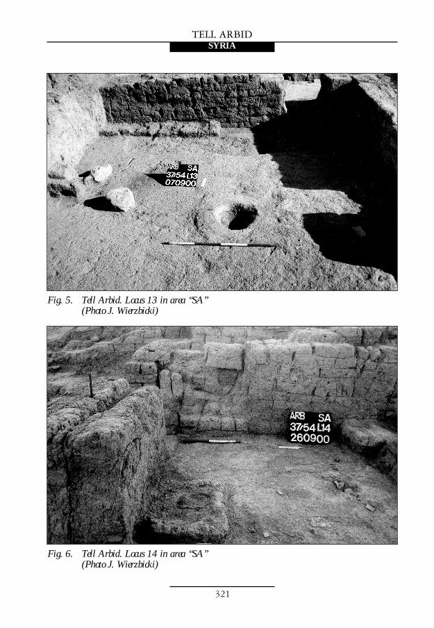
some modern grave pits. Locus SA 13 wasidentified beyond the just mentioned wallof the 1998 season. It was about 4 m wideand at least 4 m long, and it formed thenortheastern corner of a larger unitaligned more or less longitudinally (Fig.5). Inside, east of the entrance, there was astone door socket in situ, while to the west,against the northern wall of locus 13,there was a low bench made of mudbricks.In the center of the room, which had nogood floor level, there was a shallow pitwith a diameter not exceeding 40 cm. Theborders of the pit were reinforced in placeswith clay and broken sherds. It is not to beexcluded that the pit served in fact asa base for a wooden beam, perhaps a roofsupport.
2) Cf. P. Bieliñski, PAM X, Reports 1998 (1999), 206-208.
Akkadian period, as well as numerous wholeand fragmentary shells – leave the impres-sion of some kind of workshop or storeroomconnected with the production of shellornaments. The other architectural remainsdiscovered here are certainly younger thanthe cubicle from the Akkadian period, butit is difficult for the moment to assign thema more precise date. They consist of badlypreserved stumps of walls forming nocoherent plan, two ovens of the tannur type,as well as some shallow pits, one of themoblong in shape and filled with dark ashes.The walls were aligned differently than theearlier structures (“public building”).A curious rounded platform at least 2 mlong was revealed among these stumps ofwalls at the western edge of the trench. Itwas composed of very tightly packed sherdsset vertically in a sort of plaster made of clay(Fig. 3). As the platform continues
westwards beyond the present limits of thetrench, its shape and precise dimensionsremain unknown.
The most recent feature unearthed thisyear on the lower step of the “SS” sector isa child burial in a jar found in the southernpart of this trench (Grave 1, S2). Two smallvessels accompanied the skeleton, as wellas some beads and a pendant made of lapislazuli, representing a reposing bull withbearded human face (Fig. 4). Thedecoration is clearly Akkadian in style. Itspresence in this burial is quite bizarre,considering that the ceramic grave goodsprovide a date sometime in the earlyKhabour-ware period. As stratigraphicdisturbance should be ruled out in thiscase, the only other reasonable explanationis that the ancient amulet was a prizedfamily possession that was inherited downa number of generations.
321
TELL ARBIDSYRIA
Fig. 5. Tell Arbid. Locus 13 in area “SA”(Photo J. Wierzbicki)
Fig. 6. Tell Arbid. Locus 14 in area “SA”(Photo J. Wierzbicki)

TELL ARBID
322
SYRIA
Exploration of the “public building” wascontinued this year also in the southeasternpart of area “SS”, which now became aseparate sector dubbed “SL”. Last year,below several layers of ashes and claybelonging to the same refuse heap of the2nd millennium BC that covers the entireeastern part of the citadel summit, more ofthe outer wall of the “public building” hadbeen exposed.4) With the purpose of linkingtogether the various fragments of the
structure that have been uncovered in 1996and in 1999 the sector was enlarged to thepresent dimensions of 11 by 10 m.
In the northern part of the “SL” area,where more of the ashy refuse accumulationhad to be removed, some huge fragments ofpisé walls were uncovered, corresponding tosimilar walls recorded in the neighboringsector of the old “S” trench in 1996. Itseems that these walls belonged to twoquite large pisé enclosures, which had been
AREA “SL”
3) Cf. P. Bieliñski, PAM XI, Reports 1999 (2000), 275-276.
4) Cf. ibid., 278.
The second of the rooms explored thisseason, locus SA 14, was situated east oflocus 13 and formed the northwesterncorner of another structure spreadingfurther to the south and to the east (Fig. 6).Its alignment was slightly different fromthat of its western neighbor and itsnorthern wall, partly exposed already in1998, runs from northeast to southwest.Locus 14 measured about 2.7 by 2.0 mand the doorway leading to it was locatedin its western wall, near the southerncorner. The room contained a rectangularfireplace located in the middle of thesouthern wall and an internal buttress.Several phases of rebuilding are inevidence, suggesting that the room (if notthe entire house) had been in use for a longperiod of time.
A study of the ceramic finds hasprovided a date in the Khabour period forboth of these structures. The western one(locus 13), considered before as Mitannian,turned out to be erected in a deep pit, whichwas apparently dug especially for it andwhich destroyed remains of an olderKhabour-period structure existing in thisplace (locus 16). These structures of
Khabour-ware date were probably connectedone way or another with some indeterminateindustrial activities that have left theconsiderable amounts of ashes describedabove.
Probing to the north of these housingunits had brought to light the top of pre-Khabour layers.3) Below some Khabour-ware period pits that were now explored,explorations revealed mudbrick wallsrepresenting the post-Akkadian settlementon Tell Arbid. The bricks used in thesestructures are of different dimensions andcolors; together with lumps of grayish claythey lend to the walls a “patchwork”appearance, already observed in sector“SS”. This fragmentarily preserved unit,dubbed locus SA 17, may form part of alarger structure. Cleared to the north of itis a fragment of lane or square of the sameperiod, paved with potsherds and pebbles.The top of a large wall, about 2 m thickand aligned more or less EW, wasdiscovered under locus 17. Its constructionshould be attributed to the Akkadian oreven Early Dynastic III period. Quitepossibly, it was part of the “publicbuilding” complex.

323
TELL ARBIDSYRIA
Fig. 7. Tell Arbid. Plan of sector “SL” after excavations in 2000(Drawing £. Rutkowski, inking M. Wagner)
erected in the dump area during theKhabour-ware period and which wererelated to the industrial activitiesmentioned above. There were also somemodern graves and ancient child burialsdug into the rubbish layers. Bordering the
ash deposits at the southern end of thetrench were some rather modest Khabour-period structures aligned more or less likecontemporaneous houses from the southernpart of area “SA”. These structures wereheavily damaged by slope erosion.

TELL ARBID
324
SYRIA
Mudbrick walls of the “patchwork”style, already well known from the “SS” and“SA” sectors, appeared below the 2nd-millennium strata in this trench. Thesewalls, which should be dated to theAkkadian or rather post-Akkadian period,were erected directly on the ruins of the“public building”, quite often repeating thelayout of the older structure. The poorlypreserved “patchwork” remains areaccompanied by several tannurs and somepits, like the one found in 1999, dug intothe “public building” stratum.
Of the “public building” itself, frag-ments of at least three rooms (loci 5, 7, 8)
and of what seems to be a small courtyardwere uncovered in the sector this year(Fig. 7). Together with a locus S8/96 fromthe first season of excavations in 1996, locus7 makes up one entire room that is nowknown (Fig. 8). It was built against theouter wall and measured 4 by 2.8 m. Therewere two doorways provided withthresholds. One doorway with a stone doorsocket led westwards, while another openedto the north. Later a partition wall was builtdividing the room into two units linked bya doorway. What after the 1999 season wasbelieved to be the southeastern outer cornerof the “public building” now proved to be
Fig. 8. Tell Arbid. Area “SL”. General view of the sector from the west(Photo J. Wierzbicki)

325
TELL ARBIDSYRIA
Fig. 9. Tell Arbid. Entrance to the “public building” in area “SL”(Photo J. Wierzbicki)
the end of the main outer wall, but not thecorner of the complex. Near the end andparallel to the outer wall there was anentrance c. 1 m wide (Fig. 9). Due to dam-ages caused by Kahbour-period pits duginto this stratum, it is still not clear whetherthis doorway led to the “public building”complex or to a neighboring house. But evenwere it an entrance to the “public building”,it appears to have been of a secondary nature,added at a later stage. For the same reason, itwas still impossible to establish the southernborder of the “public building”.
In the southeastern part of the sector, atthe bottom of the trench, remains of some
solid mudbrick walls were reached. Theyseem to represent either an older part of the“public building” or a fragment of anotherstructure once bordering the “publicbuilding”. Whatever the case may be, thearchitecture was later removed to makeplace for some internal rearrangementswithin the “public building” complex. Thecurrent season also proved that the 3rdmillennium BC architectural complexcalled the “public building” had been usedfor a long time and was rebuilt or restoredrepeatedly. The most recent stage of itsoperation fell in the Akkadian period orslightly later.

TELL ARBID
326
SYRIA
A small probe was dug on the easternslope of the tell or, to be more precise, atthe western border of sector “SD”, insquare 36/64, where the outer wall of aKhabour-ware period grave had appearedin the western balk wall at the end of the1999 campaign. It was a vaulted gravechamber, built of mudbrick, nearly square
in shape (Fig. 10). It was about 1.7 m wideand over 1.1 m high. The top of thechamber was virtually on the tell surfaceand had already been damaged by erosion.Inside, a bronze spearhead and twopainted Khabour jars were foundalongside some longer bones in very poorcondition.
PROBE IN AREA “SD”
The most important result of the season isthe establishment of a more detailedstratigraphy of the tell summit in the late
3rd and early 2nd millennium BC, and thedetermination of settlement chronology inthis part of the ancient city.
SUMMARY
Fig. 10. Tell Arbid. Khabour-ware period grave in area “SD”, view of the west wall(Photo J. Wierzbicki)