Bedrock gorges in the central mainland Kachchh: Implications for landscape evolution
8
Bedrock gorges in the central mainland Kachchh: Implications for landscape evolution M G Thakkar 1 , B Goyal 1 , A K Patidar 2 , D M Maurya 2 and L S Chamyal 2,∗ 1 Department of Geology, R R Lalan College, Bhuj, Kachchh 370 001, India. 2 Department of Geology, The Maharaja Sayajirao University of Baroda, Vadodara 390 002, India. ∗ e-mail: [email protected] Kachchh possesses a fault-controlled first-order topography and several geomorphic features indica- tive of active tectonics. Though coseismic neotectonic activity is believed to be the major factor in the evolution of the landscape, detailed documentation and analysis of vital landscape features like drainage characteristics, bedrock gorges and terraces are lacking. The present study is a site-specific documentation of gorges developed in the central part of the mainland Kachchh. We analyzed and interpreted four gorges occurring on either side of Katrol Hill Fault (KHF). The Khari river gorge is endowed with six levels of bedrock terraces, some of which are studded with large potholes and flutings. Since no active development of potholes is observed along the rivers in the present day hyper-arid conditions, we infer an obvious linkage of gorges to the humid phases, which provided high energy runoff for the formation of gorges and distinct bedrock terraces and associated ero- sional features. Development of gorges within the miliolites and incision in the fluvial deposits to the south of the KHF indicates that the gorges were formed during Early Holocene. However, ubi- quitous occurrence of gorges along the streams to the south of KHF, the uniformly N40 ◦ E trend of the gorges, their close association with transverse faults and the short length of the exceptionally well developed Khari river gorge in the low-relief rocky plain to the north of KHF suggests an important role of neotectonic movements. 1. Introduction Bedrock gorges are spectacular geomorphic fea- tures that result from high-intensity fluvial erosion. These are characterized by minimal alluvial sedi- ment storage and are typically formed when sedi- ment transport capacity exceeds sediment supply over a long term (Howard et al 1994). Bedrock incision processes like plucking, abrasion and cav- itation may also lead to fluting and potholing of massive jointed and unjointed rocks (Whipple et al 2000). Bedrock channel systems have been found useful for understanding landscape evolution because they reflect boundary conditions, such as fluctuations in base level and/or land level, climate change and tectonics across landscapes (Whipple et al 2000). Climate, lithology and rock uplift are identified as the critical parameters governing the formation of bedrock gorges (Whipple et al 2000). However, coupled tectono-geomorphic mod- els often suggest that high strain rates are spatially associated with high erosion rates (Burbank et al 1996). In this paper, we describe the geomorpho- logic characteristics of the bedrock gorges devel- oped along lower as well as higher order stream channels in the vicinity of the Katrol Hill Fault (KHF) in Kachchh (figure 1). 2. General geologic setting Kachchh is a pericratonic palaeo-rift graben which is currently experiencing active co-seismic defor- mation (Biswas and Khattri 2002). Major geo- morphologic characteristics of the Kachchh basin Keywords. Bedrock gorges; rocky terraces; potholes; tectonic uplift; landscape evolution; Kachchh. J. Earth Syst. Sci. 115, No. 2, April 2006, pp. 249–256 © Printed in India. 249
-
Upload
independent -
Category
Documents
-
view
1 -
download
0
Transcript of Bedrock gorges in the central mainland Kachchh: Implications for landscape evolution
Bedrock gorges in the central mainland Kachchh:Implications for landscape evolution
M G Thakkar1, B Goyal1, A K Patidar2, D M Maurya2 and L S Chamyal2,∗
1Department of Geology, R R Lalan College, Bhuj, Kachchh 370 001, India.2Department of Geology, The Maharaja Sayajirao University of Baroda, Vadodara 390 002, India.
∗e-mail: [email protected]
Kachchh possesses a fault-controlled first-order topography and several geomorphic features indica-tive of active tectonics. Though coseismic neotectonic activity is believed to be the major factor inthe evolution of the landscape, detailed documentation and analysis of vital landscape features likedrainage characteristics, bedrock gorges and terraces are lacking. The present study is a site-specificdocumentation of gorges developed in the central part of the mainland Kachchh. We analyzed andinterpreted four gorges occurring on either side of Katrol Hill Fault (KHF). The Khari river gorgeis endowed with six levels of bedrock terraces, some of which are studded with large potholes andflutings. Since no active development of potholes is observed along the rivers in the present dayhyper-arid conditions, we infer an obvious linkage of gorges to the humid phases, which providedhigh energy runoff for the formation of gorges and distinct bedrock terraces and associated ero-sional features. Development of gorges within the miliolites and incision in the fluvial deposits tothe south of the KHF indicates that the gorges were formed during Early Holocene. However, ubi-quitous occurrence of gorges along the streams to the south of KHF, the uniformly N40◦E trend ofthe gorges, their close association with transverse faults and the short length of the exceptionallywell developed Khari river gorge in the low-relief rocky plain to the north of KHF suggests animportant role of neotectonic movements.
1. Introduction
Bedrock gorges are spectacular geomorphic fea-tures that result from high-intensity fluvial erosion.These are characterized by minimal alluvial sedi-ment storage and are typically formed when sedi-ment transport capacity exceeds sediment supplyover a long term (Howard et al 1994). Bedrockincision processes like plucking, abrasion and cav-itation may also lead to fluting and potholingof massive jointed and unjointed rocks (Whippleet al 2000). Bedrock channel systems have beenfound useful for understanding landscape evolutionbecause they reflect boundary conditions, such asfluctuations in base level and/or land level, climatechange and tectonics across landscapes (Whippleet al 2000). Climate, lithology and rock uplift
are identified as the critical parameters governingthe formation of bedrock gorges (Whipple et al2000). However, coupled tectono-geomorphic mod-els often suggest that high strain rates are spatiallyassociated with high erosion rates (Burbank et al1996). In this paper, we describe the geomorpho-logic characteristics of the bedrock gorges devel-oped along lower as well as higher order streamchannels in the vicinity of the Katrol Hill Fault(KHF) in Kachchh (figure 1).
2. General geologic setting
Kachchh is a pericratonic palaeo-rift graben whichis currently experiencing active co-seismic defor-mation (Biswas and Khattri 2002). Major geo-morphologic characteristics of the Kachchh basin
Keywords. Bedrock gorges; rocky terraces; potholes; tectonic uplift; landscape evolution; Kachchh.
J. Earth Syst. Sci. 115, No. 2, April 2006, pp. 249–256© Printed in India. 249
250 M G Thakkar et al
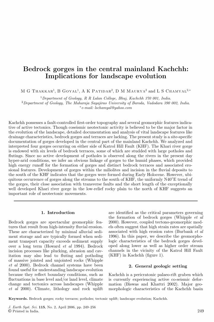
Figure 1. Map of the study area showing the location of gorges studied, the Khari drainage basin, prominent physiographicdivisions, major tectonic lineaments and general slope direction.
include a fault-controlled first-order topography,uplifted Quaternary and pre-Quaternary plana-tion surfaces, youthful fault scarps and a struc-turally controlled drainage network that exhibitsincised rocky valleys and gorges (Biswas 1974;Thakkar et al 1999). The study area exposes Mid-dle Jurassic to Cretaceous sedimentary rocks withthe Katrol Hill Fault (KHF) marking a distinctstructural contact between the Bhuj Formation(Late Cretaceous) to the north and the Jumaraand Jhuran Formations (Middle Jurassic to EarlyCretaceous) to the south (Biswas and Deshpande1970). Quaternary deposits fill the structural val-leys within the Katrol hill range, cover rocky ped-iments in the foothills, and occur as alluvial andcolluvial fans to the north of the Katrol Hill Fault(Thakkar et al 1999). Sandy biomicrites known asMiliolite Limestone of the Middle Pleistocene ageoverlie the colluvial and alluvial deposits and areolder than the fluvial sand bars exposed withinthe Katrol hill range (Thakkar et al 1999). TheKatrol Hill Fault (KHF) and the Kachchh Main-land Fault (KMF) trending E–W show right-lateraland left-lateral shifts at places along transversefaults (Biswas and Deshpande 1970; Maurya et al2003). Close examination of structural featuresshows that the transverse faults have been active
since the Late Pleistocene (Thakkar et al 1999;Maurya et al 2003).
3. Drainage characteristics
In mainland Kachchh, the Katrol Hill Range formsthe main drainage divide between the north-flowing and south-flowing drainage. The north-facing scarps of the Katrol Hill Range mark theKatrol Hill Fault (KHF), an active intrabasinalfault of the Kachchh basin. The north-flowingdrainage originates within the mountainous ter-rain of the Katrol Hill Range and subsequentlyflows across the KHF, the rocky plain, the north-ern hill range and the Kachchh Mainland Fault(KMF) before dying out in the Banni–Rann plains.Within the Katrol Hill Range almost all streamsdisplay bedrock gorges of varying dimensions. How-ever, in the rocky plain to the north of the KHF,which is identified as part of an Early Quaternaryplanation surface developed all over Kachchh, therivers show incised bedrock channels with occa-sional development of deep narrow gorges withmultiple levels of rocky terraces and isolated pock-ets of alluvial deposits. As the region is located inthe hyper-arid belt in western India, the present
Bedrock gorges in the central mainland Kachchh 251
climate is characterized by prolonged periods ofdrought with occasional precipitation. The riversshow ephemeral character and runoff lasts only fora few days when erosion is the dominating fluvialprocess. Lack of deposition is further evidencedby the rocky valleys and absence of channel allu-vium along most of the river courses. However, suc-cessive erosional episodes are preserved along thebedrock channels in the form of gorges, rocky ter-races or straths at various levels. We investigatedfour gorges formed along north and south flow-ing rivers originating from the Katrol Hill Range(figure 1) with a view to understand their signifi-cance in the evolution of the landscape. Of these,three are located to the south of KHF withinthe Katrol Hill Range while one (the Khari rivergorge) is located in the rocky plain to the north ofKHF. This is interestingly the most well-developedgorge with multiple rocky terraces. We have com-pared various parameters of all the four gorges,explaining in detail the Khari river gorge (G1 infigure 1). The Katrol Hill Fault and the associ-ated transverse faults being tectonically active, anattempt has been made to look for possible linkagesbetween gorge formation and neotectonic activityalong various faults.
4. The Khari river gorge
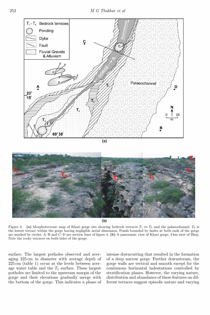
The Khari river rises from the Katrol Hill Rangeand flows northward along a 10–15 m deep incisedchannel developed on a highly pitted and rockylandscape identified as an Early Quaternary ero-sional surface formed over Late Cretaceous sand-stones belonging to the Bhuj Formation (figure 1).About 4 km west of Bhuj on the Bhuj–Kodki road,the river exhibits a locally developed deep gorge(∼400m long) with bedrock terraces in the Cre-taceous sandstones and a palaeochannel filled withalluvial deposits (figure 2a, b). A basic dyke runsalong the N100◦ trend across the channel confin-ing a pond to the downstream side of the gorge.Also seen is a prominent vertical normal faulttrending N50◦ (figure 2a). Since the level of thedeepest part of the Khari gorge and the pond inthe downstream is relatively lower than the aver-age height of the valley floor, the flow of the wateris reversed at the downstream end of the pond.A similar tectonic pond is also observed at theupstream end of the gorge, bounded by two normalfaults across the gorge (figure 2a). Several trans-verse and E–W faults with both normal and reversemovements have been mapped on two scatteredand eroded hillocks located north of the gorge (fig-ure 2a). Though the channel of Khari river remainsdry for most of the year, the gorge-reach is perma-nently filled with stagnant subsurface water that
seeps up along the various structural features men-tioned above. This is also evidenced by the factthat the water in the gorge does not vanish evenafter several consecutive years of drought.
The general trend of the gorge is N40◦ E (fig-ure 2a) and is about 21 m deep. The vertical gorgewalls are ∼15m deep, which confine an extremelynarrow channel (1.5–4 m wide). The narrow gorgeis followed upwards by a succession of pairedrocky terraces of varying morphologic character-istics (figure 2a, b), some of which are studdedwith numerous large potholes and prominent direc-tional erosional structures like flutes and longitu-dinal ridges and grooves. A total of six bedrockterraces have been mapped at the gorge site, eachof which exhibits characteristic morphologic fea-tures, especially in terms of the size of potholes.The total number of potholes and flutings withtheir average size and orientation on each bedrockterrace are given in table 1. The uppermost strathhas been identified as T1, while the lowermost withthe smallest surface area as T6 along the gorge. T1
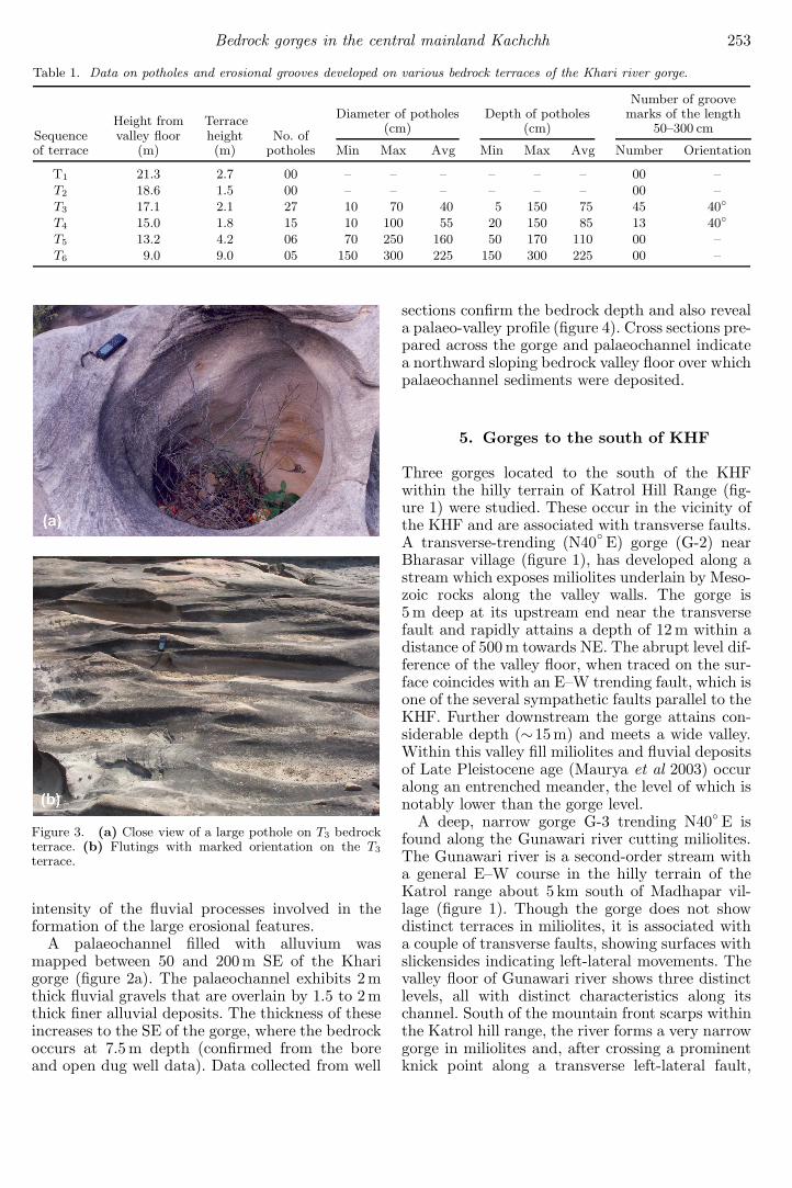
and T2 are distinct planar surfaces with typical ter-race morphology occurring at 21.3 m and 18.6 mrespectively. These terrace surfaces are weatheredand do not show definite erosional fluvial forms asobserved in other terraces. The T1 terrace exhibitsseveral joints parallel to the direction of the gorge.The T2 terrace is wide in the middle part, whichnarrows down and bifurcates towards the upstreamdirection on both sides of the gorge (figure 2a). TheT3 is the most prominent and widest terrace, whichis characterized by the occurrence of many potholesand flutings (figure 3a, b). Most of the potholes andflutings are concentrated on the northern side ofthe T3 terrace, while a meagre number of these areseen on the other bank. It is observed that the T3
on either sides of the gorge slopes 2◦ in the down-stream direction. Several large potholes and flut-ings occur on this terrace. The potholes have anaverage diameter of 45 cm and an average depth of75 cm. The flutings show a general NE trend thatis consistent with the present day flow direction.
A terrace 1.8 m lower than the T3 is observed tobe more pitted and highly eroded than the earlierterraces and is termed as T4. Coalescing of potholeshas resulted into mushroom shaped rocky projec-tions on this terrace and the dimension of potholesis much larger than those seen on terrace T3. Theaverage diameter and depth of the potholes occur-ring on terrace T4 are 55 cm and 85 cm respectively.Terrace T5 occurs 4.2 m below the T4 and showsstill larger potholes with an average diameter of160 cm and depth 110 cm. At the upstream end ofthe gorge, the water flows at the level of T4 andfalls down T5 terrace creating rapids for a distanceof about 50 m before merging with the gorge waterlevel, which is ∼9m lower than the identified T5
252 M G Thakkar et al
Figure 2. (a) Morphotectonic map of Khari gorge site showing bedrock terraces T1 to T5 and the palaeochannel. T6 isthe lowest terrace within the gorge having negligible aerial dimension. Ponds bounded by faults at both ends of the gorgeare marked by circles. A–B and C–D are section lines of figure 4. (b) A panoramic view of Khari gorge, 4 km west of Bhuj.Note the rocky terraces on both sides of the gorge.
surface. The largest potholes observed and aver-aging 225 cm in diameter with average depth of225 cm (table 1) occur at the levels between aver-age water table and the T5 surface. These largestpotholes are limited to the upstream margin of thegorge and their elevations gradually merge withthe bottom of the gorge. This indicates a phase of
intense downcutting that resulted in the formationof a deep narrow gorge. Further downstream, thegorge walls are vertical and smooth except for thecontinuous horizontal indentations controlled bystratification planes. However, the varying nature,distribution and abundance of these features on dif-ferent terraces suggest episodic nature and varying
Bedrock gorges in the central mainland Kachchh 253
Table 1. Data on potholes and erosional grooves developed on various bedrock terraces of the Khari river gorge.
Number of groove
Height from TerraceDiameter of potholes Depth of potholes marks of the length
(cm) (cm) 50–300 cmSequence valley floor height No. ofof terrace (m) (m) potholes Min Max Avg Min Max Avg Number Orientation
T1 21.3 2.7 00 – – – – – – 00 –T2 18.6 1.5 00 – – – – – – 00 –T3 17.1 2.1 27 10 70 40 5 150 75 45 40◦
T4 15.0 1.8 15 10 100 55 20 150 85 13 40◦
T5 13.2 4.2 06 70 250 160 50 170 110 00 –T6 9.0 9.0 05 150 300 225 150 300 225 00 –
Figure 3. (a) Close view of a large pothole on T3 bedrockterrace. (b) Flutings with marked orientation on the T3
terrace.
intensity of the fluvial processes involved in theformation of the large erosional features.
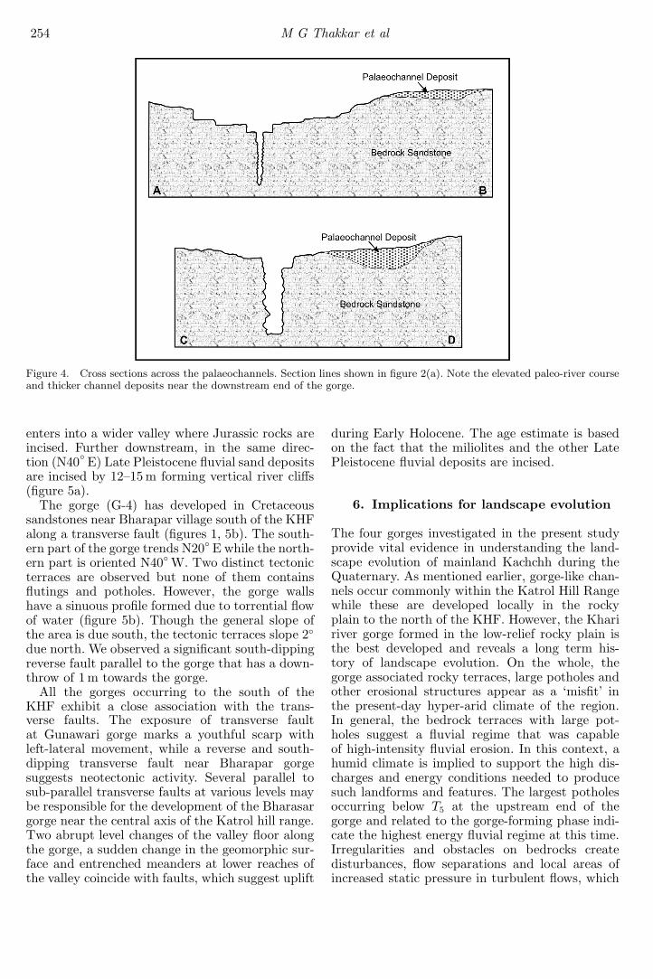
A palaeochannel filled with alluvium wasmapped between 50 and 200 m SE of the Kharigorge (figure 2a). The palaeochannel exhibits 2mthick fluvial gravels that are overlain by 1.5 to 2mthick finer alluvial deposits. The thickness of theseincreases to the SE of the gorge, where the bedrockoccurs at 7.5 m depth (confirmed from the boreand open dug well data). Data collected from well
sections confirm the bedrock depth and also reveala palaeo-valley profile (figure 4). Cross sections pre-pared across the gorge and palaeochannel indicatea northward sloping bedrock valley floor over whichpalaeochannel sediments were deposited.
5. Gorges to the south of KHF
Three gorges located to the south of the KHFwithin the hilly terrain of Katrol Hill Range (fig-ure 1) were studied. These occur in the vicinity ofthe KHF and are associated with transverse faults.A transverse-trending (N40◦ E) gorge (G-2) nearBharasar village (figure 1), has developed along astream which exposes miliolites underlain by Meso-zoic rocks along the valley walls. The gorge is5 m deep at its upstream end near the transversefault and rapidly attains a depth of 12 m within adistance of 500 m towards NE. The abrupt level dif-ference of the valley floor, when traced on the sur-face coincides with an E–W trending fault, which isone of the several sympathetic faults parallel to theKHF. Further downstream the gorge attains con-siderable depth (∼15m) and meets a wide valley.Within this valley fill miliolites and fluvial depositsof Late Pleistocene age (Maurya et al 2003) occuralong an entrenched meander, the level of which isnotably lower than the gorge level.
A deep, narrow gorge G-3 trending N40◦ E isfound along the Gunawari river cutting miliolites.The Gunawari river is a second-order stream witha general E–W course in the hilly terrain of theKatrol range about 5 km south of Madhapar vil-lage (figure 1). Though the gorge does not showdistinct terraces in miliolites, it is associated witha couple of transverse faults, showing surfaces withslickensides indicating left-lateral movements. Thevalley floor of Gunawari river shows three distinctlevels, all with distinct characteristics along itschannel. South of the mountain front scarps withinthe Katrol hill range, the river forms a very narrowgorge in miliolites and, after crossing a prominentknick point along a transverse left-lateral fault,
254 M G Thakkar et al
Figure 4. Cross sections across the palaeochannels. Section lines shown in figure 2(a). Note the elevated paleo-river courseand thicker channel deposits near the downstream end of the gorge.
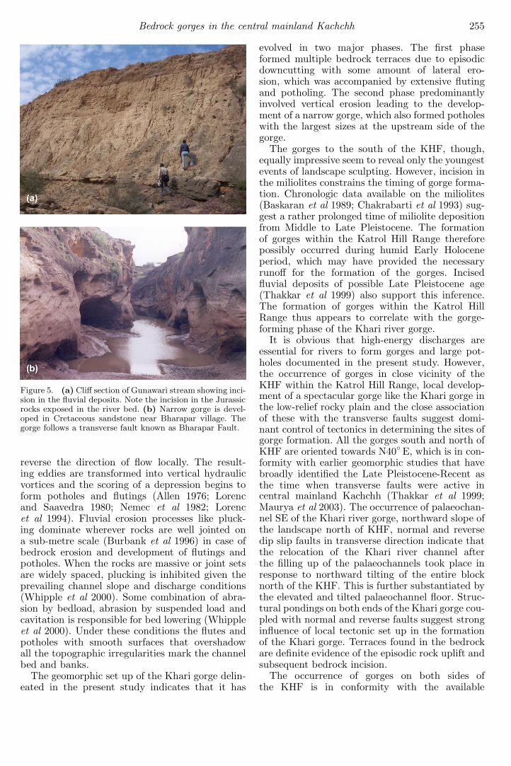
enters into a wider valley where Jurassic rocks areincised. Further downstream, in the same direc-tion (N40◦ E) Late Pleistocene fluvial sand depositsare incised by 12–15 m forming vertical river cliffs(figure 5a).
The gorge (G-4) has developed in Cretaceoussandstones near Bharapar village south of the KHFalong a transverse fault (figures 1, 5b). The south-ern part of the gorge trends N20◦ E while the north-ern part is oriented N40◦ W. Two distinct tectonicterraces are observed but none of them containsflutings and potholes. However, the gorge wallshave a sinuous profile formed due to torrential flowof water (figure 5b). Though the general slope ofthe area is due south, the tectonic terraces slope 2◦
due north. We observed a significant south-dippingreverse fault parallel to the gorge that has a down-throw of 1 m towards the gorge.
All the gorges occurring to the south of theKHF exhibit a close association with the trans-verse faults. The exposure of transverse faultat Gunawari gorge marks a youthful scarp withleft-lateral movement, while a reverse and south-dipping transverse fault near Bharapar gorgesuggests neotectonic activity. Several parallel tosub-parallel transverse faults at various levels maybe responsible for the development of the Bharasargorge near the central axis of the Katrol hill range.Two abrupt level changes of the valley floor alongthe gorge, a sudden change in the geomorphic sur-face and entrenched meanders at lower reaches ofthe valley coincide with faults, which suggest uplift
during Early Holocene. The age estimate is basedon the fact that the miliolites and the other LatePleistocene fluvial deposits are incised.
6. Implications for landscape evolution
The four gorges investigated in the present studyprovide vital evidence in understanding the land-scape evolution of mainland Kachchh during theQuaternary. As mentioned earlier, gorge-like chan-nels occur commonly within the Katrol Hill Rangewhile these are developed locally in the rockyplain to the north of the KHF. However, the Khaririver gorge formed in the low-relief rocky plain isthe best developed and reveals a long term his-tory of landscape evolution. On the whole, thegorge associated rocky terraces, large potholes andother erosional structures appear as a ‘misfit’ inthe present-day hyper-arid climate of the region.In general, the bedrock terraces with large pot-holes suggest a fluvial regime that was capableof high-intensity fluvial erosion. In this context, ahumid climate is implied to support the high dis-charges and energy conditions needed to producesuch landforms and features. The largest potholesoccurring below T5 at the upstream end of thegorge and related to the gorge-forming phase indi-cate the highest energy fluvial regime at this time.Irregularities and obstacles on bedrocks createdisturbances, flow separations and local areas ofincreased static pressure in turbulent flows, which
Bedrock gorges in the central mainland Kachchh 255
Figure 5. (a) Cliff section of Gunawari stream showing inci-sion in the fluvial deposits. Note the incision in the Jurassicrocks exposed in the river bed. (b) Narrow gorge is devel-oped in Cretaceous sandstone near Bharapar village. Thegorge follows a transverse fault known as Bharapar Fault.
reverse the direction of flow locally. The result-ing eddies are transformed into vertical hydraulicvortices and the scoring of a depression begins toform potholes and flutings (Allen 1976; Lorencand Saavedra 1980; Nemec et al 1982; Lorencet al 1994). Fluvial erosion processes like pluck-ing dominate wherever rocks are well jointed ona sub-metre scale (Burbank et al 1996) in case ofbedrock erosion and development of flutings andpotholes. When the rocks are massive or joint setsare widely spaced, plucking is inhibited given theprevailing channel slope and discharge conditions(Whipple et al 2000). Some combination of abra-sion by bedload, abrasion by suspended load andcavitation is responsible for bed lowering (Whippleet al 2000). Under these conditions the flutes andpotholes with smooth surfaces that overshadowall the topographic irregularities mark the channelbed and banks.
The geomorphic set up of the Khari gorge delin-eated in the present study indicates that it has
evolved in two major phases. The first phaseformed multiple bedrock terraces due to episodicdowncutting with some amount of lateral ero-sion, which was accompanied by extensive flutingand potholing. The second phase predominantlyinvolved vertical erosion leading to the develop-ment of a narrow gorge, which also formed potholeswith the largest sizes at the upstream side of thegorge.
The gorges to the south of the KHF, though,equally impressive seem to reveal only the youngestevents of landscape sculpting. However, incision inthe miliolites constrains the timing of gorge forma-tion. Chronologic data available on the miliolites(Baskaran et al 1989; Chakrabarti et al 1993) sug-gest a rather prolonged time of miliolite depositionfrom Middle to Late Pleistocene. The formationof gorges within the Katrol Hill Range thereforepossibly occurred during humid Early Holoceneperiod, which may have provided the necessaryrunoff for the formation of the gorges. Incisedfluvial deposits of possible Late Pleistocene age(Thakkar et al 1999) also support this inference.The formation of gorges within the Katrol HillRange thus appears to correlate with the gorge-forming phase of the Khari river gorge.
It is obvious that high-energy discharges areessential for rivers to form gorges and large pot-holes documented in the present study. However,the occurrence of gorges in close vicinity of theKHF within the Katrol Hill Range, local develop-ment of a spectacular gorge like the Khari gorge inthe low-relief rocky plain and the close associationof these with the transverse faults suggest domi-nant control of tectonics in determining the sites ofgorge formation. All the gorges south and north ofKHF are oriented towards N40◦ E, which is in con-formity with earlier geomorphic studies that havebroadly identified the Late Pleistocene-Recent asthe time when transverse faults were active incentral mainland Kachchh (Thakkar et al 1999;Maurya et al 2003). The occurrence of palaeochan-nel SE of the Khari river gorge, northward slope ofthe landscape north of KHF, normal and reversedip slip faults in transverse direction indicate thatthe relocation of the Khari river channel afterthe filling up of the palaeochannels took place inresponse to northward tilting of the entire blocknorth of the KHF. This is further substantiated bythe elevated and tilted palaeochannel floor. Struc-tural pondings on both ends of the Khari gorge cou-pled with normal and reverse faults suggest stronginfluence of local tectonic set up in the formationof the Khari gorge. Terraces found in the bedrockare definite evidence of the episodic rock uplift andsubsequent bedrock incision.
The occurrence of gorges on both sides ofthe KHF is in conformity with the available
256 M G Thakkar et al
information on tectonic set up of the KHF. TheKHF is, in general, recognized as an E–W trend-ing intrabasinal fault that marks the lithotectoniccontact between rocks older than Bhuj Formation(Late Cretaceous) on the south and the Bhuj For-mation to the north (Biswas and Deshpande 1970).An important feature of the KHF is its segmentednature as evidenced by right- and left-lateral offsetsalong the NE–SW to NW–SE trending transversefaults (Maurya et al 2003). Seismo-tectonic studiesindicate that various faults of the Kachchh basinare accumulating compressive stresses along them,which is responsible for recurrent seismic activity(Biswas and Khattri 2002) and uplift of the basin.Preliminary results of a Ground Penetrating Radar(GPR) study along the KHF (Maurya et al 2005)suggest that the nature of the KHF in the shal-low subsurface is in general a near-vertical southdipping reverse fault. We therefore, infer that theformation of gorges on both sides of the KHF tookplace due to neotectonic movements under an over-all compressive stress regime. However, site-specifictectonic conditions controlled the distribution,orientation and the nature of gorges formed.
7. Conclusions
The study of four selected gorges located to thesouth and north of Katrol Hill Fault points to theirdevelopment in response to neotectonically aidedhigh intensity fluvial erosion under conditions ofprecipitation much higher than present. The Khaririver gorge, though developed locally, reveals along term (Early Quaternary to present) evolution-ary history that can be broadly divided into twophases. The earliest phase resulted in the formationof typical bedrock terraces with extensive develop-ment of erosional features like large potholes andflutes in response to well marked periods of highintensity fluvial erosion. The second phase led tothe formation of the deep narrow gorge during thewet period of Early Holocene. Incision of the mil-iolite and Late Pleistocene fluvial deposits alongthe gorges and to the south of the KHF respec-tively further indicate an Early Holocene (post-miliolite) age for gorge formation. Close associationof the transverse faults with the gorges and thelocal nature of the exceptionally well developedKhari river gorge point to the control exercisedby local tectonics. The study demonstrates theimportance of gorges in understanding the succes-sive stages of Quaternary landscape evolution ofmainland Kachchh.
Acknowledgements
The Department of Science and Technology (DST)is gratefully acknowledged for providing financialassistance to MGT. Critical reviews by two anony-mous reviewers and Dr. H C Sheth have beenhelpful in improving the quality of the paper.
References
Allen J R L 1976 Transverse erosional marks of mud androck: their physical basis and geological significance;Sedim. Geol. 5 167–385.
Baskaran M, Deshpande S V, Rajaguru S N andSomayajulu B L K 1989 Geochronology of the milioliterocks of Kutch; J. Geol. Soc. India 33 588–593.
Biswas S K 1974 Landscape of Kutch – A MorphotectonicAnalysis; Ind. J. Earth Sci. 1 77–190.
Biswas S K and Deshpande S V 1970 Geological and Tec-tonic maps of Kutch; Bull. O.N.G.C. 7 115–123.
Biswas S K and Khattri K N 2002 A geological study ofearthquakes in Kutch, Gujarat, India; J. Geol. Soc. India60 131–142.
Burbank D W, Leland J, Fielding E, Anderson R S,Brozovic N, Raid M R and Duncan C 1996 Bedrock inci-sion, rock uplift, and threshold hillslopes in the north-western Himalaya; Nature 379 505–510.
Chakrabarti A, Somayajulu B L K, Baskaran M andKumar B 1993 Quaternary miliolites of Kutch andSaurashtra, western India: Depositional environments inthe light of physical sedimentary structures, biogenicstructures and geochronological setting of the rocks;Sencken. Maritima 23 7–28.
Howard A D, Seidl M A and Dietrich W E 1994 Modelingfluvial erosion on regional to continental scales; J. Geo-phys. Res. 99 13971–13986.
Lorenc M W and Saavedra J 1980 Remarks on the potholeerosion at the Tormes River (Salamanca Province, Spain);Acta Geol. Hisp. 15 91–93.
Lorenc M W, Barco M P and Saavedra J 1994 The evolu-tion of potholes in granite bedrock, W Spain; Catena 22265–274.
Maurya D M, Thakkar M G and Chamyal L S 2003 Impli-cations of transverse fault system on tectonic evolu-tion of Mainland Kachchh, Western India; Curr. Sci. 85661–667.
Maurya D M, Patidar A K, Mulchandani N, Goyal B,Thakkar M G, Bhandari S, Vaid S I, Bhatt N P,Chamyal L S 2005 Need for initiating Ground Penetrat-ing Radar (GPR) studies along active faults in India: Anexample from Kachchh; Curr. Sci. 88 231–240.
Nemec W, Lorenc M W and Saavedra J 1982 Potholed gran-ite terrace in the Rio Salor valley, western Spain: a studyof bedrock erosion by floods; Tecniterrae 50 6–21.
Thakkar M G, Maurya D M, Rachna Raj and Chamyal L S1999 Quaternary tectonic history and terrain evolution ofthe area around Bhuj, Mainland Kachchh, western India;J. Geol. Soc. India 53 601–610.
Whipple K, Hancock G S and Anderson R S 2000 Riverincision into bedrock: Mechanics and relative efficacyof plucking, abrasion and cavitation; Geol. Soc. Amer.Bull. 112 490–503.
MS received 20 June 2005; revised 25 August 2005; accepted 19 October 2005