Investigation of in situ weathering of quartz diorite bedrock in the Rio Icacos basin, Luquillo...
29
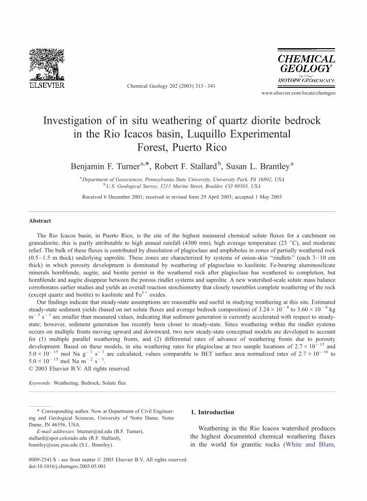
Investigation of in situ weathering of quartz diorite bedrock in the Rio Icacos basin, Luquillo Experimental Forest, Puerto Rico Benjamin F. Turner a, * , Robert F. Stallard b , Susan L. Brantley a a Department of Geosciences, Pennsylvania State University, University Park, PA 16802, USA b U.S. Geological Survey, 3215 Marine Street, Boulder, CO 80303, USA Received 6 December 2001; received in revised form 29 April 2003; accepted 1 May 2003 Abstract The Rio Icacos basin, in Puerto Rico, is the site of the highest measured chemical solute fluxes for a catchment on granodiorite; this is partly attributable to high annual rainfall (4300 mm), high average temperature (23 jC), and moderate relief. The bulk of these fluxes is contributed by dissolution of plagioclase and amphiboles in zones of partially weathered rock (0.5– 1.5 m thick) underlying saprolite. These zones are characterized by systems of onion-skin ‘‘rindlets’’ (each 3 –10 cm thick) in which porosity development is dominated by weathering of plagioclase to kaolinite. Fe-bearing aluminosilicate minerals hornblende, augite, and biotite persist in the weathered rock after plagioclase has weathered to completion, but hornblende and augite disappear between the porous rindlet systems and saprolite. A new watershed-scale solute mass balance corroborates earlier studies and yields an overall reaction stoichiometry that closely resembles complete weathering of the rock (except quartz and biotite) to kaolinite and Fe 3+ oxides. Our findings indicate that steady-state assumptions are reasonable and useful in studying weathering at this site. Estimated steady-state sediment yields (based on net solute fluxes and average bedrock composition) of 3.24 10 9 to 3.60 10 9 kg m 2 s 1 are smaller than measured values, indicating that sediment generation is currently accelerated with respect to steady- state; however, sediment generation has recently been closer to steady-state. Since weathering within the rindlet systems occurs on multiple fronts moving upward and downward, two new steady-state conceptual models are developed to account for (1) multiple parallel weathering fronts, and (2) differential rates of advance of weathering fronts due to porosity development. Based on these models, in situ weathering rates for plagioclase at two sample locations of 2.7 10 15 and 5.0 10 15 mol Na g 1 s 1 are calculated, values comparable to BET surface area normalized rates of 2.7 10 16 to 5.0 10 15 mol Na m 2 s 1 . D 2003 Elsevier B.V. All rights reserved. Keywords: Weathering; Bedrock; Solute flux 1. Introduction Weathering in the Rio Icacos watershed produces the highest documented chemical weathering fluxes in the world for granitic rocks (White and Blum, 0009-2541/$ - see front matter D 2003 Elsevier B.V. All rights reserved. doi:10.1016/j.chemgeo.2003.05.001 * Corresponding author. Now at Department of Civil Engineer- ing and Geological Sciences, University of Notre Dame, Notre Dame, IN 46556, USA. E-mail addresses: [email protected] (B.F. Turner), [email protected] (R.F. Stallard), [email protected] (S.L. Brantley). www.elsevier.com/locate/chemgeo Chemical Geology 202 (2003) 313 – 341
-
Upload
dailycamera -
Category
Documents
-
view
2 -
download
0
Transcript of Investigation of in situ weathering of quartz diorite bedrock in the Rio Icacos basin, Luquillo...
www.elsevier.com/locate/chemgeo
Chemical Geology 202 (2003) 313–341
Investigation of in situ weathering of quartz diorite bedrock
in the Rio Icacos basin, Luquillo Experimental
Forest, Puerto Rico
Benjamin F. Turnera,*, Robert F. Stallardb, Susan L. Brantleya
aDepartment of Geosciences, Pennsylvania State University, University Park, PA 16802, USAbU.S. Geological Survey, 3215 Marine Street, Boulder, CO 80303, USA
Received 6 December 2001; received in revised form 29 April 2003; accepted 1 May 2003
Abstract
The Rio Icacos basin, in Puerto Rico, is the site of the highest measured chemical solute fluxes for a catchment on
granodiorite; this is partly attributable to high annual rainfall (4300 mm), high average temperature (23 jC), and moderate
relief. The bulk of these fluxes is contributed by dissolution of plagioclase and amphiboles in zones of partially weathered rock
(0.5–1.5 m thick) underlying saprolite. These zones are characterized by systems of onion-skin ‘‘rindlets’’ (each 3–10 cm
thick) in which porosity development is dominated by weathering of plagioclase to kaolinite. Fe-bearing aluminosilicate
minerals hornblende, augite, and biotite persist in the weathered rock after plagioclase has weathered to completion, but
hornblende and augite disappear between the porous rindlet systems and saprolite. A new watershed-scale solute mass balance
corroborates earlier studies and yields an overall reaction stoichiometry that closely resembles complete weathering of the rock
(except quartz and biotite) to kaolinite and Fe3 + oxides.
Our findings indicate that steady-state assumptions are reasonable and useful in studying weathering at this site. Estimated
steady-state sediment yields (based on net solute fluxes and average bedrock composition) of 3.24� 10� 9 to 3.60� 10� 9 kg
m� 2 s� 1 are smaller than measured values, indicating that sediment generation is currently accelerated with respect to steady-
state; however, sediment generation has recently been closer to steady-state. Since weathering within the rindlet systems
occurs on multiple fronts moving upward and downward, two new steady-state conceptual models are developed to account
for (1) multiple parallel weathering fronts, and (2) differential rates of advance of weathering fronts due to porosity
development. Based on these models, in situ weathering rates for plagioclase at two sample locations of 2.7� 10� 15 and
5.0� 10� 15 mol Na g� 1 s� 1 are calculated, values comparable to BET surface area normalized rates of 2.7� 10� 16 to
5.0� 10� 15 mol Na m� 2 s� 1.
D 2003 Elsevier B.V. All rights reserved.
Keywords: Weathering; Bedrock; Solute flux
0009-2541/$ - see front matter D 2003 Elsevier B.V. All rights reserved.
doi:10.1016/j.chemgeo.2003.05.001
* Corresponding author. Now at Department of Civil Engineer-
ing and Geological Sciences, University of Notre Dame, Notre
Dame, IN 46556, USA.
E-mail addresses: [email protected] (B.F. Turner),
[email protected] (R.F. Stallard),
[email protected] (S.L. Brantley).
1. Introduction
Weathering in the Rio Icacos watershed produces
the highest documented chemical weathering fluxes
in the world for granitic rocks (White and Blum,
B.F. Turner et al. / Chemical Geology 202 (2003) 313–341314
1995). These exceptionally high fluxes have been
attributed to high rainfall and temperature conditions
(White and Blum, 1995; White et al., 1998), as well
as the relatively young age of the rock (47 Ma) and
presumed associated volatiles and lack of metamor-
phic annealing (Stallard, 1995a). Due to the paucity
of data from systems subjected to such extreme
weathering conditions, factors affecting weathering
in the Rio Icacos watershed, as well as other
extreme weathering systems, deserve further study.
Previous research on chemical weathering in the
Rio Icacos basin has focused on watershed-scale
geochemical mass balances, and weathering in the
soils and saprolite of the system (e.g. White et al.,
1998; Murphy et al., 1998; Stonestrom et al., 1998;
Schulz and White, 1999). White et al. (1998)
investigated the geochemical mass balance and
weathering in the watershed as a whole, while
Murphy et al. (1998) and Schulz and White
(1999) investigated weathering of biotite and quartz,
respectively, in the saprolite. Stonestrom et al.
(1998) discussed methods of calculating weathering
rates in the saprolite. However, the saprolite studied
is intensely leached, and is completely depleted with
respect to all but the least reactive primary minerals
(White et al., 1998). Thus, the extreme weathering
fluxes of the Rio Icacos basin result from weather-
ing of bedrock, which has not been studied in
detail. To further understand the underlying factors
that contribute to the extreme weathering fluxes in
this rainforest environment, we have conducted an
examination of chemical weathering occurring in
porous bedrock.
Weathering of joint blocks in granitic bedrock is
believed to start in the joint planes and weathers
inward toward the center of the blocks (Ollier,
1971, 1975). Since the corners and edges of the
blocks have more surface exposed to weathering
fluids than the faces, they tend to become rounded,
resulting in core stones that are spherical or oblong in
shape (Sarracino and Prasad, 1989). Porous rock in
the subsurface of the Rio Icacos basin occurs in
‘‘onion-skin’’ rindlet systems similar to those seen
in spheroidal weathering structures (Ollier, 1971).
Spheroidal weathering (synonyms include onion-skin
weathering, concentric weathering, and spherical
weathering) is most commonly found in well-jointed,
uniform hard rocks such as granite, dolerite, and
basalt (Ollier, 1971), and is characterized by concen-
tric shells that completely surround a core stone. The
cause of spheroidal weathering is unknown; however,
it appears that the boundaries between concentric
shells are formed from the coalescence of solution
channels that tend to form parallel to the fresh rock
contact (Fritz and Ragland, 1980). Some authors (e.g.
Ollier, 1971; Fritz and Ragland, 1980; Fritz, 1988)
have suggested that the micro-cracks that form the
solution channels may result from residual stress
released after erosional unloading. Folk and Patton
(1982) suggested that such cracks may result from
expansion of rocks that are buttressed in the lateral
direction. Twidale (1982) suggested that crack forma-
tion may be aided by ‘‘hydration shattering’’ due to
small volume increases caused by adsorption of
water on mineral surfaces. The shell boundaries
often become Fe3 + oxide stained, and apparently
become the centers of weathering within a core
stone. Due to reasons possibly related to subtle
variations in rock texture or composition (Gardner
and Nelson, 1991), individual core stones may
weather completely to saprolite, or may remain
intact after the surrounding rock has weathered.
Round boulders are commonly seen at the ground
surface within the Rio Icacos basin, often overlying
saprolite, as well as deeply embedded within the
saprolite.
In this paper, we examine in detail the petrology
of weathering in the part of this system where the
bulk of mineral dissolution occurs: the zones of
porous rock, or ‘‘rindlet’’ systems. We then examine
the system as a whole, using a new basin-scale solute
mass balance precise enough to gauge the overall
reaction stoichiometry of the system. Using the
assumption of a weathering system at steady-state,
we apply this approach to estimate a long-term
sediment yield and sediment chemical composition
for the system. At spatial scales smaller than the
basin-scale, the ‘‘conveyor belt’’ model described
below (with a single weathering front) is too simple
to account for the complexities observed in the field.
Thus we present two new conceptual models: the
‘‘parallel’’ and ‘‘differential’’ models for weathering
systems with multiple fronts. The ‘‘differential’’
model is used to calculate dissolution rates for
plagioclase, the most important contributor to dis-
solved weathering products in this system.
B.F. Turner et al. / Chemical Geology 202 (2003) 313–341 315
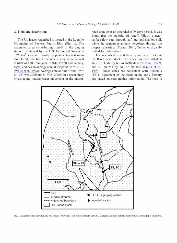
2. Field site description
The Rio Icacos watershed is located in the Luquillo
Mountains of Eastern Puerto Rico (Fig. 1). The
watershed area contributing runoff to the gaging
station maintained by the U.S. Geological Survey is
3.26 km2. Covered mostly by pristine tropical mon-
tane forest, the basin receives a very large annual
rainfall of 4300 mm year� 1 (McDowell and Asbury,
1994) and has an average annual temperature of 22 jC(White et al., 1998). Average annual runoff from 1987
to 1997 was 3900 mm (USGS, 2000). In a tracer study
investigating natural water movement in the unsatu-
Fig. 1. Location map showing the Rio Icacos watershed (as delineated from t
rated zone over an extended (509 day) period, it was
found that the majority of runoff follows a near-
surface flow path through leaf litter and shallow soil,
while the remaining amount percolates through the
deeper subsurface (Turner, 2001; Turner et al., sub-
mitted for publication).
The watershed is underlain by intrusive rocks of
the Rio Blanco stock. The stock has been dated at
46.2F 1.1 Ma by K–Ar methods (Cox et al., 1977),
and 46–48 Ma by Ar–Ar methods (Smith et al.,
1998). These dates are consistent with Seiders’s
(1971) placement of the stock in the early Tertiary
age based on stratigraphic information. The rock is
he USGS gaging station), the Rio Blanco stock, and sample locations.
B.F. Turner et al. / Chemical Geology 202 (2003) 313–341316
generally considered to consist of quartz diorite with
subordinate diorite (Seiders, 1971). However, Kesler
and Sutter (1979a) sampled rocks classified as diorite,
tonalite, and granodiorite. Volcanoclastic rocks of
Cretaceous age form some ridges bounding the wa-
tershed to the north and east (Seiders, 1971); however,
these rocks underlie less than 10% of the total
watershed area.
Much of the regolith is saprolite, formed from in
situ weathering of quartz diorite bedrock, that retains
much of the structure of the crystalline parent rock
(White et al., 1998; Murphy et al., 1998). In this soft,
thoroughly decomposed residuum, almost all of the
feldspars and amphiboles have been weathered out,
leaving quartz, biotite, and some magnetite, along
with kaolinite and ferric oxides as the secondary
phases (White et al., 1998). The saprolite extends up
to several meters in depth, and is overlain by an ultisol
of similar mineralogical composition with moderate to
high permeability, moderate to low water retention
capacity, and rapid runoff (Boccheciamp, 1977). Be-
tween the saprolite and bedrock are zones of weath-
ered, porous rock up to 1 m or more in thickness.
Since the saprolite is depleted of feldspars and
amphiboles, these zones of porous rock are apparently
where most of the weathering of these minerals
occurs.
Brown et al. (1995) estimated a mean total denu-
dation rate for the basin of 75 m Ma� 1 (F 50%) by a
mass balance based on the water chemistry data
reported by McDowell and Asbury (1994). By a
similar mass balance based on the same data, White
et al. (1998) estimated a total denudation rate of 58 m
Ma� 1. Based on the cosmogenic 10Be content of
fluvial sediments, Brown et al. (1995) estimated a
long-term average total denudation rate of 43 m
Ma� 1, with an uncertainty of 35%. This basin-scale
rate is consistent with localized rates also based on10Be content, which average over about 10,000–
100,000 years, measured on ridges, ridge flanks,
exposed core stones, and landslides (Brown et al.,
1995).
White et al. (1998) calculated watershed-scale
weathering fluxes (N L� 2 T� 1) for the Rio Icacos
basin using mass balance calculations: one based on
changes in bulk chemistry along a deep saprolite
profile, coupled with the long-term denudation rate
estimated by Brown et al. (1995); and one based on
changes in pore water chemistry, coupled with the
flux of water infiltrating through the unsaturated
saprolite. These estimates yielded fluxes of similar
magnitude, comparable with observed net solute
fluxes in stream water. The authors concluded that
weathering rates in the Rio Icacos basin have not
changed substantially in the last several hundred
thousand years.
At outcrops of weathering rock within the Rio
Icacos basin, systems of onion-skin laminae similar
to the ‘‘type I rindlets’’ described by Fritz and Rag-
land (1980) are observed. The term ‘‘rindlet’’ as used
by Fritz and Ragland (1980) and used hereafter refers
to the individual laminar sheets that constitute a
weathering rind. The rindlets discussed in this text
are intermediate in intensity of weathering between
fresh rock and the thoroughly decomposed saprolite.
This state is hereafter referred to as ‘‘weathered rock.’’
The rindlets range in thickness from 3 to 10 cm, and
retain the texture of the fresh rock. Boundaries be-
tween individual rindlets are characterized by cracks
that are usually Fe3 + oxide stained. Generally, indi-
vidual rindlets are more weathered at the inter-rindlet
boundaries than in the rindlet centers. Where rindlet
systems occur close to the ground surface, plant roots
have been observed to grow inside the rindlet shell
boundaries, even though the centers of the rindlets
may be relatively unweathered. Relicts of these inter-
rindlet boundaries are occasionally seen in the sapro-
lite as parallel deposits of black and dark red Mn/Fe
oxides.
2.1. Steady-state ‘‘conveyor belt’’ weathering
Because denudation rates apparently have not
changed substantially over several hundred thousands
of years, the system can be envisioned as being at or
near steady-state. In an ideal steady-state landscape,
the statistics describing landforms and the physical
processes occurring therein remain constant (Stallard,
1995a). In this discussion, we will assume that
physical and chemical erosion remain constant in a
system at steady-state. Under such conditions, the
volume of regolith in the system remains constant,
since processes generating and removing regolith are
balanced.
As suggested by White et al. (1998), the mineral
contributing the largest constituent of dissolved
B.F. Turner et al. / Chemical Geology 202 (2003) 313–341 317
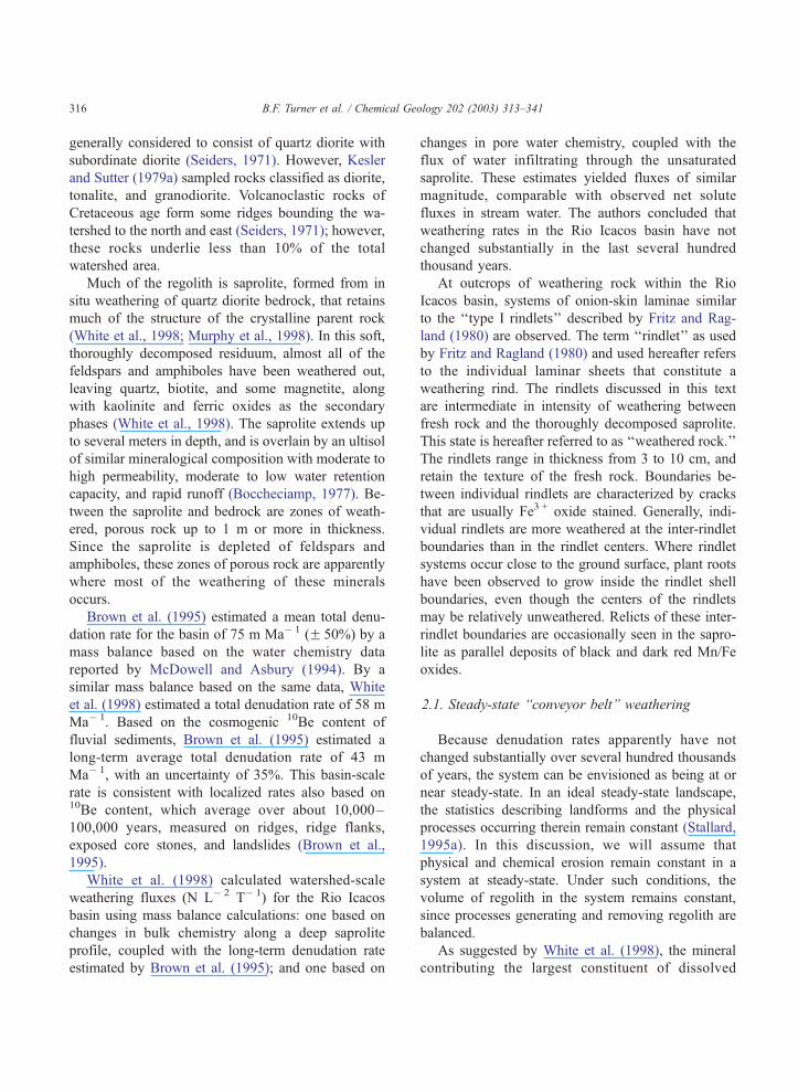
weathering products in this system is plagioclase.
Thus, we will begin by conceptualizing weathering
in the subsurface of the Rio Icacos basin in terms of
plagioclase. The subsurface can be conceptualized as
three zones: (1) competent bedrock, (2) zones of
porous rock (rindlet systems) where weathering of
plagioclase to kaolinite is occurring, and (3) saprolite
where all plagioclase has been converted to kaolinite
(Fig. 2). Since the bioturbated soil is mineralogically
indistinct from the saprolite, we will lump soil and
saprolite together in zone 3. In an ideal steady-state
system, where the generation of new regolith by
chemical weathering must equal the removal of
regolith by physical erosion (on a volume basis,
Fig. 2. Illustration of the ‘‘conveyor belt’’ model of a weathering
system at steady-state. The two plots show the changes in (D0C)/
(DC0) and d(C/D)/dx with depth for an idealized system where
plagioclase is weathering. Variables C and D each represent the
solid-phase concentration of a mobile and immobile element,
respectively, and the subscript 0 denotes concentration in bedrock.
The term (D0C)/(DC0) is the amount of plagioclase per volume of
regolith relative to that of the original rock. The derivative d(C/D)/
dx is proportional to the gross rate of weathering at depth x. Three
idealized zones of weathering, separated by dashed lines, are (1)
competent bedrock, (2) porous regolith containing plagioclase, and
(3) saprolite completely depleted in plagioclase. Within zone 2,
where plagioclase weathering is occurring, weathering rate is
controlled by the relative amounts of porosity and available
plagioclase surface. The spans of sample suites ‘‘GN,’’ ‘‘TC,’’
and ‘‘SS’’ are shown for comparison.
assuming isovolumetric weathering), the average
thicknesses of these weathering zones must stay
constant. Thus, the rate at which the land surface is
lowered due to erosion (i.e. the denudation rate) is
equal to the rate of movement of the boundaries
between zones 1 and 2, and 2 and 3. If weathering
occurs in a steady-state, ‘‘conveyor belt’’ fashion, then
the thickness of the zone 2 is equal to the distance the
weathering front travels in the time needed to dissolve
all the plagioclase from a given volume. Absolute
changes in land surface elevation are caused by uplift
in addition to ‘‘lowering’’ of the land surface by
denudation.
Weathering of plagioclase can be assumed to occur
almost entirely within zone 2, the zone of porous rock
between the unweathered bedrock and the saprolite.
Although small amounts of Na may occur in horn-
blende, most of the primary Na is in plagioclase. For
the purposes of this discussion, we will assume that
changes in Na concentration in the solid phase reflect
plagioclase weathering. It is presumed that physical
erosion removes material primarily from zone 3.
Larsen et al. (1999) found that while overland flow
of water was virtually nonexistent in the Luquillo
Experimental Forest, the vast majority of sediment
generation could be attributed to mass wasting pro-
cesses including landsliding, tree throw, and soil
creep.
White et al. (1998) concluded that the saprolite was
essentially isovolumetric with respect to the parent
rock. Thus, we can assume that weathering in zone 2
and the saprolite portion of zone 3 has occurred under
constant volume conditions (i.e. the structure of the
rock does not expand or contract appreciably during
weathering). Under such conditions, the bulk density
of the regolith decreases with time, as weathering
products are removed in solution. As weathering
progresses, the bulk chemical composition of the
regolith tends to become depleted in elements repre-
sentative of the more soluble minerals (e.g. Na and Ca
in plagioclase), and enriched in elements of relatively
insoluble weathering product (e.g. Al in kaolinite).
Some elements are considered to be immobile, form-
ing minerals so insoluble that appreciable leaching
from the regolith does not occur over long time
periods. White et al. (1998) identified Nb, Ti, and
Zr as possible immobile elements in the saprolite. By
observing the changes in the ratios of mobile elements
B.F. Turner et al. / Chemical Geology 202 (2003) 313–341318
to the immobile ones, the progress of weathering
reactions may be tracked.
Within this conceptual framework, the flux, Ji, of
an element, i, removed by chemical weathering in a
small volume of weathered rock or regolith can be
calculated as
Ji ¼ Rq0D0dðCi=DÞ=dx ð1Þ
where R is the denudation rate (equal to the rate of
advance of the weathering front in this case), q0 is
the density of bedrock, Ci is the concentration of
element i, D is the concentration of immobile ele-
ment, D0 is the concentration of immobile element in
bedrock, and x is distance in the direction of move-
ment of the weathering front (Stallard, 1985). The
derivative d(Ci/D)/dx is proportional to the flux of
weathering products and hence the weathering rate.
The ratio (D0Ci)/(DCi,0), where Ci,0 is the concen-
tration of element i in the parent material, represents
the amount of element i left in the weathered
material relative to the parent material. If element i
is Na, which essentially is contained entirely in
plagioclase, then this ratio reflects the degree of
weathering of plagioclase. The relationships between
d(Ci/D)/dx, (D0Ci)/(DCi,0), and zones 1, 2, and 3 are
illustrated in Fig. 2.
White et al. (2001) suggested that initial weather-
ing in granitoid rocks is extremely slow, being limited
by the low permeability of the primary rock matrix.
The authors further suggested that, under isovolumet-
ric weathering conditions, increased porosity and
permeability from weathering leads to increased rates
of weathering. Thus the fluxes of weathering products
from plagioclase in the Rio Icacos basin in unweath-
ered bedrock (i.e. zone 1) are expected to be minimal,
since the small amount of porosity and permeability
developed in bedrock matrix allows for only a small
amount of plagioclase surface exposed to solution.
Furthermore, the residence time of waters in existing
pore spaces may be large, leading to dissolution
conditions close to thermodynamic equilibrium. How-
ever, as the rock crosses the boundary between zones
1 and 2, significant porosity develops, allowing great-
er contact between plagioclase grains and solution,
and decreased water residence times; these effects are
expected to increase weathering rates, leading to
increasing porosity and decreasing amount of plagio-
clase. At some point, however, further increases in
porosity do not enhance the weathering flux, as gross
dissolution starts to become limited by the availability
of plagioclase rather than the availability of porosity.
Beyond this point, the flux of plagioclase weathering
decreases as the volume fraction of plagioclase de-
creases. Finally, plagioclase weathers to completion
near the boundary of zones 2 and 3. This idealized
situation is conceptualized in Fig. 2.
This conceptual model has the advantage of sim-
plicity and is useful for representing weathering on a
watershed scale. However, in reality, rock weathering
in the Rio Icacos basin is much more complex. Stallard
(1995b) argues that such a ‘‘conveyor belt’’ model is
unrealistic since energetic processes such as debris
flows and gully formation can excavate deeply into
soils. Furthermore, this type of model is limited since
the zone of porous rock is not a single sheet uniformly
underlying the site, but in reality includes multiple
layers with weathering occurring along multiple fronts.
Two additional conceptual models accounting for mul-
tiple weathering fronts are presented in Discussion.
3. Methods
3.1. Field sampling
Three suites of rock samples were collected from
within the Rio Icacos watershed (Fig. 1) in March
1996. Each suite consists of porous, weathered rock,
collected from outcrops of the weathering rindlet
systems (i.e. zone 2). In each case, several cm of
surficial material were removed prior to sampling.
Suite ‘‘GN’’ was collected from a cut stream bank
(Fig. 3), and included a system of more than 20
rindlets. The top of Fig. 3 is approximately 2 m below
the ground surface. This outcrop consists of concen-
tric low porosity rindlets 8 cm thick overlain by milky
white and iron oxide stained rindlets subparallel with
the ground surface. Overlying the white/stained rind-
lets are gray, relatively unstained rindlets in the same
orientation. Compared to the white/stained rindlets,
the gray rindlets are thicker, more uniform in thick-
ness, and have thinner ferric iron stained inter-rindlet
boundary zones. Samples were collected along a line
segment, perpendicular to the onion-skin exfoliation.
This line crossed an apparent joint plane as illustrated
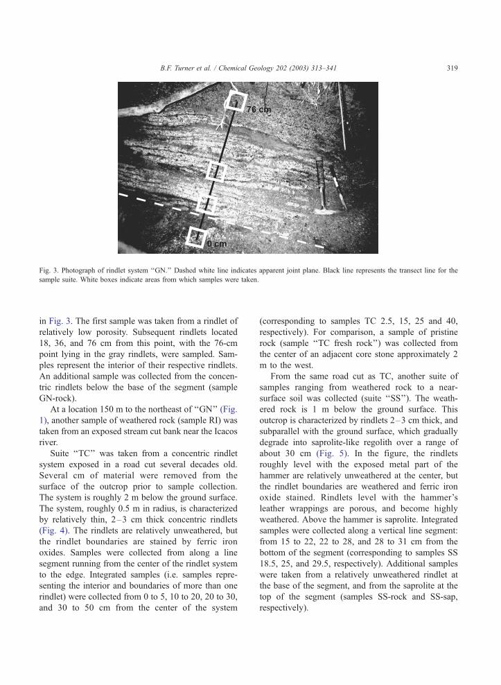
Fig. 3. Photograph of rindlet system ‘‘GN.’’ Dashed white line indicates apparent joint plane. Black line represents the transect line for the
sample suite. White boxes indicate areas from which samples were taken.
B.F. Turner et al. / Chemical Geology 202 (2003) 313–341 319
in Fig. 3. The first sample was taken from a rindlet of
relatively low porosity. Subsequent rindlets located
18, 36, and 76 cm from this point, with the 76-cm
point lying in the gray rindlets, were sampled. Sam-
ples represent the interior of their respective rindlets.
An additional sample was collected from the concen-
tric rindlets below the base of the segment (sample
GN-rock).
At a location 150 m to the northeast of ‘‘GN’’ (Fig.
1), another sample of weathered rock (sample RI) was
taken from an exposed stream cut bank near the Icacos
river.
Suite ‘‘TC’’ was taken from a concentric rindlet
system exposed in a road cut several decades old.
Several cm of material were removed from the
surface of the outcrop prior to sample collection.
The system is roughly 2 m below the ground surface.
The system, roughly 0.5 m in radius, is characterized
by relatively thin, 2–3 cm thick concentric rindlets
(Fig. 4). The rindlets are relatively unweathered, but
the rindlet boundaries are stained by ferric iron
oxides. Samples were collected from along a line
segment running from the center of the rindlet system
to the edge. Integrated samples (i.e. samples repre-
senting the interior and boundaries of more than one
rindlet) were collected from 0 to 5, 10 to 20, 20 to 30,
and 30 to 50 cm from the center of the system
(corresponding to samples TC 2.5, 15, 25 and 40,
respectively). For comparison, a sample of pristine
rock (sample ‘‘TC fresh rock’’) was collected from
the center of an adjacent core stone approximately 2
m to the west.
From the same road cut as TC, another suite of
samples ranging from weathered rock to a near-
surface soil was collected (suite ‘‘SS’’). The weath-
ered rock is 1 m below the ground surface. This
outcrop is characterized by rindlets 2–3 cm thick, and
subparallel with the ground surface, which gradually
degrade into saprolite-like regolith over a range of
about 30 cm (Fig. 5). In the figure, the rindlets
roughly level with the exposed metal part of the
hammer are relatively unweathered at the center, but
the rindlet boundaries are weathered and ferric iron
oxide stained. Rindlets level with the hammer’s
leather wrappings are porous, and become highly
weathered. Above the hammer is saprolite. Integrated
samples were collected along a vertical line segment:
from 15 to 22, 22 to 28, and 28 to 31 cm from the
bottom of the segment (corresponding to samples SS
18.5, 25, and 29.5, respectively). Additional samples
were taken from a relatively unweathered rindlet at
the base of the segment, and from the saprolite at the
top of the segment (samples SS-rock and SS-sap,
respectively).
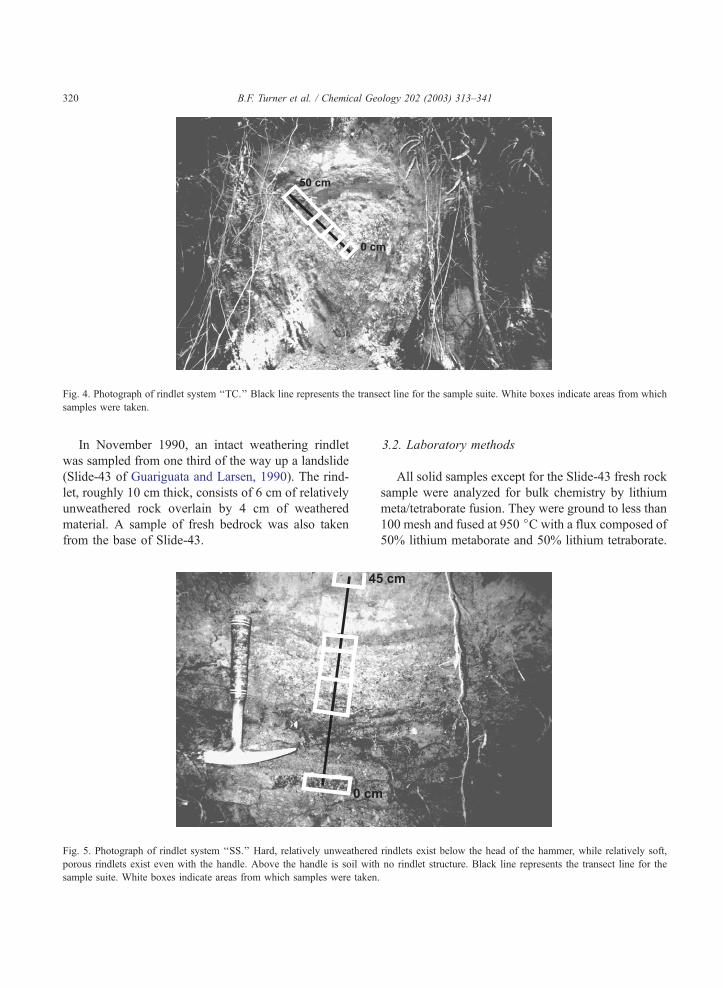
Fig. 4. Photograph of rindlet system ‘‘TC.’’ Black line represents the transect line for the sample suite. White boxes indicate areas from which
samples were taken.
B.F. Turner et al. / Chemical Geology 202 (2003) 313–341320
In November 1990, an intact weathering rindlet
was sampled from one third of the way up a landslide
(Slide-43 of Guariguata and Larsen, 1990). The rind-
let, roughly 10 cm thick, consists of 6 cm of relatively
unweathered rock overlain by 4 cm of weathered
material. A sample of fresh bedrock was also taken
from the base of Slide-43.
Fig. 5. Photograph of rindlet system ‘‘SS.’’ Hard, relatively unweathered
porous rindlets exist even with the handle. Above the handle is soil with
sample suite. White boxes indicate areas from which samples were taken
3.2. Laboratory methods
All solid samples except for the Slide-43 fresh rock
sample were analyzed for bulk chemistry by lithium
meta/tetraborate fusion. They were ground to less than
100 mesh and fused at 950 jC with a flux composed of
50% lithium metaborate and 50% lithium tetraborate.
rindlets exist below the head of the hammer, while relatively soft,
no rindlet structure. Black line represents the transect line for the
.
B.F. Turner et al. / Chemical Geology 202 (2003) 313–341 321
The resulting glass bead was immediately dissolved in
5% nitric acid. Solutions were analyzed by inductively
coupled plasma (ICP) atomic emission spectropho-
tometry (Leeman Labs PS3000UV).
The Slide-43 fresh rock sample was analyzed using
X-ray fluorescence on fused glass buttons by X-Ray
Assay Laboratories. Oxides (and sulfur) have a 0.01%
detection limit, while Cl, Zr, Rb, Sr, Ba, and Y have a
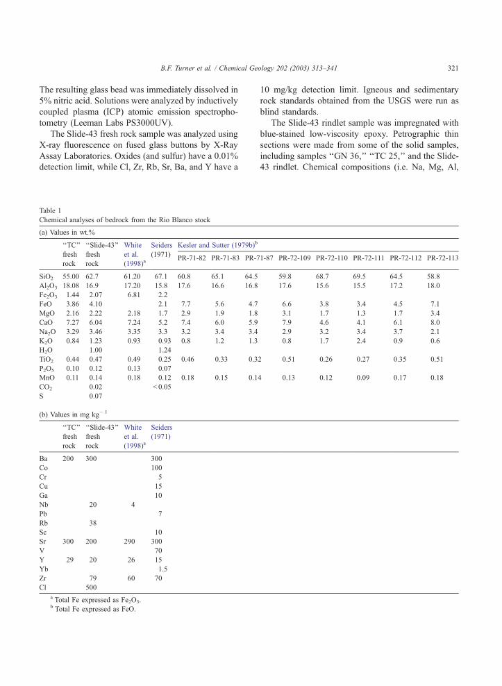
Table 1
Chemical analyses of bedrock from the Rio Blanco stock
(a) Values in wt.%
‘‘TC’’ ‘‘Slide-43’’ White Seiders Kesler and Sutter (1979b)b
fresh
rock
fresh
rock
et al.
(1998)a(1971)
PR-71-82 PR-71-83 PR-7
SiO2 55.00 62.7 61.20 67.1 60.8 65.1 64.5
Al2O3 18.08 16.9 17.20 15.8 17.6 16.6 16.8
Fe2O3 1.44 2.07 6.81 2.2
FeO 3.86 4.10 2.1 7.7 5.6 4.7
MgO 2.16 2.22 2.18 1.7 2.9 1.9 1.8
CaO 7.27 6.04 7.24 5.2 7.4 6.0 5.9
Na2O 3.29 3.46 3.35 3.3 3.2 3.4 3.4
K2O 0.84 1.23 0.93 0.93 0.8 1.2 1.3
H2O 1.00 1.24
TiO2 0.44 0.47 0.49 0.25 0.46 0.33 0.3
P2O5 0.10 0.12 0.13 0.07
MnO 0.11 0.14 0.18 0.12 0.18 0.15 0.1
CO2 0.02 < 0.05
S 0.07
(b) Values in mg kg� 1
‘‘TC’’
fresh
rock
‘‘Slide-43’’
fresh
rock
White
et al.
(1998)a
Seiders
(1971)
Ba 200 300 300
Co 100
Cr 5
Cu 15
Ga 10
Nb 20 4
Pb 7
Rb 38
Sc 10
Sr 300 200 290 300
V 70
Y 29 20 26 15
Yb 1.5
Zr 79 60 70
Cl 500
a Total Fe expressed as Fe2O3.b Total Fe expressed as FeO.
10 mg/kg detection limit. Igneous and sedimentary
rock standards obtained from the USGS were run as
blind standards.
The Slide-43 rindlet sample was impregnated with
blue-stained low-viscosity epoxy. Petrographic thin
sections were made from some of the solid samples,
including samples ‘‘GN 36,’’ ‘‘TC 25,’’ and the Slide-
43 rindlet. Chemical compositions (i.e. Na, Mg, Al,
1-87 PR-72-109 PR-72-110 PR-72-111 PR-72-112 PR-72-113
59.8 68.7 69.5 64.5 58.8
17.6 15.6 15.5 17.2 18.0
6.6 3.8 3.4 4.5 7.1
3.1 1.7 1.3 1.7 3.4
7.9 4.6 4.1 6.1 8.0
2.9 3.2 3.4 3.7 2.1
0.8 1.7 2.4 0.9 0.6
2 0.51 0.26 0.27 0.35 0.51
4 0.13 0.12 0.09 0.17 0.18
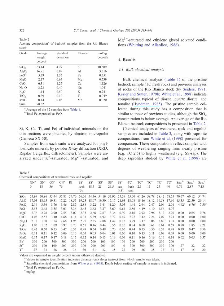
Table 2
Average compositiona of bedrock samples from the Rio Blanco
stock
Oxide Average
weight
percent
Standard
deviation
Element mol/kg
bedrock
SiO2 63.14 4.27 Si 10.509
Al2O3 16.91 0.89 Al 3.316
FeOb 5.39 1.35 Fe 0.751
MgO 2.17 0.64 Mg 0.539
CaO 6.31 1.27 Ca 1.126
Na2O 3.23 0.40 Na 1.041
K2O 1.14 0.50 K 0.241
TiO2 0.39 0.10 Ti 0.049
MnO 0.14 0.03 Mn 0.020
Sum 98.82
a Average of the 12 samples from Table 1.b Total Fe expressed as FeO.
B.F. Turner et al. / Chemical Geology 202 (2003) 313–341322
Si, K, Ca, Ti, and Fe) of individual minerals on the
thin sections were obtained by electron microprobe
(Cameca SX-50).
Samples from each suite were analyzed for phyl-
losilicate minerals by powder X-ray diffraction (XRD;
Rigaku Geigerflex diffractometer). Samples were an-
alyzed under K+-saturated, Mg2 +-saturated, and
Table 3
Chemical compositions of weathered rock and regolith
GNa
0
GNa
18
GNa
36
GNa
76
RI SSa
rock
(0)
SSa
18.5
SSa
25
SSa
29.5
SiO2 55.99 50.86 53.44 57.81 54.70 56.66 54.36 54.19 53.96
Al2O3 17.03 18.65 19.31 17.22 18.55 19.23 18.07 19.30 17.17
Fe2O3 2.16 3.36 3.76 3.46 2.87 2.88 3.22 3.41 11.20
FeO 3.55 3.48 3.55 3.01 3.36 3.45 3.62 3.27 3.60
MgO 2.36 2.78 2.90 2.55 3.09 2.35 2.66 2.67 3.36
CaO 4.08 2.57 3.10 4.68 4.14 6.33 5.39 4.92 3.72
Na2O 2.32 1.30 1.54 2.68 1.95 2.95 2.35 2.08 1.42
K2O 1.05 1.02 1.09 0.97 0.70 0.57 0.46 0.44 0.56
TiO2 0.42 0.50 0.53 0.47 0.57 0.49 0.54 0.49 0.70
P2O5 0.11 0.11 0.12 0.06 0.10 0.05 0.05 0.04 0.01
MnO 0.15 0.17 0.17 0.18 0.17 0.12 0.14 0.13 0.16
Bad 300 200 300 300 300 200 200 100 100
Srd 200 100 100 200 200 300 200 200 100
Yd 27 33 38 28 36 30 31 32 35
Values are expressed in weight percent unless otherwise denoted.a Values in sample identification indicates distance (cm) along transecb Saprolite chemical compositions from White et al. (1998). Depth bec Total Fe expressed as Fe2O3.d mg/kg.
Mg2 +-saturated and ethylene glycol solvated condi-
tions (Whitting and Allardice, 1986).
4. Results
4.1. Bulk chemical analysis
Bulk chemical analysis (Table 1) of the pristine
bedrock sample (TC fresh rock) and previous analyses
of rocks of the Rio Blanco stock (by Seiders, 1971;
Kesler and Sutter, 1979b; White et al., 1998) indicate
compositions typical of diorite, quartz diorite, and
tonalite (Hyndman, 1985). The pristine sample col-
lected during this study has a composition that is
similar to those of previous studies, although the SiO2
concentration is below average. An average of the Rio
Blanco bedrock compositions is presented in Table 2.
Chemical analyses of weathered rock and regolith
samples are included in Table 3, along with saprolite
compositions from White et al. (1998) presented for
comparison. These compositions reflect samples with
degrees of weathering ranging from nearly pristine
(e.g. TC 2.5) to highly weathered (e.g. SS-sap). The
deep saprolites studied by White et al. (1998) are
SSa
sap
(45)
TC
fresh
rock
TCa
2.5
TCa
15
TCa
25
TCa
40
Sap.b
0.76
Sap.b
2.87
Sap.b
7.13
55.59 55.00 61.26 58.78 58.42 58.55 70.67 60.12 54.74
21.93 18.08 18.16 18.12 16.58 17.90 15.35 22.59 26.14
5.05 1.44 2.64 2.47 2.04 2.01 4.42c 6.76c 7.50c
0.64 3.86 4.19 4.10 4.56 4.07
0.90 2.16 2.92 2.96 3.12 2.70 0.00 0.65 0.76
0.49 7.27 7.42 7.24 7.07 7.21 0.00 0.00 0.00
0.15 3.29 3.17 3.08 2.80 3.03 0.00 0.00 0.00
0.16 0.84 0.68 0.61 0.64 0.59 0.88 1.85 2.21
0.66 0.44 0.55 0.50 0.53 0.48 0.39 0.47 0.56
0.00 0.10 0.15 0.11 0.09 0.09 0.00 0.00 0.00
0.06 0.11 0.16 0.16 0.16 0.14 0.02 0.05 0.57
100 200 200 200 200 200
0 300 300 300 300 300 27 22 22
22 29 36 35 33 31 17 15 20
t from which sample was taken.
low surface of sample in meters is indicated.
B.F. Turner et al. / Chemical Geology 202 (2003) 313–341 323
completely depleted with respect to Na and Ca,
reflecting greater intensity of weathering than the
weathered rocks and regolith of this study, including
sample SS-sap.
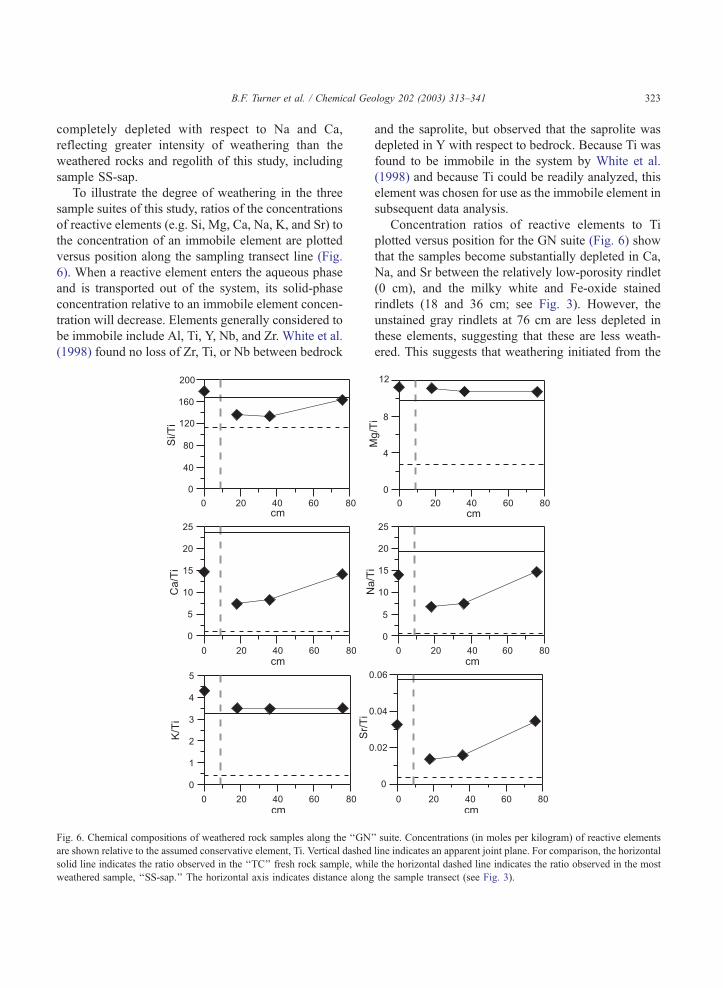
To illustrate the degree of weathering in the three
sample suites of this study, ratios of the concentrations
of reactive elements (e.g. Si, Mg, Ca, Na, K, and Sr) to
the concentration of an immobile element are plotted
versus position along the sampling transect line (Fig.
6). When a reactive element enters the aqueous phase
and is transported out of the system, its solid-phase
concentration relative to an immobile element concen-
tration will decrease. Elements generally considered to
be immobile include Al, Ti, Y, Nb, and Zr. White et al.
(1998) found no loss of Zr, Ti, or Nb between bedrock
Fig. 6. Chemical compositions of weathered rock samples along the ‘‘GN’
are shown relative to the assumed conservative element, Ti. Vertical dashed
solid line indicates the ratio observed in the ‘‘TC’’ fresh rock sample, whil
weathered sample, ‘‘SS-sap.’’ The horizontal axis indicates distance along
and the saprolite, but observed that the saprolite was
depleted in Y with respect to bedrock. Because Ti was
found to be immobile in the system by White et al.
(1998) and because Ti could be readily analyzed, this
element was chosen for use as the immobile element in
subsequent data analysis.
Concentration ratios of reactive elements to Ti
plotted versus position for the GN suite (Fig. 6) show
that the samples become substantially depleted in Ca,
Na, and Sr between the relatively low-porosity rindlet
(0 cm), and the milky white and Fe-oxide stained
rindlets (18 and 36 cm; see Fig. 3). However, the
unstained gray rindlets at 76 cm are less depleted in
these elements, suggesting that these are less weath-
ered. This suggests that weathering initiated from the
’ suite. Concentrations (in moles per kilogram) of reactive elements
line indicates an apparent joint plane. For comparison, the horizontal
e the horizontal dashed line indicates the ratio observed in the most
the sample transect (see Fig. 3).
B.F. Turner et al. / Chemical Geology 202 (2003) 313–341324
joint plane located at about 10 cm in the transect.
Thus, weathering in the GN suite appears to proceed
in an upward direction (i.e. increasing distance values
in Fig. 6) from the joint plane. The behavior of Si
follows a similar pattern to Ca, Na, and Sr, but the
relative amount of depletion is not as great. Elements
Mg and K do not appear to leach substantially in this
suite. The stoichiometry apparent from this pattern of
depletion suggests that weathering of plagioclase, a
Na- and Ca-aluminosilicate with Sr substituting for
Ca, dominates the observed chemical changes in the
rock.
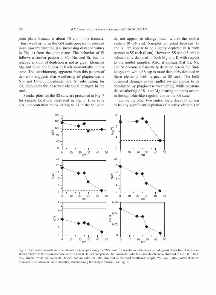
Similar plots for the SS suite are presented in Fig. 7
for sample locations illustrated in Fig. 5. Like suite
GN, concentration ratios of Mg to Ti in the SS suite
Fig. 7. Chemical compositions of weathered rock samples along the ‘‘SS’’ s
shown relative to the assumed conservative element, Ti. For comparison, th
rock sample, while the horizontal dashed line indicates the ratio observe
distance). The horizontal axis indicates distance along the sample transec
do not appear to change much within the rindlet
system (0–35 cm). Samples collected between 15
and 31 cm appear to be slightly depleted in K with
respect to SS rock (0 cm). However, SS-sap (45 cm) is
substantially depleted in both Mg and K with respect
to the rindlet samples. Also, it appears that Ca, Na,
and Sr become substantially depleted across the rind-
let system, while SS-sap is more than 90% depleted in
these elements with respect to SS-rock. The bulk
chemical changes in the rindlet system appear to be
dominated by plagioclase weathering, while substan-
tial weathering of K- and Mg-bearing minerals occurs
in the saprolite-like regolith above the SS-suite.
Unlike the other two suites, there does not appear
to be any significant depletion of reactive elements in
uite. Concentrations (in moles per kilogram) of reactive elements are
e horizontal solid line indicates the ratio observed in the ‘‘TC’’ fresh
d in the most weathered sample, ‘‘SS-sap’’ (also plotted at 45-cm
t (see Fig. 5).
B.F. Turner et al. / Chemical Geology 202 (2003) 313–341 325
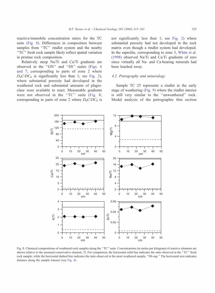
reactive/immobile concentration ratios for the TC
suite (Fig. 8). Differences in composition between
samples from ‘‘TC’’ rindlet system and the nearby
‘‘TC’’ fresh rock sample likely reflect spatial variation
in pristine rock composition.
Relatively steep Na/Ti and Ca/Ti gradients are
observed in the ‘‘GN’’ and ‘‘SS’’ suites (Figs. 6
and 7; corresponding to parts of zone 2 where
D0C/DC0 is significantly less than 1; see Fig. 2),
where substantial porosity had developed in the
weathered rock and substantial amounts of plagio-
clase were available to react. Measurable gradients
were not observed in the ‘‘TC’’ suite (Fig. 8;
corresponding to parts of zone 2 where D0C/DC0 is
Fig. 8. Chemical compositions of weathered rock samples along the ‘‘TC’’ s
shown relative to the assumed conservative element, Ti. For comparison, th
rock sample, while the horizontal dashed line indicates the ratio observed in
distance along the sample transect (see Fig. 4).
not significantly less than 1; see Fig. 2) where
substantial porosity had not developed in the rock
matrix even though a rindlet system had developed.
In the saprolite, corresponding to zone 3, White et al.
(1998) observed Na/Ti and Ca/Ti gradients of zero
since virtually all Na- and Ca-bearing minerals had
been leached away.
4.2. Petrography and mineralogy
Sample TC 25 represents a rindlet in the early
stage of weathering (Fig. 9) where the rindlet interior
is still very similar to the ‘‘unweathered’’ rock.
Modal analysis of the petrographic thin section
uite. Concentrations (in moles per kilogram) of reactive elements are
e horizontal solid line indicates the ratio observed in the ‘‘TC’’ fresh
the most weathered sample, ‘‘SS-sap.’’ The horizontal axis indicates
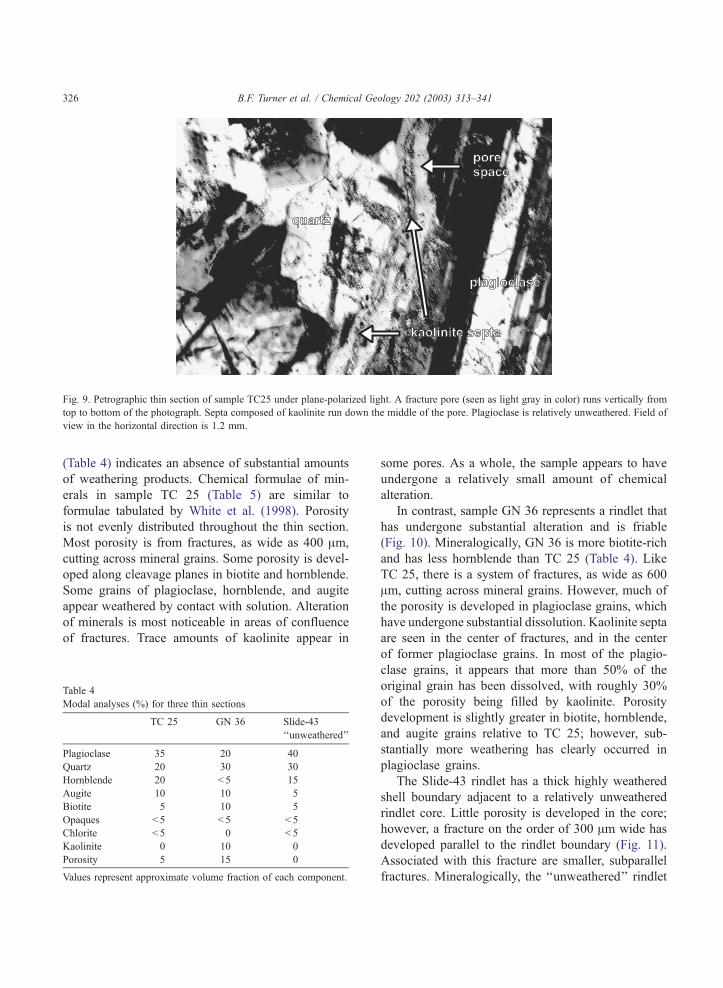
Fig. 9. Petrographic thin section of sample TC25 under plane-polarized light. A fracture pore (seen as light gray in color) runs vertically from
top to bottom of the photograph. Septa composed of kaolinite run down the middle of the pore. Plagioclase is relatively unweathered. Field of
view in the horizontal direction is 1.2 mm.
B.F. Turner et al. / Chemical Geology 202 (2003) 313–341326
(Table 4) indicates an absence of substantial amounts
of weathering products. Chemical formulae of min-
erals in sample TC 25 (Table 5) are similar to
formulae tabulated by White et al. (1998). Porosity
is not evenly distributed throughout the thin section.
Most porosity is from fractures, as wide as 400 Am,
cutting across mineral grains. Some porosity is devel-
oped along cleavage planes in biotite and hornblende.
Some grains of plagioclase, hornblende, and augite
appear weathered by contact with solution. Alteration
of minerals is most noticeable in areas of confluence
of fractures. Trace amounts of kaolinite appear in
Table 4
Modal analyses (%) for three thin sections
TC 25 GN 36 Slide-43
‘‘unweathered’’
Plagioclase 35 20 40
Quartz 20 30 30
Hornblende 20 < 5 15
Augite 10 10 5
Biotite 5 10 5
Opaques < 5 < 5 < 5
Chlorite < 5 0 < 5
Kaolinite 0 10 0
Porosity 5 15 0
Values represent approximate volume fraction of each component.
some pores. As a whole, the sample appears to have
undergone a relatively small amount of chemical
alteration.
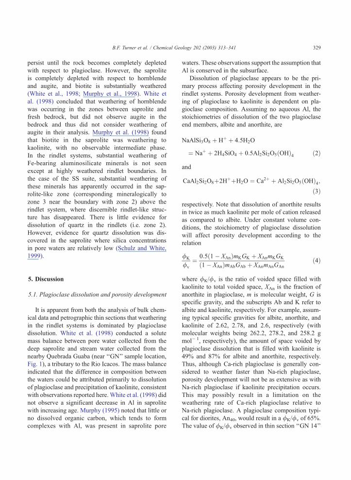
In contrast, sample GN 36 represents a rindlet that
has undergone substantial alteration and is friable
(Fig. 10). Mineralogically, GN 36 is more biotite-rich
and has less hornblende than TC 25 (Table 4). Like
TC 25, there is a system of fractures, as wide as 600
Am, cutting across mineral grains. However, much of
the porosity is developed in plagioclase grains, which
have undergone substantial dissolution. Kaolinite septa
are seen in the center of fractures, and in the center
of former plagioclase grains. In most of the plagio-
clase grains, it appears that more than 50% of the
original grain has been dissolved, with roughly 30%
of the porosity being filled by kaolinite. Porosity
development is slightly greater in biotite, hornblende,
and augite grains relative to TC 25; however, sub-
stantially more weathering has clearly occurred in
plagioclase grains.
The Slide-43 rindlet has a thick highly weathered
shell boundary adjacent to a relatively unweathered
rindlet core. Little porosity is developed in the core;
however, a fracture on the order of 300 Am wide has
developed parallel to the rindlet boundary (Fig. 11).
Associated with this fracture are smaller, subparallel
fractures. Mineralogically, the ‘‘unweathered’’ rindlet
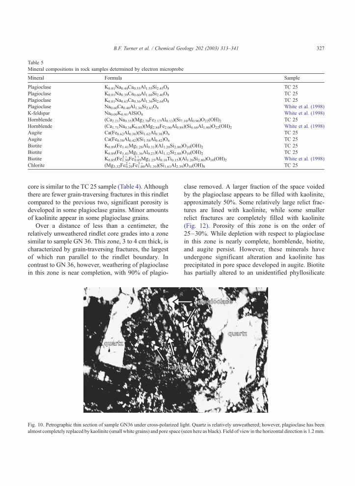
Table 5
Mineral compositions in rock samples determined by electron microprobe
Mineral Formula Sample
Plagioclase K0.01Na0.44Ca0.55Al1.55Si2.45O8 TC 25
Plagioclase K0.01Na0.39Ca0.60Al1.60Si2.40O8 TC 25
Plagioclase K0.01Na0.63Ca0.36Al1.36Si2.64O8 TC 25
Plagioclase Na0.60Ca0.40Al1.36Si2.63O8 White et al. (1998)
K-feldspar Na0.09K0.91AlSiO8 White et al. (1998)
Hornblende (Ca2.21Na0.35)(Mg2.70Fe2.17Al0.13)(Si7.10Al0.90)O22(OH)2 TC 25
Hornblende (Ca1.71Na0.34K0.05)(Mg2.84Fe2.06Al0.89)(Si6.68Al1.00)O22(OH)2 White et al. (1998)
Augite Ca(Fe0.62Al0.38)(Si1.62Al0.38)O6 TC 25
Augite Ca(Fe0.58Al0.42)(Si1.58Al0.42)O6 TC 25
Biotite K0.89(Fe1.41Mg1.28Al0.31)(Al1.20Si2.80)O10(OH)2 TC 25
Biotite K0.89(Fe1.41Mg1.36Al0.23)(Al1.12Si2.88)O10(OH)2 TC 25
Biotite K0.85(Fe2 +1.30Fe
3 +0.05Mg1.25Al0.10Ti0.15)(Al1.20Si2.80)O10(OH)2 White et al. (1998)
Chlorite (Mg3.32Fe2 +0.29Fe
3 +1.00Al1.39)(Si1.61Al2.39)O10(OH)8 TC 25
B.F. Turner et al. / Chemical Geology 202 (2003) 313–341 327
core is similar to the TC 25 sample (Table 4). Although
there are fewer grain-traversing fractures in this rindlet
compared to the previous two, significant porosity is
developed in some plagioclase grains. Minor amounts
of kaolinite appear in some plagioclase grains.
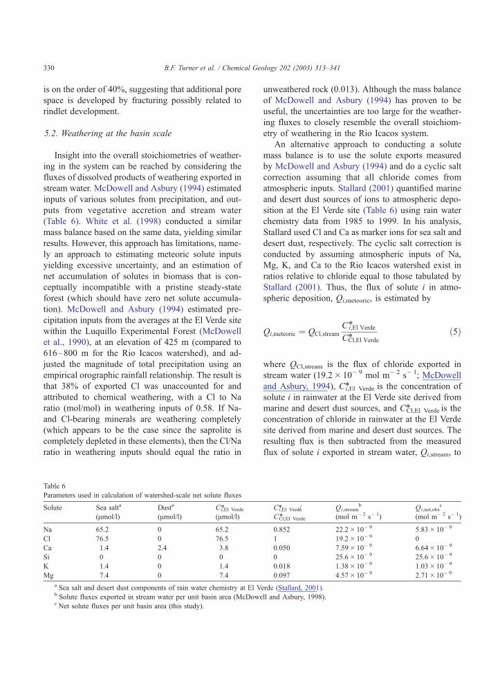
Over a distance of less than a centimeter, the
relatively unweathered rindlet core grades into a zone
similar to sample GN 36. This zone, 3 to 4 cm thick, is
characterized by grain-traversing fractures, the largest
of which run parallel to the rindlet boundary. In
contrast to GN 36, however, weathering of plagioclase
in this zone is near completion, with 90% of plagio-
Fig. 10. Petrographic thin section of sample GN36 under cross-polarized li
almost completely replaced by kaolinite (small white grains) and pore space (
clase removed. A larger fraction of the space voided
by the plagioclase appears to be filled with kaolinite,
approximately 50%. Some relatively large relict frac-
tures are lined with kaolinite, while some smaller
relict fractures are completely filled with kaolinite
(Fig. 12). Porosity of this zone is on the order of
25–30%. While depletion with respect to plagioclase
in this zone is nearly complete, hornblende, biotite,
and augite persist. However, these minerals have
undergone significant alteration and kaolinite has
precipitated in pore space developed in augite. Biotite
has partially altered to an unidentified phyllosilicate
ght. Quartz is relatively unweathered; however, plagioclase has been
seen here as black). Field of view in the horizontal direction is 1.2mm.
Fig. 11. Petrographic thin section, under plane-polarized light, of a relatively unweathered portion of the Slide-43 rindlet. A fracture pore, shown
horizontally traversing the photograph and seen as light gray in color, runs parallel to the inter-rindlet boundary. Field of view in the horizontal
direction is 2.4 mm.
B.F. Turner et al. / Chemical Geology 202 (2003) 313–341328
(refer to Murphy et al., 1998 for a discussion of
possible biotite weathering products). Samples from
each suite, analyzed for phyllosilicate minerals by
XRD, were found to contain biotite, chlorite, and
kaolinite. No evidence of gibbsite was observed.
Fig. 12. Petrographic thin section, under crossed-polarized light, of a weat
horizontally traversing the photograph, runs parallel to the inter-rindlet bou
the relict fracture pore, plagioclase has been almost completely replaced b
Field of view in the horizontal direction is 1.2 mm.
Alteration of these Fe-bearing minerals is most appar-
ent 2–4 cm from the unweathered core.
Although minor alteration of Fe-bearing alumi-
nosilicates appears to occur during the early stages
of porosity development, these minerals tend to
hered portion of the Slide-43 rindlet. A former fracture pore, shown
ndary and is now completely filled with kaolinite. On either side of
y kaolinite (small white grains) and pore space (seen here as black).
B.F. Turner et al. / Chemical Geology 202 (2003) 313–341 329
persist until the rock becomes completely depleted
with respect to plagioclase. However, the saprolite
is completely depleted with respect to hornblende
and augite, and biotite is substantially weathered
(White et al., 1998; Murphy et al., 1998). White et
al. (1998) concluded that weathering of hornblende
was occurring in the zones between saprolite and
fresh bedrock, but did not observe augite in the
bedrock and thus did not consider weathering of
augite in their analysis. Murphy et al. (1998) found
that biotite in the saprolite was weathering to
kaolinite, with no observable intermediate phase.
In the rindlet systems, substantial weathering of
Fe-bearing aluminosilicate minerals is not seen
except at highly weathered rindlet boundaries. In
the case of the SS suite, substantial weathering of
these minerals has apparently occurred in the sap-
rolite-like zone (corresponding mineralogically to
zone 3 near the boundary with zone 2) above the
rindlet system, where discernible rindlet-like struc-
ture has disappeared. There is little evidence for
dissolution of quartz in the rindlets (i.e. zone 2).
However, evidence for quartz dissolution was dis-
covered in the saprolite where silica concentrations
in pore waters are relatively low (Schulz and White,
1999).
5. Discussion
5.1. Plagioclase dissolution and porosity development
It is apparent from both the analysis of bulk chem-
ical data and petrographic thin sections that weathering
in the rindlet systems is dominated by plagioclase
dissolution. White et al. (1998) conducted a solute
mass balance between pore water collected from the
deep saprolite and stream water collected from the
nearby Quebrada Guaba (near ‘‘GN’’ sample location,
Fig. 1), a tributary to the Rio Icacos. The mass balance
indicated that the difference in composition between
the waters could be attributed primarily to dissolution
of plagioclase and precipitation of kaolinite, consistent
with observations reported here. White et al. (1998) did
not observe a significant decrease in Al in saprolite
with increasing age. Murphy (1995) noted that little or
no dissolved organic carbon, which tends to form
complexes with Al, was present in saprolite pore
waters. These observations support the assumption that
Al is conserved in the subsurface.
Dissolution of plagioclase appears to be the pri-
mary process affecting porosity development in the
rindlet systems. Porosity development from weather-
ing of plagioclase to kaolinite is dependent on pla-
gioclase composition. Assuming no aqueous Al, the
stoichiometries of dissolution of the two plagioclase
end members, albite and anorthite, are
NaAlSi3O8 þ Hþ þ 4:5H2O
¼ Naþ þ 2H4SiO4 þ 0:5Al2Si2O5ðOHÞ4 ð2Þ
and
CaAl2Si2O8þ2HþþH2O ¼ Ca2þ þ Al2Si2O5ðOHÞ4;ð3Þ
respectively. Note that dissolution of anorthite results
in twice as much kaolinite per mole of cation released
as compared to albite. Under constant volume con-
ditions, the stoichiometry of plagioclase dissolution
will affect porosity development according to the
relation
/K
/v
¼ 0:5ð1� XAnÞmKGK þ XAnmKGK
ð1� XAnÞmAbGAb þ XAnmAnGAn
ð4Þ
where /K//v is the ratio of voided space filled with
kaolinite to total voided space, XAn is the fraction of
anorthite in plagioclase, m is molecular weight, G is
specific gravity, and the subscripts Ab and K refer to
albite and kaolinite, respectively. For example, assum-
ing typical specific gravities for albite, anorthite, and
kaolinite of 2.62, 2.78, and 2.6, respectively (with
molecular weights being 262.2, 278.2, and 258.2 g
mol� 1, respectively), the amount of space voided by
plagioclase dissolution that is filled with kaolinite is
49% and 87% for albite and anorthite, respectively.
Thus, although Ca-rich plagioclase is generally con-
sidered to weather faster than Na-rich plagioclase,
porosity development will not be as extensive as with
Na-rich plagioclase if kaolinite precipitation occurs.
This may possibly result in a limitation on the
weathering rate of Ca-rich plagioclase relative to
Na-rich plagioclase. A plagioclase composition typi-
cal for diorites, An40, would result in a /K//v of 65%.
The value of /K//v observed in thin section ‘‘GN 14’’
B.F. Turner et al. / Chemical Geology 202 (2003) 313–341330
is on the order of 40%, suggesting that additional pore
space is developed by fracturing possibly related to
rindlet development.
5.2. Weathering at the basin scale
Insight into the overall stoichiometries of weather-
ing in the system can be reached by considering the
fluxes of dissolved products of weathering exported in
stream water. McDowell and Asbury (1994) estimated
inputs of various solutes from precipitation, and out-
puts from vegetative accretion and stream water
(Table 6). White et al. (1998) conducted a similar
mass balance based on the same data, yielding similar
results. However, this approach has limitations, name-
ly an approach to estimating meteoric solute inputs
yielding excessive uncertainty, and an estimation of
net accumulation of solutes in biomass that is con-
ceptually incompatible with a pristine steady-state
forest (which should have zero net solute accumula-
tion). McDowell and Asbury (1994) estimated pre-
cipitation inputs from the averages at the El Verde site
within the Luquillo Experimental Forest (McDowell
et al., 1990), at an elevation of 425 m (compared to
616–800 m for the Rio Icacos watershed), and ad-
justed the magnitude of total precipitation using an
empirical orographic rainfall relationship. The result is
that 38% of exported Cl was unaccounted for and
attributed to chemical weathering, with a Cl to Na
ratio (mol/mol) in weathering inputs of 0.58. If Na-
and Cl-bearing minerals are weathering completely
(which appears to be the case since the saprolite is
completely depleted in these elements), then the Cl/Na
ratio in weathering inputs should equal the ratio in
Table 6
Parameters used in calculation of watershed-scale net solute fluxes
Solute Sea salta
(Amol/l)
Dusta
(Amol/l)
Ci,El Verde*
(Amol/l)
Na 65.2 0 65.2
Cl 76.5 0 76.5
Ca 1.4 2.4 3.8
Si 0 0 0
K 1.4 0 1.4
Mg 7.4 0 7.4
a Sea salt and desert dust components of rain water chemistry at El Vb Solute fluxes exported in stream water per unit basin area (McDowec Net solute fluxes per unit basin area (this study).
unweathered rock (0.013). Although the mass balance
of McDowell and Asbury (1994) has proven to be
useful, the uncertainties are too large for the weather-
ing fluxes to closely resemble the overall stoichiom-
etry of weathering in the Rio Icacos system.
An alternative approach to conducting a solute
mass balance is to use the solute exports measured
by McDowell and Asbury (1994) and do a cyclic salt
correction assuming that all chloride comes from
atmospheric inputs. Stallard (2001) quantified marine
and desert dust sources of ions to atmospheric depo-
sition at the El Verde site (Table 6) using rain water
chemistry data from 1985 to 1999. In his analysis,
Stallard used Cl and Ca as marker ions for sea salt and
desert dust, respectively. The cyclic salt correction is
conducted by assuming atmospheric inputs of Na,
Mg, K, and Ca to the Rio Icacos watershed exist in
ratios relative to chloride equal to those tabulated by
Stallard (2001). Thus, the flux of solute i in atmo-
spheric deposition, Qi,meteoric, is estimated by
Qi;meteoric ¼ QCl;streamCi;El Verde*
CCl;El Verde*ð5Þ
where QCl,stream is the flux of chloride exported in
stream water (19.2� 10� 9 mol m� 2 s� 1; McDowell
and Asbury, 1994), Ci,El Verde* is the concentration of
solute i in rainwater at the El Verde site derived from
marine and desert dust sources, and CCl,El Verde* is the
concentration of chloride in rainwater at the El Verde
site derived from marine and desert dust sources. The
resulting flux is then subtracted from the measured
flux of solute i exported in stream water, Qi,stream, to
Ci,El Verde* /
CCl,El Verde*
Qi,streamb
(mol m� 2 s� 1)
Qi,net,obsc
(mol m� 2 s� 1)
0.852 22.2� 10� 9 5.83� 10� 9
1 19.2� 10� 9 0
0.050 7.59� 10� 9 6.64� 10� 9
0 25.6� 10� 9 25.6� 10� 9
0.018 1.38� 10� 9 1.03� 10� 9
0.097 4.57� 10� 9 2.71�10� 9
erde (Stallard, 2001).
ll and Asbury, 1998).
B.F. Turner et al. / Chemical Geology 202 (2003) 313–341 331
obtain the net solute flux attributable to chemical
weathering, Qi,net,obs:
Qi;net;obs ¼ Qi;stream � Qi;meteoric: ð6Þ
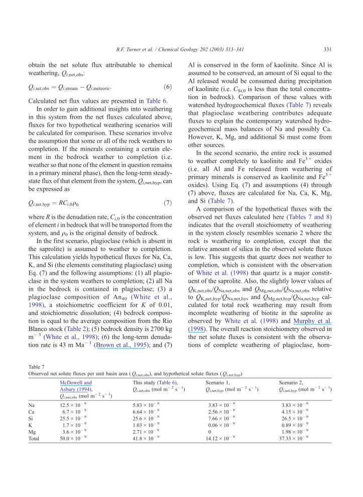
Calculated net flux values are presented in Table 6.
In order to gain additional insights into weathering
in this system from the net fluxes calculated above,
fluxes for two hypothetical weathering scenarios will
be calculated for comparison. These scenarios involve
the assumption that some or all of the rock weathers to
completion. If the minerals containing a certain ele-
ment in the bedrock weather to completion (i.e.
weather so that none of the element in question remains
in a primary mineral phase), then the long-term steady-
state flux of that element from the system,Qi,net,hyp, can
be expressed as
Qi;net;hyp ¼ RCi;0q0 ð7Þ
where R is the denudation rate, Ci,0 is the concentration
of element i in bedrock that will be transported from the
system, and q0 is the original density of bedrock.
In the first scenario, plagioclase (which is absent in
the saprolite) is assumed to weather to completion.
This calculation yields hypothetical fluxes for Na, Ca,
K, and Si (the elements constituting plagioclase) using
Eq. (7) and the following assumptions: (1) all plagio-
clase in the system weathers to completion; (2) all Na
in the bedrock is contained in plagioclase; (3) a
plagioclase composition of An40 (White et al.,
1998), a stoichiometric coefficient for K of 0.01,
and stoichiometric dissolution; (4) bedrock composi-
tion is equal to the average composition from the Rio
Blanco stock (Table 2); (5) bedrock density is 2700 kg
m� 3 (White et al., 1998); (6) the long-term denuda-
tion rate is 43 m Ma� 1 (Brown et al., 1995); and (7)
Table 7
Observed net solute fluxes per unit basin area (Qi,net,obs), and hypothetica
McDowell and
Asbury (1994),
Qi,net,obs (mol m� 2 s� 1)
This study (Table 6),
Qi,net,obs (mol m� 2 s� 1)
Na 12.5� 10� 9 5.83� 10� 9
Ca 6.7� 10� 9 6.64� 10� 9
Si 25.5� 10� 9 25.6� 10� 9
K 1.7� 10� 9 1.03� 10� 9
Mg 3.6� 10� 9 2.71�10� 9
Total 50.0� 10� 9 41.8� 10� 9
Al is conserved in the form of kaolinite. Since Al is
assumed to be conserved, an amount of Si equal to the
Al released would be consumed during precipitation
of kaolinite (i.e. CSi,0 is less than the total concentra-
tion in bedrock). Comparison of these values with
watershed hydrogeochemical fluxes (Table 7) reveals
that plagioclase weathering contributes adequate
fluxes to explain the contemporary watershed hydro-
geochemical mass balances of Na and possibly Ca.
However, K, Mg, and additional Si must come from
other sources.
In the second scenario, the entire rock is assumed
to weather completely to kaolinite and Fe3 + oxides
(i.e. all Al and Fe released from weathering of
primary minerals is conserved as kaolinite and Fe3 +
oxides). Using Eq. (7) and assumptions (4) through
(7) above, fluxes are calculated for Na, Ca, K, Mg,
and Si (Table 7).
A comparison of the hypothetical fluxes with the
observed net fluxes calculated here (Tables 7 and 8)
indicates that the overall stoichiometry of weathering
in the system closely resembles scenario 2 where the
rock is weathering to completion, except that the
relative amount of silica in the observed solute fluxes
is low. This suggests that quartz does not weather to
completion, which is consistent with the observation
of White et al. (1998) that quartz is a major constit-
uent of the saprolite. Also, the slightly lower values of
QK,net,obs/QNa,net,obs and QMg,net,obs/QNa,net,obs relative
to QK,net,hyp/QNa,net,hys and QMg,net,hyp/QNa,net,hyp cal-
culated for total rock weathering may result from
incomplete weathering of biotite in the saprolite as
observed by White et al. (1998) and Murphy et al.
(1998). The overall reaction stoichiometry observed in
the net solute fluxes is consistent with the observa-
tions of complete weathering of plagioclase, horn-
l solute fluxes (Qi,net,hyp)
Scenario 1,
Qi,net,hyp (mol m� 2 s� 1)
Scenario 2,
Qi,net,hyp (mol m� 2 s� 1)
3.83� 10� 9 3.83� 10� 9
2.56� 10� 9 4.15� 10� 9
7.66� 10� 9 26.5� 10� 9
0.06� 10� 9 0.89� 10� 9
0 1.98� 10� 9
14.12� 10� 9 37.33� 10� 9
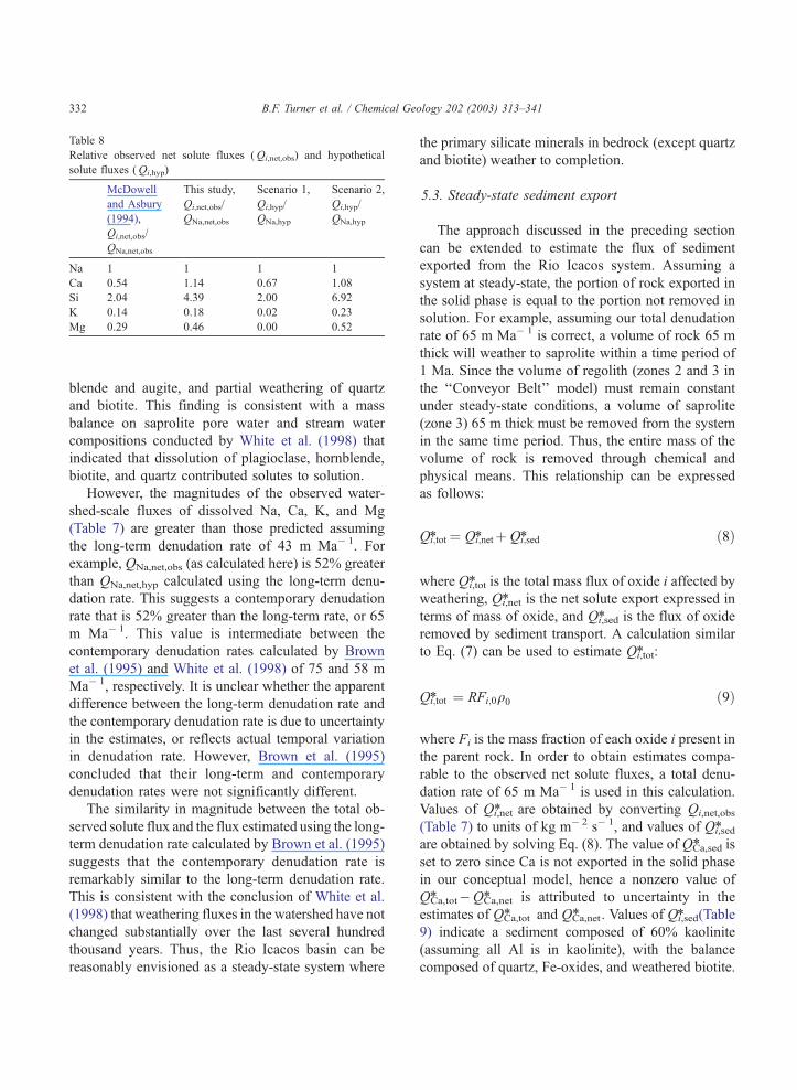
Table 8
Relative observed net solute fluxes (Qi,net,obs) and hypothetical
solute fluxes (Qi,hyp)
McDowell
and Asbury
(1994),
Qi,net,obs/
QNa,net,obs
This study,
Qi,net,obs/
QNa,net,obs
Scenario 1,
Qi,hyp/
QNa,hyp
Scenario 2,
Qi,hyp/
QNa,hyp
Na 1 1 1 1
Ca 0.54 1.14 0.67 1.08
Si 2.04 4.39 2.00 6.92
K 0.14 0.18 0.02 0.23
Mg 0.29 0.46 0.00 0.52
B.F. Turner et al. / Chemical Geology 202 (2003) 313–341332
blende and augite, and partial weathering of quartz
and biotite. This finding is consistent with a mass
balance on saprolite pore water and stream water
compositions conducted by White et al. (1998) that
indicated that dissolution of plagioclase, hornblende,
biotite, and quartz contributed solutes to solution.
However, the magnitudes of the observed water-
shed-scale fluxes of dissolved Na, Ca, K, and Mg
(Table 7) are greater than those predicted assuming
the long-term denudation rate of 43 m Ma� 1. For
example, QNa,net,obs (as calculated here) is 52% greater
than QNa,net,hyp calculated using the long-term denu-
dation rate. This suggests a contemporary denudation
rate that is 52% greater than the long-term rate, or 65
m Ma� 1. This value is intermediate between the
contemporary denudation rates calculated by Brown
et al. (1995) and White et al. (1998) of 75 and 58 m
Ma� 1, respectively. It is unclear whether the apparent
difference between the long-term denudation rate and
the contemporary denudation rate is due to uncertainty
in the estimates, or reflects actual temporal variation
in denudation rate. However, Brown et al. (1995)
concluded that their long-term and contemporary
denudation rates were not significantly different.
The similarity in magnitude between the total ob-
served solute flux and the flux estimated using the long-
term denudation rate calculated by Brown et al. (1995)
suggests that the contemporary denudation rate is
remarkably similar to the long-term denudation rate.
This is consistent with the conclusion of White et al.
(1998) that weathering fluxes in the watershed have not
changed substantially over the last several hundred
thousand years. Thus, the Rio Icacos basin can be
reasonably envisioned as a steady-state system where
the primary silicate minerals in bedrock (except quartz
and biotite) weather to completion.
5.3. Steady-state sediment export
The approach discussed in the preceding section
can be extended to estimate the flux of sediment
exported from the Rio Icacos system. Assuming a
system at steady-state, the portion of rock exported in
the solid phase is equal to the portion not removed in
solution. For example, assuming our total denudation
rate of 65 m Ma� 1 is correct, a volume of rock 65 m
thick will weather to saprolite within a time period of
1 Ma. Since the volume of regolith (zones 2 and 3 in
the ‘‘Conveyor Belt’’ model) must remain constant
under steady-state conditions, a volume of saprolite
(zone 3) 65 m thick must be removed from the system
in the same time period. Thus, the entire mass of the
volume of rock is removed through chemical and
physical means. This relationship can be expressed
as follows:
Qi;tot* ¼ Qi;net* þ Qi;sed* ð8Þ
where Qi,tot* is the total mass flux of oxide i affected by
weathering, Qi,net* is the net solute export expressed in
terms of mass of oxide, and Qi,sed* is the flux of oxide
removed by sediment transport. A calculation similar
to Eq. (7) can be used to estimate Qi,tot* :
Qi;tot* ¼ RFi;0q0 ð9Þ
where Fi is the mass fraction of each oxide i present in
the parent rock. In order to obtain estimates compa-
rable to the observed net solute fluxes, a total denu-
dation rate of 65 m Ma� 1 is used in this calculation.
Values of Qi,net* are obtained by converting Qi,net,obs
(Table 7) to units of kg m� 2 s� 1, and values of Qi,sed*
are obtained by solving Eq. (8). The value of QCa,sed* is
set to zero since Ca is not exported in the solid phase
in our conceptual model, hence a nonzero value of
QCa,tot* �QCa,net* is attributed to uncertainty in the
estimates of QCa,tot* and QCa,net* . Values of Qi,sed* (Table
9) indicate a sediment composed of 60% kaolinite
(assuming all Al is in kaolinite), with the balance
composed of quartz, Fe-oxides, and weathered biotite.

Table 9
Hypothetical mass flux of total weathering products, Qi,tot* , observed mass flux of dissolved weathering products, Qi,net* , steady-state mass flux
of sediment, Qi,sed* , and an independently calculated steady-state sediment yield, Ys, comparable to the total Qi,sed*
Qi,tot* (kg m� 2 s� 1) Qi,net* (kg m� 2 s� 1) Qi,sed* (kg m� 2 s� 1) Ys (kg m� 2 s� 1)
Na2O 0.18� 10� 9 0.18� 10� 9 0
CaO 0.35� 10� 9 0.37� 10� 9 0
SiO2 3.51�10� 9 1.54� 10� 9 1.98� 10� 9
K2O 0.006� 10� 9 0.005� 10� 9 0.001�10� 9
MgO 0.12� 10� 9 0.11�10� 9 0.001�10� 9
Al2O3 0.94� 10� 9 0 0.094� 10� 9
FeO 0.30� 10� 9 0 0.030� 10� 9
Total 5.47� 10� 9 2.25� 10� 9 3.24� 10� 9 3.60� 10� 9
B.F. Turner et al. / Chemical Geology 202 (2003) 313–341 333
This hypothetical sediment composition is very sim-
ilar to the composition of the saprolite (Table 3).
An upper limit to sediment generation under
steady-state conditions can be obtained by assuming
that the chemical composition of Rio Icacos sand is
representative of bulk sediment composition. The
mass fraction WA of a chemical component A that
dissolves in bedrock can be calculated as
WAðA;BÞ ¼Bb
Ab
� Bs
As
� �H
Bd
Ad
� Bs
As
� �ð10Þ
where A and B are the mass fractions of elements in
(b) bedrock, (d) dissolved load, and (s) solid sediment
(Stallard, 1995b). The fraction of bedrock that dis-
solves, W, is
W ðA;BÞ ¼ Ab
Ad
WcðA;BÞ ð11Þ
(Stallard, 1995b). Stallard (1995a) recommended that
the ideal pair of elements for application of Eqs. (10)
and (11) are Si (as element A) because it is the most
abundant cation in most rocks, and Na (as element B)
because the variance r(Bb/Ab) is small and Bb/AbH
Bs/As. Sediment yield, Ys, can then be predicted from
the total dissolved mass flux, Yd (Table 9):
Ys ¼ Yd1�W
Wð12Þ
(Stallard, 1995a,b). Using values of As (SiO2 in
sediment sand) of 0.7932 and Bs (Na2O in sediment
sand) of 0.0033 (Stallard, unpublished), Ab and Bb
values from Table 2, and Ad, Bd, and Yd values
obtained from Table 9, a value of Ys (see Table 9) is
obtained that is slightly higher than the total Qi,sed* .
These values represent upper and lower limits on the
steady-state sediment yield based on contemporary
solute fluxes: one estimate assumes no Na in sedi-
ment, and the other assumes the Na concentration in
the sand fraction is representative of the bulk sediment
concentration.
The total sediment flux of 3.24� 10� 9 to 3.60�10� 9 kg m� 2 s� 1 represents a hypothetical sediment
yield under idealized steady-state conditions. While a
system may or may not be at steady-state, this value
provides a convenient reference to compare measured
values to. Larsen (1997) estimated a contemporary
sediment yield for the Rio Icacos basin of
30.2� 10� 9 kg m� 2 s� 1; however, 71% of this is
estimated to be due to the presence of the road
through the basin (Fig. 1) and its associated land-
slides. Therefore, sediment transport in the basin is
currently far from steady-state due to the road. How-
ever, Larsen’s background sediment yield of 8.8�10� 9 kg m� 2 s� 1 is much smaller. A comparison
between Larsen’s background sediment yield and our
calculated steady-state yields indicates that the con-
temporary sediment yield in the absence of the road is
significantly accelerated compared to the steady-state
condition. The time scale for this disequilibrium may
be on the order of 100 years; the proximity of the10Be-derived denundation rate (43 m Ma� 1; Brown et
al., 1995) to our contemporary denudation rate (65 m
Ma� 1) indicates that sediment generation was closer
to steady-state in a pre-anthropogenic time frame
(Brown et al., 1998). Reasons for the accelerated
sediment yield over this time scale may include (1)
higher frequency of large storms, (2) vegetation
changes caused by the introduction of plants and
diseases of plants, (3) vegetation changes caused by
B.F. Turner et al. / Chemical Geology 202 (2003) 313–341334
climate shifts or pollution, or (4) subtle human effects
that we have not identified.
5.4. Parallel weathering
It is argued in preceding sections that the ‘‘Con-
veyor Belt’’ model, while useful for conceptualizing
weathering on a basin scale, is limited in its ability to
explain observations at smaller scales due to lack of
consideration of multiple weathering fronts. It is well
documented that the presence of joints in bedrock
enhances the weathering of granitoid rocks (e.g.
Twidale, 1982). Three-dimensional networks of joints
result in the bedrock being divided into joint blocks
Fig. 13. Illustration of the concept of parallel weathering of joint blocks.
(shown as heavy black arrows) is from joint planes towards the center of jo
front is a fraction of the total denudation rate. Figure is not to scale.
bounded by joint surfaces (Fig. 13). Presumably, the
early stages of rock weathering in the system are
dominated by water flow along joint planes. Since
the fracture pores that are suspected to cause the
formation of onion-skin rindlet structures tend to form
subparallel to the ground surface, it is assumed here
that most weathering of joint blocks occur along their
top and bottom surfaces. The GN outcrop (Fig. 3) is
an example of a joint block where the weathering
front appears to be moving in the upward direction
from the joint plane. Since joints typically penetrate
deep into bedrock, more than one vertically stacked
joint block may be weathering in this fashion at the
same time. Under such circumstances, Eq. (1) is not
As water flows along joint planes, movement of weathering fronts
int blocks. The magnitude of the velocity of an individual weathering
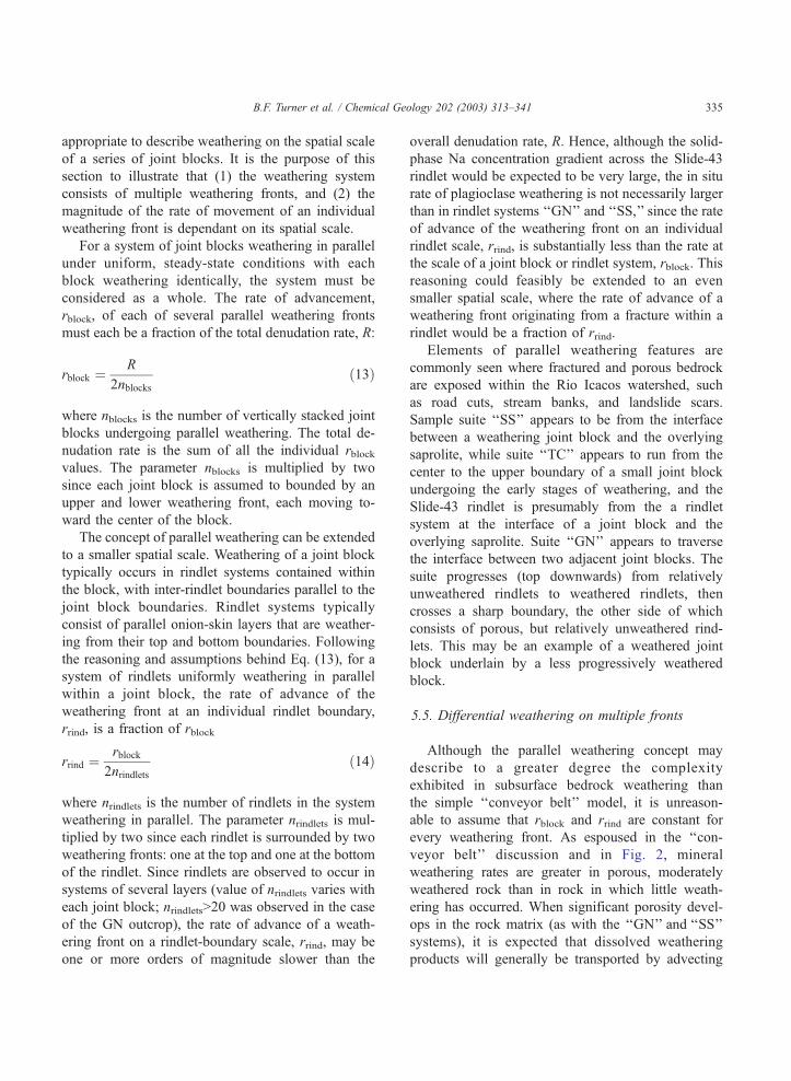
B.F. Turner et al. / Chemical Geology 202 (2003) 313–341 335
appropriate to describe weathering on the spatial scale
of a series of joint blocks. It is the purpose of this
section to illustrate that (1) the weathering system
consists of multiple weathering fronts, and (2) the
magnitude of the rate of movement of an individual
weathering front is dependant on its spatial scale.
For a system of joint blocks weathering in parallel
under uniform, steady-state conditions with each
block weathering identically, the system must be
considered as a whole. The rate of advancement,
rblock, of each of several parallel weathering fronts
must each be a fraction of the total denudation rate, R:
rblock ¼R
2nblocksð13Þ
where nblocks is the number of vertically stacked joint
blocks undergoing parallel weathering. The total de-
nudation rate is the sum of all the individual rblockvalues. The parameter nblocks is multiplied by two
since each joint block is assumed to bounded by an
upper and lower weathering front, each moving to-
ward the center of the block.
The concept of parallel weathering can be extended
to a smaller spatial scale. Weathering of a joint block
typically occurs in rindlet systems contained within
the block, with inter-rindlet boundaries parallel to the
joint block boundaries. Rindlet systems typically
consist of parallel onion-skin layers that are weather-
ing from their top and bottom boundaries. Following
the reasoning and assumptions behind Eq. (13), for a
system of rindlets uniformly weathering in parallel
within a joint block, the rate of advance of the
weathering front at an individual rindlet boundary,
rrind, is a fraction of rblock
rrind ¼rblock
2nrindletsð14Þ
where nrindlets is the number of rindlets in the system
weathering in parallel. The parameter nrindlets is mul-
tiplied by two since each rindlet is surrounded by two
weathering fronts: one at the top and one at the bottom
of the rindlet. Since rindlets are observed to occur in
systems of several layers (value of nrindlets varies with
each joint block; nrindlets>20 was observed in the case
of the GN outcrop), the rate of advance of a weath-
ering front on a rindlet-boundary scale, rrind, may be
one or more orders of magnitude slower than the
overall denudation rate, R. Hence, although the solid-
phase Na concentration gradient across the Slide-43
rindlet would be expected to be very large, the in situ
rate of plagioclase weathering is not necessarily larger
than in rindlet systems ‘‘GN’’ and ‘‘SS,’’ since the rate
of advance of the weathering front on an individual
rindlet scale, rrind, is substantially less than the rate at
the scale of a joint block or rindlet system, rblock. This
reasoning could feasibly be extended to an even
smaller spatial scale, where the rate of advance of a
weathering front originating from a fracture within a
rindlet would be a fraction of rrind.
Elements of parallel weathering features are
commonly seen where fractured and porous bedrock
are exposed within the Rio Icacos watershed, such
as road cuts, stream banks, and landslide scars.
Sample suite ‘‘SS’’ appears to be from the interface
between a weathering joint block and the overlying
saprolite, while suite ‘‘TC’’ appears to run from the
center to the upper boundary of a small joint block
undergoing the early stages of weathering, and the
Slide-43 rindlet is presumably from the a rindlet
system at the interface of a joint block and the
overlying saprolite. Suite ‘‘GN’’ appears to traverse
the interface between two adjacent joint blocks. The
suite progresses (top downwards) from relatively
unweathered rindlets to weathered rindlets, then
crosses a sharp boundary, the other side of which
consists of porous, but relatively unweathered rind-
lets. This may be an example of a weathered joint
block underlain by a less progressively weathered
block.
5.5. Differential weathering on multiple fronts
Although the parallel weathering concept may
describe to a greater degree the complexity
exhibited in subsurface bedrock weathering than
the simple ‘‘conveyor belt’’ model, it is unreason-
able to assume that rblock and rrind are constant for
every weathering front. As espoused in the ‘‘con-
veyor belt’’ discussion and in Fig. 2, mineral
weathering rates are greater in porous, moderately
weathered rock than in rock in which little weath-
ering has occurred. When significant porosity devel-
ops in the rock matrix (as with the ‘‘GN’’ and ‘‘SS’’
systems), it is expected that dissolved weathering
products will generally be transported by advecting
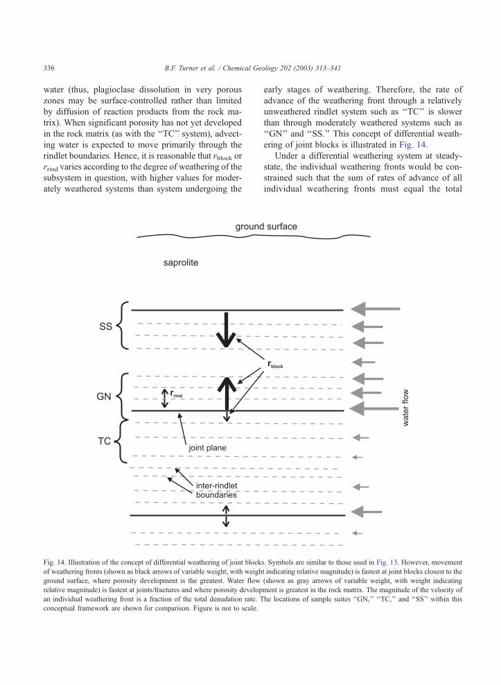
B.F. Turner et al. / Chemical Geology 202 (2003) 313–341336
water (thus, plagioclase dissolution in very porous
zones may be surface-controlled rather than limited
by diffusion of reaction products from the rock ma-
trix). When significant porosity has not yet developed
in the rock matrix (as with the ‘‘TC’’ system), advect-
ing water is expected to move primarily through the
rindlet boundaries. Hence, it is reasonable that rblock or
rrind varies according to the degree of weathering of the
subsystem in question, with higher values for moder-
ately weathered systems than system undergoing the
Fig. 14. Illustration of the concept of differential weathering of joint block
of weathering fronts (shown as black arrows of variable weight, with weigh
ground surface, where porosity development is the greatest. Water flow
relative magnitude) is fastest at joints/fractures and where porosity develop
an individual weathering front is a fraction of the total denudation rate. T
conceptual framework are shown for comparison. Figure is not to scale.
early stages of weathering. Therefore, the rate of
advance of the weathering front through a relatively
unweathered rindlet system such as ‘‘TC’’ is slower
than through moderately weathered systems such as
‘‘GN’’ and ‘‘SS.’’ This concept of differential weath-
ering of joint blocks is illustrated in Fig. 14.
Under a differential weathering system at steady-
state, the individual weathering fronts would be con-
strained such that the sum of rates of advance of all
individual weathering fronts must equal the total
s. Symbols are similar to those used in Fig. 13. However, movement
t indicating relative magnitude) is fastest at joint blocks closest to the
(shown as gray arrows of variable weight, with weight indicating
ment is greatest in the rock matrix. The magnitude of the velocity of
he locations of sample suites ‘‘GN,’’ ‘‘TC,’’ and ‘‘SS’’ within this
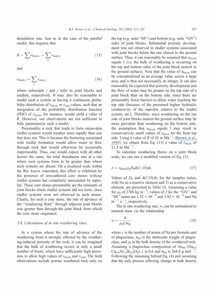
B.F. Turner et al. / Chemical Geology 202 (2003) 313–341 337
denudation rate. Just as in the case of the parallel
model, this requires that
R ¼Xi
rblock;i ¼Xi;j
rrind;i;j ð15Þ
and
rblock;i ¼Xj
rrind;i;j ð16Þ
where subscripts i and j refer to joint blocks and
rindlets, respectively. It may also be reasonable to
model such a system as having a continuous proba-
bility distribution of rblock or rrind values, such that an
integration of the probability distribution function
(PDF) of rblock, for instance, would yield a value of
R. However, our observations are not sufficient to
fully parameterize such a model.
Presumably, a rock that tends to form onion-skin
rindlet systems would weather more rapidly than one
that does not. This is because the fracturing associated
with rindlet formation would allow water to flow
through rock that would otherwise be essentially
impermeable. Thus, one would expect with all other
factors the same, the total denudation rate at a site
where such systems form to be greater than where
such systems are absent. On a localized scale within
the Rio Icacos watershed, this effect is exhibited by
the presence of unweathered core stones without
rindlet systems but completely surrounded by sapro-
lite. These core stones presumably are the remnants of
joint blocks where rindlet systems did not form, since
rindlet systems were not observed in such stones.
Clearly, for such a core stone, the rate of advance of
the ‘‘weathering front’’ through adjacent joint blocks
was greater than through the joint block from which
the core stone originated.
5.6. Calculation of in situ weathering rates
In a system where the rate of advance of the
weathering front is strongly affected by the weather-
ing-induced porosity of the rock, it can be imagined
that the bulk of weathering occurs at only a small
number of fronts, which have sufficiently high poros-
ities to allow high values of rblock and rrind. The field
observations include porous weathered rock only on
the top (e.g. suite ‘‘SS’’) and bottom (e.g. suite ‘‘GN’’)
sides of joint blocks. Substantial porosity develop-
ment was not observed in rindlet systems associated
with joint blocks below the one closest to the ground
surface. Thus, it can reasonably be assumed that nblockequals 1 (i.e. the bulk of weathering is occurring on
the top and bottom sides of the joint block nearest to
the ground surface). Note that the value of nblock can
be conceptualized as an average value across a large
area, and is thus not necessarily an integer. It can also
reasonably be expected that porosity development and
the flow of water may be greater on the top side of a
joint block than on the bottom side, since there are
presumably fewer barriers to dilute water reaching the
top side (because of the presumed higher hydraulic
conductivity of the saprolite relative to the rindlet
system, etc.). Therefore, since weathering on the top
side of joint blocks nearest the ground surface may be
more prevalent than weathering on the bottom side,
the assumption that nblock equals 1 may result in
conservatively small values of rblock for the front top
side. Using a value of R of 43 m Ma� 1 (Brown et al.,
1995), we obtain from Eq. (13) a value of rblock of
21.5 m Ma� 1.
To calculate weathering fluxes on a joint block
scale, we can use a modified version of Eq. (1):
J ¼ rblockq0D0dðC=DÞdx: ð17Þ
Values of D0 and d(C/D)/dx for the samples suites,
with Na as a reactive element and Ti as a conservative
element, are presented in Table 10. Assuming a value
for q0 of 2700 kg m� 3, values of J for the ‘‘GN’’ and
‘‘SS’’ suites are 1.52� 10� 9 and 3.82� 10� 9 mol Na
m� 3 s� 1, respectively.
The in situ weathering rate, w, can be normalized to
mineral mass via the relationship
w ¼ Jc
qbCmpl
ð18Þ
where c is the number of atoms of Na per formula unit
of plagioclase, mpl is the molecular weight of plagio-
clase, and qb is the bulk density of the weathered rock.Assuming a plagioclase composition of An40 (Na0.6Ca0.4Al1.4Si2.6O8), c is 0.6 and mpl is 268.6 g mol� 1.
Following the reasoning behind Eq. (4) and assuming
that the only process affecting change in bulk density
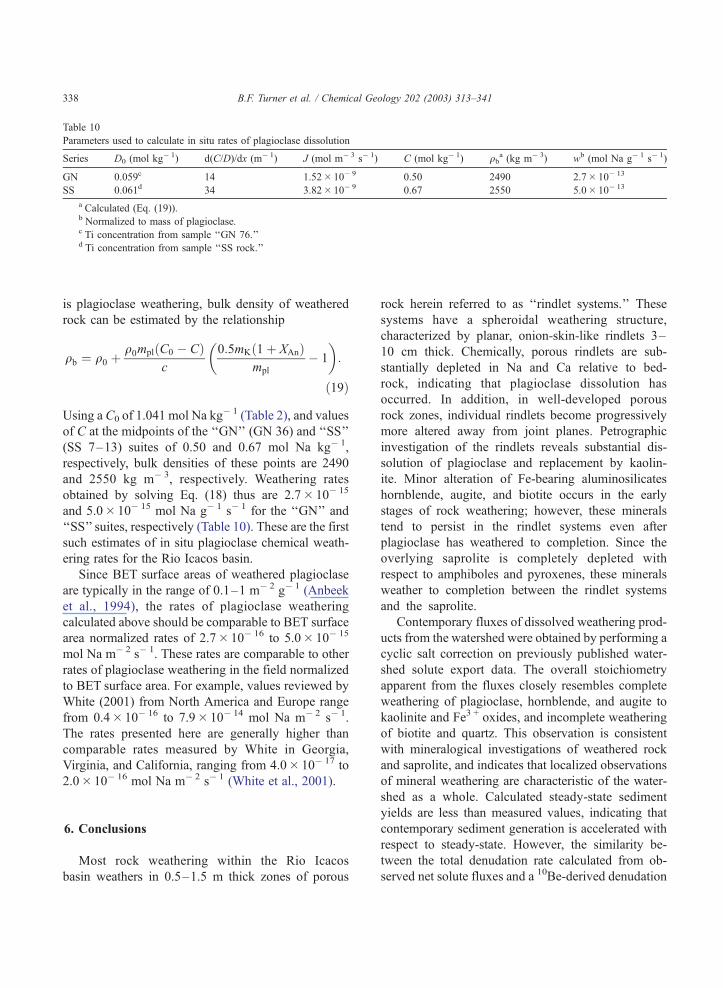
Table 10
Parameters used to calculate in situ rates of plagioclase dissolution
Series D0 (mol kg� 1) d(C/D)/dx (m� 1) J (mol m� 3 s� 1) C (mol kg� 1) qba (kg m� 3) wb (mol Na g� 1 s� 1)
GN 0.059c 14 1.52� 10� 9 0.50 2490 2.7� 10� 13
SS 0.061d 34 3.82� 10� 9 0.67 2550 5.0� 10� 13
a Calculated (Eq. (19)).b Normalized to mass of plagioclase.c Ti concentration from sample ‘‘GN 76.’’d Ti concentration from sample ‘‘SS rock.’’
B.F. Turner et al. / Chemical Geology 202 (2003) 313–341338
is plagioclase weathering, bulk density of weathered
rock can be estimated by the relationship
qb ¼ q0 þq0mplðC0 � CÞ
c
0:5mKð1þ XAnÞmpl
� 1
� �:
ð19Þ
Using a C0 of 1.041 mol Na kg� 1 (Table 2), and values
of C at the midpoints of the ‘‘GN’’ (GN 36) and ‘‘SS’’
(SS 7–13) suites of 0.50 and 0.67 mol Na kg� 1,
respectively, bulk densities of these points are 2490
and 2550 kg m� 3, respectively. Weathering rates
obtained by solving Eq. (18) thus are 2.7� 10� 15
and 5.0� 10� 15 mol Na g� 1 s� 1 for the ‘‘GN’’ and
‘‘SS’’ suites, respectively (Table 10). These are the first
such estimates of in situ plagioclase chemical weath-
ering rates for the Rio Icacos basin.
Since BET surface areas of weathered plagioclase
are typically in the range of 0.1–1 m� 2 g� 1 (Anbeek
et al., 1994), the rates of plagioclase weathering
calculated above should be comparable to BET surface
area normalized rates of 2.7� 10� 16 to 5.0� 10� 15
mol Na m� 2 s� 1. These rates are comparable to other
rates of plagioclase weathering in the field normalized
to BET surface area. For example, values reviewed by
White (2001) from North America and Europe range
from 0.4� 10� 16 to 7.9� 10� 14 mol Na m� 2 s� 1.
The rates presented here are generally higher than
comparable rates measured by White in Georgia,
Virginia, and California, ranging from 4.0� 10� 17 to
2.0� 10� 16 mol Na m� 2 s� 1 (White et al., 2001).
6. Conclusions
Most rock weathering within the Rio Icacos
basin weathers in 0.5–1.5 m thick zones of porous
rock herein referred to as ‘‘rindlet systems.’’ These
systems have a spheroidal weathering structure,
characterized by planar, onion-skin-like rindlets 3–
10 cm thick. Chemically, porous rindlets are sub-
stantially depleted in Na and Ca relative to bed-
rock, indicating that plagioclase dissolution has
occurred. In addition, in well-developed porous
rock zones, individual rindlets become progressively
more altered away from joint planes. Petrographic
investigation of the rindlets reveals substantial dis-
solution of plagioclase and replacement by kaolin-
ite. Minor alteration of Fe-bearing aluminosilicates
hornblende, augite, and biotite occurs in the early
stages of rock weathering; however, these minerals
tend to persist in the rindlet systems even after
plagioclase has weathered to completion. Since the
overlying saprolite is completely depleted with
respect to amphiboles and pyroxenes, these minerals
weather to completion between the rindlet systems
and the saprolite.
Contemporary fluxes of dissolved weathering prod-
ucts from the watershed were obtained by performing a
cyclic salt correction on previously published water-
shed solute export data. The overall stoichiometry
apparent from the fluxes closely resembles complete
weathering of plagioclase, hornblende, and augite to
kaolinite and Fe3 + oxides, and incomplete weathering
of biotite and quartz. This observation is consistent
with mineralogical investigations of weathered rock
and saprolite, and indicates that localized observations
of mineral weathering are characteristic of the water-
shed as a whole. Calculated steady-state sediment
yields are less than measured values, indicating that
contemporary sediment generation is accelerated with
respect to steady-state. However, the similarity be-
tween the total denudation rate calculated from ob-
served net solute fluxes and a 10Be-derived denudation
B.F. Turner et al. / Chemical Geology 202 (2003) 313–341 339
rate indicates that the system has been close to steady-
state in the recent past.
At a watershed scale, it is useful to envision
weathering as occurring in a ‘‘conveyor belt’’ fashion,
where weathering fronts move downward at a rate
equal to the denudation rate. However, at an outcrop
scale (similar to the spatial scale of an individual joint
block), parallel weathering fronts appear to be moving
both upward and downward from joint planes towards
the center of joint blocks. Thus, a parallel weathering
model is developed where individual weathering
fronts at this scale move at a fraction of the total
denudation rate. Similarly, at the spatial scale of an
individual rindlet, individual weathering fronts are
conceptualized as advancing from the inter-rindlet
boundaries towards the rindlet centers. Thus, the rate
of advance of weathering fronts at a rindlet scale is a
fraction of the rate of advance at a joint block scale.
However, the rate of advance of individual weath-
ering fronts depends on the degree of porosity devel-
opment. In joint blocks deep in the subsurface, where
porosity is low and water flow is minimal, the rate of
advance of weathering fronts may be negligible
compared to joint blocks nearest the ground surface
where substantial porosity has developed. In situ rates
of plagioclase weathering are calculated from within
this conceptual framework in joint blocks near the
surface, assuming that the majority of watershed-scale
fluxes of dissolved weathering products originate
from weathering of the top and bottom sides of the
joint block nearest to the ground surface. Using
chemical data from the outcrop-scale sample suites
‘‘GN’’ and ‘‘SS,’’ weathering rates are 2.7� 10� 13
and 5.0�10� 13 mol Na g� 1 s� 1, respectively (nor-
malized to mass of plagioclase in the weathering
rock). When considering the typical range of BET
surface areas of naturally weathered plagioclase, these
rates are typical for plagioclase weathering in the
field.
Stallard (1988, 1995a) argues that susceptibility to
weathering is a bulk property of silicate bedrock.
Factors include mineral composition, magma-derived
volatiles, jointing, shearing, and metamorphic anneal-
ing. Clearly, the tendency to exfoliate and develop
multiple parallel weathering fronts, as described here-
in, is another factor. Presumably, a rock that tends to
form such exfoliation features would weather more
rapidly than one that does not.
Definitions of symbols:
Dimensions
L length
M mass
N number (e.g. moles)
T time
Variables
c stoichiometric coefficient (dimensionless)
m molecular weight (M N� 1)
n number of joint blocks or rindlets (N)
r rate of advance of weathering front (L T� 1)
w mineral weathering rate (N M� 1 T� 1)
x position perpendicular to weathering front
(L)
A mass fraction of an element (dimensionless)
B mass fraction of an element (dimensionless)
C concentration of reactive substance (N M� 1)
C0 concentration of reactive substance in pris-
tine rock (N M� 1)
C* concentration in aqueous phase (N L� 3)
D concentration of immobile element (N M� 1)
D0 concentration of immobile element in pris-
tine rock (N M� 1)
F mass fraction of an oxide in bedrock
(dimensionless)
G specific gravity (dimensionless)
J element flux from volume (N L� 3 T� 1)
R denudation rate (L T� 1)
Q element flux from area (N L� 2 T� 1)
Q* mass flux from area (M L� 2 T� 1)
W mass fraction of bedrock that dissolves
(dimensionless)
WA mass fraction of element A that dissolves
from bedrock (dimensionless)
X molar fraction (dimensionless)
Y sediment or dissolved yield (M L� 2 T� 1)
/ porosity (dimensionless)
q0 original rock density (M L� 3)
qb regolith bulk density (M L� 3)
Acknowledgements
The authors would like to express their gratitude to
Dr. Matt Larsen and Angel Torres of the U.S.G.S.,
Guaynabo, Puerto Rico, for facilitating work in the
B.F. Turner et al. / Chemical Geology 202 (2003) 313–341340
field. Advice and assistance in the laboratory from Don
Voigt, Henry Gong, Kay Bickle, andMark Angelone of
Penn State University is also appreciated. This work
also benefited from helpful discussion and comments
from Sheila Murphy. Photographs of petrographic thin
sections were taken at Virginia Polytechnic Institute
and State University with assistance from RobWeaver.
The authors would like to acknowledge Art White of
the U.S.G.S.,Menlo Park, CA, for encouragingwork in
the Rio Icacos basin and for providing insightful
discussion and review. B.F. Turner acknowledges
funding by the Penn State Dept. of Geosciences, and
S.L. Brantley acknowledges National Science Founda-
tion Grant #EAR-94-06263. Comments by Suzanne
Anderson, Lee Kump, and Jon Chorover also helped to
improve the manuscript. [EO]
References
Anbeek, C., van Breeman, N., Meijer, E.L., van der Plas, L., 1994.
The dissolution of naturally weathered feldspar and quartz. Geo-
chim. Cosmochim. Acta 58, 4601–4613.
Boccheciamp, R.A., 1977. Soil Survey of the Humacao Area of
Eastern Puerto Rico. USDA Soil Conservation Service.
Brown, E.T., Stallard, R.F., Larsen, M.C., Raisbeck, G.M., Yiou, F.,
1995. Denudation rates determined from the accumulation of in
situ-produced 10Be in the Luquillo Experimental Forest, Puerto
Rico. Earth Planet. Sci. Lett. 129, 193–202.
Brown, E.T., Stallard, R.F., Larsen, M.C., Bourles, D.L., Raisbeck,
G.M., Yiou, F., 1998. Determination of predevelopment denu-
dation rates of an agricultural watershed (Cayaguas River, Puer-
to Rico) using in situ-produced 10Be in river-borne quartz. Earth
Planet. Sci. Lett. 160, 723–728.
Cox, D.P., Marvin, R.F., M’Gonigle, J.W., McIntyre, D.H., Rogers,
C.L., 1977. Potassium–argon geochronology of some metamor-
phic, igneous and hydrothermal events in Puerto Rico and the
Virgin Islands. U.S. Geol. Surv. J. Res. 5, 689–703.
Folk, R.L., Patton, E.B., 1982. Butressed expansion of granite and
development of grus in Central Texas. Z. Geomorphol. N. F. 26,
17–32.
Fritz, S.J., 1988. A comparative study of granite and gabbro weath-
ering. Chem. Geol. 68, 275–290.
Fritz, S.J., Ragland, P.C., 1980. Weathering rinds developed on
plutonic igneous rocks in the North Carolina Piedmont. Am.
J. Sci. 280, 546–559.
Gardner, L.R., Nelson, G.K., 1991. ‘‘Ghost’’ core stones in
granite saprolite near Liberty Hill, South Carolina. J. Geol.
99, 776–779.
Guariguata, M.R., Larsen, M.C., 1990. Preliminary map showing
landslides in El Yunque quadrangle, Puerto Rico. U.S. Geological
Survey, Open-File report 89-257, 1 map sheet, scale 1:20,000,
text.
Hyndman, D.W., 1985. Petrology of Igneous and Metamorphic
Rocks, 2nd ed. McGraw-Hill, New York. 786 pp.
Kesler, S.E., Sutter, J.F., 1979a. Compositional evolution of intru-
sive rocks in the eastern Greater Antilles island arc. Geology 7,
197–200.
Kesler, S.E., Sutter, J.F., 1979b. Chemical analysis of intrusive rocks
from Puerto Rico. Geol. Soc. Am. Suppl. Mater. 79-5 (2 pp.).
Larsen, M.C., 1997. Tropical geomorphology and geomorphic
work: a study of geomorphic processes and sediment and water
budgets in montane humid-tropical forested and developed
watersheds, Puerto Rico. PhD thesis. University of Colorado
Geography Department. 341 pp.
Larsen, M.C., Torres-Sanchez, A.J., Concepcion, I.M., 1999. Slo-
pewash, surface runoff and fine-litter transport in forest and
landslide scars in humid-tropical steeplands, Luquillo Experi-
mental Forest, Puerto Rico. Earth Surf. Processes Landf. 24,
481–502.
McDowell, W.H., Asbury, J.G., 1994. Export of carbon, nitrogen,
and major ions from three tropical montane watersheds. Limnol.
Oceanogr. 39, 111–125.
McDowell, W.H., Sanchez, C.G., Asbury, C.E., Perez, C.R.R.,
1990. Influence of sea salt aerosols and long range transport
on precipitation chemistry at El Verde, Puerto Rico. Atmos.
Environ. 24A, 2813–2821.
Murphy, S.F., 1995. The weathering of biotite in a tropical forest
soil, Luquillo Mountains, Puerto Rico. Master’s thesis. Dept. of
Geosciences, Pennsylvania State University.
Murphy, S.F., Brantley, S.L., Blum, A.E., White, A.F., Dong, H.,
1998. Chemical weathering in a tropical watershed, Luquillo
Mountains, Puerto Rico: II. Rate and mechanism of biotite
weathering. Geochim. Cosmochim. Acta 62, 227–243.
Ollier, C.D., 1971. Causes of spheroidal weathering. Earth-Sci. Rev.
7, 127–141.
Ollier, C.D., 1975. Weathering. Longman, London. 304 pp.
Sarracino, R., Prasad, G., 1989. Investigation of spheroidal weath-
ering and twinning. GeoJournal 19.1, 77–83.
Schulz, M.S., White, A.F., 1999. Chemical weathering in a tropical
watershed, Luquillo Mountains, Puerto Rico: III. Quartz disso-
lution rates. Geochim. Cosmochim. Acta 63, 337–350.
Seiders, V.M., 1971. Cretaceous and Lower Tertiary stratigraphy of
the Gurabo and El Yunque quadrangles, Puerto Rico. U.S. Geol.
Surv. Bull. 1294-F. 58 pp.
Smith, A.L., Schellekens, J.H., Diaz, A.M., 1998. Batholiths as
markers of tectonic change in the northeastern Caribbean. Geol.
Soc. Am. Spec. Pap. 322, 99–122.
Stallard, R.F., 1985. River chemistry, geomorphology, and soils of
the Amazon and Orinoco basins. In: Drever, J.I. (Ed.), The
Chemistry of Weathering. Reidel, Dordrecht, pp. 293–316.
Stallard, R.F., 1988. Weathering and erosion in the humid tropics.
In: Lerman, A., Meybeck, M. (Eds.), Physical and Chemical
Weathering in Geochemical Cycles. NATO ASI Series C: Math-
ematical and Physical Sciences, vol. 251. Kluwer Academic
Publishing, Dordrecht, pp. 225–246.
Stallard, R.F., 1995a. Tectonic, environmental, and human aspects
of weathering and erosion: a global review using a steady-state
perspective. Annu. Rev. Earth Planet. Sci. 12, 11–39.
Stallard, R.F., 1995b. Relating chemical and physical erosion. In:
B.F. Turner et al. / Chemical Geology 202 (2003) 313–341 341
White, A.F., Brantley, S.L. (Eds.), Chemical Weathering Rates
of Silicate Minerals. Reviews in Mineralogy, vol. 31. Minera-
logical Society of America, Washington DC, pp. 543–564.
Stallard, R.F., 2001. Possible environmental factors underlying am-
phibian decline in eastern Puerto Rico: analysis of government
data archives. Conserv. Biol. 15, 943–953.
Stonestrom, D.A., White, A.F., Akstin, K.C., 1998. Determining
rates of chemical weathering in soils—solute transport versus
profile evolution. J. Hydrol. 209, 331–345.
Turner, B.F., 2001. Effects of temperature and climate on chemical
weathering in two contrasting, high-rainfall catchments. PhD
Thesis. Pennsylvania State University, University Park, PA.
Turner, B.F., Brantley, S.L., Stonestrom, D.A., White, A.F., sub-
mitted for publication. Water and solute movement through un-
saturated regolith and implications for mineral weathering in a
tropical rain forest, Luquillo Experimental Forest, Puerto Rico.
Water Resour. Res.
Twidale, C.R., 1982. Granite Landforms. Elsevier, Amsterdam.
372 pp.
USGS, 2000. U.S. Geological Survey Daily Mean Discharge Data.
Rio Icacos Near Naguabo, PR.
White, A.F., Blum, A.E., 1995. Effects of climate on chemical
weathering rates in watersheds. Geochim. Cosmochim. Acta
59, 1729–1747.
White, A.F., Blum, A.E., Schulz, M.S., Vivit, D.V., Larsen, M.,
Murphy, S.F., 1998. Chemical weathering in a tropical water-
shed, Luquillo Mountains, Puerto Rico: I. Long-term versus
short-term weathering fluxes. Geochim. Cosmochim. Acta 62,
209–226.
White, A.F., Bullen, T.D., Schulz, M.S., Blum, A.E., Huntington,
T.G., Peters, N.E., 2001. Differential rates of feldspar weath-
ering in granitic regoliths. Geochim. Cosmochim. Acta 65,
847–869.
Whitting, L.D., Allardice, W.R., 1986. X-ray diffraction techniques.
In: Klute, A. (Ed.), Methods of Soil Analysis: Part 1. Physical
and Mineralogical Methods. Soil Science Society of America
Agronomy Monograph, vol. 9, pp. 331–362.